hydrogeological and isotopic research in the semi-arid area of northwestern nigeria
TRANSCRIPT
In the period 1998-2001 the hydrogeological and isotopic investigations of the semi-arid northwestern Nigeria were carried out. Results of the most recent isotope analyses of surface and subsurface water samples collected from most of the accessible wells in Sokoto basin have corrected and improved the previous hydrogeologic conception, which was based on few hydrochemical and hydrological field data. The scope of the study was to shed light on the hydrological and hydrogeological situation of the area on a regional scale. For this purpose groundwater, river, lake and precipitation were sampled for analyses of major ions and of environmental isotopes (2H, 18O, 14C, 3H). Analytical results of major ions show that most of the samples are low in Total Dissolved Solids (TDS) with locally higher sulphate and nitrate concentrations. The groundwater isotopic signature shows a range from -50 to >+10 ‰ for δ2H and -7 to >+3 ‰ for δ18O. The regional and vertical distribution of these values indicates “modern” direct recharge, especially in the riverine (Fadama) areas, which is periodically flooded during the rainy season. 14C-values and estimated residence times show groundwater from the last humid period at relatively greater depth.
HYDROGEOLOGICAL AND ISOTOPIC RESEARCH IN THE SEMI-ARID AREA OF NORTHWESTERN NIGERIA
S M A ADELANA and P VRBKA*
Groundwater Group, Earth Sciences Department, University of the Western Cape, Bellville, 7535* Kaupstrasse 37, 64289 Darmstadt, Germany (Formerly Geologie Institut, Technische Universitat Darmstadt)
ABSTRACT
Abstracts of the Biennial Ground Water Conference 2005Full papers on Interactive CD-ROM, ISBN Number: 0-620-33659-5Conference Document & Interactive CD-ROM Services by:Inner Circle Studios (www.innercirclestudios.co.za)
07 - 09 March 2005CSIR Conference Center Pretoria, South AfricaConference Organised by: Conference Planners
(012) 667 3681, [email protected]
2
INTRODUCTION
Northern Nigeria lies in the sub-Saharan Sudan belt of West Africa in a zone of savannah-type vegetation generally classified as semi-arid. This has a population density of about 15-25 per square kilometre spread over an area of approximately 750,000 km2. Traditionally, mostof the people in the area are dependent on agriculture and animal husbandry except in the cities where age-long commerce is popular.
Today, the population of this area is fast increasing partly because of the growing commerceand partly due to creation of states and Local Government Councils. The aim of this research therefore, is to evaluate the groundwater resources in terms of quantity and quality to aid in its development and management to meet the demands of the growing population.
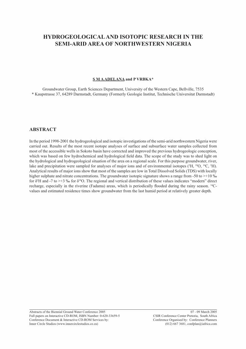
The principal area of study, the Sokoto Basin, in northwestern Nigeria, covers about 65,000 km2 and lies between latitudes 10 ° and 14 °N and longitudes 3 °and 7 °E. The area is bounded in the north and west by Niger Republic and on the southwest by Benin republicFig.1. Although extensive, the entire Sokoto basin of Nigeria occupies only about one-tenth of a much larger, elongate sedimentary basin centred in Niger, where it is referred to as Basin des Iullemmeden (Kogbe 1989).
Sokoto
River
Gogere
River
River
Bunsuru
River MaridSEDIM
ENTARY
EDGE OF River ZamfaraCRYSTALLINE
ROCK
Sokoto
Goronyo
Gidan Doka
Gwada bawa
Wamako
GandeKware
Kalmalo Sabon Birni
JibiyaBASIN
NIGER REPUBLIC
Gilbin Kc
BirninKebbi
Argungu Gayan Gilbe
River Shella
2.50
45.28
95.81
123.89
2.0
112.02
103.33
1.67
81.51
70.16
JegaRiver
Soko
to
River
Rima
Rive
rKw
are
52.35
31.90
61.85
KendeRIVER
NIGER
22.36
13.30
SOKOTO
River Zamfara
?
?
40 50 60 70140
130
120
110
Gilbin
Kc
50 50 KILOMETERS0
NIGERREPUBLIC
NIGERIA
SOKOTOBASINWEST
AFRICA
Sokoto
River
Gogere
River
River
Bunsuru
River MaridSEDIM
ENTARY
EDGE OF River ZamfaraCRYSTALLINE
ROCK
Sokoto
Goronyo
Gidan Doka
Gwada bawa
Wamako
GandeKware
Kalmalo Sabon Birni
JibiyaBASIN
NIGER REPUBLIC
Gilbin Kc
BirninKebbi
Argungu Gayan Gilbe
River Shella
2.50
45.28
45.28
95.81
95.81
123.8912
3.89
2.0
112.0211
2.02
103.3310
3.33
1.67
81.51
81.51
70.16
70.16
JegaRiver
Soko
to
River
Rima
Rive
rKw
are
52.35
52.35
31.90
31.90
61.85
61.85
KendeRIVER
NIGER
22.36
22.36
13.30
13.30
SOKOTO
River Zamfara
?
?
40 50 60 70140
130
120
110
Gilbin
Kc
50 50 KILOMETERS050 50 KILOMETERS0
NIGERREPUBLIC
NIGERIA
SOKOTOBASINWEST
AFRICA
NIGERIA
SOKOTOBASINWEST
AFRICA
Figure 1. Location map of the Sokoto Basin with drainage pattern (Inset: Map of West Africa showingthe location of Nigeria with reference to the position of Sokoto Basin)
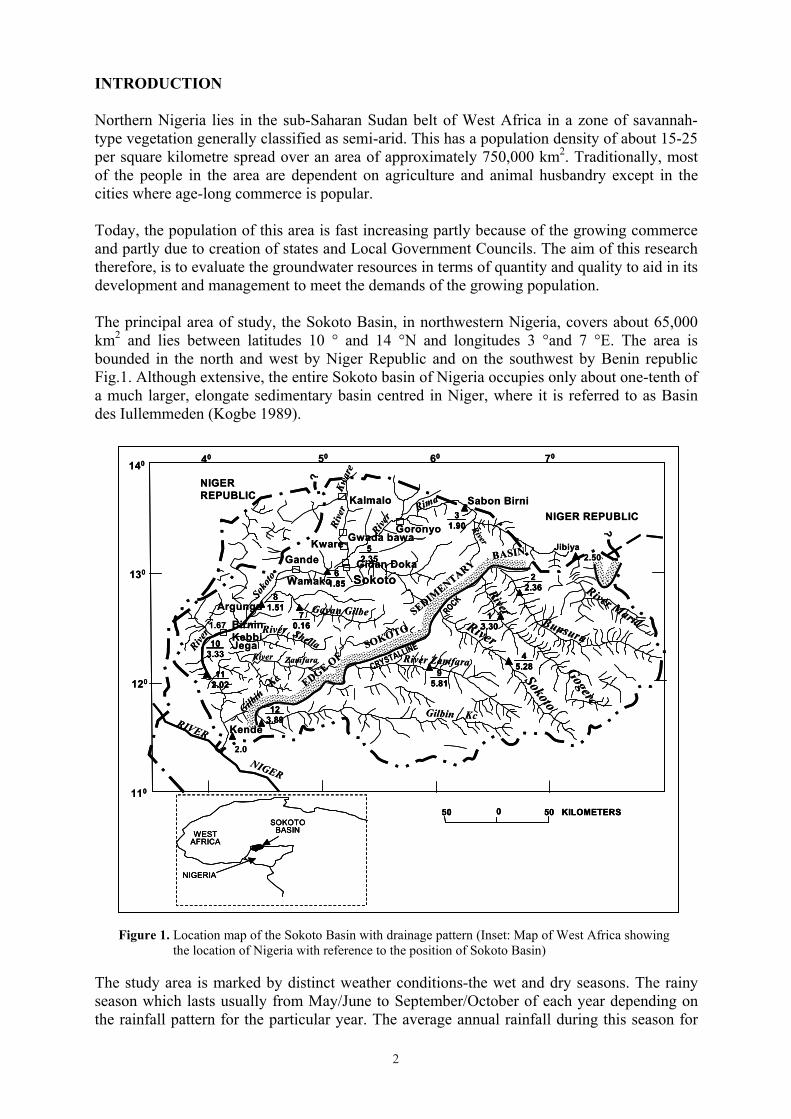
The study area is marked by distinct weather conditions-the wet and dry seasons. The rainyseason which lasts usually from May/June to September/October of each year depending onthe rainfall pattern for the particular year. The average annual rainfall during this season for
3
83-year record is 630 mm at Sokoto. Figure 2 shows the time series of annual rainfall in the study area with less than 60 raining days in a year. Evaporation ranges from <2000 mm to2500 mm in the extreme north. The dry season heralded annually by the dry, cold harmattanwinds lasts between November and March. Between the departure of harmattan and the onset of rain is the hot sunny season with temperature range of 37- 40 °C. Generally the advancement of the desert southwards which is accompanying natural climatic fluctuationsboth make the whole of the savannah belt subject to aridity.
As a result of this semiarid nature, hydrological information in most part of the area is scarce.Therefore, in order to acquire a better knowledge of the hydrological regime of this region, without the need of investing large sums in a hydrological data collection network, emphasis is laid on the hydrochemical aspects of the hydrological cycle and especially on the environmental isotopes. Preliminary results were reported by Verhagen (1997) and Vrbka (1998). These and subsequent studies (Adelana, et al., 1999; Bassey et al., 1999) have shown that different recharge pathways engender characteristic isotopic compositions which has then been traced into the aquifer systems, thus giving information on the relative importance of the different recharge mechanisms.
Figure 2. Annual rainfall time series in study area showing the mean over 83 years
Annual rainfall time series
0200400600800
10001200
1916
1921
1926
1931
1936
1941
1946
1953
1958
1963
1968
1973
1978
1983
1990
Year
Seas
onal
rain
fall
(mm
)
Annual rainfall,P(mm/a)Mean
METHOD OF RESEARCH
From the preliminary stages of the research until recently samples were taken from hand-dug wells, boreholes and the Rima and Sokoto Rivers on a regular basis. Quantitative determinations of Na+, K+, Ca+2, Mg+2, Cl-, F-, SO4
-2 and NO3 were made as well as field measurements of pH, temperature, electrical conductivity, and alkalinity using portable meters. Environmental isotopes H-2, H-3, C-13, C-14 and O-18 have been analysed. Table 1 shows a summary of methods used in the determination of physical and chemical parameters.The samples were analyzed in the laboratories of National Water Resources Institute, Kaduna (Nigeria), UNICEF, Ilorin regional office (Nigeria) and Institute of Geosciences, TechnicalUniversity Darmstadt (Germany) for chemical components. Analyses of the stable and radioisotopes were jointly carried out at the Schonland Research Centre, University of Witwatersrand, Johannesburg, South Africa, the Middle Eastern Regional Radioisotope Centre, Cairo, Egypt, Hydroisotop GmbH, ScweiterKirchen, Germany and Hydrogeology Section, Centre for Environmental Research (UFZ), Leipzig-Halle, Germany. Stable isotopes
4
ratios are expressed as delta in per mil (��) relative to VSMOW (Vienna Standard Mean Ocean Water). The isotope precision of measurement based on VSMOW is ±0.15 � for 18Oand ±1 � for 2H. Most of the data from 1997-1999 were carried out under a coordinated research, which forms part of the technical cooperation project between the International Atomic Energy Agency, Vienna and the Federal Ministry of Water Resources. However, consistent water sampling for chemistry was carried out under the student-staff research projects in the University of Ilorin (Nigeria) until January 2004.
Table 1. A summary of methods used in the determination of physical and chemical parameters. Parameter Method Parameter MethodT WTW Oxi96 Ca AAS/Titration PH WTW pH91 Mg Difference TH-
Ca/AASTH Aquamerck Titration Cl Aquamerck Titration EC WTW Lf90 HCO3 Titration of alkalinity O2 WTW Oxi96 SO4 ICK AAS NO3 ICNa AAS F IC
GEOLOGIC AND HYDROGEOLOGIC SETTINGS
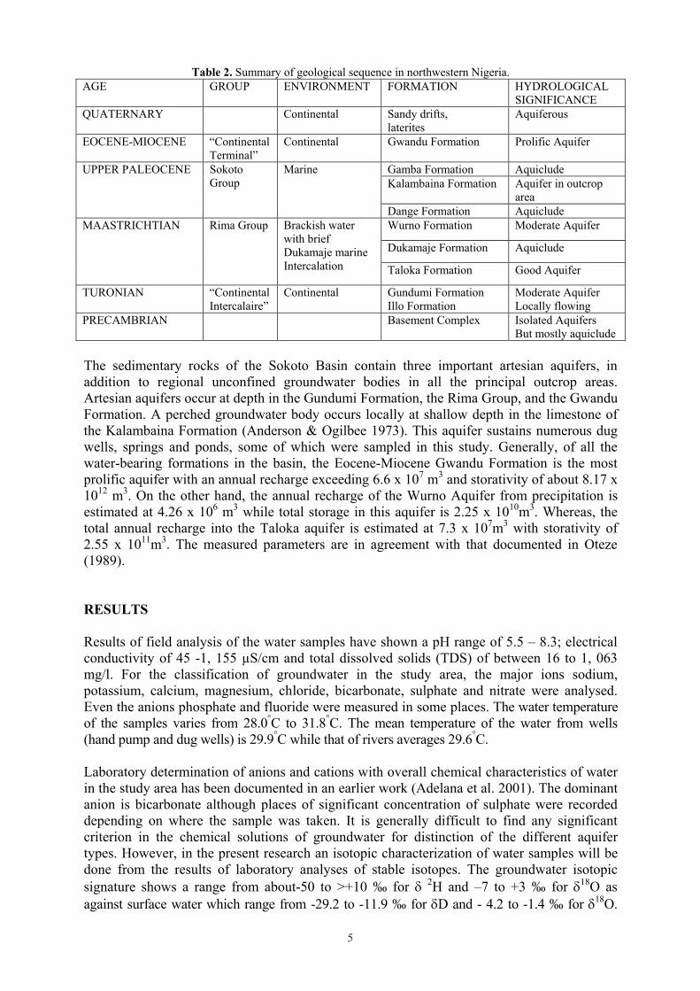
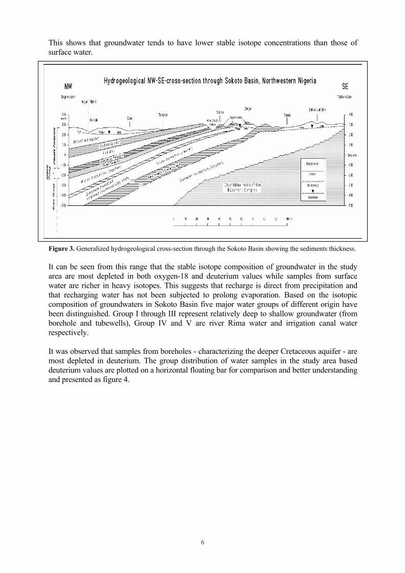
The sedimentary rocks of the Sokoto basin range in age from Cretaceous to Tertiary and are composed mostly of interbedded sand, clay, and some limestone with the beds dipping gently toward the northwest. Alluvium of Quaternary age underlies the lowlands of the River Sokoto and its principal tributaries. The sediments of the basin lie unconformably on the Basement Complex of Nigeria and have been affected by a series of marine transgressions during the Mesozoic and Tertiary with consequent deposition of a sequence of sediments Table 2. These transgressions progressively affected a greater portion of the basin, resulting in an overlap series (Kogbe 1989, Jones 1948) and sediments becoming younger as one moves towards the southwest from the north. The sediments thickness increases from tens of metres in the Southeastern end to over a thousand metres the northwest (Fig.3) and further increases toward the centre of the basin in Niger Republic. The configuration of the groundwater table indicates flow from the northern and eastern recharge area westwards, then turning southwards towards river Niger and subsequently draining into the Atlantic Ocean.
5
Table 2. Summary of geological sequence in northwestern Nigeria. AGE GROUP ENVIRONMENT FORMATION HYDROLOGICAL
SIGNIFICANCE QUATERNARY Continental Sandy drifts,
lateritesAquiferous
EOCENE-MIOCENE �Continental Terminal�
Continental Gwandu Formation Prolific Aquifer
Gamba Formation AquicludeKalambaina Formation Aquifer in outcrop
area
UPPER PALEOCENE Sokoto Group
Marine
Dange Formation AquicludeWurno Formation Moderate Aquifer
Dukamaje Formation Aquiclude
MAASTRICHTIAN Rima Group Brackish water with brief Dukamaje marine Intercalation Taloka Formation Good Aquifer
TURONIAN �Continental Intercalaire�
Continental Gundumi Formation Illo Formation
Moderate Aquifer Locally flowing
PRECAMBRIAN Basement Complex Isolated Aquifers But mostly aquiclude
The sedimentary rocks of the Sokoto Basin contain three important artesian aquifers, in addition to regional unconfined groundwater bodies in all the principal outcrop areas. Artesian aquifers occur at depth in the Gundumi Formation, the Rima Group, and the Gwandu Formation. A perched groundwater body occurs locally at shallow depth in the limestone of the Kalambaina Formation (Anderson & Ogilbee 1973). This aquifer sustains numerous dug wells, springs and ponds, some of which were sampled in this study. Generally, of all the water-bearing formations in the basin, the Eocene-Miocene Gwandu Formation is the most prolific aquifer with an annual recharge exceeding 6.6 x 10⁷ m3 and storativity of about 8.17 x 10¹² m3. On the other hand, the annual recharge of the Wurno Aquifer from precipitation is estimated at 4.26 x 10⁶ m3 while total storage in this aquifer is 2.25 x 10¹⁰m3. Whereas, the total annual recharge into the Taloka aquifer is estimated at 7.3 x 10⁷m3 with storativity of 2.55 x 10¹¹m3. The measured parameters are in agreement with that documented in Oteze (1989).
RESULTS
Results of field analysis of the water samples have shown a pH range of 5.5 � 8.3; electrical conductivity of 45 -1, 155 µS/cm and total dissolved solids (TDS) of between 16 to 1, 063 mg/l. For the classification of groundwater in the study area, the major ions sodium, potassium, calcium, magnesium, chloride, bicarbonate, sulphate and nitrate were analysed. Even the anions phosphate and fluoride were measured in some places. The water temperature of the samples varies from 28.0°C to 31.8°C. The mean temperature of the water from wells (hand pump and dug wells) is 29.9°C while that of rivers averages 29.6°C.
Laboratory determination of anions and cations with overall chemical characteristics of water in the study area has been documented in an earlier work (Adelana et al. 2001). The dominant anion is bicarbonate although places of significant concentration of sulphate were recorded depending on where the sample was taken. It is generally difficult to find any significant criterion in the chemical solutions of groundwater for distinction of the different aquifer types. However, in the present research an isotopic characterization of water samples will be done from the results of laboratory analyses of stable isotopes. The groundwater isotopic signature shows a range from about-50 to >+10 � for � 2H and �7 to +3 � for �18O as against surface water which range from -29.2 to -11.9 � for �D and - 4.2 to -1.4 � for �18O.
6
This shows that groundwater tends to have lower stable isotope concentrations than those of surface water.
Figure 3. Generalized hydrogeological cross-section through the Sokoto Basin showing the sediments thickness.
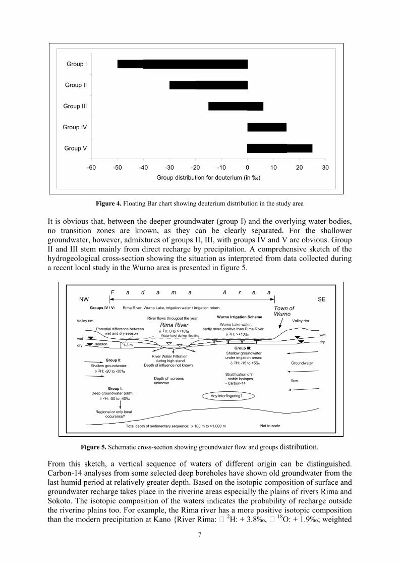
It can be seen from this range that the stable isotope composition of groundwater in the study area are most depleted in both oxygen-18 and deuterium values while samples from surfacewater are richer in heavy isotopes. This suggests that recharge is direct from precipitation and that recharging water has not been subjected to prolong evaporation. Based on the isotopiccomposition of groundwaters in Sokoto Basin five major water groups of different origin havebeen distinguished. Group I through III represent relatively deep to shallow groundwater (fromborehole and tubewells), Group IV and V are river Rima water and irrigation canal waterrespectively.
It was observed that samples from boreholes - characterizing the deeper Cretaceous aquifer - are most depleted in deuterium. The group distribution of water samples in the study area baseddeuterium values are plotted on a horizontal floating bar for comparison and better understandingand presented as figure 4.
7
-60 -50 -40 -30 -20 -10 0 10 20 30
Group I
Group II
Group III
Group IV
Group V
Group distribution for deuterium (in �)
Figure 4. Floating Bar chart showing deuterium distribution in the study area
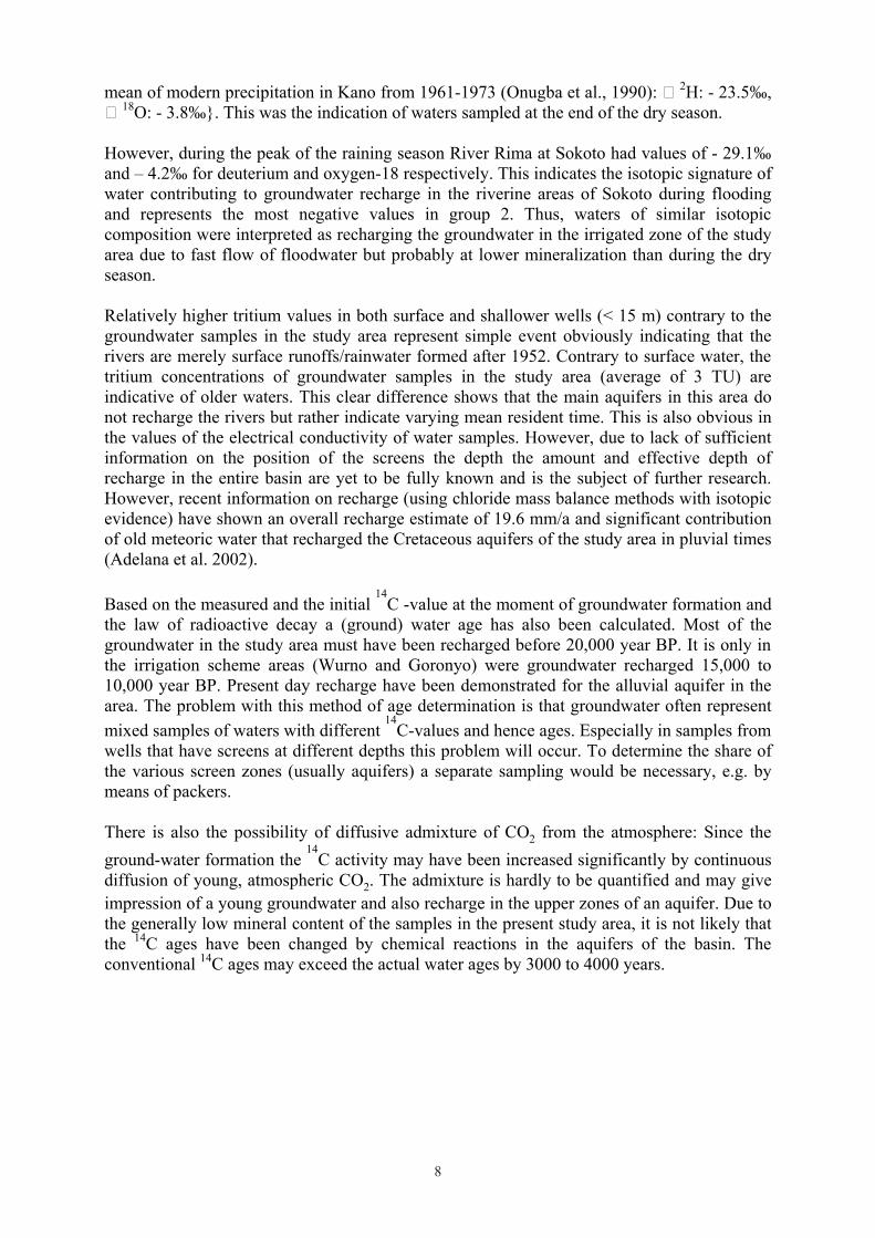
It is obvious that, between the deeper groundwater (group I) and the overlying water bodies, no transition zones are known, as they can be clearly separated. For the shallower groundwater, however, admixtures of groups II, III, with groups IV and V are obvious. Group II and III stem mainly from direct recharge by precipitation. A comprehensive sketch of the hydrogeological cross-section showing the situation as interpreted from data collected during a recent local study in the Wurno area is presented in figure 5.
NW SE
Rima River
F a d a m a A r e a
Wurno Irrigation Scheme
River Water Filtrationduring high stand
Depth of influence not known
River flows througout the year
Potential difference betweenwet and dry season
Shallow groundwater:�� 2H: -20 to -30�
Wurno Lake water,partly more positive than Rima River
�� 2H: >+10�
Total depth of sedimentary sequence: x 100 m to >1,000 m
Deep groundwater (old?):�� 2H: -50 to -40�
seasonwet
dry
Shallow groundwaterunder irrigation areas:
�� 2H: -15 to +5�
Group I:
Regional or only localoccurence?
Group II:
Group III:
Groups IV / V: Rima River, Wurno Lake, irrigation water / irrigation return
Valley rim
Groundwater
flow
wet
dry
Town ofWurno
Not to scale.
1-3 m
Any interfingering?
Stratification of?:- stable isotopes- Carbon-14
Depth of screensunknown
�� 2H: 0 to >+10�Water level during flooding
Valley rim
Figure 5. Schematic cross-section showing groundwater flow and groups distribution.
From this sketch, a vertical sequence of waters of different origin can be distinguished. Carbon-14 analyses from some selected deep boreholes have shown old groundwater from thelast humid period at relatively greater depth. Based on the isotopic composition of surface andgroundwater recharge takes place in the riverine areas especially the plains of rivers Rima and Sokoto. The isotopic composition of the waters indicates the probability of recharge outsidethe riverine plains too. For example, the Rima river has a more positive isotopic compositionthan the modern precipitation at Kano {River Rima: � 2H: + 3.8�, � 18O: + 1.9�; weighted
8
mean of modern precipitation in Kano from 1961-1973 (Onugba et al., 1990): � 2H: - 23.5�, � 18O: - 3.8�}. This was the indication of waters sampled at the end of the dry season.
However, during the peak of the raining season River Rima at Sokoto had values of - 29.1� and � 4.2� for deuterium and oxygen-18 respectively. This indicates the isotopic signature of water contributing to groundwater recharge in the riverine areas of Sokoto during flooding and represents the most negative values in group 2. Thus, waters of similar isotopic composition were interpreted as recharging the groundwater in the irrigated zone of the study area due to fast flow of floodwater but probably at lower mineralization than during the dry season.
Relatively higher tritium values in both surface and shallower wells (< 15 m) contrary to the groundwater samples in the study area represent simple event obviously indicating that the rivers are merely surface runoffs/rainwater formed after 1952. Contrary to surface water, the tritium concentrations of groundwater samples in the study area (average of 3 TU) are indicative of older waters. This clear difference shows that the main aquifers in this area do not recharge the rivers but rather indicate varying mean resident time. This is also obvious in the values of the electrical conductivity of water samples. However, due to lack of sufficient information on the position of the screens the depth the amount and effective depth of recharge in the entire basin are yet to be fully known and is the subject of further research. However, recent information on recharge (using chloride mass balance methods with isotopic evidence) have shown an overall recharge estimate of 19.6 mm/a and significant contribution of old meteoric water that recharged the Cretaceous aquifers of the study area in pluvial times (Adelana et al. 2002).
Based on the measured and the initial 14
C -value at the moment of groundwater formation and the law of radioactive decay a (ground) water age has also been calculated. Most of the groundwater in the study area must have been recharged before 20,000 year BP. It is only in the irrigation scheme areas (Wurno and Goronyo) were groundwater recharged 15,000 to 10,000 year BP. Present day recharge have been demonstrated for the alluvial aquifer in the area. The problem with this method of age determination is that groundwater often represent mixed samples of waters with different
14C-values and hence ages. Especially in samples from
wells that have screens at different depths this problem will occur. To determine the share of the various screen zones (usually aquifers) a separate sampling would be necessary, e.g. by means of packers.
There is also the possibility of diffusive admixture of CO2 from the atmosphere: Since the ground-water formation the
14C activity may have been increased significantly by continuous
diffusion of young, atmospheric CO2. The admixture is hardly to be quantified and may give impression of a young groundwater and also recharge in the upper zones of an aquifer. Due to the generally low mineral content of the samples in the present study area, it is not likely that the 14C ages have been changed by chemical reactions in the aquifers of the basin. The conventional 14C ages may exceed the actual water ages by 3000 to 4000 years.
9
CONCLUSIONS
The results of isotope analyses of surface and subsurface water samples collected from most of the accessible wells in Sokoto basin have corrected and improved the previous hydrogeologic conception, which was based on few hydrochemical and hydrological field data.
Using the isotopic composition of surface and ground water in the basin the following conclusions were made:
1. Both geochemical and isotopic data indicate �modern� precipitation as the source of recharge
2. Most of the groundwater resources in the semi-arid area of northwestern Nigeria were recharged (in pluvial times) about or before 20,000 year BP. Only in the irrigation scheme areas (Wurno and Goronyo) was groundwater recharged 15,000 to 10,000 year BP. Present day recharge have been demonstrated for the alluvial aquifer in the area.
3. The results of stable isotope analyses made it possible to divide the water in this region into distinct groups with groundwater of different age range but common origin.
4. Due to the generally low mineral content of the samples, it is not to be expected that the 14C ages have been changed by chemical reactions in the aquifers of the basin. The conventional 14C ages may exceed the actual water ages by 3000 to 4000 years.
REFERENCES
Adelana, S.M.A.; Olasehinde, P.I.; Vrbka, P. (2002). Groundwater recharge in the Cretaceous and Tertiary sediment aquifers of northwestern Nigeria, using hydrochemical and isotopic techniques. In: Bocanegra E., Martinez D and Massone H. (eds.) Groundwater and Human Development, Mar de Plata, Argentina, pp. 907-915.
Adelana, S.M.A.; Olasehinde, P.I. Vrbka, P. (2001). Hydrogeological investigation in the Sokoto Basin using environmental isotopes. Water Resources, Vol. 12, Pp 14-21.
Adelana, S.M.A.; Olasehinde, P.I; Vrbka, P. and Esan, A. (1999). A note on the results of isotope study of wells in Sokoto sedimentary Basin, North-western Nigeria. Water Resources, Vol. 10, pp. 12-18.
Anderson, H.R & Ogilbee, W. (1973) Aquifers in the Sokoto Basin - Geol. Survey Water Supply paper 1757-L, USGS Report, 79p.
Bassey, J.O.; Maduabuchi, C.; Onugba, A.; Verhagen, B. & Vrbka, P. (1999): Preliminary results of Hydrogeological and isotopic research in the Rima Basin, NW Nigeria. - Water Resources, 10, pp. 31-37.
Jones B (1948) The sedimentary rocks of Sokoto province, Geol. Survey. Nig., Bull. 18: 1-75. Kogbe CA (1989) Cretaceous and Tertiary of the Iullemmeden Basin in Nigeria (West
Africa). In: Kogbe CA (ed.), Geology of Nigeria, 2nd edn, Rock View, Jos, pp.377-421 Onugba, A.; Blavoux, B. & Dray, M. (1990): The environmental isotopes in monthly
precipitation at Kano (Nigeria) from 1961-1973. � In: Proc. 1st Biennial National Hydrology Symposium, Maiduguri, Nigeria, pp. 67-88.
Oteze GE (1989) The Hydrogeology of the northwestern Nigeria Basin. -In: Kogbe CA (ed.), Geology of Nigeria, 2nd edn, Rock View, Jos, pp.455-472.
Verhagen, B. (1997): End of mission report to the IAEA RAF/8/022-NIG. - Results of 1st sampling campaign unpublished Report (August, 1997).
Vrbka, P. (1998): End of mission report to the IAEA RAF/8/022-NIG. - Results of 2nd sampling campaign, unpublished report (March, 1998).