supply, segregation, successions, and significance of shallow
TRANSCRIPT
370
ABSTRACT
The accumulation of gravel in the shallow marine environment generally involves special conditions of sourcing, transport, and concentrating mechanism. Accordingly, the correct interpretation of shallow marine conglomerate can notonly provide unique insights to tectonics, delivery systems, sedimentary processes, and sequence stratigraphy, but alsofacilitate prediction of the distribution and quality of hydrocarbon reservoirs within these deposits. Despite their economicand scientific importance, shallow marine conglomerate remains imperfectly understood relative to shallow marine sandstone. Studies of modern shallow marine gravel are relatively few and sporadic; most of our knowledge derives fromthe stratigraphic record.
The study of shallow marine conglomerate may be facilitated by analysis of the processes whereby gravel is deliveredto the marine environment (supply), and concentrated once in place (segregation), as well as the succession in which theconglomerate occurs. Although the source of some shallow marine is obvious for some shallow marine conglomerate, it isless certain for many others. Little is known about the potential extent of longshore gravel transport. Understanding issuesof supply may be critical to predicting the distribution of gravel in many ancient shallow marine deposits.
The degree of segregation of gravel and sand in the shallow marine environment can critically influence a deposit’sreservoir character. Waves are particularly effective at winnowing sand from gravel, particularly during storms. Waves alsotend to drive gravel shoreward and concentrate it on or near beaches. Shallow marine gravel typically accumulates in anytroughs or other depressions on the sea floor.
The occurrence of gravel in the shallow marine environment is particularly sensitive to changes in the rates of accommodation and sediment supply, which in turn determines the nature of the succession in which conglomerate occurs.Coastal gravel can occur in progradational, transgressive and aggradational successions, each of which bears a distinctivesignature. Conglomerate in progradational deposits is mostly in the form of beach foreshore/upper shoreface or Gilbertdelta accumulations. In transgressive successions, conglomerate may form transgressive lags or accumulate in tidal inlets.Aggradational deposits of shallow marine conglomerate, which seem to require a persistent balance of relative sea leveland sediment input that is generally uncommon, can be difficult to explain.
RÉSUMÉ
L’accumulation de gravelles dans le milieu marin peu profond implique généralement des conditions spéciales d’approvisionnement, de transport, et de concentration de mécanismes. Par conséquent, l’interprétation correcte du conglomérat de milieu marin peu profond ne fournit pas seulement des aperçus uniques sur la tectonique, les systèmes de débit, les processus sédimentaires et les séquences stratigraphiques, mais elle facilite également la prédiction de la distribution et la qualité des réservoirs d’hydrocarbures à l’intérieur de ces dépôts. Malgré son importance économique etscientifique, le conglomérat de milieu marin peu profond demeure imparfaitement compris par rapport au grès du milieumarin peu profond. Les études pratiquées sur le grès moderne d’environnement marin peu profond sont relativement rareset sporadiques; la majeure partie de nos connaissances est puisée dans les enregistrements stratigraphiques.
L’étude du conglomérat dans le milieu marin peu profond peut être facilitée par l’analyse du processus par lequel lagravelle est transportée dans l’environnement marin (approvisionnement), et est concentrée une fois en place (ségrégation),tout comme la succession par laquelle le conglomérat apparaît. Bien que la source marine peu profonde soit évidente pourcertains conglomérats marins peu profonds, cela est moins certain pour beaucoup d’autres. On sait peu de choses au sujetde l’étendue potentielle du transport de gravelle sur le littoral. La compréhension des provenances de l’approvisionnementpeut être cruciale afin de prédire la distribution de la gravelle dans de nombreux anciens dépôts marins peu profonds.
BULLETIN OF CANADIAN PETROLEUM GEOLOGYVOL. 51, NO. 4 (DECEMBER, 2003), P. 370-388
Supply, segregation, successions, and significance of shallow marine conglomeratic deposits
H. EDWARD CLIFTON
MontereyCalifornia, USA
SHALLOW MARINE GRAVELLY DEPOSITS 371
INTRODUCTION
Shallow marine conglomerates are of particular economicand scientific interest. They are capable of bearing vast quanti-ties of hydrocarbons (Arnott, 1991; Cant and Ethier, 1984; Cantand Leckie, 1984; Leckie, 1986), and their accumulation gener-ally involves special conditions of supply, transport, and concen-trating mechanism. Accordingly, their correct interpretation canprovide unique insights to tectonics, delivery systems, processes,and sequence stratigraphy. Yet, as Bourgeois and Leithold (1984)and Hart and Plint (1995) point out in their comprehensivereviews of the subject, gravelly shoreface and beachface depositsremain poorly understood relative to sandy nearshore deposits.
Several impediments exist to our understanding of shallowmarine conglomerate. Modern shallow marine gravel com-monly accumulates in energetic settings where observation isdifficult, and gravel beds typically move only during storm con-ditions, when observation may be impossible. Because moderngravel is inherently difficult to core, its three-dimensional faciesarchitecture generally is poorly understood. As a consequence,much of our understanding derives from the stratigraphic record(Massari and Parea, 1988). This paper examines specific issuesof supply, segregation, and successions of shallow marinegravel deposits (including thick successions and individualbeds) and provides examples of their interpretive value withinstratigraphic sections.
SUPPLY
A primary requisite for the accumulation of gravel in theshallow marine environment is a source for the pebbles and/orcobbles. Tectonic activity may be a fundamental requisite forgenerating a supply of coarse material to non-glacial coasts(Massari and Parea, 1988). Tectonically active margins arecharacterized by substantial relief and steep fluvial gradients.Tectonic stresses induce fracturing that contributes to the avail-ability of coarse detritus, and uplift of older conglomeraticdeposits can provide ready sources of gravelly material.
In modern coastal settings, pebbly beaches typically areassociated with mouths of streams that discharge a coarse
bedload into the marine environment. This relationship can bevery clear in settings of low wave energy, such as theMediterranean coast of Spain, where gravelly beaches occur atthe mouths of every small, high-gradient, ephemeral stream orrambla. On coasts with greater wave energy, gravel can be car-ried alongshore as part of the littoral drift. The extent of long-shore gravel transport is not well documented, but it may be farless than that of sand-sized material. On the southern coast ofOregon, large waves prevail, but most gravelly beaches lie closeto the mouths of high-gradient streams. Studies on the high-energy southwestern coast of the South Island of New Zealandindicate that even fine gravel (–4 phi) remains in the generalvicinity of eroding alluvial fan sources (Kirk, 1980). AlthoughMassari and Parea (1988) note that shallow marine gravel bod-ies are thickest near the mouths of feeding alluvial systems, thelongshore distribution of gravel on some modern beaches showslittle clear relation to active sources (Mclean, 1970; Kirk, 1980).
The relative proportion of sand and gravel in a delivery sys-tem and partitioning of the sediment load are also likely toinfluence the occurrence of coastal gravel deposits. Even in thepresence of abundant gravel, a high sand discharge may signif-icantly dilute the concentration of gravel. Many coastal streamshave bedload largely composed of gravel that is not carried intothe open nearshore environment. Many larger high-gradientstreams have estuaries that can serve as traps for gravel, allow-ing sand to be bypassed to the coast. Beaches adjacent to themouth of the Rogue River in southern Oregon display few peb-bles, even though the river bed upstream is mostly gravel.High-gradient coastal steams that discharge into Willapa Bay,Washington, are floored mostly by gravel, but this coarse material extends only a short distance into the bay.
In erosional settings, sea cliffs supply gravel to the modernmarine environment. Gravel on beaches adjacent to sea-cliffoutcrops of Merced Formation, just south of San Francisco,California, clearly owe their derivation to erosion of that unit.Many of the clasts on the modern beach consist of concretions(or parts of concretions) that formed in the strata that composethe seacliffs. Seacliff supply of gravel is limited to transgres-sive or otherwise erosional coasts. Sea cliff erosion is anunlikely source for gravel in prograding settings.
Le degré de ségrégation de gravelle et de sable dans le milieu marin peu profond peut influencer de manière critique le caractère du réservoir d’un dépôt. Les vagues sont particulièrement effectives au vanage du sable à partir de la gravelle, notamment durant les tempêtes. Les vagues tendent aussi à déplacer la gravelle vers le rivage, et à la concentrer sur ou prochedes plages. La gravelle marine peu profonde s’accumule typiquement dans tous les creux ou autres dépressions sur le fondocéanique.
L’occurrence de la gravelle dans le milieu marin peu profond est particulièrement sensible aux changements du taux d’accomodation et d’approvisionnement de sédiment, qui à son tour détermine la nature de la succession dans laquelle apparaîtle conglomérat. La gravelle côtière peut apparaître dans des successions progradantes, transgressives et aggradantes, chacuned’entre elles portant une signature distincte. Le conglomérat dans les dépôts progradants est le plus souvent sous la forme d’accumulations sur des plages avant-plages/avant-côtes supérieures ou des accumulations de delta de Gilbert. Dans les successions transgressives, le conglomérat peut former des décalages transgressifs ou s’accumuler dans des goulets de marées.Les dépôts aggradants de conglomérat marin peu profond, qui semblent requérir un équilibre continuel du niveau marin relatifet d’apport de sédiment généralement rare, peuvent être difficiles à expliquer.
Traduit par Gabrielle Drivet
A third source of gravel in the shallow marine environmentis erosion of underlying sediment. This is probably the primarysource for most transgressive lags associated with ravinementsurfaces and can also be a source for gravel in tidal inlets. It isa somewhat unlikely source for gravel where forced regres-sions prevail, owing to the fact that a regressive surface ofmarine erosion is typically cut into more distal facies, whichare likely to be finer-grained. Rivers, however, are likely tobecome incised, owing to their steeper gradients during a sealevel fall (Bergman and Walker, 1988), thereby potentiallyeroding and redistributing previously deposited beach andshoreface gravel.
In many ancient gravelly shoreline deposits, it is unclearhow gravel was supplied. Conglomeratic shoreface deposits area common component in the stacked prograding parasequencesof the Plio-Pleistocene Merced Formation, exposed in seaciffssouth of San Francisco. Alluvial deposits, however, are quiterare in the section and the source of the nearshore gravel is notapparent. Fluvial sources may have been relatively common,but so sporadically spaced along the shoreline that they arerarely seen in the limited lateral view presented in the seacliffexposures. A possible example of a small gravel-bearing streamdeposit occurs at the top of one parasequence where 2–3 m ofrelatively coarse gravel caps a typical shoreface succession.Internally, the gravel is less well sorted into discrete beds thanis the case in the underlying shoreface deposits and it lacks thetrace fossils (mostly Macaronichnus) of the underlying beds.The lateral extent of this gravel is uncertain, owing to thenature of the exposure, but it may be relatively limited. Similarstreams may have fed the gravelly shorefaces elsewhere in thesection, but are not captured in the limited cross-sections pro-vided by the exposure.
SEGREGATION
A variety of processes/mechanisms can segregate gravelintroduced into the marine environment into beds or into astacked succession of beds with minimal intervening sand.Obviously, where the available sediment to a coast is primarilygravel, nearshore processes will exclusively produce gravelaccumulations. In most settings, however, both sand and gravelare available and need to be segregated in order to produce con-glomerate. Several factors influence the concentration of gravelin the nearshore environment: 1) selective winnowing of asso-ciated sand, 2) differential transport under shoaling waves orother processes, 3) fluctuations of physical energy, and 4)seafloor morphology.
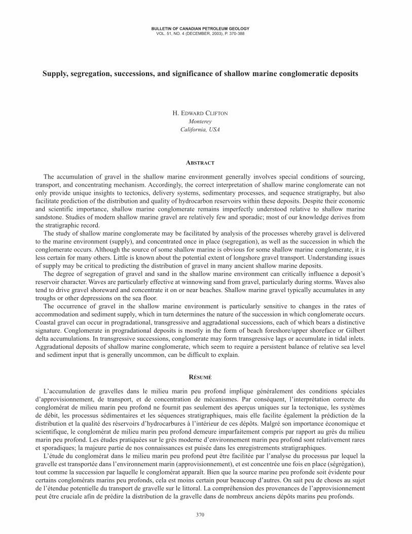
Pebbles are concentrated from a mixture of sand and gravelwhere the more mobile sand is selectively swept away (win-nowed) (Fig.1). This can result from unusual flow conditions,such as during a storm, or by continued erosion in an energeticsetting, as on a retreating shoreface. Commonly oscillatoryflow generated by passing waves mobilizes the bed, but nettransport results from weaker superimposed flow (that, byitself, may not exceed threshold velocities) (Komar, 1976).
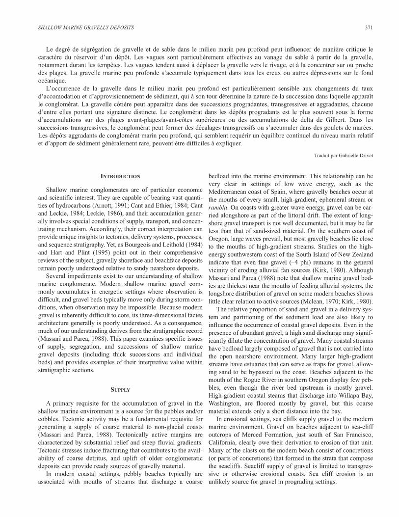
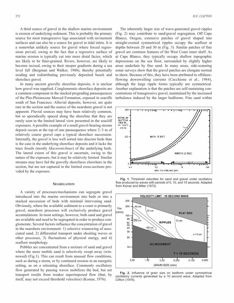
The inherently larger size of wave-generated gravel ripples(Fig. 2) may contribute to sand/gravel segregation. Off CapeBlanco, Oregon, extensive patches of gravel shaped intostraight-crested symmetrical ripples occupy the seafloor atdepths between 20 and 30 m (Fig. 3). Similar patches of finegravel are common features of the West Coast inner shelf. Asat Cape Blanco, they typically occupy shallow topographicdepressions on the sea floor, surrounded by slightly higherareas underlain by fine sand. In many areas, side-scanningsonar surveys show that the gravel patches are elongate normalto shore. Because of this, they have been attributed to offshore-flowing downwelling currents (Cacchione et al., 1984),although the large ripple forms typically are symmetrical.Another explanation is that the patches are self-sustaining con-centrations of transgressive gravel, maintained by the increasedturbulence induced by the larger bedforms. Fine sand within
372 H.E. CLIFTON
Fig. 1. Threshold velocities for sand and gravel under oscillatoryflow produced by waves with periods of 5, 10, and 15 seconds. Adaptedfrom Komar and Miller (1973).
Fig. 2. Influence of grain size on bedform under symmetrical oscillatory currents generated by a 10 second wave. Adapted fromClifton (1976).
the patch will remain preferentially suspended and ultimately bepurged from the gravel substrate by any superimposed current.
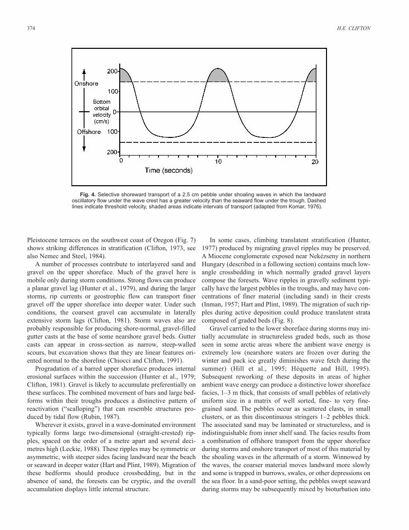
Gravel may also be segregated from sand during its trans-port. On shorefaces, the deformation of shoaling waves leads toasymmetric orbital flow that induces shoreward transport(Niedoroda and Swift, 1981). Landward flow under wavecrests is strong and short-lived, whereas seaward flow underwave troughs is prolonged, but weaker. The stronger flow canselectively drive the coarser clasts landward (Fig. 4). In mostnearshore environments the coarsest sediment occurs just sea-ward from the base of the beach foreshore. Gravel may also besegregated from sand by mass flow processes on very steepbottom profiles on Gilbert deltas (Nemec, 1990).
Under energetic conditions, gravel accumulates in topo-graphic depressions. It commonly lines the floors of channels,such as tidal channels or inlets or the troughs associated withnearshore breaker-bar systems.
On modern coasts, the distribution or proportion of gravelmay be difficult to ascertain. For example, a covering of sandcommonly mantles beach gravel. In the stratigraphic record,the preserved deposit could be quite conglomeratic, whereasthe modern analog appears predominantly sandy. Similarly,pebbly nearshore zones may lie beneath the waves offshorefrom sandy beaches, obscuring the potentially conglomeraticcharacter of the preserved ancient analog.
As Caddel and Moslow (2004) note, shallow marine con-glomerates are further segregated on the shoreface (as usedhere, the typically concave-up, relatively steeply inclined sur-face that extends from the low tide shoreline to the flatter innershelf or basin ramp). Massari and Parea (1988) note that amongcoastal gravel deposits, shorefaces predominate volumetricallyin the stratigraphic record. Gravel can accumulate on beachforeshores, upper shorefaces and, to a lesser degree, on thelower shoreface.
Bourgeois and Leithold (1984), in a general description ofgravel beaches, note their tendency to be steeper than sandybeaches. They attribute this to greater permeability of coarse-grained foreshores, where much of the wave backwash, whichcarries sediment off the beach is lost to the percolation into thegravel. This phenomenon probably also accounts for the char-acteristic seaward-inclined imbrication of pebbles on gravelbeaches (Bluck, 1967). Pebbles carried landward by the waveswash are deposited with a seaward imbrication that is notreversed by the weakened backwash. Bluck (1967, 1999) andPostma and Nemec (1990) describe the zonation and hierarchyof pebble fabric on gravelly beaches.
On beaches with both sand and gravel, plane parallel lami-nation typically is pronounced (Clifton,1973; Hunter, 1980),but in the absence of sand, stratification can be obscure. Somebeach gravels have so little associated sand that they have anopenwork fabric. Some beaches alternate between sand andgravel as a function of wave energy. Storm waves, which typi-cally erode sandy beaches, can deposit relatively thick accu-mulations of gravel if it is available. This gravel is subject tosand percolation and burial by sand in the storm’s aftermath.Bluck (1999) provides a detailed analysis of the fabric, bedforms and structure of gravel beaches including regressivegravelly barrier bars that form a series of beach ridges sepa-rated by lagoonal deposits.
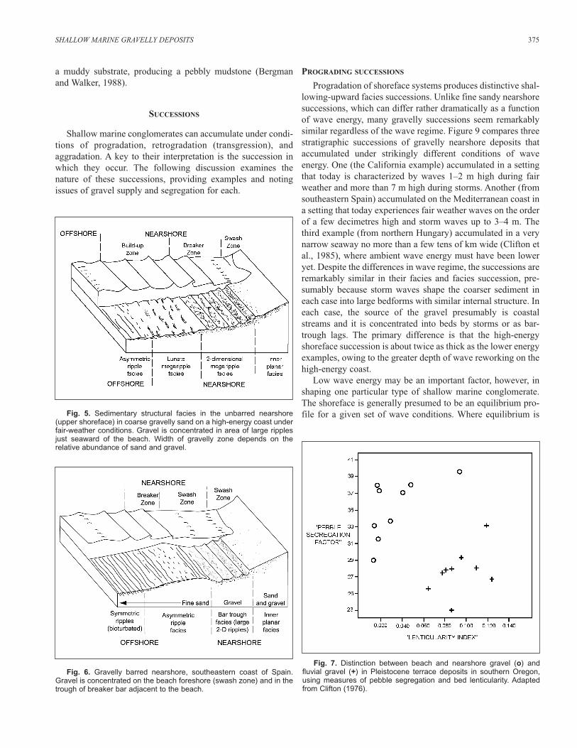
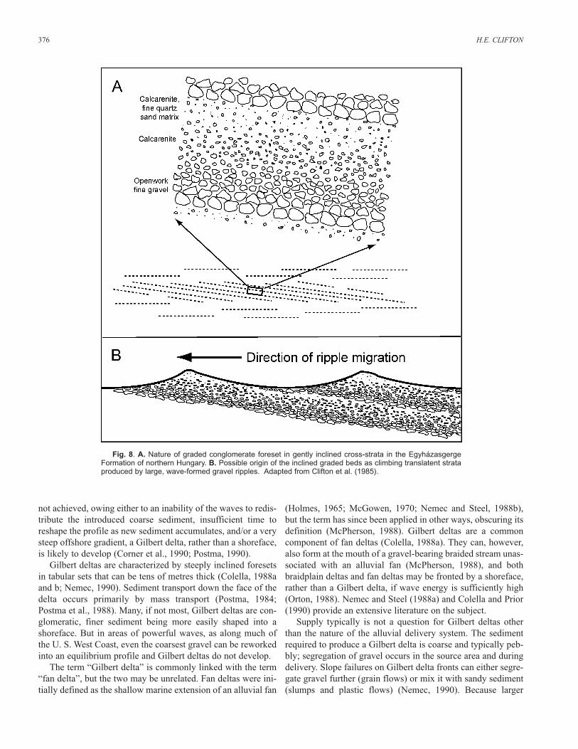
Nearshore gravel on an open coast is typically concentratedon the upper part of the shoreface in the zone where nearshorecurrents predominate. The coarsest clasts are concentrated nearthe base of the beach foreshore and tend in successions to lie atthe top of the upper shoreface deposits (Massari and Parea,1988). The gravel may occupy much of the inner uppershoreface (Fig. 5) (Hart and Plint, 1989) or be concentrated inthe troughs of longshore bars (Massari and Parea, 1988)(Fig. 6). Where a shoreface lacks significant sand, the deposit,like that of a beach foreshore, can consist of an interval ofobscurely stratified gravel. Elsewhere, the net effect of thenearshore processes is to produce a sedimentary facies in whichthe gravel is segregated into discrete, laterally extensive beds.A comparison of nearshore and fluvial gravelly deposits in
SHALLOW MARINE GRAVELLY DEPOSITS 373
Fig. 3. Side-scanning sonograph showing large ripples on a gravellysea floor at a water depth of about 25 m on the southern Oregon inner shelf, about 7 km south of Cape Blanco. Shadow pattern of thelarge ripples indicates symmetrical profiles. Apparent ripples on seafloorcaused by wave swell during the survey. Adapted from a Joint State-Federal Oregon Placer Marine Minerals Task Force Report (1991).
Pleistocene terraces on the southwest coast of Oregon (Fig. 7)shows striking differences in stratification (Clifton, 1973, seealso Nemec and Steel, 1984).
A number of processes contribute to interlayered sand andgravel on the upper shoreface. Much of the gravel here ismobile only during storm conditions. Strong flows can producea planar gravel lag (Hunter et al., 1979), and during the largerstorms, rip currents or geostrophic flow can transport finergravel off the upper shoreface into deeper water. Under suchconditions, the coarsest gravel can accumulate in laterallyextensive storm lags (Clifton, 1981). Storm waves also areprobably responsible for producing shore-normal, gravel-filledgutter casts at the base of some nearshore gravel beds. Guttercasts can appear in cross-section as narrow, steep-walledscours, but excavation shows that they are linear features ori-ented normal to the shoreline (Chiocci and Clifton, 1991).
Progradation of a barred upper shoreface produces internalerosional surfaces within the succession (Hunter et al., 1979;Clifton, 1981). Gravel is likely to accumulate preferentially onthese surfaces. The combined movement of bars and large bed-forms within their troughs produces a distinctive pattern ofreactivation (“scalloping”) that can resemble structures pro-duced by tidal flow (Rubin, 1987).
Wherever it exists, gravel in a wave-dominated environmenttypically forms large two-dimensional (straight-crested) rip-ples, spaced on the order of a metre apart and several deci-metres high (Leckie, 1988). These ripples may be symmetric orasymmetric, with steeper sides facing landward near the beachor seaward in deeper water (Hart and Plint, 1989). Migration ofthese bedforms should produce crossbedding, but in theabsence of sand, the foresets can be cryptic, and the overallaccumulation displays little internal structure.
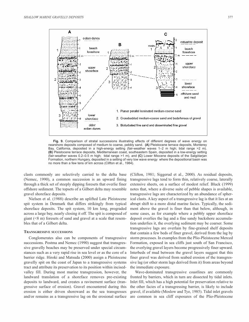
In some cases, climbing translatent stratification (Hunter,1977) produced by migrating gravel ripples may be preserved.A Miocene conglomerate exposed near Nekézseny in northernHungary (described in a following section) contains much low-angle crossbedding in which normally graded gravel layerscompose the foresets. Wave ripples in gravelly sediment typi-cally have the largest pebbles in the troughs, and may have con-centrations of finer material (including sand) in their crests(Inman, 1957; Hart and Plint, 1989). The migration of such rip-ples during active deposition could produce translatent stratacomposed of graded beds (Fig. 8).
Gravel carried to the lower shoreface during storms may ini-tially accumulate in structureless graded beds, such as thoseseen in some arctic areas where the ambient wave energy isextremely low (nearshore waters are frozen over during thewinter and pack ice greatly diminishes wave fetch during thesummer) (Hill et al., 1995; Héquette and Hill, 1995).Subsequent reworking of these deposits in areas of higherambient wave energy can produce a distinctive lower shorefacefacies, 1–3 m thick, that consists of small pebbles of relativelyuniform size in a matrix of well sorted, fine- to very fine-grained sand. The pebbles occur as scattered clasts, in smallclusters, or as thin discontinuous stringers 1–2 pebbles thick.The associated sand may be laminated or structureless, and isindistinguishable from inner shelf sand. The facies results froma combination of offshore transport from the upper shorefaceduring storms and onshore transport of most of this material bythe shoaling waves in the aftermath of a storm. Winnowed bythe waves, the coarser material moves landward more slowlyand some is trapped in burrows, swales, or other depressions onthe sea floor. In a sand-poor setting, the pebbles swept seawardduring storms may be subsequently mixed by bioturbation into
374 H.E. CLIFTON
Fig. 4. Selective shoreward transport of a 2.5 cm pebble under shoaling waves in which the landwardoscillatory flow under the wave crest has a greater velocity than the seaward flow under the trough. Dashedlines indicate threshold velocity, shaded areas indicate intervals of transport (adapted from Komar, 1976).
a muddy substrate, producing a pebbly mudstone (Bergmanand Walker, 1988).
SUCCESSIONS
Shallow marine conglomerates can accumulate under condi-tions of progradation, retrogradation (transgression), andaggradation. A key to their interpretation is the succession inwhich they occur. The following discussion examines thenature of these successions, providing examples and notingissues of gravel supply and segregation for each.
PROGRADING SUCCESSIONS
Progradation of shoreface systems produces distinctive shal-lowing-upward facies successions. Unlike fine sandy nearshoresuccessions, which can differ rather dramatically as a functionof wave energy, many gravelly successions seem remarkablysimilar regardless of the wave regime. Figure 9 compares threestratigraphic successions of gravelly nearshore deposits thataccumulated under strikingly different conditions of waveenergy. One (the California example) accumulated in a settingthat today is characterized by waves 1–2 m high during fairweather and more than 7 m high during storms. Another (fromsoutheastern Spain) accumulated on the Mediterranean coast ina setting that today experiences fair weather waves on the orderof a few decimetres high and storm waves up to 3–4 m. Thethird example (from northern Hungary) accumulated in a verynarrow seaway no more than a few tens of km wide (Clifton etal., 1985), where ambient wave energy must have been loweryet. Despite the differences in wave regime, the successions areremarkably similar in their facies and facies succession, pre-sumably because storm waves shape the coarser sediment ineach case into large bedforms with similar internal structure. Ineach case, the source of the gravel presumably is coastalstreams and it is concentrated into beds by storms or as bar-trough lags. The primary difference is that the high-energyshoreface succession is about twice as thick as the lower energyexamples, owing to the greater depth of wave reworking on thehigh-energy coast.
Low wave energy may be an important factor, however, inshaping one particular type of shallow marine conglomerate.The shoreface is generally presumed to be an equilibrium pro-file for a given set of wave conditions. Where equilibrium is
SHALLOW MARINE GRAVELLY DEPOSITS 375
Fig. 5. Sedimentary structural facies in the unbarred nearshore(upper shoreface) in coarse gravelly sand on a high-energy coast underfair-weather conditions. Gravel is concentrated in area of large ripplesjust seaward of the beach. Width of gravelly zone depends on the relative abundance of sand and gravel.
Fig. 6. Gravelly barred nearshore, southeastern coast of Spain.Gravel is concentrated on the beach foreshore (swash zone) and in thetrough of breaker bar adjacent to the beach.
Fig. 7. Distinction between beach and nearshore gravel (o) and fluvial gravel (+) in Pleistocene terrace deposits in southern Oregon,using measures of pebble segregation and bed lenticularity. Adaptedfrom Clifton (1976).
not achieved, owing either to an inability of the waves to redis-tribute the introduced coarse sediment, insufficient time toreshape the profile as new sediment accumulates, and/or a verysteep offshore gradient, a Gilbert delta, rather than a shoreface,is likely to develop (Corner et al., 1990; Postma, 1990).
Gilbert deltas are characterized by steeply inclined foresetsin tabular sets that can be tens of metres thick (Colella, 1988aand b; Nemec, 1990). Sediment transport down the face of thedelta occurs primarily by mass transport (Postma, 1984;Postma et al., 1988). Many, if not most, Gilbert deltas are con-glomeratic, finer sediment being more easily shaped into ashoreface. But in areas of powerful waves, as along much ofthe U. S. West Coast, even the coarsest gravel can be reworkedinto an equilibrium profile and Gilbert deltas do not develop.
The term “Gilbert delta” is commonly linked with the term“fan delta”, but the two may be unrelated. Fan deltas were ini-tially defined as the shallow marine extension of an alluvial fan
(Holmes, 1965; McGowen, 1970; Nemec and Steel, 1988b),but the term has since been applied in other ways, obscuring itsdefinition (McPherson, 1988). Gilbert deltas are a commoncomponent of fan deltas (Colella, 1988a). They can, however,also form at the mouth of a gravel-bearing braided stream unas-sociated with an alluvial fan (McPherson, 1988), and bothbraidplain deltas and fan deltas may be fronted by a shoreface,rather than a Gilbert delta, if wave energy is sufficiently high(Orton, 1988). Nemec and Steel (1988a) and Colella and Prior(1990) provide an extensive literature on the subject.
Supply typically is not a question for Gilbert deltas otherthan the nature of the alluvial delivery system. The sedimentrequired to produce a Gilbert delta is coarse and typically peb-bly; segregation of gravel occurs in the source area and duringdelivery. Slope failures on Gilbert delta fronts can either segre-gate gravel further (grain flows) or mix it with sandy sediment(slumps and plastic flows) (Nemec, 1990). Because larger
376 H.E. CLIFTON
Fig. 8. A. Nature of graded conglomerate foreset in gently inclined cross-strata in the EgyházasgergeFormation of northern Hungary. B. Possible origin of the inclined graded beds as climbing translatent strataproduced by large, wave-formed gravel ripples. Adapted from Clifton et al. (1985).
clasts commonly are selectively carried to the delta base(Nemec, 1990), a common succession is an upward finingthrough a thick set of steeply dipping foresets that overlie fineroffshore sediment. The topsets of a Gilbert delta may resemblegravel shoreface deposits.
Nielsen et al. (1988) describe an uplifted Late Pleistocenespit system in Denmark that differs strikingly from typicalshoreface deposits. The spit system, 10 km long, progradedacross a large bay, nearly closing it off. The spit is composed ofgiant (<8 m) foresets of sand and gravel at a scale that resem-bles that of a Gilbert delta.
TRANSGRESSIVE SUCCESSIONS
Conglomerates also can be components of transgressivesuccessions. Postma and Nemec (1990) suggest that transgres-sive gravelly beaches may be preserved under special circum-stances such as a very rapid rise in sea level or as the core of abarrier ridge. Hiroki and Matsuda (2000) assign a Pleistocenegravelly spit on the coast of Japan to a transgressive systemstract and attribute its preservation to its position within incised-valley fill. During most marine transgression, however, thelandward translation of a shoreface removes pre-existingdeposits to landward, and creates a ravinement surface (tran-gressive surface of erosion). Gravel encountered during thiserosion is either driven shoreward as the sea transgressesand/or remains as a transgressive lag on the erosional surface
(Clifton, 1981; Siggerud et al., 2000). As residual deposits,transgressive lags tend to form thin, relatively coarse, laterallyextensive sheets, on a surface of modest relief. Bluck (1999)notes that, where a diverse suite of pebble shapes is available,transgressive lags are characterized by an abundance of spher-ical clasts. A key aspect of a transgressive lag is that it lies at anabrupt shift to a more distal marine facies. Typically, the sedi-ment above the gravel is finer than that below, although, insome cases, as for example where a pebbly upper shorefacedeposit overlies the lag and a fine sandy backshore accumula-tion underlies it, the overlying sediment may be coarser. Sometransgressive lags are overlain by fine-grained shelf depositsthat contain a few beds of finer gravel, derived from the lag bystorm processes. In examples from the Plio-Pleistocene MercedFormation, exposed in sea cliffs just south of San Francisco,the overlying gravel layers become progressively finer upward.Interbeds of mud between the gravel layers suggest that thisfiner gravel was derived from seabed erosion of the transgres-sive lag (or other storm lags derived from it) from areas beyondthe immediate exposure.
Wave-dominated transgressive coastlines are commonlyfronted by barriers, which in turn are dissected by tidal inlets.Inlet fill, which has a high potential for preservation relative tothe other facies of a transgressing barrier, is likely to includegravel, if available (Moslow and Tye, 1985). Tidal inlet gravelsare common in sea cliff exposures of the Plio-Pleistocene
SHALLOW MARINE GRAVELLY DEPOSITS 377
Fig. 9. Comparison of stratal successions illustrating effects of different degrees of wave energy onnearshore deposits composed of medium to coarse, pebbly sand. (A) Pleistocene terrace deposits, MontereyBay, California, deposited in a high-energy setting (fair-weather waves 1–2 m high; tidal range >2 m). (B) Pleistocene terrace deposits, Mediterranean coast, southeastern Spain, deposited in a low-energy setting(fair-weather waves 0.2–0.5 m high; tidal range >1 m), and (C) Lower Miocene deposits of the SalgótarjanFormation, northern Hungary, deposited in a setting of very low wave energy where the depositional basin wasno more than a few tens of km across (Clifton et al., 1984).
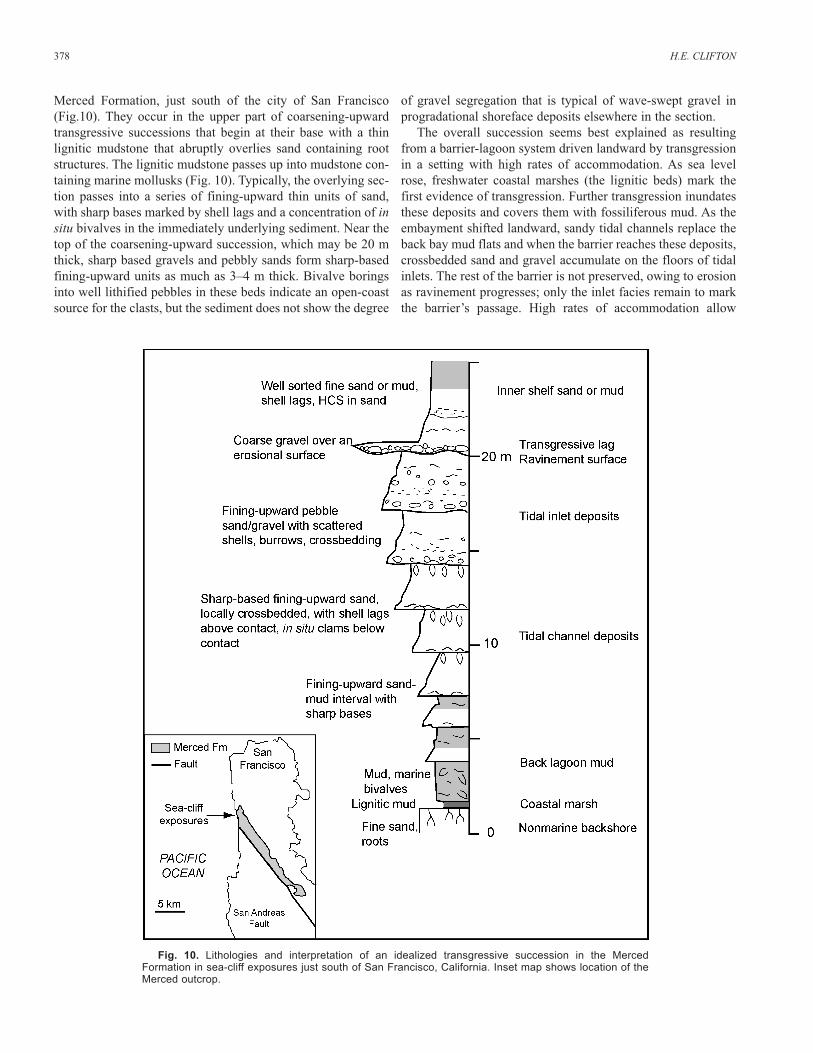
Merced Formation, just south of the city of San Francisco(Fig.10). They occur in the upper part of coarsening-upwardtransgressive successions that begin at their base with a thinlignitic mudstone that abruptly overlies sand containing rootstructures. The lignitic mudstone passes up into mudstone con-taining marine mollusks (Fig. 10). Typically, the overlying sec-tion passes into a series of fining-upward thin units of sand,with sharp bases marked by shell lags and a concentration of insitu bivalves in the immediately underlying sediment. Near thetop of the coarsening-upward succession, which may be 20 mthick, sharp based gravels and pebbly sands form sharp-basedfining-upward units as much as 3–4 m thick. Bivalve boringsinto well lithified pebbles in these beds indicate an open-coastsource for the clasts, but the sediment does not show the degree
of gravel segregation that is typical of wave-swept gravel inprogradational shoreface deposits elsewhere in the section.
The overall succession seems best explained as resultingfrom a barrier-lagoon system driven landward by transgressionin a setting with high rates of accommodation. As sea levelrose, freshwater coastal marshes (the lignitic beds) mark thefirst evidence of transgression. Further transgression inundatesthese deposits and covers them with fossiliferous mud. As theembayment shifted landward, sandy tidal channels replace theback bay mud flats and when the barrier reaches these deposits,crossbedded sand and gravel accumulate on the floors of tidalinlets. The rest of the barrier is not preserved, owing to erosionas ravinement progresses; only the inlet facies remain to markthe barrier’s passage. High rates of accommodation allow
378 H.E. CLIFTON
Fig. 10. Lithologies and interpretation of an idealized transgressive succession in the MercedFormation in sea-cliff exposures just south of San Francisco, California. Inset map shows location of theMerced outcrop.
much of the coarsening-upward lagoonal succession to be pre-served. The inlet deposits, like those described by Moslow andTye (1985), fine upward, but contain more gravel than those onthe East Coast.
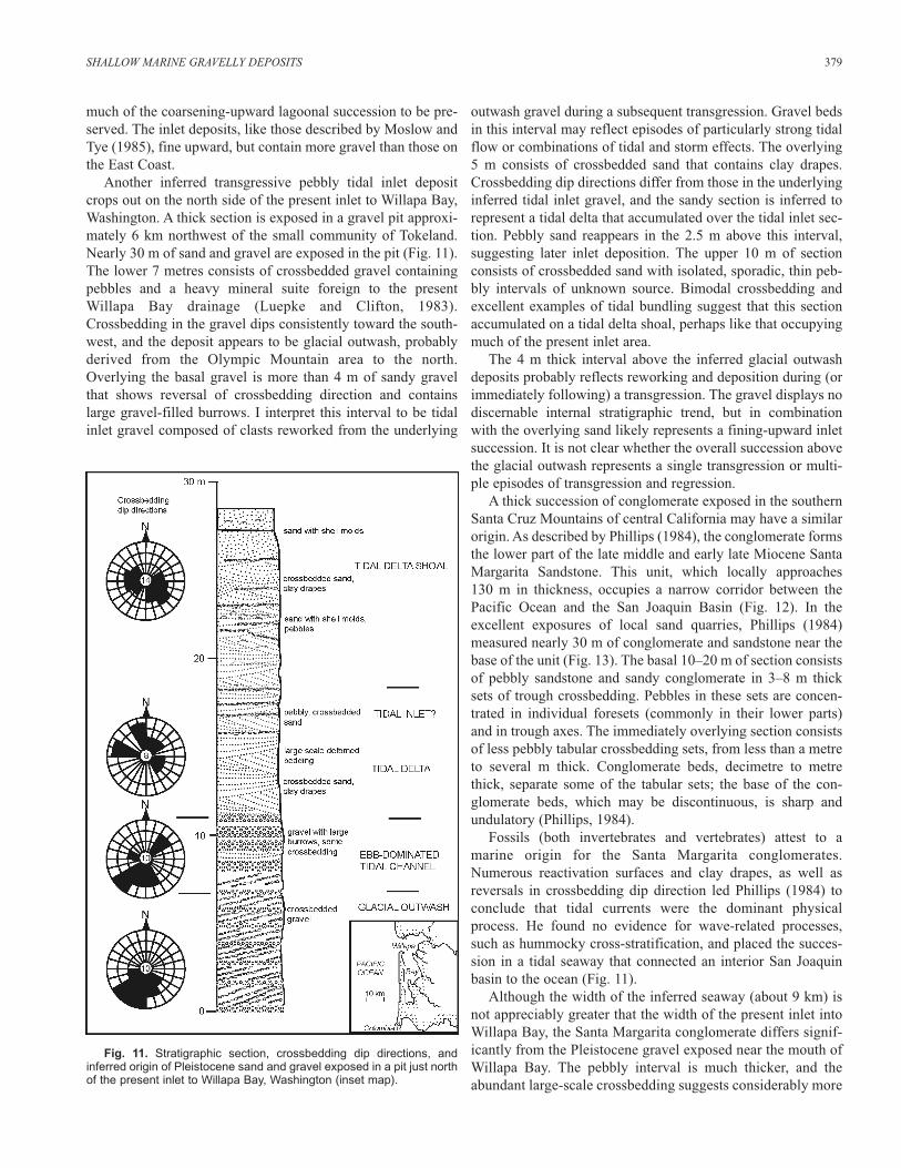
Another inferred transgressive pebbly tidal inlet depositcrops out on the north side of the present inlet to Willapa Bay,Washington. A thick section is exposed in a gravel pit approxi-mately 6 km northwest of the small community of Tokeland.Nearly 30 m of sand and gravel are exposed in the pit (Fig. 11).The lower 7 metres consists of crossbedded gravel containingpebbles and a heavy mineral suite foreign to the presentWillapa Bay drainage (Luepke and Clifton, 1983).Crossbedding in the gravel dips consistently toward the south-west, and the deposit appears to be glacial outwash, probablyderived from the Olympic Mountain area to the north.Overlying the basal gravel is more than 4 m of sandy gravelthat shows reversal of crossbedding direction and containslarge gravel-filled burrows. I interpret this interval to be tidalinlet gravel composed of clasts reworked from the underlying
outwash gravel during a subsequent transgression. Gravel bedsin this interval may reflect episodes of particularly strong tidalflow or combinations of tidal and storm effects. The overlying5 m consists of crossbedded sand that contains clay drapes.Crossbedding dip directions differ from those in the underlyinginferred tidal inlet gravel, and the sandy section is inferred torepresent a tidal delta that accumulated over the tidal inlet sec-tion. Pebbly sand reappears in the 2.5 m above this interval,suggesting later inlet deposition. The upper 10 m of sectionconsists of crossbedded sand with isolated, sporadic, thin peb-bly intervals of unknown source. Bimodal crossbedding andexcellent examples of tidal bundling suggest that this sectionaccumulated on a tidal delta shoal, perhaps like that occupyingmuch of the present inlet area.
The 4 m thick interval above the inferred glacial outwashdeposits probably reflects reworking and deposition during (orimmediately following) a transgression. The gravel displays nodiscernable internal stratigraphic trend, but in combinationwith the overlying sand likely represents a fining-upward inletsuccession. It is not clear whether the overall succession abovethe glacial outwash represents a single transgression or multi-ple episodes of transgression and regression.
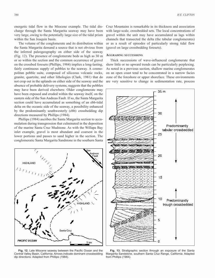
A thick succession of conglomerate exposed in the southernSanta Cruz Mountains of central California may have a similarorigin. As described by Phillips (1984), the conglomerate formsthe lower part of the late middle and early late Miocene SantaMargarita Sandstone. This unit, which locally approaches130 m in thickness, occupies a narrow corridor between thePacific Ocean and the San Joaquin Basin (Fig. 12). In theexcellent exposures of local sand quarries, Phillips (1984)measured nearly 30 m of conglomerate and sandstone near thebase of the unit (Fig. 13). The basal 10–20 m of section consistsof pebbly sandstone and sandy conglomerate in 3–8 m thicksets of trough crossbedding. Pebbles in these sets are concen-trated in individual foresets (commonly in their lower parts)and in trough axes. The immediately overlying section consistsof less pebbly tabular crossbedding sets, from less than a metreto several m thick. Conglomerate beds, decimetre to metrethick, separate some of the tabular sets; the base of the con-glomerate beds, which may be discontinuous, is sharp andundulatory (Phillips, 1984).
Fossils (both invertebrates and vertebrates) attest to amarine origin for the Santa Margarita conglomerates.Numerous reactivation surfaces and clay drapes, as well asreversals in crossbedding dip direction led Phillips (1984) toconclude that tidal currents were the dominant physicalprocess. He found no evidence for wave-related processes,such as hummocky cross-stratification, and placed the succes-sion in a tidal seaway that connected an interior San Joaquinbasin to the ocean (Fig. 11).
Although the width of the inferred seaway (about 9 km) isnot appreciably greater that the width of the present inlet intoWillapa Bay, the Santa Margarita conglomerate differs signif-icantly from the Pleistocene gravel exposed near the mouth ofWillapa Bay. The pebbly interval is much thicker, and theabundant large-scale crossbedding suggests considerably more
SHALLOW MARINE GRAVELLY DEPOSITS 379
Fig. 11. Stratigraphic section, crossbedding dip directions, andinferred origin of Pleistocene sand and gravel exposed in a pit just northof the present inlet to Willapa Bay, Washington (inset map).
energetic tidal flow in the Miocene example. The tidal dis-charge through the Santa Margarita seaway may have beenvery large, owing to the potentially large size of the tidal prismwithin the San Joaquin basin.
The volume of the conglomerate and its distribution withinthe Santa Margarita demand a source that is not obvious fromthe inferred paleogeography on either side of the seaway(Fig. 12). The presence of conglomerate beds as high as 30 mor so within the section and the common occurrence of gravelon the crossbed foresets (Phillips, 1984) implies a long-lasting,fairly continuous supply of pebbles to the seaway. A cosmo-politan pebble suite, composed of siliceous volcanic rocks,granite, quartzite, and other lithologies (Clark, 1981) that donot crop out in the uplands on either side of the seaway and theabsence of probable delivery systems, suggests that the pebblesmay have been derived elsewhere. Older conglomerate mayhave been exposed and eroded within the seaway itself, on theeastern side of the San Andreas Fault. If so, the Santa Margaritasection could have accumulated as something of an ebb-tidaldelta on the oceanic side of the seaway, a possibility enhancedby the predominantly southwesterly (ebb) crossbedding dipdirections measured by Phillips (1984).
Phillips (1984) ascribes the Santa Margarita section to accu-mulation during transgression that culminated in the depositionof the marine Santa Cruz Mudstone. As with the Willapa Bayinlet example, gravel is most abundant and coarsest in thelower portions and passes to sand higher in the section. Theconglomeratic Santa Margarita Sandstone in the southern Santa
Cruz Mountains is remarkable in its thickness and associationwith large-scale, crossbedded sets. The local concentrations ofgravel within the unit may have accumulated as lags withinchannels that transected the delta (the tabular conglomerates)or as a result of episodes of particularly strong tidal flow(gravel on large crossbedding foresets).
AGGRADING SUCCESSIONS
Thick successions of wave-influenced conglomerate thatshow little or no upward trends can be particularly perplexing.As noted in a previous section, shallow marine conglomerateson an open coast tend to be concentrated in a narrow facieszone of the foreshore or upper shoreface. These environmentsare very sensitive to change in sedimentation rate, process
380 H.E. CLIFTON
Fig. 13. Stratigraphic section through an exposure of the SantaMargarita Sandstone, southern Santa Cruz Range, California. Adaptedfrom Phillips (1984).
Fig. 12. Late Miocene seaway between the Pacific Ocean and theCentral Valley Basin, California. Arrows indicate dominant crossbeddingdip directions. Adapted from Phillips (1984).
dynamics, or relative sea-level change; they tend to be either ina progradational mode or a state of marine transgression. Thicksuccessions that show neither of these over intervals of10–15 m or more require a persistent balance of factors that israre, if not impossible.
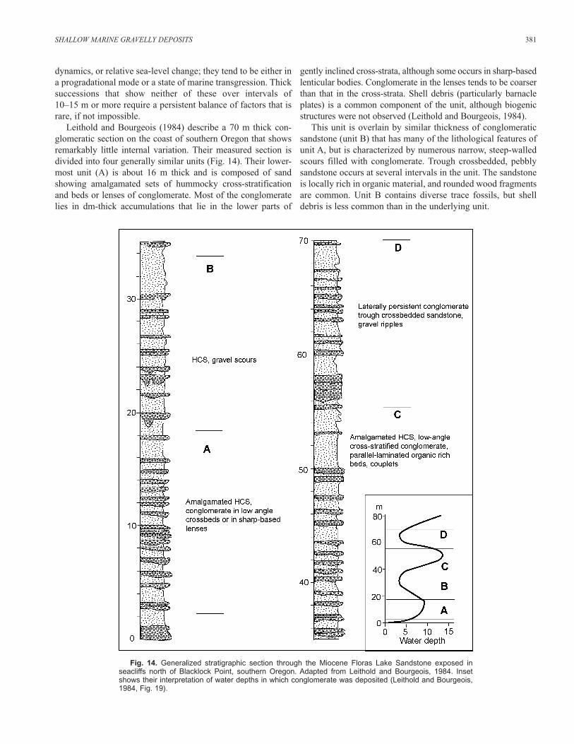
Leithold and Bourgeois (1984) describe a 70 m thick con-glomeratic section on the coast of southern Oregon that showsremarkably little internal variation. Their measured section isdivided into four generally similar units (Fig. 14). Their lower-most unit (A) is about 16 m thick and is composed of sandshowing amalgamated sets of hummocky cross-stratificationand beds or lenses of conglomerate. Most of the conglomeratelies in dm-thick accumulations that lie in the lower parts of
gently inclined cross-strata, although some occurs in sharp-basedlenticular bodies. Conglomerate in the lenses tends to be coarserthan that in the cross-strata. Shell debris (particularly barnacleplates) is a common component of the unit, although biogenicstructures were not observed (Leithold and Bourgeois, 1984).
This unit is overlain by similar thickness of conglomeraticsandstone (unit B) that has many of the lithological features ofunit A, but is characterized by numerous narrow, steep-walledscours filled with conglomerate. Trough crossbedded, pebblysandstone occurs at several intervals in the unit. The sandstoneis locally rich in organic material, and rounded wood fragmentsare common. Unit B contains diverse trace fossils, but shelldebris is less common than in the underlying unit.
SHALLOW MARINE GRAVELLY DEPOSITS 381
Fig. 14. Generalized stratigraphic section through the Miocene Floras Lake Sandstone exposed in seacliffs north of Blacklock Point, southern Oregon. Adapted from Leithold and Bourgeois, 1984. Insetshows their interpretation of water depths in which conglomerate was deposited (Leithold and Bourgeois,1984, Fig. 19).
Unit C is about 21 m thick and differs only from the under-lying section by containing distinctive parallel lamina rich inorganic material. Many of these are repeated rhythmically, andsome display well defined couplets. Trace fossils are relativelyrare and shell debris is not a significant component.
Laterally extensive tabular conglomerates and organic-richparallel laminated and planar crossbedded sandstone character-ize the 15 m thick Unit D. The outline of large symmetricalgravel ripples occurs at the top of a few conglomerate beds.Leithold and Bourgeois (1984) do not mention hummockycross-stratification in this unit, but note that possible tidal bun-dles occur in some of the trough crossbeds. The unit also showsreversals in crossbedding, and trace fossils are abundant.
Leithold and Bourgeois (1984, figure 19) attribute the entiresection to shoreface deposition at water depths not muchgreater than 10 m (Fig. 14). They call on fluvial processes tosupply the gravel and organic detritus, and note that tidal influ-ences may have been present. Their inference that waves pro-foundly influenced deposition throughout most, if not all, of theaccumulation is supported by the abundance of hummockycross-stratification throughout the three lower units and largesymmetric gravel ripples in the upper unit. Rasmussen (2000)attributes a generally similar assemblage of Eocene gravel andsand in the Ebro Basin of Spain to mouth bar systems at thefront of a large river. Many of the features Leithold andBourgeois (1984) describe, such as the trough crossbedding intheir upper unit, characterize upper shoreface deposits. Thesteep-walled, gravel-filled scours in Unit B closely resemblecross-sections of gravel-filled gutter casts described from anupper shoreface setting by Chiocci and Clifton (1991).Nonetheless, an interpretation that the whole interval accumu-lated in water depths of 10 m or less requires a near-balance ofsedimentation and accommodation that is rarely seen over sucha thick interval.
Other possible explanations exist. Leithold and Bourgeois(1984) postulate fluctuations of sea level during deposition(Fig. 14), at intervals of 5–20 m within the section. The suc-cession could be an amalgamation of prograding shorefacedeposits that are truncated by numerous cryptic ravinement sur-faces. The modest variation among the units at scales of15–20 m, however, seems inconsistent with this possibility.
Alternatively, the section might have accumulated in deeperwater, away from a shoreface. Surveys of the present inner shelfnear the Flores Lake Sandstone outcrop show extensive (>1 km)patches of gravel exposed on the seafloor at depths of 20–30 m(Joint State-Federal Oregon Placer Marine Minerals Task Force,1991). Large storm waves conceivably could shape this materialinto deposits resembling those in the Flores Lake. The offshoregravel, however, may be but a veneer at the surface, a reworkedremnant of a transgressive lag. Barnacles and other marinegrowth covered only one side of pebbles recovered during thesurvey, suggesting that storm reworking was very rare.Moreover, it would be difficult to supply an inner shelf withenough gravel to produce an inner accumulation 70 m thick.
Perhaps the most reasonable alternative explanation is thatthe Flores Lake conglomerate accumulated in shallow water at
the mouth of a large high-gradient river. Such an interpretationis consistent with the observations and conclusions of Leitholdand Bourgeois (1984) in terms of supply of gravel and organicdebris and the presence of tidal influences. The absence of rec-ognizable ravinement surfaces in the section could beexplained by an absence of shoreface development in the rivermouth. A general balance between sediment and relative sea-level rise is still required, but need not be so delicate as thatrequired by a shoreface interpretation.
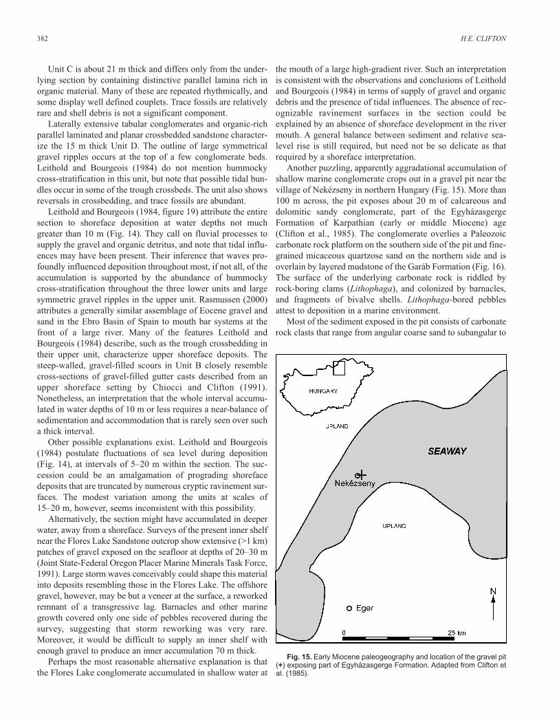
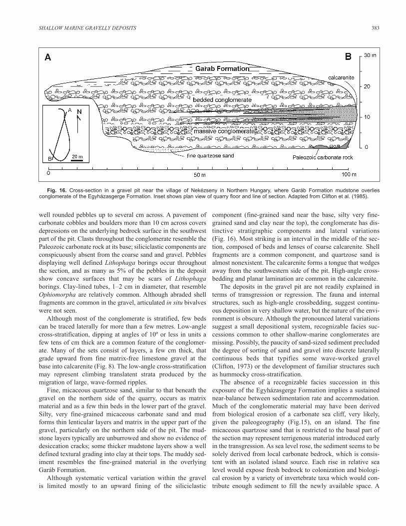
Another puzzling, apparently aggradational accumulation ofshallow marine conglomerate crops out in a gravel pit near thevillage of Nekézseny in northern Hungary (Fig. 15). More than100 m across, the pit exposes about 20 m of calcareous anddolomitic sandy conglomerate, part of the EgyházasgergeFormation of Karpathian (early or middle Miocene) age(Clifton et al., 1985). The conglomerate overlies a Paleozoiccarbonate rock platform on the southern side of the pit and fine-grained micaceous quartzose sand on the northern side and isoverlain by layered mudstone of the Garáb Formation (Fig. 16).The surface of the underlying carbonate rock is riddled byrock-boring clams (Lithophaga), and colonized by barnacles,and fragments of bivalve shells. Lithophaga-bored pebblesattest to deposition in a marine environment.
Most of the sediment exposed in the pit consists of carbonaterock clasts that range from angular coarse sand to subangular to
382 H.E. CLIFTON
Fig. 15. Early Miocene paleogeography and location of the gravel pit(+) exposing part of Egyházasgerge Formation. Adapted from Clifton etal. (1985).
well rounded pebbles up to several cm across. A pavement ofcarbonate cobbles and boulders more than 10 cm across coversdepressions on the underlying bedrock surface in the southwestpart of the pit. Clasts throughout the conglomerate resemble thePaleozoic carbonate rock at its base; siliciclastic components areconspicuously absent from the coarse sand and gravel. Pebblesdisplaying well defined Lithophaga borings occur throughoutthe section, and as many as 5% of the pebbles in the depositshow concave surfaces that may be scars of Lithophagaborings. Clay-lined tubes, 1–2 cm in diameter, that resembleOphiomorpha are relatively common. Although abraded shellfragments are common in the gravel, articulated in situ bivalveswere not seen.
Although most of the conglomerate is stratified, few bedscan be traced laterally for more than a few metres. Low-anglecross-stratification, dipping at angles of 10º or less in units afew tens of cm thick are a common feature of the conglomer-ate. Many of the sets consist of layers, a few cm thick, thatgrade upward from fine matrix-free limestone gravel at thebase into calcarenite (Fig. 8). The low-angle cross-stratificationmay represent climbing translatent strata produced by themigration of large, wave-formed ripples.
Fine, micaceous quartzose sand, similar to that beneath thegravel on the northern side of the quarry, occurs as matrixmaterial and as a few thin beds in the lower part of the gravel.Silty, very fine-grained micaceous carbonate sand and mudforms thin lenticular layers and matrix in the upper part of thegravel, particularly on the northern side of the pit. The mud-stone layers typically are unburrowed and show no evidence ofdesiccation cracks; some thicker mudstone layers show a welldefined textural grading into clay at their tops. The muddy sed-iment resembles the fine-grained material in the overlyingGaráb Formation.
Although systematic vertical variation within the gravel is limited mostly to an upward fining of the siliciclastic
component (fine-grained sand near the base, silty very fine-grained sand and clay near the top), the conglomerate has dis-tinctive stratigraphic components and lateral variations(Fig. 16). Most striking is an interval in the middle of the sec-tion, composed of beds and lenses of coarse calcarenite. Shellfragments are a common component, and quartzose sand isalmost nonexistent. The calcarenite forms a tongue that wedgesaway from the southwestern side of the pit. High-angle cross-bedding and planar lamination are common in the calcarenite.
The deposits in the gravel pit are not readily explained interms of transgression or regression. The fauna and internalstructures, such as high-angle crossbedding, suggest continu-ous deposition in very shallow water, but the nature of the envi-ronment is obscure. Although the pronounced lateral variationssuggest a small depositional system, recognizable facies suc-cessions common to other shallow-marine conglomerates aremissing. Possibly, the paucity of sand-sized sediment precludedthe degree of sorting of sand and gravel into discrete laterallycontinuous beds that typifies some wave-worked gravel(Clifton, 1973) or the development of familiar structures suchas hummocky cross-stratification.
The absence of a recognizable facies succession in thisexposure of the Egyházasgerge Formation implies a sustainednear-balance between sedimentation rate and accommodation.Much of the conglomeratic material may have been derivedfrom biological erosion of a carbonate sea cliff, very likely,given the paleogeography (Fig.15), on an island. The finemicaceous quartzose sand that is restricted to the basal part ofthe section may represent terrigenous material introduced earlyin the transgression. As sea level rose, the sediment seems to besolely derived from local carbonate bedrock, which is consis-tent with an isolated island source. Each rise in relative sealevel would expose fresh bedrock to colonization and biologi-cal erosion by a variety of invertebrate taxa which would con-tribute enough sediment to fill the newly available space. A
SHALLOW MARINE GRAVELLY DEPOSITS 383
Fig. 16. Cross-section in a gravel pit near the village of Nekézseny in Northern Hungary, where Garáb Formation mudstone overlies conglomerate of the Egyházasgerge Formation. Inset shows plan view of quarry floor and line of section. Adapted from Clifton et al. (1985).
possible still-stand or even fall in sea level may be representedby an interval 5–8 m above quarry floor, which shows very lit-tle internal structure (Fig. 16). Fresh exposures display tubularburrows and it is likely that the structureless aspect of this partof the section results from intense bioturbation related toreduced sediment input. A laterally persistent layer of scatteredcoarse (5–8 cm) rounded carbonate rock clasts in the middle ofthe interval may represent a lag formed during a period of non-deposition. At the top of the Egyházasgerge Formation, thetransition to the overlying muddy Garáb Formation can beexplained by continued sea level rise that inundated the islandthat supplied the carbonate rock detritus.
INTERPRETIVE VALUE OF SHALLOW
MARINE CONGLOMERATES
Because shallow marine conglomerates require special con-ditions of sourcing and segregation, their presence in a strati-graphic section warrants close scrutiny. Correctly interpreted,they can provide valuable information on provenance, sourcingprocesses, paleogeography, tectonic history, or relative sea-level change. The shallow marine conglomerates described inthis paper provide examples of this interpretive value.
The transgressive tidal inlet deposits at the mouth of WillapaBay are derived from reworked glacial outwash. Documentingthe extension of glacial processes to this location implies thatthis influence may be expected in other Pleistocene terracedeposits around Willapa Bay. The conglomerate further atteststo a sea-level rise following glacial outwash deposition, consis-tent with the pattern of Pleistocene glacio-eustatic fluctuations.
The Santa Margarita gravels in the Santa Cruz, Californiaarea, accumulated in a seaway that extended across the trace ofthe San Andreas Fault. The source for the gravel is unknown,but a likely possibility is from the erosion of conglomerateexposed within the seaway on the eastern side of the SanAndreas Fault. Thick successions of Cretaceous conglomeratelie across the fault 30 km or so to the south. Documenting thatthese or other conglomerates supplied the seaway could estab-lish the amount of offset on the fault since the late Miocene.
The Flores Lake conglomerates attest to the influence orstorm waves in a setting that seems to be unusual in the absenceof well defined shoreface development. If they accumulated, asseems likely, near the mouth of a large river, they provide infor-mation on the Miocene paleogeography of southern Oregon.
The carbonate clast conglomerate of the EgyházasgergeFormation in northern Hungary provides evidence of paleo-geography in that it seems to be derived from an island seacliff. It also carries information regarding relative sea-levelchange in this area during the early or middle Miocene. Lateralchanges within the conglomerate over a distance of a hundredmetres or so suggest that it is a very local feature.
A final example of the interpretive significance of shallowmarine conglomerate is drawn from the Merced Formation,which consists of more than 1750 m of Plio-Pleistocene shal-low marine and nonmarine sediment that is exposed in contin-uous section in the sea cliffs south of San Francisco, California
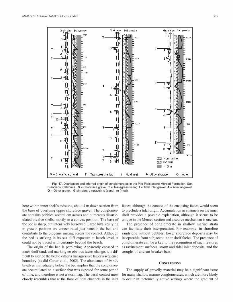
(Fig. 9). While measuring the lower 1500 m of this section, Ibecame aware that conglomerates held the key to interpretingthe facies successions and patterns of transgression and regres-sion. Three different types of conglomerate occur repetitiouslyin the succession (Fig. 17).
Shoreface conglomerates occur in the upper parts of overallcoarsening-upward successions. Typically, 2–8 m of well bed-ded inter-stratified conglomerate and medium- to coarse-grained sandstone of the upper shoreface overlie an 1–3 minterval of fine sand containing scattered small pebbles andgranules of the lower shoreface. These latter deposits rangefrom structureless to displaying wavy- to planar-parallel lami-nation. Only the presence of small pebbles or granules distin-guish this interval from inner shelf sandstone further downsection. Gravel in the upper shoreface deposits is mostly wellsorted into discrete layers that separate beds lenses of crossbed-ded to parallel-laminated sandstone. Most of the gravel concen-trations can be attributed to accumulation in the troughs of barsystems. A few successions contain gravel in the lower part ofthe overlying beach foreshore deposits, marked by nearly hori-zontal planar beds at the base of a 1–3 m planar-laminated fin-ing-upward interval. On a somewhat broader scale, shorefaceconglomerates in the Merced Formation separate intervals offine sand that may be several tens of m thick. The underlyingsand contains marine fossils or trace fossils and, locally, hum-mocky cross-stratification (shelf sand). The overlying sand con-tains root structures, beds of lignitic sand, and, locally, otherevidence of subaerial exposure such as vertebrate footprints orclimbing adhesion ripple structure (backshore sand).
Tidal inlet gravels, which were described in a foregoing section, lie in the central part of many transgressive intervals. Ona broad scale, they separate an underlying heterolithic intervalwith abundant mollusk remains and numerous burrows (trans-gressive lagoonal deposits) from an overlying fining-upwardsuccession that typically begins at the base with fine-grainedsand with storm shell lags, HCS and passes upward into fossilif-erous bioturbated siltstone (transgressive shelf succession).
Transgressive lags generated by wave action were alsodescribed in a previous section. They may occur at the top ofinlet conglomerate, above sandy backshore deposits, or at thetop of shoreface conglomerate. Typically not more than a fewpebbles thick, some transgressive lags consist of scattered iso-lated pebbles or shells along laterally extensive surface ofabrupt lithological change. In every case, they mark an abruptupward deepening of facies.
These three types of gravel dominate the Merced exposure;of the 58 conglomerate beds or intervals in the 1750 m thicksection, 53 are either shoreface deposits (24), transgressive lags(21) or inlet deposits (8) (Fig. 17). A few alluvial gravels existin the upper, mostly nonmarine part of the Merced. Composedof subangular to subrounded pebbles, these gravels occur inlow spots on erosional surfaces of marked relief at the base ofa tidal deposit (perhaps the basal part of an incised-valley fill).
Only one marine conglomerate, at about 360 m in the sec-tion (Fig. 17), seemed to fit into none of the foregoing cate-gories. An isolated conglomeratic bed, 10–50 cm thick, lies
384 H.E. CLIFTON
here within inner shelf sandstone, about 4 m down section fromthe base of overlying upper shoreface gravel. The conglomer-ate contains pebbles several cm across and numerous disartic-ulated bivalve shells, mostly in a convex position. The base ofthe bed is sharp, but intensively burrowed. Large bivalves lyingin growth position are concentrated just beneath the bed andcontribute to the biogenic mixing across the contact. Althoughthe bed is striking in its sea cliff exposure at beach level, itcould not be traced with certainty beyond the beach.
The origin of the bed is perplexing. Apparently encased ininner shelf sand, and marking no obvious facies change, it is dif-ficult to ascribe the bed to either a transgressive lag or a sequenceboundary (as did Carter et al., 2002). The abundance of in situbivalves immediately below the bed implies that the conglomer-ate accumulated on a surface that was exposed for some periodof time, and therefore is not a storm lag. The basal contact mostclosely resembles that at the floor of tidal channels in the inlet
facies, although the context of the enclosing facies would seemto preclude a tidal origin. Accumulation in channels on the innershelf provides a possible explanation, although it seems to beunique in the Merced section and a source mechanism is unclear.
The presence of conglomerate in shallow marine strata can facilitate their interpretation. For example, in shorelinesandstone without pebbles, lower shoreface deposits may beinseparable from subjacent inner shelf facies. The presence ofconglomerate can be a key to the recognition of such featuresas ravinement surfaces, storm and tidal inlet deposits, and thetroughs of ancient breaker bars.
CONCLUSIONS
The supply of gravelly material may be a significant issuefor many shallow marine conglomerates, which are more likelyto occur in tectonically active settings where the gradient of
SHALLOW MARINE GRAVELLY DEPOSITS 385
Fig. 17. Distribution and inferred origin of conglomerates in the Plio-Pleistocene Merced Formation, SanFrancisco, California. S = Shoreface gravel, T = Transgressive lag, I = Tidal inlet gravel, A = Alluvial gravel,O = Other gravel. Grain size: g (gravel), s (sand), m (mud).
coastal streams is steep and tectonic processes can make coarseclasts available. Although some shallow marine conglomeratesare clearly linked to the mouths of streams or other sources, thesource for many others is less certain. In some cases, the sup-ply system may be obscured by the sporadic exposure of thedeposits of small coastal streams. Research is needed on theextent of longshore transport under different conditions ofwave energy, after gravel reaches the marine environment. Seacliffs may be a significant source of gravel on erosional coastsbut is not likely to be important on a prograding coast. The erosion of underlying sediment can be a primary source ofgravel in transgressive settings or during a sea-level fall wherefluvial incision occurs. Understanding the mechanisms ofgravel supply may be a key to delineating the distribution ofshallow marine conglomerates (Leckie, 1986).
Segregation of gravel and sand in the shallow marine envi-ronment can critically influence a deposit’s reservoir character.Segregation may occur during the supply process, or result fromprocesses (primarily waves) once gravel has been introduced.The asymmetry of shoaling waves creates bottom flow that tendsto drive gravel shoreward, where it accumulates on or nearbeaches. Gravel beaches are particularly likely to develop wheresand is in relatively short supply. On the upper shoreface, gravelmay selectively accumulate on the floors of breaker bar troughsor in winnowed lags generated by storm waves. Waves tend toshape a gravel bed into large, two-dimensional (straight-crested)ripples, which, through a combination of increased turbulenceand superimposed currents, can purge sand from the bed.Isolated patches of gravel on the inner shelf on many coaststoday probably are palimpsest remains of transgressive gravelmaintained by this process. Gravel may also be segregated fromsand by mass flow processes on the steep fronts of Gilbert deltas.
The succession of depositional facies is a key indicator ofthe depositional setting for many shallow marine conglomer-ates, and whether they accumulated under conditions ofprogradation, transgression, or aggradation. Prograding con-glomeratic shorefaces have a distinctive upward trend, fromisolated or scattered small pebbles in a fine sandy matrix(lower shoreface) through coarser conglomerate in beds andlenses, separated in most successions by crossbedded sand-stone, (upper shoreface) to a fining-upward interval of planar-bedded conglomerate and sandstone (beach foreshore). Thissuccession seems to develop on many coasts regardless ofambient wave energy, as long as storm waves are large enoughto produce an equilibrium profile in the nearshore area. Wherethey are not, the shoreline is likely to take the form of a Gilbertdelta, in which sediment gravity flows carry sand and graveldown steep slopes into adjacent deeper water.
In transgressive successions, conglomerate forms relativelythin, but extensive lags atop transgressive surfaces of erosion(ravinement surfaces). It can also accumulate in tidal inletswhere pebbles are either carried in by the tide from adjacentsurf zones or from the reworking of older deposits exposed inthe inlet. Inlet conglomerate differs from shoreface conglomer-ate by being less well sorted into discrete beds, occurring in fin-ing-upward intervals, and, if the tidal flow is sufficiently
strong, being incorporated into the foresets of much larger bed-forms than are likely to occur in the surf zone.
Conglomerates in aggradational shallow marine depositspose particular interpretive problems. They suggest a balanceof sedimentation and accommodation that is rare, if not impos-sible. Examples may require a specialized setting, such as nearthe mouth of a large stream, or close proximity to a sea cliff.
Shallow marine conglomerates are important, not only intheir economic significance as a reservoir rock, but also guidesto geological interpretation. They require a supply of coarseclasts and mechanisms for concentrating them. Commonly, theoccurrence of conglomerate relates to shoreline migration inresponse to changes in relative sea level and sedimentationrate. Because of these factors, this type of sediment can be veryuseful in deciphering an ancient succession. In core or outcrop,the presence of pebbles in a shallow marine deposit warrantsparticular notice and consideration.
ACKNOWLEDGMENTS
This paper profited substantially from review by Ron Steel,John-Paul Zonneveld, and Federico Krause. Any shortcomingsthat remain, however, are solely the responsibility of the author.
REFERENCES
Arnott, R.W.C. 1991. The Carrot Creek "K" pool, Cardium Formation, Alberta;a conglomeratic reservoir related to a wave-reworked distributary mouth-bar complex. Bulletin of Canadian Petroleum Geology, v. 39, p. 43-53.
Bergman, K.M. and Walker, R.G. 1988. Formation of Cardium erosion surfacesE5, and associated deposition of conglomerate; Carrot Creek Field,Cretaceous Western Interior Seaway, Alberta. In: Sequences, stratigraphy,sedimentology; surface and subsurface. D.P. James and D.A. Leckie (eds.).Canadian Society of Petroleum Geologists, Memoir 15, p. 15-24.
Bluck, B.J. 1967. Sedimentation of beach gravels: examples from South Wales.Journal of Sedimentary Petrology, v. 37, p. 128-166.
______ 1999. Clast assembling, bed-forms and structure in gravel beaches.Transactions of the Royal Society of Edinburgh: Earth Sciences, v. 89, p. 292-323.
Bourgeois, J. and Leithold, E.L. 1984. Wave-worked conglomerates - deposi-tional processes and criteria for recognition. In: Sedimentology of gravelsand conglomerates. E. H. Koster, and R. J. Steel (eds.). Canadian Societyof Petroleum Geologists Memoir, v. 10, p. 331-343.
Cacchione, D.A., Drake, D.E., Grant, W.D. and Tate, G.B. 1984. Rippled scourdepressions on the inner continental shelf off central California. Journal ofSedimentary Petrology, v. 54, p. 1280-1291.
Caddel, E.M. and Moslow, T.F. 2004. Outcrop sedimentology and stratal archi-tecture of the Lower Albian Falher C sub-Member, Spirit River Formation,Bullmoose Mountain, northeastern British Columbia. In: MarineCongomerate Reservoirs: Cretaceous of Western Canada and ModernAnalogues, Part 2. T.F. Moslow and J.-P. Zonneveld (eds). Bulletin ofCanadian Petroleum Geology, v. 52, no. 1.
Cant, D.J. and Ethier, V.G. 1984. Lithology-dependant diagenetic control ofreservoir properties of conglomerates, Falher Member, Elmworth Field,Alberta. American Association of Petroleum Geologists Bulletin 68, p. 1044-1054.
______ and Leckie, D. 1984. Regional sedimentology and economic geologyof a Lower Cretaceous clastic wedge (Spirit River, Moosebar-Gates inAlberta and British Columbia). In: The Mesozoic of middle North America.D.F. Stott and D.J. Glass. (eds.). Canadian Society of Petroleum Geologists,Memoir 9, p. 552.
386 H.E. CLIFTON
Carter, R.M., Abbott, S.T., Graham, I.J., Naish, T.R. and Gammon, P.R. 2002.Middle Pleistocene Merced-2 and -3 sequences from Ocean Beach, SanFrancisco. Sedimentary Geology, v. 153, p. 23-41.
Chiocci, F.C. and Clifton, H.E. 1991. Gravel-filled gutter casts in nearshorefacies - indicators of ancient shoreline trend. In: From Shoreline to Abyss,contributions in marine geology in honor of Francis Parker Shepard. R.H.Osborne (ed.). SEPM (Society for Sedimentary Geology) SpecialPublication 46, p. 67-76.
Clark, J.C. 1981. Stratigraphy, paleontology, and geology of the central SantaCruz Ranges. U.S. Geological Survey Professional Paper 1168, 51 p.
Clifton, H.E. 1973. Pebble segregation and bed lenticularity in wave-workedversus alluvial gravel. Sedimentology, v. 20, p. 173-187.
______ 1976. Wave-formed sedimentary structures - a conceptual model. In:Beach and nearshore processes. R.A. Davis and, R.L. Ethington (eds.).Society of Economic Paleontologists and Mineralogists, SpecialPublication 24, p. 126-148.
______ 1981. Progradational sequences in Miocene shoreline deposits, south-eastern Caliente Range, California. Journal of Sedimentary Petrology, v. 51, p. 185-184.
______, Bohn-Havas, M. and Muller, P. 1985. Contrasting types of nearshoresands and gravels from semi-protected Miocene coasts, northern Hungary.Eötvös Lorand Geophysical Institute of Hungary, GeophysicalTransactions, v. 31, p 101-129.
Colella, A. 1988a. Gilbert-type fan deltas in the Crati Basin (Pliocene-Holocene, southern Italy). In: Excursion Guidebook, InternationalWorkshop on Fan Deltas, Calabria, Italy. A. Colella (ed.). p. 19-77.
______ 1988b. Pliocene-Holocene fan deltas and braid deltas in the CratiBasin, southern Italy: a consequence of varying tectonic conditions. In: Fandeltas. W. Nemec and R.J. Steel (eds.). Blackie and Son Ltd., London, p. 50-74.
______ and Prior, D. B. 1990. Coarse-grained deltas. International Associationof Sedimentologists, Special Publication 10, 357 p.
Corner, G.D., Nordahl, E., Munch-Ellingsen, K. and Robertsen, K.R. 1990.Morphology and sedimentology of an emergent fjord-head Gilbert-typeDelta: Alta delta, Norway. In: Coarse-grained deltas. A. Colella and D.B.Prior (eds.). International Association of Sedimentologists, SpecialPublication 10, p. 155-168.
Hart, B.S. and Plint, A.G. 1989. Gravelly shoreface deposits: a comparison ofmodern and ancient facies sequences. Sedimentology, v. 36, p. 551-557.
______ and ______ 1995. Gravelly shoreface and beach deposits. In:Sedimentary facies analysis, a tribute to the research and teaching ofHarold G. Reading. A.G. Plint (ed.). International Association ofSedimentology, Special Publication 22, p. 75-99.
Hill, P.R., Barnes, P.W., Héquette, A. and Ruz, M-H. 1995. Arctic coastal plainshorelines. In: Coastal evolution: late Quaternary shoreline morphodynam-ics. R.W.G. Carter and C.D. Woodroffe (eds.). Cambridge University Press,p. 341-372.
Hiroki, Y. and Matsuda, F. 2000. Gravelly spit deposits in a transgressive sys-tems tract: the Pleistocene Higashikanbe Gravel, central Japan.Sedimentology, v. 47, p. 135-149.
Héquette, A. and Hill, P.R. 1995. Response of the seabed to storm-generatedflows on a sandy arctic shoreface, Canadian Beaufort Sea. Journal ofSedimentary Research, v. A65, p. 461-471.
Holmes, A. 1965. Principles of physical geology, 2nd edition. The RolandPress Company, New York. 1288 p.
Hunter, R.E. 1977. Basic types of stratification in small eolian dunes.Sedimentology, v. 24, p. 361-387.
______ 1980. Depositional environments in some Pleistocene coastal terracedeposits, southwestern Oregon—case history of a progradational beach anddune sequence. Sedimentary Geology, v. 27, p. 241-262.
______, Clifton, H.E. and Phillips, R.L. 1979. Depositional structures andprocesses in oblique bar-rip channel systems, southwestern Oregon.Journal of Sedimentary Petrology, v. 49, p. 711-726.
Inman, D.L. 1957. Wave-generated ripples in nearshore sands. U.S. Army Corpsof Engineers, Beach Erosion Board Technical Memorandum 100, 66 p.
Joint State-Federal Oregon Placer Marine Minerals Task Force. 1991.Preliminary resource and environmental data: Oregon marine placer
minerals. State of Oregon department of Geology and Mineral IndustriesOpen File Report 0-91-02, 231 p.
Kirk, R.M. 1980. Mixed sand and gravel beaches: morphology, processes andSediments. Progress in Physical Geography, v. 4, p.189-210.
Komar, P.D. 1976. The transport of cohesionless sediments on continentalshelves. In: Marine sediment transport and environmental management. D.J.Stanley, and D.J.P. Swift (eds.). John Wiley & Sons, New York, p. 107-125.
______ and Miller, M.C. 1973. The threshold of movement under oscillatorywater waves. Journal of Sedimentary Petrology, v. 43, p. 1101-1110.
Leckie, D.A. 1986. Rates, controls, and sand-body geometries of transgressive-regressive cycles; Cretaceous Moosebar and Gates formations, BritishColumbia. American Association of Petroleum Geologists Bulletin, v. 70,p. 516-535.
______ 1988. Wave-formed, coarse-grained ripples and their relationship tohummocky cross-stratification. Journal of Sedimentary Petrology, v. 58, p. 607-622.
Leithold, E.L. and Bourgeois, J. 1984. Characteristics of coarse-grainedsequences deposited in nearshore, wave-dominated environments—examples from the Miocene of south-west Oregon. Sedimentology, v. 31, p. 749-775.
Luepke, G. and Clifton, H.E. 1983. Heavy-mineral distribution in modern andancient bay deposits, Willapa Bay, Washington. Sedimentary Geology, v. 35, p. 233-247.
Massari, F. and Parea, G.C. 1988. Progradational gravel beach sequences in amoderate- to high-energy, microtidal marine environment. Sedimentology,v. 35, p. 881-913.
McGowen, J.H. 1970. Gum Hollow fan delta, Nueces Bay, Texas. TexasBureau of Economic Geology, Report of Investigations 69, 91 p.
McLean, R.F. 1970. Variations in grain-size and sorting on two Kaikourabeaches. New Zealand Journal of Marine and Freshwater Research, v. 4, p. 141-164.
McPherson, J.G. 1988. Fan deltas and braid deltas: a conceptual problem. In:Fan Deltas. W. Nemec and R.J. Steel (eds.). Blackie and Son Ltd., London,p. 14-22.
______ and Tye, R. S. 1985. Recognition and characterization of Holocenetidal inlet sequences. Marine Geology, v. 63, p. 129-151.
Niedoroda, A.W. and Swift, D.J.P. 1981. Maintenance of the shoreface by waveorbital currents and mean flow: observations from the Long Island coast.Geophysical Research Letters, v. 8, p. 337-340.
Nielsen, L.H., Johannessen, P.N. and Surlyk, F. 1988. A late Pleistocene coarse-grained spit-platform in northern Jylland, Denmark. Sedimentology, v. 35,p. 915-938.
Nemec, W. 1990. Aspects of sediment movement on steep delta faces. In:Coarse-grained deltas. A. Coella and D.B. Prior (eds.). InternationalAssociation of Sedimentologists, Special Publication 10, p. 29-73.
______ and Steel, R.J. 1984. Alluvial and coastal conglomerates: their signifi-cant features and some comments on gravity mass flow deposits. In:Sedimentology of gravels and conglomerates. E.H. Koster and R.J. Steel(eds.). Canadian Society of Petroleum Geologists, Memoir 10, p. 1-31.
______ and ______ 1988a. Fan Deltas. Blackie and Son, Ltd., London, 444 p.
______ and ______ 1988b. What is a fan delta and how do we recognize it? In:Fan Deltas. W. Nemec and R.J. Steel (eds.). Blackie and Son Ltd., London,p. 3-13.
Orton, G.J. 1988. A spectrum of Middle Ordovician fan deltas and braidplaindeltas, North Wales: a consequence of varying fluvial clastic input. In: FanDeltas. W. Nemec and R.J. Steel (eds.). Blackie and Son Ltd., London, p. 23-49.
Phillips, R.L. 1984. Depositional features of late Miocene, marine cross-bed-ded conglomerates, California. In: Sedimentology of gravels and conglom-erates. E.H. Koster and R.J. Steel (eds.). Canadian Society of PetroleumGeologists, Memoir 10, p. 345-358.
Postma, G. 1984. Slumps and their deposits on fan delta fronts. Geology, v. 12,p.27-30.
______ 1990. Depositional architecture and facies of river and fan deltas: a syn-thesis. In: Coarse-grained deltas. A. Coella, and D.B. Prior (eds.). InternationalAssociation of Sedimentologists, Special Publication 10, p. 13-28.
SHALLOW MARINE GRAVELLY DEPOSITS 387

Rubin, D.M. 1987. Formation of scalloped cross-bedding without unsteadyflows. Journal of Sedimentary Petrology, v. 57, p. 49-45.
Siggerud, E.I.H. Steel, R.J. and Pollard, J.E. 2000. Bored pebbles and ravine-ment surface clusters in a transgressive systems tract, Sant Lloreç del Muntfan-delta complex, SE Ebro Basin, Spain. Sedimentary Geology, v. 138, p. 161-177.
Manuscript received: May 1, 2002
Revised manuscript accepted: July 24, 2003
388 H.E. CLIFTON
______ and Nemec, W. 1990. Regressive and transgressive sequences in araised Holocene gravelly beach, southwestern Crete. Sedimentology, v. 37,p. 907-920.
______, Babic, L., Zupanic, J. and Røe, S.-L. 1988. Delta-front failure andassociated bottom sets in a marine, gravelly Gilbert-type delta. In: FanDeltas. W. Nemec and R.J. Steel (eds.). Blackie and Son Ltd. London, p. 91-102.
Rasmussen, H. 2000. Nearshore and alluvial facies in the Sant Lloreç del Muntdepositional system: recognition and development. Sedimentary Geology,v. 138, p. 71-98.