stratigraphy of the pb-1 well, nopal i uranium deposit, sierra peña blanca, chihuahua, mexico
TRANSCRIPT

International Geology Review, Vol. 50, 2008, p. 959–974. DOI: 10.2747/0020-6814.50.11.959Copyright © 2008 by Bellwether Publishing, Ltd. All rights reserved.
Stratigraphy of the PB-1 Well, Nopal I Uranium Deposit, Sierra Peña Blanca, Chihuahua, Mexico
PATRICK F. DOBSON,1
Earth Sciences Division, Lawrence Berkeley National Laboratory, Berkeley, California 94720
MOSTAFA FAYEK,Department of Geological Sciences, University of Manitoba, Winnipeg, Manitoba, Canada R3T 2N2
PHILIP C. GOODELL,Department of Geological Sciences, University of Texas at El Paso, El Paso, Texas 79968
TEAMRAT A. GHEZZEHEI,Earth Sciences Division, Lawrence Berkeley National Laboratory, Berkeley, California 94720
FELIPE MELCHOR,PetroLab, Chihuahua, Chihuahua, Mexico
MICHAEL T. MURRELL, RONALD OLIVER,Los Alamos National Laboratory, Los Alamos, New Mexico 87545
IGNACIO A. REYES-CORTÉS, RODRIGO DE LA GARZA,Facultad de Ingeniería, Universidad Autónoma de Chihuahua, Chihuahua, Chihuahua CP 31125, Mexico
AND ARDYTH SIMMONS
Los Alamos National Laboratory, Los Alamos, New Mexico 87545
Abstract
The Nopal I site in the Peña Blanca uranium district has a number of geologic and hydrologicsimilarities to the proposed high-level radioactive waste repository at Yucca Mountain, making it auseful analogue to evaluate process models for radionuclide transport. The PB-1 well was drilled in2003 at the Nopal I uranium deposit as part of a DOE-sponsored natural analogue study to constrainprocesses affecting radionuclide transport. The well penetrates through the Tertiary volcanic sectiondown to Cretaceous limestone and intersects the regional aquifer system. The well, drilled along themargin of the Nopal I ore body, was continuously cored to a depth of 250 m, thus providing anopportunity to document the local stratigraphy.
Detailed observations of these units were afforded through petrographic description and rock-property measurements of the core, together with geophysical logs of the well. The uppermost unitencountered in the PB-1 well is the Nopal Formation, a densely welded, crystal-rich, rhyolitic ash-flow tuff. This cored section is highly altered and devitrified, with kaolinite, quartz, chlorite, andmontmorillonite replacing feldspars and much of the groundmass. Breccia zones within the tuff con-tain fracture fillings of hematite, limonite, goethite, jarosite, and opal. A zone of intense clay altera-tion, encountered in the depth interval 17.45–22.30 m, was interpreted to represent the basalvitrophyre of this unit. Underlying the Nopal Formation is the Coloradas Formation, which consistsof a welded lithic-rich rhyolitic ash-flow tuff. The cored section of this unit has undergone devitrifi-cation and oxidation, and has a similar alteration mineralogy to that observed in the Nopal tuff. Asharp contact between the Coloradas tuff and the underlying Pozos Formation was observed at adepth of 136.38 m. The Pozos Formation consists of poorly sorted conglomerate containing clasts ofsubangular to subrounded fragments of volcanic rocks, limestone, and chert. Three thin (2–6 m)intervals of intercalated pumiceous tuffs are present within this unit. The contact between the PozosFormation and the underlying Cretaceous limestone basement was encountered at a depth of 244.40 m.
1Corresponding author; email: [email protected]
9590020-6814/08/1025/959-16 $25.00
960 DOBSON ET AL.
The water table is located at a depth of ~223 m. Several zones with elevated radioactivity in thePB-1 core occur above the current water table. These zones may be associated with changes in redoxconditions that could have resulted in the precipitation of uraninite from downward-flowing waterstransporting U from the overlying Nopal deposit. All of the intersected units have low (typically sub-millidarcy) matrix permeability, thus fluid flow in this area is dominated by fracture flow. Thesestratigraphic and rock-property observations can be used to constrain flow and transport models forthe Peña Blanca natural analogue.
Introduction
THIS STRATIGRAPHIC STUDY is part of an integratedresearch project examining the migration behaviorof radionuclides in the Peña Blanca uranium miningdistrict. The district, located in the Sierra PeñaBlanca north of Chihuahua, Mexico, has been iden-tified as a natural analogue for the proposed reposi-tory for high-level radioactive waste at YuccaMountain (Pearcy et al., 1994). This site has a num-ber of characteristics in common with Yucca Moun-tain, including the presence of fractured rhyolitictuff overlying limestone basement, a Basin andRange extensional tectonic setting, an unsaturatedzone > 200 m thick, and an arid climate.
The immediate objectives of this study includelocating stratigraphic contacts in the third dimen-sion, describing the lithologies of the different units,and measuring selected rock properties of the coredsection. These observations serve as primary inputsto flow and transport models evaluating radio-nuclide mobility at the Peña Blanca site.
Previous Studies
The Sierra de Peña Blanca region has been thesubject of numerous previous studies. Alba andChavez (1974) presented a regional stratigraphicsection that includes the following Tertiary volcanicand sedimentary units (in decreasing stratigraphicorder): the Mesa Formation (trachyte), the PeñaBlanca Formation (tuffs and conglomerate), theEscuadra Formation (rhyolite and tuff), the NopalFormation (rhyolite and tuff), the Corrales Forma-tion (tuff and rhyolite), and the Pozos Formation(calcareous conglomerate); these all overlie Creta-ceous limestone, interpreted to be correlative withthe Edwards Formation of Texas. Alba and Chavez(1974) also reported K-Ar dates on sanidine for sev-eral of the Tertiary volcanic units, including onefrom the Nopal Formation; this age was recalculatedas 44.8 ± 0.9 Ma using the decay constants ofSteiger and Jäger (1977).
Rodríguez et al. (1976) provided a more detaileddescription of the stratigraphic units, and noted thepresence of U mineralization associated with hydro-thermally altered Nopal Formation rhyolitic tuff.Additional studies that examined the relationbetween altered volcanic rocks and the presence ofuranium mineralization at the Nopal deposit includeCalas (1977), Goodell (1981), Cárdenas-Flores(1985), Magonthier (1985), Leroy et al. (1987), Alta-mirano et al. (1988), George-Aniel et al. (1991),Leroy and George-Aniel (1992), and Reyes-Cortés(1997, 2002). Reyes-Cortés (1997, 2002) modifiedthe earlier stratigraphic nomenclature for this areaby subdividing the Nopal Formation into two differ-ent units: a basal series of lithic tuffs (the ColoradasFormation), and overlying rhyolitic ash flow tuffs(the Nopal Formation). A basal vitrophyre forms thecontact between these two units. Pearcy et al. (1994,1995), Prikryl et al. (1997), Pickett and Murphy(1999, 2002), Murrell et al. (2002), Goldstein et al.(2006), and Calas et al. (2008) evaluated processesaffecting the mobility of radionuclides at the Nopal Isite as a natural analogue for Yucca Mountain.
The Nopal I deposit is one of over 100 sites of Umineralization identified in the Sierra Peña Blancauranium district of central Chihuahua (George-Aniel et al., 1991). The Nopal I mine was activebetween 1969 to 1983, when all U mining activity inthe region ceased (Murphy et al., 1997). The depositconsists mostly of uranyl silicate and uranyl oxyhy-droxide minerals such as uranophane, soddyite,weeksite, and schoepite, with minor amounts of pri-mary uraninite (Pearcy et al., 1994). The originalsize of the Nopal I ore body was ~333 t U3O8 (Leroyet al., 1987), with around 320 t estimated to still bein place (Murphy and Codell, 1999).
Stratigraphy of the PB-1 Well
The PB-1 well was one of three wells drilled atthe Nopal I site by the Comisión Federal de Electri-cidad under contract to the Universidad Autónomade Chihuahua in 2003 through funding provided bythe U.S. Department of Energy (Fig. 1). The other

NOPAL I URANIUM DEPOSIT 961
two wells were sited ~50 m to the NE (PB-3) and SW(PB-2) of the PB-1 well, and were drilled to provideaccess to the water table in order to check for chem-ical gradients in groundwater compositions thatmight indicate the influence of the overlying oredeposit.
The PB-1 well head is located on the margin ofthe Nopal I ore deposit on the +10 level of the aban-doned uranium mine, with UTM coordinates of3220793 N, 399275 E (NAD83 datum) and a sur-face elevation of 1463 masl (S. Harder, pers.comm.). This well location corresponds to a gridcoordinate of 12.15 E, 9.10 N for the field grid sys-tem installed by Southwest Research Institute (Fig.
2) for detailed fracture mapping at the Nopal I site(Pearcy et al., 1995; Prikryl et al., 1997).
The PB-1 well was drilled to a depth of 250 musing a Christensen CS-1000 wireline coring rig.NQ core (4.76 cm diameter) was obtained through-out the entire drilled section, with an overall corerecovery of 86.2%. Due to problems encounteredduring coring, the drilling was done in three phases.The initial well was cored from 0–111.0 m, wherethe drill string was stuck. A portable rotary rig(Prospector model TKT-1000) was used to drill a 6"diameter hole immediately adjacent to the first holedown to 111 m, where NQ coring resumed from111.45 m down to 212.85 m, at which depth the core
FIG. 1. Location map for the PB-1 and neighboring wells in the Sierra Peña Blanca, Chihuahua, México. Base maptaken from Instituto Nacional de Estadística Geografía e Informática 1:50,000 El Sauz topographic map (H13C46).
962 DOBSON ET AL.
barrel was lost in the hole. After several failedattempts to retrieve the core barrel, the rotary rigwas again moved to the location, and a 6" diameterhole was drilled down to 213 m, where coring wascontinued down to a final depth of 250 m. The upper2 m of the well was enlarged so that a surface casingof 12" diameter could be installed over this interval,and the borehole was then reamed out using therotary rig with an 8 ½" diameter bit to a depth of253.5 m.
A series of geophysical logs were run in the hole(caliper, natural gamma, neutron, temperature,deviation, density, resistivity, and video), and thewell was completed using 4" diameter PVC casing,with slotted liner over the bottom 10 meters of thewell. A quartz sand filter, capped with a bentoniteseal, was emplaced around the annulus of slottedliner section. The rest of the annulus was backfilledusing a cement-bentonite mixture. The well has
been used for collection of groundwater samplesand for monitoring the elevation of the regionalwater table.
Initial core descriptions were made at the rigsite, and more detailed observation of the cores wasconducted at the Facultad de Ingeniería of theUniversidad Autónoma de Chihuahua, where thePB-1 core is stored. Each of the 60 core boxes wasphotographed and described in detail, and selectedcore samples were set aside for additional petro-graphic and geochemical studies. Hand measure-ments of radioactivity were made on the coresamples on a ~20 cm interval to complement thenatural gamma log run in the reamed PB-1 borehole.A total of 28 thin sections from the PB-1 core wereprepared and described petrographically.
Four main stratigraphic units were identified inthe PB-1 core: the Nopal Formation, the ColoradasFormation, the Pozos Formation, and the underlying
FIG. 2. Detailed plan view of Nopal I uranium deposit, with surface exposure of the ore body shaded. Local grid unitsand contour intervals are in m. Map adapted from Pearcy et al. (1995).

NOPAL I URANIUM DEPOSIT 963
Cretaceous limestone basement (Fig. 3). Severalthin (2–6 m) intervals of pumiceous tuff were foundwithin the Pozos conglomerate. Each of these unitsis described in greater detail below.
Nopal Formation
The uppermost portion of the core consists ofdensely welded, crystal-rich rhyolitic ash-flow tuff
from the Nopal Formation. The cored section of thisformation (0–22.30 m) is highly altered, with devit-rification of the glassy matrix and kaolinite com-monly replacing both feldspars and groundmass(Fig. 4). Relict, flattened pumice fragments and vol-canic lithic fragments were also observed. Zeoliteshave been detected locally in the Nopal Formation(Reyes-Cortés, 2002), but were not identified in thin
FIG. 3. Stratigraphic column and selected geophysical logs for PB-1. Borehole gamma and core gamma values aregiven in counts per second (plotted on a log scale), neutron measurements are in API units, and temperature values arein °C.
964 DOBSON ET AL.
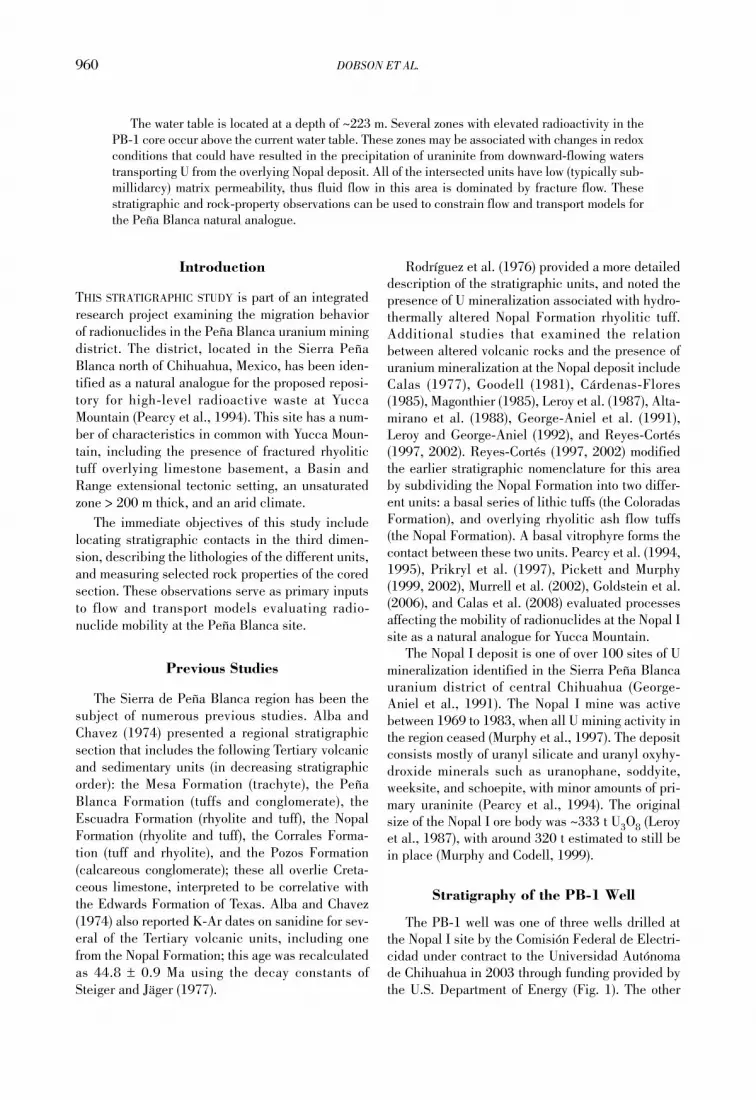
sections of core. Other alteration minerals encoun-tered in the Nopal tuff core samples includedquartz, chlorite, and montmorillonite. Much of thecore (located immediately adjacent to the U orebody) is highly brecciated, with hematite, limonite,and goethite fracture fillings. The lowermost portionof this formation consists of an intensely argillicallyaltered basal vitrophyre (17.45–22.30 m); thealtered vitrophyre is more easily identified in out-crops exposed near the PB-1 well head.
Coloradas Formation
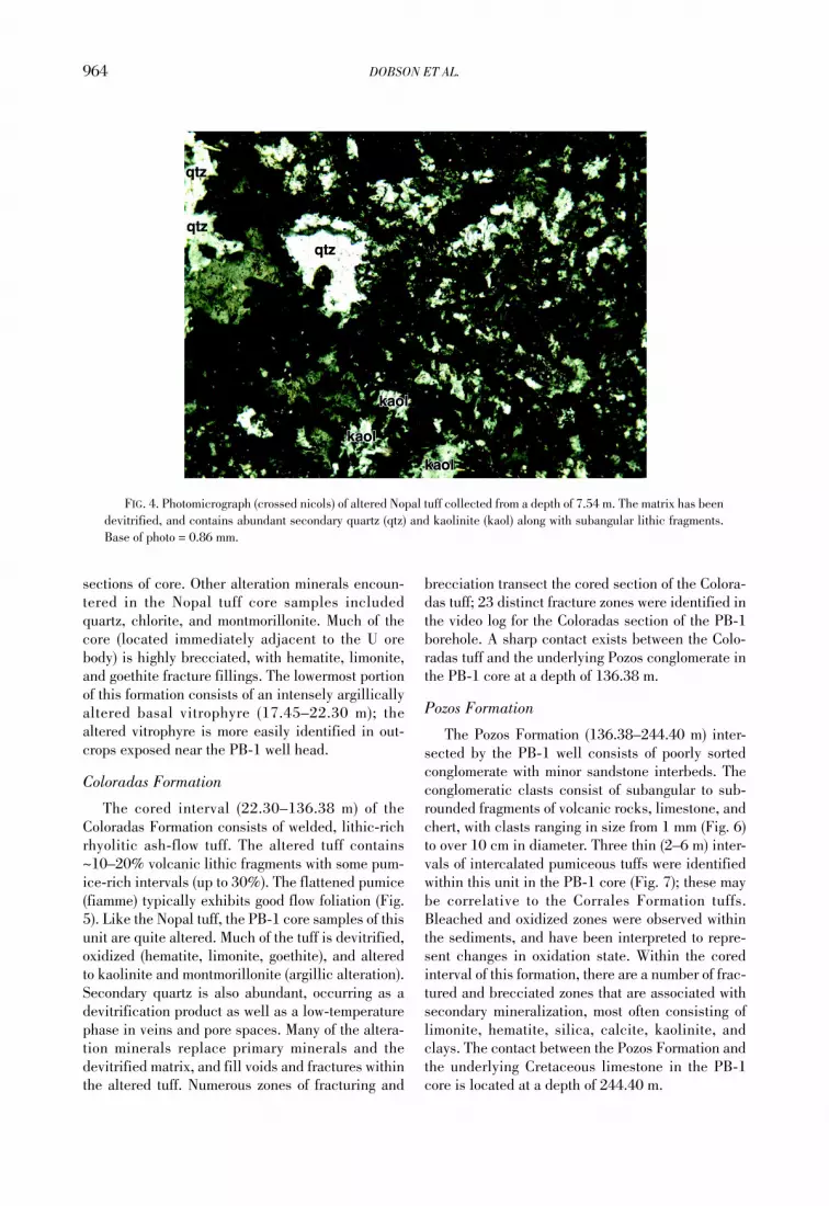
The cored interval (22.30–136.38 m) of theColoradas Formation consists of welded, lithic-richrhyolitic ash-flow tuff. The altered tuff contains~10–20% volcanic lithic fragments with some pum-ice-rich intervals (up to 30%). The flattened pumice(fiamme) typically exhibits good flow foliation (Fig.5). Like the Nopal tuff, the PB-1 core samples of thisunit are quite altered. Much of the tuff is devitrified,oxidized (hematite, limonite, goethite), and alteredto kaolinite and montmorillonite (argillic alteration).Secondary quartz is also abundant, occurring as adevitrification product as well as a low-temperaturephase in veins and pore spaces. Many of the altera-tion minerals replace primary minerals and thedevitrified matrix, and fill voids and fractures withinthe altered tuff. Numerous zones of fracturing and
brecciation transect the cored section of the Colora-das tuff; 23 distinct fracture zones were identified inthe video log for the Coloradas section of the PB-1borehole. A sharp contact exists between the Colo-radas tuff and the underlying Pozos conglomerate inthe PB-1 core at a depth of 136.38 m.
Pozos Formation
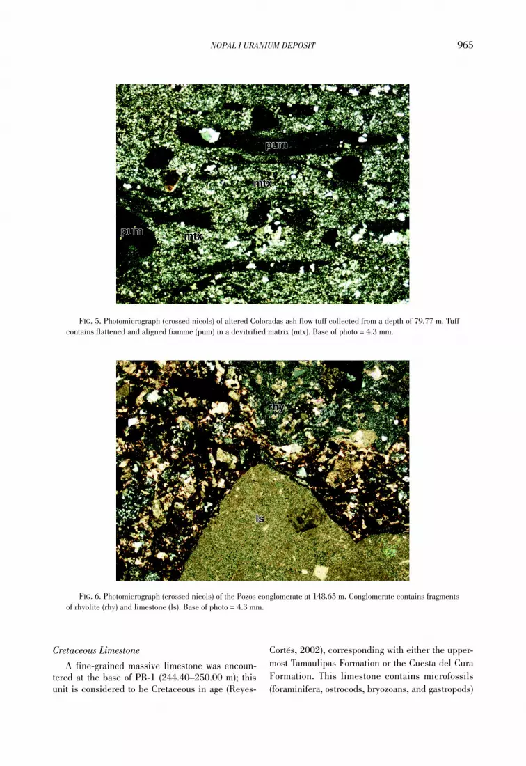
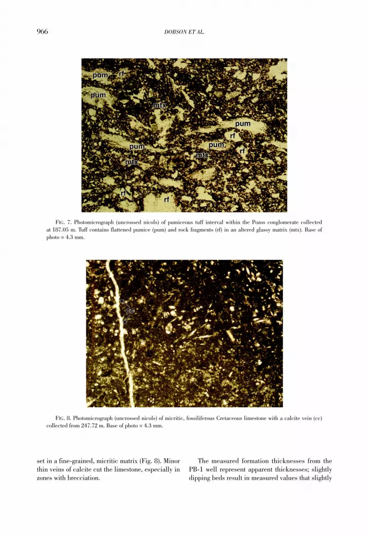
The Pozos Formation (136.38–244.40 m) inter-sected by the PB-1 well consists of poorly sortedconglomerate with minor sandstone interbeds. Theconglomeratic clasts consist of subangular to sub-rounded fragments of volcanic rocks, limestone, andchert, with clasts ranging in size from 1 mm (Fig. 6)to over 10 cm in diameter. Three thin (2–6 m) inter-vals of intercalated pumiceous tuffs were identifiedwithin this unit in the PB-1 core (Fig. 7); these maybe correlative to the Corrales Formation tuffs.Bleached and oxidized zones were observed withinthe sediments, and have been interpreted to repre-sent changes in oxidation state. Within the coredinterval of this formation, there are a number of frac-tured and brecciated zones that are associated withsecondary mineralization, most often consisting oflimonite, hematite, silica, calcite, kaolinite, andclays. The contact between the Pozos Formation andthe underlying Cretaceous limestone in the PB-1core is located at a depth of 244.40 m.
FIG. 4. Photomicrograph (crossed nicols) of altered Nopal tuff collected from a depth of 7.54 m. The matrix has beendevitrified, and contains abundant secondary quartz (qtz) and kaolinite (kaol) along with subangular lithic fragments.Base of photo = 0.86 mm.
NOPAL I URANIUM DEPOSIT 965
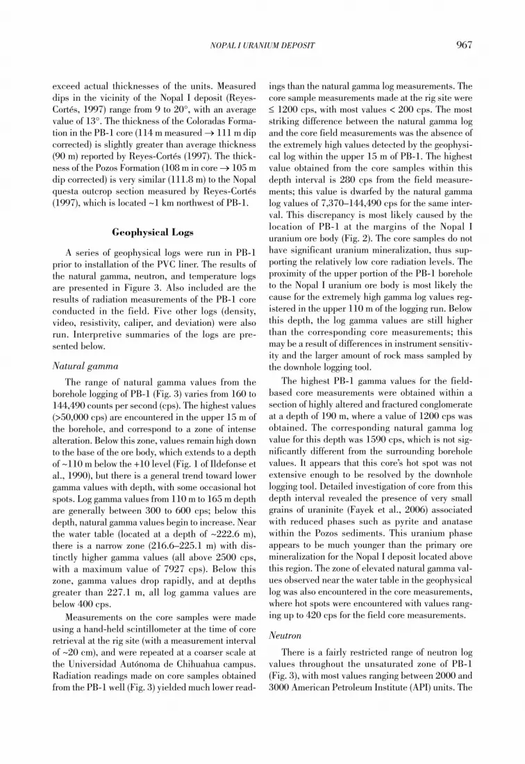
Cretaceous Limestone
A fine-grained massive limestone was encoun-tered at the base of PB-1 (244.40–250.00 m); thisunit is considered to be Cretaceous in age (Reyes-
Cortés, 2002), corresponding with either the upper-most Tamaulipas Formation or the Cuesta del CuraFormation. This limestone contains microfossils(foraminifera, ostrocods, bryozoans, and gastropods)
FIG. 5. Photomicrograph (crossed nicols) of altered Coloradas ash flow tuff collected from a depth of 79.77 m. Tuffcontains flattened and aligned fiamme (pum) in a devitrified matrix (mtx). Base of photo = 4.3 mm.
FIG. 6. Photomicrograph (crossed nicols) of the Pozos conglomerate at 148.65 m. Conglomerate contains fragmentsof rhyolite (rhy) and limestone (ls). Base of photo = 4.3 mm.
966 DOBSON ET AL.
set in a fine-grained, micritic matrix (Fig. 8). Minorthin veins of calcite cut the limestone, especially inzones with brecciation.
The measured formation thicknesses from thePB-1 well represent apparent thicknesses; slightlydipping beds result in measured values that slightly
FIG. 7. Photomicrograph (uncrossed nicols) of pumiceous tuff interval within the Pozos conglomerate collectedat 187.05 m. Tuff contains flattened pumice (pum) and rock fragments (rf) in an altered glassy matrix (mtx). Base ofphoto = 4.3 mm.
FIG. 8. Photomicrograph (uncrossed nicols) of micritic, fossiliferous Cretaceous limestone with a calcite vein (cc)collected from 247.72 m. Base of photo = 4.3 mm.
NOPAL I URANIUM DEPOSIT 967
exceed actual thicknesses of the units. Measureddips in the vicinity of the Nopal I deposit (Reyes-Cortés, 1997) range from 9 to 20°, with an averagevalue of 13°. The thickness of the Coloradas Forma-tion in the PB-1 core (114 m measured → 111 m dipcorrected) is slightly greater than average thickness(90 m) reported by Reyes-Cortés (1997). The thick-ness of the Pozos Formation (108 m in core → 105 mdip corrected) is very similar (111.8 m) to the Nopalquesta outcrop section measured by Reyes-Cortés(1997), which is located ~1 km northwest of PB-1.
Geophysical Logs
A series of geophysical logs were run in PB-1prior to installation of the PVC liner. The results ofthe natural gamma, neutron, and temperature logsare presented in Figure 3. Also included are theresults of radiation measurements of the PB-1 coreconducted in the field. Five other logs (density,video, resistivity, caliper, and deviation) were alsorun. Interpretive summaries of the logs are pre-sented below.
Natural gamma
The range of natural gamma values from theborehole logging of PB-1 (Fig. 3) varies from 160 to144,490 counts per second (cps). The highest values(>50,000 cps) are encountered in the upper 15 m ofthe borehole, and correspond to a zone of intensealteration. Below this zone, values remain high downto the base of the ore body, which extends to a depthof ~110 m below the +10 level (Fig. 1 of Ildefonse etal., 1990), but there is a general trend toward lowergamma values with depth, with some occasional hotspots. Log gamma values from 110 m to 165 m depthare generally between 300 to 600 cps; below thisdepth, natural gamma values begin to increase. Nearthe water table (located at a depth of ~222.6 m),there is a narrow zone (216.6–225.1 m) with dis-tinctly higher gamma values (all above 2500 cps,with a maximum value of 7927 cps). Below thiszone, gamma values drop rapidly, and at depthsgreater than 227.1 m, all log gamma values arebelow 400 cps.
Measurements on the core samples were madeusing a hand-held scintillometer at the time of coreretrieval at the rig site (with a measurement intervalof ~20 cm), and were repeated at a coarser scale atthe Universidad Autónoma de Chihuahua campus.Radiation readings made on core samples obtainedfrom the PB-1 well (Fig. 3) yielded much lower read-
ings than the natural gamma log measurements. Thecore sample measurements made at the rig site were≤ 1200 cps, with most values < 200 cps. The moststriking difference between the natural gamma logand the core field measurements was the absence ofthe extremely high values detected by the geophysi-cal log within the upper 15 m of PB-1. The highestvalue obtained from the core samples within thisdepth interval is 280 cps from the field measure-ments; this value is dwarfed by the natural gammalog values of 7,370–144,490 cps for the same inter-val. This discrepancy is most likely caused by thelocation of PB-1 at the margins of the Nopal Iuranium ore body (Fig. 2). The core samples do nothave significant uranium mineralization, thus sup-porting the relatively low core radiation levels. Theproximity of the upper portion of the PB-1 boreholeto the Nopal I uranium ore body is most likely thecause for the extremely high gamma log values reg-istered in the upper 110 m of the logging run. Belowthis depth, the log gamma values are still higherthan the corresponding core measurements; thismay be a result of differences in instrument sensitiv-ity and the larger amount of rock mass sampled bythe downhole logging tool.
The highest PB-1 gamma values for the field-based core measurements were obtained within asection of highly altered and fractured conglomerateat a depth of 190 m, where a value of 1200 cps wasobtained. The corresponding natural gamma logvalue for this depth was 1590 cps, which is not sig-nificantly different from the surrounding boreholevalues. It appears that this core’s hot spot was notextensive enough to be resolved by the downholelogging tool. Detailed investigation of core from thisdepth interval revealed the presence of very smallgrains of uraninite (Fayek et al., 2006) associatedwith reduced phases such as pyrite and anatasewithin the Pozos sediments. This uranium phaseappears to be much younger than the primary oremineralization for the Nopal I deposit located abovethis region. The zone of elevated natural gamma val-ues observed near the water table in the geophysicallog was also encountered in the core measurements,where hot spots were encountered with values rang-ing up to 420 cps for the field core measurements.
Neutron
There is a fairly restricted range of neutron logvalues throughout the unsaturated zone of PB-1(Fig. 3), with most values ranging between 2000 and3000 American Petroleum Institute (API) units. The
968 DOBSON ET AL.
sudden drop in the neutron log at 222.7 m, wherevalues drop from above 2000 down to around 100API units, is associated with the location of thewater table. A small shift in values occurs at 246.2m, where values increase from around 100 API units(for the region above this depth and within the satu-rated zone) to values typically between 250–600API units. This depth is very close to the contactbetween the Pozos conglomerate and the Cretaceouslimestone (244.4 m) in the PB-1 core.
Density
The values of two different gamma-gamma den-sity logs, short spacing (SS) and long spacing (LS),were reported for PB-1 by Comisión Federal deElectricidad (these are not displayed in Fig. 3). Ingeneral, the density log values are not in good agree-ment with the actual bulk and grain density labora-tory measurements of the core samples (Table 1),inasmuch as most of the log density values obtainedfrom the depth interval above the water table arelower than the core bulk density values. The lowest
log density values were recorded in the upper 15 mof the borehole (within the highly altered Nopaltuff), where the SS and LS density values range from0.05 to 1.7 and 0.03 to 1.2 g/cm3, respectively. Den-sity values for both logs between the depths of 15and 145 m increase gradually with depth andexhibit little variability, with values typically rang-ing from 1.4 to 2.4 g/cm3. Density values for bothlogs exhibit greater variability between 145 m andthe top of the water table (222.6 m), as would beexpected for this interval within the lithologicallydiverse Pozos conglomerate. Most log density valueswithin this interval range from 1.8 to 2.4 g/cm3, withthe LS density values higher than the SS values byabout 0.2 to 0.3 g/cm3. At the water table, there is anabrupt increase in the log density values, with logvalues below this depth registering around 2.2 g/cm3
and 3.4 g/cm3 for the SS and LS logs, respectively.
Temperature
There is a steady increase in measured tempera-ture values with depth, ranging from 28.5°C near the
TABLE 1. Laboratory Rock Property Values for PB-1 Core Samples
Depth, m Formation Lithology Porosity, %
Bulk density,g/cm3
Grain den-sity, g/cm3 Permeability, md
Klinkenbergpermeability, md
6.81 Nopal Ash-flow tuff 22.4 2.00 2.58 0.113 0.043
12.35 Nopal Ash-flow tuff 15.5 2.22 2.62 0.020 0.008
31.4 Coloradas Ash-flow tuff 11.9 2.26 2.56 0.008 0.003
57.02 Coloradas Ash-flow tuff 33.6 1.74 2.63 0.530 0.306
76.57 Coloradas Ash-flow tuff 21.4 2.05 2.61 1.629 1.027
100.75 Coloradas Ash-flow tuff 21.1 2.06 2.61 0.960 0.530
104.35 Coloradas Ash-flow tuff 20.8 2.06 2.60 0.760 0.497
118.91 Coloradas Ash-flow tuff 33.2 1.78 2.66 3.824 2.454
133.33 Coloradas Ash-flow tuff 19.8 2.10 2.62 1.190 0.814
142.31 Pozos Conglomerate 17.4 2.18 2.64 2.449 2.001
157.82 Pozos Conglomerate 17.1 2.20 2.65 6.302 5.182
174.65 Pozos Tuff 15.7 2.22 2.63 0.132 0.080
181.25 Pozos Conglomerate 17.1 2.23 2.69 0.017 0.007
187.05 Pozos Tuff 18.7 2.17 2.67 0.055 0.026
205.60 Pozos Conglomerate 13.2 2.33 2.68 0.003 0.001
229.29 Pozos Conglomerate 14.5 2.29 2.68 0.035 0.017
245.59 Limestone 1.9 2.65 2.70 b.d.1 b.d.
249.92 Limestone 0.3 2.68 2.69 0.0 0.001
1b.d. = below detection limit of 0.0005 md.
NOPAL I URANIUM DEPOSIT 969
surface down to 32.3°C at the base of the borehole.This increase in temperature is equivalent to a ther-mal gradient of 15°C/km. Temperatures appear toincrease more rapidly within the saturated portion ofthe wellbore, resulting in a higher thermal gradientof 31°C/km for the well section below the watertable (222.7–253.8 m). Stabilized temperaturesmeasured at the bottom of the borehole in 2006(33.0–33.4°C) are slightly higher than thoserecorded after the conclusion of drilling in 2003.
Video
The wellbore video log provides an opportunityto visually identify fractures and other featureswithin the uncased borehole. A detailed surfacefracture study by Pearcy et al. (1995) noted the keyrole of fractures for U transport at the Nopal Ideposit. Fractures and cavities within the boreholewere identified in over 30 intervals within PB-1.Most of the fractures are located within the Colora-das tuff, whereas many of the cavities occur withinthe Pozos conglomerate. Most of the fractures aresteeply dipping (> 60°) and mineralized, consistentwith observations recorded for fractures exposed onvertical faces at the Nopal I mine (Reyes-Cortés,1997). An example of one of the mineralized frac-tures in the Coloradas Formation, along with itsinterpreted core counterpart, is shown in Figure 9. Azone with abundant clasts within the PB-1 video logat a depth of around 136.6 m is interpreted to repre-sent the contact between the tuff and conglomerateunits, and is in good agreement with the contactidentified in the PB-1 core at 136.4 m.
The static water level was visually detected at adepth of 218.5 m, which is 4.2 m shallower than thedepth indicated by the neutron log (222.7 m). Turbidconditions of the drilling fluid in the well boreprecluded observing features below this depth. Thedifference between these two water table level mea-surements is most likely indicative of the relativeerror in the depth measurement between these twologging runs. Subsequent measurements of the staticwater level at PB-1 using a Solinst water-level meteryielded a depth of ~222.6 m (relative to the well-head ground surface elevation), very similar to thevalue obtained with the neutron log.
Resistivity
Three different resistivity logs were run in thedepth interval below the water table (logs not dis-played in Fig. 3). The log responses of the normalshort (16N) and lateral resistivity logs are very
similar, with most values in the SZ ranging from 50to 250 ohm-m. Higher values (up to 790 ohm-m)were recorded by the normal long (64N) resistivitylog. The lowest resistivity values for all three logs(48.5 and 41.0 ohm-m for the 16N log and laterallog, respectively, at a depth of 245.5 m and 56.5ohm-m for the 64N log at a depth of 244.2 m) wererecorded close to the contact between the Pozos con-glomerate and the underlying Cretaceous limestone(244.4 m).
Caliper
The nominal diameter of PB-1 is 8.5" (21.6 cm).Most of the caliper log measurements range from 20
FIG. 9. A. Video log image and corresponding core sam-ple of Coloradas ash-flow tuff with mineralized fracture at adepth of ~127 m. The nominal well-bore diameter for thevideo log is 8.5” (21.6 cm). B. Core sample consists of perva-sively altered lithic vitric tuff, with lithic fragments ofandesite no larger than 0.4 cm (15–20%), minor pumice(~5%), and minor altered phenocrysts. White, waxy kaolinitematerial fills the few altered feldspars. Groundmass of sam-ple has been altered to clay. Fracture fill is limonite and/orjarosite, followed by late-stage calcite. Scale bars in lowerphoto are 1 cm.

970 DOBSON ET AL.
to 24 cm (7.9–9.4"). Some slightly smaller wellborediameters were measured in the bottom meter of theborehole, as well as a few zones with larger diame-ters resulting from caving occurring during drilling.
Deviation
The deviation log measured the deviation fromvertical of the wellbore. The maximum deviationfrom vertical in PB-1 is reported to be 0.62 m.
Rock-Property Measurements
The collection of continuous core samples in thePB-1 drill hole provides the opportunity to measurekey rock properties throughout the geologic sectionneeded to constrain flow and transport models forthe Nopal I site, including porosity and permeabil-ity. Eighteen 1" (2.54 cm) diameter core plugs weredrilled from selected PB-1 core samples, with aneffort made to avoid areas with open fractures.Helium porosity, air permeability, and rock densitymeasurements were conducted on these samples byCore Laboratories (Englewood, CO). The results ofthe rock-matrix porosity, density, and permeabilitymeasurements are listed in Table 1. Reported stan-dard deviations for core-plug-analysis measure-ments are ±0.5% for porosity, ±0.01 g/cm3 for graindensity, and ±30% for permeability.
Porosity
The variation of porosity with stratigraphic depthis plotted in Figure 10. The Nopal and Coloradas
ash-flow tuff samples have porosity values rangingfrom 11.9 to 33.6%. This range is similar to thosemeasured by Meyer (1995) for five outcrop samplesof Nopal tuff (7.8 to 25.5%) collected near the NopalI deposit. Meyer (1995) observed a positive correla-tion between alteration intensity and porosity. ThePozos conglomerate samples have a smaller range ofporosities, from 13.2 to 17.4%, and the two inter-calated tuff samples have porosities of 15.7 and18.7%. The basement limestone samples have thelowest porosity values (1.9 and 0.3%).
Grain density
Grain density varies primarily as a function oflithology. Grain density values of the Nopal andColoradas welded tuffs range from 2.58 to 2.66g/cm3, and the tuff layers with the Pozos Formationhave grain densities of 2.63 and 2.67 g/cm3. Thesevalues are slightly higher than the range of graindensities (2.52 to 2.58 g/cm3) for Nopal Formationoutcrop samples measured by Meyer (1995). ThePozos conglomerate samples, which contain a mix-ture of volcanic and limestone fragments, haveslightly higher grain densities (2.64 to 2.69 g/cm3),and the basal limestone samples possess the highestgrain densities, with measured values of 2.69 and2.70 g/cm3—essentially the same value, given theprecision (±0.01 g/cm3) of the measurements.
Permeability
The variation of permeability with stratigraphicdepth is plotted in Figure 11. All measured matrix
FIG. 10. Porosity versus depth for PB-1 core samples.

NOPAL I URANIUM DEPOSIT 971
permeability values are low. The Nopal and Colora-das ash-flow tuff samples have matrix permeabilityvalues (Klinkenberg corrected) ranging from 0.003to 2.45 md. These permeabilities are generallyhigher than those obtained by Meyer (1995) for theNopal tuff outcrop samples (0.0001 to 0.098 md).The Pozos conglomerate samples have a similarrange in matrix permeability (0.003 to 6.30 md), andthe two intercalated tuffs have values of 0.055 and
0.132 md. The basement limestone samples havethe lowest matrix permeabilities, with one samplehaving a Klinkenberg corrected value of 0.001 md,and the other below detection.
Because all of the rocks in this sequence havelow matrix permeabilities, fluid flow within thethick, unsaturated zone at the Nopal I site is likelydominated by fracture flow. The presence of frac-ture-filling minerals attests to previous episodes of
FIG. 11. Matrix permeability (Klinkenberg-corrected) versus depth for PB-1 core samples.
TABLE 2. Comparision of Nopal I with Yucca Mountain
Analogue feature Nopal I Proposed Yucca Mountain Repository
Host rock Rhyolite ash flow tuffs Rhyolite ash flow tuffs1,2
Structural setting High-angle normal faults and steeply dipping fractures (Basin and Range province)
High-angle normal faults and steeply dipping fractures (Basin and Range province)2, 3
Basement lithology Limestone Limestone2, 3
Depth of radionuclides below ground surface
0–110 m ~300 m3
Distance between base of radionu-clides and water table
~110 m ~300 m3
Annual rainfall ~300 mm/y4 ~177 mm/y5
1Peterman and Cloke, 2002.2Stuckless and O’Leary, 2007.3Stuckless and Dudley, 2002.4Average annual rainfall recorded at Los Pozos, Chihuahua (1961-72) by the Servicio Meterológico Nacional, Mexico.5Sharpe, 2007.

972 DOBSON ET AL.
fluid flow and transport. Most fractures measured inthe two welded tuff units are steeply dipping, andprobably originated as cooling joints. As commonlyobserved in welded tuffs (Winograd, 1971), the pri-mary conduits for fluid flow in these units is throughjoints, fractures, and faults. A study of seepage in amine adit at the Nopal I site (Levy et al., 2008) indi-cates that fluid flow in fractures is highly heteroge-neous, with a limited number of fractures serving asfast flow paths within the unsaturated zone.
Conclusions
The Nopal I site has many similarities to the pro-posed radioactive waste repository site at YuccaMountain, making it a useful analogue for testingflow and transport models for radionuclide migra-tion (Table 2). Previous studies that have used theNopal I site as an analogue (e.g., Ildefonse et al.,1990; Murphy and Codell, 1999; Murphy, 2000;Rechard et al., 2003) have focused on the uraniummineralogy of the Nopal I deposit as an analogue forthe source term, and only address flow and transportof radionuclides in general terms. However, detailedstratigraphic and rock-property information isrequired to constrain such models (Fig. 12).
The PB-1 well was drilled for the purpose of col-lecting geologic, geochemical, and hydrologic datathat were not obtained in previous investigations ofthe Nopal I area. Four main stratigraphic units wereintersected by PB-1 well: the Nopal Formation, theColoradas Formation, the Pozos Formation, and the
Cretaceous limestone. The measured stratigraphicthicknesses of the Coloradas and Pozos Formationsare similar to those reported by Reyes-Cortés(1997). The ash-flow tuffs in the upper two forma-tions are highly altered, but do not have the abun-dant uranium mineralization found in the adjacentore deposit. Natural gamma measurements obtainedfrom geophysical logs and core measurements sug-gest that U may have been transported down fromthe Nopal I ore body to a region above the currentwater table. The tuffs have low matrix permeabili-ties; thus, fluid flow and radionuclide transportthrough these formations is most likely controlled bythe fracture network. Preliminary models for fluidflow at Nopal I (Ghezzehei et al., 2006) can beupdated using these observations.
Acknowledgments
This work was supported by the Office of theChief Scientist, Office of Civilian Radioactive WasteManagement (OCRWM), provided to the LawrenceBerkeley National Laboratory (LBNL) through U.S.Department of Energy Contract No. DE-AC02-05CH11231. Statements expressed in this paper arethose of the authors and do not necessarily reflectthe views or policies of the United States Depart-ment of Energy, LBNL, or Los Alamos National Lab-oratory. We wish to extend our thanks to Paul Cook(LBNL), Dr. Víctor Manuel Reyes Gómez, and Mr.Octavio Raúl Hinojosa de la Garza (Centro de Inves-tigación, Instituto de Ecología, A.C.), Dr. Alfredo
FIG. 12. Cross section (NW-SE) through the Nopal I deposit, providing the stratigraphic and hydrologic frameworkfor flow and transport models. Figure modified from Pearcy et al. (1994).

NOPAL I URANIUM DEPOSIT 973
Rodriguez (World Wildlife Fund), and Prof. LourdesVillalba and Ing. Héctor Mendoza (Facultad deIngeniería, Universidad Autónoma de Chihuahua)for their assistance. Differential GPS measurementsof well locations were made by Prof. Steve Harder ofthe University of Texas at El Paso.
REFERENCES
Alba, L. A., and Chavez, R., 1974, K-Ar ages of volcanicrocks from the central Sierra Peña Blanca, Chihuahua,Mexico: Isochron West, v. 10, p. 21–23.
Altamirano Rodríguez, F. J., Martínez Galvan, J. R.,Hernández González, J. A., and Pérez de la Cruz, J. A.,1988, Estudio geológico minero de la Sierra de PeñaBlanca, Municipio de Chihuahua, realizado en el añode 1987: Mexico, D.F., Uramex, unpubl. technicalreport.
Calas, G., 1977, Les phénomènes d’altération hydrother-male et leur relation avec les minéralisations urani-fères en milieu volcanique: le cas des ignimbritestertiaires de la Sierra Peña Blanca, Chihuahua (Mex-ique): Sciences Geologique, Bulletin, v. 30, p. 3–18.
Calas, G., Agrinier, P., Allard, T., and Ildefonse, P., 2008,Alteration geochemistry of the Nopal I uraniumdeposit (Sierra Peña Blanca, Mexico), a natural ana-logue for a radioactive waste repository in volcanictuffs: Terra Nova, v. 20, p. 206–212.
Cárdenas-Flores, D., 1985, Volcanic stratigraphy and U-Mo mineralization of the Sierra de Peña BlancaDistrict, Chihuahua, Mexico, in Uranium deposits involcanic Rocks: Vienna, Austria, International AtomicEnergy Agency, IAEA-TC-490, p. 125–136.
Fayek, M., Ren, M., Goodell, P., Dobson, P., Saucedo, A.,Kelts, A., Utsunomiya, S., Ewing, R. C., Riciputi,L. R., and Reyes, I., 2006, Paragenesis and geo-chronology of the Nopal I uranium deposit, Mexico, inProceedings, 2006 International High Level Radioac-tive Waste Management Conference, Las Vegas, NV,American Nuclear Society, p. 55–62.
George-Aniel, B., Leroy, J. L., and Poty, B., 1991, Volca-nogenic uranium mineralizations in the Sierra PeñaBlanca district, Chihuahua, Mexico: Three geneticmodels: Economic Geology, v. 86, p. 233–248.
Ghezzehei, T. A., Dobson, P. F., Rodriguez, J. A., andCook, P. J., 2006, Infiltration and seepage throughfractured welded tuff, in Proceedings, 2006 Inter-national High Level Radioactive Waste ManagementConference, Las Vegas, NV, American Nuclear Society,p. 105–110.
Goldstein, S. J., Luo, S., Ku, T. L., and Murrell, M. T.,2006, Uranium-series constraints on radionuclidetransport and groundwater flow at the Nopal I uraniumdeposit, Sierra Peña Blanca, Mexico, in Proceedings,2006 International High Level Radioactive Waste
Management Conference, Las Vegas, NV, AmericanNuclear Society, p. 215–222.
Goodell, P. C., 1981, Geology of the Peña Blanca uraniumdeposits, Chihuahua, Mexico, in Goodell, P. C., andWaters, A. C., eds., Uranium in volcanic and volcani-clastic rocks: American Association of PetroleumGeologists Studies in Geology, v. 13, p. 275–291.
Ildefonse, P., Muller, J.-P., Clozel, B., and Calas, G., 1990,Study of two alteration systems as natural analoguesfor radionuclide release and migration: EngineeringGeology, v. 29, p. 413–439.
Leroy, J. L., Aniel, B., and Poty, B., 1987, The Sierra PeñaBlanca (Mexico) and the Meseta Los Frailes (Bolivia):The uranium concentration mechanisms in volcanicenvironments during hydrothermal processes: Ura-nium, v. 3, p. 211–234.
Leroy, J. L., and George-Aniel, B., 1992, Volcanism anduranium mineralizations: The concept of source rockand concentration mechanism: Journal of Volcanologyand Geothermal Research, v. 50, p. 247–271.
Levy, S. S., Abdel-Fattah, A., Cook, P., Dinsmoor, J., Dob-son, P. F., Fayek, M., Ghezzehei, T., Goldstein, S.,Goodell, P., Ku, R., Luo, L., Murrell, M. T., and Pekar,K., 2008, Peña Blanca Natural Analogue, in Researchsummaries, Fiscal Years 2006–2007: Washington, DC:U.S. Department of Energy Office of Civilian Radioac-tive Waste Management, Office of the Chief Scientist,Science, Technology, and Management, DOE/RW-0594, p. 137–139.
Magonthier, M. C., 1985, Características petrográficas ygeoquímicas de las unidades ignimbríticas portadoresde mineralización de uranio de la Sierra Peña Blanca,México, in Uranium deposits in volcanic Rocks:Vienna, Austria, International Atomic Energy Agency,IAEA-TC-490, p. 137–150.
Meyer, K. A., 1995, Hydraulic characterization of hydro-thermally altered Nopal Tuff: Unpubl. M.S. thesis,University of Texas at San Antonio, 160 p.
Murphy, W. M., 2000, Natural analogs and performanceassessment for geologic disposal of nuclear waste: Sci-entific basis for nuclear waste management XXIII:Materials Research Society Symposium Proceedings,v. 608, p. 533–544.
Murphy, W. M., and Codell, R. B., 1999, Alternate sourceterm models for Yucca Mountain Performance Assess-ment based on natural analog data and secondary min-eral solubility: Scientific Basis for Nuclear WasteManagement XXII: Materials Research Society Sym-posium Proceedings, v. 556, p. 551–558.
Murphy, W. M., Pearcy, E. C., and Pickett, D. A., 1997,Radionuclide transport from mined uranium ore atPeña Blanca, Mexico: in Tailings and Mine Waste ’97,Proceedings of the 4th International Conference onTailings and Mine Waste ’97, Fort Collins, Colorado,USA: Rotterdam, The Netherlands, A.A. Balkema, p.401–404.

974 DOBSON ET AL.
Murrell, M. T., Goldstein, S. J, and Dixon, P. R., 2002,Uranium decay series mobility at Peña Blanca,Mexico: Implications for nuclear repository stability, invon Maravic, H., and Alexander, W. R., eds., EighthEC Natural Analogue Working Group Meeting, Euro-pean Commission Nuclear Science and Technology,EUR 19118 EN, p. 339–347.
Pearcy, E. C., Prikryl, J. D., and Leslie, B. W., 1995,Uranium transport through fractured silicic tuff andrelative retention in areas with distinct fracture char-acteristics: Applied Geochemistry, v. 10, p. 685–704.
Pearcy, E. C., Prikryl, J. D., Murphy, W. M., and Leslie,B. W., 1994, Alteration of uraninite from the Nopal Ideposit, Pena Blanca District, Chihuahua, Mexico,compared to degradation of spent nuclear fuel in theproposed U.S. high-level nuclear waste repository atYucca Mountain, Nevada: Applied Geochemistry, v. 9,p. 713–732.
Peterman, Z. E., and Cloke, P. L., 2002, Geochemistry ofrock units at the potential repository level, YuccaMountain, Nevada: Applied Geochemistry, v. 17, p.683–698.
Pickett, D. A., and Murphy, W. M., 1999, Unsaturatedzone waters from the Nopal natural analog, Chihuahua,Mexico—implications for radionuclide mobility atYucca Mountain: Scientific Basis for Nuclear WasteManagement XXII: Materials Research Society Sym-posium Proceedings, v. 556, p. 809–816.
Pickett, D. A., and Murphy, W. M., 2002, Uranium chem-istry and isotopy in waters and rocks at Peña Blanca,Mexico, in von Maravic, H., and Alexander, W. R.,eds., Eighth EC Natural Analogue Working GroupMeeting, European Commission Nuclear Science andTechnology, EUR 19118 EN, p. 333–337.
Prikryl, J. D., Pickett, D. A., Murphy, W. M., and Pearcy,E. C., 1997, Migration behavior of naturally occurringradionuclides at the Nopal I uranium deposit, Chihua-hua, Mexico: Journal of Contaminant Hydrology, v. 26,p. 61–69.
Rechard, R. P., Sanchez, L. C., and Trellue, H. R., 2003,Consideration of nuclear criticality when directly dis-
posing highly enriched spent nuclear fuel in unsatu-rated tuff– II: Geochemical constraints: NuclearTechnology, v. 144, p. 222–251.
Reyes-Cortés, I. A., 1997, Geologic studies in the Sierrade Peña Blanca, Chihuahua, México: Unpubl. Ph.D.thesis, University of Texas at El Paso, 342 p.
Reyes-Cortés, I. A., 2002, Geologic setting and mineral-ization: Sierra Peña Blanca, Chihuahua, México, invon Maravic, H., Alexander, W. R., eds., Eighth ECNatural Analogue Working Group Meeting, EuropeanCommission Nuclear Science and Technology, EUR19118 EN, p. 321–331.
Rodríguez Torres, R., Yza Domínguez, R., Chávez Agu-irre, R., and Constantino H. E., S. E., 1976, Rocas vol-cánicas ácidas y su potencial como objectivos paraprospectar uranio, in Exploration for uranium oredeposits: Vienna, Austria, International AtomicEnergy Agency, IAEA-SM-208, p. 601–623.
Sharpe, S. E., 2007, Using modern through mid-Pleisto-cene climate proxy data to bound future variations ininfiltration at Yucca Mountain, Nevada, in Stuckless,J. S., and Levich, R. A., eds., The geology and clima-tology of Yucca Mountain and vicinity, southernNevada and California: Geological Society of AmericaMemoir 119, p. 155–205.
Steiger, R.H., and Jäger, E., 1977, Subcommision on Geo-chronology: Convention on the use of decay constantsin geo- and cosmochronology: Earth and PlanetaryScience Letters, v. 36, p. 359–362.
Stuckless, J. S., and Dudley, W. W., 2002, The geohydro-logic setting of Yucca Mountain, Nevada: AppliedGeochemistry, v. 17, p. 659–682.
Stuckless, J. S., and O’Leary, D. W., 2007, Geology of theYucca Mountain region, in Stuckless, J. S., and Levich,R. A., eds., The geology and climatology of YuccaMountain and vicinity, southern Nevada and Califor-nia, Geological Society of America Memoir 119, p. 9–52.
Winograd, I. J., 1971, Hydrogeology of ash-flow tuff: Apreliminary statement: Water Resources Research, v.7, p. 994–1006.