status of euvn and euvn_da projects in the republic of croatia
TRANSCRIPT
- 119 -
STATUS OF EUVN AND EUVN_DA PROJECTS IN THE REPUBLIC OF CROATIA*
Ilija Grgić, Bojan Barišić, Mihajla Liker ABSTRACT The EUVN points are represent one basic element of the European geodetic infrastructure. They serve as a control of the existing continental and national geoid solutions and for the estimation of height datum differences. After the first analysis, discrepancies between gravimetric geoid EGG97 and the point-wise EUVN geoid were detected due to errors in one of compared models. Croatian Geodetic Institute (CGI) received all materials related to EUVN project from the State Geodetic Administration. Analyse of the received materials shows that some height data, which have been sent to the EUREF-UELN data centre, were calculated using benchmarks whose heights are in different height datum. This paper represents discrepancies between EGG97 and EUVN after using uniform new official height datum in Croatia – HVRS71 and densification project EUVN_DA on the territory of the Republic of Croatia. KEYWORDS EUVN, EUVN_DA 1. INTRODUCTION
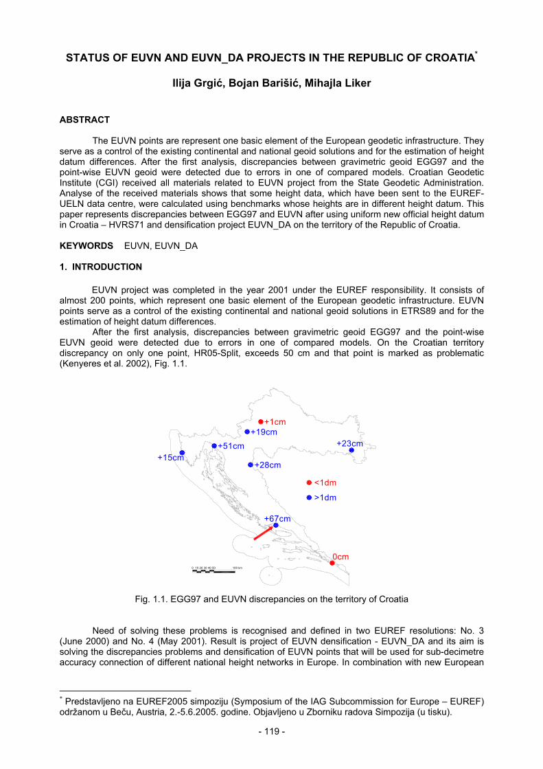
EUVN project was completed in the year 2001 under the EUREF responsibility. It consists of almost 200 points, which represent one basic element of the European geodetic infrastructure. EUVN points serve as a control of the existing continental and national geoid solutions in ETRS89 and for the estimation of height datum differences. After the first analysis, discrepancies between gravimetric geoid EGG97 and the point-wise EUVN geoid were detected due to errors in one of compared models. On the Croatian territory discrepancy on only one point, HR05-Split, exceeds 50 cm and that point is marked as problematic (Kenyeres et al. 2002), Fig. 1.1.
0 10 20 30 50 100 km40
+51cm+19cm
0cm
+23cm
+67cm
+1cm
+15cm+28cm
<1dm
>1dm
Fig. 1.1. EGG97 and EUVN discrepancies on the territory of Croatia
Need of solving these problems is recognised and defined in two EUREF resolutions: No. 3 (June 2000) and No. 4 (May 2001). Result is project of EUVN densification - EUVN_DA and its aim is solving the discrepancies problems and densification of EUVN points that will be used for sub-decimetre accuracy connection of different national height networks in Europe. In combination with new European
* Predstavljeno na EUREF2005 simpoziju (Symposium of the IAG Subcommission for Europe – EUREF) održanom u Beču, Austria, 2.-5.6.2005. godine. Objavljeno u Zborniku radova Simpozija (u tisku).
- 120 -
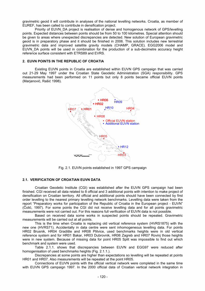
gravimetric geoid it will contribute in analyses of the national levelling networks. Croatia, as member of EUREF, has been called to contribute in densification project. Priority of EUVN_DA project is realisation of dense and homogenous network of GPS/levelling points. Expected distances between points should be from 50 to 100 kilometres. Special attention should be given to areas where unexpected discrepancies are detected. New solution of European gravimetric geoid is in preparatory phase and it should be finished in 2006. This solution includes new terrestrial gravimetric data and improved satellite gravity models (CHAMP, GRACE). EGG2006 model and EUVN_DA points will be used in combination for the production of a sub-decimetre accuracy height reference surface consistent with ETRS89 and EVRS. 2. EUVN POINTS IN THE REPUBLIC OF CROATIA Existing EUVN points in Croatia are established within EUVN GPS campaign that was carried out 21-29 May 1997 under the Croatian State Geodetic Administration (SGA) responsibility. GPS measurements had been performed on 11 points but only 8 points became official EUVN points (Marjanović, Rašić 1998).
HR10
HR12
HR09
HR01 HR02
HR06
0 10 20 30 50 100 km40
HR01 HR02
HR03
HR04
HR05
HR06
HR07
HR08
Additional EUVN stationOfficial EUVN station
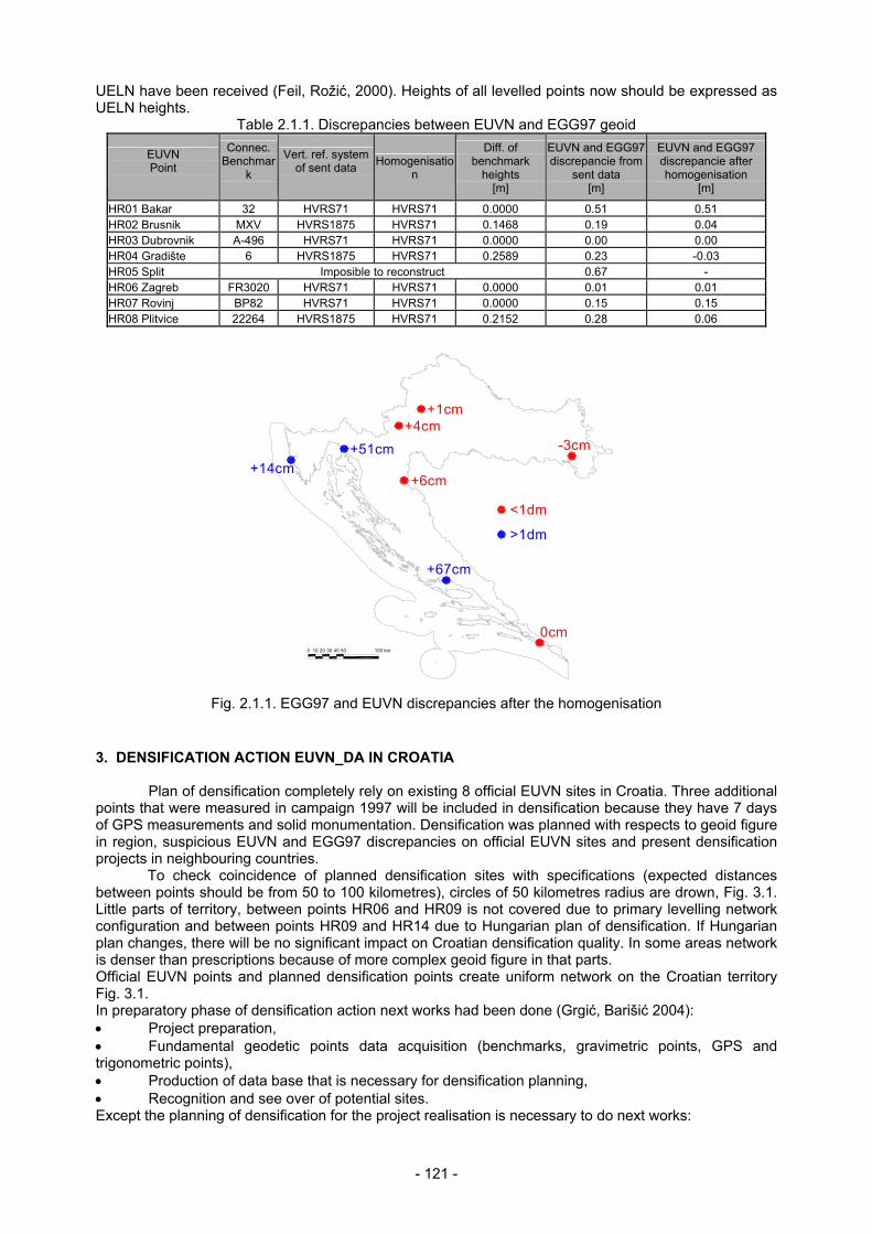
Fig. 2.1. EUVN points established in 1997 GPS campaign 2.1. VERIFICATION OF CROATIAN EUVN DATA Croatian Geodetic Institute (CGI) was established after the EUVN GPS campaign had been finished. CGI received all data related to 8 official and 3 additional points with intention to make project of densification on Croatian territory. All official and additional points should have been connected by first order levelling to the nearest primary levelling network benchmarks. Levelling data were taken from the report “Preparatory works for participation of the Republic of Croatia in the European project - EUVN” (Čolić, 1997). For some points the CGI did not receive levelling data and for all points gravimetric measurements were not carried out. For this reasons full verification of EUVN data is not possible. Based on received data some works in suspected points should be repeated. Gravimetric measurements will be carried out at all points. This is the time when Croatia is replacing old vertical reference system (HVRS1875) with the new one (HVRS71). Accidentally in data centre were sent inhomogeneous levelling data. For points HR02 Brusnik, HR04 Gradište and HR08 Plitvice, used benchmarks heights were in old vertical reference system and for HR01 Bakar, HR03 Dubrovnik, HR06 Zagreb and HR07 Rovinj those heights were in new system. Because of missing data for point HR05 Split was impossible to find out which benchmark and system were used. Table 2.1.1. shows that discrepancies between EUVN and EGG97 were reduced after homogenisation of used benchmarks heights (Fig. 2.1.1.). Discrepancies at some points are higher than expectations so levelling will be repeated at points HR01 and HR07. Also measurements will be repeated at the point HR05. Connections of EUVN points with the official vertical network were completed in the same time with EUVN GPS campaign 1997. In the 2000 official data of Croatian vertical network integration in
- 121 -
UELN have been received (Feil, Rožić, 2000). Heights of all levelled points now should be expressed as UELN heights.
Table 2.1.1. Discrepancies between EUVN and EGG97 geoid
EUVN Point
Connec. Benchmar
k
Vert. ref. system of sent data
Homogenisation
Diff. of benchmark
heights [m]
EUVN and EGG97 discrepancie from
sent data [m]
EUVN and EGG97 discrepancie after homogenisation
[m]
HR01 Bakar 32 HVRS71 HVRS71 0.0000 0.51 0.51 HR02 Brusnik MXV HVRS1875 HVRS71 0.1468 0.19 0.04 HR03 Dubrovnik A-496 HVRS71 HVRS71 0.0000 0.00 0.00 HR04 Gradište 6 HVRS1875 HVRS71 0.2589 0.23 -0.03 HR05 Split Imposible to reconstruct 0.67 - HR06 Zagreb FR3020 HVRS71 HVRS71 0.0000 0.01 0.01 HR07 Rovinj BP82 HVRS71 HVRS71 0.0000 0.15 0.15 HR08 Plitvice 22264 HVRS1875 HVRS71 0.2152 0.28 0.06
+14cm
0cm
-3cm
300 2010 40 50 100 km
+67cm
+6cm
+51cm+4cm
+1cm
>1dm
<1dm
Fig. 2.1.1. EGG97 and EUVN discrepancies after the homogenisation
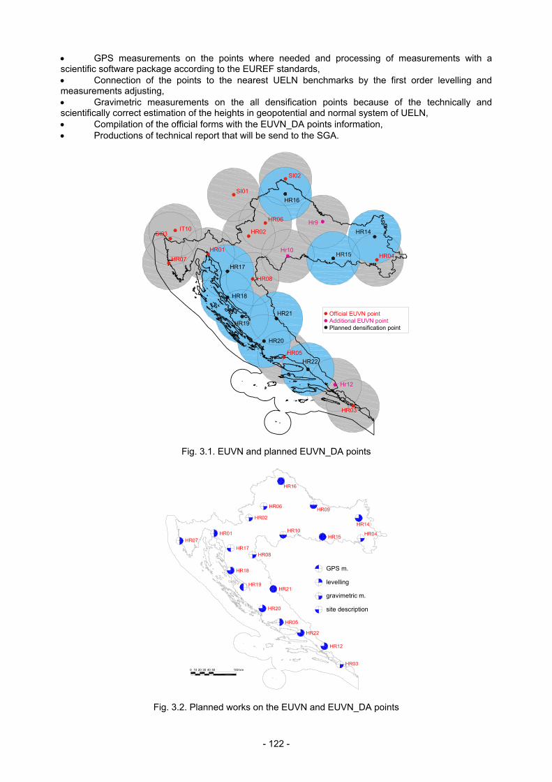
3. DENSIFICATION ACTION EUVN_DA IN CROATIA Plan of densification completely rely on existing 8 official EUVN sites in Croatia. Three additional points that were measured in campaign 1997 will be included in densification because they have 7 days of GPS measurements and solid monumentation. Densification was planned with respects to geoid figure in region, suspicious EUVN and EGG97 discrepancies on official EUVN sites and present densification projects in neighbouring countries.
To check coincidence of planned densification sites with specifications (expected distances between points should be from 50 to 100 kilometres), circles of 50 kilometres radius are drown, Fig. 3.1. Little parts of territory, between points HR06 and HR09 is not covered due to primary levelling network configuration and between points HR09 and HR14 due to Hungarian plan of densification. If Hungarian plan changes, there will be no significant impact on Croatian densification quality. In some areas network is denser than prescriptions because of more complex geoid figure in that parts. Official EUVN points and planned densification points create uniform network on the Croatian territory Fig. 3.1. In preparatory phase of densification action next works had been done (Grgić, Barišić 2004): • Project preparation, • Fundamental geodetic points data acquisition (benchmarks, gravimetric points, GPS and trigonometric points), • Production of data base that is necessary for densification planning, • Recognition and see over of potential sites. Except the planning of densification for the project realisation is necessary to do next works:
- 122 -
• GPS measurements on the points where needed and processing of measurements with a scientific software package according to the EUREF standards, • Connection of the points to the nearest UELN benchmarks by the first order levelling and measurements adjusting, • Gravimetric measurements on the all densification points because of the technically and scientifically correct estimation of the heights in geopotential and normal system of UELN, • Compilation of the official forms with the EUVN_DA points information, • Productions of technical report that will be send to the SGA.
HR16
HR18
HR20
HR21HR19
HR17
HR15
HR14IT10
SI01
SI02
Hr10
Hr9
Hr12
HR08
HR06
H 05 R
HR04
HR03
HR02
HR01
HR22
HR07
SI03
Planned densification pointAdditional EUVN pointOfficial EUVN point
Fig. 3.1. EUVN and planned EUVN_DA points
0 10 20 30 50 100 km40
GPS m.
levelling
gravimetric m.
site description
HR16
Fig. 3.2. Planned works on the EUVN and EUVN_DA points
- 123 -
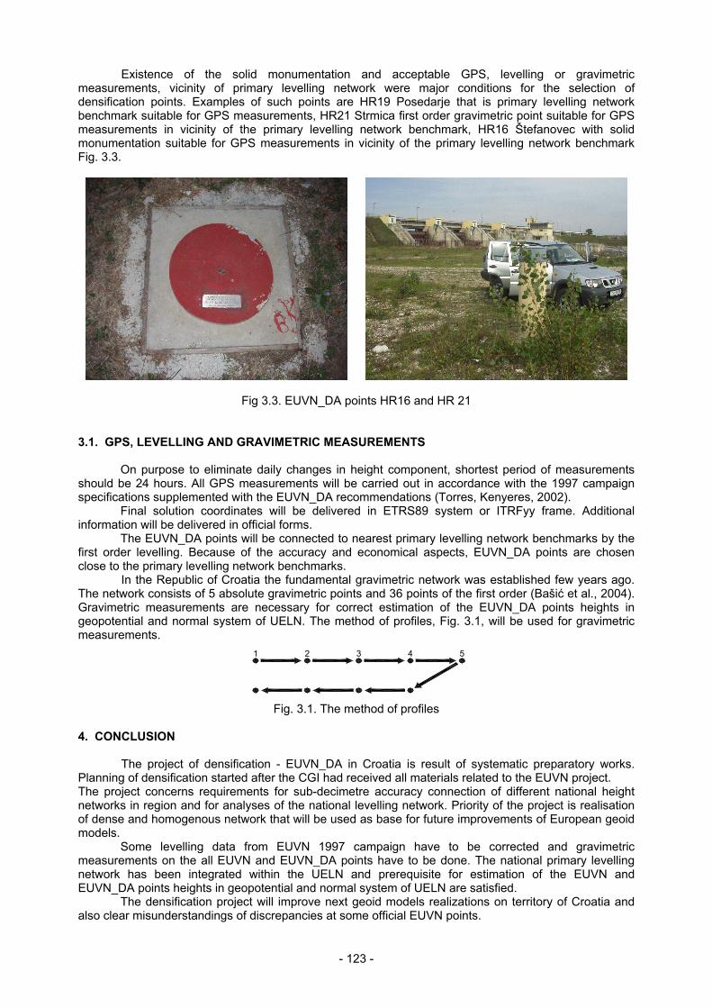
Existence of the solid monumentation and acceptable GPS, levelling or gravimetric measurements, vicinity of primary levelling network were major conditions for the selection of densification points. Examples of such points are HR19 Posedarje that is primary levelling network benchmark suitable for GPS measurements, HR21 Strmica first order gravimetric point suitable for GPS measurements in vicinity of the primary levelling network benchmark, HR16 Štefanovec with solid monumentation suitable for GPS measurements in vicinity of the primary levelling network benchmark Fig. 3.3.
Fig 3.3. EUVN_DA points HR16 and HR 21 3.1. GPS, LEVELLING AND GRAVIMETRIC MEASUREMENTS
On purpose to eliminate daily changes in height component, shortest period of measurements should be 24 hours. All GPS measurements will be carried out in accordance with the 1997 campaign specifications supplemented with the EUVN_DA recommendations (Torres, Kenyeres, 2002).
Final solution coordinates will be delivered in ETRS89 system or ITRFyy frame. Additional information will be delivered in official forms.
The EUVN_DA points will be connected to nearest primary levelling network benchmarks by the first order levelling. Because of the accuracy and economical aspects, EUVN_DA points are chosen close to the primary levelling network benchmarks. In the Republic of Croatia the fundamental gravimetric network was established few years ago. The network consists of 5 absolute gravimetric points and 36 points of the first order (Bašić et al., 2004). Gravimetric measurements are necessary for correct estimation of the EUVN_DA points heights in geopotential and normal system of UELN. The method of profiles, Fig. 3.1, will be used for gravimetric measurements.
1 2 3 4 5
Fig. 3.1. The method of profiles
4. CONCLUSION The project of densification - EUVN_DA in Croatia is result of systematic preparatory works. Planning of densification started after the CGI had received all materials related to the EUVN project. The project concerns requirements for sub-decimetre accuracy connection of different national height networks in region and for analyses of the national levelling network. Priority of the project is realisation of dense and homogenous network that will be used as base for future improvements of European geoid models.
Some levelling data from EUVN 1997 campaign have to be corrected and gravimetric measurements on the all EUVN and EUVN_DA points have to be done. The national primary levelling network has been integrated within the UELN and prerequisite for estimation of the EUVN and EUVN_DA points heights in geopotential and normal system of UELN are satisfied.
The densification project will improve next geoid models realizations on territory of Croatia and also clear misunderstandings of discrepancies at some official EUVN points.
- 124 -
REFERENCES Bašić, T., et al. (2004): Osnovna Gravimetrijska mreža Republike Hrvatske, Faculty of Geodesy, Zagreb. Čolić, K. (1997): Pripremni radovi za sudjelovanje Republike Hrvatske u europskom projektu “Europska
vertikalna referentna mreža” (EUVN), Faculty of Geodesy, Zagreb. Čolić, K. Gojčeta, B. et al. (1997): EUVN 1997 GPS Campaign in Croatia, Faculty of Geodesy, State
Geodetic Administation, Zagreb. Feil, L., Rožić, N. (2000): UELN geopotencijalni i normalni visinski sustav Republike Hrvatske, Faculty of
Geodesy, Zagreb. Grgić, I., Barišić, B. (2004): Projekt progušćenja EUVN mreže (EUVN_DA), Croatian Geodetic Institute,
Zagreb. Kenyeres, A., Ihde, J., et al. (2002): EUREF Action for the Densification of the EUVN Network, Presented
at the EUREF Symposium in Ponta Delgada. Marjanović, M., Rašić, Lj. (1998): Results of the EUVN 1997 GPS Campaign in Croatia, Paper
presented at the Second International Symposium Geodynamics of the Alps-Adria Area by means of Terrestrial and Satellite Methods, Dubrovnik.
Torres, J. A., Kenyeres, A. (2003): Densification Action for the European Vertical Reference Network (EUVN_DA), EUREF form letter.