stark park preservation master plan.p65
TRANSCRIPT
Stark Park, Manchester, New Hampshire Page 1Preservation Master Plan
Stark Park lies on 30 acres along the Merrimack River in the north end ofManchester. Once the site of the Stark Family farm, the land became theresting place of General John Stark in 1822. The City purchased the land andgravesite in 1891, and hired a Boston landscape gardening firm to design itsgrounds. It opened in 1893, and along with Derryfield Park, became one ofthe first public parks in Manchester.
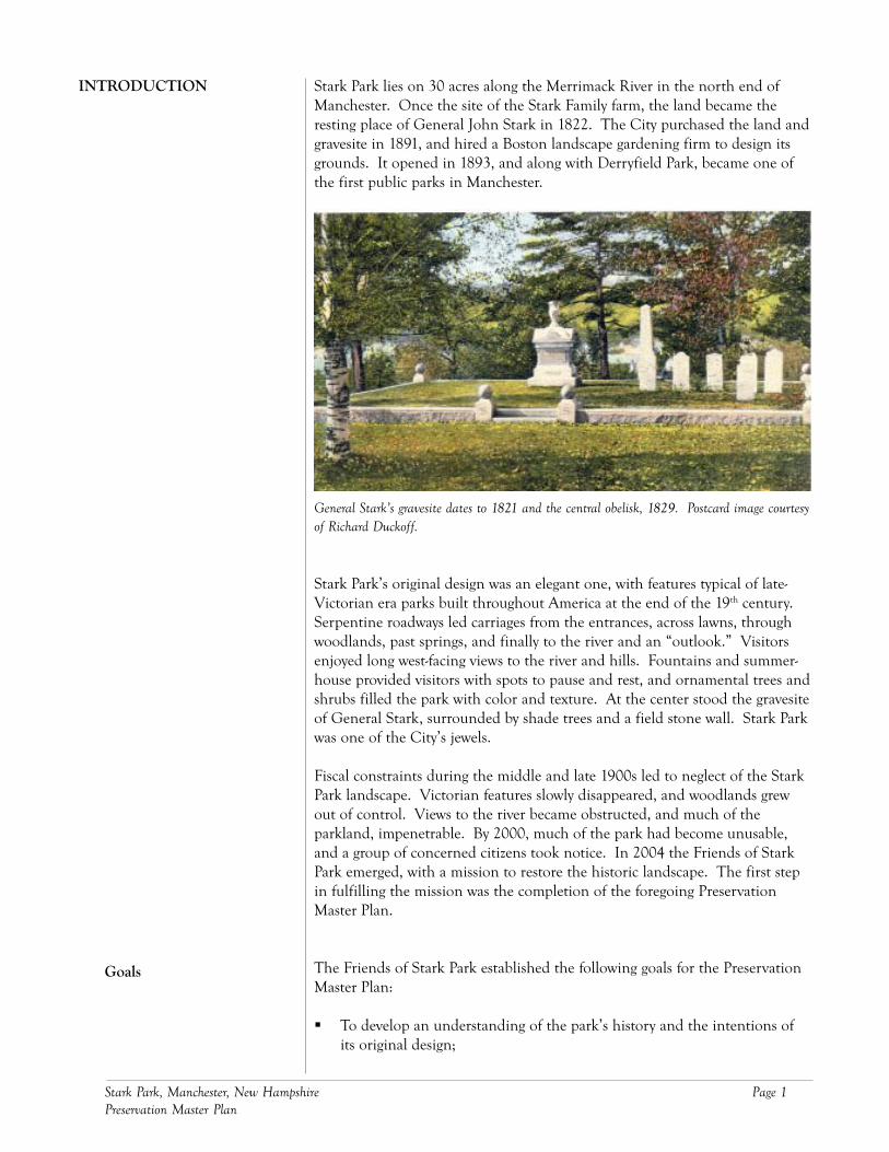
General Stark’s gravesite dates to 1821 and the central obelisk, 1829. Postcard image courtesyof Richard Duckoff.
Stark Park’s original design was an elegant one, with features typical of late-Victorian era parks built throughout America at the end of the 19th century.Serpentine roadways led carriages from the entrances, across lawns, throughwoodlands, past springs, and finally to the river and an “outlook.” Visitorsenjoyed long west-facing views to the river and hills. Fountains and summer-house provided visitors with spots to pause and rest, and ornamental trees andshrubs filled the park with color and texture. At the center stood the gravesiteof General Stark, surrounded by shade trees and a field stone wall. Stark Parkwas one of the City’s jewels.
Fiscal constraints during the middle and late 1900s led to neglect of the StarkPark landscape. Victorian features slowly disappeared, and woodlands grewout of control. Views to the river became obstructed, and much of theparkland, impenetrable. By 2000, much of the park had become unusable,and a group of concerned citizens took notice. In 2004 the Friends of StarkPark emerged, with a mission to restore the historic landscape. The first stepin fulfilling the mission was the completion of the foregoing PreservationMaster Plan.
The Friends of Stark Park established the following goals for the PreservationMaster Plan:
To develop an understanding of the park’s history and the intentions ofits original design;
INTRODUCTION
Goals
Page 2 Stark Park, Manchester, New Hampshire Preservation Master Plan
To identify contemporary and future needs for the park and its users, andmake accommodations for them; and
To prepare a plan document that records the park history, assesses itscondition, and outlines specific recommendations for restoring thelandscape.
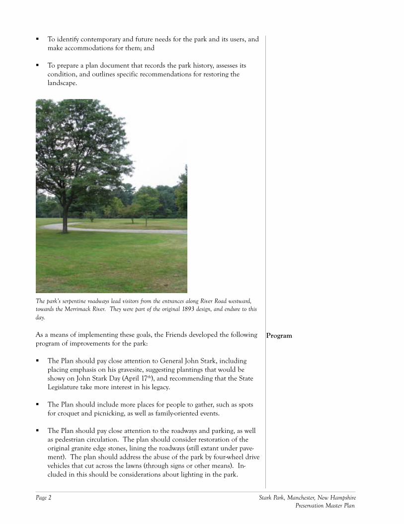
The park’s serpentine roadways lead visitors from the entrances along River Road westward,towards the Merrimack River. They were part of the original 1893 design, and endure to thisday.
As a means of implementing these goals, the Friends developed the followingprogram of improvements for the park:
The Plan should pay close attention to General John Stark, includingplacing emphasis on his gravesite, suggesting plantings that would beshowy on John Stark Day (April 17th), and recommending that the StateLegislature take more interest in his legacy.
The Plan should include more places for people to gather, such as spotsfor croquet and picnicking, as well as family-oriented events.
The Plan should pay close attention to the roadways and parking, as wellas pedestrian circulation. The plan should consider restoration of theoriginal granite edge stones, lining the roadways (still extant under pave-ment). The plan should address the abuse of the park by four-wheel drivevehicles that cut across the lawns (through signs or other means). In-cluded in this should be considerations about lighting in the park.
Program
Stark Park, Manchester, New Hampshire Page 3Preservation Master Plan
The Plan should include provisions for the Manchester Heritage Trail sothat it may be used for cross-country skiing, biking and hiking.
The Police Athletic League field should be maintained and woven into thelandscape. Provisions should be made for a stable and grazing field and/or meadow for horses.
The Plan should consider including many more flowering plants (trees,shrubs), as well as a garden (such as that in Prescott Park, Portsmouth),that could be maintained by volunteers, the Friends and possibly students,faculty and staff from the University of New Hampshire at Manchester.
The existing flagpole, made of wood, needs replacing. Its location is good,but it needs lighting (increased visibility). The Plan should address this.
The Plan should explore ways to restore the vase fountain, once located tothe south and west of the Stark gravesite.
Disposal of litter should be addressed, considering whether to placereceptacles or not, and if placed, where and what style.
The Plan should address overall security issues for General Stark’s statue,and should include a recommendation about replacing the sword.
The Plan should address signs, suggesting the types, sizes and placementof them. They should be tied into the growing arts culture in Manchester,and should include rules and regulations for using the park. John Starkshould be emphasized on them.

Page 4 Stark Park, Manchester, New Hampshire Preservation Master Plan
Stark Park, Manchester, New Hampshire Page 5Preservation Master Plan
The origins of Stark Park date to the early 1800s, and the final years in the lifeof General John Stark. The land at the northern end of Manchester thatwould become a public park was the Stark Family farm, and in 1822, itbecame the General’s gravesite. Thirteen years before he died, General Starkplanted a maple tree near what would become his grave, and the tree enduredthrough the 19th century. In 1829, the Stark family placed the Concordgranite obelisk at his grave.
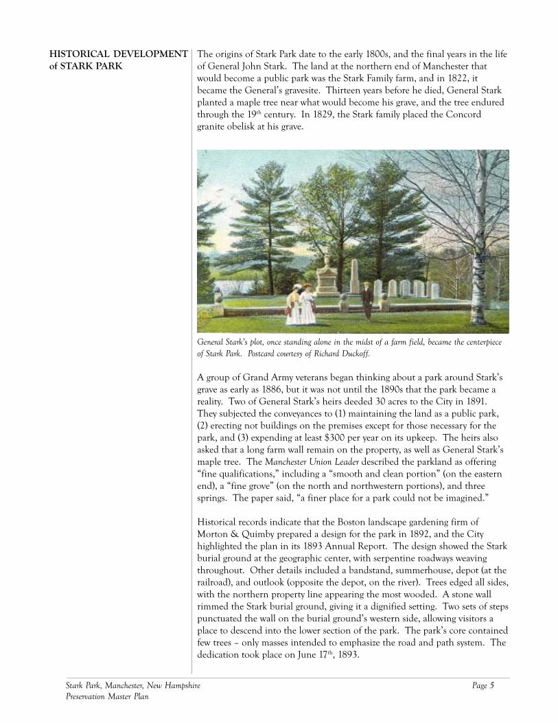
General Stark’s plot, once standing alone in the midst of a farm field, became the centerpieceof Stark Park. Postcard courtesy of Richard Duckoff.
A group of Grand Army veterans began thinking about a park around Stark’sgrave as early as 1886, but it was not until the 1890s that the park became areality. Two of General Stark’s heirs deeded 30 acres to the City in 1891.They subjected the conveyances to (1) maintaining the land as a public park,(2) erecting not buildings on the premises except for those necessary for thepark, and (3) expending at least $300 per year on its upkeep. The heirs alsoasked that a long farm wall remain on the property, as well as General Stark’smaple tree. The Manchester Union Leader described the parkland as offering“fine qualifications,” including a “smooth and clean portion” (on the easternend), a “fine grove” (on the north and northwestern portions), and threesprings. The paper said, “a finer place for a park could not be imagined.”
Historical records indicate that the Boston landscape gardening firm ofMorton & Quimby prepared a design for the park in 1892, and the Cityhighlighted the plan in its 1893 Annual Report. The design showed the Starkburial ground at the geographic center, with serpentine roadways weavingthroughout. Other details included a bandstand, summerhouse, depot (at therailroad), and outlook (opposite the depot, on the river). Trees edged all sides,with the northern property line appearing the most wooded. A stone wallrimmed the Stark burial ground, giving it a dignified setting. Two sets of stepspunctuated the wall on the burial ground’s western side, allowing visitors aplace to descend into the lower section of the park. The park’s core containedfew trees – only masses intended to emphasize the road and path system. Thededication took place on June 17th, 1893.
HISTORICAL DEVELOPMENTof STARK PARK
Page 6 Stark Park, Manchester, New Hampshire Preservation Master Plan
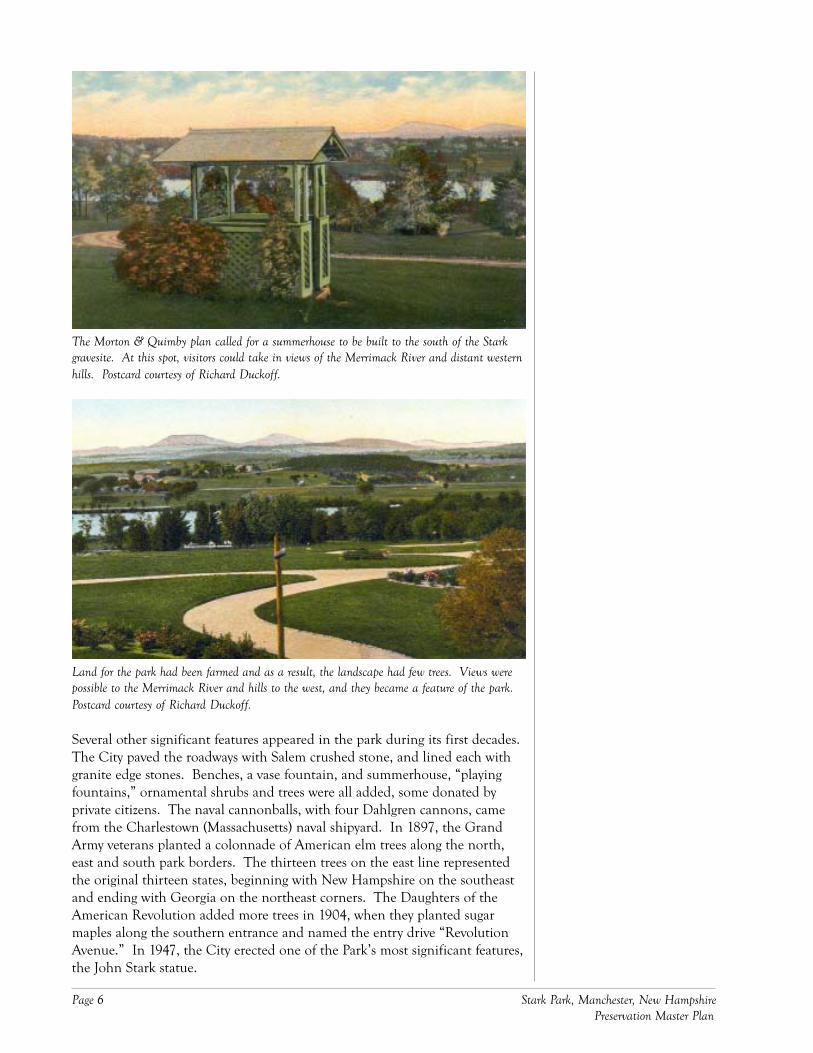
The Morton & Quimby plan called for a summerhouse to be built to the south of the Starkgravesite. At this spot, visitors could take in views of the Merrimack River and distant westernhills. Postcard courtesy of Richard Duckoff.
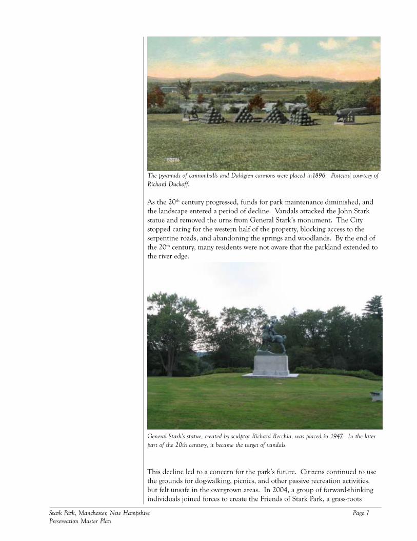
Land for the park had been farmed and as a result, the landscape had few trees. Views werepossible to the Merrimack River and hills to the west, and they became a feature of the park.Postcard courtesy of Richard Duckoff.
Several other significant features appeared in the park during its first decades.The City paved the roadways with Salem crushed stone, and lined each withgranite edge stones. Benches, a vase fountain, and summerhouse, “playingfountains,” ornamental shrubs and trees were all added, some donated byprivate citizens. The naval cannonballs, with four Dahlgren cannons, camefrom the Charlestown (Massachusetts) naval shipyard. In 1897, the GrandArmy veterans planted a colonnade of American elm trees along the north,east and south park borders. The thirteen trees on the east line representedthe original thirteen states, beginning with New Hampshire on the southeastand ending with Georgia on the northeast corners. The Daughters of theAmerican Revolution added more trees in 1904, when they planted sugarmaples along the southern entrance and named the entry drive “RevolutionAvenue.” In 1947, the City erected one of the Park’s most significant features,the John Stark statue.
Stark Park, Manchester, New Hampshire Page 7Preservation Master Plan
The pyramids of cannonballs and Dahlgren cannons were placed in1896. Postcard courtesy ofRichard Duckoff.
As the 20th century progressed, funds for park maintenance diminished, andthe landscape entered a period of decline. Vandals attacked the John Starkstatue and removed the urns from General Stark’s monument. The Citystopped caring for the western half of the property, blocking access to theserpentine roads, and abandoning the springs and woodlands. By the end ofthe 20th century, many residents were not aware that the parkland extended tothe river edge.
General Stark’s statue, created by sculptor Richard Recchia, was placed in 1947. In the laterpart of the 20th century, it became the target of vandals.
This decline led to a concern for the park’s future. Citizens continued to usethe grounds for dog-walking, picnics, and other passive recreation activities,but felt unsafe in the overgrown areas. In 2004, a group of forward-thinkingindividuals joined forces to create the Friends of Stark Park, a grass-roots

Page 8 Stark Park, Manchester, New Hampshire Preservation Master Plan
organization dedicated to the landscape’s long-term care. This PreservationMaster Plan represents one of the Friends’ first efforts to recapture the beautyof the Stark Park landscape and restore dignity to the burial place of one ofAmerica’s most prominent Revolutionary War heroes.
Stark Park, Manchester, New Hampshire Page 9Preservation Master Plan
The following is an assessment of the existing landscape conditions at StarkPark. It includes an inventory of natural, functional and built features and ananalysis of their condition. Finally, the assessment identifies the opportuni-ties and constraints posed by the landscape, and makes preliminary recom-mendations for guiding the Preservation Master Plan.
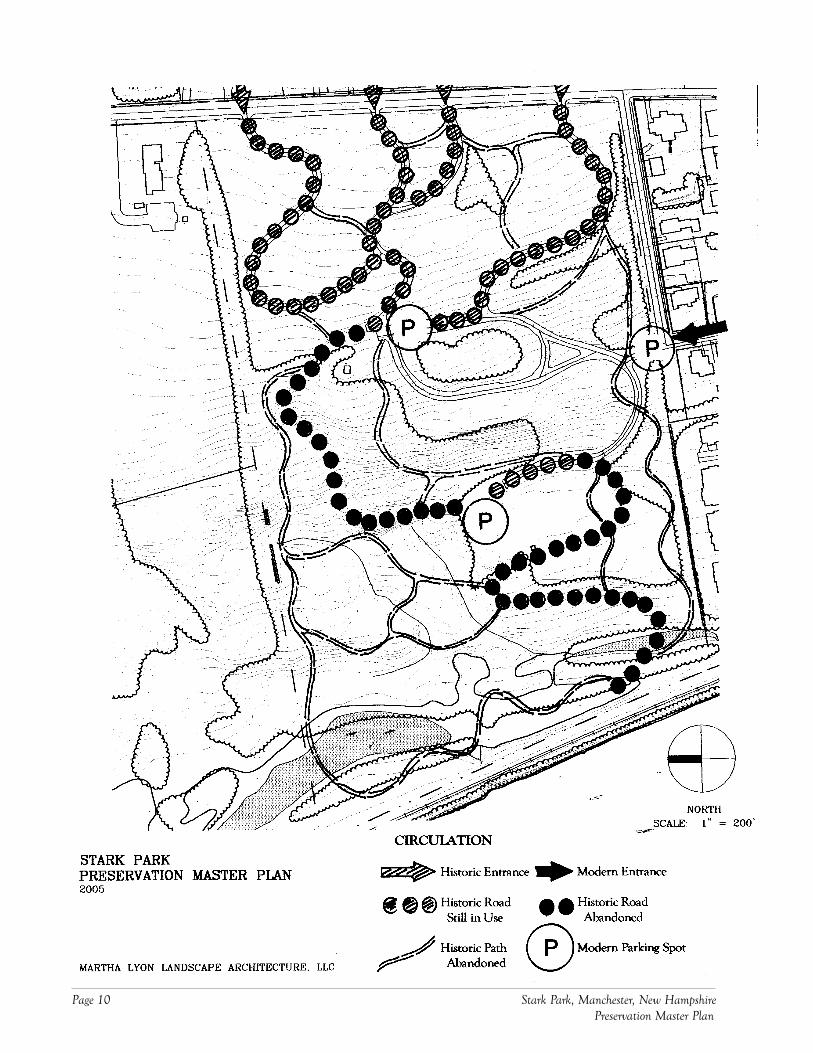
The original vehicular entrances to the park off River Road have beenretained.A new vehicular entrance has been added at the end of Park Avenue. Thisconflicts with the privacy of residents living along this quiet street. Thisnew entrance appears to be the most popularly used.Approximately one-half of the original road network has been preserved –all in the eastern half (above the Stark burial ground) of the park. Theseroads are beautifully graded – graded below the lawns so that they appearinvisible from River Road. The western roads have been eliminated, andthe original pathways around the Stark burial ground have been turnedinto roads.All of the pedestrian paths have been eliminated. This includes a series oftrails through the “Ramble” area at the northwestern corner of the park,as well as others between the River Road entrances and the Stark burialground. Because of this, much of the parkland is inaccessible, andwalkers compete with cars.Visitors park at the new entrance, and at spots along road shoulderswhere pavement is widest.
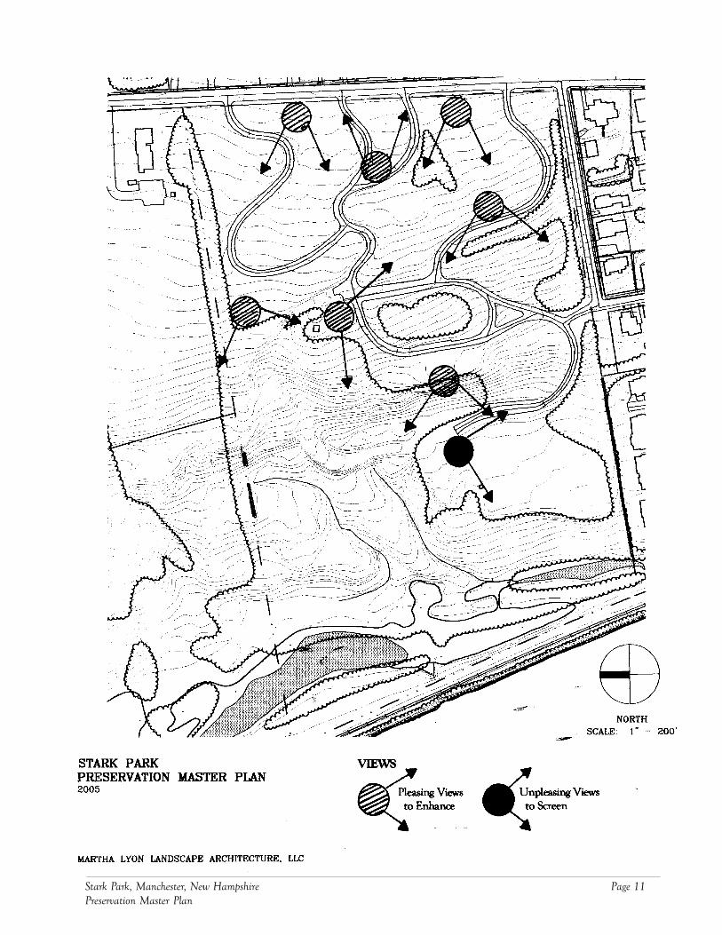
The many splendid views of the Merrimack River and distant hills (to thewest) were some of the park’s most striking historic features. Many ofthese have been blocked by new growth of woodlands. Views have alsobeen compromised by the loss of ornamental plant species – rhododen-dron and laurel – which added color and texture to the park.The contemporary housing along the south side of the park compromisesviews to the south from within the park. This housing should be screenedby a dense, mixed deciduous and coniferous hedgerow.
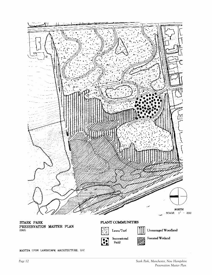
Historic maps and photos of the park from c. 1900 depict a largely openlandscape, dominated by lawns, clumps of deciduous and coniferous trees,and punctuated by masses of flowering shrubs and seasonal beds.The original designers appear to have retained many of the successionaltrees, including white birch and alders, and allowed them to mature intohandsome masses.Today, dense, wooded areas (wet and dry) cover approximately one-half ofthe parkland. These areas cover the western half of the park. In the“Ramble” area, the woodlands contain understory, obscuring visibilitythrough themThe remainder is turf, dotted with shade trees and mature shrubs.
LANDSCAPE ASSESSMENT
Circulation
Views
Plant Communities
Page 10 Stark Park, Manchester, New Hampshire Preservation Master Plan
Stark Park, Manchester, New Hampshire Page 11Preservation Master Plan
Page 12 Stark Park, Manchester, New Hampshire Preservation Master Plan
Stark Park, Manchester, New Hampshire Page 13Preservation Master Plan
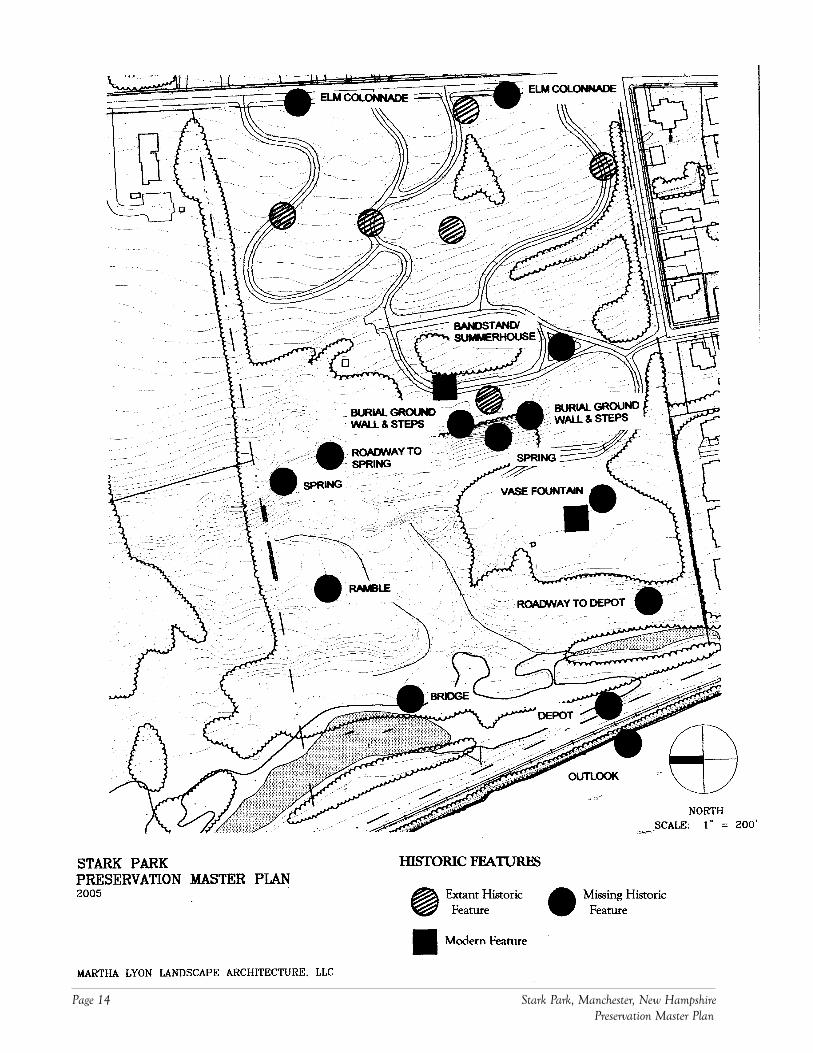
The only remaining historic features include the eastern half of theroadway network and associated grading, Stark monument and burialground, commemorative stone (GAR), and flagpole.Several modern features have been added, including additional roadways(around the Stark burial ground) and the athletic field.Many historic features have been removed. These include the GAR elmcolonnade along River Street, the summerhouse (bandstand), burialground wall and steps, roadway to the spring, “Ramble” pathways, footbridge over the pond, rail depot, outlook, vase fountain, and roadway tothe depot.Two springs, one under the “brow” of the Stark burial ground and theother in the “Ramble,” have been obscured by detritus and vegetativegrowth.
The entrance off Park Avenue should be removed. This point, whileconvenient to the Police Athletic League field, disrupts the privacy ofresidents on Park Street. All vehicles should enter and exit via RiverRoad.
The original vehicular and pedestrian networks should be restored, at leastpartially. A major reason why inappropriate activities are occurring in thepark is the lack of circulation paths through wooded and remote areas.This is particularly true in the old spring area and closer to the river.
The new roadways around the Stark burial ground are crowding this veryimportant historic feature, and should be removed and replaced, whereappropriate, by footpaths.
A significant portion of the park woodlands should be cleared andgrubbed and replaced with lawns. The woodlands are unmanaged anddense, and encourage inappropriate activities. Masses of trees should bemaintained to emphasize the lovely road and pedestrian network. Suchclearing will restore the valuable views of the river and hills to the west.
The hedgerow along the park’s southwestern edge should be maintainedand enhanced so that the contemporary housing is appropriately screened.
The Friends and City should attempt to restore as many of the importanthistoric features as possible. These will help draw more visitors to thepark, making the landscape more visible, and discouraging inappropriateuses. These features, in order of importance, are:
- the Stark burial ground environs- the original road network (to the depot and spring)- the elm colonnade along River Street- the pedestrian paths through the “Ramble”- the springs- the summerhouse/bandstand- the vase fountain- the pond and pedestrian bridge over the pond- the outlook
Historic Features
PreliminaryRecommendations
Page 14 Stark Park, Manchester, New Hampshire Preservation Master Plan

Stark Park, Manchester, New Hampshire Page 15Preservation Master Plan
The Police Athletic League field should be retained and re-shaped toaccommodate the original roadway network.
A grazing field/meadow for horses should be incorporated into thecleared areas near the river.
An irrigation system should be considered for the turf areas and plantingbeds.
A park amenities, including signs, seating, trash receptacles, etc. should beemployed to complement the landscape.

Page 16 Stark Park, Manchester, New Hampshire Preservation Master Plan
Stark Park, Manchester, New Hampshire Page 17Preservation Master Plan
The following are specific recommendations for restoring the landscape ofhistoric Stark Park. The Friends of Stark Park agreed that the master planshould strive, as much as possible to restore the landscape to its late 19th-early20th century design. The recommendations reflect this thinking by proposinga series of projects that (1) preserve or restore existing historic features, and (2)reconstruct the many lost historic features. While most of the projects involvephysical treatment of the landscape in specific geographic areas, severaladdress park-wide concerns, such as caring for the trees, placing directionalsigns, and acquiring national recognition for the landscape.
Stark Park was professionally designed in the Victorian style of the late 19th
century. Its location within the City, meandering roadways, ornamental trees,and views all reflect this design philosophy. In addition, it contains the graveof John Stark, a nationally significant historical figure. Both of these factorsmake it an excellent candidate for listing on the National Register of HistoricPlaces. Inclusion on the Register will not only establish the park’s promi-nence. It will also open up opportunities for financial support from local,state and national sources. Completing the nomination will include:
Compiling research materials pertaining to the history of the park (writtenand illustrated documents, many of which were gathered as a part of thisplan);Completing an “eligibility form” and submitting it to the New HampshireDivision for Historic Resources. Such a form serves as an official requestto determine whether the park is eligible for listing. The NHDHR willreview the form, make a site visit, and state the determination in writing;Providing the park is determined eligible, completing the National Regis-ter nomination form, including all narrative and graphic (sketch maps andphotographs) sections;Holding a public meeting to review the nomination with citizens ofManchester. This forum will allow abutters and others to voice opinionsand concerns about the nomination, and suggest amendments and/orimprovements; andSubmitting the nomination to the NHDHR for review, responding to anycomments and resubmitting the final form.
A large concern of the Friends of Stark Park has been the lack of care for thepark landscape over the past 75 years. Neglect has led to overgrown wood-lands, abandoned roads and paths, damaged trees and shrubs, and vandalismaround the Stark monument. A park management plan will provide specificinstructions for tending the landscape both before and after it has beenrestored. It will include, at a minimum:
A tree inventory and assessment, documenting the major trees, assessingtheir condition, and making recommendations for preserving and/orreplacing them. The tree assessment will also instruct the City aboutthinning, pruning and removing trees to preserve views;Recommendations for additional plantings (other than trees) includingshrubs and herbaceous perennials to be used around park feature areas, as
RECOMMENDATIONS
Project 1: National RegisterNomination
Project 2: Park ManagementPlan
Page 18 Stark Park, Manchester, New Hampshire Preservation Master Plan
well as guidance about turf care. These plants will be selected from thosethat were popularly used in late 19th and early 20th century park land-scapes;Recommendations for care of roadways and paths, including resurfacing,patching, and maintaining both chip seal and stone dust paths (seeprojects below); andRecommendations for addressing vandalism, including graffiti removal,littering, defacing monuments, and controlling inappropriate behavior.
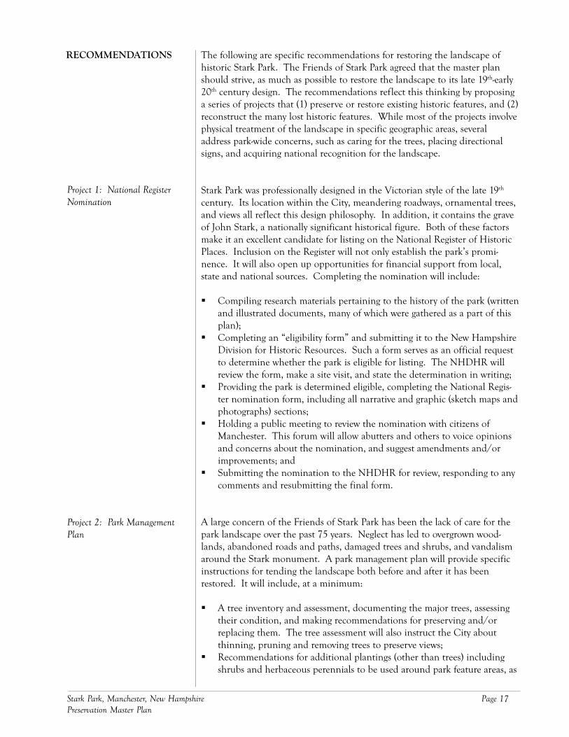
The proposal for restoring General Stark’s gravesite includes removing the roadway in front ofthe grave, erecting a fieldstone wall, and restoring the slope and spring below the grave.
The most prominent and historically important landscape feature within parkis General Stark’s gravesite, located at the geographic center. Early plans forthe park provided a comfortable setting for the plot, and connected it to thesurrounding land with paths and steps. Over time, this setting has eroded,and the gravesite appears crowded against the overgrown woodlands. Project 3will restore the Stark gravesite and its setting, including:
Removing the entrance to the park at Park Avenue. This entrance wasadded in the mid-late 20th century and has resulted in significant erosionand misuse of the park landscape.Removing the roadway running in front of the Stark gravesite and intro-ducing pedestrian paths, as appropriate. This roadway was also added inthe mid-late 20th century and has compromised the gravesite’s setting;
Project 3: General Stark Gravesite

Stark Park, Manchester, New Hampshire Page 19Preservation Master Plan
Clearing the unmanaged woodlands to the north and west of the gravesiteto open views towards the Merrimack River. Significant trees in this areawill be selectively retained;Restoring the slope below the gravesite;Reconstructing the walls and steps that once surrounded the gravesite;Introducing new plantings to the gravesite area as appeared in historicphotographs;Replanting the original maple planted by General Stark in 1809; andClearing the area around the spring (below the gravesite on the westernside), re-establishing it as a park feature.
The eastern end of the park, from the River Road edge to the Stark gravesite,is the only section of the park that is currently maintained. Here, the originalroad network appears in the landscape and mature tree shade finely gradedlawns. Over time, the city has paved over the original roadway and graniteedge stones, removed original plantings of shrubs and beds of perennials andadded new domestically scaled plants. As a result, the historic feel has beenlost. By restoring these original features, the look of this popular section ofthe park will be greatly enhanced. Project 4 will include:
Removing the several layers of bituminous paving, revealing the graniteedge stones, and re-surfacing the roadway with chip seal;Removing the yews and other domestically-scaled shrubs;Introducing, where appropriate, new plantings of ornamental, shade andevergreen trees typical of the late 19th and early 20th century;Establishing one or two ornamental planting beds to be maintained by theFriends of Stark Park;Installing an irrigation system for the planting bed areas;Redesigning the setting for General Stark’s monument, addressingvandalism and a replacement for the sword;Replacing and re-designing the setting for the flagpole;Introducing lighting along the roadways;Introducing signs to mark the roadways and provide directions to drivers;Re-establishing the network of pedestrian paths;Introducing a new, historically appropriate, and consistent style of bench;andRe-building the bandstand (summerhouse).
As noted in the landscape assessment portion of this plan, the park edges havesuffered from a loss of trees, particularly along River Road.
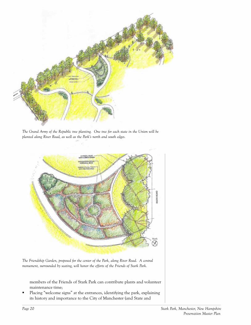
Replanting the colonnade of trees along the park edges established in1897 by the GAR. These included 13 trees along the east edge (one foreach of the original thirteen states), and 32 spread between the north andsouth edges (representing additional states). Include in the plantingsmetal tags identifying each tree and state it represents.Re-introducing the plantings of trees along either side of “RevolutionAvenue,” replacing those planted in 1904 by the DAR;Creating a “Friendship Garden,” centered along River Road, where
Project 4: General StarkMonument & Environs
Project 5: Park Entrances & Edges
Page 20 Stark Park, Manchester, New Hampshire Preservation Master Plan
The Grand Army of the Republic tree planting. One tree for each state in the Union will beplanted along River Road, as well as the Park’s north and south edges.
The Friendship Garden, proposed for the center of the Park, along River Road. A centralmonument, surrounded by seating, will honor the efforts of the Friends of Stark Park.
members of the Friends of Stark Park can contribute plants and volunteermaintenance time;Placing “welcome signs” at the entrances, identifying the park, explainingits history and importance to the City of Manchester (and State and
Stark Park, Manchester, New Hampshire Page 21Preservation Master Plan
Nation), and outlining park rules and regulations. When status isachieved, include information about the park’s listing on the NationalRegister of Historic Places; andPlacing benches along River Road for pedestrians to sit, rest, and enjoyviews of the park (see bench style described in Project 4).
One of the park’s most appealing features, as noted in Project 4, is the mean-dering roadway. Still extant in the eastern section of the park, the roadway hasbeen abandoned in the western half, making travel between the Stark gravesiteand river nearly impossible. Grading for much of this roadway still exists, andProject 6 aims to restore it and features associated with it. The project in-cludes:
Clearing and grubbing the land in the southwestern portion of the park.High quality stands of trees will be selectively retained (per the outcome ofthe tree assessment in Project 2).Restoring the original roadway leading to the depot and spring. This roadleads from the eastern half of the cemetery, around the north side of theStark gravesite, and winds down the western slope towards the river. Atits terminus is a cul-de-sac, allowing vehicles to circle around and travelback up the slope towards the park entrances. Chip seal will cover itssurface, and granite will line its edges;Introducing lighting (matching that used in the eastern half of the park) toline and illuminate the roadway;Continuing to place signs (begun in Project 4) to mark the roadways andprovide directions to drivers;Restoring the lawns stretching between curves in the roadway;Introducing new plantings (trees and shrubs) to punctuate the lawns androadway (per the original plans for the park); andRestoring the vase fountain, originally located near the Police AthleticField, below the Stark gravesite. This feature will be integrated into thedesign of the athletic field, described in Project 7.
*Note: The loop road layout may need to be modified from its original alignment toaccommodate the dimensions of the Police Athletic Field, described in Project 7.
The Manchester Police Athletic League has established a playing field belowthe Stark gravesite. It is because of this field that the city has continued tomaintain (albeit minimally) the western half of the park. The police haveasked that some of the parkland be reserved for stabling and grazing of theirhorses. The western half of the park provides ample space for such use, and ifsensitively designed, will complement (and help restore) the historic landscape.Project 7 addresses the police’s needs, including:
Upgrading the existing athletic field and situating it within the alignmentof the park loop road (see Project 6);Establishing reinforced turf areas for parking during athletic events (again,within the alignment of the loop road);Constructing a stable to house the horses; andFencing an area for grazing.
Project 6: Park Loop Road*
Project 7: Athletic Field & HorseMeadow
Page 22 Stark Park, Manchester, New Hampshire Preservation Master Plan
The most overgrown portions of the park lie in the northwest and westsections. Here, dense woodlands have grown to cover the many originalpedestrian paths that crossed these areas. “Rambles,” or areas containingwinding paths through woodlands, were popular features in late-19th centuryAmerican parks, and the northwest section of Stark Park contained a signifi-cant one. Project 8 will restore the “Ramble,” making it accessible to pedestri-ans and re-establishing it as an appealing park feature. Its restoration willinclude:
Selectively removing and clearing trees and understory;Planting new woodland shrubs and groundcover;Reconstructing intricate pedestrian paths leading through the woodlands;Cleaning out and restoring the spring;Placing benches along the paths to accommodate pedestrians wanting torest; andIntroducing signs directing visitors to the spring and through the“Ramble.”
The final project involves restoration of the westernmost section of the park,along the Merrimack River. Once open to the water, the parkland is now setapart by a railroad embankment. Wetlands, likely created when the embank-ment was built, dominate the area, making it swampy and difficult to traverse.Project 9 involves amending the wetlands, providing access and circulation, aswell as interpretive opportunities to visitors. It includes:
Creating a system of pedestrian routes that combing boardwalks andbridges with at-grade paths;Selectively clearing woodlands to upgrade quality;Where appropriate, introducing new wetland species to improve diversity;andIntroducing interpretive signs to inform visitors about wetland flora andfauna.
*Note: because Project 9 will impact the wetland, all work in this area must bereviewed and approved by the city’s conservation commission, as well as NewHampshire’s Department of Environmental Services.
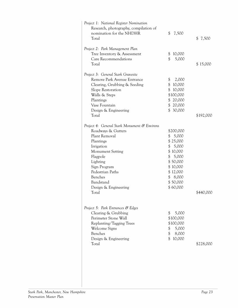
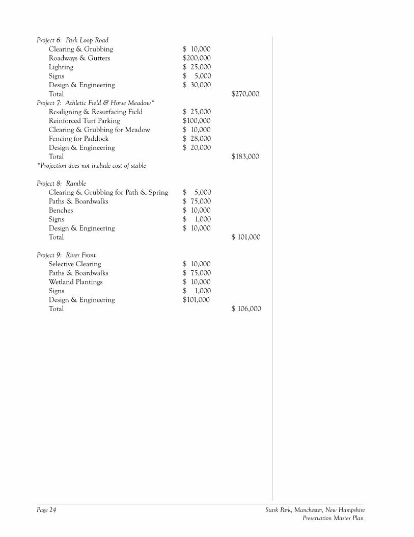
The following list assigns a preliminary cost to each of the preservationprojects listed in the “Recommendations” section of this plan. Note that thecost figures are merely projections, intended as guidelines for the Friends ofStark Park and Manchester Parks, Recreation and Cemetery Commission insetting fundraising goals. As the City and Friends undertake projects andmore detailed design becomes available, they should revise the numbersaccordingly.
Project 8: Ramble
Project 9: River Front*
Costs
Stark Park, Manchester, New Hampshire Page 23Preservation Master Plan
Project 1: National Register NominationResearch, photography, compilation ofnomination for the NHDHR $ 7,500Total $ 7,500
Project 2: Park Management PlanTree Inventory & Assessment $ 10,000Care Recommendations $ 5,000Total $ 15,000
Project 3: General Stark GravesiteRemove Park Avenue Entrance $ 2,000Clearing, Grubbing & Seeding $ 10,000Slope Restoration $ 10,000Walls & Steps $100,000Plantings $ 20,000Vase Fountain $ 20,000Design & Engineering $ 30,000Total $192,000
Project 4: General Stark Monument & EnvironsRoadways & Gutters $200,000Plant Removal $ 5,000Plantings $ 25,000Irrigation $ 5,000Monument Setting $ 10,000Flagpole $ 5,000Lighting $ 50,000Sign Program $ 10,000Pedestrian Paths $ 12,000Benches $ 8,000Bandstand $ 50,000Design & Engineering $ 60,000Total $440,000
Project 5: Park Entrances & EdgesClearing & Grubbing $ 5,000Perimeter Stone Wall $100,000Replanting/Tagging Trees $100,000Welcome Signs $ 5,000Benches $ 8,000Design & Engineering $ 10,000Total $228,000
Page 24 Stark Park, Manchester, New Hampshire Preservation Master Plan
Project 6: Park Loop RoadClearing & Grubbing $ 10,000Roadways & Gutters $200,000Lighting $ 25,000Signs $ 5,000Design & Engineering $ 30,000Total $270,000
Project 7: Athletic Field & Horse Meadow*Re-aligning & Resurfacing Field $ 25,000Reinforced Turf Parking $100,000Clearing & Grubbing for Meadow $ 10,000Fencing for Paddock $ 28,000Design & Engineering $ 20,000Total $183,000
*Projection does not include cost of stable
Project 8: RambleClearing & Grubbing for Path & Spring $ 5,000Paths & Boardwalks $ 75,000Benches $ 10,000Signs $ 1,000Design & Engineering $ 10,000Total $ 101,000
Project 9: River FrontSelective Clearing $ 10,000Paths & Boardwalks $ 75,000Wetland Plantings $ 10,000Signs $ 1,000Design & Engineering $101,000Total $ 106,000
Stark Park, Manchester, New Hampshire Page 25Preservation Master Plan
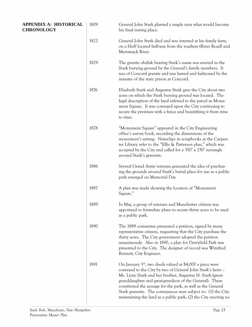
1809 General John Stark planted a maple near what would becomehis final resting place.
1822 General John Stark died and was interred at his family farm,on a bluff located half-way from the roadway (River Road) andMerrimack River.
1829 The granite obelisk bearing Stark’s name was erected in theStark burying ground by the General’s family members. Itwas of Concord granite and was hewed and fashioned by theinmates of the state prison at Concord.
1876 Elizabeth Stark and Augustus Stark gave the City about twoacres on which the Stark burying ground was located. Thelegal description of the land referred to the parcel as Monu-ment Square. It was conveyed upon the City continuing tosecure the premises with a fence and beautifying it from timeto time.
1878 “Monument Square” appeared in the City Engineeringoffice’s survey book, recording the dimensions of themonument’s setting. Newsclips in scrapbooks at the Carpen-ter Library refer to the “Ellis & Patterson plan,” which wasaccepted by the City and called for a 350’ x 250’ rectanglearound Stark’s gravesite.
1886 Several Grand Army veterans generated the idea of purchas-ing the grounds around Stark’s burial place for use as a publicpark emerged on Memorial Day.
1887 A plan was made showing the location of “MonumentSquare.”
1889 In May, a group of veterans and Manchester citizens wasappointed to formulate plans to secure thirty acres to be usedas a public park.
1890 The 1889 committee presented a petition, signed by manyrepresentative citizens, requesting that the City purchase thethirty acres. The City government adopted the petitionunanimously. Also in 1890, a plan for Derryfield Park waspresented to the City. The designer of record was WinifredBennett, City Engineer.
1891 On January 3rd, two deeds valued at $4,000 a piece wereconveyed to the City by two of General John Stark’s heirs –Ms. Lizzie Stark and her brother, Augustus H. Stark (great-granddaughter and great-grandson of the General). Theseconstituted the acreage for the park, as well as the GeneralStark gravesite. The conveyances were subject to: (1) the Citymaintaining the land as a public park, (2) the City erecting no
APPENDIX A: HISTORICALCHRONOLOGY
Page 26 Stark Park, Manchester, New Hampshire Preservation Master Plan
buildings on the premises except such as may be appropriateor necessary for the use of said park, and (3) the City expend-ing at least $300 on the average for the care and improvementof the park each year.
The land reportedly contained many historically significantfeatures. A stone wall, believed to have been constructed bysome of General Stark’s soldiers, ran from one end of theproperty to another, on the west side of River Road. MissElizabeth Stark asked that the wall remain, as well as “thelarge maple tree which stands on the west side of the roadnearly opposite the old house,” a tree that was set out by thegeneral (in 1809), and was “but a sapling when he died.”
On August 6th, The Manchester Union Leader described thepark land as offering “fine qualifications.” The easterlyportion was as smooth and clean a piece of land as there wasin the State of New Hampshire. In the north and northwest-ern portion was a fine grove, which could be made veryattractive at little expense. Three springs ran from the “baseof the brow where the graves are,” and the water was report-edly “sparkling and pure.” The paper noted that it would be“a very easy matter to make an artificial pond.” It also said,“a finer place for a park could not be imagined.”
Joseph B. Sawyer, C. E. was employed to make a survey ofStark Park. Levels were taken by the City Engineer’s officeand a contour map was prepared locating trees. Many of thetrees were alders and birches, indicating that the land was aformer agricultural field, in the throes of succession (thesurvey, located in the Manchester Highway Departmentoffice, is dated 1892). The map was then sent to WilliamDoogue, superintendent of public parks in Boston. The CityReport stated that Mr. Doogue’s office was to prepare a plan,showing proposed walks and drives. In the meantime, theCity Engineer’s office directed removal of underbrush fromthe Stark Park property.
Again, on August 6th, The Manchester Union Leader reportedthat the Mayor and “committee on commons” were to receiveMr. Doogue (one of the finest landscape gardeners in thecountry) and two competent engineers to view the old Starkfarm on North River Road.
1892 The City paid $1,000 for a design of the park made by theoffice of Morton & Quimby, landscape gardeners of Boston.The plan, which appeared in the 1893 City Report, showedthe Stark burial ground at the geographic center of the park,with serpentine roadways weaving throughout. Other detailsincluded a band stand, summer house, depot (at the railroad)and outlook (opposite the depot, on the river). Trees edged all
Stark Park, Manchester, New Hampshire Page 27Preservation Master Plan
sides of the park, although the northern edge appeared themost wooded. A stone wall rimmed the Stark burial ground,giving it a dignified setting. Two sets of steps punctuated thewall on the western side of the burial ground, allowingvisitors a place to descend into the lower section of the park.Remarkably, the core of the park contained few trees – onlymasses intended to emphasize the road and path system.
1893 On June 17th, the City dedicated the Park. The City Reportof this year contained the first report of the “Street and ParkCommission.” In it, the commissioners described the park ashaving well-prepared roadbeds with sand foundations,crushed stone top courses, secured by a Salem stone dustbinder course. 1,035 feet of paved gutters lined the roadways,each 18 inches in width. The total width of each roadway(with gutters) was 19 feet. A spring on the grounds wascleaned, and 150 rhododendrons set out in “the grove.” 100mountain laurel plants were placed, lawns graded, rolled andsown, and flower beds set.
1894 The City made improvements, including extending andpaving roadways. Workers also removed the wall on thenorth side.
c. 1895 An article appeared providing detail about the look of andimprovements made to the park. Since the land had beenpurchased, the City had expended $250 annually to upgradethe property. Much of the land in the eastern section wascleared and grubbed, and beautiful, winding macadamroadways had been completed per the specifications of theCity Engineer. Salem crushed stone was used for the paving,provided by the Massachusetts Broken Stone Company ofBoston. Trees and shrubs had been set out on the north,south and east edges, as well as in some central sections.Four hundred feet of sewer/under drain had been placedbetween River Road and the Stark burial ground, and thecenter of the park graded and seeded. Many benches hadbeen placed and a vase fountain, six feet high and six feet indiameter, had been give to the City by a private citizen. Asummerhouse was erected in the southeastern section nearthe Stark burial ground (in honor of Commissioner GeorgeStearns). Several donors had given trees, adding shade to thenorth and south borders and Stark burial ground. A grove oftrees stood at the park’s western terminus along theMerrimack River. A series of winding drives, ornamentedwith shrubbery and “playing fountains” made for a pleasingride down to the river.
1896 Four naval cannonballs from the War of 1812 were placednear the eastern end of the Park, along with four Dahlgrencannons. These were secured from the Charlestown, Mass.
Page 28 Stark Park, Manchester, New Hampshire Preservation Master Plan
Navy Yard when William C. Clarke was mayor, and “form[ed]a very picturesque feature of the landscape.” Also this year atool house was built, and curbing was added to the Starkburial ground.
1897 On July 6th, the Grand Army veterans of Manchester pre-sented the City with a “magnificent colonnade of nativeAmerican elm trees” and memorial tablet to be added to thepark. The 45 trees were laid out by Comrade E. P.Richardson and extend the one-half mile around the park’sborders. Each tree represented one of the 45 states of theUnion. They were set apart 50 feet, and placed 25 feet insidethe park border. The 13 trees on the east line represented theoriginal thirteen states – beginning with New Hampshire onthe southeast and ending with Georgia on the northeastcorners. Lines of trees on the north and south sides repre-sented newer states, and were added in the order they becamepart of the Union. Each tree held a metal tag engraved withthe name and date of each admission.
1899 The City raised hay in the park, and cut it for the Citystables. The City Report indicated that a building needed tobe erected to store the hay (in both Stark and DerryfieldParks).
1902 A survey showing roads within the park was prepared. TheStark burial ground appeared, and the iron fence had beenplaced around it. The City Report stated that the roadcircling the Stark burial ground was completed. The CityEngineering office prepared a survey of the elm trees plantedin 1897.
1903 The City added 1600 feet of cobble gutters alongside the parkroads, and repaired roadways.
1904 The main road leading into Stark Park was named “Revolu-tion Avenue” in honor of the Daughters of the AmericanRevolution, and trees were planted along both sides. TheCity maintained flower beds.
1905 A new wooden bridge was built over the brook in the lowerportion of the park. Fifty to 80 rose shrubs were planted.
1908 A footbridge was repaired, stonedust walks laid, and plantingbeds established.
1909 The City continued to maintain planting beds and replacedtrees as needed.
c.1910 A series of postcards were drawn and printed depicting thepark and its many features. The park landscape was open,
Stark Park, Manchester, New Hampshire Page 29Preservation Master Plan
with many views of the river and distant hills. Trees grew inclumps, and many appeared to be white birches. One imagedepicted the “Road to Spring,” located on the northern edgeof the park, in the woodlands. The woodlands contained nounderstory. The summerhouse was a wooden, gable-roofedstructure, open on all sides. The door to the summerhousefaced the Stark burial ground. Plantings of shrubs accentedthe curves in the roadways.
1913 A drawing of the Stark burial ground fence was prepared,with a detail plan for the posts.
1914 Miss Elizabeth Stark, the last remaining family member, died.
c. 1915 An article entitled Resting Place of Revolutionary War Hero is aBeautiful Spot appeared. In it, the author described the viewfrom the Park as “one of the most entrancing to be foundanywhere in this part of New Hampshire.” Also in 1915,funds were appropriated to bring water into the park.
1927 The City Report made first mention of vandalism in thepark, noting the need for park police. Also in this year, loamwithin the park was removed for use in other City parks.
1930 A 50’ steel flagpole was added, replacing the old wooden one.
1947 Governor Charles H. Bartlett gifted the City funds to erectthe John Stark statue to be placed in Stark Park. The Cityheld a competition, and the winner, sculptor Richard Recchiaof Rockport, Massachusetts received $12,000 to create thepiece. It took Recchia 2-1/2 years to complete the statue.
1970 The September 27 issue of the New Hampshire Sunday Newsreported that the sword atop General Stark’s statue had beenhurt by vandals.
1980 Funding was provided for two, lighted tennis courts andrelated parking at the park.
1983 The Manchester Union Leader reported that the urns atopGeneral Stark’s monument were missing. Someone hadjumped the 6’ fence surrounding the monument and stolenthe 100-pound object.
1990s The Heritage Trail effort began, and planned for a spurthrough Stark Park.
2001 The Manchester Union Leader reported, on August 21st, thatlarge boulders had been placed across the North River Roadentrance to the Park to prevent vehicular entry and “use byhomosexual men.”

Page 30 Stark Park, Manchester, New Hampshire Preservation Master Plan
2004 The Friends of Stark Park formed out of concern for the park’slong term use and care, and the City appropriated funds toprepare a preservation master plan for the park.
Stark Park, Manchester, New Hampshire Page 31Preservation Master Plan
Maps, Surveys & Plans(Arranged by date)
1878. City of Manchester Highway Department: survey of MonumentSquare showing dimensions of setting for the General Stark monu-ment.
1887. Bennett, Winfred H., City Engineer, Plan showing location of Monu-ment Square as described in the accompanying deed. July 7, 1887(City of Manchester Highway Department).
1892. City of Manchester Highway Department: survey locating trees onexisting Stark Park property.
c. 1893. Morton & Quimby, landscape gardeners of Boston, Stark Park, scale40 feet = 1 inch.
1902. City of Manchester Highway Department: survey showing roads andStark burial ground surrounded by an iron fence.
1902. City of Manchester Highway Department: Location of Trees AroundStark Park (survey of trees in Stark Park along River Road and ParkAvenue), December 22, 1902.
1913. Lord, Samuel J., City Engineer, Fence for Stark Burial Ground, StarkPark, Manchester, NH and Detail Plan of Post for Fence Around StarkBurial Lot, Stark Park, Manchester, NH. October 17, 1913 (City ofManchester Highway Department).
1946. Engineer’s Department, Manchester, NH, Plan of Site for MajorGeneral John Stark Monument, Stark Park, Manchester, NH, scale 1inch = 20 feet, February 1946.
Books & Documents
City of Manchester, Annual City Reports, 1890-1930.
Bartlett, General Charles H., Oration, Dedication of Stark Park, the City ofManchester, New Hampshire. June 17, 1893.
Newspaper Articles & Clippings(Arranged by date)
“General Stark’s Burial Place.” Publication and author unknown, January 11,1876.
“Historic Ground. Land That Will Be Inspected Today by Boston Officers.”The Manchester Union Leader, August 6, 1891.
APPENDIX B:BIBLIOGRAPHY
Page 32 Stark Park, Manchester, New Hampshire Preservation Master Plan
“Historic Stark Park. National Colonnade of Memorial Trees Presented to theCity.” Manchester Daily Mirror & American, July 7, 1897.
“Around Stark’s Grave.” Publication and author unknown, 1898.
“Stark Holds Symbol of Freedom High.” New Hampshire Sunday News,September 27, 1970.
“Stark Park Project Funded.” Publication and author unknown, November20, 1980.
“General Stark Memorial ‘Urns’ Reputation for Wanderlust.” The Manches-ter Union Leader, March 24, 1983.
“Friends of Stark Park Meets.” Hippo Press, October 6, 2004.
“Resting Place of Revolutionary Hero is a Beautiful Spot.” Publication, authorand date unknown.