spotlight - orbit gt
TRANSCRIPT
SOLUTIONS
Fast and safe accident sketching at Het Houtsche Police Zone
TRENDWATCHER
“Tour of Flanders” event contingency plan mapped by the Flemish Ardennes police zone
SPOTLIGHT
Municipality of Amersfoort opts for PanoViewer from
Orbit GT
SOLUTIONS
Municipality of Overbetuwe changes over to BGT with Orbit’s mapping solution
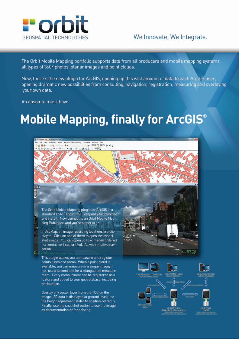
De Orbit Mobile Mapping plugin voor ArcGIS is een standard ESRI “AddIn” file. Eenvoudig in download en installatie. Je hoeft enkel te connecteren naar een Orbit Mobile Mapping Publisher, en je bent klaar.
In ArcMap zie je alle opnamelocaties. Klik op zo’n punt om het panoramabeeld te zien, je kan er 4 tegelijk openen. Navigeren is zeer intuïtief en je kan ze horizontaal, vertikaal of in grid tonen.
Met deze plugin kan je punten, lijnen en vlakken meten en registreren. Als er een puntenwolk beschikbaar is kan dat in 1 beeld, zoniet gebruik je er 2. Elke meting kan je in een feature layer opslaan, en zo aan je geo database toevoegen en attribueren.
Elke vector layer uit je TOC (table of contents) kan je inprojecteren in het panoramabeeld. Als je data in 2D is, wordt je data op grondhoogte getoond en kan je manueel de hoogte aanpassen.
PAGE 3
INFO & EDITORIAL
Dear reader,
We have been serving the Flemish municipalities for over twenty years with great diligence, vision and innovation, offering a wide range of applications and support. We have also applied the same formula successfully to local police zones for a good 10 years.
We have moreover placed our experience and expertise at the disposal of municipalities in the Netherlands for a considerable time as well. We are delighted to feature 2 cases of our projects in Dutch municipalities in this magazine.
We also want to broach topical police issues in this edition: improved surveying techniques for traffic accidents and the practical application of our tools at events.
We can see once again that applications which are simple, efficient and adapted to the shop floor have been and continue to be an important and useful instrument. Our task and challenge
to continue working to that end gives us the satisfaction of satisfied customers.
Happy reading!
EDITORIAL
CONTACT US
Peter Bonne
ORBIT GeoSpatial Technologies nv
Industriepark E17, 2021
Scherpeputstraat 14
9160 Lokeren, Belgium
phone +32 9 340 5757
+32 9 340 5750
mail [email protected]
www.orbitgis.com
CONTENTS
SPOTLIGHT
Municipality of Amersfoort opts for PanoViewer from Orbit GT Page 4
SOLUTIONS
Fast and safe accident sketching at Het Houtsche Police Zone Page 6
Municipality of Overbetuwe changes over to BGT with Orbit’s mapping solution Page 12
Orbit Softcopy, suitable for BGTPage 14
TRENDWATCHER
“Tour of Flanders” event contingency plan mapped by the Flemish Ardennes police zone Page 9
INNOVATION
Land covering oblique images, height model and LiDAR Page 15
COLOPHONPublisher: Lemarco
Sneeuwbeslaan 17 B7
B-2610 Wilrijk
+32 (0)3 827 26 36
Editorial: Lomme Devriendt
Timothy Van Cleemput
Peter Bonne,
Pieter Jongert
Editor in chief: Peter Bonne
Graphics : Sweet Lemon
Printing: Bema-Graphics NV
June 2013
PAGE 4
SPOTLIGHT
MUNICIPALITY OF AMERSFOORT OPTS FOR PANOVIEWER FROM ORBIT GT
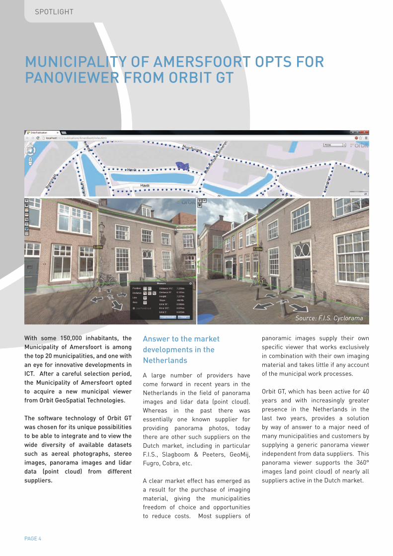
With some 150,000 inhabitants, the Municipality of Amersfoort is among the top 20 municipalities, and one with an eye for innovative developments in ICT. After a careful selection period, the Municipality of Amersfoort opted to acquire a new municipal viewer from Orbit GeoSpatial Technologies.
The software technology of Orbit GT was chosen for its unique possibilities to be able to integrate and to view the wide diversity of available datasets such as aereal photographs, stereo images, panorama images and lidar data (point cloud) from different suppliers.
Answer to the market developments in the Netherlands
A large number of providers have come forward in recent years in the Netherlands in the field of panorama images and lidar data (point cloud). Whereas in the past there was essentially one known supplier for providing panorama photos, today there are other such suppliers on the Dutch market, including in particular F.I.S., Slagboom & Peeters, GeoMij, Fugro, Cobra, etc.
A clear market effect has emerged as a result for the purchase of imaging material, giving the municipalities freedom of choice and opportunities to reduce costs. Most suppliers of
panoramic images supply their own specific viewer that works exclusively in combination with their own imaging material and takes little if any account of the municipal work processes.
Orbit GT, which has been active for 40 years and with increasingly greater presence in the Netherlands in the last two years, provides a solution by way of answer to a major need of many municipalities and customers by supplying a generic panorama viewer independent from data suppliers. This panorama viewer supports the 360° images (and point cloud) of nearly all suppliers active in the Dutch market.
Source: F.I.S. Cyclorama
PAGE 5
SPOTLIGHT
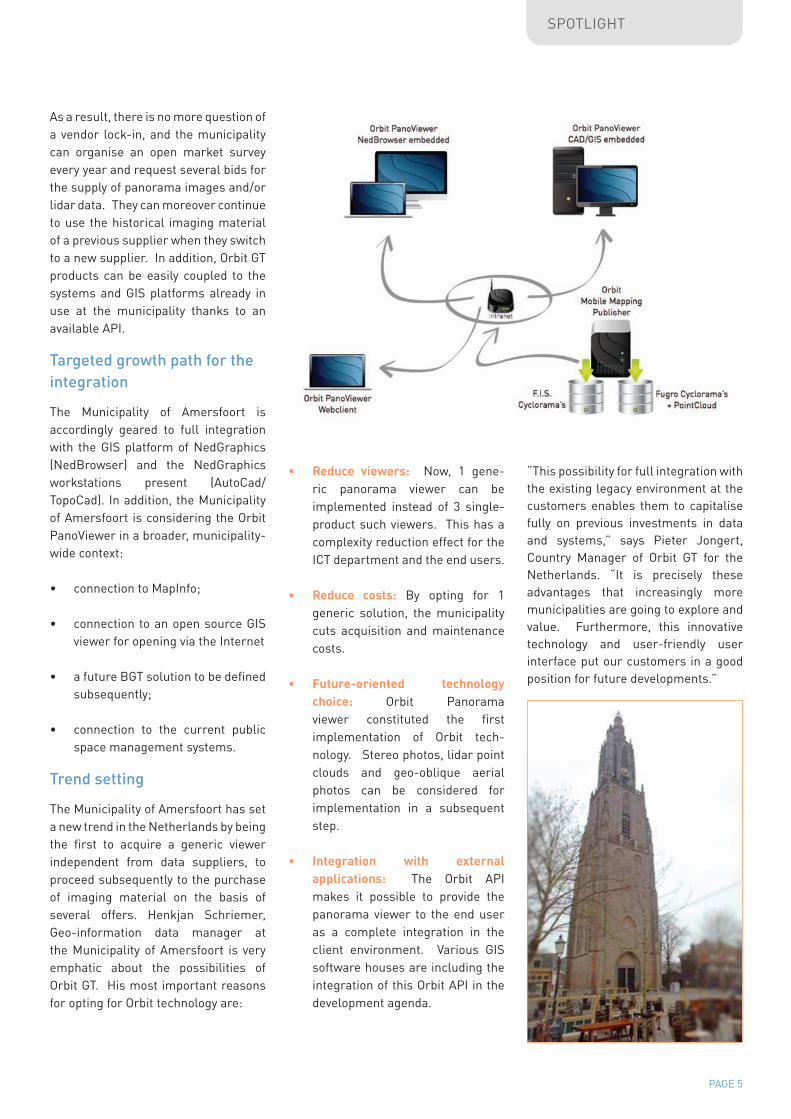
As a result, there is no more question of a vendor lock-in, and the municipality can organise an open market survey every year and request several bids for the supply of panorama images and/or lidar data. They can moreover continue to use the historical imaging material of a previous supplier when they switch to a new supplier. In addition, Orbit GT products can be easily coupled to the systems and GIS platforms already in use at the municipality thanks to an available API.
Targeted growth path for the integration
The Municipality of Amersfoort is accordingly geared to full integration with the GIS platform of NedGraphics (NedBrowser) and the NedGraphics workstations present (AutoCad/TopoCad). In addition, the Municipality of Amersfoort is considering the Orbit PanoViewer in a broader, municipality-wide context:
• connection to MapInfo;
• connection to an open source GIS viewer for opening via the Internet
• a future BGT solution to be defined subsequently;
• connection to the current public space management systems.
Trend setting
The Municipality of Amersfoort has set a new trend in the Netherlands by being the first to acquire a generic viewer independent from data suppliers, to proceed subsequently to the purchase of imaging material on the basis of several offers. Henkjan Schriemer, Geo-information data manager at the Municipality of Amersfoort is very emphatic about the possibilities of Orbit GT. His most important reasons for opting for Orbit technology are:
• Reduce viewers: Now, 1 gene-ric panorama viewer can be implemented instead of 3 single-product such viewers. This has a complexity reduction effect for the ICT department and the end users.
• Reduce costs: By opting for 1 generic solution, the municipality cuts acquisition and maintenance costs.
• Future-oriented technology choice: Orbit Panorama viewer constituted the first implementation of Orbit tech-nology. Stereo photos, lidar point clouds and geo-oblique aerial photos can be considered for implementation in a subsequent step.
• Integration with external applications: The Orbit API makes it possible to provide the panorama viewer to the end user as a complete integration in the client environment. Various GIS software houses are including the integration of this Orbit API in the development agenda.
“This possibility for full integration with the existing legacy environment at the customers enables them to capitalise fully on previous investments in data and systems,” says Pieter Jongert, Country Manager of Orbit GT for the Netherlands. “It is precisely these advantages that increasingly more municipalities are going to explore and value. Furthermore, this innovative technology and user-friendly user interface put our customers in a good position for future developments.”
PAGE 6
SOLUTIONS
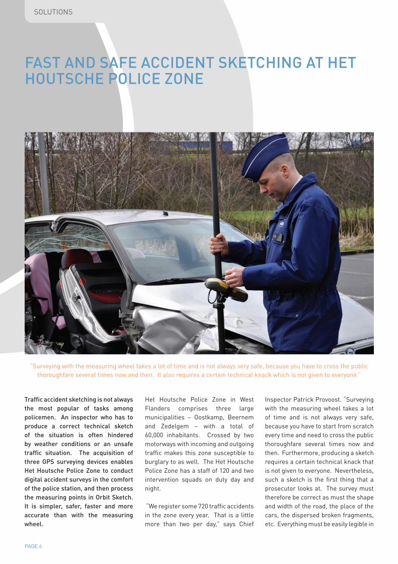
Traffic accident sketching is not always the most popular of tasks among policemen. An inspector who has to produce a correct technical sketch of the situation is often hindered by weather conditions or an unsafe traffic situation. The acquisition of three GPS surveying devices enables Het Houtsche Police Zone to conduct digital accident surveys in the comfort of the police station, and then process the measuring points in Orbit Sketch. It is simpler, safer, faster and more accurate than with the measuring wheel.
Het Houtsche Police Zone in West Flanders comprises three large municipalities – Oostkamp, Beernem and Zedelgem – with a total of 60,000 inhabitants. Crossed by two motorways with incoming and outgoing traffic makes this zone susceptible to burglary to as well. The Het Houtsche Police Zone has a staff of 120 and two intervention squads on duty day and night.
“We register some 720 traffic accidents in the zone every year. That is a little more than two per day,” says Chief
Inspector Patrick Provoost. “Surveying with the measuring wheel takes a lot of time and is not always very safe, because you have to start from scratch every time and need to cross the public thoroughfare several times now and then. Furthermore, producing a sketch requires a certain technical knack that is not given to everyone. Nevertheless, such a sketch is the first thing that a prosecutor looks at. The survey must therefore be correct as must the shape and width of the road, the place of the cars, the dispersed broken fragments, etc. Everything must be easily legible in
FAST AND SAFE ACCIDENT SKETCHING AT HET HOUTSCHE POLICE ZONE
“Surveying with the measuring wheel takes a lot of time and is not always very safe, because you have to cross the public thoroughfare several times now and then. It also requires a certain technical knack which is not given to everyone.”
PAGE 7
SOLUTIONS
order to enable a correct interpretation of the accident. The person who makes the sketch thus bears great responsibility.”
Faster and safer accident surveying
Het Houtsche Police Zone discovered the TOPCON devices for the first time at an Orbit Geospatial Technologies road show. These devices are used to register survey points of an accident digitally fast and easy at the push of a button. The technology combines positioning via satellite (GPS & Glonass) with the application of corrections and improved accuracy by means of AGIV’s Flepos antennas. Measuring devices thus attain an accuracy of no less than two centimetres. The device itself is fixed on a robust stick with the antenna/satellite receiver mounted on top. After the surveying, the data are read on an ISLP workstation in the police station. The necessary base lines can then be filled in on the survey points in the Orbit Sketch module.
Marnix Schauwaert, inspector at Het Houtsche Police Zone: “The demonstration made a strong impression. This technology could make our police work considerably easier. Just think of surveying and sketching accidents at night or during heavy rain. It would also prove useful on a busy road. The faster that we can complete a survey, the faster that we can open the road to traffic again.”
String of advantages
Het Houtsche Police Zone is deploying three GPS surveying devices from the outset. After internal training and
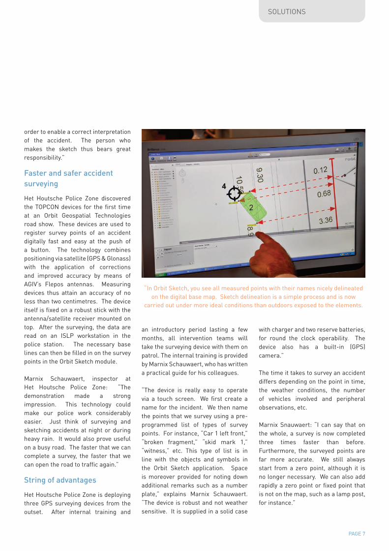
“In Orbit Sketch, you see all measured points with their names nicely delineated on the digital base map. Sketch delineation is a simple process and is now
carried out under more ideal conditions than outdoors exposed to the elements.
an introductory period lasting a few months, all intervention teams will take the surveying device with them on patrol. The internal training is provided by Marnix Schauwaert, who has written a practical guide for his colleagues.
“The device is really easy to operate via a touch screen. We first create a name for the incident. We then name the points that we survey using a pre-programmed list of types of survey points. For instance, “Car 1 left front,” “broken fragment,” “skid mark 1,” “witness,” etc. This type of list is in line with the objects and symbols in the Orbit Sketch application. Space is moreover provided for noting down additional remarks such as a number plate,” explains Marnix Schauwaert. “The device is robust and not weather sensitive. It is supplied in a solid case
with charger and two reserve batteries, for round the clock operability. The device also has a built-in (GPS) camera.”
The time it takes to survey an accident differs depending on the point in time, the weather conditions, the number of vehicles involved and peripheral observations, etc.
Marnix Snauwaert: “I can say that on the whole, a survey is now completed three times faster than before. Furthermore, the surveyed points are far more accurate. We still always start from a zero point, although it is no longer necessary. We can also add rapidly a zero point or fixed point that is not on the map, such as a lamp post, for instance.”

PAGE 8
SOLUTIONS
Processing data in Orbit Sketch
The survey points are kept on the SD card or in the internal memory. All data can be read out safely on a local ISLP workstation via the USB port and Active Sync technology (Interchange technology pursuant to the ICT guidelines of the federal police. “When you open the data file in Orbit Sketch, you see all the survey points with their labelling clearly delineated on the base map. You need now simply connect the right points with each other to reproduce the vehicles. The delineation is actually simple and is carried out under more ideal conditions not exposed to the weather elements,” says Marnix Snauwaert.
Multi-disciplinary use
Marnix Snauwaert sees other fields of application. AGIV is renewing the GRB base map according to its own schedule, but the public thorough fare may well be adapted in between, i.e. with a new round about or new road markings. With this device we
can survey the changes rapidly and adapt them on the map. In addition to accidents, we can also record other things, such as the location and impact of pollution (environmental police), a rail line (Search), where a body was
found (LOD), etc. Other public services could also make efficient use of this system.”
The applicability value during re-enactments is now being tested, during which the reverse principle is applied: the survey data are put back on the device. The software interface of the device indicates when one is back at the right place.
Marnix Snauwaert concludes: “Orbit GT has provided us with good advice and guidance in our choice of technology, including in the implementation in the police force. Contacts are smooth and when we need advice and support, they are always ready to help us. “Surveying can now be carried out three times faster and is far more accurate
than before. We can moreover add rapidly a zero point or fixed point that is not on the map.”
PAGE 9
TRENDWATCHER
“TOUR OF FLANDERS” EVENT CONTINGENCY PLAN MAPPED BY THE FLEMISH ARDENNES POLICE ZONE
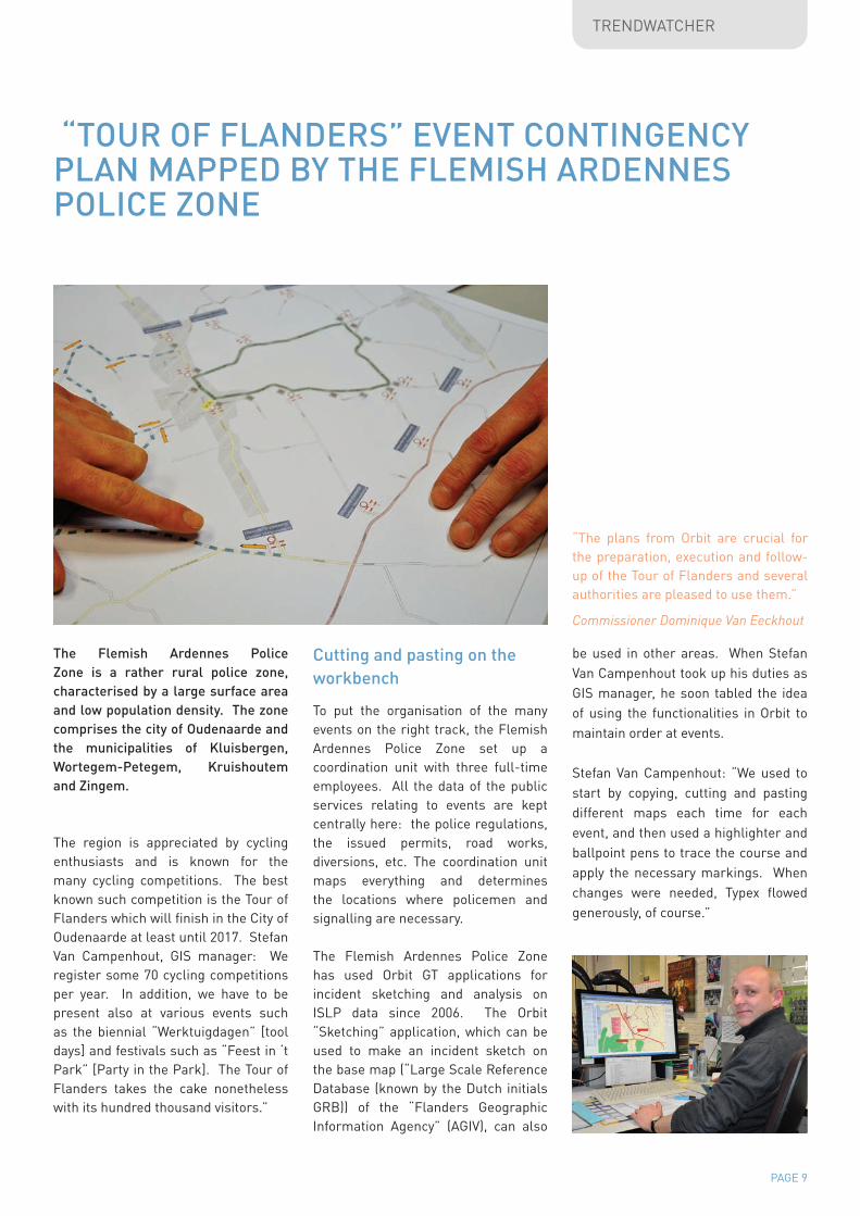
The Flemish Ardennes Police Zone is a rather rural police zone, characterised by a large surface area and low population density. The zone comprises the city of Oudenaarde and the municipalities of Kluisbergen, Wortegem-Petegem, Kruishoutem and Zingem.
The region is appreciated by cycling enthusiasts and is known for the many cycling competitions. The best known such competition is the Tour of Flanders which will finish in the City of Oudenaarde at least until 2017. Stefan Van Campenhout, GIS manager: We register some 70 cycling competitions per year. In addition, we have to be present also at various events such as the biennial “Werktuigdagen” [tool days] and festivals such as “Feest in ‘t Park” [Party in the Park]. The Tour of Flanders takes the cake nonetheless with its hundred thousand visitors.”
Cutting and pasting on the workbench
To put the organisation of the many events on the right track, the Flemish Ardennes Police Zone set up a coordination unit with three full-time employees. All the data of the public services relating to events are kept centrally here: the police regulations, the issued permits, road works, diversions, etc. The coordination unit maps everything and determines the locations where policemen and signalling are necessary.
The Flemish Ardennes Police Zone has used Orbit GT applications for incident sketching and analysis on ISLP data since 2006. The Orbit “Sketching” application, which can be used to make an incident sketch on the base map (“Large Scale Reference Database (known by the Dutch initials GRB)) of the “Flanders Geographic Information Agency” (AGIV), can also
be used in other areas. When Stefan Van Campenhout took up his duties as GIS manager, he soon tabled the idea of using the functionalities in Orbit to maintain order at events.
Stefan Van Campenhout: “We used to start by copying, cutting and pasting different maps each time for each event, and then used a highlighter and ballpoint pens to trace the course and apply the necessary markings. When changes were needed, Typex flowed generously, of course.”
“The plans from Orbit are crucial for the preparation, execution and follow-up of the Tour of Flanders and several authorities are pleased to use them.”
Commissioner Dominique Van Eeckhout
PAGE 10
TRENDWATCHER
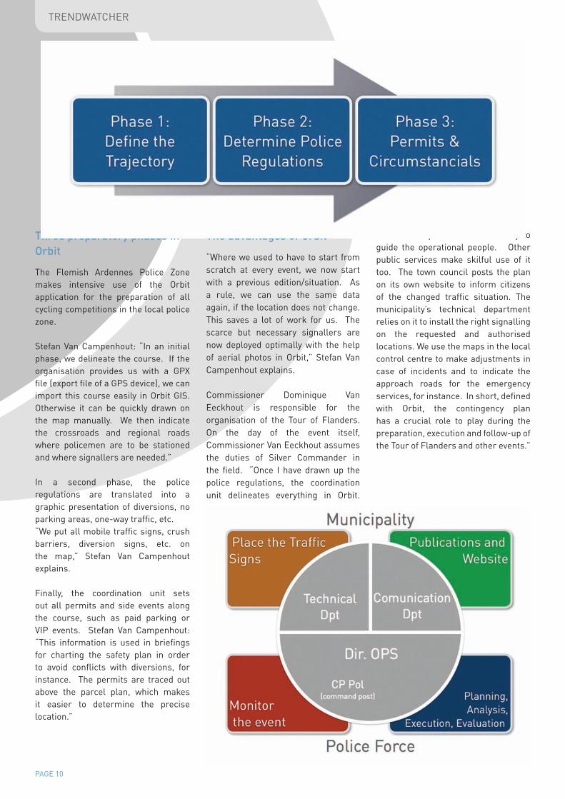
Three preparatory phases in Orbit
The Flemish Ardennes Police Zone makes intensive use of the Orbit application for the preparation of all cycling competitions in the local police zone.
Stefan Van Campenhout: “In an initial phase, we delineate the course. If the organisation provides us with a GPX file (export file of a GPS device), we can import this course easily in Orbit GIS. Otherwise it can be quickly drawn on the map manually. We then indicate the crossroads and regional roads where policemen are to be stationed and where signallers are needed.”
In a second phase, the police regulations are translated into a graphic presentation of diversions, no parking areas, one-way traffic, etc. “We put all mobile traffic signs, crush barriers, diversion signs, etc. on the map,” Stefan Van Campenhout explains.
Finally, the coordination unit sets out all permits and side events along the course, such as paid parking or VIP events. Stefan Van Campenhout: “This information is used in briefings for charting the safety plan in order to avoid conflicts with diversions, for instance. The permits are traced out above the parcel plan, which makes it easier to determine the precise location.”
The advantages of Orbit
“Where we used to have to start from scratch at every event, we now start with a previous edition/situation. As a rule, we can use the same data again, if the location does not change. This saves a lot of work for us. The scarce but necessary signallers are now deployed optimally with the help of aerial photos in Orbit,” Stefan Van Campenhout explains.
Commissioner Dominique Van Eeckhout is responsible for the organisation of the Tour of Flanders. On the day of the event itself, Commissioner Van Eeckhout assumes the duties of Silver Commander in the field. “Once I have drawn up the police regulations, the coordination unit delineates everything in Orbit.
The charted plan is used internally to guide the operational people. Other public services make skilful use of it too. The town council posts the plan on its own website to inform citizens of the changed traffic situation. The municipality’s technical department relies on it to install the right signalling on the requested and authorised locations. We use the maps in the local control centre to make adjustments in case of incidents and to indicate the approach roads for the emergency services, for instance. In short, defined with Orbit, the contingency plan has a crucial role to play during the preparation, execution and follow-up of the Tour of Flanders and other events.”
PAGE 11
TRENDWATCHER
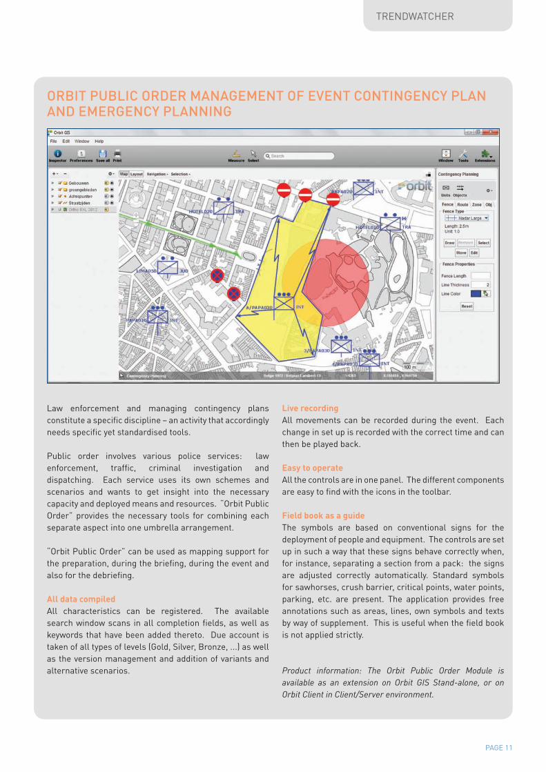
Law enforcement and managing contingency plans constitute a specific discipline – an activity that accordingly needs specific yet standardised tools.
Public order involves various police services: law enforcement, traffic, criminal investigation and dispatching. Each service uses its own schemes and scenarios and wants to get insight into the necessary capacity and deployed means and resources. “Orbit Public Order” provides the necessary tools for combining each separate aspect into one umbrella arrangement.
“Orbit Public Order” can be used as mapping support for the preparation, during the briefing, during the event and also for the debriefing.
All data compiledAll characteristics can be registered. The available search window scans in all completion fields, as well as keywords that have been added thereto. Due account is taken of all types of levels (Gold, Silver, Bronze, ...) as well as the version management and addition of variants and alternative scenarios.
Live recordingAll movements can be recorded during the event. Each change in set up is recorded with the correct time and can then be played back.
Easy to operateAll the controls are in one panel. The different components are easy to find with the icons in the toolbar.
Field book as a guideThe symbols are based on conventional signs for the deployment of people and equipment. The controls are set up in such a way that these signs behave correctly when, for instance, separating a section from a pack: the signs are adjusted correctly automatically. Standard symbols for sawhorses, crush barrier, critical points, water points, parking, etc. are present. The application provides free annotations such as areas, lines, own symbols and texts by way of supplement. This is useful when the field book is not applied strictly.
Product information: The Orbit Public Order Module is available as an extension on Orbit GIS Stand-alone, or on Orbit Client in Client/Server environment.
ORBIT PUBLIC ORDER MANAGEMENT OF EVENT CONTINGENCY PLAN AND EMERGENCY PLANNING
PAGE 12
SOLUTIONS
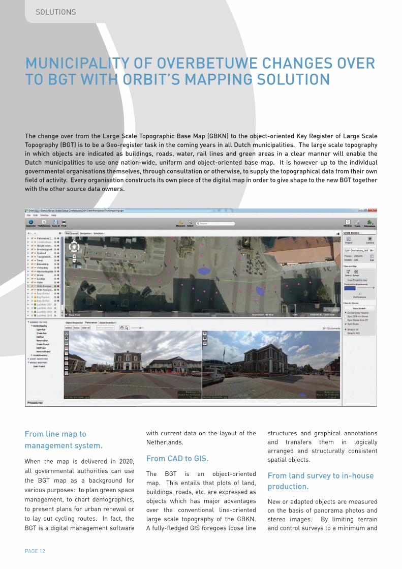
MUNICIPALITY OF OVERBETUWE CHANGES OVER TO BGT WITH ORBIT’S MAPPING SOLUTION
The change over from the Large Scale Topographic Base Map (GBKN) to the object-oriented Key Register of Large Scale Topography (BGT) is to be a Geo-register task in the coming years in all Dutch municipalities. The large scale topography in which objects are indicated as buildings, roads, water, rail lines and green areas in a clear manner will enable the Dutch municipalities to use one nation-wide, uniform and object-oriented base map. It is however up to the individual governmental organisations themselves, through consultation or otherwise, to supply the topographical data from their own field of activity. Every organisation constructs its own piece of the digital map in order to give shape to the new BGT together with the other source data owners.
From line map to management system.
When the map is delivered in 2020, all governmental authorities can use the BGT map as a background for various purposes: to plan green space management, to chart demographics, to present plans for urban renewal or to lay out cycling routes. In fact, the BGT is a digital management software
with current data on the layout of the Netherlands.
From CAD to GIS.
The BGT is an object-oriented map. This entails that plots of land, buildings, roads, etc. are expressed as objects which has major advantages over the conventional line-oriented large scale topography of the GBKN. A fully-fledged GIS foregoes loose line
structures and graphical annotations and transfers them in logically arranged and structurally consistent spatial objects.
From land survey to in-house production.
New or adapted objects are measured on the basis of panorama photos and stereo images. By limiting terrain and control surveys to a minimum and

PAGE 13
SOLUTIONS
optimising in-house mapping, BGT map production runs very efficiently.
Choice for the right tools.
What is striking is that for many Dutch municipalities, the change over from GBKN to BGT continues to be a difficult issue. It goes without saying that producing such a map, where every square centimetre of territory is set down, is an enormous task. Making the BGT object-oriented is nonetheless seen by the municipalities as a more difficult task than it actually is. Many municipalities already have a quality GBKN that is very easy to translate into a BGT with a thorough map update and an intelligent GIS interpretation. The transformation to GIS is carried out chiefly by software tools, namely BGT tools that convert lines into surfaces or couple point attributes to flat objects efficiently. In addition, the objects must be mapped by optimised functions which ensure that every user can complete the data on the basis of photo material. As such, photogrammetry, the basis for measuring objects through aerial photographs, is child’s
play when the right tools are provided and the link is made with the 2D GIS base map.
The Orbit GT offer therefore provides the key to all BGT purposes as well. The package is modern, cool and extremely user-friendly. It is an integration of panoramic, oblique and stereo images in one and the same GIS environment. The stereo images are read in via Orbit Softcopy, the extension for photogrammetric production. This means that each object is visible in the GIS also in stereo imaging and vice versa through a simple operation and immediate integration in GIS. All data present on the server can be combined with the stereo images and supplemented as and where necessary. 360° panorama photographs are a further useful source of information. What is not visible from the air, can be mapped from “street perspective.” You can view and measure the panorama photographs with the Orbit Mobile Mapping and Asset Inventory extensions and make an overlay with proprietary geo data. Measurements can also be taken in
order to update, improve or refine the municipal BGT. The joint presentation and integration in one movement of GIS, 360° panorama photographs and stereo photographs make it possible to present every (mapped) object at the same time on the ortho-, pano-, or aerial photograph. It is a matter of broaching the work flow on the ground to work time and cost effectively.
The municipality of Overbetuwe has shown that land surveyors who traditionally used to be in the field daily for the GBNK, can now produce their new BGT map in-house. After an intensive training course given by Orbit consultants in which the basic work flow for BGT production was broached in the municipality of Overbetuwe, a production environment was created. The results were quick in coming. The targeted production speed was already attained after 2 weeks of mapping
“We have found pleasure in mapping like real surveyors thanks to Orbit”
Erik Bosch, GEO staff member, municipality of Overbetuwe
PAGE 14
SOLUTIONS
experience. It looks as if the production of the BGT in the municipality of Overbetuwe is over and done with.”
The integrated applications Orbit Softcopy, Orbit Mobile Mapping and Orbit Asset Inventory endow the municipality of Overbetuwe with a unique station for the production of the BGT. All data sources are accessible and usable in one and the same GIS environment. The seamless measurement in ortho-, stereo- and pano-photos provides Overbetuwe with a powerful BGT mapping instrument.
Opting for data supplier independence.Neither the panorama images (without or without lidar point cloud) nor the type of aerial photographs are decisive for the Orbit software. Orbit Softcopy supports all standard stereo images made from low and high altitude. The entire production line of Orbit Mobile Mapping software now supports all providers of panorama images (in 3D lidar) in the Netherlands and abroad. The municipality of Overbetuwe has meanwhile opted for a future-oriented BGT narrative.
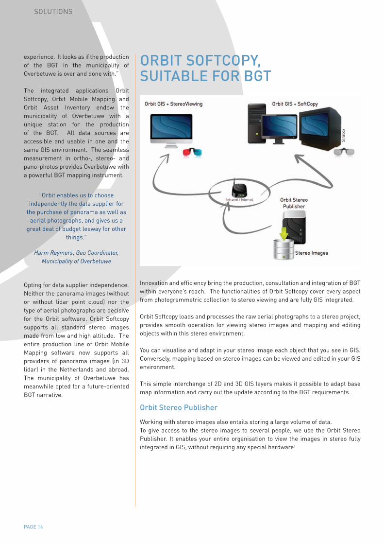
ORBIT SOFTCOPY, SUITABLE FOR BGT
Innovation and efficiency bring the production, consultation and integration of BGT within everyone’s reach. The functionalities of Orbit Softcopy cover every aspect from photogrammetric collection to stereo viewing and are fully GIS integrated.
Orbit Softcopy loads and processes the raw aerial photographs to a stereo project, provides smooth operation for viewing stereo images and mapping and editing objects within this stereo environment.
You can visualise and adapt in your stereo image each object that you see in GIS. Conversely, mapping based on stereo images can be viewed and edited in your GIS environment.
This simple interchange of 2D and 3D GIS layers makes it possible to adapt base map information and carry out the update according to the BGT requirements.
Orbit Stereo Publisher
Working with stereo images also entails storing a large volume of data. To give access to the stereo images to several people, we use the Orbit Stereo Publisher. It enables your entire organisation to view the images in stereo fully integrated in GIS, without requiring any special hardware!
“Orbit enables us to choose independently the data supplier for
the purchase of panorama as well as aerial photographs, and gives us a
great deal of budget leeway for other things.”
Harm Reymers, Geo Coordinator, Municipality of Overbetuwe
PAGE 15
INNOVATION
LAND COVERING OBLIQUE IMAGES, HEIGHT MODEL AND LIDAR Oblique aerial photos are getting more and more attention. The production cost has dropped drastically, the resolution has been improved, and the added value is becoming visible and affordable.
Even a land covering height model based on a dense point cloud (LiDAR) is no news anymore. Opening these data continued to be a challenge, however. Until now.
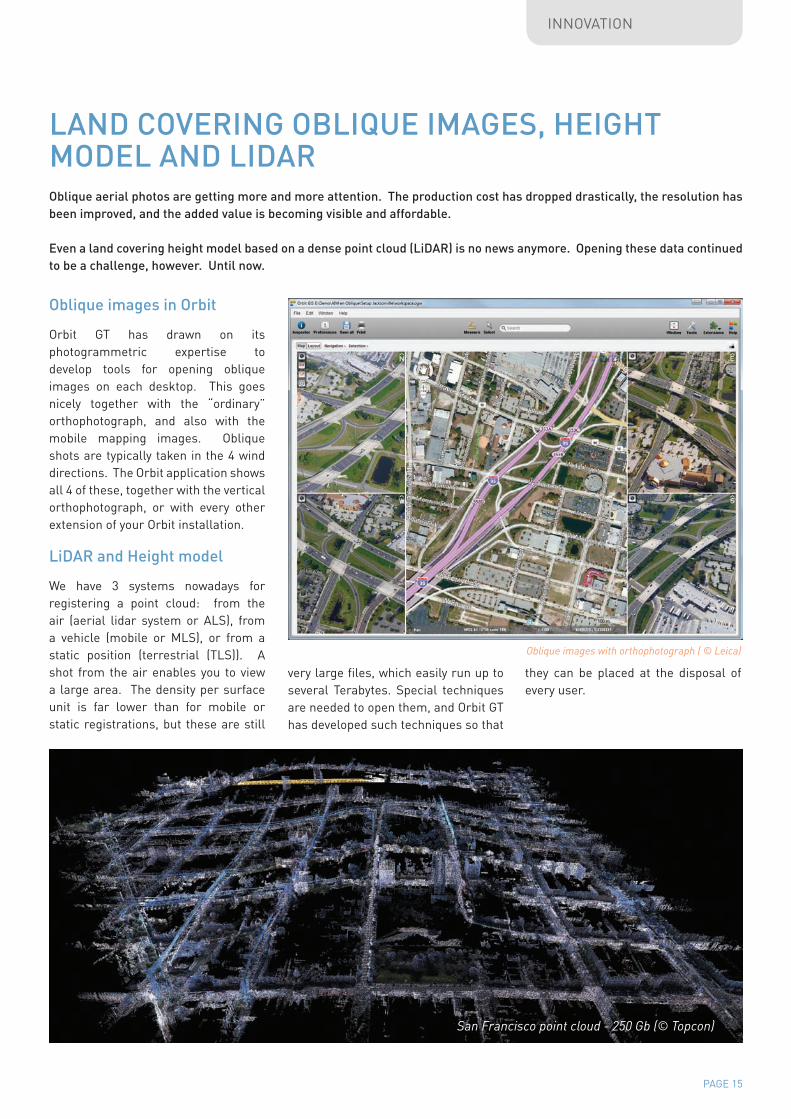
Oblique images in Orbit
Orbit GT has drawn on its photogrammetric expertise to develop tools for opening oblique images on each desktop. This goes nicely together with the “ordinary” orthophotograph, and also with the mobile mapping images. Oblique shots are typically taken in the 4 wind directions. The Orbit application shows all 4 of these, together with the vertical orthophotograph, or with every other extension of your Orbit installation.
LiDAR and Height model
We have 3 systems nowadays for registering a point cloud: from the air (aerial lidar system or ALS), from a vehicle (mobile or MLS), or from a static position (terrestrial (TLS)). A shot from the air enables you to view a large area. The density per surface unit is far lower than for mobile or static registrations, but these are still
very large files, which easily run up to several Terabytes. Special techniques are needed to open them, and Orbit GT has developed such techniques so that
they can be placed at the disposal of every user.
San Francisco point cloud - 250 Gb (© Topcon)
Oblique images with orthophotograph ( © Leica)