some relations between fractal dimension of drainage networks and geomorphology of drainage basins
TRANSCRIPT

Introduction
Theapplicationoffractalanalysisisinvolvinganincreasingnumberofscientificbranches.Infact,duetoitscapabilitytoreducetheinadequacyoftraditionalEuclideangeometry,whenstudyingcomplexforms,itcanaffordareliabletoolininvestigatingmanynaturalphenomena(Mandelbrot,1977;Turcotte,1992).Thisanalysisisapplicablealsoinmanyfieldsofearthsciences,suchasgeology,geomorphology,geophysicsandoceanography.Specifically,fractalanalysisingeomorphologyallowstoacquireinterestingquantitativeinformationontheshapeofdrainagenetworks,contourlines,topographicsurfacesandmanyothermorphosculptures.Ingeomorphologiccontexts,manyofthefractal“objects”sofarstudied,keeptheir
geometriccharacteristicsinspiteofscalevariations(scaleinvariance).Someothers,
SomeRelationsbetweenFractalDimensionofDrainageNetworksandGeomorphologyofDrainageBasins 1Transactions, JapaneseGeomorphologicalUnion28-1,p.1-21 (2007)
地形 第28巻第1号1-21頁 (2007)
SomeRelationsbetweenFractalDimensionofDrainageNetworksandGeomorphologyofDrainageBasins
MaurizioDELMONTE*,PaolaFREDI*,ElvidioLUPIAPALMIERI*
andPaolaSBARRA*
Abstract
ThefractalpropertiesofdrainagenetworksofsomeItaliandrainagebasinswithdifferentgeomorphologicalcharacteristicshavebeeninvestigated.Theaimsofthisstudyaretomeasurethe“fractaldimension”ofsuchdrainagenetworksandtoevaluatequantitativelytheirgeomorphologicalsignificance.Tothisend,fourmethodologieshavebeenappliedtoelevennetworks,whose
fractaldimension(Df)hasbeencomputed.Dataobtainedsuggestthattherelationbetweendrainagepatternandfractaldimensionvaluesisnotasimpleone;however,theparameterDfcanexpressthenetworkgeometryandafforduseful,quantitativeinformationaboutthetectonicconditioningonthenetworkemplacementsandtheirevolutiondegree.Onthisbasis,thedifferencesamongthecomplexandvariedgeometryofwidenetworkscanbetranslatedinquantitativeterms.Theresultssofarobtainedareobviouslypreliminary,andneedtobefurther
verified;however,theyareencouragingandgiveshapetothepossibilityofprovidinginformationinaparametricform aboutthegeometryofadrainagenetworkanditsevolutiondegree.Keywords:DrainageNetwork,FractalDimension,QuantitativeGeomorphology,
StructuralGeomorphology
ReceivedJune13,2006;AcceptedJuly24,2006* DipartimentodiScienzedellaTerra,UniversitàdegliStudidiRoma«LaSapienza»PiazzaleAldoMoro,5-P.O.Box11-00185RomeItaly

instead,seem topreservesomeoftheircharacteristicsunchangedwithinshorterlengthintervals.Thestudyofthesegeometriccharacteristicsallowstoobtaintheirfractionarydimensionor“fractaldimension”,Df.Thispaperfocusesparticularlyonfractalpropertiesofdrainagenetworksandon
theirgeomorphologicalmeaning.Manyauthorstackledthistopic(LaBarberaandRosso,1989;Maranietal.,1991;Rinaldoetal.,1991;MasekandTurcotte,1993;BeerandBorges,1993;Nikora,1994;Rodriguez-Iturbeetal.,1994;ClapsandOliveto,1996;MaitreandPinciroli,1997;Sagaretal.,1998;DelMonteetal.,1999).ManyofthemshowedthatDfdependsondrainagenetworkdegreeofdevelopmentandramificationandonthesinuosityofeachstream channel(Schulleretal.,2001).
Someauthors(Chengetal.,2001)assertthatadrainagenetworkwithhighDfvalues(closeto2)isspace-filling,isotropicandstructuralconditioningindependenttoo.Otherauthors,asStark(1991),assertthatanisotropicnetdoesnotnecessarilydiffersfrom ananisotropicone(structurallycontrolled)inthesizeofspace-filling.
Theconceptofspace-fillingwasintroducedbyPeanoin1890,andsuccessivelydrawn on byHilbertin1891 (Norman andMoscato,1995),toexplain thefractaldimensions ranging between1 and2 ofsome objects.Actually,drainage netispotentiallyspace-fillingasitgatherstherunofffrom thewholedrainagebasin.Tokunaga(1998),referringtoHack(1957),showedtheexistenceofatheoreticalmodelofdrainagenetworkdevelopment,wheretheupperlimitvalueofDfequals2 rightinthecaseofbasinslacking offractallacunae (maximum space-filling).Thistheoreticalcondition,however,canbeobtainedonlywhenadrainagebasinisfilledupwithitssubbasinandinterbasinareas,andnotwithitschannelnetwork(Tokunaga,2000).
Studyareas
ElevendrainagebasinsofvariousItalianareasareconsidered(Fig.1);theydifferingeological,geomorphological,structural,climatic,andvegetationcharacteristicsandtheirsizesrangebetween16 km2 and180 km2 (Table1).Althoughitisoftenimpossibletosimplyclassifyadrainagenetworkwithinasinglespecificpattern,thebasinshavebeenchosentakingintoaccountboththedensityandthepatternoftheirnetworks.The studied basins are representative enough ofthe various environmental
conditions ofCentral-Southern Italy.Some ofthem are in CentralItaly,on theTyrrheniansideoftheApenninechain,theothersflowstotheAdriaticSeaortotheIonianSeaandarelocatedinCentralandSouthernItaly.
Theclimaticconditionsofthestudyareasarequitedifferent,accordingtotheirgeographicallocations.Meanannualrainfallsrangefrom 617 to1609 mm.Rainfallsdecreasedownsteam,wherethelowestmeanannualvaluesarerecorded.Meanmonthlyvaluesrangefrom106.0to185.4mminNovember,andfrom11.6to41.1mminJuly.Rainfalleventsofconsecutivedaysarefrequent.Theyoftenreach250 mm in5
days,andsometimestheymayexceed450mm in5days.
2 MaurizioDELMONTE,PaolaFREDI,ElvidioLUPIAPALMIERIandPaolaSBARRA

Themeanannualtemperaturesofthestudybasinsrangesfrom11 and15 °C;themeanmonthlymaximum isusuallyregisteredinJuly(24.0°C)andtheminimum inJanuary(1.8°C).
SomeRelationsbetweenFractalDimensionofDrainageNetworksandGeomorphologyofDrainageBasins 3
Table1.Cumulativelengthofdrainagenetworks(L),area(A)anddrainagedensityofdrainagebasins(D)(Horton,1945).
D(km/km2)A(km2)L(km)
4.67662.53292.380TorrenteMaianoa
4.166181.43755.928TorrenteTrasubbieb
5.75619.90114.546TorrenteCertanoc
6.87643.85301.536TorrenteBuranod
4.54618.2582.968TorrenteBalbanoe
8.42821.49181.119TorrenteBrettaf
2.18275.28164.229FossodellaMolag
4.91217.5286.068FossodiVallelatah
4.13716.3267.525FossoMoranai
3.67629.05106.778Fossodell’Acquabuonal
3.71037.30138.370TorrenteGravinadiMateram
Fig.1.Studyarealocation.

Movingfrom thenorthernmostonesouthward,thestudybasinsbelongtothefollowingareas:SouthernTuscany,Umbria-Marcheboundary,SouthernMarche,Latium,(CentralItaly)andBasilicata(SouthernItaly)(Fig.1).ThedrainagebasinsofTorrenteMaianoandTorrenteTrasubbiearelocatedin
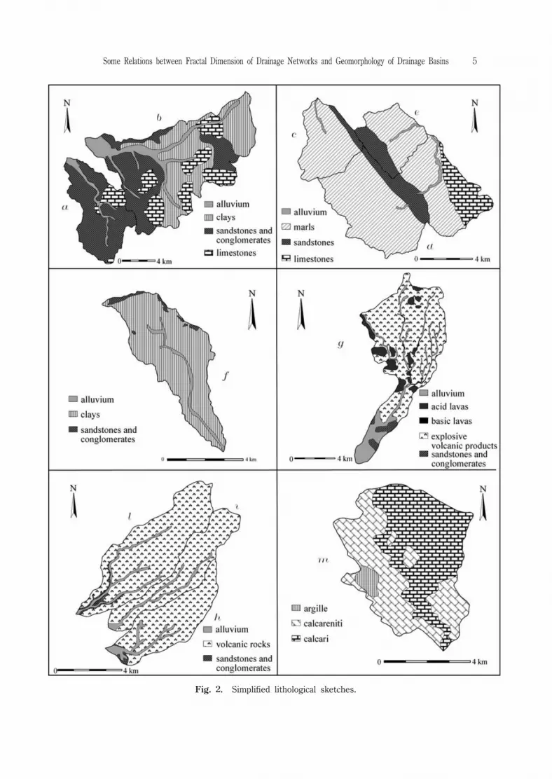
Southern Tuscany (Fig.1a-b),although adjacent,they greatly differin outcroppinglithologies.Argillaceous-arenaceouslithologiescropoutintheTorrenteMaianobasin(Figs.2aand3a);bedrockoutcrops(argillites,marlylimestones,polygenicconglomeratesandgray-blueshalesandmarls)arewidespreadintheTorrenteTrasubbiedrainagebasin(Figs2band3b).N-SorientedtectonicsaffectedthisareaduringPliocene;NE-SWtectonicdirectionsarealsopresentintheeasternportion.Pleistocenesinkingandblockfaultingcontrolledtherecentmorphologicalevolutionofthewesternmostportionofthisarea.(Pasquarèetal.,1983).
TheTorrenteCertano,TorrenteBuranoandTorrenteBalbanodrainagebasinscoveranoverallsurfaceof82km2,attheUmbria-Marcheboundary,totheNorthofGubbiotown(Table1,Figs.3c,3dand3e).Lithologiesbelongingto“SchlierFormation”(lightgray silty marls with thin arenaceous layers) and“Marnoso-Arenacea Formation”(sandstones,marlinterbeddedsandstoneandargillaceousmarls)widelycropoutinthissecondarea(Figs.2c,2dand2e).TheseformationsaretypicaloftheUmbria-MarcheApennine,aNEvergingfoldsandthrustchainsthatwerebuiltupstartingfrom UpperMiocene (Menichettiand Minelli,1991).Foldsare characterized by wide synclinesalternatedwithnarrow anticlines,allofthem NW-SEtrendingandoftendislocatedbylongitudinalfaults.Theanticlineaxisisfrequentlyaffectedbysecondaryobliqueandtransversefaults.
Secondaryfaultsandfracturesoccuronthemostresistantlithologies.TheTorrenteBrettadrainagebasinextendsforabout21 km2 (Table1)inthe
SouthernMarche,whereprevailinglypelitic-arenaceouslithologiesarewidespread(Figs.2fand3f).Outcroppingrocksarearenaceouscalcareniticlithofacies,transgressiveontheMessinian pelitic-arenaceousturbiditesofthe“LagaFormation”(Cantalamessaetal.,1986;Centamore,1986;Carlonietal.,1990).Duetoselectiveerosion,arenaceous-calcareniticrocksstandoutinthesurroundinglandscape,madeupofthelessresistantturbidites.Themorphogenesisofthisareaisstronglycontrolledbyrecenttectonicevents, and particularly by differential uplift occurred since Lower Pleistocene(Ambrosettietal.,1982;Dufaureetal.,1988),accordingtoNW-SEandNE-SW tectoniclines.ThevalleysofthemainriversareconditionedbytectonicdiscontinuitiesWSW-ENEtrending.ThedrainagebasinsofFossodellaMola,FossodiVallelata,FossoMoranaand
Fossodell’AcquabuonaarecomprehendedwithintheLatiumarea.TheFossodellaMoladrainagebasin(75.3km2,Table1)isemplacedbetween
MontiSabatinieMontiCeriti,twovolcanicdistrictsactiveduringPleistocene(Ciccaccietal.,1988).Themainvalleyiscutintotheignimbritecalled“Tuforossoascorienere”(“Redtuffwithblackscoriae”),thatwaseruptedfrom MontiSabatiniandextended
4 MaurizioDELMONTE,PaolaFREDI,ElvidioLUPIAPALMIERIandPaolaSBARRA
SomeRelationsbetweenFractalDimensionofDrainageNetworksandGeomorphologyofDrainageBasins 5
Fig.2.Simplifiedlithologicalsketches.

northeastwardasfarastheolderMontiCeriti(Figs.2gand3g).Thesearevolcanicdomes,rangingincompositionfrom rhyolitic(theolderones)totrachiyandesitic(theyoungerones).Duetothedifferentresistencetoerosionofignimbriteandlavadomes,thelandscapeismarkedbystrongcontrasts.Thelesserodiblelavadomesarepoorly
6 MaurizioDELMONTE,PaolaFREDI,ElvidioLUPIAPALMIERIandPaolaSBARRA
Fig.3.Drainagenetworksofstudybasins.
affectedbydenudationalprocessesincontrasttotheignimbritethat,atplacesfriableandearthy,ismarkedlyshapedbysurfacerunningwaters.TotheSouthofRome,betweenApriliaandArdea,themaintrunksofthedrainage
networksofFossodiVallelata(Fig.3h),FossoMorana(3i)andFossodell’Acquabuona(Fig.3l),flow followingtheNE-SW direction,whereasmostoftheirtributariesareperpendiculartothemaintrunks,flowingNW-SE.Onthewhole,thedrainagenetworksshowanoverallsubparallelpattern,althoughrectangularpatternappearsatplaces(Figs.3h,3iand3l).
These drainage networksare emplaced in the Ardeasedimentary basin whichdeveloped between Lower Pliocene and Lower Pleistocene;itshows half-grabenstructuresandisfilledbyclasticdeposits1600 m thick(DeRitaetal.,1995)overlainbythevolcanicproductseruptedbyTuscolano-Artemisioedifice(0.60-0.35 Ma;Marraetal.,2003),belongingtotheVolcanicDistrictofColliAlbani.ThelaststudiedbasinisinSouthernItaly(Basilicata);itisdrainedbythenetwork
ofTorrenteGravinadiMatera(Fig.3m),totheSouthofthebuilt-upareaofMatera(seeFig.1).Thebasinisemplacedinarecentlyupliftedarea(MateraHorst),whichispartoftheApuliaforeland.Thedrainagenetworkconsistsmainlyofstream channels(locally named“gravina”)deeply cutting the limestone outcrops(Fig.2m;Tropeano,1992),wheregorgeswithsteepslopesareoriginatedasaresultofthetectonicuplift.ThelowerorderstreamsflowaccordingtoNNE-SSW andENE-WSW jointsthataffectthemostrecentsedimentaryunits(UpperPliocene-LowerPleistocenecalcarenites);thehigherorderstreamsfollowtheNW-SEandNE-SW trendingfaultsandfractureswhichaffecttheMesozoicsubstratum andrevealonsurfaceinthedevelopmentofstreamelbows(Fig.4).Asawholethedrainagenetworkhasrectangularpatternandisclearlycontrolledbylinearstructuralelements.
Methodsoffractalanalysis
Thedrainagenetworksoftheexaminedbasinshavebeenreconstructedindetailsbymeansoftopographicmaps(scale1:25,000)andaerialphotointerpretation;streamchannelshavebeenhierarchicallyorderedafterStrahler(1957)anddigitizedbythesoftwareAutodeskAutoCAD Map®.Thegeometriccharacteristicsofstream channelshavebeenanalyzedthroughFORTRAN programsspecificallydevelopedbytheauthors;suchprogramsanalyze“.dxf”filesbycomputinglengthsandnumbersofthedifferentorderstreams.TocalculateDfvaluesthemethodsbyLaBarberaandRosso(1989),byTurcotte
(1992,1997),the channel-computing(DelMonte etal.,1997)and the box-counting(Goodchild,1982)wereused.According to the method by LaBarberaand Rosso,the fractaldimension is
obtainedfrom theratiologRb/logRl,whereRbandRlaretheparameters“bifurcationratio”and“lengthratio”byHorton(1945).
SomeRelationsbetweenFractalDimensionofDrainageNetworksandGeomorphologyofDrainageBasins 7

Both channel-computingandTurcotte’smethodsconsiderthenumberofstreamchannels(N)asfunctionoftheirlength(L),buttheformergroupschannelsaccordingtolengthintervals,whereasthelattergroupsthem accordingtotheirhierarchicalorder.Afterthechannel-computingmethod,dataaboutthenumbersofchannelsperlength
intervalsarerepresentedthroughhistogramsandprojectedontoabi-logarithmicspace,inwhichlengthintervals(L)areonthex-axisandfrequency(N)onthey-axis.Thederivedcurvesshowastraightportionwithtwo“drops”atitsedges.Thecurvedropshave then been cutoffin the regression to evidence the intervalofinverseproportionalitybetweenlogNandlogL.ThecurvedroprelatedtothelowestLvalues(resolutiondrop)dependsonthescaleatwhichthedrainagenetworkweretraced;theonerelatedtothehighestLvalues(extensiondrop)istiedtothesizeoftheexamineddrainagebasin(DelMonteetal.,1999).Alongtheintervalofinverseproportionalityofeach curve,aseriesoflinear
regressions have been performed. Starting from the regression of points, weprogressivelyreducedthepointintervaluntilasatisfactoryregressionwasreached.Asameasureofgoodness-of-fitoflinearregression,theR²value(afractionbetween0.0and1.0)wasused.Tothispoint,thefractaldimensionofthedrainagenetworkanalysediseasilydeducedfrom thegradient— changedinsign— oftherepresentativeregressionline(Df=-[Δ(logN)/Δ(logL)]).Turcotte’smethodfollowsasimilarprocedure,butthecurvedrawnbyplottinglog
LvaluesagainstlogNvaluesisalwaysdescendentandhasfewerpoints(x,#y).
8 MaurizioDELMONTE,PaolaFREDI,ElvidioLUPIAPALMIERIandPaolaSBARRA
Fig.4.Stream elbow ofGravinadiMatera(m);onthebackground,astructuralsummitsurface.
Accordingtothebox-countingmethod,aboxgridisarrangedonaplaneCartesiancoordinates.Then,alltheboxesthatcontainatleastonesegmentofanystream arecounted.Bydecreasingthesizeoftheboxside(r)andcountingagainthenumber(N(r))ofboxescrossedbyoneormorestream segments,asetofcouplesr-N(r)isobtainedthatisplottedonthecoordinatesystem byputtinglogrontheabscissasandlogN(r)onordinates.Theminimum sizeoftheboxsideconsideredinthispaperis50m.Asforthetwopreviouslydescribedmethods,Dfvaluescorrespondtothegradient(changedinsign)ofthebestequationdrawnfrom theplottedpointsbyregressionanalysis.
TheDfvaluesareconsideredsignificantwhentheprobabilitythatR2 valuesareaccidentalisrespectively<0.1% ifthebox-countingmethodisfollowedand<1% ifthechannel-computingandTurcotte’smethodsareperformed.TheDfvaluescalculatedforthestudydrainagebasinsarelistedinTable2,alongwiththevaluesthatdonotsatisfytheneededprobabilityconditions.ThesametableshowsDfvaluesobtainedthroughLaBarberaandRossomethod.
Results
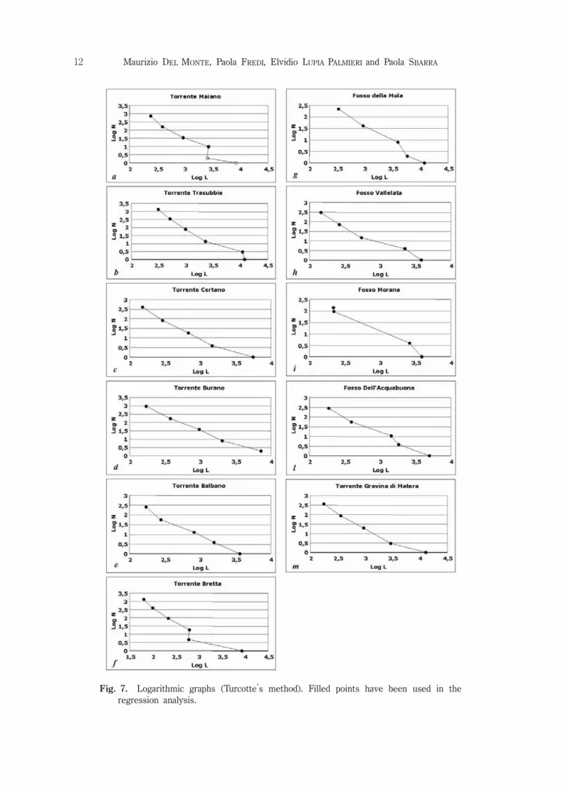
Figures5,6 and7 showtheplotsresultingfrom thefractalanalysismethodsthatrequire graphic representations (i.e.,channel-computing,box-counting and Turcotte’smethods).ThedrainagenetworkoftheTorrenteMaianobasinhasdendriticpattern(Fig.3a),
SomeRelationsbetweenFractalDimensionofDrainageNetworksandGeomorphologyofDrainageBasins 9
Box-countingTurcotteChannel-computingLaBarberaandRosso
ElemR2DfElemR2DfElemR2DfRlRbDf
70.9991.6140.9671.73*60.9891.702.223.931.72TorrenteMaianoa
50.9991.6460.9701.7940.9941.802.344.341.73TorrenteTrasubbieb
70.9971.5250.9751.6870.9871.602.564.551.61TorrenteCertanoc
80.9971.5250.9851.6680.9911.792.614.731.62TorrenteBuranod
80.9941.4150.9891.7570.9641.582.204.081.78TorrenteBalbanoe
50.9991.5460.9041.49*90.9901.234.314.321.00TorrenteBrettaf
70.9921.2750.9831.5270.8101.60*2.624.181.48FossodellaMolag
80.9951.3750.9701.6040.9921.342.444.211.61FossodiVallelatah
80.9981.2840.9791.55*40.9671.56*4.779.911.47FossoMoranai
80.9961.4050.9881.7070.9321.642.444.271.63Fossodell’Acquabuonal
90.9941.5150.9701.3960.9891.423.054.581.36TorrenteGravinadiMateram
Table2.Fractaldimension(Df)ofdrainagenetworkscalculatedthroughfourdifferentprocedures(LaBarberaandRosso,channel-computing,Turcotte,box-counting).R2
valuesareindicatedaswellasthenumberofpointsprocessed(Elem.)intheregressionanalysis.(*)indicatesDf valuesthatarenotstatisticallysignificantbecauseapoornumberofelementsorlowR2 values.

10 MaurizioDELMONTE,PaolaFREDI,ElvidioLUPIAPALMIERIandPaolaSBARRA
Fig.5.Logarithmicgraphs(channelcomputingmethod)ofdrainagenetworks.Filledpointshavebeenusedintheregressionanalysis.

SomeRelationsbetweenFractalDimensionofDrainageNetworksandGeomorphologyofDrainageBasins 11
Fig.6.Logarithmicgraphs(boxcountingmethod).Filledpointshavebeenusedintheregressionanalysis.
12 MaurizioDELMONTE,PaolaFREDI,ElvidioLUPIAPALMIERIandPaolaSBARRA
Fig.7.Logarithmicgraphs(Turcotte’smethod).Filledpointshavebeenusedintheregressionanalysis.

characterizedbytherandom orientationsofstream channelsthatlackanytectoniccontrol.AllcalculationmethodsaffordDfvaluesofthedrainagenetworkcloseto1.7,exceptbox-countingthatsuppliesalowervalue(1.61),asshowninTable2.
ThedrainagenetworkofTorrenteTrasubbiedrainagebasinhasaprevailingpinnatepattern(Fig.3b)butcontrolled,atplaces,bytectoniclines,mainlyalongthemaintrunk.The Df valuesare high,attaining the maximun of1.80 when the channelcomputingmethodisapplied.ThegraphsonFigures5b,6band7bshowtheresultsofthefractalanalysisaccordingtothethreegraphicmethods;alsointhiscasethelowestvalueofDf(1.64)isaffordedbythebox-counting(Table2).
ThebasinsofTorrenteCertano(Fig.3c),TorrenteBurano(Fig.3d)andTorrenteBalbano(Fig.3e),thethreeadjacentbasinsintheGubbioarea(Figs.1c,1dand1e),have similar rectangular drainage networks.The fractalanalyses based on thecomputationofchannelnumberasfunctionoftheirlengths,givequitehighvaluesofDf(1.58-1.79)forthedrainagenetworksofthesebasins,althoughdifferentinsize;onthecontrary,box-countinganalysisaffordsverylowervalues(1.41-1.52).
DiscordantvaluesofDfhavebeencalculatedforthedrainagenetworkofTorrenteBrettabasin(Fig.3f);thehighestvalue(1.54)isobtainedbythebox-countingmethod;thevaluethroughTurcotte’smethodfollows(1.49)and,finally,LaBarberaandRossomethod gives a Df value thatcorresponds to the lowertheoreticallimit(1.00).Moreover,thegraphinfigure5fshowsthatthechannel-computinganalysisofthisdrainagenetwork resultsin adoubleslopingcurve,thatmightindicateabifractalnetwork.Really,thefirstdescendentbranchofthecurvereferstostream channels(ranginginlengthfrom101.8125 and102.3125 m)occurringinbadlandareas,wherearealerosion isprevailing;whereasthesecondbranch referstoareaswherethelinearincisionbythehigherorderstreams(ranginginlengthfrom102.3125 and102.8125 m)preponderates.RegressionanalysisperformedforeachbranchgiveDfvaluesrespectivelyequalto1.35forthefirststeeperbranchand1.07forthesecond.Thelinearregressionthatrepresentsthewholenetwork— performedforthechannelsranginginlengthfrom101.8125 and102.8125 m (9 elements)— suppliesaDfvalueof1.23,R2 beingequalto0.990 (Table2).ThecurvepointscorrespondingtoL>102.8125 m havebeendiscardedbecauseofpoorstatisticsduetothelownumberoffluvialstreams.ThedrainagenetworkoftheFossodellaMolabasiniscontrolledbygeologic
structure,asorthogonaljunctionsdemonstrate(Fig.3g),andthereforeitshowssomefractallacunae.TheDf valuescalculatedafterTurcotteandLaBarberaandRossomethodsareusuallycloseto1.5,butdecreaseto1.27whenthebox-countingprocedureisfollowed.WithintheAprilia-Ardeaarea(totheSouthofRome),thedrainagenetworkofthe
FossoMoranabasin(Figs.2iand3i)hasDfvalueslowerthanthedrainagenetworkoftheFossodiVallelata(Figs.2hand3h)andFossodell’Acquabona(Figs.2land3l)basins(Table2).Linearequationsinferred from the graphsrelevantto the threedrainagenetworks(Figs.5h,6hand7h;Fig.5i,6iand7i;Fig.5l,6land7l)showthat
SomeRelationsbetweenFractalDimensionofDrainageNetworksandGeomorphologyofDrainageBasins 13
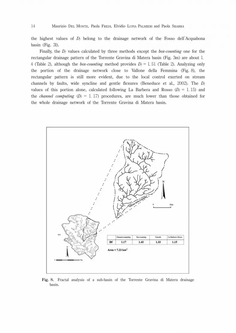
thehighestvaluesofDfbelongtothedrainagenetworkoftheFossodell’Acquabonabasin(Fig.3l).Finally,theDfvaluescalculatedbythreemethodsexceptthebox-countingoneforthe
rectangulardrainagepatternoftheTorrenteGravinadiMaterabasin(Fig.3m)areabout1.4(Table2),althoughthebox-countingmethodprovidesDf=1.51(Table2).Analyzingonlythe portion ofthe drainage network close to Vallone dellaFemmina(Fig.8),therectangularpatternisstillmoreevident,duetothelocalcontrolexertedonstreamchannelsbyfaults,widesynclineandgentleflexures(Beneduceetal.,2002).TheDfvaluesofthisportionalone,calculatedfollowingLaBarberaandRosso(Df=1.15)andthechannelcomputing(Df=1.17)procedures,aremuchlowerthanthoseobtainedforthewholedrainagenetworkoftheTorrenteGravinadiMaterabasin.
14 MaurizioDELMONTE,PaolaFREDI,ElvidioLUPIAPALMIERIandPaolaSBARRA
Fig.8.Fractalanalysisofasub-basinoftheTorrenteGravinadiMateradrainagebasin.
ValuesofDffandgeomorphologicalcharacteristicsofdrainagebasins
ResultsoffractalanalysesindicatethattherelationbetweendrainagepatternandDfvaluesisnotasimpleone.Amongthestudieddrainagepatterns,thosewithlittlefractallacunaehavesimilarvaluesofDf.Thisistrue,forexample,inthecasesofthedrainagenetworksofTorrenteMaiano(a)andTorrenteTrasubbie(b)basins.Bothofthem havehighvaluesofDf,althoughtheirpatternsarequitedifferent,duetothelowerdegreeofstructuralcontrolontheTorrenteMaianonetwork.
Theexaminationofdrainagenetworksaffectedbytectoniccontrol,testifiedbytheprevalenceofgivenstream directions(asintheTorrenteCelano(c),TorrenteBurano(d)TorrenteBalbano(e),andTorrenteGravinadiMatera(m)drainagebasins)evidencesthatsimilar(mainlyrectangular)drainagepatternshaveverydifferentDfvalues,apartfrom thechosenprocedureoffractalanalysis.
Thedrainagenetworkofbasin(m),closetoMateratown,haslowvaluesofDfandnumerousandwidefractallacunae(Fig.3m)explainablewiththerejuvenationproducedbytherecentuplift,thatfavoursthemarkeddowncuttingbythemainstreams.DrainagenetworksinthesurroundingsofGubbio(c,dande)showhighvaluesofDf,astheyaremorespace-fillingthanthenetworkofbasinm;thesevaluesmightbederivedfrom thehigherdegreeoffracturingoflithologiesoutcroppinginthedrainagebasinsc,dandf(Menichetti&Minelli,1991),aswellasfrom thelongerlastingmorphogeneticactionbysurfacerunningwatertheyhaveundergone.
AlsothedrainagenetworksofthebasinstotheSouthofRome(h,iandl)areinfluencedbyevidentneotectoniccontrols,asinthecaseoftheNW-SEflowdirectionofmanysmallchannelsoffirstorderthatjointhemainriversinthemiddle-lowerpartsoftheirvalleys.ManyNW-SE trendingfractureshavehelpedin recenttimesthedevelopmentofparallelfirstorder stream channels on the outcrops ofvolcaniclithologies(Figs.2h,iandl).TherelevantdrainagenetworksshowintermediatevaluesofDf (Table2,h,iandl)dueafasterincreaseofthefluvialnet,tendingtoaprogressive space-filling in the middle and lowerportion ofthe valleys.In theheadwatersofthese basins,fracturing density islower;stream channelsare lessabundant and,instead offollowing preferentialdirections,they appear randomlydistributed.Amongthestudieddrainagenetworks,thosehavingthelowestvalueofDfbelong
totheTorrenteBretta(Fig.3f)andFossodellaMola(Fig.3g)drainagebasins.TorrenteBrettabasinhasatplacesapinnatepattern,typicalofbadlandareas;morphogeneticprocessesareparticularlyfast(Fig.9),favouredbythelargeextentionofclayoutcropthicklydissected,asrevealedbythehighvalueofdrainagedensity(Horton,1945)(D=8.428 km-1,Fig2f,Table1).From ageometricalpointofview,pinnatepatternwouldbeinaccordancewiththefastgrowthofthedrainagenetworkthatrapidlytendstospace-fillingconditions;inthiscase,however,theexistenceofmanyfractallacunae(seeFig.3f)isresponsibleforthelowvaluesofDf(Table2).Alsothedrainagenetworkof
SomeRelationsbetweenFractalDimensionofDrainageNetworksandGeomorphologyofDrainageBasins 15

FossodellaMolabasin,wherevolcanicoutcropprevails(Fig.2g),haslowDfvaluesthatareascribabletofractallacunae;howeverthedrainagepatternisverydifferentfrom thepreviousoneanddrainagedensityislow(D=2,182km-1,Table1).
Discussion
Thedrainagenetworksexaminedcanbedividedintotwogroups,dependingonthevaluesoftheirfractaldimension;thefirstgroupshowshighvalues(a,b,c,d,e)andthesecondlow values(f,g,h,i,l,m)ofDf.Withineachgroupdifferentdrainagepatternsarepresent,thatbelongtobasinsshowingavarietyofgeologicalandclimaticconditions,butsharingsomegeomorphologicalaspects.
Thedrainagebasinswhosenetworksbelongtothefirstgroup,haveundergoneprolonged morphogenetic processes and show the fluviallandscape typicalofthe«maturity stage».Those drained by networksofthe second group,instead,showlandformsreferabletothe«youthstage».Thelatterhavebeenexposedtoexogenousmorphogeneticprocessesforashorterperiodthanthepreviousones.TheylieinareasemergedonlysinceQuaternaryorupliftedduringthisepoch,with theconsequentrejuvenationoftheirstream networks(i.e,drainagenetworkm).Inspiteofthedifferentpatternoftheirhydrologicnetworks,allofthem show summitsurfacesofdifferentextent(originatedbyplanationprocessesorbythedepositionofmarinesedimentsorvolcanicproducts,i.e.Fig.4)thatthe regressive erosion by streamshasnotyetcompletelyerased.ThepresenceofthesesurfacescanberesponsiblefortherecordedfractallacunaeandconsequentlyforthelowvaluesofDf.
Therefore,itmaybesupposedthatifadrainagenetworkcanevolvewithout«endogenousinterference»foraperiodoftimelongenough,ittendstospace-fillingconditionanyhow,independentlyfrom itspattern.Resultssofarobtainedcannotfullyconfirm thesuggestionsbysomeauthors
(Chengetal.,2001)thatdrainagenetworks,freefrom structuralcontrolandwith
16 MaurizioDELMONTE,PaolaFREDI,ElvidioLUPIAPALMIERIandPaolaSBARRA
Fig.9.Badlandsarea(TorrenteBrettadrainagebasin).

randomdistributionoftheirstreamchannels,shouldhavehighvaluesofDf,whereaslowvaluesofDfshouldrefertocontrollednetworkswithpreferentialstream orientations.Thenon-confirmationmightdependonthedefinitiondegreeofthedrainagenetworkreconstruction;infact,iftheyareextrapolatedfrom DEMsorsmallscalemaps,theirgeometrywillbedeterminedonlybythehigherorderstreams.Thus,theroleoflowerorderstreamsintheattainmentoftheoverallconfigurationsofdrainagenetworks(andin the network tendency toward space-filling)willbe neglected,in spite oftheirmorphoevolutivemeaningandofthepossibilitythattheyarecontrolledbyrecentactivetectonics(Ciccaccietal.,1986).Furthermore,externalconditioningotherthantectonicsonthedrainagegeometry,
andthereforeontheirfractaldimensions,cannotbedisregarded.Climateconditionsarean example:drainagenetworksin aridclimatemaybefarfrom space-fillingstatebecauseofasmallnumberofstream channels,oftenallogenic.Inotherwords,insuchcasesthelow valuesofDfmightbeascribedonlytotectonicswithoutholdingindueconsiderationotherimportantfactorsofthenetworkdevelopment.Thisobservationisinaccordance with Takayasu (1990),who maintains that–ceteris paribus–drainagenetworksinhumidregionshavehighvaluesofDf.
Finalremarks
Fractalanalysisofdrainagenetworksnotonlyaffordedimportantinformationaboutthe geomorphologicalevolution ofthe study basins,butitalso proved to be aninterestingmethodologicalapproach.In particular,the channel-computingprocedure can evidence acomplex bifractal
behaviourofsomedrainagenetworks,withtwoseparatevaluesofDfcorrespondingtodifferentlengthrangesofthestream channels.
Thiswouldsuggestthatthebasinstheybelongtoareaffectedbytwomainmorphogeneticprocesses,thatoperatesimultaneusly,althoughwithdifferenteffectivenessatdifferentscales.ThebifractalcharactersofsomedrainagenetworksmightexplainthedifferenceobservedbetweenDfvaluescalculatedbychannel-computingprocedureandthosedrawnfollowingtheothermethods.ThedifficultiestoobtainauniqueDfvalueofsomedrainagenetworkscanbeof
geomorphologicalsignificance.Forexample,thetwodifferentvaluesofDfcalculatedfromthedouble-slopecurveofthedrainagenetworkofTorrenteBrettabasin,indicatethatthetendencytowardspace-fillingofchannelsoflowerordersandlengthdiffersfromthatofthemainstreams,duetoerosionalprocessesofdifferentintensity.Beyondtheabovenotations,channel-computing,LaBarberaandRossoandTurcotte
methodsprovidesimilarresultsforthesamedrainagenetwork.Highestdiscrepanciesareobservedforequationswithnostatisticalsignificance.TheseareoftenobtainedfollowingtheTurcotteprocedure,duetotheinsufficientnumberofdata,especiallyforthedrainagenetworksofsmallbasins(Table2,Figs.7aandf).
SomeRelationsbetweenFractalDimensionofDrainageNetworksandGeomorphologyofDrainageBasins 17
Drainagenetworksoflimitedextensionshow unreliablevaluesofDf(Seyb,1994)alsowhenLaBarberaandRossoprocedureisfollowed(Table2,T.Brettabasin,Df=1.00).Ontheotherhand,thismethodhasnotbeentestedforsmallbasins;itisadvisabletoperform itinthecaseofdrainagebasins25-30km2 wideandanalyzedatascale1:25,000.
TheDfvaluesbybox-countingmethoddonotdivergegreatlyfrom thoseoftheotherprocedures;those,however,varyinalesswiderangeandsometimesseem toohighforthebasinsshowinglargefractallacunae(Table2,Figs.6fandm).TheDfvaluescalculatedbythisprocedure,althoughstrengthenedbyhighdeterminationcoefficients(R2>0.991),appearinfluenced by drainage density.The maximum value ofthisparameter,infact,isrecordedforT.Brettadrainagebasin(D=8.428km/km2,Table1),whosenetwork hasoneofthehighestvaluesofDf amongthosecalculated.ThedrainagebasinofFossodellaMolahasasimilaranomaly:drainagedensityhasthelowestrecordedvalue(D=2.182 km/km2,Table1)andDfofitsdrainagenetwork,generallylow,isthelowestamongthoseobtainedbybox-counting.Forthisreasonthisprocedureseemstobemoresuitabletoanalyzelineswithoutbifurcation,ascontourlines(Goodchild,1982).Toconclude,themostinterestingrelationsbetweenfractalcharactersofdrainage
networks and geomorphologicalcharacteristics oftheirdrainage basins are shortlyevidenced.ThehighertheDfvalues,thesmallertheareaoccupiedbyfractallacunaeare,according to Tokunaga’s laws (Tokunaga,2000).This occurs where randomlydistributedchannelsdraindifferentlithologies,withvaryingdegreeoffracturing,butalsowheredrainagenetworks,showinganisotropicdistributionoftheirchannels,arestronglycontrolledbystructure.Abi-directionalfracturingwith90°allowarectangularnetworktodevelop,whichis
characterizedbytherepetitionofthesamepatterninspiteofvaryingscale;asaresultDfcanattainhighvalues.Fracturing,therefore,isofgreatimportanceindeterminingDfvalues,that— otherconditionsbeingequal— arehigherinareaswithhighfracturingdensity.The Df valuesofthe studied networksare strongly depending also on their
evolutiondegree.Basically,a«young»networkislessspace-fillingthanan«older»one,independentlyfrom thegeometricalpattern.Theystrictlydependontype,intensityofdenudationalprocesses,andalsotimespanexposedtotheprocessesinstead.
Acknowledgements
WearegratefultoProf.EijiTokunaga(ChuoUniversity,Tokyo)forhiscriticalreadingandforhisencouragement.ThisworkwasfinanciallysupportedbytheItalianMinisteryfortheUniversityand
the Scientificand TechnologicalResearches(MURST);DirectorofresearchesProf.ElvidioLupiaPalmieri.
18 MaurizioDELMONTE,PaolaFREDI,ElvidioLUPIAPALMIERIandPaolaSBARRA

References
Ambrosetti,P.,Carraio,F.,Deiana,G.andDramis,F.(1982)Ilsollevamentodell’ItaliacentraletrailPleistoceneinferioreeilPleistocenemedio:Contributiconclusiviperlarealizzazionedellacartaneotettonicad’Italia.P.F.Geodinamica-C.N.R.,513,219-223.
Beer,T.andBorges,M.(1993)Horton’slawsandthefractalnatureofstreams:WaterResour.Res.,29,1475-1487.
Benedice,P.,Schiattarella,M.andTropeano,M.(2002)Caratteridelreticoloidrograficonell’areadell’HorstdiMaterainBasilicata.In:Guidaall’escursionegeomorfologica:dallaVald’AgriaMatera,UniversitàdellaBasilicataed.,pp.68-78.
Cantalamessa,G.,Centamore,E.,Chiocchino,U.,Colalongo,M.L.,Micarelli,A.,Nanni,T.,Pasini,G.,Potetti,M.andRicciLucchiF.(1986)IlPlio-PleistocenedelleMarche:StudiGeol.Camerti,Vol.Spec.— LaGeologiadelleMarche—,61-81.
Carloni,G.C.,Francavilla,F.andFurani,M.(1990)Lineamentipaleogeograficidell’areadelMontedell’Ascensione(AscoliPiceno)nelPlioceneenelPleistocene:ActanaturaliadeL’AteneoParmense,26,NN.3-4,93-128.
Centamore,E.(1986)CartaGeologicadeidepositiPlio-PleistocenicitrailF.TennaeilF.Tronto(scala1:50000):volumeSpec.StudiGeol.Camerti,UniversitàdegliStudidiCamerinoed.
Cheng,Q.,Russel,H.,Sharpe,D.,Kenny,F.and Qin,P.(2001)GIS-based statisticalandfractal/multifractalanalysisofsurfacestream patternsintheOakRidgesMoraine:Computers&Geosciences,27,513-526.
Ciccacci,S.,Fredi,P.,LupiaPalmieri,E.andSalvini,F.(1986)Anapproachtothequantitativeanalysis ofthe relations between drainage pattern and fracture trend.In:IntemationalGeomorphology,PartII,pp.49-68.Chichester.
Ciccacci,S.,DeRita,D.andFredi,P.(1988)Geomorfologiaquantitativaemorfoneotettonicadell’areadiMorlupo— CastelnuovodiPortoneiMontiSabatini(Lazio):Geogr.Fis.eDinam.Quat.,Suppl.I,197-206.
Claps,P.andOliveto,G.(1996)Re-examiningthedeterminationofthefractaldimensionofrivernetwork:WaterResour.Res.,32,3123-3135.
DeRita,D.,Facenna,C.,Funiciello,R.andRosa,C.(1995)Stratigraphyandvolcano-tectonics.In:TheVolcanooftheAlbanHills,RaffaelloTrigilaed.,Roma,56-70.
DelMonte,M.,Fredi,P.,LupiaPalmieri,E.andSalvini,F.(1997)Fractalcharacterizationofdrainagenetworkgeometry:Geogr.Fis.Din.Quat.,Suppl.III-TomoI,144-145.
DelMonte,M.,Fredi,P.,LupiaPalmieri,E.andSalvini,F.(1999)Fractalanalysistodefinethedrainagenetworkgeometry:Boll.Soc.Geol.It.,118,167-177.
Dufaure,J.,Bossuyt,D.andRasse,M.(1988)Deformationsquatermairesetmorphogenesedel’ApenninCentralAdriatique:Physio-Géo,18,9-46.
Goodchild,M.F.(1982)TheFractionalBrownianprocessasaterrainsimulationmodel:ModelingandSimulation,13(3),ProceedingsoftheThirteenthAnnualPittsburghConference,1133-1137.
Hack,J.T.(1957)Studiesoflongitudinalstream profilesinVirginiaandMaryland:U.S.Geol.Surv.Prof.Pap.,294B,45-97.
Horton,R.E.(1945)Erosionaldevelopmentofstreamsandtheirdrainagebasins:hydrophysicalapprachtoquantitativemorphology:Geol.Soc.Am.Bull.,56,275-370.
LaBarbera,P.andRosso,R.(1989)Onthefractaldimensionofrivernetworks:WaterResour.Res.,4,735-741.
Maitre,H.andPinciroli,M.(1997)FractalcharacterizationofahydrologicalbasinusingSARsatelliteimages:IEEETransactionsonGeoscienceandRemoteSensing,37,175-181.
Mandelbrot,B.B.(1977)Fractals:Form,ChanceandDimension.SanFrancisco,CA:Freeman.Marani,A.,Rigon,R.andRinaldo,A.(1991)Anoteonfractalchannelnetworks:WaterResour.
Res.,27,12,3041-3049.Marra,F.,Freda,C.,Scarlato,P.,Taddeucci,J.,Karner,D.B.,Renne,P.R.,Gaeta,M.,Palladino,D.
M.,Trigila,R.andCavarretta,G.(2003)Post-calderaactivityintheAlbaniHillsvolcanic
SomeRelationsbetweenFractalDimensionofDrainageNetworksandGeomorphologyofDrainageBasins 19

district(Italy):40Ar/39Argeochronology and insights into magma evolution:Bulletin ofVolcanology,65,227-247.
Masek,J.andTucotte,D.L.(1993)A diffusion-limitedaggregationmodelfortheevolutionofdrainagenetworks:EarthandPlanetaryScienceLetters,119,379-386.
Menichetti,M.andMinelli,G.(1991)ExtensionaltectonicsandseismogenesisinUmbria(CentralItaly):theGubbioarea:Boll.Soc.Geol.It.,110,857-880.
Nikora,V.I.(1994)Onself-similarityandself-affinityofdrainagebasinis:WaterResour.Res.,30,133-137.
Norman,M.andMoscato,P.(1995)TheEuclideanTravelingSalesmanProblem andaSpace-FillingCurve:Chaos,SolitonsandFractals,6,389-397.
Pasquarè,G.,Chiesa,S.,Vezzoli,L.andZanchi,A.(1983)EvoluzionepaleogeograficaestrutturaledipartedellaToscanameridionaleapartiredalMiocenesuperiore:Mem.Soc.Geol.It.,25,145-157.
Rinaldo,A.,Rigon,R.andMarani,A.(1991)Onwhatisexplainedbytheform ofachannelnetwork.— Attidelconvegno— EntropyandEnergyDissipation:WaterResorces,Maratea,Italia,26-28giugno.V.P.SinghandM.Fiorentinoed.,379-399.
Rodriguez-Iturbe,I.,Marani,M.,Rigon,R.andRinaldo,A.(1994)Self-organizedriverbasinlandscapes:Fractalandmultifractalcharacteristics:WaterResour.Res.,30,3531-3539.
SagarDaya,B.S.,Omoregie,C.andPrakasaRao,B.S.(1998)Morphometricrelationsoffractal-skeletalbasedchannelnetworkmodel:DiscretedynamicsinNatureandSociety,2,2,77-92.
Schuller,D.J.,Rao,A.R.andJeong,G.D.(2001)Fractalcharacteristicsofdensestreamnetworks:J.ofHydr.,243,1-16.
Seyb,A.(1994)Drainagenetworkanalysisusingfractalgeometry:Master’sthesis,UniversityofAuckland.
Stark,C.P.(1991)Aninvasionpercolationmodelofdrainagenetworkevolution:Nature,352,423-425.
Strahler,A.N.(1957)Quantitativeanalysisofwatershedgeomorphology:Trans.Am.Geoph.Un.,38,913-920.
Takayasu,H.(1990)FractalsinthePhysicalSciences.ManchesterUniversityPress,170p.Tokunaga,E.(1998)RevalutationofHack’srelationbyself-similarmodelfordrainagebasins:Trans.
Japan.Geomorph.Union,19,77-90.Tokunaga,E.(2000)Dimensionofachannelnetworkandspace-fillingpropertiesofitsbasin:
Trans.Japan.Geomorph.Union,21,4,431-449.Tropeano,M.(1992)Aspettigeologicie geomorfologicidella Gravina diMatera:Itinerari
Speleologici,2,19-33.Turcotte,D.L.(1992)FractalsandChaosinGeologyandGeophysics.CambrigeUniversityPress,
NewYork,432p.Turcotte,D.L.(1997)FractalsandChaosinGeologyandGeophysics(Secondedition).Cambrige
UniversityPress,NewYork,398p.
20 MaurizioDELMONTE,PaolaFREDI,ElvidioLUPIAPALMIERIandPaolaSBARRA

流域網のフラクタル次元と流域の地形との間のいくつかの関係
MaurizioDELMONTE*,PaolaFREDI*,ElvidioLUPIAPALMIERI*
andPaolaSBARRA*
要 旨
地形特性の異なるイタリアのいくつかの流域を対象として,流域網のフラクタル特
性を検討した.本稿の目的はこのような流域網の「フラクタル次元」を計測し,それ
らの地形的意義を定量的に評価することである.
4つの方法が11個の流域網に適用され,それらのフラクタル次元(Df)が計測され
た.得られた結果は,流域の形態とフラクタル次元の値との間の関係が単純なもので
はないことを示唆している.しかし,フラクタル次元Dfのパラメーターは流域の幾何
学を表現することが可能であり,流域網の形成やその発達過程におけるテクトニック
な状態についての有用な定量的情報を与える.このことを基に,より広い流域網の複
雑で変化に富んだ幾何学の間に存在する差異を定量的問題として扱うことができる.
本研究の結果は予察的なものであり更なる証明が必要ではあるが,流域網の幾何学
と流域の発達程度に関する特性値としての情報を提供する可能性を明確に示してい
る.
SomeRelationsbetweenFractalDimensionofDrainageNetworksandGeomorphologyofDrainageBasins 21
* DipartimentodiScienzedellaTerra,UniversitàdegliStudidiRoma«LaSapienza»PiazzaleAldoMoro,5-P.O.Box11-00185RomeItaly