soil research - international union of soil sciences
TRANSCRIPT
MANAGING SOIL RESOURCES TO MEET THE CHALLENGES TO MANKIND
REVIEW OF SOIL RESEARCH
IN INDIA
8-16 FEBRUARY 1982


MANAGING SOIL RESOURCES TO MEET THE CHALLENGES TO MANKIND
Review of Soil Research
in India

MANAGING SOIL RESOURCES TO MEET THE CHALLENGES TO MANKIND
Review of Soil Research
in India
PART II
ISSS AISS IBG
12TH INTERNATIONAL CONGRESS OF SOIL SCIENCE
NEW DELHI, INDIA 8-16 FEBRUARY 1982
FIRST PRINTED JANUARY 1982
Chairman
N.S. Randhawa
N.N. Goswami S.S. Prihar
LP. Abrol R.S. Murthy
G.S.R. Krishna Murti Sant Singh
A.B. Ghosh T.G. Sastry G. Narayanasamy
Chief Production Consultant
Krishan Kumar
Copyright © 1982 by the Indian Society of Soil Science
Responsibility for the information in this publication rests with the individual authors.
Published in India by the Secretary, Organising Committee, 12th International Congress of Soil Science on behalf of the Indian Society of Soil Science, Division of Soil Science and
Agricultural Chemistry, Indian Agricultural Research Institute, New Delhi.
Printed by Shri Mohan Makhijani at Rekha Printers Private Limited, A-102/1 Okhla Industrial Estate, Phase-II, New Delhi-110020.
Foreword
1 AM very happy that the Indian Society of Soil Science is bringing out this volume entitled "Review of Soil Research in India" on the occasion of the 12th International Congress of Soil Science scheduled in New Delhi from February 8-16, 1982. From the list of contributions and wide spectrum of topics covered it is evident that soil science in India has made rapid progress during the last decade. To achieve this, ICAR Institutes, Agricultural Universities and the large number of Coordinated Research Projects have played a significant role.
In keeping with our immediate needs,bulk of the work done by our scientists which appears in this review is of applied nature aimed at developing technology to improve agricultural production. But I am glad that there is a good sprinkling of basic investigations which not only help explain the mechanisms of response of different components of technology but also provide further basis for problem oriented applied research. More recently the need for basic and mission oriented research in agriculture has been recognised at the national level and accordingly the Indian Council of Agricultural Research has established "Centres of excellence" and "Chairs of eminence" to fulfil this objective and achieve complementarity of applied and basic research effort.
The recent energy-squeeze has posed new challenges for the soil scientists in as much as about 60 per cent of the energy utilized for crop production is accounted for by fertilisers and water. Future researches must aim at increasing the efficiency of both inputs. The unlimited reservoir of atmospheric nitrogen and abundant sunshine that our country is endowed with, offer great opportunities for supplementing the energy-dependent chemical fertiliser sources with biofertilisers. Organic matter recyclying is another area which deserve more attention in the present context and holds promise to supplement the nutrient needs of crops. Similarly, there is a great scope for improving the irrigation efficiency and water use efficiency. Even small saving in these scarce and costly inputs spread over millions of holdings can add up to substantial national gains. The need for efficient management of rainwater in our dryland regions could not be over-emphasised.
Publication of this volume, which would be an excellent reference material for the graduate students and researchers in India and elsewhere, is very timely. I am sure the soil scientists of the country will continue to strive for excellence in research for feeding the ever-increasing population from the
Vi FOREWORD
limited land resources without impairing the long-term productivity of soil or adversely affecting the environment since food security essentially depends on ecological security.
New Delhi January 15, 1982
O P . GAUTAM Director- General
Indian Council of Agricutural Research
Preface
SOIL research in India has a recorded history of less than 100 years, although the reference to the importance of soil, or more strictly land, finds a mention in the Vedas, the Upanishads and other ancient scriptures which date back to 5000 BC. A beginning in soil research was made in the last decade of the 19th century, as a part of research in agricultural chemistry, with the appointment of an Agricultural Chemist to the Government of India. However, it received a great fillip only in 1905 with the establishment of the Imperial (now Indian) Agricultural Research Institute and the agricultural colleges and research laboratories in the State Departments of Agriculture. The Indian Agricultural Research Institute did some pioneering work on various aspects of soil science. The Agricultural Chemists in the States concentrated their efforts on the problems of soil salinity and alkalinity, and other practical problems. Colloid chemists in the universities also concentrated their basic research work on soil clays including the nature and origin of soil acidity in the twenties and thirties. Work on soil survey started in 1950, in most States as a part of their agricultural development programme.
Major changes in organisation of soil research work took place in the post-independence era, when soil science emerged as a distinct discipline in agricultural research and teaching. Research on soil testing, soil genesis, fertiliser use, soil physics and soil chemistry started receiving attention in the fifties. Establishment of agricultural universities in the States and the new agricultural production technology in the sixties provided the necessary impetus for a productive soil research. The problem of increasing deficiency of phosphorus over large areas, and that of zinc and even sulphur in some areas needed greater attention. Similarly, the expanding irrigation facilities and increased fertiliser use required basic studies in soil physics and soil chemistry.
The Indian work on different aspects of soil had been reviewed in 1971 and it was published by the Indian Society of Soil Science. Since then a number of bulletins on special topics such as acid soils, soil potassium, clay minerals, soil phosphorus have also been published by the Society. A number of special bulletins or reports have also been brought out by the various agricultural universities and institutes. However, they were sporadic and do not encompass the subject matter of soil science as a whole. In view of this, the Organising Committee decided to bring out a comprehensive review of soil research in India on the occasion of the 12th International Congress of Soil Science. Some of the leading scientists in the country were requested to review
VIII PREFACE
the work in their specialised fields and the present publication is an outcome of the contribution by these specialists.
The Review covers articles on 48 topics contributed by 111 authors and has been divided into seven Chapters corresponding to the seven recognised sub-disciplines of soil science, viz, soil physics; soil chemistry; soil biology; soil fertility and plant nutrition; soil genesis, classification and cartography; soil technology and soil mineralogy. We are conscious that there might be some areas which could not be adequately covered in this review, but nevertheless, we believe that this publication will bring out the current status of knowledge and generate newer ideas for formulating future lines of research. The Editorial Committee is indeed very grateful to the scientists who responded to the invitation to write the articles for this Review, and to Dr. D.R. Bhumbla, formerly Deputy Director General (SAE), Indian Council of Agricultural Research, who at the initial stages coordinated the programme of this publication.
Publication of a volume of this magnitude requires a huge amount of technical scrutiny and reviewing, editing and proof reading. Our sincere acknowledgements are due to Dr. N.N. Goswami and his colleagues in the Division of Soil Science and Agricultural Chemistry, Indian Agricultural Research Institute, New Delhi, for their help and whole-hearted cooperation which made it possible to print this volume in time. The generous financial grant, received from the Indian Council of Agricultural Research, New Delhi is also gratefully acknowledged. We are indebted to Dr. O.P. Gautam, Director General, ICAR, for writing the Foreword and for his constant encouragement and help.
New Delhi January 15, 1982
N.S. RANDHAWA Chairman
Editorial Committee
Contents
PART II
f ORE WORD
PREFACE
V
vii
5. Soil Genesis, Classification and Cartography
Morphology, Genesis and Classification of Indo-Gengetic Plains
H.S. Shankaranarayana 467
Morphology, Genesis and Classification of Desert Soils
R.P. Dhir and S.V. Jain
474
Morphology, Genesis and Classification of Black Soils
R.J. Landey, L.R. Hirekerur and P. Krishnamoorthy
484
Morphology, Genesis and Classification of Red and Laterite Soils
S. Digar and N.K. Barde
498
Morphology, Genesis and Classification of Salt-Affected Soils
G.P. Bhargava and J.C. Bhattacharjee
508
Morphology, Genesis and Classification of High Altitude Soils
H.S. Iyer and A.K. Dutta
529
Morphology, Genesis and Classification of Tarai Soils
M.S. Gangwar R.S. Sachan and T.R. Rathore
537
Micromorphology of Some Major Soils of India
J.L. Sehgal and N.G. Raghu Mohan
552
Remote-Sensing Application in Soil Mapping
T.R. Srinivasan 559
Regional and Country Soils Maps R.S. Murthy 567
Soil-Physiography Relationship S. Pandey and R.M. Pofali
572
6. Soil Technology
Land Evaluation Y.P. Bali and M.L. Khybri
587
X CONTENTS
Acid Soils and their Management
Soil and Water Conservation Research
Water Quality and Soil Productivity
Reclamation and Management of Salt-Affected Soils
Land Use and Management Practices in Arid Zone
Land and Water Management in Semi-Arid Rainfed Areas
Management of Desertie Soils
Management of Red Soils
7. Soil Mineralogy
Clay Minerals in Indian Soils
Mineralogy of Coarse Fraction of Soils
Genesis and Transformation of Clay Minerals
Amorphous Constituents of Soil Clays
Surface Characteristics and Ion Exchange as Related to Soil Properties
Clay Mineralogy and Soil Physical Behaviour
Interactions of Clay with Organic Materials and Humus Constituents
B.R. Tripathi 597 R.N. Prasad and S.K. Bishnoi
K.G. Tejwani and 608 S.P. Bhardwaj
J.S.P. Yadav 622
LP. Abrol 635
H.S. Mann and 655 R.P. Dhir
G.P. Verma 666
H.P. Singh 676
A.S. Hadimani 689 B.R. Hegde and T. Satyanarayana
Sudhansu K. Ghosh and 703 B.S. Kapoor
G.S. Roonwal and 711 V.N. Garalapuri
V.A.K. Sarma and 718 P.S. Sidhu
G.S.R. Krishna Murti 725
S.K. Mukherjee and 731 T.G. Sastry
T.D. Biswas and 740 Jagan Nath
K.V. Raman and 746 M.B. Sen Gupta
Contents
PART I
FOREWORD
PREFACE
1. Soil Physics
Soil-Water Relations
Soil-Water-Plant Relationship
Techniques of Determining Physical Properties of Soils
Solute Movement
Soil Temperature and Plant Growth
Soil Structure and its Management
Soil Aeration
2. Soil Chemistry
Chemical Composition of Soils of India
Cation Exchange in Soils
Nutrient Transformations in Soils— Micronutrients
Nutrient Transformations in Soils— Micronutrients
Chemistry of Acid Soils
Chemistry of Sodic Soils
V
vii
B.K. Khosla, 3 C.L. Acharya and R.K. Gupta
N.T. Singh and 12 V.S. Tomar
S.B. Varade and 28 S. Kar
S.S. Prihar and 36 C. Misra
T.N. Chaudhary and 48 B.S. Sandhu
R.P. Gupta and 60 Y. Nagarajarao
A.K. Sinha and 77 B.P. Ghildyal
S.C. Das and 83 R.K. Chatterjee
S.R. Poonia and 110 Raj Pal
N.N. Goswami and 123 K.L. Sahrawat
J.C. Katyal and 146 D.L. Deb
| N. Panda and
160 M.M. Koshy
D.R. Bhumbla and 169 R. Chhabra
XÜ CONTENTS
Chemistry of Submerged Rice Soils
Soil-Pesticide Interactions
3. Soil Biology and Biochemistry
Rhizobium Research in India
Non-Symbiotic Nitrogen Fixation
Azolla as an Organic Nitrogen Fertilizer for Medium and Lowland Rice
Biochemistry of Soil Organic Matter
Microbial Recycling of Organic Matter
Biodegradation of Agrochemicals in the Soil Environment
Organic Manures and Bio-Fertilisers
4. Soil Fertility and Plant Nutrition
Nitrogen
Phosphorus
Potassium
Secondary Nutrients
Micronutrients—Forms, Contents, Distribution in Profile, Indices of Availability and Soil Test Methods
Crop Response to Applied Micro-nutrients
Other Trace Elements
Crop Responses to Nutrients under Irrigated Conditions
S. Patnaik and 181 L.N. Mandal
S.L. Chopra and 199 U.S. Sree Ramulu
N.S. Subba Rao 211 A.N. Sen and K.R. Dadarwal
G.S. Venkataraman 225
P.K. Singh 236
S. Singh and 243 M.K. Sinha
K.K.R. Bhardwaj and 258 R.B. Patil
N. Sethunathan 269
A.C. Gaur 278
Rajendra Prasad and 309 J. Thomas
S.S. Khanna and 323 A.N. Pathak
G.S. Sekhon and 331 A.B. Ghosh
GDev and Vinod Kumar 342
P.N. Takkar 361
N.S. Randhawa and 392 V.K. Nayyar
Mahendra Singh 412
O.P. Meelu, K.R. Kulkarni 426 and A.L. Bhandari
Crop Responses to Applied Nutrients under Limited Water Conditions
Long-term Fertiliser Experiments
CONTENTS XiÜ
J. Venkateswarlu and 442 Ranjodh Singh
K.K. Krishnamoorthy 453

5
Soil Genesis, Classification and Cartography

I
Morphology, Genesis and Classification of Soils of Indo-Gangetic Plains H.S. SHANKARANARAYANA*
THE Indo-Gangetic plains are among the most extensive alluvial plains of the world. They extend over a length of about 1,600 km and a width of 320 km including the arid and semi-arid environments in Rajasthan and Punjab and the humid and perhumid deltaic plains in Bengal. Of great significance to the country's agricultural production, they comprise an area of 95,714 sq km in Punjab, Haryana and Rajasthan, known as the Punjab plains, and 373,606 sq km in Uttar Pradesh (U.P.), Bihar and West Bengal, known as the Ganga plains. The Punjab plains have been built by the river systems of the Ravi, the Beas, the Sutlej, and the Yamuna over long ages with the sediments of Siwaliks and Himalayas in the north and of the Aravallis and the Vindhyans brought by the tributaries of the Yamuna and laterites and Gondwana formations in the Damodar basin. The Ganga plains are formed mainly by the Ganga, the Yamuna, the Ghagra, the Gandak and the Gomati. According to Wadia(1960) the thickness of the alluvium may have been 2,000 to 3,300 m during the Pleistocene. The nature of the alluvium varies in texture from sandy to clayey, calcareous to non-calcareous, and acidic to alkaline. The total geomorphic variations assume considerable significance even with low gradients and the average elevation ranging from 150 m in Bengal plains to nearly 300 m in Punjab plains.
The earliest investigations by Voelckar (1893) and Leather (1898) distinguished the soil of these plains as one of the four major soils of the country. The Indus valley project was the earliest map (1917) that showed the general characteristics of north-western Rajasthan and parts of Pakistan covered by soils of the Indo-Gangetic plains. Wadia et al. (1935) and Wadia (1945) referred to them in their publication on the geological formation of India.
Agarwal (1956) reviewed the work on soils in four different phases: (i) pre-1928, dominated by purely chemistry of the soils; (ii) 1928-1938, soil surveys for irrigation projects and for cash crops; (iii) 1938-1947, with genetic factors prominent in soil survey work under the influence of the Russian concept of pedology; and (iv) post-Independence, marked by more intensive surveys and soil studies in the plains in the context of the ever-increasing importance of the plains to increased agricultural production. Mathur (1971) reviewed the work on soil classification based on the work done in pedology ami soil survey in the
•Regional Centre, National Bureau of Soil Survey and Land Use Planning (ICAR), Bangalore.
4 6 8 REVIEW OF SOIL RESEARCH IN INDIA
northern zone, and Mathur and Shankaranarayana (1975) reviewed the work on soils of the old flood plains of the Indus system including the Ghaggar and Saraswati plains of Rajasthan.
MORPHOLOGY, GENESIS AND CLASSIFICATION
The morphology, genesis and classification of soils must necessarily be considered together. Morphology of natural soil bodies (pedons) can be described; their genesis deals with the influence of genetic factors on morphology; and classification'of soils is an extension of the logic of the study of soils to remember their characteristics, to locate them in the landscape, and to show their geographical distribution on maps.
Morphology Raychaudhuri (1964) compiled the morphology of alluvial soils of the Indo-
Gangetic plains under riverine old, riverine recent, and riverine calcareous. Among the earlier descriptions, one of the most comprehensive was that of Gupta et al. (1957) made in their study on genesis and pedochemical characteristics of Dhankar grey hydromorphic soils of the lower Gangetic plains of U.P. The model profile was selected on the basis of (i) thickness of the solum, (ii) depth of A and B horizons, (iii) ratio of clay in A horizon to clay in B horizon, (iv) depth, thickness and consistency of kankar pan, and (v) quality of segregation of iron-manganese nodules in B horizon as a typical sign of maximisation of the gleying process.
Gupta et al. (1957, 1960), and Agarwal and Pathak (1960) described the morphology of'karail' black clays and the soils of Bundelkhand in U.P. Soils of various districts of U.P. were described by Agarwal and Mehrotra (1952-53), Agarwal et al. (1958), Mehrotra (1968), Mehrotra and Misra (1969), and Mehrotra et al. (1972). Gerassimov (1958) in his study on genetic types of soils of India described the morphology of the soils of alluvial plains of Yamuna and Ganges on an ancient terrace in Agra. Mukherjee (1955, 1958) described the morphological characteristics of the soils of West Bengal occurring in different physiographic regions, viz, Ganga riverine alluvium, Ganga flats, Ganga uplands, Ganga lowlands, Vindhyan riverine lands, Vindhyan flat lands, Vindhyan highlands and coastal soils. Khanna et al. (1956) described the morphology of the Sone alluvium in Bihar. Ghuman and Nijhawan (1962), Sharma et al. (19^5), Kanwar and Sehgal (1962), Sehgal et al. (1968), and Sekhon et al. (1968) described the Punjab soils.
With the introduction of the seventh approximation in 1960 culminating in the publication of Soil Taxonomy (1975) and the adoption of the system in 1969 for classifying the 'Soils of India', more precise description of soils came to be available in the country. Systematic description of soils was followed in surveys conducted by the National Bureau of Soil Survey, the All India Soil and Land Use Survey, Central Soil Salinity Research Institute, Central Arid Zone
SOILS OF INDO-GANGETIC PLAINS 4 6 9
Research Institute, soil survey organisations of the state departments of agriculture and agricultural universities. Sehgal et al. (1968) described the morphology of the soils of the Punjab plains that fulfilled the requirements of modern soil classification. Morphology of the soils of Ghaggar plains in Rajasthan was similarly described in FAO/UNDP reports (1970). Soils studied in the Regional Pilot Project for Soil and Water Management, Ministry of Agriculture and USAID at Patiala in Punjab and Dhorighat in U.P. were described following modern classification. The morphology of the salt-affected lands of U.P. was described by Bhargava and Abrol (1978), soils of Sonepat district of Haryana by Bhargava and Sharma (1978), and deltaic soils of Sunderbans in West Bengal by Bhargava (1978). Shankaranarayana et al. (1981) described 14 pedons in the Indo-Gangetic plains following Soil Taxonomy (1975) and FAO guidelines for soil profile description.
Genesis The parent material of weakly developed alluvial soils of the Indo-Gangetic
plains is of recent origin transported by rivers of the region (Wadia 1945). Young alluvial soils (khadar) and older alluvial soils (bhangar) have been differentiated because of variations resulting from biological and climatic influences. Mukerji and Agarwal (1947), Agarwal and Mukerji (1951), Agarwal et al. (1956), Gupta et al. (1957), Gupta et al. (1960), and Agarwal and Pathak (1960) directed their studies topedo-chemical as well as morphological and geomorphological characteristics of the soils. Mukerji and Agarwal (1947), in their studies on the soils of Central U.P., pointed out that with four months of marked wet rainy season and high summer temperatures led to profile development that distinguished them from the zonal soils of the desert, semi-desert and arid regions in other parts of the world. Agarwal and Mukerji (1951), in their studies on the genetic soil types of Gorakhpur district developed on calcareous parent material, distinguished type 1 with CaC03 throughout the profile in lowlands, Type 2 with CaC03 leached but with presence of nodular lime associated with uplands. Type 3 with CaC03 completely removed and giving rise to acidic condition in higher situations. Agarwal and Pathak (1960) have related clay-minerals and the formation of secondary iron concretions to the factors responsible in Bundelkhand region.
Khanna et al. (1956) in their studies on five alluvial soils of the sugar-belt in Bihar made particular reference to mineralogical composition of sand and clay, and concluded that molar ratios of Si0 2 /R 20 3 of clay were more important in measuring profile development. Sinha et al. (1965), in their morphological study of three heavy-textured soils of Bihar, characterised two soils that remained under water for three to six months annually and the third only for a short time during high flood. Low chroma of two with mottles in the first two profiles and higher than two in the third were observed. Organic carbon remained more, than 0.2 per cent at and below 125 cm depth. The reasons advanced for non-development of genetic horizons were (i) cracking, swelling
4 7 0 REVIEW OF SOIL RESEARCH IN INDIA
and consequent mulching of soils obliterating any illuviation effect of clays, and (ii) younger age of deposits to develop genetic horizons. In the same period, Mukerjee (1955, 1956, 1958) studied the soils in different geomorphic positions and geological variations in West Bengal. He related the genesis and characterisation of the soils to differences in physiography, age and soil-forming material.
In semi-arid soils of Karnal, Sharma (1953) reported mechanical illuviation of clay in the middle horizons containing more sesquioxides and movement of calcium carbonate. In the arid districts of Hissar and Ferozepur, there was no indication of movement of sesquioxides, and calcium carbonate was present even in the surface horizon.
Sidhu and Pundeer (1976) studied parent material uniformity and weathering indices of the soils derived from alluvium in Punjab and concluded that Ti02/ZrC>2 ratio rather than the field morphology was important in providing true index of parent material homogeneity, and that calculations based on CaO/Zr02 could be used for establishing the weathering stage in soils developed on alluvium. Sidhu et al. (1978) studied mineralogy of soils developed on two geomorphic surfaces of Sutlej alluvium, viz, (i) the terrace, and (ii) the flood and meander plain. The former showed some variations in depth distribution of clay minerals, but the latter did not show any in situ alteration of minerals. Sidhu et al. (1978) tried to illustrate the influence of geomorphic surface and the Himalayan provenance in controlling the mineral composition of soils of the plains. From another study they reported the mechanism of genesis of Fe-Mn concretions in the alluvium-derived soils of Punjab. Sehgal and Stoops (1972) studied nine different forms of pedogenic calcite accumulation in semi-arid and arid regions of the Indo-Gangetic alluvial plain of Punjab in Camborthids, Calciorthids, Ustochrepts and Haplustalfs.
According to the observations of Karale et al. (1974) the clay coatings and clay in the subsurface horizons are invariably associated with an argillic horizon but the processes are difficult to distinguish on the basis of field observations. Micromorphological studies of subsurface horizons varied moderately to strongly oriented argillans in an Aerie Ochraqualf and a Typic Natrustalf in conformity with designation of argillic and natric horizons in the field descriptions. Subsurface horizons from a Typic Natrustalf and an Udic Haplustalf did not show illuvial argillans. Mere clay content is therefore inadequate to determine the presence of argillic horizon.
Shankaranarayana and Hirekerur (1972) characterised some selected soil series of the alluvial plains. Under hyperthermic conditions, precipitation difference was identified as the dominant factor in the formation of the soils of plains, but within the climatic subdivision physiography and drainage appear to have dominating influence on soil characteristics. This has been demonstrated by the information on soil physiography relationships in Nawanshar (Satyanarayana et al. 1959) and Varanasi area (Agarwal 1961).
SOILS OF INDO-GANGETIC PLAINS 4 7 1
Classification Schokalskaya (1932) classified the soils of India on the basis of the existing
knowledge of Russian pedological principles, and grouped the soils of the plains into (i) alluvial terraces, (ii) meadow type on older alluvium (iii) prairie type, (iv) tropical and subtropical dry steppe type on older alluvium, and (v) sierozems. Wadia et al. (1935) and Wadia(1945) classified these soils broadly as alluvial soils of the Indo-Gangetic Plains.
Viswanath and Ukil (1944) portrayed the soils of the plains with climatic types on the basis of N.S. quotients — revised at the Indian Agricultural Research Institute to the scale of \" = 70 miles. Raychaudhuri (1964) classified these soils as (i) alluvial soils riverine, old, non-saline, non-calcareous to moderately calcareous in high and moderate rainfall zones and strongly expressed dry season, (ii) alluvial soil riverine, recent (a) subject to frequent flooding (b) not subject to frequent flooding, and (iii) alluvial soil riverine, highly calcareous.
Govindarajan (1965) prepared a Soil Map of India dividing soils of the country into 24 major soil groups in which the soils of the plains were grouped as alluvial and calcareous sierozemic soils. Raychaudhuri and Govindarajan (1971) revised the Soil Map of India giving the equivalents of the U.S. system of classification. FAO/UNESCO (1974) classified the soils of the Indo-Gangetic plains using soil unit definitions of the World Soil Map.
Sharma (1953), Kanwar (1959), Bhumbla (1966), Sehgal et al. (1968) and Sehgal and Sys (1970) in Punjab; Agarwal (1961) and Tiwari (1973) in U.P.; and Ahuja et al. (1978) in Haryana have classified the soils of the respective states. Sehgal and Sys (1970) observed that not all the properties given in the U.S. system, especially at the subgroup level, were applicable to the Punjab soils and they suggested some modifications of the limits or introduction of different criteria.
In U.P. and West Bengal, soils were classified on the basis of their physiographic associations and geological formation. But soil units were not separated in the lower levels of classification, nor were they correlated uniformly. In Punjab, the soils were classified at series levels in district surveys. Association of soil series of Kapurthala district, delineated in 1:50,000 maps by Sharma et al. (1980), is a good effort in soil mapping and classification. Separation of soil classes at categorically and cartographically detailed levels is still lacking.
Categorically generalised classification at series association level and categorically detailed level, i.e. phases of soil series, is being done by the National Bureau of Soil Survey and Land Use Planning (Shankaranarayana et al. 1979 a, b) and the All India Soil and Land Use Survey Organisation of the Ministry of Food and Agriculture. Other state units are conducting detailed soil surveys in the command area development programmes and making use of the above classification. Yet many of the soil classifications lack correlation, and
4 7 2 RFVIEW OK SOIL RESEARCH IN INDIA
their mapping is not based on the required intensity of observations, separation of basic soil units, and adoption of uniform legends.
Srinivasan (1972) discussed the applicability of Soil Taxonomy in classifying saline, alkali and saline alkali soils of Karnal district. He proposed new taxa and suggested that the requirement of prismatic structure may be waived on the ground that ESP was very high. But he did not have all the required data to justify the proposed changes. Sehgal et al. (1975) appraised the problems in classifying saline-sodic soils of the country. Karale et al. (1974) explained the problem of identifying illuviationargillans for classifying soils in the field in certain situations in the Indo-Gangetic plains.
Conclusions The alluvial plains are of great importance in agricultural production. Soil
classification and correlation should therefore be guided by the concepts that (i) several soil classes occur in the topography of any village, and (ii) there is more than one cropping pattern in every village. Soil classification has to be not only scientific but also of practical utility in agricultural development. Hence, basic soil classification and mapping have to be taken up with statutory provision to achieve uniformity in scales, definition of soil classes, intensity of observation, legend for mapping, and correlation.
References
Agarwal. R.R. (1956) J. Indian Soc. Soil Sci. 4. 233. Agarwal, R.R. and Mehrotra, C.L. (1952-53) Vol. I, II and III. Supdt. Printing and Stationery,
U.P., Allahabad. Agarwal. R.R. and Mukerji, S.K. (1951) Soil Sci. 72, 21. Agarwal, R.R., Mehrotra. C.L. and Gangwar, B.R. (1958) Soil Survey and Soil Work in U.P.
Vol. 4, Supdt. Printing & Stationery, U.P., Allahabad. Agarwal. R.R.. Mehrotra, C.L. and Gupta, R.N. (1956) J. Indian Soc. Soil Sci. 4. 64. Agarwal, R.R., and Pathak. A.N. (I960) Indian J. Agric. Sci. 30, 262. Ahuja, R.L.. Garalapuri, V.N., Manchanda, M.L. and Khanna, S.S. (1978) J. Indian Soc. Soil
Sci. 26. 261. Bhargava. G.P. (1978) Soils of the Res. Station Canning Town, Central Soil Salinity Research
Institute. Karnal, India. Bhargava, G.P. and Abrol. LP. (1978) Characteristics of some typical salt affected soils of
Uttar Pradesh. Central Soil Salinity Research Institute. Karnal, India. Bhargava, G.P. and Sharma, R.C. (1978) Salt affected soils of Sonepat District, Central Soil
Salinity Research Institute. Karnal, India. Bhumbla, D.R. (1966) Agricultural Atlas of Punjab. Punjab Agricultural University, Punjab. FAO (1971) Semi detailed Soil Survey of the Anupgarh Shakha Area L.A.S.F./IND 24, Tech.
Rep. 1.2. FAO (1971) Detailed Soil Survey of the Barora Area in Anupgarh Shakha Area L.A. SF/IND24.
Tech. Rep. 1.10. Gerassimov, LP. (1958) J. Indian Soc. Soil Sci. 6, 191. Ghuman. G.S. and Nijhawan. S.D. (1962) Indian J. agric. Sci. 32. Govindarajan, S.V. (1965) World Soil Resources. Rep. No. 26. FAO UNESCO. Gupta. R.N.. Mehrotra. C.L. and Agarwal. R.R. (1957) J. Indian Soc. Soil Sci. 5. 5.
SOILS OF INDO-GANGETIC PLAINS 4 7 3
Gupta R.N., Mehrotra, CL. and Agarwal, R.R. (1960) Indian J. agnc. Sci. 30, 71. Kanwar, J.S. (1959) A note on the soils of the Punjab (unpublished). Kanwar, J.S. and Sehgal, J.L. (1962) J. Indian Soc. Soil Sci. 10, 19. Karale. R.L., Bisdom, B.A. and Jongerius, A. (1974) J. Indian Soc. Soil Sci. 22, 70. Khanna, K.L., Bhattacharya, P.B. and Jonneja, R.L. (1956) J. Indian Soc. Soil Sci. 4, 117. Leather, J.W. (1898) On the composition of Indian soils. Agril. Ledger 5, 2. Mathur, C M . (1971) Indian Council of Agricultural Research Tech. Bull, (agric.) No. 22. Mathur, C M . and Shankaranarayana, H.S. (1975) Soils of Thar Desert, Environmental Analysis
of Thar Desert. Mehrotra, CL . (1968) Soil Survey and Soil Work in U.P. Dept. Agric. U.P. Vol. 5. Mehrotra, C.L., Das, S.K. and Saksena, U.P. (1972) Soil Survey and Soil Work in U.P. Dept.
Agric. U.P. Vol. 8. Mehrotra, CL. and Misra, A.N. (1969) Soil Survey and Soil Work in U.P. Dept. Agric. U.P. Vol. 6. Mukerji, B.K. and Agarwal, R.R. (1947) Indian J. agric. Sci. 17, I. Mukerji, S.K. (1955) Proc. natn. Acad. Sci. Indian Sec. A, 24, 1. Mukerji, S.K. (1956) Proc. natn. Acad. Sci. India Sec. A. 25, 152. Mukerji, S.K. (1958) Proc. natn. Acad. Sci. India Sec. A, 27, 124. Planning Commission (1972) Report of the Task Force on Land and Soil Resources, New Delhi. Raychaudhuri, S.P. (1964) Land Resource of India, Vol. I, Planning Commission. New Delhi. Raychaudhuri, S.P. and Govindarajan, S.V. (1971) In Review of Research in India. Indian Soc.
Soil Sci., New Delhi. Satyanarayana, K.V.S. and Dhir, R.P. (1968) J. Indian Soc. Soil Sci. 16, 215. Schokalskaya, Z.J. (1932) Cited from India and Pakistan, A general and Regional Geography by
O.H.K. Spate and T.A. Learmonth, Methuen and Co. Ltd. Sehgal, J.L., Bhumbla. D.R. and Dhingra, D.R. (1968) Soil Sci. 16, 241. Sehgal, J.L., Hall, G.F. and Bhargava, G.P. (1975) Geoderma 14, 75. Sehgal, J.L. and Stoops, G. (1972) Geoderma 8, 59. Sehgal. J.L. and Sys, S. (1970) Pedologie (Ghent) 20, 244. Sehgal, J.L. and Sys, S. (1970) Pedologie (Ghent) 20, 357. Sehgal. J.L., Sys, S. and Bhumbla, D.R. (1968) Pedologie (Ghent) 38. 351. Sekhon, G.S., Saini, J.S., Kanwar, J.S. and Garg, A.C (1968) J. Indian Soc. Soil Sci. 16, 255. Shankaranarayana, H.S. and Hirekerur, L.R. (1972) J. Indian Soc. Soil Sci. 20, 157. Shankaranarayana, H.S., Verma, K.S., Das, A.L., Pandey, S., Gajbhiye, K.S., Singh, M., Yadav,
R.S., Hirekerur, L.R. and Sharma F.C. (1979a) Soil Survey and Land Use Plan of Delhi Territory, National Bureau of Soil Survey and Land Use Planning (1CAR) (Ed. R.S. Murthy).
Shankaranarayana, H.S., Verma, K.S., Saxena, R.K., Das, A.L., Hirekerur, L.R., Pandey, S. and Sharma, F.C. (1979b) Detailed Soil Survey and Land Use Planning D.R.P. Union Territory of Delhi. National Bureau of Soil Survey and Land Use Planning (ICAR) (Ed. R.S. Murthy).
Sharma, J.M., Chawla, P.P., Sawhney, J.S. (1965) J. Res. Punjab agric. Univ. 2, 143. Sharma, P.K., Kera, C.S., Sehgal, J.L., Kanwal, H.S., Sahni, J.S., Sharma, K.R., Singh, R.,
Sohal, S.S. and Kripal, V.P. (1928) The soils of the Kapurthala district. Punjab agric. Univ.
Sidhu, P.S., Pundeer, G.S. and Hall, G.F. (1978) J. Indian Soc. Soil Sci, 26, 268. Sinha, S.D., Jha, P.P. and Singh, M.P. (1965) J. Indian Soc. Soil Sci. 13, 85. Srinivasan, T.R. (1972) J. Indian Soc. Soil Sci. 20, 12. USDA (1951) Agriculture Handbook 18. USDA (1975) Agriculture Handbook 436. Viswanath, B. and Ukil, A.C. (1944) Indian J. agric. Sci. 14, 333. Wadia, D.N. (1945) J. Sci. and industr. Res. 3, 359. Wadia, D.N. (I960) J. Indian Soc. Soil Sci. 8, 18. Wadia, D.N., Krishnan, M.S. and Mukherjee, P.N. (1935) Rec. Geol. Survey India 68, 363.
Morphology, Genesis and Classification of Desert Soils
R. P. DH1R1 AND S. V. JAIN2
THE hot desertie region extends over 0.29 million sq km area in the northwestern part of the country. It forms a major part of Rajasthan, southern parts of Haryana and Punjab, and northern part of Gujarat. It is distinguished from other desertie regions of the world by its pronounced monsoonal rainfall regime. The rainfall ranges from 500 mm to less than 100 mm, whereas the potential evapo-transpiration is 2,060 mm to 1,620 mm.
A major part of the region consists of sand dunes and undulating sandy plains. However, there is a sizable area with a considerable variety of soils resulting from source rock variability of the parent material and history of evolution of the landscape. Investigations by various national and state agencies have helped in recognising and mapping this variability. The information is partly published, but much of it is in unpublished reports. Efforts were made to collect it from different sources.
Critical studies on soil-genesis and classification are lew. This is so partly because of the pedogenic manifestations being rather weak in comparison with other soil groups of the country and partly because of the difficulty of ascertaining the changes that have taken place during profile development in comparison with large variations inherent in parent material related to sedimentary processes. This review includes a brief account of landforms, climate and history of evolution in so far as they are relevant to an understanding of the morphology and genesis of the soils.
History For the Indian subcontinent, blessed with a strong monsoon regime, the
existence of a desertie region is perhaps an anachronism. Archaeological evidence of the great prehistoric cultures that had once flourished in a part of the region has provided clues to th ; causes and periods of onset of aridity. According to Krishnan (1952) and Wadia (1960), aridity might have set in during Subrecent to Postglacial period. Piggot (1950) concluded from a volume of archaeological and cultural evidence that the climate during the Harappan and Post-Harappan period, i.e. 300 to 1500 B.C., was appreciably more moist than it is today. Roy and Pandey (1971) were of the opinion that, with some fluctuations, desert conditions resulted with the rise of Himalayas and change of climate, and that the decline of various prehistoric cultures could be attributed to changes in river courses rather than a shift in climate.
I. Central Arid Zone Research Institute, Jodhpur; 2. Soil Survey Organisation, Department of Agriculture. Rajasthan. Jaipur.
DESERT SOILS 4 7 5
Recent studies by Allchin et al. (1972, 1978) and Goudie et al. (1973) point to a series of major environmental changes in the past. The Pre-Middle Stone Age (more than 45,000 years B.P ) was a major dry phase; afterwards the climate was wet till 25,000 years B.P. These conditions seem to have persisted till Early Upper Palaeolithic, after which there was a major dry phase followed by a wet phase about 10,000 years B.P. Singh (1971) concluded that from 10,000 to 4,000 years B.P. the region enjoyed a substantially higher rainfall than at present. Afterwards, with minor recoveries, there seem to have set in conditions of progressive aridity leading to the present-day environment. Agrawal et al. (1980) found evidence confirming a number of climatic oscillation during the Late Pleistocene but did not believe that Pre-Middle Stone Age was so dry. Dhir (1977a) concluded from the presence of massive lime accumulation in landscape and minimal profile development that pedogenesis in the region was typical only of an arid to semi-arid climate, and therefore, he doubted whether the climate ever was humid.
There is no doubt that aridity in the region is not man-made, and there have been periods during the Late Pleistocene when aridity was far more intense than it is now. In fact, the major desert features like the dunes owe their origin to such major dry phases of the past. The antiquity of the dunes is also confirmed by the presence of accumulative interdunes (Dhir and Kolarkar 1977).
Present Climate The mean annual rainfall in the desert region ranges from 450 mm to less
than 100 mm in Rajasthan and from 300 to 500 mm in Gujarat, Haryana and Punjab; 81 to 95 per cent of it is received during the monsoon. The annual potential evaporation varies from 1,620 mm to 2,063 mm; so there is an annual moisture deficit of 1,150 mm to 1,580 mm. However, since the rainfall is confined to a limited time span, and there are years when some of the spells are quite intense, a considerable amount of water does percolate through the soil profile. Krishnan (1978) has shown that on an average there are 1.5 to 2.0 years in every five years when an estimated 40 to 100 mm of water passes through the profile.
The temperature regime in the soil is high throughout the year. The soil temperature at 30 cm depth is about 34°C except in winter, when it is 20° to 30°C (Krishnan and Rao 1979). There is also high diurnal variation with an amplitude of 25° to 30°C at the surface and about 20°C at 5 cm depth throughout the year except for the monsoon months. The maximum soil temperatures of 50° to 60°C are recorded during the summer months.
Intensity of Biological Cycle and Organic Matter Status of Soils Concentration of rainfall in a well-defined period makes it quite effective for
biological productivity. This is further enhanced by the fact that this period is also one of high atmospheric humidity and moderately warm temperature.
4 7 6 REVIEW OF SOIL RESEARCH IN INDIA
Therefore, within a short time span the arid landscape puts on an impressive build-up of biomass. Studies by Gupta and Saxena (1971) revealed that the natural grassland carried 0.5 to 1.6 t/ha overground biomass and 2.8 to9.6t /ha underground biomass. The overground biomass is largely consumed, and additions to soil are very small indeed. Further, high temperatures are favourable to rapid mineralisation of organic residues. Therefore, the organic matter status of soils is quite low. Analytical data of a large number of samples from Rajasthan showed that the mean organic carbon content in the soil below 300 mm rainfall zone ranged 0.05 to 0.20 per cent in sandy soils, 0.2 to 0.3 per cent in medium-textured soils, and 0.3 to 0.4 per cent in fine textured soils. Soils of 300 to 500 mm rainfall zone had slightly higher values. The data from Punjab and Haryana presented a similar picture.
Landforms and Parent Material of Soils Though the region has erosional remnants of rocks ranging from
Precambrian through Palaeozoic to Tertiary, the area occupied by them and their pediments and piedmonts is small. A major coverage by far is that of Quaternary alluvium and sands. Ghose et al. (1966) and Singh et al. (1971) regarded aggraded, old alluvial plain as the dominant landform in the Central Luni Basin. Subsequent surveys showed extensive occurrence of these plains even in the present-day highly arid tract. Existence of a network of prior drainage provided yet another evidence (Ghose 1964). Therefore, a massive fluvial activity during the Pleistocene was indicated. In Rajasthan these plains are gently sloping and dominantly light-textured. It is only in the south-eastern tract that owing to source rock variability or relict depressions the alluvial sediments are medium- to fine-textured. Over a large area the surface of these plains is greatly modified or variously concealed by wind-sorted sands.
The sands constituting the dunes might have been transported from the Rann and Lower Indus basin (Wadia I960) or possibly derived from the sea (Gupta 1958). Singh (1977) believed that they originated in weathering of local rocks, whereas Dhir et al. (1977) attributed their origin to the breaking down of light-textured soils of the plains.
The region in Punjab and Haryana is made up almost entirely of lndo-Gangetic Quarternary alluvium. In the southern parts adjoining Rajasthan, Roonwal et al. (1967), and Garalapuri and Goyal (1974) found an admixture of wind-blown sand from the Rajasthan desert.
The mineralogy of the parent material is somewhat varied. Narayana (1962) found that in the light fraction of soil profiles in Pali, Jodhpur, Nagaur and Barmer usually quartz constituted 45 to 60 per cent, orthoclase 30 to 54 per cent, biotite mostly 1.5 to 3.5 per cent and plagioclase even less. The heavy fraction was made up of hornblende (mostly 8 to 25 per cent), garnet (4 to 15 per cent), tourmaline (3-15 per cent), and monazite (4 to 12 per cent), the rest being iron ore and coated grains. Fateh Karan (1975), however, reported more of quartz and less of orthoclase for a number of sites in the area. The heavy
DESERT SOILS 477
fraction, which constituted mostly 5 to 10 per cent, had appraciable proportion of chlorite and augite. In comparison with these, the alluvial sediments in Haryana had lower proportions of the heavy fraction (only 1.0 to 1.7 percent). Haryana sediments were distinguished by the presence of muscovite and negligible proportion of orthoclase and other feldspars, as shown by Roonwal et at. (1967) for undivided Hissar district and by Garalapuri and Goyal (1974) and Ahuja et al. (1980) for the fringe areas bordering Rajasthan.
Soil Morphology Morphological description and laboratory characterisation of soil profiles
form a regular part of the survey and other programmes of various central and state agencies and of the universities. In the desertie region of Rajasthan, the dominant light-textured aggraded plains have mostly a pale brown to brown (10 YR 5/3-6/3D), fine sandy to loamy fine sand, and a nearly structureless surface; a brown to yellowish brown (10 YR 5/3-5/4D), loamy fine sand, very weak to weak subangular blocky varyingly calcareous subsoil; followed by a zone of lime accumulation at depths of 60 to 120 cm. The concretions constitute 5 to 35 per cent by volume and are well formed, very hard and strongly crystalline. Dhir et al. (1973) and Dhir and Singh (1976) showed that these soils occupied 34.2 per cent and 38.7 per cent of the area in Bikaner and Jodhpur districts, respectively. Such soils were shown to occur also in Jalor (Kolarkar and Abichandani 1967), Nagaur (Narayana 1962), Barmer and Jaisalmer (Iyer 1980). Here and there lime concretionary strata are even more strongly developed and abruptly differentiated (Mehta 1958; Abichandani 1964). In Jalor, the dominant soils are dark brown to dark yellowish brown, medium-textured, well-structured, with upper 30 to 50 cm non-calcareous. In sizable parts of Pali, Nagaur and Jodhpur, on plains and in relict playas and proluvium, are found grey to dark greyish brown soils with weak to moderate subangular blocky structure and often strongly developed and highly differentiated lime concretionary layer (Narayana 1962; Roy and Kolarkar 1968). In the north of Jodhpur and adjoining tracts of Jaisalmer and Bikaner there is a large area of soil with strongly lime-indurated zone at shallow depths (Dhir and Singh 1976; Iyer 1980). Further north, on hummocky and low dunal plains, are seen brown, fine sandy to loamy fine sand, nearly structureless, non-calcareous soils with weak lime concretionary strata at 1.5 to 2.5 m depth. These soils occupy 25 per cent of Nagaur district (Dhir et al. 1980) and are even more extensive in Sikar (Vinayak et al. 1979) and Jhunjhunu districts.
In the western part, i.e. the command area of Rajasthan canal, 23 soil mapping units have been recognised. Of these, seven units are for flood plains, another seven for desert plains, and the rest for sandy plains and dunes. The soils, except those of the flood plains, are nearly structureless (FAO/UNDP 1971). The dunes here as elsewhere are pale brown to brown, structureless, and slightly to moderately calcareous.
4 7 8 REVIEW OF SOIL RESEARCH IN INDIA
In Haryana and Punjab the major part consists of varyingly calcareous, light- to medium-textured Indo-Gangetic alluvial plain (Sehgal et al. 1965; Khanna et al. 1968; Duggal 1975; Ahuja et al. 1978a). However, the alluvial plains bordering Rajasthan are appreciably modified by aeolin and local sands. The soils are in brown, yellowish brown to dark yellowish brown shades of 10 YR hue (Sehgal et al. 1965; Khanna et al. 1968; Karwasara et al. 1972). The soils of the region differ from the dominant soils of Rajasthan by a higher content of silt. The surface 30 to 90 cm is generally non-calcareous (Ahuja et al. 1979; Sharma and Shukla 1978). In Bhatinda and undivided Ferozepur district (Sehgal et al. 1965; Sehgal 1974) the soils are calcareous in most layers. The soils of Ghaggar and Chautang courses are distinct by their high silt content.
The arid part of Gujarat contiguous to Rajasthan has soils similar to those of Jalor described above (Murthy and Pandey 1977). Further south, Kutch presents an interesting association of soils (National Bureau of Soil Survey and Land Use Planning 1979). The pediment slopes are covered with brown to dark brown, clayey soils of a moderately developed prismatic structure. The soils crack up to 50 cm depth. Within this there are soils with prominent clay skins in B horizon. The piedmont plain is made of yellowish brown to brown, medium-textured, often highly calcareous, non-cracking soils with a moderate structural B horizon, at times argillic. Coastal plain soils are strongly prismatic, with compact B horizon and continuous cutans. Similar soils are common also in mud flats of the 'Rann'.
Zonal Genetic Manifestations Though extensive information is available on soil morphology, studies on
pedogenic processes and profile development are rather few. This is partly because pedological manifestations are not very conspicuous and easily discernible and partly because of difficulties inherent in sedimentary parent materials. Roonwal et al. (1967), Garalapuri and Goyal (1974) and Sultan Singh et al. (1974) have repeatedly emphasised that the size, shape and structure of quartz and various other mineral grains show not only that the parent material is from remote sources but also that the rounded grains are partly fractured, indicating that the sediments have undergone two or three cycles of redistribution. The parent material of the present-day soils in the entire region consists of sediments that have been weathered during the different cycles before being laid in their present setting.
In situ Weathering and Formation of Secondary Products Absence of feldspars in Punjab and Haryana soils and their presence in
rocks from which the alluvial sediments are derived has led to the belief that all these have undergone weathering (Roonwal et al. 1967; Garalapuri and Goyal 1974). Locally this should be manifested in relative accumulation of clav in the solum vis-a-vis parent material. An analysis of the mechanical data showed that in a majority of the profiles the clay distribution was erratic. In the others the
DESERT SOILS 4 7 9
depth of clay accumulation or particle-size distribution strongly indicated clay formation in situ. Perhaps the only exception is the soils developed on older alluvial surfaces in Pali (Narayana 1962; Fateh Karan 1975) and some soils developed on rhyolites and granites (Pandey et al. 1967). Therefore, the clay and other secondary products present in the solum seem to be inherited. Mineralogy data reported earlier support the view that the soils of the region contain appreciable amounts of easily weathered minerals.
Soil colour is often an indication of genetic differential in profiles. Though the surface layer shows a slightly stronger brown colour, the difference is not so visible because the brown colour, unless it is marked by carbonates, continues to a depth of a metre or more.
Clay Illuviation and Argillic Horizon The clay content in the surface layer is generally less than in the subsoil.
Most investigators do not ascribe it to eluviation of clay; but Narayana (1962) and'Fateh Karan (1975) in the case of soil on old alluvial plains in Pali.region, Manchanda (1964) in Bhiwani area, and Govindarajan and Godse (1972) in an accumulative interdune described in some cases. But most of these observations were not supported by critical analysis and, therefore, the presence of illuvial B horizon in a few specific situations remains to be confirmed. *
The only exception to the above is the Kutch region of Gujarat where National Bureau of Soil Survey and Land Use Planning (1979) identified and described pedons on Early Pleistocene and still older surfaces, and on Late Pleistocene mud flats with textural B horizon with prismatic structure and continuous cutans on ped surfaces. Some of these qualify for argillic and natric.
Structure Development The soils in the region, as stated earlier, have weak to moderate structure. It
is a pedogenic feature and shows gradation down the profile.
Redistribution of Alkaline Earth Carbonates Presence of accumulation is a striking feature of most soils. It is often quite
thick, ranging from 10 to 70 per cent, in the form of rounded, hard, strongly crystalline concretions. In sizable areas, as shown earlier, it forms a highly indurated horizon. In most situations in Punjab and Haryana (Sehgal and Stoops 1972), and to a smaller extent in Rajasthan, it is primarily the result of redistribution in the course of profile development. But in other situations the thickness and placement are such that redistribution is hardly plausible (Karwasara et al. 1972; Dhir 1977b); at a number of places, indurated horizon-is observed at shallow depth in slightly calcareous sand mantle with an abrupt boundary (Ahuja et al. 1979; Dhir and Singh 1976). This might be the result of spatial redistribution, possibly under a more moist climate in the past. The evidence of substantial redistribution of alkaline-earth carbonates is partly pedogenic and partly geogenic. The source of massive quantities of alkaline-
4 8 0 REVIEW OF SOIL RESEARCH IN INDIA
earth carbonates is not clear. Though some aeolian accretions are indicated, a major part appears to have been transported along with the silicate sediments. In the case of proluvial plains, the source of lime is the in situ weathering of sediments (Roy el al. 1969).
Classification of Soils Raychaudhuri et al. (1963) considered the calcareous soils of Haryana and
Punjab to be pedocal sierozems. Raychaudhuri and Govindarajan (1971) and Sidhu et al. (1972) later renamed them calcareous sierozems. Raychaudhuri (1964) and Mathur et al. (1968) classified the soils of Rajasthan in the 300 to 500 mm rainfall zone as Grey Brown (Desert) and of drier region as Desert soils. The classification was too broad and included morphologically different soils. Roy and Sen (1968) sought to improve upon it by separating dark-coloured, light- to medium-textured soils as 'Red Desertie'. They also classified soils with lime accumulation at lower depths as Sierozems. Dhir and Mann (1978) subsequently suggested eight soil groups on the basis of textural variations, presence of indurated layer, and colour. Each group was named after a prominent soil feature. But all these classifications were rather vague.
Taxonomie Classification of Arid Soils Since the introduction of the taxonomie classification in the mid-sixties,
various investigators (Sehgal et al. 1965; Khanna et al. 1968; Karwasara et al. 1972; Mathur et al. 1972; Sehgal 1974; Dhir 1977b; Ahuja et al. 1979) have attempted to use it for classifying soils of the arid region. In a number of these attempts the classification system was over-simplified and adequate reasoning and data were not provided to justify the classification. Taxonomie classification of soils has limitations arising from (i) inadequacy of the classification system, (ii) variation in interpretation of or weightage given to the criteria by the users, and (iii) peculiarities of the soils concerned.
The dominant soils of the light-textured aggraded alluvial plains in Rajasthan show a fairly homogenised, weakly structured solum with a distinct redistribution of alkaline-earth carbonates. In comparison with associated dunes, the soils of which are Torripsamments, they show appreciable pedogenic development. However, because of their texture (6 to 10 per cent clay, 7 to 9 per cent USDA silt, 60 to 77 per cent USDA fine sand), which is loamy fine sand, and being coarser than loamy very fine sand prescribed for a cambic horizon, they do not find a place in Aridisols but go under Entisols. There is, therefore, a need for a new subgroup like Torripsammentic Camborthid to accommodate such soils (Sehgal et al. 1980).
In a number of reports (Khanna et al. 1968; Sharma and Shukla 1978; Mathur et al. 1972) soils otherwise close to each other were placed in the great groups Camborthids and Calciorthids primarily on the basis of absence or presence of calcareousness in the B horizon. As pointed out in the section on genesis, the alkaline-earth carbonates seem to have been, and still are, a highly
DESERT SOILS 4 8 1
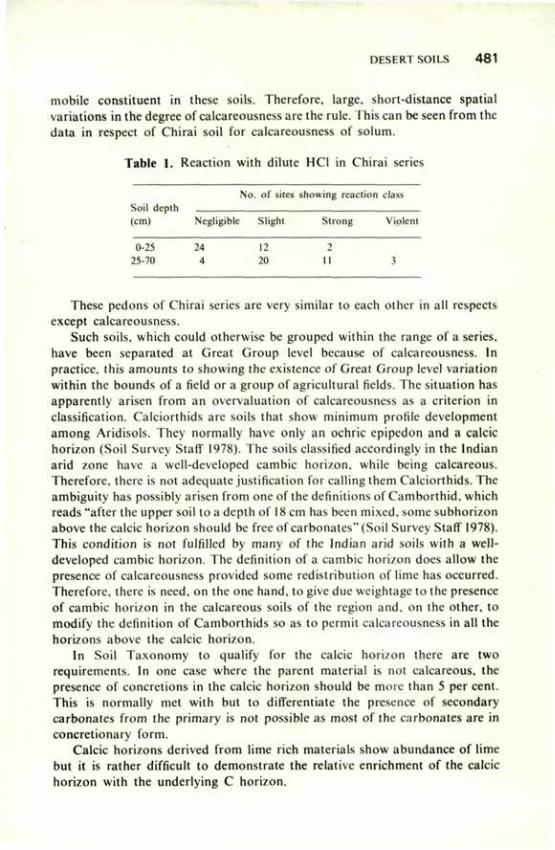
mobile constituent in these soils. Therefore, large, short-distance spatial variations in the degree of calcareousness are the rule. This can be seen from the data in respect of Chirai soil for calcareousness of solum.
Table 1. Reaction with dilute HC1 in Chirai series
Soil depth (cm)
No . of sites showing reaction class Soil depth (cm) Negligible Slight Strong Violent
0-25 25-70
24 4
12 20
2 II 3
These pedons of Chirai series are very similar to each other in all respects except calcareousness.
Such soils, which could otherwise be grouped within the range of a series, have been separated at Great Group level because of calcareousness. In practice, this amounts to showing the existence of Great Group level variation within the bounds of a field or a group of agricultural fields. The situation has apparently arisen from an overvaluation of calcareousness as a criterion in classification. Calciorthids are soils that show minimum profile development among Aridisols. They normally have only an ochric epipedon and a calcic horizon (Soil Survey Staff 1978). The soils classified accordingly in the Indian arid zone have a well-developed cambic horizon, while being calcareous. Therefore, there is not adequate justification for calling them Calciorthids. The ambiguity has possibly arisen from one of the definitions of Camborthid, which reads "after the upper soil to a depth of 18 cm has been mixed, some subhorizon above the calcic horizon should be free of carbonates" (Soil Survey Staff 1978). This condition is not fulfilled by many of the Indian arid soils with a well-developed cambic horizon. The definition of a cambic horizon does allow the presence of calcareousness provided some redistribution of lime has occurred. Therefore, there is need, on the one hand, to give due weightage to the presence of cambic horizon in the calcareous soils of the region and, on the other, to modify the definition of Camborthids so as to permit calcareousness in all the horizons above the calcic horizon.
In Soil Taxonomy to qualify for the calcic horizon there are two requirements. In one case where the parent material is not calcareous, the presence of concretions in the calcic horizon should be more than 5 per cent. This is normally met with but to differentiate the presence of secondary carbonates from the primary is not possible as most of the carbonates are in concretionary form.
Calcic horizons derived from lime rich materials show abundance of lime but it is rather difficult to demonstrate the relative enrichment of the calcic horizon with the underlying C horizon.
4 8 2 REVIEW OF SOIL RESEARCH IN INDIA
References
Abichandani, C.T. (1964) Proc. Symp. Problem Indian Arid Zone, Jodhpur p. 122. Agrawal, D.P., Dhir, R.P., Krishnamurthy, R.V., Mishra, V.N., Nanda, S.C. and Rajaguru,
S.N. (1980) Proc. and selected Papers, Int. Symp. Arid zone Res. and Dev. Sci. Pub. Jodhpur p. 18.
Ahuja, R.L., Garalapuri, V.N. and Khanna, S.S. (1978a) Bull. Desert Mgt, Haryana agric. Univ., Hissar.
Ahuja, R.L., Garalapuri, V.N.. Manchanda, ML. and Khanna, S.S. (1978a) J. Indian Soc. Soil Sci. 26, 261.
Allchin, B., Goudie, A. and Hegde, K.T.M. (1978) The prehistory and palaeogeography of the Great Indian Desert. Academic Press, New York.
Allchin, B., Hegde, H.T.M. and Goudie, A. (1972) Man. 74, 542. Dhir, R.P. (1977a) "Ecology and Archeology of western India" Concept Pub. House, New Delhi. Dhir, R.P. (1977b) "Desertification and its control" Indian Council of Agricultural Research, New
Delhi 102, 115. Dhir, R.P., Joshi, D.C., Singh, N. and Bhola, S.N. (1980) Soil Survey Rep. of Nagaur Dist.,
Central Arid Zone Research Institute, Jodhpur. Dhir, R.P. and Kolarkar, A.S. (197/) J. Indian Soc. Soil Sci. 25, 260. Dhir, R.P. and Mann, H.S. (1978) Nat. Symp. i.and and Water Mgt Indus Basin I, 422. Dhir, R.P. and Singh, N. (1976) Soil Survey Rep. of Jodhpur Dist. Duggal, S.L. (1975) 'Soil Geography of Haryana', Haryana agric. Univ., Hissar. F.A.O./U.N.D.P. (1971) Soil Survey and Land Classification in the Rajasthan Canal Command
Area. Rome Tech. Rep. 1.1-1.10. Fateh Karan (1975) Ph.D. Thesis, Indian Agril. Res. Inst., New Delhi. Garalapuri, V.N. & Goyal, V.P. (1974) Indian J. agric. Res. 8, 227. Ghose, B. (1964) Proc. Symp. Problem Indian Arid Zone, Jodhpur p. 79. Ghose, B., Pandey, S., Singh, S. and Lal, G. (1966) Annual Arid Zone 5, 10. Goudie, A.S., Allchin, B. and Hegde, K.M.T. (1973) Geogr. J. 139, 243. Govindarajan, S.V. and Godse, N.G. (1972) Indian J. agric. Sci. 42, 860. Gupta, R.K. and Saxena, S.K. (1971) Proc. int. Symp. biol. Prod. New Delhi. Gupta, R.K. and Saxena, S.K. (1972) Proc. int. Symp. Eco-physiological Found, of Ecosys. Prod.
in arid zone Moscow p. 134. Gupta, R.S. (1958) J. Indian Soc. Soil Sci. 6. 115. Iyer, H.S. (1980) Proc. and selected Papers, int. Symp. Arid Zone. Res. and Dev. Sci. Pub.
Jodhpur p. 121. Karwasara, S.P.S., Ahuja, R.L. and Goyal, V.P. (1972) J. Res. Haryana agric. Univ. 2, 29. Khanna, S.S. Abrol, LP., Anand Prakash and Khosla, B.K. (1978) J. Res. Pantnagar agric.
Univ. 5, 158. Kolarkar, A.S. and Abichandani, C.T. (1967) Annual arid Zone 16, 219. Krishnan, A. (1976) Climatological Res. at Central Arid Zone Res. Inst., Monogr. 10, 1. Krishnan, A. and Rao, G.G.S.M. (1979) Arch. Met. Geop. Biokl. Ser. B. 27, 15. Krishnan, M.S. (1952) Proc. Symp. Rajputana Deserts. Bull. natn. Inst. Sci. India I, 19. Manchanda, M L . (1964) M.Sc. Thesis, Punjab agric. Univ, Ludhiana. Mathur^C.M., Mehta, K.M. and Sharma, V.C. (1968) J. Indian Soc. Soil Sci. 16, 249. Mathur, CM. , Ganu, S.N., Moghe. V.B. and Jain, S.V. (1972) Soils of Rajasthan — Survey
and Classification in Retrospects and Prospects. Rajasthan Dept. Agric. pp. 109. Mehta, K.M. (1958) Soil and crop investigation survey of Jawai Project area. Rajasthan Dept.
Agric. pp. 51. Murthy, R.S. and Pandey, S. (1977) Desertification and its control. Indian Council of Agricultural
Research, New Delhi p 116. Narayana. M.R. (1962) Ph.D. Thesis, Indian Agril. Res. Inst., New Delhi.
DESERT SOILS 4 8 3
National Bureau of Soil Survey and Land Use Planning (1979) Soil Series Hand Book of Kachchh Dist. Nagpur Regional Centre, Nagpur.
Pandey, S., Ghose, B., Roy, B.B. and Abichandani, C.T. (1967) J. Indian Soc. Soil Sci. 15, 163.
Piggot, S. (1950) Pre-historic India. Haimondsworth. Penguin Books. Raychaudhuri, S.P. (1964) Proc. Symp. Problems Indian Arid Zone, Jodhpur p. 101. Raychaudhuri, S.P., Agrawal, R.R., Datta Biswas, N.R., Gupta, S.P. and Thomas, P.K. (1963)
Soils of India. Indian Council of Agricultural Research, New Delhi. Raychaudhuri, S.P. and Govindarajan, S.V. (1971) In "Review of soil Research in India",
Indian Society Society of Soil Science, New Delhi. Roonwal, G.S., Khanna, S.S. and Anand Prakash (1967) J. Res. Punjab agric. Univ. 4,
166. Roy, B.B., Chatterji, P.C. and Pandey, S. (1969) Annual Arid Zone 8, 181. Roy, B.B. and Kolarkar, A.S. (1968) Soils of Central Farm, Pali. Central Arid Zone
Research Institute, Jodhpur. Roy, B.B. and Pandey, S. (1971) Proc. Indian natn. Sci. Acad., 36B, 331. Roy, B.B. and Sen, A.K. (1968) Annual arid Zone 7, 1. Sehgal, J.L., (1974) Proc. Indian natn. Sci. Acad. 40B, 404. Sehgal, J.L., Dhir, R.P. and Murthy, R.S. (1980) Tech. Session "Regional occurrence of soil
with aridic, ustic and xeric moisture regimes — Their placement in Soil Taxonomy & Problems of classification.
Sehgal, J.L., Kanwar, J.S., Bhumbla, D.R. and Dhingra, D.R. (1965) J. Res. Punjab agric. Univ.
Sehgal, J.L. and Stoops, G. (1972). Geoderma 8, 59. Sharma, R.C. and Shukla, U.C. (1978) J. Res. Haryana agric. Univ. 8, 11. Sidhu, G.S., Sharma, A.C. and Dhingra, D.R. (1972) In "Soils of India" Fertil. Assoc. India,
New Delhi. Singh, G. (1971) Arch, and Phys. Anthrop. Oceania 6, 177. Singh, S. (1977) Man and Environ. 1, 7. Singh, S., Pandey, S. and Ghose, B. (1971) Annual arid Zone 10, 14. Soil Survey Staff (1978) "Soil taxonomy" Soil Cons. Serv., USDA Agric. Handbook 436. Sultan Singh, Garalapuri, V.N. and Khanna, S.S. (1979) Proc. Indian natn. Sci. Acad. 40B,
326. Vinayak, C.P., Singh, Y.P., Ram, G. and Jaggi, B.M. (1979) "Reconn. Soil Survey &
Land Classification of Danta Ram Garh Tehsil, Sikar" Rajasthan Dept. Agric. Jaipur.
Wadia, D.N. (1960) Monogr. natn. Inst. Sci. India.
Morphology, Genesis and Classification of Black Soils R.J. LANDEY1, L.R. HIREKERUR2 AND P. KRISHNAMOORTHY3
THE black soils, or 'regur' soils of India have many fundamental properties in common with deep clays of warm temperate and tropical regions. The principal region of their occurrence is the Deccan plateau ana its periphery extending from 8°45' to 26°0' N latitude and 68°0' to 83°45' E longitude (Murthy et al. 1981). The black soils, as seen from the soil map of India prepared by Raychaudhuri and Govindarajan (1971), include shallow, medium and black and associated mixed red and black soils occupying an area of about 736,230 sq km. Cotton being an important crop grown on them, the deep black soils are also referred to as black cotton soils.
Black soils are formed mainly from the Deccan trap basalt, either in situ or on transported material. At places they are derived from granite and gneiss containing lime and soda lime feldspar, basic in character. They also occur to a considerable extent in the deltas of Godavari and Krishna rivers and upstream flood plains of the main river system of the peninsular India.
In the earlier work, field studies on morphology of black soils were limited. However, a large volume of laboratory data were available. Considerable thought was given to the placement of these soils among the great soil groups of the world. Several vorkers (Basu and Sirur 1938; Desai 1942; Tamhane 1950) considered these soils to be nearer toTropical Chernozems. It was also felt that they were similar to the dark clay soils found in South Africa (Vander Merwe 1935) and Australia (Hosking 1935). Wadia (1945) compared black soils of India with adobe clays of California on the basis of laboratory and geological data. Oakes and Thorp (1950) proposed that dark clays of warm regions, including the black soils of India, be combined into a single great group set apart from other soils already recognised and be named 'Grumusols'; this was accepted by Simonson (1954). In the recent past, with expanded soil survey activities at both national and state levels, there has been considerable emphasis on field studies of soil morphology, which have provided data to complement the results of earlier studies.
The striking features of black soils, their extent, physico-chemical properties and other environmental characteristics, and potential use make them highly interesting to soil scientists. They are dominantly smectitic in mineralogy, with high coefficient of expansion and contraction, setting up a steady churning process within the pedon. This process of cyclic movement of soil material within the pedon causes vertical mixing and leads to the
I., 2. National Bureau of Soil Survey and Land Use Planning. Nagpur; 3. Andhra Pradesh Agricultural University, Rajendranagar, Hyderabad
BLACK SOILS 485
development of special features, viz, gilgai microrelief, wide and deep open cracks, and coarse intersecting slickensides. Hence, it is essential to study closely the pedography of these soils to understand their morphometric features and genesis. A review of the work done on these aspects is presented.
SOILS AND THEIR ENVIRONMENT
Relief and Topography Black soils occur at altitudes ranging from 300 to 900 m in the peninsular
India. The western part of the terrain is the scarp face of sahyadris dropping abruptly to a narrow and rugged coastal strip along the Arabian sea; the eastern part merges gradually with Godavari and Krishna deltas. The northern fringe of the peninsular plateau gradually merges with the Chambal valley and the basin of Yamuna, and the north-western corner merges with the coastal plain in Gujarat. The black and associated soils are found on various micro-landform units, both erosional and depositional. The erosional features are the result of generally residual hill ranges, dissected mesas and buttes, escarpments and pediments. Similarly, the depositional features are visible in the piedmont plain merging gradually with the valley floor or intervening basin or the flood plains of the river systems. In general, the associated red and brown soils occupy higher relief positions, and the black soils are confined to level plateaus, valley depressions and sites at lower elevations (Medlicott and Blandford 1893; Basu and Sirur 1938; Mukherjee and Agarwal 1943; Narayan 1959; Krishnamoorthy 1969; Biswas and Gawande 1962; Bhargava et al. 1973; Krishnamoorthy and Govindarajan 1977). Mohr (1954) considered that the influence of topography and drainage was through a modifying effect on the 'soil climate. Viswanath (1935) observed red soils near the hills overlying a thin layer of decomposed granite, and kaolinised feldspar and black soils of increasing depth progressively away from the hills towards the depressions. Tamhane (1950) observed black soils on the flat undulating plateau in Bombay Deccan. On the uplands and slopes, the soils were relatively light-coloured and shallow, rarely exceeding 100 cm, but soils with depth exceeding 6 m were found in flat lands in the river valleys, indicating the influence of differential drainage conditions, runoff, erosion and deposition. Biswas et al. (1966) observed in Kurnool (Andhra Pradesh) that in the natural environment as the drainage intensity decreased, the soil colour gradually changed from reddish brown to very dark grey, and the texture from sandy clay loam to clay. Similarly. Yadava et al. (1977) reported the occurrence of deep red soils in the uplands, pale brown soils in the terraces, and dark grey soils in the lowlands. It may be inferred that both topography and drainage are responsible for the different colours in the associated soils. The studies reported by Gawande and Biswas (1979) and Bhattacharjee et al. (1971) demonstrated that the topographical variations were responsible for soil heterogeneity since they regulated the hydrological
4 8 6 REVIEW OF SOIL RESEARCH IN INDIA
conditions modifying the soil climate, which in turn influenced the pedogenic processes, morphological features and physico-chemical properties.
Parent Material The differences in the mineralogical composition, texture and make-up of
the rocks are important in weathering and soil development. Composition of the rock frequently controls the nature of the secondary minerals formed influences the ionic composition of soil solution system.
The Deccan trap, from which the black soils are mainly formed (Tamhane 1950; Wadia et al. 1935; Bal 1935; Basu and Sirur 1938), is chiefly augite basalt. It ranges in texture from vitreous basalt at one extreme to coarse-grained dolerite at the other. According to Tamhane and Sen H954), basalt, norite and metamorphosed Dharwarian rocks are the geological formations on which black soils of southern India are found, and non-basic rocks give rise to red soils. Namjoshi (1956) stated that abundance of calcium in the parent material appeared to be the sin qua non for the formation of black soils; for calcium performs important functions such as maintaining high concentration of bases and an alkaline medium of weathering, blocking the formation of k-aolinite and possibly aiding the formation of montmorillonite. Simonson (1954) described some black soils formed on limestone, some of which may have been argillaceous, and observed that the black soils reported by Hosking (1935) had developed from shale and calcareous clays.
According to Padoley (1955) the differences in the parent materials were reflected in the physical and chemical composition of soils developed in Madhya Pradesh, but the observations of Tamhane and Namjoshi (1959) indicated that the differences in composition of parent material did not have a very marked influence. Parthasarthy (1959) studied the influence of parent material on black and red soils of Tiruchirapalli district in Tamil Nadu and found that the gneisses which weathered to black soils were more basic than those which weathered to red soils. Black soils derived from parent materials rich in easily weathered soda lime feldspar were said to have acquired a heavy texture (Ramiah and Raghavendrachar 1936). The occurrence of black soil over hornblende granulite, calcic gneiss, granitised schist and chlorite schist in Tungabhadra catchment in Karnataka was reported by Kalbande et al. (1976), amphibole and pyroxene rich rocks by Balakrishnan (1955), and feldspar and ferromagnesium minerals providing favourable ionic environment for the formation of smectite, a dominant clay mineral in the black soils, by Bhargava et al. (1973) and Dasog and Hadimani (1980).
Tamhane and Rao (1956) observed that black soils of Kotah region contained primary minerals predominantly of trappean origin. Black soils popularly known as karail occurring in the lower Gangetic basin in Uttar Pradesh have been described by Agarwal et al. (1956), who have attributed their development to alluvium derived from basaltic area of Bundelkhand region.
BLACK SOILS 487
The black soils of Saurashtra in Gujarat, locally called 'bhal'and derived from marine alluvium were studied by Bhattacharjee et al. (1979).
From the results reported above it may be inferred that in the genesis of black soils the presence of high proportion of alkaline earths in the weathering complex is of great importance. Equally important is the alignment of the particles of the parent materials by which free leaching and removal of alkaline earths is restricted.
Climate Black soils are found to occur in areas under the monsoon climate, mostly
of semi-arid and subhumid type. Small pockets occur under arid conditions. The overhead climate in the black soil region may be described as hot a.id dry summer followed by a rainy period with rainfall ranging from 40 to 150 cm, followed by mild to moderate winter depending upon the latitude and altitude. The mean annual temperature ranges from 24° to 30°C. The mean maximum temperature during April-May ranges from 36° to 42°C, and the mean minimum temperature during the winter months ranges from 15° to 24°C. The difference between summer and winter temperatures irrespective of different climatic regions becomes wider in the north beyond 20°N latitude and narrower below. Rains are usually received from June to September. In the extreme south, from September to December, rainfall is received in fewer storms of high intensity and may therefore be characterised as erratic; this is one of the reasons for black soils experiencing periodic drought (Hosking 1935; Simonson 1954).
In most of the black soil area, the temperature being high, the potential annual evapo-transpiration far exceeds the total precipitation, indicating conditions of incomplete leaching. The NSQ value, as stated by Desai (1942), is between 100 and 200. Further, prevalence of alternate wet and dry conditions help in recycling the leached material (Mohr 1933). Hence it is unlikely that any process other than calcification could be in operation in the bla^k soil areas. This may be one of the reasons why most black soils, besides being base-saturated, either have calcium carbonate in the matrix or have lime concretions, especially in the semi-arid region. Black soils occur only in climate with pronounced dry season extending over four to eight months. Karale et al. (1968) stated that climatic factors appeared to be decisive in characterising the soils through their influence on weathei ing. According to them, soil with saturation deficit of 0.6 to 1.5 cm is conducive to formation of black soils in India.
According to Gerassimov (1958) the intiazonal nature of Indian 'regurs' is connected with two important local features, viz, the sharp aridity of the climate in the centre of the Deccan plateau and the great petrographic peculiarity of the parent rock. Tamhane and Karale (1967), and Karale et al. (1968) indicated that varying rainfall and topography resulting in differential leaching led to the formation of different soils, i.e. black, brown and laterite. According to them, restricted leaching gave rise to black soils. Biswas et al.
4 8 8 REVIEW OF SOIL RESEARCH IN INDIA
(1978) supported the view that soils of semi-arid to subhumid region with alternating dry and wet seasons had dominance of smectite in clay fraction. It is apparent that an arid to subhumid, tropical to subtropical, monsoon-typ*e climate, with alternate dry and wet periods inducing the process of calcification, is fabvourable to the formation of black soils.
Vegetation The vegetative succession on the terrain is closely related to the soil
bioclimate. The higher elements of topography, such as ridges, mesas, buttes, tablelands and pediments, are covered with thin vegetal cover. In the black soil areas, in general, the vegetation comprises dry deciduous species, viz, palas (Butea frondosa), sisam (Dalbergia sisu). neem (Azadiraehta indiea). and teak (Tectona grandis) besides other biotic species.
The rapid degeneration of vegetal cover on the higher landscape is due to change in the ecosystem caused by erosion and human interference. Therefore, most of these units are crowned by xerophytic or semi-xerophytic thorny bushes and mixed dry deciduous biotic species. The vegetation in the piedmont plain and flood plain mostly consists of cultural species. However, at places thorny biotic species are not uncommon in culturable fallow lands.
Owing to relatively high temperature and markedly dry summer, the nature of vegetation, according to Champion (1936), comes under tropical dry deciduous and tropical thorny forest with interspersed grass. According to Dudal and Bramao (1965), in both subtropical and tropical areas, the vegetation on uncultivated dark clay soils is mostly grasses. It is possible that the original climax in many areas was some form of forest consisting of species like Anogeissus latifolia associated with Terminalia tomentosa, Chlorixylon. swietenia, Hardwickia binata, Boswellia serrata and Scymida febrifuga, and that owing to biotic interference and subsequent degeneration, they are now rare.
Acacia, a biotic species is often present, indicating relationship with thorny forests. The undergrowth is usually thin, with a fairly dense growth of grass in the monsoon season. The region abounds in open low forests in which thorny, usually hardwood, species predominate. The genus Acacia with a number of species and several other allied genera are the characteristic vegetation in black soil region. Fleshy Euphorbiaceae species and Calotropis are conspicuous constituents of the vegetation. Opuntia has become naturalised over wide tracts but is not indigenous.
Age Soils on gently sloping erosional surfaces formed on parent material of
earlier geological age are younger in terms of maturity than the soils formed on coastal plain. The age of the Deccan trap relates to the Cretaceous period; trap rocks, themselves being unfossiliferous, do not provide conclusive evidence of their age. Though the black soils cap the plateau basalt or the Deccan trap, the
BLACK SOILS 4 8 9
area of black soil by no means coincides with the boundary of the Deccan trap formation. In fact, these soils extend to the surrounding granite and basic gneiss and other formations and even Vindhyan and Cuddapah sandstones and slates. There are also large tracts of black soils derived from alluvium of basaltic origin. In such cases, the profiles are deeper, 10 to 12 m or more, without any zoning or differentiation into layers (Raychaudhuri et al. 1963).
PHYSICAL AND CHEMICAL PROPERTIES
Texture The texture of black soils is usually fine and ranges from clay loam to silty
clay loam, silty clay or clay. The clay content ranges from 35 to 60 per cent and may occasionally go up to 80 per cent. The available data on some of the deep black soil pedons indicate a rather uniform distribution of clay and organic carbon through depth, while in others organic carbon decreases regularly but clay increases progressively up to a certain depth and decreases below that. The uniform distribution in the former indicates predominance of the process of haploidisation inhibiting hori/on differentiation and horizontation in the latter. Silt fraction is also fairly high in black soils, but sand fraction is low; gravels may be found in the form of lime concretions, ferromanganese concentrations, and weathered fragments of parent material.
Organic Matter The organic carbon content is low, from 0.3 to 0.7 per cent. The distribution
of organic matter in deep black soils is uniform to a depth of 1 to 1.6 m. In some of the associated soils it may decrease.
pH The soils are generally calcareous and neutral to mildly alkaline in reaction
with pH ranging from 7.2 to 8.5. The pH is mostly related to the nature of the parent material, climate and topographic situation, which determine the composition of soils. At places, the pH may rise to 9 or 9.5 showing signs of alkali effects.
Bulk Density Bulk density is normally high in black soils. The normal range estimated
with dry clod method ranges from 1.5 to 1.8 g/cc. Higher values of 2.0 to 2.2 have been observed in some compact pedons (Bhattacharjee et al. 1981).
Cation Exchange Capacity Cation exchange capacity normally ranges from 34 to 54 me/100 g. It is
high whore line clay fraction is also high. The high cation exchange capacity in these soils is consistent with high clay content and the presence of smectite group of clay minerals (Dcsai 1942; Nagelschmidt el al. 1940; Bagchi 195l;Das
4 9 0 REVIEW OF SOIL RESEARCH IN INDIA
and Das 1966). The variation in cation exchange capacity per gram of clay in black soils is small (Desai 1942; Basu and Sirur 1938; Raychaudhuri et al. 1943; Roy and Das 1952). At places, especially in soils of basaltic origin, high cation exchange capacity values may be due to the presence of zeolite.
Sand Mineralogy The Deccan basalts with mean specific gravity of 2.82 consist of fine
grained mixture or ground mass of feldspar and augite. Besides plagioclase, large tubular crystals of clear glossy orthoclase as phenocrysts and magnetite are common. Primary accessary minerals like apatite are few, but secondary minerals, viz, calcite, quartz, chalcedony and glauconite, are in abundance. The heavy minerals of the fine sand fraction of black soils developed on Deccan trap indicate augite and iron ore and account for 75 to 98 per cent of the total minerals (Raychaudhuri et al. 1963). Harrison and Ramaswamy Sivan (1912) observed that black soils of Thirunelveli contained garnet: those of Bellary, syenite; and those of Guntur, micaceous minerals. Sant and Tamhane (1958) reported decrease in pyroxene and plagioclase content with depth in the profiles under varying conditions of rainfall and intensity of weathering of basalt. The limonite is high in the surface but decreases below; with secondary quartz it is quite the opposite. Anjaneyulu and Raychaudhuri (1964) reported that well-developed black soils of Guntur were devoid of plagioclase and hornblende in fine sand fraction.
Tamhane and Namjoshi (1959) reported the presence of pyroxene, magnetite, ilmenite, zeolite, limonite, apatite and garnet in sand fractions of black soils developed on basalt. Those derived from granite gneiss, limestone and shale were devoid of augite and zeolite. Hornblende and chlorite were in large quantities in soils derived from granite gneiss.
Desai (1942) studied the sand mineralogy of red and black soils in Hyderabad area of Andhra Pradesh. He found feldspar, quartz, hornblende, iron oxide and zircon in black soils, and mainly quartz and feldspar in red soils. It can be inferred that, depending upon the type of rock and intensity of the weathering, minerals, viz, augite, plagioclase, feldspar and ferromagnesium. which are rich in alkali and alkaline-earth metals are released and dominate the sand fraction of black soils.
Clay Mineralogy Ramiah (1937) reported that the composition of clay fraction of black soils
in Thungabhadra project showed Si02/R203 ratio of 3, suggesting preponderance of 2:1 type of clay minerals. Desai (1942) observed that black clayey soils were more silicious than red soil; molar ratios of black clays were nearly constant throughout the depth, but those of red soils showed accumulation of iron in upper layers, pointing to leaching of SiC>2 and AI2O3. Raychaudhuri et al. (1943) and Parthasarthy (1959) found that ratios of

BLACK SOILS 491
Si02 /R203 were higher for black clay fractions than for red clay, indicating that beidellite was the preponderant clay mineral in black soils.
Tamhane (1950) reported that the dominant clay minerals in 'regurs' belonged to the montmorillonitic group, but presence of illite was also noticed. Nagelschmidt et al. (1940) showed that the red soil contained predominantly kaolinite and halloysite, whereas black soil contained mainly beidellite. Mukherjee and Mitra (1946), and Sinha (1957) studied black soils of Akola and Padegaon and reported the montmorillonitic group as the dominant clay mineral. Roy and Das (1950) from electrochemical properties of H-clays of typical Indian soils, inferred the predominance of montmorillonitic clay group in black soils and of kaolinite in laterite and acid soils. They stated that black soil clays may contain some illite, and red soil clay fraction may contain halloysite. Das el al. (1952) studied electrochemical properties of Bhopal soils and concluded that black soils on continued weathering produced brown, yellow and red soils.
Das and Das (1966) made X-ray diffraction studies of various soil clays and concluded that the black soils were dominated by montmorillonite with some proportions of chloritic, illite and kaolinite. Ra jani's (1967) results showed that there was a resemblance of black soil clays with different ultra clay fractions of pure bentonite; each size fraction compared well with the corresponding fraction of black soils. Gupta (1968) reported the dominance of illite in 'dha'nkar' upland soils and montmorillonite in 'karail'. Khanna (1969) reported montmorillonite as the dominant clay mineral in black soils and observed no difference in clay mineralogy in the different horizons of the black soil profiles. According to Bhargava el al. (1973) schistose rocks with their readily weathering ferromagnesium minerals have given rise to heavy-textured smectitic soils in an atmosphere saturated with divalent cations. The soils derived from granite gneiss and banded haematite quartzite are coarse-textured and illitic. Gurcharan Singh and Krishnamurti (1975), and Chatterjee and Rathore (1976) reported that the fine clay of basaltic soils of Madhya Pradesh had smectite as the dominant clay mineral.
From the above it may be inferred that smectite is the dominant clay mineral in black soils.
MORPHOLOGY
Black soils occurring on various landform units are widely distributed throughout the country. Hence wide differences in their morphometric characteristics are common. In studying the morphology of black soils, primary attention has to be given to the horizons and characteristics of importance in genesis and soil behaviour.
Black soils in India are usually dark in colour, low in chroma, low in organic matter, usually calcareous, mildly alkaline, high in clay content and in cation exchange capacity, plastic and sticky, and high in coefficient of
4 9 2 REVIEW OF SOIL RESEARCH IN INDIA
shrinkage and expansion (Tamhane 1950). The extent of cracking as the soil dries, the content of carbonate, and thickness of the solum vary appreciably among the soils included in the group. After studying several pedons of black soils it was found that in some the morphology exhibited a high degree of uniformity throughout the profile, indicating A-C profile. Al grading to C horizon through an AC horizon, which is transitional. In contrast, the associated soils may have ABC profiles with well developed structure, colour or textural B horizon.
Soil Colour Leather (1898) attributed the black colour in the soil to the presence of
certain minerals. Annet (1910) observed that black colour in the black cotton soil of Deccan trap was mainly due to the presence of titani-ferrous magnetite and I and 2 per cent soluble humus. Wadia (1945) also thought that the colour was partly due to iron or minute quantities of some titanium-iron compounds and partly due to organic carbon. Joshi(1945) and Ramachandran el al. (1959) stated that the colour was due to a complex of clay with humus.
The formation of clay-organic matter complex, favouring anaerobic conditions during the wet season, was considered essential to the formation of dark colour by Singh (1956), Maignien (1961) and Johnson et al. (1962). Laboratory studies on extraction of organic matter showed a continuous release of dark pigments from Vertisols for about two years and from vertic subgroups for six months in soils from the semi-arid parts of Ahmednagar district of Maharashtra (Bhattacharjee el al. 1974).
According to Dudal and Bramao (1965) drainage, duration and severity of dry season, composition of parent material, and type of soil development processes might be possible causes of dark colour in these soils. Generally, black soils are dark greyish brown in hue with 10 YR and 2.5 Y with dry value 4 and 5, moist value 3 and occasionally 2 and chroma 1 to 3. The interdigitating mottle colours of dark yellowish brown (10 YR 3/4 and 4/4) are also noticed in A-C horizon as tongues. Mottling is noticed in some soils, having neutral colours in hue 2.5 Y and 5 Y, as evidence of poor drainage.
Soil Structure Data available for black soils occurring on different geomorphic units in
the country indicate varying degrees of structural development. The structure in Entisols is weak to moderate sub-angular blocky. In Inceptisols and a few associated Alfisols it is moderate to strong subangular blocky with shiny pressure faces in the subsoil horizon indicating shrinking and swelling potential. Some of the deep black soils which exhibit cracks and evidence of appreciable swelling and shrinking with changes in moisture regime set up slow churning and cyclic movement of soil material and cause vertical mixing within the pedon. There is a mass movement of one surface against the other producing slickensides, which are termed pressure faces. The prominance of
BLACK sons 493
slickensides and the orientation of face planes, and whether they are intersecting or not. are important for classification of Vertisols (Bhattacharjec el al. 1981).
The structure of black soils is usually cloddy but is occasionally crumby, with natural cleavages. The subsoil structure in the deeper phase is often laminar, with slanting cleavage. In some very deep black soils the subsoil exhibits a characteristic structure,-whose shape, size and make-up of the structural aggregate do not fit into any of the commonly recognised forms, viz, cubic, spherical, columnar, prismatic or platy. This structure was termed lentil by Krishna and Perumal (1948). lentils are stable and measured
• approximately 17 cm X 10 cm. 20 cm X 12 cm and 22 cm X 12 cm in the three axes; they can be detached with ease from the soil body. The structural pattern consists of parallel planes of cleavages inclined at 30° to the ground surface and in the direction of subsoil drainage (Raychaudhuriir al. 1963). Such black soil showing prolate ciiaspheric intersecting slickensides in the upper part and forming parallelepipeds with their long axes tilting 30° to 60° from the horizontal in the lower part are unstable (Bhattacharjec el al. 1977).
Size of Pedon Where churning or cyclic movement of soil material to cause vertical
mixing is lacking, the pedon is hexagonal and the area is considered to be 1 m2. In the case of deep black soils variability of horizon thickness due to churning were observed by Bhattacharjec el al. (1977), who classified the cyclic pedon as small, medium and large according to the measurement of half the cycle or intermittent horizon as suggested by Bartelli (1971).
Horizon Boundary Distinction between the horizons in black soils indicating contrast with the
adjacent ones has been generally recognised as clear and gradual with smooth and wavy boundary. In some black soils the recognition of the topography of the lower boundary of cyclic or intermittent horizon is somewhat difficult, but apparent topography can be identified in terms of amplitude (Dudal and Bramao 1965). Bhattacharjee el al. (1977) recognised the topography of lower boundary of cyclic or intermittent horizon in terms of amplitude and defined it as low, medium or high; and they defined the shape of the intermittent horizon as tongued, wavy or smooth.
Nomenclature of Horizons Several studies on black soils indicate that shallow black soils classified
earlier as Entisol have A horizon directly underlain by weathered rock, and that some black soils classified as lnceptisol. and at places as Alfisol. have ABC profiles. Certain black soils having wide open cracks extending through the depth and well expressed gilgai micro relief on the surface are characterised by AC profile where A horizon grades to C through AC horizon. Srinivasan e I al.

4 9 4 REVIEW OF SOIL RESEARCH IN INDIA
(1969) suggested Bv horizon in place of AC in Vertisol, and Bhattacharjee et al. (1977) suggested Al and C horizons with V as a suffix to indicate vertic characteristics.
Micro Relief Cracking on the surface is a common feature in black soils in general and
Vertisols in particular. Cracks 0.5 to 1 cm, sometimes up to 6 cm, wide and tapering along the depth extend up to 90 cm. The cracks formed during summer are filled up with loose materials falling in from the surface during rains. On swelling, the soil increases in volume. The lateral and vertical swelling stress induces the mass to collapse at the point of stress. Hence a part of the swelling mass is pushed upwards, developing micro-knoll and micro-depression in the surface. Verma and Meyers (1975) established a linear relationship between the depth and the width of the soil cracks. The linear distance of micro high and micro low varies with the moisture regime; it was studied by Bhattacharjee et al. (1977).
CLASSIFICATION
The new comprehensive system of classification, i.e. Soil Taxonomy, has been gradually introduced in this country. Raychaudhuri (1961) classified black soils under the order Vertisol and suborder Ustert. He suggested that a utilitarian approach be followed for classifying the soils into lower categories, viz. families and series. He commended the use of local names at family level. Tamhane and Karale (1967) studied the morphological properties of soils developed over basaltic parent material and classified them as Mazustert, Grumustert and Grumaquert. Govindarajan and Datta Biswas (1968) and Raychaudhuri and Govindarajan (1971) differentiated broad soil classes on Soil Map of India with local and taxonomical names. They proposed a classification of black soils in which shallow black soils were classified as Ustorthents and Ustropepts; medium deep and deep black soils (depth 50 cm to 100 cm) as Pellusterts, Chromusterts; and Peluderts. Srinivasan et al. (1969), Bhattacharjee et al. (1977), and Dasog and Hadimani (1980) classified black soils similarly.
Srinivasan and Kamphrost (1971) considered the placement of medium deep cracking soils and suggested vertic, leptic and calcic as appropriate additions for a satisfactory classification of soils. Srinivasan (1976) further suggested the inclusion of salic, halic and natric horizons in Vertisol to facilitate the classification of salt-affected soils. These suggestions, however, have yet to be applied in practice.
Summary Black soils apparently occur in different agro-climatic regions. The depth
varies from shallow to very deep although the texture is generally fine in all
BLACK SOILS 4 9 5
cases. The problems and the potentials of these soils also vary considerably. In the low rainfall zone, i.e. óf/cm or less annually, the shallow soils are
generally used for crops that mature in about 100 days or less. Minor millet (bajra) and pulses like horse gram are favourites because of their low water requirement and early maturity. These crops respond to improved management practices by yielding 50 to 60 per cent more. The soils generally occupy the pediment slopes and escarpments. Soil and water conservation measures become especially important to check erosion.
The medium deep black soils with a depth of 60 to 100 cm and moisture storage capacity of 15 to 20 cm can be used for one long-duration kharif crop or medium-duration rabi crop. Most of the lands are used for sorghum either as kharif crop sown in July or as rabi crop sown in September or October.
These soils generally occur on flat lands or gentle slopes and do not pose great problems in respect of soil and water conservation. Under irrigation, a variety of adaptable crops can be raised on medium deep soils.
Although the available moisture capacity of deep black soils is more than 20 cm, the rainfall pattern and amount are generally not adequate for raising two crops. Most of the farmers raise a single crop under dryland farming, growing sorghum sown either in July or in September-October or wheat sown in October. Safflower is also an important oil-seed crop raised on these soils in rotation.
These soils, because of their inherent drainage problems under irrigation, are usually prone to saline and sodic hazards. Hence, without assured drainage, they cannot be recommended for heavy-input crops like sugarcane. Instead, it is desirable to raise adaptable crops under dryland conditions and provide only one or two supplemental irrigations to reap optimum yields.
In the relatively high rainfall zone, i.e. 60 to 150 cm, there is a progressively greater chance of raising two crops, especially in the medium deep and deep soils. In the shallow soils, however, owing to low available moisture capacity, there is little likelihood of raising more than one crop. For such shallow soils, a variety of crops maturing in 100 to 120 days can be suggested. Actually these soils are used for cultivation of pearl millet, sorghum and minor pulses. Many of the shallow soils in this region occur on hill slopes, and therefore soil conservation measures are necessary. Even there the crops respond to management practices with considerably increased yields.
The medium deep and deep soils with available moisture capacity of 15 cm of more per 100 cm can be used either for raising a long-duration single crop like cotton or, where the rainy season extends up to October followed by one or two assured winter showers, for two crops in a sequence. The sequence may be sorghum-safnower or maize-safflower, for example.
The medium deep soils and the deep soils generally occur on the flat lands and valleys with very gentle or gentle slopes. It is necessary to provide surface drainage when such lands are brought under irrigation. Lands in valley bottom with restricted drainage may not be recommended for irrigation because of
496 REVIEW OF SOIL RESEARCH IN INDIA
salinity and sodic hazards. However, under dryland conditions and with improved technology the crop yields can be increased considerably.
References
Agarwal, R.R., Mehrotra, C.L. and Gupta, R.N. (1956) J. Indian Soc. Soil Sci. 4, 65.
Anjaneyulu, B.S.R. and Raychaudhuri. S.P. (1964) J. Indian Soc. Soil Sci. 12, 177. Annet, H.E. (1910) Mem. Dept. Agric. India, Chem. Ser. I, 185. Bagchi, S.N. (1951) Bull. Indian Soc. Soil Sci. 6. Bal, D.V. (1935) Emp. J. exp. Agric. 3. 261. Balakrishnan, M.R. (1955) Madras agric. J. 42, 274. Bartelli, L.J. (1971) Soil Taxonomy, Soil Correlation, Soil Interpretation Workshop. All India
Soil and Land Use Survey, New Delhi, India. Basu, J.K. and Sirur, S.S. (1938) Indian J. agric. Sci. 8, 637. Bhargava, G.P., Datta Biswas, N.R. and Govindarajan, S.V. (1973) J. Indian Soc. Soil Sci.
21, 193. Bhattacharjee, J.C., Kalbande, A.R. and Landey, R.J. (1974) Unpublished. Bhattacharjee, J.C., Kalbande, A.R. and Vadivelu, S. (1981) Unpublished. Bhattacharjee, J.C., Landey, R.J. and Kalbande, A.R. (1977) J. Indian Soc. Soil Sci. 25, 221. Bhattacharjee, J.C., Landey, R.J. and Kalbande, A.R. (1979) Unpublished. Bhattacharjee, J.C., Shende, N.K., Barde, N.K. and Raut, T.B. (1971) J. Indian Soc. Soil Sci.
19, 423. Biswas, T.D. and Gawande, S.P. (1962) J. Indian Soc. Soil Sci. 10, 223. Biswas, T.D., Karale, R.L. and Das, S.C. (1978) J. Indian Soc. Soil Sci. 26, 339. Biswas, T.D., Narayana, M.R. and Vasudeva Rao, A.E. (1966) J. Indian Soc. Soil Sci. 14, 183. Champion, H.C. (1936) Indian Forest Ree. N.S. Silv. I. Chatterjee, R.K. and Rathore, G.S. (1976) J. Indian Soc. Soil Sci. 24, 144. Das, D.K. and Das, S.C. (1966) J. Indian Soc. Soil Sci. 14, 43. Das, S.C, Rao, A. and Tamhane, R.V. (1952) Curr. Sci. 21, 245. Dasog, G.S. and Hadimani, A.S. (1980) J. Indian Soc. Soil Sci. 28, 49. Desai, A.D. (1942) Bull. No. 10 Dept. Agri. Culture, H.E.H. Nizam Government, Hyderabad
State. Dudal, R. and Bramao, D. Luis (1965) FAO Agri. Dev. Paper No. 83. Gawande, S.P. and Biswas, T.D. (1977) J. Indian Soc. Soil Sci. 25, 233. Gerassimov, LP. (1958) J. Indian Soc. Soil Sci. 6, 193. Govindarajan, S.V. and Datta Biswas, N.R. (1968) Proc. 21st int. Geogr. Congr., New
Delhi. Gupta, R.N. (1968) J. Indian Soc. Soil Sci. 16, 115. Gurcharan Singh and Krishna Murti, G.S.R. (1975) J. Indian Soc. Soil Sci. 23, 277. Harisson, W.H. and Ramaswamy Sivan, M.R. (1912) Mem. Dep. Agric. Indian Chem. Ser.
2, 26. Hosking, J.S. (1953) Trans. Roy. Soc. S. Aust. 59, 168. Johnson, W.M., Cady, J.C. and James, M.S. (1962) Proc. Soil Sci. Soc. Am. 26, 389. Joshi, R.H. (1945) Curr. Sci. 14, 329. Kalbande, A.R. and Swamynatha. R. (1976) J. Indian Soc. Soil Sci. 24, 290. Karale, R.L., Tamhane, R.V. and Das, S.C. (1968) J. Indian Soc. Soil Sci. 17, 227. Khanna, S.S. (1969) Indian J. Sci. and Indus. 3, 171. Krishna, P.G. & Perumal, S. (1948) Soil Sci. 66, 29. Krishnamoorthy, P. (1969) Ph.D. Thesis, Indian Agricultural Research Institute, New Delhi.
BLACK SOILS 4 9 7
Krishnamoorthy, P. and Govindarajan, S.V. (1977) J. Indian Soc. Soil Sci. 25, 239. Leather, J.W. (1898) Agric. Ledger (Agric. Ser.) 2, 83. Maignien, R. (1961) Bull. Ass. Franc. Etude Sol. No. Spec. 131. Medlicott, H.B. and Blandford, W.T. (1893) Manual of Geology of India. Mohr, E.C.J. (1933) Tropical soil forming processes and the development of tropical soils. Inter-
Science Publishers, Inc. New York. Mohr, E.C.J, and Van Baren. F.A. (1954) Tropical Soils. N.V. Uitgeverij W. Van Hoeve —
The Hague and Bandung. Mukherjee, B.K. and Aga'rwal, R.R. (1943) Indian J. agric. Sci. 13, 587. Mukherjee, J.N. and Mitra, R.P. (1946) J. Colloid Sci. 1, 141. Murthy, R.S., Bhattacharjee, J.C., Landey, R.J. and Pofali, R.M. (1981) Unpublished. Nagelschmidt. G., Desai. A.D. and Muir, A. (1940) Indian J. agric. Sci. 10. 639. Namjoshi, N.G. (1956) M.Sc. Thesis, Indian Agricultural Research Institute, New Delhi. Narayan, N.R. (1959) M.Sc. Thesis, Indian Agricultural Research Institute, New Delhi. Oakes, H. and Thorp, J. (1950) Proc. Soil Sci. Soc. Am. 15, 347. Padoley, G.C. (1955) M.Sc. Thesis. Indian Agricultural Research Institute. New Delhi. Parthasarthy, K. (1959) M.Sc, Thesis, Indian Agricultural Research Institute, New Delhi. Rajani, H.J. (1967) Sci. Cult. 33, 222. Ramchandran, V.S., Ahmed, F.U. and Jain, L.C. (1959) Proc. Indian Acad. Sci. 50A, 314. Ramiah, P.V. (1937) Report on the Soil Survey of Tungabhadra Project Dept. Agri., Madras. Ramiah, P.V. and Raghavendrachar, C. (1936) Proc. Soc. Biol. Chem. India I, 9. Raychaudhuri, S.P. (1961) J. Indian Soc. Soil Sci. 9, 1. Raychaudhuri, S.P. and Govindarajan, S.V. (1971) Indian Council of Agricultural Research
Tech. Bull. (Agric.) No. 25. Raychaudhuri, S.P., Roy, B.B., Gupta, S.P. and Dewan, M.L. (1963) National Inst. Sci.
India, Monogr. Raychaudhuri, S.P.. Sulaiman, M. and Bhuiya, A.B. (1943) Indian J. agric. Sci. 13, 264. Roy, B.B. and Das, S.C. (1950) Trans. 4th Int. Congr. Soil Sci. 3, 81. Roy, B.B. and Das, S.C. (1952) Soil Sci. 74, 351. Sant, V.N. and Tamhane, R.V. (1958) Proc. Indian Sci. Congr. 45, 455. Simonson, R.W.C. (1954) J. Soil Sci. 5, 275. Simonson, R.W.C. (1954) Proc. Soil Sci. Soc. Am. 18, 199. Singh, S. (1956) J. Soil Sci. 7, 43. Sinha, S.D. (1957) J. Indian Soc. Soil Sci. 5, 91. Srinivasan, T.R. (1976) J. Indian Soc. Soil Sci. 24, 12. Srinivasan, T.R., Bali, Y.P. and Tamhane, R.V. (1969) J. Indian Soc. Soil Sci. 17, 323. Srinivasan, T.R. and Kamphrost. A. (1971) J. Indian Soc. Soil Sci. 19, 415. Tamhane, R.V. (1950) Trans, 4th Int. Congr. Soil Sci. 3, 131. Tamhane, R.V. and Karale, R.L. (1967) J. Indian Soc. Soil Sci. 15, 269. Tamhane, R.V. and Namjoshi, N.G. (1959) J. Indian Soc. Soil Sci. 7, 49. Tamhane, R.V. and Rao, N. (1956) J. Indian Soc. Soil Sci. 4, 105. Tamhane, R.V. and Sen, A. (1954) Bull. natn. Inst. Sci. India 3, 177. Vander Merwe, C.R. (1935) Trans. 3rd Int. Congr. Soil Sci. 1, 301. Verma, Balvir and Meyers, R.E. (1975) J. Indian Soc. Soil Sci. 23, 18. Viswanath, B.A. (1938) Bull. Indian Soc. Soil Sci. 2, 21. Wadia, D.N. (1945) J. scient. ind. Res. 3, 359. Wadia, D.N., Krishnan, M.S. and Mukherjee, P.N. (1935) Rec. geol. Survey India 68,
363. Yadav, B.R., Gupta, R.N. and Singh, B.D. (1977) J. Indian Soc. Soil Sci. 25, 253.
Morphology, Genesis and Classification of Red and Laterite Soils S. DIGAR1 AND N.K. BARDE2
THE red and laterite soils occur in areas of tropical and subtropical climate with high humidity and temperature. They form nearly one-fifth of the total geographical area of the country.
Red soils are formed from rocks in situ or from products of decomposition carried to lower depths. These soils are generally red or reddish brown and have a variable thickness, with or without lime concretions, gravel and weathered rock fragments at lower depths. The soils are generally deep to very deep; the clay content increases with depth; shallow and gravelly red soils are also common. The clay fraction is dominantly kaolinitic, with illite and rarely montmorillonite. The soils are generally deficient in nitrogen, phosphorus, organic matter and lime. However, they produce a large variety of crops under irrigation.
Red soils occur in the southern part of the peninsula comprising the states of Tamil Nadu, Karnataka, Kerala, Maharashtra and Andhra Pradesh, and in the union territories of Goa and Pondicherry; on the east coast they extend further north. The eastern part of central India also has these soils; so do parts of Orissa, Madhya Pradesh, West Bengal, Bihar and Assam. Gravelly red soils are found in Bihar, Madhya Pradesh and Maharashtra.
Red soils are derived mostly from granites, gneisses and schists, mainly of the Archaean period. Other rocks include sandstone, mica schist, acid trap, quartzite and shale. The red soils derived from rocks such as gneiss, charnockite and diorite, and others which are relatively rich in clay-forming minerals such as feldspar, mica, hornblende, are fine-textured soils. Lime concretions in the form of nodules or thick veins are also found in some red soils; they result from the weathering of feldspars containing lime.
Red soils very often occur in association with laterite soils. They are well drained and often occur in toposequence. In Andhra Pradesh, Karnataka, Tamil Nadu and Madhya Pradesh, red and black soils occur in patches side by side — the red at higher elevations, the black at lower elevations.
Laterites are formed in tropical and subtropical climates having a rainy season followed by a dry season. Under these conditions silica is released and leached downwards, and the upper horizons of the soil become rich in iron oxide and aluminium oxides. Ultimately, red cinderlike residues of oxides of iron and aluminium are left. The end product of the process is termed laterite.
I. Regional Centre, National Bureau of Soil Survey and Land Use Planning, Calcutta; 2. Regional Centre, National Bureau of Soil Survey and Land Use Planning, Bangalore.
RED AND LATERITE SOILS 4 9 9
Laterite soils are usually characterised by a compact to vesicular structure in the subsoil horizon composed essentially of a mixture of hydrated oxides of aluminium and iron. The underlying mass is purplish or brick-red or brown to yellowish. It may be pisolitic or may consist of ferruginous clay, which when moist is soft but on exposure to air becomes very hard. The occurrence of plinthite or pallid zone above the water-table is a general characteristic of these soils.
Chemically, laterites are characterised by (a) low silica sesquioxide ratio, (b) relatively high content of combined or constitutional water, and (c) almost complete absence of oxides of alkali and alkaline-earth metals. They are found to occur in many physiographic situations ranging from high to low levels. Those developed in higher situations are usually pale, gritty, shallow, and poor in plant nutrients; those at lower levels are of finer texture and darker hues and contain higher organic matter. Laterites are generally well drained, porous, and deficient in organic matter, nitrogen, phosphoric acid, potash and lime.
Laterite soils occur in Karnataka, Madhya Pradesh, Maharashtra, Andhra Pradesh, Tamil Nadu, Goa, Malabar coast of Kerala, the Eastern Ghats, Orissa, West Bengal and a part of Assam. They are found overlying a variety of rocks and are common over basic igneous rocks such as basalt, norite and diabase as well as acid rocks such as granite, granulite and schists. They are present on shale, sandstone and other sedimentary rocks. Though the chemical composition of the soils developed from different parent rocks in different situations are widely different, the mineralogical make-up of their clay fractions is similar, i.e. dominantly kaolinitic with illite present in varying proportions.
Though these soils are deficient in plant nutrients, plantation crops such as tea, rubber, coffee, cinchona and cashew grow well on them in favourable topography and under good soil management.
REVIEW
The red and laterite soils have been extensively studied and a vast amount of information has become available. Research contributions on aspects relating to morphology, genesis and classification of these soils are here reviewed briefly.
Morphology and Chemical Composition
Red Soils. Raychaudhuri (1941) recognised two broad morphological types of red soils: (i) red loams, characterised by argillaceous soils with a cloddy structure and a little concretionary material, and (ii) red earth, with loose top soil, friable but rich in secondary concretions as a consequence of sesquioxide-rich clay.
Sinha et al. (1962) studied the red soils in Ranchi district of Bihar. The morphological and chemical properties of soil profiles were distinctly correlated
500 REVIEW OF SOIL RESEARCH IN INDIA
with the toposequence. Down the slope, depth increased, texture became heavier, structure changed from single grain to blocky, pH changed from acidic to neutral, and organic carbon and nitrogen contents increased.
Biswas and Gawande (1962) studied the genesis of catenary soils on sedimentary formation in Chattisgarh basin of Madhya Pradesh. Profile characters revealed good drainage in the upper slopes and impeded drainage in the lower slopes. Down the slope, depth of the solum increased, the soil properties changed, in colour from red to dark grey brown, in texture from sandy loam to clayey, in consistency from non-sticky to very stricky and plastic, in reaction from acidic to alkaline, and in calcium carbonate from almost nil to abundant. They characterised the well-drained soils of the upper and middle slopes as red soils and yellow earth. They were acidic. The clay had low to moderate cation exchange capacity and low base saturation. Iron and alumina increased with depth. X-ray studies showed the occurrence of degraded illite with some kaolinite and quartz. The primary mineral assemblage showed mixed character of the parent material. Low Si02/R203 ratio with high free iron in clay was indicative of high degree of weathering.
In the red loam soils of Mand watershed in Raigarh district, Roy and Landey (1962) observed that ferruginous concretions present in the soil increased with depth. The clay fractions had low to moderate base exchange capacity. The Si02 content remained almost uniform, but the R203 content increased with depth.
Banerjee et al. (1964) described the soils of Bihar occurring in parts of Shahabad, Monghyr, Bhagalpur, Santhal Parganas, Hazaribagh, Ranchi, Singhbhum, Dhanbad and Palamau districts, and observed that soils on the uplands were brown to red and slightly to strongly acidic. They found mixed red and black soils in some parts of Singhbhum district.
Anjaneyulu and Raychaudhuri (1964) reported the characteristics of several red soil profiles from Mandya district of Karnataka. The texture varied from sandy loam to clay in the surface. The subsoil was more clayey. The soils were acidic but approached neutrality in the lower horizons. They had low base exchange capacity. Calcium and magnesium were the dominant cations. Soluble salts, Ca, P (total and available), K, Mg and organic carbon were low. Cation exchange capacity of clay fraction ranged from 25 to 42 m.e./100 g clay. X-ray analysis indicated that the clay fraction contained a mixture of kaolinite and illite with traces of montmorillonite.
Chakrabarti and Sarkar (1968) described a red soil in Tripura state. It was dark brown to dark yellowish brown in the top layer and drak brown to strongly reddish brown in the lower layer. The soil was sandy loam in texture and contained indurated ferruginous concretions in the lower horizons.
Eleven red soil profiles collected from different areas in Karnataka were studied by Parvathappa and Raj (1970). The total iron oxide, free iron oxide, aluminium and magnesium increased with depth in most of the profiles. Iron oxide had greater mobility than alumina. Silica/sesquioxides and
RED AND LATERITE SOILS 501
silica alumina ratio indicated that the clay might be kaolinitic. The soil was neutral in most of the cases and that the pH was correlated with the available phosphorus and iron oxide.
Laterite Soils. The term laterite was originally coined by Buchanan (1807) for the highly ferruginous, vesicular and apparently unstratified deposit observed by him in Malabar, Kerala. Sen (1939) defined laterite as a soil whose profile characteristics included the presence of cellular concretions of iron irrespective of the chemical composition of the soil. Raychaudhuri (1941) also suggested that a soil may be termed laterite when layers of cellular concretions of iron or vesicular honey-combed ferruginous masse are found in the soil profile.
Sivarajasingham et al. (1962) pointed out that as early-as 1879 Blanford classified Indian laterites into 'high level' and 'low level' depending on their mode of occurrence, primarily meant to signify two contrasting positions. High-level laterites are found capping the summits of hills and plateaus on the highlands of central and western India, and low-level laterites in the coastal regions.
According to Wadia et al. (1935) and Wadia (1953) high-level laterites never occur in situations below 600 m, whereas low-level laierites occur along the coast on both sides of the peninsula. The high-level laterites are thin and gravelly. Hence they are not useful for agriculture. The low-level laterites comprising loams and clays are of considerable agricultural importance.
According to Raychaudhuri (1968) lateritic soils of India may be subdivided on the basis of climate into three classes representing laterite soils of (i) high rainfall zone with strongly expressed dry season, (ii) high rainfall zone with weakly expressed dry season, and (iii) humid zone with pronounced wet and dry season. Further, according to the situation, each of the above may be divided into two subclasses, viz, (a) high-level laterite occurring in hilly regions, and (b) low-level laterite occurring in low-lying areas.
Stephens (1961) described the morphological characters of the laterite from Angadipuram in Kerala State. It consisted of mottled, vermicular and indurated horizon in a red earth type of soil associated with gneiss. The soil profile also contained deeper horizons of mottled and pale coloured clay, and groundwater-table was also deep.
Satyanarayana and Thomas (1962) examined a number of profiles of laterite soils of Malabar and South Kanara. The slag-like crumby or honeycomb structure was confined to the surface or mature horizons, and the typical laterite quarried for building purposes had a vermicular and vesicular structure. In the pallid zone or kaolinitic layer, the material was soft and did not possess the strength or consistency observed in the top horizons.
For naming the horizons, laterite was included in the conventional 'B' by some workers. However, as the accumulation of laterite constituents may be due to more than one cause, the use of another letter 'L' along with the usual
5 0 2 REVIEW OF SOIL RESEARCH IN INDIA
suffix 'B' to denote laterite has been suggested. The 'BL' subhorizons are indicated by numerals.
Raychaudhuri ana Sulaiman (1940) studied soil profiles of laterite and red soils from various places of India and found that silica/alumina ratio of the clay fraction of almost all the soils was greater than 2.0. Sulaiman and Mukherjee (1942) also studied laterite and red soils from various parts of India. They found that in the bottom layers the percentage of free sesquioxides varied inversely with the proportion of ferro-manganese minerals. The amount of free silica was low in all the cases. Raychaudhuri and Mian (1944) similarly observed that the amount of alumina was very high as compared with that of iron in the clay fraction, and they attributed this to very low percentage of ferro-manganese minerals in the soils.
Srinivasan and Venkataraman (1960) studied the chemical composition of the laterite and lateritic soils of Coorg developed under varying rainfall conditions. They found that silica/sesquioxide ratios of the clay fraction of laterite soils varied from 1.1 to 1.3 and that of lateritic soils from 1.5 to 2.1. The ratio of silica/alumina was less than 2.0 for laterites and more than 2.0 for lateritic soils.
Gaikwad and Govindarajan (1971) described soil profiles of lateritic soils of Durg district of Madhya Pradesh and concluded that abundant presence of ferrugenous concretions in all the profiles was an important morphological feature. The clays appeared to have nearly homogeneous mineralogical composition. Amorphous material was primarily composed of silicon and iron oxides. Free silica was very high in all the profiles.
Digar and Haldar (1972) studied a lateritic soil profile at Kanksa in Burdwan district of West Bengal. The colour of the soil was reddish yellow at the surface and red below; the texture varied from loamy sand to clay loam and sandy clay loam, the clay content increasing from 11.7 per cent to 30.8 per cent with depth. Laterite mass was encountered at 150 cm depth. The cation exchange capacity was 8 m.e./100 g and base saturation of the surface soil was 70 per cent.
Mineralogical Composition Raychaudhuri and Mukherjee (1941) studied soil profiles of red and laterite
soils from different parts of India for sand mineralogy and observed that the minerals in light fractions were similar and consisted mostly of feldspar and quartz often stained with iron oxide. The minerals in the heavy fraction were iron oxide, zircon, tourmaline, staurolite, chlorite, hornblende, epidote and rutile. In a few cases bucoxene, augite, calcite and biotite were noticeable. Soils of basic igneous origin were rich in ferro-silicate groups of minerals.
Sant and Tamhane (1958) studied weathering of basaltic minerals under varying rainfall conditions. They found that under high rainfall conditions pyroxene and plagioclase feldspar decreased down the profile. Limonite, which was high in the surface horizon, decreased sharply in the lower horizons.
RED AND 1.ATER1TE SOILS 5 0 3
whereas secondary quartz showed the reverse trend. Under low rainfall conditions, however, the intensity of weathering of various minerals showed a steady decrease down the profile.
Satyanarayana and Thomas (1962) studied the mineralogical composition of rocks and laterite profiles from Malabar. Granulitic rocks contained about 10 per cent quartz and 80 per cent feldspar (orthoclase and plagioclase in equal proportions). Basaltic rocks contained limited quantities of quartz and orthoclase but larger amounts of plagioclase and ferro-manganese minerals.
Roy and Rudra (1974) studied the pedological characteristics of some laterite soils on a catena in Midnapur district of West Bengal. From upland to lowland the colour changed from yellowish brown to olive brown, and the texture from sandy loam to loam. The clay content, cation exchange capacity and pH increased down the slope. Minerals, viz, staurolite, tourmaline, kaynite and zircon, remained uniform in all the horizons, pointing to the maturity of soils and uniformity in parent material.
Roy and Landey (1962) reported the occurrence of illite minerals with some kaolinite and quartz in red and laterite soils of Raigarh district of Madhya Pradesh. The clays contained degraded illite with some kaolinite. Ghose et al. (1962) identified kaolinite, halloysite, haematite and a mineral of non-expanding nature having diffraction characteristics of montmorillonite from red and laterite soils of Coorg in Karnataka. In clay mineralogical studies of lateritic soils from Salboni, Kolar and Hoskote areas of Karnataka. Chatterjee and Chatterjee (1967) found that surface horizons of all the three profiles contained higher amounts of illite. Salboni and Kolar clays were predominantly illitic; Hoskote clay was mainly kaolinitic and the clay minerals were distributed almost uniformly in the profile. From the nature of heavy minerals studied it was evident that Kolar and Hoskote soils had formed from metamorphic Archaean rocks, and those of Salboni from basic igneous rocks.
Formation of clay minerals of humid tropical soils of India within the parallels I8°23' and 18°32' N latitude and 82°33' and 82°40' E longitude were interpreted by Datta and Adhikari (1969) in terms of weathering ionic environment. Acid igneous rock rich in K-feldspar and muscovite was the principal parent material in association with some basic components. The influence of the latter was masked by the drastic weathering which induced H in large proportions in the exchange complex. The dominance of kaolinite in clays had been associated with the weathering of feldspar present appreciably in both sand and silt separates. The abundance of muscovite in fine sand and the appearance of hydro mica phase in them were indicative of mica weathering, another possible mechanism of kaolin formation in these soils.
The clay mineralogy of red, laterite and black soils of Orissa was studied by Sahu and Nanda (1974). The red soils of Koraput contained mainly kaolinite and some amount of illite, whereas the red soil of Balasore contained a mixture of illite and kaolinite, with traces of montmorillonite. The laterite soils of
5 0 4 REVIEW OF SOIL RESEARCH IN INDIA
Bhubaneswar, Sambalpur and Sundergarh contained both kaolinite and illite types of clay minerals.
Ghosh et al. (1964) examined two laterite soils of Bankura district and one red soil of Midnapur district of West Bengal to ascertain the clay mineral distribution. The red soil from Midnapur was dominantly kaolinitic all through the profile. Its kaolinite content was higher in the subsoil than in the surface soil. Illite, smectite, chlorite and mixed-layer minerals were also present in the clay. The Bankura laterite soil profiles had kaolinite as the dominant mineral followed by illite and mixed-layer minerals. Chloritic minerals and smectite were also present in small amounts in both. Roy et al. (1974) reported illite as the dominant mineral along with kaolinite in the upland soils of Bankura. Down the slope montmorillonite increased and illite became less dominant. In the valley, the clay was mainly montmorillonitic. On the other hand, Midnapur red and laterite soils, which are more mature, had more of kaolinite.
Ghose and Raychaudhuri (1974) reviewed the clay mineralogy of red and laterite soils. Red soils of Dhanbad, Singhbhum, Hazaribagh and Ranchi districts of Bihar are dominant in illite with kaolinite, chlorite, goethite and quartz. Red soils of Orissa are dominant in illite, with kaolinite and montmorillonite as associated minerals. Red soil clays from Coorg in Karnataka derived from acid igneous rocks contained kaolinite with halloysite and haematite. Red soils of Shimoga district of Karnataka developed on granite contained montmorillonite in association with chloritised montmorillonite, illite and kaolinite.
Genesis Dhareswar (1942) inferred from his observations on the laterites of coastal
Karnataka that the residual soil structure over the highest volcanic flows was changed by the action of heat under pressure by the ultimate lava flow to form laterite.
Srinivasan and Venkataraman (1960) studied two soil profiles developed on laterite under high rainfall (375-500 cm) and one profile devoid of laterite formation occurring under low rainfall (150-200 cm) in Coorg district of Karnataka. One of the soils under high rainfall was identified as a terrace soil in laterite region and the other as a laterite soil. The soil in the lower rainfall region was described as a lateritic red soil; it had dark grey brown clay loam soil at the surface, changing to retl clay below. In the A horizon, the clay content was 26 to 28 per cent and increased to 43 to 49 per cent in the B horizon. SiO2/R203 ratio of the clay ranged from 1.5 to 2.0 and Si02/A1203 ratio from 2.0 to 2.8, pH ranged from 6.3 to 6.8.
According to Satyanarayana and Thomas (1961) the laterites that are quarried extensively in Malabar have originated in both gneissic and basaltic rocks when the rocks were of suitable composition; climate and drainage played an important role in bringing about the characteristic laterite morphology.
RED AND LATERITE SOILS 5 0 5
Satyanarayana and Thomas (1962) also pointed out that in the process of laterisation, involving disintegration and decomposition of parent rocks the horizons showed an increase in iron, aluminium, soluble silicon and water down the soil profile. The ultimate composition of the material formed is dependent on the contents of primary minerals in the rock. Laterite from basic rock is highly aluminous, and that from medium acid rock is predominantly kaolinitic. The presence of high amounts of quartz in acid rock possibly permits the development of red loams and red earths of great depth in place of laterites.
According to Gowaikar and Datta (1971), although laterisation is intensified with increase in rainfall, as in tropical parts of south India, it is retarded by high rainfall distributed over a long period. Excessive rainfall with high intensity does not enhance laterisation so much as does high rainfall with low intensity under similar duration of rainfall distribution. Lower physiographic positions have resulted in detrital lateritic soils. Gowaikar (1972) further concluded that there is reduction in Si02 and increase in R203 with increase in rainfall. The clay mineralogy is dominated by kaolinite under all moisture regimes.
Lotse et al. (1974), in their study of some red and black soils, found that the red soils were formed from granites and gneisses under conditions of good drainage. Kaolin was the predominant clay mineral in these soils. Illite, quartz, feldspar, and in a few cases montmorillonite, vermiculite and chlorite were also present in small amounts. They suggested that the red soils had developed in material eroded from old laterite layer covering southern India during the latest epochs of the Tertiary period.
Classification Classification of red and laterite soils of India was initiated by
Raychaudhuri (1961, 1962) and extended subsequently by Govindarajan and Dutta Biswas (1968). Red loamy soils have been classified as Paleustalfs, Rhodustalfs and Haplustalfs; red sandy soils as Rhodustalfs and Haplustalfs; and laterite soils as Plinthaqults, Plinthudults and Plinthustalfs.
Govindarajan and Dutta Biswas (1968) identified the red soils of Machkund basin in Koraput district of Orissa as latosols of high base status. Govindarajan and Murthy (1971) classified reddish brown lateritic soils as Haplustalfs in the American classification. The red soils compared with the Rhodustalfs. The tropical ferruginous soils resembled the grey podzolic soils of south-east Asia. The latosols were related to the ferrallitic soils or oxisols. On the basis of morphological characteristics and chemical characterisation, Digar et al. (1973) classified the red and laterite soils of Machkund catchment in Orissa and Andhra Pradesh as Udic Haplustalfs, Ultic Paleustalfs and Ultic Rhodustalfs.
Gowaikar (1973) classified the laterite soils of parts of south India as Plinthic Tropudults and Oxic Haplustalfs. Thiyagarajan et al. (1976) classified the five red and laterite soils of Hosur in Tamil Nadu as Typic Tropaqualfs, Typic Rhodustalfs, Typic Paleustalfs and Ultic Haplustalfs. Hameed Khan and
5 0 6 REVIEW OF SOIL RESEARCH IN INDIA
Hanuman Ram (1977) classified two major soil series viz, Palathurai and lrrugur of Coimbatore district (Tamil Nadu), as fine loamy kaolinitic, ïsohyperthermic calcareous Typic Rhodustalf and Udic Rhodustalf, respectively.
References
Anjaneyulu, B.S.R. and Raychaudhuri, S.P. (1964) J. Indian Soc. Soil Sci. 12, 199. Banerjee, B.S.. Ali, M.A. and Bhattacharya, P.B. (1964) J. Indian Soc. Soil Sci. 12, 97. Biswas, T.D. and Gawande, S.P. (1962) J. Indian Soc. Soil Sci. 10, 223. Buchanan F. (1807) Geol. Mag. 2. 436. Chakrabarty, N.I.. and Sarkar. S.K. (1968) J. Indian Soc. Soil. Sci. 16. 237. Chatterjee, C. and Chatterjee. B. (1967) J. Indian chem. Soc. 44. 249. Dhareswar, S.S. (1942) Indian Forester. 68. 316. Digar. S. and Haider, A K. (1972) Proc. Symp. on Soil Productivity National Acad. Sci. Calcutta
p. 459. Digar, S., Haldar. A.K. and Das, A.L. (1973) J. Indian Soc. Soil Sci. 21,
491. Dutta, B. and Adhikari, M. (1969) Acta. Agron. Hung. 18, 355. Gaikwad, S.T. and Govindarajan, S.C. (1971) Indian J. agric. Sci. 41, 1079 Ghosh, S.K., Das, S.C. and Mehta, S.C. (1962) J. Scient. Ind., Res. 21 D, 339. Ghosh, S.K. and Raychaudhuri, S.P. (1974) Bull. Indian Soc. Soil Sci. 9, 143, Govindarajan. S.V. and Dutta Biswas, N.R. (1968) J. Indian Soc. Soil Sci. 16. 179. Govindarajan, S.V. and Murthy, R.S. (1971) Indian J. agric. Chem. 4, I. Gowaikar, A.S. and Datta, N.P. (1971) J. Indian Soc. Soil Sci. 19, 279. Gowaikar, A.S. (1972) J. Indian Soc. Soil Sci. 20, 59. Gowaikar, A.S. (1973) J. Indian Soc. Soil Sci. 21, 343. Hameed Khan, H. and Hanuman Ram (1977) Madras agric. J. 64, 580. Lotse, E.G., Datta, N.P., Tomar, K.P. and Motsara, M.R. (1974) Proc. Indian natn. Sci. Acad.
40B, 216. Parvathappa, H.C. and Raj, D. (1970) Mysore J. agric. Sci. 4, 237. Raychaudhuri, S.P. and Sulaiman. M. (1940) Indian J. agric. Sci. 10, 158. Raychaudhuri, S.P. (1941) Indian J. agric. Sci. II. 220. Raychaudhuri. S.P. and Mian, A.H. (1944) Indian J. agric. Sci. 14, 117. Raychaudhuri, S.P. (1961) J. Indian Soc. Soil Sci. 9, 1. Raychaudhuri, S.P.(1962) J. Indian Soc. Soil Sci., 10, 1. Raychaudhuri, S.P. (1968) J. Indian Soc. Soil Sci. 16, 205. Roy, B.B. and Landey, R.J. (1962) Indian J. agric. Sci. 32, 294. Roy, B.B. and Rudra, P. (1974) Symp. Soil Genesis, Soil Classification and Land
Management. Indian Soc. Soil Sci. Calcutta, April 1974. Roy, B.B- and Pal, D.K. (1974) Symp. Soil Genesis, Soil Classification and Land Management. Indian Soc. Soil Sci. Calcutta, April 1974. Sahu, G.C. ana Nanda. S.S.K. (1974) Proc. Indian natn. Sci. Acad. 40B, 216. (cf: Lotscet al. 1974). Sant, V.N. and Tamhane, R.V. (1958) Proc. 45th Indian Sci. Cong. 3, 455. Satyanarayana, K.V.S. and Thomas, P.K. (1961) J. Indian Soc. Soil Sci. 9, 107. Satyanarayana. K.V.S. and Thomas, P.K. (1961) J. Indian Soc. Soil Sci. 10, 211. Sen. AT. (1939) Bull. Indian Soc. Soil Sci. 2, 9. Sinha. S.D., Verma, R.P. and Lall, A.B. (I9b2; J. Indian Soc. Soil Sci. 10. 35. Sivarajsingham, S., Alexander, L.T.. Cady, J.G. and Cline, M.G. (1962) Adv. Agron. 14 1. Srinivasan, T.R. and Venkataraman. C.R. (1960) J. Indian Soc. Soil Sci. 8. 35.
RED AND LATERITE SOILS 5 0 7
Stephens, C.G. (1961) J. Soil Sci. 12, 214. Sulaiman, M. and Mukherjee, K.C. (1942) Indian J. agric. Sci. 12, 153. Thiyagarajan, T.M., Hameed Khan, H.. Balasundaram, C.S., Ramanathan, S. and Jayaraman,
M. (1976) Madras agric. J. 63. 19. Wadia, D.N., Krishnan, M.S. and Mukherjee, P.N. (1935) Rec. Geol. Survey of India 68,
363. Wadia, D.N. (1953) Geology of India, MacMillan and Co., London.
Morphology, Genesis and Classification of Salt-Affected Soils G.P. BHARGAVA' AND J.C. BHATTACHARJEE2
SEVEN million hectares of land in the country is estimated to have salt-affected soils. These soils are mainly confined to arid and semi-arid areas, but stretches are present in some of the subhumid ana humid regions. Nearly half the area of salt-affected land occupies parts of the Indo-Gangetic alluvial plain extending from the north-western tip of Punjab to the Sunderban delta in the east. About 30 per cent of the salt-affected land, having deep black and medium-deep black soils (Vertisols), is in the states of Rajasthan, Gujarat, Maharashtra, Madhya Pradesh, Andhra Pradesh, Karnataka and Tamil Nadu. The remaining 20 per cent is in the arid parts of Rajasthan, Punjab and Haryana; in the humid coastal belt of Malabar in Kerala; and along the narrow coastal line in Orissa, Andhra Pradesh, Tamil Nadu, Maharashtra and Karnataka.
The sequence of events that led to the formation of salt-affected soils broadly comprise two phases:
(i) ionic release and synthesis of soluble salts, and (ii) redistribution of soluble salts and associated soil salinisation or
sedimentation.
Elucidating the second phase, Kovda (1973) described five distinct cycles, viz, continental cycles, marine cycles, delta cycles, artesian cycles, and anthropogenic cycles.
Bhargava et al. (1976) placed the salt-affected soils in two main groups, viz, sodic and saline on considerations of their salt regime, typical characteristics of significance to management and amelioration, and geoclimatic distribution. Bhumbla (1975) identified six different kinds of salt-affected soils, viz, (i) sodic, (ii) saline, (iii) potential saline, (iv) coastal saline, (v) deltaic saline, and (vi) saline acid-sulphate soils.
MORPHOLOGY AND GENESIS OF SODIC SOILS OF THE INDO-GANGETIC ALLUVIAL PLAIN
The sodic soils extensively occupying the micro-depressions in the Indo-Gangetic alluvial plain have been studied and characterised by several workers (Medhcott 1863; Center 1880; Voelcker 1897; Leather 1914; Auden efal. 1942; Agarwal and Mehrotra 1953; Agarwal and Yadav 1954; Govindarajan and
I. Central Soil Salinity Research Institute, Karnal, Haryana; 2. Regional Centre, National Bureau of Soil Survey and Land Use Planning (ICAR), Nagpur, Maharashtra.
SALT-AFFECTED SOILS 509
Murthy 1969; Kanwar and Bhumbla 1969; Sharma 1979; Bhargava and Abiol 1981).
Morphology and Saline Characteristics The salient characteristics of a typical sodic soil pedon are (i) an ochric
epipedon with soil matrix and mottle colours in the hues of 2.5 Y or 10 YR, (ii) high values and chromas, (iii) textural gradation from sandy loam in the epipedon to clay loam or clay in the B horizon, (iv) platy structure in a few surface centimetres followed by subangular/angular blocky structure below, ultimately turning massive in the calcic horizon usually about one metre deep, (v) presence of Fe/Mn concretions in the B horizon (normally throughout the depth above the calcic horizon), (vi) very low organic matter status, decreasing gradually with depth, (vii) preponderance of carbonates and bicarbonates of sodium, (viii) gradual decrease of ECe, pH, ESP and SAR (determined from the analysis of the saturation extract) with depth, (ix) low to very low infiltration characteristics, and (x) occasional presence of fluctuating, good-quality, shallow underground water-table (Bhargava and Abrol 1978).
THE CONTINENTAL CYCLES AND GENESIS OF SODIC SOILS
Weathering Processes and Formation of Sodium Carbonate The early investigations by Medlicott (1863), Center (1880) and Leather
(1914) on usar lands of the lndo-Gangetic alluvial plain indicated that the salts present in these soils were the result of weathering. The primary mineral suite of sodic and non-sodic soils of the lndo-Gangetic alluvial plain comprises quartz, feldspar (orthoclase and plagioclase), muscovite, biotite, chloritised biotite, tourmaline, zircon and hornblende in their sand fractions (Goswami 1979; Bhargava 1979; Bhargava et al. 1980). A similar mineralogical suite indicating prevalence of plagioclase feldspar has been reported in the soils forming part of the alluvium in Punjab (Sidhu and Sehgal 1978; Pundeer et al. 1974; Pundeer et al. 1978).
Weathering of alumino-silicate minerals through carbonation yields solutions of bicarbonates and carbonates of alkali, in addition to colloidal forms of silica and alumina. This fact emerged from the study of a cross-section of the soils from the Siwalik piedmont zone to the parts of the composite plain in Haryana where the soils in the piedmont zone have only bicarbonates and chlorides in the weathering zone, though in very small quantities (Bhargava et al. 1980).
The enormous amount of sodium release (Table 1) from the minerals present in sodic as well as non-sodic soils has been quantitatively demonstrated by Pal and Bhargava (1981) and Bhargava (1979). Such linear release of sodium (Fig. 1) from sodium-bearing minerals like plagioclase feldspar occurs through hydrolytic dissolution and is bound to be high in nature through the process of carbonation.
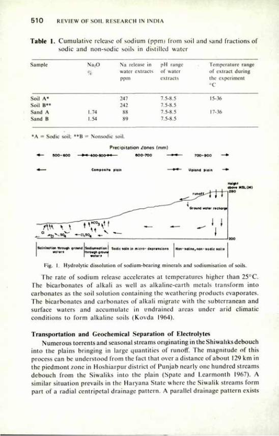
5 1 0 REVIEW OF SOIL RESEARCH IN INDIA
Table 1. Cumulative release of sodium (ppm) from soil and sand fractions of sodic and non-sodic soils in distilled water
Sample Na20 Na release ID pH range Temperature range
% water extracts of water of extract during ppm extracts the experiment
°C
Soil A* 247 7.5-8.5 15-36 Soil B** 242 7.5-8.5 Sand A 1.74 XX 7.5-8.5 17-36 Sand B 1.54 X') 7.5-8.5
*A = Sodic soil; **B = Nonsodic soil.
Precipitation /ones (mm)
-40o-soo-»<— eoo-roo —
Composite plain Upland plain
abov» MSL(M) 280
— - t i -^gy —ci,so4 ..-
Salinisotion through ground wottrs
Sodiumsation I Sodic soils in micro- daprastions through ground
s a l t r j !
Non- salint, non- sodic soils
Fig. I. Hydrolytic dissolution of sodium-bearing minerals and sodiumisation of soils.
The rate of sodium release accelerates at temperatures higher than 25°C. The bicarbonates of alkali as well as alkaline-earth metals transform into carbonates as the soil solution containing the weathering products evaporates. The bicarbonates and carbonates of alkali migrate with the subterranean and surface waters and accumulate in undrained areas under arid climatic conditions to form alkaline soils (Kovda 1964).
Transportation and Geochemical Separation of Electrolytes Numerous torrents and seasonal streams originating in the Shiwahks debouch
into the plains bringing in large quantities of runoff. The magnitude of this process can be understood from the fact that over a distance of about 129 km in the piedmont zone in Hoshiarpur district of Punjab nearly one hundred streams debouch from the Siwaliks into the plain (Spate and Learmonth 1967). A similar situation prevails in the Haryana State where the Siwalik streams form part of a radial centripetal drainage pattern. A parallel drainage pattern exists
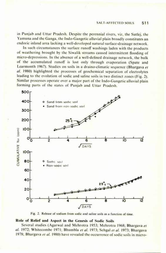
SALT-AFFECTED SOILS 511
in Punjab and Uttar Pradesh. Despite the perennial rivers, viz, the Sutlej, the Yamuna and the Ganga, the Indo-Gangetic alluvial plain broadly constitutes an endoric inland area lacking a well-developed natural surface-drainage network.
In such circumstances the surface runoff washings laden with the products of weathering brought by the Siwalik streams caused intermittent flooding of micro-depressions. In the absence of a well-defined drainage network, the bulk of the accumulated runoff is lost only through evaporation (Spate and Learmonth 1967). Studies on soils in a draino-climatic sequence (Bhargava et al. 1980) highlighted the processes of geochemical separation of electrolytes leading to the evolution of sodic and saline soils in two distinct zones (Fig. 2). Similar processes operate over a major part of the lndo-Gangetic alluvial plain forming parts of the states of Punjab and Uttar Pradesh.
500
4 0 0 -
3 0 0 -
2 0 0 -
c 100-
a a
O Sand from sodic soil • Sand from non-sodic soil
> < _ i 3 D U
6 / D A Y S
10 12
100
80
60
G Sodic soil • Non-soair. soil
6 / D A Y S
Fig. 2. Release of sodium from sodic and saline soils as a function of time.
Role of Relief and Aspect in the Genesis of Sodic Soils Several studies (Agarwal and Mehrotra 1953; Mehrotra 1968; Bhargava et
al. 1972; Whitecombe 1971; Bhumbla et al. 1973; Sehgal et al. 1973; Bhargava 1978; Bhargava et al. 1980) have revealed the occurrence of sodic soils in micro-
5 1 2 REVIEW OF SOIL RESEARCH IN INDIA
depressions in parts of the Indo-Gangetic alluvial plain. The concavities facilitating periodic accretion through accumulation of surface wash and serving as evaporating pans play a crucial role in the evolution of sodic soils. The relative relief differences between parts of the plains and the outer Himalayas or Siwaliks, and within the plains, facilitate runoff during the monsoon season carrying part of the products of weathering to be deposited in the micro-basins. Auden et al. (1942) listed the principal factors responsible for the synthesis of sodium salts as (a) alternating dry and wet seasons, (b) very gentle slope gradients, (c) rocks rich in soda minerals, (d) quality of ground and canal water, (e) base exchange reaction, and (f) prevailing high watertable. The first three of their observations are of relevance and have been substantiated by Bhargava et al. (1980), who reported that the weathering of alumino-silicate minerals and the dual factors of micro-relief and the climate lacilitating seasonal floodings and evaporation of the accumulated runoff wash played a critical role in the formation of sodic soils, spread in the form of localised stretches within the micro-depressions.
The process of sodiumisation in these soils, therefore, begins at the surface Sodiumisation of deeper horizons remains relatively low and results from the illuviation of sodium-saturated and highly deflocculatéd clay particles and limited leaching of alkali salt solutions. Repeated cycles of wetting and drying facilitate maximum accumulation of salts on the surface (Bhargava et al. 1980).
Role of Climate in the Genesis of Sodic Soils In the entire expanse of the Indo-Gangetic alluvial plain, sodic soils are met
in regions with mean annual rainfall ranging from 550 to 1,000 mm (Bhargava and Abrol 1978; Bhargava 1978b; Bhargava et al. 1980). Mainly an ustic soil moisture regime exists in the zone of sodic soils in Haryana and Punjab, but owing to the prevalence of a shallow fluctuating watertable an aquic to para-aquic moisture regime prevails in these soils in parts of Uttar Pradesh. With a marginal surplus of rainfall over the evaporating losses some amount of leaching and illuviation take place in these soils (Bhargava et al. 1980); and the existence of illuvial B horizon has been demonstrated as a result of the preponderance of finer clay constituents in B horizon, the fine/total clay ratios, and presence of clay cutans on ped faces (Sharma 1979; Bhargava et al. 1980). The effectiveness of this climate in the evolution of soils of the region has also been highlighted by Flach and Tavernier (1978).
The other effective part played by the prevailing climate is in facilitating evaporation of the runoff accumulating in the micro-depressions from June to October.
Role of Fluctuating Shallow Underground Watertable in the Genesis of Sodic Soils
A shallow underground watertable with seasonal fluctuations prevails below some of the sodic soils (Leather 1914; Raychaudhuri and Govindarajan
SALT-AFFECTED SOILS 51 3
1971; Abrol et al. 1972; Rhumbla et al. 1973; Bhargava and Abrol 1978). The wateriabie rises to a level defined by Kovda (1973) as critical. The water, having very low degree of mineralisation (Sharma et al. 1976; Manchanda 1976) and being non-sodic, is extensively used for irrigation and has never been observed to be an active source of soil sodiumisation. Leather (1914) observed sodic soils in both canal-irrigated areas and others. The observations of Abrol et a/.(1972), Bhumbla (1977). Bhargava et al. (1972), Whitecombe (1971) confirmed that over a major part of the Indo-Gangetic alluvial plain nearness to a canal or presence of a shallow watertable does not contribute to soil sodiumisation.
Formation of the Calcic Horizon A distinct, regular and thick zone of calcium carbonate accumulation,
mainly dolomitic (Sharma and Bhargava 1981), exists about one metre below the surface in sodic soils. The smooth boundary of the calcic horizon, irregular shape of individual concretions (kankar), and regularity of occurrence underneath vast areas highlight their pedogenic origin (Sehgal and Stoop 1972; Bhargava et al. 1980). The calcic horizons are not impervious to plant roots and water as described by Raychaudhuri and Govindarajan (1971), nor have they originated as a result of aeolian drift of calcareous particles from parts of Rajasthan as concluded by Dregne (1976). The systematic distribution of calcium carbonate (Table 2) in some of the diverse groups of soils in parts of the Indo-Gangetic alluvial plain further confirm their pedogenic origin.
The zone of calcic horizon possibly indicates the zone of shallow water table fluctuation. When the water table recedes the soil solution concentrates and the calcium and magnesium present in it are the first to precipitate irreversibly as carbonates. With every passing hydrological cycle the concretions continue to grow in size and occlude the diverse kinds of soil material.
Clay Mineral Degradation in Sodic Soils Sodic conditions bring about degradation of the clay minerals leading to
accumulation of amorphous oxides of silica, alumina and iron associated with repeated synthesis of clay minerals (Gorbunov 1965). Agarwal et al. (1979) reported the existence of dealkalisation processes as judged by the siight acidity build-up in the surface horizon of some sodic soils in Azamgarh district of Uttar Pradesh. Following the procedure adopted by the Hungarian scientists, using 5 per cent KOH for determining amorphous silica and alumina, and an equivalent ratio of Si02/A1203 greater than two (the critical limit piuposed by Szabolcs and Darab in 1958), Bhargava et a/.(1980) observed the existence of a degradation process in the sodic soils of the alluvial plain (Table 3). The degradation, as judged by the equivalent ratios, was highest in the surface and decreased with decrease in sodium saturation. Gupta (1961) studied sodic soils from Azamgarh and Ghazipur districts of Uttar Pradesh and detected amorphous silica. The existence of a degradation process, however, could not be established in these soils (Agarwal et al. 1979).
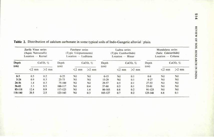
Table 2. Distribution of calcium carbonate in some typical soils of Indo-Gangetic alluvial plain
Zarifa Viran series (Aquic Natrustalfs) Location — Karnal
Depth CaCOj % (cm)
< 2 mm >2 mm
0-5 0,5 0.2 5-24 0.9 0.3
24-56 1.4 0.3 56-85 3.3 0.5 85-118 12.4 0.9
118-140 20.5 2.5
Fatehpur series (Typic Ustipsamments) Location — Ludhiana
Depth CaCO, % (cm)
<2 mm > 2 mm
0-25 Nil Nil 25-75 Nil Nil 75-100 Nil Nil
100-117 Nil 0.4 117-123 Nil 1.4 123-143 Nil 0.3
Ladwa series (Typic Camborthids) Location — Hissar
Depth CaCO, % (cm)
<2 mm >2 mm
0-15 Nil 0.1 15-29 Nil 0.1 29-57 0.5 0.1 57-80 0.5 0.1 80-103 0.8 0.2
103-127 0.7 0.2
Mundalana series (Salic Calciorthids)
Location — Cohana
Depth CaCO, % (cm)
< 2 mm > 2 mm
0-8 Nil Nil 8-27 Nil Nil
27-53 Nil Nil 53-91 Nil Nil 91-125 Nil Nil
125-148 6.8 0.1
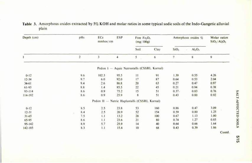
Table 3. Amorphous oxides extracted by 5% KOH and molar ratios in some typical sodic soils of the Indo-Gangetic alluvial plain
Depth (cm) pHs ECe ESP mmhos/cm
Free Fe203
(mg/100g)
Soil Clay
Amorphous oxides
SiO, A1,0,
Molar ratios Si02 /Al203
0-12 12-34 34-61 61-93 93-114
114-192
0-12 12-31 31-65 65-95 95-142
142-185
Pedon 1 — Aquic Natrustalfs (CSSRI, Karnal)
9.6 102.3 95.5 II 91 1.39 0.55 4.26
9.7 6.0 92.0 17 87 0.64 0.53 2.04
9.4 2.6 86.8 20 63 0.27 0.47 0.97
8.8 1.4 85.5 22 45 0.21 0.94 0.38
8.6 0.9 75.2 15 51 0.37. 0.83 0.76
8.6 0.9 25.9 8 51 0.43 0.80 0.92
Pedon II — Natric Haplustalfs (CSSRI, Karnal)
8.5 2.5 23.8 53 160 0.86 0.47 3.09
8.4 2.5 20.9 52 154 0.59 0.80 1.25
7.5 1.1 13.2 28 100 0.67 1.13 1.00
8.6 I.I 23.6 21 80 0.74 1.27 0.85
8.9 5.7 25.9 14 40 0.64 0.66 1.64
8.3 I.I 15.4 10 68 0.43 0.39 1.86
Contd.
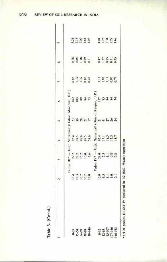
516 REVIEW OF SOIL RESEARCH IN INDIA
c o
y 1*5
s
Ti <N (N — —
O O — O o
o o o
Tf <N <N Cs| —
O — O O O
o o
0. Cl
O O Tf f*1 oo oo r-
^ t~- Vt Tt Tj- Tt »/~i oo oo oo r-
— —• 3 c c CS
^t «n \o <n vo i/"i ON OO 00 ON ON OO 0O O0 U")
•TN C-J <N O NO
* Tl O «--
e 0
X • * tTl n tN O O O O O o
to — — r- NO ** • — (N Tf t*N CN <N Q
3 o-ca i: ^ — m m t̂ « rs r̂ x vi x Z ON
«Al — 00 00
<N — ö ó
o
&
O
.va O w-j —- O — O ON O^ ON ON
E > •o
• o -o
Tf oo ON rr »n r- ON —
r- -o rn *N *n o TT NO I i r i I
O (N VI r~ NO — NO ~ — — #
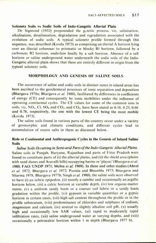
SALT-AFFECTED SOILS 5 1 7
Solonetz Soils vs Sodic Soils of Indo-Gangetic Alluvial Plain De Sigmond (1932) propounded the genetic process, viz, salinisation,
alkalisation, desalinisation, degradation and regradation associated with the evolution of sodic soils. A typical solonetz profile formed through this sequence, was described (Kovda 1973) as comprising an eluvial A horizon lying over an illuvial columnar to prismatic or blocky Bl horizon, followed by a carbonate B2 horizon, underlain finally by a salt horizon. Absence of a salt horizon or saline underground water underneath the sodic soils of the Indo-Gangetic alluvial plain shows that these are entirely different in origin from the typical solonetz soils.
MORPHOLOGY AND GENESIS OF SALINE SOILS
The occurrence of saline and sodic soils in distinct zones in inland areas has been ascribed to the geochemical processes of ionic separation and deposition (Bhargava 1978a; Bhargava et al. 1980), facilitated by differences in coefficients of energy (CE) and consequently by ionic mobilities under the influence of operating continental cycles. The CE values for some of the common ions in soils, viz, N03 , CI, S04 and COa, and COj, have been stated as 0.18, 0.23, 0.66 and 0.78, respectively, the one with the lowest CE being the most mobile (Kovda 1973).
The saline soils found in various parts of the country occur under a variety of geomorphic and climatic conditions, and different cycles lead to accumulation of excess salts in them as discussed below.
Role ol Continental and Anthropogenic Cycles in the Genesis of Inland Saline Soils
Saline Soils Occurring in Semi-arid Parts of the Indo-Gangetic Alluvial Plains. Saline soils in Punjab, Haryana, Rajasthan and parts of Uttar Pradesh were found to constitute parts of (i) the alluvial plains, and (ii) the shield area (plains with sand dunes and Aravalli hills) occupying basins or 'playas' (Bhargava et al. 1980; FAO/UNDP 1971; Mehta et al. 1969). In these and other studies (Abrol et al. 1972; Bhargava et al. 1972; Poonia and Bhumbla 1973; Bhargava and Sharma 1978; Bhargava 1977b; Singh et al. 1980), the saline soils were observed to have (i) an ochric epipedon, (ii) mostly a cambic and occasionally an argillic horizon below, (iii) a calcic horizon at variable depth, (iv) low organic-matter status, (v) a uniform sandy loam or a coarser soil fabric or a sandy loam gradation within the profile, (vi) gypsum in variable quantities or a gypsic horizon in certain cases, (vii) high salt content throughout the profile or in the profile substratum, (viii) predominance of chlorides and sulphates of sodium, magnesium and calcium, (ix) neutral to slightly alkaline soil pH, (x) usually high and occasionally low SAR values, (xi) rapid to moderately rapid infiltration rates, (xii) saline underground water at varying depths, and (xiii) occasionally a petrocalcic horizon within I m depth (Bhargava 1977 b).
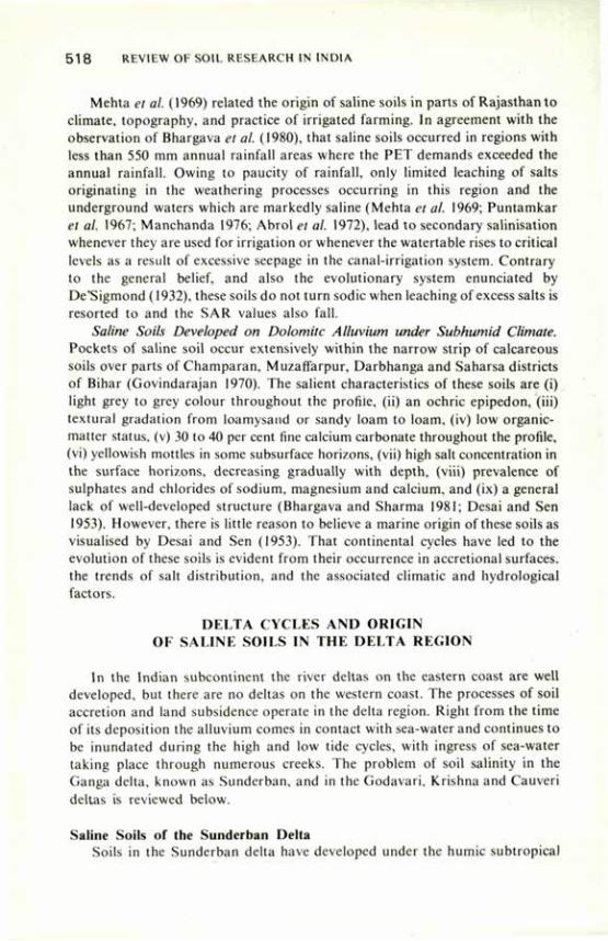
5 1 8 REVIEW OF SOIL RESEARCH IN INDIA
Mehta et al. (1969) related the origin of saline soils in parts of Rajasthan to climate, topography, and practice of irrigated farming. In agreement with the observation of Bhargava et al. (1980), that saline soils occurred in regions with less than 550 mm annual rainfall areas where the PET demands exceeded the annual rainfall. Owing to paucity of rainfall, only limited leaching of salts originating in the weathering processes occurring in this region and the underground waters which are markedly saline (Mehta et al. 1969; Puntamkar et al. 1967; Manchanda 1976; Abrol et al. 1972), lead to secondary salinisation whenever they are used for irrigation or whenever the watertable rises to critical levels as a result of excessive seepage in the canal-irrigation system. Contrary to the general belief, and also the evolutionary system enunciated by De'Sigmond (1932), these soils do not turn sodic when leaching of excess salts is resorted to and the SAR values also fall.
Saline Soils Developed on Dolomite Alluvium under Subhumid Climate. Pockets of saline soil occur extensively within the narrow strip of calcareous soils over parts of Champaran, Muzaffarpur, Darbhanga and Saharsa districts of Bihar (Govindarajan 1970). The salient characteristics of these soils are (i) light grey to grey colour throughout the profile, (ii) an ochric epipedon, (iii) textural gradation from loamysand or sandy loam to loam, (iv) low organic-matter status, (v) 30 to 40 per cent fine calcium carbonate throughout the profile, (vi) yellowish mottles in some subsurface horizons, (vii) high salt concentration in the surface horizons, decreasing gradually with depth, (viii) prevalence of sulphates and chlorides of sodium, magnesium and calcium, and (ix) a general lack of well-developed structure (Bhargava and Sharma 1981; Desai and Sen 1953). However, there is little reason to believe a marine origin of these soils as visualised by Desai and Sen (1953). That continental cycles have led to the evolution of these soils is evident from their occurrence in accretional surfaces, the trends of salt distribution, and the associated climatic and hydrological factors.
DELTA CYCLES AND ORIGIN OF SALINE SOILS IN THE DELTA REGION
In the Indian subcontinent the river deltas on the eastern coast are well developed, but there are no deltas on the western coast. The processes of soil accretion and land subsidence operate in the delta region. Right from the time of its deposition the alluvium comes in contact with sea-water and continues to be inundated during the high and low tide cycles, with ingress of sea-water taking place through numerous creeks. The problem of soil salinity in the Ganga delta, known as Sunderban, and in the Godavari, Krishna and Cauveri deltas is reviewed below.
Saline Soils of the Sunderban Delta Soils in the Sunderban delta have developed under the humic subtropical
SALT-AFFECTED SOILS 5 1 9
climate, with the mean annual rainfall exceeding the evaporative demands. But since the bulk of the rainfall is between the months of May and September, moisture deficit conditions prevail during therest of the period. The salient features of these soils, which have been derived mainly from micaceous rocks, are (i) an ochric epipedon, (ii) grey to light brownish grey and yellowish brown colours within the profile, (iii) yellowish brown mottles, (iv) signs of gleying, with neutral grey, black or dark grey colours, in the substratum, (v) uniformly fine texture, varying from clay loam to clay or silty clay loam, (vi) neutral to slightly acid pH, (vii) saline soils occurring in basins having the highest concentration of salt in the epipedon and relatively low EC values below, (viii) the relatively elevated soils even in close proximity having low EC in the epipedon with EC values gradually increasing with depth, (ix) preponderance of chlorides and sulphates of sodium, magnesium and calcium with minor quantities of bicarbonates, (x) SAR and ESP values normally varying between 10 and 30, (xi) a shallow saline water table, (xii) low infiltration rates, (xiii) absence of calcium ca.bonate, (xiv) organic matter content less than one per cent (Bhargava 1978c; Banerjee 1959a, b; Subramanyam et al. 1976).
Because of the humid climate of the region, very high ECe values are not encountered throughout the pedon as some amount of flushing of salts automatically results during the monsoon season when prolonged submergence occurs. The local relief and aspect, however, play the major role (Bhargava 1978c) in facilitating salt accumulation within the region. Agarwal et al. (1979) referred to the saline soils of this region with acidic pH as degraded saline-alkali soils, but in true sense these are simply saline soils. Neither were they sodic at any stage, nor does sodicity develop as a result of salt leaching.
Saline Soils of the Codavari, Krishna and Cauvery Deltas Soils of these deltas studied by Govinda Iyer (1957) and Bhargava (1977a)
differ from the soils of the Sunderban delta primarily in having their origin in basaltic rocks. The climate being semi-arid, the soils exhibit entirely different mineralogy and salt regimes. The salient features of these soils, which can be referred to as Vertisols of the delta region, are (i) an ochric epipedon, (ii) soil colours varying from very dark greyish brown to dark brown/very dark grey/black within the profile, (iii) a uniform clay texture, (iv) angular/subangular blocky structure grading to massive, (v) absence of concretions and calcium carbonate in the profile, (vi) neutral to slightly acid pH, (vii) very high ECe values throughout the profile, the maximum being just above the water table, (viii) organic matter content varying from 1 to 2 per cent, (ix) a perpetual shallow water table within 1 m depth, (x) deep cracking character of the soils, (xi) presence of slickensides in some of the subsurface horizons, (xii) very sticky and very plastic nature, and (xiii) very low infiltration rates.
Owing to low rainfall, flushing of salts and dilution do not take place; as a result these soils are much more saline than the soils of the Sunderban delta.
5 2 0 REVIEW OF SOIL RESEARCH IN INDIA
The salt rise mainly occurs through capillarity from the saline watertable present in the substratum.
MARINE CYCLES AND EVOLUTION OF SALINE SOILS ALONG THE COASTAL BELT
Saline soils also occur in a narrow strip along the coastline. The salinity is the result of ingress of sea-water during high tide and during the cyclonic storms which deluge vast areas with sea-water. Unlike the deltas, a variety of soils are met with in the coastal region (Bhargava 1977a). Immediately next to the shore, a variety of alluvial soils with overlying beach sands are met with (Govindarajan 1970; Bhargava 1977a).
Saline Soils in the Coastal Region of Andhra Pradesh Some of the soils studied in Guntur and Prakasam districts of Andhra
Pradesh, which are typical of the soils in the region (Bhargava 1977a) show a close relationship between soil characteristics and their physiographic settings. The salient features of these soils are (i) the uplands free from the salinity problem, particularly within the root zone of several common crops grown in the region; (ii) in the midland situations stratified soils with layers varying in thickness and texture from loamy sand or sandy loam in the surface to sandy clay loam in the substratum; (iii) in the basins dark greyish brown to grey clay-textured soils which remain submerged during the monsoon season; (iv) marine shells common in the soil profile; (v) a shallow saline water table in the substratum; (vi) high EC throughout the profile; (vii) prevalence of chlorides and sulphates of sodium, magnesium and calcium; (vii) neutral pH; (ix) slow permeability; and (x) low to medium organic matter content.
Saline Soils in the Arid and Semi-arid Coastal Region of Saurashtra Along the west coast in the arid and semi-arid coastal tract of Saurashtra in
Gujarat the problem of soil salinity is severe. Originating in basaltic rocks, most of the soils in that tract are either Vertisols or have vertic characteristics. Owing to differences in relief, there are differences with regard to the menace of the soil salinity (Pathak and Patel 1980). The more salient features of these soils are: (i) an ochric epipedon with greyish brown colours, (ii) texture grading from sandy loam to sandy clay loam in the surface to sandy clay loam or clay in the substratum, (iii) neutral to slightly alkaline pH, (iv) very high ECe throughout the pedon, the maximum being in the epipedon in many cases, (v) chlorides and sulphates of sodium, magnesium and calcium predominant but bicarbonates in small amounts, (vi) ESP values from 10 to 60, and (vii) SAR values from 10 to 25. Initially these soils have high hydraulic conductivity, but after leaching they develop sodicity and poor physical conditions.
Almost all the soils are potentially saline, i.e. the salt reserve exists in the profile substratum (Basu and Tagare 1954; Hoon 1955). While soil salinity is a
SALT-AFFECTED SOILS 521
widespread problem, soils of other terraces of flood plains, mud flat along the tidal inlet and mud flat along the coast are more saline than those of the old flood plain, interterraces of flood plains, and recent flood plains. Only those soils that are influenced by the tidal effect through creeks are saline in the interior parts (Anon. 1980).
Saline Soils in the Rann of Kutch The Rann of Kutch constitutes a vast marshy area in the arid coastal region
in Gujarat. It is divided into the Great Rann and the Little Rann, having areas of 18,130 and 5,180 sq km, respectively (Murthy et al. 1978). The Great Rann comprises three different topographical entities, viz, (i) the Rann proper (saline plains),*(ii) strips of land parallel to the Kutch mainland known as 'Banni'area, and (iii) elevated areas known as 'bets' or islands.
Rann soils are fine-textured and contain large quantities of chlorides and sulphates of sodium, magnesium and calcium. Gypsum layers are encountered at varying depths. The Ranns receive huge discharge of flood waters from Luni, Banas, Saraswati, Rupan, Fulka and Bhramni streams during July to September. At the same time, strong winds from south-west force sea-water into the area, rendering the mixture saline. The depth of flood waters which continue to stand up to December varies from 0.30 to 3.5 m in accordance with differences in surface configuration. They begin to dry from January and remain dry until the end of June. They show a high degree of gleying, with black matrix in the epipedon and blue-green to bottle-greenin the substratum. Reddish brown to brown horizons, reported to be the zone of the iron pan formation, occur in substratum (Satyanarayana 1961). An interesting feature of these soils is the presence of bands of gypsum deposition, developing iron pans and gleyed horizons within the profile in different sequences. These indicate operation of similar genetic processes over the past geological period as the process of land accretion continued.
The term 'Banni' means land newly formed by the detritus brought by rivers. These are low tablelands as compared with other areas in the Rann. The soils, mainly alluvial, are at places mixed with aeolian deposits. Generally sandy loam at the surface, they are silty clay and clay at some depth. Although not submerged by the tides, the soils are generally saline with preponderance of chlorides and sulphates of sodium, magnesium and calcium. Gypsum and lime also occur in varying quantities in the profile. The soil pH varies from 7.5 to 8.5; the exchangeable sodium percentage seldom exceeds 15 (Shah et al. 1958). The average organic matter content in the surface soil remains about 1 per cent. A perpetual saline underground water prevails.
The soils in the 'bets' are free from salinity.
SALINE AND SULPHATE SOILS
Saline acid sulphate soils occur along the Malabar coast in Kerala
5 2 2 REVIEW OF SOIL RESEARCH IN INDIA
occupying marshy depressions (lagoons). These have developed on the alluvium derived from laterites under humid and tropical climate. The soils undergo freshwater submergence from May to December, and sea-water inundation under tidal cycles during the subsequent lean months. The salient features of these soils are (i) an ochric epipedon, (ii) a humic horizon in the substratum of some soils, (iii) a variety of soil matrix colours varying from pale yellow to very dark grey, greyish brown and dark yellowish brown, (iv) signs of gleying, reduction and bleaching, (v) high EC throughout the profile, (vi) prevalence of chlorides and sulphates of sodium, magnesium and calcium, (vii) soil pH varying from 3 to 7.5, (viii) organic matter content varying from 2 to 40 per cent, and (ix) a shallow saline water table (Thomas el at. 1970; Money and Sukumaran 1973; Nambiar et al. 1966; Bhargava and Abrol 1981). Presence of pyritous clay on Malabar coast has been reported by Wadia (1966), and the observed differences with regard to acidity can be ascribed to varying distribution of pyritous clays in the alluvium (Bhargava and Abrol 1981). These soils have apparently developed under the impact of marine cycles.
ORIGIN AND CHARACTERISTICS OF SALT-AFFECTED VERTISOLS IN THE DECCAN PLATEAU
In the Deccan plateau covering parts of Madhya Pradesh, Rajasthan, Maharashtra, Karnataka, Andhra Pradesh and Tamil Nadu states, the Vertisols (deep and medium deep black soils) occur extensively. They have developed mainly from basalt or trap under semi-arid climate and are fine textured with smectitic mineralogy. When these soils are irrigated, the high seepage leads to a shallow water table build-up causing secondary salinisation or sodiumisation (Islur 1941; Talati 1941; Kulkarni 1961; Inglis 1927). The salient features of salt-affected Vertisols include (i) dark greyish brown colour, (ii) fine clay texture, (iii) extremely hard consistency in both A and B horizons, (iv) structure grading from subangular and angular blocky to massive and occasionally prismatic (Bhargava 1977a; Anon. 1980); (v) a calcic horizon in the substratum, (vi) mostly saline-sodic, (vii) wide range of electrical conductance, pH and ESP values, (viii) presence of chlorides, sulphates, bicarbonates and carbonates of sodium, calcium and magnesium in different proportions, and (ix) infiltration rates varying from moderately rapid in saline soils to almost nil in the nearly impermeable sodic soils (Basu 1950; Kibe and Narayana 1941; Venkataramiah 1941; Tamboli and Pathak 1964).
In the genesis of these soils both anthropogenic and continental cycles have influenced the evolutionary sequence at one place or another. The genesis of salt-affected Vertisols within the plateau has invariably been associated with the rising water table, and their evolution began at the lowest point of the valley (Basu and Tagare 1941; Basu and Tagare 1943; Basu and Sirur 1938; Bhadrapur and Seshagiri Rao 1977). Both saline and saline-sodic Vertisols exist in association (Talati 1941; Kati and Seshagiri Rao 1979). Within the profile the
SALT-AFFECTED SOILS 523
EC, pH and ESP tend to increase with depth. Once the shallow water table is built up, the use of well water leads to secondary salinisation and sodiumisation in the irrigated zone, as noticed in parts of the Chambal command area (Misra et al. 1975).
Krishna and Perumal (1950) explained the role of rainfall in the release and transport of electrolytes and that of acceretional aspects in facilitating their accumulation leading to salinisation and sodiumisation in the Nizamsagar project area of Andhra Pradesh. The profile substratum was free of sodicity or salinity hazard.
Classification of Salt-Affected Soils The occurrence of salt-affected soils in India has been recorded since ancient
times (2500 BC) when these soils were referred to as usar, i.e. salt (Raychaudhuri and Govindarajan 1970). Until the middle of the twentieth century they were classified by various workers as Solonchak or Solonetz as defined in the genetic systems of soil classification evolved in the USSR and the USA (Venkataramiah 1941; Raychaudhuri and Sankaram 1952; Raychaudhuri and Nimgade 1955; Raychaudhuri et al. 1962; Raychaudhuri and Tripathi 1953; Raychaudhuri and Sinha 1957). Some attempts were made to define these soils considering the genetic characteristics and the kind of salts present. Basu and Tagare (1943) recognised Vertisols having (i) sodic A and porous B horizon and (ii) sodicity spread to both A and B horizons. Kibe and Narayana (1941) defined Vertisols as (i) sour, or saltish karl, and (ii) 'savi', or sweet karl. Satyanarayana (1961) highlighted the gypsiferous saline soils and Govindarajan et al. (1971) classified saline Vertisols with and without structural B horizons.
Richards (1954) defined saline, sodic and saline-sodic as the three distinct classes of salt-affected soils, and since then these terms have been widely used. Agarwal et al. (1979) used them to group soils with different local names (Table 4).
Table 4. Broad grouping of local soil names under saline, sodic and saline-sodic classes
Class ECe ESP pH Local names (mmhos/cm)
Saline soils 4 15 8.5 Thur, Uippu, Lona, Shora, Soulu, Pokkali, Khar and Kari.
Sodic soils 4 15 8.5 Usar, Rakkar. Bara, Chopan, Karl. Saline-sodic 4 15 Variable Usar, Kallar, Karl. Chopan, Bari, soils Reh, Choudu, Kshar and Jougu.
Bhargava el al. (1976) placed salt-affected soils in two groups (i) saline and (ii) sodic. In the first group the neutral salts (mainly chlorides and sulphates of sodium, magnesium and calcium) dominated; in the second, salts capable of
5 2 4 REVIEW OF SOIL RESEARCH IN INDIA
alkaline hydrolysis (mainly bicarbonates, carbonates and silicates of sodium) dominated. These soils not only occurred in distinct geographical zones but also had contrastingly different physical, chemical, physicochemical and biological characteristics suggestive of entirely different reclamation and management practices.
With these considerations the sodic soils have been defined to be simply sodic and not saline-sodic even if the ECe values exceeding 4 mmhos/cm result from the salts capable of alkaline hydrolysis. It is only when the neutral salts occur in appreciable quantities in sodic soils that they need to be called saline-sodic, as is the case with a majority of the Vertisols.
In the World Map of Salt-Affected Soils (Szabolcs 1974— the salt-affected soils have been grouped under two classes:
Saline — comprising a class dominated by chlorides and sulphates. Alkali (Sodic) — comprising a class dominated by exchangeable sodium,
sodium bicarbonate or sodium carbonate. It is subdivided into (i) a subclass without structural B horizon,
(ii) a subclass with structural B horizon. The grouping by Bhargava et al. (1976) is therefore in line with the criterion
adopted for the World Map of Salt-Affected soils. The recent system of soil classification — Soil Taxonomy (USDA 1960,
1975) — is more technical than practical for purposes of classification of salt-affected soils. A natric and salic horizon have been defined in this system, to describe the conditions of sodicity and salinity. The natric horizon is, however, a subsurface diagnostic horizon, and most of the typical Solonetzes have a fertile and productive A horizon.
The salt-affected soils of India find place within the orders Entisols, Inceptisols, Aridisols, Alfisols, and Vertisols (Murthy et al. 1980; Bhargava 1977a, 1978). Certain obstacles, however, exist: (i) The sodic soils of the Indo-Gangetic alluvial plain lack a prismatic or columnar structure in the B horizon. To overcome these, Sehgal et al. (1975) proposed inclusion of subangular blocky structure within the realm of the natric horizon, (ii) The sodic soils lacking illuvial characteristics in the B horizon qualify as Halaquepts instead of being classified as Natraqualfs or Natrustalfs (Great Group No. 6, Murthy et al. 1980). (iii) The conditions of soil salinity or sodicity are difficult to depict at great group level in Inceptisols, Aridisols and Alfisols, and at phase level in Entisols and Vertisols.
Furthermore, the sodic soils sometimes contain salts in excess but not enough to qualify for sodic horizon. With considerations of efficient soil management, this problem was highlighted at subgroup level by defining a salic sub-group (Sehgal et al. 1975). Similarly a natric subgroup was defined to take care of the sodic conditions existing in saline soils (Aridisols). The definition of the salic subgroup was, however, modified to include neutral salts (chlorides and sulphates) (Bhargava 1977a).
To obtain management-oriented results of direct utility, the best course is to
SALT-AFFECTED SOILS 5 2 5
classify salt-affected soils by taking into account the nature and amount of salts present and other associated factors such as infiltration rate, hydraulic conductivity, presence and depth of fluctuation of the water table, presence and depth of occurrence of horizons and pans calcic, gypsic, petrocalcic, histic and duripan. In the absence of such typical horizons even the calcic or non-calcic and gypsic or non-gypsic nature of particular soils need to be made use of for purposes of classification. Accordingly, the salt-affected soils discussed in the first part of this article could be classified as in Table 5 (Kanwar and Sehgal 1962; Bhargava 1977a, 1977b; Bhargava and Abrol 1980; Murthy el al. 1980).
Table 5. Classification of salt-affected soils
Soil Class Taxonomie Units (Great Groups, USDA)
1. Sodic soils of Indo-Gangetic alluvial plain
2. Inland saline/potentially saline soils
3. Deltaic saline soils
4. Coastal saline soils 5. Acid sulphate soils
6. Vertisols
Natrustalfs, Natraqualfs
Calciorthents. Camborthids, Calciorthids Haplargids, Salorthids Halaquepts (saline), Chromusterts (salic or natric) Fluvaquents (salic/saline/sodic) Tropaquents, Sulphoaquents, Hemistic aquents Chromusterts, Pellusterts (salic, natric or salinatric)
References
Anonymous (1980) Soil Series Handbook, Saureshtra. National Bureau of Soil Survey and Land Use Planning (Gujarat State) Regional Centre, Nagpur.
Abrol, LP. and Bhumbla, D.R. (1971) FAO Wld Soil Resources Rep. 41. 41. Abrol, LP.. Bhumbla, D.R. and Bhargava, G.P. (1972) Proc. int. Symp. on New Developments in
the field of Salt Affected Soils. Min. Agric, Arab Republic of Egypt, Cairo p. 41.
Agarwal, R.R. and Mehrotra, C.L. (1953) Soil Survey and Soil Work in U.P., Vol. II Dep. Agric, U.P.
Agarwal, R.R. and Yadav, J.S.P. (1954) J. Soil Sci. 5, 300. Agarwal, R.R., Yadav, J.S.P. and Gupta, R.N. (1979) Saline and Alkali Soils of India,
Indian Council of Agricultural Research, New Delhi. Auden, J.B., Gupta, B.C., Roy, P.C. and Hussain, M. (1942) Rec. geol. Survey India, 77, I. Banerjee, S. (1959a) PI. Soil. 10, 207. Banerjee, S. (1959b) Soil Sci. 88, 45. Basu, J.K. (1950) Trans. 4th int. Congr. Soil Sci. 3, 169. Basu, J.K. and Sirur, S.S. (1938) Indian J. agric. Sci. 8, 637. Basu, J.K. and Tagare, V.D. (1941) Bull. Indian Soc. Soil Sci. 3, 13. Basu, J.K. and Tagare, V.D. (1943) Indian J. agric. Sci. 13, 157.
526 REVIEW OF SOIL RESEARCH IN INDIA
Basu, J.ft. and Tagare, V.D. (1954) J. Soil Wat. Conserv. India. 3, 4. Bhadrapur, T.G. and Seshagiri Rao. T. (1977) J. Indian Soc. Soil Sci. 25. II. Bhargava, G.P. (1977a) Proc. Indo-Hungarian Seminar, Central Soil Salinity Research
Institute. Karnal, p. 31. Bhargava, G.P. (1977b) Rep. No. 4. Central Soil Salinity Research Institute, Karnal, p. 15. Bhargava, G.P. (1978a) Natn. Symp. on Land and water Mgt. in the Indus Basin (India). The
Indian Ecological Soc. Punjab agric. Univ., Ludhiana I. 287. Bhargava, G.P. (1978b) Natn. Symp. on Land and Water Management in the Indus Basin (India).
The Indian Ecological Soc, Punjab agric. Univ., Ludhiana, I, 305. Bhargava, G.P. (1978c) Rep. No. 7, Central Soil Salinity Research Institute, Karnal, p. 26. Bhargava, G.P. (1979) In A Decade of Research, Central Soil Salinity Research Institute, Karnal,
India. Bhargava, G.P. and Abrol, LP. (1978) Central Soil Salinity Research Institute. Karnal, Report 6,
32. Bhargava, G.P. and Abrol, LP. (1981) J. Indian Soc. Soil Sci. (in press). Bhargava, G.P.. Abrol. LP. and Bhumbla, D.R. (1976) J. Indian Soc. Soil Sci. 24, 81. Bhargava, G.P. and Sharma. R.C. (1978) Rep. No. 5. Central Soil Salinity Research
Institute, Karnal, India, p. 80. Bhargava, G.P. and Sharma. R.C. (1981) J. Indian Soc. Soil Sci. (in press). Bhargava, G.P.. Sharma, R.C. Pal, D.K. and Abrol. LP. (1980) Int. Symp. Salt Affected
Soils, Central Soil Salinity Research Institute, Karnal, India. Bhargava. B.P., Singhla, S.K. and Abrol, LP. (1972) Rep. No. 2, Central Soil Salinity
Research Institute, Karnal, p. 46. Bhumbla, D.R. (1975) Map of India. Salt Affected Soils, Central Soil Salinity Research Institute,
Karnal, India. Bhumbla. D.R. (1977) Proc. Indo-Hungarian Seminar. Central Soil Salinity Research Institute,
Karnal, p. 14. Bhumbla. DR.. Abrol, LP., Bhargava, G.P. and Singhla. S.K. (1973) Bull. Central Soil
Salinity Research Institute, Karnal. I. 50. Center, W. (1880) Rec. geol. Survey India, 43. 253. Desai, S.V. and Sen, A. (1953) Indian J. agric. Sci. 23, 187. Dregne, H E . (1976) Soils of Arid Regions. Development in Soil Science Series 6, Elsevier
Scientific Pub. Co.. New York. Flach, K.W. and Tavenier, R. (1978) Soils of humid mesothermal climate. Plenary Session, 1 Ith
int. Congr. Soil Sci. Edmonton. Alberta. Canada, p. 163. Gorbunov, N.I. (1963) High dispersed minerals and methods of their study, l/d. Acad. Sci. USSR,
Moscow. Goswami, S.C. (1979) Ph.D. Thesis, Delhi University, Delhi. Govinda Iyer, T.A. (1957) M.Sc. Thesis. Madras University. Govindarajan, S.V. (1970) Soil Map of India, All India Soil and Land Use Survey, Indian
Agricultural Research Institute. New Delhi. Govindarajan. S.V. and Murthy, R.S. (1969) Agrokem. Talajt. 18 (Sup.). 243. Govindarajan, S.V., Murthy, R.S.. Kalbande, A.R. and Subramanyam, S. (1971) Proc. All
India Symp. Soil Salinity, U.P. Inst, agric. Sci., Kanpur, p. 43. Gupta. R.N. (1961) J. Indian Soc. Soil Sci. 9. 141. Hoon, R.C. (1955) Land Reclamation. Publ. Emt. Bd. Irrig. India. 2. 160. Inglis, C.C. (1927) Tech. Rep., Publ. Wks Dep. Bombay, No. 14. Islur. R.S. (1941) Bull. Indian Soc. Soil Sci. 3, 8. Kanwar, J.S. and Bhumbla, D.R. (1969) Agrokem. Telajt. 18 (Sup.). 315. Kanwar, J.S. and Sehgal, J.L. (1962) J. Indian Soc. Soil Sci. 10, 19. Kibe, M.M. and Narayana, N. (1941) Bull. Indian Soc. Soil Sci. 3, 18. Kovda, V.A. (1964) Agrokem. Talajt. 14 (Sup.), 15.
SALT-AFFECTED SOILS 5 2 7
Kovda, V.A. (1973) In Irrigation, drainage and salinity on internal source book. FAO/ UNESCO, Rome.
Krishnan, G.C. and Perumal, S. (1950) Soil Sci. 70, 335. Kulkarni, D.C. (1961) Proc. Teheran Symp. Salinity Problems Arid Zones, UNESCO, p. 267. Leather, J.W. (1914) Investigations on Usar land in the United Provinces, pp. 87. Manchanda, H.R. (1976) Quality of ground waters of Haryana, Haryana agric. Univ., Hissar, p.
160. Medlicott, H.B. (1863) J.R. Asiatic Soc. 20, 326. Mehrotra, C.L. (1968) Soil Survey and Soil Work in U.P. Vol. IV Dep. Agric, U.P. Mehta, K.M., Mathur. CM. , Shankaranarayana, H.S. and Moghe, V.B. (1969) Saline alkali soils
in Rajasthan, their nature, extent and management. Dep. Agric. Rajasthan, Jaipur. Mishra, V.K.. Gajendragadkar, G.R. and Gupta, G.P. (1975) Jawaharlal Nehru Krishi
Visva Vidyalaya Res. J. 9, 95. Money, N.S. and Sukumaran, K.M. (1973) Kerala agric. Univ., Trichur, Tech. Bull. I. Murthy, R.S.. Gosh, R.C., Palit, S.B., Bhargava, G.P., Muthana, K.D. and Paroda, R.S.
(1978) Report of the 1CAR Committee on Research and Development Programmes in Kutch district (Gujarat), Indian Council of Agricultural Research Institute, New Delhi.
Murthy, R.S., Hirekerur. L.R. and Bhaüacharjee. J.C. (1980). Int. Symp. on Salt Affected Soils, Central Soil Salinity Research Institute, Karnal, p. 67.
Nambiar, E.P., Nair, T.J. and Subramony, N. (1966) J. Indian Soc. Soil Sci. 14, 13. Pal, D.K. and Bhargava, G.P. (1981) J. Indian Soc. Soil Sci. (in press). Pathak, S.R. and Patel, N.K. (1980) J. Indian Soc. Soil Sci. 28. 31. Poonia, S.R. and Bhumbla, D.R. (1973) J. Indian Soc. Soil Sci. 21, 335. Pundeer. G.S.. Sidhu, P.S. and Hall, G.F. (1978) J. Indian Soc. Soil Sci. 26. 151. Pundeer, G.S., Singh, M. and Randhawa, N.S. (1974) J. Indian Soc. Soil Sci. 22, 269. Puntamkar, S.S., Sharma, O.P. and Seth, S.P. (1967) Symp. Natural Resources of Rajasthan,
Univ. of Jodhpur, Jodhpur. Raychaudhuri, S.P. and Govindarajan, S.V. (1970) In Review of Soil Research in India, Indian
Soc. Soil Sci., New Delhi. Raychaudhuri, S.P. and Govindarajan, S.V. (1971) Soils of India. Indian Council of
Agricultural Research Tech. Bull. (Agric.) 25 (Third Edition). Raychaudhuri, S.P.. Murthy, R.S. and Sharma, V.D. (1962) Indian J. agric. Sci. 32, 278. Raychaudhuri. S.P. and Nimgade, NJvl. (1955) Indian J. agric. Sci. 25, 105. Raychaudhuri, S.P. and Sankaram, A. (1952) Indian J. agric. Sci. 22, 209. Raychaudhuri, S.P. and Sinha, N.S. (1957) Indian J. agric. Sci. 27, 347. Raychaudhuri. S.P. and Tripathi. R.D. (1953) Indian J. agric. Sci. 23, 213. Richards, L.A. (Ed.) (1954) Handb. U. S. Dep. Agric. 60. Satyanarayana, K.V.S. (1961) Bull. Indian Soc. Soil Sci. 6, 125. Sehgal. J.L., Hall, G.F. and Bhargava, G.P. (1975) Geoderma, 14, 75. Sehgal, J.L., Randhawa, N.S. and Singh, G. (1973) Res. Bull. Punjab agric. Univ., Ludhiana. Sehgal, J.L. and Stoops, G. (1972) Geoderma, 8, 59. Shah, R.K., Vora, J.C. and Trivedi, A.M. (1958) Indian J. appl. Chem. 6, 133. Sharma, R.C., Abrol, LP. and Bhumbla, D.R. (1976) Rep. No. 3, Central Soil Salinity
Research Institute. Karnal, India. Sharma, R.C. and Bhargava, G.P. (1981) J. Indian Soc. Soil Sci. (in press). Sharma, R.K. (1979) M.Sc. Thesis, G.B. Pant Univ. Agric. Technol., Pantnagar. Sidhu. P.S. and Sehgal, J.L. (1978) Natn. Symp. Land and Water Management in the Indus
Basin. Indian Ecological Soc, Punjab agric Univ., Ludhiana. Sigmond, A.A.J. De (1932) Imp. Bureau Soil Sci. Tech. Commn, 23, 1. Singh, N.T.. Brar, G.S. and Singh, B. (1980) Int. Symp. Salt Affected Soils, Central Soil
Salinity Research Institute, Karnal, 7. 19.
5 2 8 REVIEW OF SOIL RESEARCH IN INDIA
Spate, O.H.K. and Learmonth, A.T.A. (1967) India and Pakistan. A General and Regional Geography. Ill Edition Mathuen and Co. Ltd.
Subramanyam, T.K., Kar, S. and Sinha, H.N. (1976) J. Indian Soc. Soil Sci. 24. 137. Szabolcs, I. (1974) Salt affected soils in Europe, Martinus Nijhoff, The Hague, Netherlands. Szabolcs, I. and Darab, K. (1958) Acta agron. Acad. Sci. Hung. 8, 213. Talati, R.P. (1941) Indian J. agric. Sci. II. 959. Tamboli, P.M. and Pathak, N.K.S. (1964) J. Indian Soc. Soil. Sci. 12, 195. Thomas, V., Thampi. P.S. and Money," N.S. (1970) J. Indian Soc. Soil Sci. 18, 65. UNDP/FAO (1971) Soil Survey and Soil and Water Management Research and Demonstration in
Rajasthan Canal area. Tech. Reports 1.1 to 1.10 FAO, Rome. USDA (1960) 7th Approximation, Soil Conserv Service. U.S. Dep. of Agric. USDA (1975) Soil Taxonomy, Agric. Handb. U.S. Dep. Agric. 436. Venkataramiah, P. (1941) Bull. Indian Soc. Soil Sci. 3, 14. Voelcker, J. A. (1897) Rep. on the improvement of Indian Agriculture. Wadia, D.N. (1966) Geology of India, MacMillan and Co., London. Whitecombe, E. (1971) Agrain Conditions in Northern India, Vol. 1, Thomas Press (India), New
Delhi.
Morphology, Genesis and Classification of High Altitude Soils H.S. IYER1 AND A.K. DUTTA2
THE term high altitude is widely used in climatology, ecology, geography, geology, pedology and forestry. The limits of high altitude vary with the context. In the present context of pedology, the term is used for areas 1600 m and more above the mean sea level.
High altitude regions differ from low altitude regions and plains in many respects. As the altitude increases the temperature decreases at the rate of 1°C for every 750 m. This results in a change of the local climate and affects soil formation, both directly and indirectly. The direct effects include high rainfall and low temperature resulting in low evapo-transpiration and more leaching of the soils. Indirectly, the climate influences the vegetation, which is an active factor of soil formation. Another important characteristic of high altitude regions is the influence of the slope aspect on soil formation. In the northern hemisphere, southern aspect is exposed to sunlight causing high evapo-transpiration losses and low moisture conservation. This results in scanty vegetation associated with skeletal soils. In the northern aspects the evapo-transpiration losses are relatively low and conservation of moisture is high. This contributes to good vegetative cover and gives rise to soils containing higher organic matter.
Most of the high altitude soils are located in the Himalayas and Purva-Anchal traverses of the Indo-Burma border comprising Himachal Pradesh (H.P.), Jammu and Kashmir (J & K), parts of Uttar Pradesh (U.P.), Nagaland, Assam, Meghalaya, Arunachal Pradesh, Mizoram, and Manipur. The Nilgiri district of Tamil Nadu has also some high altitude soils. An attempt is made in this review to bring out the morphology, genesis and classification of high altitude soils in different hill states of India from the available soil data (Table I).
Uttar Pradesh There are eight hill districts in this state: Nainital, Dehra Dun, Tehri-
Garhwal, Pauri-Garhwal, Chamoli, Pithorgarh, Uttarkashi and Almora. The first study of hill soils of U.P. was by Mukherji and Das (1940, 1942), who described four genetic soil types, viz, red loams, brown forest soils, podzolic soils, and meadow soils at Chaubattia, Ranikhet. Brown forest soil was one of the most important soil types with a humus-rich surface horizon of about 30 cm depth. The so-called podzols may qualify not for true podzols but for grey-brown podzols referred to by Baldwin el al. (1938).
I. Soil Survey Division. Indian Photo-Interpretation Institute (NRSA). Dehra Dun. 2. Regional Centre. National Bureau of Soil Survey and Land Use Planning (1CAR). Calcutta.
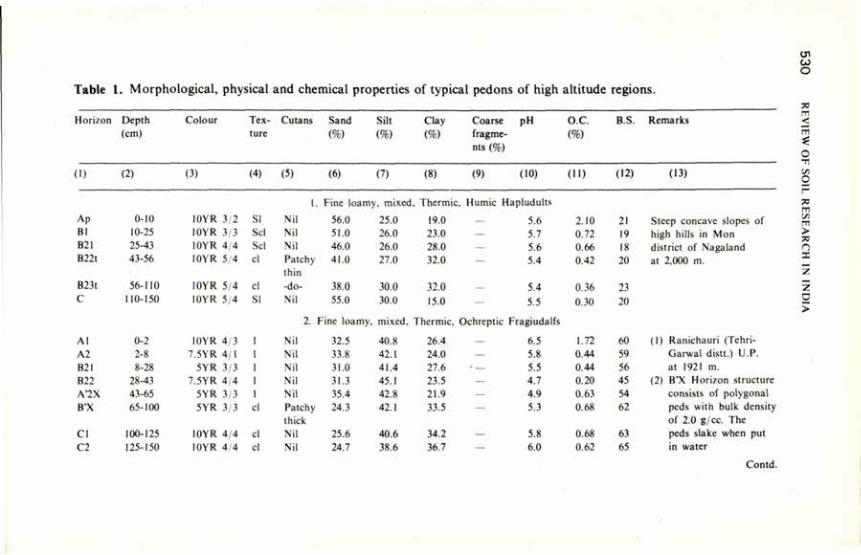
Table 1. Morphological, physical and chemical properties of typical pedons of high altitude regions.
Horizon Depth Colour Tex Cutans Sand Silt Clay Coarse pH o.c. B.S. Remarks (cm) ture (%) (%) (%) fragme
nts (%) (%)
1) (2) (3) (4) (5) (6) (7) (8) (9) (10) (11) (12) (13)
1. Fine loamy, mixed . Thermic , Humic 1- apludults
Ap 0-10 10YR 3/2 SI Nil 56.0 25.0 19.0 — 5.6 2.10 21 Steep concave slopes of Bl 10-25 10YR 3/3 Scl Nil 51.0 26.0 23.0 — 5.7 0.72 19 high hills in Mon B21 25-43 10YR 4/4 Scl Nil 46.0 26.0 28.0 — 5.6 0.66 IX district of Nagaland B22t 43-56 I0YR 5/4 cl Patchy
thin -do-
41.0 27.0 32.0 — 5.4 0.42 20 at 2,000 m.
B23t 56-110 10YR 5/4 cl
Patchy thin -do- 38.0 30.0 32.0 5.4 0.36 23
C 110-150 10YR 5/4 SI Nil 55.0 30.0 15.0 — 5.5 0.30 20
2. Fine loamy mixed. Thermic. Ochreptic Fragiudalfs
Al 0-2 I0YR 4/3 Nil 32.5 40.8 26.4 — 6.5 1.72 60 (1) Ranichauri (Tehri-A2 2-8 7.5YR 4/1 Nil 33.8 42.1 24.0 — 5.8 0.44 59 Garwal distt.) U.P. B2I 8-28 5YR 3/3 Nil 31.0 41.4 27.6 • — 5.5 0.44 56 at 1921 m. B22 28-43 7.5YR 4/4 Nil 31.3 45.1 23.5 — 4.7 0.20 45 (2) B'X Horizon structure A7X 43-65 5YR 3/3 Nil 35.4 42.8 21.9 — 4.9 0.63 54 consists of polygonal B'X 65-100 5YR 3/3 cl Patchy
thick 24.3 42.1 33.5 — 5.3 0.68 62 peds with bulk density
of 2.0 g/cc. The CI 100-125 10YR 4/4 cl Nil 25.6 40.6 34.2 — 5.8 0.68 63 peds slake when put C2 125-150 10YR 4 4 cl Nil 24.7 38.6 36.7 — 6.0 0.62 65 in water
Contd.
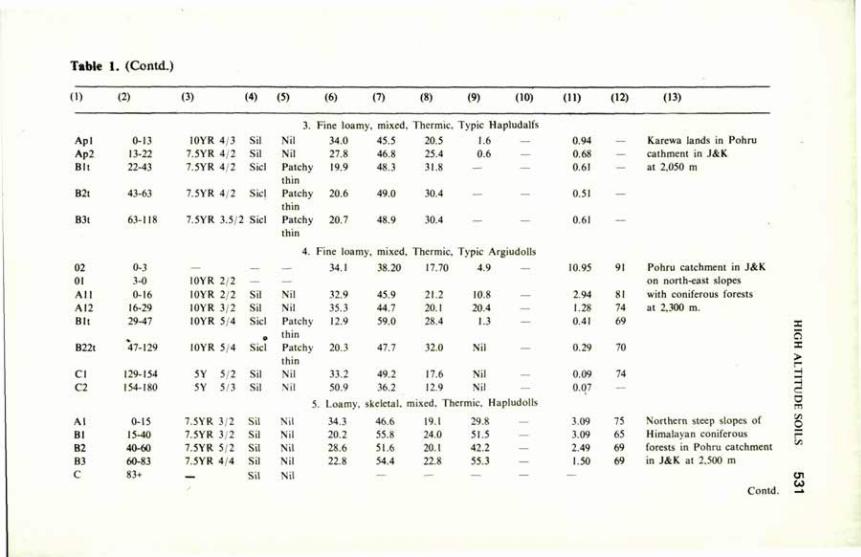
Table 1. (Cont i )
d l (2) (3) (4) (5) (6) (7) (8) (9) (10) (11) (12) (13)
3. Fine loamy , mixed. Thermic. Typic I
Apl 0-13 10YR 4/3 Sil Nil 34.0 45.5 20.5 1.6 Ap2 13-22 7.5YR 4/2 Sil Nil 27.8 46.8 25.4 0.6 Bit 22-43 7.5YR 4/2 Sic! Patchy
thin 19.9 48.3 31.8 —
B2t 43-63 7.5YR 4/2 Sicl Patchy thin
20.6 49.0 30.4 —
B3l 63-118 7.5YR 3.5/2 Sicl Patchy 20.7 48.9 30.4 — thin
4. Fine loamy , mixed, Thermic, Typic t
02 0-3 — — — 34.1 38.20 17.70 4.9 0! 3-0 10YR 2/2 — — All 0-16 10YR 2/2 Sil Nil 32.9 45.9 21.2 10.X A12 16-29 10YR 3/2 Sil Nil 35.3 44.7 20.1 20.4 Bit 29-47 10YR 5/4 Sicl
o
Patchy thin
12.9 59.0 28.4 1.3
B22t 47-129 IOYR 5/4 Sicl Patchy thin
20.3 47.7 32.0 Nil
CI 129-154 5Y 5/2 Sil Nil 33.2 49.2 17.6 Nil C2 154-180 5Y 5/3 Sil Nil 50.9 36.2 12.9 Nil
5 Loamy, s <eletal. mixed. Thermic, I
Al 0-15 7.5YR 3/2 Sil Nil 34.3 46.6 19.1 29.8 Bl 15-40 7.5YR 3,2 Sil Nil 20.2 55.8 24.0 51.5 B2 40-60 7.5YR 5/2 Sil Nil 28.6 51.6 20.1 42.2 B3 60-83 7.5YR 4/4 Sil Nil 22.8 54.4 22.8 55.3 C 83+ Sil Nil — — —
0.94 0.68 0.61
0.51
0.61
10.95 91
2.94 SI
1.28 74
0.41 69
0.29 70
0.09 T4
0.07 —
3.09 75 3.09 65
2.49 69
1.50 69
Karewa lands in Pohru cathment in J&K at 2,050 m
Pohru catchment in J&K on north-east slopes with coniferous forests at 2,300 m.
Northern steep slopes of Himalayan coniferous forests in Pohru catchment in J&K at 2,500 m
X
5 > — --c -— y. O
00 Contd. ->

Table 1. (Contd.)
(i) (2) (3) (4) (5) (6) (7) (8) (9) (10) (11) (12) (13)
6. Loamy, skeletal, mixed, Thermic, Typic Dystrochrepts
All 0-3 10YR 3 3 1 Nil 55.0 26.0 18.0 10.0 5.6 1.62 31 A12 3-12 10YR 4/4 cl Nil 44.0 24.0 32.0 10.0 5.7 1.26 23 Bl 12-22 10YR 5/6 Ski Nil 21.0 46.0 33.0 35.0 5.8 0.80 23 B2 22-65 10YR 5/6 Sicl Nil 22.0 45.0 33.0 40.0 5.8 0.53 23
R 65+ 7. Fine loamy, mixed. Thermic, Dystric Eutrochrepts
Al 0-16 2.5Y 4/2 Sil Nil 23.9 55.4 20.70 1.6 2.64 SI B2I 16-33 2.5Y 4/4 Sil Nil 26.9 50.7 22.50 3.9 1.22 85 B22 33-64 2.5Y 4,4 Sil Nil 26.4 53.3 20.3 0.6 0.77 96 CI 64-83 2.5Y 5/4 Sil Nil 33.1 48.1 18.7 0.6 0.43 96 C2 83-120 2.5Y 5/4 Sil Nil 8.7 66.6 24.7 Nil 0.34 45
8. Loamy. ! ikeletal. mi xed. Thermic, Lithic Udorthents
Ap 0-13 10YR 3/2.5 Cl Nil 35.0 30.0 35.0 25.0 5.5 2.45 52 CI 13-29 10YR 4/3.5 1 Nil 50.0 40.0 10.0 60.0 5.6 1.92 55 C2 29-36 10YR 4/4 1 Nil 55.0 35.0 10.0 50.0 5.6 0.81 55 R 36+ Lithic contact (sandstone)
Lower slope of high hill near Musullami village in Kohima Dist., Nagaland 2,100 m
Steep southern slope near village Cherakut in Pohru catchment in J&K at 2,100 m.
High hills escarpment near Satika area in Makokchung Dist., Nagaland at 1,650 m.
HIGH ALTITUDE SOILS 533
The soils of different forest communities in the Chakrata division reported by Yadav (1963) showed wide variation in profile characteristics. The soils growing silver fir, spruce and 'kharsu' oak at higher altitudes exhibited greater degrees of podzolisation than those dominated by 'ban' oak (Quercus incana) and 'moru' oak (Q. dilatata) at lower elevations; they were designated weak podzolic and brown forest soil, respectively. Studies conducted on the soils of Indian forests revealed that the highest amount of organic matter and nitrogen were contained in the soils under high altitude conifers (Yadav 1968).
Satyanarayana (1971) studied a grey brown podzolic soil of Ranikhet. It was bisequal in character with an argillic horizon in the upper sequum and a fragipan and argillic horizon in the lower sequum. The upper part of the profile was found to be silty clay in texture, and the lower sequum was of silty clay loam. Differential weathering was observed in the profile. The upper sequum was more weathered than the lower sequum. The soil was classihed as Alfisol and placed under Fragiudalf at great group level and Typic Fragiudalf at subgroup level.
A brown forest soil of Chaubattia farm was characterised and classified as Ultic Tropudalf by Pathy (1973). Mica, chlorite and allophane were dominant in both clay and silt fractions. This indicated that the soil was still in the initial stage of weathering sequence.
Rao (1977) studied five typical pedons of Ranichauri in Tehri-Garh*val district for morphology and genesis, and classified them in soil taxonomy. Besides the ochric epipedon and argillic horizon, which were common, he identified as umbric epipedon and a fragipan. He observed that the northwestern aspect with dense vegetation promoted the development of thick organic matter-rich layer. 1 he humid temperate climate caused the leaching of soluble salts and developed soil acidity. This resulted in the development of umbric epipedon. The soil with fragipan was bisequal. The upper sequum had an ochric epipedon and a fragipan in argillic horizon. Reorientation of illuvial clay was thought to have caused the development of fragipan. X-ray studies indicated the transformation of chlorite to vermiculite due to high acidity. The five soils were classified as Dystrochrepts, Eutrochrepts, Fragiudalfs, Hapludalfs and Haplumbrepts, respectively.
Bakr et al. (1978), working in parts of Dehra Dun district in U.P. and Sirmur district in H.P. observed loamy skeletal Typic Dystrochrepts in association with loamy skeletal Typic Hapludolls on southern aspects of the Himalayan high zone. On the northern aspects, they observed loamy skeletal Typic Argiudolls in association with loamy skeletal Typic Hapludalfs. They attributed the differential soil formation in these two aspects to the influence of topography, particularly the slope aspects.
Singh and Verma (1979) studied the soils of Alakhnanda catchment area in Chamoli district and reported the dominance of Hapludalfs in cultivated and open scrub land and Typic Argiudolls in forest lands on the northern aspect of the high mountainous region (2,000-3,000 m). Barren lands had lithic
5 3 4 REVIEW OF SOIL RESEARCH IN INDIA
Hapludalfs. In the southern aspect, Udic Haplustalfs under vegetative cover and Lithic Argiustolls in barren lands were prominent. In the high mountains (>3,000 m), Typic Hapludolls in forest lands and Typic Haplustalfs on the southern aspect were noticed. The moisture regime was ustic in the southern aspect and udic in the northern aspect.
Himachal Pradesh This is mainly a hill state. Sahi (1961) selected two soils developed on two
different parent materials, viz, limestone and calcareous shale to assess the influence of the parent materials on soil genesis. Soils developed on limestone revealed well-developed organic horizon, darker in colour and higher in magnesium content than soils developed on calcareous shale. Hence he classified the soils as calcimorphic in the intrazonal order according to the earlier classification system and Orthic Eutrochrepts in Soil Taxonomy.
Shamanna et al. (1967, 1970) reported on soils developed on three different parent materials: shale, limestone and sandstone. The soils developed from sandstone and limestone had granular structure and coarse loamy sand and clay loam textures, respectively, whereas those developed from shale had blocky structure and loamy to silty clay loam texture. The absence of eluviation and illuviation in the profiles indicated restricted weathering. Hence, the parent material exerted a dominant influence on the development of these soils. Soils derived from sandstone were classified as Eutric Dystrochrepts having low base saturation, and those derived from limestone as Rendollic Eutrochrepts with high base saturation. Soils derived from shale were Dystric Eutrochrepts.
Dhir (1967) described some soils of north-western Himalayas in Mahasu, Kulu and Simla districts. The high altitude soils (2,500-3,300 m) were rich in humus; they showed a 2.5 to 6.0 cm 01 layer and a 3 to 8 cm mildly acidic mulllike moder 02 layer. Eluvial and illuvial horizons were hard to distinguish. Similar soils in north-western Himalayas had been reported earlier (Hoon 1938; Tamhane and Lole 1955; Yadav 1963).
In the earlier years, there was a tendency to classify the above soils as podzols. Owing to leaching of bases and translocation of sesquioxides, there is some affinity to podzolisation. But breaking down of soil mineral particles in the unsaturated organic acid moder 02 layer is absent. The relative accumulation of sesquioxides in the lower part of the solum may be attributed to the downward translocation of mobile sesquioxides, which are otherwise profusely present in the Himalayan soils. This distinguishes the Himalayan soils from the podzols and podzolic soils. And it supports the opinion of Yadav (1963) that according to European concepts these soils would be called immature podzols, although it is doubtful whether that kind of maturity would ever be attained at these sites under the prevailing climate and vegetation. The high altitude forest soils in the north-western Himalayas therefore appear to have a unique combination of properties, and they need to be recognised as a
HIGH ALTITUDE SOILS 535
distinct soil group. Even though so many workers have reported the presence of podzols in India, the available analytical data do not fulfil the requirements of Spodosols according to Soil Taxonomy.
Nagaland A survey conducted by the Indian Photo Interpretation Institute (1978)
revealed the occurrence of loamy skeletal Typic/Lithic Udorthents and loamy skeletal Typic Dystrochrepts in the narrow ridges having 15 per cent side slopes. In the broad ridges, i.e. 200 m wide, loamy skeletal Typic Hapludults in association with fine loamy Typic Hapludults Paleudults were found. High rainfall resulting in intense leaching hasgiven rise to argillic horizons with low base status leading to the formation of Ultisols.
The escarpment slopes have loamy skeletal Typic Dystrochrepts/ Lithic Udorthents. The slopes being steeper and the erosion severe soil development is restricted. This is the reason for some of the soils showing lithic contact. On very steep slopes (40 to 100 per cent), association of fine loamy Typic Hapludults/Paleudults/Typic Dystrochrepts is common.
Jammu and Kashmir Very few pedological reports are available on soils of Kashmir. The studies
of Hoon (1938) revealed that the soils developed under deodar and blue pine in Kashmir valley showed podzol characteristics and those under deodar from Batote range resembled brown earths. Puri (1950) observed that the shallow skeletal soils formed from quartzitic rock usually supported chir pine, while deep moist soils developed on phyllite, shale and schist carried a good stand of blue pine, deodar and spruce in Kulu Himalayas.
Soil survey conducted in Pohru catchment by the Indian Photo Interpretation Institute (1974) helped to classify soils in the northern slopes of the Himalayan mountains (1,600 to 3,845 m) under Hapludollsand Argiudolls. Pockets of Udorthents were visible where vegetation was poor. Vegetation is the dominant soil-forming factor influencing soil formation in these areas through the process of melanisation.
The south-facing slopes are severely eroded and have only a few shrubs and patches of poor grass exposing the rocks at many places. Soils are Eutrochrepts and Udorthents.
Tamil Nadu Nilgiri district of Tamil Nadu also comes under high altitude regions.
Murthy et al. (1968) described two soil series, viz, Nanjanad and Ooty, in Kundah catchment, partly lying in high altitude areas. The Nanjanad series consisted of brown to dark brown soils derived from charnockites and norites with high iron content under humid temperate climate and grass and forest vegetation. They were deep to very deep, well-drained, loam to clay loam soils having a thick brown loamy and strongly acidic A horizon and clay loam or
536 REVIEW OF SOIL RESEARCH IN INDIA
clay in the B horizon with iron concretions. The Ooty series consisted of reddish brown to brown soils derived from charnockites. They were deep to very deep, well-drained loam to clay loam containing fairly high amount of organic matter in the A horizon and strongly acidic. The Nanjanad and Ooty series were classified as fine loamy, mixed. Thermic Mollic Hapludalfs and as fine loamy, mixed, thermic Typic Argiudolls, respectively.
Acknowledgements We thank Dr. B.R.M. Rao, l.P.I. (NRSA), Dehra Dun, for information
and data on high altitude soils and assistance in preparing this review and Dr. R.P. Dhir, Central Arid Zone Research Institute, Jodhpur, and Sri S.R. Naga Bhushana, Regional Centre, National Bureau of Soil Survey and Land Use Planning. Bangalore, for sending the data and other information on high altitude soils.
References
Bakr. H. Ilaj. Harindranath, C.S'. and Reddy. T.V.R. (1978) Soil Survey. l.P.I. (NRSA). Dehra Dun.
Baldwin. M. Kcllog, C.E. and Thorp. .1. (1938) Soils and Men. Year Book of Agri. USDA U.S. Govt. Printing Office. Washington. D.C.
Dhir. R.P. (1967) .1. Indian Soc. Soil Sci. 15. 161. Hoon. R.C. (1938) Indian Forester 3, 6. Indian Photo Interpretation Institute (1974) A consultancy report on Soil Conservation Planning
for Pohru Catchment (J&K) submitted by 1PI to the Forest Dept. Jammu and Kashmir State. Indian Photo Interpretation Institute (1978) A consultancy report on Soil Survey and Land Use
Planning of Nagaland, submitted by 1PI (NRSA) to Dept. Agri. Kohima, Nagaland. Mukherji. B.K. and Das. N.K. (1940) Indian J. agric. Sci. 10, 990. Mukherji. B.K. and Das, N.K. (1942) Indian J. agric. Sci. 12, 313. Murthy. R.S.. Jain. S.P. and Naga Bhushana. S.R. (1968) J. Indian Soc. Soil Sci. 16,
223. Pathy. C O . (1973) M.Sc. Thesis. G.B. Pant Univ. of Agri. and Techn., Pantnagar. Puri (1950) Cited by Yadav (1963). Rao. B.R.M. (1977) Ph.D. Thesis. G.B. Pant Univ. of Agri. and Techn., Pantnagar. Sahi, B.P.C. (1961) M.Sc. Thesis, Indian Agricultural Research Institute, New Delhi. Satyanarayana. P. (1971) M.Sc. Thesis, G.B. Pant Univ. of Agri. and Techn., Pantnagar. Shamanna, S.. Chibber, R.K. and Murthy, R.S. (1967) Indian J. Agron. 12, 397. Shamanna, S., Chibber, R.K. and Murthy, R.S. (1970) Indian J. Agron. 15, 254. Singh. D.P. and Verma. A.S. (1979) Soil Survev Report submitted to l.P.I. (NRSA), Dehra Dun. Tamhane. R.V. and l.ole. S..I. (1955) Bull. nam. Inst. Sci. India 6, 206. Yadav, J.S.P. (1963) Indian Forester 89, 18. Yadav. J.S.P. (1968) Indian Forester 98, 85.
Morphology, Genesis and Classification of Tarai Soils M.S. GANGWAR, R.S. SACHAN AND T.R. RATHORE*
TARAI soils, covering an area of 5:7 m ha in the country and 1.6 m ha in the state of Uttar Pradesh, lie below the foothills of the Himalayan mountains in the form of a narrow east-west belt, 8 to 25 km wide, on an outwash plain gently sloping southwards. The word Tarai means 'moist'in Hindi, indicating the wet moisture regime and high water-table conditions for most part of the year. The area is characterised by artesian waters and in the natural state is thickly vegetated and largely swampy. Soils of this area are highly productive; they were brought under cultivation in the late 1940s after clearing the vegetation and grasslands. This review is based largely on the studies and observations recorded for the Tarai belt of Uttar Pradesh.
Climate The area has a dry season from October to May and a wet season from June
to September, when approximately 85 to 90 per cent of the average rainfall of about 1400 mm is received. July and August are the wettest months, receiving 350 to 425 mm. Both June and October receive less, 100 to 150 mm, September has about 250 mm. May and June have high temperatures, 29° to 32°C mean temperature; and December and January are the coolest months, with 13° to 15°C mean temperature. The water-table is partly recharged by the hydrostatic head developed by rapid infiltration of water in the Bhabar tract of coarse gravel and boulders which lies at a higher elevation between the Tarai and the Siwalik range. Because of this artesian effect, the soil conditions in Tarai are much more moist than in the adjoining Bhabar tract.
Native Vegetation Native vegetation of the Tarai largely consists of sal (Shorea robusta)
forests broken by tracts of savannah (Singh 1967; Seth 1954), riverine types, swamps, etc. The most common trees are simul (Salamalia malaharia), dhak (Bulea monosperma), and khair (Acacia catechu). Puri (1960) considered the savannah to comprise degraded high forest communities rather than true savannah. The coarse species are mainly perennial and may be as tall as three metres. These species are reed grass (Phragmites karka), Johnson grass (Sorghum halepense), tiger grass (Saccharum spontanium), soru (Themeda arundinacea), cogan grass (Imperata cylindrical), kamal (Narenga porphvrocomd), and khus grass (Veliveria zizaniodies). The savannah is
*Department of Soil Science. G.B. Pant University of Agriculture and Technology, Pantnagar, Nainital, Uttar Pradesh.
538 REVIEW OF SOIL RESEARCH IN INDIA
recognised as the Phragmites/Saccharum type and, according to Whyte(1964), represents the highest stage in grass succession under Tarai conditions.
Topography The Tarai belt is a gentle south-sloping outwash plain. The gradient is 1 to
10 m/km. At places the slope may be up to 3 percent (Deshpande ?/ al. 1971a). The whole tract looks flat, with very gentle undulations here and there. The streams are shallow, and overflow during heavy rains results in flooding of low areas. The entire area is traversed by a number of small streams which originate from springs at the junctions of Bhabar and Tarai belts.
Geology and Mineralogy Alluvial sediments of the Tarai belt consist of hard clay interstratified with
beds, bars and lenses of coarse sand and gravel. The deposits are very thick (3,000 - 7,500 m), and adequately porous, with granular zones making as much as 40 per cent. The rest of the material consists of hard clay and clay mixed with carbonate concretions. These sediments were largely derived from mica and chlorite schist, gabbro, gneiss, sand-stone, shale and slate. Wadia (1953) considered them to be of middle to late Pleistocene age. The weak soil development (Deshpande et al. 1971a) suggests continued deposition in recent times on many areas. Dating with l4C has supported this view and indicated the young age of the surface horizons of these soils. The age of the subsurface soil (101 — 118 cm depth) was found to be 140 ± 130 years B.P.
Studies on the clay mineralogy of Tarai soils of Nainital district (Deshpande 1969), with X-ray and DTA, revealed that chlorite made up approximately 50 per cent of the clay minerals present. Mica was approximately 30 per cent and vermiculite 10 per cent; traces of mont-morillonite and interlayered materials were often present. Shukla et al. (1965) found illite to be the dominant clay mineral along with some associated chlorite in several soils from the foothills in Dehra Dun district. Reddy (1972) reported mica 43 per cent in clay, chlorite 28 per cent in clay and 38 per cent in silt fraction and vermiculite 11 per cent in clay and 6.5 per cent in silt, on an average.
Morphology On the basis of a detailed soil survey of the 6,000 ha farm of G.B. Pant
University of Agriculture and Technology, which is typical of tarai soils of this area, six soil series have been identified and described (Fehrenbacher et al. 1966; Deshpande et al. 1971a).
Phoolbagh Clay Loam. Phoolbagh series is a dark-coloured, poorly drained soil developed from silty alluvium. It occurs on level lands or occasionally in depressions in the lower landscape positions. It is the poorly drained member of the catena or hydrosequence, which includes the
TARAI SOILS 539
imperfectly drained Beni series and moderately well to well-drained Haldi series.
Beni Silly Clay Loam. The Beni series is a dark-coloured; imperfectly drained soil developed from silty alluvial sediments, which are normally 1 to 1.5 m thick over loamy to sandy sediments. This soil occurs on level to very gently sloping lands in association with Phoolbagh and Haldi series. It is better drained than Phoolbagh series but poorly drained when compared with Haldi series.
Haldi Loam. The Haldi series is a moderately dark to dark-coloured, moderately well to well-drained soil developed in silty alluvial sediments usually 1 to 1.25 m thick over sandy loam to sand and gravel deposits. This occurs on level to gently sloping lands in the better-drained parts of the landscape. It is the moderately well to well-drained member of the catena and includes poorly drained Phoolbagh series and imperfectly drained Beni series.
Nagla Loam. The Nagla series is a dark-coloured, poorly drained soil developed from loamy alluvium. It occurs on level lands or occasionally in depressions in the lower landscape positions. It is a poorly drained member of the catena or hydrosequence, and includes imperfectly drained Khamia series and moderately well to well-drained Patharchatta series.
Khamia Sandy Loam. The Khamia series is a dark-coloured, imperfectly drained soil developed in loamy alluvial sediments which grade to sand and gravel with depth. Surface textures are primarily loams, and loose sand and gravel normally do not occur above a depth of 1 m. This soil occurs on level to gently sloping areas is association with Nagla series and Patharchatta series. It is intermediate in natural drainage between poorly drained Nagla series and moderately well to well-drained Patharchatta series, with which it forms a natural drainage or hydrosequence.
Patharchatta Sandy Loam. The Patharchatta series is a moderately dark-coloured, moderately well to well-drained soil developed on loamy alluvial sediments 0.6 to 1 m thick over loamy sand and sand or gravel. This series occurs on gently to moderately sloping areas (occasionally on low ridges) in the higher, better-drained parts of the landscape. It is a moderately well to well-drained member of the catena or hydrosequence, and includes poorly drained Nagla series and imperfectly drained Khamia series.
Genesis and Classification Tarai soils are young and of alluvial origin. Relatively high moisture
content for the greater part of the year results in luxuriant vegetation dominated by tall grasses. Gains in organic matter have been of special significance in the horizon differentiations of these soils formed under mixed forest grass vegetation. The effect of organic matter is reflected in a greater thickness of dark-coloured surface horizon and a greater development of colour in the cambic horizon. Surface recycling of bases is an important process, which has resulted in a high degree of base saturation.
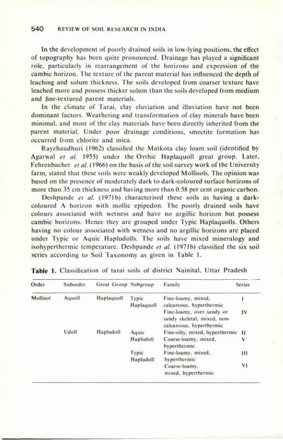
5 4 0 REVIEW OF SOIL RESEARCH IN INDIA
In the development of poorly drained soils in low-lying positions, the effect of topography has been quite pronounced. Drainage has played a significant role, particularly in rearrangement of the horizons and expression of the cambic horizon. The texture of the parent material has influenced the depth of leaching and solum thickness. The soils developed from coarser texture have leached more and possess thicker solum than the soils developed from medium and fine-textured parent materials.
In the climate of Tarai, clay eluviation and illuviation have not been dominant factors. Weathering and transformation of clay minerals have been minimal, and most of the clay materials have been directly inherited from the parent material. Under poor drainage conditions, smectite formation has occurred from chlorite and mica.
Raychaudhuri (1962) classified the Matkota clay loam soil (identified by Agarwal et al. 1955) under the Orihic Haplaquoll great group. Later, Fehrenbacher et al. (1966) on the basis of the soil survey work of the University farm, stated that these soils were weakly developed Mollisols. The opinion was based on the presence of moderately dark to dark-coloured surface horizons of more than 35 cm thickness and having more than 0.58 per cent organic carbon.
Deshpande et al. (1971b) characterised these soils as having a dark-coloured A horizon with mollic epipedon. The poorly drained soils have colours associated with wetness and have no argillic horizon but possess cambic horizons. Hence they are grouped under Typic Haplaquolls. Others having no colour associated with wetness and no argillic horizons are placed under Typic or Aquic Hapludolls. The soils have mixed mineralogy and isohyperthermic temperature. Deshpande et al. (1971b) classified the six soil series according to Soil Taxonomy as given in Table I.
Table I. Classification of tarai soils of district Nainital, Uttar Pradesh
Order Suborder Great Group Subgroup Family Series
Mollisol Aquoll Haplaquoll Typic Fine-loamy, mixed, I Haplaquoll calcareous, hyperthermic
Fine-loamy, over sandy or IV sandy skeletal, mixed, non-calcareous, hyperthermic
Udoll Hapludoll Aquic Fine-silty, mixed, hyperthermic I! Hapludoll Coarse-loamy, mixed, V
hyperthermic Typic Fine-loamy, mixed. Ill Hapludoll hyperthermic
Coarse-loamy, VI mixed, hyperthermic
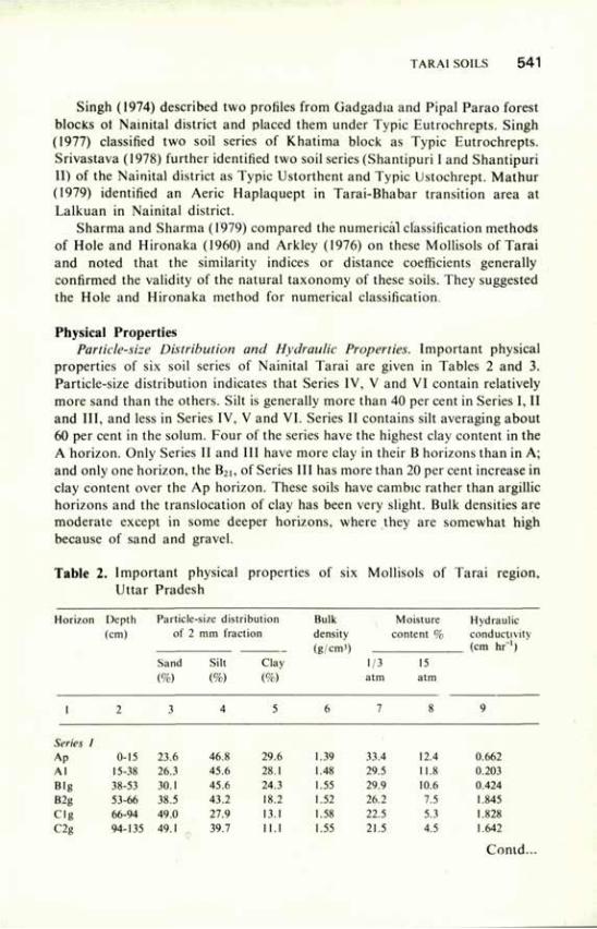
TARAI SOILS 541
Singh (1974) described two profiles from Gadgadia and Pipal Parao forest blocks ot Nainital district and placed them under Typic Eutrochrepts. Singh (1977) classified two soil series of Khatima block as Typic Eutrochrepts. Srivastava (1978) further identified two soil series (Shantipuri I and Shantipuri II) of the Nainital district as Typic Ustorthent and Typic Ustochrept. Mathur (1979) identified an Aerie Haplaquept in Tarai-Bhabar transition area at Lalkuan in Nainital district.
Sharma and Sharma (1979) compared the numerical classification methods of Hole and Hironaka (1960) and Arkley (1976) on these Mollisols of Tarai and noted that the similarity indices or distance coefficients generally confirmed the validity of the natural taxonomy of these soils. They suggested the Hole and Hironaka method for numerical classification.
Physical Properties Particle-size Distribution and Hydraulic Properties. Important physical
properties of six soil series of Nainital Tarai are given in Tables 2 and 3. Particle-size distribution indicates that Series IV, V and VI contain relatively more sand than the others. Silt is generally more than 40 per cent in Series I, II and III, and less in Series IV, V and VI. Series II contains silt averaging about 60 per cent in the solum. Four of the series have the highest clay content in the A horizon. Only Series II and III have more clay in their B horizons than in A; and only one horizon, the B2i, of Series III has more than 20 per cent increase in clay content over the Ap horizon. These soils have cambic rather than argillic horizons and the translocation of clay has been very slight. Bulk densities are moderate except in some deeper horizons, where they are somewhat high because of sand and gravel.
Table 2. Important physical properties of six Mollisols of Tarai region, Uttar Pradesh
Horizon Depth Particle-size distribution Bulk Moisture Hydraulic (cm) of 2 mm fraction density content % conductivity
(g/cm') (cm hr~') Sand Silt Clay 1/3 15 (%) (%) (%) atm atm
1 2 3 4 5 6 7 8 9
Series 1 Ap 0-15 23.6 46.8 29.6 1.39 33.4 12.4 0.662 Al 15-38 26.3 45.6 28.1 1.48 29.5 11.8 0.203 Big 38-53 30.1 45.6 24.3 1.55 29.9 10.6 0.424 B2g 53-66 38.5 43.2 18.2 1.52 26.2 7.5 1.845 Clg 66-94 49.0 27.9 13.1 1.58 22.5 5.3 1.828 C2g 94-135 49.1 39.7 I I I 1.55 21.5 4.5 1.642
Contd...
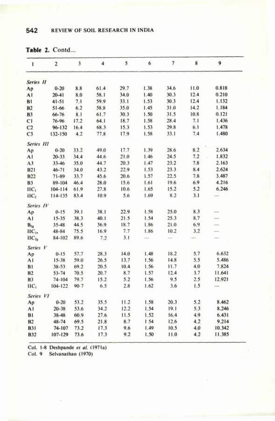
5 4 2 REVIEW OF SOIL RESEARCH
Table 2. Contd...
1 2 3 4 5
Series // Ap 0-20 8.8 61.4 29.7 Al 20-41 8.0 58.1 34.0 HI 41-51 7.1 59.9 33.1 B2 51-66 6.2 58.8 35.0 B3 66-76 8.1 61.7 30.3 CI 76-96 17.2 64.1 18.7
a 96-132 16.4 68.3 15.3 C3 132-150 4.2 77.8 17.9
Series III Ap 0-20 33.2 49.0 17.7 Al 20-33 34.4 44.6 21.0 A3 33-46 35.0 44.7 20.3 B2I 46-71 34.0 43.2 22.9 B22 71-89 33.7 45.6 20.6 B3 89-104 46.4 28.0 15.6 IIC, 104-114 61.9 27.8 10.6 iIC2 114-135 83.4 10.9 5.6
Series IV Ap 0-15 39.1 38.1 22.9 Al 15-35 38.3 40.1 21.5
B», 35-48 44.5 36.9 18.7 I I C 48-84 75.5 16.9 7.7 "C2 g 84-102 89.6 7.2 3.1
Series V Ap 0-15 57.7 28.3 14.0 Al 15-38 59.0 26.5 13.7 Bl 38-53 69.2 20.5 10.4 B2 53-74 70.5 20.7 8.7 B3 74-104 79.7 15.2 5.2 IIC, 104-122 90-7 6.5 2.8
Series VI Ap 0-20 53.2 35.5 11.2 Al 20-38 53.6 34.2 12.2 Bl 38-48 60.9 27.6 11.5 B2 48-74 69.5 21.8 8.7 B3I 74-107 73.2 17.3 9.6 B32 107-129 73.6 17.3 9.2
INDIA
6 7 8 9
1.38 34.6 11.0 0.818
1.40 30.3 12.4 0.210
1.53 30.3 12.4 1.132
1.45 31.0 14.2 1.184
1.50 31.5 10.8 0.121
1.58 28.4 7.1 1.436
1.53 29.8 6.1 1.478 1.58 33.1 7.4 1.480
1.39 28.6 8.2 2.634
1.46 24.5 7.2 1.832
1.47 23.2 7.8 2.163
1.53 23.3 8.4 2.624
1.57 22.5 7.8 3.487 1.61 19.6 6.9 4.216
1.65 15.2 5.2 6.246 1.69 8.2 3.1 —
1.58 25.0 8.3 1.54 25.3 8.7 1.86 21.0 6.9 1.86 10.2 3.2
1.48 18.2 5.7 6.632 1.56 14.8 5.5 5.486 1.56 11.7 4.0 7.824
1.57 12.4 3.7 11.641
1.56 9.5 2.5 12.921 1.62 3.6 1.5 —
1.58 20.3 5.2 8.462 1.54 19.1 5.3 8.246 1.52 16.4 4.9 6.431 1 54 12.6 4.2 9.214 1.49 10.5 4.0 10.342 1.50 11.0 4.2 11.385
Col. 1-8 Deshpande el al. (1971a) Col. 9 Selvanathan (1970)
TA RAI SOILS 5 4 3
Table 3. Aeration and thermal characteristics of three Mollisols of Tarai region, Uttar Pradesh
Name of Specific heat Thermal conductivity Thermal diffusivity Oxygen soil (Cal g"'°C') (Cal cm"1 SecT' °C"') (cm2 sec"1) diffusion rate series (ODR)
0.078 0.43 0.078 0.43 (X 10» g cm3 cm"3 cm3 cm"3 cm3 cm"3 cm3 cm"3 02cm"2
water water water water min"1) content content content content
1 2 3 4 5 6 7
Phoolbagh clay loam 0.231 0.74X10"5 6.27X10"4 I.96X10"4 8.56X10"4 12.72 — 22.61 (Series I) Beni silty clay loam 0.224 0.68X10"5 6.54X10"4 1.84X10"4. 9.02X10"4 26.85 — 33.90 (Series II) Haldi loam 0.207 0.66X10"5 5.76X10"4 8.98X10"4 8.28X10"4 33.89 — 43.80 (Series III)
Col. 1-6 Tripathi and Ghildyal (1974) Col. 7 Natarajan (1971)
Tarai soils in general, have moderate to weak blocky structure in their B horizons and are moderately to rapidly permeable. Selvanathan (1970) reported on the saturated hydraulic conductivity of various soil horizons; his data are included in Table 2. Hydraulic conductivity values were highest in soil Series V and VI (12.921 cm hr"1) and least in soil Series II. Tiwari et al. (1976) also reported the saturated hydraulic conductivity of Series II as 9.6 mm a day and unsaturated hydraulic conductivity (1/3 bar) as 0.006 mm a day. Deshpande et al. (1971a) made a detailed study of the water-retention characteristics of these soils under laboratory conditions (Table 2). Tomar and Ghildyal (1978) studied them under field conditions. Tripathi and Ghildyal (1976) studied the hydraulic conductivity and diffusivity relations of the Mollisols of Tarai. The noted soil water diffusivity variations at saturation in three soils (Series I, II and III) ranged from 1,002 to 1,898 cm2 per day. In the region between 10 to 1,000 m bar, all the soils had about the same hydraulic conductivity. Ghildyal and Tripathi (1973) also reported on the evaporation characteristics of these soils under various evaporative potentials. The hydraulic conductivity of Patharchatta sandy loam (Series VI) increased with temperature at all the water contents. At saturation, it was 15.8, 18.6, 23.5 and 25.9 cm per day at 10°, 20°, 30° and 45°C, respectively (Saha and Tripathi 1979).
As already indicated, in Tarai region, the water-table remains quite high over a considerable part of the year. In areas where the water-table is shallow (0.5 to 1 m) the upward water flow meets 50 per cent of the water requirement of the wheat crop. Even in areas where the water-table is at 1 to 1.5 m, 30 per
5 4 4 REVIEW OF SOIL RESEARCH IN INDIA
cent of the water requirement of wheat crop is met from upward water flow (V.S. Tomar 1981, personal communication). But in soils having water-table deeper than 2 m (Series VI) the upward flow into the root zone of wheat was quite low.
Aeration and Thermal Characteristics. Natarajan (1971) studied the aeration characteristics of three soil series (Table 3) of Tarai and concluded that Series 1 was poorly aerated soil and Series II and III were well-aerated soils. The difference between Series II and III was not significant.
Tripathi and Ghildyal (1974) determined the specific heat, thermal conductivity and thermal diffusivity of Phoolbagh clay loam, Beni silty clay loam, and Haldi loam soils (Table 3). Diurnal and annual periodicities in temperature wave indicated that soil temperature changes were rapid in surface (0-15 cm) layer and decreased progressively with depth (Tripathi and Ghildyal 1979). The peak and trough in the temperature curves were pronounced between the 24th and 41st weeks of the year. The soil temperature varied from 8° to 47°C at the surface, 15° to 33°C at 40 cm depth, and 19° to 29°C at 175 cm depth. Analysis of the temperature variation in the different crop seasons showed that at 40 cm depth the soil temperature varied from 31° to 27° C in monsoon crop season (from the third week of June to October) and from 15° to 24°C in the winter crop season (November onwards). During the monsoon crop season the temperature variation at 40 cm depth was only 2°C (31° to 29°C) from the third week of June to September, apparently because of the increase in soil wetness resulting from rainfall and rise in the water-table. In October the profile as a whole attained the isothermal conditions except in the surface layers, which were affected by the diurnal wave.
Mechanical- Impedance. Studies relating to soil compaction (Bhatnagar 1965; Singh and Ghildyal 1977) and crust formation (Rathore 1975) have been made in these soils. Crust formation due to frequent rains after sowing of the monsoon crops has been identified as a serious impediment to seedling emergence resulting in partial or total failure of the crops.
Chemical Properties Organic matter content is moderately high in these soils. It ranges from 2 to
3.5 per cent in Ap horizons (Table 4), decreases gradually with depth, but remains fairly high in the upper layers of B horizons. Reaction and base saturation are high, indicating relatively slight leaching. The better-drained soils in each toposequence show the greatest leaching. They have the lowest pH values in the solum and the greatest depth to complete base saturation. Series I (poorly drained) has 100 per cent base saturation in all the horizons. Series VI, the moderately well to well-drained sandy soil, has an acid reaction and less than 100 per cent base saturation throughout the profile. Series 1 is calcareous at 38 cm, and Series 11 at 66 cm; but calcium carbonate equivalents of the calcareous material are low (6 per cent or less). Some of the carbonates are secondary concretions. Generally, cation exchange capacity is the highest in Ap
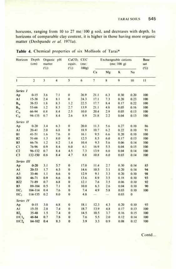
TARAI SOILS 5 4 5
horizons, ranging from 10 to 27 me/100 g soil, and decreases with depth. In horizons of comparable clay content, it is higher in those having more organic matter (Deshpande el al. 1971a).
Table 4. Chemical properties of six Mollisols of Tarai*
Horizon Depth Organu : pH C a C O , C E C : Exchangeable cations Base (cm) matter equiv. (me/ (me/100 g) sat
(%) (%) lOOg) (%) Ca Mg K Na
1 2 3 4 5 6 7 8 9 10 11
Series / Ap 0-15 3.6 7.1 0 26.9 21.1 6.3 0.30 0.20 100
Al 15-38 2.4 S.I 0 24.3 17.1 7.3 0.20 0.23 UK)
Bi, 38-53 1.8 8.3 1.2 22.5 17.7 8.4 0.17 0.22 100
fc, 53-66 1.2 8.3 2.7 13.9 21.1 4.X 0.05 0.16 100
c., 66-94 0.8 8.4 2.5 10.0 20.4 2.9 0.05 0.13 100
c2, 94-135 0.7 8.4 2.6 X» 21.8 2.2 0.04 0.13 100
Series II
Ap 0-20 3.4 6.3 0 20.0 11.3 5.6 0.27 0.10 86 Al 20-41 2.0 6.8 0 18.9 10.7 6.2 0.22 0.10 91
HI 41-51 1.6 7.6 0 16.1 9.5 6.6 0.20 0.10 100
B2 51-66 1.3 8.0 0 12.5 8.5 6.0 0.17 0.13 100
B3 66-76 1.2 8.2 1.4 10.4 4.3 5.6 0.06 0.14 100
CI 76-96 0.9 8.4 6.0 6.1 16.9 5.5 0.04 0.15 100
C2 96-132 0.7 8.4 4.5 7.3 13,9 6,0 0.04 0.14 100
C3 132-150 0.6 8.4 4.7 8.8 10.8 6.0 0.03 0.14 100
Series III
Ap 0-20 3.1 5.7 0 17.0 11.4 2.7 0.30 0.14 85
Al 20-33 1.7 6.5 0 14.6 10.5 3.1 0.20 0.14 94
A3 33-46 1.1 6.6 0 12.9 9.1 3.3 0.20 0.10 9X
B21 46-71 0.9 6.6 0 13.6 8.9 3.5 0.18 0.10 93
B22 71-89 0.7 6.8 0 12.1 7.6 3.5 0.06 0.10 92
B3 89-104 0.5 7.1 0 10.0 6.3 2.6 0.04 0.10 90
1IC, 104-114 0.4 7.6 0 7.4 4.') 5.X 0.03 0.10 100
1IC2 114-135 0.2 8.0 0 4.8 — — 0.03 0
Series IV
Ap 0-15 3.0 6.8 0 18.1 12.3 4.3 0.20 0.10 93 Al 15-35 2.X 7.4 0 18.7 13.9 4.8 0.17 0.13 100
B2, 35-48 1.5 7.4 0 14.5 10.5 3.7 0.16 0.15 100
I I C I , 48-84 0.7 7.X 0 7.6 5.5 2.0 0.12 0.14 100
11C2, 84-102 0.4 8.3 0 3.9 3.3 0.9 0.08 0.12 100
Contd...
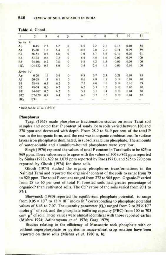
5 4 6 REVIEW OF SOIL RESEARCH IN INDIA
Table 4. Contd...
1 2 3 4 5 6 7 8 9 10 II
Series V
Ap 0-15 2.2 6.2 0 11.5 7.2 2.1 0.16 0.10 84
M 15-38 1.6 6.4 0 10.5 7.0 2.1 0.14 0.09 89
HI 38-53 0.8 6.X 0 7.0 4.7 1.5 0.10 0.08 91
B: 53-74 0.6 7.2 0 6.4 4.6 1.6 0.09 0.09 100
B3 74-104 0.2 7.8 0 5.8 4.2 1.5 0.09 0.09 100
1IC, 104-122 0.3 8.0 0 3.4 2.4 1.1 0.09 0.10 1(H)
Series VI
Ap 0-20 1.9 5.4 0 9.X 6.7 2.3 0.21 0.09 95
•\l 20-38 I.I 6.1 0 8.6 4.9 I.X 0.14 0.09 XO
Bl 38-48 0.9 6.2 0 7.5 4.0 1.6 0.14 0.10 79
H: 48-74 0.6 6.2 0 6.2 3.3 1.5 0.12 0.05 80
B3I 74-107 0.5 6.2 0 5.X 3.1 1.4 0.10 0.04 XO
B32 107-129 0.4 6 4 0 6.6 3.7 1.6 0.10 0.04 X2
IIC, 129+ — — — — — — — — —
•Deshpande el at. (1971a)
Phosphorus Tyagi (1965) made phosphorus fractionation studies on some Tarai soil
samples and noted that P content of sandy loam soils varied between 180 and 278 ppm and decreased with depth. From 28.2 to 54.9 per cent of the total P was in the inorganic form, and the rest was in organic combinations. In surface layers iron phosphates dominated, in subsoils calcium phosphate. The amounts of water-soluble and aluminium-bound phosphates were very low.
Singh (1976) reported the values of total P content in Tarai soils to be 625 to 969 ppm. These values seem to agree with the values of 300 to 862 ppm reported by Sinha (1972), 622 to 1,075 ppm reported by Rao (1971), and 575 to 770 ppm reported by Ghosh (1974) for these soils.
Ghosh (1974) studied the organic phosphorus transformations in the Nainital Tarai and reported the organic-P content of the soils to range from 79 to 529 ppm. The total P content ranged from 272 to 905 ppm. Organic-P varied from 28 to 60 per cent of total P; forested soils had greater percentage of organic-P than cultivated soils. The C:P ratios of the soils varied from 20:1 to 87:1.
Bhowmick (1980) reported the equilibrium phosphate potential, to range from 0.05 X 10~7 to 12 X 10~7 moles lit"1 corresponding to phosphate potential values of 8.45 to 7.07. The quantity parameter (Q0) ranged from 2 to 25 X 10~8
moles g~' of soil, and the phosphate buffering capacity (PBC) from 100 to 703 cm3 g~' of soil. These values were almost identifical with those reported earlier (Mishra 1974; Adinarayana et al. 1976; Garg 1979).
Studies relating to the efficiency of Mussoorie rock phosphate with or without superphosphate or pyrites in maize-wheat crop rotation have been reported on these soils (Mishra et al. 1980 a, b).
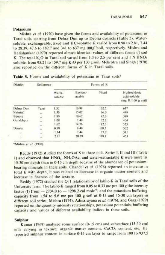
TARAI SOUS 5 4 7
Potassium Mishra et al. (1970) have given the forms and availability of potassium in
Tarai soils, starting from Dehra Dun up to Deoria districts (Table 5). Water-soluble, exchangeable, fixed and HCl-soluble K varied from 0.98 to 2.81, 7.44 to 28.39, 47.6 to 182.7 and 341 to 637 mg 100g~'soil, respectively. Mishra and Harishankar (1970) reported almost identical values of different forms of soil K. The total K20 in Tarai soil varied from 1.3 to 2.5 per cent and 1 N HNOi soluble, from 95.21 to 159.7 mg K20 per 100 g soil. Mehrotra and Singh (1970) also reported on the different forms of K in Tarai soils.
Table 5. Forms and availability of potassium in Tarai soils*
District Soil group Forms of K Soil group
Water- Exchan Fixed Hydrochloric soluble geable acid-soluble
(mg K 100 g soil)
Dehra Dun Tarai 1.50 10.98 102.5 637 Nainital 1.36 15.02 66.0 449 Bijnore ,, 1.80 10.62 47.6 349 Gorakhpur ,, 1.09 7.49 72.2 404
,, ,, 1.62 14.76 182.7 523 Deoria ,, 0.98 8.40 108.1 502
,, '! 1.14 7.44 77.2 341
" » 2. SI 28.39 169.1 453
•Mishra el al. (1970).
Reddy (1972) studied the forms of K in three soils. Series I, II and III (Table 1) and observed that HN03 , NH4OAc, and water-extractable K were more in 15-30 cm depth than in 0-15 cm depth because of the abundance of potassium-bearing minerals in these soils. Chandel et al. (1976) reported an increase in total K with depth, it was related to decrease in organic matter content and increase in fineness of the texture.
Reddy (1972) studied the Q/1 relationships of labile-K in Tarai soils of the University farm. The labile-K ranged from 0.05 to 0.33 me per 100 g the intensity factor (I) from — 2704.0 to — 1298.2 cal mole"1, and the potassium buffering capacity from 1.54 to 5.6 me per 100 g soil at 0-15 and 15-30 cm layers in different soil series. Mishra (1974), Adinarayana et al. (1976), and Garg (1979) reported on the quantity intensity relationships, potassium potentials, buffering capacity and values of different availability indices in these soils.
Sulphur Kumar (1969) analysed some surface (0-15 cm) and subsurface (15-30 cm)
soils varying in texture, organic matter content, CaCO, content, etc. He reported sulphur content in surface 0-15 cm layer to range from 100 to 937.5
5 4 8 REVIEW OF SOIL RESEARCH IN INDIA
ppm with an average of 529.3 ppm, and in 15-30 layer from 87.5 to762.5 ppm with an average of 376.3 ppm. The sulphur content increased with fineness of texture and decreased with depth. The available sulphur (heat-soluble) ranged from 5.7 to 105.6 (mean 24.0) ppm in 0-15 cm layer and from 3.1 to 31.5 (mean 12.0) ppm in 15-30 cm layer.
Sharma (1979), too, reported on the total sulphur content (mean 446.2 ppm) in 0-15 cm depth and 377.95 ppm in 15-30 cm layer of these soils. He observed a very high positive correlation (r = 0.945) between total selenium and total sulphur content, and a positive correlation (r = 0.935) between water-soluble selenium and total sulphur content. The available sulphur ranged from 7.67 to 48.6 ppm (mean 24.85 ppm) in 0-15 cm depth.
Gangwar and Parameswaran (1976 a, b) reported in detail the phosphorus-sulphur relationships in the nutrition of sunflower on these soils. Gangwar and Rai (1976) also reported the relative susceptibility of Brassica campestris var. toria to sulphur deficiency on these soils.
Iron The values of total and available iron (Mann 1971) indicated wide
variations in its profile distribution. Total iron in the profile varied from 1.02 to 2.48 per cent. The distribution of total iron with depth seemed to have no definite trend. The available iron in these profiles ranged from 6.0 to 40.0 ppm. Series I (poorly drained) horizons generally had more available iron than any other series. The nature of distribution of total iron in various textural classes did not seem to follow any regular trend (Gangwar et al. 1971).
Sharma (1979) found the available iron content in these soils to range from 3.64 to 12.56 (mean 8.33) ppm in 0-15 cm depth and from 4.10 to 10.92 (mean 7.60) ppm in 15-30 cm depth.
Zinc Vittal and Gangwar (1974) reported on zinc distribution in soil profiles of
Nainital Tarai. In all the six series (Table 1), total zinc increased with depth whereas dithizone extractable-zinc decreased with depth. They attributed the increase in total zinc with depth to the downward movement of zinc over a long period of time.
The critical limits of various availability indices of zinc in respect of lentil (Gangwar and Chandra 1975) and rice (Chandra and Gangwar 1977) in these soils were worked out. Ammonium acetate (pH 4.6) extractable zinc gave the highest significant correlation with zinc uptake by rice (r — 0.611) among the five extractants tested. It was followed by dithizone (r = 0.594), magnesium chloride (r = 0.573) and DTPA ammonium carborate (r = 0.504). Dilute hydrochloric and sulphuric acid mixture-extractable zinc did not give significant correlation (r = 0.397) with zinc uptake by rice crop.
Mann (1971).concluded that the 'khaira' disease of rice in Tarai soil (Nene 1966) was probably not due to ziric deficiency alone, that excesses of iron
TARAI SOILS 5 4 9
absorbed under flooding could also be a possible cause and that the recovery of rice from 'khaira' symptoms was due to decrease in the iron concentration in plant leaves with concurrent increase in the zinc concentration putting both the nutrients in optimum nutrient balance.
On the basis of a pot culture study, Dikshit (1971) also concluded that 'khaira' disease of rice in Tarai soils was not the manifestation of zinc deficiency per se, and reported that 'khaira' symptoms were prevented by the application of zinc as well as calcium carbonate. He also noted that 'khaira' disorder was associated with an excessive accumulation of iron in the plants. Misra and Sachan (1978) observed the application of FYM to prevent P-induced zinc deficiency symptoms of rice crop in these soils.
Boron The distribution of boron in Tarai soils was studied by Srivastava (1974).
Multiple regression equation considering all the depths together was developed including different soil properties studied for predicting the total boron concentration. The relationship was as follows:
Total boron (ppm) = 4.808 + 22.492 EC (m mhos cm"1) + 0.284 CaCO, (%) + 0.668 Ex. Ca (me lOOg"1) -20.991 Ex. Na (me lOOg"1) + 17.875 Ex. K (me lOOg"1).
Singh and Gangwar (1974) reported critical boron concentration and calcium-boron balance for sugar-beet in these soils.
Molybdenum The total molybdenum content of Nainital Tarai soils was found to range
from 2.00 to 2.53 ppm in surface layers. The molybdenum content, in general, decreased along the depth in the profile, the values reaching as low as 1.0 ppm at a depth of 130 cm. The available (ammonium oxalate extractable) molybdenum content ranged from 0.093 to 0.267 ppm in the surface layer. There was no definite trend of available molybdenum content along with depth. In some profiles it was as low as 0.07 ppm to as high as 0.43 ppm in 120 to 130 cm layer.
Copper The total and available copper obtained by different extractants for Nainital
Tarai region was reported by Gangwar and Vittal (1971). The total copper content varied from 14 to 49 ppm, most of the soils containing more than 25 ppm. The water-extractable copper was found to be only in traces, whereas 0.1 N HC1-extractable copper ranged from 0.9 to 1.5 ppm. The 0.05 M EDTA-extractable, 1 N ammonium acetate (pH 4.6) extractable and 1 N ammonium acetate (pH 7.0) extractable copper ranged from 0.6 to 1.2, 0.29 to 0.52, and 0.074 to 0.32 ppm, respectively. There was no significant correlation of extractable copper with soil pH, clay, organic matter or calcium carbonate
5 5 0 REVIEW OF SOIL. RESEARCH IN INDIA
content, but it was significant at P = 0.05 between 1 N ammonium acetate extractable copper and per cent clay (r = 0.633).
Manganese The easily reducible (1 N ammonium acetate + 0.2 per cent hydroquinone,
pH 7.0, 1:10 soil solution ratio) manganese content of poorly drained silty clay loam Tarai soil was 52 ppm, and water-soluble plus exchangeable manganese (1 N ammonium acetate, pH 7.0, 1:10 soil solution ratio) was 11 ppm (Sharma el al. 1977).
References
Adinarayana, V., Gangwar, M.S., Sachan, R.S., Ram, N. and Gupta R.A. (1976) Pantnagai J. Res. 2. 165.
Agarwal, R.R., Mehrotra. C.L. and Gupta, C.P. (1955) Proe. natn. Acad. Sci. India 24, 46. Arkley, R.J. (1976) Adv. Agron. 28, 37. Bhatnagar, V.K. (1965) M.Sc. Thesis. G.B.P.U.A. and T., Pantnagar. Bhowmick. A. (1980) M.Sc. Thesis G.B.P.U.A. and T. Pantnagar. Chandel, AS. , Singh, M. and Singh, T.A. (1976) Bull. Indian Soc. Soil Sci. 10, 13. Chandra, S.K. and Gangwar, M.S. (1977) Acta Agronom. 26, 200. Deshpande, S.B. (1969) Ph.D. Thesis, University of Illinois, Urbana, U.S.A. Dcsphande, S.B.. Fehrenbachcr. J.B. and Beavers, A.H. (1971a) Geoderma 6, 179. Deshpande. S.B., Fehrenbacher, J.B. and Ray, B.W. (1971b) Geoderma 6, 195. Dikshit, P.R. (1971) Ph.D. Thesis G.B.P.U.A. and T. Pantnagar. Fehrenbacher, J.B., Ray, B.W., Deshpande, S.B. and Sharma, A.K. (1966). Soil Survey:
Experiment Station Farm and Dairy Farm, Uttar Pradesh Agricultural University, Pantnagar, U.P., India.
Gangwar. M.S. and Chandra. S.K. (1975) Commun. Soil Sci. PI. Anal., 6, 641 Gangwar, M.S., Mann, J.S. and Sharma, A.N. (1971) Indian J. agric. Sci. 41, 1120. Gangwar, M.S. and Parameswaran, P.M. (1976a). Oilseeds J. 3, 28. Gangwar, M.S. and Parameswaran, P.M. (1976b) Oilseeds J. 3, 33. Gangwar, M.S. and Rai. P.N. (1976) Indian J. agric. Res. 10, 65. Gangwar, M.S. and Vittal, K.P.R. (1971) Ann. Arid Zone 10, 52. Garg. P.K. (1979) M.Sc. Thesis, G.B.P.U.A. and T. Pantnagar. Ghildyal, B.P. and Tripathi, R.P. (1973) Indian J. agric. Sci. 43, 704. Ghosh, S.C. (1974) M.Sc. Thesis, G.B.P.U.A. and T. Pantnagar. Hole, F.P. and Hironaka, M. (1960) Proe. Soil Sci. Soc. Am. 24, 309. Kumar, V. (1969) M.Sc. Thesis. G.B.P.U.A. and T. Pantnagar. Mann, J.S. (1971) M.Sc. Thesis, G.B.P.U.A. and T. Pantnagar. Mathur, A. (1979) M.Sc. Thesis, G.B.P.U.A. and T. Pantnagar. Mehrotra. C.L. and Singh, G. (1970) J. Indian Soc. Soil Sci. 18, 327. Mishra. B., Sharma. R.D. and Mishra. N.P. (1980a) Indian J. agric. Sci. 50, 691. Mishra, B., Sharma. R.D. and Mishra, N.P. (1980b) Indian J. agric. Sci. 50, 346. Mishra. B., Tripathi, B.R. and Chauhan, R.P.S. (1970) J. Indian Soc. Soil Sci. 18, 21. Mishra, R.V. and Shankar, H. (1970) .1. Indian Soc. Soil Sci. 18. 319. Mishra, S.M. (1974) M.Sc. Thesis. G.B.P.U.A. and T. Pantnagar. Mishra, S.M. and Sachan, R.S. (1978) IARI Newsletter 3, 15. Natarajan, R. (1971) M.Sc. Thesis, G.B.P.U.A. and T. Pantnagar.
TARAI SOILS 5 5 1
Nene, Y.L. (1966) J. Indian Phytopath. Soc. 3, 97. Puri, G.S. (I960) Indian Forest Ecology, Vol. 1, Oxford Book and Stationery Co., New Delhi. Rao, B.R.M. (1971) M.Sc. Thesis G.B.P.U.A. and T. Pantnagar. Rathore, T.R. (1975) Ph.D. Thesis G.B.P.U.A. and T. Pantnagar. Raychaudhuri, S.P. (1962) J. Indian Soc, Soil Sci. 10, II. Reddy, K.C.K. (1972) M.Sc. Thesis, G.B.P.U.A. and T. Pantnagar. Saha, R.S. and Tripathi, R.P. (1979) J. Indian Soc. Soil Sci. 27, 220. Selvanathan, G. (1970) M.Sc. Thesis G.B.P.U.A. and T. Pantnagar. Seth, S.K. (1954) The principal grassland types and other grass habitats of Uttar Pradesh. In
Symposium on "Vegetation types of India" Bull No. 24, Forest Department, Uttar Pradesh. Sharma, A.K. and Sharma, R.K. (1979) J. Indian Soc. Soil Sci. 27, 434. Sharma, B.M.. Gangwar, M.S. and Ghildyal, B.P. (1977). Mysore J. agric. Sci. II, 175. Sharma, R.K. (1979) M.Sc. Thesis, G.B.P.U.A. and T. Pantnagar. Shukla, S.S.. Rauchaudhuri. S.P. and Anjaneyulu. B.S.R. (1965) J. Indian Soc. Soil Sci. 13, 115. Singh. A.N. (1974) M.Sc. Thesis, G.B.P.U.A. and T. Pantnagar. Singh. K.D. (1976) M.Sc. Thesis, G.B.P.U.A. and T. Pantnagar. Singh, M. (1967) Working plan for the Tarai and Bhabar forest division Western circle U.P. Part 1
& II Forest Department, Uttar Pradesh. Singh, M.P. (1977) M.Sc. Thesis, G.B.P.U.A. and T. Pantnagar. Singh, R. and Ghildyal, B.P. (1977) PI. Soil 47, 125. Singh, R.R. and Gangwar, M.S. (1974) Acta agronom. 23, 108. Sinha, S.N. (1972) M.Sc, Thesis G.B.P.U.A. and T. Pantnagar. Srivastava, H.K. (1974) M.Sc. Thesis G.B.P.U.A. and T. Pantnagar. Srivastava, M.K. (1978) M.Sc. Thesis G.B.P.U.A. and T. Pantnagar. Tiwari, R.C., Ghildyal, B.P. and Tornar, V.S. (1976) Pantnagar J. Res. 1, 121. Tomar, V.S. and Ghildyal, B.P. (1978) J. Indian Soc. Soil Sci. 26, 93. Tripathi, R.P. and Ghildyal, B.P. (1974) J. Indian Soc. Soil Sci. 22, 103. Tripathi, R.P. and Ghildyal, B.P. (1976) J. Indian Soc. Soil Sci. 24, 339. Tripathi. R.P. and Ghildyal. B.P. (1979) Agric. Meteorology 20. 493. Tyagi, B.K. (1965) M.Sc. Thesis, G.B.P.U.A. and T. Pantnagar. Vittal, K.P.R. and Gangwar, M.S. (1974) J. Indian Soc. Soil Sci. 22, 151. Wadia, D.N. (1953) Geology of India, McMillan and Co. Ltd. London. Whyte, R.O. (1964) Grassland and Fodder Resources of India. Indian Council of Agricultural
Research, New Delhi.
Micromorphology of Some Major Soils of India J.L. SEHGAL' AND N.G. RAGHU MOHAN2
THE use of thin-section and microscopic techniques in the study of soils has developed in recent years as a valuable tool in determining the processes of soil iormation and in classifying soils. The micromorphological studies have been confined mainly to a few advanced countries, and the major emphasis has been on the description of micromorphological features with limited emphasis on their interpretation for certain selected soils. This paper reviews the micromorphology of some major soils of India.
The Indian subcontinent comprises three broad, well-defined physiographic regions, viz. the Himalayas and associated mountains (extra-peninsular), the Indo-gangetic plain, and peninsula or Deccan plateau.
MICROMORPHOLOGY OF ARIDIC SOILS
About 42 per cent of the land area is arid or semi-arid; most of it is in Rajasthan and the bordering states of Gujarat, Punjab and Haryana. The soils contain a high percentage of soluble salts, high pH, low loss.on ignition, varying amounts of calcium carbonate, and poor organic matter content. They are classified as Pedocal Sierozem, Pedocal Brown, Grey Brown (desert) and Desert Soils (Raychaudhuri 1964).
Several regional soil surveys of the arid and semi-arid regions of Rajasthan, Punjab and Haryana have suggested the occurrence of Camborthids, Calciorthids, Torripsamments, Salorthids (Sehgal 1970; Murthy and Pandey 1977; Dhir and Kolarkar 1977).
Camborthids The soils are dominated by quartz, mica, feldspar, calcite and hornblende.
The plasma composed of clay and secondary carbonate, is light brown to light yellow in colour. The soil fabric varies from argilasepic, agglomeratie (in Ap horizon), grading through silasepic and crystic and intertextic to agglomeratie (in B horizon), to crystic and intertextic (in C horizon). The cambic horizon exhibits a highly agglomeratie, silasepic micro-structure of the S-metrix with frequent occurrence of free grain cutans (argillans and calcitans) and common, spongy, calcareous nodules.
Free grain cutans are most pronounced in the cambic horizon. The soils show high biological activity except in the surface horizon, as is evidenced by
I. UNDP-FAO. P.B. No. 2048, (Alwiyah), Baghdad, Iraq. 2. Division of Soil Science and Agricultural Chemistry, Indian Agricultural Research Institute, New Delhi.
M1CROMORPHOLOGY OF SOME MAJOR SOILS 5 5 3
the occurrence of common to frequent, single, ortho aggrotubules giving an agglomeroplasmic distribution pattern to these soils (Sehgal 1970).
Sehgal and Stoops (1972) observed nine forms of calcite accumulations from micro-crystalline calcite to coarsely recrystallised crystallaria. The Camborthids are dominated by spongy calcitic nodules, relatively small, diffuse, irregular, composed primarily of micro-crystalline calcite and occurring within less dense crystic fabrics. The origin of these and other calcareous accumulations is discussed.
The extensively occurring Camborthids in Rajasthan (charai soils) are loamy fine sand and show appreciable soil developmerit by leaching and accumulation of free carbonates and differential in situ weathering of silicate minerals and formation of clay. The thin-section study of comparable soils shows weathering of minerals such as biotite, forming papules, which on desiccation get oriented to the skeleton grains and give rise to free grain cutans, representing typical chlamydomorphic elementary fabric of Kubiena (1938). The micromorphology of such soils suggests the establishment of cambic horizon irrespective of their coarse texture and their logic classification as Torripsammentic Camborthids (Sehgal et al. 1980).
Calciorthids The Calciorthids are widespread over all parts of the arid zone. These soils
have developed a diagnostic calcic horizon within 1 m of the surface. The most important associated soil groups are the Camborthids, Torripsamments and Salorthids.
Micromorphologically, the skeleton of Calciorthids (Hissar loam) from Haryana (Sehgal 1970) comprises quartz, micas, feldspar, hornblende, epidote and calcite. The plasma is characterised by clay and secondary carbonates and is yellowish brown in the surface and B horizon and light yellowish in the Cca horizon. The soil fabric grades from fairly loose, insepic, agglomeroplasmic (in the surface), through intertextic to compact crystic porphyroskelic in the calcic horizon. The skejeton predominates throughout, except in the calcic horizon, where plasma equals the skeleton. The voids, in general, are better represented than the plasma. The calcitic nodules (irregular, rather diffuse, clustered, sharp, compact with soil fabric) are invariably observed throughout.
According to Sehgal and Stoops (1972), the calcic horizon, typical of Calciorthids, is dominated by crystic fabric and microcrystalline calcitic soil nodules including grains of quartz, muscovite and biotite. The depth of their occurrence depends on the climatic environments. They are generally observed within 1 m of the surface in the aridic zone and below 1 m in the ustic region, where they may have included features of Fe-oxihydrates and coarsely crystalline crystallaria resulting from slow crystallisation.
These light-coloured calcareous soils with a carbonate-rich subsurface horizon are Sierozem according to Baldwin et al. (1938) and Raychaudhuri (1964) and qualify for Typic Calciorthids (Soil Survey Staff 1975).
5 5 4 REVIEW OF SOIL RESEARCH IN INDIA
Ustochrepts The Ustochrepts are observed in the less hot semi-arid (dry and semi-dry)
climatic zone. The soils show an ochric epipedon underlain by clay-enriched B horizon with shining ped faces and a calcic horizon generally below 1 m of the surface.
Micromorphologically, the Ustochrepts are dominated by quartz, mica, feldspars, hornblende, calcite and epidote interspersed with dull brownish or yellowish brown plasma. The soil fabric is spongy, silasepic (tending towards skelinsepic), agglomeratie (to intertextic) in the surface layer, loose, skelinsepic, intertextic in the subsurface horizon, rather compact, skelinsepic to mosepic, intertextic to weakly porphysoskelic in the B3 horizon, and mixed spongy and compact silasepic and crystic in the Cca horizon. The skeleton is dominant over voids, and thé'voids over plasma throughout except in the B3 horizon, where plasma is well represented after the skeleton. The illuviation cutans are almost absent. However, discontinuous, weakly oriented, free and embedded grain ferriargillans are commonly observed throughout, especially in the B horizon. Fragments of coarse, oriented clay cutans in the surface horizon and those of argillaceous papules in the B horizon are common. The microcrystalline calcite crystals are common in the Ca horizon. High biological activity in B horizon, as expressed by the orthoaggrotubules, is common (Sehgal 1970; Sehgal and Stoops 1976).
Such soils with shining ped faces and thin patchy clay skins led scientists to classify them as Haplustalfs. The laboratory data supported the field observations and led to such soils being qualified as having Bt horizon. But thin-section studies of many pedons of north-western India (Sehgal 1970; Karale 1972) did not confirm these conclusions; for no real illuviation cutans could be noticed under the polarised microscope. Sehgal (1974) investigated such soils and compared them with those having developed argillic horizons under subhumid and perhumid climatic conditions, and concluded that most of the alluvium-derived soils with shining ped faces lacked oriented clay cutans to qualify them for argillic horizon and that their classification as Haplustalfs would therefore need to be revised in the light of the thin-section study. The origin of shining ped faces in these soils (Sehgal and Stoops 1974) is related to the in situ weathering of biotite micas, which on desiccation get oriented along the primary grains and impart a shining appearance to the ped faces.
Haplustalfs The principal micromorphological features of Haplustalfs of northern
India, according to Sehgal (1970), show that the skeleton is composed of quartz, micas, feldspars and bright yellowish brown to dark brown plasma constituting clay and iron oxyhydrate associated with a little organic matter. The surface soils show soil fabric of silasepic, agglomeroplasmic, grading through vo-skel-in-mosepic (B horizon) to silasepic and weakly skelinsepic intertextic to porphyroskelic (in C horizon). The skeleton predominates the
M1CROMORPHOLOGY OF SOME MAJOR SOILS 5 5 5
plasma and voids throughout. The soils show illuvial cutans (ferri-argillans), Fe-oxyhydrate as microglaebules and clay humus complex nodules. The common in situ weathering of biotite forming papules and occasional presence of aggrotubules are some other features of Haplustalfs.
Studies by Eswaran and Raghu Mohan (1973) on petroplinthite formation in the Alfisols of Bangalore plateau with scanning electron microscope revealed the laterite formation from kaolinite mass by absolute enrichment of iron oxyhydrates. In thin sections, iron formed a vacular network; the vacuoles were composed of original kaolinite and the network formed by closely crystallising goethite crystals. The goethite formed a strong, rigid framework giving the form and the hardness to petroplinthite. The micromorphological study indicated that the material had undergone two or more weathering cycles before its formation as petroplinthite.
SEM photographs of amorphous manganese and magnatite crystals indicated that they are of localised occurrence. The iron oxyhydrate forms the network and also the droplets. The network consists of well crystallised goethite appear like 'desert roses'. There was dissolution of silica from the quartz surface followed by crystallisation. The manganese minerals observed can be considered inclusions. They are generally present as cutans on voids. The amorphous manganese are present cutanically on the voids. Lath-shaped manganite are present very locally in voids in the petroplinthite.
The plasma is hialine yellowish red in Haplustalf, red in Rhodustalf, and tan brown in Plinthustalf, indicating ageing of the plasma with advanced ferralitic weathering (Eswaran and Raghu Mohan 1973).
Salt-affected Soils Thin-section study of salt-affected soils and their cultivated associates
developed on similar parent material and under semi-arid (dry) environments (Sehgal and Stoops 1976) gave comparable results about their skeleton and inherited pedological features, but showed differences in their pattern, microstructure and other pedological features.
The salt-affected soils have a spongy, vesicular, platy salt-crust with a well-developed lamellar structure and many spherical pores. They have a moderate to densely packed soil fabric with dominance of planar voids; the plasma and skeleton predominates over voids. The related distribution is dense, intertextic, tending to porphyric. The plasmic fabric is asepic and insepic in the surface horizon; with depth, weakly developed sepic (locally crystic) fabric is noticed. In the lime-enriched horizon, plasmic fabric is masked by the presence of calcite microlites. The permeability in such horizons is low because of the development of a dense micro-fabric by dispersion and mobilisation of mobile soil constituents (Sehgal and Stoops 1976).
According to Sidhu el al. (1977) such concretions occurring in salt-affected soils are reddish brown to brown, subspherical, and non-magnetic, with hardness of 2 to 3 mohs. Under the microscope, most of the concretions exhibit
5 5 6 REVIEW OF SOIL RESEARCH IN INDIA
randomly distributed grains of primary minerals (quartz, mica and feldspars) which are cemented by non-birefringent substances (probably Fe-Mn oxides and hydroxides), appearing reddish brown in reflected light. The concretions show massive undifferentiated and concentric internal fabrics; thin sections of a soil matrix containing imbeded concretions show diffuse boundaries between the concretions and adjacent soil material.
The micro-fabric of Natrustalfs of Uttar Pradesh (Karale 1974) exhibits mostly asepic domains, which implies the retention of the original sedimentary nature of the parent material.
Hapludülls According to Sehgal (1970) the skeleton of the Hapludolls in mountain
valleys comprises lithorelicts, micas, quartz and feldspars. The S-matrix is almost completely aggregated and dominates over voids and plasma. The soil fabric is typically silasepic, agglomeroplasmic (in the surface horizon) grading to insepic, weak intertextic to porphyroskelic in the subsurface horizons. The finer fractions are coagulated, and no translocation of clay is observed. The soils show high biological activity as expressed by frequent presence of ortho-aggrotubules and of clustered faecal pellets. The argillaceous papules (weathered biotite) are most commonly observed.
The Mollic Hapludalfs in the region show silasepic, ma-insepic (phantomsepic) intertextic to moderately developed porphyroskelic soil fabric; soil show common illuviation ferri-argillans of highly birefringent clay mineral with frequent occurrence of argillaceous papules and aggrotubules suggesting good physical conditions (Sehgal 1970).
MICROMORPHOLOGY OF FERRUGENOUS SOILS
The seven pedons of Goa, representing Udipsamments, Dystrochrepts and Eutrochrepts, Hapludalf, Ferrudalf and Tropudalf and Plinthudult, were studied for micromorphology to understand the morphogenesis of the diagnostic horizons. The laterite subsurface horizons of Netorlim and Volpoi series do not qualify for an oxic horizon because of the presence of illuviation cutans in abundance. The B2tcn and the B3m horizons show ringlike argillan overlying bright red goethan. The plasma is dull yellow with low birefringence, indicating its early formation contrary to ferrans, neoferrans as well as diffused sesquioxide nodules showing iron segregation, which is recent and is the main pedological feature during plinthite formation.
In Volpoi pedon the characteristic feature is the high content of organic matter of mostly fine diminution and presence of welded faecal pellets with ortho-aggrotubules. The mammillated vughs are mostly the result of intense biological activity. The organo-argillans are intense in the subsurface horizon of vughs and channels which are in contrast with the Netrolim pedon.
MICROMORPHOLOGY OF SOME MAJOR SOILS 5 5 7
The plinthite horizon in both the pedons has tan brown plasma with isotic tendencies which are common under intertropics. The Ugem series (Ferrudalf) derived from granite gneiss shows gneissic composition with linear and foliar arrangement of the minerals during its late stage of metamorphism. Most conspicuous is the weathering of feldspars to gibbsite and mica to clay minerals such as kaolinite and iron oxides. Argillans are common in voids, channels with in-vosepic plasmic fabric. Burrowing activity is evident through the horizon, and reddish brown nodules occupy old animal burrows, which are identified as orange mottles in the field. Clay skin formation seems to be recent covering and masks a great part of the furrows as broken and disrupted clay skins are absent.
The micromorphological description of Dystrochrept indicates that this pedon is still in the process of active weathering as evidenced by the weathering of minerals in the B horizon. In the B2 horizon curved channels, irregular pores and vughs are lacking in the S-matrix. The nodules show plasmic fabric, essentially the same as the adjacent soil material indicating the in filling of the burrows after intense animal activity. Many lithorelicts of quartzitic composition derived from the gneissic bedrock are present. Alteration of feldspar in this pedon does not go beyond the amorphous stage, whereas in Ugem series it has changed mostly to gibbsite.
In the Zaimolo series (Hapludalf) the silosepic plasmic fabric with very few skeleton grains indicates the colluvial nature of the plasma. In the subsurface horizons cutans are in abundance and are mainly ferri-argillans. The degraded state is manifested by the disrupted ferri-argillans incorporated in the S-matrix. Such a state suggests that subsequent to illuviation there has been a change in the soil environmental conditions.
The SEM studies for the pedological features have brought out the surface morphology of the sesquan in Zaimolo series, the pattern of clay movement, and the development of plasmic fabric'. They have also indicated structural control by such rocks in alignment of the plasmic fabric (Raghu Mohan 1978).
MICROMORPHOLOGY OF ALFISOLS AND VERTISOLS OF ANDHRA PRADESH
Fabric analysis of four pedons of Cuddapah synclinorium of Andhra Pradesh was carried out for evaluating their pedogenesis (Rao 1981). The main pedological feature was the presence of argillans, undifferentiated nodules and invosepic plasmic fabric.
The Chromustert pedon showed spongy silosepic fabric with calcitans. The scanning techniques helped in establishing the genetic relationship of the A-C profile derived from lime-stone with rhombohydral skeletal framework continuum from parent material to the weathered pedon.
5 5 8 REVIEW OF SOIL RESEARCH IN INDIA
Conclusion Cyclic deposition of parent material is a common feature in the Indo-
Gangetic plains so also the polysequem nature of soils of the peninsular India having mostly Alfisols and Ultisols. The in situ weathering resulting from monsoon type of climate; and in case of Vertisols the intermixing by pedoturb-ation pose problems in identifying the uniformity or heterogeneity of the parent material, so important for understanding the pedogenic evolution of soils. Studies on micromorphology of soils may help in determining the nature and uniformity of the parent material and in identifying diagnostic horizons.
There is very limited information about the biological activity of various soils.
References
Baldwin, M., Kellog, C.E. and Thorp. J. (1938) Soils and Men, Year Book of Agriculture, USDA. U.S. Govt. Printing Office, Washington, D.C.
Dhir, R.P. and Kolarkar, A.S. (1977) J. Indian Soc. Soil Sci. 25, 260. Eswaran, H. and Raghu Mohan, N.G. (1973) Proc. Soil Sci. Soc. Am. 37, 79. Karale. R.L. (1974) Micromorphological studies of B horizon of some of the alluvium-derived soils
in U.P. (India). Intern. Inst. Aerial Survey and Earth Sciences, Enschede, Holland. Kubiena. W.L. (1938) Micropedology, Ames, Iowa Collegiate Press, Inc. Murthy, R.S. and Pandey, S. (1977) Desertification and its control. Indian Council of
Agricultural Research, New Delhi. Raghu Mohan, N.G. (1978) Ph.D. Thesis, Indian Agricultural Research Institute, New Delhi. Raychaudhuri, S.P. (1964) Proc. Symp. Problems of Indian Arid Zone, Jodhpur (India), p. 101. Rao. Y S. (1981) Ph.D. Thesis, Indian Agricultural Research Institute, New Delhi. Sehgal, J.L. (1970) D.Sc. Thesis, State Univ. of Ghent, Ghent (Belgium), p. 336. Sehgal, J.L. and Stoops, G. (1972) Geoderma 8, 59. Sehgal, J.L. and Stoops, G. (1976) J. Indian Soc. Soil Sci. 24, 439. Sehgal, J.L., AL-Mishadaw. Mahmud. Abdul Ghani, S.A. and Siqur, Rajih, H. (1980) J. Indian
Soc. Soil Sci. 28, 57. Sidhu, P.S., Sehgal, J.L., Sinha, M.K. and Randhawa, N.S. (1977) Geoderma 18, 241. USDA (1975) Soil Taxonomy. Agriculture Hand Book 436.
Remote-Sensing Application in Soil Mapping
T.R. SRINIVASAN*
A COMPREHENSIVE historical account of the developments in soil survey in India was presented by Satyanarayana (1967). The sixties were particularly important to soil surveyors, many of whom had training in standard soil surveys in the Soil Conservation Service, USDA. One of the beneficial effects of this quality improvement programme was the realisation of the high utility of aerial photographs in soil mapping. Accordingly, a decision was taken in 1962 to use aerial photographs as the base for soil mapping. But in the All India Soil and Land Use Survey Organisation the programme did not reach the extent desired, though the Survey of India started supplying aerial photographs of the catchment areas of the major river valley projects. In fact, the early reports of air photo use in publications emanated from the Central Arid Zone Research Institute. Abichandani (1965), and Kolarkar and Abiehandani (1967) used aerial photographs for soil survey in Rajasthan.
The term 'remote sensing' includes activities related to acquisition and analysis of data for presenting thematic interpretation, preferably in the form of maps. According to some, remote sensing should be restricted to satellite data in respect of both acquisition and interpretation. Others have pointed out that air photo interpretation was the earliest remote sensing development, because air photos are taken from a considerable height above the ground. Hempenius (1979) clarified that the term 'remote' refers not so much to the distance between the object and the sensor, as to the absence of direct contact. Viewed in this light, remote sensing data can be gathered from as low an elevation as a few metres (elevated platforms) to as far as 30,000 km or more, as in the case of geo-stationary satellites of the LANDSAT type. This view that air photo interpretation is an earlier version of remote sensing interpretation is now widely accepted. It may be called 'Aircraft Remote Sensing'; its applicability to soil mapping (basic soil maps from standard soil survey) is discussed below.
Beginning of Aerial Photo Interpretation The seventies saw the rapid popularisation of air photo interpretation
techniques for soil mapping. The chief stimulus was the establishment of the Indian Photo-Interpretation Institute (IPI) as a joint Indo-Dutch venture and run under the aegis of the Survey of India. In the beginning, usually medium
*Agrima Project Engineering and Consultancy Services Limited, Bombay.
560 REVIEW OF SOIL RESEARCH IN INDIA
scale (1:25,000) air photos were used by the trainess of IPI for preparing medium scale (1:25,000-1,50,000) soil maps.
With the initiation of a Dutch-financed research fellowship scheme in the IPI, tackling of research problems relating to soil survey was taken up. Shamacharya and Srinivasan (1972) reported the possibility of preparing small-scale (1:100,000 or smaller) soil maps through interpretation of small-scale (1:60,000) air photos available for practically the whole country, and of selective field soil survey. Since then, many soil scientists have published case studies on the successful use of air photo interpretation for soil mapping on different scales and highlighted the advantages of the procedures over mapping on conventional bases such as toposheets and planimetrie maps.
Sehgal et al. (1973) used 1:25,000 air photos for mapping salt-affected soils of Sangrur district in Punjab. Delineation of soils categorising degrees of severity of alkalinity were attempted and used as the basis for costing of reclamation and anticipated benefit. Others who mapped salt-affected soils include Srinivasan (1976), Garalapuri et al. (1978), Manchanda and Khanna (1979), and Kolarkar et al. (1980). Dhir (1974) described his experience in small-scale soil mapping in Jodhpur district of Rajasthan.
Soil maps are designated 'small', 'medium' and 'large' to denote, respectively, scale ranges of 1:100,000 to 1:250,000, 1:25,000 to 1:100,000, and 1:5,000 to 1:25,000, on the lines adopted by the FAO (1979).
Krishnamurthy and Srinivasan (1974) evaluated small-scale conventionally prepared soil maps of Barnagar tehsil in Madhya Pradesh against those prepared by air photo interpretation and concluded that the latter were superior in respect of naturalness of soil boundaries and consistent accuracy. Many other soil scientists (e.g. Ahuja et al. 1979) took advantage of the relationship between landscape subdivisions and soil patterns for soil mapping through air photo interpretation techniques.
Soil surveyors have long been aware of the utility of physiographic analysis for the preparation of small-scale soil maps, soil association boundaries being co-extensive with landforms subdivision boundaries. It is only in delineating the boundaries of land sub-units that air photo interpretation has played a significant role.
The validity of landscape-soil relationship holds good for even medium-scale maps, particularly when the terrain is composed of landscape elements having considerable relief differences. However, the efficacy of photo interpretation techniques in low relief areas decreases with increasing scales of soil mapping. In such cases, air photos are simply used as base maps for large-scale mapping. However, in certain areas it is feasible to depend to a considerable extent on air photo interpretation for large-scale soil map preparation also (Jawade and Srinivasan 1974). In large- and very large-scale mapping of irrigation and drainage projects, air photos simply serve as a better base than planimetrie maps.
The foregoing account of soil mapping work relates to the use of
REMOTE-SENSING APPLICATION IN SOIL MAPPING 561
panchromatic air photos. Other types of photography have also been tried for the preparation of soil maps. These include colour, infra-red and colour infrared photographs.
Special Photography Colwell (1960) has described the use of special-purpose photography to
satisfy highly specific needs. His presentation includes a series of plates that bring out the advantages of using Ektachrome colour and false-colour photos, the latter depicting healthy vegetation in bright red hues. He has also shown the utility of multi-date photography for achieving better results from photo-interpretation. In fact, multi-date, multi-band, aircraft remote-sensing work was the fore-runner of the LANDS AT multi-spectral sensing.
In India such special photographic imagery is not readily available for routine use by photo interpreters engaged in resources mapping. Special multi-band photography was, however, used by the Indian Space Research Organisation for a cooperative project, known as the ARISE Project, for the evaluation of agricultural resources. The multi-band imagery for Anantapur and Patiala districts was interpreted by the National Bureau of Soil Survey and Land Use Planning for mapping land use and identifying crops with the ultimate object of crop forecasting (Sahai and Barde 1975).
Remote Sensing Widespread popular interest in 'remote sensing' was aroused after the
launching of the first LANDS AT in July 1972 for a speedy evaluation of earth resources for scientific management and environmental protection although photographs were available even before the LANDSATs were set in orbit. As a fore-runner to the LANDSAT imagery, space photos through the Apollo, Gemini, Nimbus and Tiros missions were available.
Krishnamurti and Srinivasan (1973a) used Apollo space photos and Gemini photos (1973b) for small-scale soil mapping. Using monoscopic interpretation and air photo interpretation of 1:63,000 scale photos for part of the space photo area, a small-scale soil map was prepared and found to be better than the existing schematic soil map for that area. In both cases space colour photos did not yield any additional information because of the small scale.
LANDSAT Data LANDSAT data are generally available in (i) 1:1 million film/photos, (ii)
1:3.7 million chips, and (iii) computer compatible tapes (CCTs), all in the four bands of 4, 5, 6 and 7, and repetitive coverage can be procured. For thematic mapping of earth resources in general and soils in particular, image analysts adopt three approaches: (i) visual interpretation of LANDSAT 1:1 million photos of one or more bands, separately or in colour composites, (ii) visual
I
5 6 2 REVIEW OF SOIL RESEARCH IN INDIA
interpretation aided by additive colour viewer enhancement of the chips of four bands, and (iii) computer-aided digital analysis of the CCTs.
LANDSAT Photo-Interpretation Mirajkar and Srinivasan (1975) adopted a multi-stage procedure involving
visual interpretation of LANDSAT MSS 1:1,000,000 photos in bands 5 and 7 supported by air photo interpretation for samples of LANDSAT analytical units and attempted to prepare a small-scale (1:1 million) soil map for parts of Karnataka, Maharashtra and Andhra Pradesh. The resulting soil map was found to be superior to the existing soil map for the study area.
Hilwig (1976) described the use of visual interpretation techniques for preparing a small-scale (1:250,000) soil map of a part of the Indo-Gangetic plains in India with reasonable accuracy in identifying unique physiographic subgroups on LANDSAT in four bands. Soil composition could be assigned to the units because of the availability of soil data from air photo interpretation.
Naga Bhushana et al. (1977) interpreted LANDSAT-I transparencies covering parts of Cuddapah and Anantapur districts in Andhra Pradesh in bands 4, 5, 6, and 7 for different applications, viz, hydrology, geological formations and structures, surface soil types, and land use and vegetation, by using different elements of photo interpretation supported by other evidence. Since soil maps in different scales were available for the area under study; comparisons were made to correlate them; a generalised soil map on the scale 1:1 million was compiled to make an objective comparison.
Karale et al. (1978) executed a visual interpretation of LANDSAT-I imagery in four spectral bands and three different scales (1:1,000,000; 1:500,000; 1:250,000) with limited field checks for compiling a soil map of Peddavagu subcatchment in Andhra Pradesh on 1:1 million scale. The LANDSAT imagery in bands 5 and 6 in the enlarged scale of 1:250,000 in conjunction with derived colour composites and tracings of projection in an additive colour viewer yielded a fairly accurate output at the abstraction level desired for small-scale soil mapping.
Pandey and Murthy (1979) interpreted LANDSAT imagery in four bands for the preparation of a small-scale soil map with map units having soil composition at great group and suborder levels, using ground truth in the shape of available soil survey data. They found that the band 5 imagery was most suitable for soil mapping because of the subtle tonal variations that are associated with differences in soil types.
Garalapuri et al. (1980) reported on the use of LANDSAT-2 imagery in the scale of 1:250,000 for visual interpretation for delineating landscape units in arid lands. Using a false-colour composite, they could delineate five distinct zones whose soil composition was assigned on the basis of soil profile studies and adequate field check.
The foregoing examples of small-scale soil mapping by visual interpretation of LANDSAT photos, with or without enhancement aids, are indicative of the
REMOTE-SENSING APPLICATION IN SOIL MAPPING 5 6 3
potentialities of such an approach for soil mapping of hitherto unsurveyed areas besides refining the boundaries of existing soil maps.
Digital Data Analysis It is believed that effective use of the available quantitative data contained in
LANDSAT imagery is achieved through digital data analysis of the CCTs in particular. Such analyses are usually computer-aided classification of signatures, viz, 'supervised' (using training areas) and 'unsupervised' (naturally clustering data sets). Further, advantage is taken of digital enhancement processes such as contrast stretching and band ratioing. Outputs obtained through a printer/plotter can be converted to thematic map forms. Machine-aided digital analysis of LANDSAT imagery has not been widely used in India for soil mapping.
Singh et al. (1979) reported on the computer-aided analysis of LANDSAT imagery for delineating salt-affected soils in the Gangetic alluvial plains in northern India. Adoption of both supervised and unsupervised classification techniques delineated salt-affected areas. Not all the soil patterns traditionally differentiated by using aerial photos could be differentiated. Venkataratnam and Rao (1977) reported on a computer-aided 'grey maps' for soil mapping. In what they called the 'soil map' generated by printer/ plotter of the Ghaspani area of Nagaland in 1:25,000 scale, five mapping units were delineated.
Discussion Evaluation of the relative efficacy of the different approaches to soil
mapping, as attempted in the preceding sections, is impeded by lack of adequate morphological and analytical data for soil profiles representative of the taxonomie units included in the soil composition of the mapping units in the publications. A great majority of the reports do not refer to the nature and density of soil observations in the mapped area. At the same time, most of them stipulate soil composition of mapping units in terms of taxonomie classes at different categorical levels of Soil Taxonomy (USDA 1975). Even so, certain conclusions can be drawn with a fair degree of confidence.
Soil Boundary Delineations Increased accuracy in soil boundary delineations has been accomplished
through soil survey procedures that employ photo-interpretation techniques using small-scale air photos and LANDSAT photographic imagery. This benefit is largely attributable to pictorial details contained in air photos and stereoscopic images. In LANDSAT pictures, the synoptic coverage of large areas and distinct photo patterns in multi-band and multi-date imagery facilitate small-scale soil mapping.
It is difficult to make a positive statement about the proved utility of computer-aided digital data analysis for soil mapping. In their digital analysis study through a supervised classification procedure, Singh et al. (1977) could
564 REVIEW OF SOIL RESEARCH IN INDIA
identify eight spectral classes, four of which were soil classes of the salt-affected lowlands. Spectral responses for levees and old channels were about the same. These distinctly different physiographic units could not be separated by digital analysis.
Large-Scale Soil Maps Large-scale soil mapping does not appear to have been attempted through
Satellite Remote Sensing. Though Venkataratnam and Rao (1977) stated that 'grey' maps were generated at 1:25,000 scale for the Nagaland project area, the soil composition of the map units were in terms of associations of subgroups only. Baumgardner (1979), however, cited a case of the preparation of 1:15,840 soil maps through digital analysis of LANDSAT data in the USA. There is a great need for initiating systematic studies on signature analysis. The spectral signature uniqueness of terrain objects and the consequent possibilities of 'signature extension' pose special problems in respect of the preparation of dependably accurate basic soil maps, the reason being that morphology of 1.5 to 2 metre deep soil profiles can never be directly inferred from the signatures of the soil surface even when it is bare. Naturally the difficulty would be aggravated in vegetated tracts, as noted by Singh et al. (1977) in respect of the probable vitiation of discriminatory spectral signatures for three classes of soils. Kamat (1979), too, commented on the complexity of signature studies of land under intensive agricultural use.
Soil Composition of Map Units The accuracy of basic soil maps is usually judged by correctness of soil
boundary delineations and soil composition of the map units. Improvement in accuracy of soil boundary delineations by taking advantage of interpretation of remotely sensed data has already been discussed. As for the soil composition of the map units, "more accurate soil maps in terms of boundary delineations and composition of soil mapping units could be prepared by interpretation of LANDSAT images with adequate ground data" (Singh 1980). This is possible by initiating proper soil correlation.
At present the ICAR Soil Survey Organisation is concentrating on the preparation of small-scale soil maps using aerial photographs. The All India Soil and Land Use Survey of the Department of Agriculture, Government of India, is engaged in air-photo based large-scale soil mapping activities in respect of catchment areas of river valley projects. State soil survey organisations are engaged mainly in large-scale soil mapping of irrigation command areas. Agricultural universities are also engaged in photo interpretation-based soil surveys for research and other projects. Apart from these, the Indian Photo-Interpretation Institute, the National Remote Sensing Agency, and the Indian Space Research Organisation are engated in soil mapping work. It is very easy to appreciate the need for a very effective coordination of these various soil survey operations, particularly to ensure that
REMOTE-SENSING APPLICATION IN SOIL MAPPING 5 6 5
all such conforms to satisfactory specifications for modern soil surveys leading to the preparation of basic soil maps to various scales.
It is in this context that the need for intensive and coordinated soil survey research becomes urgent. Only such a research programme can determine the nature and extent of the utility of remote sensing for the preparation of basic soil maps that conform to minimum national standards covering (a) categorical and cartographic detail, (b) nature and density of soil observations, and (c) soil correlation turned to the development of pragmatic soil survey interpretations. Though small-scale soil maps are generally expected to provide very valuable information for planning development programmes, such maps can facilitate identification of problem and potential areas and 'bench-mark soil sites'. On the other hand, large-scale soil maps are more utilitarian, particularly in soil conservation and command area development though even for these the external characteristics appear to have been used to a greater extent than profile morphology data.
Conclusion The remote sensing applications considered in this review include the visual
or machine-aided interpretation of imagery through (i) air photography, and (ii) LANDSAT, MSS, but not imagery from other sensors such as RADAR and THERMAL INFRA-RED SCANNERS because they do not appear to have been tested for soil mapping capability in India.
Quantitatively, more work has been done on the use of air photography for soil mapping.
Visual interpretation of LANDSAT MSS photos aided by additive colour analysis of chips and support air photo interpretation followed by selective field work appears to be the best procedure for small-scale soil mapping.
Intensive research is needed for evolving a cost-effective operational procedure involving digital data analysis particularly for medium- and large-scale soil mapping.
For best results in soil mapping activities it appears that the most desirable approach should be an integrated data analysis using human and computer-aided interpretation of imagery obtained through aerial and space platforms and supported by selective ground work.
Acknowledgements I thank Mr M.G. Jani and Dr S.P. Jaiswal, respectively President and Chief
Project Executive (Agriculture), Agrima Project Engineering and Consultancy Services Ltd, Bombay, for permission and facilities to prepare this review.
References Abichandani, C.T. (1965) Ann. Arid Zone Res. 4, 172. Ahuja, R.L., Garalapuri, V.N., Manchanda, M.L., Suneja, B.K. and Sangwan, B.S.
5 6 6 REVIEW OE SOU. RESEARCH IN INDIA
(1979) Photonirvachak J. Indian Soc. Photo-Interpretation and Remote Sensing, 8. 39.
Baumgardner, M.E. (1979) Proc. int. Symp. Res. Engng Technol., Indian Inst. Technol., Bombay, Vol. I.
Colwell, R.N. (1960) Am. Soc. Photogrammetry, 19. Dhir, R.P. (1974) Photonirvachak J. Indian Soc. Photo-Interpretation and Remote Sensing, 2, 13. F.A.O. (1979) FAO Soil Bull. 42. Garalapuri, V.N., Sangwan, B.S. and Lee Williams, T.H. (1980) Seminar on Application of
Aerial Photo-Interpretation and Remote Sensing Techniques for Environmental Analysis, Abstracts 66.
Hempenius, S.A. (1979) The 1TC J. I, 127. Hilwig, F.W. (1976) The ITC J. I, 26. Jawade, P.M. and Srinivasan, T.R. (1974) Proc. Symp. Remote Sensing and Photo-
Interpretation, ISP Com. VII, I, 157. Karnat, D.S. (1979) Proc. Symp. Res. Engng Technol., Indian Inst. Technol., Bombay, Vol. 1. Karale, R.L., Seshagiri Rao, K.V. and Singh, A.N. (1978) Aerial Photography
Appreciation Seminar. Kolarkar. A.S. and Abichandani, C.T. (1967) Ann. Arid Zone Res. 6, 220. Kolarkar, A.S., Dhir, R.P. and Singh, N. (1980) Photonirvachak J. Indian Soc. Photo-
Interpretation and Remote Sensing, 8, 31. Krishnamurthi, G. and Srinivasan, T.R. (1973a) Photonirvachak J. Indian Soc. Photo-
Interpretation and Remote Sensing, I, 75. Krishnamurthi, G. and Srinivasan. T.R. (19773b) Remote Sensing of Earth Resources, 2, 281. Krishnamurthi, G. and Srinivasan, T.R. (1974) Photonirvachak J. Indian Soc. Photo-
Interpretation and Remote Sensing, 2, 47. Manchanda. M.L. and Khanna, S.K. (1979) Photonirvachak J. Indian Soc. Photo-
Interpretation and Remote Sensing, 8, 27. Mirajkar, M.A. and Srinivasan, T.R. (1975) Photonirvachak J. Indian Soc. Photo-Interpretation
and Remote Sensing, 3, 85. Naga Bhushana, S.R., Barde. N.K. and Venugopal, K.R. (1977) Proc. Symp. Remote
Sensing, Hydrology, Agric. Miner. Resour., INSA-1SRO-PRS, Ahmedabad, p. 187 Pandey, S. and Murthy, R.S. (1979) Proc. int. Symp. Res. Engng Technol., Indian Inst.
Technol., Bombay, Vol. 2. Sahai, B. and Barde, N.K. (1975) ARISE, Indian Space Research Organisation, Bangalore. Satyanarayana, K.V.S. (1967) J. Postgrad. Sch., Indian agric. Res. Inst., New Delhi, p. 8. Sehgal. J.L., Sharma, P.K., Randhawa, N.S., Singh, G. and Associates (1973) Res. Bull.
Punjab agric. Univ.. Ludhiana. Shamacharya, K. and Srinivasan, T.R. (1972) Twelfth Congr. int. Soc. Photogram., Ottawa,
Canada. Singh, A.N. (1980) Photonirvachak J. Indian Soc. Photo-Interpretation and Remote Sensing, 8, 1. Singh, A.N., Kristoff, S.J. and Baumgardner, M.F. (1977) LARS Tech. Rep. 3, and 77.
Purdue Univ., USA. Singh, A.N., Kristoff; S.J. and Baumgardner, M.F. (1979) Photonirvachak J. Indian Soc.
Photo-Interpretation and Remote Sensing, 8, 35. Srinivasan, T.R. (1976) J. Indian Soc. Soil Sci. 24, 12. USDA (1975) Soil Taxonomy, Handb. U.S. Dep. Agric. 436. Venkataratnam, L. and Rao. K.R. (1977) Proc. Remote Sensing, Hydrology, Agric. and Miner.
Resour., INSA-ISRO-PRS, Ahmedabad.
Regional and Country Soil Maps R.S. MURTHY*
EVERY country, region, state and farm has a unique combination of natural resources, soil and rocks, water and air, plants and animals. These, together with social, economic and human resources, determine current potential land use. Land planners in particular seek information on land capabilities and limitations. Planning goals should be based upon inventories of resources and economic analysis of the production potential for different commodities. Regional and country soil maps, therefore, assume great importance.
Maps result from survey of soils, i.e. studying and describing soils in the field; identifying soil taxonomie units and naming them; classifying kinds of soils into units; locating and plotting soil boundaries on base maps; studying the behaviour of soils when used for crop production, forestry, grazing and a variety of other purposes; and synthesising the interpretations of the survey that predict the behaviour of different kinds of soils used in different ways.
Role of Soil Maps — Regional and Country Levels While country soil maps will be useful at national level planning for
assessment of priorities, viz, allocation of resources for new development projects and of areas proposed for irrigated farming development or for urban and recreation development, regional soil maps can be made use of for fertiliser recommendations, nutrient and microbiological problems of waste disposal, archaeological studies, livestock range potential, and definition of agricultural lands. Each user representing a specific interest needs specific interpretative criteria and specific maps showing soil resource capability. All can rely upon the same basic soil data if standard methods of classification and mapping are used.
Soil Map of India — a High Priority The importance of resources survey, inventory and preparation of soil maps
and other interpretative maps for the various agricultural research and development programmes in the country has been realised. Accordingly, high priority has been accorded by the Indian Council of Agricultural Research to completion of the reconnaissance soil survey of the country and compilation of the Soil Map of India on 1:1 million scale. This work is in progress at the National Bureau of Soil Survey and Land Use Planning, and a map is expected to be ready by the end of the Sixth Plan period. Soils will be classified according to Soil Taxonomy (Soil Survey Staff 1975), which has been
*National Bureau of Soil Survey and Land Use Planning (1CAR), Nagpur.
5 6 8 REVIEW OF SOIL RESEARCH IN INDIA
reproduced in a cheaper Indian edition costing Rs. 45.00 to make it available to all the soil survey workers in India.
Country Programmes and Soil Survey Organisations For methodology of survey, mapping, inventory, reporting, etc., the
principles and guide lines being followed are those prescribed in the Soil Survey Manual (Soil Survey Staff, 1951), USDA and the Soil Survey Manual prepared by the All India Soil and Land Use Survey Organisation (1971) to suit Indian conditions.
The National Bureau of Soil Survey and Land Use Planning has five Regional Centres: (1) Delhi for the northern alluvial plains, (2) Nagpur for the central plateau of black soils, (3) Bangalore for red and laterite soils of the southern peninsula, (4) Calcutta for red and laterite soils of the eastern region, and (5) Jorhat for the north-eastern region. A centre for the arid and semi-arid western region is expected to be established soon. Each regional centre is under the charge of a Soil Correlator and has field operational units for conducting soil survey and mapping, laboratory facilities for soil characterisation and classification, and cartographic units for processing field sheets and preparing final maps. These activities are coordinated by (i) the Division of Soil Correlation and Classification, which reviews the pedon descriptions of soil series and classification; (ii) the Pedology Division to provide additional research support in clay mineralogy, micromorphology, etc.; (iii) the Cartography Division for map editing, compilation and production; (iv) the Aerial Photo Interpretation and Remote Sensing Division for preparation of suitable base maps for survey, mapping and supply of photo interpretation legends to the field units; and (v) a Land Use Planning Division for preparation of land use plans in consultation with the user agencies and Divisions of the Bureau.
As surveys are completed, the Bureau issues Soil Survey Reports and maps to potential users. The soil series, after correlation, are posted to the National Register.
The National Bureau of Soil Survey and Land Use Planning, which is one of the institutes of the Indian Council of Agricultural Research, is given the responsibility of carrying out standard soil survey and mapping on a countrywide basis and preparing the soil maps at tehsil/taluk, district, state, region and country levels. The Bureau also utilises the information contained in soil survey reports and soil maps prepared by other central and state soil survey organisations and the departments of agriculture, irrigation, forests, public works, etc.
The All India Soil and Land Use Survey Organisation of the Department of Agriculture, Government of India, undertakes detailed soil surveys of watersheds of the major river valley projects and prepares soil and land capability maps to recommend appropriate soil conservation practices. Priority
REGIONAL AND COUNTRY SOIL MAPS 5 6 9
areas are demarcated for soil conservation by using aerial photographs (1:20,000 scale) or cadastral maps (1:8,000 or 1:4,000 scale).
The State Soil Survey Organisations are primarily concerned with the detailed soil surveys of the Command Area Development Programmes, Drought-Prone Area Programmes, reclamation projects, etc., which are more problem-oriented. They have adequate staff, laboratory and transport facilities.
Advantage is taken of detailed soil maps for associating the mapping units at different levels, particularly for compiling small-scale maps.
Scale of Soil Maps and Level of Classification — Soil Taxonomy The regional and country soil maps are prepared on smaller scales of \"= 8
miles and I" = 16 miles, respectively (1:500,000 and 1:1,000,000). Such maps have to be necessarily compiled from bigger maps (1" = 1 mile). To prepare soil maps of \" — 1 mile, reconnaissance soil survey becomes necessary. The topographical maps and aerial photographs that are available on this scale are made use of as base maps. By progressive abstraction and synthesis of mapping units and using soil taxonomy as the key, the maps are further reduced to \" = 2 miles, I" = 4 miles, 1" = 8 miles, and finally I" = 16 miles. In this process of reduction, redundant units are eliminated and significant units are retained. For this purpose minimum mappable unit areas on different scales have been determined.
The level of classification that has to be maintained on different scales of maps also becomes equally important. The unit of mapping on I "= 1 mile scale is fixed at series/series associations level, the lowest category in the system. The scries are grouped into families having similar physical and chemical properties that affect their responses to management and manipulation and form mapping units for 1" = 4 miles scale maps. Families are grouped into subgroups, the typic, intergrade which are transitional to other orders, suborders or great groups and extragrade, which have properties not representative of the great group but showing no transition to any other known kind of soil and are used as mapping units on I" = 8 miles scale maps. The subgroups are grouped into great soil groups with emphasis on kinds and arrangement of diagnostic horizons and form the mapping units on \"— 16 miles scale maps. Accordingly, the regional soil maps contain subgroups and the country maps show great groups great group associations that are suitably interpreted.
Soil taxonomy helps in the grouping of soil units, beginning with series and ending with great soil groups in the present instance. It is a comprehensive classification with a selective approach of differentiating criteria, the definition of classes, and their grouping in taxa. Sojl taxonomy also uses soil moisture and soil temperature values as differentiate among classes. The reasons for using this are that they affect the direction and intensity of soil genesis and that plant growth is strongly influenced by temperature and moisture. There are five classes of moisture regime, ranging from saturated (aquic) to dry (aridic) defined on the basis of the length of time for which the soil remains moist
5 7 0 REVIEW OF SOIL RESEARCH IN INDIA
during the growing season. Ten soil temperature regimes differentiate classes at various levels of grouping in the system.
Making use of the above rationale for mapping and classification, the Regional Centres of the Bureau are conducting reconnaissance soil surveys. The base maps used are 1:50,000 aerial photographs. The unit of survey is tchsil' taluk. After the completion of soil survey of all the tehsils/taluks in a district, the district soil map is compiled. When all the districts in a state have been surveyed, the state soil map is prepared. Besides soil mapping, present land use is also indicated within the delineated soil unit boundaries. Before soil mapping, physiographical base is prepared from photo interpretation. Advantage is taken of the fact that soil taxonomie units are intimately related to features of the natural landscape.
It is, therefore, clear from the above sequential preparation of soil maps that material for the regional and country maps has to come from tehsjl and district maps, which are expected to provide adequate information on soil constraints/limitations and potential to evaluate the soil and land qualities. Accordingly, integrated land use plans can be projected on a regional basis for agricultural and other types of lands recommending suitable crops, cropping systems, crop rotations, package of practices for rainfed and irrigated farming on the one hand and for improvement of lands degraded by salinity/alkalinity erosion, waterlogging, etc. on the other to make them more productive for on the one hand and for improvement of lands degraded by salinity/alkali, erosion, waterlogging etc. on the other to make them more productive for growing food, fodder, horticultural crops and trees. These maps will help to focus the attention of the agencies concerned to utilise the information in planning and projecting various development programmes.
The material for the country maps in turn will come from the regional soil maps to the extent of identifying national priorities for research, training and development programmes, allocation of funds, assessment of various inputs, etc., with respect to the resource areas. These maps with broad indications will help administrators and planners to take appropriate decisions.
How to Make Maps More Effective? The following are a few tips for scientists who are involved in the
preparation of small-scale soil and land use maps (Nielsen 1978). (i) Land planning is an interpretative process which might go on
changing as and when new technology becomes available. But it should start,
(ii) The map scale should be such that it fits the need of the user. Larger scale maps are time consuming, expensive and too large for country or regional land resource evaluation,
(iii) Soil maps should be delivered according to users' needs. Taxonomical names are of interest and necessity to soil scientists. But users are interested in potential crop production maps, etc.
REGIONAL AND COUNTRY SOIL MAPS 5 7 1
(iv) The criteria used should be listed for resource evalution. (v) The soil resource information should be delivered in time,
(vi) The maps prepared should look colourful, be easy to understand and attract the attention,
(vii) The key reference points (roads, rivers, towns, etc.) should be included to give a feeling of being present on the land,
(viii) The survey agencies should be prepared to make a leading role and ready to share maps and displays.
Future Maps and Systems It is thrilling to read that land information systems will eventually
incorporate computer graphic displays, remote sensing from high-elevation aircraft and satellites, computer data processing systems and systems analysis techniques. Integrated land capability maps will appear on television monitors. Planners wil! simulate future land uses for decision-makers. Although these advanced systems will undoubtedly be common in future, they are expensive and examples of useful outputs are rare.
References
All India Soil and Land Use Survey Organisation (1971) Soil Survey Manual, Indian Agricultural Research Institute, New Delhi.
Nielsen, C.A. (1978) Soil Resource Data for Agricultural Development, University of Hawaii. Soil Survey Staff (1951). Soil Survey Manual, US Dept. Agri. Handbook No. 18, USA. Soil Survey Staff (1975) Soil Taxonomy, US Dept. Agri. Handbook No. 436, USA.
Soil-Physiography Relationship S. PANDEY' AND R.M. POFALI2
THE close relationship between soil and physiography has been widely recognised. It is generally observed that the factors responsible for evolution of landform are also responsible for the formation of soils. This has led to the development of the concept of 'Soil-Physiographic Survey'. The governing principle has been that the soils are the products of the same natural processes and conditions that sculpture the landscape they exist in. Physiographic mapping therefore, is important in mapping soils. The topographical maps, aerial photographs, LANDSAT imageries, and other remote-sensing data products provide useful tools for geomorphic analysis of the region and help the soil scientists in soil survey and mapping.
The paper reviews the work done in India on the physiographic system and processes to characterise, classify and map soils against the background of geomorphological setting.
The catenary concept introduced by workers in the temperate climate has shown that the relief of the land has considerable influence on the genetic characte'r of the soil. Initial work on this aspect indicating the impact of landscape on the soil type was studied by Milne (1935) who investigated the soils of Tanganyika (mainland Tanzania) and proposed the name 'catena' to express the sequence of soil profiles which appear in regular repetition in association with a region possessing a regular sequence of certain topographical features. The catena concept not only directs attention to the relationship of different soils developed on the same parent material to geomorphic unit but also helps in mapping complex areas. This concept was amplified by many workers of the temperate region, and the term 'soil-scape' was coined to make the relationship more connotative. The concept was utilised not only to determine the variations in morphological characteristics of soils but also to establish their genetical relationship.
Soil Studies Based on Catena Concept Chatterjee et al. (1956, 1957) first used the catenary concept to study the
pedogenesis of soils of West Bengal. They studied the morphological and physico-chemical properties of soils associated with different elements of a catena and concluded that these had a profound effect on soils in determining their properties.
Agarwal et al. (1957) studied the soils of Vindhyan plateau based on the catenary concept. The main object of their study was to determine the influence
I. Cartography Division, National Bureau of Soil Survey and Land Use Planning, IARI Buildings, New Delhi; 2. National Bureau of Soil Survey and Land Use Planning, Nagpur.
SOIL-PHYSIOGRAPHY RELATIONSHIP 5 7 3
of topography on soil moisture regime and soil colour; colour and soil moisture variations from top to bottom of the catena were found to be related to the slope.
To understand the genesis of soils, Biswas and Gowande (1962) used the catenary concept in Chhattisgarh basin of Madhya Pradesh. They studied the soil catena in a sedimentary terrain and observed certain rythmic patterns related to land-form units. The sequence consists essentially of four types of soils, viz, red earth, yellow earth, brown earth, and black earth locally known as bhata, matasi, dorsa and kanhar, respectively. The red bhata occurs on the top of the mounds, followed by yellow matasi; the brown dorsa down the slopes; and kanhar in the valleys. The variation in colour and moisture status is a function of slope. The depth of the solum increases from top to bottom slopes with soils acidic to alkaline in reaction, structureless to blocky, and sandy loam to clayey in texture. The sequence represented a complete drainage scale, drainage conditions, differential transport of eroded material, leaching, translocation and redeposition of mobile soil constituents, which influenced the genesis of soils.
Gawande el al. (1968) reported the influence of toporsequence on the clay mineralogical properties of soils on sedimentary formations in Chhattisgarh Basin. They indicated a gradual decrease in the preponderance of illite with concurrent increase in montmorillonite. The cation exchange capacity of the soils gradually increased down the slope and exchangeable calcium and magnesium dominated the exchange complex. In the soils of the upper reaches the rate of leaching was appreciably higher than in the soils of the lower reaches. Hence, the difference in drainage condition of the catenary members and nature of the primary minerals influenced the mineralogical make-up of the clay fraction.
Govindarajan et al. (1968) described a soil catena in the Ghataprabha watershed. They divided the catena into three distinct slope aspects, viz, crest slope, back slope, and foot slope; and they studied the soil profiles for their morphological characteristics. The crest slope, with mostly rough, broken terrain characteristics consisted of gravelly material in patches, skeletal soils with shallow depth influencing the dominance of erosion and weathering. The 'Yadahalli' series developed on back slope consisted of very deep silty clay loam with silty clay texture in the subsoil horizon. The Ghataprabha series in the foot slope of the catena was dominated by the colluvial and alluvial material transported from the higher reaches and deposited in the foot-hills because of loss of gradient. The development of numerous alluvial fans supported that origin. The other characteristics which pointed to their alluvial and colluvial nature were the depth, moderate to imperfect drainage, and silty loam to silty clay loam texture with numerous water-worn pebbles grading to a hard and heavy subsoil mixed with fine lime concretions.
Gaikawad et al. (1974) studied the soils on anticlinal and synclinal structure from Gumbum in Prakasam district of Andhra Pradesh and reported that the
5 7 4 REVIEW OF SOIL RESEARCH IN INDIA
soils associated with anticlinal structure were shallow, light in colour, coarse textured, gravelly, and had low groundwater-table. On the other hand, soils near synclines were deep, grey, fine textured, and had high ground water-table. The variations in the morphological characteristics of the soils were related mainly to be aspect of slope gradient. The analysis of physical and chemical properties of the soil indicated the dominant role of topographic elements of the catena in the formation of these soils.
On the homogeneous geological formation of basaltic terrain in Nagpur district, Gaikawad et al. (1974) studied the occurrence of red and black soils and their morphological characteristics. The red colour of the soils, abundance of quartz gravel, low percentage of clay, low cation exchange capacity, low pH. and high content of reductant-soluble iron and of amorphous material were found in association with the higher elements of the topography; on the lower slopes the soil exhibited dark greyish brown colour, higher clay content and cation exchange capacity, high pH, abundance of lime with decrease in reductant-soluble iron and in amorphous material.
Roy et al. (1974a) characterised three different soil profiles on catenary sequence in western districts of Tripura situated in upland, midland and low-lying valley. They reported that most of the physical and chemical properties had a distinct gradation with the toposequence. Increase in clay content, pH, cation exchange capacity and fertility status with decrease in the intensity of drainage condition from upland to lowland was dominated by the topography. In studying the genesis of red and lateritic soils of West Bengal, Roy et al. (1974b) utilised the same concept and concluded that topography had a dominant role in varying clay mineralogical make-up of the soil profiles.
Gupta et al. (1974) carried out pedo-chemical studies on the soils of lower Vindhyan plateau in Mirzapur district of Uttar Pradesh. Two catenas were selected for study, one on sandstone and the other on limestone and shale. In each toposequence, the soils were studied on uplands, terraces and lowland positions; and their detailed morphological, mechanical and chemical properties were determined to bring out the soil development and to establish catenary relationships existing among the soils of the plateau. The soils exhibited well-defined catenary relationship and with decreasing drainage intensity down the slope revealed changes in colour from yellowish brown or reddish brown to very dark grey, and in texture from loam to clay loam, clay or silty clay. The C/N ratio of the soils in the lowlying areas was higher than in upland and terrace soils of both the toposequences. Gupta et al. classified the upland soils of both the catena as Alfisols and the lowland soils as Inceptisols based on predominance of topography and associated soil characteristics.
To determine the morphology, genesis and classification of some soils of Birbhum district, West Bengal, Digar et al. (1974) studied representative catena in the lateritic tract to evaluate morphological variations in relation to genesis. The morphological, chemical and mineralogical make-up of soils was related to toposequence.
SOIL-PHYSIOGRAPHY RELATIONSHIP 5 7 5
The investigations of Krishnamoorthy and Govindarajan (1974) showed that the red soils in Mahbub Nagar district, Andhra Pradesh, occurring on the higher topographic situations were shallow, well-drained, distinctly neutral, rich in potash, essentially kaolinitic in clay mineral composition, and had a far lower CEC value per gram of clay and lower Si02/ R2O3 ratio of the clay fraction than had black soils in the mid and lower positions; who were deep, moderately well-drained, finer in texture, alkaline, calcareous, essentially montmonllonitic, and associated with a more basic make-up of the mineral suite.
Bhattacharjee et al. (1974) studied shallow, medium deep, and very deep black soils occurring in catenary sequence in a subhumid part of Maharashtra. They distinguished Vartisols and Inceptisols on the basis of cyclic process of soil development. Significant pedogenic heterogeneity was observed under the influence of differential expansion and contraction of surface and subsurface layers as a result of change in soil climate induced by topographic variation despite the uniform overhead climate, Shallow and medium-deep black soils i.e. Inceptisols occurring on the crest and gentle slopes of the catena expressed, weakly discernible horizon differentiation in their profiles, whereas their deep and very deep associates on nearly level and level valleys exhibited dominance of cyclic processes in their profiles in different magnitudes impeding the process of horizon differentiation.
Sehgal (1974) observed a toposequence under humid and prehumid conditions in Himachal Pradesh to characterise the physico-chemical properties of soils. Soils on uplands revealed a higher degree of weathering as indicated by red colours, deeper B horizon, and lower base saturation than those on the valleys with greyish colours and high base status. On the basis of soil characteristics and their association with different landscape units, he classified the soils of uplands as Hapludalfs and of valleys as Ochraqualfs.
Gawande and Biswas (1977) characterised and classified the horticultural black soils developed on basalt in relation to micro-relief in the farm at Amravati in Maharashtra. They reported that the micro-relief had influenced some of the soils characters viz. depth of solum, colour, reaction, texture and calcareousness.
Soil Studies Based on Physiographic Analysis In this approach the area is divided into specific geomorphic units taking
into consideration their morphometric and morphogenetic characteristics. For this purpose either topographic maps or aerial photographs are used and landform units are demarcated before carrying out soil studies. Traversing, location of profiles, classification of soils and boundary delineations of mapping units are undertaken on a rational basis. In India some of the geographers and soil scientists have used this approach and established genetic relationship between landform evolution and development of soil profiles. The concept of soil as landscape has created a profound interest in the study. The
576 REVIEW OF SOIL RESEARCH IN INDIA
introduction of aerial photographs, LANDSAT imageries and integrated approach to soil studies has provided good support to this concept.
Lahiri and Bhattacharya (1965) prepared a soil map of Rajmahal area based on physiographic analysis as older floodplain and newer floodplain. He reported that in each of these physiographic units there were variations in soil texture, pH, organic matter and land use.
Govindarajan et al. (1971b) analysed the landscapes of Goa by using aerial photographs. The landscapes included (i) laterite uplands, (ii) Zuari flood plains, (iii) Coastal plain, (iv) granite terrain, and (v) Sahyadri mountains. The landforms were further subdivided into micro-geomorphic units, and in each unit the soil characteristics were studied and the series was identified. The soils associated with lateritic mounds and their slopes were mostly gravelly silty clay loam to gravelly clay loam designated Natorlim series. The movement of water governed by the toposequence played an important role, and the residuum was generally rich in iron. The soil associated with the Zuari floodplain was designated Zuari series with texture ranging from gravelly silty clay loam to silty clay. The landform units of the coastal region, identified as spit bar, offshore bar, beach and marine alluvium showed profound influence on texture. In the Sahyadris the units identified were mainly steep hills, rolling lands, colluvial plain, valley bottoms and depressions. In this land unit large variations in morphometric characteristics were identified with respect to three soil series, viz, Netorlim, Zaimolo and Rivona.
Govindarajan et al. (1971a) evaluated the soil fertility and fertiliser needs of six soil series situated in four physiographic units, viz, floodplain, terrace, mound, and upland in the Tungabhadra catchment. The soils associated at the higher elements of topography were less fertile and their fertiliser requirement was more than that of the soil series associated with the floodplain and terraces.
In their studies on the soils of IB watershed, Bhattacharee et al. (1971) analysed the soils into geomorphic components, viz, plateau, pediments and alluvial plain, to relate the soils to each of them. They reported that topographic variations regulated hydrological conditions modifying soil climate as locally arid or locally humid, which in turn, influenced pedogenic processes. Morphological features such as depth, colour, distribution of clay, and physico-chemical properties of soils distinctly indicated heterogeneity in soil development. Deshmukh and Chawdhary (1972) used aerial photographs for landform analysis of the sous of Rajasthan canal area, and divided the area into (i) aeolian landscapes, with inter-dunal flats, undulating area with stabilised dunes, and areas of unstabilised dunes as micro units, and (ii) erosional landscapes, with line mesas, concave valleys, low hills, inter-hill depressions as the minor units. He studied the soil profiles developed on each of the geomorphic units and sub-units. They were of opinion that the analysis of landforms gives genetic base to the evolution of soil profiles.
Shankaranarayana and Hirekerur (1972) characterised the soils of north
SOIL-PHYSIOGRAPHY RELATIONSHIP 5 7 7
Indian plains occurring in the various geomorphic units developed under different climatic environments. They concluded that within the climatic subdivision physiography and drainage appeared to have a dominating influence on soil characteristics. Hilwing(1972), used remote sensing technique in studying the soils of Ganga plains and explained the concept of
physiographic analysis. Govindarajan et al. (1972) studied the soil physiographic sequence in Supa
Taluka of Karwar district, Karnataka, on schistose formation under subhumid climate and divided the area into four specific landform units, viz, (i) areas of higher elevation with lateritic mapping (730-825 m), (ii) rolling to highly undulating terrain, (iii) undulating to gently sloping terrain, and (iv) valley. They concluded that a careful study of the terrain provided useful information on the distribution of different soils and their relation to physiographical and geological variations. Murthy et al. (1974) also described the geomorphological expressions of soil variations in the sedimentary terrain of a part of Rayalseema region, Andhra Pradesh, and suggested that a number of physiographic features of erosional, residual and depositional types together with geology had acted upon the area resulting in a variety of soils.
Sidhu et al. (1974) studied the soils in recent floodplain and old floodplain of central Punjab. In recent floodplain they observed no soil profile development, but in the old floodplain they noted cambic and argillic horizons. They took the help of geomorphic process to determine the probable path of soil genesis. Pundeer et al. (1974) studied the mineralogy and genesis of soils on two geomorphic surfaces of the Sutlej alluvium in central Punjab. They studied the soils associated with each of the landscape units for their mineralogical contents and soil profile development. In the soils of recent flood and meander plains, muscovite/illite, kaolinite, vermiculite and montmorillonite in decreasing order of abundance were present. In addition, soils from the recent floodplain contained more of chlorite and calcite. Soils on the terraces showed an increase in vermiculite and decrease in montmorillonite from surface downwards. In all these soils the sand/silt ratio indicated stratification. In all these soils of older geomorphic surface there was a complete degradation of chlorite.
Pofali et al. (1974) made systematic analysis of landform features on basaltic terrain using topographic maps. The analysis brought out the geomorphic features such as tableland, escarpment, pediment, alluvial plain and floodplain. Soils associated with each of the geomorphic units were studied for their morphological and physico-chemical properties. Medium to heavy textured, reddish brown residual soils on basalt were found to be associated with higher landforms, whereas skeletal soils were most common along the escarpments. On the depositional landforms in lower reaches, depending on the nature of inclination of the landmass, dark-coloured, medium to heavy textured, deep to very deep soils were observed. The study revealed that configuration of landscape was one of the important factors that affected genetic environment of
5 7 8 REVIEW OF SOIL RESEARCH IN INDIA
soils and thereby influenced the morphological and physico-chemical properties of soils.
For a detailed soil survey in Borunda tract of Jodhpur district, Sharma et al. (1974) classified six geomorphic units, viz. plateau, escarpment, midland, plain, hummocks and dune area and identified six soil series. They analysed the profiles representing each series for mechanical, chemical and physico-chemical characteristics and collected clay samples to study chemical characteristics. They highlighted the problems and capabilities associated with each soil series inherited due to its location on a particular land unit. They attempted a classification to suggest soil conservation measures and land use based on soil physiographic association.
Raghumohan and Murthy (1974) studied soil association in different geomorphic units in the Union Territory of Goa. The major geomorphic units delineated were the Sahyadri ranges, piedmont plain, monadnock, alluvial plain and coastal plain. The authors were able to find relationship between soils and geomorphic and geological formations encountered in the area.
In a reconnaissance soil survey of part of the Yamuna alluvial plain in Siwah area of Karnal, Sangwan and Singh (1974) used aerial photo-interpretation technique and divided the area into distinct physiographic units at micro level, viz, active plain, composite plain, and lower plain, and studied the influence of the geomorphic process on the development of soil profile. In classifying the soils in the new system of soil classification they took into account the influence of geomorphic processes on the development of soil profile. Manchanda and Ahuja (1974) used similar techniques and concepts to classify the soils in part of the Ganges alluvial plains.
Shende et al. (1974) used the photo elements analysis of physiography to characterise the soils of lower Mand watershed and reported that the physiographic analysis from aerial photographs provided minute details of landscape and served as a better base map to identify, classify and map soils. Murthy et al. (1977) prepared soil map of Kedgaon and its surrounding area in Maharashtra with the help of geomorphological analysis and reported that there was close relationship between soils and geomorphic units.
Ahuja et al. (1978) divided the area of Haryana into eleven main zones, i.e. Siwalik hills, dissected rolling plain, interfluvial plain, active and recent floodplain, tableland, water divide, ancient floodplain, relict widge plain, precambrian hills, piedmont plain and lowland plain, using aerial photographs and LANDSAT imageries. Three moisture regimes, aridic, ustic and udic were extrapolated on the physiographic map. The soil characteristics exhibited the influence of landform characteristics which were directly governed by the moisture regimes. Severe salinity and impeded drainage were common to floodplains because of high water-table and low-lying situation.
Garalapuri et al. (1978) studied the deposition and genesis of alluvial soils in the Indo-Gangetic alluvial plain. They took the study to understand the relation of stratigraphy and genesis on the one hand, and landscape and pedogenesis on
SOIL-PHYSIOGRAPHY RELATIONSHIP 5 7 9
the other; and they gave a detailed account of micro relief, soil association, and the processes responsible for textural variations in the soil by adopting morphogenetical approach in soil characterisation. Relief and climate strongly influenced the fluviatile sedimentation process in the area.
Manchanda and Khanna (1979) used the technique of aerial photo-interpretation to study the developments of soil salinity and alkalinity in relation to landforms in parts of Haryana. The authors tried to delineate major genetic landform units with varying elements to know their relation to salt accumulation in the soils. Salt accumulation was pronounced in land units of alluvial uplands, lowland, backwamp, and remnant hortland due to configuration of slope and basement ridge control. In some landform units, such as interfluves and abandoned channels, patches of salinity were observed; but other landform units, such as undifferentiated plain and active aeolian plain, were free from this hazard.
Sharma el al. (1980) studied the morphological characteristics of soils occurring in schist, quartizite and granite geneiss toposequence in Malnad tract of Karnataka and reported that in all the toposequence the soils were related to landscape elements and relief. Down the slope soil characters, viz. colour, texture, structure, consistency, depth, gravel content and soil reaction changed and profile characters reflected the drainage condition. The soils were classified according to the new system of soil classification.
Soil Studies Based on Altitude and Rainfall Tamhane and Karale (1967) studied the basaltic soils of Bombay region in
Sahyadrian ranges selecting profile sites at different altitudes and rainfall zones. After interpreting the morphological, physical, chemical and mineralogical properties of the soils, they concluded that topography and climate had predominantly influenced the genesis and properties of soils. The distinct variations in such properties as soil reaction, contents of silica and sesquioxides, base saturation, cation exchange capacity and clay mineralogy were related to rainfall, which was directly governed by the altitude. Under low to moderate rainfall, the properties characteristics of the parent rock were preserved, whereas under heavy rainfall they get obliterated and soil characters were governed mainly by climatic factors.
Dhir (1971) studied the micromorphology of forest soils on high and medium altitudes in north-western Himalayas. The study brought out that the high-altitude profile had B2 large ferro-humic accumulations which were confined to pores and cavities and so were of illuvial nature. The A2 horizon had a uniformly brown plasma, indicating the possibility of aggressive action of organic acids even on a microscopic scale. The medium-altitude profile, instead, shared argillic accumulation in some of the pores and cavities in B2. this movement of colloidal clay in the face of well-congulated plasma in the A'A" horizon was suspected to be linked with the sudden wet monsoon phase that followed dry summer.
5 8 0 REVIEW OF SOIL RESEARCH IN INDIA
Biddappa and Venkatarao (1973) studied the influence of rainfall and elevation on the physico-chemical properties of some coffee soils in the hills of Karnataka, Tamil Nadu and Kerala and reported that there was a tendency for the clay fraction and the soil fraction to increase with elevation up to 1,020 m. While nitrogen and CEC increased with elevation and rainfall, soluble silica and pH decreased because of intensive removal of bases from the soils.
Rajmannar and Krishnamoorthy (1978) reported on the influence of altitude on the physico-chemical characters of forest soils of the Western Ghats. Soil profiles at the altitudes of 200, 1010 and 2237 m were studied. At 200 m, the iron content, water-holding capacity, organic carbon content, and cation exchange capacity were low; at higher altitudes they were high, and at moderate altitudes they were intermediate.
Sexena and Singh (1978) studied the morphogenetic characteristics of Surajgad catchment for watershed management. They used altitude zones of the Himalayas to classify soil associations and established tolerance limit for specific soils and topographic situations. On steep slopes they found well-developed soils with higher tolerance limit than at lower altitudes.
Soil Studies Based on Environmental Characteristics In this approach major soil-forming factors were taken into consideration
and the influence of each on soil genesis and morphological characteristics was studied.
Joshi et al. (1961) attempted to classify the soils of Penchganga valley in Maharashtra, using the concept of climate and physiography to study the soil morphology and physical characteristics. They classified the soils according to rainfall zone existing on physiographic elements such as residual lateritic soils and lateritic alluvium in high rainfall zone, alluvial clay of floodplain in medium rainfall zone, and residual low-lying black earths in low rainfall zone. They observed that physiography and climate had significantly influenced the physical and chemical properties of soils. On the same lines, Roy et al. (1962) studied the morphology and genesis of Bijapur soils and reported that the variations in soil characteristics were related to relief, vegetation and parent material.
Bhargava et al. (1973) investigated the soils of Tungabhadra catchment and used the environmental characteristics to study the soil morphological properties. The genetic study of nine soil profiles revealed that they owed their origin to widely varying geological material, associated with microclimatic changes conditioned by topographic variations of low magnitude. Red soils occupied higher physiographic position and had developed from granites and gneisses. They had undergone prolonged weathering as evidenced by the presence of resistant minerals. The low amount of illuviation exhibited the subsidiary role of climate. The black soils occurring on midland situation were derived from schistose rocks. Alluvial soils occupied lower physiographic positions formed out of mixed mineralogy and had undergone less weathering.
SOIL-PHYSIOGRAPHY RELATIONSHIP 5 8 1
Similar observations were made by Prasad et al. (1977) in studies on soil genesis from complex geological rocks in the area around Junagarh in Gujarat. Despite variations in primary mineralogical composition of the soils and their clay content, the influence of parent rock in soil development seemed to have been counteracted by the physiography and bioclimatic forces. The soilscape appeared to be the result of both the degradational and aggradational processes induced by available relief variations resulting in intermixing of the soils and obliterating the inherent soil characteristics.
Soil Studies Based on Geomorphic Processes This concept was used to analysed the landforms on the basis of
morphogenetic characteristics. The classification of landforms was based on the dominance of geomorphic processes which existed in the region. Roy et al. (1967) studied landscape soil relationship in Chohtan block in Barmer district of Rajasthan and reported that landform features were due to fluvial as well as aeolian geomorphic processes. They divided the area into several geomorphic units developed from fluvial and aeolian processes and studied the soils occurring on these landform units. The development of soil characteristics was largely related to geomorphic processes that acted in the part and were still prevalent. Pandey et al. (1967) studied the soil genesis and evolution of landform features in Raghunathpura and Bhadrajan catchments in semi-arid and arid climates, respectively. They discussed the geomorphic processes involved in the sequential development of soil profiles and landform features along two catenary units developed in two different climates and parent materials.
Conclusion From the foregoing review it is evident that there is a close relationship
between physiography and soils. Physiography involves the study of factors and processes responsible for the evolution of landforms on which the soils are developed. The study of physiography, particularly in relation to soil, is concerned with natural processes and landform evolution in various morphogenetic environments that have a bearing on soil morphology.
The concept of catena has attracted much attention, and many reports have been published. Variations in soil morphological, physical, chemical and physico-chemical properties as well as clay mineralogical properties have been taken to be associated like a catenary sequence. This concept though valid, has some limitations; for it requires the homogeneity of parent material, climate, vegetation and time. In areas having heterogeneous physiographic conditions the catenary concept may not be of great significance for mapping the soils. Further, it does not take into consideration the morphology, morphometry, morphogenesis and morphochronology of the landforms (except the slope) which help to determine the soil micro-climate and the drainage conditions.
While establishing the soil physiographic relationships, some scientists used
5 8 2 REVIEW OF SOIL RESEARCH IN INDIA
altitude and rainfall as the parameters. Their studies were mainly related to hilly terrain where there are rainfall as well as altitude variations. The effect of altitude and rainfall on morphological, physical, chemical and engineering properties of soils were studied. It is natural that high altitude and high rainfall should have profound effect in modifying the soil properties because of excessive leaching and presence of thick vegetative cover. But the concept has limited application, for it does not tell anything about the morphology of the landform, the parent material, the stage of evolution, etc., which are equally important in determining the pedogenesis.
The environmental concept to determine the soil characteristics does not specifically bring out the dominance of any one factor. Most of the scientists, however, stress the role of topography in determining the soil characteristics and development of soil profiles even in areas having heterogeneous climate and complex geological formations.
Since the introduction of aerial photographs and LANDSAT imageries, the integrated approach to study the soil characteristics has gained enough momentum in India. A number of organisations have utilised the physiographic analysis maps to study the soils. Such maps, prepared from aerial photographs or LANDSAT imageries and supplemented by topographical maps, provide a valuable catalogue of landforms with clues to morphogenesis so helpful in soil mapping, interpretation and classification. Landforms classified on these aspects provide the basic data needed for preliminary assessment of associated soils developed on a particular land unit and focus the specific soil problems. It is now agreed that the various soil-forming processes and morphological characteristics may be related to the landform characteristics. This approach, being more genetic, should facilitate classification of soils in the new system.
References
Agarwal, R.R.M. Mehrotra, C.L. and Gupta, R.N. (1957) Indian J. agric. Sci. 27, 395.
Ahuja, R.L., Garalapuri, V.N., Manchanda, M.L. and Hall, G.F. (1978) J. Indian Soc. Soil Sci. 26, 261.
Bhargava, G.P., Dutta Biswas, N.R. and Govindarajan, S.V. (1973) J. Indian Soc. Soil Sci. 21, 91.
Bhattacharjee, J.C., Shende, N.K., Barde, N.K. and Raut, T.B. (1971) J. Indian Soc. Soil Sci. 19, 423.
Bhattacharjee. J.C., Barde. N.K., Shende, N.K. and Vaidya G.S. (1974) Symp. Soil Gene. Soil Classi. and Land Manag, Ind. Soc. Soil Sci., Calcutta.
Bidappa, S.C. and Venkata Rao, B.V. (1973) J. Indian Soc. Soil Sci. 21, 47. Biswas, T.D. and Gawande, S.P. (1962) J. Indian Soc. Soil Sci. 10, 223. Chatterjee, S.P., Lahiri. R., Venkataraman, S. and Mukherjee, S. (1956) Geo. Rev. Ind. 18, I. Chatterjee, S.P., Lahiri, R. and Venkataraman, S. (1957) Geo. Rev. Ind. 19, I. Deshmukh, P.L. and Ghawdhary, R.S. (1972) Indian Forester 98.
SOIL-PHYSIOGRAPHY RELATIONSHIP 5 8 3
Dhir, R.P. (1971) J. Indian Soc. Soil Sci. 19, 260. Digar, S., Thampi. C.J., Haldar, A.K. and Goswami Aruna (1974) Symp. Soil Gene. Soil
Classi. and Land Manag, lnd. Soc. Soil Sci., Calcutta. Gaikawad, S.T., Rao, Y.S. and Verma, H.K.G. (1974) J. Indian Soc. Soil Sci. 22. 184. Gaikawad, S.T. and Rao, Y.S. (1974) Symp. Soil Gene. Soil Classi. and Land Manag, lnd.
Soc. Soil Sci., Calcutta. Garalapuri, V.N., Manchanda, M.L. and Ahuja, R.L. (1978) J. Indian Soc. Photo lntp. 6. 23. Gawande, S.P., Das, S.C and Biswas, T.D. (1968) J. Indian Soc. Soil Sci. 16, 71. Gawande, S.P. and Biswas, T.D. (1977) J. Indian Soc. Soil Sci. 25, 233. Govindarajan, S.V., Murthy, R.S., Landey, R.J. and Raghu Mohan, N.G. (1968) Indian J.
agric. Sci. 38, 6. Govindarajan, S.V., Murthy, R.S., Kalbande, A.R. and Venkataramaiah, K. (1971a) Symp.
Soil Fert. Eva. 41, 9. Govindarajan. S.V., Murthy, R.S.. Nagabhushana, S.R. and Raghu Mohan, N.G. (1971b)
Indian J. agric. Sci. 41, 2. Govindarajan. S.V., Murthy, R.S. and Venugopal, K.R. (1972) Sci. Cult. 38, 151. Gupta R.N., Yadav, B.R. and Singh, B.D. (1974) Symp. Soil Gene. Soil Classi. and Land
Manag, lnd. Soc. Soil Sci. Calcutta. Hilwing, F.W. (1972) LP.I. Appreciation Seminar. Dehradun. Joshi, K.V., Pharande, K.S. and Dixit. L.A. (1961) J. Indian Soc. Soil Sci. 9. 157. Krishnamoorthy, P. and Govindarajan, S.V. (1974) Symp. Soil Gene. Soil Classi. and
Land Manag. lnd. Soc. Soil Sci. Calcutta. Lahiri, R. and Bhattacharya, R. (1965) Geo. Rev. lnd. 27, 42. Manchanda, M.L. and Ahuja, E.L. (1974) Symp. Soil Gene. Soil Classi and Land Manag, lnd.
Soil Sci. Calcutta. Manchanda, M.L. and Khanna, S.S. (1979) J. Indian Soc. Photo lntp. 7, 27. Milne, G. (1935) Trans. Third Int. Congr. Soil Sci. I, 345. Murthy, R.S., Venugopal, K.R. and Govindarajan, S.V. (1974) Sci. Cult. 40, 203. Murthy, R.S., Pandey, S., Hirekerur, L.R. and Unni, N.V.M. (1977) Rem. Sens. Env. 6, 139. Pandey, S., Ghose. B., Roy, B.B. and Abichandani, C.T. (1967) J. Indian Soc. Soil Sci. 15,
163. Pofali, R.M., Bhattacharjee, J.C. and Landey, R.J. (1974) Symp. Soil Gene. Soil Classi.
and Land Manag, lnd. Soc. Soil Sci. Calcutta. Prasad. K.K., Karale, R.L. and Biswas, T.D. (1977) J. Indian Soc. Soil Sci. 25, 207. Pundeer, OS. , Sidhu, P.S. and Hall, G.F. (1974) Symp. Soil Gene. Soil Classi. and Land
Manag, lnd. Soc. Soil Sci. Calcutta. Raghu Mohan, N.G. and Murthy, D.A.N. (1974) Symp. Soil Gene. Soil Classi. and Land
Manag. lnd. Soc. Soil. Sci. Calcutta. Rajmannar, A. and Krishnamoorthy. K..K. (1978) J. Indian Soc. Soil Sci. 26, 399. Roy, B.B., Barde, N.K. and Rajaram, S. (1962) J. Indian Soc. Soil Sci. 10, 43. Roy, B.B., Ghose, B. and Pandey, S. (1967) J. Indian Soc. Soil Sci. 15, 53. Roy, B.B., Gupta, S.K. and Paul, P.K. (1974a) Symp. Soil Gene. Soil Classi. and Land
Manag. lnd. Soc. Soil Sci. Calcutta. Roy, B.B. and Pal, D.K. (1974b) Symp. Soil Gene. Soil Classi. and Land Manag, lnd.
Soc. Soil Sci. Calcutta. Sangwan, B.S. and Tej Singh (1974) Symp. Soil Gene. Soil Classi. and Land Manag, lnd.
Soc. Soil Sci. Calcutta. Saxena, R.K.. and Singh. B.M. (1978) J. Indian Soc. Photo lntp. 6. Sehgal, J.L. (1974) Symp. Soil Gene. Soil Classi. and Land Manag. lnd. Soc. Soil Sci. Calcutta. Sehgal. J.L. and Stoops, G. (1974) Symp. Soil Gene. Soil Classi. and Land Manag. lnd. Soc.
Soil Sci. Calcutta. Shankaranarayana, H.S. and Hirekerur, L.R. (1972) J. Indian Soc. Soil Sci. 20, 157.
5 8 4 REVIEW OF SOIL RESEARCH IN INDIA
Sharma, V.C., Joshi, D.C. and Hiralal (1974) Symp. Suil Gene. Soil Classi. and Land Manag. Ind. Soc. Soil Sci. Calcutta.
Sharma, R.C., Srinivasan, T.R., Mirajkar, M.A. and Lyer, H.S. (1980) Mysore J. agric. Sci. 14, 155. Shende, N.K., Deshmukh, V.S. and Pofali, R.M. (1974) Geo. Rev. Ind. 36, 251. Sidhu, P.S., Hall, G.F. and Sehgal, J.L. (1974) Symp. Soil Gene. Soil Classi. and Land Manag, Ind.
Soc. Soil Sci. Calcutta. Tamhane, R.V. and Karale, R.L. (1967) J. Indian Soc. Soil Sci. 15, 269.
6
Soil Technology

Land Evaluation Y.P. BALI1 AND M.L. KHYBRI2
LAND is broadly defined as the physical environment including relief, soils, hydrology, vegetation and climate in so far as they affect the land use potential. Its nature, extent and capabilities greatly influence the socio-economic status and development of a nation. Land evaluation is aimed at assessment of land performance and its production potential for a specific purpose.
Historical Throughout history land has not only met the basic needs of food, fodder,
fuel, fibre and raw materials for the industry, but has been a major source of revenue for the State. Since ancient times the rulers and administrators of India have been having a share of the produce from land, earlier in kind and later in cash. Although the quantum of share was often customary, yet continuous efforts were made to develop criteria to link the State's share with the productive capacity of different parcels of land. Raychaudhuri (1958) referred to Vedic literature in which lands are mentioned as urvara (fertile) and anurvara or ushra (sterile), and are also recognised by the crops grown on them, e.g. Java (barley), tila (sesamum), uma (linseed), and urinhi (rice).
Baden-Powell (1892) mentioned that collection of land, revenue, particularly in the form of money, required standardisation of the State's share in accordance with the productive capacity of the land. Sher Shah Suri, in the 16th century, initiated systematic operations for assessment and collection of land revenue. But it was during the period of Akbar, about 1571, that Todar Mai reorganised and systematised the settlement procedures by actual measurement of land and its classification as continually cultivated, cultivated with annual and long fallow, waste land, etc. But there is no evidence as to how the comparative fertility of the individual fields was ascertained.
Land Settlement System During the British period, the land settlement procedures were further
elaborated and improved, with flexibility to meet the local conditions. Land settlement was first initiated in Bengal, Bihar and Orissa in 1765. The methods used were mainly cadastral land surveys, classification of land, and determination of land rent in 'annawari' rating as so many annas out of a rupee. The criteria used were texture, colour, slope, sometimes depth of soil,
I. All India Soil and Land Use Survey, I.A.R.1. Buildings, New Delhi; 2. Land and Water Division, Central Soil and Water Conservation Research and Training Institute, Dehra Dun, Uttar Pradesh.
588 REVIEW OF SOIL RESEARCH IN INDIA
water availability, yield of crops, location of land, etc. These settlement surveys led to an elaborate descriptive terminology for soils. A few examples follow:
Basis Classes
Colour Kali, Bhuri, Kalmat, Berangi Texture Mar, Kabar, Domat, Dubba, Retri, Padua, Maryar,
Dhankar Topography Bhata, Matasi, Dorsa and Kanhar in Raipur district of
Madhya Pradesh and Guda, Mai, Berna, Bahal in Sundergarh district of Orissa (catenary sequences)
Water availability Chahi, Nehri, Talabi, Dehri or Sewa, Barani, Kachhar Land use Parat, Banjar, Bir, Charnoi, Shamlat Poor quality Halki, Bardi, Khardi, Rankar, Kankardi, Patardi Some more terms Chalka, Tari, Bagayat. Jirayat, Bhat, Done, Tanr
Although revenue land classification lacks uniformity and precision in definition, limits and ranges of various diagnostic attributes, yet it provides a fair index of land productivity and crop suitability (Tamboli and Bali 1957). Dharwadi Kaida, also known as the Bombay System (Anon. 1908, 1953), which is perhaps the only system recording soil depth, was used by Bali (1970a) to determine soil loss due to erosion. In Yeotmal district it was shown that during the period from 1905 to 1960 the annual loss from five fields ranged from 0.22 to 0.70 cm, or 31 to 105 tonnes, per hectare.
There is need to refine land settlement procedures and to introduce standard soil surveys and interpretations. Jain et at. (1980) compared the settlement procedures of the Revenue Department with those of standard soil surveys in three villages in Banaswara district of Rajasthan. They suggested land capability classification for land rent calculations to achieve uniformity. Sahu et al. (1979) suggested a numerical rating system for assessing land for consolidation in the irrigation command areas in Orissa. Marks were assigned to criteria such as productivity of land as judged by land capability (60), availability of irrigation (20), drainage facilities (10), and location of land (10). Nanda and Bastia (1980) reported a significant correlation between soil test values and productivity rating of soil mapping units. Out of a total of 100 marks, 20 each were assigned to texture, permeability, available water-holding capacity, and available nutrients as expressed by Parker Nutrient Index, and 10 each to pH and cation exchange capacity. It was also found that the revenue valuations made by the Land Consolidation Department of Orissa were at variance with the soil rating. It appears tnat utilisation of soil survey data for determining land rents would require a cautious approach and development of detailed criteria and guidelines.
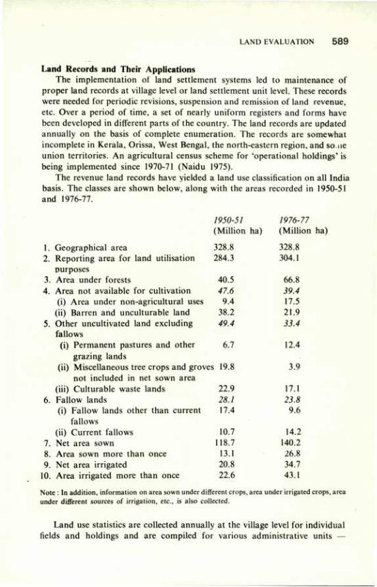
LAND EVALUATION 5 8 9
Land Records and Their Applications The implementation of land settlement systems led to maintenance of
proper land records at village level or land settlement unit level. These records were needed for periodic revisions, suspension and remission of land revenue, etc. Over a period of time, a set of nearly uniform registers and forms have been developed in different parts of the country. The land records are updated annually on the basis of complete enumeration. The records are somewhat incomplete in Kerala, Orissa, West Bengal, the north-eastern region, and so ne union territories. An agricultural census scheme for 'operational holdings' is being implemented since 1970-71 (Naidu 1975).
The revenue land records have yielded a land use classification on all India basis. The classes are shown below, along with the areas recorded in 1950-51 and 1976-77.
1. Geographical area 2. Reporting area for land utilisation
purposes 3. Area under forests 4. Area not available for cultivation
(i) Area under non-agricultural uses (ii) Barren and unculturable land
5. Other uncultivated land excluding fallows
(i) Permanent pastures and other 6.7 12.4 grazing lands
(ii) Miscellaneous tree crops and groves 19.8 3.9 not included in net sown area
(iii) Culturable waste lands 6. Fallow lands
(i) Fallow lands other than current fallows
(ii) Current fallows 7. Net area sown 8. Area sown more than once 9. Net area irrigated
10. Area irrigated more than once
Note : In addition, information on area sown under different crops, area under irrigated crops, area under different sources of irrigation, etc., is also collected.
1950-51 1976-77 (Million ha) (Million ha)
328.8 328.8 284.3 304.1
40.5 66.8 47.6 39.4
9.4 17.5 38.2 21.9 49.4 33.4
22.9 17.1 28.1 23.8 17.4 9.6
10.7 14.2 18.7 140.2 13.1 26.8 20.8 34.7 22.6 43.1
Land use statistics are collected annually at the village level for individual fields and holdings and are compiled for various administrative units —
590 REVIEW OF SOIL RESEARCH IN INDIA
'patwar', subdivision, police station, tehsil/taluka, district, state, and the country as a whole. India enjoys a unique position in regard to the availability of such a valuable storehouse of basic data on land use. This information is extensively used for studying trends in the land use changes, yield estimations, adequacy and inadequacy of production for the specific needs, damage to production due to natural calamities, and a variety of other purposes. The data are used for planning agricultural development programmes, and they provide bench-mark statistics for monitoring and evaluation. The "annawarf system of land rating was effectively used for determining the proportionate quantum of lands to be exchanged for the consolidation of holdings, which was taken up as a land reform measure after independence in 1947.
Bali (1970b) used the following land use statistics for grading the districts of India for their development potential:
1. Per cent net sown area (of geographical or reporting area) 2. Per cent area sown more than once (of net sown area) 3. Per cent net irrigated area (of net sown area) 4. Per cent area irrigated more than once (of net irrigated area) Weightage of 4, 3, 2, 1 and 0 was assigned respectively to the categories of
more than 50, 30-50, 10-30, 1-10 and less than 1 per cent. The development potential was directly related to the sum of marks — the higher the marks, the better the development potential. This simple technique could be used for grading an individual village or an administrative unit with respect to its development status and potential.
The 1959 Committee on Wasteland Survey and Reclamation was able to locate about 0.5 m ha of culturable waste lands in blocks of more than 100 ha in 13 states by making use of the land records and field checks (Anon. 1960). Later, under the scheme on survey and categorisation of wastelands started in 1962-63 the culturable wastelands to the extent of about 2.2 m ha in blocks of less than 100 ha were located in 15 states. Extensive use of land records was made under this scheme also.
Tamhane and Bali (1972) analysed land use statistics to locate the extensiveness of "fallow lands other than current fallows", to study the causes of their being cultivated only once in 2-5 years and to suggest measures to improve their cropping efficiency. It was observed that such lands decreased from 6 per cent of the reporting area in 1950-51 to 3 per cent in 1964-65. Further, nearly nine-tenths of the total fallow land other than current fallows was found in eight states only. In these states, 65 districts having more than 0.1 m ha of such lands accounted for nearly two-thirds of the total area.
Extensive literature on characterisation and evaluation of saline and alkali soils has accumulated in the last 40 to 50 years. With the establishment of the Central Soil Salinity Research Institute, at Karnal in 1969, techniques have been developed for reclamation of alkali soils (Anon. 1979). Nearly 0.1 m ha of alkali soils had been reclaimed up to 1980. Available land use statistics proved handy in locating alkali soils for reclamation.
LAND EVALUATION 591
Surveys and Interpretations for Land Evaluation For reliable land evaluation and rating, sound knowledge of basic soil and
land characteristics is essential. Pragmatic and purposeful interpretations of the basic data are also essential for developing classification systems for specific needs in addition to those for revenue purposes. Methods for high, medium and low intensity soil and land use surveys are available. They are being constantly improved for their technical quality and efficiency with the advent of new technologies such as aerial photo interpretation, remote-sensing data, and visual, machine and computer analysis. The establishment of an Earth Station in India for direct reception of LANDSAT and other satellite data, and the launching of our own earth resources satellite in the near future, offer tremendous opportunities for survey and monitoring of land use and land degradation for more effective land evaluation programmes. Review of such surveys is beyond the scope of this paper. However, the development of criteria and of classifications for land evaluation for different purposes is briefly reviewed.
Land Capability Classification The 'eight-class' land capability classification (LCC) developed by the
United States Department of Agriculture (USDA) has been used, with or without modifications, in many countries. The details of criteria and assumptions used in the system are well known. The classification is based upon increasing intensity of limitations and hazards in sustained land use; it groups the soil mapping units on the basis of their capabilities to produce common cultivated crops, pasture and forest vegetation without deterioration. The classification is somewhat biased towards soil conservation and is a rather generalised type of classification.
In India, the USDA land capability classification was adopted during the 1950s. The All India Soil and Land Use Survey (AISLUS), a central soil survey organisation, and many state soil survey organisations and other agencies include LCC in their soil survey reports. Guidelines for LCC have been elaborated in the Soil Survey Manual (Anon. 1970). The AISLUS now interprets the soil survey data up to "land capability units" which are somewhat akin to the land management units. However, it has been felt that the LCC does not meet the requirements of land evaluation for all purposes. Further, making the criteria uniform for grouping soils into LCC hinders in its application to widely varying landscapes in the country. Realising its shortcomings, modifications in the system and new approaches to meet specific requirements have been suggested.
Tejwani and Dhruvanarayana (1961) and Tejwani (1974) suggested modifications in the LCC for application to gullied and ravine lands. The important factors introduced were morphometry of the ravines, slope gradients, and distance of table and marginal lands from the gully head. Tejwani (1976) suggested specific limits of slopes for different land capability classes for
5 9 2 REVIEW OF SOIL RESEARCH IN INDIA
alluvial, black, red and deep red soils of the Eastern and Western Ghats and for the Himalayan region. Khybri (1979) pointed out that for developing LCC for steeper slopes in the Himalayan region, soil depth and slopes need to be considered in combination so as to indicate the potential for terracing for cultivation and horticultural development. A new parameter of soil: stone ratio was also introduced.
Land Suitability Classifications Land suitability is defined as the fitness of a given type of land fora specific
purpose (Anon. 1976). It is being increasingly realised that the purpose-specific and area-specific interpretations of basic soil and land characteristics are needed to properly evaluate the suitability of land for a variety of demands that are being made on it. This has prompted various workers to develop specific land suitability classifications. The "framework for land evaluation" (Anon. 1976) recommended this concept of land suitability.
Suitability for Irrigation Development of irrigation is essential for obtaining increased and assured
agricultural production and for bringing new areas under the plough. Evaluation of the lands of command area helps in their development and in making optimum use of the valuable irrigation water. Therefore, numerous attempts have been made to work out an irrigation-suitability classification.
Tamboli and Bali (1958) followed the general criteria laid down by the Central Water and Power Commission, with slight modifications, for soil irrigability classification in Chambal command area in Madhya Pradesh. The characteristics used were clay per cent, total soluble salts and pH, and also calcium carbonate content to some extent. Mehta et al. (1958) and Mehta and Shankaranarayana (1961) developed a numerical rating system with a total of 100 marks made up by 20 marks for soil texture, 20 for permeability, 25 for total soluble salts, 15 for pH, and 10 each for exchangeable sodium and non-capillary porosity. The soil profiles were grouped into irrigation suitability class I with more than 85 marks, class II with 76-85 marks, class III with 66-75 marks, and class IV having less than 66 marks. The method was first used in Chambal command area in Rajasthan and was later extended to Jawai project
Misra (1967) suggested characteristics such as texture, permeability, pH, total soluble salts, exchangeable sodium, and water-table during spring for pre-irrigation soil surveys in Orissa. Seth and Talati (1968) suggested another numerical rating method with a total of 1000 marks using eight characteristics, viz. texture, colour, structure, permeability, consistency, effervescence with HC1, salinity, and pH. In all the numerical systems, proportionate marks were allotted to characteristics of surface, subsurface and substratum layers of the profile. Dastane and Saraf (1966) proposed a rating index for irrigation suitability calculated by multiplying together the points assigned to characteristics such as permeability, depth to water-table, water-
LAND EVALUATION 5 9 3
holding capacity, soluble salts, and exchangeable sodium per cent. The multiplication helps to enhance the effect of the limiting factors.
In 1969, at a workshop organised by the Ministry of Agriculture, specific criteria for soil and land irrigability were developed and were later incorporated in the Soil Survey Manual (Anon. 1970). The workshop suggested six soil irrigability classes based on quantified limits of inherent soil characteristics, viz. effective soil depth, texture of surface 30 cm, permeability, available water-holding capacity, coarse fragments, gravels and kankars, rock outcrops, salinity, alkalinity, subsoil and substrata drainage, and soil erosion status. Under land irrigability classification six classes were defined by using land characters such as soil irrigability class, slope, surface grading, surface and subsurface drainage outlets, and the depth of groundwater-table.
To facilitate the use of irrigation suitability classification of land available for irrigation in the command area development programmes, detailed guidelines were prepared by the Ministry of Agriculture (Rege et al. 1974); later these were printed by the Agricultural Refinance and Development Corporation.
Other Land Evaluation Attempts For proper utilisation of culturable wastelands Singh and Bali (1972)
outlined a method of survey based on soil profile studies and related site, climate, water-availability and ownership status inventories. They also suggested a wasteland reclamability classification based on increasing limitations to reclamation.
Bali and Karate (1977a) suggested reclamation suitability grouping of ravines, particularly for cultivation. They developed five classes on the basis of quantified limits of characteristics such as depth of gully, width of gully, bed slope, frequency of gullies (length in metres/ha), texture within one metre depth, depth of occurrence of calcareous layer, hard pan, bedrock, salinity, alkalinity, depth of lithic or paralithic contact, and groundwater-table.
Rice is an important crop and is grown under semi-aquatic conditions. The AISLUS includes a rice soil grouping (Anon. 1978) in its reports. The soil mapping units are grouped into rice suitability classes using attributes such as texture, depth, salinity, puddling quality, permeability and slope gradient. Mahapatra (1979) compiled a field key to aid soil and land capability classification in which criteria and classes were suggested for suitability of land for reclamation, for growing cashewnut, coffee or sisal, and for land consolidation purposes. The compilation also deals with the land capability classification and irrigation suitability.
For minimising siltation rate of the costly multipurpose reservoirs, soil conservation measures need to be taken in the priority areas/watersheds yielding maximum silt load. Bali and Karale (1977b) suggested a method to determine the sediment yield index of small watersheds. It consists of field surveys and developing composite erosion intensity mapping units based on
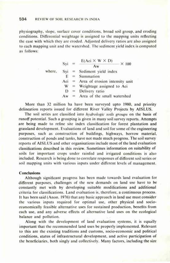
5 9 4 REVIEW OF SOIL RESEARCH IN INDIA
physiography, slope, surface cover conditions, broad soil group, and eroding conditions. Differential weightage is assigned to the mapping units reflecting the ease with which they are eroded. Adjusted delivery ratios are also assigned to each mapping unit and the watershed. The sediment yield index is computed as follows:
Syi
where, Syi E
Aei W D
Aw
More than 32 million ha have been surveyed upto 1980, and priority delineation reports issued for different River Valley Projects by A1SLUS.
The soil series are classified into hydrologie soils groups on the basis of runoff potential. Such a grouping is given in many soil survey reports. Attempts are being made to refine site index classification for forest plantation and grassland development. Evaluations of land and soil for some of the engineering purposes, such as construction of buildings, highways, borrow material, construction of ponds and tanks, have not made much progress. The soil survey reports of AISLUS and other organisations include most of the land evaluation classifications described in this review. Sometimes information on suitability of soils for important crops under rainfed and irrigated conditions is also included. Research is being done to correlate responses of different soil series or soil mapping units with various inputs under different levels of management.
Conclusions Although significant progress has been made towards land evaluation for
different purposes, challenges of the new demands on land use have to be constantly met with by developing suitable modifications and additional criteria for classifications. Land evaluation is, therefore, a continuous process. It has been said (Anon. 1976) that any basic approach in land use must consider the various inputs required for optimal use, other physical and socio-economically feasible alternative uses for sustained production, benefits from each use, and any adverse effects of alternative land uses on the ecological balance and pollution. , .•
Along with the development of land evaluation systems, it is equally important that the recommended land uses be properly implemented. Relevant to this are the existing traditions and customs, socio-economic and political conditions, status of infrastructural development, and active participation of the beneficiaries, both singly and collectively. Many factors, including the size
E(Aei X W X D)
Sediment yield index Summation Area of erosion intensity unit Weightage assigned to Aei Delivery ratio Area of the small watershed
LAND EVALUATION 5 9 5
of land holdings, their fragmentation, ownership pattern of ravine lands, extent of land holdings in alkali land reclamation, rights of local people in areas to be developed for afforestation and grasslands, existing land use pattern where a change in land use is warranted, need to be dealt with for proper implementation of land evaluation.
References
Anon. (1908) District Gazetteer, Yeotmal District. Anon. (1953) Settlement Rules, Revenue Survey Department (Southern Maharashtra country)
Bombay. Anon. (1960) Report on location and utilisation of wastelands in India Parts I to XII, Wasteland
Survey and Reclamation Committee, Ministry of Food, Agri. C D . and Cooperation, New Delhi.
Anon. (1970) Soil Survey Manual, All India Soil and Land Use Survey, Indian Agricultural Research Institute. New Delhi, p. 57.
Anon. (1976) F.A.O. Soils Bull. 32, Rome, p. 72. Anon. (1978) All India Soil and Land Use Survey, Report No. AGRI 432, Dep. Agric. New Delhi. Anon. (1979) A decade of research. Central Soil Salinity Res. Inst.,Karnal. Baden-Powell, B.H. (1892) The land systems of British India, Vol. I, Clarendon Press, Oxford. Bali, Y.P. (1970a) Proc. Seminar on Soil and Water Cons., Institution of Agricultural
Technologists. Dharwar. 1. Bali, Y.P. (1970b) Development potential of districts based on present land use. Unpublished
Departmental Studies under Resources Inventory Centre, Ministry of Agriculture, New Delhi. Bali, Y.P. and Karale, R.L. (1977a) Soil Cons. Digest 5. 40 Bali. Y.P. and Karale, R.L. (1977b) Proc. Paris Symp. IASH AISH Publ. No. 122. Dastane, N.G. and Saraf, C.S. (1966) Proc. 6th irrigation practices seminar. Near East and
South Asia Region, Jordan. Jain, S.V., Moghe, V.B. and Lodha, B.K. (1980) Res. Monogr. 3. Soil Survey Organisation,
Dep. Agri., Rajasthan, p. 43. Khybri, M.L. (1979) Ind. J. Soil Cons. 7, 54. Mahapatra, G. (1979) Field key to aid soil and land capability classifications. Shakti Art Printers,
Cuttack Mehta, K.M.. Mathur, C M . and Shankaranarayana, H.S. (1958) J. Indian Soc. Soil Sci. 6, 125. Mehta. K.M. and Shankaranarayana, H.S. (1961) J. Indian Soc. Soil Sci. 9, 71. Misra, D.P. (1967) J. Soil and Water Cons. India 15, 50. Nanda, S.S K. and Bastia, R.K. (1980) 45th Annual Convention of Indian Soc. Soil Sci., Karnal. Naidu, I.J. (1975) All India report on agricultural census 1970-71, Ministry of Agric. and lrrig..
New Delhi. Raychaudhuri, S.P. (1958) Indian Counc. agric. Res., Review Ser. No. 4. Rege, N.D.. Bali, r'.P. and Karale, R.L. (1974) Soil and land characteristics—Their interpretation
for irrigability classification. Soil Cons. Div.. Dept. Agri., New Delhi. Sahu, D.K., Benura, R.C., Misra, A.K.. and Panda, J. (1979) A suggested procedure for
valuation of land in command areas of major ' irrigation projects for consolidation purposes (Unpublished).
Seth, S.P. and Talati, N.R. (1968) J. Indian Soc. Soil Sci. 16, 277. Singh. Gurmel and Bali. Y.P. (1972) Proc. Symposium. National Inst, of Sciences of India,
1968 Bull. 44.
5 9 6 REVIEW Ol SOIL RESEARCH IN INDIA
Tamboli, P.M. and Bali, Y.P. (1957) Gwalior College of Agric. .1. I, 23. Tamboli, P.M. and Bali, Y.P. (1958). J. Vikram Univ. 2, 169. Tamhane, R.V. and Bali, Y.P. (1972) Proc. Symposium, National Inst, of Sciences of India, 1968
Bull. 44. Tejwani, K.G. and Dhruvanarayana, V.V. (1961) J. Indian Soc. Soil Sci. 9, 233. Tejwani, K.G. (1974) Soil Cons. Digest 2, 24. Tejwani, K.G. (1976) Soil Cons. Digest 4, I.
Acid Soils and their Management B.R. TRIPATHI ' , R.N. PRASAD2 AND S.K. BISHNOI1
ACID soils contain relatively high amounts of exchangeable aluminium and hydrogen. Conventionally, acid soils have been defined in terms of soil pH and per cent base saturation. Coleman and Thomas (1967) put forward two definitions for an acid soil. One states that the pH is below 7, the other that the propotion of cation exchange capacity countered by basic metal cation is below 1, Murthy et al. (1976) defined acid soils as those having low pH and responding to the application of lime. The USDA (1970) used the pH of 5.5 of 1:1 soil-water suspension as a criterion to classify a soil family as acid or non-acid. However, in view of the complicated relationship between soil pH and base saturation, and exchangeable Al-,+ and H\ defining acid soils in terms of a definite soil pH may not be very accurate.
The Extent Acid soils are characteristic of high rainfall areas all over the world. The
mean annual temperature, type of vegetation, parent material, hydrologie conditions, etc., also govern the extent and intensity of acid soils. These soils occupy a considerable area in India. Out of the total cultivated area of 157 million hectares, about 49 m ha are considered acidic; 26 m ha have soil pH below 5.6 and about 23 m ha between 5.6 and 6.5 (Bhumbla et al. 1971). Among many reports on distribution, characterisation, and management of acid soils of India are a few recent reviews, e.g. Anon. (1971 a, b), Mandal et al. (1975) and Anon. (1976).
Acid soils occur in association with non-acid soils in almost all the major soil groups except black cotton soils. The major processes involved in the formation of acid soils are laterisation of varying degrees, podzolisation in areas with subtemperate to temperate climate, intense leaching of light alluvial soils, and marshy conditions with significant amount of partly decomposed organic matter (Mandal et al. 1975). The largest area is covered by laterites and various latosolic soils. This group of soils occurs extensively in Assam. West Bengal, Bihar, Orissa, Andhra Pradesh, Kerala, Madhya Pradesh, Karnataka, Maharashtra and Tamil Nadu. Acid podzol soils with varying degrees of podzolisation in association with brown forest soils occupy a considerable area in the Himalayan regions. Large stretches of acid soils of alluvial origin are found in West Bengal, Assam and Bihar. Peaty and marshy soils are found in Assam, Kerala, coastal tracts of Orissa, south-east coast of Tamil Nadu, and
1. H.P. Krishi Vishva Vidyalaya. Palampur; 2: I.C.A.R. Complex. Shillong.
5 9 8 REVIEW OF SOIL RESEARCH IN INDIA
tarai regions ot Uttar Pradesh and Bihar. In Kerala the acid sulphate soils and in Assam the bheel soils are distinct in characteristics and problems.
The distribution of acid soils in various regions was summarised by Mandal et al. (1975).
The Problems The adverse effect of acid soils on plant growth is mainly related to the
presence of aluminium, manganese, and iron in toxic concentrations; low availability of bases; microbial and nutrient imbalances.
Al, Mn and Fe Toxicity. The hydrated Al ion (Al H203 ') is an acid in the general sense. Aluminium toxicity has multiple effects, of which the inhibition of root growth is perhaps the most important. Excess Al interferes with cell division, respiration, DNA synthesis, sugar phosphorylation, and uptake of Ca, P, other nutrients and water, in general, soils having Al saturation above 10 per cent of the effective cation exchange capacity or pH below 5 are suspected to present Al problems. Information on the amounts of different forms of Al in Indian soils is meagre. Thakur et al. (1969) reported the contents of various forms of Al in sedentary and alluvial soils of Bihar. Water-soluble, exchangeable, and extractable Al in sedentary soils (pH 4.8-6.8) ranged 0.0015-0.0126, 0.093-0.291 and 1.488-4.842 me/100 g, respectively. The corresponding figures for alluvial soils (pH 4.4-6.6) were 0.0072-0.0144,0.076-0.270 and 0.975-4.755 me/100 g. Aluminium saturation in sedentary and alluvial soils ranged from 6.0 to 9.0 per cent and from 4.2 to 5.4 per cent of CEC respectively. Thakur et al. concluded that soils with pH below 5.0 in the sedentary group and below 4.5 in the alluvial group contained toxic levels of Al exceeding the limits proposed by Vlamis (1953). Khera and Pradhan (1976) reported the values of exchangeable Al as 0.49 to 3.96 me/100 g in some soils of Sikkim (pH 4.2-5.6). These soils showed low values of exchangeable Al at pH above 5.5. In podzolic soils (pH 4.7-6.1) of north-western India, the range of variation in exchangeable and extractable Al was from 0.028 to 0.811 and from 0.622 to 1.756 me/100 g, respectively, and the Al saturation of the soils having pH below 5.5 ranged from 9.80 to 15.69 per cent (Bishnoi 1979).
Manganese toxicity may show up in soils having pH below 5.0 when excess Mn accumulates in all the tissues of plants and interferes with normal metabolism. Manganese toxicity in rice has been reported in Bahal land of Orissa for soils having pH of 6.5 under reduced conditions (Sahu 1965). The work on the manganese content of Indian soils was reviewed by Kanwar and Randhawa (1974). Biswas (1953) observed that acid soils (pH 4.3-6.9) contained up to 15.6 per cent of the total Mn in water-soluble and exchangeable forms. Randhawa et al. (1961) reported an average of 18.7 ppm exchangeable Mn for acid soils of northern India. They found acid soils to be richer in exchangeable Mn than neutral and alkaline soils. The range of exchangeable and easily reducible Mn contents in acid soils of Assam, sedentary and alluvial acid soils
ACID SOILS AND THEIR MANAGEMENT 5 9 9
of Bihar, and grey brown podzolic acid soils of Himachal Pradesh was reported by Das et al. (1971), Mandal et al. (1975) and Bishnoi (1979), respectively.
The most important factors affecting the Fe content are soil reaction and aeration. Mandal (1962) indicated that waterlogging, resulting in low oxygen status, increased Fe2+ in drainage water and in plants. It is known that the more is the organic matter in the soil, the greater is the change from Fe3+ to Fe2+
Bhumbla (1965) reported that Fe2+ content of soils increased with decreasing pH. Takkar et al. (1976) reported that Fe formed an active component of soil acidity and contributed 17 per cent and 34 per cent of total acidity in soils of Palampur and Dalhousie. Reports on Fe toxicity in acid soils are scanty. Recently, Verma (1979) reported that in acid soils of Himachal Pradesh 30.9 per cent of rice plants showing physiological disorder suffered from Fe toxicity.
Deficiency of Bases. Soil acidity is a complex of a number of factors, among which reduction in the absolute amount of exchangeable bases with decrease in pH resulting in low status of calcium and magnesium in soils is an important factor. In most acid soils, Ca and Mg deficiencies per se are not primary growth-limiting factors except in very sandy and highly leached soils having low CEC values and for crops having higher requirements for these nutrients. Deficiencies of bases may have secondary effects, such as reduced absorption of cations, poor physical conditions and depressed bicrlogical acitivities. Besides, Ca is said to act as a detoxifier for Al. Mandal et al. (1975) presented comprehensive data on exchangeable bases in acid soils in relation to soil pH; the Ca-t-Mg saturation varied from 20.89 to 70.95 per cent and averaged 49.56 per cent. Sharma et al. (1977) studied the Ca status of some Himachal Pradesh soils and reported that soils of warm and wet mountainous zone (pH 5.1 to 6.2) contained, on an average, 1.96 me/100 g exchangeable Ca and fell in low range. Information on Mg status of acid soils in the country is meagre. Reports on the Mg status include those by Sinha and Singh (1966) for acid soils of Bihar and Sharma et al. (1977) for acid soils of Himachal Pradesh. The exchangeable Mg content in the warn; and wet zone of Himachal mountains was low, the average value being 1.04 me/100 g.
Microbial Imbalances. Soil acidity alters the kind, number and activities of microorganisms involved in soil organic matter transformation and subsequent availability of organically bound N, P, S, and also of some micronutrients. Besides, soil reaction affects both symbiotic and non-symbiotic N-fixation. A review of the work on microbial ecology, activities of microorganisms and their relationships with higher plants in acid soils was published by Jha (1976). It was stated that the populations of bacteria and actinomycetes were lower and that of fungi higher in acid soils than in neutral soils (Jha 1965). A complete absence of Azotobacter was noted in acid soils, and nitrifying capacity was found to be very low (De 1954; Mukherjee et al. 1955; Nair and Ramaswami 1965).
Ca deficiency associated with acid soils adversely affects nodule initiation, disturbs the structural integrity of rhizobial cells, and reduces their N-fixing capacity (Tewari 1963). Mo deficiency also affects nodule formation (Atwal and
600 REVIEW OF SOIL RESEARCH IN INDIA
Sidhu "(1964). Excess Al inhibits N-fixation because of reduced root growth and fewer sites for nodule formation. Yadav et al. (1970) reported that rhizobial strains of lucerne were more acid-sensitive (pH 4.5-5.0) than those of black gram, green gram and pea.
Nutrient Imbalances. In addition to excess of soluble Al, Mn and Fe and low amounts of bases, low availability of P and Mo is common in acid soils and requires corrective measures. The effect of soil acidity on K. availability can be different in different soils, but the status of available micronutrients, except Mo, is generally adequate in such soils. Sulphate availability may also be affected at low pH because of fixation of sulphate ion on hydrated oxides and because of reduced sulphur oxidation.
In acid soils, P is subject to rapid fixation, principally by Fe and Al compounds, either by precipitation or by surface chemisorption reaction. Further, excess Al in soil may reduce the uptake and transport of P in plants. The P-fixing capacity of acid soils was studied by Kanwar and Grewal (I960), Gupta (1965) and Chakraborty (1976). The acid soils of Sikkim (pH 4.2-5.6) were found to fix as much as 90 per cent of the applied P (Khera and Pradhan 1976). P-fixing capacity of some acid soils (pH 4.9-6.5) of Himachal Pradesh was found to vary from 4.7 to 18.3 moles/100 g (Sharma 1979). P-deficiency, though common in most soils of the country, is particularly acute in acid soils.
Molybdenum deficiency is common in legumes, crucifers and citrus grown on acid soils. At low pH, Mo is adsorbed by soils and by oxides, and Mo deficiency results. Bhumbla and Dhingra (1964) found that available Mo was higher in alkali soils than in acid soils of Punjab. They observed response to application of Mo in acid soils. Mandal and Jha (1969) reported that the acid soils of Chhotanagpur, Santhal Pargana and Purnea in Bihar were deficient in available Mo (0.13-0.90 ppm). Chakraborti (1972) reported that acid soils of Assam were deficient in Mo.
Management The management of acid soils should aim at realisation of the production
potential either by addition of the amendments to counteract the abnormalities of such soils or to manipulate the agricultural practices to obtain optimum crop yields under the acid conditions. In the latter case the most pertinent practice would be to grow acid-tolerant plant species and varieties. In the USA considerable progress has been made in tailoring the crops to fit acid-soil conditions. But this approach seems to offer only a temporary solution, for the acid conditions may be aggravated by continuous cropping with tolerant crops. For this reason, liming has long been regarded by many as an essential component of good management of acid soils. In the following paragraphs the work on lime requirements, liming materials, and effects of liming on crops and soils is reviewed.
Lime Requirement. A major problem is that of estimating the amount of lime required to counteract the harmful effects of soil acidity. At present, there
ACID SOILS AND THEIR MANAGEMENT 6 0 1
are two main chemical approaches to determine the lime requirements of acid soils: (i) to apply lime to bring a soil to a desired soil pH, preferably between 6.5 and 6.8, and (ii) to add lime to neutralise the exchangeable Al. The proponents of the first approach argue that by liming of acid soils to pH 6.5 and 6.8, most desirable effects result from higher nutrient availability, favourable biological activity, movement of basic cations to lower soil horizons improving the subsoil, and the total inactivation of toxic elements. But liming above the exchangeable Al equivalent can prove detrimental and also uneconomical. In recent years, however, it has been repeatedly observed that raising the pH to neutrality is useful for temperate soils, and addition of lime to neutralise exchangeable Al acidity is useful for tropical soils.
In India, the lime requirement determinations have been mostly based on raising the soil pH to near neutrality. For this, titration, buffer and incubation methods have been used. Puri (1949) estimated lime requirement of acid soils of Punjab by titrating samples of the soils with standard base and found this method suitable. Mandal and Mukherjee (1952) also used the titration method for determining lime requirement of acid soils of Islampur in Bihar and reported that for each unit rise in soil pH, 2.47 tonnes of lime per hectare was required. Sinha et al. (1965) studied the lime requirement of Chhotanagpur acid soils and reported that the lime-water titration method of Dunn (1943) correlated well with lime response. Tamboli and Tulsi (1967) used the Ca(OH)2
titration method to determine lime requirement of silty clay loam soils of Bastar district of Madhya Pradesh. But Bhumbla and Nijhawan (1965) found exchangeable cations data more dependable than the titration method for determining the lime requirement of acid soils of Kangra and Kulu districts of Himachal Pradesh. They further suggested that raising the exchangeable Ca of the soils to 58 or reducing the exchangeable Al to 22 per cent of the CEC gave good estimation of lime requirement of the soils. Bhaumik and Asthana (1969) reported that CaC03 incubation gave a better indication of lime needs than did titration curves.
Solankey (1965) compared several lime requirement methods for acid soils of Madhya Pradesh and reported that Pratt and Bair's (1961) buffer method and Puri's (1949) titration method of moist-incubation with CaC03 gave comparable results. Singh and Dutta (1976) found the buffer method of Adams and Evans (1962) and the exchangeable hydrogen method of Shaw and Mclntyre (1951) suitable for determining lime requirement of acid soils of Bangalore, Nanjanad, Ootacamund, Agartala and Ranchi. Bishnoi (1979) reported that the methods of Woodruff (1948) and Shoemaker el al. (1961) overestimated, and the methods of Jackson (1958) and Adams and Evans (1962) underestimated the lime requirement of acid soils of Himachal Pradesh.
Lime requirement values can be calibrated with soil pH, texture, organic matter, nature of clay and hydrous oxides for a homogeneous geographical area. On this principle, Kanwar and Bhumbla (1959) suggested a ready reckoner for quick appraisal of lime requirement of acid soils of Punjab and
6 0 2 REVIEW OF SOIL RESEARCH IN INDIA
Mandal et al. (1975) for red loam soils of Bihar, taking into consideration the pH and texture of the soils.
The second approach of liming based on the addition of lime to neutralise the exchange acidity or exchangeable Al was found suitable by Balasundaram (1970) for Madras soils, by Pradhan and Khera (1976) for Sikkim soils, and by Dadhwal and Prasad (1979) for Meghalaya soils. On the contrary, Bishnoi (1979) reported that exchangeable acidity underestimated the lime requirement of acid soils of Himachal Pradesh. Both the approaches of estimating lime requirement gave theoretical values and did not estimate actual field lime requirement because of the variations in soil factors and in the nature and size of the liming material. Consequently, a liming factor is used to calculate the actual quantities of lime needed. Pradhan and Khera (1976) recommended a lime factor of 1.5 to 2.0 for lime requirement values based on exchangeable Al for Sikkim soils.
Liming Material. An agricultural liming material is defined as the substance whose Ca and Mg compounds are capable of neutralising soil acidity. In this definition, the primary effect of liming is mediated through provision of adequate Ca and Mg, but the main value of liming material lies in its capacity to provide hydroxyl ions which neutralise the soil acidity and raise the soil pH. A number of liming materials have been tested on acid soils of India. Mandal and Jha (1970a) reported the results of a field experiment conducted at Ranchi in which the effect of natural limestone of different origin, precipitated CaCOj from Sindri fertiliser factory, dolomitic limestone and cement waste was tested. It was found that all the liming materials were equally good in increasing the crop yield. Abraham and Kathuria (1967) also reported that on kari soils of Kerala, lime in any form, e.g. raw lime, fully burnt lime, and half-burnt lime, could be adopted with necessary dose adjustment. Basic slag was reported a suitable liming material on acid soils of Bastar in Madhya Pradesh (Tamboli and Tulsi 1967), Ranchi in Bihar (Mandal and Jha 1970b), and Palampur in Himachal Pradesh (Motsara and Datta 1976). Panda (1967) reported the usefulness of paper mill sludge as liming material in acid lateritic sandy loam soils of Bhubaneswar.
The factors that affect the action of any liming material in soils are particle size, neutralising value, physical properties and Mg content. Not much work has been done on these parameters of liming materials in India with the exception of a few reports on fineness. Mandal and Jha (1969) reported that particle size of limestone powder need not be so fine as 80 to 100 mesh but definitely fine enough to pass through 10-20 mesh.
The effectiveness of a liming material will also depend on the method of its application in the soil. For this, the general recommendation is for thorough mixing of liming material so that the soil and lime particles are in intimate contact. Contrary to this, under the no-tillage method of crop production, it is suggested that liming material be applied only to soil surface and allowed to leach down.
ACID SOILS AND THEIR MANAGEMENT 6 0 3
Effect of Liming on Crop and Soil. There have been only a few field investigations on crop responses to liming. Mandal et al. (1955) reported the results of an experiment conducted on the alluvial soil of lslampur (pH 4.8) with varying doses of lime calculated by Dunn's (1943) method and stated that maize and wheat responded significantly to lime application, but paddy showed no response. Mandal e! al. (1966) summarised the results of the experiments conducted from 1958 to 1961 on red loam soils of Ranchi, representing the main acid soil belt of Bihar, and divided the upland crops in respect of lime response into three groups, viz. highly responsive — pigeon pea, soybean and cotton; moderately responsive - gram, lentil, pea, groundnut, maize and sorghum; and slightly responsive barley, small millet, paddy, mustard and linseed. Barley, which is regarded as a sensitive crop to soil acidity, was found to give low response to liming. Unlike barley, wheat crop was found to respond significantly to lime application in 1964-65 and 1966-67 on red loam soils of Ranchi (Mandal and Jha 1970a), the yield increases being 66.3 and 29.7 per cent in two years. The response to liming declined markedly when lime was applied along with N and P fertilisers. In another study on the effect of lime in combination with phosphate and seed inoculation of green manure crop on the succeeding wheat crop, Mandal et al. (1975) reported an increase in wheat yield by 92.7 per cent on application of lime alone and 193.7 per cent on application of lime with phosphate.
About 90 per cent of the area under cultivation in Orissa is under rice. The results of early investigations on liming at Central Rice Research Institute. Cuttack, showed that lime applied to soil up to 100 kg ha was not beneficial. Contrary to this, paddy yield increased by 25 per cent on application of 2.0 tonnes of lime to Mahanadi alluvium (Abichandani and Patnaik 1961) and by 73.7 per cent on application of 1.2 tonnes of lime to loamy sand latosols of Bhubaneswar (Sahu 1968). In Assam, significant response to lime application was reported for black gram and mustard (Barua 1964) and rice (Roy 1967; Anon. 1974) on alluvial soils and for jute (Anon. 1975) and red loam soils. In West Bengal, wheat crop showed significant response to lime application on lateritic soils of Kharagpur in 1970-71 and 1978-79.
Govindarajan and Narayanan (1957) found appreciable response to liming of paddy even at moderate doses (500 kg ha) on upland red loamy soils (pH below 5.0) of Mysore district. Subramaniam and Varadarajan (1957) reported the results of liming acid soils in Pannampet and Shimoga districts and stated that paddy yield increased by 10 to 35 per cent on application of 2.5 tonnes lime ha. The results of liming on lateritic soils of Mangalore were reported by Govindarajan and Venkata Rao (1976) and Mandal el al. (1975). The former team reported 20 per cent increase in the yield of paddy with slaked lime applied annually at 2 to 3 tonnes ha. The latter team reported no significant response to lime applied up to 3.36 tonnes ha. The beneficial effects of liming on sunnhemp (Venkata Rao and Govindarajan 1954, 1960; Venkata Rao and Badanur 1972) and groundnut (Mandal el al. 1975) were observed on
6 0 4 REVIEW OF SOIL RESEARCH IN INDIA
red loam soils and at Bangalore. The literature on liming of acid soils of Tamil Nadu was reviewed by Krishnamoorthy et al. (1976) who concluded that acid soils of Tamil Nadu generally responded favourably to liming.
Kanwar and Joshi (1964) reported that wheat, maize and potatoes responded to lime application on grey brown podzolic soils of Palampur; in the presence of fertilisers, however, the response was less. The results of the experiments on liming conducted under the Model Agronomic Experiments scheme at Palampur from 1972 to 1975 showed significant responses to liming in wheat but not in soybean. The beneficial effect of liming was reduced when P and K fertilisers were applied along with lime.
The favourable effect of liming on soil properties was reported by a number of workers. Lime application in proper doses was said to increase soil pH, Ca saturation, and uptake and utilisation of Ca by plants on acid soils in several regions (Kothandaraman and Mariakulandai 1965; Mandal et al. 1966; Patnaik et al. 1968; Khind et al. 1970). There are only a few reports on effect of liming on Mg saturation and availability. Sinha and Singh (1966) reported reduced availability of Mg to soybean and maize, on application of calcitic limestone to acid soils of Kanke in Bihar. Liming reduced the solubility of Al on acid lateritic soils of West Bengal (Tripathi and Pandey 1971), soluble, exchangeable and reducible Mn in lateritic soils of Bihar (Banerjee and Sinha 1966), and extractable Fe in grey-brown podzolic soils of Himachal Pradesh (Verma 1979). Dube (1969), working on acid soils of Ranchi, however, reported that liming at pH 6.3 to 7.4 had no effect on Mn availability.
Among major fertility elements, lime application showed favourable effect on N availability (Abichandani and Patnaik 1961; Sahu 1965), P availability in soils and plants (Mandal et al. 1966; Roy 1967; Biddappa and Venkata Rao 1972), and inhibitory effect on P-fixation (Mariakulandai et al. 1955). Liming did not affect K availability in Assam soils (Roy 1967), and in Madhya Pradesh a greater availability of K was reported (Motiramani 1967).
Effect of liming on zinc and copper availability in soils varied with the nature of soils, but in a majority of cases liming decreased the availability of both nutrients (Sharma 1965; Motiramani 1967). The effect of liming of acid soils on Mo availability has been mostly favourable (Verma and Jha 1970; Tewari 1967). Phosphate application to limed soils was found to increase Mo availability (Tripathi and Pande 1971).
Liming generally improves the microbial activities of acid soils. Mandal (1976) reported that liming increased the population of bacteria from 1.6 to 6.6 million/gand that of actinomycetes from 1.0 to 2.5 million/g, but decreased the fungal population from 253,000 to 73,000/g.
Conclusions Extent, characterisation, nutritional problems and amelioration of acid
soils have been investigated. But information is scanty in respect of soil pH and base saturation relationship, iron and aluminium toxicity and availability of
ACID SOILS AND THEIR MANAGEMENT 6 0 5
nutrients particularly phosphorus, sulphur and molybdenum. Lime requirement of different acid soils needs to be rationalised considering soil pH and cationic composition, neutralising ability of liming material and crop nutrition.
References
Anon. (1971a) Soil and water research in India in retrospect and prospect (A review) Tech. Bull. (Agric.) No. 22, Indian Council of Agricultural Research. New Delhi.
Anon. (1971b) Review of soil research in India. International Symposium on soil fertility evaluation. New Delhi.
Anon. (1974) ICAR Coordinated Agronomic Research Project Annual Report 1973-74. Anon. (1975) ICAR Coordinated Agronomic Research Project Annual Report 1974-75. Anon. (1976) Acid Soils of India Their Genesis, Characteristics and Management. Bull.
Indian Soc. Sci. 11. Abichandani, C. and Patnaik, S. (1961) J. Indian Soc. Soil Sci. 9. 55. Abraham. T.A. and Kathuria, O P . (1967) Pert. News 12, 9. Adams, F. and Evans, C.E. (1962) Proc. Soil Sci. Soc. Am. 26, 355. Atwal, A.S. and Sidhu, G.S. (1964) Indian J. agric. Sci. 34, 139. Balasundaram, C.S. (1970) Madras agric. J. 57, 364. Banerjee. P K. and Sinha, H. (1966) Ranchi Univ. J. agric. Sci. 193. Barua. J.N. (1964) Bull. natn. Inst. Sci. India 26, 135. Bhaumik. H.D. and Asthana. A.K. (1969) J. Indian Soc. Soil Sci. 17, 275. Bhumbla, D.R. (1965) Ann. Rep. Soils Dep., Punjab Agricultural University, I.udhiana. Bhumbla, D.R. and Dhingra, D.R. (1964) J. Indian Soc. Soil Sci. 12. 255. Bhumbla. DR., Mandal, S.C., Tejwani.K.G. and Abrol. l.P. (1971) Soil technology. In Review of
soil research in India. Ed. Kanwar. J.S. and Raychaudhuri, S.P., International Symposium on Soil Fertility Evaluation, p. 137.
Bidappa, C.C. and Venkata Rao, B.V. (1972) Mysore J. agric. Sci. 6. 219. Bishnoi, S.K. (1979) Ph.D. Thesis, Himachal Pradesh Krishi Vishva Vidyalaya. Palampur. Biswas, T.D. (1953) J. Indian Soc. Soil Sci. I. 21. Chakraborty. S.K. (1972) Ph.D. Thesis, Ranchi Univ. Chakraborty, S.K. (1976) Bull. Indian Soc. Soil Sci. II, 214. Coleman, NT. and Thomas, G.W. (1967) The basic chemistry of soil acidity and liming. Ed.
Pearson, R.W. and Adams. F. Agronomy Monogr. No. 12, I. Coleman, NT., Weed, S.B. and McCracken, R.J. (1959) Proc. Soil Sci. Soc. Am. 23, 146. Dadhwal. K.S. and Prasad. R.N. (1979) Symposium on increasing productivity of acid soils in the
eastern region. Fertilizer Association of India. New Delhi. Das, M.C., Bora, P.K.. Sharma, S.C. and Sharma, K.C. (1971) Fert. News 16, 42. De, P.K. (1954) Ann. Rep. Scheme Res. A/otobactor, West Bengal. Dunn, L.E. (1943) Soil Sci. 54, 341. Dube, R.R. (1969) M.Sc. Thesis, Ranchi Univ. Govindarajan, S.V. and Narayanan, H.T. (1957) Bull. natn. Inst. Sci. India 3, 74. Govindarajan, S.V. and Venkata Rao, B.V. (1976) Bull. Indian Soc. Soil Sci. II. 38. Gupta, A.P. (1965) Agra Univ. J. Res. 14. 191. Jackson, M.L. (I95S) Soil Chemical Analysis. Prentice-Hall Inc. Englewood Cliffs, N.J. Jha. K.K. (1965) Indian J. Microbiol. 5, 89, Jha, K.K. (1976) Bull. Indian Soc. Soil Sci. II. 89. Kanwar J.S. and Bhumbla, D.R. (1959) Indian Fmg. 9(2), 27.
6 0 6 REVIEW OF SOIL RESEARCH IN INDIA
Kanwar, J.S. and Grewal, J.S. (I960) J. Indian Soc. Soil Sci. 8. 211. Kanwar, J.S. and Joshi. M.D. (1964) Res. Bull., Punjab Agricultural University, Ludhiana. Kanwar, J.S. and Randhawa, N.S. (1974) Micronutrient research in soil and plants in India. Indian
Council of Agricultural Research, New Delhi. Khera, M.S. and Pradhan. H.R. (1976) Bull. Indian Soc. Soil Sci. II, 224. Khind, C.S., Datta, N.P. and Khanna, P.K. (1970) Proc. Symp. Radiation and Radioisotopes in
Soil Studies and Plant Nutrition, Bangalore. Kothandaraman, G.V. and Mariakulandai, A. (1965) Madras agric. J. 52, 39. Krishnamoorthy, K.K.. Mahalingam, P.K. and Kothandaraman (1976) Bull. Indian Soc. Soil
Sci. II. 54. Mandal, S.C. (1962) J. Ranchi agric. Coll. and Res. Inst. 2, 39. Mandal, S.C. (1976) Bull. Indian Soc. Soil Sci. 11, 191. Mandal, S.C. Das, S.K. and Mukherjee, H.N. (1955) J. Indian Soc. Soil Sci. 3, 71. Mandal. S.C. and Jha, K.K. (1969) Tech. Bull. No. 1 Agric. Res. Inst. Kanke. Ranchi. Bihar. Mandal. S.C. and Jha, K.K. (1970a) J. Ranchi agric. Coll. 2. 39. Mandal. S.C. and Jha. K.K. (1970b) Tech. Bull. No. 5 Res. Inst. Kanke, Ranchi, Bihar. Mandal, S.C. and Mukherjee, H.N. (1952) Proc. Indian Sci. Congr. Pt. Ill (Absts). Mandal, S.C, Sinha, H., Prasad, C.R. and Ali. M.A. (1966) J. Indian Soc. Soil Sci. 14, 127. Mandal. S.C, Sinha M.K. and Sinha, H. (1975) Acid Soils of India and Liming. Tech. Bull. No. 51,
Indian Council of Agricultural Research, New Delhi. Mariakulandai, A., Venkatachalam and Iyenger, R. (1955) J. Indian Soc. Soil Sci. 3. 15. Motiramani. D.P. (1967) A Review Soil and Water Research in India in Retrospect and Prospect,
Indian Council of Agricultural Research. Bull. 22, New Delhi. Motsara, M.R. and Datta, N.P. (1976) Bull. Indian Soc. Soil Sci. II. Mukherjee, H.N., Jha, K.K., Verma. A.S. and Singh, R. (1955) Proc. Bihar Acad, agric. Sci. 4, 30. Murthy. R.S., Shankaranarayana., H.S. and Hirekerur, L.R. (1976) Bull. Indian Soc. Soil Sci. 1 I,
17. Nair, K.S. and Ramaswami, P.P. (1965) Madras agric. J. 52. 485. Panda, N. (1967) East Zonal Workshop on Soil Sci., Indian Council of Agricultural Research. Pradhan. H.R. and Khera. M.S. (1976) Bull. Indian Soc. Soil Sci. II, 291. Pratt, F.W. and Bair, F.L. (1961) Calif. Agric. 15, 13. Puri, A.N. (1949) Soils- Their Physics and Chemistry. Reinhold Pub. Corp., New York. Randhawa, N.S., Kanwar, J.S. and Nijhawan, S.D. (1961) J. Res. Punjab Agricultural University,
92, 106. Roy, H.K. (1967) M.Sc. Thesis, Ranchi University. Sablkar, A.K. (1970) M.Sc. (Agric.) Thesis. Cited in Bull. Indian Soc. Soil Sci. II, 47. Sahu, B.N. (1965) J. Indian Soc. Soil Sci 13, 241. Sahu, B.N. (1968) Fert. News 13, 21. Sharma, P.K. (1979) Ph.D. Thesis, Himachal Pradesh Krishi Vishva Vidyalaya, Palampur. Sharma, P.K., Kaistha, B.P., Tripathi, B.R. and Gupta, R.D. (1977) Agrochimica 21, 529.
Sharma, P.K., Sud, R.D., Tripathi, B.R., Kaistha, B.P. and Gupta, R.D. (1977) Him. J. agric. Res. 4, 19.
Sharma, R.B. (1965) M.Sc. Thesis. J.N. agric. Univ. Shaw, V.M. and Mclntyre, W.H. (1951) J. Ass. Off. Agric. Chem.. 34, 477. Shoemaker, H.E., McLean, E.O. and Pratt, P.F. (1961) Proc. Soil Sci. Soc. Am. 25, 274. Singh, B.R. and Datta, N.P. (1976) Bull. Indian Soc. Soil Sci. II. Sinha, M.K., Ali, M.A. and Mandal, S.C. (1965) J. Indian agric. 9, 157. Sinha, H. and Singh, S.P. (1966) Ranchi Univ. J. agric. Res. I, 47. Solankey, R.S. (1965) M.Sc. Thesis, J.N. aerie. Univ. Cited in Bull No. 22, Indian Council of
Agricultural Research, New Delhi. Suoramaftiam, CK. and Vaiadarajan, B.S. (1957) Madras agric. J. 44. 6. Takkar, P.N., Arora, B.R. and Bhumbla, D.R. (1976) Bull. Indian Soc. Soil Sci. 11, 157.
ACID SOILS AND I HEIR MANAGEMENT 6 0 7
Tamboli, P.N. and Tulsi, M.J.S. (1967) J. Indian Soc. Soil Sci. 15, 229. Tewari, C.P. (1963) Empire J. exp. Agric. 31, 50. Tewari, S.N. (1967) .1. Inst.. Chem. (India) 39, 283. Thakur. M.S., Sinha, H. and Mandal, S.C. (1969) J. Indian Soc. Soil Sci. 17, 501. Tripathi, R.S. and Pande, H.K. (1971) Proc. Int. Symp. Soil Fertil. Fvaln.,New Delhi. USDA (1970) Soil Taxonomy. Agriculture Handbook No. 436: Venkata Rao, B.V. and Badanur. V.P. (1972) Curr. Res. (UAS Monthly News Letter) I. 50. Venkata Rao, B.V. and Govindarajan, S.V. (1954) Mysore agric. J. 30, 4. Venkata Rao. B.V. and Govindarajan, S.V. (1960) Indian Oil Seed J. 4, 234. Verma. T.S. (1979) Ph.D. Thesis. Himachal Pradesh Krishi Vishva Vidyalaya, Palampur. Verma, K.P. and Jha. K.K. (1970) J. Indian Soc. Soil Sci. 18, 37. Vlamis, J. (1953) Soil Sci. 75, 383. Woodruff, C M . (1948) Soil Sci. 66, 53." Yadav. N.K., Abrol, LP. and Vyas, S.R. (1970) Indian J. agric. Sci. 40, 623.
Soil and Water Conservation Research K.G. TEJWANI AND S.P. BHARDWAJ1
SOIL conservation research in the country started in 1935 when the Indian Council of Agricultural Research decided to establish five regional centres for research on dryland farming at Sholapur and Bijapur in Maharasthra, Hagari and Raichur in Karnataka, and Rohtak in Haryana. The average annual rainfall at these centres varied from 490 mm at Hagari to 702 mm at Sholapur. The work carried out at these stations till 1954 was summarised by Kanitkare/ al. (1960).
In the first five year plan (1951-1956) the need for intensive research for a solution of erosion problems was realised by the Government of India and a chain of Soil Conservation Research, Demonstration and Training Centres was established. Each centre was entrusted with the responsibility of tackling the problems specific to that area. The State Governments also joined hands in soil and water conservation research. The implementation of the soil conservation programmes is the responsibility of the State Governments, who provide the organisation, funds and staff to look after each area of the country. The responsibility of training, research and demonstration has been entrusted to the Central Soil and Water Conservation Research and Training Institute, Dehra Dun (ICAR) along with its regional centres at Chandigarh, Agra, Kota, Bellary, Hyderabad, Vasad and Ootacamund, which represent various soil and agro-climate zones of the country posing different types of soil conservation problems.
Soil and water conservation research in India was reviewed by Bhumbla et al. (1971). The aim of this paper is to present on upto-date review.
Extent and Types of Erosion The estimates of the National Commission on Agriculture (1976) on the
extent of erosion and reproduced below:
Particulars Area million ha
Total geographical area 328 Total area subject to serious water and wind erosion 150 Area at critical stage of deterioration due to erosion 69 Area subject to wind erosion 32
•Central Soil and Water Conservation Research and Training Institute, Dehra Dun, Uttar Pradesh.
SOIL AND WATER CONSERVATION RESEARCH 6 0 9
Area affected by gullies and ravines 4 Area affected by shifting cultivation 3 Area under rainfed farming (non-paddy) 70
Das (1977) prepared an erosion map of India showing the kind, extent and distribution of erosion problems. In many areas there is more than one kind of problem. The most spectacular form of soil erosion, however, has been the gully erosion. Gullies or ravines are spreading horizontally and vertically at a frightful rate. Sheet erosion is a common feature throughout the country. Erosion by glaciers and sea is limited to certain regions of the country.
Soil Conservation Zones The country has been divided into a number of land resource regions and
areas for planning, resource development and research needs. Gupta et al. (1970a) delineated the whole country into 20 land resource regions and 186 land resource areas on the basis of soils, vegetation, physiography, rainfall and irrigation. Das (1977) regrouped these 20 land resource regions into 10 soil conservation regions: (1) Northern Himalayan region, (2) North-eastern Himalayan region, (3) Indo-Gangetic and other alluvial plains, (4) Assam valley and Ganga delta region, (5) Rajasthan desert, Rann of Kutch and bordering semi-arid region, (6) Mixed red, black and yellow soil region, (7) Black soil region, (8) Eastern red soil region, (9) Southern red soil region, (10) East Coast and West Coast regions.
Factors of Soil Erosion Soil erosion is the function of erosivity of rainfall (intensity, duration and
amount), erodibility of soil and land features, especially slope and land use. Wischmeier (1959) found that erosion index (EI) is the most precise single estimate of rainfall erosion potential. Ram Babu et al. (1978a) developed an iso-erodent map of the country based on data from 44 stations, and computed EI values of 180 stations. Olsen and Wischmeier (1963) stated that soil losses may vary more than 30 folds just because of basic soil differences. Various workers attempted to relate erodibility of soils with their physical and chemical properties, and developed erodibility indices. This work was recently reviewed by Bhardwaj (1976) and earlier by Bhumbla et al. (1971). Various soil erodibility indices such as dispersion ratio, DR, and erosion ratio, ER, of Middleton (1930), percolation ratio, PR, of Slater and Byers (1931), clay ratio, CR, of Bouyoucos (1935), pore space/clay ratio of Harper (1936), clay/silt ratio of Ballal (1954), and suspension ratio, SR, of Bhardwaj (1979) have been used under Indian conditions.
Measurement of Erosion Losses in Runoff Plots Runoff plot studies were initiated in the early fifties to determine parameters
6 1 0 " REVIEW OF SOIL RESEARCH IN INDIA
of the universal soil loss equation. These plots are equipped with gauging devices such as multislot devisors (daily values), stage level recorders with H-flumes, and Coshocton silt samplers to measure runoff and sediment. The soils of these plot at different places are alluvial (Dehra Dun, Baroda, Lucknow, Agra and Kanpur) regosol (Chandigarh), black (Kota and Bellary), deep lateritic (Ootacamund) and red (Hazaribagh).
Erosion Pertniting and Resisting Crops. While reviewing the erosion losses from agricultural lands (runoff plots) Tejwani et al. (1975) found that losses were the highest in bare fallow and bare cultivated fallow, and the least under grass cover. Legumes such as moong (Phaseolus aureus) and cowpea (Vigna sinensis) suffered lower erosion losses than non-legumes such as jowar (Sorghum vulgare), bajra (Pennisetum typhoideum) and maize (Zea mays).
At Kota, Pratap Narain et al. (1978) reported higher soil loss and runoff under soybean (Glycine hispida) and urd (Phaseolus mungo) (about 6 tonnes/ha and 20 per cent of rainfall) when compared with jowar + arhar (Cajanus cajari) and cowpea (about 3.3 tonnes/ha and 14 per cent of rainfall) Khybri et al. (1977) studied the soil conservation value of common hill crops and grouped them into three classes as follows:
(i) High runoff and soil loss— Maize, soybean (Glycine max) (ii) Medium runoff and soil loss Jhangora (Paspalum scrobiculatum),
Mandua (Eleusine coracana) and Niger (Guizotia abyssinica)
(iii) Low runoff and soil loss Napier grass (Pennisetumpurpureum)
At Lucknow the soil loss was minimum for til (7.4 tonnes/ha) closely followed by sanai (Crotalaria juncea); kodon (Paspalum scrobiculatum) and guar (Cyamopsis tetragonaloba) were intermediate; jowar, moong and groundnut gave the highest amounts of soil loss (11-14 tonnes/ha). The lowest runoff (29 per cent of rainfall) was recorded in sanai (Anon. 1962). Bhatt et al. (1971) reported that among various one-year, two-course crop sequences tried under rainfed conditions maize-wheat gave the highest soil loss and runoff in comparison with sunnhemp (Crotalaria juncea) wheat and jowar fodder-wheat crop sequences.
Cropping Systems. Cropping systems such as mixed cropping, intercropping and strip cropping have been found to be good agronomic practices for soil conservation. At Deochanda Research Station of Damodar Valley Corporation (DVC), Hazaribagh (Anon. 1972) it was found that 'gora' paddy + jowar (4.1 tonnes/ha soil loss and runoff 17.2 percent of rainfall) was the most suitable mixed cereal crop for reducing erosion when compared with mixing either of urd, marua,$roundnut, arhar, maize, cotton (Gossypium spp.) or castor (Ricinus communis) with'gora'paddy (4.7-8.4 tonnes/ha soil loss and runoff 21.5-24.5 per cent of rainfall). Singh et al. (1979) reported that soybean reduced significantly the runoff and loss of soil and nutrients when grown alone or as an intercrop with maize on 4 per cent slope, the reduction was more as the
SOIL AND WATER CONSERVATION RESEARCH 61 1
area covered under soybean was increased. At DVC (Hazaribagh) intercropping of cowpea with cotton reduced, soil loss (from 6.4 to 4.1 tonnes/ha) and runoff (from 30 to 19 per cent) when compared with cotton alone; groundnut and mung reduced the soil loss and runoff to some extent and urd and guar did not have any effect on runoff and soil loss (Anon. 1972). Mirchandani et al. (1958) studied the effect of mixing arhar or urd (seed or green manure) in 'gora' paddy and maize on soil and water loss in runoff plots. They observed that mixed cropping did not reduce soil loss, which varied from 3.28 to 2.55 tonnes/ ha, and runoff which varied from 8.6 to 6.4 per cent of total rainfall. Experiments at Dehra Dun showed a definite decrease in runoff (from 48 to 33 per cent of rainfall) and soil loss (from 23 to 14 tonnes/ha) on 4 per cent slope under maize by increasing inter-row spacing from 45 to 90 cm and decreasing intra-row spacing from 40 to 20 cm and keeping the plant population constant. The yield of maize remained unaffected.
Mulches, Minimum Tillage and Weedicides. Surface mulches are used to prevent soil from blowing and washing away; reduce evaporation, increase infiltration of water, control weeds, improve soil structure and eventually increase crop yields. Of six local grasses used as mulch in 'gora' paddy (Oryza saliva) cultivation on 2 per cent slope at Hazaribagh (Anon. 1972) spear grass (Heteropogon contortus) @ 1 tonne/ha was the most suitable in reducing soil loss (4.3 to 0.9 tonnes/ha) and runoff (25 to 9 per cent of rainfall). The other grasses gave 2.0 to 3.5 tonnes/ha soil loss. In another study, significant reduction in runoff and soil loss on 8 per cent slope at Dehra Dun was achieved by using grass and leaf litter mulch (4 tonnes/ ha) and minimum tillage (1 / 3 strip ploughing) as soil conservation measure. Mulch was more effective than minimum tillage in maize in reducing erosion losses. Clean cultivation of maize by application of atrazine @ 2 kg/ha gave increased runoff and soil loss in comparison with hand weeding on 8 per cent slope without affecting the maize yield (Bhardwaj et al. 1978).
Soil Conservation Engineering. Mechanical measures play an important role in erosion control on agricultural land. They are adopted to supplement the agronomical practices when the latter alone are not effective. They include contour cultivation, bunding, bench terraces, diversions, etc. The main objects of mechanical measures are (i) to increase the time of concentration, and (ii) to divide a long slope into several short ones so as to reduce the velocity of runoff.
Contour Cultivation. Tejwani et al. (1975) reported that for maize crop grown on 8 per cent slope at Dehra Dun by adopting contour farming, the reduction in runoff and soil loss was from 54 to 41 per cent of rainfall and from 29 to 19 tonnes/ha, respectively, when compared with up-and-down farming. Raghunath et al. (1967) reported 40 per cent and 21 per cent reduction in runoff on 25 per cent slope for the main and second season potato crop, respectively; the corresponding reduction in soil loss was 68 per cent and 51 per cent in the main and second season potato (Solanum tuberosum) crop respectively. In another study contour farming in combination with
6 1 2 REVIEW OF SOIL RESEARCH IN INDIA
fertilisation reduced the average annual soil loss by 75 per cent (16.7 to 4.2 tonnes/ha) over up-and-down cultivation and unfertilised treatment. The runoff was also reduced by 50 per cent (Bhatia and Chaudhary 1977).
At Hazaribagh (Anon. 1972) contour cultivation of arhar + maize on 2 per cent slope reduced the soil loss (18 to 5 tonnes/ha) and runoff(38 to 13 percent of rainfall) when compared with up-and-down cultivation (Anon. 1972).
Bunding. Bunding in a small agricultural watershed of 54.6 ha reduced the monthly runoff and peak rate to the extent of 62 per cent and- 40 per cent respectively (Ram Babu et al. 1978b). Sud et al. (1977) compared the bunded and unbunded plots and found that bunding reduced runoff (22 to 14 per cent of rainfall), annual peak discharge (0.19 to 0.12 cumec/ ha) and soil loss (3.3 to 1.0 tonnes/ha).
Gupta et al. (1969a) 'observed that in Doon Valley runoff and soil loss from graded terraces were more from vertical interval of 0.3 (S/2 + 3) than from that of 0.3 (S/ 2 + 2). They also found that channel grades of 0.4 per cent and 0.6 per cent did not have any scouring.
Bench Terracing. Bench terracing was observed to reduce runoff by 50 per cent and soil loss by 98 per cent of that from field under potato cultivated up-and-down the slope (Das et al. 1967). The nutrients lost with eroded soil from bench terraces were worth Rs 10/ha when compared with Rs 130/ha from a field cultivated along contour and Rs 344/ha from a field cultivated up-and-down the slope (Raghunath et al. 1967). Bench terracing exhibited comparable ability to reduce soil and water loss to permanent grass cover which was clipped frequently. The length of bench terrace did not influence the runoff, soil loss and yield of the crops. However, on analysis of fortnightly moisture data it was observed that on benches longer than 91.5 m (122.0 and 152.5 m) the farther ends were significantly drier than those near the cross disposal drains. On this consideration, it was considered desirable to have bench terraces less than 100 m in length in the Nilgiris (Das et al. 1967).
Runoff and soil loss increased with increase in the longitudinal grade of the bench terraces (Table I). However, maximum runoff was only 0.9 per cent of rainfall and soil loss was only 0.3 tonnes/ha, both negligible. The differences in the yield of potato from bench terraces of various longitudinal grades were not significant (Tejwani et al. 1975).
Graded Trenching (Diversions). Graded trenching on land with 10 to 16 per cent slope is one of the recommended practices for reduction of runoff and soil loss from agricultural lands. In studies at Ootacamund a vertical interval of 2.46 m for contour trenches appeared to be optimum, considering the runoff, soil loss and yield of potato (Das et al. 1977) when compared with 1.23 and 3.69 m vertical intervals.
Grassed Waterway. At the Soil Conservation Research farm, Dehra Dun, a 1,031 m long waterway was constructed for a terrace system (15 ha). The maximum recorded flow through the waterway was 2 cumec. The average permissible velocity was 1.5 m/sec. Dalai et al. (1965) tried eight grasses in the
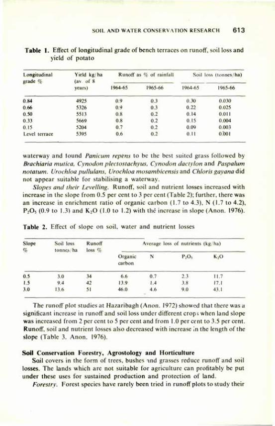
SOIL AND WATER CONSERVATION RESEARCH 6 1 3
Table 1. Effect of longitudinal grade of bench terraces on runoff, soil loss and yield of potato
Longitudinal Yield kg ha Runoff as % of rain fall Soil loss (tonnes/ha) grade % (av o f 8 grade %
years) 1964-65 1965-66 1964-65 1965-66
0.84 4925 0.9 0.3 0.30 0.030 0.66 5326 0.9 0.3 0.22 0.025 0.50 5513 0.8 0.2 0.14 0.011 0.33 5669 0.8 0.2 0.15 0.004 0.15 5204 0.7 0.2 0.09 0.003 Level terrace 5395 0.6 0.2 0.11 0.001
waterway and tound Panicum repëns to be the best suited grass followed by Brachiaria mutica, Cynodon plectostachyus, Cynodon dactylon and Paspalum notatum. Urochloa pullulans, Urochloa mosambicensis and Chloris gayana did not appear suitable for stabilising a waterway.
Slopes and their Levelling. Runoff, soil and nutrient losses increased with increase in the slope from 0.5 per cent to 3 per cent (Table 2); further, there was an increase in enrichment ratio of organic carbon (1.7 to 4.3), N (1.7 to 4.2), P205 (0.9 to 1.3) and K20 (1.0 to 1.2) with thé increase in slope (Anon. 1976).
Table 2. Effect of slope on soil, water and nutrient losses
Slope Soil loss Runoff Average loss of nutrients (kg/ha) % tonnes; ha loss %
Organic N P2Os K20 carbon
0.5 3.0 34 6.6 0.7 2.3 11.7 1.5 9.4 42 13.9 1.4 3.8 17.1 3.0 13.6 51 46.0 4.6 9.0 43.1
The runoff plot studies at Hazaribagh (Anon. 1972) showed that there was a significant increase in runoff and soil loss under different crops when land slope was increased from 2 per cent to 5 per cent and from 1.0 per cent to 3.5 per cent. Runoff, soil and nutrient losses also decreased with increase in the length of the slope (Table 3. Anon. 1976).
Soil Conservation Forestry, Agrostology and Horticulture Soil covers in the form of trees, bushes and grasses reduce runoff and soil
losses. The lands which are not suitable for agriculture can profitably be put under these uses for sustained production and protection of land.
Forestry. Forest species have rarely been tried in runoff plots to study their
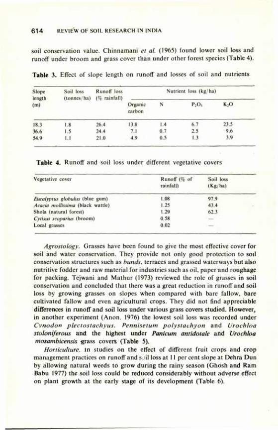
6 1 4 REVIEW OF SOIL RESEARCH IN INDIA
soil conservation value. Chinnamani et al. (1965) found lower soil loss and runoff under broom and grass cover than under other forest species (Table 4).
Table 3. Effect of slope length on runoff and losses of soil and nutrients
Slope length (m)
Soil loss (tonnes/ha)
Runoff loss (% rainfall)
Nutrient loss (kg/ha) Slope length (m)
Soil loss (tonnes/ha)
Runoff loss (% rainfall)
Organic carbon
N P205 K20
18.3 36.6 54.9
1.8 1.5 1.1
26.4 24.4 21.0
13.8 7.1 4.9
1.4 6.7 0.7 2.5 0.5 1.3
23.5 9.6 3.9
Table 4. Runoff and soil loss under different vegetative covers
Vegetative i :over Runoff (% of rainfall)
Soil loss (Kg/ha)
Eucalyptus globulus (blue gum) 1.08 97.9 Acacia mollissima (black wattle) 1.25 43.4 Shola (natural forest) 1.29 62.3 Cytisus scoparius (broom) 0.58 — Local grasses 0.02
Agrostology. Grasses have been found to give the most effective cover for soil and water conservation. They provide not only good protection to soil conservation structures such as bunds, terraces and grassed waterways but also nutritive fodder and raw material for industries such as oil, paper and roughage for packing. Tejwani and Mathur (1973) reviewed the role of grasses in soil conservation and concluded that there was a great reduction in runoff and soil loss by growing grasses on slopes when compared with bare fallow, bare cultivated fallow and even agricultural crops. They did not find appreciable differences in runoff and soil loss under various grass covers studied. However, in another experiment (Anon. 1976) the lowest soil loss was recorded under Cvnodon plectostachyus. Pennisetum polystachyon and Vrocbloa stoloniferous and the highest under Panicum antidotale and Vrochha mosambicensis grass covers (Table 5).
Horticulture, in studies on the effect of different fruit crops and crop management practices on runoff and s.;il loss at 11 per cent slope at Dehra Dun by allowing natural weeds to grow during the rainy season (Ghosh and Ram Babu 1977) the soil loss could be reduced considerably without adverse effect on plant growth at the early stage of its development (Table 6).
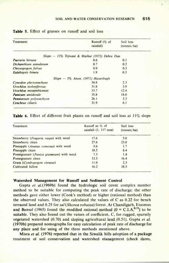
SOIL AND WATER CONSERVATION RESEARCH 6 1 5
Table 5. Effect of grasses on runoff and soil loss
Treatment Runoff (% of Soil loss rainfall) (tonnes/ha)
Slope - 11% Tejwani & Malhur (1973) Dehra Dun Pueraria hirsuta 0.6 0.1 Dichanthium annulatum 0.7 0.2 Chrysopogon fulvus 0.9 0.3 Eulaliopsis binata 1.9 0.3
Slope --5% ,1; ion. (1971) Hazaribagh Cynodon plectostachyus 34.8 2.3 Urochloa stoloniferous 31.8 3.9 Urochloa mosambicensis 33.7 12.4 Panicum antidolale 35.8 18.0 Pennisetum polystachyon 26.1 3.3 Cenchrus ciliahs 31.9 6.1
17.6 5.0 27.6 23.0
5.6 1.7 10.5 8.4 7.3 1.4
33.5 16.4 11.0 2.3 16.2 18.5
Table 6. Effect of different fruit plants on runoff and soil loss at 11% slope
Treatment Runoff as % of Soil loss rainfall (1, 117 mm) (tonnes/ha)
Strawberry (Fragaha vaspa) with weed Strawberry clean Pineapple (Ananas comosus) with weed Pineapple clean Pomegranate (Punka granalum) with weed Pomegranate clean Grass (Cymbopogon citratus) Cultivated fallow
Watershed Management for Runoff and Sediment Control Gupta et al.( 1969b) found the hydrologie soil cover complex number
method to be suitable for computing the peak rate of discharge: the other methods gave either lower (Cook's method) or higher (rational method) than the observed values. They also calculated the values of C as 0.22 for bench terraced land and 0.25 for sal(Shorea robusta) forest. At Chandigarh, Erasmus and Bansal (1965) found the modified rational method (0 = C.I.A.0-73) to be suitable. They also found out the values of coefficient, C, for rugged, sparsely vegetated watershed (0.70) and sloping agricultural land (0.51). Gupta et al. (1970b) prepared nomographs for easy calculation of peak rate of discharge for any place and for using of the three methods mentioned above.
Misra et al. (1976) reported that in the Siwalik hills adoption of a package treatment of soil conservation and watershed rrianagement (check dams,
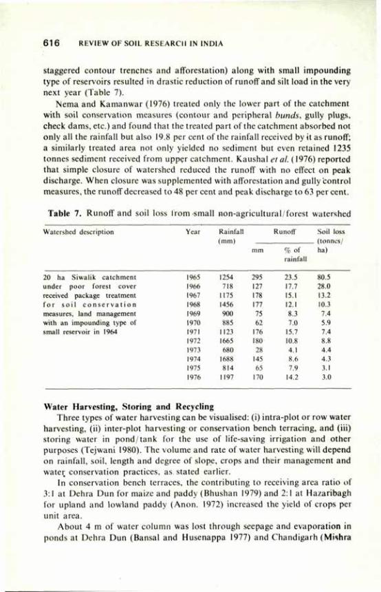
616 REVIEW OF SOIL RESEARCH IN INDIA
staggered contour trenches and afforestation) along with small impounding type of reservoirs resulted in drastic reduction of runoff and silt load in the very next year (Table 7).
Nema and Kamanwar (1976) treated only the lower part of the catchment with soil conservation measures (contour and peripheral bunds, gully plugs, check dams, etc.) and found that the treated part of the catchment absorbed not only all the rainfall but also 19.8 per cent of the rainfall received by it as runoff; a similarly treated area not only yielded no sediment but even retained 1235 tonnes sediment received from upper catchment. Kaushal et al. (1976) reported that simple closure of watershed reduced the runoff with no effect on peak discharge. When closure was supplemented with afforestation and gully'control measures, the runoff decreased to 48 per cent and peak discharge to 63 per cent.
Table 7. Runoff and soil loss from small non-agricultural/forest watershed
Watershed description Year Rainfall Runoff Soil loss (mm) (tonnes/
mm % of ha) rainfall
1965 1254 295 23.5 80.5
1966 718 127 17.7 28.0
1967 1175 178 15.1 13.2
1968 1456 177 12.1 10.3
1969 900 75 8.3 7.4 1970 88J 62 7.0 5.9 1971 1123 176 15.7 7.4 1972 1665 ISO 10.8 8.8
1973 680 28 4.1 4.4 1974 1688 145 8.6 4.3 1975 814 65 7.9 3.1 1976 1197 170 14.2 3.0
Water Harvesting, Storing and Recycling Three types of water harvesting can be visualised: (i) intra-plot or row water
harvesting, (ii) inter-plot harvesting or conservation bench terracing, and (iii) storing water in pond/tank for the use of life-saving irrigation and other purposes (Tejwani 1980). The volume and rate of water harvesting will depend on rainfall, soil, length and degree of slope, crops and their management and water conservation practices, as stated earlier.
In conservation bench terraces, the contributing to receiving area ratio of 3:1 at Dehra Dun for maize and paddy (Bhushan 1979) and 2:1 at Hazaribagh for upland and lowland paddy (Anon. 1972) increased the yield of crops per unit area.
About 4 m of water column was lost through seepage and evaporation in ponds at Dehra Dun (Bansal and Husenappa 1977) and Chandigarh (Mishra
20 ha Siwalik catchment under poor forest cover received package treatment for so i l c o n s e r v a t i o n measures, land management with an impounding type of small reservoir in 1964
SOIL AND WATER CONSERVATION RESEARCH 61 7
et al. 1975). There was no cheap technology available to reduce seepage losses. Cement concrete lining cost Rs 8.28/m2 (Nema and Kamanwar 1976) and PVC lining cost Rs 9.75/ m2. If a pond is allowed to silt up for four or five years, the seepage losses would be reduced considerably.
The Central Soil and Water Conservation Research and Training Institute, Dehra Dun along with its seven centres throughout India has demonstrated successfully the need of ponds for increasing agricultural production and reducing flood hazards. This valuable water can be utilised for minimal, life-saving and supplemental irrigation for increasing crop yield. The reported increase in the yield of crops by giving two life saving irrigations of 5 cm each was from 2,143 to 4,119 kg/ha in wheat (Singh and Bhushan 1978) from 3,644 to 4,725 kg/ha in barley, and from 1,298 to 1,846 kg/ha in gram (Singh 1978). Similar results for wheat were reported by Mittal et al. (1978). At Kota it was observed that irrigation in gram by skipping a few rows saved water without adversely affecting the yield.
Universal Soil Loss Equation An estimate of soil loss under different land uses and soil climatic conditions
is essential for effective planning and execution of integrated watershed management projects. A universal soil loss equation (Anon. 1961) was proposed to give an estimate of sediment yield. Attempts have been made to find out the value of the different parameters of the equation:
A = R, K, L, S, C, P, in which the symbols stand for the following: A— Average annual soil loss in tonnes per hectare. R— Rainfall erosivity factor, EI. EI values were calculated for different
places by various workers for the duration of 5, 15, 30 and 60 minutes. EI30 was found to be quite suitable. Ram Babu et al. (1978a) prepared on isoerodent map based on EI30 values.
K— Soil erodibility factor. The use of an average value of 0.30 is recommended for Dhulkot silty clay loam at Dehra Dun, 0.34 for laterite soil of south India (Tejwani et al. 1975) and 0.059 for alluvial soil of Baroda (Nema et al. 1978).
L— Slope length 1 Formula given by Smith (1961) can be used to S_^ Slope percentage! calculate the value of the SL factor. C— Cropping management factor. In addition to available tables, C factor
was found from runoff plot studies at Dehra Dun for maize (0.73) and wheat (0.73) (Tejwani et al. 1975). Nema et al. (1978) worked out the 'C' factor for moong, groundnut and cowpea as 0.465, 0.374 and 0.317 respectively. Das et al. (1973) reported the 'C' factor for various crop rotations, such as potato-potato (0.82), potato-barley (0.93), potato-fallow (0.83).
P— Supporting conservation practice factor. Raghunath et al. (1967) calculated the P factor for contour cultivation (0.321) and bench terracing (0.076) from runoff plot studies.
618 REVIEW OF SOIL RESEARCH IN INDIA
Special Problems of Soil Erosion Ravine Reclamation. It is estimated that about 4 million hectares of land
area is affected by severe gully erosion in Madhya Pradesh, Rajasthan (along the Chambal), Uttar Pradesh, Gujarat, Punjab, West Bengal, Bihar and Tamil Nadu (Das 1977). Gullies have been classified into four kinds depending on their bed width, depth and side slope (Tejwani et al. 1961). Tejwani (1976) also prepared a land capability classification for ravine lands. For the reclamation of these lands protection of tablelands is essential. A study of the natural flora of eroded areas at Vasad, Kota and Agra showed that only poor types of annual unpalatable grasses grow Under the prevailing management conditions. Closure to grazing reduced the soil loss from 3.3 tonnes/ha to 0 6 tonnes/ha, increased the quantity, and improved the quality of grasses (Tejwani et al. 1961; Kaul 1962; Pandey et al. 1967; Singh et al. 1967).
Tejwani et al. (1975) reported that for proper retention and disposal of rain water in alluvial soils, contour bunds with a cross-section of 0.9 to 1.3 m2 spaced at 90 to 190 cm vertical interval (V.I.) were most effective at Vasad. For black soils with less than 4 per cent slope at Kota, graded bunds of 0.7 to 1.05 m2 in cross-section and 0.5 to 1.0 per cent grade were suitable. For stabilising these bunds, Dichanthium annulatum, Amphilophis glabra, Cenchrus ciliaris and Andopogon ischaeum were very suitable. These grasses also have good fodder value.
For gully plugging, where no runoff is expected from the top, earthen gully plugs of 1.1 sq m cross-section with grassed ramp 22.5 cm below the top and spaced at 45 to 60 m horizontal intervals were recommended; but where excess runoff is expected from top, earthen gully plugs of 2.2 sq m cross section with a pipe outlet were recommended (Tejwani et al. 1960). The size of the pipe would depend on the expected discharge. For catchments larger than 1.6 ha, a composite check dam of earth and brick masonry was considered essential. Brush-wood was not found very useful because of the maintenance cost.
Tejwani et al. (1975) found that economic utilisation of gullies for production of agricultural crops was possible only with small and medium gullies. For small gullies, levelling and putting diversion-cum-check bunds of 1.5 m2 provided diagonally for overflow in excess of 30 cm ponding at the end of the bunds were useful. The beds of medium gullies could be used for cultivation by terracing the side slopes and constructing a series of composite earthen and brick masonry check dams. The earthen dams were stabilised with Dichanthium annulatum or Cynodon dactylon.
Landslide Control. The problem of landslides and landslips is widespread in the hilly terrain of the country. There are more than 10,000 km long roads in the hills, especially in the Himalayas. Landslides and landslips cause damage to the mountain ecology and recurring losses of more than Rs 100 crores annually apart from the huge losses of vehicle hours, of man-hours, of perishable goods, etc. (Bansal and Mathur 1976). The main causes for landslides are the weak geology of the rocks (the Himalayan rocks being mostly sedimentary), seismic
SOIL AND WATER CONSERVATION RESEARCH 619
disturbances, improper land use, overgrazing, deforestation and unscientific mining.
The Central Soil and Water Conservation Research and Training Institute, Dehra Dun, took up a research project on a landslide of four hectares in 1964-65. As a result of the ameliorative measures, the entire slide-affected area was completely stabilised within four years. The area was protected by fencing from all kinds of biotic interference; gabion retaining wells were constructed to protect the bottom of the slope and gabion spurs were constructed to divert the flow of the water from the banks to the original channel. All the gullies on the slide face- were plugged by constructing vegetative and logwood check dams. A series of gabion check dams were constructed for reducing the flow velocity of water to a safe limit to prevent erosion. These engineering measures channelled the flow.
Live contour wattling and mulching were adopted on the slide face to break the slope and protect the slide face, respectively, before sowing and planting afforestation. The plant species used for live contour wattling were Lannea coromandelia, Vitex negundo, Erythrina tuberosa and Salix tetrasperma. Dry grass species Chrysopogon fulvus and Saccharum spontaneum were used for mulching.
Conclusions Studies on land and water resource'appraisal and utilisation, watershed
hydrology, erosion hazards and control measures and agronomic practices in relation to crop productivity have yielded useful information for soil and water conservation. However, research has been carried out mainly to evolve a single practice programme. While soil and water conservation research needs to be oriented to develop an integrated technology for watershed management, specific research efforts need to be directed to enhance understanding of relationship of soil erodibility with soil properties, sediment transport behaviour, soil hydrology, and basic design criteria of soil conservation structures.
References
Anon. (1961) Rep. agric. Res. Ser. USDA, Special Rep. 22. Anon. (1962) Ann. Rep. Soil Conserv. Sect. Dep. Agric. U.P., Lucknow. Anon. (1970) Ann. Res. Rep. Soil Conserv. Sect. Dep. Agric. U.P., Lucknow. Anon. (1971) Rev. Res. Work (1952-58), Vol. I, Soil Conserv. Dep. D.V.C., Hazaribagh. Anon. (1972) Rev. Res. Work (1959-69), Vol. II. Soil Conserv. Dep. D.V.C. Hazaribagh. Anon. (1976) Ann. Res. Rep. Soil Conserv. Sect. Dep. Agric. U.P., Lucknow. Anon. (1978) Rep. Working Group on Soil Conserv. and Land Reclam. for 1978-79 to 1982-83.
Min. Agric. Irrig. Govt, of India, New Delhi. Ballal, D.K. (1954) J. Am. Soc. Agron. 27, 738. Bansal, R.C. and Husenappa, V. (1977) Ann. Rep. Control Soil and Water Conserv. Res.
and Trg. Inst., Dehra Dun.
6 2 0 REVIEW OF SOU RESEARCH IN I N D I A
Bansal, R.C. and Mathur. H.N. (1976) Soil Conserv. Digest 4,'36. Uhardwaj. S.P. (1976) Soil Conserv. Digest. 4. 36.
Uhardwaj. S.P. (1979) Indian J. Soil Conserv. 7. 31. Uhardwaj, S.P., Khybri . M.l . . . Gupta. O.P. and Rai. R.N. (1978) Indian J. Soil Conserv. 7, 5. Bhatia. K.S. and Choudhary. H P . (1977) Soil Conserv. Digest 5, 16.
Bhatt. P.N., Gupta, O.P. and Tejwani, K G . (1971) Proc. Intern. Symp. Soil fertil. Eval. New Delhi. Bhumbla. D.R.. Mandal, S.C., Tejwani. K G . and Ab io l , I.P. (1971) Chapter VI Soil Tech.
Rev. Soil Res. in India, Pub. Indian Council of Agricultural Research, New Delhi. Bhushan. L.S. (1979) Soil Sci. Soc. Am. .1. 43, 754. Bouyoucos, G.J. (1935) .1. Am. Soc. Agron. 27. 738.
Chinnamani. S., Gupta, S.C.. Rege. N.D. and Thomas, P.K. (1965) Indian Forester 91, 676. Dalai, S.C., Patnaik, N. and Singh. B. (1965) Indian Forester, 91, 498. Das. D.C. (1977) F.A.O. Soils Bull. 33. I I .
Das. D . C . Raghunath. B. and Poornachandran, G. (1977) J. Soil and Water Conserv. India 27, 37. Das. D.C. Reghunath. B.. Poornachandran, G. and Joseph, A.R. (1968) Unpublished. Das. D . C . Reghunath. B. and Sreedharan. A. (1967) J. Indian Soc. agric. Eng. 4. 49. Das. D .C . Tejwani. K.G. and Ram Babu (1973) Intern. Hydrol. Decade Newsletter No. 22. Erasmus. I.I. and Bansal, R.C. (1965) Indian Forester 91. 548. Ghosh. S.P. and Ram Babu (1977) Soil Conserv. Digest 5. 15. Gupta. S.K.. Ram Babu and Nayal, M.S. (1969a) Harvester I I , 150. Gupta. S.K.. Ram Babu, Nayal, M.S. and Singh. U. (1969b) Paper presented at 7tli Annual
Meeting of Indian Soc. agric. Engrs. Pantnagar. U P , Gupta. S.K.. Ram Babu and Tejwani. K.G. (1970a) .1. Indian Soc. agric. Eng. 7. 25. Gupta. S.K.. Tejwani. K G . . Mathur, H.N. and Srivastava, M M . (1970b).I. Indian Soc. >>oil Sci.
18. 187. Harper. J .H. (1936) Proc. Soil Sci. Soc. Am. I. 33. Kanitkar, N.V., Sirur, S. S. and Gokhale. D.N. (I960) Dry Farming in India, Pub. Indian Council
of Agricultural Research. New Delhi. Kanwar. J.S. (1973) Soil Conserv. Digest I, I. Kaushal. R.C, Mishra. P.R. and Dayal, S.M.N. (1976) Ann. Rep. Central Soil and Water
Conserv. Res. and Trg. Inst. Dehra Dun. Kaul. O.N. (1962) Indian Forester 88. 832. Khybri. M.l.. . Bhardwaj. S.P. and Prasad, S.N. (1977) Ann. Rep. Central Soiland Water Conserv.
Res. and Trg. Inst. Dehra Dun. Middleton. H.E. (1930) U.S. Dep. Agric. Tech. Bull. 178. Mirchandani. O.P.M.. Guha, D P . and Vasudevaiah, R.D. (1958) .1. Soil and Water Conserv.
India. 6. 125. Mishra. P R . . Kaushal. R.C. Dayal, S.K.N, and Prabhushankar. (1975) Ann. Rep. Central Soil
and Water Conserv. Res. and Trg. Inst., Dehra Dun. Mishra, PR. . Kaushal. R .C, Dayal, S.K.N, and Prabhushankar (1976) Ann. Rep Central Soil
and Water Conserv. Res. and T ig . Inst.. Dehra Dun. Mit tal , S.P., Gupta, R.K., Pratap Singh and Prahalad Singh (1978) Ann. Rep. Central Soil and
Water Conserv. Res. and Trg. Inst., Dehra Dun. National Commission on Agriculture (1976) Report Part IX. Chapter 42. Min. of Agric. and
Irrigation, New Delhi. Nema, J.P. and Kamanwar. H.K. (1976) Ann. Rep. Central Soil and Water Conserv. Res. and Trg.
Inst., Dehra Dun. Nema, J.P.. Vcrma. B. and Patel. A.P. (1978) Indian .1. Soil ( o n s e n . 6. 75. Olsen. T.C. and Wischmeier, W.H. (1963) Proc. Soil Sci. Soc. Am. 27, 590. Pandey, S.N., Teotia. S.P. and Guha, D.P. (1967) I Soil and Water Conserv. India 15, 64. Pratap Narain, Verma, B. and Singhal, A.K. (1978) Ann. Rep. Central Soil and Water Conserv.
Res. and Trg. Inst.. Dehra Dun.
SOIL AND WATER CONSERVATION RESEARCH 6 2 1
Raghunath. B.. Sreenathan, A.. Das, D.C. and Thomas. P.K. (1967) Paper presented at 6th Ann. Meet. Indian Soc. Agric. Engrs., Bangalore.
Ram Babu, Bansal, R.C and Srivastava. M.M. (l97Xa) Indian J. Soil Conserv. 6. 89. Ram Babu. Tejwani, K.G. Agarwal. M.C. and Chandra. S. (1978b) Bull. 2, Central Soil and Water
Conserv. Res. and Trg. Inst. Dehra Dun. Rao, K.L. (1975) India's Water Wealth. Orient Longman Ltd, New Delhi. Singh, G. (1978) Ann. Rep. Central Soil and Water Conserv. Res. and Trg. Inst., Dehra Dun. Singh, G., Bhardwaj. S.P. and Singh, B.P. (1979) Indian J. Soil Conserv. 7, 43. Singh. G. and Bhushan, L.S. (1978) Ann. Rep. Central Soil and Water Conserv. Res. and Trg. List.
Dehra Dun. Singh. O . Dayal, R. and Bhola. S.N. (1967) J. Soil and Water Conserv. India 15. 102. Slater, C.S. and Byers. H.G. (1931) Tech. Bull. 232, U.S. Dep. of Agric. Smith. D P . (1961) Rep. Soil i. onscrv. 4-15743, U.S. Dep. Agric. Sud. A.D.. Gupta, R.K., Mittal, S.P. and Madan Lai (1977) Ann. Rep. Central Soil and Water
Conserv. Res. and Trg. Inst., Dehra Dun. Tejwani. K.G. (1976) Soil Conserv. Digest 4. I. Tejwani. K.G. (1980) Presented at the Symposium on "Rain Water for Life Saving Irrigation and
Increasing Production" organised by the Indian National Science Academy, New Delhi. 3 Oct 1980.
Tejwani. K.G., Dhruvanarayana. V.V. and Satyanarayana. T.J. (I960) J. Soil Water Conserv. India, 8, 65.
Tejwani. K.G. and Mathur. H.N. (1973) Soil Conserv. Digest, 1973, 21. Tejwani. K.G.. Gupta. S.K. and Mathur. H.N. (1975) Soil and Water Conserv. Res. 1956-71.
Pub. ICAR. New Delhi. Tejwani. K.G.. Srinivasan, V. and Mistry, M.S. (1961) Indian Fmg. II, 20. Wischmeier, W.H. (1959) Proc. Soil Sci. Soc. Am. 23, 246.
Water Quality and Soil Productivity J.S.P. YADAV*
GROUND water forms an important source of irrigation next to surface water in many parts of the world. In the arid and semi-arid regions, ground water is either the major or the only source of irrigation to supplement the scanty rainfall, but the quality of ground water in these areas is generally poor on account of excessive salt content, high sodium adsorption ratio (SAR), high residual sodium carbonate (RSC) or presence of other toxic elements. In many areas along the sea coast, too, the quality of underground water is poor. Being the major source of irrigation in the arid and semi-arid tracts, poor-quality ground waters adversely affects the soil properties and plant growth, though the nature and extent of the adverse effect depend upon the concentration and composition of salts present in the irrigation water, soil texture, organic matter content, nature of clay minerals, calcareousness and drainability of the soil, crops and varieties to be grown, climatic conditions of the area, and management practices.
Quality of Ground Waters A number of studies have been reported on the quality of ground waters in
different parts of India (Bhumbla 1972; Paliwal 1972; Kanwar and Manchanda 1964; Mejirotra 1969; Talati 1972; Yadav 1979). The data indicate that most of the ground waters are medium to highly saline. Highly saline waters are dominated by sodium and chloride ions. Waters of low to moderate sajinity contain greater proportions of Ca and Mg and carbonate ions. The carbonate and bicarbonate ions decrease with increase in total salinity, being almost absent in waters of high electrical conductivity. Many waters show predominance of Mg over Ca. Boron is present in appreciable quantities in certain waters and may be injurious to plant growth. The presence of nitrate and potassium in some waters has been found to counteract the adverse effect of high sodium. Some waters have been reported to contain toxic amounts of lithium and fluorine.
The mean chemical composition of well waters in some districts of Punjab, Haryana and Rajasthan is given in Table 1. The distribution of ground waters according to EC, SAR and RSC in some districts of Uttar Pradesh, Andhra Pradesh, Delhi, Gujarat and Karnataka is given in Table 2. In general, the quality of ground waters is poor in the arid areas (Tripathi et al. 1969) and improves in the regions having comparatively high rainfall, as is evident from the per cent distribution of ground waters of Rajasthan in different EC classes
•Central Soil Salinity Research Institute, Karnal, Haryana.
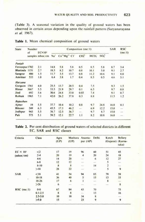
WATER QUALITY AND SOIL PRODUCTIVITY 6 2 3
(Table 3). A seasonal variation in the quality of ground waters has been observed in certain areas depending upon the rainfall pattern (Satyanarayana el al. 1967).
Table 1. Mean chemical composition of ground waters
State Numbei • Composition (me/1) SAR RSC
of ECX10'
mhos/cm
(me / I ) samples
ECX10'
mhos/cm Na* Ca"Mg~ CI" CO,2" HCOj" SO,2'
Punjab
Ferozepur1702 2.1 14.8 5.X 5.X 0.5 8.5 5.X 8.7 3.4 Bhatinda 1151 2.7 18.5 8.2 10.7 0.8 10.1 5.0 9.1 2.7 Sangrur 400 I.J 11.7 3.5 13.7 0.8 11.2 10.6 9.1 8.0 Amritsar 533 1.0 6.4 3.X 1.7 0.4 8.5 0.5 4.6 5.1
Harvana
Gurgaon 1561 4.0 25.5 13.7 20.5 0.4 7.5 9.3 1.5 Hissar 3667 5.5 33.5 21.9 29.7 0.1 6.5 9.7 (I.X
Jind 692 5.6 30.6 24.8 33.0 0.03 7.4 9.1 0.7 Rohtak 1965 7.1 42.0 26.2 37.8 0.3 8.8 11.5 1.2
Rajaslhan Ajmer 19 5.5 37.7 10.4 10.2 0.8 9.7 24.8 16.0 0.1 Bikaner 249 6.3 45.5 17.3 46.2 6.9 12.2 15.0 — J o d h p u r 943 5.5 38.7 12.5 36.7 9.7 8.7 15.0 — Pali 573 5.1 39.2 12.1 22.7 I.I 8.2 10 X 16.0 —
Table 2. Per cent distribution of ground waters of selected districts in different EC, SAR and RSC classes
Criteria Class Agra Mathura Ananta- Delhi Kutch Bellary
(UP) (UP) pur (AP) (Gujarat) (Karna-
taka)
EC X 103 <2 17 19 9f, 60 51 45
(mhos /cm) 2-4 20 19 4 20 24 IX
4-6 14 20 — 6 12 27 6-8 12 12 — — 5 — 8-10 X X — 14 2 —
>10 2X 22 — — 5 9
SAR <10 41 54 94 85 79 59
10-18 36 40 5 15 13 33 18-26 17 6 1 — X — >26 6 — — — — 8
RSC ( m e / J ) 0-0 67 X4 43 70 75
0.1-2.5 8 X — 13 16
2.5-5.0 10 IX 34 X — >5.0 15 — 23 9 9
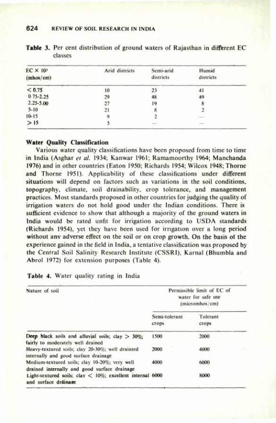
6 2 4 REVIEW OF SOIL RESEARCH IN INDIA
Table 3. Per cent distribution of ground waters of Rajasthan in different EC classes
Arid districts Semi-arid Humid districts districts
EC X 10' (mhos/cm)
<0.75 0 75-2.23 2.25-5.00 5-10
10-15 >15
10 2.1 41 24 48 44 27 14 X 21 8 2 9 2 — 5 — —
Water Quality Classification Various water quality classifications have been proposed from time to time
in India (Asghar et al. 1934; Kanwar 1961; Ramamoorthy 1964; Manchanda 1976) and in other countries (Eaton 1950; Richards 1954; Wilcox 1948; Thorne and Thorne 1951). Applicability of these classifications under different situations will depend on factors such as variations in the soil conditions, topography, climate, soil drainability, crop tolerance, and management practices. Most standards proposed in other countries forjudging the quality of irrigation waters do not hold good under the Indian conditions. There is sufficient evidence to show that although a majority of the ground waters in India would be rated unfit for irrigation according to USDA standards (Richards 1954), yet they have been used for irrigation over a long period without any adverse effect on the soil or on crop growth. On the basis ot the experience gained in the field in India, a tentative classification was proposed by the Central Soil Salinity Research Institute (CSSRI), Karnal (Bhumbla and Abrol 1972) for extension purposes (Table 4).
Table 4. Water quality rating in India
Nature of soil Permissible limit of EC of water for safe use (micromhos/cm)
Semi-tolerant Ioleiant crops crops
Deep black soils and alluvial soils; clay > 30%; 1500 2000 fairly to moderately well drained Heavy-textured soils; clay 20-30%; well drainted 2000 4000 internally and good surface drainage Medium-textured soils; clay 10-20%; very well 4000 6000 drained internally and good surface drainage Light-textured soils; clay < 10%; excellent internal 6000 8000 and surface drainaee
WATER QUALITY AND SOIL PRODUCTIVITY 6 2 5
In the proposed limits of water quality rating given in Table 4, it is presumed that the groundwater-table at no time of the year is within 1.5 m from the surface. If the water table comes up within the root zone, the limits need to be reduced to half. Similarly, if the soil has impeded internal drainage because of the presence of hard pan, unusually high amounts of clay or some other morphological features, the limit of water quality should again be reduced to half.
Effect of Saline Water Irrigation on Soil Properties The adverse effect of poor quality water on crop growth is reflected by
changes in physical and chemical properties of the soil. However, as stated above, changes in soil properties due to saline water irrigation depend upon the depth, texture and structure of the soil, type and swelling characteristics of the clay, lime and gypsum content of the soil, soil permeability and fertility, irrigation method, management practices, and climatic conditions.
Salinity Build-up in Relation to Soil Texture. In general, accumulation of salts in the soil profile increases with the clay content. In soils of varying clay content, Singh and Bhumbla (1968) observed that the EC of the saturation extract of the soil was about half that of irrigation water when the clay content was less than 10 per cent, three-fourths if the clay content was between 10 and 20 per cent, and 1.5 times if the clay content was between 20 and 30 per cent. Yadav (1978) reported that saline ground waters could be used beneficially in the light-textured soils where easy leaching of the salts would be helpful in maintaining a favourable salt balance. The well waters of Chambal command area of Kota and Bundi districts of Rajasthan are of medium quality, but continuous accumulation of salts is taking place because of their high clay content and impeded drainage (Nathani et al. 1966). Even with relatively infrequent use of saline waters, high accumulation of salts was recorded in the heavy-textured soils of poor permeability. Studies by Talati (1972) showed that in sandy soils good crops could be grown with irrigation waters containing up to 3,000 ppm of total soluble salts, but in silty to clayey soils the use of waters containing even 2,000 ppm salts caused serious salinisation in a period of three to five years. In a lysimetric study, Agarwal and Ramamoorthy (1974) observed greater salinity hazard in a heavy montmorillonitic soil than in a kaolinitic and an illitic light-textured soil, whereas sodic hazard was more in the last two soils owing to their lower cation exchange capacity. Jain and Saxena (1970) and Lai and Singh (1974) also observed greater salinisation in heavy soils than in light soils. Greater accumulation of salts and boron as a result of saline water irrigation occurred with increasing fineness of texture (Paliwal and Mehta 1973). Hence, there is an intimate relationship between the soil texture and the effect of irrigation water on soil salinisation. Kanwar (1961) considered soil texture an important factor and included soil texture and crop tolerance in the triangular diagram proposed by him for evaluating the quality of irrigation waters.
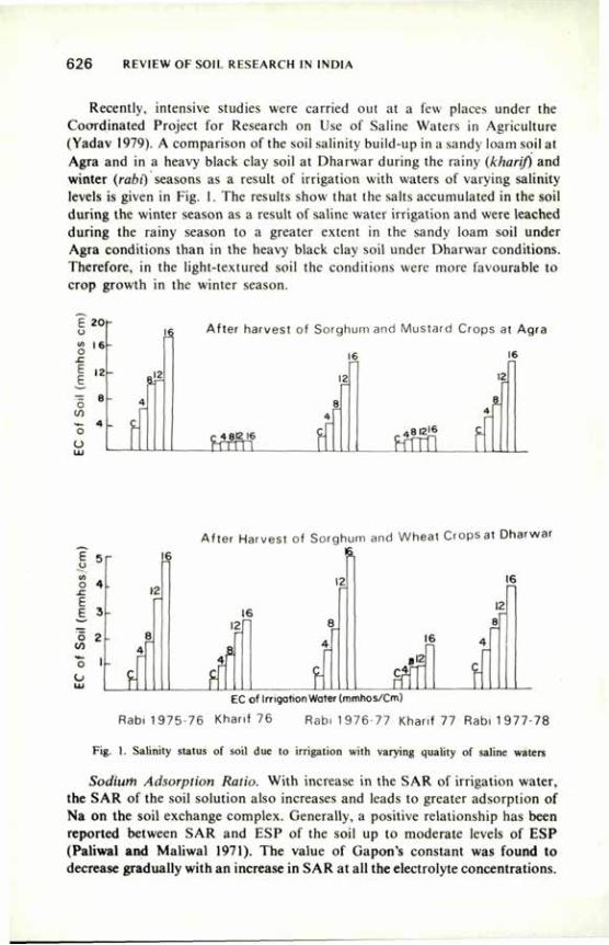
6 2 6 REVIEW OF SOIL RESEARCH IN INDIA
Recently, intensive studies were carried out at a few places under the Coordinated Project for Research on Use of Saline Waters in Agriculture (Yadav 1979). A comparison of the soil salinity build-up in a sandy loam soil at Agra and in a heavy black clay soil at Dharwar during the rainy (kharif) and winter (rabi) seasons as a result of irrigation with waters of varying salinity levels is given in Fig. 1. The results show that the salts accumulated in the soil during the winter season as a result of saline water irrigation and were leached during the rainy season to a greater extent in the sandy loam soil under Agra conditions than in the heavy black clay soil under Dharwar conditions. Therefore, in the light-textured soil the conditions were more favourable to crop growth in the winter season.
E 20
o
s • {,« •5 8
*- 4 O
U
'§
^
After harvest of Sorghum and Mustard Crops at Agra
16 6
4 812 16
iöfn
8
a 8
„ 4 8 I 2 I 6 C
After Harvest of Sorghum and Wheat Crops at Dharwar
o 4 -.c E E 3
1 2 </) o I
O
r 6 IS.
12 16 12
12 - 16
2 8 8
- 8 i » « 4
4 £ r— r-
" F 4
ff 6 B'2
far. c r EC of Irrigation Water (mmhos/Cm)
Rabi 1975-76 Khanf 76 Rabi 1 976-77 Kharif 77 Rabi 1 977-78
Fig. 1. Salinity status of soil due to irrigation with varying quality of saline waters
Sodium Adsorption Ratio. With increase in the SAR of irrigation water, the SAR of the soil solution also increases and leads to greater adsorption of Na on the soil exchange complex. Generally, a positive relationship has been reported between SAR and ESP of the soil up to moderate levels of ESP (Paliwal and Maliwal 1971). The value of Gapon's constant was found to decrease gradually with an increase in SAR at all the electrolyte concentrations.
WATER QUALITY AND SOIL PRODUCTIVITY 6 2 7
According to Lai and Singh (1974) accumulation of salts in the soil increased and hydraulic conductivity of the soil decreased with an increase in SAR of irrigation water. Palaniswamy and Dhanapalan Mosi (1973) observed an increase in ESP and dispersion coefficient, and a decrease in exchangeable Ca and Mg and in soil permeability, with increasing SAR of irrigation water. Deo and Kanwar (1968) observed reduced wheat growth when the SAR of irrigation water was increased from 1.5 to 15.7. Paliwal and Deo (1978) reported that the use of saline waters in calcareous soils decreased the sodium hazard because of the release of Ca caused by the dissolution of CaC03 .
Mg.Ca Ratio. In the saline ground waters the proportion of Mg is generally higher than that of Ca, and the Mg:Ca ratio is 4:1 or more. Opinions differ on the role of high Mg:Ca ratio of the irrigation waters. Some think that Mg behaves like Ca in influencing adsorption of Na, while others think that the two cations do not behave alike. Deo and Kanwar (1969) reported that the effect of Mg was comparable with that of Ca at higher Mg:monovalent cation ratio (~ 5) and with Na or K at lower Mg:monovalent cation ratio. Greater adsorption of Na occurred in the presence of Mg. Higher concentrations of exchangeable Na and Mg were found in soils irrigated with Mg-rich waters in western Rajasthan (Shankaranarayana and Ganu 1963). Paliwal and Gandhi (1976) reported that adsorption of Na increased with higher Mg:Ca ratio of irrigation water and resulted in enhanced soil sodicity, particularly in light-textured soils. Regression equations for ESR-SAR relationship differed with soil texture and Mg:Ca ratio of the equilibrating solution. Girdhar and Yadav (1980) and Yadav and Girdhar (1980) observed that the hydraulic conductivity of soil decreased and the degree of dispersion increased with an increase in Mg:Ca ratio of irrigation water. The effect was more pronounced at higher SAR and in heavy black soils dominated by montmorillonite clay than in alluvial soil dominated by illite clay. The adverse effect of higher Mg:Ca ratio was more in non-calcareous than in calcareous soil. These, and the results of greenhouse studies suggest that Mg differs from Ca in affecting the soil properties and crop growth under certain conditions.
Effect of Saline Water Irrigation on Crop Growth Variation in Tolerance of Crops on Different Soils. Crops vary in their
tolerance of saline water irrigation, as judged by the relative reduction in the yield at varying salinity levels and compared with the yield obtained with good-quality water. Studies were undertaken recently in micro plots at a few places under the Coordinated Research Project on the Use of Saline Water in Agriculture to determine the relative tolerance of important field crops. Data from these experiments revealed considerable difference in the tolerance of different crops grown on similar soils. The tolerance of crops also varied with soil type and climate. The salinity levels of irrigation water which could be used for growing crops satisfactorily under different conditions are given in Table 5.
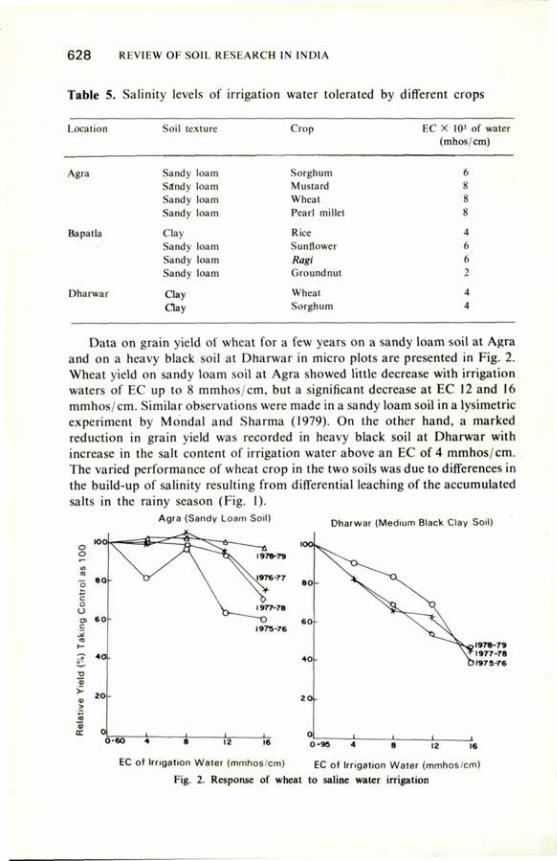
628 REVIEW OF SOIL RESEARCH IN INDIA
Table 5. Salinity levels of irrigation water tolerated by different crops
Location Soil texture Crop EC X I03 of water (mhos/cm)
Agra
Bapatla
Dharwar
Sandy loam Sorghum Sandy loam Mustard Sandy loam Wheat Sandy loam Pearl millet
Clay Rice Sandy loam Sunflower Sandy loam Ragi Sandy loam Groundnut
Clay Wheat
Clay Sorghum
ft
X
s 8
4
ft
ft
2
4 4
Data on grain yield of wheat for a few years on a sandy loam soil at Agra and on a heavy black soil at Dharwar in micro plots are presented in Fig. 2. Wheat yield on sandy loam soil at Agra showed little decrease with irrigation waters of EC up to 8 mmhos/cm, but a significant decrease at EC 12 and 16 mmhos/cm. Similar observations were made in a sandy loam soil in a lysimetric experiment by Mondal and Sharma (1979). On the other hand, a marked reduction in grain yield was recorded in heavy black soil at Dharwar with increase in the salt content of irrigation water above an EC of 4 mmhos/cm. The varied performance of wheat crop in the two soils was due to differences in the build-up of salinity resulting from differential leaching of the accumulated salts in the rainy season (Fig. 1).
Agra (Sandy Loam Soil) Dharwar (Medium Black Clay Soil)
6 0 " 8 12 16 0-95 4 8 |2 , 6
EC of Irngation Water (mmhos/cm) EC of Irrigation Water (mmhos/cm)
Fig. 2. Response of wheat to saline water irrigation
WATER QUALITY AND SOIL PRODUCTIVITY 6 2 9
Varietal Differences in Tolerance. Different varieties of the same crop differ in their tolerance to salinity. Several varieties of important field crops have been tested for their relative tolerance to saline water irrigation at many places in India, and the tolerant varieties have been identified on the basis of mean deviation in the yield as compared with that of the control. The slope of the curve in relation to the yield at varying salinity levels of irrigation water together with the mean salinity index have been used as criteria to determine the comparative tolerance.
Crop Tolerance at Different Growth Stages. Crops show varying tolerance to salinity at different growth stages. In the areas where irrigation waters of high as well as low salinity are available, irrigation with high salinity water can be avoided at growth stages at which the crop is more sensitive. Germination and seedling stages are usually the most sensitive. Therefore, pre-sowing irrigation should be given with good-quality water wherever possible. This practice has helped in growing a satisfactory crop of wheat on a sandy loam soil by irrigation with saline water having EC up to 8 mmhos/cm. In rice, tillering to flowering, and in groundnut, pegging to pod formation, have been observed to be the sensitive stages. In general, the tolerance of the crop increases with age, though this may not hold good for every crop.
Nutrient Uptake by Plants. Generally, the saline water irrigation resulted in an increased uptake of Na and a decreased uptake of some other nutrient elements (Kanwar and Kanwar 1971; Gandhi and Paliwal 1975). Increasing SAR of irrigation water resulted in decreased absorption of Ca and Mg in wheat and barley (Khan and Saxena 1974). A reduction in the grain and straw yield of wheat and uptake of N, P, K, Ca and Mg with increasing EC and SAR of the irrigation water was noted by Lai and Singh (1973), Maliwal and Paliwal (1973) and Sharma and Lai (1975) but the adverse effect was mitigated by fertiliser application only at the lower values of EC and SAR. Similar observations were made with respect to absorption of P and K by Saxena and Jain (1971). Increased B content of irrigation water decreased the P content of wheat plants in the clayey soil but not in a sandy soil (Ruhal and Deo 1971). Selective uptake of Na and K and maintenance of a high K/Na ratio were indicative of salt tolerance of crop varieties (Janardhan et al. 1976; Joshi et al. 1977; Murthy et al. 1979). A decrease in K/Na ratio in peanut plants due to salinity was reported (Chavan and Karadge 1980).
Management Practices to Use Saline Water for Irrigation Certain practices help in reducing the damage to the crops due to high
salinity of irrigation water. Selection of Crops. Since the quality of water cannot be modified beyond a
certain limit to suit a crop under the given agro-climatic conditions, a correct choice of the crop and its variety is important for successful crop cultivation with saline irrigation water. Several tolerant crops and their varieties have been
630 REVIEW OF SOIL RESEARCH IN INDIA
identified, and there is ample scope for selecting varieties suited to local conditions.
Irrigation Method. The irrigation method adopted should be such as would maintain a proper soil moisture regime and a favourable salt balance. The drip and sprinkler methods of irrigation have been reported to cause less salt accumulation in the soil. In a comparative field study with radish crop using poor-quality (EC 6500 micromhos/cm) and good-quality waters on a sandy loam soil at Hissar (Yadav 1972), the drip method proved much superior to the surface method in obtaining higher yields and greater water use efficiency in case of both kinds of water.
In field experiments on a loamy sand soil at Jodhpur (Singh et al. 1978) application of saline water of EC 3,000 micromhos/cm through drip irrigation did not limit the yield of potatoes and tomatoes, but the yields obtained with furrow irrigation were significantly reduced. Hence, high-salt water diluted with good quality water to reduce the salinity to about 3,000 micromhos/cm could be used for irrigation with the drip method. The pitcher method of irrigation for using saline water gave promising results with water melon and musk melon at CSSRI, Karnal (Mondal, unpublished). Application of saline irrigation water 25 per cent more than the cumulative pan evaporation resulted in increased yields of sorghum and wheat in heavy black soil at Dharwar (Yadav 1977).
Application of Manures and Fertilisers. Application of manures and fertilisers has been found to be beneficial in enhancing the suitability of saline water for irrigation. Application of farmyard manure (FYM)@50 t/ha proved more beneficial in minimising the adverse effect of saline water irrigation on pearl millet than on wheat grown in a sandy loam soil at Hissar (Poonia et al. 1974a). Increased yields of wheat were obtained with the application of nitrogenous fertilisers under saline-water irrigation (Dhir et al. 1975; Sharma and Lai 1975). The response to fertilisation decreased as the level of EC and SAR of water increased (Lai and Singh 1973). The application of phosphatic and potassic fertilisers increased the yield of hybrid bajra irrigated with waters of EC 6 and 10 mmhos/cm (Puntamkar et al. 1979a). High amounts of potassium and nitrate in the irrigation waters reduced the deleterious effect of high sodium (Kanwar and Manchanda 1964). In some areas of Uttar Pradesh, the yield of tobacco crop receiving about 110 kg N/ha through saline irrigation water was as good as with normal waters (Mehrotra 1969).
Gypsum Application. Irrigation waters rich in carbonates tend to precipitate soluble Ca and Mg in the soil and bring about increased SAR of soil solution, resulting in increased exchangeable sodium percentage (ESP). Hence, irrigation waters containing high residual sodium carbonate (RSC) cause alkalinisation of the soil. Kanwar and Kanwar (1971) and Pali wal et al. (1978) further observed that at the same RSC value the harmful effect of water was more when carbonates were in excess over bicarbonates. Singh and Sharma (1970) observed that the detrimental effect of high RSC was greater in heavy-textured soils. Puntamkar et al. (1972) found that application of gypsum at the
WATER QUALITY AND SOIL PRODUCTIVITY 631
rate of 20 t/ha increased the wheat yield when it was irrigated with water of RSC 12.4 me/1 in western Rajasthan. However, in recent studies conducted in micro plots of sandy loam 'soil at Agra (Yadav 1979) and in lysimeters in medium-textured soil at Karnal (Gupta 1979), irrigation with water having RSC as high as 10 me/1 caused neither any significant sodiumisation of the soil nor any reduction in wheat yield. Gupta (1979) was of the opinion that waters of EC 2 mmhos/cm and RSC up to 10 me/1 could be used for salt-tolerant crops on light- to medium-textured well-drained soils without any adverse effect, provided the SAR was less than 10. Use of gypsum has also been advocated for irrigation waters having soluble sodium more than 70 per cent to offset the adverse effect. Gupta and Chandra (1972) found gypsum application to be effective in reducing the boron hazard of saline irrigation waters.
In a study on the growth behaviour of seedlings of forest species as affected by irrigation with saline waters of varying salinity and residual sodium carbonate levels, Tomar and Yadav (1979, unpublished) observed appreciable reduction in height increment of Eucalyptus hybrid and Albizzia lebbek at RSC value of 15 me/1. The injurious effect was much less at RSC of 5 me/1 and, therefore, the detrimental effect of high RSC (15 me/1) could be minimised by reducing the RSC value to 5 me/1 with the addition of gypsum to the soil.
Fallowing. In the arid areas of scanty rainfall and where the number of saline water irrigations required for growing two crops in a year is large, accumulation of salts takes place in the root, zone to the detriment of the subsequent crops. To reduce the salt concentration in the root zone through leaching by rain, the land is kept fallow for one or two years either only in the rainy season or in both the seasons. Maximum conservation of rain-water is essential to promote the leaching of salts by rain. The practice of fallowing is common in parts of Rajasthan and Haryana, and tolerant crops such as barley, and mustard have been grown on light-textured soils successfully for decades with saline-water irrigation. Gupta and Abichandani (1970) recorded reduction in soil salinity by leaching caused by rainfall, and satisfactory growth of winter crops by saline-water irrigation. They observed that the surface soils, which were of Na-Mg-Cl-S04 type before the rains, became Na-Ca-Cl-HC03 type after the rains. Lai and Singh (1973) also observed a marked reduction in the electrical conductivity, SAR, ESP and pH values of the soil after the rainy season. Manchanda and Bhandari (1976) noted a marked decrease in salt content of top 0-30 cm layers of well-drained coarse loam soil of Rewari and Gurgaon areas in Haryana due to seasonal rains. The leaching of the salts, however, depends upon the quantity of salts accumulated, soil drainability, calcareousness of soil, and the quantity and distribution of the rainfall.
Conjunctive Use of Canal and Saline Ground Water. In areas where good-quality canal water is available in limited quantity, judicious use of both surface and ground waters can minimise the injurious effects of salinity. In field experiments on a sandy loam soil at Agra (Yadav 1979) cowpea, a sensitive crop, could be grown successfully in the summer season if each tubewell-water

6 3 2 REVIEW OF SOIL RESEARCH IN INDIA
(EC 6 mmhos/cm) irrigation was followed by two canal-water (EC 0.6 mmhos/cm) irrigations. The crop growth was, however, best when canal water alone was used for irrigation and almost nil when only tubewell-water was used for irrigation. The data on soil salinity changes as affected by alternate use of the two sources of water also exhibited similar trends.
Dilution of saline ground water by mixing with good-quality canal water also reduces the salinity or sodium hazard and can thereby help in utilising
ighly saline waters for irrigation. Poonia et al. (1974b) reported that the ccumulation of salts in a sandy loam soil at Hissar decreased progressively as
the dilution of saline water with canal water was increased. In their studies on response of wheat and bajra crops to irrigation with sea-water and its dilutions, Iyengar and Kurian (1971) recorded a trend of slow acclimatisation of crops to higher salinity levels.
Inducement of Crop Tolerance to Salinity. Plants which are able to maintain higher osmotic potential in their cells under salt stress can withstand higher salinity and sodicity (Strognov 1964). The permeability of root, exudation of salts, and conservation of water in the plant tissue are some of the functional processes which determine this ability. Based on this concept, some work to induce resistance was done (Sarin and Naryanan 1968; Qadar et al. 1980). Puntamkar et al. (1979b) reported a significant increase in wheat yield grown on a soil irrigated with saline water when the seeds were soaked in 3 per cent Na2S04 solution before sowing. On the other hand, Manchanda and Bhandari (1976) did not find any increase in the grain yield of wheat and barley from seeds soaked in sodium chloride and sodium sulphate solutions, however, pre-soaking of seeds in highly saline irrigation water did increase the grain yield.
Recently, pot and field experiments were conducted at the CSSRI, using calcium nitrate, calcium chloride, ascorbic acid, proline, albumin, pyridoxin, and atonic chemicals to treat the seeds and seedlings of crop plants. The most encouraging results were recorded when roots of rice seedlings were treated with 1 per cent calcium nitrate and 1 per cent calcium chloride solutions before transplanting. Both in field and pot conditions, grain yield increased 1.44 to 1.48 times at pH 9.8, and 1.5 to 2.02 times at pH 10.0. However, further systematic studies are required to understand the various physiological processes and to work out procedures for practical application.
Conclusions Wide variations occur in the chemical composition of underground saline
waters. The effects of irrigation with saline waters on soil properties and crop growth depend on the quality of the water, soil texture and its drainability, calcareousness of soil, water-table, rainfall pattern, crop tolerance, management practices, duration of their use, etc. Crops and varieties of the same crop differ in their tolerance and, therefore, provide a scope for selection for different qualities of irrigation waters and soil conditions. Saline waters of
WATER QUALITY AND SOIL PRODUCTIVITY 6 3 3
certain qualities can be used for irrigation by adopting suitable management practices to produce satisfactory crop yields. The experience indicates that the current standards forjudging the quality of irrigation waters do not hold good under Indian conditions, and therefore there is need for modifying them for practical use under different agro-climatic conditions. Further studies on these lines should help in the development of scientifically sound criteria to suit the varied local conditions and ultimately in optimum utilisation of ground-water resources for increased crop production in arid and semi-arid regions.
References
Agarwal, R.P. and Ramamoorthy, B. (1974) Ann. Arid Zone 13, 309. Asghar, A.G., Puri, A.N. and Taylor, E.M. (1934) Part I, Punjab Irrig. Res. Inst. Amritsar Publ.
IV, No. 7. Bhumbla, D.R. (1972) Symp. Soil Water Management, Hissar (1969), p. 87. Bhumbla, D.R. and Abrol, LP. (1972) Indian Fmg. 22, 15. Chavan, P.D. and Karadge, B.A. (1980) PI. Soil 54, 15. Deo, R. and Kanwar, J.S. (1968) J. Indian Soc. Soil Sci. 16, 365. Deo, R. and Kanwar, J.S. (1969) J. Indian Soc. Soil Sci. 17, 217. Dhir, R.P.. Kolarkar, A.S. and Bhola, S.N. (1975) Ann. Arid Zone 14, 277. Eaton, F.M. (1950) Soil Sci. 69, 123. Gandhi, A.P. and Paliwal, K.V. (1975) Indian natn. Sci. Acad. 41B, 440. Girdhar, I.K. and Yadav, J.S.P. (1980) Intern. Symp. Salt Affected Soils, Karnal, p. 202. Gupta, LC. (1979) Use of Saline Water in Agriculture. Oxford and IBH Pub. Co., New Delhi. Gupta, LC. and Abichandani, C.T. (1970) J. Indian Soc. Soil Sci. 18, 429. Gupta, LC. and Chandra, Harish (1972) Ann. Arid Zone 11, 228. Iyengar, E.R.R. and Kurian, T. (1971) Indian J. agric. Res. 5, 249. Jain, B.L. and Saxena, S.N. (1970) J. Indian Soc. Soil Sci. 18, 175. Janardhan, K.V., Parashiva Murty, A.S., Giriraj, K. and Panchaksharaiah, S. (1976)
Mysore J. agric. Sci. 10, 599. Joshi, Y.C., Qadar, A. and Rana, R.S. (1977) Ann. Rep. Central Soil Salinity Research Institute,
Karnal, p. 62. Kanwar, B.S. and Kanwar, J.S. (1971) Indian J. agric. Sci. 41, 54. Kanwar, J.S. (1961) Potash Rev. 13, I. Kanwar, J.S. and Manchanda, H.R. (1964) Bull. natn. Inst. Sci. India 26, 198. Khan, M.U. and Saxena, S.N. (1974) Ann. Arid Zone 13, II. Lai, P. and Singh, K.S. (1973) Indian J. agric. Sci. 43, 292. Lai, P. and Singh, K.S. (1974) J. Indian Soc. Soil Sci. 22, 19. Maliwal, G.L. and Paliwal, K.V. (1973) Agrochimica 16, 450. Manchanda, H.R. (1976) Quality of ground waters in Haryana, Haryana Agric. Univ., Hissar. Manchanda, H.R. and Bhandari, D.K. (1976) J. Indian Soc. Soil Sci. 24, 432. Mehrotra, C.L. (1969) J. Indian Soc. Soil Sci. 17, 235. Mondal, R.C. and Sharma, B.R. (1979) Ann. Rep. CSSRI, p. 40. Murthy, A.S.P., Vankataramu, M.N. and Yadav. J.S.P. (1979) Ann. Arid Zone 18, 62. Nathani, G.P., Gupta, V.K., Shankaranarayana, H.S. (1966) J. Indian Soc. Soil Sci. 14, 235. Palaniswamy, N. and Dhanapalan Mosi, A. (1973) Madras agric. J. 60, 805. Paliwal, K.V. (1972) Indian Agricultural Research Institute. Monograph No. 2, (N.S.), New Delhi. Paliwal, K.V. and Deo, R. (1978) J. Indian Soc. Soil Sci. 26, 125. Paliwal, K.V. and Gandhi, A.P. (1976) Soil Sci. 122, 85. Paliwal, K.V. and Maliwal, G.L. (1971) J. Indian Soc. Soil Sci. 19, 299.
6 3 4 REVIEW OF SOIL RESEARCH IN INDIA
Paliwal. K.V., Maliwal, G.L. and Nanavati, G.C. (1978) Ann. Arid Zone 17, 164. Paliwal, K.V. and Mehta, K.K. (1973) Indian J. agric. Sci. 43, 766. Poonia, S.R., Jhorar, L.R., Nath, J., Khanna, S.S. and Singh. Anoop (1974b) J. Res. Hissar
4, 266 Puntamkar. S.S., Mehta, P.C. and Seth, S.P. (1972) J. Indian Soc Soil Sci. 20, 281. Puntamkar, S.S., Mehta, P.C. and Seth, S.P. (1979a) Raj. J. agric. Sci. 2, 80. Puntamkar, S.S., Mehta. P.C. and Seth, S.P. (1979b) Indian J. agric. Sci. 49, 717. Qadar, A., Joshi, Y.C., Bal, A.R. and Rana, R.S. (1980) Intern. Symp. Salt Affected Soils,
Karnal, p. 468. Ramamoorthy, B. (1964) Proc. Symp. Prob. Indian Arid Zone, CAZR1, Jodhpur, p. 276. Richards, L.A. (1954) Handbook U.S. Dept. Agric. No. 60. Ruhal, D.S. and Deo, R. (1971) Indian J. agric. Sci. 41, 577. Sarin, M.N. and Narayanan, A. (1968) Physiol. Plantarum 21, 1201. Satyanarayana, K.V.S., Chibber, R.K. and Verma, H.K.G. (1967) J. Indian Soc. Soil Sci. 15, 181. Saxena, S.N. and Jain, B.L. (1971) Proc. Symp. Soil Salinity, Kanpur, p. 123. Shankaranarayana, H.S. and Ganu, S.N. (1963) J. Soil Wat. Conserv. India 11. 43. Sharma, G. and Lai, P. (1975) J. Res. Punjab Agricultural University, Ludhiana 15, 166. Singh. K.S. and Sharma, R.P. (1970) J. Indian Soc. Soil Sci. 18, 345. Singh, S.D., Gupta, J.P. and Singh, Punjab (1978) Agron. J. 70. 948. Strognov, B.P. (1964) "Physiological basis of salt tolerance of plants". Academy of Sciences of
USSR, IPST Jerusalem, p , 19. Talati, R.P. (1972) Proc. Symp. Water Management, Hissar, 1969, p. 300. Thome, J.P. and Thome. D.W. (1951) U.S. Dept. Agric. Tech. Bull. 962, 40. Tripathi, B.R., Singh, R.M. and Dixit, S.R. (1969) Indian J. Agron. 14, 180. Wilcox, L.V. (1948) U.S. Dept. Agric. Tech. Bull. 962, 40. Yadav, J.S.P. (1972) Indian Fmg. 22, 52. Yadav, J.S.P. (1977) Agrokem Talajt 26, 19. Yadav, J.S.P. (1978) Proc. Indian natn. Sci. Acad. 44, 205. Yadav, J.S.P. (1979) Report Coordinated Project on Use of Saline Water in Agriculture. Yadav, J.S.P. and Girdhar, I.K. (1980) PI. Soil. 56, 413.
Reclamation and Management of Salt-Affected Soils I.P. ABROL*
EXCESS sodium on the soil exchange complex and/or soluble salts in the soil profile reduce the productivity of an estimated seven million hectares of crop land in India (Abrol and Bhumbla 1971). Detailed soil surveys to evaluate the extent of the problem in different parts of the country are lacking, but the existing information on salt-affected soils in different geographical zones as compiled by Bhumbla (1977) is given in Table 1. The distribution of salt-affected soils in individual states (Abrol and Bhumbla 1971) is given in Table 2.
The data given in Table 1 and 2 do not include the potential salt-affected soils, i.e. soils which at present do not have salinity or sodicity problems or have the problem to only a very mild degree but in which human intervention, particularly through introduction of-irrigation, may result in severe salinity problems. In view of the extensive programmes envisaged to bring large areas under irrigation in the Sixth Five Year Plan and beyond also to meet the demands for increased food production, the salinity problems are likely to pose greater challenges.
CLASSIFICATION
Salt-affected soils have been classified into two main categories (Szabolcs 1974):
1. Saline soils — soils containing excess neutral soluble salts dominated by chlorides and sulphates.
2. Alkali or sodic soils — soils containing excess exchangeable sodium and those influenced by sodium salts capable of alkaline hydrolysis, e.g. carbonates and bicarbonates of sodium.
The two categories generally tend to occur in distinct geographical zones; they have distinct physical and physicochemical properties, and require different methods for their management and reclamation. Another term, saline-alkali or saline-sodic, is commonly used in literature for describing soils which have a high content of neutral soiuble salts and a high sodium adsorption r^tio (SAR 15) of the saturated soil extract. It has been argued (Abrol and Bhumbla 1978; Bhumbla ana Abrol 1979) that the so-called'saline-sodic'and'saline'soils
•Central Soil Salinity Research Institute, Karnal, Haryana.
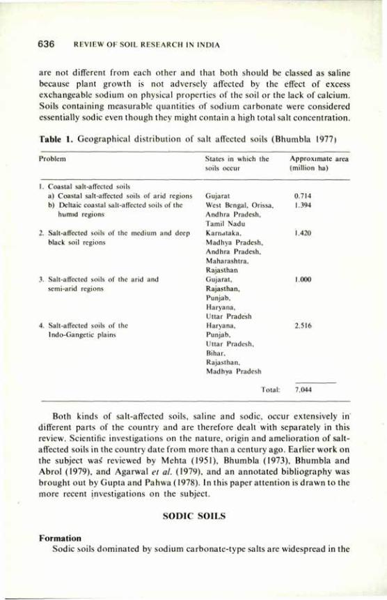
6 3 6 REVIEW OF SOIL RESEARCH IN INDIA
are not different from each other and that both should be classed as saline because plant growth is not adversely affected by the effect of excess exchangeable sodium on physical properties of the soil or the lack of calcium. Soils containing measurable quantities of sodium carbonate were considered essentially sodic even though they might contain a high total salt concentration.
Table 1. Geographical distribution of salt affected soils (Bhumbla 1977)
Problem States in which the Approximate area soils occur (million ha)
1. Coastal salt-affected soils a) Coastal salt-affected soils of arid regions Gujarat 0.714 b) Deltaic coastal salt-affected soils of the West Bengal, Orissa, 1.394
humid regions Andhra Pradesh, Tamil Nadu
2. Salt-affected soils of the medium and deep Karnataka, 1.420 black soil regions Madhya Pradesh,
Andhra Pradesh, Maharashtra. Rajasthan
3. Salt-affected soils of the arid and Gujarat, 1.000 semi-arid regions Rajasthan,
Punjab, Haryana, Uttar Pradesh
4. Salt-affected soils of the Haryana, 2.516 lndo-Gangetic plains Punjab,
Uttar Pradesh, Bihar, Rajasthan, Madhya Pradesh
Total:
Punjab, Uttar Pradesh, Bihar, Rajasthan, Madhya Pradesh
Total: 7.044
Both kinds of salt-affected soils, saline and sodic, occur extensively in different parts of the country and are therefore dealt with separately in this review. Scientific investigations on the nature, origin and amelioration of salt-affected soils in the country date from more than a century ago. Earlier work on the subject was' reviewed by Mehta (1951), Bhumbla (1973), Bhumbla and Abrol (1979), and Agarwal et al. (1979), and an annotated bibliography was brought out by Gupta and Pahwa (1978). In this paper attention is drawn to the more recent investigations on the subject.
SODIC SOILS
Formation Sodic soils dominated by sodium carbonate-type salts are widespread in the
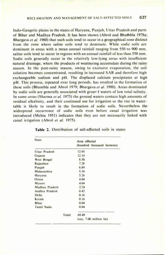
RECLAMATION AND MANAGEMENT OF SALT-AFFECTED SOILS 6 3 7
lndo-Gangetic plains in the states of Haryana, Punjab, Uttar Pradesh and parts of Bihar and Madhya Pradesh. It has been shown (Abrol and Bhumbla 1978a; Bhargava el al. 1980) that such soils tend to occur in a geographical zone distinct from the zone where saline soils tend to dominate. While sodic soils are dominant in areas with a mean annual rainfall ranging from 550 to 900 mm, saline soils tend to occur in regions with an annual rainfall of less than 550 mm. Sodic soils generally occur in the relatively low-lying areas with insufficient natural drainage, where the products ot weathering accumulate during the rainy season. In the post-rainy season, owing to excessive evaporation, the soil solution becomes concentrated, resulting in increased SAR and therefore high exchangeable sodium and pH. The displaced calcium precipitates at high pH. This process, repeated over long periods, has resulted in the formation of these soils (Bhumbla and Abrol 1979; Bhargava el al. 1980). Areas dominated by sodic soils are generally associated with ground waters of low total salinity. In some areas (Sharma el al. 1975) the ground waters contain high amounts of residual alkalinity, and their continued use for irrigation or the rise in water-table is likely to result in the formation of sodic soils. Nevertheless the widespread occurrence of sodic soils even before canal irrigation was introduced (Mehta 1951) indicates that they are not necessarily linked with canal irrigation (Abrol et al. 1975).
Table 2. Distribution of salt-affected soils in states
Area affected (hundred thousand hectares)
Uttar Pradesh 12.95 Gujarat 12.14 West Bengal 8.50 Rajasthan 7.28 Punjab 6.89 Maharashtra 5.34 Haryana 5.26 Orissa 4.04 Mysore 4.04 Madhva Pradesh 2.24 Andhra Pradesh 0.42 Delhi 0.16 Kerala 0.16 Bihar 0.04 Tamil Nadu 0.04
Total: 69.49 (say, 7.00 million ha)
638 REVIEW OF SOIL RESEARCH IN INDIA
Characteristics Chemical. Chemical characteristics of alkali soils in the Indo-Gangetic
plains in a number of publications (Agarwal and Yadav 1954; Kanwar and Sehgal 1962; Yadav and Agarwal 1963; Govindarajan and Murthy 1969; Kanwar and Bhumbla 1969; Raychaudhuri 1969; Bhargava et al. 1972; Bhumbla el al. 1972; Singhal and Akhtar 1973; Mehrotra el al. 1975; Bhargava and Abrol 1978), which bring out certain common characteristics. The soils are generally medium in texture, with sandy loam in the surface and clay loam below. The soils nearly always contain calcium carbonate and have a zone of calcium carbonate concretions at a depth of about 1 m. Sodium carbonate is the dominant soluble salt and imparts high exchangeable sodium percentage (ESP) to the soils. High ESP of these soils is also accompanied by high pH, and values as high as 10.5 (in 1:2 soil-water suspension) have been frequently reported. Abrol el al. (1980) presented data to show that in sodic soils an ESP of 15 to 20 is most often associated with a saturation paste pH of 8.2. They suggested that for diagnostic purposes a saturation paste pH of 8.2 would be more realistic than the hitherto used value of 8.5, which is nearly always associated with much higher ESP values. In a later study they (Gupta el al. 1981) developed a theoretical expression based on Na — (Ca+Mg) exchange equilibrium to quantitatively relate exchangeable sodium cation with pC02 , pH, sodium concentration and ionic strength. And they showed that in the calcareous sodic soils containing sodium carbonate, the pH of the system adequately describes the ESR and, therefore, the exchangeable sodium percentage of the soils. These results further showed that high sodicity and high pH were together responsible for the unproductivity of sodic soils and that determining their respective roles in influencing soil physicochemical properties and effect on crop performance could be rather difficult.
The sodic soils of the Indo-Gangetic plains usually occupy landscapes of lower elevation, and regions where sodic soils occur extensively are generally associated with ground waters of low total salinity. For this reason the ground water can be exploited for irrigation of areas brought under reclamation.
Physical. Excess exchangeable sodium, characteristic of sodic soils, has a marked effect on the soil physical properties. In a laboratory study with dominantly illitic medium-textured soils, Abrol et al. (1978) observed increased moisture retention with increasing ESP at soil water suctions greater than about 0.2 atm. At lower suctions more water was held in soils of lower ESP resulting in decreased available water capacity. While increasing the ESP from 5 to 14 resulted in only slight soil deterioration, a further increase in ESP resulted in a sharp decrease in infiltration rate, soil water storage following infiltration and hydraulic conductivity. In another correlative study (Sandhu et al. 1980) the soil-water diffusivity, 'D ' values obtained from the water content, 0, distribution in the laboratory columns followed the relationship of the type D = efl At all values of 6, the diffusivity decreased with increasing ESP and the decrease was more pronounced above ESP 20. A good agreement between the
RECLAMATION AND MANAGEMENT OF SALT-AFFECTED SOILS 6 3 9
observed and predicted values of the wetting front was obtained by using the D and 0 relationships, but the prediction of soil moisture profile was poor when constant values of weighted mean diffusivity were used. With increase in ESP from 5 to 93, there was a linear increase in the modulus of rupture and water dispersible clay, indicating that increasing ESP would also render the soils increasingly prone to crusting and erosion by rain.
In a number of field studies (Abrol and Acharya 1975; Acharya and Abrol 1978; Acharya et al. 1979 a, b; Acharya et al. 1980) attempts were made to quantitatively evaluate the effect of exchangeable sodium on soil water behaviour under field conditions. These studies brought out that (i) the magnitude and pattern of water content changes in the profile, following evaporation, were significantly affected by ESP; (ii) at all ESP values the cumulative water loss from soil at any time was greater under high than under low evaporative demand conditions; and (iii) the pattern of water loss from different layers in the soils of varying ESP remained the same, but the depth to which water content changes observed were increased with decrease in the evaporative demand. Similar observations were made under conditions of actual plant growth.
Reclamation The reclamation of sodic soils basically required that excess sodium on the
exchange complex be replaced with calcium and the exchanged sodium leached out of the root zone. Being cheapest and abundantly available, gypsum (CaS04.2H20) is the most commonly used amendment for sodic soil reclamation.
Quantity of Amendment The quantity of an amendment required for sodic soil reclamation depends
upon the amount of exchangeable sodium that must be replaced and the depth to which soil improvement is desired. This quantity is often referred to as the gypsum requirement (GR) of soils and is determined in most laboratories by the method of Schoonover (Richards 1954). For soils containing soluble carbonates, as most sodic soils of the Indo-Gangetic plains do, the method estimates the quantity of gypsum required both to neutralise the soluble carbonates and to replace the exchangeable sodium. It has, however, been shown that when gypsum is surface applied on a sodic soil high in soluble carbonates and then leached, only a small fraction of the applied calcium reacts with soluble carbonates and the carbonates are leached practically unreacted (Abrol et al. 1975). The results of these and other studies (Abrol and Dahiya 1974) suggested that the existing procedure overestimated the gypsum requirement of soils containing soluble carbonates. A modified procedure in which soluble carbonates were leached before GR determination provided a more reliable estimate of the requirement (Abrol et al. 1975).
Several field studies (Yadav and Agarwal 1959; Singh et al. 1969; Bhumbla
6 4 0 REVIEW OF SOIL RESEARCH IN INDIA
and Abrol 1975; Abrol and Bhumbla 1979) have aimed at establishing the optimum quantity of gypsum for reclamation. From these and other studies f Abrol et al. 1973) it was concluded that for obtaining optimum yields of rice and wheat it was enough to improve only the upper 15 cm soil depth although for deep root crops it was necessary to improve the soil to lower depths. A chart was prepared to.depict the relationship between the pH of 1:2 soil-water suspension and the gypsum requirement ol the soil (Abrol and Bhumbla 1973); it has been successfully used by soil-testing laboratories for making recommendations on the gypsum requirement of soils.
Nature of Amendments Apart from gypsum, several other materials have been used or
recommended for sodic soil reclamation. These include calcium salts, organic waste materials, and acids or acid-forming materials. Acids and acid-forming materials react with the insoluble calcium carbonate present in sodic soils to form soluble calcium, which in turn replaces the exchangeable sodium. Milap Chand et al. (1977) studied the effect of eight soil amendments on soil properties and crop growth in a highly sodic soil. When applied in chemically equivalent quantities, gypsum, sulphuric acid and aluminium sulphate were nearly equal in improving the soil and grain yield of barley, but the yield of the subsequent rice crop was the lowest in aluminium sulphate-treated plots possibly because of toxic effect of aluminium. Sharma and Mehrotra (1971) compared the effect of gypsum and sulphuric acid applied in equivalent quantities on the yield of rice and wheat and on changes in soil properties. They found the two to be nearly equally effective.
In recent years attention has also been drawn to the possibility of using pyrite, FeS2, as an amendment. This material is available in large quantities as sedimentary deposit at Amjhore in Rohtas district of Bihar. Being pyrophillic, pyrite reacts with atmospheric air and water to form sulphuric acid and iron sulphate. Verma and Abrol (1980a; 1980b) compared the effect of five levels of pyrite with that of equivalent quantities of gypsum and found pyrite containing 31 per cent sulphur to be only one-fourth as effective as gypsum when applied on chemically equivalent basis. Singh et al. (1978) and Verma and Abrol (1980a) arrived at similar conclusions from laboratory studies. Venkat Krishnan and Abrol (1981) attributed the inefficiency of pyrite in improving sodic soils to lack of its oxidation in sodic soils of high pH.
Application Method Khosla et al. (1973) found that mixing limited quantities of gypsum in
shallower depths was more beneficial than mixing in deeper depth, which resulted in its dilution and less ESP reduction throughout the depth. Moreover, when gypsum is mixed into a greater soil depth, it is more likely that a fraction of the gypsum will be used up in neutralizing soluble carbonates at the expense of exchangeable sodium replacement. In laboratory studies, Abrol et al. (1975)
RECLAMATION AND MANAGEMENT OF SALT-AFFECTED SOILS 641
showed that when gypsum was surface-applied or mixed and the sodic soils were leached, a greater reduction in ESP and higher final hydraulic conductivity were achieved with surface-applied gypsum.
Fineness From laboratory studies with gypsum ground to varying degrees of fineness,
Chawla and Abrol (1980) suggested that gypsum ground to pass through a 2 mm sieve and having a wide particle-size distribution is likely to be more effective for reclamation of sodic soils having appreciable quantities of sodium carbonate in the soil solution. Similarly, under field conditions, Chawla and Abrol (1980) found that no particular advantage was gained with gypsum grades finer than 2 mm when rice was grown as the first crop. Hira et al. (1980) reported increased solubility of gypsum with increasing fineness. They confirmed the observation of Abrol et al. (1979) that the solubility of gypsum mixed in a sodic soil was much more than that in water, and that solubility increased with increasing ESP. They showed further that this was the reason that the quantity of water required for reclamation was much less than that calculated on the basis of solubility of gypsum in water.
Crops in Sodic Soils Proper choice of crops during reclamation of sodic soils is important.
Growing crops tolerant of excess exchangeable sodium can ensure reasonable returns during the initial years of reclamation. Studies on crop tolerance of sodic conditions were undertaken in a number of greenhouse experiments (Das and Mehrotra 1972; Mehrotra and Gangwar 1964) and field experiments (Bhumbla and Abrol 1975; Abrol and Bhumbla 1979; Chhabra et al. 1979; Singh et al. 1979; Acharya et al. 1979; Singh et al. 1980). On the basis of the results of these studies the common crops were listed according to their relative tolerance of soil sodicity (Table 3). The results showed that rice yields were nearly unaffected up to an ESP of 50, at which wheat crop and most legumes may completely fail. In general, crops able to withstand excess moisture conditions are also more tolerant of high exchangeable sodium conditions.
The high tolerance of rice of exchangeable sodium arises chiefly from its need for excess water throughout the growing season. Low permeability of sodic soils is a further advantage to rice because percolation loss of water is restricted, although in most cases it is sufficient to leach soluble salts which result from exchange of sodium and are present in the root zone. From controlled greenhouse studies, Chhabra and Abrol (1977) inferred that growing of rice resulted in high and continued removal of exchangeable sodium by mobilisation of native, insoluble calcium carbonate. This was a result of increasea Hydrolysis, and the C0 2 liberated by plant roots which together with restricted oxygen supply favoured a decrease in soil pH (Singh 1969, 1974).
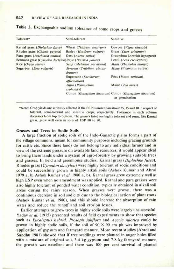
6 4 2 REVIEW OF SOIL RESEARCH IN INDIA
Table 3. Exchangeable sodium tolerance of some crops and grasses
Tolerant* Semi-tolerant Sensitive
Karnal grass (Diplachne fusca) Wheat (Triticum aestivum) Cowpea (Vigna sinensis) Rhodes grass (Chloris gayana) Barley (Hordeum vulgare) Gram (Cicer arielinum) Para grass {Brachiaria mulica) Oats (Avena saliva) Groundnut (Arachis hypogaea) Bermuda grass (Cynodon dactyIori)Raya (Brassica juncea) Lentil (Lens eseulentum) Rice (Oryza saliva) Senji (Melilotus parviflora) Mash (Phaseolus mungo) Sugarbeet (Beta vulgaris) Berseem (Trifolium alexan- Mung (Phaseolus aureus)
drinum) Sugarcane (Saccharum Peas (Pisum sativum) officinarum) Bajra (Pennesetum Maize (Zea mays) typhoides) Cotton (Gossypium hirsutum) Cotton (Gossypium hirsutum)
at germination
•Note: Crop yields are seriously affected if the ESP is more than about 55, 35 and 10 in respect of tolerant, semi-tolerant and sensitive crops, respectively. Tolerance in each column decreases from top to bottom. The grasses listed are highly tolerant and some, like Karnal grass, grow well even in soils of ESP 80 to 90.
Grasses and Trees in Sodic Soils A large fraction of sodic soils of the Indo-Gangetic plains forms a part of
the village commons, meant for community purposes including grazing grounds for cattle etc. Since these lands do not belong to any individual farmer and in view of the extreme pressure on available land resources, it would appear ideal to bring these lands under a system of agro-forestry by growing suitable trees and grasses. In field and greenhouse studies, Karnal grass (Diplachne fused), Rhodes grass (Cynodon dactylori) were highly tolerant of sodic conditions and could be successfully grown in highly alkali soils (Ashok Kumar and Abrol 1979 a, b; Ashok Kumar et al. 1980 a, b). Karnal grass grew extremely well at high ESP even when no amendment was applied. Karnal and para grasses were also highly tolerant of ponded water condition, typically obtained in alkali soil areas during the rainy season. When grasses were grown, there was a continuous decrease in soil sodicity due to the biological action of plant roots (Ashok Kumar el al. 1980), and this should increase the absorption of rain water and reduce the runoff and soil erosion losses.
Earlier attempts to grow trees in highly sodic soils were largely unsuccessful. Yadav et al. (1975) presented results of field experiments to show that species such as Eucalyptus hybrid, Prosopis juliflora and Acacia nilotica could be grown in highly sodic soils, if the soil of 90 X 90 cm pit was improved by application of gypsum and farmyard manure. More recent studies (Abrol and Sandhu 1981) showed that if tree seedlings were planted in auger holes filled with a mixture of original soil, 3-4 kg gypsum and 7-8 kg farmyard manure, the growth was excellent and there was 100 per cent survival of planted
RECLAMATION AND MANAGEMENT OF SALT-AFFECTED SOILS 6 4 3
Eucalyptus tereticornis and Acacia nilotica seedlings. In this way a favourable environment for root growth was created in a limited area but to a depth of 180 cm. The technique holds out promise for large-scale afforestation programmes in alkali areas.
Management Practices Adoption of best-suited cultural and crop management practices is essential
for obtaining optimum returns from the inputs to sodic soils. The management practices often have to be specific for soils of a particular region.
Planting Planting techniques can often be modified to overcome unfavourable soil
conditions for germination or crop establishment. Dargan et al. (1974) reported significant increase in rice yield when four and six seedlings were transplanted per hill in a highly sodic soil instead of usual practice of planting only one to two seedlings per hill in normal soils. In another study it was found that planting somewhat older rice seedlings than the usually recommended 30-day old seedlings was more beneficial.
Fertilisation Low organic matter and high pH impart poor fertility to sodic soils. Poor
air-water relations and high pH characteristic of most sodic soils further influence the transformation and availability of applied fertiliser nutrients. Laboratory studies by Nitant and Bhumbla (1974) showed that with increasing soil pH and sodicity the time required for nearly complete hydrolysis of urea increased from about three days for a soil of ESP 3 to about seven days for a soil of ESP 50. This was attributed to the effect of high pH on the activity of enzyme urease and the presence of carbonates in soils of high ESP. In another laboratory study (Nitant and Dargan 1974) it was observed that during urea incubation with a sodic soil (ESP 89) large quantities of nitrites were produced, and persisted for longer periods; but in a non-sodic soil practically no nitrites were detected.
Bhardwaj and Abrol (1978) studied volatilisation losses of nitrogen from ammonium sulphate applied @ 200 ppm to the surface 2 cm layer of two soils having pH 9.0 and 10.3, and found that as much as 32 per cent and 52 per cent of the added ammonium N was lost by volatilisation from the two soils, respectively. It was also found that the losses were more from a soil containing CaC03 than in the absence of CaC03 . Since the alkali soils of the Indo-Gangetic plains nearly always contain calcium carbonate and have high pH, it would appear that considerable losses of N occur through volatilisation. Although experimental evidence is lacking, physicochemical conditions prevalent in sodic soils are likely to favour losses of elemental N because, as Patrick and Wyatt (1964) concluded, losses of elemental N must be highest under alternate aerobic and anaerobic conditions — a situation ideally met
644 REVIEW OF SOIL RESEARCH IN INDIA
within sodic soils — because the conditions are favourable for the formation of NO3—N and its denitrification.
Singh et al. (1969) studied the effect of amendments and fertilisers on the yield of crops grown in a highly sodic soil and concluded from a three-year study that the effect of nutrients was more marked than that of gypsum. In a number of field trials at the Central Soil Salinity Research Institute, Karnal to study the response of rice and wheat to various levels of N in amended sodic soils, it was found that crops grown in sodic soils invariably responded to higher doses of N than those grown in non-sodic soils (Dargan et al. 1974; Nitant and Dargan 1974). It is now recommended that in the initial years of reclamation the N dose to crops should be increased by 15 to 20 per cent over the dose recommended for crops under similar agro-climatic non-sodic soil conditions. Ammonium sulphate was a better source of N for alkali soils than either calcium ammonium nitrate or urea (Nitant and Dargan 1974). In addition to other factors, the superiority of ammonium sulphate could be attributed to its potential acidic influence on soil reaction (Chander and Abrol 1972). Soil application of urea, though inferior to that of ammonium sulphate, proved as effective if some of it was applied through spray. Dargan et al. (1975) studied the effect of differential nitrogen fertilisation on rice following green manuring with dhaincha (Sesbania bispinosa) grown for nine weeks, and found that the effect of green manuring on the yield of paddy was nearly the same as that of 80 kg N applied to the crop grown after fallow. They did not, however, evaluate the extent of N-fixation.
From the foregoing it is apparent that although there is ample experimental evidence that for crops grown in sodic soils the optimum dose of N is higher than for crops grown in non-sodic soils, further quantitative studies on N losses under field conditions, effective rhizobial strains for legumes, and extent of N fixation by green manuring crops, etc., are needed. A greater understanding of these processes will form a sound basis for more efficient management of N fertilisers in sodic soils.
The availability of other major nutrients and their crop response relationships have not been studied in great detail. Agarwal et al. (1964) observed that with increasing exchangeable sodium, phosphorus increased in the rice tissues. Singh et al. (1975) reported that octa-calcium phosphate was the predominant form in sodic soils, although the agronomic significance of these findings remains to be evaluated. Chhabra et al. (1980) studied the P status of a large number of sodic soil profiles and found that most of them had high amounts of Olsen's extractable P. When gypsum was applied to such a soil and the soil was brought under cultivation, a large fraction of the soluble P was leached below the root zone. In spite of substantial P losses through leaching, long-term field studies (Dargan and Chillar 1978; Chhabra et al. 1981) have shown that because of high available P status of sodic soils, rice and wheat grown in rotation do not respond to applied P fertilisers, and therefore a considerable saving can be effected on this account in the initial years of reclamation (Chhabra et al. 1980).
RECLAMATION AND MANAGEMENT OF SALT-AFFECTED SOILS 6 4 5
Among micronutrients, fertilisation with zinc in the initial years of reclamation has been stressed in a number of studies (Dargan et al. 1976; Shukla and Mukhi 1980; Takkar and Randhawa 1978). Experiments by Mahavir Singh and his associates (unpublished), however, tend to show that repeated application of zinc fertilisers may not be necessary after an initial dose of 10 to 20 kg ZnS04/ha has been applied. However, this will much depend on the transformation of added zinc (Singh and Sekhon 1977) on the one hand and of changes in soil sodicity on the other hand. A greater understanding of the chemistry of added zinc will form a basis for long-term fertilisation needs of crops in alkali soils.
Toxic Elements Widespread toxicity of elements like boron has not been reported. Gupta
and Chandra (1972) found soluble boron to decrease when gypsum was incorporated in alkali soil because of reduced solubility of boron compounds. Singh and Randhawa (1980) showed that when an amendment was surface-applied and sodic soil was leached in columns, a major part (62 to 87 per cent) of the boron was leached out and the remaining 13 to 38 per cent converted to insoluble form. Similarly, laboratory and greenhouse studies (Chhabra et al. 1980; Singh et al. 1979 a. b) showed that the solubility and plant availability of fluorine in sodic soils decreased when gypsum was incorporated in sodic soils. These findings suggested that phosphogypsum, a by-product of fertiliser industry, could be used as an amendment for sodic soil reclamation even if it contained up to 1 per cent fluorine.
Singh and Singh (1966) studied the distribution of molybdenum in profile samples from cultivated and alkali soil profiles of Uttar Pradesh and found a significant positive correlation between pH and available molybdenum. Pasricha and Randhawa (1971) presented results of a field study to show that 13 per cent of collected plant samples contained toxic levels of molybdenum and
70 per cent of them showed N/S ratio wider than 20:1 which was much higher than that required for adequate nutrition of ruminant animals. Our knowledge of the behaviour of toxic elements in soil-plant-animal relationships is extermely limited, and this area of research deserves greater attention.
Irrigation For crops other than rice, irrigation management presents major difficulties
in the optimum use ef sodic soils. Low infiltration rates and hydraulic conductivity results in reduced profile water storage. Root penetration in these soils is often restricted because of dense and high ESP sub-soil layer (Abrol and Acharya 1975). The movement of stored water to the root zone is slow, and drying of surface soil layer is rapid (Acharya and Abrol 1978). These considerations require irrigation more frequently and with small quantities of water at each irrigation than for crops grown on normal soils (Gaul et al. 1973). For cavity well irrigated areas with an average well discharge of 10 litres/sec it was shown
6 4 6 REVIEW OF SOIL RESEARCH IN INDIA
(Dhruvanarayana 1980) that optimum border dimensions of 50 m X 6 m, 50m X 8 m,70 m X 6 m o r 7 0 m X 8 m could be adopted for rice-wheat rotation in reclaimed sodic areas.
Reclamation Programmes Studies by Parmatma Singh (1980) on a field scale showed that reclamation
of alkali soils was economically feasible and sound. A significant step in the past decade was the launching of systematic efforts by the State Governments of Haryana, Punjab and Uttar Pradesh to bring under cultivation the vast areas of sodic soils lying barren. It is estimated that nearly 60,000 hectares have already been brought under cultivation, and efforts are under way to further strengthen the field reclamation programmes. These programmes have drawn heavily on the research efforts in formulating a package of practices for the guidance of farmers undertaking reclamation.
Impact of Reclamation Considering that, on an average, each hectare reclaimed is contributing
about 6 tonnes (4 t paddy and 2 t wheat), the annual contribution from the reclaimed area is about 0.36 million tonnes. Apart from the direct contribution to food production, reclamation measures have resulted in progressively reduced peak runoff and total water yield with time from the beginning of reclamation in the catchment. In one storm it was observed that the peak value was reduced by more than 50 per cent and the runoff value by 75 percent. This was attributed to increased ground water recharge as a result of increased infiltration rates, opportunity time and retention storage (Dhruvanarayana 1980).
SALINE SOILS
Formation Saline soils are widely distributed in arid and semi-arid areas and in
seasonally dry coastal areas. Introduction of irrigation in arid and semi-arid areas without adequate provision of drainage leads to soil salinisation within a few years. The main contributing factors are: high salt content in the profile, saline ground water and high water-table conditions, occurrence of salt layer in the soil crust and rise in water-table, seepage from canal and adjacent irrigated areas, restricted surface and sub-surface drainage, irrigation with water of high salt content, and ingress of sea water (Bhumbla and Abrol 1979).
Soils of arid and semi-arid regions invariably contain salts in the profile because of inadequate natural leaching. Apart from the salts formed during weathering, salts may also be deposited with sediment in alluvial areas. The salts are washed from the surface layers and deposited at some depth, the latter depending on the amount, intensity and distribution of rainfall and the water retention and transmission characteristics of soil (Abrol and Bhumbla 1971).
RECLAMATION AND MANAGEMENT OF SALT-iAFFECTED SOILS 6 4 7
Very coarse-textured soils even in areas of 200-300 mm rainfall may be relatively free of salts in upper 2-3 m. Sandy loam and loamy soils developed on alluvium in a 300-400 mm rainfall zone usually have a salt layer at a depth of 1 to 2 m. Most Vertisols in medium- or deep-black soil areas in 500-700 mm rainfall zones have an accumulation of salts at a depth of 1 to 1.5 m (Basu 1950). When such areas are irrigated and the amount of water is inadequate, the salts dissolved by water during irrigation move to the soil surface during the fallow season. This was considered to be main cause of soil salinisation in canal-irrigated areas of Punjab (now in Pakistan) (Mehta 1951).
Saline ground water, when present close to the soil surface, contributes to soil salinisation. The critical depth of water-table depends on soil properties, salinity of the ground water and evaporative conditions. Sharma and Prihar (1973) observed in controlled studies on soil columns that the maximum evaporation from soil (Y max) was related to the depth of water-table (X cm) by the equation X = 149.2 — 150 log Y, indicating that evaporation practically ceased when water-table depth was more than 1.5 m. Chaudhary and Khepar (1972) studied the effect of soil type, water-table depth, and salt concentration of ground water on soil salinisation under constant water-table conditions and found that evaporation decreased markedly when water-table depth was 115 cm. Singh and Singh (1974) studied salt distribution in profile where the water-table was at 150 cm depth and found no net salt accumulation due to leaching by rains in the following season. Khosla et al. (1980) evaluated maximum flux in relation to the depth of water-table under field condition. Under bare soil condition they found that when water-table depth was 80 cm the upward flux was reduced to 0.1 cm/day. For cropped conditions thay suggested that the water-table needed to be controlled at 80 cm below the active root zone to prevent the effect of salinisation on growing crops.
All ground waters contain some salts, and prolonged use of these waters will cause soil salinisation in course of time if leaching and drainage are not provided. In certain soil and climatic conditions prolonged use of ground water
for irrigation may be posible under sufficient rainfall to accomplish leaching and good internal drainage conditions (Gupta and Abichandani 1970). Gulati (1971) presented equations which could predict accumulation and distribution of salts in the root zone depth when several irrigation-evapotranspiration cycles were gone through.
In the coastal saline areas, particularly the deltaic areas, the soils are rendered saline by the ingress of sea water, high water-table, and salinity of ground water (Yadav et al. 1979). Subramanyam et al. (1976) found the intensity of salinity to increase with decreasing distance from rivers and sea coast.
Characteristics Several workers have reported the characteristics of saline soils occurring in
648 REVIEW OF SOIL RESEARCH IN INDIA
different parts of the country. Some important studies on the subject are listed below:
Mukherjee et al. (1950) West Bengal Satyanarayana (1951) Gujarat Raychaudhuri and Sankaram (1952); Delhi Raychaudhuri and Tripathi (1953) Desai and Sen (1953) Bihar Krishna Rao and Raja Rao (1960) Andhra Pradesh Sharma and Moghe (1968) Rajasthan Mehta et al. (1969) Rajasthan Poonia and Bhumbla (1973) Haryana Bhargava (1977); Bhargava and Haryana Sharma (1978) Bhargava (1978) West Bengal Bhargava and Abrol (1981) Kerala (unpublished)
Excess salinity in most soils is due to the dominance of sodium chloride. Sodium often constitutes more than half of the total soluble cations. The pH of these soils is often near neutral with the exception of saline soils of Kerala, which are distinctly acidic. Because of the presence of excess neutral salts, saline soils are usually flocculated, and the soils have good physical properties.
Reclamation Leaching. Leaching and drainage are the two essential components of any
permanent solution of salinity problem. Although in sodic soils leaching is necessary after application of suitable quantities of amendments, in saline soils salt leaching can usually be accomplished without application of amendments. Several studies were concerned with the quantity of water required to leach soluble salts in the root zone to a safe level and the mode of application of water for most effective leaching.
The data of leaching experiments carried out in parts of Punjab (now in Pakistan) showed that application of about 1 m of water in sandy loam soils reduced the salt content to a safe level, 0.2 per cent, in the upper 2 m. Summer months were considered ideal for leaching since at that time of year water-table was the lowest (Mehta 1951); but if summer leaching was not feasible, rainy-season leaching with or without rice crop was the next best alternative.
Working on the coastal saline soils of Gujarat, Hoon (1966) reported that the khar lands could be brought under cultivation within two to five years if they were protected from tidal inundations and leached by rain-water or artificial irrigation. However, as observed by Krishna Rao and Raja Rao (1960), unless adequate drainage is provided to lower the water-table, leaching alone is
RECLAMATION AND MANAGEMENT OF SALT-AFFECTED SOILS 6 4 9
likely to prove ineffective, as was observed in the coastal region of Andhra Pradesh.
Leffelaar and Sharma (1977) carried out leaching studies in a soil having high salt content and high SAR and observed that leaching accomplished not only desalinisation but also desodification, since the SAR of soil solution was reduced with leaching. Similar observations had been made by Sekhon and Gill (1971) in field drainage trials at Ludhiana. Khoslae? al. (1979) found that for 80 per cent reduction in profile salinity 0.4 cm leaching water/cm soil depth was required to pass through the soil, and this corresponded to 1.14 pore volume displacement. They also found that desalinisation was accompanied by simultaneous reduction in SAR of the soil solution. When leached in the presence of gypsum, SAR was reduced to a greater extent, which would otherwise have been achieved by passing additional quantities of water. Sekhon and Gill (1971) concluded that the decision to use an amendment for the high-salt-high-SAR soils would depend chiefly on the soil infiltration characteristics, and that in heavy-textured soils leached with low-electrolyte water, application of gypsum might be desirable to hasten the reclamation process.
Studies on the methods of leaching carried out in other countries (Nielsen et al. 1966) tend to show that the efficiency of leaching saline soils may be significantly increased by controlling the degree of water saturation and the rate of water movement through the soil profile. In practice this could be accomplished by leaching by means of sprinkler irrigation or under alternate ponding and drying conditions. Several laboratory studies attempted to define the effect of soil conditions including soil texture (Dahiya and Abrol 1974; Ghuman and Prihar 1980) and initial wetness and mode of water application (Ghuman et al. 1975; Pandey 1979; Dahiya et al. 1980b) on salt displacement and efficiency of salt leaching. Under field conditions controlled leaching is difficult and adoption of sprinklers etc. is costly. Heavy-textured soils, even under ponded conditions, are leached under somewhat unsaturated conditions and any attempt at controlled leaching is likely to considerably increase the reclamation time (Abrol and Bhumbla 1973; Dahiya and Abrol 1974).
Drainage. Research efforts to define the drainage needs of different soils have been limited. Under sodic soil conditions, when the rainfall was more than about 600 mm, provision of shallow surface drains to take care of surface runoff and storage of excess rain-water in dugout ponds was an effective
drainage measure (Narayana et al. 1977). Sub-soil tile drainage under these conditions was neither feasible nor effective. Since the quality of ground water in alkali soil areas is generally good, vertical drainage and pumping of ground water and its use for irrigation may be an effective method for the control of ground water-table.
A pilot demonstration project for drainage and reclamation of the coastal salt-affected area near Umrath (Gujarat) was initiated in 1964 in an area of 250 ha provided with sea dykes and shallow open drains (Talati 1972). After two years of ponding, root zone salinity was reported to have decreased from 4.7 to
6 5 0 REVIEW OF SOIL RESEARCH IN INDIA
7.9 per cent to 0.6 to 1.2 per cent. Field trials conducted in heavy black salt-affected soils of Siruguppa in Karnataka showed (Yadav 1973) that tile drains placed at 1.2 m depth and 12 m spacing were most efficient in lowering the water-table and leaching the salts below the root zone. Although the need for adequate drainage measures for effective control of root zone salinity in areas being brought under irrigation have been emphasised in a number of documents, successful implementation of tile drainage system in sizable irrigated areas are lacking. Soil, climatic and hydrological conditions where installation of the drainage, system may be expected to be effective and economical need 'to be denned after careful field studies.
Management Practices For optimum crop production in saline areas appropriate selection of crops
and varieties and adoption of best-suited cultural and fertiliser practices are essential. Rice is considered a satisfactory crop during the initial years of reclamation of saline soils even though it is classified only a semi-tolerant crop. It can withstand ponding and the salts get diluted in the soil under saturated conditions. After rice, a legume crop is recommended (Mehta 1951). Several studies attempted to evaluate the salinity tolerance of crops. Information on the subject was reviewed by Raheja (1962) and Agarwal et al. (1979). In a number of papers the effect of soaking seeds in. different salt solutions on germination and crop yield was reported. Although advantages of such a treatment were stated in some case (Puntamkar et al. 1971), the field of study needs to be critically evaluated before any conclusions of practical value can be deduced. Similarly, the nutrient requirements of crops in saline soils were evaluated in a number of studies but the existence of any specific interaction at both soil and plant levels needs to be fully understood before any general recommendation be framed. Application of phosphorus to saline soils helps in reducing the chloride toxicity (Chhabra et al. 1976; Singh et al. 1979a).
Water management needs of growing crops demand serious attention in any package of crop management. Work on the desirable leaching fraction for different crops under different soil and climatic conditions will aid in deciding optimum water schedules. It would also be desirable to collect intensive research information under different management alternatives on salinity control and crop production over a sizable area to serve as a basis for extension of reclamation and management measures in larger areas.
References
Abrol, I.P. and Acharya. C.L. (1975) Proc. 2nd WId Congr. Wat. Resour. 1, 335. Abrol, l.P. and Bhumbla, D.R. (1971) Paper presented at FAO/UNDP Seminar on soil survey and
soil fertility research, 15-20 Feb. 1971, New Delhi, FAO World Soil Resources Report No. 41, p. 42.
RECLAMATION AND MANAGEMENT OF SALT-AFFECTED SOILS 6 5 1
Abrol, l.P. and Bhumbla, D.R. (I973) Soil Sci. II5, 429. Abrol. LP. and Bhumbla, D.R. (I978a) Paper presented at the Dryland Saline Seep Symposium,
24-27 June, I978, Edmonton, Alberta, Canada, p. 6. Abrol, LP. and Bhumbla, D.R (1978b) Paper presented at FAO Expert consultation on
Identification and Reclamation of Salt Affected Soils and Secondary Salinisation, 5-7 Dec. 1977, Rome (In press).
Abrol, LP. and Bhumbla, D.R. (1979) Soil Sci. 127, 79. Abrol, LP., Chhabra, R. and Gupta, R.K. (1980) International Symposium on Salt Affected Soils,
p. I42. Abrol, LP. and Dahiya, l.S. (1974) Geoderma, II, 305. Abrol, LP., Dahiya, l.S. and Bhumbla, D.R. (1975) Soil Sci. 120, 30. Abrol, LP.. Dargan, K.S. and Bhumbla, D.R. (1973) Bull. Central Soil Salinity Research Institute,
Karnal, 2, 58. Abrol, LP., Gupta, R.K. and Singh, S.B. (1979) J. Indian Soc. Soil Sci. 27, 482. Abrol, LP., Saha, A.K. and Acharya, C.L. (1978) J. Indian Soc. Soil Sci. 26, 98. Abrol, LP. and Sandhu, S.S. (1981) Indian Fmg, 31, 7. Acharya, C.L. and Abrol, LP. (1978) Soil Sci, 125, 310. Acharya, C.L., Sandhu, S.S. and Abrol, l.P. (1979a) Soil Sci. 127, 56. Acharya, C.L., Sandhu, S.S. and Abrol, LP. (1979b) Agron. J. 71, 936. Acharya, C.L., Sandhu, S.S. and Abrol, LP. (1980) Int. Symp. Salt Affected Soils, Karnal, 18-21
Feb., 1980, p. 219. Agarwala, S.C., Mehrotra, N.K. and Sinha, B.K. (1964) J. Indian Soc. Soil Sci. 12, 7. Agarwal, R.R. and Yadav, J.S.P. (1954) J. Soil Sci, 5, 330. Agarwal, R.R., Yadav, J.S.P. and Gupta, R.N. (1979) Indian Council of Agricultural Research,
Tech. Bull. 15. Ashok Kumar and Abrol, LP. (1979a) Indian J. agric. Sci. 49, 473. Ashok Kumar and Abrol, l.P. (1979b) Indian J. agric. Sci. 49, 535. Ashok Kumar, Abrol, l.P. and Dargan, K.S. (1980a) Forage Res. 6, 123. Ashok Kumar, Abrol, LP. and Dargan, K.S. (1980b) Indian Fmg, 30, 14. Basu, J.K. (1950) Trans, 4th int. Congr. Soil Sci. 3, 169. Bhardwaj. K.K.R. and Abrol. LP. (1978) Paper presented at National Symp. on Nitrogen
Assimilation and Crop Productivity, 5-7 Oct. 1976, Plant Biochemical Society, p. 83. Bhargava, G.P. (1977) Proc. lndo-Hungarian Seminar on Salt Affected Soils, Central Soil Salinity
Research Institute, Karnal. p. 31. Bhargava, G.P. (1978) Proc. natn. Symp. Land and Water Management in the Indus Basin (India),
Punjab agric. University, Ludhiana, I, 287. Bhargava, G.P. and Abrol, LP. (1978) Rep. No. 6, Central Soil Salinity Research Institute,
Karnal, India. Bhargava, G.P. and Sharma, R.C. (1978) Brochure-Aerial Photography Appreciation Seminar, the
Survey of India and the Institute of Surveyors, New Delhi. Bhargava, G.P., Sharma, R.C, Pal, D.K. and Abrol, LP. (1980) Int. Symp. on Salt Affected Soils.
1980, p. 83. Bhargava, G.P., Singhla, S.K. and Abrol, LP. (1972) Rep. No. 2, Division of Soils and Agronomy,
Central Soil Salinity Research Institute. Karnal, p. 36. Bhumbla, D.R. (1973) Seminar on Strategy on Fertiliser Use under Limited Availability, Fertilizer
Association of India, 19-20 October. Bhumbla, D.R. (1977) lndo-Hungarian Seminar on Management of Salt Affected Soils, 7-12 Feb.,
1977, p. 14. Bhumbla, D.R. and Abrol, LP. (1975) Proc. Int. Symp. New Develop. Field Salt Affected Soils,
Cairo, 1972, p. 537. Bhumbla, D.R. and Abrol, LP. (1979) Paper presented at the Symposium on Soils and Rice at the
Int. Rice Res. Inst., Los Banos. Laguna, Philippines, 20-23 Sept. 1977. p. 719.
6 5 2 REVIEW OF SOIL RESEARCH IN INDIA
Bhumbla, D.R.. Abrol, I.P., Bhargava, G.P. and Singhla, S.K. (1972) Bull. Central Soil Salinity Research Institute, Kama], 1, 50.
Chander, H. and Abrol, I.P. (1972) Commun Soil Sci. PI. Anal. 3, 51. Chaudhary, T.N. and Khepar, S.D. (1972) J. Res. Punjab agric. Univ., Ludhiana. 9, 45. Chawla, K.L. and Abrol, I.P. (1980) Int. Symp. Salt Affected Soils, Central Soil Salinity
Research Institute, Karnal, 18-21 Feb., 1980, p. 339. Chhabra, R. and Abrol, I.P. (1977) Soil Sci. 124, 49. Chhabra, R., Abrol, I.P. and Mahavir Singh (1980) Int. Symp. Salt Affected Soils, Central Soil
Salinity Research Institute, Karnal, 18-21 Feb. 1980, p. 418. Chhabra, R„ Abrol, I.P. and Singh, M.V. (1981) Soil Sci. (in press). Chhabra, R„ Ruinguet. A. and Lamberts, D. (1976)Zeitschrift f. Pflanzenphysiologie, 78, 253. Chhabra, R., Singh, S.B. and Abrol, I.P. (1979) Soil Sci. 147, 242. Dahiya, I.S. and Abrol, I.P. (1974) J. Indian Soc. Soil Sci. 22, 209. Dahiya, I.S., Abrol, LP. and Hajrasuliha, S. (1980a) J. agric. Sci., Camb. 94, 709. Dahiya, I.S., Singh, Mahendra and Hajrasuliha, S. (1980b) Soil Sci. Soc. Am. J. 44, 223. Dargan, K.S., Abrol, I.P. and Bhumbla, D.R. (1974) Agron. J. 66, 279 Dargan, K.S. and Chillar, R.K. (1973) Indian Fmg, 24(5), II. Dargan, K.S. and Chillar, R.K. (1978) Indian J. Agron. 23, 14.
Dargan, K.S., Gaul, B.L., Abrol, LP. and Bhumbla, D.R. (1976) Indian J. agric. Sci. 46, 535. Dargan, K.S., Nitant. H.C. and Bhumbla, D.R. (1975) Indian Fmg 25(7). II. Das, S.K. and Mehrotra, C.L. (1972) Indian J. agric. Sci. 42, 540. Desai, S.V. and Sen, A. (1953) Indian J. agric. Sci. 23, 187. Dhruvanarayarla (1980) Central Soil Salinity Research Institute, Karnal, Bull. No. 6. GauJ, B.L., Abrol, I.P. and Dargan, K.S. (1973) Indian Fmg, 23(4), 14. Ghuman, B.S. and Prihar, S.S. (1980) Soil Sci. Soc. Am. J. 44, 17. Ghuman, B.S., Verma, S.M. and Prihar, S.S. (1975) Proc. Soil Sci. Soc. Am. 39, 7. Govindarajan, S.V. and Murthy, R.S. (1969) Agrokem. Talajt. 18 (Sup.), 243. Gulati, O.P. (1971) Indian J. agric. Sci. 41, 1073. Gupta, I.C. and Abichandani, C.T. (1970). J. Soil Wat. Conserv. India, 18, 62. Gupta, l.C. and Chandra, H. (1972) Arid Zone II, 228. Gupta, R.K., Chhabra, R. and Abrol I.P. (1981) Soil Sci. 131, 215. Gupta, I.C. and Pahwa, K.N. (1978) A Century of Soil Salinity Research in India—An annotated
bibliography 1963-1976, Oxford and IBH Publishing Co., New Delhi, pp. 400. Hira, G.S., Singh, N.T. and Singh, R. (1980) Proc. int. Symp. Salt Affected Soils, Karnal.India, p.
322. Hoon. R.C. (1966) Trans. 6th int. Congr. Commn Irrig. Drain., New Delhi, 19, 301. Kanwar, J.S. and Bhumbla, D.R. (1969) Agrokem. Talajt. 18 (Sup.), 315. Kanwar, J.S. and Sehgal, J.L. (1962) J. Indian Soc. Soil Sci. 10, 19. Khosla, B.K., Dargan, K.S., Abrol, I.P. and Bhumbla, D.R. (1973) Indian J. agric. Sci. 43, 1024. Khosla, B.K., Gupta, R.K. and Abrol, LP. (1979) Agric. Wat. Management, 2, 193. Khosla, B.K., Gupta, R.K. and Chawla, K.L. (1980) Int. Symp. on Salt Affected Soils, 18-21 Feb.
1980. p. 256. Krishna Rao, D.V. and Raja Rao, G. (1960) Dep. Agric, Andhra Pradesh. Laffelaar, P.A. and Sharma, R.P. (1977) J. Hydrol. 32, 203. Mehrotra, C.L., Das, S.K. and Yadav, J.S.P. (1975) Dep. Agric. U.P. Tech. Bull., p. 278. Mehrotra, C.L. and Gangwar, B.R. (1964) J. Indian Soc. Soil Sci. 12, 75. Mehta, M.L. (1951) Cent. Board Irrig. Power, New Delhi, Pub. 1951, 43(1), p. 117. Mehta, K.M., Mathur, CM, , Shankaranarayana, H.S. and Moghe, V.B. (1969) Res. Monogr. 1.
Dep. Agric, Rajasthan, p. 61. Milap Chand, Abrol, I.P. and Bhumbla, D.R. (1977) Indian J. agric. Sci. 47, 348. Mukherjee, S.K., Datta, N.P. and Mukherjee, J.N. (1950) Indian J. agric. Sci. 20, I. Narayana, D.V.V., Pandey, R.N. and Gupta, S.K. (1977) J. Indian Assoc. Hydrologists, 1, 21.

RECLAMATION AND MANAGEMENT OF SALT-AFFECTED SOILS 6 5 3
Nielsen. D.R., Biggar. J.W. and Luthin. J.N. (1966) Int. Commn Irrig. Drainage 6th Congr., New Delhi, Indian Question 19, p. 15.
Nitant, H.C. and Bhumbla, D.R. (1974) J. Indian Soc. Soil Sci. 22, 234. Nitant, H.C. and Dargan, K.S. (1974) J. Indian Soc. Soil Sci. 22, 121. Pandey, R.N. (1979) J. agric. Sci.,Camb. 92, 663. Parmatma Singh (1980) Int. Symp.on Salt Affected Soils, 18-21 Feb. 1980, paper 12.7, p. 555. Pasricha, N.S. and Randhawa, N.S. (1971) Proc. Int. Symp. Soil Fertility Evaln, New Delhi, I,
1017. Patrick, W.H. Jr. and Wyatt. R. (1964) Proc. Soil Sci. Soc. Am. 28, 647. Poonia, S.R., and Bhumbla, D.R. (1973) J. Indian Soc. Soil Sci. 21, 335. Puntamkar. S.S., Mehta, P.C. and Sethi, S.P. (1971) Rajasthan J. agric. Sci. 2, 80. Raheja, P.C. (1962) Working group of waste lands including saline alkali and waterlogged lands.
Govt, of India. Raychaudhuri, S.P. (1969) Agrokem. Talajt, 18 (Sup.), 227. Raychaudhuri, S.P. and Sankaram, A. (1952) Indian J. agric. Sci. 22, 209. Raychaudhuri, S.P. and Tripathi, R.D. (1953) Indian J. agric. Sci. 23, 213. Richards, D.A. (1954) Handb. U.S. Dep. Agric. 60. Sandhu, S.S., Acharya, C.L. and Abrol, LP. (1981) J. Indian Soc. Soil Sci. 29, 148. Satyanarayana, K.V.S. (1951) Bull. Indian Soc. Soil Sci. 6, 125. Sharma, D.L. and Moghe, V.B. (1968) J. Indian Soc. Soil Sci. 16, 263. Sharma, D.N. ana Mehrotra, C.L. (1971) Scient. Proc. All India Symp. Soil Salinity,.Kanpur,
p. 173. Sharma, D.R. and Prihar, S.S. (1973) Indian J. agric. Sci. 43, 582. Sharma, R.A., Bhargava, B.S., Rastogi, S.K. and Ghurayya, R.S. (1975) Indian J. agric. Res. 9,
107. Sekhon, G.S. and Gill, S.S. (1971) Scient. Proc. All India Symp. Soil Salinity, Kanpur, p. 178. Shukla, U.C. and Mukhi, A.K. (1980) Int. Symp. on Salt Affected Soils, Karnal, p. 362. Singh, Anoop, Chhabra, R. and Abrol, LP. (1979a) Soil Sci. 127, 86. Singh, Arjan and Singh, N.T. (1974) J. Indian Soc. Soil Sci. 22, 156. Singh, B., Bhumbla, D.R. and Randhawa, N.S. (1975) J. Indian Soc. Soil Sci. 23, 353. Singh, B. and Sekhon, G.S. (1977)-Soil Sci. 124, 366. Singh, J. and Randhawa, N.S. (1980) J. Indian Soc. Soil Sci. 28, 307. Singh, K.N., Bains, S.S. and Agarwal, K.N. (1969) Indian J. Agron. 14, 26. Singh, M., Chhabra, R. and Abrol, LP. (1980) Annual Rep. Central Soil Salinity Research
Institute, Karnal. Singh, N.T. (1969) Soil Sci. PI. Nutr. 15, 156. Singh, N.T. (1974) PI. Soil, 40, 303. Singh, S. and Singh, B. (1966) J. Indian Soc. Soil Sci. 14, 19. Singh, S.B., Chhabra, R. and Abrol, LP. (1979b) Soil Sci. 128, 90. Singhal, J.P. and Akhtar, M. (1973) Agrochimica, 17, 424. Subramanyam, T.K., Kar, S. and Sinha, H.N. (1976) J. Indian aoc. Soil Sci. 24, 137. Szabolc, I. (1974) Hung. Res. Inst, for Soil Sci. agric. Chem. of the Hung. Acad. Sci. — Budapest. Takkar, P.N. and Randhawa, N.S. (1978) Fertil. News, 23(8), 3. Talati, R.P. (1972) Proc. Symp. Soil and Water Management, Hissar, Indian Council of
Agricultural Research, p. 300. Venkat Krishnan and Abrol, LP. (1981) J. Indian Soc. Soil Sci. (in press). Verma, K.S. and Abrol, LP. (1980a) Indian J. agric. Sci. 50, 844. Verma, K.S. and Abrol, LP. (1980b) Indian J. agric. Sci. 50, 935. Yadav, J.S.P. (1973) In Adv. Agric. U.P. Inst. Agric. Sci. Kanpur, 3, 87. Yadav, J.S.P. and Agarwal, R.R. (1959) J. Indian Soc. Soil Sci. 7, 213. Yadav, J.S.P. and Agarwal, R.R. (1963) J. Soil Wat. Conserv. India II, 107.
6 5 4 REVIEW OF SOIL RESEARCH IN INDIA
Yadav, J.S.P., Bandyopadhya, A.K., Rao, K.V.G.K., Sinha, T.S. and biswas, C.R. (1979) Central Soil Salinity Research Institute, Karnal, Bull, No. 5, p. 34.
Yadav, J.S.P., Bhumbla, D.R. and Sharma, O.P. (1975) Proc. Int. Symp. New Dev. Field of Salt Affected Soils, Cairo, 1972, p. 683.
Land Use and Management Practices in Arid Zone H.S. MANN AND R.P. DHIR*
THE hot arid zone of India is characterised by high density of human and livestock population and a long history of human occupation and exploitation of natural resources. Spread over an area of 0.32 million sq km, it supports a human population of 19 million and an even greater livestock population.
However, the present land use and management are somewhat overexploitative of its natural resource. Studies on this aspect are reviewed in this paper. A brief account of the environmental and physical characteristics and the evolution of the arid zone is also included.
Extent of the Arid Zone Pramanik et al. (1952) classified the climates of the arid zone using isopleths
of Demartonne's indices of aridity. But Shanbagh (1956) and Bhatia (1957) found Thornwaite's moisture index more suitable for classifying the climates of the country and delineating the arid zone. They based their studies on the data of the Indian Meteorological Department observations, for which long-period normals were available. Krishnan (1968) sought to improve upon this by utilising the data of numerous provincial rain gauge stations. Adopting a moisture index value of less than or equal to — 40, he delimited the arid zone of the country (Table 1).
Evolution In the Indian subcontinent, with a strong monsoon regime, the occurrence
of an arid zone is an enigma. And the fact that a series of great prehistoric cultures had once flourished in a part of this zone has provided a fertile ground for many ideas on the origin and period of onset of aridity. Krishnan (1952) was of opinion that, though the present pattern of rainfall must have set in during the Tertiary when the Himalayas rose high enough to become an obstruction, the general lowering of temperature during the Ice Ages and the presence of a fore-deep fed by the Himalayan rivers must have kept Rajasthan moist till perhaps subrccent times. Wadia (I960), Piggot (1950), and Bryson and Barreis (1967) also believed in a Holocene or even historic origin of the aridity. However, Roy and Pandey (1971) and Meher (1973) were of the opinion that aridity in the region was much older.
Goudie el al. (1973) and Allchin el al. (1978) suggested that the region had
'Central Arid Zone Research Institute, Jodhpur, Rajasthan.

6 5 6 REVIEW OF SOIL RESEARCH IN INDIA
in fact witnessed a series of climatic changes during the late Pleistocene. According to them, the Pre-Middle Stone Age was a major dry phase, which led to formation of large dune bodies. The succeeding Middle Stone Age, extending from about 45,000 years to 25,000 years B.P., was wetter. These conditions seem to have persisted till early Upper Palaeolithic, after which set in a major dry phase to be followed by a moist phase about 10,000 years B.P. The succeeding period also witnessed a series of climatic changes (Singh et al. 1974).
From these studies at least two points are clear. First, aridity in the region is not man-made as had been believed by many for a number of years. Second, there was a period in the past when conditions were more desertie and the arid zone was bigger than today. Therefore, it had witnessed fluctuations of climate both wetter and drier than those of today. However, considerable difference of opinion persists regarding the amplitude of these fluctuations. Whereas Allchin et al. (1978), Singh et al. (1974) and Ghosh (1977) indicated wet and humid interludes between the dry phases, Dhir (1977a) stated that soil formations in the region were suggestive of arid to semi-arid climates only.
In the early fifties, fears were expressed that the desert was expanding and marching in the north-westernly direction, but Mann et al. (1974), using parameters such as land use, availability of water and crop-yield performance in desert and adjoining regions, concluded that the desert was not spreading. Ghosh et al. (197/b) also found no geomorphic evidence to show expansion of the desert.
Rainfall The Indian arid zone is strongly influenced by the Asiatic monsoon regime.
Of the annual rainfall, 78 to 96 per cent is received during the monsoon season, especially the south-western monsoon. Only in the southern arid zone does the south-eastern monsoon contribute 21 to 32 per cent of the annual rainfall. The mean annual precipitation varies from 100 to 450 mm in Rajasthan, from 300 to 500 mm in Gujarat, and from 200 to 450 mm in Punjab and Haryana; it is about 500 mm in the southern arid zone. The annual potential evapotranspiration varies from 1411 to 1700 mm (Table 2). The result is an annual water deficiency of 1019 to 1171 mm (Krishnan 1978).
Besides the low annual rainfall, the coefficient of year to year variation is as high as 40 to 56 per cent. At times the onset of the monsoon is delayed or there are extended periods of drought during the monsoon season. In arid Rajasthan, in 13 to 27 per cent of the years rains set in only after the 29th of July. Severe drought occurs once in three to four years in different parts of the region (Table 3).
Landform and .Soils Raheja and Sen (1964) showed that dunes of various dimensions and
density are present in 58 per cent of arid Rajasthan. They are of various types,
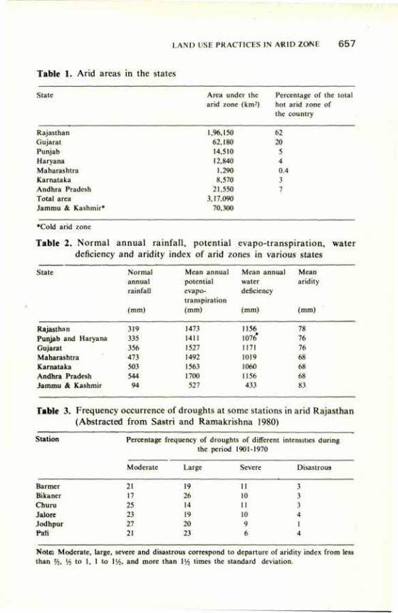
LAND USE PRACTICES IN AfUD ZONE 6 5 7
Table 1. Arid areas in the states
State Area under the Percentage of the total arid zone (km*) hot arid zone of
the country
1,96,150 62 62,180 20 14,510 5 12,840 4
1,290 0.4 8,570 3
21,550 7 3,17,090
70,300
Rajasthan Gujarat Punjab Haryana Maharashtra Karnataka Andhra Pradesh Total area Jammu & Kashmir*
•Cold arid zone
Table 2. Normal annual rainfall, potential evapo-transpiration, water deficiency and aridity index of arid zones in various states
State Normal Mean annual Mean annual Mean annual potential water aridity rainfall evapo- deficiency
transpiration (mm) (mm) (mm) (mm)
Rajasthan 319 1473 1156 78 Punjab and Haryana 335 1411 1076* 76 Gujarat 356 1527 1171 76 Maharashtra 473 1492 1019 68 Karnataka 503 1563 1060 68 Andhra Pradesh 544 1700 1156 68 Jammu & Kashmir 94 527 433 83
Table 3. Frequency occurrence of droughts at some stations in arid Rajasthan (Abstracted from Sastri and Ramakrishna 1980)
Station Percentage frequency of droughts of different intensities during the period 1901-1970
Barmer Bikaner Churu Jalore Jodhpur Pali
Moderate Large Severe Disastrous
21 19 11 3 17 26 10 3 25 14 II 3 23 14 10 4 27 2(1 9 1 21 23 6 4
Note: Moderate, large, severe and disastrous correspond to departure of aridity index from less than 'A, !4 to 1, 1 to \xh, and more than 1V4 times the standard deviation.
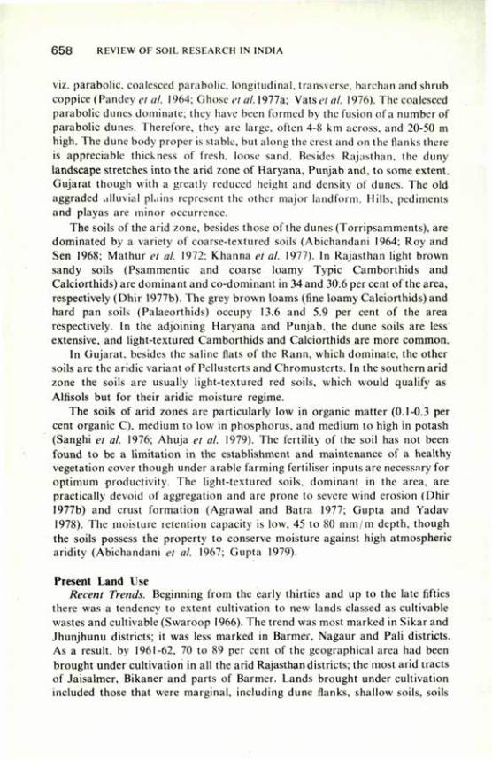
6 5 8 REVIEW OF SOIL RESEARCH IN INDIA
viz. parabolic, coalesced parabolic, longitudinal, transverse, barchan and shrub coppice (Pandey et al. 1964; Ghose et al. 1977a; Vatsetal. 1976). The coalesced parabolic dunes dominate; they have been formed by the fusion of a number of parabolic dunes. Therefore, they are large, often 4-8 km across, and 20-50 m high. The dune body proper is stable, but along the crest and on the flanks there is appreciable thickness of fresh, loose sand. Besides Rajasthan, the duny landscape stretches into the arid zone of Haryana, Punjab and, to some extent. Gujarat though with a greatly reduced height and density of dunes. The old aggraded alluvial plains represent the other major landform. Hills, pediments and playas are minor occurrence.
The soils of the arid zone, besides those of the dunes (Torripsamments), are dominated by a variety of coarse-textured soils (Abichandani 1964; Roy and Sen 1968; Mathur et al. 1972; Khanna et al. 1977). In Rajasthan light brown sandy soils (Psammentic and coarse loamy Typic Camborthids and Calciorthids) are dominant and co-dominant in 34 and 30.6 per cent of the area, respectively (Dhir 1977b). The grey brown loams (fine loamy Calciorthids) and hard pan soils (Palaeorthids) occupy 13.6 and 5.9 per cent of the area respectively. In the adjoining Haryana and Punjab, the dune soils are less extensive, and light-textured Camborthids and Calciorthids are more common.
In Gujarat, besides the saline flats of the Rann, which dominate, the other soils are the aridic variant of Pellusterts and Chromusterts. In the southern arid zone the soils are usually light-textured red soils, which would qualify as Alfisols but for their aridic moisture regime.
The soils of arid zones are particularly low in organic matter (0.1-0.3 per cent organic C), medium to low in phosphorus, and medium to high in potash (Sanghi et al. 1976; Ahuja et al. 1979). The fertility of the soil has not been found to be a limitation in the establishment and maintenance of a healthy vegetation cover though under arable farming fertiliser inputs are necessary for optimum productivity. The light-textured soils, dominant in the area, are practically devoid of aggregation and are prone to severe wind erosion (Dhir 1977b) and crust formation (Agrawal and Batra 1977; Gupta and Yadav 1978). The moisture retention capacity is low, 45 to 80 mm/m depth, though the soils possess the property to conserve moisture against high atmospheric aridity (Abichandani et al. 1967; Gupta 1979).
Present Land Use Recent Trends. Beginning from the early thirties and up to the late fifties
there was a tendency to extent cultivation to new lands classed as cultivable wastes and cultivable (Swaroop 1966). The trend was most marked in Sikar and Jhunjhunu districts; it was less marked in Barmer, Nagaur and Pali districts. As a result, by 1961-62, 70 to 89 per cent of the geographical area had been brought under cultivation in all the arid Rajasthan districts; the most arid tracts of Jaisalmer, Bikaner and parts of Barmer. Lands brought under cultivation included those that were marginal, including dune flanks, shallow soils, soils
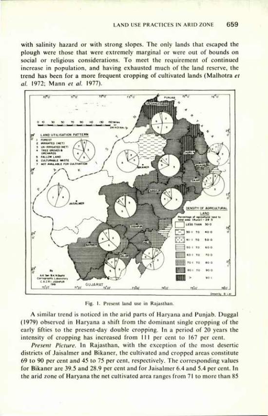
LAND USE PRACTICES IN ARID ZONE 6 5 9
with salinity hazard or with strong slopes. The only lands that escaped the plough were those that were extremely marginal or were out of bounds on social or religious considerations. To meet the requirement of continued increase in population, and having exhausted much of the land reserve, the trend has been for a more frequent cropping of cultivated lands (Malhotra et al. 1972; Mann et ai. 1977).
Fig. 1. Present land use in Rajasthan.
A similar trend is noticed in the arid parts of Haryana and Punjab. Duggal (1979) observed in Haryana a shift from the dominant single cropping of the early fifties to the present-day double cropping. In a period of 20 years the intensity of cropping has increased from 111 per cent to 167 per cent.
Present Picture. In Rajasthan, with the exception of the most desertie districts of Jaisalmer and Bikaner, the cultivated and cropped areas constitute 69 to 90 per cent and 45 to 75 per cent, respectively. The corresponding values for Bikaner are 39.5 and 28.9 per cent and for Jaisalmer 6.4 and 5.4 per cent. In the arid zone of Haryana the net cultivated area ranges from 71 to more than 85
6 6 0 REVIEW OF SOIL RESEARCH IN INDIA
per cent, with an intensity of cropping of 110 to 150 per cent. Similar is the picture in Punjab. In the arid zone of Gujarat, in Jamnagar district the cultivated area is a little more than 50 per cent, the remaining being unfit for cultivation. Similarly, in Kutch, a major part of which is formed by the saline Ranns, the cultivated area is only 14 per cent. Of the southern arid zone, 47 to 60 per cent is cultivated.
From the above it can be concluded that arable farming has come to stay as the most common land use. Cultivation has stretched up to 250 mm isohyet, and large ploughed patches can be seen even below this rainfall zone where crops have a chance to succeed only once in about three years (Anon. 1974 a, b). The only land left out, besides the village commons and other protected lands, are rocky, very shallow or saline areas or those with extremely rigorous climate.
Crops and Cropping Pattern In much of arid Rajasthan pearl millet is the principal crop, covering 50 to
70 per cent of the sown area; it is followed by pulses (10-30 per cent), cluster bean and sesame (Anon. 1974 a, b). In the more desertie western part, millet is the sole crop, whereas in specific situations of market demand, as in Bikaner and Churu, pulses assume greater importance. In the northern part of the arid zone, which is characterised by winter rainfall, besides millet and cluster bean there is a large area under gram and oilseed crops. In Gujarat, with medium-textured soils and higher rainfall, groundnut, sorghum and cotton assume significance, whereas in the south minor millet appears in addition. Where irrigation facilities exist, wheat, cotton and a variety of fodder crops constitute the pattern.
Land Management The village commons and other uncultivated lands serve as open pastures.
Though there is some control on cutting of trees, there is no control on the intensity of grazing; hence there is hardly any management of these lands. Farming in the region is essentially a mixed enterprise, and most farmers maintain sizable herds of livestock sustained on crop residues, grazing on fallow and cropped fields, on top-feed trees that are purposely maintained, and on common grazing lands (Jodha and Vyas 1969). Another feature is the system of fallow farming. A part of the cultivated land is left fallow for one to two years for soil recuperation and for grazing of livestock. Only the lands in the immediate vicinity of settlements are cropped every year. However, the fallow farming system is on the decline, and more and more lands are being regularly cropped. To meet the problem of wind erosion, many farmers are resorting to field bunding and green fencing. Off and on, the soil piled up against the fence is dragged back into the fields.
Another common practice is mixed cropping. Pearl millet is often grown in mixture with one or more of the following — mung, moth or cluster beans and
LAND USE PRACTICES IN ARID ZONE 661
sesame. The object is to minimise the risk due to erratic rainfall by exploiting the behavioural difference between these crops (Gupta 1975).To a limited extent the practice of legume-millet rotation is followed. There is a system of crop rescheduling in relation to the time of onset of the monsoon. Whenever the rains are delayed beyond 20 July or so, the farmers do not grow pearl millet but concentrate on pulses (mung and moth) and beans. They are aware of the need to improve the fertility of soils, and they encourage the penning of livestock on the fields.
Because of the rapid drying of the surface soil after rain, the sowing period is a critical factor in obtaining good crop stands. To cope with the task ploughing with tractor has become popular. To illustrate, the number of tractors increased from 698 in 1956 to 2,543 in 1966 and 14,535 in 1976.
Among the top-feeds, Prosopis cmeraria is most important. The density of this tree varies from 90 to 120trees/ha in 350 mm and higher rainfall zone to 20 to 40 trees in most other areas. Each well-grown tree gives 25 to 50 kg of air-dry feed which has 12-15 per cent protein and is therefore quite nutritious (Kaul and Ganguli 1962). The tree does not compete for moisture with the annual crops since it survives on the subsoil moisture built up during years of good rainfall. In fact, crops and natural vegetation under the canopy of the tree showed better growth (Shankar et al. 1976; Agarwal el al. 1976). Another equally useful species is Zizyphus nummularia.
The sandy soils of the region, in spite of their low moisture retention capacity, have the property of conserving moisture against high atmospheric deficit. This has been exploited by the enterprising farmers in raising special types of water melons (Misra 1962; Mann and Lahiri 1979). The ingenuity of the people is also reflected in the novel khadin system of farming based on water harvesting in the most arid parts of the region. It is so designed that even 80-100 mm rainfall in the season in the catchment ensures millet crop in a small cropped area (catchmentxommand :: 12:1). When the rainfall is higher, wheat and gram are the main crops.
Ground waters in the area are generally saline to highly saline. The farmers have developed management practices for the use of poor-quality waters for irrigating winter crops such as wheat and barley by keeping the lands fallow during the rainly season to ensure the leaching of accumulated salts. Where water quality is not a problem, diversified cropping pattern is followed. The crops grown include chillies, a variety of condiments, onions and other vegetables. These are raised in an intensive management with heavy application of organic manures, relay cropping and shelter belt plantation.
Water Resources and Development of Irrigation Underground water resources are limited, and in the last few years their
exploitation has been on the increase. At present in arid Rajasthan the ground water is being exploited to irrigate 0.4 m ha. Some other potential resources still exist (Dasgupta 1975; Chatterjee 1978). The quality is variable and often
6 6 2 REVIEW OF SOIL RESEARCH IN INDIA
restricts the choice of crops besides imposing management limitations. A striking development has been the diversion of Indus basin waters into the arid zone. In all 0.7 m ha in arid Rajasthan are benefiting. Another major project which is nearing completion will raise the irrigated area to 1.34 m ha. As a result, nearly 11 per cent of arid Rajasthan will have the benefit of irrigation.
In Punjab almost all the arid land is irrigated. In Haryana, barring a small area, 7 to 30 per cent of it is irrigated, and in Gujarat 7 to 10 per cent.
Over-exploitation and its Consequences The land management practices developed over the years, though efficient,
are exploitative, considering the long-term soil productivity. Open grazing lands are in a serious state of degradation. The vegetative cover is thin and dominated by low yielding annuals or unpalatable species, deformed or diminutive useful trees and shrubs. According to some studies (Bhimaya et al. 1967; Gupta and Saxena 1972) these have a basal cover of only 0.1 to 5.0 per cent as compared with 11.5. to 24 per cent on scientifically managed lands. Overgrazed lands have only 10 to 25 cent productivity of that obtained under good management (Anon. 1976; Mann et al. 1977). High livestock pressure and irrational grazing practices are the main causes. The current trend in livestock composition, i.e. increase in the proportion of goats in comparison with sheep and cattle is leading to further deterioration.
Extension of cultivation on to the dunes is leading to their reactivation (Abichandani and Roy 1966; Roy and Pandey 1971; Ghoseet al. 1977a). There is a common practice of ploughing the land during winter and summer to remove extraneous vegetation and to prepare the land for cropping. This practice, without adequate conservation measures, induces surface instability and promotes wind erosion. Therefore, an important undesirable consequence of the present land management of both open grazing land and farmed land is the increased component of loose sand in the landscape. Each summer strong winds cause a massive movement of sand. Gupta and Aggrawal (1978) reported that in certain situations a bare sandy soil lost as much as 9.7 cm of its top soil in just one year. In another study (Anon. 1976) it was observed that in a period of 18 years from 1958 sand deposition features such as hummocks and sand sheeting had become accentuated over an area of 16.6 per cent. These fresh sand deposits had low level of plant nutrients and were so unstable as to cause difficulty in the establishment of a plant population.
Over the years, efforts have been made to harness the limited surface water resources of the area for irrigation. In a number of projects, e.g. Sardar Semand and Hemawas, secondary salinisation has become a serious problem, as has over-exploitation of ground water resources in certain localities (Chatterjee 1978).
Combating Deterioration Arid zone research in the past 20 years has considerably increased our
LAND USE PRACTICES IN ARID ZONE 6 6 3
knowledge about the structure and functioning of the arid zone ecosystem. It has also given us a number of measures for upgrading the production on farm and grazing lands.
Land Use Adjustment. It is necessary that cultivation be limited to interdunes and sandy plains with rainfall exceeding 275 mm, and that too with rigorous measure for the control of wind erosion (Raheja 1964; Abichandani and Roy 1966; and Mann et al. 1977). Though this will shorten the cultivated area, the gap in production can be made good by adoption of improved cultivation practices.
Improved Management of Arable Lands. The present productivity of cultivated lands is low. The main reasons are inadequate stand establishment of the crop, competition from extraneous vegetation, and lack of adequate inputs of fertilisers and of improved varieties. Line-sowing with tractor- or bullock-drawn seed drill ensured good germination and proper weeding (Yadav and Singh 1978). Paired row system of bajra sowing was found to further increase the moisture use efficiency (Singh et al. 1978a). Improved varieties of traditional crops were identified and strategic use of fertilisers i.e. 20 kg N/ha basal and a supplementary dose at knee-high stage depending upon rainfall proved useful (Singh et al. 1978b; Singh 1976).
Farming with in-field water harvesting is a good means of stabilising production. Permanent systems with or without barrier and a system of inter-row water harvesting have been developed to suit individual needs and resources (Singh et al. 1973; Singh 1976). Some of these have also been tried successfully for horticultural crops (Singh 1978).
Improving Range Land Productivity. Reseeding of the existing degraded land with high-yielding perennials, controlled grazing, and adoption of water conservation measures such as furrowing and staggered trenching can improve land productivity (Verma and Chakravarty 1972; Ahuja and Mann 1975).
Sand Dune Stabilisation. Pioneering work has been done in the country to develop a suitable technique for stabilising sand dunes. It includes (i) nursery raising of the saplings in earthen bricks, (ii) establishment of micro barrier in strip or chess-board design, (iii) transplanting of saplings and seeding with grasses, and (iv) after-care of the stabilised dune. It is also desirable that seedlings of exotic tree species be planted only on the upper half of the dune; and that the lower half and interdunes be planted with indigenous frost-resistant species (Bhimaya et al. 1961; Kaul 1968).
Conclusions Arid areas have great potential for mixed farming and development of
horticulture and research efforts, therefore, need to be directed towards them. Since these areas suffer from chronic water deficit for raising crops, water supply has to be enhanced by water harvesting optimised in respect of method and ratio of catchment to cropped area. Efficient utilisation of water is imperative by practising cultural practices appropriate to coarse textured soils
664 REVIEW OF SOIL RESEARCH IN INDIA
which are apparently droughty but conserve moisture in the deeper layers. Further research is needed to develop suitable techniques for wind erosion control, sand dune stabilisation and improving grass land productivity.
References
Anonymous (1974a) Basic Resources of Bikaner district, Central Arid Zone Research Institute, Jodhpur.
Anonymous (1974b) Interim Report on Desert Dev. Nat. Comm. Agri.. Delhi. Anonymous (1976) A case study on desertification, Central Arid Zone Research Institute,
Jodhpur. Abichandani, C.T. (1964) Proc. Symp. Prot, Indian Arid Zone, Jodhpur p. 122. Abichandani, C.T., Krishnan, A., Bhatt, P.N. and Rakhecha, P. (1967) J. Indian Soc. Soil
Sci. 15, 7. Abichandani, C.T. and Roy, B.B. (1966) Indian geog. J. 41, 35. Aggrawal, R. K., Gupta, J.P., Saxena, S.K. and Muthana, K.D. (1976) Indian Forester 102,
863. Agrawal, R. P. and Batra, M.L. (1977) J. Indian Soc. Soil Sci. 25, 77. Ahuja, L.D. and Mann, H.S. (1975) Ann. Arid Zone 14, 29. Ahuja, R.L., Garalapuri, V.N. and Khanna, S.S. (1979) Bull. Desert Management of Haryana,
Haryana agric. Univ. p. 21. Allchin, B., Goudie, A. and Hegde, K.M.T. (1978) The Prehistory and Palaegeography of
the Great. Indian Desert Academic Press, London. Bhatia, S.S. (1957) Indian J. Meteor, and Geoph. 8, 355. Bhimaya, C.P., Kaul, R.N. and Ahuja, L.D. (1967) Proc. Joint Symp. natn. Inst. Sci.
and ICAR on Sci. and India's Food Problem, New Dehi p. 215. Bhimaya, C.P., Kaul, R.N. and Ganguli, B.N. (1961) Proc. 5th World Forestry Congr. P. 358. Bryson, R.A. and Barreis, A. (1967) Bull Am. Met. Soc. 48, 136. Chatterjee, P.C. (1978) Arid Zone Res. and Dev. Sci. Pub. Jodhpur p. 87. Dasgupta, K. (1975) Workshop on Problems of the Deserts in India, Geological Survey of India,
Jaipur Sept. 1975. Dhir, R.P. (1977a) Ecology and Archaeology of Western India, Concept Publishing House, New
Delhi p. 127. Dhir, R.P. (1977b) Desertification and its control, Indian Council of Agricultural Research, New
Delhi p. 102 Duggal, S.L. (1979) Bull Desert Management of Haryana, Haryana agric. Univ. p. 48. Ghose, B„ Singh, S. and Kar, A. (1977a) Ann. Arid Zone 16, 290. Chose, B., Singh, S. and Kar, A. (1977b) Desertificatiion and its Control, Indian Council of
Agricultural Research, New Delhi p. 69. Ghosh, R.N. (1977) In Ecology and Archaeology of Western India, Concept Publishing House,
New Delhi p. 157. Goudie, A., Allchin, S. and Hegde, K.M.T. (1973) Geor. J. 139, 243. Gupta, J.P. (1979) J. Hydro. 41, 153. Gupta, J.P. and Aggrawal, R.K. (1978) Arid Zone Res. and Dev. Sci. Pub. Jodhpur p. 109. Gupta, J.P. and Yadav, R.C. (1978) J. Indian Soc. Soil Sci. 26, 20. Gupta, R.K. (1975) Environmental Analysis of the Thar Desert English Book Dept. Dehra Dun. Gupta, R.K. and Saxena, S.K. (1972) Ann. Arid. Zone 11, 198. Jodha, N.S. and Vyas, V.S. (1969) Condition of stability and growth in arid agriculture, Agro-
Econ. Res. Centre, Vallabh Vidyanagar, Gujarat.
LAND USE PRACTICES IN ARID ZONE 6 6 5
Kaul, R.N. (1968) Indian Fmg. 18, 54. Kaul, R.N. and Ganguli, B.N. (1962) Indian Fmg. 12, 7. Khanna, S.S., Ahuja, R.L., Manchanda, M.L., Sangwan, B.S. and Goyal, V.P. (1977) Ann. Arid
Zone 16, 201. Krishnan, A. (1968) Indian J. Geog. 3, 33. Krishnan, A. (1978) Climatological Research at Central Arid Zone Research Institute Krishnan, M.S. (1952) Bull. natn. Inst. Sci. India, New Delhi, I, 19. Malhotra, S.P., Rao, J.S., Goyal, D. and Patwa, F.C. (1972) Ann. Arid Zone II. 116. Mann, H.S. and Lahiri, A.N. (1979) Proc. Indian natn. Sci. Acad. 45B, I. Mann, H.S., Malhotra, S.P. and Kalia, J.C. (1974) Ann. Arid Zone 13, 103. Mann, H.S., Malhotra, S.P. and Shankaranarayan, K.A. (1977) Desertificatiion and its control,
Indian Council of Agril. Research. New Delhi p. 89. Mathur, CM., Gank, S.N.. Moghe, V.B. and Jain, S.V. (1972) Soils of Rajasthan, Dep. Agric.
Rajasthan, Jodhpur. Meher, Homji (1973) Geoforum 15, 47. Misra, D.K. (1962) Indian Hort. 6, 3. Pandey. S., Singh, S. and Ghose, B. (1964) Proc. Symp. Prob. Indian Arid Zone. Jodhpur p. 84. Pandey, S.. Singh. S. & Ghose. B. (1964) Proc. Symp. Prob. Indian Arid Zone, Jodhpur p. 84. Piggot, S. (1950) Pre-Historic India, Harmondsworth, Penguin Books. Pramanik. S.K.. Gariharan, P.S. and Ghosh, S.K. (1952) Indian J. Meteor. Geoph. 3. 2. Prasad, M.V.R. and Singh, B. (1975) Ann. Arid Zone 14, 379. Raheja, P.C. (1964) Ann. Arid Zone 3, 63. Raheja, P.C. and Sen, A.K. (1964) Recent developments in Rajasthan. Souvenir Volume. Central
Arid Zone Research Institute, Jodhpur, p. I. Roy, B.B. and Pandey, S. (1971) Proc. Indian natn. Sci. Acad. 36B, 331. Roy, B.B. and Sen, A.K. (1968) Ann. Arid Zone 7, I. Sanghi. C.L., Lodha, B.K. and Jain, S.V. (1976) Ann. Arid Zone 15, 23. Shanbhag, G.Y. (1956) Indian Geog. J. 31, I. Shankar, V.. Dadhich, N.K. and Saxena, S.K. (1976) Forage Res. 2, 91. Sharma, D. (1966) Rajasthan through the Ages. Rajasthan State Arch., Bikaner. Singh, G., Joshi, R.D., Chopra, S.K. and Singh, A.B. (1974) Phil. Trans. 267(B), 467. Singh. H.P. (1978) Arid Zone Res. and Dev. Sci. Pub. Jodhpur, p. 245. Singh, R.P. (1976) Central Arid Zone Research Institute, Tech. Bull. I. Singh, R.P., Daulay, H.S., Singh, K.C. and Gupta, B.S. (1978b) Ann. Arid Zone 17, 136. Singh, R.P., Singh, K.C. and Ramakrishna, Y.S. (1978a) Indian J. agric. Sci. 48, 138. Singh, S.D., Daulay, H.S. and Muthana, K.D. (1973) Indian Fmg July p. 7. Swaroop, B. (1966) Artha Vijnana 8, 186. Vats, P.C, Singh, S., Ghose, B. and Kaith, D.S. (1976) Geo. Observ. 12, 69. Verma. C M . and Chakravarty, A.K. (1972) Ann. Arid Zone II, 60. Wadia, D.N. (1960) Monogr. natn. Inst. Sci. India. Yadav, R.C and Singh, R.P. (1978) Agric. Mech. Asia 9, 71.

Land and Water Management in Semi-Arid Rainfed Areas G.P. VERMA*
LAND and water management practices for raising good crops in any rainfed region depend upon the climate, particularly the prevailing moisture regime. Several approaches have been adopted to characterise the moisture regime of various regions. They include total rainfall, number of rainy days, climatic water balance (considering the rainfall and the potential evaporation), Thornewaite's moisture index, (P-PE)X100/PE (where P is rainfall and PE is potential evaporation), simple soil moisture budget, and the versatile moisture budget (Bair and Robertson 1966). The concept of versatile soil moisture budget to work out the moisture availability period of a particular locality is valuable, but unfortunately information on runoff, drainage, drying curve of the soil and the effect of different atmospheric demand rates on the actual evaporation/potential evaporation ratio is not available for different stations/zones. Consequently, Indian climatologists have tried to characterise the various agro-climatic zones by using the available information. One common approach is the use of Thornewaite's moisture index to identify broad climatic zones, the areas having moisture index ranging from 66.7 to 33.3 per cent are termed 'semi-arid'. But this approach has a limitation, for it does not take into account the texture and depth of soil, so important in determining the moisture regime.
Semi-Arid Areas Extent. Semi-arid areas cover about one-third of India, and include north
western and western Madhya Pradesh (M.P.), Marathwada and Vidarbha regions of Maharashtra, Telangana region and central part of Andhra Pradesh (A.P.), most of Saurashtra (except the extreme west and the Rann of Kutch), Tamil Nadu, Karnataka except some arid pockets in the central part, southeastern Rajasthan, eastern Haryana and western Uttar Pradesh (U.P.). Patches of skeleton or sandy soil occurring within these areas are not semi-arid but arid, as pointed out later.
Rainfall. The average annual rainfall in semi-arid areas varies from 1,110 to 700 mm. The bulk of this rainfall is received in a period of about three months, and in this period the rainfall exceeds the potential evaporation. The moisture index based on annual figures of the total rainfall and potential evaporation (Table 1) works out to between 30 per cent and 56 per cent (Sreenivasan 1972). However, the moisture storage capacity of a soil affects the water availability period, and so the texture and depth of soil in a region need to
•College of Agriculture, Rewa, Madhya Pradesh.
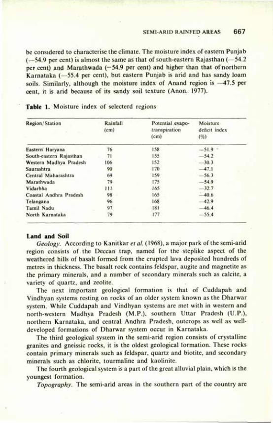
SEMI-ARID RAINFED AREAS 6 6 7
be considered to characterise the climate. The moisture index of eastern Punjab (_54.9 per cent) is almost the same as that of south-eastern Rajasthan (—54.2 per cent) and Marathwada (-54.9 per cent) and higher than that of northern Karnataka (—55.4 per cent), but eastern Punjab is arid and has sandy loam soils. Similarly, although the moisture index of Anand region is —47.5 per cent, it is arid because of its sandy soil texture (Anon. 1977).
Table 1. Moisture index of selecterd regions
Region/Station Rainfall Potential evapo- Moisture (cm) transpiration deficit index
(cm) (%)
Eastern" Haryana 76 158 —51.9 -• South-eastern Rajasthan 71 155 —54.2 Western Madhya Pradesh 106 152 —30.3 Saurashtra 90 170 -47 .1 Central Maharashtra 69 159 —56.3 Marathwada 79 175 —54.9 Vidarbha 111 165 —32.7 Coastal Andhra Pradesh 98 165 —40.6 Telangana 96 168 —42.9 Tamil Nadu 97 181 —46.4 North Karnataka 79 177 —55.4
Land and Soil Geology. According to Kanitkar et al. (1968), a major park of the semi-arid
region consists of the Deccan trap, named for the steplike aspect of the weathered hills of basalt formed from the erupted lava deposited hundreds of metres in thickness. The basalt rock contains feldspar, augite and magnetite as the primary minerals, and a number of secondary minerals such as calcite, a variety of quartz, and zeolite.
The next important geological formation is that of Cuddapah and Vindhyan systems resting on rocks of an older system known as the Dharwar system. While Cuddapah and Vindhyan systems are met with in western and north-western Madhya Pradesh (M.P.), southern Uttar Pradesh (U.P.), northern Karnataka, and central Andhra Pradesh, outcrops as well as well-developed formations of Dharwar system occur in Karnataka.
The third geological system in the semi-arid region consists of crystalline granites and gneissic rocks, it is the oldest geological formation. These rocks contain primary minerals such as feldspar, quartz and biotite, and secondary minerals such as chlorite, tourmaline and kaolinite.
The fourth geological system is a part of the great alluvial plain, which is the youngest formation.
Topography. The semi-arid areas in the southern part of the country are
668 REVIEW OF SOIL RESEARCH IN INDIA
undulating and consists of series of low ridges and valleys. The configuration favours rain-water runoff and soil erosion. The altitude varies from 600 m in the west to 420 m in the east. The semi-arid areas with alluvial deposits are almost level with a fall of about 40 cm per km. In general, the altitude varies from 200 to 250 m.
Soils. There are three predominant soil types in the semi-arid regions: black soils, red soils and alluvial soils. Black soils are formed mostly by weathering of basalt rock and to some extent by weathering of granites and gneissic rocks. Black soils are either formed in situ where they are shallow to medium deep, or transported under water where they are deep and very deep. Red soils are formed by weathering of granites and gneissic rocks, and are comparatively shallow. The alluvial soils are a part of the great Indo-Gangetic plain in northwestern M.P., western U.P., and eastern Haryana. They are several hundred metres deep.
The texture of black soils varies from clay loam to clay. The clay and the silt fractions together make up more than 80 per cent of the soil. These soils are characterised by their dark reddish brown to black colour, high percentage (>30) of clay, high plasticity and stickiness, high water-holding capacity, low organic matter content, calcareous nature and mildly alkaline reaction, high cation exchange capacity, and dominance of montmorillonite type of minerals and consequent 'cracking' property due to enormous shrinkage on drying.
Red soils usually contain a high percentage i f sand. Alluvial soils have sandy loam to clay loam texture. The presence of lime nodules, especially in lower layers, is a typical feature of clay loam (Kanitkar et al. 1968).
Rainfall The average annual rainfall varies from 700 to 1,110 mm, and is mostly
confined to the monsoon season. The rainfall is highly variable, both in time and in space. A number of monsoon showers have an erosive intensity greater than 25 mm/ hour (Hudson 1971). Five-minute maximum intensities of rainfall up to 180 mm/hour have been recorded (Anon. 1980).
The rainfall being highly seasonal and erratic in distribution, there is excess of water during a part of the year and acute deficiency during the rest of the year. Excess of rain-water causes water stagnation and water logging in some areas creating unfavourable conditions for kharif crops and severe soil erosion and floods in other areas followed by moisture stress during the intermittent dry spells. The problem of rain-water management centres on drainage of excess water for the cultivated fields and its storage for use where and when it is needed. Therefore, land has to be managed properly to control the water so as to make the best possible use of both these natural resources.
Problems of Land and Soil Black soil not brought under the plough has an enormous capacity for
surface moisture storage through gilgai formations, and consequently there is
SEMI-ARID RAINFED AREAS 6 6 9
very little runoff. Further, grass cover under natural conditions saves the soil from both splash and runoff erosion. But when the soil is cultivated if becomes susceptible to erosion, as can be seen by the behaviour of hard clods with the first showers of rain. The rate of infiltration is reduced considerably and the soil becomes almost impervious under saturated conditions when even light showers result in runoff and tend to cause erosion. The erosion is more serious on clean cultivated fields because of kharif (rainy season) fallow widely practised on Vertisols, particularly those receiving high rainfall.
Red and alluvial soils have comparatively high rates of infiltration but once runoff occurs they become very susceptible to erosion, particularly where the slope is more than 0.8 per cent.
So/7 Erosion. The magnitude of soil erosion depends upon the land slope and on the condition of the land, i.e. whether cropped or fallow. While sheet erosion is common on flat lands (slope less than 0.8 per cent) rills, washes and gullies of varying dimensions are formed on sloping lands (slope greater than 0.8 per cent), and more so under kharif iaWovi. Under clean cultivation, the land is exposed to severe erosion by high intensity rains and runoff, particularly where there is a layer of loose soil on the surface created by occasional ploughing and almost saturated and impervious soil below the surface. The washes through the fields result in rills and gullies, and the problem is serious on land with a slope greater than 0.8 per cent. Further, the gullies deepen anc" widen with time from continuous erosion of bed at first and then falling away of the sides (walls) of gullies; they also extend in length and advance finally into the fields. Hence, loss of valuable land on a vast scale under semi-arid conditions is a bigger problem than loss of soil particles.
Rain- Water Management. Two systems of land and water management are practised in the semi-arid and sub-humid regions where no crop is usually grown in the rainy season. One is the open field cultivation, and the other is called the haveli (bunded) system. In the open field cultivation, fields are cultivated throughout the monsson season as and when soil conditions permit a clean seed-bed and a layer of loose soil on the surface to serve as mulch till the sowing of winter crops. In the haveli system, water is impounded in bunded fields so as to take care of weeds till the sowing time of winter crops, then the water is drained out and wheat is drilled in directly without preparatory tillage and without any fertiliser. In either case, no crop is grown in the rainy season, when there is an abundant supply of water, and only one winter crop is grown on profile-stored moisture. In both systems, therefore, an inefficiënt use of land and water resources is made.
On alluvial and red soils, kharif fallowing is not so common, and an effort is made to raise crops during the rainy season. However, the yields are low owing to lack of adoption of improved practices and, again, a very inefficient use of available water is made.
For efficient use of land and water resources, an integrated approach to land
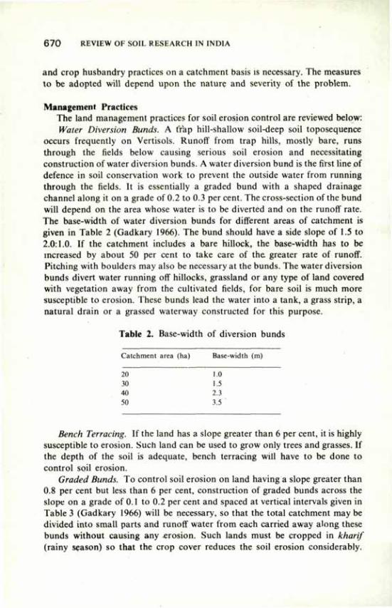
6 7 0 REVIEW OF SOIL RESEARCH IN INDIA
and crop husbandry practices on a catchment basis is necessary. The measures to be adopted will depend upon the nature and severity of the problem.
Management Practices The land management practices for soil erosion control are reviewed below: Water Diversion Bunds. A trap hill-shallow soil-deep soil toposequence
occurs frequently on Vertisols. Runoff from trap hills, mostly bare, runs through the fields below causing serious soil erosion and necessitating construction of water diversion bunds. A water diversion bund is the first line of defence in soil conservation work to prevent the outside water from running through the fields. It is essentially a graded bund with a shaped drainage channel along it on a grade of 0.2 to 0.3 per cent. The cross-section of the bund will depend on the area whose water is to be diverted and on the runoff rate. The base-width of water diversion bunds for different areas of catchment is given in Table 2 (Gadkary 1966). The bund should have a side slope of 1.5 to 2.0:1.0. If the catchment includes a bare hillock, the base-width has to be increased by about 50 per cent to take care of the greater rate of runoff. Pitching with boulders may also be necessary at the bunds. The water diversion bunds divert water running off hillocks, grassland or any type of land covered with vegetation away from the cultivated fields, for bare soil is much more susceptible to erosion. These bunds lead the water into a tank, a grass strip, a natural drain or a grassed waterway constructed for this purpose.
Table 2. Base-width of diversion bunds
Catchment area (ha) Base-width (m)
2(1 1.0 30 1.5 4(1 2.3 50 3.5
Bench Terracing. If the land has a slope greater than 6 per cent, it is highly susceptible to erosion. Such land can be used to grow only trees and grasses. If the depth of the soil is adequate, bench terracing will have to be done to control soil erosion.
Graded Bunds. To control soil erosion on land having a slope greater than 0.8 per cent but less than 6 per cent, construction of graded bunds across the slope on a grade of 0.1 to 0.2 per cent and spaced at vertical intervals given in Table 3 (Gadkary 1966) will be necessary, so that the total catchment may be divided into small parts and runoff water from each carried away along these bunds without causing any erosion. Such lands must be cropped in kharif (rainy season) so that the crop cover reduces the soil erosion considerably.
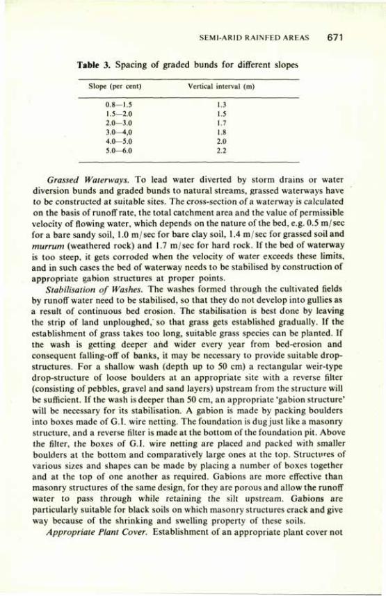
SEMI-ARID RAINFED AREAS 6 7 1
Table 3. Spacing of graded bunds for different slopes
Slope (per cent) Vertical interval (m)
0.8—1.5 1.3 1.5—2.0 1.5 2.0—3.0 1.7 3.0^1,0 1.8 4.0—5.0 2.0 5.0—6.0 2.2
Grassed Waterways. To lead water diverted by storm drains or water diversion bunds and graded bunds to natural streams, grassed waterways have to be constructed at suitable sites. The cross-section of a waterway is calculated on the basis of runoff rate, the total catchment area and the value of permissible velocity of flowing water, which depends on the nature of the bed, e.g. 0.5 m/sec for a bare sandy soil, 1.0 m/sec for bare clay soil, 1.4 m/sec for grassed soil and murrum (weathered rock) and 1.7 m/sec for hard rock. If the bed of waterway is too steep, it gets corroded when the velocity of water exceeds these limits, and in such cases the bed of waterway needs to be stabilised by construction of appropriate gabion structures at proper points.
Stabilisation of Washes. The washes formed through the cultivated fields by runoff water need to be stabilised, so that they do not develop into gullies as a result of continuous bed erosion. The stabilisation is best done by leaving the strip of land unploughed,' so that grass gets established gradually. If the establishment of grass takes too long, suitable grass species can be planted. If the wash is getting deeper arid wider every year from bed-erosion and consequent falling-off of banks, it may be necessary to provide suitable drop-structures. For a shallow wash (depth up to 50 cm) a rectangular weir-type drop-structure of loose boulders at an appropriate site with a reverse filter (consisting of pebbles, gravel and sand layers) upstream from the structure will be sufficient. If the wash is deeper than 50 cm, an appropriate 'gabion structure' will be necessary for its stabilisation. A gabion is made by packing boulders into boxes made of G.I. wire netting. The foundation is dug just like a masonry structure, and a reverse filter is made at the bottom of the foundation pit. Above the filter, the boxes of G.I. wire netting are placed and packed with smaller boulders at the bottom and comparatively large ones at the top. Structures of various sizes and shapes can be made by placing a number of boxes together and at the top of one another as required. Gabions are more effective than masonry structures of the same design, for they are porous and allow the runoff water to pass through while retaining the silt upstream. Gabions are particularly suitable for black soils on which masonry structures crack and give way because of the shrinking and swelling property of these soils.
Appropriate Plant Cover. Establishment of an appropriate plant cover not
6 7 2 REVIEW OF SOIL RESEARCH IN INDIA
only is the cheapest and most effective soil conservation measure (Shaxson 1980) but also leads to best exploitation of land and water resources. Soybean has Droved to be a good cover crop although a well-nourished maize or sorghum crop also provide a good canopy. The appropriate plant cover will depend upon the nature of land, its slope and soil depth, as summarised in Table 4.
Practices for Control of Waterlogging On fiat lands with less than 0.3 per cent slope waterlogging or water
stagnation are more serious problems than erosion, particularly on deep black soils which have low infiltration rates. Red and alluvial soils with clay, clay loam and silty loam texture also suffer from waterlogging and water stagnation problems, particularly under bunded conditions. Similarly, soils with impervious substrata or a hard pan below the surface also present such problems. Soils with sandy loam and loamy sand texture are free from these problems except the low-lying patches where runoff from other areas is received and is not drained because of restricted natural and artificial drainage.
Table 4. Appropriate crop planning according to suitability of land
Type of land Crop plans
Bare hill slopes
Shallow soil with slope>3%
Shallow soil with slope 1-3% or light soil
Shallow soil with slope<l% Deep soil with slope>3%
(gullies) Deep soil with slope 1-3%
Deep soil with slope < 1%
Trees for fuel, fodder and fruits and grasses. Species and varieties to be chosen on local experience. Grasses with legumes including fodder shrubs. Species and varieties on local experience. Must be cropped in kharif (sorghum fodder, maize, short-duration pulses) on 0.3% grade across slope. Sorghum (CSH-6), Soybean (JS 2, JS 72-44). Grass plantation and stabilisation work.
Sorghum (CSH-5), sorghum intercropped with pigeon pea, soybean (JS 72-44) intercropped with pigeon pea, cotton intercropped with soybean or maize and soybean alone on 0.3% grade across slope. Sorghum, soybean (on 0.3% grade), etc., after providing surface drainage (e.g. graded furrow) or rice with supplementary irrigation through runoff collection followed by gram or wheat with one come-up irrigation or late rain.
To solve the problems of water stagnation and waterlogging, provision for both total land drainage and crop drainage is necessary, the latter particularly on deep clay soils with flat topography. Various land treatments are described in the following paragraphs.
Provision of Drainage Areas Between Waterways. Safe disposal of runoff water from areas between the waterways and from fields between two crests to a
SEMI-ARID RAINFED AREAS 6 7 3
grassed waterway is essential. Construction works are designed according to the slope of land, e.g. (i) graded bunds on 0.3 per cent grade if the slope of land is more than 1 per cent but less than 6 per cent, and (ii) open channels on a grade (0.8 per cent) on comparatively flat lands (slope less than 0.8 per cent). The cross-section of graded bund and open channels will depend upon the rate of runoff and the area of the catchment. And, depending upon the difference in bed-levels of the grassed waterways, rams or suitable fall structures will have to be provided.
Management of Soil Water in Root Zone. On black soils, kharif crops generally fail or yield poorly because of excess of moisture in the root zone. The inter-bund area (i.e. area between two graded bunds) on sloping lands and inter-channel area (i.e. area between two open drainage channels on flat lands) need suitable treatment to manage water in the root zone. For this, one or more of the following practices can be adopted depending upon the soil conditions and the severity of the drainage problem.
Narrow Ridge and Furrow System. Studies at International Crop Research Institute for Semi-Arid Tropics, Hyderabad, support the contention that ridges and furrow system can be used to manipulate runoff and reduce erosion (Anon. 1980). The ridges serve as 'mini bunds' and the furrows under a slope serve as small surface drains. This practice may be useful on flat lands with comparatively high rainfall.
Broad Ridges or Bedding Systems. Work at International Crop Research Institute for Semi-Arid Tropics and at the Indore centre of the All India Coordinated Research Project on Dryland Agriculture has shown that 90 to 240 cm broad ridges (depending on crop and rows) made with tool bar attached with furrow openers are easier to maintain and work with, and are as satisfactory as narrow ridge and furrow system.
Graded Furrows. Observations in the Indo-UK. Project have showed that furrows opened on a grade of 0.2 to 0.3 per cent serve as surface drains and let out excess water safely. The furrows should have a cross-section of 0.10 to 0.15 m2 and be spaced at 8 to 10 m intervals depending upon crops and slope of land. Such furrows can be easily constructed by a farmer with the help of a desi plough to the share of which a piece of wooden plank has been tied.
Broad-Base Bunds. These structures consist of low-hight sloping bunds with a shallow channel; they should have a grade of 0.1 to 0.2 per cent. The cross-section of the bunds is 1.56 m2 and the bunds are made at a vertical interval of 0.61 to 0.76 m.
Runoff Collection and Recycling Runoff Collection. Even in drought years, the velocity of rainfall is such
that a part of the rainfall is available as runoff, particularly on black soils. Runoff measurement studies, on small agricultural watersheds under the All India Coordinated Dryland Research Project during 1971-1979 have shown that 21 to 53 per cent of the total rainfall is available as runoff (Table 5). At
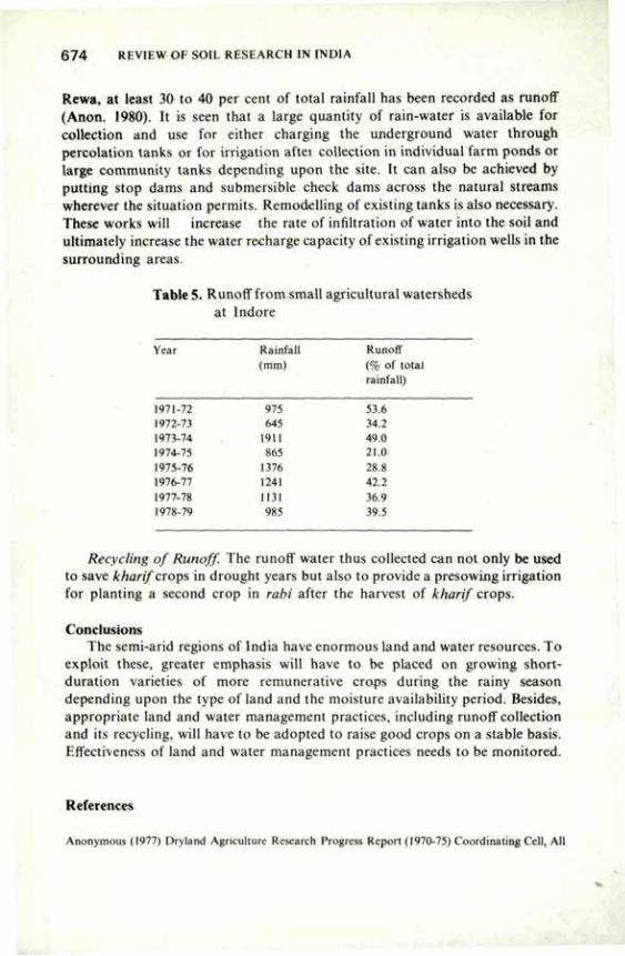
6 7 4 REVIEW OF SOIL RESEARCH IN INDIA
Rewa, at least 30 to 40 per cent of total rainfall has been recorded as runoff (Anon. 1980). It is seen that a large quantity of rain-water is available for collection and use for either charging the underground water through percolation tanks or for irrigation after collection in individual farm ponds or large community tanks depending upon the site. It can also be achieved by putting stop dams and submersible check dams across the natural streams wherever the situation permits. Remodelling of existing tanks is also necessary. These works will increase the rate of infiltration of water into the soil and ultimately increase the water recharge capacity of existing irrigation wells in the surrounding areas.
TableS. Runoff from small agricultural watersheds at Indore
Year Rainfall Runoff (mm) (% of total
rainfall)
1971-72 975 53.6 1972-73 645 34.2 1973-74 1911 49.0 1974-75 865 21.0 1975-76 1376 28.8 1976-77 1241 42.2 1977-78 1131 36.9 1978-79 985 39.5
Recycling of Runoff. The runoff water thus collected can not only be used to save kharif crops in drought years but also to provide a presowing irrigation for planting a second crop in rabi after the harvest of kharif crops.
Conclusions The semi-arid regions of India have enormous land and water resources. To
exploit these, greater emphasis will have to be placed on growing short-duration varieties of more remunerative crops during the rainy season depending upon the type of land and the moisture availability period. Besides, appropriate land and water management practices, including runoff collection and its recycling, will have to be adopted to raise good crops on a stable basis. Effectiveness of land and water management practices needs to be monitored.
References
Anonymous (1977) Dryland Agriculture Research Progress Report (1970-75) Coordinating Cell, All
SEMI-ARID RAINFED AREAS 675
India Coordinated Dryland Research Project, Hyderabad, Indian Council of Agricultural Research, New Delhi.
Anonymous (1980) Progress Report Indo-UK Dry Farming Project (I.C.A.R.) for the periodl974-75 to 1979-80, JNKVV Campus College of Agriculture, Indore.
Bair, W. and Robertson, G.W. (1966), Can. J. PI. Sci. 46, 299. Gadkary, D.A. (1966) A Manual on Soil Conservation, Dep. of Agric, Govt, of Maharashtra,
Pune, India. Hudson, N.W. (1971) Soil Conservation. Batsford, London. Kanitkar, N.V., Sirur, S.S. and Gokhale, D.H. (1968) Dry Farming in India, Indian Council of
Agricultural Research, New Delhi. Shaxson, T.F. (1980). Rapporteur's paper for session IV, Economic Social and Legal Aspects
presented at the Symposium Conservation 1980. Silsoe. National College of Agric. Eng., U.K. Sreenivasan, P.S. (1972) Indian Fmg, 22(2), 38. Troll, C. (1965) In World Maps of Climatology, Ed. E. Rodenwaldt and H. Jusatz. Springer-
Verlag, Berlin, 22.
Management of Desertie Soils H.P. SINGH*
THE Indian desert, situated in the north-west, occupies about 286,000 km2 in the states of Rajasthan, Gujarat, Haryana and Punjab. In the east the desert has a natural geomorphic and climatic (500 m isohyte) boundary in the Aravallis running in the NE-SW direction. In the west it runs into Pakistan desert, whereas in the north into Haryana and Punjab, and in the south in the Gujarat. Two-thirds (67 per cent) of the desert is in western Rajasthan — the Thar, desert — and one-fourth (25 per cent) of it is in Gujarat. The remaining 8 per cent is distributed almost equally between Punjab and Haryana. In Gujarat it is largely a coastal desert extending from the Rann of Kutch to Jamnagar, Rajkot and Banaskantha districts. The normal features of tropical and subtropical deserts — low rainfall, hot summers, large annual and diurnal variations in temperature, and low humidity — are to some extent modified in the littoral (Sen and Shankarnarayana 1977). The major difference is the humidity, which is high in coastal deserts.
Besides the hot desert, about 70,000 sq km area is the cold desert in the Ladakh plateau, where crop production is severely limited by the extreme aridity and low temperatures (Mann 1977). This region requires an altogether different management strategy and is not covered here.
Distribution of Soils Nearly 70 per cent of the desert region is covered by wind-worked sandy
soils—sands, loamy sands and sand dunes (Dhir 1977). The remaining area is under medium-textured, old and recent alluvium (brown light loams and grey brown loams), sandy, rocky and gravelly soils (skeletal or Lithosolic) and salt marshes (Kutch area) and sierozems. Rocky and gravelly soils are particularly met with in Gujarat (Murthy and Pandey 1977). It would, therefore, appear that sandy soils dominate the desert environment. For this reason emphasis has been laid on the management of sandy soils in this review.
Problems Wind erosion, deposition and movement of sand dunes, low soil moisture
storage, instability of soil structure, and poor soil fertility are the major problems of soil management in the desert ecosystem. But for these, the sands are most productive, being easy to till and least resistant to plant growth and development (Singh 1980a).
Considerable research effort has gone into the methods of ameliorating these
•Central Arid Zone Research Institute. Jodhpur, Rajasthan.
MANAGEMENT OF DESERT1C SOILS 6 7 7
conditions at state and central research organisations and agricultural universities. Some aspects of the integrated approach have been worked out, and some are still under investigation, at various levels, as will be apparent from the following account.
Wind Erosion Wind erosion is doubly harmful (Singh 1977). Both the areas, from where
the soil blows and where it is deposited, are lost to crop production. The silt removed in water erosion at times leads into fertile river valley deposits. The ancient civilisations of the Nile, the Tigris, the Harappans, etc. owed their existence to erosion in the headwaters.
The Harappan culture flourished about 2,000 BC on the deposits of Ghaggar, Saraswati, Drishadvati and old Yamuna in parts of Haryana, Rajasthan and Pakistan (Vishnumitre 1977; Mishra 1977). Among other factors, it was wind erosion caused by the shift to extreme arid conditions that brought that culture to ruins. It stands as an example of eventual benefits of water erosion (silt deposition) being undone by wind erosion.
Sand dunes deposited by wind action do not remain stationary. They move farther along the wind direction and pose a constant threat to crop production as also to general public facilities, rail tracks, highways, buildings, etc. New dune systems of the type known as barchan are more active in this respect (Pandey et al. 1964). Studies on soil drifting conducted at Bikaner showed that 1,449 t/ ha of soil was removed in three months (April to June) from a bare flat land, depleting the soil fertility by 224, 116, 232 and 215 kg/ha in terms of organic matter, total nitrogen, phosphorus and potassium, respectively (Gupta and Aggarwal 1980b).
Causes The causes of wind erosion in the desert region are low rainfall, high wind
velocity, and sandy soil texture with loose single-grained structure. Wind speed may reach as high as 20-27 km/hr in summer months in areas like Jaisalmer in Rajasthan, the threshold wind velocity for initiating the soil movement being 14 km/hr for the desert conditions (Mann 1980). Much of the wind action is confined to the summer months, April to June, barring occasional storms during the rest of the year. It is during the summer that the ground vegetation cover is minimum, facilitating severe erosion. Applying the universal wind erosion equation to western Rajasthan conditions, the erodibility index for unprotected conditions was found to be 14, which is rather high (Singh 1977).
Control Measures Broadly, these are of two kinds (Singh 1980b): (1) sheltering the soil from
wind action, and (2) creating a soil condition resistant to wind action. The control measures that have been worked out include:
6 7 8 REVIEW OF SOIL RESEARCH IN INDIA
— afforestation; plantation of wind-breaks and shelter-belts; — grassland development; plantation of trees and grasses on marginal and
sub-marginal lands; — wind strip cropping; — stubble mulching, vegetation fencing; — proper tillage: (a) suitable equipment, and (b) minimum tillage — set
row cultivation.
It would appear that, except tillage, all other measures fall under the first approach, i.e. sheltering the soil. However, vegetative covers like grasses, apart from their direct sheltering effect, help in stabilising the soil structure with the binding action of their root system, root exudates, etc. In fact, any agronomic practice which directly (FYM, amendments, etc.) or indirectly (through better plant growth) improves the soil physical conditions would reduce wind erosion.
Plantation of Trees Considerable work has been done on the plantation of trees as wind-breaks
and shelter-belts. Kaul (1964) successfully used Prosopis juliflora, Azadirachta indica and Albizzia lebbek as three-row shelter-belts along the highways in western Rajasthan. Five-row shelter-belts in pyramidal shape were found to be suitable in desert areas where wind direction changes abruptly (Kaul 1969). Acacia tortillis was most suitable for arid zone afforestation on sand dunes and sandy-rocky habitats (Muthana et al. 1980). In rocky and semi-rocky soil areas of the desert, tree plantation is particularly problematic. Contour ridges-cum-trenches proved suitable for planting trees like Prosopis juliflora in such areas (Kaul and Chand 1977; Sahrawat 1977).
The effect of tree shelter-belts on soil movement has also been studied (Gupta 1979b). Soil removal over a period of 20 days from April onwards was 3 t/ha from sheltered area as against 72 t/ha from unsheltered area
The effect of various tree species on soil properties, particularly fertility regime, was studied by Aggarwal et al. (1976). Species such as Prosopis cineraria and Tecomela nodulata were found to improve the soil fertility regime considerably.
Sand Dunes — Stabilisation Techniques Water balance studies have revealed considerable moisture (2-5 per cent)
stored in the lower depths of unstabilised dunes even in the peak evaporation months of May and June (Gupta 1979a). The reason is low capillarity. This shows that there is considerable scope for the stabilisation of such areas.
The technique for stabilisation of shifting dunes has been standardised after 10 years of experimentation at the Central Arid Zone Research Institute (CAZRI), Jodhpur (Kaul 1970; Muthana and Ahuja 1973). It consists of (i) protection against biotic interferences, (ii) treatment of sand by fixing mulch barrier in parallel strips or in a chess-board design, using the local shrub
MANAGEMENT OF DESER I IC SOILS 6 7 9
material, from the crest down to the heel of the dune against the direction of the wind to protect the seedlings from burial or exposure by the blowing of sand, and (iii) planting trees, grasses and shrubs. The species suitable for erecting barriers (micro wind-breaks) are Zizyphus nummularia and Crotalaria burhea. Grasses and creepers are directly seeded in lines (2-5 m apart) on the leeward side of the micro wind-break.
Suitable species of trees, shrubs and grasses that can be used for dune stabilisation are given below (Bhimaya et al. 1966). Trees Shrubs Grasses
Acacia Senegal Calligonum polygonoides Lasiurus sindicus Prosopis juliflora Cassia auriculata Panicum turgidum Aibizzia lebbek Ricinus communis Erianthus munia Cordia rothii Zizyphus nummularia Dalbergia sissoo Zizyphus jujuba
Grassland Development Singh and Skidmore (1974) reviewed the work on the control of wind
erosion in the sandy plains of arid regions. They particularly stressed the role of proper pasture/range management practices — systematic grazing etc. Gupta and Aggarwal (1980b) observed that soil drifting from a grass land near Bikaner was practically nil as against 1,449 and 5,560 t/ha from a bare sandy field and a sand dune, respectively, in a period of 75 days in April to June. Apart from stabilising the soil, grasses are reported to improve the soil fertility regime too. A build-up in soil organic matter (16-43 per cent) and nitrogen (20 per cent) was observed under Cenchrus ciliaris and Lasiurus sindicus stands over a 12-year period (Aggarwal and Lahiri 1977). Contour furrowing, staggered pitting and trenching, and contour trenching have been found useful practices for efficient soil and water conservation on range lands in the desert region (Bhimaya and Ahuja 1967; Wasi Ullah et al. 1972; Ahuja et al. 1973; Mann and Ahuja 1975). Grasses, therefore, hold considerable promise in stabilising sands vulnerable to wind action. Cultivation on marginal and submarginal lands, therefore, has to be stopped and these areas brought under ranges and pastures to curb wind erosion.
Strip Cropping Field strip cropping in grass strips of legumes (mung—Phaseolus aureus,
and moth—Phaseolus aconitifolius) in a ratio of 6:1 has been found useful for the control of wind erosion and higher total production in the arid zone conditions (Mishra 1964). Grass and crop strips are oriented as nearly as possible at right angle to the wind direction. Mann (1980) observed that wind strip cropping as recommended in the USA and Canada was not feasible because of the Indian land tenure system and small and scattered holdings. However, the field strip cropping system of grain legumes or cereals
680 REVIEW OF SOIL RESEARCH IN INDIA
(Pennisetum typhoideum) in grass strips developed at the CAZRI seems promising, for it can be applied to individual fields and holdings.
Stubble Mulch Farming Under this practice, crop stubbles are left in the field and the next crop is plan
ted with minimum tillage. Mishra et al. (1964) reported a decrease in soil loss by 28.6, 46.5, 54.6 and 63.5 per cent after 15, 30, 45 cm, and whole stalk pearl millet (Pennisetum typhoideum) stubbles left in the field, respectively. Sinha (1970) found stubble mulching by leaving 30 cm wheat stubbles to be useful for curbing wind erosion in Punjab conditions. Gupta and Aggarwal (1980b) observed that soil loss in wind action from fields having bajra (Pennisetum typhoideum) stubbles (10-15 cm) in western Rajasthan (Bikaner) was 22.5 t/ha as against 1,449 t/ha from bare unprotected fields. Mann (1980) stated that crop stubbles also reduced surface evaporation and may eventually help the growth of vegetation.
The practice, however, has limitations to its adoption on a large scale. The farmers were reluctant to leave stubbles in the field because they are useful animal feed. In summer the soil is the most vulnerable to wind action, and at that time there is hardly anything to graze in the fields. The animals, therefore, feed on whatever they can find; hence it is difficult to maintain stubbled fields in summer months. Further, it has been reported that the practice, at times, is not so useful because of its nitrogen immobilising effect (Singh 1977).
Tillage — Intensity and Suitable Implements Excessive tillage leads to severe erosion. This was the reason that 40 t/ha of
surface soil was lost from a field in six days during a dust storm (30 km/hr)in 1979 at the otherwise protected research farm of the CAZRI (Gupta and Gupta 1981). Direct seeding by tractor-operated drill without prior seed-bed preparation gave as much yield of Pennisetum typhoideum as with seeding after preparatory tillage (Anon. 1980a). Singh (1980b), however, reported that at least one ploughing/harrowing was required for rainfed crop production in sandy soils. Not only have weeds to be controlled, but the sandy soils get considerably compacted under unsaturated conditions which prevail in drylands; hence root penetration and development is retarded in the absence of proper tillage.
Agra wal and Sharma (1978) reported shallow preparatory tillage to be beneficial under both irrigated and rainfed conditions for better root development. Plough-plant system may, therefore, hold good only for good rainfall situations, when the compaction problem is not serious. Singh (1980b) suggested the use of fixed or set row system of tillage and planting for rainfed conditions in areas prone to wind erosion. Under this system tillage is performed in set rows of 30-40 cm at intervals of 60-70 cm, and crops are planted in the tilled set rows. This way the tillage is reduced by 60-70 per cent, and it may eventually reduce the requirements for inputs of energy and manure etc. The
MANAGEMENT OF- DESER I IC SOILS 6 8 1
unfilled inter-set space may also act as a barrier to soil movement by wind. Work on the evaluation of various tillage implements with respect to
control of wind erosion is rather scanty. Studies by Yadav and Singh (1975) indicated that subsurface tillers like sweeps were more suitable for preparatory tillage in such areas. The soil surface is least disturbed by sweep cultivation. Seed-bed preparation by wedge plough, disc plough and disc harrow was evaluated in a loamy soil of Hissar for irrigated pearl millet (Penniseium lyphoideum), chickling vetch (Lathyrus sativus) and mustard (Brassica juncea) (Agrawal and Agarwal 1979). Disc ploughing and harrowing proved better than the use of country plough.
It is obvious that the measures described above are essentially site-specific. The desert is not uniform all through, the range in the rainfall being 100 to 500 mm. Singh (1980b) reported that the question of suitability of various practices, such as stubble mulching, strip cropping and minimum tillage, arises only in areas where the rainfall is more than 300 mm and where crop production is feasible. He further stated that the production systems for areas receiving 100-200 mm rainfall were range development and afforestation and that the 200-300 mm rainfall areas were in the transitional zone, where some overlapping was possible. However, the crop component can perhaps be best introduced only as strip cropping of legumes in grass strips in such areas. Plantation of windbreaks, shelter-belts, range-pasture development/agro-forestry on marginal and sub-marginal lands are common erosion control practices for all situations.
Moisture Conservation Sandy soils have low soil moisture storage, varying from 1 to 1.50 mm per
cm soil depth (Singh 1980a). Singh el al. (1975) showed that under Jodhpur conditions 40-60 per cent of seasonal rainfall was lost through deep percolation to the murrum substratum in normal to good rainfall years, depending upon rainfall distribution and intensity. Open pan evaporation values vary from 6-8 mm/day in kharif cropping season (July to October) to 10-15 mm/day in summer months of April to June (Krishnan 1977). High evaporation and low storage capacity limit the availability of rain-water for plant use.
It seems there are two approaches to the problem: (1) to improve the inherent soil conditions by the application of organic and fine fractions and by measures like compaction etc., (2) to reduce the losses of moisture from evaporation and deep percolation.
Application of exfoliated vermiculite and bentonite at the rate of 40 t/ha in the surface 20 cm soil increased the moisture storage at 0.1 bar from 12 to 17 per cent. Application of pond sediments at the rate of 76 t/ha also increased the soil moisture storage capacity by 8.5 to 11.5 per cent (Gupta and Aggarwal 1981). Large quantities of fine materials required as amendment limit the scope of this approach.
6 8 2 REVIEW OF SOIL RESEARCH IN INDIA
Compacting Sandy Soils by Rollers Studies under the coordinated project on improvement of soil physical
conditions were carried out at Hissar and Jaipur centres on improving the soil moisture storage' by compacting the soil by using rollers (Anon. 1978). Eight rollings with a 480 kg i oiler increased the bulk density from 1.42 g/cc to 1.57 g/cc and reduced the infiltration rate from 20.4 to 12 cm/hr in Durgapur sandy soil (Anon. 1978). At Hissar six passes of a 1.5 t tractor-drawn roller increased the bulk density of surface soil layer from 1.45 to 1.52 g/cc, and decreased the hydraulic conductivity from 2.83 to 1.72 cm/hr (Anon. 1-978). The treatment resulted in an increase in the yield of pearl millet from 21.0 to 27.0 q/ha.
Surface Mulches Capillary continuity in sandy soils is generally poor. Water stored in deeper
layers, therefore, moves up very slowly in response to the evaporation pull unless the conditions are very harsh as in summer when PET range is 10-16 mm. Hence, in the kharif season, the surface soil, after it dries up, acts as mulch and evaporation in the constant rate stage is negligible (0.5 to 1.0 mm/day). Hence, normally, the use of mulches may not be of much practical utility in these soils (Singh et al. 1974)* However, planting of crops during khari/ is often followed by drought in the desert regions. In such situations application of mulches such as grass waste and husk of pearl millet immediately after seeding may delay the rate of surface drying, promote better establishment of the crop, and result in higher yields (Daulay et al. 1979; Gupta and Yadav 1978). Gupta (1980) observed polyethylene mulch to be very effective under these conditions, giving 70 per cent higher yields of pearl millet (29 q/ha) over the control. He also observed that organic waste mulches reduced the soil temperature regime by 2° to 5°C; this was conducive to better root development.
Studies on reducing the losses of moisture, through deep percolation by the incorporation of bentonite clay as sub surface barrier were initiated at CAZRI in 1971 (Singh et al. 1975; Singh 1978). The technique proved to be particularly useful for localised application by digging pits for the planting of cucurbits such as round gourd, i.e. tinda {Citrullus vulgaris). Later, in 1974, the technique was combined with in situ runoff concentration to increase its efficiency in low rainfall and drought years (Singh and Singh 1975).
Results with respect to increase in soil moisture storage and yield of round gourd as affected by bentonite barrier, for the drought year 1974, are presented in Table 1.
In further studies (unpublished) this technique was successfully extended to other vegetable crops such as bhindi (Hibiscus esculentus). Infiltration rate of the barriered profile is reduced from 8-10 to 5 cm/hr with resulting increase in soil moisture storage capacity by about 40 per cent (Singh et al. 1979; Singh 1980a). Studies are in progress to perfect the technique for wider use.
One of the problems of tree plantation in the arid zone is the initial sapling mortality due to moisture stress. The surface soil dries up before the roots
MANAGEMENT OF DESERTIC SOUS 6 8 3
Table 1. Effect of bentonite barrier on soil moisture storage and yield of round gourd (Citrullus vulgaris)
Treatment Soil moisture storage (mm) Yield in 60 cm profile (q ha)
15.7.74 26.7.74 21.8.74
Barrier runoff concentration 101 103 88 43 Barrier 52 60 4'! 20 Control 43 60 44 13
penetrate into the moisture-retaining deeper layers. A technique of bentonite barrier placement to form a buried potlike structure was developed and found very useful; in this way the moisture storage capacity of the soil in the vicinity of the sapling was increased by 70 to 80 per cent (Singh 1981; Singh 1980a).
The use of asphalt as subsurface moisture barrier was also studied (Gupta et at. 1979). Placement of 2 mm asphalt layer to 60 cm depth in the profile almost doubled the moisture storage capacity, from 80 to 176 mm. Throughout the growing periods in 1976 and 1977 the barriered 60 cm soil profile stored 20-40 cm more moisture than the unbarriered soil and gave 30-60 per cent higher yield of pearl millet. Besides increasing the soil moisture storage, asphalt and bentonite barriers reduced the leaching losses of nitrogen. On an average the N content was 66 and 75 per cent higher in asphalt and bentonite barriered soils, respectively, than in the control.
Organic Manures and Amendments Singh (1978) reported the beneficial effect of FYM and chopped pieces of
Calotropis procera plants at the rate 'bf 15-20 t/ha on the soil physical properties, particularly the moisture storage under rainfed conditions. Incorporation of Calotropis was also said to have improved N-mineralisation and soil nitrogen regime.
Long-term experiments on the maintenance and build-up of soil fertility were started at the CAZR1 in 1975 (Singh el al. 1980b). Application of FYM at the rate of 20 t/ ha every alternate year resulted in 60 per cent build-up of soil organic matter over a five-year period. The effect of organic amendments on soil physical properties was particularly noticeable when the amendments were incorporated in the subsurface layer (20-25 cm depth). It was thought that, since the surface soil in the arid zone is rather unstable, subsurface incorporation of amendments might be more beneficial. This may, however, prove to be not so if the application of amendments is also aimed at controlling the surface crusting problem in some soils.
6 8 4 REVIEW OF SOIL RESEARCH IN INDIA
Control of Surface Crusting Sandy soils are reported to develop surface crusts due to reorientation of soil
particles caused by the impact of rain drops. If the crust is the result of rainfall immediately after sowing, seedling emergence of crops such as pearl millet, cotton and mustard is inhibited, leading to poor crop stands and low yields.
Increase in rainfall intensity from 15 to 21 mm/minute increased the crust strength considerably (Gupta and Yadav 1978). As a result, seedling emergence of sunflower (Helianthus annuus) and mustard (Brassica juncea) crops was reduced from the normal 70 and 63 per cent to 48 and 30 per cent, respectively. It was further observed that sowing on ridges and using double seed rate reduced the crusting hazard considerably.
Sharma and Agrawal (1980) evaluated modulus of rupture as an index of surface crusting. They obtained positive correlations between modulus of rupture and contents of clay and silt, bulk density, water dispersible silt plus clay, CEC, ESP and organic matter contents of crust samples. Regression equations relating crust strength to different soil properties were also developed.
The behaviour of seedling emergence of pearl millet, cotton and guar beans (Cyamopsis psoraloides) as affected by surface crust was also studied by Sharma and Agrawal (1979). Cotton was found most susceptible to crust formation in that its seedling emergence was reduced to zero when the crust strength was 1,024 per cent. The next in order was pearl millet, whose emergence was reduced to 27 per cent under the crust strength of 570 per cent.
Sharma and Agrawal (1978) studied the effect of various organic amendments in reducing the hazard of surface crusting in Hissar soils. Application of FYM in 3 cm strips up to 2.5 cm depth soon after sowing proved to be promising for reducing the crust strength considerably in loamy sand soils. Rains immediately after sowing were not so harmful as those received one or two days after sowing; the maximum impedance would coincide with the time of seedling emergence in the latter case. Application of rice husk on the seeded rows and planting of two seeds per hole also improved the crop stand of cotton under crusted conditions (Agrawal and Sharma 1978). Work at the CAZRI (Anon. 1976) also showed a favourable effect of the application of FYM on the seed rows and of bajra husk mulch in the entire plot in overcoming the crusting problem. Later it was reported (Anon. 1980b) that application of mulch had a dual role in that it reduced the rate of surface drying after sowing and also the crusting if the rains were received immediately after sowing.
It has been observed that owing to loose and unstable soil structure the ridges formed by seeding equipment disintegrate under rains and bury the adjoining seed furrows. As a result, seeding depth is increased and pearl millet seeds, being susceptible to this, cannot come up. Therefore, it is not the formation of surface crust alone that hampers the germination of pearl millet in loamy sand soils of Jodhpur. Packing of seed furrows offers promise to overcome this situation. Yadav and Singh (1978) reported beneficial effect of
MANAGEMENT OF DESERT1C SOILS 6 8 5
packing wheels attached to seed drills on the emergence of pearl millet seedlings when sowing was followed by shower of rain in a loamy sand soil at Jodhpur.
Water Harvesting Owing to low moisture storage capacity and high infiltration rates of sandy
soils, the scope of water harvesting in desert soils is small (Singh et al. 1980; Sharma et al. 1980).
Studies on in situ water harvesting on micro-catchment basis were initiated at the CAZRI in 1969-70 (Singh et al. 1973). In years when rainfall was low to normal, and its intensity was low and showers were well distributed, the effect of this practice was quite promising. On the other hand, in years when rainfall was high or concentrated in a small period during the season the practice did not prove to be of any advantage (Singh et al. 1980). Bulk of the additional water diverted from the micro-catchments found its way in deep percolation. Observations that in situ runoff concentration in such years (1975, 1976) was effective when it was combined with bentonite barrier bore out this fact (Singh et al. 1979). The limitation of low soil moisture storage capacity, however, does not apply to plants having deep root system, e.g. fruit trees. The moisture stored in murrum is well within the reach of tree roots and, hence, does not go waste. Singh et al. (1980) reported beneficial effect of in situ water harvesting in a ber orchard. The moisture stored in 3 m soil profile under ber trees throughout the season was 50-80 per cent higher in plots having micro-catchments than in those under flat planting. This benefit, however, is only possible if the murrum stratum is reasonably good in moisture storage capacity. The practice, therefore, has been recommended for application to orchard development (ber, pomegranate, etc.) in the desert areas of Rajasthan. The concept may be extended to tree-crop intercropping systems in such areas. This would ensure a two-storeyed moisture extraction — trees feeding from murrum, and crops from the soil profile proper. Moisture lost through deep percolation is, thus, profitably used.
Studies on runoff collection in ponds and recycling (Anon. 1976) have shown that lining of ponds (soil-cement, stone wall) is necessary for storing water against seepage loss in sandy soil areas. The measure is expensive but is the only way of providing protective or life-saving irrigation to rainfed crops in the desert areas.
Agra wal et al. (1977) recommended the use of water harvesting for supplementing the recharge of ground water in the sandy soils of Haryana. In western Rajasthan, however, the ground water-table is very deep and, hence, the recommendation can be adopted only in areas having perched water-tables. A considerable area in the desert region is under rocky and gravelly habitats. Runoff from such areas can be collected for utilisation in adjoining soil packets by the in situ or pond storage method depending upon soil characteristics, total available water potential, and crops to be grown. Khadins, which are widespread in Jaisalmer and Barmer districts of Rajasthan, are
6 8 6 REVIEW OF SOIL RESEARCH IN INDIA
examples of such soil situations. These are normally wet during kharif season, and hence, are cultivated in rabi for crops such as wheat and mustard. Such catchments need to be surveyed, and the runoff needs to be controlled so that the excess runoff may be diverted elsewhere. This may reveal possibilities of bringing more land under cultivation, and for double cropping in some areas, thereby^ increasing production per unit of available runoff and soil.
Conclusion Considerable work to solve various problems of desert soils has been done,
and field practices have been developed. For regions receiving less than 300 mm rainfall, the management systems based on plantation of shelter-belts and establishment of grass lands are most suitable. In higher rainfall areas, where rainfed farming is possible, there is a need for studying the applicability of various management practices, particularly those related to rain-water management (water harvesting etc.) on watershed basis.
References
Anonymous, (1976) Annual Rep. (Dry Farming), Central Arid Zone Research Institute, Joshpur. Anonymous, (1978) Coordinator's Report. All India ICAR Coordinated Project on the
Improvement of Soil Physical Conditions to Increase Agricultural Production in Problematic Areas and Acid Soils. Division of agric. Physics, Indian Agricultural Research Institute. New Delhi.
Anonymous, (1980a) Review of Research, Divn. of Soil Plant and Water Relationships, Central Arid Zone Research Institute, Jodhpur.
Anonymous (1980b) Review of Research, Coordinated Project for dryland Agriculture, CAZR1, Jodhpur.
Aggarwal, R.K., Gupta, J.P., Sexena, S.K. and Muthana, K.D. (1976) Indian Forester 102, 863. Aggarwal, R.K. and Lahiri, A.N. (1977) Sci. Cult. 43, 533. Aggarwal, R.K. and Sharma, V.K. (1980) J. Indian Soc. Soil Sci. 28, 407. Agrawal, R.P. and Agarwal, M.C. (1979) 8th Conf. Intern. Soil Tillage Res. Organ. Deutschland
p. I. Agrawal, R.P., Agarwal, M.C, Singh K. and Nath, J. (1977) Trans. Indian Soc. Desert
Technology, Jodhpur p. 255. Agrawal, R.P. and Sharma, D.P. (1978) Cotton Development 8, 15. Ahuja, L.D., Vangani, N.S. and Bhimaya, C.P. (1973) 43rd Ann. Session natn. Acad. Sci.,
Jodhpur. Bhimaya, C.P. and Ahuja, L.D. (1967) Proc. Workshop in Soil Sciences. North Zone, Hissar. Bhimaya, C.P., Ahuja, L.D., Prakash, M., Gopi Nath, C. and Vangani, N.S. (1966) Ann. Arid.
Zone 5, 159. Dhir, R.P. (1977) Desertificatioin and 4ts Control. Indian Council of Agricultural Research, New
Delhi p. 102. Daulay, H.S., Singh, H.P., Singh, R.P. and Singh, K.C. (1979) Ann. Arid Zone 18, 108. Gupta, J.P. (1979a) J. Hydrology 41, 153. Gupta, J.P. (1979b) Annual Rep. Central Arid Zone Research Institute, Jodhpur. Gupta, J. P. (1980) Ann. Arid Zone 19, 132. Gupta, J.P. and Aggarwal, R.K. (1981) Agrochimica (in press).
MANAGEMENT OF DESERT1C SOILS 6 8 7
Gupta, J.P. and Aggarwal, R.K. (1980b) Arid Zone Res. and Development (Ed. H.S. Mann), Scientific Publishers, Jodhpur p. 109.
Gupta, J.P., Aggarwal, R.K. and Kaul, P. (1979) Indian J. agric. Sci. 49, 875. Gupta, J.P. and Gupta, G.N. (1981) J. Indian Soc. Soil Sci. 29, 278. Gupta, J.P. and Yadav, R.C. (1978) J. Indian Soc. Soil Sci. 26, 20. Kaul, R.N. (1964) Agric. Res. J. 4. 58. Kaul, R.N. (1969) Sci. Cult. 24, 406. Kaul, R.N. (1970) Afforestation in Arid Zone. Dr. W. Junk. Publishers, The Hague, Netherlands
p. 155. Kaul, R.N. and Chand, G. (1977) Desertification and its Control. Indian Council of Agricultural
Research, New Delhi p. 196. Krishnan, A. (1977) Desertification and Its Control. Indian Council of Agricultural Research, New
Delhi p. 47. Mann, H.S. (1977) Desertification and Its Control. Indian Council of Agricultural Research,
New Delhi p. I, Mann, H.S. (1980) FAO/DANIDA Training Course, Central Arid Zone Research Institute,
Jodhpur. Mann, H.S. and Ahuja, L.D. (1975) Proc. Ann. Meet. Soc. Range Mgt. USA, Mexico City. Mishra, D.K. (1964) Proc. Symp. Problems of Indian Arid Zone, Jodhpur p. 165. Mishra, V.N. (1977) Desertification and Its Contol, Indian Council of Agricultural Research, New
Delhi p. 3. Murthy, R.S. and Pandey, P. (1977) Desertificatiion and Its Control Indian Council of
Agricultural Research, New Delhi p. 116. Muthana, K.D. and Ahuja, L.D. (1973) Indian Fmg. 23, 25. Muthana, K.D., Chand, G. and Arora, G.D. (1980) Arid Zone Res. Development. (Ed. H.S.
Mann) Scientific Publishers, Jodhpur p. 339. Pandey, S., Singh, S. and Ghosh, B. (1964) Proc. Symp. Problems of Indian Arid Zone, Central
Arid Zone Research Institute, Jodhpur, p. 84 Sahrawat, R.S. (1977) Proc. Seminar Desert Afforestation and Grassland Mgt. Haryana Forest
Dept. p. 13. Sen, A.K. and Shankaranarayana K.A. (1977) Desertification and Its Control. Indian Council
of Agricultural Research, New Delhi p. 81. Sharma, D.P. and Agrawal, R.P. (1978) Curr. Agriculture 2, 7. Sharma, D.P. and Agrawal, R.P. (1979) Mysore J. agric. Sci. 13, 400. Sharma, D.P. and Agrawal, R.P. (1980) J. Indian Soc. Soil Sci. 28, 119. Sharma, K.D., Singh, H.P. and Pareek, O.P. (1980) Intern. Symp. Rainfall-Runoff Modelling,
Mississippi, USA (in press). Singh, Gurmel and Skidmore, E.L. (1974) U.S. Dept. Agric. Tech. Bull. 1186. Singh, H.P. (1977) Soil Conservation Digest, 5, 80. Singh, H.P. (1978) Proc. Indian natn. Sci. Acad. 44B. 187. Singh, H.P. (1980a). Arid Zone Res. Development (Ed. H.S. Mann). Scientific Publishers,
Jodhpur p. 245. Singh, H.P. (1980b). 1CAR Summer Institute on the Management öf Arid Zones of India, Central
Arid Zone Research Institute, Jodhpur Vol. II, 1. Singh, H.P., Sharma, K.D. and Pareek, O.P. (1980) National Sy.np. on Soil Conservation and
Water Management in 1980, CSWCRTI, Dehradun. Singh, H.P., Singh, R.P. and Singh, K. (1979) Indian J. agric. Sci. 49, 382. Singh, R.P. and Singh, H.P. (1975) Indian Hort. July-Sept. Singh, R.P., Daulay, H.S., Singh, H.P., Ramakrishna, Y.S. and Singh, K.C. (1974) Symp. on
Desert Technology, Central Arid Zone Research Institute, Jodhpur. Singh, R.P., Singh, H.P., Daulay, H.S. and Singh, K.C. (1981) Indian J. agric. Sci. 51, 498. Singh, R.P., Singh, H.P. and Singh, K.C. (1975) Ann. Arid. Zone 14, 66.
6 8 8 REVIEW OF SOIL RESEARCH IN INDIA
Singh, S.D. (1975) Seminar on Dry Farming, Punjab agricultural University, Ludhiana. Singh, S.D., Daulay, H.S. and Muthana, K.D. (1973) Indian Fmg 23, 7. Sinha, B.K. (1970) J. Res. Punjab agric. Univ. 7, 178. Vishnumitre (1977) Desertification and its control. Indian Council of Agricultural Research, New
Delhi p. 6. Wasi Ullah, Chakravarti, A.K., Mathur, C.P. and Vangani, N.S. (1972) Ann. Arid Zone 11, 169. Yadav, R.C. and Singh, R.P. (1975) Seminar on Crop Management (Dryland Agriculture),
Hyderabad. Yadav, R.C. and Singh, R.P. (1978) Agric. Mech. Asia 9, 71.
Management of Red Soils A.S. HADIMANI', B.R. HEGDE2 AND T. SATYANARAYANA3
THE red soils form an important soil group in India and have been studied extensively. About 4000 years ago the Chinese engineer Yu differentiated between red clayey soils and yellow soft soils, on the basis of soil colour and structure (Thorp 1936).The yellow soft soils were better than the clayey soils. The farmers of Karnataka have long identified a red or dark-red soil (Kisu mattaru) for specific soil and land use. In the Tungabhadra project of Karnataka, red soils are locally called chalkas or masabs. The chalkas are sandy loam in texture and are used for growing kharif crops (Mehta 1933). In the Telangana division of Andhra Pradesh these soils are known as reva zamins and are found on somewhat higher land. Ferruginous red gravelly soils, locally called bhata, occur extensively in the Durg district of Madhya Pradesh (Raychaudhuri 1964). One more type of red soil locally called dubba is widespread in Andhra Pradesh (Raychaudhuri 1966). Knowledge of the local names of soils in various parts of the country is important; for identification of soil classes is basic to successful crop production. Govindarajan (1963) classified all red soils into three units, and placed the mixed red and black soils in separate units in accordance with the revised classification of the soils of India. These are listed below alongwith their extent, the states in which they occur, and the important crops that are grown on them, as adapted from Raychaudhuri (1963).
Soil Unit Total area States Important (million/ha) crops
Red loam soils 10.0 Orissa, Tamil Nadu, Karnataka, Rice Arunachal Pradesh, Meghalaya, Naga land
Red sandy soils 25.0 Madhya Pradesh. Orissa, Rice, jowar, ragi. West Bengal, Karnataka, groundnut Tamil Nadu
Red and Yellow soils 15.0 Bihar, Madhya Pradesh, Rice, maize Manipur, Mizoram
Mixed red and black soils 11.5 Rajasthan, Madhya Pradesh, Jowar, maize Andhra Pradesh wheat, gram
Intensive research on management of red soils was initiated in 1970 under
1. Regional Research Station, Raichur; 2., 3. Dryland Agriculture Project, GKVK, University of Agricultural Sciences, Bangalore, Karnataka.
690 REVIEW OF SOIL RESEARCH IN INDIA
the All India Coordinated Research Project (AICRP) on dryland agriculture. Research stations were established for the semi-arid red soils regions at Bangalore, Anantapur and Hyderabad, and for the semi-humid regions at Ranchi, Bhubaneswar and Jhansi. These centres are located in typical agro-climatic zones identified on the basis of moisture idex formula P—PE/PEX 100, where P is precipitation and PE is potential evapo-transpiration. Research work on soil conservation aspects of red soils at Ibrahimpatam (Hyderabad) and at Coimbatore and Hyderabad centres on improvement of physical conditions of problem soils also deserves a mention. Location-specific and multidisciplinary researches carried out at these and other centres concerned with crop productivity in red soil regions have yielded valuable information.
V
Climate The red soil regions receive rainfall both south-west monsoon (June-
September) and post-monsoon (October-November) with the annual rainfall range of 500-1000 mm in Andhra Pradesh 380-1620 mm in Karnataka and 740-1710 mm in Tamil Nadu. The climate in all the three states is hot. As typical examples, the rainfall pattern at Anantapur, Hyderabad and Bangalore are described.
Anantapur receives a rainfall of 545 mm with erratic distribution. Rainfall in the second half of the period from June to September is more than in the first half; they are also more assured in the second half; the post-monsoon rains (October-November) are less dependable (Ramaiah 1937). From the last week of August till the middle of October is a period of relatively assured moisture availability.
Hyderabad has a mean annual precipitation of 800 mm concentrated in four rainy months from mid-June to mid-October. The rainfall is highly erratic. Data for the past 78 years show that it may vary from 320 to 1400 mm with a C.V. of 26 per cent. Variability is by years as well as by seasons. The highest rainfall intensity at International Crops Research Institute for Semi-Arid Tropics in Hyderabad was 88 mm an hour recorded in September, 1975. Large storms of high intensity result in considerable loss as surface run-off and as drainage beyond the root zone (Virmani 1979).
Bangalore comes under the rain shadow area of Karnataka plateau and receives a mean annual rainfall of 830 mm. The rainfall pattern has two peaks, one in May and the other in September-October. The first peak rains are useful for taking up preparatory cultivation of land followed by sowing of crops in the first-week of July and the second peak coincides with the period of maximum water utilisation by the crops (Hegde and Krishnamurthy 1968). At the three centres, moisture deficit index values differ. Anantapur has the maximum deficit index of —60 to —80 per cent; Bangalore has the minimum of —20 to —40 per cent. Hyderabad is intermediate with —40 to —60 per cent (Gurmel Singh et aJ. 1974),
MANAGEMENT OF RED SOUS 691
Physical Characteristics Most of the red soils are light-textured, shallow to medium in depth, and
usually underlain by compact subsoil. The water-storage capacity is low, so that cropping without irrigation is confined to the kharif season. The soils are prone to erosion, and the runoff is collected in large reservoirs and tanks to irrigate lowland rice. Well-irrigation is a common feature (Krishnamurthy 1976b).
In a study of several soil series of Bangalore district the soils were found to be moderately deep to deep, coarse to fine-textured, and well-drained. The profiles contained quartz gravel with an argillic horizon. Soils on slopes were susceptible to severe sheet erosion (Murthy 1976). The work at Bangalore centre indicated that the annual loss of rainwater could be 24 to 36 per cent of the total annual rainfall. The available water-holding capacity of these soils ranged from 80 to 90 mm per metre depth of soil.
In Andhra Pradesh, red soils occupy nearly 80 per cent of the area in Anantapur, Cuddapah. Kurnool and Chittoor districts. These soils have poor moisture-retaining capacity and are subject to soil erosion (Sree Ramulu 1972). At Anantapur, the soils are shallow, the depth seldom exceeding 15 cm. The total moisture-storage capacity of the soil is only about 30 mm over a 30 cm depth. There is a compact subsoil, which allows water movement but impedes root penetration of most crops. The soils are cropped during the rainy season, and the planting time is adjusted so that full crop growth is attained before the intense September showers. Because of the high infiltration rate and of the crop canopy that develops, erosion is not heavy (less than 5 to 6 tonnes per hectare annually). However, considering the light nature of these soils, even this loss cannot be ignored (Krishnamurthy 1976a). The light texture and the related soil moisture properties chiefly limit crop production in red chalka soils represented by soils of Ibrahimpatam centre. In these soils field moisture capacity ranges from 6.8 to 11.3 per cent, available moisture from 5.1 to 7.9 per cent, and wilting point from 1.7 to 3.4 per cent (Chinnamani and Gurmel Singh 1974). Red soils of the semi-arid regions in Tamil Nadu were studied by Selvakumari et al. (1973) for their moisture desorption and retention characteristics. It was observed that the soils lost most of their moisture before they reached pF 4.0.
Chemical Characteristics Compared with other major soil groups of India, the red soils contain low
nitrogen, 0.03 per cent (Ramamoorthy and Velayutham 1976). Jenny and Raychaudhuri (I960) attributed the low level of nitrogen in many Indian soils primarily to environment and secondarily to cultivation. Most soils in Tamil Nadu are deficient in organic matter, nitrogen and phosphorus. There is no evidence of potassium deficiency except in the Nilgiris (Ratnam et al. 1972).
Soils of Andhra Pradesh, in general, are low in organic matter about 62 per cent of Rayalseema and 52 per cent of Telangana districts. Nearly 75 per cent of the area in Rayalseema and 69 per cent of the area in Telangana are low in
6 9 2 REVIEW OF SOIL RESEARCH IN INDIA
available phosphorus (Kumarshastry and Mathur 1972). Of the red loams and red sandy loams of Karnataka 55 per cent are low in nitrogen and 85 per cent are low in available phosphorus. Venkateswaralu (1976) reported extensive areas of Hyderabad region to be delicient in zinc. In this area soils are low in nitrogen and extremely low in available phosphorus but rich in available potassium. In the dryland centre, Bangalore, the exchange acidity was only a few tenths meq. per 100 g soil, whereas pH-dependent acidity varied from 8.1 to 11.8 meq/100 g soil. The CEC of the soil was 7.4 meq/100 g of soil. In red soils, kaolinite is the dominant clay mineral and as a result the capacity for retention of cations such as potassium, calcium and magnesium is very small. Fixation of applied phosphorus occurs readily; and in soils with increasing acidity, fixation capacity increases (Raychaudhuri 1966). However, in some areas of the red soil zone of Hyderabad centre, the important clay mineral is illite followed by kaolinite, therefore the fixed potassium is high in the region (Venkateswarlu 1976). The clay fraction of Bangalore soil is dominant in kaolinite with moderate amounts of illite (Biddappa and Perur 1972). Studies on -samples from eleven profiles collected from Bangalore district showed that the available zinc varied from 0.3 to 4.25 ppm, considered adequate for crop growth (Mithyantha and Perur 1969).
Microbiological Characteristics Actinomycetes constitute the predominant microbial population in soils of
low moisture. They play an important role in decomposing the more resistant forms of organic matter sucn as lignin, hemicelluloses and complex hydrocarbons. Actinomycetes also help in the synthesis of antibiotics which influence the microbial balance in soils (Anon. 1970). The red acid soils of Tamil Nadu were found to be unfavourable for Azotobacter (Nair and Satyadas 1964). Ramaswami (1966) found practically no difference in bacterial population between the acidic red and lateritic and other soils. Similar observations were also recorded for antinomycetes. Rangaswami et al. (1967) compared seven different soils collected from south India for bacterial, fungal and actinomycetic populations, and correlated their numbers with various physical and chemical soil properties. A higher percentage of actinomycetes was recorded in acidic soils (pH 4.5 to 5.9) and particularly in the red and lateritic soils. Antagonistic actinomycetes, inhibiting the symbiotic N—fixing bacteria, Rhizobium spp. were found to be selectively encouraged in red soils. In pot culture experiments, reduced nodulation of groundnut and Sesbania was observed when the seeds were inoculated with root nodule bacteria and were antagonistic under sterile soil conditions (Obliswami and Rangaswami 1967). It was inferred that if the Rhizobium spp. present in red soil are inhibited by the soil actinomycetes, it would reflect on the symbiotic relationship and hence on nitrogen nutrition of the leguminous crops, particularly groundnut, extensively cultivated in red soils.
MANAGEMENT OF RED SOILS 6 9 3
Soil and Water Management Crust Problem. One of the serious problems of crop production in red soils
of Bangalore, Hyderabad and Anantapur is the formation of surface crust. In the non-crop season, crusting results in soil capping leading to considerable runoff. Even under cropped conditions, when the crust is/formed, runoff in red soils (Alfisols) is more than in black soils (Vertisols). At ICR1SAT it was observed that with a total rainfall of 489 mm, the runoff in cropped Alfisol was 140.6 mm as against 73.00 mm in the cropped deep Vertisol (Krantz et al. 1978). Crusting just after seeding results in poor emergence of seedlings. This problem is more serious with small seeds such as ragi (finger millet), bajra (pearl millet), and sometimes sorghum, which have a weak plumule. Practices to overcome this problem include working a spike-toothed harrow if the crust is formed within one or two days of seeding; seeding on the ridge side, which is less prone to crust formation; and mulching the seedlines with organic residues to minimise the beating action of rain. In studies at Hyderabad castor and pigeon-pea were not so severely affected by crust formation (Krishnamurthy 1976b).
Tillage. Tillage operations like ploughing and chiselling open up the hard soil layers and increase the infiltration. The depth of penetration of moisture is increased and the runoff is reduced.
At the Anantapur centre deep ploughing promoted greater root development than shallow tillage particularly with castor, bajra and Setaria Deep tillage also increased profile moisture storage and improved crop yields. The infiltration rate increased from 3.5 to 6.00 cm/hr. Sree Ramulu (1972) reported that bajra, castor and Setaria crops in deep tilled plots recorded 12, 34 and 87 per cent more yields respectively than shallow-tilled plots. Further studies showed that ploughing with early showers in May or June once in three years to a depth of 25-30 cm was an effective practice. The moisture penetration as influenced by ploughing at Bangalore centre after a total rainfall of 81 mm is given in Table 1.
Table 1. Moisture per cent in different soil layers as influenced by ploughing in the red soils of Bangalore
Depth of Moisture (%) soil (cm)
Ploughed area Unploughed area
0—15 10.74 3.59 15—30 13.22 7.13 30—60 13.27 8.59 60—90 13.44 Dry
Studies at Raichur showed that red soils put under summer ploughing had
6 9 4 REVIEW OF SOU. RESEARCH IN INDIA
better intake capacity than the soils not put under summer ploughing (Hadimani and Perur 1971). Even shallow surface cultivation is of advantage, for it helps the rain to soak deep into the soil. For example, at Hyderabad, it was observed that rain-water penetrated to a depth of 30 cm in the harrowed plot after a rain, while in the adjacent unharrowed plot the soil was dry below 15 cm.
Incorporation of Crop Residues. Crop residue incorporation in red soils with low organic matter content helps in improving the fertility status and soil physical conditions. Straw and plant residues with C/N ratio of 75 to 150 were quite effective (Krishnamurthy and Venkateswarlu 1976). At the Bangalore centre, maize stalks were incorporated by tractor discing and the effect on the yield of the next crop was studied (Table 2).
Table 2. Effect of soil incorporation of maize residue on the yield of subsequent crop
Yield of maize grain (q/ha) Year
Residue No incorporated Residue @ 4 t/ha
1975 1976 1977 1978 1979 Mean
Soil analysis after five years revealed that organic matter status had improved from 0.55 per cent in the control plot to 0.90 per cent in the plot receiving the residues. Experiments done from 1974 to 1978 at Hyderabad on the effect of crop residue incorporation gave similar findings.
Water Harvesting and Recycling. A promising approach to conserving soil and water is the construction of graded bunds. In these, the excess water is carried through protected waterways and collected in a dug-out farm pond. The problems and prospects of such ponds were discussed by Havanagi (1980). Efforts have been made at several research stations to find out ways to control seepage losses from the farm ponds. At Hayatnagar, polythene film proved to be best, whereas at Anantapur incorporation of alkali soil was found effective. Response to protective irrigation from such harvested water has been substantial in several dry-farming stations. At Bangalore, the response to one irrigation of 5 cm was 88 per cent increase in fodder yield of cowpea and 188 per cent increase in grain yield. The same quantity of irrigation water resulted in
35.71 11.45 35.58 25.16 9.86
23.55
29.51 7.52
27.97 22.29 6.90
18.84
MANAGEMENT OF RED SOILS 6 9 5
113 per cent increase in yield of chillies. Tomato and ragi also gave good response to one irrigation of 5 cm.
At the Hyderabad centre, the techniques of water harvesting and runoff recycling for crop-saving irrigation for small holdings in red chalka soils have been developed. For a holding of 0.5 ha, a combination of graded bund of 0.5m2 cross-section with a reservoir capacity 250 m3 was found adequate. One irrigation from this reservoir increased the grain yield of sorghum from 25.1 to 36.8 q/ha in the rainy season of 1974.
Broad-Bed and Furrow System. Another aspect of soil and water conservation is the management of inter-terrace area. Systematic studies at International Crops Research Institute for Semi-arid Tropics and other dry-farming stations have shown that a system of ridge and furrow is useful in conserving both soil and water. A broad-bed and furrow system with an amplitude of 150 cm was found to be suitable at ICRISAT. The broad-bed is about 100 cm wide, and the sunken forrow is about 50 cm (Kampen 1979). The furrows opened on a gradient of 0.3 per cent in ragi after every two seed drill widths (3 m) increased the grain yield by about 16 per cent (Anon. 1978).
Soil Fertility Management. Permanent manurial experiments in progress at Coimbatore for over 25 years have shown that cattle manure was not superior to complete fertiliser (NPK) in giving increased yield, but its application as a basal dressing enhanced the effect of chemical fertilisers on the yield of ciops and maintenance of soil fertility (Anon. 1959). High responses to nitrogen have been obtained with sorghum in red chalka soils of Telangana region and with pearl millet in red soils of Anantapur in the presence of 40 kg P205 /ha (Vijayalakshmi 1979). Remunerative responses to N and P have also been obtained with ragi and maize in the red soil region of Bangalore. A dose of 50-75 kg N/ha plus 60 kg P205 /ha was found to be optimum for both ragi and maize crops (Havanagi 1979). In studies on the timing of nitrogen application in red chalka soils of Hyderabad and Anantapur, split application of nitrogen did not result in additional yield of jowar and bajra but a split application of nitrogen resulted in an additional yield of 2.2 q/ha and 3.4 q/ha of ragi and maize, respectively, in the Bangalore region. The fertiliser nitrogen was split and applied in two equal doses — one at sowing and the other just before flowering. Some studies have shown that the basal dressing of nitrogen could be skipped in crops ragi and jowar. However, it was observed that the initial vigour of plants was reduced under such conditions. Initial vigour in seedlings is essential in crops like jowar to reduce the shootfly damage. This could be overcome to some extend by the combined application of P and part of N, leading to healthy seedlings and better vigour (Anon. 1976). In uplands where rainfed, direct-seeded rice is grown, it has been possible to get grain yields of 5 t/ha, at 100 kg/ha nitrogen application and with a simple management practice of moderate soil compaction. Comparable grain yields of 3,966 kg/ha after 100 kg/ ha nitrogen with no compaction, and of 3,788 kg/ ha after 50 kg/ ha nitrogen with moderate compaction, indicated that fertiliser efficiency increased almost
6 9 6 REVIEW OF SOIL RESEARCH IN INDIA
twofold through soil compaction. This was because compaction reduced the loss of applied nitrogen through deep percolation, and the increased water retention also increased availability of phosphorus in the soil (Patnaik 1971).
In the red soils of Bangalore region, response to phosphorus was about 9 quintals of ragi grain for every 25 kg P205 application up to 50 kg/ha. However, this response decreased in the subsequent years when the phosphate status in the soil increased after continued application. In another study it was observed that the grain yield of ragi did not vary with the source of phosphorus (Satyanarayana et al. 1977). The per cent utilisation of phosphorus by ragi from superdigested compost was 4.98 in contrast with 3.85 from superphosphate only in the red soils of Bangalore (Subbiah and Mohan 1965). Application of P to legume fodders resulted in a significant increase in yield even in soils where laboratory tests showed high available P. Grain legumes like pigeon pea were less responsive than cereal crops such as sorghum and pearl millet even in soils low in available phosphorus (Krantz 1976). Greater root penetration, higher solubilising capacity of the root exudates and longer duration of the crop were the probable contributing factors (Bhumbla 1977). Similar observations were made at Raichur on pigeon pea.
Liming of Red Soils. Response to liming was observed in red soils of Bangalore with groundnut and cowpea, but ragi and green gram did not respond (Anon. 1978). In Tamil Nadu, liming increased the yield of cotton by 30 per cent at Coimbatore and of paddy in Pattambi and Ambasam (Mandal 1971).
Crops and Crop Management Important crops in red soils regions of semi-arid tracts of Andhra Pradesh,
Karnataka and Tamil Nadu are jowar, ground nut, ragi, bajra, cotton, pigeon-pea, maize, minor pulses, castor and other oilseeds. Plantation crops like coconut are grown in almost all the districts of southern states having red soils. Studies at various research stations have resulted in the identification of suitable varieties of important crops for better management practices (Table 3).
On Chalka soils at Hyderabad, castor (Aruna) and cowpea (Russian giant) performed well. Castor yielded 12 q/ha, and cowpea 18 q/ha (Anon. 1976). In field studies at Anantapur sunflower could be successfully cultivated in the red soil areas. Sunflower (EC 68415) yield was 7.5 q seed/ha and groundnut yield was 5.9 q pods/ha (Sree Ramulu 1972).
At Bangalore, double cropping with sunflower (10.39 q/ha) and ragi (18.98 q/ha), fodder maize (239 q/ha) and ragi(19.6 q/ha), orfoddery'onw(320q/ha) and ragi (13.2 q/ha) was more remunerative than only ragi (27.8 q/ha) grown at normal sowing rate as a single crop with the recommended fertiliser at 50, 50 and 25 kg/ ha N, P and K, respectively (Anon. 1979). It was also shown that vegetable cowpea (S 202) fits very well in double cropping as an early monsoon crop followed by ragi. In another study a good crop of cowpea could be taken for grain instead of vegetable (Prabhakar et al. 1977). However, in double
MANAGEMENT O! RED SOILS 6 9 7
Table 3. Important crops and varieties suitable for dry lands of Karnataka, Andhra Pradesh and Tamil Nadu.
Region Crop Varieties
Bangalore Ragi PR 202, Indof 1. lndof 3, lndof 5. Indof 8 Maize Deccan 101. Deccan hybrid Groundnut TMV 2, DH 330, IG 3 Cowpea C 152 Red gram Hy 3C Sunflower BSH 1. Morden
Raichur Castor RC 8. Aruna Sunflower BSH 1. Morden Groundnut S 206 N iger No. 71 Red gram PT 221. C 28 Jowar SB 1066 Selaria RS 118
Anantapur Groundnut Kadari 71-1 Castor Aruna, Bhagya Red gram PM 1. ST 1 Selaria 1SE 377 Sorghum CSH 5. CSH 6, SPV 104
Hyderabad Castor Aruna. Bhagya Jowar CSH 5, CSH 6 Bajra PHB 14 Red gram HYB 2
Coimbatore Groundnut (Spreading)
TMV 1, TMV 3. TMV 4
Groundnut TMV 2, TMV 7, TMV 9, I (bunch) TMV 12. POL 1. POL 2.
Sorghum CSH I. CSH 5
cropping, even with a leguminous crop, the main cereal crop needed full dose of fertilisers for achieving its potential (Anon. 1978).
Intercropping of short-duration crops such as black gram, cowpea, soybean and groundnut in red gram has been found possible under Bangalore condittons. These intercrops gave a yield of 4 to 5 q ha, without affecting the main crop yield of 22 q ha (Yadahali and Jayaram 1974). An intercropping of Hy 3C red gram in groundnut in 1:4 row proportion was also more remunerative than a pure crop of groundnut. Intercropping with kharifjowar or bajra with red gram has been an accepted practice in red soil regions of Hyderabad. Often a land equivalent ratio of 1.6 to 1.8 has been obtained with this system (Anon. 1976). Groundnut — red gram is another important intercropping system in Anantapur region.
At Raichur an intercropping of niger and groundnut in 1:1 row proportion, or
6 9 8 REVIEW OF SOIL RESEARCH IN INDIA
of niger and sunflower in 1:1 row proportion, was more remunerative than the other intercropping systems tried (Kachapur 1977).
Table 4 compares the yield levels of important crops achieved at the various experimental stations with those obtained under the farmers'conditions.These data show the large potential for obtaining increased production from these areas with adoption of improved soil, water and crop management practices.
Table 4. Potential of dryland agriculture as shown by yields achieved with various crops in red soil zones as compared with farmers' yield
Centre Crop Yield (M ha) Crop
Research Farmers achievement average yield
Hyderabad1 Castor 20 7 Sorghum 43 3
Bangalore' Finger millet 35 10 Maize 45 34
Raichur2 Niger 6.6 2.5 Anantapur1 Groundnut 15 5
Pearl millet 10 3
Source I. Dryland Agriculture Research Progress Report 1970-75. 1CAR 1977. pp. 27. 2. Agricultural Research Station, Raichur.
Conclusions Red soils which occupy a large area in different parts of the country have
low productivity as they are mostly coarse textured, have poor water and nutrient retentivity and also suffer from some specific physical and chemical limitations. To improve the soil productivity and crop yields on these soils, intensive research work was taken up under the All India Coordinated Research Project for Dryland Agriculture beginning from 1970 and useful information has been obtained. There is, however, a need to direct research efforts towards developing field level technology for amelioration of physical and chemical limitations under different agro-climatic conditions.
References
Anonymous (1959) Proceedings of the Seminar on Recent Advances in Agronomy and Soil Science, Simla.
Anonymous (1976) Achievement of Research 1972-1975. Dryland Agriculture Project, Hyderabad. Anonymous (1978) Salient findings of Research, Dryland Agriculture Project, Bangalore Centre. Anonymous (1979) Annual Progress Report, Dryland Agriculture Project, Bangalore. Biddappa, C.C. and Perur, N.G. (1972) The First 10 years-U.A.S., Bangalore, 1965-75, 63. Bhumbla, D.R. (1977) Dr. Baradananda Chatterjee Memorial Lecture for 1976 delivered at the
University of Agricultural Sciences, Bangalore.

MANAGEMENT OF RED SOILS 6 9 9
Chinnamani, C. and Singh, G. (1974) Ann. Arid Zone 10: 217. Govindarajan, S.V. (1963) Soil Map of India, Indian Agricultural Research Institute, New Delhi. Gurmel Singh, Bhushan, L.S. and Khoranne, K.D. (1974) Report of the FAO/UNDP International
Expert Consultation on the use ol improved technology for Food Production in rainfed areas of tropical Asia (Nov.-Dec. 1974) FAO/UN.
Hadimani, A.S. and Perur, N.G. (1971) J. Indian Soc. Soil Sci. 19, 231. Havanagi, G.V. (1979) Proceedings of the FAI Group discussion on fertiliser use in Drylands, New
Delhi, 39. Havanagi, G.V. (1980) Proceedings of the Symposium on Rain Water and Dryland Agriculture,
Indian National Science Academy, New Delhi, 163. Hegde.'B.R. and Krishnamurthy, K. (1968) Proceedings of Symposium on Drought, University of
Agricultural Sciences, Bangalore. Jenny, H. and Raychaudhuri, S.P. (1960) Indian Council of Agricultural Research Tech. Bull. I. Kampen, J. (1979) International Symposium on Development and Transfer of Technology for
Rainfed Agriculture and the SAT Farmer, International Crops Research Institute for Semi-arid Tropics, Hyderabad, India.
Kachapur, M.D. (1977) Curr. Res. 4, 130. Krantz, B.A., Kampen, J. and Virmani, S.M. (1978) 1 Ith Congress of International Society of Soil
Sci. June, 1978, 19, Edmonton, Canada. Krantz, B. A. (1976) Annual Progress Report of International Crops Research Institute for Semi-arid
Tropics, Hyderabad. Krishnamurthy, Ch. (1976a) International Seminar on Uses of Soil Survey and Classification in
Planning and Implementing Agricultural Development in Tropics, International Crops Research Institute for Semi-arid Tropics, Hyderabad. India.
Krishnamurthy, Ch. (1976b) Proceedings of Training Programme for Agricultural Officers from selected DPAP Districts — International Crops Research Institute for Semi-arid Tropics Hyderabad, India.
Krishnamurthy, Ch. and Venkateswarlu, J. (1976) In Soil Fertility-Theory and Practices (ed. J.S. Kanwar) p. 65.
Kumar, Sastry, V.V. and Mathur, B. (1972) In Soils of India, FAI, New Delhi. Mandal. S.C. (1971) Presidential Address. Agricultural Sciences, 58th Indian Science Congress.
Bangalore. Mehta, J.B. (1933) Report on the Agricultural Survey of TBP, Raichur Dist., Hyderabad Deccan,
Govt. Central Press. Mithyantha, M.S. and Perur, N.G. (1969) The First 10 Years, Thesis Abstract, Univ Agric. Sci.,
Bangalore, 1965-75, 59. Murthy, R.S. (1976) International Seminar on Use of Soil Survey and Classification in Planning and
Implementing Agriculture Development in Tropics, International Crops Research Institute for Semi-arid Tropics, Hyderabad, India.
Nair. K.S. and Satyadas, M. (1964) Madras agric. J. 51, 82. Obliswami, G. and Rangaswami, G. (1967) Indian J. Microbiol, 1, 69. Patnaik, S. (1971) Proc. Symp. Science and India's Food Problem, ICAR and INSA, 243. Prabhakar, M., Gopal Reddy, M., Sreekantaradhya, R. and Shivashankar. G. (1977) Curr. Res. 4,
22. Ramaswami, R.P. (1966) Madras agric. J. 53, 388. Ramaiah, P.V. (1937) Report on the Soil Survey of TBP. Department of Agriculture, Madras Govt.
Press, Madras. Ramamurthy, B. and Velayutham, M. (1976) In Soil Fertility Theorty and Practice, (ed. J.S
Kanwar) Indian Council of Agricultural Research, New Delhi. Rangaswami, G., Obliswami, G. and Swaminatham, R. (1967) University of Agricultural Sciences
and USAID PL-480 Res. Proj. Pub.. Bangalore, kainam. C , Sundrarajan, R. and Durairaj, J. (1972) In Soils of India (ed. FAI) New Delhi, 249.
7 0 0 REVIEW OF SOIL RESEARCH IN INDIA
Raychaudhuri, S. P. (1963) Report on Land Resources of India — Committee on Natural Resources, Planning Commission, Govt, of India.
Raychaudhuri, S.P. (1964) Land Resources of India. Vol. 1, Planning Commission, New Delhi. Rauchaudhuri, S.P. (1966) 'Land and Soil', National Book Trust of India, New Delhi, 1966, 171. Satyanarayana. T., Varadan, K.M. and Havanagi, G.V. (1977) Curr. Res. 6, 104. Selvakumari, G., Raj, D. and Krishnamurthy, K.K.. (1973) Madras agric. J. 60, 845. Sreeramulu, C. (1972) Mysore economic Rev. Spl. Agr. Number, 41. Subbaiah, B.V. and Surinder, M. (1965) Fertiliser News 10, 1. Thorp, J. (1936) Geography of the Soils of China, pp. 552.
Vijayalakshmi, K. (1979) Proc. FAI Group discussion on fertiliser use in drylands, New Delhi, 31. Virmani, S.M. (1979) Intern. Symp. Development and Transfer of Technology for Rainfed
Agriculture and SAT Farmer, International Crops Research Institute for Semi-arid Tropics, Hyderabad, India.
Venkateswarlu, J. (1976) Proc. Training Programme for Agricultural Officers from Selected DPAP Districts, International Crops Research Institute for Semi-arid Tropics, Hyderabad, India.
Yadahalli, Y.H. and Jayaram, G. (1974) Report of the Experiments on kharif pulses conducted during 1973-74, Bangalore.
7
Soil Mineralogy

Clay Minerals in Indian Soils SUDHANSU K. GHOSH1 AND B.S. KAPOOR2
COMPREHENSIVE reviews on the nature and distribution of clay minerals in Indian soils were published earlier by Mukherjee et al. (1971) and Ghosh and Raychaudhuri (1974). The methods of their identification and quantification were reviewed by Raman and Ghosh (1974). Most of the earlier work was mainly limited to the identification of the dominant clay mineral. Information on quantitative mineralogy, particularly of the profile samples, was lacking. IrV this paper the work of the past decade is reviewed, and the general pattern of distribution of clay minerals in the major soil groups is indicated. Though exact taxonomical equivalents of soils belonging to each group are yet to be decided, approximate equivalent names according to the taxonomie system of classification are given in parentheses.
Alluvial Soils (Haplaquents, Ustifluvents, Udifluvents, Haplustalfs, Ustochrepts) This group of soils covers an area of about 600,000 sq km and is the most
important soil group. Alluvial soils have developed mainly from deposition of silt of big rivers such as Indus, Ganga and Brahmaputra, and their tributaries, as they traverse the plains. Accordingly, they are found in vast areas of Rajasthan, Punjab, Haryana, Uttar Pradesh (U.P.), Bihar, and West Bengal. They also occur in parts of Orissa and Assam, and along the coastal belt in the peninsular region.
Detailed investigations on the mineralogy of alluvial soils of various districts of West Bengal (Ghosh and Datta 1974; Ghosh et al. 1976a) revealed the dominance of smectite (30-60 per cent), mica (10-40 per cent) and kaolinite (6-10 per cent), with occasional presence of mixed-layer minerals (10-38 per cent) and chlorite (7-18 per cent) as the other associated constituents in the clay fractions. The mixed-layer minerals were either mica-smectite or mica-chlorite. According to Chatterjee and Dalai (1976), however, illite (mica) was dominant, along with fair amounts of kaolinite and traces of chlorite in some soils in this region. Dominance of illite (mica) in association with illite-vermiculite mixed-layer minerals and appreciable quantities of chlorite was reported in some soils of northern Bengal (Ghosh and Datta 1974; Sahu et al. 1977).
Yadav and Gupta (1974) reported illite (mica), smectite, chlorite and kaolinite in the fine clay fractions of some semi-arid soils of eastern Rajasthan and western U.P. They detected traces of vermiculite and significant amounts of quartz and feldspars in the coarse clay fraction. Nath and Das (1974)
I. Nuclear Research Laboratory, Indian Agricultural Research Institute. New Delhi; 2. Department of Chemistry, University of Delhi, Delhi.
704 REVIEW OF SOIL RESEARCH IN INDIA
observed an irregularly interstratified mineral of illite-chlorite type in the soils of eastern Rajasthan. Chatterjee and Gupta (1970) stated that smectite was absent in some soils of western U.P.
Rao et al. (1977) studied the alluvial soil profiles of the IARI farm, New Delhi, and reported fair amounts of smectite (30-45 per cent) and mica (15-30 per cent) with small amounts (15-20 per cent) of kaolinite. Rao and Chatterjee (1972) reported the occurrence of small amounts of chlorite in addition. Satyanarayana et al. (1974) studied soil clays from different sources of alluvial parent materials in north-western India and reported dominance of mica (illite) with good amounts of smectite.
Sehgal and de Coninck (1971) and Sehgal (1974) studied the geographic distribution of clay minerals in soils of different moisture regimes in parts of Punjab and Haryana and reported that the soils contained, in addition to the dominant mineral illite, some kaolinite, and intergrade minerals such as chloritised vermiculite or smectite rather than true chlorite. Their observation regarding chlorite was, however, discounted by Sidhu and Gilkes (1977), who contended that true chlorite was of wider occurrence in the alluvial soils of north-western India. In addition, they reported an occasional occurrence of smectite.
Pundeer et al. (1978) made quantitative studies on some soil profiles of central Punjab and reported illite (37-66 per cent), kaolinite (10-26 per cent), chlorite (15-18 per cent), vermiculite (4-18 per cent), smectite (2-13 per cent), hydrobiotite and metahalloysite in the clay fractions. The hydrobiotite seems to be a mixed-layer mineral rather than true hydrobiotite (Kapoor 1972).
Recently, Kapoor et al. (1981a) investigated the nature and semiquantitative distribution of clay mineral constituents of the clay and silt fractions of profile samples representing Hissar, Tohana, Suniarheri and Bhanra soil series in the semi-arid tract of Haryana and Punjab. In addition to illite (23-34 per cent) and chlorite (10-20 per cent), they found appreciable amounts of smectite or chloritised-smectite (10-40 per cent), and mixed-layer minerals of the type illite-chlorite and illite-smectite (15-30 per cent) together with some vermiculite (2-14 per cent) in the clay fraction.
From the intensity ratios of the (001) reflexions, Sehgal (1974) and Kapoor et al. (1980a) concluded that illite in these clays was a mixture of both di- and trioctahedral varieties, while the chlorite, smectite and vermiculite were trioctahedral in nature. But Sidhu and Gilkes (1977) reported illite to be predominantly dioctahedral. The clay mineral transformation in these soils followed the sequence (Kapoor et al. 1980a) biotite—mixed-layers—vermiculite—smectite. In general, alluvial soil clay was characterised by dominance of either mica or smectite. Mixed-layer minerals, vermiculite, kaolinite and chlorite appeared to be common in these soils though their proportions varied.
CLAY MINERALS IN INDIAN SOILS 7 0 5
Saline and Alkali Soils (Salorthids, Salargids, Natrargids) Saline and alkali soils are distributed in different parts of the country, e.g.
U.P., Punjab, Haryana, Maharashtra, Gujarat, Rajasthan, Karnataka and West Bengal, covering a total area of about 70,000 sq km. Information on the mineralogical composition of such soils is meagre. In some earlier reports, illite was stated to be the dominant mineral in association with kaolinite and chlorite.
From studies on some saline deltaic alluvial soils of coastal West Bengal, Ghosh et al. (1976b) reported illite as the dominant mineral (45 per cent), with smectite ( = 25 per cent), vermiculite (*• 10 per cent), chlorite («=8 per cent) and kaolinite ("• 5 per cent). Occasional presence of mixed-layer minerals was also noticed.
Yadav and Gupta (1974) reported the presence of smectite, in addition to illite, chlorite and kaolinite, in some moderately alkali soils of U.P. Raman and coworkers (1975) reported the occurrence of illite (30-47 per cent), chlorite (16-23 per cent), vermiculite (3-7 per cent), smectite (2-11 per cent) and traces of kaolinite in some similar profile samples of this region.
Systematic studies on profile distribution of clay minerals in the clay and silt fractions of some sodic soils from the semi-arid regions of Haryana were undertaken by Kapoor et al. (1980a) and Bhargava et al. (1981). The clay mineralogy of these soils was found to be essentially the same, with illite (29-35 per cent), smectite (17-20 per cent), vermiculite (4-7 per cent), chlorite (9-11 per cent); kaolinite was practically absent. Besides, mixed-layer minerals (15-30 per cent) ol the type illite-smectite, illite-chlorite, illite-vermiculite (occasionally) and smectite-chlorite, all belonging to two-component (10-14A) interstratification were also reported. Three-component (10-14-14 A) interstratified minerals ol the kind illite-smectite-chlorite were also identified in the clay fraction (Kapoor et al. 1981b). It was suggested that interstratified minerals in Indian soils, in general, and salt-affected soils, in particular, were common than had been realised before.
Mineralogical investigations of some highly saline-sodic soils of U.P. revealed the occurrence ol mixed-layer minerals (two-component interstratification) along with other minerals reported for the alkali soils. Besides, the clay fraction of the saline sodic soil was found to contain sodium zeolite (analcime), considered to be of pedogenic origin under conditions of high pH (>10) and sodicity (Kapoor et al. 1980b).
Studies on acid-sulphate soils of Kerala (Ghosh et al. 1976b) revealed the occurrence of kaolinite and halloysite (34-37 per cent) in association with smectite (18-32 per cent), illite (6-12 per cent), chlorite (4-11 per cent), vermiculite (0-5 per cent) and interstratified minerals (4-12 per cent). In addition, gibbsite (0-4 per cent) and traces of amphibole together with quartz and feldspars were detected.
Clay mineralogy of the soils affected with sodicity or salinity is similar to that of the main soil groups with which they are associated. In the alluvial
706 REVIEW OF SOIL RESEARCH IN INDIA
tract these soils seem to contain higher proportions of mixed-layer minerals, and sodicity appears to favour the formation of three-component mixed-layer minerals.
Black Soils (Ustorthents, Ustropepts, Pellusterts, Chromusterts, Pelluderts) This group derives its name from the black colour of the soil and is the
second largest group, occupying an area of about 810,000 sq km. It covers central and western Madhya Pradesh (MP.), almost the whole of Maharashtra, southern districts of Orissa and Andhra Pradesh (A.P.), and the northern districts of Karnataka. These soils also occur in parts of Rajasthan and U.P. The soils have developed on different parent materials, the Deccan trap contributing largely to their formation.
Black soils developed on basalt in Malwa plateau were found to contain 70-85 per cent smectite (Krishna Murti and Satyanarayana 1969, 1970). Iron was said to influence the formation of this mineral more than magnesium. In some soils of Mandsaur district (M.P.) smectite was the dominant mineral (50-80 per cent) with mica (5-30 per cent) and kaolinite (5-10 per cent) (Singh and Krishna Murti 1974). Most of the soil smectites were characterised as beidellite-nontronite type, with the structural formula of the typical soil smectite of Kamliakhen series (Si6.84 A1U6) (Fe3J.22 Al2.34 Mgo.49)Xi.05 O20 (OH)4 (Singh and Krishna Murti 1975). A more or less similar mineralogy together with some amphibole was reported by Lotse el al. (1974) in a soil profile from Indore. In soil clays of the same basalt tract, however, smectite was found to be dominant (60-78 per cent) together with illite (5-12 per cent) and kaolinite (7-12 per cent), but chlorite, quartz and feldspar were absent (Chatterjee and Rathore 1976).
A mineral of the nontronite-beidellite series, together with illite, chlorite and small amount of amphibole, was detected in the clay from Pune (Tomar and Rosenqvist 1975). Sahu and Nanda (1974) observed the dominance of smectite, with small amounts of illite, in the black soils of Kalahandi region in Orissa. Lotse et al. (1974) reported a similar mineral make-up with kaolinite in some soils of Tamil Nadu. Tomar and Bystrom-Brusewitz (1977) suggested the following half-unit cell formula of smectite separated from Madurai soil: Xo.45 (Si3.66 Alo.35) (Ali.37 Fea43 Feao2 Mgo.27) Oi0 (OH)2. Kulkarni and Deshpande '1970) reported the presence of both montmorillonite and beidellite in some soils of Mysore.
So, in some areas montmorillonite and in others iron-rich beidellite appears to be the dominant mineral in black soils. The associated mineral suit may vary considerably depending on the parent material and the history of development of the soil in a particular locality.
Red Soil (Paleustalfs, Rhodustalfs, Haplustalfs, Ochraquults) This group of soils occupies an area of about 349,300 sq km in parts of
Nagaland, Tripura, West Bengal, Bihar, M.P., A.P., Tamil Nadu, Karnataka,
CLAY MINERALS IN INDIAN SOILS 707
Rajasthan, Maharashtra and south-western U.P. It includes (i) ferruginous red soil, (ii) ferruginous red and gravelly soil and (iii) red and yellow soils
Kaolinite (40-60 per cent) and illite (25-55 per cent) were found in a cultivated and virgin soil profile developed on ferruginous sandstone under the hot and humid climate of the red and yellow soilyones of Tripura (Ghosh 1973). Chlorite (5 per cent) and mixed-layer mica-montmorillonite (10-25 per cent) were present in the two top layers. Weathering of mica under the influence of rice cultivation was thought to have caused the formation of these two minerals in the cultivated profile.
Clay mineralogical studies of some red soils from the districts of Bankura and Midnapore in West Bengal (Ghosh et al. 1974) revealed the dominance of kaolinite (50-55 per cent) in association with illite (25-35 per cent), smectite (10-15 per cent), chlorite (0-5 per cent) and mixed-layer minerals (0-5 per cent). On the other hand, dominance of illite (50-60 per cent) together with kaolinite and possibly halloysite (35-45 per cent) and a little quartz in the red ferralitic soils of Purulia was reported by Chatterjee and Dalai (1976). In red loamy soils of northern West Bengal also, mica was found to be dominant (60 per cent), followed by mixed-layer minerals, chlorite and a little kaolinite (Ghosh and Datta 1974).
Studies on the red soils from different districts in the adjoining stab* of Bihar invariably showed the occurrence of kaolinite in association with illite and chlorite or chlorite-like minerals in the clay fraction (Prasad et al. 1969; Adhikari 1972; Sahu and Nanda 1974). According to Singh and Sinha (1972), however, illite was the dominant mineral and kaolinite was absent in some soils of other districts. The absence of kaolinite in such soils mostly developed on granite-gneiss, is rather surprising. Studies on catenary soils on sedimentary formation in M.P. revealed the dominance of illite in the higher elevations and smectite in the lower basin (Gawande and Biswas 1974).
Clay mineralogical investigations on some red soils from different places in Karnataka and Kerala revealed one thing in common, viz, the dominance of kaolinite, varying from 50 to 90 per cent, with occasional presence of other minerals such as mica, smectite, vermiculite and mixed-layer minerals (Ghosh and Tomar 1973; Lotse et al. 1974; Ghosh and Ghosh 1977). Presence of amorphous ferrialumino silicates, AFAS (16-28 per cent), was reported by Murali et al. (1974), who suggested weathering transformations of the type : Diotite—vermiculite—smectite and feldspars—kaolinite
\ t AFAS
Dominance of kaolinite in association with mica and small amounts oi quartz in addition to AFAS (13-25 per cent) in the clay fractions of red soil profiles from Krishnagiri and Kodaripuram area of Tamil Nadu was reported by Murali et al. (1978). In one profile, however, smectite was dominant. Except for AFAS, a more or less similar mineral suit together with interstratified
708 REVIEW OF SOIL RESEARCH IN INDIA
minerals was reported by Tomar and Bystrom-Brusewitz (1977) in a soil clay from Madurai.
Red soils developed on metamorphic rocks in the Coorg district of Maharasthra were found to contain kaolinite and halloysite as the dominant mineral along with chloritised smectite and some haematite (Ghosh and Das 1960). Presence of some smectite in the kaolinite-dominant soil of Ratnagiri and Panhala was reported by Biswas et al. (1978).
Laterite Soil (Plinthaquults, Plinthustults, Plinthudults, Oxisols) The soils of this group are especially well developed on the summits of the
hills of the Deccan plateau, Himachal Pradesh, Eastern Ghats, certain parts of Orissa, Assam, Karnataka, etc., and occupy an area of about 248,000 sq. km. They are formed under conditions of high rainfall with alternate wet and dry periods.
Laterite soils of Bankura and Midnapore districts in West Bengal, though dominant in kaolinite (49-60 per cent), contained appreciable quantity of mica (20-29 per cent) together with 4-7 per cent smectite, 7-20 per cent mixed-layer and 4-7 per cent chlorite in the clay fraction (Ghosh et al. 1974; Ghosh and Datta 1974). In laterite soils of some parts of Midnapore, however, illite was dominant (60-70 per cent), with 25-35 per cent kaolinite and less than 5 per cent quartz (Chatterjee and Dalai 1976). In the clays of some similar soils of Orissa, dominance of kaolinite with some illite was reported (Sahu and Nanda 1974).
The laterite soils, under all moisture regimes, in the central region of the Western ghats, sloping westward in Kerala and Karnataka states, were found to be dominated by kaolinite with small quantities of quartz in the clay fractions (Gowaikar 1972); gibbsite occurred in high and excessive rainfall areas. Soil clays from Belgaum region contained kaolinite (50-85 per cent), illite (0-10 per cent), smectite (3-5 per cent), chlorite (5-10 percent), quartz (3-15 per cent) and feldspar (4-10 per cent); vermiculite was also observed in the surface layers (Datta et al. 1973). In some soil clays of the same area, however, chlorite, vermiculite and feldspar were reported as absent (Ghosh and Tomar 1973). And in the kaolinite-dominant soil clay of Trivandrum (Kerala), smectite, illite, halloysite, quartz and small amounts of vermiculite were present. Kaolinite with illite and halloysite was reported in some soils of Alwaye in Kerala (Datta and Das 1974).
Rengasamy et al. (1978) studied the clay mineralogy of three red-laterite soil associations in the southern and northern landscapes of Nandi Hills of Mysore plateau, and reported that these soils were dominant in kaolinite (24-74 per cent) irrespective of their location in the landscape. The other minerals were AFAS (10-35 per cent), mica (5-17 per cent), smectite (0-27 per cent), quartz (0.4-18.0 per cent) and feldspars (0.2-5.0 per cent). The kaolinite formation in the red and laterite soils of the Deccan plateau is believed to have taken place during the semi-humid conditions of the Miocene-Pliocene, which changed to semi-arid with the formation of Western Ghats during the Plio-Pleistocene
CLAY MINERALS IN INDIAN SOILS 7 0 9
crustal movements (Rengasamy et al. 1978; Murali et al. 1978). The clay fraction of laterite soil profile developed on metamorphic rock in Coorg district of Karnataka was found to be dominant in kaolinite and halloysite in association with small amount of haematite and a non-expanding 14 A mineral (Ghosh and Das 1976).
Kaolinite, with occasional presence of halloysite, has been found to be the major constituent of the laterite soil clay, irrespective of the parent material and the location of the pedon in the landscape. In the newer landscape, toposequences influence the type of dominant mineral. The associated mineral suit, however, varies widely depending on the nature of the soil-forming material, location in the landscape, and other pedogenic factors.
Hill Soils (Palehumults, Hapludalfs, etc.) These soils occur in the states of Jammu and Kashmir, U.P., Assam, West
Bengal, Orissa, M.P., Himachal Pradesh, Bihar, Tamil Nadu and Tripura, on an area of about 240,600 sq km. The group includes (i) brown soils, (ii) forest soils, (iii) podsolic soils, and (iv) mountain and hill soils. The soils have developed on various parent materials.
The mineralogy of these soils has not been studied much in recent years. Clay mineralogy of soil profiles developed on different parent materials in Simla, Kulu and Palampur in Himachal Pradesh was reported as illite, smectite/chloritised-smectite, chlorite, kaolinite (small amounts) and occasional presence of mixed-layer minerals (Ghosh and Tomar 1973; Krishna Murti et al. 1973; Sehgal 1974). Mineralogical composition of a number of soil profiles of Jammu and Kashmir was reported by Gupta etal. (1977). The soil clays were dominant in illite and chlorite with kaolinite and smectite present in fair amounts.
References
Bhargava, G.P., Pal, D.K., Kapoor, B.S. and Goswami, S.C. (1981) J. Indian Soc. Soil Sci. 29,61. Biswas, C.R., Karale, R.L. and Das, S.C. (1978) J. Indian Soc. Soil Sci. 26, 339. Chatterjee, R.K. and Dalai; R.C. (1976) J. Indian Soc. Soil Sci. 24, 253. Chatterjee, R.K. and Gupta, D.S. (1970) J. Indian Soc. Soil Sci. 18, 391. Chatterjee, R.K. and Rathore, G.S. (1976) J. Indian Soc. Soil Sci. 24, 157 Datta, B. and Adhikari, M. (1969). Acta agric. Acad. Hung. 18, 355. Datta, B. and Adhikari, M. (1974) Proc. Indian natn. Sci. Acad. 40B. 182. Datta, B. and Das, S.C. (1974) Proc. Indian natn. Sci. Acad. 40B, 132. Datta, N . P , Lotse, E.G., Tomar, K.P. and Motsara, M.R. (1973) Int. Symp. on Use of Isotopes
and Radiation in Agriculture and Animal Husbandry Research, New Delhi, p. 370. Gawande, S.P. and Biswas, T.D. (1974) Proc. Indian natn. Sci. Acad. 40B, 192. Ghosh, S.K. (1973) Proc. Int. Symp. on 'Jse of Isotopes and Radiation in Agriculture and
Animal Husbandry Research. New Delhi, p. 337. Ghosh, S.K., Das, D.K. and Deb, D.L. (1976a) Bull Indian Soc. Soil Sci. 11, 117. Ghosh, S.K. and Das, S.C. (1976) Bull. Indian Soc. Soil Sci. II 145.
7 1 0 REVIEW OK SOIL RESEARCH IN INDIA
Ghosh. S.K. and Datta. N.P. (1974) Proc. Indian natn. Sci. Acad. 40B, 138. Ghosh. S.K. and Ghosh. G. (1977) J. Nuclear Agric. Biol. 6, 53. Ghosh, S.K., Ghosh, G. and Das. S.C. (1976b) J. Indian Soc. Soil Sci. 24, 263. Ghosh, S.K. and Raychaudhuri, S.P. (1974) Bull. Indian Soc. Soil Sci. 9, 143. Ghosh, S.K.. Sahu. S. and Das. S.C. (1974) Proc. Indian natn. Sci. Acad. 40B, 200. Ghosh, S.K. and Tomar, K.P. (1973) 1SNA Newsletter 2, 173. Gowaikar, A.S. (1972) J. Indian Soc. Soil Sci. 20. 59. Gupta, R.D., .lha, K.K. and Sahi, B.P. (1977) Indian J. agric. Chem. 10, 177. Kapoor. B.S. (1972) Clay Miner. 9, 383. Kapoor, B.S., Singh, H.B. and Goswami. S.C. (1980a) J. Indian Soc. Soil Sci. 28, 510. Kapoor, B.S., Singh, H.B. and Goswami, S.C. (1980b) J. Indian Soc. Soil Sci. 28, 513. Kapoor, B.S., Goswami. S.C, Padmini, C M . and Laxmi, V.V. (1981a) J. Indian Soc. Soil Sci. (In
press). Kapoor, B.S., Singh, H.B. and Goswami, S.C. (1981b) J. Indian Soc. Soil Sci. 29, 123. Krishna Murti. G.S.R.. Sahi, B.P. and Satyanarayana, K.V.S. (1973) Indian J. agric. Sci. 43, 946. Krishna Murti, G.S.R. and Satyanarayana, K.V.S. (1969) Soil Sci. 107, 381. Krishna Murti, G.S.R. and Satyanarayana. K.V.S. (1970) Soil Sci. 110, 287. Kulkarni. S.V. and Deshparide. P.V. (1970) Mysore agric. J. 4. 76. Lotse, E.G., Datta, N.P., Tomar, K.P. and Motsara, M.R. (1974) Proc. Indian natn. Sci. Acad.
40B, 216. Mukherjee, S.K., Das. S.C and Raman. K.V. (1971) Review of Soil Resarch in India. Indian Soc.
Soil Sci., New Delhi, p. 169. Murali, V.. Krishna Murti, G.S.R. and Sarma, V.A.K. (1978) Geoderma 20. 257. Murali, V., Sarma. V.A.K. and Krishna Murti, G.S.R. (1974) Geoderma II, 147. Pundeer. G.S.. Sidhu, P.S. and Hall. G.P. (1978) .1. Indian Soc. Soil Sci. 26. 151. Prasad, R.N., Sinha, H. and Mandal, S.C. (1969) J. Indian Soc. Soil Sci. 17. 209. Raman. K.V. and Ghosh. S.K. (1974) Bull. Indian Soc. Soil Sci. 9. 117. Raman, K.V. and Co-workers (1975) Prog. Rep., ICAR Project, Dept. of Soils. G.B. Pant
University of Agriculture and Technology. Pantnagar, U.P. Rao, A:E.V. and Chatterjee, R.K. (1972) Indian J. agric. Sci. 42, 189. Rengasamy, P., Sarma, V.A.K., Murty, R.S.and Krishna Murti. G.S.R. (1978) J. Soil Sci. 29,431. Roy, B.B. (1976) Proc. natn. Acad. Sci. India 46, 85. Sahu, G.S. and Nanda, S.S.K. (1974) Proc. Indian natn. Sci. Acad. 40B, 123. Sahu, S.S., Roy. S. and Ghosh, S.K. (1977) Indian Agric. 21, 187. Sehgal. J.L. (1974) Proc. Indian natn. Sci. Acad. 40B, 151. Sehgal, J.L. and de Coninck Pr. (1971) J. Indian Soc. Soil Sci. 19, 159. Sidhu, P.S. and Gilkes, R.J. (1977) Soil Sci. Soc. Am. J. 41, 1194. Singh, G. and Krishna Murti, G.S.R. (1974) Proc. Indian natn. Sci. Acad. 40B, 338. Singh, G. and Krishna Murti. G.S.R. (1975) J. Indian Soc. Soil Sci. 23, 177. Tomar, K.P. and Bystrom-Brusewitz, A.M. (1977) Geol. Poreni, Forhan, 99, 278. Tomar, K.P. and Rosenqvist, I. Th. (1975) Lithos 8. 269. Yadav, B.R. and Gupta, R.N. (1974) Proc. Indian natn. Sci. Acad. 40B, 160.
Mineralogy of Coarse Fraction of Soils G.S. ROONWAL1 AND V.N. GARALAPURI2
ROCK weathering processes lead to the formation of soils. In fact, soil formation is a result of weathering. Soils can be denned simply as the products of weathering that remain in situ, over the weathered parent material. Although they are the most weathered part of the bedrock, clay minerals play a significent role in either release or adsorption of nutrient ions necessary for plant growth. Genetically, however, they are dependent on rocks as a whole and on the detritus. Therefore, there is a close relationship between bedrock and C to B to A horizons of a soil profile.
Investigations on sand fractions in soils are necessary to find an explanation for geological processes not only of chemical weathering but also of genetic grouping of soils, their age, and the nature of their formation. Frequency distribution of heavy and resistant minerals and ratios between the index minerals have often been used to indicate whether the sand fraction is largely or entirely derived from the parent rock or not.
A review of the existing information would confirm the impact of four physiographic divisions, namely (i) the peninsula (including the Ueccan trap region), (ii) the Himalaya, (iii) The Indo-Gangetic plain, and (iv) the Thar desert of Rajasthan, on the soil map of India. Within each division there are groups based on the rock type and the seasonal variations of temperature, rainfall and altitude. Generalisations cannot be detailed and fine, because in the Indo-Gangetic plain alone, where much of the soil is alluvium, we have within it 'older' and 'younger' alluvial and a rhythmic pattern showing influence of seasonal depositional changes. Further, within this short period of deposition and lithification, diagenic changes have resulted in the origin of several authigenic minerals such as calcite (carbonate) concretion. Indeed, the older as well as the younger alluvium, as found in lower depths, contains mostly quartz in the sand fraction; but the heavy/resistant mineral assemblage shows variations in the abundance of chlorite, biotite, epidote, tourmaline and zircon. Apatite and calcite, and a few grains of alkali feldspar, barite and gypsum represent authigenic origin.
In this review the studies on sand mineralogy are considered under the following seven groups.
1. Indo-Gengetic alluvial soils. 2. Desert sands and sand dunes.
1. Department of Geology, University of Delhi, Delhi; 2. Department of Soils, Haryana Agricultural University, Hissar.
712 REVIEW OF SOIL RESEARCH IN INDIA
3. Soils developed on granite-gneisses in humid to temperate zones in the Himalayas.
4. Soils on basaltic (Deccan Trap) region of the peninsula. 5 Soils on crystalline rocks (gneisses, granites, schists and associated
rocklike charnockites) of the semi-arid to tropical areas of the peninsular India.
6. Laterite and lateritic soils. 7. Coastal sands and coastal soils.
Indo-Gangetic Alluvial Soils (Haplaquents, Ustifluvents, Udifluvents, Haplustalfs and Ustochrepts).
The vast alluvial tract between the mobile Himalayan mountain system and the stable peninsular shield in the south is filled with material brought by the Himalayan as well as peninsular rivers. Tectonic movement caused highlands on both sides of the 'trough' to attain steeper gradients. These aggravated the erosive powers of the streams, and that in turn produced more detritus to be transported. Seasonal fluctuations in groundvater-level during wet and dry months have resulted in calcite and carbonate accumulations. The sand mineralogy of these alluvial soils shows quartz, micas, chlorite and a few feldspars and heavy resistant minerals such as tourmaline, garnet, zircon, apatite, gypsum, calcite, barite and fresh potash feldspars of authigenic origin. Quartz is the most important constituent. Muscovite-biotite and chlorite appear to be related to the illite-chlorite clays in a part of northern India, especially in low rainfall areas. Major parts of the soils have been brought down by torrential rivers of the Himalayas and deposited during the Pleistocene to recent times into the Indo-Gangetic'trough'or'rift'. The influence of enormous amount of sand being brought almost every day, particularly from March to July, from the desert tracts of Rajasthan has been the biggest cause of the sandy nature of these soils. A deficiency of ferro-magnesian minerals confirms the gneissic-granitic source material of these alluvial soils (Agarwal and Mukherjee I951; Gerassimov I958; Murthy and Mathur 1964 Pundeer et al. 1974, 1976;
Roonwal et al. 1967, 1969; Roonwal and Abrol 1969; Roonwal 1975; Sahay et al. 1960; Sehgal and Stoops 1973; Sidhu and Sehgal 1976; Wadia et al. 1935).
These mineralogical characteristics are reflected throughout. Examining them from west to east, it is seen that around Panipat, the sand fraction of soils contains quartz, muscovite, albite, tourmaline, hornblende, biotite, chlorite and opaque oxides. Secondary calcium carbonate associations are present. Other accessory minerals in soils of Punjab and some other parts of Haryana are zircon, garnet, kyanite, rutile and apatite (Ahuja et al. 1978; Garalapuri and Goyal 1974; Pundeer et al. 1974, 1978; Roonwal et al. 1967; Sidhu et al. 1976; Sidhu and Gilkes 1977). Some local differences in Mineralogy are influenced by the rock fragments added through surrounding rocks; for example, in Mirzapur district the influence of Vindhyan system rocks, mainly shale, sandstone.
MINERALOGY OF COARSE FRACTION OF SOILS 71 3
limestone, has modified the sand composition of the soils (Singh and Gangwar 1971).
Sand mineralogy of the alluvium-derived soils of eastern India, as in Bihar, shows readily weatherable minerals, such as feldspars and biotite, in higher amounts than in the sedimentary soils developed on crystalline rocks (Sahay et al. 1960; Sinha and Mandal 1963).
In the Brahmaputra valley around Lakhimpur there is a dominance of quartz and muscovite in the silt fraction (Mukherjee et al. 1971), but in general the Brahmaputra alluvium is dominated by mixed mineralogy, comprising quartz, feldspars, micas, and the heavies (Chakraborty et al. 1979). The upland alluvial soils are more mature than the recent alluvium. Presence of insoluble phosphate minerals of the plumbo-gummite group have been reported in some soils of this region (Sarma and Krishna Murti 1969);
Desert Soils and Sand Dunes (Lithic Entisols, Psamments and Calciorthids) The Thar sand dunes are derived from the weathering of country rocks,
which contain mica, such as mica schists, pegmatites, gneisses. Mica is generally absent in the sands of western part of the desert, where the rocks are chiefly sandstone, rhyolite, granites, and shale-limestone. Heavy mineral analysis of sands of western Rajasthan show variation from place to place consistent with the local lithology.
In the desert plains, alluvium of both 'older' and 'younger' types is found. The older alluvium appears to be derived from weathered volcanics and granites in the area and deposited by sheet washes, as in Marwar area (Luni basin). The river sands of younger alluvium are deposited by occasional floods (Gupta 1958; Govindarajan 1978; Fateh Lai and Biswas 1973; Roy et al. 1978; Singh and Bhandari 1964; Singh and Lai 1946; Wadia et al. 1935).
The dune sands comprise predominantly quartz, with other minerals such as garnet, zircon, tourmaline, epidote, hornblende, magnetite as accessories, which together make up about 0.6 per cent in barchan sands, 0.8 per cent in ancient aeolian sands, 1 per cent in alluvial flood plains, 1.2 per cent in lowlands, 1.5 per cent in plains and 2.1 per cent in the basin. Dunes are, however, devoid of any pedogenic activity, except for weak segregation of carbonate accumulates. A catenary sequence is readily observed through the dunes; the June flanks and centre of the inter-dune showing enrichment of silt, clay, carbonates and heavies in them (Abhichandani 1964; Garalapuri 1978; Roy et al. 1978).
In the adjoining Gujarat region, the soils are mixed riverine and aeolian alluvium, derived from the igneous and metamorphic of precambrian basement (Barde and Gowaikar 1965).
Soils Developed on Granite-Gneisses in Humid to Temperate Zones of the Himalayas (Palehumults and Podsols)
In humid to temperate zones of the Himalayas, the absence of feldspar appears to be related to kaolinite and illite-kaolinite mixed-layer minerals in the
7 1 4 REVIEW OF SOIL RESEARCH IN INDIA
clay fraction, as in soils over Dalhousie granite. The sand fractions are dominated by quartz, microcline, sodic plagioclases and the micas. Quartz is maximum in A and B horizons; Plagioclase, though present throughout, shows an inverse relationship to quartz. The distribution of K in the profiles is s'toichiometrically related to the microcline content in the soils. Muscovite, biotite and chlorite are generally concentrated in C and A horizons. The higher content of these minerals in A horizon as compared to B horizon suggests the possibility of airborne addition.
The heavy minerals in the sand fraction are angular grains of hornblende, tourmaline, zircon, biotite, epidote and chlorite. In most of the profiles, although the tourmaline/zircon ratio indicates that the sand fraction is very largely or entirely derived from local granite, the sand-silt ratios differ appreciably, suggesting that there had been deposition of silt and perhaps of clay in the soil (Dhir 1967; Marok et al. 1972; Roonwal and Bhumbla 1969; Roonwal 1979; Sehgal et al. 1968; Yadav 1963). Sand mineralogy of soils on calcareous rock has been described by Krishna Murti el al. (1973).
Soils Developed from Basalts (Deccan Trap) — Black Soils (Ustorthents, Ustochrepts, Pellusterts, Chromusterts, Pelluderts).
The fine texture of the black soils has been attributed to rapid weathering of the parent basaltic material, which is obviously rich in lime soda plagioclases. Information on the clay mineralogy of black soils is available, but there is no systematic information on the mineralogy of the sand fraction (Desai 1942; Gawande et al. '963; Singh and Krishna Murti 1974; Viswanath 1938). Augite, plagioclase, magnetite, ilmenite, apatite, and some secondary minerals such as chlorites and zeolites have been reported in black soils (Tamhane and Sen 1954; Tamnane and Narsingarao 1956; Tamhane and Namjoshi 1959). Satyanarayana et al. (1969, 1970) reported that the fine sand and silt fractions of basaltic soils of Madhya Pradesh are in fact aggregates of smectite-rich clays and iron oxides. Associations of gypsums along with carbonate concretions in black soils have been reported. The concretions, however, contain grains of quartz, feldsper and amphibole, as in the Tungabhadra-watershed area (Govindarajan et al. 1972).
Soils over Crystalline Rocks of the Peninsular India — Red Soils (Paleustalfs, Rhodustalfs and Haplustalfs)
The coarse sand fraction of these soils consist mainly of quartz and highly decomposed and stained feldspar (Desai 1942) with iron oxide, hornblende, garnet and zircon. The mineralogy of the soils indicates that they are derived from gneissic complex parent material. The heavy mineral crop includes hypersthene, augite, indicating influence of such rocks as charnokites and norites in the area (Biswas et al. 1966; Datta and Adhikari 1974; Datta and Das 1974; Raychaudhuri and Mukherjee 1942).
The red soils developed over gneissic rock near Bangalore indicate that
MINERALOGY OF COARSE FRACTION OF SOILS 71 5
quartz, feldspars, biotite, muscovite and magnetite occur in sands. The silt fractions of the same soils show traces of quartz and feldspars with high contents of kaolinite, smectite and vermiculite (Murali et al. 1974, 1978). The mineralogy of the sand fraction of the soils on Mysore plateau comprises quartz, feldspars and hematite-magnetite; it reflects the gneissic parent material (Rengasamy et al. 1978).
Over the crystalline rocks in eastern India, e.g. in Bankura, the soils are mixed red and lateritic types. They have a high content of biotite, with staurolite as an important mineral among the heavies (Chatterjee and Rao 1980).
Laterites and Lateritic Soils (Plinthaquults, Plinthustults, Plinthudults, Oxisols).
Laterites occur in various environments and on various altitudes, such as (a) high level (above 600 m) and (b) low level (below 600 m). The low-level laterites are in most cases of secondary origin and are derived from the high-level laterites and recombined after deposition in the valleys or plains. Low-level laterites, therefore, are mainly detrital in origin.
Zircon, tourmaline, staurolite, rutile, hornblende, epidote and chlorite among the heavy minerals and quartz and feldspars, dominant in the light fraction, are usually reported in laterites.
Laterites in India are found on basalts and over granitic-crystalline terrain. In Malabar area, the laterites are derived from basalt rocks. The present-day climate has a rainfall of 300-350 mm during the summer monsoon. The chief minerals are quartz, kaolin and geothite, with subordinate amounts of illite and gibbsite. Hematite is also present, owing to.later dehydration near the surface. A rather unusual feature is the high mica content.
On laterites developed over coarse granite, which contain calcite in cracks and fills in several horizons, no gibbsite was found; kaolinite and small amounts of mica were present in all horizons (Koster 1955; Satyanarayana and Thomas 1961).
Coastal Sands and Coastal Soils Beach sands and soils are found all along the coast. They are known for
heavy mineral deposits where concentrations are economic ort both eastern and western coasts. The deposits on the west coast, e.g. from Kanyakumari to Malabar to Ratnagiri are more useful than the eastern coast sands, e.g. of Balasore (Orissa) The deposits occur on present beaches and old elevated inland beaches, buried under sand dunes. The heavy minerals are ilmenite, zircon, rutile, monazite, sittimanite, and others such as garnet, staurolite, tourmaline. They are products of the action of rivers which carried them to the coasts. The heavy minerals are thought to be derived from the crystalline basement rocks, chiefly granitic-gneissic-charnockite-norite types (Siddiquie 1966; Viswanathan 1957).
7 1 6 REVIEW OF SOIL RESEARCH IN INDIA
References
Abhichandani, C.T. (1964) Proc. Symp. Problems of Indian Arid Zone, Jodhpur, p. 122. Agarwal, R.R.and Mukherjee, S.K. (1951) Soil Sci. 77, 21. Ahuja, R.L., Garalapuri. V.N. Suneja, B.K., Sangwan, B.S. and Manchanda, M.L. (1978) Bull. 8,
Dep. of Soils, Haryana agric. Univ., Hissar. Barde, N.K. and Gowaikar. A.S. (1965) J. Indian Soc. Soil Sci. 13, 43. Biswas, T.D., Narayana, M.R. and Yasudeva Rao, A.E. (1966) J. Indian Soc. Soil Sci. 14, 183. Chakravarty, D.N., Sehgal, J.L. and Dev, G. (1979) J. Indian Soc. Soil Sci. 27, 417. Chatterjee, R.K. and Vasudeva Rao, A.E. (1980) Mysore J. agric. Sci. 14, 177. Datta, B. and Adhikari, M. (1974) Proc. Indian natn. Sci. Acad. 40 (B), 182. Datta, B. and Das, S.C. (1974) Proc. Indian natn. Sci. Acad. 40(B), 132. Desai, A.D. (1942) Bull. 10, Dep. Agric, Hyderabad. Dhir, R.P. (1967) J. Indian Soc. Soil Sci. 15, 61. Fateh Lai and Biswas, T.D. (1973) J. Indian Soc. Soil Sci. 21, 455. Garalapuri, V.N. (1978) Int. Symp. Arid Zone Res. and Dev. Jodhpur, p. 7 (Abstract). Garalapuri, V.N. and Goyal, V.P. (1974) Indian J. agric. Res. 8, 227. Gawande, S.P., Vasudeva Rao and Biswas, T.D. (1963) J. Indian Soc. Soil Sci. 11, 355. Garassimov, LP. (1958) J. Indian Soc. Soil Sci. 6, 193. Govindarajan, S.V. (1976) Proc. Indian natn. Sci. Acad. 40(B), 176. Govindarajan, S.V.. Murthy, R.S., Kalbande, A,R. and Venugopal, K.R. (1972) Indian J. agric. Sci.
42, 1020. Gupta, R.S. (1958) J. Indian Soc. Soil Sci. 6, 113. Karale, R.L., Tamhane, R.V. and Das, S.C. (1969) J. Indian Soc. Soil Sci. 17, 227. Koster, H.M. (1955) Heidelberge Beit, Mineral, Petrograph, 5, 23. Krishna Murti, G.S.R., Sahi, B.P. and Satyanarayana,K.V.S. (1973) Indian J. agric. Sci. 43, 946. Marok, A.S., Roonwal, G.S and Khanna, S.S. (1972), Abstr. Symp. Clay Minerals in Indian
Soils, INSA, New Delhi. Mukherjee, S.K., Das, S.C. and Raman, K.V. (1971) Soil Mineralogy, p. 167-194. In J.S. Kanwar
and S.P. Raychaudhury (Ed.) Review of Soil Research in India, Indian Soc. Soil Sci., New Delhi.
Murali, V., Sarma, V.A.K. and Krishna Murti, G.S.R. (1974) Geoderma, 11, 147. Murali, V., Krishna Murti, G,S.R. and Sarma, V.A.K. (1978) Geoderma 20, 257. Murthy, N.S. and Mathur, B.S. (1964) Bull. natn. Inst. Sci. India, 26, 108. Pundeer, G.S., Malkiat Singh and Randhawa, N.S. (1974) J. Indian Soc. Soil Sci. 22, 269. Pundeer, G.S., Sidhu, P.S. and Hall, G.F. (1978) J. Indian Soc. Soil Sci. 26, 151. Raychaudhuri, S.P. and Mukherjee, K.C. (1942) Indian J. agric. Sci. 12, 323. Rengasamy, P., Sarma, V.A.K., Murthy, R.S. and Krishna Murti, G.S.R. (1978) J. Soil Sci.
29, 431. Roonwal, G.S. (1975) Sem. Sediment and Sedi Environ. University of Delhi, p. 248. Roonwal, G.S. (1979) Indian J. Earth Sci. 6., 82. Roonwal, G.S. and Abrol, LP. (1969) Arid Lands in Changing World, Tucson (Abstract). Roonwal, G.S., Bhandari, G.S.. Maskina, M.S. and Randhawa, N.S. (1969) J. Res. Punjab agric.
Univ. 6, 331. Roonwal, G.S. and Bhumbla, DR. (1969) Geoderma, 2, 309. Roonwal, G.S., Khanna, S.S. and Prakash, A. (1967) J. Res. Punjab agric. Univ. 4, 166. Roy, B.B., Dhir, R.P. and Kolarkar, A.S. (1978) Proc. Indian natn. Sci. Acad., 40(B), 161. Sahay, S., Jha, P.P. and Mandal, S.C. (1960) J. Indian Soc. Soil Sci. 8, 134. Sarma, V.A,K. and Krishna Murti, G.S.R. (1969) Geoderma, 3, 321. Satyanarayana, K.V.S., Dhir, R.P., Krishna Murti, G.S.R. and Jolly P. (1970) Curr. Sci. 39, 211 Satyanarayana, K.V.S., Sahi, B.P. and Krishna Murti, G.S.R. (1969) Curr. Sci. 38, 545. Satyanarayana, K.V.S. and Thomas, P.K. (1961) J. Indian Soc. Soil Sci. 9, 107. Sehgal, J.L. and Stoops, G. (1973) Geoderma, 10, 59.
MINERALOGY OF COARSE FRACTION OF SOILS 7 1 7
Sehgal, J.L., Sys, C. and Bhumbla. D.R. (1968) Pedologie, Ghent. 18, 351 Siddiquie, H.N. (1966) Rec. geol. Surv. India, 94, 229. Sidhu, P.S. and Gilkes, R.J. (1977) Soil Sci. Soc. Am. J. 41, 1194. Sidhu, P.S., Hall, G.F. and Sehgal, J.L. (1976) J. Res. Punjab agric. Univ. 13, 23. Sidhu, P.S. and Sehgal, J.L. (1976) Pedologie, Ghent, 26, 191. Singh, D. and Lal, G. (1946) Indian J. agric. Sci. 16, 328. Singh, G. and Krishna Murti, G.S.R. (1974) Proc. Indian natn. Sci. Acad. 40(B), 338. Singh, S. and Bhandari, G.S. (1964) Proc. natn. Acad. Sci. India, Sec. A. Pt. 4, 415. Singh, S. and Gangwar, B.M. (1971) J. Indian Soc. Soil Sci. 19, 59. Sinha, M.K and Mandal, S.C. (1963) J. Indian Soc. Soil Sci. II, 329. Tamhane, R.V. and Namjoshi, N.G. (1959) J. Indian Soc. Soil Sci. 7, 49. Tamhane, R.V. and Narasinga Rao (1956) J. Indian Soc. Soil Sci. 4, 105. Tamhane, R.V. and Sen, N. (1954) Bull. natn. Inst. Sci. India, 3, 177. Viswanath, B. (1938) Bull. Indian Soc. Soil Sci. 2, 4. Vishwanathan, P. (1957) Indian Minerals, 5, 109. Wadia, D.N., Krishnan, M.S. and Mukherjee, P.N. (1935) Rec. Geol. Surv. India, 68, 363. Yadav, J.S.P. (1963) Indian Forester, 89. 18.
Genesis and Transformation of Clay Minerals V.A.K. SARMA' AND P.S. SIDHU2
STUDIES on the mineralogy of soil clays have been mostly exploratory, often confined to the identification and semi-quantitative estimates of minerals. Only a few investigations have been specifically aimed at elucidating the origin of clay minerals and their transformations. However, in most published work on soil clay mineralogy there has been some attempt to explain the mineralogical composition of soil clays from known or established weathering sequences. This review presents a summary of the work on genesis and transformation of soil clay minerals.
Micaceous Minerals The term 'illite' has been widely used in India to denote the non-expanding
10 A layer silicates of soil clavs. Such minerals are dominant constituents of the clays of alluvium-derived soils of the Indo-Gangetic plain. Illite is also present in minor amounts in black soils (Vertisols and Vertic subgroups of Inceptisols), red soils (Alfisols), laterite soils (Ultisols, Oxisols, Oxic subgroups of Alfisols and Inceptisols), and various salt-affected soils (Mukherjee el al. 1971). The illite of soil clays is generally presumed to have been derived from the micas of the sand and silt fractions by alteration (Das and Das 1970; Datta and Adhikari 1974). In a recent investigation, Sidhu and Gilkes (1977) found that both muscovite in the coarser fractions and illite in the clays of some soils of the western Indo-Gangetic plain were of the 2M| polytype, indicating that the illite was derived from the muscovite. The mechanisms suggested were communition and loss of part of the interlayer potassium during transportation, sedimentation, and pedogenesis following deposition. The formation of a trioctahedral illite from biotite has been suggested but not proved (Sehgal 1974). A biotite-chlorite-illite weathering sequence was suggested by Kameswara Rao and Krishna Murti (1974).
from a study of the kaolinitic ferruginous soils of the Mysore plateau, Kengasamy el al. (1978) concluded that the mica in the soil clays was formed from the muscovite and potash feldspars of the parent rock. They were inclined to believe that the biotite of the rock would have been hydrolysed rapidly in the tropical weathering environment. However, in an earlier study of a ferruginous soil profile of the same area, Murali et al. (1974) had reported that biotite partly weathered through the vermiculite stage to smectite, since the silt fractions contained a trioctahedral smectite and vermiculite of high crystallinity. Both
1. National Bureau of Soil Survey and Land Use Planning, Regional Centre. Bangalore; 2. Department of Soils, Punjab Agricultural University, Ludhiana.
GENESIS AND TRANSFORMATION OE CLAY MINERALS 71.9
modes of weathering of muscovite (hydrolysis followed by neoformation of other minerals, and K loss wuh charge reduction leading to smectite) are believed to have taken place during he formation of soils of peninsular India (Murali et al. 1978).
The illite content of the ciays of some soil profiles of the western Indo— Gangetic plain was found to decrease down the profile (Kapoor et al. 1980a). This was attributed to weathering of the illite of the surface soil clay to smectite, which preferentially translocated downward, giving an increase of illite in the surface soil clay. This was only apparent because the illite content on soil basis increased with depth. Both dioctahedral and trioctahedral illites were found in the soil clays (Kapoor et al. 1980b), but only the trioctahedral mineral weathered to smectitic minerals through chloritised intermediate.
The weathering transformation of potash feldspars of the sand and silt fractions to illite in the clay was studied by Das and Das (1970). The mechanism is presumed to be essentially a solid-phase transformation, without an intermediate gel stage, as had been suggested by Jenny (1950) and reported by later workers (Sand 1956; DeVore 1959).
The ionic environment that facilitates formation of clay-sized mica, or rather stabilises it, is believed to be one rich in potassium, or a saline environment. However, Kanwar (1961) found that there was no significant difference in illite content between saline and their associated non-saline soils in Punjab.
The weathering of biotite following oxidation of the structural ferrous iron has not been studied in detail. Nevertheless it might be pertinent to mention that Roy et al. (1970) observed the conversion of biotite in sand fractions to 'muscovite' during soil formation. Though such work has not been continued in India, the almost dioctahedral nature of oxidised biotite is now known (Juo and White 1969).
Expanding 2:1 Layer Silicates The expanding minerals belonging to the smectite and vermiculite groups
are essentially weathering products of the micas. The occurrence of vermiculite in the clays of soils of India has been reported only in recent literature. The mineral is usually a minor component of the clay (Sehgal 1974; Anand and Sehgal 1977; Ghosh and Ghosh 1977). Vermiculite is an intermediate stage in the weathering of micas to smectite. Sidhu and Gilkes (1977) observed that biotite weathered in alluvium-derived soils of north-western India first to vermiculite by loss of interlayer potassium and charge reduction, and later to kaolinite. The ready laboratory conversion of biotite to vermiculite by replacement of K with hydrated ions has of course been long known (Barshad 1948). Kapoor et al. (1980a) found that the weathering of biotite to vermiculite in some alluvium-derived soils lakes place through an intermediate mixed-layer mineral stage. Even where vermiculite was not detected, it was presumed to
720 REVIEW OF SOIL RESEARCH IN INDIA
have been the precursor of smectite in the clay (Rengasamy et al. 1978; Murali et al. 1978).
Vermiculite may also be formed by replacement of the brucite layers of magnesian chlorites by exchangeable cations in regions of high rainfall and leaching (Sehgal 1974). The observation of Sidhu and Gilkes (1977) that a vermiculite-like artefact may form from chlorite by oxidation of octahedral ferrous iron during the laboratory pretreatment of soils with hydrogen peroxide should caution soil clay mineralogists.
The use of the group name 'smectite' to denote the layer mineral that expands to 18 A with Mg-saturation and glycerol solvation, and collapses to 10 A on heating, is fairly recent. The term is preferred where the exact nature of the mineral (dioctahedral or trioctahedral, site of permanent charge, dominant octahedral ion) is not known. The term montmorillonite has long been used as a group name by workers in India, and is still being so applied by many.
In general, smectite is found to be dominant in soils with abundant Mg, Ca, Na, K in the weathering environment (Datta and Adhikari 1968: Lotse et al. 1974; Prasad et al. 1977; Dasog and Hadimani 1980). Such an environment is provided by parent materials derived from basic and ultrabasic rocks and where drainage is impeded (Mukherjee et al. 1971). Basalt-derived materials readily give rise to smectites (Chatterjee and Rathore 1976). Smectites are dominant in the tropical black clay soils (Vertisols, Vertic subgroups of Inseptisols). In these soils the drainage is greatly influenced by the nature of the clay mineral itself, so that smectite is stabilised by the environment which is partly created by the mineral. Gurcharan Singh and Krishna Murti (1975) found that most of the smectites of the clays of such soils in Madhya Pradesh were nearly beidellitein composition.
Some attempts were made to characterise the environment responsible for smectite formation. Krishna Murti and Satyanarayana (1969) used a statistical approach, considering the octahedral Mg and Fe contents of the smectites in the clays of several black, red and laterite soils of the Malwa plateau, and the amount of smectite in the clays. They concluded from multiple correlation analysis that octahedral iron was more important than magnesium in determining the amount of smectite. However, the partial correlation coefficient with iron was negative, so that Yaalon (1970) was led to observe that the presence of Mg enhanced the formation of smectite, and that of Fe inhibited it. Later, Krishna Murti and Satyanarayana (1970) stated that the exact role of iron in the formation of smectite was not clearly understood, though it is certainly of great importance.
Studies on toposequences of soils (Gawande et al. 1968; Biswas et al. 1966; Murali et al. 1978) have shown that the smectite content tends to be higher in the clays of soils in the lowest parts of the slope, where drainage is slightly impeded and where the soluble products of weathering tend to accumulate. Rengasamy et al. (1978) found that the smectite content was quite high in the clay of a soil formed in a depression from the kaolinitic colluvium of
GENESIS AND TRANSFORMATION OF CLAY MINERALS 721
ferruginous soils on the surrounding slopes. The constancy of the sum of kaolinite and smectite contents down the profile indicated that the smectite had formed by resilication of the kaolinite. It must be emphasised that climate, topography and parent material are only descriptive of the environment, and are not precise characteristics determining the prevailing physico-chemical system.
The age-old practice of rice cultivation, under submerged conditions, on soils developed on the Indo-Gangetic alluvium could have resulted in smectite formation nucleated by hydrous oxides of Fe on surfaces of layer silicates (Ghosh el al. 1976b). Some saline-sodic soils of the lndo-Gangetic plain are characterised by abundance of smectite in the clay (Sehgal 1974; Sidhu and Gilkes 1977). The smectite appears to have been formed by transformation of micas in the presence of high concentration of alkali and alkaline earth cations.
An actual analysis of the matrix soil solution together with careful quantitative mineralogical determinations should provide data for a better understanding of the environment where smectite is formed and is stable.
Chlorite and Other Interstratified Minerals The presence of chlorite minerals in the soils of India has been reported by
many (Sinha and Mandal 1963; Anjaneyulu el al. 1965; Gupta 1968; Pundeer ei al. 1978). It is possible that much of the chlorite is inherited from the parent material.
A few studies have been conducted to determine the nature and mode of formation of pedogenic chloritic minerals. Vermiculite-chlorite intergrades were frequently found in soil clays of the Ganga plain (Raman and Deshpande 1975). indicating the chloritisation of vermiculite. The chlorite was considered magnesian because of the high pH and presence of alkaline earth carbonates. In the acidic red soils of Ranchi the occurrence of a chloritic mineral was attributed to interlayering of expanding minerals with iron oxides (Ghosh and Das 1963). Contrary to the general belief, chloritic minerals may be stable in highly acidic environments also, as found in acid sulphate soils (Ghosh et al. 1976a). Here the interlayer material might be iron-rich.
The formation of chloritic mineral by interlayering of vermiculite derived from illite in some soils on alluvium was postulated by Sehgal (1974) and Anand and Sehgal (1977). Sidhu and Gilkes (1977), on the other hand, considered that the clay mineral was chlorite derived from the primary chlorite by communition. However, both random and regular interstratifications of illite and chlorite were identified in these soils (Kapoor el al. 1980a), indicating the weathering sequence; clay mica-interstratified mineral-vermiculite-smectite.
Reports on complex interstratified minerals in soil clays are very few. Kapoor el al. (1981) postulated a mechanism involving nucleation and silication to explain the formation of a three-component interstratified mineral from biotite in some saline-sodic soils of Haryana and Uttar Pradesh. Ramamohana Rao and Krishna Murti (1964) reported a randomly
7 2 2 REVIEW OF SOIL RESEARCH IN INDIA
interstratified biotite-vermiculite in exposed precambrian rocks of the Pakhals belt in A.idhra Pradesh, presumably formed by supergene action of waters rich in Ca and Mg.
Kaolinite Kaolinite is the dominant mineral in the clays of laterite and in lateritic and
some red soils (Mukherjee et al. 1971). It is usually an indicator of a highly leached environment with good drainage, leading to acidic soils. The kaolinite in soil clays of semi-arid regions (Murali et al. 1978) or even desert soils (Gupta 1958) is probably a legacy from an earlier humid climate (Yadav and Gupta 1974; Murali et al. 1978) or has been inherited from the parent material (Sidhu and Gikes 1977).
Under severe leaching conditions the weathering of acid igneous rocks rich in notasn feldspars and muscovite gives kaolinite (Datta and Adhikari 1974). Where kaolinite is dominant in the clay, hydrolysis of feldspars has taken place so that the feldspar: quart? ratios are quite low (Das and Das 1970; Datta anü Das 1974). Chatterjee and Rathore (1976) found kaolinite as one of the alteration products where basalt had weathered under a leaching regime. So, an environment of severe leaching with pH below 7 leads to kaolinite formation even from basic rocks.
Though kaolinite mav form from feldspars through an intermediate mica stage, it now appears that it is usually formed by neosynthesis from the products of hydrolytic decomposition of feldspars and other primary minerals. In an investigation of the clays of the ferruginous soils of the Karnataka plateau the soil kaolinite was found to contain iron in the structure (Kengasamy et al. 1^751. Also present in the clay was an amorphous mineral component (extractable by 0.5JV NaOH), which contained iron in addition to the usual silicon and aluminium (Krishna Murti et al. 1976). There were significant correlations between the iron in the kaolinite, the iron in the amorphous mineral, and the iron in the form of free hydrous oxides (Rengasamy et al. 1978). The sequence of weathering proposed was as follows: the primary rock minerals underwent hydrolysis, releasing monomeric forms of silica, aluminium and iron; iron precipitated first, followed by co-precipitation of Si and Al as a gel occuluding islands of hydrous iron oxide; further leaching of bases from the weathering zone led to acid conditions in which the gel crystallised into kaolinite and incorporated part of the iron in the octahedral layer.
Even where the sequence muscovite-kaolinite was postulated (Datta and Adhikari 1974), an intermediate gel stage might have to be envisioned to explain the loss of the tetrahedral aluminium of the mica so that the purely siliceous tetrahedral layer of kaolinite may form. However, the desilication of mica to kaolinite (intermediate desilication of Jackson 1964) has been suggested for soils of the Chotanagpur plateau (Prasad et al. 1969).
GENESIS AND TRANSFORMATION OF CLAY MINERALS 7 2 3
Other Minerals Halloysite is probably present along with kaolinite in highly weathered
soils, but has rarely been reported. Ghosh and Das (1976) found halloysite in some acidic soils, and considered it to be one of the products of weathering of plagioclases. Pundeer et al. (1978) found metahalloysite in some soils of Punjab but did not offer any explanation for its origin.
Attapulgite has been identified in some desert soils of Rajasthan (Krishna Murti and Narayana 1968). It is believed to have been formed by the alteration of pyroxenes and amphiboles. Attapulgite rapidly weathers to montmorillonite and other minerals where weathering intensity is high; and this accounts for its absence in similar soils of Punjab (Sehgal 1974).
Amorphous minerals are dealt with in another review.
References
Anand, R.R. and Sehgal, J.L. (1977). Fertil. Technol. 14, 66. Anjaneyulu. B.S.R., Raychaudhuri, S.P. and Krishna Murti, G.S.R. (1965) Proc. natn. Inst. Sci.
India. 31(B), 11. Rarxhad. I. (1948) Am. Miner. 33, 655. Biswas, T.D., Narayana, M.R. and Vasudeva Rao, A.E. (1966) J. Indian Soc. Soil Sci. 14. 183. Chatterjee, R.K. and Rathore, G.S. (1976) J. Indian Soc. Soil Sci. 24, 144. Das, D.K. and Das, S.C. (1970) J. Indian Soc. Soil Sci. 18, 473. Das, S.C. (1956) J. Indian Soc. Soil Sci. 4, 135. Dasog, G.S. and Hadimani, A.S. (1980) J. Indian Soc. Soil Sci. 28, 49. Datta, B. and Adhikari. M. (1968) Indian J. appl. Chem. 31. 143. Datta, B. and Adhikari, M. (1974) Proc. Indian natn. Sci. Acad. 40 (B), 209. Datta, B. and Das, S.C. (1974) Proc. Indian natn. Sci. Acad. 40(B). 209. Dcvore. G.W. (1959) Clays Clay Miner. 6. 26. Gawande, S.P., Das, S.C. and Biswas, T.D. (1968) J. Indian Soc. Soil Sci. 16, 71. Ghosh. S.K. and Das, S.C. (1963) J. Indian Soc. Soil. Sci. 11, 69. Ghosh. S.K. and Das, S.C. (1976) Bull. Indian Soc. Soil Sci. II, 145. Ghosh. S.K. and Ghosh, G. (1977) J. nucl. Agric. Biol. 6. 53. Ghosh, S.K., Das, D.K. and Deb, D.L. (1976a) Bull. Indian Soc. Soil Sci. II, 117. Ghosh, S.K., Ghosh, G. and Das, S.C. (1976b) J. Indian Soc. Soil Sci. 24. 263. Gupta, R.N. (1968) J. Indian Soc. Soil Sci. 16, 115. Gupta, R.S. (1958). J. Indian Soc. Soil Sci. 6, 115. Gurcharan Singh and Krishna Murti, G.S.R. (1975) J. Indian Soc. Soil Sci. 23, 177. Jackson. M.L. (1964) In: Chemistry of the Soil. Rcinhold Publishing Corporation. New York,
p. 71. Jenny, H. (1950) /;;. Applied Sedimentation, John Wiley and Sons, New York, p. 41. Juo, A.S.R. and White. J.L. (1969) Science, 165, 804. Kameswara Rao, K. and Krishna Murti. G.S.R. (1974) Proc. Indian natn. Sci. Acad. 40(B). 212. Kanwar, J.S. (1961) J. Indian Soc, Soil Sci, 9, 35. Kapoor, B.S., Singh, H.B. and Goswami, S.C. (1980a) J. Indian Soc. Soil Sci. 28, 510. Kapoor, B.S., Singh. H.B. and Goswami, S.C. (1980b) J. Indian Soc. Soil Sci. 28, 513. Kapoor, B.S., Goswami, S.C, Padmini. C.W. and Laxmi, V.V. (1981) J. Indian Soc. Soil Sci.
(in press). Krishna Murti, G.S.R. and Narayana. M.R. (1968) Indian J. agric. Sci. 38, 945.

7 2 4 REVIEW OF SOIL RESEARCH IN INDIA
Krishna Murti, G.S.R. and Satyanarayana, K.V.S. (1969) Soil Sci. 107, 381. Krishna Murti, G.S.R. and Satyanarayana, K.V.S. (1970) Soil Sci. 110, 287. Krishfna Murti, G.S.R., Sarma, V.A.K. and Rengasamy, P. (1976) Clay Miner. 11, 137. Lotse, E.G., Datta, N.P., Tomar, P.K. and Motsara, M.R. (1974) Proc. Indian natn. Sci. Acad.
40(B), 216. Mukherjee. S.K., Das, S.C. and Raman. K.V. (1971) In: Review of Soil Research in India. Indian
Society ot Soil Science,, New Delhi, p. 169. Murali, V., Sarma, V.A.K. and Krishna Murti, G.S.R. (1974) Geoderma, 11, 147. Murali, V., Krishna Murti. G.S.R. and Sarma, V.A.K. (1978) Geoderma 20, 257. Prasad, R.N., Sinha, H. and Mandal, S.C. (1969) J. Indian Soc. Soil Sci. 17, 203. Prasad, K.K., Karale, R.L. and Biswas, T.D. (1977) J. Indian Soc. Soil Sci. 25, 207. Pundeer, G.S., Sidhu, P.S. and Hall, G.F. (1978) J. Indian Soc. Soil Sci. 26, 151. Ramamohana Rao, T. and Krishna Murti, G.S.R. (1974) Proc. Indian natn. Sci. Acad. 40(B), 209. Raman, K.V. and Deshpande, S.B. (1975) Annual Progress Report, ICAR adhoc Scheme,
Department of Soils. G.B. Pant University of Agriculture and Technology, Pantnagar. Rengasamy, P., Krishna Murti. G.S.R. and Sarma, V.A.K. (1975) Clays Clay Miner. 23. 211. Rengasamy, P., Sarma. V.A.K.. Murthy. R.S. and Krishna Murti. G.S.R. (1978) J. Soil Sci. 29,
341. Roy. G„ Mukherjee. S.K. and Ghosh, A.K. (1970) J. Indian Soc. Soil Sci. 18, 57. Roy, G., Mukherejee, S.K. and Ghosh, A.K. (1970) J. Indian Soc. Soil Sci. 18, 57. Sand, L.B. (1956) Am. Miner. 41, 28. Sehgal, J.L. (1974) Proc. Indian natn. Sci. Acad. 40(B), 151. Sidhu, P.S. and Gilkes, R.J. (1977) Soil Sci. Soc. Am. J. 41, 1194. Sinha. M.K. and Mandal, S.C. (1963) J. Indian Soc. Soil Sci. II. 329. Yaalon, D.H. (1970) Soil Sci. 110. 74. Yadav, J.S.P. and Gupta, R.N. (1974) Proc. Indian natn. Sci. Acad. 40(B), 160.
Amorphous Constituents of Soil Clays G.S.R. KRISHNA MURTI*
AMORPHOUS clay minerals are often desribed by the term 'active' because of their large surface area and high chemical reactivity and cation exchange capacity. Their importance in affecting the physical and chemical properties in volcanic ash 'Andosols' is well documented. It has been suggested that they also play a significant role in other soils even though they are present in small amounts (Wada and Harward 1974).
Chemically, the principal forms of the amorphous clay materials in soils are oxides and hydrous oxides of iron, aluminium and silicon, and silicates of aluminium and iron, all in various combinations with water. Brindley (1969) defined the amorphous material as 'having a short-range order'. The term 'allophane' has been used for the amorphous constituent, even though it is specific to those present in soils of volcanic origin. A. tentative definition was proposed (van Olphen 1971): "Allophanes are members of a series of naturally occurring minerals which are hydrous aluminium silicates of widely varying chemical composition, characterised by short-range order, by the presence of Si-O-Al bonds, and by a differential thermal analysis curve displaying a low temperature endotherm and a high temperature exotherm with no intermediary endotherm." De Villers (1971) remarked that this defined neither the end members of the series nor the relationship between properties and composition.
Work on characterisation and estimation of amorphous constituents in the soils of India was intensified only recently. This paper reviews the work of the last decade. The review of Pundeer and Randhawa (1974) on 'non-crystalline clays in soils' brought out the paucity of reports on this subject till 1972.
The problem of specific characterisation of amorphous constituent can be traced to the difficulty of separating them from the crystalline components of soil clays. Amorphous materials tend to combine intimately with crystalline minerals (Jones and Uehara 1973) and can not be separated from them without destruction.
Quantitative determination of amorphous constituents is interesting and important for the study of soils. The most appropriate method, however, has not yet been found. Hashimoto and Jackson (1960) reported that boiling for 2.5 minutes in excess of 0.5N NaOH dissolved the amorphous inorganic material of soil clays without appreciably affecting the crystalline components; but small amounts of smectite and kaolinite were also dissolved. In addition, the reagent completely dissolved the crystalline aluminium hydroxide (gibbsite)
•Division of Agricultural Physics, Indian Agricultural Research Institute, New Delhi, India.
7 2 6 REVIEW OF SOIL RESEARCH IN INDIA
and free hydrous silica. The released iron was subsequently extracted with the citrate-bicarbonate-dithionite method of Mehra and Jackson (1960). Schwertmann (1964) advocated the use of acidified ammonium oxalate (pH 3.0) for extraction of amorphous material. Segalen (1968) suggested alternate treatment with 8 A' HC1 (30 minutes) and 0.5 N NaOH (5 minutes in warm water-bath) for estimation of amorphous constituents in tropical soils. Aomine and Jackson (1959) determined the allophane content by applying the cation exchange capacity delta values.
Nature and Characterisation The method of Hashimoto and Jackson (1960) is used extensively to
estimate the amorphous material present in the soil clays. Krishna Murti et al. (1976) suggested that studies of the properties of the soil clays, before and after treatment with 0.5yV NaOH, be used for understanding the properties of the amorphous material if the crystalline clays have low CEC and other surface properties. They reported the CEC (at pH 7.0) of the amorphous material to vary with its chemical composition. Use of KOH instead of NaOH in the dissolution techniques was subsequently suggested because of its low effect on crystalline clay minerals (Briner and Jackson 1970; Dudes and Harward 1971; Krishna Murti and Rao 1981).
The characteristics and content of amorphous material extracted by 0.5A7
NaOH/KOH from different soil clays are presented in Table I. The Vertisols of Hyderabad, developed on basalts, had the lowest amounts of amorphous material (4.2 to 5.9 per cent), and the ferruginous red soils of Nandi hills, Karnataka, had the highest amounts (up to 31.0 per cent). The molar Si02 /Al203 ratios of the amorphous material ranged from 1.35 to 5.33. Gaikwad and Govindarajan (1971) reported significantly high proportion (up to 80.3 per cent) of amorphous material, with high molar Si02/A1203 ratios (up to 20.50), in the lateritic soils of Durg, Madhya Pradesh.
The cation exchange capacity (at pH 7.0) of the amorphous material had a wide variation in value (10 to 366.9 me/100 g), that of the kaolinitic red soils had low values (21.3 to 105.7 me/100 g), and that of the smectitic Vertisols had high values (87.9 to 366.9 me/100 g). The CEC-composition per cent Al203/Si02 + Al203) relationship showed a similar trend as that reported for the synthetic amorphous silico-alumina gels (Milliken el al. 1950; de Villiers 1971) with maximum CEC for a composition value of 22.0 per cent.
The charge characteristics of the amorphous material were explained (Krishna Murti et al. 1976) by a structural model consisting mainly of tetrahedrally coordinated silico-alumina phase Si3A106 (OH)4 — the one-in-four substitution of Al for Si was confirmed by the maximum CEC (Ca/Mg) value obtained at a composition value of 22.9 per cent — containing domains of neutral FeOOH, with an outer octahedrally coordinated hydroxy-aluminium polymeric component, (AL(OH)25)n. The CEC was found to have a highly significant negative correlation with the octahedral hydroxy-aluminium
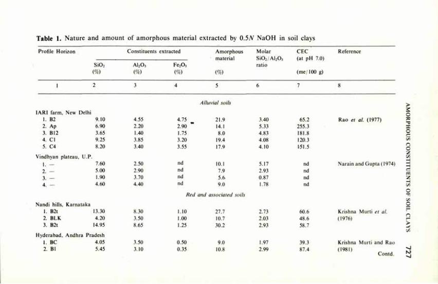
Table 1. Nature and amount of amorphous material extracted by 0.5JV NaOH in soil clays
Profile Horizon Constituents extracted Amorphous material
(%)
Molar Si02 /Al203
ratio
CEC (at pH 7.0)
(me/100 g)
Reference
Si02
(%) AI2O3
(%) Fe203
(%)
Amorphous material
(%)
Molar Si02 /Al203
ratio
CEC (at pH 7.0)
(me/100 g)
1 2 3 4 5 6 7 8
Alluvial soils
IARI farm, New Delhi 1. B2 9.10 4.55 4.75 21.9 3.40 65.2 2. Ap 6.90 2.20 2.90 14.1 5.33 255.3 3. B12 3.65 1.40 1.75 8.0 4.83 181.8 4. CI 9.25 3.85 3.20 19.4 4.08 120.3 5. C4 8.20 3.40 3.55 17.9 4.10 151.5
Vindhyan plateau, U.P.
1. — 7.60 2.50 nd 10.1 5.17 nd
2. — 5.00 2.90 nd 7.9 2.93 nd
3. — 1.90 3.70 nd 5.6- 0.87 nd 4. — 4.60 4.40 nd 9.0 1.78 nd
Nandi hills, Karnataka 1. B2t 13.30 2. BLK 4.20 3. B2t 14.95
Hyderabad, 1. BC 2. Bl
Andhra Pradesh 4.05 5.45
8.30 3.50 8.65
3.50 3.10
Red and associated soils
1.10 1.00 1.25
0.50 0.35
27.7 10.7 30.2
9.0 10.8
2.73 2.03 2.93
1.97 2.99
60.6 48.6 58.7
39.3 87.4
Rao et al. (1977)
Narain and Gupta (1974) 3
Krishna Murti et al. (1976)
Krishna Murti and Rao (1981)
Contd.
> 2 C — C
c S. n o z S. H H C rr -s. C — J-. C
> -< s.
-J
^1
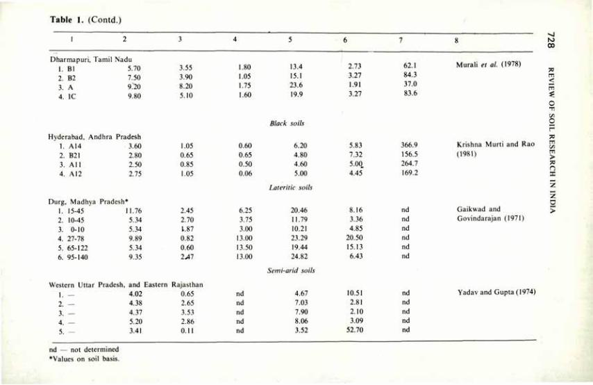
Table 1. (Contd.)
Dharmapuri, Tamil Nadu 1. Bl 5.70 2. B2 7.50 3. A 9:20 4. IC 9.80
Hyderabad, Andhra Pradesh 1. A14 3.60 2. B21 2.80 3. All 2.50 4. A12 2.75
Durg, Madhya Pradesh* 15-45 10-45 0-10
27-78 65-122 95-140
11.76 5.34 5.34 9.89 5.34 9.35
3.55 3.90 8.20 5.10
1.05 0.65 0.85 1.05
2.45 2.70 1.87 0.82 0.60 2>»7
Western Uttar Pradesh, and Eastern Rajasthan
I. 2. 3. 4. 5.
4.02 4.38 4.37 5.20 3.41
0.65 2.65 3.53 2.86 0.11
1.80 13.4 1.05 15.1 1.75 23.6 1.60 19.9
Black soils
0.60 6.20 0.65 4.80 0.50 4.60 0.06 5.00
Lateritic soils
6.25 20.46 3.75 11.79 3.00 10.21
13.00 23.29 13.50 19.44 13.00 24.82
Semi-arid soils
nd 4.67 nd 7.03 nd 7.90 nd 8.06 nd 3.52
2.73 3.27 1.91 3.27
5.83 7.32 5-00„ 4.45"
8.16 3.36 4.85
20.50 15.13 6.43
10.51 2.81 2.10 3.09
52.70
62.1 84.3 37.0 83.6
366.9 156.5 264.7 169.2
nd nd nd nd nd nd
nd nd nd nd nd
Murali et al. (1978)
Krishna Murti and Rao (1981)
Gaikwad and Govindarajan (1971)
Yadav and Gupta (1974)
-J ro 00
-—, <
C -O —
m s. m > n
z >
nd — not determined 'Values on soil basis.
AMORPHOUS CONSTITUENTS OF SOIL CLAYS 7 2 9
polymeric component confirming the structural model (Krishna Murti et al. 1976; Rao et al. 1977; Murali et al. 1978; Krishna Murti 1980; Krishna Murti and Rao 1981).
Alexiades and Jackson (1966) assumed a CEC value of 100 me/100 g for the amorphous material with a molar Si02/Al203 ratio greater than 3.0, while suggesting a flow-sheet for quantitative mineralogical analysis of soil clays. Since the CEC of the amorphous material is dependent on its chemical composition, Rengasamy et al. (1975b) advocated the removal of the amorphous material from soil clays before quantifying the mineralogy
Soil Aggregation Krishna Murti and Rengasamy (1976) reported that the amorphous
materials bound the kaolinite particles less tha 1 p in size into units 1-2 n in size, with further aggregation by the free hydroxides of iron. A model for water-stable micro-aggregate in the ferruginous soils of Karnataka was suggested as follows:
Unit C of size 5-50 M : (B-Fed-B) Fed-dithionite-extractable free iron oxides
Unit B of size 1-2 n : (A-am-A) Unit A bound by amorphous material (am) through coulombic
or cohesive forces
Unit A : Kaolinite particles < 1 n in size
This mechanism was suggested from the data on particle size distribution of soils before and after the removal of various aggregating agents and confirmed by the regression analysis.
Mineral Transformation Fripiat and Herbillion (1971) favoured the synthesis of clay minerals from
the products of hydrolysis, viz. the monomers of Fe, Al and Si. The amorphous material was formed from the monomers released by the hydrolysis of weatherable primary minerals; when the soil matrix lost the bases, the pH gradually changed from alkaline to acidic, and synthesis of kaolinite resulted in the red and associated soils of South India (Rengasamy et al. 1978; Murali et al. 1978). Significant positive correlations between the iron in amorphous material and free iron oxides on soil basis, and the isomorphous substitution of Fe3+ for Al3+ in the octahedral layers of the soil kaolinites to the extent of 0.15 to 0.98 were cited in support of this hypothesis (Murali et al. 1978; Rengasamy et al. 1975a).
7 3 0 REVIEW OF SOIL RESEARCH IN INDIA
Conclusion The amorphous clay constituents have different physical, chemical and
physicochemical reactions in soils because of differences in chemical composition but have a common characteristic due to structural randomness. The characterisation of these constituents in soils derived from parent materials other than volcanic ash has been hampered by their small content and their intimate association with crystalline components.
Proper methods for their characterisation and for obtaining data for verifying the effects on soil properties are needed. There are many inherent difficulties, but recent developments in the study of allophane and related constituents in volcanic ash soils should encourage future studies.
References
Alexiades, C.A. and Jackson, ML. (1966) Clays Clay Miner. 14, 35. Aomine, S. and Jackson, M.L. (1959) Soil Sci. Soc. Am. Proc. 23, 210. Brindley, G.W. (1969) U.S. Japan Seminar 'Amorphous Clay Minerals' Abstract, p. II. Briner, G.P. and Jackson, M.L. (1970) Israel J. Chem. 8. 487. de Villiers, J.M. (1971) Soil Sci. 112, 3. Dudas, M.J. and Harward, M.E. (1971) Soil Sci. Soc. Am. Proc. 3, 134. Fripiat, J.J. and Harbillon (1971) In: "Soils and Tropical Weathering", UNESCO, Paris, p. 15-24. Gaikwad, S.T. and Govindarajan, S.V. (1971) Indian J. agric. Sci. 41, 1079. Hashimoto, I. and Jackson, M.L. (I960) Clays Clay Miner. 7, 102. Jones, R.C. and Uehara, G. (1973) Soil Sci. Soc. Am. Proc. 37, 792. Krishna Murti, G.S.R. (1980) Proc. natn. Symp. Ion Exchange in Soils, Calcutta (In press). Krishna Murti, G.S.R. and Rao, T.V. (1981) Proc. Intern. Symp. 'Soils with Variable Charge'.
New Zealand. Feb. 1981. Krishna Murti, G.S.R. and Rengasamy, P. (1976) Med. Fac. Landbouww. Rijksuniv. Gent. 41,
407. Krishna Murti, G.S.R., Sarma, V.A.K. and Rengasamy, P. (1976) Clay Miner. II, 137. Mehra, O.P. and Jackson, M.L. (I960) Clays Clay Miner. 7, 317. Milliken, T.H., Mills, G.A. and Oblad, A.G. (1950) Disc. Farad. Soc. 8, 279. Murali, V., Krishna Murti, G.S.R. and Sarma, V.A.K. (1978) Geoderma 20, 257. Murali, V., Sarma, V.A.K. and Krishna Murti, G.S.R. (1974) Geoderma II, 147. Narain, B. and Gupta, R.N. (1974) Proc. Indian natn. Sci. Acad. 40B, 249. Pundeer, G.S. and Randhawa, N.S. (1974) Bull. Indian Soc. Soil Sci. 9, 35. Rao, T.V., Gurcharan Singh and Krishna Murti, G.S.R. (1977) Z. Pflanzener Bondenkund. 140,
689. Rengasamy, P., Krishna Murti, G.S.R. and Sarma, V.A.K. (1975a) Clays Clay Miner. 23, 211. Rengasamy, P., Sarma, V.A.K. and Krishna Murti, G.S.R. (1975b) Clays Clay Miner. 23, 78. Rengasamy, P., Sarma, V.A.K., Murty, R.S. and Krishna Murti, G.S.R. (1978) J. Soil Sci. 29,431. Schwertmann, U. (1964) Z. Pflanzener. Bondenkund. 105, 194. Segalen, P. (1968) Cah. ORSTOM Ser. Pedol 6, 106. van Olphen, H. (1971) Science 171, 91. Wada, Koji and Harward, M.E. (1974) Adv. Agron. 26, 211. Yadav, B.R. and Gupta, R.N. (1974) Proc. Indian natn. Sci. Acad. 40B, 160.
Surface Characteristics and Ion Exchange as Related to Soil Properties S.K. MUKHERJEE1 AND T.G. SASTRY2
THE surface characteristics of clay minerals are of the utmost importance in understanding soil behaviour in response to treatments. The multifarious applications to which the soil may be subjected are mainly related to the large surface area the soil presents. It is basically an expression of the crystal structure of clay minerals present in the soil. These minerals belong to the phyllo-silicates having layered lattices. They are capable of sorbing ions in exchangeable forms. Cation exchange is more common with clay minerals than anion exchange.
This review supplements the fairly comprehensive reviews published earlier (Chakravarty 1974; Mukherjee 1974; Seal et al. 1974). It is expedient to divide the subject into the following topics:
1. Surface activity as a function of particle size fractions. 2. Measurements of surface area and interpretation of data. 3. Origin, measurement and distribution of surface charge in relation to the
liquid phase. 4. Adsorption of ions on clay surface. 5. The ion-exchange phenomenon. 6. Exchange equilibrium laws. 7. Catalytic reactions on clay surface.
Surface Activity as a Function of Particle Size Fractions The fine particles being associated with large surface, the measurement of
important soil properties has been confined to the finer-sized fractions. Size fractionation work leads to a knowledge of size distribution, which determines qualitatively as well as quantitatively some of the bulk physical properties of soil, especially those connected with interaction of soil with moisture and adsorption. The limit above which particle size has only negligible influence has been arbitrarily fixed at 2 microns. Most of the work on clay minerals, particularly on the secondary minerals, has been done with suspensions of particles less than 2 microns isolated from the soil by well known methods.
Attempts were made to understand adsorption, coagulation, affinity of soil
1. 332 Jodhpur Park, Calcutta; 2. Division of Soil Science and Agricultural Chemistry, Indian Agricultural Research Institute, New Delhi.
7 3 2 REVIEW OF SOIL RESEARCH IN INDIA
colloids for cations and anions, soil acidity, and electrokinetic and electrochemical properties of clays, it being assumed that these characteristics are most prominent in the finer fractions of the soil. But the properties of the coarser fractions (particle size >2 n) have been studied and compared with those of finer fractions (particle size < 2 p) (Pathak et al. 1950; Kanwar 1956; Banerjee et al. 1978). The phosphate retention capacities were found to increase^ as expected, with decrease in the size of the particles. However, coarse and fine sand fractions also showed high phosphate-retention capacity; it was attributed to sesquioxides, particularly in lateritic soils. Potassium fixation (Lodha and Seth 1970; Ramanathan and Krishnamoorthy 1978; Mehrotra et al. 1972), Copper adsorption (Sethi and Chopra 1976), and zinc adsorption (Bijay Singh and Sekhon 1976) were studied by using varying particle sizes in different soils. High exchange capacity was found to be associated with finer-sized fractions (Mukherjee 1951).
Satyanarayana et al. (1969, 1970) observed high cation exchange capacity for coarser fractions in soils of Malwa plateau of Madhya Pradesh. They attributed it to the presence of adhering smectites. Lavti et al. (1969) reported that cation exchange capacity (CEC) of Rajasthan soils was correlated with clay, silt and organic matter content, but the clay contributed the most. They found the equation CEC=0.51 clay+4.12 o.m. to be more applicable than the one that included the silt factor.
The relative contributions of clay and organic matter to CEC were reported by Mukherjee (1944) and Somani and Saxena (1977). In the case of aggregates having apparently large particle sizes, higher CEC was observed, for the simple reason that aggregates, like the micelles,.retained the surface activity of small-sized particles.
Measurement of Surface Area and Data Interpretation Surface area and Martin's Y-value, although qualitative, are widely used in
mineralogical analysis of soil clays. In the determination of surface area the main principle involved is the adsorption by clays of ethylene glycol, dyestuffs, etc. From these estimations the total surface area, which is apportioned as internal and external surface areas, is calculated. The ethylene glycol (EG) retention by clays, first developed by Dayal and Hendricks (1950), was subsequently modified and improved upon and reviewed critically by Mortland and Kemper (1964). Adhikari and Majumdar (1972) used this method for calculating the surface areas of clays and clay minerals. The value of the internal surface area and the exchange capacity of clay minerals are used to calculate Martin's Y-value, which gives an idea of the dominant clay mineral component. However, in India the dye-adsorption technique and the calculation of Langmuir constants assuming a monolayer sorption have been more commonly used because of their simplicity. The results have not always been free from ambiguities.
De et al. (1973) obtained data on sorption of cationic dyes such as
SURFACE CHARACTERISTICS AND ION EXCHANGE 7 3 3
methylene blue, malachite green and crystal violet by kaolinite, montmorillo-nite, vermiculite, asbestos and feldspar. Das Kanungo and Chakravarti (1980) studied the adsorption and desorption characteristics of Co (NH,)^*, Co (en)5+
Co (pm)"3* and other cationic dyes on different clay minerals. They observed adsorption and desorption to be correlated with surface characteristics of absorbents and with the shape, size and charge of the dye ions. On the basis of these studies, they suggested the possible modes of orientation and interaction of the dye molecules on the surface. They considered crystal violet a better absorbate for evaluation of surface area of minerals. De el al. (1979) also studied the adsorption of crystal violet and its release by surface-active organic ions. Singhal and Namita Singh (1978) studied the adsorption and interaction of dimecron (phosphamidon), using H-, Na- and Ca-montmorillonites, and showed that the process was diffusion*controlled. Maximum adsorption occurred at pH 6.0.
Methylene blue as absorbate on certain clay minerals such as bentonite, kaolinite and vermiculite had some apparent disadvantages (Chatterjee 1969; Ghosal 1971; Ghosal and Mukherjee 1972 a, b; Dee/ al. 1978) because of its self-association even at low concentrations. This problem of self-association in methylene blue was critically examined by Mukherjee and Ghosh (1970a, b). The specific surface areas of some common clay minerals measured by the EG method were reported by Chakravarti (1974).
Sahu and Das (1972) applied the method of Carter el al. (1965) using ethylene glycol monoethyl ether (EGME) to determine the surface areas of clay minerals and soil clays, and compared the results with those obtained with the EG method. The results were comparable, but the EGME method is now preferred because it is quick.
Origin, Measurement and Distribution of Surface Charge in Relation to the Liquid Phase
The electrical charge of clay minerals of the three-layer type is, as already stated, primarily due to isomorphous lattice substitution. This results in a constant negative charge density on the surface of the crystal; it is not affected by the composition of the outside soil solution. This particle charge is balanced by an equivalent amount of ions of opposite sign, called counter ions, which are associated with the particle surface and are distributed so as to form the electrical double layer.
The structure of the electrical double layer has been critically examined, theoretically and experimentally, because of the peculiar properties of suspensions of electrically charged particles, which have demanded plausible interpretations. But doubts still exist in understanding the clay-water system in all its details on the basis of the electrical double layer. Although zeta potential measurements are utilised to evaluate the magnitude of the electrical charge on the surface of colloidal particles in general, it is subject to variations caused by geometrical effects in such systems. As in the case of pure colloidal system, the
7 3 4 REVIEW OF SOIL RESEARCH IN INDIA
surface conductance plays important role, sometimes a decisive one, in estimating the surface charge density of clay particles, which depends on the ionic composition in the vicinity of the particle.
Electrometric titrations, whether potentiometric or conductometric, reveal the existence of reacting ions at different levels of affinity on the clay surface. The shape of the titration curves are similar to those of systems in solution. But the structure of the surface and the electrical charge associated with it have a marked influence. The existence of the electrical double layer and the polyphasic character of the clay-water system have been recognised. As a result, the detailed analysis of the titration curves and a comparison with the situation as obtained in solution electrochemistry reveals certain apparently contradictory properties. The potentiometric and conductometric titrations do not agree, and the effect of neutral salts on such titrations is different than that expected from the principles of solution electrochemistry. Some explanation, though not fully satisfactory, is possible on the basis of the electrical double layer, which is the expression of a charged surface in contact with ions in solution.
Among the different clay minerals, those of the montmorillonite group have been subjected to a variety of measurements, because of their many interesting properties, such as high solvation with polar liquids, dispersibility, electrical charge, exchange capacity and complexation with organic compounds. Most of the black and black cotton soils are predominantly montmorillonitic, but when the parent rock is rich in potash-bearing minerals illite is also present (Tamhane and Namjoshi 1959).
The charge on montmorillonite is situated, as has been mentioned earlier, mainly in the octahedral layer because of large isomorphous replacement. In aqueous suspensions, water molecules and the hydrated exchangeable cations are situated between unit layers of montmorillonite particles and give rise to swelling, which causes C-spacing expansion in the mineral, as shown by X-ray diffraction of the dried samples. Montmorillonites similarly accommodate polar organic molecules or large-sized cations between the unit layers.
In the case of 2:1 lattice minerals, e.g. smectites, there is a good deal of variation in isomorphous substitution, which is possible not only in the octahedral but also in the tetrahedral layers; as a result, the electrical charge varies, and hence also the nature of the clay minerals themselves. These deep-seated changes are most likely to occur under natural conditions of mineral formation. But some changes in mineral character may also be brought about by replacing one kind of exchangeable cation with another. Thus, the conversion of biotite to vermiculite or montmorillonite is caused by removal of K+ ions which hold the oxygen planes of two unit lattices together in biotite. The reverse process, viz, K+ ion exchanging with the naturally occurring Ca2+ and like ions of montmorillonite, converts it into illite as a consequence of potash fixation (Mishra 1959; Chatterjee and Roy 1954, 1958).
SURFACE CHARACTERISTICS AND ION EXCHANGE 7 3 5
Adsorption of Ions on Clay Surface Adsorption reactions between clay minerals and ions or molecules are
surface phenomena. The adsorption isotherms have been shown to follow either the Freundlich or the Langmuir equations (Gaikwad and Patnaik 1969; Mahapatra et al. 1979; Joginder Singh and Randhawa 1979). The logarithmic forms should be linear, as many experimental data also confirm. But there are instances where linearity is not obtained; instead two linear graphs having distinct differences in slope are observed (Mukherjee and Ghosh 1950). This would signify the existence of surface heterogeneity. Similar evidence has been obtained by means of electrometric studies (Mukherjee 1974; Mitra and Kapoor 1969; Mitra and Sindhu 1971).
Desorption studies have also revealed the heterogeneous nature of the surface, and the results have been complementary to those obtained in desorption studies. That structure of the surface and its electrical charge play a predominant role as shown by the influence of such factors as charge and size of the interacting ions (Das Kanungo et al. 1967, 1968; Ghosal and Mukherjee 1972).
The concept of isoconductivity value of clay electrolyte systems has been applied to estimation of the cation exchange capacity of clays (Dakshinamurti and Bhavanarayana 1980). Clay mineral particles are negatively charged and adsorb cations by exchange for the counter ions. Adsorption of anions, particularly that of phosphate, has been studied because of the importance of phosphorus in determining soil fertility. In fact, in spite of being negatively charged, clays are found to adsorb phosphates and a number of other anions such as arsenate, oxalate, humate, ferrocyanide, but not the simpler anions such as"sulphate, nitrate, and chloride. It has been argued that so long as the exposed Al-OH layer in kaolinite or the edge Al-OH groups are capable of ionisation as Al+ + OH~, the OH-ions will be capable of exchanging with other anions. It is also likely that the exposed Al-OH groups react with phosphates and other anions forming Al compounds which either remain adsorbed on the surface or are separated out as a solid phase. It is still more likely that SiO*" ions in the tetrahedral layer are replaced by PO4- in such proportion as is required to maintain electroneutrality. Experimental evidence, although not always convincing, has been obtained for each of the mechanisms suggested above. Some of the experiments do, however, show the complex nature of the reactions which take place on the clay surfaces and lack of information on the detailed structure of these surfaces.
The magnitude and nature of adsorption and desorption on clay surface are in a broad sense dependent on the relative bonding energies and on the chemical characteristics of the interacting ions or molecules. Peculiarities of individual processes have been explained by invoking the predominance of one or more of the factors mentioned above.
7 3 6 REVIEW OF SOIL RESEARCH IN INDIA
The Ion Exchange Phenomenon The iön exchange phenomenon was observed about 150 years ago. Since
then both capacity and intensity factors of ion exchange have been studied thoroughly. The generality of the phenomenon and its wide applicability have been recognised. The capacity factor, which is quantitatively expressed by the ion (both cation and anion) exchange capacity, is now a routine measurement, and gives a fair idea of a soil's ability to utilise fertilisers, its water-holding capacity, the predominant clay, and the type of minerals present in it. The intensity factor is expressed quantitatively with the help of exchange isotherms, which usually follow either the empirical Freundlich or the more rigorous Langmuir type equation. A collateral study is that of exchange equilibria.
The exchange capacity is attributed to, and should be equivalent to, the electrical charge caused by isomorphous substitution in the case of 2:1 lattice clay minerals, and to the number of surface OH groups donating protons by dissociation, as in the case of kaolinitic minerals.
Many methods have been proposed to determine the exchange capacity of clays and clay minerals. The general principle is to convert the usual heteroionic system by treatment, usually by leaching a known amount of it with an electrolyte, and then to determine the amount of ion replaced, again by leaching, with another ion. Through systematic studies it became apparent that the nature and concentration of the ions and the pH of the electrolyte solution are the important factors which determine the value of the exchange capacity. Since these factors varied in the different studies, the values obtained were sometimes very different. Comparative studies have revealed the causes of the differences and have helped in determining the conditions under which fairly reliable and consistent values of exchange capacity may be obtained. Studies of exchange isotherms or the intensity factors under varying conditions have also helped to establish the above factors.
Clay and clay minerals saturated with one kind of exchangeable cation are not common. Such monoionic systems may be prepared by treating a natural system repeatedly with an electrolyte containing the desired cation. However, it is of interest to study the physical and electro-chemical properties of the monoionic systems. When a system is fully saturated with hydrogen ions, it becomes somewhat unstable, but because of the ease and accuracy of measurement of hydrogen ion the hydrogen clays can be subjected to a number of electrochemical studies. In fact, a very thorough and systematic study of hydrogen systems has been made and many interesting results have emerged.
For instance, the electrometric titration curves of aqueous suspensions of hydrogen clays with alkalies show weak acid features which change to those of strong acids in the presence of neutral salts, unljke anything observed with aqueous solutions. The ubiquitous presence of aluminium ions in any reaction with clays complicates measurements and their interpretation. Removal of aluminum by quick exchange with hydrogen resins, and immediate electrometric titrations show the difference and elucidate the role of aluminium
SURFACE CHARACTERISTICS AND ION EXCHANGE 7 3 7
ions in modifying the features of the titration curves (Majumdar and Mukherjee 1979).
By titration of a hydrogen clay with alkalies, the clay system, is progressively converted into a bi-ionic (H-M-clay) and finally to a monoionic system. The physical and electro-chemical properties also change during the process. Dispersion, viscosity, electrokinetic potential, and electrical birefringence show characteristic changes. At high concentrations of clays, properties such as plasticity, thixotropy and aggregation become predominant; they are greatly influenced by the saturating cation.
Exchange Equilibrium Laws The exchange equilibria between a clay system and an added electrolyte
assume a somewhat different picture when hydrogen ions are not present — that is, when to a non-ionic clay saturated with a metal ion another metal ion is added in the form of a neutral salt, the study of equilibrium is not complicated so much by the presence of aluminium ions. But the measurements are relatively tedious, because of the analytical problems and difficulties of activity measurements and calculations. Clay membrane electrodes (Pain and Mukherjee 1969) have to some extent minimised the difficulties, but they have certain limitations, e.g. at high concentration and in the presence of more than one ion the accuracy of activity measurement is often low. However, membranes prepared from exchange resins and ion-specific membrane are capable of giving higher accuracy. Though polybasic, the clay system yield an equilibrium constant which is perhaps an average of closely lying values (Gupta 1956a, 1956b; Gupta and Adhikari 1958).
Electrometric measurements using silver clays and silver electrode system, on the changes in silver ion activity with the addition of metal ions as nitrates, revealed at least two types of binding sites on clays (Mukherjee and Ghosh 1950). It was also observed that the same stage of equilibrium was not reached when approached from opposite directions, showing the existence of a certain degree of 'hysteresis', and also the exchange sites are not of equal value quantitatively. This was shown (Mukherjee 1942; Mukherjee et al. 1951; Mukherjee and Marshall 1951) by studying the properties of bi-ionic systems prepared by changing the order of replacement of the two cations. An M r M 2
clay prepared by introducing M2 first and M, next showed differences in exchangeability of Mt and M2 for a third cation, fiom that of an M2-Mi clay where the addition of M, and M2 was reversed. These experiments carried out with bi-ionic clays showed that up to 30 per cent saturation the ion exchange sites are of a different bonding energy from those above this saturation. In the case of kaolinite it is about 50 per cent. The heterogeneity of the surface may be much greater but measurements similar to the above using lower percentages or tri-ionic clays do not yield data sufficiently accurate to admit an unequivocal interpretation.
7 3 8 REVIEW OF SOIL RESEARCH IN INDIA
Catalytic Reactions on Clay Surface The clays and clay minerals are capable of adsorbing various compounds,
both ionic and non-ionic. Therefore they may catalyse reactions between adsorbates by lowering the activation energy. Many reactions in nature, including the formation of constituents of living matter, may have originated on clay surfaces. Cracking of hydrocarbons and dehydrogenation and hydrogenation reactions are extensively employed in practice using specially treated clays, which attain very high surface acidity (Jacobs 1977).
The ability of the surface of clays to catalyse reactions is increased by treatment with an acid, so that the adsorbed cations such as Ca2\ Mg2+, Al1+, Na\ K+ and Fe1+ may be replaced by the more active H+ ions. Banerjee and Sen (1974) have given a brief account of the applications of clay minerals in the catalyst industry. Not much work has been reported on this topic.
References
Adhikari, M. and Majumdar, M.K. (1972) Indian J. Tech. 10. 413. Banerjee. B.K. and Sen, M.K. (1974) Bull. Indian Soc. Soil Sci. 9, 247. Banerjee, S.K.. Pal. O.K. and Gupta. S.K. (1978) Fert. Technol. 15, 30. Bijay Singh and Sekhon. G.S. (1976) Soil Sci. 124, 366. Carter, D.L., Heilman, M.D. and Gonzalez, C. (1965) Soil Sci. 10, 356. Chakravarti, S.K. (1974) Bull. Indian Soc. Soil Sci. 9, 103. Chatterjee, B. and Ray, A. (1954) J. Indian Soc. Soil Sci. 2, 63. Chatterjee, B. and Ray, A. (1958) J. Indian Soc. Soil Sci. 6, 7. Chatterjee, R.K. (1969) .1. Indian Soc. Soil Sci. 17, 316. Dakshinamurti, C. and Bhavanarayana, M. (1980) Catena (in press). Das Kanungo, J.L., Chakravarti, S.K. and Mukherjee, S.K. (1967) J. Indian Chem. Soc. 44, 339. Das Kanungo, J.L., Chakravarti. S.K. and Mukherjee. S.K. (1968) J. Indian Chem. Soc. 45, 685. Das Kanungo. J.L.. and Chakravarti, S.K. (1980) Proc. natl. Symp. on Ion-exchange
Phenomenon, Calcutta. Dayal. R.S. and Hendricks, S.B. (1950) Soil Sci. 69, 421 Gaikwad, S.T. and Patnaik, S. (1969) J. Indian Soc. Soil Sci. 17. 437. De, D.K., Das Kanungo, J.L. and Chakravarti, S.K. (1973) J. Indian Soc. Soil Sci. 21, 137. De, D.K., Das Kanungo, J.L. and Chakravarti, S.K. (1978) J. Indian Soc. Soil Sci. 26, 225. De, D.K., Das Kanungo, J.L. and Chakravarti, S.K. (1979) J. Indian Soc. Soil Sci. 27, 85. Ghosal, D.N. and Mukherjee, S.K. (1972a) J. Indian Chem. Soc. 49, 569. Ghosal, D.N. and Mukherjee, S.K. (1972b) Indian J. Chem. 10, 835. Gupta, S.K. (1956a) Sci. Cult. 22, 54. Gupta, S.K. (1956b) J. Indian Chem. Soc. 33, 587. Gupta, S.L. and Adhikari. M. (1958) J. Indian Chem. Soc. 35, 753. Hoffman, U. and Kiemen, R. (1950) J. inorg. allg. chem. 262, 95. Jacob, P.A. (1977) Carboniogenic activity of zeolites, Elsevier, London, 49, 201. .loginder Singh and Randhawa, N.S. (1979) Indian J. agric. Sci. 49, 201. Kanwar, J.S. (1956) Soil Sci. 82, 93. Lavti, D.L., Gandhi, A.P. and Paliwal, K.V. (1969) J. Indian Soc. Soil Sci. 17, 71. Lodha, B.K. and Sethi, S.P. (1970) J. Indian Soc. Soil Sci. 18, 121. Mahapatra, J.S., Mishra, C , Panda, D. and Panda, N. (1979) Bull. Indian Soc. Soil Sci. 12, 274. Majumdar, R.N. and Mukherjee, S.K. (1979) J. Indian Soc. Soil Sci. 27, 26.
SURFACE CHARACTERISTICS AND ION EXCHANGE 7 3 9
Mehrotra, C.L., Gulab Singh and Pandey, R.K. (1972) J. Indian Soc. Soil Sci. 20, 121. Misra, S.G. (1959) J. Indian Soc. Soil Sci. 7, 49. Mitra, R.P. and Kapoor, B.S. (1969) Soil Sci. 108, 111. Mitra, R.P. and Sindhu. P.S. (1971) Clays Clay Miner. 19. 391. Mort land, M.M. and Kemper, W.I). (1964) Agronomy Monog. 9, Am. Soc. Agron. Inc. Madison.
Wisconsin. Mukherjee, S.K. (1942) Bull Indian Soc. Soil Sci. 4, 188. Mukherjee, S.K. (1944) Indian J. agric. Sci. 14. 137. Mukherjee. S.K. (1951) Bull. Indian Soc. Soil Sci. 6. 89. Mukherjee, S.K. (1974) Bull. Indian Soc. Soil Sci. 9, 87. Mukherjee, S.K., De, R.M. and Rao, V. (1951) Bull. Indian Soc. Soil Sci. 6, 89. Mukherjee, S.K. and Ghosh, S. (1950). J. phys. colloid Chem. 54, 1110. Mukherjee, P. and Ghosh, A.K. (1970a) J. Am. Chem. Soc. 92, 6403. Mukherjee, P. and Ghosh. A.K. (1970b) J. Am. Chem. Soc. 92, 6408. Mukherjee, S.K. and Marshall. C.E. (1951) J. phys. Coll. Chem. 55, 61. Pain, B.K. and Mukherjee, S.K. (1969) J. Indian Soc. Soil Sci. 17, 407. Pathak, A.N., Mukherjee, S.K. and Shrikhandi, J.G. (1950) Curr. Sci. 19, 290. Ramanathan, KM. and Krishnamoorthy, K.K. (1978) Mysore J. agric. Sci. 12, 69. Sahu, S.S. and Das, S.C. (1972) Indian J. appl. Chem. 35, 40. Satyanarayana, K.V.S., Sahi, B.P. and Krishna Murti, G.S.R. (1969) Curr. Sci. 38, 545. Satyanarayana, K.V.S., Dhir. R.P., Krishna Murti. G.S.R. and Prem Jolly (1970) Curr. Sci. 39,
211. Seal, B.K., Lahiri, M.M. and Layek, D. (1974) Bull. Indian Soc. Soil Sci. 9. 65. Sethi, R.K. and Chopra, S.L. (1976) Indian J. agric. Res. 10, 10. Singhal, J.P. and Namita Singh (1978) Soil Sci. 125, 301. Somani, L.L. and Saxena, S.N. (1977) Agrochimica 21, 200. Tamhane, R.V. and Namjoshi, N.G. (1959) J. Indian Soc. Soil Sci. 7, 49.
Clay Mineralogy and Soil Physical Behaviour T.D. BISWAS' AND JAGAN NATH2
SOIL consists of a large number of smaller and bigger solid particles structurally organised to a greater or less extent. The way in which these are organised largely determines the physical behaviour of the soil and crop growth. The pattern of arrangement of the solid particles and the degree of its stability are, to a large extent, controlled by the nature of the solid colloidal particles, mainly their mineralogical make-up. According to Low (1968), the likely factors related to soil mineralogy influencing soil physical phenomena may be classed as follows:
Particle Size Distribution. Depending upon either lattice energy or cationic substitutions in silicate layers causing strains in the system, particle size distribution controls a majority of soil physical characteristics.
Inter-Particle Bonds per Unit Volume and the Strength of the Bonds. These bonds are due to the various attractive and repulsive forces, which are dependent upon the mineralogical composition. They influence soil strength, aggregation and plasticity.
The Charge Imbalance in the Crystal Lattice or the Surface Charge Density. This effects the swelling.
Molar Potential Energy in the Adsorptive Force Fields Related to the Inter-Particle Distance and the Porosity. It controls the water retention at a particular suction.
Particle Arrangement. Specific surface, porosity, pore shape and tortuosity of a system depend upon the particle arrangement and are indirectly related to the mineralogical composition. This factor controls water movement, thermal conductivity, and the like.
Biswas and Karale (1974) reviewed the literature on clay minerals and soil physical properties. This paper is a supplement to that review. It deals with the topics of soil structure, soil water, surface area, and rheological properties.
Soil Structure Soil structure may be defined as a disposition of parts into a system. In
other words, soil structure means how the three phases — solid, liquid and gaseous — are arranged in relation to one another both qualitatively and quantitatively. An optimum structure maintains the liquid and gaseous phases, which are continuously exchanging with the environment, in a suitable reciprocal ratio with the solid phase, depending upon the necessities of soil
I. Formerly, Division of Soil Science and Agricultural Chemistry, Indian Agricultural Research Institute. New Delhi; 2. Department of Soils, Haryana Agricultural University, Hissar.
CLAY MINERALOGY AND SOIL PHYSICAL BEHAVIOUR 741
microorganisms and plant roots. Therefore, the pore-size distribution is important in characterising soil structure (Sequi 1978). The pore-size distribution depends on the arrangements and bonding of these aggregates. The development of interparticle bonds contributes to the stability of soil aggregates and may take place through cations, organic molecules and water, and also between clay-clay and clay-coarse grains. The nature of clay minerals has a profound effect on the nature, size, and stability of the aggregates. Besides, the sesquioxides usually stabilise the aggregates (Russell 1973).
Krishna Murti and Richards (1974) observed that amorphous aluminium hydroxide aggregated the clay particles better than the amorphous iron hydroxide. Krishna Murti and Rengasamy (1976) studied the ferruginous soils of India and observed aggregation of kaolinitic fine clay ( < 1 p) by amorphous ferri-aluminosilicates and further agglomeration by free iron hydrous oxides.
On investigating the relative importance of the nature of clay fraction to the stability of the aggregates, Krishna Murti et al. (1977) reported that the water-stable aggregates were the result of clay mineral-iron oxide interactions. In the black soils of Madhya Pradesh, with dominant smectite, the water-stable aggregates of a size < 250 /u were more; this was the result of cohesive forces due to edge-face interactions or because of linkage by divalent cations. The kaolinitic ferruginous soils of southern India had more aggregates <50 ft. Similar observations were reported by Rengasamy et al. (1974) and Krishna Murti and Gurcharan Singh (1975).
Soil Water Retention of water by the soil (as a result of the presence of retaining forces
associated with the soil matrix) against external forces (resulting from the gravitational field, centrifugal fields, gradient of external gas pressure, etc.) is one of the primary functions of soil in sustaining plant growth under conditions of intermittent water supply.
Water-Retention Characteristics. Rao and Ramacharlu (1959) systematically studied the influence of mineralogical make-up of soil clays on moisture-retention characteristics of the soil, in the pF range of 0 to 2.7. They pointed out that, for the same clay content, black soils with dominant smectite had higher moisture content than soil groups (red, laterite, alluvial and forest soils) having other minerals dominant. Ali et al. (1966), working with major soil groups of India, observed that the moisture retained throughout the available range was mainly controlled by the mineralogical make-up of the soil clay. The moisture content of any particular tension followed the order (Ali and Biswas 1971): black soil (smectite) > alluvial soil (illite) > laterite (kaolinite).
Ali and Biswas (1971) also studied the water retention and release behaviour of H-bentonite, H-illite and H-kaolinite, in the range of 0-15 bar. The water content at any metric suction (0-15 bars) was highest in bentonite, intermediate in illite, and lowest in kaolinite. The water retention curves of the
742 REVIEW OF SOIL RESEARCH IN INDIA
three minerals were widely separated in the low suction range but converged with increase in suction, i.e. the difference in water retention at higher suctions narrowed down. The relatively high amount of water retained by bentonite at low suction was said to be due to predominant inter-layer adsorption of water.
The amount of water released at different suction ranges was the highest in bentonite clay followed by illite and kaolinite. The water retention curve of bentonite was, therefore, steeper than that of either illite or kaolinite.
The type of clay mineral constituting the soil clay determines the water-retention characteristics of the soil as reflected by the similarity of the water retention curves of the soil with that of its dominant clay mineral. Therefore, the water-retention curves for Padegaon black soils (dominantly montmorillonitic), Sabour alluvial soils (dominantly illitic), and Suri lateritic soil (dominantly kaolinitic) resembled those for bentonite, illite and kaolinite, respectively. The shape and position of ihe curves would have been more conspicuous if the exchange sites of the three soils had been occupied by sodium and if the colloidal content were of the same order.
The influence of exchangeable cations on water retention by expanding clays was demonstrated by Thomas and Moody (1962). They observed that water retained by bentonite at 0.33 bar decreased from 600 per cent to 105 per cent when its exchange sites occupied by sodium were replaced by aluminium.
Volume of Expansion. The volume of expansion, an intrinsic property of soil colloids, depends upon the nature and amount of clay and associated cations. The swelling of montmorillonite clays up to 20 A is determined by the hydration of exchangeable cations.
Black soils with smectitic clay mineral and some other soils having predominantly smectitic minerals are characterised by high swell/shrinkage potential (Biswas and Karale 1974). The self-mulching characteristics and high percentage of pseudo-aggregates of black soils are related to their high swell/shrinkage property. This property is not so marked in soils having kaolinite as the dominant clay mineral.
Better correlation of volume of expansion with cation exchange capacity of soil than with its clay content signifies the contribution of the nature of soil clays — mainly their mineralogical make-up. Ramanathan and Krishnamoorthy (1977) studied different soil groups of Tamil Nadu, varying in their mineralogical make-up and clay content, and observed that the value of coefficient of correlation increased from 0.37 to 0.92 on correlating the volume of expansion with cation exchange capacity instead of clay content of the soil. This indicates that the mineralogical make-up of the soil clays has a profound effect on the volume of expansion of the soil.
Hygroscopicity. The absorption of water by soils, particularly at lower vapour pressures, is related to the nature of colloids of the soil. Rajani (1968) reported that moisture absorbed by soils (based on 100 per cent clay content) at 50 per cent relative humidity was 12.0-14.0 per cent for montmorillonite, 8.0-10.0 per cent for the mixture of kaolinite and montmorillonite, 7.0-8.0 per cent
CLAY MINERALOGY AND SOIL PHYSICAL BEHAVIOUR 7 4 3
for illite, and 4.0-6.0 per cent for kaolinite and halloysite. Ali et al. (1966) also investigated the effect of clay minerals on the hygroscopic coefficient of soils. The results obtained by them, when compared at 100 per cent clay content, indicate that the hygroscopic coefficient was the highest for soils having montmorillonite as dominant clay mineral, intermediate for illite + montmorillonite. and lowest for illite + kaolinite.
Maximum Water Holding Capacity. The moisture retained by the soil when all the attractive forces for holding water are satisfied is a function of colloid content of the soil, mineralogical make-up of soil clays, and pore-size distribution. Ramanathan and Krishnamoorthy (1977) observed that 37 per cent variation in the maximum water holding capacity was due to the clay content of the soil, and 67 per cent was due to the clay content and mineralogical make-up of soil clays (measured through cation exchange capacity of the soil). The regression equations obtained by them were as follows:
Y=28.57+0.65 X, (r=0.61) Y=26.27+1.046 X2 (r=0.82)
where, Y = maximum water holding capacity, Xi^clay content of the soil, and X2 = cation exchange capacity of the soil.
Surface Area The surface area of the soil is the seat for all the chemical, physical and
biological activities. This property of the soil is affected by the nature and total colloidal content of the soil. Montmorillonite has the highest total as well as internal specific surface area, and kaolinite has the lowest. Illite occupies an intermediate position (Table 1). Soil clays from black soil groups, being dominantly smectitic, had the highest internal as well as total specific surface area. Soil clays from red and lateritic soils have very high specific surface area in comparison with the nature of clay minerals present in them. This is due to the amorphous iron and aluminium oxides present in them. The influence of amorphous colloid content of soil clays on surface area was reported by Wada and Harward (1974).
Rheological properties The behaviour of the soil in response to the applied force mainly depends on
the nature of the low-temperature water given 'up by heating from 100° to 150°C and the factors that control its characteristics. The nature of clay minerals is important in determining the nature of this water.
The amount of water required for bringing the soil to liquid limit was 1.7 g per gram of clay for montmorillonitic, 0.9 g for illitic and 0.74 g for kaolinitic soils (Hajera and Bhatnagar 1972). The force required to till at this moisture
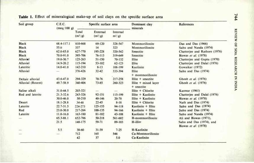
Table 1. Effect of mineralogical make-up of soil clays on the specific surface area
Soil group C.E.C. (meq/IOO g)
Total (m2/g)
Specific surface
External (m2/g)
area
Internal m2/g)
Dominant clay minerals
References
Black 68.4-117.1 410-668 69-120 328-547 Montmorillonite Das and Das (1966) Black 55.0 337 14 323 Montmorillonite Sahu and Nanda (1974) Black 62.0-85.0 627-770 195-228 320-542 Smectite Chatterjee and Rathore (1976) Black 70.0-91.0 395-706 76-113 319-649 Smectite Biswas el al. (1978) Alluvial 19.0-30.7 125-263 51-150 70-132 Mite Chatterjee and Gupta (1970) Alluvial 14.9-20.2 115-194 53-102 62-123 Ulite Chatterjee and Dalai (1976) Lateritic 14.0-41.0 142-210 8-13 108-199 Kaolinite Gowaikar (1972) Alluvial — 376-426 32-42 333-394 Ulite
+ montmorillonite Sahu and Das (1974)
Deltaic alluvial 43.6-47.0 294-329 70-76 217-258 Ulite + smectite Ghosh et al. (1976) Alluvial (Recent) 49.7-58.9 340-406 73-85 260-323 Ulite + mixed layer
+ smectite Ghosh el al. (1976)
Saline alkali 31.0-44.5 203-321 — — Ulite + Chlorite Kan war (1961) Red and laterite 21.3-32.6 243-326 92-151 115-199 Ulite + Kaolinite Chatterjee and Dalai (1976)
30.0-46.0 50-210 40-146 20-70 Ulite + Kaolinite Biswas el al. (1978) Desert 18.1-28.8 34-48 22-45 8-18 Ulite + Chlorite Nath and Das (1974) Laterite 22.7-31.5 224-273 125-155 94-118 Kaolinite + Ulite Sahu and Das (1974) Red 23.0-30.0 217-266 100-135 94-166 Kaolinite + Ulite Sahu and Das (1974) Laterite 11.0-16.0 163-180 81-102 43-108 Kaolinite + Ulite Sahu and Nanda (1974) — 65.3-88.1 652-786 50-218 561-602 H-montmorillonite AH and Biswas (1971),
21.5 148-175 59-71 89-103 H-illite Sahu and Das (1974), and Biswas et al. (1978)
— 5.5 38-60 31-39 7-25 H-Kaolinite — — 712 165 546 Ca-Montmorillonite
42 37 5.0 Ca-Kaolinite
CLAY MINERALOGY AND SOIL PHYSICAL BEHAVIOUR 7 4 5
content was the least for soils having montmorillonite as the dominant clay mineral and was highest for soils having kaolinite as the dominant clay mineral. The moisture content at which smectitic, illitic and kaolinitic soils could be moulded ranged as 2.67-1.70, 1.76-0.9, and 1.6-0.7 g per gram of clay, respectively.
From the foregoing resume it may be inferred that little work has been done to evaluate the influence of clay minerals on the physical behaviour of soil in quantitative terms. Nevertheless, the influence of the major mineralogical group, on soil physical properties such as soil structure, moisture characteristics, volume of expansion, specific surface area and rheological properties has been well brought out.
References
Ali, M.H. and Biswas, T.D. (1971) J. Indian Soc. Soil Sci. 19, 363. Ali, M.H., Chatterjee, R.K. and Biswas, T.D. (1966) J. Indian Soc. Soil Sci. 14, 51. Biswas, T.D. and Karale, R.L. (1974) Bull. Indian Soc. Soil Sci. 9, 165. Biswas, C.R., Karale, R.L. and Das, S.C. (1978) J. Indian Soc. Soil Sci. 26, 339. Chatterjee, R.K. and Dalai, R.C. (1976) J. Indian Soc. Soil Sci. 24, 253. Chatterjee, R.K. and Gupta, D.S. (1970) J. Indian Soc. Soil Sci. 18, 391. Chatterjee, R.K. and Rathore, G.S. (1976) J. Indian Soc. Soil Sci. 24, 144. Dfas, D.K. and Das, S.C. (1966) J. Indian Soc. Soil Sci. 14, 43. Ghosh, S.K., Ghosh, G. and Das, S.C. (1976) J. Indian Soc. Soil Sci. 24, 263. Gowaikar, A S . (1972) J. Indian Soc. Soil Sci. 20, 59. Hajera, R.B. and Bhatnagar, J.M. (1972) Soil Sci,. 114, 122. Kanitkar, M.V., Sirur, S.S. and Gokhale, D.H. (I960) Dry farming in India, 1CAR, New Delhi. Kanwar, J.S. (1961) J. Indian Soc. Soil Sci. 9, 35. Krishna Murti, G.S.R. and Gurcharan Singh (1975) Indian J. Agron. 20, 317. Krishna Murti, G.S.R., Gurcharan Singh, Rengasamy, P. (1977) Aust. J. Soil Res. 15. J 15. Krishna Murti, G.S.R. and Richards, S.J. (1974) Indian J. Agron. 19, 141. Krishna Murti, G.S.R. and Rengasamy, P. (1976) Med. Fac. Land bouww. Rijksuniv. Gent. 41,
407. Low, P .P . (1968) Mineralogy in Soil Science and Engineering, Soil Science Society of America,
Madison, Wisconsin, USA. Nath, J. and Das, S.C. (1974) Proc. natn. Sci. Acad. India 40B, 231. Rajani, H.J. (1968) Indian J. Tech. 6, 377. Ramanathan, 0 . and Krishnamoorthy, K.K. (1977) Madras agric. J. 64, 330. Rao, S.K. and Ramacharlu, P.T. (1959) Soil Sci. 87, 174. Rengasamy, P., Gurcharan Singh and Krishna Murti, G.S.R. (1974) II Riso 23, 151. Russell, E.W. (1973) Soil Conditions and Plant Growth, Longman Group Ltd., London. Sahu, G.C. and Nanda, S.S.K. (1974) Proc. natn. Sci. Acad. Indian 40B, 123. Sahu, S.S. and Das, S.C. (1974) Proc. natn. Sci. Acad. Indian 40B, 235. Sequi, P. (1978) Agrochimica 22, 403. Thomas, G.W. and Moody, J.E. (1962) Proc. Soil Sci. Soc. Am. 26, 153. Wada, K. and Harward, M.E. (1974) Adv. Agron. 26, 211.
Interactions of Clay with Organic Materials and Humus Constituents K.V. RAMAN' AND M.B. SEN GUPTA2
THE importance of clay-humus interactions in modifying the physical and chemical characteristics of the soil has been long recognised. The significance of clay-organic complexes in the production of 'regur' soils has been noted and systematic studies have been made on interactions between the inorganic soil colloid, i.e. the clay, and the organic colloidal component, i.e. the humic material. In these interactions, mutual peptisation of the colloidal constituents takes place and results in the formation of fairly resistant, stable components which modify the physical structure and chemical reactivity of the soil. This paper reviews the studies on the interactions between clay and humus constituents and various organic compounds including pesticides.
Nature of Soil Organic Matter Fractions in Indian Soils The wide variations in the agro-climatic conditions have led to equally wide
differences in the nature and quantity of the soil organic matter in these soils. The organic matter content varies from very low in Punjab and Rajasthan soils, through medium in Uttar Pradesh (U.P.), West Bengal and Tamil Nadu, to moderate or high in the tarai, the coastal soils, and the hill soils of the upper Himayalayas and the west coast. Peaty soils with very high organic matter content have been reported from Kerala (Koshi & Verghese 1972), medium to high organic matter content has been found in the soils of Assam (Bora & Das 1972).
Soil organic matter or the humus substances contain different fractions — fulvic acid, humic acid, hymatamelonic acid and humin. Depending upon the degree of condensation and polymerisation of the high-polymer molecules, the proportions of these different constituents and their structure and reactivity vary widely. Adityachaudhury and Saha (1973), from their study of the rice-growing and waterlogged soils of West Bengal, reported variations in these constituents with depth. The humic fraction was high in the bottom layer, while fulvic acid followed the reverse trend. The distribution of humic acid was, however, not so consistent. From optical density and infra-red absorption studies, these authors concluded that humic acids of bottom layers were more humified and more highly aromatic.
Singh and Gangwar (1971) reported that lowland humic acid was more
I. Andhra Pradesh Agricultural University, Hyderabad, Andhra Pradesh. 2. Division of Soil Science and Agricultural Chemistry, Indian Agricultural Research Institute, New Delhi.
INTERACTIONS OF CLAY WITH ORGANIC MATERIALS 7 4 7
numified than upland humic acid. They concluded that topography and drainage were important in the humification process. Potentiometric titration of humic acids extracted from soils of four different climatic zones (a Dehra Dun forest soil, a Nagpur black soil, a Bangalore red soil, and an Ootacamund acid soil) indicated that variations in the oxidation status of humic acid were largely dependent on the climatic conditions under which soil formation took place (Sengupta 1975). Dhir (1973) examined some soil profiles of northwestern Himalayas and observed that the humus was overwhelmingly fulvic in high-altitude soil, less fulvic with humic acid molecule becoming more condensed in the middle-altitude soil, and predominantly humic in the low-altitude soil. The influence of associated vegetation on the composition of humus has been suggested by him. Datta and Mukherjee (1968) concluded from electrometric titrations that the nature of the fulvic acids varied from soil to soil.
Nand Ram and Raman (1981) isolated humic and fulvic acid fractions from a group of Entisols Alfisols and lnceptisols, and characterised them on the basis of chemical properties and functional group analysis. The ratio of humic to fulvic acids varied from 0.4 to 2.0, and their ability to form complexes with metal ions and clays varied widely depending upon the active functional groups available for such interactions. Similar variations were reported between cultivated and forested soils, even though the molecular weights of HA and FA isolated from all of them were relatively uniform (Srivatsava & Raman 1981).
Clay-humus Complexes: their Formation and Properties The formation of group 1 colloids, or the 'fertile' group, as one of the
fractions of clay-humus complex is normally called, was investigated in a number of experiments. Ramamoorthy et al. (1957) concluded that their formation was favoured by the presence of montmorillonite clays, whereas the formation of group II, or the 'infertile' group, was favoured by the presence of kaolinite. Sen Gupta (1964) reported that group I colloid was higher in soils that received farm manures than in soils that received only chemical fertiliser. Using Ca45 and C14, Sen Gupta and Banerjee (1970) were able to show conclusively that organic matter incorporation favoured group I colloid formation. While K+ ion increased this group quantitatively, Ca2+ ions reduced it. The formation of 'aggregate' in presence of Ca2* ions was believed to be the cause of such reduction.
Adhikari et al. (1976) reported four inflexion points for clay-fulvic acid complex indicating complex formation at these points. From the sharp increasing trend of conductance values they inferred the possibility of 'water bridge' type of compound formation between FA molecules and metal cation on the clay surface. They also reported that clay-FA complexes were stable at low pH but began to break up at higher pH. Adhikari and Mukhopadhyaya (1978) reported that HA and FA adsorption on clay occurred mostly on external surfaces, broken edges and bonds of the crystallites. Banerjee and

7 4 8 REVIEW OF SOIL RESEARCH IN INDIA
Mukherjee (1973) reported that the COOH and phenolic OH groups rather than the sugar units were mainly responsible for the binding with clay.
Sen (1961) concluded that the decomposition of humus-clay compounds was less than that of humus alone and that the stability increased further in the presence of Al1+ ions. At a low ratio of humic acid to clay the CEC of clay humus complex was low. Adhikari el al. (1979) studied the thermal behaviour of clay-FA/HA complexes and identified four types of thermal reactions. They concluded that the higher E values in decomposition of Ca-clay-organic complexes were due to the greater binding power of bivalent ions. Sen Gupta (1978) reported that the viscosity of electrolyte-free suspension of natural clay-humus complex was different in soils receiving different organic matter and fertiliser treatment. Adhikari and Mukhopadhyaya (1980) reported that the stability constant of H-clay-HA complex was higher than that of H-clay-FA complex and that the values increased with rise in temperature. From the positive and moderately high values of AS for clay-humus interactions they concluded that clay-organic matter interactions were an entropy effect.
Clay-humus Complexes iu Relation to Soil Fertility Sen Gupta (1964) reported that a higher content of clay-humus complex in
soil gave a higher yield of maize, and that sodium bicarbonate-soluble phosphate accumulated mostly in the group I colloid fraction of clay-humus complex in soils treated with farmyard manures but not in soils that received chemical fertilisers only. Gaur (1968) reported that phosphate fixation in soils decreased in the presence of humic acid because of complex-formation with Al and Fe. According to Sen Gupta (1966), when bentonite was combined with humic acid, the phosphate-retention capacity of the latter was reduced. Joshi and Saxena (1972) reported that organic phosphorus distribution in some soils of Rajasthan was high in FA followed by HA and hymatomelanic acid. Humins did not contain phosphorus. Adhikari and Chakravorti (1975) reported that application of humic acid to soil could minimise seepage loss and influence capability and that HA could impart greater water repellency to the soil.
Pesticide — Soil Interactions With the advent of chemical pesticides, there has been an increasing
awareness of the importance of soil colloids in the adsorption, movement, persistence, degradation and bioactivity of pesticides. In India this problem at the moment is less severe than in the developed countries. However, with the introduction of new varieties of crops less adapted to the ecology of a region and the increase in the intensity of cultivation, the use of chemicals applied to the soil for insect and weed control has increased. Studies on adsorption, desorption and degradation of pesticides on clay and soil organic matter have been initiated. In these studies, the properties of the surface, of the organic compounds which act as ligands, and of the medium are all-important.
INTERACTIONS OF CLAY WITH ORGANIC MATERIALS 7 4 9
In view of their basic character, certain heterocyclic organic nitrogen compounds as pyridine, quinoline and nicotine are adsorbed on acid clays. Of these, nicotine has been studied in detail. Khan and Singhal (1966) showed that nicotine adsorption was equivalent to the base exchange capacity of montmorillonite, illite and kaolinite, and that stoichiometric titrations were possible with it. On the basis of electrometric titrations, they concluded that layer-surface sites as well as two-edge surface sites of different energy levels were involved in these reactions.
In further studies, Singhal et al. (1976) showed that aliphatic N in the pyrolidine ring of nicotine acted as an electron donor species and Al-montmorillonite behaved as a Bronsted acid. I hey suggested a mechanism tor this interaction on the basis of the thermodynamic parameters to investigate the ion-exchange equilibria.
Sethi and Chopra (1977) studied the adsorption and degradation of Alachlor (2-Chloro-2', 61 diethyl-N-methoxy methyl acetanilide) on soils of varying texture. Adsorption decreased with rise in temperature and also with increase in pH. The products of degradation were identified, the split occurring at the substituent groups at nitrogen. Chopra and Khullar (1971) observed that degradation of parathion increased with increase in soil pH.
Singhal and Singh (1974) studied the adsorption of nitrogen (1-2 dibromo-3 chloropropane) on acid-saturated and base-saturated bentonite. Adsorption did not follow defined isotherm patterns. Since adsorption exceeded the CEC of clays, it was concluded that it was not a single-layer adsorption process. Significant protonation or formation of coordinate bonds between clays and pesticide was ruled out.
Mithyanthaef al. (1974) studied adsorption of paraquat (1:1' — dimethyl — 4:4' — bipyridilium ion) on pure samples of metabentonite, montmorillonite, halloysite and pyrophyllite. It was strongly adsorbed on montmorillonite and converted to a form which could not be extracted by NH4C1 solutions, even when the quantity added was as much as 25 mg/g of clay. The differences in the capacity of the minerals to adsorb the herbicide were attributed to differences in CEC, strength of the negative charges, and presence of specific adsorption sites for paraquat. From further studies, Mithyantha and Perur (1975) concluded that the preferential adsorption of paraquat to montmorillonite over kaolinite was due to its fixation in the interlayer space — the size of paraquat approximates to the available space between layers. This was further confirmed by the G values obtained in the equilibrium studies. On the red and laterite soil clays, the G values were +953.8 Cal/equiv. and +798.9 Cal/equiv., whereas in the black and karl soils they were —53.7 cal/equiv. and —59.6 cal/equiv. respectively.
In a series of studies on adsorption of Telone (1, 3-dichloro-propene) on different clay minerals, Singhal and Kumar (1976 a, b) studied the interactions using X-ray diffraction and IR-spectroscopy. Adsorption isotherms were similar to class 'H' isotherms. Rapid initial adsorption pointed to
7 5 0 REVIEW OF SOIL RESEARCH IN INDIA
chemisorption as a cation-exchange reaction. Some negative adsorption was observed in Na-clay. This was attributed to a change from a hydrophobic to a hydrophillic nature of the clay resulting in preferential adsorption of the solvent (H20) and release of Telone. More Telone was adsorbed by the acid clay than by Na-clay. The partial molar free energy changes that occurred during the interaction confirmed this. It was concluded that more pesticide would be needed for application as an optimum dose in acidic kaolinite soils than in alkaline soils. Adsorption in excess of CEC suggested a multi-layer adsorption. No desorption occurred with treatment of the complexes with salts and water; this suggested a very strong binding of Telone to the clay; it further suggested that a substantial part of Telone was bound on the edge surfaces of kaolinite by irreversible chemisorption.
The organic matter in Indian soils is rather low and is generally believed not to contribute much to soil fertility or even to influence the physical and chemical properties of the soil. Studies have shown that this statement may not be necessarily true except in degraded soils in which organic matter is not present in significant quantities. Even in cultivated soils, the biomass added to the soil by way of roots and residues incorporated would considerably influence the physical nature and the chemical activity of the soil complex. In the properties of this complex, the interaction between inorganic and organic soil colloids plays an important role through modifying the various adsorption, desorption and stabilisation reactions.
References
Adhikari, M. and Chakravorty, G. (1975) J. Indian chem. Soc. 52, 591. Adhikari, M. and Chakravorty, G. (1976) J. Indian Soc. Soil Sci. 24, 217. Adhikari, M., Mazumdar, M.K. and Mukhopadhyaya, T.K. (1979) Fert. Tech. 16, 50. Adhikari, M., Mukherjee, T.K. and Chakravorty, G. (1976) J. Indian chem. Soc. 53, 1233. Adhikari, M. and Mukhopadhyay, T.K. (1978) J. Indian chem. Soc. 54, 835. Adhikari, M. and Mukhopadhyay, T.K. (1980) J. Indian chem. Soc. 57, 529. Adityachaudhury, N. and Saha, Ü.N. (1973) J. Indian Soc. Soil Sci. 21, 77. Banerjee, S.K. and Mukherjee, S.K. (1973) J. Indian Soc. Soil Sci. 21, 389. Bora, P.K. and Das, M.C. (1972) Soils of India, FAI Pub. 22. Chopra, S.L. and Khullar, V.C. (1971) J. Indian Soc. Soil Sci. 19, 79. Datta, C. and Mukherjee, S.K. (1968) J. Indian chem. Soc. 55, 555. Dhir, R.P. (1973) J. Indian Soc. Soil Sci. 21, 149. Gaur, A.C. (1968) Agrochemica 14, 62. Joshi, D.C. and Saxena, S.N. (1972) J. Indian Soc. Soil Sci. 20, 117. Khan, S. and Singhal, J.P. (1967) Soil Sci. 104, 427. Koshy, M.M. and Thomas Verghese (1972) Soils of India, FAI Pub., p. 144. Mithyantha, M.S. and Perur, N.G. (1974) Curr. Sci. 44, 342. Mithyantha, M.S., Rao, K.B., Bidappa, C C , Lillaram, N.T. and Perur, N.G. (1974) Proc. natn.
Sci. Acad. 40B, 293. Nand Ram and Raman, K.V. (1981) J. Indian Soc. Soil Sci. (in press). Ramamoorthy, B., Singh, M.M. and Guha (1957) Curr. Sci. 26. 84.
INTERACTIONS OF CLAY WITH ORGANIC MATERIALS 7 5 1
Sen, B.C. (1960) Indian J. appl. Chem. 23, 145. Sen, B.C. (1961) J. Indian chem. Soc. 88, 737. Sen Gupta, M B . (1964) J. Indian Soc. Soil Sci. 12, 165. Sen Gupta, M.B. (1966) J. Indian Soc. Soil Sci. 14, 253. Sen Gupta, M.B. (1975) Curr. Sci. 44, 286. Sen Gupta, M.B. (1978) J. Indian Soc. Soil Sci. 26, 76. Sen Gupta, M.B. and Banerjee, N.K. (1970) J. Indian Soc. Soil Sci. 18, 453. Sethi, R.K. and Chopra, S.L. (1977) Pesticides II, 15. Singh, S. and Gangwar, B.M. (1971) J. Indian Soc. Soil Sci. 19, 167. Singhal, J.P. and Kumar, D. (1976) Soil Sci. 121, 156. Singhal, J.P. and Kumar, D. (1976) Soil Sci. and PI. Nutr. 22, 473. Singhal, J.P. and Singh, C.P. (1971) J. Indian Soc. Soil Sci. 22, 226. Singhal, J.P., Singh, R.P., Singh, C.P. and Gupta, G.K. (1976) J. Soil Sci. 44, 286. Srivastava, A.K. and Raman, K.V. (1981) Pantnagar J. Res.'in press).