situating texas' world geography end- of-course exam in
TRANSCRIPT
Review of International Geographical Education Online ©RIGEO Volume 3, Number 3, Winter 2013
© Review of International Geographical Education Online RIGEO 2013
ISSN: 2146-0353 www.rigeo.org
Situating Texas’ World Geography End-
Of-Course Exam in the Ecosystem of American Geography Education
Jeff LASH1 University of Houston-Clear Lake, Houston, USA
Introduction
Educational policy in the United States is highly decentralized. While the federal
government subsidizes education across the country, and despite federal initiatives to
1University of Houston-Clear Lake, Geography Program, 2700 Bay Area Blvd., Box 246, Houston, Texas, 77058, USA,
Abstract
Educational policy in the United States is highly decentralized. While the federal government subsidizes
education across the country, and despite federal initiatives such as the Common Core and the
Partnership for Assessment of Readiness for College and Careers to establish national standards and
assessments, most states maintain control over the daily affairs of education. Nowhere in the United
States is this fact more pronounced than in Texas. The purpose of this paper is to situate Texas’
assessment of geographic literacy in the ecosystem of American geography education. The research is
driven by three fundamental questions: 1) Is Texas’ World Geography End-of-Course (EOC) exam an
accurate assessment of national geography standards?; 2) Does Texas’ World Geography EOC
assessment framework reflect the most prominent American assessment framework?; and 3) Is Texas’
World Geography EOC exam a good model of large-scale summative assessment of geographic
literacy? A content analysis of the second edition of Geography for Life: National Geography
Standards, Texas’ state geography standards, the National Assessment of Educational Progress in
Geography, and Texas’ World Geography assessment framework, combined with a review of 2012
student performance data and public reaction are used to answer the research questions. Findings
indicate that Texas’ World Geography EOC is an accurate and useful summative assessment of
geographic literacy at the local scale, but that the assessment’s ability to inform educational decision-
making at the state level has not been realized.
Keywords: Geography education, national geography standards, summative assessment, Texas
Review of International Geographical Education Online ©RIGEO Volume 3, Number 3, Winter 2013
267
establish a Common Core of national standards and assessments, most states maintain
control over the daily affairs of education. At the local scale policymakers are
approaching the use of a common language of curriculum and assessment from different
corners of the country, but have historically been so separated that they continue to
grapple with a newfound move toward integration (DeBoer, 2012). Nowhere in the
United States is this fact more pronounced than in Texas. With regard to geography
education, Texas has been at the forefront of education policy; adapting national
standards and assessment frameworks for local use. In an effort to explain this process, I
adopt an ecological perspective to situate the State of Texas Assessments of Academic
Readiness (STAAR) World Geography End-of-Course (EOC) exam in the context
American geography education.
As any geographer will explain, an ecosystem is a complex of many variables, all
functioning independently yet in concert, with complicated flows of energy and matter.
“The key is to understand the linkages and interconnections within and between
systems” (Christopherson, 2012, p. 556). The purpose of this paper is to situate Texas’
assessment of geographic literacy in the ecosystem of American geography education.
The research is driven by three fundamental questions: 1) Is Texas’ World Geography
EOC exam an accurate assessment of national geography standards?; 2) Does Texas’
World Geography EOC assessment framework reflect the most prominent American
assessment framework?; and 3) Is Texas’ World Geography EOC exam a good model
for large-scale summative assessment of geographic literacy?
Background
Educational assessment seeks to determine how well students are learning and is
an integral part of the quest for improved education. It provides feedback to
students, educators, parents, policy makers, and the public about the effectiveness
of educational services…A vision for the future is that assessments at all levels—
from classroom to state—will work together in a system that is comprehensive,
coherent, and continuous. In such a system, assessments would provide a variety
of evidence to support educational decision making. Assessment at all levels
would be linked back to the same underlying model of student learning and would
provide indications of student growth over time (National Research Council,
2001, pp. 1-2).
Standards and Summative Assessment in American Geography Education
Over the last twenty years, the American geography education community has moved
slowly toward the goal of integrating standards and assessment. As Stiggins and
Chappuis (Chappuis, Stiggins, Arter, & Chappuis, 2005) state, “We can’t dependably
assess that which we have not defined” (pp.2). In 1984, a committee comprised of
geographers representing the Association of American Geographers and the National
Council for Geographic Education published the Guidelines for Geographic Education
(1984). The Guidelines articulated the teacher-friendly “five fundamental themes in
geography” and presented an inquiry method of skills development in geography. The
Guidelines served as the cornerstone for standards development for ten years until the
LASH, j. / Situating Texas’ World Geography End-Of-Course Exam in the Ecosystem of..
268
publication of Geography for Life: National Standards in Geography (1994). At the
turn of the 20th
century, American geographers struggled to define the boundaries of
geographic education research (Brown, 1997; Hanson, 2004). Meanwhile, education
scholars such as Marzano (cited in Scherer, 2001, p. 4) advocated for “lean and mean
standards that are specific and non-redundant.” In the mid-1990s when the American
standards movement was maturing, Darling-Hammond (Darling-Hammond, 1994)
suggested that:
Standards are useful only to the extent that teachers can use them to build their
own knowledge and understanding of what helps students learn…it is the
process of using a set of images about teaching and learning to deepen one’s
own understanding and that of the teachers and students with whom we work
that makes standards useful in any way (p.10).
Throughout the 1990s, states implemented the new standards to various degrees
(Anthematten, 2004; S. W. Bednarz, 2003; Black & William, 1998; Gandy & Kruger,
2004). In the late 1990s, the College Board developed an Advanced Placement Human
Geography course complete with standards and assessments (Gray, Hildebrant, &
Strauss, 2006). The publication of the second edition of Geography for Life (Heffron &
Downs, 2012) represents a great leap forward toward Darling-Hammond’s goal of
making standards useful to teachers.
Like the first edition, the second edition of Geography for Life articulates curricular
standards for what students should know and be able to do. The stated goal of the U.S.
national geography standards is to enable students to become geographically informed
through knowledge and mastery of three things: 1) factual knowledge; 2) mental maps
and tools; and 3) ways of thinking (Heffron and Downs 2012, p.7). The desired outcome
of Geography for Life is a geographically informed person who 1) applies spatial and
ecological perspectives to life situations; 2) see meaning in the spatial arrangement of
things; 3) see relations among people, places, and environments; and 4) uses geographic
skills (Heffron and Downs 2012, p.9). Redesigned with practitioners in mind, the three-
column publication, organized by grade level (K-4, 5-8 and 9-12) includes both
knowledge statements and performance statements. Two of the original eighteen
standards have been updated to reflect 21st century geographic thinking: the revised
Standard 1, concerning the use of maps and other geographic representations, includes
geospatial technologies and spatial thinking. The discussion of ecosystems in Standard
8 has been expanded to include biomes. Throughout the text, classroom vignettes offer
teachers suggestions for doing geography (asking and answering geographic questions)
in the classroom. The five themes of geography remain embedded in the “6 Essential
Elements,” which clearly articulate how geographic literacy is an important element for
understanding the world.
With the evolution of standards like Geography for Life came the development of
summative assessments. The roots of large-scale summative assessment in American
educational history are well documented and can be traced back to the mid-1980s
(Herman, 1997; Popham, 2001). Rothman (1995) has argued that the modern American
educational testing period began with the passage of the Elementary and Secondary
Review of International Geographical Education Online ©RIGEO Volume 3, Number 3, Winter 2013
269
Education Act of 1965 (ESEA), and by the mid-1980s a majority of states were
administering some type of large-scale assessment. Today’s large-scale summative
assessment took shape after the publication of A Nation at Risk in 1983. Prepared for
the United States Department of Education by the National Commission on Excellence
in Education, the report called for the adoption of rigorous and measurable standards
along with higher expectations for students (National Commission on Excellence in
Education, 1983).
Today, as discussed in the 2013 report A Road Map for 21st Century Geography
Education – Assessment there are three prominent geographic literacy assessment
frameworks currently being used in the United States: the National Assessment of
Educational Progress (NAEP) in Geography, Advanced Placement Human Geography,
and the National Assessment of Educational Progress for Science. NAEP is the oldest
assessment having first been administered in 1994. The NAEP geography assessments
at grades 4, 8, and 12 measure the knowledge and skills students have acquired as part
of their geography education. The NAEP assessment framework in geography consists
of two dimensions: a content dimension; and a cognitive dimension. Each question in
the assessment has a content and cognitive skills dimension. Student achievement is
measured at three levels: 1) Basic, which denotes partial mastery of prerequisite
knowledge and skills that are fundamental for proficient work at each grade; 2)
Proficient, which represents solid academic performance and demonstrated competency
over challenging subject matter; and 3) Advanced, which represents superior
performance (National Center for Educational Satistics, 2011).
Despite NAEP’s longevity, there is consensus that American summative assessments
continue to place too little emphasis on the practical skills of doing geography (Edelson,
Shavelson, & Wertheim, 2013; Fu, Raizen, & Shavelson, 2009; National Center for
Educational Satistics, 2011; National Research Council, 2011, 2012).
At the state scale, summative assessments of geographic literacy are rare. This fact
highlights the importance of the Texas Assessment of Academic Readiness (STAAR).
In 2007, the state of Texas enacted Senate Bill 1031. The legislation phased out the old
accountability system known as the Texas Assessment of Knowledge and Skills
(TAKS) and replaced it with the State of Texas Assessments of Academic Readiness
(STAAR). With STAAR, students in grades 3-8 are tested in mathematics and reading.
Students are also tested in writing at grades 4 and 7, science at grades 5 and 8, and
social studies at grade 8. In addition, STAAR phased out high school TAKS and
replaced them with STAAR end-of-course (EOC) assessments beginning in the 2011-
2012 academic year. Students enrolled in grade 9 or below in 2011-2012 were required
to take the STAAR EOC assessments as part of their graduation plan. Students
graduating on the “recommended” plan had to pass fifteen EOC assessments: six
English exams, and one each in Algebra I, Geometry, Algebra II, Biology, Chemistry,
Physics, World Geography, World History, and U.S. History (Texas Education Agency
2011b). In May 2012, Texas administered the STAAR World Geography EOC exam for
the first time to 320,971 students, and again in the spring of 2013 to 366,114 students
(Texas Education Agency, 2012). However, in May 2013, House Bill 5 (HB5) was
LASH, j. / Situating Texas’ World Geography End-Of-Course Exam in the Ecosystem of..
270
passed into law. The law radically altered the landscape of summative assessment in
Texas and included the elimination of the World Geography EOC.
Methodology
Given the uniqueness of the STAAR World Geography EOC, this research asks three
fundamental questions: 1) Is Texas’ World Geography End-of-Course (EOC) exam an
accurate assessment of national geography standards?; 2) Does Texas’ World
Geography EOC assessment framework reflect the most prominent American
assessment framework?; and 3) Is Texas’ World Geography EOC exam a good model
for large-scale summative assessment of geographic literacy? The basic premise of this
research is that well-designed, state-level summative assessments are necessary to
support “…the effective and broad implementation of the development of geographic
knowledge, skills, and practices..” (S. Bednarz, Heffron, & Huynh, 2012, pp. p. 8-9).
In an effort to determine whether or not the STAAR World Geography EOC is a
useful summative assessment, this study combines a qualitative content analysis of
geography education standards documents and assessment frameworks with a review of
student performance data.
Content Analysis
In order to generate data to answer the research questions one and two, I conducted two
crosswalk analyses, the first between the Texas Essential Knowledge and Skills (TEKS)
for high school world geography, and the twelfth grade standards articulated in the
second edition of Geography for Life; and a second crosswalk between the State of
Texas Assessment of Academic Readiness (STAAR) and National Assessment of
Educational Progress (NAEP) assessment frameworks. The purpose of the crosswalk
comparisons was to situate Texas’ system for assessing geographic literacy in the
context of American geography education. Like the study Texas standards conducted by
Talerico and Moseley (2012), this study examines relationships by arraying two sets of
statements orthogonally in a matrix format and then examining the intersection of each
element of each statement in a unique cell. The result is designed to produce insight into
how the pairs of content standards and assessment frameworks interact with one
another. Because of its length, the geography standards crosswalk appears in Appendix
A. The geography assessment framework crosswalk appears in Table 2.
Review of STAAR Reported Data
A review of STAAR reported data addresses research question three. Data were
acquired from the Texas Education Agency (TEA) STAAR website
(http://www.tea.state.tx.us/student.assessment/staar/) and a data portal created for the
TEA by Pearson Education – the company contracted by the state to design and
implement STAAR. The portal may be accessed at:
https://www.pearsonaccess.com/cs/Satellite?pagename=Pearson/QuickLink/tx. The goal
of the review was to analyze the quantity and quality of student performance data.
Quantity was defined by the availability of data at various scales from individual
student performance to state-level aggregated data. Quality was defined by the data’s
ability to foster reflective collaboration at all scales.
Review of International Geographical Education Online ©RIGEO Volume 3, Number 3, Winter 2013
271
Findings
An analysis of the STAAR World Geography EOC exam reveals a strong alignment
with the national geography standards as presented in the second edition of Geography
for Life. The analysis also reveals that Texas’ assessment framework reflects the
assessment framework used by the National Assessment of Educational Progress in
Geography. Finally, the study concludes that STAAR is a useful summative assessment
at the local scale, but falls short of influencing educational reform at the state scale.
Aligning the STAAR World Geography EOC Exam with Geography for Life
As stated previously, any assessment must be tied to established standards. In Texas, the
Texas Essential Knowledge and Skills (TEKS) guide the curriculum and form the basis
for the STAAR World Regional Geography EOC exam. The question becomes: how
does Texas define geographic literacy? In other words, is the exam an accurate
assessment of national geography standards?
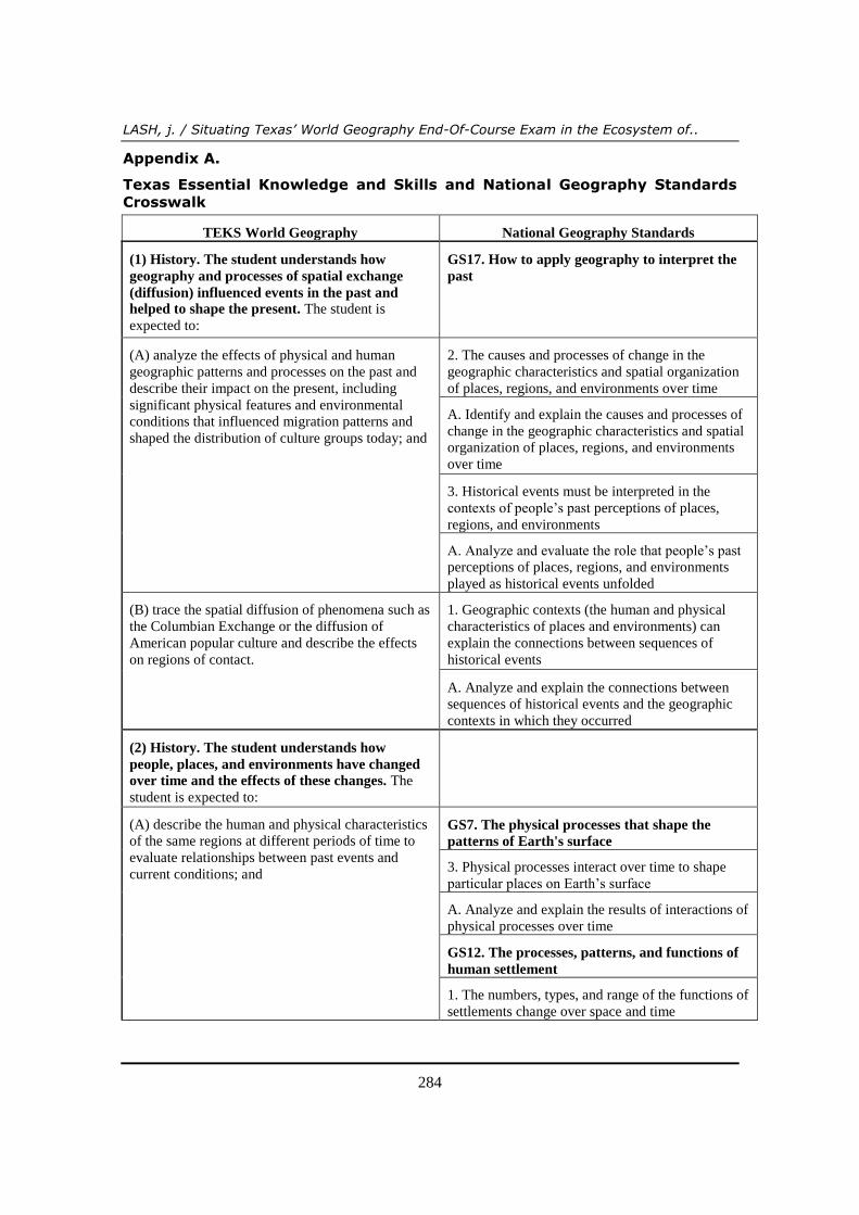
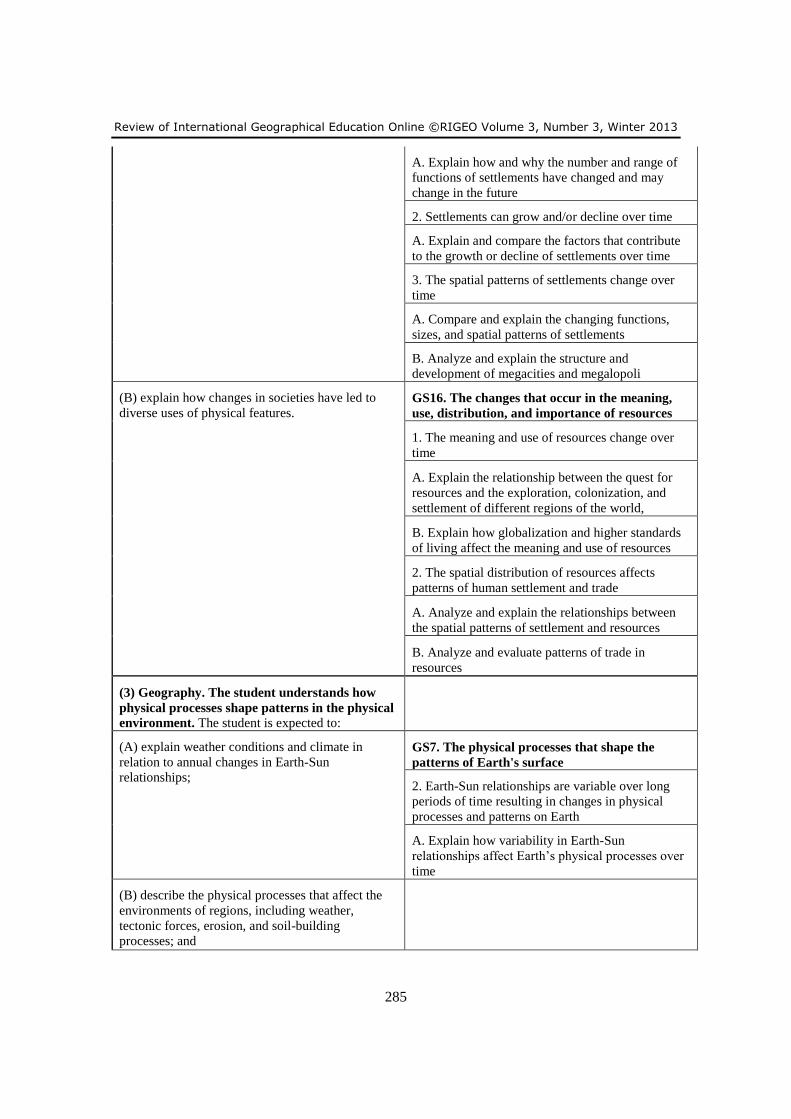
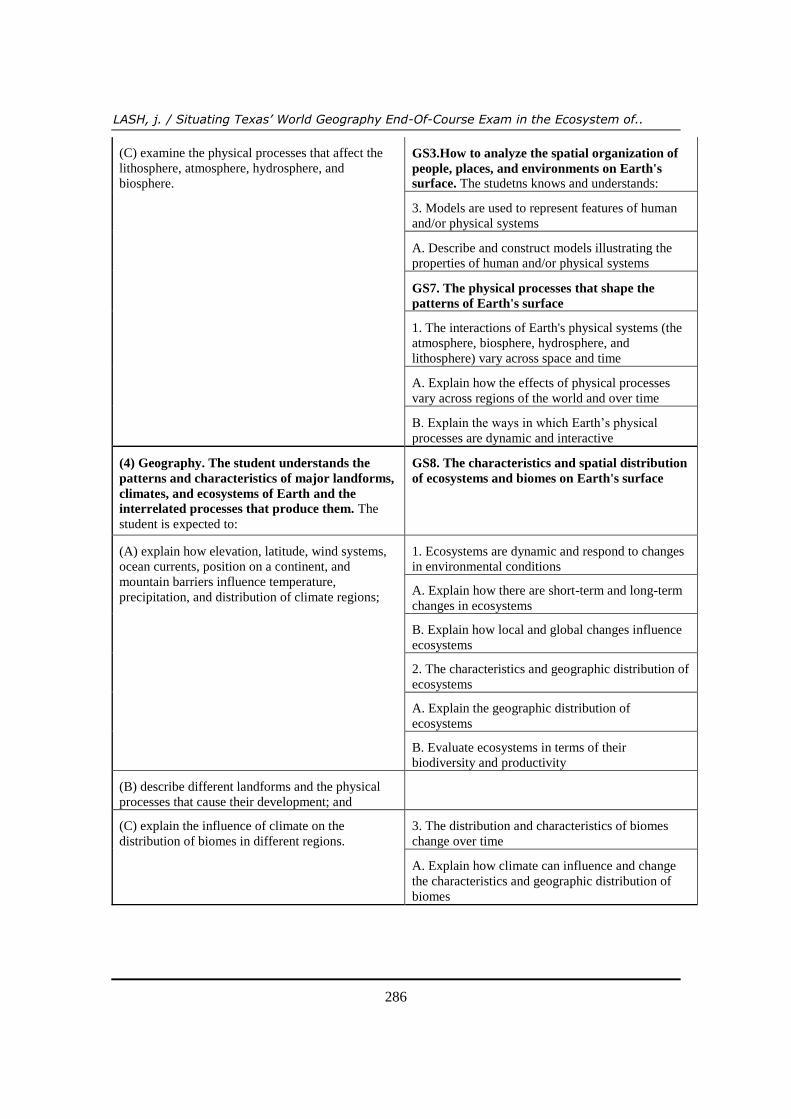
Appendix A contains a crosswalk analysis of the Texas Essential Knowledge and
Skills (TEKS) and the national geography standards (GS) articulated in the second
edition of Geography for Life. In some cases the alignment is straight forward. For
example, TEKS 1.A aligns with GS17.2.A and GS17.3.A. Specifically, the state of
Texas expects geographically literate students to be able to analyze the effects of
physical and human geographic patterns and processes on the past and describe their
impact of the present, including significant physical features and environmental
conditions that influenced migration patterns and shape the distribution of culture
groups today. At the national level, geographically literate students are expected to
interpret the causes and processes of change in the geographic characteristics and spatial
organization of places, regions, and environments over time, identify and explain the
causes and processes of change in the geographic characteristics and spatial
organization of places, regions, and environments over time; interpret historical events
in the contexts of people’s past perceptions of places, regions, and environments, and
analyze and evaluate the role that people’s past perceptions of places, regions, and
environments played as historical events unfolded. In other cases, the TEKS combine
parts of several national standards into one. This fact is illustrated in TEKS 2.A aligned
with GS7.3.A, GS12.1.A, GS12.2.A, GS12.3.A, and GS12.3.B. The basic piece of
geographic literacy expressed in this cell of the crosswalk is that the human and
physical characteristics of places change over time. The language at the national level
breaks the idea down into specific topics (i.e. physical processes interact over time to
shape Earth’s surface, and the spatial patterns of settlements change over time), while
the state presents more general language.
Empty cells in the crosswalk suggest apparent gaps in the curriculum. These gaps,
however, are more a product of mismatched language than of curricular omissions. For
example, TEKS14.B expects students to compare how democracy, dictatorship,
monarchy, republic, theocracy, and totalitarian systems operate in specific countries.
This specific set of knowledge and skills does not appear in the national standards for
twelfth grade, but more generalized statements addressing the world’s political
geography do appear and align more directly with TEKS14.A.
LASH, j. / Situating Texas’ World Geography End-Of-Course Exam in the Ecosystem of..
272
Whether the alignment is “exact” or not, the conclusion must be that based on the
crosswalk analysis, it is clear that the TEKS define geographic literacy in a manner
consistent with Geography for Life.
Aligning the STAAR World Geography EOC Exam with the National
Assessment of Education Progress in Geography
Having established that Texas has developed a high school world geography curriculum
that reflects the national geography standards, I turn now to how the state assesses
geographic literacy. The findings are based on a crosswalk analysis of the STAAR
World Geography EOC assessment framework with the assessment framework used by
the National Assessment of Educational Progress (NAEP) in Geography for grade
twelve.
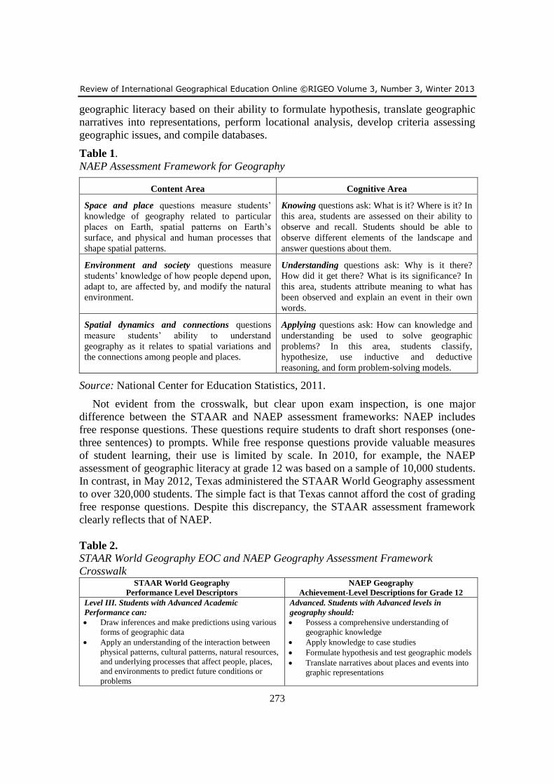
First and foremost, from crosswalk analysis in Table 1, it is important to note that
both the STAAR World Geography EOC and the NAEP assessment frameworks
address what NAEP refers to as “content areas” and “cognitive areas” (see Table 1).
The term “content areas” refers to the specific geographic matter, or standards, that
should be measured by the assessment; in this case the TEKS or the national geography
standards. The term “cognitive areas” refers to the importance placed on a student’s
ability to know (What is it? Where is it?), understand (Why is it there? How did it get
there? What is its significance?), and apply (How can knowledge and understanding be
used to solve geographic problems?) geographic concepts and vocabulary (National
Center for Educational Satistics, 2011).
In both the STAAR and NAEP assessment frameworks, process skills are assessed in
context, not in isolation, which allows for a more integrated and authentic assessment of
the content areas. Process skills are incorporated into exam questions and reported along
with content skills under the content reporting categories. In the STAAR assessment
framework, process skills are not listed under a separate reporting category as was the
case with the Texas’ previous assessment framework.
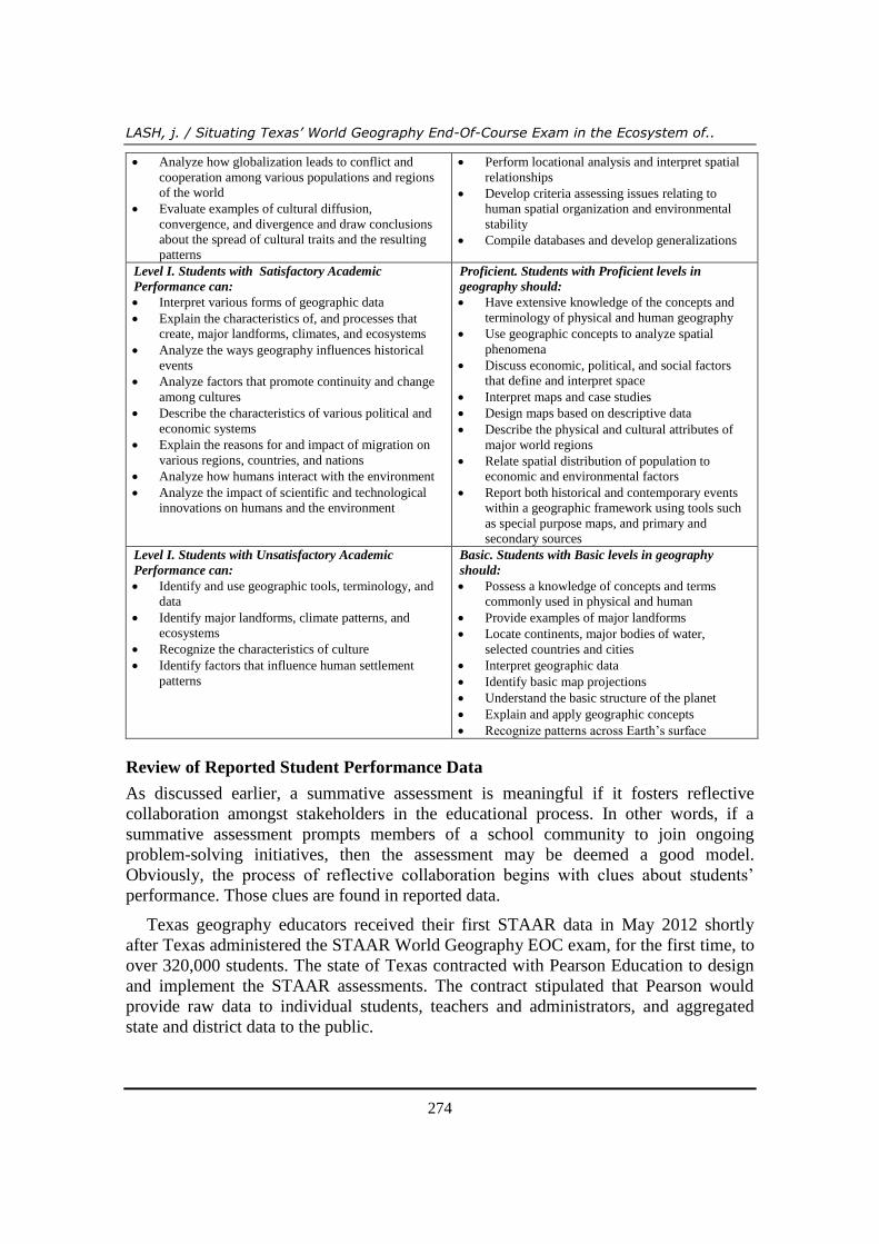
Table 2 exposes additional and striking similarities between the state-level STAAR
and the national-level NAEP assessment frameworks. To begin, both frameworks utilize
three performance levels defined by increasing levels of process skill. STAAR and
NAEP documents are quick to point out that performance levels are based on the
recommendations of policymakers, educators, and members of the general public. At
the lowest level of “unsatisfactory” STAAR assessed geographic literacy, students are
able to use the process skills of identifying and recognizing. NAEP defines “basic”
geographic literacy at a slightly higher level by adopting the verbs “interpret” and
“understand.” Texas considers students to have achieved satisfactory geographic
literacy if they can interpret, explain, analyze, and describe geographic phenomena.
Texas students performing at this level “pass” the exam. At the highest or third level of
academic performance, both the STAAR and NAEP assessment frameworks place a
premium on the application of geographic knowledge and skills. If Texas students can
draw inferences, make predictions, evaluate data, and generally apply an understanding
of geographic concepts, then the state deems them to have achieved advanced academic
performance. Likewise, at the national level, NAEP classifies students with advanced
Review of International Geographical Education Online ©RIGEO Volume 3, Number 3, Winter 2013
273
geographic literacy based on their ability to formulate hypothesis, translate geographic
narratives into representations, perform locational analysis, develop criteria assessing
geographic issues, and compile databases.
Table 1.
NAEP Assessment Framework for Geography
Content Area Cognitive Area
Space and place questions measure students’
knowledge of geography related to particular
places on Earth, spatial patterns on Earth’s
surface, and physical and human processes that
shape spatial patterns.
Knowing questions ask: What is it? Where is it? In
this area, students are assessed on their ability to
observe and recall. Students should be able to
observe different elements of the landscape and
answer questions about them.
Environment and society questions measure
students’ knowledge of how people depend upon,
adapt to, are affected by, and modify the natural
environment.
Understanding questions ask: Why is it there?
How did it get there? What is its significance? In
this area, students attribute meaning to what has
been observed and explain an event in their own
words.
Spatial dynamics and connections questions
measure students’ ability to understand
geography as it relates to spatial variations and
the connections among people and places.
Applying questions ask: How can knowledge and
understanding be used to solve geographic
problems? In this area, students classify,
hypothesize, use inductive and deductive
reasoning, and form problem-solving models.
Source: National Center for Education Statistics, 2011.
Not evident from the crosswalk, but clear upon exam inspection, is one major
difference between the STAAR and NAEP assessment frameworks: NAEP includes
free response questions. These questions require students to draft short responses (one-
three sentences) to prompts. While free response questions provide valuable measures
of student learning, their use is limited by scale. In 2010, for example, the NAEP
assessment of geographic literacy at grade 12 was based on a sample of 10,000 students.
In contrast, in May 2012, Texas administered the STAAR World Geography assessment
to over 320,000 students. The simple fact is that Texas cannot afford the cost of grading
free response questions. Despite this discrepancy, the STAAR assessment framework
clearly reflects that of NAEP.
Table 2. STAAR World Geography EOC and NAEP Geography Assessment Framework
Crosswalk STAAR World Geography
Performance Level Descriptors
NAEP Geography
Achievement-Level Descriptions for Grade 12
Level III. Students with Advanced Academic
Performance can:
Draw inferences and make predictions using various
forms of geographic data
Apply an understanding of the interaction between
physical patterns, cultural patterns, natural resources,
and underlying processes that affect people, places,
and environments to predict future conditions or
problems
Advanced. Students with Advanced levels in
geography should:
Possess a comprehensive understanding of
geographic knowledge
Apply knowledge to case studies
Formulate hypothesis and test geographic models
Translate narratives about places and events into
graphic representations
LASH, j. / Situating Texas’ World Geography End-Of-Course Exam in the Ecosystem of..
274
Analyze how globalization leads to conflict and
cooperation among various populations and regions
of the world
Evaluate examples of cultural diffusion,
convergence, and divergence and draw conclusions
about the spread of cultural traits and the resulting
patterns
Perform locational analysis and interpret spatial
relationships
Develop criteria assessing issues relating to
human spatial organization and environmental
stability
Compile databases and develop generalizations
Level I. Students with Satisfactory Academic
Performance can:
Interpret various forms of geographic data
Explain the characteristics of, and processes that
create, major landforms, climates, and ecosystems
Analyze the ways geography influences historical
events
Analyze factors that promote continuity and change
among cultures
Describe the characteristics of various political and
economic systems
Explain the reasons for and impact of migration on
various regions, countries, and nations
Analyze how humans interact with the environment
Analyze the impact of scientific and technological
innovations on humans and the environment
Proficient. Students with Proficient levels in
geography should:
Have extensive knowledge of the concepts and
terminology of physical and human geography
Use geographic concepts to analyze spatial
phenomena
Discuss economic, political, and social factors
that define and interpret space
Interpret maps and case studies
Design maps based on descriptive data
Describe the physical and cultural attributes of
major world regions
Relate spatial distribution of population to
economic and environmental factors
Report both historical and contemporary events
within a geographic framework using tools such
as special purpose maps, and primary and
secondary sources
Level I. Students with Unsatisfactory Academic
Performance can:
Identify and use geographic tools, terminology, and
data
Identify major landforms, climate patterns, and
ecosystems
Recognize the characteristics of culture
Identify factors that influence human settlement
patterns
Basic. Students with Basic levels in geography
should:
Possess a knowledge of concepts and terms
commonly used in physical and human
Provide examples of major landforms
Locate continents, major bodies of water,
selected countries and cities
Interpret geographic data
Identify basic map projections
Understand the basic structure of the planet
Explain and apply geographic concepts
Recognize patterns across Earth’s surface
Review of Reported Student Performance Data
As discussed earlier, a summative assessment is meaningful if it fosters reflective
collaboration amongst stakeholders in the educational process. In other words, if a
summative assessment prompts members of a school community to join ongoing
problem-solving initiatives, then the assessment may be deemed a good model.
Obviously, the process of reflective collaboration begins with clues about students’
performance. Those clues are found in reported data.
Texas geography educators received their first STAAR data in May 2012 shortly
after Texas administered the STAAR World Geography EOC exam, for the first time, to
over 320,000 students. The state of Texas contracted with Pearson Education to design
and implement the STAAR assessments. The contract stipulated that Pearson would
provide raw data to individual students, teachers and administrators, and aggregated
state and district data to the public.
Review of International Geographical Education Online ©RIGEO Volume 3, Number 3, Winter 2013
275
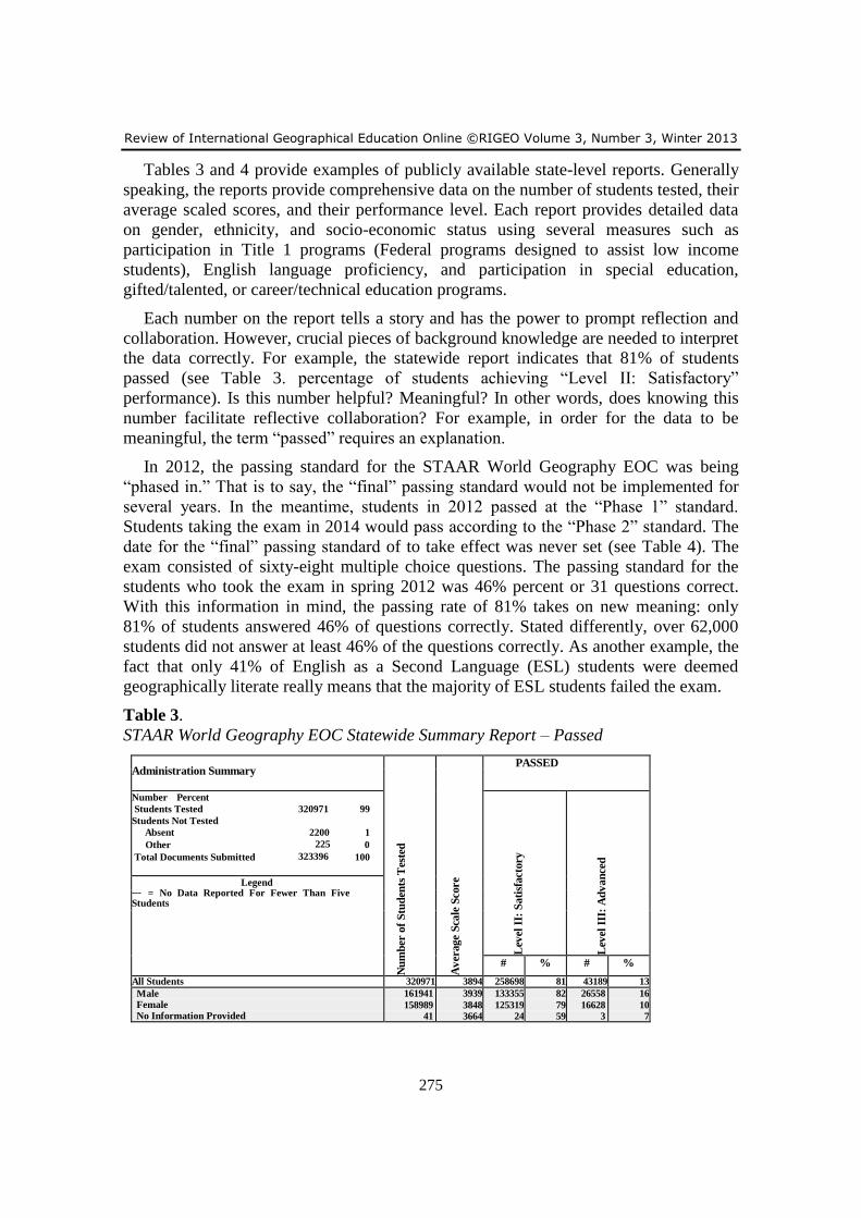
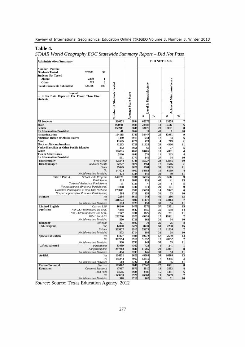
Tables 3 and 4 provide examples of publicly available state-level reports. Generally
speaking, the reports provide comprehensive data on the number of students tested, their
average scaled scores, and their performance level. Each report provides detailed data
on gender, ethnicity, and socio-economic status using several measures such as
participation in Title 1 programs (Federal programs designed to assist low income
students), English language proficiency, and participation in special education,
gifted/talented, or career/technical education programs.
Each number on the report tells a story and has the power to prompt reflection and
collaboration. However, crucial pieces of background knowledge are needed to interpret
the data correctly. For example, the statewide report indicates that 81% of students
passed (see Table 3. percentage of students achieving “Level II: Satisfactory”
performance). Is this number helpful? Meaningful? In other words, does knowing this
number facilitate reflective collaboration? For example, in order for the data to be
meaningful, the term “passed” requires an explanation.
In 2012, the passing standard for the STAAR World Geography EOC was being
“phased in.” That is to say, the “final” passing standard would not be implemented for
several years. In the meantime, students in 2012 passed at the “Phase 1” standard.
Students taking the exam in 2014 would pass according to the “Phase 2” standard. The
date for the “final” passing standard of to take effect was never set (see Table 4). The
exam consisted of sixty-eight multiple choice questions. The passing standard for the
students who took the exam in spring 2012 was 46% percent or 31 questions correct.
With this information in mind, the passing rate of 81% takes on new meaning: only
81% of students answered 46% of questions correctly. Stated differently, over 62,000
students did not answer at least 46% of the questions correctly. As another example, the
fact that only 41% of English as a Second Language (ESL) students were deemed
geographically literate really means that the majority of ESL students failed the exam.
Table 3.
STAAR World Geography EOC Statewide Summary Report – Passed
Administration Summary
Nu
mb
er o
f S
tud
ents
Tes
ted
Av
erage S
cale
Sco
re
PASSED
Number Percent
Students Tested 320971 99
Students Not Tested
Absent 2200 1
Other 225 0
Total Documents Submitted 323396 100
Lev
el I
I: S
ati
sfact
ory
Lev
el I
II:
Ad
van
ced
Legend --- = No Data Reported For Fewer Than Five Students
# % # %
All Students 320971 3894 258698 81 43189 13
Male Female No Information Provided
161941
158989 41
3939
3848 3664
133355
125319 24
82
79 59
26558
16628 3
16
10 7
LASH, j. / Situating Texas’ World Geography End-Of-Course Exam in the Ecosystem of..
276
Hispanic/Latino American Indian or Alaska Native
Asian
Black or African American Native Hawaiian or Other Pacific Islander
White
Two or More Races No Information Provided
154115
1449
11625
41263
492
106276
5220 531
3785
3913
4270
3728
3951
4068
4043 3775
115668
1205
11152
29338
430
95871
4644 390
75
83
96
71
87
90
89 73
10851
193
4563
2037
71
24319
1119 36
7
13
39
5
14
23
21 7
Economically Free Meals Disadvantaged Reduced Meals
Other
No No Information Provided
125648
22727
25049
147073 474
3741
3870
3670
4067 3734
90621
18766
16288
132690 333
72
83
65
90 70
6592
2109
851
33614 23
5
9
3
23 5
Title I, Part A School wide Program Participants
Targeted Assistance Participants Nonparticipants (Previous Participants)
Homeless Participants at Non-Title I Schools
Nonparticipants (Not Previous Participants) No Information Provided
142178
313
19
1068
176885 508
3781
3606
3725
3746
3987 3718
105803
187
15
758
151586 349
74
60
79
71
86 69
10277
6
0
58
32821 27
7
2
0
5
19 5
Migrant Yes No
No Information Provided
2284
318174 513
3610
3896 3725
1340
257003 355
59
81 69
67
43099 23
3
14 4
Limited English Current LEP Proficient Non-LEP (Monitored 1st Year)
Non-LEP (Monitored 2nd Year)
Other Non-LEP
No Information Provided
16140
4388
7147
292766 530
3479
3647
3731
3925 3726
6862
2838
5320
243311 367
43
65
74
83 69
154
100
264
42644 27
1
2
4
15 5
Bilingual Bilingual ESL Program ESL
Neither
No Information Provided
321
14900
305177 573
3807
3470
3915 3714
242
6161
251902 393
75
41
83 69
22
129
43010 28
7
1
14 5
Special Education Yes No
No Information Provided
17877
302594 500
3498
3918 3733
7605
250742 351
43
83 70
426
42739 24
2
14 5
Gifted/Talented Participants Nonparticipants
No Information Provided
33089
287388 494
4362
3840 3733
32667
225683 348
99
79 70
15218
27947 24
46
10 5
At-Risk Yes No
No Information Provided
124621
195842 508
3623
4067 3727
76016
182327 355
61
93 70
3226
39939 24
3
20 5
Career/Technical Elective Education Coherent Sequence
Tech Prep
No No Information Provided
105162
47067
24565
143659 518
3848
3870
3938
3928 3719
82515
38157
20979
116691 356
78
81
85
81 69
11341
5059
3359
23404 26
11
11
14
16 5
Source: Source: Texas Education Agency, 2012
Review of International Geographical Education Online ©RIGEO Volume 3, Number 3, Winter 2013
277
Table 4. STAAR World Geography EOC Statewide Summary Report – Did Not Pass
Administration Summary
Nu
mb
er o
f S
tud
ents
Tes
ted
Av
erage S
cale
Sco
re
DID NOT PASS
Number Percent
Students Tested 320971 99
Students Not Tested
Absent 2200 1
Other 225 0
Total Documents Submitted 323396 100
Lev
el I
: U
nsa
tisf
act
ory
Ach
iev
ed M
inim
um
Sco
re
Legend --- = No Data Reported For Fewer Than Five Students
# % # %
All Students 320971 3894 62273 19 23355 7
Male Female No Information Provided
161941
158989 41
3939
3848 3664
28586
33670 17
18
21 41
10332
13015 8
6
8 20
Hispanic/Latino American Indian or Alaska Native
Asian
Black or African American Native Hawaiian or Other Pacific Islander
White Two or More Races No Information Provided
154115
1449
11625
41263
492
106276
5220 531
3785
3913
4270
3728
3951
4068
4043 3775
38447
244
473
11925
62
10405
576 141
25
17
4
29
13
10
11 27
13981
94
219
4366
27
4381
233 54
9
6
2
11
5
4
4 10
Economically Free Meals Disadvantaged Reduced Meals
Other
No No Information Provided
125648
22727
25049
147073 474
3741
3870
3670
4067 3734
35027
3961
8761
14383 141
28
17
35
10 30
12655
1646
2835
6169 50
10
7
11
4 11
Title I, Part A School wide Program Participants
Targeted Assistance Participants
Nonparticipants (Previous Participants)
Homeless Participants at Non-Title I Schools
Nonparticipants (Not Previous Participants) No Information Provided
142178
313
19
1068
176885 508
3781
3606
3725
3746
3987 3718
36375
126
4
310
25299 159
26
40
21
29
14 31
13237
41
1
101
9922 53
9
13
5
9
6 10
Migrant Yes No
No Information Provided
2284
318174 513
3610
3896 3725
944
61171 158
41
19 31
286
23014 55
13
7 11
Limited English Current LEP Proficient Non-LEP (Monitored 1st Year)
Non-LEP (Monitored 2nd Year) Other Non-LEP
No Information Provided
16140
4388
7147
292766 530
3479
3647
3731
3925 3726
9278
1550
1827
49455 163
57
35
26
17 31
2391
598
781
19531 54
15
14
11
7 10
Bilingual/ Bilingal ESL Program ESL
Neither No Information Provided
321
14900
305177 573
3807
3470
3915 3714
79
8739
53275 180
25
59
17 31
25
2238
21034 58
8
15
7 10
Special Education Yes No
No Information Provided
17877
302594 500
3498
3918 3733
10272
51852 149
57
17 30
2550
20752 53
14
7 11
Gifted/Talented Participants Nonparticipants
No Information Provided
33089
287388 494
4362
3840 3733
422
61705 146
1
21 30
241
23061 53
1
8 11
At-Risk Yes No
No Information Provided
124621
195842 508
3623
4067 3727
48605
13515 153
39
7 30
16805
6495 55
13
3 11
Career/Technical Elective Education Coherent Sequence
Tech Prep
No
No Information Provided
105162
47067
24565
143659 518
3848
3870
3938
3928 3719
22647
8910
3586
26968 162
22
19
15
19 31
8581
3583
1481
9659 51
8
8
6
7 10
Source: Source: Texas Education Agency, 2012
LASH, j. / Situating Texas’ World Geography End-Of-Course Exam in the Ecosystem of..
278
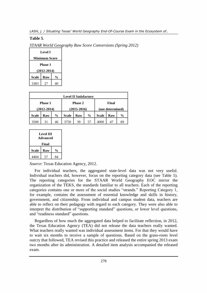
Table 5.
STAAR World Geography Raw Score Conversions (Spring 2012)
Level I
Minimum Score
Phase 1
(2012-2014)
Scale Raw %
3383 27 40
Level II Satisfactory
Phase 1
(2012-2014)
Phase 2
(2015-2016)
Final
(not determined)
Scale Raw % Scale Raw % Scale Raw %
3500 31 46 3750 39 57 4000 47 69
Level III
Advanced
Final
Scale Raw %
4404 57 84
Source: Texas Education Agency, 2012.
For individual teachers, the aggregated state-level data was not very useful.
Individual teachers did, however, focus on the reporting category data (see Table 5).
The reporting categories for the STAAR World Geography EOC mirror the
organization of the TEKS, the standards familiar to all teachers. Each of the reporting
categories contains one or more of the social studies “strands.” Reporting Category 1,
for example, contains the assessment of essential knowledge and skills in history,
government, and citizenship. From individual and campus student data, teachers are
able to reflect on their pedagogy with regard to each category. They were also able to
interpret the distribution of “supporting standard” questions, or lower level questions,
and “readiness standard” questions.
Regardless of how much the aggregated data helped to facilitate reflection, in 2012,
the Texas Education Agency (TEA) did not release the data teachers really wanted.
What teachers really wanted was individual assessment items. For that they would have
to wait six months to receive a sample of questions. Based on the grass-roots level
outcry that followed, TEA revised this practice and released the entire spring 2013 exam
two months after its administration. A detailed item analysis accompanied the released
exam.

Review of International Geographical Education Online ©RIGEO Volume 3, Number 3, Winter 2013
279
Table 6. STAAR World Geography EOC Assessment Framework
Reporting Categories Number of Standards Number of
Questions
Reporting Category 1:
History, Government, and Citizenship
Readiness Standards 4
14 Supporting Standards 5
Total 9
Reporting Category 2: Geography
Readiness Standards 9
26 Supporting Standards 10
Total 19
Reporting Category 3: Culture
Readiness Standards 3
14 Supporting Standards 9
Total 12
Reporting Category 4:
Economics, Science, Technology, and Society
Readiness Standards 5
14 Supporting Standards 9
Total 14
Readiness Standards Total # of Standards 21 60–65%
(41-44)
Supporting Standards Total # of Standards 33 35–40%
(24–27)
Total # of Questions on Test = 68 Multiple Choice
Source: Texas Education Agency, 2012
With the exam in hand, geography educators at the classroom level began to reflect on
how they had or had not taught the assessed content and cognitive areas. The reflection
triggered a desire for collaboration as teachers sought out peers whose students
performed well on items that their own students had not.
The abundance of student performance data available to classroom teachers
represents the greatest value of STAAR. STAAR’s state-wide standardization not only
validates good geography education, but also exposes gaps in learning. These data stand
in contrast to the abstract, national-scale NAEP results, which are based on nationally
representative samples of public and nonpublic school students with scaled scores
reported at five percentiles that show only national trends in results for students
performing at lower (10th
and 25th
percentiles), middle (50th
percentile), and higher (75th
and 90th
percentiles) levels (National Center for Educational Satistics, 2011, p. 5).
LASH, j. / Situating Texas’ World Geography End-Of-Course Exam in the Ecosystem of..
280
Conclusions
Student assessment is valuable when it has the capacity to improve and document the
results of teaching and learning. The State of Texas Assessment of Academic Readiness
(STAAR) World Geography EOC exam is a case in point. The purpose of this paper has
been to situate Texas’ assessment of geographic literacy in the ecosystem of American
geography education. Toward this end, I established the validity of the exam based on
its connections to the national geography standards expressed in the second edition of
Geography for Life and the assessment framework used by the National Assessment of
Educational Progress (NAEP) in Geography, and a review of released student
performance data for quantity and quality. In the end, I conclude that the STAAR World
Geography exam is an accurate and useful summative assessment of geographic literacy
at the local scale, but that the assessment’s ability to inform educational decision-
making at the state level will never be realized. The previous statement alludes to the
fact that, as of June 2013, the STAAR World Geography EOC exam is extinct.
Earlier in this paper I suggested that an ecosystem provides an analogy for
understanding Texas’ public education assessment program. If thought of as an
organism, then in order to survive the STAAR World Geography EOC exam had to find
a niche within a community in the ecosystem. Without a defined role or function in a
particular community, the organism is doomed to extinction. Such is the fate of the
STAAR World Geography EOC exam. In the eyes of the Texas public, summative
assessment serves no positive function in the education community. In other words, the
STAAR World Geography EOC exam never carved out a niche. The exam never
became part of an educational culture in which the purpose of assessment transcended
accountability and fostered a collective sense of responsibility (Darling-Hammond,
2010; Hargreaves & Shirley, 2012; Ravitch, 2011; Sahlberg, 2011). The question
becomes, what factors contributed to the exam’s extinction?
I posit that a sudden seismic shift in Texas’ political climate doomed the exam.
Throughout the summer and fall of 2012, as the Texas Education Agency disseminated
STAAR data for geography, as well as equally depressing assessment data for other
subjects, public opposition to STAAR began to grow. By the time Texas legislators
meet in January 2013, two groups of stakeholders emerged with strong voices in
opposition to STAAR: school district superintendents, and a select group of parents.
In January 2013, Texas legislators began to file bills for discussion. Several bills
reflected school districts superintendents’ desire to eliminate STAAR on the basis that
the state simply did not provide sufficient resources to enable students to pass the
assessment. Other pieces of legislation opposed STAAR on the basis that the
assessments were taking too much time away from classroom instruction. The business
community, experienced teachers, and organizations speaking on behalf of minority and
economically disadvantaged students, voiced their support for STAAR. They believed
that the assessments fostered higher expectations for all students.
In June 2013, House Bill 5 (HB5), one piece of anti-STAAR legislation, became law.
With regard to geography education, not only did HB5 eliminate the EOC, but also
made the high school world regional geography course optional. Geography educators
Review of International Geographical Education Online ©RIGEO Volume 3, Number 3, Winter 2013
281
may take heart in the knowledge that legislators never argued against geography as a
discipline. Rather, they were swayed to eliminate assessments by high level
administrators responsible for maintaining high standards, and by parents who feared
reduced success in their children attending elite universities because STAAR
performance negatively affected their high school grade-point-average. In the end,
geography education fell victim to misguided habitat destruction.
The extinction of the exam, furthermore, provides a cautionary tale for those
investing time and money in large-scale, centralized educational assessments like
American’s latest effort at education reform: the Common Core and the associated
Partnership for Assessment of Readiness for College and Careers. Whether or not
national efforts to improve the quality of education in general and geography education
specifically, will depend on how local and state communities react to the first waves of
nationally standardized high stakes assessment data. As the implementation of the
Common Core proceeds, American geography educators would be wise to study the fate
of Texas’ assessment system.
Acknowledgments
I am grateful to the Center for Social Studies Education at the University of Texas at
Arlington and the Texas Alliance for Geographic Education for their partial funding of
this research. I am in debt to the anonymous reviewers whose thoughtful assessments of
fostered a great deal of reflection. Thanks also to Dr. Michael Solem for ushering this
manuscript to publication.
References
Anthematten, P. (2004). State geography standards in 2004. Journal of Geography, 103(4), 182-
184.
Bednarz, S., Heffron, S., & Huynh, N. T. (Eds.). (2012). A road map project for 21st century
geography education: Geography education research. Washington, DC: National
Geographic Society.
Bednarz, S. W. (2003). Nine years on: Examining implementaiton of the National Geography
Standards. Journal of Geography, 102(3), 99-109.
Black, P., & William, D. (1998). Inside the black box: Raising standards through classroom
assessment. Kappan Professional Journal, October, 139-148.
Brown, L. (1997). The GeoEd research agenda: What it is, what it might be, what...? In R. G.
Boehm & J. F. Petersen (Eds.), The first assessment: Research in geographic education
(pp. 239-247). San Marcos, Texas: The Gilbert M. Grosvenor Cneter for Geographic
Education.
Chappuis, C., Stiggins, R., Arter, J., & Chappuis, J. (2005). Assessment for learning: An action
guide for school leaders. Protland, Oregon: Assessment Training Institute.
Christopherson, R. W. (2012). Geosystems (8th ed.). Boston: Prentice Hall.
Darling-Hammond, L. (1994). Standards for teachers. New York, New York: American
Association of Colleges for Teacher Education.
LASH, j. / Situating Texas’ World Geography End-Of-Course Exam in the Ecosystem of..
282
Darling-Hammond, L. (2010). The Flat World and Education: How America's Commitment to
Equity Will Determine Our Future. New York: Teachers College Press.
DeBoer, J. (2012). Centralization and Decentralization in American Education Policy. Peabody
Journal of Education (0161956X), 87(4), 510-513. doi: 10.1080/0161956X.2012.705153
Edelson, D., Shavelson, R. J., & Wertheim, J. A. (Eds.). (2013). A roadmap for the 21st century
geography education: Assessment (A report from the Geography Education Research
Committee of the Road Map for the 21st Century Geography Education Project).
Washington, DC: Association of American Geographers.
Fu, A. C., Raizen, S. A., & Shavelson, R. J. (2009). The nation's report card: A vision of large-
scale science assessment. Science, 236, 1637-1638.
Gandy, S. K., & Kruger, D. P. (2004). An assessment of influences on the implementation of
the national geography standards. Journal of Geography, 103(4), 161-170.
Geography Education Standards Project. (1994). Geography for Life: National geography
standards. Washington, DC: National Geographic Research and Exploration.
Gray, T. P., Hildebrant, B. S., & Strauss, T. R. (2006). Advanced Placement Human
Geography: The first five years. Journal of Geography, 105(3), 99-107.
Hanson, S. (2004). Who are we? An important qustion for geography's future. Annals of the
Association of American Geographers, 94(4), 715-722.
Hargreaves, A., & Shirley, D. (2012). The global fourth way: The quest for educational
excellence. Thousand Oaks, Calif.: Corwin Press.
Heffron, S. G., & Downs, R. M. (2012). Geography for Life: National Geography Standards
(2nd ed.). Washington, DC: National Geographic Society.
Herman, J. (1997). Large-Scale Assessment in Support of School Reform: Lessons in the
Search for Alternative Measures. CSE Technical Report 446. Los Angeles: National
Center for Research on Evaluation, Standards, and Student Testing (CRESST), University
of California, Los Angeles.
Joint Committee on Geographic Education. (1984). Guidelines for Geographic Education.
Washington, DC: Assocation of American Geographers and National Council for
Geographic Education.
National Center for Educational Satistics. (2011). The nation's report card: Geography 2010.
Wasshington, DC: U.S. Department of Education.
National Commission on Excellence in Education. (1983). A nation at risk: The imperative for
education reform. Washington, DC: U.S. Government Printing Office.
National Research Council. (2011). Assessing 21st century skills. Washington, DC: National
Academies Press.
National Research Council (Ed.). (2001). Knowing what students know: The science and design
of educational assessment (J.W. Pellegrino, N. Chudowsky, and R. Glaser, Eds.).
Washington, DC: The National Academies Press.
National Research Council (Ed.). (2012). A framework for K-12 science education: Practices,
cross-cutting concepts, and core ideas. Washington, DC: The National Academies Press.
Popham, W. J. (2001). The truth about testing: An educator’s call to action. Alexandria,
Virginia: Association for Supervision and Curriculum Development.
Review of International Geographical Education Online ©RIGEO Volume 3, Number 3, Winter 2013
283
Ravitch, D. (2011). The death and life of the great American school system : how testing and
choice are undermining education (Rev. and expanded ed.). New York: Basic Books.
Rothman, R. (1995). Measuring Up: Standards Assessment, and School Reform. San Francisco,
California: Jossey-Bass Publishers.
Sahlberg, P. (2011). Finish Lessons: What the World Can Learn From Educational Change in
Finland. New York, NY: Teacher's College Press.
Scherer, M. (2001). How and why standards can improve student achievement: A conversation
with Robert J. Marzano. Educational Leadership, 59(1), 1-7.
Talerico, N., & Moseley, C. (Eds.). (2012). NAAEE-TEKS-CCRS CROSSWALK: Alignment of
the Excellence in Environmental Education Guidelines for Learning (NAAEE), the Texas
Essential Knowledge and Skills, & College & Career Readiness Science & Social Studies
Standards for Grades K-12. San Antonio, TX: CPS Energy and the University of Texas at
San Antonio.
Texas Education Agency. (2012). State of Texas Assessments of Academic Readiness Summary
Report for World Geography. Austin: Texas Education Agency.
Biographical statements
Dr. Jeff Lash is the Geography Program Chair and an Associate Professor of Geography at
the University of Houston-Clear Lake. He teaches a wide variety of courses and continues to
conduct research locally and internationally on human development through education.
LASH, j. / Situating Texas’ World Geography End-Of-Course Exam in the Ecosystem of..
284
Appendix A.
Texas Essential Knowledge and Skills and National Geography Standards
Crosswalk
TEKS World Geography National Geography Standards
(1) History. The student understands how
geography and processes of spatial exchange
(diffusion) influenced events in the past and
helped to shape the present. The student is
expected to:
GS17. How to apply geography to interpret the
past
(A) analyze the effects of physical and human
geographic patterns and processes on the past and
describe their impact on the present, including
significant physical features and environmental
conditions that influenced migration patterns and
shaped the distribution of culture groups today; and
2. The causes and processes of change in the
geographic characteristics and spatial organization
of places, regions, and environments over time
A. Identify and explain the causes and processes of
change in the geographic characteristics and spatial
organization of places, regions, and environments
over time
3. Historical events must be interpreted in the
contexts of people’s past perceptions of places,
regions, and environments
A. Analyze and evaluate the role that people’s past
perceptions of places, regions, and environments
played as historical events unfolded
(B) trace the spatial diffusion of phenomena such as
the Columbian Exchange or the diffusion of
American popular culture and describe the effects
on regions of contact.
1. Geographic contexts (the human and physical
characteristics of places and environments) can
explain the connections between sequences of
historical events
A. Analyze and explain the connections between
sequences of historical events and the geographic
contexts in which they occurred
(2) History. The student understands how
people, places, and environments have changed
over time and the effects of these changes. The
student is expected to:
(A) describe the human and physical characteristics
of the same regions at different periods of time to
evaluate relationships between past events and
current conditions; and
GS7. The physical processes that shape the
patterns of Earth's surface
3. Physical processes interact over time to shape
particular places on Earth’s surface
A. Analyze and explain the results of interactions of
physical processes over time
GS12. The processes, patterns, and functions of
human settlement
1. The numbers, types, and range of the functions of
settlements change over space and time
Review of International Geographical Education Online ©RIGEO Volume 3, Number 3, Winter 2013
285
A. Explain how and why the number and range of
functions of settlements have changed and may
change in the future
2. Settlements can grow and/or decline over time
A. Explain and compare the factors that contribute
to the growth or decline of settlements over time
3. The spatial patterns of settlements change over
time
A. Compare and explain the changing functions,
sizes, and spatial patterns of settlements
B. Analyze and explain the structure and
development of megacities and megalopoli
(B) explain how changes in societies have led to
diverse uses of physical features. GS16. The changes that occur in the meaning,
use, distribution, and importance of resources
1. The meaning and use of resources change over
time
A. Explain the relationship between the quest for
resources and the exploration, colonization, and
settlement of different regions of the world,
B. Explain how globalization and higher standards
of living affect the meaning and use of resources
2. The spatial distribution of resources affects
patterns of human settlement and trade
A. Analyze and explain the relationships between
the spatial patterns of settlement and resources
B. Analyze and evaluate patterns of trade in
resources
(3) Geography. The student understands how
physical processes shape patterns in the physical
environment. The student is expected to:
(A) explain weather conditions and climate in
relation to annual changes in Earth-Sun
relationships;
GS7. The physical processes that shape the
patterns of Earth's surface
2. Earth-Sun relationships are variable over long
periods of time resulting in changes in physical
processes and patterns on Earth
A. Explain how variability in Earth-Sun
relationships affect Earth’s physical processes over
time
(B) describe the physical processes that affect the
environments of regions, including weather,
tectonic forces, erosion, and soil-building
processes; and
LASH, j. / Situating Texas’ World Geography End-Of-Course Exam in the Ecosystem of..
286
(C) examine the physical processes that affect the
lithosphere, atmosphere, hydrosphere, and
biosphere.
GS3.How to analyze the spatial organization of
people, places, and environments on Earth's
surface. The studetns knows and understands:
3. Models are used to represent features of human
and/or physical systems
A. Describe and construct models illustrating the
properties of human and/or physical systems
GS7. The physical processes that shape the
patterns of Earth's surface
1. The interactions of Earth's physical systems (the
atmosphere, biosphere, hydrosphere, and
lithosphere) vary across space and time
A. Explain how the effects of physical processes
vary across regions of the world and over time
B. Explain the ways in which Earth’s physical
processes are dynamic and interactive
(4) Geography. The student understands the
patterns and characteristics of major landforms,
climates, and ecosystems of Earth and the
interrelated processes that produce them. The
student is expected to:
GS8. The characteristics and spatial distribution
of ecosystems and biomes on Earth's surface
(A) explain how elevation, latitude, wind systems,
ocean currents, position on a continent, and
mountain barriers influence temperature,
precipitation, and distribution of climate regions;
1. Ecosystems are dynamic and respond to changes
in environmental conditions
A. Explain how there are short-term and long-term
changes in ecosystems
B. Explain how local and global changes influence
ecosystems
2. The characteristics and geographic distribution of
ecosystems
A. Explain the geographic distribution of
ecosystems
B. Evaluate ecosystems in terms of their
biodiversity and productivity
(B) describe different landforms and the physical
processes that cause their development; and
(C) explain the influence of climate on the
distribution of biomes in different regions.
3. The distribution and characteristics of biomes
change over time
A. Explain how climate can influence and change
the characteristics and geographic distribution of
biomes
Review of International Geographical Education Online ©RIGEO Volume 3, Number 3, Winter 2013
287
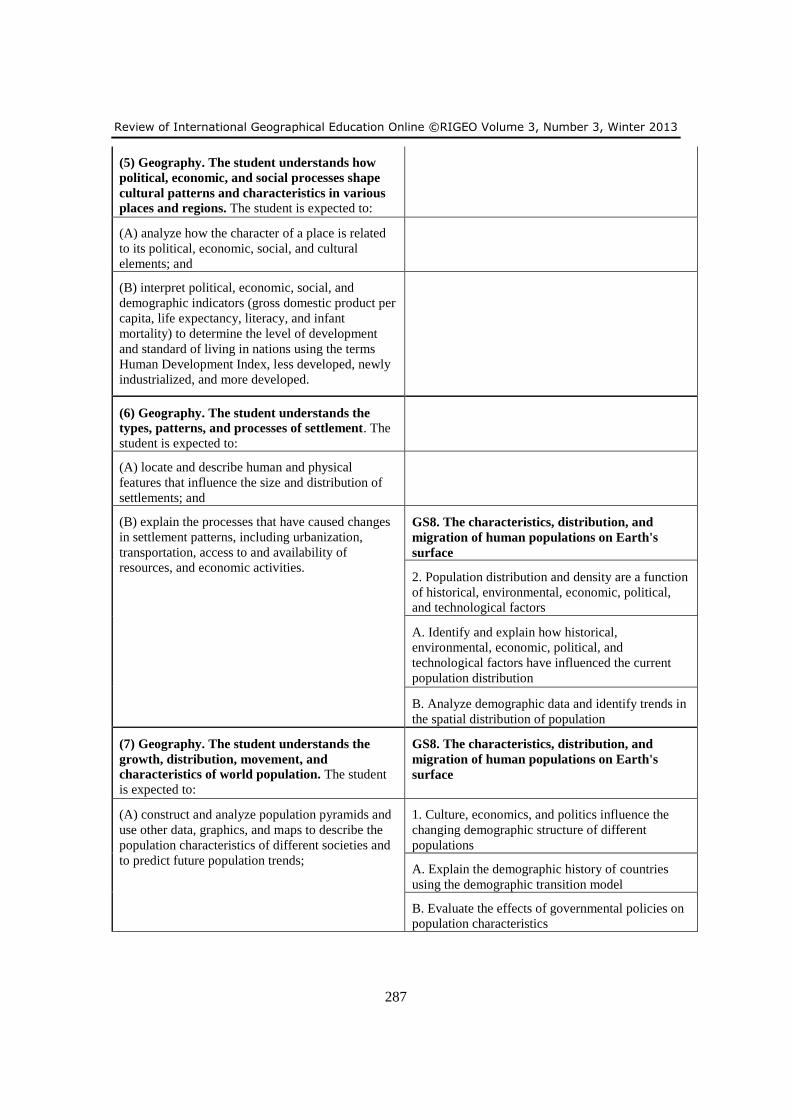
(5) Geography. The student understands how
political, economic, and social processes shape
cultural patterns and characteristics in various
places and regions. The student is expected to:
(A) analyze how the character of a place is related
to its political, economic, social, and cultural
elements; and
(B) interpret political, economic, social, and
demographic indicators (gross domestic product per
capita, life expectancy, literacy, and infant
mortality) to determine the level of development
and standard of living in nations using the terms
Human Development Index, less developed, newly
industrialized, and more developed.
(6) Geography. The student understands the
types, patterns, and processes of settlement. The
student is expected to:
(A) locate and describe human and physical
features that influence the size and distribution of
settlements; and
(B) explain the processes that have caused changes
in settlement patterns, including urbanization,
transportation, access to and availability of
resources, and economic activities.
GS8. The characteristics, distribution, and
migration of human populations on Earth's
surface
2. Population distribution and density are a function
of historical, environmental, economic, political,
and technological factors
A. Identify and explain how historical,
environmental, economic, political, and
technological factors have influenced the current
population distribution
B. Analyze demographic data and identify trends in
the spatial distribution of population
(7) Geography. The student understands the
growth, distribution, movement, and
characteristics of world population. The student
is expected to:
GS8. The characteristics, distribution, and
migration of human populations on Earth's
surface
(A) construct and analyze population pyramids and
use other data, graphics, and maps to describe the
population characteristics of different societies and
to predict future population trends;
1. Culture, economics, and politics influence the
changing demographic structure of different
populations
A. Explain the demographic history of countries
using the demographic transition model
B. Evaluate the effects of governmental policies on
population characteristics
LASH, j. / Situating Texas’ World Geography End-Of-Course Exam in the Ecosystem of..
288
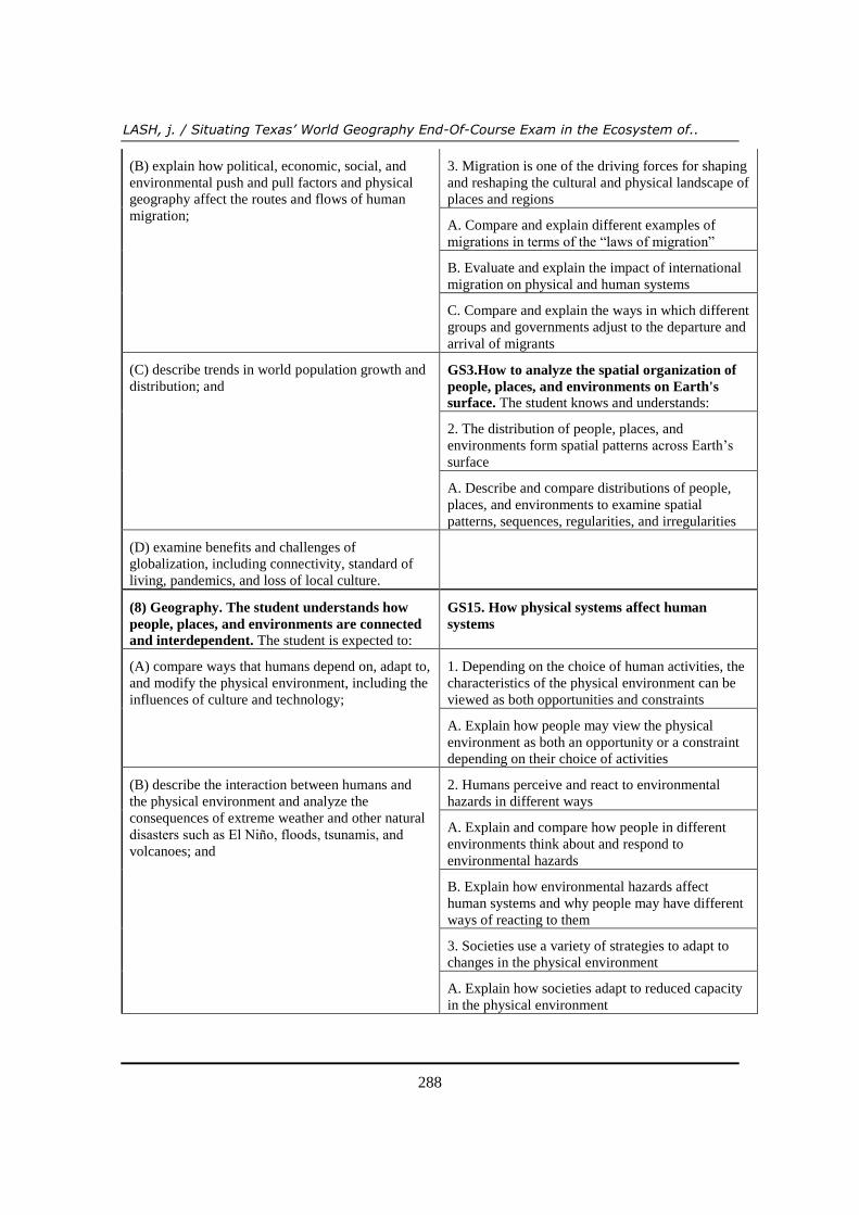
(B) explain how political, economic, social, and
environmental push and pull factors and physical
geography affect the routes and flows of human
migration;
3. Migration is one of the driving forces for shaping
and reshaping the cultural and physical landscape of
places and regions
A. Compare and explain different examples of
migrations in terms of the “laws of migration”
B. Evaluate and explain the impact of international
migration on physical and human systems
C. Compare and explain the ways in which different
groups and governments adjust to the departure and
arrival of migrants
(C) describe trends in world population growth and
distribution; and GS3.How to analyze the spatial organization of
people, places, and environments on Earth's
surface. The student knows and understands:
2. The distribution of people, places, and
environments form spatial patterns across Earth’s
surface
A. Describe and compare distributions of people,
places, and environments to examine spatial
patterns, sequences, regularities, and irregularities
(D) examine benefits and challenges of
globalization, including connectivity, standard of
living, pandemics, and loss of local culture.
(8) Geography. The student understands how
people, places, and environments are connected
and interdependent. The student is expected to:
GS15. How physical systems affect human
systems
(A) compare ways that humans depend on, adapt to,
and modify the physical environment, including the
influences of culture and technology;
1. Depending on the choice of human activities, the
characteristics of the physical environment can be
viewed as both opportunities and constraints
A. Explain how people may view the physical
environment as both an opportunity or a constraint
depending on their choice of activities
(B) describe the interaction between humans and
the physical environment and analyze the
consequences of extreme weather and other natural
disasters such as El Niño, floods, tsunamis, and
volcanoes; and
2. Humans perceive and react to environmental
hazards in different ways
A. Explain and compare how people in different
environments think about and respond to
environmental hazards
B. Explain how environmental hazards affect
human systems and why people may have different
ways of reacting to them
3. Societies use a variety of strategies to adapt to
changes in the physical environment
A. Explain how societies adapt to reduced capacity
in the physical environment
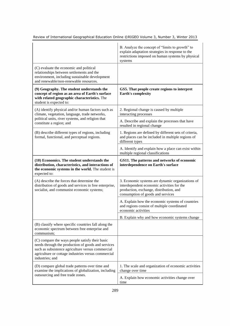
Review of International Geographical Education Online ©RIGEO Volume 3, Number 3, Winter 2013
289
B. Analyze the concept of “limits to growth” to
explain adaptation strategies in response to the
restrictions imposed on human systems by physical
systems
(C) evaluate the economic and political
relationships between settlements and the
environment, including sustainable development
and renewable/non-renewable resources.
(9) Geography. The student understands the
concept of region as an area of Earth's surface
with related geographic characteristics. The
student is expected to:
GS5. That people create regions to interpret
Earth's complexity
(A) identify physical and/or human factors such as
climate, vegetation, language, trade networks,
political units, river systems, and religion that
constitute a region; and
2. Regional change is caused by multiple
interacting processes
A. Describe and explain the processes that have
resulted in regional change
(B) describe different types of regions, including
formal, functional, and perceptual regions.
1. Regions are defined by different sets of criteria,
and places can be included in multiple regions of
different types
A. Identify and explain how a place can exist within
multiple regional classifications
(10) Economics. The student understands the
distribution, characteristics, and interactions of
the economic systems in the world. The student is
expected to:
GS11. The patterns and networks of economic
interdependence on Earth's surface
(A) describe the forces that determine the
distribution of goods and services in free enterprise,
socialist, and communist economic systems;
3. Economic systems are dynamic organizations of
interdependent economic activities for the
production, exchange, distribution, and
consumption of goods and services
A. Explain how the economic systems of countries
and regions consist of multiple coordinated
economic activities
B. Explain why and how economic systems change
(B) classify where specific countries fall along the
economic spectrum between free enterprise and
communism;
(C) compare the ways people satisfy their basic
needs through the production of goods and services
such as subsistence agriculture versus commercial
agriculture or cottage industries versus commercial
industries; and
(D) compare global trade patterns over time and
examine the implications of globalization, including
outsourcing and free trade zones.
1. The scale and organization of economic activities
change over time
A. Explain how economic activities change over
time
LASH, j. / Situating Texas’ World Geography End-Of-Course Exam in the Ecosystem of..
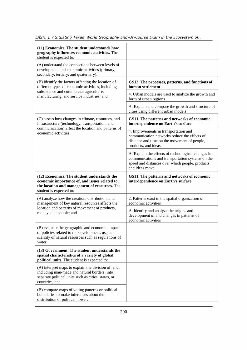
290
(11) Economics. The student understands how
geography influences economic activities. The
student is expected to:
(A) understand the connections between levels of
development and economic activities (primary,
secondary, tertiary, and quaternary);
(B) identify the factors affecting the location of
different types of economic activities, including
subsistence and commercial agriculture,
manufacturing, and service industries; and
GS12. The processes, patterns, and functions of
human settlement
4. Urban models are used to analyze the growth and
form of urban regions
A. Explain and compare the growth and structure of
cities using different urban models
(C) assess how changes in climate, resources, and
infrastructure (technology, transportation, and
communication) affect the location and patterns of
economic activities.
GS11. The patterns and networks of economic
interdependence on Earth's surface
4. Improvements in transportation and
communication networks reduce the effects of
distance and time on the movement of people,
products, and ideas
A. Explain the effects of technological changes in
communications and transportation systems on the
speed and distances over which people, products,
and ideas move
(12) Economics. The student understands the
economic importance of, and issues related to,
the location and management of resources. The
student is expected to:
GS11. The patterns and networks of economic
interdependence on Earth's surface
(A) analyze how the creation, distribution, and
management of key natural resources affects the
location and patterns of movement of products,
money, and people; and
2. Patterns exist in the spatial organization of
economic activities
A. Identify and analyze the origins and
development of and changes in patterns of
economic activities
(B) evaluate the geographic and economic impact
of policies related to the development, use, and
scarcity of natural resources such as regulations of
water.
(13) Government. The student understands the
spatial characteristics of a variety of global
political units. The student is expected to:
(A) interpret maps to explain the division of land,
including man-made and natural borders, into
separate political units such as cities, states, or
countries; and
(B) compare maps of voting patterns or political
boundaries to make inferences about the
distribution of political power.
Review of International Geographical Education Online ©RIGEO Volume 3, Number 3, Winter 2013
291
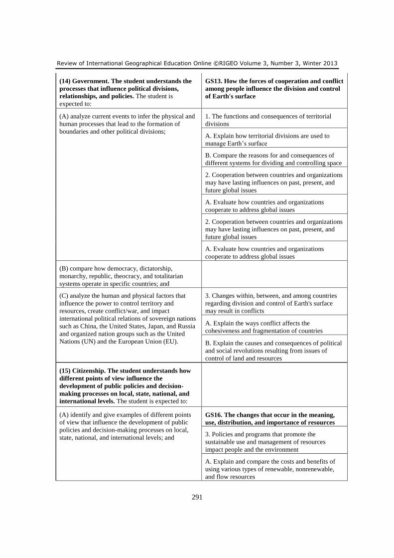
(14) Government. The student understands the
processes that influence political divisions,
relationships, and policies. The student is
expected to:
GS13. How the forces of cooperation and conflict
among people influence the division and control
of Earth's surface
(A) analyze current events to infer the physical and
human processes that lead to the formation of
boundaries and other political divisions;
1. The functions and consequences of territorial
divisions
A. Explain how territorial divisions are used to
manage Earth’s surface
B. Compare the reasons for and consequences of
different systems for dividing and controlling space
2. Cooperation between countries and organizations
may have lasting influences on past, present, and
future global issues
A. Evaluate how countries and organizations
cooperate to address global issues
2. Cooperation between countries and organizations
may have lasting influences on past, present, and
future global issues
A. Evaluate how countries and organizations
cooperate to address global issues
(B) compare how democracy, dictatorship,
monarchy, republic, theocracy, and totalitarian
systems operate in specific countries; and
(C) analyze the human and physical factors that
influence the power to control territory and
resources, create conflict/war, and impact
international political relations of sovereign nations
such as China, the United States, Japan, and Russia
and organized nation groups such as the United
Nations (UN) and the European Union (EU).
3. Changes within, between, and among countries
regarding division and control of Earth's surface
may result in conflicts
A. Explain the ways conflict affects the
cohesiveness and fragmentation of countries
B. Explain the causes and consequences of political
and social revolutions resulting from issues of
control of land and resources
(15) Citizenship. The student understands how
different points of view influence the
development of public policies and decision-
making processes on local, state, national, and
international levels. The student is expected to:
(A) identify and give examples of different points
of view that influence the development of public
policies and decision-making processes on local,
state, national, and international levels; and
GS16. The changes that occur in the meaning,
use, distribution, and importance of resources
3. Policies and programs that promote the
sustainable use and management of resources
impact people and the environment
A. Explain and compare the costs and benefits of
using various types of renewable, nonrenewable,
and flow resources
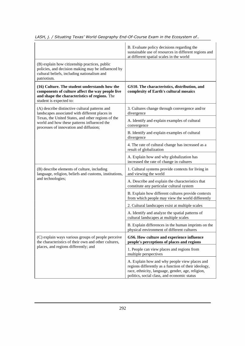
LASH, j. / Situating Texas’ World Geography End-Of-Course Exam in the Ecosystem of..
292
B. Evaluate policy decisions regarding the
sustainable use of resources in different regions and
at different spatial scales in the world
(B) explain how citizenship practices, public
policies, and decision making may be influenced by
cultural beliefs, including nationalism and
patriotism.
(16) Culture. The student understands how the
components of culture affect the way people live
and shape the characteristics of regions. The
student is expected to:
GS10. The characteristics, distribution, and
complexity of Earth's cultural mosaics
(A) describe distinctive cultural patterns and
landscapes associated with different places in
Texas, the United States, and other regions of the
world and how these patterns influenced the
processes of innovation and diffusion;
3. Cultures change through convergence and/or
divergence
A. Identify and explain examples of cultural
convergence
B. Identify and explain examples of cultural
divergence
4. The rate of cultural change has increased as a
result of globalization
A. Explain how and why globalization has
increased the rate of change in cultures
(B) describe elements of culture, including
language, religion, beliefs and customs, institutions,
and technologies;
1. Cultural systems provide contexts for living in
and viewing the world
A. Describe and explain the characteristics that
constitute any particular cultural system
B. Explain how different cultures provide contexts
from which people may view the world differently
2. Cultural landscapes exist at multiple scales
A. Identify and analyze the spatial patterns of
cultural landscapes at multiple scales
B. Explain differences in the human imprints on the
physical environment of different cultures
(C) explain ways various groups of people perceive
the characteristics of their own and other cultures,
places, and regions differently; and
GS6. How culture and experience influence
people's perceptions of places and regions
1. People can view places and regions from
multiple perspectives
A. Explain how and why people view places and
regions differently as a function of their ideology,
race, ethnicity, language, gender, age, religion,
politics, social class, and economic status
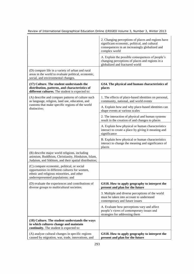
Review of International Geographical Education Online ©RIGEO Volume 3, Number 3, Winter 2013
293
2. Changing perceptions of places and regions have
significant economic, political, and cultural
consequences in an increasingly globalized and
complex world
A. Explain the possible consequences of people’s
changing perceptions of places and regions in a
globalized and fractured world
(D) compare life in a variety of urban and rural
areas in the world to evaluate political, economic,
social, and environmental changes.
(17) Culture. The student understands the
distribution, patterns, and characteristics of
different cultures. The student is expected to:
GS4. The physical and human characteristics of
places
(A) describe and compare patterns of culture such
as language, religion, land use, education, and
customs that make specific regions of the world
distinctive;
1. The effects of place-based identities on personal,
community, national, and world events
A. Explain how and why place-based identities can
shape events at various scales
2. The interaction of physical and human systems
result in the creation of and changes to places
A. Explain how physical or human characteristics
interact to create a place by giving it meaning and
significance
B. Explain how physical or human characteristics
interact to change the meaning and significance of
places
(B) describe major world religions, including
animism, Buddhism, Christianity, Hinduism, Islam,
Judaism, and Sikhism, and their spatial distribution;
(C) compare economic, political, or social
opportunities in different cultures for women,
ethnic and religious minorities, and other
underrepresented populations; and
(D) evaluate the experiences and contributions of
diverse groups to multicultural societies. GS18. How to apply geography to interpret the
present and plan for the future
3. Multiple and diverse perceptions of the world
must be taken into account to understand
contemporary and future issues
A. Evaluate how perceptions vary and affect
people’s views of contemporary issues and
strategies for addressing them
(18) Culture. The student understands the ways
in which cultures change and maintain
continuity. The student is expected to:
(A) analyze cultural changes in specific regions
caused by migration, war, trade, innovations, and GS18. How to apply geography to interpret the
present and plan for the future
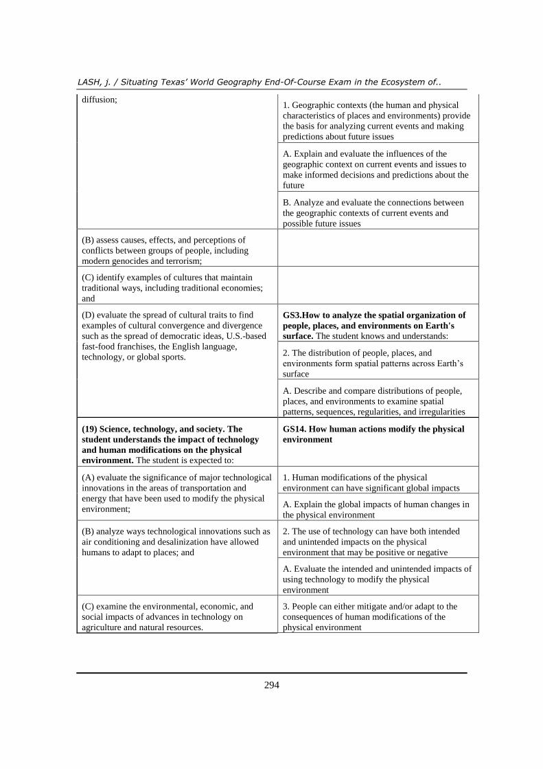
LASH, j. / Situating Texas’ World Geography End-Of-Course Exam in the Ecosystem of..
294
diffusion; 1. Geographic contexts (the human and physical
characteristics of places and environments) provide
the basis for analyzing current events and making
predictions about future issues
A. Explain and evaluate the influences of the
geographic context on current events and issues to
make informed decisions and predictions about the
future
B. Analyze and evaluate the connections between
the geographic contexts of current events and
possible future issues
(B) assess causes, effects, and perceptions of
conflicts between groups of people, including
modern genocides and terrorism;
(C) identify examples of cultures that maintain
traditional ways, including traditional economies;
and
(D) evaluate the spread of cultural traits to find
examples of cultural convergence and divergence
such as the spread of democratic ideas, U.S.-based
fast-food franchises, the English language,
technology, or global sports.
GS3.How to analyze the spatial organization of
people, places, and environments on Earth's
surface. The student knows and understands:
2. The distribution of people, places, and
environments form spatial patterns across Earth’s
surface
A. Describe and compare distributions of people,
places, and environments to examine spatial
patterns, sequences, regularities, and irregularities
(19) Science, technology, and society. The
student understands the impact of technology
and human modifications on the physical
environment. The student is expected to:
GS14. How human actions modify the physical
environment
(A) evaluate the significance of major technological
innovations in the areas of transportation and
energy that have been used to modify the physical
environment;
1. Human modifications of the physical
environment can have significant global impacts
A. Explain the global impacts of human changes in
the physical environment
(B) analyze ways technological innovations such as
air conditioning and desalinization have allowed
humans to adapt to places; and
2. The use of technology can have both intended
and unintended impacts on the physical
environment that may be positive or negative
A. Evaluate the intended and unintended impacts of
using technology to modify the physical
environment
(C) examine the environmental, economic, and
social impacts of advances in technology on
agriculture and natural resources.
3. People can either mitigate and/or adapt to the
consequences of human modifications of the
physical environment
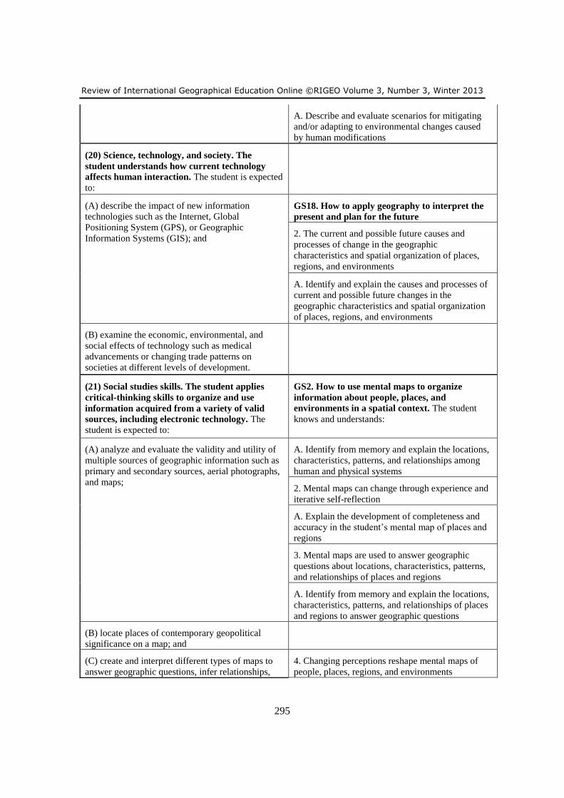
Review of International Geographical Education Online ©RIGEO Volume 3, Number 3, Winter 2013
295
A. Describe and evaluate scenarios for mitigating
and/or adapting to environmental changes caused
by human modifications
(20) Science, technology, and society. The
student understands how current technology
affects human interaction. The student is expected
to:
(A) describe the impact of new information
technologies such as the Internet, Global
Positioning System (GPS), or Geographic
Information Systems (GIS); and
GS18. How to apply geography to interpret the
present and plan for the future
2. The current and possible future causes and
processes of change in the geographic
characteristics and spatial organization of places,
regions, and environments
A. Identify and explain the causes and processes of
current and possible future changes in the
geographic characteristics and spatial organization
of places, regions, and environments
(B) examine the economic, environmental, and
social effects of technology such as medical
advancements or changing trade patterns on
societies at different levels of development.
(21) Social studies skills. The student applies
critical-thinking skills to organize and use
information acquired from a variety of valid
sources, including electronic technology. The
student is expected to:
GS2. How to use mental maps to organize
information about people, places, and
environments in a spatial context. The student
knows and understands:
(A) analyze and evaluate the validity and utility of
multiple sources of geographic information such as
primary and secondary sources, aerial photographs,
and maps;
A. Identify from memory and explain the locations,
characteristics, patterns, and relationships among
human and physical systems
2. Mental maps can change through experience and
iterative self-reflection
A. Explain the development of completeness and
accuracy in the student’s mental map of places and
regions
3. Mental maps are used to answer geographic
questions about locations, characteristics, patterns,
and relationships of places and regions
A. Identify from memory and explain the locations,
characteristics, patterns, and relationships of places
and regions to answer geographic questions
(B) locate places of contemporary geopolitical
significance on a map; and
(C) create and interpret different types of maps to
answer geographic questions, infer relationships,
4. Changing perceptions reshape mental maps of
people, places, regions, and environments
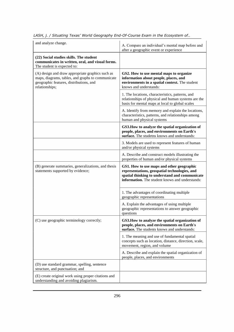
LASH, j. / Situating Texas’ World Geography End-Of-Course Exam in the Ecosystem of..
296
and analyze change. A. Compare an individual’s mental map before and
after a geographic event or experience
(22) Social studies skills. The student
communicates in written, oral, and visual forms.
The student is expected to:
(A) design and draw appropriate graphics such as
maps, diagrams, tables, and graphs to communicate
geographic features, distributions, and
relationships;
GS2. How to use mental maps to organize
information about people, places, and
environments in a spatial context. The student
knows and understands:
1. The locations, characteristics, patterns, and
relationships of physical and human systems are the
basis for mental maps at local to global scales
A. Identify from memory and explain the locations,
characteristics, patterns, and relationships among
human and physical systems
GS3.How to analyze the spatial organization of
people, places, and environments on Earth's
surface. The studetns knows and understands:
3. Models are used to represent features of human
and/or physical systems
A. Describe and construct models illustrating the
properties of human and/or physical systems
(B) generate summaries, generalizations, and thesis
statements supported by evidence; GS1. How to use maps and other geographic
representations, geospatial technologies, and
spatial thinking to understand and communicate
information. The student knows and understands:
1. The advantages of coordinating multiple
geographic representations
A. Explain the advantages of using multiple
geographic representations to answer geographic
questions
(C) use geographic terminology correctly; GS3.How to analyze the spatial organization of
people, places, and environments on Earth's
surface. The students knows and understands:
1. The meaning and use of fundamental spatial
concepts such as location, distance, direction, scale,
movement, region, and volume
A. Describe and explain the spatial organization of
people, places, and environments
(D) use standard grammar, spelling, sentence
structure, and punctuation; and
(E) create original work using proper citations and
understanding and avoiding plagiarism.
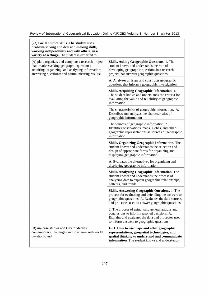
Review of International Geographical Education Online ©RIGEO Volume 3, Number 3, Winter 2013
297
(23) Social studies skills. The student uses
problem-solving and decision-making skills,
working independently and with others, in a
variety of settings. The student is expected to:
(A) plan, organize, and complete a research project
that involves asking geographic questions;
acquiring, organizing, and analyzing information;
answering questions; and communicating results;
Skills. Asking Geographic Questions. 1. The
student knows and understands the role of
developing geographic questions in a research
project that answers geographic questions.
A. Analyzes an issue and constructs geographic
questions that inform a geographic investigation
Skills. Acquiring Geographic Information. 1.
The student knows and understands the criteria for
evaluating the value and reliability of geographic
information.
The characteristics of geographic information. A.
Describes and analyzes the characteristics of
geographic information
The sources of geographic information. A.
Identifies observations, maps, globes, and other
geographic representations as sources of geographic
information
Skills. Organizing Geographic Information. The
student knows and understands the selection and
design of appropriate forms for organizing and
displaying geographic information.
A. Evaluates the alternatives for organizing and
displaying geographic information
Skills. Analyzing Geographic Information. The
student knows and understands the process of
analyzing data to explain geographic relationships,
patterns, and trends.
Skills. Answering Geographic Questions. 1. The
process for evaluating and defending the answers to
geographic questions. A. Evaluates the data sources
and processes used to answer geographic questions
2. The process of using valid generalizations and
conclusions to inform reasoned decisions. A.
Explains and evaluates the data and processes used
to inform answers to geographic questions
(B) use case studies and GIS to identify
contemporary challenges and to answer real-world
questions; and
GS1. How to use maps and other geographic
representations, geospatial technologies, and
spatial thinking to understand and communicate
information. The student knows and understands:
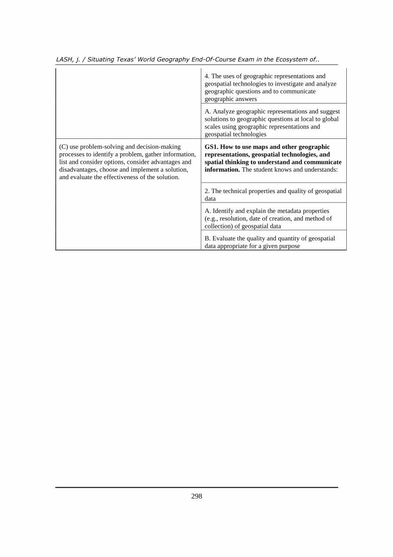
LASH, j. / Situating Texas’ World Geography End-Of-Course Exam in the Ecosystem of..
298
4. The uses of geographic representations and
geospatial technologies to investigate and analyze
geographic questions and to communicate
geographic answers
A. Analyze geographic representations and suggest
solutions to geographic questions at local to global
scales using geographic representations and
geospatial technologies
(C) use problem-solving and decision-making
processes to identify a problem, gather information,
list and consider options, consider advantages and
disadvantages, choose and implement a solution,
and evaluate the effectiveness of the solution.
GS1. How to use maps and other geographic
representations, geospatial technologies, and
spatial thinking to understand and communicate
information. The student knows and understands:
2. The technical properties and quality of geospatial
data
A. Identify and explain the metadata properties
(e.g., resolution, date of creation, and method of
collection) of geospatial data
B. Evaluate the quality and quantity of geospatial
data appropriate for a given purpose