singaporean notices to mariners - maritime and port authority
TRANSCRIPT

1ST JANUARY 2016 Monthly Edition No. 1
Notices to Mariners 1 to 6
SINGAPOREAN NOTICES TO MARINERS
SECTION CONTENT Page
l Index of Charts & Publications 1 ll New Publications 9
Notices to Mariners and Chart Corrections 16 Temporary and Preliminary Notices 19
lll Navigational Information 20 Amendments to Publications 22
lV Reprint of Radio Navigational Warnings 23 V Extract of Admiralty Notices to Mariners for
Dual Badged Charts 24
The monthly Notices to Mariners contain corrective information affecting charts published by the Hydrographic Department, Maritime and Port Authority of Singapore. The information contained in these Notices should be updated on the charts affected. Notices under Section ll apply only to the particular Singaporean Chart(s) indicated. Mariners are requested to notify the Chief Hydrographer, Maritime and Port Authority of Singapore, immediately on the discovery of new dangers or suspected dangers to navigation and of changes or defects in aids to navigation. See Hydrographic Note on back page.
The monthly Singaporean Notices to Mariners can be accessed directly from the MPA website: http://www.mpa.gov.sg/sites/port_and_shipping/circulars_and_notices/singapore_notices_to_mariners(ntm).page
The Chief Hydrographer of
Maritime and Port Authority of Singapore
wishes all users of Singaporean and Dual Badged Charts
A HAPPY NEW YEAR
Hydrographic Department
Maritime and Port Authority of Singapore
7B Keppel Road
#20-00 Tanjong Pagar Complex
Singapore 089055
Tel: (65) 6325 2027 Fax: (65) 6226 1076
Email: [email protected]
(i)
EXPLANATION OF FORMAT
The elements of a typical chart correction are explained below.
500 7Ed 26/09/13 Last NM 83/2015 (Maritime and Port Authority of Singapore) NM 2/2016
Amend legend ‘Being reclaimed (2016)’ for ‘Being reclaimed (2015)’ centred at : 1° 14·98’N 103° 37·86’E
Insert ¶ Dir F.WRG.15m13M(occas) 1° 12·59’N 103° 46·66’E Sectors at above light, as follows: R 19·3° - 17·6° (1·7°) W 17·6° - 16·5° (1·1°) G 16·5° - 15·5° (1·0°)
Notes: a) Notice to Mariners number followed by: T indicates a Temporary Notice (eg. NM 3T/2016). P indicates a Preliminary Notice (eg. NM 4P/2016). b) Bearings are true reckoned clockwise from 000° to 359° ; those relating to lights are from seaward. c) Heights and elevations are above Mean High Water Springs.
Edition Number Last Notice to
Mariners Number
Source of Information
Current Notice to Mariners Number
Position (WGS84 Datum)
Chart Number Edition Date
Corrective Action
Correction
Bearing
Elevation
Edition No. 1/2016
I
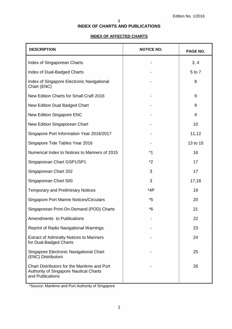
INDEX OF CHARTS AND PUBLICATIONS
INDEX OF AFFECTED CHARTS
1
DESCRIPTION NOTICE NO.
PAGE NO.
Index of Singaporean Charts - 3, 4
Index of Dual-Badged Charts - 5 to 7
Index of Singapore Electronic Navigational - 8 Chart (ENC)
New Edition Charts for Small Craft 2016 - 9
New Edition Dual Badged Chart - 9
New Edition Singapore ENC - 9
New Edition Singaporean Chart - 10
Singapore Port Information Year 2016/2017 - 11,12
Singapore Tide Tables Year 2016 - 13 to 15
Numerical Index to Notices to Mariners of 2015 *1 16
Singaporean Chart GSP1/SP1 *2 17
Singaporean Chart 202 3 17
Singaporean Chart 500 3 17,18
Temporary and Preliminary Notices *4P 19
Singapore Port Marine Notices/Circulars *5 20
Singaporean Print-On-Demand (POD) Charts *6 21
Amendments to Publications - 22
Reprint of Radio Navigational Warnings - 23
Extract of Admiralty Notices to Mariners - 24 for Dual-Badged Charts
Singapore Electronic Navigational Chart - 25 (ENC) Distributors
Chart Distributors for the Maritime and Port - 26 Authority of Singapore Nautical Charts and Publications
*Source: Maritime and Port Authority of Singapore

Edition No.1/2016
I
INDEX OF CHARTS AND PUBLICATIONS
INDEX OF NOTICES
2
NOTICE NO. DESCRIPTION
PAGE NO.
- Index of Singaporean Charts 3, 4
- Index of Dual-Badged Charts 5 to 7
- Index of Singapore Electronic Navigational Chart (ENC) 8
- New Edition Charts for Small Craft 2016 9
- New Edition Dual Badged Chart 9
- New Edition Singapore ENC 9
- New Edition Singaporean Chart 10
- Singapore Port Information Year 2016/2017 11,12
- Singapore Tide Tables 2016 13 to 15
*1 Numerical Index to Notices to Mariners of 2015 16
*2 Singaporean Chart GSP1/SP1 17
3 Singaporean Chart 202 17
3 Singaporean Chart 500 17,18
*4P Temporary and Preliminary Notices 19
*5 Singapore Port Marine Notices/Circulars 20
*6 Singaporean Print-On-Demand (POD) Charts 21
- Amendments to Publications 22
- Reprint of Radio Navigational Warnings 23
- Extract of Admiralty Notices to Mariners 24
for Dual-Badged Charts
- Singapore Electronic Navigational Chart 25 (ENC) Distributors
- Chart Distributors for the Maritime and Port 26 Authority of Singapore Nautical Charts
* Source: Maritime and Port Authority of Singapore

Edition No. 1/2016
I
INDEX OF CHARTS AND PUBLICATIONS
3
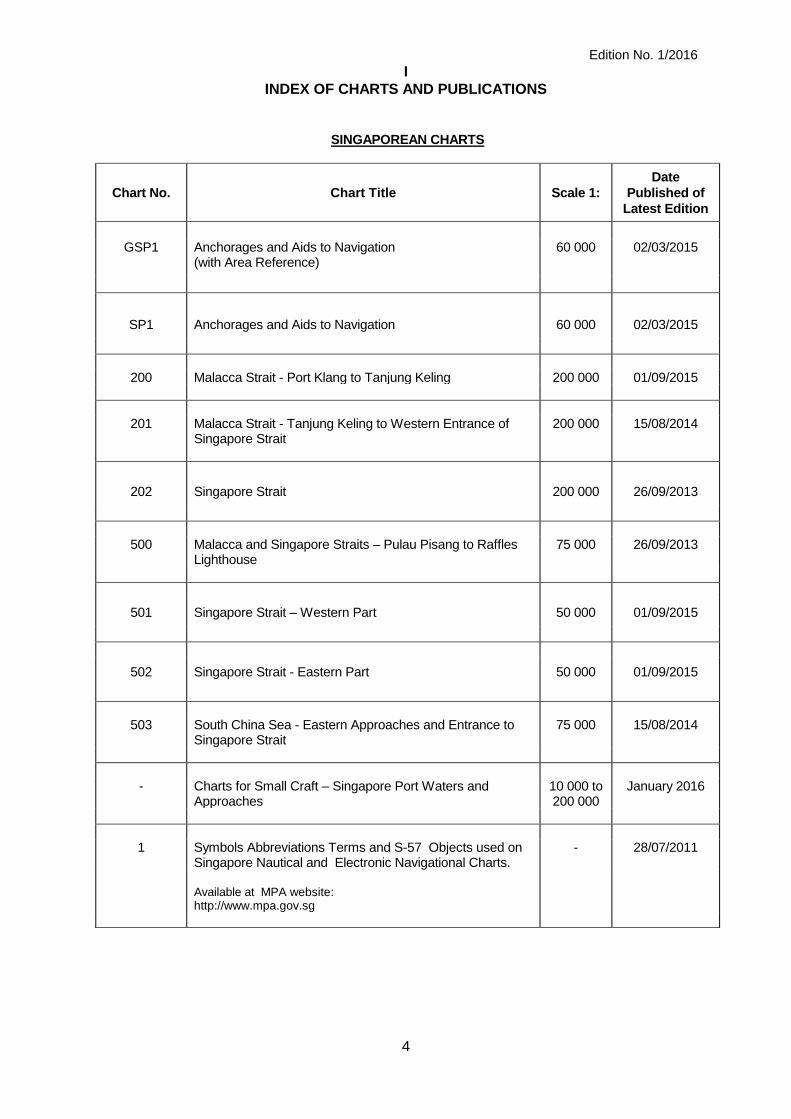
INDEX OF SINGAPOREAN CHARTS
Notes: Updated Singaporean Charts are available through our Print-On-Demand (POD) Chart Service. For more information, refer to Section III – Navigational Information. These charts can be purchased from our Chart Distributors.
Edition No. 1/2016
I
INDEX OF CHARTS AND PUBLICATIONS
4
SINGAPOREAN CHARTS
Chart No. Chart Title Scale 1: Date
Published of
Latest Edition
GSP1 Anchorages and Aids to Navigation (with Area Reference)
60 000 02/03/2015
SP1 Anchorages and Aids to Navigation 60 000 02/03/2015
200 Malacca Strait - Port Klang to Tanjung Keling 200 000 01/09/2015
201 Malacca Strait - Tanjung Keling to Western Entrance of
Singapore Strait 200 000 15/08/2014
202 Singapore Strait 200 000 26/09/2013
500 Malacca and Singapore Straits – Pulau Pisang to Raffles
Lighthouse 75 000 26/09/2013
501 Singapore Strait – Western Part 50 000 01/09/2015
502 Singapore Strait - Eastern Part 50 000 01/09/2015
503 South China Sea - Eastern Approaches and Entrance to
Singapore Strait 75 000 15/08/2014
- Charts for Small Craft – Singapore Port Waters and
Approaches 10 000 to 200 000
January 2016
1 Symbols Abbreviations Terms and S-57 Objects used on
Singapore Nautical and Electronic Navigational Charts. - 28/07/2011
Available at MPA website:
http://www.mpa.gov.sg

Edition No. 1/2016
I
INDEX OF CHARTS AND PUBLICATIONS
5
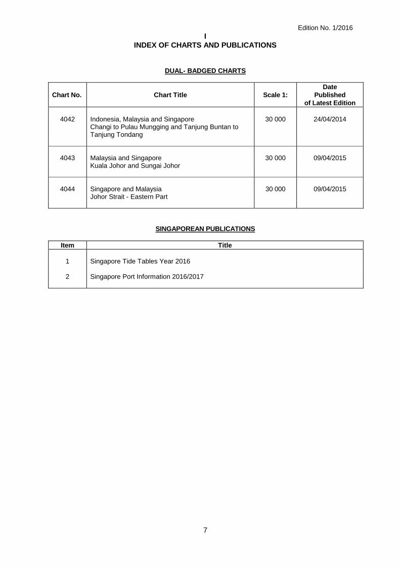
DUAL-BADGED CHARTS

Edition No. 1/2016
I
INDEX OF CHARTS AND PUBLICATIONS
6
DUAL- BADGED CHARTS
Chart No. Chart Title Scale 1:
Date
Published
of Latest Edition
4030 Port of Singapore
West Jurong Anchorages and Temasek Fairway 10 000 07/05/2015
4031 Port of Singapore
Western Approaches to Jurong Island 10 000 07/05/2015
4032 Port of Singapore
Sinki Fairway 10 000 15/05/2014
4033 Port of Singapore
Tuas Bay, West Jurong Channel and Pesek Basin 10 000 07/05/2015
4034 Port of Singapore
East Jurong Channel, Pasir Panjang Terminal and West Keppel Fairway
10 000 28/05/2015
4035 Port of Singapore
Western Anchorages, Jong Fairway and Cruise Bay 10 000 28/05/2015
4036 Port of Singapore
Raffles Lighthouse to The Sisters 10 000 28/05/2015
4037 Port of Singapore
Keppel Harbour, Tanjong Pagar Terminal and Approaches
10 000 28/05/2015
4038 Malaysia and Singapore
Johor Strait – Western Part 30 000 26/09/2013
4039 Indonesia, Singapore and Malaysia
Western Approaches to Main Strait 30 000 24/04/2014
4040 Singapore, Indonesia and Malaysia
Tuas View to Pulau Sakijang Bendera (S. John’s Island)
30 000 27/08/2015
4041 Singapore and Indonesia
Pulau Sebarok to Changi 30 000 27/08/2015
Edition No. 1/2016
I
INDEX OF CHARTS AND PUBLICATIONS
7
DUAL- BADGED CHARTS
Chart No. Chart Title Scale 1:
Date
Published
of Latest Edition
4042 Indonesia, Malaysia and Singapore
Changi to Pulau Mungging and Tanjung Buntan to Tanjung Tondang
30 000 24/04/2014
4043 Malaysia and Singapore
Kuala Johor and Sungai Johor 30 000 09/04/2015
4044 Singapore and Malaysia
Johor Strait - Eastern Part 30 000 09/04/2015
SINGAPOREAN PUBLICATIONS
Item Title
1 Singapore Tide Tables Year 2016 2 Singapore Port Information 2016/2017
Edition No. 1/2016
I
INDEX OF CHARTS AND PUBLICATIONS
8
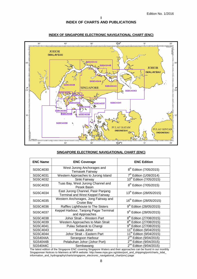
INDEX OF SINGAPORE ELECTRONIC NAVIGATIONAL CHART (ENC)
SINGAPORE ELECTRONIC NAVIGATIONAL CHART (ENC)
ENC Name ENC Coverage ENC Edition
SG5C4030 West Jurong Anchorages and
Temasek Fairway 8
th Edition (7/05/2015)
SG5C4031 Western Approaches to Jurong Island 7th Edition (1/09/2014)
SG5C4032 Sinki Fairway 10th Edition (7/05/2015)
SG5C4033 Tuas Bay, West Jurong Channel and
Pesek Basin 8
th Edition (7/05/2015)
SG5C4034 East Jurong Channel, Pasir Panjang Terminal and West Keppel Fairway
13th Edition (28/05/2015)
SG5C4035 Western Anchorages, Jong Fairway and
Cruise Bay 16
th Edition (28/05/2015)
SG5C4036 Raffles Lighthouse to The Sisters 9th Edition (28/05/2015)
SG5C4037 Keppel Harbour, Tanjong Pagar Terminal
and Approaches 9
th Edition (28/05/2015)
SG5C4038 Johor Strait – Western Part 8th Edition (27/08/2015)
SG5C4039 Western Approaches to Main Strait 8th Edition (27/08/2015)
SG5C4041 Pulau Sebarok to Changi 9th Edition (27/08/2015)
SG5C4043 Kuala Johor 11th Edition (9/04/2015)
SG5C4044 Johor Strait – Eastern Part 11th Edition (9/04/2015)
SG54044A Serangoon Harbour 2nd
Edition (9/04/2015) SG54044B Pelabuhan Johor (Johor Port) 2
nd Edition (9/04/2015)
SG54044C Sembawang 2nd
Edition (9/04/2015) The latest edition of the Singapore ENC covering Singapore Waters and their approaches can be found in our monthly Singaporean Notices to Mariners at MPA website: http://www.mpa.gov.sg/sites/port_and_shipping/port/charts_tidal_ information_and_hydrography/charts/singapore_electronic_navigational_chart(enc).page
Edition No. 1/2016
II
NEW PUBLICATIONS
9
NEW EDITION CHART TO BE PUBLISHED ON 4
TH JANUARY 2016
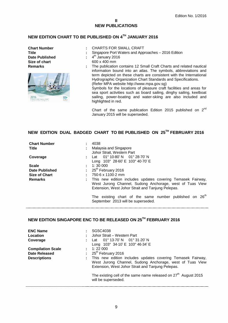
Chart Number : CHARTS FOR SMALL CRAFT
Title : Singapore Port Waters and Approaches – 2016 Edition
Date Published : 4th January 2016
Size of chart 600 x 400 mm
Remarks
: The publication contains 12 Small Craft Charts and related nautical information bound into an atlas. The symbols, abbreviations and term depicted on these charts are consistent with the International Hydrographic Organization Chart Standards and Specifications. (Refer MPA website http://www.mpa.gov.sg) Symbols for the locations of pleasure craft facilities and areas for sea sport activities such as board sailing, dinghy sailing, keelboat sailing, power-boating and water-skiing are also included and highlighted in red. Chart of the same publication Edition 2015 published on 2
nd
January 2015 will be superseded.
NEW EDITION DUAL BADGED CHART TO BE PUBLISHED ON 25TH
FEBRUARY 2016
Chart Number : 4038
Title : Malaysia and Singapore Johor Strait, Western Part
Coverage : Lat 01° 10·80’ N 01° 28·70’ N Long 103° 28·60’ E 103° 40·70’ E
Scale : 1: 30 000
Date Published : 25th February 2016
Size of Chart : 750·6 x 1100·2 mm
Remarks : This new edition includes updates covering Temasek Fairway, West Jurong Channel, Sudong Anchorage, west of Tuas View Extension, West Johor Strait and Tanjung Pelepas.
The existing chart of the same number published on 26
th
September 2013 will be superseded.
NEW EDITION SINGAPORE ENC TO BE RELEASED ON 25TH
FEBRUARY 2016
ENC Name : SG5C4038
Location : Johor Strait – Western Part
Coverage : Lat 01° 13·70’ N 01° 31·20’ N Long 103° 34·10’ E 103° 46·34’ E
Compilation Scale : 1: 22 000
Date Released : 25th February 2016
Descriptions : This new edition includes updates covering Temasek Fairway, West Jurong Channel, Sudong Anchorage, west of Tuas View Extension, West Johor Strait and Tanjung Pelepas.
The existing cell of the same name released on 27
th August 2015
will be superseded.
Edition No. 1/2016
II
NEW PUBLICATIONS
10
NEW EDITION SINGAPOREAN CHART TO BE PUBLISHED ON 15
TH FEBRUARY 2016
Chart Number : *GSP1
Title : Anchorages and Aids to Navigation
Coverage : Lat 01° 06·43’ N 01° 29·40’ N Long 103° 34·00’ E 104° 08·10’ E
Scale : 1: 65 000
Date Published : 15th February 2016
Size of Chart : 973.2 x 651.3mm
Descriptions : This new edition covers the eastern and western approaches to the port of Singapore. It includes updates on aids to navigation, working areas, submarine cables, updated contours covering west of Tuas View Reclamation, West Johor Strait, Temasek Fairway, West Jurong Channel, East Jurong Channel, Pasir Panjang, West Keppel Fairway, Western anchorages, Buran Channel, East Keppel Fairway, south of St John Island, East Johor Strait and around Pulau Tekong.
The existing chart of the same number published on 2
nd March 2015 will be superseded.
* This chart is provided with a grid area reference.
Chart Number : SP1
Title : Anchorages and Aids to Navigation
Coverage : Lat 01° 06·43’ N 01° 29·40’ N Long 103° 34·00’ E 104° 08·10’ E
Scale : 1: 65 000
Date Published : 15th February 2016
Size of Chart : 973.2 x 651.3mm
Descriptions : This new edition covers the eastern and western approaches to the port of Singapore. It includes updates on aids to navigation, working areas, submarine cables, updated contours covering west of Tuas View Reclamation, West Johor Strait, Temasek Fairway, West Jurong Channel, East Jurong Channel, Pasir Panjang, West Keppel Fairway, Western anchorages, Buran Channel, East Keppel Fairway, south of St John Island, East Johor Strait and around Pulau Tekong.
The existing chart of the same number published on 2
nd March 2015 will be superseded.
Edition No. 1/2016
II
NEW PUBLICATIONS
11
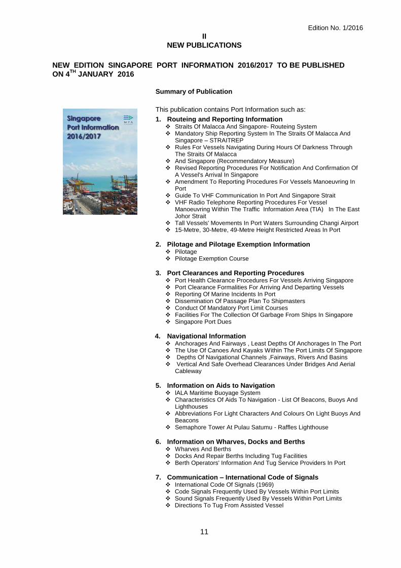
NEW EDITION SINGAPORE PORT INFORMATION 2016/2017 TO BE PUBLISHED
ON 4TH
JANUARY 2016
Summary of Publication
This publication contains Port Information such as:
1. Routeing and Reporting Information Straits Of Malacca And Singapore- Routeing System Mandatory Ship Reporting System In The Straits Of Malacca And
Singapore – STRAITREP Rules For Vessels Navigating During Hours Of Darkness Through
The Straits Of Malacca And Singapore (Recommendatory Measure) Revised Reporting Procedures For Notification And Confirmation Of
A Vessel's Arrival In Singapore Amendment To Reporting Procedures For Vessels Manoeuvring In
Port Guide To VHF Communication In Port And Singapore Strait VHF Radio Telephone Reporting Procedures For Vessel
Manoeuvring Within The Traffic Information Area (TIA) In The East Johor Strait
Tall Vessels' Movements In Port Waters Surrounding Changi Airport 15-Metre, 30-Metre, 49-Metre Height Restricted Areas In Port
2. Pilotage and Pilotage Exemption Information Pilotage Pilotage Exemption Course
3. Port Clearances and Reporting Procedures Port Health Clearance Procedures For Vessels Arriving Singapore Port Clearance Formalities For Arriving And Departing Vessels Reporting Of Marine Incidents In Port Dissemination Of Passage Plan To Shipmasters Conduct Of Mandatory Port Limit Courses Facilities For The Collection Of Garbage From Ships In Singapore Singapore Port Dues
4. Navigational Information Anchorages And Fairways , Least Depths Of Anchorages In The Port The Use Of Canoes And Kayaks Within The Port Limits Of Singapore Depths Of Navigational Channels ,Fairways, Rivers And Basins Vertical And Safe Overhead Clearances Under Bridges And Aerial
Cableway
5. Information on Aids to Navigation lALA Maritime Buoyage System Characteristics Of Aids To Navigation - List Of Beacons, Buoys And
Lighthouses Abbreviations For Light Characters And Colours On Light Buoys And
Beacons Semaphore Tower At Pulau Satumu - Raffles Lighthouse
6. Information on Wharves, Docks and Berths Wharves And Berths Docks And Repair Berths Including Tug Facilities Berth Operators' Information And Tug Service Providers In Port
7. Communication – International Code of Signals International Code Of Signals (1969) Code Signals Frequently Used By Vessels Within Port Limits Sound Signals Frequently Used By Vessels Within Port Limits Directions To Tug From Assisted Vessel
Edition No. 1/2016
II
NEW PUBLICATIONS
12
8. Nautical Services and Products
Index And Chart Catalogue Of Singaporean Charts Index And Chart Catalogue Of Dual Badged Charts Maritime and Port Authority of Singapore - Nautical Charts and Publications Distributors Singapore Electronic Navigational Charts Catalogue and Distributors Feedback Form Singapore DGPS Correction Service
9. Chartlets STRAITREP Operational Area (Sectors 1 To 9) and (Sectors 7 To 9 ) Reporting Points For Confirmation Of Arrivals Reporting Sectors Traffic Information Area Area In Which Tall Vessels Would Affect Aircraft Operations In Port Waters 15-Metre, 30-Metre, 49-Metre Height Restricted Areas Pilotage District Areas A, B And D Pilot Boarding Grounds Pilot Disembarkation Grounds Anchorages And Fairways In The Port Port of Singapore – Prohibited Areas Index of Singaporean Charts. Index of Dual Badged Charts
It will be useful for the following users: Mariners, shipping community, port users and other interested users.
Frequency / Year of Publication: Once every 2 years.
This publication would be available from the following Chart Distributors: 1) Cornes (Singapore) Pte Ltd 2) DPM (Singapore) Pte Ltd 3) E.W. Liner Charts & Publications Pte Ltd 4) Kelvin Hughes (Singapore) Pte Ltd 5) Motion Smith (Please refer Page 26 for details)
Edition No. 1/2016
II
NEW PUBLICATION
13
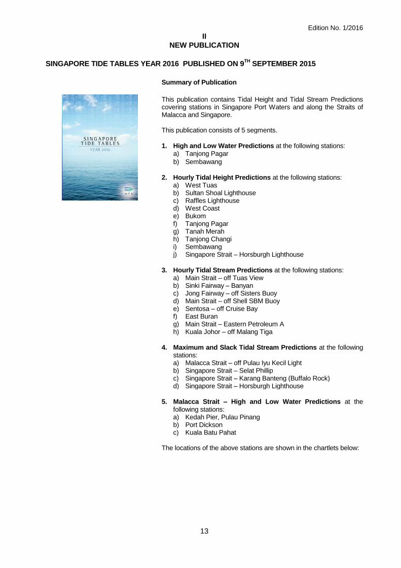
SINGAPORE TIDE TABLES YEAR 2016 PUBLISHED ON 9
TH SEPTEMBER 2015
Summary of Publication
This publication contains Tidal Height and Tidal Stream Predictions covering stations in Singapore Port Waters and along the Straits of Malacca and Singapore. This publication consists of 5 segments.
1. High and Low Water Predictions at the following stations: a) Tanjong Pagar
b) Sembawang
2. Hourly Tidal Height Predictions at the following stations: a) West Tuas b) Sultan Shoal Lighthouse c) Raffles Lighthouse d) West Coast e) Bukom f) Tanjong Pagar g) Tanah Merah h) Tanjong Changi i) Sembawang j) Singapore Strait – Horsburgh Lighthouse
3. Hourly Tidal Stream Predictions at the following stations: a) Main Strait – off Tuas View b) Sinki Fairway – Banyan c) Jong Fairway – off Sisters Buoy d) Main Strait – off Shell SBM Buoy e) Sentosa – off Cruise Bay f) East Buran g) Main Strait – Eastern Petroleum A h) Kuala Johor – off Malang Tiga
4. Maximum and Slack Tidal Stream Predictions at the following stations:
a) Malacca Strait – off Pulau Iyu Kecil Light b) Singapore Strait – Selat Phillip c) Singapore Strait – Karang Banteng (Buffalo Rock) d) Singapore Strait – Horsburgh Lighthouse
5. Malacca Strait – High and Low Water Predictions at the following stations:
a) Kedah Pier, Pulau Pinang b) Port Dickson c) Kuala Batu Pahat
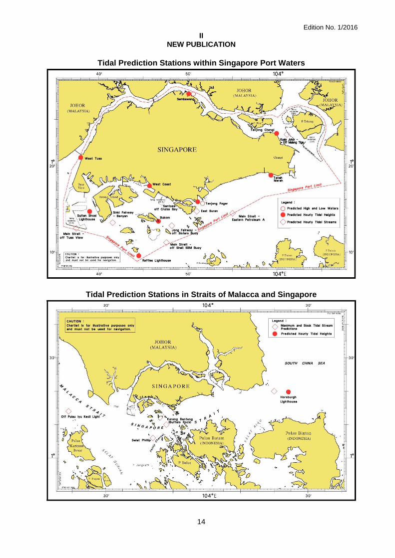
The locations of the above stations are shown in the chartlets below:
Edition No. 1/2016
II
NEW PUBLICATION
14
Tidal Prediction Stations within Singapore Port Waters
Tidal Prediction Stations in Straits of Malacca and Singapore

Edition No. 1/2016
II
NEW PUBLICATION
15
Tidal Prediction Stations in Malacca Strait
This publication is available from the following Chart Distributors: 1. Cornes Singapore Pte Ltd 2. DPM (Singapore) Pte Ltd 3. E.W. Liner Charts & Publications Pte Ltd 4. Kelvin Hughes (Singapore) Pte Ltd 5. Motion Smith (Please refer Page 26 for details)

Edition No. 1/2016
II
NOTICES TO MARINERS AND CHART CORRECTIONS
16
*(NM 1/2016) NUMERICAL INDEX TO NOTICES TO MARINERS OF 2015 (1 TO 104T)
MONTH NOTICES TO MARINERS NO.
JANUARY 2015 1 to 14T
FEBRUARY 2015 15 to 21
MARCH 2015 23 to 29
APRIL 2015 30 to 37
MAY 2015 38 to 48
JUNE 2015 49 to 58
JULY 2015 59 to 66
AUGUST 2015 67 to 73
SEPTEMBER 2015 74 to 82
OCTOBER 2015 83 to 90
NOVEMBER 2015 91 to 97
DECEMBER 2015 98 to 104T
CHART NO. PUBLISHED YEAR NOTICES TO MARINERS NO.
GSP1, SP1 10 Ed 2/03/15 2015 23-24-30-31-32-38-39-49-50-51-59-67-68-69-74-83-84-85-91-92-98-99
200 4 Ed 1/09/15 2015 None
201 5 Ed 15/08/14 2015 7-40-41-52-53-62-70-76-77-86
202 7 Ed 26/09/13 2015 1-17-25-31-42-63-74-87-100
500 7 Ed 26/09/13 2015 38-50-59-74-83-100
501 7 Ed 1/09/15 2015 100
502 7 Ed 1/09/15 2015 92
503 5 Ed 15/08/14 2015 31-42-63
Edition No. 1/2016
II
NOTICES TO MARINERS AND CHART CORRECTIONS
17
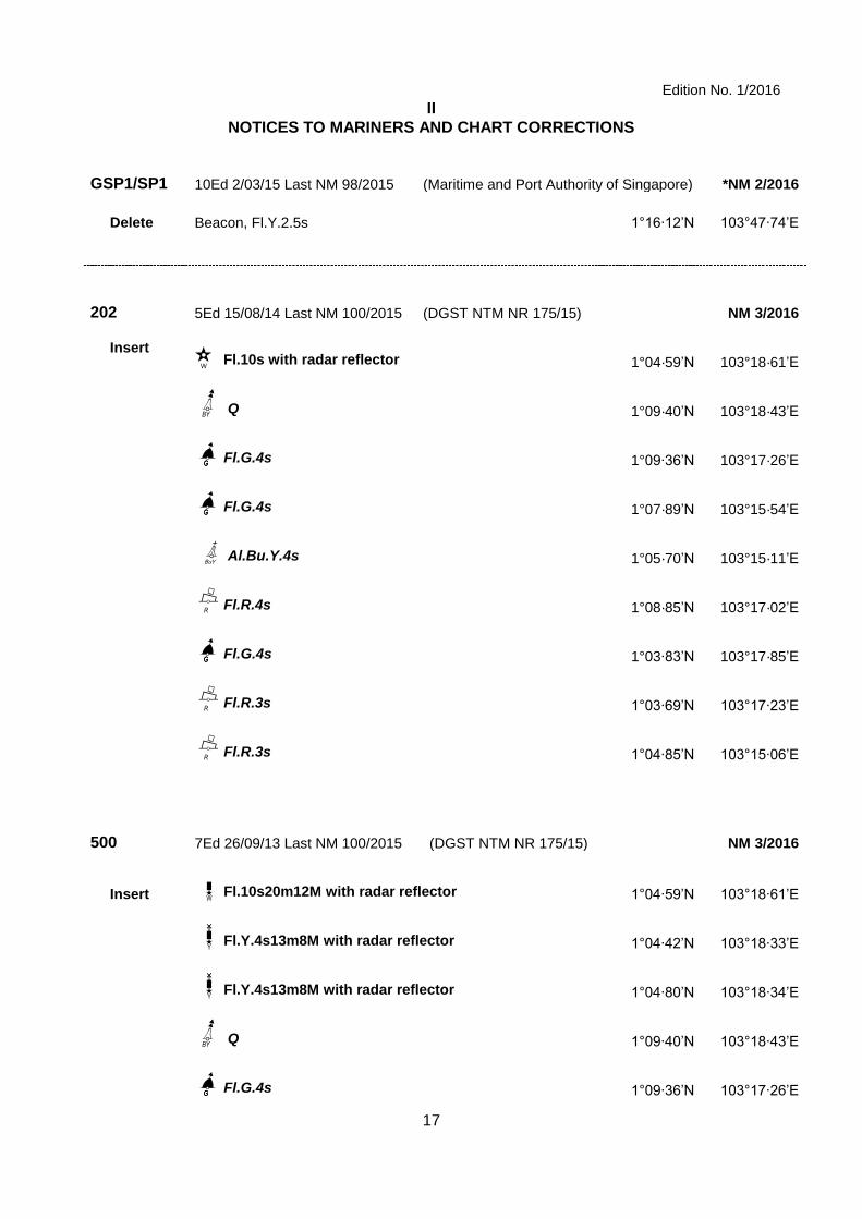
GSP1/SP1 10Ed 2/03/15 Last NM 98/2015 (Maritime and Port Authority of Singapore) *NM 2/2016
Delete Beacon, Fl.Y.2.5s 1°16·12’N 103°47·74’E
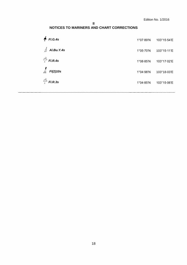
202 5Ed 15/08/14 Last NM 100/2015 (DGST NTM NR 175/15) NM 3/2016
Insert ;wwrwssfffw;wwwwwds¶ Fl.10s with radar reflector 1°04·59’N 103°18·61’E
UUUUYGmU Q 1°09·40’N 103°18·43’E
]C]bbbFl.G.4s 1°09·36’N 103°17·26’E
C]bbbFl.G.4s 1°07·89’N 103°15·54’E
bbbHAl.Bu.Y.4s 1°05·70’N 103°15·11’E
bbbB\dFl.R.4s 1°08·85’N 103°17·02’E
C]bbbFl.G.4s 1°03·83’N 103°17·85’E
bbbB\dFl.R.3s 1°03·69’N 103°17·23’E
bbbB\dFl.R.3s 1°04·85’N 103°15·06’E
500 7Ed 26/09/13 Last NM 100/2015 (DGST NTM NR 175/15) NM 3/2016
Insert ;wwrwssfffw;TkFl.10s20m12M with radar reflector 1°04·59’N 103°18·61’E
;;;TÜlÜFl.Y.4s13m8M with radar reflector 1°04·42’N 103°18·33’E
;;;TÜlÜFl.Y.4s13m8M with radar reflector 1°04·80’N 103°18·34’E
UUUUYGmU Q 1°09·40’N 103°18·43’E
C]bbbFl.G.4s 1°09·36’N 103°17·26’E
+
BuY
W
Edition No. 1/2016
II
NOTICES TO MARINERS AND CHART CORRECTIONS
18
Cbbb]Fl.G.4s 1°07·89’N 103°15·54’E
bbbHAl.Bu.Y.4s 1°05·70’N 103°15·11’E
bbbB\dFl.R.4s 1°08·85’N 103°17·02’E
GYo Fl(2)10s 1°04·98’N 103°18·03’E
bbbB\dFl.R.3s 1°04·85’N 103°15·06’E
BuY
+
Edition No. 1/2016
II
TEMPORARY AND PRELIMINARY NOTICES
19
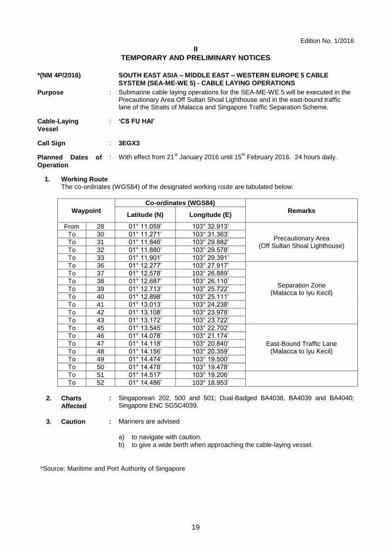
*(NM 4P/2016) SOUTH EAST ASIA – MIDDLE EAST – WESTERN EUROPE 5 CABLE
SYSTEM (SEA-ME-WE 5) - CABLE LAYING OPERATIONS
Purpose : Submarine cable laying operations for the SEA-ME-WE 5 will be executed in the Precautionary Area Off Sultan Shoal Lighthouse and in the east-bound traffic lane of the Straits of Malacca and Singapore Traffic Separation Scheme.
Cable-Laying
Vessel
: ‘CS FU HAI’
Call Sign : 3EGX3
Planned Dates of
Operation
: With effect from 21st January 2016 until 15
th February 2016. 24 hours daily.
1. Working Route
The co-ordinates (WGS84) of the designated working route are tabulated below:
Waypoint
Co-ordinates (WGS84)
Remarks
Latitude (N) Longitude (E)
From 28 01° 11.059’ 103° 32.913’
Precautionary Area (Off Sultan Shoal Lighthouse)
To 30 01° 11.271’ 103° 31.363’
To 31 01° 11.846’ 103° 29.882’
To 32 01° 11.880’ 103° 29.578’
To 33 01° 11.901’ 103° 29.391’
To 36 01° 12.277’ 103° 27.917’
Separation Zone (Malacca to Iyu Kecil)
To 37 01° 12.578’ 103° 26.889’
To 38 01° 12.687’ 103° 26.110’
To 39 01° 12.713’ 103° 25.722’
To 40 01° 12.898’ 103° 25.111’
To 41 01° 13.013’ 103° 24.238’
To 42 01° 13.108’ 103° 23.978’
To 43 01° 13.172’ 103° 23.722’
To 45 01° 13.545’ 103° 22.702’
East-Bound Traffic Lane (Malacca to Iyu Kecil)
To 46 01° 14.078’ 103° 21.174’
To 47 01° 14.118’ 103° 20.840’
To 48 01° 14.156’ 103° 20.359’
To 49 01° 14.474’ 103° 19.500’
To 50 01° 14.478’ 103° 19.478’
To 51 01° 14.517’ 103° 19.206’
To 52 01° 14.486’ 103° 18.953’
2. Charts
Affected
: Singaporean 202, 500 and 501; Dual-Badged BA4038, BA4039 and BA4040; Singapore ENC SG5C4039.
3. Caution : Mariners are advised
a) to navigate with caution.
b) to give a wide berth when approaching the cable-laying vessel.
*Source: Maritime and Port Authority of Singapore

Edition No. 1/2016
IIl
NAVIGATIONAL INFORMATION
20
*(NM 5/2016) SINGAPORE PORT MARINE NOTICES/CIRCULARS
The Port Marine Notices/Circulars shortlisted below would be of particular interest to mariners. Details and complete list of Port Marine Notices/Circulars are available at this link: http://www.mpa.gov.sg
PMN No. Subject
75/2015 Works at Tuas Terminal Phase 1
88/2015 Mooring & unmooring of vessels at Banyan Basin, Jurong Island
107/2015 Soil investigation work off Changi East
109/2015 Upgrading works at Jurong Terminal Berth J10
111/2015 Removal of Floating sea barrier off Poyan Reservoir, West Johor Strait
112/2015 Reclamation work at Tuas View, off Temasek Fairway
114/2015 Soil investigation work at Tuas Bay
115/2015 Construction of jetties & deployment of acoustic Doppler current profiler (ADCP) At Tanah Merah Staging Ground
116/2015 Replacement of floating sea barrier at Serangoon Harbour
121/2015 Reclamation work at Pulau Tekong
122/2015 Construction of aviation park staging ground & Changi East Finger work Extension
123/2015 Mooring & unmooring of vessels off Pulau Tekong
124/2015 Reclamation work at western part of Tuas View Extension
128/2015 Soil investigation work off west of Tuas View, Johor Strait
130/2015 Construction of jetty & Pontoon at Pulau Ubin
133/2015 Dredging works at West Jurong Channel
135/2015 Mooring & unmooring of vessels off eastern part of Tuas View Extension
136/2015 Construction of pier at west of Tuas View Extension, West Johor Strait
138/2015 Laying of submarine cable off west of Tuas View Extension, Johor Strait
143/2015 Soil investigation work off west Tuas View, Johor Strait
146/2015 Reclamation and soil investigation works off Tuas
148/2015 Soil investigation off Changi East
PMC No. Subject
PMC 12/2015 Implementation of Automatic Identification System – B (AIS-B) Transponder and Electronic Chart System (ECS) on power-driven harbour and pleasure craft.
*Source: Maritime and Port Authority of Singapore
Edition No. 1/2016
IIl
NAVIGATIONAL INFORMATION
21
*(NM 6/2016) SINGAPOREAN PRINT-ON-DEMAND (POD) CHARTS
Print-On-Demand (POD) Charts are the most up-to-date paper nautical charts printed for navigational use. These nautical charts are produced in accordance with the International Hydrographic Organisation (IHO) chart specifications. These official nautical charts are continually updated to the latest Notices to Mariners before they are printed and sold to users.
These POD Charts include 200, 201, 202, 500, 501, 502 and 503.
BENEFITS TO OUR CUSTOMERS
Convenience Customers need not make numerous hand corrections to the nautical charts before use. In addition the updated POD Charts are more accurate and reliable than offset printed charts with hand corrections.
Clarity Clarity in the presentation of updated information as compared to lithographic printed charts, where in some cases there are several overlapping corrections over existing information.
Coverage The POD Charts cover the Malacca and Singapore Straits, from One Fathom Bank to Horsburgh Lighthouse.
*Source: Maritime and Port Authority of Singapore

Edition No. 1/2016
IIl
AMENDMENTS TO PUBLICATIONS
22
NIL

Edition No. 1/2016
IV REPRINT OF RADIO NAVIGATIONAL WARNINGS
23
The following Radio Navigational Warnings have been shortlisted, as they would be of particular interest to mariners.
TT175 VESSELS IN EAST JOHOR STRAIT ARE ADVISED TO NAVIGATE WITH PARTICULAR ALERTNESS AND CAUTION WHEN NEAR THE PROJECT AREAS OFF PULAU TEKONG, CHANGI AND MALANG PAPAN AS SHALLOW WATER AREAS EXIST. VESSELS ARE REMINDED TO PROCEED AT A SAFE SPEED AND MAINTAIN A PROPER LOOK-OUT,PARTICULARLY FOR TUGS AND BARGES NAVIGATING NEAR THE PROJECT AREAS AND PASSENGER FERRIES CROSSING BETWEEN CHANGI AND PULAU TEKONG AND VICINITY OF PASIR GUDANG. TT273 ALL VESSELS ARE ADVISED TO NAVIGATE WITH CAUTION, COMPLY WITH THE INTERNATIONAL COLLISION REGULATIONS, MAINTAIN VHF RADIO WATCH AND LISTEN TO TRAFFIC INFORMATION WHEN NAVIGATING IN THE SINGAPORE STRAIT AND PORT WATERS. MARINERS ARE ALSO ADVISED TO KEEP A GOOD LOOKOUT OF FREQUENT FERRIES CROSSING THE SINGAPORE STRAIT. TT282 RACON DELTA Q(6)LFL.15S IN POSITION LAT 01° 03.60’N LONG 103° 38.85’E IS REPORTED UNLIT. ALL VESSELS ARE ADVISED TO NAVIGATE WITH CAUTION. TT285 (AMENDED ON 28 DEC 2015 0112Z) A SUNKEN YACHT IS LOCATED AT POSITION 01-17.83N 104-23.69E. ALL VESSELS ARE ADVICED TO NAVIGATE WITH PARTICULAR CAUTION. TT292 (AMENDED ON 181630UTC DEC 2015) A WRECK IS LOCATED AT 01-12.80N 103-54.89E IN THE EAST BOUND LANE OF SINGAPORE STRAIT. AN EMERGENCY WRECK MARKING BUOY WITH A LIGHT CHARACTERISTIC OF ALTERNATING OCCULTING BLUE YELLOW 3 SECONDS HAS BEEN INSTALLED AT POSITION 01-12.74N 103-54.78E IN THE EAST BOUND LANE OF THE SINGAPORE STRAIT. MARINERS ARE ADVISED NAVIGATE WITH CAUTION. TT961 VESSELS INTENDING TO CROSS THE TRAFFIC SEPARATION SCHEME (TSS) OR PRECAUTIONARY AREAS IN THE SINGAPORE STRAIT DURING THE HOURS OF DARKNESS ARE RECOMMENDED TO DISPLAY THE NIGHT SIGNALS CONSISTING OF 3 ALL ROUND GREEN LIGHTS IN A VERTICAL LINE AS DETAILED IN MARITIME AND PORT AUTHORITY OF SINGAPORE'S PORT MARINE CIRCULAR, 02 OF 2011 DATED 30 MAY 2011. -------------------------------------------------------------------------------------------------- -------------------------------------------
ISSUED BY SINGAPORE PORT OPERATIONS CONTROL CENTRE (as at 27th December 2015)
Edition No. 1/2016
V
EXTRACT OF ADMIRALTY NOTICES TO MARINERS
FOR DUAL-BADGED CHARTS
24
These notices can also be accessed directly from UKHO Website: http://www.ukho.gov.uk/ProductsandServices/MartimeSafety/Pages/NMPublic.aspx
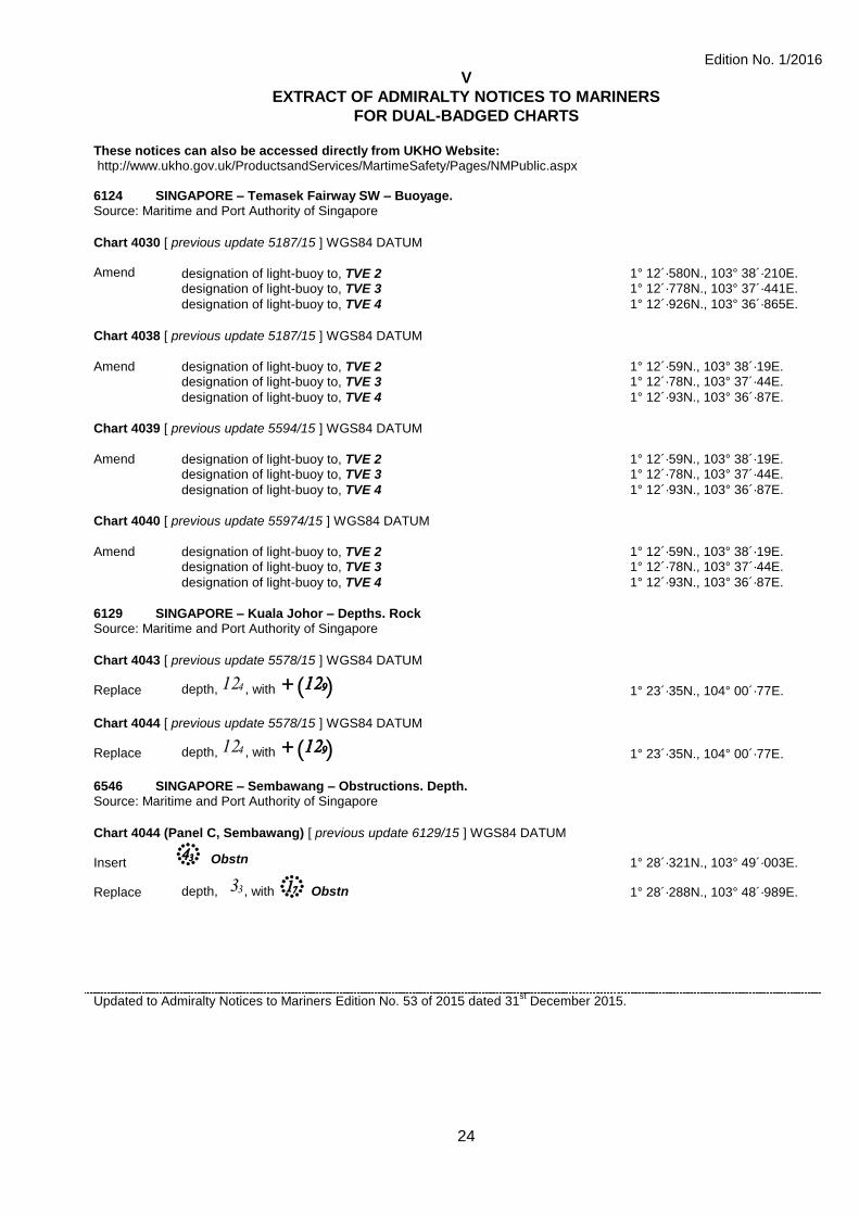
6124 SINGAPORE – Temasek Fairway SW – Buoyage. Source: Maritime and Port Authority of Singapore
Chart 4030 [ previous update 5187/15 ] WGS84 DATUM Amend
designation of light-buoy to, TVE 2
1° 12´·580N., 103° 38´·210E.
designation of light-buoy to, TVE 3 1° 12´·778N., 103° 37´·441E.
designation of light-buoy to, TVE 4 1° 12´·926N., 103° 36´·865E.
Chart 4038 [ previous update 5187/15 ] WGS84 DATUM Amend designation of light-buoy to, TVE 2 1° 12´·59N., 103° 38´·19E. designation of light-buoy to, TVE 3 1° 12´·78N., 103° 37´·44E.
designation of light-buoy to, TVE 4 1° 12´·93N., 103° 36´·87E.
Chart 4039 [ previous update 5594/15 ] WGS84 DATUM Amend designation of light-buoy to, TVE 2 1° 12´·59N., 103° 38´·19E. designation of light-buoy to, TVE 3 1° 12´·78N., 103° 37´·44E.
designation of light-buoy to, TVE 4 1° 12´·93N., 103° 36´·87E.
Chart 4040 [ previous update 55974/15 ] WGS84 DATUM Amend designation of light-buoy to, TVE 2 1° 12´·59N., 103° 38´·19E. designation of light-buoy to, TVE 3 1° 12´·78N., 103° 37´·44E.
designation of light-buoy to, TVE 4 1° 12´·93N., 103° 36´·87E.
6129 SINGAPORE – Kuala Johor – Depths. Rock Source: Maritime and Port Authority of Singapore
Chart 4043 [ previous update 5578/15 ] WGS84 DATUM Replace depth, 12$ , with ¯(12))
1° 23´·35N., 104° 00´·77E.
Chart 4044 [ previous update 5578/15 ] WGS84 DATUM Replace depth, 12$ , with ¯(12))
1° 23´·35N., 104° 00´·77E.
6546 SINGAPORE – Sembawang – Obstructions. Depth. Source: Maritime and Port Authority of Singapore
Chart 4044 (Panel C, Sembawang) [ previous update 6129/15 ] WGS84 DATUM
Insert 4#+ Obstn
1° 28´·321N., 103° 49´·003E.
Replace depth, 3# , with 1Ó+ Obstn
1° 28´·288N., 103° 48´·989E.
Updated to Admiralty Notices to Mariners Edition No. 53 of 2015 dated 31st December 2015.
25
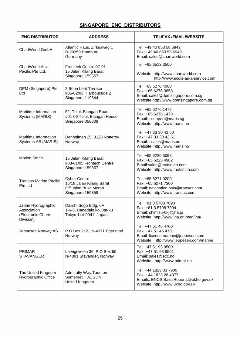
SINGAPORE ENC DISTRIBUTORS
ENC DISTRIBUTOR ADDRESS TEL/FAX /EMAIL/WEBSITE
ChartWorld GmbH
Atlantic Haus, Zirkusweg 1 D-20359 Hamburg Germany
Tel: +49 40 853 58 6942 Fax: +49 40 853 58 6949 Email: [email protected]
ChartWorld Asia Pacific Pte Ltd.
Frontech Centre 07-01 15 Jalan Kilang Barat Singapore 159357
Tel: +65 6513 3500 Website: http://www.chartworld.com
http://www.ecdis-as-a-service.com
DPM (Singapore) Pte Ltd
2 Boon Leat Terrace #05-02/03, Harbourside 2 Singapore 119844
Tel: +65 6270 4060 Fax: +65 6276 3858 Email: [email protected] Website:http://www.dpmsingapore.com.sg
Maritime Information
Systems (MARIS)
52, Telok Blangah Road
#01-06 Telok Blangah House
Singapore 058809
Tel: +65 6276 1472 Fax: +65 6276 1473 Email: : [email protected]
Website: http://www.maris.no
Maritime Information Systems AS (MARIS)
Danholmen 25, 3128 Notteroy
Norway
Tel: +47 33 30 42 50 Fax: +47 33 30 42 51 Email: : [email protected] Website: http://www.maris.no
Motion Smith
15 Jalan Kilang Barat
#08-01/05 Frontech Centre Singapore 159357
Tel: +65 6220 5098 Fax: +65 6225 4902 Email:[email protected] Website: http://www.motsmith.com
Transas Marine Pacific Pte Ltd
Cyber Centre 16/18 Jalan Kilang Barat Off Jalan Bukit Merah Singapore 159358
Tel: +65 6271 0200 Fax: +65 6271 7300 Email: [email protected] Website: http://www.transas.com
Japan Hydrographic Association (Electronic Charts Division)
Daiichi Sogo Bldg, 6F 1-6-6, Hanedakuko,Ota-ku Tokyo 144-0041, Japan
Tel: +81 3 5708 7093 Fax: +81 3 5708 7094 Email: [email protected] Website: http://www.jha.or.jp/en/jha/
Jeppesen Norway AS
P.O Box 212 , N-4371 Egersund Norway
Tel: +47 51 46 4700 Fax: +47 51 46 4701 Email: [email protected] Website : http://www.jeppesen.com/marine
PRIMAR STAVANGER
Lervigsveien 36, P.O Box 60 N-4001 Stavanger, Norway
Tel: +47 51 93 9500 Fax: +47 51 93 9501 Email: [email protected] Website : http://www.primar.no
The United Kingdom Hydrographic Office
Admiralty Way,Taunton Somerset, TA1 2DN United Kingdom
Tel: +44 1823 33 7900 Fax: +44 1823 28 4077 Emails: [email protected] Website: http://www.ukho.gov.uk
26
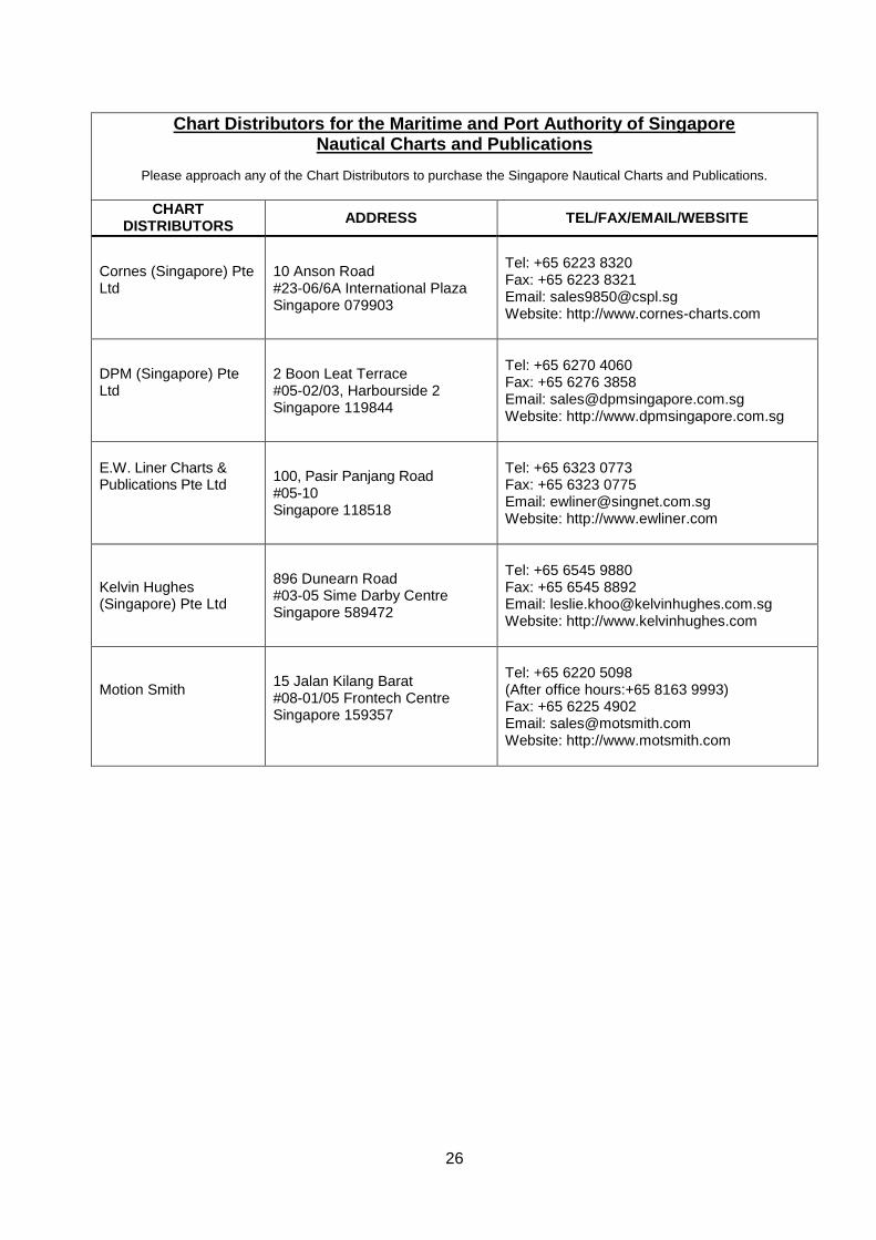
Chart Distributors for the Maritime and Port Authority of Singapore Nautical Charts and Publications
Please approach any of the Chart Distributors to purchase the Singapore Nautical Charts and Publications.
CHART DISTRIBUTORS
ADDRESS TEL/FAX/EMAIL/WEBSITE
Cornes (Singapore) Pte Ltd
10 Anson Road #23-06/6A International Plaza Singapore 079903
Tel: +65 6223 8320 Fax: +65 6223 8321 Email: [email protected] Website: http://www.cornes-charts.com
DPM (Singapore) Pte Ltd
2 Boon Leat Terrace #05-02/03, Harbourside 2 Singapore 119844
Tel: +65 6270 4060 Fax: +65 6276 3858 Email: [email protected] Website: http://www.dpmsingapore.com.sg
E.W. Liner Charts & Publications Pte Ltd
100, Pasir Panjang Road #05-10 Singapore 118518
Tel: +65 6323 0773 Fax: +65 6323 0775 Email: [email protected] Website: http://www.ewliner.com
Kelvin Hughes (Singapore) Pte Ltd
896 Dunearn Road #03-05 Sime Darby Centre Singapore 589472
Tel: +65 6545 9880 Fax: +65 6545 8892 Email: [email protected] Website: http://www.kelvinhughes.com
Motion Smith
15 Jalan Kilang Barat #08-01/05 Frontech Centre Singapore 159357
Tel: +65 6220 5098 (After office hours:+65 8163 9993) Fax: +65 6225 4902 Email: [email protected] Website: http://www.motsmith.com
HYDROGRAPHIC NOTE - Instructions
1. Mariners are requested to notify the Chief Hydrographer, Maritime and Port Authority of Singapore, when new or suspected dangers to navigation are discovered, changes are observed in aids to navigation or where corrections to nautical publications may be necessary. Reports, which cannot be confirmed or are lacking in certain details should not be withheld. 2. Any ambiguities of time, positioning and depth should be stressed and any firm expectation of being able to check the information provided on a following voyage should be mentioned. 3. Mariners using satellite position fixing systems, eg. GPS, should provide details of equipment and datum used (where applicable). Where bearings (true or magnetic) are taken visually or by radar to fix a position, it should include more than two objects in order to provide a check on its accuracy. A position may also be defined by bearing and distance from a conspicuous object eg. beacon, lighthouse etc. 4. The note should include a tracing or a digital image of the chart used and the details should be clearly marked. 5. Echo sounders frequently register greater depths than the advertised maximum depth for the equipment, eg. a trace appearing at 50 metres may be in fact be 550 metres or even 1050 metres for equipment whose maximum depth is 500 metres. Erroneous depths caused by 2nd transmission error can usually be recognised by the following: (a) the tracing being weaker than normal for the depth registered, (b) the trace appearing to pass through the transmission line, (c) the feathery nature of the trace. 6. Upon receipt of a hydrographic note, a Notice to Mariners may be issued. The sender's vessel or name is quoted as the source unless the same information is also received in foreign Notices to Mariners. 7. Reports of shoals, uncharted dangers and defects in aids to navigation may also be made to
the appropriate Singapore Port Operations Control Centre on VHF Channels 10, 12, 14, 68 or 73.

HYDROGRAPHIC NOTE
To: Chief Hydrographer Maritime and Port Authority of Singapore 7B Keppel Road #20-00 Tanjong Pagar Complex Singapore 089055 Tel : (65) 6325 2027 Fax : (65) 6226 1076 Email : [email protected] Sender’s Contact Details : Date :
Name of Vessel :
Address of Sender :
Tel : Fax :
Email :
Nature of Observation : General Location :
Subject :
Position : Lat. Long.
Charts Used :
Date & Time of Observation :
Details :
Attachment :
Equipment Used : Type of Position Fixing : GPS / DGPS Others :
Type of Echo Sounder :
Name and Signature :
Ship’s/Company’s Stamp :