shore-based voyage planning - core
TRANSCRIPT
MAREENA VILJANEN
Shore-based Voyage Planning
MASTERS OF MARITIME MANAGEMENT 2020

Author
Viljanen, Mareena
Type of Publication
Master’s thesis
Date
June 2020
Number of pages
115
Language of publication:
English
Shore-based Voyage Planning
Masters of Maritime Management
The objective of the thesis was to describe the voyage planning process and factors that
influence it to see how the process could be adapted for being performed shoreside. The
thesis is a qualitative study written from the voyage planning officer’s point of view
concentrating on the appraisal and planning stages.
Regulatory framework was defined using IMO and British Admiralty publications.
Carnival Corporation’s SMS policies and Holland America Line’s voyage planning
routines were used as examples of the process. As there is not much research available
on voyage planning and new developing technologies, interviews and internet sources
were used.
The amount of work put into a voyage plan varies greatly depending on a ship type and
trade area, but generally it is a time-consuming process, partly because the information
needs to be gathered from multiple sources and is not always easily available. The
concept of e-navigation is aimed to improve connectivity between different systems and
stakeholders allowing new types of services and information dissemination across the
industry enabling the navigators to receive relevant information in time and often
automatically with no need to request the information separately. Also automated ship-
to-ship information exchange will become possible.
AI-aided planning software and government provided passage plans can be of assistance
in the voyage planning officer’s work, but their scope is still quite limited. In the future
when the technology develops, and especially if all information can be accessed from a
single window, time spent on appraisal and planning stages will decrease considerably
and most of the process could be done shoreside leaving the officers on board more time
for other tasks.
Autonomous vessels and augmented reality are the future, and as the technology
develops shore-based voyage planning will become more common.
Key words
Voyage planning, e-navigation, autonomous ships
CONTENTS
ABBREVIATIONS
1 INTRODUCTION .................................................................................................... 8
1.1 Background ........................................................................................................ 8
1.2 Aim of the study ............................................................................................... 10
2 REGULATORY FRAMEWORK ........................................................................... 13
2.1 SOLAS ............................................................................................................. 13
2.2 STCW ............................................................................................................... 14
2.3 IMO Guidelines for Voyage Planning ............................................................. 16
2.3.1 Appraisal Stage ......................................................................................... 16
2.3.2 Planning Stage ........................................................................................... 17
2.3.3 Execution Stage ......................................................................................... 18
2.3.4 Monitoring Stage ....................................................................................... 18
2.4 Polar Code ........................................................................................................ 20
2.5 MSC.1/Circ.1184 Enhanced Contingency Planning Guidance for Passenger
Ships Operating in Areas Remote from SAR Facilities ......................................... 21
2.6 ISM ................................................................................................................... 22
2.7 Other sources .................................................................................................... 22
2.7.1 NP231 Guide to the Practical Use of ENCs .............................................. 22
2.7.2 NP232 Guide to ECDIS Implementation, Policy and Procedures ............ 23
2.7.3 Carnival Corporation Safety Management System ................................... 24
3 VOYAGE PLANNING ON CARNIVAL CORPORATION SHIPS ..................... 27
3.1 Sources for appraisal ........................................................................................ 28
3.1.1 Official sources ......................................................................................... 28
3.1.2 Internal sources ......................................................................................... 30
3.1.3 External sources ........................................................................................ 32
3.2 The appraisal process ....................................................................................... 35
3.2.1 Sailing area and chart coverage................................................................. 36
3.2.2 Generation of track .................................................................................... 39
3.2.3 Publications and local regulations ............................................................. 40
3.2.4 Environmental conditions ......................................................................... 41
3.2.5 Protection of marine environment ............................................................. 42
3.2.6 Contingency plans and speed schedule ..................................................... 44
3.3 Planning ........................................................................................................... 45
3.3.1 Finalizing the track .................................................................................... 45
3.3.2 Safety depth calculations .......................................................................... 47
3.3.3 Speed schedule and tidal windows ............................................................ 48
3.3.4 User Chart Objects .................................................................................... 51
3.3.5 Alarm management ................................................................................... 52
3.3.6 Reporting requirements ............................................................................. 53
3.3.7 Berth information and docking plan ......................................................... 54
3.3.8 Second person check ................................................................................. 56
3.3.9 Operational schedules ............................................................................... 56
3.3.10 Finalization of the plan ........................................................................... 58
3.4 Execution ......................................................................................................... 60
3.5 Monitoring ....................................................................................................... 62
4 SHORE-BASED VOYAGE PLANNING TODAY ............................................... 68
4.1 Fiordland, New Zealand ................................................................................... 69
4.2 The Great Barrier Reef, Australia .................................................................... 71
4.3 Norwegian Digital Route Service .................................................................... 73
4.4 Shore-based voyage planning in Finland ......................................................... 74
5 E-NAVIGATION .................................................................................................... 77
5.1 IMO e-navigation strategy ............................................................................... 77
5.2 Implications of e-navigation for the VPO ........................................................ 80
5.3 Sea Traffic Management .................................................................................. 83
5.3.1 EfficientFlow ............................................................................................ 88
6 SHORE-BASED VOYAGE PLANNING IN THE FUTURE ............................... 91
6.1 Artificial Intelligence-aided planning .............................................................. 93
6.1.1 AI-aided software ...................................................................................... 94
6.1.2 Augmented reality ..................................................................................... 98
6.2 Autonomous and unmanned vessels ................................................................ 99
6.2.1 IMO and MASS ...................................................................................... 101
6.2.2 MUNIN-Project ...................................................................................... 102
6.2.3 One Sea- ecosystem ................................................................................ 105
7 DISCUSSION ....................................................................................................... 108
8 CONCLUSIONS ................................................................................................... 114
REFERENCES
APPENDICES
ABBREVIATIONS
ADRS Admiralty Digital Radio Signals
AENP Admiralty e-NP
AIO Admiralty Information Overlay
AMSA Australian Maritime Safety Authority
APR Automated Position Report
ARCS Admiralty Raster Chart Service
ATT Admiralty Total Tide
AVCS Admiralty Vector Chart Service
AWWTS Advanced Wastewater Treatment System
BA British Admiralty
BAM Bridge Alert Management
BIIT Built-in Integrity Test
BWTS Ballast Water Treatment System
CSMART Center for Simulator Maritime Training
CSV Commence Sea Voyage
ECR Engine Control Room
ENC Electronic Navigational Chart
ENSI Enhanced Navigational Support Information
EOOW Engineering Officer of the Watch
ESV End of Sea Voyage
EO Environmental Officer
FOC Fleet Operations Center
GOFREP Gulf of Finland Reporting System
HAG Holland America Group
HESS-MS Health, Environment, Safety and Security Management System

INS Integrated Navigation System
LOP Line of Position
MASS Maritime Autonomous Surface Ships
MIN Marine Information Network
MSC Maritime Safety Committee
MSP Maritime Service Portfolio
NAS Navigational Assistance Service
NCA Norwegian Coastal Administration
NOAA National Oceanic and Atmospheric Administration
NtM Notices to Mariners
PAIR Pre-Arrival Information Report
PAYS Pay As You Sail
PBG Pilot Boarding Ground
PI Parallel Index
PNT Position, Navigation and Timing
PPO Port Paper Officer
PPU Portable Pilot Unit
PSSA Particularly Sensitive Sea Area
OOW Officer of the Watch
OWS Oily Water Separator
PWOM Polar Water Operation Manual
QCPP Queensland Coastal Passage Plan
RCDS Raster Chart Display System
RCO Risk Control Option
RNC Raster Navigational Chart
ROC Remote Operations Center
RTF Real-Time Ferries

S/C Staff Captain
SCC Shore Control Center
SD Sailing Directions
SMS Safety Management System
SOG Speed Over Ground
SOP Standard Operating Procedure
STM Speed to Make / Sea Traffic Management
T&P Temporary and Preliminary Notices to Mariners
TOS Traffic Organization Service
UCO User Chart Object
UKC Under Keel Clearance
VAIS Vessel Arrival Information Sheet
VOM Voyage Overview Meeting
VP Voyage Plan
VPO Voyage Planning Officer
VTSO Vessel Traffic Service Operator
WOL Wheel over Line
WOP Wheel over Point
WP Waypoint
WTD Watertight door
XTD Cross Track Distance
ZOC Zone of Confidence

8
1 INTRODUCTION
1.1 Background
A well-made and comprehensive voyage plan is an imperative part of sailing a vessel
from point A to point B. Every vessel excluding fishing vessels and pure recreational
craft must have a proper voyage plan before departing from port. IMO regulates
voyage planning to some extent in various codes, conventions and guidelines, that
partly overlap, but it is left to the voyage planning officers to decide how to implement
the regulations. Shipping companies’ safety management systems give some guidance,
depending on the company’s size, traffic area and type of ships. Cruise ships generally
try to follow rules rigorously and their SMS can be quite detailed in some respects,
with voyage planning standards above those of cargo ships. In this paper the Carnival
Corporation standards are used to illustrate how to achieve a high-quality voyage plan
that fulfills the requirements.
Demands of voyage planning vary from ship to ship and from area to area. A ferry
plying between the same two ports has no need to create new voyage plan regularly
unless there are major changes e.g. in routeing; usually small amendments due to e.g.
weather are sufficient. A small cargo ship in coastal trade needs to take into account
ballast operations, but otherwise there are not many environmental discharge
considerations. Cargo ships in worldwide trade have to consider weather routing1
during the ocean passages, but they generally follow the regular shipping routes. On a
cruise ship the voyage plans has to take into account factors that are not an issue on
other types of ships. Today most of voyage planning is still done onboard by the
navigation officer, on cruise ships in particular workload related to planning is quite
high and some of it could be shared by shoreside resources.
In future when unmanned and autonomous vessels will become more common the
voyage planning must be done shoreside by necessity. The topic of autonomous
1 Weather routing: Optimizing the planned route based on weather data.
9
shipping goes beyond IMO’s strategy of e-navigation, which is aiming for
standardized integration of marine information2, but the research will benefit greatly
from the e-navigation concept.
European Maritime Safety Agency EMSA publishes Annual Overview of Marine
Casualties and Incidents. According to the report published in 2019 there were 3174
occurrences reported in 20183. Over half of the accident events (54.2%) with a ship4
were related to issues of a navigational nature, such as contacts, grounding and
collisions5. EMSA divides root causes to “accident events” and “contributing factors”.
During the period of 2011-2018 human action represented 65,8% of accident events,
and 65% of events within human action category were related to shipboard operations6.
Generally the mid-water phase of the voyage appears to be the most unsafe, but there
is no statistics showing the phase per accident type, so at which stage accidents of
navigational nature occurred is not known. However, 78% of the casualties were
reported to have happened in internal waters.
There are no detailed statistics available as to how many accidents can directly be
attributed to voyage planning7, but it is safe to assume that inadequate voyage planning
has caused or contributed to at least some of the grounding/stranding accidents.
According to EMSA’s Annual Overview “inadequate work methods” were the second
most common contributing factor in all human action related accidents on cargo ships8
with “lack of knowledge” and “lack of skill” contributing to over half of the accidents.
On passenger vessels (including also small ferries on short domestic routes)
“inadequate work methods” was by far the most common factor, with “lack of
knowledge” and “lack of skill” contributing to roughly one third of the accidents9.
2 IMO MSC 85/26/Add.1, Annex 20, 1.1
3 European Maritime Safety Agency Annual Overview of Marine Casualties and Incidents 2019, p. 8
4 Meaning that the nature of the accident was not a pure personal injury.
5 European Maritime Safety Agency Annual Overview of Marine Casualties and Incidents 2019, p. 8
6 European Maritime Safety Agency Annual Overview of Marine Casualties and Incidents 2019, p. 8
7 Haimila, Risto
8 European Maritime Safety Agency Annual Overview of Marine Casualties and Incidents 2019, p. 65
9 European Maritime Safety Agency Annual Overview of Marine Casualties and Incidents 2019, p. 104
10
Some accidents are caused by errors in the appraisal or planning stages where the
voyage planning officer has missed some crucial piece of information. Sometimes it
has been a question of incorrect ECDIS settings10 which has led the officer to believe
that the planned track is in safe waters, sometimes a change to regulations in the area
of a previously acceptable track has not been identified. In some cases the problem
could have been avoided by simply running the electronic route check function in the
ECDIS, which would have highlighted the areas of concern.
Voyage planning-related accidents that happen during the execution and monitoring
phases are likely caused by human error as opposed to technical problems. For
instance, groundings can occur not only due to a faulty voyage plan or incorrect safety
contour settings, but also because the OOW decided not to follow the existing plan
taking a short cut instead without a proper check. Even if the vessel is sailing along
the approved track inadequate monitoring by OOW can cause it to miss a turn at a
waypoint putting the vessel in danger. Technical malfunction, such as black out or a
steering gear failure, may cause groundings that cannot be prevented by proper voyage
planning, even if all contingencies have been looked at.
1.2 Aim of the study
The objective was to describe the voyage planning process and factors that influence
it to see how the process could be adapted in order to do part or all of the work
shoreside. As some planning is already being done by shore-based personnel or
artificial intelligence-aided software it was looked into how this type of voyage
planning could be increased, and how likely it is to happen in the future. Development
of autonomous vessels is well underway, and their voyage planning will be done
shoreside by necessity. Although most of the MASS11 development at this point
10 In 2013 the chemical tanker Ovit grounded on the Varne Bank due to shortcomings in the voyage
planning process. The track, which crossed over the bank, had been made by an inexperienced junior
officer and was not checked by another person.
11 Maritime Autonomous Surface Ships
11
concentrates on technical solutions some human involvement will be necessary for the
operations in the future, how much will depend on the level of automation.
This thesis is a qualitative study written from the voyage planning officer’s point of
view, i.e. looking into what is required in practice to achieve a good professional
voyage plan. This paper concentrates more on the appraisal and planning phases, as
execution and monitoring, especially on MASS, can be more a question of available
technology and equipment than human activity.
IMO and British Admiralty’s documents and publications were used to define the
regulatory framework governing the voyage planning process. Carnival Corporation’s
safety management system policies illustrate the demands a shipping company sets for
a high-quality plan, and Holland America Line’s (a Carnival Corporation operating
line) voyage planning routines were used as an example of how a thorough passage
plan is achieved in practice.
There is not research available on the voyage planning process itself, nor any statistics
on how much time the voyage planning officers (VPOs) generally spend on different
parts of appraisal and planning stages or how the demands for a voyage plan differ
between ship types and trading areas. However, it is a fact that the demands vary
greatly, and it can be assumed that VPOs on cruise ships with variable itineraries,
plenty port calls and specific information requirements spend more time with the
appraisal and planning stages compared to cargo vessels.
Although the practical planning process is not much studied, there are several research
projects ongoing associated with e-navigation, and results from some of them were
available. Autonomous ships and AI-aided planning are being developed by several
actors worldwide, but the amount of published material is often in form of short
presentations or papers, and a lot of it is related to pure technological matters not
directly interesting from the voyage planning officer’s point of view.
The intention was to visit companies that provide and develop products like software
for AI-aided planning or autonomous vessels to see how the products work in real-life
and what kind of advantages they have over conventional equipment, or problems they

12
might cause for voyage planning officers. Unfortunately the coronavirus pandemic
during spring 2020 did not allow this so instead the information was gathered mainly
from internet sources and interviews. This naturally limits the type of information
obtainable as it is hard to describe a complex product without actually seeing it and
having an opportunity to get hands-on experience.
13
2 REGULATORY FRAMEWORK
IMO regulations are the main source for principles concerning voyage planning.
SOLAS, STCW and Polar Code give very general guidelines for voyage planning, but
do not go into any details on how to achieve a good plan. IMO Guidelines for Voyage
Planning is more detailed outlining minimum requirements, but no examples or
practical guidance on how to do it are included. British Admiralty’s publications
NP231 and NP232 go more in depth and are generally used as examples of good
voyage planning although they do not have a regulatory status. Safety management
systems govern voyage planning in individual companies, and it is up to the company
to decide how detailed instructions they want to include in addition to minimum
requirements set by the regulations. The flag states are responsible for controlling their
ships’ adherence to carriage requirements. In Finland the only mention of voyage
planning in the maritime law12 is a direct translation of SOLAS Regulation 34,
excluding the reference to IMO Guidelines for Voyage Planning.
In the future with the development of autonomous vessels some of the regulations will
need to be amended to suit the new reality. Although the main objectives of a voyage
plan will remain the same, the way safety and efficiency are reached will be somewhat
different which will be reflected in the voyage plan and should therefore be also
reflected in the regulations.
2.1 SOLAS
Voyage planning is mentioned shortly in SOLAS Chapter V Safety of Navigation.
Regulation 2 defines the nautical chart. Regulation 19 Carriage Requirements for
Shipborne Navigational Systems and Equipment requires all ships to have “nautical
charts and publications to plan and display the ship’s route and to plot and monitor
positions throughout the voyage”13.
12 Maritime Law 6 chapter 3 a §
13 SOLAS Regulation 19.2.1.4

14
Voyage planning as such is not mentioned in Regulation 27 Nautical Charts and
Nautical Publications, but the regulation talks about carriage requirements for sources
of information essential for voyage planning: “Nautical charts and nautical
publications, such as sailing directions, lists of lights, notices to mariners, tide tables
and all other nautical publications necessary for the intended voyage, shall be adequate
and up to date”14.
Regulation 34 Safe Navigation and Avoidance of Dangerous Situations requires that
“the master shall ensure that the intended voyage has been planned using the
appropriate charts and publications taking into account the guidelines and
recommendations developed by IMO”. Here a direct reference is made to IMO
Resolution A.893(21) Guidelines for Voyage Planning as the guidelines to be
followed.
Further it is said that “the voyage plan shall identify a route which takes into account
any routeing systems, ensures sufficient sea room throughout the voyage, anticipates
all known navigational hazards and adverse weather conditions, and takes into
account environmental protection measures”15.
2.2 STCW
In STCW voyage planning is mentioned in Part A Chapter II and Chapter VIII. In Part
B the Guidance regarding the use of simulators sets the requirements for ECDIS
training, in addition to recommendations on what deck officers should know in effect
to cover all aspects of voyage planning.
Part A, Chapter II – Standards regarding the Master and Deck Department
Table A-II/1 Navigation at the Operational Level
All deck officers should be able to plan and conduct a passage and determine position.
Thorough knowledge of and ability to use nautical charts and publications is required,
14 SOLAS Regulation 27
15 SOLAS Regulation 34
15
together with ability to determine the ship’s position using electronic navigational aids
and use of ECDIS to maintain the safety of navigation. Further they should be able to
maintain a safe navigational watch, including knowledge of routeing systems,
reporting and the use of information from navigational equipment.
Table A-II/2 Navigation at the Management Level
Officers at the management level must be able to plan a voyage and conduct navigation
for all conditions by acceptable methods of plotting ocean tracks, taking into account
for example restricted waters, meteorological conditions, including ice and restricted
visibility, TSS, VTS and areas of extensive tidal effects. They must be able to
determine the ship’s position and the accuracy of the fix.
Criteria for evaluating competence mentions for example that the planned route needs
to be supported by facts and statistical data obtained from relevant sources and
publications. All potential navigational hazards need to be accurately identified.
Part A, Chapter VIII – Watchkeeping
Section A-VIII/2 Watchkeeping arrangements and principles to be observed
As per Part 2 – Voyage planning the master shall ensure prior to each voyage that the
intended route is planned using adequate and appropriate charts and publications. All
relevant information must be taken into consideration and be up to date. The route
shall be clearly displayed and be available at all times to the OOW. If a deviation from
planned route is necessary, the amended route shall be planned prior to deviating.
In Part 4 – Watchkeeping at sea several references are made to the requirement to
properly monitor the ship’s progress.
Part B of STCW Recommended Guidance gives more detailed recommendations
additional to mandatory standards in Part A for knowledge and skills that deck officers
should attain, covering the aspects relevant to all stages of voyage planning.
16
2.3 IMO Guidelines for Voyage Planning
The most important regulation governing voyage planning is IMO Resolution
A.893(21) – Guidelines for Voyage Planning. IMO Guidelines is more detailed than
STCW and SOLAS, and it lists items that need to be taken into account, but it does
not give any examples on how to achieve the required result.
According to the IMO Guidelines the objectives for a voyage plan is “the development
of a plan for voyage or passage, as well as the close and continuous monitoring of the
vessel's progress and position during the execution of such a plan” to ensure “safety
of life at sea, safety and efficiency of navigation and protection of the marine
environment”16.
The Guidelines divides voyage planning into four stages:
2.3.1 Appraisal Stage
Appraisal means gathering all information relevant to the contemplated voyage.
Information that should be considered includes e.g.:
- The condition and state of the vessel;
- Up-to-date certificates and documents;
- Appropriate scale, accurate and up-to-date charts as well as any relevant notices
to mariners and navigational warnings, including accurate and up-to-date
publications;
- Meteorological information including availability of services for weather
routeing;
- Ships' routeing and reporting systems, vessel traffic services, and marine
environmental protection measures;
- Volume of traffic likely to be encountered throughout the voyage;
16 IMO Resolution A.893(21) – Guidelines for Voyage Planning 1.1
17
- If a pilot is to be used, information relating to pilotage and embarkation and
disembarkation;
- Available port information, including information concerning the availability of
shore-based emergency response.
2.3.2 Planning Stage
Planning stage means detailed planning of the whole voyage from berth to berth,
including pilotage areas based on the fullest possible appraisal. The detailed voyage
plan should include for example the following factors:
- Plotting of the intended route on appropriate scale charts. All areas of danger,
existing ships' routeing and reporting systems, vessel traffic services, and any
areas where marine environmental protection considerations apply should be
indicated;
- The main elements to ensure safety of life at sea including safe speed, proximity
of navigational hazards, the maneuvering characteristics of the vessel and its
draft in relation to the available water depth;
- Necessary speed alterations, e.g. due to tidal restrictions, or allowance for the
increase of draught due to squat and heel effect when turning;
- Minimum UKC;
- Course alteration points, taking into account turning circle at the planned speed
and any expected effect of tidal streams and currents;
- The method and frequency of position fixing, including primary and secondary
options, and the indication of areas where accuracy of position fixing is critical;
- Use of ships' routeing and reporting systems and vessel traffic services;
- Considerations relating to the protection of the marine environment;
- Contingency plans, alternative action to place the vessel in deep water or proceed
to a port of refuge or safe anchorage in the event of any emergency necessitating
abandonment of the plan, taking into account existing shore-based emergency
response arrangements and equipment and the nature of the cargo and of the
emergency itself.
18
The details of the voyage plan should be clearly marked and recorded on charts and in
a voyage plan notebook. Each voyage plan as well as the details of the plan, should be
approved by the ship’s master prior to the commencement of the voyage.
2.3.3 Execution Stage
After finalizing the voyage plan the voyage should be executed in accordance with the
plan. Factors which should be taken into account when executing the plan, or deciding
to deviate from it, include:
- The reliability and condition of the vessel's navigational equipment;
- Estimated times of arrival at critical points;
- Meteorological conditions, (particularly in areas known to be affected by
frequent periods of low visibility) as well as weather routeing information;
- Daytime versus night-time passing of danger points, and any effect this may have
on position fixing accuracy;
- Traffic conditions, especially at navigational focal points.
It is important for the master to consider whether any particular circumstance, such as
the forecast of restricted visibility in an area where position fixing by visual means at
a critical point is an essential feature of the voyage or passage plan, introduces an
unacceptable hazard to the safe conduct of the passage; and thus whether that section
of the passage should be attempted under the conditions prevailing or likely to prevail.
The master should also consider at which specific points of the voyage or passage there
may be a need to utilize additional deck or engine room personnel.
2.3.4 Monitoring Stage
Monitoring of the progress of the vessel in the implementation of the plan. The plan
should be available at all times on the bridge to allow officers of the navigational watch
immediate access and reference to the details of the plan. The progress of the vessel in
accordance with the voyage and passage plan should be closely and continuously
19
monitored. Any changes made to the plan should be made consistent with these
guidelines and clearly marked and recorded.
In addition to Resolution A.893(21) IMO has published supplementary guidelines for
passenger vessels: Resolution A.999(25) – Guidelines for Voyage Planning for
Passenger Ships Operating in Remote Areas. It was developed “in order to prevent
incidents of groundings and collisions, and thereby enhance safety of life at sea”.17 It
includes additional factors that ships operating in remote areas should include in their
voyage planning, although all of these are things that should be considered in any area
on any ship, not only passenger ships sailing in remote areas.
According to Resolution A999(25) the following factors are to be included in appraisal
stage18:
- The source, date and quality of the hydrographic data on which the charts to be
used are based;
- Limitations on available maritime safety information (MSI) data and Search and
Rescue resources;
- Availability or lack of aids to navigation;
- Places of refuge.
If the ship is operating in Arctic or Antarctic waters the voyage plan should consider
also the following factors:
- Knowledge of ice and ice formations, in order to be able to navigate in ice, and
how environmental conditions relating to current, wind, calm weather, fog and
different seasons affect the ice and navigation in ice;
- Current information on the extent and type of ice and icebergs in the vicinity of
the intended route, and statistical information on ice from former years;
- Operational limitations in ice-covered waters;
- Availability and use of ice navigators.
17 IMO Resolution A.999(25) – Guidelines for Voyage Planning for Passenger Ships Operating in
Remote Areas
18 IMO Resolution A.999(25) – 2.1

20
During the planning phase the following factors should be considered:
- Safe areas and no-go areas;
- Surveyed marine corridors, if available;
- Contingency plans for emergencies in the event of limited support being
available for assistance in areas remote from SAR facilities.
In Arctic or Antarctic waters the voyage plan needs to address conditions when it is
not safe to enter areas containing ice or icebergs because of darkness, swell or fog,
safe distance to icebergs, and presence of ice and icebergs, and safe speed in such
areas.
When executing the plan the vessel should “report changes to a previously advised
plan to the relevant authorities”19. When operating in Arctic or Antarctic waters the
ship should consider existing ice conditions and measures to be taken before entering
ice waters, e.g., an abandon ship drill and preparation of special equipment.
2.4 Polar Code
Like all the other IMO Codes the Polar Code does not include any detailed instructions
for voyage planning. Chapter 11 gives general guidelines for voyage planning in polar
waters with emphasis on the special nature of the polar areas. Most of the requirements
are basically same as in the Resolution A.999(25) – Guidelines for Voyage Planning
for Passenger Ships Operating in Remote Areas, which is also referred to in Polar
Code Chapter 11. In addition to requirements in other IMO documents the Polar Code
specifically mentions avoidance of marine mammals and designated protected areas20:
- current information and measures to be taken when marine mammals are
encountered relating to known areas with densities of marine mammals,
including seasonal migration areas
19 IMO Resolution A999(25) – 4.1
20 IMO Polar Code Chapter 11, .6-.8
21
- current information on relevant ships’ routing systems, speed recommendations
and vessel traffic services relating to known areas with densities of marine
mammals, including seasonal migration areas
- national and international designated protected areas along the route
Hazards specific to polar areas include the effects of ice and low temperatures (such
as stability, emergency preparedness and equipment performance), remoteness (in
terms of lacking SAR facilities, and possible lack of adequate hydrographic data and
navigational aids), rapidly changing and severe weather conditions, and environment
that is sensitive to harmful substances and other environmental impacts. These
hazards, among other things, must be considered when making the ship-specific Polar
Water Operational Manual (PWOM). Operational assessment of the ship and its
equipment is carried out taking into consideration the operating area and the time of
the year, and risk assessment is done. The master is required to take into account
procedures required by the PWOM.
2.5 MSC.1/Circ.1184 Enhanced Contingency Planning Guidance for Passenger Ships
Operating in Areas Remote from SAR Facilities
As contingency planning is part of making a voyage plan the MSC Circular 1184 is
relevant to those passenger ships operating in remote areas. It is a short document that
defines criteria for determining what can be considered an area remote from SAR
facilities and reminds of the need to assess and plan for risks of remote area operation.
The circular gives recommended enhancements that should be considered when
planning for a remote area, including:
- voyage pairing, i.e., mutual exchange of information, so that, if two or more
passenger ships are operating in the same general area at the same time, each can
be used as a SAR facility in case of accident to another
- the carriage of enhanced life-saving appliances
- the provision of additional life-saving resources

22
2.6 ISM
The ISM Code does not expressively mention voyage planning, but it refers to same
objectives mentioned also in IMO Resolution .893(21) – Guidelines for Voyage
Planning. According to ISM the company should clearly define and document the
master's responsibility with regard to for example implementing the safety and
environmental protection policy of the company and verifying that specified
requirements are observed. Concerning with shipboard operations the Company
should establish procedures and instructions, including appropriate checklists, for “key
shipboard operations concerning the safety of the personnel, ship and protection of the
environment”21. The various tasks should be defined and assigned to qualified
personnel.
2.7 Other sources
In addition to IMO codes and guidelines there are other documents governing the
voyage planning process. Deck officers must comply with the company Safety
Management System (SMS), whereas British Admiralty publications do not have a
regulatory status and are for guidance only. However, the BA publications go more
into detail than any of the other documents and being of high quality their advice is
usually followed.
2.7.1 NP231 Guide to the Practical Use of ENCs
Chapter 6 of NP231 discusses voyage planning with ECDIS. During appraisal the
voyage planning officer should consider for example ENC coverage (including
appropriate scale and up to date ENCs and ENC accuracy), AIO, Readme text file,
weekly NtMs and T&Ps.
21 ISM Code Part A-07 Shipboard Operations

23
When planning the voyage NP231 advices to check ENC display settings and scale.
Safety settings needs to be determined, the recommendation is to always set safety
contour and depth, cross-track distance (XTD) and look-ahead sector; deep and
shallow water contours should be set. Routes must be checked both electronically and
visually as the electronic check does not provide an automatic alarm for everything.
Correct contour settings, XTD and radius should be also checked visually.
For execution and monitoring NP231 recommends using proper alarms and
indications, look-ahead settings and appropriate display settings (text is recommended
to be kept at minimum, displaying only the immediately relevant information).
Monitoring the overlay is a useful tool, if radar and chart display shows good
alignment all systems are performing correctly, but visual position checks (LOP)
should also be used.
2.7.2 NP232 Guide to ECDIS Implementation, Policy and Procedures
Another BA publication, NP232, goes more into detail than NP231. It gives examples
and recommendations on how to solve issues arising during the voyage planning
process.
Appraisal stage is defined as the responsible officer identifying all the essential
information so that any gaps can be filled, and risks can be assessed and mitigated. All
necessary information sources should be taken into account and the goal is to identify
all dangers to navigation, determine the full extent of safe water, locate routeing,
reporting schemes and VTS, note any environmental areas, and identify sources of
information that require updating. The basic structure of appraisal procedure is to
gather all information available that will influence the plan, assess the information,
identify associated risks and any shortfalls to be resolved, and put in place a procedure
to obtain updates to data already held. As part of the appraisal process appropriate
ENCs are selected, ordered and updated; T&P, AIO, navigational warnings, Readme
and Section VIII updates to admiralty digital products and services are checked. The
responsible officer must understand the limits of ENC accuracy and know how to use
24
associated software such as digital chart catalogue, updating and folio management
service, weather prediction programs, and voyage optimization tools.
Planning should be done berth to berth, taking into consideration vessel’s
characteristics (UKC, air draft, turn radius). ZOC is to be verified and scale minimum
set off for planning, pick report is to be utilized. If the officers onboard have previous
knowledge of the area it should be used, any other local knowledge should be gathered
from available sources (such as SD, pilot or port assessment). Safety parameters are
decided. NP232 introduces two methods for crossing the safety contour: safety contour
is left as it is and own safety line is used around safety depth, or alternatively the safety
contour is set lower than safety depth, which brings up the issue of isolated dangers
not being highlighted. Chart alarms should be chosen to give time to investigate;
NP323 recommends 1-2 min in channels, 12-15 min in coastal waters and 30 min on
ocean. Details can be added to ECDIS as UCOs. When the plan is ready it needs to be
reviewed by running a second person check, finalizing the output and making changes
if required. For monitoring NP232 recommends constantly checking that all equipment
operates correctly and performing cross checks.
2.7.3 Carnival Corporation Safety Management System
Carnival Corporation’s safety management system (HESS-MS) includes several
policies that govern the voyage planning process on the corporation vessels. All deck
officers must be familiar with the policies, and these policies are also taught at
CSMART, the Carnival Corporation’s simulator training center in Almere,
Netherlands. The most important is the marine policy Voyage Planning, which
summarizes the IMO Guidelines and NP232 setting the minimum standards for a
voyage plan. Voyage Planning defines the voyage planning process as the process of
gathering information relevant to the voyage, including ascertaining risks and
assessing its critical areas. The voyage must be developed and documented in at least
three sections: departure, sea passage, and arrival. The Voyage Planning Officer
(VPO) is required to develop a navigational strategy to ensure safe and efficient
navigation from berth to berth, incorporate environmental restrictions and support
decision-making process.
25
The voyage planning policy includes a planning checklist, a safety depth calculation
form and a template for environmental schedule. All the checklists and templates in
the policy must be used by all Carnival Corporation ships and the ships are not allowed
to make their own modifications. As Carnival Corporation ships are engaged in a
variety of itineraries worldwide ranging from 7-day cruises from the same port all year
round to 3-month expedition cruises sailing round the globe it is obvious that the same
templates do not fit everybody. This creates extra work for the officers involved in
voyage planning as they need to work around the problems and try to create something
that works for their ship, but still complies with the SMS. The reason behind the
corporation’s reluctance to allow ship-based templates for environmental schedules is
to reduce the amount of non-compliant discharges.
In addition to Voyage Planning there are references to voyage planning in at least
fifteen other policies varying from sailing in whale waters (Marine Mammal
Avoidance) to managing the waste streams on board (Intact Stability Management).
Most of the regulations are quite self-evident and should be considered in any case
during the voyage planning process as part of good seamanship like the requirement
to have up-to-date charts (Chart and Publications Management) or to actively monitor
warnings received and take action if needed (Company Navigational and
Watchkeeping Orders). However, some of the policies do point out things that are not
encountered regularly such as parametric/synchronous rolling22 to be taken into
account during the execution phase (Heavy Weather), or give detailed parameters to
be used such as anticipated potentially hazardous conditions (Watertight Door
Management)23 and position fixing frequency when using paper charts (Company
Navigational and Watchkeeping Orders).
22 Parametric rolling: Phenomenon occurs when seas are coming from bow/stern and variations in
stability moment causes large roll angles. Synchronous rolling: Phenomenon occurs with seas from
abeam causing the vessel’s natural rolling period to equal the period of the waves resulting in heavy
rolling with the possibility of capsizing.
23 The list of conditions that can be defined as potentially hazardous includes for example UKC being
less than twice the draft, which affects the WTD schedule for example in the Southern Baltic and needs
to be addressed during the planning stage.

26
HESS-MS includes also several policies governing discharges and actions expected
from deck and technical officers regarding the environment. Worldwide Cruising
Environmental Standards sets the minimum limits for all discharges. The
environmental matrix attached to the policy lists all the countries and areas the
corporation vessels are sailing in indicating which discharges are allowed under which
conditions, the matrix is used daily on board in all stages of voyage planning. It also
includes marine sanctuaries and other special areas which have stricter limitations than
the surrounding waters.
Although many of the policies refer to the planning stage of voyage planning, several
are applicable to execution and monitoring phases as well and all deck officers are
required to be familiar with these policies such as Deck Officer Environmental
Responsibilities and Ballast Water Management.
27
3 VOYAGE PLANNING ON CARNIVAL CORPORATION SHIPS
In this paper the Carnival Corporation standards are used as an example of the voyage
planning process. Carnival Corporation is the world’s largest travel leisure company
with over 100 ships, all of which follow the same general voyage planning policies
described here. There are some small differences between operating lines and here
reference is made to Holland America Group’s (HAG) routines (including Holland
America Line, Seabourn, Princess and P&O Australia). Although all planning is done
using the same guidelines and policies the Carnival Corporation recognizes that
individual ships’ needs may differ due to e.g. sailing area, and they allow some leeway
for the voyage planning officers by saying that each voyage planning officer shall
develop their own navigational strategy24. This leads to some differences between
ships even within the same operating line in how the planning process proceeds and
how the information is presented. Therefore the process described in this paper
represents only author’s own experience from five HAG vessels and may not be
identical to the way the planning is done on some of the other company vessels.
The process of voyage planning is extensive and very time consuming, and especially
on ships with varied itinerary the Navigation Officer, who is also the voyage planning
officer (VPO), is not doing full time watchkeeping if possible, to enable them to have
enough time for the planning. The Navigation Officer is a 2nd Officer (a senior
watchkeeper with the minimum of Chief Officer’s license) who has one or two 3rd
Officers and sometimes a cadet as assistant(s). The VPO usually does all the pre-
planning from appraisal to making the track, with the assistant navigation helping with
tidal information, voyage and port notes, and schedules in addition to other duties that
belong to the team navigation. Tasks related to voyage planning can be divided in
different ways depending on e.g. itinerary, workload, the number of people in the team
and their level of experience. The Navigation Officer is the leader of the team
navigation and it is left to their discretion how to allocate the tasks.
24 HESS-MS Voyage Planning
28
3.1 Sources for appraisal
As per voyage planning policy the VPO “must conduct a full appraisal of the intended
voyage before beginning the planning phase”. Appraisal and planning checklist (see
Appendix 1) must be used to ensure that all aspects are covered. “Appraisal should
provide clear indication of all areas of danger, areas where it will be possible to
navigate safely, any routing, reporting and VTS systems, any areas where marine
environmental protection consideration apply”25.
Planning is a long process, the tracks are made generally between three months and
one year before sailing, with additional information such as berth information added
closer to the actual cruise. Although voyage planning is described as a straight forward
linear process (appraisal-planning-execution-monitoring), in real life it is more of a
circular process, with some appraisal going on during the planning stage as the plan
gets revised, and some planning done during the execution phase if a need arises to
modify the plan.
If the ship has been sailing in the same area for some time already and a new port is
added to the itinerary, the task is not very demanding, but repositioning to a whole new
area puts more strain on the planning. Sometimes a ship visits a port where no other
company ship has been before, and that generally requires quite some extra work in
the appraisal stage to enable the VPO to ensure that it is possible and safe to visit the
port with a cruise ship.
3.1.1 Official sources
The first source used in appraisal is usually ECDIS. Carnival Corporation sets
minimum standards for ECDIS settings for appraisal and planning stages (the terms
may vary between ECDIS manufacturers)26:
25 IMO Resolution A.893(21) – Guidelines for Voyage Planning 2.2
26 HESS-MS Voyage Planning
29
- Appropriate scale
- Visibility group set to “ALL”
- Appropriate safety depth/contour for each leg
- Shallow water danger “ON”
- AIO27 “ON”
- Update review
- Date dependents objects within execution date
- Accuracy symbols on when appraising chart accuracy
- Ignore scale minimum “ON”28
- Scale dependent objects “ON”
- Track limit for each leg
Looking at the area gives a general idea what can be expected; if it is confined waters
with many restrictions, or a relatively simple open sea passage from pilot to pilot.
Admiralty Information Overlay (AIO) is a useful tool, but it is being used less and less
as most countries include T&Ps29 in the ENC updates and do not publish AIOs
anymore, this is why it is important to check “Update Review”. Safety notices such as
Readme file or Section VIII must be checked, since they contain information for
example about cancelled ENCs or errors in cells that might be relevant. Navigational
warnings and local Notices to Mariners are important, but they are usually reviewed
during the planning stage and again closer to the actual sailing date.
Most ships today use the British Admiralty’s digital publications ADP and E-NPs, and
these provide a large part of the information needed for a voyage plan, but local
publications are needed. In Australia the Seafarers Handbook for Australian Waters
provides information not available in BA sources and in the USA local pilot books are
often used in addition to BA Sailing Directions. Mariner’s Handbook NP100 provides
27 Admiralty Information Overlay shows Temporary and Preliminary Notices to Mariners as an overlay
on the ENC.
28 Ignore Scale Minimum must be “OFF” when checking the chart coverage. If SCAMIN is left “ON”
the over scale alarm is not activated and the jail bars do not appear, and the VPO will have no indications
that the ENC compilation scale is not suitable for navigation.
29 Temporary and Preliminary Notices to Mariners indicate non-permanent changes to charts and ENCs.
30
general information on e.g. ice and weather. Routeing charts and NP136 Ocean
Passages for the World can provide some information for ocean crossings.
BA publications are generally of high quality, but when sailing in more exotic parts of
the world the VPO needs to bear in mind that the BA publications can often be not
only inadequate but also downright faulty, and the information needs to be double
checked from another source whenever possible. There can be errors in the BA
publications even when sailing in European waters, although this is not very common.
Security related information in general comes from the BA Maritime Security Charts
(Q Series) and for reporting from ADRS. The company provides the ship with security
information about the ports and this is communicated to the VPO via Security Officer
when applicable. If any planned ports of call have serious concerns about security, the
company most likely will cancel the call, or if the ship visits the port then usually shore
leave is not allowed and only organized shore excursion tours will take place. Often
cancelling is a result to a last-minute change due to a terrorist attack or a coup, which
does not give the VPO much time for planning. Sometimes the company will inform
the ship about alternative port or the call is just cancelled, and the ship will proceed to
the next port of call, but sometimes the Master and VPO must try to search for a
substitute.
3.1.2 Internal sources
Past experience is one of the easiest tools for the VPO to use. Officers transfer from
ship to ship occasionally and unless the ship is sailing in a less frequented area, there
is often somebody on board who has previous experience of the area. When a ship is
scheduled to go to a place where it has never sailed before, the VPO usually checks
which ships have been there and asks for tracks and other information directly from
the other Navigation Officers.
Holland America Group has an internal Marine Information Network (MIN) which is
a useful tool including many things relevant to voyage planning. If a new port is added
to company itinerary somebody from the office will visit the port to conduct a port

31
assessment prior to the first call. When the first ship calls the port, the VPO will fill in
a port visit report and send it to the office. These assessments and reports are made
available to all HAG ships via MIN. Any ship can send in reports and pictures of a
port any time and are encouraged to do it if they find that any information has changed.
These reports are quite useful to VPOs planning for the same area as they are made by
cruise ship officers and can give relevant information not available anywhere in other
sources30. When a ship visits a tender port for the first time the company asks them to
provide a tender ride video, which can be used in tender briefings on other ships.
Although port information is the most important part of MIN, there are also passage
notes for some areas highlighting the special features. The Carnival Corporation’s
simulator training center CSMART has conducted port studies for some of the more
frequently visited ports or ports that are considered difficult, and these studies can be
also found in MIN. The voyage planning policy requires the VPO to check these port
studies if planning for any of these ports31. The ships’ itineraries are published in MIN
and the schedules also list if the port is a tender port or if the ship is docking. This is
not always correct, and if other sources indicate differently the VPO needs to check
which one is applicable as other departments, such as Shore Excursions, rely on
information from the VPO when planning their operations.
The most important sources for environmental regulations are MARPOL and
Worldwide Cruising Environmental Standards, known as “the environmental matrix”,
which is updated monthly and lists discharge and emission regulations per country,
including notes on marine sanctuaries and other special areas, sometimes providing
coordinates for these areas. More and more countries claim an archipelagic baseline,
which is often not marked in ECDIS, but the environmental matrix lists only
undisputed baselines. Many ships opt to follow also disputed baselines to avoid any
possible repercussions with the authorities of the country, and coordinates for these
30 One report on Petropavlovsk, Russia, warned that immigration on arrival took so long that it had not
finished by the time the ship was scheduled to sail so nobody was able to go ashore. When arrival
clearance was finally finished (a couple of hours after scheduled departure in late afternoon), the
departure clearance was started and the whole process took so long into the night that the vessel had to
cancel also the next port of call because of the delay.
31 HESS-MS Voyage Planning

32
baselines need to be obtained from either the UNCLOS website or the US Navy
Maritime Claims Reference Manual, which includes also charts if available. Even if
the country claims only a normal baseline from the low water mark it is not always
simple to determine where their territorial waters end as the width of territorial waters
can vary, 12NM being the most common. If the neighboring country is close (less than
12NM) the VPO must try to find out the exact coordinates of the border as ECDIS
does not usually provide that. A website called Marine Regions is normally used for
checking the territorial waters and EEZ. Although Marine Regions does not provide a
list of coordinates for the boundaries, it gives a good visual overview that often enables
the VPO to determine the limits.
HESS-MS gives guidance for marine mammal avoidance and policy Marine Mammal
Avoidance lists areas where a speed limit or other local regulations concerning whales
exist, including links to websites for detailed regulations. A speed limit of 10kn is the
standard around the world in areas where a heavy concentration of whales can be
expected. In some places the speed limit is a recommendation, like Hauraki Gulf, in
others, such as Gulf of St. Lawrence, it is strictly enforced with a substantial fine (in
some cases up to tens of thousands of dollars) if the ship’s speed exceeds the limit with
as much as a tenth of a knot32. The HESS-MS policy does not list all whale areas, and
the VPO needs to check other sources to make sure that the regulations are followed.
For example the Gulf of Panama has a seasonal speed limit, which is not mentioned in
any BA publications or Marine Mammal Avoidance but can be found by interrogating
the ECDIS.
3.1.3 External sources
For many ports in regularly visited areas the official sources listed here are sufficient
for a proper appraisal, but often the VPO needs to dig deeper to make sure that all
aspects are covered. FindaPort program (previously known as Guide to Port Entry)
includes some information not found in Sailing Directions and can give indication e.g.
32 Transport Canada www.tc.gc.ca/en/services/marine/navigation-marine-conditions/protecting-north-
atlantic-right-whales-collisions-ships-gulf-st-lawrence.html (Referred 13.5.2020)

33
for the expected berth. If the ship has not visited the port before, the VPO usually sends
the agent a port questionnaire with questions on e.g. dock, gangway and tugs. Often
the agent is able to provide details about the port not available in other sources, such
as compulsory tugs, dock height, location of the tender pier or even local tide tables,
which can sometimes differ from the ATT. Some local regulations, reporting
requirements and speed limits may not be mentioned in ADRS or SDs and the VPO
must rely on the agent to provide this information or search for the information on the
internet. For example in Singapore Cruise Bay the ships with an air draft exceeding
45m must stop before entering the channel to undergo a manual air draft check, since
they have to pass under a cable to reach the dock, but there is no mention of this in any
BA publication. Port visit reports in MIN often bring up regulations like this giving
the VPO an indication to check with the agent.
When calling a port that is still under construction or newly finished the official
sources often do not have much, if any, information at all, and in some cases the port
does not even exist according to BA publications. It has happened that according to
official ENC there is open water where in fact a fully operational port exists. If it is a
question of a last-minute change to the itinerary there is no time to search for local
paper charts, and then the only alternative is to use unofficial charts (such as iSailor
application) or rely on the pilot and information received from the agent.
Official ENC (UCOs added by VPO) Scanned copy of a local chart provided by the pilot
Figure 1. Port of Kuantan, Malaysia (February 2019)
Berth
34
The importance of the internet as a source is constantly increasing. Especially in
western countries many VTS, ports and pilot associations have their own websites with
e.g. local regulations, dock information and passage plans that the official sources do
not mention at all, but which are important for ships to know. The agent may provide
this kind of information of their own accord, but they do not always do that and in that
case the VPO needs to either ask for the information or find it some other way. Most
local regulations are not found in BA publications, and although a few (e.g. US Rules
and Panama Canal Regulations) can be obtained as a hard copy from the chart
provider, normally downloading them is the only option. This also ensures that the
latest version is used, for instance, Panama Canal Authority publishes Notices to
Shipping and Advisories to Shipping which cannot be obtained in any other way.
Although most of the sources provided by government agencies and hydrographic
offices must be obtained from the chart provider, there are also some official sources
available in the internet free of charge. For example, the US National Oceanic and
Atmospheric Administration (NOAA) offers US Coast Pilots (equivalent to BA
Sailing Directions) for download via their website for no cost. ENCs are also available,
as well as RNC, although raster charts are being gradually phased out33.
Internet is not useful only for port information but can also provide real time weather
information e.g. at a pilot station, and also tide and current information not obtainable
anywhere else34. ADRS provide time zones and local time information, but the data is
not presented in a very user-friendly way and finding a correct time zone for the more
obscure ports can be challenging. That is why many VPOs use time and date websites
which give an easier overview of e.g. daylight-saving times etc. and double check the
information from ADRS 2. However, when using the internet as a source the VPO
must be critical as to reliability of the information. Most of the information is accurate,
33 https://www.nauticalcharts.noaa.gov/ (Referred 2.6.2020)
34 For example ships sailing to Montreal need to pass under a bridge in Quebec City, but the passage
cannot be made at high water as the bridge is quite low. The water level in the St. Lawrence River at
Quebec City is not influenced only by the tide, but also by e.g. rainstorms or melting snow which can
raise the water level, and tidal data is not sufficient alone to determine the time window for the passage.
A Canadian website gives dynamic water level information and provides a dynamic vertical clearance
calculation with 15 minutes interval, so that ships can plan what time it is possible to pass under the
bridge.

35
especially on official government or port websites, but there is a chance that incorrect
or outdated information is included.
Sometimes there can be a lot of information available e.g. on a port website, or the
agent sends several documents to the ship, but although English is the international
language of shipping it does not mean that non-western countries are willing to
accommodate to the fact, and they can happily send information like this, which is
quite useless to the VPO unless they happen to be Japanese:
Figure 2. Port information from the agent in Takamatsu, Japan
3.2 The appraisal process
Planning is a long process, the tracks are made generally between three months and
one year before sailing, with additional information such as berth information added
closer to the actual cruise. Although voyage planning is described as a straight forward
linear process (appraisal-planning-execution-monitoring), in real life it is more of a
circular process, with some appraisal going on during the planning stage as the plan
gets revised, and some planning done during the execution phase if a need arises to
modify the plan.

36
3.2.1 Sailing area and chart coverage
The appraisal stage usually begins with the VPO taking a look at the general area of
the intended cruise to see where the ship is supposed to go. The official itineraries are
published ca. one and half years before the cruise, but they give only the name of the
port and the country/province it is located in. On the company website there is an
overview map showing the approximate location of the ports, but it is for advertising
purposes only and does not give any detailed information relevant for the VPO. Some
of the more obscure ports of call are not mentioned in any BA publication and often
Google Maps is the best source to find the exact location of the port.
When the area of the cruise is identified, the next step is to check the chart coverage.
Depending on the ECDIS manufacture and the chart provider, new ENC cells may
need to be ordered if the ship is repositioning to a new area. Nowadays all ships use
PAYS (Pay As You Sail), which gives the possibility to have all the ENCs in the world
installed in the ECDIS as the user only pays for the cells they sail through, but in reality
ships install only those cells they need for sailing and planning purposes. ECDIS do
not generally have the capacity to store all the world’s ENCs, and as the HAG’s chart
provider Marine Press of Canada (MP) has a fairly complicated way for managing and
updating the ENC library, it is preferable to keep only the cells required, which means
that new cells need to be ordered regularly and old cells cancelled, if the ship has a
varied itinerary.
Still today in many parts of the world the ENC coverage is inadequate or non-existing
and Raster Navigational Charts (RNCs) are needed. If RNCs are required for a larger
area or in large scale, then equivalent paper charts must be ordered as backup as per
Carnival Corporation policy35. This needs to be done although all RNCs are installed
on all ECDIS units, both primary and backup, and even if the flag state had less
stringent requirements for back-up. This is due to RCDS mode not having the full
functionality of ECDIS and therefore it “can only be used together with an appropriate
35 HESS-MS Chart and Publication Management
37
portfolio of up-to-date paper charts”36. For an overview-scale RNC paper charts are
not necessary as the compilation scale of equivalent ENC is normally sufficient.
In some areas, South America in particular (e.g. Chilean fjords, Easter Island and some
ports in Pacific Central America), there is no ENC or RNC coverage at all and paper
charts are required. If there are no BA charts available, it can be quite hard to find the
necessary charts and often assistance from the chart provider or the local agent is
needed. Many hydrographic offices, especially in less developed countries, do not
publish their chart catalogues on the internet at all, or if the catalogues are available
online, they are not available in English. Receiving paper charts for remote, less visited
areas can take several months, so the VPO needs to be sufficiently far ahead with the
planning to ensure that all necessary charts are received on board early enough to do
proper appraisal and planning37.
Regulations demand appropriate, official, up-to-date charts and most of the time this
is achievable in one way or another, but occasionally when doing expedition cruising
more creative solutions are called for. In some remote parts of the world there are no
proper modern surveys conducted at all, and therefore there are no charts of
appropriate scale available, neither digital or paper, official or unofficial. Sometimes
the itinerary planners do not check if a destination is actually reachable by a cruise
ship, or if it is feasible to go there, and after the itinerary is published it falls on the
ship to find a solution. If the newest chart data is from leadline surveys from 1830s
(e.g. parts of the Maldives) the Master has always the option to refuse to sail in the
area, but the guests are keen to see these faraway places and the company does its best
to make the calls happen.
A custom-made satellite derived bathymetric chart is an option if there is no other chart
data available, but as it is very costly (one ENC cell costs a few thousand euros) it is
not suitable for large areas. A commercial company can make a survey based on
36 IMO MSC.1/Circ.1503 ECDIS – Guidance for Good Practice D/26
37 The best practice is to ask for a screenshot of the chart before ordering it to make sure it fits the
intended purpose. It has happened that a VPO has ordered (without checking) what he thought was a
harbor chart of Easter Island, but instead received an overview chart of the South Pacific Ocean with
Easter Island a barely visible dot.
38
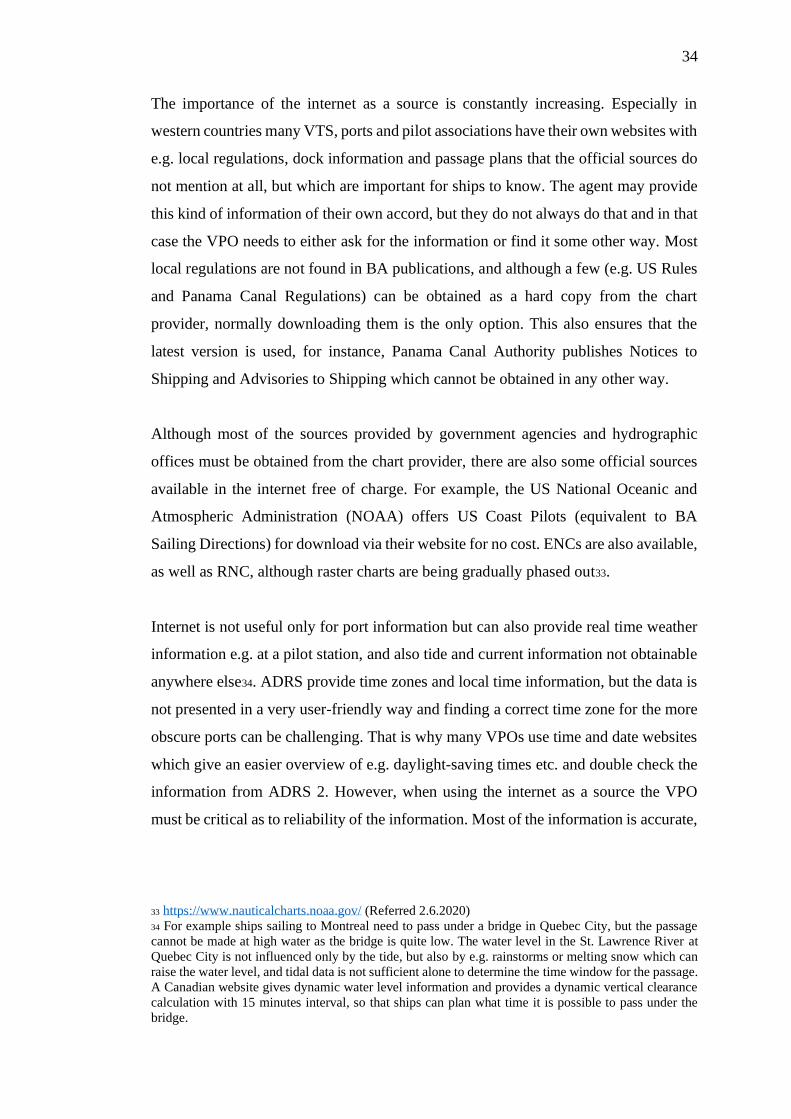
satellite images and provide a bathymetric chart both in a printable form and as an
unofficial ENC cell. The bathymetric chart includes nothing but water depths, there
are no land features, aids to navigation or place names. However, the quality of data is
very high with much more accurate and dense depth information than on a regular
chart.
Official ARCS (the best scale available 1:350000) Unofficial ENC from satellite derived bathymetry
Figure 3. Charts for Utheemu, Maldives
Checking the chart coverage alone is not sufficient, also the quality of chart data must
be assessed. The Zone of Confidence (ZOC) or a source diagram needs to be checked,
as they give a good indication on the quality of the survey the chart is based on. ZOC
is also required for safety depth calculations later on. Even when the compilation scale
is acceptable (magnification ratio of x2 or less) the chart may be based on old surveys
with unknown or imprecise datum. Such areas are not compatible with satellite
navigation and when interrogating the ECDIS a warning comes up alerting the user
that positions in the region are estimated to lie within several hundred meters of
WGS84 datum. Any datum mismatch and GNSS error areas must be identified before
starting the planning phase.
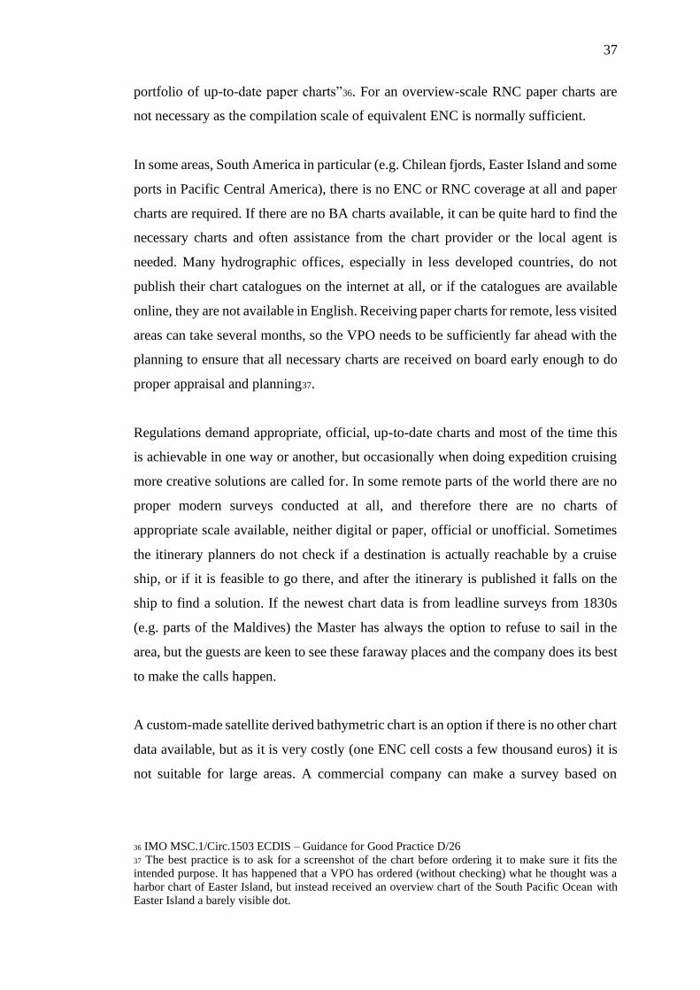
Sometimes the ENC coverage for an area seems fine with acceptable compilation scale
and ZOC, but when the ship arrives to the area the charts do not match reality at all.
This is the case for example in the Amazon River where the river’s course is constantly
changing creating new islands and shallows eroding old ones away. The official ENCs
cannot keep up with the changes, and the pilot will bring a set of corrected local paper
charts with him when he arrives onboard. These charts are property of the Brazilian
39
government and cannot be obtained beforehand, so the route will be planned on the
ENCs the ship has but executed according to the pilots’ advice. The bridge team has
access to the Brazilian charts during the passage, and they are used for monitoring the
ship’s position.
Figure 4. Official ENC for the Amazon River. The brown line is the past track the
ship has sailed, seemingly passing over land.
3.2.2 Generation of track
Although the track should be made only after a full appraisal has been conducted, a
preliminary track is generated at this stage to see approximately where it is going to
pass. This helps to pinpoint for example the applicable reporting schemes, relevant
pilot books or the pilot boarding ground if there are several. Sometimes cruise ships
are required to use pilot boarding ground for deep draft vessels, and this can make a
difference in STM. The official PBG can differ from the actual one, but usually the
agent is able to provide the information. It is uncommon that PBG information in BA
publications or ENCs is incorrect, but it is not unheard of and comparing different
sources of information usually allows the VPO to identify the correct position38. Pilot
boarding by helicopter is not preferred for safety reasons but can be done if there is no
other option.
38 For example in Male, Maldives, one PBG was discontinued as it would have required a passage
through a strait with dangerous currents, and later on a bridge was built across the strait impeding the
passage. The incorrect PBG was still shown in BA ENCs two years after the construction started. In
Madang, PNG, the PBG was on dry land according to ADRS 6.

40
At this point there is usually no berth information available yet, and if the port has
multiple berths the VPO needs to make an educated guess as where the ship is going
to dock in order to be able to prepare a plan from berth to berth without needing to
make a lot of changes later. Some ports publish shipping schedules with berth
information a few months ahead, for other ports MIN or Findaport can give guidance
which berth can be expected. The berth is usually confirmed well in advance before
the scheduled call, but there can be last minute changes and the VPO needs to take a
look at different alternatives to see where it is possible to dock, or if anchoring must
be considered.
The safety depth calculations and UKC are finalized in the planning stage, but some
safety depth parameters need to be inserted in the ECDIS to give an overview of
navigable waters along the intended track. Normally the deep-water contour settings
do not vary greatly on one ship as the calculations are generally based on worst case
scenario, and these settings can be used for the preliminary track, which gives the VPO
an indication if there are any possible problems with the UKC expected.
3.2.3 Publications and local regulations
Charts do not contain all available information about an area and Sailing Directions,
or equivalent pilot books supplement the charts by going into more detail. BA pilot
books often give recommended tracks for coastal navigation, but this information must
again be double checked since occasionally the SDs give recommended routes through
areas that are navigable, but nonetheless prohibited for foreign vessels. E-NPs are not
very user friendly and finding the relevant information is time-consuming, but
nevertheless it has to be done in order to prepare the voyage plan.
Routeing charts and ADRS can also provide information on recommended routes and
possible limitations. Reporting requirements, including security reporting, are checked
to see if there are any mandatory schemes that must be followed. ADRS is normally
sufficient, but some reporting requirements are not mentioned in official publications,
such as Northern Right Whale reporting in Gulf of Maine area, requiring the ships to

41
report all sightings of Northern Right Whales in the area. Information from the agent
is used to supplement ADRS, as the information in ADRS can be incorrect particularly
for small ports located in remote parts of the world.
Not all relevant information is found in publications and therefore local regulations
may need to be obtained some other way, either via the agent or more often by
downloading from the internet. Mostly the local regulations deal with the conduct of
the vessel, but they may also impose certain technical standards and sometimes ships
are required to install for instance extra signaling lights in order to comply. Checking
the regulations at the early stage of appraisal gives enough time to order and install the
needed equipment, as it is not always part of the standard set up and thus not installed
originally in the shipyard. 39
3.2.4 Environmental conditions
Weather and current information can be obtained from several sources, but SDs give
normally a good overview of expected conditions in the area. HAG uses two shore-
side meteorological service providers: American WRI and Norwegian StormGeo.
WRI has an extensive website with a lot of information including daily weather for all
ports of call no matter how remote, BVS is StormGeo’s weather program used on the
bridge for daily work. It provides detailed information a few days ahead, and it can be
used also for route optimization in case of heavy weather, and for calculations to
prevent parametric rolling. In the SDs there are notes on currents in straits and around
islands, and sometimes this kind of information can also be included in the material
received from the agent. For example, the Japanese Coast Guard publishes a document
called “Maritime Safety Information”, which contains not only local regulations and
information about reporting and pilotage, but also information about the weather and
sea conditions around Japan.
39 Cruise ships passing through Panama Canal are required to show a fixed blue light in the mast during
dark hours to indicate that they are so called “preferred vessel”. In Japan any ship longer than 200m is
considered a “Huge Vessel” and when sailing in certain areas, such as Seto Inland Sea or Tokyo Bay,
the ship is required to display at day time two cylinders placed vertically on top of each other and at
night an all-round green light flashing at regular intervals defined in the regulations.
42
If the ship is planning to sail in Polar areas, Alaska or Chile, information on the extent
and type of ice in the vicinity of the intended route is looked for, but it is not always
possible to obtain. Statistical information can give an indication on expected
conditions, but the current ice information must be checked closer to the actual cruise.
In the North Atlantic Polar areas ships use BarentsWatch-service where ice and
weather information, along with safety related information, is gathered in one place.
None of the HAG ships has an ice class, and their ice navigation is based on avoiding
ice. In Antarctica an ice pilot is normally used, i.e. an experienced master who has
worked in Antarctica for a long time and has practical experience of navigating in the
area and knowledge of expected conditions.
Tidal information comes mostly from ATT, but if local tide tables are available online
or as a separate program (such as AusTides for Australia or Tides&Currents for US)
they are often used, since they tend to be more accurate and have more data than ATT.
Sometimes the agent can provide a copy of the local tide tables. In British waters and
St. Lawrence River local tidal atlases are useful to determine the expected tidal streams
during the sea passage or approach, also some ECDIS models can incorporate tidal
information. Tidal graphs for the ports of call are checked quite early in the planning
process to ensure that there is enough UKC for the planned time of the call and to find
out if there is a tidal window that will restrict the entry into the port. Occasionally
neither the itinerary planning department nor the port has realized that the port is too
shallow for the ship and the earlier the VPO is able to warn them about the conflict,
the easier it is to find an alternative port of call or adjust the itinerary.
3.2.5 Protection of marine environment
The environmental schedule is made at a later stage, but an overview of the regulations
in the area must be clear already at the appraisal phase. For many discharges Carnival
Corporation has more stringent limits than MARPOL, but in some areas, such as Great
Barrier Reef, the local regulations are used even if they are less strict that Corporation
rules. If a country claims an archipelagic baseline and the ship is expected to be inside
for five days, it is clear even without any detailed plan that problems can be expected,

43
and that they need to be addressed as soon as possible in case a change in itinerary or
schedule is necessary to ensure compliance with the regulations. The VPO will consult
the EO if there is any ambiguities, and if the EO cannot answer the question, they will
contact the office. When a preliminary track is made the environmental limits are
drawn in ECDIS as User Chart Objects (UCO) to visualize the effect of the
environmental limitations. Often the track can be adjusted to stay outside for a longer
period without affecting the speed required. If the neighboring countries are close to
each other and have different environmental regulations, it must be clearly marked.
For example Indonesia allows permeate40 to be discharged 4NM from shore, but one
of its neighbors, Timor-Leste, has not published any regulations and to be on the safe
side all overboards are kept closed inside 12NM when in Timor-Leste waters. This
means that when the ship crosses the border between Indonesia and Timor-Leste all
discharges are stopped although the ship is more than 4NM from shore and outside the
MARPOL 3NM limit.
Stability data is not a concern at this stage, but all areas suitable for ballast water
exchange (>50NM or >200NM) must be identified. Some countries prohibit even
clean ballast discharge without ballast water treatment system (BWTS) within 12NM
and the VPO needs to be aware of this especially if their vessel uses ballast water
regularly for stability reasons. Closer to the actual cruise, when the voyage plan has
been finalized and the environmental schedule is made, the VPO will discuss stability
requirements with the Staff Captain, Chief Engineer, EO and the Stability Officer, and
the C/E will inform the rest of the team of planned bunkering ports and amounts. If the
VPO can see that there may be an issue for wastewater storage, e.g. due to an overnight
or archipelagic baseline, they will inform the Stability Officer normally a couple of
weeks before the cruise, so that the Stability Officer has time to make a pre-plan.
Wastewater issues usually require limits to production and consumption of fresh water
and may affect the amount of bunker that can be loaded.
40 Advanced Wastewater Treatment System (AWWTS) is an on-board grey water and sewage treatment
system, which produces purified water called permeate. In most countries the discharge requirements
for permeate and grey water are identical, although permeate is practically fresh water. Therefore some
countries, like Canada and New Zealand, allow permeate discharge 24/7 even when the ship is
alongside.
44
3.2.6 Contingency plans and speed schedule
Contingency plans are considered for the sea passage during appraisal, for arrivals and
departures more detailed contingency plans are made later. Authorities responsible for
search and rescue are identified and their contact details are made available to the
bridge team. In more remote parts of the world there is a possibility that only assistance
available will be other ships sailing in the area, who are not equipped to help a couple
of thousand people. In polar code areas the ship must be prepared to be on her own for
five days. MSC Circular1184 suggests voyage pairing, but this is not actively used at
least on HAL ships.
Although the track is not finalized yet, a preliminary speed schedule is made at this
point to make sure that the voyage is achievable without too low or too high speed
required, at the same time giving the ship enough time outside the environmental limits
for discharges. The company publishes a so called ICN (Itinerary Condition
Notification) schedule with official arrival and departure times including miles,
required speeds and fuel consumption. This schedule is never accurate and the VPO
must compare it with their own calculations quite early on to identify possible
challenges. Especially if the ICN schedule shows very low or high STM it is likely
that some kind of adjustment of either the route or the time schedule will be necessary.
If the ship is planning for an area with varied emission restrictions the Chief Engineer
usually needs a preliminary speed schedule several months before, with approximate
distances inside and outside of different emission areas and speed limits, to be able to
plan consumption for different types of bunkers41.
41 For example a Western Alaska cruise from San Francisco will sail both in and out of ECA zone,
inside the Californian 24NM limit, passing several marine sanctuaries and whale waters with a speed
limit. In practice for part of the cruise HFO with 3.5% sulphur content could be used (prior to the global
sulphur cap), other areas allow HFO with scrubbers with EGCS discharge pH of 4, in some areas
scrubbers are allowed, but the pH must be over 6, and some areas require MGO to be used. Depending
on the ports of call there can be two route options between ports. The VPO needs to make preliminary
calculations for all the alternative routes since STM and the distance and time spent in various emission
areas vary greatly and affect bunker planning.
45
3.3 Planning
The second part of Appraisal and planning checklist deals with planning. The planning
checklist for departure and arrival includes two items that will be part of
departure/arrival briefings and BRM and are not considered at this point: engine
configuration and reference of changing steering mode position. The engine
configuration for arrivals and departures is mostly standard, on diesel-electric vessels
often two or three engines, and if there are any exceptions, they are discussed during
the BRM. The navigator (person doing the maneuvering) will inform the bridge team
during the briefing when they intend to change to wing/center console.
3.3.1 Finalizing the track
A preliminary track is made already during the appraisal stage, but after all the
necessary information has been gathered the track is finalized. Waypoints are edited
and radius is selected bearing in mind speed required for the leg. Even if speed required
is not very high, large radius is preferred for sea passage to minimize the rate of turn
and heeling during turns, cruise ships generally prefer to keep the ROT under ten
degrees or less. If STM is very low, then the radius can be reduced to avoid the turn
taking too long. In confined waters, especially in ports and on approaches, the radius
is less than a mile, normally 0,5NM since the speed will be low and the ship will be
sailing in hand steering.
If there are no ENC or RNC available and the ship needs to use paper charts the
planning must be done on those charts and the waypoints transferred to ECDIS. In
many areas without ENCs the paper charts are old and not WGS-84 compatible. If the
chart has a known datum, there is often a note telling the user how to convert positions
on the chart to WGS-84. Sometimes the chart is so old that the datum cannot be
determined and there is no way to tell what the difference is compared to WGS-84. In
this case the off-track function in ECDIS will not give any indication if the ship is
sailing in safe waters and the watchkeepers will need to rely on PI lines and plot the
positions by visual or radar bearings.

46
Route Safety Corridor for each leg must be established for route checking, the safety
corridor will also be used for route monitoring later on. How the corridor is done
depends on the model of the ECDIS on board. The older NACOS systems allow only
a symmetric track limit to be set and the route check is done on wider limits, which
are then changed to actual track limits after the track is approved. Newer systems and
other manufactures allow separate safety corridor and track limit, with different values
on port and starboard. The safety corridor must be wide enough that all possible
dangers are detected even if the ship is forced to deviate from the track e.g. for collision
avoidance. In certain parts of the world, specifically in Asia, traffic density is high and
quite large deviations can be expected.
In NACOS systems waypoint and track notes are added after the track is finished.
Waypoint notes are reminders to the watchkeepers for example for manning change,
environmental limits, reporting, speed limit or expected reduced UKC. Track notes are
more general, and they do not vary much from cruise to cruise. The most important
information in track notes is the chart coverage, if there is no full ENC coverage then
the applicable ARCS/paper chart numbers are listed in the track notes for the
watchkeepers’ reference. Otherwise the track notes mainly lists things that the
watchkeepers need to pay attention to (such as safety contours, reporting,
environmental limits and gangway) and refers to the appropriate document, e.g. HESS-
MS or the voyage portfolio. Not all EDCIS manufactures use waypoint and track notes,
for example on Furuno ships the notes need to be added to the voyage & port notes.
During the planning the VPO will run preliminary route checks every once in a while
to make sure that they have not missed any ECDIS provided information, but the final
checks are made after the route is finalized and the safety depth calculation are done.
During the appraisal and planning stages the VPO must ensure that adequate UKC is
maintained. If the reliability of the surveys is unknown or there are other concerns
about the actual depth, an additional safety margin is considered.
Sometimes there are two alternative routes for a voyage, for example one that might
be preferable, but which might not be usable due to weather or other environmental
conditions at the time of the actual cruise. If there is more than one option the VPO
will make full voyage plan for all the alternatives, and the track used will be chosen
47
closer to the departure date.42. The VPO needs to calculate all possible options and
make sure that the voyage plan is finalized for all of them. For example weather
forecast and whale sighting reports are monitored closer to the departure date, and all
the information gathered together with the voyage plan will support the Master’s
decision when choosing the route to take.
When there are no more changes expected to the track the VPO will run a final route
check with settings recommended by the Carnival Corporation and using the
calculated ECDIS safety settings. If the ECDIS model allows the safety settings to be
linked to each waypoint only one route check is required, but at least in older ECDIS
where the user has to change the settings manually, the check must be run with every
separate set of safety settings. After the tracks are finalized, they are converted to
different formats used by programs other than ECDIS. For example all routes must be
downloaded into the weather program, but it cannot read the ECDIS format, also
navigation applications such as iSailor or pilots’ PPU need a different format.
3.3.2 Safety depth calculations
Voyage planning policy provides a UKC Computation Form (see Appendix 2) that
needs to be filled in taking every leg into consideration, and it must be used to
determine the ECDIS safety depth settings. The voyage must be developed in at least
three sections: departure, sea passage, arrival, but if necessary, the voyage can be
divided into several sections in the safety depth calculation. For example the approach
to Panama Canal would be considered open water, but in the canal itself shallow water
contours would be used with a change back to open water contours on the other side.
42 For instance, there are two route alternatives for Charlottetown P.E.I. to Quebec City, going east and
west of Prince Edward Island. The western route is shorter, but the Northumberland Strait between the
island and the mainland is quite shallow and restricted not allowing passage at full speed, and there is a
wind speed limit for passing under the Confederation Bridge. During the lobster season the ship needs
to follow the recommended (longer) route, and restricted visibility may pose a problem in the strait.
Also, after clearing the strait the ship will need to sail 150NM at 10 knots due to the whale water
restrictions, increasing the STM after whale waters to 20kn. The eastern route is much longer, but the
ship has to sail only 25NM in the static speed restriction zone allowing lower overall STM. However,
most of the track will pass through the dynamic speed restriction zones, and if the Canadian authorities
decide to close the dynamic sectors when the ship is passing through, the ship will not be able to make
the ETA to Quebec and might need to cancel the call altogether.
48
Sometimes the sea passage needs to be separated into coastal waters and deep waters
with different contours.
The calculation is always done using the maximum draft, usually maximum speed is
also used even on slow speed runs to accommodate for any possible changes in
schedule due to weather or emergencies. Water density and potential heeling angles
are estimated. For tidal ports the lowest astronomical tide value is used to make sure
that the ship can sail in and out even if arrival or departure times change unexpectedly.
In shallow ports with several meters of tide this is not always doable, and then the
lowest possible tide value is used for calculations with a note in the voyage plan about
the tidal window. The VPO checks manually the route to find out the shallowest
charted depth and lowest ZOC. There is an option not to apply the ZOC, but this is
used only if the minimum UKC is not achieved otherwise and it is known to be safe to
disregard the extra safety margin given by ZOC calculation.
The safety depth calculation will result in safety parameters to be inserted in the
ECDIS, and it will indicate if minimum UKC is achieved or not. If it is not, then the
plan must be adjusted. Often reducing speed will be enough as long as it does not affect
the schedule, also adjusting the tide value can give the needed extra margin. Often in
ports where the ship calls regularly and the past experience tells that the water depth
is sufficient the ZOC can be disregarded, same as in the US where the charts often
have only U as ZOC. If there is no other way to comply with the minimum UKC then
a risk assessment has to be conducted (see Appendix 3). The first draft is made by the
VPO listing measures that are to be in place when entering the port, the Master includes
his comments and last the company will check the assessment and supplement it if
necessary.
3.3.3 Speed schedule and tidal windows
To make sure that the track is doable timewise a final speed schedule is made with
ETD, CSV, time at sea, ESV and ETA to berth, including notes on clock/date changes
and different route alternatives, also possible speed limit areas are taken into
consideration (see Appendix 4). Sometimes the maneuvering characteristics of the
49
vessel or proximity of navigational hazard will impose restrictions on what can be
considered safe speed and speed reductions must be taken into consideration in the
speed schedule. High speed runs should be avoided in areas known for marine mammal
activity even if there is no official speed limit43. Although the ICN schedules received
from the office include average speed the schedules are known to be incorrect and after
doing their own calculation the VPO can find STM over or on the upper limit of ship’s
maximum speed in which case departure and/or arrival times may need to be adjusted.
A detailed calculation is made including e.g. ETA to each waypoint, track distance,
course, ROT and planned speed. This can be done either on the ECDIS if the system
allows it, or on a separate spreadsheet (see an example in Appendix 5), and it will be
used as basis for environmental, WTD and BRM schedules. How detailed the speed
schedule and voyage plan are depends partly on how user-friendly the ECDIS is. Some
models, such as Transas, allow the VPO to adjust calculations and include parameters
to suit the vessel’s needs reducing necessity to make separate spreadsheets44.
If there is any concern that the time outside environmental limits is not enough for
discharges the VPO tries to amend the track or speed schedule to accommodate for
that and presents the options to the Master. Sometimes the arrival/departure times need
to be changed to make sure that there is enough storage available for wastewater, or
initial STM is increased allowing the ship to stay outside longer to be able to finish
discharges. After all the tracks and the speed schedules have been finalized the Master
will review and approve them providing his input, and after that the VPO will finalize
the planning.
Tides and currents were checked at the appraisal stage, and after the route and the
speed schedule are finalized, they are reviewed again to find out the expected
conditions and make sure that the ship will be able to pass critical points. Some narrow
43 HESS-MS Marin Mammal Avoidance
44 Some Transas ECDIS models allow the user to link safety contour settings to all waypoints. This
enables the ECDIS to change contour settings automatically when passing the waypoint (giving the user
an alert that the contours are going to be changed). Speed limits can be entered by the user to be taken
into account in the calculations. The user can freely enter ETA/ETD for any waypoint, also time spent
at a waypoint, e.g. in a lock, resulting the speed calculation giving ETA to every waypoint making a
separate spreadsheet unnecessary.
50
passages, such as Seymour Narrows in Western Canada or China Strait in Papua New
Guinea, have very strong tidal streams and it is not advisable, or even possible, to pass
through during unfavorable conditions. Sometimes a higher initial speed is required to
arrive at a strait before the current gets too strong, but detailed calculation must be
done to make sure that speed does not affect for example environmental discharges
negatively. The VPO will make a few calculations using different speeds to give the
Master a time window when the critical point can be passed, and to show how it will
affect STM. There have been cases where the tidal streams have been miscalculated
for example in Pentland Firth, resulting in incidents and near-miss situations when the
ship has found herself in dangerous conditions.
Lower speed is preferred due to bunker consumption, but if there is an alternative of a
longer route versus a shorter one with initial high speed to reach a critical point at a
certain time with a low speed required afterwards, it can be quite a puzzle for the VPO
to provide the Master with all information to support his decision making. For example
a passage from Portree, Isle of Skye to Kirkwall, Orkney Islands has two route
alternatives: southern via Pentland Firth or northern via Fair Isle Channel. The speed
required for the northern route is 19,7kn, for the southern route it is 15,4kn. However,
if the tidal window in Pentland Firth is unfavorable the ship would need to make for
example 21kn to reach the western entrance in time and a minimum 19kn to pass
through the strait with a speed required of 6kn afterwards, maybe a bit more if she
needs to go outside 12NM for discharges45. The tidal window for Pentland Firth,
weather, bunker consumption and tidal streams for the whole passage need to be
considered and calculated in order to reach a decision that is safe and most efficient.
45 As an example HAL ship m/s Rotterdam could make the northern route with three engines, dropping
down to two after passing the Fair Isle Channel, depending on the strength and direction of tidal streams.
For the southern route she would need four engines initially, dropping down to three at some point
before Pentland Firth and running on two engines after the firth. In one case the decision was made to
take the northern route although the currents north of Orkney were unfavorable as the difference in fuel
consumption was not that big and the passage through the firth would have meant increasing the
manning level to yellow in the middle of the night.
51
3.3.4 User Chart Objects
Environmental limits are marked on the ECDIS already at the appraisal stage, but other
essential UCOs are drawn after the track is finalized. Depending on the sailing area
this job can take quite some time. At least one parallel index (PI) is drawn for every
leg if possible, except for very short or very long ones, clearing bearings and dead
range are added when applicable. Same is done on paper charts if they are in use. Any
other notes deemed necessary are added, e.g. if the discharge requirements in a port
differ from the general requirements in the area a note on the ECDIS is good to have
in addition to a waypoint note, a remark in the Voyage & Port Notes and the
environmental schedule. Excessive clutter on the ECDIS should be avoided, and non-
vital information is added to the voyage portfolio only, but any hazards not clearly
visible on the ECDIS must be marked.
Own safety lines are added if needed. Usually the safety contour is used as the default
alarm when crossing into unsafe water and in fairly deep waters crossing the safety
contour is normally not necessary. Some countries make ENC cells with the depth
contour interval of one meter, and in these areas it is easy to configure the ECDIS
without crossing the safety contour. The safety depth calculations have been done
earlier and at this point the method for crossing the safety contour is chosen depending
on the Master’s preference and the make of the ECDIS, all ECDIS models do not allow
the safety contour set lower than the safety depth. Method 1 is normally the preferred
way to configure the ECDIS. If crossing a safety contour is necessary then own safety
lines are drawn around dangers within the safety contour, i.e. around the safety depth
soundings. In Method 2 the safety contour value is less than the safety depth and own
safety lines must be drawn around all safety depths in the area, isolated danger symbols
are not shown. Some Masters prefer to sail in “white water”, i.e. not crossing the safety
contour, and in shallow areas this means that the safety depth calculations must be
adjusted if the ECDIS does not allow Method 2 to be used. If planning is done on
RNCs the ECDIS safety settings do not apply.
Contingency plans for approaches are considered at this stage taking into account
ship’s maneuvering characteristics. If the approach is shallow and high swell can be

52
expected the stabilizers cannot be used, and an assessment must be made if it possible
to board the pilot in actual sea conditions.
Cruise ships have a large windage area, which can become an issue when approaching
a port with a narrow fairway or limited room for maneuvering, especially as in many
small ports there are no tugs available. The VPO must calculate maximum swept path
for all narrow channels and fairways and make a note of the maximum drift angle on
the ECDIS to function as decision support on the approach/departure. The commit
point must be marked on the ECDIS including drawing the track for abort maneuver
with radius and final safe heading, taking into account tactical diameter, advance and
transfer. Contingency anchorage is marked; if there is no contingency anchorage
available anywhere near the port then a note will be made in the Voyage & Port Notes.
No-go limits are marked if not clear otherwise, and speed range, planned navigable
corridor, reserve, passing distances, swept path and stopping distance are considered.
Turning circle is drawn as a UCO with a note of its diameter. Often also distances
between breakwaters or piers are marked for quick reference.
3.3.5 Alarm management
To be able to utilize the safety features of ECDIS the chart alarms must be activated.
SMS policies for voyage planning and INS require efficient alarm management and
the alarm management checklist is to be filled out as part of the voyage plan (see an
example in Appendix 6, the format of the checklist depends on the make and model of
the ECDIS and can vary quite a lot depending on what kind of alarm groups are
available in INS). The alarm settings are changed at same waypoint as ECDIS safety
contour settings, so mostly there are three set of alarm settings: departure, sea passage
and arrival.
First the look-ahead sector is defined. The width is given in either meters or nautical
miles and depends on how confined waters the ship is passing. The length of the sector
can be either in nautical miles or time, although time is the preferred setting as it works
on any speed and if STM is radically changed due to any reason, the bridge team does
not need to adjust the length manually. In some ECDIS models the user can choose if
53
the alarms are on track or ahead; choosing track will check only along the track, the
ahead function will use the look-ahead sector which will work also if the ship deviates
from the track. In most ECDIS models the user can choose which chart alarms they
want activated, and in Special Areas also which types of areas will generate an alarm.
Alarm management is needed to ensure that the alarm system supports the operator
instead of causing distraction. A minimum speed can be selected in order to avoid too
many alarms while maneuvering. When configuring the look-ahead sector it is best
practice not to be excessive. Depending on the manning level there are four to seven
persons in the bridge team and the alarms are not there to warn the bridge team of
dangers they are aware of, but as a safety net to catch a mistake nobody noticed. On
NACOS ships the alarms are usually activated only on the ECDIS, not on Multipilots,
to avoid too many alarms and warnings. The alarm management includes also the echo
sounder alarm. Alarm settings other than safety contours can be changed at OOW’s
discretion if so required.
3.3.6 Reporting requirements
Ships have to submit various reports to different government agencies, ports and pilots.
Many of the reports do not concern the VPO (such as immigration or health
declaration), and on cruise ships there is a dedicated Port Paper Officer (PPO) who is
responsible for ensuring that the reporting regulations are met. The VPO is still
responsible for pure navigation-related reports, such as notices to pilots or traffic
controls, but some of the reports overlap and the VPO needs to either assist the PPO
or coordinate with them the responsibilities. For example Canadian PAIR and
ECAREG46 reports are taken care of by the team navigation, whereas somewhat
similar pre-arrival report to Singapore is done by the PPO with input from the VPO.
46 Pre-Arrival Information Reporting form is sent to Transport Canada 96h before entering Canadian
waters and is similar to pre-arrival reports in other countries. ECAREG (Eastern Canada Vessel Traffic
Services Zone) Report is sent e.g. minimum 24h before entering the area/departing from berth, and
before departure/after arrival and on other specified conditions.
54
Some reports are only a call on VHF when passing a VTS reporting point, though there
might be several calling points with different channels and some traffic controls ask
for a lot of details such as bunker figures. Sometimes the report can be an email with
a few words, but more often than not either a specific spreadsheet, sometimes several
pages long, has to be used, or the report must be in a certain format. In many countries
the authorities do not communicate with each other and the ship will need to send the
same information to several places. The timeline for reporting, such as notices to pilots,
varies from 1h to 48hrs. The ship may need to send up to five different reports a day
and missing a report can have consequences, ranging from delayed pilot embarkation
to the local authorities prohibiting the passage. As part of the voyage plan a reporting
matrix is prepared with templates for separate reports making it easier for the bridge
team to follow up on reporting requirements that need to be done as part of
watchkeeping. Mostly the information required is quite basic, but occasionally the
VPO needs to answer questions on the color and mark of the funnel (Hainan Strait,
China) or the bilge-keel radius (Panama Canal), and security related reports usually
ask for a sailing plan with at least a few waypoints. Some ports require the ship to send
in a Vessel Arrival Information Sheet (VAIS) with e.g. ship’s particulars, bollard SWL
and type of mooring lines. This is common for ports with challenging swell or tidal
conditions where ships are required to use shore tension system, or where the pilots
need to calculate dynamic draft to see whether the vessel can enter.
Many of the fees the ship has to pay are based on number of people onboard, GT or
such, but if the fee is even partly based on the area the ship is sailing in (as in Fiordland,
New Zealand), the VPO must fill in a report to the responsible authority as soon as
possible after the passage to inform them which areas the ship has sailed through. If
any report needs to be sent immediately after the ship has exited the area, the VPO will
prepare a draft and makes a note in the voyage plan so that the watchkeepers know
they will need to fill in the report.
3.3.7 Berth information and docking plan
Docking plan is made as far as possible and supplemented later if needed. If the berth
is confirmed and the ship has docked there before, old docking plans can be used

55
showing the bollard and line arrangements and the gangway position (see an example
in Appendix 7). Every time a ship visits a new port or docks at a new berth photos are
taken of mooring arrangements, and these photos are included in the docking plan with
a note of the stage of tide, so that when the ship comes back to the port the VPO can
with the help of the pictures and information included anticipate expected conditions.
In some places the port will make a docking plan, but it is not usually sent to the ship
until a couple of days before the call. If the ship has never visited the port before
docking plans from other ships can be downloaded from MIN to give an idea of what
is expected. The agents are often asked to send berth information (length, height, depth
at LW) including photos, also Google can help providing pictures. Mostly the material
received from the agent is relevant and accurate, but especially in ports that do not
have many cruise ship calls the information can be erroneous and the ship needs to be
prepared for unexpected challenges like not having enough bollards or the gangway
door being below the dock level.
Designated cruise ports often have a shoreside gangway or jetway available, but in
most places the ship has to use own gangway. Most cruise ships have shell doors for
gangways on three decks in addition to the boat deck, and some even have an
accommodation ladder, but some ships have shell doors only on two decks and if the
dock is high or the tidal range is several meters, this can become a problem. Even if
there is a shoreside gangway available, the gangway angle can become too steep for
passengers if the port cannot provide a setup to reduce it, such as a box or container,
and the gangway angle calculations for all stages of tide are part of the docking plan
(see Appendix 8). Ports are generally eager to assist the ship and try to provide a
gangway if the ship’s own gangway cannot be used, but there have been occasions
when the passengers have been tendered ashore although the ship has been alongside,
only because there was no solution to the gangway problem. It can take a couple of
months for the port to find a gangway, or build one, so the berth information has to be
checked early enough to find a solution in case issues are expected. In rare cases the
company has even considered cancelling the port if there is no guarantee that
passengers can go ashore.
Heavy loading is normally done on a turnaround day or in a major port, and if the port
knows that the tidal range will affect the times marshalling area or provision shell
56
doors are accessible, the agent will normally notify the ship of the timeframe the
loading is possible. Major ports are generally used to dealing with cruise ships and
there are seldom issues related to loading, the VPO just needs to check that the relevant
shell doors are reachable, e.g. they are next to the main pier and not a dolphin.
3.3.8 Second person check
As per HESS-MS policies the EO is required to review the environmental restrictions
in the voyage plan and when finalizing the voyage plan the VPO will go through the
planned route with the EO, who will check that the environmental lines are drawn on
the ECDIS and all relevant regulations are included in the plan. All environmental
restrictions must be appropriately displayed on the ECDIS as per HESS-MS
environmental policies. After the VPO is happy with the route, a second person,
normally the assistant navigation, will run both an electronic and visual route checks
on appropriate scale with correct display setting to confirm that the route is good and
fulfills all requirements. The VPO will double check the material the assistant
navigation has prepared, e.g. gangway angle calculations or that correct time zone is
used in the tidal chart/stream printouts.
3.3.9 Operational schedules
The voyage plan includes some information that is relevant not only for the bridge
team, but for various departments on board, and this information needs to be
disseminated in an easy-to-read format. Schedules are made for anticipated watertight
door (WTD) conditions and manning levels (see appendix 9). The times are naturally
only approximate, but the schedules will give the rest of the ship, in particular those
working below the water line, an idea when they can expect that the WTDs must
remain closed. The manning level schedule (so called BRM schedule) will give the
senior deck and technical officers a timeline when they are likely needed for increased
manning level, and it also gives the rest of the ship an indication on when the bridge
and ECR will be in closed condition and no calls other than in an emergency are
accepted. WTD condition and BRM level can be changed at any time if the OOW feels

57
it is required, but during a routine voyage the schedules are more or less followed. The
ECR can increase their manning level for instance if they encounter a problem with a
piece of equipment, but the bridge does not need to follow unless it is a question of
major malfunction. However, if the OOW decides to change the manning level,
generally the ECR will need to follow the bridge. This is quite common in areas with
restricted visibility where the bridge will go to yellow manning in case of fog.
WTD and BRM schedules are simple Excel spreadsheets that ships can modify as they
like, but the environmental schedule (ENV) is common for every Carnival Corporation
ship and the standard format must be used (see Appendix 10). Ships have itineraries
that vary greatly and the standard ENV schedule does not suit every ship, which makes
it labor intensive to create if the ship is not on a regular 7-day run. The ENV schedule
gives estimated times for crossing environmental zones and lists 14 discharges or
emissions showing if they are allowed or not within that particular zone. In addition to
discharge regulations any possible special areas or marine sanctuaries must be noted
with expected entry/exit times. There is one page per day and every page is signed by
the VPO and the EO after s/he has checked and approved the schedule. The ENV
schedule is relevant for deck and engine for planning where discharges can be made
and what is allowed.
One schedule unique to cruise ships is casino limits. Most countries allow the ship’s
casino to be open when the vessel is underway, but some countries prohibit casino
operations within their territorial waters. As a part of voyage plan the VPO needs to
make an approximate schedule when the ship is going to cross the limits, make a note
on ECDIS and discuss the plan it in detail with the casino staff especially if the casino
needs to be closed on a sea day. In Australia every state has different rules on casino
operations with limits ranging from 3 NM to 12NM, and the bridge team has to be
aware of when to give notices to the casino. During a coastal passage ship may need
to go in and out of casino limits several times, and the casino normally needs several
notices, both an hour before closing and when crossing the line, both by phone and
email.
58
3.3.10 Finalization of the plan
At the end of the planning phase the assistant navigation will assemble a document
called Voyage & Port Notes. There is no standard format and ships do what suits their
needs best, on some ships the document is several pages long, on others there is just
bare minimum (such as in an example in Appendix 11). The voyage and port notes
combine the most important information in an easy-to-read format, and any
information that is essential but is not included in any of the other documents will be
added to the voyage and port notes, such as requirements for tugs or escort vessels,
shore tension mooring or environmental expected conditions like swell or current in a
port etc. Emergency contact numbers for ports are listed, including the agent’s details,
firefighting, ambulance and law enforcement numbers if these exist or are known. The
voyage and port notes often summarize reporting requirements with applicable VHF
channels for quick reference for the bridge team, although these are also added as
printouts from ADRS 6. Information that is included in waypoint notes or UCOs can
be mentioned also in the voyage and port notes, such as speed limits or special hazards
to navigation.
The company voyage planning policy requires the VPO to put together a voyage
portfolio with all relevant information. In practice the voyage portfolio is most often a
binder kept on the bridge for easy access for watchkeepers, although some ships use a
digital portfolio in OneNote instead of printouts. The voyage portfolio contains47:
- Waypoint list including track information, ETAs and waypoint notes signed by
the VPO, assistant navigation, S/C and Master,
- Speed schedule,
- Safety depth calculations,
- Risk assessment if required,
- Alarm management,
- ENV, WTD and BRM schedules,
- Voyage and port notes,
- Track notes (on NACOS ships),
47 HESS-MS Voyage Support Portfolio
59
- Tide tables and current information. In the tidal graph the gangway position
must be marked, and if shifting the gangway is required the times must be
indicated (see Appendix 12),
- Docking plans including pictures of the port and mooring arrangements during
previous calls. Previous docking plans are also laminated and put in binders on
mooring decks for reference. If it is a new port and the ship does not have
docking plans yet, pictures from the agent, MIN or the internet are included.
- Voyage planning checklist signed by the VPO, the assistant navigation and the
EO for applicable parts,
- Printouts from ADRS, sometimes also from SDs,
- Local regulations
- Weekly AVCS Readme-file
- Any other information deemed necessary or of interest for watchkeepers.
After all planning is finalized, but before the actual cruise, the VPO must hold a voyage
overview meeting (VOM) with a minimum Master, Staff Captain, Chief Engineer and
EO attending, sometimes the Staff Chief Engineer and the Stability Officer will attend
also, on some ships the attendance of all deck and engine officers are required. VOM
is not a detailed BRM held for the bridge team, but a general overview of the whole
cruise concentrating on environmental aspects with environmental limits and
restrictions considered and agreed on with reference to STM and times outside/inside
environmental zones. Any other potential issues that need to be taken into account are
discussed. The Chief Engineer informs the team about expected bunkering, and
possible stability or wastewater storage issues are brought up. If there are any
complicated requirements due to e.g. fuel changeovers for ECA zones these are
discussed at VOM, but also a separate meeting for all OOWs and EOOWs is arranged
a day or two before the actual passage so that everybody will be on the same page on
what is going to be expected, and the VPO will provide both the bridge and ECR a
timeline when 1, 2, and 3 hour notices for the changeover are likely to be given.
A review of the route shall be conducted within 24 hours of the planned departure to
check any ENC updates, new navigational warnings and weather forecasts. At some
point during the day of departure the bridge team will have a BRM meeting to discuss
both the upcoming voyage and considerations for departure and arrival, such as

60
expected environmental conditions, maneuver, reserves, contingencies etc.48 When the
pilot comes on board a short departure briefing will be held so that the pilot can give
his input to the plan.
3.4 Execution
Execution of the voyage plan begins when the ship leaves the berth and continues until
the voyage is completed. According to IMO Guidelines for Voyage Planning “the
voyage or passage should be executed in accordance with the plan or any changes
made thereto”49. The track is to be followed as far as possible, deviation is allowed for
collision avoidance and weather-related reasons. The watchkeepers need to follow the
reporting matrix and ensure that all relevant reporting is done in time. Some reports
can be made at a later point of time and these reports are usually taken care of by team
navigation.
During the execution phase the bridge team should take into consideration the
reliability and condition of the vessel's navigational equipment. If any concerns are
experienced for example with gyro or GPS a more frequent position checking might
be in order using methods not relying only on satellite position fixing.
At departure ETA is set in the INS to enable the bridge team to monitor the speed
required and adjust the engine power to achieve it. Mostly the ETA is set for pilot
boarding position, but if the vessel has to pass a waypoint at a certain time due to tidal
conditions or regional speed limit, this waypoint is set as the ETA waypoint. For
example Kanmon Strait in Japan can be passed preferably with the current 2-4kn
against, and passage is not allowed with following current, so if the ship misses the
tidal window there will be several hours delay. In the planning stage the VPO has
48 In addition to voyage planning the team navigation has multiple other tasks including compiling a so-
called sunrise-sunset schedule. As the name says it lists calculated sunrise and sunset times for each day
for the vessel’s estimated position, and among other things the schedule is used in daily BRMs to
indicate if the approach and departure will be during daylight hours. If the port is unfamiliar to the team
and requires complex maneuvering it is preferable to arrive in daylight, and if ETA to pilot station is
close to sunrise the arrival time could be adjusted accordingly.
49 IMO Resolution A.893(21) – Guidelines for Voyage Planning 4.1
61
calculated required speeds both for the midway waypoint and the final pilot boarding
waypoint to make sure that it is possible for the ship to achieve speeds required.
The active route must be downloaded also in the weather program, which is also used
for daily position reports to the company. Weather forecasts are monitored constantly,
and if significant deterioration is expected action needs to be taken to ensure safe
passage while adhering to the schedule if possible. If restricted visibility is expected
the Master normally puts in his night orders a fog schedule, i.e. which of the senior
officers is to be called in case the bridge needs to increase the manning level due to
low visibility. If tropical storms or hurricanes are causing concern shoreside weather
routeing service is utilized, and the bridge team constantly monitors the track of the
storm. The Master shall consider “whether any particular circumstance … introduces
an unacceptable hazard to the safe conduct of the passage; and thus whether that
section of the passage should be attempted under the conditions prevailing or likely to
prevail”50. Occasionally a call is cancelled due to environmental conditions, and either
an alternative port is considered or the STM is adjusted to the next port of destination.
During the voyage planning process areas and points of concern have been identified,
such as areas with heavy traffic or adverse sea conditions, and the bridge team is made
aware where these can be expected and when increase in manning level or change of
engine configuration might be called for.
Environmental schedule is made at the planning stage identifying the times when
various discharges are allowed, or emissions and ballast operations are limited. Every
day the Stability Officer will make daily stability orders detailing which permeate or
sewage tanks are to be used and which ones must be discharged and in what sequence
and give instructions on any possible (de)ballasting and freshwater
production/consumption sequence. The stability orders are signed by the Staff Captain
and distributed to the bridge and ECR. During the execution phase the bridge team
must follow the stability orders and environmental schedule to make sure that stability
is maintained and required waste streams are discharged while the ship is complying
with environmental regulations. A minimum speed of 6kn is required for any discharge
50 IMO Resolution A.893(21) – Guidelines for Voyage Planning 4.3
62
when at sea, if the ship needs to slow down for any reason, the bridge watchkeepers
need to remind the ECR to close the discharges. The bridge is required to provide
sufficient notice to ECR before entering or existing areas with discharge or emission
restrictions. The minimum times are set in the Carnival Corporation SMS, but often
the bridge and ECR agree on giving even earlier notices.
During execution and monitoring phases circumstances may arise which may require
the voyage plan to be reviewed or altered. The voyage plan has taken into
consideration normal deviations from the planned route due to collision avoidance,
which in some parts of the world, especially in Asia, can be several miles off the track.
Unexpected events, such as a medical debark or technical failure, can cause a major
deviation requiring a new voyage plan to be made. If the VPO is not available, the
Master can appoint any deck officer to amend the voyage plan. The process is basically
the same. Most of the appraisal has been done already, but anything not included in
the original plan, e.g. reporting or port information for the alternative port, is checked.
After the track has been amended both an electronic and a visual route check are
carried out with appropriate ECDIS settings. The Master needs to sign the amended
plan to confirm that he has approved it.
3.5 Monitoring
Monitoring the ship’s progress along the pre-planned track is a continuous process and
the voyage plan must be available at all times on the bridge for the watchkeeping
officers to be able to check that the plan is followed. On Carnival Corporation ships
this is achieved by the voyage planning portfolio, which includes all the necessary
information from waypoint radii and safety parameters to reporting and expected
meteorological conditions. According to the IMO Guidelines the progress of the vessel
should be closely and continuously monitored and any changes to the plan must be
made according to the guidelines and clearly marked.
63
Carnival Corporation gives the minimum ECDIS settings for monitoring51:
- Look-ahead function and chart alarm set as appropriate, included in the VP
portfolio
- Visibility groups “Standard” plus spot soundings (shallow), submarine cables
and pipelines, all isolated dangers and miscellaneous (other). However, ships
normally choose to use more stringent settings with the visibility groups set to
“All” and ticking off the groups not applicable at the time, such as magnetic
variation.
- Shallow water danger “ON”
- Appropriate safety depth/contour for each stage
- Accuracy symbols “OFF”
- Scale dependent objects “Within effective scale”
- “Ignore scale minimum” deselected
- Date dependent object ”Within current date”
The bridge team must use all available means to monitor the ship’s progress and many
of these are included in the voyage plan. Wheel over points (WOP) and wheel over
lines (WOL) are generated when the radius for the turn is chosen. In most ECDIS
models the WOP is marked automatically, but in some models the WOL needs to be
drawn using UCOs. PIs are used whenever possible and they are drawn in the ECDIS,
sometimes also a note can be made in the waypoint notes. If there are appropriate radar
conspicuous reference targets available dead range can be used, usually for passages
in archipelagic waters. Also clearing bearings are useful, especially on approaches.
There are no rules which scale the radars or ECDIS must be on, this is left to the
watchkeepers’ discretion. However, the navigator and the co-navigator must use
different scales on their radars with the navigator usually monitoring the immediate
situation and the co-nav looking further ahead. Safety corridor and look-ahead sector
are decided already at the planning stage and included in the VP portfolio, depending
on the ECDIS model they can also be visually displayed on the ECDIS screen. Look-
ahead sector can be changed by the watchkeepers if deemed necessary.
51 HESS-MS ECDIS on Board Familiarization
64
Depending on the make of the INS the bridge team has various tools to help them with
monitoring, such as vectors, curved heading line and predictor. Chart underlay on the
radar can give indication if there is an issue with a sensor, but in areas where there is
a datum mismatch the operator needs to determine if the overlay mismatch is due to a
sensor error or the quality of the ENC. The operators must understand and
continuously evaluate the information provided by the system.
The watchkeepers are encouraged to develop a scanning pattern similar to airline
pilots, enabling them to pick up any signs of malfunction at earliest possible stage. All
faults do not trigger an alarm, and it is left to the watchkeepers to notice if something
is amiss, e.g. a rudder indicator not working correctly can be detected only by
comparing it to other indicators. Especially on older ships there might not be any
alarms for significant changes such as steering mode. On some ships it is possible to
accidentally change from trackpilot to hand steering without any alarms sounding, and
the only way for the watchkeepers to recognize this change immediately is to monitor
the Multipilot screen as the steering mode indication will change from “trackpilot” to
“off”.
Alarm management is an important part of watchkeeping, and many of the alarms are
related to either sensors, traffic or ECDIS therefore relating directly to voyage
planning and monitoring. Bridge Alert Management (BAM)52 distinguishes between
four alert priorities, all of which are not applicable to voyage monitoring, but more to
general watchkeeping duties. According to BAM the alert messages should be
completed with aids for decision-making as far as practicable.53 Every alert or alarm
has to be acknowledged and investigated to identify the cause.
Chart alarm and echo sounder settings are included in the voyage plan, also the points
where the settings need to be changed. Each watchkeeper chooses their preferred
collision warning alarm settings. Sometimes alarms can present a distraction while not
providing a relevant warning, and the bridge teams are allowed to mute or deactivate
52 IMO MSC 302.(87) Performance Standards for Bridge Alert Management
53 IMO Performance Standards for Bridge Alert Management MSC 302.(87) 8.1

65
the distracting alarms, but it can only be done by the Master’s approval and the whole
bridge team must be aware of which alarms are disabled.54 Often modifying the
threshold value is enough and the watchkeepers are allowed to do this if needed, e.g.
the echo sounder alarm for sea passage is usually set for deep water, and if the track
passes over an isolated shallow patch the alarm will go off. In this case the
watchkeepers will adjust the echo sounder alarm temporarily and change it back to the
original settings once past the shallow area. If there are larger areas with shallower
water, then usually the voyage plan will treat these as a separate section in the UKC
calculation form.
The INS has a built-in sensor monitor, which constantly compares sensors against each
other and alerts the user if the difference exceeds the threshold limit. IMO recommends
that officers should “undertake all available measures to check the position…such as
radar and visual observation methods”55. This is normally done by using lines of
position (LOP), mostly a radar bearing and distance, but two or more visual bearings
can also be used. In areas where there is no ENC or RNC coverage available and paper
charts are used for navigation, using LOPs in addition to other monitoring techniques
such as PIs is paramount as ECDIS alarms and safety settings are not applicable. When
sailing with paper charts the Carnival Corporation has laid down the minimum
requirements for position fixing: in restricted waters the position fix must be made, if
possible, every six minutes, in coastal waters every 12 minutes and in open waters
once an hour56.
Carnival Corporation requires that watchkeepers determine gyro error at least once a
watch, if it is not possible then a compass comparison must be made to ensure that
there is no creeping gyro error that goes undetected. When doing the gyro error also
the magnetic compass deviation is checked.
In addition to all electronic equipment checks the Carnival Corporation instructs the
watchkeepers to use also visual clues to monitor ships position, such as lighthouse
54 HESS-MS Integrated Navigation System
55 SN.1/Circ. 255Additional Guidance on Chart Datums and the Accuracy of Positions on Charts
56 HESS-MS Company Navigational and Watchkeeping Orders
66
characteristics. The Corporation standing orders requires the watchkeepers to inform
the Master if a lighthouse is spotted in an unexpected place or its characteristics do not
match what was expected57.
According to IMO Guidelines one of the objectives of a voyage plan is protection of
marine environment. Environmental considerations are part of the voyage plan, and
monitoring discharges ensures that the plan is followed. The watchkeepers must be
aware of which discharges are going overboard at any given time, and they need to
keep an eye on the integrated control and monitoring system to double check that the
ECR is doing the correct thing. Depending on the system the bridge team can see which
valves are open, and which tanks are being emptied or filled and at what rate, giving
them possibility to challenge the EOOW in case the actions do not seem to correspond
with what was discussed. If the ship has an energy efficiency optimization tool such
as Eniram, the watchkeepers need to monitor it and take action, e.g. (de)ballasting or
changing engine configuration, to keep it in green. Exact engine configuration for a
voyage cannot be pre-planned as it depends on several variables. STM gives an
approximate guidance, but in the end the configuration depends on which engines are
available, possible maintenance issues, environmental conditions, such as wind and
current, and delays or changes to ETA.
Although the watchkeepers are solely responsible for monitoring the ship’s progress,
occasionally there is another pair of eyes doing the same job. Every HAG operating
line has its own Fleet Operations Center (FOC), which gets live data from the bridge
and various equipment on board enabling the FOC operators to monitor where the ship
is sailing and what it is doing. They are able to see radar and ECDIS data on board, as
well as the electronic logbook and status board. If the bridge is equipped with CCTV
there is a possibility that the FOC gets also live feed from the camera. The main reason
for FOC’s existence is emergency preparedness. They are equipped to assist in various
ways if any of the ships is in distress, like taking over the job of contacting any shore-
side authorities or services allowing the vessel to concentrate on dealing with the
emergency. Once a day the Stability Officer sends a copy of loading condition to the
57 HESS-MS Company Navigational and Watchkeeping Orders
67
FOC, so that in case of an emergency they have stability data available and although
damaged stability support is outsourced to a specialized company, the FOC is also able
to provide advice and assist the vessel with stability calculations.
Since emergencies are rare monitoring the ships’ performance is part of their daily
duties. If FOC spots something that does not look quite right, they will contact the ship
and ask for clarification, for example they might recognize that wrong baseline has
been used for environmental lines.
Monitoring is mainly understood to include ship’s progress along the pre-planned track
and operational alarms, but at least on cruise ships the watchkeepers need to monitor
also the bridge email, although it cannot be considered a navigational instrument or an
alarm on operational conditions. Emails are naturally not checked during busy
navigational situations, but if the time allows the watchkeepers are advised to check if
there are any incoming messages that may affect the vessel’s voyage. Pilots and agents
can send information which requires the vessel to take action and amend their voyage
plan, usually adjusting the speed, but occasionally also changing the track.

68
4 SHORE-BASED VOYAGE PLANNING TODAY
Most of voyage planning today is still done onboard by deck officers. There are some
projects trying to engage the shoreside operations more in the process, but often it is a
question of ETA adjustments or efficiency, not a full-scale voyage plan. In the future
when the unmanned and autonomous vessels will start operating, all stages of voyage
planning from appraisal to monitoring are going to be done ashore or done by a
machine. Although there already has been test runs with autonomous vessels, they
have been short distances in a restricted area. The execution and monitoring phases
will be part of deck officers’ job description for many years to come, and it is likely
that the appraisal and planning stages are moved to shoreside before unmanned vessels
become a reality in large scale.
As of today there are no actors doing full-scale voyage planning shoreside, and it
would also be quite challenging to achieve. The first step has been taken in many
places around the world offering the seafarers ready-made passage plans for ports or
coastal areas. However, it is not a question of a full voyage plan with all the details
required, but a recommended track, sometimes with only waypoints and courses,
sometimes including more details. IMO Guidelines require the VPO to consider ship
specific data, but general passage plans are not able to accommodate this, although for
example in the Great Barrier Reef there are three versions of passage plans depending
on the vessel’s draft.
These kinds of port passage plans are common in Australia and New Zealand, where
many major ports publish them on their websites, for some ports it is possible to obtain
the plans via agent. They are a recommendation, not requirement, but even if the ship’s
plan would deviate from the port’s recommendation, the pilots will follow the local
plan. For example in Sydney, Australia, the passage plans are meant for cruise ships
only, although most likely the pilots use the same approach route for all vessels since
it is a question of a relatively long pilotage, and the route to the cruise ship terminals
will differentiate only in the far end of the harbor.
69
4.1 Fiordland, New Zealand
The Fiordland National Park is part of the Southland Region located in the southwest
of New Zealand’s South Island. Fiordland consists of several sounds and fjords in a
remote wilderness area with very little population. It is a popular travel destination and
cruise ships sailing in the area visit Milford Sound (a UNESCO World Heritage site,
which is actually a fjord), and if the time allows, they will transit one or two of the
other sounds for scenic cruising. The sounds are deep but narrow with tidal streams
and swell from the ocean adding to the challenge of navigating in the area. Weather
can be rainy and windy with winds gusting to over 70 knots even during the regular
cruise season from October to April. A pilot is required for all the sounds, but due to
the remoteness of the area there is only one pilot boarding ground in Milford Sound,
and the pilot will stay onboard for the whole duration of the Fiordland transit
(dis)embarking in Port Chalmers or Dunedin.
Environment Southland, which is the regional authority regulating maritime activity
in the area, requires cruise ships operating in the Southland Region waters either to
have a resource consent or they have to sign into the Deed of Agreement, which is the
norm. The Deed places environmental obligations on the companies including a zero-
discharge regime, and it includes regulations to manage the risks associated with ship
movements in enclosed waters, for example by limiting the number of cruise ships, so
that no more than two ships are in any passage or fjord at any one time.
Cruise ships sailing in Southland Region tend to be mid-size or expedition ships, as
the area is not suitable for large ships. Number of visits by cruise ships has increased
from 34 in 2006/2007 to 116 in 2018/2019, with 133 visits scheduled for 2019/2020
season. In the Milford Sound basin the local tour operators have 150+ scheduled
movements every day adding to the amount of traffic in confined waters58 with
kayakers and private boats on top of that. As there is very limited accommodation
available in Milford Sound, most visitors come for a day and due to long distance to
58 Cleaver, Lyndon
70
the nearest town, all the visitors tend to congregate during roughly the same hours
creating congestion.
In February 2017 cruise ship L’Austral struck a stony bank during entry to Milford
Sound narrowly avoiding significant damage to the vessel and environment. Although
the accident was mainly attributed to a lack of proper BRM, there were several
contributing factors, as usual. The New Zealand Transport Accident Investigation
Commission identified issues with planning, execution and monitoring stages of the
ship’s voyage plan. Although the track itself was similar to the Fiordland Pilotage
SOPs, the ECDIS was not configured properly, the ship was off the planned track, and
there was no agreement on reserve, i.e. how far off the track the ship would be allowed
to deviate. Key lessons include a note that “a ship’s passage plan is more than just the
planned track for the ship to follow. Every part of a ship’s voyage must be planned,
and all members of the bridge team be fully familiar with and agree to the plan. This
is a cornerstone of good bridge resource management”59. At the time of the accident it
was dark, and as there are no visual navigational aids in Milford Sound the ship was
solely relying on electronic navigation equipment. According to the TAIC “conducting
‘blind pilotage’ with large ships in confined waters represented risks that had not been
fully considered by Environment Southland”60. After the accident Environment
Southland has improved their safety management system for cruise ships, and as part
of that started to enforce their passage plans.
The passage plans were initially originated already in 2008 by both Environment
Southland and Maritime New Zealand, the maritime regulator in the country. The
actual passage plans were put together by experienced Southland pilots and pilot
auditors from Maritime New Zealand. Environment Southland has published Pilotage
Standard Operating Procedures, which include passage plans for all the sounds allowed
for cruise ship transit. The plans are available on their website, and the agents are
supposed to pass them onto the ships as part of local regulations. These general passage
plans are more extensive than government agency plans tend to be including not only
59 TAIC Final Report MO-2017-202 / 1.9
60 TAIC Final Report MO-2017-202 / 1.6

71
waypoints, courses and distances, but also WP radius, recommended speed, ROT, PIs,
WOPs with range/bearing, and waypoint notes. The pilots have their own Portable
Pilot Units (PPU) and the actual passage plan is agreed to during the master/pilot
exchange, but it is preferable if the ship’s voyage plan is identical to the pilot’s from
the beginning so that the whole bridge team has a shared mental model.
4.2 The Great Barrier Reef, Australia
The Great Barrier Reef (GBR) was the first ever Particularly Sensitive Sea Area
(PSSA) named by IMO, today also the adjacent Torres Strait and Coral Sea are
included. Sections of the reef are complex to navigate with confined waters and strong
tidal streams, and to help to protect the GBR a Designated Shipping Area (DSA) is
charted throughout the GBR, penalties apply to vessels that enter any other zone
outside the DSA. REEFVTS monitors 6000km of coastline. Traffic conditions in the
GBR area are generally light when compared to the major shipping routes in Asia and
Europe, the REEFVTS monitors over 11,250 vessel movements per year over the vast
area61. Parts of the GBR are remote, and subsequently VHF coverage is limited in
some areas. All vessels are required to set up their Inmarsat-C so that they can receive
messages from VTS for ship encounter information and maritime safety information.
The ships are required to send their general route plan in the pre-entry report. There
are no intermediate position reports required, as the vessels are continuously tracked
by radar, AIS and Automated Position Reports (APR) via Inmarsat-C, comparing this
data to the route plans provided by the vessels in their pre-entry report.
Since 2011 the Australian Maritime Safety Authority (AMSA) has published the 102-
page long document Queensland Coastal Passage Plan (QCPP), which covers the GBR
and Torres Strait area62. The purpose of the QCPP is to “improve pre-pilotage
communications between coastal pilotage providers, the vessels they service, and the
pilots embarked within these vessels. The QCPP improves the readiness of vessels
61 https://www.amsa.gov.au/safety-navigation/navigating-coastal-waters/great-barrier-reef-and-torres-
strait-vessel-traffic (Referred 27.6.2019)
62 Adams, Conrad
72
transiting coastal pilotage areas within the Great Barrier Reef and Torres Strait by
ensuring that voyage plans, waypoints and other planning considerations have been
completed in a standardized manner”63.
The coastal pilotage area does not cover the whole GBR and pilot is required only for
certain parts of the passage. Depending on the ship’s speed and route, the passage
through GBR can take up to 48 hours. Normally only one pilot will board for the whole
length of coastal pilotage, and pilots will routinely leave the bridge when the vessel is
transiting the less complex or less navigationally challenging areas. Even when the
pilot is on the bridge often the OOW will maintain the conn.
According to the Australian law the pilot must “prepare a detailed passage plan for the
pilotage of a ship that uses the approved passage plan model, specific to the ship being
piloted”64. The QCPP is this plan, and AMSA encourages the vessels to prepare their
voyage plans accordingly. Usually the pilot will contact the vessel a couple of weeks
prior to the transit and ask the vessel to forward their voyage plan so that it can be
checked beforehand. In places where there is more than one route alternative, the
QCPP gives three different options depending on the vessel’s draft: shallow (<7m),
moderate (7-10.5m) or deep (>10.5m). The passage plans include waypoints, courses,
distances and PIs, plus a couple clearing bearings for deep draft vessels. Torres Strait
has variable and complex tidal system, with large tidal range and streams up to eight
knots. Australian regulations permit vessels of up to 12.2m static draft to transit the
Torres Strait if they are maintaining the nominated UKC requirements. The UKC
management system predicting a vessel’s dynamic UKC in real time is in use, using
data from environmental sensors, and it is obligatory to all vessels with draft exceeding
8m.
Since the pilot is required to be on the bridge for certain sections only, the QCPP
includes instructions on points when the OOW should call the pilot, and usually the
pilot will ask these points to be marked on ECDIS. VTS entry/exit reporting points are
63 QCPP page 8
64 QCPP page 8

73
also marked in the QCPP planning chartlets. AMSA encourages vessels transiting any
of these coastal pilotage areas to consider the information contained within the QCPP
when preparing their voyage plans, and to ensure that the QCPP is available on the
bridge.
4.3 Norwegian Digital Route Service
Norwegian Coastal Administration (NCA) has a bit more ambitious project in the
testing phase. NCA has made reference routes covering ports and coastal passages in
southern and southwestern Norway, all of Norway should be included in the digital
route service in 2020. Reference routes are available for downloading free of charge,
and unlike other government-provided plans, which usually come in an Excel or PDF
format, the Norwegian reference routes are in RTZ format which can be loaded in the
ECDIS directly thus minimizing a chance of errors. NCA has used vessel dimensions
of 150m LOA and 9m draft for the routes, and turn radius of 0,1NM has been used on
most waypoints65. Due to these parameters the reference routes cannot be used directly
on larger vessels without amendments. There are also routes for large cruise ships, but
at the moment only to Stavanger and Haugesund. For these routes the dimensions of
all cruise ships which have called the given ports have been taken into account.
The Norwegian digital route service is taking a step further when it comes to providing
the user with useful information. Unlike many other shore-based plans where all the
routes follow the centerline of the fairway, in Norway the in- and outbound routes are
separated where possible using the whole fairway area thus making the traffic
situations easier for the watchkeepers allowing them to follow their track without
deviating too much in meeting situations. During the planning phase the VPO is
supposed to identify the navigable waters and mark the no-go areas but depending on
the quality of the planning this might not be done, and a preliminary track taking this
into account will make the work easier for the bridge team.
65 https://www.routeinfo.no/ (Referred 28.11.2019)

74
In addition to routes all ports, port facilities and quays in the area are listed, and
clicking on a port or a dock a list of routes to and from the dock come up together with
the UN LOCODE. If the facility owners would cooperate with NCA dock information
could be added to the service, as for now all the information provided comes from
NCA. On the route info website the user can choose a visual display of base map, chart
or ENC. Clicking on a route opens a list of VTS information and local regulations
applicable to that route giving the user a good overview. At this time the system is still
in the testing phase and information provided is quite limited not covering everything,
e.g. speed limits are not mentioned at all, and most local regulations deal with
maximum draft allowed or restrictions on passing other vessels. If all information
related to a route was included it would ensure that the VPO had easy access to all
relevant information.
4.4 Shore-based voyage planning in Finland
Today Finland does not provide shore-based voyage planning in form of preliminary
routes. ENSI (Enhanced Navigation Support Information) project provided tankers
sailing in the Gulf of Finland with a way to share their route plans with the VTS
enabling the VTS to check the routes and offer feedback in order to prevent accidents.
As part of the service the vessels received other relevant information from the VTS,
such as ice, traffic, environmental condition or port information. This required internet
connection and a suitable PC or tablet. The original aim of the project was to expand
the service to all vessels, but it was discontinued in 2019 as the ships did not feel it
provided any added value.
The voyage plans for sea trials at Meyer Turku are made by the shipyard project
outfitting manager together with sea trial masters who come from Finnpilot. Pilots are
familiar with the fairways and they are responsible for conning the vessel out to sea.
The actual sea trials are conducted on the open sea in the northern Baltic, but the
shipyard does not make a detailed voyage plan for this part as there are many variables
influencing the trials. The vessel does not enter any other state’s territorial sea are, but
otherwise there are no restrictions for the trial area. The shipyard makes a preliminary
plan for the test sequence, but as many tests require certain conditions, such as wind
75
speed or wave height, the test sequence needs to be modified often and thus the voyage
plan can be amended several times a day.66
As per Pilotage Act “the pilot shall present the master of the piloted vessel with a
passage plan based on up-to-date charts and any other information and instructions
necessary for the safe passage of the ship”67. In Finland the pilots are required to be
able to utilize the whole fairway area. Finnpilot has a comprehensive route bank
including waypoint radii and XTE-areas, pilots have access to the route bank, and they
can adjust the routes as they wish. The ships have their own tracks, but the quality of
passage planning varies from ship to ship, sometimes the vessel has planned the route
using small craft fairway for example. If a vessel’s route plan differs greatly from the
pilot’s the pilot must be able to justify why they want to use their own plan, but
generally there is a clear reason for this, and vessels accept it.68
A Swedish study on shore-based pilotage noted that if the crew is well-prepared, the
pilot could be a more passive role, more supporting the crew’s decisions than helping
to make them69. In Finnish waters the depths can vary within the fairway area and a
route running over a 10m patch would not be suitable for a vessel with a deeper draft,
while going around the same patch would not make sense in case of a smaller vessel.
How to navigate in areas like this is left to each pilot’s discretion.
Remote pilotage is not yet available in Finland, but legislation has been recently
changed (2019) to allow testing of remote pilotage in certain restricted fairway areas
subject to permit. Shore-based or remote pilotage is pilotage where the pilot is still
responsible for pilotage although s/he is not be on board the vessel, it is not same as
navigational assistance provided by VTS. Most countries with shore-based pilotage
offer it only as supplementary service used in case of bad weather preventing the pilot
from embarking safely. Finnpilot has started preliminary work for testing shore-based
66 Klami, Laura
67 Pilotage Act 8§
68 Taipale, Olli
69 Bruno, Karl & Lützhöft, Margareta
76
pilotage, and some tests have been run in a simulator, but the project is just in the
beginning70.
VTS Finland is equipped to provide all levels of VTS service: Information Service,
Traffic Organization Service (TOS) and Navigational Assistance Service (NAS). As
per Finnish law VTS is allowed to give navigational assistance to vessels if it is
required by navigational situations or challenging weather or ice conditions, but
assistance is only advisory and is provided within the VTS areas at open sea to the
vicinity of pilot boarding places and outer anchorages.71 In daily operation the VTS
supports safety of navigation by providing information to ships and monitoring their
progress, warning them if they seem to be running into danger.
Archipelago VTS is involved in an e-navigation implementation project called
EfficientFlow, which intends to help to optimize the traffic flow in restricted waters
between Turku and Stockholm by sharing real-time voyage plans from participating
vessels. VTS Finland is also going to participate in another e-navigation project related
to voyage planning, STM BALT SAFE, which is aimed for tankers sailing in the
Baltic, and it is testing and developing electronic route plan exchange both ship-to-
ship and between ships and ship reporting system centers including automated
reporting. As part of the ongoing e-navigation development VTS software is updated
to allow the use of e-strips72, so that the VTSO always has the most up-to-date
information available.
70 Taipale, Olli
71 Vessel Traffic Service Act 2 Chapter 6§
72 E-strips are similar to the method used by air traffic controllers for information management. Each
ship in the VTS area has an e-strip where information about ETA, berth assignment etc. appears. E-
strips are connected to Finnish PortNet-system so all information in PortNet updated by agents or ports
will appear automatically on vessel’s e-strip. The VTSO sees the strips on their screens and moves them
between categories when needed, e.g. vessel is docked or leaves the area, so that the VTSO has an
overview which vessels are moored within a port or are sailing within their sector.

77
5 E-NAVIGATION
IMO defines e-navigation as “the harmonized collection, integration, exchange,
presentation and analysis of marine information on board and ashore by electronic
means to enhance berth to berth navigation and related services for safety and security
at sea and protection of the marine environment”73. E-Navigation is a broad concept
involving both shipboard and shoreside operations, and it encompasses also parts of
the voyage planning process.
E-navigation’s goal is to provide tools to make navigation and communications more
reliable and user friendly by for example standardizing bridge design, navigation
equipment, information structure and formats used at the same time providing support
for decision making while reducing the workload.
5.1 IMO e-navigation strategy
IMO’s strategy summarizes the advantages of e-navigation seen from the VPO’s point
of view: “Mariners require information pertaining to the planning and execution of
voyages, the assessment of navigation risk and compliance with regulation. This
information should be accessible from a single integrated system”.74 Standardization
increases similarities in operation between nations and vessels, which in turn will
increase safety and efficiency, reducing risk of accidents. One the objectives of IMO’s
Guidelines for Voyage Planning is to increase efficiency and to protect the marine
environment, and e-navigation will aid this by using dynamic route planning and
coordinated arrival times thus reducing steaming distances and ensuring just-in-time
arrival together with voyage planning tools, such as software with artificial
intelligence-aided planning, that help identifying navigational hazards.
73 IMO MSC 85/26/Add.1, Annex 20, 1.1
74 IMO MSC 85/26/Add.1, Annex 20, 8.2.1
78
IMO’s e-navigation Strategy Implementation Plan (SIP) introduces five e-navigation
solutions75. The first solution, S1, is harmonized bridge design including Integrated
Navigation System (INS) performance standard. Standardized mode of operation (S-
mode) for all navigational equipment would ensure that relevant information is
displayed using symbols and terminology familiar to all users making it easy for the
bridge team to operate the equipment and understand the presented information. This
includes for example standard default settings, complying with IMO’s Bridge Alert
Management (BAM) performance standard and indication on information accuracy
and reliability.
S2 is to standardize reporting, and as far as possible, make it automated to reduce non-
navigational work of the bridge team. This can be achieved for example by automated
collection of internal ship data and standardized formats for ship reporting agreed by
Administrations in order to enable "single window" reporting worldwide.
The third solution, S3, seeks to improve reliability and integrity of bridge equipment
and navigation information including indication when the equipment is not working
satisfactorily. To achieve this a standardized self-check/built-in integrity test (BIIT)
should be developed. Ensuring reliable and resilient Position, Navigation and Timing
(PNT) data is essential and performance standard for PNT data processing should aim
for consistent approach to avoid differing systems in different regions.
S4 covers integration of information received via communication equipment and
presentation of it in graphical displays such as radar or ECDIS. Common Maritime
Data Structure should be developed together with standardized interfaces for data
exchange to enable transfer of information from communication equipment to
navigational systems.
Harmonized and improved communications between shore and ships regarding
information related to maritime services is the fifth solution, called S9. The aim is to
identify the possible communications methods that might be used, such as maritime
75 IMO E-Navigation Strategy Implementation Plan
79
cloud. Maritime Service Portfolios (MSPs) include a variety of shore-based services
such as VTS, SAR, MSI, chart update service, weather forecast providers, etc. who all
produce information that needs to be disseminated to ships in an efficient and timely
manner, and services required by vessels such as pilotage and tugs.
Solutions S2, S4 and S9 focus on efficient transfer of information and data between
users, both ship and shore, while solutions S1 and S3 are meant to improve the way
how the information is used on board.
In short, e-navigation systems should strive for the same objectives as any other
navigational system: support good decision making, improve efficiency and prevent
single person error. If the bridge team has easy access to relevant information, they
will be able to respond and to solve problems easier. To achieve this IMO suggest that
all shipboard systems should include analysis functions to “support the user in
complying with regulations, voyage planning, risk assessment, and avoiding collisions
and groundings including the calculation of Under Keel Clearance (UKC) and air
draughts”76. Also shore-based systems such as environmental impact, incident
preventions or risk assessment should support analysis function.
IMO has identified Risk Control Options (RCOs) which are broadly defined measures
helping to assess e-navigation solutions. IMO’s e-navigation SIP identifies seven
RCOs77:
1. Integration of navigation information and equipment including improved
software quality assurance,
2. Bridge alert management,
3. Standardized mode(s) for navigation equipment,
4. Automated and standardized ship-shore reporting,
5. Improved reliability and resilience of onboard PNT systems,
6. Improved shore-based services,
7. Bridge and workstation layout standardization.
76 IMO MSC 85/26/Add.1, Annex 20, 8.2.7
77 IMO E-Navigation Strategy Implementation Plan p.23
80
The RCOs include measures that call for usable, reliable and resilient systems on board
with centralized and standardized presentation of information. New means of PNT and
increased automation together with automatic and digital distribution of information
from shore-based stakeholders would help the development and implementation of e-
navigation solutions.
5.2 Implications of e-navigation for the VPO
E-navigation can make the VPO’s job easier both in the appraisal and planning stages.
If all information is accessible from a single system, it is less likely that any important
information is overlooked, and time spent on planning will decrease. Today
information still needs to be gathered from several sources, although some countries
have websites that try to offer a single window access to government provided data. In
Canada e-Navigation Maritime Information Portal website provides information on
e.g. charts, tides, weather, ice conditions, navigational warnings and notices to
mariners. However, the website is not fully operational and some of the information is
easier to find in BA publications. If a ship passes through several areas or countries
during its voyage the VPO would need to search for information on several websites
if all countries chose to publish the information in this way. The risk with relying too
much on internet-based services is that ships without internet do not have access to the
information, and if the website provider is not diligent in keeping the site updated the
users can be faced with annoying problem of clicking links that refer to non-existing
pages, which is a problem with for example Canadian Maritime Information Portal.
Easy access to reliable and fail-safe environmental data (such as wave and current
forecasts, water level and buoy status) supports decision making on board when
deciding which route to take or if the conditions are so bad that the passage should not
be attempted at all.
Under Keel Clearance Management systems (UKCM) are used in many ports and
areas, particularly in Australia, where shallow waters combined with complex tidal
conditions can make navigation on deep-draft vessels challenging. UKCM system uses
ship’s actual stability information together with hydrodynamic modeling of the area in
81
order to predict the dynamic motion of the ship such as squat and heel. This
information is then combined with the latest bathymetry and observed data from
environmental sensors, like tide, tidal stream and wave sensors, calculating an accurate
estimate of a ship’s UKC in real time. The system allows pilots to plan and monitor
safe passages of large vessels.
Execution phase is where the advantages of e-navigation has been seen already in some
countries. Harmonized and simplified information exchange will reduce reporting
requirements, and automated and standardized reporting will ensure that all reports
that need to be sent are remitted in time thus reducing navigators’ workload. One
example is Australian MASTREP (Modernized Australian Ship Tracking and
Reporting System) covering the whole Australian coast78. All reporting requirements
are fulfilled by AIS and ships do not need to report by radio or any other means. In the
GBR area information about expected traffic situations is communicated to the ships
via Inmarsat-C.
Norway uses SafeSeaNet79 as a single window reporting portal from ship to ports and
authorities shoreside. It includes various mandatory information from pilot ordering
and border crossing notifications to security notifications and waste declarations. The
ship’s agent fills in some of the information on their part, such as pilot orders, and the
ships can see this when they log in. SafeSeaNet is meant to do exactly what is one of
the objectives of e-navigation: reduce administrative workload and the number of
notifications. According to the Norwegian Coastal Administration the number of the
notifications from ships to authorities has been reduced from 330 000 to 85 000 (74%
reduction) since 2004 when SafeSeaNet Norway was first introduced.80
The problem with the Norwegian SafeSeaNet is that it is built from the shoreside users’
point of view. Although the website looks simple enough often ships have difficulties
to fill in required information and need assistance from the agent. Another drawback
78 ADRS 6
79 SafeSeaNet is “a vessel traffic monitoring and information system” which “enables European Union
Member States, Norway, and Iceland, to provide and receive information on ships, ship movements,
and hazardous cargoes” (EMSA, Referred 13.5.2020)
80https://www.kystverket.no/ (Referred 9.12.2019)
82
is that SafeSeaNet requires internet access, and in many parts of Norway this is not
possible due to satellite coverage, meaning that either the report cannot be sent at all
or the ship needs to send an email to the agent with all the details required and the
agent will fill in SafeSeaNet.
Some systems implementing e-navigation principles, such as Sea Traffic Management,
allow compliant ships to see each other’s planned routes improving the navigators’
situational awareness, especially in coastal or otherwise restricted waters, and giving
them a better picture of how other vessels around them may influence their voyage and
thus allowing watchkeepers to be proactive and plan their maneuvers ahead of time.
Monitoring of a voyage plan will also benefit from e-navigation. It is normal for a
bridge to have hundreds of alarms relating to not only navigation, but also technical
systems, communication and, in some cases, cargo. These alarms are usually located
all over the bridge, and often give little indication of severity of the problem, which
can become a distraction as the watchkeepers need to interrogate every alarm to find
out if it can be disregarded or if immediate action is required. Standardized functions
between various manufacturers would improve navigators’ ability to monitor alarms
without being distracted from the task of conning the vessel, especially watchkeepers
new to the vessel would benefit from standardization. Also, integration would make
alarm monitoring easier, for example presenting all navigation related information on
ECDIS instead of separate Navtex or AIS screens.
Monitoring is not something that is done only on board by the watchkeepers. Ship’s
passage is monitored also by various shoreside actors using different grades of
technology ranging from reports made by VHF to radar surveillance and automated
tracking. NCA is developing systems for dynamic risk monitoring, which should help
to identify potentially dangerous situations and risk vessels as early as possible
enabling the VTS to intervene. Dynamic risk monitoring is an automated system that
analyzes vessels’ sailing pattern in real time based on traffic data available today81.
This data is then combined with a static analysis of risks based partly on different
81 Hagen, John Erik. Implementing e-Navigation, p.114
83
parameters such the number of passengers, type of cargo, or earlier recorded events.
Sometime in the future a system that gives automatic notice to the ship running into
danger could be developed.
In near future artificial intelligence and augmented reality will provide additional
assistance to navigators, but to facilitate the work on board the technology should be
based on users’ needs, otherwise it is more likely to increase the workload and add to
distractions instead of improving safety.
5.3 Sea Traffic Management
Sea Traffic Management (STM) is a concept defined in MONALISA 2.0-project. It is
one of several projects worldwide that has concentrated on exchange of information
both on board and ashore, which is essential in e-navigation. In the MONALISA 2.0-
project three improvement phases were identified, and these were used as a base for
STM82. During the improvement phase 1 the planning of the voyage is expected to
benefit from digitalized information and standardized route format. The next
improvement phase, expected to run 2020-2025, introduces information sharing
platform SeaSWIM, which provides supporting services and allows authorized actors
to access to the voyage plan decreasing the need for emails, it will increase the
verification of routes as well. Shore-based service providers, such as VTS or route
optimization services, are able to offer improved service as they will have access to all
needed information. Improvement phase 3 will introduce STM-services integrated into
shipping companies planning systems, and new actors can be expected to emerge,
providing complex voyage optimization support and route verification services. Many
monitoring tasks will become more automated and third parties can offer services such
as route check and optimization.
STM is based on information exchange and this includes also looking into how the
maritime single window reporting could be adjusted to permit automatic handling of
82 STM Master Plan
84
information, like pilot ordering83. A global maritime digital infrastructure should allow
sending and receiving standard messages seamlessly. In STM information owners
select who can see their data, so that business sensitivity issues are avoided.
STM Validation Project, which finished in 2019, looked into current maritime
transport systems, operations, and interactions between maritime actors focusing on
berth-to-berth voyage. The aim was to develop data sharing services to allow maritime
stakeholders on board and ashore to make decisions based on real-time information84.
Services could include for example route optimization services, ship-to-ship route
exchange, port call synchronization and enhanced monitoring.
STM relies on four enablers:
1. Port Collaborative Decision Making (PortCDM) is meant to support just-in-
time operations within ports by gathering all available information and using
this information to create a common situational awareness for all actors. To
achieve this continuous interaction is required by the actors involved in a port
call.
2. Voyage Management deals with both the planning stage and monitoring the
execution of that plan. It involves decisions about a voyage, such as route of a
ship and its interaction with other vessels in its vicinity. The goal is improved
route planning, route exchange, and route optimization before and during the
voyage, and to achieve this voyage management offers tools to connect ships,
add intelligent processes and provide secure and transparent information
exchange to all stakeholders.
3. Flow Management seeks to optimize the traffic flow in congested or
navigationally challenging areas by providing support to both VTS control and
83 Koivisto, Heikki
84 STM Validation Project - Final Report p.98

85
ships. Coordination and information sharing are used to build situational
awareness and enhance decision-making.
4. Sea System Wide Information Management (SeaSWIM) provides a
“framework for the harmonization of data formats and standards for
information management and operational services”85. SeaSWIM includes for
example the Maritime Connectivity Platform (MCP) which combines the
Maritime Service Registry where all STM services by various providers are
registered, and the Maritime Identity Registry where all users are
authenticated.
STM Validation project was a testbed for various e-navigation systems both in
simulated environment and in real life. The testing phase involved six shore centers,
nine ports, 12 simulator centers and 311 ships. STM Validation project validated the
following services86:
- Route Cross-check, the intended voyage plan is sent to a shoreside service
provider for cross-checking,
- Route Optimization, the means to optimize ship’s route in reference to different
environmental or traffic parameters,
- Ship to Ship Route Exchange, to increase situational awareness and enable the
OOW to plan ahead,
- Baltic Navigational Warnings, allows only those navigational warnings that are
relevant to the ship to be sent directly to ECDIS,
- Enhanced Monitoring, sharing the ship’s planned route with VTS,
- Port Call Synchronization, port will provide the vessel with information to
allow it to arrive just-in-time,
- Port Call Optimization, key actors within a port sharing their plans with the
whole process chain to improve resource utilization,
- Winter Navigation, information about routes, convoys, etc. preferably
transmitted directly to navigation system,
85 STM Validation Project - Final Report p.10
86 https://www.seatrafficmanagement.info/stm-services/ (Referred 17.4.2020)
86
- Importing Pilot Routes, importing and merging the routes,
- Search and Rescue, MRCC will be able to send areas and routes directly to
SAR-units’ navigation system.
Information exchange in form of route sharing plays an important part in STM.
Enabling route sharing both between ships will allow ships to make decision at longer
range than only the conventional monitoring of the surroundings makes possible. Ship-
to-ship route exchange will provide the next seven waypoints of another vessel and the
route segments are broadcast via AIS87. Shore-to-ship route exchange allows the VTS
to send a route suggestion to the vessel. The VTS can also cross check a ship’s route
against navigational hazards, and if the vessel deviates from their planned route or
schedule the VTS can monitor and challenge the vessel.
From the STM route template service vessels can download routes used by the pilots
thus enabling the VPO to plan the route without needing to re-plan it later and allowing
the bridge team to share the same mental with the pilot. The analysis has shown that
STM services are beneficial in areas where ships are able to navigate fairly freely
without being constrained by other traffic or no-go areas, however, the value of
available STM services in areas with regulated traffic could not be proved88.
STM services were tested in simulators to find out benefits and risks from the
seafarers’ point of view. Generally the mariners had a positive attitude towards STM,
providing that safety has priority over costs, and that they will receive training for
using the services. The ECDIS/STM client interface received some negative comments
during the simulation exercises for being not very user-friendly, but this is
understandable as the STM Validation Project established the groundwork on which
the services will be developed and built upon89.
End-user feedback for the STM Validation Project indicates that digital information
sharing can improve situational awareness and operations both on board and shoreside.
87 Aylward, Katie, p.12
88 STM Validation Project - Final Report p.6
89 Siwe, Ulf, p. 3

87
Result from simulator studies suggest that STM services may improve
communications and decrease bridge team workload, giving the navigators more time
to respond to challenging situations. Workload for other actors than the bridge team
might increase as some services are not aiming to reduce the workload, but for example
enhance shoreside operations or promote safety90.
The project resulted for instance in STM solutions developed by several ECDIS and
VTS manufacturers, new standards for message formats which are in progress of being
approved, and a STM clause adopted for standard charter parties by BIMCO91. Some
of the operational services developed during the project will remain operative
including the Nordic Pilot Route Service (NPRS), navigational warnings in the Baltic
Sea and winter navigation services, which all provide information relevant for a
specific route and time in opposite to regular broadcast to all ships.92
One result of the STM validation project is establishing of the International PortCDM
Council (IPCDMC) which is to provide an international governance body for STM in
ports. IPCDMC is promoting harmonized collaboration and data sharing of port-call
operations globally by having in place various measures such as a standard for port
call message format S-211 or a system of indicators and warnings allowing actors to
coordinate actions93.
Concepts defined in Sea Traffic Management are used in several ongoing
implementation projects, and some future projects are in the planning phase. Real-
Time Ferries (RTF) uses the on-board knowledge of delays to inform their customers
about the changes to the schedule. BALT SAFE provides STM services to tankers in
the Baltic, and in the first phase 50 tankers will have their ECDIS updated to be able
to exchange their routes both with each other and VTS. VTS centers in Finland,
Sweden and Estonia will also have their software updated for the same purpose.94 VTS
90 STM Validation Project - Final Report
91 https://www.bimco.org (Referred 18.4.2020)
92 STM Validation Project – Final Report p.6
93 www.ipcdmc.org (Referred 19.4.2020)
94 https://www.seatrafficmanagement.info/news/wartsila-contracted-to-install-route-exchange-on-50-
ships/ (Referred 25.4.2020)

88
Finland or GOFREP do not yet provide fully automated and standardized ship-to-shore
reporting in accordance to IMO’s e-navigation RCO 495, although some of the
information is received automatically from PortNet the ships still need to report to the
traffic control on VHF.
In order for STM services to work effectively collaboration is required throughout the
whole shipping industry. A non-profit industry consortium, Navelink, was founded by
Kongsberg, Saab and Wärtsilä in December 2019 and run by Combitech aims to
develop and operate infrastructure for the STM ecosystem, working together with
relevant authorities, partners and other actors. The infrastructure is an open platform
and is pushing for development and implementation of international standards trying
to accelerate digitalization in the maritime sector and provide a common basis for
delivering services and develop software.96
5.3.1 EfficientFlow
EfficientFlow is one of the ongoing projects, and among its objectives is the aim to
develop new e-navigation services in order to optimize traffic in restricted waters
between Finland and Sweden, mainly in Turku and Stockholm archipelagoes. Better
coordination of meeting, overtaking and crossing situations is to be achieved by
information exchange ship-to-ship and ship-to-shore, but the final operational
decisions are still left to the master. Information will be provided to all ships during
the planning and execution stages of their voyages97.
A key player in EfficientFlow is a shore-based operator, in practice VTS, who has a
complete traffic image together with the planned routes for the participating ships.
Today VTS in Finland connects all ships sailing in the VTS area to a route in their own
system enabling the operators to simulate ships’ ETA to key waypoints. This
95 IMO E-Navigation Strategy Implementation Plan
96https://www.seatrafficmanagement.info/news/industry-consortium-contracted-to-run-stm-
infrastructure/ (Referred 23.4.2020)
97 EfficientFlow Concept of Operations 2.3
89
information is then passed on to the ships so that they can make their own
arrangements. When STM technology becomes available to ships, vessels that are
equipped with it will be able to calculate where meeting/overtaking will take place and
determine what speed would be best to avoid meeting in a narrow place, having this
information they can then agree on passing arrangements. The system could be used
also to synchronize approaches to port although this is generally not a big problem in
Finland. In order to optimize arrival time the speed should be adjusted earlier than after
the pilot station.
Both ships and shore operators participating in EfficientFlow require a certain type of
software that enables them to share the information in real time. ECDIS on board
should be able to receive routes from other vessels and use these routes to calculate
meeting positions taking into account speed limitations. If a fairway is closed for some
reason the shoreside operator can suggest a new route. If vessels are able to calculate
the meeting position themselves, it would decrease radio communication from VTS.
In the EfficientFlow study made in Stockholm archipelago, some vessels found the
amount of communication from VTS too frequent and disturbing, although most users
were happy with it98.
The software used by VTS Finland gives warning if a vessel exceeds the speed limit,
but the advantage of STM is that VTS will see the vessel’s planned speed calculated
in the voyage plan, and that speed can be used in simulation of meeting positions.
STM-compliant VTS software should also give warning if the planned speed is more
than the speed limit.
Fairways leading to Finnish ports are generally narrow and meeting/overtaking is
prohibited in certain areas. VTS-software gives a warning to the operator if meeting is
expected in a restricted area, and the information is then passed on to the ships. VTS
Stockholm does not have this service, but the pilots can calculate the meeting point on
their PPUs, although the calculation is done only using ships’ actual speed, not the
planned speed. With STM-compliant equipment the role of VTS as intermediary will
98 EfficientFlow Report on Traffic Analysis and User Needs
90
decrease as ships will be able to do the simulation on board and the accuracy of the
simulation increases in some cases when the system allows planned speed as
parameter99.
Testing phase for EfficientFlow is ongoing and is expected to end in November 2020.
Pilots’ have received PPUs that can be used for the information exchange, and VTSs
in Finland and Sweden have software that can perform the tasks required. 15-20
vessels, mainly ferries, have STM functionalities installed in their navigation system.
During the testbed user feedback will be collected together with traffic analysis to
identify user needs onboard and on shoreside. Ship simulators may be used for testing
to collect feedback in a controllable environment.100
99 If only actual speed is allowed for the simulation the calculation will not be accurate if the vessel has
not got the speed up after departure or has slowed down for some reason.
100 EfficientFlow Concept of operations document 5.2
91
6 SHORE-BASED VOYAGE PLANNING IN THE FUTURE
On many ships the deck officers doing the planning feel that they do not have enough
time to do it properly. On cargo ships the VPOs might not see the need to document
the voyage plan in every small detail the same way as on cruise ships, and the quality
of the plan might be not as high. Naturally, cargo vessels require less information in
their voyage plans than cruise ships do as their itineraries are generally less complex
and they do not need to take into account any activity resulting from having thousands
of people on board.
Often the ships within a company share their routes with each other when required if
the INS make and model make it possible, but not all models allow saving the routes
in a format that can be read by other types of INS. In larger companies or on ships with
varied itinerary the VPOs would benefit greatly from having part of voyage planning
done shoreside. For example Carnival Corporation has 100+ ships with 100+ voyage
planning officers doing planning for the same routes over and over again. The
corporation does assist voyage planning a bit by providing an environmental matrix
listing allowed discharges. The matrix is a great help for the VPOs, as it would be
difficult, even impossible, and time consuming to try to find out specific environmental
regulations in various countries and areas the ship is sailing in.
If the company would provide pre-planned routes including UCOs for environmental
limits, the workload for VPOs would decrease noticeably, especially on ships in
worldwide trade and varied itineraries. Although tracks made shoreside would still
need to be checked and adjusted on board to suit the ship, having preliminary tracks
would give more time for the VPO to concentrate on parts of voyage planning which
are ship specific, such as environmental schedule or docking plans. Drawing
environmental lines takes considerable time and there is a risk for errors. Although
more and more countries include their baselines in ENCs, many do not but instead
provide a list of coordinates with positions in minutes and seconds. Manually entering
tens of coordinates in ECDIS is asking for mistakes, when errors could be eliminated
by using ready-made, checked UCOs. Many deck officers in Carnival Corporation
92
operating lines have voiced a wish that the company would take more ownership in
voyage planning.
Voyage planning partly done shoreside will probably become more common in the
future when demands set for a voyage plan increase while the number of officers on
board does not, and as artificial intelligence-aided software becomes more common it
could enable shoreside personnel to become more involved in the planning process.
Nothing in IMO’s guidelines for a voyage plan (“the development of a plan … and
monitoring of the vessel's progress”101) stipulates that the plan must be made or
executed on board.
On manned ships execution and monitoring will still be done on board, but there is
nothing preventing appraisal and planning stages from being done at least partially
elsewhere. When the degree of automation increases also part of monitoring will be
transferred to a shoreside operation center, and a service provider could sell ready-
made plans also to shipping companies. Extensive shore-based planning is not reality
yet, but planning assisted by e-navigation –related technological developments is
already making VPOs’ lives a bit easier.
IMO is working on standardization of INS, radar and ECDIS displays in order to
harmonize the way information is presented. The improvement is meant take effect in
January 2024, with all other displays on the bridge to follow from July 2025. The
intention is to integrate e.g. regulatory information and weather so that information is
available in one window. This will make the appraisal stage of voyage planning
simpler and faster as the VPO does not need to gather all the necessary information
from several sources. Having the ability to display new or local regulations on screen
is a clear advantage as it will allow the VPO to have accurate knowledge of various
regulatory regimes, information that is not always easy to find. As per IMO e-
navigation SIP RCO3: “Safe navigation relies on the ability of key personnel of the
101 IMO Resolution A.893(21) – Guidelines for Voyage Planning 1.1

93
bridge team to easily operate navigational equipment as well as to comprehend the
information that is presented to them”102.
New standards for ECDIS will allow applications such as time-varying data,
information exceeding traditional hydrography such as tides and currents, or use of
web-based services for acquiring, processing, analyzing, accessing and presenting
data. Some standards are already in testing phase such as UKC Management systems
or Marine Radio Services 103. For example, NOAA is currently developing products
and services which will allow existing software to automatically read and process
NOAA marine navigation data, such as surface currents and high-resolution
bathymetry104.
Artificial intelligence-aided planning and autonomous vessels are not strictly speaking
“future” as the technology exists already and is available for commercial use.
However, the technology is not yet widespread, and its importance will only increase
with time to come, but the world’s first company to operate autonomous vessels,
Massterly, has already been established by Kongsberg and Wilhelmsen105.
6.1 Artificial Intelligence-aided planning
Although today appraisal and planning are mainly done on board, there are some data
solutions in line of intended new requirements from IMO available to aid the voyage
planning process. Simple artificial intelligence-aided planning has been around for
quite some time already in various weather routing software used on board. Vessel has
downloaded their planned route in the software and after choosing parameters, like
wave height or direction, the program has calculated the best possible route. Today
there are more sophisticated programs available, which include navigational
102 IMO E-Navigation SIP p.23
103 IHO Circular Letter 54/2019
104 https://www.nauticalcharts.noaa.gov/ (Referred 5.6.2020)
105 www.massterly.com (Referred 27.5.2020)

94
information and warnings. Augmented reality solutions are starting to emerge to assist
the bridge team in execution and monitoring stages.
6.1.1 AI-aided software
Some of these solutions are integrated in ECDIS, providing information such as tides
and currents from ATT for example, while some are separate software. The amount of
information available in these programs is wide-ranging. Some are pure weather data
programs used for weather routing, and this kind of software does not have any
navigational information although they may show ECAs or other MARPOL areas,
which does not have any real value from the voyage planning point of view as the VPO
and the watchkeepers would need to see this kind of information on ECDIS. If the
route must be adjusted due to weather conditions and a simulation is ran on the weather
software, the MARPOL limits can give a rough idea if the new route is going to have
an impact on allowed fuel type or discharges, but still the actual planning would be
done on ECDIS. Passage planning software, like Navtor’s NavStation or ChartWorld’s
MyRA, generally offer somewhat automated planning using artificial intelligence, or
integrate extra information in the program, but as of today there are no programs
available that would include all the information required for a voyage plan, and human
input is still a necessary part of the process.
Navtor incorporates all ADP, AENP and NavArea warnings as overlays in their
software. Navtex stations, position fix and PIs are added automatically to the plan, and
it also shows which ENC cells the ship needs for the intended voyage. UKC
calculations are filled in automatically for each leg using dynamic draft based on
planned speed, the user can then enter different parameters for the calculation. Weather
routing is part of the program106.
Total Marine Solutions (TMS) is an American company specialized in environmental
regulation globally107. They have developed an environmental compliance solution
106 Fossmark, Gaute
107 http://www.tms-fla.com/ (Referred 6.4.2020)
95
called Ocean Guardian, a database including international, national, regional, port and
company regulations assisting vessels and shipping companies in planning their
environmental operations by offering advice and simplifying regulatory requirements.
Ocean Guardian’s environmental rules are integrated into NAVTOR’s voyage
planning software, which does give the VPO easy access to all regulations, not only
mandatory rules on e.g. emissions but also port restrictions. This kind of service does
give added value that many companies and VPOs would find useful. Especially port
regulations, such as if ballast operations or painting is allowed, can be difficult to find
out beforehand.
ChartWorld offers a digital routing service My Route Appraisal (MyRA), which
provides vessels with a proposed ECDIS-ready voyage plan. A port information
database FindaPort and a weather routing program SPOS are integrated in the
software108. After the user chooses the ports of rotation and the pilot stations the
program will calculate the shortest and the most cost-efficient route using bathymetry
from ENCs. The software generates a navigationally safe track taking into account e.g.
TSS (and possible restrictions due to the nature of the cargo), vessel’s draft in relation
to depth soundings, and other vessel measurements such as air draft and maximum
LOA/ beam in locks and canals109. Ship-specific safety contours and safety corridors
are added automatically. UKC is calculated with dynamic draft, and shipping
companies can define how the safety depths are calculated for their vessels using their
own safety margin policies.
MyRA provides a list of the publications required for the voyage and includes
information from some publications such as ADP. In the future hopefully AENP
information will be available also as an overlay. Since AENP is not geo-referenced
this is not possible yet, but ChartWorld is working on the problem together with
UKHO110. NavArea warnings and T&Ps are plotted directly in the ECDIS, and also
108 www.chartworld.com/web/on-route/routing-tools (Referred 15.5.2020)
109 Schwarz, Oliver
110 Schwarz, Oliver
96
listed in the voyage plan for each leg for reference. Plan includes information about
the ENC cells, such as ZOC, ECA and MARPOL areas111.
NAPA’s Fleet Intelligence provides voyage optimization tool that can be integrated
with MyRA112. The user can choose either the fastest or most economic route, i.e.
weather- and/or fuel optimized route. The software combines weather routing
including currents with parameters such as speed, RPM, engine load or arrival time.
Calculation for the influence of different fuel types and emission control areas will be
available in the future. Operational efficiency of past voyages is automatically
evaluated and analysed taking into account weather and other factors affecting the
voyage, this data can then be used to optimize future voyages on the same route.
Different route alternatives for the same voyage can be compared to find the most
efficient one.113 The route derived from NAPA’s Voyage Optimization tool takes into
account some navigational requirements, for example straits and TSS114.
Wärtsilä Navi-Planner offers similar service. Route optimization takes into account
parameters such as weather, currents and ship-specific power demand and
consumption. The software will prepare a voyage plan based on e.g. navigation info,
ships’ dimensions and hydrodynamics choosing the shortest possible route. The user
can define additional parameters. The automatic route generation is also applicable for
rivers and channels. In the future when STM is used to coordinate port arrival times
Navi-Planner is able to dynamically adjust the route and speed to ensure just-in-time
arrival115.
Some of the features in voyage planning software are more useful than others, while
some of the extra features have a limited value for voyage planning, such as many
programs plotting T&Ps directly on ENCs when most countries in fact already include
111 www.chartworld.com/web/on-route/myra (Referred 23.4.2020)
112www.napa.fi/news/napa-and-chartworld-partner-to-provide-artificial-intelligence-driven-voyage-
optimization/ (Referred 23.4.2020)
113 Manderbacka, Teemu
114 https://www.napa.fi/software-and-services/ship-operations/napa-fleet-intelligence/voyage-
optimization/#overview (Referred 4.5.2020)
115 Argyros, Dimitris
97
T&Ps in their ENC updates. However, listing the T&Ps by leg helps the VPO to easily
identify that there are notices in force. What features a VPO finds most valuable
depends naturally on the type of ship and the trade it is employed in.
Electronic check function in ECDIS proves that software is good at finding pieces of
information that a human might miss if it is not presented as visual information, but
when using AI-assisted planning it is still imperative that the VPO does a proper cross
check of the plan and does not blindly trust the software-generated plan. When doing
voyage planning on cruise ships at least two officers have checked the plan before it
is presented to the master, and before execution the plan will be discussed at BRM
with the whole bridge team.
AI-aided voyage planning software is probably most beneficial for cargo ships,
especially those on long distance trades where voyage optimization really can make a
difference. Vessels employed in short coastal voyages do not benefit greatly from
voyage optimization as most of the time the vessels are generally following the shortest
safe route already and there is only limited sea room for any deviations due to shallows
and restricted areas. Some features would be useful for voyage planning officers on
cruise ships, such as safety depth calculations included automatically, or detailed
environmental regulations integrated in the software. Voyage planning on cruise ships
is much more complex than on cargo vessels, and voyage planning software cannot
replace human involvement entirely although it could ease the workload.
The advantage with software separate from ECDIS is that the onshore operations of
the company have access to the same information, and if the office has know-how,
they can crosscheck the vessel’s plans and even assist with the planning. Depending
on the equipment and INS setup on board the navigators likely would find it easier if
all the extra information was integrated in the ECDIS. Even if the route from the
software is ECDIS-ready, easy to transfer and can be edited in ECDIS, transferring the
routes is one extra step and if the watchkeepers want to check any information
provided only in the software while on watch they need to step away from the conning
position.
98
6.1.2 Augmented reality
The navigator has to make sure that the vessel is in safe waters and maintain situational
awareness of the surroundings at the same time. Whether the ship’s position is plotted
automatically on an electronic chart or radar references are used, the navigator must
look down on their instruments to verify ship’s position, same is done for traffic
monitoring and collision avoidance. Reducing this Head Down Time (HDT) enables
the navigator to pay more attention to their surroundings. Augmented reality can
integrate information provided by the system with the physical environment and thus
assist in reducing HDT by displaying the most important navigational information in
a way that facilitates the navigator’s eye movement116.
Tests conducted on board used graphics fixed to an imaginary sphere around user so
that the graphics follow the user’s movements, but it was shown not to work in a ship
environment as the vessel’s movement affected the users negatively. Attaching the AR
graphics to physical surfaces improved the user experience117. Displaying AR graphics
without wearable equipment can be obtained in different ways. Furuno Envision AR
Navigation System uses a forward-facing camera with a separate display on which the
image from the camera is shown with navigation data superimposed as an overlay118.
The system uses either fixed screens or tablets. Ulstein has developed Ulstein Bridge
Vision that uses infographics displayed on bridge windows and which can be
controlled by hand gestures119.
Visual clues can help navigators to recognize impending collision or grounding. AR
combines real-life data with virtual overlay, for example a CPA/TCPA note can be
attached to a moving object and this extra layer of information will stay fixed to the
reference object even if the observer turns their head120. Navigational and geographical
information, such as heading, track or no-go areas, are presented as a transparent layer
116 Hareide, O.S. & Porathe, T.
117 Frydenberg, S., Eikenes, J.O. & Nordby, K. Serendipity in the Field.
118 www.furuno.com/special/en/envision/ (Referred 17.5.2020)
119 https://ulstein.com/innovations/bridge-vision (Referred 17.5.2020)
120 Hareide, O.S. & Porathe, T.

99
on top of the water surface121. In reduced visibility or adverse weather AR can support
the navigator by making information clear and making other vessels or objects more
visible. In confined waters, heavy traffic or when navigating in ice visualization of the
planned track projected on the window will enhance the navigator’s situational
awareness.
Although augmented reality is a useful tool for assisting in monitoring the execution
of a voyage plan, it cannot be considered shore-based voyage planning as such.
However, in the future when the technology develops it might be used by shoreside
actors like VTS to point out information to the vessel, for example an unlit buoy or a
temporary restricted area could be highlighted in the AR system to notify the vessel of
the nonconformity. STM route exchange allows a VTS to send a proposed track to a
vessel if e.g. a part of the fairway is closed and the traffic needs to be diverted, perhaps
in the future this kind of information exchange can also include information that the
on-board AR system could make more visible for the bridge team.
6.2 Autonomous and unmanned vessels
Development of Maritime Autonomous Surface Ships (MASS) is getting up to speed,
and their voyage planning will be done shoreside of necessity. In the beginning
autonomous ships will be small, operating on short routes in restricted areas with little
other traffic, and operated or monitored by a remote operation center with an
alternative of having some crew onboard ready to intervene if necessary. It is likely
that as the degree of automation increases the crew will conn the vessel in more
challenging navigational areas, whereas on the open sea the role of automation will
become more important. Bridge Zero (B0) concept developed by ABB Marine & Ports
aims to utilize the crew resources more efficiently by enabling an unmanned bridge in
certain conditions similar to E0 ECR. If environmental conditions, technical and
equipment status, and traffic situation allow the OOW could leave the bridge
unmanned. The criteria for B0 limit values would be dependent on range, time and
121 Frydenberg, S., Eikenes, J.O. & Nordby, K. Exploring Designs.
100
distance enabling the OOW to reach the bridge with ample time to evaluate the
situation and take action122.
It will take several years before unmanned vessels are operating in larger scale. There
are development projects that have aimed for deep-sea traffic, e.g. MUNIN, but most
projects concentrate on short-sea shipping and liner traffic, partly because the
repetitive pattern of operations makes modeling easy, and also because it is not viable
to leave the engines used on ships today unattended for a longer period of time123.
Demands on regulations, maintenance and connectivity still limit the adoption of
Bridge Zero for deep-sea shipping in the near future124. The degree of automation will
naturally make a difference in who will be doing the actual planning, in the beginning
with partial automation the crew on board would still be responsible for voyage
planning although some parts of the task might be delegated to shoreside or AI-aided
software.
Projects dealing with the development of MASS concentrate naturally on the
technology required to operate autonomous vessels, and thus cover the execution and
monitoring stages of voyage planning. Appraisal and planning processes are at this
stage left to less attention; they will become more important when autonomous vessels
start sailing longer voyages outside restricted areas.
There are already intelligent awareness solutions commercially available assisting the
bridge team in monitoring the surroundings of vessels and detecting objects that would
be hard or impossible to see due to e.g. weather or darkness125.
122 https://new.abb.com/news/detail/24651/b0-a-conditionally-and-periodically-unmanned-bridge
(Referred 15.5.2020)
123 www.imarest.org (Referred 14.5.2020)
124 www.imarest.org (Referred 14.5.2020)
125 https://www.rolls-royce.com/media/press-releases (Referred 3.5.2020)
101
6.2.1 IMO and MASS
IMO recognizes four levels of automation126 of which the first one is already in use on
all modern merchant vessels:
- Ship with automated processes and decision support: Seafarers are on board to
operate and control shipboard systems and functions. Some operations may be
automated.
- Remotely controlled ship with seafarers on board: The ship is controlled and
operated from another location, but seafarers are on board.
- Remotely controlled ship without seafarers on board: The ship is controlled
and operated from another location. There are no seafarers on board.
- Fully autonomous ship: The operating system of the ship is able to make
decisions and determine actions by itself.
Autonomous vessels are still such a new concept that there is not much regulations
governing their use, but IMO has published Interim Guidelines for MASS Trials in
order to “assist relevant authorities and relevant stakeholders with ensuring that the
trials of Maritime Autonomous Surface Ships (MASS) related systems and
infrastructure are conducted safely, securely and with due regard for protection of the
environment”127. The guidelines are based on the principle that the autonomous vessels
must be operated at least on the same level of safety than manned ships, and that
effective risk management must be in place.
In their Strategic Plan for 2018-2023 IMO includes MASS in the strategic direction
SD 2 Integrate new and advancing technologies in the regulatory framework.
Maritime Safety Committee is working on a scoping exercise, aiming to complete it in
2020128, in order to determine how MASS can be incorporated in IMO instruments.
The scoping exercise will look into a number of issues ranging from the human
element including e.g. safety, pilotage and interactions with ports, to protection of the
126 www.imo.org/en/MediaCentre/HotTopics/Pages/Autonomous-shipping (Referred 2.5.2020)
127 IMO MSC.1/Circ.1604 1.1
128 IMO Resolution A.1110(30) - Strategic Plan for the Organization for the six-year period 2018 to
2023
102
marine environment and response to incidents. The different levels of automation must
be defined and described, and for all of the levels there should be a scoping exercise
to test the resiliency and reliability of technical systems including communications and
software. Also the human element both for onboard and shoreside personnel within
the different levels should be included whether it is a question of a remote-controlled
vessel with various degree of input from the shore control center or an automated ship
with an advanced decision support system making all operational decisions with
minimal intervention of a human operator.
The introduction of MASS will have an impact on several existing treaties which will
need to be adapted to cover MASS operations. The Maritime Safety Committee (MSC)
is looking at regulations governing safety (SOLAS), collision regulations (COLREG),
search and rescue (SAR), training (STCW) and loading and stability (Load Lines,
Tonnage Convention, Safe Containers). The Legal Committee has numerous
conventions under consideration, such as various liability, pollution and salvage
conventions.129
6.2.2 MUNIN-Project
Maritime Unmanned Navigation through Intelligence in Networks (MUNIN) was a
research project studying the concept of autonomous ships, which was finalized in
2015. They defined autonomous as “a vessel primarily guided by automated on-board
decision systems but controlled by a remote operator in a shore side control station”130.
The project concentrated only on unmanned operations during deep-sea voyages, not
approaches or congested waters, as it is likely that the first autonomous operations on
large cargo vessels will be open sea passages with the crew being in charge of the more
demanding coastal navigation. The vessel type chosen for research was a dry bulk
carrier in intercontinental trade, since this type of vessel is well adapted to autonomous
operations due to long, uninterrupted deep-sea voyages without several ports of call,
129 IMO http://www.imo.org/en/MediaCentre/MeetingSummaries/MSC/Pages/MSC-98th-session.aspx
(Referred 3.5.2020)
130 MUNIN http://www.unmanned-ship.org/munin (Referred 10.4.2020)
103
often slow steaming and carrying cargo that does not require much care. MUNIN
project was technology-orientated developing a suitable mixture of automated and
remote technology to operate autonomous vessels, aiming for unattended bridge
during deep-sea voyages similar to unattended engine room that already exists. In
addition they looked into risks, legal aspects and economics of autonomous
operations131.
The project identified different systems required to control the vessel:
- Advanced Sensor Module taking care of lookout duties by combining sensor
data from navigational systems such as radar,
- Autonomous Navigation System following a predefined voyage plan, with
ability to autonomously adjust the route if required e.g. for collision avoidance
or weather change,
- Autonomous Engine and Monitoring Control system monitoring the technical
systems while trying to optimize efficiency,
- Shore Control Centre monitoring and controlling autonomous vessel. The
shore control center would have both nautical officers, who monitor several
ships at the same time and can control the vessel e.g. update the voyage plan
or the operation envelope of the system, and engineers, who assist the operator
in technical questions and are in charge of the maintenance plan making sure
that the technical systems are in reliable condition for the next journey. The
shore control center includes a team that can take over the direct control of the
vessel if needed.
Appraisal and planning for an open sea passage are not very demanding, and MUNIN
did not look into on board route planning, but instead concentrated on ways to deal
with execution and monitoring of the voyage.
The main focus of MUNIN was to develop systems able to reliably detect dangerous
situations and take appropriate action in an environment where there are also
conventional vessels operating. The autonomous navigation system, also called deep-
131 MUNIN Final Brochure

104
sea navigation system, takes into account the ship’s particulars and technical condition
as well as the traffic situation and weather conditions132. The system is able to
determine COLREG-obligations and maneuver the vessel according to the rules.
Meteorological forecasts are used to optimize the voyage plan and the system can
operate the vessel in immediate and harsh weather conditions. In case of an unexpected
situation the system will try to resolve the problem within its limits, if this is not
possible a remote operator will take over. This type of autonomy reduces human
supervision but maintains safety at the same time.
In addition to deep-sea navigation system a remote maneuvering support system was
developed. It predicts anticipated vessel movements calculating the outcome of
various rudder or engine commands and can be used both for collision avoidance and
for complex maneuvers in restricted waters, such as ports. The system can be used
both in autonomous as well as remote navigation.
Most of the time the ships are operating without any need for intervention from shore
center, only in cases where the automated onboard systems cannot safely handle a
situation, assistance will be provided. The limits for what is considered safe are
customizable within the so-called operational envelope, setting navigational
boundaries. The operational envelope will also include other factors such as visibility,
wave height and traffic. Some tasks are still performed by the shore-based personnel,
such as maintenance planning and VHF communications, although with the advance
of e-navigation the number of reports required to be made on VHF is likely to decrease.
If communications with the shore center are lost in case of an emergency, the ship will
activate the fail-safe-mode.
MUNIN relies on shore-based operators as the autonomous systems cannot handle
complex situations. According to the cost-benefit analysis this concept will strike a
balance between technological complexity and economic rationality, making it a
viable option133.
132 MUNIN Final Brochure p.8
133 MUNIN Final Brochure p.11

105
6.2.3 One Sea- ecosystem
One Sea is a Finnish driven research collaboration led by DIMECC aiming to gather
key players to develop a maritime ecosystem for autonomous operations by 2025134.
Big Data with devices and solutions able to utilize the data create environment capable
of independent decision-making. Increased efficiency will be reached by optimized
operations with artificial intelligence choosing between the safest, most economical
and ecological options. As human error is the greatest cause of accidents at sea AI-
operated vessels would reduce the number of incidents by removing a major root
cause135.
One of the partners in the One Sea ecosystem is Kongsberg, who is engaged in several
ongoing MASS and Intelligent Awareness projects. In Finland the company is
involved in the development of remote operation solutions. The voyage planning
process itself does not greatly differ from conventional vessels, but at Remote
Operations Center (ROC) there must be enough resources to deal with both the
appraisal/planning process as well as execution and monitoring136.
Same principles govern the planning process on MASS as on conventional vessels,
although the planning on MASS is done with AI-aided software, so it is a combination
of human and machine input. On autonomous vessels the track XTD is likely to be
quite large, so that the vessel will stay within the area that has been checked already
during the planning phase even if a large deviation is required due to collision
avoidance. On some conventional vessels conditional no-go areas are used, giving a
choice to enter an area in an emergency, but on MASS the no-go areas are absolute,
the vessel can either navigate in the area or not, although the ROC has always the
option to override. As with conventional ships an autonomous vessel can enter areas
otherwise avoided, such as an oncoming traffic lane in a TSS, if situation so requires
as long as it is navigationally safe to do so137.
134 Haikkola, Päivi
135 https://www.oneseaecosystem.net/about/ (Referred 3.5.2020)
136 Westerlund, Anton
137 Westerlund, Anton
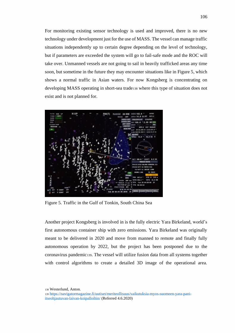
106
For monitoring existing sensor technology is used and improved, there is no new
technology under development just for the use of MASS. The vessel can manage traffic
situations independently up to certain degree depending on the level of technology,
but if parameters are exceeded the system will go to fail-safe mode and the ROC will
take over. Unmanned vessels are not going to sail in heavily trafficked areas any time
soon, but sometime in the future they may encounter situations like in Figure 5, which
shows a normal traffic in Asian waters. For now Kongsberg is concentrating on
developing MASS operating in short-sea trade138 where this type of situation does not
exist and is not planned for.
Figure 5. Traffic in the Gulf of Tonkin, South China Sea
Another project Kongsberg is involved in is the fully electric Yara Birkeland, world’s
first autonomous container ship with zero emissions. Yara Birkeland was originally
meant to be delivered in 2020 and move from manned to remote and finally fully
autonomous operation by 2022, but the project has been postponed due to the
coronavirus pandemic139. The vessel will utilize fusion data from all systems together
with control algorithms to create a detailed 3D image of the operational area.
138 Westerlund, Anton.
139 https://navigatormagazine.fi/uutiset/meriteollisuus/vaikutuksia-myos-suomeen-yara-pani-
itseohjautuvan-laivan-koipalloihin/ (Referred 4.6.2020)

107
Advanced decision support systems and collision avoidance technology enabling the
vessel to avoid any obstacles detected by sensors ensure that the vessel can be operated
safely and will be in compliance with COLREGS.140 Yara Birkeland will be monitored
by three separate ROCs which can handle all aspects of operation, not only
emergencies and exception handling but also operational and condition monitoring as
well as surveillance of the vessel’s surroundings.141
140 https://www.kongsberg.com/maritime/support/themes/autonomous-shipping/ (Referred 30.5.2020)
141 https://www.kongsberg.com/maritime/support/themes/autonomous-ship-project-key-facts-about-
yara-birkeland/ (Referred 30.5.2020)
108
7 DISCUSSION
Information required for a voyage plans varies greatly depending on the type of vessel
and its trade. Cruise ships have relatively small draft (generally less than 9 m) so the
water depth tends not to be too restricting in open waters, although many cruise ships
sail in areas and visit ports where large cargo ships do not go and where draft can pose
a problem. On the other hand cargo ships might need to take into account restrictions
due to the nature of their cargo, e.g. tanker traffic is regulated in many places around
the world.
The amount of detailed voyage planning done on cruise ships may seem excessive for
officers working on ferries or cargo ships, and it is true that a lot of it is not needed on
ships sailing in liner traffic or with less complex itineraries and less people on board.
However, for cruise ship VPOs there is no choice, partly so that the VPO is able to
prove that all aspects of the voyage are covered if ever a problem would arise. Mostly
because lot of the information is actually needed, for instance, if a vessel were to arrive
at a berth where she cannot use ship’s gangway and the port does not have a shoreside
gangway available the passengers would not be able to go ashore or tendering
operation would need to be set up with no notice.
Environmental considerations on a cruise ship are not like on any other ship type.
Thousands of people on board generate daily hundreds of tons of wastewater with only
limited tank capacity for storage. Cruise ships often operate fairly close to the coast
and many visit environmentally sensitive areas where getting rid of the wastewater is
not easy. The time spent inside an environmentally restricted area needs to be taken
into consideration in voyage planning, and sometimes adjustments in the itinerary or
the intended route are necessary to ensure compliance with environmental regulations.
On a cargo ship the only overboards would likely be ballast and occasional OWS, and
any discharges can easily be agreed between the bridge and ECR without any pre-
planned time windows for discharging. Many shoreside actors are keen to protect the
marine environment, but people with experience in shipboard operations are not
always consulted when drafting new regulations, sometimes resulting in rules that are

109
difficult for ships to comply with142 instead of facilitating environmental planning
onboard or for example providing shoreside facilities for waste discharges.
Voyage planning is labor intensive work taking a great deal of time if done properly.
To ease the workload onboard some parts of planning could well be done shoreside,
but still today most of the work is done on board. Some areas and ports, in Australia
and New Zealand in particular, provide passage plans, i.e. ready-made routes with
waypoints and courses, sometimes including a lot more information. Some countries
like Norway provide plans in RTZ-format which can be installed directly on the
ECDIS. These passage plans are official ones used by the pilots, and the ships are
strongly encouraged to use them in their voyage planning so that everybody has the
same mental model before pilotage starts. Although these kinds of passage plans are
helpful for the VPO they do not reduce the workload significantly.
The one single improvement which would make most difference for the efficiency of
the whole voyage planning process is the single window principle. Appraisal is the
most time consuming stage of the process and if all available information was
integrated into one source, the VPO would not need to spend time searching for it143,
especially if they do not know if the information exists in the first place (e.g. does a
port have a speed limit or not?), and they could be certain that all aspects were covered
and no information was missing144. The industry naturally has a long way to go to
142 Mexico introduced marine sanctuaries that cover most of the Pacific coast and extend far out to sea
leaving only small gaps were discharges are allowed. For cruise ships this can pose a problem.
143 For example, there are several Particularly Sensitive Sea Areas around the coast of Australia which
are well marked in ENCs. When picking report on ECDIS in some of the areas a note comes up that
special discharge limitations might apply, and a reference is made to Seafarers Handbook for Australian
Waters. The handbook in its turn only refers to a government environmental agency’s website where
no further information can be found. On one occasion after emailing back and forth with the government
agency for several days the VPO learnt that there were no special requirements in force for the vessel
during that particular cruise. It took quite some time and effort to find out that no limitations applied.
144 Hong Kong is a prime example of how easy it is to miss important information. On the approach
from SW there is a strait between two islands that has deep water and no navigational hazards except
one anchorage area. BA Sailing Directions even give instructions for passing through the strait and
nowhere can any indication or visual clues be found that the passage is actually prohibited. Only when
interrogating the ECDIS in the nearby TSS or running an electronic route check a warning comes up.
The whole port area is covered by speed limit ranging from 8 to 15 kn. Sailing Directions mention the
range, but not in which areas the speed limits are in force, and this information is not included in the
ENC either (as per March 2019). The only way to find out the speed limit areas is to search for the
information on the port website where it is available only in Chinese or ask the agent to send a chart
(and provide English translation) where the different areas are color-coded.

110
reach this goal, and like the final report of the Sea Traffic Management Validation
Project noted: the development must be based on user needs, and the whole industry
must cooperate in order to make it happen. Even if the quality of hydrographic data
can be increased fairly easily (as individual hydrographic offices can make this happen
and no input from other actors outside the country is required) integrating e.g. local
environmental regulations in the data calls for wide-ranging collaboration between
stakeholders.
The best option from the navigators’ point of view would be to have all information
accessible in the ECDIS and not in a separate software. Even if a voyage planning
software produces the track in an ECDIS-compatible format it has happed that for
unknown reason an ECDIS has not been able to read the transferred file. Another
advantage with the single window access integrated into ECDIS is that the
watchkeepers would be able to double check the information when on watch without
leaving the conning position.
Visualization of information would enhance both VPO’s and navigators’ situational
awareness, but too much information on an ECDIS screen makes it cluttered making
it harder to find out quickly the most relevant data. The user should have the
opportunity to choose which layers they want to see, and for optimized user experience
every type of information should have their own layer. For example information on
MARPOL areas is not interesting for the VPO if they are checking the chart coverage,
while for instance all areas where navigation is restricted or forbidden should be visible
for the watchkeepers without a need to pick report.
The equipment available today must develop in order to considerably save time for the
VPO. As an example, the amount of warnings in a route check is too much, same
warning pops up several times. Some models give coordinates for each warning and
when clicking on the warning ECDIS zooms into that position. Some other
manufacturers, even new models, list warnings only by leg, and when clicking on the
warning only the coordinates for the starting waypoint of the leg is given, which is
useless especially if it is a question of a long leg.

111
Single window reporting with as much automation as practicable would be another
improvement reducing the workload and allowing the navigators to concentrate on
watchkeeping without worrying if all necessary reports and notifications have been
sent. On a national level this should be achievable without too much effort, a few
countries have already taken steps towards this. Norway uses SafeSeaNet for all pre-
arrival reporting, and the vessel can easily see which reports are required, which ones
are still missing and can see e.g. pilot and berth information. Position reports must still
be entered manually into the system, whereas Australia has automated position
reporting system already in place so there is no reporting required over radio.
AI-aided software decreases the time the VPO needs to spend with the planning, but
there is still some way to go until the software will be on the level where it will free
the VPO from most of the planning-related work. Dropping and adjusting waypoints
is the easy part of the process, most of the time involved is either during the appraisal
stage or when drawing UCOs such as PIs or own safety lines, and AI-aided software
provides help with only a small part of this kind of work145. Exchange and integration
of data from several different sources would give added value to the equipment and
software146.
Route planning today must to be done by trained navigators who know what they are
doing. With AI-aided software even people with less experience could so at least part
of the work, although the plan must always be cross-checked by a competent person.
This would enable moving at least part of the process shoreside. AI-aided planning
saves time, but truly valuable it will become in the future if a single window approach
is adopted. The amount of information that needs to be incorporated in the software is
145 If for example all ENCs had depth contours with one-meter intervals the safety contours could be
used as no-go areas and there would not be need for drawing own safety lines. As most ENCs do not
have this possibility safety contours are crossed regularly resulting in extra work for marking the no-go
areas in the ECDIS.
146 Transas ECDIS has allowed downloading a file with tidal stream predictions for the next day in
European waters. After installing the file and running the speed calculation for the track, the ECDIS
indicated the average direction and strength of the tidal stream for each leg. The VPO could easily see
if they were going to have the stream with or against, and the calculation also indicated the speed
required at each leg to keep the average STM for the whole voyage. This saved time considerably as
otherwise the VPO would have needed to calculate streams from tidal atlas hour by hour and if the
streams were strong even a quite small change in SOG would result in calculations being incorrect.
112
huge and a lot of cooperation is required between stakeholders before all information
will be accessible in a standardized format.
Even when the degree of automation increases as long as the voyage planning process
(including execution and monitoring) is kept fairly traditional with conventional
equipment on board, the navigators need to be competent deck officers with solid
navigation skills and an understanding of what they are looking at. When automation
and artificial intelligence become more common and shoreside operations take over
many tasks now performed on board the question is if traditional navigators are best
for the task. When many processes will become more automated and sophisticated the
focus of the required training is likely to shift. For comparison, air traffic controllers
do not need to be trained pilots in order to be able to perform their job safely and
efficiently.
Competent and well-trained personnel is still needed with implementation of e-
navigation, otherwise there is a risk of over-reliance on technology. If technology is
used to replace experienced seafarers the result can be loss of seamanship, and
deterioration of BRM and best practices. Technology developers need to have a clear
picture of what type of product the end user requires in order to minimize the risk that
the human element is inappropriately substituted by technology. If too much reliance
is based on technology alone, technical failures can cause a vessel to be deemed
unseaworthy147.
If voyage plans are made shoreside the responsibilities should be made clear. Although
the plan must be checked on board before execution as the Master and OOWs are
responsible for it, there should be some kind of guarantee that the person who has
made the plan in the first place is competent for the job. All shipping companies do
not have the expertise in the office to provide assistance with the planning, and not
necessarily the understanding why a vessel might need to deviate from a plan. When
appraisal is done on board the VPO is able to build a good overview of the intended
147 MSC 85 annex 20, 7.1

113
route during the process, with shoreside planning the information should be presented
in a manner that is clear and easy for the navigators to comprehend.
All ships will benefit from technology developed for MASS, such as better sensors or
obstacle detection. A shoreside monitoring center can help with decision-making also
on board a manned vessel, reducing human error, sharing the workload and ensure
compliance with regulations.
114
8 CONCLUSIONS
The complexity of a voyage plan and the time spent on making it depends on the vessel
and its trade. Information needs to be gathered from multiple sources and is not always
easily available. Considering the increasing number of demands and regulations the
standardization and integration of data would make the process more efficient,
decrease the VPOs’ workload and increase safety. There is definitely a possibility to
move some of the planning process to shoreside, either to shipping companies (if they
have competent personnel), by using AI-aided software or giving the task to a separate
service provider. ROCs will be making voyage plans for MASS, but the service could
be utilized as well on manned vessel willing to outsource parts of the planning process
or monitoring of the voyage execution. There is also a chance for new service
providers to enter the market with products enabling companies to outsource parts of
the voyage planning process.
Although the officers on board must be familiar with the voyage plan, nothing prevents
at least part of the process being done shoreside as long as all information is presented
to the navigators in a format that is easy to read and comprehend. AI-aided planning
software and government provided passage plans can be of assistance in the voyage
planning officer’s work, but their scope is still quite limited. In the future when the
technology develops, and especially if all information can be accessed from a single
window, time spent on appraisal and planning stages will decrease considerably and
most of the process could be done shoreside leaving the officers on board more time
for other tasks. Sharing the information between different actors will be the key. If
data formats in the whole industry, both shoreside and onboard, are standardized it will
lead to better connectivity and the data can be utilized more efficiently to benefit all
stakeholders.
It is not exactly correct to call AI-aided planning or autonomous vessels “future” since
the technology is in use already. As the stage of development is still fairly rudimentary
and the importance of the technology will only increase with time, the products we
will see in twenty years from now are expected to be on a totally different level
compared with what is available today.
115
The future will bring a huge change for officers responsible for navigating ocean-going
vessels. From relying on a magnetic compass and a sextant in the past to digital
navigation of today the shipping will move towards automated, AI-controlled
processes where humans will mainly have a role of monitoring. Navigating navigator
will still be needed for many years to come, although their job will be made easier with
technological advancements. Better use of data and dissemination of information is
likely to increase safety and efficiency of shipping.
REFERENCES
Literature:
Aylward, Katie. Automated Functions: Their Potential for Impact Upon Maritime
Sociotechnical Systems. Chalmers University of Technology. Gothenburg 2020.
E-navigation 10 years on. Fairplay, September 2018.
Frydenberg, S., Eikenes, J.O., & Nordby, K. Serendipity in the Field. Facilitating
serendipity in design-driven field studies on ship bridges, The Design Journal 2019.
22:sup1, 1899-1912
Hagen, John Erik. Implementing e-Navigation. Artech House 2017.
Bruno, Karl. and Lützhöft, Margareta. Chalmers University of Technology, Shore-
Based Pilotage: Pilot or Autopilot? Piloting as a Control Problem. The Journal of
Navigation (2009), p. 427–437
Finnish legislation:
HE 225/2018 vp Hallituksen esitys eduskunnalle laiksi luotsauslain muuttamisesta
Maritime Law (Merilaki) 1994/674
Pilotage Act (Luotsauslaki) 2003/940
Vessel Traffic Service Act (Alusliikennepalvelulaki) 2005/623
IMO Codes, Conventions, Resolutions and Circulars:
E-navigation Strategy Implementation Plan, 2014
ISM Code, 2018 Edition
MARPOL, Consolidated Edition, 2017
MSC 302.(87) Performance Standards for Bridge Alert Management, 2010
MSC.1/Circ.1184 Enhanced Contingency Planning Guidance for Passenger Ships
MSC.1/Circ.1503/Rev.1 ECDIS – Guidance for Good Practice, 2017
MSC.1/Circ.1604 Interim Guidelines for MASS Trials
MSC 85/26/Add.1, annex 20 Strategy for the development and implementation of e-
navigation
Operating in Areas Remote from SAR Facilities, 2006
Polar Code, 2016 Edition
Resolution A.893(21) Guidelines for Voyage Planning, 1999
Resolution A.999(25) Guidelines for Voyage Planning for Passenger Ships
Operating in Remote Areas, 2007
Resolution A.1110(30) Strategic Plan for the Organization for the six-year period
2018 to 2023
SN.1/Circ.255 Additional Guidance on Chart Datums and the Accuracy of Positions
on Charts, 2006
SOLAS, Consolidated Edition, 2014
STCW, 2017 Edition
British Admiralty publications:
ADRS 6
NP231 Guide to the Practical Use of ENCs
NP232 Guide to ECDIS Implementation, Policy and Procedures
Interviews:
Adams, Conrad. Principal Advisor - Coastal Pilotage Operations, AMSA (7.11.2019)
Cleaver, Lyndon. Maritime Manager - Harbourmaster, Environment Southland
(30.5.2019)
Fossmark, Gaute. Product Manager, Navtor (14.4.2020)
Haimila, Risto. Chief Marine Safety Investigator, Finnish Safety Investigation
Authority (20.5.2020)
Klami, Laura. Outfitting Project Manager, Meyer Turku (16.3.2020)
Schwarz, Oliver. Business Development Director, ChartWorld (5.5.2020)
Taipale, Olli. Finnpilot (19.4.2020)
Westerlund, Anton. VP Remote Operation Solutions, Kongsberg (19.5.2020)
Westerlund, Kati. Quality Manager, VTS Finland (3.3.2020)
Unpublished sources:
Carnival Corporation HESS-MS
EfficientFlow Concept of Operations
EfficientFlow Report on Traffic Analysis and User Needs
Sea Traffic Management documents:
Koivisto, Heikki. Interreg Central Baltic EfficientFlow project as a digital STM
solution for improving information exchange between ships, ports and hinterland
actors. Proceedings of 8th Transport Research Arena TRA 2020, Finland.
https://www.seatrafficmanagement.info/documents/
Sea Traffic Management Master Plan
http://stmmasterplan.stmvalidation.eu/improvement-phases/
Sea Traffic Management Validation Project - Final Report https://s3-eu-west-
1.amazonaws.com/stm-stmvalidation/uploads/20190709125520/STM-Validation-
Final-report.pdf
Siwe, Ulf. Impacts of standardized information sharing on maritime safety, efficiency
and environment - STM Validation results. Proceedings of 8th Transport Research
Arena TRA 2020, Finland. https://www.seatrafficmanagement.info/documents/
Other sources:
ABB https://new.abb.com/news/detail/24651/b0-a-conditionally-and-periodically-
unmanned-bridge (Referred 15.5.2020)
AMSA Queensland Coastal Passage Plan, January 2019 Edition
Argyros, Dimitris. Solutions Manager, Efficiency Optimization Wärtsilä Voyage.
Transas Webinar Collaborative Voyage Planning 27.5.2020
BIMCO https://www.bimco.org/contracts-and-clauses/bimco-clauses/current/sea-
traffic-management-clause-for-voyage-charter-parties (Referred 18.4.2020)
ChartWorld https://www.chartworld.com/web/on-route/myra (Referred 25.3.2020)
European Maritime Safety Agency Annual Overview of Marine Casualties and
Incidents 2019.

“For the Safety Navigation in Japanese Coastal Waters”. Japan Coast Guard.
https://www.kaiho.mlit.go.jp/syoukai/soshiki/toudai/navigation-
safety/en/navi_safety.htm (Referred 4.6.2019)
Frydenberg, S., Eikenes, J.O., & Nordby, K. Exploring designs of augmented reality
systems for ship bridges in arctic waters.
https://www.researchgate.net/publication/328065246 (Referred 6.5.2020)
Haikkola, Päivi. Roadmap towards commercial autonomous shipping in 2025.
https://www.oneseaecosystem.net/roadmap/ (Referred 15.5.2020)
Hareide, O.S. & Porathe, T. Maritime Augmented Reality.
www.researchgate.net/project/Maritime-Augmented-Reality (Referred 6.5.2020)
IHO Circular Letter 54/2019. IHO Submission to IMO Sub-Committee on
Navigation, Communications and Search and Rescue.
https://iho.int/uploads/user/circular_letters/eng_2019/CL54_2019_EN_v1.pdf
Institute of Marine Engineering, Science & Technology
www.imarest.org/themarineprofessional/item/5497-marine-professional-special-
report-autonomous-shipping (Referred 14.5.2020)
IMO http://www.imo.org/en/MediaCentre/HotTopics/Pages/Autonomous-
shipping.aspx (Referred 2.5.2020)
International PortCDM Council (IPCDMC) www.ipcdmc.org (Referred 19.4.2020)
Kongsberg https://www.kongsberg.com/maritime/support/themes/autonomous-
shipping/ (Referred 30.5.2020)
Manderbacka, Teemu. Senior Research Engineer, NAPA Shipping Solutions. Riviera
Webinar Voyage Planning for Maximum Vessel Efficiency 14.5.2020
Massterly https://www.massterly.com (Referred 27.5.2020)
Meriliikenteen automaation kehitys – raportti. Traficomin julkaisuja 122/2019
https://www.traficom.fi/sites/default/files/media/publication/Meriliikenteen_automaa
tion_kehitys_Traficom_julkaisuja_122_2019.pdf
MUNIN http://www.unmanned-ship.org/munin/ (Referred 10.4.2020)
NAPA https://www.napa.fi/news/napa-and-chartworld-partner-to-provide-artificial-
intelligence-driven-voyage-optimization/ (Referred 3.4.2020)
Navigator Magazine https://navigatormagazine.fi/uutiset/meriteollisuus/vaikutuksia-
myos-suomeen-yara-pani-itseohjautuvan-laivan-koipalloihin/ (Referred 4.6.2020)
Navtor https://www.navtor.com/navigating-the-future.html (Referred 2.3.2020)
NOAA https://www.nauticalcharts.noaa.gov/updates/noaa-seeks-industry-feedback-
as-it-begins-testing-the-precision-navigation-data-dissemination-prototype/ (Referred
5.6.2020)

Norwegian Route Info https://routeinfo.kystverket.no (Referred 28.11.2019)
Ocean Guardian https://www.oceanguardian.com (Referred 26.3.2020)
One Sea https://www.oneseaecosystem.net/about/ (Referred 3.5.2020)
Rolls Royce https://www.rolls-royce.com/media/press-releases/2018/06-09-2018-rr-
mol-verify-enhanced-navig-safety-with-intelligent-awareness-test-abd-passenger-
ferry.aspx (Referred 3.5.2020)
Total Marine Solutions http://www.tms-fla.com/ (Referred 6.4.2020)
The Transport Accident Investigation Commission Final report MO-2017-202:
Passenger vessel L’Austral, grounding, Milford Sound, Fiordland, 9 February 2017
https://taic.org.nz/inquiry/mo-2017-202
Transport Canada https://www.tc.gc.ca/en/services/marine/navigation-marine-
conditions/protecting-north-atlantic-right-whales-collisions-ships-gulf-st-
lawrence.html (Referred 13.5.2020)
Wärtsilä https://www.wartsila.com/marine/optimise/e-navigation (Referred 3.4.2020)
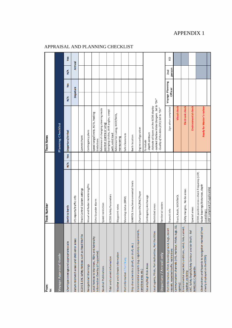
APPENDIX 1
APPRAISAL AND PLANNING CHECKLIST

APPENDIX 2
SAFETY DEPTH CALCULATION
APPENDIX 3
RISK ASSESSMENT
APPENDIX 4
SPEED SCHEDULE
APPENDIX 5
WAYPOINT LIST
APPENDIX 6
ALARM MANAGEMENT (for ships with NACOS 4 or 5 ECDIS)
APPENDIX 7
DOCKING PLAN
APPENDIX 8
GANGWAY ANGLE CALCULATION
APPENDIX 9
WATERTIGHT DOOR SCHEDULE

BRM SCHEDULE
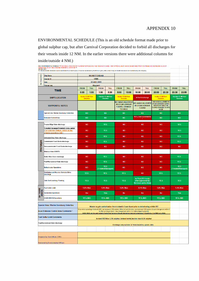
APPENDIX 10
ENVIRONMENTAL SCHEDULE (This is an old schedule format made prior to
global sulphur cap, but after Carnival Corporation decided to forbid all discharges for
their vessels inside 12 NM. In the earlier versions there were additional columns for
inside/outside 4 NM.)

APPENDIX 11
VOYAGE & PORT NOTES

APPENDIX 12
TIDAL CHART