shannon park development agreement
TRANSCRIPT
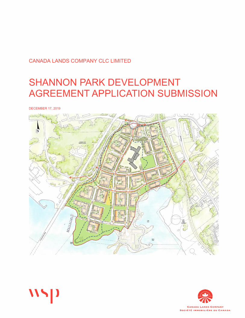
CANADA LANDS COMPANY CLC LIMITED
SHANNON PARK DEVELOPMENT AGREEMENT APPLICATION SUBMISSION DECEMBER 17, 2019
SHANNON PARK DEVELOPMENT SUBMISSION CANADA LANDS COMPANY CLC LIMITED PROJECT NO.: 151-03999-00 DATE: DECEMBER 13, 2019 WSP 1 SPECTACLE LAKE DRIVE DARTMOUTH, NS CANADA B3B 1X7 T: +1 902-835-9955 F: +1 902-835-1645 WSP.COM
1 Spectacle Lake Drive Dartmouth, NS Canada B3B 1X7 T: +1 902-835-9955 F: +1 902-835-1645 wsp.com
December 17, 2019 Confidential
HALIFAX – Planning & Development Policy & Strategic Initiatives Program Manager 40 Alderney Drive, 2nd Floor Dartmouth, NS
Attention: Kate Greene, Policy & Strategic Initiatives Program Manager
Subject: Shannon Park Development Agreement Submission
Dear Ms. Greene:
Please find enclosed our formal submission for a Development Agreement for the Canada Lands Company CLC Limited (CLC) Shannon Park lands located in Dartmouth under Policy 3.34 of the Regional Centre Secondary Municipal Planning Strategy (SMPS) (Package A).
As you are aware, CLC has previously completed an extensive (18-month) community and stakeholder engagement program and developed a Preferred Development Concept for the redevelopment of this regionally significant property. The concept has been shared with the community, Municipal and Provincial agencies and North Dartmouth community groups.
In 2016, WSP submitted CLC’s Development Submission and several technical studies to HRM outlining their development plans for Shannon Park. It was our understanding that this submission was so that HRM Planning staff and other departments would be able to review this proposal and begin a draft Development Agreement, while the Policy was being drafted/approved under the Centre Plan. Including the policy under the Centre Plan was identified as the most straightforward way to create enabling policy for the Shannon Park lands, rather than through a site-specific MPS amendment. It has, however, taken several years since WSP’s submission for the Centre Plan to be created and approved by Regional Council.
As was discussed with HRM staff on multiple occasions, CLC requested that a draft development agreement for Shannon Park be prepared so that it may be formally considered immediately upon the adoption of the Centre Plan. It was WSP and CLC’s understanding, and from discussions with HRM staff in the Fall of 2018, that this would take place. CLC also requested that as a term of the agreement to considering the SSE bid to HRM for the stadium, that a draft Development Agreement with and without the stadium be prepared to be able to respond to either outcome. This has not taken place to our knowledge.
As it has been three years since CLC’s Development Submission, we would like to formally submit our application for a Development Agreement for the Shannon Park Lands. This application includes the Master Plan layout as determined through the community engagement process in 2015-2016.
Page 2
We trust that given the 5-year review process for Shannon Park, including the engagement process and Development Submission review, that staff have had sufficient time to consider CLC’s proposal. We look forward to having a Development Agreement drafted for the site, so we can help to bring forward substantial housing and new commercial businesses in Dartmouth.
CHANGES TO THE MASTER PLAN SINCE THE 2016 SUBMISSION
Following the 2016 submission, HRM staff completed a review of the application materials and consulted several internal and external stakeholders; and provided comment to WSP/CLC as the applicants. Major changes since the 2016 proposal have occurred in discussion with HRM staff and are outlined in the following section.
PARKS AND OPEN SPACES
As part of the 2016 development submission, a large area of public parkland was proposed between the existing school and Tufts Cove to create a stronger link between the school and the water. HRM’s department of Parks & Recreation requested relocation of the park space to the same block as the existing Shannon Park school. CLC agreed with this comment and this revised submission re-locates the public park to lands immediately east of the school site. This change will allow students to access the park without the need to cross a road. Private mixed-use development is proposed to occur where the park was previously proposed.
CLC is committed to investing in the infrastructure and amenities that would make up this square and turn ownership over to HRM to allow it to truly be a public space. This is the typical process that CLC follows for parks and public spaces within their developments. HRM staff have indicated that they would require a further study regarding open space and recreation amenities. CLC does not feel that this is warranted. The proposal includes significant lands along the waterfront, park space, a public plaza, and an extensive off-road trail system for active transportation and recreational use. Parkland dedication significantly exceeds Subdivision Bylaw requirements. CLC has also constructed and operates the Canada 150 Trail and Lookout, which has been designed and constructed as part of CLC’s open space strategy for Shannon Park.
TRANSPORTATION NETWORK
Shannon Park is currently poorly serviced by Halifax Transit. The proposed development intends to introduce 3,000 new units into the community, further increasing the demand for efficient access to transit. Harbourside Transportation Consultants (HTC) and Design Point Engineering & Surveying Ltd. were retained by CLC to prepare a Traffic Impact Study (TIS) for the site. Recommendations in that report led to this submission’s updated preferred concept which includes a roundabout on Princess Margaret Boulevard.
The updated preferred concept also includes an urban street grid that prioritizes pedestrians and Active Transportation opportunities through a “transit hub”. The proposed transit route through the development will connect Windmill Road to Baffin Boulevard with stops integrated along the way, including a “transit hub” as suggested by HRM. Previous HRM comments (March 2017) suggested a direct route through the community would be preferred. We disagree with this comment and believe two turns between Baffin and Windmill is an acceptable route and helps keep speeds low in this neighbourhood.
During the September 18th, 2019 Regional Council Hearing for Centre Plan, Councillor Mancini asked HRM Planning Staff if there would still be opportunity through the Development Agreement to have discussions regarding this road layout; and if not, he would ask that the requested change to policy be considered in Package B Centre Plan. Ms. Tota responded that there is still opportunity to discuss this through the Development Agreement and that Staff expect to have different road alignments than shown on the schedule, as long as the DA is
Page 3
relatively consistent with Policy. Based on this we understand that there can be flexibility in the road layout, from Map 11, through the DA process without requiring an amendment to the MPS.
A direct connection will greatly encourage ‘short cutting’ of vehicles through the site (BIO traffic). Furthermore, there are grade challenges, which would disrupt the street grid pattern established through the public engagement process if a direct connection to Baffin Boulevard was established.
The proposed concept plan and street network have been developed through an extensive community consultation process that identified a desire to create a safe, walkable neighbourhood. This resulted in the creation of an urban street grid with smaller scale development blocks. The proposed grid intends to slow vehicles down and create a safe urban neighbourhood. There was no community desire or intent to create a direct thoroughfare across the site. Therefore, as stated on many occasions, CLC is not prepared to support the request for a ‘direct’ transit connection.
A direct connection would greatly encourage ‘short cutting’ of vehicles through the site (BIO traffic). Furthermore, there are grade challenges, which would disrupt the street grid pattern established through the public engagement process if a direct connection to Baffin Boulevard was established.
The current Map 11 within the Regional Centre SMPS includes a representation of such a connection, again, which CLC does not support, and which is not consistent with the community design principles which were identified through CLC’s extensive public engagement process. The grade challenges involved in this connection would require an elevated roadway. CLC has no desire to repeat the urban design challenges posed by the local example of an urban elevated roadway connection, the Cogswell Interchange. As discussed at the time of draft policy adoption, we understand that Map 11 is intended to show broad intention and there will be flexibility with regards to the terms/drawings of the development agreement.
ATTACHED MATERIAL To aid in your review of this application, the following material has been included in addition to the detailed proposal description and policy review tables within thin this submission letter.
A. Concept Master Plan (Block Diagram)
B. Parks and Open Space (Render)
C. Phasing Plan
D. Schematic Servicing and Infrastructure Design Report, WSP Canada Inc., Nov. 18, 2016
E. Traffic Impact Study (Draft), Harbourside and Design Point, Dec. 15, 2016
Note that an environmental review has also been completed and CLC will be able to guarantee the results provided will satisfy Nova Scotia Environment requirements.
COLLABORATION AND FUTURE STUDIES
CLC and Millbrook First Nation have entered a Memorandum of Understanding for the development of their respective Shannon Park Lands. The parties have regular discussions regarding the integration of uses and design between the two lands. Although the two parties are working in cooperation, Millbrook is solely responsible for the development of their own lands, including any approvals and requirements that may be applicable.
Note that while our understanding is that the DA with HRM will cover broad aspects such as road layout, parcels, park and trail location, zones and FAR, CLC also intends to undertake an
Page 4
Urban Design Standards study for the site, above and beyond the Urban Design Regulations within the Centre Plan. CLC sees this process as independent of any planning regulatory approvals; rather, this study is intended to set an Urban Design Standards to construct a cohesively designed community with the subsequent builder partners.
CLOSING
We would like to thank you for taking the time to review this application submission. We look forward to continued dialogue with HRM’s Planning and Development staff, and reviewing the draft development agreement as provided by them. We look forward to bringing the vision for the development of Shannon Park, as developed through the extensive community engagement process, to reality. If you have any questions or would like to meet to discuss this submission, please let me know.
Yours truly,
Christina Lovitt, MCIP, LPP Manager, Planning - Atlantic Canada
CL/jd cc: Chris Miller - CLC WSP ref.: 151-03999-00
Original Signed
Shannon Park Development Submission Project No. 151-03999 Canada Lands Company CLC Limited
WSP December 2019
Page i
E X E C U T I V E S U M M A R Y Canada Lands Company CLC Limited (CLC) is a self-financing, federal Crown corporation that specializes in real estate, development and attractions management. The company’s goal in all it does is to produce the best possible benefit for Canadian communities and the Government of Canada. CLC works to achieve its mandate with industry leading expertise. The company prides itself on its consultation-based approach to pursuing community-oriented goals, environmental stewardship and heritage commemoration with all its projects across Canada.
The company’s activities ensure that former government properties are redeveloped or managed in accordance with their highest and best use, and that they are harmoniously reintegrated into local communities. CLC’s goal is to help transform surplus parcels and reshape them to meet the needs of Canadians with inspiring and sustainable new neighbourhoods in which they can live, work and play. The CLC development process is built around 5 phases:
1 Acquisition; 2 Consultation; 3 Planning; 4 Preparation; 5 Completion.
The Shannon Park application has gone through extensive community and stakeholder consultation and is now moving into the Planning/approvals phase. Please consider this package as our Planning Application to enable development of the Shannon Park lands.
CLC is a firm believer in community engagement and stakeholder consultation. In that vein, we (WSP and CLC) have spent well over a year communicating with the community and HRM staff prior to our 2016 submission. Prior to consultation or design, we contacted the City and asked for a Planner to be assigned to this significant project. It has been very useful having a Senior Planner to contact and work with in preparing our development concepts. This early engagement with the Municipality and government stakeholder has assisted us in bringing a concept forward that we believe is aligned with both community aspirations and broader regional community development goals.
In addition to the community engagement and consultation process, CLC has also undertaken a variety of technical studies and utilized these findings to create the Preferred Development Concept. The development of Shannon Park is well overdue. The Municipality, surrounding businesses and residents have been waiting for something to happen on these lands for well over a decade.
Due to the extensive community consultation and stakeholder engagement, please consider that these efforts satisfy the engagement requirements of master neighbourhood planning as part of this application. We have talked to hundreds of people from across the Municipality, and the one common question was: when is this going to happen? It’s long overdue. We believe the engagement undertaken to date has been more than sufficient to meet the Municipality’s requirements as set out with in the applicable SMPS policy. Note that individual buildings are not being requested under the terms of the development agreement. Rather it is our understanding that the buildings will be through the Site Plan Approval process at a future date, which shall include the public participation process as required under Centre Plan.

Page ii
CLC’s expectation around the schedule has been discussed several times with the Municipality, stakeholders and the community. It was CLC’s intention to have detailed Engineering Design for Phase 1 done by the spring of 2018 and site construction in summer of 2018. Obviously, timelines associated with Centre Plan and the City’s consideration of the community stadium by SSE have delayed this considerably. We request that with the submission of this DA application, that the City begins to draft a Development Agreement at this time, so CLC can bring this much anticipated and supported development to fruition.
Shannon Park Development Submission Project No. 151-03999 Canada Lands Company CLC Limited
WSP December 2019
Page iii
TABLE OF CONTENTS
1 BACKGROUND AND SITE OVERVIEW ......... 1
1.1 The Shannon Park Site ................................................. 1
1.2 History ............................................................................ 2
2 THE PLAN ....................................................... 3
2.1 Public Engagement Process ........................................ 3 2.1.1 Ideas Fair ................................................................................................. 3 2.1.2 Industry Roundtable #1 ........................................................................... 4 2.1.3 Open House Event – Concept Scenarios .............................................. 6 2.1.4 Industry Roundtable #2 ........................................................................... 8 2.1.5 Open House Event – Preferred Development Concept ...................... 10 2.1.6 individual stakeholder meetings ........................................................... 10
2.2 Urban Design Principles ............................................. 11 2.2.1 Overview ................................................................................................ 11
2.3 Preferred Development Concept ............................... 13 2.3.1 Overview ................................................................................................ 13 2.3.2 Big Moves .............................................................................................. 15 2.3.3 Development Blocks ............................................................................. 19 2.3.4 Phasing .................................................................................................. 19 2.3.5 Density and Built Form .......................................................................... 20 2.3.6 Millbrook Lands ..................................................................................... 20 2.3.7 Shannon Park School ........................................................................... 21
3 MUNICIPAL POLICY FRAMEWORK ............ 22
3.1 Regional Municipal Planning Strategy ...................... 22 3.1.1 Future Growth Centres ......................................................................... 22 3.1.2 Regional Local Growth Centres (Table 3-1 of the RMPS) .................. 23 3.1.3 Harbour Designation ............................................................................. 24
3.2 Regional Centre Secondary Municipal Planning Strategy ........................................................................ 25
3.2.1 CDD General Planning Policies ........................................................... 25 3.2.2 Neighbourhood Master Planning Policies ............................................ 27 3.2.3 General Development Agreement Consideration Planning Policies .. 30 3.2.4 Shannon Park Planning Policies .......................................................... 32

Page iv
3.2.5 Future Growth Node Land Use Concept Shannon Park ..................... 38
4 TECHNICAL STUDIES ................................. 39
4.1 Introduction .................................................................. 39
4.2 Servicing Study ........................................................... 39
4.3 Traffic Analysis ............................................................ 39
5 CONCLUSION .............................................. 41
Page 1
1 BACKGROUND AND SITE OVERVIEW
1.1 THE SHANNON PARK SITE Shannon Park is a former military community located on the eastern shore of the Halifax Harbour. In 2014, CLC acquired the Shannon Park site from the Department of National Defense. The approximately 87-acre site is one of the few remaining large tracts of developable land with direct harbour frontage.
The site is located immediately southeast of the A. Murray MacKay Bridge. The site is in North Dartmouth. Most of the land uses in the immediate area are commercial, industrial and institutional.
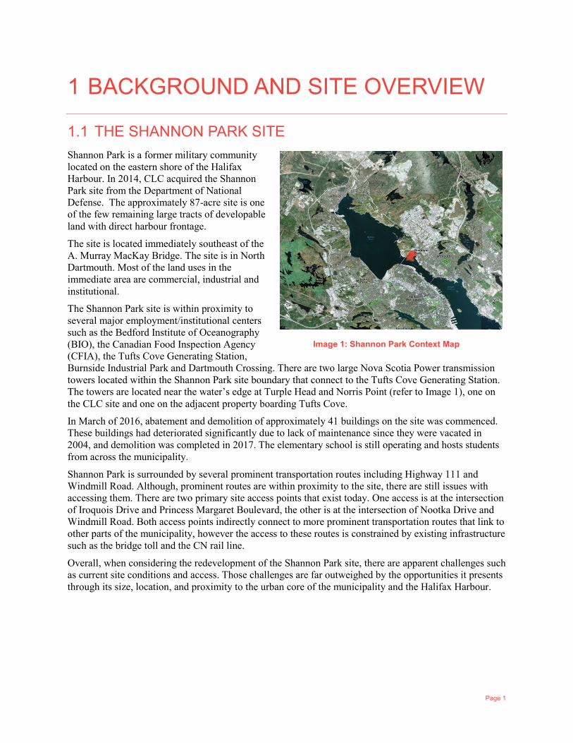
The Shannon Park site is within proximity to several major employment/institutional centers such as the Bedford Institute of Oceanography (BIO), the Canadian Food Inspection Agency (CFIA), the Tufts Cove Generating Station, Burnside Industrial Park and Dartmouth Crossing. There are two large Nova Scotia Power transmission towers located within the Shannon Park site boundary that connect to the Tufts Cove Generating Station. The towers are located near the water’s edge at Turple Head and Norris Point (refer to Image 1), one on the CLC site and one on the adjacent property boarding Tufts Cove.
In March of 2016, abatement and demolition of approximately 41 buildings on the site was commenced. These buildings had deteriorated significantly due to lack of maintenance since they were vacated in 2004, and demolition was completed in 2017. The elementary school is still operating and hosts students from across the municipality.
Shannon Park is surrounded by several prominent transportation routes including Highway 111 and Windmill Road. Although, prominent routes are within proximity to the site, there are still issues with accessing them. There are two primary site access points that exist today. One access is at the intersection of Iroquois Drive and Princess Margaret Boulevard, the other is at the intersection of Nootka Drive and Windmill Road. Both access points indirectly connect to more prominent transportation routes that link to other parts of the municipality, however the access to these routes is constrained by existing infrastructure such as the bridge toll and the CN rail line.
Overall, when considering the redevelopment of the Shannon Park site, there are apparent challenges such as current site conditions and access. Those challenges are far outweighed by the opportunities it presents through its size, location, and proximity to the urban core of the municipality and the Halifax Harbour.
Image 1: Shannon Park Context Map
Page 2
1.2 HISTORY The Shannon Park site has a significant historical past as both a Mi’Kmaq settlement and military housing community.
In the mid 1800’s the Mi’Kmaq settled on a small portion of land within Tufts Cove. The settlement was known as Turtle Grove. A painting from early 1800’s shows a Mi'kmaq family at the cove and an oil painting by William Eager (1837) shows a Mi'kmaq encampment at Tufts Cove.
Many years later, the Shannon Park military housing community opened to much excitement in the late 1950s. “It is completely fireproof, of Architectural concrete design, and 30,000 cubic yards of concrete was poured in this huge project.” This community thrived during the latter half of the 20th century until defence cutbacks occurred in the early 2000’s reducing the number of personnel serving in the military. That combined with the housing available on the civilian market, led to the closing of the Shannon Park community in 2004. Remaining residents were relocated to military housing units in Willow Park.
Historical events such as the War of 1812 and the Halifax Explosion had major physical and cultural impacts on the site.
The War of 1812 was a conflict between the United States and Great Britain. As a colony of Great Britain, Canada (and Halifax) were swept up in the War. HMS Shannon was a 38-gun Ledaclass frigate of the Royal Navy. She was launched in 1806 and served in the Napoleonic Wars and the War of 1812. She won a noteworthy naval victory on 1 June 1813 during the latter conflict, when she captured the American Navy’s USS Chesapeake in a singularly bloody battle.
The Shannon Park site, including the Mi’Kmaq settlement at Tufts Cove, was destroyed by the Halifax Explosion on December 6, 1917. The Mi’Kmaq settlement was never rebuilt after the explosion and surviving members settled in other Nova Scotian communities.
Commemoration is a key part of the CLC’s process; therefore, CLC intends to commemorate Shannon Park’s rich history through the development of a new urban community at the site. The naming of streets, parks and public spaces as well as the integration of historical interpretive elements such as statues or commemorative art are certain initiatives that can be incorporated into the new community to ensure the rich history of the site carries into the future.

Page 3
2 THE PLAN 2.1 PUBLIC ENGAGEMENT PROCESS Public consultation is a key pillar of the CLC Shannon Park development process. Their team works closely with residents and municipal officials to organize the most effective community consultation strategy possible. Their consultation often includes: meeting with community organizations, holding public open houses and establishing local advisory committees to get input on potential plans for a property. The public is always invited to attend and participate through an open, integrated and transparent community consultation process.
WSP/CLC has held several consultation events to receive comprehensive input from representatives of the development industry, municipal staff and general members of the public who have a vested interest in the future development of the Shannon Park site. CLC advertised each consultation events prior to its occurrence through various methods of notification such as public newspaper notices (Chronicle Herald, The Coast, The Metro), social media, CLC’s website and emails to people who signed up to the mailing list. The following is a summary of all the consultation events that have been held for this project to date.
2.1.1 IDEAS FAIR
On June 24, 2015, WSP and CLC held two Open House meetings at the Shannon Park School. Sessions were 4:00 pm – 6:00 pm and 7:00 pm – 9:00 pm. Approximately 65 attendees were at each session for a total of 130 interested individuals. The purpose of the Ideas Fair was to harvest as many ideas and comments as possible from the community about opportunities, concerns, values and hopes. Each session started with a short introduction to the project scope and team. Following the presentation, participants circulated through several stations where the following topics and questions were discussed:
1 History — What memories do you have of Shannon Park, what does the area mean to you? — What specific moments of Shannon Park’s history are most important to you? — How should the history and culture of Shannon Park be reflected through new development?
2 Community Inventory — What valuable services exist in the community? — What services/amenities are missing?
3 Access and Connections — How will Shannon Park connect to the rest of the city? — What should be considered, from an access and mobility standpoint, when designing Shannon
Park? 4 Sustainability
— What particular sustainability initiatives, both societal and environmental, should be considered when designing Shannon Park?
5 Design & Land Use — What particular land uses do you envision being part of Shannon Park?
The Ideas Fair produced many great ideas and conversations about the site. Residents from across the City are attached to these lands and are excited to see something finally happen at Shannon Park. Generally, topics discussed during the Ideas Fair fell into the following common themes/suggestions:
1 Take Full Advantage of the Waterfront. The Harbour edge is a precious resource. The Shannon Park waterfront should be accessible by the public and be incorporated into a system of roads and trails,
Page 4
allowing easy access to the water. Waterfront activities such as marinas, piers, boardwalks, shops and restaurants will help activate the Harbour edge.
2 Social Hub. At one time Shannon Park was a lively place where residents from the surrounding communities would gather for social events, services and sporting events. North Dartmouth seems to be lacking a central gather place and service centre. Shannon Park should become a vibrant community consisting of services, events and unique places.
3 Environmental Awareness. The Shannon Park lands should be carefully remediated back to an acceptable level for residential and commercial use. In developing the ‘new’ Shannon Park, environmental sustainability should be incorporated through items like community gardens, district heat, mixed land-uses, natural trail networks, active play spaces and interconnected transit systems.
4 Commemoration. Shannon Park was a special place for many people and the community still holds many great memories. The First Nations community and DND presence should both be recognized/commemorated in the development. Shannon Park was known as a great place to live and raise a family. On top of a great physical development, there is an opportunity for great programming. Shannon Park has a great history of bringing people and families together. This interaction should be commemorated and re-invigorated in a new development.
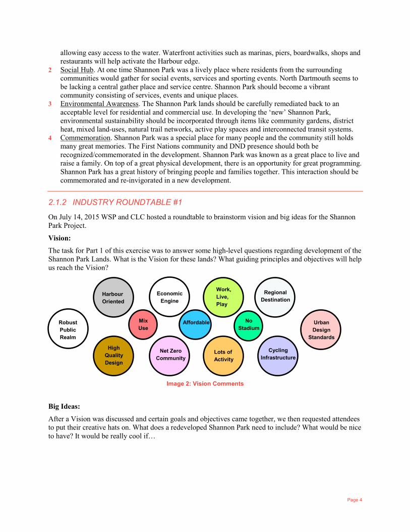
2.1.2 INDUSTRY ROUNDTABLE #1
On July 14, 2015 WSP and CLC hosted a roundtable to brainstorm vision and big ideas for the Shannon Park Project.
Vision:
The task for Part 1 of this exercise was to answer some high-level questions regarding development of the Shannon Park Lands. What is the Vision for these lands? What guiding principles and objectives will help us reach the Vision?
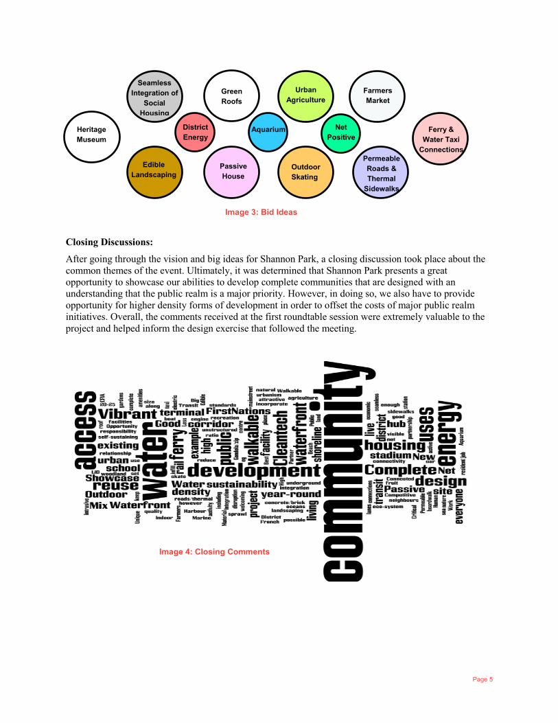
Big Ideas:
After a Vision was discussed and certain goals and objectives came together, we then requested attendees to put their creative hats on. What does a redeveloped Shannon Park need to include? What would be nice to have? It would be really cool if…
Harbour Oriented
Economic Engine
Work, Live, Play
Regional Destination
Robust Public Realm
High Quality Design
Net Zero Community
Lots of Activity
Cycling Infrastructure
Urban Design
Standards
Mix Use
No Stadium
Affordable
Image 2: Vision Comments
Page 5
Closing Discussions:
After going through the vision and big ideas for Shannon Park, a closing discussion took place about the common themes of the event. Ultimately, it was determined that Shannon Park presents a great opportunity to showcase our abilities to develop complete communities that are designed with an understanding that the public realm is a major priority. However, in doing so, we also have to provide opportunity for higher density forms of development in order to offset the costs of major public realm initiatives. Overall, the comments received at the first roundtable session were extremely valuable to the project and helped inform the design exercise that followed the meeting.
Seamless Integration of
Social Housing
Green Roofs
Urban Agriculture
Farmers Market
Heritage Museum
Edible Landscaping
Passive House
Outdoor Skating
Permeable Roads & Thermal
Sidewalks
Ferry & Water Taxi
Connections
District Energy
Net Positive
Aquarium
Image 3: Bid Ideas
Image 4: Closing Comments
Page 6
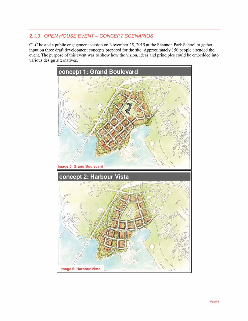
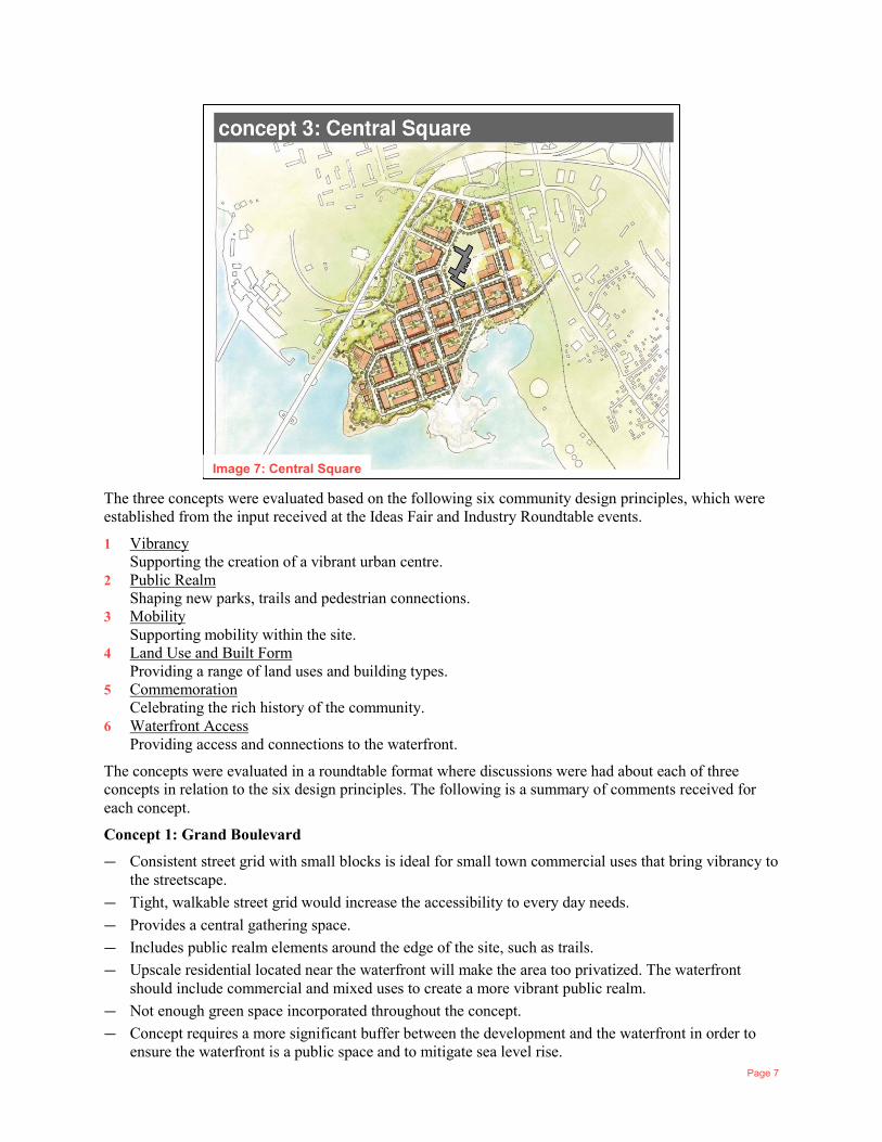
2.1.3 OPEN HOUSE EVENT – CONCEPT SCENARIOS
CLC hosted a public engagement session on November 25, 2015 at the Shannon Park School to gather input on three draft development concepts prepared for the site. Approximately 150 people attended the event. The purpose of this event was to show how the vision, ideas and principles could be embedded into various design alternatives.
Image 5: Grand Boulevard
Image 6: Harbour Vista
Page 7
The three concepts were evaluated based on the following six community design principles, which were established from the input received at the Ideas Fair and Industry Roundtable events.
1 Vibrancy Supporting the creation of a vibrant urban centre.
2 Public Realm Shaping new parks, trails and pedestrian connections.
3 Mobility Supporting mobility within the site.
4 Land Use and Built Form Providing a range of land uses and building types.
5 Commemoration Celebrating the rich history of the community.
6 Waterfront Access Providing access and connections to the waterfront.
The concepts were evaluated in a roundtable format where discussions were had about each of three concepts in relation to the six design principles. The following is a summary of comments received for each concept.
Concept 1: Grand Boulevard
— Consistent street grid with small blocks is ideal for small town commercial uses that bring vibrancy to the streetscape.
— Tight, walkable street grid would increase the accessibility to every day needs. — Provides a central gathering space. — Includes public realm elements around the edge of the site, such as trails. — Upscale residential located near the waterfront will make the area too privatized. The waterfront
should include commercial and mixed uses to create a more vibrant public realm. — Not enough green space incorporated throughout the concept. — Concept requires a more significant buffer between the development and the waterfront in order to
ensure the waterfront is a public space and to mitigate sea level rise.
Image 7: Central Square
Page 8
Concept 2: Harbour Vista
— Proximity between commercial spaces and open spaces will enable ‘spill out’ activity to occur, creating a more interesting and vibrant public realm.
— Strong integration of parkland and open spaces throughout the entire site. — The wedge-shaped public space is in a great location and enhances mobility to and from the
waterfront. — Contains an organic street pattern that includes walkable blocks and well integrated public spaces
connecting to the waterfront and AT trails. — Offices and high rises are ideally located towards the rear of the site away from the water and close to
the bridge. This distribution of land use and density will mitigate noise and preserve waterfront views.
Concept 3: Central Square
— Strong support for a central square or public space within the mixed-use community adjacent to the waterfront.
— Street grid with small blocks will allow for efficient walkability. — Locating larger scale commercial uses and offices along Windmill road is logical. — Not enough public spaces and parks integrated into the concept beyond the central square. — Offset street grid pattern blocks north/south views to the waterfront. — Not enough public space dedicated along the waterfront.
Overall there were positive and constructive comments received for each of the three proposed concepts. The importance of integrating public spaces throughout the development, especially the waterfront was the most prominent point of discussion. Concept 2 – Harbour Vista received the most positive comments due to its unique wedge-shaped public space and its surrounding walkable street grid that preserves views to the waterfront. Participants felt that this concept also had a suitable distribution of land use and density, concentrating commercial uses and high rise residential towards the back of the site and away from the water.
2.1.4 INDUSTRY ROUNDTABLE #2
CLC hosted a Round Table event on January 22, 2016 at the Best Western Hotel to gather input based on three draft development concepts. The purpose of the event was to test the three concepts with experts on the local development community and receive input on the positive aspects of each, as well as improvements that can be made. Testing the concepts with approximately 45 experts through a roundtable format was a unique way to receive detailed input. Two questions were used to structure the discussion. The three draft development concepts were evaluated, and the following comments were received.
2.1.4.1 WHAT DID WE MISS?
Opportunities:
— District Energy and other renewable energy solutions. — Arts centre for the community and amenity space at the school. — Future commuter connection to existing rail. — Small scale residential options such as townhomes. — Shoreline energy generation. — Strong connections between the school and the rest of the concept development.
Waterfront:
— Water transportation options (ferry or water taxi).
Page 9
— Boat Launch / Marina. — Parking and vehicular access for outsiders visiting the waterfront. — What type of public shoreline will it be? (natural, manufactured, commercial) Similar to Point
Pleasant Park or the Halifax Waterfront boardwalk?
Complete Community:
— Spaces that are safe and secure for children and families. — Integration of social and affordable housing. — Public facilities such as museums. — Transportation hub. — Halifax explosion memorials.
2.1.4.2 HOW DO WE MAKE IT WORK?
Unit Mix:
— Do not want to see 3,000 apartments. — Integrate townhouse options that can be converted from residential to commercial. — Options for in-law suites/bachelor suites to adapt to life changes, needs and affordability. — Schools encourage family living; larger style units should be provided. — Variety of units and styles that attract multiple demographics. — Provide small units with lower price point. — Consider inclusionary zoning. — Affordable housing options through subsidies.
Local Commercial Component:
— Provide affordable office space for small businesses. — Create a central location for neighbourhood retail uses such as a main street or prominent public space. — Wide sidewalks in front of small-scale commercial uses. — Provide a balance of local vs. non-local. — Commercial units should be versatile and adaptable to respond to market demands over time. — Locating larger scale commercial uses and offices near bridge and Windmill Road and outside of main
neighbourhood. These uses do not promote activity outside of typical business hours (9am-5pm).
Amenity Space & Public Realm:
— Parkland dedication that is maintained by HRM and built by the developer. — Taxes generated out of Shannon Park can be used as a levy to improve amenity areas and public spaces. — The more amenities and public services – the more expensive it is for private developers. There has to
be some sort of incentive system in place. — Keep prominent open spaces public (waterfront, wedge, park spaces). — Underground services.
Environmental Sustainability:
— Efficient design of the built environment (passive house, solar energy systems, thermal heating). — Connections to transit should be fully integrated to discourage private car use. — Stormwater capture systems. — Integrate rain gardens and bioswales to mitigate storm water.
Page 10
— District heating.
Building Form:
— We are unable to predict what mobility options are going to be prominent over the long-term course of the development. Flexibility should be given to building form in order to respond to these long-term changes.
— Develop in phases where building form can change and adapt over time. — Building form needs to be flexible in order to properly respond to long term market demands. — Building form should encourage active and walkable streets. — Monitor the impact certain building forms have on the public realm over the long term and respond.
Overall, like the Open House event in November, there were positive and constructive comments received for each of the three proposed concepts. The comments received at the Industry Round Table got into more specific details and suggestions regarding the future development of a complete community. Some of these suggestions were difficult to explicitly address in a general development concept for the area; however, they are important to consider at the later stages of the project when development regulations and policies are established for the site.
2.1.5 OPEN HOUSE EVENT – PREFERRED DEVELOPMENT CONCEPT
On April 20, 2016, WSP and CLC held two Open House meetings at the Shannon Park School in Dartmouth to present the preferred development concept for Shannon Park. The concept is a hybrid of the three previous concepts, incorporating a variety of positive aspects that were identified within each of them. Please refer to Section 2 of this report for a detailed description of the preferred concept.
The purpose of this meeting was to discuss the preferred concept with the community and gain insight on what works and what is missing. The response to the following six Urban Design principles were presented and discussed. Detail on each of these principles follows in this report.
— Vibrancy — Public realm — Mobility — Land Use & Built form — Commemoration
Millbrook First Nation participated in the meeting and shared their vision for the lands they are to acquire. Their development plans have been reflected in the Preferred Concept.
2.1.6 INDIVIDUAL STAKEHOLDER MEETINGS
Throughout the formal engagement process, CLC also had a number of individual meetings with key stakeholders such as Millbrook First Nation, Halifax Harbour Bridge Commission, the School Board, Nova Scotia Power, DND, and the Dartmouth North Community Association.
Page 11
2.2 URBAN DESIGN PRINCIPLES
2.2.1 OVERVIEW
The input that was received from community members who attended the open house events and the industry member’s roundtable events led to the creation of six core urban design principles for Shannon Park. These principles guided the design team in creating a preferred development concept. The principles also reflect the public’s and HRM’s vision to develop a mixed-use complete urban community. A community that will significantly contribute to the quality of urban life within Halifax. The six core community design principles are as follows. We also understand that the Regional Centre Secondary Municipal Planning Strategy also includes an Urban Design Manual that the development blocks will be subject to when developers are going through the Site Plan Approval process.
2.2.1.1 VIBRANCY
Vibrancy, in relation to community development, can be generally defined as the sentiment people feel when they are part of a place with a unique scale and intensity of design elements that encourage human interaction and activity. These kinds of interactions can be between humans themselves or between humans and the elements within the public realm. It is important to incorporate design elements that encourage vibrancy when planning for large scale urban communities such as Shannon Park.
2.2.1.2 PUBLIC REALM
When planning for large, comprehensive infill development initiatives, it is important to ensure that residents have easy access to a quality public realm. As such, the built form, streetscape treatments and public spaces should provide an attractive and safe environment for community members. This can be achieved through a variety of design responses, including a comprehensive network of pedestrian oriented streets that incorporate ground level facade treatments (i.e. transparent glass that shares the interior activities with the street), architectural details, paving patterns, shade, seating, adequate sidewalk widths and other features. An integrated network of parks, trails and open spaces can also contribute to the creation an attractive and safe public realm.
2.2.1.3 MOBILITY
Over recent years, there has been a shift away from designing our transportation systems primarily for private vehicles to designing systems for people, especially within urban centres. This shift involves planning complete streets that provide enough space for a variety of mobility options where pedestrians, cyclists and transit receive higher priority than private vehicles. This shift also aims to ensure that all mobility options are available and accessible for people of all ages and abilities. It is important to ensure that a network of mobility connections for different modes is incorporated throughout the site. This can be achieved by developing an interconnected and compact street grid network. The network should include wide sidewalks and cycling infrastructure, providing community members with an array of route options that not only reduces their travel time, but also enhances their mobility experience. An additional network of trails and pathways, exclusive to pedestrians and cyclists, is also encouraged within large comprehensive developments.
2.2.1.4 LAND USE & BUILT FORM
To achieve the future vision for the Shannon Park, a range of land uses and building types should be integrated into future plans/concepts for the community. Over recent years, ideas about appropriate land use and urban structure have significantly changed. Separating land uses was once the ideal approach for planning communities; however, what has been discovered is that this once ideal approach has led to the
Page 12
creation of unsustainable, car-dependent communities that do not promote vibrancy or quality public life. By shifting the land use design paradigm from a separated approach to a mixed-use approach, it brings the everyday uses of the residents closer to their doorstep, thus encouraging more sustainable mobility options and a higher quality public realm.
Built form has an immense impact on the character of the space and its success in a neighbourhood. It is important to ensure that built-form design relates to human scale, meaning the relationship between the size and articulation of built form components within an urban area is at a scale that is relatable, comfortable and stimulating for the pedestrian.
2.2.1.5 COMMEMORATION
As outlined in Section 1 of this report, the Shannon Park site has a very rich history. Often, when large areas of land are redeveloped through an infill approach, the sites historical past is not adequately reflected through new development plans, especially where there are no policies in place to preserve and protect heritage elements. For the case of Shannon Park, the preservation and incorporation of the sites historical past must be prioritized. This is supported by HRM’s Regional Plan and Centre Plan that include specific policies relating to the preservation of historical elements through new development initiatives. There are three specific opportunities for focus: Military; Mi’Kmaq presence; and the Halifax explosion.
2.2.1.6 WATERFRONT
Through discussions with the broader community and prominent industry members, it has been clearly determined that the most valuable natural asset of the entire Shannon Park site is the significant amount of frontage it has on the Halifax Harbour. It is important to ensure that such a prominent natural asset is dedicated for public use. Similar to the Halifax Harbourwalk or DeWolf Park in Bedford, the waterfront area of Shannon Park has potential to become a vibrant and appealing public space where community members can gather, and events can be held. It is important to ensure that the waterfront is easily accessible for people of all ages and abilities by designing strong connections to the greater community.
Page 13
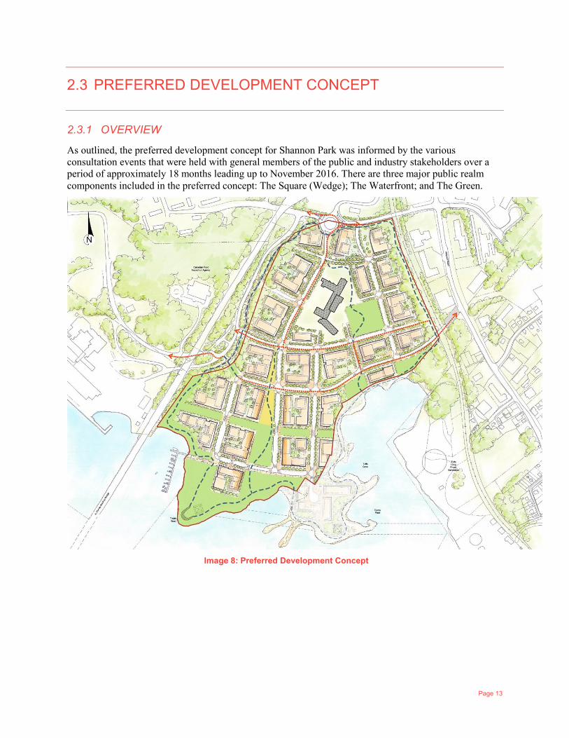
2.3 PREFERRED DEVELOPMENT CONCEPT
2.3.1 OVERVIEW
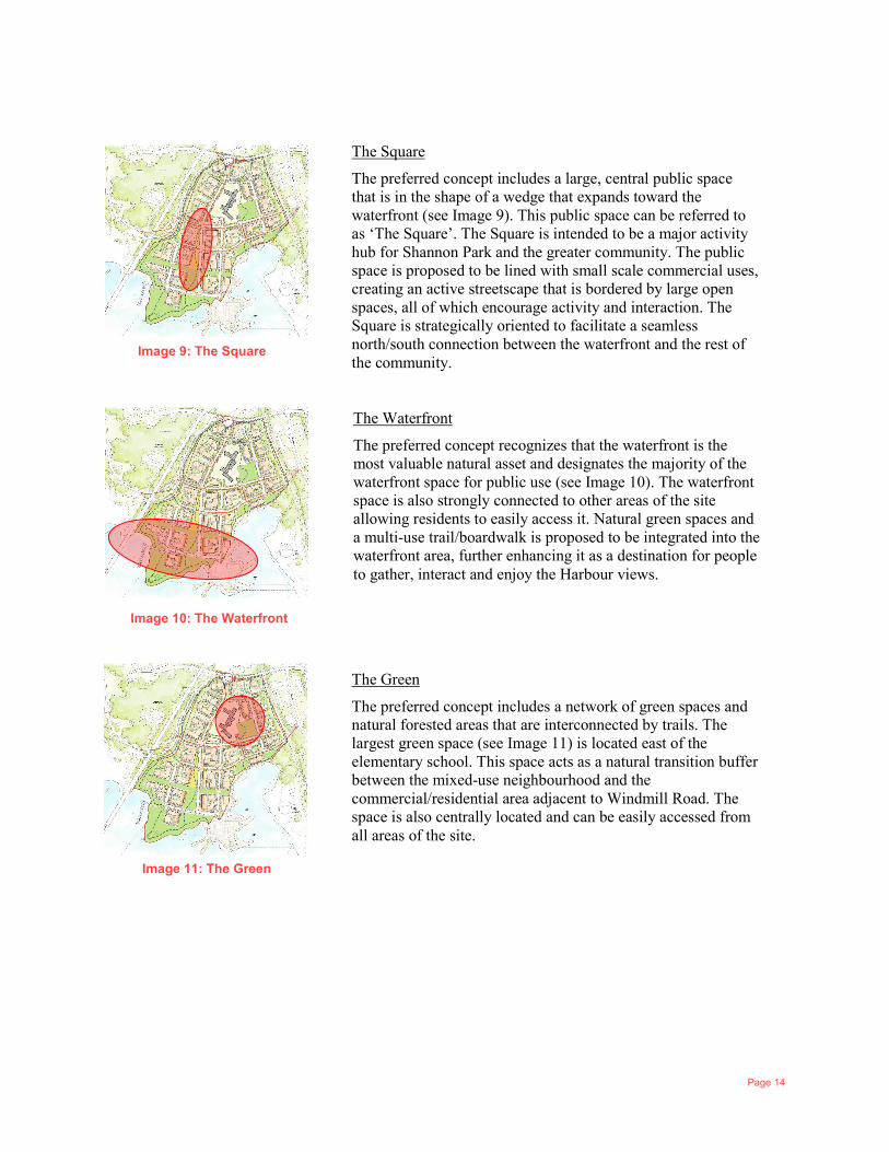
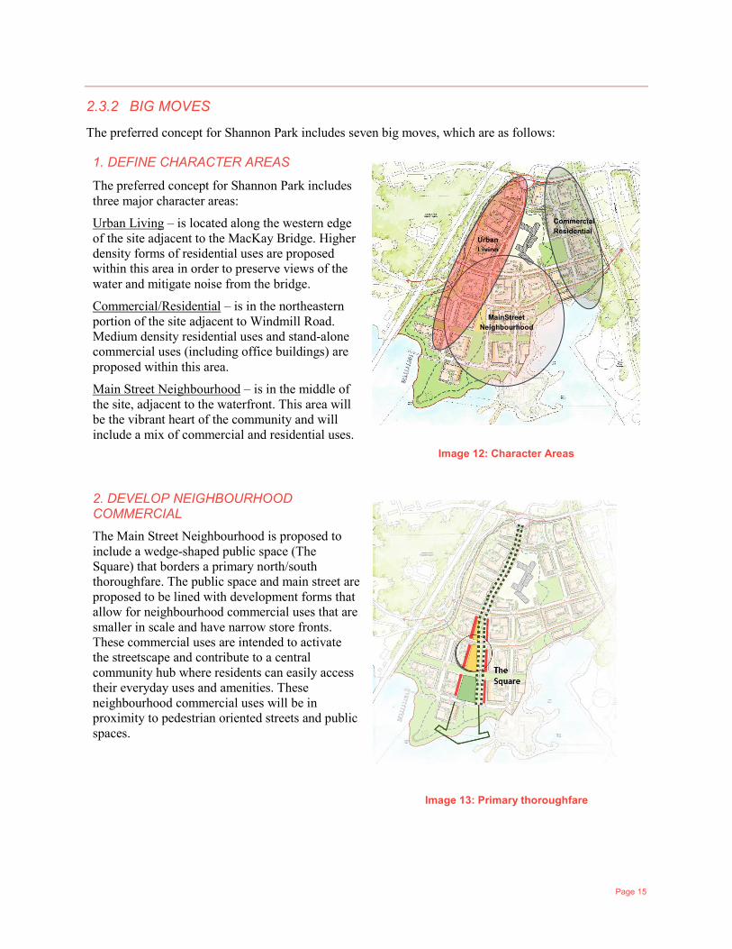
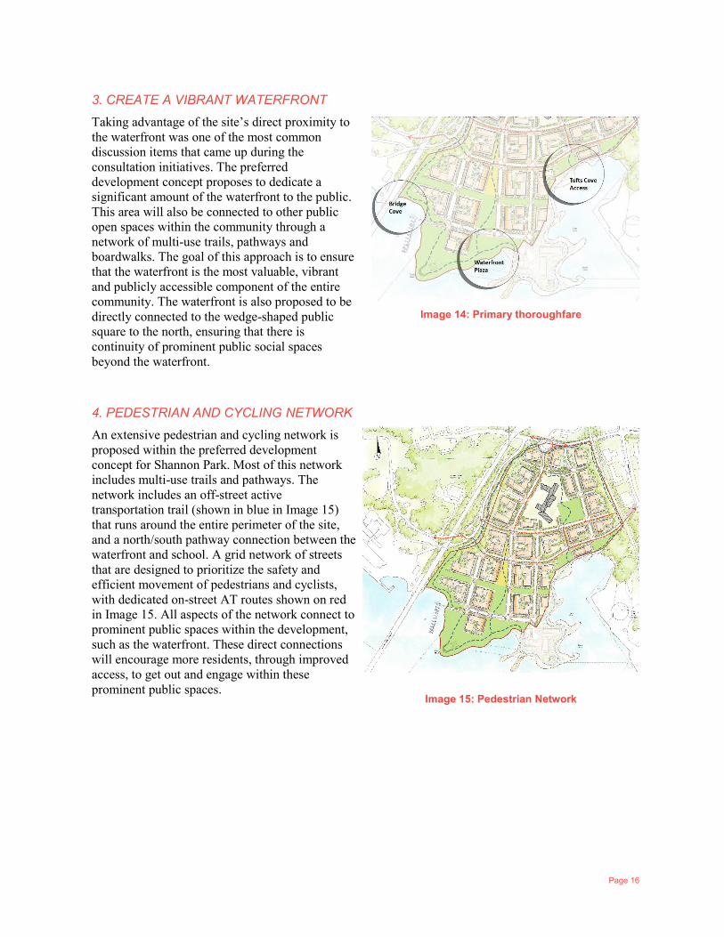
As outlined, the preferred development concept for Shannon Park was informed by the various consultation events that were held with general members of the public and industry stakeholders over a period of approximately 18 months leading up to November 2016. There are three major public realm components included in the preferred concept: The Square (Wedge); The Waterfront; and The Green.
Image 8: Preferred Development Concept
Page 14
Image 9: The Square
Image 10: The Waterfront
Image 11: The Green
The Square
The preferred concept includes a large, central public space that is in the shape of a wedge that expands toward the waterfront (see Image 9). This public space can be referred to as ‘The Square’. The Square is intended to be a major activity hub for Shannon Park and the greater community. The public space is proposed to be lined with small scale commercial uses, creating an active streetscape that is bordered by large open spaces, all of which encourage activity and interaction. The Square is strategically oriented to facilitate a seamless north/south connection between the waterfront and the rest of the community.
The Waterfront
The preferred concept recognizes that the waterfront is the most valuable natural asset and designates the majority of the waterfront space for public use (see Image 10). The waterfront space is also strongly connected to other areas of the site allowing residents to easily access it. Natural green spaces and a multi-use trail/boardwalk is proposed to be integrated into the waterfront area, further enhancing it as a destination for people to gather, interact and enjoy the Harbour views.
The Green
The preferred concept includes a network of green spaces and natural forested areas that are interconnected by trails. The largest green space (see Image 11) is located east of the elementary school. This space acts as a natural transition buffer between the mixed-use neighbourhood and the commercial/residential area adjacent to Windmill Road. The space is also centrally located and can be easily accessed from all areas of the site.
Image 10: The Waterfront
Page 15
2.3.2 BIG MOVES
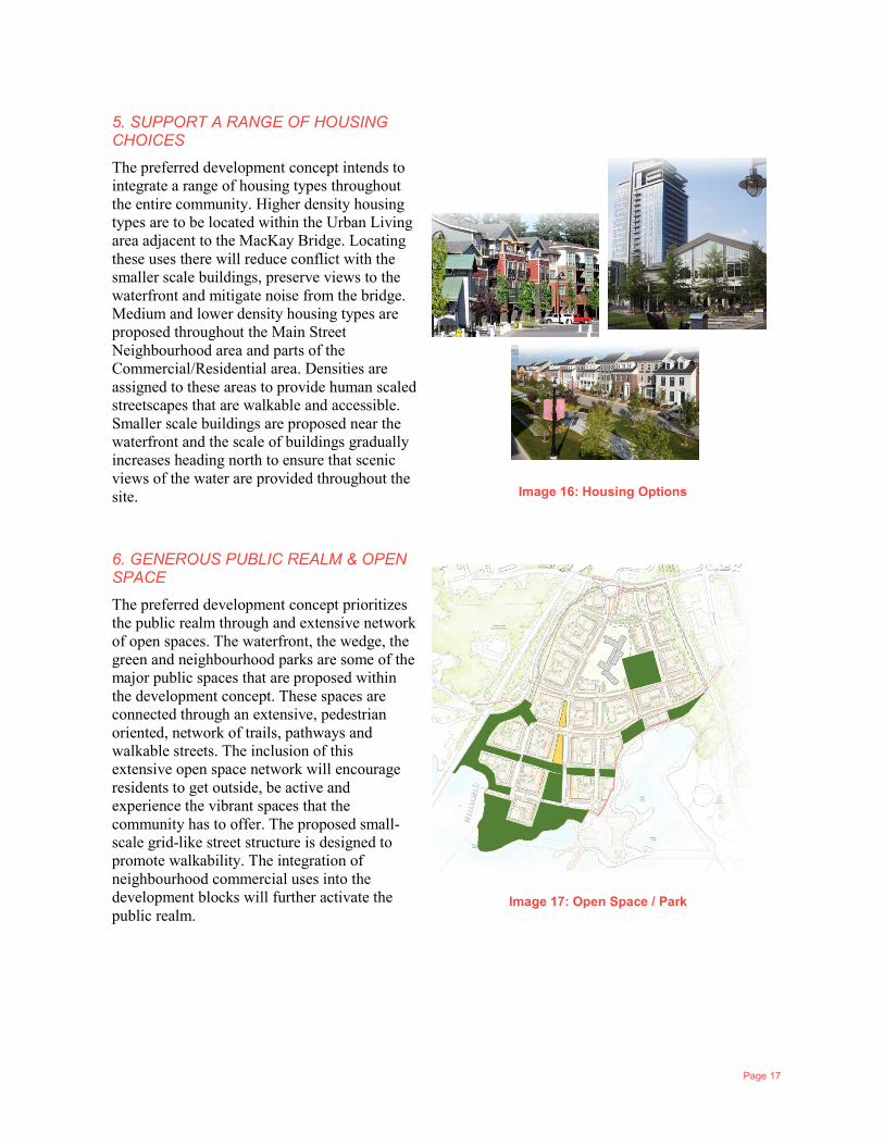
The preferred concept for Shannon Park includes seven big moves, which are as follows:
1. DEFINE CHARACTER AREAS
The preferred concept for Shannon Park includes three major character areas:
Urban Living – is located along the western edge of the site adjacent to the MacKay Bridge. Higher density forms of residential uses are proposed within this area in order to preserve views of the water and mitigate noise from the bridge.
Commercial/Residential – is in the northeastern portion of the site adjacent to Windmill Road. Medium density residential uses and stand-alone commercial uses (including office buildings) are proposed within this area.
Main Street Neighbourhood – is in the middle of the site, adjacent to the waterfront. This area will be the vibrant heart of the community and will include a mix of commercial and residential uses.
Image 12: Character Areas
2. DEVELOP NEIGHBOURHOOD COMMERCIAL
The Main Street Neighbourhood is proposed to include a wedge-shaped public space (The Square) that borders a primary north/south thoroughfare. The public space and main street are proposed to be lined with development forms that allow for neighbourhood commercial uses that are smaller in scale and have narrow store fronts. These commercial uses are intended to activate the streetscape and contribute to a central community hub where residents can easily access their everyday uses and amenities. These neighbourhood commercial uses will be in proximity to pedestrian oriented streets and public spaces.
Image 13: Primary thoroughfare
MainStreet Neighbourhood
Commercial Residential
Urban Living
Page 16
3. CREATE A VIBRANT WATERFRONT
Taking advantage of the site’s direct proximity to the waterfront was one of the most common discussion items that came up during the consultation initiatives. The preferred development concept proposes to dedicate a significant amount of the waterfront to the public. This area will also be connected to other public open spaces within the community through a network of multi-use trails, pathways and boardwalks. The goal of this approach is to ensure that the waterfront is the most valuable, vibrant and publicly accessible component of the entire community. The waterfront is also proposed to be directly connected to the wedge-shaped public square to the north, ensuring that there is continuity of prominent public social spaces beyond the waterfront.
Image 14: Primary thoroughfare
4. PEDESTRIAN AND CYCLING NETWORK
An extensive pedestrian and cycling network is proposed within the preferred development concept for Shannon Park. Most of this network includes multi-use trails and pathways. The network includes an off-street active transportation trail (shown in blue in Image 15) that runs around the entire perimeter of the site, and a north/south pathway connection between the waterfront and school. A grid network of streets that are designed to prioritize the safety and efficient movement of pedestrians and cyclists, with dedicated on-street AT routes shown on red in Image 15. All aspects of the network connect to prominent public spaces within the development, such as the waterfront. These direct connections will encourage more residents, through improved access, to get out and engage within these prominent public spaces.
Image 15: Pedestrian Network
Page 17
5. SUPPORT A RANGE OF HOUSING CHOICES
The preferred development concept intends to integrate a range of housing types throughout the entire community. Higher density housing types are to be located within the Urban Living area adjacent to the MacKay Bridge. Locating these uses there will reduce conflict with the smaller scale buildings, preserve views to the waterfront and mitigate noise from the bridge. Medium and lower density housing types are proposed throughout the Main Street Neighbourhood area and parts of the Commercial/Residential area. Densities are assigned to these areas to provide human scaled streetscapes that are walkable and accessible. Smaller scale buildings are proposed near the waterfront and the scale of buildings gradually increases heading north to ensure that scenic views of the water are provided throughout the site.
Image 16: Housing Options
6. GENEROUS PUBLIC REALM & OPEN SPACE
The preferred development concept prioritizes the public realm through and extensive network of open spaces. The waterfront, the wedge, the green and neighbourhood parks are some of the major public spaces that are proposed within the development concept. These spaces are connected through an extensive, pedestrian oriented, network of trails, pathways and walkable streets. The inclusion of this extensive open space network will encourage residents to get outside, be active and experience the vibrant spaces that the community has to offer. The proposed small-scale grid-like street structure is designed to promote walkability. The integration of neighbourhood commercial uses into the development blocks will further activate the public realm.
Image 17: Open Space / Park
Page 18
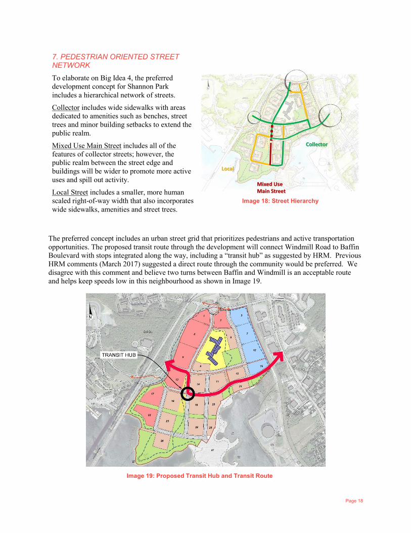
7. PEDESTRIAN ORIENTED STREET NETWORK
To elaborate on Big Idea 4, the preferred development concept for Shannon Park includes a hierarchical network of streets.
Collector includes wide sidewalks with areas dedicated to amenities such as benches, street trees and minor building setbacks to extend the public realm.
Mixed Use Main Street includes all of the features of collector streets; however, the public realm between the street edge and buildings will be wider to promote more active uses and spill out activity.
Local Street includes a smaller, more human scaled right-of-way width that also incorporates wide sidewalks, amenities and street trees.
Image 18: Street Hierarchy
The preferred concept includes an urban street grid that prioritizes pedestrians and active transportation opportunities. The proposed transit route through the development will connect Windmill Road to Baffin Boulevard with stops integrated along the way, including a “transit hub” as suggested by HRM. Previous HRM comments (March 2017) suggested a direct route through the community would be preferred. We disagree with this comment and believe two turns between Baffin and Windmill is an acceptable route and helps keep speeds low in this neighbourhood as shown in Image 19.
Image 19: Proposed Transit Hub and Transit Route
Page 19
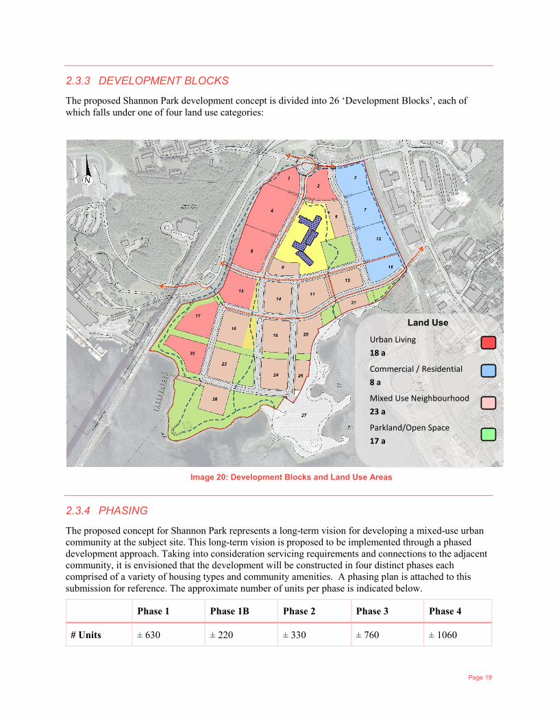
2.3.3 DEVELOPMENT BLOCKS
The proposed Shannon Park development concept is divided into 26 ‘Development Blocks’, each of which falls under one of four land use categories:
2.3.4 PHASING
The proposed concept for Shannon Park represents a long-term vision for developing a mixed-use urban community at the subject site. This long-term vision is proposed to be implemented through a phased development approach. Taking into consideration servicing requirements and connections to the adjacent community, it is envisioned that the development will be constructed in four distinct phases each comprised of a variety of housing types and community amenities. A phasing plan is attached to this submission for reference. The approximate number of units per phase is indicated below.
Phase 1 Phase 1B Phase 2 Phase 3 Phase 4
# Units ± 630 ± 220 ± 330 ± 760 ± 1060
Urban Living 18 a
Commercial / Residential 8 a
Mixed Use Neighbourhood 23 a
Parkland/Open Space 17 a
Land Use
Image 20: Development Blocks and Land Use Areas
Page 20
2.3.5 DENSITY AND BUILT FORM
The concept for Shannon Park accommodates 3,000 residential units and 145,000 square feet of commercial space. It is our understanding that density bonusing will be required at Site Plan Approval stage as per the policies outlined in the Regional Centre SMPS.
Residential and neighbourhood commercial uses are proposed to be distributed throughout the development with three distinct Character Areas (Big Move #1). The Urban Living area (adjacent to MacKay Bridge) is primarily designated for larger scale buildings that may contain residential and or office uses. The buildings will sit on a podium designed to promote street level activity.
The Commercial/Residential area (near Windmill Rd.) is proposed to include a significant amount of commercial space with apartment style residential units integrated above street level. The commercial spaces in this area are proposed to occupy the ground level of buildings and potentially additional levels above ground. The commercial spaces are intended to accommodate larger scale uses that may serve the greater community.
The Main Street Neighbourhood (area around ‘The Wedge’) is proposed to include smaller scale mixed use buildings that have neighbourhood style commercial uses at street grade along prominent street frontages with residential units above. In areas where commercial frontage is not viable, townhouse units with direct access to the street are proposed.
The three proposed built form areas for Shannon Park intend to create a complete community where residents can live, work and play. This is to be achieved through a variety of residential and commercial uses that are seamlessly connected to an integrated network of public spaces.
2.3.6 MILLBROOK LANDS
CLC has worked with First Nations communities across the country and has recent experience working closely with First Nations on development projects.
Building on these successes with First Nations communities, it was identified early on that developing a positive working relationship with Millbrook will be a key pillar in the creating a successful project at Shannon Park. Regarding this project, there are a few key points worth stating here.
CLC acquired the Shannon Park Lands from the Federal Government in March 2014, at that time, the 9 acres depicted on our conceptual plans was held to eventually be added to the Millbrook reserve. We understand the Federal Government, INAC and Millbrook are in negotiations regarding when this land will be formally added to the Millbrook reserve.
CLC identified the importance of a relationship with Millbrook early in the development process and set out a path of co-operation and engagement with Millbrook. They are a significant stakeholder and their involvement is a key element of the CLC workplan. To date several meetings and workshops have occurred with Millbrook and CLC, and they have been invited and participated in all the Community meetings and Stakeholder working sessions.
Millbrook has stated that their primary interest in the lands rests with the economic opportunity which development of them presents. CLC has recognized this and has undertaken to assist Millbrook in the development of their lands and capacity building within the First Nations community. CLC has been open with their development intentions for the CLC portions of the site and Millbrook has stated that they intend on building a complimentary project. Both sides agree that a cooperative approach with an integrated development plan is the best solution for both parties and the Municipality. To that end, Millbrook and CLC have been and will continue to share site development plans with each other.
CLC recognizes that the Millbrook Lands are not developable on their own as there is no road frontage or services to the site, therefore development of these lands is linked to development of the CLC portion.

Page 21
CLC has agreed to extend road, water and sewer services to the Millbrook boundary. Extension of these services into the Millbrook parcel is the responsibility of the Millbrook community.
CLC recognizes that although the two parties are working together in developing concepts, Millbrook is clearly responsible for approvals and development of their own lands.
Looking forward, CLC intends on a continued collaborative approach and active engagement with Millbrook. Although a development concept is being presented here, there are still many details to sort out as CLC and Millbrook work together to develop a comprehensive development concept at Shannon Park.
2.3.7 SHANNON PARK SCHOOL
When CLC acquired the Shannon Park site from DND, CLC assumed the DND undertaking to sell the school to HRSB. CLC owns the school until the sale can be completed.
CLC has also worked closely with the Shannon Park Elementary School throughout the 18-month consultation process. As mentioned, most public consultation events that were held for the project took place in the Shannon Park school gymnasium. The preferred development concept for Shannon Park has been designed to incorporate the Shannon Park School as a central institutional use within the community. The purposed land use distribution, road network pattern and infrastructure design has all incorporated the existing school.
Page 22
3 MUNICIPAL POLICY FRAMEWORK
3.1 REGIONAL MUNICIPAL PLANNING STRATEGY The Regional Municipal Planning Strategy (RMPS) is HRM’s overarching planning document that established long-range, region-wide planning policies outlining where and how future growth should take place in the municipality over the 25-year life of the plan.
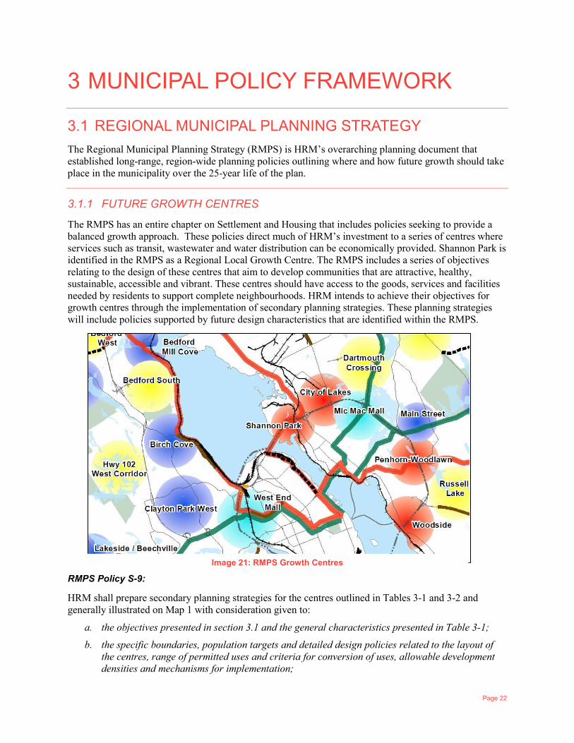
3.1.1 FUTURE GROWTH CENTRES
The RMPS has an entire chapter on Settlement and Housing that includes policies seeking to provide a balanced growth approach. These policies direct much of HRM’s investment to a series of centres where services such as transit, wastewater and water distribution can be economically provided. Shannon Park is identified in the RMPS as a Regional Local Growth Centre. The RMPS includes a series of objectives relating to the design of these centres that aim to develop communities that are attractive, healthy, sustainable, accessible and vibrant. These centres should have access to the goods, services and facilities needed by residents to support complete neighbourhoods. HRM intends to achieve their objectives for growth centres through the implementation of secondary planning strategies. These planning strategies will include policies supported by future design characteristics that are identified within the RMPS.
RMPS Policy S-9:
HRM shall prepare secondary planning strategies for the centres outlined in Tables 3-1 and 3-2 and generally illustrated on Map 1 with consideration given to:
a. the objectives presented in section 3.1 and the general characteristics presented in Table 3-1;
b. the specific boundaries, population targets and detailed design policies related to the layout of the centres, range of permitted uses and criteria for conversion of uses, allowable development densities and mechanisms for implementation;
Image 21: RMPS Growth Centres
Page 23
c. the recommendations of any plans and studies identified by this Plan that have been accepted or endorsed by Regional Council; and
d. any other relevant objectives and policies of this Plan.
The RMPS separates the growth centres within the municipality into two geographical areas:
1 Urban Settlement Growth Centres (within the service boundary) 2 Growth Centres within the Rural Commuter Designation (outside the service boundary)
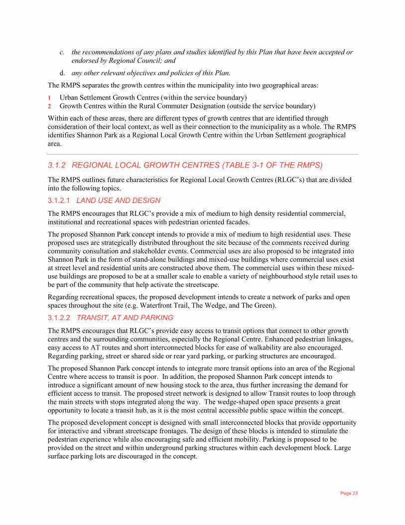
Within each of these areas, there are different types of growth centres that are identified through consideration of their local context, as well as their connection to the municipality as a whole. The RMPS identifies Shannon Park as a Regional Local Growth Centre within the Urban Settlement geographical area.
3.1.2 REGIONAL LOCAL GROWTH CENTRES (TABLE 3-1 OF THE RMPS)
The RMPS outlines future characteristics for Regional Local Growth Centres (RLGC’s) that are divided into the following topics.
3.1.2.1 LAND USE AND DESIGN
The RMPS encourages that RLGC’s provide a mix of medium to high density residential commercial, institutional and recreational spaces with pedestrian oriented facades.
The proposed Shannon Park concept intends to provide a mix of medium to high residential uses. These proposed uses are strategically distributed throughout the site because of the comments received during community consultation and stakeholder events. Commercial uses are also proposed to be integrated into Shannon Park in the form of stand-alone buildings and mixed-use buildings where commercial uses exist at street level and residential units are constructed above them. The commercial uses within these mixed-use buildings are proposed to be at a smaller scale to enable a variety of neighbourhood style retail uses to be part of the community that help activate the streetscape.
Regarding recreational spaces, the proposed development intends to create a network of parks and open spaces throughout the site (e.g. Waterfront Trail, The Wedge, and The Green).
3.1.2.2 TRANSIT, AT AND PARKING
The RMPS encourages that RLGC’s provide easy access to transit options that connect to other growth centres and the surrounding communities, especially the Regional Centre. Enhanced pedestrian linkages, easy access to AT routes and short interconnected blocks for ease of walkability are also encouraged. Regarding parking, street or shared side or rear yard parking, or parking structures are encouraged.
The proposed Shannon Park concept intends to integrate more transit options into an area of the Regional Centre where access to transit is poor. In addition, the proposed Shannon Park concept intends to introduce a significant amount of new housing stock to the area, thus further increasing the demand for efficient access to transit. The proposed street network is designed to allow Transit routes to loop through the main streets with stops integrated along the way. The wedge-shaped open space presents a great opportunity to locate a transit hub, as it is the most central accessible public space within the concept.
The proposed development concept is designed with small interconnected blocks that provide opportunity for interactive and vibrant streetscape frontages. The design of these blocks is intended to stimulate the pedestrian experience while also encouraging safe and efficient mobility. Parking is proposed to be provided on the street and within underground parking structures within each development block. Large surface parking lots are discouraged in the concept.
Page 24
3.1.2.3 OPEN SPACE
The RMPS outlines the following future characteristics in relation to Open Spaces:
— Streetscaping featuring landscaped pocket parks and tree-lined streets; — Interconnected private and public open space linked with greenbelt corridors; — Improved quality and quantity of parkland; — Focus on waterfront parks and trails; — Private and public realm urban forest canopy cover to be maintained and improved; — Riparian canopy cover to be maintained and improved; — Provisions for food security.
The proposed Shannon Park concept integrates all of these features. A network of neighbourhood scale parks and open spaces are proposed throughout the site and are connected by exclusive AT routes and pedestrian oriented streets. The waterfront trail, it’s associated open spaces and the wedge-shaped public space will significantly improve the quality and quantity of parkland in the area. Development within each of the private blocks includes private open spaces that are directly linked to the uses within the block and are also seamlessly connected to other areas of the development. These spaces provide opportunity to introduce community initiatives such as shared gardening plots that could help improve food security. The proposed street network includes streets that are lined with trees on both sides in order to provide a riparian buffer and improve the public realm.
3.1.2.4 CULTURAL HERITAGE
The RMPS encourages that built and natural heritage elements are to be maintained, improved and integrated into new development. It is encouraged that public art also be integrated into new development and that scenic views are preserved.
The proposed Shannon Park concept is designed to preserve the primary natural heritage elements within the site: The Waterfront. The majority of the waterfront area of the Shannon Park site is proposed to be dedicated for public use to ensure all members of the public are able to access it and that its scenic views are preserved. The concept design provides flexibility regarding the variety of types of public uses or spaces that could be integrated into the waterfront area. These could include elements such as public art and historical commemoration/ interpretation.
Shannon Park’s history as a major military housing community was an important consideration during the development of the concept design. CLC wants the area’s rich history to be incorporated into the public realm. The naming of streets, parks and public spaces as well as the integration of historical interpretive elements such as commemorative art are certain ways that the history of the site can be integrated into the new community.
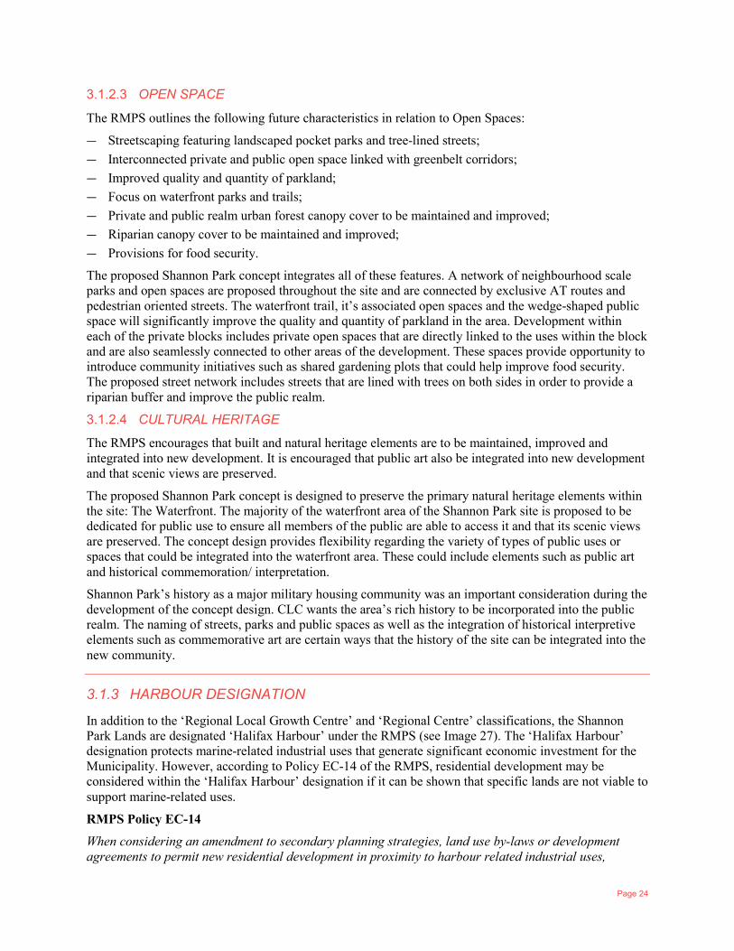
3.1.3 HARBOUR DESIGNATION
In addition to the ‘Regional Local Growth Centre’ and ‘Regional Centre’ classifications, the Shannon Park Lands are designated ‘Halifax Harbour’ under the RMPS (see Image 27). The ‘Halifax Harbour’ designation protects marine-related industrial uses that generate significant economic investment for the Municipality. However, according to Policy EC-14 of the RMPS, residential development may be considered within the ‘Halifax Harbour’ designation if it can be shown that specific lands are not viable to support marine-related uses.
RMPS Policy EC-14
When considering an amendment to secondary planning strategies, land use by-laws or development agreements to permit new residential development in proximity to harbour related industrial uses,
Page 25
consideration shall be given to the potential for nuisances and compatibility issues and the importance to HRM in protecting the viability of the marine related industrial uses.
In 2016, Cantwell & Company studied this consideration and confirmed that the Shannon Park Lands are indeed unsuitable for marine-related industrial uses, and intensive mixed-use redevelopment with supporting services should be encouraged.
3.2 REGIONAL CENTRE SECONDARY MUNICIPAL PLANNING STRATEGY
The Regional Centre Secondary Municipal Planning Strategy (Centre Plan) is HRM’s planning document that applies and establishes the enabling policies for Shannon Park’s development agreement application. The policies that apply to the comprehensive development agreement (CDD) application include:
1 CDD General Planning Policies for the Future Growth Node Designation 2 Neighbourhood Master Planning Policies 3 General Development Agreement Consideration Policies 4 Shannon Park Policies that apply to the specific consideration of CDD development on the Shannon
Park site. The following tables outline these policies and the associated planning rationale as provided in CLC’s concept proposal and supporting information.
3.2.1 CDD GENERAL PLANNING POLICIES
Policies 3.27 to 3.29 deal with the CDD general policies applicable for all CDD sites, including Shannon Park. The table below outlines each of these general policies and the planning rationale for the development concept’s response to these policies.
Image 22: Harbour Designation Map
Page 26
REFERENCE CDD GENERAL POLICY PLANNING RATIONALE
Policy 3.27 Lands designated as Future Growth Nodes on Map 1 are established as CDDs over lands where there is potential to accommodate significant growth due to the site’s size, location and proximity to services. These lands are intended to develop comprehensively into compact mixed-use communities where transit and human scale and pedestrian-oriented environment is prioritized and supported.
CLC’s Shannon Park Lands are ±87 acres. As outlined in this application letter, the development concept was created through the community engagement process with the explicit purpose of creating a compact mixed-use community where human scale, pedestrian-oriented environment, active transportation and transit is prioritized and supported.
Policy 3.28 The LUB shall establish a CDD zone and apply it over lands within the Future Growth Node Designation. The CDD zone shall permit all commercial and industrial uses permitted in the CEN-2 zone without a DA, providing:
a) any new use is permitted as of right in the CDD zone;
b) any new use is limited to a max. floor area of 1,000 sq. m. and to a max. building height of 20 m; and
c) the new use is located on a lot in existence at the time of the adoption of this Plan.
A DA shall be required for any other use in the CDD zone, in accordance with the Policy 3.32. Where a DA is required in a CDD zone, the LUB shall require incentive or bonus zoning.
As significant development is envisioned on the CLC Shannon Park Lands, a DA is being requested to accommodate approximately 3,000 residential units and 145,000 sq. ft. of commercial area, and institutional uses. Our understanding is that the DA will outline this like maximum FAR, and maximum building height precincts and zones will be applied. Building developers would then go through a separate process of Site Plan Approval for the building(s). It is also understood that incentive/bonus zoning would be part of the site plan approval agreement.
See the following table for the planning rationale associated with Policy 3.32.
Policy 3.29 Amendments to the LUB may be considered to allow for the additional expansion of existing uses permitted in the CDD Zone provided such expansion, or internal conversion, would not preclude the future comprehensive subdivision and development of the lands and complies with the LUB.
N/A
Page 27
3.2.2 NEIGHBOURHOOD MASTER PLANNING POLICIES
Policies 3.30 to 3.31 deal with the CDD general policies applicable for master neighbourhood planning initiatives on CDD sites, including Shannon Park. The table below outlines each of these policies and the planning rationale for the development concept’s response to these policies.
REFERENCE
MASTER NEIGHBOURHOOD
PLANNING POLICY PLANNING RATIONALE
Policy 3.30 The Municipality shall undertake master neighbourhood planning for each Future Growth Node prior to considering a development agreement to enable the comprehensive development of the site. New or revised CDD Design Guidelines for a Future Growth Node shall consider and be reasonably consistent with the Regional Centre Urban Design Manual (Urban Design Manual) contained in Appendix 2, and the following matters:
a) the objectives of Section 3.6 of this Plan;
b) the classes of uses permitted;
c) the type, location and phasing of development;
d) the use and conservation of energy, including sustainable design;
e) opportunities to identify, preserve, rehabilitate and celebrate significant environmental features or cultural assets as identified through a culture and heritage assessment;
f) on-site stormwater management including green stormwater infrastructure to reduce the stormwater flowing into the public
As outlined previously in section 2.1, CLC with their consultants WSP and Dialog, conducted a Master Neighbourhood Planning Study throughout 2015 and 2016. This included an 18-month community engagement process and involved a significant number of stakeholders. The results of this process helped to inform Policy 3.34 of the Centre Plan, which specifically addresses the DA requirements for Shannon Park. Our proposal is a master plan DA and does not propose specific building design. For future building design, it is reasonable to utilize the Centre Plan’s Urban Design Manual for subsequent Site Plan Approval Processes for the buildings.
This Master Neighbourhood Planning exercise encompassed the factors as laid out in Policy 3.30.
- The objectives of Section 3.6 of the Plan prioritizes engagement opportunities, and recognizes the need for master planning to address numerous community objectives. The development concept was created through a robust community engagement process and balances multiple community objectives towards creating a strong pedestrian-oriented public realm and community where the daily needs of residents can be met.
- Uses permitted are anticipated to be the uses of the CEN-2 zone.
- The location of development (development blocks), road alignment, and park and open space was carefully considered throughout the Master Neighbourhood Planning study. Appropriate phasing can be discussed through the DA negotiation process.
Page 28
REFERENCE
MASTER NEIGHBOURHOOD
PLANNING POLICY PLANNING RATIONALE
stormwater system, and improve the quality of runoff through filtration;
g) the provision of parks, open spaces and community recreation facilities that meet the objectives of this Plan;
h) the transportation network and the need for on-site transit facilities;
i) the design of streets, buildings and open spaces to respond to weather patterns, mitigate potential for flooding and accommodate seasonal conditions;
j) the layout of public streets with a block pattern that supports transit and connects to the surrounding community, Centres, the Downtown, and other key destination areas;
k) the provision of a mix of uses;
l) encouraging the use of buffers, building design, and landscape design to mitigate negative air quality impacts to building users and residents, particularly in areas near highways, regional truck routes, high traffic streets and other sources of air pollution;
m) setbacks and other measures to minimize safety risks and conflicts associated with railway operations;
n) setting max. building FARs and max. heights for the entire or a portion of the site that may differ from those
- Sustainable design has been considered throughout the Master Planning Study to make optimal use of active transportation throughout the site and maximizing building’s ability to account for solar aspect.
- The archaeology study identifies cultural resources on the site. The urban design analysis CLC will prepare will examine celebration and commemoration opportunities throughout the site. There are three specific opportunities for focus: Military; Mi’Kmaq presence; and the Halifax explosion.
- Stormwater management will have some on-site opportunities through the provision of open space lands as well as shoreline access. The servicing plan has identified several methods to help control post development flows such as controlled flow roof drains and Low Impact Development (LID) measures such as bio-retention areas, bio swales, green roofs and permeable asphalt. The use of LID measures will also help improve stormwater quality and mitigate temperature extremes in the runoff water.
- Parks and open spaces comprise 19% (16.4 acres) of the site, exceeding Subdivision Bylaw requirements. Section 2.3.1 of this report details the open space offering in more detail.
- A public waterfront assists in buffering roads and buildings from storm events.
- The three character areas proposed for the site accommodate a mix of commercial, open space and residential uses.
- Buffering from the noise impacts of the bridge has been considered through the layout to place the taller buildings in this location, essentially buffering the rest of the site.
Page 29
REFERENCE
MASTER NEIGHBOURHOOD
PLANNING POLICY PLANNING RATIONALE
illustrated on Map 3 of this Plan and Schedule 7 of the LUB;
o) the location and built form regulations under the LUB particularly with respect to streetwalls and max. building dimensions;
p) provisions for incentive or bonus zoning;
q) urban design that supports pedestrian environments;
s) community food security and urban agriculture; and
t) applicable direction contained in the Regional Plan and in any approved Priority Plans.
- Individual building and site designs will need to accommodate setbacks from the railway to minimize safety risks. The location of commercial-oriented space in proximity to the railway is proposed to mitigate conflicts associated with railway operations.
- As mentioned above, our understanding is that the DA will outline this like maximum FAR, and maximum building height precincts and zones will be applied.
- Building developers would need to follow the built form regulations under the LUB, as specific buildings are not proposed within this DA.
- Incentive/bonus zoning would be considered at the subsequent Site Plan Approval phase.
- As outlined, pedestrian supported urban design was paramount in the conceptual layout of the Shannon Park Master Plan.
- There is ample park space and open space proposed within the concept plan that could support urban agriculture/community gardens.
- The IMP plan raises that the feasibility of a Woodside-Burnside Rail Connection in Dartmouth could be provided. Our understanding is that VIA and HRM could not negotiate a feasible agreement based on CN scheduling needs.
Policy 3.31 Council may only consider development agreement applications
for the development of Future Growth Nodes when site specific
CDD Design Requirements are adopted in this Plan.
- Policy 3.3.4 outlines site specific policy for the development of Shannon Park.
Page 30
3.2.3 GENERAL DEVELOPMENT AGREEMENT CONSIDERATION PLANNING POLICIES
Policies 3.32 to 3.33 deal with the CDD development agreement consideration criteria applicable for master neighbourhood planning initiatives on CDD sites, including Shannon Park. The table below outlines each of these policies and the planning rationale for the development concept’s response to these policies.
REFERENCE GENERAL DA POLICY PLANNING RATIONALE
Policy 3.32 The Maximum Building Height Precincts illustrated on Map 3 and Schedule 7 shall not apply to a DA within a CDD zone. In considering DA for any lands zoned CDD, Council shall consider the following:
a) the Urban Design Manual contained in Appendix 2 of this
Plan;
b) the applicable site specific CDD requirements set out in Section 3.6.3 of this Plan;
c) all applicable policies of the Regional Plan and of this Plan;
d) the subdivision of land;
e) the phasing of infrastructure;
f) the proposed road network and the location of transit facilities;
g) the provision of open space that meets the objectives of this Plan and the requirements of Regional Subdivision By-law;
h) the proposed built form and land use requirements reference the appropriate zones and sections of LUB with limited variation considered as needed to meet Urban Design Manual;
i) the agreement may identify Pedestrian-Oriented Commercial Streets, View Corridors, and View Terminus Sites;
- As specific buildings are not being proposed as part of this DA, the DA can simply refer to requirements of the Centre Plan Urban Design Manual.
- Section 3.6.3. requirements outlined in following table (Policy 3.34 deals with Shannon Park).
- Regional Plan Policies outlined in previous section above.
- Subdivision of land will occur as lots are sold.
- A Servicing Plan was created by WSP to account for efficient phasing of infrastructure. A Phasing plan is also provided in this submission.
- A traffic impact study has been prepared as part of the 2016 submission and is attached again in this submission. The concept plan has a formalized grid pattern of streets that creates short interconnected blocks. The concept also locates a transit hub or major transit stop within or near the wedge-shaped public space. This public space is envisioned to be the heart of the entire development and will be lined with neighbourhood commercial uses, creating a small employment hub. Transit is also proposed to loop through the rest of the development site providing access to the other character areas where additional employment uses are proposed.
- See Section 2 of this submission letter for an overview off the proposed parks, open spaces, and pedestrian and AT network creating connection between the spaces. Shannon Park is not directly connected to any parks or AT trails within the Municipality’s larger parks network.
Page 31
REFERENCE GENERAL DA POLICY PLANNING RATIONALE
j) provisions to comply with the Pedestrian Wind Impact Assessment Protocol and Performance Standards, and the Shadow Impact Assessment Protocol and Performance Standards of the LUB;
k) provisions for incentive or bonus zoning;
l) impacts to Municipal infrastructure and the need, if any, to concurrently approve by-laws to pay for growth related municipal infrastructure; and
m) the agreement to enable the agreement to be discharged when all terms and obligations are fulfilled.
The proposed trails, parks and open spaces are strategically located to easily integrated into the Municipality’s larger parks network when it expands towards the Shannon Park site. 19% (16.4 acres) of the lands are planned as parks/open space, exceeding Subdivision Bylaw requirements.
- The proposed built form and land use requirements largely align with the permissions of the CEN-2 Zone.
- No Shadow Protocol is triggered based on this proposal. It is our understanding that Wind Studies will be required at Site Plan Approval Stage for the individual buildings proposed (and not at DA stage).
- CLC is proposing to sell an estimated 26 blocks to the private sector for mixed use development. The proposed block structure aligns well with the density bonusing programs that are encouraged in the Centre Plan. Private developers will be required to meet Density Bonus requirements under the Site Plan Approval Stage and this can be outlined in the terms of the DA.
- It is our understanding that once the subdivision of roads, parcels, and park space is completed, that the DA can be discharged and an underlying zone (CEN-2), height or FAR would be applied as per the DA.
Page 32
REFERENCE GENERAL DA POLICY PLANNING RATIONALE
Policy 3.33 Zoning identified in the development agreement pursuant to Policy 3.32 shall be applied to the Future Growth Nodes upon the fulfillment of the approved terms of the development agreement to continue to regulate land use and built-form on the site. In considering amendments to LUB to replace the CDD Zone with any other Regional Centre Plan zone, the Council shall be satisfied that the proposed zoning meets the intent of the approved CDD DA Requirements.
- As noted above, it is our understanding that once the subdivision of roads, parcels, and park space is completed, that the DA can be discharged and an underlying zone (CEN-2), height or FAR would be applied as per the DA.
3.2.4 SHANNON PARK PLANNING POLICIES
Section 3.6.3.1 of the Regional Centre SMPS provides policy specific to considering a Development Agreement on the Shannon Park Lands. It notes:
Shannon Park is a former military community located on the eastern shore of the Halifax Harbour. Now vacant, the 85-acre site is intended to be developed into a compact, mixed use community of approx. 7,000 residents. As a site that is bordered by a rail line, the A. Murray Mackay Bridge and the Tufts Cove Power Generating Plant, special attention is required to connect the community to surrounding neighbourhoods and employment centres.
REFERENCE SHANNON PARK LANDS POLICY PLANNING RATIONAL
Policy 3.34 When considering a development agreement for Shannon Park Lands Future Growth Node, Council shall consider that the proposed development is reasonably consistent with Policy 3.32, and with the following:
Policy 3.32 rationale summary provided in previous table.
Page 33
REFERENCE SHANNON PARK LANDS POLICY PLANNING RATIONAL
Policy 3.34 (a) The Land Use Concept as illustrated on Map 11, including the general location of proposed land uses, road network and road connections, parks and multi-use trails;
The concept conforms to the general location of proposed land uses, road network and road connections, parks and multi-use trails. Note that since the December 2016 submission, CLC has repeatedly indicated to HRM staff that we do not support a direct road connection through Shannon Park between Windmill Road and Baffin Boulevard. Grade requirements would necessitate an elevated roadway reminiscent of the Cogswell Interchange that would largely detract from the walkable urban community this development aims to create. As provided in correspondence at the time of the Centre Plan adoption, we understand that there is flexibility in Map 11 relating to this item.
Policy 3.34 (b) Site and building design that supports a compact, mixed- use neighbourhood by providing:
i. a mix of mid-rise buildings, tall mid-rise buildings and high-rise buildings, including ground-oriented units;
ii. commercial and institutional uses located within mixed use buildings and primarily clustered along the ground floor of pedestrian-oriented commercial streets; and
iii. pedestrian-oriented building facades and designs.
As outlined in the development concept, the goal with the street network is to offer a mixed-use walkable neighbourhood. There are distinct ‘character areas’ offered in the plan – Urban Living, Commercial/Residential, and Main Street Neighbourhood.
This approach provides for taller buildings towards the bridge (Urban Living) and lower height buildings towards the waterfront with ground-oriented units (Main street Neighbourhood) to maximize views and limit shadowing effects on the proposed public parks and open spaces. Each of these defining character areas will have a component of a mix of uses.
The wedge-shaped public space is envisioned to be the heart of the entire development, and lined with neighbourhood commercial uses, creating a small employment hub. See section 2.3.2. of this application letter for further descriptions.
Page 34
REFERENCE SHANNON PARK LANDS POLICY PLANNING RATIONAL
Policy 3.34 (c) Parks and open spaces that provide the full range of recreation and open spaces needed to serve the dense community by including:
i. a waterfront park that is a destination for both residents and surrounding communities;
ii. a centrally located multi-use park primarily designed to serve the outdoor recreation needs of the local community; and
iii. other small park parcels that may be needed to facilitate pedestrian connections within the community and to surrounding areas.
Section 2 of this DA application submission letter describes the various parks and open spaces that are proposed within the Shannon Park concept. That section also describes the pedestrian and AT network that is proposed to connect the various parks and open spaces within the site. A waterfront park, a centrally located multi-use park, and other small park parcels are all proposed as part of the Concept.
Page 35
REFERENCE SHANNON PARK LANDS POLICY PLANNING RATIONAL
Policy 3.34 (d) A transportation network that prioritizes walking, the use of mobility devices, cycling, and transit use by considering:
i. the location of a centrally located transit facility located close to shops and services that provides a comfortable space for people to wait and gather;
ii. multi-use trails through the site that link to planned multi-use trail routes located on Windmill Road, Baffin Boulevard and near the Mackay Bridge; and
iii. the location of potential future commuter rail and ferry services during the phasing and design of development blocks.
The concept plan depicts the location and space for a centrally located transit facility. This location is at the ‘heart’ of the development and located at the ‘top’ of the wedge-shaped public space. The public space and main street are proposed to be lined with development forms that allow for neighbourhood commercial uses that are smaller in scale and have narrow store fronts. These commercial uses are intended to activate the streetscape and contribute to a central community hub where residents can easily access their everyday uses and amenities. These neighbourhood commercial uses will be in proximity to pedestrian oriented streets and public spaces. See section 2.3.2 item 2, 4 and 7 for further descriptions.
Section 2 of this DA application submission letter describes the pedestrian and AT network that is proposed to connect the various parks, open spaces, neighbourhood character area. This concept depicts the planned multi-use trails through the site that link to planned multi-use trail routes located on Windmill Road, Baffin Boulevard and near the Mackay Bridge.
We feel that any future commuter rail service does not seem likely during the phasing and design of development blocks, given recent Council decisions on the matter. Note that the Millbrook First Nation has ownership of the shoreline areas suitable for ferry services. Millbrook has not communicated the possibility of any potential ferry service to CLC.
Page 36
REFERENCE SHANNON PARK LANDS POLICY PLANNING RATIONAL
Policy 3.34 (e) The design and location of buildings and public infrastructure so as to mitigate potential climate change and storm surge risks in vulnerable areas by:
i. designing new buildings to be flood resistant to a storm surge/sea level rise elevation established in the Regional Plan;
ii. designing and locating roads, parks and other public infrastructure to comply with engineering standards to minimize risks of damage caused by future sea level rise and storm surge; and
iii. incorporating the following into the design and location of neighbourhood features: scenic views; historic connections to the harbour; past community and military use of the site; and the results of an archeological assessment.
Designing to mitigate the potential impacts of future sea level rise and storm surge as it relates to the design and location of buildings and infrastructure at Shannon Park is important.
CLC has undertaken to incorporate virtually all the property’s waterfrontage as public parkland. CLC’s waterfrontage is primarily located adjacent to the narrows/Norris Point and the elevation of these lands is substantially higher than the 3.2-m elevation specified in the Regional Plan, aiding in resiliency to future sea level rise and storm surge.
Through the site grading and road engineering, it is anticipated that Nootka Avenue will be designed at an elevation that can act as a buffer for sea level rise risks.
Page 37
Policy 3.34 (f) f) Development is designed to coordinate with adjacent lands and neighbourhoods by:
i. coordinating road, park, servicing and trail designs with the anticipated development of the lands owned by the Millbrook First Nation;
ii. considering development next to the railway and the Canadian Municipalities (FCM) and the Railway Association of Canada (RAC) Guidelines for New Development in Proximity to Railway Operations (Guidelines),
iii. ensuring land uses and buildings transition to existing and planned development located on Windmill Road;
iv. incorporating the Shannon Park School site into the design of the community while also enabling the school lands to be readily integrated into the neighbourhood design should it be closed in the future;
v. considering the proximity to the Tufts Cove Power Generating Plant and related infrastructure and any measures needed to mitigate potential land use conflicts; and
vi. considering the scale and separation of buildings adjacent to the Mackay Bridge and its approaches, to mitigate noise impacts and
The 18-month planning process that was undertaken by CLC in cooperation with WSP and other agencies led to the creation of a preferred concept for the Shannon Park site that is supported by various technical studies. The concept and supporting studies address the items listed under this policy as follows:
- CLC and Millbrook First Nations have entered a Memorandum of Understanding and have ongoing discussion to have complimentary development across the CLC and Millbrook First Nation Shannon Park Lands. Road layout and phasing has been planned to consider the anticipated development on the Millbrook First Nation Lands.
- Development along the rail corridor will be such that the FCM and RAC guidelines are followed.
- The School lands have been maintained and considered in the overall development layout. Park space has been relocated in the revised concept plan to be directly adjacent to the School lands as requested by HRM Parks Planning.
- The consideration to Tufts Cove Plant has been considered in the master plan layout.
- The Halifax Dartmouth Bridge Commission was been involved in all stakeholder engagement leading up to the preparation of CLC’s concept plan. No major land use conflicts were identified. Furthermore, master plan layout has been designed to have taller buildings adjacent to the bridge to buffer noise and visual impact from the rest of the Shannon park development.
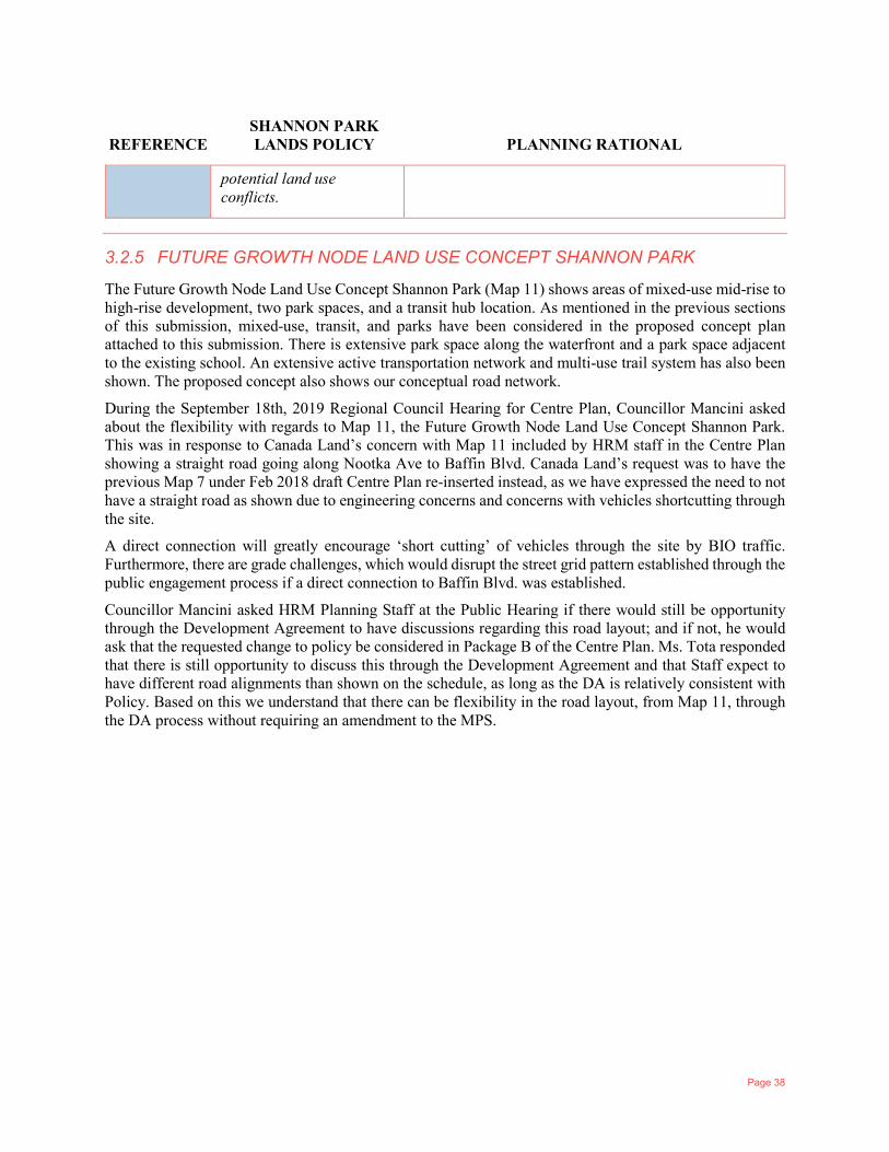
Page 38
REFERENCE SHANNON PARK LANDS POLICY PLANNING RATIONAL
potential land use conflicts.
3.2.5 FUTURE GROWTH NODE LAND USE CONCEPT SHANNON PARK
The Future Growth Node Land Use Concept Shannon Park (Map 11) shows areas of mixed-use mid-rise to high-rise development, two park spaces, and a transit hub location. As mentioned in the previous sections of this submission, mixed-use, transit, and parks have been considered in the proposed concept plan attached to this submission. There is extensive park space along the waterfront and a park space adjacent to the existing school. An extensive active transportation network and multi-use trail system has also been shown. The proposed concept also shows our conceptual road network.
During the September 18th, 2019 Regional Council Hearing for Centre Plan, Councillor Mancini asked about the flexibility with regards to Map 11, the Future Growth Node Land Use Concept Shannon Park. This was in response to Canada Land’s concern with Map 11 included by HRM staff in the Centre Plan showing a straight road going along Nootka Ave to Baffin Blvd. Canada Land’s request was to have the previous Map 7 under Feb 2018 draft Centre Plan re-inserted instead, as we have expressed the need to not have a straight road as shown due to engineering concerns and concerns with vehicles shortcutting through the site.
A direct connection will greatly encourage ‘short cutting’ of vehicles through the site by BIO traffic. Furthermore, there are grade challenges, which would disrupt the street grid pattern established through the public engagement process if a direct connection to Baffin Blvd. was established.
Councillor Mancini asked HRM Planning Staff at the Public Hearing if there would still be opportunity through the Development Agreement to have discussions regarding this road layout; and if not, he would ask that the requested change to policy be considered in Package B of the Centre Plan. Ms. Tota responded that there is still opportunity to discuss this through the Development Agreement and that Staff expect to have different road alignments than shown on the schedule, as long as the DA is relatively consistent with Policy. Based on this we understand that there can be flexibility in the road layout, from Map 11, through the DA process without requiring an amendment to the MPS.
Page 39
4 TECHNICAL STUDIES
4.1 INTRODUCTION To support concept planning, a variety of technical studies have been undertaken. Information from this work will assist CLC in discussing with appropriate agencies as the development concept is reviewed and further refined.
4.2 SERVICING STUDY In August 2016, WSP completed a Schematic Servicing and Infrastructure Design Preliminary Report. WSP reviewed all relevant background information, assessed the development demands based on the preferred development concept plan, and developed conceptual servicing strategies for the proposed development. WSP met with Halifax Water (HW) to discuss water and sanitary sewer servicing for the site. HW provided additional record and design drawings as well as water system modeling information for the Dartmouth area near the site. The WSP report addresses: water, sanitary, stormwater, gas and electrical.
The findings of this report concluded that the preferred concept can be developed in accordance with Municipal Specifications (Red & Blue Book) with no offsite impacts.
4.3 TRAFFIC ANALYSIS Harbourside Transportation Consultants (HTC) and Design Point Engineering & Surveying Ltd. were retained by CLC to prepare a traffic impact study (TIS) for the proposed development of Shannon Park in Dartmouth, NS.
The study area for this project focused on seven intersections including the ramps to the MacKay Bridge toll plaza. Traffic counts were collected during the AM and PM peak traffic periods on a variety of dates and locations.
HTC and Design Point are of the opinion that the proposed development can proceed if the following road network improvement are implemented before 2027.
1 A signalized intersection needs to be installed at Princess Margaret Boulevard/MacKay Bridge Ramp (west). The signals should be configured to provide a protected left-turn phase for the eastbound approach. The eastbound approach requires a left-turn lane, existing conditions show a wider approach which already serves as a left-turn lane, however the left-turn lane should be delineated by pavement markings.
2 The Princess Margaret Boulevard/MacKay Bridge Ramp (east)/Shannon Park Access intersection needs to be upgraded to a single lane roundabout. The roundabout will require right turn by-passes at the eastbound and westbound approaches. An auxiliary left-turn lane is required for the westbound approach of Princess Margaret Boulevard/Iroquois Drive.
3 At Windmill Road/Princess Margaret Boulevard widening will need to occur at the intersection to accommodate new lane configurations. The intersection requires lane reconfigurations in both the southbound and eastbound directions to include separate left-turn, through and right-turn lanes. The signals should be reconfigured to provide protected left-turn phases for the southbound and eastbound approaches.
4 A signalized intersection needs to be installed at Windmill Road/Nootka Avenue. The signals should be configured to provide a protected left-turn phase for the northbound approach. The Nootka Avenue approach should be reconfigured to provide a left-turn pocket and right-turn lane.
Page 40
5 The existing signals at Windmill Road/Albro Lake Road need to be reconfigured to provide a protected left-turn phase for the southbound approach.
With these improvements in place, the intersection operations throughout the study area with the full buildout of the Shannon Park Development and will not impact the CN at grade crossings on both Princess Margaret Boulevard and Nootka Avenue or the MacKay Bridge toll plaza.
Page 41
5 CONCLUSION In closing, CLC and WSP see Shannon Park as a unique opportunity to develop an urban mixed-use community within the regional centre. We understand the significance of this site and look forward to working with the Municipality to see it through to completion. Below are a few points worth reiterating here;
Shannon Park is a significant redevelopment opportunity for the Region. Although the site is in Dartmouth, it holds regional significance due to the location and history of the site.
CLC’s engagement strategy and preferred development concept is in line with HRM’s planning direction and goals and objectives set-out in the Centre Plan.
The engagement process to date has been very extensive. We trust that the Municipality will respect the work the community has done to date and establish an efficient process to see the project through to completion.
The next step in this process is to work closely with the Centre Plan team to develop a Development Agreement to allow Shannon Park to move to forward. CLC’s site construction goal was the of summer 2018, which has been passed with delays to the Centre Plan documents. We hope to have prompt review of our proposal so that CLC may proceed with realizing the development of the Shannon Park lands.