resort master plan - gov. bc. ca
TRANSCRIPT
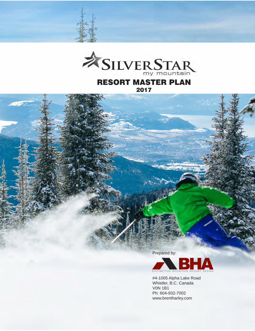
RESORT MASTER PLAN2017
Prepared by:
#4-1005 Alpha Lake RoadWhistler, B.C. CanadaV0N 1B1Ph: 604-932-7002www.brentharley.com

Credits
For Silver Star:
Jane CannKen DerpakBrad BakerIan GrantGuy PaulsonIan GalbraithCameron Sorenson
For BHA (Brent Harley and Associates Inc.):
Brent HarleyKyle VashRyan RobertsonChristine BilodeauAlix MacKaySue ClarkCarlos ZavarceBernard Messeguer
Statement of limitations: The information included on this map has been compiledby BHA from a variety of sources and is subject to changewithout notice. BHA makes no representation or warranty,
expressed or implied, as to accuracy, completeness,timeliness or rights to the use of such information. BHA shall
not be liable for any general, special, indirect, incidental orconsequential damages including, but not limited to, lost
revenues or lost profits resulting from the use or misuse ofthe information contained on this map.
SILVER STAR MASTER PLAN • 2017 • EXECUTIVE SUMMARY
I
Executive Summary
Introduction
Silver Star is a successful mountain resort located within the Okanagan Valley of British Columbia. Operating as a ski area since 1958, the resort features downhill skiing, snowboarding, skating, tubing and snowmobiling in the winter and has become world renowned for its Nordic skiing trail system and facilities. In the summer, lift service mountain biking, training camps, guided nature tours, hiking and various festivals continue to attract visitors on a year-round basis.
The resort’s activities and attractions are staged from Silver Star Village, a Victorian influenced development composed of hotels, restaurants and retail outlets. The village is surrounded by a diverse mix of resort residential areas. All of the residential developments are directly linked by trails from the Village Core, creating ski to / ski from access in the winter and easy route finding in the summer.
Resort Master Plan
The Resort Master Plan for Silver Star Mountain Resort has been created by BHA (Brent Harley and Associates Inc.), with the dedicated direction and assistance of the resort owners and their management group. The intent of the Master Plan is to craft a document that will guide the ongoing refinements of the resort’s development and assist Silver Star in realizing its potential to become a distinctive, world class resort destination.
II
Resort Vision, Goals and Objectives
The primary Vision is:
“ To enhance and advance Silver Star’s reputation as the premier, family oriented, all-season mountain resort in British Columbia. ”
Supporting this, the following are the resort’s primary Goals and Objectives:
d Expand and improve on the diverse range of Silver Star’s winter attractions with an emphasis on alpine skiing and snowboarding, complemented by Nordic skiing, tubing, skating and snowmobiling;
d Increasingly add to the year-round attractions of the resort by: expanding the lift serviced mountain biking and bike park; developing an eighteen hole golf area, zipline(s), a spa, indoor pool, water park and museum; by offering nature trails, hiking, fishing, horseback riding, hosting a series of special celebrations, conferences, events and festivals;
d Continue to refine the base area developments into a well balanced mix of support attractions focused within the Village Core that include an assorted variety of specialized resort retail, equipment rental, restaurants, pubs, bistros, workout and training facilities and “unique to Silver Star” outlets and galleries;
d Ensure that the resort residential development is made up of the appropriate mix of accommodation types, primarily oriented toward short term publicly available use, carefully balanced to the realities of the skier marketplace.
SILVER STAR MASTER PLAN • 2017 • EXECUTIVE SUMMARY
III
Existing Conditions
Silver Star is located approximately 22 kilometers northeast of Vernon, bordered by the Silver Star Provincial Park. The City of Kelowna, the main Okanagan regional population center, is situated approximately 68 kilometers to the south. It is about a five hour drive from Vancouver via the Coquihalla Highway. By air, there are regularly scheduled flights to the Kelowna International Airport.
MARKET
Since the first ski lifts were installed in the mid - 1950’s, the number of alpine skier visits has steadily increased to a high of 384,055 during the 2007 / 2008 season. Since that time, the number of visits has levelled off, with the 2013 / 2014 season totalling 337,196 skier visits. This can be viewed as a stabilization, where Silver Star has achieved a level of development that can only be increased with improvements to their offering, both in terms of facilities and real estate. It is Silver Star’s belief that by expanding the resort, embracing a more complete four season product and diversifying the mix of accommodation and real estate, they will attract new markets and enable the resort to achieve a higher level of success.
EXISTING WINTER ATTRACTIONS
Alpine skiing and snowboarding are the primary winter attractions at Silver Star. The existing lift serviced mountain facilities consist of 10 ski lifts accessing 128 ski trails, within an area of 1,240 hectares (3,065 acres). The Comfortable Carrying Capacity (CCC) of the lifts and trails is approximately 5,550 skiers and snowboarders per day.
IV
Currently, the downhill capacity of the ski trail terrain exceeds the uphill capacity of the ski lift systems, an imbalance that reinforces the powder skiing reputation of Silver Star. The types of established terrain largely matches the breakdown of the skier marketplace, the exception being a lack of true Intermediate terrain and an excess of Advanced Intermediate terrain. While this is a function of the natural shape and slope gradients of the land, efforts will be made to bring the proposed expansion closer to the mix of the skier marketplace as new improvements are developed.
The capacity of the additional winter attractions of Nordic skiing (700), tubing (100), skating (50), snowplay (100), snowmobiling (50), and conference centre (400) add a total of 1,400 visitors to the CCC of the mountain. As such, the total capacity of the existing winter attractions equates to 6,950 visitors per day. A further 1,042 “passive” guests (15% of the total) bring the Balanced Resort Capacity (BRC) of Silver Star to 7,992 visitors per day. This is the baseline number used to evaluate the amount of built space, parking and accommodation in place at Silver Star. Subsequently, the strengths and weaknesses of the existing facilities have been determined.
EXISTING BASE AREA VILLAGE
Supporting the mountain attractions, the base area facilities in Silver Star Village total an area of approximately 86,090 square feet. These include 66,997 square feet of activity oriented facilities (tickets, operation, rental, retail, administration, ski patrol, day care, restaurant and bar, etc.). The remaining 19,093 square feet of built space are classified as being destination oriented, catering to the needs of the visitors outside of their ski resort facilities requirements and expectations.
SILVER STAR MASTER PLAN • 2017 • EXECUTIVE SUMMARY
V
Based on the BRC (Balanced Resort Capacity) of 7,992 guests per day, the gross space area requirements are 90,673 square feet for activity oriented space and 25,389 square feet for destination oriented space, totalling 116,062 square feet. This difference of 29,972 square feet, between the existing and industry standards, will be methodically addressed as the base area built space is refined to match village capacity with that of the attractions. .
EXISTING ACCOMMODATION AND BED UNITS
In the Village and throughout the various resort residential subdivisions, there are 1,624 existing, committed or under construction accommodation units in place at Silver Star. This matches the existing assessment of 6,608 bed units. Based on the the BRC of 7,992 visitors per day, Silver Star has earned 9,590 bed units.
PARKING
The existing day use parking lots at Silver Star have a total capacity of 1,701 cars and 8 buses equating to parking for approximately 5,423 guests. In addition, the existing, committed and under construction resort accommodation within the Village has the space to park 385 cars catering to 1,155 guests. The existing, committed and under construction resort residential development outside of the Village Core, but with the attribute of being “ski to / ski from” capable, can accommodate 961 cars or 2,883 guests. As such, Silver Star has the capacity to park a total of 3,047 cars and 8 buses equaling 9,461 guests. Comparing this to the resort’s BRC of 7,992, there appears to be more than sufficient capacity to cater to the number of guests that would be at Silver Star on a busy day. The ratio of day use to destination parked guests is 60:40.
VI
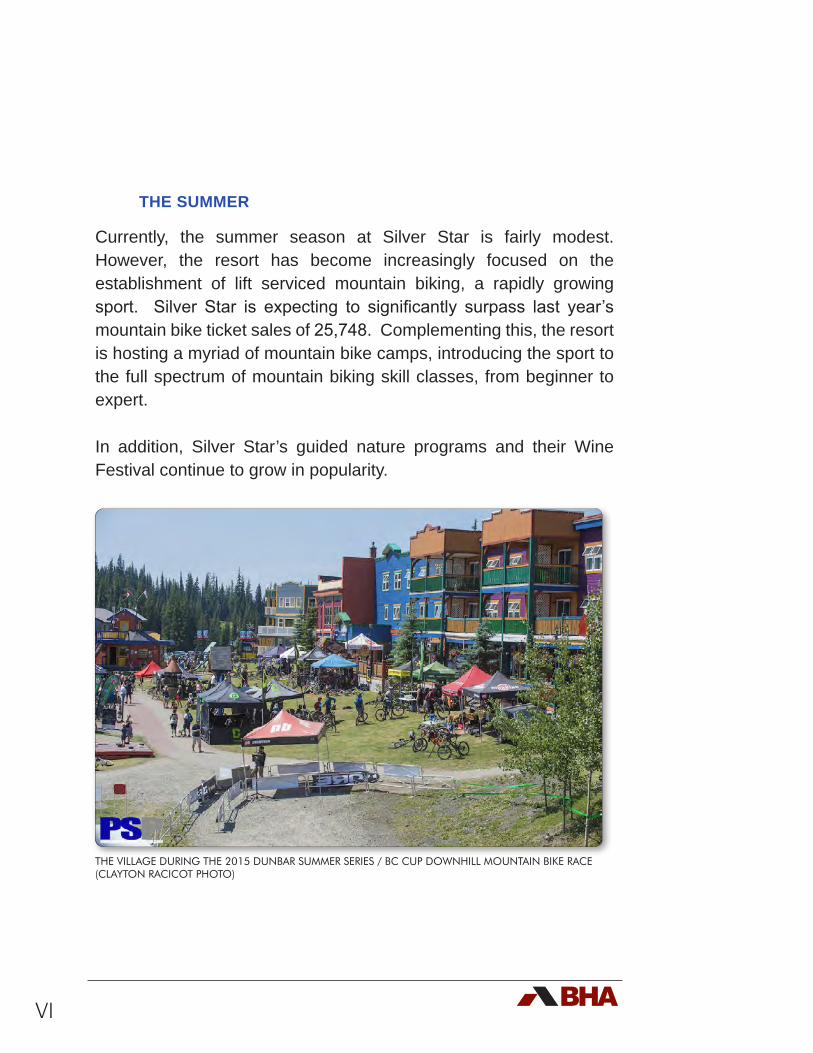
THE SUMMER
Currently, the summer season at Silver Star is fairly modest. However, the resort has become increasingly focused on the establishment of lift serviced mountain biking, a rapidly growing sport. Silver Star is expecting to significantly surpass last year’s mountain bike ticket sales of 25,748. Complementing this, the resort is hosting a myriad of mountain bike camps, introducing the sport to the full spectrum of mountain biking skill classes, from beginner to expert.
In addition, Silver Star’s guided nature programs and their Wine Festival continue to grow in popularity.
THE VILLAGE DURING THE 2015 DUNBAR SUMMER SERIES / BC CUP DOWNHILL MOUNTAIN BIKE RACE (CLAYTON RACICOT PHOTO)
SILVER STAR MASTER PLAN • 2017 • EXECUTIVE SUMMARY
VII
Proposed Expansion
SITE INVENTORY AND ANALYSIS
The potential to expand Silver Star was fully evaluated using newly acquired topographic mapping combined with input from management, operations staff and knowledge gained from site visits. Previously completed Master Plans provided the basis to re-explore the concepts of the past, applying current design criteria. The results clearly identified potential for improvements, significant enough to strongly suggest that the expansion of the mountain facilities can more than double the size of the resort. Key to this potential success will be the need to incorporate snowmaking to ensure that a reliable snow base will be available for skiers and snowboarders throughout the ski season.
WINTER FACILITIES AND ATTRACTIONS EXPANSION
The proposed lift serviced mountain facilities increases the number of ski lifts from eleven to twenty. Likewise, the Mountain Plan calls for the expansion of the trails and glading, increasing the existing 128 ski trails to 216 trails. Gladed skiing will also be expanded from the current area of 120 hectares to over 413 hectares. Newly gladed areas will be constructed with feathered boundaries that will reduce the hard edges of ski runs, as well as inviting a greater portion of the skier marketplace into the glades. At buildout, the Comfortable Carrying Capacity of the mountain will grow from the existing CCC of 5,550 skiers per day to 14,166 skiers per day.
The proposed expansion of the trails will still see the establishment of terrain that is close to matching the market’s expectations for the Beginner, Novice, Low Intermediate and Expert skill class. The
VIII
exception is the shortfall of Intermediate and the excess of Advanced Intermediate terrain. This apparent imbalance is the direct result of the natural terrain mix of the mountain. It will be rectified by the creation of wider trails for these two categories and an intense and constant grooming of key Advanced Intermediate terrain. This will enable Intermediate skiers and boarders to negotiate Advanced Intermediate terrain and will bring Silver Star into balance with the skier marketplace.
For the purposes of determining the BRC, the additional winter attractions of Nordic skiing (1400), tubing (100), snowshoeing (100), skating (100), snowmobiling (50), conferences (400), ziplining (100) and spa facilities (100) will add a total of 2,350 visitors to the capacity of the resort’s offerings. This plus the CCC at buildout of the alpine skiing on the mountain (14,166) brings the total capacity of the winter attractions to 16,516 visitors per day. A further 2,477 “passive” guests (15% of the capacity) brings the Balanced Resort Capacity of Silver Star at buildout to 18,993. This number typically acts as the basis for determining the built space requirements and the appropriate number of bed units to be established.
BASE VILLAGE EXPANSION
At buildout the base area facilities in Silver Star Village will need to expand from the existing 86,090 square feet to approximately 306,827 square feet. Internal to this, the activity oriented facilities (tickets, operation, rental, retail, administration, ski patrol, day care, restaurant and bar, etc.) will need to ultimately grow from the existing 66,997 square feet to 219,162 square feet. Likewise, the current 19,093 square feet of space classified as being destination oriented (catering to the needs of the visitors outside of their ski resort facilities requirements and expectations) will need to grow to about 87,665 square feet.
SILVER STAR MASTER PLAN • 2017 • EXECUTIVE SUMMARY
IX
PROPOSED ACCOMMODATION AND BED UNITS
Based on the Bed Unit Model of the All Season Resort Guidelines, Silver Star should have a ratio of 130 bed units for every 100 units of BRC. Utilizing the buildout BRC of 18,993, this equates to 24,690 bed units. However, given the current market realities, Silver Star will remain focused on attracting regional visitors. As such, at this time, the resort will continue to develop its currently earned bed units of 9,590. This will be initiated by a modestly planned expansion of 1,976 bed units, increasing the existing bed unit count from 6,608 to 8,584 and leaving 1,006 existing earned bed units to be allocated. The result will augment the ability to accommodate destination visitors while allowing Silver Star to remain focused on attracting regional markets to experience the improved on-mountain product. It is important to note that a portion of these bed units will be dedicated to the development of resident restricted / employee housing.
As planned, the Village Core has 1,026 accommodation units of built or committed resort development. This equates to 2,951 bed units at buildout. An additional 330 accommodation units (990 bed units) will be added to the Village at the buildout of this planned expansion. The surrounding resort residential subdivisions have 598 accommodation units of built or committed development equalling 3,657 bed units. At buildout of this expansion, another 378 units will be added, equating to 1,477 bed units.
In the future, should the opportunity arise with increased market demand for overnight accommodation, Silver Star reserves the right to apply for more bed units. This would continue to adhere to the All Season Resort Policy and remain well within the earned bed units based on the developed BRC.
X
PARKING
Assuming a buildout BRC of 18,993 guests and gradual shift to a 40:60 day use to destination ratio, 7,597 would be expected to be day use guests. By buildout it is assumed that 4,178 (55%) would arrive by car, equating to 1,392 cars that will have to be parked in day use lots. The remaining 3,418 (45%) day use guests would arrive by bus. It is assumed that 20 buses will be parked in the day lots and the remaining bus traffic would commute up and down to Vernon.
The Master Plan illustrates proposes adjustments to the day use parking lots to accommodate these buildout requirements. The destination parking requirements will be accommodated at the resort residential units.
THE SUMMER
As planned, the summer season at Silver Star will grow in prominence and importance to the resort. It is anticipated that lift serviced mountain biking will continue to grow significantly. Careful planning and design is underway to ensure that this will become the summertime cornerstone attraction to the resort. Complementing this, the resort plans to establish a variety of other mountain biking products and festivals. These could include expansion into cross-country mountain biking; major races and events; weekly races; expanded mountain bike camps; etc.
In addition to the mountain biking focus, Silver Star intends to expand their guided nature programs featuring guided tours, interpretive programs and camps and birding. Other possible attractions, such as zip lining, an aerial adventure park, alpine slide / alpine coaster, an indoor pool, four season spa, museum, etc. will be considered.
SILVER STAR MASTER PLAN • 2017 • EXECUTIVE SUMMARY
XI
Further, the intention is to use the Village as a base to stage more programs in the future. Building on the success of their established Wine Festival, the plan is to explore the possibility of creating more celebrations and festivals with a variety of different themes. These will likely move toward a mix of events and shows such as an iconic mountain biking race married with the arts, focusing on specialized film, photos, and live music.
The golf area, as it is established, will add another dimension to Silver Star. The potential to accommodate tournament play is being considered. In addition, and complementing the resort’s nature and environmental programs, the golf area may be developed to meet Audubon criteria and credentials.
PHASED IMPLEMENTATION
Development, as defined within the Master Plan, will methodically occur in response to Silver Star’s ongoing analysis of the resort marketplace. An implementation program, based on the “perform / reward” structure of the All Season Resort Policy, will be completed and incorporated into the new Master Development Agreement with the Province.

XII
SILVER STAR MASTER PLAN • 2017 • TABLE OF CONTENTS
i
TABLE OF CONTENTS
1.0 Introduction 11.1 Project Overview ...................................................................................................11.2 The Proponent .......................................................................................................41.3 Planning Process ..................................................................................................41.4 Vision, Goals and Objectives .................................................................................61.5 Master Plan Goals and Objectives ........................................................................91.6 First Nations ........................................................................................................11
2.0 Existing Conditions 152.1 Location ...............................................................................................................152.2 Access .................................................................................................................152.3 Current Regional Context ....................................................................................162.4 Historic Context ...................................................................................................162.5 Existing Mountain Facilities .................................................................................21
2.5.1 Introduction ..........................................................................................212.5.2 Skiing and Snowboarding ....................................................................212.5.3 Existing Ski Lifts ...................................................................................222.5.4 Existing Ski Trails .................................................................................262.5.5 Existing Terrain and Distribution Analysis ............................................322.5.6 Existing Comfortable Carrying Capacity ..............................................332.5.7 Existing Lift Balance Assessment ........................................................36
2.6 Existing Nordic Trails ...........................................................................................382.7 National Altitude Training Centre .........................................................................382.8 Additional Existing Winter Activities .....................................................................382.9 Existing Summer Activities ..................................................................................40
2.9.1 Mountain Bike Terrain Park ..................................................................422.9.2 Other Summer Activities ......................................................................42
2.10 Balanced Resort Capacity .................................................................................472.11 Existing Base Area.............................................................................................49
2.11.1 Existing Activity Oriented Built Space ................................................522.11.2 Existing All Season Resort Related Space ........................................542.11.3 Space Use Analysis ...........................................................................542.11.4 Existing Commercial Accommodations ..............................................602.11.5 Existing Residential Development .....................................................602.11.6 Bed Unit Analysis ...............................................................................602.11.7 Existing Parking .................................................................................62
2.12 Controlled Recreation Area ...............................................................................64
ii
2.13 Existing Land Uses ............................................................................................652.13.1 Development Regulations ..................................................................652.13.2 Wildlife Interests ................................................................................692.13.3 Recreation Areas ...............................................................................692.13.4 Forest Tenures ...................................................................................692.13.5 Mineral Tenures .................................................................................722.13.6 Water Interests...................................................................................722.13.7 Grazing Leases ..................................................................................76
2.14 Environmental Context ......................................................................................77
3.0 Analysis 793.1 Introduction ..........................................................................................................79
3.1.1 Existing Development Opportunities ....................................................793.1.2 Study Area ...........................................................................................79
3.2 Mountain Terrain Assessment .............................................................................833.2.1 Mountain Slope Analysis ......................................................................843.2.2 Mountain Elevation Analysis ................................................................873.2.3 Mountain Fall-Line Analysis .................................................................913.2.4 Mountain Aspect Analysis ....................................................................913.2.5 Reliable Snowpack ..............................................................................95
3.3 Silver Star Climate Analysis ................................................................................953.3.1 Introduction ..........................................................................................953.3.2 Resort Comparison ..............................................................................963.3.3 Winter Mean Temperature - Comparison .............................................973.3.4 Degree Days Below 0C - Comparison .................................................873.3.5 Snowfall - Comparison .........................................................................983.3.6 Historical Trends ..................................................................................993.3.7 Winter Mean Temperature - Silver Star .............................................1003.3.8 Degree Days Below 0C - Silver Star ..................................................1003.3.9 Snowfall - Silver Star .........................................................................101
3.4 Base Area Expansion Potential .........................................................................1033.4.1 Base Area Slope Analysis ..................................................................1043.4.2 Base Area Elevation Analysis ............................................................1093.4.3 Base Area Aspect and Solar Access Analysis ...................................113
4.0 Expansion Master Plan 1174.1 Introduction ........................................................................................................1174.2 Mountain Master Plan .......................................................................................118
4.2.1 Mountain Development Goals ...........................................................1194.2.2 Ski Pods .............................................................................................1204.2.3 Proposed Gladed Terrain ...................................................................1234.2.4 Proposed Ski Trail Inventory ..............................................................1234.2.5 Downhill Capacity ..............................................................................1324.2.6 Alpine Terrain Distribution ..................................................................1334.2.7 Proposed Ski Lift Inventory ................................................................1374.2.8 Proposed Comfortable Carrying Capacity .........................................1394.2.9 Proposed Lift Balance Assessment ...................................................1414.2.10 Snowmaking ....................................................................................142
SILVER STAR MASTER PLAN • 2017 • TABLE OF CONTENTS
iii
4.3 Other Resort Attractions ....................................................................................1454.3.1 Winter Activities .................................................................................145
4.3.1.1 Nordic Skiing ..........................................................................1454.3.1.2 Snowmobiling .........................................................................1464.3.1.3 Tubing .....................................................................................1464.3.1.4 Skating ....................................................................................1474.3.1.5 Snowplay ................................................................................1474.3.1.6 Ziplines ...................................................................................1474.3.1.7 Spas and Pools ......................................................................1494.3.1.8 Conferences and Museum .....................................................149
4.3.2 Proposed Summer Activities ..............................................................1504.3.2.1 Mountain Biking ......................................................................1504.3.2.2 Golf Area .................................................................................1504.3.2.3 Alpine Slide/Alpine Coaster ....................................................1544.3.2.4 Aerial Adventure Park .............................................................1544.3.2.5 Other Attractions .....................................................................155
4.4 Balanced Resort Capacity at Buildout ...............................................................1564.5 Base Area Development ....................................................................................157
4.5.1 Base Area Development Goals ..........................................................1584.5.2 Balanced Resort Capacity .................................................................1594.5.3 Built Space Requirements .................................................................1594.5.4 Overnight Accommodation Requirements .........................................163
4.5.4.1 Unit Types ...............................................................................1644.5.4.2 Public Accommodation ...........................................................1644.5.4.3 Private Accommodation ..........................................................1654.5.4.4 Attainable Housing for Employees and Residents ..................165
4.5.5 Parking Requirements .......................................................................1664.5.5.1 Day Use Parking Requirements .............................................1664.5.5.2 Destination Use Parking Requirements ..................................167
4.5.6 Development Areas ...........................................................................1684.5.6.1 The Village ..............................................................................1704.5.6.2 Village North ...........................................................................1724.5.6.3 The Knoll .................................................................................1724.5.6.4 The West Knoll .......................................................................1724.5.6.5 Golf Area .................................................................................172
4.5.7 Resort Residential Types ...................................................................1764.6 Infrastructure .....................................................................................................1784.7 Access ...............................................................................................................1804.8 Market ...............................................................................................................181
4.8.1 Market Position ..................................................................................1834.9 Environmental Mitigation Strategies ..................................................................1854.10 Phased Implementation ...................................................................................186
4.10.1 Existing Conditions ..........................................................................1914.10. 2 Phase One ......................................................................................1914.10. 2 Phase Two ......................................................................................1944.10. 2 Phase Three ...................................................................................1954.10. 2 Phase Four .....................................................................................1954.10. 2 Phase Five ......................................................................................196
4.11 Social and Economic Impact ...........................................................................1974.12 Conclusion .......................................................................................................207
iv
LIST OF TABLES:TABLE 2-1: DISTANCE FROM MAJOR POPULATION CENTRES ...............................................................15
TABLE 2-2: SUMMARY OF EXISTING LIFTS ............................................................................................22
TABLE 2-3: SUMMARY OF EXISTING SKI TRAILS ....................................................................................26
TABLE 2-4: EXISTING SKI TRAILS BY POD ..............................................................................................28
TABLE 2-5: DESIGN CRITERIA USED AT SILVER STAR ..............................................................................34
TABLE 2-6: EXISTING UPHILL CCC .......................................................................................................35
TABLE 2-7: EXISTING UPHILL AND DOWNHILL CCC BY POD ...............................................................36
TABLE 2-8: CAPACITY OF EXISTING ADDITIONAL WINTER ACTIVITIES .................................................40
TABLE 2-9: BALANCED RESORT CAPACITY (BRC) OF SILVER STAR ..........................................................47
TABLE 2-10: EXISTING ACTIVITY ORIENTED BUILT SPACE ......................................................................53
TABLE 2-11: EXISTING DESTINATION ORIENTED BUILT SPACE ..............................................................54
TABLE 2-12: EXISTING SPACE USE ANALYSIS BASED ON A BRC OF 7,992 ............................................57
TABLE 2-13: EXISTING SPACE USE ANALYSIS BASED ON A TYPICAL DAY OF 4,500 GUESTS ..................58
TABLE 2-14: EXISTING AND COMMITTED ACCOMMODATION AT SILVER STAR .....................................59
TABLE 2-15: ASRG BED UNIT MODEL APPLIED AT SILVER STAR ..............................................................61
TABLE 2-16: EXISTING PARKING ..........................................................................................................63
TABLE 2-17: SILVER STAR ZONING .......................................................................................................66
TABLE 2-18: MINERAL TENURES ...........................................................................................................72
TABLE 2-19: WATER LICENSE HOLDERS ...............................................................................................75
TABLE 2-20: WELLS .............................................................................................................................76
TABLE 3-1: SKI AREA SLOPE ANALYSIS CRITERIA ...................................................................................84
TABLE 3-2: ELEVATION AND VERTICAL COMPARISONS ........................................................................88
TABLE 4-1: SUMMARY OF PROPOSED TERRAIN PODS ........................................................................124
TABLE 4-2: PROPOSED SKI TRAILS ....................................................................................................125
TABLE 4-3: DOWNHILL CAPACITY BY POD .......................................................................................132
TABLE 4-4: TERRAIN DISTRIBUTION ...................................................................................................133
TABLE 4-5: PROPOSED LIFT NETWORK AT BUILDOUT ........................................................................137
TABLE 4-6: PROPOSED COMFORTABLE CARRYING CAPACITY ...........................................................140
TABLE 4-7: PROPOSED LIFT AND TRAIL CAPACITIES - BUILD OUT .......................................................141
TABLE 4-8: SNOWMAKING PLAN.......................................................................................................144
TABLE 4-9: BALANCED RESORT CAPACITY (BRC) OF SILVER STAR AT BUILD OUT .................................156
TABLE 4-10: SPACE USE ANALYSIS AT BUILDOUT (BRC OF 18,993) ....................................................161
TABLE 4-11: BED UNIT ANALYSIS .......................................................................................................163
TABLE 4-12: PROPSED OVERNIGHT ACCOMMODATION EXPANSION ................................................168
TABLE 4-13: CWSAA SKIER VISITS.......................................................................................................182
TABLE 4-14: PHASING SCHEDULE .....................................................................................................187
TABLE 4-15: PRELIMINARY SOCIO-ECONOMIC IMPACTS OF SILVER STAR AT BUILDOUT ...................198
TABLE 4-16: PRELIMINARY SOCIO-ECONOMIC IMPACTS OF SILVER STAR By PHASE ..........................199
SILVER STAR MASTER PLAN • 2017 • TABLE OF CONTENTS
v
LIST OF CHARTS:CHART 2-1: EXISTING CAPACITY DISTRIBUTION ..................................................................................32
CHART 2-2: EXISTING TRAIL AND LIFT BALANCE ..................................................................................37
CHART 4-1: TERRAIN DISTRIBUTION ANALYSIS – AT BUILDOUT..........................................................135
CHART 4-2: LIFT BALANCE ASSESSMENT – BUILD OUT ......................................................................142
CHART 4-3:SKIER/SNOWBOARDER VISITS IN CANADA ......................................................................181
LIST OF FIGURES:FIGURE 1-0: REGIONAL AND LOCAL CONTEXT ...................................................................................3
FIGURE 1-1: EXISTING MOUNTAIN PLAN ...........................................................................................14
FIGURE 1-2: MOUNTAIN MASTER PLAN ..............................................................................................16
FIGURE 1-3: MOUNTAIN MASTER PLAN 1994 COMPARISON ..............................................................17
FIGURE 2-1: EXISTING LIFTS, TRAILS & GLADES ...................................................................................23
FIGURE 2-1A: EXISTING MOUNTAIN: FRONT SIDE ...............................................................................24
FIGURE 2-1B: EXISTING MOUNTAIN: BACKSIDE ..................................................................................25
FIGURE 2-2: EXISTING SKI PODS .........................................................................................................27
FIGURE 2-3: NORDIC TRAIL MAP INCLUDING SOVEREIGN LAKES ........................................................39
FIGURE 2-4: OTHER WINTER ATTRACTIONS .........................................................................................41
FIGURE 2-5: SILVER STAR SUMMER PLAN .............................................................................................43
FIGURE 2-5A: SILVER STAR SUMMER PLAN (DH PARK) ...........................................................................44
FIGURE 2-5B: SILVER STAR SUMMER PLAN (XC AT THE KNOLL) .............................................................45
FIGURE 2-6: EXISTING BASE ...............................................................................................................50
FIGURE 2-7: EXISTING BASE VILLAGE CORE ........................................................................................51
FIGURE 2-8A: NORTH OKANAGAN REGIONAL DISTRICT ZONES ........................................................67
FIGURE 2-8B: SILVER STAR ZONING (WITHIN NORD ZONE C) .............................................................68
FIGURE 2-8C: WILDLIFE INTERESTS AND RECREATION AREAS ..............................................................70
FIGURE 2-8D: FOREST TENURES ..........................................................................................................71
FIGURE 2-8E: MINERAL CLAIMS AND COMMUNITY WATERSHEDS .......................................................73
FIGURE 2-8F: GRAZING LEASES ..........................................................................................................74
FIGURE 3-1: STUDY AREA METES AND BOUNDS .................................................................................81
FIGURE 3-2: MOUNTAIN SLOPE ANALYSIS ...........................................................................................85
FIGURE 3-3: MOUNTAIN ELEVATION ANALYSIS ...................................................................................89
FIGURE 3-4: MOUNTAIN ASPECT ANALYSIS .........................................................................................93
FIGURE 3-5: WINTER MEAN TEMPERATURE WITH ELEVATION ...............................................................97
FIGURE 3-6: WINTER DEGREE DAYS <0C WITH ELEVATION .................................................................98
vi
FIGURE 3-7: WINTER MEAN SNOWFALL WITH ELEVATION ...................................................................99
FIGURE 3-8: WINTER MEAN TEMPERATURE 1900-2012 ......................................................................100
FIGURE 3-9: WINTER DEGREE DAYS <0C 1900-2012 ........................................................................101
FIGURE 3-10: AVERAGE WINTER SNOWFALL 1900-2012 ...................................................................102
FIGURE 3-11: BASE AREA SLOPE ANALYSIS ........................................................................................107
FIGURE 3-12: BASE AREA ELEVATION ANALYSIS .................................................................................111
FIGURE 3-13: BASE AREA ASPECT ANALYSIS ......................................................................................115
FIGURE 4-1: PROPOSED SKI PODS ....................................................................................................121
FIGURE 4-2: FEATHERING 3D VISUALIZATION ...................................................................................122
FIGURE 4-2A: FEATHERING TYPICAL SKETCH ....................................................................................122
FIGURE 4-3: MOUNTAIN MASTER PLAN ............................................................................................129
FIGURE 4-3A: MOUNTAIN MASTER PLAN OVERALL - 3D VIEW ...........................................................131
FIGURE 4-3B: MOUNTAIN MASTER PLAN BACKSIDE - 3D VIEW ..........................................................131
FIGURE 4-3C: MOUNTAIN MASTER PLAN FRONTSIDE - 3D VIEW .......................................................131
FIGURE 4-4: PROPOSED SKI TRAILS BY SKIER CATEGORY ...................................................................134
FIGURE 4-4A: PROPOSED GLADING BY SKILL CLASS .........................................................................136
FIGURE 4-5: PROPOSED SKI LIFTS .....................................................................................................138
FIGURE 4-6: PROPOSED NORDIC & ALL PURPOSE TRAILS ..................................................................148
FIGURE 4-6A: MOUNTAIN BIKING, HIKING AND OTHER YEAR-ROUND RECREATIONAL ACTIVITIES ...151
FIGURE 4-6B: PROPOSED XC TRAILS AND ALPINE SLIDE ALIGNMENT ..............................................152
FIGURE 4-7: DEVELOPMENT AREAS ...................................................................................................169
FIGURE 4-8A: SILVER STAR VILLAGE ...................................................................................................170
FIGURE 4-8: VILLAGE CORE MASTER PLAN ........................................................................................171
FIGURE 4-9A: VILLAGE MASTER PLAN ................................................................................................173
FIGURE 4-10: RESORT RESIDENTIAL TYPES .........................................................................................177
FIGURE 4-11: INFRASTRUCTURE PLAN...............................................................................................179
FIGURE 4-12: PHASING PLAN ...........................................................................................................192
FIGURE 4-13A: 3D VIEW - MASTER PLAN OVERALL ............................................................................201
FIGURE 4-13B: 3D VIEW - BACKSIDE (PROPOSED) .............................................................................203
FIGURE 4-13C: 3D VIEW - VILLAGE (PROPOSED) ...............................................................................205
APPENDICESAPPENDIX 1: CERG ENVIRONMENTAL ASSESSMENT
APPENDIX 2: MMM GROUP TRAFFIC IMPACT STUDY
INTRODUCTION
SILVER STAR MASTER PLAN • 2017 • 1.0 INTRODUCTION
1
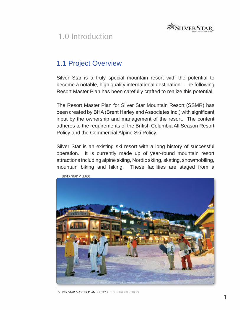
1.1 Project Overview
Silver Star is a truly special mountain resort with the potential to become a notable, high quality international destination. The following Resort Master Plan has been carefully crafted to realize this potential.
The Resort Master Plan for Silver Star Mountain Resort (SSMR) has been created by BHA (Brent Harley and Associates Inc.) with significant input by the ownership and management of the resort. The content adheres to the requirements of the British Columbia All Season Resort Policy and the Commercial Alpine Ski Policy.
Silver Star is an existing ski resort with a long history of successful operation. It is currently made up of year-round mountain resort attractions including alpine skiing, Nordic skiing, skating, snowmobiling, mountain biking and hiking. These facilities are staged from a
SILVER STAR VILLAGE
1.0 Introduction
2
highly stylized Victorian oriented Village made up of resort hotels, restaurants and retail outlets surrounded by a diverse mix of single and multi-family residential areas, all directly linked to the skiing by ski trails leading to the resort’s facilities.
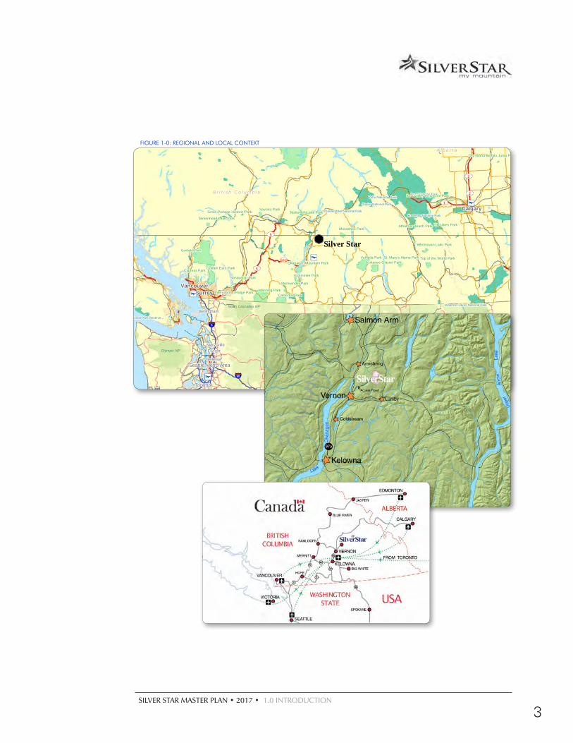
Silver Star is located in the Okanagan Highlands, approximately 22 kilometers to the northeast of Vernon, British Columbia and adjacent to the Silver Star Provincial Park (See Figure 1-0). Kelowna, the main population centre of the B.C. Interior, is situated approximately 68 kilometers to the south.
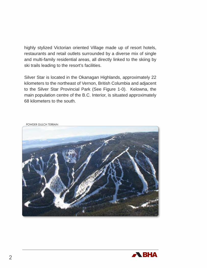
POWDER GULCH TERRAIN
SILVER STAR MASTER PLAN • 2017 • 1.0 INTRODUCTION
3
FIGURE 1-0: REGIONAL AND LOCAL CONTEXT
Seattle Metro Area
Tacoma
Spokane
Bellevue
Everett
Bellingham
Marysville
Calgary
Edmonton
SurreyVancouver
5
97C
1
2
2
5
1
2
2
Jasper National Park
Banff National Park
Kootenay National Park
Glacier National Park
Yoho National Park
Waterton Lakes National Park
Elk Island National Park
Mount Revelstoke National Park
Pacific Rim National Park Reserve
Wells Gray Park
Garibaldi Park
Tweedsmuir Park Mount Robson Park
Bowron Lake Park
Manning Park
Valhalla Park
Golden Ears Park
Cathedral Park
Hamber Park
Bow Valley Provincial Park
Kokanee Glacier Park
Kickininee Park
Savona Park
Top of the World Park
Stemwinder Park
Okanagan Mountain Park
Monashee Park
St. Mary's Alpine Park
Elk Lakes Park
Whiteswan Lake Park
Cypress Park
Birkenhead Lake Park
Niskonlith Lake Park
Entrance Provincial Park
Crimson Lake Provincial Park
Sasquatch Park
Ma-Me-O Beach Provincial Park
International Ridge Park
Athalmer Beach Park
Dry Island Buffalo Jump Provincial Park
Seton Portage Historic Park
5
90
101
A l b e r t a
B r i t i s h C o l u m b i a
Glacier NP
Olympic NP
North Cascades NP
Resort Master PlanJune 2008
C:\DWG Projects\Cabcss00\MasterPlan 2006\Plots MasterPlan Figures\Regional Context-11x17.mxd
Regional Context
1-1
Prepared for:
PO Box 3002Silver Star, B.C.,Canada V1B 3M1Phone: 250-542-0224Fax: 250-542-1236Email: [email protected]
Silver Star Mountain Resort Ltd.
Planning by:
4 -1005 Alpha Lake Rd.Whistler, B.C., Canada, V0N 1B1Phone: 604-932-7002 Fax: 604-938-1161Email: [email protected]
Silver Star
0 50 100 150 20025Kilometers
1:3,000,000
4
1.2 The Proponent
Silver Star Ski Resort Ltd. is a privately owned Canadian Company. It has a single shareholder which operates the company on behalf of a family trust. The family has been in the business of operating ski resorts in Western Canada and overseas for over 40 years.
1.3 Planning Process
In the Winter of 2006, Brent Harley and Associates Inc. (BHA) were retained to create a Resort Master Plan for Silver Star. For a variety of reasons this work was put on hold in 2008 and reactivated in 2014. The resultant process builds upon the various master plans that have been completed for the resort; specifically the Village Plan (2000), the Base Area Master Plan (1995), and the Mountain Master Plan (1994). Over the past 20 years, BHA has worked with Silver Star on the creation and implementation of their long range planning for the mountain and base areas of the resort. After obtaining up-to-date high quality topographic data, BHA initiated the Master Planning exercise by re-inventorying the existing conditions at the resort.
Subsequently, the undeveloped potential of the mountain was carefully reviewed and analyzed with an eye to primarily update the skiing and snowboarding product. The objective was to take into account the existing development and expand onto terrain that would improve the balance of the offering, reflecting changes in the expectations of the skier marketplace.
The Comfortable Carrying Capacity (CCC) of the lift serviced skiing and snowboarding was determined. Consistent with the All Season Resort Policy, the cumulative capacity of the resort attractions (the
SILVER STAR MASTER PLAN • 2017 • 1.0 INTRODUCTION
5
alpine skiing and snowboarding, the Nordic skiing, the skating, the tubing, snowmobiling, etc.) enabled the determination of the Balanced Resort Capacity (BRC) of Silver Star. This, in turn, enabled the determination of the appropriate amount of base area development. While the BRC is typically used to identify the amount of additional accommodation ‘required’, the development of additional bed units in Silverstar will be tied to market realities and focus on targeting the regional resort market. Opportunities and weaknesses of the existing mountain and base area offering were identified. The results of this process provided the basis for the creation of the Master Plan, designed to guide the development of Silver Star’s attractions and facilities well into the future.
Complementing the winter oriented development, and proceeding toward the goal of becoming a true all-season resort, Silver Star has maintained a strong summer tourism presence with their mountain bike park and wide range of programs and activities. Further reinforcing their commitment to summer operations, the resort has reactivated its intentions of developing an eighteen hole golf course. This has introduced another facet to the year-round opportunity and reputation that the resort has gradually been building.
6
1.4 Vision, Goals and Objectives
The Vision for Silver Star is:
“To be the premier, boutique, family oriented, four-season mountain resort of British Columbia.”
Complementing the Vision, the owners have defined their Mission:
“To enhance Silver Star’s reputation as a key and vibrant destination resort that provides a sustained profitable return to its investors”.
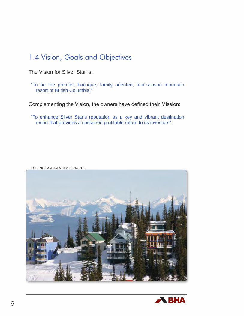
EXISTING BASE AREA DEVELOPMENTS
SILVER STAR MASTER PLAN • 2017 • 1.0 INTRODUCTION
7
Supporting this, the resort’s goals and objectives include the following:
d Respect the natural attributes of the mountain and the setting, recognizing that these are Silver Star’s primary attraction and currency;
d Provide state-of-the-art facilities on the mountain and complementary staging and support services in the village;
d Focus on the development and operation of a wide variety of recreation and retreat pursuits on a year-round basis;
d Accommodate the needs and expectations of the second home owners, destination guests and day use visitors;
d Cater to the development and attraction of a tourist /visitor population as compared to being focused on establishing a permanent population at the resort;
d Provide a well balanced lift serviced skiing and snowboarding experience as the primary winter attraction;
d Offer a diverse range of attractions to complement the alpine skiing including Nordic skiing, tubing, snowshoeing, snowmobiling and skating;
d Increasingly add to the year-round attractions of the resort by: expanding the lift serviced mountain biking and bike park; developing an eighteen hole golf course, zipline(s), indoor pool; offering horseback riding, nature trails, fishing and hiking; hosting a series of special celebrations, conferences, events and festivals;
d Develop a well balanced mix of support attractions focused within the Village Core that include specialized resort retail and equipment rental, restaurants, pubs, bistros, four season spa, museum, workout and training facilities and “unique to Silver Star” outlets and galleries;
8
d Develop an appropriate mix of facilities that will cater to longer term visitors that may include a grocery / liquor store, day care, general store, post office, etc.;
d Ensure that the amount of real estate and overnight accommodation that is developed is in line with current market realities, requirements and expectations;
d Develop a wide range of resort oriented real estate product (hotels, condotels, condominiums, townhouses, duplex and single family) that are designed and zoned to be used for nightly rental;
d Maximize “warm beds” in the Village, ensuring that the majority of development caters to the needs and expectations of short term guests as compared to full time residents;
d Maximize the “ski to / ski from” attribute that already defines Silver Star as being a truly unique ski resort;
d Minimize the number of second home “cold beds” ensuring that this type of development is located outside the Village Core;
d Expand the resort’s capability to cater to the convention and retreat marketplace;
d Maintain and reinforce the established brand and character of Silver Star ensuring that all new development and renovation respects this history.
The expansion and changes contemplated in this plan are proposed in order to implement these Goals and Objectives. This plan is designed to distinguish Silver Star as the Premier Family Mountain Resort of British Columbia.
SILVER STAR MASTER PLAN • 2017 • 1.0 INTRODUCTION
9
1.5 Master Plan Goals and Objectives
The primary goal of this planning process is to create a new Resort Master Plan for Silver Star that will guide in the ongoing development of the resort. It must reflect the:
d Unique development opportunities of Silver Star, reinforcing the established resort ambience and experience offered;
d Defined Vision, Goals and Objectives;
d Changes in the mountain resort marketplace;
d Requirements and expectations of the owners of Silver Star;
d Requirements of the Ministry of Forests, Lands and Natural Resource Operations (MFLNRO);
d Requirements of the All Season Resort Policy (ASRP).
Since the first lifts were installed in the mid-1950’s, skier visits have steadily
increased to 384,055 visitors during the 2007 / 2008 season.
10
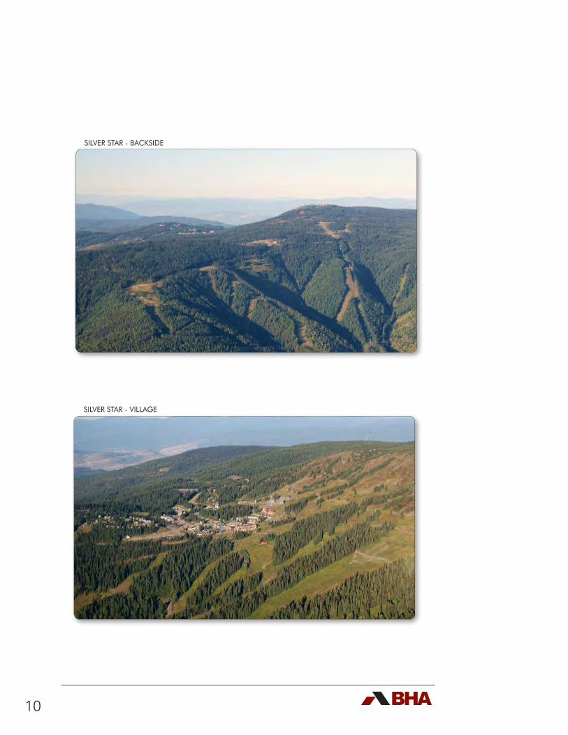
SILVER STAR - BACKSIDE
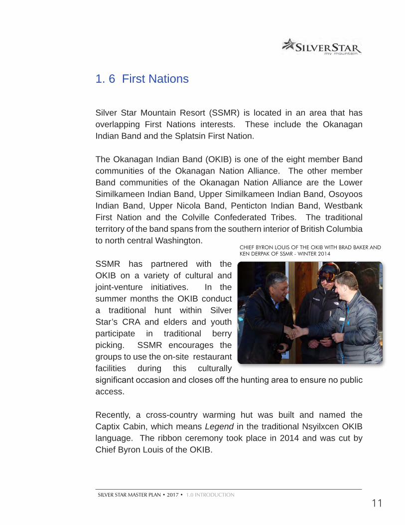
SILVER STAR - VILLAGE
SILVER STAR MASTER PLAN • 2017 • 1.0 INTRODUCTION
11
1. 6 First Nations
Silver Star Mountain Resort (SSMR) is located in an area that has overlapping First Nations interests. These include the Okanagan Indian Band and the Splatsin First Nation.
The Okanagan Indian Band (OKIB) is one of the eight member Band communities of the Okanagan Nation Alliance. The other member Band communities of the Okanagan Nation Alliance are the Lower Similkameen Indian Band, Upper Similkameen Indian Band, Osoyoos Indian Band, Upper Nicola Band, Penticton Indian Band, Westbank First Nation and the Colville Confederated Tribes. The traditional territory of the band spans from the southern interior of British Columbia to north central Washington.
SSMR has partnered with the OKIB on a variety of cultural and joint-venture initiatives. In the summer months the OKIB conduct a traditional hunt within Silver Star’s CRA and elders and youth participate in traditional berry picking. SSMR encourages the groups to use the on-site restaurant facilities during this culturally significant occasion and closes off the hunting area to ensure no public access.
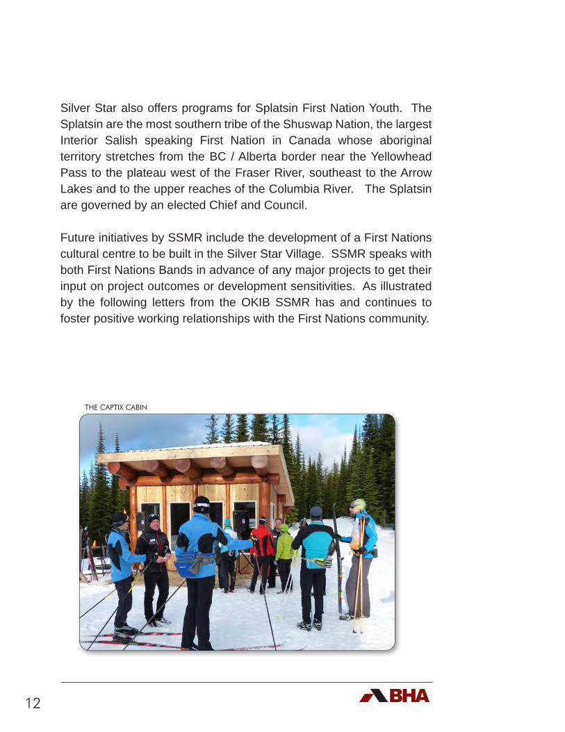
Recently, a cross-country warming hut was built and named the Captix Cabin, which means Legend in the traditional Nsyilxcen OKIB language. The ribbon ceremony took place in 2014 and was cut by Chief Byron Louis of the OKIB.
CHIEF BYRON LOUIS OF THE OKIB WITH BRAD BAKER AND KEN DERPAK OF SSMR - WINTER 2014
12
Silver Star also offers programs for Splatsin First Nation Youth. The Splatsin are the most southern tribe of the Shuswap Nation, the largest Interior Salish speaking First Nation in Canada whose aboriginal territory stretches from the BC / Alberta border near the Yellowhead Pass to the plateau west of the Fraser River, southeast to the Arrow Lakes and to the upper reaches of the Columbia River. The Splatsin are governed by an elected Chief and Council.
Future initiatives by SSMR include the development of a First Nations cultural centre to be built in the Silver Star Village. SSMR speaks with both First Nations Bands in advance of any major projects to get their input on project outcomes or development sensitivities. As illustrated by the following letters from the OKIB SSMR has and continues to foster positive working relationships with the First Nations community.
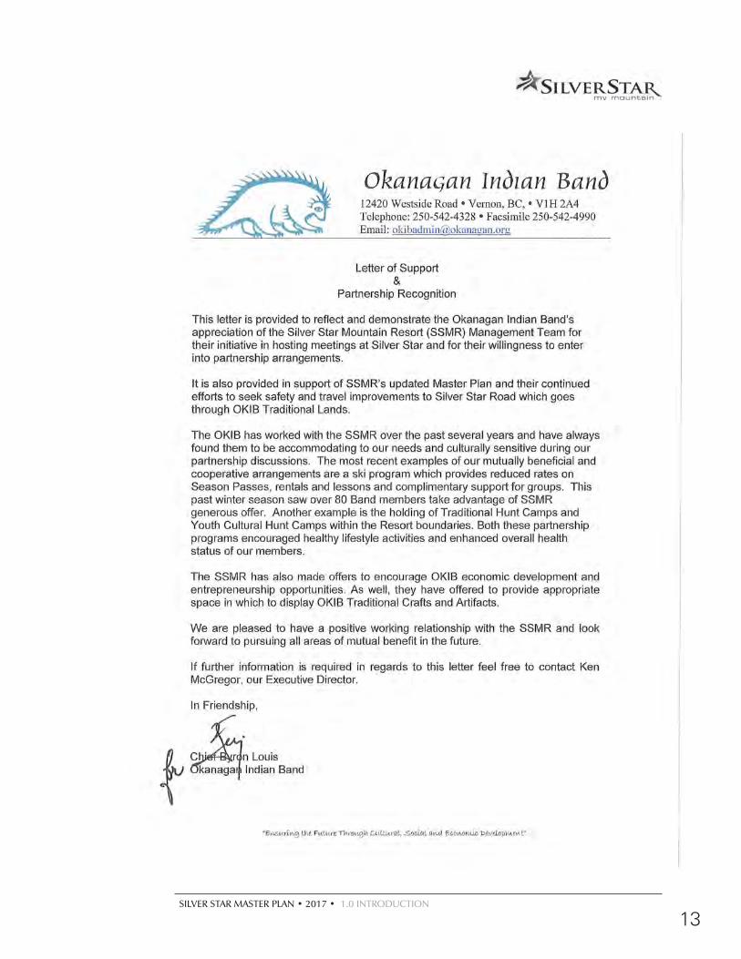
THE CAPTIX CABIN
SILVER STAR MASTER PLAN • 2017 • 1.0 INTRODUCTION
13
##
#
#
#
#
#
SUM
MIT C
HAIR
POWDER GULCH E
XPRESS
COMET SIX-PACK EXPRESS
HOME RUN T
ALPINE CH
AIR
SILVER WOODS EXPRESS
SILVER QUEEN
Resort Master Plan2015
C:\D
WG
Projects\C
abcss00\MasterP
lan 2013 Restart\P
lots\Master P
lan graphics 2014 - (newer) \(Fig i-1)E
xisting MtnP
lan.mxd
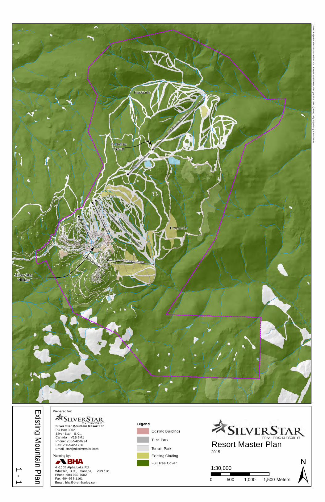
Existing Mountain Plan
1- 1 ±
Legend
Existing Buildings
Tube Park
Terrain Park
Existing Glading
Full Tree Cover
0 500 1,000 1,500 Meters
1:30,000
ParadiseCamp
Silver StarVillage
Prepared for:
PO Box 3002Silver Star, B.C.,Canada V1B 3M1Phone: 250-542-0224Fax: 250-542-1236Email: [email protected]
Silver Star Mountain Resort Ltd.
Backside
Frontside
Planning by:
4 -1005 Alpha Lake Rd.Whistler, B.C., Canada, V0N 1B1Phone: 604-932-7002 Fax: 604-938-1161Email: [email protected]

#
#
#
#
#
#
#
#
#
#
#
#
#
#
#
#
VILLAGE
LIFT
TERRAIN-PARK
SILVER QUEEN
ALPINE CHAIR
HOME RUN T
VALHALLA1
VALHALLA2
INTO THE SUN
SIDEWINDER
SILVER WOODS EXPRESS
LOW
ER
VAN
CE
HOLY
SM
OKE
UPPER VANCE
COMET SIX-PACK EXPRESS
POWDER GULC
H EXPRESS
TRINITY
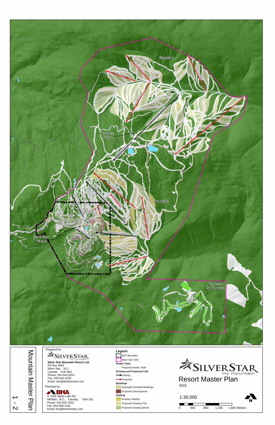
Resort Master Plan2015
LegendOCP Boundary
Silver Star CRANordic Trails
Proposed Nordic TrailsExisting and Proposed Lifts
#
Existing
#
ProposedBuildings
Existing/Committed Buildings
Proposed DevelopmentGlading
Existing Glading
Proposed Glading-Thin
Proposed Glading-Dense 0 400 800 1,200 1,600 Meters
1:30,000
Prepared for:
PO Box 3002Silver Star, B.C.,Canada V1B 3M1Phone: 250-542-0224Fax: 250-542-1236Email: [email protected]
Silver Star Mountain Resort Ltd.
Planning by:
4 -1005 Alpha Lake Rd.Whistler, B.C., Canada, V0N 1B1Phone: 604-932-7002 Fax: 604-938-1161Email: [email protected]
Backside
Frontside
ProposedGolf Course
Silver StarVillage
ParadiseCamp
Mountain M
aster Plan
1- 2

Trinity Express
Yellow Chair
Valhalla Express
Putnam Creek E
xpres
s
Deer Park Express
Vance Creek Express
Summ
it Chair
Holy
Smok
e Ch
air
Attri
dge L
ift
Silver Woods Express
Alder Pont T-Bar
Mid
Tee
Bar
Town Chair
TRINITY
UPPER VANCE
HOLY
SM
OKE
SIDEWINDER
VALHALLA2
LOW
ER
VAN
CE
VALHALLA1
INTO
THE SUN
HOME RUN T
ALPINE CH
AIR
SILVER QUEEN
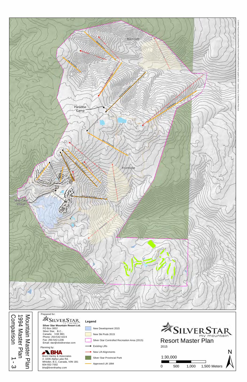
Resort Master Plan2015
C:\D
WG
Projects\C
abcss00\MasterP
lan 2013 Restart\P
lots\Master P
lan graphics 2014 - (newer) \(Fig i-2) M
tnMaster P
lan.mxd
Mountain M
aster Plan 1994 M
aster Plan Com
parison1
- 3 ±0 500 1,000 1,500 Meters
1:30,000
Backside
Frontside
Prepared for:
PO Box 3002Silver Star, B.C.,Canada V1B 3M1Phone: 250-542-0224Fax: 250-542-1236Email: [email protected]
Silver Star Mountain Resort Ltd.
Silver StarVillage
ParadiseCamp
Planning by:
Brent Harley & Associates4 -1005 Alpha Lake Rd.Whistler, B.C, Canada, V0N 1B1604-932-7002 [email protected]
Legend
New Development 2015
New Ski Pods 2015
Silver Star Controlled Recreation Area (2015)
#
Existing Lifts
#
New Lift Alignments
Silver Star Provincial Park
Approved Lift 1994


EXISTING CONDITIONS
SILVER STAR MASTER PLAN • 2017 • 2.0 EXISTING CONDITIONS
15
2.1 LocationSilver Star is located in the Okanagan Highlands, approximately 22 kilometres to the northeast of Vernon and is adjacent to the Silver Star Provincial Park. Kelowna, the main population centre of the B.C. interior, is situated approximately 68 kilometres to the south.
2.2 Access
Silver Star Mountain is easily accessed from Vancouver via the Coquihalla Connector and Highway 97 to Vernon. From Calgary, access is via the Trans Canada Highway to Sicamous and south to Vernon.
By air, there are regularly scheduled flights to the Kelowna or Kamloops Airports from points across Canada. Increasingly, scheduled international flights arrive and depart directly to and from Kelowna International Airport. In addition, connector flights are available from Vancouver or Calgary for international or U.S. arrivals. A shuttle service or rental cars are available to transport visitors to Silver Star.
TABLE 2-1: DISTANCE FROM MAJOR POPULATION CENTRES
City Distance
Vernon, BC 22 km
Kamloops, BC 139 km
Kelowna, BC 68 km
Vancouver, BC 463 km
Calgary, AB 578 km
2.0 EXISTING CONDITIONS
SILVER STAR VILLAGE
16
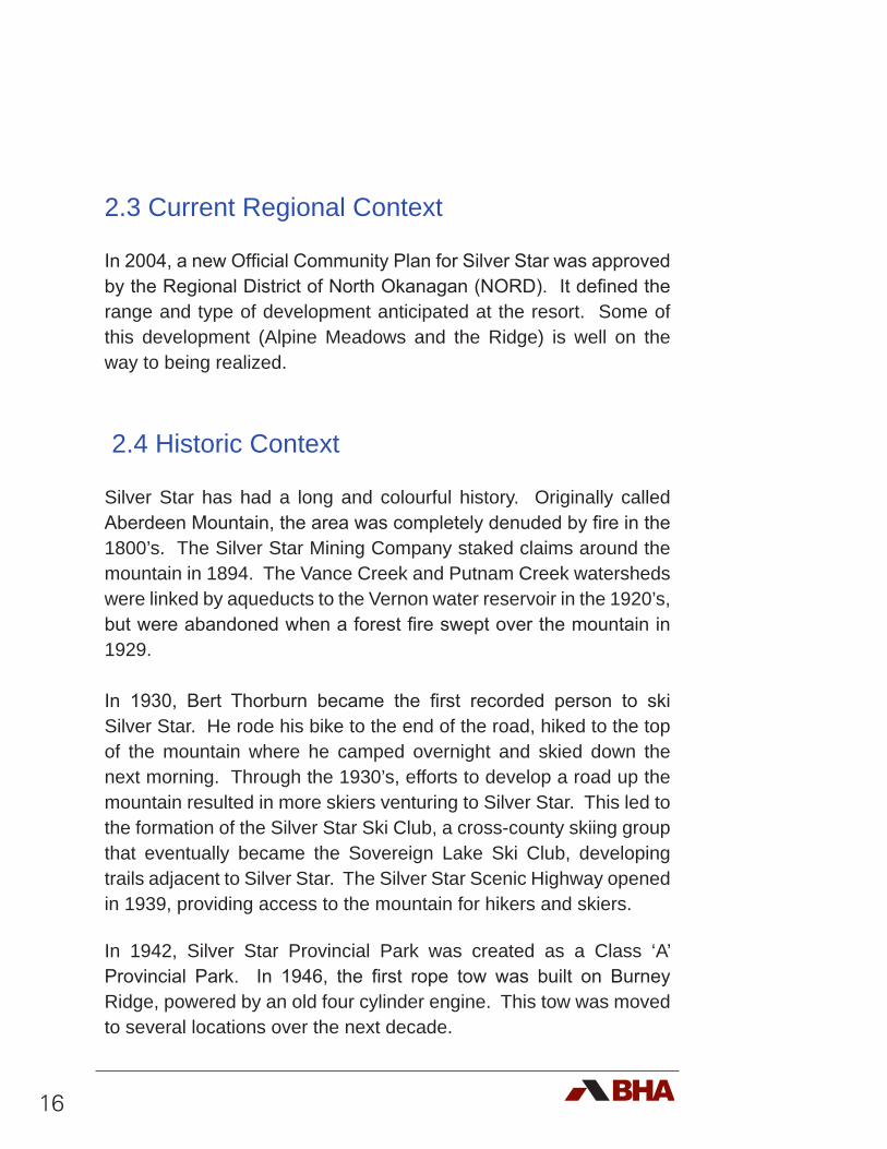
2.3 Current Regional Context
In 2004, a new Official Community Plan for Silver Star was approved by the Regional District of North Okanagan (NORD). It defined the range and type of development anticipated at the resort. Some of this development (Alpine Meadows and the Ridge) is well on the way to being realized.
2.4 Historic Context
Silver Star has had a long and colourful history. Originally called Aberdeen Mountain, the area was completely denuded by fire in the 1800’s. The Silver Star Mining Company staked claims around the mountain in 1894. The Vance Creek and Putnam Creek watersheds were linked by aqueducts to the Vernon water reservoir in the 1920’s, but were abandoned when a forest fire swept over the mountain in 1929.
In 1930, Bert Thorburn became the first recorded person to ski Silver Star. He rode his bike to the end of the road, hiked to the top of the mountain where he camped overnight and skied down the next morning. Through the 1930’s, efforts to develop a road up the mountain resulted in more skiers venturing to Silver Star. This led to the formation of the Silver Star Ski Club, a cross-county skiing group that eventually became the Sovereign Lake Ski Club, developing trails adjacent to Silver Star. The Silver Star Scenic Highway opened in 1939, providing access to the mountain for hikers and skiers.
In 1942, Silver Star Provincial Park was created as a Class ‘A’ Provincial Park. In 1946, the first rope tow was built on Burney Ridge, powered by an old four cylinder engine. This tow was moved to several locations over the next decade.
SILVER STAR MASTER PLAN • 2017 • 2.0 EXISTING CONDITIONS
17
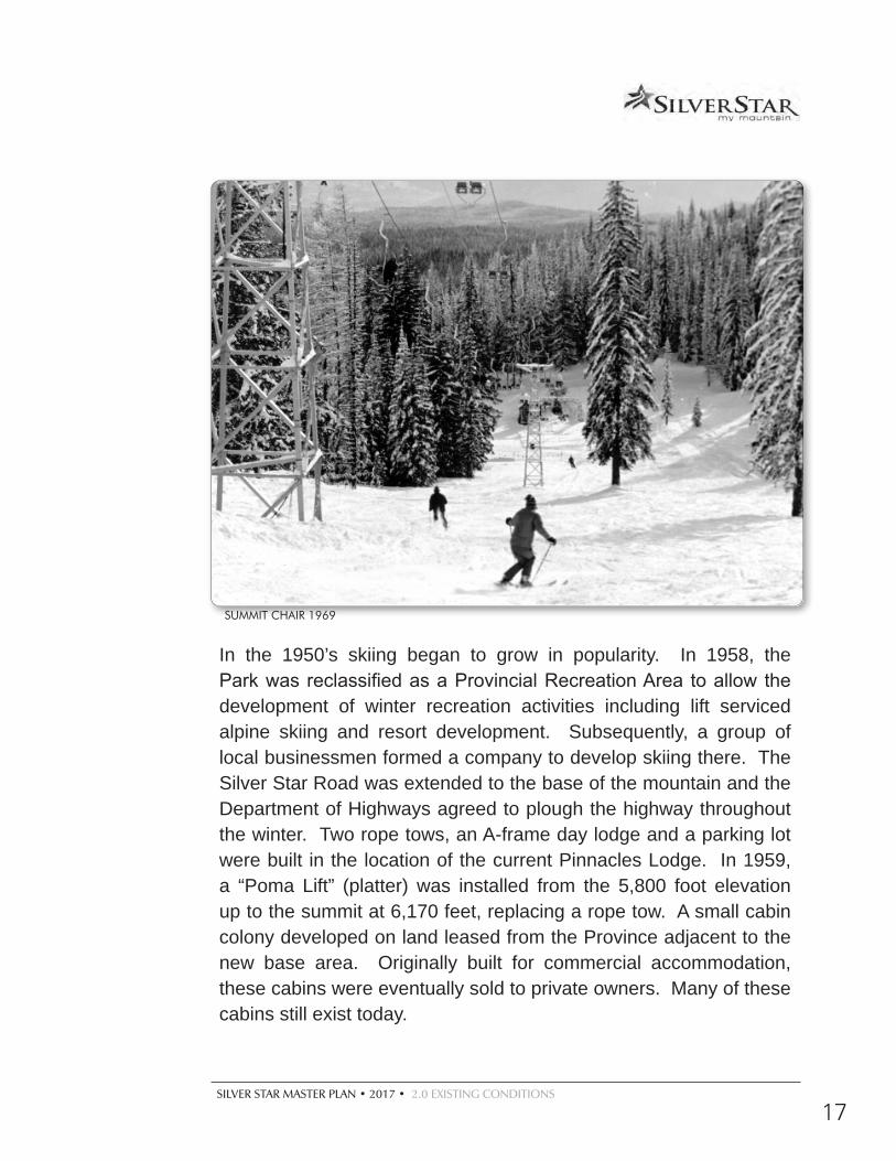
In the 1950’s skiing began to grow in popularity. In 1958, the Park was reclassified as a Provincial Recreation Area to allow the development of winter recreation activities including lift serviced alpine skiing and resort development. Subsequently, a group of local businessmen formed a company to develop skiing there. The Silver Star Road was extended to the base of the mountain and the Department of Highways agreed to plough the highway throughout the winter. Two rope tows, an A-frame day lodge and a parking lot were built in the location of the current Pinnacles Lodge. In 1959, a “Poma Lift” (platter) was installed from the 5,800 foot elevation up to the summit at 6,170 feet, replacing a rope tow. A small cabin colony developed on land leased from the Province adjacent to the new base area. Originally built for commercial accommodation, these cabins were eventually sold to private owners. Many of these cabins still exist today.
SUMMIT CHAIR 1969
18
In 1964, T-bars were installed on the mountain and shortly after the day lodge was expanded. In 1969, the Yellow Chair was built to service the expanded ski terrain; at the time it was one of the biggest ski lifts in Canada. In the same year, the Summit Chair replaced the Poma, making Silver Star a very popular ski destination rivalling Sunshine Village and Lake Louise in Banff.
In 1976, the Blue or Aberdeen Chair was built, again adding more skiing to the resort. During the 1970’s, ski resort development in western Canada was rampant. With it, Silver Star’s growth began to slow down. In 1979, a new Master Plan was developed to create a Village at the resort.
In 1980, the Master Plan was approved, enabling the development of land within the Park to foster on-mountain accommodation. In 1981, Silver Star was purchased by Norm Crerar, Charlie Locke, John Hindle, Rab Marshall and John Gow, becoming Silver Star Mountain Resorts Ltd. A short time later, the first of the cross-country ski trails at Silver Star were built. By 1983, the first buildings in the Village were developed, including the Putnam Station Hotel. In 1984, the base facilities were relocated into the Village along with ongoing development of the core buildings. To further diversify the offering, an increased emphasis was placed on cross-country skiing with an expansion of the trails, the installation of lights for a night skiing loop and the development of the biathlon range. Real estate development near the entrance to the resort began shortly after. In an effort to initiate all season use, summer operations began in 1984. In 1985, when the last outstanding mining claim lapsed, Silver Star was again classified as a Class ‘A’ Park in order to protect the area from future mining claims. In 1988, a Master Plan amendment was approved including the development of lifts and trails in the Putnam Creek area of mountain. In 1989, the first home in the Knoll was built, with substantial resort residential development to follow.
SILVER STAR MASTER PLAN • 2017 • 2.0 EXISTING CONDITIONS
19
HISTORIC PINNACLES
HISTORIC YELLOW CHAIR
HISTORIC VIEW FROM THE SUMMIT
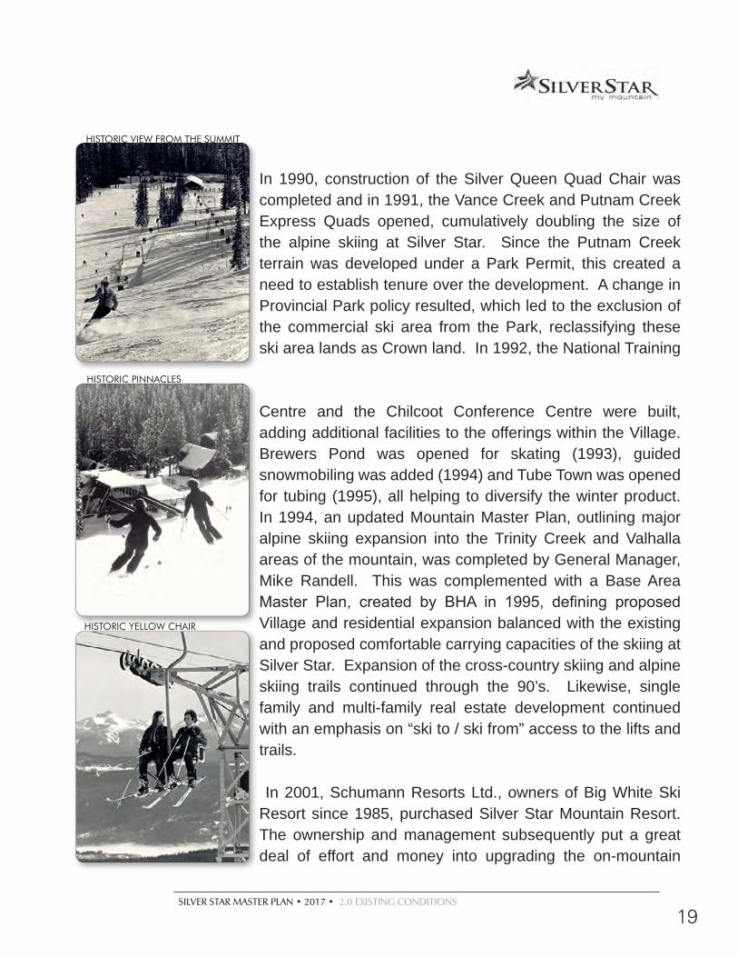
In 1990, construction of the Silver Queen Quad Chair was completed and in 1991, the Vance Creek and Putnam Creek Express Quads opened, cumulatively doubling the size of the alpine skiing at Silver Star. Since the Putnam Creek terrain was developed under a Park Permit, this created a need to establish tenure over the development. A change in Provincial Park policy resulted, which led to the exclusion of the commercial ski area from the Park, reclassifying these ski area lands as Crown land. In 1992, the National Training
Centre and the Chilcoot Conference Centre were built, adding additional facilities to the offerings within the Village. Brewers Pond was opened for skating (1993), guided snowmobiling was added (1994) and Tube Town was opened for tubing (1995), all helping to diversify the winter product. In 1994, an updated Mountain Master Plan, outlining major alpine skiing expansion into the Trinity Creek and Valhalla areas of the mountain, was completed by General Manager, Mike Randell. This was complemented with a Base Area Master Plan, created by BHA in 1995, defining proposed Village and residential expansion balanced with the existing and proposed comfortable carrying capacities of the skiing at Silver Star. Expansion of the cross-country skiing and alpine skiing trails continued through the 90’s. Likewise, single family and multi-family real estate development continued with an emphasis on “ski to / ski from” access to the lifts and trails.
In 2001, Schumann Resorts Ltd., owners of Big White Ski Resort since 1985, purchased Silver Star Mountain Resort. The ownership and management subsequently put a great deal of effort and money into upgrading the on-mountain
20
facilities. In 2002, a $10,000,000 resort expansion was initiated with the installation of the six passenger Comet Express replacing the Vance Creek Quad, the Powder Gulch Express replacing the Putnam Creek Quad and the addition of the Wonder Carpet beginner lift. This was followed with the installation of the Home Run Tee (2003), the Silver Woods Express (2005), the new Silver Queen Quad (replacing and realigning the old quad - 2007) and the Alpine Meadows Chair (replacing the Alpine T-Bar - 2007). In addition, the Telus Terrain Park was built to cater to specialized freestyle snowboarding and skiing.
Summer at Silver Star progressively improved and grew in popularity with the introduction of the lift serviced mountain bike park, unique events such as the Summer Wine and Food Festival and specialized camps such as the Piping Hot Summer Drummer, lift serviced sight seeing and hiking, horseback riding and ATVing. These activities were all complemented by an expanding variety of restaurants, bistros and retail outlets in the village that continue to attract summer visitors in greater numbers.
As expansion of the Village continued, agreements with the Regional District were secured in 2005 to develop a water reservoir ensuring the water capacity of Silver Star well into the future. Subsequently, development proceeded with the construction of the $54,000,000 Snowbird Lodge in the Village, the Ridge subdivision and the Alpine Meadows subdivision. Based on the speed with which the Alpine Meadows development sold out (all 49 lots were sold over the course of one weekend in March 2006), the owners of Silver Star saw this as a statement of confidence in Silver Star. This enthusiasm is tempered by the ongoing commitment to ensure that facilities and attractions at Silver Star are second to none, align all development with the vision to be the premier family oriented, all-season mountain resort of British Columbia.
In 2012 Silver Star’s ownership was restructured and now has a single shareholder which operates the company on behalf of a family trust.
SILVER STAR MASTER PLAN • 2017 • 2.0 EXISTING CONDITIONS
21
2.5 Existing Mountain Facilities
2.5.1 INTRODUCTION
The existing winter attractions at Silver Star include lift serviced alpine skiing and snowboarding, Nordic skiing, skating, tubing and snowmobiling. The alpine skiing and snowboarding are the predominant attractions, with the Nordic skiing a significant but distant second. The other attractions act primarily as complements that round out the dynamic offering at the resort. The following describes and illustrates the existing winter mountain facilities at Silver Star.
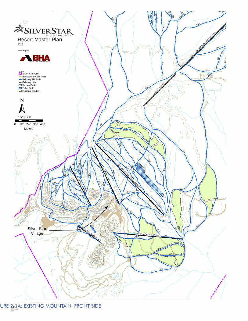
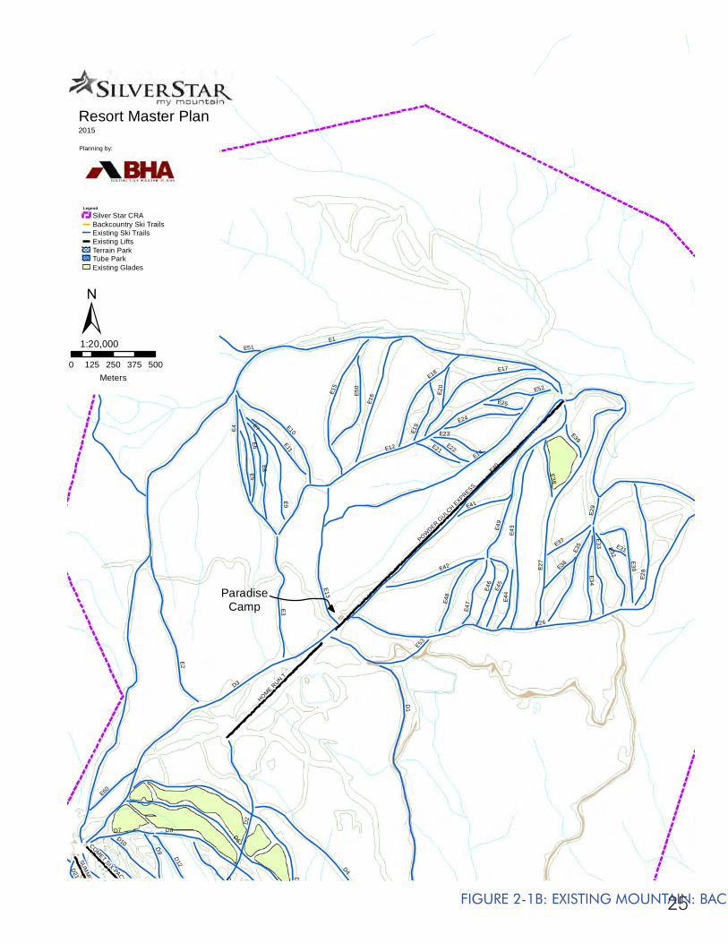
2.5.2 SKIING AND SNOWBOARDING
The existing lift serviced mountain facilities consist of 10 ski lifts accessing 128 ski trails and glades, totalling approximately 421 hectares of developed terrain (1,043 acres). Overall, Silver Star boasts a skiable area of approximately 1,240 hectares (3,065 acres). These facilities have a Comfortable Carrying Capacity (CCC) of approximately 5,550 skiers per day.
The CCC is a measure of the optimum number of skiers / snow boarders who can utilize the resort at any one time, being guaranteed a pleasant recreational experience without causing a decline in the quality of the environment. Generally, depending on weather and snow conditions, 40% of the total CCC will be actively skiing, 25% will be on lifts, 10% will be waiting in lift queues and the remaining skiers are rated as passive and will be using the skier service facilities and amenities. The estimation of the CCC of a ski area is the single most important planning criterion for the resort. Based on the proper identification of the mountain’s true capacity, all other related skier service facilities such as restaurants, retail outlets, resort services,
22
parking, overnight accommodation, and other destination facilities can be planned.
The ski season at Silver Star runs from mid-November to mid-April of each year, accounting for a total of approximately 150 operating days. Since the first lifts were installed in the mid-1950s, skier visits have steadily increased to a high of 384,055 visitors during the 2007 / 2008 season. As a comparison, this makes Silver Star the sixth largest ski resort in British Columbia by skier visits, behind Whistler / Blackcomb, Big White, Cypress, Mt. Washington and Sun Peaks.
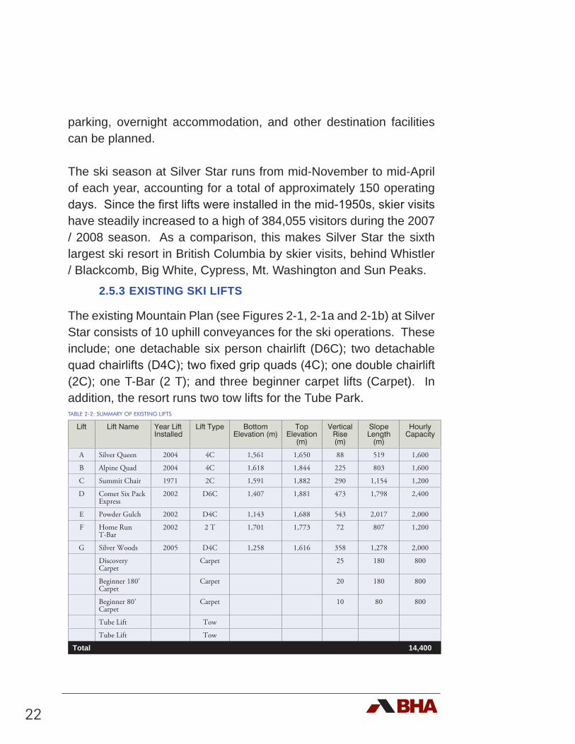
2.5.3 EXISTING SKI LIFTS
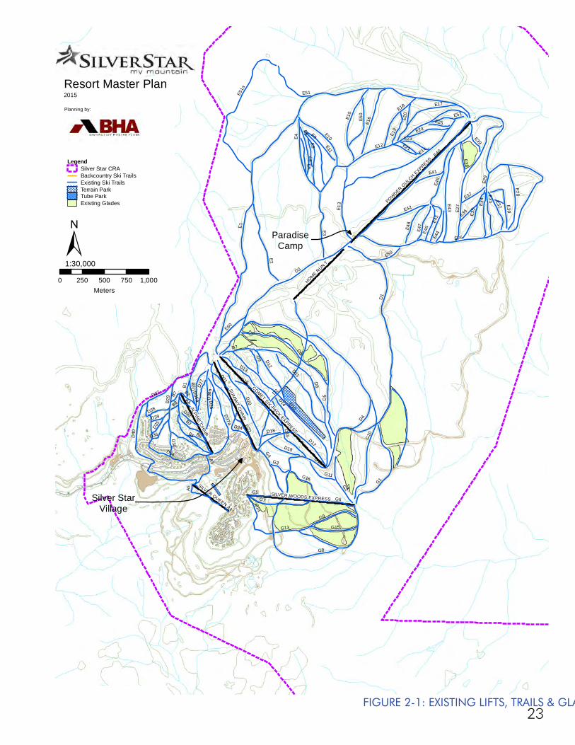
The existing Mountain Plan (see Figures 2-1, 2-1a and 2-1b) at Silver Star consists of 10 uphill conveyances for the ski operations. These include; one detachable six person chairlift (D6C); two detachable quad chairlifts (D4C); two fixed grip quads (4C); one double chairlift (2C); one T-Bar (2 T); and three beginner carpet lifts (Carpet). In addition, the resort runs two tow lifts for the Tube Park. TABLE 2-2: SUMMARY OF EXISTING LIFTS
Lift Lift Name Year Lift Installed
Lift Type Bottom Elevation (m)
Top Elevation
(m)
Vertical Rise (m)
Slope Length
(m)
Hourly Capacity
A Silver Queen 2004 4C 1,561 1,650 88 519 1,600
B Alpine Quad 2004 4C 1,618 1,844 225 803 1,600
C Summit Chair 1971 2C 1,591 1,882 290 1,154 1,200
D Comet Six Pack Express
2002 D6C 1,407 1,881 473 1,798 2,400
E Powder Gulch 2002 D4C 1,143 1,688 543 2,017 2,000
F Home Run T-Bar
2002 2 T 1,701 1,773 72 807 1,200
G Silver Woods 2005 D4C 1,258 1,616 358 1,278 2,000
Discovery Carpet
Carpet 25 180 800
Beginner 180’ Carpet
Carpet 20 180 800
Beginner 80’ Carpet
Carpet 10 80 800
Tube Lift Tow
Tube Lift Tow
Total 14,400
23
SUM
MIT C
HAIR
POWDER G
ULCH EXPRESS
COMET SIX-PACK EXPRESSHOME R
UN T
ALPINE CHAIR
SILVER WOODS EXPRESS
SILVER QUEEN
E1
D1
D3
D2
D5
D8
E12
E40
E26
D10
D4
D6
E14
E27
E2
E4
G1
E43
G10
E3
G6
D40
E49
G8
D11
D22D
20
G7
E51a
E9
D29
G13
G12
B3
E7
D34
E15
E13
E6
E16
E17
D17
G4
A4
D35a
G2
E28
D15
G9
D13
D16
E10
D21
E18
D37a
E42
G15
D12
E35
B5
E53
E5
G5
E50
D25
E33
D7
A3
E51
E34
G14
E48
E11
E8
E24
E32 E30
G16
D14
D37
E45
E47
D28
E46
D9
D36
a
D19
E60
E52
E44
E19
B4
G11
B6
E41
D27
E38
A5
E23
E37
D35
G3
B2
E21
D36
D24
B1
E36
D33
D30
D38E2
0
E25
E39
D18
B7
E29
B8
D39
Resort Master Plan2015
Planning by:
0 250 500 750 1,000Meters
1:30,000
LegendSilver Star CRABackcountry Ski TrailsExisting Ski TrailsTerrain ParkTube ParkExisting Glades
± ParadiseCamp
Silver StarVillage
FIGURE 2-1: EXISTING LIFTS, TRAILS & GLADES
24
SUM
MIT C
HAIR
COMET SIX-PACK EXPRESS
HOME RUN T
ALPINE CHAIR
POWDER G
ULCH EXPRESS
SILVER WOODS EXPRESS
SILVER QUEEN
E1
D1
D3
D2D
5D8
D10
D4
D6
E2
G1
E40G
10
E3
G6
D40
G8
E14
D11
D22
D20
G7
D29
G13G12
B3E26
D34
E13
D17
G4
A4
D35a
G2
E4
D15
G9
D13
D16
E12
D21
D37a
E42
G15
D12
B5
E53
G5
D25
D7
E9
E7
A3
G14
E48
G16
D14
D37
E47
D28
D9
D36
a
D19
E60
E6
B4
G11
B6
D27
A5
E5
D35
G3
B2
D36
D24
B1
D33
D30
D38
E46
E8E51a
E41
D18
B7
B8
E10
D39
E11
E15
E49
E45
Resort Master Plan2015
Planning by:
0 120 240 360 480Meters
1:20,000
Legend
Silver Star CRABackcountry Ski TrailsExisting Ski TrailsExisting LiftsTerrain ParkTube ParkExisting Glades
±
Silver StarVillage
FIGURE 2-1A: EXISTING MOUNTAIN: FRONT SIDE
25
POWDER G
ULCH EXPRESS
HOME RUN T
SUM
MIT C
HAIR
COMET SIX-PACK EXPRESS
E1
D3
D1
E12
E40
E26
D5
D6
E14
E27
D2
E2
E4
D4
D8
E43
E3
E49
E51a
E9
E7
E15
E13
E6
E16
E17
E28
E10
E18
E42E3
5
E53
D10
E5
E50
D13
E33
D7
D12
D11
E51
E34
E48
E11
E8
E24
E32
E30
E45
E47
E46
D9
D20
E60
E52
E44
E19
E41
E38
E23
E37
D21
E21E22
E36
E20
E25
E39
D22
E29
E31
Resort Master Plan2015
Planning by:
0 125 250 375 500Meters
1:20,000
Legend
Silver Star CRABackcountry Ski TrailsExisting Ski TrailsExisting LiftsTerrain ParkTube ParkExisting Glades
±
ParadiseCamp
FIGURE 2-1B: EXISTING MOUNTAIN: BACKSIDE
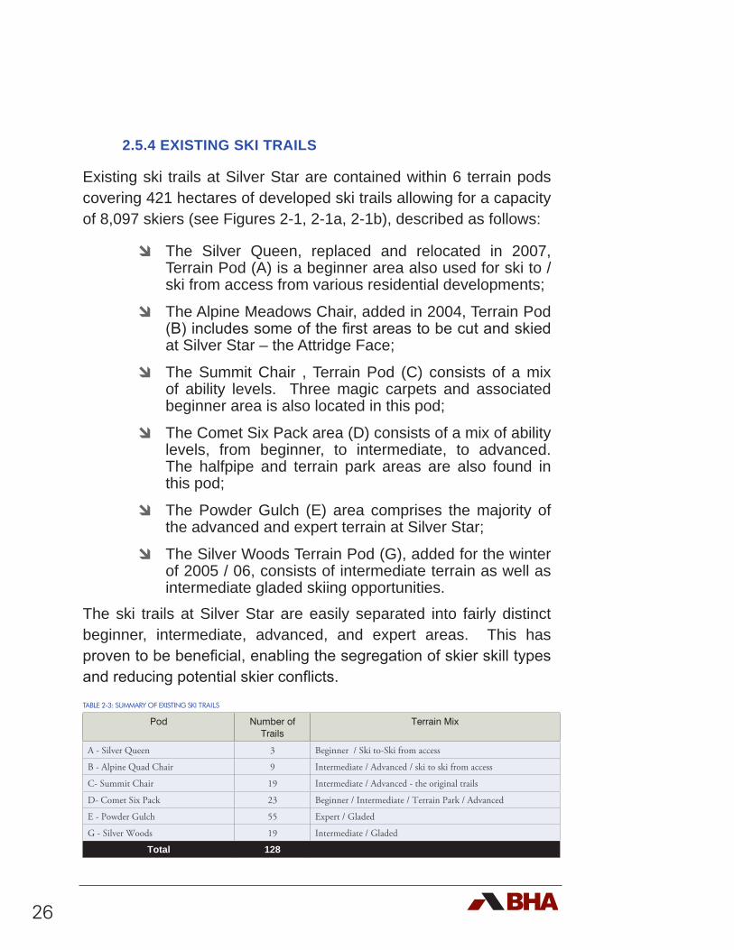
26
2.5.4 EXISTING SKI TRAILS
Existing ski trails at Silver Star are contained within 6 terrain pods covering 421 hectares of developed ski trails allowing for a capacity of 8,097 skiers (see Figures 2-1, 2-1a, 2-1b), described as follows:
d The Silver Queen, replaced and relocated in 2007, Terrain Pod (A) is a beginner area also used for ski to / ski from access from various residential developments;
d The Alpine Meadows Chair, added in 2004, Terrain Pod (B) includes some of the first areas to be cut and skied at Silver Star – the Attridge Face;
d The Summit Chair , Terrain Pod (C) consists of a mix of ability levels. Three magic carpets and associated beginner area is also located in this pod;
d The Comet Six Pack area (D) consists of a mix of ability levels, from beginner, to intermediate, to advanced. The halfpipe and terrain park areas are also found in this pod;
d The Powder Gulch (E) area comprises the majority of the advanced and expert terrain at Silver Star;
d The Silver Woods Terrain Pod (G), added for the winter of 2005 / 06, consists of intermediate terrain as well as intermediate gladed skiing opportunities.
The ski trails at Silver Star are easily separated into fairly distinct beginner, intermediate, advanced, and expert areas. This has proven to be beneficial, enabling the segregation of skier skill types and reducing potential skier conflicts. TABLE 2-3: SUMMARY OF EXISTING SKI TRAILS
Pod Number of Trails
Terrain Mix
A - Silver Queen 3 Beginner / Ski to-Ski from access
B - Alpine Quad Chair 9 Intermediate / Advanced / ski to ski from access
C- Summit Chair 19 Intermediate / Advanced - the original trails
D- Comet Six Pack 23 Beginner / Intermediate / Terrain Park / Advanced
E - Powder Gulch 55 Expert / Gladed
G - Silver Woods 19 Intermediate / Gladed
Total 128
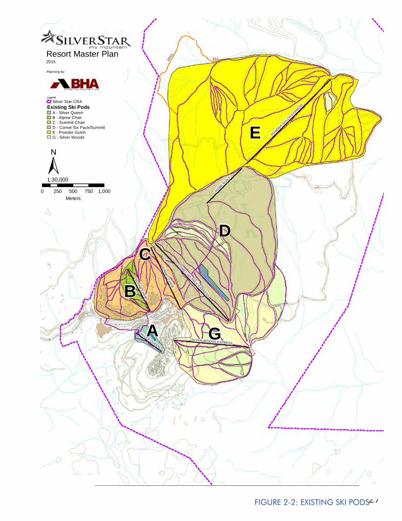
27
SUM
MIT C
HAIR
POWDER G
ULCH EXPRESS
COMET SIX-PACK EXPRESSHOME R
UN T
ALPINE CHAIR
SILVER WOODS EXPRESS
SILVER QUEEN
E51a
E51Resort Master Plan2015
Planning by:
0 250 500 750 1,000Meters
1:30,000
Legend
Silver Star CRAExisting Ski Pods
A - Silver QueenB - Alpine ChairC - Summit ChairD - Comet Six Pack/SummitE - Powder GulchG - Silver Woods
±E
D
GA
B
C
FIGURE 2-2: EXISTING SKI PODS
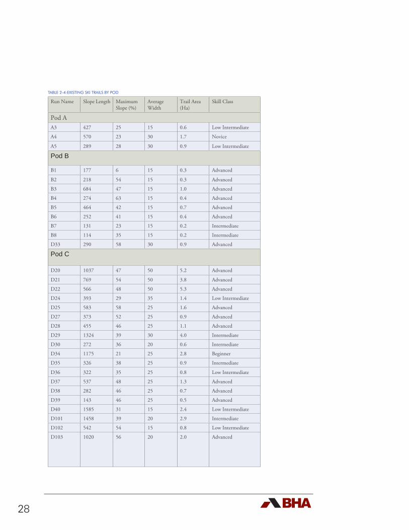
28
TABLE 2-4:EXISTING SKI TRAILS BY POD
Run Name Slope Length Maximum Slope (%)
Average Width
Trail Area (Ha)
Skill Class
Pod A A3 427 25 15 0.6 Low Intermediate
A4 570 23 30 1.7 Novice
A5 289 28 30 0.9 Low Intermediate
Pod B
B1 177 6 15 0.3 Advanced
B2 218 54 15 0.3 Advanced
B3 684 47 15 1.0 Advanced
B4 274 63 15 0.4 Advanced
B5 464 42 15 0.7 Advanced
B6 252 41 15 0.4 Advanced
B7 131 23 15 0.2 Intermediate
B8 114 35 15 0.2 Intermediate
D33 290 58 30 0.9 Advanced
Pod C
D20 1037 47 50 5.2 Advanced
D21 769 54 50 3.8 Advanced
D22 566 48 50 5.3 Advanced
D24 393 29 35 1.4 Low Intermediate
D25 583 58 25 1.6 Advanced
D27 373 52 25 0.9 Advanced
D28 455 46 25 1.1 Advanced
D29 1324 39 30 4.0 Intermediate
D30 272 36 20 0.6 Intermediate
D34 1175 21 25 2.8 Beginner
D35 326 38 25 0.9 Intermediate
D36 322 35 25 0.8 Low Intermediate
D37 537 48 25 1.3 Advanced
D38 282 46 25 0.7 Advanced
D39 143 46 25 0.5 Advanced
D40 1585 31 15 2.4 Low Intermediate
D101 1458 39 20 2.9 Intermediate
D102 542 54 15 0.8 Low Intermediate
D103 1020 56 20 2.0 Advanced
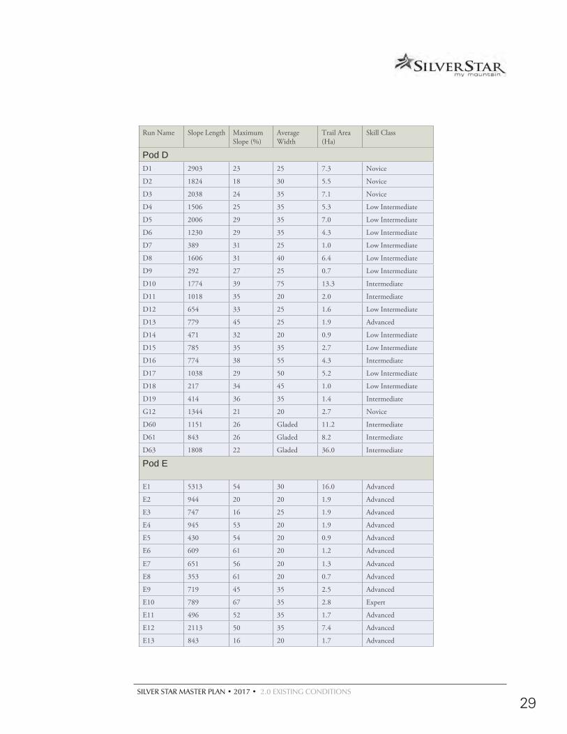
SILVER STAR MASTER PLAN • 2017 • 2.0 EXISTING CONDITIONS
29
Run Name Slope Length Maximum Slope (%)
Average Width
Trail Area (Ha)
Skill Class
Pod DD1 2903 23 25 7.3 Novice
D2 1824 18 30 5.5 Novice
D3 2038 24 35 7.1 Novice
D4 1506 25 35 5.3 Low Intermediate
D5 2006 29 35 7.0 Low Intermediate
D6 1230 29 35 4.3 Low Intermediate
D7 389 31 25 1.0 Low Intermediate
D8 1606 31 40 6.4 Low Intermediate
D9 292 27 25 0.7 Low Intermediate
D10 1774 39 75 13.3 Intermediate
D11 1018 35 20 2.0 Intermediate
D12 654 33 25 1.6 Low Intermediate
D13 779 45 25 1.9 Advanced
D14 471 32 20 0.9 Low Intermediate
D15 785 35 35 2.7 Low Intermediate
D16 774 38 55 4.3 Intermediate
D17 1038 29 50 5.2 Low Intermediate
D18 217 34 45 1.0 Low Intermediate
D19 414 36 35 1.4 Intermediate
G12 1344 21 20 2.7 Novice
D60 1151 26 Gladed 11.2 Intermediate
D61 843 26 Gladed 8.2 Intermediate
D63 1808 22 Gladed 36.0 Intermediate
Pod E
E1 5313 54 30 16.0 Advanced
E2 944 20 20 1.9 Advanced
E3 747 16 25 1.9 Advanced
E4 945 53 20 1.9 Advanced
E5 430 54 20 0.9 Advanced
E6 609 61 20 1.2 Advanced
E7 651 56 20 1.3 Advanced
E8 353 61 20 0.7 Advanced
E9 719 45 35 2.5 Advanced
E10 789 67 35 2.8 Expert
E11 496 52 35 1.7 Advanced
E12 2113 50 35 7.4 Advanced
E13 843 16 20 1.7 Advanced
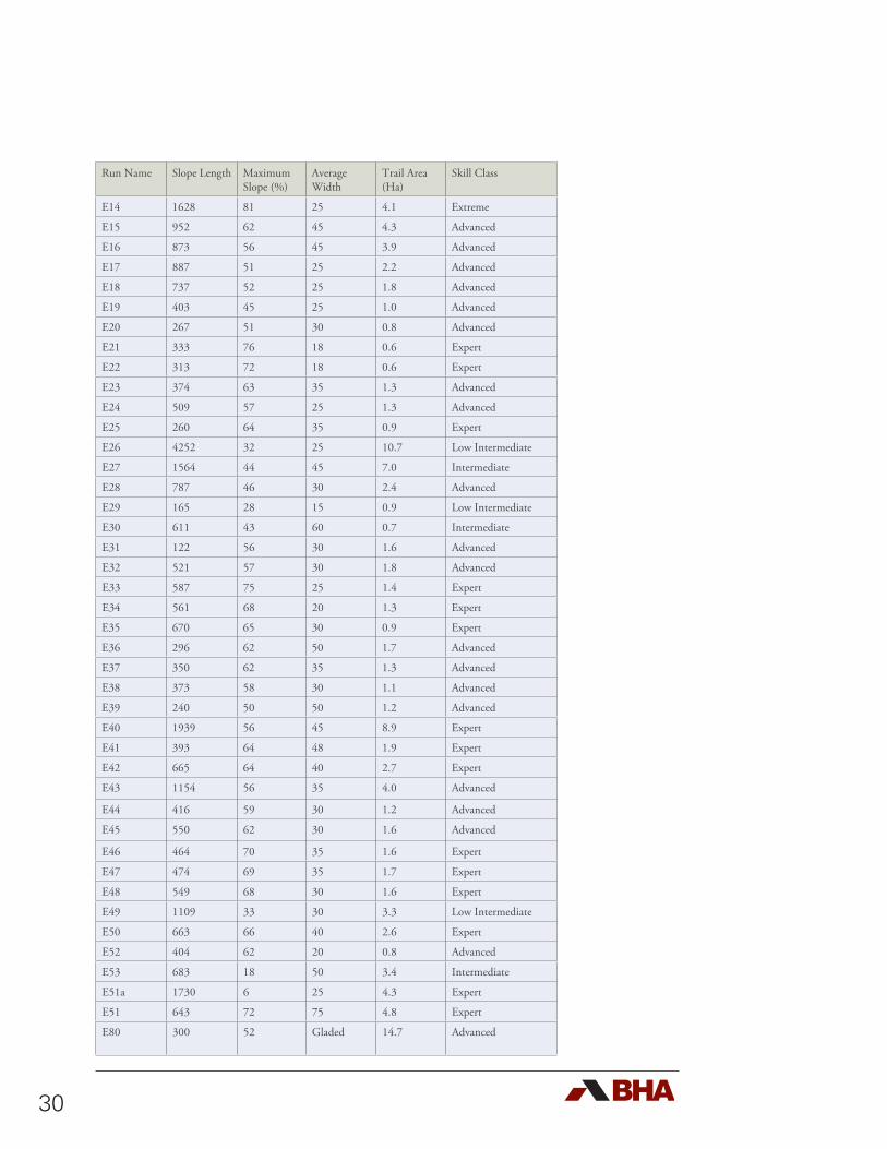
30
Run Name Slope Length Maximum Slope (%)
Average Width
Trail Area (Ha)
Skill Class
E14 1628 81 25 4.1 Extreme
E15 952 62 45 4.3 Advanced
E16 873 56 45 3.9 Advanced
E17 887 51 25 2.2 Advanced
E18 737 52 25 1.8 Advanced
E19 403 45 25 1.0 Advanced
E20 267 51 30 0.8 Advanced
E21 333 76 18 0.6 Expert
E22 313 72 18 0.6 Expert
E23 374 63 35 1.3 Advanced
E24 509 57 25 1.3 Advanced
E25 260 64 35 0.9 Expert
E26 4252 32 25 10.7 Low Intermediate
E27 1564 44 45 7.0 Intermediate
E28 787 46 30 2.4 Advanced
E29 165 28 15 0.9 Low Intermediate
E30 611 43 60 0.7 Intermediate
E31 122 56 30 1.6 Advanced
E32 521 57 30 1.8 Advanced
E33 587 75 25 1.4 Expert
E34 561 68 20 1.3 Expert
E35 670 65 30 0.9 Expert
E36 296 62 50 1.7 Advanced
E37 350 62 35 1.3 Advanced
E38 373 58 30 1.1 Advanced
E39 240 50 50 1.2 Advanced
E40 1939 56 45 8.9 Expert
E41 393 64 48 1.9 Expert
E42 665 64 40 2.7 Expert
E43 1154 56 35 4.0 Advanced
E44 416 59 30 1.2 Advanced
E45 550 62 30 1.6 Advanced
E46 464 70 35 1.6 Expert
E47 474 69 35 1.7 Expert
E48 549 68 30 1.6 Expert
E49 1109 33 30 3.3 Low Intermediate
E50 663 66 40 2.6 Expert
E52 404 62 20 0.8 Advanced
E53 683 18 50 3.4 Intermediate
E51a 1730 6 25 4.3 Expert
E51 643 72 75 4.8 Expert
E80 300 52 Gladed 14.7 Advanced
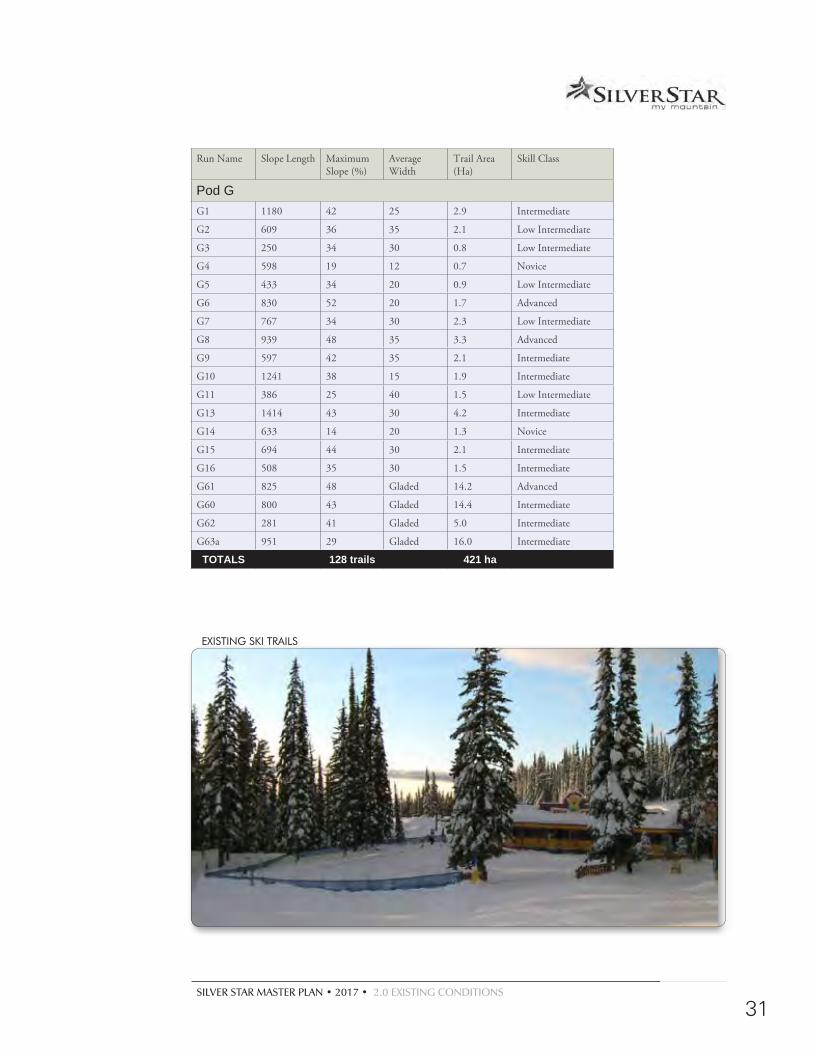
SILVER STAR MASTER PLAN • 2017 • 2.0 EXISTING CONDITIONS
31
EXISTING SKI TRAILS
Run Name Slope Length Maximum Slope (%)
Average Width
Trail Area (Ha)
Skill Class
Pod GG1 1180 42 25 2.9 Intermediate
G2 609 36 35 2.1 Low Intermediate
G3 250 34 30 0.8 Low Intermediate
G4 598 19 12 0.7 Novice
G5 433 34 20 0.9 Low Intermediate
G6 830 52 20 1.7 Advanced
G7 767 34 30 2.3 Low Intermediate
G8 939 48 35 3.3 Advanced
G9 597 42 35 2.1 Intermediate
G10 1241 38 15 1.9 Intermediate
G11 386 25 40 1.5 Low Intermediate
G13 1414 43 30 4.2 Intermediate
G14 633 14 20 1.3 Novice
G15 694 44 30 2.1 Intermediate
G16 508 35 30 1.5 Intermediate
G61 825 48 Gladed 14.2 Advanced
G60 800 43 Gladed 14.4 Intermediate
G62 281 41 Gladed 5.0 Intermediate
G63a 951 29 Gladed 16.0 Intermediate
TOTALS 128 trails 421 ha
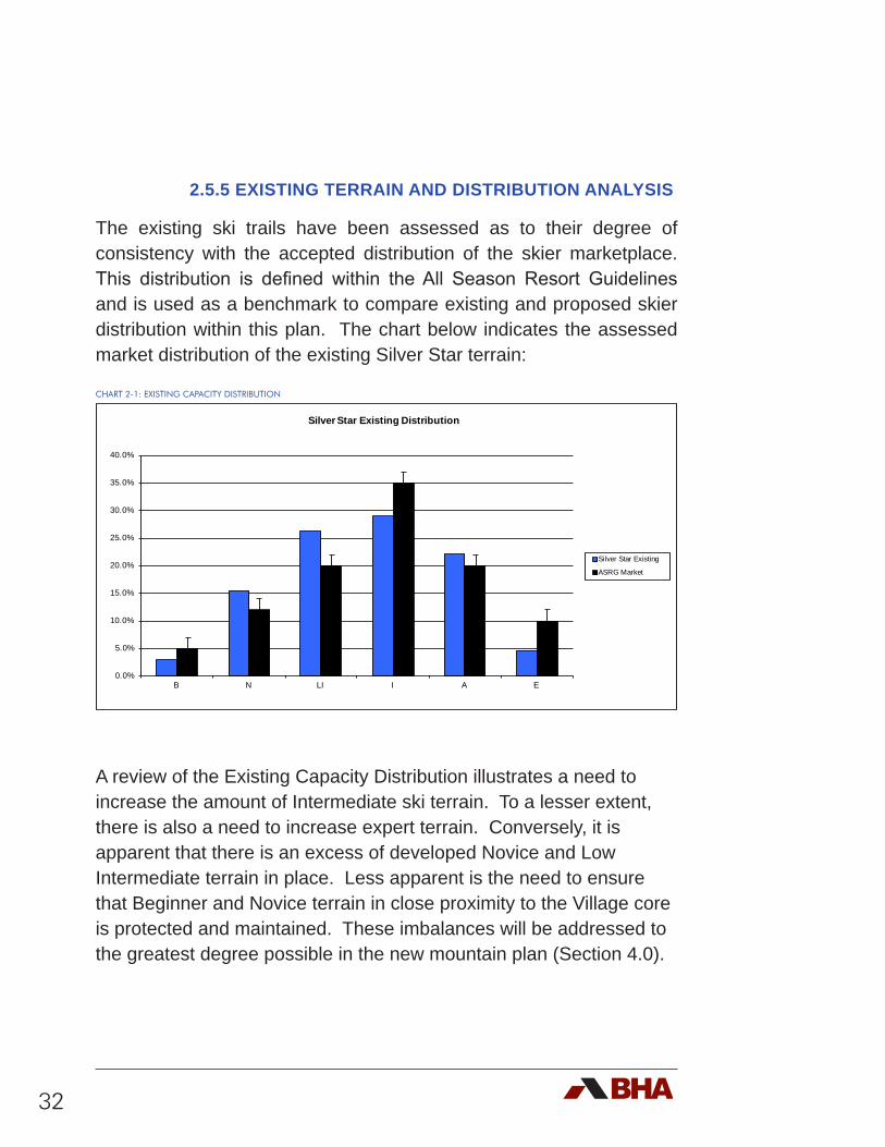
32
2.5.5 EXISTING TERRAIN AND DISTRIBUTION ANALYSIS
The existing ski trails have been assessed as to their degree of consistency with the accepted distribution of the skier marketplace. This distribution is defined within the All Season Resort Guidelines and is used as a benchmark to compare existing and proposed skier distribution within this plan. The chart below indicates the assessed market distribution of the existing Silver Star terrain:
CHART 2-1: EXISTING CAPACITY DISTRIBUTION
A review of the Existing Capacity Distribution illustrates a need to increase the amount of Intermediate ski terrain. To a lesser extent, there is also a need to increase expert terrain. Conversely, it is apparent that there is an excess of developed Novice and Low Intermediate terrain in place. Less apparent is the need to ensure that Beginner and Novice terrain in close proximity to the Village core is protected and maintained. These imbalances will be addressed to the greatest degree possible in the new mountain plan (Section 4.0).
0.0%
5.0%
10.0%
15.0%
20.0%
25.0%
30.0%
35.0%
40.0%
B N LI I A E
Silver Star Existing Distribution
Silver Star Existing
ASRG Market
SILVER STAR MASTER PLAN • 2017 • 2.0 EXISTING CONDITIONS
33
2.5.6 EXISTING COMFORTABLE CARRYING CAPACITY
The B.C. All Season Resort Guidelines (ASRG) defines Comfortable Carrying Capacity (CCC), “…as the optimum number of skiers that can utilize the resort per day, while being guaranteed a pleasant recreation experience without causing a decline in the quality of the physical and sociological environment.”
CCC is calculated as a function of the uphill capacity of the ski lifts combined with the downhill capacity of the ski trails and terrain as influenced by the market breakdown of the skier skill classes.
With the advent of the All Season Resort Guidelines (ASRG), the criteria used to calculate the CCC were redefined and adjusted to reflect changes in the ski industry. Of particular note is the fact that, “preferred and acceptable skier / rider densities on ski trails have decreased considerably in recent years” (for all skill classes). Further, the increased popularity of shaped skis, combined with snowboarding’s relatively easy learning curve, has enabled a larger number of skiers and riders to negotiate steeper and more adventuresome slopes sooner and with greater control than ever before. What was considered “experts-only’ terrain ten years ago is now accessible and used by a much broader segment of the skiing population. This has led to new terrain being opened up in areas that were traditionally too steep to ski or ride. In addition, skiers are skiing faster. This has lead to an increase in the vertical demand of skiers and snowboarders - the amount of skiing they can do in a day. The net result is that the traditional lift and trail configurations are less and less able to provide the quality of experience that is expected by today’s skier / boarder marketplace.
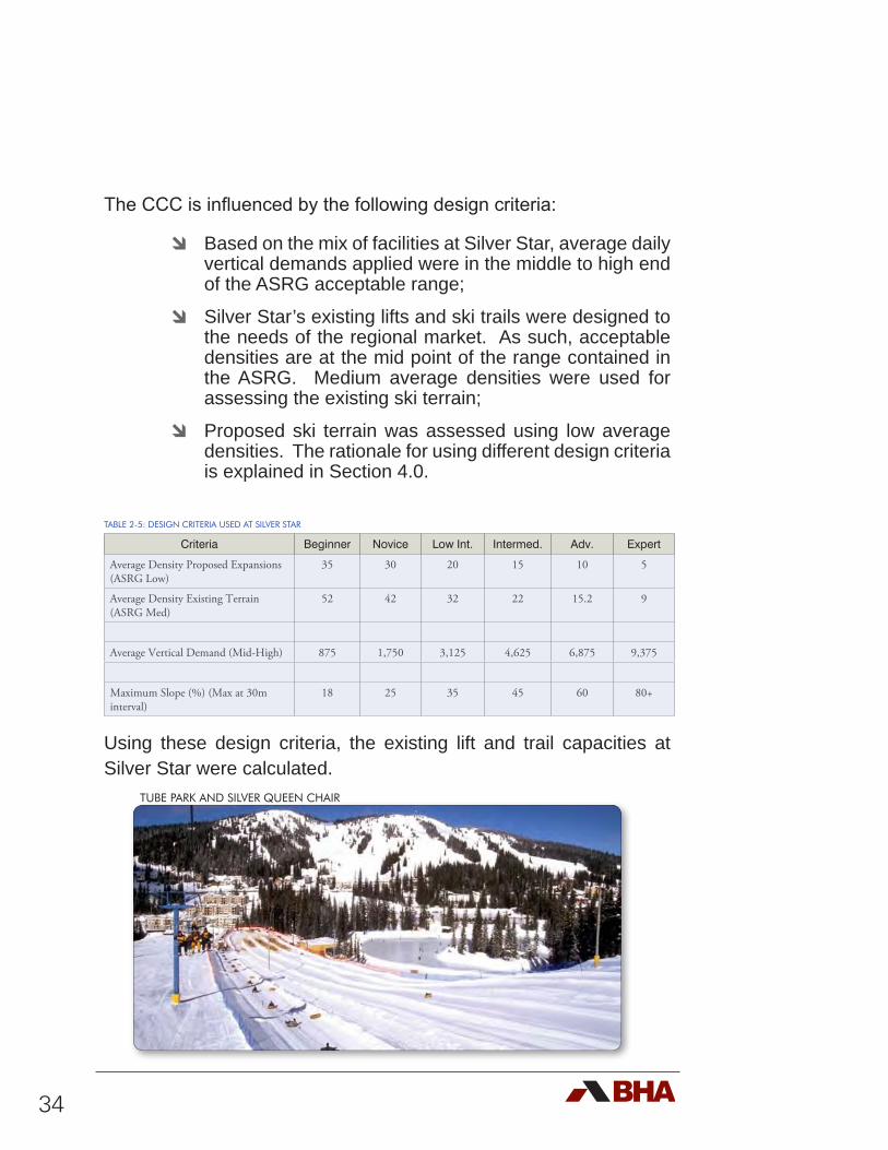
34
The CCC is influenced by the following design criteria:
d Based on the mix of facilities at Silver Star, average daily vertical demands applied were in the middle to high end of the ASRG acceptable range;
d Silver Star’s existing lifts and ski trails were designed to the needs of the regional market. As such, acceptable densities are at the mid point of the range contained in the ASRG. Medium average densities were used for assessing the existing ski terrain;
d Proposed ski terrain was assessed using low average densities. The rationale for using different design criteria is explained in Section 4.0.
TABLE 2-5: DESIGN CRITERIA USED AT SILVER STAR
Criteria Beginner Novice Low Int. Intermed. Adv. Expert
Average Density Proposed Expansions (ASRG Low)
35 30 20 15 10 5
Average Density Existing Terrain (ASRG Med)
52 42 32 22 15.2 9
Average Vertical Demand (Mid-High) 875 1,750 3,125 4,625 6,875 9,375
Maximum Slope (%) (Max at 30m interval)
18 25 35 45 60 80+
Using these design criteria, the existing lift and trail capacities at Silver Star were calculated.
TUBE PARK AND SILVER QUEEN CHAIR
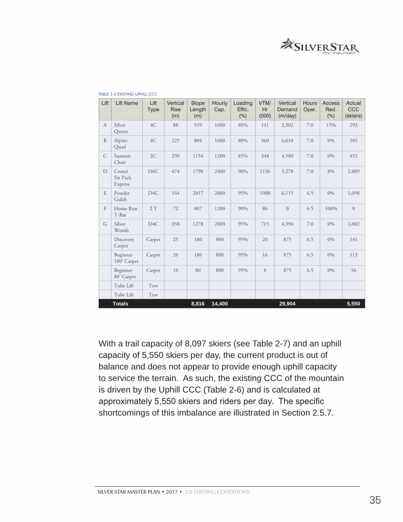
SILVER STAR MASTER PLAN • 2017 • 2.0 EXISTING CONDITIONS
35
TABLE 2-6 EXISTING UPHILL CCC
Lift Lift Name Lift Type
Vertical Rise (m)
Slope Length
(m)
Hourly Cap.
Loading Effic. (%)
VTM/Hr
(000)
Vertical Demand (m/day)
Hours Oper.
Access Red. (%)
Actual CCC
(skiers)
A Silver Queen
4C 88 519 1600 80% 141 2,302 7.0 15% 292
B Alpine Quad
4C 225 804 1600 80% 360 6,610 7.0 0% 305
C Summit Chair
2C 290 1154 1200 85% 348 4,580 7.0 0% 452
D Comet Six Pack Express
D6C 474 1798 2400 90% 1136 3,278 7.0 8% 2,009
E Powder Gulch
D4C 544 2017 2000 95% 1088 6,115 6.5 0% 1,098
F Home Run T-Bar
2 T 72 807 1200 90% 86 0 6.5 100% 0
G Silver Woods
D4C 358 1278 2000 95% 715 4,394 7.0 0% 1,082
Discovery Carpet
Carpet 25 180 800 95% 20 875 6.5 0% 141
Beginner 180’ Carpet
Carpet 20 180 800 95% 16 875 6.5 0% 113
Beginner 80’ Carpet
Carpet 10 80 800 95% 8 875 6.5 0% 56
Tube Lift Tow
Tube Lift Tow
Totals 8,816 14,400 29,904 5,550
With a trail capacity of 8,097 skiers (see Table 2-7) and an uphill capacity of 5,550 skiers per day, the current product is out of balance and does not appear to provide enough uphill capacity to service the terrain. As such, the existing CCC of the mountain is driven by the Uphill CCC (Table 2-6) and is calculated at approximately 5,550 skiers and riders per day. The specific shortcomings of this imbalance are illustrated in Section 2.5.7.
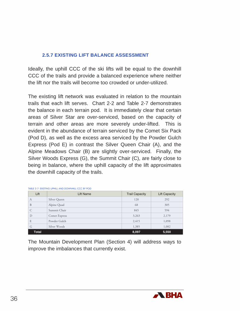
36
2.5.7 EXISTING LIFT BALANCE ASSESSMENT
Ideally, the uphill CCC of the ski lifts will be equal to the downhill CCC of the trails and provide a balanced experience where neither the lift nor the trails will become too crowded or under-utilized.
The existing lift network was evaluated in relation to the mountain trails that each lift serves. Chart 2-2 and Table 2-7 demonstrates the balance in each terrain pod. It is immediately clear that certain areas of Silver Star are over-serviced, based on the capacity of terrain and other areas are more severely under-lifted. This is evident in the abundance of terrain serviced by the Comet Six Pack (Pod D), as well as the excess area serviced by the Powder Gulch Express (Pod E) in contrast the Silver Queen Chair (A), and the Alpine Meadows Chair (B) are slightly over-serviced. Finally, the Silver Woods Express (G), the Summit Chair (C), are fairly close to being in balance, where the uphill capacity of the lift approximates the downhill capacity of the trails.
TABLE 2-7: EXISTING UPHILL AND DOWNHILL CCC BY POD
Lift Lift Name Trail Capacity Lift Capacity
A Silver Queen 120 292
B Alpine Quad 68 305
C Summit Chair 845 594
D Comet Express 3,263 2,179
E Powder Gulch 2,415 1,098
G Silver Woods 1,385 1,082
Total 8,097 5,550
The Mountain Development Plan (Section 4) will address ways to improve the imbalances that currently exist.
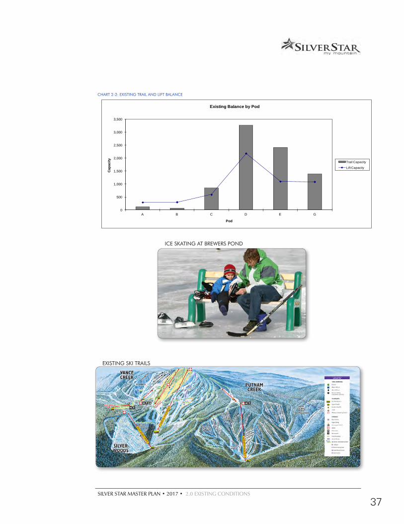
SILVER STAR MASTER PLAN • 2017 • 2.0 EXISTING CONDITIONS
37
CHART 2-2: EXISTING TRAIL AND LIFT BALANCE
0
500
1,000
1,500
2,000
2,500
3,000
3,500
A B C D E G
Capa
city
Pod
Existing Balance by Pod
Trail Capacity
Lift Capacity
ICE SKATING AT BREWERS POND
EXISTING SKI TRAILS
38
2.6 Existing Nordic Trails
The Nordic skiing facilities at Silver Star are recognized as some of the best in North America. Combined, the Silver Star trails and the adjacent Sovereign Lakes trails consist of 110 km of shared groomed and track-set trails, of which 4 km are illuminated for night skiing. (See Figure 2-3). SSMR and Sovereign Lake Nordic Centre operate under a collaborative approach agreement signed in 2013. An integral part of the Silver Star cross-country skiing facilities is the biathalon course and range. The trails were upgraded in 1991 in order to host a World Cup event. The capacity of the combined Silver Star and Sovereign Lakes trails are estimated to be capable of accommodating approximately 2,000 skiers per day. Silver Star alone is estimated to have a capacity of 700 Nordic skiers per day.
2.7 National Altitude Training Centre
Located in the Village, and directly associated with the Nordic facilities, is the National Altitude Training Centre. This facility acts as a base for cross-country skiing training camps, race clinics and as a race centre.
2.8 Additional Existing Winter Activities
In addition to the primary attractions of alpine and Nordic skiing, other winter attractions (See Figure 2-4) include:
d Tubing, accessed by 2 tow lifts with a capacity for approximately 100 tubers per day;
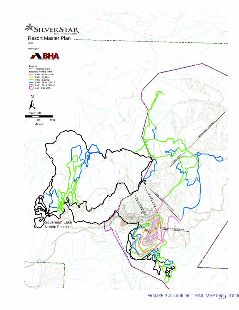
39
SUM
MIT C
HAIR
POWDER G
ULCH EXPRESS
COMET SIX-PACK EXPRESS
HOME RUN T
SILVER WOODS EXPRESS
SILVER QUEEN
ALPINE MEADO
WS CH
AIR
Resort Master Plan2015
Planning by:
0 490 980Meters
1:40,000
LegendProvincial Park
Existing Nordic TrailsTrails - All PurposeTrails - LightedTrails - EasiestTrails - More DifficultTrails - Most DifficultSilver Star CRA
±
Sovereign LakeNordic Facilities
FIGURE 2-3 NORDIC TRAIL MAP INCLUDING SOVEREIGN LAKES
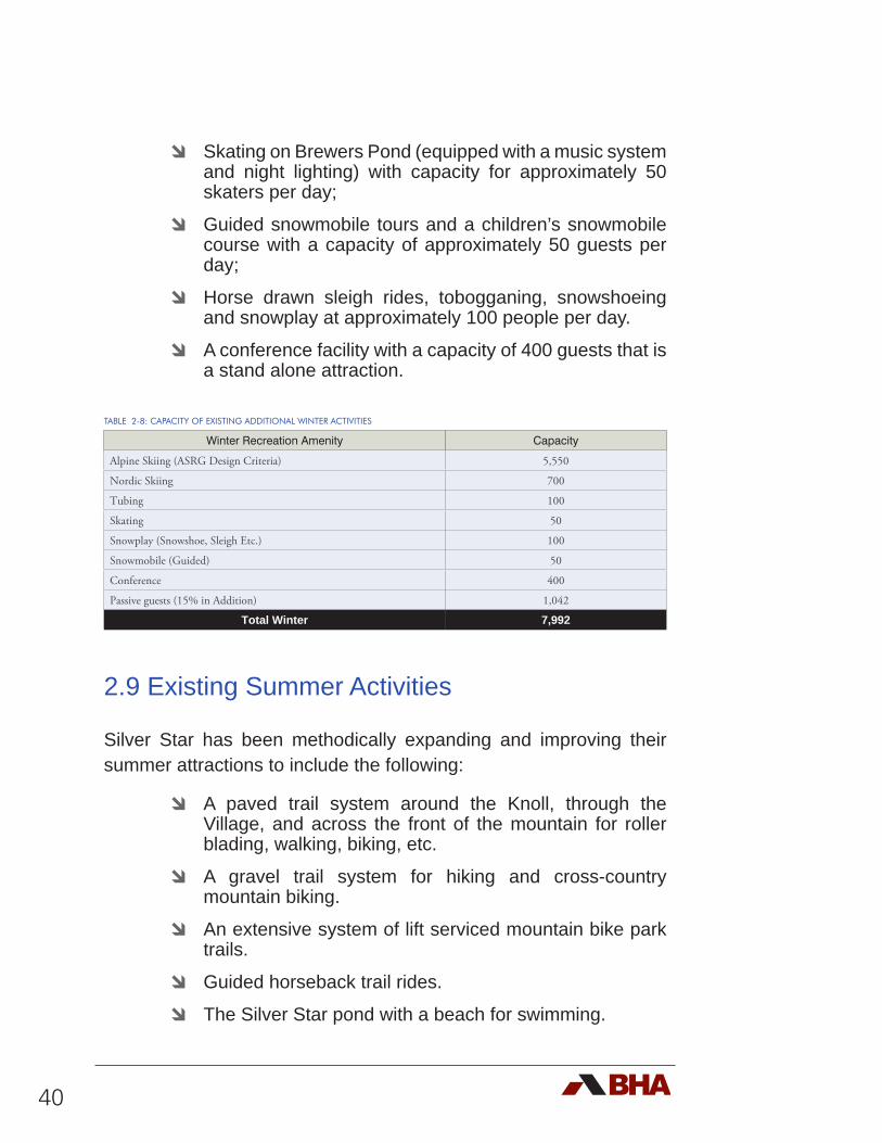
40
d Skating on Brewers Pond (equipped with a music system and night lighting) with capacity for approximately 50 skaters per day;
d Guided snowmobile tours and a children’s snowmobile course with a capacity of approximately 50 guests per day;
d Horse drawn sleigh rides, tobogganing, snowshoeing and snowplay at approximately 100 people per day.
d A conference facility with a capacity of 400 guests that is a stand alone attraction.
TABLE 2-8: CAPACITY OF EXISTING ADDITIONAL WINTER ACTIVITIES
Winter Recreation Amenity Capacity
Alpine Skiing (ASRG Design Criteria) 5,550
Nordic Skiing 700
Tubing 100
Skating 50
Snowplay (Snowshoe, Sleigh Etc.) 100
Snowmobile (Guided) 50
Conference 400
Passive guests (15% in Addition) 1,042
Total Winter 7,992
2.9 Existing Summer Activities
Silver Star has been methodically expanding and improving their summer attractions to include the following:
d A paved trail system around the Knoll, through the Village, and across the front of the mountain for roller blading, walking, biking, etc.
d A gravel trail system for hiking and cross-country mountain biking.
d An extensive system of lift serviced mountain bike park trails.
d Guided horseback trail rides.
d The Silver Star pond with a beach for swimming.
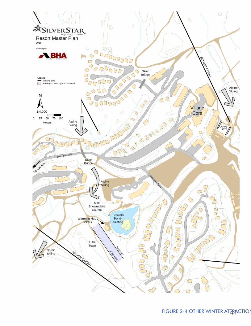
41
SUMM
IT CHAIR
SILVER QUEEN
ALPINE MEADO
WS CHAIR
Resort Master Plan2015
Planning by:
0 25 50 75 100Meters
1:4,000
LegendExisting LiftsBuildings - Existing & Committed
±
To Verno
n
BrewersPond-
Skating
Silver Star Road
Monashee Road
TubeTown
Warming Hut/Tickets
MiniSnowmobile
Course
SkierBridge
VillageCore
TUBE LIFT
TUBE LIFT
AlpineSkiing
AlpineSkiing
CARPETLIFTS
NordicSkiing
SkierBridge
AlpineSkiing
FIGURE 2-4 OTHER WINTER ATTRACTIONS
42
2.9.1 MOUNTAIN BIKE TERRAIN PARK
Mountain biking has long been an important summer activity at Silver Star, having hosted the World Cup cross country and downhill events in 1994. A formalized mountain bike terrain park was first established at Silver Star in 2005. The park is accessed from the Comet Six Pack Express, which currently services 20 trails with a vertical drop of 475 metres (1560 feet). The mountain bike park and hiking trails account for approximately 22,000 visits in the summer of 2011, increasing to over 23,000 visits in 2012, over 24,000 visits in 2013 and closing with a record number of visits at 25,748 in 2014.
The daily capacity for the mountain bike park is a function of the uphill capacity of the lift(s) and the downhill capacity of the trails. In the case of Silver Star, the Comet Express has a capacity of about 1,200 bikers per hour. The trail capacity is somewhat less than that. As such, the trails are the primary determining factor enabling a park capacity of approximately 400 bikers per day.
2.9.2 OTHER SUMMER ACTIVITIES
In addition to the lift serviced mountain bike park, Silver Star has cross-country mountain biking, hiking, guided horse back riding and a beach on Brewers Pond. In total these attractions account for approximately 150 guests per day.
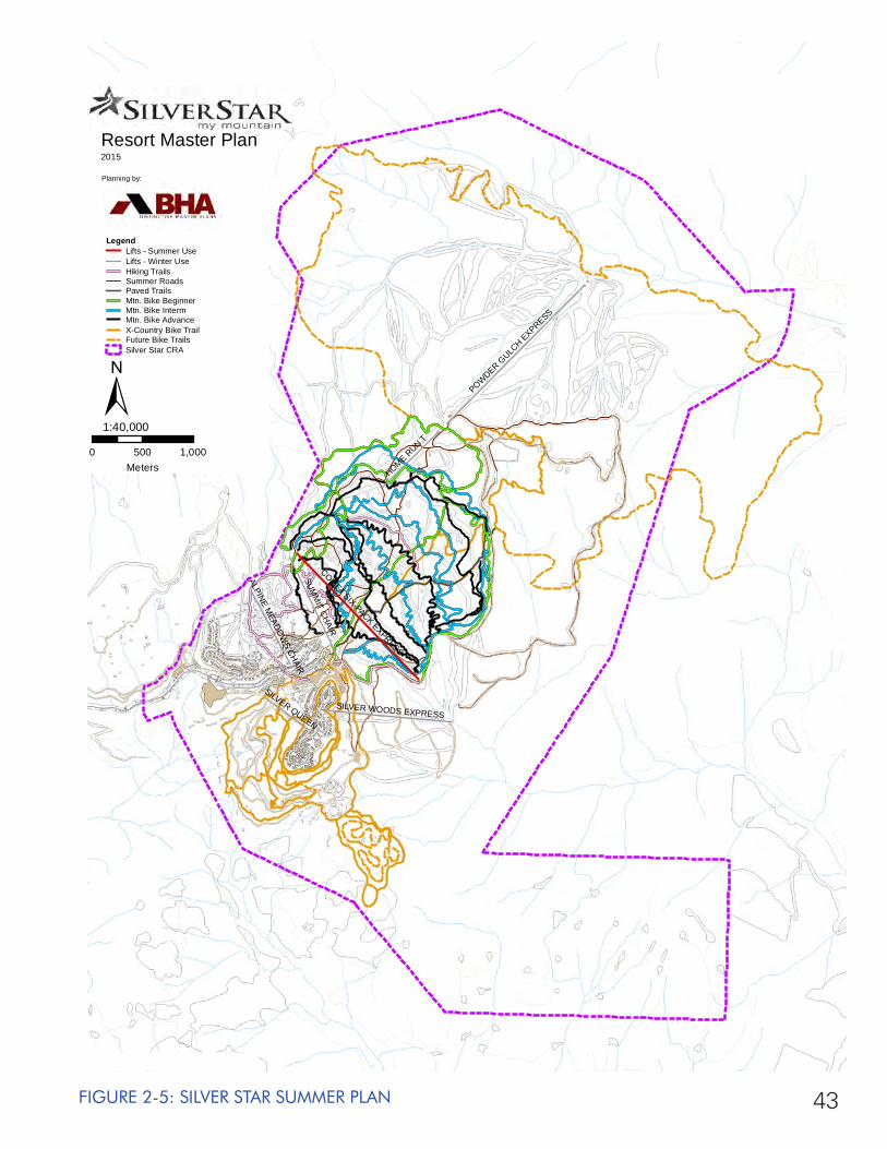
43FIGURE 2-5: SILVER STAR SUMMER PLAN
SUMM
IT CHAIR
POWDER GULC
H EXPRESS
COMET SIX-PACK EXPRESS
HOME RUN T
SILVER WOODS EXPRESS
SILVER QUEEN
ALPINE MEADO
WS CHAIR
Resort Master Plan2015
Planning by:
0 500 1,000Meters
1:40,000
LegendLifts - Summer UseLifts - Winter UseHiking TrailsSummer RoadsPaved TrailsMtn. Bike BeginnerMtn. Bike IntermMtn. Bike AdvanceX-Country Bike TrailFuture Bike TrailsSilver Star CRA
±
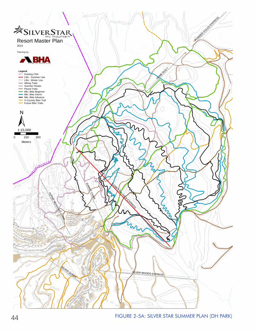
44 FIGURE 2-5A: SILVER STAR SUMMER PLAN (DH PARK)
SUMM
IT CHAIR
COMET SIX-PACK EXPRESS
HOME RUN T
SILVER WOODS EXPRESS
SILVER QUEEN
ALPINE MEADO
WS CHAIR
POWDER GULC
H EXPRESS
Resort Master Plan2015
Planning by:
0 150 300Meters
1:15,000
LegendExisting CRALifts - Summer UseLifts - Winter UseHiking TrailsSummer RoadsPaved TrailsMtn. Bike BeginnerMtn. Bike IntermMtn. Bike AdvanceX-Country Bike TrailFuture Bike Trails
±
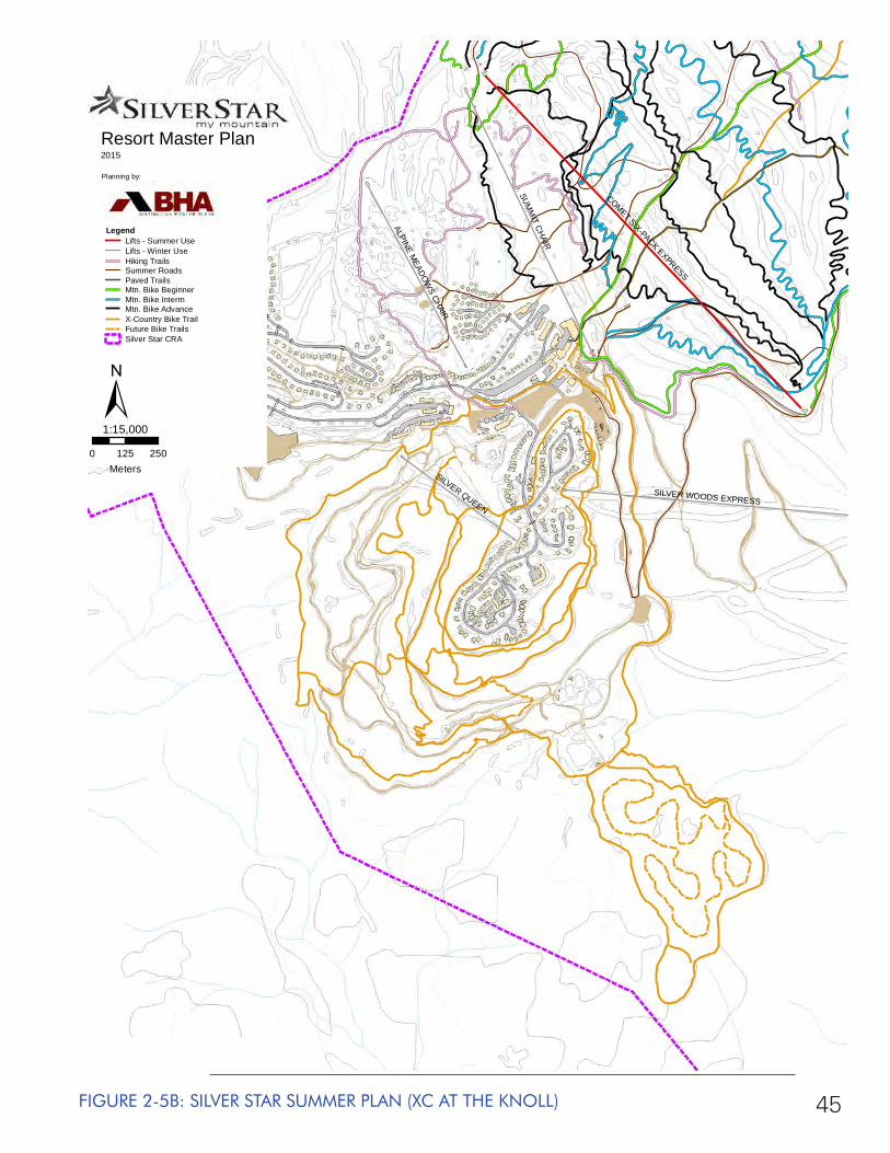
45FIGURE 2-5B: SILVER STAR SUMMER PLAN (XC AT THE KNOLL)
SUMM
IT CHAIR
COMET SIX-PACK EXPRESS
SILVER WOODS EXPRESS
SILVER QUEENALPINE M
EADOW
S CHAIR
Resort Master Plan2015
Planning by:
0 125 250Meters
1:15,000
LegendLifts - Summer UseLifts - Winter UseHiking TrailsSummer RoadsPaved TrailsMtn. Bike BeginnerMtn. Bike IntermMtn. Bike AdvanceX-Country Bike TrailFuture Bike TrailsSilver Star CRA
±
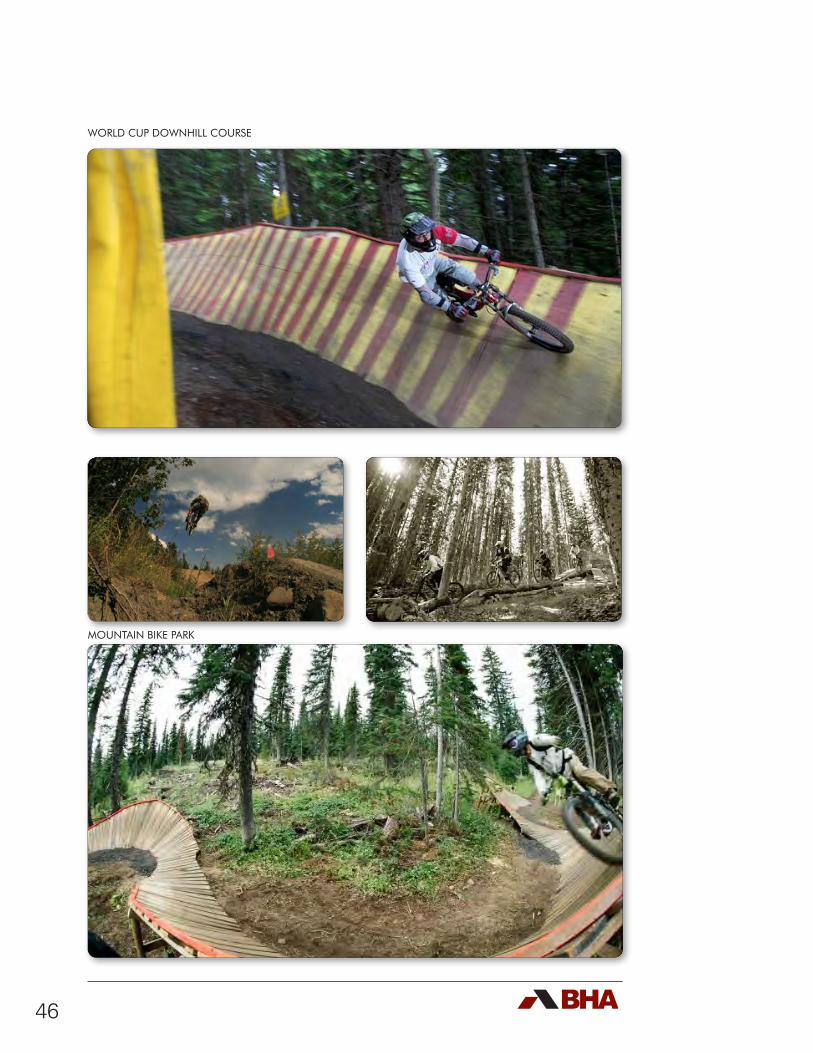
46
WORLD CUP DOWNHILL COURSE
MOUNTAIN BIKE PARK
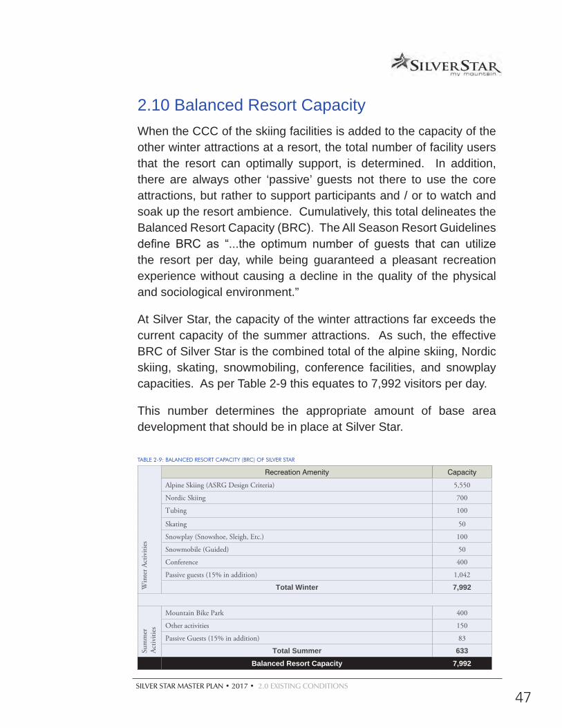
SILVER STAR MASTER PLAN • 2017 • 2.0 EXISTING CONDITIONS
47
2.10 Balanced Resort CapacityWhen the CCC of the skiing facilities is added to the capacity of the other winter attractions at a resort, the total number of facility users that the resort can optimally support, is determined. In addition, there are always other ‘passive’ guests not there to use the core attractions, but rather to support participants and / or to watch and soak up the resort ambience. Cumulatively, this total delineates the Balanced Resort Capacity (BRC). The All Season Resort Guidelines define BRC as “...the optimum number of guests that can utilize the resort per day, while being guaranteed a pleasant recreation experience without causing a decline in the quality of the physical and sociological environment.”
At Silver Star, the capacity of the winter attractions far exceeds the current capacity of the summer attractions. As such, the effective BRC of Silver Star is the combined total of the alpine skiing, Nordic skiing, skating, snowmobiling, conference facilities, and snowplay capacities. As per Table 2-9 this equates to 7,992 visitors per day.
This number determines the appropriate amount of base area development that should be in place at Silver Star.
TABLE 2-9: BALANCED RESORT CAPACITY (BRC) OF SILVER STAR
Win
ter A
ctiv
ities
Recreation Amenity Capacity
Alpine Skiing (ASRG Design Criteria) 5,550
Nordic Skiing 700
Tubing 100
Skating 50
Snowplay (Snowshoe, Sleigh, Etc.) 100
Snowmobile (Guided) 50
Conference 400
Passive guests (15% in addition) 1,042
Total Winter 7,992
Sum
mer
Ac
tiviti
es
Mountain Bike Park 400
Other activities 150
Passive Guests (15% in addition) 83
Total Summer 633Balanced Resort Capacity 7,992
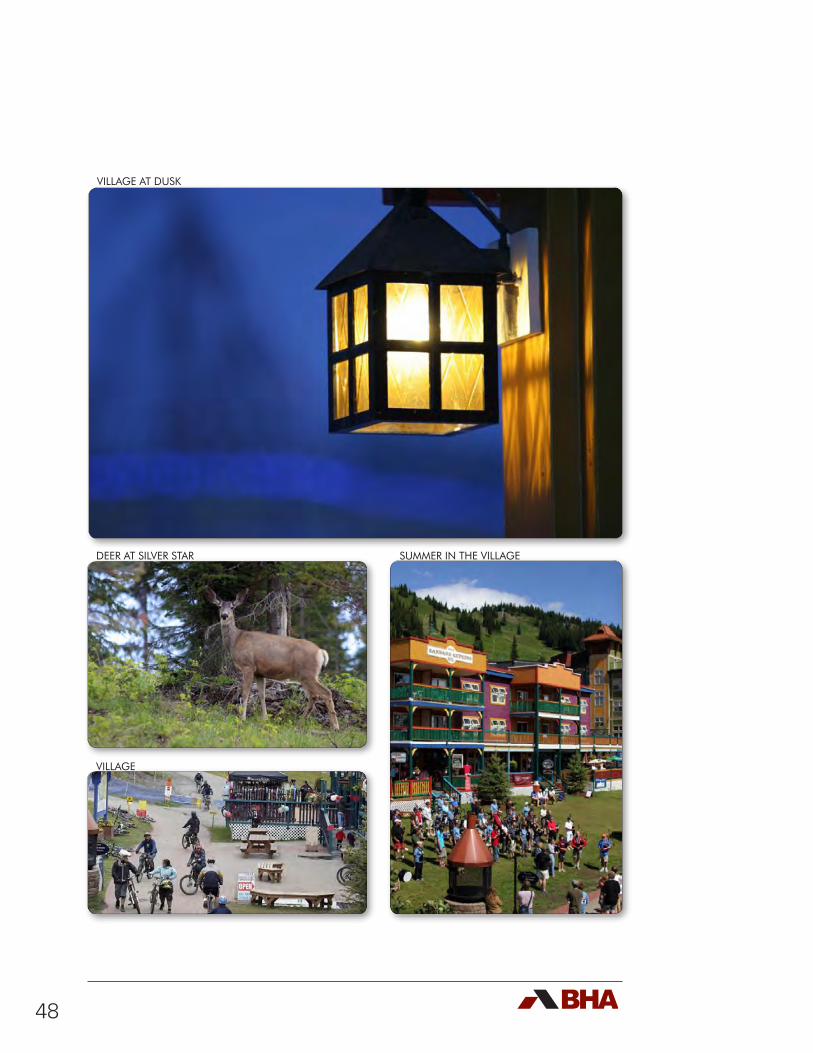
48
VILLAGE AT DUSK
DEER AT SILVER STAR SUMMER IN THE VILLAGE
VILLAGE
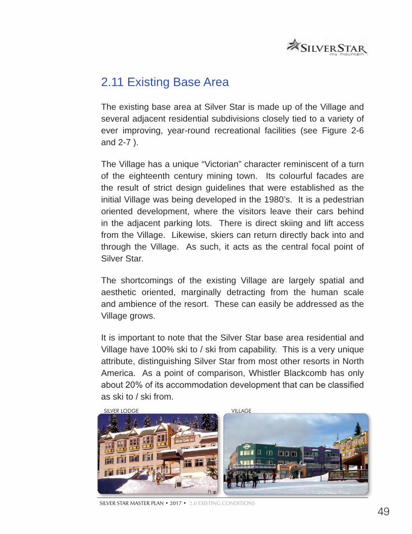
SILVER STAR MASTER PLAN • 2017 • 2.0 EXISTING CONDITIONS
49
VILLAGESILVER LODGE
2.11 Existing Base Area
The existing base area at Silver Star is made up of the Village and several adjacent residential subdivisions closely tied to a variety of ever improving, year-round recreational facilities (see Figure 2-6 and 2-7 ).
The Village has a unique “Victorian” character reminiscent of a turn of the eighteenth century mining town. Its colourful facades are the result of strict design guidelines that were established as the initial Village was being developed in the 1980’s. It is a pedestrian oriented development, where the visitors leave their cars behind in the adjacent parking lots. There is direct skiing and lift access from the Village. Likewise, skiers can return directly back into and through the Village. As such, it acts as the central focal point of Silver Star.
The shortcomings of the existing Village are largely spatial and aesthetic oriented, marginally detracting from the human scale and ambience of the resort. These can easily be addressed as the Village grows.
It is important to note that the Silver Star base area residential and Village have 100% ski to / ski from capability. This is a very unique attribute, distinguishing Silver Star from most other resorts in North America. As a point of comparison, Whistler Blackcomb has only about 20% of its accommodation development that can be classified as ski to / ski from.
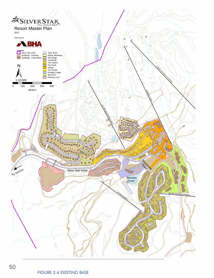
50
SUM
MIT C
HAIR
COMET SIX-PACK EXPRESS
SILVER QUEEN
ALPINE MEADO
WS CH
AIR
SILVER WOODS EXPRESS
Resort Master Plan2015
Planning by:
0 100 200 300 400Meters
1:10,000
LegendSilver Star CRABuildings - ExistingBuildings - Committed
Tube TownAlpine MeadowsThe RidgeCreeksideThe CabinsThe KnollVillageThe HostelFirelight LodgeBlock AGParking Lot E±
To Vernon
BrewersPond
Silver Star Road
Monashee
Road
FIGURE 2-6 EXISTING BASE
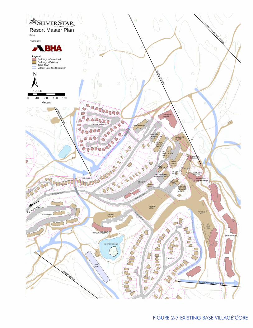
51
2.11.1 EXISTING ACTIVITY ORIENTED BUILT SPACE
Currently, there are approximately 67,000 square feet (6,225 sq. m) of activity oriented built space at the resort, as indicated in Table 2-10. Activity oriented built space provides the expected and required services for a ski resort and associated activities in order to function properly throughout the day. These facilities include all built space (restaurants, retail, equipment rentals, day care, rest rooms, ski patrol, lockers, resort info, administration etc.) catering to both day use and destination guests.
With the high speed express lifts combined with good snow grooming and much easier-to-master skis and snowboards, skiers and riders are able to satisfy their maximum expectations for skiing within shorter time periods. Add to this the fact that as a resort becomes more destination oriented, the guests tend to have a more relaxed attitude with a greater propensity to spend less time actually skiing, and more time indulging in other activities. This results in an increasing demand for use of the base area and on-mountain facilities over the course of the day.
2.11.2 EXISTING ALL SEASON RESORT RELATED SPACE
The need for space that caters to the requirements of visitors that are at the resort for reasons other than lift serviced skiing and boarding is also increasing.
Table 2-11 shows that there are approximately 19,100 square feet (1,775 sq m) of destination space existing at the resort. This is space designed to cater to the needs of the destination guest or non-skiing guests for use before and after skiing, and includes unique facilities (i.e. retail, bars, restaurants, convention and seminar facilities, swimming pool, fitness room, sauna, indoor entertainment, etc.) that act as attractions in their own right.
BULLDOGHOTEL
FIREHALL
THE PINNACLES
CREEKSILVER
HOTEL
SILVERLODE INN
ALTITUDETRAINING
NATIONAL
CENTRE
LORD ABERDEENAPARTMENT HOTEL
CHILCOOTCONFERENCECENTRE
VANCECREEKHOTEL
TOWNHALL
TOWNHALLEXPANSION
PARKINGLOT B
PARKINGLOT A
PARKINGLOT D
BREWER'S POND
FIRELIGHT LODGE
ALPINE MEADOWS
CREEKSIDE
THE CABINS
PARKINGLOT C
TUBETOWN
OFFICETICKET
SAMESUNBACKPACKERSHOSTEL
SNOWBIRDLODGE
SNOWBIRDLODGE 2
STAR KIDSCENTRE
SKI PATROLHEADQUARTERS
THE KNOLL
SILVER WOODS
Monashee Road
Silver Star Road
Silver Star Road
SUM
MIT C
HAIR
ALPINE MEADO
WS CH
AIR
SILVER QUEEN
COMET SIX-PACK EXPRESS
SILVER WOODS EXPRESS
Resort Master Plan2015
Planning by:
0 40 80 120 160Meters
1:5,000
LegendBuildings - CommittedBuildings - ExistingTube TownVillage Core Ski Circulation
±
To Vernon
FIGURE 2-7 EXISTING BASE VILLAGE CORE
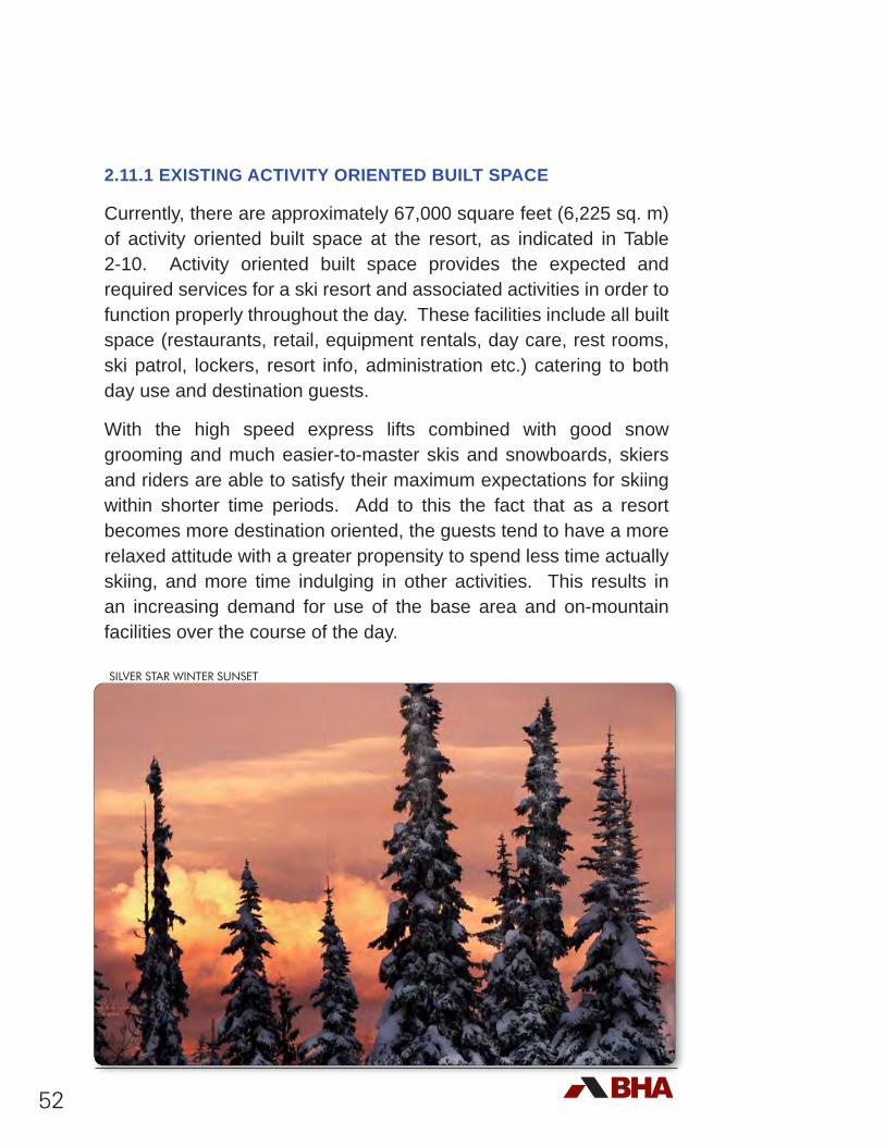
52
2.11.1 EXISTING ACTIVITY ORIENTED BUILT SPACE
Currently, there are approximately 67,000 square feet (6,225 sq. m) of activity oriented built space at the resort, as indicated in Table 2-10. Activity oriented built space provides the expected and required services for a ski resort and associated activities in order to function properly throughout the day. These facilities include all built space (restaurants, retail, equipment rentals, day care, rest rooms, ski patrol, lockers, resort info, administration etc.) catering to both day use and destination guests.
With the high speed express lifts combined with good snow grooming and much easier-to-master skis and snowboards, skiers and riders are able to satisfy their maximum expectations for skiing within shorter time periods. Add to this the fact that as a resort becomes more destination oriented, the guests tend to have a more relaxed attitude with a greater propensity to spend less time actually skiing, and more time indulging in other activities. This results in an increasing demand for use of the base area and on-mountain facilities over the course of the day.
SILVER STAR WINTER SUNSET
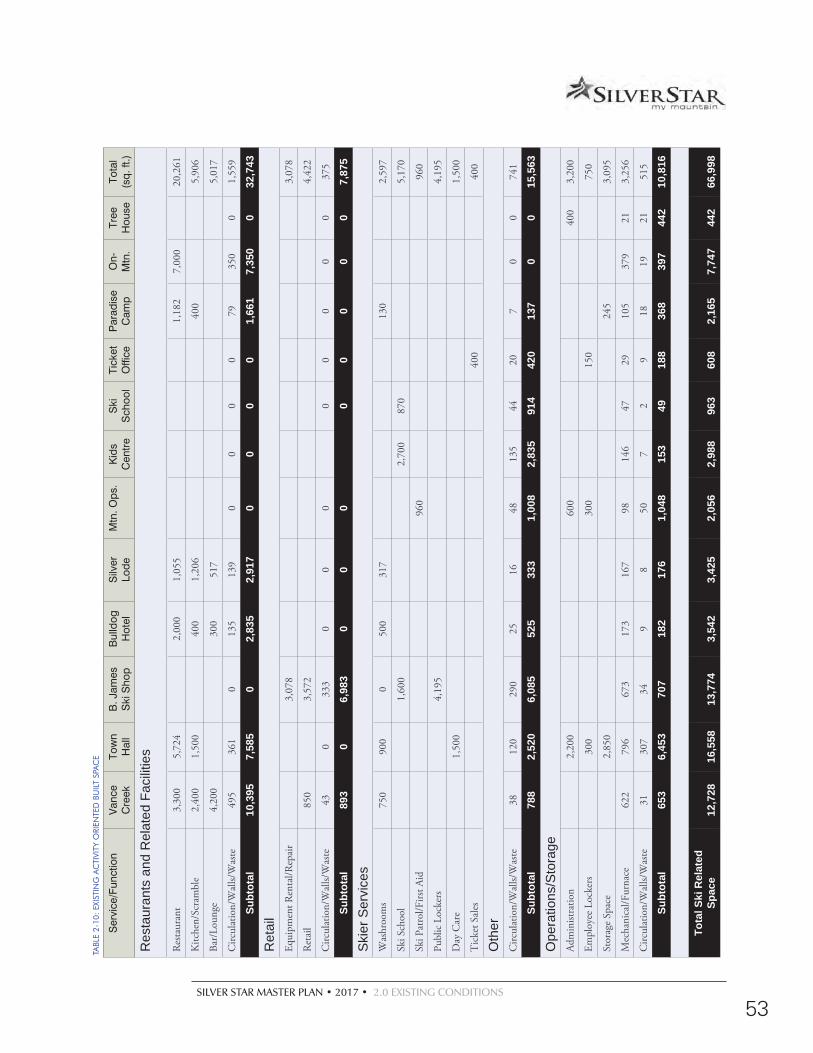
SILVER STAR MASTER PLAN • 2017 • 2.0 EXISTING CONDITIONS
53
Ser
vice
/Fun
ctio
nV
ance
C
reek
Tow
n H
all
B. J
ames
S
ki S
hop
Bul
ldog
H
otel
S
ilver
Lo
deM
tn. O
ps.
Kid
s C
entr
eS
ki
Sch
ool
Tick
et
Offi
ceP
arad
ise
Cam
pO
n-M
tn.
Tree
H
ouse
Tota
l (s
q. ft
.)
Res
taur
ants
and
Rel
ated
Fac
ilitie
s
Res
taur
ant
3,30
05,
724
2,00
01,
055
1,18
27,
000
20,2
61
Kitc
hen/
Scra
mbl
e2,
400
1,50
040
01,
206
400
5,90
6
Bar/
Loun
ge4,
200
300
517
5,01
7
Circ
ulat
ion/
Wal
ls/W
aste
495
361
013
513
90
00
079
350
01,
559
Subt
otal
10,3
957,
585
02,
835
2,91
70
00
01,
661
7,35
00
32,7
43
Ret
ail
Equi
pmen
t Ren
tal/R
epai
r3,
078
3,07
8
Ret
ail
850
3,57
24,
422
Circ
ulat
ion/
Wal
ls/W
aste
430
333
00
00
00
00
375
Subt
otal
893
06,
983
00
00
00
00
7,87
5
Ski
er S
ervi
ces
Was
hroo
ms
750
900
050
031
713
02,
597
Ski S
choo
l1,
600
2,70
087
05,
170
Ski P
atro
l/Firs
t Aid
960
960
Publ
ic L
ocke
rs4,
195
4,19
5
Day
Car
e1,
500
1,50
0
Tic
ket S
ales
400
400
Oth
erC
ircul
atio
n/W
alls/
Was
te38
120
290
2516
4813
544
207
00
741
Subt
otal
788
2,52
06,
085
525
333
1,00
82,
835
914
420
137
00
15,5
63
Ope
ratio
ns/S
tora
geAd
min
istra
tion
2,20
060
040
03,
200
Empl
oyee
Loc
kers
300
300
150
750
Stor
age
Spac
e2,
850
245
3,09
5
Mec
hani
cal/F
urna
ce62
279
667
317
316
798
146
4729
105
379
213,
256
Circ
ulat
ion/
Wal
ls/W
aste
3130
734
98
507
29
1819
2151
5
Subt
otal
653
6,45
370
718
217
61,
048
153
4918
836
839
744
210
,816
Tota
l Ski
Rel
ated
Sp
ace
12,7
2816
,558
13,7
743,
542
3,42
52,
056
2,98
896
360
82,
165
7,74
744
266
,998
TABL
E 2-
10:
EXIS
TIN
G A
CTI
VITY
ORI
ENTE
D B
UIL
T SP
AC
E
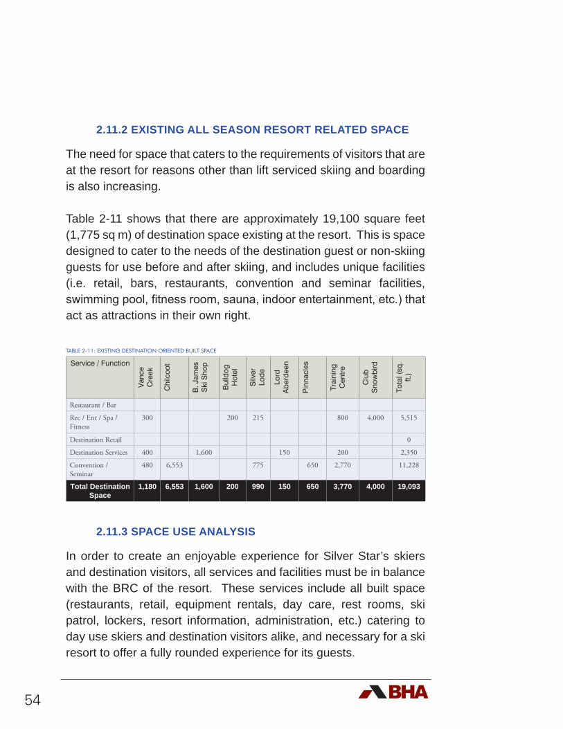
54
2.11.2 EXISTING ALL SEASON RESORT RELATED SPACE
The need for space that caters to the requirements of visitors that are at the resort for reasons other than lift serviced skiing and boarding is also increasing.
Table 2-11 shows that there are approximately 19,100 square feet (1,775 sq m) of destination space existing at the resort. This is space designed to cater to the needs of the destination guest or non-skiing guests for use before and after skiing, and includes unique facilities (i.e. retail, bars, restaurants, convention and seminar facilities, swimming pool, fitness room, sauna, indoor entertainment, etc.) that act as attractions in their own right.
TABLE 2-11: EXISTING DESTINATION ORIENTED BUILT SPACE
Service / Function
Van
ce
Cre
ek
Chi
lcoo
t
B. J
ames
S
ki S
hop
Bul
ldog
H
otel
Silv
er
Lode
Lord
A
berd
een
Pin
nacl
es
Trai
ning
C
entr
e
Clu
b S
now
bird
Tota
l (sq
. ft.
)Restaurant / Bar
Rec / Ent / Spa / Fitness
300 200 215 800 4,000 5,515
Destination Retail 0
Destination Services 400 1,600 150 200 2,350
Convention / Seminar
480 6,553 775 650 2,770 11,228
Total Destination Space
1,180 6,553 1,600 200 990 150 650 3,770 4,000 19,093
2.11.3 SPACE USE ANALYSIS
In order to create an enjoyable experience for Silver Star’s skiers and destination visitors, all services and facilities must be in balance with the BRC of the resort. These services include all built space (restaurants, retail, equipment rentals, day care, rest rooms, ski patrol, lockers, resort information, administration, etc.) catering to day use skiers and destination visitors alike, and necessary for a ski resort to offer a fully rounded experience for its guests.
SILVER STAR MASTER PLAN • 2017 • 2.0 EXISTING CONDITIONS
55
Based on the existing BRC of 7,992 guests per day, the space use requirements have been calculated and delineated in Table 2-12. In the same table, these numbers are compared to the existing built space. It should be noted that the calculated areas are intended to act as a guide in determining the ‘ideal’ amount of built space that is necessary to create a balance with the capacity of the mountain’s attractions. These numbers are based on measurements that have been made at successful resorts of a similar size and market orientation as Silver Star. They are intended for planning purposes and should not be considered as absolute; rather, they are a baseline from which to develop Silver Star into a well functioning, balanced, unique, and special resort.
As illustrated in Table 2-12, if 7,992 guests arrive on any given day, the existing facilities represent about 74% of the base area facilities necessary to be in balance with attractions at the resort. It should be noted that the bar / lounge and storage space skews the percentage upwards. It also shows that there are significant shortfalls apparent in the amount of space provided for restrooms, retail sales, equipment rentals and repair, and day care. Some of the lack of space for restrooms can be justified by the easy access to the ski to / ski from overnight accommodations on the mountain.
Discussions with staff at Silver Star suggest that the apparent shortcomings in base area facilities are not as serious as the percentage may suggest. This revolves around the fact that, to date, the number of times that actual visitation has achieved the 7,992 mark has been relatively infrequent. However, based on an average of 4,500 guests, a number more typical of a Saturday or Sunday during the winter (Table 2-13), the existing base area facilities appear to offer closer to 109% of the necessary space, or approximately 119% of the activity related space. Clearly the excess area (kitchen / scramble, bar / lounge, ski school, public lockers, ticket sales, administration, and employee lounge) skews this number higher than it should be overall.
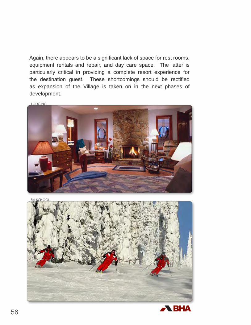
56
Again, there appears to be a significant lack of space for rest rooms, equipment rentals and repair, and day care space. The latter is particularly critical in providing a complete resort experience for the destination guest. These shortcomings should be rectified as expansion of the Village is taken on in the next phases of development.
LODGING
SKI SCHOOL
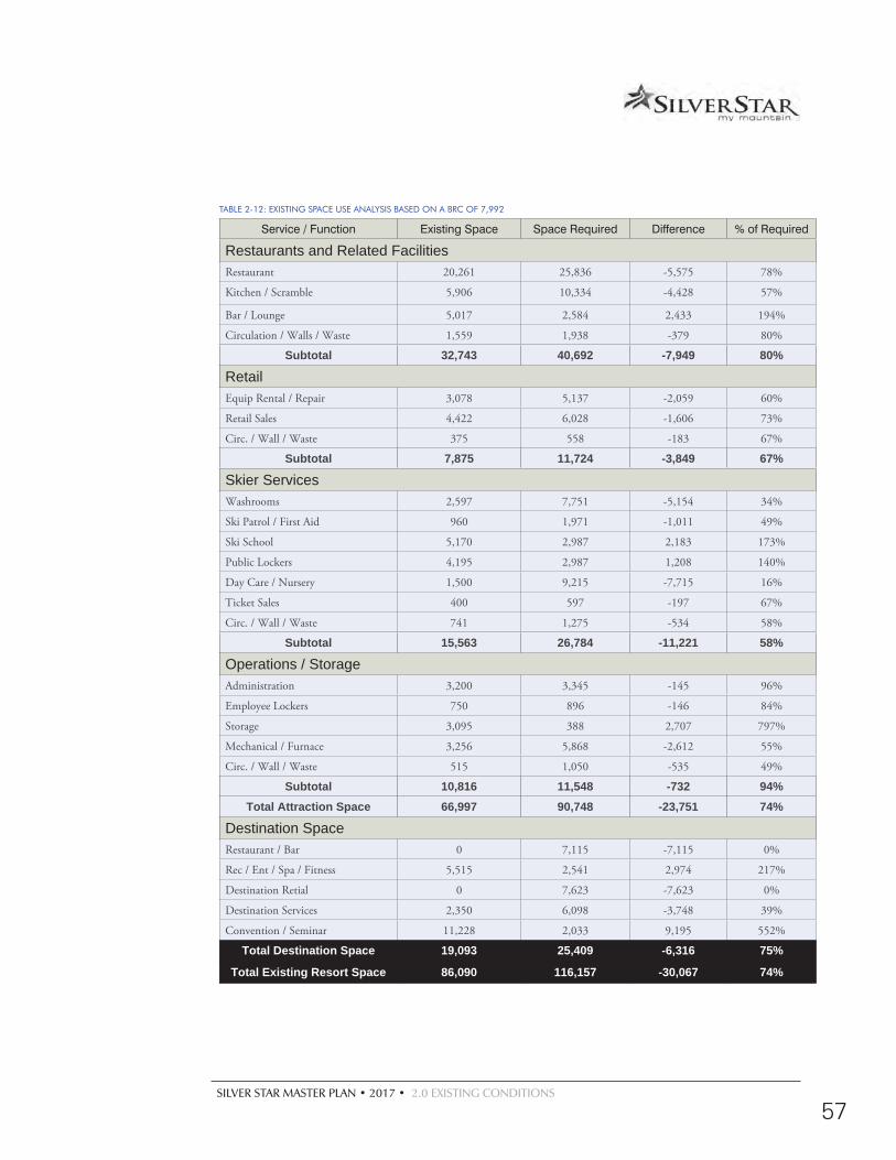
SILVER STAR MASTER PLAN • 2017 • 2.0 EXISTING CONDITIONS
57
TABLE 2-12: EXISTING SPACE USE ANALYSIS BASED ON A BRC OF 7,992
Service / Function Existing Space Space Required Difference % of Required
Restaurants and Related FacilitiesRestaurant 20,261 25,836 -5,575 78%
Kitchen / Scramble 5,906 10,334 -4,428 57%
Bar / Lounge 5,017 2,584 2,433 194%
Circulation / Walls / Waste 1,559 1,938 -379 80%
Subtotal 32,743 40,692 -7,949 80%
Retail Equip Rental / Repair 3,078 5,137 -2,059 60%
Retail Sales 4,422 6,028 -1,606 73%
Circ. / Wall / Waste 375 558 -183 67%
Subtotal 7,875 11,724 -3,849 67%
Skier ServicesWashrooms 2,597 7,751 -5,154 34%
Ski Patrol / First Aid 960 1,971 -1,011 49%
Ski School 5,170 2,987 2,183 173%
Public Lockers 4,195 2,987 1,208 140%
Day Care / Nursery 1,500 9,215 -7,715 16%
Ticket Sales 400 597 -197 67%
Circ. / Wall / Waste 741 1,275 -534 58%
Subtotal 15,563 26,784 -11,221 58%
Operations / StorageAdministration 3,200 3,345 -145 96%
Employee Lockers 750 896 -146 84%
Storage 3,095 388 2,707 797%
Mechanical / Furnace 3,256 5,868 -2,612 55%
Circ. / Wall / Waste 515 1,050 -535 49%
Subtotal 10,816 11,548 -732 94%Total Attraction Space 66,997 90,748 -23,751 74%
Destination SpaceRestaurant / Bar 0 7,115 -7,115 0%
Rec / Ent / Spa / Fitness 5,515 2,541 2,974 217%
Destination Retial 0 7,623 -7,623 0%
Destination Services 2,350 6,098 -3,748 39%
Convention / Seminar 11,228 2,033 9,195 552%
Total Destination Space 19,093 25,409 -6,316 75%
Total Existing Resort Space 86,090 116,157 -30,067 74%
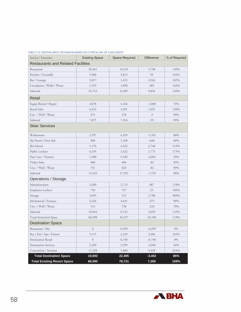
58
TABLE 2-13: EXISTING SPACE USE ANALYSIS BASED ON A TYPICAL DAY OF 4,500 GUESTS
Service / Function Existing Space Space Required Difference % of Required
Restaurants and Related FacilitiesRestaurant 20,261 14,531 5,730 139%
Kitchen / Scramble 5,906 5,813 93 102%
Bar / Lounge 5,017 1,453 3,564 345%
Circulation / Walls / Waste 1,559 1,090 469 143%
Subtotal 32,743 22,887 9,856 143%
Retail Equip Rental / Repair 3,078 4,166 -1,088 74%
Retail Sales 4,422 3,391 1,031 130%
Circ. / Wall / Waste 375 378 -3 99%
Subtotal 7,875 7,934 -59 99%
Skier Services
Washrooms 2,597 4,359 -1,762 60%
Ski Patrol / First Aid 960 1,598 -638 60%
Ski School 5,170 2,422 2,748 213%
Public Lockers 4,195 2,422 1,773 173%
Day Care / Nursery 1,500 5,183 -3,683 29%
Ticket Sales 400 484 -84 83%
Circ. / Wall / Waste 741 823 -82 90%
Subtotal 15,563 17,292 -1,729 90%
Operations / StorageAdministration 3,200 2,713 487 118%
Employee Lockers 750 727 23 103%
Storage 3,095 315 2,780 983%
Mechanical / Furnace 3,256 3,631 -375 90%
Circ. / Wall / Waste 515 738 -223 70%
Subtotal 10,816 8,123 2,693 133%
Total Attraction Space 66,998 56,237 10,760 119%
Destination SpaceRestaurant / Bar 0 6,299 -6,299 0%
Rec / Ent / Spa / Fitness 5,515 2,249 3,266 245%
Destination Retail 0 6,748 -6,748 0%
Destination Services 2,350 5,399 -3,049 44%
Convention / Seminar 11,228 1,800 9,428 624%
Total Destination Space 19,093 22,495 -3,402 85%Total Existing Resort Space 86,090 78,731 7,359 109%
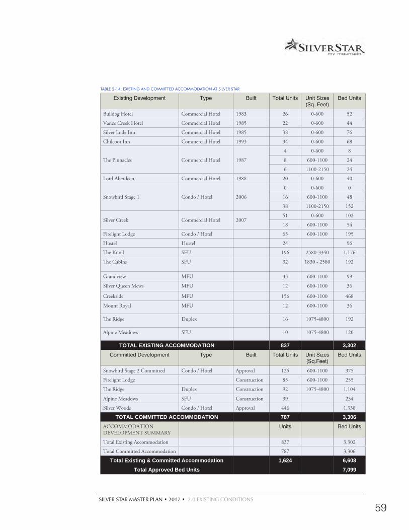
SILVER STAR MASTER PLAN • 2017 • 2.0 EXISTING CONDITIONS
59
TABLE 2-14: EXISTING AND COMMITTED ACCOMMODATION AT SILVER STAR
Existing Development Type Built Total Units Unit Sizes (Sq. Feet)
Bed Units
Bulldog Hotel Commercial Hotel 1983 26 0-600 52
Vance Creek Hotel Commercial Hotel 1985 22 0-600 44
Silver Lode Inn Commercial Hotel 1985 38 0-600 76
Chilcoot Inn Commercial Hotel 1993 34 0-600 68
The Pinnacles Commercial Hotel 1987
4 0-600 8
8 600-1100 24
6 1100-2150 24
Lord Aberdeen Commercial Hotel 1988 20 0-600 40
Snowbird Stage 1 Condo / Hotel 2006
0 0-600 0
16 600-1100 48
38 1100-2150 152
Silver Creek Commercial Hotel 200751 0-600 102
18 600-1100 54
Firelight Lodge Condo / Hotel 65 600-1100 195
Hostel Hostel 24 96
The Knoll SFU 196 2580-3340 1,176
The Cabins SFU 32 1830 - 2580 192
Grandview MFU 33 600-1100 99
Silver Queen Mews MFU 12 600-1100 36
Creekside MFU 156 600-1100 468
Mount Royal MFU 12 600-1100 36
The Ridge Duplex 16 1075-4800 192
Alpine Meadows SFU 10 1075-4800 120
TOTAL EXISTING ACCOMMODATION 837 3,302
Committed Development Type Built Total Units Unit Sizes (Sq.Feet)
Bed Units
Snowbird Stage 2 Committed Condo / Hotel Approval 125 600-1100 375
Firelight Lodge Construction 85 600-1100 255
The Ridge Duplex Construction 92 1075-4800 1,104
Alpine Meadows SFU Construction 39 234
Silver Woods Condo / Hotel Approval 446 1,338
TOTAL COMMITTED ACCOMMODATION 787 3,306ACCOMMODATION DEVELOPMENT SUMMARY
Units Bed Units
Total Existing Accommodation 837 3,302
Total Committed Accommodation 787 3,306
Total Existing & Committed Accommodation 1,624 6,608Total Approved Bed Units 7,099
60
2.11.4 EXISTING COMMERCIAL ACCOMMODATIONS
The existing overnight accommodation at Silver Star consists of seven commercial hotels and two condo / hotels and one hostel totalling 370 units, or 983 bed units. In addition, there are other commercial hotel / condo developments (Snowbird Lodge Phase 2, Firelight Lodge Phase 2 and Silver Woods) under construction and / or committed for development, totalling 656 units. In total, there are 1,026 existing and committed commercial units equating to roughly 2,951 bed units.
2.11.5 EXISTING RESIDENTIAL DEVELOPMENT
The existing resort residential development consists of a mix of single family, multi family and duplex dwellings, all located adjacent to the village. The single family units are primarily focused in the Knoll subdivision and in older cabin developments. The current mix of single family and multi family units, totals 467 overall. Two additional developments, the Ridge and Alpine Meadows, are committed and / or under construction. When complete there will be 598 additional units of residential development totalling 3,657 bed units.
Overall, there are 1,624 existing and committed accommodation units at Silver Star. This equates to 6,608 bed units at present.
2.11.6 BED UNIT ANALYSIS
Based on a BRC of 7,992 guests, the appropriate number of bed units are determined. Using the ASRG model (Table 2-15), Silver Star’s existing offering can expect to require a number comprising 120% of the BRC. As such, the resort should work towards increasing its bed base from the current 6,608 bed units to 9,590 bed units, as the market dictates. It is important to note that approximately 10% of those beds need to be dedicated for employee accommodation. Presently, Silver Star houses approximately staff 134 in the Silverlode Lodge (now owned by Silver Star) and an additional approximately 75 staff are provided accommodation in the Samesun
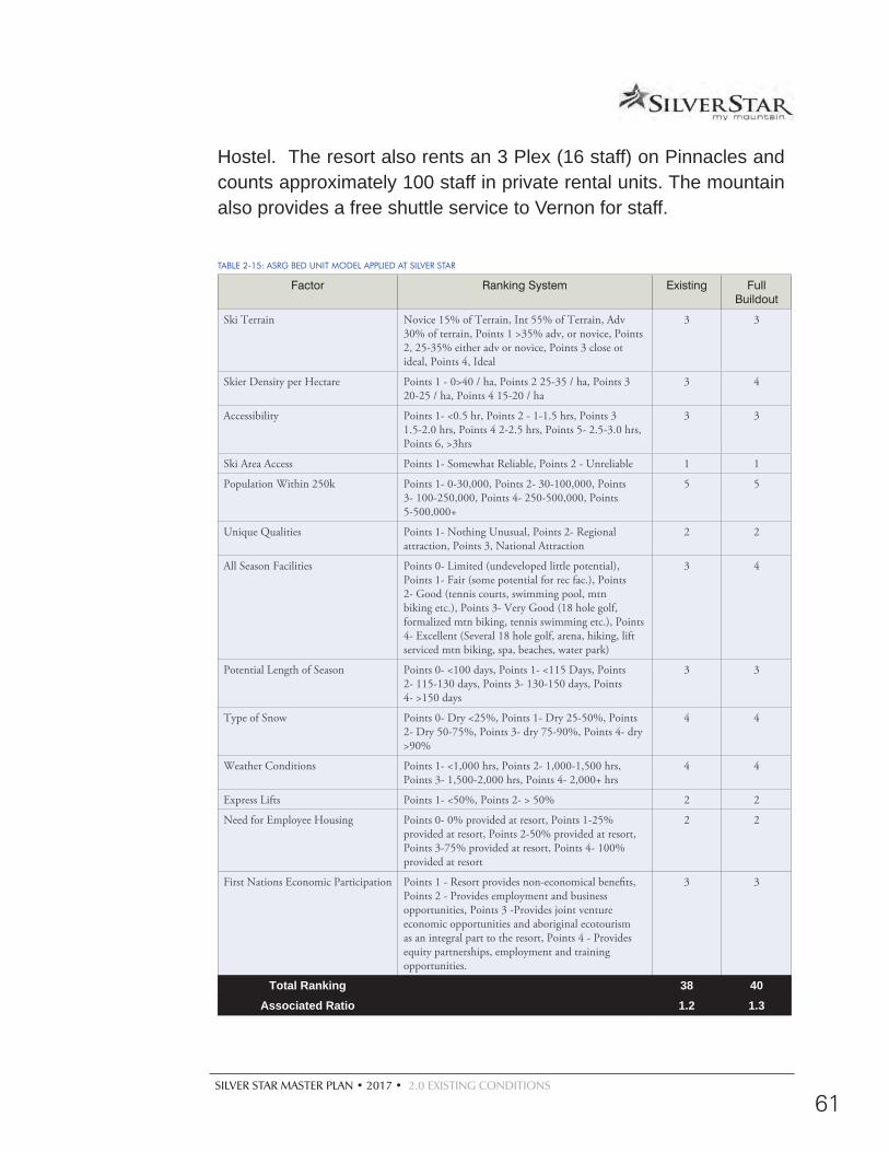
SILVER STAR MASTER PLAN • 2017 • 2.0 EXISTING CONDITIONS
61
Hostel. The resort also rents an 3 Plex (16 staff) on Pinnacles and counts approximately 100 staff in private rental units. The mountain also provides a free shuttle service to Vernon for staff.
TABLE 2-15: ASRG BED UNIT MODEL APPLIED AT SILVER STAR
Factor Ranking System Existing Full Buildout
Ski Terrain Novice 15% of Terrain, Int 55% of Terrain, Adv 30% of terrain, Points 1 >35% adv, or novice, Points 2, 25-35% either adv or novice, Points 3 close ot ideal, Points 4, Ideal
3 3
Skier Density per Hectare Points 1 - 0>40 / ha, Points 2 25-35 / ha, Points 3 20-25 / ha, Points 4 15-20 / ha
3 4
Accessibility Points 1- <0.5 hr, Points 2 - 1-1.5 hrs, Points 3 1.5-2.0 hrs, Points 4 2-2.5 hrs, Points 5- 2.5-3.0 hrs, Points 6, >3hrs
3 3
Ski Area Access Points 1- Somewhat Reliable, Points 2 - Unreliable 1 1
Population Within 250k Points 1- 0-30,000, Points 2- 30-100,000, Points 3- 100-250,000, Points 4- 250-500,000, Points 5-500,000+
5 5
Unique Qualities Points 1- Nothing Unusual, Points 2- Regional attraction, Points 3, National Attraction
2 2
All Season Facilities Points 0- Limited (undeveloped little potential), Points 1- Fair (some potential for rec fac.), Points 2- Good (tennis courts, swimming pool, mtn biking etc.), Points 3- Very Good (18 hole golf, formalized mtn biking, tennis swimming etc.), Points 4- Excellent (Several 18 hole golf, arena, hiking, lift serviced mtn biking, spa, beaches, water park)
3 4
Potential Length of Season Points 0- <100 days, Points 1- <115 Days, Points 2- 115-130 days, Points 3- 130-150 days, Points 4- >150 days
3 3
Type of Snow Points 0- Dry <25%, Points 1- Dry 25-50%, Points 2- Dry 50-75%, Points 3- dry 75-90%, Points 4- dry >90%
4 4
Weather Conditions Points 1- <1,000 hrs, Points 2- 1,000-1,500 hrs, Points 3- 1,500-2,000 hrs, Points 4- 2,000+ hrs
4 4
Express Lifts Points 1- <50%, Points 2- > 50% 2 2
Need for Employee Housing Points 0- 0% provided at resort, Points 1-25% provided at resort, Points 2-50% provided at resort, Points 3-75% provided at resort, Points 4- 100% provided at resort
2 2
First Nations Economic Participation Points 1 - Resort provides non-economical benefits, Points 2 - Provides employment and business opportunities, Points 3 -Provides joint venture economic opportunities and aboriginal ecotourism as an integral part to the resort, Points 4 - Provides equity partnerships, employment and training opportunities.
3 3
Total Ranking 38 40Associated Ratio 1.2 1.3
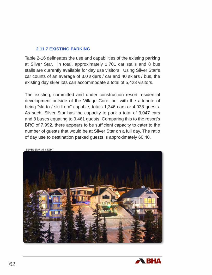
62
2.11.7 EXISTING PARKING
Table 2-16 delineates the use and capabilities of the existing parking at Silver Star. In total, approximately 1,701 car stalls and 8 bus stalls are currently available for day use visitors. Using Silver Star’s car counts of an average of 3.0 skiers / car and 40 skiers / bus, the existing day skier lots can accommodate a total of 5,423 visitors.
The existing, committed and under construction resort residential development outside of the Village Core, but with the attribute of being “ski to / ski from” capable, totals 1,346 cars or 4,038 guests. As such, Silver Star has the capacity to park a total of 3,047 cars and 8 buses equating to 9,461 guests. Comparing this to the resort’s BRC of 7,992, there appears to be sufficient capacity to cater to the number of guests that would be at Silver Star on a full day. The ratio of day use to destination parked guests is approximately 60:40.
SILVER STAR AT NIGHT
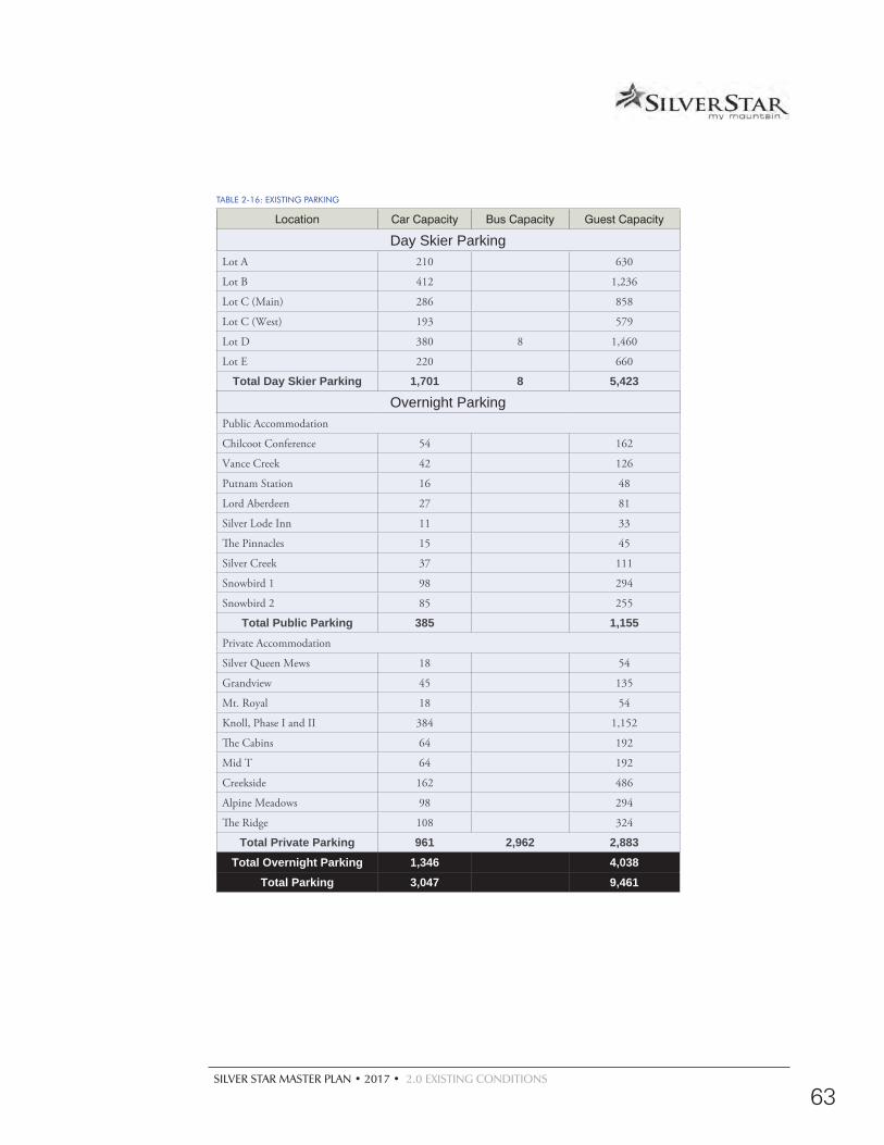
SILVER STAR MASTER PLAN • 2017 • 2.0 EXISTING CONDITIONS
63
TABLE 2-16: EXISTING PARKING
Location Car Capacity Bus Capacity Guest Capacity
Day Skier ParkingLot A 210 630
Lot B 412 1,236
Lot C (Main) 286 858
Lot C (West) 193 579
Lot D 380 8 1,460
Lot E 220 660
Total Day Skier Parking 1,701 8 5,423
Overnight ParkingPublic Accommodation
Chilcoot Conference 54 162
Vance Creek 42 126
Putnam Station 16 48
Lord Aberdeen 27 81
Silver Lode Inn 11 33
The Pinnacles 15 45
Silver Creek 37 111
Snowbird 1 98 294
Snowbird 2 85 255
Total Public Parking 385 1,155Private Accommodation
Silver Queen Mews 18 54
Grandview 45 135
Mt. Royal 18 54
Knoll, Phase I and II 384 1,152
The Cabins 64 192
Mid T 64 192
Creekside 162 486
Alpine Meadows 98 294
The Ridge 108 324
Total Private Parking 961 2,962 2,883Total Overnight Parking 1,346 4,038
Total Parking 3,047 9,461
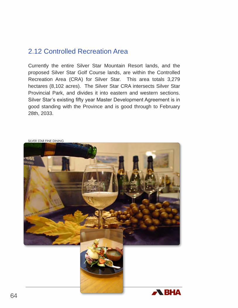
64
2.12 Controlled Recreation Area
Currently the entire Silver Star Mountain Resort lands, and the proposed Silver Star Golf Course lands, are within the Controlled Recreation Area (CRA) for Silver Star. This area totals 3,279 hectares (8,102 acres). The Silver Star CRA intersects Silver Star Provincial Park, and divides it into eastern and western sections. Silver Star’s existing fifty year Master Development Agreement is in good standing with the Province and is good through to February 28th, 2033.
SILVER STAR FINE DINING
SILVER STAR MASTER PLAN • 2017 • 2.0 EXISTING CONDITIONS
65
2.13 Existing Land Uses
Within the defined Study Area, existing land uses have been inventoried and taken into account in the creation of the development concepts and ultimately the Master Plan. Existing land uses include:
d Development Regulations;
d Recreation Areas;
d Private Lands (Zoning);
d Forest Tenures;
d Mineral Tenures;
d Water Interests.
2.13.1 DEVELOPMENT REGULATIONS
Silver Star’s Controlled Recreation Area is located in the North Okanagan Regional District (NORD) in Zone C. Within the NORD Zone C there are a variety of zoning regulations under the NORD Official Community Plan specific to Silver Star (see Figure 2-7A, 2-7B and table 2-17). Importantly, zoning within the current OCP is already in place for the proposed development of residential housing in the West Knoll and Knoll Areas.
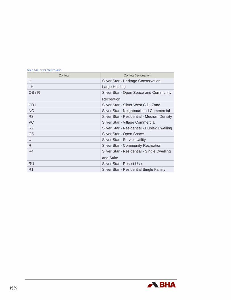
66
TABLE 2-17: SILVER STAR ZONING
Zoning Zoning Designation
H Silver Star - Heritage ConservationLH Large HoldingOS / R Silver Star - Open Space and Community
RecreationCD1 Silver Star - Silver West C.D. ZoneNC Silver Star - Neighbourhood CommercialR3 Silver Star - Residential - Medium DensityVC Silver Star - Village CommercialR2 Silver Star - Residential - Duplex DwellingOS Silver Star - Open SpaceU Silver Star - Service UtilityR Silver Star - Community RecreationR4 Silver Star - Residential - Single Dwelling
and SuiteRU Silver Star - Resort UseR1 Silver Star - Residential Single Family
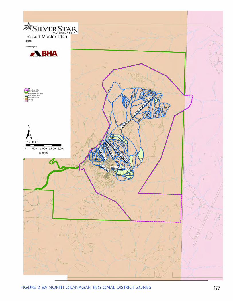
67FIGURE 2-8A NORTH OKANAGAN REGIONAL DISTRICT ZONES
SUM
MIT C
HAIR
POWDER G
ULCH EXPRESS
COMET SIX-PACK EXPRESS
HOME RUN T
ALPINE CHAIR
SILVER WOODS EXPRESS
SILVER QUEEN
E1
D1
D3
D2
D5
D8
E12
E40
E26
D10
D4D6
E14
E27
E2
E4
G1
E43
G10
E3
D40
E49
G8
D11E5
1aE9
D29
G13
G12
B3
E7
D34
E15
E13
E6
E16
E17
D17
G4
D35
a
G2
E28
G9
D13
E10D
21
E18
D37a
E42
G15
D12
E35
B5
E53
E50
E33
D7
A3
E51
E34
G14
E48
E24
E32
E30
G16
D37E4
5E47
D19
E60
E52
E19
E38
A5
E37
D35
G3
E21
D24
E39
Resort Master Plan2015
Planning by:
0 500 1,000 1,500 2,000Meters
1:60,000
LegendSilver Star CRAPark BoundaryBackcountry Ski TrailsExisting Ski TrailsExisting GladesArea CArea D
±
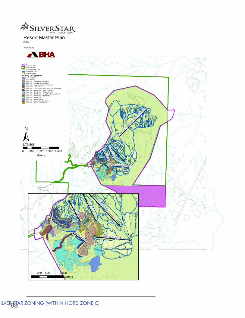
68
SUM
MIT C
HAIR
POWDER G
ULCH EXPRESS
HOME RUN T
ALPINE CHAIR
SILVER WOODS EXPRESS
E1
D1
D3
D2
D5
D8
E12
E26
D10
D4
D6
E14
E27
E2
E4
G1
E43
G10
E3
D40
E49
G8
D11
E51a
E9
D29
G13
G12
E7
D34
E15
E13
E16
E17
G4
A4
D35a
E28
D15
G9
D13
E10 E18
E42
G15
D12
E35
B5
E53
E33
D7
A3
E51
E34
G14
E48
E11E30
D37
E45
E38
A5
E39
Resort Master Plan2015
Planning by:
0 660 1,320 1,980 2,640Meters
1:79,506
LegendSilver Star CRAPark BoundaryBackcountry Ski TrailsExisting Ski TrailsExisting Glades
Zoning Designation Large HoldingLarge HoldingSilver Star - Community RecreationSilver Star - Heritage ConservationSilver Star - Neighbourhood CommercialSilver Star - Open SpaceSilver Star - Open Space and Community RecreationSilver Star - Residential - Duplex DwellingSilver Star - Residential - Medium DensitySilver Star - Residential - Single Dwelling and SuiteSilver Star - Residential Single FamilySilver Star - Resort UseSilver Star - Service UtiltiySilver Star - Silver West C.D. ZoneSilver Star - Village Commercial
±SU
MM
IT CH
AIR
COMET SIX-PACK EXPRESS
ALPINE CHAIR
SILVER WOODS EXPRESS
SILVER QUEEN
D10
D2
D8
G6
D40
D1
G8
D5
D22
G7
D29
G13
G12
D4
B3
D34
G10
D17
D20
G4
G2
D15
G9
D16
D35a
D11
D37a
G15
D21
B5
G5
A3D
25
G14
G16
D14
D37
D13
D19
D28
G1
B4
G11
D27
A5
D35
D12
G3
B2
D36D24
B1
D30
D38
D18
B8
0 500 1,000250Meters
FIGURE 2-8B SILVER STAR ZONING (WITHIN NORD ZONE C)
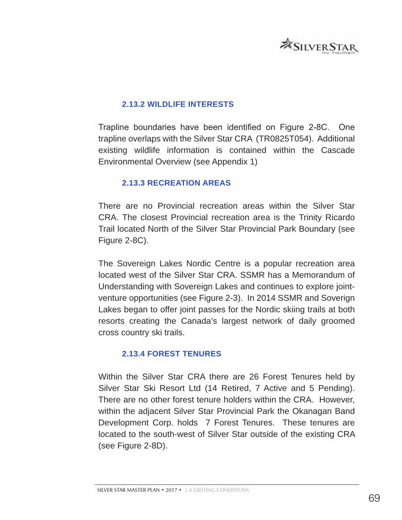
SILVER STAR MASTER PLAN • 2017 • 2.0 EXISTING CONDITIONS
69
2.13.2 WILDLIFE INTERESTS
Trapline boundaries have been identified on Figure 2-8C. One trapline overlaps with the Silver Star CRA (TR0825T054). Additional existing wildlife information is contained within the Cascade Environmental Overview (see Appendix 1)
2.13.3 RECREATION AREAS
There are no Provincial recreation areas within the Silver Star CRA. The closest Provincial recreation area is the Trinity Ricardo Trail located North of the Silver Star Provincial Park Boundary (see Figure 2-8C).
The Sovereign Lakes Nordic Centre is a popular recreation area located west of the Silver Star CRA. SSMR has a Memorandum of Understanding with Sovereign Lakes and continues to explore joint-venture opportunities (see Figure 2-3). In 2014 SSMR and Soverign Lakes began to offer joint passes for the Nordic skiing trails at both resorts creating the Canada’s largest network of daily groomed cross country ski trails.
2.13.4 FOREST TENURES
Within the Silver Star CRA there are 26 Forest Tenures held by Silver Star Ski Resort Ltd (14 Retired, 7 Active and 5 Pending). There are no other forest tenure holders within the CRA. However, within the adjacent Silver Star Provincial Park the Okanagan Band Development Corp. holds 7 Forest Tenures. These tenures are located to the south-west of Silver Star outside of the existing CRA (see Figure 2-8D).
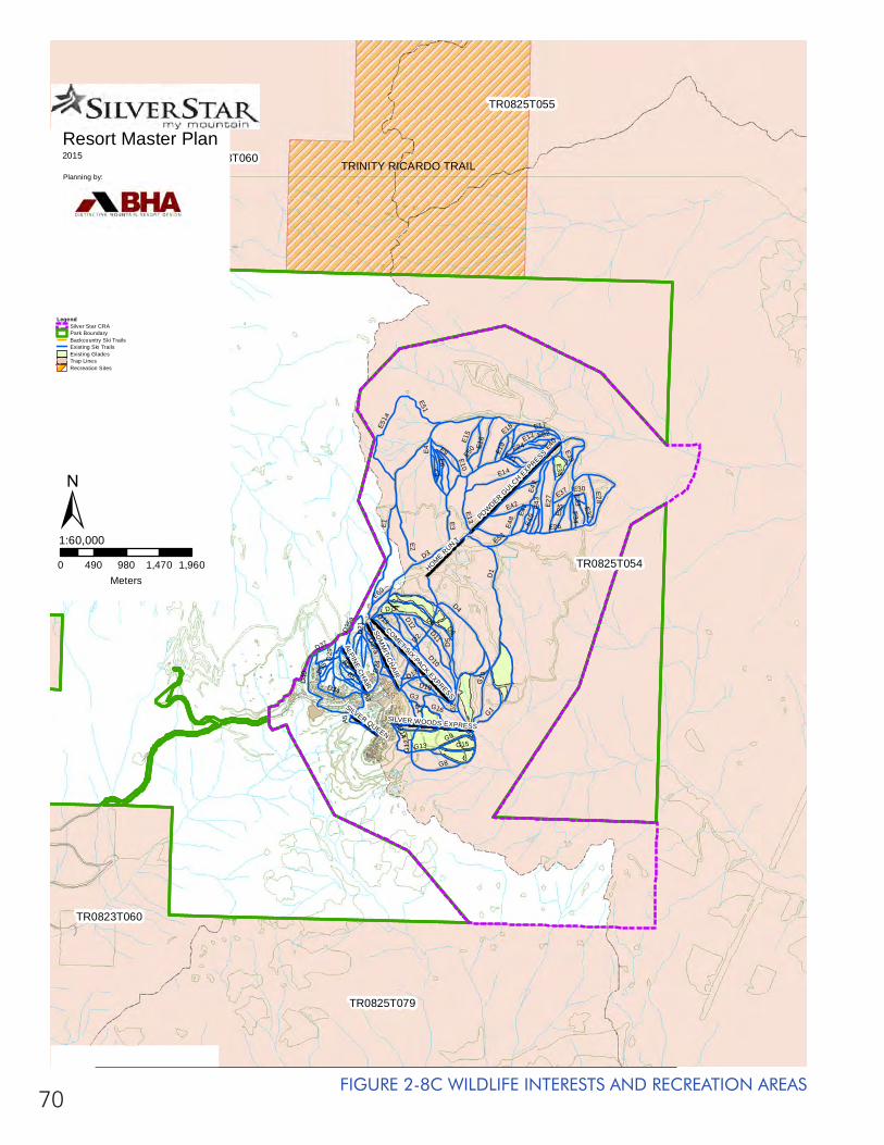
70FIGURE 2-8C WILDLIFE INTERESTS AND RECREATION AREAS
TR0825T054
TR0823T060
TR0825T079
TR0825T055
TR0823T060
SUM
MIT C
HAIR
POWDER G
ULCH EXPRESS
COMET SIX-PACK EXPRESS
HOME RUN T
ALPINE CHAIR
SILVER WOODS EXPRESS
SILVER QUEEN
E1
D1
D3
D2
D5
D8
E12
E40
E26
D10
D4D6
E14
E27
E2
E4
G1
E43
G10
E3
D40
E49
G8
D11
E51a
E9
D29
G13
G12
B3
E7
D34
E15
E13
E6
E16
E17
D17
G4
D35
a
G2
E28
G9
D13
E10
D21
E18
D37a
E42
G15
D12
E35
B5
E53
E50
E33
D7
A3
E51
E34
G14
E48
E24
E32
E30
G16
D37
E45E4
7
D19
E60
E52
E19
E38
A5
E37
D35
G3
E21
D24
E39
TRINITY RICARDO TRAIL
Resort Master Plan2015
Planning by:
0 490 980 1,470 1,960Meters
1:60,000
LegendSilver Star CRAPark BoundaryBackcountry Ski TrailsExisting Ski TrailsExisting GladesTrap LinesRecreation Sites
±
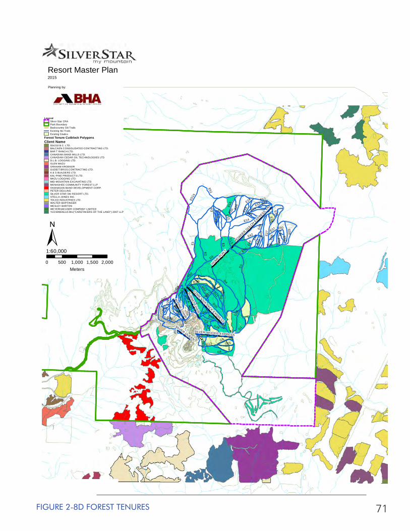
71FIGURE 2-8D FOREST TENURES
SUM
MIT C
HAIR
POWDER G
ULCH EXPRESS
COMET SIX-PACK EXPRESS
HOME RUN T
ALPINE CHAIR
SILVER WOODS EXPRESS
SILVER QUEEN
E1
D1
D3
D2
D5
D8
E12
E40
E26
D10
D4D6
E14
E27
E2
E4
G1
E43
G10
E3
D40
E49
G8
D11E5
1aE9
D29
G13
G12
B3
E7
D34
E15
E13
E6
E16
E17
D17
G4
D35
a
G2
E28
G9
D13
E10D
21
E18
D37a
E42
G15
D12
E35
B5
E53
E50
E33
D7
A3
E51
E34
G14
E48
E24
E32
E30
G16
D37
E45E4
7
D19
E60
E52
E19
E38
A5
E37
D35
G3
E21
D24
E39
Resort Master Plan2015
Planning by:
0 500 1,000 1,500 2,000Meters
1:60,000
LegendSilver Star CRAPark BoundaryBackcountry Ski TrailsExisting Ski TrailsExisting Glades
Forest Tenure Cutblock Polygons Client Name
554210 B.C. LTD.BALCAEN CONSOLIDATED CONTRACTING LTD.BAR T RANCH LTD.CANADIAN BAND MILLS LTD.CANADIAN CEDAR OIL TECHNOLOGIES LTDD.L.B. LOGGING LTD.GLEN MAZUGRAHAM KROEKERGUDEIT BROS.CONTRACTING LTD.K & S BUILDERS LTD.KAL-PINE PRODUCTS LTD.MAZU LOGGING LTD.MID-MOUNTAIN EXCAVATING LTD.MONASHEE COMMUNITY FOREST LLPOKANAGAN BAND DEVELOPMENT CORP.PETER DEULINGSILVER STAR SKI RESORT LTD.STELLA-JONES INC.TOLKO INDUSTRIES LTD.WALTER BOPFINGERWESLEY BARTONWEYERHAEUSER COMPANY LIMITEDYUCWMENLUCWU(''CARETAKERS OF THE LAND'') 2007 LLP
±
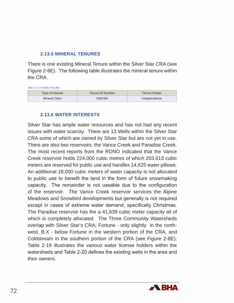
72
2.13.5 MINERAL TENURES
There is one existing Mineral Tenure within the Silver Star CRA (see Figure 2-8E). The following table illustrates the mineral tenure within the CRA.
TABLE 2-18: MINERAL TENURES
Type of Interest Tenure ID Number Tenure Holder
Mineral Claim 1053/581 Independence
2.13.6 WATER INTERESTS
Silver Star has ample water resources and has not had any recent issues with water scarcity. There are 13 Wells within the Silver Star CRA some of which are owned by Silver Star but are not yet in use. There are also two reservoirs: the Vance Creek and Paradise Creek. The most recent reports from the RDNO indicated that the Vance Creek reservoir holds 224,000 cubic metres of which 203,613 cubic meters are reserved for public use and handles 14,625 water pillows. An additional 18,000 cubic meters of water capacity is not allocated to public use to benefit the land in the form of future snowmaking capacity. The remainder is not useable due to the configuration of the reservoir. The Vance Creek reservoir services the Alpine Meadows and Snowbird developments but generally is not required except in cases of extreme water demand, specifically Christmas. The Paradise reservoir has the a 41,639 cubic meter capacity all of which is completely allocated. The Three Community Watersheds overlap with Silver Star’s CRA; Fortune - only slightly in the north-west, B.X - below Fortune in the western portion of the CRA, and Coldstream in the southern portion of the CRA (see Figure 2-8E). Table 2-19 illustrates the various water license holders within the watersheds and Table 2-20 defines the existing wells in the area and their owners.
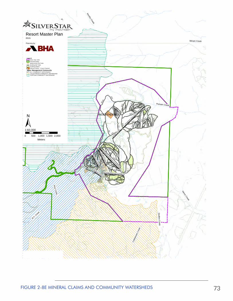
73FIGURE 2-8E MINERAL CLAIMS AND COMMUNITY WATERSHEDS
Miriam Creek
Putnam Creek
Vance Creek
B.X. Cree
k
Fortune Creek
South Fortune Creek
Deafies C
reek
Cold
stre
am C
reek
Joyce Creek
Pine Creek
Alderson Creek
Kendry Creek
INDEPENDENCE
SUM
MIT C
HAIR
POWDER G
ULCH EXPRESS
COMET SIX-PACK EXPRESS
HOME RUN T
ALPINE CHAIR
SILVER WOODS EXPRESS
SILVER QUEEN
E1
D1
D3
D2
D5
D8
E12
E40
E26
D10
D4D6
E14
E27
E2
E4
G1
E43
G10
E3
D40
E49
G8
D11
E51a
E9
D29
G13
G12
B3
E7
D34
E15
E13
E16
E17
D17
G4
D35
a
G2
E28
G9
D13
E10
D21
E18
D37a
E42
G15
D12
E35
B5
E53
E50
E33
D7
A3
E51
E34
G14
E48
E24
E32
E30
G16
D37
E45E4
7
D19
E60
E52
E19
E38
A5
E37
D35
G3
E21
D24
E39
Resort Master Plan2015
Planning by:
0 500 1,000 1,500 2,000Meters
1:60,000
LegendSilver Star CRAPark BoundaryBackcountry Ski TrailsExisting Ski TrailsExisting GladesMineral Claims - Crown Granted
Water Management CommunityB.X. COMMUNITY WATERSHEDCOLDSTREAM COMMUNITY WATERSHEDFORTUNE COMMUNITY WATERSHED
±
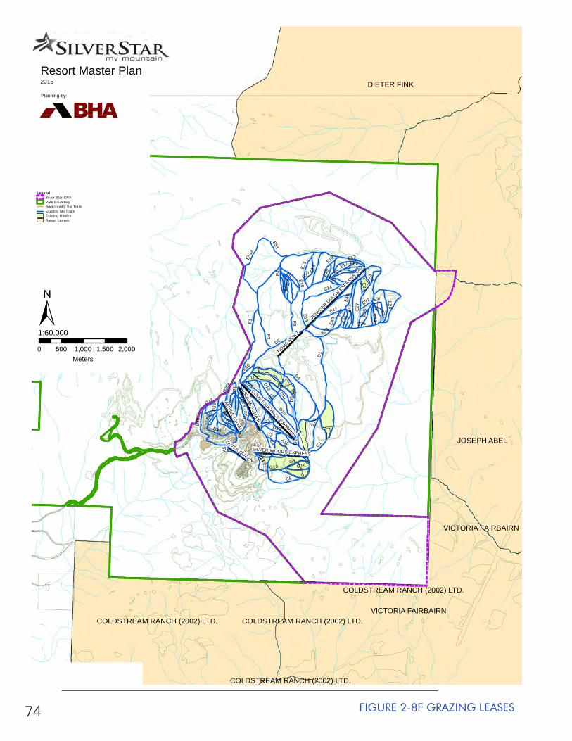
74 FIGURE 2-8F GRAZING LEASES
JOSEPH ABEL
DIETER FINK
VICTORIA FAIRBAIRN
COLDSTREAM RANCH (2002) LTD.
COLDSTREAM RANCH (2002) LTD.COLDSTREAM RANCH (2002) LTD.VICTORIA FAIRBAIRN
COLDSTREAM RANCH (2002) LTD.
SUM
MIT C
HAIR
POWDER G
ULCH EXPRESS
COMET SIX-PACK EXPRESS
HOME RUN T
ALPINE CHAIR
SILVER WOODS EXPRESS
SILVER QUEEN
E1
D1
D3
D2
D5
D8
E12
E40
E26
D10
D4D6
E14
E27
E2
E4
G1
E43
G10
E3
D40
E49
G8
D11
E51a
E9
D29
G13
G12
B3
E7
D34
E15
E13
E6
E16
E17
D17
G4
D35
a
G2
E28
G9
D13
E10
D21
E18
D37a
E42
G15
D12
E35
B5
E53
E50
E33
D7
A3
E51
E34
G14
E48
E24
E32
E30
G16
D37
E45E4
7
D19
E60
E52
E19
E38
A5
E37
D35
G3
E21
D24
E39
Resort Master Plan2015
Planning by:
0 500 1,000 1,500 2,000Meters
1:60,000
LegendSilver Star CRAPark BoundaryBackcountry Ski TrailsExisting Ski TrailsExisting GladesRange Leases
±
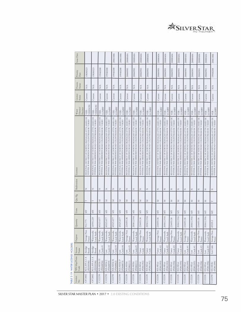
SILVER STAR MASTER PLAN • 2017 • 2.0 EXISTING CONDITIONS
75
TABL
E 2-
19:
WAT
ER L
ICEN
SE H
OLD
ERS
Lice
nce
No
WR
Map
/Poi
nt
Cod
eSt
ream
N
ame
Purp
ose
Qua
ntity
Uni
tsQ
ty F
lgR
ediv
ersio
n Li
cens
eeW
ater
D
istric
t/Pr
ecin
ct
Lice
nce
Stat
usPr
oces
s St
atus
Prio
rity
Dat
eIs
sue
Dat
e
C07
2602
82.L
.035
.4.1
A
(PD
5959
6)At
trid
ge
Broo
kSt
orag
e-N
on
Pow
er91
2.77
5M
YT
NR
EGIO
NAL
DIS
TR
ICT
OF
NO
RT
H O
KAN
AGAN
AT
TN
: JAM
ES D
E PF
YFFE
R, R
984
8 AB
ERD
EEN
RO
AD C
OLD
STR
EAM
BC
V1B
2K9
VER
- V
ERN
ON
Cur
rent
N/A
1983
0323
C07
2602
82.L
.035
.4.1
A
(PD
5959
6)At
trid
ge
Broo
kW
ater
wor
ks
Loca
l Aut
h16
593.
229
MY
TN
REG
ION
AL D
IST
RIC
T O
F N
OR
TH
OK
ANAG
AN A
TT
N: J
AMES
DE
PFYF
FER
, R 9
848
ABER
DEE
N R
OAD
CO
LDST
REA
M B
C V
1B2K
9V
ER -
VER
NO
NC
urre
ntN
/A19
8303
23
C12
2250
82L/
6E(h
) H
(PD
6885
6)Lo
st C
reek
#1
Wat
erw
orks
Lo
cal A
uth
4932
5.07
7M
YM
NR
EGIO
NAL
DIS
TR
ICT
OF
NO
RT
H O
KAN
AGAN
AT
TN
: JAM
ES D
E PF
YFFE
R, R
984
8 AB
ERD
EEN
RO
AD C
OLD
STR
EAM
BC
V1B
2K9
VER
- LU
MBY
Cur
rent
N/A
1994
0208
C12
2250
82L/
6E(h
) J
(PD
6885
9)Lo
st C
reek
#2
Wat
erw
orks
Lo
cal A
uth
4932
5.07
7M
YM
NR
EGIO
NAL
DIS
TR
ICT
OF
NO
RT
H O
KAN
AGAN
AT
TN
: JAM
ES D
E PF
YFFE
R, R
984
8 AB
ERD
EEN
RO
AD C
OLD
STR
EAM
BC
V1B
2K9
VER
- LU
MBY
Cur
rent
N/A
1994
0208
C12
2250
82L/
6E(h
) K
(PD
6886
2)Lo
st C
reek
#3
Wat
erw
orks
Lo
cal A
uth
4932
5.07
7M
YM
NR
EGIO
NAL
DIS
TR
ICT
OF
NO
RT
H O
KAN
AGAN
AT
TN
: JAM
ES D
E PF
YFFE
R, R
984
8 AB
ERD
EEN
RO
AD C
OLD
STR
EAM
BC
V1B
2K9
VER
- LU
MBY
Cur
rent
N/A
1994
0208
2006
1006
C12
2250
82L/
6E(h
) P
(PD
6887
3)Lo
st C
reek
#4
Wat
erw
orks
Lo
cal A
uth
4932
5.07
7M
YM
NR
EGIO
NAL
DIS
TR
ICT
OF
NO
RT
H O
KAN
AGAN
AT
TN
: JAM
ES D
E PF
YFFE
R, R
984
8 AB
ERD
EEN
RO
AD C
OLD
STR
EAM
BC
V1B
2K9
VER
- LU
MBY
Cur
rent
N/A
1994
0208
2006
1006
C12
2226
82L/
6E(h
) (P
D80
211)
Lost
Cre
ek #
5St
orag
e-N
on
Pow
er22
4493
.36
MY
MN
REG
ION
AL D
IST
RIC
T O
F N
OR
TH
OK
ANAG
AN A
TT
N: J
AMES
DE
PFYF
FER
, R 9
848
ABER
DEE
N R
OAD
CO
LDST
REA
M B
C V
1B2K
9V
ER -
LUM
BYC
urre
ntN
/A20
0609
0120
0804
04
C12
2226
82L/
6E(h
) (P
D80
211)
Lost
Cre
ek #
5W
ater
wor
ks
Loca
l Aut
h20
3612
.916
MY
MN
REG
ION
AL D
IST
RIC
T O
F N
OR
TH
OK
ANAG
AN A
TT
N: J
AMES
DE
PFYF
FER
, R 9
848
ABER
DEE
N R
OAD
CO
LDST
REA
M B
C V
1B2K
9V
ER -
LUM
BYC
urre
ntN
/A20
0609
0120
0804
04
C12
2226
82L/
6E(a
) (P
D81
392)
Van
ce
Cre
ekSt
orag
e-N
on
Pow
er22
4493
.36
MY
MN
REG
ION
AL D
IST
RIC
T O
F N
OR
TH
OK
ANAG
AN A
TT
N: J
AMES
DE
PFYF
FER
, R 9
848
ABER
DEE
N R
OAD
CO
LDST
REA
M B
C V
1B2K
9V
ER -
LUM
BYC
urre
ntN
/A20
0609
0120
0804
04
C12
2226
82L/
6E(a
) (P
D81
392)
Van
ce
Cre
ekW
ater
wor
ks
Loca
l Aut
h20
3612
.916
MY
MN
REG
ION
AL D
IST
RIC
T O
F N
OR
TH
OK
ANAG
AN A
TT
N: J
AMES
DE
PFYF
FER
, R 9
848
ABER
DEE
N R
OAD
CO
LDST
REA
M B
C V
1B2K
9V
ER -
LUM
BYC
urre
ntN
/A20
0609
0120
0804
04
C12
2226
82L/
6E(a
) (P
D81
393)
Van
ce
Cre
ek #
2St
orag
e-N
on
Pow
er22
4493
.36
MY
MN
REG
ION
AL D
IST
RIC
T O
F N
OR
TH
OK
ANAG
AN A
TT
N: J
AMES
DE
PFYF
FER
, R 9
848
ABER
DEE
N R
OAD
CO
LDST
REA
M B
C V
1B2K
9V
ER -
LUM
BYC
urre
ntN
/A20
0609
0120
0804
04
C12
2226
82L/
6E(a
) (P
D81
393)
Van
ce
Cre
ek #
2W
ater
wor
ks
Loca
l Aut
h20
3612
.916
MY
MN
REG
ION
AL D
IST
RIC
T O
F N
OR
TH
OK
ANAG
AN A
TT
N: J
AMES
DE
PFYF
FER
, R 9
848
ABER
DEE
N R
OAD
CO
LDST
REA
M B
C V
1B2K
9V
ER -
LUM
BYC
urre
ntN
/A20
0609
0120
0804
04
C12
2226
82L/
6E(a
) (P
D81
394)
Van
ce
Cre
ek #
3St
orag
e-N
on
Pow
er22
4493
.36
MY
MN
REG
ION
AL D
IST
RIC
T O
F N
OR
TH
OK
ANAG
AN A
TT
N: J
AMES
DE
PFYF
FER
, R 9
848
ABER
DEE
N R
OAD
CO
LDST
REA
M B
C V
1B2K
9V
ER -
LUM
BYC
urre
ntN
/A20
0609
0120
0804
04
C12
2226
82L/
6E(a
) (P
D81
394)
Van
ce
Cre
ek #
3W
ater
wor
ks
Loca
l Aut
h20
3612
.916
MY
MN
REG
ION
AL D
IST
RIC
T O
F N
OR
TH
OK
ANAG
AN A
TT
N: J
AMES
DE
PFYF
FER
, R 9
848
ABER
DEE
N R
OAD
CO
LDST
REA
M B
C V
1B2K
9V
ER -
LUM
BYC
urre
ntN
/A20
0609
0120
0804
04
C12
2226
82L/
6E(a
) (P
D81
395)
Lost
Cre
ek #
1St
orag
e-N
on
Pow
er22
4493
.36
MY
MN
REG
ION
AL D
IST
RIC
T O
F N
OR
TH
OK
ANAG
AN A
TT
N: J
AMES
DE
PFYF
FER
, R 9
848
ABER
DEE
N R
OAD
CO
LDST
REA
M B
C V
1B2K
9V
ER -
LUM
BYC
urre
ntN
/A20
0609
0120
0804
04
C12
2226
82L/
6E(a
) (P
D81
395)
Lost
Cre
ek #
1W
ater
wor
ks
Loca
l Aut
h20
3612
.916
MY
MN
REG
ION
AL D
IST
RIC
T O
F N
OR
TH
OK
ANAG
AN A
TT
N: J
AMES
DE
PFYF
FER
, R 9
848
ABER
DEE
N R
OAD
CO
LDST
REA
M B
C V
1B2K
9V
ER -
LUM
BYC
urre
ntN
/A20
0609
0120
0804
04
C12
2226
82L/
6E(a
) (P
D81
396)
Lost
Cre
ek #
3St
orag
e-N
on
Pow
er22
4493
.36
MY
MN
REG
ION
AL D
IST
RIC
T O
F N
OR
TH
OK
ANAG
AN A
TT
N: J
AMES
DE
PFYF
FER
, R 9
848
ABER
DEE
N R
OAD
CO
LDST
REA
M B
C V
1B2K
9V
ER -
LUM
BYC
urre
ntN
/A20
0609
0120
0804
04
C12
2226
82L/
6E(a
) (P
D81
396)
Lost
Cre
ek #
3W
ater
wor
ks
Loca
l Aut
h20
3612
.916
MY
MN
REG
ION
AL D
IST
RIC
T O
F N
OR
TH
OK
ANAG
AN A
TT
N: J
AMES
DE
PFYF
FER
, R 9
848
ABER
DEE
N R
OAD
CO
LDST
REA
M B
C V
1B2K
9V
ER -
LUM
BYC
urre
ntN
/A20
0609
0120
0804
04
C12
2250
82L/
6E(h
) (P
D81
399)
Lost
Lake
Stor
age-
Non
Po
wer
4933
9.2
MY
TN
REG
ION
AL D
IST
RIC
T O
F N
OR
TH
OK
ANAG
AN A
TT
N: J
AMES
DE
PFYF
FER
, R 9
848
ABER
DEE
N R
OAD
CO
LDST
REA
M B
C V
1B2K
9V
ER -
LUM
BYC
urre
ntN
/A19
9402
0820
0610
06
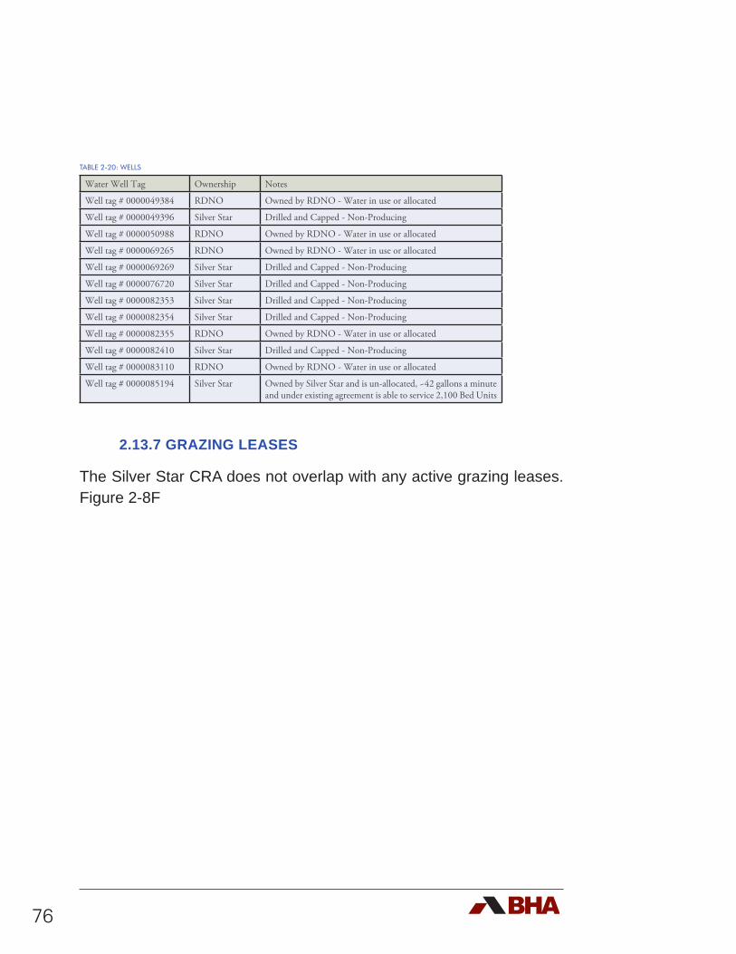
76
TABLE 2-20: WELLS
Water Well Tag Ownership Notes
Well tag # 0000049384 RDNO Owned by RDNO - Water in use or allocated
Well tag # 0000049396 Silver Star Drilled and Capped - Non-Producing
Well tag # 0000050988 RDNO Owned by RDNO - Water in use or allocated
Well tag # 0000069265 RDNO Owned by RDNO - Water in use or allocated
Well tag # 0000069269 Silver Star Drilled and Capped - Non-Producing
Well tag # 0000076720 Silver Star Drilled and Capped - Non-Producing
Well tag # 0000082353 Silver Star Drilled and Capped - Non-Producing
Well tag # 0000082354 Silver Star Drilled and Capped - Non-Producing
Well tag # 0000082355 RDNO Owned by RDNO - Water in use or allocated
Well tag # 0000082410 Silver Star Drilled and Capped - Non-Producing
Well tag # 0000083110 RDNO Owned by RDNO - Water in use or allocated
Well tag # 0000085194 Silver Star Owned by Silver Star and is un-allocated, ~42 gallons a minute and under existing agreement is able to service 2,100 Bed Units
2.13.7 GRAZING LEASES
The Silver Star CRA does not overlap with any active grazing leases. Figure 2-8F
SILVER STAR MASTER PLAN • 2017 • 2.0 EXISTING CONDITIONS
77
2.14 Environmental Context
Cascade Environmental Research Group Ltd. (Cascade) was engaged by Silver Star Mountain Resort (SSMR) in 1995, 2006 and again in 2017 to complete an overview assessment of potential environmental issues within the resort’s CRA. This study gives an accurate representation of the environmental factors that Silver Star has to work with.
The resultant Cascade environmental overviews and options were used during the resort design and planning process in an effort to avoid or minimize environmental impacts.
The Cascade 2017 Report in its entirety can be found in Appendix 1. Contained within, the report outlines potential environmental issues associated with this site, and possible challenges related to the proposed development and potential environmental impacts, including:
d Comments regarding the Cultural, Physical, Terrestrial, Aquatic and Wetland Environments;
d Comments regarding the quality of wildlife habitat on site;
d Comments regarding fish habitat values associated with watercourses in the study area, and;
d The potential existence of Species at Risk Act (SARA) and other species / ecosystems of conservation concerns on site..
78
The results of this study found no significant environmental constraints to pursing the proposed ski resort development within the study area. The key takeaways from the report indicates:
• Wetlands should be retained due to their relative uncommon occurrence in uplands, and;
• Where possible ephemeral streams should be retained due to their significant biological utility as wildlife corridors and habitat;
• Construction documentation should include appropriate riparian setbacks;
• The fuel management program is very well executed and should continue. In addition to providing fire breaks, it is improving habitat and increasing diversity;
• Alpine larch should be protected wherever it occurs and whenever possible;
• While 13 SARA listed species could potentially occur, only the American badger has potentially been sighted. While the subspecies is not verified at this time, its denning locale is known and should be protected from disturbance.

ANALYSIS

SILVER STAR MASTER PLAN • 2017 • 3.0 ANALYSIS
79
3.1 Introduction
An analysis of Silver Star was completed in order to identify future development potential at the resort aimed at improving the balance between recreation activities and base area facilities aligned with market needs and expectations. Achieving this balance of facilities will allow Silver Star to maintain and enhance its position as a world class, all-season mountain resort. Working with newly acquired mapping, a detailed terrain analysis was undertaken to initiate and guide the mountain and base area planning.
3.1.1 EXISTING DEVELOPMENT OPPORTUNITIES
In 1997, Silver Star commissioned a study to determine the potential to incorporate an eighteen hole golf course into the resort’s offering. That exercise culminated in a realignment of the Controlled Recreation Area boundaries. The objective of establishing the golf course has been reactivated. In addition, the 2004 Official Community Plan (OCP) for Silver Star effectively defined areas of prescribed development opportunity.
3.1.2 STUDY AREAFor the purposes of this planning exercise, the Study Area has been delineated outside of the CRA boundary (See Figure 3-1: Study Area). The intent was to explore all of the physical opportunities and potential for Silver Star to become a comprehensive and well integrated resort development.
3.0 ANALYSIS
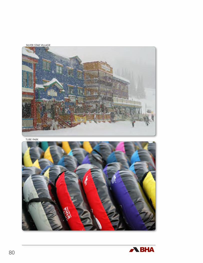
80
SILVER STAR VILLAGE
SILVER STAR VILLAGE
TUBE PARK
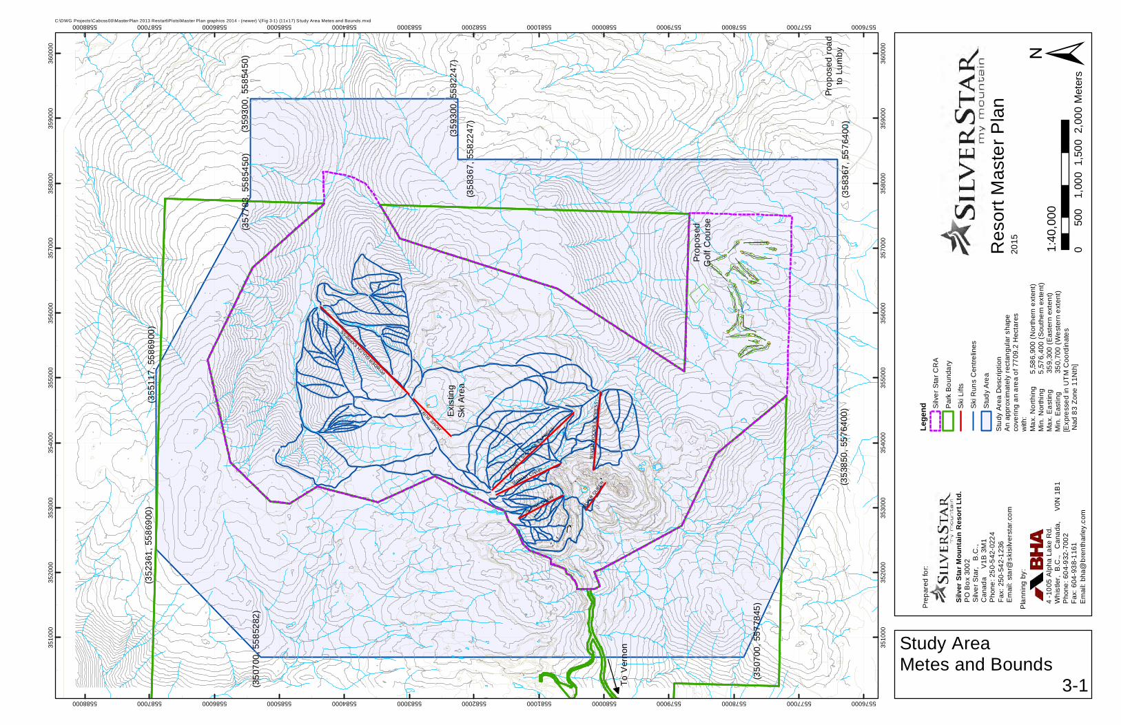
SUMMIT CHAIR
POWDER GULCH E
XPRESS
COMET SIX
-PACK EXPRESSHOME R
UN T
ALPINE CHAIR
SILV
ER
WO
OD
S E
XP
RE
SS
SILV
ER Q
UEEN
3510
00
3510
00
3520
00
3520
00
3530
00
3530
00
3540
00
3540
00
3550
00
3550
00
3560
00
3560
00
3570
00
3570
00
3580
00
3580
00
3590
00
3590
00
3600
00
3600
00
5576000
5576000
5577000
5577000
5578000
5578000
5579000
5579000
5580000
5580000
5581000
5581000
5582000
5582000
5583000
5583000
5584000
5584000
5585000
5585000
5586000
5586000
5587000
5587000
5588000
5588000
Res
ort M
aste
r Pla
n20
15
C:\DWG Projects\Cabcss00\MasterPlan 2013 Restart\Plots\Master Plan graphics 2014 - (newer) \(Fig 3-1) (11x17) S tudy Area Metes and Bounds.mxd
Study AreaMetes and Bounds
3-1
±
Lege
nd Silv
er S
tar C
RA
Par
k B
ound
ary
Ski
Lift
s
Ski
Run
s C
entre
lines
Stu
dy A
rea
050
01,
000
1,50
02,
000
Met
ers
1:40
,000
Stu
dy A
rea
Des
crip
tion
An
appr
oxim
atel
y re
ctan
gula
r sha
peco
verin
g an
are
a of
770
9.2
Hec
tare
sw
ith:
Max
. Nor
thin
g
5,5
86,9
00 (N
orth
ern
exte
nt)
Min
. Nor
thin
g
5,
576,
400
(Sou
ther
n ex
tent
)M
ax. E
astin
g
3
59,3
00 (
Eas
tern
ext
ent)
Min
. Eas
ting
350
,700
(W
este
rn e
xten
t)[E
xpre
ssed
in U
TM
Coo
rdin
ates
Nad
83
Zone
11N
th]
To V
erno
n
Prop
osed
Gol
f Cou
rse
Prop
osed
road
to L
umby
(358
367,
557
6400
)
(358
367,
558
2247
)
(359
300,
558
2247
)
(359
300,
558
5450
)(3
5778
3, 5
5854
50)
(355
117,
558
6900
)(3
5236
1, 5
5869
00)
(350
700,
558
5282
)
(350
700,
557
7845
)
(353
850,
557
6400
)Exis
ting
Ski A
rea
Pre
pare
d fo
r:
PO
Box
300
2S
ilver
Sta
r, B
.C.,
Can
ada
V
1B 3
M1
Pho
ne: 2
50-5
42-0
224
Fax:
250
-542
-123
6E
mai
l: st
ar@
skis
ilver
star
.com
Silv
er S
tar M
ount
ain
Res
ort L
td.
Pla
nnin
g by
:
4 -1
005
Alp
ha L
ake
Rd.
Whi
stle
r, B
.C.,
Can
ada,
V
0N 1
B1
Pho
ne: 6
04-9
32-7
002
Fax:
604
-938
-116
1E
mai
l: bh
a@br
enth
arle
y.co
m

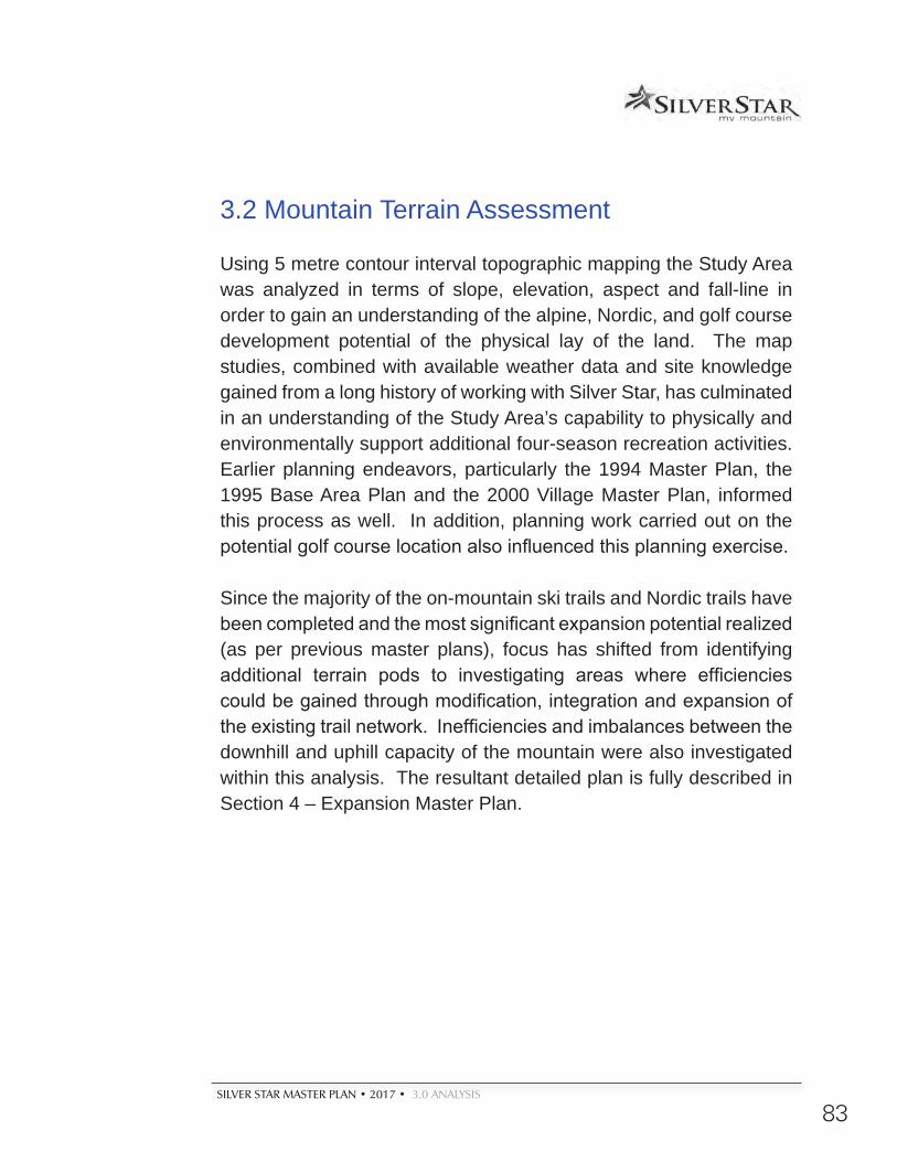
SILVER STAR MASTER PLAN • 2017 • 3.0 ANALYSIS
83
3.2 Mountain Terrain Assessment
Using 5 metre contour interval topographic mapping the Study Area was analyzed in terms of slope, elevation, aspect and fall-line in order to gain an understanding of the alpine, Nordic, and golf course development potential of the physical lay of the land. The map studies, combined with available weather data and site knowledge gained from a long history of working with Silver Star, has culminated in an understanding of the Study Area’s capability to physically and environmentally support additional four-season recreation activities. Earlier planning endeavors, particularly the 1994 Master Plan, the 1995 Base Area Plan and the 2000 Village Master Plan, informed this process as well. In addition, planning work carried out on the potential golf course location also influenced this planning exercise.
Since the majority of the on-mountain ski trails and Nordic trails have been completed and the most significant expansion potential realized (as per previous master plans), focus has shifted from identifying additional terrain pods to investigating areas where efficiencies could be gained through modification, integration and expansion of the existing trail network. Inefficiencies and imbalances between the downhill and uphill capacity of the mountain were also investigated within this analysis. The resultant detailed plan is fully described in Section 4 – Expansion Master Plan.
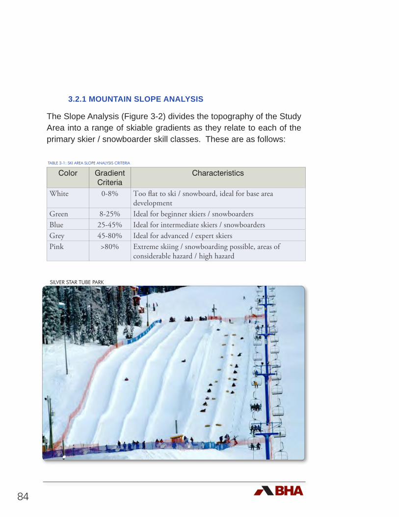
84
3.2.1 MOUNTAIN SLOPE ANALYSIS
The Slope Analysis (Figure 3-2) divides the topography of the Study Area into a range of skiable gradients as they relate to each of the primary skier / snowboarder skill classes. These are as follows:
TABLE 3-1: SKI AREA SLOPE ANALYSIS CRITERIA
Color Gradient Criteria
Characteristics
White 0-8% Too flat to ski / snowboard, ideal for base area development
Green 8-25% Ideal for beginner skiers / snowboardersBlue 25-45% Ideal for intermediate skiers / snowboardersGrey 45-80% Ideal for advanced / expert skiersPink >80% Extreme skiing / snowboarding possible, areas of
considerable hazard / high hazard
SILVER STAR TUBE PARK
SUMMIT CHAIR
POWDER G
ULCH EXPRESS
COMET SIX-P
ACK EXPRESSHOME R
UN T
ALPINE CHAIR
SILV
ER
WO
OD
S E
XP
RE
SS
SILV
ER Q
UEEN
C:\DWG Projects\Cabcss00\MasterPlan 2013 Restart\Plots\Master Plan graphics 2014 - (newer) \(Fig 3-2) (11x17) Mtn Slope Analysis.mxd
MountainSlope Analysis
3-2
±
Lege
nd Silv
er S
tar C
RA
Park
Bou
ndar
ySl
ope
Ana
lysi
s>8
0%45
- 80
25 -
458
- 25
0 - 8
%
Ski L
ifts
Ski R
uns
Cen
trelin
esSt
udy
Area
050
01,
000
1,50
02,
000
Met
ers
1:40
,000
To V
erno
n
Prop
osed
Gol
f Cou
rse
Prop
osed
road
to L
umby
Exis
ting
Ski A
rea
Res
ort M
aste
r Pla
n20
15
Pre
pare
d fo
r:
PO
Box
300
2S
ilver
Sta
r, B
.C.,
Can
ada
V
1B 3
M1
Pho
ne: 2
50-5
42-0
224
Fax:
250
-542
-123
6E
mai
l: st
ar@
skis
ilver
star
.com
Silv
er S
tar M
ount
ain
Res
ort L
td.
Pla
nnin
g by
:
4 -1
005
Alp
ha L
ake
Rd.
Whi
stle
r, B
.C.,
Can
ada,
V
0N 1
B1
Pho
ne: 6
04-9
32-7
002
Fax:
604
-938
-116
1E
mai
l: bh
a@br
enth
arle
y.co
m
2015

SILVER STAR MASTER PLAN • 2017 • 3.0 ANALYSIS
87
The resultant analysis delineates the general character of the land. It is readily apparent that much of the Intermediate skier oriented terrain has already been developed. As it is one of the identified shortcomings of the existing offering, it is clear that finding significant additional Intermediate terrain will be the challenge.
3.2.2 MOUNTAIN ELEVATION ANALYSIS
The Elevation Analysis (Figure 3-3) slices the topographic features of the Study Area into 50 metre increments. Effectively, this analysis illustrates the height and “flow” of the land. It also acts as a good benchmarking tool to defining reliable snowline. The highest point within the Silver Star Study Area is the peak of the Summit at 1,890 metres (6,200 feet). The base area Village sits at an elevation of approximately 1,600 metres (5,250 feet). The lowest elevation of existing ski facilities development is at the base of the Powder Gulch Express at 1,155 metres (3,790 feet) and the lowest elevation in consideration within the Study Area is at approximately the 1,000 metre (3,280 feet) elevation.
Silver Star’s elevation and vertical drop is similar to the Okanagan ski areas of Big White, Apex and Sun Peaks. However, in comparison to other B.C. resorts, Silver Star lacks high alpine terrain and a large vertical drop.
Silver Star is physically divided into a ‘front side’ and a ‘backside’. This creates a distinctive grouping and separation of terrain pods. While this results in some difficulties in linkages connecting one pod to another, it also enables the establishment of separate, relatively self contained areas. The opportunity is available to embrace a greater sense of adventure and even a backcountry character. Further, the disconnected terrain pods also segregate uses between Beginner / Intermediate and Expert skier classifications, providing
88
a better, more enjoyable ski product with less conflict. Conversely, Silver Star is limited by its terrain in that it cannot compete against other resorts such as Whistler, or emerging resorts such as Kicking Horse and Revelstoke Mountain Resort, that offer a high alpine product.
TABLE 3-2: ELEVATION AND VERTICAL COMPARISONS
Ski Area Summit Elevation (m)
Skiable Vertical (m)
Base Elevation (m)
Silver Star 1,890 775 1,115
Big White 2,319 564 1,755
Apex 2,160 531 1,629
Sun Peaks 2,150 895 1,255
Mt. Baldy 2,303 577 1,726
Kicking Horse 2,450 1,260 1,190
Mt. Washington 1,588 505 1,033
Blackcomb 2,284 1,609 675
Whistler 2,182 1,530 652
Revelstoke 2,225 1,713 512
SILVER STAR LODGING
SUMMIT CHAIR
POWDER G
ULCH EXPRESS
COMET SIX-P
ACK EXPRESSHOME R
UN T
ALPINE CHAIR
SILV
ER
WO
OD
S E
XP
RE
SS
SILV
ER Q
UEEN
C:\DWG Projects\Cabcss00\MasterPlan 2013 Restart\Plots\Master Plan graphics 2014 - (newer) \(Fig 3-3) (11x17) Mtn Elevation Analysis.mxd
MountainElevation Analysis
3-3
±
Lege
ndEl
evat
ion
>185
0 m
1800
- 18
5017
50 -
1800
1700
- 17
5016
50 -
1700
1600
- 16
5015
50 -
1600
1500
- 15
5014
50 -
1500
1400
- 14
5013
50 -
1400
1300
- 13
5012
50 -
1300
1200
- 12
5011
50 -
1200
1100
- 11
5010
50 -
1100
1000
- 10
50<
1000
m
Ski L
ifts
Ski R
uns
Cen
trelin
esSi
lver
Sta
r CR
APa
rk B
ound
ary
Stud
y Ar
ea
050
01,
000
1,50
02,
000
Met
ers
1:40
,000
To V
erno
n
Prop
osed
Gol
f Cou
rse
Prop
osed
road
to L
umby
Exis
ting
Ski A
rea
Res
ort M
aste
r Pla
n20
15
Pre
pare
d fo
r:
PO
Box
300
2S
ilver
Sta
r, B
.C.,
Can
ada
V
1B 3
M1
Pho
ne: 2
50-5
42-0
224
Fax:
250
-542
-123
6E
mai
l: st
ar@
skis
ilver
star
.com
Silv
er S
tar M
ount
ain
Res
ort L
td.
Pla
nnin
g by
:
4 -1
005
Alp
ha L
ake
Rd.
Whi
stle
r, B
.C.,
Can
ada,
V
0N 1
B1
Pho
ne: 6
04-9
32-7
002
Fax:
604
-938
-116
1E
mai
l: bh
a@br
enth
arle
y.co
m
2015

SILVER STAR MASTER PLAN • 2017 • 3.0 ANALYSIS
91
3.2.3 MOUNTAIN FALL-LINE ANALYSIS
The Fall-Line Analysis was completed to assist in the identification of contiguous skiable areas. Effectively, a fall-line analysis identifies potential routes that will allow for the natural flow of skiers and snowboarders from the mountain heights to the valley bottoms in a consistent fashion. This consistency of fall-line provides the best recreational skiing experience while causing the least amount of environmental disruption during trail construction. Based on this analysis, the development of defined planning units (terrain pods) was established, and specific run layouts incorporated into the Mountain Plan. Opportunities for re-alignment and modification of existing runs were identified using the fall line analysis.
3.2.4 MOUNTAIN ASPECT ANALYSIS
The Mountain Aspect Analysis (Figure 3-4) involves color-coding the topographic features of the Study Area to illustrate the orientation and geographical exposure with respect to the eight points of the compass. Receiving reduced direct sunlight, northern exposures have greater snow retention, and therefore better suited for ski trail development. Southern exposures can prove to be problematic for skiing terrain due to reduced snow retention capabilities and a greater probability of solar burn out. However, southern exposures are ideal for base area developments and on-mountain lodges as the heating capability of the sun is maximized, increasing the opportunity and comfort of outdoor winter activities and seating.
Ski trails that have a high degree of solar exposure can have the solar burn out of the snow minimized through careful design including detailed grading (angling trails away from direct exposure),
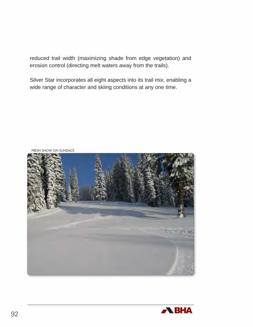
92
reduced trail width (maximizing shade from edge vegetation) and erosion control (directing melt waters away from the trails).
Silver Star incorporates all eight aspects into its trail mix, enabling a wide range of character and skiing conditions at any one time.
FRESH SNOW ON SUNDACE
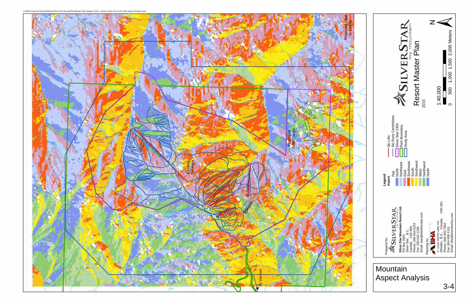
SUMMIT CHAIR
POWDER G
ULCH EXPRESS
COMET SIX-P
ACK EXPRESSHOME R
UN T
ALPINE CHAIR
SILV
ER
WO
OD
S E
XP
RE
SS
SILV
ER Q
UEEN
C:\DWG Projects\Cabcss00\MasterPlan 2013 Restart\Plots\Master Plan graphics 2014 - (newer) \(Fig 3-4) (11x17) Mtn Aspect Analysis.mxd
MountainAspect Analysis
3-4
±
Lege
ndA
spec
t Flat
Nor
thN
orth
east
East
Sout
heas
tSo
uth
Sout
hwes
tW
est
Nor
thw
est
Nor
th
Ski L
ifts
Ski R
uns
Cen
trelin
esSi
lver
Sta
r CR
APa
rk B
ound
ary
Stud
y Ar
ea
050
01,
000
1,50
02,
000
Met
ers
1:40
,000
To V
erno
n
Prop
osed
Gol
f Cou
rse
Prop
osed
road
to L
umby
Exis
ting
Ski A
rea
Res
ort M
aste
r Pla
n20
15
Pre
pare
d fo
r:
PO
Box
300
2S
ilver
Sta
r, B
.C.,
Can
ada
V
1B 3
M1
Pho
ne: 2
50-5
42-0
224
Fax:
250
-542
-123
6E
mai
l: st
ar@
skis
ilver
star
.com
Silv
er S
tar M
ount
ain
Res
ort L
td.
Pla
nnin
g by
:
4 -1
005
Alp
ha L
ake
Rd.
Whi
stle
r, B
.C.,
Can
ada,
V
0N 1
B1
Pho
ne: 6
04-9
32-7
002
Fax:
604
-938
-116
1E
mai
l: bh
a@br
enth
arle
y.co
m
2015

SILVER STAR MASTER PLAN • 2017 • 3.0 ANALYSIS
95
3.2.5 RELIABLE SNOWPACK
If there are at least 40 cm of snow on the ground at the lowest elevations of the ski terrain by mid-November and lasting through to mid-April, the snowpack is considered to be reliable enough for skiing and snowboarding without being augmented by snowmaking. Typically, at Silver Star, the reliable snowpack occurs on northern aspects above the 1,100 metre elevation (i.e. the bottom of the Powder Gulch Express). On southern aspects, the reliable snowpack sits above the 1,370 metre elevation (ie. the bottom of the Comet Sixpack). Sun influences affect the quality of skiing particularly at the end of the ski season when air temperatures are increasing. This makes south to southwest slopes particularly vulnerable to snow quality deterioration in the Spring, when the direct rays of the sun hit the snow in the late afternoon and the air is warmest. Ski terrain with elevations below the reliable snowpack and southern aspects must be augmented with snowmaking as an insurance program to ensure that those trails will be skiable for the duration of the ski season.
3.3 Silver Star Climate Analysis
3.3.1 INTRODUCTION
By the end of the 21st century, the Intergovernmental Panel on Climate Change (IPCC) estimates that the continued emissions of greenhouse gases by human activity will significantly increase surface air temperatures on our planet at the local, regional, and global spatial scales1. This warming will also increase rates of 1 IPCC. 2013. Summary for Policymakers. In: Climate Change 2013: The Physical ScienceBasis. Contribution of Working Group I to the Fifth Assessment Report of theIntergovernmental Panel on Climate Change, T.F. Stocker, D. Qin, G.-K. Plattner, M.Tignor, S. K. Allen, J. Boschung, A. Nauels, Y. Xia, V. Bex and P.M. Midgley (eds.).Cambridge University Press, Cambridge, United Kingdom and New York, NY, USA.
96
evaporation and the subsequent storage of water vapor in the lower atmosphere, intensify precipitation events, cause more precipitation events to fall as rain instead of snow, and will modify the scarcity and location of thunderstorms, mid-latitude cyclones, monsoons and hurricanes. Together these alterations will significantly alter the spatial patterns of precipitation on our planet. Understanding the effect of climate change on Silver Star’s climate is critical to future planning. Using data obtained from the software database ClimateBC2 and assistance from UBC Okanagan’s Dr. Michael Pidwirny ‘virtual’ meteorological stations were used to analyze the historic climate scenarios for Silver Star.
Two analyses were conducted, the first compares Silver Star to other resorts in British Columbia. The second is composed of 112 years of data generated at Silver Star’s mid elevation. This historical view is valuable in forecasting future possible trends. All analyses utilize seasonal weather (winter) data from the Climate BC database which defines winter as December, January and February.
3.3.2 RESORT COMPARISON
The first dataset illustrates climactic factors for various ski resorts in British Columbia. Specifically the figures focus on winter mean temperature, degree days below 0°C and snowfall between the periods of 1961-1990 for the various resorts. The dataset includes bottom, mid and top of mountain readings for various resorts using interpolated Climate BC data. Each section begins with a brief definition of the climatic features listed above.
2 Wang, T., Hamann, A., Spittlehouse, D., and Murdock, T.N. 2012. ClimateWNA - High-resolution spatial climate data for Western North America. Journal of Applied Meteorology and Climatology 61:16-29.
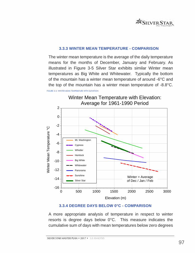
SILVER STAR MASTER PLAN • 2017 • 3.0 ANALYSIS
97
3.3.3 WINTER MEAN TEMPERATURE - COMPARISON
The winter mean temperature is the average of the daily temperature means for the months of December, January and February. As illustrated in Figure 3-5 Silver Star exhibits similar Winter mean temperatures as Big White and Whitewater. Typically the bottom of the mountain has a winter mean temperature of around -6°C and the top of the mountain has a winter mean temperature of -8.8°C.
3.3.4 DEGREE DAYS BELOW 0°C - COMPARISON
A more appropriate analysis of temperature in respect to winter resorts is degree days below 0°C. This measure indicates the cumulative sum of days with mean temperatures below zero degrees
-16
-14
-12
-10
-8
-6
-4
-2
0
2
0 500 1000 1500 2000 2500 3000
Win
ter M
ean
Tem
pera
ture
°C
Elevation (m)
Mt. Washington
Cypress
Whistler
Hemlock
Big White
Whitewater
Panorama
Sunshine
Silver Star
Winter Mean Temperature with Elevation: Average for 1961-1990 Period
Winter = Averageof Dec / Jan / Feb
FIGURE 3-5: WINTER MEAN TEMPERATURE WITH ELEVATION
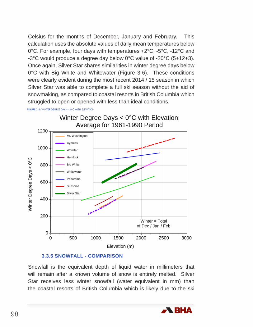
98
Celsius for the months of December, January and February. This calculation uses the absolute values of daily mean temperatures below 0°C. For example, four days with temperatures +2°C, -5°C, -12°C and -3°C would produce a degree day below 0°C value of -20°C (5+12+3). Once again, Silver Star shares similarities in winter degree days below 0°C with Big White and Whitewater (Figure 3-6). These conditions were clearly evident during the most recent 2014 / 15 season in which Silver Star was able to complete a full ski season without the aid of snowmaking, as compared to coastal resorts in British Columbia which struggled to open or opened with less than ideal conditions.
3.3.5 SNOWFALL - COMPARISON
Snowfall is the equivalent depth of liquid water in millimeters that will remain after a known volume of snow is entirely melted. Silver Star receives less winter snowfall (water equivalent in mm) than the coastal resorts of British Columbia which is likely due to the ski
Winter Degree Days < 0°C with Elevation: Average for 1961-1990 Period
0
200
400
600
800
1000
1200
0 500 1000 1500 2000 2500 3000
Win
ter D
egre
e D
ays
< 0°
C
Elevation (m)
Mt. Washington
Cypress
Whistler
Hemlock
Big White
Whitewater
Panorama
Sunshine
Silver Star
Winter = Totalof Dec / Jan / Feb
FIGURE 3-6: WINTER DEGREE DAYS < 0°C WITH ELEVATION
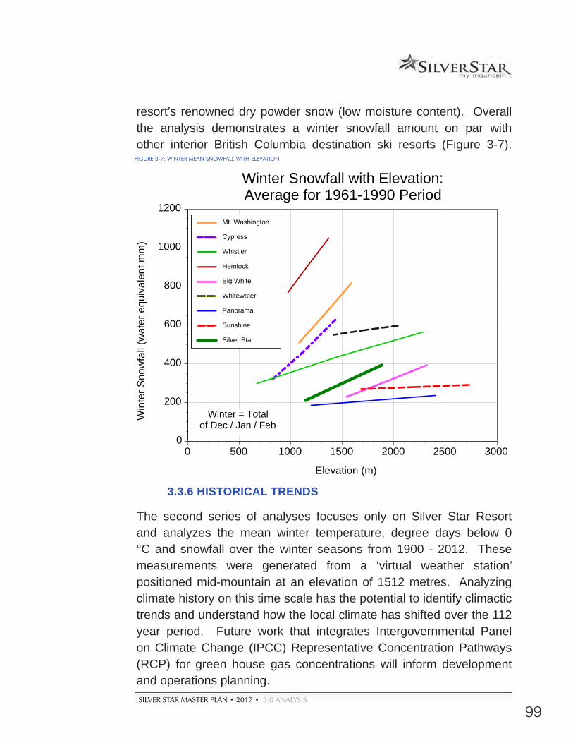
SILVER STAR MASTER PLAN • 2017 • 3.0 ANALYSIS
99
resort’s renowned dry powder snow (low moisture content). Overall the analysis demonstrates a winter snowfall amount on par with other interior British Columbia destination ski resorts (Figure 3-7).
3.3.6 HISTORICAL TRENDS
The second series of analyses focuses only on Silver Star Resort and analyzes the mean winter temperature, degree days below 0 °C and snowfall over the winter seasons from 1900 - 2012. These measurements were generated from a ‘virtual weather station’ positioned mid-mountain at an elevation of 1512 metres. Analyzing climate history on this time scale has the potential to identify climactic trends and understand how the local climate has shifted over the 112 year period. Future work that integrates Intergovernmental Panel on Climate Change (IPCC) Representative Concentration Pathways (RCP) for green house gas concentrations will inform development and operations planning.
0
200
400
600
800
1000
1200
0 500 1000 1500 2000 2500 3000
Win
ter S
now
fall
(wat
er e
quiv
alen
t mm
)
Elevation (m)
Mt. Washington
Cypress
Whistler
Hemlock
Big White
Whitewater
Panorama
Sunshine
Silver Star
Winter Snowfall with Elevation: Average for 1961-1990 Period
Winter = Totalof Dec / Jan / Feb
FIGURE 3-7: WINTER MEAN SNOWFALL WITH ELEVATION
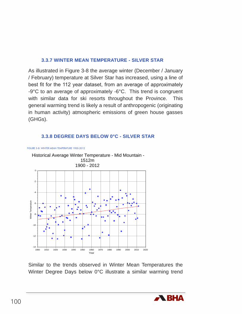
100
3.3.7 WINTER MEAN TEMPERATURE - SILVER STAR
As illustrated in Figure 3-8 the average winter (December / January / February) temperature at Silver Star has increased, using a line of best fit for the 112 year dataset, from an average of approximately -9°C to an average of approximately -6°C. This trend is congruent with similar data for ski resorts throughout the Province. This general warming trend is likely a result of anthropogenic (originating in human activity) atmospheric emissions of green house gasses (GHGs).
3.3.8 DEGREE DAYS BELOW 0°C - SILVER STAR
Similar to the trends observed in Winter Mean Temperatures the Winter Degree Days below 0°C illustrate a similar warming trend
FIGURE 3-8: WINTER MEAN TEMPERATURE 1900-2012
-14
-12
-10
-8
-6
-4
-2
0
1900 1910 1920 1930 1940 1950 1960 1970 1980 1990 2000 2010 2020
Win
ter T
empe
ratu
re
Year
Historical Average Winter Temperature - Mid Mountain - 1512m
1900 - 2012
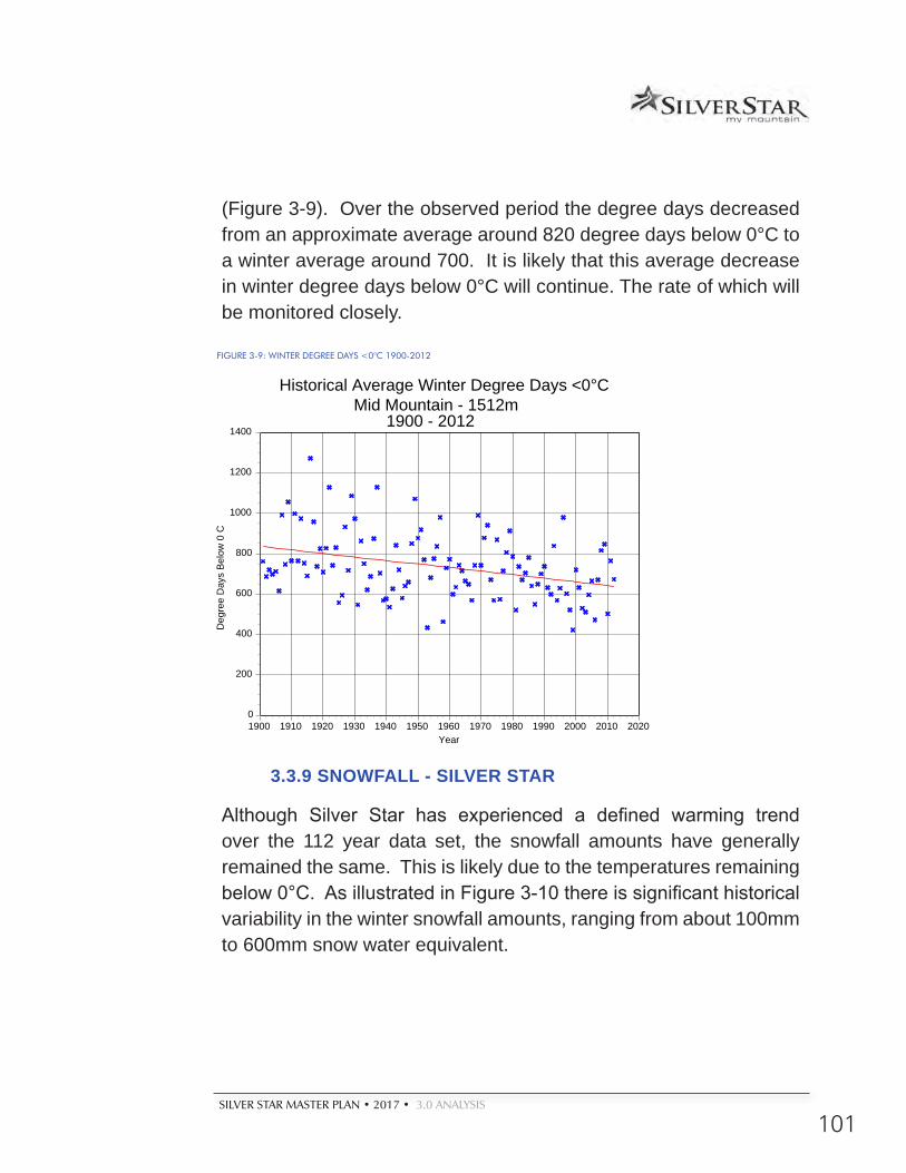
SILVER STAR MASTER PLAN • 2017 • 3.0 ANALYSIS
101
(Figure 3-9). Over the observed period the degree days decreased from an approximate average around 820 degree days below 0°C to a winter average around 700. It is likely that this average decrease in winter degree days below 0°C will continue. The rate of which will be monitored closely.
3.3.9 SNOWFALL - SILVER STAR
Although Silver Star has experienced a defined warming trend over the 112 year data set, the snowfall amounts have generally remained the same. This is likely due to the temperatures remaining below 0°C. As illustrated in Figure 3-10 there is significant historical variability in the winter snowfall amounts, ranging from about 100mm to 600mm snow water equivalent.
0
200
400
600
800
1000
1200
1400
1900 1910 1920 1930 1940 1950 1960 1970 1980 1990 2000 2010 2020
Deg
ree
Day
s B
elow
0 C
Year
Historical Average Winter Degree Days <0°C Mid Mountain - 1512m
1900 - 2012
FIGURE 3-9: WINTER DEGREE DAYS <0°C 1900-2012
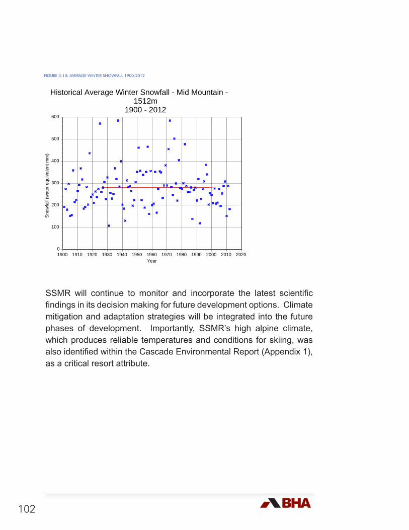
102
SSMR will continue to monitor and incorporate the latest scientific findings in its decision making for future development options. Climate mitigation and adaptation strategies will be integrated into the future phases of development. Importantly, SSMR’s high alpine climate, which produces reliable temperatures and conditions for skiing, was also identified within the Cascade Environmental Report (Appendix 1), as a critical resort attribute.
0
100
200
300
400
500
600
1900 1910 1920 1930 1940 1950 1960 1970 1980 1990 2000 2010 2020
Sno
wfa
ll (w
ater
equ
ival
ent m
m)
Year
Historical Average Winter Snowfall - Mid Mountain - 1512m
1900 - 2012
FIGURE 3-10: AVERAGE WINTER SNOWFALL 1900-2012
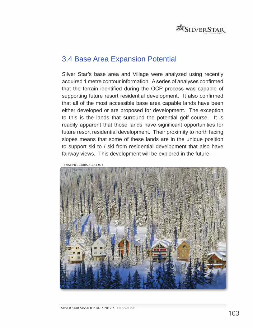
SILVER STAR MASTER PLAN • 2017 • 3.0 ANALYSIS
103
3.4 Base Area Expansion Potential
Silver Star’s base area and Village were analyzed using recently acquired 1 metre contour information. A series of analyses confirmed that the terrain identified during the OCP process was capable of supporting future resort residential development. It also confirmed that all of the most accessible base area capable lands have been either developed or are proposed for development. The exception to this is the lands that surround the potential golf course. It is readily apparent that those lands have significant opportunities for future resort residential development. Their proximity to north facing slopes means that some of these lands are in the unique position to support ski to / ski from residential development that also have fairway views. This development will be explored in the future.
EXISTING CABIN COLONY
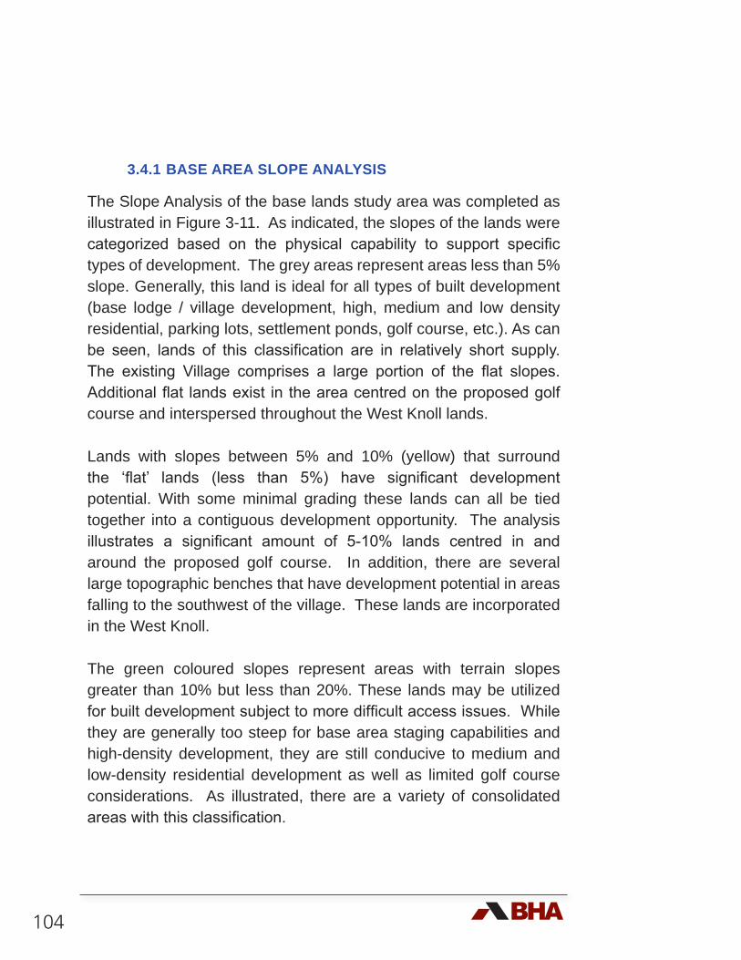
104
3.4.1 BASE AREA SLOPE ANALYSIS
The Slope Analysis of the base lands study area was completed as illustrated in Figure 3-11. As indicated, the slopes of the lands were categorized based on the physical capability to support specific types of development. The grey areas represent areas less than 5% slope. Generally, this land is ideal for all types of built development (base lodge / village development, high, medium and low density residential, parking lots, settlement ponds, golf course, etc.). As can be seen, lands of this classification are in relatively short supply. The existing Village comprises a large portion of the flat slopes. Additional flat lands exist in the area centred on the proposed golf course and interspersed throughout the West Knoll lands.
Lands with slopes between 5% and 10% (yellow) that surround the ‘flat’ lands (less than 5%) have significant development potential. With some minimal grading these lands can all be tied together into a contiguous development opportunity. The analysis illustrates a significant amount of 5-10% lands centred in and around the proposed golf course. In addition, there are several large topographic benches that have development potential in areas falling to the southwest of the village. These lands are incorporated in the West Knoll.
The green coloured slopes represent areas with terrain slopes greater than 10% but less than 20%. These lands may be utilized for built development subject to more difficult access issues. While they are generally too steep for base area staging capabilities and high-density development, they are still conducive to medium and low-density residential development as well as limited golf course considerations. As illustrated, there are a variety of consolidated areas with this classification.
SILVER STAR MASTER PLAN • 2017 • 3.0 ANALYSIS
105
Slopes between 20% and 30% gradients (indicated by light blue) are lands where medium density development becomes more challenging. The key to entertaining such development is both vehicular access and the establishment of sufficient off-street parking in an economically viable fashion. Low-density single family and duplex type development may be applied to these lands with greater ease than the multi-family, medium-density development. The benefits of development on these slopes usually include ski to / ski from capabilities, unrestricted views and good solar access.
The dark blue colour represents areas with slopes between 30% and 40%. This generally represents the maximum limit to low-density development without incurring access and development expenses beyond economic viability. The challenges of developing on these slopes are often offset with the benefits of big views and excellent solar access.
Finally, pink coloured areas represent slopes greater than 40%. These areas should be avoided due to the difficulties of access and the expense of development unless special circumstances prevail. As illustrated in the Base Area Slope Analysis, there is one contiguous area with this classification, located between the West Knoll and the Golf course area.
In summary, based on slope classifications, there appears to be significant large tracts of land capable of supporting both continued development of the Village, a full spectrum of ‘ski to / ski from’ (with future residential lift development) resort residential development, and areas of contiguous lands that will be able to support at least eighteen holes of golf and associated real estate, with close connection to the skiing.

106
SUM
MIT C
HAIR
COMET SIX-PACK EXPRESS
ALPINE CHAIR
SILVER WOODS EXPRESS
SILVER QUEEN
1:20,000
Resort Master Plan2015
Base AreaSlope Analysis
3-11
±0 250 500 750 1,000Meters
LegendSilver Star CRA
Existing Ski Lifts
Park Boundary
Terrain Park
Buildings
Base Slope
>40%
30 - 40
20 - 30
10 - 20
5 - 10
0 - 5%
Prepared for:
PO Box 3002Silver Star, B.C.,Canada V1B 3M1Phone: 250-542-0224Fax: 250-542-1236Email: [email protected]
Silver Star Mountain Resort Ltd.
Planning by:
4 -1005 Alpha Lake Rd.Whistler, B.C., Canada, V0N 1B1Phone: 604-932-7002 Fax: 604-938-1161Email: [email protected]
ProposedGolf Course
C:\D
WG
Projects\C
abcss00\MasterP
lan 2013 Restart\P
lots\Master P
lan graphics 2014 - (newer) \(Fig 3-5) (11x17) B
ase Area S
lope Analysis.m
xd

SILVER STAR MASTER PLAN • 2017 • 3.0 ANALYSIS
109
3.4.2 BASE AREA ELEVATION ANALYSIS
A Base Area Elevation analysis has been completed as illustrated in Figure 3-11. The areas of equal elevation have been graphically delineated in order to identify the general ‘flow’ of the base lands. This is key in establishing an understanding of the pedestrian, vehicular and skiing linkages between the resort residential, village base, golf course and more distant day use parking areas, as well as the adjacent development areas as they relate to the mountain development potential.
NORDIC SKIING AT SILVER STAR VILLAGE

110
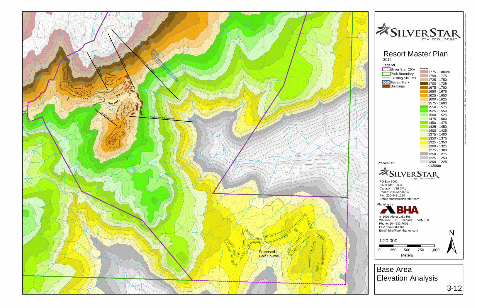
SUM
MIT C
HAIR
COMET SIX-PACK EXPRESS
ALPINE CHAIR
SILVER WOODS EXPRESS
SILVER QUEEN
1:20,000
Resort Master Plan2015
Base AreaElevation Analysis
3-12
±0 250 500 750 1,000Meters
LegendSilver Star CRAPark BoundaryExisting Ski LiftsTerrain ParkBuildings
Elevation
1775 - 1800m1750 - 17751725 - 17501700 - 17251675 - 17001650 - 16751625 - 16501600 - 16251575 - 16001550 - 15751525 - 15501500 - 15251475 - 15001450 - 14751425 - 14501400 - 14251375 - 14001350 - 13751325 - 13501300 - 13251275 - 13001250 - 12751225 - 12501200 - 1225<1200m
Prepared for:
PO Box 3002Silver Star, B.C.,Canada V1B 3M1Phone: 250-542-0224Fax: 250-542-1236Email: [email protected]
Silver Star Mountain Resort Ltd.
Planning by:
4 -1005 Alpha Lake Rd.Whistler, B.C., Canada, V0N 1B1Phone: 604-932-7002 Fax: 604-938-1161Email: [email protected]
ProposedGolf Course
C:\D
WG
Projects\C
abcss00\MasterP
lan 2013 Restart\P
lots\Master P
lan graphics 2014 - (newer) \(Fig 3-6) (11x17) B
ase Area E
levation Analysis.m
xd

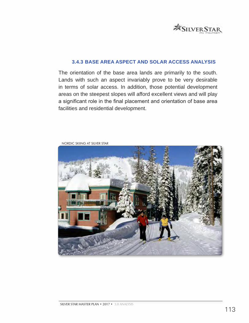
SILVER STAR MASTER PLAN • 2017 • 3.0 ANALYSIS
113
3.4.3 BASE AREA ASPECT AND SOLAR ACCESS ANALYSIS
The orientation of the base area lands are primarily to the south. Lands with such an aspect invariably prove to be very desirable in terms of solar access. In addition, those potential development areas on the steepest slopes will afford excellent views and will play a significant role in the final placement and orientation of base area facilities and residential development.
NORDIC SKIING AT SILVER STAR

114
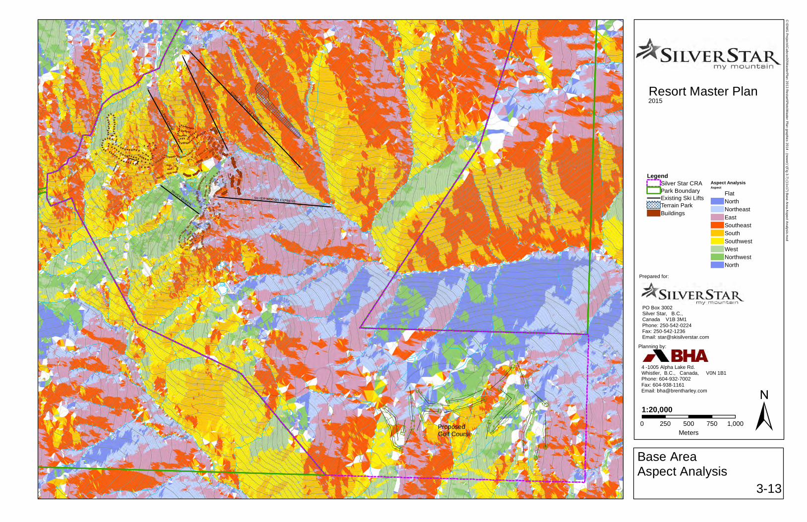
SUM
MIT C
HAIR
COMET SIX-PACK EXPRESS
ALPINE CHAIR
SILVER WOODS EXPRESS
SILVER QUEEN
1:20,000
Resort Master Plan2015
Base AreaAspect Analysis
3-13
±0 250 500 750 1,000Meters
LegendSilver Star CRAPark BoundaryExisting Ski LiftsTerrain ParkBuildings
Aspect AnalysisAspect
FlatNorthNortheastEastSoutheastSouthSouthwestWestNorthwestNorth
Prepared for:
PO Box 3002Silver Star, B.C.,Canada V1B 3M1Phone: 250-542-0224Fax: 250-542-1236Email: [email protected]
Silver Star Mountain Resort Ltd.
Planning by:
4 -1005 Alpha Lake Rd.Whistler, B.C., Canada, V0N 1B1Phone: 604-932-7002 Fax: 604-938-1161Email: [email protected]
ProposedGolf Course
C:\D
WG
Projects\C
abcss00\MasterP
lan 2013 Restart\P
lots\Master P
lan graphics 2014 - (newer) \(Fig 3-7) (11x17) B
ase Area A
spect Analysis.m
xd

EXPANSION MASTER PLAN
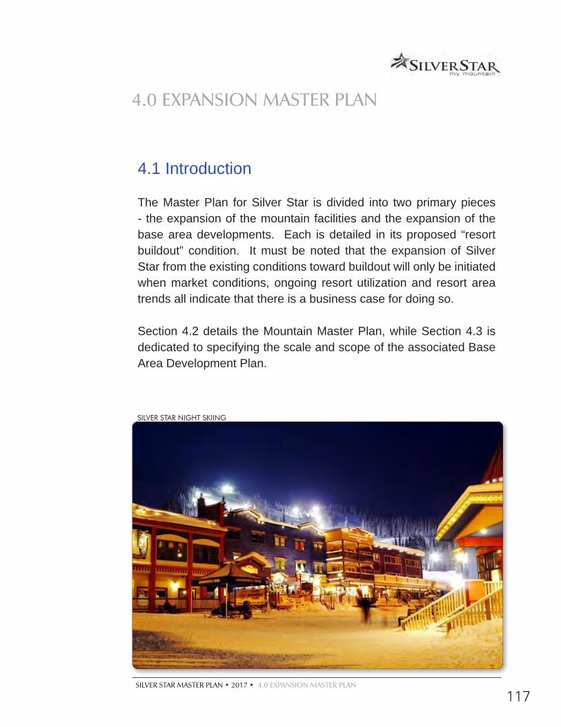
SILVER STAR MASTER PLAN • 2017 • 4.0 EXPANSION MASTER PLAN
117
4.1 Introduction
The Master Plan for Silver Star is divided into two primary pieces - the expansion of the mountain facilities and the expansion of the base area developments. Each is detailed in its proposed “resort buildout” condition. It must be noted that the expansion of Silver Star from the existing conditions toward buildout will only be initiated when market conditions, ongoing resort utilization and resort area trends all indicate that there is a business case for doing so.
Section 4.2 details the Mountain Master Plan, while Section 4.3 is dedicated to specifying the scale and scope of the associated Base Area Development Plan.
4.0 EXPANSION MASTER PLAN
SILVER STAR NIGHT SKIING
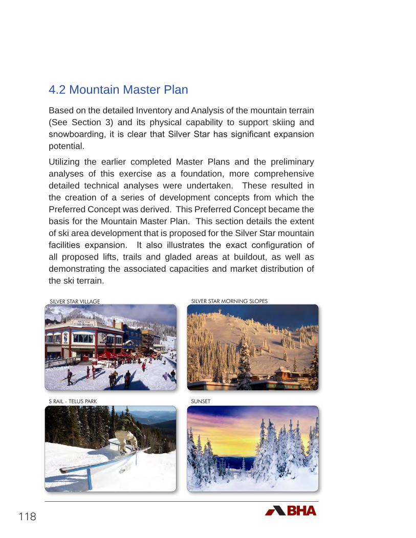
118
4.2 Mountain Master PlanBased on the detailed Inventory and Analysis of the mountain terrain (See Section 3) and its physical capability to support skiing and snowboarding, it is clear that Silver Star has significant expansion potential.
Utilizing the earlier completed Master Plans and the preliminary analyses of this exercise as a foundation, more comprehensive detailed technical analyses were undertaken. These resulted in the creation of a series of development concepts from which the Preferred Concept was derived. This Preferred Concept became the basis for the Mountain Master Plan. This section details the extent of ski area development that is proposed for the Silver Star mountain facilities expansion. It also illustrates the exact configuration of all proposed lifts, trails and gladed areas at buildout, as well as demonstrating the associated capacities and market distribution of the ski terrain.
SILVER STAR VILLAGE
S RAIL - TELUS PARK
SILVER STAR MORNING SLOPES
SUNSET
SILVER STAR MASTER PLAN • 2017 • 4.0 EXPANSION MASTER PLAN
119
4.2.1 MOUNTAIN DEVELOPMENT GOALS
Building upon the identified goals and objectives of the resort as a whole (see Section 1: Introduction), the following development goals were envisioned for the mountain, the skiing and snowboarding and the associated attractions:
d Develop terrain that offers something for everyone (from traditional ski runs to gladed, adventure terrain for all ability levels) that reinforces the diverse needs of families;
d Develop cruising runs for family fun;
d Develop Beginner terrain to the greatest extent possible in close proximity to the Village;
d Develop terrain that is designed to encourage an advancement of skills;
d Develop Intermediate/entry level glades that are ‘feathered’ into more advanced gladed terrain;
d Realize efficiencies within existing terrain through modifications and glading;
d Upgrade and modernize the ski lift systems;
d Preserve, develop and enhance the ski to/ski from capabilities of the resort residential development;
d Create new terrain that will excite and inspire the skier marketplace;
d Develop a comprehensive snowmaking system, especially for south facing, lower elevation slopes, that utilizes state of the art technologies to ensure a reliable snowpack;
d Develop the terrain park to a level that exceeds the market expectations and encourages a wide range of skills development.
120
As such, the overarching planning goal of the Mountain Development Plan is to provide the blueprint that defines, describes and guides the development of a cutting edge alpine skiing and snowboard product that anticipates and capitalizes on evolving market trends; establishes a unique and distinctive character; and is fundamentally about ‘mountain play’ on a year-round basis.
The focused vision of the Silver Star development team has led to the specialized application of the new design criteria contained within the All Season Resort Guidelines (ASRG). Responding to a more powder skiing oriented expectation from the skier marketplace, Silver Star has moved toward solidifying its status as a destination mountain resort by applying significantly lower densities than those used in the 1994 Master Plan.
The existing mountain infrastructure was developed using older design considerations, notably the ‘1996 Guidelines to Alpine Ski Area Development in British Columbia’. As a result, lifts and trails were developed applying higher densities than are now deemed to be acceptable in today’s skier marketplace. Working towards the desired high quality skiing experience, the proposed Mountain Development Plan incorporates the lowest possible densities. Combining the design criteria for the existing and the proposed facilities, the overall average density at the resort will ultimately be much lower than the current medium densities, aligning the quality of the skiing product with the expectations of the market.
4.2.2 SKI PODS
The existing and proposed ski pods are illustrated in Figure 4-1. Pods A through G contain the existing lift and trail system. There will be additional trails, glading and lifts developed in these areas, designed to improve the quality of the skiing experience. Pods H through O are new. These pods, individually and collectively, will move Silver Star’s skiing into a well balanced and integrated destination resort experience.
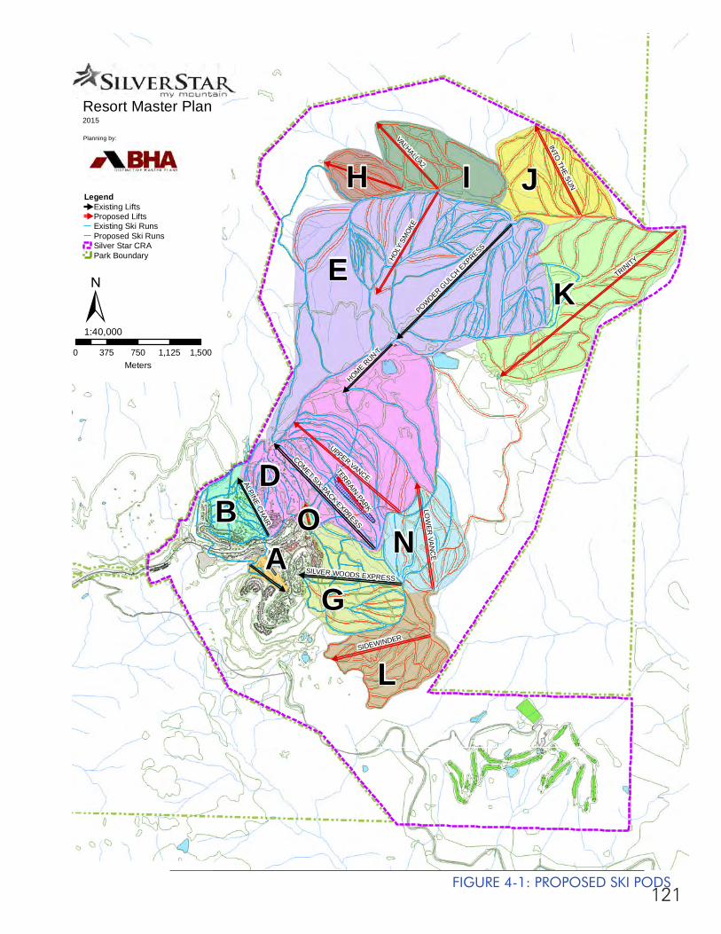
121
#
#
#
#
#
#
#
#
#
#
#
#
#
#
#
#
E
D
K
I J
L
G
NB
H
AO
TRINITY
UPPER VANCE
HOLY
SM
OKE
VALHALLA2
SIDEWINDER
LOW
ER VA
NC
E
INTO
THE SUN
POWDER GULC
H EXPRESS
COMET SIX-PACK EXPRESS
HOME RUN T
ALPINE CHAIR
SILVER WOODS EXPRESS
TERRAIN-PARK
Resort Master Plan2015
Planning by:
0 375 750 1,125 1,500Meters
1:40,000
Legend#
Existing Lifts#
Proposed LiftsExisting Ski RunsProposed Ski RunsSilver Star CRAPark Boundary
±
FIGURE 4-1: PROPOSED SKI PODS
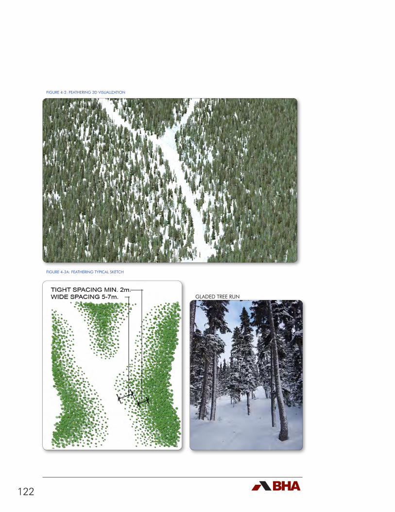
122
FIGURE 4-2: FEATHERING 3D VISUALIZATION
FIGURE 4-2A: FEATHERING TYPICAL SKETCH
GLADED TREE RUN
SILVER STAR MASTER PLAN • 2017 • 4.0 EXPANSION MASTER PLAN
123
4.2.3 PROPOSED GLADED TERRAIN
At buildout, gladed skiing on the mountain will be expanded from the current 120 hectares to over 413 hectares. It is proposed that the gladed terrain will be developed using a feathering technique from the ski run edges. Feathering ski trail edges is beneficial from both an environmental and recreational perspective. As illustrated in Figures 4-2 and 4-2a, tree spacing will initially be quite wide (5 to 7 metres) from the clear cut of the ski trail. Glading will then become more dense to produce closer spacing (down to a minimum of 2 metres). The lower branches of gladed trees will also be limbed to a height of 3 metres above the maximum snow depth to facilitate clear paths for skiers and boarders.
Feathering forest edges by thinning encourages a brushy transition zone between the open run and the denser stand, which promotes food growth and improved wildlife habitat. In addition, the feathered edge protects against wind blow down and provides greater visual quality across the forest stand.
From a recreational point of view, feathering the edges of ski trails provides an excellent skills development opportunity by making an open-gladed transition zone between the fully cut ski run and the denser gladed areas in between runs. Overall, glading in between runs will provide great adventure terrain for all ability levels and encourages progression to new levels of enjoyment. The approximate breakdown of this gladed terrain by area is 26% intermediate, 70% advanced, and 4% expert.
4.2.4 PROPOSED SKI TRAIL INVENTORY
The proposed expansion of lifts and trails at Silver Star will see adjustments to some of the existing terrain plus the addition of seven new pods of ski area development upon reaching buildout. These
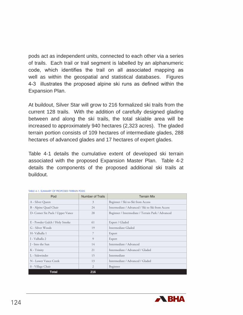
124
pods act as independent units, connected to each other via a series of trails. Each trail or trail segment is labelled by an alphanumeric code, which identifies the trail on all associated mapping as well as within the geospatial and statistical databases. Figures 4-3 illustrates the proposed alpine ski runs as defined within the Expansion Plan.
At buildout, Silver Star will grow to 216 formalized ski trails from the current 128 trails. With the addition of carefully designed glading between and along the ski trails, the total skiable area will be increased to approximately 940 hectares (2,323 acres). The gladed terrain portion consists of 109 hectares of intermediate glades, 288 hectares of advanced glades and 17 hectares of expert glades.
Table 4-1 details the cumulative extent of developed ski terrain associated with the proposed Expansion Master Plan. Table 4-2 details the components of the proposed additional ski trails at buildout.
TABLE 4-1: SUMMARY OF PROPOSED TERRAIN PODS
Pod Number of Trails Terrain Mix
A - Silver Queen 3 Beginner / Ski to-Ski from Access
B - Alpine Quad Chair 24 Intermediate / Advanced / Ski to Ski from Access
D- Comet Six Pack / Upper Vance 28 Beginner / Intermediate / Terrain Park / Advanced
E - Powder Gulch / Holy Smoke 61 Expert / Gladed
G - Silver Woods 19 Intermediate Gladed
H- Valhalla 1 7 Expert
I - Valhalla 2 9 Expert
J - Into the Sun 14 Intermediate / Advanced
K - Trinity 21 Intermediate / Advanced / Gladed
L - Sidewinder 15 Intermediate
N - Lower Vance Creek 13 Intermediate / Advanced / Gladed
0 - Village Chair 2 Beginner
Total 216
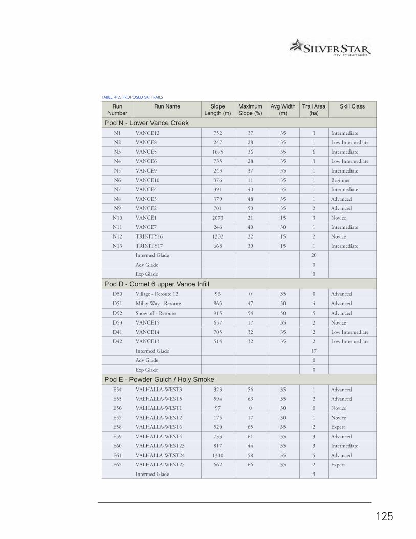
SILVER STAR MASTER PLAN • 2017 • 4.0 EXPANSION MASTER PLAN
125
TABLE 4-2: PROPOSED SKI TRAILS
Run Number
Run Name Slope Length (m)
Maximum Slope (%)
Avg Width (m)
Trail Area (ha)
Skill Class
Pod N - Lower Vance CreekN1 VANCE12 752 37 35 3 Intermediate
N2 VANCE8 247 28 35 1 Low Intermediate
N3 VANCE5 1675 36 35 6 Intermediate
N4 VANCE6 735 28 35 3 Low Intermediate
N5 VANCE9 243 37 35 1 Intermediate
N6 VANCE10 376 11 35 1 Beginner
N7 VANCE4 391 40 35 1 Intermediate
N8 VANCE3 379 48 35 1 Advanced
N9 VANCE2 701 50 35 2 Advanced
N10 VANCE1 2073 21 15 3 Novice
N11 VANCE7 246 40 30 1 Intermediate
N12 TRINITY16 1302 22 15 2 Novice
N13 TRINITY17 668 39 15 1 Intermediate
Intermed Glade 20
Adv Glade 0
Exp Glade 0
Pod D - Comet 6 upper Vance InfillD50 Village - Reroute 12 96 0 35 0 Advanced
D51 Milky Way - Reroute 865 47 50 4 Advanced
D52 Show off - Reroute 915 54 50 5 Advanced
D53 VANCE15 657 17 35 2 Novice
D41 VANCE14 705 32 35 2 Low Intermediate
D42 VANCE13 514 32 35 2 Low Intermediate
Intermed Glade 17
Adv Glade 0
Exp Glade 0
Pod E - Powder Gulch / Holy SmokeE54 VALHALLA-WEST3 323 56 35 1 Advanced
E55 VALHALLA-WEST5 594 63 35 2 Advanced
E56 VALHALLA-WEST1 97 0 30 0 Novice
E57 VALHALLA-WEST2 175 17 30 1 Novice
E58 VALHALLA-WEST6 520 65 35 2 Expert
E59 VALHALLA-WEST4 733 61 35 3 Advanced
E60 VALHALLA-WEST23 817 44 35 3 Intermediate
E61 VALHALLA-WEST24 1310 58 35 5 Advanced
E62 VALHALLA-WEST25 662 66 35 2 Expert
Intermed Glade 3
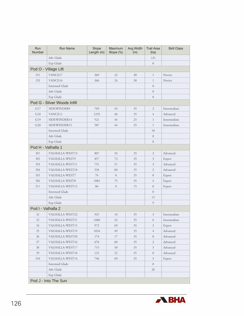
126
Run Number
Run Name Slope Length (m)
Maximum Slope (%)
Avg Width (m)
Trail Area (ha)
Skill Class
Adv Glade 121
Exp Glade 0
Pod O - Village LiftO1 VANCE17 369 22 30 1 Novice
O2 VANCE16 366 24 30 1 Novice
Intermed Glade 0
Adv Glade 0
Exp Glade 0
Pod G - Silver Woods InfillG17 SIDEWINDER9 703 43 35 2 Intermediate
G18 VANCE11 1235 46 35 4 Advanced
G19 SIDEWINDER14 521 44 25 1 Intermediate
G20 SIDEWINDER15 587 44 25 1 Intermediate
Intermed Glade 10
Adv Glade 8
Exp Glade 0
Pod H - Valhalla 1H1 VALHALLA-WEST13 807 54 35 3 Advanced
H2 VALHALLA-WEST9 857 72 35 3 Expert
H3 VALHALLA-WEST11 751 51 35 3 Advanced
H4 VALHALLA-WEST10 534 60 35 2 Advanced
H5 VALHALLA-WEST7 76 0 35 0 Expert
H6 VALHALLA-WEST8 1082 75 35 4 Expert
I11 VALHALLA-WEST12 86 0 15 0 Expert
Intermed Glade 0
Adv Glade 15
Exp Glade 9
Pod I - Valhalla 2I2 VALHALLA-WEST22 925 16 35 3 Intermediate
I3 VALHALLA-WEST21 1680 42 35 6 Intermediate
I4 VALHALLA-WEST15 973 69 35 3 Expert
I5 VALHALLA-WEST19 1034 49 35 4 Advanced
I6 VALHALLA-WEST20 174 17 35 0 Advanced
I7 VALHALLA-WEST16 676 60 35 2 Advanced
I8 VALHALLA-WEST17 715 50 35 3 Advanced
I9 VALHALLA-WEST18 122 22 35 0 Advanced
I10 VALHALLA-WEST14 746 69 35 3 Expert
Intermed Glade 0
Adv Glade 26
Exp Glade
Pod J - Into The Sun
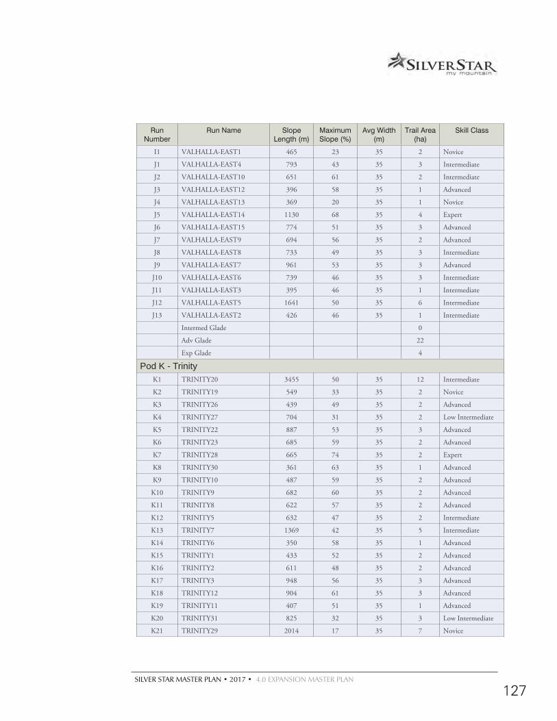
SILVER STAR MASTER PLAN • 2017 • 4.0 EXPANSION MASTER PLAN
127
Run Number
Run Name Slope Length (m)
Maximum Slope (%)
Avg Width (m)
Trail Area (ha)
Skill Class
I1 VALHALLA-EAST1 465 23 35 2 Novice
J1 VALHALLA-EAST4 793 43 35 3 Intermediate
J2 VALHALLA-EAST10 651 61 35 2 Intermediate
J3 VALHALLA-EAST12 396 58 35 1 Advanced
J4 VALHALLA-EAST13 369 20 35 1 Novice
J5 VALHALLA-EAST14 1130 68 35 4 Expert
J6 VALHALLA-EAST15 774 51 35 3 Advanced
J7 VALHALLA-EAST9 694 56 35 2 Advanced
J8 VALHALLA-EAST8 733 49 35 3 Intermediate
J9 VALHALLA-EAST7 961 53 35 3 Advanced
J10 VALHALLA-EAST6 739 46 35 3 Intermediate
J11 VALHALLA-EAST3 395 46 35 1 Intermediate
J12 VALHALLA-EAST5 1641 50 35 6 Intermediate
J13 VALHALLA-EAST2 426 46 35 1 Intermediate
Intermed Glade 0
Adv Glade 22
Exp Glade 4
Pod K - TrinityK1 TRINITY20 3455 50 35 12 Intermediate
K2 TRINITY19 549 33 35 2 Novice
K3 TRINITY26 439 49 35 2 Advanced
K4 TRINITY27 704 31 35 2 Low Intermediate
K5 TRINITY22 887 53 35 3 Advanced
K6 TRINITY23 685 59 35 2 Advanced
K7 TRINITY28 665 74 35 2 Expert
K8 TRINITY30 361 63 35 1 Advanced
K9 TRINITY10 487 59 35 2 Advanced
K10 TRINITY9 682 60 35 2 Advanced
K11 TRINITY8 622 57 35 2 Advanced
K12 TRINITY5 632 47 35 2 Intermediate
K13 TRINITY7 1369 42 35 5 Intermediate
K14 TRINITY6 350 58 35 1 Advanced
K15 TRINITY1 433 52 35 2 Advanced
K16 TRINITY2 611 48 35 2 Advanced
K17 TRINITY3 948 56 35 3 Advanced
K18 TRINITY12 904 61 35 3 Advanced
K19 TRINITY11 407 51 35 1 Advanced
K20 TRINITY31 825 32 35 3 Low Intermediate
K21 TRINITY29 2014 17 35 7 Novice
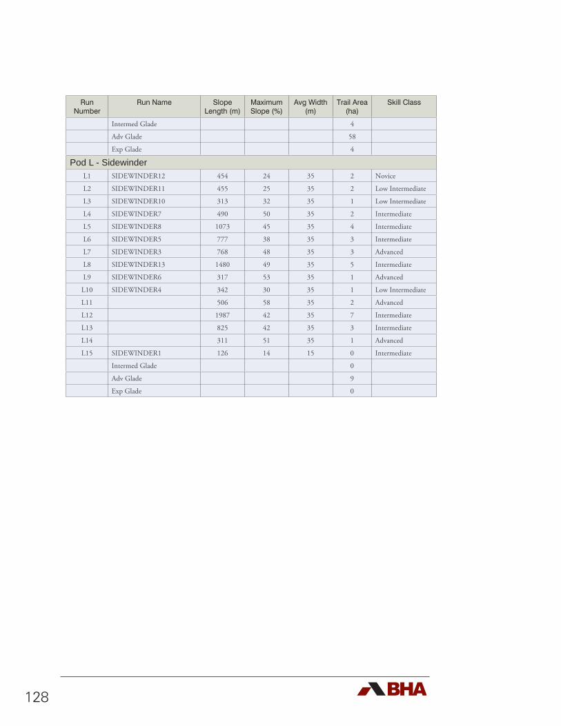
128
Run Number
Run Name Slope Length (m)
Maximum Slope (%)
Avg Width (m)
Trail Area (ha)
Skill Class
Intermed Glade 4
Adv Glade 58
Exp Glade 4
Pod L - SidewinderL1 SIDEWINDER12 454 24 35 2 Novice
L2 SIDEWINDER11 455 25 35 2 Low Intermediate
L3 SIDEWINDER10 313 32 35 1 Low Intermediate
L4 SIDEWINDER7 490 50 35 2 Intermediate
L5 SIDEWINDER8 1073 45 35 4 Intermediate
L6 SIDEWINDER5 777 38 35 3 Intermediate
L7 SIDEWINDER3 768 48 35 3 Advanced
L8 SIDEWINDER13 1480 49 35 5 Intermediate
L9 SIDEWINDER6 317 53 35 1 Advanced
L10 SIDEWINDER4 342 30 35 1 Low Intermediate
L11 506 58 35 2 Advanced
L12 1987 42 35 7 Intermediate
L13 825 42 35 3 Intermediate
L14 311 51 35 1 Advanced
L15 SIDEWINDER1 126 14 15 0 Intermediate
Intermed Glade 0
Adv Glade 9
Exp Glade 0
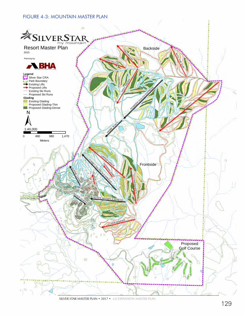
SILVER STAR MASTER PLAN • 2017 • 4.0 EXPANSION MASTER PLAN
129
FIGURE 4-3: MOUNTAIN MASTER PLAN
TRINITY
UPPER VANCE
HOLY
SM
OKE
VALHALLA2
SIDEWINDER
LOW
ER VA
NC
E
VALHALLA1
INTO
THE SUN
POWDER GULC
H EXPRESS
COMET SIX-PACK EXPRESSHOME R
UN T
ALPINE CHAIR
SILVER WOODS EXPRESS
SILVER QUEEN
TERRAIN-PARK
VILLAGE LIFT
Backside
ProposedGolf Course
Frontside
Resort Master Plan2015
Planning by:
0 490 980 1,470Meters
1:40,000
LegendSilver Star CRAPark Boundary#
Existing Lifts#
Proposed LiftsExisting Ski RunsProposed Ski Runs
GladingExisting GladingProposed Glading-ThinProposed Glading-Dense
±

130
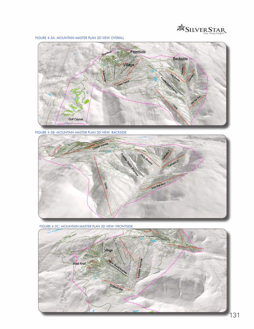
SILVER STAR MASTER PLAN • 2017 • 4.0 EXPANSION MASTER PLAN
131
FIGURE 4-3A: MOUNTAIN MASTER PLAN 3D VIEW OVERALL
FIGURE 4-3B: MOUNTAIN MASTER PLAN 3D VIEW- BACKSIDE
FIGURE 4-3C: MOUNTAIN MASTER PLAN 3D VIEW- FRONTSIDE
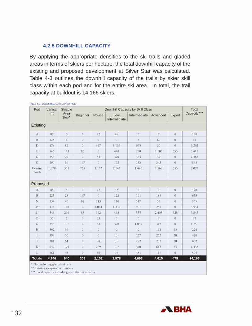
132
4.2.5 DOWNHILL CAPACITY
By applying the appropriate densities to the ski trails and gladed areas in terms of skiers per hectare, the total downhill capacity of the existing and proposed development at Silver Star was calculated. Table 4-3 outlines the downhill capacity of the trails by skier skill class within each pod and for the entire ski area. In total, the trail capacity at buildout is 14,166 skiers.
TABLE 4-3: DOWNHILL CAPACITY BY POD
Pod Vertical (m)
Skiable Area (ha)*
Downhill Capacity by Skill Class Total Capacity***Beginner Novice Low
IntermediateIntermediate Advanced Expert
Existing
A 88 3 0 72 48 0 0 0 120
B 225 4 0 0 0 8 60 0 68
D 474 82 0 947 1,159 665 30 0 3,263
E 543 143 88 0 448 250 1,105 355 2,415
G 358 29 0 83 320 334 32 0 1,385
C 290 39 147 0 172 183 343 0 845
Existing Totals
1,978 301 235 1,102 2,147 1,440 1,569 355 8,097
ProposedA 88 3 0 72 48 0 0 0 120
B 225 28 147 0 128 191 186 0 653
N 337 46 68 213 110 517 57 0 965
D** 474 140 0 1,044 1,339 901 250 0 3,534
E* 544 290 88 192 448 355 2,433 328 3,843
O 55 2 0 93 0 0 0 0 93
G 358 107 0 83 320 1,039 312 0 1,756
H 392 39 0 0 0 0 161 63 224
I 394 50 0 0 0 137 253 30 420
J 381 61 0 88 0 282 233 30 632
K 637 129 0 269 107 320 613 24 1,333
L 361 45 0 48 78 351 117 0 593
Totals 4,246 940 303 2,102 2,578 4,093 4,615 475 14,166* Not including gladed ski runs** Existing + expansion numbers*** Total capacity includes gladed ski run capacity
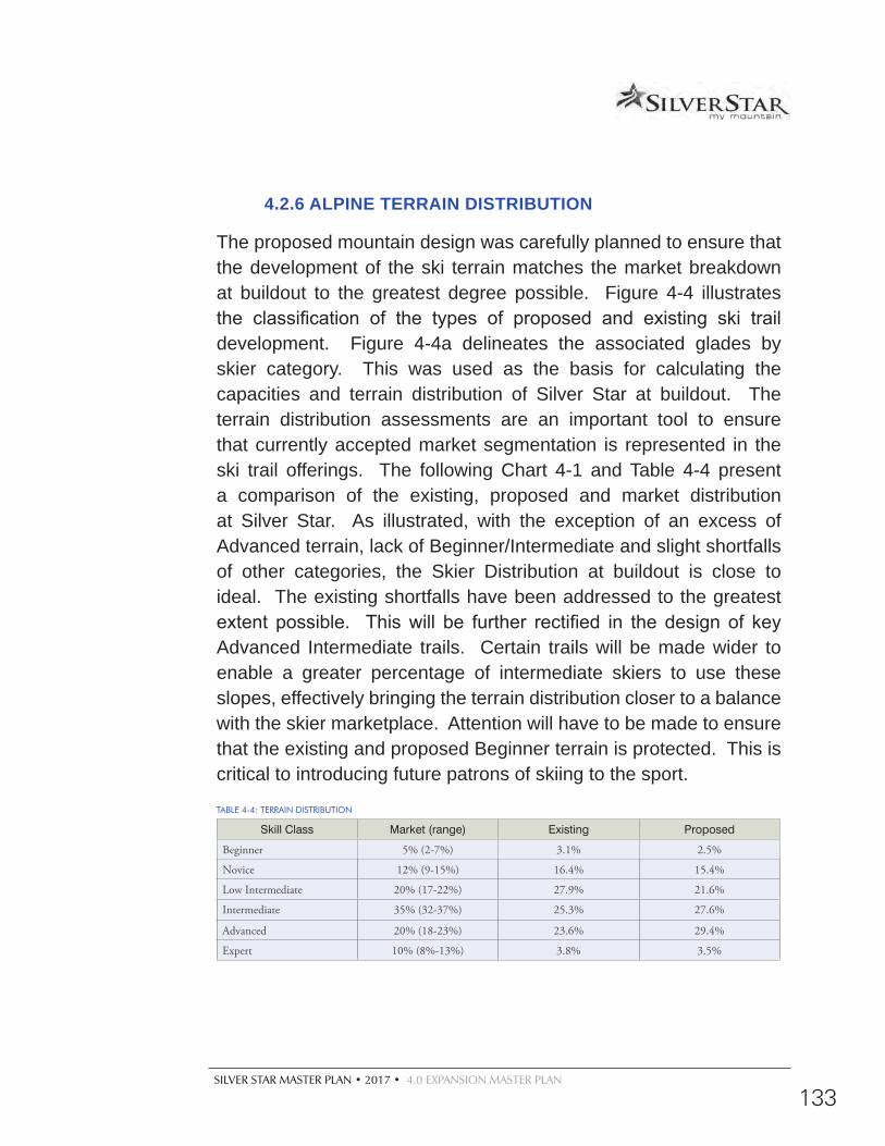
SILVER STAR MASTER PLAN • 2017 • 4.0 EXPANSION MASTER PLAN
133
4.2.6 ALPINE TERRAIN DISTRIBUTION
The proposed mountain design was carefully planned to ensure that the development of the ski terrain matches the market breakdown at buildout to the greatest degree possible. Figure 4-4 illustrates the classification of the types of proposed and existing ski trail development. Figure 4-4a delineates the associated glades by skier category. This was used as the basis for calculating the capacities and terrain distribution of Silver Star at buildout. The terrain distribution assessments are an important tool to ensure that currently accepted market segmentation is represented in the ski trail offerings. The following Chart 4-1 and Table 4-4 present a comparison of the existing, proposed and market distribution at Silver Star. As illustrated, with the exception of an excess of Advanced terrain, lack of Beginner/Intermediate and slight shortfalls of other categories, the Skier Distribution at buildout is close to ideal. The existing shortfalls have been addressed to the greatest extent possible. This will be further rectified in the design of key Advanced Intermediate trails. Certain trails will be made wider to enable a greater percentage of intermediate skiers to use these slopes, effectively bringing the terrain distribution closer to a balance with the skier marketplace. Attention will have to be made to ensure that the existing and proposed Beginner terrain is protected. This is critical to introducing future patrons of skiing to the sport.
TABLE 4-4: TERRAIN DISTRIBUTION
Skill Class Market (range) Existing Proposed
Beginner 5% (2-7%) 3.1% 2.5%
Novice 12% (9-15%) 16.4% 15.4%
Low Intermediate 20% (17-22%) 27.9% 21.6%
Intermediate 35% (32-37%) 25.3% 27.6%
Advanced 20% (18-23%) 23.6% 29.4%
Expert 10% (8%-13%) 3.8% 3.5%
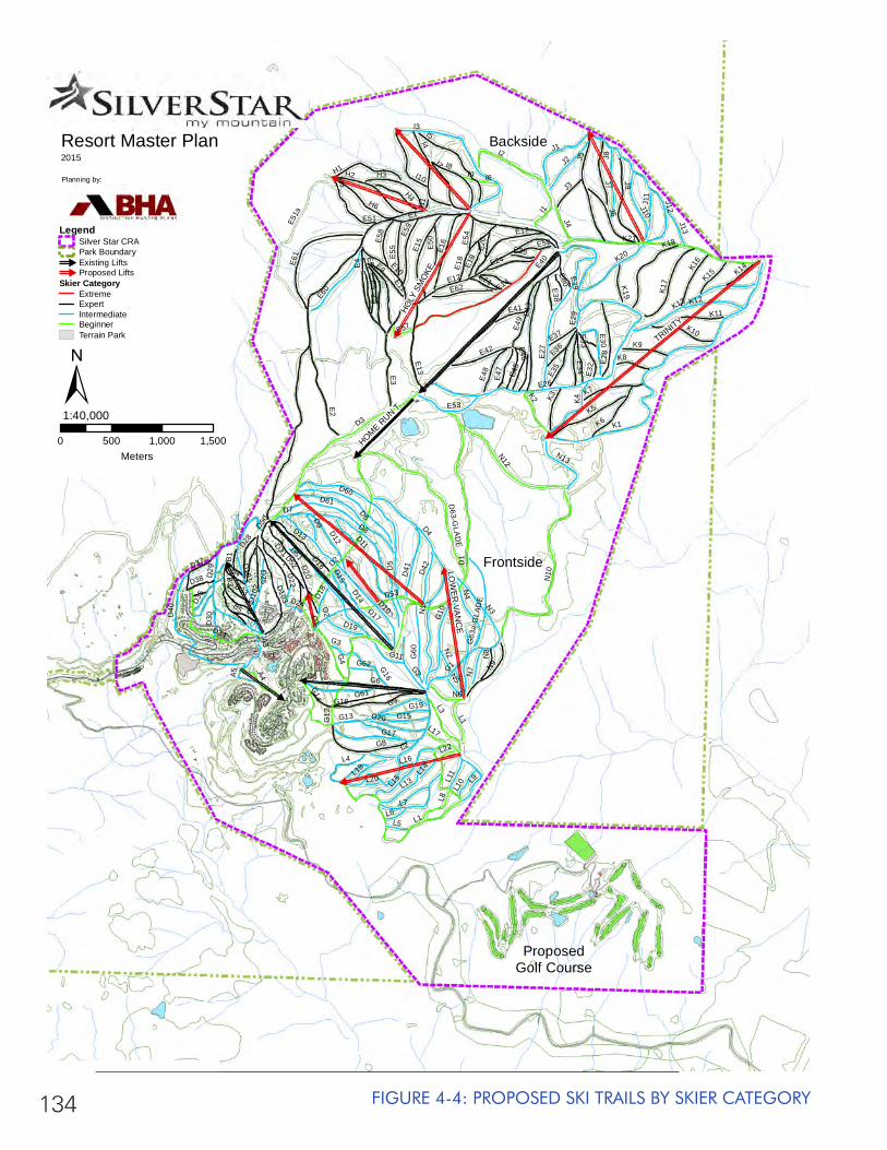
134
dd
FIGURE 4-4: PROPOSED SKI TRAILS BY SKIER CATEGORY
E1
D1
D3
D5D2
D8
E12
E40
E26
D10
D4
D6
E14
E27
E2
E4
G1
E43
G10
E3
G6
D40
E49
D60
G8
D11
D20
E51a
E9
D29
G13G12
B3
E7
D34
E15
E13
E6
E16
E17
D17
G4
A4
D101
G2
G61
D61
G60
E28
D15
G9
D13
D16
E10
D21
E18
D103
E42
G15
D12E3
5
B5
E53
E5
G5
E50
D25
E33
D7
D22
D63-G
LAD
E
A3
E51
E34
G14
E48
E11
E24
E32
E30
G16
D14
D37
E45
E47
D28
E46
D9
D10
2
D19
E52
E19
B4
G11
B6
E41
E38
A5
E37
D35
G3
E21
D24
E80
B1
E36
D33
D18
D30
G63
a-G
LAD
E
D38
G62
E20
E25
E39
E29
K1
I3
K21
I5
L1
I4
J5
N3
N10
I2
J9
L2
J12
K13
H6
I8I7
K5
J6
N12
J8
J1
L7
J7
G18
H2
J2
N1
L3
N4
H1
K4
E61
K6
H3
K7
N9
K17
I1
I10
D52
K20
D51
L15
E60
K18
L13
J10
L9
D41
H4
E59
K9
L8
G17
J4K10
D53
K3
K2
E62
J3
L4
K11K12
K16E
55
G20
N7
L18
N13
N6
D42
N8
G19
K8
J13
E58
O1
J11
O2
K15
I6
K19
L6
L11
L5
N2
K14
L10
N5
E54
I9
L14
L17
E57
L20
L22
L16
I11
H5
D50
L1
TRINITY
HOLY
SM
OKE
LOW
ER VA
NC
EHOME R
UN T
Backside
ProposedGolf Course
Frontside
Resort Master Plan2015
Planning by:
0 500 1,000 1,500Meters
1:40,000±
LegendSilver Star CRAPark Boundary#
Existing Lifts#
Proposed LiftsSkier Category
ExtremeExpertIntermediateBeginnerTerrain Park
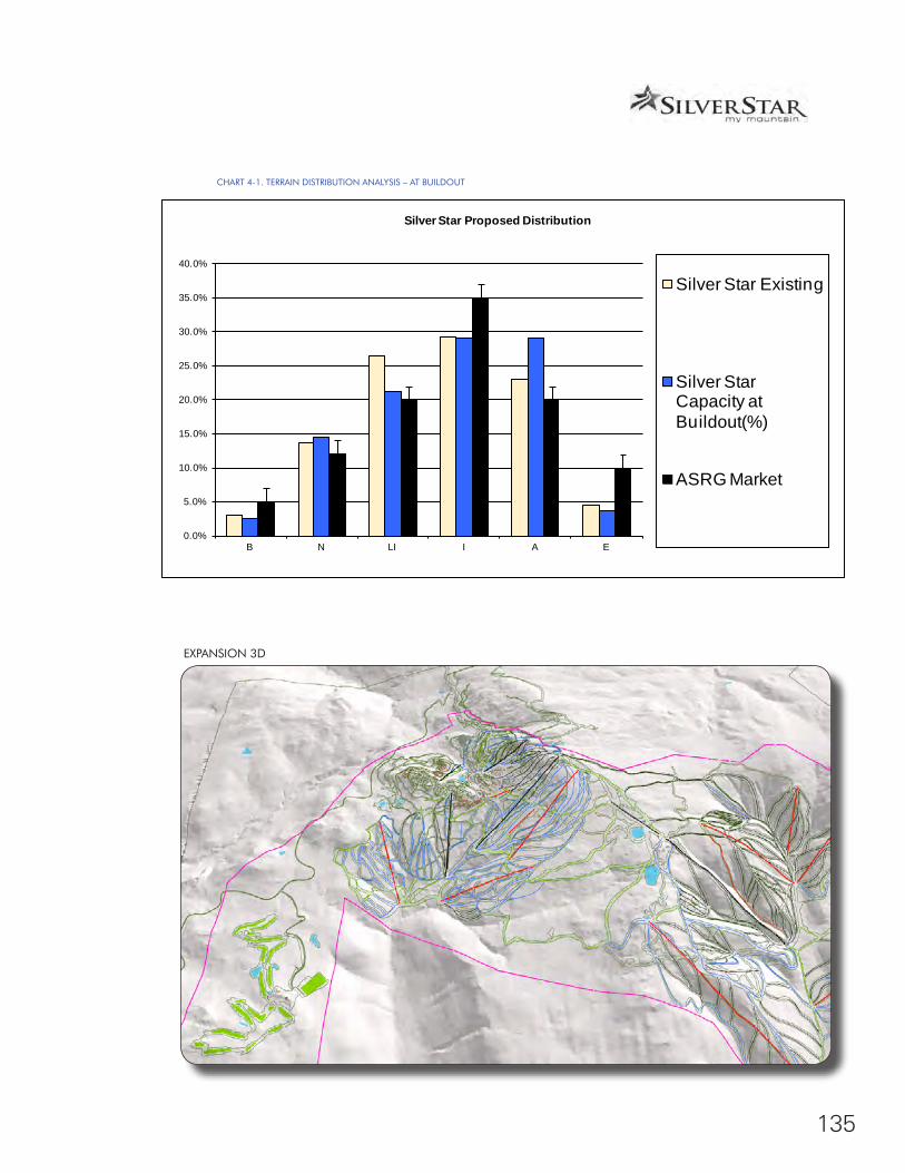
135
CHART 4-1. TERRAIN DISTRIBUTION ANALYSIS – AT BUILDOUT
EXPANSION 3D
0.0%
5.0%
10.0%
15.0%
20.0%
25.0%
30.0%
35.0%
40.0%
B N LI I A E
Silver Star Proposed Distribution
Silver Star Existing
Silver Star Capacity at Buildout(%)
ASRG Market
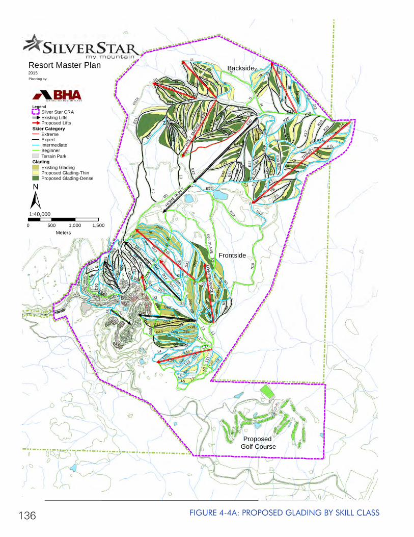
136 FIGURE 4-4A: PROPOSED GLADING BY SKILL CLASS
E1
D1
D3
D5D2
D8
E12
E40
E26
D10
D4
D6
E14
E27
E2
E4
G1
E43
G10
E3
G6
D40
E49
D60
G8
D11
D20
E51a
E9
D29
G13G12
B3
E7
D34
E15
E13
E6
E16
E17
D17
G4
A4
D101
G2
G61
D61
G60
E28
D15
G9
D13
D16
E10
D21
E18
D103
E42
G15
D12
E35
B5
E53
E5
G5
E50
D25
E33
D7
D22
D63-G
LAD
E
A3
E51
E34
G14
E48
E11
E24
E32
E30
G16
D14
D37
E45
E47
D28
E46
D9
D10
2
D19
E52
E19
B4
G11
B6
E41
E38
A5
E37
D35
G3
E21
D24
E80
B1
E36
D33
D18
D30
G63
a-G
LAD
E
D38
G62
E20
E25
E39
E29
K1
I3
K21
I5
L1
I4
J5
N3
N10
I2
J9
L2
J12
K13
H6
I8I7
K5
J6
N12
J8
J1
L7
J7
G18
H2
J2
N1
L3
N4
H1
K4
E61
K6
H3
K7
N9
K17
I1
I10
D52
K20
D51
L15
E60
K18
L13
J10
L9
D41
H4
E59
K9
L8
G17
J4K10
D53
K3
K2
E62
J3
L4
K11K12
K16E
55
G20
N7
L18
N13
N6
D42
N8
G19
K8
J13
E58
O1
J11
O2
K15
I6
K19
L6
L11
L5
N2
K14
L10
N5
E54
I9
L14
L17
E57
L20
L22
L16
I11
H5
D50
L1
TRINITY
HOLY
SM
OKE
LOW
ER VA
NC
EHOME R
UN T
Backside
Proposed Golf Course
Frontside
Resort Master Plan2015Planning by:
0 500 1,000 1,500Meters
1:40,000±
LegendSilver Star CRA#
Existing Lifts#
Proposed LiftsSkier Category
ExtremeExpertIntermediateBeginnerTerrain Park
GladingExisting GladingProposed Glading-ThinProposed Glading-Dense
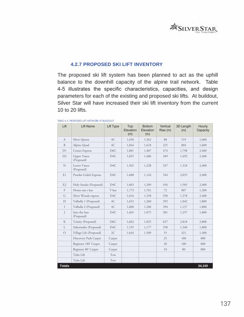
137
4.2.7 PROPOSED SKI LIFT INVENTORY
The proposed ski lift system has been planned to act as the uphill balance to the downhill capacity of the alpine trail network. Table 4-5 illustrates the specific characteristics, capacities, and design parameters for each of the existing and proposed ski lifts. At buildout, Silver Star will have increased their ski lift inventory from the current 10 to 20 lifts.
TABLE 4-5: PROPOSED LIFT NETWORK AT BUILDOUT
Lift Lift Name Lift Type Top Elevation
(m)
Bottom Elevation
(m)
Vertical Rise (m)
3D Length (m)
Hourly Capacity
A Silver Queen 4C 1,650 1,562 88 519 1,600
B Alpine Quad 4C 1,844 1,618 225 804 1,600
D1 Comet Express D6C 1,881 1,407 474 1,798 2,400
D2 Upper Vance (Proposed)
D4C 1,835 1,486 349 1,693 2,400
N Lower Vance (Proposed)
D4C 1,565 1,228 337 1,318 2,400
E1 Powder Gulch Express D4C 1,688 1,144 544 2,035 2,400
E2 Holy Smoke (Proposed) D4C 1,665 1,209 456 1,505 2,400
F Home run t-bar T-bar 1,773 1,701 72 807 1,200
G Silver Woods express D4C 1,616 1,258 358 1,278 2,400
H Valhalla 1 (Proposed) 4C 1,652 1,260 392 1,042 1,800
I Valhalla 2 (Proposed) 4C 1,600 1,206 394 1,137 1,800
J Into the Sun (Proposed)
D4C 1,465 1,075 381 1,257 1,800
K Trinity (Proposed) D6C 1,662 1,025 637 2,818 2,800
L Sidewinder (Proposed) D4C 1,535 1,177 358 1,340 1,800
O Village Lift (Proposed) 2C 1,644 1,589 55 321 1,400
Discovery Park Carpet Carpet 25 180 800
Beginner 180’ Carpet Carpet 20 180 800
Beginner 80’ Carpet Carpet 10 80 800
Tube Lift Tow
Tube Lift Tow
Totals 34,100
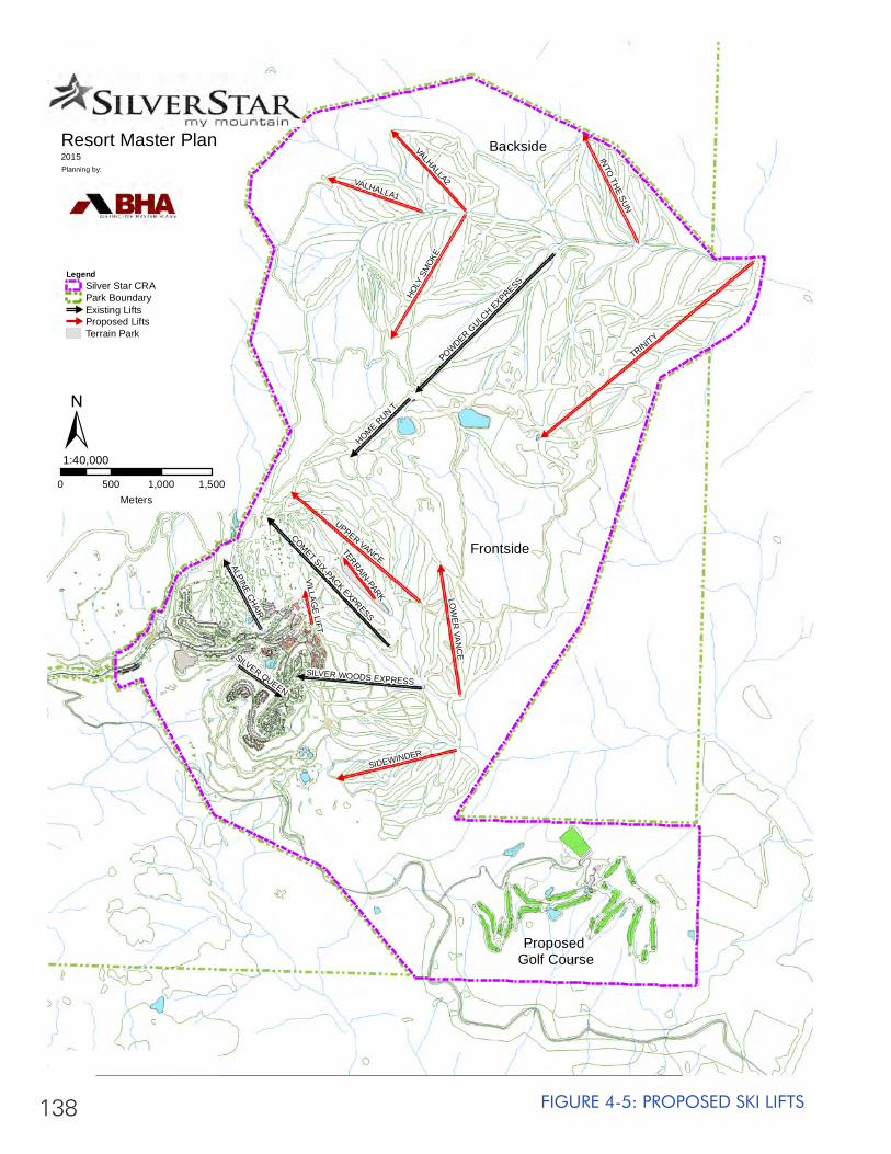
138 FIGURE 4-5: PROPOSED SKI LIFTS
TRINITY
UPPER VANCE
HOLY
SM
OKE
VALHALLA2
SIDEWINDER
LOW
ER VA
NC
E
VALHALLA1
INTO
THE SUN
POWDER GULC
H EXPRESS
COMET SIX-PACK EXPRESS
HOME RUN T
ALPINE CHAIR
SILVER WOODS EXPRESS
SILVER QUEEN
TERRAIN-PARK
VILLAGE LIFT
Backside
Proposed Golf Course
Frontside
Resort Master Plan2015Planning by:
0 500 1,000 1,500Meters
1:40,000±
LegendSilver Star CRAPark Boundary#
Existing Lifts#
Proposed LiftsTerrain Park

139
4.2.8 PROPOSED COMFORTABLE CARRYING CAPACITY
In an effort to establish an optimal skiing experience that is representative of emerging trends in the industry, the actual capacity of Silver Star’s proposed ski trails were calculated using low densities found within the ASRG (see Table 2-5). These numbers are more responsive to industry and market trends that aim to provide a lower density, powder oriented product. They will also produce a skiing experience more consistent with current skier market expectations. Table 4-6 illustrates that the proposed uphill comfortable carrying capacity for Silver Star at buildout is 14,965 skiers per day.
CONVERTED CHAIR LIFT FOR SUMMER BIKING
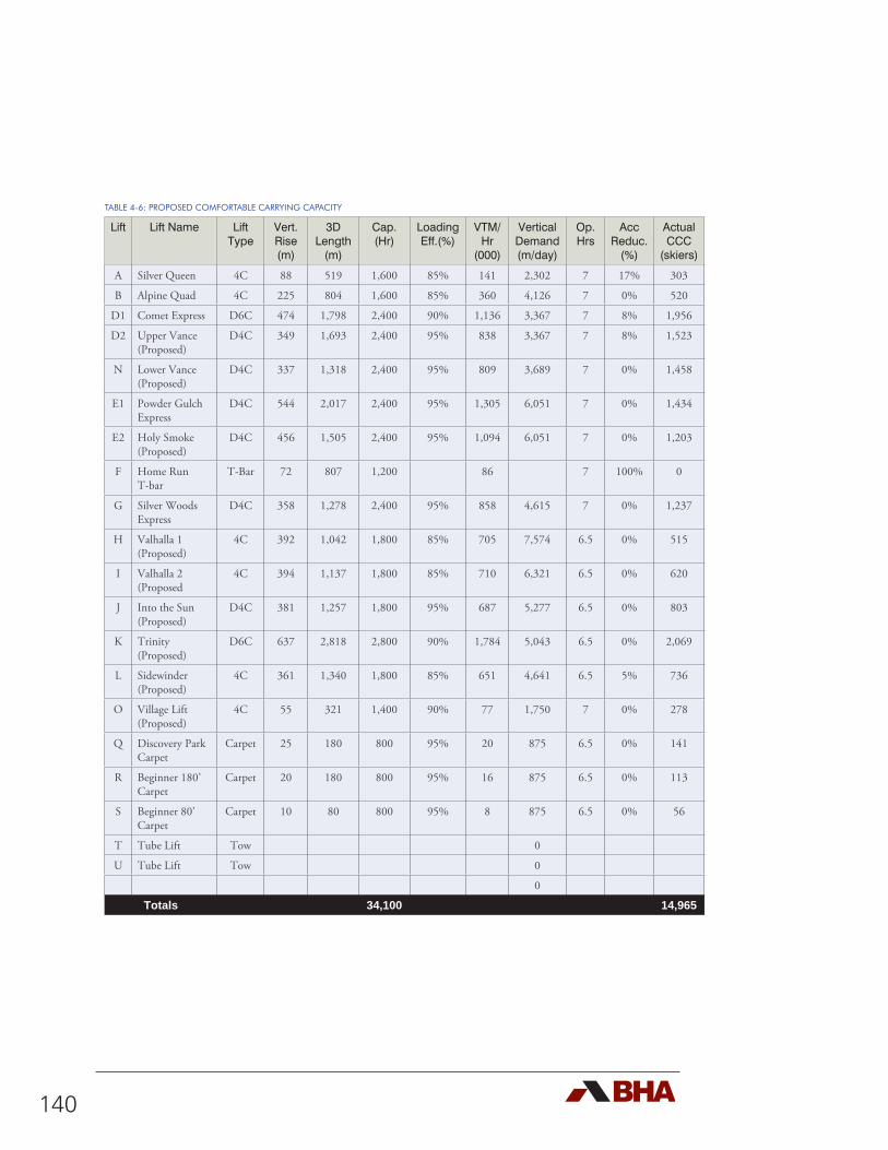
140
TABLE 4-6: PROPOSED COMFORTABLE CARRYING CAPACITY
Lift Lift Name Lift Type
Vert. Rise (m)
3D Length
(m)
Cap. (Hr)
Loading Eff.(%)
VTM/Hr
(000)
Vertical Demand (m/day)
Op. Hrs
Acc Reduc.
(%)
Actual CCC
(skiers)
A Silver Queen 4C 88 519 1,600 85% 141 2,302 7 17% 303
B Alpine Quad 4C 225 804 1,600 85% 360 4,126 7 0% 520
D1 Comet Express D6C 474 1,798 2,400 90% 1,136 3,367 7 8% 1,956
D2 Upper Vance (Proposed)
D4C 349 1,693 2,400 95% 838 3,367 7 8% 1,523
N Lower Vance (Proposed)
D4C 337 1,318 2,400 95% 809 3,689 7 0% 1,458
E1 Powder Gulch Express
D4C 544 2,017 2,400 95% 1,305 6,051 7 0% 1,434
E2 Holy Smoke (Proposed)
D4C 456 1,505 2,400 95% 1,094 6,051 7 0% 1,203
F Home Run T-bar
T-Bar 72 807 1,200 86 7 100% 0
G Silver Woods Express
D4C 358 1,278 2,400 95% 858 4,615 7 0% 1,237
H Valhalla 1 (Proposed)
4C 392 1,042 1,800 85% 705 7,574 6.5 0% 515
I Valhalla 2 (Proposed
4C 394 1,137 1,800 85% 710 6,321 6.5 0% 620
J Into the Sun (Proposed)
D4C 381 1,257 1,800 95% 687 5,277 6.5 0% 803
K Trinity (Proposed)
D6C 637 2,818 2,800 90% 1,784 5,043 6.5 0% 2,069
L Sidewinder (Proposed)
4C 361 1,340 1,800 85% 651 4,641 6.5 5% 736
O Village Lift (Proposed)
4C 55 321 1,400 90% 77 1,750 7 0% 278
Q Discovery Park Carpet
Carpet 25 180 800 95% 20 875 6.5 0% 141
R Beginner 180’ Carpet
Carpet 20 180 800 95% 16 875 6.5 0% 113
S Beginner 80’ Carpet
Carpet 10 80 800 95% 8 875 6.5 0% 56
T Tube Lift Tow 0
U Tube Lift Tow 0
0
Totals 34,100 14,965
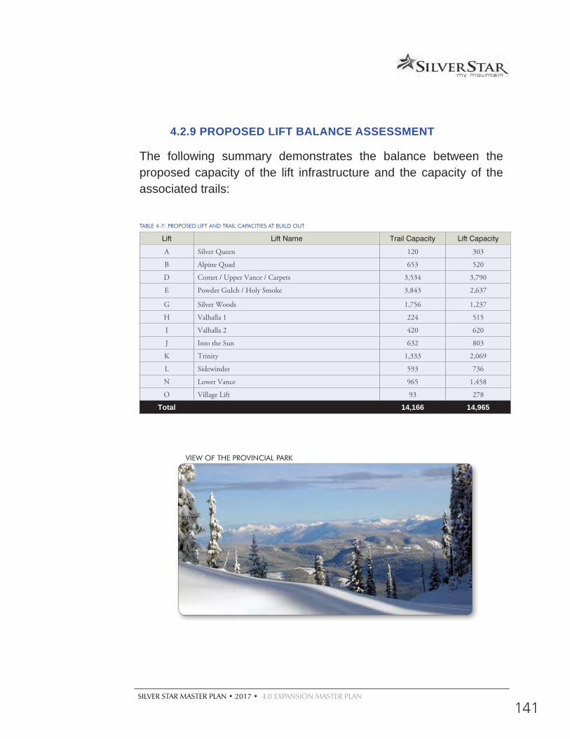
SILVER STAR MASTER PLAN • 2017 • 4.0 EXPANSION MASTER PLAN
141
4.2.9 PROPOSED LIFT BALANCE ASSESSMENT
The following summary demonstrates the balance between the proposed capacity of the lift infrastructure and the capacity of the associated trails:
TABLE 4-7: PROPOSED LIFT AND TRAIL CAPACITIES AT BUILD OUT
Lift Lift Name Trail Capacity Lift Capacity
A Silver Queen 120 303
B Alpine Quad 653 520
D Comet / Upper Vance / Carpets 3,534 3,790
E Powder Gulch / Holy Smoke 3,843 2,637
G Silver Woods 1,756 1,237
H Valhalla 1 224 515
I Valhalla 2 420 620
J Into the Sun 632 803
K Trinity 1,333 2,069
L Sidewinder 593 736
N Lower Vance 965 1,458
O Village Lift 93 278
Total 14,166 14,965
VIEW OF THE PROVINCIAL PARK
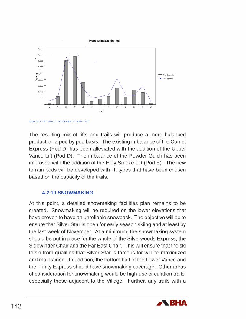
142
CHART 4-2: LIFT BALANCE ASSESSMENT AT BUILD OUT
The resulting mix of lifts and trails will produce a more balanced product on a pod by pod basis. The existing imbalance of the Comet Express (Pod D) has been alleviated with the addition of the Upper Vance Lift (Pod D). The imbalance of the Powder Gulch has been improved with the addition of the Holy Smoke Lift (Pod E). The new terrain pods will be developed with lift types that have been chosen based on the capacity of the trails.
4.2.10 SNOWMAKING
At this point, a detailed snowmaking facilities plan remains to be created. Snowmaking will be required on the lower elevations that have proven to have an unreliable snowpack. The objective will be to ensure that Silver Star is open for early season skiing and at least by the last week of November. At a minimum, the snowmaking system should be put in place for the whole of the Silverwoods Express, the Sidewinder Chair and the Far East Chair. This will ensure that the ski to/ski from qualities that Silver Star is famous for will be maximized and maintained. In addition, the bottom half of the Lower Vance and the Trinity Express should have snowmaking coverage. Other areas of consideration for snowmaking would be high-use circulation trails, especially those adjacent to the Village. Further, any trails with a
0
500
1,000
1,500
2,000
2,500
3,000
3,500
4,000
4,500
A B D E G H I J K L M N O
Cap
acity
Pod
Proposed Balance by Pod
Trail Capacity
Lift Capacity
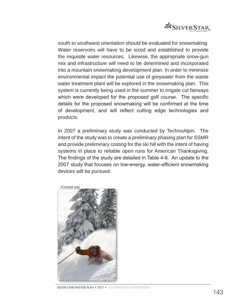
SILVER STAR MASTER PLAN • 2017 • 4.0 EXPANSION MASTER PLAN
143
south to southwest orientation should be evaluated for snowmaking. Water reservoirs will have to be sized and established to provide the requisite water resources. Likewise, the appropriate snow-gun mix and infrastructure will need to be determined and incorporated into a mountain snowmaking development plan. In order to minimize environmental impact the potential use of greywater from the waste water treatment plant will be explored in the snowmaking plan. This system is currently being used in the summer to irrigate cut fairways which were developed for the proposed golf course. The specific details for the proposed snowmaking will be confirmed at the time of development, and will reflect cutting edge technologies and products.
In 2007 a preliminary study was conducted by TechnoAlpin. The intent of the study was to create a preliminary phasing plan for SSMR and provide preliminary costing for the ski hill with the intent of having systems in place to reliable open runs for American Thanksgiving. The findings of the study are detailed in Table 4-8. An update to the 2007 study that focuses on low-energy, water-efficient snowmaking devices will be pursued.
POWDER DAY
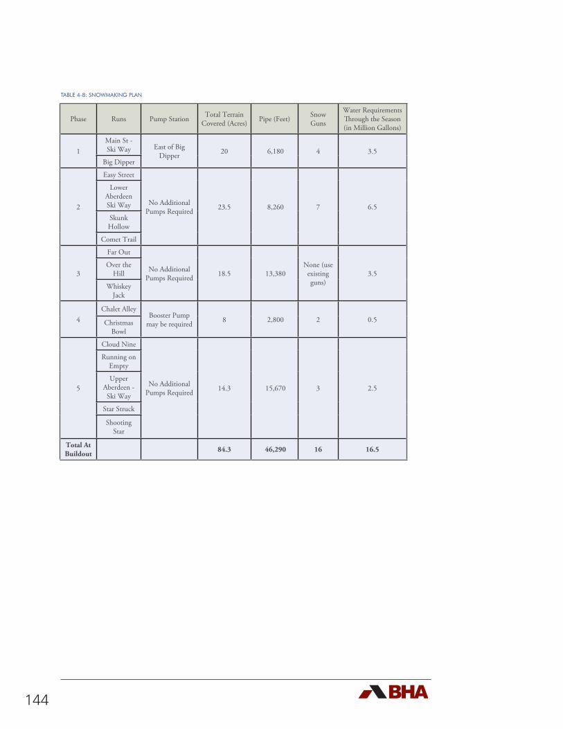
144
Phase Runs Pump Station Total Terrain Covered (Acres) Pipe (Feet) Snow
Guns
Water Requirements Through the Season (in Million Gallons)
1Main St - Ski Way East of Big
Dipper 20 6,180 4 3.5Big Dipper
2
Easy Street
No Additional Pumps Required 23.5 8,260 7 6.5
Lower Aberdeen Ski Way
Skunk Hollow
Comet Trail
3
Far Out
No Additional Pumps Required 18.5 13,380
None (use existing guns)
3.5Over the
Hill
Whiskey Jack
4Chalet Alley
Booster Pump may be required 8 2,800 2 0.5Christmas
Bowl
5
Cloud Nine
No Additional Pumps Required 14.3 15,670 3 2.5
Running on Empty
Upper Aberdeen - Ski Way
Star Struck
Shooting Star
Total At Buildout 84.3 46,290 16 16.5
TABLE 4-8: SNOWMAKING PLAN
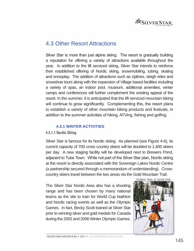
SILVER STAR MASTER PLAN • 2017 • 4.0 EXPANSION MASTER PLAN
145
4.3 Other Resort Attractions
Silver Star is more than just alpine skiing. The resort is gradually building a reputation for offering a variety of attractions available throughout the year. In addition to the lift serviced skiing, Silver Star intends to reinforce their established offering of Nordic skiing, snowmobiling, tubing, skating and snowplay. The addition of attractions such as ziplines, sleigh rides and snowshoe tours along with the expansion of Village based facilities including a variety of spas, an indoor pool, museum, additional amenities, winter camps and conferences will further complement the existing appeal of the resort. In the summer, it is anticipated that the lift serviced mountain biking will continue to grow significantly. Complementing this, the resort plans to establish a variety of other mountain biking products and festivals, in addition to the summer activities of hiking, ATVing, fishing and golfing.
4.3.1 WINTER ACTIVITIES4.3.1.1 Nordic Skiing
Silver Star is famous for its Nordic skiing. As planned (see Figure 4-6), its current capacity of 700 cross country skiers will be doubled to 1,400 skiers per day. A new staging facility will be developed next to Brewers Pond, adjacent to Tube Town. While not part of the Silver Star plan, Nordic skiing at the resort is directly associated with the Sovereign Lakes Nordic Centre (a partnership secured through a memorandum of understanding). Cross-country skiers travel between the two areas via the Gold Mountain Trail.
The Silver Star Nordic Area also has a shooting range and has been chosen by many national teams as the site to train for World Cup biathlon and Nordic racing events as well as the Olympic Games. In fact, Becky Scott trained at Silver Star prior to winning silver and gold medals for Canada during the 2002 and 2006 Winter Olympic Games.
NORDIC TRAIL AT SILVER STAR
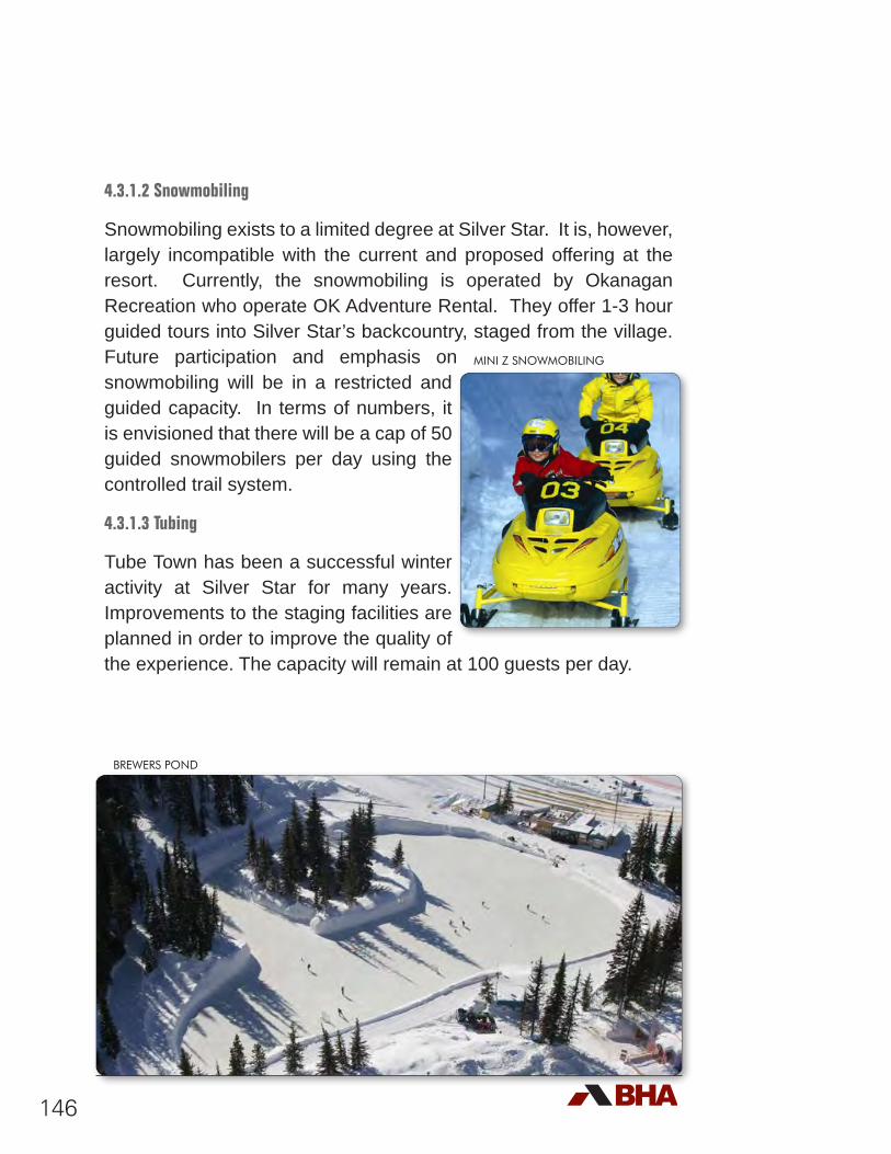
146
4.3.1.2 Snowmobiling
Snowmobiling exists to a limited degree at Silver Star. It is, however, largely incompatible with the current and proposed offering at the resort. Currently, the snowmobiling is operated by Okanagan Recreation who operate OK Adventure Rental. They offer 1-3 hour guided tours into Silver Star’s backcountry, staged from the village. Future participation and emphasis on snowmobiling will be in a restricted and guided capacity. In terms of numbers, it is envisioned that there will be a cap of 50 guided snowmobilers per day using the controlled trail system.
4.3.1.3 Tubing
Tube Town has been a successful winter activity at Silver Star for many years. Improvements to the staging facilities are planned in order to improve the quality of the experience. The capacity will remain at 100 guests per day.
MINI Z SNOWMOBILING
BREWERS POND
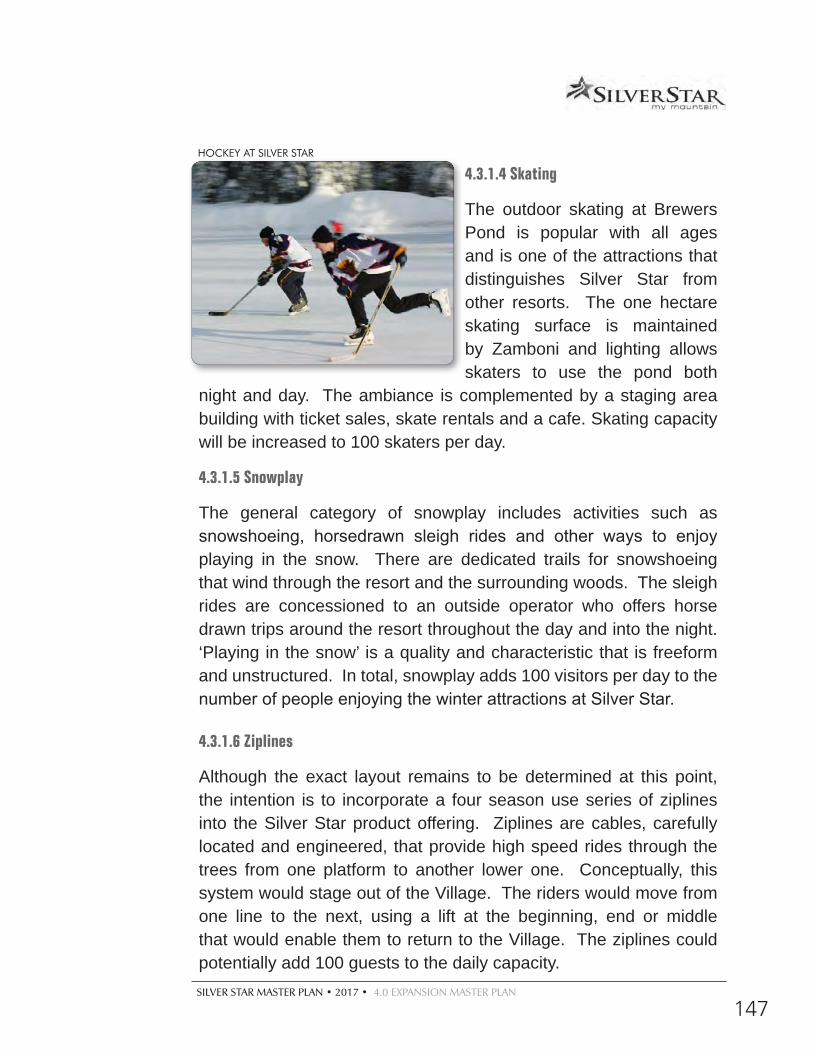
SILVER STAR MASTER PLAN • 2017 • 4.0 EXPANSION MASTER PLAN
147
4.3.1.4 Skating
The outdoor skating at Brewers Pond is popular with all ages and is one of the attractions that distinguishes Silver Star from other resorts. The one hectare skating surface is maintained by Zamboni and lighting allows skaters to use the pond both
night and day. The ambiance is complemented by a staging area building with ticket sales, skate rentals and a cafe. Skating capacity will be increased to 100 skaters per day.
4.3.1.5 Snowplay
The general category of snowplay includes activities such as snowshoeing, horsedrawn sleigh rides and other ways to enjoy playing in the snow. There are dedicated trails for snowshoeing that wind through the resort and the surrounding woods. The sleigh rides are concessioned to an outside operator who offers horse drawn trips around the resort throughout the day and into the night. ‘Playing in the snow’ is a quality and characteristic that is freeform and unstructured. In total, snowplay adds 100 visitors per day to the number of people enjoying the winter attractions at Silver Star.
4.3.1.6 Ziplines
Although the exact layout remains to be determined at this point, the intention is to incorporate a four season use series of ziplines into the Silver Star product offering. Ziplines are cables, carefully located and engineered, that provide high speed rides through the trees from one platform to another lower one. Conceptually, this system would stage out of the Village. The riders would move from one line to the next, using a lift at the beginning, end or middle that would enable them to return to the Village. The ziplines could potentially add 100 guests to the daily capacity.
HOCKEY AT SILVER STAR
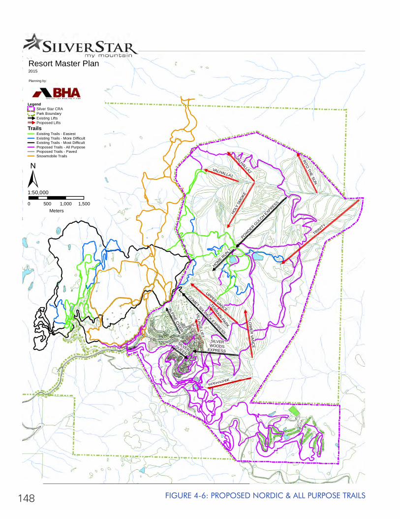
148 FIGURE 4-6: PROPOSED NORDIC & ALL PURPOSE TRAILS
VILLAGE LIFT
TERRAIN-PARK
SILVERQUEEN
ALPINE CHAIR
HOME RUN T
VALHALLA1
VALHALLA2
INTO THE SUN
SILVERWOODS
EXPRESS
LOW
ER
VAN
CE
HOLY
SM
OKE
UPPER VANCE
COMET SIX-PACK EXPRESS
POWDER GULC
H EXPRESS
TRINITY
SIDEWINDER
Resort Master Plan2015
Planning by:
0 500 1,000 1,500Meters
1:50,000±
LegendSilver Star CRAPark Boundary#
Existing Lifts#
Proposed LiftsTrails
Existing Trails - EasiestExisting Trails - More DifficultExisting Trails - Most DifficultProposed Trails - All PurposeProposed Trails - PavedSnowmobile Trails
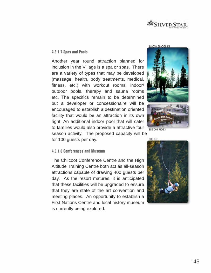
149
4.3.1.7 Spas and Pools
Another year round attraction planned for inclusion in the Village is a spa or spas. There are a variety of types that may be developed (massage, health, body treatments, medical, fitness, etc.) with workout rooms, indoor/outdoor pools, therapy and sauna rooms etc. The specifics remain to be determined but a developer or concessionaire will be encouraged to establish a destination oriented facility that would be an attraction in its own right. An additional indoor pool that will cater to families would also provide a attractive four season activity. The proposed capacity will be for 100 guests per day.
4.3.1.8 Conferences and Museum
The Chilcoot Conference Centre and the High Altitude Training Centre both act as all-season attractions capable of drawing 400 guests per day. As the resort matures, it is anticipated that these facilities will be upgraded to ensure that they are state of the art convention and meeting places. An opportunity to establish a First Nations Centre and local history museum is currently being explored.
SNOW SHOEING
SLEIGH RIDES
ZIPLINE
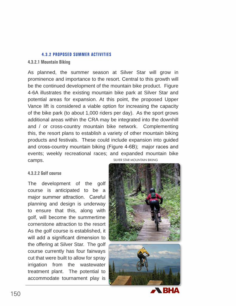
150
4.3.2 PROPOSED SUMMER ACTIVITIES
4.3.2.1 Mountain Biking
As planned, the summer season at Silver Star will grow in prominence and importance to the resort. Central to this growth will be the continued development of the mountain bike product. Figure 4-6A illustrates the existing mountain bike park at Silver Star and potential areas for expansion. At this point, the proposed Upper Vance lift is considered a viable option for increasing the capacity of the bike park (to about 1,000 riders per day). As the sport grows additional areas within the CRA may be integrated into the downhill and / or cross-country mountain bike network. Complementing this, the resort plans to establish a variety of other mountain biking products and festivals. These could include expansion into guided and cross-country mountain biking (Figure 4-6B); major races and events; weekly recreational races; and expanded mountain bike camps.
4.3.2.2 Golf course
The development of the golf course is anticipated to be a major summer attraction. Careful planning and design is underway to ensure that this, along with golf, will become the summertime cornerstone attraction to the resort As the golf course is established, it will add a significant dimension to the offering at Silver Star. The golf course currently has four fairways cut that were built to allow for spray irrigation from the wastewater treatment plant. The potential to accommodate tournament play is
SILVER STAR MOUNTAIN BIKING
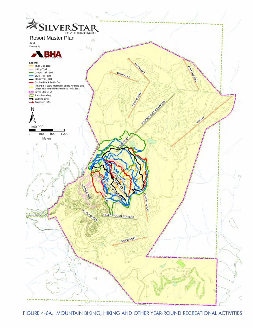
151
TRINITY
UPPER VANCE
HOLY
SM
OKE
VALHALLA2
SIDEWINDER
LOW
ER
VANC
E
VALHALLA1
INTO THE SUN
POWDER GULC
H EXPRESS
COMET SIX-PACK EXPRESS
HOME RUN T
ALPINE CHAIR
SILVER WOODS EXPRESS
SILVER QUEEN
TERRAIN-PARK
VILLAGE LIFT
Resort Master Plan2015Planning by:
0 400 800 1,200Meters
1:40,000±
LegendMulti-Use TrailHiking TrailGreen Trail - DHBlue Trail - DHBlack Trail - DHDouble Black Trail - DHPotential Future Mountain Biking / Hiking andOther Year-round Recreational ActivitiesSilver Star CRAPark Boundary#
Existing Lifts#
Proposed Lifts
FIGURE 4-6A: MOUNTAIN BIKING, HIKING AND OTHER YEAR-ROUND RECREATIONAL ACTIVITIES
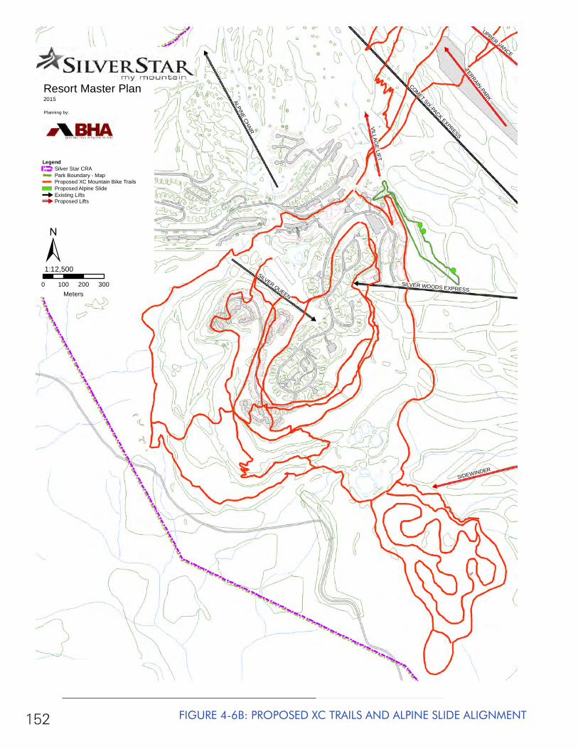
152 FIGURE 4-6B: PROPOSED XC TRAILS AND ALPINE SLIDE ALIGNMENT
ALPINE CHAIR
COMET SIX-PACK EXPRESS
SILVER QUEEN
SIDEWINDER
TERRAIN-PARK
SILVER WOODS EXPRESS
VILLAGE LIFT
UPPER VANCE
Resort Master Plan2015
Planning by:
0 100 200 300Meters
1:12,500
LegendSilver Star CRAPark Boundary - MapProposed XC Mountain Bike TrailsProposed Alpine Slide#
Existing Lifts#
Proposed Lifts
±
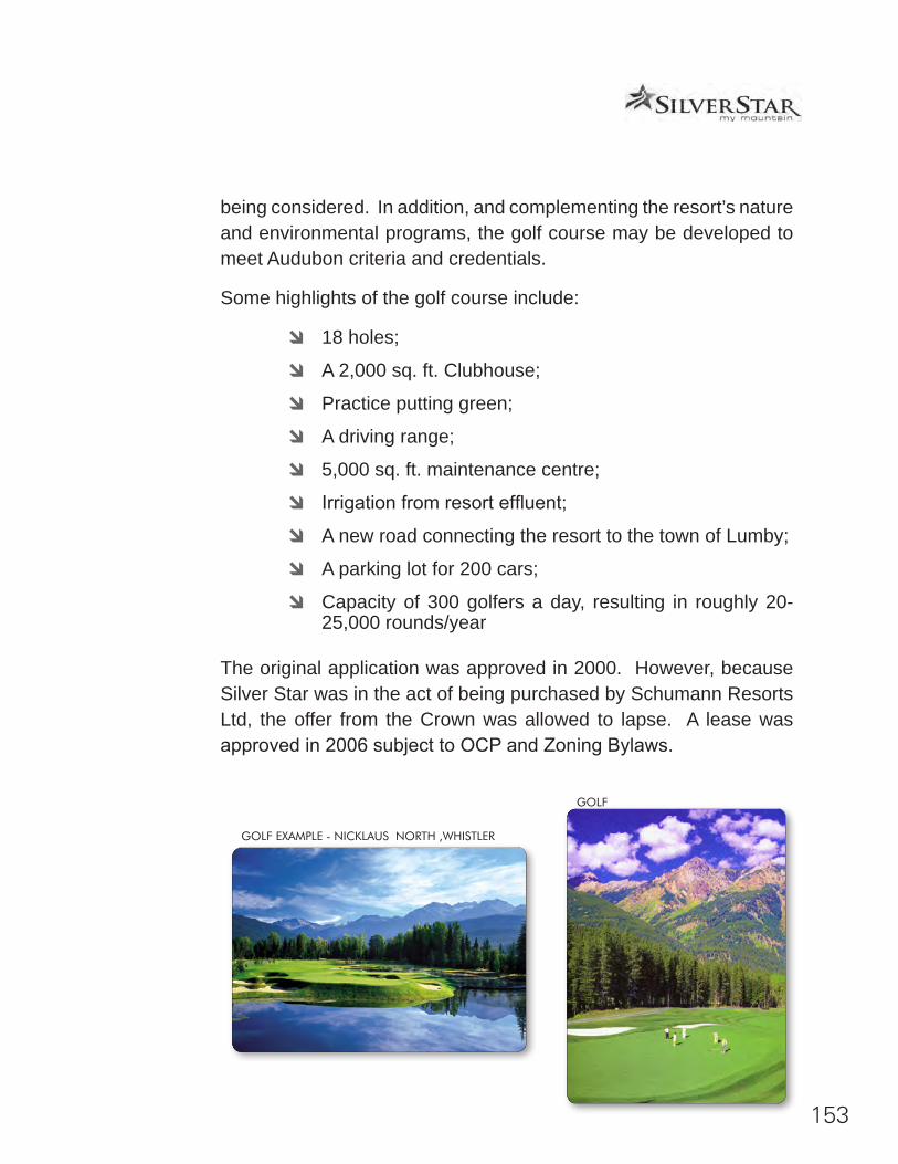
153
being considered. In addition, and complementing the resort’s nature and environmental programs, the golf course may be developed to meet Audubon criteria and credentials.
Some highlights of the golf course include:
d 18 holes;
d A 2,000 sq. ft. Clubhouse;
d Practice putting green;
d A driving range;
d 5,000 sq. ft. maintenance centre;
d Irrigation from resort effluent;
d A new road connecting the resort to the town of Lumby;
d A parking lot for 200 cars;
d Capacity of 300 golfers a day, resulting in roughly 20-25,000 rounds/year
The original application was approved in 2000. However, because Silver Star was in the act of being purchased by Schumann Resorts Ltd, the offer from the Crown was allowed to lapse. A lease was approved in 2006 subject to OCP and Zoning Bylaws.
GOLF
GOLF EXAMPLE - NICKLAUS NORTH ,WHISTLER
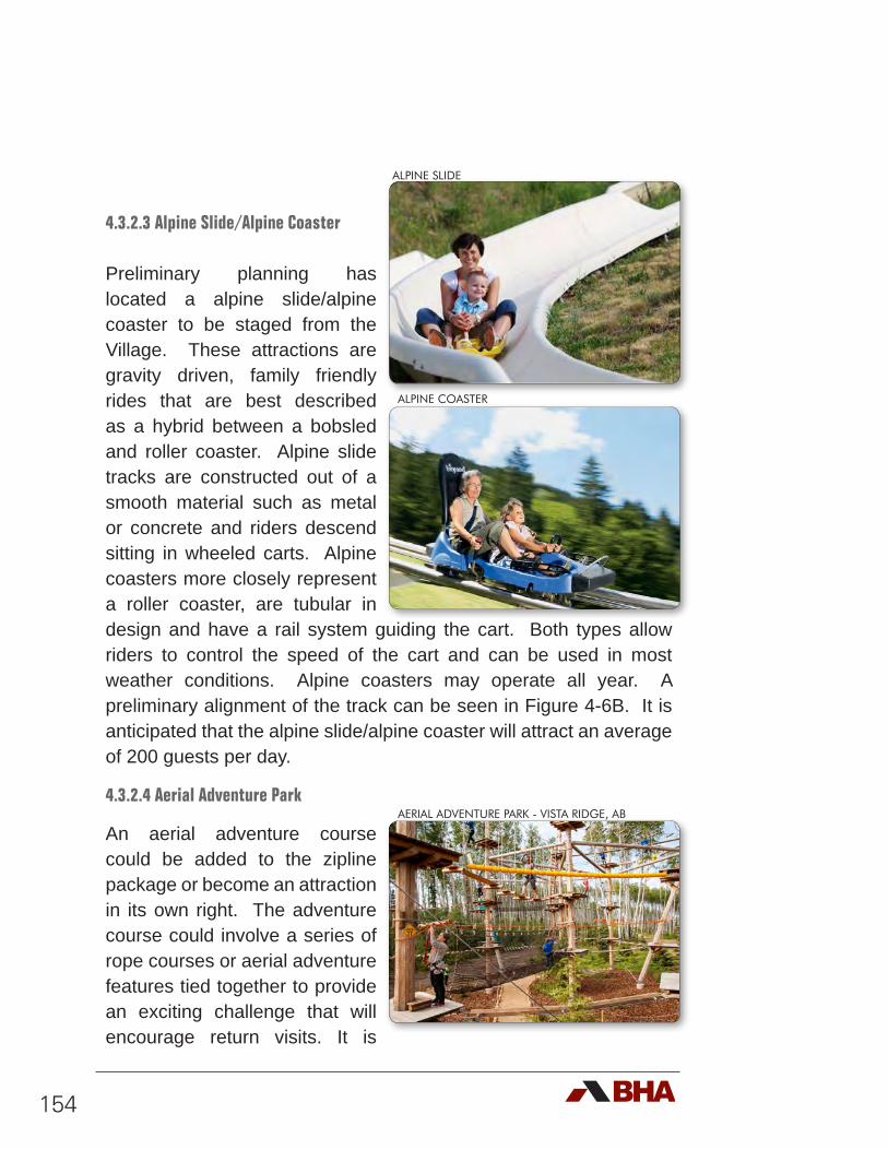
154
4.3.2.3 Alpine Slide/Alpine Coaster
Preliminary planning has located a alpine slide/alpine coaster to be staged from the Village. These attractions are gravity driven, family friendly rides that are best described as a hybrid between a bobsled and roller coaster. Alpine slide tracks are constructed out of a smooth material such as metal or concrete and riders descend sitting in wheeled carts. Alpine coasters more closely represent a roller coaster, are tubular in design and have a rail system guiding the cart. Both types allow riders to control the speed of the cart and can be used in most weather conditions. Alpine coasters may operate all year. A preliminary alignment of the track can be seen in Figure 4-6B. It is anticipated that the alpine slide/alpine coaster will attract an average of 200 guests per day.
4.3.2.4 Aerial Adventure Park
An aerial adventure course could be added to the zipline package or become an attraction in its own right. The adventure course could involve a series of rope courses or aerial adventure features tied together to provide an exciting challenge that will encourage return visits. It is
ALPINE SLIDE
ALPINE COASTER
AERIAL ADVENTURE PARK - VISTA RIDGE, AB
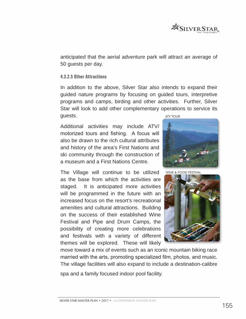
SILVER STAR MASTER PLAN • 2017 • 4.0 EXPANSION MASTER PLAN
155
anticipated that the aerial adventure park will attract an average of 50 guests per day.
4.3.2.5 Other Attractions
In addition to the above, Silver Star also intends to expand their guided nature programs by focusing on guided tours, interpretive programs and camps, birding and other activities. Further, Silver Star will look to add other complementary operations to service its guests.
Additional activities may include ATV/motorized tours and fishing. A focus will also be drawn to the rich cultural attributes and history of the area’s First Nations and ski community through the construction of a museum and a First Nations Centre.
The Village will continue to be utilized as the base from which the activities are staged. It is anticipated more activities will be programmed in the future with an increased focus on the resort’s recreational amenities and cultural attractions. Building on the success of their established Wine Festival and Pipe and Drum Camps, the possibility of creating more celebrations and festivals with a variety of different themes will be explored. These will likely move toward a mix of events such as an iconic mountain biking race married with the arts, promoting specialized film, photos, and music. The village facilities will also expand to include a destination-calibre
spa and a family focused indoor pool facility.
ATV TOUR
WINE & FOOD FESTIVAL
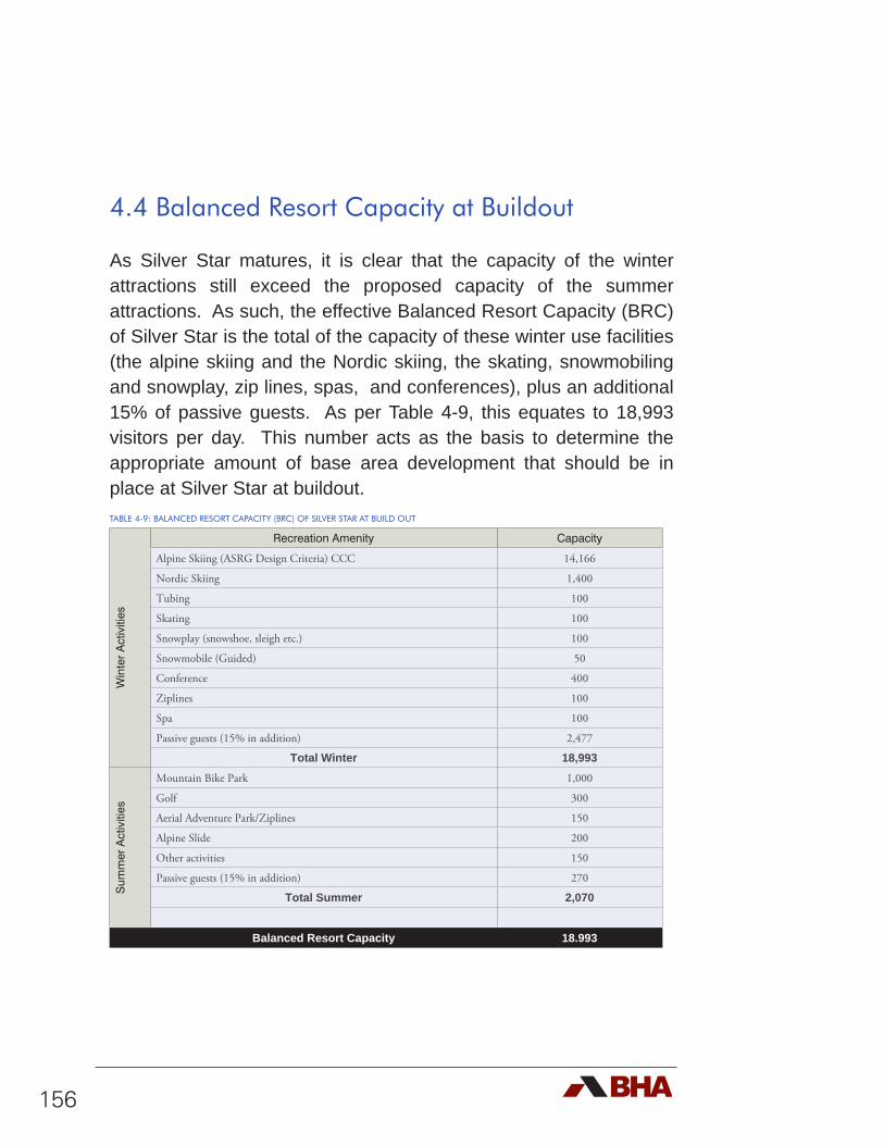
156
4.4 Balanced Resort Capacity at Buildout
As Silver Star matures, it is clear that the capacity of the winter attractions still exceed the proposed capacity of the summer attractions. As such, the effective Balanced Resort Capacity (BRC) of Silver Star is the total of the capacity of these winter use facilities (the alpine skiing and the Nordic skiing, the skating, snowmobiling and snowplay, zip lines, spas, and conferences), plus an additional 15% of passive guests. As per Table 4-9, this equates to 18,993 visitors per day. This number acts as the basis to determine the appropriate amount of base area development that should be in place at Silver Star at buildout.TABLE 4-9: BALANCED RESORT CAPACITY (BRC) OF SILVER STAR AT BUILD OUT
Win
ter
Act
iviti
es
Recreation Amenity Capacity
Alpine Skiing (ASRG Design Criteria) CCC 14,166
Nordic Skiing 1,400
Tubing 100
Skating 100
Snowplay (snowshoe, sleigh etc.) 100
Snowmobile (Guided) 50
Conference 400
Ziplines 100
Spa 100
Passive guests (15% in addition) 2,477
Total Winter 18,993
Sum
mer
Act
iviti
es
Mountain Bike Park 1,000
Golf 300
Aerial Adventure Park/Ziplines 150
Alpine Slide 200
Other activities 150
Passive guests (15% in addition) 270
Total Summer 2,070
Balanced Resort Capacity 18.993
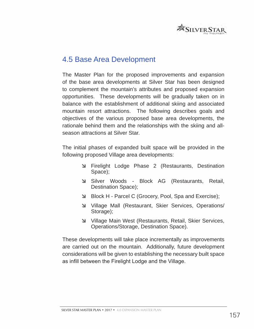
SILVER STAR MASTER PLAN • 2017 • 4.0 EXPANSION MASTER PLAN
157
4.5 Base Area Development
The Master Plan for the proposed improvements and expansion of the base area developments at Silver Star has been designed to complement the mountain’s attributes and proposed expansion opportunities. These developments will be gradually taken on in balance with the establishment of additional skiing and associated mountain resort attractions. The following describes goals and objectives of the various proposed base area developments, the rationale behind them and the relationships with the skiing and all-season attractions at Silver Star.
The initial phases of expanded built space will be provided in the following proposed Village area developments:
d Firelight Lodge Phase 2 (Restaurants, Destination Space);
d Silver Woods - Block AG (Restaurants, Retail, Destination Space);
d Block H - Parcel C (Grocery, Pool, Spa and Exercise);
d Village Mall (Restaurant, Skier Services, Operations/Storage);
d Village Main West (Restaurants, Retail, Skier Services, Operations/Storage, Destination Space).
These developments will take place incrementally as improvements are carried out on the mountain. Additionally, future development considerations will be given to establishing the necessary built space as infill between the Firelight Lodge and the Village.
158
4.5.1 BASE AREA DEVELOPMENT GOALS
Specific to Silver Star’s Base Area and Village, the following development goals were applied to guide in the creation of the Development Plan:
d Develop the base areas at Silver Star in a comprehensive and integrated fashion that caters to day use and destination visitors as well as second home owners in a high quality, all-season capacity;
d Incorporate direct linkages to and from the base areas and resort residential development areas by ensuring the establishment and maintenance of ski to/ski from trail development, as well as the creation of a highly integrated, all purpose trail network;
d Establish all of the base area facilities and residential development in balance with the capacities of the resort’s attractions - recognizing that there are absolute limits to growth;
d Ensure that all development is completed in a proactive, environmentally sensitive fashion;
d Balance base area facilities with the on-mountain development, with a focus on meeting the demands of regional (day use) markets;
d Encourage the continued development of pedestrian friendly base area development;
d Incorporate a variety of resort residential accommodation styles;
d Incorporate affordable resident and employee housing;
d Provide the appropriate amount of vehicle parking to match the day use and destination capacity requirements.
SILVER STAR MASTER PLAN • 2017 • 4.0 EXPANSION MASTER PLAN
159
4.5.2 BALANCED RESORT CAPACITY
The ideal size and scale of development of the base area facilities are directly linked to the capacity, location and scope of the resort attractions. In the case of Silver Star, the Balanced Resort Capacity (BRC) defines how big the resort can ultimately become in terms of the number of visitors and residents that can be expected at buildout. It is important to remember that this is a static picture of the finished resort in the future. There are a series of phases of development leading from the existing conditions to this end point.
The BRC was calculated to total 18,993 visitors per day. This defines the number of people that need to be catered to in terms of their expectations for a satisfying resort experience. By extension, this delineates the total amount and type of built space that needs to be put in place. It also defines the infrastructure (sewer, water and power) and parking requirements for the resort. Finally, while this number is typically the basis for determining the appropriate amount of accommodation in terms of bed units. Silver Star has decided that a modest increase of the bed base is more in line with the resort real estate market as compared to a major expansion. If and when the market demand for resort accommodation strengthens, the appropriate number of bed units, as defined by the BRC, will be revisited.
4.5.3 BUILT SPACE REQUIREMENTS
Built space requirements are driven by the described carrying capacity of the resort’s facilities – the Balanced Resort Capacity. At buildout, Silver Star must have the ability to provide for the needs of approximately 18,993 guests. The types of built space necessary to accommodate the needs and expectations of the guests range from restaurants, lounges, commercial and retail outlets, rental and repair shops, guest services, ski school, patrol/first aid, day care
160
and lockers to resort administration and employee facilities. As illustrated in Table 4-10, the specific space use requirements are listed. The total requirements at buildout are compared with the existing development. This provides a sense of the size, scale and shortcomings that need to be rectified for Silver Star’s built space to match the capacities of the attractions.
At buildout, the base area facilities in Silver Star Village will need to house significant additional space, expanding from the existing 86,000 square feet (8,000 sq. m.) to approximately 320,000 square feet (29,700 sq. m.). Internal to this, the attractions oriented facilities (tickets, operation, rental, retail, administration, ski patrol, day care, restaurant and bar, etc.) will need to ultimately grow from the existing 67,000 square feet (6,200 sq. m.) to 230,000 square feet (21,350 sq. m.). Likewise, the current 20,000 square feet (1,800 sq. m.) of space classified as being destination oriented (catering to the needs of the visitors outside of their ski resort facilities requirements and expectations) will need to grow to about 91,000 square feet (8,450 sq. m.). The space use requirements at buildout are summarized in Table 4-10. It is important to note that the development of this additional built space will be done incrementally, matched to the phased expansion of the mountain facilities.
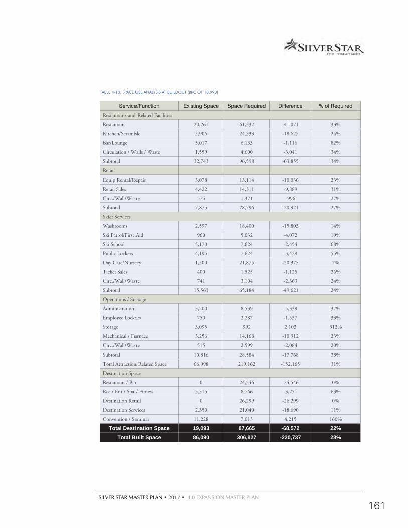
SILVER STAR MASTER PLAN • 2017 • 4.0 EXPANSION MASTER PLAN
161
TABLE 4-10: SPACE USE ANALYSIS AT BUILDOUT (BRC OF 18,993)
Service/Function Existing Space Space Required Difference % of Required
Restaurants and Related Facilities
Restaurant 20,261 61,332 -41,071 33%
Kitchen/Scramble 5,906 24,533 -18,627 24%
Bar/Lounge 5,017 6,133 -1,116 82%
Circulation / Walls / Waste 1,559 4,600 -3,041 34%
Subtotal 32,743 96,598 -63,855 34%
Retail
Equip Rental/Repair 3,078 13,114 -10,036 23%
Retail Sales 4,422 14,311 -9,889 31%
Circ./Wall/Waste 375 1,371 -996 27%
Subtotal 7,875 28,796 -20,921 27%
Skier Services
Washrooms 2,597 18,400 -15,803 14%
Ski Patrol/First Aid 960 5,032 -4,072 19%
Ski School 5,170 7,624 -2,454 68%
Public Lockers 4,195 7,624 -3,429 55%
Day Care/Nursery 1,500 21,875 -20,375 7%
Ticket Sales 400 1,525 -1,125 26%
Circ./Wall/Waste 741 3,104 -2,363 24%
Subtotal 15,563 65,184 -49,621 24%
Operations / Storage
Administration 3,200 8,539 -5,339 37%
Employee Lockers 750 2,287 -1,537 33%
Storage 3,095 992 2,103 312%
Mechanical / Furnace 3,256 14,168 -10,912 23%
Circ./Wall/Waste 515 2,599 -2,084 20%
Subtotal 10,816 28,584 -17,768 38%
Total Attraction Related Space 66,998 219,162 -152,165 31%
Destination Space
Restaurant / Bar 0 24,546 -24,546 0%
Rec / Ent / Spa / Fitness 5,515 8,766 -3,251 63%
Destination Retail 0 26,299 -26,299 0%
Destination Services 2,350 21,040 -18,690 11%
Convention / Seminar 11,228 7,013 4,215 160%
Total Destination Space 19,093 87,665 -68,572 22%Total Built Space 86,090 306,827 -220,737 28%
162
CORDUROY COMET SIX CHAIR
AIRTIME
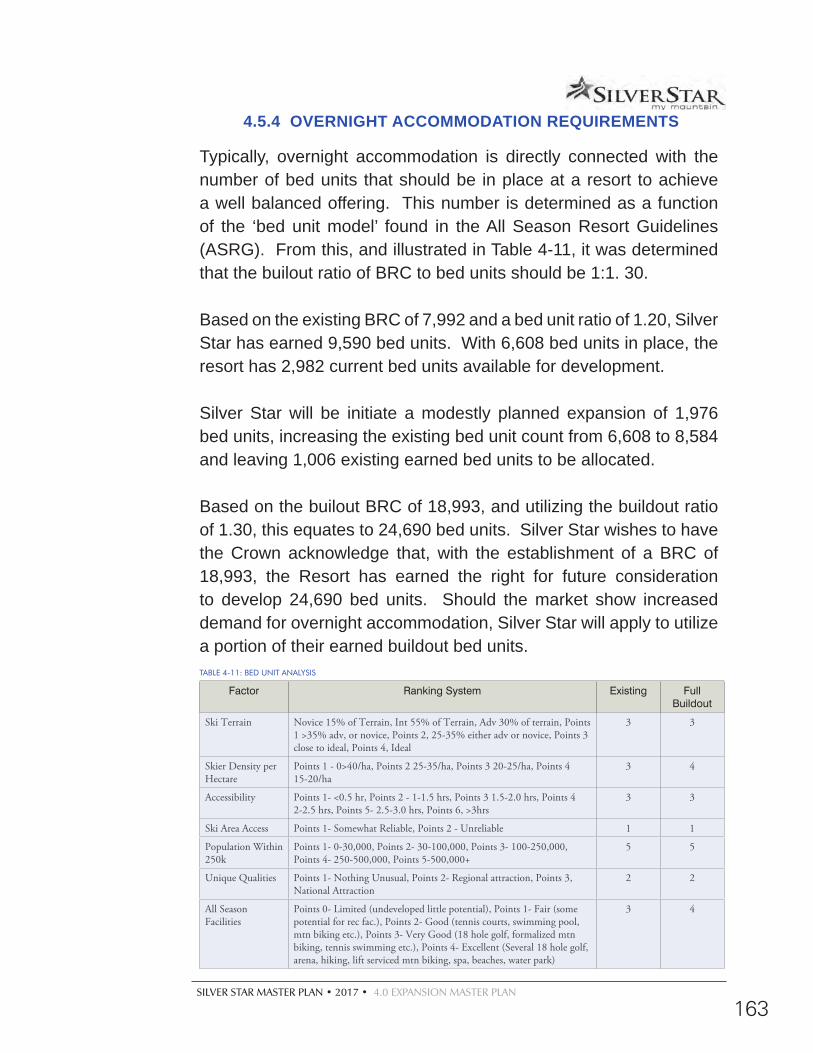
SILVER STAR MASTER PLAN • 2017 • 4.0 EXPANSION MASTER PLAN
163
4.5.4 OVERNIGHT ACCOMMODATION REQUIREMENTS
Typically, overnight accommodation is directly connected with the number of bed units that should be in place at a resort to achieve a well balanced offering. This number is determined as a function of the ‘bed unit model’ found in the All Season Resort Guidelines (ASRG). From this, and illustrated in Table 4-11, it was determined that the builout ratio of BRC to bed units should be 1:1. 30.
Based on the existing BRC of 7,992 and a bed unit ratio of 1.20, Silver Star has earned 9,590 bed units. With 6,608 bed units in place, the resort has 2,982 current bed units available for development.
Silver Star will be initiate a modestly planned expansion of 1,976 bed units, increasing the existing bed unit count from 6,608 to 8,584 and leaving 1,006 existing earned bed units to be allocated.
Based on the builout BRC of 18,993, and utilizing the buildout ratio of 1.30, this equates to 24,690 bed units. Silver Star wishes to have the Crown acknowledge that, with the establishment of a BRC of 18,993, the Resort has earned the right for future consideration to develop 24,690 bed units. Should the market show increased demand for overnight accommodation, Silver Star will apply to utilize a portion of their earned buildout bed units.TABLE 4-11: BED UNIT ANALYSIS
Factor Ranking System Existing Full Buildout
Ski Terrain Novice 15% of Terrain, Int 55% of Terrain, Adv 30% of terrain, Points 1 >35% adv, or novice, Points 2, 25-35% either adv or novice, Points 3 close to ideal, Points 4, Ideal
3 3
Skier Density per Hectare
Points 1 - 0>40/ha, Points 2 25-35/ha, Points 3 20-25/ha, Points 4 15-20/ha
3 4
Accessibility Points 1- <0.5 hr, Points 2 - 1-1.5 hrs, Points 3 1.5-2.0 hrs, Points 4 2-2.5 hrs, Points 5- 2.5-3.0 hrs, Points 6, >3hrs
3 3
Ski Area Access Points 1- Somewhat Reliable, Points 2 - Unreliable 1 1
Population Within 250k
Points 1- 0-30,000, Points 2- 30-100,000, Points 3- 100-250,000, Points 4- 250-500,000, Points 5-500,000+
5 5
Unique Qualities Points 1- Nothing Unusual, Points 2- Regional attraction, Points 3, National Attraction
2 2
All Season Facilities
Points 0- Limited (undeveloped little potential), Points 1- Fair (some potential for rec fac.), Points 2- Good (tennis courts, swimming pool, mtn biking etc.), Points 3- Very Good (18 hole golf, formalized mtn biking, tennis swimming etc.), Points 4- Excellent (Several 18 hole golf, arena, hiking, lift serviced mtn biking, spa, beaches, water park)
3 4
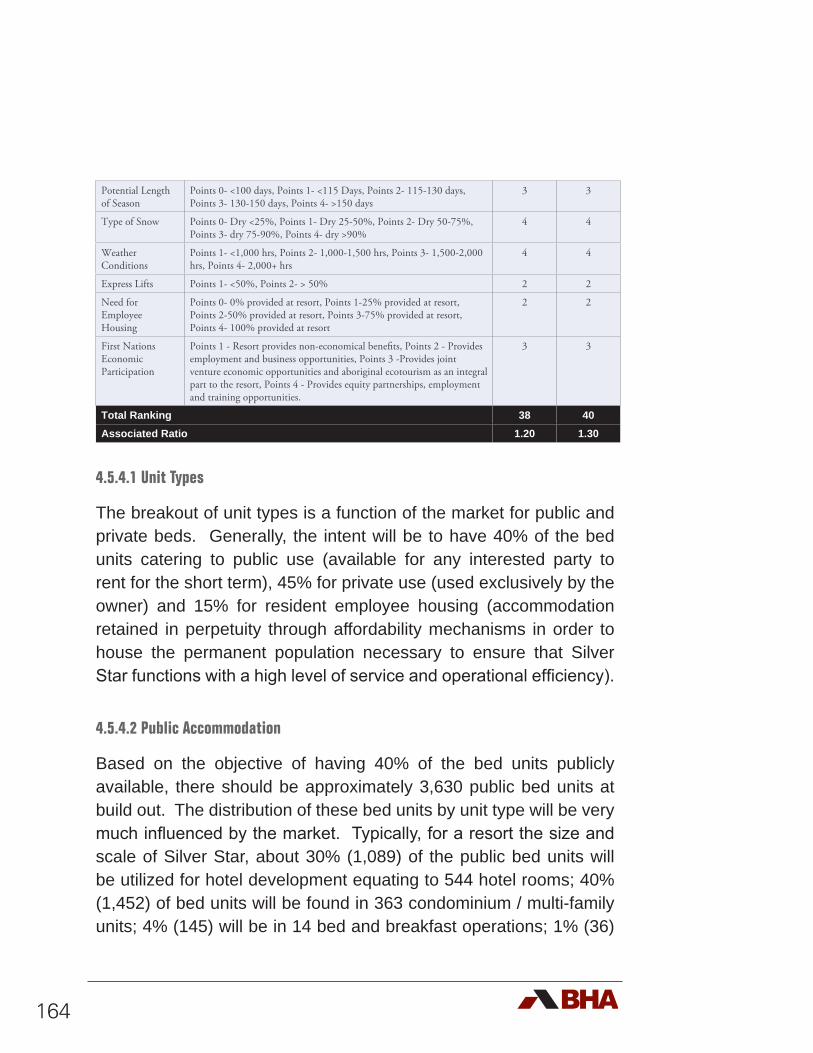
164
Potential Length of Season
Points 0- <100 days, Points 1- <115 Days, Points 2- 115-130 days, Points 3- 130-150 days, Points 4- >150 days
3 3
Type of Snow Points 0- Dry <25%, Points 1- Dry 25-50%, Points 2- Dry 50-75%, Points 3- dry 75-90%, Points 4- dry >90%
4 4
Weather Conditions
Points 1- <1,000 hrs, Points 2- 1,000-1,500 hrs, Points 3- 1,500-2,000 hrs, Points 4- 2,000+ hrs
4 4
Express Lifts Points 1- <50%, Points 2- > 50% 2 2
Need for Employee Housing
Points 0- 0% provided at resort, Points 1-25% provided at resort, Points 2-50% provided at resort, Points 3-75% provided at resort, Points 4- 100% provided at resort
2 2
First Nations Economic Participation
Points 1 - Resort provides non-economical benefits, Points 2 - Provides employment and business opportunities, Points 3 -Provides joint venture economic opportunities and aboriginal ecotourism as an integral part to the resort, Points 4 - Provides equity partnerships, employment and training opportunities.
3 3
Total Ranking 38 40Associated Ratio 1.20 1.30
4.5.4.1 Unit Types
The breakout of unit types is a function of the market for public and private beds. Generally, the intent will be to have 40% of the bed units catering to public use (available for any interested party to rent for the short term), 45% for private use (used exclusively by the owner) and 15% for resident employee housing (accommodation retained in perpetuity through affordability mechanisms in order to house the permanent population necessary to ensure that Silver Star functions with a high level of service and operational efficiency).
4.5.4.2 Public Accommodation
Based on the objective of having 40% of the bed units publicly available, there should be approximately 3,630 public bed units at build out. The distribution of these bed units by unit type will be very much influenced by the market. Typically, for a resort the size and scale of Silver Star, about 30% (1,089) of the public bed units will be utilized for hotel development equating to 544 hotel rooms; 40% (1,452) of bed units will be found in 363 condominium / multi-family units; 4% (145) will be in 14 bed and breakfast operations; 1% (36)
SILVER STAR MASTER PLAN • 2017 • 4.0 EXPANSION MASTER PLAN
165
will be in 18 RV sites; and, 25% (908) will be in 151 single family rental houses. It is anticipated that all of these developments will be maintained and restricted as publicly available through zoning, land use covenants and rental pools as coordinated through a resort association and enforced through municipal and/or Regional District governance.
4.5.4.3 Private Accommodation
At buildout, the objective to have 45% of the resort bed units as privately held accommodation would total about 4,084 private bed units. Of this number, approximately 55% (2,246) will be utilized in the development of 374 single family/duplex/cabins and about 45% (1,838) will result in 460 multi-family/condominium/townhouse units.
4.5.4.4 Attainable Housing for Employees and Residents
A resort’s employees, local support workforce and community residents are key to the character and quality of experience offered to its visitors. It is important to note the distinction between resort employees and support residents. The former are directly engaged by Silver Star to operate all aspects of the resort. They include everyone from the transient/seasonal workers to the top levels of resort management. Complementing this are all the other members of the working community at Silver Star. These include everyone from the hotel and restaurant personnel to trade industry operators (eg. plumbers, electricians, contractors) to professional services (eg. doctors, police, firemen, school teachers). Collectively, they are the locals of Silver Star. These locals are the lifeblood of the resort community and as such, function as ambassadors for the experience. It is in the best interest of Silver Star to ensure that their employees and the support residents live close by and have access to the activities and services offered. This engagement becomes more of a challenge as the resort becomes more successful. Over
166
time, seasonal and full time employees and residents are typically less able to compete with the financial resources of investors and second homeowners. This makes it increasingly difficult to live within or near the resort. Unchecked, the resort will become less and less affordable. Employees, critical to the provision of all resort services (not just the operation of the resort) begin to move further away. Ultimately, this compromises the vibrancy and economic vitality of the resort.
In the case of Silver Star, Vernon is approximately a half hour drive away, providing an accessible bed base for many employees working at the resort. However, to significantly depend on the availability of personnel being housed ‘down valley’ puts Silver Star at risk of not being able to find reliable staff and service personnel, especially in light of the increased costs of commuting. To address this, employee and resident restricted housing should be integrated throughout the resort. This will include a spectrum of accommodation ranging from rental units made available to the transient seasonal workers; multi-family rental units; employee restricted rental suites within individual homes; to resident/employee-restricted, fee simple, multi- and single-family units made available for purchase. At buildout, the total number of bed units at Silver Star assigned for employee/resident use equals 1,362. The specific unit types will be determined over time. These will be integrated throughout Silver Star to avoid ‘employee ghettos’ and an ‘us and them’ setting.
4.5.5 PARKING REQUIREMENTS4.5.5.1 Day Use Parking Requirements
Assuming a buildout BRC of 18,993 guests at Silver Star, the issue of providing the appropriate amount of parking needs to be incorporated into the base area planning. Currently, the resort has a ratio of 60:40 day use to destination guests. Given the assessment
SILVER STAR MASTER PLAN • 2017 • 4.0 EXPANSION MASTER PLAN
167
of the current skier marketplace, it is anticipated that this will gradually shift to a 40:60 day use to destination ratio. As such, at buildout, of the potential 18,993 guests that could be at Silver Star, approximately 7,597 would be expected to be day use guests. The challenge is to determine how those day use guests would arrive at the resort. For today’s marketplace, about 85% of day use guests can be expected to arrive by private car (with 3 riders per car) and 15% by bus (with 45 riders by bus). With fluctuating gas prices, the belief is that as long as service is provided, more people will take the bus. Where possible the resort will encourage increased bus/shuttle ridership. If it is assumed that the ratio of private cars arriving at Silver Star can be reduced to 55% with 3 riders per car, the day use requirements at buildout become 4,178 guests arriving in 1,392 cars.
Likewise, 45% of the guests will arrive by a bus and/or shuttle. This premised on the assumption that, to be successful, bus service will be frequent, convenient and significantly cheaper than going by car. This would see about 3, 419 day use guests arriving by bus. Because of its close proximity, it is assumed that 20 buses (carrying approximately 25% of the day use guests) would park for the day and the remaining bus traffic would commute up and down to Vernon.
4.5.5.2 Destination Use Parking Requirements
If 60% of the BRC is tied to destination guests, then about 11,396 visitors to Silver Star will be parked at their overnight accommodation units. This will be guaranteed through current and future zoning requirements, if and when Silver Star decides to expand beyond their already approved bed base..
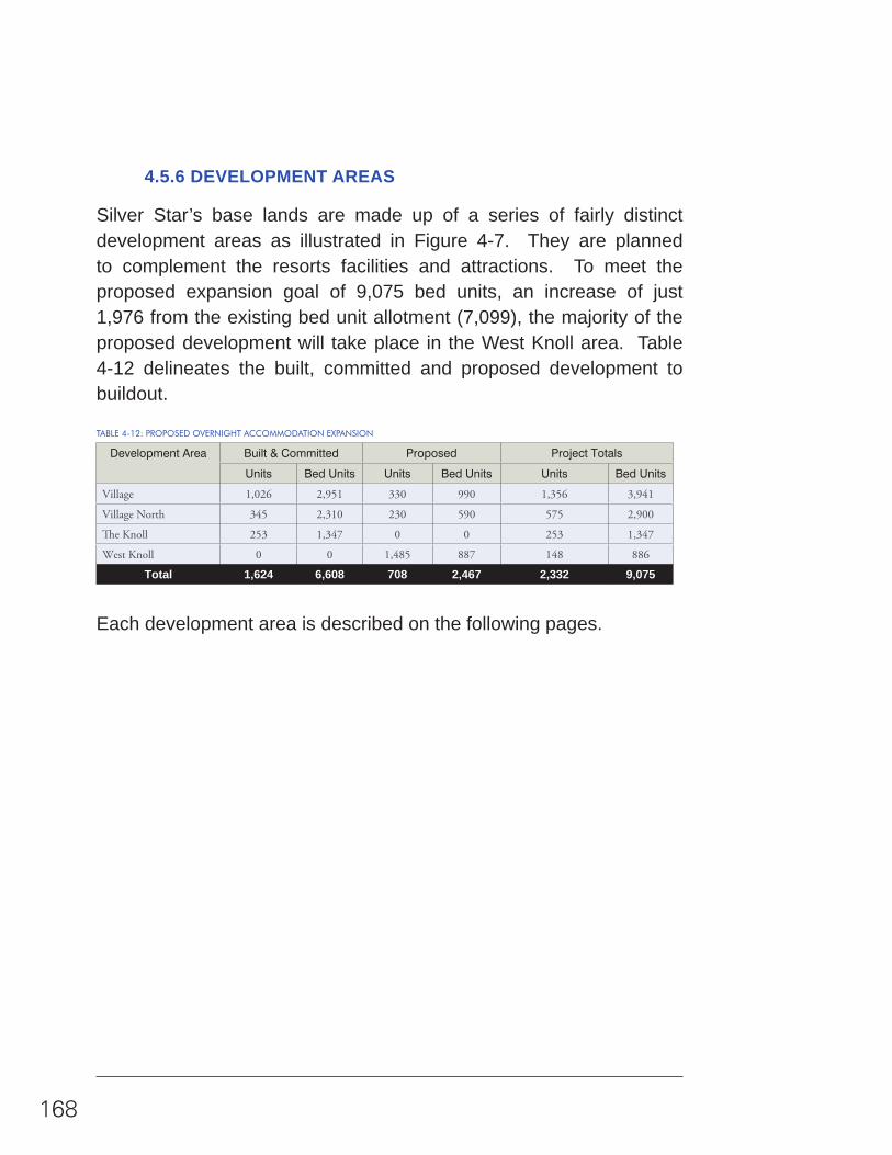
168
4.5.6 DEVELOPMENT AREAS
Silver Star’s base lands are made up of a series of fairly distinct development areas as illustrated in Figure 4-7. They are planned to complement the resorts facilities and attractions. To meet the proposed expansion goal of 9,075 bed units, an increase of just 1,976 from the existing bed unit allotment (7,099), the majority of the proposed development will take place in the West Knoll area. Table 4-12 delineates the built, committed and proposed development to buildout.
TABLE 4-12: PROPOSED OVERNIGHT ACCOMMODATION EXPANSION
Development Area Built & Committed Proposed Project Totals
Units Bed Units Units Bed Units Units Bed Units
Village 1,026 2,951 330 990 1,356 3,941
Village North 345 2,310 230 590 575 2,900
The Knoll 253 1,347 0 0 253 1,347
West Knoll 0 0 1,485 887 148 886
Total 1,624 6,608 708 2,467 2,332 9,075
Each development area is described on the following pages.

169
#
##
#
#
#
#
#
#
#
#
#
#
#
#
#
Golf Course Estate
Village North Village
The KnollWest Knoll
TRINITY
UPPER VANCE
HOLY
SM
OKE
VALHALLA2
SIDEWINDER
LOW
ER VA
NC
E
VALHALLA1IN
TO THE SUN
POWDER GULC
H EXPRESS
COMET SIX-PACK EXPRESS
HOME RUN T
ALPINE CHAIR
SILVER WOODS EXPRESS
TERRAIN-PARK
VILLAGE LIFT
Resort Master Plan2015
Planning by:
0 400 800 1,200Meters
1:40,000±
Proposed Golf Course
Legend#
Existing Lifts#
Proposed LiftsSilver Star CRA
Parcels by DevelopmentThe KnollVillageVillage NorthWest Knoll
FIGURE 4-7: DEVELOPMENT AREAS
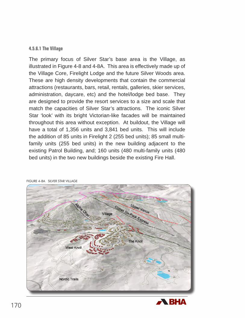
170
4.5.6.1 The Village
The primary focus of Silver Star’s base area is the Village, as illustrated in Figure 4-8 and 4-8A. This area is effectively made up of the Village Core, Firelight Lodge and the future Silver Woods area. These are high density developments that contain the commercial attractions (restaurants, bars, retail, rentals, galleries, skier services, administration, daycare, etc) and the hotel/lodge bed base. They are designed to provide the resort services to a size and scale that match the capacities of Silver Star’s attractions. The iconic Silver Star ‘look’ with its bright Victorian-like facades will be maintained throughout this area without exception. At buildout, the Village will have a total of 1,356 units and 3,841 bed units. This will include the addition of 85 units in Firelight 2 (255 bed units); 85 small multi-family units (255 bed units) in the new building adjacent to the existing Patrol Building, and; 160 units (480 multi-family units (480 bed units) in the two new buildings beside the existing Fire Hall.
FIGURE 4-8A SILVER STAR VILLAGE
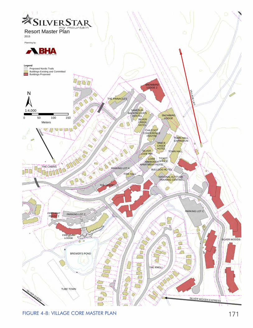
171FIGURE 4-8: VILLAGE CORE MASTER PLAN
#
#
#
#
#
#
SILVER QUEEN
ALPINE CHAIR
SILVER WOODS EXPRESS
VILLAGE LIFT
SNOWBIRDLODGE 2
THE PINNACLES
SAMESUNBACKPACKER'S
HOSTEL SNOWBIRDLODGESILVER
CREEKHOTEL
CHILCOOTCONFERENCE
CENTRE
VANCECREEKHOTEL
SILVERLODE INN
LORDABERDEEN
APARTMENT HOTEL
TOWN HALLEXPANSION
TOWN HALL
TICKETOFFICE
BULLDOG HOTEL
NATIONAL ALTITUDETRAINING CENTRE
FIRE HALL
PARKING LOT A
THE HOSTEL
PARKING LOT C
SILVER WOODS
THE KNOLL
BREWER'S POND
TUBE TOWN
FIRELIGHTPHASE 2
FIRELIGHTLODGE
PARKING LOT C
THE CABINS
ALPINEMEADOWS
Resort Master Plan2015
Planning by:
0 50 100 150Meters
1:4,000
LegendProposed Nordic TrailsBuildings-Existing and CommittedBuildings-Proposed
±
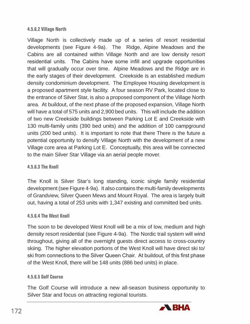
172
4.5.6.2 Village North
Village North is collectively made up of a series of resort residential developments (see Figure 4-9a). The Ridge, Alpine Meadows and the Cabins are all contained within Village North and are low density resort residential units. The Cabins have some infill and upgrade opportunities that will gradually occur over time. Alpine Meadows and the Ridge are in the early stages of their development. Creekside is an established medium density condominium development. The Employee Housing development is a proposed apartment style facility. A four season RV Park, located close to the entrance of Silver Star, is also a proposed component of the Village North area. At buildout, of the next phase of the proposed expansion, Village North will have a total of 575 units and 2,900 bed units. This will include the addition of two new Creekside buildings between Parking Lot E and Creekside with 130 multi-family units (390 bed units) and the addition of 100 campground units (200 bed units). It is important to note that there There is the future a potential opportunity to densify Village North with the development of a new Village core area at Parking Lot E. Conceptually, this area will be connected to the main Silver Star Village via an aerial people mover.
4.5.6.3 The Knoll
The Knoll is Silver Star’s long standing, iconic single family residential development (see Figure 4-9a). It also contains the multi-family developments of Grandview, Silver Queen Mews and Mount Royal. The area is largely built out, having a total of 253 units with 1,347 existing and committed bed units.
4.5.6.4 The West Knoll
The soon to be developed West Knoll will be a mix of low, medium and high density resort residential (see Figure 4-9a). The Nordic trail system will wind throughout, giving all of the overnight guests direct access to cross-country skiing. The higher elevation portions of the West Knoll will have direct ski to/ski from connections to the Silver Queen Chair. At buildout, of this first phase of the West Knoll, there will be 148 units (886 bed units) in place.
4.5.6.5 Golf Course
The Golf Course will introduce a new all-season business opportunity to Silver Star and focus on attracting regional tourists.
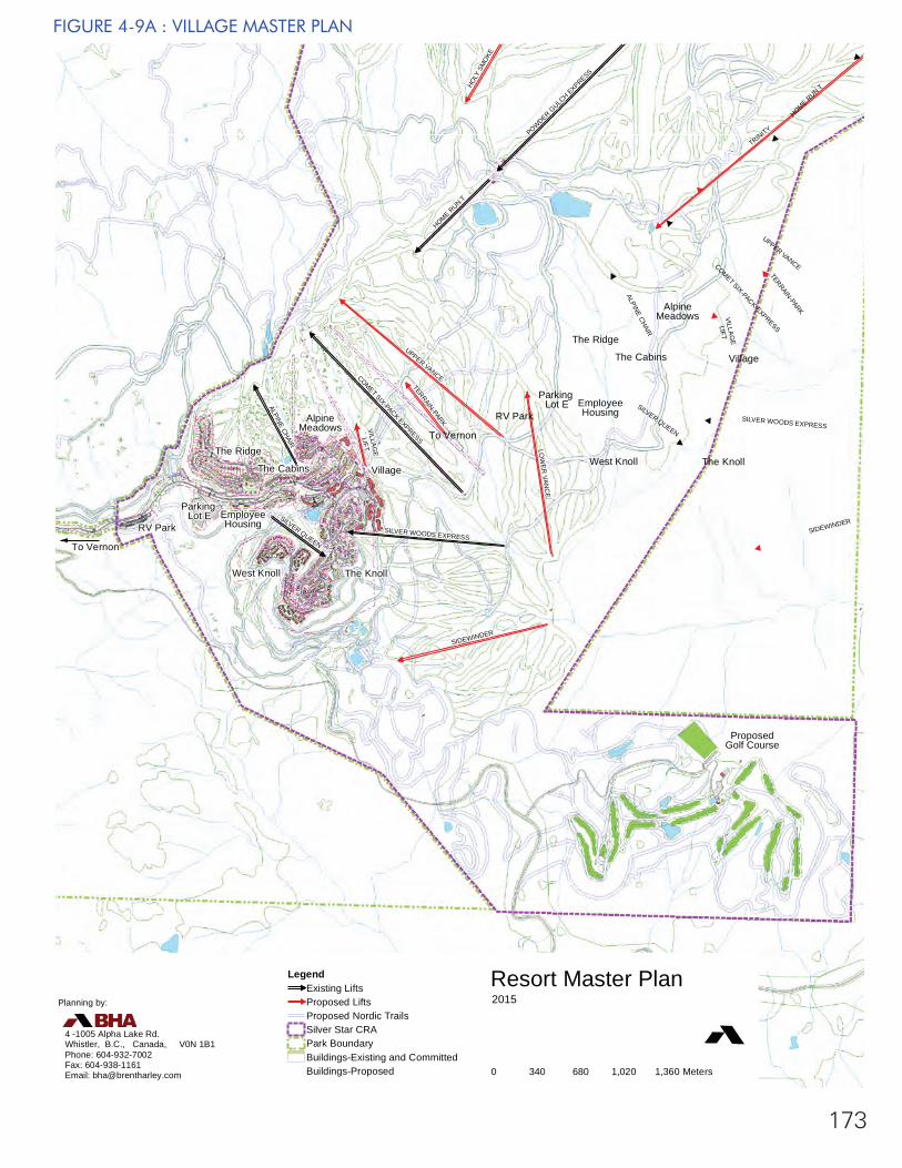
#
#
#
#
#
#
#
#
#
#
#
#
#
VILLAGE
LIFT
TERRAIN-PARK
SILVER QUEEN
HOLY
SM
OKE
ALPINE CHAIR
HOME RUN T
SIDEWINDER
SILVER WOODS EXPRESS
LOW
ER VAN
CE
POWDER GULC
H EXPRESS
UPPER VANCECOMET SIX-PACK EXPRESS
TRINITY
Prepared for:Vill
Parking Lot E Employee
HousingRV Park
To Vernon
West Knoll The Knoll
The Cabins
The Ridge
AlpineMeadows
Village
ProposedGolf Course
#
#
#
#
#
#
#
#
#
#
VILLAGE
LIFT
TERRAIN-PARK
SILVER QUEEN
ALPINE CHAIR
HOME RUN T
SIDEWINDER
SILVER WOODS EXPRESS
UPPER VANCECOMET SIX-PACK EXPRESS
Parking Lot E Employee
HousingRV Park
To Vernon
West Knoll The Knoll
The Cabins
The Ridge
AlpineMeadows
Village
173
FIGURE 4-9A : VILLAGE MASTER PLAN
Resort Master Plan2015
Legend
#
Existing Lifts
#
Proposed LiftsProposed Nordic TrailsSilver Star CRAPark BoundaryBuildings-Existing and CommittedBuildings-Proposed 0 340 680 1,020 1,360 Meters
Planning by:
4 -1005 Alpha Lake Rd.Whistler, B.C., Canada, V0N 1B1Phone: 604-932-7002 Fax: 604-938-1161Email: [email protected]
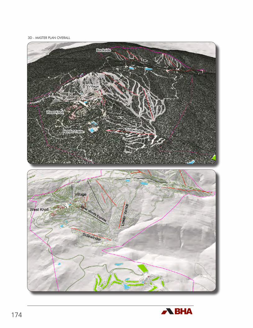
174
3D - MASTER PLAN OVERALL
175
3D - BACKSIDE (PROPOSED)
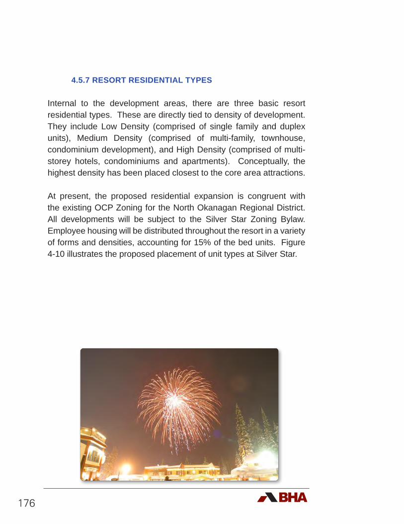
176
4.5.7 RESORT RESIDENTIAL TYPES
Internal to the development areas, there are three basic resort residential types. These are directly tied to density of development. They include Low Density (comprised of single family and duplex units), Medium Density (comprised of multi-family, townhouse, condominium development), and High Density (comprised of multi-storey hotels, condominiums and apartments). Conceptually, the highest density has been placed closest to the core area attractions.
At present, the proposed residential expansion is congruent with the existing OCP Zoning for the North Okanagan Regional District. All developments will be subject to the Silver Star Zoning Bylaw. Employee housing will be distributed throughout the resort in a variety of forms and densities, accounting for 15% of the bed units. Figure 4-10 illustrates the proposed placement of unit types at Silver Star.
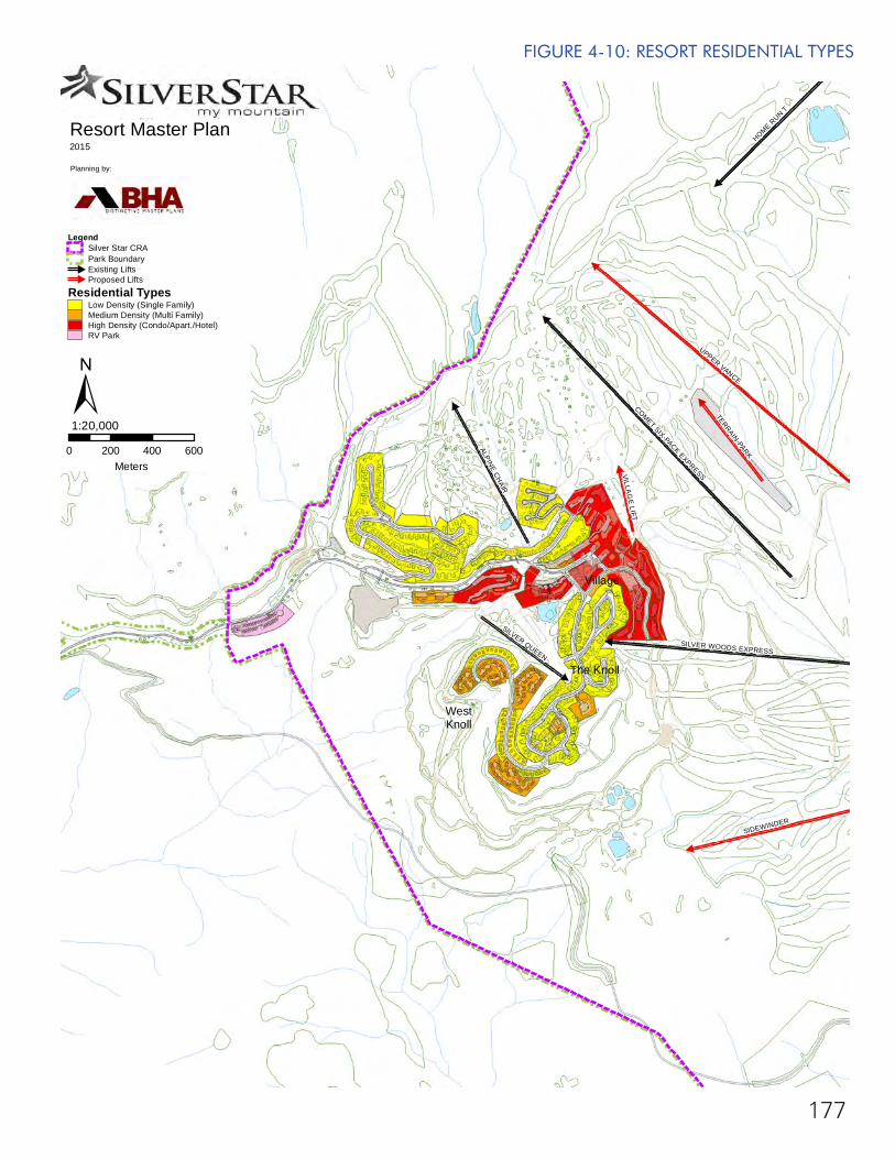
177
UPPER VANCE
COMET SIX-PACK EXPRESS
HOME RUN T
SIDEWINDER
ALPINE CHAIR
SILVER WOODS EXPRESS
SILVER QUEEN
TERRAIN-PARK
VILLAG
E LIFT
Resort Master Plan2015
Planning by:
0 200 400 600Meters
1:20,000
LegendSilver Star CRAPark Boundary#
Existing Lifts#
Proposed Lifts
Residential TypesLow Density (Single Family)Medium Density (Multi Family)High Density (Condo/Apart./Hotel)RV Park
±
WestKnoll
The Knoll
Village
FIGURE 4-10: RESORT RESIDENTIAL TYPES
178
4.6 Infrastructure
The Silver Star Water System (SSW) was constructed in the 1980s and is operated by the Regional District of the North Okanagan. The water system provides potable water to 15 commercial and 371 residential connections. All customers are metered. The source water for the utility is from both surface water and groundwater. The surface water, mostly runoff from snow melt, is collected and stored in the Paradise Lake and Vance Creek open water reservoirs. The groundwater is currently supplied from seven operational bedrock wells. The water from all sources is directed through the Mid Tee Water Treatment Plant where it is irradiated with Ultraviolet light, chlorinated and directed to the Mid Tree Reservoir for storage. The Mid Tree Reservoir is an ‘enclosed’ reservoir. Silver Star Water Daily Flow ranges from a high of about 825 m3 per day (Christmas Holidays) to a low of about 50 m3 per day (Early November). A summary of water interests in the area can be found in Section 2.13.6.
Silverhawk Utilities, owns and operates the Wastewater Treatment Plant (WWTP) at Silver Star Mountain Resort. This third party owned utility has been upgraded over the last several years to handle the peak periods of use during holidays. SSMR, in partnership with Silverhawk Utlilities logged and cleared fairways in the golf course for the purposes of spray irrigation, Silverhawk Utilities ran lines to the start of each fairway but at present the lines are not being used. The plant seems to have sufficient capacity to handle the effluent internally. There does not seem to be any capacity issues associated with the WWTP Similarly, there have been no indications that the existing power infrastructure will require upgrades to accommodate the proposed expansion.
All infrastructure capacity requirements for water, sewer and power, to the level necessary to accommodate the development proposed in this plan, will need to be investigated further. SSMR would need to provide sufficient capacity of infrastructure to supply all existing, committed and proposed development (See Figure 4-11). SSMR is confident that the existing infrastructure is sufficient, without any major modifications, to accommodate the increases proposed in Phase 1 of the Master Plan. Note, any increase in water demands above and beyond the capacity of the existing system will be addressed through the utilization of existing capped wells owned by SSMR.
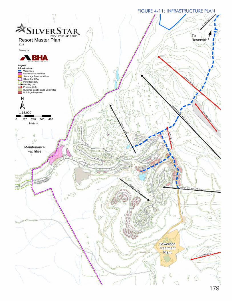
179
UPPER VANCE
COMET SIX-PACK EXPRESSALPINE CHAIR
SILVER QUEEN
TERRAIN-PARK
SIDEWINDER
SILVER WOODS EXPRESS
VILLAG
E LIFT
HOME RUN T
Resort Master Plan2015
Planning by:
0 120 240 360 480Meters
1:15,000
LegendInfrastructure
WaterlinesMaintenance FacilitiesSewerage Treatment PlantSilver Star CRAPark Boundary#
Existing Lifts#
Proposed LiftsBuildings-Existing and CommittedBuildings-Proposed
±
ToReservoir
SewerageTreatment
Plant
MaintenanceFacilities
FIGURE 4-11: INFRASTRUCTURE PLAN
180
4.7 Access
At present the access road to Silver Star terminates at the resort creating some unique access challenges. In an effort fully understand these challenges, Silver Star engaged the MMM Group to complete a Traffic Impact Study (Appendix 2). In summary, MMM recommend that two traffic studies be completed over the five phases of development envisioned at Silver Star:
• The initial TIS covering Phases 1, 2 and 3 should be prepared prior to the completion of Phase 2 of the Silver Star Master Plan.
• The final TIS covering Phases 4 and 5 (Buildout) should be prepared prior to the completion of Phase 4 of the Silver Star Master Plan.
One opportunity is to create a second access point by connecting the road to the proposed golf course and on to the town of Lumby. This connection was studied in 2002 by Ference Weicker & Company in a study entitled ‘Market Analysis of the Impact of a Road Link from Lumby to Silver Star Resort’. However, the study is only in draft form and is not available to the public. SSMR is actively pursuing the opportunities associated with this road link which could reduce drive time for visitors coming from that direction by 15-20 minutes and provide a valuable alternative emergency access route.
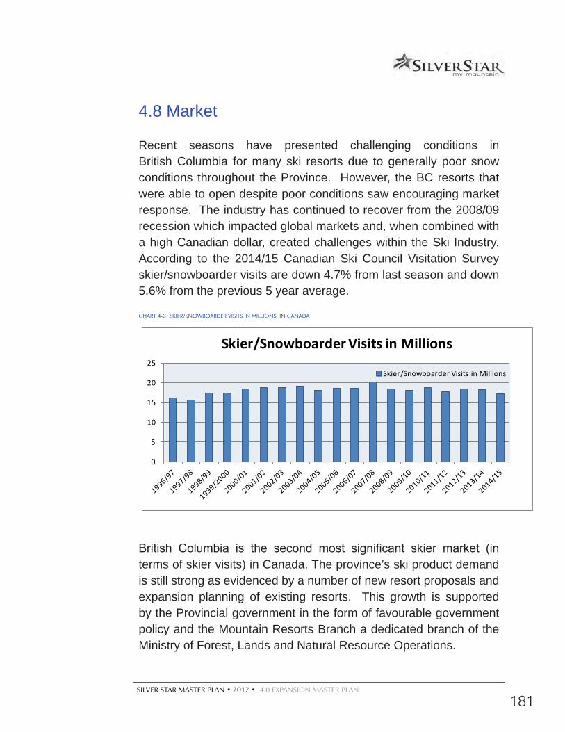
SILVER STAR MASTER PLAN • 2017 • 4.0 EXPANSION MASTER PLAN
181
4.8 Market
Recent seasons have presented challenging conditions in British Columbia for many ski resorts due to generally poor snow conditions throughout the Province. However, the BC resorts that were able to open despite poor conditions saw encouraging market response. The industry has continued to recover from the 2008/09 recession which impacted global markets and, when combined with a high Canadian dollar, created challenges within the Ski Industry. According to the 2014/15 Canadian Ski Council Visitation Survey skier/snowboarder visits are down 4.7% from last season and down 5.6% from the previous 5 year average.
CHART 4-3: SKIER/SNOWBOARDER VISITS IN MILLIONS IN CANADA
0
5
10
15
20
25
Skier/Snowboarder Visits in Millions
Skier/Snowboarder Visits in Millions
British Columbia is the second most significant skier market (in terms of skier visits) in Canada. The province’s ski product demand is still strong as evidenced by a number of new resort proposals and expansion planning of existing resorts. This growth is supported by the Provincial government in the form of favourable government policy and the Mountain Resorts Branch a dedicated branch of the Ministry of Forest, Lands and Natural Resource Operations.
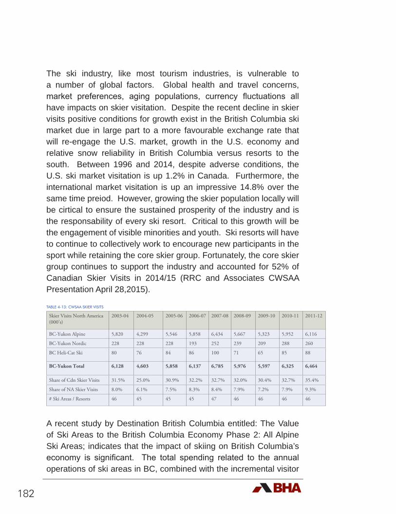
182
The ski industry, like most tourism industries, is vulnerable to a number of global factors. Global health and travel concerns, market preferences, aging populations, currency fluctuations all have impacts on skier visitation. Despite the recent decline in skier visits positive conditions for growth exist in the British Columbia ski market due in large part to a more favourable exchange rate that will re-engage the U.S. market, growth in the U.S. economy and relative snow reliability in British Columbia versus resorts to the south. Between 1996 and 2014, despite adverse conditions, the U.S. ski market visitation is up 1.2% in Canada. Furthermore, the international market visitation is up an impressive 14.8% over the same time preiod. However, growing the skier population locally will be cirtical to ensure the sustained prosperity of the industry and is the responsability of every ski resort. Critical to this growth will be the engagement of visible minorities and youth. Ski resorts will have to continue to collectively work to encourage new participants in the sport while retaining the core skier group. Fortunately, the core skier group continues to support the industry and accounted for 52% of Canadian Skier Visits in 2014/15 (RRC and Associates CWSAA Presentation April 28,2015).
TABLE 4-13: CWSAA SKIER VISITS
Skier Visits North America (000’s)
2003-04 2004-05 2005-06 2006-07 2007-08 2008-09 2009-10 2010-11 2011-12
BC-Yukon Alpine 5,820 4,299 5,546 5,858 6,434 5,667 5,323 5,952 6,116
BC-Yukon Nordic 228 228 228 193 252 239 209 288 260
BC Heli-Cat Ski 80 76 84 86 100 71 65 85 88
BC-Yukon Total 6,128 4,603 5,858 6,137 6,785 5,976 5,597 6,325 6,464
Share of Cdn Skier Visits 31.5% 25.0% 30.9% 32.2% 32.7% 32.0% 30.4% 32.7% 35.4%
Share of NA Skier Visits 8.0% 6.1% 7.5% 8.3% 8.4% 7.9% 7.2% 7.9% 9.3%
# Ski Areas / Resorts 46 45 45 45 47 46 46 46 46
A recent study by Destination British Columbia entitled: The Value of Ski Areas to the British Columbia Economy Phase 2: All Alpine Ski Areas; indicates that the impact of skiing on British Columbia’s economy is significant. The total spending related to the annual operations of ski areas in BC, combined with the incremental visitor
SILVER STAR MASTER PLAN • 2017 • 4.0 EXPANSION MASTER PLAN
183
spending for the 2012/13 season amounted to over $1.4 billion. From this, $1.4 billion in spending, the associated effects of both ski area operations and incremental visitor spending on the Province were $1.3 billion in revenue, a gross domestic product (GDP) of $972 million and 18,823 full time equivalent jobs resulting in wages of $573 million. This amounts to a contribution of approximately 13% to the total real tourism GDP in 2013.
4.8.1 MARKET POSITION
Today, British Columbia is home to some of the most sought out snow-sport destinations in the world. Names like Whistler, Wiegele, Rossland and the Bugaboos now carry near-mythical weight with mountain enthusiasts from Melbourne to Munich. This is a well established reputation. BC entrepreneurs have been bold enough to create innovative new mountain models inspired by the province’s unique geography. Further, British Columbia’s status as one of the de facto centres of the snow-sports universe has been reinforced by the 2010 Winter Olympic Games. With the federal and provincial governments having spent multi-millions of dollars to promote and market BC’s image worlwide, it should be safe to assume that they will reinforce the value of those expenditures with ongoing marketing to capture the value of the Olympic exposure.
Growing from this, as visitors (both foreign and domestic) experience the well known resorts within the Province, the belief is that they will be drawn to explore other mountain destination resorts throughout BC. Silver Star, with an already strong reputation will be positioned well to take advantage of this opportunity.
Finally, the demand and market support for all-season mountain resorts has emerged and gained momentum. While much of the entrepreneurial energy over the last 25 years has been focused on establishing a viable winter-based mountain tourism business in BC, recent summer initiatives at leading resorts like Whistler
184
have shown tremendous returns (Whistler now has more visitors in the summer than in the winter). Whether mountain biking, climbing, hiking or simply fleeing the urban summer heat for the cool clean air of the highlands, visitors are increasingly viewing British Columbia’s mountain resorts as potential summer destinations as well.
Complementing this, it is worth noting that studies have shown that ‘ski tourists’ from the United States are very active participants in other activities. Summer pastimes include wildlife viewing (51%), hiking/backpacking (41%), cycling and mountain biking (30%), white-water rafting (22%), and rock climbing (10%). Given their interests (and the high level of commitment they show to their favoured sports), it would seem a reasonable assumption that once they have ‘discovered’ BC as a welcoming winter destination with a full palette of recreational activities, they would be much more likely to return here for summer trips.
Like all industries, the mountain tourism business needs to remain flexible and creative in the face of new opportunities and challenges. While BC is still basking in the success of its original groundbreaking resort models, the sustained the growth of these enterprises are quickly changing. The following trends will also come into play:
d The fast-changing demographics in western North america featuring an influx of new Pacific Rim residents who don’t necessarily have a cultural attachment to snow play;
d The dramatic rise in the number of active seniors and the opporuntiy for various businesses to refine their traditional offerings to better suit the needs of this group;
d The rise in multi-sport participation among families and the need for mountain resorts to provide a broader and more diverse range of activities suited to a wide spectrum of tastes;
d The powerful voice and far-reaching economic clout of the environmental lobby as it pertains to global tourism and mountain resort businesses and how the growing market influence of this group will impact the development of future resorts;
SILVER STAR MASTER PLAN • 2017 • 4.0 EXPANSION MASTER PLAN
185
d The advent of amenity migrants with the ability to seamlessly relocate one’s business to the resort setting.
Silver Star is well positioned to continue to grow its market share focusing on offering world-class family ski vacation opportunities and expanding its terrain to cater to the high-end ski market. Silverstar’s natural and man made attributes that including ski in/ski out public and private accommodation, world-class gladed skiing and stable snow conditions make it a special place to visit. The future developments proposed within this Master Plan will help elevate Silver Star even further and secure its position in the BC skier marketplace.
4. 9 Environmental Mitigation Strategies
The SSMR expansion plan does not propose a CRA expansion, only infill in the forms of both residential/commercial building and ski run development. Mitigation strategies will be developed on a project by project basis as required by the approving body. The mitigation strategies will be informed by the CERG environmental report (Appendix 1) and industry best practices. Finally, where possible, mitigation strategies will be aligned with the Okanagan - Shushwap Land and Resource Management Plan.
Silver Star Mountain Resorts is committed to ensuring that the appropriate field assessments, mitigation plans and strategies are completed prior to any development and/or construction activities that could affect environmental values. The specific field assessment procedures, mitigation plans and mitigation strategies will be developed with the Ministry of Environment using up-to-date industry best practices following approval of the Master Plan.
186
4. 10 Phased Implementation
The proposed implementation and phasing program recognizes that it may take many years before Silver Star will reach buildout. In order to achieve the Development Plan described in Section 4, a detailed phasing strategy has been created. The phasing plans match the size and capacity of the attractions with the associated base area development. Each phase is designed to result in a completed, well balanced resort offering, not dependant upon subsequent development. This is premised on the fact that development of Silver Star will be market driven. That is, a phase could be as short or as long as it takes for the market to support and demand expansion.
Ultimately, economic conditions, financial costs and/or emerging business opportunities will dictate the pace by which the phasing plan eventually unfolds. Typically, subsequent phases of development are not triggered until a given threshold of utilization is achieved with the existing infrastructure and trail opportunities (generally 35% utilization).
The following Table 4-14 summarizes the overall growth sequencing on a phase-by-phase basis. Further, the accommodation development by unit type is outlined.
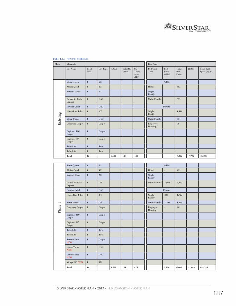
SILVER STAR MASTER PLAN • 2017 • 4.0 EXPANSION MASTER PLAN
187
TABLE 4-14: PHASING SCHEDULE
Phase Mountain Base Area
Lift Name Total Lifts
Lift Type (CCC) Total Ski Trails
Ski Trails Area (HA)
Bed Unit Type
Bed Units Added
Total Bed Units
(BRC) Total Built Space (Sq. Ft.
Exis
ting
Silver Queen 1 4C Public
Alpine Quad 1 4C Hotel 492
Summit Chair 1 2C Single Family
Comet Six Pack Express
1 D6C Multi-Family 395
Powder Gulch 1 D4C Private
Home Run T-Bar 1 2 T Single Family
1,488
Silver Woods 1 D4C Multi-Family 831
Discovery Carpet 1 Carpet Employee Housing
96
Beginner 180' Carpet
1 Carpet
Beginner 80' Carpet
1 Carpet
Tube Lift 1 Tow
Tube Lift 1 Tow
Total 12 5,500 128 421 - 3,302 7,992 86,090
Phas
e 1
Silver Queen 1 4C Public
Alpine Quad 1 4C Hotel - 492
Summit Chair 1 2C Single Family
-
Comet Six Pack Express
1 D6C Multi-Family 1,968 2,363
Powder Gulch 1 D4C Private
Home Run T-Bar 1 2 T Single Family
234 1,722
Silver Woods 1 D4C Multi-Family 1,104 1,935
Discovery Carpet 1 Carpet Employee Housing
- 96
Beginner 180' Carpet
1 Carpet
Beginner 80' Carpet
1 Carpet
Tube Lift 1 Tow
Tube Lift 1 Tow
Terrain Park NEW
1 Carpet
Upper Vance NEW
1 D4C
Lower Vance NEW
1 D4C
Village Lift NEW 1 4C
Total 16 8,499 141 474 3,306 6,608 11,049 148,735
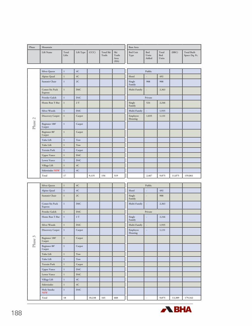
188
Phase Mountain Base Area
Lift Name Total Lifts
Lift Type (CCC) Total Ski Trails
Ski Trails Area (HA)
Bed Unit Type
Bed Units Added
Total Bed Units
(BRC) Total Built Space (Sq. Ft.
Phas
e 2
Silver Queen 1 4C Public
Alpine Quad 1 4C Hotel - 492
Summit Chair 1 2C Single Family
908 908
Comet Six Pack Express
1 D6C Multi-Family - 2,363
Powder Gulch 1 D4C Private
Home Run T-Bar 1 2 T Single Family
524 2,246
Silver Woods 1 D4C Multi-Family - 1,935
Discovery Carpet 1 Carpet Employee Housing
1,035 1,131
Beginner 180' Carpet
1 Carpet
Beginner 80' Carpet
1 Carpet
Tube Lift 1 Tow
Tube Lift 1 Tow
Terrain Park 1 Carpet
Upper Vance 1 D4C
Lower Vance 1 D4C
Village Lift 1 4C
Sidewinder NEW 1 4C
Total 17 9,135 156 519 2,467 9,075 11,875 159,861
Phas
e 3
Silver Queen 1 4C Public
Alpine Quad 1 4C Hotel - 492
Summit Chair 1 2C Single Family
- 908
Comet Six Pack Express
1 D6C Multi-Family - 2,363
Powder Gulch 1 D4C Private
Home Run T-Bar 1 2 T Single Family
- 2,246
Silver Woods 1 D4C Multi-Family - 1,935
Discovery Carpet 1 Carpet Employee Housing
- 1,131
Beginner 180' Carpet
1 Carpet
Beginner 80' Carpet
1 Carpet
Tube Lift 1 Tow
Tube Lift 1 Tow
Terrain Park 1 Carpet
Upper Vance 1 D4C
Lower Vance 1 D4C
Village Lift 1 4C
Sidewinder 1 4C
Holy Smoke NEW
1 D4C
Total 18 10,238 165 660 - 9,075 13,309 179,162
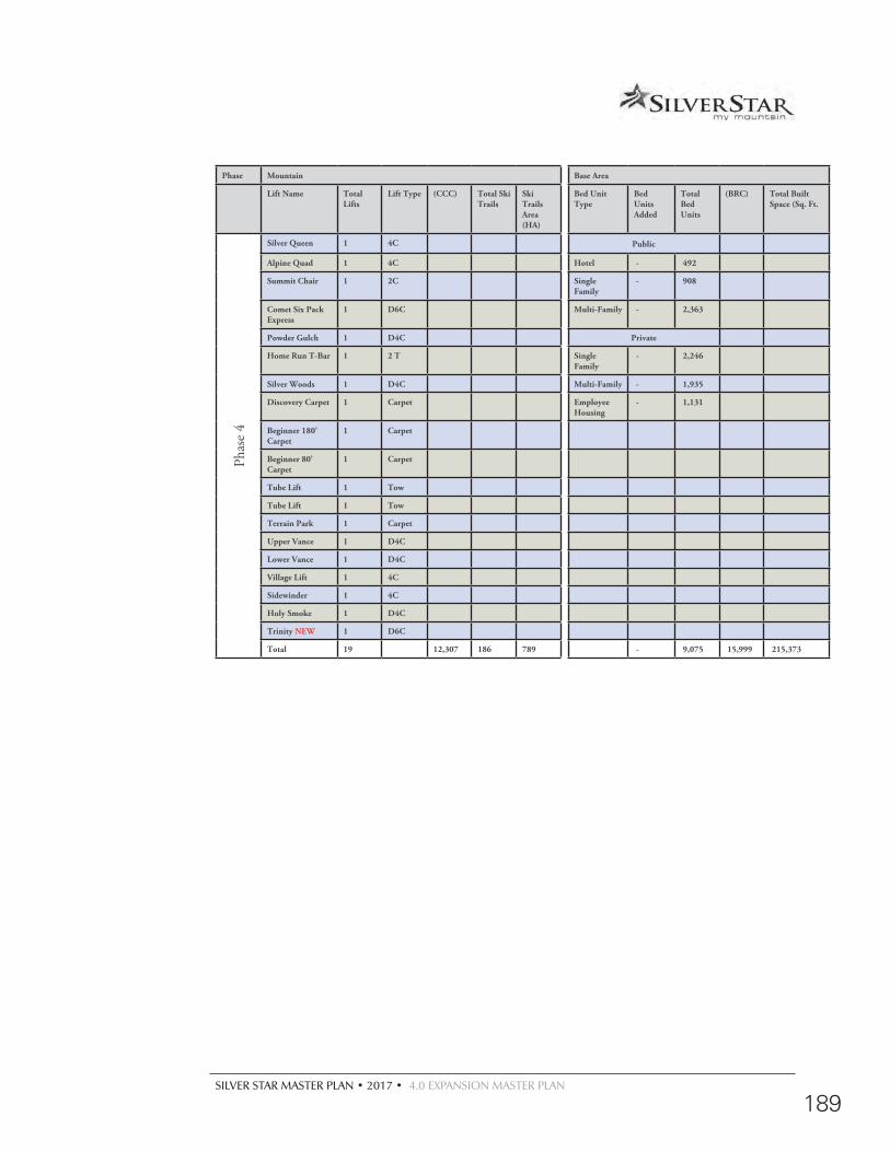
SILVER STAR MASTER PLAN • 2017 • 4.0 EXPANSION MASTER PLAN
189
Phase Mountain Base Area
Lift Name Total Lifts
Lift Type (CCC) Total Ski Trails
Ski Trails Area (HA)
Bed Unit Type
Bed Units Added
Total Bed Units
(BRC) Total Built Space (Sq. Ft.
Phas
e 4
Silver Queen 1 4C Public
Alpine Quad 1 4C Hotel - 492
Summit Chair 1 2C Single Family
- 908
Comet Six Pack Express
1 D6C Multi-Family - 2,363
Powder Gulch 1 D4C Private
Home Run T-Bar 1 2 T Single Family
- 2,246
Silver Woods 1 D4C Multi-Family - 1,935
Discovery Carpet 1 Carpet Employee Housing
- 1,131
Beginner 180' Carpet
1 Carpet
Beginner 80' Carpet
1 Carpet
Tube Lift 1 Tow
Tube Lift 1 Tow
Terrain Park 1 Carpet
Upper Vance 1 D4C
Lower Vance 1 D4C
Village Lift 1 4C
Sidewinder 1 4C
Holy Smoke 1 D4C
Trinity NEW 1 D6C
Total 19 12,307 186 789 - 9,075 15,999 215,373
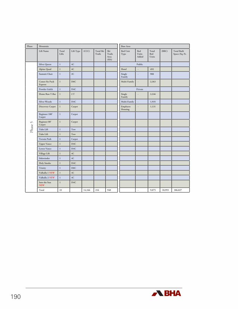
190
Phase Mountain Base Area
Lift Name Total Lifts
Lift Type (CCC) Total Ski Trails
Ski Trails Area (HA)
Bed Unit Type
Bed Units Added
Total Bed Units
(BRC) Total Built Space (Sq. Ft.
Phas
e 5
Silver Queen 1 4C Public
Alpine Quad 1 4C Hotel - 492
Summit Chair 1 2C Single Family
- 908
Comet Six Pack Express
1 D6C Multi-Family - 2,363
Powder Gulch 1 D4C Private
Home Run T-Bar 1 2 T Single Family
- 2,246
Silver Woods 1 D4C Multi-Family - 1,935
Discovery Carpet 1 Carpet Employee Housing
- 1,131
Beginner 180' Carpet
1 Carpet
Beginner 80' Carpet
1 Carpet
Tube Lift 1 Tow
Tube Lift 1 Tow
Terrain Park 1 Carpet
Upper Vance 1 D4C
Lower Vance 1 D4C
Village Lift 1 4C
Sidewinder 1 4C
Holy Smoke 1 D4C
Trinity 1 D6C
Valhalla 1 NEW 1 4C
Valhalla 2 NEW 1 4C
Into the Sun NEW
1 D4C
Total 22 14,166 216 940 - 9,075 18,993 306,827
SILVER STAR MASTER PLAN • 2017 • 4.0 EXPANSION MASTER PLAN
191
4.10.1 EXISTING CONDITIONS
Silver Star is a boutique, family oriented ski resort that attracts regional and destination visitors. Its offerings include lift serviced alpine skiing and snowboarding, cross-country skiing, tubing, snow shoeing, skating and snowmobiling in the Winter and mountain biking, hiking, horseback riding and swimming in the Summer. Additionally, the conference centre attracts visitors year round.
Specific details include the following:
d 12 ski lifts;
d 128 named trails;
d 421 hectares of skiable terrain;
d Comfortable Carrying Capacity (CCC) total 5,500 skiers per day;
d BRC total 1,640 guests per day;
d Built space for services and commercial facilities (skier services, restaurants, cafes, bars, retail, rental, etc.) not including built space for accommodation totals approximately 86,090 square feet; and
d Bed Units totalling 3,302
4.10.2 PHASE ONE
The first phase of development will see the upgrade of facilities on the mountain with the installation of four new lifts: a terrain park lift, the Upper Vance, Lower Vance and Village lifts. These lifts will increase the capacity on the frontside of the mountain and diversify the skier offering. Of significant note, the Lower Vance pod will open a new pod and feature world class gladed skiing Additional resort amenities including a destination spa will be constructed in the village base area. Residential development will continue focusing on infill within the Village, Village North and the Knoll. The 18-hole golf course and club house will be constructed as outlined. Specific elements and actions include:
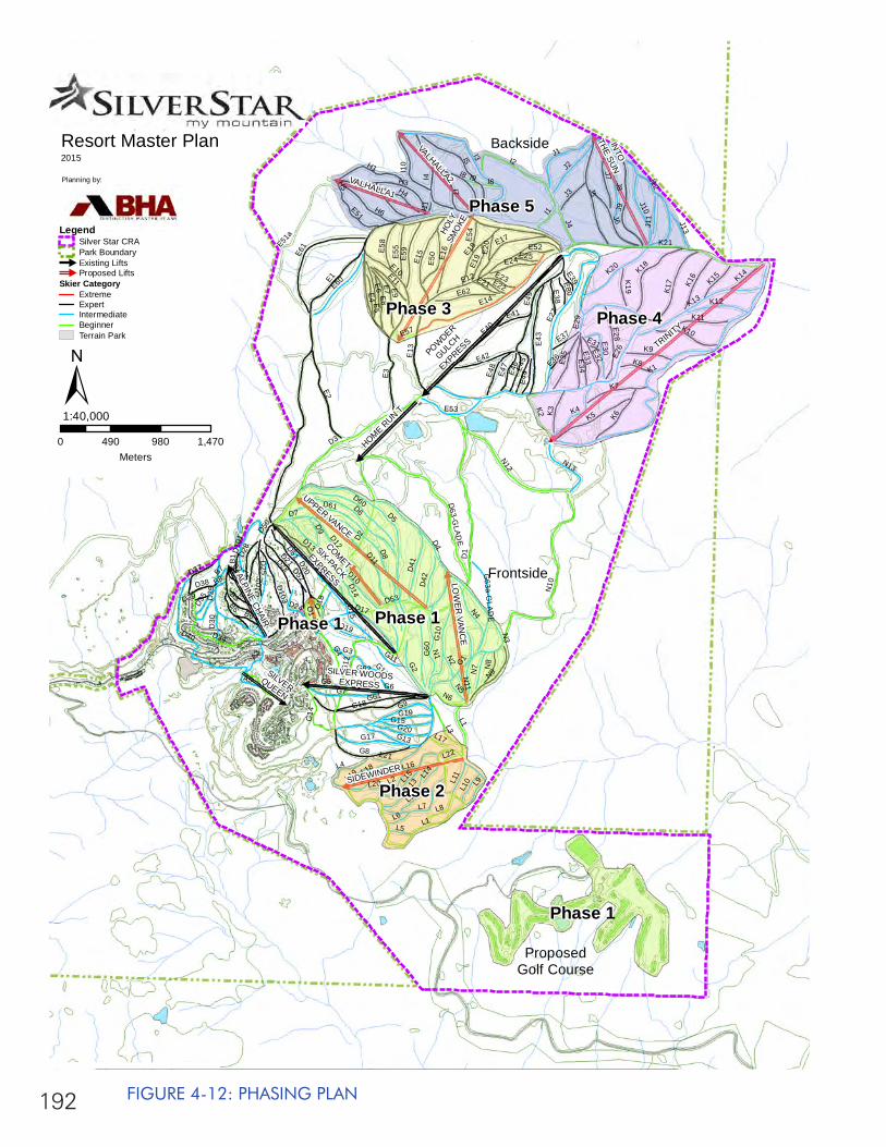
192
H5
I11
D50
L16
I9
L22
L20
I6
E57
L5
L14
L17
N5N
11
L6
N2
L21
L19
E54
L11
L10
K8
K14
L12
N8
J3O
1
O2
J4 J11
N7
K19
N6
K15
J13
L8
K3
K9
L1
I1
E58
H4
L18
G19
D42
E55
K2
G20
K16
L4
K11
K12E62
J2
K7
L9
L3I7
K10
J7
K6
N13
D53
E59
I8
G17
N9
J8
I10
K4D
41
H3
J10
N4
N1
J6
H1
J1
L13
H2
E60K20
L7
L15
D51
K5
K18
D52
K17
J9
I4
I2I5
H6
J5
L2
G18
E61
N12
K13
J12
I3
N3
K21
N10
L1
K1
E31
B8
B7
D39
E29
B1
B2
E39
E25
G3
B6
E20
B4
E36
D30
D38
G62
D33
D18
E22
E80
A5
D9
E21
D35
E37
E8
E23
E38
E41
D27
E44
E52
E19
G11
D24
D7
D19
E5
E46
A3
E47
G5
B5
D28
D14
E11
E24
E32
G16
E48 E4
5 E34
D37
D10
2
E33
D22
D25
A4
E51
E6
G9
E30
G2
G4
E50
E35
E7
E42
G14
D12
B3
G15
E18
E9
E53
D21
E10
G7
D13
E3
D16
E28
D15
G60
G6G61
E16
D61
E17
E13
E15
E4
G8
G63a-G
LAD
E
E2
D103
D11D20
D17
E43
E49
D60
G1
D34 G10
D6
D29
G12
G13
D10
1 D4
E27
E14
D40
D8
D2
D10
E51a
D63-G
LADE
E40
D5
E12
D3
D1
E26
E1
SILVERQUEEN
ALPINE CHAIR
HOME RUN T
VALHALLA1
VALHALLA2
INTO
THE SUN
SIDEWINDER
SILVER WOODSEXPRESS
LOW
ER VAN
CE
HOLY
SMO
KE
UPPER VANCE
COMET
SIX-PACK
EXPRESS
POWDER
GULCH
EXPRESS TRINITY
Phase 5
Phase 3 Phase 4
Phase 1Phase 1
Phase 2
Phase 1
Backside
ProposedGolf Course
Frontside
Resort Master Plan2015
Planning by:
0 490 980 1,470Meters
1:40,000±
LegendSilver Star CRAPark Boundary#
Existing Lifts#
Proposed LiftsSkier Category
ExtremeExpertIntermediateBeginnerTerrain Park
FIGURE 4-12: PHASING PLAN
SILVER STAR MASTER PLAN • 2017 • 4.0 EXPANSION MASTER PLAN
193
d Install Terrain Park Lift (Carpet) and develop associated trails and features;
d Install Upper Vance Lift (fixed grip quad) and develop the associated trails;
d Install Lower Vance Lift (fixed grip quad) and develop the associated trails;
d Install Village Lift (fixed grip quad) and develop associated trails;
d Infill existing base and residential areas with committed development;
d Develop golf course.
In summary, Phase 1 will see the following:
d The number of ski lifts increase from 12 to 16;
d The number of named ski trails increase from 128 to 141;
d The developed ski terrain increases from 421 to 474 hectares, designed to correct the existing imbalances;
d The lift serviced mountain bike park is further developed
d The golf course is established
d CCC increases from 5,500 to 8,499 skiers per day;
d BRC increases from 7,992 to 11,049 guests per day;
d Built space for services and commercial facilities (skier services, restaurants, cafes, bars, retail, rental, etc.) not including built space for accommodation increases from 86,090 to 148,735 square feet.
d Bed units will increase from 3,302 to 6,608 (the total bed units approved under the existing Master Plan). The breakdown in development types (hotel, single family, multi family, employee housing) has largely been assigned, however, SSMR will encourage the development of employee housing to address the current shortfall. At present, Silver Star provides 225 units of staff housing (7% vs goal of 15%).
194
4.10.3 PHASE TWO
The second phase of development will see the upgrade of facilities on the mountain with the installation of the Sidewinder Lift. This pod will create additional Intermediate skiing close to the Village base. In Phase Two the Village will be further developed and additional summer opportunities will be explored. Additional residential units will be constructed in the Knoll and West Knoll neighbourhoods. Specific elements and actions include:
d Install Sidewinder Lift (fixed griped quad) and develop associated trails;
d Develop the Knoll and West Knoll.
In summary, Phase 2 will see the following:
d The number of ski lifts will increase from 16 to 17;
d The number of named ski trails increase from 141 to 156;
d The developed ski terrain increases from 474 to 519 hectares;
d CCC increases from 8,499 to 9,135 skiers per day;
d BRC increases from 11,049 to 11,875 guests per day;
d Built space for services and commercial facilities (skier services, restaurants, cafes, bars, retail, rental, etc.) not including built space for accommodation increases from 148,735 to 159,861 square feet.
d Bed Units increase from 6,608 to 9,075 encouraging the construction of employee housing, public single family rental pool units and single family private units.

SILVER STAR MASTER PLAN • 2017 • 4.0 EXPANSION MASTER PLAN
195
4.10.4 PHASE THREE
The third phase of development will see the upgrade of facilities on the mountain with the installation of the Holy Smoke Lift. This lift opens up a large section of natural terrain which will offer a unique backcountry experience through the integration of glading and low density run development. Runs will consist of mainly Expert terrain and will be a popular destination for skiers looking for Silver Star’s world renowned champaign powder. Specific elements and actions include:
d Install Holy Smoke Lift (detachable quad) and develop the associated trails;
In summary, Phase 3 will see the following:
d The number of ski lifts will increase from 17 to 18;
d The number of named ski trails increase from 156 to 165;
d The developed ski terrain increases from 519 to 660 hectares;
d CCC increases from 9,135 to 10,238 skiers per day;
d BRC increases from 11,875 to 13,309 guests per day;
d Built space for services and commercial facilities (skier services, restaurants, cafes, bars, retail, rental, etc.) not including built space for accommodation increases from 189,496 to 215,096 square feet.
d Bed Units remain at the approved maximum of 9,075.
4.10.5 PHASE FOUR
The fourth phase of development will see the upgrade of facilities on the mountain with the installation of the Trinity Lift. This lift will offer a skiing experience that will elevate Silver Star’s reputation to a global level. The associated terrain pod development will largely be in the form of glading and removal of timber to create new trail connections. The Trinity ski pod will increase the Intermediate,
196
Advanced and Expert terrain offerings on the mountain and, when combined with the proposed glading program, will open Silver Star to an international marketplace. The high-speed detachable six-chair will add significant capacity to the mountain and will be SSMR’s longest chairlift at 2,817 metres rising an impressive 637 meters. The associated terrain pod modifications will include run development and glading. Specific elements and actions include:
d Install Trinity Ski Lift and develop the associated trails;
In summary, Phase 4 will see the following:
d The number of ski lifts will increase from 18 to 19;
d The number of named ski trails increase from 165 to 186;
d The developed ski terrain increases from 660 to 789 hectares;
d CCC increases from 10,238 to 12,307 skiers per day;
d BRC increases from 13,309 to 15,999 guests per day;
d Built space for services and commercial facilities (skier services, restaurants, cafes, bars, retail, rental, etc.) not including built space for accommodation increases from 179,162 to 215,373 square feet.
d Bed Units remain at the approved maximum of 9,075.
4.10.6 PHASE FIVE
The fifth phase of development will see the upgrade of facilities on the mountain with the installation of three lifts, Vallhalla 1, Valhalla 2 and the Into the Sun lifts. These lifts and their associated terrain pods will increase Advanced and Expert ski terrain offerings at Silver Star creating a balanced resort offering and increasing the resort’s destination appeal. Specific elements and actions include:
SILVER STAR MASTER PLAN • 2017 • 4.0 EXPANSION MASTER PLAN
197
d Install Valhalla 1 lift (fixed griped double) and develop associated trails;
d Install Valhalla 2 lift (fixed grip double) and develop associated trails;
d Install Into the Sun lift (detachable quad) and develop associated trails;
In summary, Phase 5 will see the following:
d The number of ski lifts will increase from 19 to 22;
d The number of named ski trails increase from 186 to 216;
d The developed ski terrain increases from 789 to 940 hectares;
d CCC increases from 12,307 to 14,166 skiers per day;
d BRC increases from 15,999 to 18,993 guests per day;
d Built space for services and commercial facilities (skier services, restaurants, cafes, bars, retail, rental, etc.) not including built space for accommodation increases from 215,373 to 306,827 square feet.
d Bed Units remain at the approved maximum of 9,075
4.11 Social and Economic Impact
The proposed expansion of Silver Star Mountain Resort is expected to have a far reaching positive economic and social impact on the region. Specifically, the nearby communities of Vernon and Lumby as well as the Okanagan Indian Band and the Splatsin First Nation.
Preliminary projections have been generated to indicate the scale and scope of employment creation and capital expenditure associated with the full buildout condition at Silver Star as
198
contemplated in this Master Plan. During the 2007/2008 season, Silver Star received 384,055 skier visits. This number reflects a steady increase over the previous five years. Since that record season visitor numbers have remained high but have leveled off. It is anticipated that Silver Star will approach and potentially exceed 675,000 skier visits at buildout. From this preliminary analysis, the development of Silver Star has the potential to create 5,514.9 person years of employment. Of this, 3,783.9 person years will be direct employment and 1,730.9 will be indirect employment. This is correlated with an estimated total capital expenditure of approximately $402,545,000. This type of investment would mean a full spectrum of construction jobs will be required over the course of the implementation of the Silver Star Master Plan. As such, the personnel working those jobs will need to live within an easy commute to Silver Star. This will create a direct benefit to those companies located within close proximity to the resort. Table 4-15 describes the economic impact in greater detail.
TABLE 4-15: PRELIMINARY SOCIO-ECONOMIC IMPACTS OF SILVER STAR AT BUILDOUT
Item Cost Direct Employment
(Jobs)
Indirect Employment
(Jobs)
Ski LiftsD4C Lower Vance (Proposed) $4,500,000 42.3 19.4
D4C Upper Vance (Proposed) $5,000,000 47.0 21.5
D4C Holy Smoke (Proposed) $4,500,000 42.3 19.4
4C Village Lift (Proposed) $1,500,000 14.1 6.5
4C Valhalla 1 (Proposed) $2,000,000 18.8 8.6
4C Valhalla 2 (Proposed) $2,000,000 18.8 8.6
D4C Into the Sun (Proposed) $4,500,000 42.3 19.4
D6C Trinity (Proposed) $5,500,000 51.7 23.7
4C Sidewinder (Proposed) $2,000,000 18.8 8.6
Ski Lifts Total $31,500,000 296.1 135.7
Mtn. DevelopmentRun Development $5,369,055 50.5 23.1
Base Area DevelopmentSkier-Related Space $43,832,400 412.0 188.5
Destination Guest Related Space $17,533,000 164.8 75.4
Public Accommodation $104,960,000 986.6 451.3
Private Accommodation $201,600,000 1,895.0 866.9
Totals $402,544,455 3,783.9 1,730.95,514.9

SILVER STAR MASTER PLAN • 2017 • 4.0 EXPANSION MASTER PLAN
199
In addition, there will be a number of permanent jobs created at Silver Star (Table 4-16) as a result of the expansion of the Ski Area. It is expected that management, staff and employees of Silver Star will choose to live at or near the resort and spend their money in the surrounding area. At buildout the resort is expected to require over 945 direct full time equivalent positions and 472.5 indirect full time equivalent positions.
TABLE 4-16: PRELIMINARY SOCIO-ECONOMIC IMPACTS OF SILVER STAR BY PHASE
Phase Approximate Projected Yearly
Skier Vistis*
Direct (FTE) Indirect (FTE) Total (FTE)
One 404,975 567.0 283.5 850.4
Two 435,271 609.4 304.7 914.1
Three 487,822 683.0 341.5 1,024.4
Four 586,416 821.0 410.5 1,231.5
Buildout 675,000 945.0 472.5 1,417.5
* at end of proposed Phase
In summary, major economic and social impacts will include:
d 5,515 person years of construction related employment over over the course of the estimated 15 to 25 year development of Silver Star;
d 1,417 plus year-round and seasonal jobs at the resort;
d Property tax revenue from the all-season mountain attractions and the supporting facilities;
d Major boosts to the local and regional economy.

200
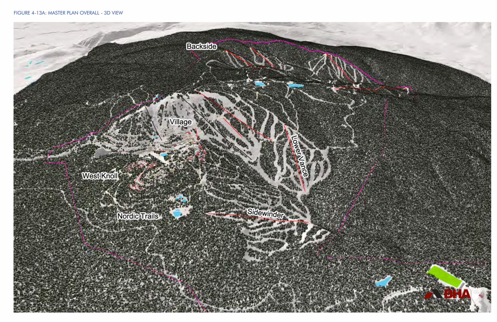
FIGURE 4-13A: MASTER PLAN OVERALL - 3D VIEW

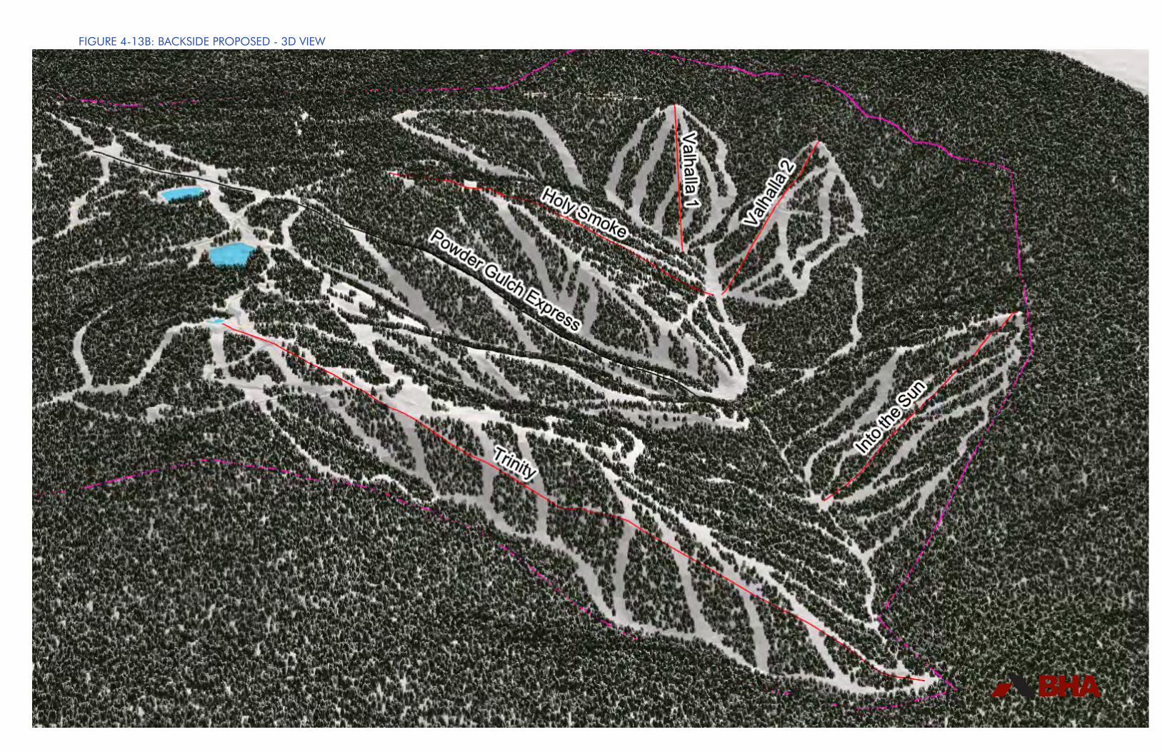
FIGURE 4-13B: BACKSIDE PROPOSED - 3D VIEW

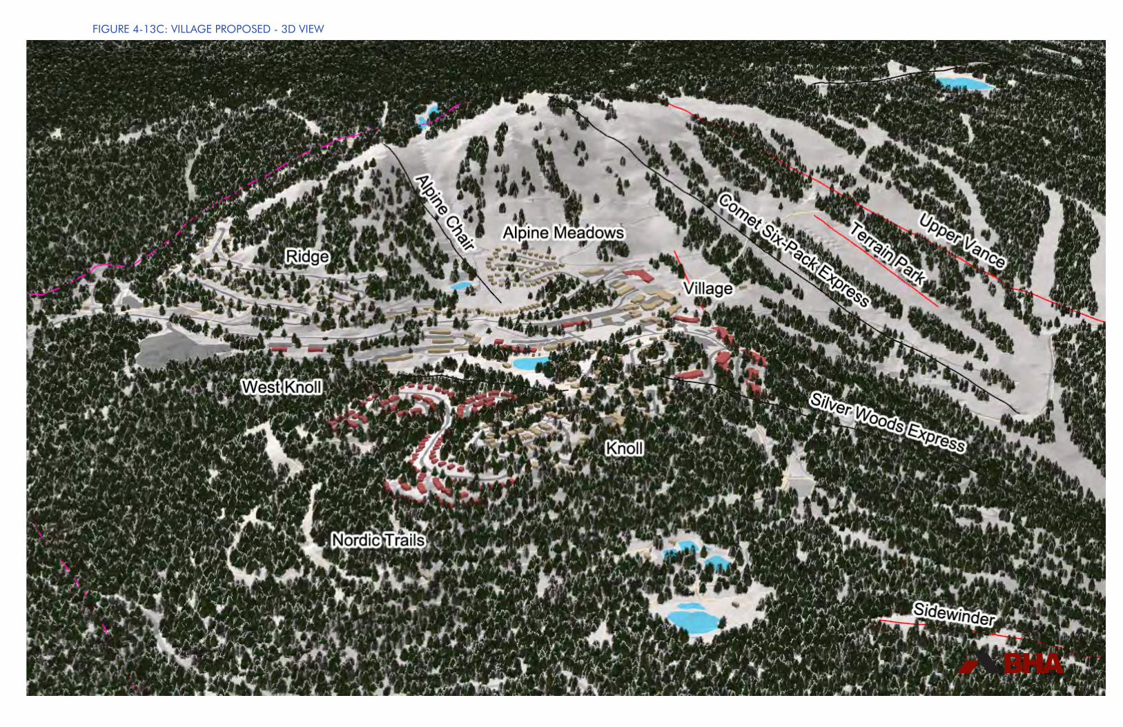
FIGURE 4-13C: VILLAGE PROPOSED - 3D VIEW

SILVER STAR MASTER PLAN • 2017 • CONCLUSION
207
4.12 Conclusion
It is Silver Star Mountain Resort Ltd.’s vision to “enhance and advance Silver Star’s reputation as the premier, family oriented, all season mountain resort of British Columbia.” Since Silver Star was acquired in 2001, the ownership has diligently worked towards achieving that vision by investing significantly in the on-mountain amenities and facilities, infrastructure and the supporting accommodation in the Village and surrounding neighbourhoods. Silver Star has received many awards from various ski and lifestyle publications including the Ski Canada Magazine award for “Best Family Skiing” in the “2006 Best of Skiing in Canada” article and the “Best Tourist Attraction” in the “2014 Okanagan Life Best Of”.
With this new Master Plan, Silver Star wishes to establish sustained prosperity for all those connected to the resort well into the future. The proposed continued improvements to of Silver Star are designed to satisfy the growing demand for recreational amenities and resort real estate opportunities within the Okanagan and British Columbia as a whole. This Master Plan is structured to guide Silver Star’s continued growth in a well balanced, organized and integrated fashion, while remaining sensitive to its natural surroundings. The Plan is also designed to be flexible enough to enable Silver Star to respond to market and industry trends in a dynamic manner that helps Silver Star evolve into an all season, destination focused mountain resort.

208
Silver Star is excited about the opportunity to implement the Master Plan and looks forward to achieving the local, regional and Provincial support required to bring the vision and goals described within this document into reality.
BIG AIR

SILVER STAR MASTER PLAN • 2017 • APPENDIX
Appendix 1 - Cascade Environmental Report

Environmental Review: SilverStar Mountain Resort
Prepared for:
SilverStar Mountain Resort PO Box 3002 Silver Star Mountain, BC V1B 3M1 Prepared by:
File #: 012-02-02 Date: March 10, 2017

ENVIRONMENTAL REVIEW | PREPARED FOR: SILVERSTAR MOUNTAIN RESORT | File #: 012-02-02 | Date: March 10, 2017 i
Table of Contents
Statement of Limitations .............................................................................................................. v
1 Introduction .......................................................................................................................... 6
1.1 Background ....................................................................................................................... 6
1.1.1 Environmental Reviews for the Golf Course Area ........................................................ 6
1.1.2 Current Environmental Review for the Controlled Recreation Area............................... 7
1.2 Study Area Location ......................................................................................................... 7
1.3 The Project Team .............................................................................................................. 7
1.4 Project Scope .................................................................................................................... 7
1.5 Methodology ..................................................................................................................... 8
1.5.1 Vegetation ................................................................................................................... 8
1.5.2 Wildlife and Wildlife Habitat ......................................................................................... 9
1.5.3 Aquatic Environment ................................................................................................... 9
2 Existing Environmental Conditions ................................................................................... 15
2.1 Cultural Environment...................................................................................................... 15
2.1.1 First Nations .............................................................................................................. 15
2.1.2 Timber Harvesting ..................................................................................................... 15
2.1.3 Anthropogenic Features ............................................................................................ 18
2.2 Physical Environment ..................................................................................................... 23
2.2.1 Climate...................................................................................................................... 23
2.2.2 Geology .................................................................................................................... 23
2.2.3 Geomorphology ......................................................................................................... 23
2.2.4 Hydrology .................................................................................................................. 26
2.3 Terrestrial Environment .................................................................................................. 31
2.3.1 Soils .......................................................................................................................... 31
2.3.2 Vegetation ................................................................................................................. 32
2.3.3 Wildlife and Wildlife Habitat ....................................................................................... 54
2.4 Aquatic Environment ...................................................................................................... 72
2.4.1 Aquatic Biophysical ................................................................................................... 72
2.4.2 Water Quality ............................................................................................................ 76
2.5 Wetland Environment ..................................................................................................... 79
2.5.1 Delineation ................................................................................................................ 79
ii ENVIRONMENTRAL REVIEW | PREPARED FOR: SILVERSTAR MOUNTAIN RESORT | File #: 012-02-02 | Date: March 10, 2017
2.5.2 Functionality .............................................................................................................. 79
2.5.3 Rare and Endangered Fish Species .......................................................................... 80
3 Environmental Constraints ................................................................................................ 84
3.1 Cultural Environment...................................................................................................... 84
3.1.1 Anthropogenic Features ............................................................................................ 84
3.2 Physical Environment ..................................................................................................... 84
3.2.1 Climate...................................................................................................................... 84
3.2.2 Geology .................................................................................................................... 84
3.2.3 Geomorphology and Surficial Material ....................................................................... 84
3.2.4 Hydrology .................................................................................................................. 84
3.3 Terrestrial Environment .................................................................................................. 85
3.3.1 Soils .......................................................................................................................... 85
3.3.2 Vegetation ................................................................................................................. 85
3.3.3 Wildlife and Valued Ecosystem Components ............................................................. 86
3.4 Aquatic Environment ...................................................................................................... 90
3.4.1 Aquatic Biophysical ................................................................................................... 90
3.4.2 Water Quality ............................................................................................................ 91
3.5 Wetland Environment ..................................................................................................... 92
3.5.1 Delineation ................................................................................................................ 92
3.5.2 Functionality .............................................................................................................. 92
4 Conclusions and Recommendations ................................................................................. 93
4.1 Conclusions .................................................................................................................... 93
4.2 Recommendations .......................................................................................................... 93
4.2.1 General ..................................................................................................................... 93
4.2.2 Cultural Environment ................................................................................................. 94
4.2.3 Physical Environment ................................................................................................ 95
4.2.4 Terrestrial Environment ............................................................................................. 95
4.2.5 Aquatic Environment ................................................................................................. 95
4.2.6 Habitat Enhancement ................................................................................................ 96
4.3 Additional Studies .......................................................................................................... 96
5 References .......................................................................................................................... 96

ENVIRONMENTAL REVIEW | PREPARED FOR: SILVERSTAR MOUNTAIN RESORT | File #: 012-02-02 | Date: March 10, 2017 iii
6 Appendices ....................................................................................................................... 105
iv ENVIRONMENTRAL REVIEW | PREPARED FOR: SILVERSTAR MOUNTAIN RESORT | File #: 012-02-02 | Date: March 10, 2017
List of Appendices Appendix A. Wastewater Treatment Plant – Summary of Operations .......................................... 105 Appendix B. Stream Survey Forms ............................................................................................. 114 Appendix C. Water Sampling Analysis ........................................................................................ 119 Appendix D. Map 8 – Data Sources ............................................................................................ 127
List of Maps Map 1: Location Map ................................................................................................................... 11 Map 2: Watershed and Drainage Basins ...................................................................................... 13 Map 3: Remediation Site ............................................................................................................. 21 Map 4: Terrain Mapping............................................................................................................... 25 Map 5: Terrestrial Ecosystems..................................................................................................... 35 Map 6: Stream Sampling Locations ............................................................................................. 78 Map 7: Opportunities and Constraints .......................................................................................... 83 Map 8: Data Sources ................................................................................................................. 128 List of Tables Table 1. Historical Streamflow Summary (to 2017), Water Survey of Canada ............................... 29 Table 2. Sample Plot Soils ........................................................................................................... 32 Table 3: VRI Site Series .............................................................................................................. 37 Table 4: PEM Site Series ............................................................................................................. 38 Table 5: TEM Site Series .............................................................................................................. 39 Table 6: TEM Site Modifiers......................................................................................................... 39 Table 7: TEM Structural Stage Modifiers ...................................................................................... 40 Table 8: Typical conditions and total areas of site series in the CRA ............................................ 41 Table 9: Plant species list for the TEM portion of the study area................................................... 50 Table 10: Rare tree species types – Vernon Landscape Unit ....................................................... 53 Table 11. Bird species known or expected to occur in the Study Area .......................................... 54 Table 12: Potential Rare and Endangered Wildlife Species .......................................................... 63 Table 13. Stream Sampling Locations.......................................................................................... 76 Table 14. Wetland Function Matrix............................................................................................... 80 Table 15. Rare and Endangered Fish Species ............................................................................. 81 List of Photographs Photo 1. Example of wildfire fuel management at SilverStar ......................................................... 16 Photo 2. Firebreak at SilverStar ................................................................................................... 16 Photo 3. Example of gladed and revegetated slope at SilverStar.................................................. 17 Photo 4. Brush cutting flail mower mounted on a snowcat at slope at SilverStar ........................... 17 Photo 5. View of remediated contaminated site at SilverStar ........................................................ 18 Photo 6. Back of house view, SilverStar Village ........................................................................... 19 Photo 7. Waste Transfer Station at SilverStar .............................................................................. 19 Photo 8. Slopeside resort development at SilverStar. ................................................................... 20 Photo 9. Vehicle maintenance building at SilverStar..................................................................... 20 Photo 10. Riparian condition, Vance Creek at SilverStar. ............................................................. 27 Photo 11. Paradise Lake Reservoir. ............................................................................................. 28 Photo 12. Oblique aerial view of the Plateau containing the ICHmk1 ............................................ 45 Photo 13. View up to the Plateau from the lower Vance Creek drainage basin. ............................ 46 Photo 14. Sample site in ICHmk1, Site Series 03 ......................................................................... 47 Photo 15. Sample site in ICHmk1, Site Series 05 ......................................................................... 48 Photo 16. Site of badger activity at SilverStar............................................................................... 59
ENVIRONMENTAL REVIEW | PREPARED FOR: SILVERSTAR MOUNTAIN RESORT | File #: 012-02-02 | Date: March 10, 2017 v
Statement of Limitations This Document was prepared by Cascade Environmental Resource Group Ltd. for the account of SilverStar Mountain Resort. Should this report contain an error or omission then the liability, if any, of Cascade Environmental Resource Group Ltd. should be limited to the fee received by Cascade Environmental Resource Group Ltd. for the preparation of this document. Recommendations contained in this report reflect Cascade Environmental Resource Group Ltd.’s judgment in light of information available at the time of study. The accuracy of information provided to Cascade Environmental Resource Group Ltd. is not guaranteed. Neither all nor part of the contents of this report should be used by any party, other than the client, without the express written consent of Cascade Environmental Resource Group Ltd. This report was prepared for the client for the client’s own information and for presentation to the approving government agencies. The report may not be used or relied upon by any other person unless that person is specifically named by Cascade Environmental Resource Group Ltd. as a beneficiary of the report, in which case the report may be used by the additional beneficiary Cascade Environmental Resource Group Ltd. has named. If such consent is granted, a surcharge may be rendered. The client agrees to maintain the confidentiality of the report and reasonably protect the report from distribution to any other person. If the client directly or indirectly causes the report to be distributed to any other person, the client shall indemnify, defend and hold Cascade Environmental Resource Group Ltd. harmless if any third party brings a claim against Cascade Environmental Resource Group Ltd. relating to the report. This document should not be construed to be:
A Phase 1 - Environmental Site Assessment; A Stage 1 – Preliminary Site Investigation (as per the Contaminated Sites Regulations of
the Waste Mgt. Act); An Environmental Impact Assessment.
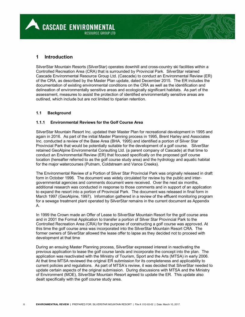
6 ENVIRONMENTRAL REVIEW | PREPARED FOR: SILVERSTAR MOUNTAIN RESORT | File #: 012-02-02 | Date: March 10, 2017
1 Introduction
SilverStar Mountain Resorts (SilverStar) operates downhill and cross-country ski facilities within a Controlled Recreation Area (CRA) that is surrounded by Provincial Park. SilverStar retained Cascade Environmental Resource Group Ltd. (Cascade) to conduct an Environmental Review (ER) of the CRA, as described by the Master Plan update, dated December 2015. The ER includes the documentation of existing environmental conditions on the CRA as well as the identification and delineation of environmentally sensitive areas and ecologically significant habitats. As part of the assessment, measures to assist the protection of identified environmentally sensitive areas are outlined, which include but are not limited to riparian retention.
1.1 Background
1.1.1 Environmental Reviews for the Golf Course Area
SilverStar Mountain Resort Inc. updated their Master Plan for recreational development in 1995 and again in 2016. As part of the initial Master Planning process in 1995, Brent Harley and Associates Inc. conducted a review of the Base Area (BHA, 1995) and identified a portion of Silver Star Provincial Park that would be potentially suitable for the development of a golf course. SilverStar retained GeoAlpine Environmental Consulting Ltd. (a parent company of Cascade) at that time to conduct an Environmental Review (ER) that focused specifically on the proposed golf course location (hereafter referred to as the golf course study area) and the hydrology and aquatic habitat for the major watercourses (Putnam, Coldstream and Vance Creeks). The Environmental Review of a Portion of Silver Star Provincial Park was originally released in draft form in October 1996. The document was widely circulated for review by the public and inter-governmental agencies and comments document were received. Over the next six months, additional research was conducted in response to those comments and in support of an application to expand the resort into a portion of Provincial Park. The document was released in final form in March 1997 (GeoAlpine, 1997). Information gathered in a review of the effluent monitoring program for a sewage treatment plant operated by SilverStar remains in the current document as Appendix A. In 1999 the Crown made an Offer of Lease to SilverStar Mountain Resort for the golf course area and in 2001 the Formal Application to transfer a portion of Silver Star Provincial Park to the Controlled Recreation Area (CRA) for the purpose of constructing a golf course was approved. At this time the golf course area was incorporated into the SilverStar Mountain Resort CRA. The former owners of SilverStar allowed the lease offer to lapse as they decided not to proceed with development at that time During an ensuing Master Planning process, SilverStar expressed interest in reactivating the previous application to lease the golf course lands and incorporate the concept into the plan. The application was reactivated with the Ministry of Tourism, Sport and the Arts (MTSA) in early 2006. At that time MTSA reviewed the original ER submission for its completeness and applicability to current policies and regulations. As part of MTSA’s review, it was decided that SilverStar needed to update certain aspects of the original submission. During discussions with MTSA and the Ministry of Environment (MOE), SilverStar Mountain Resort agreed to update the ER. This update also dealt specifically with the golf course study area.
ENVIRONMENTAL REVIEW | PREPARED FOR: SILVERSTAR MOUNTAIN RESORT | File #: 012-02-02 | Date: March 10, 2017 7
The 2006 Updated Environmental Review (Cascade, 2006) was prepared based on analysis of orthophotos produced from 2004 aerial photography and on the understanding that no changes have occurred to the subject lands in the intervening period.
1.1.2 Current Environmental Review for the Controlled Recreation Area
In 2016, SilverStar Mountain Resort submitted an updated Master Plan and application for a replacement of their existing Master Development Agreement (MDA) with a new 60 year MDA. With the most recent Updated Environmental Review now almost 10 years old and its scope limited primarily to the golf course study area, a new update was required by the Mountain Resort Branch of the Ministry of Forests, Lands, and Natural Resource Operations (FLNRO). SilverStar commissioned an update to the Environmental Review that integrated the additional information for the CRA into the original document, thereby providing a more comprehensive review.
1.2 Study Area Location
SilverStar Mountain Resort is encircled by Silver Star Provincial Park and is located on the east side of Okanagan Lake, approximately 20 km northeast of Vernon and 15 km northwest of Lumby. The study area comprises the entire CRA of the Resort, including the upper Putnam, Vance and Coldstream Creek drainages (see Map 1).
1.3 The Project Team
Initial studies were conducted by a project team consisting of Dave Williamson, B.E.S., Mike Nelson, R.P.Bio., Mike Cole, M.Sc., P.Eng., Ethan Askey, M.R.M., and Martin Gebauer, M.Sc., R.P.Bio. Additional research assistance was provided by Jas Michalski, B.Sc., and Karina Andrus, B.A. The 2006 update was completed by Dave Williamson, Mike Nelson, Chris Wood, M.Sc., and Amber Lunn, B.Sc. For this 2016 update, Dave Williamson, QEP, conducted on-site investigations to verify existing site conditions for the project. Mike Nelson, Kersti Vaino, R.B.Tech., Natasha Dudley, B.Sc., B.I.T., and Adrien Baudouin, M.Sc., R.P.Bio., contributed to the review. Todd Hellinga, B.Sc., GIS-AS, and Nicola Church, B.A., M.Sc., performed GIS analyses and constructed applicable maps. All project team members have extensive experience in conducting environmental inventories, reviews and assessments.
1.4 Project Scope
An update to the 2006 Environmental Review was required by the Mountain Resort Branch of the Ministry of Forests, Lands, and Natural Resource Operations (FLNRO) as part of SilverStar Mountain Resort’s 2016 submission for an updated Master Plan. This updated ER integrates the contents of the 1996 report and the 2006 update for the golf course study area with additional information for the entire CRA. It incorporates all work completed since 1996 and has an expanded scope to include the entire CRA as well as Putnam, Coldstream and Vance Creeks. The primary objectives of this review are to identify and delineate ecosystem units, environmentally sensitive areas, and ecologically significant habitats within the study area. This updated document also addresses changes in legislation, policy and regulation that have occurred since 1996.
8 ENVIRONMENTRAL REVIEW | PREPARED FOR: SILVERSTAR MOUNTAIN RESORT | File #: 012-02-02 | Date: March 10, 2017
1.5 Methodology
The ER examined the relationships between the built resort environment, the surrounding natural habitat and the recreational interface within the CRA. Further detail on methodology is included under separate section headings. Additional documents were prepared during the application process and reviewed as part of the update. These documents include, but are not limited to:
Formal Application to transfer a portion of Silver Star Provincial Park to the Controlled Recreation Area for the purpose of constructing a golf course, 1997
SilverStar Mountain Resort Golf Course Environmental Construction and Monitoring Plan, 1999.
Hydrological Assessment For Proposed Golf Course Development Silver Star Provincial Park, 1997.
SilverStar Mountain Resort, Golf Course Project – Comparison of Pre-Development and Post Development Drainage, 1997.
Paradise Lake and Vance Creek Reservoirs, Operation, Maintenance and Surveillance Manual, 2007.
New Well 13 at Silver Star Mountain Resort, Initial Report on Sustainable Yield and Water Quality. 2007
Fish Inventory and Stream Classification for an Unnamed Tributary to Vance Creek, 2008. Resort Wildfire Protection Plan, 2010. SilverStar Mountain Resort Master Plan, 2016. SilverStar Masterplan Update, Splatsin Cultural Heritage Overview Assessment, 2016. Archaeological Overview Assessment of SilverStar Mountain Resort, 2016.
1.5.1 Vegetation
The CRA is divided into three sub areas based on the level and type of vegetation/habitat assessment data available. The three areas are presented in Map 8, in Appendix D of this report and are described as the Terrestrial Ecosystem Mapping (TEM), the Predictive Ecosystem Mapping (PEM) and the Vegetation Resource Inventory (VRI) mapping areas. The most intensively studied is the TEM area, which consists of the golf course study area. In the original 1996 Environmental Review, the golf course study area was divided into map bio-terrain polygons based on ecological criteria such as climate, surficial geology and topography, soil, and vegetation. Established terrestrial ecosystem mapping principles (Resources Inventory Committee, 1998) were employed to identify and delineate distinct ecosystem units and show their distribution within the study area. Terrestrial ecosystem mapping integrates both abiotic and biotic components to provide an ecological framework for land use and resource management. Furthermore, it also served to: 1. Identify sensitive wetlands and riparian areas; 2. Identify productive forest types; 3. Produce wildlife capability and suitability mapping for the following species: Deer, Black Bear,
Amphibians, Cavity Nesters, Bats.
ENVIRONMENTAL REVIEW | PREPARED FOR: SILVERSTAR MOUNTAIN RESORT | File #: 012-02-02 | Date: March 10, 2017 9
At the outset of the 1996 study, a literature review was conducted to collect pertinent data and identify information gaps. Maps and aerial photographs of the golf course study area were analyzed to develop preliminary distinctions between ecosystem units, based on terrain and vegetation. To ensure accurate descriptions of the environmental conditions golf course study area and to reflect environmental reporting standards, a color orthophoto (1.0 m pixel size) was used for TEM unit interpretation. These tentatively delineated polygons were mapped for field use and ground-truthing during site investigations. Reconnaissance level field investigations were conducted between July 21 and 25, 1996. Ecosystem Field Forms [FS 882(1) HRE 96/4] were used to collect and record information to describe the site, soils, vegetation, and mensuration/wildlife in each polygon of the golf course study area. A Global Positioning System (GPS) was employed during field investigation to provide accurate geo-referencing of sample sites. Predictive Ecosystem Mapping (PEM) was used to describe areas within SilverStar’s CRA where TEM data was not available. The PEM areas are described in accordance with the outcomes of the analysis derived from the Okanagan TSA Predictive Ecosystem Mapping (PEM) Compilation Project Final Report (Timberline, 2010). The PEM areas are found in the lower reaches of the Putnam Creek, Vance Creek and BX Creek drainages within the CRA (see Map 2 and Map 8, Appendix D). The mid and upper elevations of the CRA have not been subjected to advanced ecological analysis and as such, the area is described in the context of VRI mapping (FLNRO, 2016). Site series descriptions are derived from interpretations of the PEM and TEM data combined with cursory observations from the site visits.
1.5.2 Wildlife and Wildlife Habitat
Wildlife was identified by visual observation, songs, tracks and feeding signs. Potential wildlife use not observed during the site reconnaissance was inferred from available habitats, local information, and known distributions. Valued ecosystem components such as riparian corridors, and first growth (i.e., veteran) trees, if any, were also noted during the survey. This report provides a reconnaissance-level description of wildlife and wildlife habitats at SilverStar Mountain Resort. This report does not generally provide species-specific impacts related to the proposed developments. Rather, this report provides general conclusions on the likely impacts of development on various species/communities.
1.5.3 Aquatic Environment
Fish habitat information was collected using the DFO/MOE Stream Survey Forms and methodology, and a program of electrofishing and trapping was undertaken to determine fish presence. Fish data was collected in the 1996 study and included assessments of all major watercourses within SilverStar’s CRA. The collected field data and other information constitute a baseline environmental inventory which identifies the main ecological systems and processes that occur in the study area. In the final phase of the study, an analysis of the inventory information was performed to identify constraints to development in the study area.

10 ENVIRONMENTRAL REVIEW | PREPARED FOR: SILVERSTAR MOUNTAIN RESORT | File #: 012-02-02 | Date: March 10, 2017
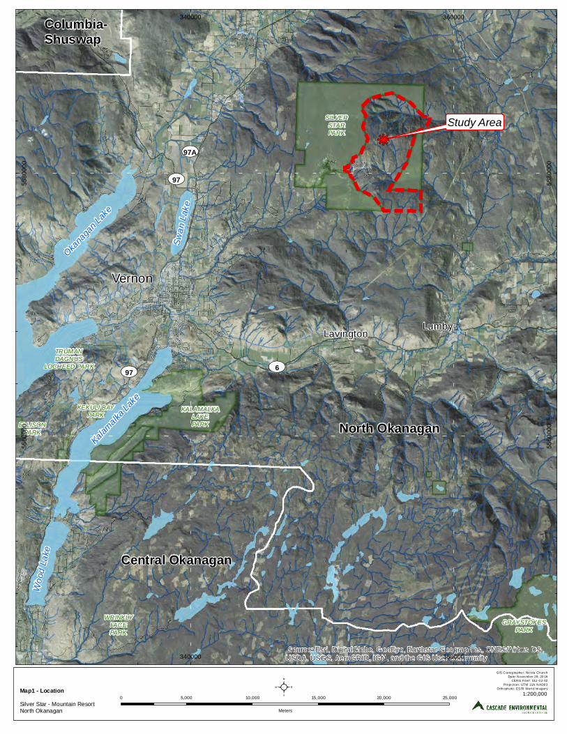
North Okanagan
Study Areakj
Central Okanagan
Columbia- Shuswap
LumbyLavington
KEKULI BAYPARK
TRUMANDAGNUS
LOCHEED PARK
SILVERSTARPARK
WRINKLYFACEPARK
GRAYSTOKESPARK
ELLISONPARK
KALAMALKALAKEPARK
Source: Esri, DigitalGlobe, GeoEye, Earthstar Geographics, CNES/Airbus DS,USDA, USGS, AeroGRID, IGN, and the GIS User Community
340000
340000
360000
360000
5560
000
5560
000
5580
000
5580
000
²Map1 - LocationSilver Star - Mountain ResortNorth Okanagan
GIS Cartog ra phe r: Nicola Ch urchDa te: Nove mb er 29 , 20 16
CERG File#: 012 -0 2-02Pro je ction: UTM 11N NAD8 3
Orth oph oto : ES RI World Im ag ery
0 5,000 10,000 15,000 20,000 25,000
Meters
Vernon
Kalamalk
a Lake
UV97A
Okanaga
n Lake
Swan
Lake
Wood
Lake
UV6UV97
UV97
1:200,000

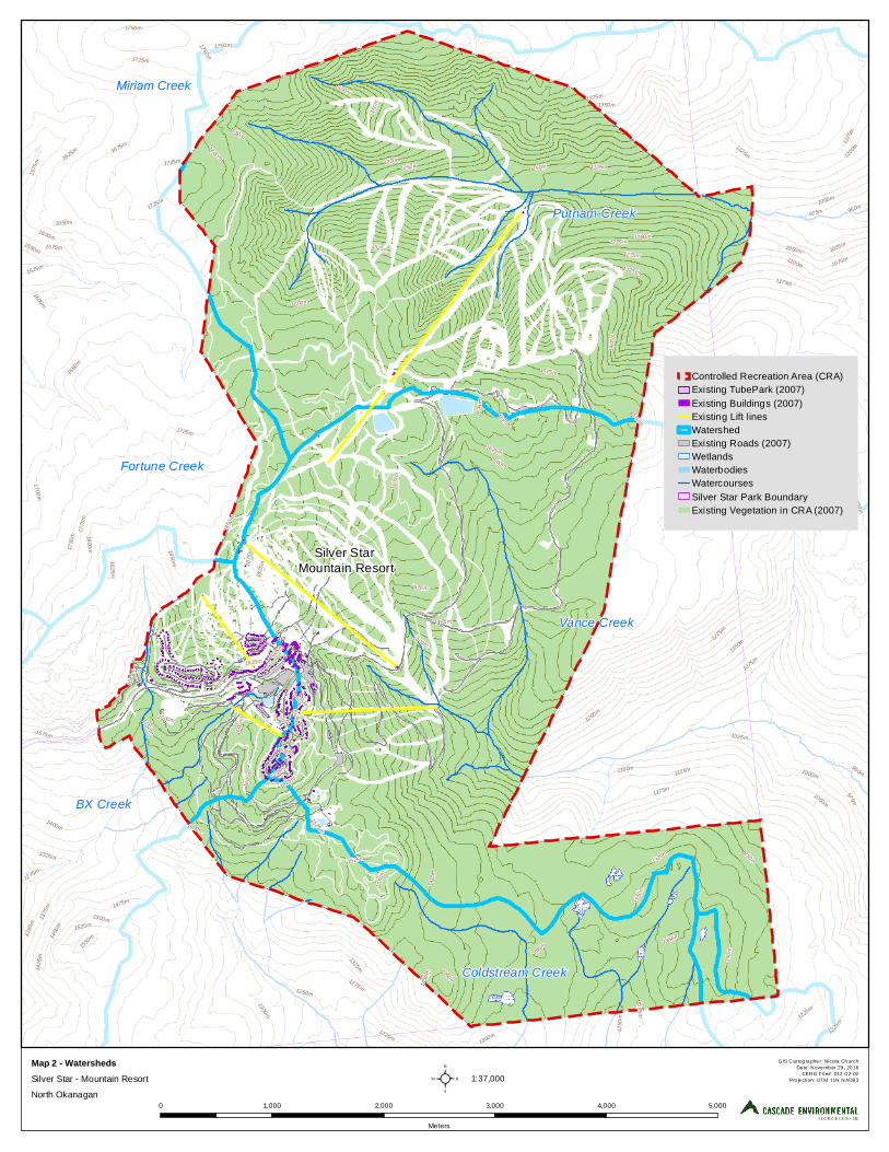
Putnam Creek
Silver Star Mountain Resort
Vance Creek
Coldstream Creek
Fortune Creek
BX Creek
1375m
1300m
1475m
1500m
1525m
1550m
1250m
1200m
1175m
1750
m
1150m
1650m
1600m
1100m
1675m
1775
m
1325m
1075m
1700m1625m
1400m
1050m
1725m
1800m
1425
m
1025m
1450
m
1275m
1000m
1825
m
975m13
50m
1225m
1125m
1575m
1850
m
950m
1875
m
1650m
1125m
1125m
1625m1625m
1150m
1600m
1175m
1575m
1550m
1425
m
1675
m
1650m
1325m
1625m
1025m1225m
1650m
1550m
1350m
1625m
1275m
1250
m
1275m
1475m
1550m
1350m
1625m
1650m
1200m
1450m
1525m
1250m
1100m
1400
m
1500m
1575
m1750m
1600m
1575m
1600m
1350
m
1600m
1625m
1300m
1525m1700m
1000m
1450
m
1525m
1625m
1725m
1825m
975m
1375
m
1300m
1075m
1250m
1125m
950m
1325m
1675m
1600
m
1550
m
1675
m
1750m
1525m
1050m
1625m
1225m
1850m
1325m
1400m 1225m
1350
m
1750m
1350m 1350m
1600
m
1250m
1100m
1725m
1550m
1500m
1275m
1625
m
1725m
1450
m
1225m
Controlled Recreation Area (CRA)Existing TubePark (2007)Existing Buildings (2007)Existing Lift linesWatershedExisting Roads (2007)WetlandsWaterbodiesWatercoursesSilver Star Park BoundaryExisting Vegetation in CRA (2007)
²Map 2 - Watersheds Silver Star - Mountain Resort
North Okanagan
GIS Cartog ra phe r: Nicola Ch urchDa te: Nove mb er 29 , 20 16
CERG File#: 012 -0 2-02Pro je ction: UTM 11N NAD8 3
0 1,000 2,000 3,000 4,000 5,000
Meters
1:37,000
Miriam Creek

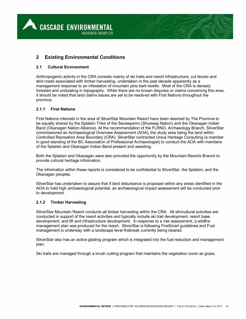
ENVIRONMENTAL REVIEW | PREPARED FOR: SILVERSTAR MOUNTAIN RESORT | File #: 012-02-02 | Date: March 10, 2017 15
2 Existing Environmental Conditions
2.1 Cultural Environment
Anthropogenic activity in the CRA consists mainly of ski trails and resort infrastructure, cut blocks and skid roads associated with timber harvesting, undertaken in the past decade apparently as a management response to an infestation of mountain pine bark beetle. Most of the CRA is densely forested and undulating in topography. While there are no known disputes or claims concerning this area, it should be noted that land claims issues are yet to be resolved with First Nations throughout the province.
2.1.1 First Nations
First Nations interests in the area of SilverStar Mountain Resort have been deemed by The Province to be equally shared by the Splatsin Tribe of the Secwepemc (Shuswap Nation) and the Okanagan Indian Band (Okanagan Nation Alliance). At the recommendation of the FLRNO, Archaeology Branch, SilverStar commissioned an Archaeological Overview Assessment (AOA), the study area being the land within Controlled Recreation Area Boundary (CRA). SilverStar contracted Ursus Heritage Consulting (a member in good standing of the BC Association of Professional Archaeologist) to conduct the AOA with members of the Splatsin and Okanagan Indian Band present and assisting. Both the Splatsin and Okanagan were also provided the opportunity by the Mountain Resorts Branch to provide cultural heritage information. The information within these reports is considered to be confidential to SilverStar, the Splatsin, and the Okanagan peoples. SilverStar has undertaken to assure that if land disturbance is proposed within any areas identified in the AOA to hold high archaeological potential, an archaeological impact assessment will be conducted prior to development.
2.1.2 Timber Harvesting
SilverStar Mountain Resort conducts all timber harvesting within the CRA. All silvicultural activities are conducted in support of the resort activities and typically include ski trail development, resort base development, and lift and infrastructure development. In response to a risk assessment, a wildfire management plan was produced for the resort. SilverStar is following FireSmart guidelines and Fuel management is underway with a landscape level firebreak currently being cleared. SilverStar also has an active glading program which is integrated into the fuel reduction and management plan. Ski trails are managed through a brush cutting program that maintains the vegetation cover as grass.
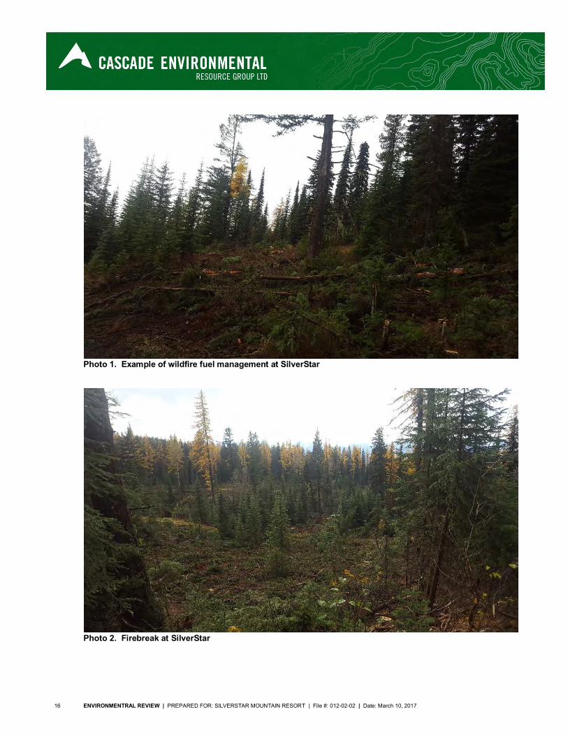
16 ENVIRONMENTRAL REVIEW | PREPARED FOR: SILVERSTAR MOUNTAIN RESORT | File #: 012-02-02 | Date: March 10, 2017
Photo 1. Example of wildfire fuel management at SilverStar
Photo 2. Firebreak at SilverStar
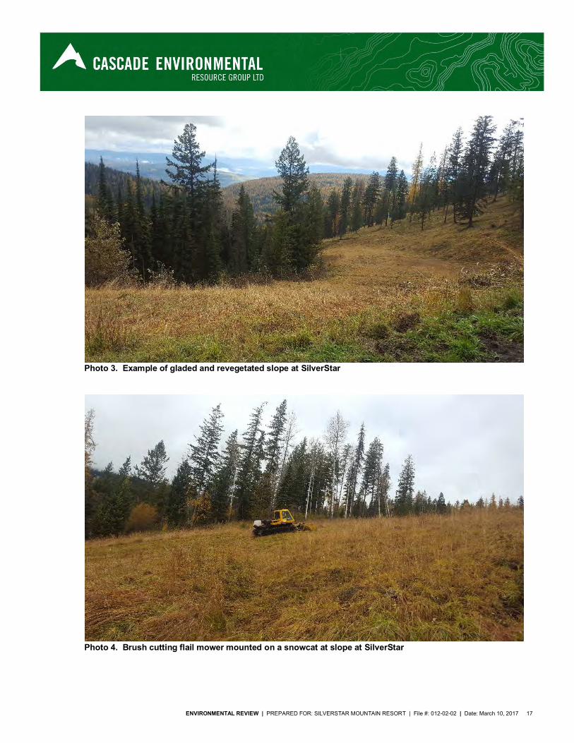
ENVIRONMENTAL REVIEW | PREPARED FOR: SILVERSTAR MOUNTAIN RESORT | File #: 012-02-02 | Date: March 10, 2017 17
Photo 3. Example of gladed and revegetated slope at SilverStar
Photo 4. Brush cutting flail mower mounted on a snowcat at slope at SilverStar
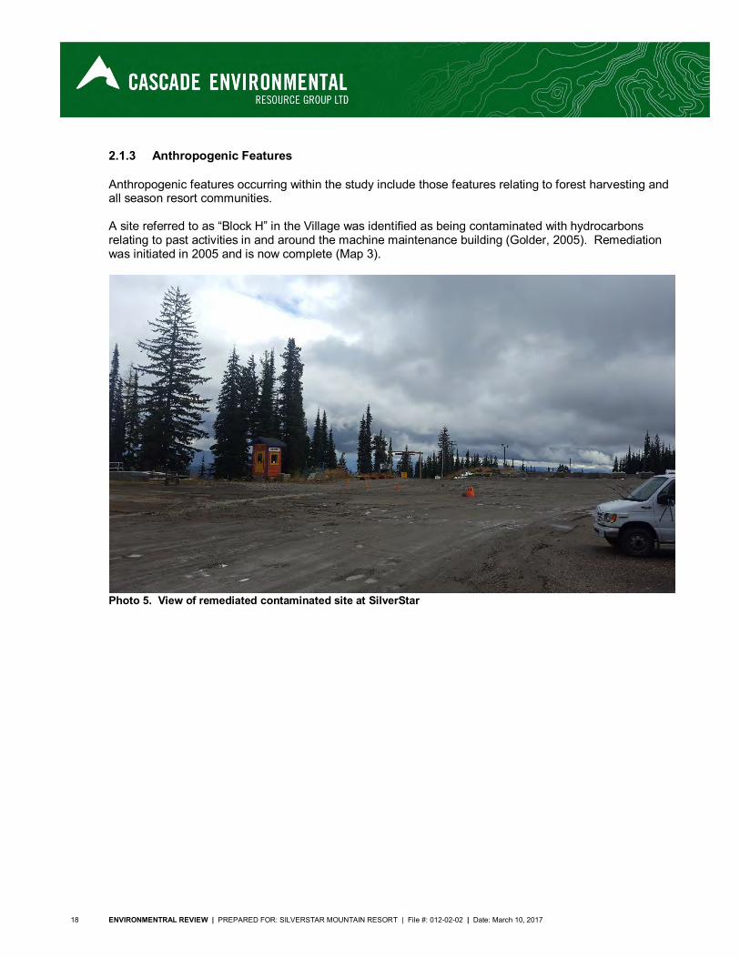
18 ENVIRONMENTRAL REVIEW | PREPARED FOR: SILVERSTAR MOUNTAIN RESORT | File #: 012-02-02 | Date: March 10, 2017
2.1.3 Anthropogenic Features
Anthropogenic features occurring within the study include those features relating to forest harvesting and all season resort communities. A site referred to as “Block H” in the Village was identified as being contaminated with hydrocarbons relating to past activities in and around the machine maintenance building (Golder, 2005). Remediation was initiated in 2005 and is now complete (Map 3).
Photo 5. View of remediated contaminated site at SilverStar
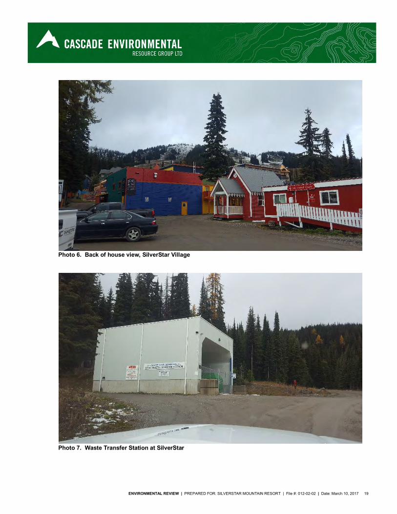
ENVIRONMENTAL REVIEW | PREPARED FOR: SILVERSTAR MOUNTAIN RESORT | File #: 012-02-02 | Date: March 10, 2017 19
Photo 6. Back of house view, SilverStar Village
Photo 7. Waste Transfer Station at SilverStar
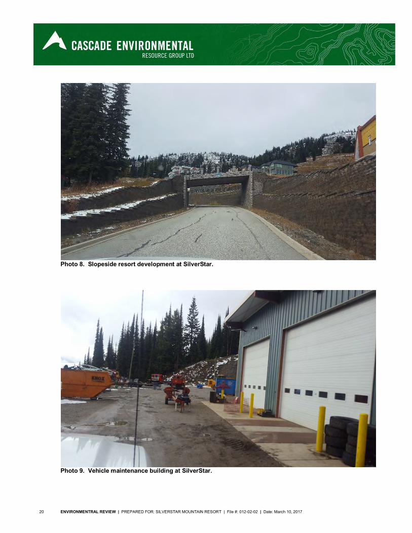
20 ENVIRONMENTRAL REVIEW | PREPARED FOR: SILVERSTAR MOUNTAIN RESORT | File #: 012-02-02 | Date: March 10, 2017
Photo 8. Slopeside resort development at SilverStar.
Photo 9. Vehicle maintenance building at SilverStar.
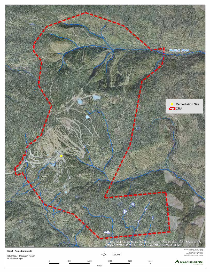
Putnam Creek
Source: Esri, DigitalGlobe, GeoEye, Earthstar Geographics, CNES/Airbus DS,USDA, USGS, AeroGRID, IGN, and the GIS User Community
²Map3 - Remediation siteSilver Star - Mountain ResortNorth Okanagan
GIS Carto graph er: N ico la Chu rchDa te: Ja nu ary 23, 20 17CERG File# : 01 2-02-02
Pro jection : UTM 11N NAD83Orth op hot o: E SRI Wo rld I ma gery
0 800 1,600 2,400 3,200 4,000
Meters
1:38,449
Remediation SiteCRA

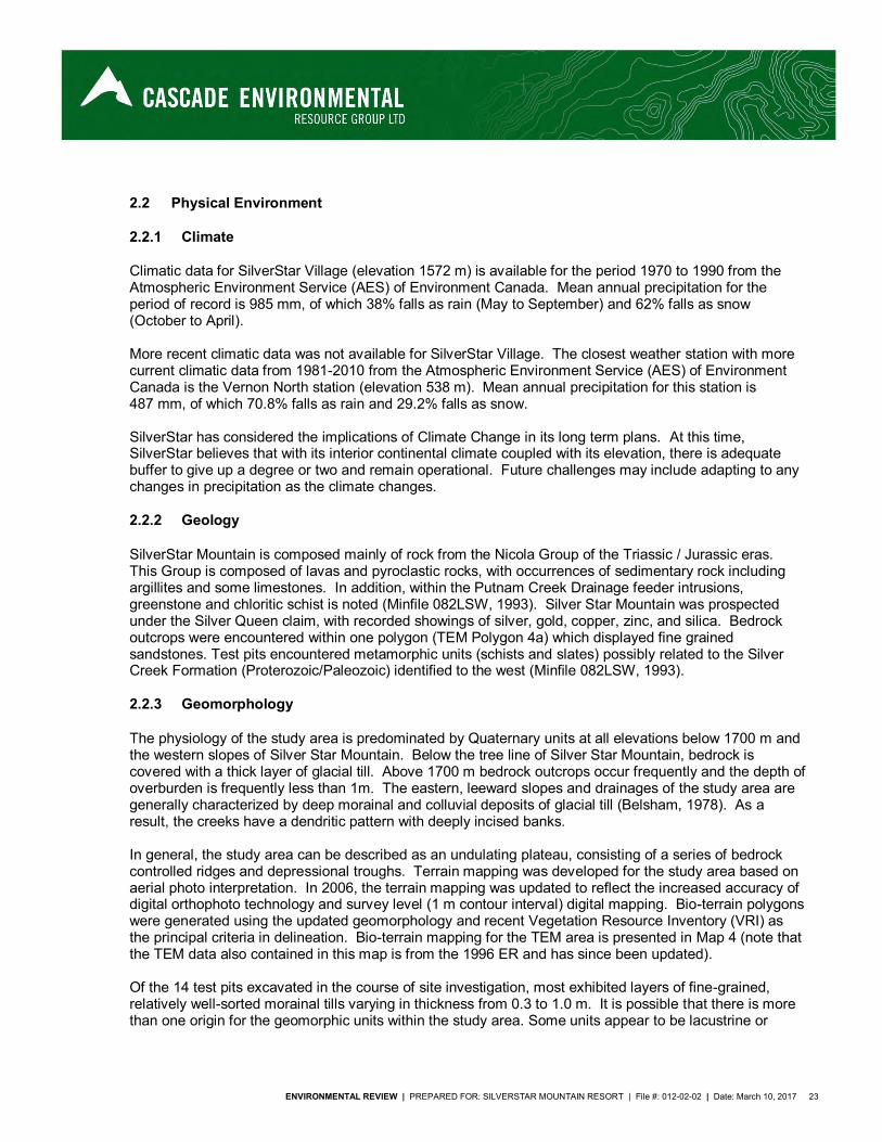
ENVIRONMENTAL REVIEW | PREPARED FOR: SILVERSTAR MOUNTAIN RESORT | File #: 012-02-02 | Date: March 10, 2017 23
2.2 Physical Environment
2.2.1 Climate
Climatic data for SilverStar Village (elevation 1572 m) is available for the period 1970 to 1990 from the Atmospheric Environment Service (AES) of Environment Canada. Mean annual precipitation for the period of record is 985 mm, of which 38% falls as rain (May to September) and 62% falls as snow (October to April). More recent climatic data was not available for SilverStar Village. The closest weather station with more current climatic data from 1981-2010 from the Atmospheric Environment Service (AES) of Environment Canada is the Vernon North station (elevation 538 m). Mean annual precipitation for this station is 487 mm, of which 70.8% falls as rain and 29.2% falls as snow. SilverStar has considered the implications of Climate Change in its long term plans. At this time, SilverStar believes that with its interior continental climate coupled with its elevation, there is adequate buffer to give up a degree or two and remain operational. Future challenges may include adapting to any changes in precipitation as the climate changes.
2.2.2 Geology
SilverStar Mountain is composed mainly of rock from the Nicola Group of the Triassic / Jurassic eras. This Group is composed of lavas and pyroclastic rocks, with occurrences of sedimentary rock including argillites and some limestones. In addition, within the Putnam Creek Drainage feeder intrusions, greenstone and chloritic schist is noted (Minfile 082LSW, 1993). Silver Star Mountain was prospected under the Silver Queen claim, with recorded showings of silver, gold, copper, zinc, and silica. Bedrock outcrops were encountered within one polygon (TEM Polygon 4a) which displayed fine grained sandstones. Test pits encountered metamorphic units (schists and slates) possibly related to the Silver Creek Formation (Proterozoic/Paleozoic) identified to the west (Minfile 082LSW, 1993).
2.2.3 Geomorphology
The physiology of the study area is predominated by Quaternary units at all elevations below 1700 m and the western slopes of Silver Star Mountain. Below the tree line of Silver Star Mountain, bedrock is covered with a thick layer of glacial till. Above 1700 m bedrock outcrops occur frequently and the depth of overburden is frequently less than 1m. The eastern, leeward slopes and drainages of the study area are generally characterized by deep morainal and colluvial deposits of glacial till (Belsham, 1978). As a result, the creeks have a dendritic pattern with deeply incised banks. In general, the study area can be described as an undulating plateau, consisting of a series of bedrock controlled ridges and depressional troughs. Terrain mapping was developed for the study area based on aerial photo interpretation. In 2006, the terrain mapping was updated to reflect the increased accuracy of digital orthophoto technology and survey level (1 m contour interval) digital mapping. Bio-terrain polygons were generated using the updated geomorphology and recent Vegetation Resource Inventory (VRI) as the principal criteria in delineation. Bio-terrain mapping for the TEM area is presented in Map 4 (note that the TEM data also contained in this map is from the 1996 ER and has since been updated). Of the 14 test pits excavated in the course of site investigation, most exhibited layers of fine-grained, relatively well-sorted morainal tills varying in thickness from 0.3 to 1.0 m. It is possible that there is more than one origin for the geomorphic units within the study area. Some units appear to be lacustrine or

24 ENVIRONMENTRAL REVIEW | PREPARED FOR: SILVERSTAR MOUNTAIN RESORT | File #: 012-02-02 | Date: March 10, 2017
glaciofluvial in origin, based on their well-sorted nature. Conversely, a dense, poorly-sorted clay unit was encountered in two test pits, which is more characteristic of morainal tills. The majority of the surficial units are free-draining depending on slope. The lithic contacts tend to contain weathered bedrock units (in the form of angular gravels) ranging from sandstones to slate schists in origin.
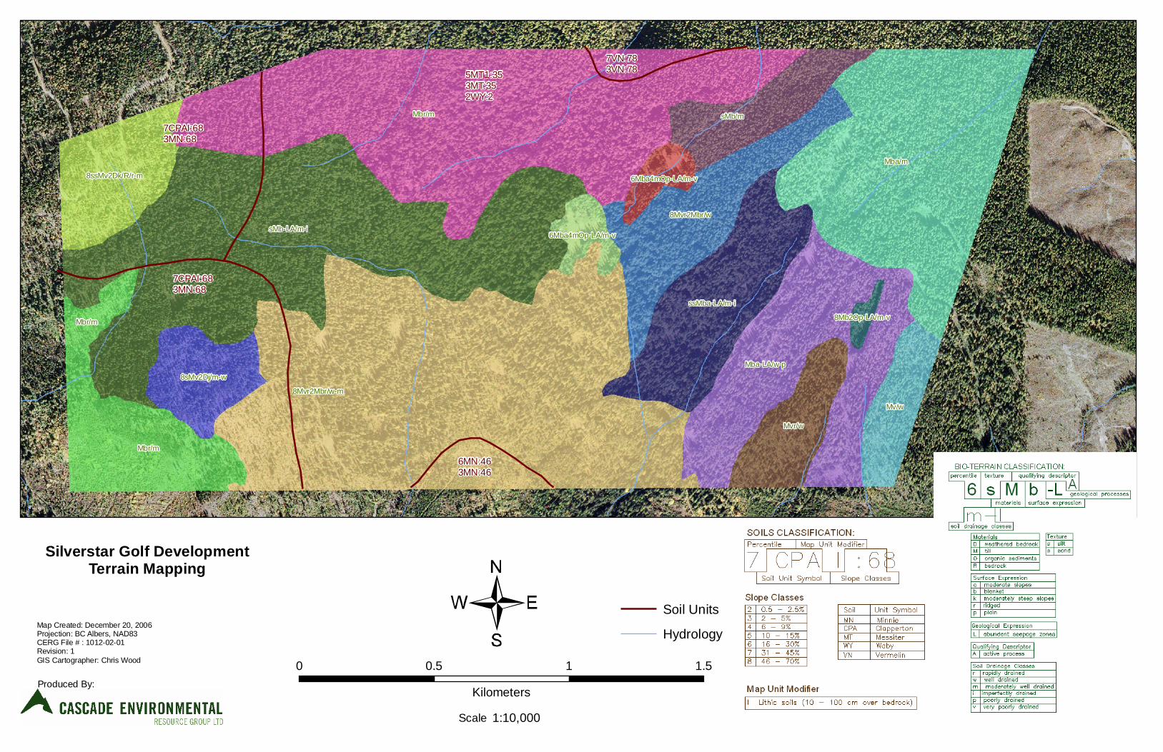
6MN:463MN:46
7CPAI:683MN:68
7CPAI:683MN:68
5MT1:353MT:352WY:2
7VN:783VN:78
Mbr/m
Mba/m
8Mvr2Mbr/w-m
sMb-LA/m-i
Mba-LA/w-p
Mbr/m
ssMba-LA/m-i
Mvr/w
sMb/m
8Mvr2Mbr/w
Mv/w
8ssMv2Dk/R/r-m
8sMv2Dj/m-w
Mbr/m
6Mba4mOp-LA/m-v
6Mba4mOp-LA/m-v
8Mb2Op-LA/m-v
Silverstar Golf DevelopmentTerrain Mapping
Map Created: December 20, 2006Projection: BC Albers, NAD83CERG File # : 1012-02-01Revision: 1GIS Cartographer: Chris Wood
Produced By:
Soil Units
Hydrology
Scale
0 0.5 1 1.5
Kilometers
1:10,000

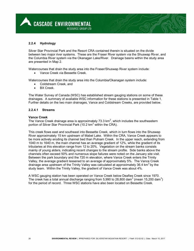
26 ENVIRONMENTAL REVIEW | fPREPARED FOR: SILVERSTAR MOUNTAIN RESORT | File#: 012-02-02 | Date: March 10, 2017
2.2.4 Hydrology
Silver Star Provincial Park and the Resort CRA contained therein is situated on the divide between two major river systems. These are the Fraser River system via the Shuswap River, and the Columbia River system via the Okanagan Lake/River. Drainage basins within the study area are presented in Map 2. Watercourses that drain the study area into the Fraser/Shuswap River system include:
Vance Creek via Bessette Creek. Watercourses that drain the study area into the Columbia/Okanagan system include:
Coldstream Creek, and BX Creek.
The Water Survey of Canada (WSC) has established stream gauging stations on some of these drainages. A summary of available WSC information for these stations is presented in Table 1. Further details on the two main drainages, Vance and Coldstream Creeks, are provided below.
2.2.4.1 Streams
Vance Creek The Vance Creek drainage area is approximately 73.3 km2, which includes the southeastern portion of Silver Star Provincial Park (10.2 km2 within the CRA). This creek flows east and southeast into Bessette Creek, which in turn flows into the Shuswap River approximately 15 km upstream of Mabel Lake. Within the CRA, Vance Creek appears to be more actively eroding its channel bed than Putnam Creek. In the upper reach, extending from 1040 m to 1640 m, the main channel has an average gradient of 12%, while the gradient of its tributaries at this elevation range from 12 to 20%. Vegetation on the stream banks consists mainly of young alders, indicating recent changes to the stream profile. Side banks above the channels often exceed 50% and numerous slope failures were noted on the January site visit. Between the park boundary and the 720 m elevation, where Vance Creek enters the Trinity Valley, the average gradient lessened to an average of approximately 5%. The Vance Creek drainage area upstream of the Trinity Valley was calculated at approximately 36.4 km2 by the study team. Within the Trinity Valley, the gradient of Vance Creek was about 4%. A WSC gauging station has been operated on Vance Creek below Deafies Creek since 1970. The creek has a total annual discharge ranging from 5,990 to 28,800 dam3 (mean 15,200 dam3) for the period of record. Three WSC stations have also been located on Bessette Creek.
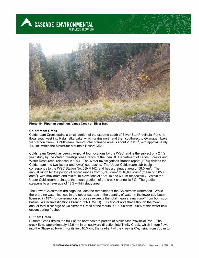
ENVIRONMENTAL REVIEW | PREPARED FOR: SILVERSTAR MOUNTAIN RESORT | File #: 012-02-02 | Date: March 10, 2017 27
Photo 10. Riparian condition, Vance Creek at SilverStar.
Coldstream Creek Coldstream Creek drains a small portion of the extreme south of Silver Star Provincial Park. It flows southwest into Kalamalka Lake, which drains north and then southwest to Okanagan Lake via Vernon Creek. Coldstream Creek's total drainage area is about 207 km2, with approximately 1.4 km2 within the SilverStar Mountain Resort CRA. Coldstream Creek has been gauged at four locations by the WSC, and is the subject of a 2 1/2 year study by the Water Investigations Branch of the then BC Department of Lands, Forests and Water Resources, released in 1974. The Water Investigations Branch report (1974) divides the Coldstream into two (upper and lower) sub-basins. The Upper Coldstream sub-basin corresponds to the WSC Station No. 08NM142, and has a drainage area of 58.5 km2. The annual runoff for the period of record ranges from 2,740 dam3 to 16,600 dam3 (mean of 7,850 dam3), with maximum and minimum elevations of 1660 m and 600 m respectively. Within the Upper Coldstream drainage, the mean gradient of the creek channel is 5%. The gradient steepens to an average of 13% within study area. The Lower Coldstream drainage includes the remainder of the Coldstream watershed. While there are no water licenses in the upper sub-basin, the quantity of water in the lower sub-basin licensed in 1974 for consumption purposes exceeds the total mean annual runoff from both sub-basins (Water Investigations Branch, 1974; WSC). It is also of note that although the mean annual total discharge of Coldstream Creek at the mouth is 19,800 dam3, 90% of this water flow occurs during freshet. Putnam Creek Putnam Creek drains the bulk of the northeastern portion of Silver Star Provincial Park. The creek flows approximately 12.9 km in an eastward direction into Trinity Creek, which in turn flows into the Shuswap River. For its first 10.5 km, the gradient of the creek is 6%, rising from 700 m to
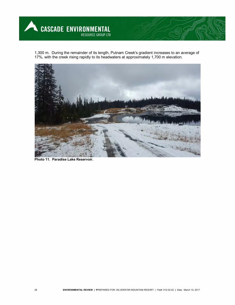
28 ENVIRONMENTAL REVIEW | fPREPARED FOR: SILVERSTAR MOUNTAIN RESORT | File#: 012-02-02 | Date: March 10, 2017
1,300 m. During the remainder of its length, Putnam Creek's gradient increases to an average of 17%, with the creek rising rapidly to its headwaters at approximately 1,700 m elevation.
Photo 11. Paradise Lake Reservoir.
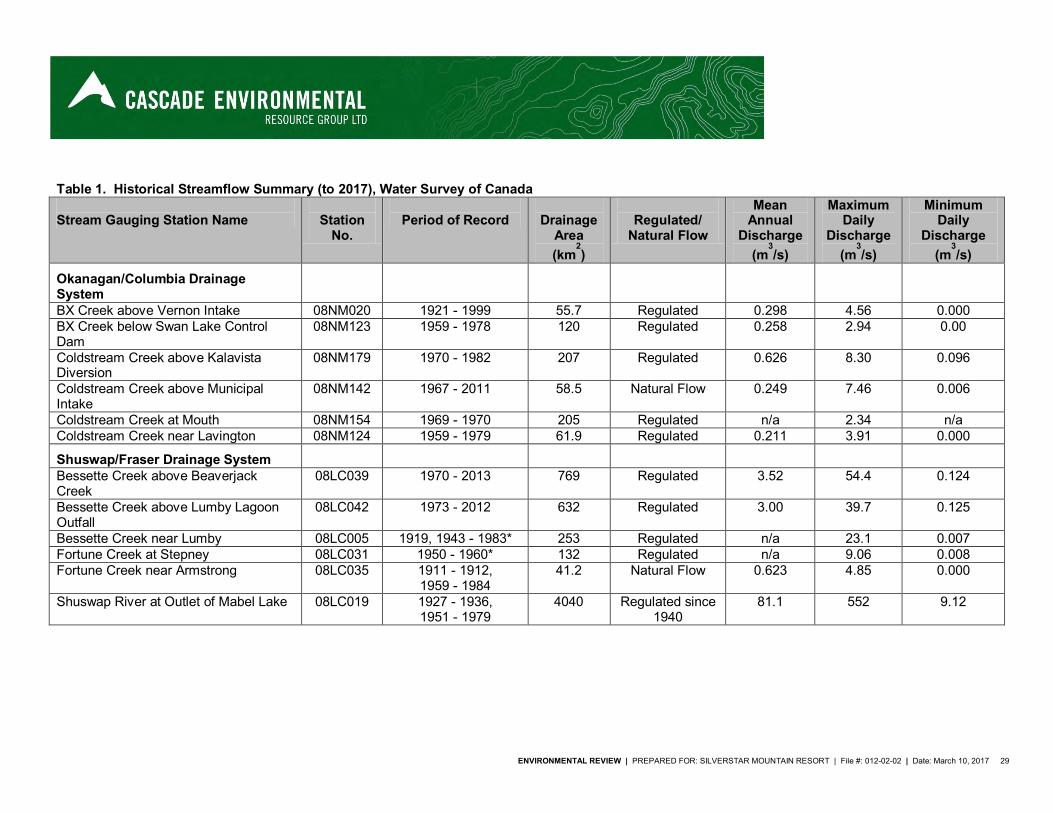
ENVIRONMENTAL REVIEW | PREPARED FOR: SILVERSTAR MOUNTAIN RESORT | File #: 012-02-02 | Date: March 10, 2017 29
Table 1. Historical Streamflow Summary (to 2017), Water Survey of Canada
Stream Gauging Station Name
Station
No.
Period of Record
Drainage
Area (km
2)
Regulated/
Natural Flow
Mean Annual
Discharge (m
3/s)
Maximum Daily
Discharge (m
3/s)
Minimum Daily
Discharge (m
3/s)
Okanagan/Columbia Drainage System
BX Creek above Vernon Intake 08NM020 1921 - 1999 55.7 Regulated 0.298 4.56 0.000 BX Creek below Swan Lake Control Dam
08NM123 1959 - 1978 120 Regulated 0.258 2.94 0.00
Coldstream Creek above Kalavista Diversion
08NM179 1970 - 1982 207 Regulated 0.626 8.30 0.096
Coldstream Creek above Municipal Intake
08NM142 1967 - 2011 58.5 Natural Flow 0.249 7.46 0.006
Coldstream Creek at Mouth 08NM154 1969 - 1970 205 Regulated n/a 2.34 n/a Coldstream Creek near Lavington 08NM124 1959 - 1979 61.9 Regulated 0.211 3.91 0.000
Shuswap/Fraser Drainage System
Bessette Creek above Beaverjack Creek
08LC039 1970 - 2013 769 Regulated 3.52 54.4 0.124
Bessette Creek above Lumby Lagoon Outfall
08LC042 1973 - 2012 632 Regulated 3.00 39.7 0.125
Bessette Creek near Lumby 08LC005 1919, 1943 - 1983* 253 Regulated n/a 23.1 0.007 Fortune Creek at Stepney 08LC031 1950 - 1960* 132 Regulated n/a 9.06 0.008 Fortune Creek near Armstrong 08LC035 1911 - 1912,
1959 - 1984 41.2 Natural Flow 0.623 4.85 0.000
Shuswap River at Outlet of Mabel Lake 08LC019 1927 - 1936, 1951 - 1979
4040 Regulated since 1940
81.1 552 9.12
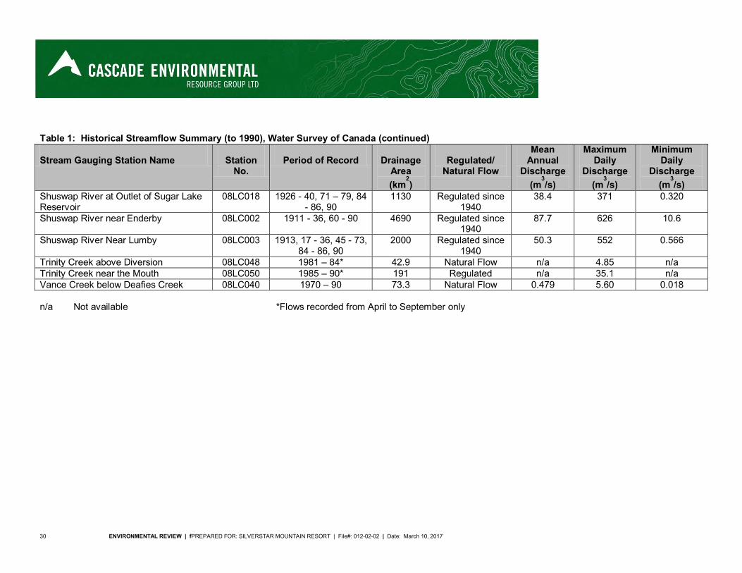
30 ENVIRONMENTAL REVIEW | fPREPARED FOR: SILVERSTAR MOUNTAIN RESORT | File#: 012-02-02 | Date: March 10, 2017
Table 1: Historical Streamflow Summary (to 1990), Water Survey of Canada (continued) Stream Gauging Station Name
Station
No.
Period of Record
Drainage
Area (km
2)
Regulated/
Natural Flow
Mean Annual
Discharge (m
3/s)
Maximum Daily
Discharge (m
3/s)
Minimum Daily
Discharge (m
3/s)
Shuswap River at Outlet of Sugar Lake Reservoir
08LC018 1926 - 40, 71 – 79, 84 - 86, 90
1130 Regulated since 1940
38.4 371 0.320
Shuswap River near Enderby 08LC002 1911 - 36, 60 - 90 4690 Regulated since 1940
87.7 626 10.6
Shuswap River Near Lumby 08LC003 1913, 17 - 36, 45 - 73, 84 - 86, 90
2000 Regulated since 1940
50.3 552 0.566
Trinity Creek above Diversion 08LC048 1981 – 84* 42.9 Natural Flow n/a 4.85 n/a Trinity Creek near the Mouth 08LC050 1985 – 90* 191 Regulated n/a 35.1 n/a Vance Creek below Deafies Creek 08LC040 1970 – 90 73.3 Natural Flow 0.479 5.60 0.018 n/a Not available *Flows recorded from April to September only
ENVIRONMENTAL REVIEW | PREPARED FOR: SILVERSTAR MOUNTAIN RESORT | File #: 012-02-02 | Date: March 10, 2017 31
2.3 Terrestrial Environment
The terrestrial environment is described using an ecological approach. Information for the TEM area was gathered with the assistance of Describing Ecosystems in the Field (Luttmerding, et. al., 1990). Ecosystem Field Forms were used to collect general site information as well as more detailed information on soils, vegetation, mensuration and wildlife. The PEM area is described according to the codes and descriptions provided by FLNRO and the Okanagan TSA Predictive Ecosystem Mapping (PEM) Compilation Project (Timberline, 2010). The remaining area within the CRA uses a similar ecosystem-based approach, but the descriptions rely on the VRI mapping and the Land Management Handbook 23 (Lloyd, et al., 1990).
2.3.1 Soils
Only the TEM area was sampled for soils and the description are provided herein. However, the soils can be considered to be representative of the soils found within the CRA. Reconnaissance (Intensity Level 4) soils mapping undertaken by the provincial government in the 1970’s indicates that Brunisolic Gray Luvisols, Orthic Gray Luvisols, Typic Humisols, and both Orthic and Eluviated Dystric Brunisols are expected to occur in the study area (Kowall, 1978). This mapping was undertaken by way of surface and aerial reconnaissance of the map area at an average working scale of 1:100,000 with traverses up to 8 km apart (Kowall, 1978; Van Vlies, 1996). Messiter (MT) soils associated with lesser amounts of Waby (WY) soils are shown to be most widely distributed in the study area. Clapperton (CPA) soils with lesser amounts of Minnie (MN) soils are shown to occur primarily in the far western portion of the study area, with some Vermelin (VN) soils occurring on the northern edge of the area. Other soils in higher elevation areas and ridges in the vicinity of Silver Star Mountain include Cinnemousen (CNA) and Snookwa (SAA) soils, which are classified as Orthic Humo-Ferric Podzols. Soils inventory information is presented in Map 4, Terrain Mapping (note that the TEM data also contained in this map is from the 1996 ER and has since been updated). The occurrence of Messiter, Waby, and Vermelin soils is generally consistent with other identified environmental factors such as the elevation, slope, acidic parent materials, ecological moisture regime, and biogeoclimatic vegetation units (ICH-T) that describe the area. Field investigations undertaken for the current study suggest that Clapperton and Vermelin soils may occur in the study area to a greater extent than indicated by Kowall (1978). These soils, which are characterized by Orthic Dystric Brunisols and Eluviated Dystric Brunisols, were indicated in several soil pits. Given the uncertainty associated with the taxonomic distinction (made in the field) between these Brunisolic soils and Orthic Humo-Ferric Podzols, there is also the possibility that Cinnemousen and Snookwa soils extend down into the study area. The use of chemical analysis to differentiate between these morphologically similar soils is beyond the scope and budget of this study. Soil interpretations were developed based on field descriptions of soil morphology at non-random, representative sample sites. Apparent diagnostic processes and properties were noted and later interpreted using the Canadian Soil Classification System, with the results of this classification presented below in Table 2.
32 ENVIRONMENTAL REVIEW | fPREPARED FOR: SILVERSTAR MOUNTAIN RESORT | File#: 012-02-02 | Date: March 10, 2017
Table 2. Sample Plot Soils
Sample Plot No. Soil Classification Abbreviation
1 Orthic Dystric Brunisol O.DYB 2 Orthic Dystric Brunisol O.DYB 3 Eluviated Dystric Brunisol E.DYB 4 Gleyed Eluviated Dystric Brunisol GLE.DYB 5 Eluviated Dystric Brunisol E.DYB 6 Eluviated Dystric Brunisol E.DYB 7 Eluviated Dystric Brunisol E.DYB 8 Eluviated Dystric Brunisol E.DYB 9 Typic Humisol TY.H 10 Eluviated Dystric Brunisol E.DYB 11 Orthic Dystric Brunisol O.DYB 12 Orthic Dystric Brunisol O.DYB 13 Duric Dystric Brunisol DU.DYB 14 Humic Fibrisol HU.F
Soils of the Brunisolic order (Orthic and Eluviated Dystric Brunisols) appear to be most widely distributed in the study area, with Organic soils occurring in wetlands. Dystric Brunisols are typically less developed than most other soils, brownish to red-brown in color, acidic, and well to imperfectly drained (Canada Soil Survey Committee, 1978). Organic soils, which in this study area appear to include both Humisols and Fibrisols, are often referred to as peat, muck, or bog. They occur in poorly drained depressions or level areas, and are saturated with water throughout much or all of the year. The chief distinction between the Luvisolic soil order (Messiter soils) indicated by Kowall (1978) and other orders (specifically the Brunisolic and Podzolic orders) is the presence of illuvial clay in the soil profile. The diagnostic process of illuviation (a Bt horizon at least 5 cm thick) was not evident in any of the soil pits dug during field investigation.
2.3.2 Vegetation
Terrestrial ecosystem units were identified using three different methods based on the data available for the given area. The different types of data available were: the TEM mapping, previously conducted by Cascade, Predictive Ecosystem Mapping (PEM) (Timberline Natural Resource Group Ltd., 2010), and Vegetation Resource Inventory (VRI) data (FLNRO, 2016b). Where PEM data was available, this overlapped with the VRI, while in some areas only the VRI data was available. Where TEM was previously conducted, the resulting data were used. These areas are each discussed and summarized separately in the sections below. A standard method of land classification used in BC is the Biogeoclimatic Ecosystem Classification system (BEC). The biogeoclimatic ecosystem classification describes the variation in climate, vegetation, and site conditions occurring within ecosections. BEC is also hierarchal, with separate climate and site levels (Resource Information Standards Committee (RISC), 1998). There are six levels of organization with increasing specificity: zone, subzone, phase, variant, site association, and site series. At the highest level, biogeoclimatic zones are classed based on broad macroclimatic patterns; at the lowest level, site series describes the vegetation potential of the land area based on its ability to support the same climax plant association, and displaying the same soil moisture and nutrient regimes (RISC, 1998). For the purposes of this report, descriptions are set at the biogeoclimatic subzone, variant, and site series levels of detail. Site series descriptions are included below and the terrestrial ecosystem and site series information is presented in Map 5, Terrestrial Ecosystems.

ENVIRONMENTAL REVIEW | PREPARED FOR: SILVERSTAR MOUNTAIN RESORT | File #: 012-02-02 | Date: March 10, 2017 33
Vegetation Update The base mapping for the study area was altered with updated layers and new data.
Ecoregion/ecosection mapping has changed (FLNRO, 2016a), Biogeoclimatic subzone mapping was updated with new line-work in 2016 (FLNRO, 2016a), PEM mapping was available (Timberline Natural Resource Group Ltd., 2010),VRI mapping
(rollover from FC1 updated in 2002) provided new baseline forest inventory (FLNRO, 2016b), 2005 contour mapping covering the entire area with 5 m contours was available, 2004
orthophotos were available, and Updated BEC-based wetland classification system was available (Mackenzie and Moran, 2004).
Preliminary changes in base line-work occurred as a result of updates to the Ecoregional mapping which had subsequent impacts on Biogeoclimatic mapping. Further changes to provincial Biogeoclimatic mapping were finalized in 2016. These updated lines were incorporated directly into the TEM mapping resulting in a westerly and northerly shift of several lines. Updated terrain mapping based on a new elevation model and orthophoto was brought in to the existing TEM mapping and line-work was adapted to match terrain features. Updated forest cover mapping (VRI) linework was utilized when appropriate and final TEM stand-class determination was based partly on VRI age attributes. Wetland classifications were made based on the new provincial wetland codes (MacKenzie and Moran, 2004).
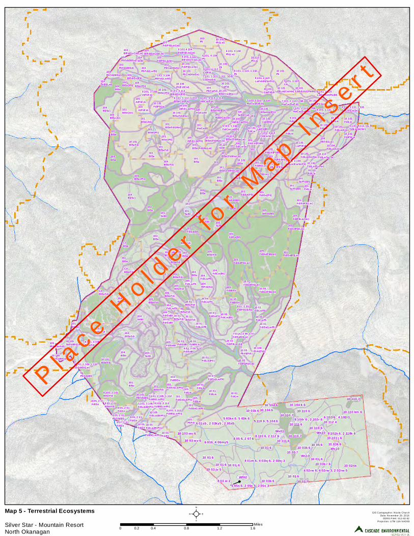
104BlSeFdi
101SeBl
104FdiBlSe
101BlSe
101BlSe
105FdiSe(Bl)
104BlSeFdi
104BlSe
101SeBl
104BlSeFdi
104Bl(Se)
B3BlSe
104BlSe
10 01FdiLw(Pli)
104SeBl
105FdiSePli(Lw)
10 101BlSeFdi
101BlSe(At)
10 01FdiLw
104BlSe(Pli)
104BlSe
105SeFdi(Bl)
101BlSe
103Pli
101FdiSe(Pli)
10 101BlSeFdi
10 01FdiLw
104BlSe
104BlSeFdi
104BlSe
104SeBl
105FdiSeBl
105SeBl
10 101FdiLw
104Bl(Se)
101SeFdi(Bl)
10 05FdiSePli(Lw)
10 101LwPliFdi
104BlSe
10 101Pli
104FdiLw(Bl)
104BlSeFdi
105FdiSePli(Lw)
105BlSeFdi
8 105, 2 101BlSeFdi
C4BlSeFdi
101SeBl
6 101, 4 105BlSeFdi
9 101, 1 112FdiLw
10 101PliCw(HwSe)
6 101, 4 104Pli(Lw)
101BlSeFdi
10 101BlSeFdi(Hw)
105BlSeFdi
C3BlSe
10 05FdiBlSe
101BlSe
104BlSe
103PliFdi(LwBl)
101BlSeFdi(Hw)
10 101BlSe
10 101FdiLw
10 101FdiLw
101FdiBl(Lw)
7 101, 2 112 , 1 110HwCw(SeFdi)
101BlSeFdi
101
101
10 01FdiSePli
7 01ys, 2 06, 1 07FdiSeBl(Lw)
10 01FdiLwPli
104Bl
101FdiSeBl(Lw)
10 05FdiLw(Bl)
10 01FdiSe(LwPli)
8 101, 1 110, 1 102,Pli
10 07FdiSe(LwPli)
104BlFdi(Se)
10 101BlSeHw(Pli)
105BlSeFdi
101BlSeFdi
10 104Pli(FdiCw)
101SeBl
8 01, 2 05FdiPliSe(At)
10 104PliAt(Fdi)
6 101, 4 104Pli
6 101, 3 112, 1 110HwCw(Fdi)
10 101Pli
101
104PliCwFdi
10 101FdiLw
7 101, 3 104FdiLw(CwSePli)
9 101, 1 104FdiCwLw(Pli)
01BlSeFdi
101FdiSe(Pli)
104PliFdi(Lw)
101
101
10 110PliLw
8 101, 1 105, 1 112SeFdiBl(Lw)
101Bl(Se)
10 110FdiLwSe(Se)
10 05FdiPli
105BlSeFdi
105BlSe(Pli)
10 101FdiLw(PliBl)
10 01FdiSeBl
10 05FdiLwPli
101
10 101FdiLw
10 101CwFdi
101BlSe(Pli) 7 101, 3 110
FdiLwSe101BlSe
6 101 4 104FdiPli(LwCw)
103FdiPli(LwCw)
101BlSe(Pli)
10 101FdiPliCw
8 101, 2 110LwFdiBl(SePli)
104Lw(FdiBl)
10 101SeFdiBl(Lw)
10 01FdiLw
101BlSe(At)
8 105, 2 112FdiBl(LwPli)8 05, 2 01
PliFdi(Bl)
105FdiBlSe
101FdiLwPli
10 101Lw(BlSe)
101HwCwBl
110HwCwBl
10 101CwPliFdi
10 05PliAt(Fdi)
105AtPliFdi
10 110BlSe(FdiHwLw)
6 01, 3 06, 1 07FdiSeBl
10 01FdiPliLw(At)
105FdiLwPli
10 101PliFdi(Bl)
10 01FdiLwPli
10 105FdiLw(BlPli)
01PliFdi(Bl)
105FdiPli(LwSe)
101SePli(Bl)
110FdiLwSe
104AtPliFdi
101HwBlCw(Se)
10 101BlSe(Pli)
103PliFdi(BlSe)
10 01FdiBlLw
8 05, 2 01FdiSe 105
PliFdi
10 104FdiLw(Cw)
101SeBl
104FdiLwPli
104BlSeFdi
7 101, 1 112, 1 111, 1GBCw(HwSe)
10 101BlSeCw(Hw)
10 01FdiSePli(Lw)
10 110BlSe(FdiHwLw)
10 101AtFdiLw(Pli)
101SePli(Bl)
8 101, 2 104AtPliFdi
10 101BlSeHw(Pli)
10 101PliLw(CwHw)
7 101, 3 104PliFdi(LwBl)
7 101, 2 110, 1 GBHwCw(SeFdi)
7 101, 3 105FdiLw(BlPli)
9 101, 1 110Lw
C4BlSeFdi
101
8 05, 2 01FdiSe
8 101, 2 112BlFdiSe(Pli)
105BlFdiSe(Pli)
10 101LwCw(PliSe)
8 101, 1 111, 1 GBFdiLw104
BlSe(At)
10 110SeBl
7 101, 2 110,1 GBHwCw(SeFdi)
10 104FdiLw(SePw)
101BlSe(FdiHwLw)
105PliBl(SeFdi)
10 05FdiSe
8 105, 2 112FdiBl(LwPli)
101SeBl
101BlSe(FdiHwLw)
9 101, 1 112CwFdi
10 05FdiPliAt(Cw)
105AtFdiLw(Pli)
10 101FdiPliLw
105FdiLw
101FdiLw(PliBl)101
BlSe(FdiHwLw)
10 101LwFdiAct(PwBl)
104PliFdi(BlSe)
105BlFdiSeCw(Lw)
101FdiSe(Bl)
104BlSe
103PliCw(HwSe)
104PliFdi(BlSe)
105FdiPliLw(Se)
8 101, 2 112BlFdiSeCw(Lw)
10 05FdiLw(BlPli)
104SeBl
101FdiLw(PliSe)
8 101, 2 110LwFdiAct(PwBl)
101
105FdiLw
8 110, 1 111, 1 GBFdiLw(CwSe)
8 07, 2 01FdiSe
10 103Pli(Lw)
104SeBl(Lw) 104
BlSe(Pli)
105FdiSeBl
8 05, 2 01BlSeFdi
101FdiLw(PliSe)
10 101FdiLw
101FdiSe(LwPli)
10 101AtFdiLw(Pli)
6 101, 3 112, 1 110BlSeCw(Pli)
10 101FdiPli(LwSe)
101FdiSePli(Lw)
07FdiBl(LwPli)
101FdiBl(Lw)
10 105FdiSe(BlCwPli)
101FdiLw
10 101FdiLw(Cw)
8 05, 2 01FdiSe
110SeBl(Cw)
10 101FdiLw(SePw)
6 110, 4 111, 1G BFdiLwSe(Se)
105FdiSePli(Lw)
101FdiSe(LwPli)
7 101, 2 105, 1 112FdiBl(LwPli)
10 01BlSeFdi
01BlSeFdi
104BlFdiSeCw(Lw)
10 04FdiLwPli10 01
BlSeFdi104FdiLwPli
10 01FdiSeBl
101FdiSe(LwPli)
10 01j 610 02rw
6 016, 4 06my510 03k 6
10 110 km 6
4 01m 6, 4 03kj 6, 2 03kj 3
10 01 6
10 01 6
5 03ks 6, 5 03k 610 110 6
10 01j 6
10 110 7
10 03k 6
10 104 k 6
8 101k 6, 2 110k 6
10 110 7
8 05 6, 2 07 6
5 110 6, 5 104 6
8 110 6, 2 112 610 03 wv 6
8 03 w 2
10 03 jv 5
10 103 wv 6
8 104r 6 , 2 102r 6
10 03k 6
10 110 6
10 101 j 6
10 01 6
6 05s 6, 2 05s 5, 2 05s 3
10 110 7
6 01s5 , 2 03ky5 , 2 05x5
10 03k r 6
10 111 66 102r6 , 4 102r3
Wf024 02rw 6, 4 02rw 3, 2 02rw 5
10 111 610 05 610 01 6
Ws01
10 05 7
10 112 4
10 104 6
10 01 7
Ws10
10 03k 6
Ws10
Ws10
10 104 6
P l ac e H
o l de r
f or M
a p In s e r t
P l ac e H
o l de r
f or M
a p In s e r t
GIS Cartog ra ph er: N ico la ChurchDa te: No ve mb er 29 , 20 16
CERG File#: 01 2-02-02Pro je ction: UTM 11N NAD83
Map 5 - Terrestrial Ecosystems Silver Star - Mountain ResortNorth Okanagan
²0 0.4 0.8 1.2 1.60.2
Miles

ENVIRONMENTAL REVIEW | PREPARED FOR: SILVERSTAR MOUNTAIN RESORT | File #: 012-02-02 | Date: March 10, 2017 37
2.3.2.1 Vegetation Mapping
Vegetation Resource Inventory (VRI) Mapping Within the CRA, only Vegetation Resource Inventory data was available for the entire ESSFdc1 (524.2 ha) and ESSFdcw (50.5 ha) variants, almost all of the ESSFmh (942.2 ha) subzone, and some of the ICHdw4 (40.4 ha), ICHmk1 (15.6 ha) and ICHmw5 (118.7 ha) subzones. This data includes tree species cover by decile, predicted age of each tree species, and predicted soil moisture regime (SMR) and soil nutrient regime (SNR) (FLNRO, 2016b). Age classes were differentiated as young (younger than 80 years), mature (80 to 140 years), old (older than 140 and younger than 250 years), very old (250 years and older). Topographical information for the CRA was used to differentiate the slope, aspect, and relative slope position (i.e. upper, mid, lower) within each polygon. Slope classes were defined as level (less than 5%), gentle (5-25%), and moderately steep (25-100%); there were no slopes greater than 89%. Aspects were classed into warm (south to southwest), cool (north to northeast), and neutral (east to southeast and west to northwest) aspects. Inferences were made to determine the site series based on the vegetation tables, edatopic grids, site series flowcharts, environment tables, and site series descriptions for the relevant biogoeclimatic subzone/variant in the literature (MacKillop et al., 2016; Lloyd et al., 1990; Ryan, 2016). It was acknowledged that vegetation is indicative of site conditions, but that variations in tree cover can occur within a site series, particularly in young and early seral stands. Where the sources did not clearly agree, emphasis was placed on the environmental conditions described in the environment tables. For the ESSFdcw variant, no literature was available and the polygons were therefore labeled with the predicted SMR (B = poor and C = medium) and SNR (3 = submesic, 4 = mesic) from the VRI data. The site series inferred from the VRI data are listed in Table 3 and shown on Map 5. Note that map labels for VRI data include the tree species codes in order of dominance and that species having cover of 10% or less are included in parentheses. Each site series is described in Vegetation Associations and the combined areas of each site series are provided in Table 8.
Table 3: VRI Site Series
Biogeoclimatic Subzone/Variant Site Series Biogeoclimatic
Subzone/Variant Site Series
ESSFdc1 101 ICHmw5
101 104 104
ESSFdcw B3 110 C3 ICHdw4 101 C4
ICHmk1
01
ESSFmh 101 04 103 05 105 07
Predictive Ecosystem Mapping (PEM) In areas having Predictive Ecosystem Mapping data available, this was in addition to the VRI and topographical data described above. Within the CRA, this occurred in the entire ICHdw4 subzone (40.4 ha), much of the ICHmk1 subzone (395.5 ha) and in a small portion of the ESSFmh subzone (140.7 ha) (Timberline Natural Resource Group Ltd., 2010). The PEM data includes predicted site series compositions for each polygon by decile, however PEM site series do not directly align with the TEM site series and a conversion is required. This involved converting the two letter PEM site series codes to numerical TEM site series codes (Temmel, 2016).
38 ENVIRONMENTAL REVIEW | fPREPARED FOR: SILVERSTAR MOUNTAIN RESORT | File#: 012-02-02 | Date: March 10, 2017
During updates to the BEC units in the region, several of the subzones and variants have changed since the PEM analysis was conducted in 2010 (i.e. ICHmw2 changed to ICHdw4 and ICHmw5 and some of the ICHmk1 changed to ESSFmh and ICHmw5) (Temmel, 2016 and Timberline Natural Resource Group Ltd., 2010). For affected polygons, a second conversion was completed by cross-referencing the site series of the old and new subzones and variants (MacKillop et al., 2016). The resulting data was then combined with the VRI data. Where polygons and site series from the VRI and PEM were not well aligned, inferences were again made using the topographical data and BEC literature. The site series inferred from both the PEM and VRI data are listed in Table 4 and shown in Map 5. Note that map labels include the deciles of each site series within a polygon. Each site series is described in Section Vegetation Associations and the combined areas of each site series are provided in Table 8.
Table 4: PEM Site Series
Biogeoclimatic Subzone/Variant Site Series Biogeoclimatic
Subzone/Variant Site Series
ESSFmh 101
ICHdw4
101 105 110 112 111
ICHmw5
101 GB 104
ICHmk1
01 110 05 111 06 112 07
Terrestrial Ecosystem Mapping (TEM) For Terrestrial Ecosystem Mapping, preliminary bio-terrain polygons identified using air photographs (September 4, 1990) and Forest Cover Mapping (1992) prior to site investigations were further subdivided into terrestrial ecosystem units following vegetation surveys conducted in 1995. Vegetation condition including dominant and sub-dominant tree species was used to distinguish ecosystem unit boundaries. The vegetation of each unit is indicative of specific growing conditions, and therefore can be used to map subtle changes in the site ecology, which are referred to as site series. Vegetation information was collected during the 1996 field investigations from fourteen non-random sample plots of 20 m X 20 m (representing 1/25 ha) at various locations in the study area. An attempt was made to represent each bio-terrain unit identified. Some polygons were not sampled due to difficulty of access and constraints associated with available mapping. General vegetation health and species identification information was included in the sample plot survey. A count of tree species within the A1, A2 and A3 strata was used to estimate tree density within the plots. Core samples were taken from representative trees to determine age and soundness. Crown closure and ground cover were estimated. Shrub layer coverage was estimated for B1 and B2. Ground cover plant coverage was estimated and species were identified. A list of all plant species observed is presented in Table 9. The TEM study area falls within the ICHmk1 (326.6 ha), ICHmw5 (182.5 ha), and ESSFmh (8.2 ha) (previously ICHmk1, ICHmw2, and ESSFdc2) biogeoclimatic units. Vegetation of the study area is typical of the vegetation expected in these units, nonetheless, it is unusual to experience a transition from three different subzones and two different zones in a study area of less than 500 ha.
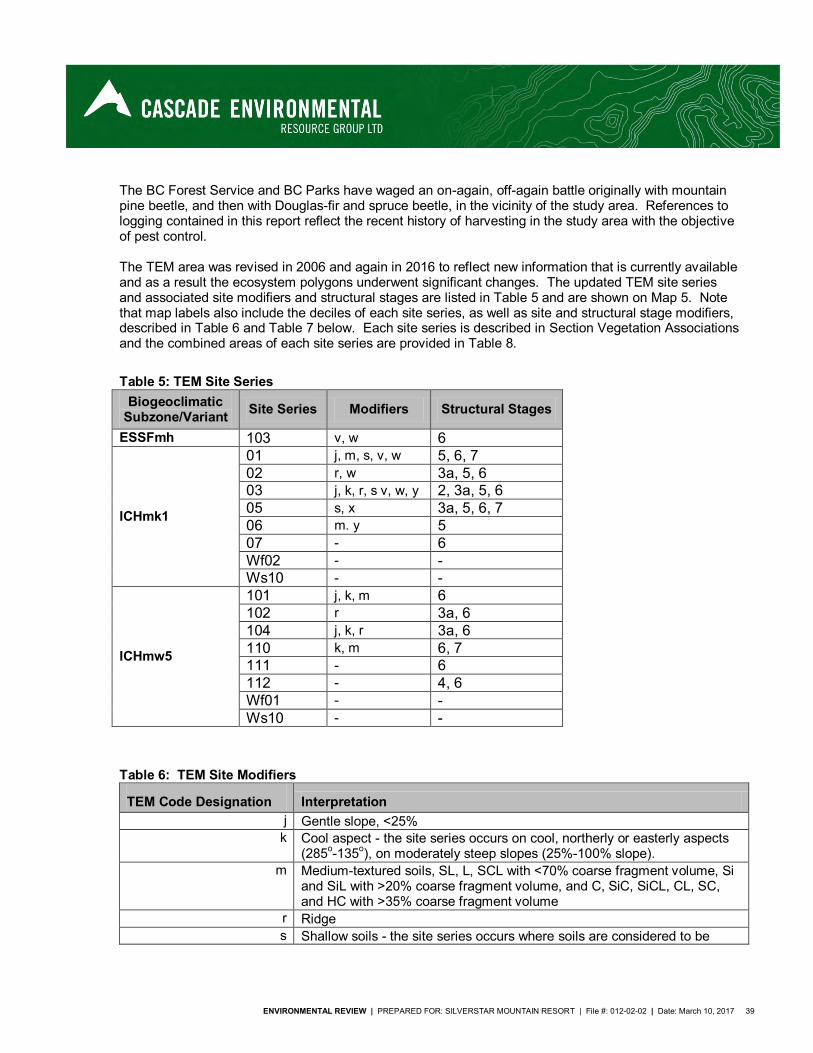
ENVIRONMENTAL REVIEW | PREPARED FOR: SILVERSTAR MOUNTAIN RESORT | File #: 012-02-02 | Date: March 10, 2017 39
The BC Forest Service and BC Parks have waged an on-again, off-again battle originally with mountain pine beetle, and then with Douglas-fir and spruce beetle, in the vicinity of the study area. References to logging contained in this report reflect the recent history of harvesting in the study area with the objective of pest control. The TEM area was revised in 2006 and again in 2016 to reflect new information that is currently available and as a result the ecosystem polygons underwent significant changes. The updated TEM site series and associated site modifiers and structural stages are listed in Table 5 and are shown on Map 5. Note that map labels also include the deciles of each site series, as well as site and structural stage modifiers, described in Table 6 and Table 7 below. Each site series is described in Section Vegetation Associations and the combined areas of each site series are provided in Table 8.
Table 5: TEM Site Series
Biogeoclimatic Subzone/Variant Site Series Modifiers Structural Stages
ESSFmh 103 v, w 6
ICHmk1
01 j, m, s, v, w 5, 6, 7 02 r, w 3a, 5, 6 03 j, k, r, s v, w, y 2, 3a, 5, 6 05 s, x 3a, 5, 6, 7 06 m. y 5 07 - 6 Wf02 - - Ws10 - -
ICHmw5
101 j, k, m 6 102 r 3a, 6 104 j, k, r 3a, 6 110 k, m 6, 7 111 - 6 112 - 4, 6 Wf01 - - Ws10 - -
Table 6: TEM Site Modifiers
TEM Code Designation Interpretation j Gentle slope, <25%
k Cool aspect - the site series occurs on cool, northerly or easterly aspects (285o-135o), on moderately steep slopes (25%-100% slope).
m Medium-textured soils, SL, L, SCL with <70% coarse fragment volume, Si and SiL with >20% coarse fragment volume, and C, SiC, SiCL, CL, SC, and HC with >35% coarse fragment volume
r Ridge s Shallow soils - the site series occurs where soils are considered to be
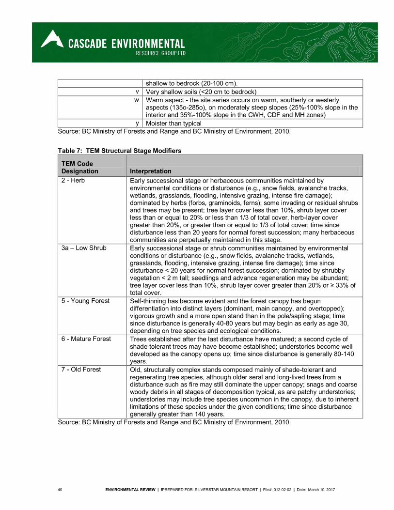
40 ENVIRONMENTAL REVIEW | fPREPARED FOR: SILVERSTAR MOUNTAIN RESORT | File#: 012-02-02 | Date: March 10, 2017
shallow to bedrock (20-100 cm). v Very shallow soils (<20 cm to bedrock) w Warm aspect - the site series occurs on warm, southerly or westerly
aspects (135o-285o), on moderately steep slopes (25%-100% slope in the interior and 35%-100% slope in the CWH, CDF and MH zones)
y Moister than typical Source: BC Ministry of Forests and Range and BC Ministry of Environment, 2010.
Table 7: TEM Structural Stage Modifiers
TEM Code Designation Interpretation 2 - Herb Early successional stage or herbaceous communities maintained by
environmental conditions or disturbance (e.g., snow fields, avalanche tracks, wetlands, grasslands, flooding, intensive grazing, intense fire damage); dominated by herbs (forbs, graminoids, ferns); some invading or residual shrubs and trees may be present; tree layer cover less than 10%, shrub layer cover less than or equal to 20% or less than 1/3 of total cover, herb-layer cover greater than 20%, or greater than or equal to 1/3 of total cover; time since disturbance less than 20 years for normal forest succession; many herbaceous communities are perpetually maintained in this stage.
3a – Low Shrub Early successional stage or shrub communities maintained by environmental conditions or disturbance (e.g., snow fields, avalanche tracks, wetlands, grasslands, flooding, intensive grazing, intense fire damage); time since disturbance < 20 years for normal forest succession; dominated by shrubby vegetation < 2 m tall; seedlings and advance regeneration may be abundant; tree layer cover less than 10%, shrub layer cover greater than 20% or ≥ 33% of total cover.
5 - Young Forest Self-thinning has become evident and the forest canopy has begun differentiation into distinct layers (dominant, main canopy, and overtopped); vigorous growth and a more open stand than in the pole/sapling stage; time since disturbance is generally 40-80 years but may begin as early as age 30, depending on tree species and ecological conditions.
6 - Mature Forest Trees established after the last disturbance have matured; a second cycle of shade tolerant trees may have become established; understories become well developed as the canopy opens up; time since disturbance is generally 80-140 years.
7 - Old Forest Old, structurally complex stands composed mainly of shade-tolerant and regenerating tree species, although older seral and long-lived trees from a disturbance such as fire may still dominate the upper canopy; snags and coarse woody debris in all stages of decomposition typical, as are patchy understories; understories may include tree species uncommon in the canopy, due to inherent limitations of these species under the given conditions; time since disturbance generally greater than 140 years.
Source: BC Ministry of Forests and Range and BC Ministry of Environment, 2010.

ENVIRONMENTAL REVIEW | PREPARED FOR: SILVERSTAR MOUNTAIN RESORT | File #: 012-02-02 | Date: March 10, 2017 41
2.3.2.2 Vegetation Associations
The following table summarizes all of the site series found in the entire study area and includes the typical site conditions and area of each. Written descriptions of each of the biogeoclimatic subzones/variants and site series are found below the table. A list of vegetation found within the TEM portion of the CRA is found in Table 9, also in this section. Rural development refers to existing ski resort development, including ski runs (but does not include areas of glading), chalets and outbuildings, and water reservoirs.
Table 8: Typical conditions and total areas of site series in the CRA
Biogeoclimatic Subzone/Variant
Map Symbol (Site Series) Typical Conditions1, 2 Area (ha)
Area of Old or Very Old
Growth3 (ha)
ESSFdc1
101 Mid-slopes, cool to neutral aspects 94.3 81.6
104 Gentle to moderately-steep slopes; deep, well-drained and coarse soils.
291.8 141.8
RR Rural development 138.1 0 Total 524.2 223.5
ESSFdcw
B3 N/A 16.2 0 C3 N/A 5.8 5.8 C4 N/A 4.8 4.8 RR Rural development 23.7 - Total 50.5 10.6
ESSFmh
101 Mid-slopes, cool to neutral aspects 337.5 64.9
103 Crests and steep, warm aspect slopes; coarse, shallow soils 59.2 0
104 Coarse-textured, gravelly soils; poor to very poor soil nutrient content
144.7 22.4
105 Mid-slopes, warm aspects, deep soils 318.1 226.4
112 Gentle lower slopes or level, water table near surface, thin organic soils
4.6 0
RR Rural development 227.0 - Total 1091.1 313.7
ICHdw4
101 Mid-slope, cool to neutral aspects 26.2 5.0
110 Gentle to moderately-steep slope, lower and toe slopes, seasonal seepage
10.9 4.2
111 Gently sloping to level, cool, associated with riparian areas 1.5 0.4
GB Gravel bar 1.8 - Total 40.4 9.6
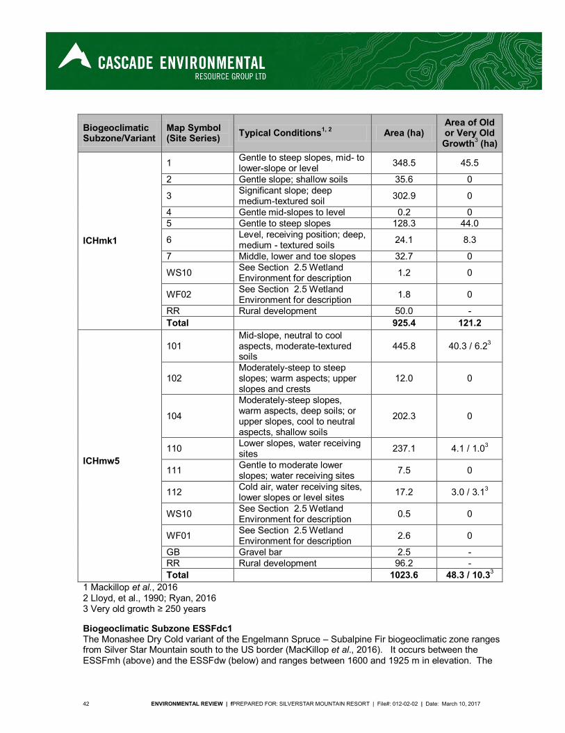
42 ENVIRONMENTAL REVIEW | fPREPARED FOR: SILVERSTAR MOUNTAIN RESORT | File#: 012-02-02 | Date: March 10, 2017
Biogeoclimatic Subzone/Variant
Map Symbol (Site Series) Typical Conditions1, 2 Area (ha)
Area of Old or Very Old
Growth3 (ha)
ICHmk1
1 Gentle to steep slopes, mid- to lower-slope or level 348.5 45.5
2 Gentle slope; shallow soils 35.6 0
3 Significant slope; deep medium-textured soil 302.9 0
4 Gentle mid-slopes to level 0.2 0 5 Gentle to steep slopes 128.3 44.0
6 Level, receiving position; deep, medium - textured soils 24.1 8.3
7 Middle, lower and toe slopes 32.7 0
WS10 See Section 2.5 Wetland Environment for description 1.2 0
WF02 See Section 2.5 Wetland Environment for description 1.8 0
RR Rural development 50.0 - Total 925.4 121.2
ICHmw5
101 Mid-slope, neutral to cool aspects, moderate-textured soils
445.8 40.3 / 6.23
102 Moderately-steep to steep slopes; warm aspects; upper slopes and crests
12.0 0
104
Moderately-steep slopes, warm aspects, deep soils; or upper slopes, cool to neutral aspects, shallow soils
202.3 0
110 Lower slopes, water receiving sites 237.1 4.1 / 1.03
111 Gentle to moderate lower slopes; water receiving sites 7.5 0
112 Cold air, water receiving sites, lower slopes or level sites 17.2 3.0 / 3.13
WS10 See Section 2.5 Wetland Environment for description 0.5 0
WF01 See Section 2.5 Wetland Environment for description 2.6 0
GB Gravel bar 2.5 - RR Rural development 96.2 - Total 1023.6 48.3 / 10.33
1 Mackillop et al., 2016 2 Lloyd, et al., 1990; Ryan, 2016 3 Very old growth ≥ 250 years
Biogeoclimatic Subzone ESSFdc1 The Monashee Dry Cold variant of the Engelmann Spruce – Subalpine Fir biogeoclimatic zone ranges from Silver Star Mountain south to the US border (MacKillop et al., 2016). It occurs between the ESSFmh (above) and the ESSFdw (below) and ranges between 1600 and 1925 m in elevation. The
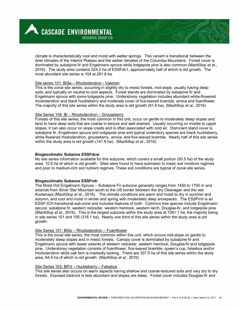
ENVIRONMENTAL REVIEW | PREPARED FOR: SILVERSTAR MOUNTAIN RESORT | File #: 012-02-02 | Date: March 10, 2017 43
climate is characteristically cool and moist with wetter springs. This variant is transitional between the drier climates of the Interior Plateau and the wetter climates of the Columbia Mountains. Forest cover is dominated by subalpine fir and Engelmann spruce while lodgepole pine is also common (MacKillop et al., 2016). The study area contains 524.2 ha of ESSFdc1, approximately half of which is old growth. The most abundant site series is 104 at 291.8 ha. Site series 101: BlSe – Rhododendron - Valerian This is the zonal site series, occurring in slightly dry to mesic forests, mid-slope, usually having deep soils, and typically on neutral to cool aspects. Forest stands are dominated by subalpine fir and Engelmann spruce with some lodgepole pine. Understorey vegetation includes abundant white-flowered rhododendron and black huckleberry and moderate cover of five-leaved bramble, arnica and foamflower. The majority of this site series within the study area is old growth (81.6 ha). (MacKillop et al., 2016) Site Series 104: Bl – Rhododendron – Grouseberry Forests of this site series, the most common in this unit, occur on gentle to moderately steep slopes and tend to have deep soils that are coarse in texture and well-drained. Usually occurring on middle to upper slopes, it can also occur on slope crests and is often associated with cold air. Dominant stand cover is subalpine fir, Engelmann spruce and lodgepole pine and typical understory species are black huckleberry, white-flowered rhododendron, grouseberry, arnica, and five-leaved bramble. Nearly half of this site series within the study area is old growth (141.8 ha). (MacKillop et al., 2016)
Biogeoclimatic Subzone ESSFdcw No site series information available for this subzone, which covers a small portion (50.5 ha) of the study area, 10.6 ha of which is old growth. Sites were found to have submesic to mesic soil moisture regimes and poor to medium-rich soil nutrient regimes. These soil conditions are typical of zonal site series.
Biogeoclimatic Subzone ESSFmh The Moist Hot Engelmann Spruce – Subalpine Fir subzone generally ranges from 1450 to 1700 m and extends from Silver Star Mountain south to the US border between the dry Okanagan and the wet Kootenays (MacKillop et al., 2016). The climate conditions are warm and moist to dry in summer and autumn, and cool and moist in winter and spring with moderately deep snowpacks. The ESSFmh is an ESSF-ICH transitional sub-zone and includes features of both. Common tree species include Engelmann spruce, subalpine fir, western redcedar, western hemlock, western larch, Douglas-fir, and lodgepole pine (MacKillop et al., 2016). This is the largest subzone within the study area at 1091.1 ha, the majority being in site series 101 and 105 (318.1 ha). Nearly one third of this site series within the study area is old growth. Site Series 101: BlSe – Rhododendron – Foamflower This is the zonal site series, the most common within this unit, which occurs mid-slope on gentle to moderately steep slopes and in mesic forests. Canopy cover is dominated by subalpine fir and Engelmann spruce with lesser extents of western redcedar, western hemlock, Douglas-fir and lodgepole pine. Understorey vegetation consists of foamflower, five-leaved bramble, queen’s cup, falsebox and/or rhododendron while oak fern is markedly lacking. There are 337.5 ha of this site series within the study area, 64.9 ha of which is old growth. (MacKillop et al., 2016) Site Series 103: BlFd – Huckleberry – Falsebox This site series also occurs on warm aspects having shallow and coarse-textured soils and very dry to dry forests. Exposed bedrock is less abundant and slopes are steep. Forest cover includes Douglas-fir and
44 ENVIRONMENTAL REVIEW | fPREPARED FOR: SILVERSTAR MOUNTAIN RESORT | File#: 012-02-02 | Date: March 10, 2017
lodgepole pine, with Engelmann spruce x white spruce hybrid, subalpine fir and western larch also occurring in lesser extents. The presence of pinegrass or pussytoes is notable. (MacKillop et al., 2016) Site Series 104: BlPl – Flasebox – Grouseberry Forests in this site series typically occur on gentle slopes with coarse and rapidly- to well-drained soils that are nutrient poor to very poor. Overstory species are dominated by lodgepole pine, Engelmann spruce and subalpine fir. Understorey species include falsebox, black huckleberry, and grouseberry, the most distinct species for this site series with lesser amounts of twinflower, prince’s pine and one-sided wintergreen. (MacKillop et al., 2016) Site Series 105: BlCwLw – Queen’s cup This site series also occurs mid-slope on gentle to moderately steep slopes and in slightly dry to mesic forests. Soils are usually deep. Forest stands include Engelmann spruce, subalpine fir, Douglas-fir, lodgepole pine, western larch and western redcedar. Queen’s cup, twinflower, and prince’s pine are present, while the lack of pinegrass, grouseberry, foamflower or five-leaved bramble is notable. More than half of the 218.1 ha of this site series within the CRA is old growth (226.4 ha). (MacKillop et al., 2016) Site Series 112: SeBl – Horsetail – Arrow-leaved groundsel This site series occurs on the toe of gentle slopes or in level areas with a thin layer of soil. Typically occurring in water-receiving sites where the water table is shallow, it is often associated with riparian areas. The canopy is most commonly dominated by Engelmann spruce with some subalpine fir. Horsetails are abundant and indicator species include groundsel and bluejoint reedgrass. (MacKillop et al., 2016)
Biogeocliatic Subzone ICHdw4 The Shuswap Dry Warm Interior Cedar – Hemlock sub-zone occurs at lower elevations, generally ranging from 350 to 1200 m, and extends from Shuswap Lake south to Monashee Creek (MacKillop et al., 2016). It occurs at valley bottom or above the IDFmw1 sub-zone and below the ICHmw5 or ICHmw2 sub-zones. The climate conditions are warm and moist in spring, hot and dry in summer, and mild and dry winter with moderately shallow snowpacks. Diversity of tree species is high and includes Douglas-fir, western redcedar, western hemlock, lodgepole pine, western white pine, western larch, paper birch, trembling aspen and black cottonwood with subalpine fir and Engelmann x white spruce hybrid at higher elevations (MacKillop et al., 2016). The study area contains only 40.4 ha of ICHdw4, mostly in the zonal site series 101 (26.2 ha), and 9.6 ha of which is old growth. Site Series 101: CwFd – Prince’s pine – Twinflower This is the zonal site series, occurring mid slope and usually having deeper soils. Soils are mesic and forest stands are a mix of western redcedar, western hemlock, Douglas-fir and western larch, with lodgepole pine, paper birch and trembling aspen in early seral stage stands. Feathermosses tend to be abundant and bunchberry or foamflower have minor covers of < 2 %. (MacKillop et al., 2016) Site Series 110: CwHw – Devil’s club – Lady fern This site series occurs in the wetter conditions of lower slopes or level areas where the presence of water from seepages or the water table is evident. Forests are moist to very wet and are dominated by western hemlock and western redcedar. Understorey vegetation includes devil’s club, yew, oak fern, lady fern, queen’s cup, and/or foamflower. (MacKillop et al., 2016) Site Series 111: CwHw - Horsetail – Lady fern This site series is typically associated with riparian areas and cool air and is found on gentle slopes or level areas. Soils are thin and the water table is shallow. Overstory species consist of western redcedar, western hemlock and Englemann x white spruce hybrid. Understorey species consist of horsetails, lady
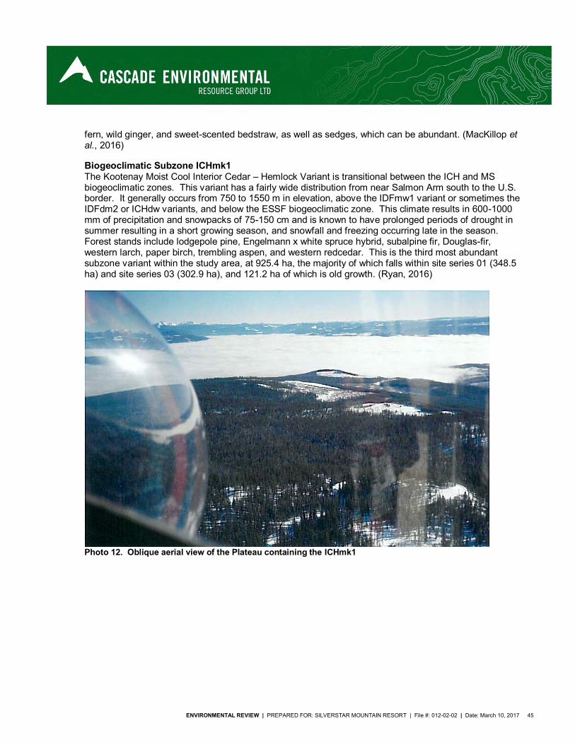
ENVIRONMENTAL REVIEW | PREPARED FOR: SILVERSTAR MOUNTAIN RESORT | File #: 012-02-02 | Date: March 10, 2017 45
fern, wild ginger, and sweet-scented bedstraw, as well as sedges, which can be abundant. (MacKillop et al., 2016)
Biogeoclimatic Subzone ICHmk1 The Kootenay Moist Cool Interior Cedar – Hemlock Variant is transitional between the ICH and MS biogeoclimatic zones. This variant has a fairly wide distribution from near Salmon Arm south to the U.S. border. It generally occurs from 750 to 1550 m in elevation, above the IDFmw1 variant or sometimes the IDFdm2 or ICHdw variants, and below the ESSF biogeoclimatic zone. This climate results in 600-1000 mm of precipitation and snowpacks of 75-150 cm and is known to have prolonged periods of drought in summer resulting in a short growing season, and snowfall and freezing occurring late in the season. Forest stands include lodgepole pine, Engelmann x white spruce hybrid, subalpine fir, Douglas-fir, western larch, paper birch, trembling aspen, and western redcedar. This is the third most abundant subzone variant within the study area, at 925.4 ha, the majority of which falls within site series 01 (348.5 ha) and site series 03 (302.9 ha), and 121.2 ha of which is old growth. (Ryan, 2016)
Photo 12. Oblique aerial view of the Plateau containing the ICHmk1
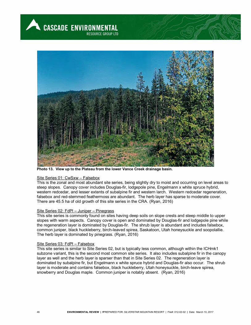
46 ENVIRONMENTAL REVIEW | fPREPARED FOR: SILVERSTAR MOUNTAIN RESORT | File#: 012-02-02 | Date: March 10, 2017
Photo 13. View up to the Plateau from the lower Vance Creek drainage basin.
Site Series 01: CwSxw – Falsebox This is the zonal and most abundant site series, being slightly dry to moist and occurring on level areas to steep slopes. Canopy cover includes Douglas-fir, lodgepole pine, Engelmann x white spruce hybrid, western redcedar, and lesser extents of subalpine fir and western larch. Western redcedar regeneration, falsebox and red-stemmed feathermoss are abundant. The herb layer has sparse to moderate cover. There are 45.5 ha of old growth of this site series in the CRA. (Ryan, 2016) Site Series 02: FdPl – Juniper – Pinegrass This site series is commonly found on sites having deep soils on slope crests and steep middle to upper slopes with warm aspects. Canopy cover is open and dominated by Douglas-fir and lodgepole pine while the regeneration layer is dominated by Douglas-fir. The shrub layer is abundant and includes falsebox, common juniper, black huckleberry, birch-leaved spirea, Saskatoon, Utah honeysuckle and soopolallie. The herb layer is dominated by pinegrass. (Ryan, 2016) Site Series 03: FdPl – Falsebox This site series is similar to Site Series 02, but is typically less common, although within the ICHmk1 subzone variant, this is the second most common site series. It also includes subalpine fir in the canopy layer as well and the herb layer is sparser than that in Site Series 02. The regeneration layer is dominated by subalpine fir, but Engelmann x white spruce hybrid and Douglas-fir also occur. The shrub layer is moderate and contains falsebox, black huckleberry, Utah honeysuckle, birch-leave spirea, snowberry and Douglas maple. Common juniper is notably absent. (Ryan, 2016)
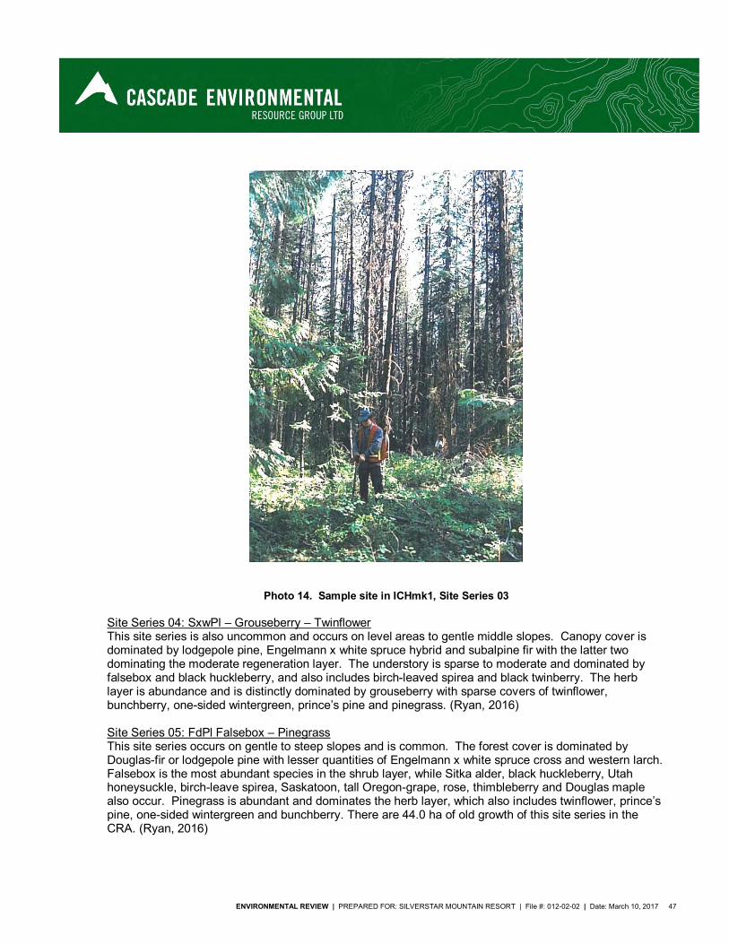
ENVIRONMENTAL REVIEW | PREPARED FOR: SILVERSTAR MOUNTAIN RESORT | File #: 012-02-02 | Date: March 10, 2017 47
Photo 14. Sample site in ICHmk1, Site Series 03
Site Series 04: SxwPl – Grouseberry – Twinflower This site series is also uncommon and occurs on level areas to gentle middle slopes. Canopy cover is dominated by lodgepole pine, Engelmann x white spruce hybrid and subalpine fir with the latter two dominating the moderate regeneration layer. The understory is sparse to moderate and dominated by falsebox and black huckleberry, and also includes birch-leaved spirea and black twinberry. The herb layer is abundance and is distinctly dominated by grouseberry with sparse covers of twinflower, bunchberry, one-sided wintergreen, prince’s pine and pinegrass. (Ryan, 2016) Site Series 05: FdPl Falsebox – Pinegrass This site series occurs on gentle to steep slopes and is common. The forest cover is dominated by Douglas-fir or lodgepole pine with lesser quantities of Engelmann x white spruce cross and western larch. Falsebox is the most abundant species in the shrub layer, while Sitka alder, black huckleberry, Utah honeysuckle, birch-leave spirea, Saskatoon, tall Oregon-grape, rose, thimbleberry and Douglas maple also occur. Pinegrass is abundant and dominates the herb layer, which also includes twinflower, prince’s pine, one-sided wintergreen and bunchberry. There are 44.0 ha of old growth of this site series in the CRA. (Ryan, 2016)
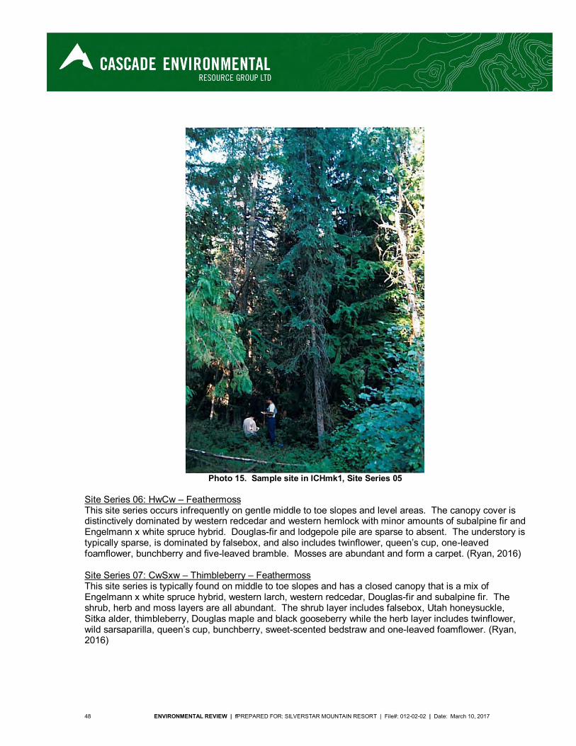
48 ENVIRONMENTAL REVIEW | fPREPARED FOR: SILVERSTAR MOUNTAIN RESORT | File#: 012-02-02 | Date: March 10, 2017
Photo 15. Sample site in ICHmk1, Site Series 05
Site Series 06: HwCw – Feathermoss This site series occurs infrequently on gentle middle to toe slopes and level areas. The canopy cover is distinctively dominated by western redcedar and western hemlock with minor amounts of subalpine fir and Engelmann x white spruce hybrid. Douglas-fir and lodgepole pile are sparse to absent. The understory is typically sparse, is dominated by falsebox, and also includes twinflower, queen’s cup, one-leaved foamflower, bunchberry and five-leaved bramble. Mosses are abundant and form a carpet. (Ryan, 2016) Site Series 07: CwSxw – Thimbleberry – Feathermoss This site series is typically found on middle to toe slopes and has a closed canopy that is a mix of Engelmann x white spruce hybrid, western larch, western redcedar, Douglas-fir and subalpine fir. The shrub, herb and moss layers are all abundant. The shrub layer includes falsebox, Utah honeysuckle, Sitka alder, thimbleberry, Douglas maple and black gooseberry while the herb layer includes twinflower, wild sarsaparilla, queen’s cup, bunchberry, sweet-scented bedstraw and one-leaved foamflower. (Ryan, 2016)
ENVIRONMENTAL REVIEW | PREPARED FOR: SILVERSTAR MOUNTAIN RESORT | File #: 012-02-02 | Date: March 10, 2017 49
Biogeoclimatic Subzone ICHmw5 The Granby Moist Warm Interior Cedar Hemlock subzone ranges from Shuswap Lake south to the U.S. border (MacKillop et al., 2016). It is a mid-elevation sub-zone occurring at 1100 to 1550 m in elevation, and below the ESSFmh sub-zone and above the ICHdw1 and ICH dw4 sub-zones. The climate in this region is warm and moist in summer, cool and dry to moist in winter and with moderate and persistent snowpacks. This sub-zone is highly productive and bio-diverse with mixes of a wide variety of tree species, including western redcedar, western hemlock, western larch, Douglas-fir, lodgepole pine, western white pine, subalpine fir, Engelmann x white spruce hybrid, paper birch, trembling aspen and black cottonwood (MacKillop et al., 2016). This is the second most abundant subzone in the study area at 1023.6 ha, the majority of which being Site Series 101 at 445.8 ha. This subzone also includes both old growth and very old growth (250 years and older) within Site Series 101, 110 and 112. Site Series 101: HwCw - Falsebox This is the most abundant site series and is zonal, occurring mid-slope on moderately steep slopes, usually having deeper soils. Soils are mesic and forest stands consist of western hemlock, western redcedar, western larch and Engelmann x white spruce hybrid. There is typically moderate cover of falsebox or black huckleberry, low to moderate cover of foamflower and five-leaved bramble, with no Douglas maple, soopolallie, birch-leaved spirea, or oak fern. This site series contains 40.3 ha of old growth and 6.2 ha of very old growth. (MacKillop et al., 2016) Site Series 102: FlPl – Juniper – Kinnikinnick This site series typically occurs on sites having soils of variable depths from exposed bedrock to pockets of deeper soils. Stands are often sparse with open areas and are dominated by Douglas-fir or lodgepole pine in earlier seral stages. Understorey vegetation includes falsebox, birch-leaved spirea, Saskatoon, juniper, pinegrass, kinnikinnick, and pussytoes. Yellow glacier lily, round-leaved alumroot, rock ferns and stonecrops are also common. (MacKillop et al., 2016) Site Series 104: FdCw – Falsebox – Prince’s pine This site series is slightly drier than zonal and has forest stands of western larch, Douglas-fir, western redcedar, western hemlock, lodgepole pine and Engelmann x white spruce hybrid with abundant falsebox, prince’s pine and/or twinflower with none to very little of foamflower and bunchberry. (MacKillop et al., 2016) Site Series 110: CwHw – Oak fern This site series is slightly wetter than zonal and slightly more nutrient rich. It occurs on lower slopes or level areas, is often associated with riparian vegetation, and has evidence of water present in mesic to moist soils. Forest stands consist of western redcedar and western hemlock. Oak fern is abundant and devil’s club and lady fern are absent to sparse. There are old growth occurrences of this site series in the CRA. This site series contains 4.1 ha of old growth and 1.0 ha of very old growth. (MacKillop et al., 2016) Site Series 111: CwHw – Devil’s club – Lady fern This is a wetter site series, occurring in water-receiving sites with seepages present, and is often associated with riparian areas. It is found on moderately-steep sites where seepages occur, to slope toes and level areas with well-drained coarse-textured soils. Canopy species are dominated by western redcedar and western hemlock with Engelmann x white spruce hybrid and subalpine fir occurring less frequently. Dominant understory species include devil’s club and lady fern, and oak fern, queen’s cup, foamflower and spiny wood fern are also common. (MacKillop et al., 2016) Site Series 112: Sxw(Hw) – Huckleberry – Oak fern
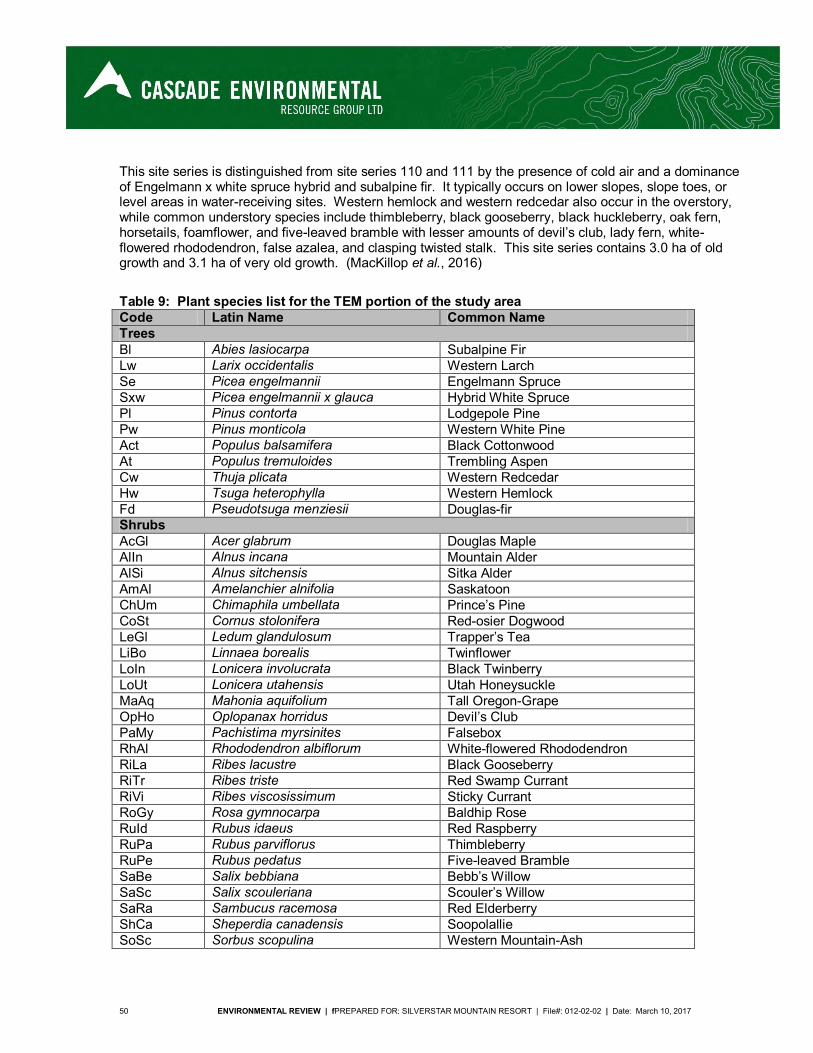
50 ENVIRONMENTAL REVIEW | fPREPARED FOR: SILVERSTAR MOUNTAIN RESORT | File#: 012-02-02 | Date: March 10, 2017
This site series is distinguished from site series 110 and 111 by the presence of cold air and a dominance of Engelmann x white spruce hybrid and subalpine fir. It typically occurs on lower slopes, slope toes, or level areas in water-receiving sites. Western hemlock and western redcedar also occur in the overstory, while common understory species include thimbleberry, black gooseberry, black huckleberry, oak fern, horsetails, foamflower, and five-leaved bramble with lesser amounts of devil’s club, lady fern, white-flowered rhododendron, false azalea, and clasping twisted stalk. This site series contains 3.0 ha of old growth and 3.1 ha of very old growth. (MacKillop et al., 2016)
Table 9: Plant species list for the TEM portion of the study area
Code Latin Name Common Name
Trees Bl Abies lasiocarpa Subalpine Fir Lw Larix occidentalis Western Larch Se Picea engelmannii Engelmann Spruce Sxw Picea engelmannii x glauca Hybrid White Spruce Pl Pinus contorta Lodgepole Pine Pw Pinus monticola Western White Pine Act Populus balsamifera Black Cottonwood At Populus tremuloides Trembling Aspen Cw Thuja plicata Western Redcedar Hw Tsuga heterophylla Western Hemlock Fd Pseudotsuga menziesii Douglas-fir Shrubs AcGl Acer glabrum Douglas Maple AlIn Alnus incana Mountain Alder AlSi Alnus sitchensis Sitka Alder AmAl Amelanchier alnifolia Saskatoon ChUm Chimaphila umbellata Prince’s Pine CoSt Cornus stolonifera Red-osier Dogwood LeGl Ledum glandulosum Trapper’s Tea LiBo Linnaea borealis Twinflower LoIn Lonicera involucrata Black Twinberry LoUt Lonicera utahensis Utah Honeysuckle MaAq Mahonia aquifolium Tall Oregon-Grape OpHo Oplopanax horridus Devil’s Club PaMy Pachistima myrsinites Falsebox RhAl Rhododendron albiflorum White-flowered Rhododendron RiLa Ribes lacustre Black Gooseberry RiTr Ribes triste Red Swamp Currant RiVi Ribes viscosissimum Sticky Currant RoGy Rosa gymnocarpa Baldhip Rose RuId Rubus idaeus Red Raspberry RuPa Rubus parviflorus Thimbleberry RuPe Rubus pedatus Five-leaved Bramble SaBe Salix bebbiana Bebb’s Willow SaSc Salix scouleriana Scouler’s Willow SaRa Sambucus racemosa Red Elderberry ShCa Sheperdia canadensis Soopolallie SoSc Sorbus scopulina Western Mountain-Ash
ENVIRONMENTAL REVIEW | PREPARED FOR: SILVERSTAR MOUNTAIN RESORT | File #: 012-02-02 | Date: March 10, 2017 51
Code Latin Name Common Name
SpBe Spiraea betulifolia Birch-leaved Spiraea TaBr Taxus brevifolia Western Yew VaMe Vaccinium membranaceum Black Huckleberry VaOv Vaccinium ovalifolium Oval-leaved Blueberry VaSc Vaccinium scoparium Grouseberry ViEd Viburnum edule High-Bush Cranberry Herbs AcRu Actaea rubra Baneberry AdBi Adenocaulon bicolor Pathfinder AnMa Anaphalis margaritacea Pearly Everlasting AnRa Antennaria racemosa Racemose Pussytoes ArNu Aralia nudicaulis Wild Sarsaparilla ArCo Arnica cordifolia Heart-leaved Arnica AsCo Aster conspicuus Showy Aster CaRu Calamagrostis rubescens Pinegrass CaCr Carex crawfordii Crawford’s Sedge CaMe Carex media Scandinavian Sedge CaRo Carex rostrata Beaked Sedge CaMi Castilleja miniata Common Red Paintbrush Cirsium spp. Thistle spp. ClUn Clintonia uniflora Queen’s Cup CoMa Corallorhiza maculata Spotted Coralroot CoCa Cornus canadensis Bunchberry CyMo Cypripedium montanum Mountain Ladyslipper DiHo Disporum hookeri Hooker’s Fairybells EpAn Epilobium angustifolium Fireweed EpCi Epilobium ciliatum Purple-leaved Willowherb ErSu Erigeron subtrinervis Triple-nerved Daisy ErAn Eriophorum angustifolium Narrow-leaved Cotton-Grass EqAv Equisetum arvense Common Horsetail FrVi Fragaria virginiana Wild Strawberry GaTr Galium trifidum Small Bedstraw GaTr Galium triflorum Sweet-scented Bedstraw GePr Gentianella propinqua Four-parted Gentian GeMa Geum macrophyllum Large-leaved Avens GeRi Geum rivale Water Avens GoOb Goodyera oblongifolia Rattlesnake Plantain HiAl Hieracium albiflorum White Hawkweed LiCo Lilium columbianum Tiger Lily LiCa Listera caurina Northwestern Twayblade LiCo Listera convallariodes Broad-leaved Twayblade LiCo Listera cordata Heart-leaved Twayblade LuAr Lupinus arcticus Arctic Lupine MeTr Menyanthes trifoliata Buckbean MiGu Mimulus guttatus Yellow Monkey-Flower MiBr Mitella breweri Brewer’s Mitrewort MiNu Mitella nuda Common Mitrewort
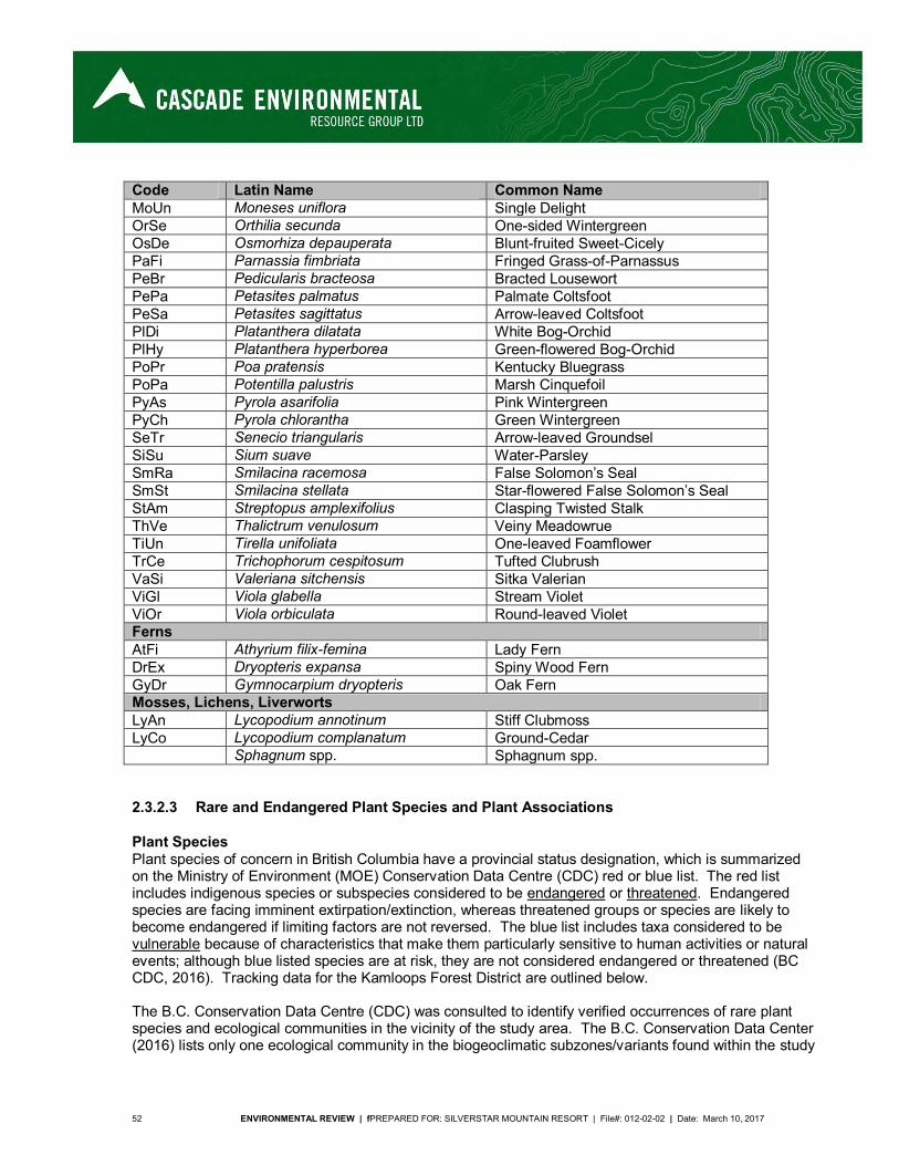
52 ENVIRONMENTAL REVIEW | fPREPARED FOR: SILVERSTAR MOUNTAIN RESORT | File#: 012-02-02 | Date: March 10, 2017
Code Latin Name Common Name
MoUn Moneses uniflora Single Delight OrSe Orthilia secunda One-sided Wintergreen OsDe Osmorhiza depauperata Blunt-fruited Sweet-Cicely PaFi Parnassia fimbriata Fringed Grass-of-Parnassus PeBr Pedicularis bracteosa Bracted Lousewort PePa Petasites palmatus Palmate Coltsfoot PeSa Petasites sagittatus Arrow-leaved Coltsfoot PlDi Platanthera dilatata White Bog-Orchid PlHy Platanthera hyperborea Green-flowered Bog-Orchid PoPr Poa pratensis Kentucky Bluegrass PoPa Potentilla palustris Marsh Cinquefoil PyAs Pyrola asarifolia Pink Wintergreen PyCh Pyrola chlorantha Green Wintergreen SeTr Senecio triangularis Arrow-leaved Groundsel SiSu Sium suave Water-Parsley SmRa Smilacina racemosa False Solomon’s Seal SmSt Smilacina stellata Star-flowered False Solomon’s Seal StAm Streptopus amplexifolius Clasping Twisted Stalk ThVe Thalictrum venulosum Veiny Meadowrue TiUn Tirella unifoliata One-leaved Foamflower TrCe Trichophorum cespitosum Tufted Clubrush VaSi Valeriana sitchensis Sitka Valerian ViGl Viola glabella Stream Violet ViOr Viola orbiculata Round-leaved Violet Ferns AtFi Athyrium filix-femina Lady Fern DrEx Dryopteris expansa Spiny Wood Fern GyDr Gymnocarpium dryopteris Oak Fern Mosses, Lichens, Liverworts LyAn Lycopodium annotinum Stiff Clubmoss LyCo Lycopodium complanatum Ground-Cedar Sphagnum spp. Sphagnum spp.
2.3.2.3 Rare and Endangered Plant Species and Plant Associations
Plant Species Plant species of concern in British Columbia have a provincial status designation, which is summarized on the Ministry of Environment (MOE) Conservation Data Centre (CDC) red or blue list. The red list includes indigenous species or subspecies considered to be endangered or threatened. Endangered species are facing imminent extirpation/extinction, whereas threatened groups or species are likely to become endangered if limiting factors are not reversed. The blue list includes taxa considered to be vulnerable because of characteristics that make them particularly sensitive to human activities or natural events; although blue listed species are at risk, they are not considered endangered or threatened (BC CDC, 2016). Tracking data for the Kamloops Forest District are outlined below. The B.C. Conservation Data Centre (CDC) was consulted to identify verified occurrences of rare plant species and ecological communities in the vicinity of the study area. The B.C. Conservation Data Center (2016) lists only one ecological community in the biogeoclimatic subzones/variants found within the study
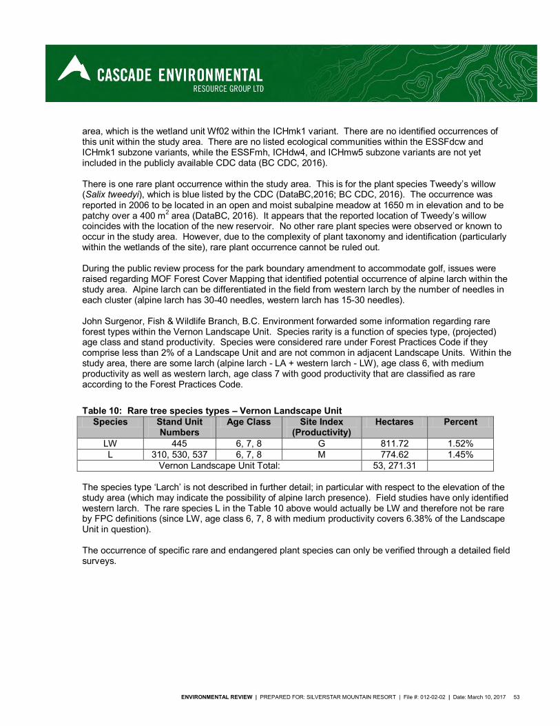
ENVIRONMENTAL REVIEW | PREPARED FOR: SILVERSTAR MOUNTAIN RESORT | File #: 012-02-02 | Date: March 10, 2017 53
area, which is the wetland unit Wf02 within the ICHmk1 variant. There are no identified occurrences of this unit within the study area. There are no listed ecological communities within the ESSFdcw and ICHmk1 subzone variants, while the ESSFmh, ICHdw4, and ICHmw5 subzone variants are not yet included in the publicly available CDC data (BC CDC, 2016). There is one rare plant occurrence within the study area. This is for the plant species Tweedy’s willow (Salix tweedyi), which is blue listed by the CDC (DataBC,2016; BC CDC, 2016). The occurrence was reported in 2006 to be located in an open and moist subalpine meadow at 1650 m in elevation and to be patchy over a 400 m2 area (DataBC, 2016). It appears that the reported location of Tweedy’s willow coincides with the location of the new reservoir. No other rare plant species were observed or known to occur in the study area. However, due to the complexity of plant taxonomy and identification (particularly within the wetlands of the site), rare plant occurrence cannot be ruled out. During the public review process for the park boundary amendment to accommodate golf, issues were raised regarding MOF Forest Cover Mapping that identified potential occurrence of alpine larch within the study area. Alpine larch can be differentiated in the field from western larch by the number of needles in each cluster (alpine larch has 30-40 needles, western larch has 15-30 needles). John Surgenor, Fish & Wildlife Branch, B.C. Environment forwarded some information regarding rare forest types within the Vernon Landscape Unit. Species rarity is a function of species type, (projected) age class and stand productivity. Species were considered rare under Forest Practices Code if they comprise less than 2% of a Landscape Unit and are not common in adjacent Landscape Units. Within the study area, there are some larch (alpine larch - LA + western larch - LW), age class 6, with medium productivity as well as western larch, age class 7 with good productivity that are classified as rare according to the Forest Practices Code.
Table 10: Rare tree species types – Vernon Landscape Unit
Species Stand Unit Numbers
Age Class Site Index (Productivity)
Hectares Percent
LW 445 6, 7, 8 G 811.72 1.52% L 310, 530, 537 6, 7, 8 M 774.62 1.45%
Vernon Landscape Unit Total: 53, 271.31 The species type ‘Larch’ is not described in further detail; in particular with respect to the elevation of the study area (which may indicate the possibility of alpine larch presence). Field studies have only identified western larch. The rare species L in the Table 10 above would actually be LW and therefore not be rare by FPC definitions (since LW, age class 6, 7, 8 with medium productivity covers 6.38% of the Landscape Unit in question). The occurrence of specific rare and endangered plant species can only be verified through a detailed field surveys.
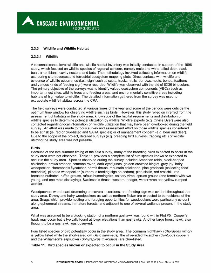
54 ENVIRONMENTAL REVIEW | fPREPARED FOR: SILVERSTAR MOUNTAIN RESORT | File#: 012-02-02 | Date: March 10, 2017
2.3.3 Wildlife and Wildlife Habitat
2.3.3.1 Wildlife
A reconnaissance level wildlife and wildlife habitat inventory was initially conducted in support of the 1996 study, which focused on wildlife species of regional concern, namely mule and white-tailed deer, black bear, amphibians, cavity nesters, and bats. The methodology involved collecting information on wildlife use during site traverses and terrestrial ecosystem mapping plots. Direct contacts with wildlife and evidence of wildlife occurrence (i.e., ‘sign’ such as scats, tracks, trails, burrows, nests, bones, feathers, and various kinds of feeding sign) were recorded. Wildlife was observed with the aid of 8X36 binoculars. The primary objective of the surveys was to identify valued ecosystem components (VECs) such as important nest sites, wildlife trees and feeding areas, and environmentally sensitive areas including habitats of high value to wildlife. The detailed information gathered from the survey was used to extrapolate wildlife habitats across the CRA. The field surveys were conducted at various times of the year and some of the periods were outside the optimum time window for observing wildlife such as birds. However, this study relied on inferred from the assessment of habitats in the study area, knowledge of the habitat requirements and distribution of wildlife species to determine potential utilization by wildlife. Wildlife experts (e.g. Orville Dyer) were also contacted regarding local information on wildlife utilization that may have been overlooked during the field survey. An effort was made to focus survey and assessment effort on those wildlife species considered to be at risk (ie. red or blue-listed and SARA species) or of management concern (e.g. bear and deer). Due to the scope of the project, detailed surveys (e.g. breeding bird surveys, trapping etc.) of wildlife utilizing the study area was not possible. Birds Because of the late summer timing of the field survey, many of the breeding birds expected to occur in the study area were not observed. Table 11 provides a complete list of bird species known or expected to occur in the study area. Species observed during the survey included American robin, black-capped chickadee, brown creeper, common raven, dark-eyed junco, golden-crowned kinglet, gray jay, hairy woodpecker, Hammond’s flycatcher, hermit thrush, mountain chickadee, pine grosbeak (collecting food materials), pileated woodpecker (numerous feeding sign on cedars), pine siskin, red crossbill, red-breasted nuthatch, ruffed grouse, rufous hummingbird, solitary vireo, spruce grouse (one female with two young, and one male displaying), Swainson’s thrush, western tanager, winter wren and yellow-rumped warbler. Woodpeckers were heard drumming on several occasions, and feeding sign was evident throughout the study area. Downy and hairy woodpeckers as well as northern flicker are expected to be residents of the area. Snags which provide nesting and foraging opportunities for woodpeckers were particularly evident along ephemeral streams, in mature forests, and adjacent to one of several wetlands present in the study area. What was assumed to be a plucking station of a northern goshawk was found within Plot #5. Cooper’s hawk may occur but is typically found at lower elevations than goshawks. Another large forest hawk, also thought to be a goshawk, was observed. Four listed species of bird potentially occur in the study area. The common nighthawk (Chordeiles minor) is yellow listed while the short-eared owl (Asio flammeus), the olive-sided flycatcher (Contopus cooperi) and the Williamson’s sapsucker (Sphyrapicus thyroideus) are blue-listed.
Table 11. Bird species known or expected to occur in the Study Area
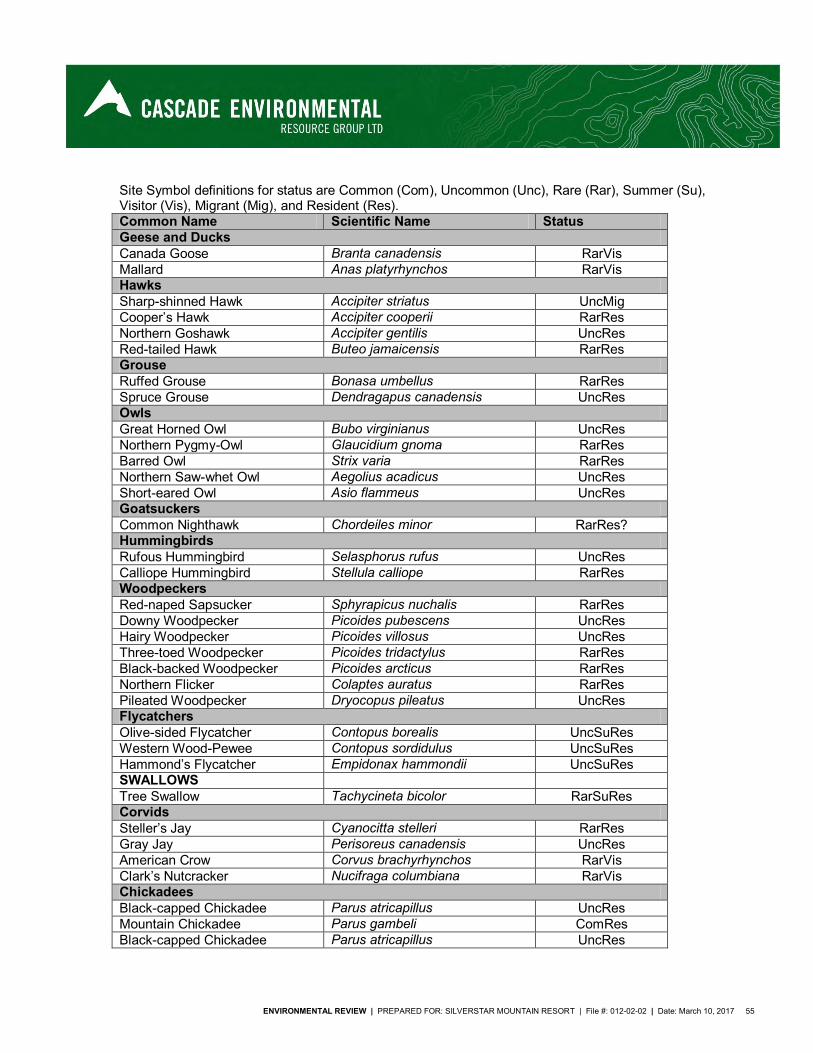
ENVIRONMENTAL REVIEW | PREPARED FOR: SILVERSTAR MOUNTAIN RESORT | File #: 012-02-02 | Date: March 10, 2017 55
Site Symbol definitions for status are Common (Com), Uncommon (Unc), Rare (Rar), Summer (Su), Visitor (Vis), Migrant (Mig), and Resident (Res). Common Name Scientific Name Status Geese and Ducks Canada Goose Branta canadensis RarVis Mallard Anas platyrhynchos RarVis Hawks Sharp-shinned Hawk Accipiter striatus UncMig Cooper’s Hawk Accipiter cooperii RarRes Northern Goshawk Accipiter gentilis UncRes Red-tailed Hawk Buteo jamaicensis RarRes Grouse Ruffed Grouse Bonasa umbellus RarRes Spruce Grouse Dendragapus canadensis UncRes Owls Great Horned Owl Bubo virginianus UncRes Northern Pygmy-Owl Glaucidium gnoma RarRes Barred Owl Strix varia RarRes Northern Saw-whet Owl Aegolius acadicus UncRes Short-eared Owl Asio flammeus UncRes Goatsuckers Common Nighthawk Chordeiles minor RarRes? Hummingbirds Rufous Hummingbird Selasphorus rufus UncRes Calliope Hummingbird Stellula calliope RarRes Woodpeckers Red-naped Sapsucker Sphyrapicus nuchalis RarRes Downy Woodpecker Picoides pubescens UncRes Hairy Woodpecker Picoides villosus UncRes Three-toed Woodpecker Picoides tridactylus RarRes Black-backed Woodpecker Picoides arcticus RarRes Northern Flicker Colaptes auratus RarRes Pileated Woodpecker Dryocopus pileatus UncRes Flycatchers Olive-sided Flycatcher Contopus borealis UncSuRes Western Wood-Pewee Contopus sordidulus UncSuRes Hammond’s Flycatcher Empidonax hammondii UncSuRes SWALLOWS Tree Swallow Tachycineta bicolor RarSuRes Corvids Steller’s Jay Cyanocitta stelleri RarRes Gray Jay Perisoreus canadensis UncRes American Crow Corvus brachyrhynchos RarVis Clark’s Nutcracker Nucifraga columbiana RarVis Chickadees Black-capped Chickadee Parus atricapillus UncRes Mountain Chickadee Parus gambeli ComRes Black-capped Chickadee Parus atricapillus UncRes
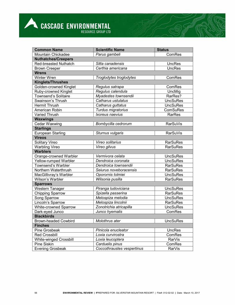
56 ENVIRONMENTAL REVIEW | fPREPARED FOR: SILVERSTAR MOUNTAIN RESORT | File#: 012-02-02 | Date: March 10, 2017
Common Name Scientific Name Status Mountain Chickadee Parus gambeli ComRes Nuthatches/Creepers Red-breasted Nuthatch Sitta canadensis UncRes Brown Creeper Certhia americana UncRes Wrens Winter Wren Troglodytes troglodytes ComRes Kinglets/Thrushes Golden-crowned Kinglet Regulus satrapa ComRes Ruby-crowned Kinglet Regulus calendula UncMig Townsend’s Solitaire Myadestes townsendii RarRes? Swainson’s Thrush Catharus ustulatus UncSuRes Hermit Thrush Catharus guttatus UncSuRes American Robin Turdus migratorius ComSuRes Varied Thrush Ixoreus naevius RarRes Waxwings Cedar Waxwing Bombycilla cedrorum RarSuVis Starlings European Starling Sturnus vulgaris RarSuVis Vireos Solitary Vireo Vireo solitarius RarSuRes Warbling Vireo Vireo gilvus RarSuRes Warblers Orange-crowned Warbler Vermivora celata UncSuRes Yellow-rumped Warbler Dendroica coronata UncSuRes Townsend’s Warbler Dendroica townsendii RarSuRes Northern Waterthrush Seiurus noveboracensis RarSuRes MacGillivray’s Warbler Oporornis tolmiei UncSuRes Wilson’s Warbler Wilsonia pusilla RarSuRes Sparrows Western Tanager Piranga ludoviciana UncSuRes Chipping Sparrow Spizella passerina RarSuRes Song Sparrow Melospiza melodia UncSuRes Lincoln’s Sparrow Melospiza lincolnii RarSuRes White-crowned Sparrow Zonotrichia atricapilla UncSuRes Dark-eyed Junco Junco hyemalis ComRes Blackbirds Brown-headed Cowbird Molothrus ater UncSuRes Finches Pine Grosbeak Pinicola enucleator UncRes Red Crossbill Loxia curvirostra ComRes White-winged Crossbill Loxia leucoptera RarVis Pine Siskin Carduelis pinus ComRes Evening Grosbeak Coccothraustes vespertinus RarVis
ENVIRONMENTAL REVIEW | PREPARED FOR: SILVERSTAR MOUNTAIN RESORT | File #: 012-02-02 | Date: March 10, 2017 57
Mammals
Shrews A single water shrew (Sorex palustris) was captured in a minnow trap in a small creek draining the study area. Water shrews are expected to occur in creek and wetland habitats throughout the study area. However, some of the creeks dry up in the summer and would not be suitable for this species. Other shrew species expected to occur within the study area include common (Sorex cinereus), dusky (S. monticolus) and vagrant shrew (S. vagrans). Bats The availability of wildlife trees and wetlands in the study area provides excellent roosting and foraging opportunities for bats. SilverStar CRA falls within the known distribution of several bat species. These species include California myotis (Myotis californicus), western long-eared myotis (M. evotis), little brown myotis (M. lucifugus), long-legged myotis (M. volans), Yuma myotis (M. yumanensis), hoary bat (Lasiurus cinereus), silver-haired bat (Lasionycteris noctivagans), big brown bat (Eptesicus fuscus), and Townsend’s big-eared bat (Corynorhinus townsendii). Two species of bat are listed; the little brown myotis is yellow listed while the Townsend’s big eared bat is blue listed. Little brown myotis. Colonies are often established in buildings, or large-diameter trees. Foraging occurs over water, along waterways, forest edges and gaps in the forest (COSEWIC, 2013). Townsend’s big-eared bats are found is variety of habitat including forested regions and buildings, and in areas with a mosaic of woodland, grassland, and/or shrubland (BC MOE, 2016) and therefore may be present in the study area. Snowshoe Hare Although snowshoe hares (Lepus americanus) were not observed during the field survey, they are expected to be relatively common in the study area, especially in denser, mature forests. The absence of sign during the recent field survey may be due to the currently low populations. Snowshoe hare populations’ exhibit marked cycles. Small Rodents Evidence of earth mounding and tunneling indicates that northern pocket gopher (Thomomys talpoides) are present in moderate abundance within the study area. Southern red-backed vole (Clethrionomys gapperi) is expected to inhabit forested regions whereas deer mouse (Peromyscus maniculatus) likely occurs in most habitats. Other small rodent species that may occur include long-tailed vole (Microtis longicaudis), heather vole (Phenacomys intermedius), meadow vole (Microtis pennsylvanicus) and meadow jumping mouse (Zapus hudsonius). Porcupine Porcupine (Erethizon dorsatum) was not observed during the field surveys but is expected to occur in moderate numbers in the study area. Squirrels and Chipmunks Red squirrel (Tamiasciurus hudsonicus) sign and individuals were observed on numerous occasions. Sign included cone scales, large and extensive middens and calls. The predominance of cone-bearing trees within the study area provides an abundance of foraging opportunities. Yellow-pine chipmunk (Tamias amoenus) occurs throughout the study area, especially in areas with high course woody debris, or windthrow areas with large, dense brushpiles. Columbian groundsquirrel
58 ENVIRONMENTAL REVIEW | fPREPARED FOR: SILVERSTAR MOUNTAIN RESORT | File#: 012-02-02 | Date: March 10, 2017
(Spermophilus columbianus) may occur in open, disturbed areas in the study area (they are common at Silver Star Village nearby) and northern flying squirrel (Glaucomys sabrinus), a nocturnal squirrel, likely inhabits forested regions. Canids Habitats of the CRA are suitable for all three canid species. Coyote (Canis latrans) is likely the most abundant species followed by red fox (Vulpes vulpes) and gray wolf (Canis lupus). Gray wolves are expected to be of rare or occasional occurrence within the study area. Cats Cougars (Felis concolor) are likely attracted to the high numbers of deer within and adjacent to the CRA. Lynx (Lynx canadensis) and bobcat (Lynx rufus) likely occur occasionally and at low numbers (Orville Dyer, BCE, Penticton, pers. comm., 1996). Mustelids Marten (Martes americana) and ermine (Mustela erminea) are expected to be relatively common residents of the CRA (Orville Dyer, BCE, Penticton, pers. comm., 1996). Red squirrels and small rodents provide an abundance of prey. Occurrence of long-tailed weasel (Mustela frenata), striped skunk (Mephitis mephitis) and wolverine (Gulo gulo luscus) is not known. Wolverine is blue-listed by the B.C. Ministry of Environment. Although there has been no recorded sightings of fishers (Pekania pennant) on the CRA and most populations inhabit lower elevations (majority below 1000 m), they can be found up to 2500 m. Fishers, a blue-listed species, are generalist predators with a specialty of porcupines (Erethizon dorsatum) and snowshoe hares (Lepus americanus). Summer foraging is strongly associated with coarse woody debris (MOE 2004b). Wolverine, a blue-listed species, is widely distributed albeit at low densities from valley bottom to alpine meadows. Wolverines use a wide variety of ecosystems and are known to pass through the area. Wolverine intensity and frequency is dependent on the ability of the habitat to support specific food source (ungulates, hoary marmots). Habitat is in predominantly mature and old forest structural stage. (MOE, 2004c). There is a known denning site of the badger (Taxidea taxus jeffersonii) within the CRA (Map 7). It is a species red-listed by BC Environment, and is classified as endangered under Schedule 1 of the Federal Species at Risk Act (SARA). The BC Ministry of Environment has prepared a recovery plan for Taxidea taxus (MOE, 2008). In BC most badger activity is at low elevations and in dry regions within native or non-native grasslands, open forests of Douglas-fir or Ponderosa pine, and disturbed sites such as agricultural fields. Habitat is prey-dependent (MOE, 2004a).
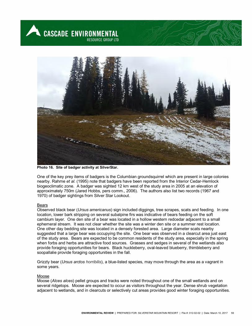
ENVIRONMENTAL REVIEW | PREPARED FOR: SILVERSTAR MOUNTAIN RESORT | File #: 012-02-02 | Date: March 10, 2017 59
Photo 16. Site of badger activity at SilverStar.
One of the key prey items of badgers is the Columbian groundsquirrel which are present in large colonies nearby. Rahme et al. (1995) note that badgers have been reported from the Interior Cedar-Hemlock biogeoclimatic zone. A badger was sighted 12 km west of the study area in 2005 at an elevation of approximately 750m (Jared Hobbs, pers comm., 2006). The authors also list two records (1967 and 1970) of badger sightings from Silver Star Lookout. Bears Observed black bear (Ursus americanus) sign included diggings, tree scrapes, scats and feeding. In one location, lower bark stripping on several subalpine firs was indicative of bears feeding on the soft cambium layer. One den site of a bear was located in a hollow western redcedar adjacent to a small ephemeral stream. It was not clear whether the site was a winter den site or a summer rest location. One other day bedding site was located in a densely forested area. Large diameter scats nearby suggested that a large bear was occupying the site. One bear was observed in a clearcut area just east of the study area. Bears are expected to be common residents of the study area, especially in the spring when forbs and herbs are attractive food sources. Grasses and sedges in several of the wetlands also provide foraging opportunities for bears. Black huckleberry, oval-leaved blueberry, thimbleberry and soopallalie provide foraging opportunities in the fall. Grizzly bear (Ursus arctos horribilis), a blue-listed species, may move through the area as a vagrant in some years. Moose Moose (Alces alces) pellet groups and tracks were noted throughout one of the small wetlands and on several ridgetops. Moose are expected to occur as visitors throughout the year. Dense shrub vegetation adjacent to wetlands, and in clearcuts or selectively cut areas provides good winter foraging opportunities.
60 ENVIRONMENTAL REVIEW | fPREPARED FOR: SILVERSTAR MOUNTAIN RESORT | File#: 012-02-02 | Date: March 10, 2017
Moose populations in the areas were increasing when the initial study was conducted (Orville Dyer, BCE, Penticton, pers. comm., 1996), but more recently the population have experienced moderate declines (FLNRO, 2014). Elk Although there are recent reports of a small elk (Cervus canadensis) herd in the Lumby and Cherryville area, there have been no reports from Silver Star Mountain. However, elk numbers may increase in the future and expand their range into other suitable habitats (Orville Dyer, BCE, Penticton, pers. comm., 1996). Deer Mule deer (Odocoileus hemionus hemionus) are common residents of the study area. Utilization of the study area in the winter is likely limited by high snow depths. Anecdotal information indicates that the study area and surrounding habitats may be prime areas during the fall rut (approximately early October to mid-December). However, forested habitats within the study area have been significantly reduced in the last few years because of salvage operations for beetle-killed wood possibly reducing the suitability of the area for rutting. Old and fresh deer sign was encountered frequently in the study area. Deer were seen on at least five occasions, especially in open clearcut or selectively logged areas where forb and herb productivity is high. White-tailed Deer (Odocoileus virginianus) are not as abundant as mule deer in the study area. They were, however, observed on two occasions. White-tailed deer typically inhabit dense areas adjacent to creeks or in valley bottoms whereas mule deer are more typically found in open, higher elevation areas in summer. Caribou The nearest known mountain caribou (Rangifer tarandus) populations are on the east side of the valley north of Sugar Lake (Orville Dyer, BCE, Penticton, pers. comm., 1996). Recent searches of the Conservation Data Centre indicate the nearest population is the Monashee herd located northwest of Sugar Lake (BC CDC, 2017). This is likely the same remnant population. Regardless, it is more than 70 km from SilverStar Mountain Resort. Amphibians and Reptiles Several spotted frogs (Rana pretiosa) were observed in wetlands on the CRA. One of the wetlands had numerous tadpoles thought to be of either spotted frog or western toad (Bufo boreas). Although only one Pacific tree frog (Hyla regilla) was observed during the site reconnaissance, they are expected to be relatively common in the study area. The only salamander species that is expected to occur in the study area is long-toed salamander (Ambystoma macrodactylum) (Green and Campbell 1984). No reptiles were observed during the field surveys of the study area. Species which may occur include northern alligator lizard (Gerrhonotus coeruleus), common garter snake (Thamnophis sirtalis), western terrestrial garter snake (T. elegans), western painted turtle (Chrysemys picta), Pacific gopher snake (Pituophis catenifer catenifer), western yellow-bellied racer (Coluber constrictor mormon) and northern rubber boas (Charina bottae) (Les Anthony, Pers comm, 2016).
Three species of amphibians and reptiles are listed. The northern rubber boa is yellow listed while the western painted turtle and the western toad are blue listed. Northern rubber boa is found from sea level to about 3050 meters of elevation and occupies a variety of habitats including stream banks, thickets, grasslands, and montane forests. This snake needs rocky outcrops and abundant coarse woody debris to
ENVIRONMENTAL REVIEW | PREPARED FOR: SILVERSTAR MOUNTAIN RESORT | File #: 012-02-02 | Date: March 10, 2017 61
hide from predators and to thermoregulate (BC MOE, 2016). The western painted turtle may potentially occur in the study area as the species is found in the shallow waters of ponds, lakes, marshes and slow-moving streams. Suitable wetlands have muddy substrates, an abundance of emergent vegetation, and numerous basking sites, such as logs and accessible banks (COSEWIC, 2006). Western toads breed in a variety of aquatic habitat from shallow margin of lakes to roadside ditches. Adult toads can be found in forested areas, wet shrublands, avalanche slopes, and meadows. They appear to favor dense shrub cover, perhaps because it provides protection from desiccation and predators (COSEWIC, 2002)
2.3.3.2 Rare and Endangered Species
An online search for known species at risk occurrences was conducted (DataBC, 2016) and a search of the British Columbia Species and Ecosystems Explorer (BC MOE, 2016) was conducted to identify all species at risk potentially occurring in the applicable biogeoclimatic zone and Forest District and their habitat requirements. Potential occurrences are then designated as unlikely or possible based upon species specific habitat requirements and an on-site assessment of those habitats. In B.C., there are two bodies involved with the ranking of species and/or ecological communities at risk. At the national level, the Committee on the Status of Endangered Wildlife in Canada (COSEWIC) works under the Species at Risk Act (SARA), and at the provincial level, the Conservation Data Centre (CDC) manages the B.C. Status List. The Canadian government created the Species at Risk Act (SARA) in 2002 to complement the Accord for the Protection of Species at Risk (a national effort to identify and protect threatened and endangered wildlife and their associated habitats across the country, 1996). The Committee on the Status of Endangered Wildlife in Canada is the scientific body responsible for assigning the status of species at risk under SARA. This ranking system uses the following terminology:
Extinct (XX) Extirpated (XT) Endangered (E) Threatened (T) Special concern (SC) Not at risk (NAR) Data deficient (DD)
A species that is listed as Endangered, Extirpated or Threatened is included on the legal list under Schedule 1 of the Act and is legally protected under the Act with federal measures to protect and recover these species in effect. The B.C. CDC designates provincial red or blue list status to animal and plant species, and ecological communities of concern (BC MOE, 2016). The red list includes indigenous species or subspecies considered to be endangered or threatened. Endangered species are facing imminent extirpation/extinction, whereas threatened groups or species are likely to become endangered if limiting factors are not reversed. The blue list includes taxa considered to be vulnerable because of characteristics that make them particularly sensitive to human activities or natural events. Although blue listed species are at risk, they are not considered endangered or threatened. Yellow listed species are all those not included on the red or blue list and may be species which are declining, increasing, common or uncommon (BC Ministry of Sustainable Resource Management, 2002)
62 ENVIRONMENTAL REVIEW | fPREPARED FOR: SILVERSTAR MOUNTAIN RESORT | File#: 012-02-02 | Date: March 10, 2017
The table below includes CDC listed (i.e. red and blue listed) species that have the potential to occur on or near the subject site; species designated at SARA Schedule 1 are also noted. This potential is based on broad habitat preferences delineated by forest district and biogeoclimatic zone. 13 species at risk have the potential to occur within the study area. Three species are yellow listed, 11 species are blue listed and one species is red listed. The yellow listed species are the northern rubber boa (SARA 1 SC), the common nighthawk (SARA 1-T) and the little brown myotis (SARA 1-E). The blue listed species are the western toad (SARA 1-SC), the short eared owl (SARA 1-SC), the painted turtle (SARA 1-SC), the olive-sided flycatcher (SARA 1-T), Townsend’s big eared bat, the Columbia sculpin, the wolverine, the cutthroat trout, the fisher, the Willimason’s sapsucker (SARA 1-E) and the grizzly. The red listed species is the American badger (SARA 1-E).
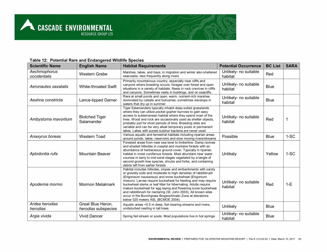
ENVIRONMENTAL REVIEW | PREPARED FOR: SILVERSTAR MOUNTAIN RESORT | File #: 012-02-02 | Date: March 10, 2017 63
Table 12: Potential Rare and Endangered Wildlife Species
Scientific Name English Name Habitat Requirements Potential Occurrence BC List SARA Aechmophorus occidentalis Western Grebe Marshes, lakes, and bays; in migration and winter also sheltered
seacoasts, less frequently along rivers Unlikely- no suitable habitat Red
Aeronautes saxatalis White-throated Swift Primarily mountainous country, especially near cliffs and canyons where breeding occurs; forages over forest and open situations in a variety of habitats. Nests in rock crevices in cliffs and canyons. Sometimes nests in buildings, and on seacliffs.
Unlikely- no suitable habitat Blue
Aeshna constricta Lance-tipped Darner Rare at small ponds and open, warm, nutrient-rich marshes dominated by cattails and bulrushes; sometimes develops in waters that dry up in summer
Unlikely- no suitable habitat Blue
Ambystoma mavortium Blotched Tiger Salamander
Tiger Salamanders typically inhabit deep-soiled grasslands where they can utilize pocket gopher burrows to gain easy access to subterranean habitat where they spend most of the lives. Wood and rock are occasionally used as shelter objects, probably just for short periods of time. Breeding sites are variable and can be very alkali temporary pools or permanent lakes. Lakes with purple sulphur bacteria are never used
Unlikely- no suitable habitat Red 1
Anaxyrus boreas Western Toad Various aquatic and terrestrial habitats including riparian areas around ponds, lakes, reservoirs and slow moving rivers/streams Possible Blue 1-SC
Aplodontia rufa Mountain Beaver
Forested areas from near sea level to timberline. Damp ravines and shaded hillsides in coastal and montane forests with an abundance of herbaceous ground cover. Typically in riparian habitat in moist coniferous forests. Most abundant near water courses in early to mid-seral stages vegetated by a tangle of second growth tree species, shrubs and forbs, and containing debris left from earlier forests
Unlikely Yellow 1-SC
Apodemia mormo Mormon Metalmark
Habitat includes hillsides, slopes and embankments with sandy or gravelly soils and moderate to high densities of rabbitbrush (Erigoneum nauseosus) and snow buckwheat (Erigonium niveum). Larvae require buckwheat for feeding and may require buckwheat stems or leaf litter for hibernating. Adults require mature buckwheat for egg laying and flowering snow buckwheat and rabbitbrush for nectaring (St. John 2003). All known sites occur in the Bunchgrass Biogeoclimatic Zone at elevations below 520 meters ASL (BCMOE 2004).
Unlikely- no suitable habitat Red 1-E
Ardea herodias herodias
Great Blue Heron, herodias subspecies
Aquatic areas <0.5 m deep, fish bearing streams and rivers, undisturbed nesting in tall trees. Unlikely Blue
Argia vivida Vivid Dancer Spring fed stream or pools. Most populations live in hot springs Unlikely- no suitable habitat Blue
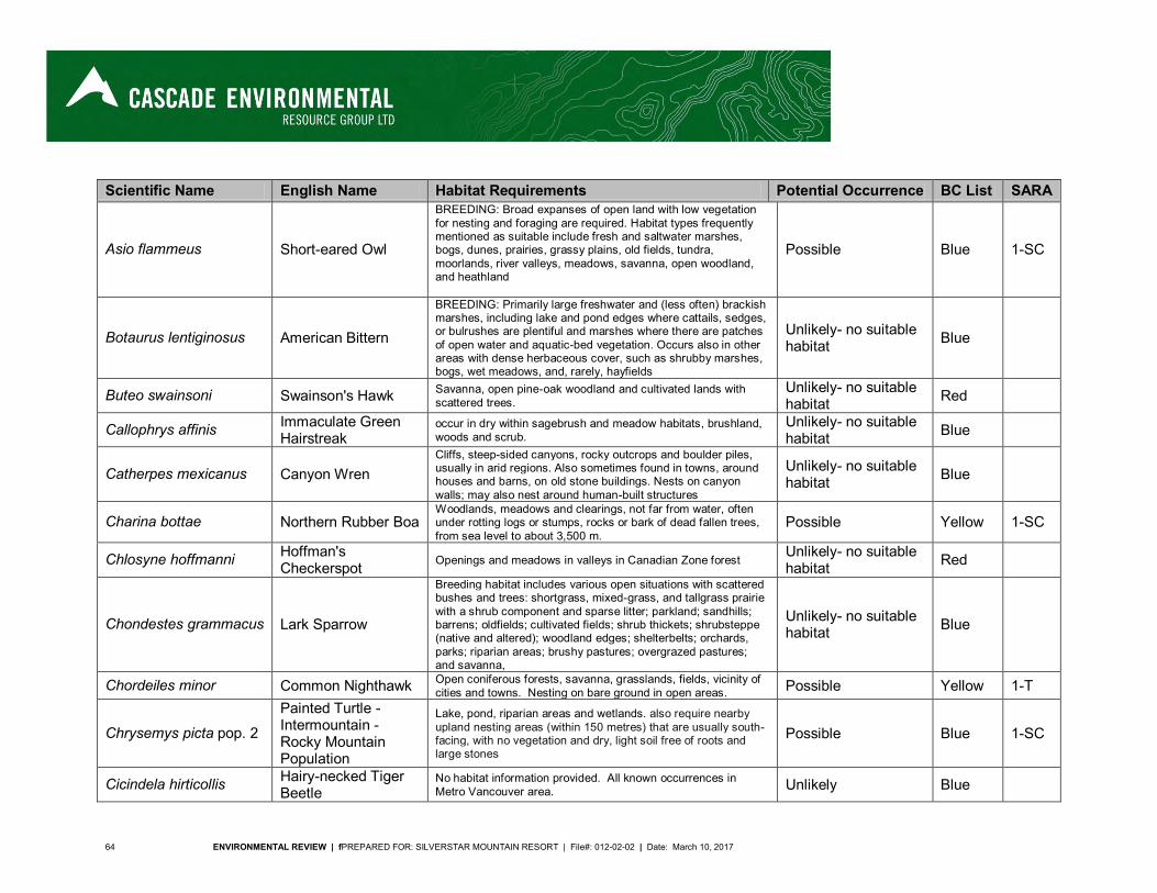
64 ENVIRONMENTAL REVIEW | fPREPARED FOR: SILVERSTAR MOUNTAIN RESORT | File#: 012-02-02 | Date: March 10, 2017
Scientific Name English Name Habitat Requirements Potential Occurrence BC List SARA
Asio flammeus Short-eared Owl
BREEDING: Broad expanses of open land with low vegetation for nesting and foraging are required. Habitat types frequently mentioned as suitable include fresh and saltwater marshes, bogs, dunes, prairies, grassy plains, old fields, tundra, moorlands, river valleys, meadows, savanna, open woodland, and heathland
Possible Blue 1-SC
Botaurus lentiginosus American Bittern
BREEDING: Primarily large freshwater and (less often) brackish marshes, including lake and pond edges where cattails, sedges, or bulrushes are plentiful and marshes where there are patches of open water and aquatic-bed vegetation. Occurs also in other areas with dense herbaceous cover, such as shrubby marshes, bogs, wet meadows, and, rarely, hayfields
Unlikely- no suitable habitat Blue
Buteo swainsoni Swainson's Hawk Savanna, open pine-oak woodland and cultivated lands with scattered trees.
Unlikely- no suitable habitat Red
Callophrys affinis Immaculate Green Hairstreak
occur in dry within sagebrush and meadow habitats, brushland, woods and scrub.
Unlikely- no suitable habitat Blue
Catherpes mexicanus Canyon Wren Cliffs, steep-sided canyons, rocky outcrops and boulder piles, usually in arid regions. Also sometimes found in towns, around houses and barns, on old stone buildings. Nests on canyon walls; may also nest around human-built structures
Unlikely- no suitable habitat Blue
Charina bottae Northern Rubber Boa Woodlands, meadows and clearings, not far from water, often under rotting logs or stumps, rocks or bark of dead fallen trees, from sea level to about 3,500 m.
Possible Yellow 1-SC
Chlosyne hoffmanni Hoffman's Checkerspot Openings and meadows in valleys in Canadian Zone forest
Unlikely- no suitable habitat Red
Chondestes grammacus Lark Sparrow
Breeding habitat includes various open situations with scattered bushes and trees: shortgrass, mixed-grass, and tallgrass prairie with a shrub component and sparse litter; parkland; sandhills; barrens; oldfields; cultivated fields; shrub thickets; shrubsteppe (native and altered); woodland edges; shelterbelts; orchards, parks; riparian areas; brushy pastures; overgrazed pastures; and savanna,
Unlikely- no suitable habitat Blue
Chordeiles minor Common Nighthawk Open coniferous forests, savanna, grasslands, fields, vicinity of cities and towns. Nesting on bare ground in open areas. Possible Yellow 1-T
Chrysemys picta pop. 2
Painted Turtle - Intermountain - Rocky Mountain Population
Lake, pond, riparian areas and wetlands. also require nearby upland nesting areas (within 150 metres) that are usually south-facing, with no vegetation and dry, light soil free of roots and large stones
Possible Blue 1-SC
Cicindela hirticollis Hairy-necked Tiger Beetle
No habitat information provided. All known occurrences in Metro Vancouver area. Unlikely Blue
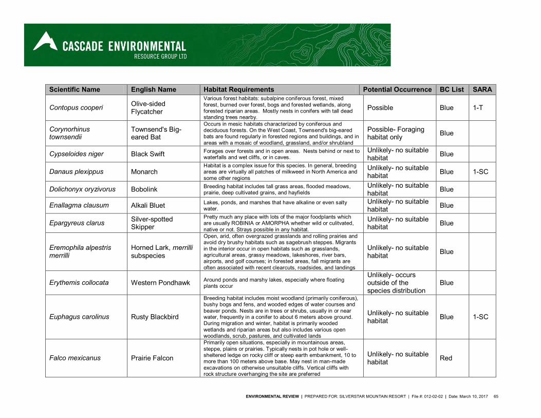
ENVIRONMENTAL REVIEW | PREPARED FOR: SILVERSTAR MOUNTAIN RESORT | File #: 012-02-02 | Date: March 10, 2017 65
Scientific Name English Name Habitat Requirements Potential Occurrence BC List SARA
Contopus cooperi Olive-sided Flycatcher
Various forest habitats: subalpine coniferous forest, mixed forest, burned over forest, bogs and forested wetlands, along forested riparian areas. Mostly nests in conifers with tall dead standing trees nearby.
Possible Blue 1-T
Corynorhinus townsendii
Townsend's Big-eared Bat
Occurs in mesic habitats characterized by coniferous and deciduous forests. On the West Coast, Townsend's big-eared bats are found regularly in forested regions and buildings, and in areas with a mosaic of woodland, grassland, and/or shrubland
Possible- Foraging habitat only Blue
Cypseloides niger Black Swift Forages over forests and in open areas. Nests behind or next to waterfalls and wet cliffs, or in caves.
Unlikely- no suitable habitat Blue
Danaus plexippus Monarch Habitat is a complex issue for this species. In general, breeding areas are virtually all patches of milkweed in North America and some other regions
Unlikely- no suitable habitat Blue 1-SC
Dolichonyx oryzivorus Bobolink Breeding habitat includes tall grass areas, flooded meadows, prairie, deep cultivated grains, and hayfields
Unlikely- no suitable habitat Blue
Enallagma clausum Alkali Bluet Lakes, ponds, and marshes that have alkaline or even salty water.
Unlikely- no suitable habitat Blue
Epargyreus clarus Silver-spotted Skipper
Pretty much any place with lots of the major foodplants which are usually ROBINIA or AMORPHA whether wild or culitvated, native or not. Strays possible in any habitat.
Unlikely- no suitable habitat Blue
Eremophila alpestris merrilli
Horned Lark, merrilli subspecies
Open, arid, often overgrazed grasslands and rolling prairies and avoid dry brushy habitats such as sagebrush steppes. Migrants in the interior occur in open habitats such as grasslands, agricultural areas, grassy meadows, lakeshores, river bars, airports, and golf courses; in forested areas, fall migrants are often associated with recent clearcuts, roadsides, and landings
Unlikely- no suitable habitat Blue
Erythemis collocata Western Pondhawk Around ponds and marshy lakes, especially where floating plants occur
Unlikely- occurs outside of the species distribution
Blue
Euphagus carolinus Rusty Blackbird
Breeding habitat includes moist woodland (primarily coniferous), bushy bogs and fens, and wooded edges of water courses and beaver ponds. Nests are in trees or shrubs, usually in or near water, frequently in a conifer to about 6 meters above ground. During migration and winter, habitat is primarily wooded wetlands and riparian areas but also includes various open woodlands, scrub, pastures, and cultivated lands
Unlikely- no suitable habitat Blue 1-SC
Falco mexicanus Prairie Falcon
Primarily open situations, especially in mountainous areas, steppe, plains or prairies. Typically nests in pot hole or well-sheltered ledge on rocky cliff or steep earth embankment, 10 to more than 100 meters above base. May nest in man-made excavations on otherwise unsuitable cliffs. Vertical cliffs with rock structure overhanging the site are preferred
Unlikely- no suitable habitat Red
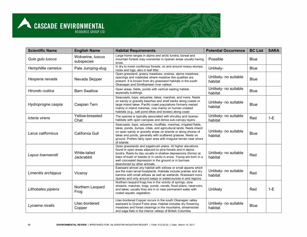
66 ENVIRONMENTAL REVIEW | fPREPARED FOR: SILVERSTAR MOUNTAIN RESORT | File#: 012-02-02 | Date: March 10, 2017
Scientific Name English Name Habitat Requirements Potential Occurrence BC List SARA
Gulo gulo luscus Wolverine, luscus subspecies
Large home ranges in alpine and arctic tundra, boreal and mountain forests may overwinter in riparian areas usually having snow.
Possible Blue
Hemphillia camelus Pale Jumping-slug In dry to moist coniferous forests, on and around mossy stumps, rocks and logs; also in leaf litter Unlikely- Blue
Hesperia nevada Nevada Skipper Open grassland; grassy meadows, prairies, alpine meadows, openings and roadsides where meadow like qualities are present. It is known from dry grassland habitats in the south Okanagan and Similkameen river valleys
Unlikely- no suitable habitat Blue
Hirundo rustica Barn Swallow Open areas, fields, ponds with vertical nesting habitat, especially buildings.
Unlikely- no suitable habitat Blue
Hydroprogne caspia Caspian Tern
Seacoasts, bays, estuaries, lakes, marshes, and rivers. Nests on sandy or gravelly beaches and shell banks along coasts or large inland lakes. Pacific coast populations formerly nested mainly in inland marshes, now mainly on human-created habitats (e.g., salt pond dikes and levees) along coast
Unlikely- no suitable habitat Blue
Icteria virens Yellow-breasted Chat
The species is typically associated with shrubby and riparian habitats with open canopies and dense sub-canopy layers .
Unlikely- no suitable habitat Red 1-E
Larus californicus California Gull
Seacoasts, bays, estuaries, mudflats, marshes, irrigated fields, lakes, ponds, dumps, cities, and agricultural lands. Nests inland on open sandy or gravelly areas on islands or along shores of lakes and ponds, generally with scattered grasses. Nests on ground. Prefers fairly open area with irregular terrain near shore of islands
Unlikely- no suitable habitat Blue
Lepus townsendii White-tailed Jackrabbit
Open grasslands and sagebrush plains. At higher elevations found in open areas adjacent to pine forests and in alpine tundra. Rests by day usually in shallow depressions (forms) at base of bush or beside or in cavity in snow. Young are born in a well concealed depression in the ground or in burrows abandoned by other animals.
Unlikely- no suitable habitat Red
Limenitis archippus Viceroy Eastward almost any habitat with willows or small aspens which are the main larval foodplants. Habitats include prairies and dry barrens with small willows as well as wetlands. Westward more riparian and only around seeps or watercourses in arid regions
Unlikely- no suitable habitat Red
Lithobates pipiens Northern Leopard Frog
Northern leopard frogs live in the vicinity of springs, slow streams, marshes, bogs, ponds, canals, flood plains, reservoirs, and lakes; usually they are in or near permanent water with rooted aquatic vegetation.
Unlikely Red 1-E
Lycaena nivalis Lilac-bordered Copper
Lilac-bordered Copper occurs in the south Okanagan valley eastward to Grand Forks area. Habitat includes dry flowering meadows and forest clearings in the mountains, streamsides and sage flats in the interior valleys of British Columbia
Unlikely- no suitable habitat Blue
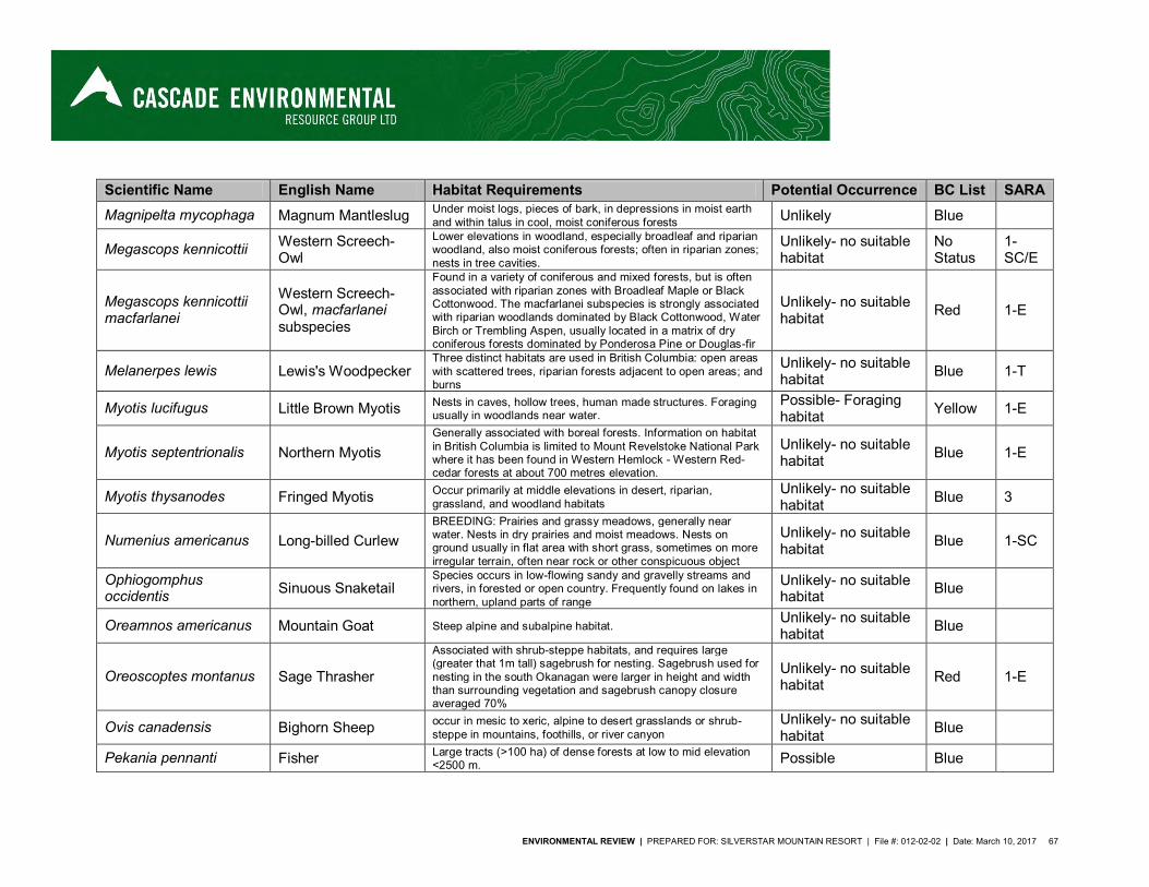
ENVIRONMENTAL REVIEW | PREPARED FOR: SILVERSTAR MOUNTAIN RESORT | File #: 012-02-02 | Date: March 10, 2017 67
Scientific Name English Name Habitat Requirements Potential Occurrence BC List SARA Magnipelta mycophaga Magnum Mantleslug Under moist logs, pieces of bark, in depressions in moist earth
and within talus in cool, moist coniferous forests Unlikely Blue
Megascops kennicottii Western Screech-Owl
Lower elevations in woodland, especially broadleaf and riparian woodland, also moist coniferous forests; often in riparian zones; nests in tree cavities.
Unlikely- no suitable habitat
No Status
1-SC/E
Megascops kennicottii macfarlanei
Western Screech-Owl, macfarlanei subspecies
Found in a variety of coniferous and mixed forests, but is often associated with riparian zones with Broadleaf Maple or Black Cottonwood. The macfarlanei subspecies is strongly associated with riparian woodlands dominated by Black Cottonwood, Water Birch or Trembling Aspen, usually located in a matrix of dry coniferous forests dominated by Ponderosa Pine or Douglas-fir
Unlikely- no suitable habitat Red 1-E
Melanerpes lewis Lewis's Woodpecker Three distinct habitats are used in British Columbia: open areas with scattered trees, riparian forests adjacent to open areas; and burns
Unlikely- no suitable habitat Blue 1-T
Myotis lucifugus Little Brown Myotis Nests in caves, hollow trees, human made structures. Foraging usually in woodlands near water.
Possible- Foraging habitat Yellow 1-E
Myotis septentrionalis Northern Myotis Generally associated with boreal forests. Information on habitat in British Columbia is limited to Mount Revelstoke National Park where it has been found in Western Hemlock - Western Red-cedar forests at about 700 metres elevation.
Unlikely- no suitable habitat Blue 1-E
Myotis thysanodes Fringed Myotis Occur primarily at middle elevations in desert, riparian, grassland, and woodland habitats
Unlikely- no suitable habitat Blue 3
Numenius americanus Long-billed Curlew BREEDING: Prairies and grassy meadows, generally near water. Nests in dry prairies and moist meadows. Nests on ground usually in flat area with short grass, sometimes on more irregular terrain, often near rock or other conspicuous object
Unlikely- no suitable habitat Blue 1-SC
Ophiogomphus occidentis Sinuous Snaketail
Species occurs in low-flowing sandy and gravelly streams and rivers, in forested or open country. Frequently found on lakes in northern, upland parts of range
Unlikely- no suitable habitat Blue
Oreamnos americanus Mountain Goat Steep alpine and subalpine habitat. Unlikely- no suitable habitat Blue
Oreoscoptes montanus Sage Thrasher
Associated with shrub-steppe habitats, and requires large (greater that 1m tall) sagebrush for nesting. Sagebrush used for nesting in the south Okanagan were larger in height and width than surrounding vegetation and sagebrush canopy closure averaged 70%
Unlikely- no suitable habitat Red 1-E
Ovis canadensis Bighorn Sheep occur in mesic to xeric, alpine to desert grasslands or shrub-steppe in mountains, foothills, or river canyon
Unlikely- no suitable habitat Blue
Pekania pennanti Fisher Large tracts (>100 ha) of dense forests at low to mid elevation <2500 m. Possible Blue
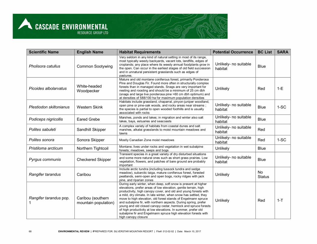
68 ENVIRONMENTAL REVIEW | fPREPARED FOR: SILVERSTAR MOUNTAIN RESORT | File#: 012-02-02 | Date: March 10, 2017
Scientific Name English Name Habitat Requirements Potential Occurrence BC List SARA
Pholisora catullus Common Sootywing
Very seldom in any kind of natural setting in most of its range, most typically weedy backyards, vacant lots, landfills, edges of croplands; any place where its weedy annual foodplants grow in the open. Can occur in the earliest stages of old field succession and in unnatural persistent grasslands such as edges of pastures.
Unlikely- no suitable habitat Blue
Picoides albolarvatus White-headed Woodpecker
Mature and old montane coniferous forest, primarily Ponderosa Pine and Douglas Fir. Found more often in structurally complex forests than in managed stands. Snags are very important for nesting and roosting and should be a minimum of 25 cm dbh (snags and large live ponderosa pine >60 cm dbh optimum) and at densities of 588/100 ha for maximum population densities
Unlikely Red 1-E
Plestiodon skiltonianus Western Skink Habitats include grassland, chaparral, pinyon-juniper woodland, open pine or pine-oak woods, and rocky areas near streams ; the species is partial to open wooded foothills and is usually associated with rocks
Unlikely- no suitable habitat Blue 1-SC
Podiceps nigricollis Eared Grebe Marshes, ponds and lakes; in migration and winter also salt lakes, bays, estuaries and seacoasts
Unlikely- no suitable habitat Blue
Polites sabuleti Sandhill Skipper A complex variety of habitats from coastal dunes and salt marshes, alkalai grasslands to moist mountain meadows and lawns
Unlikely- no suitable habitat Red
Polites sonora Sonora Skipper Mostly Canadian Zone moist meadows Unlikely- no suitable habitat Red 1-SC
Pristiloma arcticum Northern Tightcoil Montane; lives under rocks and vegetation in wet subalpine forests; meadows, seeps and bogs Unlikely Blue
Pyrgus communis Checkered Skipper Transient species in a great variety of dry disturbed situations and some more natural ones such as short grass prairies. Low vegetation, flowers, and patches of bare ground are probably important
Unlikely- no suitable habitat Blue
Rangifer tarandus Caribou Include arctic tundra (including tussock tundra and sedge meadow), subarctic taiga, mature coniferous forest, forested peatlands, semi-open and open bogs, rocky ridges with jack pine, and riparian zones
Unlikely No Status
Rangifer tarandus pop. 1
Caribou (southern mountain population)
During early winter, when deep, soft snow is present at higher elevations, prefer areas of low elevation, gentle terrain, high productivity, high canopy cover, and old and young forests with a mild, dry climate. In late winter, when snow has settled, they move to high elevation, old forest stands of Engelmann spruce and subalpine fir, with northern aspects. During spring, prefer young and old closed canopy cedar, hemlock and spruce forests of high productivity at low elevations. In summer, prefer old subalpine fir and Engelmann spruce high elevation forests with high canopy closure
Unlikely Red 1-T
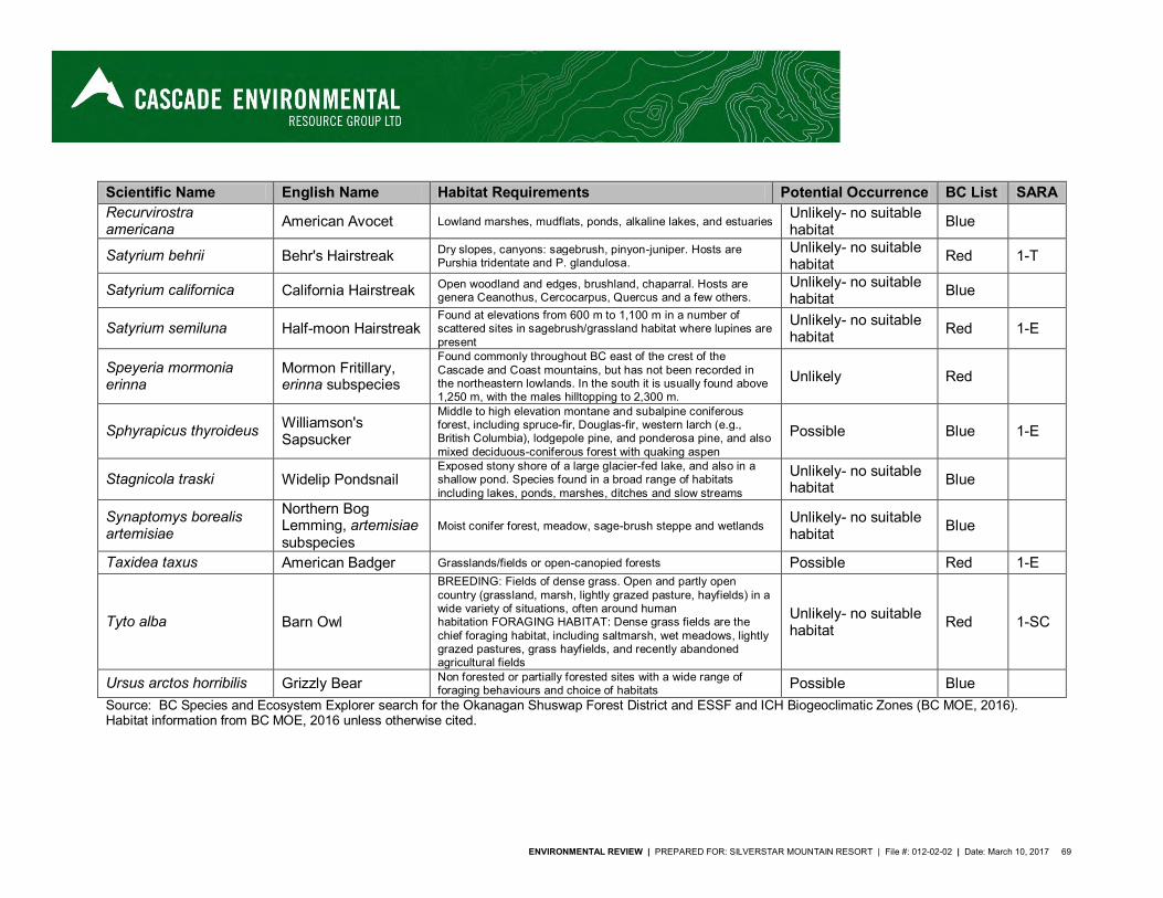
ENVIRONMENTAL REVIEW | PREPARED FOR: SILVERSTAR MOUNTAIN RESORT | File #: 012-02-02 | Date: March 10, 2017 69
Scientific Name English Name Habitat Requirements Potential Occurrence BC List SARA Recurvirostra americana American Avocet Lowland marshes, mudflats, ponds, alkaline lakes, and estuaries
Unlikely- no suitable habitat Blue
Satyrium behrii Behr's Hairstreak Dry slopes, canyons: sagebrush, pinyon-juniper. Hosts are Purshia tridentate and P. glandulosa.
Unlikely- no suitable habitat Red 1-T
Satyrium californica California Hairstreak Open woodland and edges, brushland, chaparral. Hosts are genera Ceanothus, Cercocarpus, Quercus and a few others.
Unlikely- no suitable habitat Blue
Satyrium semiluna Half-moon Hairstreak Found at elevations from 600 m to 1,100 m in a number of scattered sites in sagebrush/grassland habitat where lupines are present
Unlikely- no suitable habitat Red 1-E
Speyeria mormonia erinna
Mormon Fritillary, erinna subspecies
Found commonly throughout BC east of the crest of the Cascade and Coast mountains, but has not been recorded in the northeastern lowlands. In the south it is usually found above 1,250 m, with the males hilltopping to 2,300 m.
Unlikely Red
Sphyrapicus thyroideus Williamson's Sapsucker
Middle to high elevation montane and subalpine coniferous forest, including spruce-fir, Douglas-fir, western larch (e.g., British Columbia), lodgepole pine, and ponderosa pine, and also mixed deciduous-coniferous forest with quaking aspen
Possible Blue 1-E
Stagnicola traski Widelip Pondsnail Exposed stony shore of a large glacier-fed lake, and also in a shallow pond. Species found in a broad range of habitats including lakes, ponds, marshes, ditches and slow streams
Unlikely- no suitable habitat Blue
Synaptomys borealis artemisiae
Northern Bog Lemming, artemisiae subspecies
Moist conifer forest, meadow, sage-brush steppe and wetlands Unlikely- no suitable habitat Blue
Taxidea taxus American Badger Grasslands/fields or open-canopied forests Possible Red 1-E
Tyto alba Barn Owl
BREEDING: Fields of dense grass. Open and partly open country (grassland, marsh, lightly grazed pasture, hayfields) in a wide variety of situations, often around human habitation FORAGING HABITAT: Dense grass fields are the chief foraging habitat, including saltmarsh, wet meadows, lightly grazed pastures, grass hayfields, and recently abandoned agricultural fields
Unlikely- no suitable habitat Red 1-SC
Ursus arctos horribilis Grizzly Bear Non forested or partially forested sites with a wide range of foraging behaviours and choice of habitats Possible Blue
Source: BC Species and Ecosystem Explorer search for the Okanagan Shuswap Forest District and ESSF and ICH Biogeoclimatic Zones (BC MOE, 2016). Habitat information from BC MOE, 2016 unless otherwise cited.


ENVIRONMENTAL REVIEW | PREPARED FOR: SILVERSTAR MOUNTAIN RESORT | File #: 012-02-02 | Date: March 10, 2017 71
2.3.3.3 Valued Ecosystem Components
Wildlife Trees Wildlife trees include significant standing snags, veteran trees, and trees with broken tops. These trees are important as perching areas for raptors such as red-tailed hawk, and foraging and nesting sites for woodpeckers, small owls and other cavity nesters. Although the majority of the CRA is dominated by second growth forest, important wildlife snags are scattered throughout. These snags are especially prevalent adjacent to wetlands and along ephemeral streams. Pileated woodpecker and other woodpeckers were frequently observed throughout the study area. Cedar snags, both dead and alive, appear to be the preferred foraging substrate for pileated woodpeckers. Large snags may also be used as roosting areas for bats, especially adjacent to important foraging areas over wetlands, ridge crests and other open habitats. Mid Elevation Young/Mature Forests Typically, mature and young seral forest at middle elevations, as well as subalpine meadows at higher elevations, represent productive wildlife habitat in the ESSF biogeoclimatic zone (Meidinger and Pojar, 1991). The ESSF is also noted as one of the most productive zones for grizzly bears, particularly where avalanche activity serves to maintain abundant forage in a seral state preferred by both grizzly and black bears (Meidinger and Pojar, 1991). Ephemeral Streams and Riparian Areas The CRA is intersected by several small ephemeral streams and tributaries, many of which are dry during the summer months. Riparian and ravine habitats are dominated by vegetation such as western redcedar, Sitka alder, black cottonwood and Douglas maple. These habitats provide high structural heterogeneity and plant species diversity compared to the more adjacent uniform coniferous forests, and are attractive to numerous bird, mammal and amphibian species. Because of fluctuating water flows, snags are often in greater abundance adjacent to creeks. During migration, these habitats also attract neotropical migrants such as warblers, vireos, flycatchers and thrushes. A black bear den site was located in a hollow cedar snag adjacent to a small ephemeral stream on the CRA during the recent field survey. Ephemeral stream and pool habitats are utilized as drinking and preening areas for wildlife, and possibly breeding areas for frogs, toads and salamanders. Ephemeral streams are also natural wildlife movement corridors. These movement corridors are of greater importance once adjacent upland areas are developed. In 2006, the Riparian Area Regulation of the British Columbia Fish Protection Act came into effect and all developments requiring development permits and/or building permits must comply with the regulation. For the Purpose of this study the Streamside Protection and Enhancement Area (SPEA) was assessed as 30 m from top of bank, based on the Simple Assessment Method. This riparian buffer was applied to all mapped watercourses within the study area. The original assessment for this area identified a recommended setback of 15 m for the watercourses within the study area. As the project moves into the detailed design stages, SilverStar may wish to conduct Detailed Assessment for portions of the watercourses where needed. There is potential for reduction in the width of the SPEA to 10 m for the subject watercourses with this type of assessment. Proposed crossings or intrusions into the SPEA may require site specific permitting under the B.C. Water Sustainability Act or the Federal Fisheries Act.
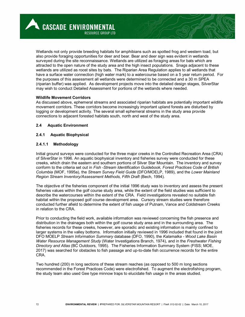
72 ENVIRONMENTAL REVIEW | fPREPARED FOR: SILVERSTAR MOUNTAIN RESORT | File#: 012-02-02 | Date: March 10, 2017
Wetlands not only provide breeding habitats for amphibians such as spotted frog and western toad, but also provide foraging opportunities for deer and bear. Bear and deer sign was evident in wetlands surveyed during the site reconnaissance. Wetlands are utilized as foraging areas for bats which are attracted to the open nature of the study area and the high insect populations. Snags adjacent to these wetlands are utilized as roost sites by bats. The Riparian Area Regulation applies to all wetlands that have a surface water connection (high water mark) to a watercourse based on a 5 year return period. For the purposes of this assessment all wetlands were determined to be connected and a 30 m SPEA (riparian buffer) was applied. As development projects move into the detailed design stages, SilverStar may wish to conduct Detailed Assessment for portions of the wetlands where needed. Wildlife Movement Corridors As discussed above, ephemeral streams and associated riparian habitats are potentially important wildlife movement corridors. These corridors become increasingly important upland forests are disturbed by logging or development activity. The several small ephemeral streams in the study area provide connections to adjacent forested habitats south, north and west of the study area.
2.4 Aquatic Environment
2.4.1 Aquatic Biophysical
2.4.1.1 Methodology
Initial ground surveys were conducted for the three major creeks in the Controlled Recreation Area (CRA) of SilverStar in 1996. An aquatic biophysical inventory and fisheries survey were conducted for these creeks, which drain the eastern and southern portions of Silver Star Mountain. The inventory and survey conform to the criteria set out in Fish -Stream Identification Guidebook, Forest Practices Code of British Columbia (MOF, 1995a), the Stream Survey Field Guide (DFO/MOELP, 1989), and the Lower Mainland Region Stream Inventory/Assessment Methods, Fifth Draft (Bech, 1994). The objective of the fisheries component of the initial 1996 study was to inventory and assess the present fisheries values within the golf course study area, while the extent of the field studies was sufficient to describe the watercourses within the extent of the CRA. Field investigations revealed no suitable fish habitat within the proposed golf course development area. Cursory stream studies were therefore conducted further afield to determine the extent of fish usage of Putnam, Vance and Coldstream Creeks in relation to the CRA. Prior to conducting the field work, available information was reviewed concerning the fish presence and distribution in the drainages both within the golf course study area and in the surrounding area. The fisheries records for these creeks, however, are sporadic and existing information is mainly confined to larger systems in the valley bottoms. Information initially reviewed in 1996 included that found in the joint DFO MOELP Stream Information Summary database (DFO, 1990), the Kalamalka - Wood Lake Basin Water Resource Management Study (Water Investigations Branch, 1974), and in the Freshwater Fishing Directory and Atlas (BC Outdoors, 1995). The Fisheries Information Summary System (FISS; MOE, 2017) was searched for obstacles to fish passage and up-to-date fish occurrence records for the entire CRA. Two hundred (200) m long sections of these stream reaches (as opposed to 500 m long sections recommended in the Forest Practices Code) were electrofished. To augment the electrofishing program, the study team also used Gee type minnow traps to elucidate fish usage in the areas studied.
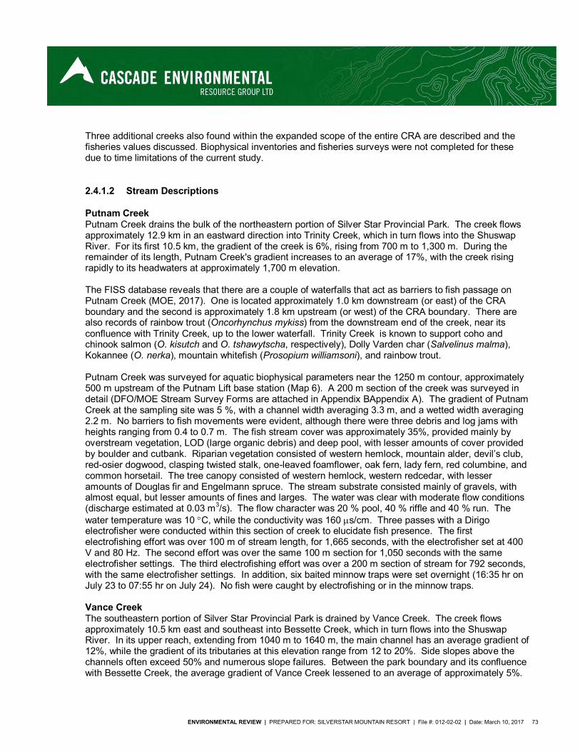
ENVIRONMENTAL REVIEW | PREPARED FOR: SILVERSTAR MOUNTAIN RESORT | File #: 012-02-02 | Date: March 10, 2017 73
Three additional creeks also found within the expanded scope of the entire CRA are described and the fisheries values discussed. Biophysical inventories and fisheries surveys were not completed for these due to time limitations of the current study.
2.4.1.2 Stream Descriptions
Putnam Creek Putnam Creek drains the bulk of the northeastern portion of Silver Star Provincial Park. The creek flows approximately 12.9 km in an eastward direction into Trinity Creek, which in turn flows into the Shuswap River. For its first 10.5 km, the gradient of the creek is 6%, rising from 700 m to 1,300 m. During the remainder of its length, Putnam Creek's gradient increases to an average of 17%, with the creek rising rapidly to its headwaters at approximately 1,700 m elevation. The FISS database reveals that there are a couple of waterfalls that act as barriers to fish passage on Putnam Creek (MOE, 2017). One is located approximately 1.0 km downstream (or east) of the CRA boundary and the second is approximately 1.8 km upstream (or west) of the CRA boundary. There are also records of rainbow trout (Oncorhynchus mykiss) from the downstream end of the creek, near its confluence with Trinity Creek, up to the lower waterfall. Trinity Creek is known to support coho and chinook salmon (O. kisutch and O. tshawytscha, respectively), Dolly Varden char (Salvelinus malma), Kokannee (O. nerka), mountain whitefish (Prosopium williamsoni), and rainbow trout. Putnam Creek was surveyed for aquatic biophysical parameters near the 1250 m contour, approximately 500 m upstream of the Putnam Lift base station (Map 6). A 200 m section of the creek was surveyed in detail (DFO/MOE Stream Survey Forms are attached in Appendix BAppendix A). The gradient of Putnam Creek at the sampling site was 5 %, with a channel width averaging 3.3 m, and a wetted width averaging 2.2 m. No barriers to fish movements were evident, although there were three debris and log jams with heights ranging from 0.4 to 0.7 m. The fish stream cover was approximately 35%, provided mainly by overstream vegetation, LOD (large organic debris) and deep pool, with lesser amounts of cover provided by boulder and cutbank. Riparian vegetation consisted of western hemlock, mountain alder, devil’s club, red-osier dogwood, clasping twisted stalk, one-leaved foamflower, oak fern, lady fern, red columbine, and common horsetail. The tree canopy consisted of western hemlock, western redcedar, with lesser amounts of Douglas fir and Engelmann spruce. The stream substrate consisted mainly of gravels, with almost equal, but lesser amounts of fines and larges. The water was clear with moderate flow conditions (discharge estimated at 0.03 m3/s). The flow character was 20 % pool, 40 % riffle and 40 % run. The water temperature was 10 C, while the conductivity was 160 s/cm. Three passes with a Dirigo electrofisher were conducted within this section of creek to elucidate fish presence. The first electrofishing effort was over 100 m of stream length, for 1,665 seconds, with the electrofisher set at 400 V and 80 Hz. The second effort was over the same 100 m section for 1,050 seconds with the same electrofisher settings. The third electrofishing effort was over a 200 m section of stream for 792 seconds, with the same electrofisher settings. In addition, six baited minnow traps were set overnight (16:35 hr on July 23 to 07:55 hr on July 24). No fish were caught by electrofishing or in the minnow traps. Vance Creek The southeastern portion of Silver Star Provincial Park is drained by Vance Creek. The creek flows approximately 10.5 km east and southeast into Bessette Creek, which in turn flows into the Shuswap River. In its upper reach, extending from 1040 m to 1640 m, the main channel has an average gradient of 12%, while the gradient of its tributaries at this elevation range from 12 to 20%. Side slopes above the channels often exceed 50% and numerous slope failures. Between the park boundary and its confluence with Bessette Creek, the average gradient of Vance Creek lessened to an average of approximately 5%.
74 ENVIRONMENTAL REVIEW | fPREPARED FOR: SILVERSTAR MOUNTAIN RESORT | File#: 012-02-02 | Date: March 10, 2017
Fisheries records for Vance Creek are limited to rainbow trout in the downstream reaches, well outside of the study area (more than 10 km downstream) (MOE, 2017). There is also a record of a culvert approximately another 3 km downstream that acts as a barrier to fish passage. Fish known to occur in Bessette Creek include sockeye salmon (O. nerka), coho and chinook salmon, sculpin (Cottus sp.), rainbow trout, dace (Rhinichthys sp.), mountain whitefish (Prosopium williamsoni), rainbow trout, redside shiner (Richardsonius balteatus) and sucker (Catostomus sp.). Due to the low gradients in the lower reaches of Vance Creek, it is likely that at least some of these species also utilize that creek. Two sampling stations were established on Vance Creek, one at the 1,190 m contour near the proposed ski lift base, and the other downstream at 6.8 km on the Vance Creek Forestry Road at about the 900 m contour (Map 6). At the upstream site, a 200 m section of the creek was surveyed in detail (DFO/MOE Stream Survey Forms appended). The creek’s gradient averaged 14 %, with a channel width averaging 4.9 m, and a wetted width averaging 2.3 m. Fish stream cover was estimated as 20%, provided mainly by boulder and deep pool, with lesser amounts provided by overstream vegetation and a trace of LOD and cutbank. Riparian vegetation consisted of mountain alder, willow, northern black cottonwood, red-osier dogwood, Douglas maple, thimbleberry, black gooseberry, one-leaved foamflower, oak fern, lady fern, and common horsetail. The crown closure was less than 5 %. The stream substrate consisted mainly of larges, with lesser amounts of gravels and fines. The water was clear with moderate flow conditions (discharge estimated at 0.02 m3/s). The flow character was 40 % pool, 55 % riffle and 5 % run. The water temperature was 11 C, while the conductivity was 200 s/cm. Three passes with the electrofisher were conducted within this section of creek to elucidate fish presence. The first electrofishing effort was over 100 m of stream length, for 1,296 seconds, with the electrofisher set at 400 V and 80 Hz. The second effort was over an additional 100 m section of stream for 1,080 seconds with the same electrofisher settings. The third electrofishing effort was over a 200 m section of stream for 840 seconds, with the same electrofisher settings. In addition, six baited minnow traps were set overnight (12:20 hr on July 23 to 07:05 hr on July 24). No fish were caught by either sampling method. At the lower Vance Creek Sampling site, approximately 100 m of the stream was sampled in detail (DFO/MOE Stream Survey Forms appended). The creek’s gradient averaged 7 %, with a channel width averaging 3.4 m, and a wetted width averaging 1.6 m. Although no barriers to fish movements were observed, there were three small log and sediment controlled falls within the section surveyed (heights ranging from 0.6 to 1.0 m). Fish stream cover was estimated as 30%, provided predominantly by overstream vegetation, deep pool and LOD, with some cutbank. Riparian vegetation consisted of western hemlock, western red cedar, northern black cottonwood, mountain alder, thimbleberry, black gooseberry, one-leaved foamflower, oak fern, and devil’s club. The crown closure was estimated as 10 %. The stream substrate consisted predominately of gravels with some cobble and fines. The water was clear with moderate flow conditions (discharge estimated at 0.02 m3/s). The flow character was 20 % pool, 50 % riffle and 30 % run. The water temperature was 8 C, while the conductivity was 160 s/cm. Two passes were conducted with the electrofisher, both over 100 m sections of stream, with the electrofisher set at 400 V and 80 Hz. The first effort was for 1,350 seconds, while the second effort was for 972 seconds. As with the other sites, six baited minnow traps were set overnight (13:30 hr on July 24 to 10:00 hr on July 25). Again, no fish were caught by either sampling method. An additional survey was conducted on the upper east branch of Vance Creek within the CRA to determine fish presence or absence (Columbia, 2008). No fish were captured or observed and the tributary was determined to be non-fish bearing. Coldstream Creek Coldstream Creek drains a small portion of the extreme south of Silver Star Provincial Park. The creek flows southwest, from its headwaters in the park, for 25 km to Kalamalka Lake. Within the upper
ENVIRONMENTAL REVIEW | PREPARED FOR: SILVERSTAR MOUNTAIN RESORT | File #: 012-02-02 | Date: March 10, 2017 75
Coldstream drainage, the mean gradient of the creek channel is 5%. However, immediately downstream but within Silver Star Park the creek steepens and has an average gradient of 13 %. Coldstream Creek is known to provide spawning habitat for both Kokanee and rainbow trout in its lower 6 km (Water Investigations Branch, 1974). At approximately 6.7 km upstream of its mouth, the gradient of Coldstream Creek increases, and there is a log jam that prevents further fish migrations past that point. The report also noted that the creek could support these species along 15 km of its 25 km length if it was in pristine condition. No fish records exist for Coldstream Creek within the FISS (MOE, 2017). Minimum discharge requirements to support a viable fishery in Coldstream Creek are also detailed in the Water Investigations Branch (1974) report. The minimum recommended flow for the spring rainbow trout spawning period (April to May) and the kokanee spawning period (September to November) is 0.226 m3/s. The mean monthly discharge was lower than this quantity for five months between 1970 and 1992. The recommended absolute minimum flow to maintain a resident population of rainbow trout was 0.045 m3/s. The minimum flow has not dipped below this critical level at the WSC gauging stations near the mouth or above the Kalavista diversion. The extreme minimum daily discharge for the period of record at the later station (the station for which there is a lengthier record) was 0.096 m3/s, observed on February 10, 1971. Coldstream Creek was surveyed for aquatic biophysical parameters on July 24 and 25, 1996, at about the 1000 m contour, approximately 1 km downstream of the Park boundary. Within the park, the stream was ephemeral, with no surface flow at the park boundary. A 200 m section of the creek was surveyed in detail (DFO/MOE Stream Survey Forms are attached in Error! Reference source not found.). The radient of Coldstream Creek at the sampling site was 2%, with a channel width averaging 1.8 m, and a wetted width averaging 1.0.2 m. No barriers to fish movements were evident, except for the culvert at Deafies Creek Forestry Road (at about the 1000 m contour) which would pose a barrier to upstream fish movements during low flows. Fish stream cover was very high, estimated at about 80%, provided mainly by overstream vegetation with lesser amounts of cover provided by LOD, cutbank and a trace of pool. The dense riparian vegetation consisted of Englemann spruce, western red cedar, Douglas fir, mountain alder, devil’s club, red-osier dogwood, clasping twisted stalk, twinberry, thimbleberry, black gooseberry, lady fern, highbush-cranberry, fireweed, Indian hellebore, and common horsetail. The tree canopy was thin, estimated at about 10%. The stream substrate consisted was dominated by fines and small gravels. The water was clear with low flow conditions (discharge measured at 0.006 m3/s). The flow character was 10% pool, 50% riffle and 40% run. The water temperature was 9 C, while the conductivity was 160 s/cm. Only a single pass electrofishing effort was conducted over a 100 m section of the stream. The electrofisher set at 400 V and 80 Hz, for the 1,125 seconds of sampling. Six baited minnow traps were set overnight (17:30 hr on July 24 to 11:00 hr on July 25), three upstream and three downstream of the forestry road. No fish were caught by electrofishing or in the minnow traps. Other Streams The northwestern portion of Silver Star Provincial Park and the northwestern fringe of the Controlled Recreation Area are drained by Fortune Creek, which flows into the Shuswap River near Enderby. Within the park, Fortune Creek drains an area whose elevation ranges from 1,880 m to 1,100 m. The average gradient of the creek within the park is approximately 11%. Downstream of the park boundary the creek steepens to about 17% until it reaches the broad valley bottom near Armstrong at the 400 m elevation. The FISS database indicates the presence of coho and chinook salmon, and rainbow trout approximately 2.0 km downstream of the park boundary and over 7.0 km downstream of the CRA (MOE, 2017). Downstream occurrences also include largescale sucker and redside shiner. There are also records of several barriers to fish passage downstream of the study area including a dam, log jams, pumps and culverts. An aquatic biophysical assessment of this system was not conducted by the study team.
76 ENVIRONMENTAL REVIEW | fPREPARED FOR: SILVERSTAR MOUNTAIN RESORT | File#: 012-02-02 | Date: March 10, 2017
The extreme northern eastern portion of Silver Star Provincial Park is drained by the easterly flowing Miriam Creek. Waters from this creek flow into Trinity Creek, which tends north into the Shuswap River. Fisheries records for Miriam Creek were not found in the FISS (MOE, 2017), however, with stream gradients of over 25 % within the park, those reaches are unlikely to be fish bearing. No field work was conducted on this creek. BX Creek, draining the southwestern portion of Silver Star Provincial Park, flows southwest into Swan Lake, which drains into Okanagan Lake via lower BX Creek and Vernon Creek. The streams gradient ranges from an average of 11% above 1,100 m, to less than 5% below that elevation. At the park boundary, BX Creek has a stream gradient of approximately 20 %. Fisheries records within the FISS (MOE, 2017) include rainbow trout, and suckers as recently as 2013, with the nearest record being greater than 5 km downstream of the park and nearly 8 km downstream of the CRA. Fish barriers noted downstream include a dam, cascade and culvert. An aquatic biophysical assessment was not conducted on this creek.
2.4.2 Water Quality
Water quality sampling was conducted to elucidate baseline water quality of the watercourses within the CRA in 1996. These results form an historic baseline for comparison with future water quality sampling results. As there was no flowing water within the golf course study area, the samples were collected from the various water courses that drained the area in question, or, receive waters draining from the area. The sites selected were the same as the fisheries sampling sites and are identified in Table 13 and on Map 6). These are Vance Creek at the new lift base (1180 m contour upstream of the study area) sampled on July 23, 1996; Vance Creek 6.8 km up Vance Creek forestry Road (920 m contour downstream of the study area) sampled on July 24, 1996; and Coldstream Creek at Deafies Forestry Road (1100 m contour downstream of the study area) sampled on July 25, 1996. In addition, Putnam Creek which drains the north-eastern flank of the current SilverStar operation was also sampled (1060 m contour) on July 23, 1996. Parameters sampled for include pH, electrical conductivity, total dissolved solids, total suspended solids, turbidity, orthophosphate, total nitrogen, potassium, calcium, magnesium, sodium, iron, copper, zinc, manganese, sulphate, chloride, fluoride, boron, carbonate, bicarbonate, hardness, ammonia, nitrate, nitrate-nitrite, phosphate, total phosphorus, total Kjeldahl nitrogen and fecal and total coliforms. Results of the analyses are listed in Appendix CError! Reference source not found..
Table 13. Stream Sampling Locations
Water Sampling Site UTM Grid Reference Vance Creek – upstream (at New Lift Base) 356400E 5578250N Vance Creek – downstream (at Forestry Road) 359730E 5578400N Coldstream at Deathie Forestry Road 354175E 5576275N Putnam Creek near Lift Base 355995E 5584450N
All of the water samples meet the guidelines for drinking water for the parameters sampled (Health Canada, 1996). The waters can be considered hard, with moderate alkalinity. Total suspended solid levels are low as would be expected for clear mountain streams. Nutrient concentrations (nitrogen and phosphorus) are generally fairly low, and are lower than the suggested guidelines of the protection of aquatic life (Pommen, 1991). Ammonium-N levels in the Coldstream Creek sample, however, can be considered as moderate, being approximately 50% of the 0.461 mg/l guideline for the protection of aquatic life at the pH and temperature of that site (Pommen, 1991, CCREM, 1992). The moderate ammonium levels are likely due to microbial production in Coldstream Creek’s wetland source within the study area. As ammonium is a fairly

ENVIRONMENTAL REVIEW | PREPARED FOR: SILVERSTAR MOUNTAIN RESORT | File #: 012-02-02 | Date: March 10, 2017 77
volatile compound, it is probable that additional sampling of Coldstream Creek further downstream would have seen much reduced ammonium concentrations. The water quality sampling has not been repeated since its inception.

Putnam Creek
Vance Creek
Coldstream Sample Site
Putnam Creek Sample Site
Vance Creek 2 Sample Site
Vance Creek 1 Sample Site
²Map 6 - Stream Sampling LocationsSilver Star - Mountain ResortNorth Okanagan
GIS Cartog ra ph er: N ico la ChurchDa te: No ve mb er 29 , 20 16
CERG File#: 01 2-02-02Pro je ction: UTM 11N NAD83
Orth op hoto : ES RI World I mag ery
0 1,000 2,000 3,000 4,000 5,000
Meters
1:45,039

ENVIRONMENTAL REVIEW | PREPARED FOR: SILVERSTAR MOUNTAIN RESORT | File #: 012-02-02 | Date: March 10, 2017 79
2.5 Wetland Environment
2.5.1 Delineation
All identified wetlands occur within the golf course study area portion of the CRA and are presented in Map 5. No other wetlands have been identified within the CRA as none were picked up at the scale that TEM mapping was conducted. The six small pocket wetlands were organic soil wetlands of the fen or swamp type, and sphagnum moss was prevalent (NWWG, 1987, Mackenzie and Moran, 2004). Formation of the wetlands appears to be a function of low gradients coincident with seepage or collection areas. Three of the wetlands are classified as Ws10, 2 are classified as Wf01, and one is classified as Wf02. Ws10 Western redcedar – Spruce - Skunk cabbage This site series is relatively uncommon, although there are three wetlands of this site association within the CRA. This swamp site association includes tree and shrub vegetation and the canopy is dominated by Western redcedar, spruce, western hemlock with subalpine fir in colder sites. The understory layers are abundant Soils typically include an organic layer of peat, varying from 20 cm to 2 m in depth, above fine-textured lacustrine materials. (MacKenzie and Moran, 2004) Wf01 Water sedge – Beaked sedge This fen site association is the most common within the province, occurring on a wide variety of landscapes from low to subalpine elevations. Plant species diversity is low in these wetlands, often being dominated by sedges (Carex aquatilis and C. utriculata), which can form continuous fields. There are no trees or shrubs and vegetation includes only herbs, dominated by the sedges, and mosses. Peat is at least 30 cm deep and can be greater than 3 m deep. There are two wetlands of this site association within the CRA. (MacKenzie and Moran, 2004) Wf02 Scrub birch – Water sedge This is another common fen site association and is widespread, occurring in nearly all of the biogeoclimatic zones within BC. Sites in this association are sometimes hummocked and as a result, have shrubs, consisting of Salix pedicelarris and Betula nana, in higher areas. Sedge species, including Carex aquatilis and C. utriculata, and Comarum palustre dominate the herb layer and mosses are present. The depth of peat is often between 1 and 2 m but can be as deep as 4 m. There is one wetland of this site association within the CRA. (MacKenzie and Moran, 2004)
2.5.2 Functionality
The wetlands were assessed for functionality using a 14 point system of evaluation that includes the following functions: Education / Research Erosion Control Fish Habitat Flood Storage Flood Conveyance Food Production Red / Blue Listed Species Habitat Historic / Archeological Aesthetics Recreation
80 ENVIRONMENTAL REVIEW | fPREPARED FOR: SILVERSTAR MOUNTAIN RESORT | File#: 012-02-02 | Date: March 10, 2017
Sediment Control Timber Production Water Supply Water Quality Wildlife Habitat
A matrix was generated to identify functional values associated with each of the wetlands of the site. Each function was assessed a value of High, Medium or Low. Functional values were based on a regional level. High values were then highlighted in the matrix to illustrate significance.
Table 14. Wetland Function Matrix
Function Wetland Wf02
(ICHmk1)
Ws01 (ICHmw5)
Wf01 (ICHmw5)
Ws10 (ICHmk1) West
Ws10 (ICHmw5)
Ws10 (ICHmw5) East
Education / Research
H H H L M M
Erosion Control L M M H M M Fish Habitat L L L L L L Flood Storage L M M M M L Flood Conveyance
L M M M M L
Food Production M M M L M M Red / Blue Listed Species Potential Habitat
M M M L L M
Historic / Archeological
L L L L L L
Aesthetics H H H L L M Recreation H H H L M L Sediment Control L M M M M M Timber Production Water Supply
L L L M L L
Water Quality L M M L M M Wildlife Habitat H H H M H M The primary functions provided by the wetlands appear to include aesthetics, recreation (nature viewing), wildlife habitat, biodiversity, and education. Of secondary significance although of potentially equal importance is the potential for the occurrence of red or blue listed plants. No Red or Blue Listed species were identified, however, past conversations with local naturalist Roseanne VanEe, yielded information regarding the potential occurrence within these wetlands. Low value functions and functions not provided by these wetlands include flood protection, water quality protection and food production.
2.5.3 Rare and Endangered Fish Species
The CRA occupies headwaters of Vance, Coldstream, Putman, BX, and Fortune Creeks. As such, no fish have been captured or recorded in the watercourses within the CRA. While these headwaters are
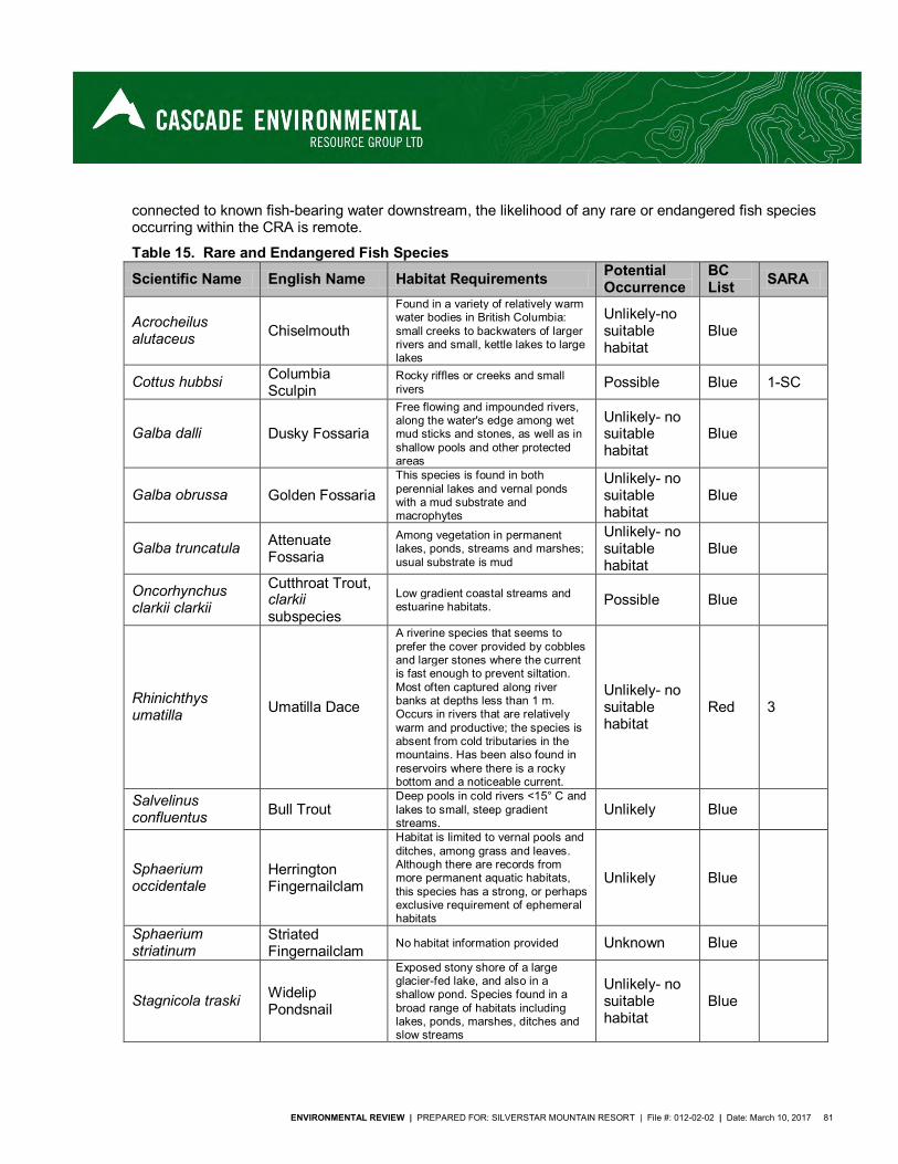
ENVIRONMENTAL REVIEW | PREPARED FOR: SILVERSTAR MOUNTAIN RESORT | File #: 012-02-02 | Date: March 10, 2017 81
connected to known fish-bearing water downstream, the likelihood of any rare or endangered fish species occurring within the CRA is remote.
Table 15. Rare and Endangered Fish Species
Scientific Name English Name Habitat Requirements Potential Occurrence
BC List SARA
Acrocheilus alutaceus Chiselmouth
Found in a variety of relatively warm water bodies in British Columbia: small creeks to backwaters of larger rivers and small, kettle lakes to large lakes
Unlikely-no suitable habitat
Blue
Cottus hubbsi Columbia Sculpin
Rocky riffles or creeks and small rivers Possible Blue 1-SC
Galba dalli Dusky Fossaria
Free flowing and impounded rivers, along the water's edge among wet mud sticks and stones, as well as in shallow pools and other protected areas
Unlikely- no suitable habitat
Blue
Galba obrussa Golden Fossaria This species is found in both perennial lakes and vernal ponds with a mud substrate and macrophytes
Unlikely- no suitable habitat
Blue
Galba truncatula Attenuate Fossaria
Among vegetation in permanent lakes, ponds, streams and marshes; usual substrate is mud
Unlikely- no suitable habitat
Blue
Oncorhynchus clarkii clarkii
Cutthroat Trout, clarkii subspecies
Low gradient coastal streams and estuarine habitats. Possible Blue
Rhinichthys umatilla Umatilla Dace
A riverine species that seems to prefer the cover provided by cobbles and larger stones where the current is fast enough to prevent siltation. Most often captured along river banks at depths less than 1 m. Occurs in rivers that are relatively warm and productive; the species is absent from cold tributaries in the mountains. Has been also found in reservoirs where there is a rocky bottom and a noticeable current.
Unlikely- no suitable habitat
Red 3
Salvelinus confluentus Bull Trout
Deep pools in cold rivers <15° C and lakes to small, steep gradient streams.
Unlikely Blue
Sphaerium occidentale
Herrington Fingernailclam
Habitat is limited to vernal pools and ditches, among grass and leaves. Although there are records from more permanent aquatic habitats, this species has a strong, or perhaps exclusive requirement of ephemeral habitats
Unlikely Blue
Sphaerium striatinum
Striated Fingernailclam No habitat information provided Unknown Blue
Stagnicola traski Widelip Pondsnail
Exposed stony shore of a large glacier-fed lake, and also in a shallow pond. Species found in a broad range of habitats including lakes, ponds, marshes, ditches and slow streams
Unlikely- no suitable habitat
Blue

82 ENVIRONMENTAL REVIEW | fPREPARED FOR: SILVERSTAR MOUNTAIN RESORT | File#: 012-02-02 | Date: March 10, 2017
Source: BC Species and Ecosystem Explorer search for the Okanagan Shuswap Forest District and ESSF and ICH Biogeoclimatic Zones (BC MOE, 2016). Habitat information from BC MOE, 2016 unless otherwise cited
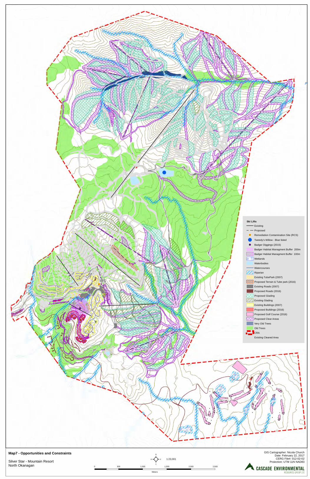
Putnam Creek
RS
²Map7 - Opportunities and Constraints Silver Star - Mountain ResortNorth Okanagan
GIS Cartographer: Nicola ChurchDate: February 22, 2017CERG File#: 012-02-02
Projection: UTM 11N NAD831:23,001
0 500 1,000 1,500 2,000 2,500
Meters
Ski LiftsExisting
Proposed
Remediation Contamination Site (RCS)
! Tweedy's Willow - Blue listed
Badger Diggings (2015)
Badger Habitat Managment Buffer 200m
Badger Habitat Managment Buffer 100m
Wetlands
Waterbodies
Watercourses
Riparian
Existing TubePark (2007)
Proposed Terrain & Tube park (2016)
Existing Roads (2007)
Proposed Roads (2016)
Proposed Glading
Existing Glading
Existing Buildings (2007)
Proposed Buildings (2016)
Proposed Golf Course (2016)
Proposed Clear Areas
Very Old Trees
Old Trees
CRA
Existing Cleared Area

84 ENVIRONMENTAL REVIEW | fPREPARED FOR: SILVERSTAR MOUNTAIN RESORT | File#: 012-02-02 | Date: March 10, 2017
3 Environmental Constraints
Environmental constraints presented on Map 7 are discussed in the following section.
3.1 Cultural Environment
Three areas of high archaeological potential were identified within the CRA. These areas are considered to be confidential and cannot be shown, however, they should be considered constraining to resort development due to the recommendation for further study prior to initiating any disturbance. A confidential archaeological site is also known and as such is protected.
3.1.1 Anthropogenic Features
No other constraints relating to anthropogenic features were identified within the CRA. The contaminated site in the Village is now remediated and should not pose a constraint to development.
3.2 Physical Environment
3.2.1 Climate
Climate in the study area presents no obvious constraints or concerns with respect to development. The only potential constraints represented by climatic conditions in the study area relate to the availability and seasonality of snow cover on skiable terrain. Snowfall can be considerable and infrastructure must be able to withstand heavy snow loads. Management and storage of cleared snow on-site should not impact existing water courses and therefore may constrain development. Climate constraints imposed on wildlife relate to difficulty of travel over deep snow and reduced food supply due to climate changes with increasing elevation. These constraints are discussed in the wildlife component of this section.
3.2.2 Geology
The geology of the area presents no obvious constraints or concerns with respect to development. No obvious bedrock stability concerns were noted during the field visit. Caution should be taken in locating ski runs and traffic areas below cliffs faces. The integrity of the rock mass should be assessed by trail crews and any concerns should be addressed by a qualified professional. Any geotechnical issues associated with potential development within the study area should be addressed in a separate report.
3.2.3 Geomorphology and Surficial Material
The majority of the surficial units are free-draining across gentle to moderate slopes. Steeper slopes near the summit of Silver Star Mountain are already developed as ski terrain and revegetated. No constraints are noted in relation to the stability of these materials.
3.2.4 Hydrology
No hydrologic concerns were noted during field visits. Visual inspections of the creek systems and existing culverts should be conducted by summer crews prior to the fall to monitor any accumulations of debris. Any wetlands and riparian areas encountered in the CRA should be considered as constraining to development.
ENVIRONMENTAL REVIEW | PREPARED FOR: SILVERSTAR MOUNTAIN RESORT | File #: 012-02-02 | Date: March 10, 2017 85
3.2.4.1 Streams
The CRA occupies the upper reaches of the tributaries to Vance, Putnam, Coldstream, BX, Miriam, and Fortune Creeks. Putnam and Vance Creeks are the major streams within the CRA as most tributaries of the other creeks are ephemeral. Consequently, in the ephemeral drainages, hydrologic constraints are minimal. However, stream channel structure and riparian integrity should be maintained to allow seasonal runoff and protect water quality. The prime objective of the hydrology design is to minimize any increase in peak flows associated with development. Peak flow increases could potentially affect fish populations by altering channel morphology, changing patterns of debris recruitment and placement, increasing bed load, and adversely affecting water quality.
3.3 Terrestrial Environment
3.3.1 Soils
The widely distributed Brunisols in the study area are generally well drained soils which are associated with no known constraints to recreational development. The Organic soils which occur in poorly drained areas, however, are associated with wetlands. Development constraints associated with wetlands are discussed in Section 3.4. Any issues associated with soils and potential development within the study area would be addressed in a separate geotechnical report.
3.3.2 Vegetation
The forest of the study area is generally less than 180 years old and one forested unit was estimated at 253 years of age. Older trees are less tolerant of the potential impacts that may arise from development. Accordingly, any forested polygon of structural stage 7 should be considered constraining to development. The majority of the CRA forest age range is mature forest ranging from 80 to 140 years, and as a result site specific conditions will affect the degree of impact arising from development. Core samples taken from the largest trees in sample plots within the TEM area supported the classification as mature forest structural stage 6. This information is conveyed in Map 5 in this report. Much of the TEM area was selectively logged (due to pest infestation) such that many of the veteran trees may have been removed. Windthrow is an existing problem within the CRA and will continue to be a constraint as clearing proceeds. However, the potential for timber blowdown can be minimized or even mitigated to a large degree by sound clearing practices. All forest edges should be scalloped to avoid straight cut lines and will be feathered to reduce abrupt changes in the vertical profile of the vegetated landscape. Dripline protection should be included in tree preservation and an environmental monitor should be present during clearing. Veteran trees developing within the protected riparian setback may present safety concerns arising from windthrow potential. Specific constraints associated with the various tree or plant species noted within the study area are limited. Only one rare or endangered terrestrial plant is known to occur within the study area (the blue listed Tweedy’s willow) and is considered a constraint to development. No rare or endangered plant communities were observed within the study area. Potential presence of alpine larch may be considered constraining if encountered. While no rare or endangered plants were identified within the wetlands, the
86 ENVIRONMENTAL REVIEW | fPREPARED FOR: SILVERSTAR MOUNTAIN RESORT | File#: 012-02-02 | Date: March 10, 2017
reconnaissance level of survey precluded identification of all plants to the level of species. Consequently, wetland vegetation should be considered constraining due to the potential presence of rare or endangered plant species. As a result of the climatic constraints imposed on growth of vegetation, maximizing preservation of existing vegetation should always be a priority in development planning. Based on the cursory field investigation and communication with the B.C. Conservation Data Centre, there are no other development constraints or particular concerns associated with rare or endangered vegetation in the study area. Vegetation constraints relate to the habitat provided and the need to maintain biodiversity in the CRA. Large tree islands should be preserved between ski runs to provide adequate shelter for resident fauna and to prevent excessive windthrow. Larger tree islands will allow for preservation of standing wildlife snags while maintaining safe distances from ski runs, trails and roads.
3.3.3 Wildlife and Valued Ecosystem Components
3.3.3.1 Wildlife and Wildlife Habitat
In general, preserving or rehabilitating the environmentally valued ecosystem components will serve to protect wildlife values and mitigate potential development impacts. Wildlife trees within the study area, particularly mature trees and snags should be preserved as they provide valuable habitat for numerous species. Coarse woody debris should retain as much as possible, in a variety of sizes and stages of decay, to provide wildlife habitat. Wildlife movement corridors between waterways should be maintained to prevent fragmentation of available habitat. Amphibian eco-passage should be installed under roadways to maintain habitat connectivity. Amphibians, Reptiles and Mammals Best management practices stated in the Guideline for Amphibian and Reptile Conservation during Urban and Rural Land Development in British Columbia (BC MOE, 2014b) and within Develop with Care (BC MOE, 2014a) should be adhered to along with the specific recommendations for species at risk, as detailed in the rare and endangered species section below. The riparian areas within the study area should be protected and fragmentation of riparian habitat should be avoided.
Birds Breeding birds are legally protected as outlined in Section 34 of the BC Wildlife Act (BC MOE, 1996), which states: A person commits an offence if the person, except as provided by regulation, possesses, takes, injures, molests or destroys
(a) a bird or its egg, (b) the nest of an eagle, peregrine falcon, gyrfalcon, osprey, heron or burrowing owl or, (c) the nest of a bird not referred to in paragraph (b) when the nest is occupied by a bird or its egg.
Active nests of all song birds and raptors are legally protected and, as such, vegetation clearing should occur outside of the typical bird breeding period of April 1 to July 31. If clearing is to take place during this window, a nesting bird survey should be completed by a Qualified Environmental Professional prior to any clearing to ensure that no active nests are disturbed. Wildlife as Pests As development of SilverStar continues, it may become necessary to manage certain species of wildlife to prevent their becoming pests. Some of the wildlife species that can be considered potential pests include:
ENVIRONMENTAL REVIEW | PREPARED FOR: SILVERSTAR MOUNTAIN RESORT | File #: 012-02-02 | Date: March 10, 2017 87
biting insects such as mosquitoes, horseflies and blackflies, Canada goose (presence and droppings on greens), woodpeckers (excavate holes in man-made wood structures), crows and ravens (garbage), coyote (safety), bears (safety and garbage), deer (eating flowers, shrubs at clubhouse, other facilities etc.), moose (browsing shrubs, particularly in winter), northern pocket gopher (burrowing and mounding on greens), snowshoe hare (clipping of ornamental shrubs), cougar (safety), and skunks (denning under man-made structures).
3.3.3.2 Rare and Endangered Species
Western Toad and Painted turtle Best management practices recommend maintaining a 30 m core area from the high water mark of any water course (BC MOE, 2014). In addition, habitat connectivity should be maintained throughout the study area by maintaining corridors of suitable habitat between the ponds and the forested wetland associated with the creeks. Roads represent a barrier to dispersal and can fragment the habitat. Under road amphibian passages should be installed in order to reduce habitat fragmentation and road kill.
Short Eared Owl Short-eared Owls breed in a large number of open habitats including grasslands, arctic tundra, taiga, bogs, marshes, old pastures. The nest is typically a simple scrape on the ground, lined with grasses and a few feathers (COSEWIC, 2008). Therefore preserving wetlands and associated riparian areas will protect the short eared owl breeding habitat. It is recommended that a nest survey should be conducted prior to any ground disturbance during the bird nesting window from April 1 to July 31.
Rubber Boa The Management Plan for the Northern Rubber Boa (BC MOE, 2016) includes a threat classification table in which it is stated that development for tourism and recreation have a negligible impact on the species, while the severity of any impact would be slight. The low threat rating is due in part to the widespread distribution of the species, which counters localized disturbances (BC MOE, 2016). As any development could directly impact individuals of the species, if present at the site, it is recommended that searches for rubber boas be conducted if land clearing is considered, concurrently with the amphibian searches, prior to any vegetation clearing and grubbing activities. As they are not easily located during summer, when the snakes tend to take shelter under cover objects during the day, searching under these objects may be required in order to locate them (BC MOE, 2016). Common Nighthawk The species lays eggs directly on soil or bare rock, therefore in order to minimize the impact on the species, it is recommended that a nest survey should be conducted prior to any ground disturbance during the bird nesting window from April 1 to July 31. Olive-sided Flycatcher The olive-sided flycatcher is most often associated with natural forest openings; forest edges near natural openings (such as wetlands) or open to semi-open forest stands and will use human-made openings (such as clearcuts). The species will use early successional forest, although the presence of tall snags
88 ENVIRONMENTAL REVIEW | fPREPARED FOR: SILVERSTAR MOUNTAIN RESORT | File#: 012-02-02 | Date: March 10, 2017
and residual live trees for foraging and nesting is essential (COSEWIC, 2007). These habitat features are present on the study area and should therefore preserve if possible. A nesting bird survey should be completed prior to any clearing between April 1 and July 31.
Townsend’s Big Eared Bat and Little Brown Myotis These two species may potentially use the study area for foraging habitat only. As a result, any development in the study area will only affect their foraging habitat. Their residences, however, will not be affected
Wolverine In order to minimize the impact of any potential development in the study area on the wolverine, the following mitigation measures should be adopted. Forest development should occur on one side of the watershed at a time where practicable. Limiting concurrent development will concentrate the activity at any one time and allow wolverines to avoid operational areas as much as possible during their daily movements. This will reduce displacement associated with forest development and will help facilitate normal movement throughout the landscape (BC MOE, 2004c). Seasonal foraging areas should be maintained through the appropriate juxtaposition of structural stages throughout the watershed. Adequate foraging habitat for wolverines is likely closely linked to the suitability of habitats to support their primary food sources (ungulates, snowshoe hares, porcupines, marmots). Maintaining these habitats in close proximity to thermal and security cover (generally mature and old forest structural stages) will be important to securing seasonal foraging areas for wolverines(BC MOE, 2004c). Suitable movement and dispersal corridors should be retained. Habitat connectivity within and between watersheds is very important for successful daily movements, foraging, and dispersal of wolverines. Connectivity of valley bottom habitats is important, specifically along watercourses. These corridors should be dominated by older forests (stage 6 or 7) and connection between the valley bottom and patches of ESSF habitats should also be maintained (BC MOE, 2004c).
Fisher Suitable habitat for the fisher is characterized by shrub cover, coniferous canopy cover, sub-hygric or wetter moisture regime, patches of large, declining trees (particularly black cottonwood), and greater than average amounts of CWD for the zone. Therefore, old growth forest with mature and old cottonwood as well as large fir and spruce along riparian habitat should be preserved to maintain sufficient suitable habitat to support healthy populations of fishers. CWD of a variety of size and decay class should also be preserved (BC MOE, 2004b). Habitat connectivity through the use of corridors of mature and old growth forests should be maintained through the study area. Connectivity can be maintained by preserving a 100m riparian buffer (where ecologically appropriate) along stream that contain suitable habitat features to support fishers (BC MOE, 2004b).
Williamson’s Sapsucker The Williamson’s sapsucker is highly dependent on old growth western larch forest as breeding habitat (COSEWIC, 2005). Western larch is abundant within the CRA. Therefore, development requiring tree clearing in those polygons should be avoided. In addition, a nesting bird survey should be completed prior to any clearing between April 1 and July 31.
ENVIRONMENTAL REVIEW | PREPARED FOR: SILVERSTAR MOUNTAIN RESORT | File #: 012-02-02 | Date: March 10, 2017 89
American Badger Suitable habitat for the American badger is highly dependent on prey habitat (i.e ground squirrel, yellow-bellied marmot or microtine rodents). Badgers can use areas that have been modified by humans and tolerate some level of human activity (BC MOE, 2008). This is supported by the presence of a den near the base of a ski lift which is generally associated with increased levels of human activity. Since a known den occurs within the CRA, “no development” buffers should be applied around the den. As long as wildlife habitat suitable for preys is maintained, limited impact will occur on the badger habitat present on the study area. The badger is a fossorial species, meaning they dig dens in the ground. Therefore, ground disturbance should be avoided. Proper soil handling technique should be used to avoid compaction of soil and erosion. Construction activities should take place between mid-summer and fall (July 15 to October 15) since this is when badgers are most active. In addition, a pre-construction survey to identify any active badger dens should be conducted (Trans Mountain, 2016). Grizzly Bear Grizzly bear is considered extirpated from the study area (Environmental Reporting BC, 2016), however transient individual might still utilize the study area. Therefore connectivity of forest should be maintained throughout the study area to maintain movement corridors.
3.3.3.3 Valued Ecosystem Components
Riparian Areas Riparian areas within 30 meters of a permanent water course are subject to assessment in accordance with the Riparian Area Regulation (RAR) of the B.C. Fish Protection Act. Any intrusion in the resulting riparian setback may require permitting under Section 11 of the B.C. Water Sustainability Act, and/or approval under Section 35 (2) of the Federal Fisheries Act. Wildlife Movement Corridors Wildlife movement corridors maintain the connectivity of adjacent habitats and need to be provided for wildlife moving across or through the study area. Ephemeral streams and riparian areas are natural corridors and should be maintained as such. As planning for the expansion of the resort proceeds, design should consider maintaining and protecting wildlife movement corridor opportunities. Deer Rutting Because utilization of the CRA by deer during the rutting season is poorly understood, it is difficult to recommend options for mitigating potential impacts. Restrictions on resort development or golf course activity between 15 October and 15 December would reduce disturbance to deer utilizing the area during the rut. The golf course would likely not be operational at this time of year, but ski trail maintenance may be an issue (Photo 4).
At Sun Peaks Golf Course, greenways and fairways appear to be providing additional foraging opportunities for deer in the area (Rick Howie, BCE, Kamloops, pers. comm., 1996). Deer would also be expected to forage on existing ski trails and golf fairways, if developed at SilverStar. Wildlife Trees
90 ENVIRONMENTAL REVIEW | fPREPARED FOR: SILVERSTAR MOUNTAIN RESORT | File#: 012-02-02 | Date: March 10, 2017
Areas with high snag densities need to be retained to maintain nesting and foraging opportunities for woodpeckers, small owls, bats and cavity nesting passerines. Large snags in upland areas with known nesting activity should not be removed unless absolutely necessary from a development design perspective. Care must be taken in golf course design and construction to provide adequate forested buffers along fairways, so that important nest and forage trees/snags are less vulnerable to windthrow. Approximately 60-70% of resident bird species in British Columbia are cavity nesters and use cavities to roost in winter (Millikan, 1994). Wildlife trees that contain dens or breeding cavities may be constraining to development during the breeding season of the animal. Song birds were evident visually and acoustically, but are typically summer breeders and not permanent residents. Wildlife trees that pose a safety risk within the study area may need to be removed outside of the breeding season. Ephemeral streams and Riparian Areas Ephemeral streams and adjacent riparian areas should not be disturbed. These habitats are important as feeding, drinking, and breeding sites for numerous wildlife species. These habitats also act as natural movement corridors for wildlife across the study area, especially following intensive land use activities such as clear-cutting, golf course and potential residential development. Carefully designed crossings will be required. Open Wetlands Because wetlands are relatively uncommon in upland ecosystems of Silver Star Provincial Park, the integrity of all existing wetlands should be retained. Any additional wetlands that may be identified in the future should also be retained. Wetlands are important foraging areas for bats and breeding areas for amphibians. With careful design, any ponds created as part of the golf course layout may also eventually be utilized by amphibians as breeding areas. At Sun Peaks Golf Course, western toads have begun breeding in drainage ponds (Rick Howie, BCE, Kamloops, pers. comm., 1996). However, breeding success and long-term impacts on toad populations is not known.
3.4 Aquatic Environment
3.4.1 Aquatic Biophysical
3.4.1.1 Stream Descriptions
Putnam Creek The aquatic biophysical assessment and fish sampling program indicates that Putnam Creek within Silver Star Provincial Park and CRA is likely non-fish bearing. This creek does, however, support a population of rainbow trout downstream of the study area and it flows into Trinity Creek, which is a known to support a fish population. It is important, therefore, to retain the riparian vegetation to protect the stream banks from erosion which could lead to downstream siltation. In addition, the riparian vegetation helps to maintain lower water temperatures in summer, and provides a potential food source for downstream fish (i.e. terrestrial insects falling into the stream). Vance Creek As with Putnam Creek, studies indicate that Vance creek is unlikely to support fish within Silver Star Provincial Park and CRA. Again, it is important to retain the existing riparian vegetation for the previously mentioned reasons. In addition, the banks and side slopes in Vance Creek’s headwaters are noted to be slumping in several locations. Maintenance of appropriate buffer leave strips adjacent to the creek, and proper water management will help address this ongoing concern.
ENVIRONMENTAL REVIEW | PREPARED FOR: SILVERSTAR MOUNTAIN RESORT | File #: 012-02-02 | Date: March 10, 2017 91
Coldstream Creek Coldstream Creek is known to support a fisheries resource in the valley downstream of the CRA. Within and immediately downstream of Silver Star Provincial Park, the creek has been shown to be barren of fish. Similar to constraints for the above two creeks, it is important to maintain an appropriate buffers to protect the riparian vegetation adjacent to the headwaters of this creek. Other Streams The other watercourses and associated ravines and gullies pose the same constraints as those previously mentioned. No fish were captured during the 1996 fish sampling program using either of the sampling methods and it is Cascade’s opinion that further sampling in these areas would not have captured any fish. However, it has been the authors’ experience that a single sampling program (using a double pass electrofishing and Gee trap program as utilized in this case) is rarely sufficient to conclusively prove that a stream is barren. Therefore, for the purposes of this development, the waters into which development lands drain are being considered as fish bearing or directly connected to fish bearing waters. To that end, a 30 m Riparian Assessment Area (RAA) is identified. It is Cascade’s interpretation of the RAR (Malaspina, 2006) that the RAA of 30 m is applied as a default unless a detailed assessment is conducted. It is also understood that reduced setbacks represent exceptions and that whenever possible the largest setback feasible should be delineated. A 30 m minimum setback cannot be applied consistently given the topography of the study area. Cascade suggests that a 15 m Streamside Protection Enhancement Area (SPEA) may be attainable with detailed assessment given the bio-physical character of the watercourses. Past experience with golf courses, residential, commercial and mountain resort developments indicates that there will be “pinch points”. These “pinch points” may be addressed through detailed assessment or site specific permitting. However, every attempt should be made to minimize the encroachments into that 30 m buffer.
3.4.2 Water Quality
Water quality of the streams draining the study area is of particular concern to downstream water users, especially in the Coldstream Creek watershed, where the total water licensed for consumption for that water body exceeds its total mean annual runoff. As water is a valued resource in the arid Okanagan, maintaining (and / or improving) the water quality of the streams leaving the CRA is essential. In addition, any changes to the water quality in the creeks will not only affect downstream human water usage (whether it be for agriculture, domestic, or other usage), but could impact on downstream fisheries resources. A decrease in groundwater recharge to the creeks within the study area could lead to decreased flows in those drainages. This could lead to higher summer temperatures in affected drainages, and hence reduced oxygen carrying capacity of those waters. Groundwater resources should be managed so that summer low flows in the adjacent drainages are not adversely affected. Changes to the groundwater regime also can potentially affect fisheries resources if water quality is deteriorated or if groundwater recharge is decreased. Increases in nutrients (nitrogen and phosphorus) can lead to excessive algal growth, which could deplete oxygen levels in waters where algal blooms occur. It is recommended that a water quality monitoring program be developed so that any potential changes to the surface and ground water regimes in the area can be detected and appropriate action can be taken. The program will include sampling of the streams in the area (upstream and downstream samples) as
92 ENVIRONMENTAL REVIEW | fPREPARED FOR: SILVERSTAR MOUNTAIN RESORT | File#: 012-02-02 | Date: March 10, 2017
well as sampling of representative golf course ponds and all wetlands and ponds constructed for water quality control. The effectiveness of the present water sampling program will be reviewed and incorporated into an expanded program. Parameters to be sampled for include primarily nitrogen and phosphorus compounds, but will also include and pesticides used on the golf course. By properly designing the water quality monitoring program, the effectiveness of the fertilizer and pesticide management program, water management program, and constructed wetland water treatment can be realized. Potential problems can be identified, and appropriate mitigating measures and corrective action can be taken. Petroleum storage, including propane storage, fuel storage, lubricant storage, storage of other petroleum products and fuel should be designed to meet or exceed the existing safety regulations of the British Columbia Fire Code, as well as the “Environmental Code of Practice for Aboveground Storage Tank Systems Containing Petroleum Products” (Canadian Council of Ministers of the Environment, 1994) and the “Summary of Environmental Standards & Guidelines for Fuel Handling, Transportation and Storage” (Ministry of Environment, Lands and Parks and Ministry of Forests, 2002). Water quality issues in relation to the effluent of the wastewater treatment plant are addressed by the third-party operator. This system and potential receiving areas are monitored to ensure that the system it is functioning effectively.
3.5 Wetland Environment
3.5.1 Delineation
Delineated wetlands should be considered constraining to development and all of these are within the golf course study area of the CRA. Smaller wetlands may occur throughout the CRA, but were not picked up during mapping at this scale.
3.5.2 Functionality
Wetlands Wf02, Ws01, and Wf01 have the highest function values and are considered the most significant wetlands in the study area. They are classic fens and presently exist in an undisturbed state. Although occurring in close proximity it is now known that Ws01 and Wf01 are hydrologically isolated from each other. These wetlands were noted when the Ministry of Forests produced in forest cover mapping at 1:20,000 scale. Wetland Ws10 West actually represents a single wetland complex that is bisected by a logging haul road. As a result its functional value is somewhat reduced. The small swamp wetland identified by polygon Ws10 East is assessed lower functional values due to its smaller size. Present plans call for the construction of a series of wetland ponds designed to operate in isolation from the existing wetlands for the purpose of isolating irrigation waters from the golf course. The objective of these constructed wetlands would be to prevent irrigation waters from entering the natural wetland system while providing complimentary habitat enhancement opportunities. In 1993, there were more than 150 constructed wetlands in the United States used to treat municipal and industrial wastewaters. The majority of these were in the southeastern and south-central states where a long growing period occurs (Horner, 1993). A long growing season is required in these cases, as there is waste input throughout the year. Additionally, SilverStar has two constructed reservoirs, two constructed ponds and 4 wastewater treatment ponds in the CRA. Habitat enhancement opportunities exist for each of these waterbodies.
ENVIRONMENTAL REVIEW | PREPARED FOR: SILVERSTAR MOUNTAIN RESORT | File #: 012-02-02 | Date: March 10, 2017 93
In the case of a golf courses and ski trails, potential nutrient (phosphorus and nitrogen) losses would likely be associated with fertilization of turf grasses. The most efficient method of reducing the potential losses of these compounds is, therefore, to properly manage the use of fertilizer and the provision of adequate buffer zones between areas fertilized and waterbodies. Where this precautionary approach has been previously undertaken, no noticeable nutrient level increases was found in adjacent waterbodies. However, where fertilizers are used, there is always potential for nutrient loading to become a problem. Constructed wetlands should be considered in areas requiring heavier application of fertilizer, to facilitate removal of excess quantities of phosphorus and nitrogen compounds. Constructed wetlands in the United States have been found to remove between 40 and 90% of total suspended solids, 20 to 50% of the ammonia, and 50 to 75% of the total phosphorus in wastewaters (Strecker et al., 1992). While the use of wetlands has been proven for wastewater treatment, one disadvantage in northern climates is the lack of nutrient uptake in the winter months. This disadvantage has limited the use of wetlands for treatment of municipal wastewater, and underlines the need for supplemental tertiary treatment. However, in the case of golf courses for example, the potential nutrient loading would only be realized in the growing season when fertilizers are applied. If a golf course is developed as originally proposed, then an environmental monitoring program should be initiated. As part of the proposed monitoring program, drainages in and around the golf course will be analyzed for nutrient levels. If phosphorous uptake slows down and nutrient concentrations in the sampled waters become elevated, a wetland vegetation harvesting program will be initiated. Once the vegetation in the wetland is established a program of rotational vegetation (Typha / Scirpus /Juncus) harvest will be implemented. It is important to recognize that, within a closed loop system, concentrations of phosphorous in the water will be redistributed onto the golf course. The effectiveness of phosphorous uptake will depend on biological productivity of the aquatic plants. During past field work the consultants observed healthy, productive plant life within the wetlands in the study area. It is reasonable to presume the constructed wetlands and ponds in the CRA will be similarly healthy and productive.
4 Conclusions and Recommendations
4.1 Conclusions
This report summarizes the baseline conditions found within the study area and investigates environmental constraints to development. Based on the information reviewed and the conditions observed in the study area, the CRA appears to be suitable for use in the development and operation of all season resort infrastructure and facilities. In order to avoid or mitigate potent adverse impacts arising from resort development and operation the following general recommendations are provided.
4.2 Recommendations
Based on the information reviewed and the site conditions observed, the following recommendations are made to minimize potential negative impacts in the study area arising from development at SilverStar Mountain Resort:
4.2.1 General
1. The integrity of the water quality, habitat values and downstream fisheries values of all waterbodies should be protected by the establishment of riparian buffer zones (SPEAs). In general, buffers should be as specified in the Riparian Areas Regulation of the B.C. Riparian Areas Protection Act.
94 ENVIRONMENTAL REVIEW | fPREPARED FOR: SILVERSTAR MOUNTAIN RESORT | File#: 012-02-02 | Date: March 10, 2017
2. With respect to resort development within the CRA, SilverStar should follow the guidelines and best
practices described in BC Ministry of Environment’s Develop with Care and the National Ski Areas Association’s Sustainable Slopes charter and, where applicable, incorporate into development planning and design (BC MOE, 2014a and NSAA, 2005).
3. SilverStar should repeat the water quality sampling program at the previously established sample
locations. The will provide comparative water quality information spanning a 20 year period. 4. SilverStar should endeavor to employ Integrated Pest Management (IPM) techniques to minimize
pest problems. 5. SilverStar should preserve all wetlands with suitable buffers within the CRA. Wetlands potentially
impacted by future developments should be subjected to detailed assessment to identify all plant species prior to development approval.
6. Fairways and ski trails should be situated parallel to both ephemeral and permanent streams to
reduce the need for crossings and to maintain the undisturbed nature of riparian buffer areas. 7. Alpine larch found within the CRA should be preserved wherever possible. 8. Retain an on-site environmental monitor to be present during all environmentally sensitive
development activity.
The environmental monitor will be a Qualified Environmental Professional (QEP) retained by SilverStar and approved by BC Ministry of Environment/FLNRO (the Province), whose responsibilities may include:
a. Preparation of site-specific monitoring programs, in accordance with the Province’s requirements. b. Monitor all project development related activities and their effects on biophysical resources within
and adjacent to the CRA in accordance with the approved monitoring program. c. Review and submit monitoring reports to SilverStar,, the Province and other applicable
government agencies on the monitoring results in accordance with a predetermined schedule and format.
d. Impose temporary work stoppages for non-compliance with the monitoring program. e. Amend the monitoring program, undertake additional resource assessments, and implement
mitigative measures if requested by the Province or SilverStar. f. Make recommendations to SilverStar for changing construction and operating procedures and
methods deemed necessary to ensure protection of the environment. g. The Environmental Monitor may be dismissed by either SilverStar or the Province for not
adequately enforcing the Guidelines. 8. All mountain development design should incorporate “no adverse effects” on downstream water
flows. The prime objective of the hydrology design is to minimize any increase in peak flows associated with development.
4.2.2 Cultural Environment
9. Future developments should consider maintaining recreational trails connecting the services with residential areas.
ENVIRONMENTAL REVIEW | PREPARED FOR: SILVERSTAR MOUNTAIN RESORT | File #: 012-02-02 | Date: March 10, 2017 95
4.2.3 Physical Environment
10. Future developments should implement snow clearing plans to ensure that snow storage or removal does not impact any of the water courses.
4.2.4 Terrestrial Environment
11. Land clearing activity should be conducted with due diligence between April 1 and August 31, to comply with Section 34 of the BC Wildlife Act, which forbids the destruction of nests occupied by a bird, its eggs, or young (BC MOE, 1996).
12. Prior to clearing during migratory bird nesting season (typically April 1 – September 1), a nesting bird
survey should be conducted to identify active nests. All active nests (containing either a bird, or eggs) are protected under the BC Wildlife Act, while raptor nests are protected all year whether inactive or active. Nests of short-eared owl found during land clearing activity must be adequately protected by forested buffer while the nest is occupied.
13. Ground surveys should be conducted in the vicinity of the new reservoir to determine if any Tweedy’s
willow has survived. Any surviving specimens should be protected from development. Several other rare and endangered species may be present in the study area. Detections of any of these species should trigger the implementation of appropriate BMPs.
14. Vegetation should be retained wherever possible to maintain suitable wildlife habitat, particularly
areas of old growth, near creeks and wetlands, and within riparian buffers. Efforts should be made to conserve snags and wildlife habitat trees. Wildlife movement corridors will be provided if retention zones along creeks are designated as recommended above. Road and trail crossings of these creeks should be designed so that wildlife movement is not impeded or discouraged. Amphibian eco-passage should be installed under roadways to maintain habitat connectivity.
15. Development should occur during the least risk window for badger (July 15 to October 15) to reduce mortality risk since this is a period when badgers are active if badgers are deemed or known to be present in the area where development is to occur..
16. Ground disturbance should be avoided to prevent any impact on rubber boa and existing or potential American badger dens if badgers or rubber boas are deemed or known to be present in the area to be disturbed. Should ground disturbance be required, a pre-construction survey to identify any active badger dens should be conducted. In addition, a rubber boa salvage should be conducted to comply with Section 26 of the BC Wildlife Act stating that a person commits an offense if the person kills wildlife that is an endangered species.
4.2.5 Aquatic Environment
17. Riparian Area Assessments should be conducted at sites of disturbance near watercourses to determine appropriate clearing setbacks for the protection of fish habitat values and water quality.
18. Stream crossings should be minimized. Bridges rather than culverts or fords are preferred. Planting of additional native, riparian shrubs and trees may be necessary where intrusions occur.
21. All wetlands greater than 20 m2 should be retained. No disturbance such as filling, redirection of runoff etc. should occur. Water utilization for watering and other uses should ensure that current
96 ENVIRONMENTAL REVIEW | fPREPARED FOR: SILVERSTAR MOUNTAIN RESORT | File#: 012-02-02 | Date: March 10, 2017
hydrology of wetlands is not altered. A 15 to 30 m vegetated setback should be established adjacent to wetlands to protect the unique plant and wildlife values of the wetland and adjacent riparian areas. Often wildlife trees important to bats and other wildlife species are located within the setback area.
22. Future developments should implement stormwater management plans that implement BMPs to ensure the protection of the ecological values of receiving waters. In addition to the post-development storm-water management, a drainage plan should also be developed to deal with concerns related to land clearing, grubbing, and construction. This plan should adhere to Develop with Care 2014: Environmental Guidelines for Urban and Rural Land Development in British Columbia.
4.2.6 Habitat Enhancement
23. Establish and maintain a nest box program. Strategically placed nest boxes of swallows, chickadees, small owls and woodpeckers will enhance breeding opportunities in the study area. Bat houses in more remote areas of the course may also be a consideration. A single bat can consume 500 to 1000 mosquitoes and insects in an hour, depending on the bat species and size (Millikan 1994).
24. Planting of native shrubs and trees such as Douglas maple, spruce, alder and cedar may be necessary in previously or proposed disturbance areas. Native ground cover and shrubs adjacent to watercourses, ponds and fairways, along with trees, provide excellent habitats for birds and many other small animals. Plant species using local seed and plant strains suitable for high elevation areas. Transplanting from cleared areas is also an option although plant survival may be an issue.
25. Ponds should be designed with extensive emergent and riparian vegetation along the majority of the
shoreline to provide habitat diversity for wildlife. Vegetation such as cattails can sequester certain contaminants as well as provide a source of litter for the invertebrate community.
26. Additional detailed surveys or assessments of wildlife may be useful. However, given the costs
associated with conducting surveys (i.e. repeated surveys throughout the survey period), further assessment may not be possible. Because wetland areas and buffers are considered to be sensitive habitats of high value to many species, disturbance would not be permitted in these areas. Wildlife utilizing these areas should be adequately protected by the proposed set-back and buffer areas.
4.3 Additional Studies
Although it is unlikely for the majority of the listed rare and endangered species to occur within the study area, detailed surveys of development sites should be conducted by qualified environmental professionals (QEPs), at appropriate times of year, to positively confirm presence or absence.
5 References
Agriculture Canada, 1978. The Canadian System of Soil Classification, Publication 1646. Barnard, A.I. 1992. Guidelines to protect, maintain and enhance fish and wildlife habitat on and adjacent
to proposed golf course developments and existing golf course re-developments on lowland areas. B.C. Environment, Fish and Wildlife Management.
BC Conservation Data Centre (CDC). 2016. BC Species and Ecosystems Explorer. BC Ministry of
Environment. Victoria, BC. Website: http://a100.gov.bc.ca/pub/eswp/. Accessed December 12, 2016.
ENVIRONMENTAL REVIEW | PREPARED FOR: SILVERSTAR MOUNTAIN RESORT | File #: 012-02-02 | Date: March 10, 2017 97
BC Integrated Land Management Bureau (ILMB), 1998. Terrestrial Ecosystem Mapping in British Columbia. Resource Inventory Committee, BC. BC Ministry of Energy, Mines and Petroleum Resources, 1993. Minfile Map NTS 082LSW Vernon.
updated May, 1996. BC Ministry of Environment. 2017. Fisheries Information Summary System (FISS). Website:
http://www.env.gov.bc.ca/fish/fiss/. Accessed on: February 16, 2017. Victoria, BC. BC Ministry of Environment. 1991. British Columbia's Environment, Planning for the Future. Document
prepared by the Wildlife Branch, Ministry of Environment. Victoria, B.C. BC Ministry of Environment, Wildlife Act (RSBC 1996)] CHAPTER 488. BC Ministry of Environment. 2004. Identified Wildlife Management Strategy (IWMS). Available at:
http://www.env.gov.bc.ca/wld/frpa/iwms/. Accessed September 26, 2007. BC Ministry of Environment. 2004a. Badger (Taxidea taxus jeffersonii) Accounts and Measures for
managing Identified Wildlife. Available at: http://www.env.gov.bc.ca/wld/frpa/iwms/documents/Mammals/m_badger.pdf
BC Ministry of Environment. 2004b. Fisher (Martes pennanti) Accounts and Measures for managing
identified Wildlife. Available at: http://www.env.gov.bc.ca/wld/frpa/iwms/documents/Mammals/m_fisher.pdf
BC Ministry of Environment. 2004c. Wolverine (Gulo gulo) Accounts and Measures for managing
identified Wildlife. Available at: http://www.env.gov.bc.ca/wld/frpa/iwms/documents/Mammals/m_wolverine.pdf
BC Ministry of Environment. 2004d. Short eared owl (Asio flammeus flammeus) Accounts and Measures
for managing identified Wildlife. Available at http://www.env.gov.bc.ca/wld/frpa/iwms/documents/Birds/b_shortearedowl.pdf
BC Ministry of Environment (BC MOE). 2008. Recovery Strategy for the Badger (Taxidea taxus) in British
Columbia. Available at: http://www.env.gov.bc.ca/wld/documents/recovery/rcvrystrat/badger_jeffersonii_rcvry_strat18092008.pdf
BC Ministry of Environment, 2007. Guidelines and Best Management Practices (BMPs). Online: http://www.env.gov.bc.ca/wld/BMP/bmpintro.html
BC Ministry of Environment (BC MOE). 2016. BC Species and Ecosystems Explorer. Website:
http://www.env.gov.bc.ca/atrisk/toolintro.html.
BC Ministry of Environment (BC MOE). 2016. Management Plan for the Northern Rubber Boa (Charina bottae) in British Columbia. Website: http://a100.gov.bc.ca/pub/eirs/finishDownloadDocument.do?subdocumentId=10011.
98 ENVIRONMENTAL REVIEW | fPREPARED FOR: SILVERSTAR MOUNTAIN RESORT | File#: 012-02-02 | Date: March 10, 2017
BC Ministry of Environment (BC MOE). 2014 Water Sustainability Act. Website: https://engage.gov.bc.ca/watersustainabilityact/
BC Ministry of Environment (BC MOE). 2014a. Develop with Care 2014 Environmental Guidelines for Urban and Rural Land Development in British Columbia. Website: http://www.env.gov.bc.ca/wld/documents/bmp/devwithcare/#Main
BC Ministry of Environment (BC MOE). 2014b. Guideline for Amphibian and Reptile Conservation during Urban and Rural Land Development in British Columbia. Website: http://www.env.gov.bc.ca/wld/documents/bmp/HerptileBMP_complete.pdf.
BC Ministry of Forests. 1992. Okanagan Timber Supply Area Integrated Resource Management Timber Harvesting Guidelines. Forest Service, February 1992.
BC Ministry of Forests. 1995a. Fish-Stream Identification Guidebook, Forest Practices Code of British
Columbia (July 1995 ed.). Victoria, B.C. BC Ministry of Forests. 1995b. Riparian Management Area Guidebook, also includes Marine Sensitive
Zones and Fisheries Sensitize Zones, Draft 2 Guidebook, Forest Practices Code of British Columbia (March 30 1995 ed.). Victoria, B.C.
BC Ministry of Forests and Range and BC Ministry of Environment. 2010. Field Manual for Describing
Terrestrial Ecosystems. Land Management Manual 25, 2nd ed., Victoria, BC. BC Ministry of Forests, Lands and Natural Resource Operations. 2002. Forest and Range Practices Act
(FRPA), SBC 2002, c. 69, Part 5 Protection of Resources, Section 56. BC Ministry of Forests, Lands and Natural Resource Operations. 2014. Factsheet, Provincial overview of moose population estimates for 2014. June 17, 2014, Victoria, BC. BC Ministry of Forests, Lands and Natural Resource Operations. 2016a. Biogeoclimatic Ecosystem
Classification (BEC) Map. Available at: https://catalogue.data.gov.bc.ca/dataset/biogeoclimatic-ecosystem-classification-bec-map.
BC Ministry of Forests, Lands and Natural Resource Operations. 2016b. VRI – Forest Vegetation
Composite Polygons and Rank 1 Layer. Available at: https://catalogue.data.gov.bc.ca/dataset/vri-forest-vegetation-composite-polygons-and-rank-1-layer.
BC Ministry of Water, Land and Air Protection and Ministry of Forests, 2002. Summary of Environmental
Standards & Guidelines for Fuel Handling, Transportation and Storage. 3rd Edition, Victoria, B.C. BC Outdoors. 1995. Freshwater Fishing Directory and Atlas. OP Publishing Ltd. Vancouver,
B.C. Bech, P. 1994. Lower Mainland Region Stream Inventory/Assessment Methods. Regional Fisheries
Report No. LM 229. Fish & Wildlife Management, BC Environment. Surrey, B.C. Belsham,. J. 1978. Soils of the Vernon Map Area 82 L. B.C. Department of Agriculture, Kelowna, B.C. Brent Harley and Associates Inc. 1995. SilverStar Mountain Base Area Master Plan. Whistler B.C.
ENVIRONMENTAL REVIEW | PREPARED FOR: SILVERSTAR MOUNTAIN RESORT | File #: 012-02-02 | Date: March 10, 2017 99
Brent Harley and Associates Inc. 2016. SilverStar Mountain Resort Master Plan. Whistler B.C. Campbell, R. Wayne, Neil K. Dawe, Ian McTaggart-Cowan, John M. Cooper, Gary W. Kaiser, Michael C.E. McNall, 1990. The Birds of British Columbia, Volumes I and II. Royal British Columbia Museum, Victoria. Canada West Ski Areas Association, 1992. Guidelines for Environmental Good Practices for
Ski Areas. Cannings, S.G. and J. Ptolomy. 1998. Rare Freshwater Fish of British Columbia. BC Ministry of
Environment, Lands and Parks, Victoria, B.C. 214 pp. Carl, G.C., W.A. Clemens and C.C. Lindsey. 1977. The Fresh-water Fishes of British Columbia.
British Columbia Provincial Museum. Victoria, B.C. Cascade Environmental Resource Group Ltd. 2006. Environmental Review, SilverStar Mountain Resort.
Whistler, BC. Chilibeck, B., Chislett, G., and Norris, G., 1992. Land Development Guidelines for the Protection
of Aquatic Habitat. Habitat Management Division of the Department of Fisheries and Oceans and the Integrated Management Branch of the Ministry of Environment, Lands and Parks.
Columbia Environmental Consulting Ltd., 2008. Fish Inventory and Stream Classification for an Unnamed
Tributary to Vance Creek. October 18, 2008, Penticton, BC.
Committee on the status of endangered wildlife in Canada (COSEWIC). 2013. Assessment and status report of the little brown myotis Myotis lucifigus. Available at: http://www.registrelep-sararegistry.gc.ca/virtual_sara/files/cosewic/sr_Little%20Brown%20Myotis%26Northern%20Myotis%26Tri-colored%20Bat_2013_e.pdf
Committee on the status of endangered wildlife in Canada (COSEWIC). 2008. Assessment and status report on the short-eared owl Asio flammeus. Available at: http://www.registrelep-sararegistry.gc.ca/virtual_sara/files/cosewic/sr_shorteared_owl_0808_e.pdf
Committee on the status of endangered wildlife in Canada (COSEWIC). 2007. Assessment and status report on the olive-sided flycatcher Contopus cooperi. Available at: http://www.registrelep-sararegistry.gc.ca/virtual_sara/files/cosewic/sr_olivesided_flycatcher_0808_e.pdf
Committee on the status of endangered wildlife in Canada (COSEWIC). 2005. Assessment and status report on the Williamson’s sapsucker Sphyrpicus thyroideus. Available at: https://www.registrelep-sararegistry.gc.ca/virtual_sara/files/cosewic/sr_williamsons_sapsucker_e.pdf
Committee on the status of endangered wildlife in Canada (COSEWIC). 2006. Assessment and status report on the western painted turtle Chysemys picta bellii. Available at: http://www.registrelep-sararegistry.gc.ca/virtual_sara/files/cosewic/sr_western_painted_turtle_e.pdf
Committee on the status of endangered wildlife in Canada (COSEWIC). 2002. Assessment and status report on the western toad Bufo boreas. Available at:
100 ENVIRONMENTAL REVIEW | fPREPARED FOR: SILVERSTAR MOUNTAIN RESORT | File#: 012-02-02 | Date: March 10, 2017
Corkran, C.C. and C. Thomas. 1996. Amphibians: A Complete Field Identification Manual for Oregon, Washington, and British Columbia. Lone Pine Publishing. Redmond, Washington (In Press).
Courmier, R. 2016. SilverStar Masterplan Update Splatsin Cultural Heritage Overview Assessment.
Enderby, BC. Demarchi, D. 1995. Map Ecoregions of British Columbia. Wildlife Branch, MOELP, 4th ed.,
Victoria, B.C. Demarchi, D. A. 1996. An Introduction to the Ecoregions of British Columbia. Draft document f
rom the Wildlife Branch, BC Ministry of Environment, Lands, and Parks. Demarchi, D.A., B.Fuhr, B.A. Pendergast and A.C. Stewart. 1983. Wildlife capability classification for
British Columbia: an ecological (biophysical) approach for ungulates. MOE Manual 4. Department of Fisheries and Oceans (DFO) and the Integrated Management Branch of the
Ministry of Environment, 1993. Land Management Guidelines. DataBC. 2016. iMap BC. Province of British Columbia. Website: http://maps.gov.bc.ca/ess/sv/imapbc/. Davies, J., Coulthard, M. and Zukanovic, N. 2009. Resort Wildfire Protection Plan. Vahalla Consulting,
Diamond Head Consulting and Timberline. Produced for the Ministry of Tourism, Culture and Arts.
Dodson, R.G. 1990. Audubon Cooperative Sanctuaries for Golf Course Management. USGA Green
Section Record. 28(2): 14-16. Dyer, O. 1996. Personal communication 1996. BCE, Penticton. EBA Engineering Consultants Ltd. 1997. Hydrological Assessment For Proposed Golf Course
Development Silver Star Provincial Park. Vancouver, B.C. Ecosystems Working Group, 1995 and 1999. Standards for Terrestrial Ecosystems Mapping in British
Columbia. Resources Inventory Committee, Victoria, B.C. Environment Canada. 1981. Canadian Climate Normals, Temperature and Precipitation, 1951 - 1980,
British Columbia. Atmospheric Environment Service, Canadian Climate Program. Downsview, Ont.
Environment Canada. 2013. Recovery Strategy for the American Badger, jacksoni subspecies (Taxidea taxus jacksoni) in Canada [Proposed]. Species at Risk Act Recovery Strategy Series. Environment Canada, Ottawa. 14 pp. + Appendices.
Environment Canada, Water Office. 2017. Historical Hydrometric Data Search. https://wateroffice.ec.gc.ca/search/historical_e.html accessed on February 2, 2017.
Environmental Reporting BC website.2015. Grizzly bear population status in B.C.. Website: http://www.env.gov.bc.ca/soe/indicators/plants-and-animals/grizzly-bears.html accessed on December 2, 2016.
ENVIRONMENTAL REVIEW | PREPARED FOR: SILVERSTAR MOUNTAIN RESORT | File #: 012-02-02 | Date: March 10, 2017 101
GeoAlpine Environmental Consulting Ltd. 1997. Environmental Review Big White Ski Resort Master Plan Updated 1997. GeoAlpine Environmental Consultants Ltd. Whistler, BC.
Golder Associates, 2005. Silver Star Stage II PSI / Remediation Vernon, BC. Project Plan No. 022-4094-
6100, Figure 1 and Figure 2, May 4, 2005. Golder Associates, 2007. New Well 13 at Silver Star Mountain Resort, Initial Report on Sustainable Yield
and Water Quality. 2007 Green, D.M. and R.W. Campbell. 1984. The Amphibians of British Columbia. Handbook No. 45. British
Columbia Provincial Museum. Gregory, P.T. and R.W. Campbell. 1987. The Reptiles of British Columbia. Handbook No. 44,
B.C. Provincial Museum. Ministry of Provincial Secretary and Government Services., Victoria, B.C.
Harding, L.E. and E. McCullum. 1994. Biodiversity in British Columbia: Our Changing
Environment. Canadian Wildlife Service, Environment Canada. Ottawa, Ont. Hamilton, A.N. 2008. 2008 Grizzly Bear Population Estimates for British Columbia. Ecosystem
Branch, Ministry of Environment, British Columbia Health Canada. 1996. Guidelines for Canadian Drinking Water Quality, Sixth Edition. Canada
Communications Group. Ottawa, Ont. Hobbs, J. 2006. Personal communication December 12, 2006. Biodiversity Branch, IWMS. Horner, R. 1993. Constructed Wetlands for Storm Runoff Water Quality Control, Center for Urban Water
Resources Management, University of Washington, Seattle, Washington. Hosie, R.C., 1990. Native Trees of Canada, Fitzhenry & Whiteside. Howie, R. 1996. Personal communication, 1996, BCE, Kamloops. Kowalls, R. 1978. Soils of the Vernon Map Area 82L (Mapsheet 82L/6 at 1:50,000 scale). Province of
British Columbia. Krajina, V.J. , 1965. Biogeoclimatic Zones and Biogeocoenoses of British Columbia. Ecology of Western North America, University of British Columbia. LaCas, B. 1997. Silver Star Mountain Resort, Golf Course Project – Comparison of Pre-Development and
Post Development Drainage. Unpublished report, Vancouver, B.C. Lloyd, D., K. Angove, G. Hope, and C. Thompson, 1990. A Guide to Site Identification and
Interpretation for the Kamloops Forest Region. BC Ministry of Forests Land Management Handbook No. 23. Queen’s Printer, Victoria, BC.
Luttmerding, H.A., Demarchi, D.A., Lea, E.C., Meidinger, D.V., Vold, T., 1990. Describing
Ecosystems in the Field. MOE Manual 11 (2nd Ed.). Queen’s Printer, Victoria, BC.
102 ENVIRONMENTAL REVIEW | fPREPARED FOR: SILVERSTAR MOUNTAIN RESORT | File#: 012-02-02 | Date: March 10, 2017
Lyons, C.P., 1976. Trees, Shrubs and Flowers to know in British Columbia. J.M. Dent & Sons. Vancouver, B.C.
MacKenzie, W.H. and J.R. Moran. 2004. Wetlands of British Columbia: a guide to identification. Res. Br.,
B.C. Min. For., Victoria, B.C. Land Manage. Handb. No. 52. MacKillop, D., A. Ehman, and M. Ryan. 2016. A Field Guide to Ecosystem Classification and Identification
for Southeast British Columbia: Four Biogeoclimatic Subzones/Variants in the Boundary-Okanagan. A Temporary Supplement to Land Management Handbook 70. Prov. B.C., Victoria, BC.
MacKillop, D., A. Ehman, and M. Ryan. 2016a. A Temporary Supplement to Land Management
Handbook 70 - A Field Guide to Ecosystem Classification and Identification for Southeast British Columbia: Four Biogeoclimatic Subzones/Variants in the Boundary-Okanagan. Prov. B.C., Victoria, BC.
McTaggat-Cowan, Ian, and Charles J. Guiguet, 1978. The Mammals of British Columbia, British Columbia Provincial Museum, Victoria, BC. Malaspina University College. 2006 Riparian Areas Regulation, Assessment Methodology, Participant’s
Manual. Produced with MWLAP and DFO, ver 3.3, April, Nanaimo, B.C. Meidinger, Del and Jim Pojar (Eds.). 1991. Ecosystems of British Columbia. BC Ministry of
Forests, Victoria, B.C. Meidinger, D. (Ed.). 1996. Field Manual for Describing Terrestrial Ecosystems. Rough Draft, Ministry of
Forests / BC Environment, Victoria, B.C. Midgley, C. 1999. Silver Star Mountain Resort Golf Course Environmental Construction and Monitoring
Plan. Vernon, B.C.. Millikan, R. 1994. Enhancing habitat for birds in urban spaces. The Turf Line News 123: 36-39. Nagorsen, D.W. 1990. The Mammals of British Columbia: a Taxonomic Catalogue. Royal British
Columbia Museum Memoir, 4:4-140. Nagorsen, D.W. and R.M. Brigham. 1993. Bats of British Columbia. Royal British Columbia Museum
Handbook. UBC Press. Vancouver, B.C. National Wetland Working Group. 1988. Wetlands of Canada. Ecological Land Classification Series No.
24. Sustainable Development Branch, Environment Canada, Ottawa, Ont. and Polyscience Publications Inc., Montreal P.Q.
NSAA, 2005. National Ski Areas Association. Sustainable Slopes.
http://www.nsaa.org/environment/sustainable-slopes/. Accessed January 31, 2017. Okanagan Nation Alliance, Syilx. Copyright 2004. http://www.syilx.org/history-history.php. Accessed
December 12, 2008. Parish, Roberta, Ray Coupe, and Dennis Lloyd (Eds.) 1996. Plants of Southern Interior British Columbia.
Lone Pine Publishing, Vancouver, B.C..
ENVIRONMENTAL REVIEW | PREPARED FOR: SILVERSTAR MOUNTAIN RESORT | File #: 012-02-02 | Date: March 10, 2017 103
Pommen, L.W. 1991. Approved and Working Criteria for Water Quality. Ministry of Environment, Water
Management Division, Water Quality Branch. Victoria, B.C. Rahme, A.H., A.S. Harestad and F.L. Bunnell. 1995. Status of badger in British Columbia. Wildlife
Working Report No. WR-72, Ministry of Environment, Lands and Parks, Wildlife Branch, Victoria. RCGA, 1993. Environmental guidelines for Canadian golf clubs. Royal Canadian Golf Association,
Oakville, Ontario. 10 pp. Resource Information Committee (RIC), 1998. Standard for Terrestrial Ecosystem Mapping in British
Columbia. Ecosystem Working Group, Terrestrial Ecosystems Taskforce. Victoria, B.C. Ryan, Michael. 2016. Personal communication November 28, 2016. Research Ecologist, Ministry of
Forests, Lands and Natural Resource Operations, BC, Canada. Scott, W.B. and E.J. Crossman. 1973. Freshwater Fishes of Canada. Bulletin 184. Fisheries Research
Board of Canada. Ottawa, Ont. Stevens, V., 1993. Wildlife Diversity in British Columbia: Distribution and Habitat Use in Biogeoclimatic
Zones. Ministry of Environment, Lands & Parks & Ministry of Forests, Victoria. Final draft. Strecker, E.W., Kersnar, J.M., Driscoll, E.D., and Horner, R.R. 1992. The Use of Wetlands for Controlling
Storm Water Pollution. The Terrene Institute. Washington, D.C. Tarnocai, C. 1980. Canadian Wetland Registry. In Proceedings, Workshop on Canadian Wetlands.
C.D.A. Rubec and F.C. Pollett, editors. Lands Directorate, Environment Canada. Ecological Land Classification Series No. 12, Ottawa, Ont.
Temmel, Nyssa 2016. Personal communication November 28,2016. And email correspondence from
December 1, 2016. Provincial Terrestrial Ecosystems Ecologist, Ministry of Environment - Province of British Columbia, Canada
Timberline Natural Resource Group Ltd. 2010. Okanagan TSA Predictive Ecosystem Mapping (PEM)
Compilation Project Final Report. March 5, 2010, Victoria, BC Prepared for Okanagan Innovative Forestry Society.
Trans Mountain Pipeline ULC. 2016. American Badger Mitigation and Habitat Restoration Plan. Available at : https://www.transmountain.com/uploads/pages/1474048290-044---American-Badger.pdf
Ursus Heritage Consulting. 2016. Archaeological Overview Assessment of Silverstar Mountain Resort.
Draft, Coldstream, BC. Produced for Silver Star Mountain Resort. Van Vlies, Laurens 1996. Personal communication October 10, 1996. Research Branch, Agriculture
Canada. Vegetation Section, Resource Analysis Unit. 1976. Forest Zonation Mapsheet 82L6. E.L.U.C Secretariat,
Kelowna, B.C. Water Investigations Branch. 1974. Kalamalka - Wood Lake Basin Water Resource Management Study.

104 ENVIRONMENTAL REVIEW | fPREPARED FOR: SILVERSTAR MOUNTAIN RESORT | File#: 012-02-02 | Date: March 10, 2017
Water Survey of Canada. 1991. Historical Streamflow Summary, British Columbia. Environment Canada.
Ottawa, Ont.

ENVIRONMENTAL REVIEW | PREPARED FOR: SILVERSTAR MOUNTAIN RESORT | File #: 012-02-02 | Date: March 10, 2017 105
6 Appendices
Appendix A. Wastewater Treatment Plant – Summary of Operations
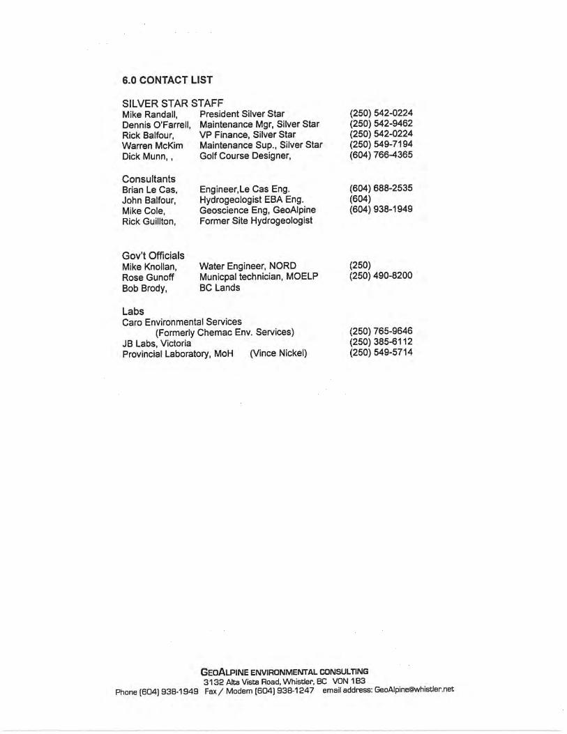

114 ENVIRONMENTAL REVIEW | fPREPARED FOR: SILVERSTAR MOUNTAIN RESORT | File#: 012-02-02 | Date: March 10, 2017
Appendix B. Stream Survey Forms
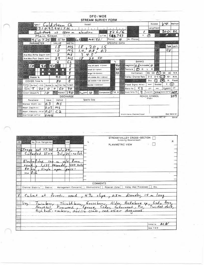
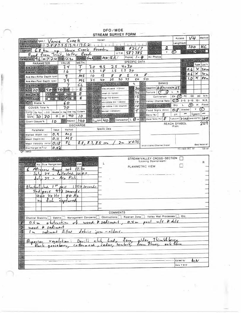
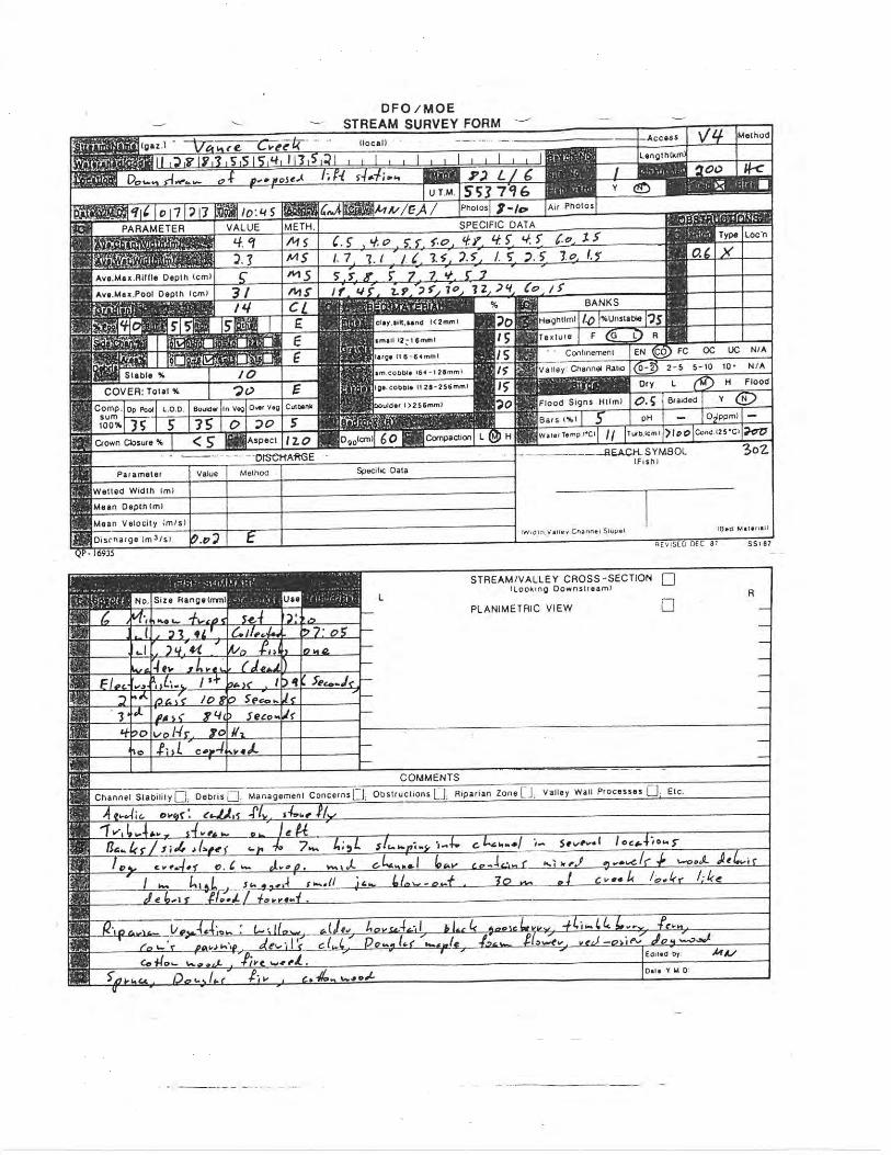
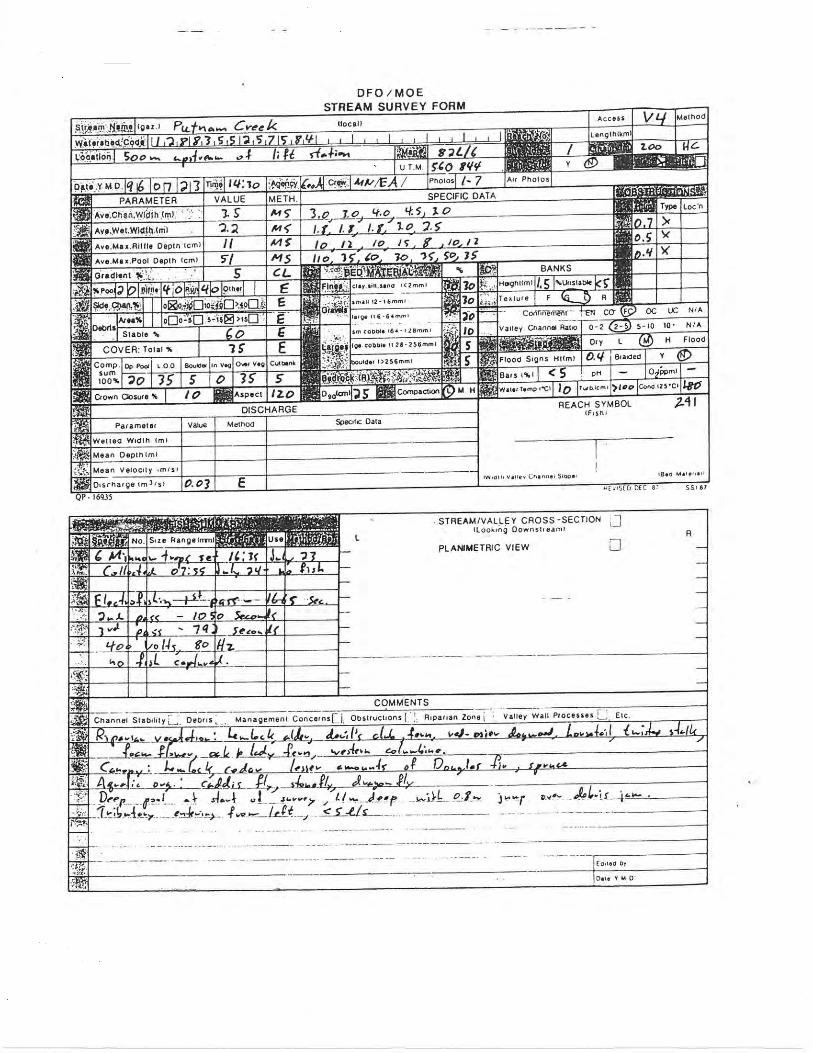

ENVIRONMENTAL REVIEW | PREPARED FOR: SILVERSTAR MOUNTAIN RESORT | File #: 012-02-02 | Date: March 10, 2017 119
Appendix C. Water Sampling Analysis
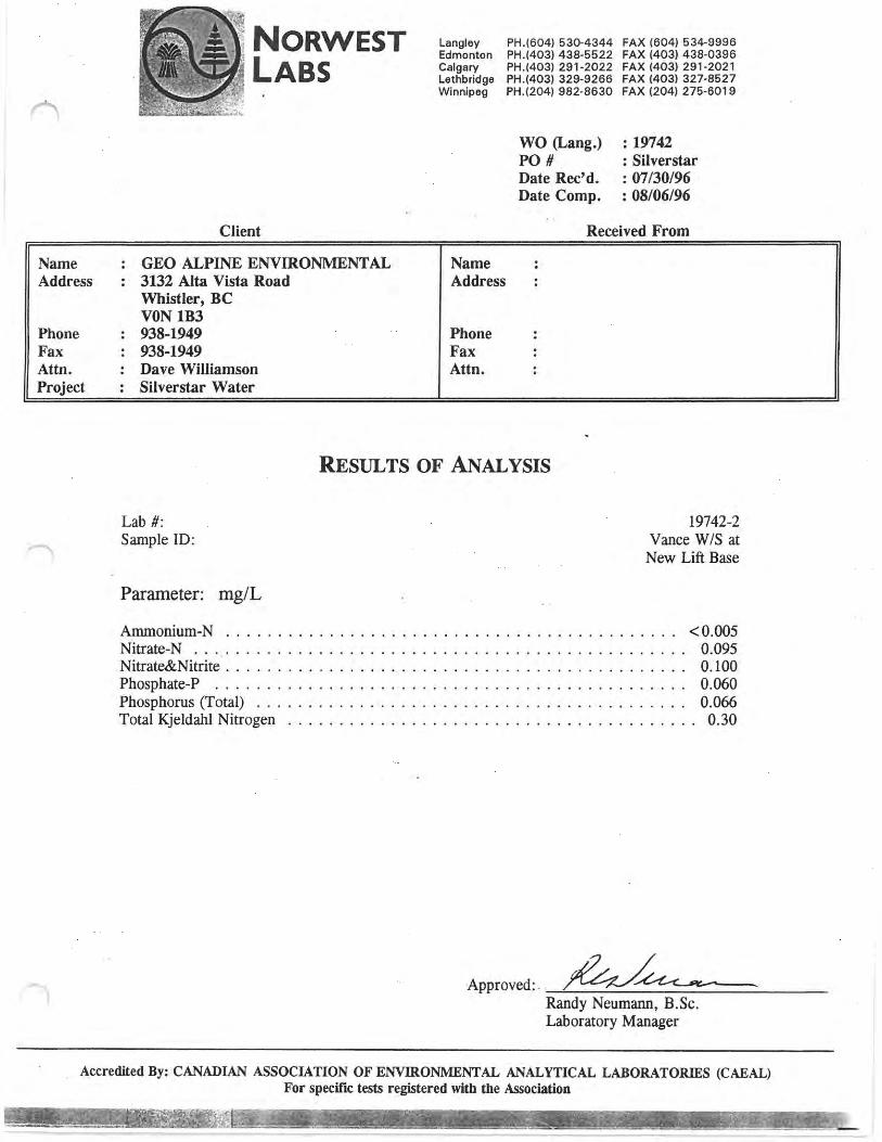

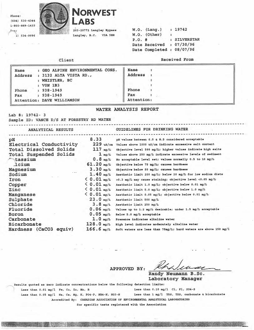
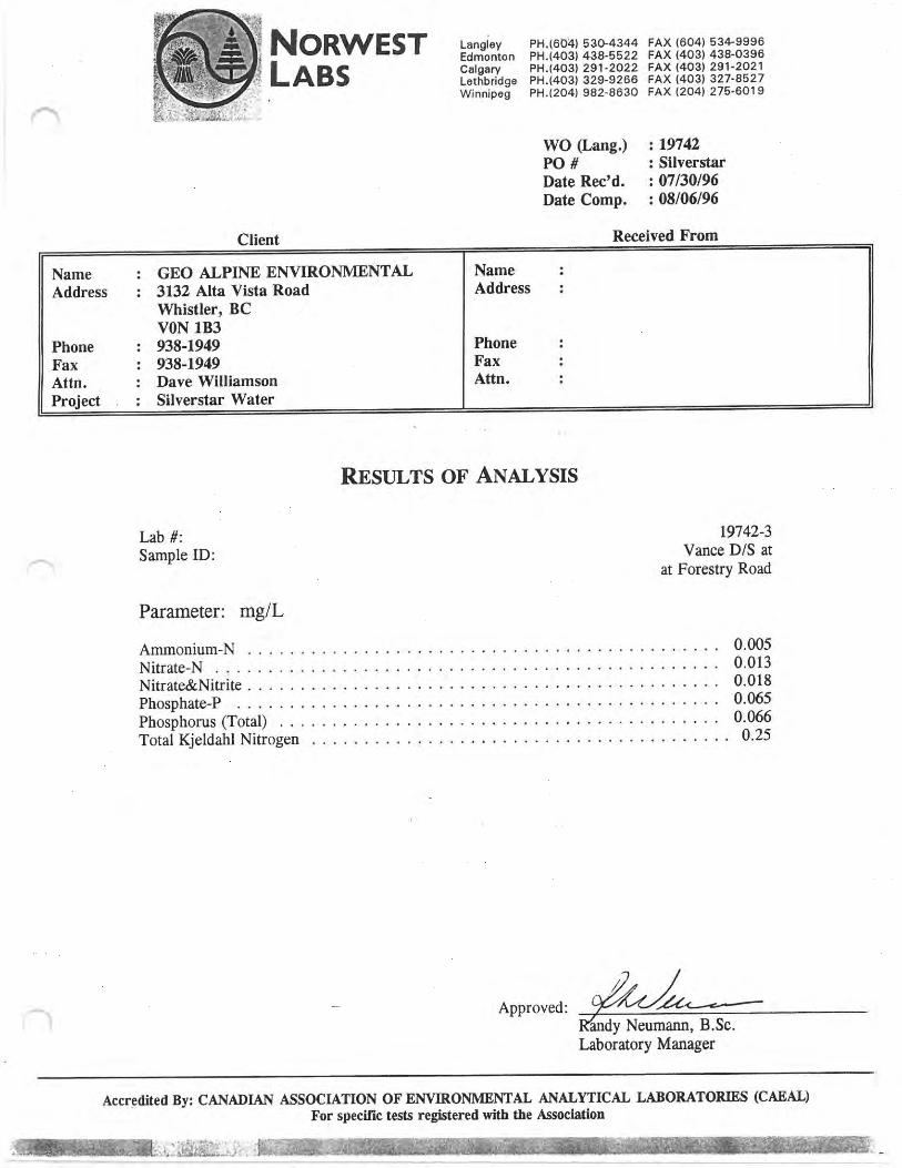

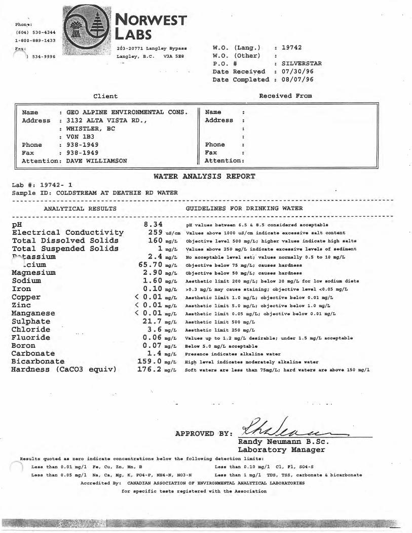
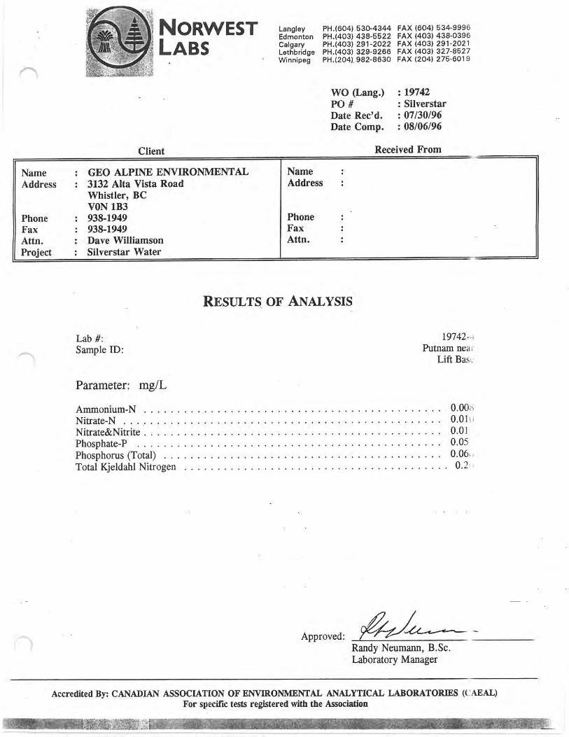
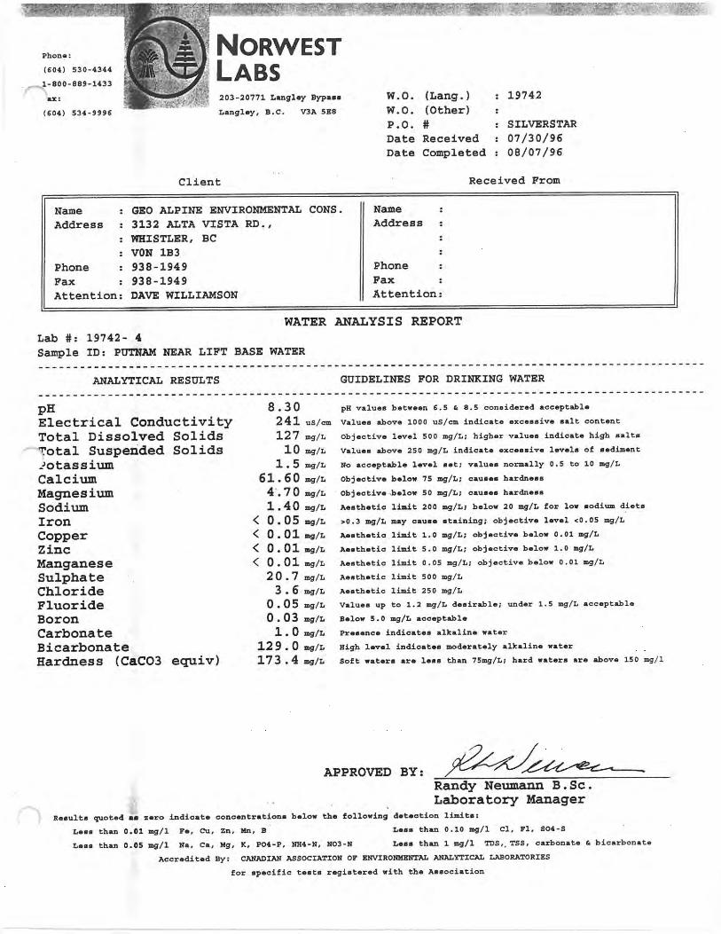

ENVIRONMENTAL REVIEW | PREPARED FOR: SILVERSTAR MOUNTAIN RESORT | File #: 012-02-02 | Date: March 10, 2017 127
Appendix D. Map 8 – Data Sources

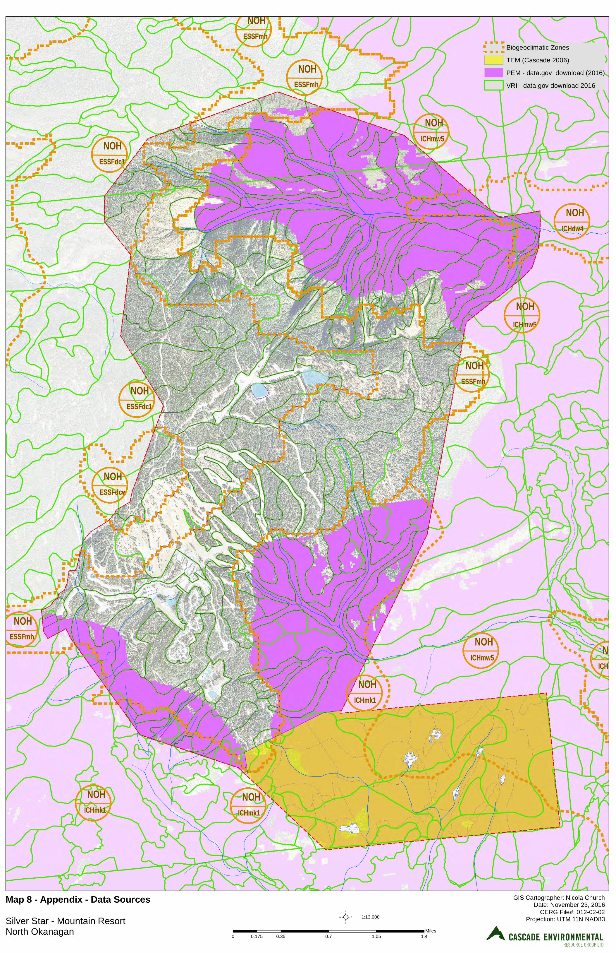
IC H m k 1N O H
E S S F m hN O H
E S S F d c wN O H
E S S F d c 1N O H
E S S F d c 1N O H
E S S F m hN O H
IC H m w 5N O H
IC H d w 4N O H
IC H m w 5N O H
E S S F m hN O H
IC H m w 5N O H
IC H m k 1N O H
IC H m k 1N O H
IC H d w 4N O H
E S S F m hN O H
Biogeoclimatic Zones
TEM (Cascade 2006)
PEM - data.gov download (2016)
VRI - data.gov download 2016
GIS Cartographer: Nicola ChurchDate: November 23, 2016
CERG File#: 012-02-02Projection: UTM 11N NAD83
M a p 8 - A p p e n d ix - D a ta S o u rc e s Silver Star - Mountain ResortNorth Okanagan
1:13,000²0 0.35 0.7 1.05 1.40.175
Miles


SILVER STAR MASTER PLAN • 2017 • APPENDIX
Appendix 2 - MMM Group Traffic Impact Study

TECHNICAL MEMO
17M-00265-00-REP-01-Rev2 (Traffic Study ToR)
Suite 700 - 1045 Howe Street, Vancouver, BC V6Z 2A9 | T: 604.685.9381 | F: 604.683.8655 | W: www.mmm.ca
File No.: 17M-00265-00 From: Floris van Weelderen, P.Eng, PTOE Date: April 8, 2017
Subject: Traffic Impact Study Terms of Reference Silver Star Master Plan Update – Silver Star, BC
This technical memorandum presents an assessment of when a Traffic Study will be needed as well as the potential Terms of Reference for the traffic impact studies that will be prepared as part of the master planning currently underway at Silver Star. These studies would help the BC Ministry of Transportation and Infrastructure (Ministry), Regional District of North Okanagan (RDNO) and City of Vernon (City) assess Silver Star’s compatibility with planning policy contained within, amongst other things, the RDNO’s Regional Growth Strategy, the RDNO’s and City’s Official Community Plans (OCP), as well as the City’s Master Transportation Plan.
BACKGROUND
Brent Harley and Associates Inc. (BHA) were retained to update the existing Resort Master Plan for Silver Star. This document will guide in the ongoing development of the resort by accounting for the existing development and expanding onto terrain that would improve the balance of the offering, reflecting changes in the expectations of the skier marketplace. A review of the Silver Star Master Plan 2015 (Whistler, BC: Brent Harley and Associates Inc., 2015) indicated the following:
Silver Star is an all-season mountain resort located within BC’s Okanagan Valley. Operating as a ski area since 1958, the resort features downhill skiing, snowboarding, skating, tubing and snowmobiling in the winter and has become world renowned for its Nordic skiing trail system and facilities. In the summer, lift service mountain biking, training camps, guided nature tours, hiking and various festivals continue to attract visitors on a year-round basis.
The resort’s activities and attractions are staged from Silver Star Village, a Victorian-influenced development composed of hotels, restaurants and retail outlets. The village is surrounded by a diverse mix of resort residential areas. All of the residential developments are directly linked by trails from the Village Core, creating ski-in / ski-out access in the winter and easy route finding in the summer.
As currently proposed, Silver Star would increase the Balanced Resort Capacity (BRC) from 7,992 visitors per day (2017) to 18,993 visitors per day (Build-out). Although this represents an increase of about 135% in daily visitors, traffic volumes are not expected to increase at the same rate given the anticipated reduction in the percent of day skiers - from 60% (2017) to 40% (Build-out) - who would come and go on the same day.
The Master Plan would be implemented in a phased approach and as of yet to be determined off-site mitigation measures would be implemented if and when required.
As part of the review process, various levels of government - namely the Ministry, RDNO and City - have expressed concern about the potential impacts of increased BRC on the ability of the road network leading to Silver Star to accommodate additional traffic. Both the Ministry and the City have forwarded generic Terms of Reference to Silver Star that outline their expectations for a Traffic Impact Study. In response to these concerns, MMM Group conducted a preliminary traffic study to determine what level of development would trigger the need for a Traffic Impact Study (TIS) as well as these Terms of Reference for such a study, which would be conducted at the appropriate time.

Page 2
Suite 700 - 1045 Howe Street, Vancouver, BC V6Z 2A9 | T: 604.685.9381 | F: 604.683.8655 | W: www.mmm.ca
EXISTING TRANSPORTATION NETWORK
At present, the 21 km long Silver Star Road connects the mountain resort through the RDNO to the City of Vernon and points beyond. The western part of Silver Star Road is under the jurisdiction of the City while the 14.5 km section of Silver Star Road between the City limits and the resort boundary is under the jurisdiction of the Ministry. Silver Star Road turns into 48th Avenue at Pleasant Valley Road before connecting to Highway 97 in Vernon.
In Vernon, both 48th Avenue and Silver Star Road are classified as an Arterials1 with 48th Avenue having an Arterial Road – Urban section (5 lanes, bike lanes, curb, and sidewalk). Between Pleasant Valley Road and the city limits, Silver Star Road has an Arterial Road - Rural with Multi-Use Pathway (MUP) section (2 lanes with paved shoulders and separate MUP although the MUP is not continuous).
Key intersections between Highway 97 and the mountain resort include:
48th Avenue / Anderson Way Traffic signal 48th Avenue / 29th Street Traffic signal 48th Avenue / 27th Street Traffic signal 48th Avenue / 20th Street Traffic signal Silver Star Road / Pleasant Valley Road Traffic signal Silver Star Road / MacDonald Road Minor street stop control Silver Star Road / Blackcomb Way Minor street stop control Silver Star Road / Foothills Drive Minor street stop control Silver Star Road / Phoenix Drive Minor street stop control Silver Star Road / Sovereign Lake Road Minor street stop control Silver Star Road / Cathedral Drive Minor street stop control
Traffic Volumes
Daily traffic volume data collected for the year 2015 at the Ministry’s Permanent Traffic Counter P-24-1NS (Armstrong) on Highway 97 is presented in Figure 1 (monthly variation) and Figure 2 (daily variation). The permanent counter is located about 15 minutes north of the intersection of Highway 97 and 48th Avenue in Vernon. It provides general trends in traffic volumes on Vernon’s city streets. Key findings from Figure 1 include:
Traffic volumes on City streets such as 48th Avenue and Silver Star Road west of L&A Road typically peak during the summer (July and August)
Conversely, traffic volumes on these same streets are typically at their lowest in the winter (November through February) when Silver Star traffic peaks
Key findings from Figure 2 include:
Traffic volumes on City streets typically peak on Fridays Conversely, traffic volumes on these same streets are typically at their lowest in weekends when
Silver Star traffic peaks
1 The primary function of an arterial road is to carry relatively high volumes of intra-municipal and inter-regional traffic through Vernon (25 Year Master Transportation Plan, 2013)
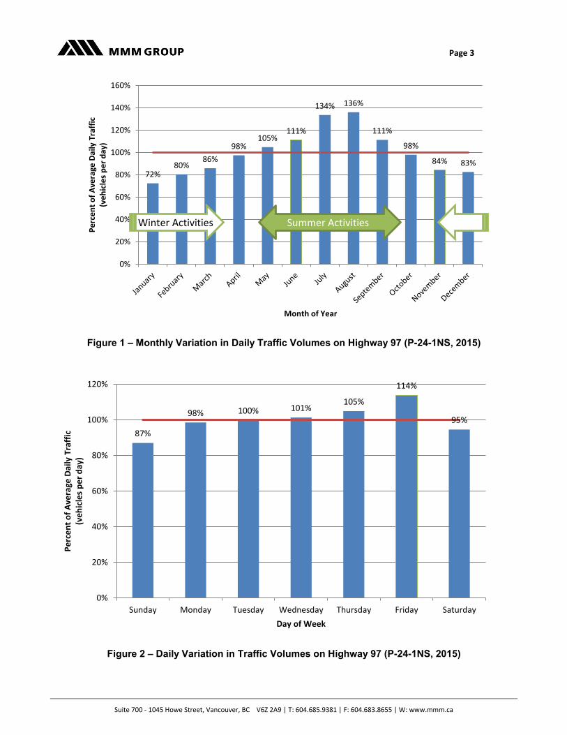
Page 3
Suite 700 - 1045 Howe Street, Vancouver, BC V6Z 2A9 | T: 604.685.9381 | F: 604.683.8655 | W: www.mmm.ca
Figure 1 – Monthly Variation in Daily Traffic Volumes on Highway 97 (P-24-1NS, 2015)
Figure 2 – Daily Variation in Traffic Volumes on Highway 97 (P-24-1NS, 2015)
72%80%
86%
98%105%
111%
134% 136%
111%
98%
84% 83%
0%
20%
40%
60%
80%
100%
120%
140%
160%P
erc
en
t o
f A
vera
ge D
aily
Tra
ffic
(ve
hic
les
pe
r d
ay)
Month of Year
87%
98% 100% 101%105%
114%
95%
0%
20%
40%
60%
80%
100%
120%
Sunday Monday Tuesday Wednesday Thursday Friday Saturday
Pe
rce
nt
of
Ave
rage
Dai
ly T
raff
ic(v
eh
icle
s p
er
day
)
Day of Week
Summer Activities
Winter Activities

Page 4
Suite 700 - 1045 Howe Street, Vancouver, BC V6Z 2A9 | T: 604.685.9381 | F: 604.683.8655 | W: www.mmm.ca
A review of traffic volumes collected by the City of Vernon at three locations along Silver Star Road in 2013 is presented in Figure 3. The key finding is that on a busy day during an average month, traffic volumes vary from 4,400 vehicles per day (Phoenix Drive) to about 8,600 vehicles per day (L&A Road).
The City also collected data on Silver Star Road at L&A Road during the Christmas period (the busiest time of year at Silver Star Mountain) in 2009. Figure 4 compares the daily variation in traffic on a typical week over Christmas with that observed on a typical week during an average month (May). The key finding is that Christmas traffic has similar patterns as traffic during a typical month; however, Christmas Day (Friday, December 25, 2009) is lower. Note that volumes were not compared since significant growth has occurred east of L&A Road between 2009 and 2013.
Future Transportation Network
Originally a two lane road, Silver Star Road will be upgraded to address traffic demands, safety concerns and provide improved facilities for pedestrian and bicycle use. For instance, the 25 Year Master Transportation Plan (Vernon, BC: City of Vernon, 2013) identifies the following development led and funded road improvements along Silver Star Road:
3 lane road from Pearson Road to McDonald Road to provide turn lanes in to future development sites, and
3 lane road from Foothills Drive to approx. 75m north of Phoenix Drive to provide up-hill passing lanes.
In addition, the Foothills Neighbourhood Plan (Vernon, BC: City of Vernon, 2013) identifies the following potential improvements to Silver Star Road:
Roundabout at Silver Star Road and Phoenix Drive
On-street sidewalk or path on the north side of Silver Star Road east of Foothills Drive
Recently, the Ministry repaved 14.5 km of Silver Star Road between the City limits and the resort village in part to address the prevalence of potholes and crumbling pavement.
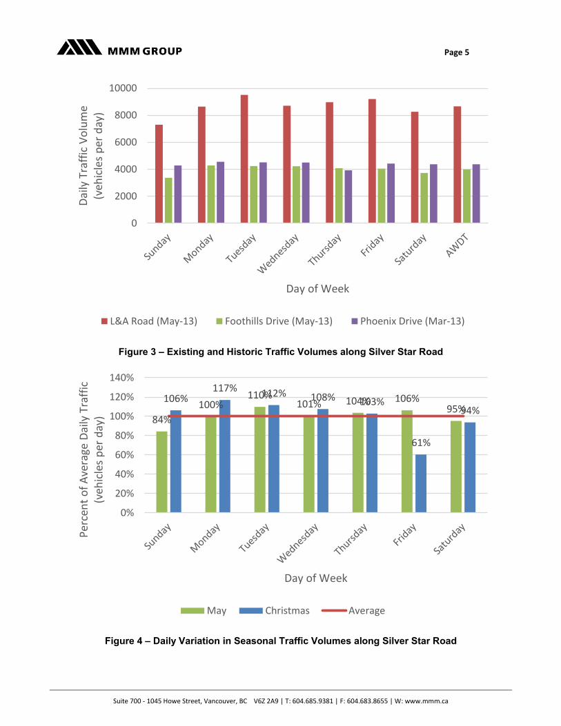
Page 5
Suite 700 - 1045 Howe Street, Vancouver, BC V6Z 2A9 | T: 604.685.9381 | F: 604.683.8655 | W: www.mmm.ca
Figure 3 – Existing and Historic Traffic Volumes along Silver Star Road
Figure 4 – Daily Variation in Seasonal Traffic Volumes along Silver Star Road
0
2000
4000
6000
8000
10000D
aily
Tra
ffic
Vo
lum
e (v
ehic
les
per
day
)
Day of Week
L&A Road (May-13) Foothills Drive (May-13) Phoenix Drive (Mar-13)
84%
100%110%
101% 104% 106%95%
106%117% 112% 108% 103%
61%
94%
0%
20%
40%
60%
80%
100%
120%
140%
Per
cen
t o
f A
vera
ge D
aily
Tra
ffic
(v
ehic
les
per
day
)
Day of Week
May Christmas Average
Page 6
Suite 700 - 1045 Howe Street, Vancouver, BC V6Z 2A9 | T: 604.685.9381 | F: 604.683.8655 | W: www.mmm.ca
Site-Generated Traffic Volumes
Traffic at Silver Star Mountain Resort is generated by the following user groups:
Day visitors Overnight visitors Residents Resort employees and local support workforce Logistical support, i.e. deliveries and solid waste management
A preliminary (or order of magnitude) trip generation estimate was prepared for each of the five phases that are being considered for the mountain resort based on first principles and the respective BRC. These traffic volumes (see Figure 5) represent the traffic generated by Sliver Star during the worst case scenario, i.e. Christmas season when the resort is expected to operate at capacity. The daily traffic volumes are based on the following assumptions (which will be refined as part of the Traffic Impact Study):
About 85% pf the day use visitors are expected to arrive by passenger car (with 3 people per car) and 15% by bus (with 45 passengers per bus). These visitors would depart the same day.
All of the overnight guests will arrive by passenger car (with 3 people per car). For analysis purposes, the overnight guests would arrive one day and depart the following day. This results in a conservative analysis as some visitors would stay longer than one night.
The ratio of day use visitors to overnight visitors is expected to change from 60%:40% (current) to 40%:60% by the completion of Phase 5.
Trips by resort employees, local support workforce, and logistical support were not included.
Figure 5 – Order of Magnitude Daily Trips Generated by Silver Star
Key findings include:
At build-out, Silver Star is expected to double the amount of trips that are generated by the current mountain resort during the Christmas season.
Phases 1, 2 and 3 could generate between 4,300 and 4,600 vehicle trips per day on the busiest day.
3200
4300 4400 4600
5300
6300
0
1000
2000
3000
4000
5000
6000
7000
ExistingWinter
Phase 1 Phase 2 Phase 3 Phase 4 Phase 5(Build-out)
Site
Gen
erat
ed T
raff
ic
(veh
icle
s p
er d
ay)
Implementation Phase
Page 7
Suite 700 - 1045 Howe Street, Vancouver, BC V6Z 2A9 | T: 604.685.9381 | F: 604.683.8655 | W: www.mmm.ca
PROPOSED TERMS OF REFERENCE
Given that development as defined within the Master Plan will methodically occur in response to Silver Star’s ongoing analysis of the resort marketplace, Traffic Impact Studies of relevant scope should be conducted at key milestones. Since Phases 1, 2 and 3 are expected to increase traffic volumes on Silver Star Road by up to 1,400 vehicles per day which is equivalent to a lift in average daily traffic of between 16% (at L&A Road) and 30% (at Phoenix Drive), an initial TIS covering Phases 1, 2 and 3 should be prepared prior to the completion of Phase 2.
A final TIS covering Phases 4 and 5 should be prepared prior to the completion of Phase 4.
Study Area
Silver Star Road west of Pleasant Valley Road would not be included in the study area as this arterial is already at the ultimate design, i.e. Arterial Road – Urban. Consequently, the initial TIS would focus on the impacts of the first four phases of the mountain resort on Silver Star Road east of MacDonald Road including the following intersections:
Silver Star Road / MacDonald Road Silver Star Road / Blackcomb Way Silver Star Road / Foothills Drive Silver Star Road / Phoenix Drive Silver Star Road / Sovereign Lake Road Silver Star Road / Cathedral Drive
The final TIS would evaluate the impacts of the built-out resort on a larger study area, namely Silver Star Road east of Pleasant Valley Road by also including the following intersection:
Silver Star Road / Pleasant Valley Road
Traffic Impact Study Elements
Both the initial and final Traffic Impact Studies will address the following:
Existing Conditions
The TIS would provide a full description of the existing mountain resort information, describing the current physical infrastructure and characteristics of Silver Star and its surroundings and should include:
A site location plan that shows Silver Star in relation to the surrounding area and transportation system;
The permitted and existing use of the site; The existing land uses in the vicinity of the site, including development plan allocations, or potential
future use in the case of undeveloped sites; Existing site access arrangements including access constraints, where appropriate; Any abnormal load uses of the current site, i.e. special events; Significant traffic generators in the study area, i.e. Foothills neighbourhood, Little Feather Gravel
Quarry, Sovereign Lake Nordic Club, etc.; Existing public transit facilities (including provision/frequency of services, location of bus stops) in the
study area; If available, the current level of patronage or usage on the public transit network in the study area; Parking facilities available at Silver Star; Existing pedestrian and cycle facilities and their movements in the vicinity of the site;
Page 8
Suite 700 - 1045 Howe Street, Vancouver, BC V6Z 2A9 | T: 604.685.9381 | F: 604.683.8655 | W: www.mmm.ca
A description and functional classification of the road network in the study area; current traffic flows on links and at intersections in the study area; and
Identification of the critical links and intersections on the road network, with calibrated capacity tests to reflect existing conditions.
Baseline transportation / traffic data will be collected, normally no more than three years old, with turning movements at key intersections. The traffic data would reflect the normal traffic flow conditions on the transportation network (e.g. non-school holiday periods) in the study area. It should also take account of the Christmas season since peaks occur in periods that might normally be considered non-neutral. Proposed Form of Development
This section would detail the proposal, the buildings, parking lots and their orientation within the area. It will detail how the form of development makes the best possible use of the existing transportation infrastructure. It will detail how access to / from the transportation network will be managed and include any adjacent lots directly affected by this proposal. The TIS would provide a full description of the form of development including:
Plans and drawings showing the proposed resort layout, particularly the proposed pedestrian and vehicular access / egress points for the resort;
The proposed land use; The scale of development, such as numbers of residential units and/or gross floor area, subdivided
by land use where appropriate; The transportation impacts of site construction, including the requirements of abnormal loads in the
construction, use and decommissioning of the present development; The transportation impacts of delivery and servicing operations for the mountain resort; and Since the resort has a current use with trip patterns/volumes, the net level of change for both patterns
and volumes that might arise out of the new proposal should be set out.
Trip Generation and Modal Choice
The trip rates to produce the trip generation and modal split would be derived on the basis of site-specific details of the proposed development e.g. proposed gross floor area, number of dwelling units, number of hotel rooms, availability and accessibility of non-car modes of travel, provision and nature of travel plans. This section would detail the modal choice of these trips to and from Silver Star Mountain and would include:
A breakdown of the trip generation factors utilised and the modal split of those trips; A qualitative and quantitative description (based on recent site observations) of the travel
characteristics of the proposed development, including pedestrian and cyclist facilities / movements, in the study area;
Proposed improvements to site accessibility via sustainable modes of travel, i.e. provision / enhancement of pedestrian and cyclist network, public transit improvements, and servicing arrangements where appropriate; and
The parking strategy and internal vehicular circulation, i.e. number of spaces, parking accumulation, parking layout in relation to other site elements, ratio of operational to non-operational spaces, method of parking lot operation, overspill parking considerations, disabled parking, motorcycle parking, bicycle parking, taxi drop-off points and the allocation of spaces for carpooling.
In addition, this section would also describe trip generation by time of day and day of week and would include as a minimum the following:
Weekday morning and afternoon peak period trips for the transportation network, with particular focus on the peak period traffic flows on the road network; and
Page 9
Suite 700 - 1045 Howe Street, Vancouver, BC V6Z 2A9 | T: 604.685.9381 | F: 604.683.8655 | W: www.mmm.ca
Weekend morning and afternoon peak period trips as Silver Star generates significant levels of trips on weekends.
Trip Distribution
The trip distribution would be used to assign development trips to the transportation network, taking due account of the impact of the various trip types and their timing. This section would describe trip distribution by the times of day and day of week described in the previous section.
Assignment of Resort Traffic
This section will detail which parts of the transportation network will be used by the generated and redistributed traffic. The trip distribution should be used to assign development trips to the network, taking due account of the impact of the various trip types, as noted earlier.
Assessment Years
This section will detail the length of time that the generated and redistributed trips were projected over and therefore project the future traffic volumes for both low and high growth scenarios. The assessment years in respect of capacity analysis for the transportation network would be as follows:
Initial TIS - the completion date of Phase 4; and Final TIS - the completion date of Phase 5.
The assessment years would consider person trips from all committed developments that would impact significantly on the transportation network, particularly where they substantially overlap, such as at the same intersection and/or roads as the proposed development. The committed developments will typically include development sites that have approval. Developments that have been completed but not fully occupied should be included in these assessments. The inclusion or exclusion of committed developments in the assessments would be agreed.
Land Use and Traffic Impact
This section will review the impact of the proposal and make recommendations for the immediate accesses and any nearby intersections to mitigate the impact on the transportation network. It will describe any steps that will be taken to minimise the extent to which the development adversely affects the available capacity of the existing road network and neighbouring properties.
Where mitigation is required, the proposed alterations would be detailed for inclusion in agreements as appropriate. The transportation mitigation plan or package of measures would focus on maximising sustainable accessibility to the development. The mitigation plan would consider measures and improvements to the local public transit network (such as improvements to development site layout to facilitate walking and cycling as well as accessibility to the public transit; improvements to walking and cycling network in the vicinity of the resort).
If the TIS confirms that the resort will have material impact on the road network, the level of impact at critical locations on the network would be established.

SILVER STAR MASTER PLAN • 2017 •

Prepared by:
#4-1005 Alpha Lake RoadWhistler, B.C. CanadaV0N 1B1Ph: 604-932-7002www.brentharley.com