reservoir sites near kelcie's tier
TRANSCRIPT
I ___ -L---- 41
7tf<1-41_4-q
RESERVOIR SITES NEAR KELCIE'S TIER By K ERRY BURNS
Summary
On the basis of a detailed examination of shafts and available outcrops. the site3 at t he south end of Kelcie's Tier are found to occur in a region of extensive landsliding.
It is certain that the load of water in reservoirs would contribute to the instability of the slope, and may even precipate landsliding.
42 ENGINEERING GEOLOGY.
There is every indication that landslide recent, geologically, and aTe still continuing. in particular, the possibility of landslides into tioD is very real.
movements are very Thus at No. 2 site.
the reservoir exea va-
Despite the advantages of these sites from other points of view. from a geological standpoint they are entirely unsuited for reservoir construction.
In addition, the manner of slope development here sounds a clear warning tha~ all the eastern face of Kelcie's Tier is potentially unstable, so the reservoir must be located, if possible, right out of the southern area altogether. The northern site (No.3) is quite safe from landslides, with a bedrock of either dolerite or Permian s iltstone. overlain by aluvium, and is eminently suitable for reservoir construction.
Introduction At the request of the Devonport Municipal Council, a visit was
made to two proposed water storage sites on Kelcie's Tier, near the existing reservoir. These sites are numbered sites 1 and 2, and occur together in what is called the" southern area" in this report.
From an engineering standpoint, No. 1 site is ideal. It constitutes a natural basin, requiring a minimum of excavation, is fortunately situated with respect to hydraulic grade, and adjoins a site that has supported the existing reservoir for 30 years. No. 2 site is higher up the hill, and while not a natural basin, an earth dam could be constructed very readily. No. 2 site is at the highest level available hydraulically. There are no other areas suitable for reservoir construction within miles, the nearest being No. 3 site, about two miles north.
The southern area was visited by Mr. Hughes in 1954, and a marked topographical linear, running north-south just west of site No.1, was interpreted as a fault. He considered site No. 1 to be overlain by landslide material from the fault zone, and recommended a. line of shafts to test the attitude of underlying bedrock.
The recommendation was acted upon. and the 1956 visit was to examine the shafts. When it became apparent that the southern sites were unsuitable, the No. 3 site was located, and examined as 'part of this project.
Acknowledgments The advice and criticism of the Senior Geologist, Mr. T. D.
Hughes, and the lecturer in Economic Geology at the University of 'Tasmania, Dr. E. Williams, is gratefully acknowledged.
'General Geology Kelcie's Tier is a large range striking north-south, composed
-of Permian rocks overlain by a thin dolerite sill. The dolerite has vertical. platy jointing, possibly systematically orientated N.W.-S.E. The top of the Tier is covered with a thick superfiCial deposit of baematite and limonite. probably derived from lateritic weathering of the dolerite.
I •
ENGINEERING GEOLOGY. 43
The dolerite is underlain by soft. blue shales, about 100 feet thick, which overly a sandstone sequence, at least 30 feet thick, but not well exposed. The only continuous section of any length is in road cuttings on a road leading west from near the Ovaltine factory to the summit of the Tier.
The Tier lies near the western edge of the Mersey Coal Basin. The Permian rocks are bounded on the west by a large Tertiary fault system running through Aberdeen to Don. Coal seams were mined on the western side of Kelcie'~ Tier at Tugrah, at about sea level. On the eastern side the same seams (occurring in the LUTey Group stands tone) are mined at Spreyton 80 feet below the surface. It seems probable, without any regional maps available. that the eastern side of Kelcie's Tier is bounded by a fault downthrown to the east. the fault line beiug the original limit of the dolerite. The northern end of the Tier is bounded by several faults down throwing north.
Stratigraphy
The stratigraphy of the area is a matter of guesswork. At the north-eastern corner about 100 feet of soft, blue laminated
shales overly pebbly siltstones. These formations are denoted Pa and Pb for the purposes of this report .
. Site No. 1 is underlain by blue shale. correlated in Pa. In shaft No.2, site No.1, and on the track to the No. 1 site. about 100 yards N.E. of the existing reservOir. occurs conglomeratic sandstones containing plant fossils and numerous erratics. These are denoted Pc.
Site No. 2 is underlain by brown shale and claystone, which weathers white or orange. This is considered to overly Pc, and is denoted Pb. Pb and Pc are probably closely related.
In the water tunnel on the pipe-line, half a mile south of site No.1, occurs barren, massive limestones and interbedded shales. bounded by faults at each end of the tunnel. These are considered to underly Pc, and are denoted Pd in this report. The formation Pd probably includes the pebbly siltstones that outcrop on the hill below the tunnel.
The provisional stratigraphy is therefore:-Pa : Blue shales, non-fossiliferous, without pebbles. About
100 feet thick. Pb: Brown siltstone and claystone, weathering blue and
orange, containing small pebbles. Probably merging downward into
Pc: Conglomerite sandstones with plant fossils . Greater them 50 feet thick.
Pd: Pebbly siltstones, probably several hundred feet thick, with barren limestones and shales towards the top (not at the top).
With this stratigraphy, the faults on the eastern side of Kelcie's Tier down throw east. Indications are that these formations are much higher in the Permian than the coal measures at Tugrah.
44 ENGINEERING GEOLOGY.
Southern Area The most striking feature about the area is the occurrence of
numerous benches. The highest are backed by steep slopes, concave downhill, and are almost certainly due to slides on deep slip surfaces. The lowest are tongue-like in plan, with steep slopes convex downhill. The higher ones are probably due to deep deformational shear (slumping) while the lower ones represent toes due to rock flow.
Numerous springs occur at the bottom of the steep banks. The material in the toes at the foot of the hill is a dlsorientated mixture of Permian rocks and dolerite. The amount of dolerite is often quite high, as the pipe-line excavations proved. Below No. 2 site (east) the dolerite blocks are very large, up to 10 feet across.
From a geomorphological viewpoint, the topography is undoubtedly due to a complex of landslides, probably a pair of adjacent slumps of very large size. A smaller. recent earthtlow in dolerite was identitled below the ' steep bank east of No. 2 site.
Detailed examination of the excavations was made, with a view to assessing the degree of stability of the slope.
The details are recorded below.
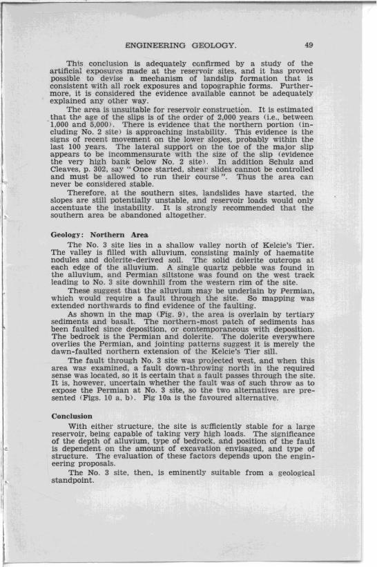
Site No.1: Shaft No.1 Surface to seven feet: Red and Brown clay. A uniform red
colour at surface, becoming mottled red and grey in depth. Contains small quartzite pebbles averaging a quarter of an inch diameter.
Seven feet to nine feet: Brown clay. with grey mottling much stronger. The grey clay occurs as in terconnected seams. averaging half an inch wide. disposed vertically. Contains rounded Quartzite pebbles.
Nine to thirteen feet: On the north. east, and west faces is a brecciated silty mudstone, in angular blocks averaging twelve inches diametel.
The south face is extensively slickensided, consisting of small slivers of silty mudstone averaging half an inch diameter. The slickensides dip in various directions. but strike generally at N UooE .
Thi'rteen feet (water level): In the bottom is a creamy buff (yellow) and white coloured claystone. with rare pebbles of schist and Quartzite.
Note: These slickenslides are interpreted as due to deep deformational shear (landslidingL They differ from Tectonic slickensides in being well developed in very weathered material.
SIte No.1: Shaft No. 2 Thi[. hole was inaccessible, but the material from the hole
consisted of fine-grained sandstone containing plant fragments and plant stem impressions. The carbonaceous material gives a strong smell of sulphuretted hydrogen on fresh surfaces. This sandstone (according to the workmen) lies flat and horizontal on the bottom of t he hole
..
•
"
•
,
I.
ENGINEERING GEOLOGY. 45
The sandstone contains pebbly bands, and bands containing abundant plant fossils. Large erratics of quartzite occur, up to 18 inches diameter, and erratics of a very pyritic black Quartzite.
On weathered surfaces the sandstone has a black, spotted appearance, apparently due to bituminous matter.
Note: These conglomeratic sandstones (P.c) are a freshwater sequence.
Site No.1: Shaft No. 3 Thi.<; shaft was inaccessible, but was apparently sunk in breccia.
t he material consists of angular blocks of-(1) Blue-green sandstone, consisting of pebbles of quartz,
black quartz. and quartzite. averaging a Quarter of an in-:h diameter, in a Quartzose matrix with only a little clay.
(2) Brown, fine-grained. argillaceous siltstone .. (3) A greenish-yellow sandstone. containing quartz pebbles
in a matrix of quartz and clay. Note: It is considered that these rocks are fresh (unweathered)
varietiec;; of rocks exposed in Shaft NO.4.
Site No.1: Shaft No. 4 Surface to nine feet six inches: A breccia of silty mudstone.
which becomes finer-grained and more clayey as the surface is approached (weathering>. At six feet depth is a band of large boulders of brown silty mudstone (with green blotches) about three feet thick. containing large (one inch diameter) rounded quartzite pebbles.
Ninf' feet six inches to thirteen feet six inches: A typical fault breccia. containing angular boulders of brown silty mudstone. which average one inch diameter. but range up to twelve inch diameter.
Underlying this is a thick bed (collection of large blocks) of brown mudstone or siltstone. containing incipient partings, and weathering to a bright orange. It cont&ins occasional blue patches, and small mica flakes. This bed has the bottom at thirteen feet six jnches with the toP at ten feet six inches in the S.W. comer. and at nine feet on the north side.
An important · feature is the occurrence. on the west face. of slickensides, which plunge 50 ° to N laO oE, in a fault plane dipping 55°. striking N 30 °E.
Thirteen feet six inches to fifteen feet six inches: Obscured by timbering.
Fifteen feet six inches to 18 feet four inches: In the S.W. comer occur large blocks of blue sandstone mottled orange. It is a ftnegrained siltstone. free of argillaceous material, with occasional mica .flakes. At sixteen feet it changes abruptly downward to a gritty. iron-stained layer dipping several degrees east. containing small. angular pebbles of clear quartz. Running sands occurred beneath this layer.
46 ENGINEERING GEOLOGY.
In the N.W. corner is a soft clay, containing small sub-angular translucent Quartz pebbles.
Eighteen feet four inches to twenty feet: Boulders of blue grey and orange, banded, fine-grained siltstone. The orange bands look more argllIaceous. The boulders are well jointed. A boulder in the S.W. corner dips horizontal, extends up to eighteen feet four inches. Other boulders range up to two feet diameter, averaging six inches, and are orange with faint traces of blue marks. and in the orange parts carry large muscovite flakes .
Twenty feet to twenty-seven feet: Timbered. Looks like loose sandstone.
Twenty-seven feet to twenty-seven feet nine inches: At twentysix feet nine inches is a soft. puggy blue clay with brown bands, containing fresh muscovite flakes.
At the bottom is a hard, horizontal floor in a blue grey, very flne-grained, argIllaceous siltstone, wit., incipient horizontal parting. It contains rare, sub-angular quartzite pebbles averaging onefifth of an 'inch diameter. It forms a very hard fioor, but frets easily from the wall.
Note: The bottom of the hole is in solid rock (Pa). This is overlain by a fauIt breccia containing sandstone (Pc ?) to fifteen feet six inches, and then argillaceous siltstone (Pg?) to the surface.
The orientation of slickensides may be meaningless, but the occurrence confirms the origin of the b!'eccia by faulting.
Site No.2: Shaft No. 1 This shaft is eleven feet deep to water level. It is sunk entirely
in large sub-angular boulders of dolerite. without marked spheriodal weathering, averaging twelve inches diameter, which occur scattered through a matrix of blue-brown mottled clay which becomes a uniform red colour towards the surface.
The clay contains large amounts of structureless haematite and limonite, and no pebbles of Permian rocks.
The clay does not appear to be a product of normal dolerite weathering.
Site No.2: Shaft No. 2 Total depth is seventeen feet. The surface material is yellow
brown clay, containing a single large sub-angular dolerite boulder at four feet from the surface on the western side. It contains occasional rounded Quartzite pebbles up to 11 feet djameter.
Beneath this the clay is mottled blue and orange, with the blue bands disposed vertically.
The bottom of the hole is in blue-grey clay with orange patches, containing pieces of green shale. Angular fragments of milky quartz are abundant, ranging up to 1 inch diameter, averaging one-tenth of an inch diameter. There are some big dolerite boulders at the bottom of the hole, as well as seams of charcoal.
•
•
•
I~
ENGINEERING GEOLOGY. 47
Note: Both shafts No.1 and No.2 are sunk in dolerite embedded in Permian-derived clays. The original material was probably a mixture of dolerite boulders, iron ore nodules. and Permian fragments. The nature of the matrix formed by decomposition of the Permian has apparently prevented the spheroidal weathering of the dolerite (The iron ore nodules are a product of lateritic weathering of the dolerite, and occur extensively on top of Kelcie's Tier.)
Site No. 2: Hole No. 3 (Borehole) Not inspected.
Site No.2: Shaft No. 4 Surface to eleven feet: Blue and brown mottled clay derived
from bedrock. It is a blue colour, be~oming red towards the surface, and contains no dolerite boulders.
Eleven feet to sixteen feet: Rubble derived from bedrock. Contains a few large boulders of green dolerite up to two feet diameter. between eleven and fifteen feet from the surface.
Sixteen feet to twenty-one feet: Brown shale, weathering to a bright blue or orange. with a good shaley parting, although some large pieces have a conchoidal fracture. Although not unctuous, the rock is largely a claystone. It contains small muscovite flakes. but no pebbles or plant fossils.
Twenty-one feet: The bottom is solid, and dips 35°8, strikes N 90 "E.
Note: The clays of shafts Nos. 1 and 2 are derived from this material. The steep dip is ascribed to the proximity of a shearing surface. and is not regarded as tectonic strain.
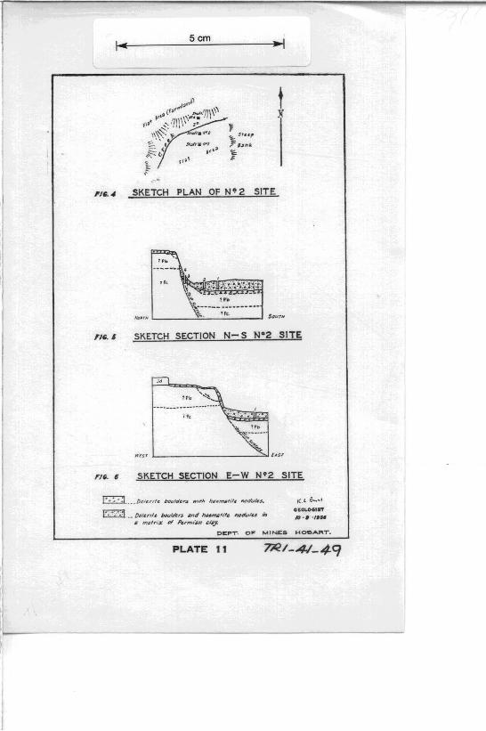
General Slope Development
Combining observations from the two reservoir sites, the slips have developed as outlined in Fig 7 (section).
This adequately explains the observed outcrops, and depends upon the assumptions made as to stratigraphy, and faul t displacement
The initial slope was a fairly steep one, and from the occurrence of fault breCCia. the fault lay some distance back from the edge. The dolerite scarplet lay west of the edge of the slope (Fig. 8a), just as it does today. The claystone or shale underlying the dolerite has very low strength, so that extensive scree overlay the top bench, migrating on a slope of only a few degrees, as it still does today.
As the hill-slope retreated west, the amount of lateral support on the column of rock bounded by the hill-slope on the east, and fault zone on the west. was progressively reduced, so that the slope became unstable. It failed initially by deep deformational shear (Schulz and Cleaves, p. 291 ),
The initial failure was as a pair of slides, the northern one probably first. Both slides were probably slope failures (Terzaghi and Peck, p. 182). but in the northern one the surface of sliding may have intercepted the slope some distance above the foot of the slope.
48 ENGINEE:RING GEOLOGY.
This initial failure created the No.2 site. The second stage (Fig. 8b) concerned the fault zone. Renewed movement occurred, with the heads of the new set of slips coincident with the fault plane, which would be weak in tension. The shear surface thus developed can be differentiated at No, 2 site from tectonic slickensides by the fact that the slide shears are developed in very weathered material (after weathering), whereas tectonic slickensides are destroyed when that stage of weathering is reached.
ThE' alignme:lt of the heads of this second set is responsible for the topographic linear interpreted by Hughes as a fault. The interpretation is correct, but the Unear is a secondary feature , as described. When the second movement~ took place, breccia in the fault plane was unsupported, and tumbled down on to the surface of the slips. This is the situation at No. 1 site.
The third stage of development has been the formation of new minor slips.
It ic; probable that these three stages were, to some extent, contemporaneous, and probably none were catastrophic. The new movements are taking place very slowly.
The surface material at No. 2 site is a mixture of dolerite and Permian boulders. The original scree (dolerite) is overlain by new dolerite which has travelled down the slope from above. admixed with Permian from the exposed back slope. This is illustrated in Figs. 5 and 6. Since the original slide, the dolerite scree originating from the top bench has established a talus slope onto the second bench (containing No.2 site), has migrated across the bench and over the edge. to some extent obscuring the fauIt linear. This scree development is shown as a tongue on Fig. 8a, but the shape was not mapped in detail.
To summarise. the order of event::. (with overlap possible in certain instances) was-
(1) Deep deformational shear to form No. 2 site. with flowage of the toe.
(2) Accumulation on top of No. 2 site of dolerite scree admixed with Permian detritus. at least seventeen feet deep. overlying the original scree.
(3) Renewed movement of the second stage (forming No. 1 Site) with the heads of slumps aligned on the fault to form a topographic linear.
(4) Fault breccia, now unsupported. tumbled down onto No.1 site. covering it to a depth of twenty-seven feet.
(5) New scree development in a localised area has somewhat obscured the fault linear.
The emplacement of fault breccia at No. 1 site is of interest in that. rather than being debris shed from a rising scarp. the breccia moved following the loss of support due to landslip action. In this case the occurrence of breccia does not alone indicate recent tectonsim, a feature of interest in such deposits as the Tertiary breccias of Sandy Bay.
Conclusions: Southern Area On morphological grounds. and the irregular distribution of
rock types on lower slopes. the southern area is a zone of instability. failing by slumping.
•
•
ENGINEERING GEOLOGY. 49
Thi.s conclusion is adequately confirmed by a study of the artificial exposur~s made at the reservoir sites, and it has proved possible to devise a mechanism of landslip formation that is consistent with all rock exposures and topographic forms. Furthermore, it is considered the evidence available cannot be adequately explained any other way. .
The area is unsuitable for reservoir construction. It is estimated that the age of the slips is of the order of 2,000 years (Le .• between 1,000 and 5.000). There is evidence that the northern portion (1neluding No. 2 site) is approaching instability. This evidence is the signs of recent movement on the lower slopes. probably within the last 100 years. The lateral support on the toe of the major slip appears to be incommensurate with the size of the slip (evidence the very high bank below No. 2 site). In addition Schulz and Cleaves, p. 302, say" Once started, shear slides cannot be controlled and must be allowed to run their course ". Thus the area can never be considered stable.
Therefore, at the southern sites, landslides have started, the slopes are still potentially unstable, and reservoir loads would only accentuate the instability. It is strongly recommended that the southern area be abandoned altogether.
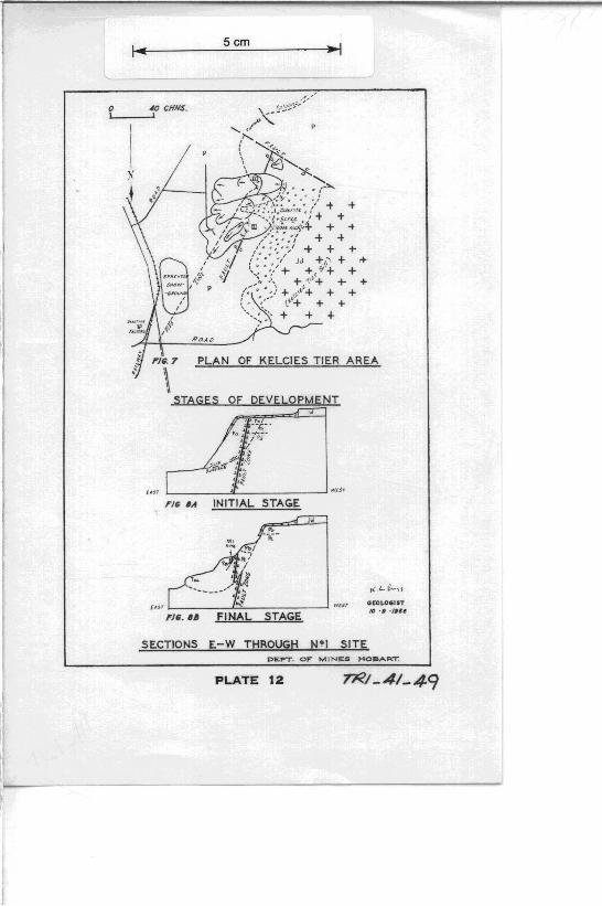
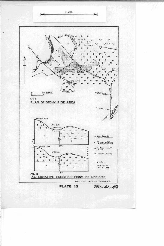
Geology: Northern Area ThE' NO.3 site lies in a shallow valley north of Kelcie's Tier.
The valley is filled with alluvium, consisting mainly of haematite nodules and dolerite-derived soil. The solid dolerite outcrops at each edge of the allUVium. A single quartz pebble was found in the allUVium, and Permian siltstone was found on the west track leading to NO.3 site downhill from the western rim of the site.
These suggest that the alluvium may be underlain by Permian, which would require a fault through the site. So mapping was extended northwards to find evidence of the faulting.
As shown in the map (Fig. 9) , the area is overlain by tertiary sediments and basalt. The northern-most patch of sediments has been faulted since deposition, or contemporaneous with deposition. The bedrock is the Permian and dolerite. The dolerite everywhere overlies the Permian, and jointing patterns suggest it is merely the dawn-faulted northern extension of the Kelcie's Tier sill.
The fault through No. 3 site was projected west, and when this area was examined, a fault down-throwing north in the required sense was located, so it is certain that a fault passes through the s ite. It is. however, uncertain whether the fault was of such throw as to expose the Permian at No. 3 site, so the two alternatives are presented (Figs. 10 a, b). Fig lOa is the favoured alternative.
Conclusion With either structure. the site is svfflciently stable for a large
reservoir, being capable of taking very high loads. The signlflcance of the depth of alluvium, type of bedrock, and position of the fault is dependent on the amount of excavation envisaged. and type of structure. The evaluation of these factors depends upon the engineering proposals.
The No. 3 site. then, is eminently suitable from a geologtcal standpoint.
5cm
l _________________________________ ~
----~,.....-..
FlIi. 1 SKETCH PLAN OF N'I SITE
"
m'.2 SKETCH SECTION E-W N'I SITE
/'Iii.' SKETCH SECTION N-S N~I SITE
G[CLOGIST
10·, ·/IS.
Oe:PT Or MIN£.& HOBART.
PLATE 10
Scm
t }(
SKETCH PLAN OF N" 2 SITE
,'i w \~ 1'. "'------ ----------
No.'-H '-____ \~:!:o"_. __ ,~ ... ___ _I 5lJUTN
,,~. 6 SKETCH SECTION N- S N e 2 SITE
SKETCH SECTION E-W Nq 2 SITE
V~·· · ~.:~~~' _ DC/~rlfe bculthr'$ :lnd h •• mJ/fife ""tlulu in II m;lr i :e (If Pvm/~n cJ"'J'
DEPT. Oft MINES
PLATE 11
!C.L 0 ... .. , GC.OUHi''''
10 ·. 'If"
HOS .... RT.
Scm
o 4() CHNS. I I
+
PLAN OF KELCIES TIER AREA
STAGES OF DEVELOPMENT
1-____ -''-_______ -' W[ir
CIS' 1------''''----::-,-:-::----' F/~. U
SECTIONS E-W THROUGH N~I SITE
Gi!:OL,.OCI'T 10' • • / ...
D~PT. O~ M INES HOBART.
PLATE 12
Scm
o 40 CHNS. L----J
("'-. PLAN OF STONY RISE AREA
+ .Jd + N~J Sife
T + AII""'f,," .. . _------------._-- -' .
---1+ + J'4- • + • • J • • + 1 t--- ------; ---- ---- --'--
~
'~-------+~------~
1'1'-_ '0 ( b )
--I
,. ~rmi.". lilt~""ne • ~c,.."/~I7'I~,.,,1e
G[OLOGIST
If) . • . I''''
ALTERNATIVE CROSS SECTIONS OF W3 SITE DEPT. OF MINE3 HOeART.
PLATE 13 TI'l.I_ 41-4-9