regulation 14 edition – draft july 2019 - benenden
TRANSCRIPT

BenendenNeighbourhood
Development Plan
Regulation 14 Edition – Draft
July 2019

BenendenNeighbourhood
Development Plan
Regulation 14 Edition – Draft
July 2019
1

2
Contents
Foreword .......................................................................................................................................................5
Introduction .................................................................................................................................................7
History .........................................................................................................................................................11
Chapter 1 Landscape and the Environment ...............................................................................13
Chapter 2 Housing Supply and Site Allocation..........................................................................27
Chapter 3 Design and the Built Environment ............................................................................53
Chapter 4 Business and Local Economy.......................................................................................61
Chapter 5 Transport and Infrastructure ......................................................................................71
Glossary of Terms....................................................................................................................................84
Supporting Documents:
IA1 Consultation Feedback
LEA1 SWOT Data Environment (online)
LEA2 Landscape Character assessments (online)
LEA3 Wildlife Summary
LEA4 List of Local Wildlife Sites & SSSI
LEA5 List of Local Green Spaces
LEA6 List of source documents (online)
LEA7 List of Views
LEA8 View assessments
LEA9 Local Green Space assessments
LEA10 Local Wildlife Site maps and citations
LEA11 High Weald AONB Landscape Character Maps (online)
HSA1 Process/background information (online)
HSA2 SWOT Analysis (online)
HSA3 Individual Site Assessments (ISAs)
HSA4 High Weald AONB site assessments
HSA5 Sites submitted in the Call for Sites
HDA1 Survey documentation (online)
HDA2 Conservation Areas Appraisal 2018 (online)
HDA3 Character Area Assessments
HDA4 Summary of materials used in existing housing
HDA5 Existing house styles in the Character Areas
BEA1 SWOT Analysis for Business/Local Economy (online)
BEA2 Employee Survey 2018 (online)
BEA3 Local Business Survey 2018 (online)
BEA4 Note on Benenden Community Shop (online)
TA1 SWOT Analysis for Transport and infrastructure (online)
TA2 Cycle route report (online)
Parish Plan 2015 (online)
AECOM Strategic Environmental Assessment (online)
3

4
Foreword to the Draft Neighbourhood DevelopmentPlan for Benenden 2018 – 2033
The Localism Act (2011) coming into force in April 2012, supported by the National
Planning Policy Framework (2012), reinforced by the Neighbourhood Planning Act
(2017) and the revised National Planning Policy Framework (July 2018 & February
2019), introduced Neighbourhood Planning into the hierarchy of spatial planning in
England, giving communities the right to shape development at local level.
In April 2017 Benenden Parish Council unanimously decided to forge ahead with a
Neighbourhood Plan, enabling the village to have an active role in in�luencing growth
in the parish. Once the application for the designated Neighbourhood Area (the
whole parish) was approved by Tunbridge Wells Borough Council in August 2017,
a Steering Group Committee was set up, led with characteristic strength and
perseverance by Paul Tolhurst, Chair of the NDP Committee.
It is a brave step for a small rural community to take on the challenge of delivering
its own Neighbourhood Plan. Benenden was fortunate in having already prepared a
Parish Plan in 2015, in which the origins of the NDP can be found. Whilst there has
been professional advice and guidance from Community Planner, Jim Boot, and Merit
Thornton Planning and Community Consultants Ltd, as well as support from the
Tunbridge Wells Borough Council planning team, the Plan originates from, and still
remains, very much a grass roots perspective of the way Benenden can develop and
prosper.
Without doubt the biggest challenge for the NDP has been working out how to
manage change by ensuring that development in Benenden will have minimal
impact on a place that holds such an abundance of natural beauty.
The surveys, exhibitions and consultations sought to understand what is important
to residents and stakeholders, and what came through �irst and foremost from this
evidence gathering was the desire to preserve the beautiful open �ields and
panoramic views, as well as protecting the ancient woodland, the special ecological
biodiversity, and the swathes of quintessential High Weald landscape. And of course,
the dark skies. All this as well as providing an adequate and affordable housing
supply for the needs of the elderly or single people and young families alike.
The NDP has worked hard to protect and preserve all of the natural assets that are
dear to the hearts of the villagers by emphasising the use of brown�ield sites. The
result is a Plan that sees housing development as a means of growing and sustaining
our community facilities, supporting the long‐term security of our charities and
stakeholders, allowing a rural parish to evolve whilst preserving all that it holds
close.
The Parish Council and the Neighbourhood Plan Committee would like to thank all
those residents who have taken the time to participate in the process and for
supporting the Plan over its development to date.
Nicola Thomas – Chair, Benenden Parish Council – July 2019
5
6
Introduction
Benenden’s Neighbourhood Development Plan
Vision
The Parish of Benenden in 2035 will be a thriving, peaceful and rural place to
live, work and rest. Its village feel and historic beauty will have been preserved
through sympathetic and managed growth. We will have retained our existing
major employers. Farming and other small businesses will be encouraged. We
will offer everyone the chance to be part of an inclusive and vibrant community.
We will support:
Locally led development with a mix of well‐designed, high quality, sustainable
and affordable housing alongside other homes that enhance the existing built
and natural environment.
Infrastructure enhancements; managing traf�ic growth, improving connectivity,
and enhancing community facilities for health and recreation.
A balanced community; with small businesses and home working providing
employment; pubs, clubs and shops providing an active social scene, and quality
of life retained through existing public green spaces, footpaths and dark skies.
Background
Benenden parish is some 2,600 hectares. The parish comprises three main
settlements, Benenden, Iden Green, and East End (dominated by Benenden
Hospital), and a number of smaller hamlets or ‘dens’. In 2011 there were 1,820
residents (excluding Benenden School boarders), in 840 homes.1 Benenden is
broadly equidistant (35 – 45 minutes’ drive) from Maidstone, Ashford, Hastings, and
Tunbridge Wells. The parish is not well served by public transport: the nearest train
station (Staplehurst) is 7 miles north with no direct connecting bus service.
1 National Census 2011
7
Benenden parish is deeply rural. Even in the centre of Benenden housing density
averages less than 10 dwellings per hectare (dph). Nearly 15% of housing is Listed,
and the centres of Benenden and Iden Green are designated Conservation Areas.
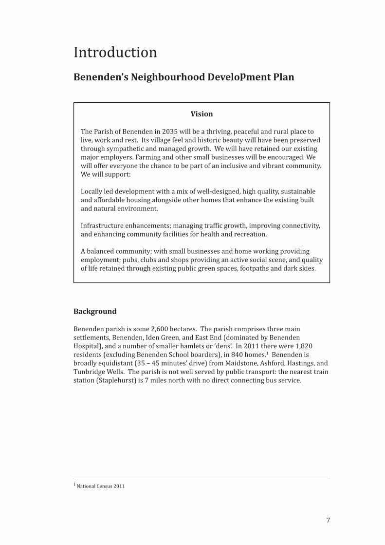
Over 98% of the parish lies within the High Weald Area of Outstanding Natural
Beauty (AONB), south of Benenden Hospital (Fig. 1). Tourism, leisure and
hospitality, and more traditional rural businesses such as farming and forestry,
dominate local employment, alongside Benenden School and Benenden Hospital.
The Neighbourhood Planning Process
Successive UK Governments have failed to meet the growth in demand for housing.
The Government has a current target to build 300,000 homes each year and has
introduced changes to planning policies and regulations to drive up the pace of
building. Amongst the changes was the introduction of the Neighbourhood
Development Plan2 (NDP). These enable local communities more control, within
national guidelines, over where, how and when new housing is built.
Benenden began its neighbourhood planning journey in spring 2017, when the
Parish Council voted to join the growing number of neighbourhoods participating in
the planning process through the creation of an NDP. Later that year the Parish
Council approved the formation and membership of the Steering Group, and the
team were in a position to commence work. The Steering Group came from across
the parish, and at the �irst village workshop volunteers were secured for Working
Groups for each of the core themes. Areas covered are: Landscape and the
Environment, Housing Supply and Allocation, Design and the Built Environment,
Business and the Local Economy and Transport and Infrastructure.
2 Neighbourhood Plans were initiated in the Localism Act 2011 and reinforced in the National Planning Policy
Frameworks 2017 and 2018.
Fig. 1 Map of Benenden’s location in relation to main towns
8
Over winter 2017, and into spring 2018 workshops were held in the village to gather
the parish’s thoughts and views on how Benenden should evolve over the next 15
years. With this input on overall direction, each Working Group was guided through
local and national planning policies and guidelines by our advisers and with the help
of TWBC. A huge amount of data has been gathered: the Working Groups assessed
sites, walked the �ields and footpaths of Benenden, surveyed local businesses,
plotted views and suggested local green spaces, and counted weatherboarding, tiled
roofs, and architectural features. The Working Groups built on the 2015 Parish Plan,
and the guiding hand of the Parish Council has helped the Steering Group to shape
our approach.
Plan Content
Chapter 1: Landscape and the Environment documents the beauty of Benenden
Parish, a very signi�icant part of the High Weald AONB. It has highlighted important
views and designated Local Green Spaces (LGS) of importance in the parish and
demonstrated how the NDP team propose to protect and enhance the footpaths,
views, Local Wildlife Sites (LWS), ancient woodland and �ield systems, so that they
can be enjoyed by both visitors and residents.
Chapter 2: Housing Supply. An appropriate indicative number of new dwellings for
the parish over the life of the Plan (up to 2033) of around 100 plus existing
permissions for 36 new homes was agreed with TWBC following a detailed
workshop with them in summer 2018. In the light of new provisions in the 2018
revised NPPF the Steering Group recommended that the Parish Council agree to
allocate sites for new dwellings rather than give the �inal decisions to TWBC.
Planning to meet the agreed indicative number for new homes and allocating sites
gives signi�icantly greater weight to the Benenden NDP and greater certainty to the
community. The Housing Supply chapter includes the details on the sites, the
selection process, and site speci�ic policies.
Chapter 3: Housing Design and the Built Environment describes how the buildings
and their setting make each of the core settlements in the parish different. It sets
out the approach to design that �its best with the architectural look and feel of
homes in Benenden, Iden Green and East End; what sort of developments might be
appropriate, and how they might help to sustain communities and the immediate
environment.
Chapter 4: Business and the Local Economy sets out policies to support sustainable
growth for local businesses while retaining the essential rural and historic character
of the parish. Farming and forestry have been increasingly automated with fewer,
permanent, full‐time jobs, but these industries continue to shape the landscape of
the High Weald. Rural businesses are changing, with increased focus on hospitality,
tourism and leisure: the rural character of our parish is critically important to these
employers. Data suggests that homeworking is becoming increasingly important.
Chapter 5: Transport and Infrastructure notes that in 2019, in the �ifth biggest
economy in the world, there is still no effective mobile signal in the centre of the
main settlements. New building will result in more people and in particular more
traf�ic; and here the NDP team set out proposals on mitigating the impact of that
growth. The chapter also proposes actions to improve sustainable transport and to
facilitate a move to electric vehicles in response to climate change.
9

Each Chapter of the Plan contains Policies and Projects designed to support the
aspirations and requirements for the development of the community of Benenden:
Policies can be generic or site speci�ic proposals that must be considered by
developers or landowners when they create planning proposals;
Projects are speci�ic proposals that could be funded by developer contributions
(Section 106), or by the Community Infrastructure Levy or by grants/individuals.
They may be delivered in partnership with other organisations such as Kent County
Council, or Tunbridge Wells Borough Council, the Parish Council, businesses or
individuals. When the Neighbourhood Plan is made and Tunbridge Wells have
adopted a CIL Policy (proposed 2020), the Parish Council will receive 25% of CIL
contributions by right.
Next Steps
In February 2019 the NDP team took the opportunity to share a �irst draft informally
with the parish and seek early feedback. This also allowed for ‘scoping’ consultation
with the statutory agencies: the Environment Agency, Natural and Historic England
and the AONB Unit. This Regulation 14 Draft takes account of that feedback and is
accompanied by a Strategic Environmental Assessment of the Plan and its Policies.
Once the Regulation 14 phase is concluded and the Plan reviewed in the light of the
feedback, a Second or Submission Draft will be produced. This will be subject to a
further phase of consultation, by TWBC, and then be reviewed by an Independent
Examiner. When that phase is complete and any required changes made the parish
will have a chance to vote on the Plan. If the referendum supports the Plan (a simple
majority) it will become part of the overall Development Plan for the area and carry
the same force in planning law as TWBC’s Local Plan.
Paul Tolhurst, Chair Benenden NDP
Supporting Documents for Introduction:
Supporting Document IA1 – BNDP Rough Draft Consultation Feedback
10
History
Benenden is a medieval village situated on the edge of the High Weald AONB.
Settlement in the parish dates back to the Roman period. The landscape of Benenden
village and the surrounding parish has been shaped by the processes of human
interaction with the environment over thousands of years to create the historic
landscape character we see today. A Bronze Age palstave axe was found at the site of
Benenden Hospital indicating human activity here over 3000 years ago. The hospital
lies close to an old routeway following one of the high ridges that characterise this
part of the High Weald.
Evidence at Farningham Farm in the adjacent parish of Cranbrook has been found of
Roman ironworking organised by the “Classis Britannica” or the Roman Fleet. There
is recorded evidence of a Roman settlement at Hemsted the junction of two Roman
Roads, one from Rochester and one from Ashford the Romano British settlement at
Westhawk Farm to Hastings. However, it was in the early medieval period [AD 450 –
AD 1066] that the landscape of Benenden began to take on its present character.
The Weald was divided into large ‘commons’ attached to Jutish agricultural estates in
north and east Kent. The commons were used for seasonal grazing but were
gradually broken up into dens or swine pastures attached to the parent manors on
the periphery of the Weald. Eventually, temporary farmsteads became permanent
ones taking their names from the ‘dens’ and enclosing �ields from the swine pastures
in order to cultivate. The name Benenden, like nearby Biddenden, is a ‘folk‐name’
meaning the swine pasture for the Bynni people (Wallenberg 1934, 347). These folk
names represent an early phase of Saxon settlement in the Weald probably 6 to 8th
century AD (Witney 1976, 70‐71). Benenden belonged to the Manor of Bilsington in
the common of the lathe of Lympne. Hemsted (or the ‘homestead’ Wallenberg 1931,
341) lay within the common of the lathe of Wye. Again this is an early recorded den
and indicating early established settlement, possibly a continuation of the Roman
settlement on the junction of two Roman roads. The division between the lathes was
continued when the lathes were divided into hundreds with the boundary between
that of Rolvenden and Selbrittenden traversing the area south of the ridgeway road.
The den of Benenden (which developed into the village of Benenden and its
immediate environs) is thought to have been a large swine pasture located in what
was to become the middle of the parish and centred on the cross way between the
east‐west ridgeway route (along which the medieval village developed) and the
north‐south Rochester to Hastings Roman Road (Pollard and Strouts 2005, 57). A
church, recorded in Domesday Book, was founded in the den of Benenden before
1066 to provide spiritual welfare to the scattered farmsteads across the parish.
Before 1066 it was held by a Saxon Osgeard from King Edward. The fact that
Benenden Manor is a rare example of a Wealden settlement recorded in Domesday
suggests that it was already fairly independent of its parent manor on the outskirts
of the Weald and thus well‐settled. Small farmsteads would have been established as
the land was enclosed from the wood and wood pasture. The medieval village of
Benenden grew up around the church which became the focus for ecclesiastical and
secular activity, in particular fairs and markets. The church was appropriated as part
of the possessions of nearby Combwell Priory (in Goudhurst) before 1370 (Hasted
1797, 182).
11
Edward Hasted, an early commentator on the Kent landscape describes the parish as
being situated mostly on high ground, much more so than most of the adjoining
country, which consequently makes it more pleasant (Hasted 1797, 173). He also
refers to this junction of the Roman Road with the ridgeway route as ‘Hagner’s
Corner’.
In the medieval period the village of Benenden comprised a small scatter of
farmsteads and cottages, along the ridgeway route, with a cluster around the church
and green. Apart from some estate buildings and modern small‐scale in�illing, the
village of Benenden has remained little altered over the centuries. To the west of the
village is the old Manor of Benenden. In the twelfth century it became the practice to
construct water‐�illed moats around the main manorial farmstead and both the
manor for Benenden and Hemsted were moated. Most were not only a status symbol
but were constructed as a supply of �ish as well as a form of local defence, during
periods of political instability.
Surrounding these small farmsteads were the �ields, paddocks, meadows and woods.
To the south of the ridgeway road these �ields have remained fairly intact, but to the
north the gentri�ication of Hemsted Manor, begun with the enclosure of the deer
park in the Tudor period followed by the landscaping and enlargement of the park in
the eighteenth and nineteenth century, has swept away the medieval �ields to replace
them with a designed landscape.
The history of Iden Green is less certain. Iden Green is thought to have developed
around existing farmsteads which developed as part of the medieval cloth industry.
In contrast to Benenden, many of the buildings are modest in scale and they are
thought to have been occupied by cloth workers. In terms of population it was at one
time the larger settlement. Like Benenden, the village has a linear settlement form
located on elevated land built up sporadically along two crossing roads.
Above: an extract from the High Weald AONB Unit’s Woodside Farm study and herereproduced with their permission
East End, once also known as East Ridden, remained a small and scattered
settlement until the fresh air and rural setting saw the arrival of Benenden Hospital.
It was opened in 1907 by the National Association for the Establishment and
Maintenance of Sanatoria to treat postal workers suffering from tuberculosis. The
Association was a consortium founded by trade unions and friendly societies and the
Benenden Healthcare Society (formerly the Post Of�ice and Civil Service Sanatoria).
With cases of TB declining, the Benenden Healthcare Society expanded treatment to
include chest complaints and cancer and shortly afterwards an operating theatre,
surgical wards and an x‐ray department were introduced and today is a state‐of‐the‐
art modern private hospital.
12
1. Landscape and the Environment
Objective
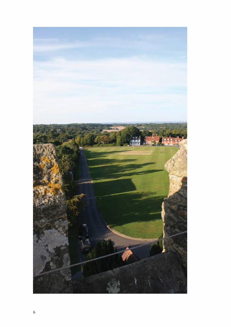
To protect valued environmental assets and support our peaceful, rural, way oflife. Recognising that the parish of Benenden is one of the most unspoilt partsof the High Weald AONB, our policies will enable villagers and visitors tocontinue to enjoy important Local Green Spaces, footpaths, views and darkskies.
Introduction
The Working Group built on the Benenden Parish Plan 2015 written by a Steering
Group of residents and endorsed by the Parish Council in 2015 following
widespread consultation in the community and is a key supporting document for
this Neighbourhood Development Plan. The Parish Plan Environment Chapter starts
(p. 17) with highlights from the village survey that informed the writing of the 2015
Plan:
In the village survey 218 people said they walk a local footpath every week, with afurther 67 walking a route at least monthly which is a signi�icant proportion of the428 who responded to the questions on footpaths in the survey.
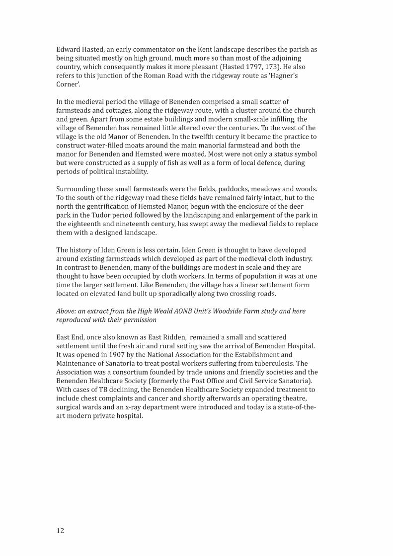
Ancient Woodland
13
The introduction to the Environment chapter of the Parish Plan continues (p. 17):
The village is fortunate to be set within the High Weald Area of Outstanding NaturalBeauty (AONB) one of 46 such designated areas in the UK. Within the parish thereare 66 footpaths covering 27.5 miles, in addition to this there are numerous trackswithin Hemsted Forest which are used and enjoyed by residents and visitors. TheHigh Weald Landscape Trail passes through the village and brings many walkers tothe area. Route 18 of the National Cycle Network which runs 61 miles fromCanterbury to Tunbridge Wells, passes through the parish along some of the quieterlanes. The lanes around the parish have previously been recognised as beingimportant in the Tunbridge Wells Supplementary Planning Guidance in terms ofvisual amenity, nature conservation, historical/archaeological importance andrecreational amenity value.
In terms of new building the Parish Plan states (p. 19):
Careful consideration should be observed when planning where new buildingsshould be located, brown�ield sites should be used wherever possible.
51.5% of respondents to the survey said they would be ‘willing to help with nature
conservation and footpaths’, the largest group of respondents.
Thirty‐six residents and stakeholders attended the Landscape and Green
Environment Workshop on 13th January 2018 which followed on from the original
Visioning Workshop on 28th October 2017. After an introduction from Arianwen
Neve, a member of the Landscape and Green Environment Working Group, on some
of the key environmental facts about the parish and its landscape, a number of topics
were discussed using SWOT analysis (Strengths, Weaknesses, Opportunities and
Threats ‐ see Supporting Document LEA1) including:
• Routeways, footpaths, bridleways and public open spaces
• Ancient woodland, veteran trees, hedgerows and �ield patterns
• Bio‐diversity – mammals (e.g. dormice), invertebrates (e.g. butter�lies) and
�lora (e.g. bluebells, buckler ferns etc.)
• Views, dark skies and tranquillity
• Streams, ponds, ditches and �looding
• Developer contributions to conserving wildlife
After discussion of these points, and subsequent consultation with the
Neighbourhood Plan Steering Group and the Parish Council, the objective for the
Landscape and Environment Working Group was agreed as representing the views
of many parishioners.
Process
The Working Group started surveying Benenden’s natural assets in 2017 and, after
training from of�icers from TWBC, identi�ied the landscape characteristics (see
Landscape Character Assessments Supporting Document LEA2), footpaths,
environmental and historical features, Local Green Spaces (LGS), Local Wildlife Sites
14

(LWS) and notable views. The Working Group walked all the footpaths, identifying
key views, environmental and other features and met regularly to discuss their
�indings.
The initial �indings were shared with the community at the April 2018 exhibition in
the Village Hall, and subsequently through the Parish Magazine and further
engagement with the local residents in September 2018 at the Iden Green Pavilion.
The Working Group was given advice and training on aspects of the NDP by external
specialists, especially in relation to policies, identi�ication of Local Green Spaces,
notable views and their documentation. Additional guidance and information was
sought from and provided by Tunbridge Wells Borough Council (TWBC),1 the High
Weald AONB Unit, Natural England, Kent Wildlife Trust, RSPB, the Woodland Trust
and the Kent & Medway Biological Records Centre.
Policies
Landscape
1.1 The landscape is largely characterised as Wooded Farmland.2 The undulating
ridges and valleys of the parish de�ine Benenden’s special combination of small
irregular �ields and wooded gills, panoramic views and sheltered, hidden, ancient
sunken ways. The landscape still re�lects many of its medieval origins in its �ield
boundaries, numerous footpaths and historic routeways. Much of the pasture is
unimproved and together with large areas of ancient woodland fosters a rich
spectrum of bird, animal and insect species. The absence of arti�icial lighting in the
villages of Benenden and Iden Green ensure that dark skies prevail, supporting and
maintaining residents’ connection to the natural environment. Being so distant from
any large conurbations, major roads or mainline railway stations has kept Benenden
distinct and unspoilt by creeping development. This is re�lected in the parish
predominately being designated as part of the High Weald AONB.
1.2 Benenden is particularly rich in views because of its undulating geography and
the landscape of ancient woodland juxtaposed with smaller irregular �ields and
pockets of traditional buildings. This has consequences for planning decisions as
developments can be seen for long distances and is a large component of Benenden’s
environmental signi�icance.
1.3 In the process of walking the parish a number of the many outstanding views
were identi�ied and recorded. These were publicised at the NDP meetings and in the
Parish Magazine where any additional suggested views were sought. These are
identi�ied in the map overleaf (Fig. 1).
1 TWBC Local Green Space Designation Methodology ‐ September 2018
2 Landscape Character Assessment 2017 ‐ LCA 6 p. 64; TWBC Historic Environment Review ‐ 2.4.2 p. 20
15

Reference DescriptionP1 Panoramic views towards Sandhurst, from Footpath 338
P2 Panoramic views towards Iden Green from Iden Green Road,
Hilly Fields green space
P3 Panoramic views from ridgeline south across Weald, visible from
multiple points along Footpath 325, 327, 328
P4 Set of westerly views along Stepneyford Lane
P5 Panoramic views north and south from Halden Lane
P6 Panoramic view of Benenden village green, mentioned in 2005 TWBC
Conservation Area Appraisal
V1 Looking south / south‐west from footpath from Hinksden Road to
Tongs Wood
V2 Looking south‐east from Parsonage Wood from track north of
Coldharbour Lane
V3 Looking south from Footpath 313
V4 Looking west from Footpath 316
V5 Looking north from Coldharbour Road
V6 Looking north‐west towards Cranbook, and across Dibley Shaw from
High Weald Landscape Heritage Trail
V7 Looking south across historic, designated parkland from Benenden
School from Footpath 315
V8 Looking south‐west from Walkhurst Road across to village and
church
V9 Looking north‐west from Walkhurst Road
V10 Looking north‐east from Frogs Hole Lane near Bishopsden Farm
V11 Looking west from Footpath 362 towards Dingleden
Fig. 1 Views
16
V12 Looking south‐east from Footpath 333, mentioned in 2005 TWBC
Conservation Area Appraisal
V13 Looking south‐east from Iden Green Recreation Ground, mentioned
in 2005 TWBC Conservation Area Appraisal
V14 Looking north from Chapel Lane towards Benenden, mentioned in
2005 TWBC Conservation Area Appraisal
V15 Looking north towards Benenden from Iden Green Road, mentioned
in 2005 TWBC Conservation Area Appraisal
V16 View south from east side of East End towards Bexhill Farm
V17 Looking north‐west from Goddards Green Road across to
Hemsted Forest
Fig. 2 View south from Footpath 327
Fig. 3 View south from Hilly Fields
Fig. 4 View south east from Pullington
17

1.3.1 The High Weald AONB Management Plan identi�ies the need to identify and
protect views (see Supporting Document LEA7) as part of its objectives.3
Policy LE1 Ensure that the identi�ied special views are not adversely impacted
by inappropriate development either inside the parish or immediately
outside it.
Developers should demonstrate that proposals will not have an adverse
impact on these views.
Open Space and recreation
1.4 The parish features many aspects that support the health and wellbeing of its
residents and visitors. From its clean air to its beautiful natural surroundings,
Benenden is an ideal area for outdoor activities such as walking, cycling and riding
as well as sports such as cricket, bowling and tennis. There is speci�ic provision for
these through:
‐ An extensive network of footpaths throughout the parish.
‐ 2 tennis courts in Iden Green, 2 tennis courts in East End.
‐ The cricket pitch on Benenden Village Green.
‐ The bowling green alongside Benenden Village Hall.
‐ A football pitch on the Recreation Ground opposite Benenden Village Hall.
‐ The playing �ield (Glebe Field) at Benenden used for village activities and by
the local Primary school, and the Recreation Ground at Iden Green, both of
which support a range of community outdoor activities including fairs, jazz
concerts, �irework display and rounders matches.
3 The High Weald AONB – Management Plan 2019‐2024 ‐ Objective OQ4 Page 63
Fig. 5 View of the church from Walkhurst Road
18
‐ Benenden School, which is supportive of the local community, and has
extensive facilities which it often makes available such as for the well‐known
Benenden Tennis Tournament which takes place every year supporting local
charities and good causes.
‐ Play areas in Iden Green and Benenden.
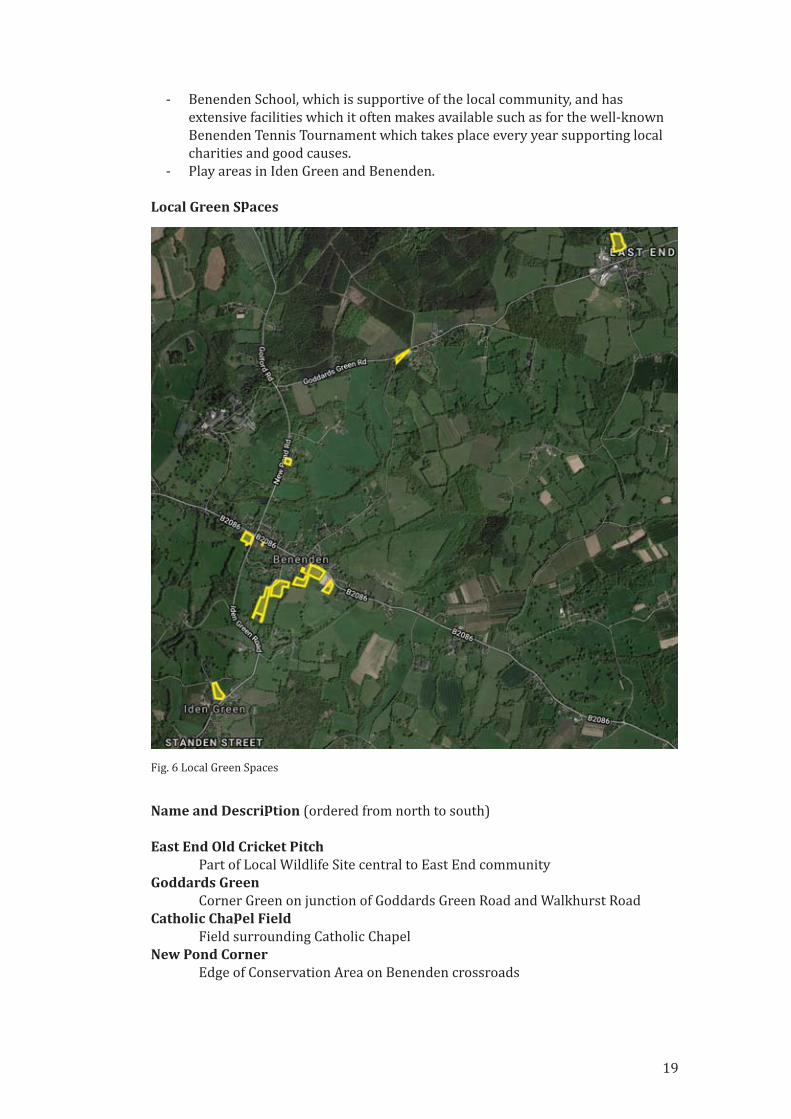
Local Green Spaces
Name and Description (ordered from north to south)
East End Old Cricket PitchPart of Local Wildlife Site central to East End community
Goddards GreenCorner Green on junction of Goddards Green Road and Walkhurst Road
Catholic Chapel FieldField surrounding Catholic Chapel
New Pond CornerEdge of Conservation Area on Benenden crossroads
Fig. 6 Local Green Spaces
19
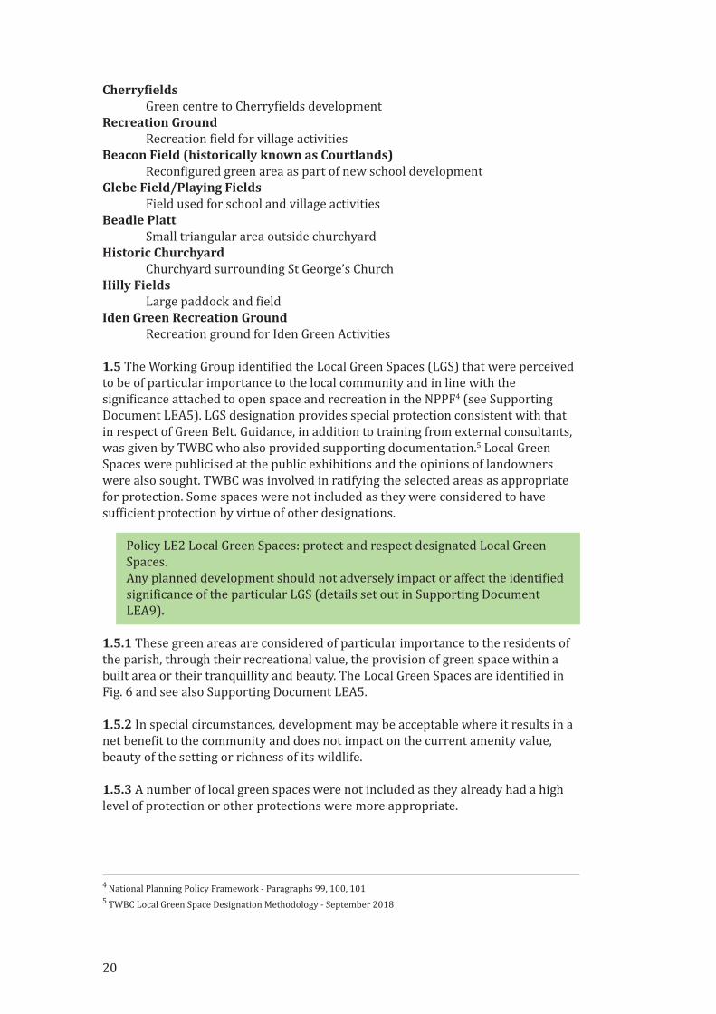
Cherry�ieldsGreen centre to Cherry�ields development
Recreation GroundRecreation �ield for village activities
Beacon Field (historically known as Courtlands)Recon�igured green area as part of new school development
Glebe Field/Playing FieldsField used for school and village activities
Beadle PlattSmall triangular area outside churchyard
Historic ChurchyardChurchyard surrounding St George’s Church
Hilly FieldsLarge paddock and �ield
Iden Green Recreation GroundRecreation ground for Iden Green Activities
1.5 The Working Group identi�ied the Local Green Spaces (LGS) that were perceived
to be of particular importance to the local community and in line with the
signi�icance attached to open space and recreation in the NPPF4 (see Supporting
Document LEA5). LGS designation provides special protection consistent with that
in respect of Green Belt. Guidance, in addition to training from external consultants,
was given by TWBC who also provided supporting documentation.5 Local Green
Spaces were publicised at the public exhibitions and the opinions of landowners
were also sought. TWBC was involved in ratifying the selected areas as appropriate
for protection. Some spaces were not included as they were considered to have
suf�icient protection by virtue of other designations.
Policy LE2 Local Green Spaces: protect and respect designated Local Green
Spaces.
Any planned development should not adversely impact or affect the identi�ied
signi�icance of the particular LGS (details set out in Supporting Document
LEA9).
1.5.1 These green areas are considered of particular importance to the residents of
the parish, through their recreational value, the provision of green space within a
built area or their tranquillity and beauty. The Local Green Spaces are identi�ied in
Fig. 6 and see also Supporting Document LEA5.
1.5.2 In special circumstances, development may be acceptable where it results in a
net bene�it to the community and does not impact on the current amenity value,
beauty of the setting or richness of its wildlife.
1.5.3 A number of local green spaces were not included as they already had a high
level of protection or other protections were more appropriate.
4 National Planning Policy Framework ‐ Paragraphs 99, 100, 101
5 TWBC Local Green Space Designation Methodology ‐ September 2018
20
These green spaces are:
Name and Reason
Benenden Village GreenDesignated as a registered village green.
Benenden School ParkIn part has ancient woodland protection and in whole an Historic Park
and Garden designation.
The Grange GroundsSuf�iciently protected by multiple TPOs and Historic Park and
Garden designation.
Jubilee PlantationMore appropriate for TPO protection.
Footpaths
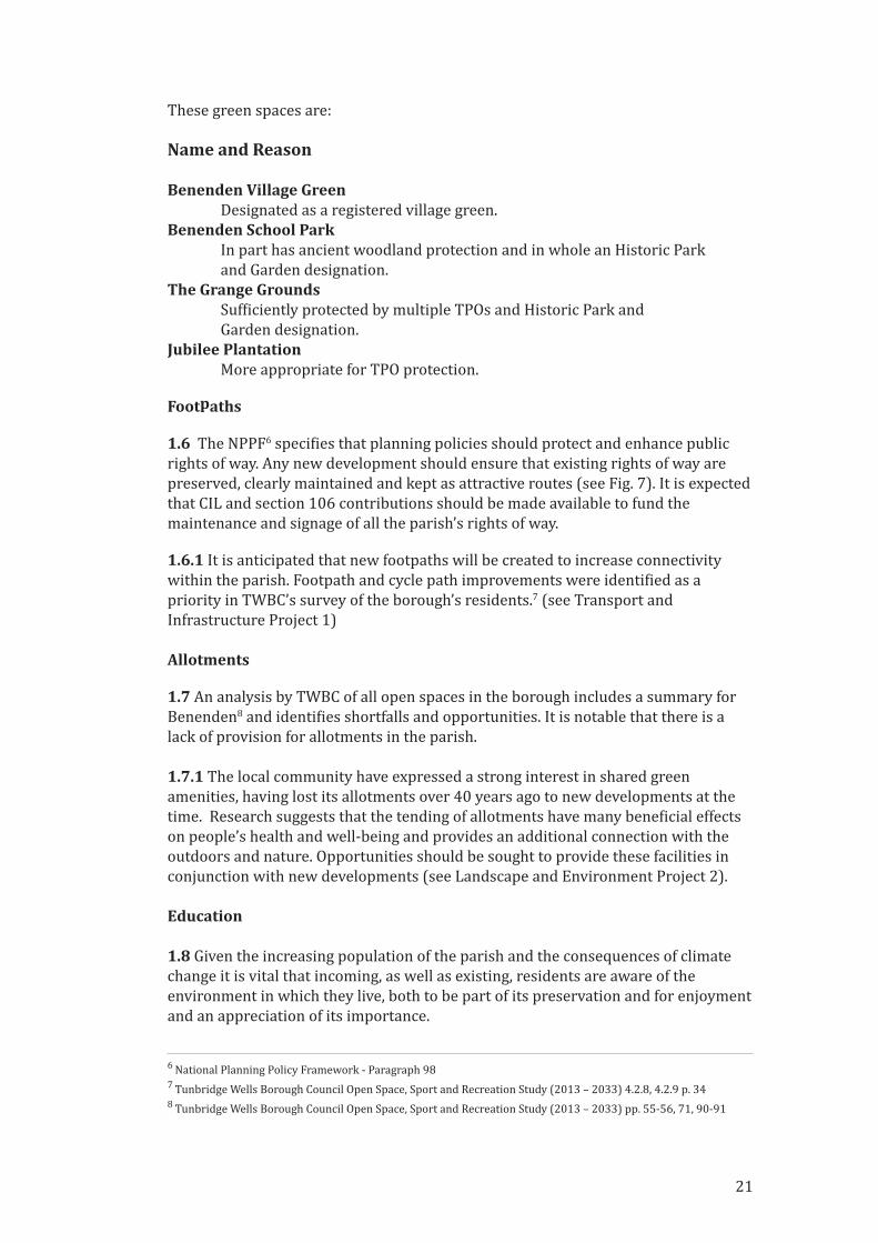
1.6 The NPPF6 speci�ies that planning policies should protect and enhance public
rights of way. Any new development should ensure that existing rights of way are
preserved, clearly maintained and kept as attractive routes (see Fig. 7). It is expected
that CIL and section 106 contributions should be made available to fund the
maintenance and signage of all the parish’s rights of way.
1.6.1 It is anticipated that new footpaths will be created to increase connectivity
within the parish. Footpath and cycle path improvements were identi�ied as a
priority in TWBC’s survey of the borough’s residents.7 (see Transport and
Infrastructure Project 1)
Allotments
1.7 An analysis by TWBC of all open spaces in the borough includes a summary for
Benenden8 and identi�ies shortfalls and opportunities. It is notable that there is a
lack of provision for allotments in the parish.
1.7.1 The local community have expressed a strong interest in shared green
amenities, having lost its allotments over 40 years ago to new developments at the
time. Research suggests that the tending of allotments have many bene�icial effects
on people’s health and well‐being and provides an additional connection with the
outdoors and nature. Opportunities should be sought to provide these facilities in
conjunction with new developments (see Landscape and Environment Project 2).
Education
1.8 Given the increasing population of the parish and the consequences of climate
change it is vital that incoming, as well as existing, residents are aware of the
environment in which they live, both to be part of its preservation and for enjoyment
and an appreciation of its importance.
6 National Planning Policy Framework ‐ Paragraph 98
7 Tunbridge Wells Borough Council Open Space, Sport and Recreation Study (2013 – 2033) 4.2.8, 4.2.9 p. 34
8 Tunbridge Wells Borough Council Open Space, Sport and Recreation Study (2013 – 2033) pp. 55‐56, 71, 90‐91
21
1.8.1 Education about the natural environment is important in ensuring that the
community itself appreciates the value and importance of the natural world and is
actively involved in its long term care. Funding should be provided by developers to
meet this aim (see Landscape and Environment Project 3).
Peaceful and Rural Nature
1.9 The rural nature of Benenden is a fundamental feature identi�ied in the 2015
Parish Plan and encompassed in the overall vision of this NDP. New development
should not impact this important and distinctive characteristic of the parish. Keeping
skies dark and the overall environment peaceful are key to the rural ‘feel’ of the
parish. The High Weald AONB Management Plan includes proposed action for dark
sky‐friendly lighting and for general noise intrusion.9
1.9.1 There is minimal arti�icial lighting in the parish. New developments should not
introduce inappropriately bright lighting at night over paths/footways or other
areas within the site. Arti�icial lighting at night creates light pollution and is
detrimental to wildlife and to the rural nature of the parish. ‘Smart’ lighting or
lighting on short timing devices are more environmentally friendly and would also
be more ef�icient as suggested by the High Weald AONB Management Plan.10
TWBC’s Core Strategy emphasises the need to limit and reduce light pollution.11
See Policy HD5.
9 The High Weald AONB – Management Plan 2019‐2024 ‐ Objective OQ4 p. 63
10 The High Weald AONB – Management Plan 2019‐2024 ‐ Objective G3 p. 29.
11 Tunbridge Wells Borough Local Development Framework ‐ June 2010 5.120 p. 44
Fig. 7 Footpaths in the parish
22
1.9.2 In addition to insulation up to the highest environmental standards, the design
of new developments should incorporate materials to reduce the transference of
airborne sound. Use of planting, vegetation and thoughtful design should be
incorporated to help minimise the transmission of noise outside private areas (see
Policy HD3d). TWBC’s Core Strategy emphasises the need to minimise noise with
particularly attention to the High Weald.12
Policy LE3 Developers should demonstrate that the design of the houses and
their surroundings minimises transmission of sound outside their own
boundaries. Developments should encourage tranquillity and incorporate
strategies to facilitate this. See also Policy HD3d.
Environmental aspects of new development
1.10 The parish’s rural environment of ancient woodland, unimproved pasture,
wooded gills, streams and ponds provides a favourable habitat for rare species of
animal and plant. Notable recorded sightings are listed in Supporting Document
LEA3. The parish is also part of the Linkhill Turtle Dove‐Friendly Zone which is an
important initiative to reverse the catastrophic decline in the species.
1.10.1 There are ten Local Wildlife Sites (LWS) in the parish and one Site of Special
Scienti�ic Interest (SSSI), Parsonage Wood, (see Supporting Document LEA4)
highlighting the wildlife‐rich environment. The noted rich lichen �lora are a
particular feature indicative of the clean, unpolluted air in the parish.
1.10.2 The NPPF emphasises the importance of the natural environment.13 It is
especially important that new development pays special attention to this in an area
so rich in biodiversity. TWBC provides guidance notes for planning applications in
relation to Landscape and Nature Conservation and states that development should
‘seek to protect and enhance the biodiversity of the site and the surrounding area.’14
Policy LE4 Environmental site surveys: sites must be surveyed prior to
development to ensure important natural features are identi�ied, and those
requiring protection, maintained and preserved during construction and
thereafter.
1.11 Before any development starts, a formal independent survey should be carried
out by an independent expert to assess important environmental features.
Developers will be expected to take these �indings into account.
Policy LE5 Minimise the environmental impact of construction. Developers
should include plans to minimise the impact to existing trees, hedgerow and
other natural resources during construction.
1.11.1 The environmental site survey carried out as a condition of Policy LE4 should
be used to identify the features required to be protected during construction and
which must be taken into account during the planning process. The plans should
include third party monitoring during the build phase to ensure the policy is met.
12 Tunbridge Wells Borough Local Development Framework ‐ June 2010 5.121 p. 44
13 National Planning Policy Framework – Chapter 15, Paragraphs 170‐183
14 Landscape and Nature Conservation Guidance Notes for Applicants August 2002 – Part 1 p. 1
23

Policy LE6 Buffers must be provided to protect habitats. Developers should
strive to achieve a buffer of 50m to protect ancient woodland, local wildlife
sites and other areas of natural importance, and at no time should the buffer
be less than 15m except where existing physical restrictions make this
unfeasible. The buffer itself should be kept as a natural wildlife haven and not
used as an amenity.
1.11.2 The Woodland Trust suggest a minimum buffer of 50m.15 Natural England
state a lower minimum of 15m.16 Natural England also state that the buffer zone
should be a semi‐natural habitat itself and speci�ically should not include gardens,
access roads or sustainable drainage.
Policy LE7 On‐going environmental maintenance for all new housing
developments in the parish. Developers should include an on‐going
management plan for wildlife‐related aspects of the site and provision for its
funding. The development should incorporate rules that include provision for
inspection and oversight by TWBC or its representatives.
1.11.3 Developers will be expected to include plans for the long‐term care of the
features which encourage wildlife. This could include maintenance of woodland
which remains on an undeveloped part of the site, new verges which encourage
wild�lowers or speci�ic habitat features within the new development. TWBC’s Green
Infrastructure Planning document highlights the need for long‐term management
and its �inancing.17
Policy LE8 Developers should demonstrate that best practice sustainable drainage
will be incorporated into any development before construction commences.
1.12 Drainage should be structured in such a way as not to overwhelm the local
ecosystem with the quantity and quality of the water emanating from any new
development. In order to minimise the impact on the wildlife and plant habitats,
it may be necessary to pump water off site and it is expected that developers will
provide independent surveys in order to satisfactorily achieve this aim.
Policy LE9 Features to encourage wildlife. All new developments should
include features within the development which are sympathetic to Benenden’s
character and its wildlife. See also Landscape and Environment Project 1.
a) Plans for new developments should include elements that encourage
wildlife and plants.
b) Use native hedgerow species for boundaries in preference to walls or
fencing (see also Policy HD4). Insect and bee‐friendly planting should also
be encouraged.
c) Ensure common areas, boundaries and verges on new developments are
wildlife rich, not neatly mown.
d) Include speci�ic elements such as bird boxes, bat roosts, hedgehog
highways to encourage wildlife.
15 Planner’s Manual for Ancient Woodland and Veteran Trees by Woodland Trust, October 2017 – p. 20
16 https://www.gov.uk/guidance/ancient‐woodland‐and‐veteran‐trees‐protection‐surveys‐licences#
use‐of‐buffer‐zones 17 TWBC Green Infrastructure Plan Supplementary Planning Document August 2014 – 6.2 p. 24
24
Landscape and The Environment
Projects1. Creation of new habitat Development should include provision for creating new wildlife habitat and
joining up of existing wildlife‐rich areas.
This could involve planting and other measures on an undeveloped part of the
site, or funding to achieve the policy elsewhere within the parish. Measures
should be meaningful and long‐lasting. The NPPF refers to the establishment
of coherent ecological networks18 as part of the provision for net gains for
biodiversity.
2. Allotments Promote the creation of shared amenities such as allotments and a community
compost area.
3. Education Support on‐going education of children and adults about the countryside and
the environment. Primary School children are expected to spend a certain
amount of time in the open air looking at nature and we would like to extend
this to older children and adults with organised nature trails, walks and
encouragement to volunteer in the upkeep of footpaths and habitats. Contact
with nature contributes to health and wellbeing.
4. Footpaths Footpaths provide a valuable amenity both for the existing local community
and new residents as well as for tourists or visitors. In order to encourage
greater use of this amenity there should be improved signage and access to the
extensive footpath network.
Supporting Documents
LEA1 SWOT Data Environment
LEA2 Landscape Character assessments 2018
LEA3 Wildlife Summary
LEA4 List of Local Wildlife Sites & SSSI
LEA5 List of Local Green Spaces
LEA6 List of source documents
LEA7 List of Views
LEA8 View assessments
LEA9 Local Green Space assessments
LEA10 Local Wildlife Site maps and citations
LEA11 High Weald AONB Landscape Character Maps
18 National Planning Policy Framework – Chapter 15, Paragraph 170 d
25
26
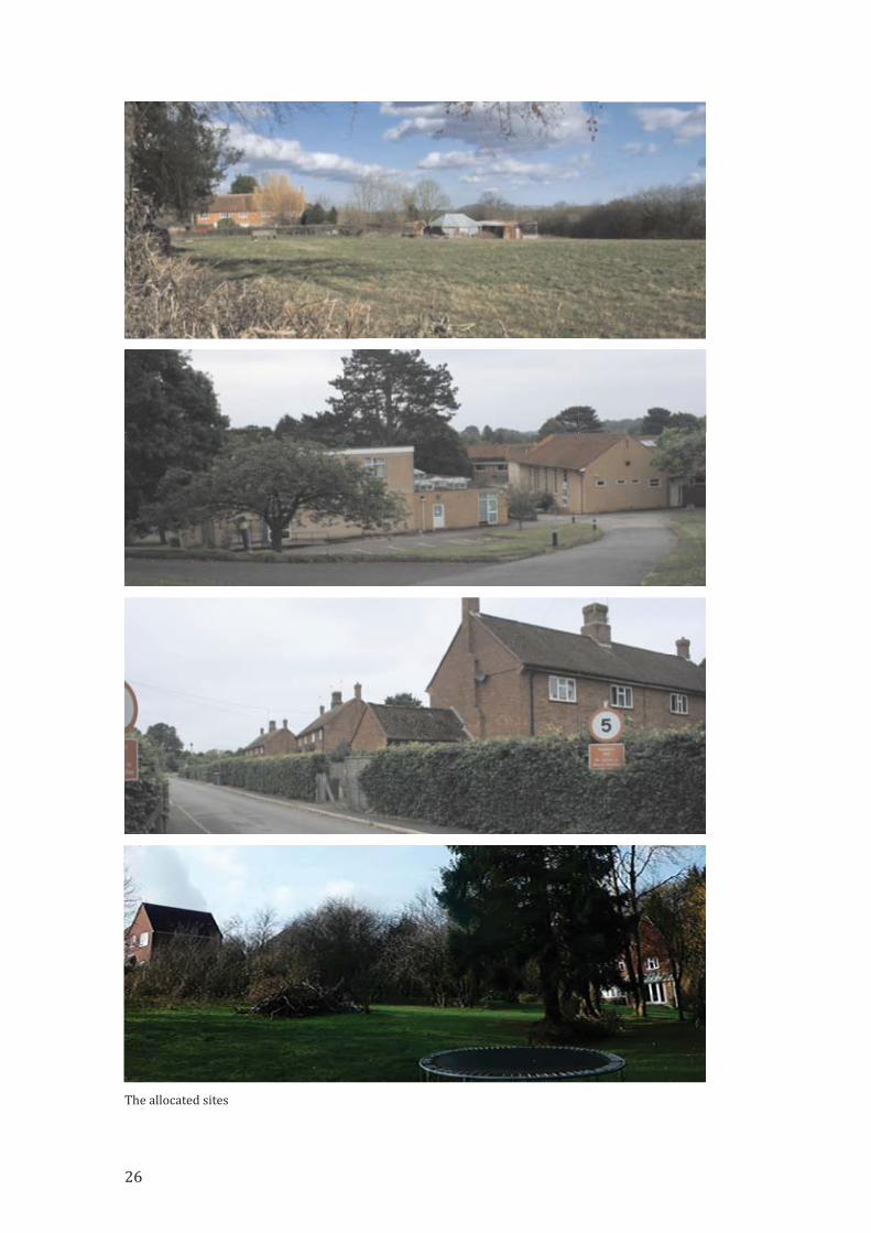
The allocated sites

2. Housing Supply and Site Allocation
Objective
To support development, wherever possible locally-led, to meet local needswith a mix of well-designed, high quality, sustainable and affordable housingthat enhances the existing built and natural environment.
Introduction
This Plan will support development on a number of sustainable and economically
viable sites, the majority on previously developed land, the only exception being to
allow the almshouse development for provision of affordable housing for the parish
in perpetuity. We believe suitable design can minimise harmful impacts and
improve the character and quality of Benenden parish and the way it functions in the
future.
The Housing Supply and Allocation Working Group built on the work of the
Benenden Parish Plan 2015,1 adopted by Benenden Parish Council (BPC) following
widespread consultation in the community and is a key supporting document for the
Benenden Neighbourhood Development Plan (BNDP).
Housing needs within the parish
Housing need in the parish is relatively low, demonstrated in the Objectively
Assessed Need (OAN) for housing established using standard methodology.
The 2018 TWBC Housing Needs Survey identi�ied Benenden as having the second
lowest housing needs within the borough, with a requirement for 6 affordable
dwellings; 4 for older residents and 2 for families. This Plan will provide up to
43 affordable dwellings.
1 Parish Plan 2015 https://www.benendenvillage.org.uk/ParishPlan/BenendenParishPlan2015ScreenCopy.pdf
Fig. 1 Drawing for houses by Clague Architects
27

Consultation
The Parish Plan and Housing Needs Survey 2015 were used with other information
collected in the interim to inform the Visioning Workshop held on 28th October
2017 and subsequent Housing and Design Workshop on Saturday 11th November
2017. Subsequent exhibitions and a presentation took place in 2018‐2019
(Supporting Document HSA1, 2)
Policy context/justi�ication
Potential for new housing in the parish is highly constrained
• Over 98% of the parish is in the High Weald AONB
• Access within the parish is constrained by the width of the roads
• Access to/from the parish is constrained by the distance from main centres:
Tunbridge Wells 15m (24km), Maidstone 13m (22km), Ashford 14m (23km)
and Hastings 14m (23km)
• Benenden has over 150 listed buildings, Roman roads, medieval �ield systems,
an SSSI and much ancient woodland
• Poor infrastructure: broadband and mobile signal a particular concern
• Rural setting
TWBC Landscape Character Assessment 2017
‘The pattern of dispersed historic farmsteads and hamlets…which add important
local character’2 noted in the report was of signi�icant importance in the local
consultation process. This was taken into account when considering the allocation
of sites.
AONB designation
• Benenden was designated AONB in 1983
• The parish’s stated opinion at the last public consultation (2017) was that the
rural nature of the parish was of paramount importance to residents
The NPPF states:
great weight should be given to conserving and enhancing landscape and scenicbeauty in…the Area of Outstanding Natural Beauty which have the highest status ofprotection in relation to these issues…The scale and extent of development withinthese designated areas should be limited. Planning permission should be refused formajor development other than in exceptional circumstances.3
Under the Environment Act 1995,4 strengthened by the Countryside and Rights of
Way Act 2000,5 local authorities must ‘have regard to the purpose of conserving and
enhancing the natural beauty’ of the AONB.
2 http://www.tunbridgewells.gov.uk/__data/assets/pdf_�ile/0019/132256/711D8F912E166417E0531401A8C086
E8_Tunbridge_Wells_HNS_draftreport_May_2018V4.pdf p. 793 NPPF para 172
4 Environment Act 1995
5 CRoW Act 2000 section 82; 85
28

National Planning Policy Framework (NPPF)
The NPPF states that ‘Local and neighbourhood plans should develop robust and
comprehensive policies that set out the quality of development that will be expected
for the area’ (para 127) and that ‘The planning system should contribute to and
enhance the natural and local environment’ (para 170).
In assessing the potential sites for development the BNDP has taken local
circumstances into account while applying the three planning objectives set out in
the NPPF: economic, social and environmental (para 8).
Rural setting
The impact of housing developments in an Area of Outstanding Natural Beauty
(AONB), and protecting the rural nature of the parish, were the most important
factors for most people in the consultation process. A number of the rural sites in the
Call for Sites would, if developed, in the opinion of the BNDP, signi�icantly harm the
rural setting and be contrary both to the AONB Management Plan6 and the
protection afforded to the AONB in the NPPF.7 For this reason they are not
considered suitable for development in this Plan. Any development in the AONB will
be required to be sensitively designed and landscaped in order to mitigate the
impact on the rural setting (see Policy HD1).
The Local Plan
The emerging new Tunbridge Wells Borough Council Local Plan 2019 will replace
the existing Local Plan 2006, Core Strategy 2010 and the Site Allocations Local Plan
2016. The new Local Plan will guide future development in the borough to cover the
period up to 2036. Benenden’s Neighbourhood Development Plan (BNDP) will form
part of the statutory Development Plan for the parish area.
Limits to Built Development (LBD)
In the draft TWBC Local Plan 2019,8 TWBC have adopted a policy of re‐drawing the
LBD tightly around Benenden village centre, thus the remainder of the parish will be
outside the LBD, affording more protection against any future development. The
sites allocated in Benenden village in the BNDP are included in the re‐drawn LBD.
This Plan supports this approach as it seeks to maintain the distinctive character of
the parish.
6 AONB Management Plan 2019‐24 p. 20
7 NPPF 2018 para 172
8 TWBC Local Plan 2019
29
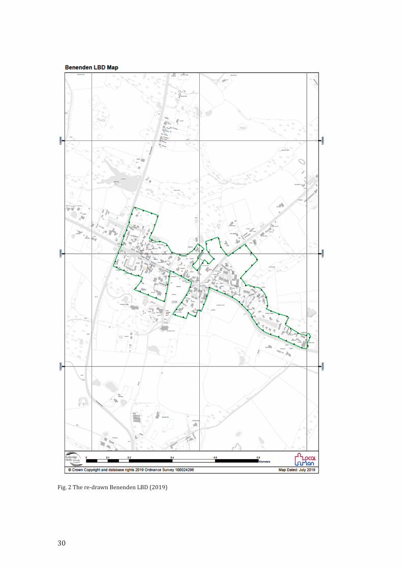
Fig. 2 The re‐drawn Benenden LBD (2019)
30
Housing supply – principles and policies
Quantity and location of new housing development
2.1 Following the 2016 Call for Sites landowners and their agents in Benenden put
up 20 sites for consideration (see Supporting Document HSA5). BNDP has chosen to
allocate four sites. This is in addition to those already permitted but as yet
undeveloped (Walkhurst Road and Benenden Hospital).
2.1.1 Our allocation, made in close co‐operation with TWBC, would meet the
Government’s requirement for sustainable and deliverable new housing.9 This is an
extrapolation of the approach set out in the Benenden Parish Plan of 201510 which
outlined growth of 1% per annum up to 2025 (1% per annum over 18 years being
circa 150 houses).
Policy HS1 Number of new dwellings
In addition to existing planning permissions, this Plan allocates four sites to
accommodate around 100 additional new homes in the parish.
Ref LS16 Uphill 18‐20 units
Ref 277 Feoffee 22‐25 units
Ref 424 Hospital South 22‐25 units
Ref LS40 Hospital North 23‐25 units
There are two unimplemented existing planning consents in Walkhurst Road
and at Benenden Hospital for 36 units.
2.1.2 The selection of the most suitable sites for allocation for housing development
has followed all relevant national guidance and best practice and been conducted in
close liaison with TWBC. All 20 sites in the parish that were submitted to the TWBC
Call for Sites (during and since 2016) have been carefully considered using
appropriate methods following national policies, guidance and best practice advice,
including a preference for ‘brown�ield’ sites and protection of the AONB, and
recognising local preferences for modestly sized viable sites (See Supporting
Document HSA2).
2.1.3 Any development immediately adjacent to the AONB will have an impact upon
it and must therefore be taken into account. Any development should conserve and
enhance the landscape and scenic beauty, wildlife and cultural life of the AONB;
major development would need to satisfy the requirements of NPPF para 172.
Types of housing - achieving the right mix
2.2 Re�lecting the �indings of the initial consultation workshops in 2017/18, and the
evidence provided in the 2015 Parish Plan Housing Needs Survey and the 2018
TWBC Housing Needs Survey, the BNDP will deliver a mix of different types of well‐
designed, high quality, sustainable, and affordable housing that meets local needs
and enhances the built and natural environment.11
9 NPPF para 8
10 Parish Plan 2015 p. 7
11 NPPF para 61
31
Policy HS2 Delivering a balanced community
Developments will be required to provide balanced communities with the
following mix of properties. New housing should meet the Tunbridge Wells
Borough Council’s Strategic Housing Assessment mix, and take note of the
Local Housing Needs Survey, to ensure suitable and affordable housing is
available for individuals and families and, in particular, housing to meet the
needs of an ageing population. Each site should include
a) Affordable housing in line with TWBC policy of 35% of dwellings.
b) Options to include low cost rental/shared equity/Help to Buy equity loans.
c) Suitable property for older local residents who wish to downsize within
the parish.
d) Mixed sizes of market housing for parishioners and new residents.
e) Affordable and market housing should be well integrated within each
development to help to establish and maintain a strong, mixed and
balanced community.
2.2.1 An integrated variety of types ‐ such as �lats, maisonettes and bungalows, in
addition to family houses ‐ should be offered in any new housing developments.
2.2.2 Given the anticipated rise in the ageing population of Benenden highlighted in
the 2018 HNS, in developments of 10 dwellings or more it will be expected that a
proportion of a minimum of 10% will be single storey or accessible and designed
with elderly or disabled occupants in mind.
2.2.3 The 2015 Parish Plan and 2018 HNS identi�ied the need for larger family
houses in Benenden. It is therefore considered important that the housing ‘mix’
should include some larger properties, suitable for families, as well as smaller units.
2.2.4 The Plan considers it necessary to have an adequate supply of housing of
different types between which to move within the parish in order to maintain an
enduring sense of community.
Locally-led housing delivery
2.3 It is considered that the local aspirations of the community can often be best
achieved by partnership‐based and locally‐led development initiatives. The Parish
Council has a history of working with English Rural Housing Association on a
number of locally‐based schemes by which affordable housing remains in the
community.
Policy HS3 Partnership schemes
The Parish Council will encourage partnership‐based locally‐led housing
schemes initiatives, on sites that
a) Satisfy national policy requirements.
b) Are designed to maintain an appropriate demographically mixed and
balanced community.
c) Respects the local environment.
d) Upholds village services.
32

2.3.1 Benenden is unusual in having almshouses, a category of low cost housing
which remains in the control of the local trustees. They also comply with the parish’s
requirement for locally‐led, locally‐managed housing development. Almshouses
therefore have the full backing of the BNDP and the scheme being considered for the
Feoffee site (277) will increase the number of such units available in perpetuity to
people, of all ages, with a connection to the parish.
Policy HS4 Almshouses
The Parish Council will give priority to schemes in the parish applying the
almshouse principle. Benenden’s almshouses are administered by the
Benenden Almshouse Charities (see Feoffee site 277) and, where appropriate,
this principle should be followed to provide a supply of ‘affordable housing’ in
perpetuity.
2.3.2 Almshouses provide low cost rental available to individuals and families, of
whatever age, with a local connection and are administered and regulated by local
trustees. These properties are exempt from the Government’s ’Right to Buy’ scheme.
2.3.3 The parish at consultation expressed an interest in setting up a Community
Land Trust (CLT) which could ensure that local housing remains genuinely
affordable in perpetuity. However, in the light of the existing Benenden Village Trust
and the Benenden Almshouse Charities it may be that the parish does not need
another vehicle. However, should land or assets be gifted to the community or made
available at a reduced price, such as land for allotments or for housing, then it is
recommended that a CLT be investigated (see Housing Supply Project 1) to
administer such assets for the community.
Supporting a sustainable community
2.4 Home working is becoming increasingly common and the need to cater for
different ways of working is addressed in this Plan.
2.4.1 Developers will be encouraged to provide in a substantial proportion, at least
25%, of new market housing, designated space for a home of�ice in anticipation of an
increasing number of people spending at least one or two days a week working from
home.
Policy HS5 Working from Home
The Parish Council is supportive of an increased amount of working from
home. With appropriate support and facilities home working will improve
local employment, health and personal well‐being and is environmentally
friendly. Homes must have appropriate telecommunications and internet
connectivity, and developers are encouraged to provide speci�ic of�ice space
and to contribute to the provision of community level facilities to support
home working.
2.4.2 It is the intention of the BNDP to foster creative or small home‐based
businesses by providing the spaces for them to work. Residential properties with a
speci�ic commercial space enabling small businesses to thrive will be supported
provided they conform to Policy HS6
33
HS6 Live/Work units
Live/work units can improve local employment and are environmentally
friendly. Premises should have appropriate internet connectivity. Units will
only be considered appropriate if they conform with our Windfall Policy HS7,
are conversions of redundant farm buildings or are on brown�ield sites.
2.4.3 With rapidly developing new technologies there is a need to encourage
different ways of working. In addition to home working, one such way is considered
to be the construction of of�ices or live/work units on appropriate sites.
The form and distribution of past and new development
2.5 Traditionally, development has been scattered across the many ‘dens’ which
make up the parish, with concentrations in the three main settlements of Benenden,
Iden Green and East End. ‘Where there are groups of smaller settlements,
development in one village may support services in village nearby.’12
2.5.1 The initial consultation workshop showed a clear preference for small
scattered development rather than on one or two large sites. BNDP therefore
considered if this would be possible and after assessment of the 20 sites identi�ied in
the TWBC Call for Sites, the following conclusions were drawn:
• Only 2 small sites were actually submitted to the Call for Sites (Ref 66 & 295)
• The impact on the AONB would be most detrimental if development was
scattered across the parish: building on green�ield sites, loss of agricultural
land, impact on the landscape and views in the AONB and increased traf�ic on
quiet rural lanes
• There would be less variety of housing types – small developments increase
building cost per unit and favour large, expensive properties
• There would be no obligation on developers to build affordable housing under
the currently adopted development policies
• Building in a small part of a larger site would open up that site for larger
schemes and more housing later
• Small sites of 4 houses or fewer will be delivered through windfall sites
Policy HS7 Windfall Sites
It is expected that a number of windfall sites will come forward in the life of
this Plan. These will be supported if they conform to national and TWBC
planning policy and the following criteria:
a) Sites contain 4 dwellings or fewer
b) The scale, design and appearance comply with BNDP design policy criteria
c) Development on the site does not signi�icantly harm the AONB, impact
biodiversity or damage heritage assets
2.5.2 The parish at consultation supported priority being given to brown�ield sites
and previously developed land. The BNDP therefore gave extra weight to those sites
which met these criteria. This Plan has ‘set out a clear strategy for accommodating
12 NPPF para 78 and 79
34

objectively assessed needs, in a way that makes as much use as possible of
previously‐developed or ‘brown�ield’ land.’13
2.5.3 In considering which sites should be allocated, attention was paid to the
existing built environment, as an integral part of landscape character, especially
given the high proportion of listed buildings in the parish14 and following guidelines
set out by Historic England15 and in the government’s Planning Practice Guide.16
13 AONB Management Plan 2019‐24 p.20.
14 https://britishlistedbuildings.co.uk/england/benenden‐tunbridge‐wells‐kent
15 Historic England The Setting of Heritage Assets Historic Environment Good Practice Advice in Planning Note 3
(Second Edition) p.216 https://www.gov.uk/guidance/conserving‐and‐enhancing‐the‐historic‐environment
Fig. 3 Map showing the scattered settlements/dens of the parish
35
2.5.4 The environment is an important policy issue, both for the Local Plan and in
terms of the AONB Management Plan. Consequently, equal weight is given to both
the built environment and the rural environment in this Neighbourhood Plan.
Policy HS8 Integration and the environment
New housing should seek to be well integrated into and enhance the local built
environment as well as respect the rural landscape in conjunction with
Policies LE1, 2, HD1.
Character Assessments
2.6 Landscape Character Assessments have been carried out by the Environment
Group (See Supporting Document LEA2) The particular characteristics of the
different areas of the parish will be expected to be protected (See Policy LE2). The
rare survival of the landscape which surrounds Benenden is of particular interest
and importance.17
2.6.1 Building Design Character Assessments in the main areas of the parish (see
Supporting Document HDA3) were carried out by the Housing Design Working
Group as a reference tool for future building design in the parish. In addition, the
NPPF sets out the importance of conserving the historic built environment.18
Density
2.7 BNDP has argued for development to be kept at an appropriate density, in
keeping with the existing neighbouring pattern of development (see Policy HS9),
while cognisant of the fact that the most ef�icient use must be made of valuable land.
This position is supported by CPRE that in order to protect more of the AONB, some
sites nearer to built‐up areas should be developed at greater density. The TWBC
guidelines are 30 dph (dwellings per hectare) in rural areas.
2.7.1 The average density in the parish is much lower (Benenden village averages 10
dph) and as a result BNDP has argued that density should vary depending on the
location of the site and its impact on the AONB.
2.7.2 Sites which would increase the coalescence between the major settlements, in
particular between Iden Green and Benenden, thus reducing their separate
identities, have not been allocated. This is a Key Characteristic in the AONB
Management Plan.19
17 The High Weald AONB Unit has carried out a number of studies on the landscape character of the Benenden arein particular: Historic Landscape Characterisation of the Parishes of Hawkhurst, Cranbrook, Goudhurst &
Benenden updated in 2017; Case Study report: Benenden by footpath March 2017; Fields in the High Weald Case
Study Report Woodside Farm March 201718 NPPF 184, 185
19 AONB Management Plan p.31; objective S2 p. 33
36

Policy HS9 Housing density
While being aware of the need to make ef�icient use of land, as expressed in
the NPPF and endorsed by CPRE, nonetheless the density of new housing
should where possible be consistent with existing densities in the adjacent
parts of the parish in order to maintain the character and distinctiveness of
the settlement. Density at no time to be greater than 25 dwellings per hectare.
2.7.3 In the construction of new housing it is the Neighbourhood Development
Plan’s view that one of the factors that contributes most to the distinctiveness and
character of the parish is housing density. New development should take account of
the density of neighbouring housing in order to maintain the distinctive character of
that settlement. Furthermore, the character of the development itself should comply
with the design requirements speci�ied in the BNDP under the Design and Built
Environment chapter and the policies contained therein.
New Housing Site Allocations
Overview
The Working Group
• looked at and objectively assessed the 13 originally submitted sites
• looked at and objectively assessed the 7 late submitted sites
• met regularly to discuss and debate their �indings
• site assessments were based on site walks, addressing parish concerns
(eg access, traf�ic) and reviewing relevant local and national planning (NPPF)
and AONB guidelines. See Supporting Document HSA3.
Site assessments made by the AONB Unit
The High Weald AONB Unit has carried out a separate assessment of the sites within
the Benenden AONB (see Supporting Document HSA4). Their conclusions
underscore the importance of the rural landscape in Benenden and the need to
protect it as much as possible by restricting development to previously developed
land or sites outside the AONB. Their assessment is considered a key supporting
document.
37
BE 2
BE 3
BE 4
424
AS_41
1310
00
1310
00
1315
00
1315
00
1320
00
1320
00
1325
00
1325
00
1330
00
1330
00
1335
00
1335
00
1340
00
1340
00
1345
00
1345
00
1350
00
1350
00
1355
00
1355
00
1360
00
1360
00
1365
00
1365
00
1370
00
1370
00
© Crown Copyright and database rights 2019 Ordnance Survey 100024298
0 0.85 1.7 2.55 3.40.425Kilometers
Map Dated: July 2019
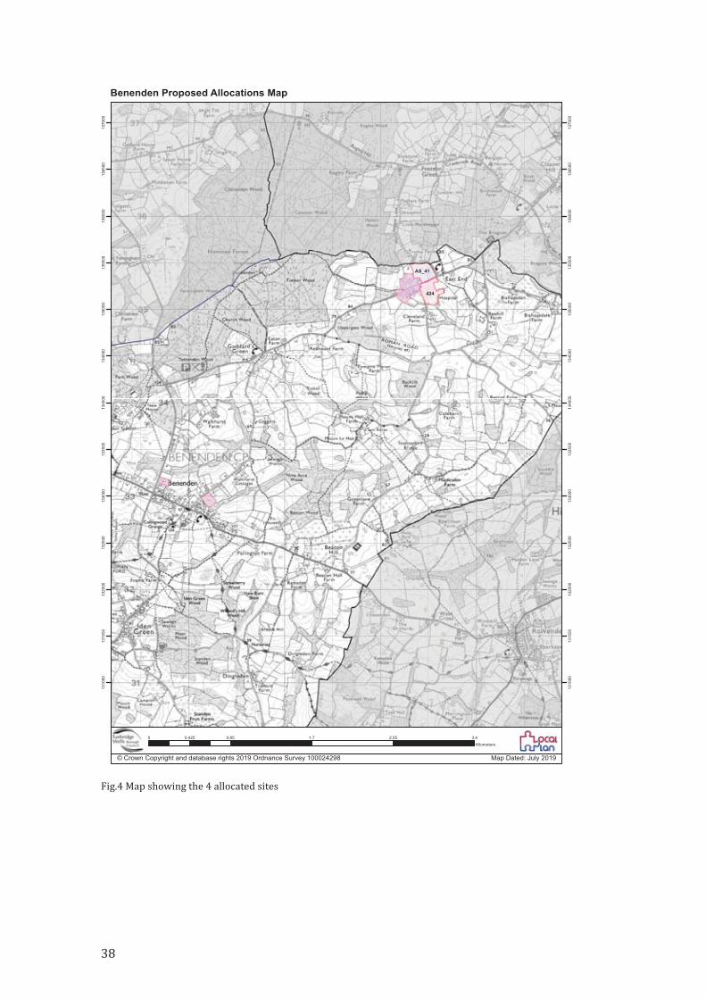
Benenden Proposed Allocations Map
Fig.4 Map showing the 4 allocated sites
38
To meet government aspirations, and the consequent indicative �igure for TWBC,
there is a requirement to accommodate some new housing development within the
parish. After consultation, the BNDP and TWBC have agreed on the most appropriate
sites which will achieve around 100 dwellings over the Plan period, in addition to
existing planning permissions. This scale of development is consistent with the
expectations of the 2015 Parish Plan, which suggested growth of 1% per annum.
The sites
These sites most clearly meet the requirements of the NPPF (para 118c and 172) to
prioritise previously developed land while giving the AONB the ‘highest status of
protection’, and that of the High Weald AONB Management Plan to ‘conserve and
enhance natural beauty’ while at the same time ful�illing the wishes of the parish to
maintain its rural nature while providing a range of housing, much of it affordable,
on 3 ‘brown�ield’ sites plus 1 green�ield site which is going to provide almshouse
accommodation in perpetuity for residents of the parish.
SITE SPECIFIC POLICIES FOR THEALLOCATED SITES
BENENDEN VILLAGE SITES
Context
Benenden village is the largest settlement of the parish but remains a relatively
remote and unsustainable location, with sensitive landscape character, built heritage
and environmental quality. Planning applications should be refused for any
development of poor design that fail to take the opportunities available for
improving the character and quality of the area and the way it functions, taking into
account the design and other requirements speci�ied in the Benenden
Neighbourhood Plan Design and Built Environment chapter, and the policies and
guidance in the Tunbridge Wells Local Plan.
The identi�ied sites present the best opportunities available for some well‐designed
development with a mix of housing size and type to meet a range of local housing
39
needs, a substantial proportion of it affordable, and including a high standard of
accessibility for older people and those with poor mobility.
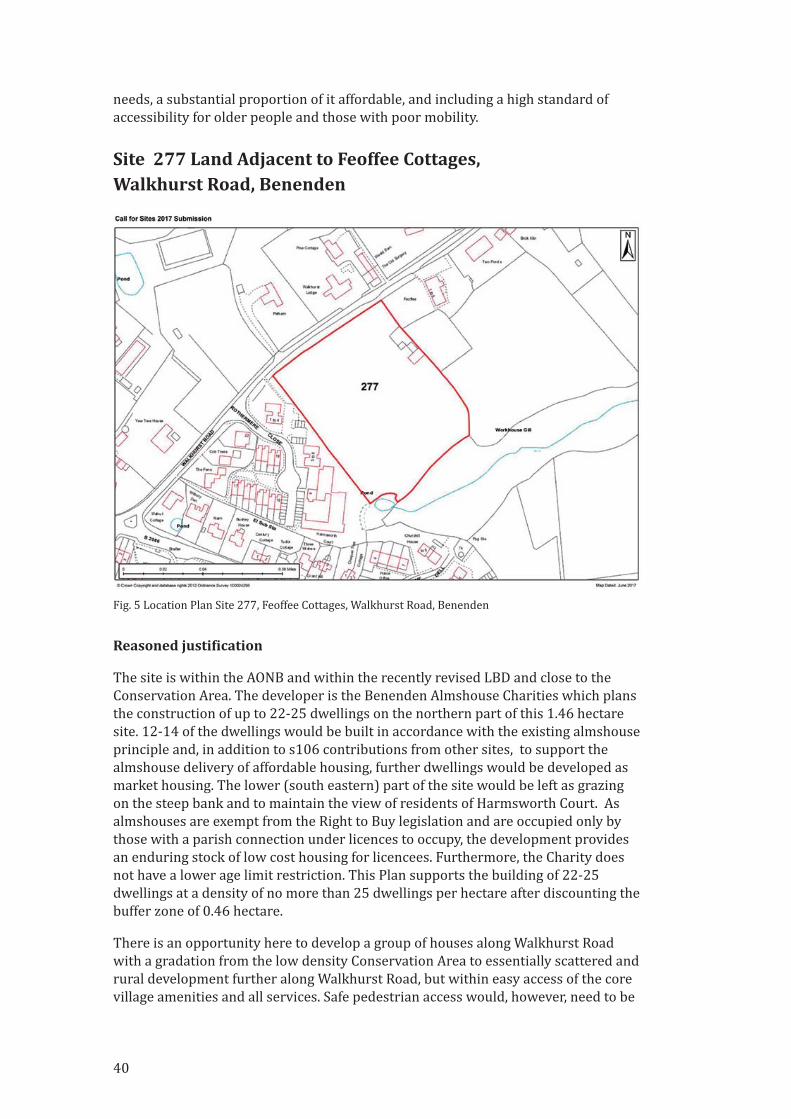
Site 277 Land Adjacent to Feoffee Cottages,Walkhurst Road, Benenden
Reasoned justi�ication
The site is within the AONB and within the recently revised LBD and close to the
Conservation Area. The developer is the Benenden Almshouse Charities which plans
the construction of up to 22‐25 dwellings on the northern part of this 1.46 hectare
site. 12‐14 of the dwellings would be built in accordance with the existing almshouse
principle and, in addition to s106 contributions from other sites, to support the
almshouse delivery of affordable housing, further dwellings would be developed as
market housing. The lower (south eastern) part of the site would be left as grazing
on the steep bank and to maintain the view of residents of Harmsworth Court. As
almshouses are exempt from the Right to Buy legislation and are occupied only by
those with a parish connection under licences to occupy, the development provides
an enduring stock of low cost housing for licencees. Furthermore, the Charity does
not have a lower age limit restriction. This Plan supports the building of 22‐25
dwellings at a density of no more than 25 dwellings per hectare after discounting the
buffer zone of 0.46 hectare.
There is an opportunity here to develop a group of houses along Walkhurst Road
with a gradation from the low density Conservation Area to essentially scattered and
rural development further along Walkhurst Road, but within easy access of the core
village amenities and all services. Safe pedestrian access would, however, need to be
Fig. 5 Location Plan Site 277, Feoffee Cottages, Walkhurst Road, Benenden
40
provided and land would be provided by the Benenden Almshouse Charities for this
purpose.
Given this site’s proximity to a grade II listed building, its position in the AONB and
proximity to the Conservation Area, the BNDP is backing this scheme only on the
basis that it will provide affordable housing for local families in perpetuity.
Description
• TWBC Call for Sites ref. 277
• Total site area 1.46ha, rectangular shaped open green�ield site sloping steeply
at the south
• The site owner/developer is the Benenden Almshouse Charities
• Existing use is grazing land
Constraints
• Located in the High Weald AONB
• Located within the recently revised LBD of Benenden village and abuts
development in Rothermere Close and Harmsworth Court
• Adjacent to Ancient Woodland and Workhouse Gill
• Outlook from Harmsworth Court across the site to be protected
• Walkhurst Road is a narrow characterful rural lane but with no pavement and
well used as a ‘cut through’
• In proximity to heritage assets ‐ the Benenden Conservation Area and grade II
listed building (Feoffee Cottages)
Opportunities
• Highly sustainable location close to/within walking distance of village
amenities
• Suited to a modest mixed development including homes for families and
smaller dwellings, the majority being local needs affordable almshouse
dwellings
• Design should be sympathetic to the setting of heritage assets, rural character
of the lane, scale and character of nearby built development and minimise
impact on the landscape and scenic beauty of the AONB and natural
environment.
• Creation of a footway link into the village
Site Speci�ic Policy 1 Land Adjacent to Feoffee Cottages, BenendenOur Approach
To support a suitable development proposal of the Feoffee site as an exceptional
opportunity for a sustainable development to meet local needs affordable housing
through the Benenden Almshouse Charities in a location that is close to village
facilities. A suitable design can minimise harmful impacts and improve the character
and quality of Benenden village and the way it functions in the future.
41

We will achieve this by:
Supporting suitable proposals from the Benenden Almshouse Charities and the
allocation of any other available s106 affordable housing contributions from
development proposals at East End or elsewhere in Benenden Parish to support the
maximisation of local needs affordable housing on the site.
We will expect development proposals to:
1. Provide a mixed residential development of around 22‐25 dwellings with at
least 12 units provided for affordable housing adhering to the almshouse
principle, and with an element of market housing necessary to provide the
�inancial basis for the almshouse development. To include a mix of housing
types including affordable family housing as well as smaller units.
2. Be designed to conserve and enhance the character and distinctiveness of the
village, the density of housing should be sympathetic to local character
including surrounding built housing density in the adjacent areas and the
landscape and heritage setting of the village.
3. Include the provision of adequate parking facilities to avoid on‐street parking
beyond the development site. Reference should be made to para 3.6 and Policy
HD6 for determining the quantity of vehicle parking, with allowance for the
likely occupation of the special forms of housing proposed but also the
generally high reliance on private cars in this area of relatively poor public
transport provision. Areas should be set aside for amenity vehicles turning
and for the parking of mobility scooters, ideally under cover.
4. Protect the Ancient Woodland (and pond) lining Workhouse Gill, which should
include a ‘buffer’ area adjacent to the designated area of a minimum of 15m
free from any form of built development, track or private garden space; the
details and planting of the buffer area to be approved and thereafter
maintained in line with Policies LE6 and LE7.
5. Provide all dwellings with a suitable standard of shared semi‐private and/or
private garden space. Landscaping of open areas and the means of enclosure of
all the site boundaries should be appropriately planted and screened with
native hedging species (see Policies LE9b and HD4); solid fencing and other
hard borders should be strictly minimised. Permitted development rights to
erect fences and garden structures should be removed.
6. Provide vehicle access link with a footpath to Walkhurst Road and a direct
footway connection within the site to Rothermere Close to provide safe
pedestrian access, on one side of the road only, to the village centre (see Policy
HD7).
7. Design and materials should comply with the design requirements speci�ied in
the Benenden Neighbourhood Development Plan under the Design and Built
Environment chapter and the policies contained therein.
42
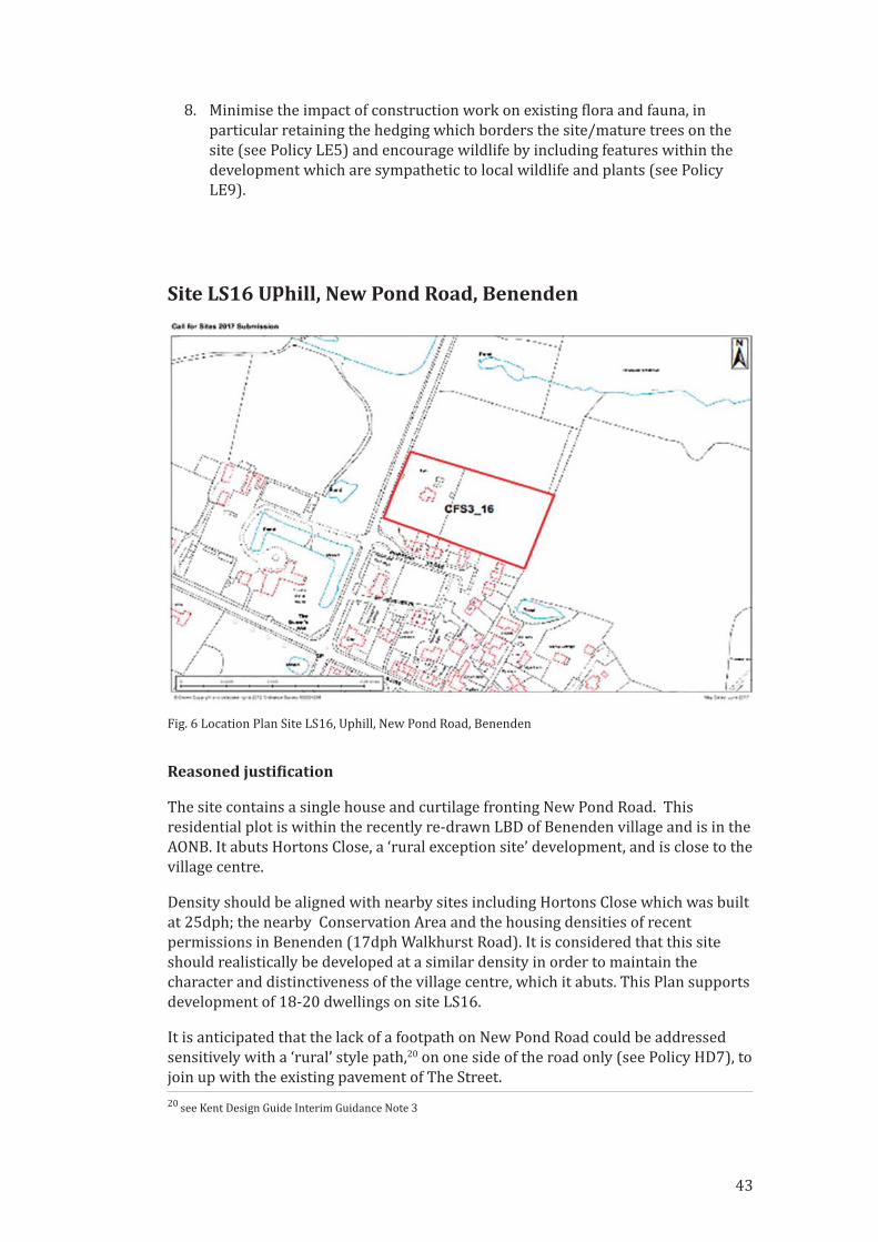
8. Minimise the impact of construction work on existing �lora and fauna, in
particular retaining the hedging which borders the site/mature trees on the
site (see Policy LE5) and encourage wildlife by including features within the
development which are sympathetic to local wildlife and plants (see Policy
LE9).
Site LS16 Uphill, New Pond Road, Benenden
Reasoned justi�ication
The site contains a single house and curtilage fronting New Pond Road. This
residential plot is within the recently re‐drawn LBD of Benenden village and is in the
AONB. It abuts Hortons Close, a ‘rural exception site’ development, and is close to the
village centre.
Density should be aligned with nearby sites including Hortons Close which was built
at 25dph; the nearby Conservation Area and the housing densities of recent
permissions in Benenden (17dph Walkhurst Road). It is considered that this site
should realistically be developed at a similar density in order to maintain the
character and distinctiveness of the village centre, which it abuts. This Plan supports
development of 18‐20 dwellings on site LS16.
It is anticipated that the lack of a footpath on New Pond Road could be addressed
sensitively with a ‘rural’ style path,20 on one side of the road only (see Policy HD7), to
join up with the existing pavement of The Street.
20 see Kent Design Guide Interim Guidance Note 3
Fig. 6 Location Plan Site LS16, Uphill, New Pond Road, Benenden
43
The site offers the opportunity for a modest mixed housing development in a
sustainable location. This is a previously developed site which is within close
walking distance of the village centre, with good road access and relatively well
screened within the AONB landscape.
The site is inside the recently re‐drawn LBD and in an area of sensitive heritage and
landscape character and permission should be refused for any development of poor
design that fails to take the opportunities available for improving the character,
safety and quality of an area and the way it functions, taking into account the design
and other requirements speci�ied in the Benenden Neighbourhood Plan Design and
Built Environment chapter and the policies and guidance in the Tunbridge Wells
Local Plan.
Description
• Total site area 0.78ha
• Owner‐occupier
• Existing use for a single dwelling and garden
Constraints:
• Within the High Weald AONB
• Just outside the Benenden village Conservation Area
• Direct existing access point to New Pond Road, but with fast traf�ic speeds
(outside the 30mph limit) and some 140m from the Benenden crossroads. A
contribution to traf�ic calming and safe pedestrian routes is required
• Substantial trees and hedging on the site to be retained
• Development to be contained within the existing site boundaries
Opportunities:
• Brown�ield site – existing residential curtilage of one substantial house,
adjacent to relatively high density housing at the Hortons Close development,
now inside in the recently re‐drawn LBD of Benenden village.
• Scale, massing and design to respond to surroundings, suitable for a mixed
housing development
• Visually a relatively enclosed site screened from long views from AONB
footpaths, but visible from New Pond Road. Proposals should conserve and
enhance trees, hedging, landscape screening and habitat of value
• Sustainable location close to/within walking distance of village centre
amenities
• Creation of a footway link into the village
• Contribution to traf�ic calming on New Pond Road and at the Benenden
crossroads
44
Site Speci�ic Policy 2 Uphill, New Pond Road,BenendenOur Approach
To support a modest scale development on a relatively enclosed and sustainable site
close to village amenities. A suitable design can minimise harmful impacts and
improve the character and quality of Benenden village and the way it functions in
the future.
We will achieve this by:
Supporting suitable development proposals and collaborating with the developer to
achieve a traf�ic calming scheme on New Pond Road and at Benenden crossroads,
and create a new pedestrian footway to connect the site to Hortons Close and the
village centre.
We will expect development proposals to:
1. Provide a residential development of around 18‐20 dwellings, with 35%
affordable housing and a mix of type and size integrated throughout the
development to help meet locally identi�ied needs (see Policy HS2).
2. Be designed to conserve and enhance the character and distinctiveness of the
village, the density of housing should be sympathetic to local character
including surrounding built housing density in the adjacent areas and the
landscape and heritage setting of the village.
3. Include the provision of adequate parking facilities to avoid on‐street parking
beyond the development site. Reference should be made to Housing Design
para 3.6 and Policy HD6 for determining the quantity of vehicle parking, in the
context of the generally high reliance on private cars in this area of relatively
poor public transport provision. If provided, attached garages will not count
towards the required quantity of parking spaces.
4. Protect the natural environmental and landscape enclosure of the site, the
trees at the rear of the site and trees and hedging at all the site boundaries
should be assessed at pre‐application stage environmental survey (Policy LE4)
for the health of the trees, their contribution to landscape character of the
AONB and biodiversity; the most signi�icant trees and hedges should be
protected and incorporated into the design of the development in order to
maintain the rural nature of the development and surroundings. Existing
hedges and trees at the New Pond Road frontage should be conserved and
enhanced to screen the site and setting of the nearby historic parkland.
5. Protect important habitat; the site lies within the National Biodiversity
Networks area for Turtle Doves – a Priority Species in the UK post 2010
Biodiversity Framework, listed on the Red list of Threatened Species.
Mitigation to reduce the impact of development both during construction, and
from housing, increased traf�ic/people.
45
6. Provide all dwellings with a suitable standard of shared semi‐private and/or
private garden space. Landscaping of open areas and the means of enclosure of
all the site boundaries should be appropriately planted and screened with
native hedging species; solid fencing and other hard borders should be strictly
minimised (see Policy HD4). Permitted development rights to erect fences and
garden structures should be removed.
7. Provide a footway on the east side of New Pond Road between the
development and Hortons Close in order to connect it/give pedestrian access
to the village centre (see policy HD7).
8. Vehicular access should be designed to be compatible with and support the
implementation of approved plans for the improved traf�ic calming and safety
measures in New Pond Road. Contribution must be made to improving the
safety of the Benenden crossroads.
9. Design and materials should comply with the design requirements speci�ied in
the Benenden Neighbourhood Plan under the Design and Built Environment
chapter and the policies contained therein.
SITES AT EAST END, BENENDEN
Context
Benenden Hospital is the largest complex of buildings and largest employment site
in the parish, established for over 100 years. The nature and services of the hospital
continue to change and evolve.
Travelling west Goddards Green Road links the settlement to Benenden village
amenities and towards the station at Staplehurst; travelling east via Castleton Oak
crossroads towards the town of Tenterden or the station at Headcorn.
TWBC has previously approved substantial redevelopment at the Hospital campus,
with planning permission 12/03130 and related consents for the relocation and
redevelopment of hospital buildings (now occupied) and subsequent construction of
24 dwellings including 8 affordable homes (6 Affordable Rent and 2 Shared
Ownership). Construction of the dwellings has yet to commence.
The Hospital has now submitted three sites from its estate to the TWBC Call for Sites
for residential allocation. This Plan addresses the future use of the two sites that
have been allocated, in two parcels, north and south of Goddards Green Road, in Site
Speci�ic Policy 3 below.
TWBC believe that the scale of potential development relative to the small
established community at East End and the challenges of the location means that
planning proposals require the publication of a Masterplan to address the combined
and cumulative impacts of any foreseeable future development of the Hospital
estate. The Masterplan should be prepared by the Hospital in close collaboration
with the local community, Benenden Parish Council and TWBC in advance of any
future planning application.
46
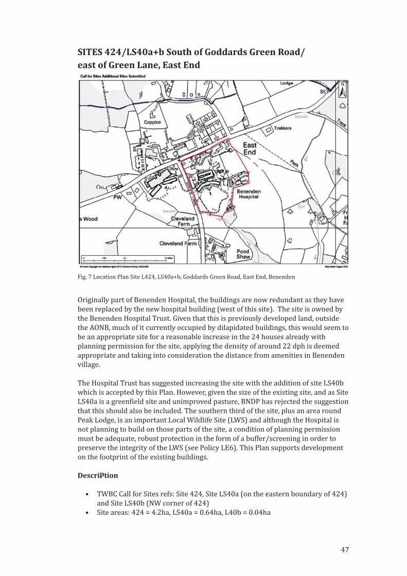
SITES 424/LS40a+b South of Goddards Green Road/east of Green Lane, East End
Originally part of Benenden Hospital, the buildings are now redundant as they have
been replaced by the new hospital building (west of this site). The site is owned by
the Benenden Hospital Trust. Given that this is previously developed land, outside
the AONB, much of it currently occupied by dilapidated buildings, this would seem to
be an appropriate site for a reasonable increase in the 24 houses already with
planning permission for the site, applying the density of around 22 dph is deemed
appropriate and taking into consideration the distance from amenities in Benenden
village.
The Hospital Trust has suggested increasing the site with the addition of site LS40b
which is accepted by this Plan. However, given the size of the existing site, and as Site
LS40a is a green�ield site and unimproved pasture, BNDP has rejected the suggestion
that this should also be included. The southern third of the site, plus an area round
Peak Lodge, is an important Local Wildlife Site (LWS) and although the Hospital is
not planning to build on those parts of the site, a condition of planning permission
must be adequate, robust protection in the form of a buffer/screening in order to
preserve the integrity of the LWS (see Policy LE6). This Plan supports development
on the footprint of the existing buildings.
Description
• TWBC Call for Sites refs: Site 424, Site LS40a (on the eastern boundary of 424)
and Site LS40b (NW corner of 424)
• Site areas: 424 = 4.2ha, LS40a = 0.64ha, L40b = 0.04ha
Fig. 7 Location Plan Site L424, LS40a+b, Goddards Green Road, East End, Benenden
47
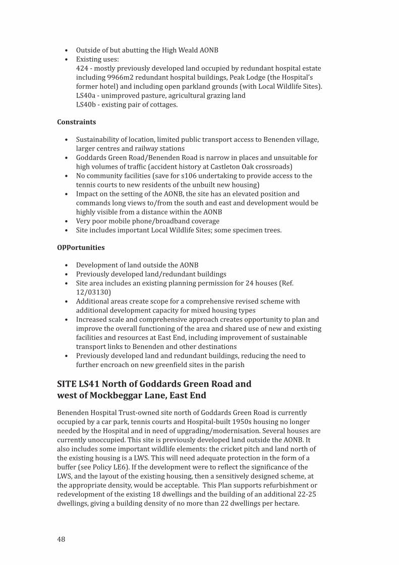
• Outside of but abutting the High Weald AONB
• Existing uses:
424 ‐ mostly previously developed land occupied by redundant hospital estate
including 9966m2 redundant hospital buildings, Peak Lodge (the Hospital’s
former hotel) and including open parkland grounds (with Local Wildlife Sites).
LS40a ‐ unimproved pasture, agricultural grazing land
LS40b ‐ existing pair of cottages.
Constraints
• Sustainability of location, limited public transport access to Benenden village,
larger centres and railway stations
• Goddards Green Road/Benenden Road is narrow in places and unsuitable for
high volumes of traf�ic (accident history at Castleton Oak crossroads)
• No community facilities (save for s106 undertaking to provide access to the
tennis courts to new residents of the unbuilt new housing)
• Impact on the setting of the AONB, the site has an elevated position and
commands long views to/from the south and east and development would be
highly visible from a distance within the AONB
• Very poor mobile phone/broadband coverage
• Site includes important Local Wildlife Sites; some specimen trees.
Opportunities
• Development of land outside the AONB
• Previously developed land/redundant buildings
• Site area includes an existing planning permission for 24 houses (Ref.
12/03130)
• Additional areas create scope for a comprehensive revised scheme with
additional development capacity for mixed housing types
• Increased scale and comprehensive approach creates opportunity to plan and
improve the overall functioning of the area and shared use of new and existing
facilities and resources at East End, including improvement of sustainable
transport links to Benenden and other destinations
• Previously developed land and redundant buildings, reducing the need to
further encroach on new green�ield sites in the parish
SITE LS41 North of Goddards Green Road and west of Mockbeggar Lane, East End
Benenden Hospital Trust‐owned site north of Goddards Green Road is currently
occupied by a car park, tennis courts and Hospital‐built 1950s housing no longer
needed by the Hospital and in need of upgrading/modernisation. Several houses are
currently unoccupied. This site is previously developed land outside the AONB. It
also includes some important wildlife elements: the cricket pitch and land north of
the existing housing is a LWS. This will need adequate protection in the form of a
buffer (see Policy LE6). If the development were to re�lect the signi�icance of the
LWS, and the layout of the existing housing, then a sensitively designed scheme, at
the appropriate density, would be acceptable. This Plan supports refurbishment or
redevelopment of the existing 18 dwellings and the building of an additional 22‐25
dwellings, giving a building density of no more than 22 dwellings per hectare.
48
Description
• TWBC Call for Sites ref. LS41, approx 3.71ha
• Site includes existing low density post war housing (18 dwellings); tennis
courts, car park, an unused cricket pitch with smaller buildings, designated
Local Wildlife Site.
• Areas of actively used hospital car parking and subject to requirements from
planning permission 12/03130
Constraints:
• Sustainability of location, limited public transport access to Benenden village,
larger centres and railway stations
• Goddards Green Road/Benenden Road is narrow in places and unsuitable for
high volumes of traf�ic (accident history at Castleton Oak crossroads)
• Few community facilities (save for s106 undertaking to provide access to the
tennis courts to new residents of unbuilt new housing)
• Poor mobile phone/broadband coverage
• Setting of the AONB
• Important Local Wildlife Site
Opportunities
• Development of land outside the AONB
• Previously developed land/redundant buildings
• Comprehensive redevelopment creates scope for increased quantity and
quality of housing and the opportunity to plan and improve the overall
functioning of the area and shared use of new and existing facilities and
Fig. 8 Location Plan Site LS41, Goddards Green Road, East End, Benenden
49
resources at East End, including improvement of sustainable transport links to
Benenden and other destinations
• Some of the existing dwellings may be suited to refurbishment rather than
redevelopment
Site Speci�ic Policy 3 Site North of GoddardsGreen Road, East End; Site South of GoddardsGreen Road, East End
Reasoned justi�ication
The sites are in a relatively remote area with sensitive landscape character and
environmental quality. Applications will be supported that take the opportunities
available for improving the character and quality of the area, and taking into account
the design and other requirements speci�ied in the Benenden Neighbourhood Plan
Design and Built Environment chapter and the policies and guidance in the
Tunbridge Wells Local Plan.
The site presents an opportunity for a well‐designed development with a mix of
housing size and type to meet a range of local housing needs including those with a
high standard of accessibility for older people and those with poor mobility. It also
enables provision of community amenities to promote the health and wellbeing of all
residents of East End.
Our Approach
We consider the Hospital to be an important part of the fabric of the parish.
However, the relative scale of potential development and remote location requires
that before detailed planning proposals for further development are prepared the
Hospital Trust should prepare a comprehensive Masterplan. This should address the
combined and cumulative impacts of foreseeable future development of the estate
and redundant sites released for non‐hospital development. The Masterplan should
be produced in close collaboration with the local community, Benenden Parish
Council and Tunbridge Wells Borough Council.
We will achieve this by:
Working with the Hospital Trust, TWBC and other agencies as a Masterplan develops
for the future planning of the Hospital estate, and working with them to improve
location sustainability through the creation of community spaces and connectivity.
We expect the Hospital Trust development proposals to:
1. Provide space for a small shop, café, or other commercial enterprise to serve
the locality and create a focal point for the community.
2. Provide a community space for events and to provide amenities such as a pre‐
school or play group. An appropriate building might be the existing old chapel
50
building to the west of the site which has in the past been used as a nursery
school.
3. Contribute to a foot and cycle path linking East End with Benenden following
the route identi�ied by the Parish Council (See Supporting Document TA2 and
see Policy T1,2 & 5).
4. Provide a mini‐bus for the use of Benenden Primary School and contribute to
the costs of maintaining and running the minibus service to/from Benenden
village/Primary School to serve school times thus reducing traf�ic and
improving sustainability.
5. Promote and support the Kent County Council Hopper Bus trial and other DRT
initiatives. It is intended to serve the growing community in proximity to the
Hospital in order to aid connectivity with larger conurbations, such as
Tenterden, for the purposes of work, leisure and health.
6. Include an area for sport and recreational use by the local community, in part
repurposing the existing tennis courts
We will expect development proposals across the two sites to:
1. Ensure that design, scale, massing and overall density create a sense of place
and focus to the residential communities and re�lect the character and rural
nature of the East End area adjacent to the AONB whilst acknowledging the
scale of adjacent hospital buildings. Building heights should generally be
restricted to two storeys.
2. Include the provision of adequate parking facilities to avoid on‐street parking.
Reference should be made to Housing Design para 3.6 and Policy HD6 for
determining the quantity of vehicle parking in the context of generally high
reliance on private cars in this area. Houses to be provided with electric car‐
charging facilities.
3. As a signi�icant part of the affordable housing contribution, make a speci�ied
�inancial contribution to The Benenden Almshouse Charities to enable
provision of additional almshouses/affordable housing near to facilities in
Benenden village in exchange for a reduced requirement for affordable
housing on the two sites at the former hospital.
4. Require a minimum of 25% of the new‐build houses to have a purpose‐
designed designated working/of�ice space to enable home working thus aiding
sustainability.
5. Have close regard to the design and materials requirements speci�ied in the
Benenden Neighbourhood Plan under the Design and the Built Environment
chapter and the policies contained therein.
6. Provide private garden space and/or shared semi‐private spaces, all enclosure
to be appropriately planted and screened with native hedging species to
protect the occupiers privacy (see policy HD4).
51
7. Ensure the Local Wildlife Sites (LWS) be conserved and protected in
accordance with national and local planning policy and in line with the
guidelines laid out in Policy LE6.
8. Ensure the LWSs be conserved and enhanced as wildlife sites with a
management plan adopted to achieve this, and the sites to not be used for
recreational purposes.
9. In order to reduce the amount of construction traf�ic using local roads where
possible the disposal of earth spoil generated by construction works should
be redistributed on the wider site in landscape remodelling. Details to be
approved at planning stage to ensure ground levels changes are sympathetic
to the landscape character of the area.
10. Minimise the impact of construction work on existing �lora and fauna, in
particular retaining the hedging which borders the site/mature trees on the
site (see Policy LE5).
Speci�ically we expect development of the South site to:
Comprise 22‐25 new dwellings in addition to the existing planning permission
for 24 dwellings
The area at Site 40a is unimproved pasture and should not be included in the
development area but retained in use as viable farmland
The development to be built out before work can commence on the North site
Speci�ically we expect development of the North site to:
Comprise 22‐25 new dwellings in addition to the 18 existing dwellings
No work will commence until the South site is fully built out.
Housing Supply and Allocation
Projects1. Community Land Trust Feasibility Study
Establish a group of interested volunteers to explore further the idea of setting up a
Community Land Trust (CLT). The purpose of this group would be to establish if
there are assets or land holdings in the parish which might be acquired and run by a
CLT to the bene�it of the community. The group would also undertake to �ind out
about government funding for such a scheme and how it would be administered.
Supporting Documents for Housing Supply and Allocation
HSA1 – Process/Background information
HSA2 – SWOT Analysis
HSA3 – Individual Site Assessments
HSA4 – High Weald AONB Site Assessments
HSA5 – Sites put forward in the Call for Sites
52

53
3. Design and the Built Environment
Objective
New dwellings should be of good quality construction, using local materialsand designed to be sympathetic to the character of existing landscape andbuildings, with scale, form and density to be of similar proportions to theexisting; the principal aim is to protect and enhance the beauty of the Parish.
Introduction
Following on from the Visioning Workshop with residents and stakeholders held on
28th October 2017 and follow‐up workshop on 11th November 2017, a number of
design‐based issues were raised including:
• Good architectural design
• Buildings of good quality
• Variety of design
• Appropriate landscaping
• Well‐designed layout
• Minimise the impact on the environment (particularly lighting/dark skies)
• Preserve village character/village ‘feel’
• Preserve rural character
• Developers to provide adequate parking to minimise on‐street parking
• Varied types of buildings
The Working Group built on the work of the Benenden Parish Plan 2015, written
following widespread consultation in the community and is a key supporting
document for the Neighbourhood plan.

It states:
New homes in Benenden should be of a high quality in terms of building standards,architecture that is sympathetic to the local environment, and give suf�icient spacefor modern living…New properties in the village need to be environmentally friendlyand energy ef�icient. They should also be suitable for all ages and level of mobility.Doorways need to be wide enough for wheelchair access, staircases not too narrowor too steep.
After further discussions with the Parish Council and the Neighbourhood Plan
Steering Group, the above objective was agreed as representing the views of many
parishioners and to provide the basis for the Working Group.
Process
The Working Group set out to produce a series of policies which prospective
developers should use to establish appropriate housing designs. The group reviewed
current housing stock in the parish, and chose the three main settlements, Benenden
village, Iden Green and East End to establish as ‘Character Areas’ for the parish.
These Character Areas were then assessed for their individual characteristics so that
development could be designed sympathetically to the locality.
In order to understand the key characteristics of the existing dwellings, the Design
Group carried out a comprehensive building survey in these Character Areas. This
survey noted the material composition of all dwellings and identi�ied individual
building features; for example, Iden Green has predominantly white
weatherboarding to frontages, Benenden village housing has mainly tile‐hanging and
East End has mostly brick‐built structures.
Common to all the main Character Areas is their remoteness and rural setting.
Reference should be made to the Design Group’s survey documentation (Supporting
Document HDA1) and to the Conservation Areas Appraisal (2005) produced by
Tunbridge Wells Borough Council (TWBC) as reviewed by the Neighbourhood Plan
Design Group in 2018 (Benenden and Iden Green Conservation Areas Appraisal
2018 see Supporting Document HDA2).
Using the data obtained from the surveys, the Design Group was able to produce
Character Assessments (Suppporting Document HDA3) for each Character Area and
these Assessments should be used by developers, together with the Policy
Documentation produced by the Group in order to produce development designs
which are sympathetic to adjacent settlements.
Policy context/justi�ication
The design policies have been drafted to complement those of the National Planning
Policy Framework (NPPF) 2018 and the Tunbridge Wells current Local Plan 2019.
54
The Policies
New housing developments must be designed in accordance with this
Neighbourhood Development Plan’s Housing Design Policies HD1‐HD9 inclusive.
3.1 Benenden is located in an Area of Outstanding Natural Beauty (AONB) and as
such, any new development in this area must be designed so that it sits sensitively
within its surroundings. Developers are required to refer to the emerging High
Weald AONB Design Guidance document for new Housing Development published
by the High Weald Joint Advisory Committee.
Policy HD1 General Design Policy
Proposals for all forms of new development must plan positively for the
achievement of high quality and inclusive building and landscaping design, at
the same time demonstrating that they have sought to conserve local
distinctiveness and the aesthetic qualities for traditional rural settlements and
buildings found in the High Weald AONB.
3.2 The Design Group assessed the predominant characteristics of the existing
housing in each of the Character Areas and it is anticipated that any prospective
developer should access these assessments to ensure that any new development is
sympathetically designed. A summary of the main characteristics of every house in
the Character Areas is noted in Supporting Document HDA4 to this document and a
percentage given for each characteristic. Also, house styles existing in the three
Character Areas have been identi�ied in Supporting Document HDA5. The BNDP
believes that having an understanding of the weighting that each characteristic
holds, architects can begin to formulate their designs so as to be sympathetic to the
adjacent settlement.
Policy HD2 General Appearance
Any new development should conserve the distinct character of the local
existing built environment, should respect the density, footprint, separation
and features of the surrounding area and the scale and bulk of new buildings
should be in keeping with the local area.1
a) The height of buildings should be in keeping with the heights of building in
the local area.2
b) Styles and materials that relate to the existing built environment for the
local area will be encouraged including roof construction materials.2
c) New developments should generally maintain the traditional appearance
and layout of the built environment1 but we would consider innovative,
high quality, exceptional modern design which would signi�icantly enhance
the setting and be sensitive to the de�ining characteristics of the
surrounding area.
1 TWBC Local Plan 2006 Policy EN 1. Ch. 4 Environment Aims Para. 9 Policy EN25. TWBC Core Strategy Development
Plan Document (Adopted June 2010) Core Policy 14: Development in the Villages and Rural Areas and Core Policy
4: Environment. NPPF Paras: 125, 127,128, 170 and 172.2 TWBC Local Plan 2006 Policy EN 25. TWBC Core Strategy Development Plan Document (Adopted June 2010) Core
Policy 14: Development in the Villages and Rural Areas. NPPF Paras: 125, 127,128, 170 and 172. High Weald AONB
Unit's colour study 2017.
55
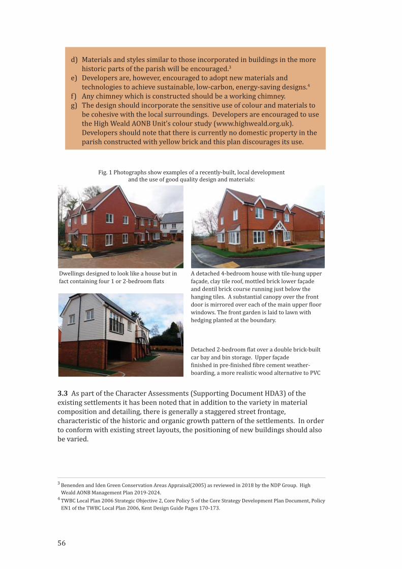
d) Materials and styles similar to those incorporated in buildings in the more
historic parts of the parish will be encouraged.3
e) Developers are, however, encouraged to adopt new materials and
technologies to achieve sustainable, low‐carbon, energy‐saving designs.4
f) Any chimney which is constructed should be a working chimney.
g) The design should incorporate the sensitive use of colour and materials to
be cohesive with the local surroundings. Developers are encouraged to use
the High Weald AONB Unit’s colour study (www.highweald.org.uk).
Developers should note that there is currently no domestic property in the
parish constructed with yellow brick and this plan discourages its use.
3.3 As part of the Character Assessments (Supporting Document HDA3) of the
existing settlements it has been noted that in addition to the variety in material
composition and detailing, there is generally a staggered street frontage,
characteristic of the historic and organic growth pattern of the settlements. In order
to conform with existing street layouts, the positioning of new buildings should also
be varied.
3 Benenden and Iden Green Conservation Areas Appraisal(2005) as reviewed in 2018 by the NDP Group. High
Weald AONB Management Plan 2019‐2024.4 TWBC Local Plan 2006 Strategic Objective 2, Core Policy 5 of the Core Strategy Development Plan Document, Policy
EN1 of the TWBC Local Plan 2006, Kent Design Guide Pages 170‐173.
Dwellings designed to look like a house but in
fact containing four 1 or 2‐bedroom �lats
A detached 4‐bedroom house with tile‐hung upper
façade, clay tile roof, mottled brick lower façade
and dentil brick course running just below the
hanging tiles. A substantial canopy over the front
door is mirrored over each of the main upper �loor
windows. The front garden is laid to lawn with
hedging planted at the boundary.
Detached 2‐bedroom �lat over a double brick‐built
car bay and bin storage. Upper façade
�inished in pre‐�inished �ibre cement weather‐
boarding, a more realistic wood alternative to PVC
Fig. 1 Photographs show examples of a recently‐built, local development
and the use of good quality design and materials:
56
Policy HD3 Layout
a) The street scene should incorporate variations in form and detail; the
positioning of dwellings in relation to the road should be varied to create a
stepped/staggered street scene.5
b) Developers will be encouraged to ensure site permeability 6 via roadways
to allow integration of the proposed development into existing areas of
built development.
c) Informal spaces could be incorporated with the use of benches or tables to
provide community amenity.
d) Housing should be positioned to minimise the overlooking of adjacent
properties and to reduce the transference of air‐borne sound between
properties.7
e) The layout of any development should be such as to create an impression
of organic growth over time. Material �inishes should avoid a single style
or multiple styles in any one cluster thus keeping a large variation of styles
to a minimum.
f) A generally straight or gently curving road layout through developments is
preferred rather than meandering roads which do not re�lect local
character and design.8
g) Road narrowing or other design features, including planting, to be put in
place to reduce traf�ic speeds, avoiding the use of signs.
3.4 Designs should include open green spaces of appropriate scale and quality in
order to promote health and wellbeing. A mix of indigenous tree planting should be
incorporated to give an aesthetically pleasing street view, to re�lect the rural locality
and minimise the impact on the AONB. Attention should be paid to the Character
Assessment for each Character Area. Benenden’s designated important landscape
character as an Area of Outstanding Natural Beauty (AONB)9 is of primary
importance to residents of the parish, as noted at consultation meetings. It is this
landscape character that the High Weald AONB Management Plan seeks to preserve
and this Neighbourhood Development Plan contains planning policies and objectives
that are complementary to this work.
5 NPPF Paras. 125, 127,128, 170 and 172.
6 Kent Design Guide Para 2.3 Designing for Movement. ‘Developments must be easy to move through in all
directions’7 Kent Design Guide 2.2.6 Protection from noise and visual privacy
8 Kent Design Guide Para 2.3 Designing for movement. Page 130 Reference ‘Lane’ applicable to rural sites next to
village centres or within small village centres where these are not built up.9 TWBC Local Plan 2006 Policy EN 1: Landscaping Paras 4.23 to 4.28. TWBC Core Strategy Development Plan
Document (Adopted June 2010) Core Policy 14: Development in the Villages and Rural Areas. NPPF Paras: 172.
High Weald AONB Management Plan 2019‐2024.
57
Policy HD4 Landscaping
Green spaces should be included within the development as amenity areas and
private gardens adjacent to properties.10 Plot boundaries should be designed
to have a green appearance, using, for example, native hedging; solid fencing
should be avoided. 11 Suf�icient landscaping will be required to re�lect the
existing rural streetscape adjacent to the development. Existing mature trees
should be retained to provide open spaces within the proposed development
and are considered essential to maintain the rural nature of the area,12 as well
as to provide adequate amenity space for each dwelling. Creative landscaping
to avoid the urbanising effect of car parking spaces would be encouraged.
3.5 There is minimal arti�icial lighting in the parish. New developments should not
introduce inappropriately bright lighting at night over pathways or other areas
within the site. Arti�icial lighting at night creates light pollution and is detrimental to
wildlife and to the rural nature of the parish. Sites on top of the ridge or very open
sites would be particularly impactful and low lighting levels would be expected to be
used. The parish has repeatedly stressed a wish to preserve Benenden’s dark skies.
(See Guidance notes for the Reduction of Obtrusive Light, The Institution of Lighting
Engineers 2005, and any subsequent revisions).
Policy HD5 Dark Skies
In order to maintain the Benenden dark skies policy,13 all external lighting
included in any proposal should be carefully designed and strictly limited.
All proposals for including externally visible lighting should include:
a) Full details of the proposed lighting to be installed and maintained for
approval;
b) Prior to development a light survey of the site should be undertaken using
a Sky Quality Meter, and the results shared with the Parish Council. The
proposed lighting should not lower this reading by more than one
percentage point, and in any event should not have a noticeable impact on
the dark skies enjoyed by the parish.
c) Lighting should be limited to that required for safe access and only where
carefully designed and justi�ied, for security;
d) All lighting should be be time limited and only low level (in terms of height
and wattage) street lighting will be acceptable.
e) Any �loodlighting should be proportionate to the particular location and to
be on short timing devices to illuminate the event period only.
f) Planning conditions may be added and permitted development rights may
be removed to ensure approved lighting is thereafter properly maintained,
and that additional exterior lighting is not added without express approval.
The Parish Council will work with the owners of existing exterior lighting
schemes to modify these to enhance the quality of the dark sky of the parish.
3.6 Benenden is more or less equidistant from Tunbridge Wells, Ashford, Maidstone
and Hastings and so is remote from major towns. The likelihood of people using
public transport is low with people relying on private transport for travel anywhere
10 Kent Design Guide. 2.2.9 The Design of Open Spaces.
11 TWBC Local Plan 2006 Policy EN1
12 Kent Design Guide para 2.2.1 Retaining existing buildings and features (page 64)
13 TWBC Local Plan 2006 Policy EN 8: Outdoor Lighting. TWBC Core Strategy Development Plan Document
(Adopted June 2010) Core Policy 14: Development in the Villages and Rural Areas. NPPF Para: 180 c).
58
within the area. Adequate parking within new developments is therefore an
absolute necessity as on‐street parking is already a problem in the main settlements
in the parish. The BNDP would expect an increase in the numbers of parking spaces,
provided by developers, over and above the average parking guidance set out in the
Kent Design Guide and TWBC draft Local Plan. As a rule of thumb, 1 space per
bedroom plus additional spaces for visitors. Attention should be paid to the
Character Assessment for each Character Area. Garages or car barns would be
acceptable with a design appropriate to match the adjacent buildings.
Policy HD6 Parking
Suf�icient off‐road parking should be incorporated in all new developments. In
addition, there should be space for storage, refuse and recycling bins, and bicycle
parking to ensure a high quality, well‐managed streetscape. Driveways should
have, as a minimum, semi‐permeable surfaces. On‐road parking is discouraged
to prevent the blocking of access roads and endangering pedestrians. Access
roads should be of suf�icient width to allow two vehicles to pass each other. 14
3.7 Developers will be encouraged to ensure site permeability via footpaths/ways
to increase connectivity within new developments and to aid access to local
amenities. The design of footways should re�lect the rural nature of the locality and
be constructed with semi‐permeable surfaces. They should be constructed on one
side of the road only to re�lect the existing local custom in Benenden, Iden Green and
East End, to reduce the amount of hard surfacing.
Policy HD7 Footpaths
All footways/footpaths in a new development should be constructed on one
side of the road only, to re�lect the rural character of the local area.15 Materials
used for the footway are to be sensitive to the rural setting and preferably be
semi‐permeable in nature.
3.8 Any new development, both residential and non‐residential, should be shaped and
in�luenced by the traditional character and style of the existing settlements within
the parish. All new developments should reference the local context and demonstrate
the use of high quality materials and styles appropriate to the location. Development
around the edges of settlements should be sensitive to the rural and historic context
by re�lecting the character of buildings in proximity to adjacent countryside.
Policy HD8 Materials and technology
All new dwellings should be constructed to the highest manufacturing
standards to be sustainable, with the inclusion of measures to help conserve
water (including the re‐use of grey water) and energy. The use of renewable
energy technologies, including air‐source or ground‐source heating/cooling,
solar thermal (solar water heating), photovoltaics (PV), will be supported.
Developers will be expected to refer to the TWBC Renewable Energy
Supplementary Planning Document and subsequent 2016 update. The re‐use
and recycling of building materials will be encouraged as will the use of locally
sourced materials.16
14 KCC Kent Design Guide Review: Interim Guidance Note 3: Residential Parking. Guidance table for residential
parking Suburban Edge Village Rural. TWBC Local Plan 2006 Chapter 11 Transport and Parking. NPPF Para. 105.15 Kent Design Guide. 2.2.9 The Design of Open Spaces.
16 TWBC Local Plan 2006 Chapter 4 Environment ‐ Aims: Para 13. NPPF Para 8
59
3.9 The quality and safety of new build housing under the Building Regulations is of
great concern to the Neighbourhood Development Plan.
Policy HD9 Building Regulations
We support the use, by developers, of Tunbridge Wells Building Control
Department for carrying out inspections under the Building Regulations to
ensure such quality and safety. As a minimum requirement to accord with this
condition, inspections should be made during the following phases of the
construction:
• Foundation excavations prior to concreting.
• Beam and block �loor construction.
• Damp proof course.
• Structure (to include walls, �loors, beams and roof) prior to covering over.
• Insulation prior to plasterboarding.
• Internal drainage prior to covering over.
• External drainage laid prior to back�illing.
• Completion of works.
Conclusion
The aim for all new developments should be for them to leave a positive
architectural legacy, to be sensitive to their local context and environment and
enhance the character of Benenden Parish.
Design and the Built Environment
Projects
1. Reduce existing light pollutionThe current excessive car park illumination at Benenden Hospital, lighting at
Benenden School and outside Benenden Village Hall until late into the night is
contrary to the express wish of the parish for ‘dark skies’ and is the cause of local
grievance. Negotiations should be undertaken by the Parish Council to see if the
lighting could be timed or set to switch off earlier in the evening.
Supporting Documents for Design and the Built Environment
HDA1 Survey Documentation
HDA2 Conservation Areas Appraisal (2018)
HDA3 Character Area Assessments
HDA4 Summary of materials used in existing housing
HDA5 Existing house styles in the Character Areas
60
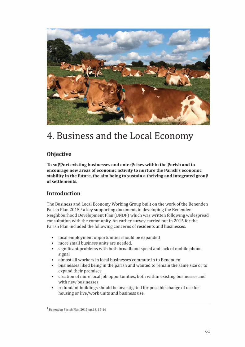
4. Business and the Local Economy
Objective
To support existing businesses and enterprises within the parish and toencourage new areas of economic activity to nurture the parish’s economicstability in the future, the aim being to sustain a thriving and integrated groupof settlements.
Introduction
The Business and Local Economy Working Group built on the work of the Benenden
Parish Plan 2015,1 a key supporting document, in developing the Benenden
Neighbourhood Development Plan (BNDP) which was written following widespread
consultation with the community. An earlier survey carried out in 2015 for the
Parish Plan included the following concerns of residents and businesses:
• local employment opportunities should be expanded
• more small business units are needed.
• signi�icant problems with both broadband speed and lack of mobile phone
signal
• almost all workers in local businesses commute in to Benenden
• businesses liked being in the parish and wanted to remain the same size or to
expand their premises
• creation of more local job opportunities, both within existing businesses and
with new businesses
• redundant buildings should be investigated for possible change of use for
housing or live/work units and business use.
1 Benenden Parish Plan 2015 pp.13, 15‐16
61

62
These concerns have been echoed in the surveys and meetings carried out as part of
the process of the BNDP.
At the Visioning Workshop with residents and stakeholders held on 28th October
2017 a ‘SWOT’ (strengths, weaknesses, opportunities and threats) exercise (see
Supporting Document BEA12) highlighted that:
• amongst the many businesses in the parish, Benenden has several large
employers and it was important to ensure these larger, established businesses
continue to bene�it the local community and the economy
• tourism and leisure were important contributors to the local economy
• businesses suffered from poor infrastructure/transport
• lack of work opportunities for young people
• opportunity to improve childcare facilities to support local employment
• importance of agriculture in the parish/seasonal work
• better use of redundant buildings could enhance employment
• the community village shop was seen as a signi�icant asset
• a signi�icant proportion of self‐employed people in the parish/working from
home
• encouraging small businesses can create employment
• there could be a website to showcase local businesses/crafts/local shops
After further discussions with the Parish Council and the Neighbourhood Plan
Steering Group, the objective was agreed as representing the views of many
parishioners and to provide a basis for the working group.
Process
By undertaking two signi�icant surveys (Supporting Document BEA2 and BEA3),3 4
conducting local and regional research and consultations with parish residents,
businesses, employers and employees,5 the BNDP Business and Local Economy
Group has developed policies to sustain and improve local economic development.
They focus on supporting existing businesses and encouraging new areas of
economic activity to nurture the parish’s economic stability through the Plan period.
Principal aims:
• Help to maintain the rural environment by encouraging developments that
sustain the existing balance of commerce and the rural environment
• Support the sympathetic evolution of existing businesses and creation of new
enterprises that generate a thriving rural economy
• Ensure that local economic development has a long‐term positive
environmental impact on the parish
• Encourage the improvement and development of local and district services
that underpin economic and business success
2 SWOT Analysis from Visioning Workshop 28th October 2017 (Supporting Document BEA1)
3 BNDP Employee Survey 2018 (Supporting Document BEA2)
4 BNDP Local Business Survey 2018 (Supporting Document BEA3)
5 Supporting Document BEA2
63
• Inspire the creative business use of redundant buildings and previously
developed land for sustainable and environmentally benign working
environments
Policy context/justi�ication
These principles and the following policies are consistent with the National Planning
Policy Framework February 2019 (NPPF)6 in which it is stated that planning policies
and decisions should enable:
• the sustainable growth and expansion of all types of business in rural areas,
both through conversion of existing buildings and well‐designed new
buildings;
• the development and diversi�ication of agricultural and other land‐based rural
businesses;
• sustainable rural tourism and leisure developments which respect the
character of the countryside; and
• the retention and development of accessible local services and community
facilities, such as local shops, meeting places, sports venues, open space,
cultural buildings, public houses and places of worship.
The Policies
4.1 Benenden parish has historically been sustained by economic activities
dependent on its location, such as farming and forestry, which are interdependent
with the associated rural trades and services. These activities remain signi�icant
employers within the parish with over 60% of the parish being farmland and over
20% as managed woodland. The AONB Management Plan is keen that these should
continue:
In pursuing the primary purpose of (AONB) designation, account should be taken ofthe needs of agriculture, forestry, other rural industries and of the economic andsocial needs of local communities. Particular regard should be paid to promotingsustainable forms of social and economic development that in themselves conserveand enhance the environment.7
4.2 However, the survey (Supporting Document BEA3) identi�ied numerous other
active business sectors, the most prevalent being education, building/construction,
retail, tourism and healthcare. These businesses are distributed across all the main
settlements within the parish. The largest employers are Benenden Hospital and
Benenden School that between them employ approximately 800 staff. There are
several smaller‐scale business sites in the parish including Apple Pie Farm, Turks
Yard and the Cranden Diamond Products site, which support a range of businesses,
with up to 50 employees.
6 National Planning Policy Framework Para 83, Ministry of Housing, Communities and Local Government, 2019 ‐
https://www.gov.uk/government/publications/national‐planning‐policy‐framework‐‐27 High Weald AONB Management Plan 2019‐24 p.17, High Weald Joint Advisory Committee, 2019 ‐
http://www.highweald.org/high‐weald‐aonb‐management‐plan.html
64
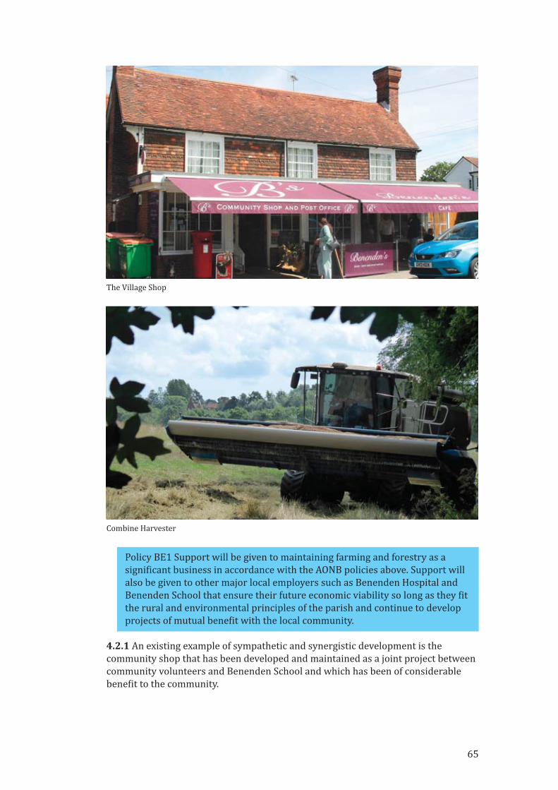
Policy BE1 Support will be given to maintaining farming and forestry as a
signi�icant business in accordance with the AONB policies above. Support will
also be given to other major local employers such as Benenden Hospital and
Benenden School that ensure their future economic viability so long as they �it
the rural and environmental principles of the parish and continue to develop
projects of mutual bene�it with the local community.
4.2.1 An existing example of sympathetic and synergistic development is the
community shop that has been developed and maintained as a joint project between
community volunteers and Benenden School and which has been of considerable
bene�it to the community.
The Village Shop
Combine Harvester
65

4.2.2 The National Planning Policy Framework8 notes that although business
development sites in rural areas ‘may have to be found adjacent to or beyond
existing settlements, and in locations that are not well served by public transport...
it will be important to ensure that development is sensitive to its surroundings, does
not have an unacceptable impact on local roads and exploits any opportunities to
make a location more sustainable.’
8 National Planning Policy Framework’ Section 84, Ministry of Housing, Communities and Local Government, 2019
‐ https://www.gov.uk/government/publications/national‐planning‐policy‐framework‐‐2
Benenden Hospital
Benenden School
66
67
4.3 Businesses are spread across the parish with, for example, Benenden Hospital at
East End, Benenden School at Hemsted, Laurels Nursery and Dingleden Vineyard at
Dingleden, a farm shop and Mr Noah’s Nursery School in Iden Green. The Street, at
the centre of Benenden, hosts several disparate enterprises including Wards the
butchers, St George’s Social Club, Benenden pre‐school playgroup, the community
shop, post of�ice and café, the Bull pub and most recently the Maison Manicure nail
bar. In the centre of Benenden, the Grange Care Home and the Primary School as
well as providing essential community services, each employ over 25 people.
4.4 These all provide important services and employment and contribute
signi�icantly to maintaining a vibrant local economy. Of the near 1000 employees
working in parish businesses, approximately 90% commute into the parish to come
to work.
4.5 The surveys conducted for this plan indicate that there are approximately 100
small businesses typically employing fewer than 5 people as well as a growing
number of solo home workers. For more detailed information on the majority of
businesses across the parish see the Local Business Survey 2018 (Supporting
Document BEA3).
4.6 Benenden village also hosts a number of other Community Assets which are
sources of employment including the Primary School, Village and Memorial Halls
and St Georges Club and Pre‐School.
4.6.1 This applies to existing Community Assets9 and new initiatives to be
investigated and developed for the future bene�it of the economy, inhabitants and/or
environment of the parish. As previously highlighted in the Benenden Parish Plan
201510 support, both practical and �inancial, is required to ensure the success of
local businesses and business sites. Examples that were identi�ied during the
workshop sessions include health care facilities, dedicated pre‐school playgroup
facilities, a community resource centre including of�ice accommodation and meeting
rooms, telecommunications and broadband, village information centre and
recreational facilities.
4.7 The intention of all the proposed policies is to be consistent with the High Weald
AONB Management Plan 2019‐24 objective S111 which is ‘to reconnect settlements,
residents and their supporting economic activity with the surrounding countryside.’
4.8 Land‐based industry, tourism, sporting and craft‐based businesses will be
encouraged whilst those attracting high volumes of vehicular traf�ic and that have
potentially signi�icant environmental impact will not. Businesses and institutions
that provide services required by the whole community including older people and
the disabled, such as medical facilities, care provision, training and education, will be
actively sought to support the need as identi�ied in the NPPF, para 8.12
9 Schedule of Community Assets see Parish Plan 2015
10 Parish Plan 2015 p.15
11 High Weald AONB Management Plan 2019‐2024 objective S1 p.33
12 NPPF 2018 para 8
68
4.8.1 This policy is consistent with the TWBC Economic Needs Study13 …‘Villages
were also deemed appropriate locations for small‐scale economic development
activity, while appropriate rural buildings could also be converted to facilitate
economic development’.
4.9 The business survey (Supporting Document BEA3) indicated a rich variety of
over 30 business types in the village that provide opportunities for symbiotic
development. Over 40% of the current village businesses cited that availability of
suitable premises was an attraction to setting up business in Benenden. The
business survey con�irmed the �indings of the 2015 Benenden Parish Plan14 that
there are signi�icant challenges that need addressing in the provision of good quality
broadband and mobile phone communication (See Policy T6).
4.10 Over a quarter of the businesses in the business survey (Supporting Document
BEA3) are likely to require more accommodation in the next 3 to 5 years. Similarly,
over 25% considered that it was getting increasingly dif�icult to �ind premises.
Businesses that underpin the social fabric of the village, such as the pre‐school
playgroup, reported the need for improved premises so they could properly continue
their essential work.
4.10.1 The Tunbridge Wells Borough Local Development Framework, Core Strategy
Development Plan Document (adopted June 2010), Section 5.191 quotes PPS415 in
supporting the re‐use of appropriately located and suitably constructed existing
buildings and states that re‐use for business purposes will usually be preferable to
residential. It also notes that the change of use, or conversion of, an existing building
may therefore be permitted if it would provide the best reasonable means of
conserving the character, appearance, fabric and setting of a listed building or a
building whose loss would be detrimental to the character of the countryside. This is
re�lected in TWBC Core Strategy Development Plan Core Policy 14.16
Policy BE2 We will support the re‐development of previously developed land
and redundant buildings particularly for new and existing businesses that
reinforce the inherently rural nature of our surroundings and sustain the
balance between housing and commercial provision.
Policy BE3 In order to maintain local employment, existing commercial areas
should not be developed for housing over the life of this NDP, speci�ically
Apple Pie Farm, Cranden Industrial Estate, Turks Yard and the Hams Travel
site.
4.11 The survey of businesses (Supporting Document BEA3) highlighted in
particular the current challenges with broadband and mobile coverage, safe and
well‐maintained roads, local recycling of a full range of refuse, renewable energy
sources, utility and sewerage provision.
13 Sevenoaks and Tunbridge Wells Borough Council Economic Needs Study – Final Report for Tunbridge Wells, 2016
para 3.4514 Parish Plan 2015 pp.13‐15
15 Tunbridge Wells Borough Local Development Framework, Core Strategy Development Plan Document (adopted
June 2010), Section 5.191 Planning Policy Statement 4: Planning for Sustainable Economic Growth
16 Tunbridge Wells Borough Council Core Strategy Development Plan Policy 14
Policy BE4 No signi�icant business or residential development project shall be
approved without evidence of a detailed infrastructure impact assessment and
a plan to deliver requirements.
Business and the Economy
ProjectsIn the process of listening to the community and in particular local businesses and
operators of Community Assets a number of quite speci�ic and near term projects
have emerged which will be launched by the Parish Council and executed on its
behalf by discrete projects which are monitored by a Neighbourhood Plan Forum
created from the Plan Team supplemented by further participants and skills as
required. These include:
1. Technical feasibility study to improve broadband and mobile signal In conjunction with Operating Companies, Consultants and the Community
[Asset Owners] conduct a technical and commercial feasibility study to
improve broadband and mobile communications in the Parish.
2. Renewable energy Engage with businesses to assess the potential for renewable energy and local
recycling.
3. Increased connectivity Opportunities will continue to be sought to foster closer working relationships
with and between all the village businesses and enterprises where it is
bene�icial to the community and the environment. An existing example of
sympathetic and synergistic development is the community shop that has
been developed and maintained as a joint project between the Parish Council
and Benenden School (see Supporting Document BEA6).
4. Meetings/Online directory Over a third of the businesses responding to the business survey are
interested in regularly meeting with others in the village and over 75% would
like to be listed in an online village directory.
5. Utilise data gathered in researching the BNDP Ensure that data gathered as a part of the plan process, for example, sources of
�inancing and creative development schemes are rolled out to interested
parties in site speci�ic meetings (see Supporting Documents BEA7 & 8).
Supporting Documents
BEA1 SWOT Analysis from Visioning Workshop 28th October 2017
BEA2 Employee Survey – 2018
BEA3 Local Business Survey 2018
BEA4 Note on Benenden Community Shop
69

70
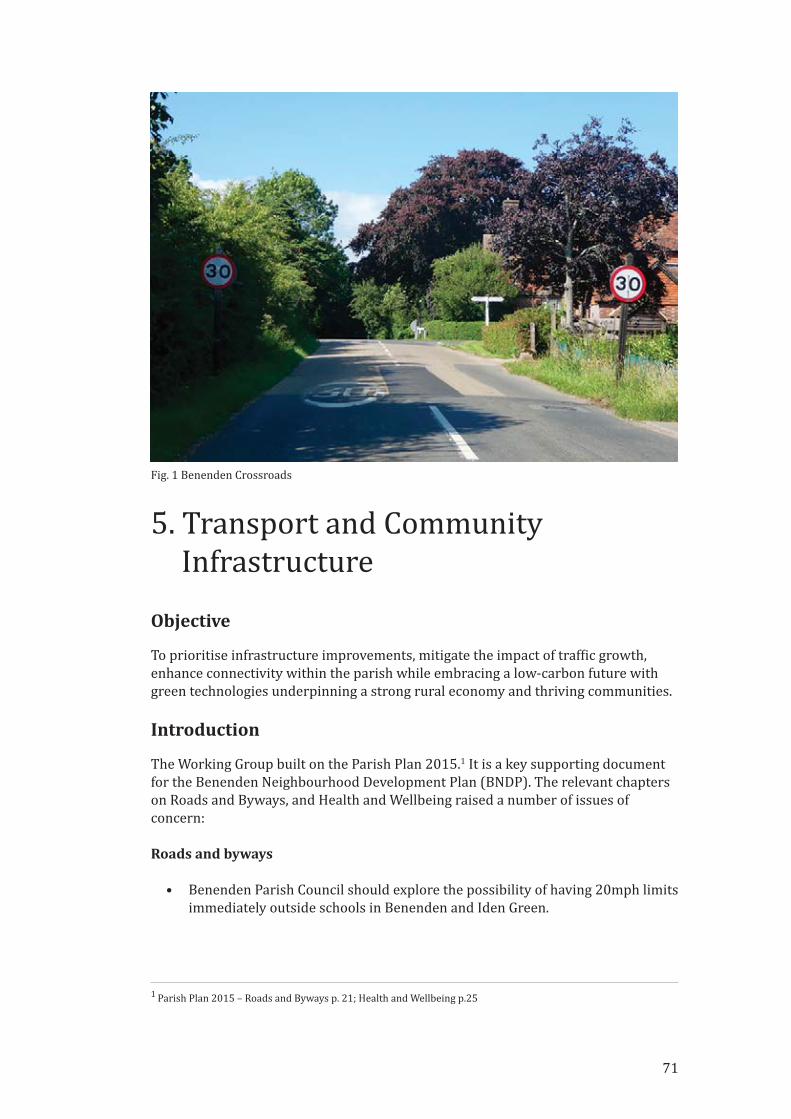
71
5. Transport and Community
Infrastructure
Objective
To prioritise infrastructure improvements, mitigate the impact of traf�ic growth,
enhance connectivity within the parish while embracing a low‐carbon future with
green technologies underpinning a strong rural economy and thriving communities.
Introduction
The Working Group built on the Parish Plan 2015.1 It is a key supporting document
for the Benenden Neighbourhood Development Plan (BNDP). The relevant chapters
on Roads and Byways, and Health and Wellbeing raised a number of issues of
concern:
Roads and byways
• Benenden Parish Council should explore the possibility of having 20mph limits
immediately outside schools in Benenden and Iden Green.
1 Parish Plan 2015 – Roads and Byways p. 21; Health and Wellbeing p.25
Fig. 1 Benenden Crossroads

• The crossroads at Benenden (see Fig. 1) and at Iden Green are both potentially
dangerous and there have been a number of near collisions [now several
serious accidents]. It is recommended that the Parish Council raises the issue
of the crossroads with Kent County Council (KCC).
• Facilities for cyclists are inadequate within the parish and should be improved.
Health and wellbeing
• Healthcare provision in the village is limited. Benenden Hospital offers limited
NHS services and some other services to members of its healthcare plan.
District nurses and associated staff visit the village but there is no clinic base.
Family doctor services are provided to parishioners from practices in
Tenterden, Cranbrook and Hawkhurst. Other services, such as dentistry and
opticians, are also based in nearby towns.
• Over 40% of parishioners felt that access to healthcare services is a problem;
with over 70% stating that they would like to see a nurse‐led clinic and
chiropody services visit the village.
Following the initial Neighbourhood Plan Visioning Workshop on 28th October
2017, the Transport and Infrastructure Workshop took place on 9th December 2017.
As well as addressing business and economic issues this workshop also considered
transport and infrastructure. At the Visioning Workshop a ‘SWOT’ (strengths,
weaknesses, opportunities and threats) exercise (see Supporting Documents TA1)
explored issues including:
• improved infrastructure to cope with more houses/cars
• better maintained roads
• hazardous crossroads at Benenden and Iden Green
• poor broadband/mobile signal
• improve existing leisure amenities (tennis/bowls/football/cricket)
• a school minibus/community minibus
After further discussions with the Parish Council and the Neighbourhood Plan
Steering Group, the objective (above) was agreed as representing the views of many
parishioners and to provide a basis for the Working Group.
Process
The residents of Benenden have consistently supported managed housing growth.2
However, they have real concerns about the impact of growth on the limited rural
infrastructure of the parish. Following the Transport & Infrastructure Workshop, a
number of avenues were explored to enhance the experience of living in the parish
during the lifetime of the BNDP.
2 Parish Plan 2015 page 9 proposed housing growth of 1% per year would be an appropriate target.
72

Principal aims:
• improved facilities and greater connectivity both within the parish and with
the wider world
• encourage the application of new technologies to improve communication and
to protect the environment
• better maintained roads
• improved safety of crossroads in Benenden, Iden Green and Castleton Oak
• implementation of traf�ic calming measures such as 20mph speed limits
• encourage sustainable links using footpaths and cycle‐paths
Policy context/justi�ication
The High Weald Area of Outstanding Natural Beauty (AONB) Management Plan3
seeks to preserve the character of both the landscape and its settlements but also
stresses that they should be economically viable i.e. not a museum. The BNDP
contains planning policies and projects that complement the High Weald AONB
Management Plan.
The transport and infrastructure policies have been drafted to complement those of
the National Planning Policy Framework (NPPF) 2018 and the Tunbridge Wells
Local Plan (2019). Para 102 of the NPPF demands that potential impacts of
development on transport networks is addressed and that opportunities to promote
walking, cycling and public transport are identi�ied. Para 104 of the NPPF requires
planning policy makers to engage with highways authorities and to provide high
quality walking and cycling networks. NDP creators are asked to produce policies
that will support high quality communications. NPPF paras 112 – 114 seek to
discourage creation of new mobile phone masts by making maximum use of existing
facilities and encouraging wireless technology. However, if new facilities are
required, they should be camou�laged to minimise their adverse visual impact.
Landowners and Developers will review the Infrastructure Policies set out in the
BNDP and must set out within their plans how they will contribute to their delivery.
Community Infrastructure Levies (CIL), Section 106 contributions and other grants
or donations made via Tunbridge Wells Borough Council or direct to Benenden
Parish Council will be used to enable the policies listed below.
Neighbourhood Planning and Transport
A number of the transport/traf�ic concerns/issues raised at the workshops are
outside the remit of the BNDP. This Plan makes recommendations for infrastructure
enhancements based on local knowledge and requirements. These
recommendations should be taken into account by planners when outlining
infrastructure requirements to support housing development in the parish.
3 AONB Management Plan 2019‐2024
73
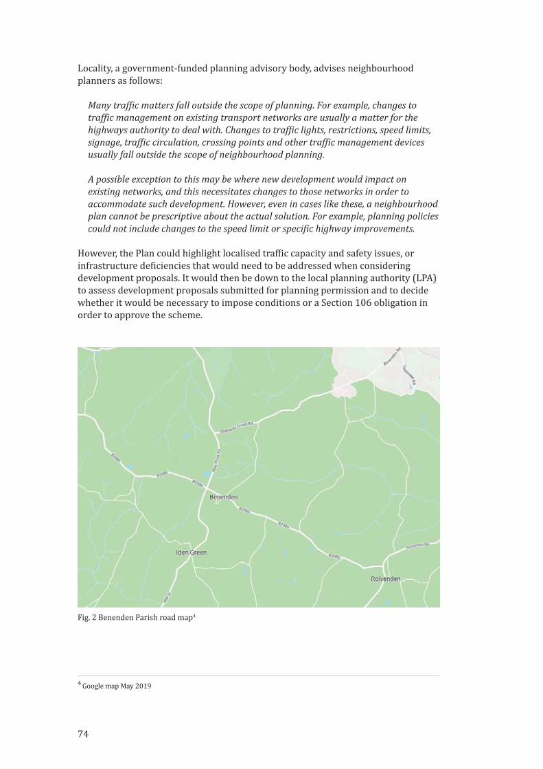
Locality, a government‐funded planning advisory body, advises neighbourhood
planners as follows:
Many traf�ic matters fall outside the scope of planning. For example, changes totraf�ic management on existing transport networks are usually a matter for thehighways authority to deal with. Changes to traf�ic lights, restrictions, speed limits,signage, traf�ic circulation, crossing points and other traf�ic management devicesusually fall outside the scope of neighbourhood planning.
A possible exception to this may be where new development would impact onexisting networks, and this necessitates changes to those networks in order toaccommodate such development. However, even in cases like these, a neighbourhoodplan cannot be prescriptive about the actual solution. For example, planning policiescould not include changes to the speed limit or speci�ic highway improvements.
However, the Plan could highlight localised traf�ic capacity and safety issues, or
infrastructure de�iciencies that would need to be addressed when considering
development proposals. It would then be down to the local planning authority (LPA)
to assess development proposals submitted for planning permission and to decide
whether it would be necessary to impose conditions or a Section 106 obligation in
order to approve the scheme.
4 Google map May 2019
Fig. 2 Benenden Parish road map4
74

Parish Infrastructure: Transport
Benenden Parish is one of the remotest parts of the Tunbridge Wells Borough,
roughly equidistant from centres of commerce and potential sources of work in
Ashford, Hastings, Maidstone and Tunbridge Wells. It comprises three main
settlements (Benenden, Iden Green and East End), and 29 smaller settlements or
‘dens’ connected by a network of narrow lanes.
The UK Department for Transport forecasts an increase in road traf�ic of between
19% and 55% by 2040.5 The B2086, Iden Green Road, New Pond Road and Goddards
Green Road (see Fig. 2) will be subject to increased traf�ic volumes. Maintaining safe
connectivity for drivers, pedestrians and cyclists within the parish will require
careful management and investment. Our local roads are narrow and often not well
maintained. There are already signi�icant traf�ic bottle‐necks in Hawkhurst,
Sissinghurst and Goudhurst on journeys to the A21 and to the railway stations at
Staplehurst or Headcorn. Increased traf�ic is adding to the risk of accidents and
discourages walking / cycling.
Public transport connections are very limited: It takes 1 hour 17 minutes to travel to
Tunbridge Wells by bus, with a maximum of 6 buses per day. It takes 30 minutes to
travel to Tenterden by bus. There is no direct bus route to Maidstone or Ashford nor
to the Railway Station at Staplehurst. Train journeys to central London take an hour,
but the drive to Staplehurst (nearest train station) adds a further 20 mins travel
time.
This Plan welcomes a new initiative by Kent County Council to create a new ‘hopper’
bus service. The service will run Monday to Friday between Iden Green, Benenden
and East End to and from Tenterden. It is designed to be a taxi bus service calling at
scheduled stops en‐route but also able to pick up and drop off passengers in more
rural locations. The service will run directly past three of the four development sites
within our Plan and very close to the fourth site.
The Policies
5.1 In 2011 there were 837 dwellings in Benenden Parish and a population of 1824
permanent residents.6 Since then just under 20 additional dwellings have been built,
planning consent for a further 36 have been approved and this plan allows for an
indicative �igure of around 100 further dwellings. This 18.6% increase in homes will
place additional strain on our rural road network. The core village of Benenden
contains only 32.4% of the residential properties in the parish. The scattered nature
of settlement results in high levels of car use for journeys within the parish.
5.1.1 Average car ownership in Benenden is 1.8 vehicles per household compared to
1.2 cars per household across Kent.6 Increased car journeys may result in increased
congestion and accident risk so alternative means should be encouraged. NPPF para
102(c) underlines the importance of promoting walking and cycling as part of a
wider transport infrastructure. Cycling has grown in popularity as the bene�its of
5 DfT – Road Traf�ic Forecasts 2018
6 UK Census 2011
75
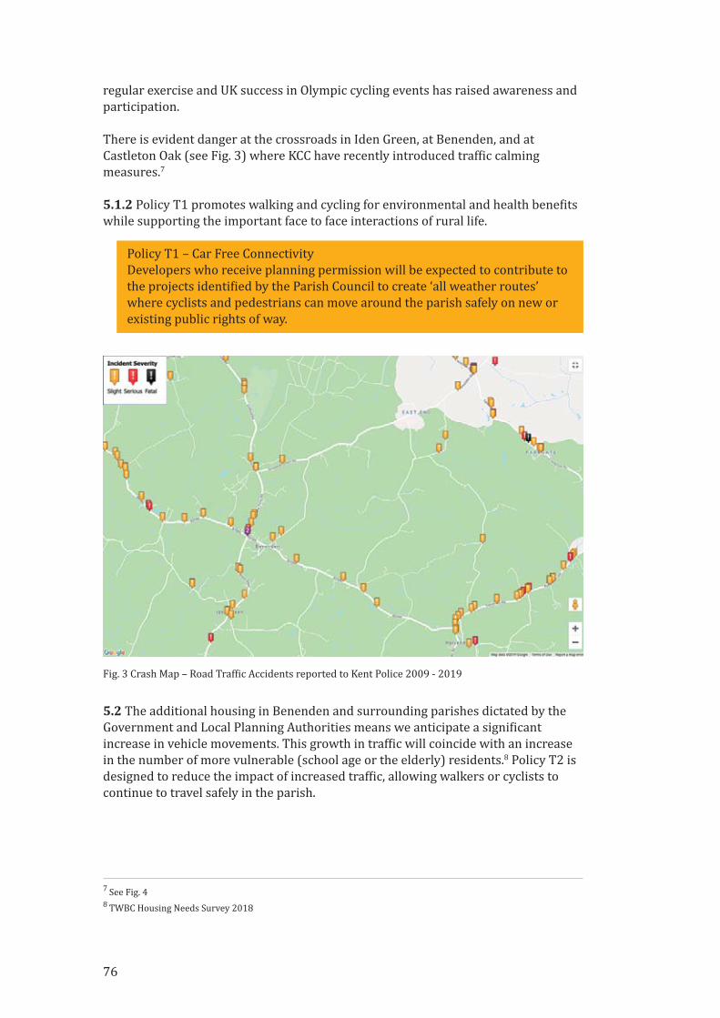
regular exercise and UK success in Olympic cycling events has raised awareness and
participation.
There is evident danger at the crossroads in Iden Green, at Benenden, and at
Castleton Oak (see Fig. 3) where KCC have recently introduced traf�ic calming
measures.7
5.1.2 Policy T1 promotes walking and cycling for environmental and health bene�its
while supporting the important face to face interactions of rural life.
Policy T1 – Car Free Connectivity
Developers who receive planning permission will be expected to contribute to
the projects identi�ied by the Parish Council to create ‘all weather routes’
where cyclists and pedestrians can move around the parish safely on new or
existing public rights of way.
5.2 The additional housing in Benenden and surrounding parishes dictated by the
Government and Local Planning Authorities means we anticipate a signi�icant
increase in vehicle movements. This growth in traf�ic will coincide with an increase
in the number of more vulnerable (school age or the elderly) residents.8 Policy T2 is
designed to reduce the impact of increased traf�ic, allowing walkers or cyclists to
continue to travel safely in the parish.
7 See Fig. 4
8 TWBC Housing Needs Survey 2018
Fig. 3 Crash Map – Road Traf�ic Accidents reported to Kent Police 2009 ‐ 2019
76
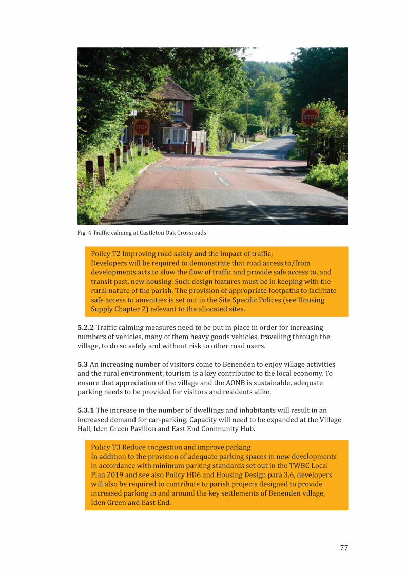
Policy T2 Improving road safety and the impact of traf�ic;
Developers will be required to demonstrate that road access to/from
developments acts to slow the �low of traf�ic and provide safe access to, and
transit past, new housing. Such design features must be in keeping with the
rural nature of the parish. The provision of appropriate footpaths to facilitate
safe access to amenities is set out in the Site Speci�ic Polices (see Housing
Supply Chapter 2) relevant to the allocated sites.
5.2.2 Traf�ic calming measures need to be put in place in order for increasing
numbers of vehicles, many of them heavy goods vehicles, travelling through the
village, to do so safely and without risk to other road users.
5.3 An increasing number of visitors come to Benenden to enjoy village activities
and the rural environment; tourism is a key contributor to the local economy. To
ensure that appreciation of the village and the AONB is sustainable, adequate
parking needs to be provided for visitors and residents alike.
5.3.1 The increase in the number of dwellings and inhabitants will result in an
increased demand for car‐parking. Capacity will need to be expanded at the Village
Hall, Iden Green Pavilion and East End Community Hub.
Policy T3 Reduce congestion and improve parking
In addition to the provision of adequate parking spaces in new developments
in accordance with minimum parking standards set out in the TWBC Local
Plan 2019 and see also Policy HD6 and Housing Design para 3.6, developers
will also be required to contribute to parish projects designed to provide
increased parking in and around the key settlements of Benenden village,
Iden Green and East End.
Fig. 4 Traf�ic calming at Castleton Oak Crossroads
77
Parish Infrastructure: Amenities and Leisure
5.4 The Parish has two village halls (Benenden and Iden Green), two village greens,
community recreation areas, sport facilities (bowls, cricket, football, tennis). Meeting
places for local clubs include the St. George’s Club, the Village Hall, Memorial Hall
and the Iden Green Pavilion. Benenden’s new Primary School opens in 2019 and Mr
Noah’s in Iden Green provides pre‐school places. More recent community initiatives
are the Community Shop & cafe and the formation of the Benenden Village Trust
(which owns many of the village amenities). There are a number of recreational
clubs, ranging from the Benenden Players, Benenden Bon�ire Society and Bell‐
Ringing to the Ukulele Band, and village sports clubs (bowls, cricket, darts, tennis).
The village has lost two village pubs in the past 20 years, but still retains a pub in the
centre of the village (The Bull) and another in Iden Green (The Woodcock). Churches
include the congregational church in Iden Green, St George’s (CofE) at the top of the
village green, and the Catholic chapel in New Pond Road. Limited banking and cash
withdrawals can be made through the Post Of�ice associated with the Community
Shop and Benenden Hospital offers an ATM and café for residents of East End.
5.4.1 With new housing there will come increasing demand for sports and other
recreational facilities. Continued good provision is recognised as essential for both
personal and community health and well‐being in both Borough9 and National
Planning10 guidance.
5.4.2 BNDP recognises the importance of community cohesion and that with
increased housing growth developers should enable the village to build strong,
sustainable support networks. Contributions to meeting spaces, community clubs
and community transport infrastructure will be required.
5.4.3 The parish supports the provision of safe children’s play areas. Benenden
Village Trust are currently refurbishing the children’s play area in Benenden. There
is a smaller playground in Iden Green, but there is currently no provision for
younger children in East End. Funding for a play area should be provided by the
developer of Sites 424 and LS 41.
5.4.5 East End currently has limited community facilities. Benenden’s Community
Shop has demonstrated that small, locally led projects can have a positive impact on
community cohesion, and this should be replicated with commercial and social
facilities provided as an East End Community Hub.
Policy T4: Community Cohesion and Recreational Facilities
Developers will be required to contribute to parish projects designed to
improve provision for children’s play areas in all three main settlements
within the parish. Developers will also be required to support projects
designed to meet the health and well‐being needs of residents.
9 Tunbridge Wells Borough Council Open Space Study – June 2018
10 NPPF July 2018 Section 8 Policy 92
78
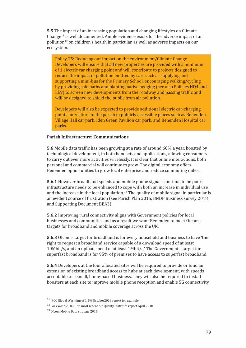
5.5 The impact of an increasing population and changing lifestyles on Climate
Change11 is well documented. Ample evidence exists for the adverse impact of air
pollution12 on children’s health in particular, as well as adverse impacts on our
ecosystem.
Policy T5: Reducing our impact on the environment/Climate Change
Developers will ensure that all new properties are provided with a minimum
of 1 electric car charging point and will contribute to projects designed to
reduce the impact of pollution emitted by cars such as supplying and
supporting a mini‐bus for the Primary School, encouraging walking/cycling
by providing safe paths and planting native hedging (see also Policies HD4 and
LE9) to screen new developments from the roadway and passing traf�ic and
will be designed to shield the public from air pollution.
Developers will also be expected to provide additional electric car‐charging
points for visitors to the parish in publicly accessible places such as Benenden
Village Hall car park, Iden Green Pavilion car park, and Benenden Hospital car
parks.
Parish Infrastructure: Communications
5.6 Mobile data traf�ic has been growing at a rate of around 60% a year, boosted by
technological development, in both handsets and applications, allowing consumers
to carry out ever more activities wirelessly. It is clear that online interactions, both
personal and commercial will continue to grow. The digital economy offers
Benenden opportunities to grow local enterprise and reduce commuting miles.
5.6.1 However broadband speeds and mobile phone signals continue to be poor:
infrastructure needs to be enhanced to cope with both an increase in individual use
and the increase in the local population.13 The quality of mobile signal in particular is
an evident source of frustration (see Parish Plan 2015, BNDP Business survey 2018
and Supporting Document BEA3).
5.6.2 Improving rural connectivity aligns with Government policies for local
businesses and communities and as a result we want Benenden to meet Ofcom’s
targets for broadband and mobile coverage across the UK.
5.6.3 Ofcom’s target for broadband is for every household and business to have ‘the
right to request a broadband service capable of a download speed of at least
10Mbit/s, and an upload speed of at least 1Mbit/s.’ The Government’s target for
superfast broadband is for 95% of premises to have access to superfast broadband.
5.6.4 Developers at the four allocated sites will be required to provide or fund an
extension of existing broadband access to hubs at each development, with speeds
acceptable to a small, home‐based business. They will also be required to install
boosters at each site to improve mobile phone reception and enable 5G connectivity.
11 IPCC Global Warming of 1.5% October2018 report for example,
12 For example DEFRA’s most recent Air Quality Statistics report April 2018
13 Ofcom Mobile Data strategy 2016
79

Policy T6: Infrastructure, Broadband and Mobile
Developers will be required to contribute to appropriate new amenities, new
infrastructure and public transport provision as agreed with the Parish,
Borough and County Councils in order to improve connectivity within the
parish and with the wider community. Speci�ically, developers will contribute
to parish projects designed to enhance broadband speed and also to enable
the centre of East End to be connected to superfast broadband.
Parish Infrastructure: Essential Services
5.7 Research underpinning the BNDP suggests that core essential services are
generally considered to be adequate within the village. Waste water and sewerage
capacity is something that will need careful attention from developers in order not
to impact the environment (see Policy LE8) but current systems have been assessed
as adequate14 for the additional housing under consideration.
5.7.1 The whole parish has access to mains electricity, however much of the parish
does not have a mains gas supply and many residents therefore use either wood,
electricity or oil‐�ired heating.
Transport and infrastructure
ProjectsThese projects have been identi�ied by the BNDP team and recommended to the
Parish Council as priority infrastructure improvements. They may be facilitated by
the Community Infrastructure Levy (CIL). Each project will require oversight by the
Parish Council and require engagement with other organisations such as Kent
County Council, BT and mobile phone providers. Volunteers from within the
community should be encouraged to help the Parish Council deliver each project.
Initial scoping for each project should be led by the Parish Council, funded by
developer contributions.
Each Project should be scoped out prior to review and assessment by the Parish
Council to prioritise and determine which should be taken forward.
1. Support Car Free ConnectivityThe Parish Council to identify an active route (see Fig 5) and work with Sustrans /
KCC to create a combined Cycle Lane and Footpath linking Green Lane (East End)
with Walkhurst Road (Benenden). The outline report is available in Supporting
Document TA2. See also Site Speci�ic Policy 3.
14 AECOM Sustainability Scoping Report April 2019
80
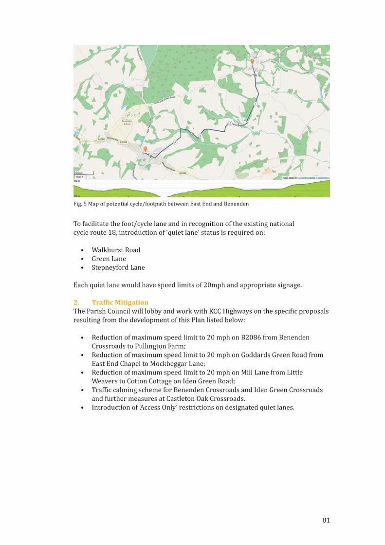
To facilitate the foot/cycle lane and in recognition of the existing national
cycle route 18, introduction of ‘quiet lane’ status is required on:
• Walkhurst Road
• Green Lane
• Stepneyford Lane
Each quiet lane would have speed limits of 20mph and appropriate signage.
2. Traf�ic MitigationThe Parish Council will lobby and work with KCC Highways on the speci�ic proposals
resulting from the development of this Plan listed below:
• Reduction of maximum speed limit to 20 mph on B2086 from Benenden
Crossroads to Pullington Farm;
• Reduction of maximum speed limit to 20 mph on Goddards Green Road from
East End Chapel to Mockbeggar Lane;
• Reduction of maximum speed limit to 20 mph on Mill Lane from Little
Weavers to Cotton Cottage on Iden Green Road;
• Traf�ic calming scheme for Benenden Crossroads and Iden Green Crossroads
and further measures at Castleton Oak Crossroads.
• Introduction of ‘Access Only’ restrictions on designated quiet lanes.
Fig. 5 Map of potential cycle/footpath between East End and Benenden
81

3. Additional Car ParkingThe Parish Council will arrange and manage meetings between landowners with a
view to improving both public and residential car parking provision. Speci�ically
looking at:
• Providing additional car parking spaces in Rothermere Close. Working with
the housing association and Benenden Almshouse Charities to see if additional
car parking can be designed to reduce congestion for residents.
• Providing additional car parking spaces at Benenden Village Hall. Working
with the Benenden Village Trust to extend existing car parking, reducing the
adverse impact on village streets (see Fig. 6) when large events are held at
the hall.
Fig. 7 Traf�ic Congestion, The Street Benenden
Fig. 6 Traf�ic Congestion, The Street Benenden
82

83
4. Support Health & Community CohesionThe Parish Council will identify means of providing a designated space for ‘medical
use’ , such as roving GP/nurse/physio/podiatrist/dentist, which will be funded by
developer contributions.
Supporting Documents
TA1 ‘SWOT’ data
TA2 Cycle route report

84
Glossary of Terms (In alphabetical order)
AONB Area of Outstanding Natural Beauty
Allocated Site A site which has been allocated for the NDP for housing development
BNDP Benenden Neighbourhood Development Plan
BPC Benenden Parish Council
Call for Sites TWBC’s request to Landowners to put forward land for possible
housing development
CIL Community Infrastructure Levy
CLT Community Land Trust
CPRE Campaign for the Protection of Rural England
DPH Dwellings Per Hectare
HELAA Housing and Economic Land Availability Assessment
HNS Housing Needs Survey
ISA Individual Site Appraisal
KCC Kent County Council
LBD Limits to Built Development
LGS Local Green Space
LPA Local Planning Authority
LS Late (submitted) Site
LWS Local Wildlife Site
NDP Neighbourhood Development Plan
NPPF National Planning Policy Framework
OAN Objectively Assessed Need (affordable housing)
PPS Government Planning Policy Statement
Section 106 Developer contributions required as a planning requirements
SHELAA Strategic Housing and Environmental Land Availability Assessment
SSP Site Speci�ic Policy produced by the NDP Housing Supply Group
SSSI Site of Special Scienti�ic Interest
Submitted Site A site put forward for development by Landowners under the TWBC
‘Call for Sites’ programme
TPO Tree Preservation Order
TWBC Tunbridge Wells Borough Council
Windfall Site A Site of new housing development which gain planning approval, in
addition to the agreed sites detailed in the NDP