reconstruction of paleovegetation and paleoclimate in the early and middle eocene, hainan island,...
TRANSCRIPT
Climatic Change (2009) 92:169–189DOI 10.1007/s10584-008-9457-2
Reconstruction of paleovegetation and paleoclimatein the Early and Middle Eocene, Hainan Island, China
Yi-Feng Yao · Subir Bera · David K. Ferguson ·Volker Mosbrugger · Khum N. Paudayal ·Jian-Hua Jin · Cheng-Sen Li
Received: 3 January 2007 / Accepted: 17 April 2008 / Published online: 16 September 2008© Springer Science + Business Media B.V. 2008
Abstract The Early–Middle Eocene palynoflora and paleoclimate of ChangchangBasin, Hainan Island, South China, is described in the present paper and is comparedwith that of the Middle–Late Eocene, Hunchun City, Jilin Province, North China.
Y.-F. Yao · C.-S. Li (B)State Key Laboratory of Systematic and Evolutionary Botany,Institute of Botany, Chinese Academy of Sciences,Beijing 100093, People’s Republic of Chinae-mail: [email protected]
Y.-F. Yaoe-mail: [email protected]
S. BeraDepartment of Botany, University of Calcutta, Kolkata 700019, Indiae-mail: [email protected]
D. K. FergusonDepartment of Paleontology, University of Vienna,Althanstrasse 14, 1090 Vienna, Austriae-mail: [email protected]
V. MosbruggerSenckenberg Forschungsinstitut und Naturmuseum,Senckenberganlage 25, 60325 Frankfurt am Main, Germanye-mail: [email protected]
K. N. PaudayalCentral Department of Geology, Tribhuvan University,Kirtipur, Kathmandu, Nepale-mail: [email protected]
J.-H. Jin (B)School of Life Sciences, Sun Yat-sen University,Guangzhou 510275, People’s Republic of Chinae-mail: [email protected]
170 Climatic Change (2009) 92:169–189
The nearest living relatives (NLRs) of the recovered palynotaxa suggest a subtropicalevergreen or deciduous broad-leaved forest at the center of the basin but a temperateevergreen or deciduous broad-leaved forest and needle-leaved forest growing inthe peripheral part of the basin. Based on the climatic preferences of the NLRs,the climate in the Changchang Basin during the Early–Middle Eocene was warmand humid subtropical with a mean annual temperature of 14.2–19.8◦C, a meantemperature of the warmest month of 22.5–29.1◦C, a mean temperature of the coldestmonth of 1.7–11.9◦C, a difference of temperature between coldest and warmestmonths of 12.1–24.6◦C, a mean annual precipitation of 784.7–1,113.3 mm, a meanmaximum monthly precipitation of 141.5–268.1 mm and a mean minimum monthlyprecipitation of 6.9–14.1 mm. A comparison of the palynoflora and paleoclimatebetween the Changchang Basin and Hunchun City, suggests essentially a similarclimate in South and North China during Eocene time in contrast to the oceanictropical climate in South China and cool dry temperate climate in North China as atpresent.
1 Introduction
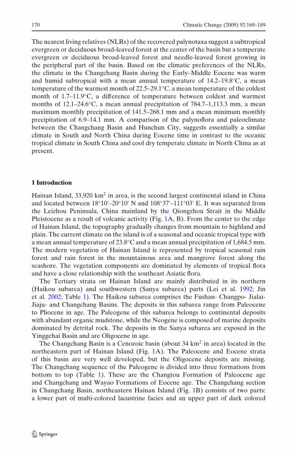
Hainan Island, 33,920 km2 in area, is the second largest continental island in Chinaand located between 18◦10′–20◦10′ N and 108◦37′–111◦03′ E. It was separated fromthe Leizhou Peninsula, China mainland by the Qiongzhou Strait in the MiddlePleistocene as a result of volcanic activity (Fig. 1A, B). From the center to the edgeof Hainan Island, the topography gradually changes from mountain to highland andplain. The current climate on the island is of a seasonal and oceanic tropical type witha mean annual temperature of 23.8◦C and a mean annual precipitation of 1,684.5 mm.The modern vegetation of Hainan Island is represented by tropical seasonal rainforest and rain forest in the mountainous area and mangrove forest along theseashore. The vegetation components are dominated by elements of tropical floraand have a close relationship with the southeast Asiatic flora.
The Tertiary strata on Hainan Island are mainly distributed in its northern(Haikou subarea) and southwestern (Sanya subarea) parts (Lei et al. 1992; Jinet al. 2002; Table 1). The Haikou subarea comprises the Fushan- Changpo- Jialai-Jiaju- and Changchang Basins. The deposits in this subarea range from Paleoceneto Pliocene in age. The Paleogene of this subarea belongs to continental depositswith abundant organic mudstone, while the Neogene is composed of marine depositsdominated by detrital rock. The deposits in the Sanya subarea are exposed in theYinggehai Basin and are Oligocene in age.
The Changchang Basin is a Cenozoic basin (about 34 km2 in area) located in thenortheastern part of Hainan Island (Fig. 1A). The Paleocene and Eocene strataof this basin are very well developed, but the Oligocene deposits are missing.The Changchang sequence of the Paleogene is divided into three formations frombottom to top (Table 1). These are the Changtou Formation of Paleocene ageand Changchang and Wayao Formations of Eocene age. The Changchang sectionin Changchang Basin, northeastern Hainan Island (Fig. 1B) consists of two parts:a lower part of multi-colored lacustrine facies and an upper part of dark colored
Climatic Change (2009) 92:169–189 171
Fig. 1 Location of Changchang Basin in Hainan Island (A). Detail map around Jiazi Town,Qiongshan City (B)
172 Climatic Change (2009) 92:169–189
Tab
le1
Cen
ozoi
cst
rata
ofH
aina
nIs
land
(Jin
etal
.200
2)
Geo
logi
calp
erio
dSe
dim
enta
ryba
sin
Fus
han
Bas
inC
hang
poB
asin
Jial
aiB
asin
Jiaj
uB
asin
Cha
ngch
ang
Bas
inY
ingg
ehai
Bas
in
Neo
gene
Plio
cene
Wan
glou
gang
Fm
.W
angl
ouga
ngF
m.
Plio
cene
Plio
cene
Yin
ggeh
aiF
m.
Mio
cene
LD
engl
oujia
oF
m.
Den
glou
jiao
Fm
.D
engl
oujia
oF
m.
MJi
aow
eiF
m.
Cha
ngpo
Fm
.C
hang
poF
m.
Cha
ngpo
Fm
.H
uang
liuF
m.
EX
iaya
ngF
m.
Mei
shan
Fm
.P
aleo
gene
Olig
ocen
eL
–MW
eizh
ouF
m.
Sany
aF
m.
EL
iush
agan
gF
m.
The
first
mem
ber
Eoc
ene
LT
hese
cond
mem
ber
Way
aoF
m.
MT
heth
ird
mem
ber
Cha
ngch
ang
Fm
.E
Wen
shic
unF
m.
Pal
eoce
neC
hang
liuF
m.
Hao
xian
Fm
.C
hang
tou
Fm
.
LL
ate,
Mm
iddl
e,E
earl
y;F
m.f
orm
atio
n
Climatic Change (2009) 92:169–189 173
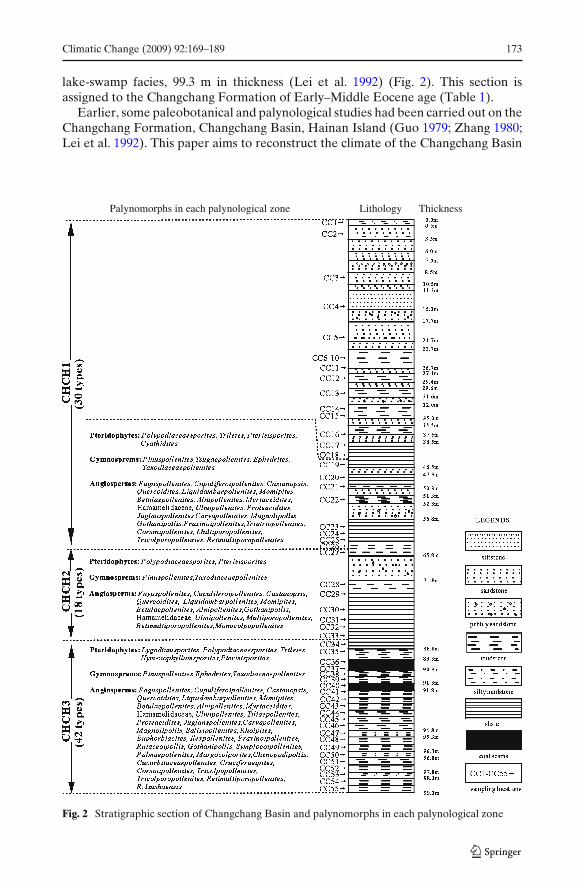
lake-swamp facies, 99.3 m in thickness (Lei et al. 1992) (Fig. 2). This section isassigned to the Changchang Formation of Early–Middle Eocene age (Table 1).
Earlier, some paleobotanical and palynological studies had been carried out on theChangchang Formation, Changchang Basin, Hainan Island (Guo 1979; Zhang 1980;Lei et al. 1992). This paper aims to reconstruct the climate of the Changchang Basin
Palynomorphs in each palynological zone Lithology Thickness
Fig. 2 Stratigraphic section of Changchang Basin and palynomorphs in each palynological zone
174 Climatic Change (2009) 92:169–189
during the Early–Middle Eocene based on the climatic preferences of the nearestliving relatives (NLRs) of the recovered palynotaxa. The study also compares theflora and climate of this part of South China with those of Middle–Late Eocenesedimentary strata of Jilin Province, North China to discover whether there was anydifference in flora and climate in North and South China during Eocene time.
2 Materials and methods
Fifty-five palynological samples were collected from this section in the field. Thesamples were analyzed following standard techniques (Peck 1974; Moore and Webb1978; Moore et al. 1991; Li and Du 1999). No pollen grains or spores were found in20 samples, fewer than 200 grains (5–187) were found in 13 samples, while more than200 grains (218–2,028) were found in 22 samples. The pollen grains and spores wereidentified using the palynological literature and monographs (Sun et al. 1981, 1982,1989; Wu and Yu 1981; Zhang 1981; Yu 1983; Lei 1985; Li 1989; Zhang et al. 1990;Lei et al. 1992; Li and Qing 1994; Song et al. 1999).
The reconstruction of the Early–Middle Eocene climate in the ChangchangBasin is attempted following the Coexistence Approach (CoA, Mosbrugger andUtescher 1997; Xu et al. 2000). The method is based on the assumption that theclimatic tolerance of a fossil taxon is similar to that of its Nearest Living Relative(NLR). The procedure for obtaining the climatic tolerance of a NLR is as follows.Firstly, the climatic parameters of all NLRs (seed plants) in a palynoflora areobtained from the climatic records within their modern distribution area (Wu andDing 1999). Secondly, the maximum and minimum of each parameter of each NLRare established. Thirdly, the climatic interval of each parameter of all NLRs isoverlapped and the coexistence interval of all NLRs is obtained.
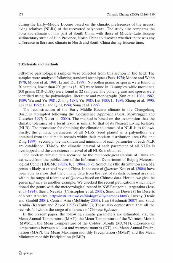
The modern climatic data recorded by the meteorological stations of China areextracted from the publications of the Information Department of Beijing Meteoro-logical Center (IDBMC 1983a, b, c, 1984a, b, c). Sometimes the distribution area of agenus is likely to extend beyond China. In the case of Quercus, Kou et al. (2006) havebeen able to show that the climatic data from the rest of its distributional area fallwithin the range of tolerance of Quercus based on Chinese data. Herein, we give thegenus Ephedra as another example. We checked the recent publications which men-tioned the genus with the meteorological record in NW Patagonia, Argentina (Joseet al. 1994), Sierra Nevada (Christopher et al. 2007), Sonoran Desert (The Desertsof North America, http://instruct.uwo.ca/biology/320y/namdes.html), Turkey (Denizand Sümbül 2004), Central Asia (McGinley 2007), Iran (Heshmati 2007) and SaudiArabia (Karemy and Zayed 1992) (Table 2); These also demonstrate that all therecords fall within the range of tolerance of Chinese Ephedra.
In the present paper, the following climatic parameters are estimated, viz., theMean Annual Temperature (MAT), the Mean Temperature of the Warmest Month(MWMT), the Mean Temperature of the Coldest Month (MCMT), difference oftemperatures between coldest and warmest months (DT), the Mean Annual Precip-itation (MAP), the Mean Maximum monthly Precipitation (MMaP) and the MeanMinimum monthly Precipitation (MMiP).
Climatic Change (2009) 92:169–189 175
Tab
le2
The
MA
Tan
dM
AP
inth
edi
stri
buti
onar
eaof
Eph
edra
outw
ith
Chi
naba
sed
onre
cent
stud
ies
ofth
ege
nus
Pla
ceL
ocat
ion
Alt
itud
e(m
.a.s
.l.)
MA
T(◦
C)
MA
P(m
m)
Ref
eren
ces
Sono
ran
dese
rt,N
Am
eric
a–
150–
950
–∼
300
The
Des
erts
ofN
orth
Am
eric
a(2
007)
Whi
teM
ount
ains
,Sie
rra
Nev
ada
–1,
250
13.3
142
Chr
isto
pher
etal
.(20
07)
NW
Pat
agon
ia,A
rgen
tina
–90
0–1,
400
7.4
304
Jose
etal
.(19
94)
Ant
alya
,Tur
key
36◦ N
,29◦
E1,
660
7.5
616.
5D
eniz
and
Süm
bül(
2004
)So
uthe
rnde
sert
s,C
entr
alA
sia
––
∼16
70–1
25M
cGin
ley
(200
7)Sa
ndde
sert
s,ce
ntra
lpla
teau
,Ira
n–
500–
1,20
015
–18
<20
0H
eshm
ati(
2007
)B
aha
plat
eau,
Saud
iAra
bia
19◦ 5
0′–2
0◦18
′ N,
1,70
0–2,
400
–36
0.1
Kar
emy
and
Zay
ed(1
992)
41◦ 3
8′–4
2◦10
′ ET
heto
lera
nce
ofE
phed
rafr
omC
hine
seda
ta–
–−4
.9−
19.8
16.4
–1,1
13.3
Pre
sent
pape
r
176 Climatic Change (2009) 92:169–189
Fig. 3 Palynomorphs recovered from the Changchang Basin, Hainan Island, compared with thepalynoflora of Hunchun City, Jilin Province
Climatic Change (2009) 92:169–189 177
3 Results
3.1 Description of polynological zones
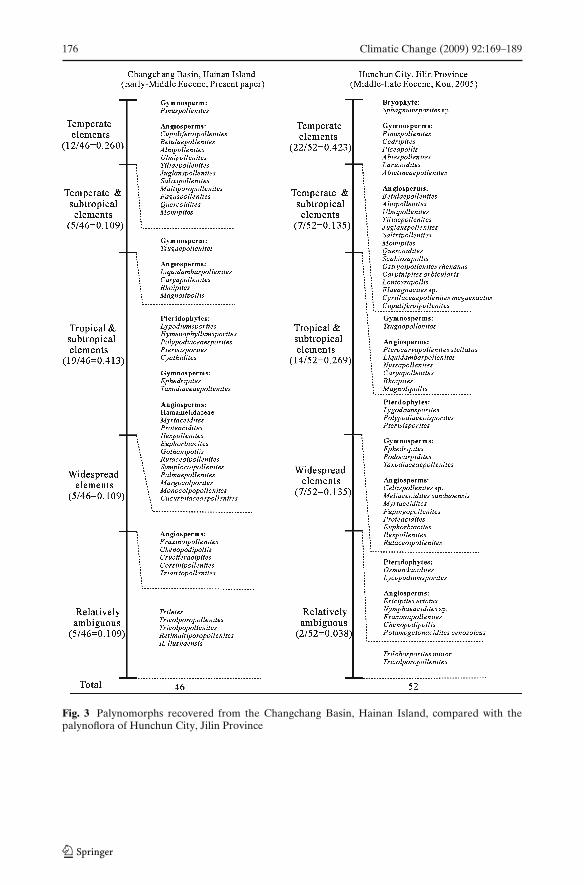
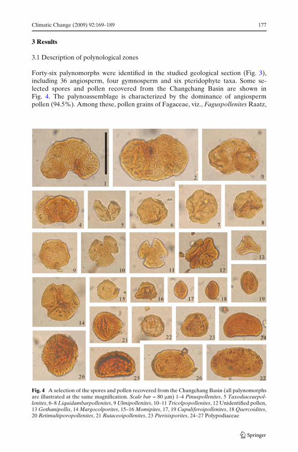
Forty-six palynomorphs were identified in the studied geological section (Fig. 3),including 36 angiosperm, four gymnosperm and six pteridophyte taxa. Some se-lected spores and pollen recovered from the Changchang Basin are shown inFig. 4. The palynoassemblage is characterized by the dominance of angiospermpollen (94.5%). Among these, pollen grains of Fagaceae, viz., Faguspollenites Raatz,
Fig. 4 A selection of the spores and pollen recovered from the Changchang Basin (all palynomorphsare illustrated at the same magnification. Scale bar = 80 μm) 1–4 Pinuspollenites, 5 Taxodiaceaepol-lenites, 6–8 Liquidambarpollenites, 9 Ulmipollenites, 10–11 Tricolpopollenites, 12 Unidentified pollen,13 Gothanipollis, 14 Margocolporites, 15–16 Momipites, 17, 19 Cupuliferoipollenites, 18 Quercoidites,20 Retimultiporopollenites, 21 Rutaceoipollenites, 23 Pterisisporites, 24–27 Polypodiaceae
178 Climatic Change (2009) 92:169–189
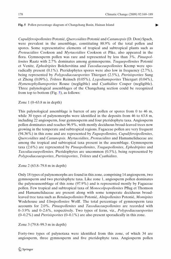
�Fig. 5 Pollen percentage diagram of Changchang Basin, Hainan Island
Cupuliferoipollenites Potonié, Quercoidites Potonié and Castanopsis (D. Don) Spach,were prevalent in the assemblage, constituting 88.9% of the total pollen andspores. Some representative elements of tropical and subtropical plants such asProteacidites Cookson and Myrtaceidites Cookson et Pike, also appeared in theflora. Gymnosperm pollen was rare and represented by less than 3%. Pinuspol-lenites Raatz with 2.7% dominates among gymnosperms. Tsugaepollenites Potoniéet Venitz, Ephedripites Bolchovitina and Taxodiaceaepollenites Kremp were spo-radically present (0.1%). Pteridophytes spores were also low in frequency (2.7%),being represented by Polypodiaceaesporites Thiergart (2.5%), Pterisisporites Sunget Zheng (0.09%), Triletes Reinsch (0.05%), Lygodiumsporites Thiergart (0.04%),Hymenophyllumsporites Rouse (negligible) and Cyathidites Couper (negligible).Three palynological assemblages of the Changchang section could be recognizedfrom top to bottom (Fig. 5), as follows:
Zone 1 (0–63.8 m in depth)
This palynological assemblage is barren of any pollen or spores from 0 to 46 m,while 30 types of palynomorphs were identified in the deposits from 46 to 63.8 m,including 22 angiosperm, four gymnosperm and four pteridophyte taxa. Angiospermpollen dominates and reaches 96.9%, with mostly deciduous broad-leaved trees nowgrowing in the temperate and subtropical regions. Fagaceae pollen are very frequent(94.36%) in this zone and are represented by Faguspollenites, Cupuliferoipollenites,Quercoidites and Castanopsis. Myrtaceidites, Proteacidites and Hamamelidaceae areamong the tropical and subtropical taxa present in the assemblage. Gymnospermtaxa (2.6%) are represented by Pinuspollenites, Tsugaepollenites, Ephedripites andTaxodiaceaepollenites. Pteridophytes are uncommon (0.5%), being represented byPolypodiaceaesporites, Pterisisporites, Triletes and Cyathidites.
Zone 2 (63.8–79.8 m in depth)
Only 18 types of palynomorphs are found in this zone, comprising 14 angiosperm, twogymnosperm and two pteridophyte taxa. Like zone 1, angiosperm pollen dominatesthe palynoassemblage of this zone (97.9%) and is represented mostly by Fagaceaepollen. Few tropical and subtropical taxa of Monocolpopollenites Pflug et Thomsonand Hamamelidaceae are present along with some temperate deciduous broad-leaved tree taxa such as Betulaepollenites Potonié, Alnipollenites Potonié, MomipitesWodehouse and Ulmipollenites Wolff. The total percentage of gymnosperm taxaaccounts for 2.0%. Pinuspollenites and Taxodiaceaepollenites are recorded with0–3.9% and 0–2.6%, respectively. Two types of ferns, viz., Polypodiaceaesporites(0–0.2%) and Pterisisporites (0–0.1%) are also present sporadically in this zone.
Zone 3 (79.8–99.3 m in depth)
Forty-two types of palynotaxa were identified from this zone, of which 34 areangiosperm, three gymnosperm and five pteridophyte taxa. Angiosperm pollen
Climatic Change (2009) 92:169–189 179
180 Climatic Change (2009) 92:169–189
occurs in a lower frequency than that in zones 1 and 2, but remains predominant andreaches 92.4% of the pollen sum. Faguspollenites, Momipites,Betulaepollenites andJuglanspollenites Raatz represent deciduous broad-leaved tree taxa. Few herbaceoustaxa (Cucurbitaceaepollenites, Corsinipollenites Nakoman, Cruciferaeipites Zhengand Chenopodipollis Krutzsch) are also present at low frequency (0.1–0.2%).The pollen types of tropical and subtropical taxa Myrtaceidites, Palmaepollenites,Proteacidites, Gothanipollis Krutzsch, Symplocoipollenites Potonié, MargocolporitesRamanujam ex Srivastava and Hamamelidaceae increase in this zone. Gymnospermtaxa (3.0%) are represented by Pinuspollenites, Ephedripites and Taxodiaceaepol-lenites. A comparatively higher percentage of pteridophyte spores (4.6%) withPolypodiaceaesporites, Pterisisporites, Triletes, Lygodiumsporites and Hymenophyl-lumsporites are recorded in this zone.
3.2 Coexistence analysis on the whole palynoassemblage and eachof the palynological zones
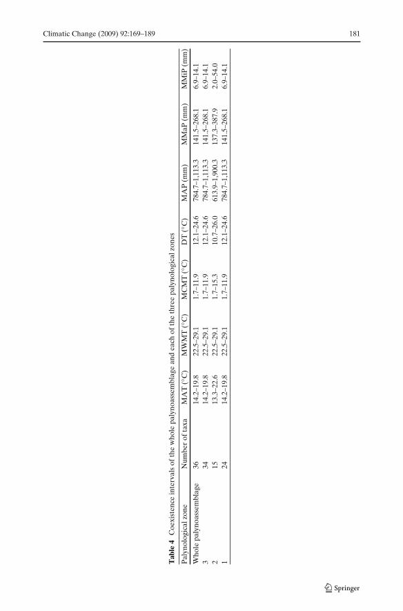
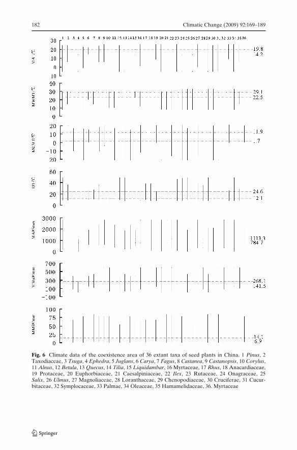
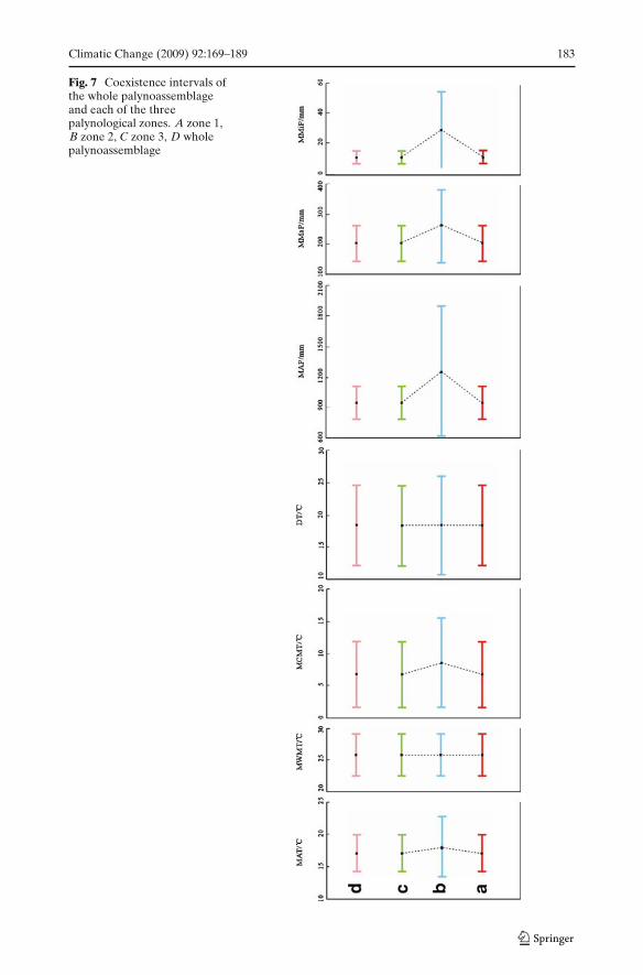
Thirty-six fossil palynomorph taxa used in our CoA approach are shown in Table 3.The seven climate parameters (MAT, MWMT, MCMT, DT, MAP, MMaP andMMiP) from the CoA approach on the whole palynoassemblage are shown inTable 4 and Fig. 6. The climatic parameters have also been determined for eachof the three palynological zones (Table 4, Fig. 7). Coexistence analysis of thepalynological zones 1 and 3 gives exactly the same result as that obtained from thewhole palynoassemblage (The coexistence intervals of 14.2–19.8◦C for MAT, 22.5–29.1◦C for MWMT, 1.7–11.9◦C for MCMT, 12.1–24.6◦C for DT, 784.7–1,113.3 mm forMAP, 141.5–268.1 mm for MMaP, and 6.9–14.1 mm for MMiP) (Table 4). However,palynological zone 2 gives slightly wider coexistence intervals but still overlapping
Table 3 Palynomorph taxa used in CoA (Song et al. 1999)
Fossil palynomorph taxa NLRs Fossil palynomorph taxa NLRs
Pinuspollenites Pinus L. Proteacidites ProteaceaeTsugaepollenites Tsuga Carr. Juglanspollenites Juglans L.Taxodiaceaepollenites Taxodiaceae Multiporopollenites Juglans L.Ephedripites Ephedra Tourn. ex Linn. Caryapollenites Carya Nutt.Faguspollenites Fagus L., Castanopsis Magnolipollis Magnolia L.
(D. Don) SpachCupuliferoipollenites Castaneae Mill. Salixipollenites Salix L.Quercoidites Quercus L. Euphorbiacites EuphorbiaceaeRhoipites Anacardiaceae, Rhus Fraxinoipollenites Oleaceae
(Tourn.) L.Ilexpollenites Ilex L. Hamamelidaceae HamamelidaceaeLiquidambarpollenites Liquidambar L. Cucurbitaceaepollenites CucurbitaceaeRutaceoipollenites Rutaceae Monocolpopollenites PalmaeBetulaceoipollenites Betula L. Palmaepollenites PalmaeAlnipollenites Alnus Mill. Triatriopollenites MyricaceaeGothanipollis Loranthaceae Margocolporites CaesalpiniaceaeMomipites Juglandaceae Ulmipollenites Ulmus L.Cruciferaeipites Cruciferae Corsinipollenites OnagraceaeChenopodipollis Chenopodiaceae Tiliaepollenites Tilia L.
Climatic Change (2009) 92:169–189 181
Tab
le4
Coe
xist
ence
inte
rval
sof
the
who
lepa
lyno
asse
mbl
age
and
each
ofth
eth
ree
paly
nolo
gica
lzon
es
Pal
ynol
ogic
alzo
neN
umbe
rof
taxa
MA
T(◦
C)
MW
MT
(◦C
)M
CM
T(◦
C)
DT
(◦C
)M
AP
(mm
)M
MaP
(mm
)M
MiP
(mm
)
Who
lepa
lyno
asse
mbl
age
3614
.2–1
9.8
22.5
–29.
11.
7–11
.912
.1–2
4.6
784.
7–1,
113.
314
1.5–
268.
16.
9–14
.13
3414
.2–1
9.8
22.5
–29.
11.
7–11
.912
.1–2
4.6
784.
7–1,
113.
314
1.5–
268.
16.
9–14
.12
1513
.3–2
2.6
22.5
–29.
11.
7–15
.310
.7–2
6.0
613.
9–1,
900.
313
7.3–
387.
92.
0–54
.01
2414
.2–1
9.8
22.5
–29.
11.
7–11
.912
.1–2
4.6
784.
7–1,
113.
314
1.5–
268.
16.
9–14
.1
182 Climatic Change (2009) 92:169–189
Fig. 6 Climate data of the coexistence area of 36 extant taxa of seed plants in China. 1 Pinus, 2Taxodiaceae, 3 Tsuga, 4 Ephedra, 5 Juglans, 6 Carya, 7 Fagus, 8 Castanea, 9 Castanopsis, 10 Corylus,11 Alnus, 12 Betula, 13 Quecus, 14 Tilia, 15 Liquidambar, 16 Myrtaceae, 17 Rhus, 18 Anacardiaceae,19 Protaceae, 20 Euphorbiaceae, 21 Caesalpiniaceae, 22 Ilex, 23 Rutaceae, 24 Onagraceae, 25Salix, 26 Ulmus, 27 Magnoliaceae, 28 Loranthaceae, 29 Chenopodiaceae, 30 Cruciferae, 31 Cucur-bitaceae, 32 Symplocaceae, 33 Palmae, 34 Oleaceae, 35 Hamamelidaceae, 36. Myrtaceae
Climatic Change (2009) 92:169–189 183
Fig. 7 Coexistence intervals ofthe whole palynoassemblageand each of the threepalynological zones. A zone 1,B zone 2, C zone 3, D wholepalynoassemblage
184 Climatic Change (2009) 92:169–189
with the other results. There is no evidence of climatic change during the overallperiod of deposition.
4 Discussion
4.1 The paleovegetation and paleoclimate in Changchang Basin
The palynoflora found in the Changchang Basin includes temperate plants, viz.,Pinus L., Betula L., Alnus Mill., Corylus L., Ulmus L., Tilia L., Juglans L., SalixL., Castanea Mill., temperate and subtropical plants, viz., Carya Nutt., MagnoliaL., Liquidambar L., and subtropical and tropical plants, viz., Taxodiaceae,Ilex L., Myrtaceae, Proteaceae, Anacardiaceae, Rutaceae, Symplocaceae, Palmae,Caesalpiniaceae.
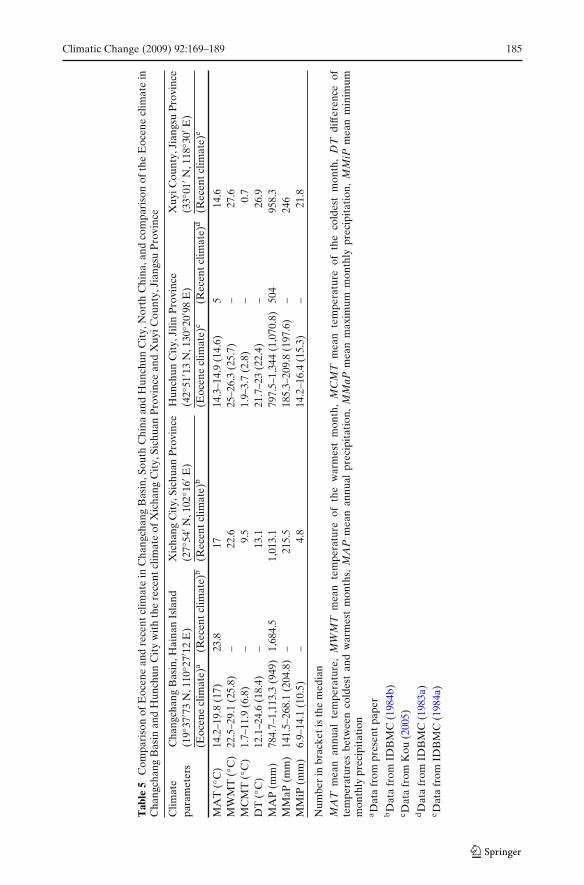
Based on the climatic preferences of the nearest living relatives of recoveredpalynotaxa, paleovegetation vis-à-vis paleoclimate of the basin is suggested. Forinstance, plants of the genera Salix and Betula are commonly distributed in the northtemperate zone. The plants of the genus Ilex are mostly distributed in the tropicsand subtropics, while some species extend into the temperate regions. The genusLiquidambar is discontinuous between the temperate and subtropical zones of theEast Asia, S.W. Asia and North America. The Palmae is a pantropical family, whichis widely distributed in the tropical and subtropical regions of the world (Wu 1991;Mabberley 1997; Wu et al. 2003). Based on the palynoassemblage, it is assumedthat the vegetation in the central part of the Changchang Basin was evergreen ordeciduous broad-leaved forest and the vegetation on the surrounding mountain wasneedle-leaved forest and deciduous broad-leaved forest. During the Early–MiddleEocene of the Changchang Basin, it is thought that a subtropical climatic regime,very similar to the present climate (MAT: 17.0◦C; MAP: 1,013.1 mm) of Xichang City(27◦54′ N, 102◦16′ E), Sichuan Province, southwestern China, existed (Table 5). Themodern climate in Hainan Island is of an oceanic tropical type (MAT 23.8◦C; MAP1,684.5 mm) with tropical seasonal rain forest in the mountains area and mangroveforest fringing the coastal plain.
4.2 Comparison of palynoflora and paleoclimate with Hunchun City
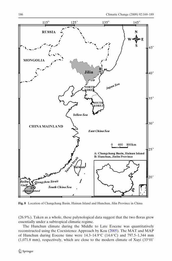
An Eocene palynoflora and paleoclimatic estimates are available from HunchunCity, Jilin Province, (42◦51′13′′ N, 130◦20′98′′ E) North China (Kou 2005), enablingus to compare it with those of the Changchang Basin, South China (19◦37′73 N,110◦27′12 E). Although these two sites are geographically widely separated (Fig. 8),the palynoflora and paleoclimate are close to each other. Angiosperm taxa dominateboth the Changchang and Hunchun City palynoassemblages, represented by 94.5%and 50.8–84.55%, respectively. Forty-six taxa of palynomorphs from the ChangchangBasin, compared to 52 types from Hunchun City, have been recovered amongwhich 27 taxa appeared common to both (Fig. 3). More temperate elements areencountered in Hunchun City (42.3% of total palynomorphs) than in ChangchangBasin (26.0%); in contrast, there are more tropical and subtropical elements amongthe Changchang Basin palynotaxa (41.3%) than in the Hunchun City assemblage
Climatic Change (2009) 92:169–189 185
Tab
le5
Com
pari
son
ofE
ocen
ean
dre
cent
clim
ate
inC
hang
chan
gB
asin
,Sou
thC
hina
and
Hun
chun
Cit
y,N
orth
Chi
na,a
ndco
mpa
riso
nof
the
Eoc
ene
clim
ate
inC
hang
chan
gB
asin
and
Hun
chun
Cit
yw
ith
the
rece
ntcl
imat
eof
Xic
hang
Cit
y,Si
chua
nP
rovi
nce
and
Xuy
iCou
nty,
Jian
gsu
Pro
vinc
e
Clim
ate
Cha
ngch
ang
Bas
in,H
aina
nIs
land
Xic
hang
Cit
y,Si
chua
nP
rovi
nce
Hun
chun
Cit
y,Ji
linP
rovi
nce
Xuy
iCou
nty,
Jian
gsu
Pro
vinc
epa
ram
eter
s(1
9◦37
′ 73
N,1
10◦ 2
7′12
E)
(27◦
54′ N
,102
◦ 16′
E)
(42◦
51′ 1
3N
,130
◦ 20′
98E
)(3
3◦01
′ N,1
18◦ 3
0′E
)(E
ocen
ecl
imat
e)a
(Rec
entc
limat
e)b
(Rec
entc
limat
e)b
(Eoc
ene
clim
ate)
c(R
ecen
tclim
ate)
d(R
ecen
tclim
ate)
e
MA
T(◦
C)
14.2
–19.
8(1
7)23
.817
14.3
–14.
9(1
4.6)
514
.6M
WM
T(◦
C)
22.5
–29.
1(2
5.8)
–22
.625
–26.
3(2
5.7)
–27
.6M
CM
T(◦
C)
1.7–
11.9
(6.8
)–
9.5
1.9–
3.7
(2.8
)–
0.7
DT
(◦C
)12
.1–2
4.6
(18.
4)–
13.1
21.7
–23
(22.
4)–
26.9
MA
P(m
m)
784.
7–1,
113.
3(9
49)
1,68
4.5
1,01
3.1
797.
5–1,
344
(1,0
70.8
)50
495
8.3
MM
aP(m
m)
141.
5–26
8.1
(204
.8)
–21
5.5
185.
3–20
9.8
(197
.6)
–24
6M
MiP
(mm
)6.
9–14
.1(1
0.5)
–4.
814
.2–1
6.4
(15.
3)–
21.8
Num
ber
inbr
acke
tis
the
med
ian
MA
Tm
ean
annu
alte
mpe
ratu
re,
MW
MT
mea
nte
mpe
ratu
reof
the
war
mes
tm
onth
,M
CM
Tm
ean
tem
pera
ture
ofth
eco
ldes
tm
onth
,D
Tdi
ffer
ence
ofte
mpe
ratu
res
betw
een
cold
est
and
war
mes
tm
onth
s,M
AP
mea
nan
nual
prec
ipit
atio
n,M
MaP
mea
nm
axim
umm
onth
lypr
ecip
itat
ion,
MM
iPm
ean
min
imum
mon
thly
prec
ipit
atio
na D
ata
from
pres
entp
aper
bD
ata
from
IDB
MC
(198
4b)
c Dat
afr
omK
ou(2
005)
dD
ata
from
IDB
MC
(198
3a)
e Dat
afr
omID
BM
C(1
984a
)
186 Climatic Change (2009) 92:169–189
Fig. 8 Location of Changchang Basin, Hainan Island and Hunchun, Jilin Province in China
(26.9%). Taken as a whole, these palynological data suggest that the two floras grewessentially under a subtropical climatic regime.
The Hunchun climate during the Middle to Late Eocene was quantitativelyreconstructed using the Coexistence Approach by Kou (2005). The MAT and MAPof Hunchun during Eocene time were 14.3–14.9◦C (14.6◦C) and 797.5–1,344 mm(1,071.8 mm), respectively, which are close to the modern climate of Xuyi (33◦01′

Climatic Change (2009) 92:169–189 187
N, 118◦30′ E), Jiangsu Province, China (MAT: 14.6◦C; MAP: 985.3 mm), and alsoclose to those of the Changchang Basin during the Early to Middle Eocene (MAT:14.2–19.8◦C (17.0◦C), MAP: 784.7–1,113.3 mm (949 mm)) (Table 5). The similarityof these climatic parameters in the Changchang Basin and Hunchun City suggeststhat the Eocene climates in South China and North China were not so different, bothwarm and humid.
The reason behind the similarity of the paleoclimates in the two areas, whichare quite far apart (about 23 degrees in latitude) may be explained in two ways.Firstly, from the paleogeographical point of view, the landmass of China during thePaleogene was possibly located at the southeastern part of Eurasia and its landformwas relatively flat, as the Indian Plate commenced to collide with the Eurasian Platein the Eocene (ca. 50 Ma). Late Cretaceous–Paleogene marine deposits have beenfound in southern Tibet, which indicates that at least some of the region was at sealevel around the time of collision (Zhang et al. 1998; Harris 2006). It is suggestedthat the Tibetan Plateau was not uplifted much during this period. The thickness anddensity of the troposphere in China was almost uniform everywhere, which couldconserve the heat equally (CCPGCCAS 1984; CCVC 1995). Secondly, the easternpart of China, including South and North China, was influenced by the warm oceaniccurrent around Eurasia which caused the temperature of the landmass to increase(CCPGCCAS 1984). Spjeldnaes (1973) suggested that the atmospheric- and oceaniccirculation were not too strong in the Paleogene and climatic zones were not asdistinct as at the present day, thereby supporting a similar climatic regime throughoutthe northern and southern part of the Chinese landmass. Furthermore, the EarlyEocene was one of the warmest intervals of the Cenozoic, with little or no polar ice(Rea et al. 1990; Sloan and Barron 1992; Sloan and Rea 1995; Sloan et al. 2001),which possibly led to little change in temperature across latitudes at that time.
5 Conclusions
1) The palynoflora of the Changchang Basin in the Early–Middle Eocene ischaracterized by the dominance of angiosperm pollen (94.5%), followed bygymnosperm pollen (2.8%) and pteridophyte spores (2.7%).
2) The vegetation in the central part of the Changchang Basin in Early–MiddleEocene time was evergreen or deciduous broad-leaved forest surrounded byevergreen or deciduous broad-leaved forest and needle-leaved forest on thenearby highlands.
3) The climate in the Changchang Basin in the Early–Middle Eocene is supposedto have been of a subtropical type. The MAT in Eocene time is estimated as14.2–19.8◦C, with a MWMT of 22.5–29.1◦C, MCMT of 1.7–11.9◦C, DT of 12.1–24.6◦C, MAP of 784.7–1,113.3 mm, MMaP of 141.5–268.1 mm, and a MMiP of6.9–14.1 mm.
4) A comparison of paleoclimatic parameters between the Changchang Basin(MAT: 14.2–19.8◦C, MAP: 784.7–1,113.3 mm in Early–Middle Eocene) andHunchun City (MAT: 14.3–14.9◦C, MAP: 797.5–1,344 mm in Middle–LateEocene) suggests that the climate of South China and North China was similar,both warm and humid.
188 Climatic Change (2009) 92:169–189
Acknowledgements We thank Professor Nai-Qiu Du and Dr. Qi-Gao Sun from the Institute ofBotany, Chinese Academy of Sciences and Professor Wen-Bo Liao from Sun Yat-sen Universityfor their help with this study. We also thank Dr. Xiang-Yu Kou for providing the data of theEocene palynoflora and paleoclimate of Hunchun City, Jilin Province. This study was supported bygrants from the National Natural Science Foundation of China (40672017, 40701191) and GuangdongProvincial Natural Science Foundation of China (06023161).
References
CCPGCCAS (Compilation Committee of Physical Geography of China, Chinese Academy ofSciences) (1984) Physical geography of China, vol. 1. Science, Beijing, pp 1–63 (in Chinese)
CCVC (Compilation Committee of Vegetation of China) (1995) Vegetation of China. Science Press,Beijing, pp 61–82 (in Chinese)
Christopher et al (2007) Plant species distributions under present conditions and forecasted forwarmer climates in an arid mountain range. Earth Interact 11(Paper No. 9):1–33
Deniz IG, Sümbül H (2004) Flora of the Elmali Cedar Research Forest (Antalya/Turkey). Turk JBot 28:529–555
Guo SX (1979) Late Cretaceous and Early Tertiary floras from the southern Guangdong andGuangxi with their stratigraphic significance. In: Institute of Vertebrate Palaeontology andPalaeoanthropology, Nanjing Institute of Geology and Palaeontology. Academia Sinica (eds)Mesozoic and Cenozoic red beds of South China. Science Press, Beijing, pp 223–230 (in Chinese)
Harris N (2006) The elevation history of the Tibetan Plateau and its implications for the Asianmonsoon. Paleogeogr Paleoclimatol Paleoecol 241:4–15
Heshmati (2007) Vegetation characteristics of four ecological zones of Iran. Int J Plant Prod 2:215–224
IDBMC (Information Department of Beijing Meteorological Center) (1983a) Land climate dataof China (I) (1951–1980). Meteorology Press, Beijing, pp 4–5, 86–87 (in Chinese)
IDBMC (Information Department of Beijing Meteorological Center) (1983b) Land climate data ofChina (VI) (1951–1980). Meteorology Press, Beijing, pp 4–6, 126–128 (in Chinese)
IDBMC (Information Department of Beijing Meteorological Center) (1983c) Land climate dataof China (II) (1951–1980). Meteorology Press, Beijing, pp 4–5, 72–73 (in Chinese)
IDBMC (Information Department of Beijing Meteorological Center) (1984a) Land climate data ofChina (III) (1951–1980). Meteorology Press, Beijing, pp 4–6, 107–109 (in Chinese)
IDBMC (Information Department of Beijing Meteorological Center) (1984b) Land climate dataof China (IV) (1951–1980). Meteorology Press, Beijing, pp 4–6, 99–101 (in Chinese)
IDBMC (Information Department of Beijing Meteorological Center) (1984c) Land climate data ofChina (V) (1951–1980). Meteorology Press, Beijing, pp 4–6, 108–110 (in Chinese)
Jin JH et al (2002) Palaeodiversification of the environment and plant community of Tertiary inHainan Island. Acta Ecol Sin 22(3):425–432 (in Chinese with English abstract)
Jose et al (1994) Range assessment using remote sensing in Northwest Patagonia (Argentina).J Range Manag 47(6):498–502
Karemy ZAR, Zayed KM (1992) The vegetation and habitat types of Baha Plateau (Saudi Arabia).J Islamic Acad Sci 5(4):256–264
Kou XY (2005) Studies on quantitative reconstruction of Cenozoic climates in China by palyno-logical data. Ph.D. thesis, Institute of Botany, the Chinese Academy of Science, Beijing, China,pp 46–55 (in Chinese with English abstract)
Kou XY et al (2006) The reconstruction of paleovegetation and paleoclimate in the Late Pliocene ofWest Yunnan, China. Clim Change 77(3–4):431–448
Lei ZQ (1985) Tertiary sporo-pollen assemblage of Zhujiangkou (Pearl River North) Basin and itsstratigraphical significance. Acta Bot Sin 27(1):94–10 (in Chinese with English abstract)
Lei YZ et al (1992) Tertiary. In: Yichang Institute of Geology and Mineral Resources, Bureau ofGeology and Mineral Resources of Hainan (eds) Geology of Hainan Island (I): stratigraphy andpalaeontology. Geological Publishing House, Beijing, pp 1–281 (in Chinese)
Li MY (1989) Sporo-pollen from Shanghu Formation of Early Paleocene in Nanxiong Basin,Guangdong. Acta Palaeontol Sin 28(6):741–749 (in Chinese with English abstract)
Li MY, Qing GR (1994) Paleocene sporopollen from the Buxin Group of the Longgui Basin,Guangdong. Acta Micropalaeontol Sin 11(1):55–69 (in Chinese with English abstract)

Climatic Change (2009) 92:169–189 189
Li XQ, Du NQ (1999) The acid–alkali-free analysis of Quaternary pollen. Acta Bot Sin 41(7):782–784(in Chinese with English abstract)
Mabberley DJ (1997) The plant-book: a portable dictionary of the vascular plants, 2nd edn.Cambridge University Press, UK, pp 1–858
McGinley (2007) Central Asian southern desert. http://www.eoearth.org/article/Central_Asian_southern_desert. Cited 22 Dec 2007
Moore PD, Webb JA (1978) An illustrated guide to pollen analysis. Hodder and Stoughton, London,pp 5–50
Moore PD et al (1991) Pollen analysis, 2nd edn. Blackwell, London, pp 191Mosbrugger V, Utescher T (1997) The coexistence approach: a method for quantitative recon-
structions of Tertiary terrestrial palaeoclimate data using plant fossil. Paleogeogr PaleoclimatolPaleoecol 134:61–86
Peck RM (1974) A comparison of four absolute pollen preparation techniques. New Phytol 73:567–587
Rea DK et al (1990) Global change at the Paleocene–Eocene boundary: climatic and evolutionaryconsequences of tectonic events. Paleogeogr Paleoclimatol Paleoecol 79:117–128
Sloan LC, Barron EJ (1992) A comparison of Eocene climate model results to quantified paleocli-matic interpretations. Paleogeogr Paleoclimatol Paleoecol 93:183–202
Sloan LC, Rea DK (1995) Atmospheric CO2 of the Early Eocene: a general circulation modelingsensitivity study. Paleogeogr Paleoclimatol Paleoecol 119:275–292
Sloan LC et al (2001) Effect of sea surface temperature configuration on model simulations of“equable” climate in the Early Eocene. Paleogeogr Paleoclimatol Paleoecol 167:321–335
Song ZC et al (1999) Fossil spores and pollen of China, vol 1: the Late Cretaceous and Tertiaryspores and pollen. Science Press, Beijing, pp 1–910 (in Chinese with English abstract)
Spjeldnaes N (1973) Comments on 4.1 “The primary cause of ice age”. In: Tarling DH, Runcorn SK(eds) Implication of continental drift to the earth sciences, vol I. Academic, London, p 450
Sun XJ et al (1981) Spores and pollen. In: South Sea Branch of Petroleum Corporation of thePeople’s Republic of China et al (eds) Tertiary palaeontology of north continental shelf of SouthChina Sea. Guangdong Science and Technology Press, Guangzhou, pp 1–58 (in Chinese)
Sun XJ et al (1982) Palynoflora of the Liushagang Formation (Eocene–Early Oligocene) in thenorthern part of South China Sea. Acta Phytotaxon Sin 20(1):63–71 (in Chinese with Englishabstract)
Sun MR et al (1989) Spore and pollen. In: Research Party of Marine Geology, Ministry of Geologyand Mineral Resources Institute of Geology Chinese Academy of Geological Science (ed)Cenozoic paleobiota of the continental shelf of the East China Sea (Donghai) (micropaleob-otanical volume). Geological Science Press, Beijing, pp 6–40 (in Chinese)
The Deserts of North America. http://instruct.uwo.ca/biology/320y/namdes.html. Cited 22 Dec 2007Wu ZY (1991) The areal-types of Chinese genera of seed plants. Acta Bot Yunnan (suppl.) IV:1–139
(in Chinese with English abstract)Wu ZY, Ding TY (1999) Seed plants of China. Yunnan Science and Technology Press, Kunming
(Electronic publication in Chinese)Wu ZJ, Yu JF (1981) Late Paleocene spores and pollen grains from the uppermost part of Nongshan
group in Nanxiong Basin, Guangdong. Acta Palaeontol Sin 20(5):442–448 (in Chinese withEnglish abstract)
Wu ZY et al (2003) The areal-types of the world families of seed plants. Acta Bot Yunnan 25(3):245–257 (in Chinese with English abstract)
Xu JX et al (2000) A method for quantitative reconstruction of Tertiary palaeoclimate andenvironment—coexistence approach. In: Li CS (ed) Advances in plant science, vol 3. ChinaHigher Education Press, Beijing and Springer, Heidelberg, pp 195–203 (in Chinese)
Yu JF (1983) A study on the Late Eocene–Early Oligocene microflora of Fu-1 borehole, Fushan,Hainan Island. Trop Oceanol 2(1):1–10 (in Chinese with English abstract)
Zhang QR (1980) Stratigraphy and palaeontology. Yichang Institute of Geology and MineralResources, Chinese Academy of Geology Sciences, Yichang, pp 106–117 (in Chinese)
Zhang YY (1981) Tertiary spores and pollen grains from the Leizhou Peninsula. Acta Micropalaeon-tol Sin 20(5):449–458 (in Chinese with English abstract)
Zhang YY et al (1990) Eocene palynoflora from the southwestern continental shelf basin of the EastChina Sea. Acta Micropalaeontol Sin 7(4):389–402 (in Chinese with English abstract)
Zhang KJ et al (1998) Did the Indo-Asian collision alone create the Tibetan Plateau; discussion.Geology 26:958