reconsidering the definition of a spatial data infrastructure
TRANSCRIPT
This article was downloaded by: [Paul Hendriks]On: 27 February 2012, At: 23:50Publisher: Taylor & FrancisInforma Ltd Registered in England and Wales Registered Number: 1072954 Registeredoffice: Mortimer House, 37-41 Mortimer Street, London W1T 3JH, UK
International Journal of GeographicalInformation SciencePublication details, including instructions for authors andsubscription information:http://www.tandfonline.com/loi/tgis20
Reconsidering the definition of aspatial data infrastructurePaul H.J. Hendriks a , Ezra Dessers b & Geert van Hootegem ba Institute for Management Research, Radboud University,Nijmegen, the Netherlandsb Centre for Sociological Research, Katholieke UniversiteitLeuven, Leuven, Belgium
Available online: 27 Feb 2012
To cite this article: Paul H.J. Hendriks, Ezra Dessers & Geert van Hootegem (2012): Reconsideringthe definition of a spatial data infrastructure, International Journal of Geographical InformationScience, DOI:10.1080/13658816.2011.639301
To link to this article: http://dx.doi.org/10.1080/13658816.2011.639301
PLEASE SCROLL DOWN FOR ARTICLE
Full terms and conditions of use: http://www.tandfonline.com/page/terms-and-conditions
This article may be used for research, teaching, and private study purposes. Anysubstantial or systematic reproduction, redistribution, reselling, loan, sub-licensing,systematic supply, or distribution in any form to anyone is expressly forbidden.
The publisher does not give any warranty express or implied or make any representationthat the contents will be complete or accurate or up to date. The accuracy of anyinstructions, formulae, and drug doses should be independently verified with primarysources. The publisher shall not be liable for any loss, actions, claims, proceedings,demand, or costs or damages whatsoever or howsoever caused arising directly orindirectly in connection with or arising out of the use of this material.

International Journal of Geographical Information ScienceiFirst, 2012, 1–16
Reconsidering the definition of a spatial data infrastructure
Paul H.J. Hendriksa*, Ezra Dessersb and Geert van Hootegemb
aInstitute for Management Research, Radboud University, Nijmegen, the Netherlands; bCentre forSociological Research, Katholieke Universiteit Leuven, Leuven, Belgium
(Received 9 February 2011; final version received 1 November 2011)
The great interest in spatial data infrastructures (SDIs) has led to a wealth of SDIdefinitions in SDI debates. The article aims to contribute to both theory-orientedand practice-oriented SDI research by providing a critical re-examination of the SDIliterature. Ashby’s formal theory of regulation, which sees infrastructures as regulatorydevices, is used to identify the strengths and weaknesses of several SDI definitions.This exercise shows how debates of the SDI objectives and the roles of users get caughtin mantraps and also opens the door for a way out of this confusion by distinguishingbetween functional and adoption objectives. It also highlights the emphasis on techno-logical components in the SDI definitions, which sidestep the importance of structuraland human resource components in SDI.
Keywords: spatial data infrastructures SDI; Ashby; spatially enabled societies
1. Introduction
The concept of spatial data infrastructures (SDIs) refers to the infrastructure, or basic phys-ical and organizational structures, needed to facilitate efficient and effective use of spatialdata (Rajabifard et al. 2006, Hjelmager et al. 2008). The realization that spatial data or geo-graphical information systems (GIS) storing these data should not be considered within theboundaries of individual organizations or contexts has led to the development of ideas andpractices of SDI. Spatial data and GIS simply need to be embedded in a broader frameworkif the usefulness of spatial data to multiple users – individuals, groups and organizations –at national and global levels is to be addressed meaningfully (Williamson et al. 2003). SDIrequires the ability to envision the potential of working with spatial data produced by oth-ers and to look beyond the confines of data models and technological dimensions whenaddressing issues of data usage. In this way, SDI has proven to be a successful concept.Many governments have launched SDI initiatives at local, national and international levels(see Crompvoets et al. 2004, Masser 2005, Rajabifard et al. 2006). In addition to the dedi-cated sessions at conferences and discussions in leading geographical journals, researchershave also devoted to SDI special conferences, such as GSDI (global spatial data infrastruc-ture), and journals (e.g. International Journal of Spatial Data Infrastructure Research).In the research community, it is clear that the concept of SDI has passed its infancy from the
*Corresponding author. Email: [email protected]
ISSN 1365-8816 print/ISSN 1362-3087 online© 2012 Taylor & Francishttp://dx.doi.org/10.1080/13658816.2011.639301http://www.tandfonline.com
Dow
nloa
ded
by [
Paul
Hen
drik
s] a
t 23:
50 2
7 Fe
brua
ry 2
012

2 P.H.J. Hendriks et al.
fact that after the initial stream of papers and articles, there are now several books address-ing SDI-related concepts and practices (e.g. Groot and McLaughlin 2000, Williamson et al.2003, Masser 2005, 2007, Onsrud 2007, Nedovic-Budic et al. 2011).
As many authors (e.g. Georgiadou et al. 2005, De Man 2006, Hjelmager et al. 2008)have observed, SDI is a complex phenomenon. This complexity is due to several causes.First, the question which objectives SDI should serve makes the concept complex. Possiblereasons for considering an SDI range from the more mundane concerns such as linkingcurrent and future data sets via broad objectives of ‘spatially enabled societies’ (Rajabifard2007, Rajabifard et al. 2010) or ‘spatially enabled governments’ (Masser et al. 2008) tothe more lofty goals of ‘democratizing the use of Geographical Information’ (Roche et al.2003) or, more generally, the ‘triple bottom line’ (Williamson et al. 2003) involving eco-nomic, social and environmental goals. The debate about SDI objectives is repeated in thediscussion whether SDIs should deliver products or support communication and cooper-ation processes, leading to various generations of SDI (Masser 1999, Crompvoets et al.2004, Georgiadou et al. 2005).
Second, the role of users is a source of complexity within SDI. To understand that role,many different viewpoints need to be identified and combined, such as the enterprise, infor-mation, computation, engineering and technology viewpoints (Hjelmager et al. 2008). Theenterprise viewpoint, or administrative perspective, involves many different stakeholdersfrom different jurisdictional levels in the spatial data community, including policy-makers,data producers, brokers, resellers and end-users (Williamson et al. 2003, Rajabifard et al.2006). Users are not just local and national government agencies, with often conflictinginterests and traditions of suboptimal cooperation (Harvey et al. 1999), but also compa-nies or grassroots groups (Poore 2003, Elwood 2008). Part of the complexity problem ofSDI, as Williamson et al. (2003, p. xxvi) see it, is that ‘SDI is an evolving concept thatsustains various perspectives or views depending on the user’s interests and its role withinthe broader SDI hierarchy.’
The third reason that SDI is complex is that it consists of many different components,and in definitions they often appear as unordered lists of disparate elements. For instance,Georgiadou et al. (2005. p. 1113) state that ‘SDI subsumes technology, systems, stan-dards, networks, people, policies, organizational aspects, geo-referenced data, and deliverymechanisms to end users.’ It is no easy task to assess whether such lists, of which the SDIliterature offers many, are either logical or complete.
A fourth reason that SDI is complex comprises a more general class of miscellaneouscomplexity sources. For instance, SDIs owe part of their complexity to their inevitablydynamic nature caused by rapid technological developments (Rajabifard et al. 2002). Alsoadding to its complexity is the notion of an SDI hierarchy, because the identification ofglobal, regional and national levels down to local and corporate levels at which SDIs areto be addressed involves many intra-level and inter-level relationships (Williamson et al.2003). Another source of complexity is the fact that many disciplines are interested in SDI,including geography, sociology, informatics, organization studies, public administration,economics and environmental studies.
Despite its success, SDI is still a fuzzy concept, as, for instance, Williamson et al.(2003) note. The combined causes of complexity described above help explain why SDIhas been hard to define. The complexity of the SDI concept has caused distinctions tobe vague and sometimes confused, thereby either unduly simplifying the SDI notion orincreasing its apparent complexity even more. The objective of this article is to identifythe strengths, weaknesses and challenges of the current understanding of SDI by criti-cally reviewing collective SDI definitions. A useful but insufficient approach to achieve
Dow
nloa
ded
by [
Paul
Hen
drik
s] a
t 23:
50 2
7 Fe
brua
ry 2
012

International Journal of Geographical Information Science 3
that objective would be to take existing understandings as its starting point (gathering def-initions, identifying definition elements and sorting these), as the current literature doesnot provide a sufficiently sharp and encompassing foothold. A purely inductive approachanalysing extant literature would inherit any embedded lack of rigour. This article argueshere that Ashby’s systemic theory of regulation provides a useful starting point for crit-ically reviewing existing SDI definitions (Ashby 1956, 1960). This theory is appropriateas SDI, as an infrastructure, is a concept of regulation; it has little meaning outside thiscontext or its specifications (e.g. management, policy, governance). It also highlights thatan SDI, as a regulatory concept, plays an intermediate role between objectives and waysof achieving these. That intermediate role may be a partial explanation of why it is hard todefine the SDI phenomenon; an SDI is not there for its own sake but exists as a facilitatingdevice to connect objectives and the activities designed to meet them. Recognizing thisintermediate role in regulation leads to a functional definition of an SDI by focusing on‘what it can or should do’ (Hendriks 1986).
The rest of this article is organized as follows. First, Section 2 identifies the differencesand similarities of definitions of SDI offered in the literature. In Section 3, an assess-ment template for SDI definitions is developed based on system-theoretical arguments.In Section 4 that template is then used as a review tool to assess the completeness, consis-tency and combinability of prevailing definitions. Section 5 discusses how the conceptualexercises presented in this article may help to unravel the four sources of complexitysurrounding the SDI definitions that were identified above.
2. Charting the SDI landscape
SDI definitions in the literature take many different directions (De Man 2008). To cometo grips with this variety, different SDI definitions starting from existing reviews werecollected and analysed. Although an ever-growing list of definitions can be found in theliterature, only few publications actually discuss and compare definitions offered in SDIliterature. The overview by Chan et al. (2001) is often used. Other authors who have pub-lished lists of SDI definitions, such as Rajabifard et al. (2003) and more recently VanLoenen (2006) and Vandenbroucke et al. (2009), all refer to Chan et al. (2001) as the start-ing point for their inventory. As the basis for this review, the definitions in these overviewswere stacked, and selected recent definitions were added from both scientific- and practice-oriented publications (such as the SDI cookbook, GSDI (2004)). This resulted in a list of28 SDI definitions. A comparative analysis showed two classes of elements used in thedefinitions: (A) a description of SDI components (such as technology or human resources(HRs)) and/or (B) a listing of SDI objectives (such as data access).
Some authors prefer to identify the components in a general way by using a collec-tive term, such as ‘framework’, where others list specific components. This means the(A) definitions can be divided up into (A0) definitions that do not refer to components,(A1) definitions describing the components via general categories and (A2) those thatspecify lists of components. It is not always easy to draw the dividing line between broadlyidentifying and listing components because a component such as technology may qualifyas a specification of the more general identification of a ‘set-up of instruments’, yet it mayitself be a framework that covers many kinds of more specific types. Also, even if theanalysed set of definitions did not show this, it is possible to combine broad categorieswith specific lists in one definition. Therefore, the distinction between the categories onlyserves to show the variety of approaches, and it should not be seen as a rigid taxonomicscheme that allows assigning individual definitions to their ultimate home base.
Dow
nloa
ded
by [
Paul
Hen
drik
s] a
t 23:
50 2
7 Fe
brua
ry 2
012
4 P.H.J. Hendriks et al.
The historical overviews of SDI by Masser (2005) and Rajabifard et al. (2002, 2006)were used to order the different types of SDI objectives specified in the definitions. Theseauthors make a distinction between first-generation SDIs that have data as their key driverand are based on a product model and second-generation SDIs in which user needs arethe key driver and are based on a process or development model. These and other authors,including Roche et al. (2003) who refer to ‘social utility value’ and Williamson et al.(2003) who mention the ‘triple bottom line’, recognize that SDI development is driven notonly by data and user needs but also by broader background objectives (Rajabifard et al.also relate first-generation SDI to, for instance, the promotion of economic development,the stimulation of better government and encouraging environmental sustainability). Thismeans that the (B) definitions can be divided up into (B0) those that do not refer to objec-tives, (B1) those that include data-related objectives (such as data sharing) and (B2) thosethat add user-related objectives (such as supporting business processes) and objectives thatare broader than issues of direct SDI use (such as performance of organizations, sustainingeconomic development or spatially enabling societies and governments).
Combining the two elements and their three categories leads to the scheme presentedin Table 1 listing eight possible groups of definitions.1 Each group represents a specificcombination of how the components and/or SDI objectives are specified in the definition.For each group, one representative definition is given in Table 1.
The first two classes of definitions define SDI via their components, excluding anyreference to objectives.
(1) The first class of definitions uses a general concept to express what constitutesan SDI by characterizing it as a social network of people and organizations, asexemplified by the definition given by Craglia and Campagna (2009, p. 10) listedin Table 1.
(2) The second type of definition lists a set of components an SDI should or couldinclude, also without mentioning any objectives. McLaughlin and Nichols’ (1994)definition is an example of this, as it includes a variety of constituents, ranging fromspatial databases to institutional arrangements. Even the end-users are viewed asSDI components.
Definitions are also provided that make no mention of SDI components and describethe SDI in terms of the objectives it should support. A distinction can be made herebetween definitions that refer to data-related objectives (definition class 3) and those thatrefer to a combination of data-related, user-related and/or broader objectives (definitionclass 6).
(3) Crompvoets et al. (2004) identify an SDI entirely in terms of the data-relatedobjective of facilitating and coordinating spatial data exchange and sharing.
(6) Grus et al. (2010, p. 439) use a combination of data-related and user-related objec-tives to define an SDI. Just like definitions in class 3, their definition does notinclude a reference to the components of an SDI.
While the classes either specify components or objectives, most definitions do both; theycombine some specification of essential components with critical objectives. Typically,they refer to objectives of one type (data-related, user-related or broader).
(4) No examples of definitions linking one type of objectives to a general descriptionof the components were found.
Dow
nloa
ded
by [
Paul
Hen
drik
s] a
t 23:
50 2
7 Fe
brua
ry 2
012

International Journal of Geographical Information Science 5
Tabl
e1.
Sor
ting
sche
me
for
SD
Ide
fini
tion
s.
Obj
ectiv
esB
0:N
oob
ject
ives
B1:
Onl
yda
ta-r
elat
edob
ject
ives
B2:
Als
ous
er-r
elat
edor
broa
der
obje
ctiv
esC
ompo
nent
s
A0:
No
com
pone
nts
–(3
)Fo
rex
ampl
e,S
pati
alD
ata
Infr
astr
uctu
re(S
DI)
isab
out
the
faci
lita
tion
and
coor
dina
tion
ofth
eex
chan
gean
dsh
arin
gof
spat
iald
ata
betw
een
stak
ehol
ders
inth
esp
atia
ldat
aco
mm
unit
y(C
rom
pvoe
tset
al.2
004)
(6)
For
exam
ple,
An
infr
astr
uctu
refo
rac
cess
ing
and
shar
ing
spat
iald
ata
tore
duce
the
dupl
icat
ion
ofsp
atia
ldat
aco
llec
tion
bybo
thus
ers
and
prod
ucer
san
den
able
bett
erut
iliz
atio
nof
spat
iald
ata
and
asso
ciat
edse
rvic
es(G
rus
etal
.201
0)
A1:
Gen
eral
typi
fica
tion
ofco
mpo
nent
s(1
)Fo
rex
ampl
e,S
pati
alD
ata
Infr
astr
uctu
res
are
fore
mos
tsoc
ial
netw
orks
ofpe
ople
and
orga
nisa
tion
s,in
whi
chte
chno
logy
and
data
play
asu
ppor
tive
role
.The
tech
nolo
gyis
chea
p,da
tais
expe
nsiv
e,bu
tsoc
ial
rela
tion
sar
ein
valu
able
(Cra
glia
and
Cam
pagn
a20
09)
(4)
Of
this
clas
s,no
exam
ples
wer
efo
und.
(7)
For
exam
ple,
An
SD
Iis
ase
tof
tech
nolo
gica
lan
dno
n-te
chno
logi
cals
et-u
ps[c
ompo
nent
s]w
ithi
nan
dbe
twee
nor
gani
sati
ons
[net
wor
k]to
faci
lita
teac
cess
,exc
hang
ean
dus
eof
spat
ial
data
[nar
row
obje
ctiv
es],
ther
eby
cont
ribu
ting
toth
epe
rfor
man
ceof
the
busi
ness
proc
esse
s[b
road
erob
ject
ives
](V
ande
nbro
ucke
etal
.20
09)
A2:
Lis
tof
com
pone
nts
(2)
For
exam
ple,
The
com
pone
nts
ofa
spat
iald
ata
infr
astr
uctu
resh
ould
incl
ude
sour
ces
ofsp
atia
ldat
a,da
taba
ses
and
met
adat
a,da
tane
twor
ks,t
echn
olog
y(d
eali
ngw
ith
data
coll
ecti
on,m
anag
emen
tand
repr
esen
tati
on),
inst
itut
iona
lar
rang
emen
ts,p
olic
ies
and
stan
dard
san
den
d-us
ers
(McL
augh
lin
and
Nic
hols
1994
)
(5)
For
exam
ple,
Nat
iona
lSpa
tial
Dat
aIn
fras
truc
ture
(NS
DI)
mea
nsth
ete
chno
logy
,po
lici
es,s
tand
ards
and
hum
anre
sour
ces
nece
ssar
yto
acqu
ire,
proc
ess,
stor
e,di
stri
bute
,and
impr
ove
util
izat
ion
ofge
ospa
tial
data
(Exe
cutiv
eO
ffice
ofth
eP
resi
dent
1994
)
(8)
For
exam
ple,
infr
astr
uctu
refo
rsp
atia
lin
form
atio
nm
eans
:met
adat
a,sp
atia
ldat
ase
tsan
dsp
atia
ldat
ase
rvic
es;n
etw
ork
serv
ices
and
tech
nolo
gies
;agr
eem
ents
onsh
arin
g,ac
cess
and
use;
and
coor
dina
tion
and
mon
itor
ing
mec
hani
sms,
proc
esse
san
dpr
oced
ures
,es
tabl
ishe
d,op
erat
edor
mad
eav
aila
ble
inac
cord
ance
wit
hth
isD
irec
tive.
(...
)IN
SP
IRE
shou
ldas
sist
poli
cy-m
akin
gin
rela
tion
topo
lici
esan
dac
tivit
ies
that
may
have
adi
rect
orin
dire
ctim
pact
onth
een
viro
nmen
t(E
urop
ean
Com
mis
sion
2007
)
Dow
nloa
ded
by [
Paul
Hen
drik
s] a
t 23:
50 2
7 Fe
brua
ry 2
012
6 P.H.J. Hendriks et al.
(5) The second most common class of definitions (containing 6 of the 28 definitionsanalysed) combines a specified list of SDI components with data-related objectives.An example of this type of definition is offered by the Executive Office of thePresident (1994) that is shown in Table 1.
(7) The components of an SDI are identified in some publications, but it is consideredunfeasible to make an exhaustive list. Therefore, the SDI components are describedin a very broad way, that is, as ‘a set-up’ (Vandenbroucke et al. 2009) or ‘a frame-work’ (Van Loenen 2006), while the data-related, user-related or broader objectivesare more explicitly discussed.
(8) The most in-depth definitions combine a specification of components, such asthe technology and standards, with combinations of data-related, user-related orbroader objectives (this is also the most popular class in our data set, containing10 of the 28 definitions). For instance, the definition of the European Commission(2007) that is shown in Table 1 lists a set of components and combines short-term, data-related goals with long-term, broader objectives of supporting political,economic, social and personal development.
While Table 1 shows the various definitions of SDI, it still also partly hides the differencesand inconsistencies between the various definitions. In the set of 28 definitions, no twodefinitions were found that presented exactly the same list of components or the sameessential objectives. Also definitions classified in the same group in Table 1 can be verydifferent when examined more closely.
3. Conceiving SDI in systemic terms
3.1. The intermediate role of SDI in regulation
To understand the common foundation of the various definitions of SDI, the term infras-tructure should first be explained. An infrastructure is commonly defined as the basicfeatures or structure of some larger whole, for example, a country, a community or an orga-nization. For instance, the Merriam-Webster dictionary (2006) defines infrastructure as ‘theunderlying foundation or basic framework (as of a system or organization)’. Infrastructuresshould be understood in the context of the larger system in which they are based; they arenot primarily stand-alone phenomena with a function of their own. An infrastructure isapparent in the regulation of the system. For instance, the road infrastructure of a countryis present because of economic and social factors that make the road network important.As an infrastructure, the road network is an intentional network. Regulation is used as a‘neutral’ term indicating any activity aimed at deliberately regulating some object. It canrefer to management or policy or governance; these terms are used when regulation isapplied to different systems such as organizations, societies and networks. It can refer toindividuals or grassroots groups intentionally regulating their own behaviour, or govern-ment or managers trying to facilitate or control the behaviour of others. A basic modelof system regulation is provided by Ashby (1956, 1960, Achterbergh and Vriens 2009,Pickering 2010). Ashby’s approach to regulation is appealing because it offers a logic-based, formal model of regulatory functions in goal-oriented systems, which ensures itsbroad applicability. Ashby perceives regulation as the act of influencing the behaviour ofsome entity. The focus is not on the subject being regulated but on the behaviour of theregulated entity. Rather than one specific theory of regulation aimed at empirically identi-fying different instances of regulation, Ashby offers a metalanguage of principles, concepts
Dow
nloa
ded
by [
Paul
Hen
drik
s] a
t 23:
50 2
7 Fe
brua
ry 2
012
International Journal of Geographical Information Science 7
and models for transdisciplinarian use (Francois 1999). Ashby provides a functional defini-tion of a regulator, thus making his model particularly broadly applicable. For instance, hisapproach can be applied to situations where an external regulator (e.g. government) aims toinfluence a large system (e.g. a state), as well as to situations where an individual considersthe regulation of their own behaviour (e.g. a person regulating their health via holidays andother means). Ashby’s approach has been highly influential, inspiring such scientists asHerbert Simon, Norbert Wiener and Stafford Beer (see Pickering 2010). The main influ-ence of Ashby’s model is indirect via the theories of these and other authors, though manyauthors continue to directly use Ashby’s approach, for example, for the measurement ofenvironmental performance of business organizations (Lewis and Stewart 2003), for diag-nosing ‘healthy organizations’ (Tarride et al. 2008) or for analysing leadership of medicalpractitioners (Thygeson et al. 2010).
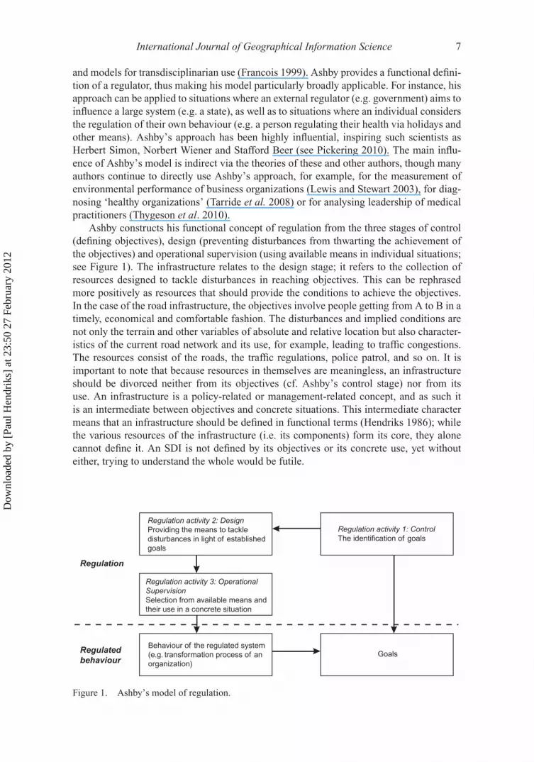
Ashby constructs his functional concept of regulation from the three stages of control(defining objectives), design (preventing disturbances from thwarting the achievement ofthe objectives) and operational supervision (using available means in individual situations;see Figure 1). The infrastructure relates to the design stage; it refers to the collection ofresources designed to tackle disturbances in reaching objectives. This can be rephrasedmore positively as resources that should provide the conditions to achieve the objectives.In the case of the road infrastructure, the objectives involve people getting from A to B in atimely, economical and comfortable fashion. The disturbances and implied conditions arenot only the terrain and other variables of absolute and relative location but also character-istics of the current road network and its use, for example, leading to traffic congestions.The resources consist of the roads, the traffic regulations, police patrol, and so on. It isimportant to note that because resources in themselves are meaningless, an infrastructureshould be divorced neither from its objectives (cf. Ashby’s control stage) nor from itsuse. An infrastructure is a policy-related or management-related concept, and as such itis an intermediate between objectives and concrete situations. This intermediate charactermeans that an infrastructure should be defined in functional terms (Hendriks 1986); whilethe various resources of the infrastructure (i.e. its components) form its core, they alonecannot define it. An SDI is not defined by its objectives or its concrete use, yet withouteither, trying to understand the whole would be futile.
Regulation activity 2: DesignProviding the means to tackle
disturbances in light of established
goals
Behaviour of the regulated system
(e.g. transformation process of an
organization)
Regulation activity 3: OperationalSupervisionSelection from available means and
their use in a concrete situation
Goals
Regulation activity 1: ControlThe identification of goals
Regulation
Regulatedbehaviour
Figure 1. Ashby’s model of regulation.
Dow
nloa
ded
by [
Paul
Hen
drik
s] a
t 23:
50 2
7 Fe
brua
ry 2
012

8 P.H.J. Hendriks et al.
3.2. The objectives of SDI
The functions of an infrastructure and its use in concrete situations involve two differentclasses of objectives, which can be labelled functional and adoption objectives, respec-tively. Functional objectives refer to the function of the infrastructure; they define theinfrastructure’s reason for existence (in the case of the road infrastructure, the objectiveof people getting from A to B). In an SDI, these functional objectives are spatial datarelated: the raison d’être of SDIs is to improve spatial data handling and the underlyingfunctional objectives (e.g. connections to the triple bottom line and to spatially enabledsocieties).
When considering the functionality of the infrastructure (i.e. the degree in which thefunctional objectives are actually met), the adoption of the infrastructural resources is rel-evant. The infrastructure can only be adopted in situations in which some feature of itsfunctional objectives is relevant. To a designer of an SDI, the adoption of the infrastructureis also an objective, although it is separate from functional objectives. Adoption objectivesderive from the fact that the design stage in regulation, when the infrastructure is estab-lished, involves preparing for actually tackling disturbances once they occur (cf. Ashby’sthird stage of regulation). An infrastructure not in use has potential only and gains meaningthrough being used in concrete situations. The requisites for adoption of an infrastructureare the recognition by potential users that it is available (their awareness of it) and thatit can help them achieve their (functional) objectives, as well as their ability and willing-ness (motivation, trust and broader social context, etc.) to adopt the components offered inan SDI. Theoretically, an infrastructure stands a better chance of serving its (functional)purpose when it is designed with adoption by potential users in mind. Inherent to an SDIis a model of adoption which, rephrased into regulation terms, involves an understandingor making an educated guess of when the infrastructure will fulfil its function (lifting thebarriers, providing the appropriate conditions). It entails an understanding of what may ormay not work. Yet it would be inaccurate to say that the perspective of the end-user definesthe SDI (cf. Poore 2003), even if an SDI can only be enacted by its actual use. What definesthe SDI is the regulatory perspective, which means that it is associated with objectives ofadoption.
3.3. The components of SDI
The core elements of SDI are its components (referred to as resources) that should allowtackling possible disturbances in reaching (spatially related) functional objectives (e.g.Craglia and Campagna 2009, Vandenbroucke et al. 2009). Infrastructures are relativelystable, in spite of the dynamics associated with their technological components. Resourcesfor a single use would not be considered part of an infrastructure. The components of anSDI do not consist only of the much-debated databases, issues of interoperability and stan-dards, legal issues and processing facilities. All these are technological components, notonly referring to computer technology but also interpreted in a broad sense (also includingconceptual data models and legal regulations). A more encompassing model, specifyingan integrated framework of infrastructural components and their connections, is offeredby Achterbergh and Vriens (2009), who discern three classes of such components. Theseclasses are (1) organizational structures, or the pattern of tasks and the coordination neededto achieve the objectives; (2) skills and competencies of individuals and groups required;and (3) all other resources, identified as technological components, employed by theseindividuals and groups. The tendency in the SDI literature to put the third class – the
Dow
nloa
ded
by [
Paul
Hen
drik
s] a
t 23:
50 2
7 Fe
brua
ry 2
012
International Journal of Geographical Information Science 9
technology – on a pedestal is in line with how infrastructures are perceived in everydaylanguage, where too easily an infrastructure is equated with the ‘technical infrastructure’.An SDI’s technological components alone will not ensure success in achieving the objec-tives. The second class of skills and competencies is required to achieve the functionalobjectives of the system in which the SDI is part of the regulation. Therefore, technologi-cal resources are not the core of the SDI to be used, however necessary, to achieve results,but they are to be considered as integral to the resources required to achieve the functionaland adoption objectives. What the skills and competencies are depends on the system inquestion. At the level of a country, effective and efficient data handling requires appro-priate education and research institutions addressing the development and disseminationof knowledge concerning concepts, theories and tools of spatiality, as well as a smoothlyoperating labour market. All such spatial skills-related institutions are therefore to be con-sidered as crucial SDI components. At the level of an organization, the hiring policies,the development and rewards systems, the training programmes and other practices of HRmanagement aimed at acquiring, developing and retaining skills and competencies withinthe workforce needed for effective and efficient handling of spatial data (in light of theorganization’s overall mission and objectives) are part of that organization’s SDI.
Aside from technological resource and HR, there is a third class of SDI componentsthat is consistently overlooked, and it concerns the crucially important class of ‘how workis organized’ (the first class in Achterbergh and Vriens’ typology). The objectives of SDIsare typically complex, requiring a multitude of tasks to be performed. Therefore, achiev-ing the objectives depends on how these tasks of working with spatial data are defined(divided) and how divided tasks are coordinated. At the level of a country, the division oflabour concerns how the tasks of, for instance, organizations or other groups are assigned(by the government or by themselves), how these (spatial data) tasks are linked to the tasksof others and how they are coordinated. A country’s government could be organized fullyalong functional lines with different national departments for urban, environmental andhealthcare planning and so on or it could group these tasks regionally (most countries haveadopted some combination of these two options, however, mostly replicating the functionaldivision at local levels, thus not achieving full integration). The first option would resultin highly specialized bodies, whereas the second option would produce more generalizedgovernment agencies. The requirements for an SDI as facilitator for these individual gov-ernment agencies to achieve effective, efficient and coordinated data usage would be verydifferent for the two situations. Consider a national water policy that is fragmented acrossmany agencies responsible for the different areas of water management (e.g. groundwa-ter, surface water or drinking water), for a specific thematic aspect (such as infrastructure,environment, culture or public health) or for a certain administrative area (e.g. munici-pality, polder, province, region or country). Such a highly specialized task division wouldrequire extensive coordination structures and data exchange protocols. If the water manage-ment system were a coherent and functional whole, comprising surface water, groundwater,river and lake beds and banks, the need for coordination and data exchange could be verydifferent.
At the level of an organization, similar distinctions are important to the ground-work of an SDI. For instance, consider a consultancy firm delivering land-use planningservices. The requirements for the technological and HR components of the organiza-tion’s SDI will be different if that organization has a specialist department for all spatialdata handling compared with being organized into departments responsible for differ-ent customer–market combinations, dividing the handling of spatial data across thesedepartments.
Dow
nloa
ded
by [
Paul
Hen
drik
s] a
t 23:
50 2
7 Fe
brua
ry 2
012

10 P.H.J. Hendriks et al.
3.4. Summary
In summary, it can be established that an SDI definition that recognizes its regulatory natureneeds to encompass the two different classes of objectives, functional and adoption, aswell as three classes of components, organizational structures, HR systems and all othercomponents, summarized as technological resources. What sets an SDI apart from otherinfrastructures is that these components are intentionally crafted to achieve the functionalobjectives of geo-data-related processes. Looking at SDI from an Ashby-like perspectiveshows its intermediate position as a connector of functional and adoption objectives andactivities to achieve these. What makes SDIs especially complex is that they aim at sup-porting individuals and groups towards their specific goals. However, that which facilitatesachieving one objective can be counterproductive in achieving others. Another point isthat in one situation a specific resource may be used, whereas in another the same maybe rejected. Changing objectives can also have an effect on the effectiveness of processes.Therefore, any taxonomic approach to defining SDI, listing viewpoints, components, andso on and combining these in conceptual schemata, however elaborate, systematic andwell-informed, is bound to fail. It follows that a definition of SDI would be incompletewithout a reference to both classes of objectives and to the processes and practices SDIsare supposed to support (to enable, to facilitate, to control, etc.). However, this shouldnot be taken to mean that these objectives or the processes and practices they refer to arepart of the SDI. Even if they cannot be adequately understood (i.e. defined) when isolatedfrom the behaviour of individuals and organizations, SDIs are to be distinguished from thatbehaviour.
4. Reconsidering prevailing SDI definitions
The approach detailed above will be used here for reviewing existing SDI definitions. It cancontribute to the discussion of ‘What is an SDI?’, a question that can be answered in twodistinct ways, that is, referring to the definition of SDI and to the characterization of theSDI phenomenon that is being defined. Below, an assessment is given for either answer tothis question. First, assorted definitions will be proofread using an Ashby-like perspectiveof infrastructures as a litmus test and a focus for discussion. Second, it will be assessedhow the literature approaches the SDI as the object of definition; in other words, the viewson what characterizes and constitutes SDIs are reconsidered.
4.1. Ad (1) What defines an SDI?
It is apparent that many authors struggle with the combination of components and objec-tives. It can be argued that both are indispensable to understand the functional nature ofan SDI. Without objectives, SDIs lack their raison d’être and without components theylack facilities for achieving these objectives. Consequently, definitions in classes (1), (2),(3) and (6), which do not include both objectives and components, have to be consideredas incomplete.
Definitions have been sorted on the distinction between data-related, user-related andbroader objectives that were derived from discerning first- and second-generation SDI(Masser 2005, Rajabifard et al. 2006). This distinction is useful because it makes clearthat data-related objectives alone do not define an SDI. Users and their organizationaland social context are indispensable, yet underexposed (cf. Poore 2003). However, ade-quately addressing the role of the user when defining SDI is not an easy task. User-centreddefinitions typically take the SDI as a point of reference. As an example, take the elaborate
Dow
nloa
ded
by [
Paul
Hen
drik
s] a
t 23:
50 2
7 Fe
brua
ry 2
012
International Journal of Geographical Information Science 11
definition given by Onsrud (2008) presented in Section 2, which includes objectives ofall three types. That definition identifies (1) ‘easy, consistent and effective access to geo-graphic information and services’ (data-related objectives) and (2) the ‘support of political,economic, social and personal development’ (user-related and broader objectives) as SDIobjectives. Onsrud specifically says that what defines an SDI is that it is conceived anddesigned ‘to serve its goals’. Definitions like these take ‘SDI as a means’ as the perspec-tive for considering situations in which it may be useful (compare the idea of a hammerlooking for a carpenter instead of a carpenter looking for a hammer). A more adequatetake on the role of SDI is arrived at if it is considered as a possible means not for achiev-ing ‘its objectives’ but the objectives of the SDI users (user-related objectives) and theirorganizational or social context (broader objectives), whether these users are individuals,groups or organizations. Characteristic of any infrastructure is that it should offer genericfacilities for achieving classes of objectives. An SDI is much like a road infrastructure thatshould help achieve objectives for all kinds of users, not only for transport companies butalso for visiting family. An infrastructure may serve many objectives that are not known toits designers beforehand. Yet the objectives of these SDI users define the role of an infras-tructure as a regulatory device, and not some abstract class of ‘objectives of the SDI’. Theobjective of SDI is not the use of spatial data extended into user-related or broader goalsbut to serve those purposes of individuals, groups and organizations for which spatial dataare or may become useful. These objectives and the possible role of an SDI in achievingthem define its potential functionality.
It is important to view the SDI not from the perspective of its own objectives, which areessentially of a virtual nature, but from the reversed perspective of the users’ objectives.Only through that reversal can it become visible that the triplet of data-related, user-relatedand broader objectives alone cannot fully capture the nature of SDI. That triplet looks atthe functionality of an SDI from the SDI’s perspective and thus involves only a partial per-spective on the role of individuals and organizations. There are other conditions for SDIto support effectively the users’ objectives, which involve the capability and willingnessof potential users to access, accept and integrate SDI in their work (i.e. in the tasks theyperform to achieve their objectives). These conditions, though connected to the functionalconditions, are of a different nature; they do not refer to a means–ends connection. Theyinvolve a broad spectrum of social phenomena, including power relations, culture and edu-cational facilities, that affect SDI effectiveness (e.g. discussed by Harvey (2003), De Man(2006)). All definitions that try to go beyond the restricted data-related nature of its objec-tives struggle with the role of users and their broader organizational and social objectives.This struggle can only be resolved by taking the organizations and other SDI users as thepoint of reference for defining the SDI and by distinguishing between their functional goalsand the goals associated with adopting SDI in their work.
In addition to the objectives, the role of the components in the various definitions needsto be examined. As Ashby’s definition of regulation explains, SDI components are mean-ingful only once objectives have been set and barriers to achieving these, identified byAshby as disturbances, have been specified. Only one definition that was analysed rec-ognized this indispensable connecting role of disturbances, in this case referred to asimpediments, to give SDI components their raison d’être:
A spatial data infrastructure supports ready access to geographic information. [. . .] Theseactions encompass the policies, organizational remits, data, technologies, standards, deliverymechanisms, and financial and human resources necessary to ensure that those working atthe (national) and regional scale are not impeded in meeting their objectives (GSDI, cited byMasser (2005))
Dow
nloa
ded
by [
Paul
Hen
drik
s] a
t 23:
50 2
7 Fe
brua
ry 2
012
12 P.H.J. Hendriks et al.
Particularly, older definitions focus on technological resources – especially those relatedwith computer use – or have lists that put technological features on a pedestal. This fitsthe previously mentioned tendency outside the SDI domain of associating infrastructurefirst and foremost with technological infrastructure. More extensive lists, such as the oneoffered by GSDI mentioned above, include more diverse categories of components, such asdata, metadata, policies, standards and regulations, services and education. What such listsappropriately signal – yet mostly implicitly – is that the individual components will not giveSDIs their functionality but some meaningful combination of them. However, there was nodefinition based on an analysis of the interdependencies between (classes of) components;all definitions appear as unordered lists where the components are concerned.
To conclude, most attention in SDI definitions has been paid to technological resources,or the third class in Achterbergh and Vriens’ (2009) argument (see Section 3). Theseauthors argue that this class is not to be considered on a stand-alone basis; it derives itsrelevance from the first two classes. Hardly any attention is given to the first class, thatof organizational structures. A different division, allocation and coordination of tasks isbound to lead to a different need for the other resources, including the technological ones.This is surely an important shortcoming in definitions of and approaches to SDI.
4.2. Ad (2) What constitutes an SDI?
When considering what an SDI is, one may address the definition of an SDI or the exis-tence of one. Several approaches view SDI as a phenomenon or system of its own, witha separate existence and relationship to its environment. These approaches seem to defineSDI but upon closer examination they sidestep the core nature of infrastructures as regu-latory devices. The basic approach taken in these studies is visible in Hjelmager et al.’s(2008) distinction of five perspectives of SDI labelled as the enterprise, information, com-putation, engineering and technology perspectives. This article then elaborates the first twoof these. The enterprise perspective grounds the other perspectives and ‘describes the pur-pose, scope and policies for an SDI. The enterprise viewpoint describes the relationshipof an SDI to its environment, its role and the policies associated’ (Hjelmager et al. 2008,p. 1299). An elaborated understanding of SDI considered from an enterprise perspectivemay come from Grus et al.’s (2010) treatment of SDI as complex adaptive systems (CAS),which highlights many informative traits of SDI, such as their openness in the sense ofinteraction with their environment, their nonlinearity, their emergent nature resulting fromthe interactions between components and not from characteristics inherent in the compo-nents themselves, their adaptability, self-organization, unpredictability and sensitivity toinitial conditions. While these approaches have contributed to the understanding of SDI, itis important to stress that in themselves they do not provide an appropriate basis for a totalunderstanding because they approach SDI as a stand-alone phenomenon maintaining rela-tionships with its surroundings. A definition of SDI, which is the key focus in this article,is then only implied. Presuming that an enterprise or CAS perspective fully captures thenature of SDI easily leads to confusion. It opens the discussion on SDI not with the defini-tion of SDI but with an interpretation of the phenomenon, leaving the definition implicit inthe background. It seems more appropriate to address the system that the SDI should helpregulate as a CAS (e.g. a country that introduces a clearinghouse to support its nationalSDI, an organization that delivers its data-related services via SDI, a grassroots group thatconnects to an international SDI to support its social action). The CAS perspective on SDIfocuses on ‘what an SDI is’ and not on ‘what an SDI can or should do’.
Dow
nloa
ded
by [
Paul
Hen
drik
s] a
t 23:
50 2
7 Fe
brua
ry 2
012
International Journal of Geographical Information Science 13
An increasingly popular debate in which the idea of SDI as ‘a phenomenon with a sep-arate existence’ becomes more visible and elaborated is SDI performance (e.g. Steudler2003, De Man 2006, Scholten et al. 2006, Giff and Crompvoets 2008). The argument lead-ing to the SDI performance question entails using a management approach to SDI. Theargument links the outcomes associated with SDI usage to SDI objectives embedded ina strategy. Performance assessment then involves weighing outcomes against objectives,which presumes the identification of performance indicators and standards to assess indi-cator values. This approach may prove useful, but it should be stressed that it starts atthe ‘wrong’ level. First and foremost the concept of performance refers to that what isbeing regulated via the infrastructure and not to the infrastructure itself. As stressed above,it is not the data-related, user-related and broader objectives that define the SDI, but theobjectives of individuals, groups and organizations that may be better achieved through acollectively built and maintained SDI. Therefore, the performance question concerns theSDI’s proven functionality, given conditions of access, acceptance and integration, judgedby how well these objectives are met. Obviously, if one uses certain resources or tools, itmakes sense to ask questions about quality and functionality of these; the provider of theresources would be particularly interested in such questions. However, to couch that debatein performance terminology appears odd, to say the least. Assessing the infrastructure inits own right involves a strange inversion based on a manifestation of the infrastructure.In other words, the performance debate approaches the SDI as a physical entity, but theactual character of an SDI can only be established within the context of its use.
Similar remarks can be made regarding the organization of the SDI, for instance,through clearinghouse constructions, staffing policies and geospatial one-stop shops (e.g.Junker and Weber 2001, Dueker and Bender 2003, Crompvoets et al. 2004, Kohler andWachter 2006, Goodchild et al. 2007). Since these discussions, just like the debates con-cerning the five perspectives mentioned in Section 4.2, CAS and performance, aim atcontributing to understanding SDIs, they may appear to build on a definition of SDI andelaborate on it. Yet closer examination shows that they, willingly or not, overlook the inter-mediate character of the SDI as a regulation phenomenon. These approaches take SDI as‘something that is there’; therefore, they involve a manifestation of SDI.
5. Conclusions
The objective of this article was to critically review existing SDI definitions using asystem-theoretical understanding of infrastructures as the reviewing perspective. Whilethis approach in itself does not produce a new, sharper definition of SDI, it should still behelpful in expanding our understanding of SDIs. To conclude this article, the conceptualdiscussion of SDI is used to briefly revisit the four classes of complexity involved in defin-ing SDI that were identified in the introduction. The first two sources of complexity, theroles played by objectives and users, are closely linked. The distinction between functionaland adoption objectives is key to these discussions. It is important to note that users (cf.the second source of complexity) are connected to both functional and adoption objec-tives. As De Man (2006, p. 338), quoting Carver, establishes: ‘SDIs should be focused onreal people using real systems to address real problems.’ The adoption objectives refer toindividual practices of ‘real people’ turning to the ‘real systems’ available in SDI whentackling their ‘real problems’, while the functional objectives are dealing with these realproblems (e.g. understanding them, assessing their relevance, solving them). There is noth-ing forcing SDI designers to have an explicit adoption model in mind when constructingthe SDI’s functionality, but it seems logical to assume that better knowledge of adoption
Dow
nloa
ded
by [
Paul
Hen
drik
s] a
t 23:
50 2
7 Fe
brua
ry 2
012
14 P.H.J. Hendriks et al.
factors may lead to both better SDI design knowledge and a more effective contribution ofSDI to its intended users’ performance. The distinction between functional and adoptiongoals shows that grouping together user-related objectives with data-related objectives andbroader objectives is insufficiently precise. The role of users in connection with SDI objec-tives is different from the roles of the data-related and broader objectives. The concept ofadoption objectives may help in dealing with these differences in the practice of designing,implementing and running ‘real’ SDIs.
The third source of complexity is the role of components. What a system-theoreticalapproach to regulation makes clear is that, at a general level, these components come underthree classes of organization structures (tasks and their coordination), HR systems (skills,competencies, etc. presumed necessary for task completion) and technology (all otherresources that are considered instrumental to achieving functional objectives). Applyingthis distinction to SDI literature shows that the class of technological mechanisms appearscentre stage in SDI debates, while particularly the first class of components (organizationalstructures) gets systematically overlooked (the ‘Spatialist’ research programme is one ofthe exceptions proving this rule, see Dessers et al. (2010)). Even if ‘the core of an SDIis a set of networked, and potentially interlocked, geospatial databases’ (Hjelmager et al.2008), without downplaying the importance of the necessary standards, laws and regu-lations, interoperability issues, and so on, such components alone cannot make the SDI‘work’. A meaningful connection to SDI objectives, both functional and adoption, pre-sumes that technological components are linked to task division and HR facilities (e.g.educational and training programmes). More insight is needed in the role of these twoclasses of SDI components.
The fourth class of miscellaneous complexity sources such as the dynamic nature ofSDI and SDI hierarchies has not been explicitly addressed in this article. A better under-standing of this fourth class should build on the perspective developed in this article andalso needs further conceptualization. For example, adequately dealing with the dynamicsof SDI requires a model of regulation (or intervention) as a process, whereas the focus inthis article is on identifying the structure of the SDI concept. This means a limitation ofthis article and shows that further elaboration of the argument developed here is necessary.
Note1. The combination of ‘no components’ and ‘no objectives’ does not lead to a feasible definition.
ReferencesAchterbergh, J. and Vriens, D., 2009. Organizations: social systems conducting experiments.
New York: Springer.Ashby, W.R., 1956. An introduction to cybernetics. London: Chapman and Hall.Ashby, W.R., 1960. Design for a brain: the origin of adaptive behaviour. New York: John Wiley.Chan, T.O., et al., 2001. The dynamic nature of spatial data infrastructures: a method of descriptive
classification. Geomatica, 55 (1), 65–72.Craglia, M. and Campagna, M., 2009. Advanced regional spatial data infrastructures in Europe.
Luxembourg: Office for official publications of the European Communities.Crompvoets, J., et al., 2004. Assessing the worldwide developments of national spatial data
clearinghouses. International Journal of Geographical Information Science, 18 (7), 665–689.De Man, E., 2008. The multi-faceted nature of SDIs and their assessment – dealing with dilemmas.
In: J. Crompvoets, A. Rajabifard, B.V. Loenen, and T.D. Fernández, eds. A multi-view frameworkto assess spatial data infrastructures. Melbourne: Melbourne University Press, 23–49.
De Man, W.H.E., 2006. Understanding SDI; complexity and institutionalization. InternationalJournal of Geographical Information Science, 20 (3), 329–343.
Dow
nloa
ded
by [
Paul
Hen
drik
s] a
t 23:
50 2
7 Fe
brua
ry 2
012

International Journal of Geographical Information Science 15
Dessers, E., et al., 2010. Developing spatially-enabled business processes: the role of organisationalstructures. In: A. Rajabifard, J. Crompvoets, M. Kalantari, and B. Kok, eds. Spatially enablingsociety, research, emerging trends and critical assessment. Leuven: Leuven University Press,41–54.
Dueker, K.J. and Bender, P., 2003. Building and maintaining a statewide transportation frame-work. In: Annual meeting of the transportation research board. Washington, DC: TransportationResearch Board National Research Council, 93–101, 12–16 January 2003, Washington, DC.
Elwood, S., 2008. Grassroots groups as stakeholders in spatial data infrastructures: challenges andopportunities for local data development and sharing. International Journal of GeographicalInformation Science, 22 (1), 71–90.
European Commission, 2007, Establishing an Infrastructure for Spatial Information in the EuropeanCommunity (INSPIRE). Directive 2007/2/EC of the European Parliament and of the Council of14 March 2007.
Executive Office of the President, 1994, Coordinating geographic data acquisition and access:the National Spatial Data Infrastructure. Executive Order 12906. Federal Register, 59,17671–17674.
Francois, C., 1999. Systemics and cybernetics in a historical perspective. Systems Research andBehavioral Science, 16 (3), 203–219.
Georgiadou, Y., Puri, S.K., and Sahay, S., 2005. Towards a potential research agenda to guide theimplementation of spatial data infrastructures – a case study from India. International Journalof Geographical Information Science, 19 (10), 1113–1130.
Giff, G.A. and Crompvoets, J., 2008. Performance indicators a tool to support spatial datainfrastructure assessment. Computers Environment and Urban Systems, 32 (5), 365–376.
Goodchild, M.F., Fu, P.D., and Rich, P., 2007. Sharing geographic information: an assessment of thegeospatial one-stop. Annals of the Association of American Geographers, 97 (2), 250–266.
Groot, R. and McLaughlin, J., 2000. Geospatial data infrastructure: concepts, cases and goodpractice. Oxford: Oxford University Press.
Grus, L., Crompvoets, J., and Bregt, A.K., 2010. Spatial data infrastructures as complex adaptivesystems. International Journal of Geographical Information Science, 24 (3), 439–463.
GSDI, 2004, The SDI cookbook [online]. Available from: http://www.gsdi.org/gsdicookbookindex,Accessed on 13 November 2011.
Harvey, F., 2003. Developing geographic information infrastructures for local government: the roleof trust. Canadian Geographer-Geographe Canadien, 47 (1), 28–36.
Harvey, F.J., Buttenfield, B.P., and Lambert, S.C., 1999. Integrating geodata infrastructures from theground up. Photogrammetric Engineering and Remote Sensing, 65 (11), 1287–1291.
Hendriks, P.H.J., 1986. De relationele definitie van begrippen: een relationeel realistische visieop het operationaliseren en representeren van begrippen (Functionally defining concepts; arelationally-realistic perspective on the operationalisation and representation of concepts).Amsterdam: Koninklijk Nederlands Aardrijkskundig Genootschap.
Hjelmager, J., et al., 2008. An initial formal model for spatial data infrastructures. InternationalJournal of Geographical Information Science, 22 (11–12), 1295–1309.
Junker, M. and Weber, G., 2001. Geodata management in a transborder region. Results of the INFO2000 project Spatial Data Clearinghouse Saar-Lor-Lux CLEAR. Nfd Information-WissenschaftUnd Praxis, 52 (8), 445–452.
Kohler, P. and Wachter, J., 2006. Towards an open information infrastructure for disaster researchand management: data management and information systems inside DFNK. Natural Hazards,38 (1–2), 141–157.
Lewis, G.J. and Stewart, N., 2003. The measurement of environmental performance: an applicationof Ashby’s law. Systems Research and Behavioral Science, 20 (1), 31–52.
Masser, I., 1999. All shapes and sizes: the first generation of national spatial data infrastructures.International Journal of Geographical Information Science, 13 (1), 67–84.
Masser, I., 2005. GIS worlds: creating spatial data infrastructures. Redlands, CA: ESRI.Masser, I., 2007. Building European spatial data infrastructures. Redlands, CA: ESRI.Masser, I., Rajabifard, A., and Williamson, I., 2008. Spatially enabling governments through SDI
implementation. International Journal of Geographical Information Science, 22 (1), 5–20.McLaughlin, J. and Nichols, S., 1994. Developing a national spatial data infrastructure. Journal of
Surveying Engineering-ASCE, 120 (2), 62–76.Merriam-Webster, 2006. Merriam Webster’s collegiate dictionary. Springfield: Merriam-Webster.
Dow
nloa
ded
by [
Paul
Hen
drik
s] a
t 23:
50 2
7 Fe
brua
ry 2
012
16 P.H.J. Hendriks et al.
Nedovic-Budic, Z., Crompvoets, J., and Georgiadou, Y., eds., 2011. Spatial data infrastructures incontext: north and south. London/New York: CRC Press.
Onsrud, H., 2007. Research and theory in advancing spatial data. Redlands, CA: ESRI.Onsrud, H., 2008. Foreword. In: J. Crompvoets, A. Rajabifard, B.V. Loenen, and T.D. Fernández, eds.
A multi-view framework to assess spatial data infrastructures. Melbourne: Melbourne UniversityPress, xi–xii.
Pickering, A., 2010. The cybernetic brain: sketches of another future. Chicago, IL: University ofChicago Press.
Poore, B.S., 2003. The open black box: the role of the end-user in GIS integration. CanadianGeographer-Geographe Canadien, 47 (1), 62–74.
Rajabifard, A., ed., 2007. Towards a spatially enabled society. Melbourne: University of Melbourne.Rajabifard, A., Feeney, M.-E.F., and Williamson, I.P., 2002. Future directions for SDI development.
International Journal of Applied Earth Observation and Geoinformation, 4 (1), 11–22.Rajabifard, A., Feeney, M.-E.F., and Williamson, I.P., 2003. Spatial data infrastructures: con-
cept, nature and SDI hierarchy. In: Williamson, I.P., Rajabifard, A. and Feeney, M.-E.F., eds.Developing spatial data infrastructures. From concept to reality. London/New York: Taylor &Francis, 17–40.
Rajabifard, A., et al., 2006. The role of sub-national government and the private sector in futurespatial data infrastructures. International Journal of Geographical Information Science, 20 (7),727–741.
Rajabifard, A., et al., eds., 2010. Spatially enabling society; research, emerging trends and criticalassessments. Leuven: Leuven University Press.
Roche, S., Sureau, K., and Caron, C., 2003. How to improve the social utility value of geographicinformation systems for French local governments? A Delphi study. Environment and PlanningB-Planning & Design, 30 (3), 429–447.
Scholten, M., Klamma, R., and Kiehle, C., 2006. Evaluating performance in spatial datainfrastructures for geoprocessing. IEEE Internet Computing, 10 (5), 34–41.
Steudler, D., 2003. Developing evaluation and performance indicators for SDI’s. In: I. Williamson,A. Rajabifard, and M.F. Feeney, eds. Developing spatial data infrastructures: from concept toreality. London: Taylor and Francis, 235–246.
Tarride, M.I., et al., 2008. Healthy organizations: toward a diagnostic method. Kybernetes, 37 (8),1120–1150.
Thygeson, M., Morrissey, L., and Ulstad, V., 2010. Adaptive leadership and the practice of medicine:a complexity-based approach to reframing the doctor-patient relationship. Journal of Evaluationin Clinical Practice, 16 (5), 1009–1015.
Vandenbroucke, D., et al., 2009. A network perspective on spatial data infrastructures: application tothe sub-national SDI of Flanders (Belgium). Transactions in GIS, 13 (1), 105–122.
Van Loenen, B., 2006. Developing geographic information infrastructures. The role of informationpolicies. Delft: Delft University of Technology.
Williamson, I., Rajabifard, A., and Feeney, M.F., eds., 2003. Developing spatial data infrastructures:from concept to reality. London: Taylor and Francis.D
ownl
oade
d by
[Pa
ul H
endr
iks]
at 2
3:50
27
Febr
uary
201
2