quantifying erosion using 137cs and 210pb in cultivated soils in three mediterranean watershed:...
TRANSCRIPT

(This is a sample cover image for this issue. The actual cover is not yet available at this time.)
This article appeared in a journal published by Elsevier. The attachedcopy is furnished to the author for internal non-commercial researchand education use, including for instruction at the authors institution
and sharing with colleagues.
Other uses, including reproduction and distribution, or selling orlicensing copies, or posting to personal, institutional or third party
websites are prohibited.
In most cases authors are permitted to post their version of thearticle (e.g. in Word or Tex form) to their personal website orinstitutional repository. Authors requiring further information
regarding Elsevier’s archiving and manuscript policies areencouraged to visit:
http://www.elsevier.com/copyright

Author's personal copy
Quantifying erosion using 137Cs and 210Pb in cultivated soils in threeMediterranean watershed: Synthesis study from El Hachef, Raouz and Nakhla(North West Morocco)
Brahim Damnati a,⇑, Sanaa Ibrahimi a, Olivier Radakovitch b
a Department of Earth Sciences, Faculty of Sciences and Techniques, Environment, Oceanology and Natural Resources Laboratory, BP 416 Tangier, Moroccob CEREGE, Aix-Marseille University, IRD, Collège de France, BP 80, 13545 Aix-en-Provence, France
a r t i c l e i n f o
Article history:Received 18 January 2012Received in revised form 15 October 2012Accepted 29 October 2012Available online 19 November 2012
Keywords:El HachefRaouzNakhlaMoroccoErosion137Cs
a b s t r a c t
Measurements of soil erosion on the Moroccan landscape using classical erosion methods have been theobjective of several research studies, but these classical methods are difficult to conduct, time consumingand very expensive and the quantitative estimation of soil loss remains insufficient particularly in theNorth of Morocco. In this study, we present results on soil erosion quantification using 137Cs and 210Pbin three dam catchments: El Hachef, Raouz and Nakhla.
In each area inventories of 137Cs and 210Pbex were measured in cultivated soils and compared to refer-ence inventories (noneroded) measured in the same area. The differences were converted onto erosion oraccumulation rate using mass balance models (MB1 and MB2).
In El Hachef, the mean erosion rates using 137Cs with MB1 and MB2 models and 210Pbex with MB2model are respectively 32 t ha�1 yr�1, 29 t ha�1 yr�1 and 20 t ha�1 yr�1.
In Raouz, the mean erosion rates using 137Cs with MB1 and MB2 models and 210Pbex with MB2 modelare respectively 13.9 t ha�1 yr�1, 12.2 t ha�1 yr�1 and 16.1 t ha�1 yr�1.
In Nakhla, the mean erosion rates using 137Cs with MB1 and MB2 models and 210Pbex with MB2 modelare respectively 33.1 t ha�1 yr�1, 41.3 t ha�1 yr�1 and 20 t ha�1 yr�1.
These results show the severity of erosion in North West Morocco compare to other Mediterraneancountries and the necessity to seek for urgent solutions to stem this problem.
� 2012 Elsevier Ltd. All rights reserved.
1. Introduction
Soil erosion affects both agricultural and natural landscapes,and is one of the most important of today’s environmental prob-lems. The loss of soil from farmland can induce reduction of cropproduction potential, decrease surface water quality and damageddrainage networks. Many methods have been used to measure themovement of soils and sediments including for example trappingof sediments transported by runoff wash in rills or survey ofchanges in ground elevation. The Universal Soil Loss Equation(USLE) has been also widely used, but many times in areas very dif-ferent from the environment for which this empirical equation wasderived (Roose, 1991; Lahlou, 1990; Damnati, 1997; Damnati et al.,1998) and this sometimes induced large differences when com-pared to other methods.
The limitation of these techniques has led to research in moreaccurate methods, such as the tracer techniques based on determi-nation of radionuclides activities. Caesium-137 and lead-210 arethe most widely used radionuclides for soil erosion and sedimenta-
tion estimation because they have a high affinity for fine particles,their half-life are sufficiently long and they can be measured quiteeasily. Many studies have confirmed the potential of lead-210 asboth an alternative and complementary sediment tracer to 137Csin soil erosion investigations (Bunzl and Kracke, 1988; Wallinget al., 1995; He and Walling, 1997; IAEA, 1998).
137Cs is an artificial radionuclide with a half-life of 30 years,produced from past atmospheric testing of thermonuclear weap-ons (1950–1970) or accidents. It was released into the strato-sphere, distributed globally and deposited as fallout inassociation with precipitation.
The 210Pb is a naturally occurring radionuclide and is a productof the 238U decay series with a half-life of 22.1 years. It is derivedfrom gaseous 222Rn, the daughter of 226Ra. Two parts must be dis-tinguished in soils: the supported 210Pb, produced in situ by the de-cay of 226Ra in the soil, and the unsupported 210Pb (also known as‘‘unsupported’’ or ‘‘excess’’, i.e., 210Pbex), issued from 222Rn decay inthe atmosphere and subsequent deposition on the earth surface bywet and dry precipitation. This unsupported lead-210 has abehaviour similar to 137Cs and once deposited they have both astrong affinity for soil particles. Since the deposition is assumedhomogeneous at the local scale (small watershed), their spatial dis-
1464-343X/$ - see front matter � 2012 Elsevier Ltd. All rights reserved.http://dx.doi.org/10.1016/j.jafrearsci.2012.10.006
⇑ Corresponding author.E-mail address: [email protected] (B. Damnati).
Journal of African Earth Sciences 79 (2013) 50–57
Contents lists available at SciVerse ScienceDirect
Journal of African Earth Sciences
journal homepage: www.elsevier .com/locate / ja f rearsc i

Author's personal copy
tribution provide information on soil redistribution on mediumand long term periods (since 1958 for 137Cs and the last 100 yearsfor 210Pb: Mitchell et al., 1980; Ritchie and MacHenry, 1990; Carv-alho, 1990; Walling et al., 1995).
2. Study areas
The study was conducted in three sites North-West of Morocco.The first one is a watershed of an artificial reservoir created in 1996:the El Hachef dam (area of 230 km2, 30 km south of Tangier; Fig. 1).This reservoir is used for domestic supply and irrigation, but ero-sion is a real problem leading to silting up of lake and damagingthe arable soils. The sub-humid Mediterranean climate of the studyregion is characterised by winter rains, long dry summers and anannual precipitation about 800 mm (Tangier). The annual tempera-ture average is about 17 �C. The drainage basin is dominated by aseries of pelitic and sandstone hills including some cliffs underplant cover of mattoral or agriculture fields. Lower altitudes corre-spond to marly-clayey deposits, terraces and Quaternary deposits(El Gharbaoui, 1981). The mountains mainly correspond to quartz-itic sandstones and mudstones, whereas flat areas are dominatedby clay and limestone or marly limestone and the wide valleys byalluvial–colluvial material. The geomorphology of the watershedshows a series of sandstone ridge formed by Oligo–Miocene Numi-dian rocks (7047 ha, 34%), sandstone and marl (2442 ha, 11%) and aflysch marly shale unit of Tangier representing 10,232 ha (46% ofthe watershed). The rest (9%) is plain fluvial terraces and mudflows.
Slopes between 5% and 15% occupy 15686 ha (71% of the basinarea). Slopes lower than 5% are mainly in the flat areas of the val-leys (17% of surface: Table 1) and the main part is used for agricul-ture. Soils in the basin are brown earths on stone wares andvertisols developed on the marly.
Three reference sites (where erosion and accumulation are notsuspected) and more than teen cultivated sites were selected alongthe slope of three transects.
The second site is Raouz, a watershed of 47 km2, located 15 kmnorthwest of the city of Tetouan (Fig. 1). The average annual rain-fall ranges from 1356 mm (2003/2004) to 225 mm (1994–1995)with a high intra-annual rainfall. The wet season usually extendsover 8 months (October to May), with a maximum recorded inthe month of December.
The geology of the watershed is characterized by a dominanceof flysch marl–limestone and clay, sandstone and dolomite (inter-nal domain of the Rif mountain). The main geological units that
form the watershed are the backbone of the Rif internal limestone,the layers of flysch unit and Tangier external domain (El Gharba-oui, 1981). Dorsal calcareous covers the entire eastern part of thebasin, occupying 15% of the total area (717.3 ha). The flysch arefairly extensive in the watershed 52% of the area (2480 ha) andthe Tangier unit cover 14% (681 ha). Vegetation and soils are sim-ilar to those from the Hachef catchment.
Two reference sites and more than sixteen cultivated sites wereselected along the slope of four transects (Table 2).
The third study site is an experimental plot located in the drain-age basin of the Nakhla dam (Fig. 1). Mean annual precipitationgenerally exceeds 800 mm. The vegetation is dominated by corkoak, sometimes with olive, laurel burl and tamarisk. The geologyof the region is characterized by the presence of Eocene–Oligocenemarls, conglomerates and Miocene sandstones (Moukhchane et al.,1998). The recent deposits consist of mudflows, talus and alluvium.The plot is small and has an oblong shape of 20.8 m of length and4.5 m of width. Four transects have been sampled (Table 3).
3. Material and methods
Samples were collected in 2000 and 2001 in cultivated anduncultivated soils in the three basin catchments (Tables 2 and 3).The soils were sampled from surface to 30 cm or 40 cm depth
Fig. 1. Geographical situation of studied sites in North-West of Morocco.
Table 1Samples number and slope angle of studied profiles of El Hachef site.
Profiles Samples number Slope angle (�)
Dr1 5 15Dr2 5 12Dr3 5 10Dr4 5 11Dr5 3 20Dr6 5 10Dh1 5 10Dh2 5 13Dh3 5 8Dh4 5 15Dh5 5 16Pr1 5 45Pr2 4 30Pr3 4 18Pr4 4 0Pr10 4 15Pr11 4 4Pr12 4 4
Table 2Samples number and slope angle of studied profiles of Raouz site.
Profiles Position Samples number Slope angle (�)
Transect T1 35�N440004J2 5�W290834 5 15J3 5 15J4 5 25J5 5 30
Transect T2 35�N430830J6 5�W300099 5 15J7 5 25J8 5 25J9 5 15
Transect T3 35�N430439J10 5�W290688 5 32J11 5 10J12 5 15J13 5 20
Transect T4 35�N430491J14 5�W290956 5 35J15 5 15J16 5 20
B. Damnati et al. / Journal of African Earth Sciences 79 (2013) 50–57 51

Author's personal copy
and cut into 2.5 (between 0 and 10 cm) or 10 cm (in the bottom)increments in order to analyse the vertical distribution of 137Csand unsupported 210Pb. The samples were dried, sieved to <2 mmand homogenised for a gamma spectrometry analyses in the CER-EGE laboratory (France) using a semi-planar germanium detector.137Cs, 210Pb and 226Ra activities were measured at 662, 42 and352 keV respectively for 24 h. These activities were obtained onunit mass (Bq/kg) and converted to inventory (Bq/m2) using the to-tal weight of the bulk core sample and the cross sectional area ofsampling device. Soil bulk densities (kg/m3) calculations werebased on the volume of bulk soil cores and oven-dried soil massdeterminations.
The technique used to estimate erosion and deposition rates isbased on the approach described by Quine et al. (1994), He andWalling (1997) and Walling and He (1999). Estimates of 137Cs and210Pb losses in the soil were calculated by comparing each soilinventory with those obtained on reference sites from the same wa-tershed. These sites are assumed to be neither eroded or accumu-lated (Owen and Walling, 1996; Radakovitch et al., 2002; Xinbaoet al., 2003; Damnati et al., 2003). The reference sites were alwayschosen near the study sites, in flat and non-agricultural areas.
The conversion of inventories (Bq/m2) into soil redistribution(t ha�1 yr�1) is made using the simplified mass-balance models(MB1 and MB2) for 137Cs inventories and the mass balance model(MB2) for 210Pb inventories (He and Walling, 1997; IAEA, 1998;Walling and Quine, 1990; Walling and He, 1999, 2001).
In El Hachef site the parameters used are:
� 137Cs inventory at the reference site: 2582 ± 540 Bq/m2.� Average density: 1365 kg/m3.� Plough horizon: 10 cm or 20 cm thick (according the profile),
with an equivalent weight of 136 kg/m2.� The weight of the depth migration calculated according Walling
and He (2001) and the average density of this site is equal to5.5 kg/m2.� The proportion factor is calculated from the ratio of the amount
of rain on the episode erosive force of rainfall annually in ElHachef basin, the average value of the episode (1942–2003)found is 0.3.
� The dominant texture of the soil is clay and silt. Thus P = 1 inmodels (IAEA, 1998).
In Raouz site the parameters used are:
� 137Cs inventory at the reference site: 2651 ± 234 Bq/m2
� average density: 1351 kg/m3,� Plough horizon: 10 cm or 20 cm thick (according the profile),
with an equivalent weight of 270 kg/m2 and 135 kg/m2
respectively.� weight of the depth migration according Walling and He (2001)
and the average density of this site is equal to 5.4 kg/m2.� The proportion factor is calculated from the ratio of the amount
of rain on the episode erosive force of rainfall annually in Raouzbasin, the average value of the episode (1942–2003) found is0.3.� The dominant texture of the soil is clay and silt. Thus P = 1 in
models (IAEA, 1998).� The model for 210Pbex was also applied. The inventory of refer-
ence site used is 2206 ± 553 Bq/m2. The other parameters arethose used for 137Cs.
For the Nakhla plot the parameters used are:
� 137Cs inventory at the reference site: 2142 ± 254 Bq/m2.� Average density: 1421 kg/m3.� Plough horizon: 10 cm thick, with an equivalent weight of
142 kg/m2.� Weight of the depth migration: 5.7 kg/m2.� The proportion factor is calculated from the ratio of the amount
of rain on the episode erosive rainfall total annual basin Nakhla,the average value of the episode (1942–2003) found is 0.3.� The most dominant texture of the soil is clay and silt. Thus P = 1
in models (IAEA, 1998).� The model conversion 210Pbex was also applied. The inventory of
reference site used 1246 ± 288 Bq/m2. The other parameters arethose used for 137Cs.
4. Results
4.1. El Hachef site
The undisturbed reference profiles of 137Cs show typical trendswith depth, with maximum activities in the upper 5 cm followedby sharp decline (Fig. 2). The 210Pb profiles show a continuousand more or less exponential decrease with depth. These featuresreflect the different fallout pattern of the two radionuclides:unsupported 210Pb fallout input is constant through time and thusits concentrations are greatest at the surface, whereas in the case of137Cs, the lack of significant replenishment over the past 30 yearscoupled with biological activity within the soil and some down-ward diffusion, has caused the level of maximum concentrationto be displaced a few centimetres below the surface (Wallinget al., 1990). Three references sites were sampled in the grasslandwith a mean of 2582 ± 540 Bq/m2 for 137Cs and 1334 ± 312 Bq/m2
for 210Pb.Almost all profiles from cultivated areas show relatively uni-
form 137Cs activities through the upper 10–15 cm. Below this level,the activity declines sharply with depth (Fig. 3). This feature resultsfrom the mixing of the surface soil and associated radionuclide bytillage and this value equivalent to plough depth is logical since theploughing in this basin is made using animals.
Eroding and accumulating sites would be clearly distinguish-able within the cultivated zone, in terms of both their total inven-
Table 3Samples number and slope angle of studied profiles of Nakhla plot.
Profiles Position Samples number Slope angle (�)
Transect T1 35�N200441PI 5�W220169 5 15P2 1 14P3 5 20P4 1 22P5 5 20
Transect T2 35�N200465P6 5�W220085 1 21P7 1 15P8 1 28P9 1 10P10 1 15
Transect T3 35�N200468P11 5�W220084 1 28P12 1 15P13 1 15P14 1 12P15 1 20
Transect T4P16 1 20P17 1 25P18 1 31P19 1 18P20 1 15
52 B. Damnati et al. / Journal of African Earth Sciences 79 (2013) 50–57

Author's personal copy
Fig. 2. Vertical depth distribution of 137Cs and 210Pb in reference sites.
Fig. 3. Depth distributions of 137Cs and 210Pb along three transects in El Hachef basin.
B. Damnati et al. / Journal of African Earth Sciences 79 (2013) 50–57 53
Author's personal copy
tory and the vertical profile distribution. Most of the profiles showclear evidence of erosion with both low 137Cs activity at the surfaceand a low inventory. Their positions along the slope facilitate theloss soil of particles and then 137Cs. PR1 and PR12 are characterizedby higher activities of 137Cs and higher inventories than the refer-ence site that must be related to particles deposition. The otherprofiles exhibit a uniform 137Cs activity throughout the ploughlayer and minimal 137Cs below the plough depth. They are charac-terized by both low activities of 137Cs and inventories significantlylower than the reference site. Those sites have been subject to137Cs loss and therefore erosion. The profiles of 210Pbex (Fig. 3)
are similar to those of 137Cs but with different penetration depth.Whereas 137Cs penetrates up to 40 cm, the 210Pbex is limited tothe first 10–15 cm, probably due to a stronger adsorption ontoparticles.
The highest erosion and deposition rates were obtained withthe MB1 model. The MB1 erosion prediction varied from 1.9 to91 t ha�1 yr�1 and the deposition rate varied from 0.8 to100 t ha�1 yr�1. The MB2 erosion rate varied from 1.6 to 86 t ha�1 -yr�1 and the deposition rate from 0.7 to 87 t ha�1 yr�1. The meanerosion/deposition rate estimated with MB1 was 32/36 t ha�1 yr�1
and 29/31 t ha�1 yr�1 with MB2.
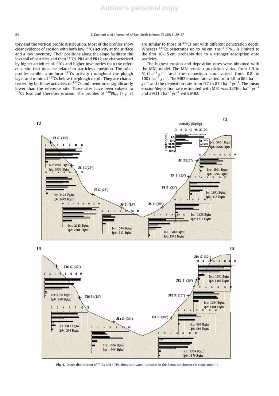
Fig. 4. Depth distribution of 137Cs and 210Pb along cultivated transects in the Raouz catchment (S: slope angle �).
54 B. Damnati et al. / Journal of African Earth Sciences 79 (2013) 50–57

Author's personal copy
The estimates of soil erosion rates derived from the measure-ments of unsupported 210Pb varied from 3 to 39 t ha�1 yr�1 witha mean of 20 t ha�1 yr�1.
4.2. Raouz site
The reference site sampled in Raouz catchment has values equalto 2651 ± 234 Bq/m2 for 137Cs and 2206 ± 553 Bq/m2 for 210Pbex.The 210Pbex inventory is higher than those of El Hachef and Naklaand we have no explanation for that. Since 137Cs inventory is sim-ilar to those of the other site, it cannot be due to a sedimentationprocess.
The analysis of the depth distribution of 137Cs in cultivated pro-files shows that there is no significant difference between theshape of these profiles and those observed in the El Hachef basin:the activity of 137Cs is concentrated within the first few centime-tres, and then declines gradually with depth.
Total 210Pbex distribution shows clear exponential decay formost of the profiles (J1, J2, J3, J5, J7, J8, J9, J11, J12 and J16:Fig. 4). It is noteworthy that most of them showed homogeneityin the first few centimetres, and a decline below this depth. Dis-rupted distribution of 210Pb activity at the surface occurred forsome of them (Fig. 4), the first 5 cm of these profiles being charac-terized by a lower activity than those of the deeper layers.
Erosion and accumulation processes are defined for each culti-vated profile transects according the difference of inventories.For both radionuclides, the same rate of change is found in profilesalong the slope (Fig. 4). However, areas of accumulation accordingto 137Cs correspond to stability according to 210Pbex.
On the transect T1 a stable site is found at the top (J1) and thenall sites downstream show erosion (J2–J5). The transect T2 has twosectors: accumulation at the top of the slope (which is equivalentto a stable area for 210Pbex) and which extends over 120 m, and asite of stability and erosion site. The maximum inventories areapproximately 3422 Bq/m2 for 137Cs and 2704 Bq/m2 for 210Pbex,while lowest ones are 574 Bq/m2 and 511 Bq/m2 respectively.
The transect T3 shows an area of erosion that covers 180 m, thendeclining inventory values along the slope of between 869 and3364 Bq/m2 for 137Cs and between 549 and 1870 for 210Pbex. Thedownstream of this transect has a high 137Cs inventory (3364 Bq/m2) that can be associated to deposition of soil material issuedfrom upstream erosion. For transect T4, all profiles show lowinventories reflecting widening erosion along the slope (Fig. 4).
The average erosion rates vary from 7 to 19 t ha�1 yr�1 (MB1),from 7 to 16.4 t ha�1 yr�1 (MB2) or from 7 to 25 t ha�1 yr�1 (210Pbex
MB2: Table 4).
4.3. Nakhla site
The inventory used as the reference site of this plot is2142 ± 254 Bq/m2 for 137Cs and 1246 ± 288 Bq/m2 for 210Pb.
The depth distribution of radionuclides is similar to the profilesP1, P3 and P5 (Fig. 5). This distribution shows the lack of homoge-neity of 137Cs activity in the surface layer, even if these profiles arelocated in a cultivated field. Very low activities of 137Cs were foundin this layer rarely exceeding 3 Bq/kg. They increase in the under-lying level and then decrease steadily to 30–35 cm, where it be-comes zero.
The depth distribution of 210Pbex clearly show a decrease of theactivity for the three profiles (Fig. 5). The activities are more vari-able than those of 137Cs but they are also very low. The depth dis-tribution of 210Pbtot shows that activities of supported 210Pboccurred to 15 cm for P3 and P5, while the P1 profile never reachedstable value.
All the 137Cs inventories are clearly below the reference inven-tory ranging from 276 Bq/m2 to a maximum of 1194 Bq/m2. The210Pbex inventories follow the same pattern and they are all lowerthan the reference one, except however P3, P9 and P20.
The erosion rates vary according to transect and depending onthe model used (Table 5). The average erosion rates ranges be-tween 22.8 and 26 t ha�1 yr�1 for transect 1; between 10 and53.3 t ha�1 yr�1 for transect 2; between 22.4 and 48.8 t ha�1 yr�1
for the third transect and from 23.8 to 37 t ha�1 yr�1 for the lastone. Considering all the models, the highest erosion rates are ob-served in the transect 2.
5. Discussion
In El Hachef site, the comparison of both erosion and depositionrates estimates provided by the 210Pbex and 137Cs measurementsshow a discrepancy with values always higher for 210Pbex. This re-sult is due to the fact that these two methods have a different timebase, with the 137Cs measurements providing estimates of soil
Table 4Erosion rates for the Raouz transects calculated using 210Pbex and the 137Cs models(t ha�1 yr�1).
MB1 MB2 210PbexMB2
Transect 1 �19.1 �16.4 �16.5Transect 2 �7.5 �7.0 �7.9Transect 3 �13.1 �11.4 �15.1Transect 4 �15.9 �13.8 �25.0Mean erosion rates (t ha�1 yr�1) �13.9 �12.2 �16.1
Fig. 5. Depth distribution of 137Cs (a) and 210Pbex (b) and 210Pbtot (c) in some profiles in Nakhla basin.
B. Damnati et al. / Journal of African Earth Sciences 79 (2013) 50–57 55

Author's personal copy
redistribution rates for the past 40 years, whereas those derivedfrom 210Pbex measurements relate to the past 100 years at least.
The mean erosion rates using 137Cs with MB1 and MB2 arerespectively 32/36 t ha�1 yr�1 and 29/31 t ha�1 yr�1. The meanerosion rate estimated with MB2 using unsupported 210Pb is20 t ha�1 yr�1.
In the Raouz watershed the models of conversion of 137Cspresent the same behaviour along the slope of each transect. How-ever, a remarkable difference was observed between losses andaccumulations.
The rates obtained from 210Pbex show a trend along the slope tothose from 137Cs, except for some points (transects 1 and 4) char-acterized by low values of inventory (274–415 Bq/m2). However, aclear difference appear between these two tracers on a quantita-tive point of view. A character of deposition is also registered bythe 210Pbex on transect 2. Generally, evidence presented by the137Cs contradict these results and reveal a slight erosion 210Pbex.This may be due to the standard deviation error associated withthe value of the reference inventory of both radionuclides, or asuccession of erosion and deposition which differs from one periodto another.
The erosion rates obtained with 210Pbex are slightly higher thanthose obtained with except on transects 1 and 2 where they aresimilar to those calculated with MB2. The higher values can bedue to the error associated with low inventory found at the bottomof the transect. In any case the result of net rates from the tworadioactive elements is that all transects are exposed to a soil losswith values of 14 t ha�1 yr�1 (MB1), 12 t ha�1 yr�1 (MB2) or16 t ha�1 yr�1 for 210Pbex with MB2.
In Nakhla plot, 137Cs inventories vary greatly but they are all be-low the mean reference inventory. The 210Pbex inventories showthe same kind of large variations (between 114 Bq/m2 and1709 Bq/m2). Averages along the transect are more homogeneousand the mean erosion rates varied between 20 and 41.3 t ha�1 yr�1.
The variability of 137Cs inventories could be considered as a re-sult of the intrinsic heterogeneity of the environment, such as soilproperties (density, clay content, macropores, cracks, stones, . . .),vegetation (acting on interception of rainfall), soil micromorphol-ogy, plant roots, disturbance by humans and animals. Sutherland(1991) considered that the variability of the physical propertiesof a grassland soil is between 15% and 75% and therefore the 27%
of the variability of the 137Cs activity we found can be consideredas normal.
Similarly we can have large-scale variations, such as variationsin precipitation, vegetation cover and soil type. This source of var-iability can be neglected if the reference sites are flat and if thesamples were collected in a small area of sites (Owens and Walling,1996).
Given that 1952 is the year from which the fallout of 137Cs be-came significant and the total activity of 137Cs detected in soil isstrongly related to the amount of annual rainfall (Basher and Mat-thews, 1993), it is interesting to get data from rainy period cover-ing the entire history of fallout 137Cs. For the three sites (El Hachef,Raouz and Nakhla) a comparative study of the total annual rainfallwas conducted during the period extending from 1952 to 1999 theyear of harvest of our references in 1999 (Table 6). Annual averagevalues are between 745 and 860 mm indicating that there is not alarge spatial variability in the study area (13%).
Erosion rates were calculated by other methods in areas close toour studied site. Similar rates were obtained by Merzouki (1992)which used the changes in bathymetry measured in the catchmentdam of Ibn Battuta (47.19 t ha�1 yr�1) which is located close to ElHachef. Dahman (1994) obtained values between 32 and49 t ha�1 yr�1 in the basin near Tlata using empirical models andremote sensing measurements in the same basin gave valuesaround 39 t ha�1 yr�1 (Bonn, 1998). Using the proportional modelin Raouz basin an average erosion rate of 27 t ha�1 yr�1 was ob-tained by Damnati et al. (2006). In the watershed of El Hachefdam, erosion rates were very variable (from 1.8 to over 49 t ha�1 -yr�1), with an average of 22 t ha�1 yr�1 using the same model(Damnati et al., 2004).
Nouira et al. (2003) applied the MB2 in the Casablanca region(West of Morocco) and found rates of about 16–44 t ha�1 yr�1 inwatershed Tgrigra and between 20 and 44 t ha�1 yr�1 on a parcelof watershed Ain Harouda. Benmansour et al. (2000) found valuesbetween 11.9 and 22.3 t ha�1 yr�1 at Zaytuna basin (Al Housseima,North Morocco). The same rate resulting from MB2 (24 t ha�1 yr�1)was found in Nakhla watershed by Bouhlassa et al. (2000) usingMB1 and MB3 (31, 24 and 37 t ha�1 yr�1). Moukhchane (1999) atSmir basin, Nakhla, and El Hachef found average values rangingfrom 37 to 60 t ha�1 yr�1 using the Ritchie et al. (1974) empiricalmodel.
Radionuclides caesium-137 and lead-210 are increasingly usedto estimate the importance of soil movements and they comple-ment more conventional techniques. However caution must be ta-ken to extrapolate the results across the entire catchment basin.Indeed, several factors governing the variation of caesium-137 fall-out can be used including the slope, the relative exposures to pre-cipitation, vegetation, etc. (Bernard et al., 1998). On the other hand,lead-210 has the same potential for environmental studies thatcaesium-137 has. Its use in a complementary manner removessome limitations, related to differential impact of 137Cs in bothhemispheres and the geographical impact of Chernobyl (Bernardet al., 1998; Ibrahimi, 2005; Ibrahimi et al., 2005).
In all cases, the results above show the severity of erosion inthis region the El Hachef and Nakhla sites being particularly af-fected. We must therefore seek urgent solutions that are locallyappropriate. It is especially important to integrate land managerssuch as farmers and ranchers in making decisions for effective soilprotection upstream and therefore the protection of waterresources.
6. Conclusion
This study used the 137Cs and 210Pbex methods to give anestimate of soil loss in North West Morocco. Estimated soil loss
Table 5Erosion rates for the Nakhla transects calculated using different models (t ha�1 yr�1).
MB1 MB2 210PbexcMB2
Transect 1 �26.0 �22.8 �23.8Transect 2 �53.3 �48.2 �10.0Transect 3 �48.8 �28.5 �22.4Transect 4 �37.0 �32.8 �23.8Mean erosion rates (t ha�1 yr�1) �41.3 �33.1 �20.0
Table 6Average annual rainfall for the period 1951–2000 on the three watershed (El Hachef,Raouz and Nakhla).
Drainagebasin
Years Average Annual rainfall (mm)
Variationcoefficient
Standarddeviation
Nakhla 1951–1952/1999–2000
803 0.33 264
Raouz 1951–1952/1999–2000
860 0.49 424
El Hachef 1951–1952/1999–2000
745 0.37 279
56 B. Damnati et al. / Journal of African Earth Sciences 79 (2013) 50–57

Author's personal copy
degradation in the El Hachef dam drainage basin range from 20 to32 t ha�1 yr�1 depending on model and tracer used. These ratesrange from 12 to 16 t ha�1 yr�1 in the Raouz catchment and from20 to 41 t ha�1 yr�1 in the Nakhla experimental plot. The studyand quantification of erosion by the determination of both theradionuclides 210Pb and 137Cs is a particularly rapid, economicand complementary method. They complement each other andgenerate complementary information to those from conventionaltechniques which require longer and more expensive fieldinvestigations.
These results are comparable to those obtained by other andmore traditional methods near the study area. Since all these re-sults are similar, they can be taken as real, and clearly indicate thatthere is an urgent need for anti-erosion plans in the studied basins.
Acknowledgements
The authors thank the direction of the equipment of Tangierand the direction of El Hachef, Raouz and Nakhla dams for the col-laboration during field work. This research received the financialsupport of IAEA (Vienne) and ACI Morocco–Spain and also the sup-port of Environment, Oceanology, and Natural Resources Labora-tory (Department of Earth Sciences, FST-Tangier) and CEREGEwere the radionuclide’s analyses were made by the Prof O.Rada-kovitch (Aix-en-Provence, France). Many thanks for the professorD. Walling, Pat Eriksson and A. Benmanssour for there commentsof the manuscript.
References
Basher, L.R., Matthews, K.M., 1993. Relationship between 137Cs in some undisturbedNew Zealand soils and rainfall. Australian Journal of Soil Research 31, 655–663.
Benmansour, M., Ibn majah, M., Marah, H., Marfak, T., Walling, D.E., 2000. Use of the137Cs technique in soil erosion investigation in Morocco – case study of theZitouna basin in the north. In: October 16th–20th, Proceeding of anInternational Symposium on Nuclear Techniques in Integrated Plant Nutrient,Water and Soil Management. AIEA/FAO, Vienna, pp. 308–315.
Bernard, C., Mabit, C., Laverdière, Marc R., Wicherek, S., 1998. Césium-137 et érosiondes sols. Cahiers Agricultures 7, 179–186.
Bonn, F., 1998. La spatialisation des modèles d’érosion des sols à l’aide de latélédétection et des SIG: possibilités, erreurs et limites. Sécheresse 9 (3), 185–192.
Bouhlassa, S., Moukhchane, M., Aiachi, A., 2000. Estimate of soil erosion anddeposition of cultivated soil of Nakhla watershed, Morocco, using 137Cstechnique and calibration models. Acta Geologica Hispanica 35 (3/4), 239–249.
Bunzl, K., Kracke, W., 1988. Cumulative deposition of 137Cs, 238Pu, 239+240Pu and241Am from global fallout in soils from forest, grassland and arable land inBavaria. Journal of Environmental Radioactivity 8, 1–14.
Carvalho, F.P., 1990. Contribution à l’étude du cycle du polonium 210 et du Plomb210 dans l’environnement. Thèse de l’Université Sophia-Antipolis, Nice, France,120pp.
Dahman, H., 1994. Modélisation des pertes en sol par l’érosion hydrique basée surl’utilisation d’un SIG et des images satellitaires Spot (XS). Application au BassinVersant de Tlata (Rif occidental). Mémoire de 3ème cycle I.A.V. Hassan II. Rabat.Maroc, 130pp.
Damnati, B., 1997. Utilisation de quelques paramètres sédimentologiques etgéochimiques pour la quantification de l’érosion et du colmatage desretenues artificielles (barrages) au Maroc central. Rapport AUPELF-UREF, 41 pp.
Damnati, B., Bouhlassa, S., Bouraja, A., Leveque, F., Mohsine, Y., 1998. Identificationdes sources de l’érosion et du colmatage du barrage Sidi Mohamed BenAbdellah: Etude du bassin pilote de Mezguida (Sud du Plateau centralMarocain). In: Proceedings of the International Symposium of Satellite-basedObservation: A Tool for the Study of the Mediterranean Basin, Tunis, 23–27November, 1998, Tunisia, 4p.
Damnati, B., Radakovitch, O., Ibrahimi, S., Youlal, A., 2003. Estimation of soil loss in adrainage basin of north Morocco using caesium-137. Africa Geoscience Review10 (4), 347–354.
Damnati, B., Radakovitch, O., Ibrahimi, S., 2004. Utilisation du césium-137 pourl’estimation des taux d’érosion dans un bassin versant au Nord du Maroc.Sécheresse 15 (2), 195–199.
Damnati, B., Chatt.A, Hamani, M., Ligero Gimenez, R.A., 2006. L’érosion hydrique etsa quantification par le radioélément 137Cs au niveau du bassin versant dubarrage Raouz (Région de Tanger-Tétouan). TANCA-01. Workshop sur lestechniques analytiques, nucléaires et conventionnelles, et leurs applications.Rabat 8–9 Décembre 2006, Résumé, p 38.
El Gharbaoui, A., 1981. La terre et l’Homme dans la péninsule tingitane – étude surl’homme et le milieu dans le Rif occidental. Travaux de l’institut scientifique.Série Géologie et Géographie physique, n�15, Rabat. Maroc.
He, Q., Walling, D.E., 1997. The distribution of fallout 137Cs and 210Pb in undisturbedand cultivated soils. Applied Radiation and Isotopes 48 (5), 677–690.
IAEA, 1998. Use of 137Cs in the study of soil erosion and sedimentation. IAEA-TECDOC-1028, 123pp.
Ibrahimi, S., 2005. Quantification de l’érosion hydrique des sols par deuxradioéléments le Césium-137 et le plomb-210 au niveau des basins versantsEl Hachef et Raouz (région de Tanger-Tétouan Nord du Maroc). Thèse dedoctorat. Université Abdelmalek Essaadi. Faculté des Sciences et Techniques.Tanger. Maroc, 259pp.
Ibrahimi, S., Damnati, B., Radakovitch, O., Hassouni, K., Simon, B., 2005. Usingconversion models to estimate soil erosion and deposition rates, from the 137Csmeasurements in cultivated soils (north Morocco). Revista de la SociedadGeologica de Espana 18 (3–4), 217–224.
Lahlou, M.A., 1990. Modèles de prediction de la sédimentation des retenues debarrages des pays du grand Maghreb. « Atelier International sur l’applicationdes modèles mathématiques à l’évaluation des modifications de la qualité del’eau ». Tunis 7–12 Mai, pp. 80–87.
Merzouki, T., 1992. Diagnostic de l’envasement des grands barrages marocains. LaRevue marocaine du Génie civil 38, 46–50.
Mitchell, J.K., Bubenzer, G.D., McHenry, J.R., Ritchie, J.C., 1980. Soil loss estimationfrom fallout cesium-137 measurements. In: DeBoodt, M., Gabriels, D. (Eds.),Assessment of Erosion. Wiley, Chichester, pp. 393–401.
Moukhchane, M., Bouhlassa, S., Chalouan, A., 1998. Approche cartographique etmagnétique pour l’identification des sources de sédiments: cas du bassinversant Nakhla (Rif, Maroc). Sécheresse 3 (9), 227–232.
Moukhchane, M., 1999. Contribution à l’étude de l’érosion hydrique dans le rifoccidental. Application des méthodes expérimentales du 137Cs et de lasusceptibilité magnétique aux bassins versants Nakhla, El Hachef et Smir.Thèse doctorale. Faculté des sciences de Tétouan, Maroc.
Nouira, A., Sayouty, E.H., Benmansour, M., 2003. Use of 137Cs technique for soilerosion studyin the agricultural region of Casablanca in Morocco. Journal ofEnvironmental Radioactivity 68, 11–26.
Owens, P.N., Walling, D.E., 1996. Spatial variability of caesium-137 inventories atreference sites: an example from two contrasting sites in England andZimbabwe. Applied Radiation and Isotopes 47 (7), 699–707.
Quine, T.A., Navas, A., Walling, D.E., Machin, J., 1994. Soil erosion and distribution oncultivated land near Las Barenas in the central Ebro river basin, Spain. LandDegradation and Rehabilitation 5, 41–55.
Radakovitch, O., Damnati, B., Ibrahimi, S., Youlal, A., 2002. 137Cs and 210Pb profiles innorth morrocan soils: inventaires and erosion rates estimates. In: Internationalcongress on the radioecology–ecotoxicology of continental and estuarineenvironnements. Aix en Provence, 3–7 September 2001, vol. 37(C1).Radioprotection, pp. 255–258.
Ritchie, J.C., Spraberry, J.A., McHenry, J.R., 1974. Estimating soil erosion from theredistribution of fallout 137Cs. Proceedings – Soil Science Society of America 38,137–139.
Ritchie, J.C., MacHenry, J.R., 1990. Application of radioactive fallout cesium-137 formeasuring soil erosion and sediment accumulation rates and patterns: areview. Journal of Environmental Quality 19, 215–233.
Roose, E., 1991. Conservation des sols en zones méditerranéennes synthèse etproposition d’une nouvelle stratégie de lutte antiérosive: la GCES. Cah.orstom,sér. Pédol XXVI (2), 145–181.
Sutherland, R.A., 1991. Examination of caesium-137 areal activities in control(uneroded) locations. Soil Technology 4, 33–50.
Walling, D.E., He, Q., Quine, T.A., 1995. Use of caesium-137 and lead-210 as tracersin soil erosion investigations. Tracer Technologies for Hydrological Systems.IAHS Publ. 229, 163–172.
Walling, D.E., He, Q., 1999. Using fallout lead-210 measurements to estimate soilerosion on cultivated land. Soil Science Society of America Journal 63, 1404–1412.
Walling, D.E., Quine, T.A., 1990. Use of 137Cs measurements to investigate patternsand rates of soil erosion on arable fields. In: Broadman, J., Foster, I.D.I., Dearing,J.A. (Eds.), Soil Erosion on Agricultural Land. Willey, London, pp. 33–53.
Walling, D.E., He, Q., 2001. Models for converting 137Cs Measurements to estimatesof soils redistribution rates on cultivated and uncultivated soils and estimatingCs-137 reference inventories (including software for model implementation).
Xinbao, Z., Walling, D.E., Mingy, F., Anbang, W., 2003. 210Pbex depth distribution insoil and calibration models for assessment of soil erosion rates from 210Pbex
measurements. Chinese Journal 48 (8), 813–818.
B. Damnati et al. / Journal of African Earth Sciences 79 (2013) 50–57 57