proposal for shared location information platform
TRANSCRIPT
Shared Location Platform Future “Locate South West”
1 | P a g e
SHARED LOCATION INFORMATION PLATFORM FUTURE “LOCATE SOUTH WEST”
Prepared By
Ankit Bhardwaj
Student at Edith Cowan University
Course: Master of Management Information System
Intern At
Western Australian Land Information Authority
Submitted to
Dr Philip Dobson
FINAL REPORT
Submitted on
30/10/2014
Shared Location Platform Future “Locate South West”
2 | P a g e
Contents 1. Executive Summary .......................................................................................... 3
1.1 Project objective and Derivable ................................................................................................ 3
2. Getting Started ................................................................................................ 4
3. Locate South West – Google Earth 3D version ................................................ 4
3.1 Using Locate South West – Google Earth 3D version ................................................................ 5
3.2 Locate Start Banner ................................................................................................................... 5
3.3 Locate Data Layers .................................................................................................................... 6
3.4 Google Earth - Viewing 3D Images ............................................................................................ 7
3.5 Google Earth - How to adjust Opacity....................................................................................... 8
3.6 Property Information .............................................................................................................. 11
3.7Imagery andHistoric Maps ....................................................................................................... 11
3.8 Boundaries and Places ............................................................................................................ 12
3.9 Education, Health and Emergency Services ............................................................................ 12
3.10 Transport and Infrastructure................................................................................................. 13
3.11 Land Use and Resources ........................................................................................................ 14
3.12 People & Society .................................................................................................................... 14
3.13 Utilities .................................................................................................................................. 15
4. Locate South West– Google Maps 2D version ............................................... 16
4.1 Property Information .............................................................................................................. 17
4.2 Imagery and Historic Maps ..................................................................................................... 18
4.3 Boundaries and Places ............................................................................................................ 18
4.4 Education Health and Emergency Services ............................................................................. 19
4.5 Transport and Infrastructure................................................................................................... 19
4.6 Land and Resources ................................................................................................................. 20
4.7 People & Society ...................................................................................................................... 20
5. Managing Data, Layer and Map Life Cycle .................................................... 21
5.1 Configuration and Publishing Existing Layer/s ........................................................................ 21
5.2 Deleting items from SLIP Google Map Engine......................................................................... 21
Appendix A ............................................................................................................................... 22
Appendix B ............................................................................................................................... 25
Appendix C ............................................................................................................................... 26
Appendix C ............................................................................................................................... 27
Shared Location Platform Future “Locate South West”
3 | P a g e
1.Executive Summary
As a Statutory Authority, Landgate maintains the State’s official register of land ownership
and survey information and is responsible for valuing the State's land and property for
government interest.
Landgate is at the cutting edge of location information technology. In 2008 they launched
the Shared Land Information Platform (SLIP) Enabler, an application that has revolutionised
the way spatial information is used and shared.
The SLIP Enabler facilitates the sharing of spatial information across government and
business to provide the community with easier access to data. It provides the infrastructure
and services required to access Western Australia's considerable land and geographic
information resources.
The Shared Location Information Platform (SLIP) is Western Australia’s premier source of
location based information. SLIP has been operating for more than six years. During that
time SLIP shows a steady growth in the delivery of core online location information services,
used by a wide range of business clients across the public, private and research sectors –
currently more than 2,000 data layers are being served to 4,000 individual registered users.
Through the Location Information Strategy (LIS) for Western Australia, which is being
coordinated by Landgate, now transforming SLIP to deliver an even more robust and user
driven platform. Based on the Google Maps Engine (GME), new SLIP builds on the strength of
the current system by enabling the many data custodians to retain full control of how their
information is published. The GME platform will make this rich source of information more
accessible to all.
1.1 Project objective and Derivable
Prepare Assets data of South West Development commission for Building map on
Google Map Engine
Shared Location Platform Future “Locate South West”
4 | P a g e
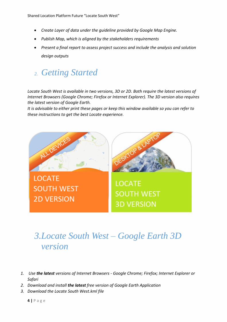
Create Layer of data under the guideline provided by Google Map Engine.
Publish Map, which is aligned by the stakeholders requirements
Present a final report to assess project success and include the analysis and solution
design outputs
2. Getting Started
Locate South West is available in two versions, 3D or 2D. Both require the latest versions of Internet Browsers (Google Chrome; Firefox or Internet Explorer). The 3D version also requires the latest version of Google Earth.
It is advisable to either print these pages or keep this window available so you can refer to
these instructions to get the best Locate experience.
3.Locate South West – Google Earth 3D
version
1. Use the latest versions of Internet Browsers - Google Chrome; Firefox; Internet Explorer or
Safari
2. Download and install the latest free version of Google Earth Application
3. Download the Locate South West.kml file
Shared Location Platform Future “Locate South West”
5 | P a g e
4. Save the kml file to your desktop
5. Double click on the kml file to open Locate
6. See below for detailed instructions
7. Note – The 3D version of Locate is not currently supported for mobile devices but can be
accessed via your desktop/laptop computer.
3.1 Using Locate South West – Google Earth 3D version
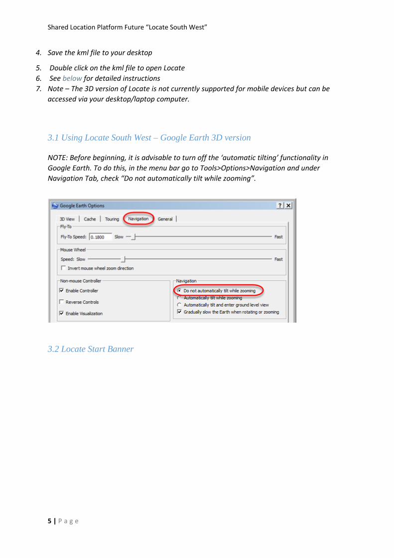
NOTE: Before beginning, it is advisable to turn off the ‘automatic tilting’ functionality in
Google Earth. To do this, in the menu bar go to Tools>Options>Navigation and under
Navigation Tab, check “Do not automatically tilt while zooming”.
3.2 Locate Start Banner

Shared Location Platform Future “Locate South West”
6 | P a g e
Follow these easy steps and then close the pop up box to start using Locate.
1. Go to Layers (lower left hand corner of the screen) remove the tick (in the box) by clicking
the box near the text ‘Primary Database’
2. Staying in the Layers section, expand ‘Locate’ by clicking the + symbol. (some browsers will
display a small triangle instead of a tick box – similarly click the small triangle to expand
or retract the data)
3. To start viewing Locate go to the ‘Search’ box in the top left corner of the screen and type in
an address, town or region in WA and then click on Search
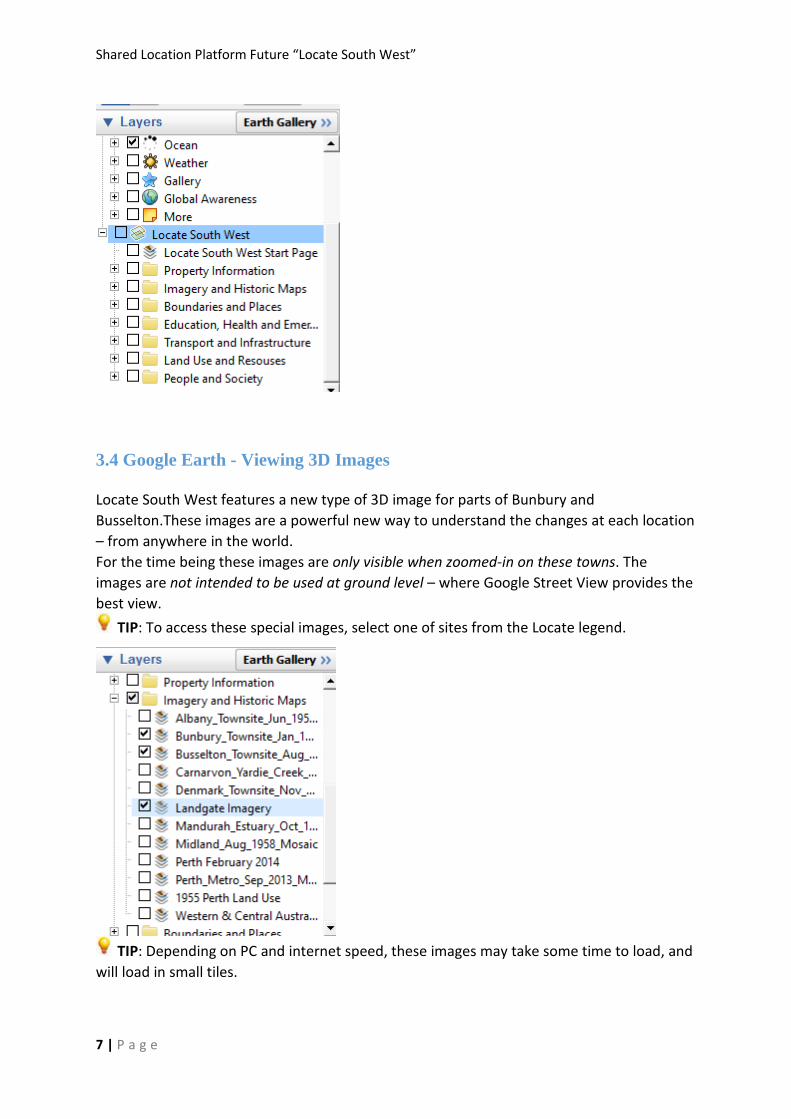
3.3 Locate Data Layers
There are multiple data layers in Locate for you to explore.
TIP – expand Imagery layer first by clicking on the triangle (not in the box) and select
Aerial Photography. This will ensure you are now viewing Landgate’s aerial photography
which is more recent than any other imagery of WA. Keep this layer selected for all future
layer selections.
Shared Location Platform Future “Locate South West”
7 | P a g e
3.4 Google Earth - Viewing 3D Images
Locate South West features a new type of 3D image for parts of Bunbury and
Busselton.These images are a powerful new way to understand the changes at each location
– from anywhere in the world.
For the time being these images are only visible when zoomed-in on these towns. The
images are not intended to be used at ground level – where Google Street View provides the
best view.
TIP: To access these special images, select one of sites from the Locate legend.
TIP: Depending on PC and internet speed, these images may take some time to load, and
will load in small tiles.
Shared Location Platform Future “Locate South West”
8 | P a g e
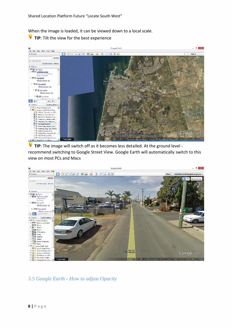
When the image is loaded, it can be viewed down to a local scale.
TIP: Tilt the view for the best experience
TIP: The image will switch off as it becomes less detailed. At the ground level -
recommend switching to Google Street View. Google Earth will automatically switch to this
view on most PCs and Macs
3.5 Google Earth - How to adjust Opacity
Shared Location Platform Future “Locate South West”
9 | P a g e
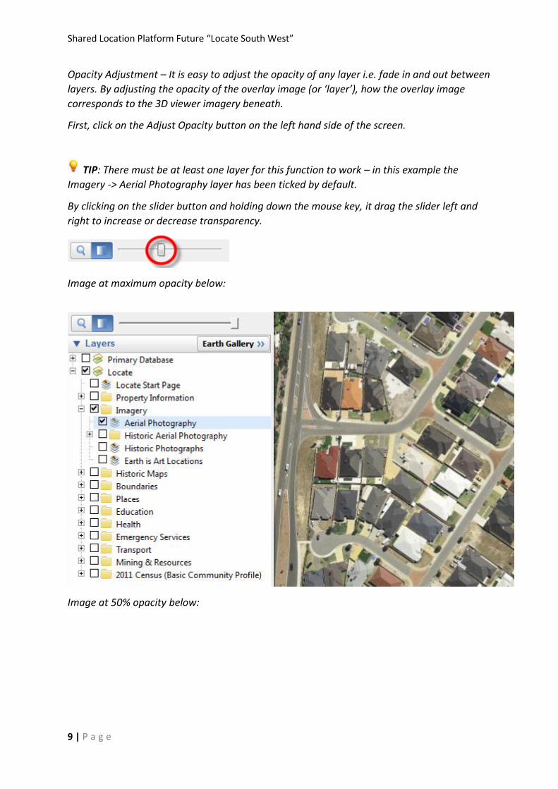
Opacity Adjustment – It is easy to adjust the opacity of any layer i.e. fade in and out between
layers. By adjusting the opacity of the overlay image (or ‘layer’), how the overlay image
corresponds to the 3D viewer imagery beneath.
First, click on the Adjust Opacity button on the left hand side of the screen.
TIP: There must be at least one layer for this function to work – in this example the
Imagery -> Aerial Photography layer has been ticked by default.
By clicking on the slider button and holding down the mouse key, it drag the slider left and
right to increase or decrease transparency.
Image at maximum opacity below:
Image at 50% opacity below:
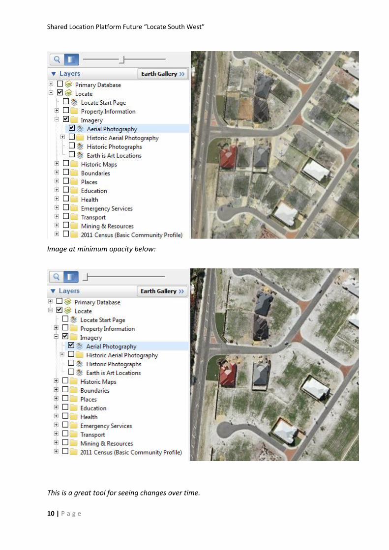
Shared Location Platform Future “Locate South West”
10 | P a g e
Image at minimum opacity below:
This is a great tool for seeing changes over time.
Shared Location Platform Future “Locate South West”
11 | P a g e
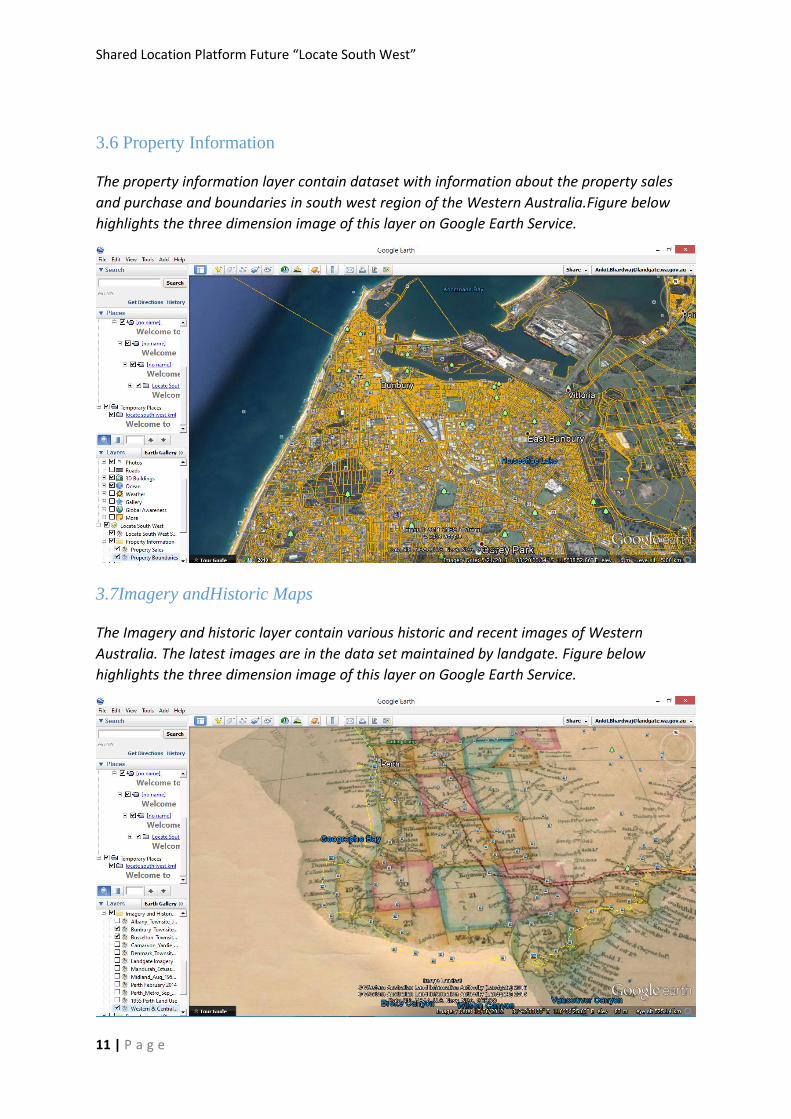
3.6 Property Information
The property information layer contain dataset with information about the property sales
and purchase and boundaries in south west region of the Western Australia.Figure below
highlights the three dimension image of this layer on Google Earth Service.
3.7Imagery andHistoric Maps
The Imagery and historic layer contain various historic and recent images of Western
Australia. The latest images are in the data set maintained by landgate. Figure below
highlights the three dimension image of this layer on Google Earth Service.
Shared Location Platform Future “Locate South West”
12 | P a g e
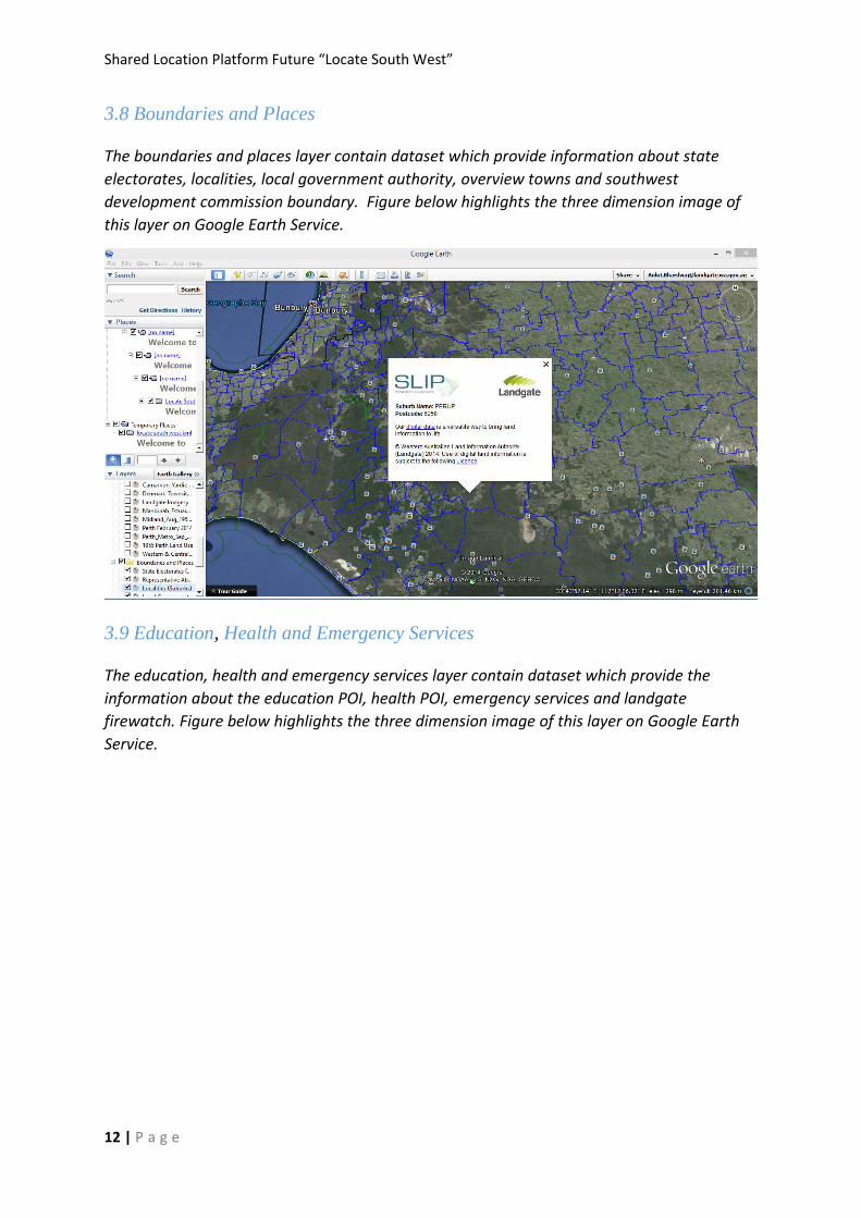
3.8 Boundaries and Places
The boundaries and places layer contain dataset which provide information about state
electorates, localities, local government authority, overview towns and southwest
development commission boundary. Figure below highlights the three dimension image of
this layer on Google Earth Service.
3.9 Education, Health and Emergency Services
The education, health and emergency services layer contain dataset which provide the
information about the education POI, health POI, emergency services and landgate
firewatch. Figure below highlights the three dimension image of this layer on Google Earth
Service.
Shared Location Platform Future “Locate South West”
13 | P a g e
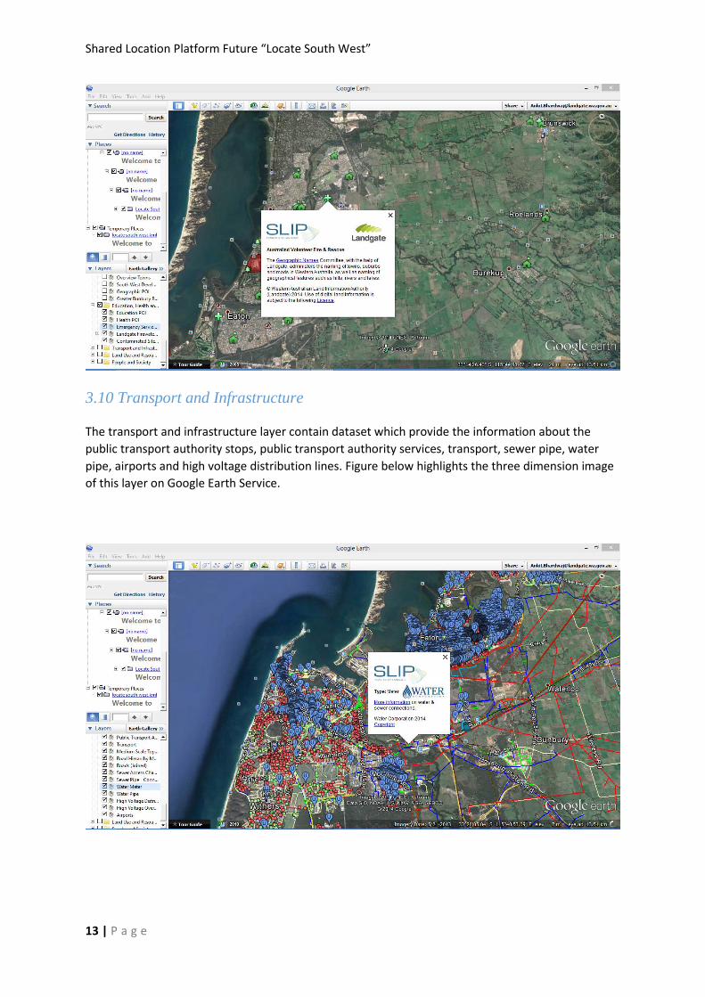
3.10 Transport and Infrastructure
The transport and infrastructure layer contain dataset which provide the information about the
public transport authority stops, public transport authority services, transport, sewer pipe, water
pipe, airports and high voltage distribution lines. Figure below highlights the three dimension image
of this layer on Google Earth Service.
Shared Location Platform Future “Locate South West”
14 | P a g e
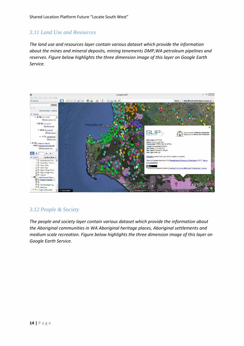
3.11 Land Use and Resources
The land use and resources layer contain various dataset which provide the information
about the mines and mineral deposits, mining tenements DMP,WA petroleum pipelines and
reserves. Figure below highlights the three dimension image of this layer on Google Earth
Service.
3.12 People & Society
The people and society layer contain various dataset which provide the information about
the Aboriginal communities in WA Aboriginal heritage places, Aboriginal settlements and
medium scale recreation. Figure below highlights the three dimension image of this layer on
Google Earth Service.
Shared Location Platform Future “Locate South West”
15 | P a g e
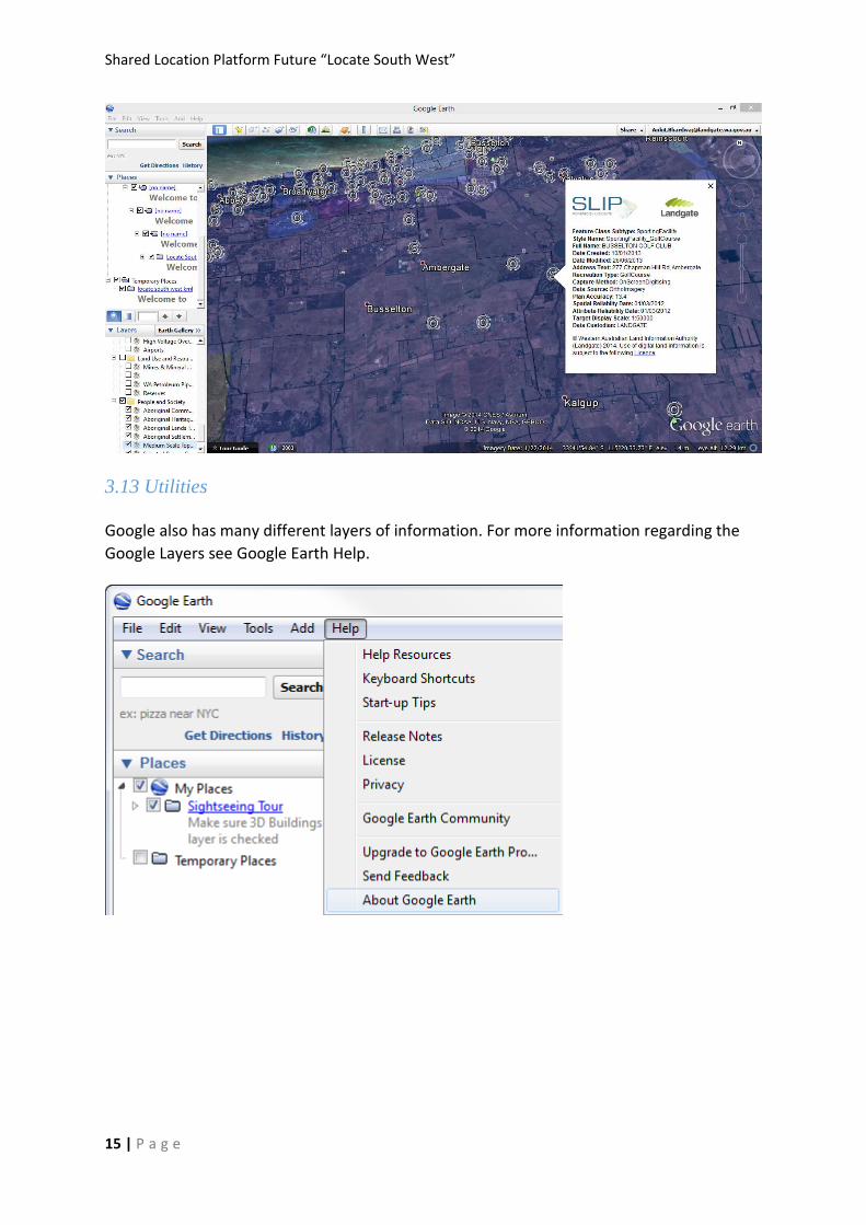
3.13 Utilities
Google also has many different layers of information. For more information regarding the
Google Layers see Google Earth Help.
Shared Location Platform Future “Locate South West”
16 | P a g e
4.Locate South West– Google Maps 2D
version
1. Use the latest versions of Internet Browsers - Google Chrome; Firefox; Internet Explorer or
Safari.
2. Start using Locate South West – Google Maps Version.
3. See below for further instructions.
NOTE: This version is suitable for mobile devices (tablets, smartphones etc).
Using Locate South West – Google Maps 2D version
This 2D version is available on mobile devices.
Locate South West using Google Maps has two key parts:
Google Search
Locate South west currently uses Google Search data. Just type in an address, town or
region in WA and click on Search.
Shared Location Platform Future “Locate South West”
17 | P a g e
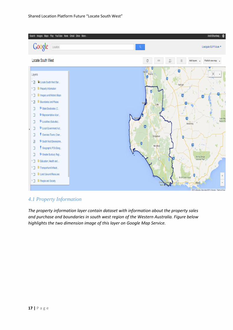
4.1 Property Information
The property information layer contain dataset with information about the property sales
and purchase and boundaries in south west region of the Western Australia. Figure below
highlights the two dimension image of this layer on Google Map Service.

Shared Location Platform Future “Locate South West”
18 | P a g e
4.2 Imagery and HistoricMaps
The Imagery and historic layer contain various historic and recent images of Western
Australia. The latest images are in the data set maintained by landgate. Figure below
highlights the three dimension image of this layer on Google Earth Service.
4.3 Boundaries and Places
The boundaries and places layer contain dataset which provide information about state
electorates, localities, local government authority, overview towns and southwest
development commission boundary. Figure below highlights the three dimension image of
this layer on Google Earth Service.
Shared Location Platform Future “Locate South West”
19 | P a g e
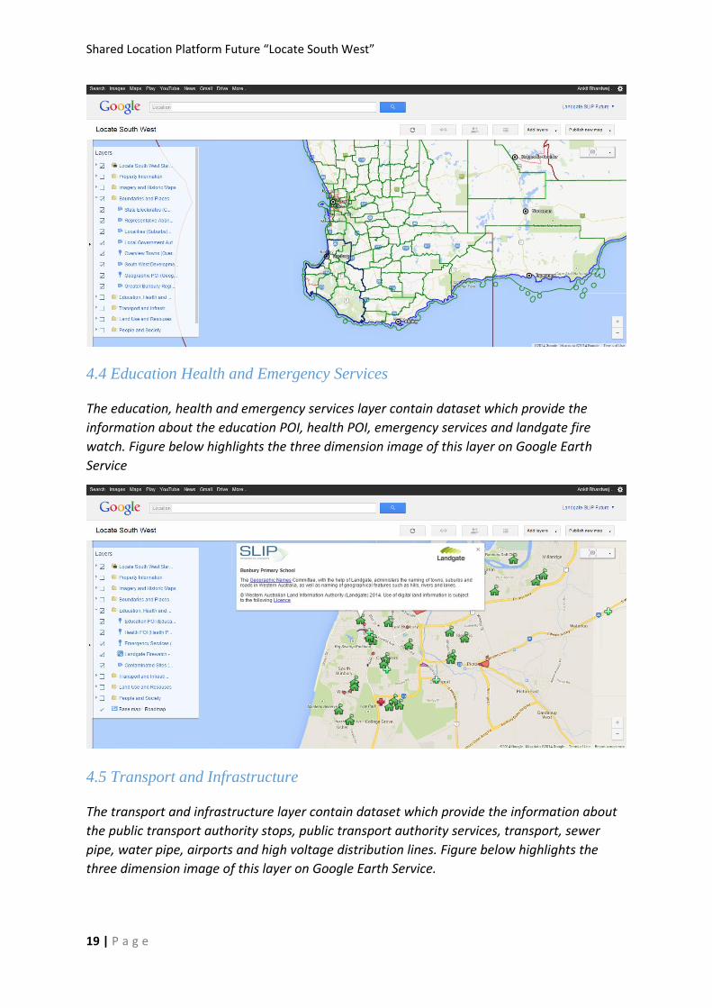
4.4 Education Health and Emergency Services
The education, health and emergency services layer contain dataset which provide the
information about the education POI, health POI, emergency services and landgate fire
watch. Figure below highlights the three dimension image of this layer on Google Earth
Service
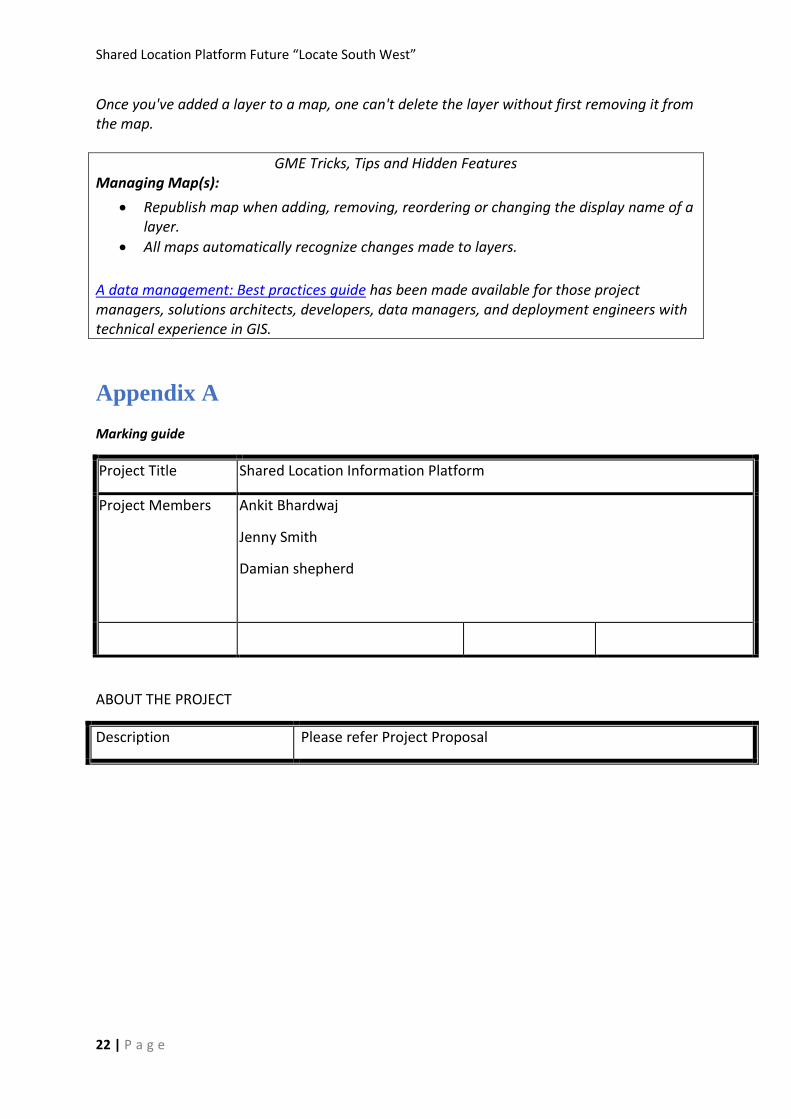
4.5 Transport and Infrastructure
The transport and infrastructure layer contain dataset which provide the information about
the public transport authority stops, public transport authority services, transport, sewer
pipe, water pipe, airports and high voltage distribution lines. Figure below highlights the
three dimension image of this layer on Google Earth Service.
Shared Location Platform Future “Locate South West”
20 | P a g e
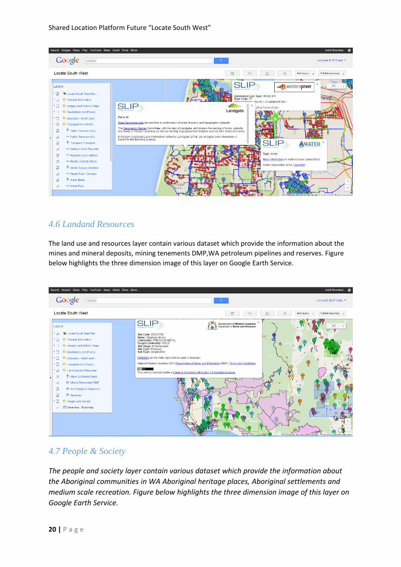
4.6 Landand Resources
The land use and resources layer contain various dataset which provide the information about the
mines and mineral deposits, mining tenements DMP,WA petroleum pipelines and reserves. Figure
below highlights the three dimension image of this layer on Google Earth Service.
4.7 People & Society
The people and society layer contain various dataset which provide the information about
the Aboriginal communities in WA Aboriginal heritage places, Aboriginal settlements and
medium scale recreation. Figure below highlights the three dimension image of this layer on
Google Earth Service.

Shared Location Platform Future “Locate South West”
21 | P a g e
5.Managing Data, Layer and Map Life
Cycle
5.1 Configuration and Publishing Existing Layer/s
Existing layers that have already been published as part of the upload process, therefore the symbology and features already exist in the layer from previous uploads. Symbology/styles are copied from previous version’s layer.
“Map editor” is needed to access to configure and publish layers.
Note1: that this process is subject to be automated by the Create, Read, Update and Delete (Feature Update Tool) process that will be built by NGIS with the GME API. Note2: Some layers are to be configured in multiple Map Services
5.2 Deleting items from SLIP Google Map Engine
Maps, layers and data can all be deleted out of maps engine. If the item to be deleted is
being used elsewhere in maps engine it must be removed from this before it can be deleted.
For example:
Once data source is added to a layer, one can't delete the data source without first removing it from the layer.
Shared Location Platform Future “Locate South West”
22 | P a g e
Once you've added a layer to a map, one can't delete the layer without first removing it from the map.
GME Tricks, Tips and Hidden Features Managing Map(s):
Republish map when adding, removing, reordering or changing the display name of a layer.
All maps automatically recognize changes made to layers.
A data management: Best practices guide has been made available for those project managers, solutions architects, developers, data managers, and deployment engineers with technical experience in GIS.
Appendix A
Marking guide
Project Title Shared Location Information Platform
Project Members
Ankit Bhardwaj
Jenny Smith
Damian shepherd
ABOUT THE PROJECT
Description Please refer Project Proposal
Shared Location Platform Future “Locate South West”
23 | P a g e
Project Completed: (Yes, as
planned / Yes, with changes
to project scope / No)
Was the project completed
as planned or were there
considerable changes to the
project scope or schedule?
Provide details where
significant variation
occurred.
How well was the scope
defined? Did it change?
How effective was the scope
management process? Was
there any scope creep?
Was the business value
achieved? Include support to
prove that the business value
was achieved.
Yes, as planned.
The scope was developed with the time and resources in mind;
therefore, deliverables were in line with the scope definition.
The business value was directly achieved by successfully creating a
map service for landgate’scustomer, the South West Development
Commission. The service was published and handed over to the
customer successfully.
Project Deviations
Document any exceptional
or significant changes in
project scope
How close was the project
schedule and budget
estimates to the actual cost
of the project Were there
any surprises or
discrepancies? If so, why.
Not applicable.
List of Deliverables Prepare Assets data of South West Development commission
for Building map on Google Map Engine
Create Layer of data under the guideline provided by Google
Map Engine.
Publish Map, which is aligned by the stakeholders
requirements
Shared Location Platform Future “Locate South West”
24 | P a g e
Present a final report to assess project success and include
the analysis and solution design outputs
Project Website address
If hosted site
Not applicable
PROJECT REVIEW
Lessons learnt and
recommendations
What have you learnt from
this project that you would
use again or advise for a
similar type of project.
What would you do different
next time?
Working on this project provided me an opportunity to work in a
business environment, where I was able to get exposure to their
culture, policies, processes, values, strategic objectives, customer
interaction, Last but not the least the Google map engine useability.
Useful references
Please list any documents,
specifications, etc which may
be useful to others trying to
understand the process or
outcomes of your project.
List any documents which
others might want to use in
future projects.
Google Map Engine Guidelines
Slip Map Development Guidelines
Project self-evaluation and
promotion
Was the project
implemented successfully?
Do you have any specific
indicators of success? (eg no.
of website hits or users, user
feedback)
Yes, the Map Product was graciously accepted by South West
Development Commission. The customer of Landgate.
The successful handover of the Map service to the customer itself is
a major KPI for Accomplishment.
Shared Location Platform Future “Locate South West”
25 | P a g e
How has the project been
promoted?
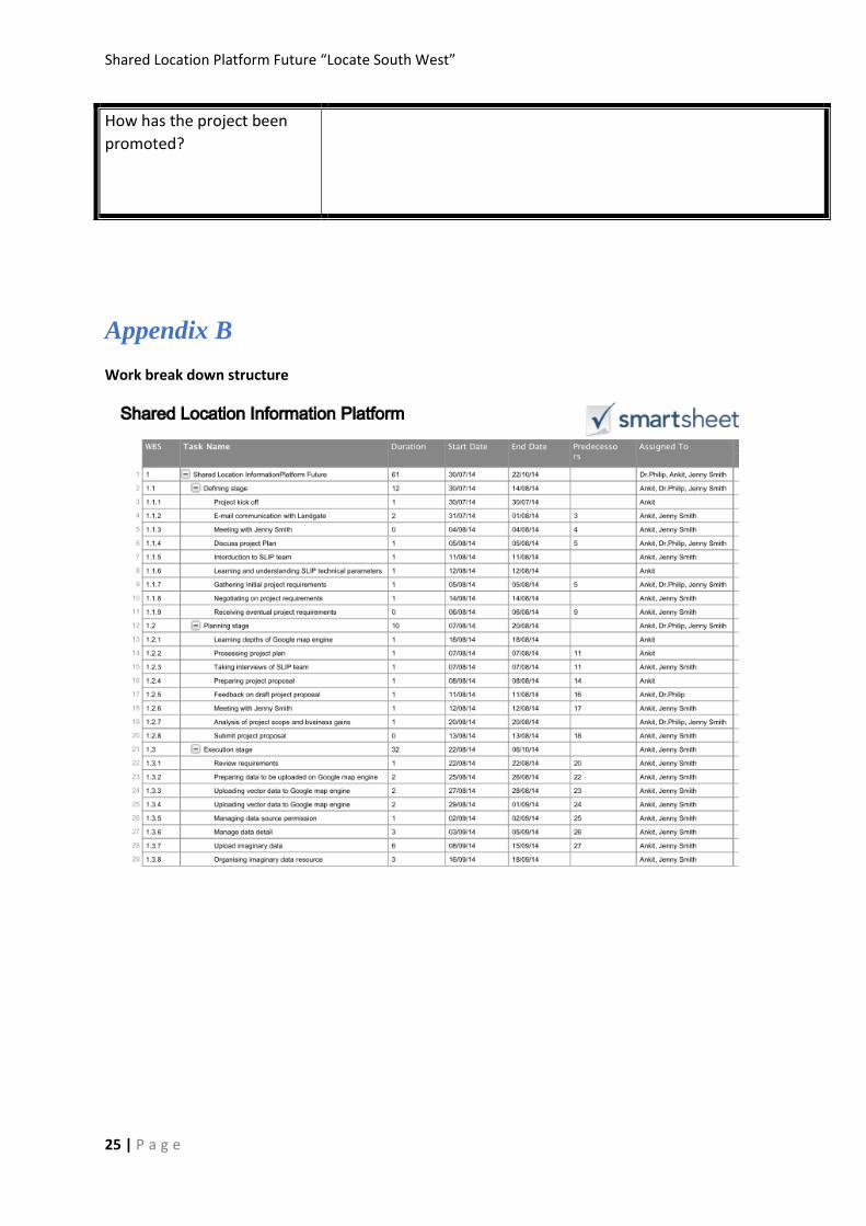
Appendix B
Work break down structure
Shared Location Platform Future “Locate South West”
26 | P a g e
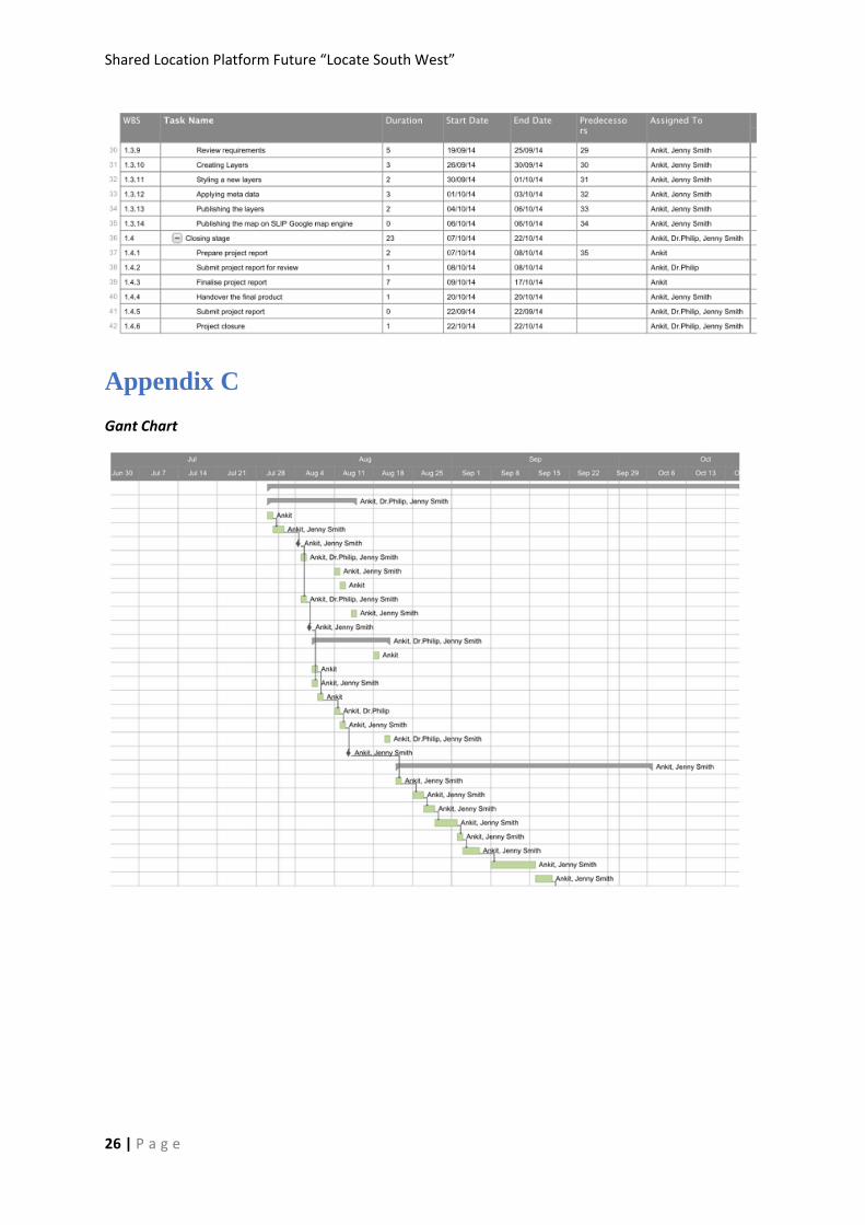
Appendix C
Gant Chart
Shared Location Platform Future “Locate South West”
27 | P a g e
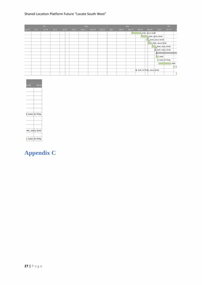
Appendix C

Shared Location Platform Future “Locate South West”
28 | P a g e