settlement location factors
TRANSCRIPT
pages 30 and 31
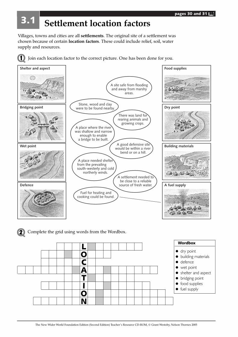
Villages, towns and cities are all settlements. The original site of a settlement waschosen because of certain location factors. These could include relief, soil, watersupply and resources.
Join each location factor to the correct picture. One has been done for you.
3.1 Settlement location factors
The New Wider World Foundation Edition (Second Edition) Teacher’s Resource CD-ROM, © Grant Westoby, Nelson Thornes 2005
Food supplies
Dry point
Building materials
A fuel supplyDefence
Wet point
Shelter and aspect
Bridging point
A place needed shelterfrom the prevailingsouth-westerly and cold
northerly winds.
There was land forrearing animals and
growing crops.A place where the riverwas shallow and narrow
enough to enablea bridge to be built.
A settlement needed tobe close to a reliablesource of fresh water.
A good defensive sitewould be within a river
bend or on a hill.
A site safe from floodingand away from marshy
areas.
Fuel for heating andcooking could be found.
Stone, wood and claywere to be found nearby.
Complete the grid using words from the Wordbox.
Wordbox
• dry point
• building materials
• defence
• wet point
• shelter and aspect
• bridging point
• food supplies
• fuel supply
LOCATION
Q1
Q2
pages 30 and 31
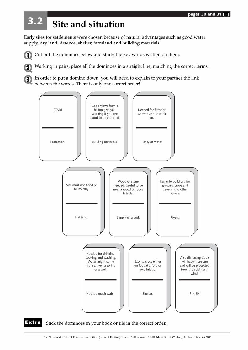
Early sites for settlements were chosen because of natural advantages such as good watersupply, dry land, defence, shelter, farmland and building materials.
Cut out the dominoes below and study the key words written on them.
Working in pairs, place all the dominoes in a straight line, matching the correct terms.
In order to put a domino down, you will need to explain to your partner the linkbetween the words. There is only one correct order!
Stick the dominoes in your book or file in the correct order.
3.2 Site and situation
The New Wider World Foundation Edition (Second Edition) Teacher’s Resource CD-ROM, © Grant Westoby, Nelson Thornes 2005
Q1Q2Q3
Extra
START
Protection.
Good views from a hilltop give you
warning if you are about to be attacked.
Building materials.
Needed for fires for warmth and to cook
on.
Plenty of water.
Site must not flood or be marshy.
Flat land.
Wood or stone needed. Useful to be near a wood or rocky
hillside.
Supply of wood.
Easier to build on, for growing crops and travelling to other
towns.
Rivers.
Needed for drinking, cooking and washing.
Water might come from a river, a spring
or a well.
Not too much water.
Easy to cross either on foot at a ford or
by a bridge.
Shelter.
A south-facing slope will have more sun
and will be protected from the cold north
wind.
FINISH
pages 30 and 31
The New Wider World Foundation Edition (Second Edition) Teacher’s Resource CD-ROM, © Grant Westoby, Nelson Thornes 2005
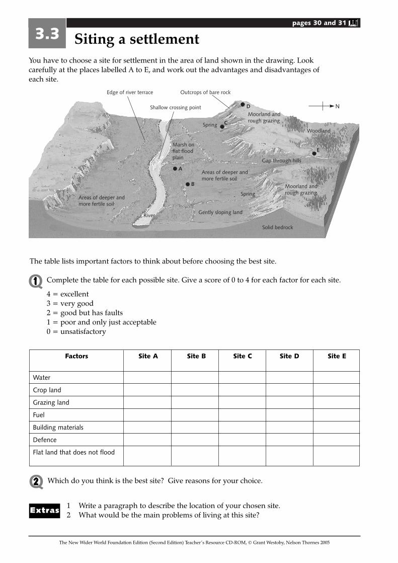
You have to choose a site for settlement in the area of land shown in the drawing. Lookcarefully at the places labelled A to E, and work out the advantages and disadvantages ofeach site.
3.3 Siting a settlement
Factors Site A Site B Site C Site D Site E
Water
Crop land
Grazing land
Fuel
Building materials
Defence
Flat land that does not flood
Which do you think is the best site? Give reasons for your choice.
1 Write a paragraph to describe the location of your chosen site.2 What would be the main problems of living at this site?Extras
The table lists important factors to think about before choosing the best site.
Complete the table for each possible site. Give a score of 0 to 4 for each factor for each site.
4 = excellent3 = very good2 = good but has faults1 = poor and only just acceptable0 = unsatisfactory
N
Outcrops of bare rockEdge of river terrace
Areas of deeper andmore fertile soil
Marsh onflat floodplain
River Gently sloping land
Spring
Spring
Shallow crossing point
Gap through hills
Moorland andrough grazing
D
C
A
B
E
Solid bedrock
Areas of deeper andmore fertile soil
Moorland andrough grazing
Woodland
Q1
Q2
pages 32 and 33
The New Wider World Foundation Edition (Second Edition) Teacher’s Resource CD-ROM, © Grant Westoby, Nelson Thornes 2005
3.4 Types of settlement
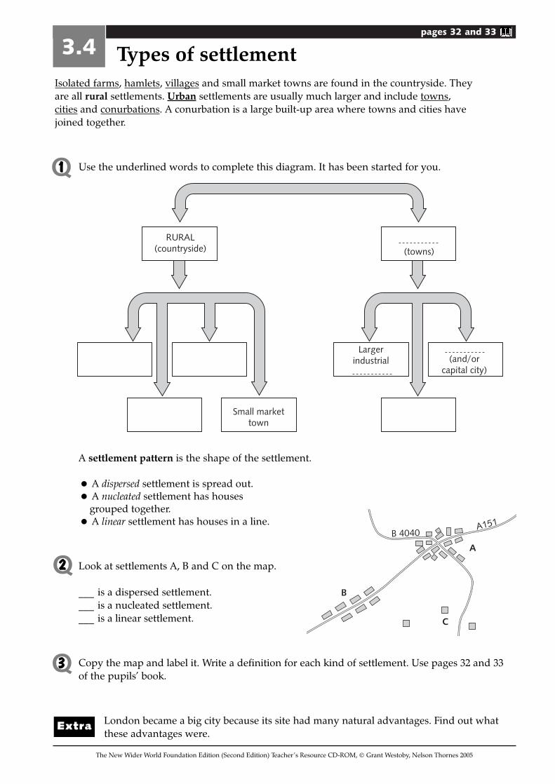
A settlement pattern is the shape of the settlement.
• A dispersed settlement is spread out.
• A nucleated settlement has houses grouped together.
• A linear settlement has houses in a line.
Look at settlements A, B and C on the map.
___ is a dispersed settlement.___ is a nucleated settlement.___ is a linear settlement.
Copy the map and label it. Write a definition for each kind of settlement. Use pages 32 and 33of the pupils’ book.
London became a big city because its site had many natural advantages. Find out whatthese advantages were.
Isolated farms, hamlets, villages and small market towns are found in the countryside. Theyare all rural settlements. Urban settlements are usually much larger and include towns,cities and conurbations. A conurbation is a large built-up area where towns and cities havejoined together.
Use the underlined words to complete this diagram. It has been started for you.
B
C
A
B 4040A151
RURAL(countryside)
Small markettown
Largerindustrial (and/or
capital city)
(towns)
Extra
Q1
Q2
Q3
pages 32 and 33
The New Wider World Foundation Edition (Second Edition) Teacher’s Resource CD-ROM, © Grant Westoby, Nelson Thornes 2005
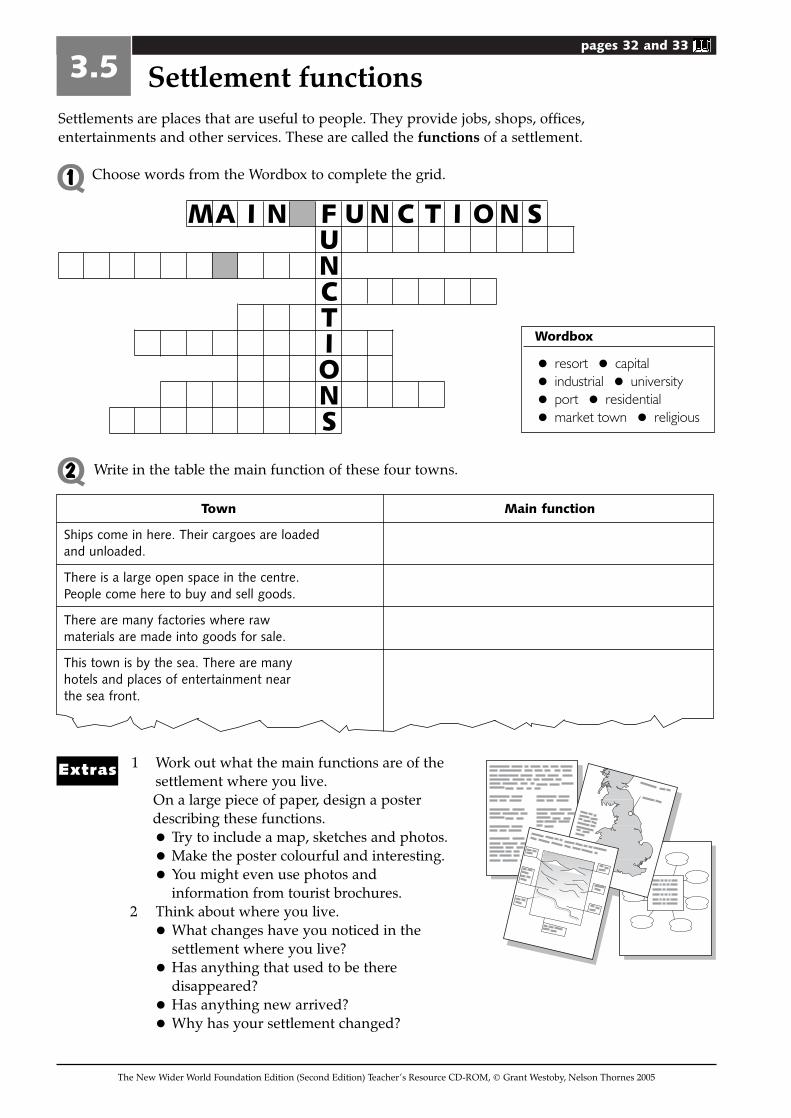
Settlements are places that are useful to people. They provide jobs, shops, offices,entertainments and other services. These are called the functions of a settlement.
Choose words from the Wordbox to complete the grid.
3.5 Settlement functions
Wordbox
• resort • capital
• industrial • university
• port • residential
• market town • religious
MA I N F U N C T I O N SUNCTIONS
Write in the table the main function of these four towns.
Town Main function
Ships come in here. Their cargoes are loaded and unloaded.
There is a large open space in the centre. People come here to buy and sell goods.
There are many factories where raw materials are made into goods for sale.
This town is by the sea. There are many hotels and places of entertainment near the sea front.
1 Work out what the main functions are of thesettlement where you live.On a large piece of paper, design a posterdescribing these functions.
• Try to include a map, sketches and photos.
• Make the poster colourful and interesting.
• You might even use photos and information from tourist brochures.
2 Think about where you live.
• What changes have you noticed in thesettlement where you live?
• Has anything that used to be theredisappeared?
• Has anything new arrived?
• Why has your settlement changed?
Extras
Q1
Q2
pages 34 and 35
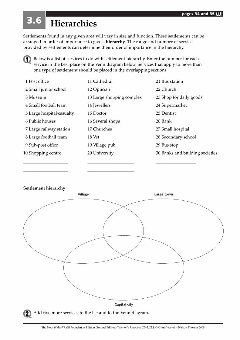
Settlements found in any given area will vary in size and function. These settlements can bearranged in order of importance to give a hierarchy. The range and number of servicesprovided by settlements can determine their order of importance in the hierarchy.
Below is a list of services to do with settlement hierarchy. Enter the number for eachservice in the best place on the Venn diagram below. Services that apply to more thanone type of settlement should be placed in the overlapping sections.
1 Post office 11 Cathedral 21 Bus station
2 Small junior school 12 Optician 22 Church
3 Museum 13 Large shopping complex 23 Shop for daily goods
4 Small football team 14 Jewellers 24 Supermarket
5 Large hospital/casualty 15 Doctor 25 Dentist
6 Public houses 16 Several shops 26 Bank
7 Large railway station 17 Churches 27 Small hospital
8 Large football team 18 Vet 28 Secondary school
9 Sub-post office 19 Village pub 29 Bus stop
10 Shopping centre 20 University 30 Banks and building societies
____________________ _____________________ __________________
____________________ _____________________
Settlement hierarchy
Add five more services to the list and to the Venn diagram.
3.6 Hierarchies
The New Wider World Foundation Edition (Second Edition) Teacher’s Resource CD-ROM, © Grant Westoby, Nelson Thornes 2005
Q1
Village
Capital city
Large town
Q2
pages 38 and 39
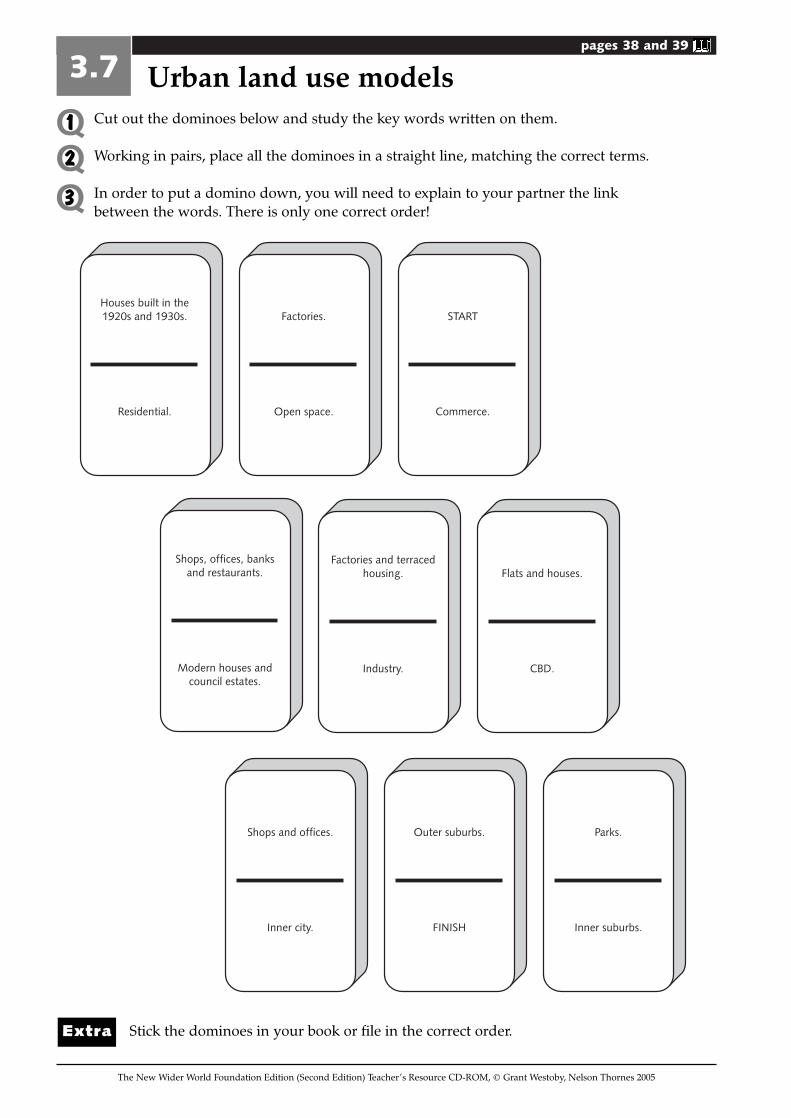
Cut out the dominoes below and study the key words written on them.
Working in pairs, place all the dominoes in a straight line, matching the correct terms.
In order to put a domino down, you will need to explain to your partner the linkbetween the words. There is only one correct order!
Stick the dominoes in your book or file in the correct order.
3.7 Urban land use models
The New Wider World Foundation Edition (Second Edition) Teacher’s Resource CD-ROM, © Grant Westoby, Nelson Thornes 2005
Q1Q2Q3
Houses built in the 1920s and 1930s.
Residential.
Factories.
Open space.
START
Commerce.
Shops, offices, banks and restaurants.
Modern houses and council estates.
Factories and terraced housing.
Industry.
Flats and houses.
CBD.
Shops and offices.
Inner city.
Outer suburbs.
FINISH
Parks.
Inner suburbs.
Extra
pages 38 and 39
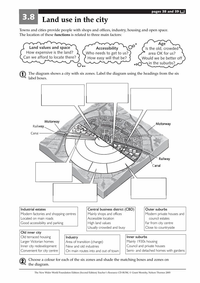
Towns and cities provide people with shops and offices, industry, housing and open space.The location of these functions is related to three main factors:
3.8 Land use in the city
The New Wider World Foundation Edition (Second Edition) Teacher’s Resource CD-ROM, © Grant Westoby, Nelson Thornes 2005
Land values and spaceHow expensive is the land?
Can we afford to locate there?
AccessibilityWho needs to get to us?How easy will that be?
AgeIs the old, crowded
area OK for us?Would we be better off
in the suburbs?
The diagram shows a city with six zones. Label the diagram using the headings from the sixlabel boxes.
RRailw
Caanal
Industrial estatesModern factories and shopping centresLocated on main roadsGood accessibility and parking
Central business district (CBD)Mainly shops and officesAccessible locationHigh land valuesUsually crowded and busy
Outer suburbsModern private houses and
council estatesFar from city centreClose to countryside
IndustryArea of transition (change)New and old industriesOn main routes into and out of town
Old inner cityOld terraced housingLarger Victorian homesInner city redevelopmentConvenient for city centre
Inner suburbsMainly 1930s housingCouncil and private housesSemi- and detached homes with gardens
Choose a colour for each of the six zones and shade the matching boxes and zones on the diagram.
Q1
Q2
pages 40 and 41
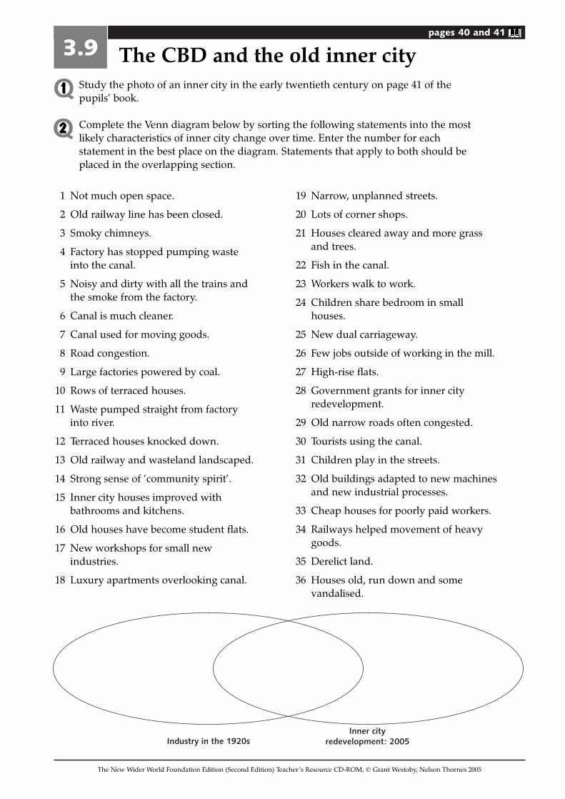
Study the photo of an inner city in the early twentieth century on page 41 of thepupils’ book.
Complete the Venn diagram below by sorting the following statements into the mostlikely characteristics of inner city change over time. Enter the number for eachstatement in the best place on the diagram. Statements that apply to both should beplaced in the overlapping section.
3.9 The CBD and the old inner city
The New Wider World Foundation Edition (Second Edition) Teacher’s Resource CD-ROM, © Grant Westoby, Nelson Thornes 2005
Q1
Q2
1 Not much open space.
2 Old railway line has been closed.
3 Smoky chimneys.
4 Factory has stopped pumping wasteinto the canal.
5 Noisy and dirty with all the trains andthe smoke from the factory.
6 Canal is much cleaner.
7 Canal used for moving goods.
8 Road congestion.
9 Large factories powered by coal.
10 Rows of terraced houses.
11 Waste pumped straight from factoryinto river.
12 Terraced houses knocked down.
13 Old railway and wasteland landscaped.
14 Strong sense of ‘community spirit’.
15 Inner city houses improved withbathrooms and kitchens.
16 Old houses have become student flats.
17 New workshops for small newindustries.
18 Luxury apartments overlooking canal.
19 Narrow, unplanned streets.
20 Lots of corner shops.
21 Houses cleared away and more grassand trees.
22 Fish in the canal.
23 Workers walk to work.
24 Children share bedroom in smallhouses.
25 New dual carriageway.
26 Few jobs outside of working in the mill.
27 High-rise flats.
28 Government grants for inner cityredevelopment.
29 Old narrow roads often congested.
30 Tourists using the canal.
31 Children play in the streets.
32 Old buildings adapted to new machinesand new industrial processes.
33 Cheap houses for poorly paid workers.
34 Railways helped movement of heavygoods.
35 Derelict land.
36 Houses old, run down and somevandalised.
Industry in the 1920sInner city
redevelopment: 2005
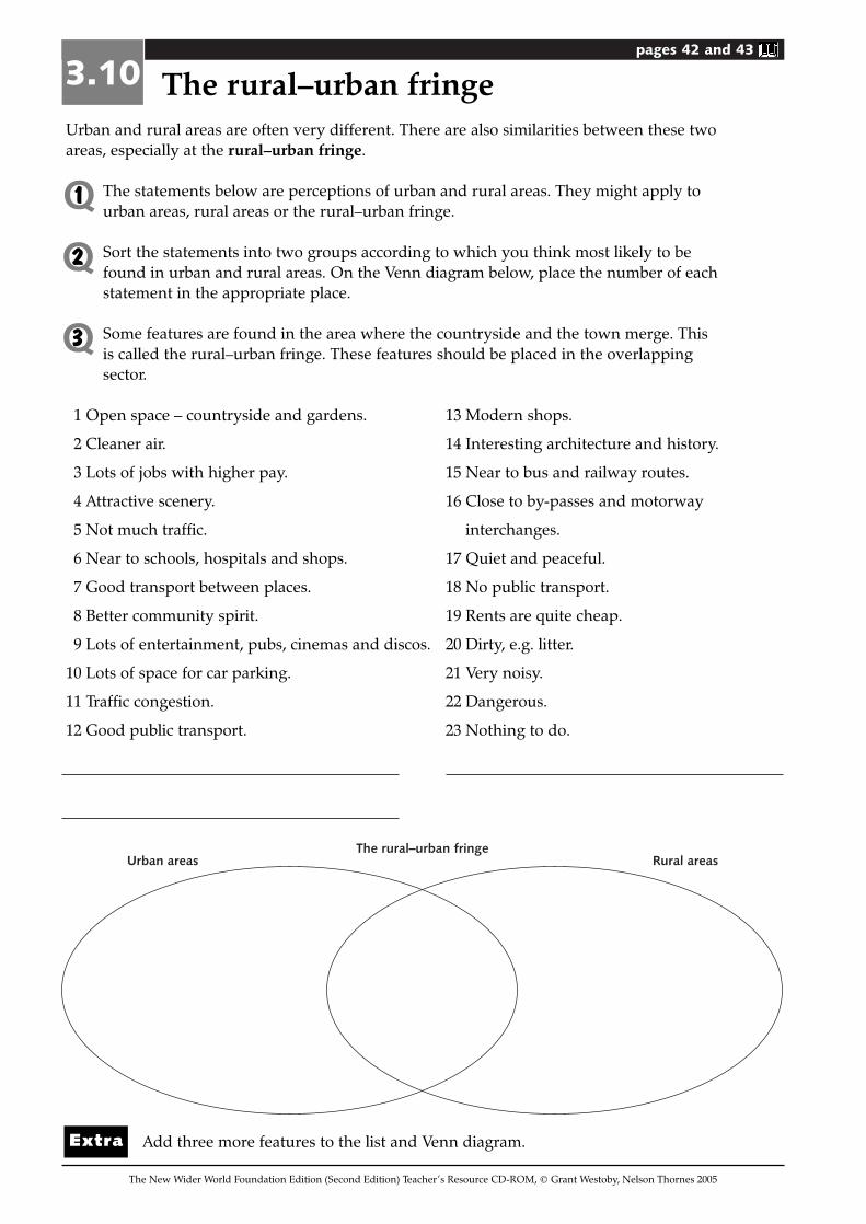
pages 42 and 43
Urban and rural areas are often very different. There are also similarities between these twoareas, especially at the rural–urban fringe.
The statements below are perceptions of urban and rural areas. They might apply tourban areas, rural areas or the rural–urban fringe.
Sort the statements into two groups according to which you think most likely to befound in urban and rural areas. On the Venn diagram below, place the number of eachstatement in the appropriate place.
Some features are found in the area where the countryside and the town merge. Thisis called the rural–urban fringe. These features should be placed in the overlappingsector.
1 Open space – countryside and gardens. 13 Modern shops.
2 Cleaner air. 14 Interesting architecture and history.
3 Lots of jobs with higher pay. 15 Near to bus and railway routes.
4 Attractive scenery. 16 Close to by-passes and motorway
5 Not much traffic. interchanges.
6 Near to schools, hospitals and shops. 17 Quiet and peaceful.
7 Good transport between places. 18 No public transport.
8 Better community spirit. 19 Rents are quite cheap.
9 Lots of entertainment, pubs, cinemas and discos. 20 Dirty, e.g. litter.
10 Lots of space for car parking. 21 Very noisy.
11 Traffic congestion. 22 Dangerous.
12 Good public transport. 23 Nothing to do.
Add three more features to the list and Venn diagram.
3.10 The rural–urban fringe
The New Wider World Foundation Edition (Second Edition) Teacher’s Resource CD-ROM, © Grant Westoby, Nelson Thornes 2005
Q1
Q2
Q3
Urban areasThe rural–urban fringe
Rural areas
Extra
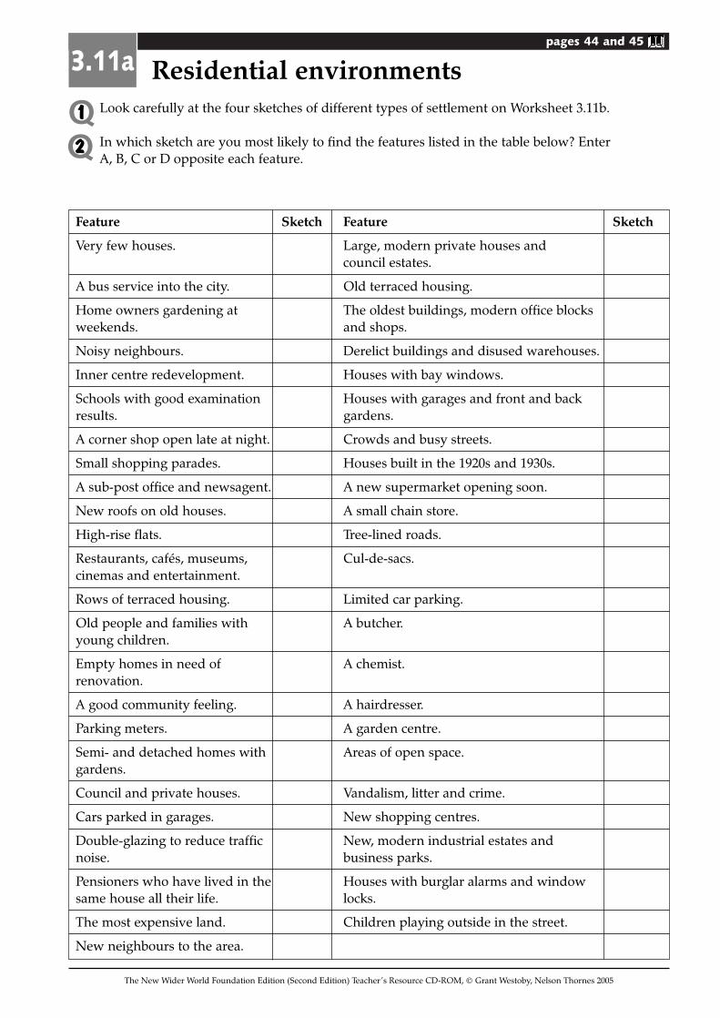
pages 44 and 45
Look carefully at the four sketches of different types of settlement on Worksheet 3.11b.
In which sketch are you most likely to find the features listed in the table below? EnterA, B, C or D opposite each feature.
Feature Sketch Feature Sketch
Very few houses. Large, modern private houses and council estates.
A bus service into the city. Old terraced housing.
Home owners gardening at The oldest buildings, modern office blocks weekends. and shops.
Noisy neighbours. Derelict buildings and disused warehouses.
Inner centre redevelopment. Houses with bay windows.
Schools with good examination Houses with garages and front and back results. gardens.
A corner shop open late at night. Crowds and busy streets.
Small shopping parades. Houses built in the 1920s and 1930s.
A sub-post office and newsagent. A new supermarket opening soon.
New roofs on old houses. A small chain store.
High-rise flats. Tree-lined roads.
Restaurants, cafés, museums, Cul-de-sacs.cinemas and entertainment.
Rows of terraced housing. Limited car parking.
Old people and families with A butcher.young children.
Empty homes in need of A chemist.renovation.
A good community feeling. A hairdresser.
Parking meters. A garden centre.
Semi- and detached homes with Areas of open space.gardens.
Council and private houses. Vandalism, litter and crime.
Cars parked in garages. New shopping centres.
Double-glazing to reduce traffic New, modern industrial estates and noise. business parks.
Pensioners who have lived in the Houses with burglar alarms and window same house all their life. locks.
The most expensive land. Children playing outside in the street.
New neighbours to the area.
3.11a Residential environments
The New Wider World Foundation Edition (Second Edition) Teacher’s Resource CD-ROM, © Grant Westoby, Nelson Thornes 2005
Q1Q2
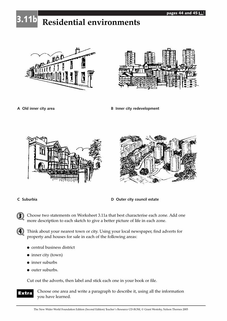
pages 44 and 45
A Old inner city area B Inner city redevelopment
C Suburbia D Outer city council estate
Choose two statements on Worksheet 3.11a that best characterise each zone. Add onemore description to each sketch to give a better picture of life in each zone.
Think about your nearest town or city. Using your local newspaper, find adverts forproperty and houses for sale in each of the following areas:
� central business district
� inner city (town)
� inner suburbs
� outer suburbs.
Cut out the adverts, then label and stick each one in your book or file.
Choose one area and write a paragraph to describe it, using all the informationyou have learned.
3.11b Residential environments
The New Wider World Foundation Edition (Second Edition) Teacher’s Resource CD-ROM, © Grant Westoby, Nelson Thornes 2005
Q3
Q4
Extra