preparation of development plan for kushtia sadar upazila
TRANSCRIPT
MOBILIZATION & INCEPTION REPORTof
‘‘Preparation of Development Plan ForKushtia Sadar Upazila”
SUBMITTED
to
Project Director‘‘Preparation of Development Plan For
Kushtia Sadar Upazila’’Urban Development Directorate (UDD),
Khulna Regional Office.1st Floor, NHA Bhaban Khalishpur, Khulna 9000
December 2017
SUBMITTED BY
TROYEE associates
in association with
Asian Disaster Preparedness Center (ADPC)Geolysis Limited
Office:Hasan Holdings, Level – 12,52/1 New Eskaton Road, Dhaka-1000.
Phone 880-2-58313605-7, Fax: 880-2-58313872.E-mail: [email protected]

EXECUTIVE SUMMARY

EXECUTIVE SUMMARY
TROYEE-ADPC-GEOLYSIS i
This Mobilization and Inception Report is the first official report for “Preparation of DevelopmentPlan for Kushtia Sadar Upazila”. This project has been initiated in order to prepare a multi-sectoralshort and long term investment plan through participatory process and comprises the large tract ofurban, semi-urban and rural lands. The report is being submitted in pursuance of the agreementsigned between the client, Urban Development Directorate (UDD) and consultant, TROYEEassociates in association with ADPC and GEOLYSIS. The intended plans of the Kushtia SadarUpazila will provide a framework for overall development of the Upazila and a basis ofdevelopment with Action Plans for public and private agencies following a common goal. TheStructure Plan, Urban Area Plan and Action Area Plan will be formulated through a team ofdomestic consultants under the jurisdiction of Urban Development Directorate (UDD). Theproposed work is a comprehensive endeavor which has to be designed to assist the Kushtia SadarUpazila authorities to cater to the growing need for both the present and the future development inorder to cope with the growing demand in respect of service delivery and management.
The prime objective of the project is to prepare a Master Plan for Kushtia Municipality area tocontrol its unplanned development. The objective of the project is also to optimize resources andactivities for sustenance of marginal people. There is no long term holistic Development Plan forthe Sadar Upazila. It needs to be integrated with the mainstream of development process of thecountry. So, an interdisciplinary development planning approach is urgent to optimize livelihood ofthe area.
Urban Development Directorate prepared Land Use Plan for Kushtia Paurashava in 1989 underNational Physical Plan. The plans were formulated for 20 years in perspective. It is important tomention here that the plan period for Kushtia Paurashava has been over in 2009. Thus review ofthese plans is long overdue. The plan of the Kushtia Paurashava was prepared as individual townsin isolation from rest of the Upazila areas. Hence, Kushtia Sadar Upazila is undertaken by UDD toprepare Structure Plan, Urban Area Plan and Action Area Plan with demand from the HonorableMayor of Kushtia Paurashava being highly recommended by the Parliament Member (MP) andHonorable Minister, Ministry of Information, Mr. Hasanul Haq Inu, MP.
Kushtia Sadar Upazila is the focal point of the Kushtia District and stands in the middle of theKhulna and Rajshahi divisional headquarters with unique geographical importance. Total area ofKushtia Sadar Upazila is 318.22 sq.km. According to population census 2011 (BBS, 2015), Totalpopulation of Kushtia Sadar is 5,02,255 having a density figure of 1578 persons per sq.km.
A reconnaissance survey has been conducted in some selected localities of the project areas tounderstand the general condition of the areas and works to be performed by the consultants duringthe project period. This provided an overall idea of the development pattern of the areas. In theinitial survey, basic information on transportation mode and overall visual scenario of the areas ofSadar Upazila has been captured. This overview pertains not only to the physical features,prospects and problems of the area, but also the ideas, aspirations and mood of the localresidents, which are essential to develop methodological approaches in data collection. Besides

Mobilization & Inception ReportPreparation of Development Plan for Kushtia Sadar Upazila Executive Summary
TROYEE-ADPC-GEOLYSIS ii
the visual observation, discussions were held with the local officials and elites, officials of publicand private agencies and a section of general people of various occupation groups.
In the planning process, mauza maps for land management and Digital stereo image for digitalmodeling and mapping will be used. Digital Photogrammetric Workstation with latest software andtechnology will be used in the project. There are three levels of engagement of the experts forcarrying out the project work, which include Personnel of the Consultant Organizations, TechnicalManagement Committee (TMC) and Steering Committee (SC).
The Mobilization and Inception Report contains altogether seven chapters. The report starts with ashort description of background and objectives of this project, information on Kushtia SadarUpazila in national and regional context, scope of services, methodology, work schedule andtentative demarcation of the project area boundary.
Brief historical profile of Kushtia Sadar Upazila is described in Chapter Two, with geographiclocation, regional importance, heritage and historic sites, population, urban development patternand some glimpse of public agencies operating in the city. A very succinct account of variousconstraints and potentialities of the project area also have been illustrated in this chapter.
The understanding of the consultants regarding Seventh Five Year Plan, Sustainable DevelopmentGoals (SDGs), and Poverty Reduction Strategy (PRSP), Annual Development Plan (ADP) fordeveloping further linkage of the national plans and policies with different levels of planning aredescribed in Chapter Three.
Chapter Four explains the approach and methodology for the project planning. The approach andmethodology has been developed to accomplish the objectives and activities stated in the ToR.Based on general understanding of the problems and prospects of the project area as well as ToRguidelines, the consultants have developed the approaches and methodologies for this project.
Chapter Five outlines the format of outputs (maps and reports) to be submitted in the process ofPreparation of Development Plan for Kushtia Sadar Upazila. It also includes format of differenttypes of surveys and studies.
Details of the project management plan are described in Chapter Six, with the description ofProject Organogram, list of Professional Staff, Staffing Schedule and Detailed specification oftasks. Activity schedule presented via Gantt chart articulates completion of the project within 18months from the date of commencement.
The final part of the report, Chapter Seven, includes the conclusive remarks.

TABLE OF CONTENTS
Mobilization & Inception ReportPreparation of Development Plan for Kushtia Sadar Upazila Table of Contents
TROYEE-ADPC-GEOLYSIS iii
PREPARATION OF DEVELOPMENT PLAN FOR KUSHTIA SADAR UPAZILA,KUSHTIA DISTRICT
MOBILIZATION & INCEPTION REPORT
Table of Contents
Page No.Executive Summery iTable of Contents iiiList of Tables viList of Maps viList of Photographs viList of Figures viiList of Annexures vii
CHAPTER ONE: INTRODUCTION1.1 Introduction 1-11.2 Background Information of the Project 1-11.3 Vision Statement for Kushtia Sadar Upazila 1-11.4 Mission or Long-Term Policy Framework 1-21.5 Objectives of the Project 1-31.6 Scope of Work 1-31.7 Specific Activities to be Carried by Consultant 1-51.8 Study/Project Area Demarcation 1-61.9 Kick-off meeting with UDD and Team Mobilization Meeting 1-71.10 Mobilization and setting up Project office at Kushtia 1-81.11 Reconnaissance Survey 1-81.12 Inception Meeting 1-9
CHAPTER TWO: PROFILE OF KUSHTIA SADAR UPAZILA2.1 Location, Area and Physical Setting 2-12.2 Historical & Location Importance of Kushtia Sadar Upazila in the Regional
Context2-2
2.3 Road Networks and Inter- regional Connectivity of Kushtia Sadar Upazila 2-62.4 Population 2-72.5 Socio-Economic Scenario 2-82.6 Urban Development Pattern 2-82.7 Traffic and Transportation 2-82.8 Services and Facilities 2-92.8.1 Water Supply and Sanitation 2-92.8.2 Electricity Connection 2-92.8.3 Heath Care Facilities 2-10
2.8.4 Educational Facilities 2-10
Mobilization & Inception ReportPreparation of Development Plan for Kushtia Sadar Upazila Table of Contents
TROYEE-ADPC-GEOLYSIS iv
2.8.5 Community Facilities 2-102.9 Environmental Condition 2-112.10 Institutional Development 2-112.11 Potentiality of Tourism 2-122.12 Natural Hazards 2-132.13 SWOT Analysis 2-13
CHAPTER THREE: NATIONAL DEVELOPMENT PLAN AND POLICIES
3.1 Introduction 3-13.2 Rationale of Relating National and Local Plan 3-13.3 National Development Plans 3-13.3.1 7th Five Year Plan 3-13.3.2 Poverty Reduction Strategy Paper (PRSP) 3-23.4 Annual Development Plan 3-43.5 Relevant Acts and Policies 3-5
CHAPTER FOUR: APPROACH AND METHODOLOGY4.1 Introduction 4-14.2 Technical Approach to the Study 4-1
4.2.1 Background of the Consultant’s Approach 4-14.2.2 General Approach to the Study 4-14.2.3 Technical Approach to the Study 4-1
4.3 Management Approach to the Study 4-24.3.1 Consultants’ Approach and Strategy 4-24.3.2 Management Organogram 4-24.3.3 Consultants Team Management 4-24.3.4 Co-ordination Meeting 4-3
4.4 Population Forecasts 4-34.5 Tentative Detection of Project Area 4-34.6 Compilation of Base Map 4-3
4.6.1 Collection of Mauza Maps 4-44.6.2 Scanning of Mauza Maps 4-44.6.3 Digitization of Mauza Maps 4-54.6.4 Projecting or Geo-referencing of Mauza Maps 4-8
4.7 Demarcation of Project Area Boundary 4-114.7.1 Preparation of Mosaic Mauza Maps 4-114.7.2 Edge Matching of Mauza Maps 4-114.7.3 Preparation of Layout of Project Area Map 4-114.7.4 Submission of the Project Area Map and Report 4-12
4.8 Physical Surveys (Topographic, Physical Feature and Landuse Survey) 4-124.8.1 Mobilization of Survey Team 4-124.8.2 Equipment, Hardware and Software to be used 4-12
Mobilization & Inception ReportPreparation of Development Plan for Kushtia Sadar Upazila Table of Contents
TROYEE-ADPC-GEOLYSIS v
4.8.3 Methodology of Physical Surveys (Topographic, Physical Feature & Landuse) 4-134.9 Physical Features Survey 4-214.10 Topographic Survey 4-214.11 Land use Survey 4-224.12 Data Processing of Physical Surveys 4-22
4.12.1 Preparation of Physical Survey Maps 4-234.12.2 Field Verification of Physical Survey Maps 4-234.12.3 Updating and Finalization of Physical Survey Maps 4-23
4.13 Traffic and Transportation Survey 4-234.13.1 Transportation Infrastructure and Facilities 4-244.13.2 Transportation Fleets and Services 4-254.13.3 Volume and Movement Patterns 4-254.13.4 Analysis of Volume and Movement Patterns 4-264.13.5 Origin Destination Survey 4-27
4.14 Housing, Slums and Squatters Settlement Survey 4-274.15 Household/ Socio-Economic Survey 4-284.16 Population and Migration Survey/ Study 4-304.17 Investment and Employment Survey 4-304.18 Drainage and Utility Survey and Study 4-314.19 Environmental Survey and Study 4-324.20 Scheme Identification Survey 4-334.21 Others Relevant Survey and Study 4-34
4.21.1 Housing 4-344.21.2 Health 4-344.21.3 Education 4-344.21.4 Sanitation 4-344.21.5 Energy 4-344.21.6 Heritage, Archeology and Tourism Management 4-35
4.22 Database Preparation 4-35
CHAPTER FIVE: OUTPUTS AND FORMATS5.1 Introduction 5-15.2 Format of Reports to be submitted by Consultants (Both Digital and Hard Copy) 5-15.3 Format for Submission of Maps and Drawings 5-15.4 Format for Submission of Soft copy 5-25.5 Format to be used for Preparation of maps 5-2
CHAPTER SIX: PROJECT MANAGEMENT PLAN6.1 Commencement of Work 6-16.2 Project Management Profile 6-16.3 Staffing Schedule 6-36.4 Tasks and Responsibilities of Professionals 6-36.5 Activity Schedule/Work Plan 6-6
Mobilization & Inception ReportPreparation of Development Plan for Kushtia Sadar Upazila Table of Contents
TROYEE-ADPC-GEOLYSIS vi
CHAPTER SEVEN: CONCLUSION 7-1
LIST OF TABLES
Table 1.1 Name of Paurashava and Unions with area of Kushtia Sadar Upazila 1-7Table 2.1 No of administrative units, population, density and literacy rate 2-1Table 2.2 Total Length of Road, Railway and River way 2-7Table 2.3 Road length based on road types 2-7Table 2.4 Road length based on Road classification of Kushtia 2-7
Table 2.5 Number of educational institutes in Kushtia Sadar Upazila 2-10
Table 2.6 Existing Community Facilities in Kushtia Sadar Upazila Area 2-10
Table 4.1 Population and Area of Kushtia Sadar upazila 4-3
Table 4.2 Specifications for Scanned Images 4-5Table 4.3 Nomenclature of Image Files (Example) 4-5Table 4.4 Sample Feature Description for Digitization Manuscript-1 4-6Table 4.5 Feature Description for Digitization Manuscript-2 & 3 4-7Table 4.6 Attribute Database Format for Digitized Mauza Map 4-7Table 4.7 Master TIC File 4-10
Table 4.8 Updated/Projected TIC 4-10
Table 4.9 Reference BM & GPS Pillar information in Kushtia Sadar Upazila 4-15
Table 5.1 Format of Reports to be submitted by Consultant 5-1Table 5.2 Format of Maps and Drawings to be submitted by Consultant 5-2Table 5.3 Format to be used for Preparation of Maps by Consultant 5-3
LIST OF MAPS
Map 2.1: Location of Kushtia Sadar Upazila of Bangladesh 2-1Map 2.2: Kushtia Sadar Upazila map 2-1Map 2.3: Regional transport connectivity of Kushtia Sadar Upazila 2-6
LIST OF PHOTOGRAPHS
Photograph 1.1: Contract Signing of Preparation of Development Plan of of Kushtia SadarUpazila with Director, UDD
1-8
Photograph 1.2: Opened Drainage System 1-9Photograph 1.3: Narrow local road 1-9Photograph 1.4: Unpaved Pedestrian 1-9Photograph 1.5: Haphazard open solid waste dumping 1-9Photograph 1.6: Kushtia Sadar Upazila Headquarter 1-10Photograph 1.7: Consultation meeting with DC, Kushtia 1-10
Mobilization & Inception ReportPreparation of Development Plan for Kushtia Sadar Upazila Table of Contents
TROYEE-ADPC-GEOLYSIS vii
Photograph 1.8: Formal Consultation meeting with Upazila Nirbahi Officer (UNO) ofKushtia Sadar Upazila
1-10
Photograph 1.9: Consultation meeting with Secretary, Town Planner and Engineersof Kushtia Municipality
1-10
Photograph 2.1 Jhaudia Jamme Mosque 2-2Photograph 2.2 Swastipur Mosque 2-3Photograph 2.3: The Shrine of Lalon Fakir 2-3Photograph 2.3 Road Connectivity 2-6Photograph 2.4: Road and Railway transport system of Kushtia Sadar Upazila 2-7Photograph 2.5: Existing roads and intersection of Kushtia Paurashava 2-8Photograph 2.6: Central Bus Terminal of Kushtia Sadar Upazila 2-9Photograph 2.7: Main gate of Kushtia Zila School 2-11Photograph 2.8: Kushtia City College 2-11Photograph-4.1 UAV/Drone to be used for Kushtia Sadar Upazila Development Plan
Survey4-13
Photograph-4.2 Sample Aerial Photography using the UAV/Drone 4-20Photograph-4.3 Sample Physical Feature Survey and Mapping 4-21Photograph-4.4 Sample Digital Elevation Model (DEM) 4-22
LIST OF FIGURES
Figure 2.1: Kushtia Sadar UpazilaFigure 2.2: Landmarks in Kushtia Sadar Upazila
2-32-4
Figure 2.3: Landmarks in Kushtia Municipal Town 2-5Figure 6.1: Project OrganogramFigure 6.2: Staffing Schedule
6-16-2
LIST OF ANNEXURES
Annexure 1 Documents of Satellite Image ProcurementAnnexure 2 List of Mauzas of the Kushtia Sadar UpazilaAnnexure 3 Mauza Map Scanning and DigitizationAnnexure 4 Location of Project office at KushtiaAnnexure 5 TMC Meeting Comments and Adjustment on Report

INTRODUCTION
Chapter: 01
CHAPTER-1INTRODUCTION
TROYEE-ADPC-GEOLYSIS 1-1
1.1 Introduction
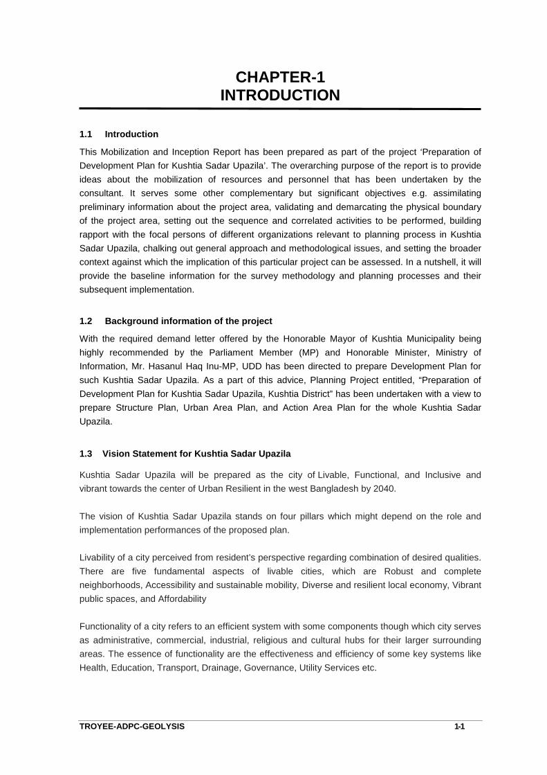
This Mobilization and Inception Report has been prepared as part of the project ‘Preparation ofDevelopment Plan for Kushtia Sadar Upazila’. The overarching purpose of the report is to provideideas about the mobilization of resources and personnel that has been undertaken by theconsultant. It serves some other complementary but significant objectives e.g. assimilatingpreliminary information about the project area, validating and demarcating the physical boundaryof the project area, setting out the sequence and correlated activities to be performed, buildingrapport with the focal persons of different organizations relevant to planning process in KushtiaSadar Upazila, chalking out general approach and methodological issues, and setting the broadercontext against which the implication of this particular project can be assessed. In a nutshell, it willprovide the baseline information for the survey methodology and planning processes and theirsubsequent implementation.
1.2 Background information of the project
With the required demand letter offered by the Honorable Mayor of Kushtia Municipality beinghighly recommended by the Parliament Member (MP) and Honorable Minister, Ministry ofInformation, Mr. Hasanul Haq Inu-MP, UDD has been directed to prepare Development Plan forsuch Kushtia Sadar Upazila. As a part of this advice, Planning Project entitled, “Preparation ofDevelopment Plan for Kushtia Sadar Upazila, Kushtia District” has been undertaken with a view toprepare Structure Plan, Urban Area Plan, and Action Area Plan for the whole Kushtia SadarUpazila.
1.3 Vision Statement for Kushtia Sadar Upazila
Kushtia Sadar Upazila will be prepared as the city of Livable, Functional, and Inclusive andvibrant towards the center of Urban Resilient in the west Bangladesh by 2040.
The vision of Kushtia Sadar Upazila stands on four pillars which might depend on the role andimplementation performances of the proposed plan.
Livability of a city perceived from resident’s perspective regarding combination of desired qualities.There are five fundamental aspects of livable cities, which are Robust and completeneighborhoods, Accessibility and sustainable mobility, Diverse and resilient local economy, Vibrantpublic spaces, and Affordability
Functionality of a city refers to an efficient system with some components though which city servesas administrative, commercial, industrial, religious and cultural hubs for their larger surroundingareas. The essence of functionality are the effectiveness and efficiency of some key systems likeHealth, Education, Transport, Drainage, Governance, Utility Services etc.

Mobilization & Inception ReportPreparation of Development Plan for Kushtia Sadar Upazila Chapter-1
TROYEE-ADPC-GEOLYSIS 1-2
The definition of inclusiveness is an aura or environment of letting people in and making them feelwelcome. An example of inclusiveness is when you make your home a comfortable place for all ofyour friends, family, guests and people you meet. An inclusive city is a city in which the processesof development include a wide variety of citizens and activities. These cities maintain their wealthand creative power by avoiding marginalization, which compromises the richness of interactionupon which cities depend.
Vibrant economy is one that goes beyond financial returns and takes into account the well-being ofsociety and everybody’s ability to thrive. It is characterized by dynamic changes in terms of theemergency role of technology and in the process of production. Vibrant economies contribute tothe health and well-being of people and communities by providing economic security and accessto opportunities. This includes access to education and living wage employment, affordablehousing, healthy food, and the kinds of services and amenities that promote strong and healthyfamilies and vibrant and sustainable communities. Economically Vibrant City refers to a place,which has a unique collection of qualities and characteristics – visual, cultural, social, andenvironmental.
1.4 Mission or Long-Term Policy Framework
Livability withConnectivity
To plan for affordable housing for the city dwellers with the need ofincreasing population.
To promote sustainable urban development with well-connected andhierarchical network with the union headquarters and growth centers.
To establish effective hierarchical linkage integrated regional connectivityto promote uninterrupted economic flow of goods and services in order tofoster the development in union centers as well as in upazila headquartersand regional centers
Plan for making union and growth centers also an attractive place for livingwith the provision of education, health and better public facilities.
Functionality To ensure well-connected transportation network keeping option forwalking and cycling and planning for improved public transport services.
Inclusiveness
To adopt adaptive comprehensive planning approach for ensuring livableand sustainable living environment.
To plan for capacity building of the agencies/ institution for taking care andlook-after development according to higher level plan and efficientmanagement.
Economy
To plan housing options close to the job location of the major industriallocation and facilitate provision of essential infrastructure and services forthe estimated workforce of the priority industrial locations.
To encourage compact and clustered industrial growth and promote formaleconomic activities to ensure economic vibrancy of the area

Mobilization & Inception ReportPreparation of Development Plan for Kushtia Sadar Upazila Chapter-1
TROYEE-ADPC-GEOLYSIS 1-3
1.5 Objectives of the Project
The prime objective of the project is to prepare Development Plan for the Kushtia Sadar Upzilaincluding Sadar Municipality area to control its unplanned development. The project will ensureoptimization of the resources and sustainable development. There is no long term holisticDevelopment Plan for the Sadar Upazila. Therefore, an interdisciplinary development planningapproach is essential. The current project will aim to address the followings,
1) Determine a long-term distribution of population. In other words a desirable rural urbanbalance and the optimum pattern of urban growth.
2) To canalized government resources to areas with potential for higher output ofinvestment and thus to eliminate existing disparity, meaning to provide equaldevelopment scenario for the whole of project area. To guide the spatial pattern of landuse development so as to operate the maximum advantage of rural economy.Formulation of Development Plan and Development Control Plan at local level.
3) To guide the spatial pattern of land use development so as to operate the maximumadvantage of rural economy.
4) Formulate of Development Plan and Development Control Plan at local level.
5) Prepare a conservation plan for the Kushtia Sadar upazila in order to protect unplanneddevelopment, to control environmental degradation, to conserve bio-diversity, to ensurebetter living environment for the inhabitants.
6) Transformation of National and Regional Policies at the local level.
7) To suggest proper policy guideline to mitigate water logging problem and to ensureavailability of safe drinking water in the area.
8) Formulation and Integration of different sectoral strategies for the Upazila.
9) Designing a standard for land use by the UDD as the Statutory Body, Paurashava, Unionand other government agencies involved in development, economic growth,employment, housing, utilities and amenities, education, health, recreation and openspace etc.
1.6 Scope of Work
The scope of Consultancy Services encompasses for Preparation of three tiers Development Planfor Kushtia Sadar Upazila, which includes Structure Plan, Urban Area Plan, and Action Area Plan.
The project will provide a basis for development agencies, public and private, to proceed ontowards a common goal. The Development plan for the Pauraashava and UnionHeadquarters\Growth Centres would provide a framework for overall development of the Upazila.
Mobilization & Inception ReportPreparation of Development Plan for Kushtia Sadar Upazila Chapter-1
TROYEE-ADPC-GEOLYSIS 1-4
The plan would examine the existing situation, draw attention to key problems, assess likelychanges and their implications and proposes; with the resources available, how major problemsmight be tackled.
Planning Components
Development Plan will be prepared for managing and promoting development on the basis of thestrategies set by the longer-term structure plan. The Development Plan of Kushtia Sadar Upazila iscomprised of the three following components-
a) Structure Plan
b) Urban Area Plan (UAP)/Master Plan
c) Action Area Plan (AAP)
A. The Structure Plan
The Structure Plan will be prepared for the entire jurisdiction of the plan for a period of 20 years.
Structure plan is a policy level plan that conducts detail study on the major sectors of theconcerned area and forecast the future with as much accuracy as possible to derive the policiesthat will help the later stages of the plan to cope with the upcoming challenges. Structure planprovides flexibility to the whole plan package. Structure Plan would delineate area whereurbanization would be permitted and restricted area where urbanization would not be permittedand formulate policies for such areas.
The structure plan examined the existing situation, drew attention to key problems, assessed likelychanges and their implications and proposed how some major problems might be tackled. Verybriefly, the structure plan notes an anticipated population increase in the project area by the end ofthe plan period and assesses the implications of this growth.
B. The Urban Area Plan/Master Plan
The Urban Area Plan will be prepared for the study area on map focusing developed and recentlydeveloping areas, covering the instruction and transtate the strategy of the structure plan.
Urban area plan would be prepared for the Kushtia Municipality and all identified GrowthCenters/Union Headquarters of the Sadar Upazila area and to be presented on mauza map withplot boundary. Planning standard has to be formulated for the planning area. The Urban Area Planwill provide an interim mid-term guideline for the 10 years and covers for the development of urbanareas and Union Headquarters within Kushtia Sadar Upazila. The Urban Area Plan will consist ofthe following:
1) Conservation and Development Control Plan through Land Use Plan;
2) Traffic and Transportation Management Plan;
3) Drainage, Sewerage & Environment Management Plan
4) Disaster Management Plan
Mobilization & Inception ReportPreparation of Development Plan for Kushtia Sadar Upazila Chapter-1
TROYEE-ADPC-GEOLYSIS 1-5
C. Action Area Plan
The Action Area Plans (AAP) will be prepared for selected areas that are using to be urbanizedwithin next 5 years. The objective of the action plan is to evaluate some projects, whichshould be -implemented during the first five years life of the structure plan. It will provide moredetailed planning proposals for specific sub-areas of Kushtia Sadar Upazila.The objective of theaction area plan is to evaluate those projects, which should be implemented during the first fiveyears of the plan.
1.7 Specific Activities to be carried by the Consultant
The ToR defines that the following activities are to be undertaken by the consultants to achievethe main objectives of this consultancy assignment:
A. Mobilization, Reconnaissance Survey, Consultation and Submission of Mobilization andInception Report
B. Mauza Map Processing: Collection of Mauza Maps (CS/RS), Scanning, Digitization,Inventory
C. Submission of Survey Report-1
D. Physical Feature Survey: Physical feature survey will have to be conducted for the whole ofproject area. Location and dimension (X, Y, Z value) of all existing structures includingbuilding type, number of floors, household number, height, and use, settlement boundary etc.
E. Topographic Survey: The topographic database shall be obtained from through the SoBpillars through level machine. Based on the BM’s height, stereo images will be converted toreal height. Location and alignment of all data obtained from physical feature surveyincluding roads, flood embankments and other drainage divides. Location and alignment ofall drainage and irrigation channels/canals showing depth and direction of flow. Closedboundary/outline of homestead, water bodies, swamps, forest etc. junctions, spot heights orland levels at minimum 5 meters in urban area and 10 meters grid in rural area on thewhole project in respect to bench mark pillar established by the Survey of Bangladesh(SoB) and to prepare the spot level at close interval as and when required such as dyke,embankment, roads, river bank etc.
F. Land Use Survey: The land use survey (both attribute and spatial) will indicate the use ofeach plot of land and each building in the study area. The Surveyors will visit each andevery site to record existing usage with specified notation and colours. The output of thisSurvey will be one or more maps showing existing Gross agricultural land use, Residential,Industrial, Commercial, Administrative and Cultural zones, urban fringe area (high, lower),water courses and water bodies, roads demarcating the main zones andplantation/vegetation’s
G. Primary and secondary data collection: Traffic & Transportation, Drainage & Environmental,Socio-economic, Economy & Commerce, Collection of documents, secondary informationand statistical data regarding demographic, economic, environmental, commerce and other

Mobilization & Inception ReportPreparation of Development Plan for Kushtia Sadar Upazila Chapter-1
TROYEE-ADPC-GEOLYSIS 1-6
relevant issues. Collection of information from all Government agencies in respect of theirexisting and future development projects.
Processing, Spatial analysis and Preparation of Maps/Charts/Diagram/Reports.
Submission of Survey Reports along with maps and figures
H. Higher Level Frameworks: Integration of Strategies, Policies, Plans, Decisions, Programs,Commitments and Wishes made by the Government/Semi-Government/PublicSectors/Corporation/Departments/ Institutions, NGOs and Donors Agencies.
I. Analysis of Outputs, Formulation and Adoption of proper Development Strategies, PlanProposals, Approaches, Design Principles and Standards appropriate to the Planning Area
Submission of Interim Reports along with maps and figures
J. Integrated Plan: Inputs from Public/Private Sectors, Local Leaders, Communities, InterestGroups, NGOs, and Foreign Investors. Study of Feasibility, Benefit and Cost Ratio, Social,Economic and Environmental Impact Assessment
K. Consultation: Consultation with public representative, local people, Government/Semi-Government/Public Sectors/Corporation/Departments/ Institutions, NGOs and DonorsAgencies.
L. Incorporation of Development Proposals in response to the community desires andfeedback.
M. Preparation of Mechanism for Development Control, Zoning and Land ManagementTechniques following the Policies/Guidelines Proposed in land use plan.
N. Preparation of Legal Support Documents to be imposed Legal or Judicial Power/Act, Laws,Rules and Regulations for any sorts of Deviation, Alteration, Modification, Violation orMisuse of Plan or Plan Proposals.
O. Submission of Draft Plan Report along with Maps and Figures: Detail description anddesign of development plans and planning proposals with alternative development optionsand plan proposals.
P. Incorporation of Comments collected from formal Public Hearing (30 working days) andSubmission of Final Plan as specified in ToR.
Q. Submission of Final Reports (English & Bangla) and Plan Maps
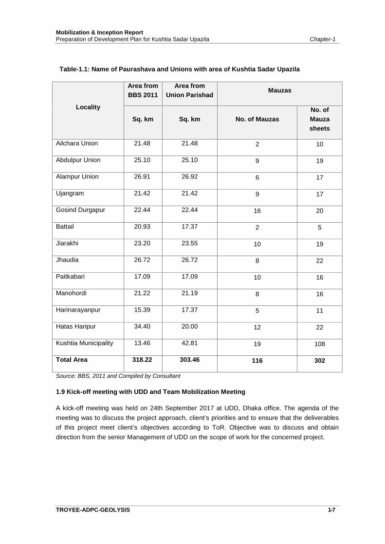
1.8 Study/ Project Area Demarcation
According to the ToR, Kushtia Sadar Upazila will be considered as the Study Area forDevelopment plan. It will cover an area of 318.22 sq. km. (approximately) including the KushtiaMunicipality and 12 Unions.
Mobilization & Inception ReportPreparation of Development Plan for Kushtia Sadar Upazila Chapter-1
TROYEE-ADPC-GEOLYSIS 1-7
Table-1.1: Name of Paurashava and Unions with area of Kushtia Sadar Upazila
Locality
Area fromBBS 2011
Area fromUnion Parishad
Mauzas
Sq. km Sq. km No. of MauzasNo. ofMauzasheets
Ailchara Union 21.48 21.48 2 10
Abdulpur Union 25.10 25.10 9 19
Alampur Union 26.91 26.92 6 17
Ujangram 21.42 21.42 9 17
Gosind Durgapur 22.44 22.44 16 20
Battail 20.93 17.37 2 5
Jiarakhi 23.20 23.55 10 19
Jhaudia 26.72 26.72 8 22
Paitkabari 17.09 17.09 10 16
Manohordi 21.22 21.19 8 16
Harinarayanpur 15.39 17.37 5 11
Hatas Haripur 34.40 20.00 12 22
Kushtia Municipality 13.46 42.81 19 108
Total Area 318.22 303.46 116 302
Source: BBS, 2011 and Compiled by Consultant
1.9 Kick-off meeting with UDD and Team Mobilization Meeting
A kick-off meeting was held on 24th September 2017 at UDD, Dhaka office. The agenda of themeeting was to discuss the project approach, client’s priorities and to ensure that the deliverablesof this project meet client’s objectives according to ToR. Objective was to discuss and obtaindirection from the senior Management of UDD on the scope of work for the concerned project.

Mobilization & Inception ReportPreparation of Development Plan for Kushtia Sadar Upazila Chapter-1
TROYEE-ADPC-GEOLYSIS 1-8
Photograph 1.1: Contract Signing of Preparation of Development Plan of of Kushtia Sadar Upazila with Director, UDD
1.10 Mobilization and setting up Project Office at Kushtia
A full strength study team has been mobilized after signing the contract agreement and approval ofthe work plan by UDD. Detail activities carried out in connection with the mobilization is outlinedbelow:
Arrangement of accommodation for consultants Arrangement for communication and transport for mobilization Calibration of equipment’s Local Area Networking Appointment of support staffs
A team mobilization meeting was held on 2nd October 2017 at consultant’s office at Eskaton. Theobjective of the meeting was to discuss on terms of reference and way forward for completing theassignment with the time stipulated in the contract document.
A full phase project site office will be launch at the Kushtia Paurashava area in the mid ofDecember 2017 and all survey activities will be operated from there (see annexure-D for site officelocation with pictures).
1.11 Reconnaissance Survey
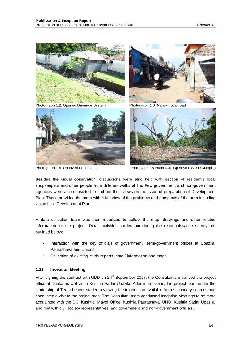
The key professional staffs made a comprehensive reconnaissance survey of the project areaimmediately after the mobilization process. The reconnaissance was performed with an overallvisit to the entire project area, discussions with key personnel of government, semi-governmentoffices at Upazila, Paurashava. A reconnaissance survey of the project area has been conductedto identify the existing problems, development constraints and future development potentialities ofthe town and its adjoining areas. This reconnaissance survey has provided the planning team aninitial overview of the area that is necessary to set on the task of preparing a Development plan.This overview pertains not only to the physical features, prospects and problems of the area, butalso the ideas, aspirations and mood of the local residents, which is very much essential todevelop the methodological approach for required data collection.
Mobilization & Inception ReportPreparation of Development Plan for Kushtia Sadar Upazila Chapter-1
TROYEE-ADPC-GEOLYSIS 1-9
Photograph 1.2: Opened Drainage System Photograph 1.3: Narrow local road
Photograph 1.4: Unpaved Pedestrian Photograph 1.5: Haphazard Open Solid Waste Dumping
Besides the visual observation, discussions were also held with section of resident’s localshopkeepers and other people from different walks of life. Few government and non-governmentagencies were also consulted to find out their views on the issue of preparation of DevelopmentPlan. These provided the team with a fair view of the problems and prospects of the area includingvision for a Development Plan.
A data collection team was then mobilized to collect the map, drawings and other relatedinformation for the project. Detail activities carried out during the reconnaissance survey areoutlined below:
Interaction with the key officials of government, semi-government offices at Upazila,Paurashava and Unions.
Collection of existing study reports, data / information and maps.
1.12 Inception Meeting
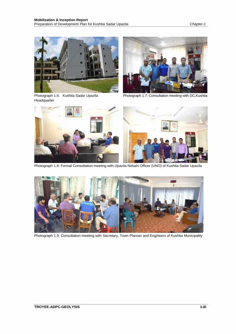
After signing the contract with UDD on 24th September 2017, the Consultants mobilized the projectoffice at Dhaka as well as in Kushtia Sadar Upazila. After mobilization, the project team under theleadership of Team Leader started reviewing the information available from secondary sources andconducted a visit to the project area. The Consultant team conducted Inception Meetings to be moreacquainted with the DC, Kushtia, Mayor Office, Kushtia Paurashava, UNO, Kushtia Sadar Upazila,and met with civil society representatives, and government and non-government officials.
Mobilization & Inception ReportPreparation of Development Plan for Kushtia Sadar Upazila Chapter-1
TROYEE-ADPC-GEOLYSIS 1-10
Photograph 1.6: Kushtia Sadar UpazilaHeadquarter
Photograph 1.7: Consultation meeting with DC,Kushtia
Photograph 1.8: Formal Consultation meeting with Upazila Nirbahi Officer (UNO) of Kushtia Sadar Upazila
Photograph 1.9: Consultation meeting with Secretary, Town Planner and Engineers of Kushtia Municipality

Chapter: 02
PROFILE OF KUSHTIA SADAR UPAZILA
CHAPTER-2PROFILE OF KUSHTIA SADAR UPAZILA
TROYEE-ADPC-GEOLYSIS 2-1
2.1 Location, Area and Physical Setting
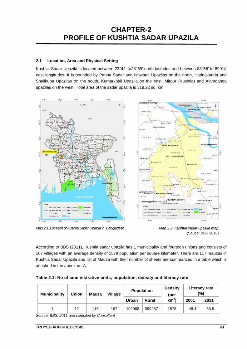
Kushtia Sadar Upazila is located between 23°42' to23°59' north latitudes and between 88°55' to 89°04'east longitudes. It is bounded by Pabna Sadar and Ishwardi Upazilas on the north, Harinakunda andShailkupa Upazilas on the south, Kumarkhali Upazila on the east, Mirpur (Kushtia) and Alamdangaupazilas on the west. Total area of the sadar upazila is 318.22 sq. km.
Map 2.1: Location of Kushtia Sadar Upazila in Bangladesh Map 2.2: Kushtia sadar upazila map(Souce: BBS 2016)
According to BBS (2011), Kushtia sadar upazila has 1 municipality and fourteen unions and consists of167 villages with an average density of 1578 population per square kilometer. There are 117 mauzas inKushtia Sadar Upazila and list of Mauza with their number of sheets are summarized in a table which isattached in the annexure-A.
Table 2.1: No of administrative units, population, density and literacy rate
Municipality Union Mauza VillagePopulation Density
(perkm2)
Literacy rate(%)
Urban Rural 2001 2011
1 12 116 167 102988 399267 1578 48.4 53.9
Source: BBS, 2011 and compiled by Consultant
Mobilization & Inception ReportPreparation of Development Plan for Kushtia Sadar Upazila Chapter-2
TROYEE-GEOLYSIS-ADPC 2-2
2.2 Historical & Geographical Importance of Kushtia Sadar Upazila in the Regional Context
Historical events
Like other parts of Bengal, Indigo Resistance Movement spread over Kushtia before liberation war. Agroup of 147 Pak soldiers faced heavy resistance from the local EPR, Police, Ansar, students andgeneral public on their entry to Kushtia on 25 March 1971. On 30 March 1971, the flag of theindependent Bangladesh was hoisted in Kushtia. An encounter was held between the freedom fightersand the Pak army at Bangshitala of the Kushtia Sadar Upazila on 5 September in where a number offreedom fighters were killed. The Pak army killed about 12 persons of a single family at 'KohinoorLodge' in Mill Para.
Marks of the War of Liberation Mass grave
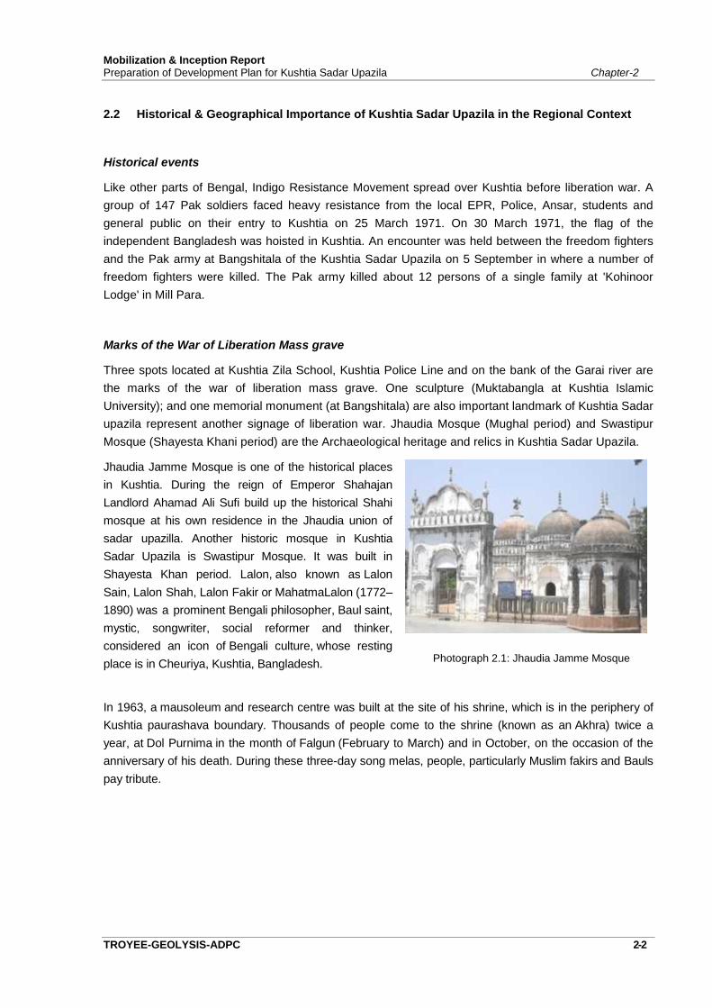
Three spots located at Kushtia Zila School, Kushtia Police Line and on the bank of the Garai river arethe marks of the war of liberation mass grave. One sculpture (Muktabangla at Kushtia IslamicUniversity); and one memorial monument (at Bangshitala) are also important landmark of Kushtia Sadarupazila represent another signage of liberation war. Jhaudia Mosque (Mughal period) and SwastipurMosque (Shayesta Khani period) are the Archaeological heritage and relics in Kushtia Sadar Upazila.
Jhaudia Jamme Mosque is one of the historical placesin Kushtia. During the reign of Emperor ShahajanLandlord Ahamad Ali Sufi build up the historical Shahimosque at his own residence in the Jhaudia union ofsadar upazilla. Another historic mosque in KushtiaSadar Upazila is Swastipur Mosque. It was built inShayesta Khan period. Lalon, also known as LalonSain, Lalon Shah, Lalon Fakir or MahatmaLalon (1772–1890) was a prominent Bengali philosopher, Baul saint,mystic, songwriter, social reformer and thinker,considered an icon of Bengali culture, whose restingplace is in Cheuriya, Kushtia, Bangladesh. Photograph 2.1: Jhaudia Jamme Mosque
In 1963, a mausoleum and research centre was built at the site of his shrine, which is in the periphery ofKushtia paurashava boundary. Thousands of people come to the shrine (known as an Akhra) twice ayear, at Dol Purnima in the month of Falgun (February to March) and in October, on the occasion of theanniversary of his death. During these three-day song melas, people, particularly Muslim fakirs and Baulspay tribute.
Mobilization & Inception ReportPreparation of Development Plan for Kushtia Sadar Upazila Chapter-2
TROYEE-ADPC-GEOLYSIS 2-3
Photograph 2.2: Swastipur Mosque Photograph 2.3: The Shrine of Lalon Fakir
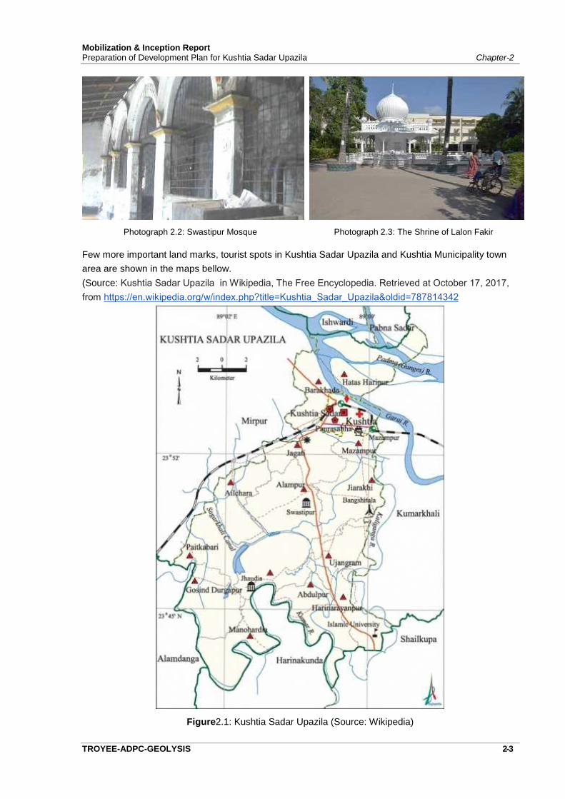
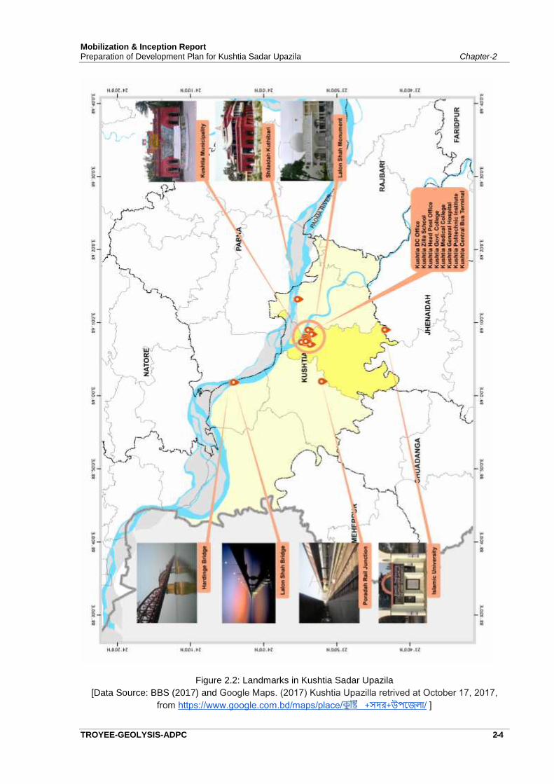
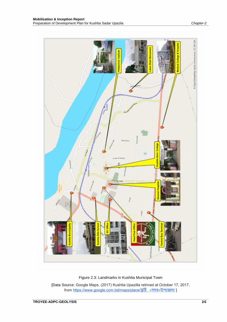
Few more important land marks, tourist spots in Kushtia Sadar Upazila and Kushtia Municipality townarea are shown in the maps bellow.(Source: Kushtia Sadar Upazila in Wikipedia, The Free Encyclopedia. Retrieved at October 17, 2017,from https://en.wikipedia.org/w/index.php?title=Kushtia_Sadar_Upazila&oldid=787814342
Figure2.1: Kushtia Sadar Upazila (Source: Wikipedia)
Mobilization & Inception ReportPreparation of Development Plan for Kushtia Sadar Upazila Chapter-2
TROYEE-GEOLYSIS-ADPC 2-4
Figure 2.2: Landmarks in Kushtia Sadar Upazila[Data Source: BBS (2017) and Google Maps. (2017) Kushtia Upazilla retrived at October 17, 2017,
from https://www.google.com.bd/maps/place/ +সদর+উপেজলা/ ]
Mobilization & Inception ReportPreparation of Development Plan for Kushtia Sadar Upazila Chapter-2
TROYEE-ADPC-GEOLYSIS 2-5
Figure 2.3: Landmarks in Kushtia Municipal Town
[Data Source: Google Maps. (2017) Kushtia Upazilla retrived at October 17, 2017,from https://www.google.com.bd/maps/place/ +সদর+উপেজলা/ ]
Mobilization & Inception ReportPreparation of Development Plan for Kushtia Sadar Upazila Chapter-2
TROYEE-GEOLYSIS-ADPC 2-6
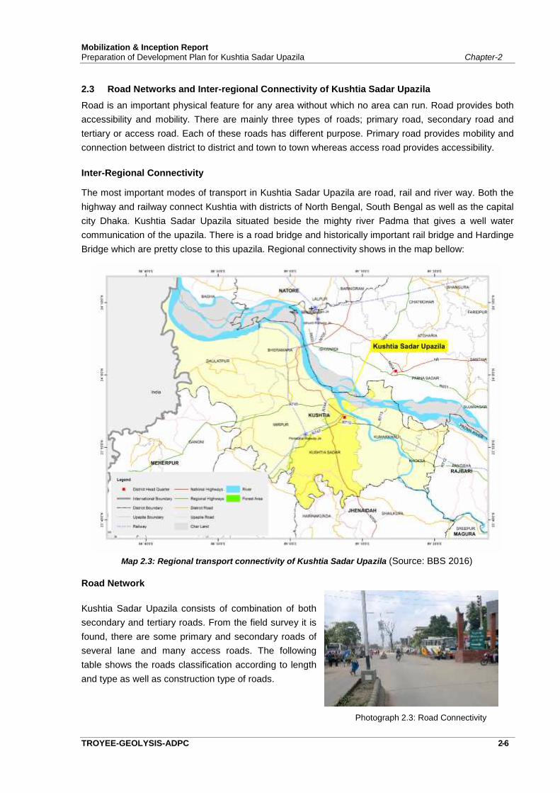
2.3 Road Networks and Inter-regional Connectivity of Kushtia Sadar UpazilaRoad is an important physical feature for any area without which no area can run. Road provides bothaccessibility and mobility. There are mainly three types of roads; primary road, secondary road andtertiary or access road. Each of these roads has different purpose. Primary road provides mobility andconnection between district to district and town to town whereas access road provides accessibility.
Inter-Regional Connectivity
The most important modes of transport in Kushtia Sadar Upazila are road, rail and river way. Both thehighway and railway connect Kushtia with districts of North Bengal, South Bengal as well as the capitalcity Dhaka. Kushtia Sadar Upazila situated beside the mighty river Padma that gives a well watercommunication of the upazila. There is a road bridge and historically important rail bridge and HardingeBridge which are pretty close to this upazila. Regional connectivity shows in the map bellow:
Map 2.3: Regional transport connectivity of Kushtia Sadar Upazila (Source: BBS 2016)
Road Network
Kushtia Sadar Upazila consists of combination of bothsecondary and tertiary roads. From the field survey it isfound, there are some primary and secondary roads ofseveral lane and many access roads. The followingtable shows the roads classification according to lengthand type as well as construction type of roads.
Photograph 2.3: Road Connectivity
Mobilization & Inception ReportPreparation of Development Plan for Kushtia Sadar Upazila Chapter-2
TROYEE-ADPC-GEOLYSIS 2-7
Table 2.2: Total Length of Road, Railway and River way
Upazila Road(km)
Railway(km)
Waterway inmonsoon
(km)
Waterway in roundthe year
(km)
Kushtia Sadar 583 8 15 5
Source: BBS, 2011
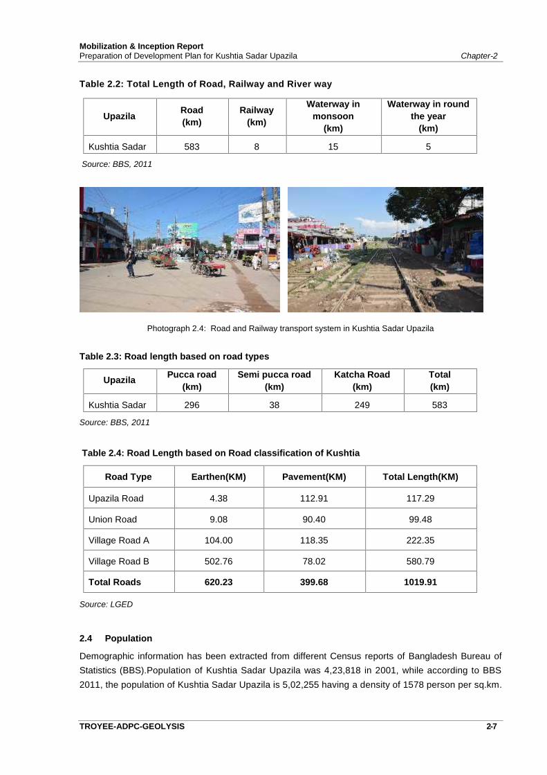
Photograph 2.4: Road and Railway transport system in Kushtia Sadar Upazila
Table 2.3: Road length based on road types
Upazila Pucca road(km)
Semi pucca road(km)
Katcha Road(km)
Total(km)
Kushtia Sadar 296 38 249 583
Source: BBS, 2011
Table 2.4: Road Length based on Road classification of Kushtia
Road Type Earthen(KM) Pavement(KM) Total Length(KM)
Upazila Road 4.38 112.91 117.29
Union Road 9.08 90.40 99.48
Village Road A 104.00 118.35 222.35
Village Road B 502.76 78.02 580.79
Total Roads 620.23 399.68 1019.91
Source: LGED
2.4 Population
Demographic information has been extracted from different Census reports of Bangladesh Bureau ofStatistics (BBS).Population of Kushtia Sadar Upazila was 4,23,818 in 2001, while according to BBS2011, the population of Kushtia Sadar Upazila is 5,02,255 having a density of 1578 person per sq.km.
Mobilization & Inception ReportPreparation of Development Plan for Kushtia Sadar Upazila Chapter-2
TROYEE-GEOLYSIS-ADPC 2-8
2.5 Socio-Economic Scenario
The economy of the project area is agro-based dominated by trading of various agro-products. Total41.5% people are involved in agriculture, 13.9% labourer and 8.53% are in service Paddy, wheat, jute,potato and maize are major cash crops of the area. Jute is cultivated throughout the region and hasbecome less popular as a cash crop. On the other hand paddy and wheat are major cereal crops. Inrecent years cultivation of maize is becoming popular which generally fetches good income for thecultivators. In the rural settlements, groves of bamboo and betel nut trees are a common picture. Thearea has potential for the production of oil seed like mustard. Large portions of the manpower are alsoengaged in service sector. Industrial development in Kushtia is lagging. Agriculture and fishing are stillthe main source of employment. With the squeeze of agricultural sector in this district, slums andjobless population are increasing in Kushtia Sadar Upazila.
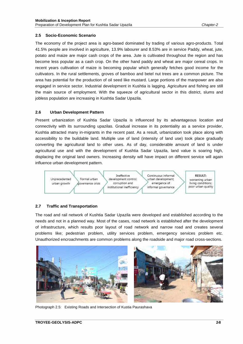
2.6 Urban Development Pattern
Present urbanization of Kushtia Sadar Upazila is influenced by its advantageous location andconnectivity with its surrounding upazilas. Gradual increase in its potentiality as a service provider,Kushtia attracted many in-migrants in the recent past. As a result, urbanization took place along withaccessibility to the buildable land. Multiple use of land (intensity of land use) took place graduallyconverting the agricultural land to other uses. As of day, considerable amount of land is underagricultural use and with the development of Kushtia Sadar Upazila, land value is soaring high,displacing the original land owners. Increasing density will have impact on different service will againinfluence urban development pattern.
2.7 Traffic and Transportation
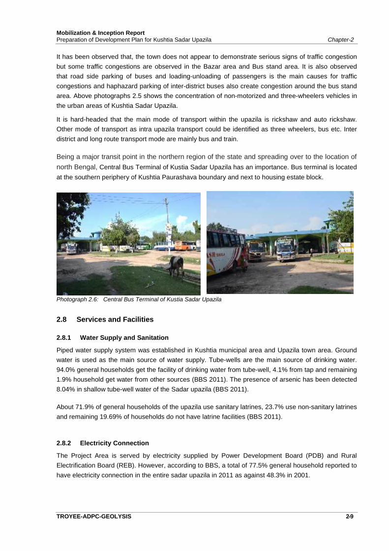
The road and rail network of Kushtia Sadar Upazila were developed and established according to theneeds and not in a planned way. Most of the cases, road network is established after the developmentof infrastructure, which results poor layout of road network and narrow road and creates severalproblems like; pedestrian problem, utility services problem, emergency services problem etc.Unauthorized encroachments are common problems along the roadside and major road cross-sections.
Photograph 2.5: Existing Roads and Intersection of Kustia Paurashava
Mobilization & Inception ReportPreparation of Development Plan for Kushtia Sadar Upazila Chapter-2
TROYEE-ADPC-GEOLYSIS 2-9
It has been observed that, the town does not appear to demonstrate serious signs of traffic congestionbut some traffic congestions are observed in the Bazar area and Bus stand area. It is also observedthat road side parking of buses and loading-unloading of passengers is the main causes for trafficcongestions and haphazard parking of inter-district buses also create congestion around the bus standarea. Above photographs 2.5 shows the concentration of non-motorized and three-wheelers vehicles inthe urban areas of Kushtia Sadar Upazila.
It is hard-headed that the main mode of transport within the upazila is rickshaw and auto rickshaw.Other mode of transport as intra upazila transport could be identified as three wheelers, bus etc. Interdistrict and long route transport mode are mainly bus and train.
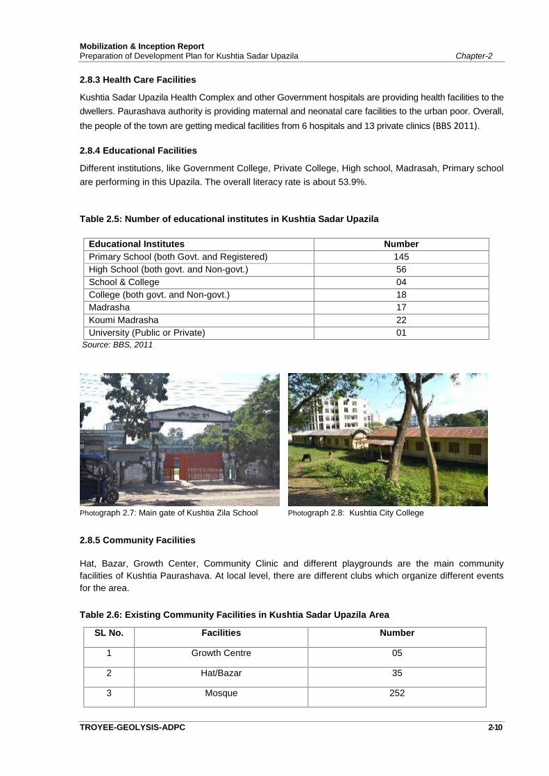
Being a major transit point in the northern region of the state and spreading over to the location ofnorth Bengal, Central Bus Terminal of Kustia Sadar Upazila has an importance. Bus terminal is locatedat the southern periphery of Kushtia Paurashava boundary and next to housing estate block.
Photograph 2.6: Central Bus Terminal of Kustia Sadar Upazila
2.8 Services and Facilities
2.8.1 Water Supply and Sanitation
Piped water supply system was established in Kushtia municipal area and Upazila town area. Groundwater is used as the main source of water supply. Tube-wells are the main source of drinking water.94.0% general households get the facility of drinking water from tube-well, 4.1% from tap and remaining1.9% household get water from other sources (BBS 2011). The presence of arsenic has been detected8.04% in shallow tube-well water of the Sadar upazila (BBS 2011).
About 71.9% of general households of the upazila use sanitary latrines, 23.7% use non-sanitary latrinesand remaining 19.69% of households do not have latrine facilities (BBS 2011).
2.8.2 Electricity Connection
The Project Area is served by electricity supplied by Power Development Board (PDB) and RuralElectrification Board (REB). However, according to BBS, a total of 77.5% general household reported tohave electricity connection in the entire sadar upazila in 2011 as against 48.3% in 2001.
Mobilization & Inception ReportPreparation of Development Plan for Kushtia Sadar Upazila Chapter-2
TROYEE-GEOLYSIS-ADPC 2-10
2.8.3 Health Care Facilities
Kushtia Sadar Upazila Health Complex and other Government hospitals are providing health facilities to thedwellers. Paurashava authority is providing maternal and neonatal care facilities to the urban poor. Overall,the people of the town are getting medical facilities from 6 hospitals and 13 private clinics (BBS 2011).
2.8.4 Educational Facilities
Different institutions, like Government College, Private College, High school, Madrasah, Primary schoolare performing in this Upazila. The overall literacy rate is about 53.9%.
Table 2.5: Number of educational institutes in Kushtia Sadar Upazila
Educational Institutes NumberPrimary School (both Govt. and Registered) 145High School (both govt. and Non-govt.) 56School & College 04College (both govt. and Non-govt.) 18Madrasha 17Koumi Madrasha 22University (Public or Private) 01
Source: BBS, 2011
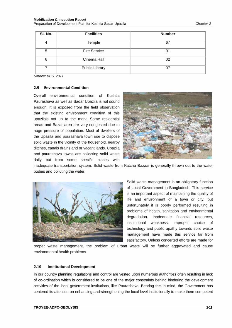
Photograph 2.7: Main gate of Kushtia Zila School Photograph 2.8: Kushtia City College
2.8.5 Community Facilities
Hat, Bazar, Growth Center, Community Clinic and different playgrounds are the main communityfacilities of Kushtia Paurashava. At local level, there are different clubs which organize different eventsfor the area.
Table 2.6: Existing Community Facilities in Kushtia Sadar Upazila Area
SL No. Facilities Number
1 Growth Centre 05
2 Hat/Bazar 35
3 Mosque 252
Mobilization & Inception ReportPreparation of Development Plan for Kushtia Sadar Upazila Chapter-2
TROYEE-ADPC-GEOLYSIS 2-11
SL No. Facilities Number
4 Temple 67
5 Fire Service 01
6 Cinema Hall 02
7 Public Library 07
Source: BBS, 2011
2.9 Environmental Condition
Overall environmental condition of KushtiaPaurashava as well as Sadar Upazila is not soundenough. It is exposed from the field observationthat the existing environment condition of thisupazilais not up to the mark. Some residentialareas and Bazar area are very congested due tohuge pressure of population. Most of dwellers ofthe Upazila and pourashava town use to disposesolid waste in the vicinity of the household, nearbyditches, canals drains and or vacant lands. Upazilaand paurashava towns are collecting solid wastedaily but from some specific places withinadequate transportation system. Solid waste from Katcha Bazaar is generally thrown out to the waterbodies and polluting the water.
Solid waste management is an obligatory functionof Local Government in Bangladesh. This serviceis an important aspect of maintaining the quality oflife and environment of a town or city, butunfortunately it is poorly performed resulting inproblems of health, sanitation and environmentaldegradation. Inadequate financial resources,institutional weakness, improper choice oftechnology and public apathy towards solid wastemanagement have made this service far fromsatisfactory. Unless concerted efforts are made for
proper waste management, the problem of urban waste will be further aggravated and causeenvironmental health problems.
2.10 Institutional Development
In our country planning regulations and control are vested upon numerous authorities often resulting in lackof co-ordination which is considered to be one of the major constraints behind hindering the developmentactivities of the local government institutions, like Paurashava. Bearing this in mind, the Government hascentered its attention on enhancing and strengthening the local level institutionally to make them competent
Mobilization & Inception ReportPreparation of Development Plan for Kushtia Sadar Upazila Chapter-2
TROYEE-GEOLYSIS-ADPC 2-12
in carrying out their responsibilities. Other agencies/institutions that are likely to be thestakeholders/participants of the Development Plan will be taken into confidence by the Upazila authority soas to get the optimum level of co-ordination. The legal framework of the Paurashava and the envisagedobligations that cropped up from the Paurashava Act needs to be clearly understood. Their readiness toaccept organizational change and persistent interaction with the planning team and stakeholders during andpost plan preparation period will help strengthen the local government institutionally.
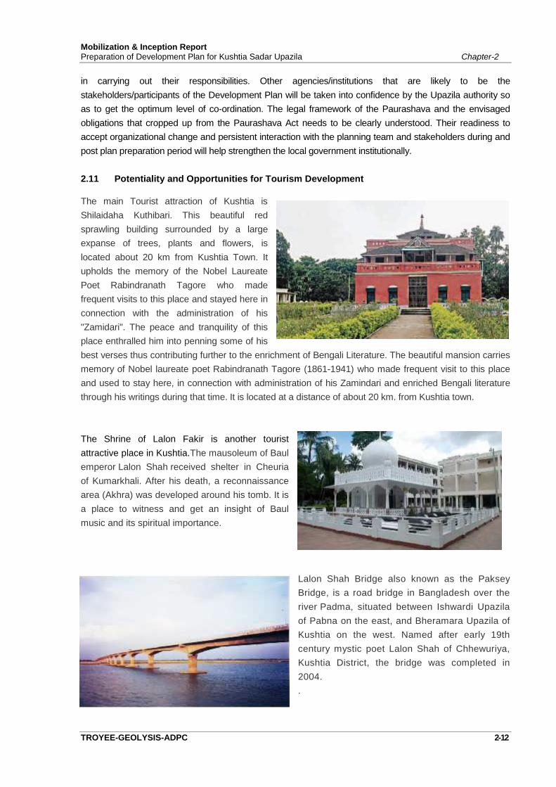
2.11 Potentiality and Opportunities for Tourism Development
The main Tourist attraction of Kushtia isShilaidaha Kuthibari. This beautiful redsprawling building surrounded by a largeexpanse of trees, plants and flowers, islocated about 20 km from Kushtia Town. Itupholds the memory of the Nobel LaureatePoet Rabindranath Tagore who madefrequent visits to this place and stayed here inconnection with the administration of his"Zamidari". The peace and tranquility of thisplace enthralled him into penning some of hisbest verses thus contributing further to the enrichment of Bengali Literature. The beautiful mansion carriesmemory of Nobel laureate poet Rabindranath Tagore (1861-1941) who made frequent visit to this placeand used to stay here, in connection with administration of his Zamindari and enriched Bengali literaturethrough his writings during that time. It is located at a distance of about 20 km. from Kushtia town.
The Shrine of Lalon Fakir is another touristattractive place in Kushtia.The mausoleum of Baulemperor Lalon Shah received shelter in Cheuriaof Kumarkhali. After his death, a reconnaissancearea (Akhra) was developed around his tomb. It isa place to witness and get an insight of Baulmusic and its spiritual importance.
Lalon Shah Bridge also known as the PakseyBridge, is a road bridge in Bangladesh over theriver Padma, situated between Ishwardi Upazilaof Pabna on the east, and Bheramara Upazila ofKushtia on the west. Named after early 19thcentury mystic poet Lalon Shah of Chhewuriya,Kushtia District, the bridge was completed in2004..
Mobilization & Inception ReportPreparation of Development Plan for Kushtia Sadar Upazila Chapter-2
TROYEE-ADPC-GEOLYSIS 2-13
2.12 Natural HazardsDue to the geographical location, the project area is particularly exposed to flood, storm etc. which maycause severe damage to the population and infrastructure.
River Padma runs along the northern boundary of Kushtia district. Padma becomes active duringmonsoon and flooding is a common phenomenon for the Sadar Upazila.
Poor solid waste management and without hospital waste management, it may be disastrous forcitizens of the Paurashava if it is flooded.
Kushtia Upazila situated in the Western part of Bangladesh, which is the most active seismic zone andhad experienced earthquakes of moderate to high intensity in the past, where the shocks of intensity of9.0 are possible.
2.13 SWOT Analysis
There are a number of physical constrains which are hampering the sustainable growth anddevelopment of the Kushtia Sadar Upazila. From the reconnaissance survey, a glimpse of SWOTanalysis of Kushtia Sadar upazila is discussed in below:
Strength
1. Kushtia is situated at strategic location which influences its future physical growth.2. Historic and heritage sites may attract tourist interest.3. Availability of large undeveloped peripheral areas for planned development of land uses.4. Large undeveloped land in the city periphery for providing open space recreation.
Weakness
1. Weak enforcement of land development regulations2. Ineffective implementation of the planning schemes and strategic plans.3. Lack of coordination among government agencies.4. Poor solid waste management.5. Inadequate urban services.6. Narrow roads, lack of alternate and link roads and absence of pedestrian facility7. Unplanned establishment of market places and other road side encroachments8. Problems of proper marketing facilities for agro-products;
Opportunity
1. Implication of new land use policies will cause overspill of population in the periphery and willreduce pressure on housing and services in the core area.
2. Railway line passing through the city.3. Increasing public awareness

Mobilization & Inception ReportPreparation of Development Plan for Kushtia Sadar Upazila Chapter-2
TROYEE-GEOLYSIS-ADPC 2-14
Threat
1. Filling up of water bodies and open spaces.2. Rapid unplanned development in the flood flow zone.3. Rising land price in peripheral areas.4. Uncontrolled mixed use development in peripheral areas.5. Rural to Urban Migration resulting informal settlements.6. Disruption of urban economic and living environment arising from persistent shortage of urban
infrastructure.

NATIONAL DEVELOPMENT PLAN AND POLICIES
Chapter: 03

CHAPTER-3National Development Plan and Policies
TROYEE-ADPC-GEOLYSIS 3-1
3.1 Introduction
Bangladesh’s planning model is dominated by a centrally planning system where the governmentsets out policies and implement on sector basis. Either a centrally government body or a localinstitution of a particular sector under a ministry initiates the planning process with directives fromthe higher authority. So both the orientation and the process of development planning have beenentirely top-down. This chapter explains how Development Plan of Kushtia Sadar Upazila is linkedwith the National Development Plan/Policy/Guidelines of the country. For this report, NationalDevelopment Plans like 7th Five Year Plan, Poverty Reduction Strategy Paper (PRSP) etc. havebeen studied.
3.2 Rationale of Relating National and Local Plan
National development plans are prepared considering the general needs and aspirations of thenation concerning diverse areas of development. National policies, strategies and objectives areset and budget allocation is made accordingly to realize development targets. Sectoral budgets areagain broken down in to programs and projects under each sector. Any development initiative atlocal level must relate to the national level plans in order to achieve cohesion and integrity withoverall development of the county to attain the national development objectives. It is thereforenecessary to understand and realize how the plan at micro level like Development Plan of KushtiaSadar Upazila is being related to the national development plan of the country.
The planning components of the current plan package are hierarchically related with each other.Development Plan is at the apex level providing long term policies and strategies for urbandevelopment.
3.3 National Development Plans
This Development Plan for Kushtia Sadar Upazila will be prepared focusing the SDG Goal 11 andas per legal binding of Urban Development Directorate under Ministry of Housing and PublicWorks and in the light of the policy guidelines of the 7th Five Year Plan and other related nationaldocuments.
3.3. 1 7th Five Year Plan
The 7th FYP reflects a continuation of the major goals articulated in the 7th FYP. The core targetsset in accordance with the vision and goals of the Perspective Plan under the 7th FYP include:
Sector Development
Significant growth of the agriculture, industry and service sectors; Increase the contribution of the manufacturing sector to 21% of GDP by FY20; Substantial improvement of exports to $54.1 billion by FY20; Achieving a Trade-GDP ratio of 50% by FY20.

Mobilization & Inception ReportPreparation of Development Plan for Kushtia Sadar Upazila Chapter-3
TROYEE-ADPC-GEOLYSIS 3-2
Urban Development
Infrastructural investment and civic facilities in peri-urban growth centres especially aroundSpecial Economic Zones;
Inclusive housing and other civic services for urban inhabitants including for people livingin informal settlements and slums;
Inclusive urban planning based on sustainable land use planning and zoning; Increased productivity, access to finance, and policy support for urban micro-small and
medium enterprises.
3.3.2 Poverty Reduction Strategy Paper (PRSP)
In September 2000 at the Millennium Summit, the United Nations issued the MillenniumDeclaration, signed by 189 countries including Bangladesh, committing themselves to a series oftargets, most of which are to be achieved by the year 2015. This is known as MillenniumDevelopment Goals (MDG). The member countries present a framework for achieving humandevelopment and broadening its benefits. The MDG provides a road map for the internationalcommunity’s effort for development. They focused a set of eight goals:
Eradicate extreme poverty and hunger Achieve universal primary education Promote gender equality and empower women Reduction mortality Improve maternal health Combat HIV/AIDS, malaria and other diseases Ensure environmental sustainability Develop a global partnership for development
In persuasion of achieving the MDGs, Poverty Reduction Strategic Paper was published in 2003.The PRSP thus prepared covered the basic philosophy of FYP and ultimately has taken over theplace of Five Year Plan. The Planning Commission under the Ministry of Finance initiated theInterim Poverty Reduction Strategy (IPRS) in March 2003 and a full-blown Poverty ReductionStrategy (PRS) in 2005. PRS aimed at a targeting development activity under different sectorshaving the main focus on poverty. Issues like environmental sustainability, eradication of povertyand hunger, universal primary education and health related matters are directly related to planpreparation process. In the preparation of Kushtia Sadar Upazila development plan, land usezoning will endeavor to protect the environmentally sensitive areas through conservation, promoteeducation through allocation of appropriate quantity of land for setting up of academics and healthfacilities. The plan will be directed to reduce urban deprivation through appropriate proposal forstrengthening urban economy and adequate provision of utility services.
Review of Poverty Reduction Strategic Paper
National Strategy for Accelerated Poverty Reduction II, sponsored by International Monetary Fundreviewed the PRSP in 2012. Bangladesh is experiencing rapid urbanization. In 2007, the estimatedtotal population was 142.6 million of which 35.7 million was urban. Urbanization is characterized byover crowd and a severe lack of basic facilities in almost all spheres of life.

Mobilization & Inception ReportPreparation of Development Plan for Kushtia Sadar Upazila Chapter-3
TROYEE-ADPC-GEOLYSIS 3-3
The major challenges of urbanization in Bangladesh are:
Unplanned and unguided urbanization with mounting problems Absence of strong planning outfit centrally and in urban centers; Lack of advance planning for utility services, shelter and infrastructure; Absence of an integrated approach to urbanization embracing cluster development of
adjacent towns or provision for satellite towns; Lack of comprehensive urbanization comprising all civic amenities like parks, lakes, and
other recreation facilities; Absence of a regulatory framework for utilization of urban public land and waterways to
prevent their misuse; Inadequate environmental concern for protection of urban waterways, disposal of solid
wastes and industrial sludge; Lack of concern for urban poor and slum dwellers; and Absence of statistical database for urban planning. The high population density calls for a
spatial pattern of urbanization composed of urban and peri-urban areas. Plannedurbanization will ensure growth and equity taking into consideration a futuristic scenario.
The specific goals urbanization in Bangladesh is to:
Promote urban development for balanced growth across the country; Finalization of national urban development policy and Promotes sustainable urbanization for poverty reduction and development
The following strategies will be followed for urban development:
Planning, guiding and promoting urban development with adequate services for all
Creating strong planning outfit in relevant ministries and all city corporations
Making advance planning for utility services, shelter and infrastructure in all urban center
Planning road infrastructure development and public transportation for a number of citiesand towns in a cluster
Adopting an integrated approach to urbanization embracing cluster development of adjacenttowns or provision for satellite towns
Developing comprehensive urbanization comprising all civic amenities like parks, lakes andother recreation facilities
Developing policy framework and creating a regulatory framework for utilization of urbanpublic land and rivers for building parks, lakes and civic amenities
Improving urban environment by protecting urban rivers, regulating disposal of solid wastesand industrial sludge
Creating an enabling environment including social protection systems and safety nets forurban poor and slum dwellers by building appropriate institutions like cooperatives, microcredit organizations, easy access to credit, improved health facilities, etc.
Building regulatory authority for citizens’ protection against exploitation by home developersand other private utility providers;

Mobilization & Inception ReportPreparation of Development Plan for Kushtia Sadar Upazila Chapter-3
TROYEE-ADPC-GEOLYSIS 3-4
Creating strong mechanism for coordination of infrastructure development and provision ofutilities in all urban centers
Creating a framework for operation of private sector, NGOs, CBOs, PVOs etc. for buildinginfrastructure, recreation facilities and utility services for urban inhabitants
Building institutions in collaboration with the BBS for creating statistical database for urbanplanning
In the process of preparation of Development Plan for Kushtia Sadar Upazila, large number ofdevelopment projects will be identified in different sectors. Implementation of development projectsby Upazila Authority, either by its own resource or external assistance will improve theinfrastructure and services and will create an environment or utilization of local resources. This willattract more investment in the locality to generate new employment. New employment willgenerate income for the poor people and shall improve the poverty situation, which is the mainobjective of PRSP. New jobs will also be created during implementation of various developmentprojects of the Upazila prepare under the Development Plan. New and improved roadinfrastructure will increase mobility as well as economic activities of the Upazila, which will help toaddress the problem of unemployment.
The current program of preparation of Development Plan will help to address urban poverty ifadequate steps are taken to accelerate urban infrastructure development based on the plan. Thenew developments will induce new investments in trade and industry and lead to generation ofmore employment in the services, construction, transport and informal sectors. This will directlyassist in reduction of poverty. It will help absorb additional work force produced in urban and ruralareas as a result of natural growth of population.
3.4 Annual Development Plan (ADP)
ADP is produced each year by the Planning Commission against Sector/ Sub-Sector/Departmentsshowing allocations from revenue budget and project aid. The departments/division, like LGED,DPHE and LGD who mainly work for urban and rural Development have many nationwide projectswhich cover local government areas in the country. The nature and magnitude of the approvedprojects indicate GOB intention to strengthen the urban sector of the country.
Annual Development Program of 2016-2017 has given the highest priority to power, energy, gasand natural resources sector. The project will study the emphasized issues and allocation ofbudget for Kushtia to incorporate in the planning process of Kushtia Sadar Upazila.
Annual development program will be reviewed for understanding the sector wise nationalimportance and allocation of budgets through ADP. Consultants will also review it in the ActionPlan phase. This would make the initiation of projects more practical and make it easier tointegrate them into the national planning mechanism. The combined efforts for implementationtherefore will have positive contribution towards the future development of Kushtia Sadar Upazila.
Mobilization & Inception ReportPreparation of Development Plan for Kushtia Sadar Upazila Chapter-3
TROYEE-ADPC-GEOLYSIS 3-5
3.5 Relevant Acts and Policies
Building Construction Act, 1996
Building Construction Act, 1996 was adapted on 18 July, 1996 by amending the BuildingConstruction Act 1952 and Building Construction Act 1984. This act is the key to provide approvalfor construction of a building, digging a pond and cutting of hill. This act ensures that alldevelopment work through construction must adhere to the Master Plan. The act also providesguideline for land use, building height and parking facilities, building setback and security system.The Act is the key to prevent violation of plan through controlling all construction works.
Open Space and Wetland Conservation Act, 2000
Open Space and Wetland Conservation Act, 2000 was published in a supplementary issue ofBangladesh Gazette on 18.9.2000. This act was adapted for conservation of playground, openspace, park and natural wetland in the capital, divisional town, district town and other urban areas.
The act will be the safeguard in conserving the flood flow zone, open space, playground and parkswhich are essential elements of smooth urban living.
National Forest Policy, 1994
‘National Forest Policy-1979’ was first formulated in the seventies of the last century and adaptedon July 8, 1979 to safeguard the dwindling forest resources of the country. Due to overexploitation, stock of the same got reduced to an extent that became a threat to environmentaldegradation to an alarming state. In order to preserve the natural environment and prevent climaticdegradation it was necessary to take step to augment the supply of forest resources. In thisrespect a twenty year Master Plan was formulated. To facilitate the afforestation program on thebasis of the plan the ‘National Forest Policy-1979’ was amended and revised and ‘National ForestPolicy-1994’ was adapted on May 31, 1995.
The policy framework will guide the propose conservation of forest resources of the area as part ofAction Area Plan.
Private Housing Land Development Rule, 2012
This rule was framed under the Town Improvement Act 1953 (E.B. Act XIII of 1953- Section 102),first in 2004 and revised later in 2012. The Rule deals with the registration procedure for obtainingpermission for private land development project. It provides the abiding conditions that have to befulfilled in order to obtain permission for carrying out a land development project by private sectorinitiative. Space Standards for various Urban Community Facilities have also been elaborated inthe Rule

Mobilization & Inception ReportPreparation of Development Plan for Kushtia Sadar Upazila Chapter-3
TROYEE-ADPC-GEOLYSIS 3-6
Urban and Regional Planning Act, 2016 (Draft)
The draft Urban and Regional Planning Act, 2016 is developed by the Ministry of Housing andPublic Works to ensure planned development in the country considering the needs of planning inurban, regional and rural contexts.
Objective:
- To increase the efficiency of feasible urbanization- To establish proper land use management- To implement Urban and regional Planning ( Short, medium, long term)- To ensure legitimate postulation of fundamental planning for combined progress.- To ensure planned improvement of land’s upper and lower material or mineral asset- To improve the socio-economic, cultural and political status of the people of Bangladesh.
The Advisory and Executive Councils
The proposed Act provides for the formation of Urban and Regional Planning Advisory Councilconsisting of 18 members and an Urban and Regional Planning Executive Council with 19members with a provision for co-option of members, if necessary.
Activities of the council are as follows:
- Planning, approval and implementation of the Urban and Regional planning and land usemanagement rules and regulations, also other ordinance related activities.
- Assist the implementation of the National Government Plan.
- Integrate the development works taken by national organizations with the plans enactedunder the Urban and Regional Act, 2014 and vice versa.
- Provide recommendations to control land use management carried out by professionals(involved directly or indirectly with development work) and government and non-government organizations related with plan preparation and implementation.
- Guide the planning and landuse management and related activities of governmentinstitutions, agencies and departments.
- Conduct government instructed urban and regional planning and land use managementrelated other activities.
- Define and determine the standards for the planning, landuse management anddevelopment related elements, determine planning typology, science based and publicparticipation oriented planning process, development control, relevant public hearingmethodology and process.
- Assist different government agencies in the physical planning, land development planningand landuse related all necessary activities through periodic evaluation and guidance.
Mobilization & Inception ReportPreparation of Development Plan for Kushtia Sadar Upazila Chapter-3
TROYEE-ADPC-GEOLYSIS 3-7
- The council, if required, can include the Urban Development Directorate to assist thegovernment organizations in the planning and landuse management and other relatedworks.
In addition, the following Acts / Policies will be reviewed:
- The National Urban Sector Policy, 2011- The National Agriculture Policy, 1999- The National Industrial Policy 2010- The Bangladesh Population Policy, 2004- The National Tourism Policy, 2009- The National Forest Policy, 1994- The National Housing Policy, 1993 (Amended 2008)- The National Land Transport Policy 2004- The National Land Use Policy 2001- The Environment Policy,1992- The National Reservoir Protection Act, 2000- The East Bengal Building Construction Act, 1952 (Amended 2006)- The Bangladesh National Building Code (BNBC), 2006- Population Census,- Private Housing Land Development Rules 2004, (Amended 2012)- Building Construction Rules 2008- Real Estate Development & Management Act, 2010- Natural Water Body Protection and Preservation of Open Space and Playground Act’2000- Other relevant rules and regulations issued by the Government from time to time,- Geology (sedimentation, stratification, fault lines, lineaments etc.)- Hydrology (contour lines, water bodies/courses, embankments, pump house, related
structure etc.)- Collection of geo-physical maps and report

Chapter: 04
APPROACH AND METHODOLOGY
CHAPTER- 4APPROACH AND METHODOLOGY
TROYEE-ADPC-GEOLYSIS 4-1
4.1 Introduction
The approach and methodology has been developed to accomplish the stated objectives andactivities of the ToR. Before deciding on the approach of the planning process and methodologies,the consultants visited the project area, met representatives of Kushtia Sadar Upazila, othergovernment officials, members of the civil society and general public, where the consultants hadvaluable discussions. Based on general understanding of the problems of the project area andtaking ToR into account, the consultants have developed the approaches and methodologies forthe project.
4.2 Technical Approach to the Study
4.2.1 Background of the Consultant’s Approach
The Consultant has, to his credit, vast experience and know-how of performing design of projectswith similar parameters as those envisaged for the subject project and is therefore fully cognizantand aware of the requirements of UDD. The consultant has extensive experience of planning,management and execution of works in the past decade while working for different Governmentagencies in Bangladesh, on urban planning, Feasibility Studies, Detailed Engineering Design, andConstruction Supervision services etc. This has made them well versed with the local set-up of theGovt. in Bangladesh and elsewhere.
4.2.2 General Approach to the Study
For this project, the Consultant has assigned well qualified and experienced staffs who have beeninvolved in similar and larger projects, where proper coordination, and timely completion ofactivities, has led to the successful implementation of projects.
The project and its components have been analyzed in logical sequence with respect to the timeavailable for the study. Effort has been made to economize on time, but at the same time ensuringthat high quality of work is maintained.
The Consultants has provided, in this proposal, a number of graphical illustrations and schematicpresentations for ease of understanding. Consistency is maintained between activities shown indifferent modes of presentation such as Bar Charts, Flow Charts etc.
4.2.3 Technical approach of the study
Development/Master Plan will be prepared for managing and promoting development on the basisof the strategies set by the longer-term structure plan. The Development/Master Plan of KushtiaUpazila comprise of the following three components
a) Structure Plan
b) Urban Area Plan (UAP)
c) Action Area Plan (AAP)

Mobilization & Inception ReportPreparation of Development Plan for Kushtia Sadar Upazila Chapter-4
TROYEE-ADPC-GEOLYSIS 4-2
4.3 Management Approach to the Study
4.3.1 Consultants' Approach and Strategy
The consultants' approach to the assignment will have for accomplishment of the desired output ina timely and systematic manner. For meeting the project objectives in an effective manner, theConsultants' strategic approach would encompass, but not limited to the following-
Use of state-of-the art current know-how to develop effective solutions for the projectcomponent to prepare Development Plan supported with latest software for techno-socio-environ inputs;
Deployment of highly qualified professional staffs who have worked on similar projectsboth within the country and abroad with excellent track record and most suitable to theassignment:
Employ Urban and Rural Development Guidelines, best practices and bring on broad theStakeholders' perspectives to maximize societal benefits;
4.3.2 Management Organogram
The Consultants' believe that the timely outcome of a good project will be successful if an effectiveproject management effort can be established through formation of an integrated ProjectOrganogram involving Urban Development Directorate (UDD) and other development agencies inthe surrounding areas. A key to success depends much on this very aspect of projectmanagement.
4.3.3 Consultants Team Management
The consulting team will consist of 12 (twelve) professionals including (i) Team Leader, (ii) UrbanPlanner, (iii) GIS Expert, (iv) Environmental Expert (v) Architect (vi) Transport Planning Expert (vii)Water Resource Management Expert (viii) Civil Engineer (ix) Junior GIS Experts (x) Data EntryOperators (xi) Surveyors. The whole team will be working under the leadership of the competentand experienced Team Leader. He, in consultation with the key professionals of differentdisciplines will determine who will be required and when. Accordingly work schedule in conformitywith staffing schedule has been revised accordingly after kick-off meeting for the commencementof the work. Khandaker Golam Tawhid will be act as the project coordinator as well asEnvironmental Expert for the concerned project
The Team Leader in association with Project Coordinator will set up the project managementprogram in such a way that he can achieve all the input-output schedule of activities of the projectstudy with quality assurance in time and present to the client.
The Team Leader and Project Coordinator will maintain a good liaison with the ProjectManagement Office (PMO) and brief the progress of work, status of the project and seekcooperation to resolve the issues relating the project, etc. He will also make good contact with theUpazila and other agencies of the stakeholders.
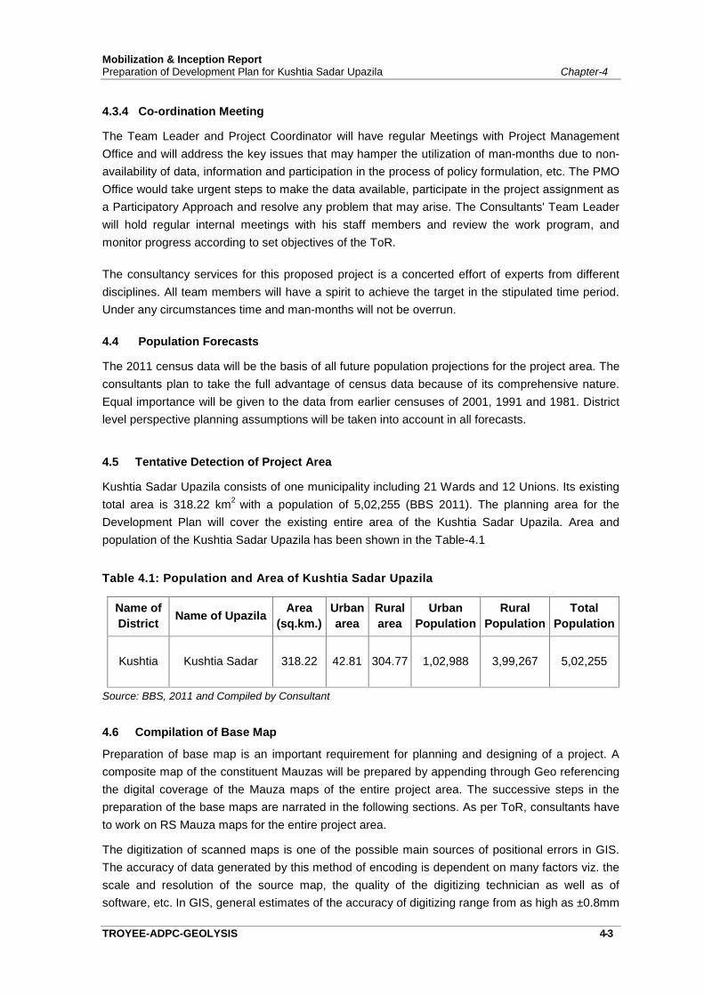
Mobilization & Inception ReportPreparation of Development Plan for Kushtia Sadar Upazila Chapter-4
TROYEE-ADPC-GEOLYSIS 4-3
4.3.4 Co-ordination Meeting
The Team Leader and Project Coordinator will have regular Meetings with Project ManagementOffice and will address the key issues that may hamper the utilization of man-months due to non-availability of data, information and participation in the process of policy formulation, etc. The PMOOffice would take urgent steps to make the data available, participate in the project assignment asa Participatory Approach and resolve any problem that may arise. The Consultants' Team Leaderwill hold regular internal meetings with his staff members and review the work program, andmonitor progress according to set objectives of the ToR.
The consultancy services for this proposed project is a concerted effort of experts from differentdisciplines. All team members will have a spirit to achieve the target in the stipulated time period.Under any circumstances time and man-months will not be overrun.
4.4 Population Forecasts
The 2011 census data will be the basis of all future population projections for the project area. Theconsultants plan to take the full advantage of census data because of its comprehensive nature.Equal importance will be given to the data from earlier censuses of 2001, 1991 and 1981. Districtlevel perspective planning assumptions will be taken into account in all forecasts.
4.5 Tentative Detection of Project Area
Kushtia Sadar Upazila consists of one municipality including 21 Wards and 12 Unions. Its existingtotal area is 318.22 km2 with a population of 5,02,255 (BBS 2011). The planning area for theDevelopment Plan will cover the existing entire area of the Kushtia Sadar Upazila. Area andpopulation of the Kushtia Sadar Upazila has been shown in the Table-4.1
Table 4.1: Population and Area of Kushtia Sadar Upazila
Name ofDistrict Name of Upazila Area
(sq.km.)Urbanarea
Ruralarea
UrbanPopulation
RuralPopulation
TotalPopulation
Kushtia Kushtia Sadar 318.22 42.81 304.77 1,02,988 3,99,267 5,02,255
Source: BBS, 2011 and Compiled by Consultant
4.6 Compilation of Base Map
Preparation of base map is an important requirement for planning and designing of a project. Acomposite map of the constituent Mauzas will be prepared by appending through Geo referencingthe digital coverage of the Mauza maps of the entire project area. The successive steps in thepreparation of the base maps are narrated in the following sections. As per ToR, consultants haveto work on RS Mauza maps for the entire project area.
The digitization of scanned maps is one of the possible main sources of positional errors in GIS.The accuracy of data generated by this method of encoding is dependent on many factors viz. thescale and resolution of the source map, the quality of the digitizing technician as well as ofsoftware, etc. In GIS, general estimates of the accuracy of digitizing range from as high as ±0.8mm
Mobilization & Inception ReportPreparation of Development Plan for Kushtia Sadar Upazila Chapter-4
TROYEE-ADPC-GEOLYSIS 4-4
to as low as ±0.054mm [Reference: Dunn R, Harrison A R, White J C, (1990); Positional accuracyand measurement error in digital database of landuse: an empirical study. International Journal ofGeographical Information Systems 4 (4): 385-98.]
Preparation of project area map comprises the following item of works:
Collection of RS Mauza Maps. Scanning of Mauza Maps. Digitization of Mauza Maps
Step-1: Preparing the Manuscript.
Manuscript-1 : Point Features
Manuscript-2 & 3 : Polygon & Line Features.
Step-2: Converting Digitized Maps Shape or Geo-database format.
Step-3: Edit Plot Check.
Geo-referencing or Projecting of Mauza Maps.
Step-1: Selection of TICs
Step-2: Update TICs
Step-3: Transform Shape or Geo-data from digitized unit to real world coordinate
Preparation of Mosaic Mauza Maps & Demarcating the Administrative and Project Boundary Preparation of Layout of Project area Map. Submission of the Project Area Map and Report
4.6.1 Collection of Mauza Maps
The RS Mauza maps are the basis of the base map for the project area. The project area will bedelineated on Mauza sheets. Mauza maps have been collected from the Deputy Commissioner’sOffice, Kushtia and DLRS covering the entire project area. The Mauza sheets having distortiondue to rapping or pasting of cloths/tape have been avoided during collection of Mauza maps.Original copies of Mauza maps were supposed to be collected. As original Mauza sheets were notavailable, photocopy versions of the same have to be collected from DLRS.
4.6.2 Scanning of Mauza Maps
Large line scanning technology, most suitable for map scanning where distortion and deviation isnearly nil, will be used for scanning Mauza maps. During scanning operation, care shall be takento maintain the geographical north line alignment. Specifications to be used for scanning Mauzamaps are tabulated in Table 4.1. Necessary processing shall be done to get rid of the noises onthe image of unwarranted marks and spots attributed to senile reasons. Also, the technicalspecifications of the scanner to be used for the purpose are provided in Table 4.2. The scannedimage files of each individual Mauza shall be saved in TIFF and JPEG format organized andnamed individually. The tentative nomenclature of image files is provided in Table 4.3. All theimage files of scanned Mauza maps shall be structurally organized and backed up in sufficientnumber of CD electronic media and shall be handed over to Project Director Office of theconcerned project as end product of this exercise.
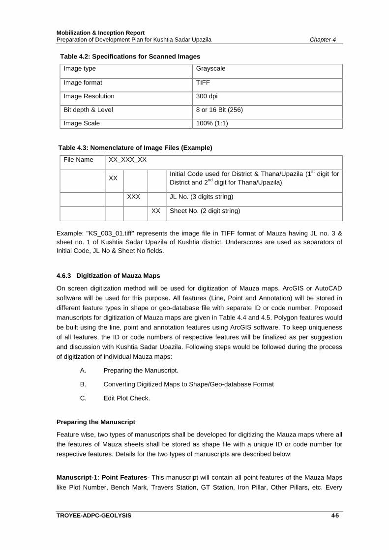
Mobilization & Inception ReportPreparation of Development Plan for Kushtia Sadar Upazila Chapter-4
TROYEE-ADPC-GEOLYSIS 4-5
Table 4.2: Specifications for Scanned Images
Image type Grayscale
Image format TIFF
Image Resolution 300 dpi
Bit depth & Level 8 or 16 Bit (256)
Image Scale 100% (1:1)
Table 4.3: Nomenclature of Image Files (Example)
File Name XX_XXX_XX
XX Initial Code used for District & Thana/Upazila (1st digit forDistrict and 2nd digit for Thana/Upazila)
XXX JL No. (3 digits string)
XX Sheet No. (2 digit string)
Example: "KS_003_01.tiff" represents the image file in TIFF format of Mauza having JL no. 3 &sheet no. 1 of Kushtia Sadar Upazila of Kushtia district. Underscores are used as separators ofInitial Code, JL No & Sheet No fields.
4.6.3 Digitization of Mauza Maps
On screen digitization method will be used for digitization of Mauza maps. ArcGIS or AutoCADsoftware will be used for this purpose. All features (Line, Point and Annotation) will be stored indifferent feature types in shape or geo-database file with separate ID or code number. Proposedmanuscripts for digitization of Mauza maps are given in Table 4.4 and 4.5. Polygon features wouldbe built using the line, point and annotation features using ArcGIS software. To keep uniquenessof all features, the ID or code numbers of respective features will be finalized as per suggestionand discussion with Kushtia Sadar Upazila. Following steps would be followed during the processof digitization of individual Mauza maps:
A. Preparing the Manuscript.
B. Converting Digitized Maps to Shape/Geo-database Format
C. Edit Plot Check.
Preparing the Manuscript
Feature wise, two types of manuscripts shall be developed for digitizing the Mauza maps where allthe features of Mauza sheets shall be stored as shape file with a unique ID or code number forrespective features. Details for the two types of manuscripts are described below:
Manuscript-1: Point Features- This manuscript will contain all point features of the Mauza Mapslike Plot Number, Bench Mark, Travers Station, GT Station, Iron Pillar, Other Pillars, etc. Every
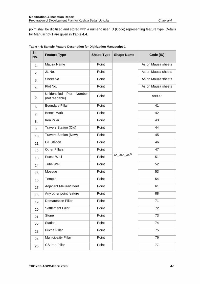
Mobilization & Inception ReportPreparation of Development Plan for Kushtia Sadar Upazila Chapter-4
TROYEE-ADPC-GEOLYSIS 4-6
point shall be digitized and stored with a numeric user ID (Code) representing feature type. Detailsfor Manuscript-1 are given in Table 4.4.
Table 4.4: Sample Feature Description for Digitization Manuscript-1
Sl.No. Feature Type Shape Type Shape Name Code (ID)
1. Mauza Name Point
xx_xxx_xxP
As on Mauza sheets
2. JL No. Point As on Mauza sheets
3. Sheet No. Point As on Mauza sheets
4. Plot No. Point As on Mauza sheets
5.Unidentified Plot Number(not readable) Point 99999
6. Boundary Pillar Point 41
7. Bench Mark Point 42
8. Iron Pillar Point 43
9. Travers Station (Old) Point 44
10. Travers Station (New) Point 45
11. GT Station Point 46
12. Other Pillars Point 47
13. Pucca Well Point 51
14. Tube Well Point 52
15. Mosque Point 53
16. Temple Point 54
17. Adjacent Mauza/Sheet Point 61
18. Any other point feature Point 88
19. Demarcation Pillar Point 71
20. Settlement Pillar Point 72
21. Stone Point 73
22. Station Point 74
23. Pucca Pillar Point 75
24. Municipality Pillar Point 76
25. CS Iron Pillar Point 77
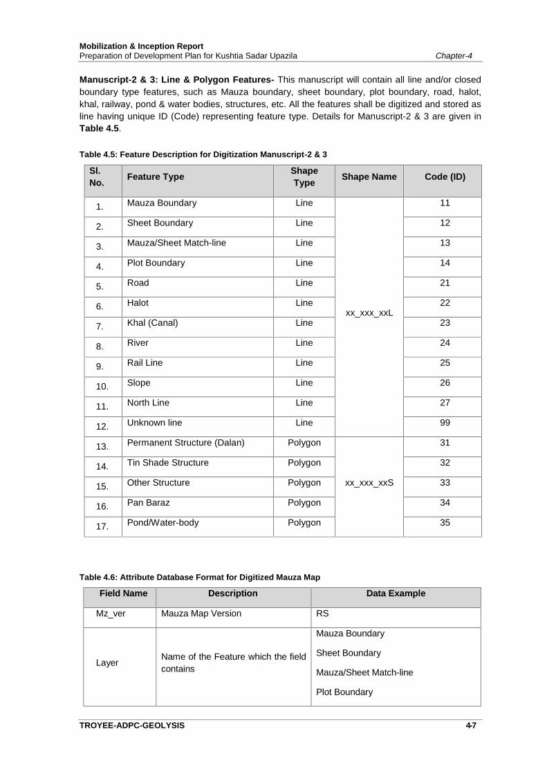
Mobilization & Inception ReportPreparation of Development Plan for Kushtia Sadar Upazila Chapter-4
TROYEE-ADPC-GEOLYSIS 4-7
Manuscript-2 & 3: Line & Polygon Features- This manuscript will contain all line and/or closedboundary type features, such as Mauza boundary, sheet boundary, plot boundary, road, halot,khal, railway, pond & water bodies, structures, etc. All the features shall be digitized and stored asline having unique ID (Code) representing feature type. Details for Manuscript-2 & 3 are given inTable 4.5.
Table 4.5: Feature Description for Digitization Manuscript-2 & 3
Sl.No. Feature Type Shape
Type Shape Name Code (ID)
1. Mauza Boundary Line
xx_xxx_xxL
11
2. Sheet Boundary Line 12
3. Mauza/Sheet Match-line Line 13
4. Plot Boundary Line 14
5. Road Line 21
6. Halot Line 22
7. Khal (Canal) Line 23
8. River Line 24
9. Rail Line Line 25
10. Slope Line 26
11. North Line Line 27
12. Unknown line Line 99
13. Permanent Structure (Dalan) Polygon
xx_xxx_xxS
31
14. Tin Shade Structure Polygon 32
15. Other Structure Polygon 33
16. Pan Baraz Polygon 34
17. Pond/Water-body Polygon 35
Table 4.6: Attribute Database Format for Digitized Mauza Map
Field Name Description Data Example
Mz_ver Mauza Map Version RS
Layer Name of the Feature which the fieldcontains
Mauza Boundary
Sheet Boundary
Mauza/Sheet Match-line
Plot Boundary
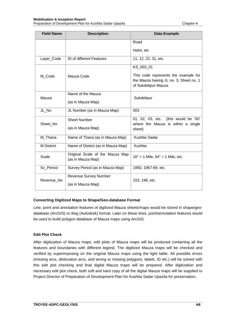
Mobilization & Inception ReportPreparation of Development Plan for Kushtia Sadar Upazila Chapter-4
TROYEE-ADPC-GEOLYSIS 4-8
Field Name Description Data Example
Road
Halot, etc
Layer_Code ID of different Features 11, 12, 22, 31, etc.
M_Code Mauza Code
KS_003_01
This code represents the example forthe Mauza having JL no. 3, Sheet no. 1of Sukdebpur Mauza.
MauzaName of the Mauza
(as in Mauza Map)Sukdebpur
JL_No JL Number (as in Mauza Map) 003
Sheet_NoSheet Number
(as in Mauza Map)
01, 02, 03, etc. (this would be ‘00’where the Mauza is within a singlesheet)
M_Thana Name of Thana (as in Mauza Map) Kushtia Sadar
M District Name of District (as in Mauza Map) Kushtia
Scale Original Scale of the Mauza Map(as in Mauza Map) 16" = 1 Mile, 64" = 1 Mile, etc.
Sv_Period Survey Period (as in Mauza Map) 1950, 1967-69, etc.
Revenue_NoRevenue Survey Number
(as in Mauza Map)153, 196, etc.
Converting Digitized Maps to Shape/Geo-database Format
Line, point and annotation features of digitized Mauza sheets/maps would be stored in shape/geo-database (ArcGIS) or dwg (Autodesk) format. Later on these lines, point/annotation features wouldbe used to build polygon database of Mauza maps using ArcGIS.
Edit Plot Check
After digitization of Mauza maps, edit plots of Mauza maps will be produced containing all thefeatures and boundaries with different legend. The digitized Mauza maps will be checked andverified by superimposing on the original Mauza maps using the light table. All possible errors(missing arcs, dislocation arcs, and wrong or missing polygons, labels, ID etc.) will be solved withthis edit plot checking and final digital Mauza maps will be prepared. After digitization andnecessary edit plot check, both soft and hard copy of all the digital Mauza maps will be supplied toProject Director of Preparation of Development Plan for Kushtia Sadar Upazila for preservation.
Mobilization & Inception ReportPreparation of Development Plan for Kushtia Sadar Upazila Chapter-4
TROYEE-ADPC-GEOLYSIS 4-9
4.6.4 Projecting or Geo-referencing of Mauza Maps
Map projection is the conversion of data from geographical location (latitude and longitude) on asphere or spheroid to a representative location (two dimensional coordinates such as northing andeasting) on a flat surface. A mathematical conversion is used to create a flat map from thespherical surface of earth. This mathematical conversion or transformation of three-dimensionalearth surface into a two dimensional flat map is called ‘Projection’.
Geo-referencing of digitized Mauza sheets/maps is the projection of Mauza maps from digitizedunit to real world coordinate units or transformation of coverage from digitized units to projectedunits. As per meeting minutes of TMC meeting, Universal Transverse Mercator for Bangladeshprojection system (BUTM 2010) shall be used for all spatial data and maps. The detailedparameters of BUTM 2010 projection system is presented below:
Projection System Parameters
Scale : As per ToR Map size : As per ToR Plotting by : GIS software (ArcGIS 10.3 or latest) Projection System : Universal Transverse Mercator for Bangladesh (BUTM 2010) Map Printouts : Plotter Printouts GIS Software : GIS (ArcGIS 10.3) Spheroid (Ellipsoid) : WGS 1984 Datum : WGS 1984 Unit : Meter
Other Parameters
Central Meridian : 90.00000000 Latitude of Projection Origin : 0.00000000 Scale factor : 0.9996 False Easting : 500000.00000000 False Northing : 0.00000000 Vertical Datum : mSoB
Geo-referencing or projection steps to be followed for preparing the digital Mauza map area are asfollows:
A. Selection of TICsB. GCP SurveyC. Update TICsD. Transform Shape or Geo-database from digitized units to real world coordinates
A. Selection of TICS
TIC is a registration or geographic control point (GCP) of coverage. TICs register coveragecoordinates to a common coordinate system (e.g., BTM: Bangladesh Transverse Mercator) and,therefore, relate locations of features in a coverage to locations on the earth’s surface.
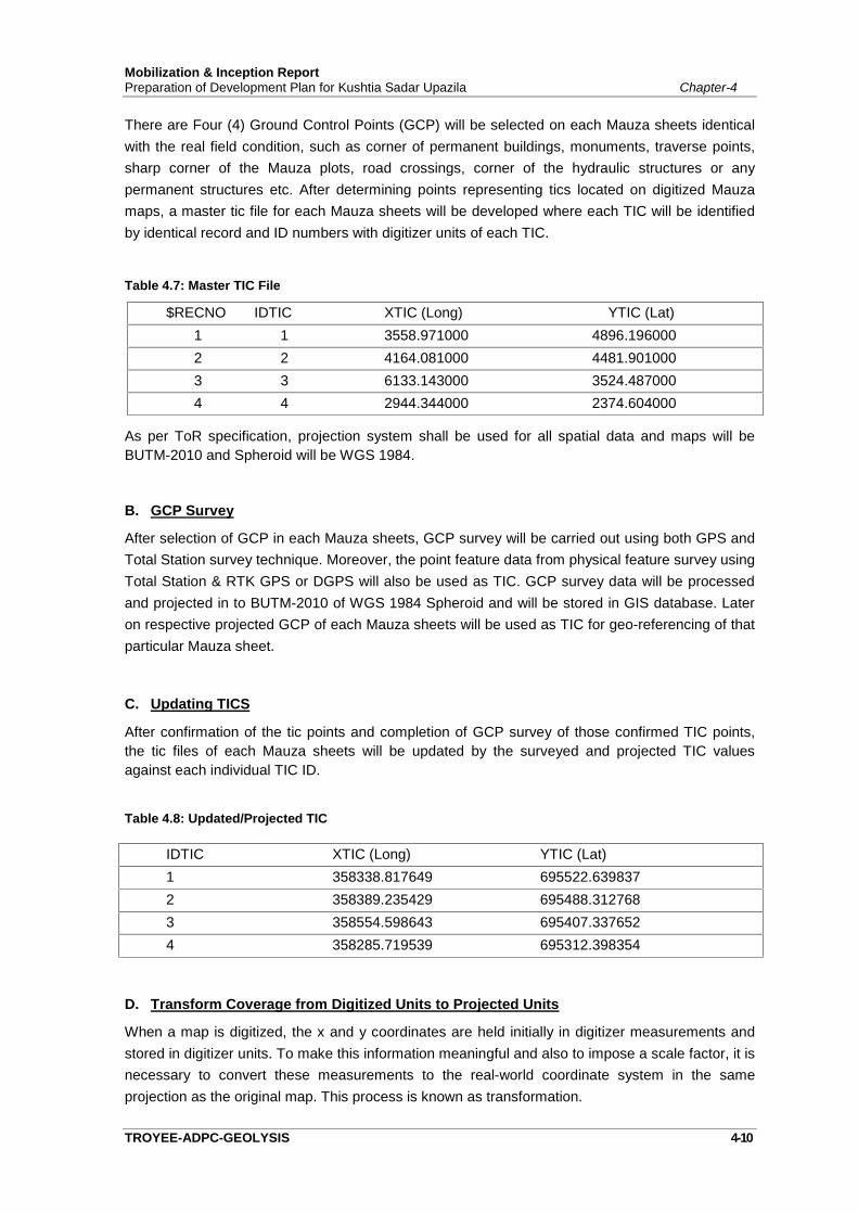
Mobilization & Inception ReportPreparation of Development Plan for Kushtia Sadar Upazila Chapter-4
TROYEE-ADPC-GEOLYSIS 4-10
There are Four (4) Ground Control Points (GCP) will be selected on each Mauza sheets identicalwith the real field condition, such as corner of permanent buildings, monuments, traverse points,sharp corner of the Mauza plots, road crossings, corner of the hydraulic structures or anypermanent structures etc. After determining points representing tics located on digitized Mauzamaps, a master tic file for each Mauza sheets will be developed where each TIC will be identifiedby identical record and ID numbers with digitizer units of each TIC.
Table 4.7: Master TIC File
$RECNO IDTIC XTIC (Long) YTIC (Lat)1 1 3558.971000 4896.1960002 2 4164.081000 4481.9010003 3 6133.143000 3524.4870004 4 2944.344000 2374.604000
As per ToR specification, projection system shall be used for all spatial data and maps will beBUTM-2010 and Spheroid will be WGS 1984.
B. GCP Survey
After selection of GCP in each Mauza sheets, GCP survey will be carried out using both GPS andTotal Station survey technique. Moreover, the point feature data from physical feature survey usingTotal Station & RTK GPS or DGPS will also be used as TIC. GCP survey data will be processedand projected in to BUTM-2010 of WGS 1984 Spheroid and will be stored in GIS database. Lateron respective projected GCP of each Mauza sheets will be used as TIC for geo-referencing of thatparticular Mauza sheet.
C. Updating TICS
After confirmation of the tic points and completion of GCP survey of those confirmed TIC points,the tic files of each Mauza sheets will be updated by the surveyed and projected TIC valuesagainst each individual TIC ID.
Table 4.8: Updated/Projected TIC
IDTIC XTIC (Long) YTIC (Lat)1 358338.817649 695522.6398372 358389.235429 695488.3127683 358554.598643 695407.3376524 358285.719539 695312.398354
D. Transform Coverage from Digitized Units to Projected Units
When a map is digitized, the x and y coordinates are held initially in digitizer measurements andstored in digitizer units. To make this information meaningful and also to impose a scale factor, it isnecessary to convert these measurements to the real-world coordinate system in the sameprojection as the original map. This process is known as transformation.
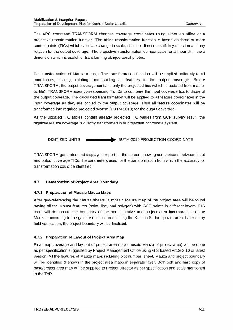
Mobilization & Inception ReportPreparation of Development Plan for Kushtia Sadar Upazila Chapter-4
TROYEE-ADPC-GEOLYSIS 4-11
The ARC command TRANSFORM changes coverage coordinates using either an affine or aprojective transformation function. The affine transformation function is based on three or morecontrol points (TICs) which calculate change in scale, shift in x direction, shift in y direction and anyrotation for the output coverage. The projective transformation compensates for a linear tilt in the zdimension which is useful for transforming oblique aerial photos.
For transformation of Mauza maps, affine transformation function will be applied uniformly to allcoordinates, scaling, rotating, and shifting all features in the output coverage. BeforeTRANSFORM, the output coverage contains only the projected tics (which is updated from mastertic file). TRANSFORM uses corresponding Tic IDs to compare the input coverage tics to those ofthe output coverage. The calculated transformation will be applied to all feature coordinates in theinput coverage as they are copied to the output coverage. Thus all feature coordinates will betransformed into required projected system (BUTM-2010) for the output coverage.
As the updated TIC tables contain already projected TIC values from GCP survey result, thedigitized Mauza coverage is directly transformed in to projection coordinate system.
DIGITIZED UNITS BUTM-2010 PROJECTION COORDINATE
TRANSFORM generates and displays a report on the screen showing comparisons between inputand output coverage TICs, the parameters used for the transformation from which the accuracy fortransformation could be identified.
4.7 Demarcation of Project Area Boundary
4.7.1 Preparation of Mosaic Mauza Maps
After geo-referencing the Mauza sheets, a mosaic Mauza map of the project area will be foundhaving all the Mauza features (point, line, and polygon) with GCP points in different layers. GISteam will demarcate the boundary of the administrative and project area incorporating all theMauzas according to the gazette notification outlining the Kushtia Sadar Upazila area. Later on byfield verification, the project boundary will be finalized.
4.7.2 Preparation of Layout of Project Area Map
Final map coverage and lay out of project area map (mosaic Mauza of project area) will be doneas per specification suggested by Project Management Office using GIS based ArcGIS 10 or latestversion. All the features of Mauza maps including plot number, sheet, Mauza and project boundarywill be identified & shown in the project area maps in separate layer. Both soft and hard copy ofbase/project area map will be supplied to Project Director as per specification and scale mentionedin the ToR.
Mobilization & Inception ReportPreparation of Development Plan for Kushtia Sadar Upazila Chapter-4
TROYEE-ADPC-GEOLYSIS 4-12
4.7.3 Submission of the Project Area Map and Report
A Project area Map along with the Report as per specification in ToR will be prepared andsubmitted. The Report will cover the following items:
Methodology for BM establishment, Methodology of GCP Survey. Methodology of collecting, scanning, digitizing & geo-referencing of Mauza maps. Methodology of Demarcating Project area.
4.8 Physical Surveys (Topographic, Physical Feature and Landuse Survey)
As per ToR specification and requirement, Physical Surveys will cover the following items:
Physical Features Survey, Topographic and Infrastructures Survey and Landuse Survey.
Detailed methodologies of conducting physical surveys are described in the following sectionsbelow.
4.8.1 Mobilization of Survey Team
Survey Manager along with survey & equipment experts, GPS and Total Station surveyors will bemobilized immediately after approval of the Mobilization and Inception Report (methodology &work plan) by the project authority of Kushtia Sadar Upazila.
4.8.2 Equipment, Hardware and Software to be used
A large number of advanced survey equipment’s including Unmanned Aerial Vehicle (UAV), RealTime Kinematic Global Positioning System (RTK-GPS) and Differential Global Positioning System(DGPS), Total Station (TS), Digital Levels will be deployed for conducting topographic, physicalfeature & landuse surveys. A local area network (LAN) comprising numbers of desktop computerswith processor speed of Core I3 and I5, colored printer, plotter and scanner will be used for dataprocessing and mapping purposes at Dhaka office.

Mobilization & Inception ReportPreparation of Development Plan for Kushtia Sadar Upazila Chapter-4
TROYEE-ADPC-GEOLYSIS 4-13
Photograph-4.1: UAV/Drone to be used for Kushtia Sadar Upazila Development Plan Survey
4.8.3 Methodology of Physical Surveys (Topographic, Physical Feature & Landuse)
Unmanned Aerial Vehicle (UAV)/Drone based on advanced survey technique will be used forconducting physical feature, topographic, physical infrastructure and land use survey. Relevantsurvey techniques to be used for conducting all types of physical surveys are narrated below:
A. Flight Planning
UAV flight planning is comprised of the following steps:
a. Conversion of project requirements to specifications in terms of area to be mapped,desired map scale and contour interval. The determination of these specifications dependson the required accuracy of the final map and on cost constraints. More accurate maps aremore costly and take longer to compile.
b. Determination of photogrammetric specifications in terms of flight height, the number ofphotographs needed the number of strips needed, flight lines, approximate location forexposure stations, and equipment to be used. Specifications should also be developed forground control, aerial triangulation, and compilation methodology.
c. Development of a schedule for aerial photography, field work, and map compilation. Theschedule should be coordinated among the various groups involved in the project. Acritical coordination is between the field crew placing the targets and the aerialphotography crew. Targets should be placed as close as possible to the time ofphotography. A project timetable with completion dates for different tasks and theapproximate cost associated with them should be developed as well.
d. Defining the expected deliverables, including details on what features are to be mappedand their graphic representation.
Mobilization & Inception ReportPreparation of Development Plan for Kushtia Sadar Upazila Chapter-4
TROYEE-ADPC-GEOLYSIS 4-14
B. Aerial Photography
The aerial photography process consists of the following:
a. Verify that the weather conditions are suitable for flying. Flying under conditions of lowvisibility or potential strong turbulence should be avoided. Bad weather conditions couldnot only produce unacceptable photographic results, but also risk the flying crew. Thefollowing procedure will be performed in order to:
b. Mount the aerial camera according to the established procedure. Test the camera toensure that it functions properly.
c. Fly the designed routes and take the photographs according to plans.
d. Process the film according to specification to ensure radio metrically and geometricallyquality images.
e. If necessary, print on the negatives the missing photo information (titles), such as serialnumber, date, project information, etc.
f. Inspect the photographs for image quality and for coverage completeness. Verify that allthe photographs have enough end laps to assure stereoscopic coverage of the entireproject area. A similar inspection should be made to verify complete side lap coverage.Incomplete end and side lap coverage or coverage gaps could void the entire aerialphotography and require re-planning or re-flying. Another inspection that has to be madeis identifying the preset targets. Target inspection includes checking whether they arevisible; appear in a stereo coverage and whether there are enough of them to ensurereliable results. If some targets are missing, or the entire project was not targeted, pointsthat can be identified and surveyed on the ground should be selected and marked onpaper prints. A copy of the prints and a description of the points selected should then besubmitted to the surveying crew for field measurements.
g. Select photographs that will be used for data compilation and develop.
C. Ground Control
The second element of the photogrammetric process is control, which is used to establish theposition and orientation of the camera at the instant of exposure. The necessity, accuracy and therigor of photogrammetric control depends on the particular product sought. Photo mosaics used forannotation, cultural studies, public meetings, and other varied purposes may not require anycontrol. Rectified aerial photographs, used mainly for photo plan sheets, may require partial controlin the form of measured distances. Field measured distances are scaled down to matchcorresponding distances on the photograph. However, most common photogrammetric products,such as mapping and ortho photography, require full control (x, y, z) information. The minimum fullcontrol to establish a stereo model is two points (x, y) with known horizontal positions (for scaling)and three points (x, y, z) with known elevations (for orientation). Using this bare minimum isunacceptable; therefore, additional control is required for a processing a stereo model.
The following Technique to be used for Ground Control:
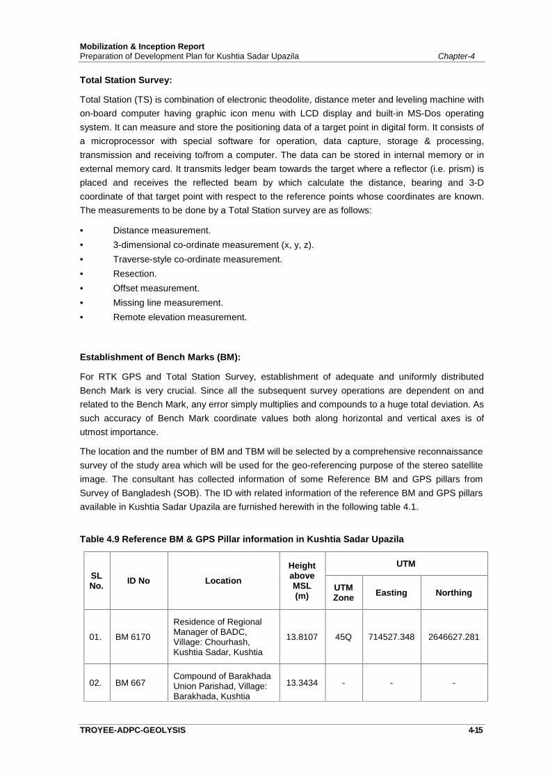
Mobilization & Inception ReportPreparation of Development Plan for Kushtia Sadar Upazila Chapter-4
TROYEE-ADPC-GEOLYSIS 4-15
Total Station Survey:
Total Station (TS) is combination of electronic theodolite, distance meter and leveling machine withon-board computer having graphic icon menu with LCD display and built-in MS-Dos operatingsystem. It can measure and store the positioning data of a target point in digital form. It consists ofa microprocessor with special software for operation, data capture, storage & processing,transmission and receiving to/from a computer. The data can be stored in internal memory or inexternal memory card. It transmits ledger beam towards the target where a reflector (i.e. prism) isplaced and receives the reflected beam by which calculate the distance, bearing and 3-Dcoordinate of that target point with respect to the reference points whose coordinates are known.The measurements to be done by a Total Station survey are as follows:
Distance measurement. 3-dimensional co-ordinate measurement (x, y, z). Traverse-style co-ordinate measurement. Resection. Offset measurement. Missing line measurement. Remote elevation measurement.
Establishment of Bench Marks (BM):
For RTK GPS and Total Station Survey, establishment of adequate and uniformly distributedBench Mark is very crucial. Since all the subsequent survey operations are dependent on andrelated to the Bench Mark, any error simply multiplies and compounds to a huge total deviation. Assuch accuracy of Bench Mark coordinate values both along horizontal and vertical axes is ofutmost importance.
The location and the number of BM and TBM will be selected by a comprehensive reconnaissancesurvey of the study area which will be used for the geo-referencing purpose of the stereo satelliteimage. The consultant has collected information of some Reference BM and GPS pillars fromSurvey of Bangladesh (SOB). The ID with related information of the reference BM and GPS pillarsavailable in Kushtia Sadar Upazila are furnished herewith in the following table 4.1.
Table 4.9 Reference BM & GPS Pillar information in Kushtia Sadar Upazila
SLNo. ID No Location
HeightaboveMSL(m)
UTM
UTMZone Easting Northing
01. BM 6170
Residence of RegionalManager of BADC,Village: Chourhash,Kushtia Sadar, Kushtia
13.8107 45Q 714527.348 2646627.281
02. BM 667Compound of BarakhadaUnion Parishad, Village:Barakhada, Kushtia
13.3434 - - -
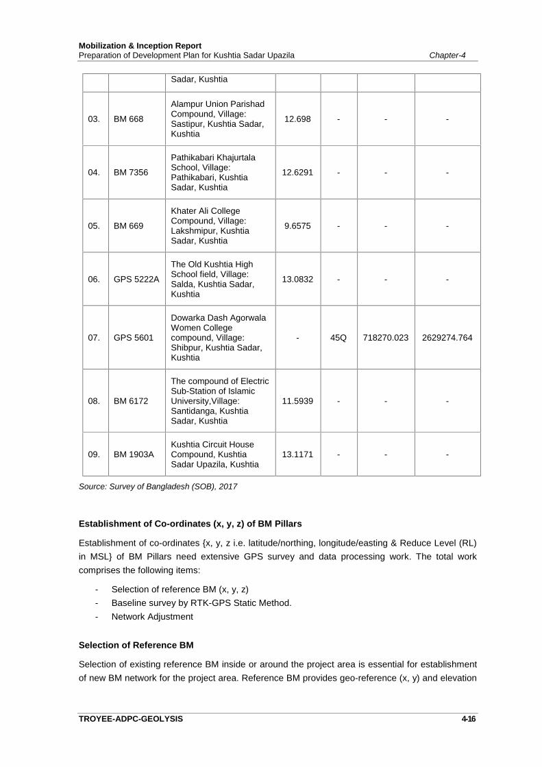
Mobilization & Inception ReportPreparation of Development Plan for Kushtia Sadar Upazila Chapter-4
TROYEE-ADPC-GEOLYSIS 4-16
Sadar, Kushtia
03. BM 668
Alampur Union ParishadCompound, Village:Sastipur, Kushtia Sadar,Kushtia
12.698 - - -
04. BM 7356
Pathikabari KhajurtalaSchool, Village:Pathikabari, KushtiaSadar, Kushtia
12.6291 - - -
05. BM 669
Khater Ali CollegeCompound, Village:Lakshmipur, KushtiaSadar, Kushtia
9.6575 - - -
06. GPS 5222A
The Old Kushtia HighSchool field, Village:Salda, Kushtia Sadar,Kushtia
13.0832 - - -
07. GPS 5601
Dowarka Dash AgorwalaWomen Collegecompound, Village:Shibpur, Kushtia Sadar,Kushtia
- 45Q 718270.023 2629274.764
08. BM 6172
The compound of ElectricSub-Station of IslamicUniversity,Village:Santidanga, KushtiaSadar, Kushtia
11.5939 - - -
09. BM 1903AKushtia Circuit HouseCompound, KushtiaSadar Upazila, Kushtia
13.1171 - - -
Source: Survey of Bangladesh (SOB), 2017
Establishment of Co-ordinates (x, y, z) of BM Pillars
Establishment of co-ordinates {x, y, z i.e. latitude/northing, longitude/easting & Reduce Level (RL)in MSL} of BM Pillars need extensive GPS survey and data processing work. The total workcomprises the following items:
- Selection of reference BM (x, y, z)- Baseline survey by RTK-GPS Static Method.- Network Adjustment
Selection of Reference BM
Selection of existing reference BM inside or around the project area is essential for establishmentof new BM network for the project area. Reference BM provides geo-reference (x, y) and elevation
Mobilization & Inception ReportPreparation of Development Plan for Kushtia Sadar Upazila Chapter-4
TROYEE-ADPC-GEOLYSIS 4-17
(z) with respect to a datum i.e. the co-ordinates of the BM pillars. For establishing co-ordinates ofthe new BMs, the available SoB BMs of the project area has already been identified.
D. Aerial Triangulation
Aerial triangulation, or aero-triangulation, is the process of determining X, Y, and Z groundcoordinates of individual points based on measurements from photographs. Aerial triangulation isused extensively for many purposes. One of the principal applications is densifying ground controlthrough strips or a block of photos to be used in subsequent photogrammetric operations. Whenused for this purpose it is often called bridging, because it allows the computation of necessarycontrol points between those measured in the field. In a large project, with dozens of photographs,the effort and cost of providing the needed control using field surveys is prohibitive. Aerialtriangulation is used to provide the necessary control for each stereo model with only a limitednumber of field surveyed control point. Other advantages of aerial triangulation are:
- The control densification is done in the office, thus minimizing delays and hardships due toadverse weather conditions.
- Field surveys in difficult or unsafe areas are minimized.- Access to much of the (private or public) property within a project area is not required.- The aerial triangulation process provides accuracy and consistency checks for the field
surveyed control points.
E. Stereo Compilation
The most commonly used photogrammetric instrument is the stereo plotter. A stereo plotter isused to reconstruct the actual orientation and geometric integrity of an image at the instant ofexposure and to collect three-dimensional (3D) data. Data collection with a stereo plotter is a two-stage process. The first stage is orientation, which consists of:
1. Inner orientation – Orient each photograph with respect to the geometry of the camera.2. Relative orientation – Orient two photographs with respect to each other to form a stereo
model.3. Absolute orientation – Orient and scale the stereo model to the ground. In some
instruments the relative and absolute orientation are performed simultaneously. Thesimultaneous solution of these orientations is called exterior orientation.
In the second stage, the operator views the image of the ground in 3D. Data collection is performsby placing a floating mark on the images of the feature that is surveyed and record its X,Y,Zcoordinates. Line features, such as roads or contours, can be digitized, point by point, or tracedand recorded continuously.
F. Stereoscopic Data Collection and Mapping
Photogrammetry can be used to collect a variety of data, presented in the following formats:
Planimetric maps – Planimetric maps are map that represents only the horizontal features of themapped area. Planimetric maps display features such as roads, sidewalks, buildings, river banks,shore lines, manholes, trees etc. No elevation information appears on planimetric maps.
Mobilization & Inception ReportPreparation of Development Plan for Kushtia Sadar Upazila Chapter-4
TROYEE-ADPC-GEOLYSIS 4-18
Topographic maps – Topographic maps are maps on which both horizontal and vertical featuresof the mapped are represented. In addition to the above mentioned planimetric features, atopographic map depicts elevation information as contours and/or as spot elevations.
DEM's – Digital Elevation Model (DEM) or Digital Terrain Model (DTM) are dense networks of spotelevations represented by X, Y, Z coordinates. The DEM points are collected in a regular grid withbreak points which depict the characteristics of the topography. DEM's are used to draw contoursand are an essential ingredient for the production of orthophotos.
In highway applications, DEMS can be used for producing cross sections, road profiles, and earthwork computations. The advantage of using DEM's for volume computations is that thecomputation and the generation of the associated plots are almost automatic if the design wasmade under the same coordinate system. This is another good reason to use state planecoordinates and a unique elevation datum in all work. One should be aware that an appropriatephoto scale must be used to obtain centimeter level elevations.
Special purpose maps – Special purpose maps are maps that are designed to meet specialneeds or depict a special theme. The rule is that if you can see it on the aerial photograph, you canmap it with photogrammetry. For example, a right-of-way map can be produced if all propertycorners are either targeted or can be identified on the photographs. Another example is a wetlandmap showing the delineation of wetland areas.
G. Monoscoping Mapping and Updates
Aerial photographs can be used to produce photomaps mainly for indexing, referencing andgeneral studies. Photomaps can be composed of a single photograph or of several photo partsmosaicked together. This is not an accurate metric product, but serves as a valuable means topresent spatial information.
Monoscopic based photogrammetry is also used for minor updates of maps. The update thatresults from this process is of a lesser accuracy and is intended more for maintaining featureinventory at an approximate spatial location. Map updates are accomplished by locally rubbersheeting (superimposing) the photographic image and the map. A few common features areidentified on the map and on the photograph. The photograph is then scaled and/or tilted to locallymatch the corresponding features.
H. Field Completion
Photogrammetry can be used for mapping only what is visible on the photographs. Thus, ifimportant features are obscured by trees, man-made structures or steep topography, they cannotbe mapped. Therefore, a field completion activity has to take place to map the missing features.The field completion phase of the project should be used for accuracy testing of the map.
I. Drafting
Drafting of photogrammetrically derived maps is performed with CAD software. It consists of thefollowing:
Sheet Layout
Mobilization & Inception ReportPreparation of Development Plan for Kushtia Sadar Upazila Chapter-4
TROYEE-ADPC-GEOLYSIS 4-19
Sheet Format Scale Change Edit and Final Corrections
All of these parameters should be part of the project specifications and should be performedaccordingly.
J. Accuracy and Errors
The attainable accuracy of a photogrammetric product depends on two main factors. The first isthe scale of the photographs from which the product is derived and the second is related to errorsin the photogrammetric process.
The scale of the photograph determines the ground resolution. If the smallest identifiable groundfeature on the photograph is a 0.1 m2 (1 ft2) object, then the mapping accuracy from thisphotograph, assuming perfect data compilation, is limited to no better than 0.3 m (±1 ft). Selectingthe appropriate photo scale for a particular product depends on product specifications. Forexample, the photo scale for topographic mapping is a function of the required map scale, thecontour interval, and the quality of the photogrammetric plotter. A required accuracy can be met byeither using smaller scale photographs and high-quality equipment or larger scale photos with lessaccurate photogrammetric equipment. The photo scale is always smaller than the map scale butthe ratio between these two scales should never be larger than eight.
The second factor controlling the accuracy of a photogrammetric product is the total amount oferrors accumulated during its derivation. In photogrammetry, as in any other surveying andmapping procedures, there are systematic errors and random errors, assuming all blunders havebeen removed.
K. Quality Control
A final report on the quality and accuracy of the maps should accompany the submission of thefinal product. The report should review the accuracy of the control. The procedure used todetermine the map's spatial and content accuracy should be documented as well. A statement,such as “this map meets the National Map Accuracy Standards” or “this map meets the projectrequirements”, is unacceptable. Any claim of accuracy or standard must be substantiated by anactual test and analysis. The testing methodology used and the findings of its implementationshould be documented in a final report.
L. Accuracy and Quality Issues of Photogrammetry
The elements that contribute errors to an orthophoto product are:
- Camera (characteristics and calibration)
- Scanner (characteristics calibration and resolution or image scale)
- Ground Control (accuracy, distribution, and abundance)
- Aerial Triangulation (design, measurement, and computation)
- Digital Elevation Modeling (DEM) - (method of compilation; quality of the source material;characteristics of the terrain; sampling spacing, with or without break lines; type of break lines
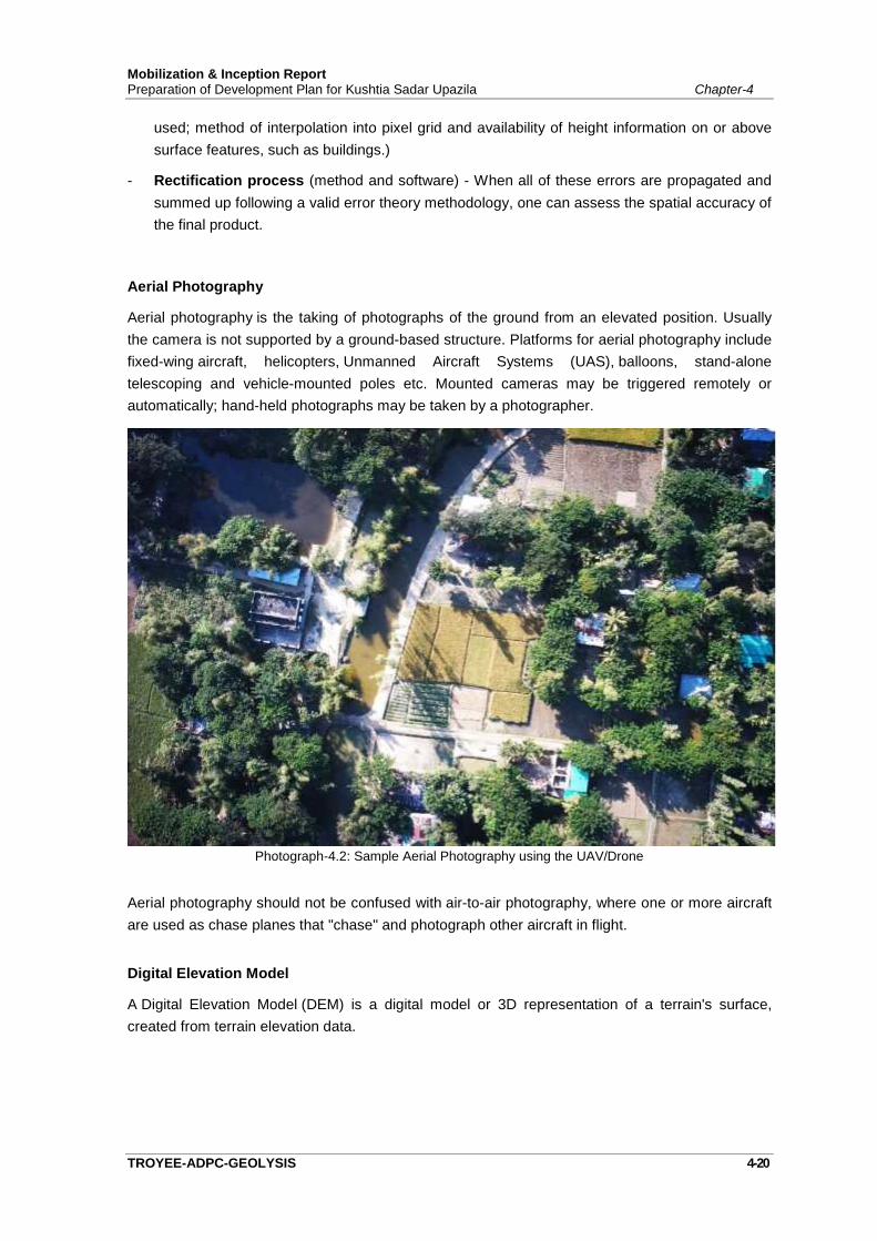
Mobilization & Inception ReportPreparation of Development Plan for Kushtia Sadar Upazila Chapter-4
TROYEE-ADPC-GEOLYSIS 4-20
used; method of interpolation into pixel grid and availability of height information on or abovesurface features, such as buildings.)
- Rectification process (method and software) - When all of these errors are propagated andsummed up following a valid error theory methodology, one can assess the spatial accuracy ofthe final product.
Aerial Photography
Aerial photography is the taking of photographs of the ground from an elevated position. Usuallythe camera is not supported by a ground-based structure. Platforms for aerial photography includefixed-wing aircraft, helicopters, Unmanned Aircraft Systems (UAS), balloons, stand-alonetelescoping and vehicle-mounted poles etc. Mounted cameras may be triggered remotely orautomatically; hand-held photographs may be taken by a photographer.
Photograph-4.2: Sample Aerial Photography using the UAV/Drone
Aerial photography should not be confused with air-to-air photography, where one or more aircraftare used as chase planes that "chase" and photograph other aircraft in flight.
Digital Elevation Model
A Digital Elevation Model (DEM) is a digital model or 3D representation of a terrain's surface,created from terrain elevation data.
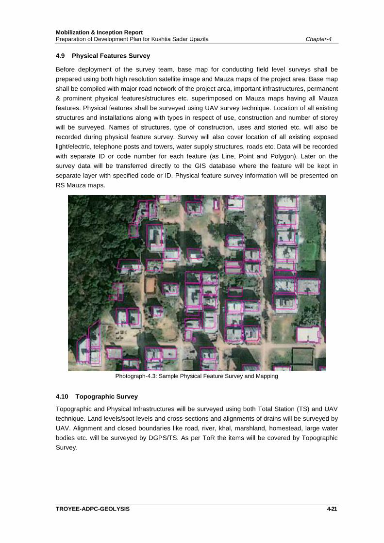
Mobilization & Inception ReportPreparation of Development Plan for Kushtia Sadar Upazila Chapter-4
TROYEE-ADPC-GEOLYSIS 4-21
4.9 Physical Features Survey
Before deployment of the survey team, base map for conducting field level surveys shall beprepared using both high resolution satellite image and Mauza maps of the project area. Base mapshall be compiled with major road network of the project area, important infrastructures, permanent& prominent physical features/structures etc. superimposed on Mauza maps having all Mauzafeatures. Physical features shall be surveyed using UAV survey technique. Location of all existingstructures and installations along with types in respect of use, construction and number of storeywill be surveyed. Names of structures, type of construction, uses and storied etc. will also berecorded during physical feature survey. Survey will also cover location of all existing exposedlight/electric, telephone posts and towers, water supply structures, roads etc. Data will be recordedwith separate ID or code number for each feature (as Line, Point and Polygon). Later on thesurvey data will be transferred directly to the GIS database where the feature will be kept inseparate layer with specified code or ID. Physical feature survey information will be presented onRS Mauza maps.
Photograph-4.3: Sample Physical Feature Survey and Mapping
4.10 Topographic Survey
Topographic and Physical Infrastructures will be surveyed using both Total Station (TS) and UAVtechnique. Land levels/spot levels and cross-sections and alignments of drains will be surveyed byUAV. Alignment and closed boundaries like road, river, khal, marshland, homestead, large waterbodies etc. will be surveyed by DGPS/TS. As per ToR the items will be covered by TopographicSurvey.
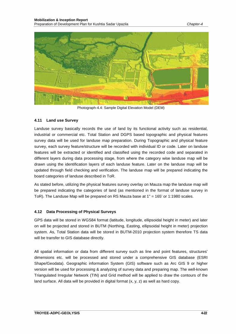
Mobilization & Inception ReportPreparation of Development Plan for Kushtia Sadar Upazila Chapter-4
TROYEE-ADPC-GEOLYSIS 4-22
Photograph-4.4: Sample Digital Elevation Model (DEM)
4.11 Land use Survey
Landuse survey basically records the use of land by its functional activity such as residential,industrial or commercial etc. Total Station and DGPS based topographic and physical featuressurvey data will be used for landuse map preparation. During Topographic and physical featuresurvey, each survey feature/structure will be recorded with individual ID or code. Later on landusefeatures will be extracted or identified and classified using the recorded code and separated indifferent layers during data processing stage, from where the category wise landuse map will bedrawn using the identification layers of each landuse feature. Later on the landuse map will beupdated through field checking and verification. The landuse map will be prepared indicating theboard categories of landuse described in ToR.
As stated before, utilizing the physical features survey overlay on Mauza map the landuse map willbe prepared indicating the categories of land (as mentioned in the format of landuse survey inToR). The Landuse Map will be prepared on RS Mauza base at 1" = 165' or 1:1980 scales.
4.12 Data Processing of Physical Surveys
GPS data will be stored in WGS84 format (latitude, longitude, ellipsoidal height in meter) and lateron will be projected and stored in BUTM (Northing, Easting, ellipsoidal height in meter) projectionsystem. As, Total Station data will be stored in BUTM-2010 projection system therefore TS datawill be transfer to GIS database directly.
All spatial information or data from different survey such as line and point features, structures’dimensions etc. will be processed and stored under a comprehensive GIS database (ESRIShape/Geodata). Geographic information System (GIS) software such as Arc GIS 9 or higherversion will be used for processing & analyzing of survey data and preparing map. The well-knownTriangulated Irregular Network (TIN) and Grid method will be applied to draw the contours of theland surface. All data will be provided in digital format (x, y, z) as well as hard copy.
Mobilization & Inception ReportPreparation of Development Plan for Kushtia Sadar Upazila Chapter-4
TROYEE-ADPC-GEOLYSIS 4-23
4.12.1 Preparation of Physical Survey Maps
Geographic information System (GIS) software such as ArcGIS 10.1 will be used for processing ofphysical survey data. As there is no mention in the ToR regarding the legend, layout and otherspecification of physical survey maps (layout, size etc.) will be finalized in consultation with theproject authority of Kushtia Sadar Upazila during map preparation process, the well-knownTriangulated Irregular Network (TIN) method will be applied to draw contour lines. AS per ToR theconsultants will prepare the survey maps incorporating the features of RS Mauza maps and otherfeatures as mentioned in the Survey Formats (Physical Feature, Landuse, Topographic andPhysical Infrastructure Survey Format). Both soft and hard format will be supplied according toformat of Base Map, Physical Feature, Landuse and others maps as provided in the ToR.
4.12.2 Field Verification of Physical Survey Maps
After preparation of physical survey maps, one set of colored maps (topographic and physicalinfrastructure, physical feature and landuse) will be plotted in 1:1980 scales for field levelverification. The field level checking will be supervised and monitored by the joint team of KushtiaSadar Upazila and consultants.
4.12.3 Updating and Finalization of Physical Survey Maps
Based on field verification, the necessary updating of physical survey maps will be done and finalmap layout will be produced for submission to Kushtia Sadar Upazila. Before preparing final maplayout, necessary approval on draft map layout will be taken from Kushtia Sadar Upazila on title,legend and size of the maps.
4.13 Traffic and Transportation Survey
Transportation linkages are integral to any settlement planning. In fact the growth anddevelopment of towns and cities are so much dependent on the condition of the transportation,that any deterioration in the later automatically signify decline of the respective towns. Position isalso true in the sense that improved transportation enhances the growth possibilities of thesettlements falling in their alignments. History is replete with examples of this relationship of riseand fall of great cities with change in communication linkages. Detailed study of present availabilityand future development prospects of transportation is therefore of paramount importance. Thefollowing paragraphs stand witness to our concern of these vital aspects.
The project area is served by two modes: road and railway transportation and the study will coverall the modes. The consultants will collect, collate and review all relevant data from the paststudies and reports on traffic. Reviewing this information will help identify the data gaps and thedata need for and extent of additional surveys and investigations require preparing report.
The Activities to be performed:
Household Interview Survey: to collect information of travel behavior both for urban and ruralareas
Mobilization & Inception ReportPreparation of Development Plan for Kushtia Sadar Upazila Chapter-4
TROYEE-ADPC-GEOLYSIS 4-24
Identification of critical transport links and hubs in the study area: through physical featuresurvey and FGD with development authorities
Identification of traffic hotspots: for congestion and heavy traffic Freight Survey: it will be performed by combined survey at Entry/Exit points and with freight
transport association and business association Analyze the landuse and activity pattern to rhetoric between them Assessment of external links and adjacent activities Water transport: present connectivity and passenger/fright volume and potential routes and
infrastructure Rail Transport: passenger and freight volume from local and regional destination Traffic survey: at critical intersection during peak hours on a neutral day Public Transport Survey: identification of routes, frequency and modal practices OD Survey: at entry/exit location and at terminals both for passenger and freight Address any plan, program, and project by other agencies Prepare a transport plan compatible with landuse and development schemes
There is no airport in the study area or on its vicinity. So, study on Air Transport has been dropped.
4.13.1 Transportation Infrastructure and Facilities
This component of information is essentially the preparation of an inventory of the existing facilitiesavailable in the study area for the transportation of passengers and goods by all the modes ofroad, rail and river. The infrastructure data gathering program will fall into these three modalgroups. The required information will be collected from the relevant authorities as well as fieldsurveys to be conducted by the consultants. In addition to these data gathering exercise fromprimary and secondary sources, an overview appraisal will be developed of the interaction ofmodel groups, particularly in relation to spatial development pattern and future development. Theconsultant will review existing information and where necessary carry out surveys to obtain furtherinformation on available facilities for the two modes in the area. Major information to be collectedby mode is mentioned below:
I Road
• Road network by hierarchy,• Physical condition of roads (row, x-sectional elements, pavement type and condition etc.),• Geometrics of major road intersections,• Truck routes, and their loading and unloading areas,• Bus route and terminals,• Traffic control, management, and signaling, and• Parking
II Railway
• Location of existing station• Physical condition of facilities• Railway route• Inter model transfer facilities• Passenger volume and their OD
Mobilization & Inception ReportPreparation of Development Plan for Kushtia Sadar Upazila Chapter-4
TROYEE-ADPC-GEOLYSIS 4-25
II Water
• Location of existing terminals for passenger and freight• Frequency and type of vessel• Routes
4.13.2 Transportation Fleets and Services
In addition to the physical infrastructure and facilities, information will be obtained on thetransportation services and fleets operating within the study area. Most of this information will becollected from various recognized authorities for different types of vehicles and their owners andoperators associations. However some field surveys and verifications will be required speciallyrelated to non-motorized vehicles. Major information to be collected by mode includes thefollowing.
I Road
• Number of motorized vehicles by their types, condition and ownership,• Number of buses by route,• Extent of and forms of public transportation services, their service conditions, fare
levels etc.,• Number of trucks, their condition and ownership,• Number of tempos and their service route, fare level, extent of service,• Number of rickshaws and fare levels,• Number of all other types of NMVs,• Types of goods carried, and• Information on cost by different modes
II Railway
• Number, types, condition, and capacity of rails operating in the study area.• Services operated and their frequency• Types of goods carrier• Cost
The summarized information collected on completion of the activity will also form a part of thereport on the proposed traffic and transportation study to be carried out under the project.
4.13.3 Volume and Movement Patterns
To determine traffic volume in important roads within the project area and entry and exit points, theconsultants will carry out a traffic survey. For this purpose appropriate forms will be designed anddetailed work plan will be prepared. Origin and Destination survey will be carried out in the projectand its surrounding area to determine the direction of flow of traffic and its impact of particularareas.
In addition to collecting information on volume and pattern of traffic movement by traffic surveys,the consultants will try to accommodate certain important questions regarding people’s attitude.

Mobilization & Inception ReportPreparation of Development Plan for Kushtia Sadar Upazila Chapter-4
TROYEE-ADPC-GEOLYSIS 4-26
The methodology to be followed to determine volume and movement pattern of traffic arediscussed below:
I. Road
The road side interview method will be followed. With the assistance of the police, vehicles of alltypes will be stopped and questioned regarding their origin and destination and other journey data.The surveyors will enter all these information’s in a preceded form.
The interview sites will be located as near as possible to the zone boundaries. Each interviewteam will be consisted of five members, two members for each direction and a team leader. Ineach direction one member will be for making a classified count of all vehicles and pedestrianspassing, and the other member conducting the actual interviews. Mutual hand-held counters willbe used for counting purpose. Sampling procedure will be used for taking interviews. Sample sizeand survey hours will be determined from field conditions. Depending on field conditions in mostlocations, survey hours will be between 12-18 hours. A parking survey will also be carried out atmajor parking locations to determine accumulation, parking duration, turnover utilization, extent ofillegal parking and cordon counts to determine net vehicles in core zones.
II Railway
Direct counting of arriving and departing passengers in the study area will be conducted at thestations. These data will be supplemented by data collected from the services operations.
For good traffic, a destination survey will be made between traffic in relatively large and smallunits. In the case of large mechanized units, inquiries will be made with the shipper, jute and otherbulk commodity traders.
4.13.4 Analysis of Volume and Movement Patterns
After completion of traffic volume surveys as discussed above, sufficient information will have to becollected and collated to proceed further with the planning activities. The collected information willbe collated and analyzed with the help of a wide variety of computer programs. The final selectionof the package for data collation, statistical and spatial analysis, matrix building etc. will beassessed during actual designing of the surveys and at the data collection stage.
The selection of programs will be made from the list given below. However, selection may notremain limited to three programs only.
Data base and Spreadsheet Programs
• FoxPro, MS Access
• MS Excel/ ArcGIS and TransCAD
Data Collection and Analysis
• SPSS
• RIAS
Capacity Assessment
• HCM
Mobilization & Inception ReportPreparation of Development Plan for Kushtia Sadar Upazila Chapter-4
TROYEE-ADPC-GEOLYSIS 4-27
4.13.5 Origin Destination Survey
In order to determine the transportation needs and appropriate solutions for an area it is importantto have an understanding of the underlying characteristics to travel. The origins and destinations ofthe traffic are among the most important of these characters.
By knowing where traffic is coming from and where it is going to, better estimates can be madeabout where traffic will reroute itself if a particular street is closed. This information is especiallyimportant in trying to gauge the amount of possible spillover. Another purpose of the survey is todetermine how much of the traffic are generated from within the neighborhood and how much of itis ‘through” traffic which does not have an origin or a destination in the neighborhood.
There are two type of Origin-Destination Survey (O-D Survey). They are Transit Terminal Surveyand Home Interview Survey. The purpose of O-D survey is to collect data about:
• Household characteristics
• Number of persons who live there
• Number of vehicles
• Occupation of the head
• Income etc.
• Location of the origin and destination of the trip (where trips begin & end)
• Time at trip started & ended (when trips begin & end)
• Mode & route of travel
• Purpose of trip
The Techniques of O-D Survey are
• Home interviews
• Telephone interviews
• On-board transit surveys
• Mailed questionnaires
• Pick-up postal cards
4.14 Housing, Slums and Squatters Settlement Survey
A separate housing sector, slums and squatter settlement survey will be carried out as required inthe ToR. The main purpose of this study is to prepare an inventory of housing in the study area.For each major housing area, a summary of population, density, housing conditions, provision ofservices, sanitation, drainage, employment, tenure and income levels have to be determined.Slums & Squatters study will be carried out by Questionnaire survey. Detailedquestionnaire/survey format will be developed. The sample size & questionnaire for the survey willbe approved by PD, UDD in advance.
Mobilization & Inception ReportPreparation of Development Plan for Kushtia Sadar Upazila Chapter-4
TROYEE-ADPC-GEOLYSIS 4-28
Data from both the primary and secondary sources will be utilized for this study. Generalconditions regarding housing structure, sanitation and provision of services are available fromcensus publication. However, most of the information has to be collected from the primary sourcethrough a specially designed household questionnaire survey. The questionnaire will be designedto capture all the required information in a coded form suitable for fast processing by computer.
A stratified weighted random sampling method will be used to conduct the household level samplesurvey. Similar to the population and migration study (described later) the study area will bedivided into 5 primary areas. After discussion with PD, UDD, a suitable housing typology will bedeveloped for each of these 5 broad types of area. The purpose of these sub-classifications is toensure that the samples are drawn across the broad classification, and no important type is leftout, and also duly represented in the sample size according to their number. The 3%-5% samplesize will be large enough to make the findings for each sub-group statistically reliable.
The questionnaire will capture a wide variety of information related to housing namely, accessfacility, building use, construction material, size and condition, service &utility facilities, ownership,cost/rent etc.
After analysis, all relevant collected data will be presented in suitable tabular form. Any change inhousing condition from that of 1991 or 2001census record will be analyzed.
For the slum and squatter settlement survey, first the locations and settlement sizes will becollected from a reconnaissance survey in the study area, supplemented by information collectedfrom secondary sources. After their identification on a map, sample survey areas will be selected.Again a stratified weighted random sampling method will be used for household level survey of theselected slum and squatter settlements. The questionnaire will be similar to the housing study butwill be more elaborate and will include additional information on socio-economic characteristics,demographic characteristics, employment, migration, community organization, attitudes, prioritiesfor development etc.
Similar type of analysis as that of housing study will be carried out for the slum and squattersettlements. Most of the results will be presented in tabular form. A separate report along with landuse recommendation and development plan for slum and squatter settlements will be produced.
4.15 Household/Socio-Economic Survey
Planning is principally directed towards people and their needs such as housing, shopping,employment, education, and health services. Detailed information on population is, therefore,essential for deciding land requirement for these needs as well as allocating land between variouscompeting uses. The urban planner must therefore study the existing population in terms of itssize, structure, socio-economic characteristics and spatial distribution. He must also equip himselfto make predictions about future population in order to assess probable needs in terms of schools,houses, shops, offices, factories and the like, over forthcoming periods of time. Socio-economicdata can be collected from secondary sources and primary source through questionnaire survey.
Data on socio-economic condition will be collected from both secondary sources. Generalinformation on Demography, Family size, Age, Religion, Education, Employment and OccupationPattern, Land Ownership Pattern, Land Value, Land Utilization, Income Level, Health and
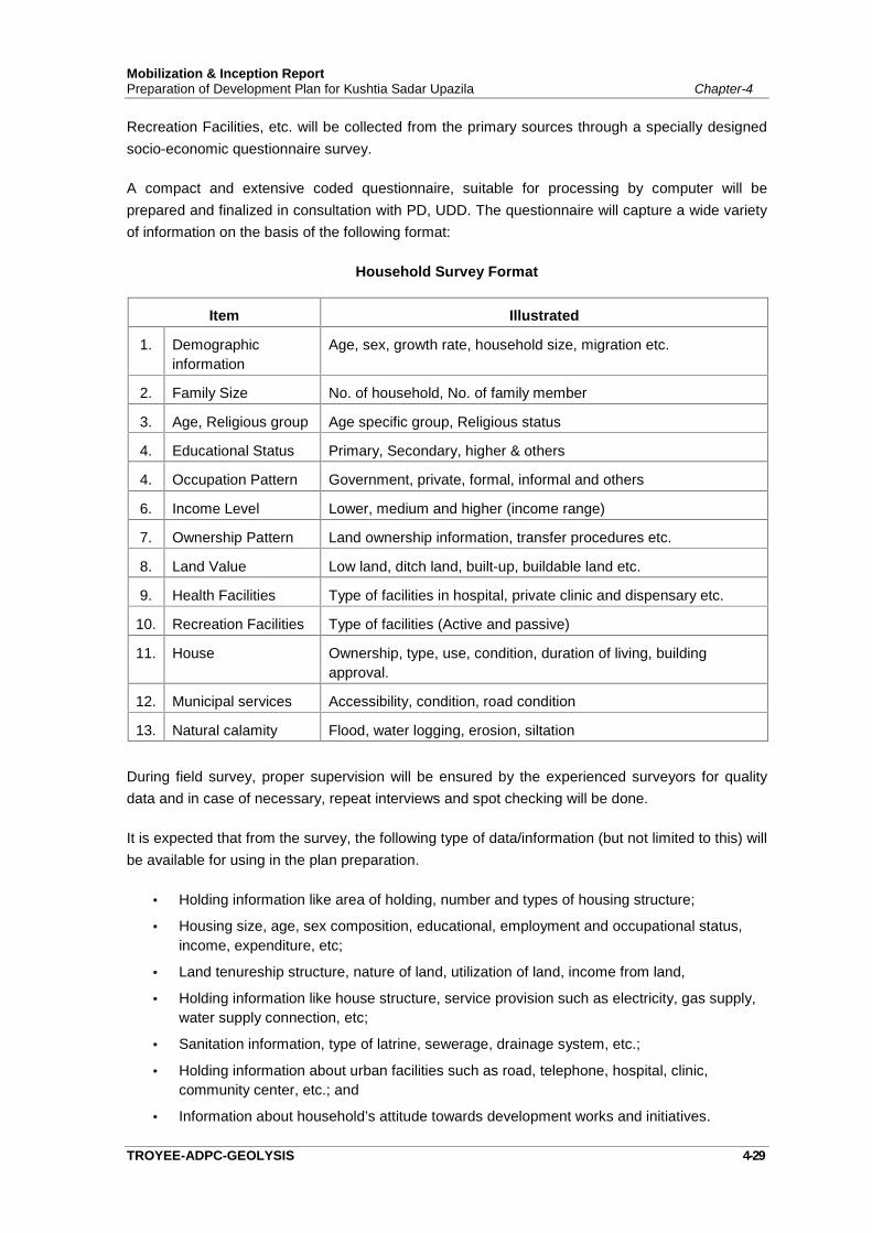
Mobilization & Inception ReportPreparation of Development Plan for Kushtia Sadar Upazila Chapter-4
TROYEE-ADPC-GEOLYSIS 4-29
Recreation Facilities, etc. will be collected from the primary sources through a specially designedsocio-economic questionnaire survey.
A compact and extensive coded questionnaire, suitable for processing by computer will beprepared and finalized in consultation with PD, UDD. The questionnaire will capture a wide varietyof information on the basis of the following format:
Household Survey Format
Item Illustrated
1. Demographicinformation
Age, sex, growth rate, household size, migration etc.
2. Family Size No. of household, No. of family member
3. Age, Religious group Age specific group, Religious status
4. Educational Status Primary, Secondary, higher & others
4. Occupation Pattern Government, private, formal, informal and others
6. Income Level Lower, medium and higher (income range)
7. Ownership Pattern Land ownership information, transfer procedures etc.
8. Land Value Low land, ditch land, built-up, buildable land etc.
9. Health Facilities Type of facilities in hospital, private clinic and dispensary etc.
10. Recreation Facilities Type of facilities (Active and passive)
11. House Ownership, type, use, condition, duration of living, buildingapproval.
12. Municipal services Accessibility, condition, road condition
13. Natural calamity Flood, water logging, erosion, siltation
During field survey, proper supervision will be ensured by the experienced surveyors for qualitydata and in case of necessary, repeat interviews and spot checking will be done.
It is expected that from the survey, the following type of data/information (but not limited to this) willbe available for using in the plan preparation.
Holding information like area of holding, number and types of housing structure;
Housing size, age, sex composition, educational, employment and occupational status,income, expenditure, etc;
Land tenureship structure, nature of land, utilization of land, income from land,
Holding information like house structure, service provision such as electricity, gas supply,water supply connection, etc;
Sanitation information, type of latrine, sewerage, drainage system, etc.;
Holding information about urban facilities such as road, telephone, hospital, clinic,community center, etc.; and
Information about household’s attitude towards development works and initiatives.
Mobilization & Inception ReportPreparation of Development Plan for Kushtia Sadar Upazila Chapter-4
TROYEE-ADPC-GEOLYSIS 4-30
4.16 Population and Migration Survey/Study
The consultants are required to analyze demographic and household data on past growth ratesand trends of migration for the district and the study area. These analyses are required to considerlikely growth factors affecting greater Kushtia District's population in general and estimate broadpopulation within the district over the next 20 years. The methodologies to be followed to carry outthese tasks are discussed next.
Data from both the secondary and primary sources will be utilized to accomplish the specifiedobjectives of the study. The 2011 census publications (the district and community series volumes)can provide valuable information on demographic structure, migration and other data related to thisstudy. Although these data have their merit because of comprehensiveness for the entire area, forbeing a little outdated, and as not all the required information will be available from censuspublications, a detailed household survey will be conducted. The sample survey will be conductedwith the help of a coded questionnaire suitable for processing by computer. The questionnaire willbe prepared in consultation with PD, UDD and will be pre-tested before actual survey is carriedout. The questionnaire will be designed for the following purposes:
to find the demographic characteristics of the population,
to find the socio-economic characteristics of the population,
to reveal the migration trend and characteristics in the area, and
to project population for 20 years
For sampling purposes we propose to divide the study area as established urban, newly urbanizedwithin the study area, newly growing area, and rural area. The localities in the study area will beidentified depending on this classification. Depending on the actual number of units, some areasfrom each of these four categories will be selected for the sample frames. A complete list ofhouseholds will be prepared for these selected units, and will be our sampling frame. Thehouseholds will be again divided as migrant and non-migrant and as household and non-household units. Total size of the sample will be decided after consultation with PD, UDD. It isexpected that the size would be about 2% of the total sample universe. Providing weightage oneach group, households will be selected randomly for questionnaire survey.
All relevant data collected through questionnaire survey will be presented in appropriate tabularform. Any change in the trend to that of 2011's census report will be analysed. The survey is alsoexpected to produce evidence on fertility rate in the study area. The population projection will bemade both at the aggregate level by time series analysis and at the disaggregate level by cohortsurvival method. However, monthly national level assumptions regarding survival and fertility ratewill be used for disaggregate projections.
4.17 Investment and Employment Survey
An employment and investment survey of the study area is required to be carried out throughcollection of secondary data and sample survey of major centers of employment. The TOR alsorequires to project economic activity and workforce by broad employment sectors. The informalsector plays a very significant role in our urban economics, as such; a major proportion of

Mobilization & Inception ReportPreparation of Development Plan for Kushtia Sadar Upazila Chapter-4
TROYEE-ADPC-GEOLYSIS 4-31
employment is in this sector. The nature, characteristics, growth and other things of this sector issignificantly different from those of the formal sector. While most of the required information on theformal sector can be obtained from the secondary sources, information regarding informal sectoractivities has to be collected from the primary source through sample surveys of the major centersof employment. Accordingly, it is essential that the two sectors be studied separately.
Formal Sector: Information on Formal sector will be collected mostly from the secondary sources.Direct inquiries of large employers, chamber of commerce, trade organizations, owners'associations and labour unions will be conducted. Besides, relevant government agencies publishregular reports that contain information on employment, investment, production etc. Furthermore,official records of City Corporation will also be a valuable source of such information.
Informal Sector: At first it would be necessary to identify the nature of informal sector activities inthe study area. It is expected that most of these activities will be in the service sector and smallmanufacturing units. A reconnaissance survey is proposed to identify the nature of activities.Sample surveys will be conducted at the household level and at the business unit level with thehelp of two separate sets of questionnaire. About 1% of both the units will be surveyed. While thehousehold surveys will be designed to collect information on employees, type and nature ofemployment, income level etc. The business unit level survey will be conducted to collectinformation on investment, production, if locally consumed, or "exported", type of trading, numberof employees etc.
The objective of this study is to analyze the present economic base of the city and to assess howthe significance of its economic base is changing compared to the national economy. This woulddetermine the future growth potential of the City Corporation. We propose to apply standardanalytical tools for this purpose such as location quotient and shift and share analysis. The findingsof these analyses will depict a clear picture about future employment and investment prospects inthe study area.
At this stage, it is difficult to suggest anything about the sampling frame. This should bedetermined after the proposed reconnaissance survey and consultation with City Corporationauthority and other concerned agencies.
In order prepare the development and action plan consultant has to consider the economicactivities and action plan study team will survey and collect existing economic activities and theirdegree of actions over the total economy of the upazila and study the potential economic sectorsto be incorporated to the final plan.
4.18 Drainage and Utility Survey and Study
The protection of environmental with the provision of mitigation measures and monitoring plan inany physical and utilities development process is the prime consideration starting from its planningto implementation and operation& maintenance. The aim of the environmental study is to improvethe general environment in the project and surrounding area and keep the parameters up to thetolerable limit of the human health and ecosystem including water, air and sound. In the urbanarea special consideration is made in water supply, sanitation, solid waste management, drainage,flooding, air, sound, food and health hazards, etc. The consultants will carry out InitialEnvironmental Examination prior to formulation of plan along with the survey activities in an
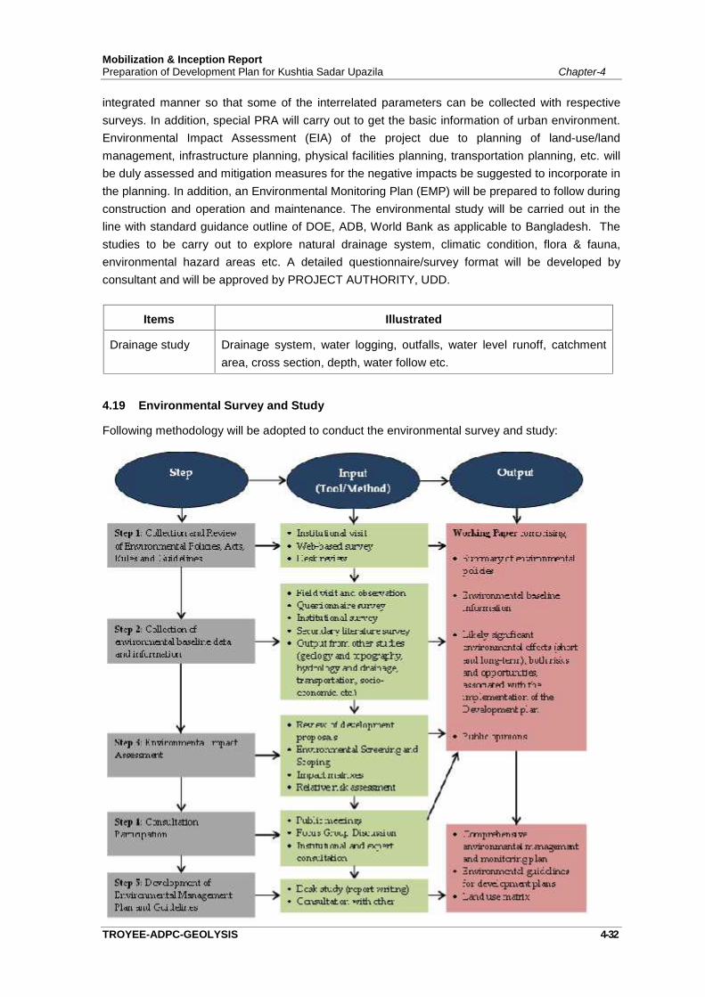
Mobilization & Inception ReportPreparation of Development Plan for Kushtia Sadar Upazila Chapter-4
TROYEE-ADPC-GEOLYSIS 4-32
integrated manner so that some of the interrelated parameters can be collected with respectivesurveys. In addition, special PRA will carry out to get the basic information of urban environment.Environmental Impact Assessment (EIA) of the project due to planning of land-use/landmanagement, infrastructure planning, physical facilities planning, transportation planning, etc. willbe duly assessed and mitigation measures for the negative impacts be suggested to incorporate inthe planning. In addition, an Environmental Monitoring Plan (EMP) will be prepared to follow duringconstruction and operation and maintenance. The environmental study will be carried out in theline with standard guidance outline of DOE, ADB, World Bank as applicable to Bangladesh. Thestudies to be carry out to explore natural drainage system, climatic condition, flora & fauna,environmental hazard areas etc. A detailed questionnaire/survey format will be developed byconsultant and will be approved by PROJECT AUTHORITY, UDD.
Items Illustrated
Drainage study Drainage system, water logging, outfalls, water level runoff, catchmentarea, cross section, depth, water follow etc.
4.19 Environmental Survey and Study
Following methodology will be adopted to conduct the environmental survey and study:
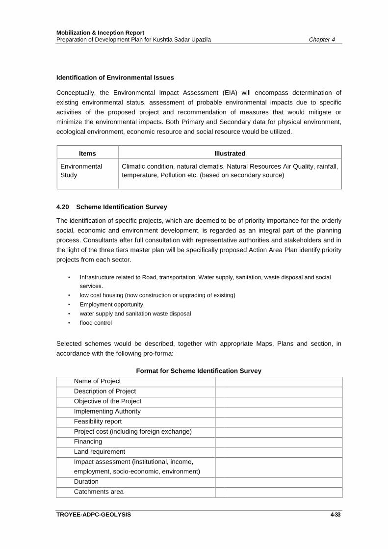
Mobilization & Inception ReportPreparation of Development Plan for Kushtia Sadar Upazila Chapter-4
TROYEE-ADPC-GEOLYSIS 4-33
Identification of Environmental Issues
Conceptually, the Environmental Impact Assessment (EIA) will encompass determination ofexisting environmental status, assessment of probable environmental impacts due to specificactivities of the proposed project and recommendation of measures that would mitigate orminimize the environmental impacts. Both Primary and Secondary data for physical environment,ecological environment, economic resource and social resource would be utilized.
Items Illustrated
EnvironmentalStudy
Climatic condition, natural clematis, Natural Resources Air Quality, rainfall,temperature, Pollution etc. (based on secondary source)
4.20 Scheme Identification Survey
The identification of specific projects, which are deemed to be of priority importance for the orderlysocial, economic and environment development, is regarded as an integral part of the planningprocess. Consultants after full consultation with representative authorities and stakeholders and inthe light of the three tiers master plan will be specifically proposed Action Area Plan identify priorityprojects from each sector.
Infrastructure related to Road, transportation, Water supply, sanitation, waste disposal and socialservices.
low cost housing (now construction or upgrading of existing) Employment opportunity. water supply and sanitation waste disposal flood control
Selected schemes would be described, together with appropriate Maps, Plans and section, inaccordance with the following pro-forma:
Format for Scheme Identification SurveyName of ProjectDescription of ProjectObjective of the ProjectImplementing AuthorityFeasibility reportProject cost (including foreign exchange)FinancingLand requirementImpact assessment (institutional, income,employment, socio-economic, environment)DurationCatchments area

Mobilization & Inception ReportPreparation of Development Plan for Kushtia Sadar Upazila Chapter-4
TROYEE-ADPC-GEOLYSIS 4-34
4.21 Others Relevant Survey and Study
4.21.1 Housing
The team will review the national housing policies and conduct study on existing condition in theUpazila. The housing study will include housing land and density, housing ownership pattern, govt.housing, private housing, housing estates, informal housing, housing type based on constructionmaterials, compliance with building construction rules, demand and supply of land for housing,stock and backlog of housing, room occupancy and floor area, building height, housing finance,housing problems and challenges, future development plans and programs, etc. The detailedinformation related to housing condition will be collected mainly from National Housing Authorityoffice as well as through physical features and socio-economic survey in the study area, andavailable secondary sources.
4.21.2 Health
The team will review the general health situation in Bangladesh and in Kushtia Sadar Upazila. Thehealth study will further include existing health care facilities provided by public, private and NGOsector, availability of doctors, nurse equipment and other facilities, quality of services, type ofcommon degasses in the area, medical services availed of by households, infant and childmortality rate, crude birth and death rate, life expectancy at birth, demand and supply of healthservices, problems and challenges, future development plans and programs, etc. The healthservices related information will be collected mainly from Civil Surgeon Office, Upazila HealthComplex, Paurashava as well as through physical features and socio-economic survey in thestudy area, and available secondary sources.
4.21.3 Education
The study related to education facilities and services will include literature rate of different agegroup, existing education infrastructure and facilities both formal and informal, teacher-studentratio, quality of education, etc. The team will try further to explore the reason for not attendingprimary school as well as problems and challenges, and future development plans and programsin education services in the area. The required information related to education facilities andservices will be collected from District Education Office, Upazila Education Office and relevantNGOs as well as through physical features and socio-economic survey in the study area, andavailable secondary sources.
4.21.4 Sanitation
The sanitation study will include household sanitation condition as well as availability and conditionof sanitary latrine, pit latrine, community toilet, public toilet, etc. The problems and challengesassociated with sanitation as well as future development plans and programs in the area will alsobe analyzed. Sanitation data will also be extracted from socio-economic survey and discussionwith the municipality.

Mobilization & Inception ReportPreparation of Development Plan for Kushtia Sadar Upazila Chapter-4
TROYEE-ADPC-GEOLYSIS 4-35
4.21.5 Energy
The study on energy will include the consumption pattern of fuel and electricity, area of electricitycoverage, demand and supply of electricity, problems and challenges associated with supply ofelectricity and future development plans and programs. Data will be extracted from socio-economicsurvey as well as discussion with Power Development Board and the municipality.
4.21.6 Heritage, Archeology and Tourism Management
Kushtia region has an ancient heritage of archaeological traditional culture and history. There aremany places of great interest such as Shelaidah Kuthibari, Lalon's Mausoleum, Mujib Nagar,Amjhupi Rest House, Jhoudia Mosque, etc. in this region. Many other places of historical interestare spread all over the district which may be treated as tourist spots. Kushtia has a bright prospectof attracting tourists from home and abroad if many historical places are turned into tourist spots.The team will conduct a comprehensive study and analysis of heritage, archeology and tourismManagement under this study with greater importance. The detailed information of potentialheritage, archeology and tourist area within the study area and its neighborhoods will be collectedfrom Archeological Department and Bangladesh Parjatan Corporation as well as through review ofhistorical documents, field visit, discussion with most familiar persons and the tourist coming fromdifferent parts of the country. A semi-structured questionnaire will be used for survey. Data willalso be extracted from physical feature survey and socio-economic survey. The team will also tryto ascertain the problems and challenges in tourism development in this region.
4.22 Database Preparation
Survey data processing
All collected topographic data, physical features data, socioeconomic data, transportation data,drainage and environmental data as well as other all secondary source data will be processed andcompiled for analysis and to plan process.
Development of GIS data base
Geo-referenced mauza data, all topographic data and physical data, all attribute data in sameprojection will be finalized and stored as GIS data format for further analysis and map preparation.
Development of Map layout and legend
Guided by the TOR and Consulting with PD and PM, consultants will finalized the legend andlayers of the GIS data and finalize the map layout. Then following the map layout and legendproperties consultant will prepare and finalize the map as per demand of planning process and theToR.
Preparation and Submission of Survey Report along with Maps
After survey and data compilation as per project demand, guided by the PD, planning team willprepare the maps layout according to ToR and survey report will be generated for submission.

Chapter: 05
OUTPUTS AND FORMATS
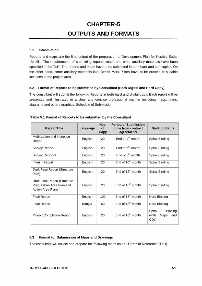
CHAPTER-5OUTPUTS AND FORMATS
TROYEE-ADPC-GEOLYSIS 5-1
5.1 Introduction
Reports and maps are the final output of the preparation of Development Plan for Kushtia SadarUpazila. The requirements of submitting reports, maps and other ancillary materials have beenspecified in the ToR. The reports and maps have to be submitted in both hard and soft copies. Onthe other hand, some ancillary materials like, Bench Mark Pillars have to be erected in suitablelocations of the project area.
5.2 Format of Reports to be submitted by Consultant (Both Digital and Hard Copy)
The consultant will submit the following Reports in both hard and digital copy. Each report will bepresented and illustrated in a clear and concise professional manner including maps, plans,diagrams and others graphics. Schedule of Submission:
Table 5.1 Format of Reports to be submitted by the Consultant
Report Title LanguageNos.
ofCopy
Period of Submission(time from contract
agreement)Binding Status
Mobilization and InceptionReport English 20 End of 1nd month Spiral Binding
Survey Report-I English 20 End of 2nd month Spiral Binding
Survey Report-II English 20 End of 8th month Spiral Binding
Interim Report English 20 End of 10th month Spiral Binding
Draft Final Report (StructurePlan) English 20 End of 12th month Spiral Binding
Draft Final Report (StructurePlan, Urban Area Plan andAction Area Plan)
English 20 End of 15th month Spiral Binding
Final Report English 100 End of 18th month Hard Binding
Final Report Bangla 50 End of 18th month Hard Binding
Project Completion Report English 20 End of 18th monthSpiral Binding(with Maps andCDs)
5.3 Format for Submission of Maps and Drawings
The consultant will collect and prepare the following maps as per Terms of Reference (ToR).
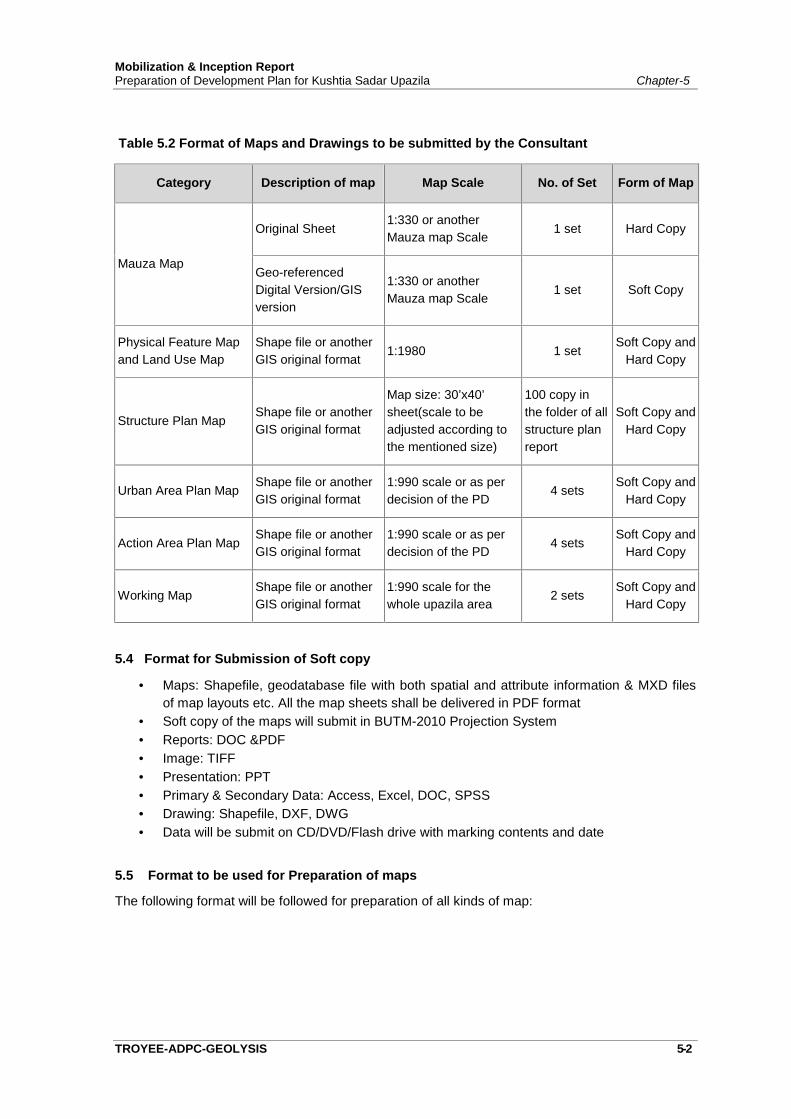
Mobilization & Inception ReportPreparation of Development Plan for Kushtia Sadar Upazila Chapter-5
TROYEE-ADPC-GEOLYSIS 5-2
Table 5.2 Format of Maps and Drawings to be submitted by the Consultant
Category Description of map Map Scale No. of Set Form of Map
Mauza Map
Original Sheet1:330 or anotherMauza map Scale
1 set Hard Copy
Geo-referencedDigital Version/GISversion
1:330 or anotherMauza map Scale
1 set Soft Copy
Physical Feature Mapand Land Use Map
Shape file or anotherGIS original format
1:1980 1 setSoft Copy and
Hard Copy
Structure Plan MapShape file or anotherGIS original format
Map size: 30’x40’sheet(scale to beadjusted according tothe mentioned size)
100 copy inthe folder of allstructure planreport
Soft Copy andHard Copy
Urban Area Plan MapShape file or anotherGIS original format
1:990 scale or as perdecision of the PD
4 setsSoft Copy and
Hard Copy
Action Area Plan MapShape file or anotherGIS original format
1:990 scale or as perdecision of the PD
4 setsSoft Copy and
Hard Copy
Working MapShape file or anotherGIS original format
1:990 scale for thewhole upazila area
2 setsSoft Copy and
Hard Copy
5.4 Format for Submission of Soft copy
Maps: Shapefile, geodatabase file with both spatial and attribute information & MXD filesof map layouts etc. All the map sheets shall be delivered in PDF format
Soft copy of the maps will submit in BUTM-2010 Projection System Reports: DOC &PDF Image: TIFF Presentation: PPT Primary & Secondary Data: Access, Excel, DOC, SPSS Drawing: Shapefile, DXF, DWG Data will be submit on CD/DVD/Flash drive with marking contents and date
5.5 Format to be used for Preparation of maps
The following format will be followed for preparation of all kinds of map:
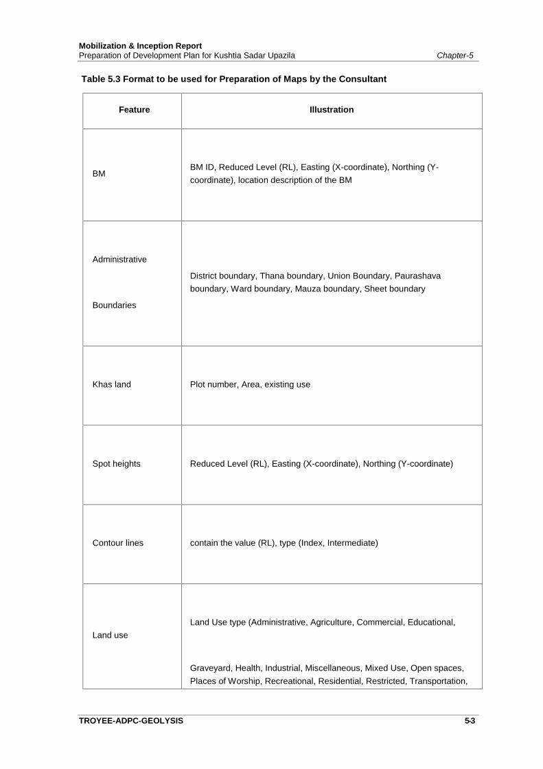
Mobilization & Inception ReportPreparation of Development Plan for Kushtia Sadar Upazila Chapter-5
TROYEE-ADPC-GEOLYSIS 5-3
Table 5.3 Format to be used for Preparation of Maps by the Consultant
Feature Illustration
BMBM ID, Reduced Level (RL), Easting (X-coordinate), Northing (Y-coordinate), location description of the BM
Administrative
Boundaries
District boundary, Thana boundary, Union Boundary, Paurashavaboundary, Ward boundary, Mauza boundary, Sheet boundary
Khas land Plot number, Area, existing use
Spot heights Reduced Level (RL), Easting (X-coordinate), Northing (Y-coordinate)
Contour lines contain the value (RL), type (Index, Intermediate)
Land useLand Use type (Administrative, Agriculture, Commercial, Educational,
Graveyard, Health, Industrial, Miscellaneous, Mixed Use, Open spaces,Places of Worship, Recreational, Residential, Restricted, Transportation,

Mobilization & Inception ReportPreparation of Development Plan for Kushtia Sadar Upazila Chapter-5
TROYEE-ADPC-GEOLYSIS 5-4
Feature Illustration
Water bodies), data base will contain detail category as per survey format
Structure
Structure type (Pucca, Semi-pucca, Katcha), structure use data base willcontain detail category as per survey format, structure name, year ofconstruction, under construction, owner’s name of the structure, Holdingnumber, adjacent road name, locality name, ward/union name
Roadroad name, road number, type of the road (Pucca, Semi-pucca, Katcha),category of the road (Primary, Secondary, Access), road width
Footpath road name, width
Drain/sewerage type, width, category, depth
Water Pipe Network Type, Diameter (secondary source)
Overhead Tanks Capacity, catchment area
Electric Lines Capacity, type
Gas line Diameter, Pressure (secondary source)
Utility and servicersfacilities
Type (Electric Pole, Electric Tower, High Volt, Electric Tower, Electric
Box, Power Station, Power Sub-station, Transformer, Gas
Transmission Center, Light Post, Telephone Pole, Telephone Box, FireService Station, Traffic Signal Pole)
Important areaType (Graveyard, Crematorium, Cemetery, Eidgah, Restricted Area,Airport, Brick Field, Rickshaw Garage, Automobile Garage, Monument,Open Space, Parks, Playground, Stadium, Botanical Garden, ZoologicalPark, Power Plant/Station, Bus Terminal, Truck Terminal, Water Treatment
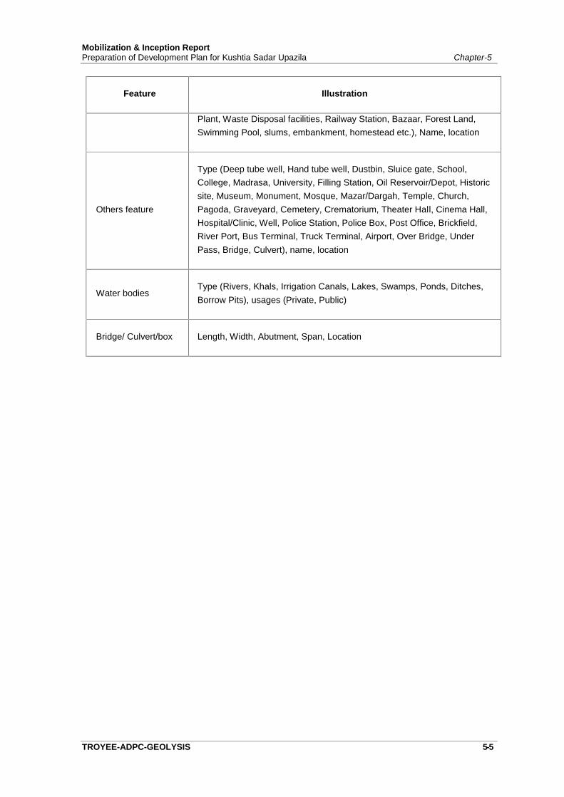
Mobilization & Inception ReportPreparation of Development Plan for Kushtia Sadar Upazila Chapter-5
TROYEE-ADPC-GEOLYSIS 5-5
Feature Illustration
Plant, Waste Disposal facilities, Railway Station, Bazaar, Forest Land,Swimming Pool, slums, embankment, homestead etc.), Name, location
Others feature
Type (Deep tube well, Hand tube well, Dustbin, Sluice gate, School,College, Madrasa, University, Filling Station, Oil Reservoir/Depot, Historicsite, Museum, Monument, Mosque, Mazar/Dargah, Temple, Church,Pagoda, Graveyard, Cemetery, Crematorium, Theater Hall, Cinema Hall,Hospital/Clinic, Well, Police Station, Police Box, Post Office, Brickfield,River Port, Bus Terminal, Truck Terminal, Airport, Over Bridge, UnderPass, Bridge, Culvert), name, location
Water bodiesType (Rivers, Khals, Irrigation Canals, Lakes, Swamps, Ponds, Ditches,Borrow Pits), usages (Private, Public)
Bridge/ Culvert/box Length, Width, Abutment, Span, Location

Chapter: 06
PROJECT MANAGEMENT PLAN
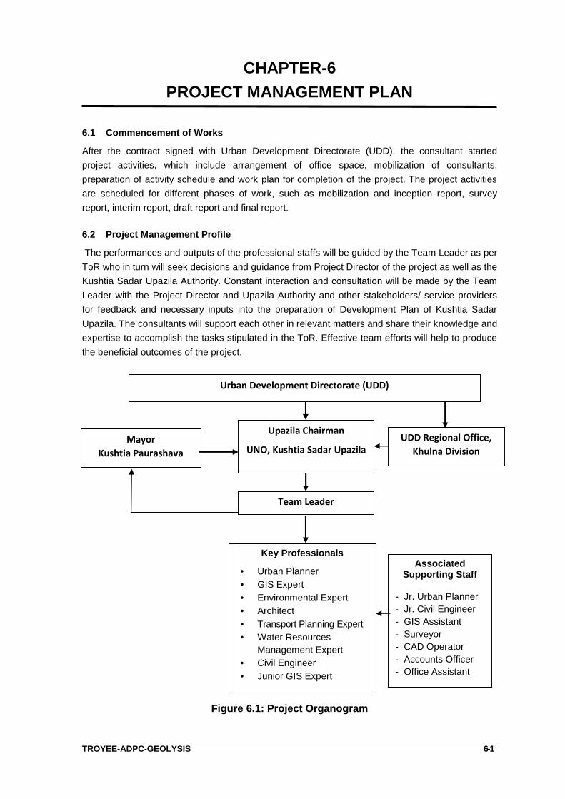
CHAPTER-6PROJECT MANAGEMENT PLAN
TROYEE-ADPC-GEOLYSIS 6-1
6.1 Commencement of Works
After the contract signed with Urban Development Directorate (UDD), the consultant startedproject activities, which include arrangement of office space, mobilization of consultants,preparation of activity schedule and work plan for completion of the project. The project activitiesare scheduled for different phases of work, such as mobilization and inception report, surveyreport, interim report, draft report and final report.
6.2 Project Management Profile
The performances and outputs of the professional staffs will be guided by the Team Leader as perToR who in turn will seek decisions and guidance from Project Director of the project as well as theKushtia Sadar Upazila Authority. Constant interaction and consultation will be made by the TeamLeader with the Project Director and Upazila Authority and other stakeholders/ service providersfor feedback and necessary inputs into the preparation of Development Plan of Kushtia SadarUpazila. The consultants will support each other in relevant matters and share their knowledge andexpertise to accomplish the tasks stipulated in the ToR. Effective team efforts will help to producethe beneficial outcomes of the project.
Figure 6.1: Project Organogram
Key Professionals
Urban Planner GIS Expert Environmental Expert Architect Transport Planning Expert Water Resources
Management Expert Civil Engineer Junior GIS Expert
MayorKushtia Paurashava
AssociatedSupporting Staff
- Jr. Urban Planner- Jr. Civil Engineer- GIS Assistant- Surveyor- CAD Operator- Accounts Officer- Office Assistant
Urban Development Directorate (UDD)
UDD Regional Office,Khulna Division
Upazila Chairman
UNO, Kushtia Sadar Upazila
Team Leader
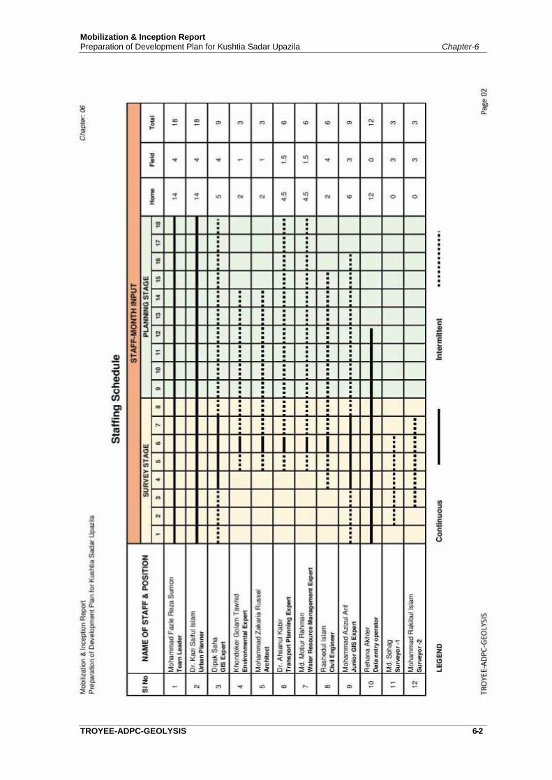
Mobilization & Inception ReportPreparation of Development Plan for Kushtia Sadar Upazila Chapter-6
TROYEE-ADPC-GEOLYSIS 6-2

Mobilization & Inception ReportPreparation of Development Plan for Kushtia Sadar Upazila Chapter-6
TROYEE-ADPC-GEOLYSIS 6-3
6.3 Staffing Schedule
The staffing requirement and duration of input of individual team member for the project have beenassessed on the basis of the work program. Before development of a staffing schedule of theproject team, the consultants require full understanding of the input-output requirements of theproject and ways of integration of multi-sectoral activities in a coordinated and sequential mannerin accordance with objective of the project and ToR. Staffing Schedule of the proposed personnelshowing involvement and duration of each professionals is presented in Figure-6.2.It provides anallocation of 78 man-months for 9 key professionals.
6.4 Tasks and Responsibilities of Professionals
Proposed key personnel’s selected for the consultancy services for Preparation of DevelopmentPlan for Kushtia Sadar Upazila are highly qualified and are specialized in their respective fields.Thoughtful consideration was made for selecting the team of consultants who are most suitable forthe assignment. The tasks and responsibilities as per ToR of the professionals are given below:
Task of the Key Personnel:
Name of Staff Position Task Assigned
Mohammad Fazle RezaSumon
Team Leader - To prepare work program in consultation with ProjectDirector.
- To coordinate among the consultant team.- To prepare work programme for the team.- To compile report, working papers, sectoral studies
and prepare report for submission to the PD.- Preparation of working paper, reports and plan of the
project as assigned by the PD.- To review the existing plans and implementation
problems.- To prepare land use planning guidelines.- To prepare land use matrix.- To identify and plan development project for the
area.- To interpret the recommendations of sectoral studies
into spatial form.- To prepare land use plan according to sectoral
studies of the Structure Plan.- To formulate plan implementation strategy and policy- Any other related job assigned by the PD.
Dr. Kazi Saiful Islam Urban Planner - To prepare work program in consultation with ProjectDirector.
- To coordinate among the consultant team.- To prepare work programme for the team.- To compile report, working papers, sectoral studies
and prepare report for submission to the PD.- Preparation of working paper, reports and plan of the
project as assigned by the PD.- To review the existing plans and implementation
problems.

Mobilization & Inception ReportPreparation of Development Plan for Kushtia Sadar Upazila Chapter-6
TROYEE-ADPC-GEOLYSIS 6-4
Name of Staff Position Task Assigned- To prepare land use planning guidelines.- To prepare land use matrix.- To identify and plan development project for the
area.- To interpret the recommendations of sectoral studies
into spatial form.- To prepare land use plan according to sectoral
studies of the Structure Plan.- To formulate plan implementation strategy and policy- Any other related job assigned by the PD.
Dipok Chandra Saha GIS Expert - To prepare Physical feature and topographic mapfrom the surveyed data.
- To prepare Map of the region from 3d satellite image.- To supervise, manage and monitor digital database
of the project.- To prepare guideline for GIS database development
and to ensure the quality of map and related work.- Installation and troubleshooting of GIS in UDD project
office and Head office.- Preparation of working paper, reports and plan of the
project as assigned by the PD.- Any other related job assigned by the PD.
Khondoker Golam Tawhid EnvironmentalExpert
- Prepare guidelines for environmental relatedcomponent of development plans according toEnvironmental laws, policies and other publisheddocuments.
- Prepare land use matrix and land use planningguidelines for the region environmental view point.
- To delineate region considering environmentalparameters.
- To identify areas with environmental hazards.- To suggest hazard mitigation measures.- Preparation of working paper and reports as assigned
by the PD.- To prepare Environmental Management Plan.- Any other related job assigned by the PD.
Md. Zakaria Ibne Razzaque Architect - To work directly under the PD in throughunderstanding about site plan/action area planrelated issues.
- To assist the PD in preparation of work program ofthe team leader of consulting firm.
- To monitor and supervise the progress of work by allcomponents with reference to project objectives andactivities and report directly to the PD about projectstatus.
- To identify important archaeological structure of theproject area and develop conservation strategy.
- To review National Tourism Management Plan andprepare specified policy guidelines for the project.
- To assist PD to integrate his input in planningprocess through Team Leader by preparing workingpapers.
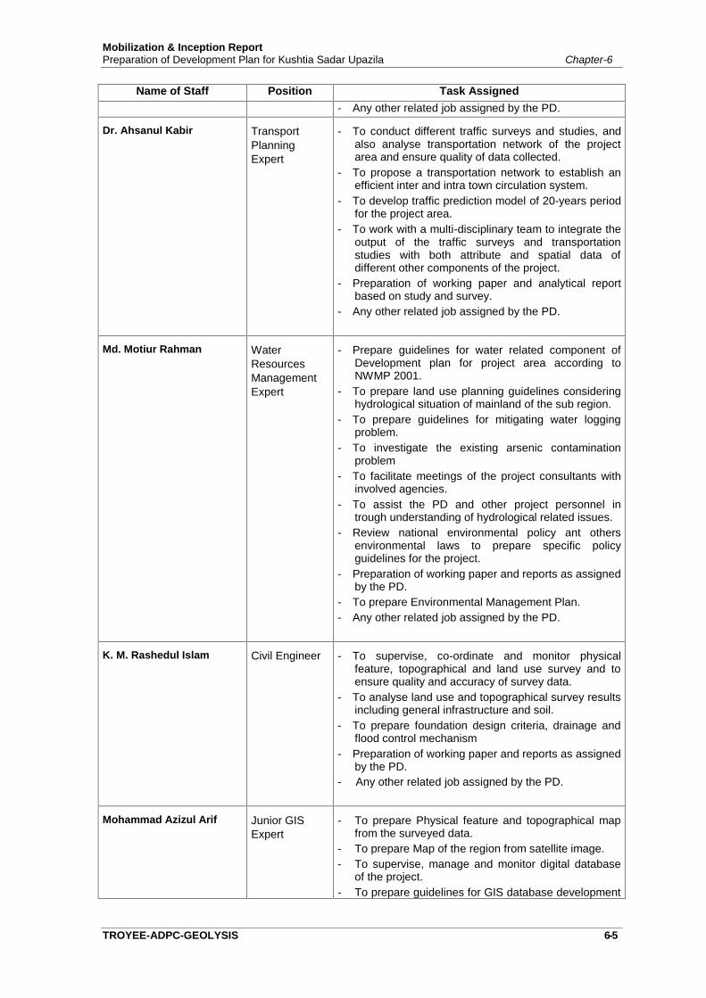
Mobilization & Inception ReportPreparation of Development Plan for Kushtia Sadar Upazila Chapter-6
TROYEE-ADPC-GEOLYSIS 6-5
Name of Staff Position Task Assigned- Any other related job assigned by the PD.
Dr. Ahsanul Kabir TransportPlanningExpert
- To conduct different traffic surveys and studies, andalso analyse transportation network of the projectarea and ensure quality of data collected.
- To propose a transportation network to establish anefficient inter and intra town circulation system.
- To develop traffic prediction model of 20-years periodfor the project area.
- To work with a multi-disciplinary team to integrate theoutput of the traffic surveys and transportationstudies with both attribute and spatial data ofdifferent other components of the project.
- Preparation of working paper and analytical reportbased on study and survey.
- Any other related job assigned by the PD.
Md. Motiur Rahman WaterResourcesManagementExpert
- Prepare guidelines for water related component ofDevelopment plan for project area according toNWMP 2001.
- To prepare land use planning guidelines consideringhydrological situation of mainland of the sub region.
- To prepare guidelines for mitigating water loggingproblem.
- To investigate the existing arsenic contaminationproblem
- To facilitate meetings of the project consultants withinvolved agencies.
- To assist the PD and other project personnel intrough understanding of hydrological related issues.
- Review national environmental policy ant othersenvironmental laws to prepare specific policyguidelines for the project.
- Preparation of working paper and reports as assignedby the PD.
- To prepare Environmental Management Plan.- Any other related job assigned by the PD.
K. M. Rashedul Islam Civil Engineer - To supervise, co-ordinate and monitor physicalfeature, topographical and land use survey and toensure quality and accuracy of survey data.
- To analyse land use and topographical survey resultsincluding general infrastructure and soil.
- To prepare foundation design criteria, drainage andflood control mechanism
- Preparation of working paper and reports as assignedby the PD.
- Any other related job assigned by the PD.
Mohammad Azizul Arif Junior GISExpert
- To prepare Physical feature and topographical mapfrom the surveyed data.
- To prepare Map of the region from satellite image.- To supervise, manage and monitor digital database
of the project.- To prepare guidelines for GIS database development
Mobilization & Inception ReportPreparation of Development Plan for Kushtia Sadar Upazila Chapter-6
TROYEE-ADPC-GEOLYSIS 6-6
Name of Staff Position Task Assignedfrom Physical feature and topographical survey forthe project.
- Installation and troubleshooting of GIS in UDDproject office and head office.
- Preparation of working paper, reports and plan of theproject as assigned by the PD.
- Any other related job assigned by the PD.
6.5 Activity Schedule
An effective time schedule is required for successful completion of the project on time. Theconsultants have made an in-depth assessment of the tasks to be accomplished in differentphases as per ToR, particularly for detailed survey and preparation of documents. The detailedschedule of activities of the project is depicted in the following table.
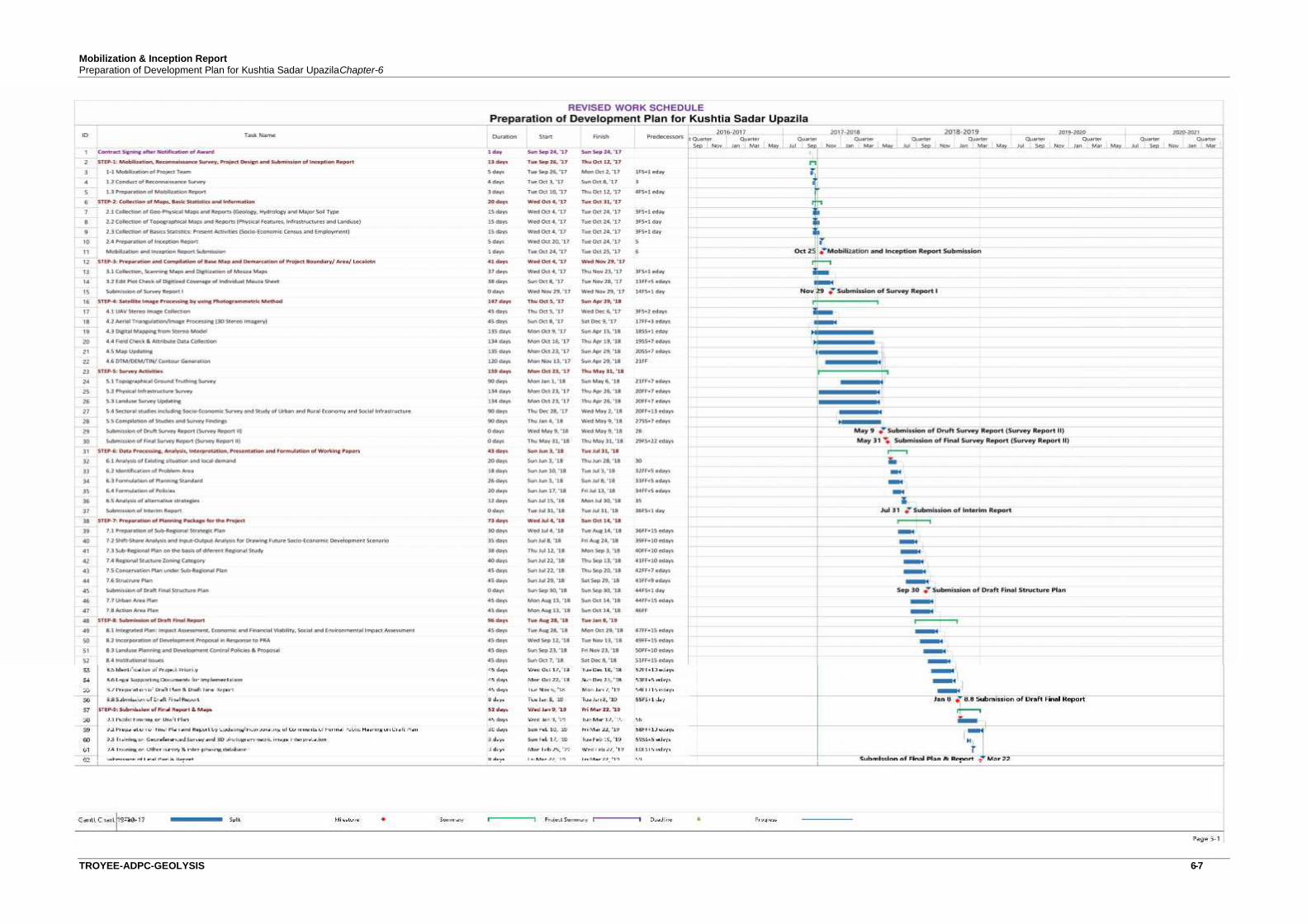
Mobilization & Inception ReportPreparation of Development Plan for Kushtia Sadar UpazilaChapter-6
TROYEE-ADPC-GEOLYSIS 6-7

Chapter: 07
CONCLUSION
CHAPTER-7CONCLUSION
TROYEE-ADPC-GEOLYSIS 7-1
The Mobilization and Inception Report has been prepared keeping in mind the Terms ofReference of the project. This will guide project activities including field surveys, data collectionand analysis and preparation of reports and maps. The project area profile based on initial survey,maps and data collection from secondary sources, has been useful in understanding thecharacteristics of the project Upazila, its general condition in physical and socio-economicdevelopment. Subsequent stages of project work will largely be dependent on the Inceptionoutput.
It is understood that the deficiency in infrastructure of the project Upazila, is currently holding backthe faster progress in development. This can be improved substantially, if planned development ofthe areas is ensured through Structure Plan, Urban Area Plan and Action Area Plan as visualizedthrough the current project. Thus the commencement of this project under the UrbanDevelopment Directorate (UDD) is very relevant and timely in line with national policies andregional development strategies as well as sustaining Sustainable Development Goal 11.

ANNEXTURES
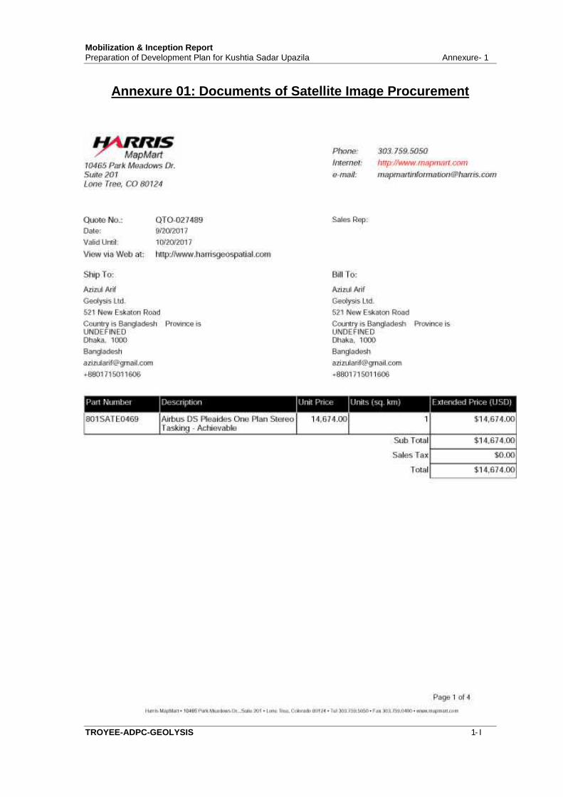
Mobilization & Inception ReportPreparation of Development Plan for Kushtia Sadar Upazila Annexure- 1
TROYEE-ADPC-GEOLYSIS 1- I
Annexure 01: Documents of Satellite Image Procurement

Mobilization & Inception ReportPreparation of Development Plan for Kushtia Sadar Upazila Annexure- A
TROYEE-ADPC-GEOLYSIS 1- II

Mobilization & Inception ReportPreparation of Development Plan for Kushtia Sadar Upazila Annexure- 1
TROYEE-ADPC-GEOLYSIS 1- III

Mobilization & Inception ReportPreparation of Development Plan for Kushtia Sadar Upazila Annexure- 1
TROYEE-ADPC-GEOLYSIS 1- IV
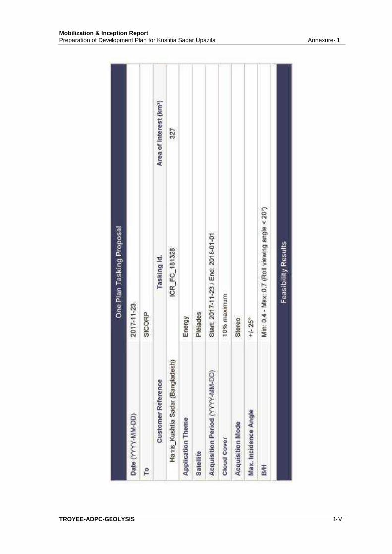
Mobilization & Inception ReportPreparation of Development Plan for Kushtia Sadar Upazila Annexure- 1
TROYEE-ADPC-GEOLYSIS 1- V
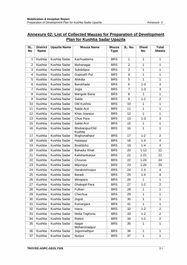
Mobilization & Inception ReportPreparation of Development Plan for Kushtia Sadar Upazila Annexure- 2
TROYEE-ADPC-GEOLYSIS 2- I
Annexure 02: List of Collected Mauzas for Preparation of DevelopmentPlan for Kushtia Sadar Upazila
SL.No
DistrictName
Upazila Name Mouza Name MouzaType
JL. No. SheetNo.
TotalSheets
1 Kushtia Kushtia Sadar Kachuadama BRS 1 1 1
2 Kushtia Kushtia Sadar Mohanagar BRS 2 1 13 Kushtia Kushtia Sadar Sukdebpur BRS 3 1 14 Kushtia Kushtia Sadar Gopinath Pur BRS 4 1 15 Kushtia Kushtia Sadar Alokdia BRS 5 1 16 Kushtia Kushtia Sadar Barokhada BRS 6 1-3 37 Kushtia Kushtia Sadar Jogia BRS 7 1-3 38 Kushtia Kushtia Sadar Mangole Baria BRS 8 1 19 Kushtia Kushtia Sadar Salda BRS 9 1-2 2
10 Kushtia Kushtia Sadar Old Kushtia BRS 10 1 111 Kushtia Kushtia Sadar Salda Arzi BRS 11 1 112 Kushtia Kushtia Sadar Khas Joanpur BRS 12 1 113 Kushtia Kushtia Sadar Chua Para BRS 13 1-3 315 Kushtia Kushtia Sadar Salda Arzi BRS 15 1 116 Kushtia Kushtia Sadar Bhobanipur/Old
KushtiaBRS 16 1 1
17 Kushtia Kushtia Sadar Roghunathpur BRS 17 1-2 218 Kushtia Kushtia Sadar Hataspur BRS 18 1-4 419 Kushtia Kushtia Sadar Boaildoho BRS 19 1-4 420 Kushtia Kushtia Sadar Bahadur Khali BRS 20 1-12 1221 Kushtia Kushtia Sadar Kalishankarpur BRS 21 1-21 2122 Kushtia Kushtia Sadar Chouras BRS 22 1-24 2423 Kushtia Kushtia Sadar Mijompur BRS 23 1-20 2024 Kushtia Kushtia Sadar Harakrishnopur BRS 24 1-4 425 Kushtia Kushtia Sadar Baradi BRS 25 1-4 426 Kushtia Kushtia Sadar Minapara BRS 26 1 127 Kushtia Kushtia Sadar Dhakajal Para BRS 27 1-2 228 Kushtia Kushtia Sadar Fulbari BRS 28 1 129 Kushtia Kushtia Sadar Chechua BRS 29 1 130 Kushtia Kushtia Sadar Jogoti BRS 30 1 131 Kushtia Kushtia Sadar Kumargara BRS 31 1 132 Kushtia Kushtia Sadar Harra BRS 32 1-2 233 Kushtia Kushtia Sadar Molla Teghoria BRS 33 1-2 234 Kushtia Kushtia Sadar Rahini BRS 34 1-2 235 Kushtia Kushtia Sadar Nagar
MohammadpurBRS 35 1 1
36 Kushtia Kushtia Sadar Jogonnathpur BRS 36 1 137 Kushtia Kushtia Sadar Nurpur BRS 37 1 1
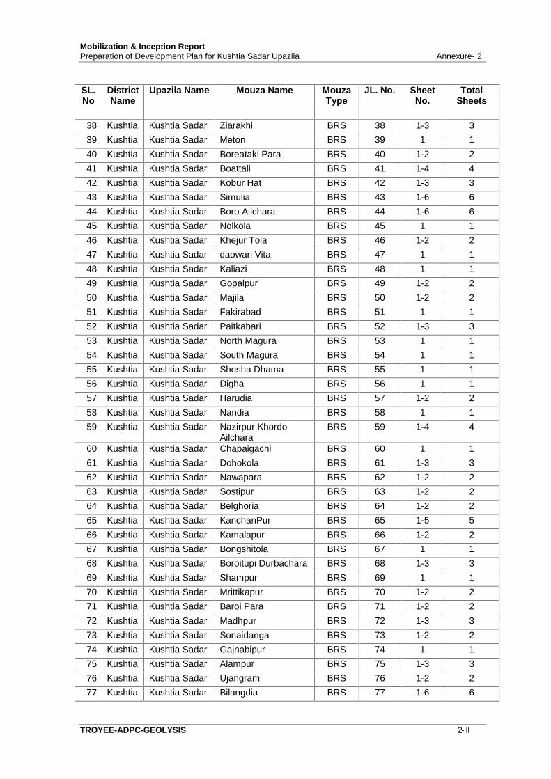
Mobilization & Inception ReportPreparation of Development Plan for Kushtia Sadar Upazila Annexure- 2
TROYEE-ADPC-GEOLYSIS 2- II
SL.No
DistrictName
Upazila Name Mouza Name MouzaType
JL. No. SheetNo.
TotalSheets
38 Kushtia Kushtia Sadar Ziarakhi BRS 38 1-3 339 Kushtia Kushtia Sadar Meton BRS 39 1 140 Kushtia Kushtia Sadar Boreataki Para BRS 40 1-2 241 Kushtia Kushtia Sadar Boattali BRS 41 1-4 442 Kushtia Kushtia Sadar Kobur Hat BRS 42 1-3 343 Kushtia Kushtia Sadar Simulia BRS 43 1-6 644 Kushtia Kushtia Sadar Boro Ailchara BRS 44 1-6 645 Kushtia Kushtia Sadar Nolkola BRS 45 1 146 Kushtia Kushtia Sadar Khejur Tola BRS 46 1-2 247 Kushtia Kushtia Sadar daowari Vita BRS 47 1 148 Kushtia Kushtia Sadar Kaliazi BRS 48 1 149 Kushtia Kushtia Sadar Gopalpur BRS 49 1-2 250 Kushtia Kushtia Sadar Majila BRS 50 1-2 251 Kushtia Kushtia Sadar Fakirabad BRS 51 1 152 Kushtia Kushtia Sadar Paitkabari BRS 52 1-3 353 Kushtia Kushtia Sadar North Magura BRS 53 1 154 Kushtia Kushtia Sadar South Magura BRS 54 1 155 Kushtia Kushtia Sadar Shosha Dhama BRS 55 1 156 Kushtia Kushtia Sadar Digha BRS 56 1 157 Kushtia Kushtia Sadar Harudia BRS 57 1-2 258 Kushtia Kushtia Sadar Nandia BRS 58 1 159 Kushtia Kushtia Sadar Nazirpur Khordo
AilcharaBRS 59 1-4 4
60 Kushtia Kushtia Sadar Chapaigachi BRS 60 1 161 Kushtia Kushtia Sadar Dohokola BRS 61 1-3 362 Kushtia Kushtia Sadar Nawapara BRS 62 1-2 263 Kushtia Kushtia Sadar Sostipur BRS 63 1-2 264 Kushtia Kushtia Sadar Belghoria BRS 64 1-2 265 Kushtia Kushtia Sadar KanchanPur BRS 65 1-5 566 Kushtia Kushtia Sadar Kamalapur BRS 66 1-2 267 Kushtia Kushtia Sadar Bongshitola BRS 67 1 168 Kushtia Kushtia Sadar Boroitupi Durbachara BRS 68 1-3 369 Kushtia Kushtia Sadar Shampur BRS 69 1 170 Kushtia Kushtia Sadar Mrittikapur BRS 70 1-2 271 Kushtia Kushtia Sadar Baroi Para BRS 71 1-2 272 Kushtia Kushtia Sadar Madhpur BRS 72 1-3 373 Kushtia Kushtia Sadar Sonaidanga BRS 73 1-2 274 Kushtia Kushtia Sadar Gajnabipur BRS 74 1 175 Kushtia Kushtia Sadar Alampur BRS 75 1-3 376 Kushtia Kushtia Sadar Ujangram BRS 76 1-2 277 Kushtia Kushtia Sadar Bilangdia BRS 77 1-6 6
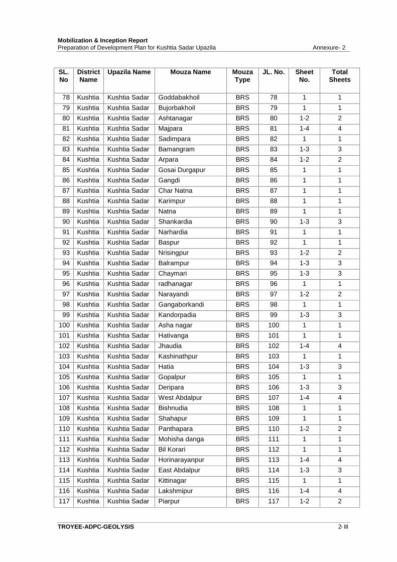
Mobilization & Inception ReportPreparation of Development Plan for Kushtia Sadar Upazila Annexure- 2
TROYEE-ADPC-GEOLYSIS 2- III
SL.No
DistrictName
Upazila Name Mouza Name MouzaType
JL. No. SheetNo.
TotalSheets
78 Kushtia Kushtia Sadar Goddabakhoil BRS 78 1 179 Kushtia Kushtia Sadar Bujorbakhoil BRS 79 1 180 Kushtia Kushtia Sadar Ashtanagar BRS 80 1-2 281 Kushtia Kushtia Sadar Majpara BRS 81 1-4 482 Kushtia Kushtia Sadar Sadimpara BRS 82 1 183 Kushtia Kushtia Sadar Bamangram BRS 83 1-3 384 Kushtia Kushtia Sadar Arpara BRS 84 1-2 285 Kushtia Kushtia Sadar Gosai Durgapur BRS 85 1 186 Kushtia Kushtia Sadar Gangdi BRS 86 1 187 Kushtia Kushtia Sadar Char Natna BRS 87 1 188 Kushtia Kushtia Sadar Karimpur BRS 88 1 189 Kushtia Kushtia Sadar Natna BRS 89 1 190 Kushtia Kushtia Sadar Shankardia BRS 90 1-3 391 Kushtia Kushtia Sadar Narhardia BRS 91 1 192 Kushtia Kushtia Sadar Baspur BRS 92 1 193 Kushtia Kushtia Sadar Nrisingpur BRS 93 1-2 294 Kushtia Kushtia Sadar Balrampur BRS 94 1-3 395 Kushtia Kushtia Sadar Chaymari BRS 95 1-3 396 Kushtia Kushtia Sadar radhanagar BRS 96 1 197 Kushtia Kushtia Sadar Narayandi BRS 97 1-2 298 Kushtia Kushtia Sadar Gangaborkandi BRS 98 1 199 Kushtia Kushtia Sadar Kandorpadia BRS 99 1-3 3
100 Kushtia Kushtia Sadar Asha nagar BRS 100 1 1101 Kushtia Kushtia Sadar Hativanga BRS 101 1 1102 Kushtia Kushtia Sadar Jhaudia BRS 102 1-4 4103 Kushtia Kushtia Sadar Kashinathpur BRS 103 1 1104 Kushtia Kushtia Sadar Hatia BRS 104 1-3 3105 Kushtia Kushtia Sadar Gopalpur BRS 105 1 1106 Kushtia Kushtia Sadar Deripara BRS 106 1-3 3107 Kushtia Kushtia Sadar West Abdalpur BRS 107 1-4 4108 Kushtia Kushtia Sadar Bishnudia BRS 108 1 1109 Kushtia Kushtia Sadar Shahapur BRS 109 1 1110 Kushtia Kushtia Sadar Panthapara BRS 110 1-2 2111 Kushtia Kushtia Sadar Mohisha danga BRS 111 1 1112 Kushtia Kushtia Sadar Bil Korari BRS 112 1 1113 Kushtia Kushtia Sadar Horinarayanpur BRS 113 1-4 4114 Kushtia Kushtia Sadar East Abdalpur BRS 114 1-3 3115 Kushtia Kushtia Sadar Kittinagar BRS 115 1 1116 Kushtia Kushtia Sadar Lakshmipur BRS 116 1-4 4117 Kushtia Kushtia Sadar Piarpur BRS 117 1-2 2

Mobilization & Inception ReportPreparation of Development Plan for Kushtia Sadar Upazila Annexure- 2
TROYEE-ADPC-GEOLYSIS 2- IV
SL.No
DistrictName
Upazila Name Mouza Name MouzaType
JL. No. SheetNo.
TotalSheets
118 Kushtia Kushtia Sadar Sugripur BRS 118 1 1119 Kushtia Kushtia Sadar Shantivanga BRS 119 1-2 2
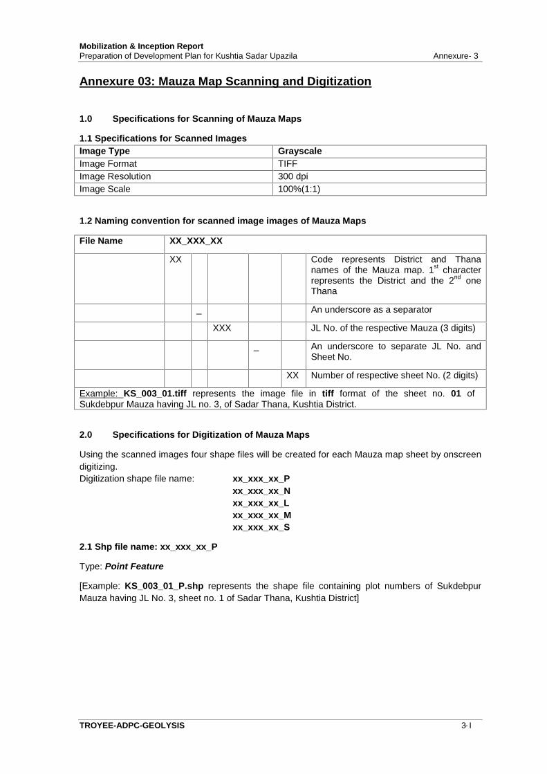
Mobilization & Inception ReportPreparation of Development Plan for Kushtia Sadar Upazila Annexure- 3
TROYEE-ADPC-GEOLYSIS 3- I
Annexure 03: Mauza Map Scanning and Digitization
1.0 Specifications for Scanning of Mauza Maps
1.1 Specifications for Scanned ImagesImage Type GrayscaleImage Format TIFFImage Resolution 300 dpiImage Scale 100%(1:1)
1.2 Naming convention for scanned image images of Mauza Maps
File Name XX_XXX_XX
XX Code represents District and Thananames of the Mauza map. 1st characterrepresents the District and the 2nd oneThana
_ An underscore as a separator
XXX JL No. of the respective Mauza (3 digits)
_ An underscore to separate JL No. andSheet No.
XX Number of respective sheet No. (2 digits)
Example: KS_003_01.tiff represents the image file in tiff format of the sheet no. 01 ofSukdebpur Mauza having JL no. 3, of Sadar Thana, Kushtia District.
2.0 Specifications for Digitization of Mauza Maps
Using the scanned images four shape files will be created for each Mauza map sheet by onscreendigitizing.Digitization shape file name: xx_xxx_xx_P
xx_xxx_xx_Nxx_xxx_xx_Lxx_xxx_xx_Mxx_xxx_xx_S
2.1 Shp file name: xx_xxx_xx_P
Type: Point Feature
[Example: KS_003_01_P.shp represents the shape file containing plot numbers of SukdebpurMauza having JL No. 3, sheet no. 1 of Sadar Thana, Kushtia District]
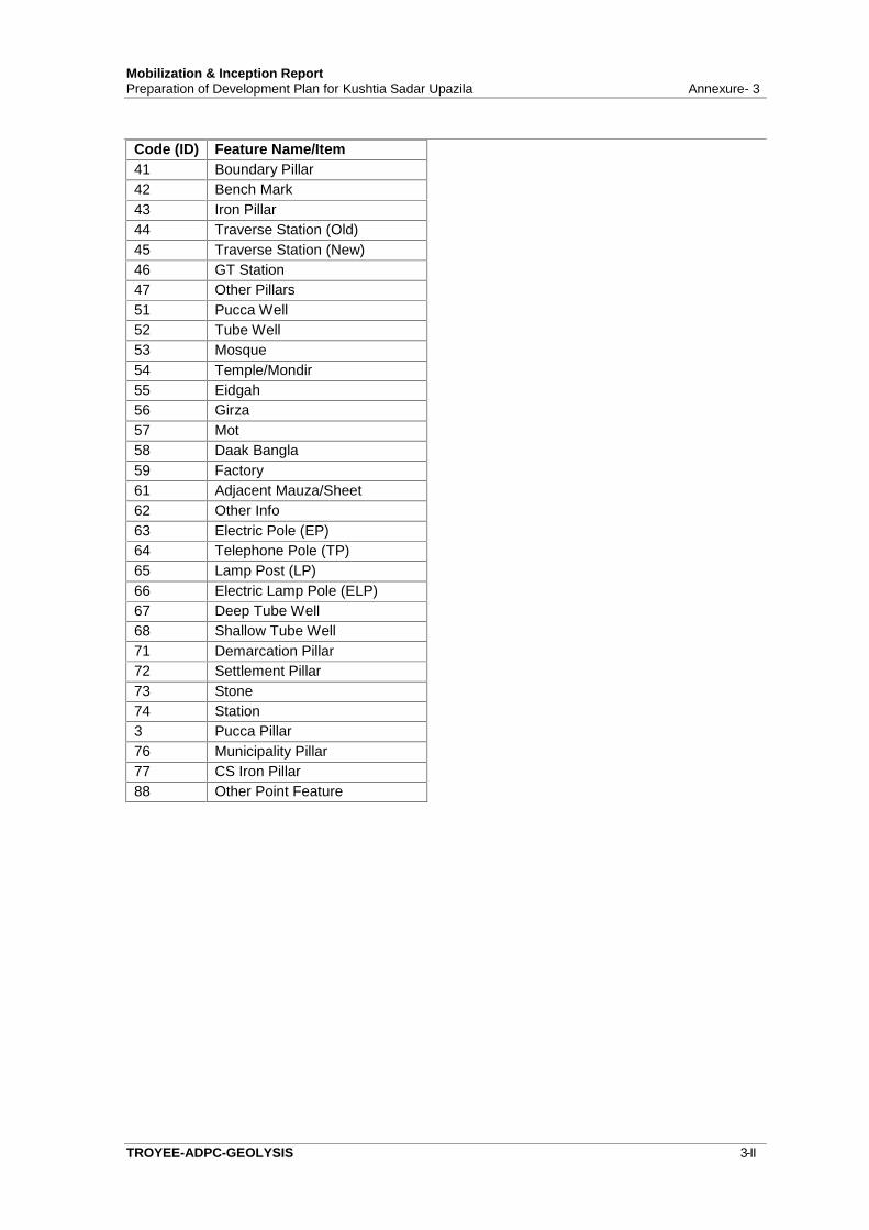
Mobilization & Inception ReportPreparation of Development Plan for Kushtia Sadar Upazila Annexure- 3
TROYEE-ADPC-GEOLYSIS 3-II
Code (ID) Feature Name/Item41 Boundary Pillar42 Bench Mark43 Iron Pillar44 Traverse Station (Old)45 Traverse Station (New)46 GT Station47 Other Pillars51 Pucca Well52 Tube Well53 Mosque54 Temple/Mondir55 Eidgah56 Girza57 Mot58 Daak Bangla59 Factory61 Adjacent Mauza/Sheet62 Other Info63 Electric Pole (EP)64 Telephone Pole (TP)65 Lamp Post (LP)66 Electric Lamp Pole (ELP)67 Deep Tube Well68 Shallow Tube Well71 Demarcation Pillar72 Settlement Pillar73 Stone74 Station3 Pucca Pillar76 Municipality Pillar77 CS Iron Pillar88 Other Point Feature
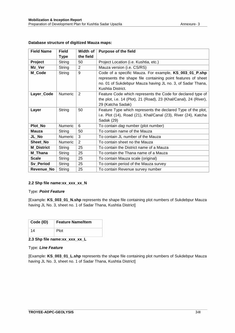
Mobilization & Inception ReportPreparation of Development Plan for Kushtia Sadar Upazila Annexure- 3
TROYEE-ADPC-GEOLYSIS 3-III
Database structure of digitized Mauza maps:
Field Name FieldType
Width ofthe field
Purpose of the field
Project String 50 Project Location (i.e. Kushtia, etc.)Mz_Ver String 2 Mauza version (i.e. CS/RS)M_Code String 9 Code of a specific Mauza. For example, KS_003_01_P.shp
represents the shape file containing point features of sheetno. 01 of Sukdebpur Mauza having JL no. 3, of Sadar Thana,Kushtia District.
Layer_Code Numeric 2 Feature Code which represents the Code for declared type ofthe plot, i.e. 14 (Plot), 21 (Road), 23 (Khal/Canal), 24 (River),29 (Katcha Sadak)
Layer String 50 Feature Type which represents the declared Type of the plot,i.e. Plot (14), Road (21), Khal/Canal (23), River (24), KatchaSadak (29)
Plot_No Numeric 6 To contain dag number (plot number)Mauza String 50 To contain name of the MauzaJL_No Numeric 3 To contain JL number of the MauzaSheet_No Numeric 2 To contain sheet no the MauzaM_District String 25 To contain the District name of a MauzaM_Thana String 25 To contain the Thana name of a MauzaScale String 25 To contain Mauza scale (original)Sv_Period String 25 To contain period of the Mauza surveyRevenue_No String 25 To contain Revenue survey number
2.2 Shp file name:xx_xxx_xx_N
Type: Point Feature
[Example: KS_003_01_N.shp represents the shape file containing plot numbers of Sukdebpur Mauzahaving JL No. 3, sheet no. 1 of Sadar Thana, Kushtia District]
Code (ID) Feature Name/Item
14 Plot
2.3 Shp file name:xx_xxx_xx_L
Type: Line Feature
[Example: KS_003_01_L.shp represents the shape file containing plot numbers of Sukdebpur Mauzahaving JL No. 3, sheet no. 1 of Sadar Thana, Kushtia District]
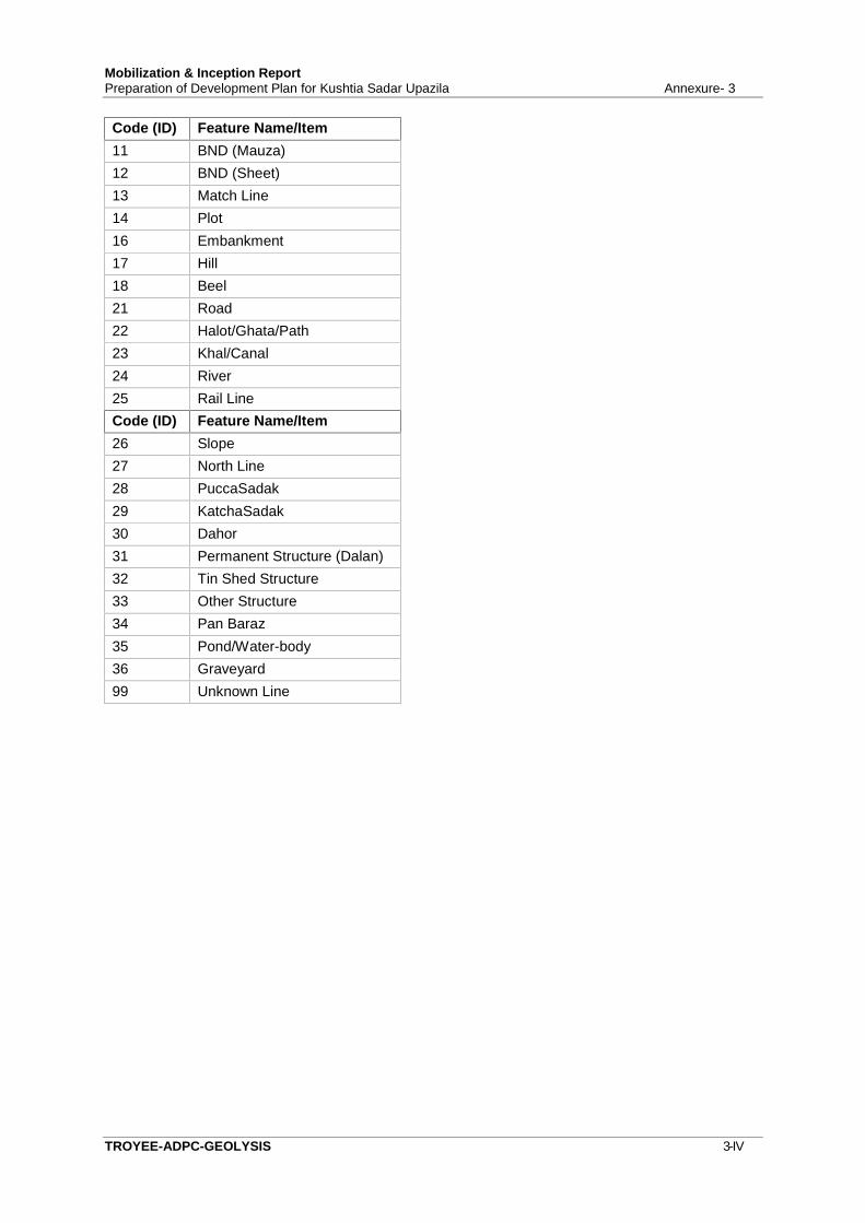
Mobilization & Inception ReportPreparation of Development Plan for Kushtia Sadar Upazila Annexure- 3
TROYEE-ADPC-GEOLYSIS 3-IV
Code (ID) Feature Name/Item11 BND (Mauza)12 BND (Sheet)13 Match Line14 Plot16 Embankment17 Hill18 Beel21 Road22 Halot/Ghata/Path23 Khal/Canal24 River25 Rail LineCode (ID) Feature Name/Item26 Slope27 North Line28 PuccaSadak29 KatchaSadak30 Dahor31 Permanent Structure (Dalan)32 Tin Shed Structure33 Other Structure34 Pan Baraz35 Pond/Water-body36 Graveyard99 Unknown Line
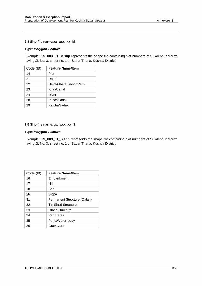
Mobilization & Inception ReportPreparation of Development Plan for Kushtia Sadar Upazila Annexure- 3
TROYEE-ADPC-GEOLYSIS 3-V
2.4 Shp file name:xx_xxx_xx_M
Type: Polygon Feature
[Example: KS_003_01_M.shp represents the shape file containing plot numbers of Sukdebpur Mauzahaving JL No. 3, sheet no. 1 of Sadar Thana, Kushtia District]
Code (ID) Feature Name/Item14 Plot21 Road22 Halot/Ghata/Dahor/Path23 Khal/Canal24 River28 PuccaSadak29 KatchaSadak
2.5 Shp file name: xx_xxx_xx_S
Type: Polygon Feature
[Example: KS_003_01_S.shp represents the shape file containing plot numbers of Sukdebpur Mauzahaving JL No. 3, sheet no. 1 of Sadar Thana, Kushtia District]
Code (ID) Feature Name/Item16 Embankment17 Hill18 Beel26 Slope31 Permanent Structure (Dalan)32 Tin Shed Structure33 Other Structure34 Pan Baraz35 Pond/Water-body36 Graveyard
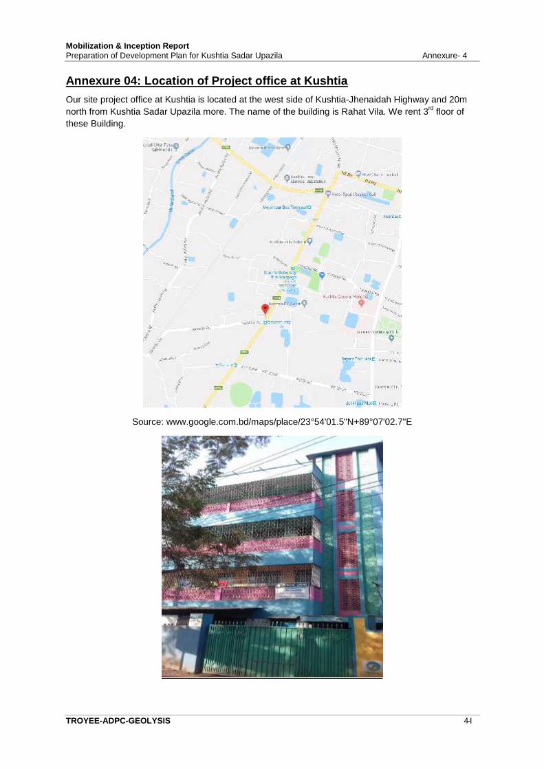
Mobilization & Inception ReportPreparation of Development Plan for Kushtia Sadar Upazila Annexure- 4
TROYEE-ADPC-GEOLYSIS 4-I
Annexure 04: Location of Project office at KushtiaOur site project office at Kushtia is located at the west side of Kushtia-Jhenaidah Highway and 20mnorth from Kushtia Sadar Upazila more. The name of the building is Rahat Vila. We rent 3rd floor ofthese Building.
Source: www.google.com.bd/maps/place/23°54'01.5"N+89°07'02.7"E

Mobilization & Inception ReportPreparation of Development Plan for Kushtia Sadar Upazila Annexure- 5
TROYEE-ADPC-GEOLYSIS 5-I
Annexure 05: TMC Meeting Comments and Adjustment on Report
SL.No. TMC Meeting Comments Adjustment on
Report Remarks of the Consultant
1. Meeting minutes and summary ofpreliminary consultation meeting andReconnaissance Survey should beincluded in Inception report.
See Chapter 1;Section 1.11 and
1.12
Meeting minutes not preparebecause it was introducingmeeting with DC of KushtiaDistrict, Mayor of KushtiaPaurashava, UNO of KushtiaSadar Upazila
2. Clarify the Specification of Scan andDigitization as per TOR.
See Chapter 4;Section 4.6.1 and
4.6.2
Corrected
3. Clarify the Specification of ProjectionSystem as per TOR
See Chapter 4;Section 4.6.4
Corrected
4. Give Importance in Edge Matching ofMauza Sheet
See Chapter 4;Section 4.7.2
Corrected
5. Clarify the Detail Specification ofResolution of DEM
See Chapter 4;Section 4.8.3
Corrected
6. Sampling Technique of different survey This was notinserted in the ToC
of this report
This will illustrated in theSurvey Report-1 withQuestionnaire format
7. Model for Drainage and HydrologyStudy
See Chapter 4;Section 4.18
Discussed in the meeting andDrainage model will not usein this project due to time andbudget constraints and notmentioned in ToR
8. Update Paurashava Information fromdistrict wise Atlas of BBS
See Chapter 1;section 1.8
Corrected
9. Give importance to DemarcateTourism Area
See Chapter 2;Section 2.11
Corrected
10. Clinical Waste Management See Chapter 4;Section 4.19
Corrected
11. Insert Local/ Site office information inInception report
See Chapter 1;Section 1.10 and
Annexure 04
Corrected
12. Clarify Vision and Mission Statementof the Project
See Chapter 1;Section 1.3 and 1.4
Corrected
13. Deliver Weekly and Monthly WorkSchedule
Attached a formatin the annexure
Will submit monthly progressreport to PMO
14. Final Survey Methodology Will mentioned in the SurveyReport-1 with questionnaireformat
15. Clarify the Specification of GISdatabase
See Annexure 03 Corrected
16. Source of different Maps and Imagesshould be included
See Chapter 2;Section 2.2 and 2.3
Corrected