preliminary seismicity and focal mechanisms in the southern gulf of suez: august 1994 through...
TRANSCRIPT
www.elsevier.com/locate/jafrearsci
Journal of African Earth Sciences 45 (2006) 48–60
Preliminary seismicity and focal mechanisms in the southern Gulfof Suez: August 1994 through December 1997
H.M. Hussein a,*, I. Marzouk a, A.R. Moustafa b, N. Hurukawa c
a National Research Institute of Astronomy and Geophysics, Seismology Department, El-Marsad St., Helwan 11421, Cairo, Egyptb Department of Geology, Faculty of Science, Ain Shams University, Cairo, Egypt
c International Institute of Seismology and Earthquake Engineering, Japan
Received 13 June 2005; received in revised form 31 December 2005; accepted 3 January 2006Available online 3 March 2006
Abstract
This paper shows an evaluation of the seismic activity in the entrance of the Gulf of Suez using the data recorded by Hurghada Seis-mological Network (HSN), in the period between August 1994 and December 1997 and represents an extension for the work publishedby the previous investigators. Hypocentral locations were determined for 180 earthquakes (duration magnitude ranged between 1.6 and4.3) selected from 300 recorded events. All these events are located with epicentral error and depth error of less than 2 km. The spatialdistribution of these earthquakes indicates the presence of three active areas. These are Shadwan Island, Gubal Island and the area adja-cent to the southern tip of Sinai Peninsula. Such pattern of activity implies a localization of stress below these areas. The concentration ofthe stress field in these areas may have been strongly controlled by ductile necking and or intrusion. Composite fault plane solutions werealso constructed for each of the three active areas. The data for each area was divided into groups, according to geographical positionand uniformity of polarity data. In Shadwan Island, the composite fault plane solution of 15 events shows almost pure dip-slip motion.The composite fault plane solutions in Gubal Island and the area adjacent to the southern tip of Sinai Peninsula indicate a mixed regimeof both strike-slip and extensional faulting mechanisms. The stress regime obtained from the fault plane solutions in this study is pre-dominantly NNE–SSW tensional stress field. This result is consistent with the present day stress field, which has a 010� ± 18� orientation.The overall results are correlated with the structural setting of the area known from other sources.� 2006 Elsevier Ltd. All rights reserved.
Keywords: Seismicity; Focal mechanism; Tensional stress
1. Introduction
The southern part of the Gulf of Suez is one of the mostseismically active areas in Egypt. It is the site of the magni-tude 7.2MS earthquake on March 31, 1969, as well as theevent of June 28, 1972 (Mb = 5.5). In general, the southernpart of the Gulf of Suez has been described as an area ofsignificant intermediate magnitude earthquake activity(Gergawi and El Khashab, 1968; Bosworth and Taviani,1996). The distribution of historical and recent earthquakes
1464-343X/$ - see front matter � 2006 Elsevier Ltd. All rights reserved.
doi:10.1016/j.jafrearsci.2006.01.006
* Corresponding author.E-mail address: [email protected] (H.M. Hussein).
in the Gulf of Suez showed that, there is a concentration ofthe activity along the southern end of the Gulf of Suez nearthe junction with the Northern Red Sea (Maamoun et al.,1984; Kulhanek et al., 1992). The higher rate of activityin the southern end of the Gulf of Suez is mainly relatedto the adjustments in motion at the triple junction betweenthe African plate, Arabian plate and Sinai microplate(Ben-Menahem et al., 1976; Daggett et al., 1986).
The focal mechanism solutions of March 31, 1969 andJune 28, 1972 earthquakes indicate that, the southern partof the Gulf of Suez is dominated by active extensionalstress regime. The foci of both events are located to the eastof Gubal Island. The mechanisms of both events (Huangand Solomon, 1987; Jackson et al., 1988) correspond tonearly pure dip-slip movement along the NE dipping fault
H.M. Hussein et al. / Journal of African Earth Sciences 45 (2006) 48–60 49
plane. The fault plane determined in their work trends in adirection of 105�–130� and dips at an angle rangingbetween 35� and 40� for March 31, 1969 event, while theJune 28, 1972 event shows a plane oriented 080�–142�anddipping 30�–50�. The notable difference between the solu-tions of the two authors is the direction of the tensile stress.Jackson et al. (1988) obtained a horizontal extension direc-tion of about 040� ± 10�, while the results of Huang andSolomon (1987) indicated a horizontal extension ofapproximately 020� ± 10�. Ben-Menahem and Aboodi(1971) obtained a mechanism for March 31, 1969 whichfavor some amount of left-lateral strike-slip motion alongthe same fault plane.
The IISEE (International Institute of Seismology andEarthquake Engineering) and NRIAG (National ResearchInstitute of Astronomy and Geophysics) have collaboratedin seismological studies of the southern part of the Gulf ofSuez since August 1994, in which the activity in this parthas been monitored by permanent telemetric network,installed on both sides of the Gulf of Suez. The main aimof this network is to study the characteristics and sourcemechanism of the microearthquake activity in order tothrow some lights on the seismotectonics and seismic haz-ard of this zone. However, the study of source mechanismprovides some information about the present-day stressfield. In this study, we presented the basic seismologicalresults of 41 months of operation of the Hurghada Seismo-logical Network.
2. General geology and tectonics
The Gulf of Suez occupies the central portion of a riftwith a length of about 350 km and a width ranging between60 and 80 km (Patton et al., 1994; El-Khadragy et al.,1999). It extends from Latitude 27�15� N to 30�00� Nand Longitude 32�00� to 34�15� E. It is characterized bythe absence of sea floor spreading and any type of lateralsymmetry (Hoseny, 1985). The Gulf of Suez formed inthe latest Oligocene to Early Miocene as the northwesternextension of the Red Sea (Robson, 1971; Garfunkel andBartov, 1977; Meshref, 1990). The Gulf of Suez and theRed Sea represent two rift systems created by extensionalmovement more or less perpendicular to their border faults(Ben-Avraham et al., 1979; Garfunkel et al., 1981). Duringthe Middle Miocene, the opening of the Suez rift died outand the Red Sea rift propagated to the NNE direction,causing left-lateral strike-slip displacement of extensionalcomponent on the Dead Sea Fault System (Quenell,1958; Steckler and Ten Brink, 1986; Bosworth andMcClay, 2001). The Gulf of Suez was previously inter-preted to be the site of either left-lateral (Abdel-Gawad,1969) or right-lateral strike-slip motion (Youssef, 1968;Francheteau and Le Pichon, 1972a; Meshref, 1990) withslight extension. Later studies indicated that the Gulf ofSuez was opened mainly by extensional stress (Lyberis,1988; Patton et al., 1994). Angelier (1985) has shown thatthe main Late Cenozoic extension at the Gulf of Suez
which occurred perpendicular to the rift axis is related inchronology and volume to the uplift of the rift shoulders.Recent studies show that, very low rate of extension equalto 1 mm/year and tectonic subsidence (Steckler et al., 1988)characterized the Gulf of Suez at present. On the contrary,the Dead Sea transform displays a higher rate of motionwith geological evidences suggesting an average rate ofabout 8–9 mm/year (Le Pichon and Gaulier, 1988; Riguzziet al., 1999).
The Gulf of Suez rift, Red Sea spreading center and theDead Sea transform separate three continental blocks:Africa, Arabia and Sinai. Plate kinematic models for theNorthern Red Sea showed that, the present-day motionof the Arabian plate would be 030� with respect to the Afri-can plate (McKenzie et al., 1970; Hempton, 1987; Joffe andGarfunkel, 1987; Lyberis, 1988). While the motion of theAfrican plate relative to the Arabian plate has been estab-lished, the role of Sinai Peninsula in the regional tectonicsis still unclear (Nur and Ben-Avraham, 1978). A number ofstudies discussed the evidences that Sinai Peninsulabehaves like a rigid block or sub-plate with respect to theAfrican plate (Ben-Menahem et al., 1976; Le Pichon andFrancheteau, 1978; Riguzzi et al., 1999). The available geo-logic, tectonic and geodetic information can be used todemonstrate the southwestward motion of Sinai Peninsulawith respect to the Arabian plate along the Dead Sea faultsystem (Le Pichon and Gaulier, 1988; Steckler et al., 1988;Riguzzi et al., 1999). The detected southwestward slipmotion agrees with the slip vectors estimated from the focalmechanism solutions of the August 3, 1993 (Mb = 5.8) andNovember 22, 1995 (Mb = 6.1) Gulf of Aqaba earthquakes(Abdel-Fattah et al., 1997). However, Swartz and Arden(1960) have postulated that, the Sinai block moved towardthe southeast along NW–SE trending faults with respect toEgypt.
The Gulf of Suez is characterized by the presence ofthree distinct depocenters; the northern, central and south-ern basins (Moustafa, 1976; Bosworth, 1985; Coffield andSchamel, 1989; McClay and Bosworth, 2001). Each sub-basin is asymmetric bounded on one side by major NWtrending border fault system with large throws togetherwith a dominant stratal dip direction towards the borderfault system. The depocenters are separated by structurallycomplex accommodation zones, oblique to the rift trend.The accommodation zones are characterized by complexlyfaulted blocks of variable dips and interlocking ‘‘flip-flop’’conjugate fault systems.
As in most extensional systems, the Gulf of Suez rift iscontrolled by normal faults and tilted blocks (Colletaet al., 1988). The fault pattern consists of two major sets:(1) the main clysmic fault trend (N 40�–30� W), that con-tains normal faults parallel to the rift axis and created dur-ing Neogene times in a pure extensional regime (Said, 1962;Meshref et al., 1976; Bartov et al., 1980; Jarrige et al., 1986;Colleta et al., 1988). (2) Transfer faults with NNE, WNWand ENE trends (Patton et al., 1994). The NNE and WNWfaults trend oblique to the clysmic trend (Salman, 1982;
50 H.M. Hussein et al. / Journal of African Earth Sciences 45 (2006) 48–60
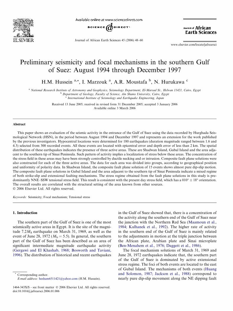
El-Khadragy et al., 1999; Youssef et al., 2000a). Faultsbelonging to these trends show predominant normal dip-slip component and very small strike-slip components(Moustafa, 1993, 2004). A summary map of the Gulf ofSuez faults is shown in Fig. 1. However, the structural pat-tern of the Gulf of Suez; the clysmic and transfer faults areinherited from the Pre-rift basement tectonics (Montenatet al., 1988). The two major trends play an important rolein the rifting processes.
The Pre-rift basement of the Gulf of Suez region, whichare found in the cores of the tilted blocks in the central andsouthern part of the Gulf and also along the marginalrelief’s consist of very heterogeneous and polygeneticrocks; Precambrian gneisses, volcanics and metasediments(Stern, 1994; Kroner, 1993). These rocks were deformedand metamorphosed during the Pan African tectono-mag-netic orogeny which terminated about 550 Ma. The base-ment of southern part of the Gulf of Suez exhibits anumber of strong Pre-rift fabrics including N and NWtrending Pan African foliations in the basement gneisses,pervasive NE to ENE trending vertical to sub-verticalmafic to andesitic post-Pan African to early Cambriandikes, N–S fracture zone that offset some of the graniticintrusions, and NW trending basement shear zones(McClay and Khalil, 1998; McClay and Bosworth, 2001).The pre-existing Precambrian to early Cambrian fabricswas reactivated during the late Cenozoic rifting of the Gulfof Suez (El Tarabili and Awady, 1972; Patton et al., 1994;Younes et al., 1998). The zigzag fault pattern (clysmic andtransfer faults) at the rift border and intra-rift fault systems
Fig. 1. Summary map of the southern Gulf of Suez (after Bosworth,1994).
resulted from reactivation and hard linkage of the NWtrending shear zones and foliation fabrics via the N–Sand NNE–SSW fault fabrics (Montenat et al., 1988;McClay and Bosworth, 2001). The most clear evidencefor the influence of the basement structural discontinuitieson Neogene rifting have been found in the Abu Ghusumarea where the limits of the Miocene faulted blocks forthe transfer faults follow the foliation direction of themetamorphic basement. The major clysmic trend is alsoparallel to Paleozoic plutonic intrusions in the southernpart of the Gulf (Gebel Zeit).
Tectonic evolution of the Gulf of Suez region using thefault planes and slickenside lineations from field measure-ments indicate three phases of extensional directions(Lyberis, 1988; Steckler et al., 1988). The first phase beganin the Early Miocene with NNE–SSW extensional direc-tion, oblique to the rift trend. This was followed by 060�extension in the Middle to Late Miocene. The last phaseof extension took place since the end of Miocene with anaverage E–W direction. The Quaternary sediments andthe kinematics of Ras Mohomed and Gebel El Zeit regions(Bosworth and Taviani, 1996) indicate that the direction ofthe second phase of extension was rotated counterclock-wise to 15� during the Late Pleistocene rather than shiftingto the third phase of E–W extension. Borehole breakoutdata in the southern part of the Gulf of Suez indicated thatthe present-day stress field orientation (010� ± 18�) is sim-ilar with some scattered E–W orientation. This scatter inthe breakout orientation was reported in three wells inthe vicinity of the active Gubal Island fault. Bosworthand Taviani (1996) attributed this scatter to relaxationand reorientation of stress following the 1969 and 1972earthquakes.
3. Data
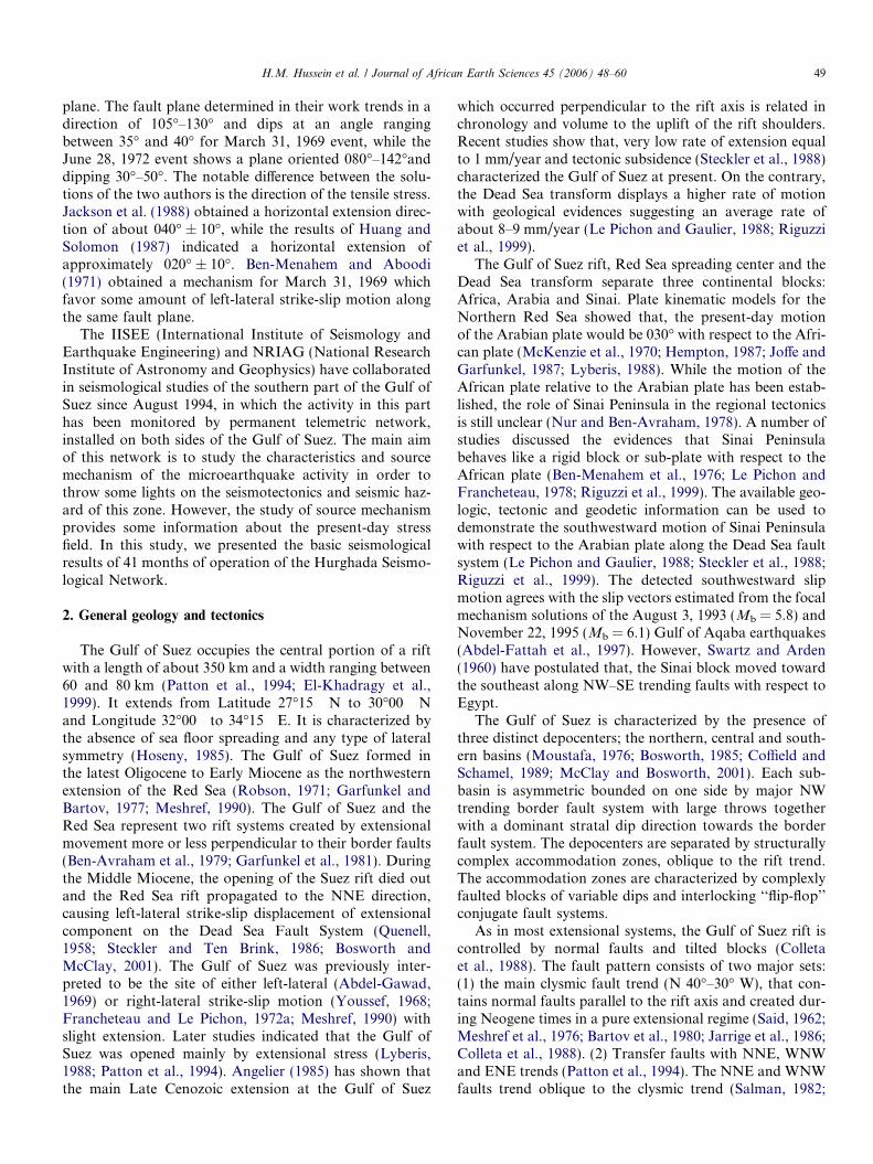
Data used in the present study are those acquired fromHurghada Seismological Network (Nakamura et al., 1999).Hurghada Seismological Network (HSN) began workingsince August 1994. It consists of 10 stations (Fig. 2). Table1 shows coordinates of each station. Nine of them are sit-uated along both sides of the southern part of the Gulfof Suez, whereas the 10th station is located on ShadwanIsland. Nine stations of HSN operate the same seismo-graph system, which is L4C (Mark Product) vertical com-ponent seismometer with 1 Hz central frequency. Onlyone station was connected to three 1 Hz L4C seismometersoriented to record the three components of motion. Theindividual stations transmit their signals to the recordingcenter in Hurghada via radio link. Accurate station timewas obtained from GPS clock at Hurghada SeismologicalCenter. The data of the 10 seismic stations are currentlydigitized at 100 sample per second and stored on magneticoptical disk. Ink pen recordings were also available foronly three stations. The main aim of installing this networkis to define the characteristics of the seismicity in this areaof active tectonics.
Table 2P wave velocity structure
VP (km/s) Depth to the top of the layer (km)
4.5 0.06.0 5.06.5 158.0 25
Fig. 2. Configuration of Hurghada Seismological Network.
Table 1List of Hurghada Seismological Network (HSN) stations
No. Station name Stationcode
LatitudeN�
LongitudeE�
Height(m)
1 Hammam Mousa HAMM 28.2763 33.5778 2402 Atot Mountain ATOT 28.1683 33.8603 2003 Mazeria MAZR 27.9292 3.9948 2004 Gebel El-Zeit ZEIT 27.8728 33.5162 1005 Gebel Abu-Shaar ABSH 27.3680 33.6208 2206 Wadi Um-Dalfa UMDL 27.0860 33.6517 1007 Gharamoul Mountain GHAR 28.0400 33.1200 3508 Sharm El Sheikh SHRM 27.8520 34.2578 3009 Shadwan Island SHDW 27.4588 34.0321 200
10 Wadi Nabq NABA 28.0648 34.4171 200
H.M. Hussein et al. / Journal of African Earth Sciences 45 (2006) 48–60 51
For the period from August 1994 till December 1997, Pand S arrival times were measured on triggered digitalrecords for hypocenter determination. We also measuredthe duration of these events from the ink pen drum recordsto determine magnitudes. Duration magnitudes for thelocated events were also calculated from the magnitudeduration relationship of Maamoun (1978). The durationmagnitude of these earthquakes are measured between1.6 and 4.3. These data provide some features of seismicity,that confirm some previous observations and add newresults. The P wave first motions were also read from seis-mograms recorded at the various stations of HSC for 58earthquakes, which occurred in the southern part of theGulf of Suez. The polarity data for these earthquakes wereused to construct composite fault plane solutions.
4. Epicentral location
During the period of study from August 1994 to Decem-ber 1997, several earthquakes were recorded by HSN.Hypocentral locations were determined for these eventsusing HYPO71 program (Lee, 1990). In hypo71 algorithm,the change in the arrival time due to change in hypocentralposition is linearized. The hypocentral coordinates and theorigin time are iteratively estimated using stepwise statisti-cal regression procedure. The HYPO71 output depends onthe crustal model and starting depth. All the hypocentralcalculations were done using the P wave velocity modelof Marzouk (1988) (Table 2). This model is based on theseismic refraction experiment performed on the northernpart of the Gulf of Suez. The phase readings at stationswith large residuals for the individual locations wererechecked. The P phase is also omitted from the calcula-tions during the periods of excessive background noise.For the S phase, it is well known that, the use of their arri-val times greatly improves the location accuracy, particu-larly hypocentral depth. Science HSN employed only onethree component sensor, in which the S phase onset timecannot be identified from the other nine short period com-ponent instruments without ambiguity. Therefore, the clearobvious S phase onsets were used for hypocentral calcula-tions. To evaluate the uncertainties in the hypocentralcoordinates, we locate events using several starting depths.The output shows that the different starting depths cause asmall changes only in the estimated depth. For the datasetdescribed here, the maximum epicentral error and the max-imum depth error were less than 2.0 km. In this study, atleast 5 P wave and 2 S wave readings are required for anevent to be included in our data.
The seismicity shown in the epicentral map (Fig. 3)appears to be concentrated into three active zones. Thesezones are clustered under Shadwan Island, Gubal Islandand the area close to the southern tip of Sinai Peninsula.In addition to these zones, a small number of earthquakestook place very close to the entrance of the Gulf of Aqabaand the median zone of the northern Red Sea. However,the zone located between the mouth of the Gulf and thearea very close to Sinai Peninsula is almost aseismic. Across-section through the hypocenters of the three activezones (Fig. 4) shows that, the focal depth for the majorityof earthquakes ranges from 10 to 17 km. In this cross-section, the largest concentration of activity is particularlyobserved under Gubal Island.
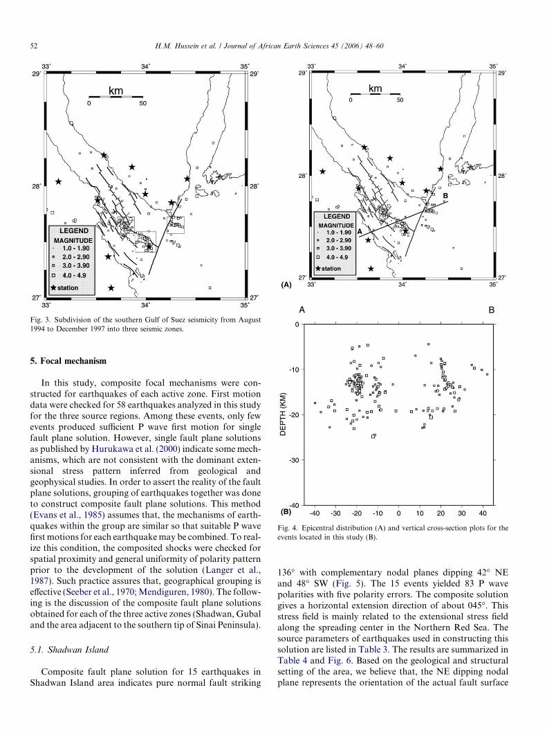
Fig. 4. Epicentral distribution (A) and vertical cross-section plots for theevents located in this study (B).
Fig. 3. Subdivision of the southern Gulf of Suez seismicity from August1994 to December 1997 into three seismic zones.
52 H.M. Hussein et al. / Journal of African Earth Sciences 45 (2006) 48–60
5. Focal mechanism
In this study, composite focal mechanisms were con-structed for earthquakes of each active zone. First motiondata were checked for 58 earthquakes analyzed in this studyfor the three source regions. Among these events, only fewevents produced sufficient P wave first motion for singlefault plane solution. However, single fault plane solutionsas published by Hurukawa et al. (2000) indicate some mech-anisms, which are not consistent with the dominant exten-sional stress pattern inferred from geological andgeophysical studies. In order to assert the reality of the faultplane solutions, grouping of earthquakes together was doneto construct composite fault plane solutions. This method(Evans et al., 1985) assumes that, the mechanisms of earth-quakes within the group are similar so that suitable P wavefirst motions for each earthquake may be combined. To real-ize this condition, the composited shocks were checked forspatial proximity and general uniformity of polarity patternprior to the development of the solution (Langer et al.,1987). Such practice assures that, geographical grouping iseffective (Seeber et al., 1970; Mendiguren, 1980). The follow-ing is the discussion of the composite fault plane solutionsobtained for each of the three active zones (Shadwan, Gubaland the area adjacent to the southern tip of Sinai Peninsula).
5.1. Shadwan Island
Composite fault plane solution for 15 earthquakes inShadwan Island area indicates pure normal fault striking
136� with complementary nodal planes dipping 42� NEand 48� SW (Fig. 5). The 15 events yielded 83 P wavepolarities with five polarity errors. The composite solutiongives a horizontal extension direction of about 045�. Thisstress field is mainly related to the extensional stress fieldalong the spreading center in the Northern Red Sea. Thesource parameters of earthquakes used in constructing thissolution are listed in Table 3. The results are summarized inTable 4 and Fig. 6. Based on the geological and structuralsetting of the area, we believe that, the NE dipping nodalplane represents the orientation of the actual fault surface
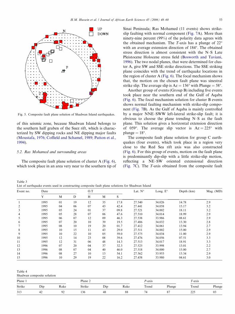
Fig. 5. Composite fault plane solution of Shadwan Island earthquakes.
H.M. Hussein et al. / Journal of African Earth Sciences 45 (2006) 48–60 53
of this seismic zone, because Shadwan Island belongs tothe southern half graben of the Suez rift, which is charac-terized by SW dipping rocks and NE dipping major faults(Moustafa, 1976; Coffield and Schamel, 1989; Patton et al.,1994).
5.2. Ras Mohamed and surrounding areas
The composite fault plane solution of cluster A (Fig. 6),which took place in an area very near to the southern tip of
Table 3List of earthquake events used in constructing composite fault plane solutions
Event no. Date O.T
Y M D H M S
1 1995 01 19 12 35 17.82 1995 04 06 07 43 42.43 1995 05 24 01 37 09.84 1995 05 28 07 06 47.65 1995 06 07 12 09 46.36 1995 07 20 10 39 19.57 1995 08 10 19 20 01.78 1995 10 15 11 43 29.09 1995 10 22 10 05 59.0
10 1995 12 14 23 08 39.611 1995 12 31 06 48 14.312 1996 07 20 04 37 32.313 1996 08 07 04 40 46.014 1996 08 27 10 13 54.115 1996 10 29 19 22 16.2
Table 4Shadwan composite solution
Plane 1 Plane 2
Strike Dip Rake Strike Dip
313 42 �92 136 48
Sinai Peninsula; Ras Mohamed (11 events) shows strike-slip faulting with normal component (Fig. 7A). More thanninety-nine percent (99%) of the polarity data agrees withthe obtained mechanism. The T-axis has a plunge of 22�with an average extension direction of 184�. The obtainedstress direction is almost consistent with the N–S LatePleistocene Holocene stress field (Bosworth and Taviani,1996). The two nodal planes, that were determined for clus-ter A, give SW and SSE strike directions. The SSE strikingplane coincides with the trend of earthquake locations inthe region of cluster A (Fig. 6). The focal mechanism showsthat, the motion on the chosen fault plane was sinestralstrike slip. The average slip is Az = 156� with Plunge = 58�.
Another group of events (Group B) including five eventstook place near the southern end of the Gulf of Aqaba(Fig. 6). The focal mechanism solution for cluster B eventsshows normal faulting mechanism with strike-slip compo-nent (Fig. 7B). As the Gulf of Aqaba is mainly controlledby a major NNE–SWW left-lateral strike-slip fault; it isobvious to choose the plane trending N–S as the faultplane. This solution gives a horizontal extension directionof 059�. The average slip vector is Az = 225� withplunge = 18�.
The composite fault plane solution for group C earth-quakes (four events), which took place in a region veryclose to the Red Sea rift axis was also constructed(Fig. 6). For this group of events, motion on the fault planeis predominantly dip-slip with a little strike-slip motion,reflecting a NE–SW oriented extensional direction(Fig. 7C). The T-axis obtained from the composite fault
for Shadwan Island
Lat. N� Long. E� Depth (km) Mag. (MD)
27.540 34.026 14.78 2.927.441 34.058 15.17 3.227.521 34.002 18.11 3.227.510 34.014 18.99 2.927.538 33.986 08.61 2.927.486 34.032 13.30 2.827.412 34.061 13.94 2.727.511 34.002 15.00 2.927.575 34.034 11.00 2.927.476 34.056 07.51 3.327.513 34.017 18.91 3.327.525 33.998 13.01 2.227.518 34.000 15.00 2.727.562 33.953 13.34 2.927.458 33.980 04.61 3.0
P-axis T-axis
Rake Trend Plunge Trend Plunge
�88 74 87 225 03
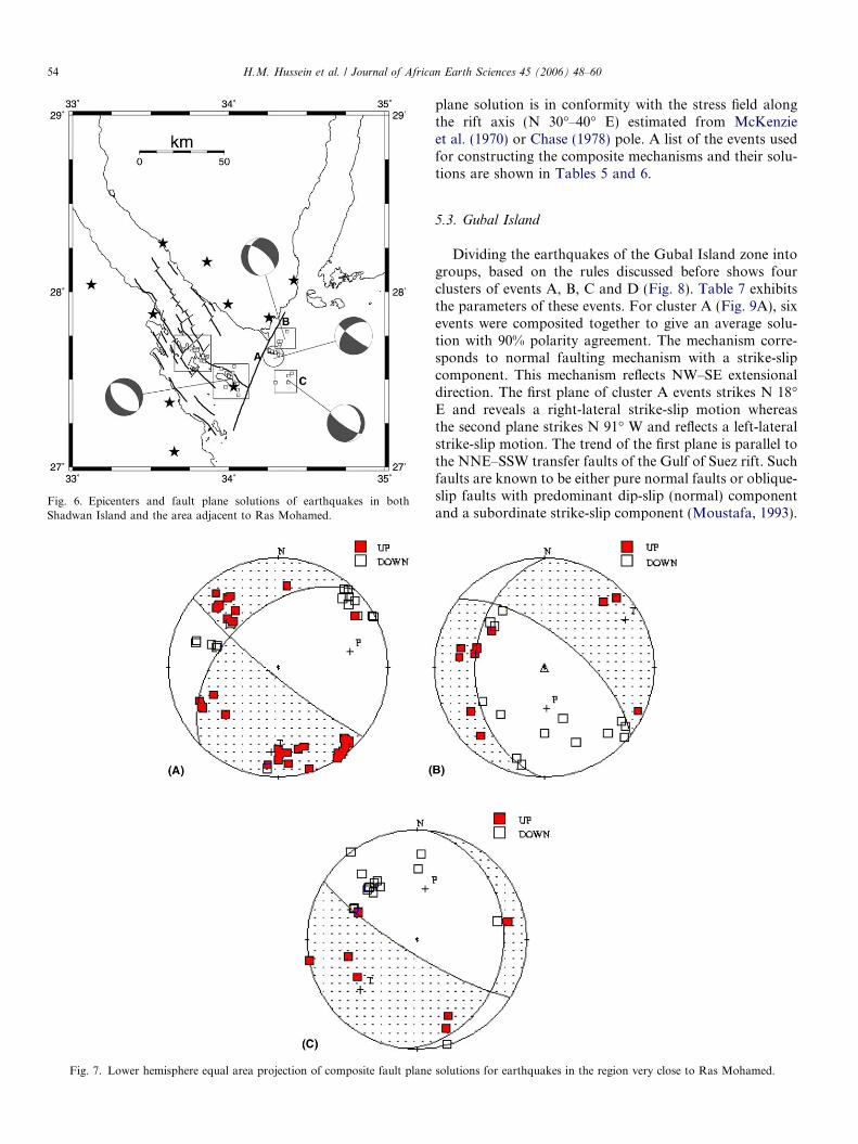
Fig. 7. Lower hemisphere equal area projection of composite fault plane
Fig. 6. Epicenters and fault plane solutions of earthquakes in bothShadwan Island and the area adjacent to Ras Mohamed.
54 H.M. Hussein et al. / Journal of African Earth Sciences 45 (2006) 48–60
plane solution is in conformity with the stress field alongthe rift axis (N 30�–40� E) estimated from McKenzieet al. (1970) or Chase (1978) pole. A list of the events usedfor constructing the composite mechanisms and their solu-tions are shown in Tables 5 and 6.
5.3. Gubal Island
Dividing the earthquakes of the Gubal Island zone intogroups, based on the rules discussed before shows fourclusters of events A, B, C and D (Fig. 8). Table 7 exhibitsthe parameters of these events. For cluster A (Fig. 9A), sixevents were composited together to give an average solu-tion with 90% polarity agreement. The mechanism corre-sponds to normal faulting mechanism with a strike-slipcomponent. This mechanism reflects NW–SE extensionaldirection. The first plane of cluster A events strikes N 18�E and reveals a right-lateral strike-slip motion whereasthe second plane strikes N 91� W and reflects a left-lateralstrike-slip motion. The trend of the first plane is parallel tothe NNE–SSW transfer faults of the Gulf of Suez rift. Suchfaults are known to be either pure normal faults or oblique-slip faults with predominant dip-slip (normal) componentand a subordinate strike-slip component (Moustafa, 1993).
solutions for earthquakes in the region very close to Ras Mohamed.
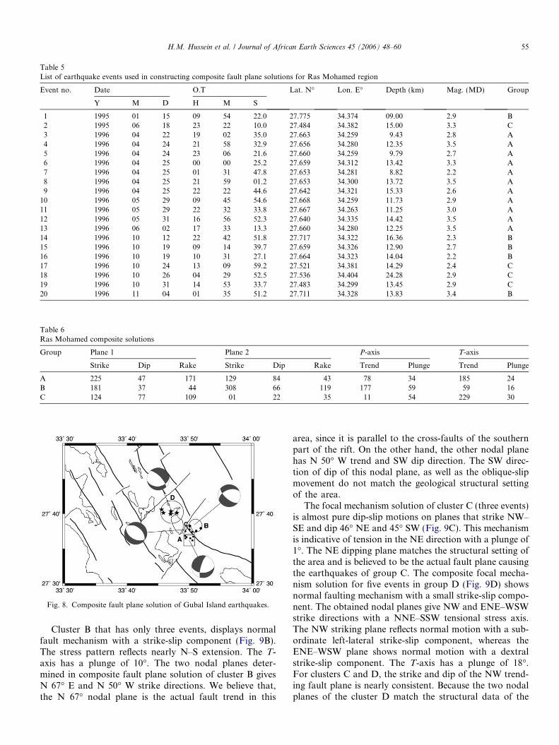
Table 5List of earthquake events used in constructing composite fault plane solutions for Ras Mohamed region
Event no. Date O.T Lat. N� Lon. E� Depth (km) Mag. (MD) Group
Y M D H M S
1 1995 01 15 09 54 22.0 27.775 34.374 09.00 2.9 B2 1995 06 18 23 22 10.0 27.484 34.382 15.00 3.3 C3 1996 04 22 19 02 35.0 27.663 34.259 9.43 2.8 A4 1996 04 24 21 58 32.9 27.656 34.280 12.35 3.5 A5 1996 04 24 23 06 21.6 27.660 34.259 9.79 2.7 A6 1996 04 25 00 00 25.2 27.659 34.312 13.42 3.3 A7 1996 04 25 01 31 47.8 27.653 34.281 8.82 2.2 A8 1996 04 25 21 59 01.2 27.653 34.300 13.72 3.5 A9 1996 04 25 22 22 44.6 27.642 34.321 15.33 2.6 A
10 1996 05 29 09 45 54.6 27.668 34.259 11.73 2.9 A11 1996 05 29 22 32 33.8 27.667 34.263 11.25 3.0 A12 1996 05 31 16 56 52.3 27.640 34.335 14.42 3.5 A13 1996 06 02 17 33 13.3 27.660 34.280 12.25 3.5 A14 1996 10 12 22 42 51.8 27.717 34.322 16.36 2.3 B15 1996 10 19 09 14 39.7 27.659 34.326 12.90 2.7 B16 1996 10 19 10 31 27.1 27.664 34.323 14.04 2.2 B17 1996 10 24 13 09 59.2 27.521 34.381 14.29 2.4 C18 1996 10 26 04 29 52.5 27.536 34.404 24.28 2.9 C19 1996 10 31 14 53 33.7 27.483 34.299 13.45 2.9 C20 1996 11 04 01 35 51.2 27.711 34.328 13.83 3.4 B
Table 6Ras Mohamed composite solutions
Group Plane 1 Plane 2 P-axis T-axis
Strike Dip Rake Strike Dip Rake Trend Plunge Trend Plunge
A 225 47 �171 129 84 �43 78 34 185 24B 181 37 �44 308 66 �119 177 59 59 16C 124 77 �109 01 22 �35 11 54 229 30
Fig. 8. Composite fault plane solution of Gubal Island earthquakes.
H.M. Hussein et al. / Journal of African Earth Sciences 45 (2006) 48–60 55
Cluster B that has only three events, displays normalfault mechanism with a strike-slip component (Fig. 9B).The stress pattern reflects nearly N–S extension. The T-axis has a plunge of 10�. The two nodal planes deter-mined in composite fault plane solution of cluster B givesN 67� E and N 50� W strike directions. We believe that,the N 67� nodal plane is the actual fault trend in this
area, since it is parallel to the cross-faults of the southernpart of the rift. On the other hand, the other nodal planehas N 50� W trend and SW dip direction. The SW direc-tion of dip of this nodal plane, as well as the oblique-slipmovement do not match the geological structural settingof the area.
The focal mechanism solution of cluster C (three events)is almost pure dip-slip motions on planes that strike NW–SE and dip 46� NE and 45� SW (Fig. 9C). This mechanismis indicative of tension in the NE direction with a plunge of1�. The NE dipping plane matches the structural setting ofthe area and is believed to be the actual fault plane causingthe earthquakes of group C. The composite focal mecha-nism solution for five events in group D (Fig. 9D) showsnormal faulting mechanism with a small strike-slip compo-nent. The obtained nodal planes give NW and ENE–WSWstrike directions with a NNE–SSW tensional stress axis.The NW striking plane reflects normal motion with a sub-ordinate left-lateral strike-slip component, whereas theENE–WSW plane shows normal motion with a dextralstrike-slip component. The T-axis has a plunge of 18�.For clusters C and D, the strike and dip of the NW trend-ing fault plane is nearly consistent. Because the two nodalplanes of the cluster D match the structural data of the
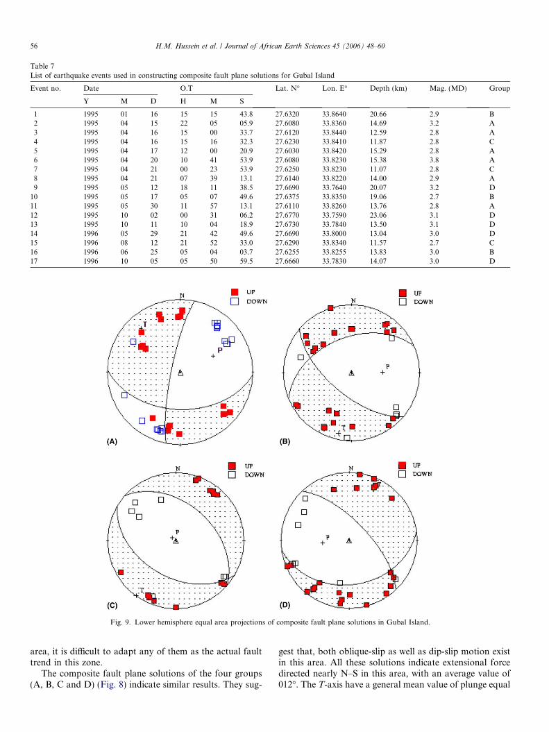
Table 7List of earthquake events used in constructing composite fault plane solutions for Gubal Island
Event no. Date O.T Lat. N� Lon. E� Depth (km) Mag. (MD) Group
Y M D H M S
1 1995 01 16 15 15 43.8 27.6320 33.8640 20.66 2.9 B2 1995 04 15 22 05 05.9 27.6080 33.8360 14.69 3.2 A3 1995 04 16 15 00 33.7 27.6120 33.8440 12.59 2.8 A4 1995 04 16 15 16 32.3 27.6230 33.8410 11.87 2.8 C5 1995 04 17 12 00 20.9 27.6030 33.8420 15.29 2.8 A6 1995 04 20 10 41 53.9 27.6080 33.8230 15.38 3.8 A7 1995 04 21 00 23 53.9 27.6250 33.8230 11.07 2.8 C8 1995 04 21 07 39 13.1 27.6140 33.8220 14.00 2.9 A9 1995 05 12 18 11 38.5 27.6690 33.7640 20.07 3.2 D
10 1995 05 17 05 07 49.6 27.6375 33.8350 19.06 2.7 B11 1995 05 30 11 57 13.1 27.6110 33.8260 13.76 2.8 A12 1995 10 02 00 31 06.2 27.6770 33.7590 23.06 3.1 D13 1995 10 11 10 04 18.9 27.6730 33.7840 13.50 3.1 D14 1996 05 29 21 42 49.6 27.6690 33.8000 13.04 3.0 D15 1996 08 12 21 52 33.0 27.6290 33.8340 11.57 2.7 C16 1996 06 25 05 04 03.7 27.6255 33.8255 13.83 3.0 B17 1996 10 05 05 50 59.5 27.6660 33.7830 14.07 3.0 D
Fig. 9. Lower hemisphere equal area projections of composite fault plane solutions in Gubal Island.
56 H.M. Hussein et al. / Journal of African Earth Sciences 45 (2006) 48–60
area, it is difficult to adapt any of them as the actual faulttrend in this zone.
The composite fault plane solutions of the four groups(A, B, C and D) (Fig. 8) indicate similar results. They sug-
gest that, both oblique-slip as well as dip-slip motion existin this area. All these solutions indicate extensional forcedirected nearly N–S in this area, with an average value of012�. The T-axis have a general mean value of plunge equal
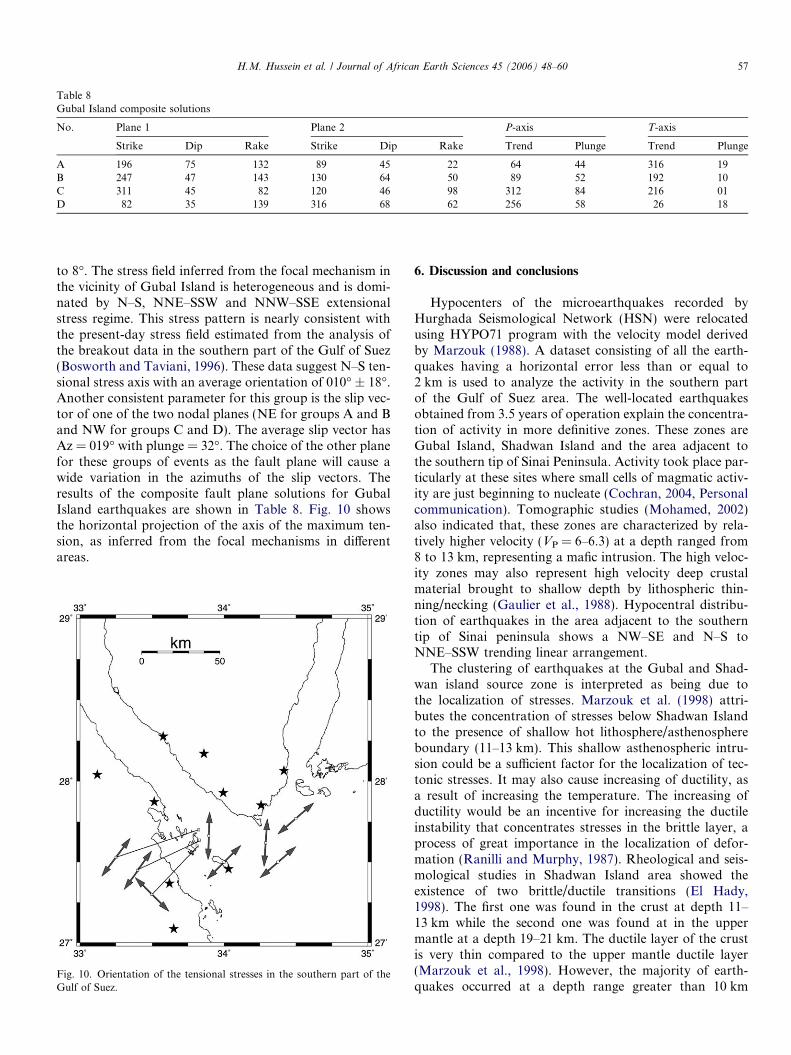
Table 8Gubal Island composite solutions
No. Plane 1 Plane 2 P-axis T-axis
Strike Dip Rake Strike Dip Rake Trend Plunge Trend Plunge
A 196 75 �132 89 45 �22 64 44 316 19B 247 47 �143 130 64 �50 89 52 192 10C 311 45 �82 120 46 �98 312 84 216 01D 82 35 �139 316 68 �62 256 58 26 18
H.M. Hussein et al. / Journal of African Earth Sciences 45 (2006) 48–60 57
to 8�. The stress field inferred from the focal mechanism inthe vicinity of Gubal Island is heterogeneous and is domi-nated by N–S, NNE–SSW and NNW–SSE extensionalstress regime. This stress pattern is nearly consistent withthe present-day stress field estimated from the analysis ofthe breakout data in the southern part of the Gulf of Suez(Bosworth and Taviani, 1996). These data suggest N–S ten-sional stress axis with an average orientation of 010� ± 18�.Another consistent parameter for this group is the slip vec-tor of one of the two nodal planes (NE for groups A and Band NW for groups C and D). The average slip vector hasAz = 019� with plunge = 32�. The choice of the other planefor these groups of events as the fault plane will cause awide variation in the azimuths of the slip vectors. Theresults of the composite fault plane solutions for GubalIsland earthquakes are shown in Table 8. Fig. 10 showsthe horizontal projection of the axis of the maximum ten-sion, as inferred from the focal mechanisms in differentareas.
Fig. 10. Orientation of the tensional stresses in the southern part of theGulf of Suez.
6. Discussion and conclusions
Hypocenters of the microearthquakes recorded byHurghada Seismological Network (HSN) were relocatedusing HYPO71 program with the velocity model derivedby Marzouk (1988). A dataset consisting of all the earth-quakes having a horizontal error less than or equal to2 km is used to analyze the activity in the southern partof the Gulf of Suez area. The well-located earthquakesobtained from 3.5 years of operation explain the concentra-tion of activity in more definitive zones. These zones areGubal Island, Shadwan Island and the area adjacent tothe southern tip of Sinai Peninsula. Activity took place par-ticularly at these sites where small cells of magmatic activ-ity are just beginning to nucleate (Cochran, 2004, Personalcommunication). Tomographic studies (Mohamed, 2002)also indicated that, these zones are characterized by rela-tively higher velocity (VP = 6–6.3) at a depth ranged from8 to 13 km, representing a mafic intrusion. The high veloc-ity zones may also represent high velocity deep crustalmaterial brought to shallow depth by lithospheric thin-ning/necking (Gaulier et al., 1988). Hypocentral distribu-tion of earthquakes in the area adjacent to the southerntip of Sinai peninsula shows a NW–SE and N–S toNNE–SSW trending linear arrangement.
The clustering of earthquakes at the Gubal and Shad-wan island source zone is interpreted as being due tothe localization of stresses. Marzouk et al. (1998) attri-butes the concentration of stresses below Shadwan Islandto the presence of shallow hot lithosphere/asthenosphereboundary (11–13 km). This shallow asthenospheric intru-sion could be a sufficient factor for the localization of tec-tonic stresses. It may also cause increasing of ductility, asa result of increasing the temperature. The increasing ofductility would be an incentive for increasing the ductileinstability that concentrates stresses in the brittle layer, aprocess of great importance in the localization of defor-mation (Ranilli and Murphy, 1987). Rheological and seis-mological studies in Shadwan Island area showed theexistence of two brittle/ductile transitions (El Hady,1998). The first one was found in the crust at depth 11–13 km while the second one was found at in the uppermantle at a depth 19–21 km. The ductile layer of the crustis very thin compared to the upper mantle ductile layer(Marzouk et al., 1998). However, the majority of earth-quakes occurred at a depth range greater than 10 km
58 H.M. Hussein et al. / Journal of African Earth Sciences 45 (2006) 48–60
and less than 17 km. This means that the activity tookplace between the two ductile layers. The action of insta-bility of these ductile layers is the concentration of stressesin the brittle layer.
In this study, P wave first motion data were used fordetermining the source mechanism. Composite fault planesolutions were constructed for 58 earthquakes. Geograph-ical grouping, as described above, provides a good basis forseparating the events and obtaining the composite solu-tions. The present solutions correlate well with the geolog-ically known tectonic faults in the Southern Gulf ofSuez. The majority of these solutions confirm that, thepresent-day tensional stress field is oriented in NE–SW toNNE–SSW direction. This stress field is nearly horizontalimplying that, the extensional force is dominant in thisarea. In Gubal seismic zone, only one solution is domi-nated by NW–SE horizontal tension. The other solutionsare dominated by NE–NNE direction of horizontal ten-sion. This variable pattern of the extensional stress regimewhich provides information on the stress at depth is consis-tent with the stress inferred from near surface breakoutdata. This consistency in the stress orientation suggests thatthe orientation of the stress field may be expected to varywithin the same structural province. The NW–SE anoma-lous stress may indicate that the motion took place on apre-existing plane of weakness rather than on a newlyformed fault plane (McKenzie, 1969). For this reason theT-axis inferred from the motion is not identical to thedirection of the maximum tensional axis. Alternatively,topography, density heterogeneities and change in the crus-tal structure induced local stresses which may also affectthe regional stress field and locally alter its direction andmagnitude (Mareschal and Pei-ding, 1989).
Composite fault plane mechanisms for earthquakes ofShadwan Island zone yielded pure normal faulting withNW–SE nodal planes. The nodal plane dipping to thenortheast is compatible with the NW–SE trending majornormal fault with NE dip direction in this area as docu-mented from subsurface data (Patton et al., 1994; Bos-worth, 1995). This mechanism is similar to the focalmechanism of March 31, 1969 and June 28, 1972 earth-quakes, obtained by inversion of long period P and SHwaveform data (Huang and Solomon, 1987). However,the mechanism obtained by summation of the moment ten-sors for earthquakes with ML between 4.6 and 6.6 in thesouthernmost part of the Gulf of Suez (Meghaed, 2004)showed almost identical solution with a slightly differentparameters. Our solution supports also ongoing predomi-nant extensional stress across the southern part of the Gulfof Suez. The inferred slip vector is in N 45� E directionnearly consistent with the slip vector obtained by AbouElenean (1998) (N 40� E ) and Meghaed (2004) (N 50� E)from stress tensor inversion and the moment tensor sum-mation of the earthquakes located in the southernmost partof the Gulf of Suez respectively. The azimuth of the slipvector obtained from crustal movement studies usingG.P.S. measurements for the period from 1997 to 2002
(Abo Ali, 2004) are nearly parallel to those obtained fromthe earthquakes, representing the relative motion betweenSinai and Arabia.
For Gubal Island earthquakes, the composite faultplane solutions of different groups suggest both normaland strike-slip mechanisms. The strike of the nodal planesis compatible with the geological and structural settings ofthe area. The ENE trending nodal plane is compatible withthe cross-fault trends in the southern Gulf of Suez and indi-cates right-lateral strike-slip motion. On the other hand,the NW trending nodal planes show predominantly nor-mal-slip like the clysmic faults of the rift.
The constructed composite focal mechanisms in the areaadjacent to Ras Mohamed show almost strike-slip motionon a plane striking NNW–SSE and dipping 82� SW. Thisplane was chosen as the fault plane depending on the distri-bution of the hypocenters, which shows the existence ofNNW–SSE linear trend. The motion along this plane issinistral with a dip-slip component.
The composite fault plane solution of the group ofearthquakes located at the entrance of the Gulf of Aqabawas related to dip-slip faulting with sinistral strike-slipcomponent along a NNE–SSW trending plane dippingwestward. This plane is well correlated with the sense ofmotion along the Dead Sea transform. The motionobtained from the two groups A and B shows southwardslip direction. This direction agrees with the resultsobtained from the focal mechanism solution of November22, 1995 Gulf of Aqaba earthquake.
The composite mechanism of the events located verynear to the median zone of the Red Sea shows nearly purenormal faulting mechanism. This mechanism is compatiblewith and mainly related to the opening of the Red Sea.
It is clear that the composite mechanisms of the eventslocated at the southern part of the Gulf of Suez show thatthe activity took place along both longitudinal and trans-verse fault planes inherited from the basement tectonics.This means that the earthquake activity is mainly associ-ated with the tectonic history of the basement.
In the present state, there is still lack of information forthe deep understanding of seismotectonics of this area.Therefore, seismicity and focal mechanism will be investi-gated continuously for obtaining sufficient knowledge forfuture studies.
Acknowledgement
The authors would like to express their deep thanks toJapan International Cooperation Agency (JICA) for pro-viding us with Hurghada Seismological Network. We alsowish to thank the Japanese experts for their scientific sup-port, especially the staff members of the International Insti-tute of Seismology and Earthquake Engineering (IISEE),Building Research Institute, Tsukuba, Japan. We are alsograteful to Dr. El Hady for helpful discussions and sugges-tions. We also wish to thank two anonymous referees fortheir valuable and constructive comments.
H.M. Hussein et al. / Journal of African Earth Sciences 45 (2006) 48–60 59
References
Abdel-Fattah, A.K., Hussein, H.M., Ibrahim, E.M., Abu El Atta, A.S.,1997. Fault plane solutions of the 1993 and 1995 Gulf of Aqabaearthquakes and their tectonic implications. Annali Di Geofisica Xxl(6), 1555–1564.
Abdel-Gawad, M., 1969. New evidence of the transcurrent movement inthe Red Sea and petroleum implications. Am. Assoc. Pet. Geol. Bull.,1466–1479.
Abo Ali, N.M.H., 2004. Evaluation of the crustal deformation in the Gulfof Suez region using G.P.S. and geophysical Data. M.Sc. thesis.Faculty of Science, Mansoura University, Mansoura, Egypt.
Abou Elenean, K., 1998. A study of the seismotectonics of Egypt inrelation to the Mediterranean and Red Sea tectonics. Ph.D. thesis.Faculty of Science, Ain Shams University, Cairo, Egypt.
Angelier, J., 1985. Extension and rifting: the Zeit region, Gulf of Suez. J.Struct. Geol. 7, 605–612.
Bartov, Y., Steinitz, G., Eyal, M., Eyal, Y., 1980. Sinistral movementalong the Gulf of Aqaba; its age and relation to the opening of the RedSea. Nature 285, 220–222.
Ben-Avraham, Z., Almagor, G., Garfunkel, Z., 1979. Sediments andstructure of the Gulf of Elat(Aqaba), northern Red Sea. Sediment.Geol. 23, 239–267.
Ben-Menahem, A., Aboodi, E., 1971. Tectonic patterns in the northernRed Sea. J. Geophys. Res. 76, 2674–2689.
Ben-Menahem, A., Nur, A., Vered, M., 1976. Tectonics, seismicity andstructure of the Afro-Eurasian Junction—The breaking of an inco-herent plate. Phys. Earth. Planet. Inter. 12, 1–50.
Bosworth, W., 1985. Geometry of propagating continental rifts. Nature316, 625–627.
Bosworth, W., 1994. A model for the three dimensional evolution ofcontinental rift basins, northeast Africa. In: Schandelmeier, H., Stern,R.J. (Eds.), Geology of Northeast Africa (Part 2), Geol. Rundsch., 83,671–688.
Bosworth, W., 1995. A high strain rift model for the southern Gulf of Suez(Egypt). In: Lambias, J.J. (Ed.), Hydrocarbon Habitat in Rift Basins,vol. 80. Geol. Soc. Spec. Publ., London, pp. 75–112.
Bosworth, W., McClay, K.R., 2001. Structural and stratigraphic evolutionof the Gulf of Suez rift, Egypt: a synthesis. In: Ziegler, P.A., Cavazza,W., Robertson, A.H.F., Crasquin-Soleau, S. (Eds.), Peri-TethysMemoir 6: Peri- Tethyan Rift/Wrench Basins and Passive Margins.Memoires du Museum National d’ Histoire Naturelle de Paris 186,567–606.
Bosworth, W., Taviani, M., 1996. Late Quaternary orientation of stressfield and extension direction in the southern Gulf of Suez, Egypt:Evidence from uplifted coral terraces, mesoscopic fault arrays andborehole breakouts. Tectonics 15 (4), 791–802.
Cochran, J.R., 2004. The northern Red Sea: nucleation of an oceanicspreading center within a continental rift. Personal communication.
Coffield, D.Q., Schamel, S., 1989. Surface expression of an accommoda-tion zone within the Gulf of Suez within the Gulf of Suez rift, Egypt.Geology 17, 76–79.
Colleta, B., Lequellec, P., Letouzey, J., Moretti, I., 1988. Longitudinalevolution of the Suez Rift structure (Egypt). Tectonophysics 153, 221–233.
Chase, C.G., 1978. Plate kinematics: the Americas, East Africa and therest of the world. Earth Planet. Sci. Lett. 37, 355–368.
Daggett, P., Morgan, P., Boulos, F.K., Hennin, S.F., el Sherif, A.A., ElSayed, A.A., Basta, N.Z., Melek, Y.S., 1986. Seismicity and activetectonics of the Egyptian Red Sea margin and the northern Red Seamargin and the northern Red Sea. Tectonophysics 125, 313–324.
El Hady, S.M., 1998. Deep tectonic process in the lithosphere of someseismically active areas in Egypt using geothermal modelling andSeismological observations. Ph.D. thesis. Faculty of Science, AinShams University, Cairo, Egypt.
El-Khadragy, A., El Gezeery, R.A., Ibrahim., S.A., Saada, S.A., 1999.Integrated geophysical interpretation of the surface geological condi-
tions at the area north of Ras Gharib, Gulf of Suez, Egypt. In:Proceedings of the Seventeenth Annual Meeting, 17–18 March 1999,pp. 233–262.
El Tarabili, E., Awady, N., 1972. Geology history of the Nukhul—Baba area, Gulf of Suez, Egypt. Am. Ass. Pet. Geol. Bull. 56, 882–902.
Evans, R., Asudeh, I., Crampin, S., 1985. Tectonics of the Maramara Searegion of Turkey: new evidence from micro-earthquake fault planesolutions. Geophys. J. R. Astro. Soc. 83, 47–60.
Francheteau, J., Le Pichon, X., 1972a. A plate kinematic model of the RedSea Area. C.O.B., Brest, Internal Report. The main results werepublished in Le Pichon et al., 1973.
Garfunkel, Z., Bartov, Y., 1977. The tectonics of the Suez Rift. Geol.Surv. Isr. Bull. 71, 1–44.
Garfunkel, Z., Zak, I., Freund, R., 1981. Active faulting in the Dead SeaRift. Tectonophysics 80, 21–26.
Gaulier, J.M., Le Pichon, X., Lyberis, N., Avedik, F., Geli, L., Moretti, I.,Deschamps, A., Hafez, S., 1988. Seismic study of the crust of thenorthern Red Sea and Gulf of Suez. Tectonophysics 153, 55–88.
Gergawi, A., El Khashab, H., 1968. Seismicity of the U.A.R. HelwanObservatory Bull., p. 76.
Hempton, M., 1987. Constraints on Arabian plate motion and extensionalhistory of the Red Sea. Tectonics 6, 687–705.
Hoseny, H.M., 1985. Geophysical investigations in the Gulf of Suezconsequences for the tectonic evolution of the northern Red Sea. Ph.D.thesis. Keil University, Keil, Germany, 188p.
Huang, P.Y., Solomon, S.C., 1987. Centroid depths and mechanisms ofthe mid-ocean ridge earthquakes in the Indian Ocean, Gulf of Adenand Red Sea. J. Geophys. Res. 92, 1361–1382.
Hurukawa, N., Seto, N., Inoue, H., Nishigami, K., Marzouk, I.,Megahed, A., Ibrahim, E.M., Murakami, H.M., Nakamura, M.,Hanedda, T., Sugiyama, S., Ohkura, T., Fujii, Y., Hussein, H.M.,Megahed, A.S., Mohammed, H.F., Abdel-Fattah, R., Mizoue, M.,Hashimoto, S., Kobayashi, M., Suestsugu, D., 2000. Seismologicalobservations in and around the southern part of the Gulf of Suez,Egypt. Bull. Seism. Soc. Am. 91 (4), 708–717.
Jackson, J.A., White, N.J., Garfunkel, Z., Anderson, H., 1988. Relationbetween normal fault geometry, tilting and vertical motions inextensional terrains: an example from the southern Gulf of Suez. J.Struct. Geol., 10155–10170.
Jarrige, J.J., Ott D’ Estevou, P., Burollet, P.F., Icart, J.C., Montenat, C.,Prat, P., Richert, J.p., Sehan, P., Thiriet, J.P., 1986. Inheriteddiscontinuities and Neogene structure: the Gulf of Suez and thenorthwestern edge of the Red Sea. Philos. Trans. R. Soc. Lond., Ser. A317, 129–139.
Joffe, S., Garfunkel, Z., 1987. Plate Kinematics of the circum Red Sea—Are-evaluation. Tectonophysics 141, 5–22.
Kroner, A., 1993. The PAN African belt of northeastern and EasternAfrica, Madagascar, southern India, Sri Lanka and East Antarctica:terrane amalgamation during the formation of Gondwana supercon-tinent. In: Thorweihe, U., Schandelmeier, H. (Eds.), GeoscientificResearch in Northeast Africa. Bakema, Rotterdam, pp. 3–9.
Kulhanek, O., Korrat, I., El Sayed, A., 1992. Connection of the seismicityin the Red Sea and Egypt. Published abstract in the 10th AnnualMeeting of the Egyptian Geophysical Society, 1–3 March 1992.
Langer, C.J., Bollinger, G.A., Merghelani, H.M., 1987. Aftershocks of the13 December 1982 north Yemen earthquake: conjugate normalfaulting in an extensional setting. Bull. Seism. Soc. Am. 77 (6),2038–2055.
Le Pichon, X., Francheteau, J., 1978. A plate tectonic analysis of the RedSea Gulf of Aden Area. Tectonophysics 46, 369–406.
Le Pichon, X., Gaulier, J.M., 1988. The rotation of Arabia and the Levantfault system. Tectonophysics 153, 271–294.
Lee, W.H.K., 1990. Hypo71 Program, vol. 1. IASPI Software Library.Lyberis, N., 1988. Tectonic evolution of the Gulf of Suez and the Gulf of
Aqaba. Tectonophysics 153, 209–220.Maamoun, M., 1978. Helwan seismic magnitude scale. HIAG Geophys.
Bull. No. 169.
60 H.M. Hussein et al. / Journal of African Earth Sciences 45 (2006) 48–60
Maamoun, M., Megahed, A., Allam, A., 1984. Seismicity of Egypt. HIAGGeophys. Bull., IV, Ser. B 2, 109–160.
Mareschal, J.-C., Pei-ding, Z., 1989. Focal mechanism of small earth-quakes and the stress field in the western quebec Andirondack region.Tectonophysics 166, 163–174.
Marzouk, I., 1988. Study of crustal structure of Egypt deduced from deepseismic and gravity data. Ph.D. thesis. Hamburg University, Germany.
Marzouk, I., El Hady, S., dessoky, M., 1998. The depth of seismicity inrelation to rheological model of Shadwan region, Gulf of Suez, Egypt.Al Azhar Bull. Sci. 9 (2), 483–499.
McClay, K.R., Bosworth, W., 2001. Gulf of Suez field excursion. USMargins Workshop, Egypt, March 2001, pp. 1–78.
McClay, K., Khalil, S., 1998. Extensional hard linkage, eastern Gulf ofSuez, Egypt. Geology 26, 563–566.
McKenzie, D.P., 1969. The relation between fault plane solutions forearthquakes and the directions of the principal stresses. Bull. Seism.Soc. Am. 59, 591–601.
McKenzie, D.P., Davies, D., Molnar, P., 1970. Plate tectonics of the RedSea and East Africa. Nature 226, 243–248.
Meghaed, A.S., 2004. Seismic deformation studies on the northeasternpart of Egypt. Ph.D. thesis. Faculty of Science, Mansoura University,Mansoura, Egypt.
Mendiguren, J.A., 1980. A procedure to resolve areas of different sourcemechanism when using the method of composite nodal plane solution.Bull. Seism. Soc. Am. 70, 985–998.
Meshref, W.M., 1990. Tectonic framework of Egypt. In: Said, R. (Ed.),The Geology of Egypt. A.A. Bakema, Rotterdam, pp. 113–155.
Meshref, W.M., Refai, E., Abdel-Baki, S., 1976. Structural interpretationof the Gulf of Suez and its oil potentialities. E.G.P.C. 5th ExplorationSeminar, Cairo, Egypt.
Mohamed, F.H., 2002. Three dimensional P wave velocity structure in theNorthern Red Sea area deduced from local earthquake data inversion.Ph.D. thesis. Ibaraki University.
Montenat, C., Ott D’ Estevou, P., Purser, B., Purser, B., Burollet, P.,Jarrige, J., Sperber, F., Philobbos, E., Plaziat, J.-C., Prat, P., Richert,J., Roussel, N., Theiriet, J., 1988. Tectonic and sedimentary evolutionof the Gulf of Suez and northern western Red Sea. Tectonophysics153, 166–177.
Moustafa, A.M., 1976. Block faulting of the Gulf of Suez. Presented at 5thExploration Seminar, Egyptian General Petroleum Company, Cairo,Unpublished Report, 19 p.
Moustafa, A.R., 1993. Structural setting and tectonic evolution of the eastmargin blocks of the Suez Rift. Tectonophysics 233, 381–399.
Moustafa, A.R., 2004. Geological maps and sections of Sinai Margin:AAPG data pages (CD rom).
Nakamura, M., Hanada, T., Seto, N., Hashimoto, S., Kobayashi, M.,1999. Cooperative seismology study between Egypt and Japan (JICA)(Technical cooperation from a joint study project to evaluate seismic
activities in Egypt). Construction of Hurghada Seismological Networkin Egypt, Technical Research Report, Earthquake Research Institute,University of Tokyo, In Japanese with English Abstract, vol. 4, pp. 7–65.
Nur, A., Ben-Avraham, Z., 1978. The eastern Mediterranean and theLevant: tectonics of continental collision. Tectonophysics 76, 297–311.
Patton, T.L., Moustafa, A.R., Nelson, R.a., Abdine, S.A., 1994. Tectonicevolution and structural setting of the Suez Rift. AAPG Memoir 59, 9–51.
Quenell, A.M., 1958. The structural and Geometric evolution of the DeadSea Rift. Quart. J. Geol. Soc. Lond. 114, 1–24.
Ranilli, G., Murphy, D.C., 1987. Rheological stratification of thelithosphere. Tectonophysics 132, 281–295.
Riguzzi, F., Mahmoud, S.M., Tealeb, A., 1999. Displacement pattern ofSinai area: first result from GPS. Annali Di Geofisica 42 (4), 755–762.
Robson, D.A., 1971. The structure of the Gulf of Suez(Clysmic) rift, withspecial reference to the eastern side. J. Geol. Soc. 127, 274.
Said, R., 1962. Geology of Egypt. Elsevier, Amsterdam, 377p.Salman, A.B., 1982. Application of landsat imagery to structural
interpretation and exploration for petroleum in the Gulf of Suezenvirons, Egypt. The American University, Cairo Press, Cairo, A.R.E.,pp. 1–27.
Seeber, L., Barazangi, M., Nowroozi, A., 1970. Microearthquakeseismicity and tectonics of coastal northern California. Bull. Seism.Soc. Am. 60, 1669–1699.
Steckler, M.S., Ten Brink, U.S., 1986. Lithospheric strength variations asa control on new plate boundaries: examples from the northern RedSea Region. Earth Planet. Sci. Lett. 79, 120–132.
Steckler, M.S, Berthelot, F., Lyberis, N., Le Pichon, X., 1988. Subsidencein the Gulf of Suez: implications from rifting and plate kinematics.Tectonophysics 153, 249–270.
Stern, R.J., 1994. Arc assembly and continental collisions in theNeoproterozoic East African orogen: implications for the consoli-dation of Gondwanalanda. Ann. Rev. Earth Planet. Sci. 22, 319–351.
Swartz, D.H., Arden, D.D., 1960. Geological history of the Red Sea area.Bull. Am. Assoc. Pet. Geol. 44, 1621–1637.
Younes, A.I., Engelder, T., Bosworth, W., 1998. Fracture distribution infaulted basement blocks: Gulf of Suez, Egypt. In: Coward, M.P.,Daltaban, T.S., Johnson, H. (Eds.), Structural Geology in ReservoirCharacterization, vol. 127. Geol. Soc., London, Spec. Publ., pp. 167–190.
Youssef, M.I., 1968. Structural pattern of Egypt and its interpretation.Am. Assoc. Pet. Geol. Bull. 52, 601–614.
Youssef, M.I., El Sayed, A., Hammouda, H., Abu Shadi, F., 2000a.Structural and tectonic patterns of the central area of the Gulf of SuezRift, Egypt. In: International Conference on the Geology of the ArabWorld. Cairo University, February 2000, Abstract, p. 274.