postglacial regional climate variability along the east antarctic coastal margin—evidence from...
TRANSCRIPT
�������� ����� ��
Post-glacial regional climate variability along the East Antarctic coastalmargin – evidence from shallow marine and coastal terrestrial records
Elie Verleyen, Dominic A. Hodgson, Koen Sabbe, Holger Cremer, Steven D.Emslie, John Gibson, Brenda Hall, Satoshi Imura, Sakae Kudoh, Gareth J.Marshall, Andrew McMinn, Martin Melles, Louise Newman, Donna Roberts,Steve J. Roberts, Shiv M. Singh, Mieke Sterken, Ines Tavernier, SergeyVerkulich, Evelien Van de Vyver, Wim Van Nieuwenhuyze, Wim Vyverman,Bernd Wagner
PII: S0012-8252(10)00141-8DOI: doi: 10.1016/j.earscirev.2010.10.006Reference: EARTH 1656
To appear in: Earth Science Reviews
Received date: 5 March 2010Accepted date: 27 October 2010
Please cite this article as: Verleyen, Elie, Hodgson, Dominic A., Sabbe, Koen, Cre-mer, Holger, Emslie, Steven D., Gibson, John, Hall, Brenda, Imura, Satoshi, Kudoh,Sakae, Marshall, Gareth J., McMinn, Andrew, Melles, Martin, Newman, Louise, Roberts,Donna, Roberts, Steve J., Singh, Shiv M., Sterken, Mieke, Tavernier, Ines, Verkulich,Sergey, de Vyver, Evelien Van, Van Nieuwenhuyze, Wim, Vyverman, Wim, Wagner,Bernd, Post-glacial regional climate variability along the East Antarctic coastal mar-gin – evidence from shallow marine and coastal terrestrial records, Earth Science Reviews(2010), doi: 10.1016/j.earscirev.2010.10.006
This is a PDF file of an unedited manuscript that has been accepted for publication.As a service to our customers we are providing this early version of the manuscript.The manuscript will undergo copyediting, typesetting, and review of the resulting proofbefore it is published in its final form. Please note that during the production processerrors may be discovered which could affect the content, and all legal disclaimers thatapply to the journal pertain.
ACC
EPTE
D M
ANU
SCR
IPT
ACCEPTED MANUSCRIPT
1
Post-glacial regional climate variability along the East Antarctic coastal
margin – evidence from shallow marine and coastal terrestrial records
Elie Verleyen 1*
, Dominic A. Hodgson 2*
, Koen Sabbe 1, Holger Cremer
3, Steven D. Emslie
4,
John Gibson5, Brenda Hall
6, Satoshi Imura
7, Sakae Kudoh
7, Gareth J. Marshall², Andrew
McMinn8, Martin Melles
9, Louise Newman
10, Donna Roberts
11, Steve J. Roberts
2, Shiv M.
Singh12
, Mieke Sterken1, Ines Tavernier
1, Sergey Verkulich
13, Evelien Van de Vyver
1, Wim
Van Nieuwenhuyze1, Bernd Wagner
9, and Wim Vyverman
1
1Protistology & Aquatic Ecology, Department of Biology, Ghent University,
Krijgslaan 281 - S8, B-9000 Ghent, Belgium
2British Antarctic Survey, Natural Environment Research Council, High Cross, Madingley
Road, Cambridge CB3 0ET, UK
3TNO Built Environment and Geosciences, Geological Survey of the Netherlands,
Princetonlaan 6, 3584 CB Utrecht, The Netherlands
4University of North Carolina, Department of Biology and Marine Biology, 601 S. College
Rd., Wilmington, NC 28403, USA
5Landscape Logic, Marine Research Laboratories, Tasmanian Aquaculture and Fisheries
Institute, Private Bag 49, Hobart TAS 7001, Australia
6Department of Earth Sciences and the Climate Change Institute, Bryand Global Sciences
Center, University of Maine, Orono, ME 04469 USA
7National Institute of Polar Research, 10-3, Midori-machi, Tachikawa-shi, Tokyo, 190-8518,
Japan
8Institute of Antarctic and Southern Ocean Studies, University of Tasmania, Tasmania
9Institute of Geology and Mineralogy, University of Cologne, Zuelpicher Str. 49a, D 50674
Cologne, Germany
ACC
EPTE
D M
ANU
SCR
IPT
ACCEPTED MANUSCRIPT
2
10PAGES International Project Office, Zähringerstrasse 25, Bern, 3012, Switzerland
11Antarctic Climate and Ecosystems Cooperative Research Centre, Private Bag 80, Hobart,
Tasmania, 7001, Australia.
12National Centre for Antarctic & Ocean Research, Ministry of Earth Sciences, Headland
Sada, Vasco-Da-Gama, Goa 403804, India
13Department of Polar Geography, Arctic and Antarctic Research Institute, Bering St., 38, St.
Petersburg 199397, Russian Federation
*These authors contributed equally to this paper
Corresponding author: [email protected]; Tel: +3292648504; Fax: +3292648599
ACC
EPTE
D M
ANU
SCR
IPT
ACCEPTED MANUSCRIPT
3
ABSTRACT
We review the postglacial climate variability along the East Antarctic coastline using
terrestrial and shallow marine geological records and compare these reconstructions with data
from elsewhere. Nearly all East Antarctic records show a near-synchronous Early Holocene
climate optimum (11.5-9 ka BP), coinciding with the deglaciation of currently ice-free regions
and the optimum recorded in Antarctic ice and marine sediment cores. Shallow marine and
coastal terrestrial climate anomalies appear to be out of phase after the Early Holocene warm
period, and show complex regional patterns, but an overall trend of cooling in the terrestrial
records. A Mid to Late Holocene warm period is present in many East Antarctic lake and
shallow coastal marine records. Although there are some differences in the regional timing of
this warm period, it typically occurs somewhere between 4.7 and 1 ka BP, which overlaps with
a similar optimum found in Antarctic Peninsula terrestrial records. The differences in the
timing of these sometimes abrupt warm events in different records and regions points to a
number of mechanisms that we have yet to identify. Nearly all records show a neoglacial
cooling from 2 ka BP onwards. There is no evidence along the East Antarctic coastline for an
equivalent to the Northern Hemisphere Medieval Warm Period and there is only weak
circumstantial evidence in a few places for a cool event crudely equivalent in time to the
Northern Hemisphere’s Little Ice Age. There is a need for well-dated, high resolution climate
records in coastal East Antarctica and particularly in Terre Adélie, Dronning Maud Land and
Enderby Land to fully understand the regional climate anomalies, the disparity between marine
and terrestrial records, and to determine the significance of the heterogeneous temperature
trends being measured in the Antarctic today.
Key words: Antarctica; Holocene; climate change; warm period; paleolimnology; marine
geology
ACC
EPTE
D M
ANU
SCR
IPT
ACCEPTED MANUSCRIPT
4
1. INTRODUCTION
Recent assessments of temperature change have revealed that warming in West Antarctica
(WA) has exceeded 0.1°C per decade during the past 50 years (Steig et al., 2009) and that the
Antarctic Peninsula (AP) is one of the fastest warming regions on Earth (Vaughan et al.,
2003). East Antarctica (EA) shows regional differences but the continent-wide average near-
surface temperature trend is positive (Steig et al., 2009). To date little is known about how this
pattern of recent warming in Antarctica relates to past natural variability in these regions,
despite this being critical for improved prediction of the impact of future climate anomalies on
the cryosphere and ecosystems of the continent. Past climate change reconstructions in
Antarctica are largely based on ice cores (e.g. Masson et al., 2000; Mayewski et al., 2009).
These records have provided information on, for example, past global atmospheric
composition (Petit et al., 1999, Jouzel et al., 2007), and productivity and iron flux in the
Southern Ocean over several glacial-interglacial cycles (Wolff et al. 2006). In addition, ice
cores have revealed the existence of a bipolar seesaw (Blunier et al. 1998, Broecker, 1998)
with warm events being out of phase between the Northern and Southern Hemispheres during
glacial periods (e.g. Stocker and Johnsen, 2003; Schneider and Steig, 2008; Barker et al.,
2009) and likely also during interglacials (Masson-Delmotte et al. 2010a,b). Over the
Pleistocene glacial-interglacial cycles, the climate of Antarctica has traditionally been
considered to be largely controlled by changes in the Northern Hemisphere and particularly in
the North Atlantic region including changes in the strength of deep water formation; yet recent
studies have revealed that the Antarctic warming events preceded those in the North (Ahn and
Brook, 2008; Mayewski et al., 2009). The mechanisms behind this forcing are still unclear, but
a reduction in the stratification of the Southern Ocean and a subsequent release of CO2
(Anderson et al., 2009, Hodgson and Sime, in press) and a decrease in sea ice (Stevens and
Keeling, 2000) are proposed as playing a critical role.
ACC
EPTE
D M
ANU
SCR
IPT
ACCEPTED MANUSCRIPT
5
During the Holocene, the connection between climate changes in both hemispheres is
however less clear both because the amplitude of the changes has been smaller (but see
Masson-Delmotte et al. 2010a,b), and because the relative impact of regional driving or
amplifying mechanisms has been greater. For example, Holocene glacier dynamics in New
Zealand have been reported as neither in phase nor strictly anti-phased with glacier changes in
both hemispheres (Schaefer et al., 2009). To better understand the past and present regional
differences and the links between the climates of the Northern and Southern hemispheres
during the Holocene, there is a clear need for well-dated paleoclimate records, particularly
from the high latitudes in the Southern Hemisphere. Ice cores have some disadvantages in this
respect because the more subtle climate anomalies such as those occurring during the
Holocene (e.g. Mayewski et al., 2004; Wanner et al., 2008) are generally less well resolved in
the records from the high central plateau (Masson et al., 2000, but see Schneider and Steig,
2008). This pattern is due to the small variations in isotopic composition in these inland
locations compared with those generally observed at coastal sites (Bromwich et al., 1998;
Masson et al., 2000). Near the coast, the recovery of reliable ice cores enabling high resolution
reconstructions is in turn difficult, because the ice sheet is often too dynamic. In coastal
regions, valuable and often overlooked alternatives are lake sediment cores and shallow
marine sediment records (see Hodgson et al., 2004; Hodgson and Smol, 2008 for a review).
Here we aim to synthesise lacustrine and coastal marine records of regional climate and
environmental changes along the margin of the East Antarctic Ice Sheet (EAIS), including the
Ross Sea region (RSR), and compare these observations with existing reviews of changes in
the AP region (e.g., Ingólfsson et al., 1998; Hjort et al., 2003; Hodgson et al., 2004; Bentley et
al., 2009) and with a variety of Antarctic ice core records (e.g., Masson et al., 2000; Steig et
al., 2000, Wolff et al., 2006).
ACC
EPTE
D M
ANU
SCR
IPT
ACCEPTED MANUSCRIPT
6
2. STUDY AREA AND MATERIALS AND METHODS
2.1. Physical settings of the study area
The most prominent feature of Antarctica is its ice sheet, which covers over 99% of the
continent and is made up of three distinct morphological zones, consisting of the EAIS, the
West Antarctic Ice Sheet (WAIS) and the glaciers of the AP. The Transantarctic Mountains,
which run between Victoria Land and the Ronne and Filchner Ice Shelves (Fig.1), separate the
EAIS from the WAIS. The AP extends north from a line between the southern part of the
Weddell Sea and a point on the mainland south of the George VI Ice Shelf. The EAIS
comprises by far the largest part of the ice sheet and drains directly into the Southern Ocean
between c. 15°W and 150°E. It also has several outlet glaciers that flow through the Trans-
Antarctic Mountains, with some of them draining directly into the Ross Sea and Weddell Sea
embayments via ice shelves, and a minority that terminate on land (e.g. Taylor Glacier in the
McMurdo Dry Valleys).
The ice-free terrain in EA includes coastal ice-free areas, together with inland nunataks
for example in the Transantarctic Mountains, and the Dronning Maud Land regions. It is
mainly in the coastal ice free areas that (paleo)lake sediments and biological, geological and
geomorphological evidence is present providing opportunities to study past climate and
environmental changes along the EA coastline. The near shore environment of most of these
coastal oases is characterised by bays and fjords, many of which have also been sampled for
their marine geological records. The main ice-free regions studied to date are Schirmacher
Oasis, the islands and peninsulas in the Lützow Holm Bay region, Amery Oasis, Larsemann
Hills, Rauer Islands, Vestfold Hills, Bunger Hills, Windmill Islands and the RSR (Fig. 1). In
brief, the Schirmacher Oasis (70°46’S-11°44’E) is a c. 50 km² wide area, bounded by the
EAIS to the South and the Lazarev Ice Shelf to the North. Lützow Holm Bay includes several
peninsulas and numerous ice free islands that cover a total ice-free area of c. 200 km². Amery
ACC
EPTE
D M
ANU
SCR
IPT
ACCEPTED MANUSCRIPT
7
Oasis (70°40’S-68°00’E) is a 1800 km² area located some 200 km inland from the front of
Amery Ice Shelf in Prydz Bay. The oasis is bordered by the Charybdis Glacier to the north, the
EAIS to the west and southwest, and the drainage system of the Amery Ice Shelf/Lambert
Glacier to the south and east. The Vestfold Hills (68°30' S, 78°00' E) are a 400 km2
ice-free
area on the Prydz Bay coast (Fig. 1), consisting of three main peninsulas (Mule, Broad and
Long Peninsula) and a number of offshore islands. The Larsemann Hills (69o23’ S, 76
o53’ E),
is a 50 km2 ice-free area on the Ingrid Christensen Coast located approximately midway
between the eastern extremity of the Amery Ice Shelf and the southern boundary of the
Vestfold Hills. The Rauer Islands (68°45' S - 68°55' S and 77°30' E - 78°00' E) are an ice-free
coastal archipelago between the Larsemann Hills and the Vestfold Hills (Fig.1). The Rauer
Islands includes 10 major islands and promontories together with numerous minor islands
covering a total area of some 300 km2. The Bunger Hills (66°17′S, 100°47′E) is a 952 km
2 ice-
free area of land and marine bays, bordered on the north by the Shackleton Ice Shelf and by
the EAIS (with partly floating outlet glaciers) to the south, west and east. The Windmill
Islands (66°20’ S - 110° 30 E) are a group of ice-free islands and peninsulas on the EA coast
north of Law Dome (Fig.1) and cover a total area of 75-80 km². The RSR contains a number of
ice free coastlines, nunataks, and most notably the McMurdo Dry Valleys (77°28’ S – 162°31’
E), which at 4800 km2 are the largest relatively ice-free region in Antarctica.
2.2. Present day climate
During the instrumental period (past ~50 years) the mean annual temperature in the EA coastal
region has been about –10°C (Steig et al., 2009), with positive temperatures generally confined
to the summer months, when lakes might become ice-free. During summer, the Antarctic
receives more solar radiation than the tropics, but the snow and ice surfaces have a high albedo
and reflect much of this radiation back into space (Turner et al. 2009). Where snow melts,
ACC
EPTE
D M
ANU
SCR
IPT
ACCEPTED MANUSCRIPT
8
exposing large patches of bare (dark) ground, or where sea ice melts exposing ice free (dark)
ocean, solar radiation is absorbed rather than reflected, and the environment will locally warm.
During winter, the Antarctic stratosphere is extremely cold due to the lack of incoming
radiation (Turner et al. 2009), which results in surface cooling, more extensive snow cover and
complete lake ice cover in coastal regions. A strong temperature gradient then develops
between Antarctica and the Southern Hemisphere mid-latitudes, thereby isolating a pool of
very cold air above Antarctica. Very strong winds develop along this thermal gradient. During
much of the year a strong temperature inversion exists above the surface, which is maintained
by radiative cooling from the highly reflective snow and ice surface. However, when strong
katabatic winds, transporting cold, relatively dense air from the interior of Antarctica, reach
the coast, they can destroy the inversion through turbulent mixing, leading to enhanced
sensible heat flux towards the surface and an increase in temperature. Thus, near-surface
temperatures often co-vary strongly with wind speed. For Antarctica as a whole, studies using
reanalysis data and climate models suggest that the season of greatest precipitation is autumn
(Marshall 2009) although there is significant regional variation across the continent (e.g. van
de Berg et al., 2005). In the coastal regions, the majority of precipitation falls in relation to the
passage of synoptic-scale weather systems and associated cloud bands within the circumpolar
trough of low pressure that rings the continent (Marshall 2009).
The primary mode of atmospheric circulation variability of the Southern high latitudes
is the Southern Annular Mode (SAM), which has a significant influence on EA coastal
temperatures (e.g. Thompson and Solomon, 2002; Marshall, 2007). In recent decades the
relationship is predominantly negative (r ~ –0.6) so that a more positive SAM leads to colder
regional temperatures. Using model data, Van den Broeke and van Lipzig (2003) demonstrated
that the negative relationship between the SAM and regional temperatures is a combination of
free atmosphere and near-surface effects. A more positive SAM, which is associated with
ACC
EPTE
D M
ANU
SCR
IPT
ACCEPTED MANUSCRIPT
9
stronger circumpolar westerlies around Antarctica, isolates the continent more effectively from
the advection of warm extra-tropical air masses into the coastal region. In addition, positive
SAM reduces the speed of katabatic flow over much of EA, hence leading to less disruption of
the surface temperature inversion, a sensible heat flux away from the surface and colder
temperatures (Van den Broeke and van Lipzig, 2003). There have been statistically significant
positive increases in the SAM over the past few decades in austral summer (DJF) and autumn
(MAM) (e.g. Marshall, 2003), which will have acted to cool EA temperatures. Nonetheless,
over the past 50 years EA coastal temperatures have changed very little so that the changes in
the SAM ― believed to be principally due to anthropogenic forcing, through ozone depletion
and increasing greenhouse gases ― can be considered to be buffering the regional impact of
global warming.
However, recent work by Marshall et al. (in press) has revealed that the sign of the
relationship between the SAM and temperature in EA is not necessarily temporally stable and
can indeed reverse on decadal timescales. The changes in sign are related to variability in the
positions of the long-waves over the Southern Ocean, the non-annular component of the SAM.
Changes in the relative strength and longitude of the two climatological lows located off the
EA coast (at ~20°E and 110°E) will impact significantly on the mean advection of temperature
and moisture into the region. Using ice core data encompassing the 20th
Century, Marshall et
al. (in press) showed that such changes are part of natural climate variability. Thus, care needs
to be taken in relating proxy indices of the SAM to regional temperature and vice versa.
2.3. Materials and methods
The majority of the past climate and environmental change reconstructions in EA reviewed
here are based upon lake or shallow near shore marine sediment cores. We are aware that some
proxies are more reliable than others in specific settings. Similarly some proxies, such as the
ACC
EPTE
D M
ANU
SCR
IPT
ACCEPTED MANUSCRIPT
10
occupation of land by biota, might also show a lagged response to climate changes, whereas
others respond more quickly (e.g. the response of lacustrine diatom assemblages to salinity
changes). Moreover, in contrast to marine sediment and ice cores in which alkenones and
stable isotopes of H and O can be used as paleothermometers, most proxies used in terrestrial
environments provide indirect measurements of past climate changes, for example by
reconstructing changes in the moisture balance which can be a function of both temperature
and wind speed. In some studies, dating uncertainty can also be high, particularly where only a
small number of 14
C dates have been used to constrain the timing of past climate and
environmental changes. Combined, these shortcomings must be taken into account when
formulating a consensus on past regional climate changes.
For an overview of the different proxies used here, the reader is referred to Hodgson et
al. (2004) and Hodgson and Smol (2008). In short, lacustrine diatoms are generally used in
combination with transfer functions to enable the quantitative reconstruction of past changes in
the moisture balance (e.g., Roberts and McMinn, 1998; Verleyen et al., 2003) and/or nutrient
levels (Roberts et al., 2004). Marine diatoms are divided into sea-ice related and open water
taxa (e.g., Verleyen et al., 2004a) based upon their presence in modern analogue assemblages
of the Southern Ocean (e.g., Armand et al., 2005; Crosta et al., 2005). Faunal microfossils are
used to study past changes in lake ecology (Cromer et al., 2005, 2006). Fossil pigments enable
the reconstruction of changes in the marine and lacustrine autotrophic communities, primary
productivity, and changes in ice cover dynamics (e.g., Hodgson et al., 2003; Verleyen et al.,
2004a, 2005). Sedimentological and geochemical proxies are used to reconstruct transitions
between different sedimentary environments (e.g., glacial vs. lacustrine), primary productivity
[e.g., loss-on-ignition, total organic carbon content (TOC)], whether a reduction or oxidation
occurs in the water column through reduced or increased ice cover [total sulphur content (TS)
e.g., Wagner et al., 2006], or the presence of vegetation in the catchment area (the total carbon
ACC
EPTE
D M
ANU
SCR
IPT
ACCEPTED MANUSCRIPT
11
vs. total nitrogen content (TC/TN), Wagner et al., 2006). Oxygen and carbon isotopes can be
used to infer changes in the moisture balance in closed lakes (e.g., Hodgson et al., 2005).
Other evidence for past climate and environmental changes in EA include the presence
of relict deltas on land formed at times of higher lake levels indicating increased meltwater
supply (Hall and Denton, 2000a,b) and the presence/absence of seal hairs on land and penguin
remains (e.g., Emslie et al., 2007; Hall et al., 2006). For example, the presence of hairs from
Southern Elephant Seals has been used to infer changes in sea ice extent in the RSR (Hall et
al., 2006), and the remains of past Adélie Penguin colonies and fossilized otoliths of their prey,
Antarctic silverfish (Lorenzini et al. 2009), indicate that pack ice was present providing
foraging opportunities for penguins during spring; conversely, their absence indicates that cold
episodes caused unfavourable marine conditions with permanent sea ice blocking access to
nesting sites (Emslie et al., 2007).
Where radiocarbon dating is used to provide a chronology, calibrated 14
C dates are
cited as reported in the original publications. Similarly, corrections for the radiocarbon
reservoir effect are applied as in the original publications. To allow comparison between the
studies where 14
C dates were used but not calibrated, we list the original 14
C dates (14
C ka BP),
and then carried out our own calibration using CALIB 5.0.2 (http://calib.qub.ac.uk/calib/)
citing the upper and lower limits (at 2-std deviations) of the calendar ages (ka BP). In cases
where dates were derived from marine organisms, the radiocarbon dates were corrected for the
marine reservoir effect by subtracting 1300 yrs following the Antarctic standard (Berkman et
al., 1998) prior to calibration (i.e., the offset from the global marine reservoir (ΔR) was set at
900 years when using the marine calibration curve; Hughen et al., 2004). For lacustrine 14
C
ages younger than 11 ka BP the Southern Hemisphere atmospheric calibration curve was used
(McCormac et al., 2004); in all other cases the Northern Hemisphere atmospheric calibration
curve (Reimer et al., 2004) was applied.
ACC
EPTE
D M
ANU
SCR
IPT
ACCEPTED MANUSCRIPT
12
The time of deglaciation of the current ice-free regions was derived from published
cosmogenic isotope dating of exposed rocks (Gosse and Philips, 2001) and 14
C dating of
fossils incorporated into raised beaches, organic material and fossils in lake sediments, and
(abandoned) bird colonies (e.g. through the radiocarbon dating of stomach oil deposits from
snow petrels (Pagodroma nivea)). The 14
C dates are interpreted as minimum ages since there
is an unknown lag time between deglaciation and colonization of the land by biota (e.g., Gore,
1997; Ingólfsson et al., 2003).
3. OVERVIEW OF PAST CLIMATE CHANGES
3.1. The Pleistocene-Holocene transition
The widespread Antarctic Early Holocene climate optimum between 11.5 and 9 ka BP
observed in all ice cores from coastal and continental sites (Steig et al., 2000, Masson et al.,
2000, Masson-Delmotte et al., 2004, 2010; Mayewski et al., 2009), coincided with the onset of
biogenic sedimentation in lakes and the occupation of ice-free land by biota between c. 13.5
and 10 ka BP in Princess Elizabeth Land and Mac Robertson Land (Fig.1; Fig.2). In the
Larsemann Hills, Vestfold Hills and Amery Oasis some areas escaped full glaciation during
the Last Glacial Maximum (LGM) (Hodgson et al., 2001; Gibson et al., 2009; Kiernan et al.,
2009; Fink et al., 2006; Colhoun et al., 2010; Newman et al. unpubl. res.), whereas other areas
were likely completely ice-covered and gradually deglaciated between c. 13.5 and 4 ka BP
(Hodgson et al., 2001; White et al., 2009). Diatoms and pigment data point to the
establishment of seasonally melting lake ice and snow cover, and the development of
microbial mats at c. 10.8 ka BP (Hodgson et al., 2005), with evidence for relatively wet
conditions between c. 11.5 and 9.5 ka BP in a lake on one of the northern islands in the
Larsemann Hills (Verleyen et al., 2004b). This is consistent with paleolimnological evidence
from the nearby Vestfold Hills, where some lakes became ice-free and diatoms and rotifers
ACC
EPTE
D M
ANU
SCR
IPT
ACCEPTED MANUSCRIPT
13
inhabited water bodies from c. 11.4 14
C ka BP onwards (c. 13.2-13.4 ka BP; Roberts and
McMinn, 1999, Cromer et al., 2005). In the Rauer Islands ice-free conditions were inferred
prior to c. 11.6-11.2 ka BP and a marine climate optimum is present between 9.2 and 8.2 ka
BP (Berg et al., 2009, 2010). At least parts of Amery Oasis were covered by locally expanded
glaciers during the Late Pleistocene (Hambrey et al., 2007), but deglaciation of some areas had
started prior to c. 11 ka BP (Wagner et al., 2004, Fink et al., 2006) and biogenic sediments
started to accumulate in some lakes from c. 13.4-12.5 ka BP (Wagner et al., 2004; Wagner et
al., 2007; Newman et al. unpubl. res.), coincident with deglaciation of coastal regions in Mac
Roberston Land from 13 ka BP onwards (Mackintosh et al., 2007). Microfossils indicate a well
developed faunal community in one of the lakes from c. 13 ka BP (Newman et al. unpubl.
res.), which was followed by the establishment of a diatom community at c. 10.2 ka BP, likely
related to increased nutrient inputs and a reduction in ice and snow cover, marking the start of
relatively warm conditions (Wagner et al., 2004).
In Wilkes Land, parts of the Bunger Hills remained ice-free during the LGM (Gore et al.,
2001), whereas the Windmill Islands (66°20’S-110°30’E) were glaciated (Goodwin, 1993).
The minimum ages for deglaciation of the Windmill Islands are also slightly younger than
those from the oases near the Lambert Glacier; post-glacial lake sediments accumulated at c.
10.2 ka BP (Roberts et al., 2004), biogenic sedimentation in the marine bays started around c.
10.5 ka BP (Cremer et al., 2003; Hodgson et al., 2003), and penguins occupied the region from
at least c. 9 ka BP (Emslie and Woehler, 2005). Despite the temperature optimum recorded in
the ice cores, relatively cool summer conditions persisted near the Windmill Islands during the
Early Holocene, probably due to the influence of local glaciers as reflected by the well
developed sea ice diatom assemblages seen in coastal marine sediment cores (Cremer et al.,
2003). The Bunger Hills were occupied by nesting snow petrels from at least 10 ka (Verkulich
and Hiller, 1994), and organic sediments started to accumulate in the lakes at the Pleistocene -
ACC
EPTE
D M
ANU
SCR
IPT
ACCEPTED MANUSCRIPT
14
Holocene boundary in association with extensive and relatively rapid ice melting, which also
supports the occurrence of an Early Holocene warm period at c. 9 +/- 0.5 ka BP (Verkulich et
al., 2002). Further radiocarbon evidence suggests that large parts of the southern Bunger Hills
were rapidly deglaciated prior to 8 ka BP (Melles et al., 1997).
Although terrestrial climate archives are present in the ice-free regions in Dronning
Maud, Enderby, and Mac Robertson Land (Sinha et al., 2000; Bera, 2004, Singh and Tiwari,
2004; Matsumoto et al., 2006), surprisingly little information is available about the
deglaciation and post-glacial climate evolution there. At least some areas such as the Untersee
Oasis (71°S-13°E) were probably ice-free during the LGM as shown by 14
C dating of stomach
oil deposits from snow petrels, which indicates occupation during at least the past 34 ka (Hiller
et al., 1988). Similarly, coastlines of some islands and peninsulas in Lützow-Holm Bay near
Syowa Station (69°00'S-39°35'E) may have been ice-free for at least 40 ka and probably
longer, as evidenced by AMS 14
C dates of individual in situ marine fossils incorporated into
raised beaches (Miura et al., 1998). Other areas such as the Schirmacher Oasis likely
deglaciated at the Pleistocene - Holocene boundary as indicated by a grounding line retreat in
the Lazarev Sea (Gingele et al., 1997). Similarly, parts of Mt. Riiser-Larsen in Enderby Land
likely deglaciated at the beginning of the Holocene as evidenced by the onset of organic
sedimentation in Lake Richardson (Zwartz et al., 1998).
In the RSR, a grounded ice sheet fed from the glaciers of the Ross Embayment began
filling the McMurdo Sound at ~27 14
C ka BP (Emslie et al., 2007) until reaching its northern
extent at the LGM, and remained at its LGM position until c. 12.7 14
C ka BP (c. 14.7-15.2 ka
BP). Following the LGM, the ice receded at a very slow rate, or stood still, until c. 10.8 14
C ka
BP (c. 12.7-12.9 ka BP) (Denton and Marchant, 2000; Hall and Denton, 2000a; see Hall, 2009
for a review). For example, the Wilson Piedmont Glacier probably maintained its LGM
position until c. 10.7 14
C ka BP (c. 12.6-12.8 ka BP) (Hall and Denton, 2000b; Hall et al.,
ACC
EPTE
D M
ANU
SCR
IPT
ACCEPTED MANUSCRIPT
15
2001) and persisted there into the Early Holocene (Hall et al., 2000; Hendy, 2000; Hall et al.,
2001, 2002). This grounded ice sheet blocked several valleys in the McMurdo Dry Valleys and
fed large proglacial lakes such as glacial Lakes Washburn and Wright, which had water over
500 m deep in some valleys (Hall and Denton, 1995) and existed until the Early Holocene
(Hall et al., 2000; Hendy, 2000; Hall et al., 2002). Between c. 14 ka and 8 ka BP these large
proglacial lakes started to evaporate (Hendy, 2000); the evaporation of Lake Washburn
starting during the LGM. In the Taylor Valley, evaporation of Lake Fryxell was discontinuous,
with a series of high and low stands (Wagner et al., 2006). Significant changes in the rate of
carbonate precipitation (measured as Total Inorganic Carbon) in a sediment core from Lake
Fryxell between c. 13 and 11 ka BP suggest a significant desiccation event at the Pleistocene-
Holocene transition (Wagner et al., 2006, but see Whittaker et al., 2008). Offshore, an Early
Holocene climate optimum with open marine conditions is inferred from the presence of
varved diatomaceous ooze in a marine sediment core from Cape Hallett at >9.5-9.4 ka BP
(Finocchiaro et al., 2005).
3.2. After the Early Holocene Warm period
The period following deglaciation shows complex and less consistent patterns than those
observed at the Pleistocene – Holocene boundary (Fig.3). In the Larsemann Hills, relatively
dry conditions occurred on land between c. 9.5 and 7.4 ka BP, when lake levels dropped below
their present position (Verleyen et al., 2004b). The composition of marine sediments deposited
in isolation basins between c. 7.4 and 5.2 ka BP is consistent with a marine climate optimum,
which is not clearly evident in the terrestrial sediments (Verleyen et al., 2004b; Hodgson et al.,
2005). In the Amery Oasis, the slight warming inferred from a minor increase in lake organic
matter content during the Early Holocene at 10.2 ka persisted until c. 6.7 ka BP, when a clear
temperature optimum is inferred from geochemical proxies between c. 8.6 and 8.4 ka BP
ACC
EPTE
D M
ANU
SCR
IPT
ACCEPTED MANUSCRIPT
16
(Cremer et al., 2007). This warming was proposed as being in opposite phase (within dating
uncertainty) to the 8.2 ka cold event reported from the North Atlantic region, yet recently
obtained 14
C dates place this optimum earlier, between 8.9-8.7 ka BP (Newman et al. unpubl.
res.), implying that the anomalies in both hemispheres are possibly not related. The optimum
was followed by cold conditions from c. 6.7 – 3.7 ka BP (Wagner et al., 2004). . In the
Vestfold Hills, isostatic rebound and the emergence of isolation lakes from the sea resulted in
major ecosystem changes, which hampers detailed paleoclimatological inferences being made
for the period after the Early Holocene optimum, particularly in lower altitude lakes (Fulford-
Smith and Sikes, 1996; Roberts and McMinn, 1999). However, in one of the lakes there is
evidence for a warm period between c. 8.5 and 5.5 ka BP and a major cooling event between
5.5 and 5 ka BP (Gibson unpubl. res.). In the Rauer Islands, the cold conditions that started
around 8.2 ka BP persisted until 5.7 ka BP were followed by a marine climate optimum which
lasted until 3.5 ka BP (Berg et al. 2010). In the Windmill Islands, relatively cool summer
conditions were observed in a marine bay with a combination of winter sea-ice and seasonal
open water conditions inferred from diatom assemblages between c. 10.5-4 ka BP (Cremer et
al., 2003; Hodgson et al., 2003). These open water conditions are partly corroborated in the
marine sediments of a nearby isolation basin but have less robust chronological constraints
(Roberts et al., 2004). The peak of this (marine) cooling period was pinpointed at about c. 7 ka
BP, when penguin colonies where abandoned on one of the peninsulas (Emslie and Woehler,
2005). In the Bunger Hills cold and dry conditions with limited meltwater and extended
periods of lake ice cover prevailed on land between c. 9 and 5.5 ka BP (Verkulich et al., 2002),
coincident with an expansion in snow petrel colonisation between c. 8 and 6 ka BP (Verkulich
and Hiller, 1994). Ainley et al (2006) link slightly elevated δ13
C values in stomach oil deposits
from snow petrels to a shift in feeding to 13
C enriched prey which was made available by a
reduction in sea ice during a marine climate optimum sometime between 7.5 to 5.5 ka BP, yet
ACC
EPTE
D M
ANU
SCR
IPT
ACCEPTED MANUSCRIPT
17
the temporal resolution of this record is particularly low during this period. Perhaps a better
constraint on the timing of this marine optimum can be identified in coastal sediments where
high Total Organic Carbon, high C/N and low concentrations of ice related diatoms were
present from at least. 9.4 to 7.6 ka BP (Kulbe et al., 2001), followed by cold marine conditions
between c. 7.6 and 4.5 ka BP.
In the RSR, the last remnants of grounded ice in Taylor Valley post-date c. 8.4 14
C ka BP
(c. 9-9.4 ka BP), and penguins did not recolonize the area until c. 8 ka BP, after an absence of
c. 19,000 years (Baroni and Orombelli, 1994; Hall et al., 2006; Emslie et al., 2007). Relict lake
deltas show an increase in the meltwater supply and increases in lake levels at c. 6 14
C ka BP
(c. 6.8 ka BP; Hall and Denton, 2000a,b) coinciding with a major retreat of the Ross Ice Sheet
and a regional deglaciation inferred from radiocarbon dating of remains in raised beaches, till
deltas, and marine sediments (c. 6.6 14
C ka BP: c. 7.5 ka BP; Hall et al., 2000a 2004; Hall and
Denton, 1999). The recession of parts of the Wilson Piedmont Glacier was delayed until an ice
shelf retreat in the area at c. 5.7 14
C ka BP (c. 6.6-6.3 ka BP; Hall and Denton, 1999) and this
retreat lasted until at least c. 4.4-3.1 14
C ka BP (c. 5.2-4.8 – 3.5-3.3 ka BP; Hall and Denton,
2000b). This post-dates a secondary climate optimum detected in the ice cores of the RSR,
between 8 and 6 ka BP (Masson et al., 2000, p 355). There is also sedimentological and
geochemical evidence for increases in inferred salinity between c. 9 and 4 ka BP in a sediment
core from Lake Fryxell (Wagner et al., 2006); although subsequent analyses based on
stratigraphy, mineralogy and diatom assemblages found generally stable Holocene lake levels
after the initial drop in the Early Holocene, with only a minor low-stand at ~6.4 ka BP
(Whittaker et al., 2008). In a marine sediment core from northern Victoria Land, there is
evidence for cooling from 9.4 ka and an abrupt decrease in palaeoproduction markers from 8.0
to 7.8 ka BP when sandy mud sediment suggests a rapid landward recession of the
ACC
EPTE
D M
ANU
SCR
IPT
ACCEPTED MANUSCRIPT
18
local/regional glaciers, together with the onset of seasonal sea-ice formation (Finocchiaro et
al., 2005).
3.3. The Mid to Late Holocene warm period
A Mid to Late Holocene warm period is inferred from various ice, lake and marine core
records from Antarctica (see Hodgson et al. (2004) for a review). In the Larsemann Hills this
warm period is dated between c. 4 and 2 ka BP (Fig.3). There, relatively wet conditions
resulted in increased lake water levels, which predate then overlap with the coastal marine
optimum inferred from the presence of open water marine diatoms in isolation basins at 2.7 to
2.2 ka BP (Verleyen et al., 2004a, 2004b). A short return to dry conditions and low water
levels is present in one of the lake records at c. 3.2 ka BP (Verleyen et al., 2004b). The
relatively wet period is coincident with ice thinning over Progress Lake and the resumption of
biogenic sedimentation at 3.5 ka BP, after at least 40 ka of permanent ice cover (Hodgson et
al., 2006a), and the formation of proglacial lakes on Stornes, the eastern of the two main
peninsulas in the Larsemann Hills between c. 3.8 and 1.4 14
C ka BP (c. 4.4-4.1 and 1.3 ka BP;
Hodgson et al., 2001). In the Amery Oasis, relatively warm conditions between c. 3.2 and 2.3
ka BP are inferred from abundant organic matter deposition in Lake Terrasovoje (Wagner et
al., 2004), yet newly obtained 14
C dates place this optimum slightly earlier at c. 3.5 and 3.1 ka
BP (Newman et al. unpubl. res.). In the Vestfold Hills, a decline in lake salinity could be
inferred between c. 4.2 and 2.2 ka BP, but the dates are at low resolution (Roberts and
McMinn, 1996, 1999a). This period of low salinity is however broadly supported by the warm
and humid conditions between c. 4.7 and 3 ka BP proposed by Björck et al. (1996) after
reinterpretation of previously published results (Pickard et al., 1986) and with reduced sea-ice
cover in one of the fjords between >3.5 and 2.5 ka BP (McMinn et al., 2001). Following this, a
ACC
EPTE
D M
ANU
SCR
IPT
ACCEPTED MANUSCRIPT
19
large increase in sea-ice in the fjords suggests cooling occurred between 2.5 and 2 ka BP
(McMinn et al., 2001).
In the Windmill Islands, enhanced biological production, probably reflecting more open
water conditions and a climate optimum, occurred in the near shore environment between c. 4
and 1 ka BP (Kirkup et al., 2002), with stratified conditions caused by enhanced meltwater
input (Cremer et al., 2003). In this area the Mid to Late Holocene warm period coincided with
the readvance of the Law Dome ice margin after c. 4 ka BP, in response to an increase in
precipitation (Goodwin, 1996). In the Bunger Hills, a stepwise increase in primary production
was reported in the lakes between c. 4.7 and 2 ka BP (Melles et al., 1997) and was
accompanied by the draining of some ice-dammed lakes between c. 5.5 and 2 ka BP
(Verkulich et al., 2002). Similarly a gradual near shore marine warming was inferred for this
area from c. 4.5 ka BP, followed by an optimum between c. 3.5 and 2.5 ka BP (Kulbe et al.,
2001).
In the Lützow-Holm Bay region, a rapid isostatic rebound (6 m in c. 1000 years)
occurred between c. 4.7 and 3 ka BP, which was linked to the rapid removal of part of the
regional ice mass, most likely as a result of ice melting caused by warming (Okuno et al.,
2007). No detailed information is available for other areas in the Dronning Maud Land region.
In the RSR, the presence of hairs from Southern Elephant Seals along with the remains
of Adélie Penguins between c. 6 and 4 14
C ka BP (c. 5.6 - 2.8 ka BP), indicates less sea ice
than today, but sufficient pack ice for penguins to forage during spring according to Hall et al.
(2006), but it is not until 4-2 ka BP that there was extensive occupation by Adélie Penguins
along the central to southern coastlines (Baroni and Orombelli, 1994, Emslie et al 2007) after a
period of abandonment between 5 and 4 ka BP (Emslie et al., 2007). Moreover, the temporal
distribution of otoliths from Antarctic silverfish, which is the preferred prey of Adélie
penguins, shows a peak between 4 and 2 ka BP (Lorenzini et al. 2009). In Lake Fryxell, well-
ACC
EPTE
D M
ANU
SCR
IPT
ACCEPTED MANUSCRIPT
20
developed microbial mats occurred from c. 4 ka BP onwards, which indicates similar
environmental conditions and water depths to those found today (Wagner et al., 2006)
although minor low stands have been inferred at 4.7, 3.8, and 1.6 ka BP (Whittaker et al.,
2008).
3.4. Past 2000 years - Neoglacial cooling, the Medieval Warm Period, the Little Ice Age
and recent climate change
Much attention has been paid to the fluctuations in climate which in the Northern Hemisphere
gave rise to the well-documented Medieval Warm Period (900-1300 AD or 1100-700 BP), and
the Little Ice Age (LIA) (1450-1850 AD or 500 and 100 BP). The search in Antarctica for
these climate signals is an important element in understanding how the Earth’s climate system
works, and in particular to determine if Late Holocene climate events are in phase or exhibit an
antiphase or see-saw pattern between the hemispheres.
In the Larsemann Hills, there is some evidence of neoglacial cooling (Fig.4) leading to dry
conditions around 2 ka BP (Hodgson et al., 2005), 700 yr BP and between c. 300 and 150 yr BP
in some of the lakes (Verleyen et al., 2004b). These dry conditions parallel declines in sea bird
populations during the past 2000 years which have been related to a ‘climate deterioration’ (Liu et
al., 2007). In the Amery Oasis, neoglacial cooling occurred from c. 2.3 ka BP onwards, with a
short return to a relatively warmer climate between c. 1.5 and 1 ka BP (Wagner et al., 2004). In
the Vestfold Hills, meltwater input into the lakes gradually decreased from 3 ka BP onwards
(Fulford-Smith and Sikes, 1996) and an increase in fast ice extent is observed from c. 1.7 ka BP
(McMinn, 2000), broadly coincident with the Chelnock Glaciation on land (Adamson and
Pickard, 1986). Cold conditions are similarly inferred between c. 1.3 ka BP and 250 yr BP
(Bronge, 1992) and low precipitation from c. 1.5 ka 14
C BP (c. 1.3-1.5 ka BP, but dating is at low
resolution; Roberts and McMinn, 1999). A palaeohydrological model reconstructing changes in
ACC
EPTE
D M
ANU
SCR
IPT
ACCEPTED MANUSCRIPT
21
lake salinity and water level from a lake sediment core shows no significant change in
evaporation for the last c. 700 years, other than a slightly lower evaporation period at c. 150 - 200
yr BP, which is the only hint of a mild LIA-like event in the Vestfold Hills (Roberts et al., 2001).
In the Windmill Islands neoglacial cooling and persistent sea-ice cover were inferred
from a decrease in the biogeochemical proxies of production in the marine bays near the
Windmill Islands (Kirkup et al., 2002; Cremer et al., 2003). A slow decrease in lake water
salinity was observed on nearby islands during the Late Holocene, and there is no evidence for
a LIA-like event there (Hodgson et al., 2006b). Instead, a very rapid salinity rise during the
past few decades was present that has likely been brought about by increased wind speed and
evaporation (Hodgson et al., 2006b). In the Bunger Hills, extended settlement by snow petrels
after c. 2 ka BP was reported by Verkulich and Hiller (1994) from the presence of stomach oil
deposits, and coincides with a lake sediment inferred climate cooling (Melles et al., 1997;
Verkulich et al., 2002) and geomorphological evidence of a glacier readvance during recent
centuries (Adamson and Colhoun, 1992). Cool conditions persisted from c. 2 ka BP with
some minor fluctuations (Verkulich et al., 2002).
In the Lützow-Holm Bay region, lake sediment cores have yet to provide insights in past
climate variability during the Late Holocene but preliminary investigations show excellent
preservation of biogeochemical markers (Matsumoto et al., 2006). Detailed paleoclimatic
records are still lacking for the region and for areas in Dronning Maud Land and other regions
in Enderby Land.
In the RSR, the warmest period of the past 6000 years was inferred between c. 2.3 and
1.1 ka 14
C BP (c. 2.6-2.3 and 1.2-0.9 ka BP), based upon an expansion in elephant seal
colonies which was linked to a decline in sea ice extent (Hall et al., 2006). However Emslie et
al. (2007) conclude that Adélie penguins were absent from the Scott Coast and Ross Island
between 2–1.1 ka BP, likely correlated with cooling episodes and extensive sea ice that caused
ACC
EPTE
D M
ANU
SCR
IPT
ACCEPTED MANUSCRIPT
22
unfavorable marine conditions for breeding in the southern Ross Sea, whilst Hall et al (2006)
do not infer there widespread development of land fast ice until after 1.2-0.9 ka BP which led
to the abandonment of the elephant seal colonies. These differences in the climate inferences
derived from elephant seal versus penguin data have yet to be resolved. Inland enhanced
evaporation resulted in Lakes Fryxell, Vanda and Bonney becoming ice-free hypersaline
ponds by c. 1.2-1 ka BP (Lyons et al., 1998; Wagner et al., 2006), and at the same time Lake
Wilson, a perennially ice-capped, deep (>100 m) lake further South (80°S) in Southern
Victoria Land, evaporated to a brine lake (Webster et al., 1996). After 1 ka BP increasing
water levels and primary production in the lakes (Lyons et al., 1998; Wagner et al., 2006,
Whittaker et al., 2008) are attributed to higher summer temperatures or to an increase in the
number of clear, calm and snowless midsummer days (Hendy, 2000). During the last few
centuries (< c. 0.2 14
C ka BP, c. 0.4-0.1 ka BP), the Wilson Piedmont Glacier has been more
extensive than today as documented by aerial photographs taken in 1956 (Hall and Denton,
2002) but, like other areas of EA there is no clear sign in the McMurdo Dry Valleys of the
magnitude and style of glacier advances typical of the Northern Hemisphere Little Ice Age
(Hall and Denton, 2002).
Studies in the framework of the US Long Term Ecological Research program have
revealed a rapid ecosystem response to local climate cooling in the McMurdo Dry Valleys
during recent decades, as evidenced by a decline in lake primary production and declining
numbers of soil invertebrates (Doran et al., 2002). However, inter-annual fluctuations are
large, as evidenced by the occurrence of an unusually warm summer in 2001-2002, which
created sufficient meltwater to replace the prior 14 years of lake level lowering in a period of
just three months (Doran et al. 2008).
4. SYNTHESIS AND DISCUSSION
ACC
EPTE
D M
ANU
SCR
IPT
ACCEPTED MANUSCRIPT
23
Many of the larger currently ice-free regions studied, escaped full glaciation during the LGM,
such as the Larsemann Hills (Hodgson et al., 2001, 2009b), the Vestfold Hills (Gibson et al.,
2009; Colhoun et al., 2010), Amery Oasis (Fink et al., 2006) and the Bunger Hills (Gore et al.,
2001) and possibly also some island and peninsula coastlines in Lützow Holm Bay (Miura et
al., 1998), whereas other regions were probably completely glaciated and became gradually
ice-free after the Pleistocene-Holocene boundary, with differences in local ice mass and extent
causing regional differences in the timing of deglaciation and subsequent colonisation by
biota. The onset of deglaciation of the EA oases generally preceded the deglaciation of the AP
(Bentley et al., 1999; Anderson et al., 2002; see Hall, 2009 for a review). However, some areas
such as Stornes in the Larsemann Hills and parts of the Lützow Holm Bay region became ice-
free as recently as the Mid to Late Holocene, probably as a result of local ice configurations,
further climate warming and ongoing relative sea level changes. In the RSR, deglaciation
started during the transition from the Pleistocene and continued into the Early Holocene
forming a series of large proglacial lakes. These evaporated to approximately their present size
as late as the Mid Holocene (Hall and Denton, 2000; Wagner et al., 2006). This multi stage
deglaciation pattern across EA is similar to that observed in the Northern Hemisphere, where
the ice sheets started to melt immediately after the LGM and continued to disintegrate in
various stages until the Late Holocene (Siegert, 2001). For example, the western part of the
North American continent became ice-free during the Pleistocene to Holocene transition
(Carlson et al., 2008), whereas the Laurentide Ice Sheet persisted over the land masses
bordering the North Atlantic region during the Early Holocene. The mechanisms behind these
differences in deglaciation patterns along the EA coastline are still unclear. Dating
uncertainties are sometimes high which may (partly) underlie the differences in deglaciation
history between the different regions. However, it is reasonable to conclude that the main
phases of deglaciation were closely linked to the major climate shifts during Termination 1,
ACC
EPTE
D M
ANU
SCR
IPT
ACCEPTED MANUSCRIPT
24
and the widespread thermal maxima of the Early Holocene and Mid to Late Holocene with
regional variations brought about by differences in the response of the ice sheets to internal
glaciological dynamics, the volume of overriding ice at the LGM, global sea level change, and
local climate forcing (cf. Hall, 2009).
The Early Holocene in EA is characterised by the first thermal optimum, which is well
resolved in the majority of terrestrial and coastal marine records between c. 11.5-9.5 ka BP,
centred on c. 10 ka BP. This climate optimum is seen in Antarctic ice cores between 11.5 and
9 ka BP (Masson et al., 2000; Stenni et al. 2010), and detected across the continent, for
example in a marked phase of deglaciation of the AP Ice Sheet (e.g. Bentley, 1999; Hall,
2009), and thinning of the WA Ice Sheet in Marie Byrd Land (Johnson et al., 2008). Moreover,
this Early Holocene optimum on land is also evident in most marine sediment cores (e.g.,
Finocchiaro et al. 2005, Crosta et al. 2007 and references therein) and coincides with the
transition from grounded ice to open marine conditions in some regions of the EA continental
shelf, such as in Prydz Bay (Domack et al. 1991; Taylor & McMinn 2002) and Terre Adélie
(Denis et al. 2009). The Early Holocene thermal optimum appears to be a nearly bipolar
phenomenon as it is also detected in records from Beringia, Alaska and Northwest America
(e.g. Kaufman et al., 2004). However, the North Atlantic region remained cold and didn’t
experience warmer conditions until c. 2.5 ka later at 7-6 ka BP, as inferred from pollen-based
temperature reconstructions for northern Europe (e.g., Davis et al., 2003). The climate at high
latitudes in parts of the Southern and Northern Hemisphere (except the North Atlantic region)
thus likely responded in phase with the summer insolation maximum at the high latitudes in
the Northern Hemisphere during the Early Holocene (Berger and Loutre, 1991). Interestingly,
summer insolation values at the high latitudes in the Southern Hemisphere did not peak during
this Early Holocene period (Berger and Loutre, 1991), but later during the Mid to Late
Holocene; hence the Early Holocene climate optimum in Antarctica is likely related to other
ACC
EPTE
D M
ANU
SCR
IPT
ACCEPTED MANUSCRIPT
25
forcings such as the culmination of the deglacial rise in CO2 changes in the position and
strength of the Southern Westerlies leading to more negative SAM (e.g. Bentley et al., 2009)
and/or changes in the thermohaline circulation (THC; Blunier et al., 1998). For the latter
scenario geological evidence is still lacking, but it has been suggested that Antarctic
interglacial climate optima are caused by transient heat transport redistribution comparable
with glacial north-south seesaw abrupt climatic changes (Masson-Delmotte et al. 2010a, b). A
possible scenario would then be that decreased North Atlantic Deep Water formation as a
result of the final deglaciation in the Northern Hemisphere during the Early Holocene
weakened the Atlantic Meridional Overturning Circulation (AMOC) and led to warmer
conditions over Antarctica. This scenario would then be in agreement with the relatively cold
conditions observed in the North Atlantic region (Kaufman et al., 2004).
The period following the Early Holocene optimum shows complex regional patterns
with cold and dry conditions in some regions, coinciding with relatively warmer conditions
elsewhere (Fig.2 and Fig.3), suggesting that regional rather than global forcing mechanisms
dominated the climate. This is similar to the marine sediment cores from the continental shelf
in which there is also no consensus yet regarding the early Holocene climate evolution, but
most records there point to the presence of a climate optimum (see Crosta et al. 2008 and
reference therein). This thermal optimum either started during the Early Holocene and lasted
until the Mid or Late Holocene, or was only shortly interrupted by a cooling trend between 9
and 8 ka BP, after which warmer conditions were re-established until c. 5 ka BP in EA or c. 3
ka BP in West Antarctica (Leventer et al. 1996). For example, less sea ice cover was inferred
in the Prydz Bay region between 11,650 and 2600 14
C yr BP (Talyor and McMinn 2002),
which was possibly interrupted by a readvance of floating glacial ice between 7400 and 3300
14C yr BP as observed in the ODP 740A site (Domack et al. 1991). In Adélie Land, a cooler
Early Holocene was followed by a Mid Holocene warm period (from 7.7 ka BP onwards) with
ACC
EPTE
D M
ANU
SCR
IPT
ACCEPTED MANUSCRIPT
26
a transition to colder, Neoglacial conditions at c. 4 ka BP (Crosta et al. 2007, 2008). In
Victoria Land, the climate cooled from 9.4 ka BP onwards until 8 ka BP, after which seasonal
open water conditions and circulation patterns as those of today were established (Finocchiaro
et al. 2005). In summary, a marine inferred climate optimum in some areas is apparently out of
phase with terrestrially inferred temperatures, or even coincident with cool and dry conditions
on land. These anti-phased pattern in climate variability and the disparity between records
might reflect (i) differences in heat capacity and hence thermal inertia between the different
systems, which is typically higher for the ocean compared with the terrestrial realm (Renssen
et al. 2005) and the fact that (ii) the organic fraction in marine sediments reflects spring,
summer and autumn conditions (including sea-ice blooms), whereas lacustrine biotic
assemblages largely reflect summer conditions when the lakes are ice-free and primary
production peaks (Hodgson and Smol, 2008), and (iii) solar insolation maxima during spring,
summer and autumn are out of phase at the high latitudes in the Southern Hemisphere during
the Holocene (Berger and Loutre, 1991; Bentley et al., 2009). For example, solar insolation
was at a maximum during spring at the beginning of the Holocene, whereas the summer
insolation was relatively high during the Mid to Late Holocene (Renssen et al. 2005). In
addition dating uncertainties associated with variable marine reservoir effects in near shore
coastal records may also hamper comparison between the different records and anomalies,
together with lags in response time of the different archives and proxies used.
In the Amery Oasis there is evidence of a climate optimum between c. 8.6 and 8.4 ka
BP (Cremer et al., 2007) or between 8.9 and 8.7 ka BP (Newman et al. unpubl. res.), which
slightly predates the colonisation of the RSR by penguins at c. 8 ka BP after an absence of c.
19,000 years (Hall et al., 2006; Emslie et al., 2007). Interestingly, this climate optimum
coincides with a cooling trend observed in ice cores (Stenni et al. 2010) and an open marine
record from the South Atlantic Polar Frontal Zone between 9 and 8 ka BP (Nielsen et al.
ACC
EPTE
D M
ANU
SCR
IPT
ACCEPTED MANUSCRIPT
27
2004), and, although dating uncertainties are large, it also predates or overlaps (within the
dating error) with the well-known temperature decline around 8.2 ka BP in the ice core record
from central Greenland (Alley et al., 1997) and between 8.5 and 8 ka BP in records outside the
North Atlantic region (Rohling and Pälike, 2005). However, it remains to be seen whether
there is a causal link (e.g., seesaw) between the expression of these climate anomalies at the
high latitudes in the Northern and Southern hemispheres or if, as some models suggest, these
anomalies (after 9 ka) can be explained by the combined effects of local orbital forcing and the
long memory of the system (Renssen et al., 2005). Moreover, local processes in the terrestrial
realm, such as isostatic uplift and deglaciation, might have had an overriding effect on the
regional and global changes such as solar insolation and differences in the thermohaline
circulation. Isostatic uplift is known to be high after deglaciation, which, together with glacier
and ice sheet retreat, leads to an increase in the amount of ice-free land which was previously
below sea level. This relative increase in ice free ground likely had a negative effect on the
local albedo and hence could have led to warmer conditions on land.
The Mid to Late Holocene in EA is characterised by the second thermal optimum,
which is well resolved along most parts of the coastline but not well resolved in regional ice
cores (although secondary warm periods are observed ca. 3 ka BP at Dome C, Dominion
Range, and Byrd (Masson et al., 2000, p. 355), and in marine sediment cores from the
continental shelf (e.g. Crosta et al. 2007) and near the Antarctic Polar Front (between 50 and
53.2°S; Divine et al. 2010) in which a Neoglacial cooling is observed from 4 ka BP onwards.
This Mid to Late Holocene warm period in EA can be roughly placed between 4.7 and 1 ka BP
and is evidenced by open water coastal marine conditions, increased rates of deglaciation, and
wet/warm conditions on land. It is not known if it occurs in coastal Dronning Maud Land,
Enderby Land and Terre Adélie due to a lack of long-term high-resolution records in these
regions. Similarly, it is not well resolved in the RSR where ice cores point to an earlier
ACC
EPTE
D M
ANU
SCR
IPT
ACCEPTED MANUSCRIPT
28
secondary warm period at ca. 8-6 ka BP (Masson et al., 2000, p. 355) coincident with an
optimum based on the occupation of the region by seals and penguins (Hall et al., 2006). The
seal and penguin occupation data then either suggest a later optimum at c. 2.3 and 1.1 ka 14
C
BP (c. 2.6-2.3 and 1.2-0.9 ka BP) (Hall et al., 2006), or cooling and persistent sea ice (Emslie
et al., 2007); a difference in interpretation that requires further research. This is followed by an
intensification of Southern circumpolar westerlies at c. 1.2 –1 ka BP, accompanied by
relatively cooler conditions in other regions along the EA coastline and in the interior of EA
(Masson et al., 2000) and WA (Siple Dome; Mayewski et al., 2009), which is consistent with
conditions experienced when the SAM is in its positive mode. In the AP (excluding the
northernmost islands), this warm period occurs somewhere between c. 4 and 2 ka BP, whereas
in northern sites of the AP it spanned 3.6-3.4 – 0.9 ka BP (see Hodgson et al., 2004 for a
review). This Late Holocene climate optimum in terrestrial environments in Antarctica may be
a result of low altitude coastal sites being closer to the 0 °C threshold which would have the
effect of amplifying various climate proxies (e.g. Quayle et al. 2002), together with the
occurrence of maxima in spring and summer solar radiation during this period (Bentley et al.,
2009). Late spring and summer are of high importance in driving primary productivity and
inter-annual environmental variability in polar terrestrial and lake ecosystems (Hodgson &
Smol 2008), hence solar insolation maxima during this part of the year are expected to have a
profound effect on the records preserved on land. In the AP, an alternative explanation for this
warm period is that a poleward displacement of the Southern Westerlies brought warm, moist
air to the west side of the AP leading to higher temperatures and precipitation (Bentley et al.,
2009). Finally, local processes might also underlie this terrestrial optimum. For example, in the
Larsemann Hills, some lakes and likely also their catchments deglaciated during this period
which likely led to changes in albedo and a regional warming. It is however unclear whether
this deglaciation is the result of the climate optimum, or rather the trigger. This Antarctic Late
ACC
EPTE
D M
ANU
SCR
IPT
ACCEPTED MANUSCRIPT
29
Holocene climate optimum is apparently out of phase with anomalies observed in the Northern
hemisphere (Mayewski et al., 2004) and in records from the continental shelf (e.g. Crosta et al.
2008). It is clear that there is an urgent need for well-dated records around the EA coastline in
order to better compare them with the AP region and with records from the continental shelf
and sub-Antarctic regions (e.g. Divine et al. 2010). In addition, these records are needed to
study the influence of past climate variability on ecosystem functioning (Hodgson et al.,
2004), because the Late Holocene warming event acts as one of the natural analogues for the
climate change that parts of Antarctica are experiencing today.
After 2 ka BP, most areas of EA experienced neoglacial cooling, with markedly cooler
or drier events in some regions. With the exception of some ice cores where the most recent
cold anomaly is called the ‘Antarctic Little Ice Age’ (Masson et al., 2000, p354), there is little
convincing evidence for a coeval Little Ice Age event (Roberts et al., 2001), nor for anything
corresponding convincingly and region-wide to the Medieval Warm Period of the Northern
Hemisphere (e.g., Mann et al., 2008).
In the last few decades, a rapid salinity increase has been recorded in lakes in the
Windmill Islands region, and a number of ancient moss banks have become desiccated
(Wasley, 2006) possibly in response to the increased wind speed observed in some EA coastal
regions (Hodgson et al., 2006b). High resolution records from other areas in EA are however
lacking. In the RSR, a re-assessment of temperature measurements has revealed that the
continent-wide average near-surface temperature trend is positive (Steig et al., 2009). Also in
WA, recent measurements and ice core data have revealed that surface temperatures are
significantly rising (Schneider and Steig, 2008; Steig et al., 2009). The most vulnerable region
in terms of global climate change is without doubt the AP, where temperatures are rising by
~0.55°C per decade, which is six times the global mean (Vaughan et al., 2003). At present, the
ACC
EPTE
D M
ANU
SCR
IPT
ACCEPTED MANUSCRIPT
30
‘ozone hole’ is actually buffering global warming in EA and when it closes, warming is
predicted to accelerate there as well (Turner et al., 2009).
5. CONCLUSIONS
Well-dated terrestrial and shallow marine records provide valuable contributions to resolving
the magnitude and geographical extent climate changes in EA. Several past climate anomalies
appear to be in phase with changes at the higher latitudes in the Northern Hemisphere, whilst
others are out of phase (or in anti-phase). There is clear evidence for a nearly Antarctic wide
Early Holocene (11.5-9 ka BP) optimum in phase with changes at Northern Hemisphere high
latitudes, but out of phase with changes in the North Atlantic region; and a Mid to Late
Holocene (4-1 ka BP) optimum near the coast, subject to regional variations in its precise
timing, but occurring well after the orbitally forced (Hewitt and Nitchell, 1998) summer Mid
Holocene warm period experienced between 7-5 ka BP in the Northern Hemisphere high
latitudes. There is little or no evidence for a coeval Little Ice Age and Medieval Warm Period
in Antarctica. In the most recent period, there is evidence that global warming is starting to
significantly impact some ecosystems in various regions in EA, for example through increased
primary productivity in lakes, lake level lowering, increases in lake salinity and desiccation of
moss banks. At the moment, there is a pressing need for well-dated records to study this
present climate anomaly in relation to past natural variability, to reveal the likely ecological
consequences and identify both similarities and differences in the respective forcing
mechanisms involved. The paucity of data is particularly acute for coastal regions in the
Dronning Maud and Enderby Land regions and from Terre Adélie. In the latter region, shallow
marine sediments may be the only alternative due to the general lack of ice-free land
containing lakes and geological evidence of past environmental changes.
ACC
EPTE
D M
ANU
SCR
IPT
ACCEPTED MANUSCRIPT
31
6. ACKNOWLEDGEMENTS
This work was initiated by the author’s contribution to the special SCAR Antarctic Climate
Change and the Environment report. EV is a post-doctoral research fellow with the Fund for
Scientific research, Flanders (Belgium). DH is funded by the Natural Environment Research
Council (UK). IT is funded by the Institute for the promotion of science and technology in
Flanders (Belgium). DR and AM acknowledge the financial support of the Australian
Research Council, MM and BW acknowledge the German Research Foundation and SMS
acknowledges the National Indian Centre for Antarctic and Ocean Research and the Indian
Ministry of Earth Sciences. This work benefited from the HOLANT project funded by the
Belgian Federal Science Policy Office and was only possible with the logistic support of the
Australian Antarctic Division, the British Antarctic Survey, the Japanese National Institute for
Polar Research, Maaike Vancauwenberghe (BelSPO), the Office of Polar Programs of the U.S.
National Science Foundation and the Programma Nazionale di Richerche in Antartide (Italy).
Fig. 1 was prepared by Peter Fretwell, British Antarctic Survey. Two anonymous reviewers
are thanked for their constructive comments on an earlier version of the manuscript.
ACC
EPTE
D M
ANU
SCR
IPT
ACCEPTED MANUSCRIPT
32
7. REFERENCES
Adamson, D.A., Colhoun, E.A., 1992. Late Quaternary glaciation and deglaciation of the
Bunger Hills, Antarctica. Ant. Sci. 4: 435-446.
Adamson, D.A, Pickard, J., 1986. Cainozoic history of the Vestfold Hills. In: J. Pickard
(Editor), Antarctic Oasis, Academic Press, Sydney, pp. 63–97.
Ahn, J., Brook, E.J., 2008. Atmospheric CO2 and climate on millennial time scales during the
Last Glacial Period. Science 322: 83-85.
Ainley, D.G., Hobson, K.A., Crosta X., Rau, G.H., Wassenaar, L.I., Augustinus, P.C., 2006.
Holocene variation in the Antarctic coastal food web: linking δD and δ13
Cin snow petrel diet
and marine sediments. Mar. Ecol. Prog. Ser. 306: 31-40.
Alley, R.B., Mayewski, P.A., Sowers, T., Stuiver, M., Taylor, K.C., Clark, P.U., 1997.
Holocene climatic instability: a prominent, widespread event 8200 yr ago. Geology 25: 483-
486.
Anderson, J.B., Shipp, S.S., Lowe, A.L., Wellner, J.S., Mosola, A.B., 2002. The Antarctic Ice
Sheet during the Last Glacial Maximum and its subsequent retreat history: a review. Quat. Sci.
Rev. 21: 49-70.
Anderson, F.F., Ali, S., Bradtmiller, L.I., Nielsen, S.H.H., Fleisher, M.Q., Anderson, B.E.,
Burckle, L.H., 2009. Wind-driven upwelling in the Southern Ocean and the deglacial rise in
atmospheric CO2. Science 323: 1443-1448.
Armand, L.K., Crosta, X., Romero, O., Pichon, J.J., 2005. The biogeography of major diatom
taxa in Southern Ocean sediments: 1. sea ice related species. Palaeogeog. Palaeoclim.
Palaeoecol. 223: 93-126.
ACC
EPTE
D M
ANU
SCR
IPT
ACCEPTED MANUSCRIPT
33
Barker, S., Diz, P., Vautravers, M.J., Pike, J., Knorr, G., Hall, I.R., Broecker, W.S., 2009.
Interhemispheric Atlantic seesaw response during the last deglaciation. Nature 457: 1097-
1102.
Baroni, C., Orombelli, G., 1994. Abandoned penguin rookeries as Holocene paleoclimatic
indicators in Antarctica. Geology 22: 23-26.
Bentley, M.J., 1999. Volume of Antarctic ice at the Last Glacial Maximum, and its impact on
global sea level change. Quat. Sci. Rev. 18: 1569-1595.
Bentley, M.J., Hodgson, D.A., Smith, J.A., Cofaigh, C.O., Domack, E.W., Larter, R.D.,
Roberts, S.J., Brachfeld, S., Leventer, A., Hjort, C., Hillenbrand, C.D., Evans, J., 2009.
Mechanisms of Holocene palaeoenvironmental change in the Antarctic Peninsula region.
Holocene 19: 51-69.
Bera, S.K., 2004. Late Holocene palaeo-winds and climatic changes in Eastern Antarctica as
indicated by long-distance transported pollen–spores and local microbiota in polar lake core
sediments. Curr. Sci. 86: 1485-1488.
Berg, S., Wagner, B., White, D., Cremer, H., Bennike, O., Melles, M., 2009. Late Pleistocene
glaciation history of Rauer Group, East Antarctica. Ant. Sci. 21: 299-300.
Berg, S., Wagner, B., Cremer, H., Leng, M.J., Melles, M., 2010. Late Quaternary
environmental and climate history of Rauer Group, East Antarctica. Palaeogeog. Palaeoclim.
Palaeoecol. 297: 201-213.
Berger, A., Loutre, M.F., 1991. Insolation values for the climate of the last 10000000 years.
Quat. Sci. Rev. 10: 297-317.
Berkman, P.A., Andrews, J.T., Björck, S., Colhoun, E.A., Emslie, S.D., Goodwin, I.D., Hall,
ACC
EPTE
D M
ANU
SCR
IPT
ACCEPTED MANUSCRIPT
34
B.L., Hart, C.P., Hirakawa, K., Igarashi, A., Ingólfsson, O., Lopez-Martinez, J., Lyons, W.B.,
Mabin, M.C.G., Quilty, P.G., Taviani, M., Yoshida, Y., 1998. Circum-Antarctic coastal
environmental shifts during the Late Quaternary reflected by emerged marine deposits. Ant.
Sci. 10: 345-362.
Björck, S., Hjort, C., Ingólfsson, Ó., Zale, R., Ising, J., 1996. Holocene deglaciation
chronology from lake sediments. In: J., López-Martínez, M.R.A., Thomson, J.W. Thomson
(Editors), Geomorphological map of Byers Peninsula, Livingston Island. BAS GEOMAP
Series Sheet 5-A, 49-51. Cambridge, British Antarctic Survey.
Blunier, T., Chappellaz, J., Schwander, J., Dallenbach, A., Stauffer, B., Stocker, T.F.,
Raynaud, D., Jouzel, J., Clausen, H.B., Hammer, C.U., Johnsen, S.J., 1998. Asynchrony of
Antarctic and Greenland climate change during the Last Glacial period. Nature 394: 739-743.
Broecker, W.S., 1998. Paleocean circulation during the Last Deglaciation: a bipolar seesaw?
Paleoceanography 13: 119-121.
Bromwich, D.H., Chen, B., Hines, K.M., 1998. Global atmospheric impacts induced by year-
round open water adjacent to Antarctica. J. Geophys. Res. – Atmosph. 103: 11173-11189.
Bronge, C., 1992. Holocene climatic record from lacustrine sediments in a fresh-water lake in
the Vestfold Hills, Antarctica. Geogr. Ann. Ser. A-Phys. Geogr. 74: 47-58.
Carlson A.E., Legrande, A.N.Oppo, D.W. Came, R.E., Schmidt, G.A., Anslow, F.S., Licciardi,
J.M., Obbink, E.A., 2008. Rapid early Holocene deglaciation of the Laurentide Ice Sheet.
Nature Geoscience 1: 620-624.
Colhoun, E.A., Kiernan, K.W., McConnell, A., Quilty, P.G., Fink, D., Murray-Wallace, C.V.
and Whitehead, J., 2010. Late Pliocene age of glacial deposits at Heidemann Valley, East
ACC
EPTE
D M
ANU
SCR
IPT
ACCEPTED MANUSCRIPT
35
Antarctica: evidence for the last major glaciation in the Vestfold Hills. Ant. Sci. 22: 53-64.
Cremer, H., Gore, D., Melles, M., Roberts, D., 2003. Palaeoclimatic significance of Late
Quaternary diatom assemblages from Southern Windmill Islands, East Antarctica.
Palaeogeogr. Palaeoclimat. Palaeoecol. 195: 261-280.
Cremer, H., Heiri, O., Wagner, B., Wagner, B., 2007. Abrupt climate warming in East
Antarctica during the early Holocene. Quat. Sci. Rev. 26: 2012-2018.
Cromer, L., Gibson, J.A.E., Swadling, K.M., Ritz, D.A., 2005. Faunal microfossils: indicators
of Holocene ecological change in a saline Antarctic lake. Palaeogeogr. Palaeoclim. Palaeoecol.
221: 83-97.
Cromer, L. Gibson, J.A.E., Swadling, K.M., Hodgson, D.A., 2006. Evidence for a lacustrine
faunal refuge in the Larsemann Hills, East Antarctica, during the Last Glacial Maximum. J.
Biogeogr. 33: 1314-1324.
Crosta, X., Romero, O., Armand, L.K., Pichon, J.J., 2005. The biogeography of major diatom
taxa in Southern Ocean sediments: 2. open ocean related species. Palaeogeogr. Palaeoclim.
Palaeoecol. 223: 66-92.
Crosta, X., Debret, M., Denis, D., Courty, M.A., Ther, O., 2007. Holocene long- and short-
term climate changes off Adelie Land, East Antarctica, Geochemistry Geophysics Geosystems
8: art. Nr. Q11009.
Crosta, X., Denis, D., and Ther, O., 2008. Sea ice seasonality during the Holocene, Adelie
Land, East Antarctica, Mar. Micropaleont. 66: 222-232.
Davis, B.A.S., Brewer, S., Stevenson, A.C., Guiot, J., 2003. The temperature of Europe during
the Holocene reconstructed from pollen data. Quat. Sci. Rev. 22: 1701-1716.
ACC
EPTE
D M
ANU
SCR
IPT
ACCEPTED MANUSCRIPT
36
Denis, D., Crosta, X., Schmidt, S., Carson, D.S., Ganeshram, R.S., Renssen, H., Crespin, J.,
Ther, O., Billy, I., Giraudeau, J., 2009. Holocene productivity changes off Adelie Land (East
Antarctica), Paleoceanography 24: Art. No. PA3207.
Denton, G.H., Marchant, D.R., 2000. The Geologic basis for a reconstruction of a grounded
ice sheet in McMurdo Sound, Antarctica, at the Last Glacial Maximum. Geogr. Ann. Ser. a-
Phys. Geogr. 82A: 167-211.
Divine, D.V., Koc, N., Isaksson, E., Nielsen, S., Crosta, X., Godtliebsen, F., 2010. Holocene
Antarctic climate variability from ice and marine sediment cores: Insights on ocean-
atmosphere interaction, Quat. Sci. Rev. 29: 303-312.
Domack, E.W., Jull, A.J.T., and Nakao, S., 1991. Advance of fast Antarctic outlet glaciers
during the Hypsithermal – Implications for the volume state if the Antarctic Ice-Sheet under
global warming. Geology 19: 1059-1062.
Doran, P.T., Priscu, J.C., Lyons, W.B., Walsh, J.E., Fountain, A.G., McKnight, D.M.,
Moorhead, D.L., Virginia, R.A., Wall, D.H., Clow, G.D., Fritsen, C.H., McKay, C.P., Parsons,
A.N., 2002. Antarctic climate cooling and terrestrial ecosystem response. Nature 415:517-520.
Doran, P.T., McKay, C.P., Fountain, A.G., Nylen, T., McKnight, D.M., Jaros, C., Barrett, J.E.,
2008. Hydrologic response to extreme warm and cold summers in the McMurdo Dry Valleys,
East Antarctica. Ant. Sci. 20: 499-509.
Emslie, S.D., Woehler, E.J., 2005. A 9000-year record of Adélie Penguin occupation and diet
in the Windmill Islands, East Antarctica. Ant. Sci. 17: 57-66.
Emslie, S.D., Coats, L., Licht, K., 2007. A 45,000 yr record of Adélie Penguins and climate
change in the Ross Sea, Antarctica. Geology 35: 61-64.
ACC
EPTE
D M
ANU
SCR
IPT
ACCEPTED MANUSCRIPT
37
Fink, D., Mckelvey, B., Hambrey, M.J., Fabel, D., Brown, R., 2006. Pleistocene deglaciation
chronology of the Amery Oasis and Radok Lake, Northern Prince Charles Mountains,
Antarctica. Earth Planet. Sci. Lett. 243: 229-243.
Finocchiaro, F., Langone, L., Colizza, E., Fontolan, G., Giglio, F., Tuzzi, E., 2005. Records of
early Holocene warming in a laminated sediment core from Cape Hallett Bay (Northern
Victoria Land, Antarctica). Glob. Planet. Ch. 45: 193-206.
Fulfordsmith, S.P., Sikes, E.L., 1996. The evolution of Ace Lake, Antarctica, determined from
sedimentary diatom assemblages. Palaeogeogr. Palaeoclim. Palaeoecol. 124: 73-86.
Gibson, J.A.E., Paterson, K.S., White, C.A., Swadling, K.M., 2009. Evidence for the
continued existence of Abraxas Lake, Vestfold Hills, East Antarctica during the Last Glacial
Maximum. Ant. Sci. 21: 269-278.
Gingele, F., Kuhn, G., Maus, B., Melles, M., Schone, T., 1997. Holocene retreat from the
Lazarev Sea shelf, East Antarctica. Continent. Shel. Res. 17: 137–163.
Goodwin, I.D., 1993. Holocene deglaciation, sea-level change, and the emergence of the
Windmill Islands, Budd Coast, Antarctica. Quat. Res. 40: 70-80.
Goodwin, I.D., 1996. A Mid to Late Holocene readvance of the Law Dome ice margin, Budd
Coast, East Antarctica. Ant. Sci. 8: 395-406.
Gore, D.B., 1997. Blanketing snow and ice; constraints on radiocarbon dating deglaciation in
East Antarctic oases. Ant. Sci. 9: 336-346.
Gore, D.B., Rhodes, E.J., Augustinus, P.C., Leishman, M.R., Colhoun, E.A., Rees-Jones, J.
2001. Bunger Hills, East Antarctica: ice free at the Last Glacial Maximum. Geology 29: 1103-
1106.
ACC
EPTE
D M
ANU
SCR
IPT
ACCEPTED MANUSCRIPT
38
Gosse, J.C., Phillips, F.M., 2001. Terrestrial in situ cosmogenic nuclides: theory and
application. Quat. Sci. Rev. 20: 1475-1560.
Hall, B.L., Denton G.H., 1995. Late Quaternary lake levels in the Dry Valleys, Antarctica.
Ant. J. USA 30 : 52-53.
Hall, B., Denton, G., 1999. New relative sea-level curves for the southern Scott Coast,
Antarctica: Evidence for Holocene deglaciation of the western Ross Sea. J. Quat. Sci. 14: 641-
650.
Hall, B.L., Denton, G.H., 2000a. Extent and chronology of the Ross Sea Ice Sheet and the
Wilson Piedmont Glacier along the Scott Coast at and since the Last Glacial Maximum.
Geogr. Ann. Ser. a-Phys. Geogr. 82A: 337-363.
Hall, B.L., Denton, G.H., 2000b. Radiocarbon chronology of Ross Sea Drift, eastern Taylor
Valley, Antarctica: Evidence for a grounded ice sheet in the Ross Sea at the Last Glacial
Maximum. Geogr. Ann. Ser. a-Phys. Geogr. 82A: 305-336.
Hall, B.L., Denton, G.H., Hendy, C.H., 2000. Evidence from Taylor Valley for a grounded ice
sheet in the Ross Sea, Antarctica. Geogr. Ann. Ser. a-Phys. Geogr. 82A: 275-303.
Hall, B., Denton, G., Overturf, B., 2001. Glacial Lake Wright, a high-level Antarctic lake
during the LGM and early Holocene. Ant. Sci. 13: 53-60.
Hall, B.L., Denton, G.H., 2002. Holocene history of the Wilson Piedmont Glacier along the
Southern Scott Coast, Antarctica. Holocene 12: 619-627.
Hall, B.L., Denton, G.H., Overturf, B., Hendy, C.H., 2002. Glacial Lake Victoria, a high-level
Antarctic lake inferred from lacustrine deposits in Victoria Valley. J. Quat. Sci. 17: 697-706.
ACC
EPTE
D M
ANU
SCR
IPT
ACCEPTED MANUSCRIPT
39
Hall, B., Baroni, C., and Denton, G., 2004. Holocene relative sea-level history of the southern
Victoria Land Coast, Antarctica. Glob. Planet. Ch. 42: 241-263.
Hall, B.L., Hoelzel, A.R., Baroni, C., Denton, G.H., Le Boeuf, B.J., Overturf, B., Topf, A.L.,
2006. Holocene elephant seal distribution implies warmer-than-present climate in the Ross
Sea. Proc. Nat. Acad. Sci. USA 103: 10213-10217.
Hall, B.L., 2009. Holocene glacial history of Antarctica and the Sub-Antarctic islands. Quat.
Sci. Rev. 28: 2213-2230.
Hambrey, M.J., Glasser, N.F., Mckelvey, B.C., Sugden, D.E., Fink, D., 2007. Cenozoic
landscape evolution of an East Antarctic oasis (Radok Lake area, Northern Prince Charles
Mountains), and its implications for the glacial and climatic history of Antarctica. Quat. Sci.
Rev. 26: 598-626.
Hendy, C.H., 2000. Late Quaternary lakes in the McMurdo Sound region of Antarctica. Geogr.
Ann. Ser. a-Phys. Geogr. 82A: 411-432.
Hewitt, C.D. and J.F.B. Mitchell, 1998. A Fully Coupled GCM Simulation of the Climate of
the Mid-Holocene, Geophys. Res. Lett., 25: 361-364.
Hiller, A., Wandu, A., Kämpf, H., Stackebrandt, W., 1988. Occupation of the Antarctic
continent by petrels during the past 35000 years: inferences from a 14C study of stomach oil
deposits. Polar Biology 9: 69-77.
Hjort, C., Ingólfsson, O., Bentley, M.J., Björck, S., 2003. The late Pleistocene and Holocene
glacial and climate history of the Antarctic Peninsula region as documented by the land and
lake sediment records - A review. In: E., Domack ; A. Leventer ; A., Burnett; R., Bindshadler;
P., Convey; M., Kirby (Editors). Antarctic Peninsula climate variability: Historical and
ACC
EPTE
D M
ANU
SCR
IPT
ACCEPTED MANUSCRIPT
40
paleonvironmental perspectives. pp. 95-102.
Hodgson, D.A., Noon, P.E., Vyverman, W., Bryant, C.L., Gore, D.B., Appleby, P., Gilmour,
M., Verleyen, E., Sabbe, K., Jones, V.J., Ellis-Evans, J.C., Wood, P.B., 2001. Were the
Larsemann Hills ice-free through the Last Glacial Maximum? Ant. Sci. 13: 440-454.
Hodgson, D.A., McMinn, A., Kirkup, H., Cremer, H., Gore, D., Melles, M., Roberts, D.,
Montiel, P., 2003. Colonization, succession, and extinction of marine floras during a glacial
cycle: a case study from the Windmill Islands (East Antarctica) using biomarkers.
Paleoceanography 18. doi: 10.1029/2002PA000775.
Hodgson, D.A., Doran, P.T., Roberts, D., McMinn, A., 2004. Paleolimnological studies from
the Antarctic and sub-Antarctic islands. In: R., Pienitz, M.S.V., Douglas, J.P. Smol (Editors),
Developments in paleoenvironmental research volume 8. Long-term environmental change in
Arctic and Antarctic Lakes, Springer, Dordracht, The Netherlands, pp. 419-474.
Hodgson, D.A., Verleyen, E., Sabbe, K., Squier, A.H., Keely, B.J., Leng, M.J., Saunders, K.
M., Vyverman, W., 2005. Late Quaternary climate-driven environmental change in the
Larsemann Hills, East Antarctica, multi-proxy evidence from a lake sediment core. Quat. Res.
64: 83-99.
Hodgson, D.A., Verleyen, E., Squier, A.H., Sabbe, K., Keely, B.J., Saunders, K.M.,
Vyverman, W., 2006a. Interglacial environments of coastal East Antarctica: Comparison of
MIS 1 (Holocene) and MIS 5e (last interglacial) lake-sediment records. Quat. Sci. Rev. 25:
179-197.
Hodgson, D.A., Roberts, D., McMinn, A., Verleyen, E., Terry, B., Corbett, C., Vyverman,
W., 2006b. Recent rapid salinity rise in three east Antarctic lakes. J. Paleolim. 36: 385-406.
ACC
EPTE
D M
ANU
SCR
IPT
ACCEPTED MANUSCRIPT
41
Hodgson, D.A., Smol J.P. 2008. High latitude paleolimnology. In: W. F. Vincent and J.
Laybourn-Parry (eds.), Polar Lakes and Rivers - Limnology of Arctic and Antarctic Aquatic
Ecosystems. Oxford University Press, Oxford, UK, pp. 43-64.
Hodgson, D.A., Abram, N., Anderson, J., Bargelloni, L., Barrett, P., Bentley, M.J., Bertler,
N.A.N., Chown, S., Clarke, A., Convey, P., Crame, A., Crosta, X., Curran, M., di Prisco, G.,
Francis, J.E., Goodwin, I., Gutt, J., Massé, G., Masson-Delmotte, V., Mayewski, P.A.,
Mulvaney, R., Peck, L., Pörtner, H.-O., Röthlisberger, R., Stevens, M.I., Summerhayes, C.P.,
van Ommen, T., Verde, C., Verleyen, E., Vyverman, W., Wiencke, C. and Zane, L., 2009a.
Antarctic climate and environment history in the pre-instrumental period. In: J. Turner, P.
Convey, G. Di Prisco, P. A. Mayewski, D. A. Hodgson, E. Fahrbach, R. Bindschadler and J.
Gutt (Editors), Antarctic Climate Change and the Environment. Scientific Committee for
Antarctic Research, Cambridge, pp. 115-182.
Hodgson, D.A., Verleyen, E., Vyverman, W., Sabbe, K., Leng, M.J., Pickering, M., Keely,
B.J., 2009b. A geological constraint on relative sea level in Marine Isotope Stage 3 in the
Larsemann Hills, Lambert Glacier region, East Antarctica (31 366 - 33 228 cal yr BP). Quat.
Sci. Rev. 28: 2689–2696.
Hodgson , D.A., Sime, L.C., 2010. Southern westerlies and CO2. Nature Geoscience, in press.
Hughen, K.A., Baillie, M.G.L., Bard, E., Beck, J.W., Bertrand, C.J.H., Blackwell, P.G., Buck,
C.E., Burr, G.S., Cutler, K.B., Damon, P.E., Edwards, R.L., Fairbanks, R.G., Friedrich, M.,
Guilderson, T.P., Kromer, B., Mccormac, G., Manning, S., Ramsey, C.B., Reimer, P.J.,
Reimer, R.W., Remmele, S., Southon, J.R., Stuiver, M., Talamo, S., Taylor, F.W., Van Der
Plicht, J., Weyhenmeyer, C.E., 2004. Marine04 marine radiocarbon age calibration, 0-26 cal
kyr BP. Radiocarbon 46: 1059-1086.
ACC
EPTE
D M
ANU
SCR
IPT
ACCEPTED MANUSCRIPT
42
Ingólfsson, O., Hjort, C., Berkman, P.A., Björck, S., Colhoun, E., Goodwin, I.D., Hall, B.,
Hirakawa, K., Melles, M., Moller, P., Prentice, M.L., 1998. Antarctic glacial history since the
Last Glacial Maximum: an overview of the record on land. Ant. Sci. 10: 326-344.
Ingólfsson, O., Hjort, C., Humlum, O., 2003. Glacial and climate history of the Antarctic
Peninsula since the Last Glacial Maximum. Arct. Ant. Alp. Res. 35: 175-186.
Johnson, J.S., Bentley, M.J., Ghol, K., 2008. First exposure ages from the Amundsen Sea
embayment, West Antarctica: The late Quaternary context for recent thinning of Pine Island,
Smith, and Pope Glaciers. Geology 36: 223-226.
Jouzel, J., Masson-Delmotte, V., Cattani, O., Dreyfus, G., Falourd, S., Hoffmann, G., Minster,
B., Nouet, J., Barnola, J.M., Chappellaz, J., Fischer, H., Gallet, J.C., Johnsen, S., Leuenberger,
M., Loulergue, L., Luethi, D., Oerter, H., Parrenin, F., Raisbeck, G., Raynaud, D., Schilt, A.,
Schwander, J., Selmo, E., Souchez, R., Spahni, R., Stauffer, B., Steffensen, J.P., Stenni, B.,
Stocker, T.F., Tison, J.L., Werner, M., Wolff, E.W., 2007. Orbital and millennial Antarctic
climate variability over the past 800,000 years. Science 317: 793-796.
Kaufman, D.S., Ager, T.A., Anderson, N.J., Anderson, P.M., Andrews, J.T., Bartlein, P.J.,
Brubaker, L.B., Coats, L.L., Cwynar, L.C., Duvall, M.L., Dyke, A.S., Edwards, M.E., Eisner,
W.R., Gajewski, K., Geirsdottir, A., Hu, F.S., Jennings, A.E., Kaplan, M.R., Kerwin, M.N.,
Lozhkin, A.V., Macdonald, G.M., Miller, G.H., Mock, C.J., Oswald, W.W., Otto-Bliesner,
B.L., Porinchu, D.F., Ruhland, K., Smol, J.P., Steig, E.J., Wolfe, B.B., 2004. Holocene
thermal maximum in the Western Arctic (0-180 degrees W). Quat. Sci. Rev. 23: 529-560.
Kiernan, K., Gore, D.B., Fink, D., White, D.A., McConnell, A., Sigurdsson, I.A., 2009.
Deglaciation and weathering of Larsemann Hills, East Antarctica. Ant. Sci. 21: 373-382.
Kirkup, H., Melles, M., Gore, D.B., 2002. Late Quaternary environment of Southern Windmill
ACC
EPTE
D M
ANU
SCR
IPT
ACCEPTED MANUSCRIPT
43
Islands, East Antarctica. Ant. Sci. 14: 385-394.
Kulbe, T., Melles, M., Verkulich, S.R., Pushina, Z.V., 2001. East Antarctic climate and
environmental variability over the Last 9400 years inferred from marine sediments of the
Bunger Oasis. Arct. Ant. Alp. Res. 33: 223-230.
Leventer, A., Domack, E.W., Ishman, S.E., Brachfeld, S., McClennen, C.E., Manley, P., 1996.
Productivity cycles of 200-300 years in the Antarctic Peninsula region: Understanding
linkages among the sun, atmosphere, oceans, sea ice, and biota, Geol. Soc. Am. Bull. 108:
1626-1644.
Liu, X.D., Sun, L.G., Xie, Z.Q., Yin, X.B., Zhu, R.B., Wang, Y.H., 2007. A preliminary
record of the historical seabird population in the Larsemann Hills, East Antarctica, from
geochemical analyses of Mochou Lake sediments. Boreas 36: 182-197.
Lorenzini, S., Olmastroni, S., Pezzo, F., Salvatore, M.C., Baroni, C., 2009. Holocene Adelie
penguin diet in Victoria Land, Antarctica, Pol. Biol. 32: 1077-1086.
Lyons, W.B., Tyler, S.W., Wharton, R.A., Mcknight, D.M., Vaughn, B.H., 1998. A Late
Holocene desiccation of Lake Hoare and Lake Fryxell, McMurdo Dry Valleys, Antarctica.
Ant. Sci. 10: 247-256.
MacKintosh, A., White, D., Fink, D., Gore D.B., Pickard, J., Fanning, P.C., 2007. Exposure
ages from mountain dipsticks in Mac. Robertson Land, East Antarctica, indicate little change
in ice-sheet thickness since the Last Glacial Maximum. Geology 35: 551-554.
Mann, M.E., Zhang, Z.H., Hughes, M.K., Bradley, R.S., Miller, S.K., Rutherford, S., Ni, F.B.,
2008. Proxy-based reconstructions of hemispheric and global surface temperature variations
over the past two millennia. Proc. Nat. Acad. Sci. USA 105: 13252-13257.
ACC
EPTE
D M
ANU
SCR
IPT
ACCEPTED MANUSCRIPT
44
Marshall, G.J., 2003. Trends in the Southern Annular Mode from observations and reanalyses. J.
Clim 16: 4134–4143.
Marshall, G.J., 2007. Half-century seasonal relationships between the Southern Annular Mode
and Antarctic temperatures. Int. J. Clim. 27: 373–383.
Marshall, G.J., 2009. On the annual and semi-annual cycles of precipitation across Antarctica,
Int. J. Clim. 29: 2298-2308.
Marshall, G.J., Di Battista, S., Naik, S.S., Thamban, M., in press. Analysis of a regional change
in the sign of the SAM–temperature relationship in Antarctica. Climate Dynamics. Doi
10.1007/s00382-009-0682-9.
Masson, V., Vimeux, F., Jouzel, J., Morgan, V., Delmotte, M., Ciais, P., Hammer, C., Johnsen,
S., Lipenkov, V.Y., Mosley-Thompson, E., Petit, J.R., Steig, E.J., Stievenard, M., Vaikmae,
R., 2000. Holocene climate variability in Antarctica based on 11 ice-core isotopic records.
Quat. Res. 54: 348-358.
Masson-Delmotte, V., Stenni, B., Jouzel, J., 2004. Common millennial-scale variability of
Antarctic and Southern Ocean temperatures during the past 5000 years reconstructed from the
EPICA Dome C ice core. Holocene 14: 145-151.
Masson-Delmotte, V., Stenni, B., Pol, K., Braconnot, P., Cattani, O., Falourd, S., Kageyama,
M., Jouzel, J., Landais, A., Minster, B., Barnola, J.M., Chappellaz, J., Krinner, G., Johnsen, S.,
Rothlisberger, R., Hansen, J., Mikolajewicz, U., Otto-Bliesner, B., 2010a. EPICA Dome C
record of glacial and interglacial intensities, Quat. Sci. Rev. 29: 113-128.
Masson-Delmotte, V., Stenni, B., Blunier, T., Cattani, O., Chappellaz, J., Cheng, H., Dreyfus,
G., Edwards, R.L., Falourd, S., Govin, A., Kawamura, K., Johnsen, S.J., Jouzel, J., Landais,
ACC
EPTE
D M
ANU
SCR
IPT
ACCEPTED MANUSCRIPT
45
A., Lemieux-Dudon, B., Lourantou, A., Marshall, G., Minster, B., Mudelsee, M., Pol, K.,
Rothlisberger, R., Selmo, E., and Waelbroeck, C., 2010b. Abrupt change of Antarctic moisture
origin at the end of Termination II, Proc. Nat. Acad. Sci. USA 107: 12091-12094.
Matsumoto, G.I., Komori, K., Enomoto, A., Imura, S., Takemura, T., Ohyama, Y., Kanda, H.,
2006. Environmental changes in Syowa Station area of Antarctica during the last 2300 years
inferred from organic components in lake sediment cores. Pol. Biosci. 19: 52-61.
Mayewski, P.A., Rohling, E.E., Stager, J.C., Karlen, W., Maasch, K.A., Meeker, L.D.,
Meyerson, E.A., Gasse, F., Van Kreveld, S., Holmgren, K., Lee-Thorp, J., Rosqvist, G., Rack,
F., Staubwasser, M., Schneider, R.R., Steig, E.J., 2004. Holocene climate variability. Quat.
Res. 62: 243-255.
Mayewski, P.A., Meredith, M.P., Summerhayes, C.P., Turner, J., Worby, A., Barrett, P.J.,
Casassa, G., Bertler, N.A.N., Bracegirdle, T., Garabato, A.C.N., Bromwich, D., Campbell, H.,
Hamilton, G.S., Lyons, W.B., Maasch, K.A., Aoki, S., Xiao, C., Van Ommen, T., 2009. State
of the Antarctic and Southern Ocean Climate System. Rev. Geophys. 47: 1-38.
McCormac, F.G., Hogg, A.G., Blackwell, P.G., Buck, C.E., Higham, T.F.G., Reimer, P.J.,
2004. SHcal04 Southern Hemisphere Calibration, 0-11.0 cal kyr BP. Radiocarbon 46: 1087-
1092.
McMinn, A., 2000. Late Holocene increase in sea ice extent in fjords of the Vestfold Hills,
Eastern Antarctica. Ant. Sci. 12: 80-88.
McMinn, A., Heijnis, H., Harle, K., McOrist, G., 2001. Late-Holocene climatic change
recorded in sediment cores from Ellis Fjord, eastern Antarctica. Holocene 11: 291-300.
Melles, M., Kulbe, T., Verkulich, S.R., Pushina, Z.V., Hubberten, H.-W., 1997. Late
ACC
EPTE
D M
ANU
SCR
IPT
ACCEPTED MANUSCRIPT
46
Pleistocene and Holocene environmental history of Bunger Hills, East Antarctica, as revealed
by fresh-water and epishelf lake sediments. In: C.A., Ricci (Editor), The Antarctic Region:
Geological Evolution and Processes, Sienna University, Sienna.
Miura, H., Moriwaki, K., Maemoku, H., Hirakawa, K., 1998. Fluctuations of the East
Antarctic Ice Sheet margin since the last glaciation from the stratigraphy of raised beach
deposits along the Soya Coast. Ann. Glaciol. 27: 297-301.
Nielsen, S.H.H., Koc, N., Crosta, X., 2004. Holocene climate in the Atlantic sector of the
Southern Ocean: Controlled by insolation or oceanic circulation? Geology 32: 317-320.
Okuno J., Miura H., Maemoku H., 2007. The possibility of the rapid melting of ice sheet in
Holocene around the Lützow-Holm Bay, Antarctica. Geophys. Res. Abst. 7.
Petit, J.R., Jouzel, J., Raynaud, D., Barkov, N.I., Barnola, J.M., Basile, I., Bender, M.,
Chappellaz, J., Davis, M., Delaygue, G., Delmotte, M., Kotlyakov, V.M., Legrand, M.,
Lipenkov, V.Y., Lorius, C., Pepin, L., Ritz, C., Saltzman, E., Stievenard, M., 1999. Climate
and atmospheric history of the past 420,000 years from the Vostok ice core, Antarctica. Nature
399: 429-436.
Pickard, J., Adamson, D.A., Heath, C.W., 1986. The evolution of Watts Lake, Vestfold Hills,
East Antarctica, from marine inlet to freshwater lake. Palaeogeogr. Palaeoclim. Palaeoecol. 53:
271-288.
Quayle, W.C., Peck, L.S., Peat, H., Ellis-Evans, J.C., Harrigan, P.R., 2002. Extreme responses
to climate change in Antarctic lakes, Science 295: 645-645.
Reimer, P.J., Baillie, M.G.L., Bard, E., Bayliss, A., Beck, J.W., Bertrand, C.J.H., Blackwell,
P.G., Buck, C.E., Burr, G.S., Cutler, K.B., Damon, P.E., Edwards, R.L., Fairbanks, R.G.,
ACC
EPTE
D M
ANU
SCR
IPT
ACCEPTED MANUSCRIPT
47
Friedrich, M., Guilderson, T.P., Hogg, A.G., Hughen, K.A., Kromer, B., MccCormac, G.,
Manning, S., Ramsey, C.B., Reimer, R.W., Remmele, S., Southon, J.R., Stuiver, M., Talamo,
S., Taylor, F.W., Van Der Plicht, J., Weyhenmeyer, C.E., 2004. Intcal04 terrestrial
radiocarbon age calibration, 0-26 cal kyr BP. Radiocarbon 46: 1029-1058.
Renssen, H., Goosse, H., Fichefet, T., Masson-Delmotte, V. and Koc, N., 2005. Holocene
climate evolution in the high-latitude Southern Hemisphere simulated by a coupled
atmosphere-sea ice-ocean-vegetation model. The Holocene 15(7), 951-964.
Roberts, D., McMinn, A., 1996. Relationships between surface sediment diatom assemblages
and water chemistry gradients in saline lakes of the Vestfold Hills, Antarctica. Ant. Sci. 8:
331-341.
Roberts, D., McMinn, A., 1998. A weighted-averaging regression and calibration model for
inferring lake water salinity from fossil diatom assemblages in saline lakes of the Vestfold
Hills: a new tool for interpreting Holocene lake histories in Antarctica. J. Paleolim. 19: 99-
113.
Roberts, D., McMinn, A., 1999. A diatom-based palaeosalinity history of Ace Lake, Vestfold
Hills, Antarctica. Holocene 9: 401-408.
Roberts, D., Van Ommen, T.D., McMinn, A., Morgan, V., Roberts, J.L., 2001. Late-Holocene
East Antarctic climate trends from ice-core and lake-sediment proxies. Holocene 11: 117-120.
Roberts, D., McMinn, A., Cremer, H., Gore, D. B., Melles, M., 2004. The Holocene evolution
and palaeosalinity history of Beall Lake, Windmill Islands (East Antarctica) using an
expanded diatom-based weighted averaging model. Palaeogeogr. Palaeoclimat. Palaeoecol.
208: 121-140.
ACC
EPTE
D M
ANU
SCR
IPT
ACCEPTED MANUSCRIPT
48
Rohling, E.J., Pälike, H., 2005. Centennial-scale climate cooling with a sudden cold event
around 8,200 years ago. Nature 434: 975-979.
Schaefer, J. M., Denton, G. H., Kaplan, M., Putnam, A., Finkel, R. C., Barrell, D. J. A.,
Andersen, B. G., Schwartz, R., Mackintosh, A., Chinn, T., Schluchter, C., 2009. High-
Frequency Holocene Glacier Fluctuations in New Zealand Differ From the Northern
Signature. Science 324: 622-625.
Schneider, D. P., Steig, E. J., 2008. Ice Cores Record Significant 1940s Antarctic Warmth
Related to Tropical Climate Variability. Proc. Nat. Acad. Sci. USA 105: 12154-12158.
Siegert, M.J., 2001. Ice sheets and late Quaternary environmental change. John Wiley & Sons.
231 pp.
Singh, S.M., Tiwari, A.K., 2004. Deep lake sampling in Antarctica using helicopters. Curr.
Sci. 87: 420.
Sinha, R., Sharma, C., Chauhan, M.S., 2000. Sedimentological and pollen studies of Lake
Priyadarshini, Eastern Antarctica. Palaeobotanist 49: 1-8.
Steig, E.J., Morse, D.L., Waddington, E.D., Stuiver, M., Grootes, P.M., Mayewski, P.A.,
Twickler, M.S., Whitlow, S.I., 2000. Wisconsinan and Holocene climate history from an ice
core at Taylor Dome, Western Ross Embayment, Antarctica. Geogr. Ann. Ser. a-Phys. Geogr.
82A: 213-235.
Steig, E.J., Schneider, D.P., Rutherford, S.D., Mann, M.E., Comiso, J.C., Shindell, D.T.,
2009. Warming of the Antarctic Ice-Sheet surface since the 1957 International Geophysical
Year. Nature 457: 459.
Stenni, B., Masson-Delmotte, V., Selmo, E., Oerter, H., Meyer, H., Rothlisberger, R., Jouzel,
ACC
EPTE
D M
ANU
SCR
IPT
ACCEPTED MANUSCRIPT
49
J., Cattani, O., Falourd, S., Fischer, H., Hoffmann, G., Iacumin, P., Johnsen, S.J., Minster, B.,
Udisti, R., 2010. The deuterium excess records of EPICA Dome C and Dronning Maud Land
ice cores (East Antarctica), Quat. Sci. Rev. 29: 146-159.
Stocker, T.F., Johnsen, S.J., 2003. A minimum thermodynamic model for the bipolar seesaw.
Paleoceanography: 18(4) doi 10.1029/2003pa000920.
Taylor, F., McMinn, A., 2002. Late quaternary diatom assemblages from Prydz Bay, Eastern
Antarctica. Quat. Res. 57: 151-161.
Thompson, D.W.J., Solomon, S., 2002. Interpretation of recent Southern Hemisphere climate
change. Science 296: 895-899.
Turner, J., Arthern, R., Bromwich, D., Marshall, G., Worby, T., Bockheim, J., di Prisco, G.,
Verde, C., Convey, P., Roscoe, H., Jones, A., Vaughan, D., Woodworth, P., Scambos, T.,
Cook, A., Lenton, A., Comiso, J., Gugliemin, M., Summerhayes, C., Meredith, M., Naveira-
Garabato, A., Chown, S., Stevens, M., Adams, B., Worland, R., Hennion, F., Huiskes, A.,
Bergstrom, D., Hodgson, D.A., Bindschadler, R., Bargagli, R., Metzl, N., van der Veen, K.,
Monaghan, A., Speer, K., Rintoul, S., Hellmer, H., Jacobs, S., Heywood, K., Holland, D.,
Yamanouchi, T., Barbante, C., Bertler, N., Boutron, C., Hong, S., Mayewski, P., Fastook, J.,
Newsham, K., Robinson, S., Forcarda, J., Trathan, P., Smetacek, V., Gutt, J., Pörtner, H.-O.,
Peck, L., Gili, J.-M., Wiencke, C., Fahrbach, E., Atkinson, A., Webb, D., Isla, E., Orejas, C.,
Rossi, S., Shanklin, J., 2009. The Instrumental Period. In: J., Turner, P., Convey, G., Di Prisco,
P.A., Mayewski, D.A., Hodgson, E., Fahrbach, R., Bindschadler, J., Gutt (Editors), Antarctic
Climate Change and the Environment. Scientific Committee for Antarctic Research,
Cambridge, pp. 183-298.
Van de Berg, W.J., Van den Broeke, M.R., Reijmer, C.H., Van Meijgaard, E., 2005.
ACC
EPTE
D M
ANU
SCR
IPT
ACCEPTED MANUSCRIPT
50
Characteristics of the Antarctic surface mass balance, 1958-2002, using a regional atmospheric
climate model. Ann. Glaciol. 41: 97-104.
Van den Broeke, M.R., van Lipzig, N.P.M., 2003. Response of wintertime Antarctic
temperatures to the Antarctic Oscillation: results of a regional climate model. In: E., Domack,
A., Leventer, A., Burnett, R. Bindschadler, P., Convey, M., Kirby (Editors). Antarctic
Peninsula climate variability: Historical and paleoenvironmental perspectives, Antarctic
Research Series, Vol. 79, American Geophysical Union; Washington, DC, pp 43–58.
Vaughan, D.G., Marshall, G.J., Connolley, W.M., Parkinson, C., Mulvaney, R., Hodgson,
D.A., King, J.C., Pudsey, C.J., Turner, J., 2003. Recent rapid regional climate warming on the
Antarctic Peninsula. Clim. Chan. 60: 243-274.
Verkulich, S.R., Hiller, A., 1994. Holocene deglaciation of the Bunger Hills revealed by C-14
measurements on stomach oil deposits in snow petrel colonies. Ant. Sci. 6: 395-399.
Verkulich, S.R., Melles, M., Hubberten, H.W., Pushina, Z.V., 2002. Holocene environmental
changes and development of Figurnoye Lake in the Southern Bunger Hills, East Antarctica. J.
Paleolim. 28: 253-267.
Verleyen, E., Hodgson, D. A., Vyverman, W., Roberts, D., McMinn, A., Vanhoutte, K.,
Sabbe, K., 2003. Modelling diatom responses to climate induced fluctuations in the moisture
balance in continental Antarctic lakes. J. Paleolim. 30: 195-215.
Verleyen, E., Hodgson, D.A., Sabbe, K., Vanhoutte, K., Vyverman, W., 2004a. Coastal
oceanographic conditions in the Prydz Bay Region (East Antarctica) during the Holocene
recorded in an isolation basin. Holocene 14: 246-257.
Verleyen, E., Hodgson, D. A., Sabbe, K., Vyverman, W., 2004b. Late Quaternary deglaciation
ACC
EPTE
D M
ANU
SCR
IPT
ACCEPTED MANUSCRIPT
51
and climate history of the Larsemann Hills (East Antarctica). J. Quat. Sci. 19: 361-375.
Verleyen, E., Hodgson, D.A., Sabbe, K., Vyverman, W., 2005. Late Holocene changes in
ultraviolet radiation penetration recorded in an East Antarctic lake. J. Paleolim. 34: 191-202.
Wagner, B., Cremer, H., Hultzsch, N., Gore, D. B., Melles, M., 2004. Late Pleistocene and
Holocene history of Lake Terrasovoje, Amery Oasis, East Antarctica, and its climatic and
environmental implications. J. Paleolim. 32: 321-339.
Wagner, B., Melles, M., Doran, P.T., Kenig, F., Forman, S.L., Pierau, R., Allen, P., 2006.
Glacial and postglacial sedimentation in the Fryxell Basin, Taylor Valley, Southern Victoria
Land, Antarctica. Palaeogeogr. Palaeoclim. Palaeoecol. 241: 320-337.
Wagner, B., Hultzsch, N., Melles, M., Gore, D.B., 2007. Indications of Holocene sea-level rise
in Beaver Lake, East Antarctica. Ant. Sci. 19: 125-128.
Wanner, H., Beer, J., Butikofer, J., Crowley, T.J., Cubasch, U., Fluckiger, J., Goosse, H.,
Grosjean, M., Joos, F., Kaplan, J.O., Kuttel, M., Muller, S.A., Prentice, I.C., Solomina, O.,
Stocker, T.F., Tarasov, P., Wagner, M., Widmann, M., 2008. Mid- to Late Holocene climate
change: an overview. Quat. Sci. Rev. 27: 1791-1828.
Wasley, J, Robinson, S.A, Lovelock, C.E , and Popp, M., 2006. Some like it wet – an endemic
Antarctic bryophyte likely to be threatened under climate change induced drying. Functional
Plant Biology 33, 443
Webster, J., Hawes, I., Downes, M., Timperley, M., Howardwilliams, C., 1996. Evidence for
regional climate change in the recent evolution of a high latitude pro-glacial lake. Ant. Sci. 8:
49-59.
White, D.A., Bennike, O., Berg, S., Harley, S.L., Fink, D., Kiernan, K., Mcconnell, A.,
ACC
EPTE
D M
ANU
SCR
IPT
ACCEPTED MANUSCRIPT
52
Wagner, B., 2009. Geomorphology and glacial history of Rauer Group, East Antarctica. Quat.
Res. 72: 80-90.
Whittaker, T., Hall, B., Hendy, C., Spaulding, S., 2008. Holocene depositional environments
and surface-level changes at Lake Fryxell, Antarctica. Holocene 18: 775-786.
Wolff, E.W., Fischer, H., Fundel, F., Ruth, U., Twarloh, B., Littot, G.C., Mulvaney, R.,
Rothlisberger, R., De Angelis, M., Boutron, C.F., Hansson, M., Jonsell, U., Hutterli, M.A.,
Lambert, F., Kaufmann, P., Stauffer, B., Stocker, T.F., Steffensen, J.P., Bigler, M., Siggaard-
Andersen, ML., Udisti, R., Becagli, S., Castellano, E., Severi, M., Wagenbach, D., Barbante,
C., Gabrielli, P., Gaspari, V., 2006. Southern Ocean sea-ice extent, productivity and iron flux
over the past eight glacial cycles. Nature 440: 491-496.
Zwartz, D.P., Miura, H., Takada, M., Moriwaki, K., 1998. Holocene lake sediments and sea-
level change at Mt. Riiser-Larsen. Pol. Geosci. 11: 249-259.
ACC
EPTE
D M
ANU
SCR
IPT
ACCEPTED MANUSCRIPT
53
Figure captions
Fig.1: Map of Antarctica showing the locations cited in the text.
Fig.2: Deglaciation and early Holocene warmth in ice-free regions along the East Antarctic
coastline. Dashed lines represent poorly dated records. For regions indicated with an asterisk,
detailed records are lacking. Regions indicated with a cross were partly ice-free during the
LGM. SO: Schirmacher Oasis, LHB: Lützow Holm Bay region, LH: Larsemann Hills, VH:
Vestfold Hills, RI: Rauer Islands, AO: Amery Oasis, BH: Bunger Hills, WI: Windmill Islands,
and DV: McMurdo Dry Valleys. Superscript numbers refer to the original publications:
aGingele et al. (1997),
bMiura et al. (1998),
cHodgson et al. (2005),
dVerleyen et al. (2004b),
eRoberts and McMinn (1999),
fCromer et al. (2005),
gWagner et al. (2004),
hFink et al. (2006),
iEmslie et al. (2007),
jHall (2009),
kGibson (unpublished results),
lBerg et al. (2010),
mCremer
et al. (2007), nCremer et al. (2003),
oHodgson et al. (2003),
pKulbe et al. (2001),
qVerkulich et
al. 2002), rHendy (2000).
Fig.3: Mid Holocene climate variability along the East Antarctic coastline. Dashed lines
represent poorly dated records. For regions indicated with an asterisk, detailed records are
lacking. Abbreviations as in Fig.2. Superscript numbers refer to the original publications: for
a-r see caption of Fig.2; sOkuno et al. (2007),
tFulford-Smith and Sikes (1996),
uMelles et al.
(2007), vKirkup et al. (2002).
Fig.4: Climate variability along the East Antarctic coastline during the past 2000 years. For
regions indicated with an asterisk, detailed records are lacking. Short dry or cold periods are
indicated with a triangle. Abbreviations as in Fig.2. Superscript numbers refer to the original
ACC
EPTE
D M
ANU
SCR
IPT
ACCEPTED MANUSCRIPT
54
publication: for a-w see captions of Fig.2 & 3; wMcMinn (2000),
xHall et al. (2006),
yWhittaker et al., 2008.
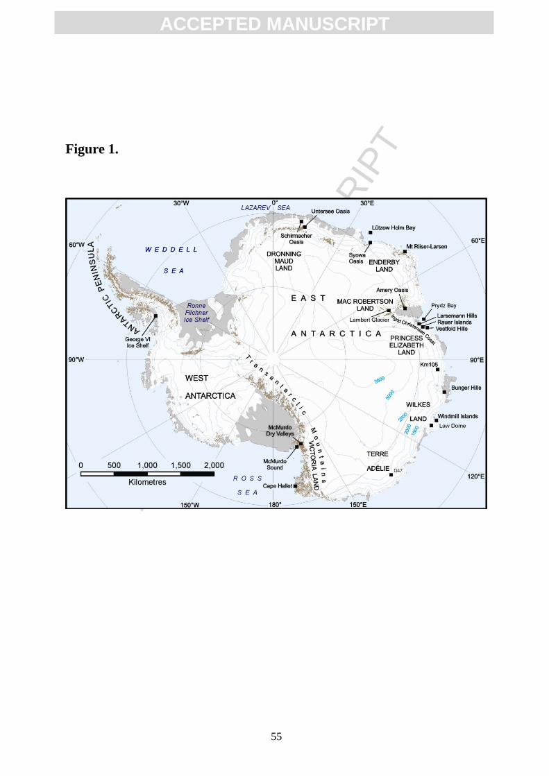
ACC
EPTE
D M
ANU
SCR
IPT
ACCEPTED MANUSCRIPT
55
Figure 1.
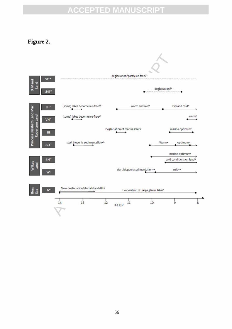
ACC
EPTE
D M
ANU
SCR
IPT
ACCEPTED MANUSCRIPT
56
Figure 2.
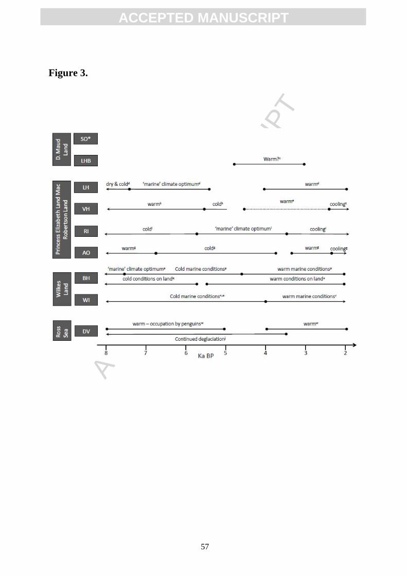
ACC
EPTE
D M
ANU
SCR
IPT
ACCEPTED MANUSCRIPT
57
Figure 3.
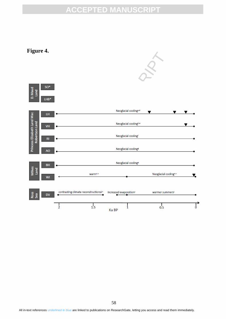
ACC
EPTE
D M
ANU
SCR
IPT
ACCEPTED MANUSCRIPT
58
Figure 4.
All in-text references underlined in blue are linked to publications on ResearchGate, letting you access and read them immediately.