political mosaics and networks: tiwanaku expansion into the upper desaguadero valley, bolivia
TRANSCRIPT
This article was downloaded by: [Franklin and Marshall College], [Scott Smith]On: 15 September 2014, At: 11:06Publisher: RoutledgeInforma Ltd Registered in England and Wales Registered Number: 1072954 Registered office:Mortimer House, 37-41 Mortimer Street, London W1T 3JH, UK
World ArchaeologyPublication details, including instructions for authors and subscriptioninformation:http://www.tandfonline.com/loi/rwar20
Political mosaics and networks: Tiwanakuexpansion into the upper DesaguaderoValley, BoliviaScott C. Smitha & John W. Janusekb
a Franklin & Marshall Collegeb Vanderbilt UniversityPublished online: 11 Sep 2014.
To cite this article: Scott C. Smith & John W. Janusek (2014): Political mosaics and networks: Tiwanakuexpansion into the upper Desaguadero Valley, Bolivia, World Archaeology
To link to this article: http://dx.doi.org/10.1080/00438243.2014.953705
PLEASE SCROLL DOWN FOR ARTICLE
Taylor & Francis makes every effort to ensure the accuracy of all the information (the “Content”)contained in the publications on our platform. However, Taylor & Francis, our agents, and ourlicensors make no representations or warranties whatsoever as to the accuracy, completeness, orsuitability for any purpose of the Content. Any opinions and views expressed in this publicationare the opinions and views of the authors, and are not the views of or endorsed by Taylor &Francis. The accuracy of the Content should not be relied upon and should be independentlyverified with primary sources of information. Taylor and Francis shall not be liable for anylosses, actions, claims, proceedings, demands, costs, expenses, damages, and other liabilitieswhatsoever or howsoever caused arising directly or indirectly in connection with, in relation to orarising out of the use of the Content.
This article may be used for research, teaching, and private study purposes. Any substantialor systematic reproduction, redistribution, reselling, loan, sub-licensing, systematic supply, ordistribution in any form to anyone is expressly forbidden. Terms & Conditions of access and usecan be found at http://www.tandfonline.com/page/terms-and-conditions

Political mosaics and networks:Tiwanaku expansion into the upperDesaguadero Valley, Bolivia
Scott C. Smith and John W. Janusek
Abstract
Ongoing debate about the expansion of the Tiwanaku state has centred on the extent to which it exerciseddirect political control over a continuous territory. Positions in this debate range from those that posit aunified Tiwanaku heartland comprising much of the Lake Titicaca Basin to those that conceptualizeTiwanaku influence as more circumscribed, and perhaps limited to the city itself. We engage this debateby assessing evidence for Tiwanaku expansion into the upper Desaguadero Valley, a region often argued tohave been within the core area of Tiwanaku control. We present new evidence from four sites: KhonkhoWankane, Iruhito, Cerro Chijcha and Nazacara. These data suggest that Tiwanaku political influence wasselective and focused on developing relationships with riverine communities in order to gain access tocaravan circuits. Rather than a core area of continuous control, these processes created a shifting politicalmosaic rooted in fluid politico-religious webs.
Keywords
Tiwanaku; Lake Titicaca; Desaguadero River; altiplano; political strategy; caravans.
Introduction
Recent approaches to the archaeology of political expansion and territoriality have shiftedfrom conceptualizing politics as idealized political types to analyses that seek to understandthe historically contingent, fluid and dynamic nature of political authority. In the archaeologyof the altiplano region of the South American Andes these broader conversations aremanifested in debates about the timing, extent and nature of the political expansion ofTiwanaku (Figs 1 and 2) (Albarracín-Jordan 2003; Bandy 2013; Couture 2002; Goldstein2013; Isbell 2013; Isbell and Burkholder 2002; Janusek 2004a, 2004b, 2005, 2006, 2008,2013a; Knobloch 2013; Kolata 1993, 2003; Stanish 2003, 2013; Vranich 2006, 2009, 2013;
© 2014 Taylor & Francis ISSN 0043-8243 print/1470-1375 onlinehttp://dx.doi.org/10.1080/00438243.2014.953705
Dow
nloa
ded
by [
Fran
klin
and
Mar
shal
l Col
lege
], [
Scot
t Sm
ith]
at 1
1:06
15
Sept
embe
r 20
14
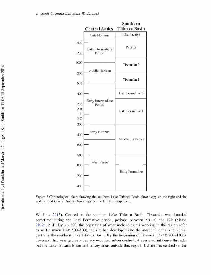
Williams 2013). Centred in the southern Lake Titicaca Basin, Tiwanaku was foundedsometime during the Late Formative period, perhaps between AD 40 and 120 (Marsh2012a, 214). By AD 500, the beginning of what archaeologists working in the region referto as Tiwanaku 1(AD 500–800), the site had developed into the most influential ceremonialcentre in the southern Lake Titicaca Basin. By the beginning of Tiwanaku 2 (AD 800–1100),Tiwanaku had emerged as a densely occupied urban centre that exercised influence through-out the Lake Titicaca Basin and in key areas outside this region. Debate has centred on the
Figure 1 Chronological chart showing the southern Lake Titicaca Basin chronology on the right and thewidely used Central Andes chronology on the left for comparison.
2 Scott C. Smith and John W. Janusek
Dow
nloa
ded
by [
Fran
klin
and
Mar
shal
l Col
lege
], [
Scot
t Sm
ith]
at 1
1:06
15
Sept
embe
r 20
14
extent to which this polity exercised direct political control outside the city of Tiwanakuitself. Some researchers argue that Tiwanaku directly controlled a core territory in thealtiplano that encompassed much of the southern Lake Titicaca Basin, whereas otherssuggest that Tiwanaku political control was more circumscribed and was tied more firmlyto the centralization of multiple llama caravan networks that moved goods throughout thesouth-central Andes.
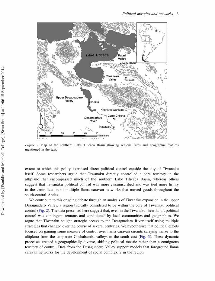
We contribute to this ongoing debate through an analysis of Tiwanaku expansion in the upperDesaguadero Valley, a region typically considered to be within the core of Tiwanaku politicalcontrol (Fig. 2). The data presented here suggest that, even in the Tiwanaku ‘heartland’, politicalcontrol was contingent, tenuous and conditioned by local communities and geographies. Weargue that Tiwanaku sought strategic access to the Desaguadero River itself using multiplestrategies that changed over the course of several centuries. We hypothesize that political effortsfocused on gaining some measure of control over llama caravan circuits carrying maize to thealtiplano from the temperate Cochabamba valleys to the south east (Fig. 3). These dynamicprocesses created a geographically diverse, shifting political mosaic rather than a contiguousterritory of control. Data from the Desaguadero Valley support models that foreground llamacaravan networks for the development of social complexity in the region.
Figure 2 Map of the southern Lake Titicaca Basin showing regions, sites and geographic featuresmentioned in the text.
Political mosaics and networks 3
Dow
nloa
ded
by [
Fran
klin
and
Mar
shal
l Col
lege
], [
Scot
t Sm
ith]
at 1
1:06
15
Sept
embe
r 20
14
Archaeologies of political expansion and territoriality in the Lake Titicaca Basin
Archaeological approaches to the study of politics have shifted from conceptualizing thepolitical in terms of institutions and organizational frameworks of governance to emphasizingthe ways that political relationships were constructed, negotiated, maintained and deconstructed(Johansen and Bauer 2011; Kosiba 2011; Schortman and Ashmore 2012; Smith 2003, 2011;Smith 2005). These approaches endeavour to understand the ways that political practices wereenacted in polity centres and in peripheries. Indeed, critical political institutions and identitieswere often constructed in areas considered ‘marginal’ to a core area (Lightfoot and Martinez1995; Stein 2002, 2005; Vogel 2012). Focusing on the ongoing constitution of political relationsleads us to consider the ways that ancient polities, traditionally understood as stable, elite-drivenentities, were historically contingent and fluid, comprised of multiple webs of political actorsworking within sets of social constraints to mobilize resources in pursuit of specific politicalobjectives (Schortman and Ashmore 2012; Smith 2005; see also Ingold 2007; Pauketat 2013).These webs cross-cut wide geographic regions and connected a diversity of sites. We shouldexpect to see variability in the nature of the relationships created and the degree to whichpolitical centres exercised influence over other communities (Smith 2005). Reformulating thepolitical prompts us to rethink territoriality according to the understanding that ancient politieswere both variably bounded and often discontinuous (Smith 2005; Stahl 2004; VanValkenburghand Osborne 2013, 10–13). Rather than controlling large expanses of contiguous territory,ancient polities exercised influence through overlapping socio-geographical webs that createdshifting political mosaics.
In the Lake Titicaca Basin, reconstructions of Tiwanaku political dynamics have changedsignificantly according to shifting theoretical developments over the past thirty-five years.
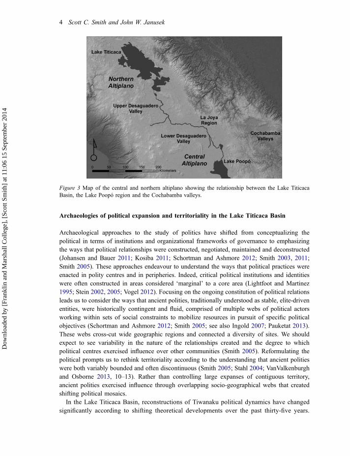
Figure 3 Map of the central and northern altiplano showing the relationship between the Lake TiticacaBasin, the Lake Poopó region and the Cochabamba valleys.
4 Scott C. Smith and John W. Janusek
Dow
nloa
ded
by [
Fran
klin
and
Mar
shal
l Col
lege
], [
Scot
t Sm
ith]
at 1
1:06
15
Sept
embe
r 20
14
Yet many of these models still conceptualize Tiwanaku as a tightly bounded, expansive statethat exercised political hegemony from an elite-dominated city centre over a continuous coreterritory, which in most models includes the Tiwanaku, Katari and upper DesaguaderoValleys. Ponce Sanginés, who began systematic scientific investigations at Tiwanaku in thelate 1950s, envisioned Tiwanaku as a militaristic state and likened its expansion to an oilslick spreading over much of the south-central Andes (Ponce Sanginés 1981, 1991, 13).Kolata (1986, 1991, 1993, 2003; Kolata and Ponce Sanginés 1992) developed a similarmodel, describing Tiwanaku as the densely populated and profoundly stratified urban capitalof an expansionary state. Both Ponce Sanginés and Kolata conceptualized a core area ofcontinuous Tiwanaku political control comprised of a series of interlinked and centrallyorganized urban and rural settlements located throughout the Tiwanaku, Katari and upperDesaguadero Valleys. The upper Desaguadero Valley was argued to have been an agricul-tural ‘breadbasket’ of the Tiwanaku state (Kolata 1991, 111). Tiwanaku was argued to havecontrolled this region from the site of Khonkho Wankane, which Ponce Sanginés concep-tualized as one of Tiwanaku’s ‘second cities’ (Ponce Sanginés 1981, 83). This model wasrefined in recent years as researchers drew on new data. For example, extensive settlementsurvey in the Lake Titicaca Basin led Stanish to suggest that Tiwanaku control was directand continuous in the southern basin, a region he refers to as the Tiwanaku heartland, whilein the northern basin control was more strategic (Stanish 2002, 2003, 2009; Stanish, Cohenet al. 2005; Stanish, Frye et al. 2005).
Since the 1970s several scholars have articulated alternative models suggesting that Tiwanakuinfluence was relatively circumscribed. Browman (1978, 1981) suggests that altiplano groupsrelied on llama caravans to gain access to resources from other regions, and especially, fromlower altitudes. Key altiplano centres developed as craft specialization centres and trading hubsthat imported raw materials and exported finished products. Browman argues that Tiwanakuemerged as an influential polity in large part due to craft specialization and mercantile exchange.As Tiwanaku sought to engage wider areas in exchange, he reasons, it extended its politicalinfluence (Browman 1981, 416). Browman conceptualizes the polity as a loosely integratedtrade federation.
Núñez Atencio and Dillehay (1995 [1979]; see also Dillehay and Núñez Atencio 1988),propose a ‘circuit mobility’ model (Nielsen 2013) that focuses on the central and southernaltiplano and directs attention to the caravan circuits that presumably facilitated exchange andpolitical influence. They argue that principal herder-caravan circuits linked influential ‘axissettlements’ and spurred the development of increasingly dense and extended interaction net-works. They suggest that the articulation of circuits at various scales and periodicities createdlinkages among diverse groups. In contrast to Browman’s model, which advocates exchange ascentral to the circulation of resources, Núñez and Dillehay suggest that the movement ofresources was based in redistribution and reciprocity. They view the resultant exchange relationsas fundamentally integrative and, in the long term, productive of relatively decentralized socialnetworks.
More recently, archaeologists working in the south-central Andes, and especially in northernChile in the San Pedro de Atacama region, have refined elements of the circuit mobility modeland debated the degree to which Tiwanaku politically controlled peripheral regions (Knudson2008; Oakland 1992; Torres-Rouff 2002; Torres and Conklin 1995; Stovel 2005; Uribe andAgüero 2001, 2004). One of the key problems with the circuit mobility model is the
Political mosaics and networks 5
Dow
nloa
ded
by [
Fran
klin
and
Mar
shal
l Col
lege
], [
Scot
t Sm
ith]
at 1
1:06
15
Sept
embe
r 20
14
underdeveloped exploration of the potential political implications of caravan exchange.Llagostera (1996) developed a modified version that he terms ‘reticular complementarity’.Critiquing singular emphases on social integration, Llagostera suggests that the exchange ofprestige goods between influential trading communities in the south-central Andes bolstered thepower of local elites. He sees the development of a peer polity network that predated theemergence of Tiwanaku, which later began to participate peripherally in this network byinjecting a novel ideological system (Llagostera 1996, 36–37).
Berenguer (2004) and Nielsen (2006, 2013) approach emergent complexity in the south-central Andes from yet another perspective. They explore the archaeology of ‘internodes’ –areas of occupation along caravan circuits but between densely occupied axis settlements. LikeLlagostera, Berenguer (2004) eschews the emphasis on social integration evident in the circuitmobility model. Drawing on a detailed case study conducted in the Loa River valley north ofSan Pedro de Atacama, he argues that internodal zones spurred sociopolitical change byconnecting elites in a complex interaction network focused on the exchange of religiouslycharged goods.
Despite an explosion of recent archaeological research in the Lake Titicaca Basin and atTiwanaku-affiliated sites outside this region (see, e.g., Anderson 2013; Blom et al. 1998;Goldstein 1989, 2005, 2013; Owen 2005), no consensus exists on the contours of Tiwanakupolitical expansion. To simplify somewhat, positions in this debate fall along a spectrum: atone end are scholars who envision Tiwanaku exercising direct control over a continuous andpolitically integrated core territory (e.g. Kolata 2003; Ponce Sanginés 1991; Stanish 2003)and, at the other end, those who envision Tiwanaku control as more circumscribed andpossibly limited to the city centre itself (e.g. Browman 1981; see also Albarracín-Jordan1996, 2003). In the following section we present archaeological evidence for Tiwanakuexpansion into the upper Desaguadero Valley with the goal of exploring the processes ofpolitical expansion into a region often argued to have been part of the core Tiwanakuterritory. We focus on four key sites in particular: Khonkho Wankane, Iruhito, CerroChijcha and Nazacara (see Fig. 2).
Assessing Tiwanaku expansion: a view from the upper Desaguadero Valley
Khonkho Wankane
Khonkho Wankane, which Ponce Sanginés and Kolata suggested was a secondary adminis-trative centre for Tiwanaku, is located 28km due south of Tiwanaku across the Kimsachata-Chilla mountain range. Recent research at Khonkho Wankane directed by Janusek has exploredthe development and influence of the site (Janusek 2008, 2012, 2013b; Janusek, Ohnstad, andRoddick 2003; Marsh 2012b; Ohnstad 2013; Smith 2009, 2013). In a full-coverage settlementsurvey in a 44km2 region surrounding Khonkho Wankane, Lémuz Aguirre (2005, 2011)registered sixteen sites dating to the Tiwanaku Period. This corresponds to a total occupiedarea of 25.67ha, representing roughly a 63 per cent increase over the 15.78ha occupation duringthe preceding Late Formative Period (200 BC–AD 500) (Table 1) (Lémuz Aguirre 2011, 41). Ofthe sixteen Tiwanaku Period sites, 72.6 per cent of the occupied area was accounted for by the
6 Scott C. Smith and John W. Janusek
Dow
nloa
ded
by [
Fran
klin
and
Mar
shal
l Col
lege
], [
Scot
t Sm
ith]
at 1
1:06
15
Sept
embe
r 20
14
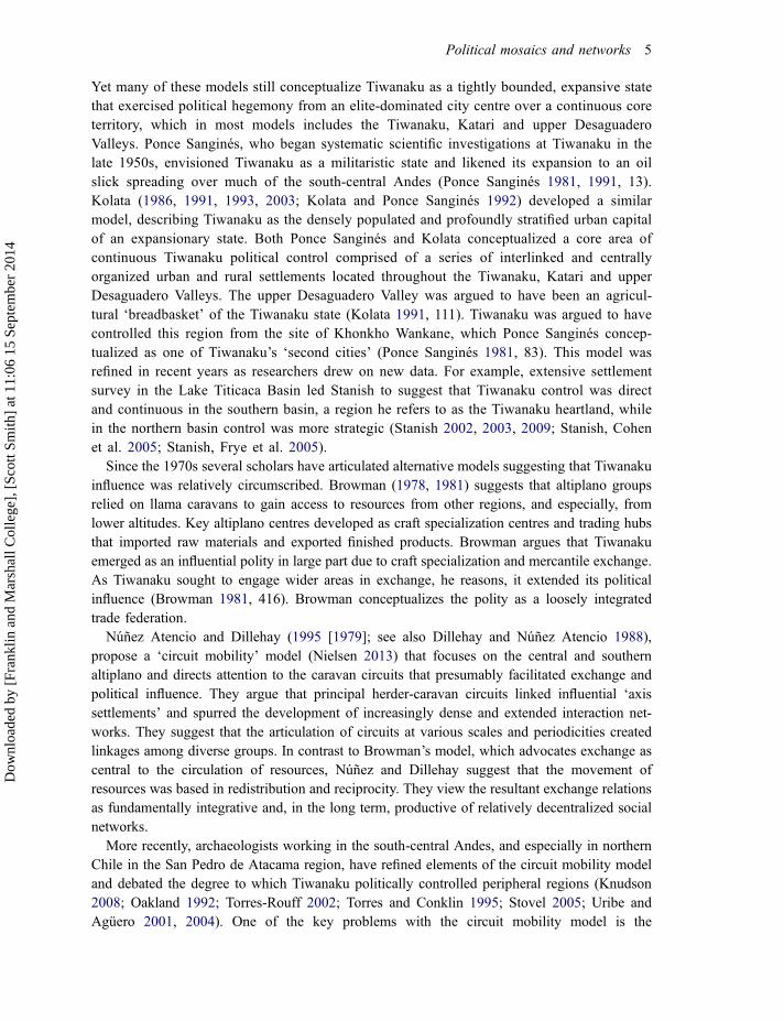
site of Khonkho Wankane, which consists of two platform mounds: Wankane, the principalmound, and the Putuni mound 200m to the north (Fig. 4a) (Lémuz Aguirre 2011, 61).
While these data originally seemed to support models that posit Khonkho Wankane was amajor Tiwanaku Period centre, excavations on the Wankane and Putuni mounds call thisconclusion into question. They demonstrated that the Tiwanaku occupation was much lesssubstantial than originally suggested by the surface survey (Lémuz Aguirre 2011, 62).Excavations in the ceremonial core on the Wankane mound revealed that the major architecturalfeatures – sunken courts, a central plaza, earthen platforms – were used nearly exclusivelyduring the Late Formative Period (Fig. 4b and 4c) (Janusek 2013b; Janusek, Ohnstad andRoddick 2003; Smith 2006, 2009, 2013). The areas of most intense Tiwanaku use at Khonkhowere limited to the northern part of the Wankane mound and the Putuni mound. On theWankane mound, excavations exposed residential areas and a specialized production complex
Figure 4 Khonkho Wankane: (a) topography and location of Putuni and Wankane mounds, (b) architecturein the ceremonial core and (c) reconstruction of the ceremonial core facing southeast.
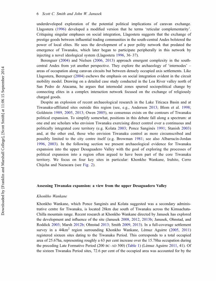
Table 1 Distribution of sites by period for regions surrounding Khonkho Wankane and Iruhito. The data forKhonkho Wankane were adapted from Lémuz Aguirre (2011, 41, table 2)
Khonkho Wankane Iruhito
Period Sites Area (ha) Sites Area (ha)
Tiwanaku 16 25.67 7 11.07Late Formative 15 15.78 23 25.39Middle Formative 6 6.67 9 12.4Early Formative 0 0 0 0
Political mosaics and networks 7
Dow
nloa
ded
by [
Fran
klin
and
Mar
shal
l Col
lege
], [
Scot
t Sm
ith]
at 1
1:06
15
Sept
embe
r 20
14

(Janusek and Ohnstad forthcoming). On the Putuni mound, excavations indicated that TiwanakuPeriod residents reused an artificially amplified platform that was constructed during the LateFormative (Fox 2005; Ohnstad 2007). Radiocarbon measurements suggest that the main use ofthe central ceremonial core began around cal. AD 50 and ended between cal. AD 430 and 550(Janusek 2013b). The earliest Tiwanaku-affiliated occupations on the north side of the Wankanemound date to between cal. AD 679 and 767, suggesting a possible hiatus in occupation of atleast 129 years between the decline of the Late Formative Period occupation and TiwanakuPeriod reuse (Table 2) (Janusek 2013b, 18–22).
Iruhito
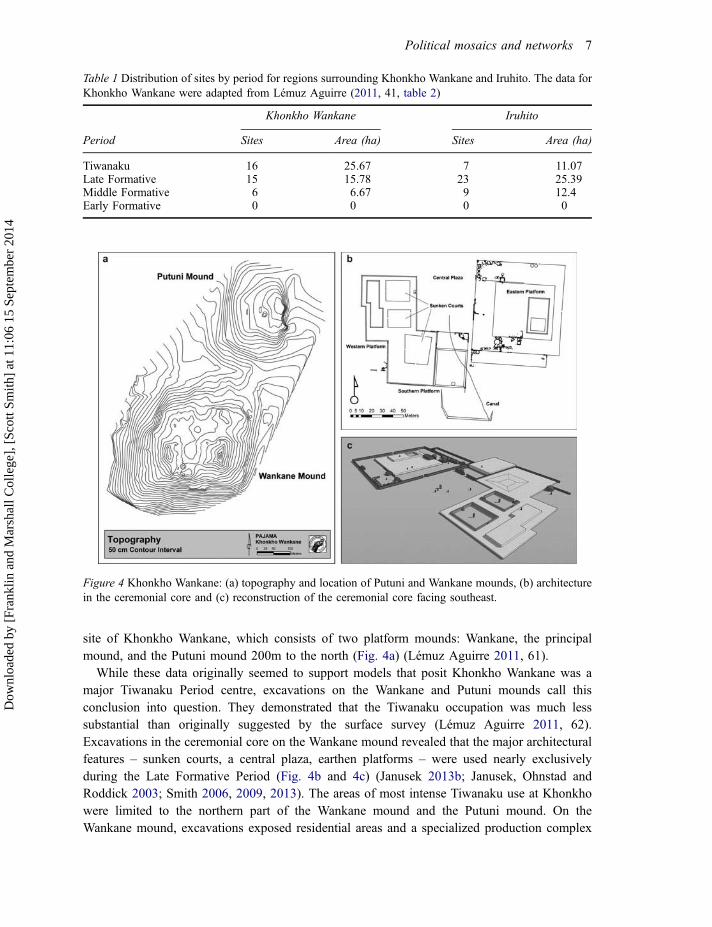
Excavations at the riverine site of Iruhito 30km west of Khonkho Wankane revealed a sub-stantial Tiwanaku occupation (A. Pérez Arias 2004; A. Pérez Arias, Smith, and M. PérezArias 2010; M. Pérez Arias 2005, 2007; Smith 2014). The prehispanic occupation at Iruhitocomprises four mounds stretching for roughly 12ha along the east bank of the DesaguaderoRiver (Fig. 5). The three mounds closest to the river were principally occupied during theMiddle Formative (800–200 BC) and Late Formative Periods. Sometime during the LateFormative Period the focus of occupation at the site shifted inland to the fourth mound whichthen became the centre of Tiwanaku-affiliated activity at the site. Both the Late Formative andTiwanaku Period occupations were roughly 4ha in extent.
Strata with particularly high frequencies of Tiwanaku-style material culture were asso-ciated with a sandstone paved floor surface containing at least one andesite pedestal (A.Pérez Arias 2007) (Fig. 6a and 6b). This pedestal may have originally provided a base for acarved andesite anthropomorphized feline sculpture (Fig. 6c) (A. Pérez Arias 2007, 225–6).Sculptures such as these, called chachapumas, are a hallmark of the Tiwanaku culture andnumerous examples are known from the site of Tiwanaku itself (Portugal Ortíz 1998). AtIruhito there are four known chachapumas, all carved in a similar style, suggesting that theremay have originally been four sets of pedestals with chachapumas arranged around thesandstone floor surface to create a formal ceremonial or political space. Importantly, radio-carbon measurements recovered from the earliest appearance of Tiwanaku-style materialculture, stratigraphically below the pedestal and sandstone surface, returned a date of
Table 2 Radiocarbon measurements associated with Tiwanaku occupations referred to in the text. All dateswere recalibrated using OxCal version 4.2 (Bronk Ramsey 2013) and the IntCal 13 calibration curve(Reimer et al. 2013)
Site Lab codeRadiocarbonage (BP)
One sigmarange (68%)(cal. BC/AD)
Two sigmarange (95%)(cal. BC/AD) Mean Citation
KhonkhoWankane
AA66952 1279 ± 37 AD 679–767 AD 658–863 AD 730 Janusek (2013b, 20)
KhonkhoWankane
AA66961 1261 ± 36 AD 687–771 AD 667–868 AD 746 Janusek (2013b, 20)
Iruhito AA75516 1278 ± 33 AD 682–767 AD 659–855 AD 727 n/aNazacara Ua2322 1580 ± 80 AD 399–562 AD 261–641 AD 472 Pärssinen (2005, 68–9)Nazacara Ua2323 1690 ± 60 AD 257–415 AD 218–536 AD 347 Pärssinen (2005, 68–9)
8 Scott C. Smith and John W. Janusek
Dow
nloa
ded
by [
Fran
klin
and
Mar
shal
l Col
lege
], [
Scot
t Sm
ith]
at 1
1:06
15
Sept
embe
r 20
14
between cal. AD 682 and 767 (Table 2). At both Khonkho Wankane and Iruhito, Tiwanaku-affiliated activity seems to have occurred around cal. AD 700, roughly 200 years afterTiwanaku emerged as the most influential polity in the region. Further, the appearance ofTiwanaku-style material culture was not abrupt. Ceramic analysis documented graduallyincreasing proportions of Tiwanaku-style ceramics as Late Formative Period style potterydecreased in frequency.
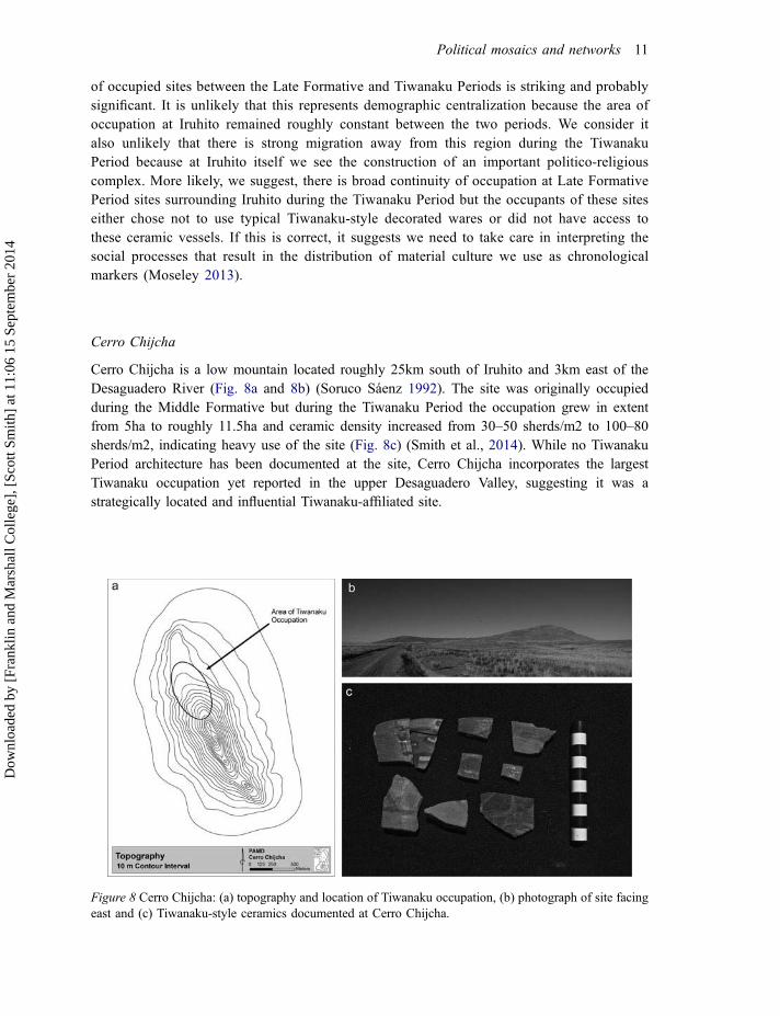
An ongoing settlement survey has, to date, registered twenty-three Late Formative Periodsites in an 8km2 region surrounding Iruhito, comprising a total occupied area of 25.39ha, asurprisingly dense occupation (Fig 7; Table 1) (Smith 2014). In contrast, only seven siteswith Tiwanaku-affiliated material have been recorded, all of which had Late Formativecomponents, comprising a total area of roughly 11.07ha. The dramatic drop in the number
Figure 5 Map of Iruhito showing topography and the location of Formative and Tiwanaku occupations atthe site.
Political mosaics and networks 9
Dow
nloa
ded
by [
Fran
klin
and
Mar
shal
l Col
lege
], [
Scot
t Sm
ith]
at 1
1:06
15
Sept
embe
r 20
14
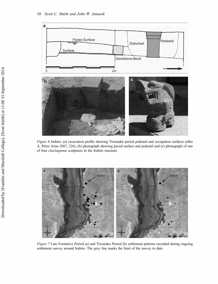
Figure 6 Iruhito: (a) excavation profile showing Tiwanaku period pedestal and occupation surfaces (afterA. Pérez Arias 2007, 226), (b) photograph showing paved surface and pedestal and (c) photograph of oneof four chachapuma sculptures in the Iruhito museum.
Figure 7 Late Formative Period (a) and Tiwanaku Period (b) settlement patterns recorded during ongoingsettlement survey around Iruhito. The grey line marks the limit of the survey to date.
10 Scott C. Smith and John W. Janusek
Dow
nloa
ded
by [
Fran
klin
and
Mar
shal
l Col
lege
], [
Scot
t Sm
ith]
at 1
1:06
15
Sept
embe
r 20
14
of occupied sites between the Late Formative and Tiwanaku Periods is striking and probablysignificant. It is unlikely that this represents demographic centralization because the area ofoccupation at Iruhito remained roughly constant between the two periods. We consider italso unlikely that there is strong migration away from this region during the TiwanakuPeriod because at Iruhito itself we see the construction of an important politico-religiouscomplex. More likely, we suggest, there is broad continuity of occupation at Late FormativePeriod sites surrounding Iruhito during the Tiwanaku Period but the occupants of these siteseither chose not to use typical Tiwanaku-style decorated wares or did not have access tothese ceramic vessels. If this is correct, it suggests we need to take care in interpreting thesocial processes that result in the distribution of material culture we use as chronologicalmarkers (Moseley 2013).
Cerro Chijcha
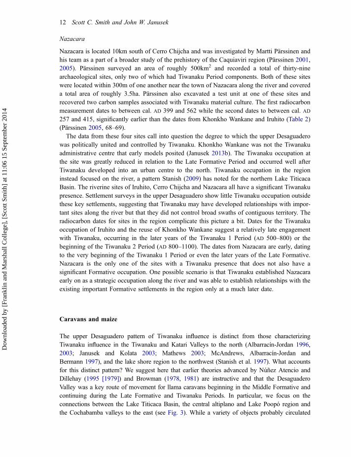
Cerro Chijcha is a low mountain located roughly 25km south of Iruhito and 3km east of theDesaguadero River (Fig. 8a and 8b) (Soruco Sáenz 1992). The site was originally occupiedduring the Middle Formative but during the Tiwanaku Period the occupation grew in extentfrom 5ha to roughly 11.5ha and ceramic density increased from 30–50 sherds/m2 to 100–80sherds/m2, indicating heavy use of the site (Fig. 8c) (Smith et al., 2014). While no TiwanakuPeriod architecture has been documented at the site, Cerro Chijcha incorporates the largestTiwanaku occupation yet reported in the upper Desaguadero Valley, suggesting it was astrategically located and influential Tiwanaku-affiliated site.
Figure 8 Cerro Chijcha: (a) topography and location of Tiwanaku occupation, (b) photograph of site facingeast and (c) Tiwanaku-style ceramics documented at Cerro Chijcha.
Political mosaics and networks 11
Dow
nloa
ded
by [
Fran
klin
and
Mar
shal
l Col
lege
], [
Scot
t Sm
ith]
at 1
1:06
15
Sept
embe
r 20
14
Nazacara
Nazacara is located 10km south of Cerro Chijcha and was investigated by Martti Pärssinen andhis team as a part of a broader study of the prehistory of the Caquiaviri region (Pärssinen 2001,2005). Pärssinen surveyed an area of roughly 500km2 and recorded a total of thirty-ninearchaeological sites, only two of which had Tiwanaku Period components. Both of these siteswere located within 300m of one another near the town of Nazacara along the river and covereda total area of roughly 3.5ha. Pärssinen also excavated a test unit at one of these sites andrecovered two carbon samples associated with Tiwanaku material culture. The first radiocarbonmeasurement dates to between cal. AD 399 and 562 while the second dates to between cal. AD257 and 415, significantly earlier than the dates from Khonkho Wankane and Iruhito (Table 2)(Pärssinen 2005, 68–69).
The data from these four sites call into question the degree to which the upper Desaguaderowas politically united and controlled by Tiwanaku. Khonkho Wankane was not the Tiwanakuadministrative centre that early models posited (Janusek 2013b). The Tiwanaku occupation atthe site was greatly reduced in relation to the Late Formative Period and occurred well afterTiwanaku developed into an urban centre to the north. Tiwanaku occupation in the regioninstead focused on the river, a pattern Stanish (2009) has noted for the northern Lake TiticacaBasin. The riverine sites of Iruhito, Cerro Chijcha and Nazacara all have a significant Tiwanakupresence. Settlement surveys in the upper Desaguadero show little Tiwanaku occupation outsidethese key settlements, suggesting that Tiwanaku may have developed relationships with impor-tant sites along the river but that they did not control broad swaths of contiguous territory. Theradiocarbon dates for sites in the region complicate this picture a bit. Dates for the Tiwanakuoccupation of Iruhito and the reuse of Khonkho Wankane suggest a relatively late engagementwith Tiwanaku, occurring in the later years of the Tiwanaku 1 Period (AD 500–800) or thebeginning of the Tiwanaku 2 Period (AD 800–1100). The dates from Nazacara are early, datingto the very beginning of the Tiwanaku 1 Period or even the later years of the Late Formative.Nazacara is the only one of the sites with a Tiwanaku presence that does not also have asignificant Formative occupation. One possible scenario is that Tiwanaku established Nazacaraearly on as a strategic occupation along the river and was able to establish relationships with theexisting important Formative settlements in the region only at a much later date.
Caravans and maize
The upper Desaguadero pattern of Tiwanaku influence is distinct from those characterizingTiwanaku influence in the Tiwanaku and Katari Valleys to the north (Albarracín-Jordan 1996,2003; Janusek and Kolata 2003; Mathews 2003; McAndrews, Albarracín-Jordan andBermann 1997), and the lake shore region to the northwest (Stanish et al. 1997). What accountsfor this distinct pattern? We suggest here that earlier theories advanced by Núñez Atencio andDillehay (1995 [1979]) and Browman (1978, 1981) are instructive and that the DesaguaderoValley was a key route of movement for llama caravans beginning in the Middle Formative andcontinuing during the Late Formative and Tiwanaku Periods. In particular, we focus on theconnections between the Lake Titicaca Basin, the central altiplano and Lake Poopó region andthe Cochabamba valleys to the east (see Fig. 3). While a variety of objects probably circulated
12 Scott C. Smith and John W. Janusek
Dow
nloa
ded
by [
Fran
klin
and
Mar
shal
l Col
lege
], [
Scot
t Sm
ith]
at 1
1:06
15
Sept
embe
r 20
14
through this corridor, we focus here on evidence for the movement of maize (see also Bandy2005; Burger, Mohr-Chavez and Chavez 2000; Giesso 2003; Levine et al. 2013; Stanish et al.2002).
There is abundant palaeobotanical evidence for the presence of maize at archaeological sitesin the region beginning as early as the Middle Formative and continuing through the TiwanakuPeriod and it is likely that much of the maize was consumed in the form of beer called chicha(Hastorf et al. 2006; Logan, Hastorf and Pearsall 2012; Wright, Hastorf and Lennstrom 2003).Recently, Berryman (2010) conducted stable carbon isotope analysis on human remains fromseveral sites in the southern Lake Titicaca Basin and her research provides compelling evidencethat the consumption of high quantities of maize in the upper Desaguadero Valley began as earlyas the Late Formative Period. Importantly, the highest levels of maize consumption registered inher study came from Iruhito where as much as 50–70 per cent of the average diet was comprisedof maize (Berryman 2010, 276–277).
These results are surprising. Maize is a mesothermal crop and grows only under very specialconditions in the Lake Titicaca Basin. Maize varieties in Tiwanaku were largely imported to theregion from warmer valleys on either side of the altiplano (Wright, Hastorf and Lennstrom2003, 393). While the Tiwanaku state almost certainly imported maize from the Moqueguaregion west of the Lake Titicaca Basin, there is strong evidence that the crop was also importedfrom Cochabamba, which, later in Andean history, incorporated a major agricultural estatededicated to the production of maize for the Inka state (see Fig. 3) (Stanish 2003; Wachtel1982). Ceramics recovered from the Ch’iji Jawira sector of Tiwanaku are very similar tocontemporaneous ‘Derived Tiwanaku’ styles present in Cochabamba, suggesting that particularsocial groups within Tiwanaku had ties to this region (Janusek 1999; Rivera Casanovas 2003).In Cochabamba, as well, there is abundant evidence for Tiwanaku influence; however, thenature of the relationship between the two regions is, at present, not entirely clear (compareAnderson 2009, 2013; Higueras Hare 1996, 2001).
A simple least cost path analysis was conducted using GIS to model potential routes ofmovement of llama caravans carrying maize between Cochabamba and Lake Titicaca. Whilethere are likely to have been many factors that influenced the movement of caravans, includingethnic boundaries, political alliances, kinship relations and the location of pastures, ease ofmovement was undoubtedly important in determining such routes. The most efficient routemodelled first crossed the eastern Cordillera near Lake Poopó and then travelled northwestfollowing the Desaguadero Valley towards Lake Titicaca (Fig. 9). It is likely that these caravansfollowed the course of the Desaguadero River, which gave them access to water, a conclusionsupported by the high levels of maize consumption at Iruhito. Further, faunal analysis by M.Pérez Arias (2005, 2007) documents a significant increase in the presence of camelids at Iruhitoafter the Middle Formative, suggesting that llama caravans passed with increased frequencyduring the Late Formative and Tiwanaku Periods. The presence of large settlements dating fromthe Middle Formative through the Tiwanaku Periods, the lack of Tiwanaku settlements at inlandlocations, evidence for substantial maize consumption and increased presence of camelids atIruhito, and least cost path analysis, all suggest that the Desaguadero River was an importantroute of movement for caravans carrying maize to the altiplano from the eastern valleys. Wehypothesize that the Tiwanaku settlement pattern in the upper Desaguadero Valley coalesced asa result of the polity’s efforts to gain access to this important route of movement.
Political mosaics and networks 13
Dow
nloa
ded
by [
Fran
klin
and
Mar
shal
l Col
lege
], [
Scot
t Sm
ith]
at 1
1:06
15
Sept
embe
r 20
14
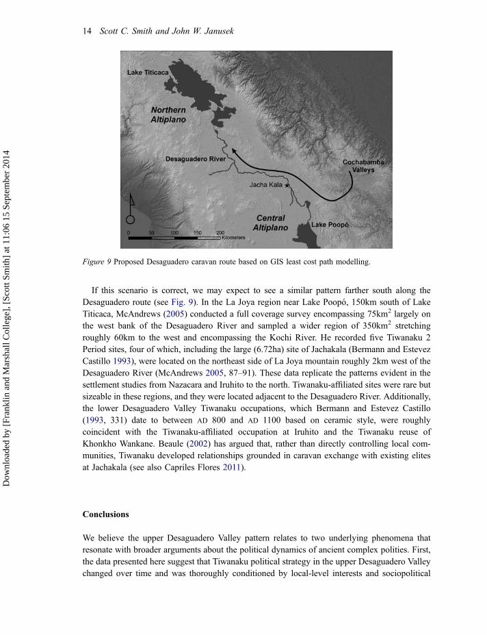
If this scenario is correct, we may expect to see a similar pattern farther south along theDesaguadero route (see Fig. 9). In the La Joya region near Lake Poopó, 150km south of LakeTiticaca, McAndrews (2005) conducted a full coverage survey encompassing 75km2 largely onthe west bank of the Desaguadero River and sampled a wider region of 350km2 stretchingroughly 60km to the west and encompassing the Kochi River. He recorded five Tiwanaku 2Period sites, four of which, including the large (6.72ha) site of Jachakala (Bermann and EstevezCastillo 1993), were located on the northeast side of La Joya mountain roughly 2km west of theDesaguadero River (McAndrews 2005, 87–91). These data replicate the patterns evident in thesettlement studies from Nazacara and Iruhito to the north. Tiwanaku-affiliated sites were rare butsizeable in these regions, and they were located adjacent to the Desaguadero River. Additionally,the lower Desaguadero Valley Tiwanaku occupations, which Bermann and Estevez Castillo(1993, 331) date to between AD 800 and AD 1100 based on ceramic style, were roughlycoincident with the Tiwanaku-affiliated occupation at Iruhito and the Tiwanaku reuse ofKhonkho Wankane. Beaule (2002) has argued that, rather than directly controlling local com-munities, Tiwanaku developed relationships grounded in caravan exchange with existing elitesat Jachakala (see also Capriles Flores 2011).
Conclusions
We believe the upper Desaguadero Valley pattern relates to two underlying phenomena thatresonate with broader arguments about the political dynamics of ancient complex polities. First,the data presented here suggest that Tiwanaku political strategy in the upper Desaguadero Valleychanged over time and was thoroughly conditioned by local-level interests and sociopolitical
Figure 9 Proposed Desaguadero caravan route based on GIS least cost path modelling.
14 Scott C. Smith and John W. Janusek
Dow
nloa
ded
by [
Fran
klin
and
Mar
shal
l Col
lege
], [
Scot
t Sm
ith]
at 1
1:06
15
Sept
embe
r 20
14
relationships (Bermann 1994, 1997). The early dates from Nazacara suggest that efforts tocontrol movement along the river may have been an early emphasis for Tiwanaku. At this time,however, several important riverside centres, including Iruhito and Cerro Chijcha, were alreadypresent and had been in existence for roughly 1,000 years. It is possible that Tiwanaku couldgain some degree of access to the Desaguadero route only through the establishment of a newcommunity at Nazacara. The late dates for Tiwanaku presence at Iruhito, and to a lesser extent atKhonkho Wankane, suggest that early Tiwanaku influence along the Desaguadero River mayhave been limited. After AD 700, Tiwanaku strategy seems to have changed to focus ondeveloping relationships of affiliation with already thriving Formative Period centres, includingCerro Chijcha and Iruhito. The data from Iruhito suggest that these political efforts were framedin ritual terms, a conclusion that resonates with Seddon’s (2013) interpretation of Tiwanaku’sincorporation of the Island of the Sun. Nevertheless, though an important ceremonial complexwas established at Iruhito, ongoing survey has to date recorded little evidence that Tiwanakuinfluence extended into the areas immediately surrounding the site. Rather than a pattern ofcontinuous political control as postulated in earlier models, Tiwanaku influence in the upperDesaguadero Valley might best be characterized as a politically strategic mosaic directedtowards particular landscapes and rooted in fluid politico-religious networks.
These insights resonate with theoretical developments in archaeology that re-centre investiga-tion on the capacity of communities, social groups and individuals outside political cores to shaperegional social dynamics (Lightfoot and Martinez 1995; Schortman and Urban 1994; Stein 2002,2005; Vogel 2003, 2012). Analytical focus has shifted to frontiers and ‘border zones’, and thefluid, hybrid and cross-cutting social networks that permeate these areas. The data from the upperDesaguadero Valley suggest that this region, often conceptualized as one component of a tripartitestate core, may be better thought of as a frontier or border zone (Janusek 2013b, 7). Thisconclusion underscores the idea that defining core regions has more to do with specific, shiftingsocial and geographical relationships than with simple spatial proximity.
This brings us to the second phenomenon underlying the upper Desaguadero Valley pattern.The data suggest that access to llama caravan trade circuits may have driven Tiwanaku efforts toexpand into the Desaguadero Valley. This alludes to the potential utility of models whichforeground caravan circuits as important components of emergent social complexity in thesouth-central Andes, such as those originally advanced by Núñez Atencio and Dillehay (1995[1979]) and Browman (1978, 1981) and later refined by Llagostera (1996) and Berenguer(2004) among others. Central places such as Tiwanaku, Khonkho Wankane, Iruhito and CerroChijcha, emerged as key nodes that anchored intricate and overlapping llama caravan circuits.They suggest that these circuits were briefly united by Tiwanaku but that over the long term theymaintained independent and stable trajectories (Dillehay and Núñez Atencio 1988). Circuits takeform based in relationships established between drovers and sedentary communities, often to theextent that they become codified through the establishment of real or fictive kin relationships.The fundamental mobility of caravans coupled with the importance of social relationshipsbetween caravan drovers and axis settlements created a situation in which Formative Periodcentres most likely had a good deal of control over caravan routes and it was probably difficultfor Tiwanaku to break into these social networks (Berenguer 2004; Llagostera 1996; Nielsen2001, 2009, 2013). The political agencies of local communities participating in caravan circuitswere likely to have significantly shaped the contours of Tiwanaku political influence andexpansion (Nielsen 2013, 413).
Political mosaics and networks 15
Dow
nloa
ded
by [
Fran
klin
and
Mar
shal
l Col
lege
], [
Scot
t Sm
ith]
at 1
1:06
15
Sept
embe
r 20
14
While the situation discussed here is to an extent particular to the south-central Andes, theunderlying principle, that sociopolitical formations are cross-cut by diverse social networksthat are inherently in flux, is increasingly evident cross-culturally (Lightfoot and Martinez1995; Schortman and Ashmore 2012; Stein 2005). Schortman and Ashmore (2012) suggestthat political formations are best studied by focusing specifically on these social networks.They argue that the capacity to shape social trajectories arises from ‘the exercise ofrelational agency by diverse agents operating at multiple, overlapping spatial scales’(Schortman and Ashmore 2012, 1). Political relationships are built, stabilized, transformedand deconstructed through practices involving people, places and objects at a variety ofspatial and temporal scales, from daily routines to periodic ceremonies (Harris 2012;Johansen and Bauer 2011; Roddick 2013). The upper Desaguadero Valley pattern callsattention to the dynamic ways in which the biographical trajectories of people, animals,objects, and ideas are bundled at key nodes or axis settlements. The data encourage us toconsider the myriad ways that political networks coalesced and were then selectively co-opted as Tiwanaku elites sought to expand their influence in key areas of the south-centralAndes.
Acknowledgements
Many thanks to Maribel Pérez, Adolfo Pérez, Victor Plaza, Arik Ohnstad, Carlos Lémuz,Wendy Ashmore, Tom Patterson and two anonymous reviewers for helpful comments. Wethank the communities of Iruhito, Cerro Chijcha and Qhunqhu Likiliki for welcoming us andfor their help and collaboration. We also thank the Unidad Nacional de Arqueología ofBolivia for their support and facilitation of this research.
Funding
Work by Smith at Iruhito, Khonkho Wankane and Cerro Chijcha was supported by the CurtissT. & Mary G. Brennan Foundation; Sigma-Xi, The Scientific Research Society (Grants-in-Aidof Research programme); the University of California, Riverside (Humanities Research Grant);and Franklin & Marshall College (COG Faculty Research Grant and the Office of CollegeGrants Resource Fund). Work by Janusek at Khonkho Wankane and Iruhito was supported bythe National Science Foundation [Grant BCS-0514624], the National Geographic Society[Grant 7700-04], the Curtiss T. & Mary G. Brennan Foundation, the Howard HeinzFoundation, and Vanderbilt University. We thank these institutions for their generous support.Any errors remain our responsibility.
Disclosure Statement
We are aware of no potential conflicts of interest in relation to this manuscript.
16 Scott C. Smith and John W. Janusek
Dow
nloa
ded
by [
Fran
klin
and
Mar
shal
l Col
lege
], [
Scot
t Sm
ith]
at 1
1:06
15
Sept
embe
r 20
14
Scott C. SmithFranklin & Marshall College
John W. JanusekVanderbilt University
References
Albarracín-Jordan, J. 1996. “Tiwanaku Settlement System: The Integration of Nested Hierarchies in theLower Tiwanaku Valley.” Latin American Antiquity 7: 183–210.
Albarracín-Jordan, J. 2003. “Tiwanaku: A Pre-Inka, Segmentary State in the Andes.” In Tiwanaku and itsHinterland: Archaeology and Paleoecology of an Andean Civilization, Vol. 2, Urban and RuralArchaeology, edited by Alan L. Kolata, 95–111. Washington, DC, and London: Smithsonian InstitutionPress.
Anderson, K. 2009. “Tiwanaku Influence on Local Drinking Patterns in Cochabamba, Bolivia.” In Drink,Power, and Society in the Andes, edited by Justin Jennings and Brenda J. Bowser, 167–199. Gainesville:University Press of Florida.
Anderson, K. 2013. “Tiwanaku Influence on the Central Valley of Cochabamba.” In Visions of Tiwanaku,edited by Alexei Vranich and Charles Stanish, 87–112. Los Angeles, CA: UCLA Cotsen Institute ofArchaeology Press.
Bandy, M. S. 2005. “Trade and Social Power in the Southern Titicaca Basin Formative.” In Foundations ofPower in the Prehispanic Andes, edited by Kevin J. Vaughn, Dennis Ogburn and Christina A. Conlee, 91–111. Arlington, VA: The American Anthropological Association.
Bandy, M. S. 2013. “Demographic Dimensions of Tiwanaku Urbanism.” In Advances in Titicaca BasinArchaeology 2, edited by Alexei Vranich and Abigail R. Levine, 79–88. Los Angeles, CA: UCLA CotsenInstitute of Archaeology Press.
Beaule, C. D. 2002. “Late Intermediate Period Political Economy and Household Organization atJachakala, Bolivia.” PhD diss., University of Pittsburgh.
Berenguer Rodríguez, J. 2004. Caravanas, interacción y cambio en el desierto de Atacama. Santiago:Ediciones Sirawi.
Bermann, M. 1994. Lukurmata: Household Archaeology in Prehispanic Bolivia. Princeton, NJ: PrincetonUniversity Press.
Bermann, M. 1997. “Domestic Life and Vertical Integration in the Tiwanaku Heartland.” Latin AmericanAntiquity 8 (2): 93–112.
Bermann, M. and J. Estevez Castillo. 1993. “Jachakala: A New Archaeological Complex of theDepartment of Oruro, Bolivia.” Annals of Carnegie Museum 62: 311–340.
Berryman, C. A. 2010. “Food, Feasts, and the Construction of Identity and Power in Ancient Tiwanaku: ABioarchaeological Perspective.” PhD diss., Vanderbilt University.
Blom, D. E., B. Hallgrimsson, L. Keng, M. C. Lozada and J. E. Buikstra. 1998. “Tiwanaku “Colonization”:Bioarchaeological Implications for Migration in the Moquegua Valley, Peru.” World Archaeology 30 (2):238–261.
Bronk Ramsey, C. 2013. Oxcal software v4.2 available from http://c14.Arch.Ox.Ac.Uk/oxcal.Html.
Browman, D. L. 1978. “Toward the Development of the Tiahuanaco (Tiwanaku) State.” In Advances inAndean Archaeology, edited by David L. Browman, 327–349. The Hague and Paris: Mouton.
Political mosaics and networks 17
Dow
nloa
ded
by [
Fran
klin
and
Mar
shal
l Col
lege
], [
Scot
t Sm
ith]
at 1
1:06
15
Sept
embe
r 20
14
Browman, D. L. 1981. “New Light on Andean Tiwanaku.” American Scientist 69 (4): 408–419.
Burger, R. L., K. L. Mohr-Chavez and S. J. Chavez. 2000. “Through the Glass Darkly: PrehispanicObsidian Procurement and Exchange in Southern Peru and Northern Bolivia.” Journal of World Prehistory14 (3): 267–362.
Capriles Flores, J. M. 2011. “The Economic Organization of Early Camelid Pastoralism in the AndeanHighlands of Bolivia.” PhD diss., Washington University.
Couture, N. C. 2002. “The Construction of Power: Monumental Space and Elite Residence at Tiwanaku,Bolivia.” PhD diss., University of Chicago.
Dillehay, T. D. and L. Núñez Atencio. 1988. “Camelids, Caravans, and Complex Societies in the South-Central Andes.” In Recent Studies in Pre-Columbian Archaeology, edited by N. J. Saunders and O. DeMontmollin, 603–634. Oxford: BAR International Series 421(ii).
Fox, J. R. 2005. “Sectores 10 y 11: Investigaciones en el montículo de Putuni.” In Khonkho Wankane:Primer informe preliminar del Proyecto Arqueológico Jach’a Machaca, edited by J. W. Janusek and VictorPlaza Martinez. La Paz: Report submitted to the Direccion Nacional de Arqueología de Bolivia.
Giesso, M. 2003. “Stone Tool Production in the Tiwanaku Heartland.” In Tiwanaku and its Hinterland:Archaeology and Paleoecology of an Andean Civilization, Vol. 2, Urban and Rural Archaeology, edited byA. L. Kolata, 363–383. Washington, DC, and London: Smithsonian Institution Press.
Goldstein, P. S. 1989. “The Tiwanaku Occupation of Moquegua.” In Ecology, Settlement and History in theOsmore Drainage, Peru, edited by D. S. Rice, C. Stanish and P. R. Scarr. Oxford: BAR International Series545(i).
Goldstein, P. S. 2005. Andean Diaspora: The Tiwanaku Colonies and the Origins of South AmericanEmpire. Gainesville: University Press of Florida.
Goldstein, P. S. 2013. “Tiwanaku and Wari State Expansion: Demographic and Outpost ColonizationCompared.” In Visions of Tiwanaku, edited by A. Vranich and C. Stanish, 41–64. Los Angeles, CA: UCLACotsen Institute of Archaeology Press.
Harris, O. J. T. 2012. “(Re)assembling Communities.” Journal of Archaeological Method and Theory 19 (2).
Hastorf, C. A., W. T. Whitehead, M. C. Bruno and M. Wright. 2006. “The Movements of Maize intoMiddle Horizon Tiwanaku, Bolivia.” In Histories of Maize: Multidisciplinary Approaches to thePrehistory, Linguistics, Biogeography, Domestication, and Evolution of Maize, edited by J. E. Staller, R.H. Tykot and B. F. Benz, 429–448. San Diego, CA: Academic Press.
Higueras Hare, A. 1996. “Prehispanic Settlment and Land-Use in Cochabamba, Bolivia.” PhD diss.,University of Pittsburgh.
Higueras Hare, A. 2001. “El Periodo Intermedio (Horizonte Medio) en los valles de Cochabamba: Unperspectiva de la análisis de asentamientos humanos y uso de tierras.” Boletín de Arqueología PUCP 5:625–646.
Ingold, T. 2007. Lines: A Brief History. London and New York: Routledge.
Isbell, W. H. 2013. “Nature of an Andean City: Tiwanaku and the Production of Spectacle.” In Visions ofTiwanaku, edited by A. Vranich and C. Stanish, 167–196. Los Angeles, CA: UCLA Cotsen Institute ofArchaeology Press.
Isbell, W. H. and J. Burkholder. 2002. “Iwawi and Tiwanaku.” In Andean Archaeology, edited by W. H.Isbell and H. Silverman, 199–241. New York: Kluwer Academic/Plenum Press.
Janusek, J. W. 1999. “Craft and Local Power: Embedded Specialization in Tiwanaku Cities.” Latin AmericanAntiquity 10 (2): 107–131.
Janusek, J. W. 2004a. Identity and Power in the Ancient Andes: Tiwanaku Cities through Time. New Yorkand London: Routledge.
18 Scott C. Smith and John W. Janusek
Dow
nloa
ded
by [
Fran
klin
and
Mar
shal
l Col
lege
], [
Scot
t Sm
ith]
at 1
1:06
15
Sept
embe
r 20
14
Janusek, J. W. 2004b. “Tiwanaku and its Precursors: Recent Research and Emerging Perspectives.”Journal of Archaeological Research 12 (2): 121–183.
Janusek, J. W. 2005. “Residential Diversity and the Rise of Complexity in Tiwanaku.” In Advances in TiticacaBasin Archaeology 1, edited by C. Stanish, A. B. Cohen and M. S. Aldenderfer, 143–171. Los Angeles, CA:UCLA Cotsen Institute of Archaeology Press.
Janusek, J. W. 2006. “The Changing “Nature” of Tiwanaku Religion and the Rise of an Andean State.”World Archaeology 38 (3): 469–492.
Janusek, J. W. 2008. Ancient Tiwanaku. Cambridge: Cambridge University Press.
Janusek, J. W. 2012. “Understanding Tiwanaku Origins: Animistic Ecology in the Andean Altiplano.” InThe Past Ahead: Language, Culture, and Identity in the Neotropics, edited by C. Isendahl, 111–138.Uppsala: Acta Universitatis Upsaliensis.
Janusek, J. W. 2013a. “Social Diversity, Ritual Encounter, and the Contingent Production of Tiwanaku.” InVisions of Tiwanaku, edited by A. Vranich and C. Stanish, 197–210. Los Angeles, CA: UCLA CotsenInstitute of Archaeology Press.
Janusek, J. W. 2013b. “Jésus de Machaca before and after Tiwanaku: A Background to Recent Archaeologyat Khonkho Wankane and Pukara de Khonkho.” In Advances in Titicaca Basin Archaeology 2, edited by A.Vranich and A. R. Levine, 7–22. Los Angeles, CA: UCLA Cotsen Institute of Archaeology Press.
Janusek, J. W. and A. L. Kolata. 2003. “Pre-hispanic Rural History in the Katari Valley.” In Tiwanaku and itsHinterland: Archaeology and Paleoecology of an Andean Civilization, Vol. 2, Urban and Rural Archaeology,edited by A. L. Kolata, 129–167. Washington, DC, and London: Smithsonian Institution Press.
Janusek, J. W. and A. T. Ohnstad. Forthcoming. Tiwanaku Occupation and the Late Formative – TiwanakuTransition at Khonkho Wankane.’ In Early Complexity in the South-Central Andes: Khonkho Wankane andits Hinterland, edited by J. W. Janusek. Los Angeles, CA: UCLA Cotsen Institute of Archaeology Press.
Janusek, J. W., A. T. Ohnstad and A. P. Roddick. 2003. “Khonkho Wankane and the Rise of Tiwanaku.”Antiquity 77 (296).
Johansen, P. G. and A. M. Bauer. 2011. “Reconfiguring the “Political” in the Reconstruction of PastPolitical Production.” In The Archaeology of Politics: The Materiality of Political Practice and Action inthe Past, edited by P. G. Johansen and A. M. Bauer, 1–28. Newcastle upon Tyne: Cambridge ScholarsPublishing.
Knobloch, P. J. 2013. “Tiwanaku’s Coming of Age: Refining Time and Style in the Altiplano.” In Visionsof Tiwanaku, edited by A. Vranich and C. Stanish, 211–234. Los Angeles, CA: UCLA Cotsen Institute ofArchaeology Press.
Knudson, K. J. 2008. “Tiwanaku Influence in the South Central Andes: Strontium Isotope Analysis andMiddle Horizon Migration.” Latin American Antiquity 19 (1): 3–23.
Kolata, A. L. 1986. “The Agricultural Foundations of the Tiwanaku State: A View from the Heartland.”American Antiquity 51 (4): 748–762.
Kolata, A. L. 1991. “The Technology and Organization of Agricultural Production in the Tiwanaku State.”Latin American Antiquity 2 (2): 99–125.
Kolata, A. L. 1993. The Tiwanaku: Portrait of an Andean Civilization. Cambridge, MA, and Oxford:Blackwell.
Kolata, A .L. 2003. “The Social Production of Tiwanaku: Political Economy and Authority in a NativeAndean State.” In Tiwanaku and its Hinterland: Archaeology and Paleoecology of an Andean Civilization,Vol. 2, Urban and Rural Archaeology, edited by A. L. Kolata, 449–472. Washington, DC, and London:Smithsonian Institution Press.
Political mosaics and networks 19
Dow
nloa
ded
by [
Fran
klin
and
Mar
shal
l Col
lege
], [
Scot
t Sm
ith]
at 1
1:06
15
Sept
embe
r 20
14
Kolata, A. L. and C. Ponce Sanginés. 1992. “Tiwanaku: The City at the Center.” In The Ancient Americas:Art from Sacred Landscapes, edited by R. F. Townsend, 317–333. Chicago: Art Institute of Chicago;Munich: Prestel-Verlag.
Kosiba, S. 2011. “The Politics of Locality: Pre-Inka Social Landscapes in the Cusco Region, Peru.” In TheArchaeology of Politics: The Materiality of Political Practice and Action in the Past, edited by P. G.Johansen and A. M. Bauer, 114–150. Newcastle upon Tyne: Cambridge Scholars Publishing.
Lémuz Aguirre, C. 2005. “Datos preliminares de prospección.” In Khonkho Wankane: Primer informepreliminar del Proyecto Arqueológico Jach’a Machaca, edited by J. W. Janusek. La Paz: Report submittedto the Direccíon Nacional de Arqueología de Bolivia.
Lémuz Aguirre, C. 2011. “Patrones de asentamiento aequeológico en el área de influencia del sitio deKhonkho Wankane.” Nuevos Aportes (5): 31–70.
Levine, A. R., C. Stanish, P. R. Williams, C. Chávez and M. Golitko. 2013. “Trade and Early StateFormation in the Northern Titicaca Basin, Peru.” Latin American Antiquity 24 (3): 289–308.
Lightfoot, K. G. and A. Martinez. 1995. “Frontiers and Boundaries in Archaeological Perspective.” AnnualReview of Anthropology 24: 471–492.
Llagostera M., A. 1996. “San Pedro de Atacama: Nodo de complementaridad reticular.” In La integaciónsur andina cinco siglos después, edited by X. Albó, M. I. Arratia, J. Hidalgo, L. Núñez, A. Llagostera, M.I. Remy and B. Revesz, 17–42. Cuzco: Centro de Estudios Regionales Andinos “Bartolomé de Las Casas”.
Logan, A. L., C. A. Hastorf and D. M. Pearsall. 2012. ““Let’s Drink Together”: Early Ceremonial Use ofMaize in the Titicaca Basin.” Latin American Antiquity 23 (3): 235–258.
Marsh, E. J. 2012a. “A Bayesian Re-assessment of the Earliest Radiocarbon Dates from Tiwanaku,Bolivia.” Radiocarbon 54 (2): 203–218.
Marsh, E. J. 2012b. “The Emergence of Tiwanaku: Domestic Practices and Regional Traditions atKhonkho Wankane and Kk’araña.” PhD diss., University of California, Santa Barbara.
Mathews, J. E. 2003. “Prehistoric Settlement Patterns in the Middle Tiwanaku Valley.” In Tiwanaku and itsHinterland: Archaeology and Paleoecology of an Andean Civilization, Vol. 2, Urban and RuralArchaeology, edited by A. L. Kolata, 112–128. Washington, DC, and London: Smithsonian InstitutionPress.
McAndrews, T. L. 2005. Wankarani Settlement Systems in Evolutionary Perspective. Pittsburgh: Universityof Pittsburgh; La Paz: Plural.
McAndrews, T. L., J. Albarracín-Jordan and M. Bermann. 1997. “Regional Settlement Patterns in theTiwanaku Valley of Bolivia.” Journal of Field Archaeology 24 (1): 67–83.
Moseley, M. 2013. “Stylistic Variation and Seriation.” In Visions of Tiwanaku, edited by A. Vranich andC. Stanish, 11–26. Los Angeles, CA: UCLA Cotsen Institute of Archaeology Press.
Nielsen, A. E. 2001. “Ethnoarchaeological Perspectives on Caravan Trade in the South-Central Andes.” InEthnoarchaeology of Andean South America: Contributions to Archaeological Method and Theory, editedby L. A. Kuznar, 163–201. Ann Arbor, MI: International Monographs in Prehistory.
Nielsen, A .E. 2006. “Estudios internodales e interacción interregional en los Andes circumpuneños:Teoría, método y ejemplos de aplicación.” In Esferas de interacción prehistóricas y fronteras nacionalesmodernas: Los Andes sur centrales, edited by H. Lechtman, 29–62. Lima: Instituto de Estudios Peruanos –Institute of Andean Research.
Nielsen, A. E. 2009. “Pastoralism and the Non-pastoral World in the Late Pre-Columbian History of theSouthern Andes.” Nomadic Peoples 13 (2): 17–35.
Nielsen, A. E. 2013. “Circulating Objects and the Constitution of South Andean Society (500 BC–AD1550). In Merchants, Markets, and Exchange in the Pre-Columbian World, edited by K. G. Hirth andJ. Pillsbury, 389–418. Washington, DC: Dumbarton Oaks Research Library and Collection.
20 Scott C. Smith and John W. Janusek
Dow
nloa
ded
by [
Fran
klin
and
Mar
shal
l Col
lege
], [
Scot
t Sm
ith]
at 1
1:06
15
Sept
embe
r 20
14
Núñez Atencio, L. and T. D. Dillehay. 1995 [1979]. Movilidad giratoria, armonía social y desarrollo enlos Andes meridionales: Patrones de tráfico e interacción económica. Antofagasto: Universidad Católicadel Norte.
Oakland, A. 1992. “Textiles and Ethnicity: Tiwanaku in San Pedro de Atacama.” Latin American Antiquity3 (4): 316–340.
Ohnstad, A. 2007. “Investigaciones en áreas periféricas de los montículos de Wankane y Putuni.” InKhonkho e Iruhito: Tercer informe preliminar del Proyecto Jach’a Machaca, edited by J. W. Janusek andV. P. Martinez, 141–186. La Paz: Report submitted to the Unidad Nacional de Arqueología de Bolivia.
Ohnstad, A. 2013. “The Stone Stelae of Khonkho Wankane: Inventory, Brief Description, and Seriation.”In Advances in Titicaca Basin Archaeology 2, edited by A. Vranich and A. R. Levine, 53–66. Los Angeles,CA: UCLA Cotsen Institute of Archaeology Press.
Owen, B. 2005. “Distant Colonies and Explosive Collapse: The Two Stages of the Tiwanaku Diaspora inthe Osmore Drainage.” Latin American Antiquity 16 (1): 45–80.
Pärssinen, M. 2001. “Tiwanaku IV en Nazacara, Bolivia.” Boletín de Arqueología PUCP (5): 605–624.
Pärssinen, M. 2005. Caquiaviri y la provincia Pacasa: Desde Alto-Formativo hasta la conquista española(1–1533). La Paz: Producciones CIMA.
Pauketat, T. R. 2013. An Archaeology of the Cosmos. London and New York: Routledge.
Pérez Arias, A. E. 2004. “Autonomía y dinámica social en los Andes: Proceso y desarrollo socioeconómicoen Irohito, Bolivia.” Licenciatura thesis, Universidad Mayor de San Andres.
Pérez Arias, A. E. 2007. “Excavación e análisis de la cerámica de Irohito.” In Khonkho Wankane: Tercerinforme preliminar del Proyecto Arqueológico Jach’a Machaca, edited by J. W. Janusek and V. P.Martinez, 217–248. La Paz: Report submitted to the Unidad Nacional de Arqueología de Bolivia.
Pérez Arias, A. E., S. C. Smith and M. Pérez Arias. 2010. “Iruhito: A Rural Riverside Community in theTiwanaku Heartland.” Paper presented at the 75th Annual Meeting of the Society for AmericanArchaeology, 14–18 April, St. Louis, Missouri.
Pérez Arias, M. 2005. “Características de la economía de subsistencia en contextos de los períodosFormativo y Tiwanaku en el sitio de Irohito – Bolivia.” Licenciatura thesis, Universidad Mayor de SanAndres.
Pérez Arias, M. 2007. “Utilización de la fauna en la economía doméstica de Irohito: (contextos Formativoy Tiwanaku).” Nuevos Aportes (4): 5–28.
Ponce Sanginés, C. 1981. Tiwanaku: Espacio, tiempo y cultura: Ensayo de síntesis arqueológica, 4th edn.La Paz and Cochabamba: Editorial Los Amigos del Libro.
Ponce Sanginés, C. 1991. “El urbanismo de Tiwanaku.” Pumapunku (Nueva Época) 1: 7–27.
Portugal Ortíz, M. 1998. Escultura prehispánica Boliviana. La Paz: Carrera de Arqueología yAntropología – UMSA.
Reimer, P. J., E. Bard, A. Bayliss, J. W. Beck, P. G. Blackwell , C.Bronk Ramsey, C. E. Buck et al. 2013.“Intcal13 and Marine13 Radiocarbon Age Calibration Curves 0–50,000 Year cal BP.” Radiocarbon 55 (4):1869–1887.
Rivera Casanovas, C. 2003. “Ch’iji jawira: A Case of Ceramic Specialization in the Tiwanaku Periphery.”In Tiwanaku and its Hinterland: Archaeology and Paleoecology of an Andean Civilization, Vol. 2, Urbanand Rural Archaeology, edited by A. L. Kolata, 296–315. Washington, DC, and London: SmithsonianInstitution Press.
Roddick, A. P. 2013. “Temporalities of the Formative Period Taraco Peninsula, Bolivia.” Journal of SocialArchaeology 13 (3): 287–309.
Political mosaics and networks 21
Dow
nloa
ded
by [
Fran
klin
and
Mar
shal
l Col
lege
], [
Scot
t Sm
ith]
at 1
1:06
15
Sept
embe
r 20
14
Schortman, E. M. and W. Ashmore. 2012. “History, Networks, and the Quest for Power: Ancient PoliticalCompetition in the Lower Motagua Valley, Guatemala.” Journal of the Royal Anthropological Institute(N.S.) 18: 1–21.
Schortman, E. M. and P. A. Urban. 1994. “Living on the Edge: Core/Periphery Relations in AncientSouthern Mesoamerica.” Current Anthropology 35: 401–430.
Seddon, M. T. 2013. “Tiwanaku Ritual and Political Transformations in the Core and Peripheries.” InVisions of Tiwanaku, edited by A. Vranich and C. Stanish, 113–134. Los Angeles, CA: UCLA CotsenInstitute of Archaeology Press.
Smith, A. T. 2003. The Political Landscape: Constellations of Authority in Early Complex Polities.Berkeley: University of California Press.
Smith, A. T. 2011. “Archaeologies of Sovereignty.” Annual Review of Anthropology 40: 415–432.
Smith, M. L. 2005. “Networks, Territory, and the Cartography of Ancient States.” Annals of theAssociation of American Geographers 95 (4): 832–849.
Smith, S. C. 2006. “Architecture and Activities at Khonkho Wankane, Bolivia.” Paper presented at theCotsen Institute Advanced Seminar, “Contending Visions of Tiwanaku”, 19–21 May, Los Angeles, CA.
Smith, S. C. 2009. “Venerable Geographies: Spatial Dynamics, Religion, and Political Economy in thePrehistoric Lake Titicaca Basin, Bolivia.” PhD diss., University of California, Riverside.
Smith, S. C. 2013. “Late Formative Period Spatial Organization at Khonkho Wankane, Bolivia.” InAdvances in Titicaca Basin Archaeology 2, edited by A. Vranich and A. R. Levine, 23–44. Los Angeles,CA: UCLA Cotsen Institute of Archaeology Press.
Smith, S. C. 2014. “Tiwanaku Political Strategy in the Upper Desaguadero Valley, Bolivia.” Posterpresented at the Institute of Andean Studies, 54th Annual Meeting, 10–11 January, Berkeley.
Smith, S. C., M. Pérez Arias, A. E. Pérez Arias and A. Flores Pérez. 2014. “Long-Term Occupation ofCerro Chijcha, Upper Desaguadero Valley, Bolivia.” Ñawpa Pacha 34 (1): 107–116.
Soruco Sáenz, E. 1992. “Informe de la prospección arqueológica en Villa Anta, provincia Pacajes.” TextosAntropológicos 3: 27–40.
Stahl, A. B. 2004. “Political Economic Mosaics: Archaeology of the Last Two Millenia in Tropical Sub-Saharan Africa.” Annual Review of Anthropology 33: 145–172.
Stanish, C. 2002. “Tiwanaku Political Economy.” In Andean Archaeology I: Variations in SociopoliticalOrganization, edited by W. H. Isbell and H. Silverman, 169–198. New York: Kluwer Academic/PlenumPress.
Stanish, C. 2003. Ancient Titicaca: The Evolution of Complex Society in Southern Peru and NorthernBolivia. Berkeley: University of California Press.
Stanish, C. 2009. “The Tiwanaku Occupation of the Northern Titicaca Basin.” In Andean Civilization: ATribute to Michael E. Moseley, edited by J. Marcus and P. R. Williams, 145–164. Los Angeles, CA: UCLACotsen Institute of Archaeology Press.
Stanish, C. 2013. “What was Tiwanaku?” In Visions of Tiwanaku, edited by A. Vranich and C. Stanish,151–166. Los Angeles, CA: UCLA Cotsen Institute of Archaeology Press.
Stanish, C., R. L. Burger, L. M. Cipolla, M. D. Glascock and E. Quelima. 2002. “Evidence for Early Long-Distance Obsidian Exchange and Watercraft Use from the Southern Lake Titicaca Basin of Bolivia andPeru.” Latin American Antiquity 13 (4): 444–455.
Stanish, C., A. Cohen, E. De La Vega M., E. Arkush, A. Plourde and C. Schultze. 2005. “ArchaeologicalReconnaissance in the Northern Titicaca Basin.” In Advances in Titicaca Basin Archaeology 1, edited byC. Stanish, A. Cohen and M. Aldenderfer, 289–316. Los Angeles, CA: UCLA Cotsen Institute ofArchaeology Press.
22 Scott C. Smith and John W. Janusek
Dow
nloa
ded
by [
Fran
klin
and
Mar
shal
l Col
lege
], [
Scot
t Sm
ith]
at 1
1:06
15
Sept
embe
r 20
14
Stanish, C., E. De La Vega M., L. H. Steadman, K. L. Frye, C. J. Chávez, L. Onofre and M. Seddon. 1997.Archaeological Survey in the Juli-Desaguadero Area, Lake Titicaca Basin, Peru. Chicago: FieldianaAnthropology.
Stanish, C., K. Frye, E. De La Vega M. and M. Seddon. 2005. “Tiwanaku Expansion into the WesternTiticaca Basin.” In Advances in Titicaca Basin Archaeology 1, edited by C. Stanish, A. Cohen andM. Aldenderfer, 103–114. Los Angeles, CA: UCLA Cotsen Institute of Archaeology Press.
Stein, G. J. 2002. “From Passive Periphery to Active Agents: Emerging Perspectives in the Archaeology ofInterregional Interaction.” American Anthropologist 104 (3): 903–916.
Stein, G. J., ed. 2005. The Archaeology of Colonial Encounters: Comparative Perspectives. Santa Fe, NM:School of American Research Press.
Stovel, E. 2005. “The Archaeology of Identity Construction: Ceramic Evidence from Northern Chile.” InGlobal Archaeological Theory: Contextual Voices and Contemporary Thoughts, edited by P. P. Funari,A. Zarankin and E. Stovel, 145–166. New York: Kluwer Academic/Plenum Press.
Torres, C. M. and W. J. Conklin. 1995. “Exploring the San Pedro de Atacama/Tiwanaku Relationship.” InAndean Art: Visual Expression and its Relation to Andean Beliefs and Values, edited by P. Dransart,78–108. Aldershot: Avebury.
Torres-Rouff, C. 2002. “Cranial Vault Modification and Ethnicity in Middle Horizon San Pedro DeAtacama, Chile.” Current Anthropology 43: 163–171.
Uribe, M. and C. Agüero. 2001. “Alfarería, texiles y la integración del norte grande de Chile a Tiwanaku.”Boletín de Arqueología PUCP 5: 397–426.
Uribe, M. and C. Agüero. 2004. “Iconografía, alfararía y textilería Tiwanaku: Elementos para una revisiöndel período medio en el norte grande de Chile.” Chungara, Revista de Antropología Chilena 36:1055–1068.
VanValkenburgh, P. and J. F. Osborne. 2013. “Home Turf: Archaeology, Territoriality, and Politics.” InTerritoriality in Archaeology, edited by J. F. Osborne and P. VanValkenburgh, 1–27. Arlington, VA: TheAmerican Anthropological Association.
Vogel, M. 2003. “Life on the Frontier: Identity and Sociopolitical Change at the Site of Cerro La Cruz,Peru.” PhD diss., University of Pennsylvania.
Vogel, M. 2012. Frontier Life in Ancient Peru: The Archaeology of Cerro La Cruz. Gainesville: UniversityPress of Florida.
Vranich, A. 2006. “The Construction and Reconstruction of Ritual Space at Tiwanaku, Bolivia (A.D. 500–1000).” Journal of Field Archaeology 31 (2): 121–136.
Vranich, A. 2009. “The Development of the Ritual Core of Tiwanaku.” In Tiwanaku: Papers from the 2005Mayer Center Symposium at the Denver Art Museum, edited by Margaret Young-Sánchez, 11–34. Denver,CO: The Mayer Center for Pre-Columbian and Spanish Colonial Art at the Denver Art Museum.
Vranich, A. 2013. “Concluding Thoughts.” In Visions of Tiwanaku, edited by A. Vranich and C. Stanish,235–237. Los Angeles, CA: UCLA Cotsen Institute of Archaeology Press.
Wachtel, N. 1982. “The Mitimaes of the Cochabamba Valley: The Colonization Policy of Huayna Capac.”In The Inca and Aztec States: 1400–1800, edited by G. A. Collier, R. I. Rosaldo and J. D. Wirth, 199–229.New York: Academic Press.
Williams, P. R. 2013. “Tiwanaku: A Cult of the Masses.” In Visions of Tiwanaku, edited by A. Vranich andC. Stanish, 27–40. Los Angeles, CA: UCLA Cotsen Institute of Archaeology Press.
Wright, M. F., C. A. Hastorf and H. A. Lennstrom. 2003. “Pre-hispanic Agriculture and Plant Use atTiwanaku: Social and Political Implications.” In Tiwanaku and its Hinterland: Archaeology andPaleoecology of an Andean Civilization, Vol. 2, Urban and Rural Archaeology, edited by A. L. Kolata,384–403. Washington, DC, and London: Smithsonian Institution Press.
Political mosaics and networks 23
Dow
nloa
ded
by [
Fran
klin
and
Mar
shal
l Col
lege
], [
Scot
t Sm
ith]
at 1
1:06
15
Sept
embe
r 20
14
Scott C. Smith studies the development of social, cultural and political landscapes in thealtiplano region of the Bolivian Andes and, more specifically, in the upper Desaguadero Rivervalley. In particular he is interested in ceremonial dynamics and the emergence of inequalityduring the Formative (1500 BC–AD 500) and Tiwanaku (AD 500–1100) periods. Smith hasconducted archaeological research in Bolivia, Ecuador, Belize, England and the eastern UnitedStates since 1998. He earned a PhD from the University of California, Riverside in 2009 and iscurrently Assistant Professor of Anthropology at Franklin & Marshall College.
John W. Janusek is an archaeologist interested in the development of complex societies andcities in the South American Andes. His theoretical interests include: human agency/identity,power relations, urbanism, space and place, ritual practice and household archaeology. He hasworked in the Bolivian highlands since 1987, conducting research principally focused onTiwanaku civilization and its precursors. He earned a PhD from the University of Chicago in1994 and is currently Associate Professor of Anthropology at Vanderbilt University.
24 Scott C. Smith and John W. Janusek
Dow
nloa
ded
by [
Fran
klin
and
Mar
shal
l Col
lege
], [
Scot
t Sm
ith]
at 1
1:06
15
Sept
embe
r 20
14