building taypikala: telluric transformations in the lithic production of tiwanaku
TRANSCRIPT
Nicholas Tripcevich • Kevin J. Vaughn Editors
Mining and Quarrying in the Ancient Andes
Sociopolitical, Economic, and Symbolic Dimensions
Editors Nicholas Tripcevich Archaeological Research Facility University of California Berkeley , CA, USA
Kevin J. Vaughn Department of Anthropology Purdue University West Lafayette, IN , USA
ISSN 1568-2722 ISBN 978-1-4614-5199-0 ISBN 978-1-4614-5200-3 (eBook) DOI 10.1007/978-1-4614-5200-3 Springer New York Heidelberg Dordrecht London
Library of Congress Control Number: 2012951615
© Springer Science+Business Media New York 2013 This work is subject to copyright. All rights are reserved by the Publisher, whether the whole or part of the material is concerned, speci fi cally the rights of translation, reprinting, reuse of illustrations, recitation, broadcasting, reproduction on micro fi lms or in any other physical way, and transmission or information storage and retrieval, electronic adaptation, computer software, or by similar or dissimilar methodology now known or hereafter developed. Exempted from this legal reservation are brief excerpts in connection with reviews or scholarly analysis or material supplied speci fi cally for the purpose of being entered and executed on a computer system, for exclusive use by the purchaser of the work. Duplication of this publication or parts thereof is permitted only under the provisions of the Copyright Law of the Publisher’s location, in its current version, and permission for use must always be obtained from Springer. Permissions for use may be obtained through RightsLink at the Copyright Clearance Center. Violations are liable to prosecution under the respective Copyright Law. The use of general descriptive names, registered names, trademarks, service marks, etc. in this publication does not imply, even in the absence of a speci fi c statement, that such names are exempt from the relevant protective laws and regulations and therefore free for general use. While the advice and information in this book are believed to be true and accurate at the date of publication, neither the authors nor the editors nor the publisher can accept any legal responsibility for any errors or omissions that may be made. The publisher makes no warranty, express or implied, with respect to the material contained herein.
Printed on acid-free paper
Springer is part of Springer Science+Business Media (www.springer.com)
65N. Tripcevich and K.J. Vaughn (eds.), Mining and Quarrying in the Ancient Andes, Interdisciplinary Contributions to Archaeology, DOI 10.1007/978-1-4614-5200-3_4, © Springer Science+Business Media New York 2013
Stone was elemental to Tiwanaku identity. One name for Tiwanaku, and possibly a key epithet during its pre-Inca apogee, was taypikala , or “central stone” ( Cobo 1990 [1653] : 100). The employment of impeccably carved stones and the elaboration of stonework in Tiwanaku are among the most notable physical aspects of monumen-tal construction at the site. Tiwanaku monumentality emphasized the permanence, mass, color, and texture of stone. It showcased stone’s materiality. Yet the stones used to build Tiwanaku, and thus the materiality and technology of Tiwanaku mon-umental construction, shifted dramatically between ad 500 and 700. Tiwanaku’s employment of new stone sources and technologies distinguished it from other cen-ters in the Lake Titicaca Basin. What was the character of this shift? What were its lithic sources, and why did they change?
Stone remains critical for shaping native identities in the south-central Andes. Today, a person raised in Tiwanaku is considered kalawawa , or born of stone. Although partly in jest, this identi fi cation has deeper resonance in the region. This was made clear at a celebration of Machac Mara (or “New Year”) on the June solstice in 2002, on the ruins of the site of Khonkho Wankane in the upper Desaguadero basin. The ritual is a recently established tradition designed by native-identifying communities as they began to garner power in Bolivian national politics.
J.W. Janusek (*) Anthropology , Vanderbilt University , Box 6050 Station B , Nashville , TN 37235 , USA e-mail: [email protected]
P. R. Williams • M. Golitko Field Museum of Natural History , 1400 S Lake Shore Dr , Chicago , IL 60605 , USA e-mail: rwilliams@ fi eldmuseum.org ; mgolitko@ fi eldmuseum.org
C. Lémuz Aguirre Sociedad de Arqueologia de La Paz, y Universidad Mayor de San Andrés , Casilla postal , 5294 La Paz , Bolivia e-mail: [email protected]
Chapter 4 Building Taypikala: Telluric Transformations in the Lithic Production of Tiwanaku
John Wayne Janusek , Patrick Ryan Williams, Mark Golitko, and Carlos Lémuz Aguirre
66 J.W. Janusek et al.
Initiated in the focal blood sacri fi ce of a carefully selected camelid as the sun ascends the horizon to the east, it continues as a lively event full of vendors selling wares, competitive local dances, and political discussion. At one point in 2002, a local political aspirant made a particularly dramatic gesture. In the midst of an ani-mated speech on the importance of fostering a native Aymara identity, he bent over and patted his hand vigorously on one of Khonkho’s carved stone monoliths, while proclaiming “we are this stone, this stone is us.”
The relationship of humans and their landscapes in the highland Andes is deeply political. Hilltops and mountain peaks are particularly important places invoked in local prayers, libations, and sacri fi cial offerings in earnest bids to ensure health, community well-being, and the success of particular projects (archaeological and otherwise, see Abercrombie 1998 ) . So are local springs and certain other prominent landscape features. Hilltops and mountain peaks are animated as powerful ancestral persons in native ritual practices such that they come to support, and indeed repre-sent, the local communities who pay tribute to them. Hilltops and peaks also punc-tuate the landscapes of local communities and larger political organizations. Fundamental components of local ritual practices, they de fi ne sociopolitical territo-ries while grounding communities to the altiplano and its agropastoral and mineral resources. The essential component of mountains, stone was a particularly impor-tant class of resources in the altiplano.
Given the profound long-term importance of stone in the Andean highlands, it is striking that so little systematic research has been dedicated to understanding quar-rying and preparation practices for monumental construction. A notable example of recent research includes Dennis Ogburn’s analysis of carved andesite ashlars in Saraguro, Ecuador, that date to the Inca period (Ogburn 2004a, b ) . Through XRF spectrometry, he determined that those volcanic blocks had been quarried in the Rumiqolqa quarry some 35 km from Cuzco, Peru; approximately 1,600 km from Saraguro. Ogburn concludes that it was important for the Inca to transfer volcanic material from a particular source and of a particular material type over an incredible distance. The Inca employed the same andesite quarry to construct many of the most important structures in Cuzco (Ogburn 2004a ; Protzen 1983 ). Ogburn considers the movement of massive andesite stones a “transfer of sacredness,” and suggests that the last legitimate Inca ruler, Wayna Capac, had the Saraguro andesite moved just as he was establishing a new center in the northern Andean highlands.
This chapter explores the shift from sandstone to volcanic stone at Tiwanaku. It explores (1) the shift from exclusive quarrying in the local Kimsachata mountain range to the inclusion of sources in more distant, ancient volcanoes and volcanic outcrops; and (2) the signi fi cance of this shift in relation to Tiwanaku’s increasing regional prestige and sociopolitical centralization in the Tiwanaku Period. We pres-ent new data related to Tiwanaku’s stone sources recovered through reconnaissance and analysis conducted in 2009–2011. Our conclusions center on these data and their signi fi cance in relation to previous research and thought on Tiwanaku stone sourcing. Secondarily, the paper proposes some preliminary hypotheses regarding the signi fi cance of the shift from sandstone to volcanic stone, emphasizing the ritual
674 Building Taypikala
and political dimensions of this shift. We conclude that the full materiality of stone—its source, texture, color, relative hardness, mineral qualities, and so forth—were made to be essential in de fi ning what Tiwanaku was, ritually and politically, and who “the Tiwanaku” were, personally and collectively.
Lithic Transformations in the Production of Tiwanaku Monumentality
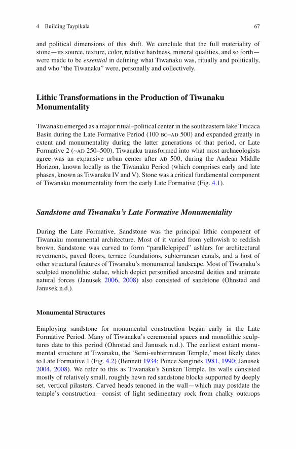
Tiwanaku emerged as a major ritual–political center in the southeastern lake Titicaca Basin during the Late Formative Period (100 bc – ad 500) and expanded greatly in extent and monumentality during the latter generations of that period, or Late Formative 2 (~ ad 250–500). Tiwanaku transformed into what most archaeologists agree was an expansive urban center after ad 500, during the Andean Middle Horizon, known locally as the Tiwanaku Period (which comprises early and late phases, known as Tiwanaku IV and V). Stone was a critical fundamental component of Tiwanaku monumentality from the early Late Formative (Fig. 4.1 ).
Sandstone and Tiwanaku’s Late Formative Monumentality
During the Late Formative, Sandstone was the principal lithic component of Tiwanaku monumental architecture. Most of it varied from yellowish to reddish brown. Sandstone was carved to form “parallelepiped” ashlars for architectural revetments, paved fl oors, terrace foundations, subterranean canals, and a host of other structural features of Tiwanaku’s monumental landscape. Most of Tiwanaku’s sculpted monolithic stelae, which depict personi fi ed ancestral deities and animate natural forces (Janusek 2006, 2008 ) also consisted of sandstone (Ohnstad and Janusek n.d.).
Monumental Structures
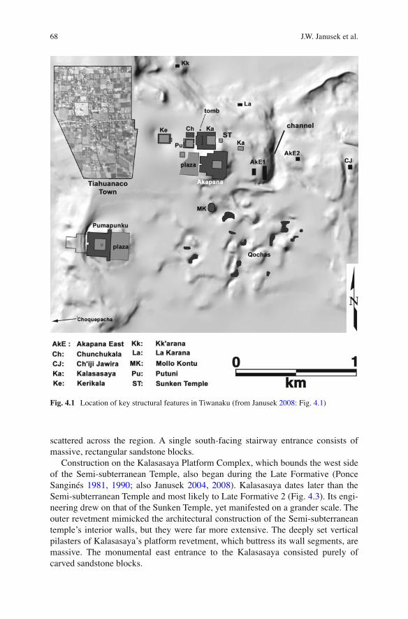
Employing sandstone for monumental construction began early in the Late Formative Period. Many of Tiwanaku’s ceremonial spaces and monolithic sculp-tures date to this period (Ohnstad and Janusek n.d.). The earliest extant monu-mental structure at Tiwanaku, the ‘Semi-subterranean Temple ,’ most likely dates to Late Formative 1 (Fig. 4.2 ) (Bennett 1934 ; Ponce Sanginés 1981, 1990 ; Janusek 2004, 2008 ) . We refer to this as Tiwanaku’s Sunken Temple. Its walls consisted mostly of relatively small, roughly hewn red sandstone blocks supported by deeply set, vertical pilasters. Carved heads tenoned in the wall—which may postdate the temple’s construction—consist of light sedimentary rock from chalky outcrops
68 J.W. Janusek et al.
scattered across the region. A single south-facing stairway entrance consists of massive, rectangular sandstone blocks.
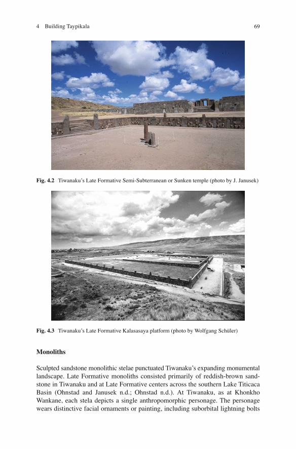
Construction on the Kalasasaya Platform Complex, which bounds the west side of the Semi-subterranean Temple, also began during the Late Formative (Ponce Sanginés 1981, 1990 ; also Janusek 2004, 2008 ) . Kalasasaya dates later than the Semi-subterranean Temple and most likely to Late Formative 2 (Fig. 4.3 ). Its engi-neering drew on that of the Sunken Temple, yet manifested on a grander scale. The outer revetment mimicked the architectural construction of the Semi-subterranean temple’s interior walls, but they were far more extensive. The deeply set vertical pilasters of Kalasasaya’s platform revetment, which buttress its wall segments, are massive. The monumental east entrance to the Kalasasaya consisted purely of carved sandstone blocks.
Fig. 4.1 Location of key structural features in Tiwanaku (from Janusek 2008 : Fig. 4.1 )
694 Building Taypikala
Monoliths
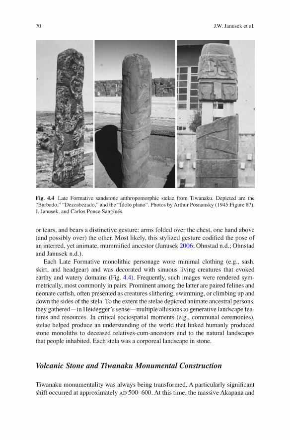
Sculpted sandstone monolithic stelae punctuated Tiwanaku’s expanding monumental landscape. Late Formative monoliths consisted primarily of reddish-brown sand-stone in Tiwanaku and at Late Formative centers across the southern Lake Titicaca Basin (Ohnstad and Janusek n.d.; Ohnstad n.d.). At Tiwanaku, as at Khonkho Wankane, each stela depicts a single anthropomorphic personage. The personage wears distinctive facial ornaments or painting, including suborbital lightning bolts
Fig. 4.2 Tiwanaku’s Late Formative Semi-Subterranean or Sunken temple (photo by J. Janusek)
Fig. 4.3 Tiwanaku’s Late Formative Kalasasaya platform (photo by Wolfgang Schüler)
70 J.W. Janusek et al.
or tears, and bears a distinctive gesture: arms folded over the chest, one hand above (and possibly over) the other. Most likely, this stylized gesture codi fi ed the pose of an interred, yet animate, mummi fi ed ancestor (Janusek 2006 ; Ohnstad n.d.; Ohnstad and Janusek n.d.).
Each Late Formative monolithic personage wore minimal clothing (e.g., sash, skirt, and headgear) and was decorated with sinuous living creatures that evoked earthy and watery domains (Fig. 4.4 ). Frequently, such images were rendered sym-metrically, most commonly in pairs. Prominent among the latter are paired felines and neonate cat fi sh, often presented as creatures slithering, swimming, or climbing up and down the sides of the stela. To the extent the stelae depicted animate ancestral persons, they gathered—in Heidegger’s sense—multiple allusions to generative landscape fea-tures and resources. In critical sociospatial moments (e.g., communal ceremonies), stelae helped produce an understanding of the world that linked humanly produced stone monoliths to deceased relatives-cum-ancestors and to the natural landscapes that people inhabited. Each stela was a corporeal landscape in stone.
Volcanic Stone and Tiwanaku Monumental Construction
Tiwanaku monumentality was always being transformed. A particularly signi fi cant shift occurred at approximately ad 500–600. At this time, the massive Akapana and
Fig. 4.4 Late Formative sandstone anthropomorphic stelae from Tiwanaku. Depicted are the “Barbado,” “Dezcabezado,” and the “Ídolo plano”. Photos by Arthur Posnansky (1945:Figure 87), J. Janusek, and Carlos Ponce Sanginés.
714 Building Taypikala
Pumapunku complexes were initiated. Radiocarbon dating suggests that construction in the two structures began at roughly the same time (Janusek 2003a ; Vranich 1999 ) . After ad 600–700, during the so-called Tiwanaku period, the Kherikala and Kantatayita structures were built. Also during this dynamic Tiwanaku IV phase, the Kalasasaya was fi tted with a west balcony wall (Ponce Sanginés 1990 ) and the Putuni complex was constructed on its west side (Couture 2002 ; Janusek 2004 ) . All of these struc-tures manifested an important material shift; unlike Late Formative construction, each structure now incorporated signi fi cant construction in volcanic stone.
Monumental Structures
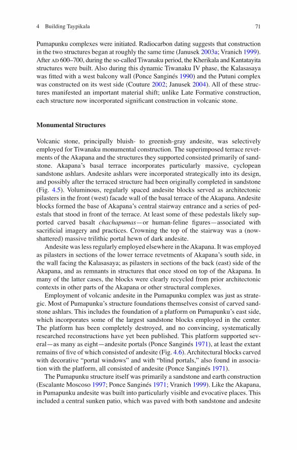
Volcanic stone, principally bluish- to greenish-gray andesite, was selectively employed for Tiwanaku monumental construction. The superimposed terrace revet-ments of the Akapana and the structures they supported consisted primarily of sand-stone. Akapana’s basal terrace incorporates particularly massive, cyclopean sandstone ashlars. Andesite ashlars were incorporated strategically into its design, and possibly after the terraced structure had been originally completed in sandstone (Fig. 4.5 ). Voluminous, regularly spaced andesite blocks served as architectonic pilasters in the front (west) facade wall of the basal terrace of the Akapana. Andesite blocks formed the base of Akapana’s central stairway entrance and a series of ped-estals that stood in front of the terrace. At least some of these pedestals likely sup-ported carved basalt chachapumas —or human-feline fi gures—associated with sacri fi cial imagery and practices. Crowning the top of the stairway was a (now-shattered) massive trilithic portal hewn of dark andesite.
Andesite was less regularly employed elsewhere in the Akapana. It was employed as pilasters in sections of the lower terrace revetments of Akapana’s south side, in the wall facing the Kalasasaya; as pilasters in sections of the back (east) side of the Akapana, and as remnants in structures that once stood on top of the Akapana. In many of the latter cases, the blocks were clearly recycled from prior architectonic contexts in other parts of the Akapana or other structural complexes.
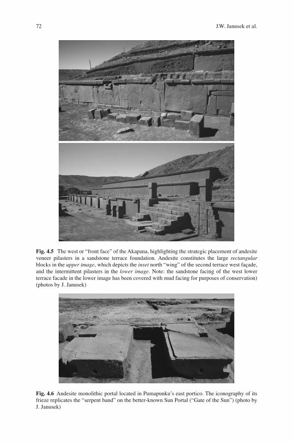
Employment of volcanic andesite in the Pumapunku complex was just as strate-gic. Most of Pumapunku’s structure foundations themselves consist of carved sand-stone ashlars. This includes the foundation of a platform on Pumapunku’s east side, which incorporates some of the largest sandstone blocks employed in the center. The platform has been completely destroyed, and no convincing, systematically researched reconstructions have yet been published. This platform supported sev-eral—as many as eight—andesite portals (Ponce Sanginés 1971 ) , at least the extant remains of fi ve of which consisted of andesite (Fig. 4.6 ). Architectural blocks carved with decorative “portal windows” and with “blind portals,” also found in associa-tion with the platform, all consisted of andesite (Ponce Sanginés 1971 ) .
The Pumapunku structure itself was primarily a sandstone and earth construction ( Escalante Moscoso 1997 ; Ponce Sanginés 1971 ; Vranich 1999 ) . Like the Akapana, in Pumapunku andesite was built into particularly visible and evocative places. This included a central sunken patio, which was paved with both sandstone and andesite
72 J.W. Janusek et al.
Fig. 4.5 The west or “front face” of the Akapana, highlighting the strategic placement of andesite veneer pilasters in a sandstone terrace foundation. Andesite constitutes the large rectangular blocks in the upper image , which depicts the inset north “wing” of the second terrace west façade, and the intermittent pilasters in the lower image . Note: the sandstone facing of the west lower terrace facade in the lower image has been covered with mud facing for purposes of conservation) (photos by J. Janusek)
Fig. 4.6 Andesite monolithic portal located in Pumapunku’s east portico. The iconography of its frieze replicates the “serpent band” on the better-known Sun Portal (“Gate of the Sun”) (photo by J. Janusek)
734 Building Taypikala
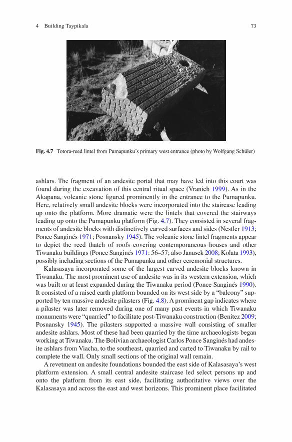
ashlars. The fragment of an andesite portal that may have led into this court was found during the excavation of this central ritual space (Vranich 1999 ) . As in the Akapana, volcanic stone fi gured prominently in the entrance to the Pumapunku. Here, relatively small andesite blocks were incorporated into the staircase leading up onto the platform. More dramatic were the lintels that covered the stairways leading up onto the Pumapunku platform (Fig. 4.7 ). They consisted in several frag-ments of andesite blocks with distinctively carved surfaces and sides ( Nestler 1913 ; Ponce Sanginés 1971 ; Posnansky 1945 ) . The volcanic stone lintel fragments appear to depict the reed thatch of roofs covering contemporaneous houses and other Tiwanaku buildings (Ponce Sanginés 1971 : 56–57; also Janusek 2008 ; Kolata 1993 ) , possibly including sections of the Pumapunku and other ceremonial structures.
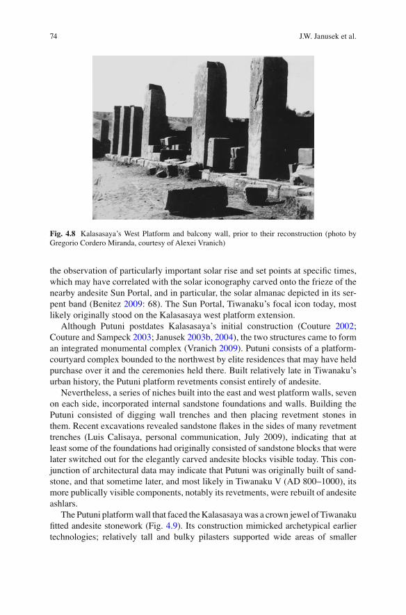
Kalasasaya incorporated some of the largest carved andesite blocks known in Tiwanaku. The most prominent use of andesite was in its western extension, which was built or at least expanded during the Tiwanaku period (Ponce Sanginés 1990 ) . It consisted of a raised earth platform bounded on its west side by a “balcony” sup-ported by ten massive andesite pilasters (Fig. 4.8 ). A prominent gap indicates where a pilaster was later removed during one of many past events in which Tiwanaku monuments were “quarried” to facilitate post-Tiwanaku construction (Benitez 2009 ; Posnansky 1945 ) . The pilasters supported a massive wall consisting of smaller andesite ashlars. Most of these had been quarried by the time archaeologists began working at Tiwanaku. The Bolivian archaeologist Carlos Ponce Sanginés had andes-ite ashlars from Viacha, to the southeast, quarried and carted to Tiwanaku by rail to complete the wall. Only small sections of the original wall remain.
A revetment on andesite foundations bounded the east side of Kalasasaya’s west platform extension. A small central andesite staircase led select persons up and onto the platform from its east side, facilitating authoritative views over the Kalasasaya and across the east and west horizons. This prominent place facilitated
Fig. 4.7 Totora-reed lintel from Pumapunku’s primary west entrance (photo by Wolfgang Schüler)
74 J.W. Janusek et al.
the observation of particularly important solar rise and set points at speci fi c times, which may have correlated with the solar iconography carved onto the frieze of the nearby andesite Sun Portal, and in particular, the solar almanac depicted in its ser-pent band (Benitez 2009 : 68). The Sun Portal, Tiwanaku’s focal icon today, most likely originally stood on the Kalasasaya west platform extension.
Although Putuni postdates Kalasasaya’s initial construction (Couture 2002 ; Couture and Sampeck 2003 ; Janusek 2003b, 2004 ) , the two structures came to form an integrated monumental complex ( Vranich 2009 ) . Putuni consists of a platform-courtyard complex bounded to the northwest by elite residences that may have held purchase over it and the ceremonies held there. Built relatively late in Tiwanaku’s urban history, the Putuni platform revetments consist entirely of andesite.
Nevertheless, a series of niches built into the east and west platform walls, seven on each side, incorporated internal sandstone foundations and walls. Building the Putuni consisted of digging wall trenches and then placing revetment stones in them. Recent excavations revealed sandstone fl akes in the sides of many revetment trenches (Luis Calisaya, personal communication, July 2009), indicating that at least some of the foundations had originally consisted of sandstone blocks that were later switched out for the elegantly carved andesite blocks visible today. This con-junction of architectural data may indicate that Putuni was originally built of sand-stone, and that sometime later, and most likely in Tiwanaku V (AD 800–1000), its more publically visible components, notably its revetments, were rebuilt of andesite ashlars.
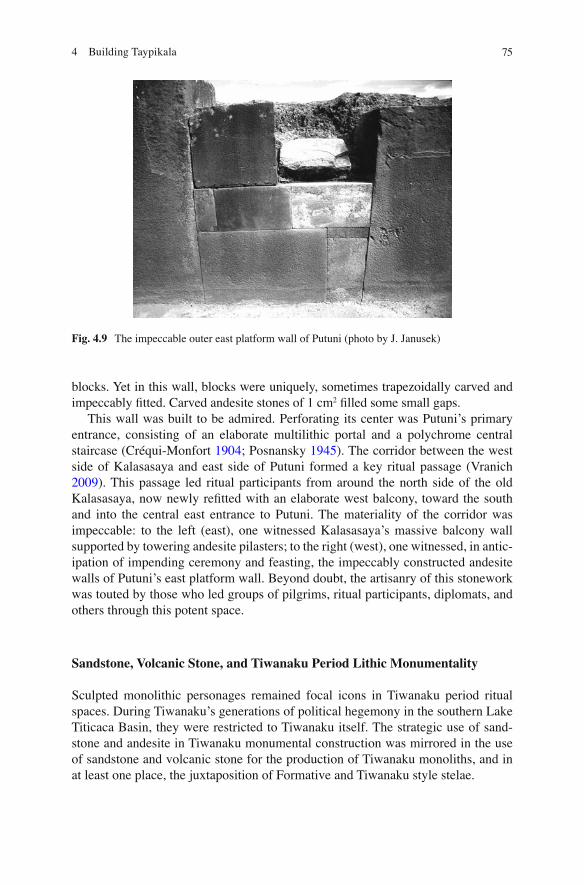
The Putuni platform wall that faced the Kalasasaya was a crown jewel of Tiwanaku fi tted andesite stonework (Fig. 4.9 ). Its construction mimicked archetypical earlier technologies; relatively tall and bulky pilasters supported wide areas of smaller
Fig. 4.8 Kalasasaya’s West Platform and balcony wall, prior to their reconstruction (photo by Gregorio Cordero Miranda, courtesy of Alexei Vranich)
754 Building Taypikala
blocks. Yet in this wall, blocks were uniquely, sometimes trapezoidally carved and impeccably fi tted. Carved andesite stones of 1 cm 2 fi lled some small gaps.
This wall was built to be admired. Perforating its center was Putuni’s primary entrance, consisting of an elaborate multilithic portal and a polychrome central staircase ( Créqui-Monfort 1904 ; Posnansky 1945 ) . The corridor between the west side of Kalasasaya and east side of Putuni formed a key ritual passage (Vranich 2009 ) . This passage led ritual participants from around the north side of the old Kalasasaya, now newly re fi tted with an elaborate west balcony, toward the south and into the central east entrance to Putuni. The materiality of the corridor was impeccable: to the left (east), one witnessed Kalasasaya’s massive balcony wall supported by towering andesite pilasters; to the right (west), one witnessed, in antic-ipation of impending ceremony and feasting, the impeccably constructed andesite walls of Putuni’s east platform wall. Beyond doubt, the artisanry of this stonework was touted by those who led groups of pilgrims, ritual participants, diplomats, and others through this potent space.
Sandstone, Volcanic Stone, and Tiwanaku Period Lithic Monumentality
Sculpted monolithic personages remained focal icons in Tiwanaku period ritual spaces. During Tiwanaku’s generations of political hegemony in the southern Lake Titicaca Basin, they were restricted to Tiwanaku itself. The strategic use of sand-stone and andesite in Tiwanaku monumental construction was mirrored in the use of sandstone and volcanic stone for the production of Tiwanaku monoliths, and in at least one place, the juxtaposition of Formative and Tiwanaku style stelae.
Fig. 4.9 The impeccable outer east platform wall of Putuni (photo by J. Janusek)
76 J.W. Janusek et al.
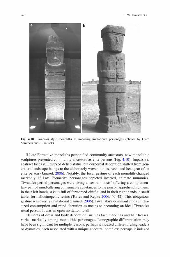
If Late Formative monoliths personi fi ed community ancestors, new monolithic sculptures presented community ancestors as elite persons (Fig. 4.10 ). Impassive, abstract faces still marked de fi ed status, but corporeal decoration shifted from gen-erative landscape beings to the elaborately woven tunics, sash, and headgear of an elite person (Janusek 2006 ) . Notably, the focal gesture of each monolith changed markedly. If Late Formative personages depicted interred, animate mummies, Tiwanaku period personages were living ancestral “hosts” offering a complemen-tary pair of mind-altering consumable substances to the person apprehending them; in their left hands, a kero full of fermented chicha , and in their right hands, a snuff tablet for hallucinogenic resins (Torres and Repke 2006 : 40–42). This ubiquitous gesture was overtly invitational (Janusek 2006 ) . Tiwanaku’s dominant ethos empha-sized consumption and mind alteration as means to becoming an ideal Tiwanaku ritual person. It was an open invitation to all.
Elements of dress and body decoration, such as face markings and hair tresses, varied markedly among monolithic personages. Iconographic differentiation may have been signi fi cant for multiple reasons; perhaps it indexed different ruling leaders or dynasties, each associated with a unique ancestral complex; perhaps it indexed
Fig. 4.10 Tiwanaku style monoliths as imposing invitational personages (photos by Clare Sammels and J. Janusek)
774 Building Taypikala
different cults, each focused on a speci fi c Tiwanaku temple and its ancestral com-plex; or, it may have indexed different landscape features outside of Tiwanaku—mountains, lakes, rivers, or other generative places—and their associated de fi ed ancestors, communities, and productive activities. We opt for the latter hypothesis (Janusek 2006, 2008 ; Ohnstad n.d.), while noting that elements of the other hypoth-eses may help explain this variability.
Stelae of sandstone and andesite presented this charged imagery. They occupied key places in Tiwanaku’s architectural complexes; notably sunken courtyards. The Kalasasaya, Akapana, and Pumapunku each incorporated a central sunken court-yard, each of which likely housed a central monolithic icon. Kalasasaya’s sunken court housed the andesite Ponce Monolith, which was found in situ. Akapana’s sunken court was dismantled during the Spanish Colonial Period. The andesite “Gigantic Monolith,” known only from its decapitated head of hard greenish-gray andesite, may have once stood in Akapana’s upper court, but other scenarios are possible. A sandstone monolithic stelae (Stela 4) found just west of Pumapunku was likely the focal monolithic icon that once stood in Pumapunku’s central patio (Ponce Sanginés 1971 ) .
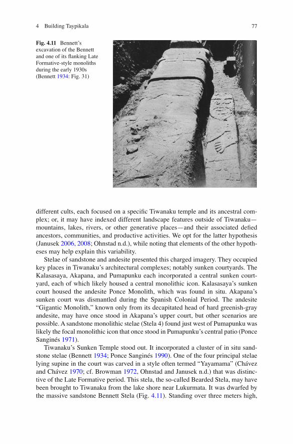
Tiwanaku’s Sunken Temple stood out. It incorporated a cluster of in situ sand-stone stelae (Bennett 1934 ; Ponce Sanginés 1990 ) . One of the four principal stelae lying supine in the court was carved in a style often termed “Yayamama” (Chávez and Chávez 1970 ; cf. Browman 1972 , Ohnstad and Janusek n.d.) that was distinc-tive of the Late Formative period. This stela, the so-called Bearded Stela, may have been brought to Tiwanaku from the lake shore near Lukurmata. It was dwarfed by the massive sandstone Bennett Stela (Fig. 4.11 ). Standing over three meters high,
Fig. 4.11 Bennett’s excavation of the Bennett and one of its fl anking Late Formative-style monoliths during the early 1930s (Bennett 1934 : Fig. 31)
78 J.W. Janusek et al.
the sandstone Bennett Monolith, like the andesite Ponce Monolith, presented impor-tant elements of Tiwanaku religious iconography. The Bennett embodied an impos-ing yet “invitational” anthropomorphic personage wearing a tunic decorated with dressed llamas and mind-altering plants.
Tiwanaku Stone Sourcing: Sandstone and Andesite
Previous Stone Sourcing at Tiwanaku
Early visitors noted that Tiwanaku monumental architecture comprised two very different types of stone, and often commented on their possible sources. As David Forbes put it in 1870 (p. 256), “the one is a light red sandstone…The other stone, however, is very different in nature, being a hard, tough, and compact volcanic rock, precisely the same as what was originally called Andesite.” He continues ( 1870 : 257), “although the sandstone has evidently been taken from the hills seen but a few miles distance from Tiahuanaco, the volcanic stone of which the two great mono-lithic portals, etc., have been constructed, has been conveyed a very great distance from the volcanic mountains on the other or western side of Lake Titicaca, where the quarries are still visible.”
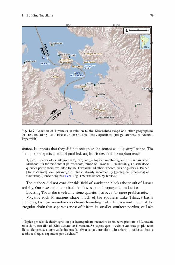
Travelers and researchers over the ensuing century brought more detailed analy-ses to bear on the origins of these two stones at Tiwanaku. While most agreed that the sandstone had derived largely from the Kimsachata mountain range south of Tiwanaku (Fig. 4.12 ), it remained unclear from which speci fi c sectors, and how it was quarried and ported.
The fi rst systemic studies were conducted and published in the early 1970s (Ponce and Mogrovejo Terrazas 1970 ; Ponce Sanginés 1971 ) . In the late 1960s, a group of researchers headed by the fi ery young Bolivian archaeologist Carlos Ponce Sanginés set out to determine the source of the sandstone employed to construct the Pumapunku complex. They conducted reconnaissance in several drainage valleys of the Kimsachata range south of Tiwanaku, isolating several possible sandstone quarries. A combination of comparative investigations that included X-ray diffrac-tion (Avila Salinas 1971 ) , geochemical analysis (Urquidi Barrau 1971 ) , and most diagnostically, lithic petrography (Castaños Echazú 1971 ) , indicated that Pumapunku sandstone came from the Kimsachata range, and most likely from the Kausani que-brada southeast of Tiwanaku (Mogrovejo Terrazas 1970 ) .
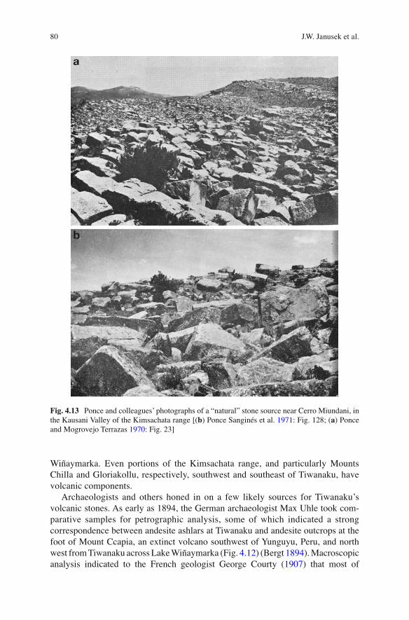
The same authors present the photo of a possible sandstone source “near Cerro Muiundani” (Ponce Sanginés 1971 : Fig. 128) in the Kausani quebrada (Fig. 4.13 ). This is a photo of the quarry that Janusek, Lemuz, and Julio Condori identi fi ed as a primary sandstone quarry in 2010 and 2011. Ponce and colleagues present photos showing the base of Kausani from the valley bottom, or pampa, to the north (Ponce Sanginés et al. 1971 : Figs. 114 and 129). Yet they say little else about this possible
794 Building Taypikala
source. It appears that they did not recognize the source as a “quarry” per se. The main photo depicts a fi eld of jumbled, angled stones, and the caption reads:
Typical process of disintegration by way of geological weathering on a mountain near Miundani, in the meridional [Kimsachata] range of Tiwanaku. Presumably, no sandstone quarries per se were exploited by the Tiwanaku, whether exposed cuts or galleries. Rather [the Tiwanaku] took advantage of blocks already separated by [geological processes] of fracturing 1 (Ponce Sanginés 1971 : Fig. 128; translation by Janusek).
The authors did not consider this fi eld of sandstone blocks the result of human activity. Our research determined that it was an anthropogenic production.
Locating Tiwanaku’s volcanic stone quarries has been far more problematic. Volcanic rock formations shape much of the southern Lake Titicaca basin,
including the low mountainous chains bounding Lake Titicaca and much of the irregular chain that separates most of it from its smaller southern portion, or Lake
1 “Tipico proceso de desintegracion por intemperismo mecanico en un cerro proximo a Muiundani en la sierra meridional [Kimsachata] de Tiwanaku. Se supone que no existio canteras propiamente dichas de areniscas aprovechadas pos las tiwanacotas, trabajo a tajo abierto o galleria, sino se acudio a bloques separados por disclasa.”
Fig. 4.12 Location of Tiwanaku in relation to the Kimsachata range and other geographical features, including Lake Titicaca, Cerro Ccapia, and Copacabana (Image courtesy of Nicholas Tripcevich)
80 J.W. Janusek et al.
Wiñaymarka. Even portions of the Kimsachata range, and particularly Mounts Chilla and Gloriakollu, respectively, southwest and southeast of Tiwanaku, have volcanic components.
Archaeologists and others honed in on a few likely sources for Tiwanaku’s volcanic stones. As early as 1894, the German archaeologist Max Uhle took com-parative samples for petrographic analysis, some of which indicated a strong correspondence between andesite ashlars at Tiwanaku and andesite outcrops at the foot of Mount Ccapia, an extinct volcano southwest of Yunguyu , Peru, and north west from Tiwanaku across Lake Wiñaymarka (Fig. 4.12 ) (Bergt 1894 ) . Macroscopic analysis indicated to the French geologist George Courty ( 1907 ) that most of
Fig. 4.13 Ponce and colleagues’ photographs of a “natural” stone source near Cerro Miundani, in the Kausani Valley of the Kimsachata range [( b ) Ponce Sanginés et al. 1971 : Fig. 128; ( a ) Ponce and Mogrovejo Terrazas 1970 : Fig. 23]
814 Building Taypikala
Tiwanaku’s volcanic stone derived from outcrops on the Huatta Peninsula east of Lake Titicaca, northeast of Tiwanaku. A few years later, Arthur Posnansky, an eccen-tric Austrian who spent half a century studying Tiwanaku, suggested that its volcanic stone derived primarily from Ccapia ( 1904 , cited in Ponce and Mogrovejo Terrazas 1970 : 35). Ironically (it turns out), he later changed his mind based on a small-scale petrographic analysis, opting for outcrops near Comanche, far southeast of Tiwanaku, as a more likely source. 2
Ponce Sanginés and other young geologists set out to determine the source of Tiwanaku’s andesite stonework. While the results were far less de fi nitive than those for sandstone, the group made progress in eradicating several igneous outcrops as possible primary sources for Tiwanaku’s volcanic stone constructions (Mille and Carlos Ponce 1968 ; Ponce and Mogrovejo Terrazas 1970 ) . Mineralogical and petrographic analysis marked the volcanic outcrops of Chilla and Gloriakollu in the Kimsachata range south of Tiwanaku as clear nonprimary sources (Mogrovejo Terrazas 1970 : 247–248). A key conclusion of the collaboration of Ponce and Mogrovejo, published in 1970, was that Tiwanaku’s primary volcanic sources were nonlocal (Ponce and Mogrovejo Terrazas 1970 ) . Somewhat earlier, Carlos Ponce and Max Mille had determined, based on reconnaissance and petrographic analysis, that Tiwanaku volcanic stone had not originated from sources southeast of Tiwanaku. This effectively discounted Viscachani, Comanche (Posnansky’s favored source), and Viacha (Ponce Sanginés 1968 : 37), from which Ponce had hundreds of andesite ashlars carved to reconstruct the west balcony wall of Tiwanaku’s Kalasasaya in the 1970s (Marcelino Lopez, personal communication, July 2010).
For Ponce and colleagues, more likely sources for Tiwanaku’s andesitic stone included: Mount Ccapia, across Lake Wiñaymarka to the west; the Copacabana Peninsula, to the northwest; and other volcanic outcrops along the shores of Lake Titicaca further north. Considering Tiwanaku’s distance from the shore, they hypoth-esized that Tiwanaku leaders, artisans, and stoneworkers took advantage of lake shore sources so that stone traveled relatively minimal overland distances. Impeccably engineered rafts crafted of locally harvested totora reeds, they suggested, served to cart heavy volcanic stones across long stretches. Recent projects in experimental archaeology have developed multiple proposals for how such heavy-duty totora reed rafts—essentially barges—might have been constructed (Vranich, personal communication, 2006).
2 Posnanksy commissioned petrographic analyses that were conducted by a certain Dr. Schneiderhohn at the Petrographic Institute of the University of Berlin (Ponce and Mogrovejo Terrazas 1970 : 36). He published the results of 23 petrographic analyses, two of them conducted on volcanic stone samples from Ccapia (samples Q and R). At least ten samples derived from Tiwanaku monumental constructions, and two others from Tiwanaku basalt monuments. (Posnansky 1945 , II; Figs. 162–180; Ponce and Mogrovejo Terrazas 1970 : 36–37). The two sam-ples from Ccapia (Q and R) did not provide a good match for the Tiwanaku samples. Of course, this is not surprising. Mineralogical and chemical signatures vary signi fi cantly in volcanic sources due to variable local formation conditions. Posnansky made the critical mistake of second guessing his initial instinct. As it turns out, most Tiwanaku andesitic stone derived from Mount Ccapia.
82 J.W. Janusek et al.
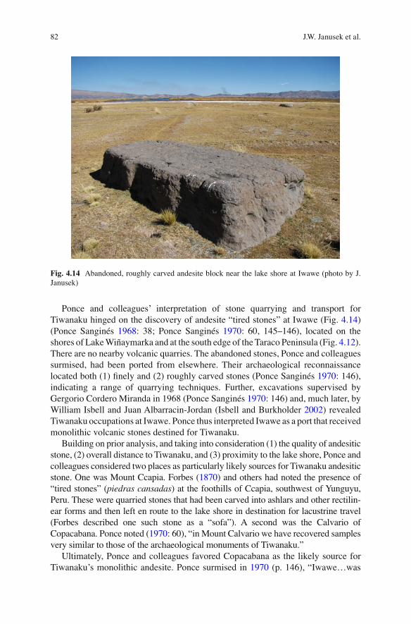
Ponce and colleagues’ interpretation of stone quarrying and transport for Tiwanaku hinged on the discovery of andesite “tired stones” at Iwawe (Fig. 4.14 ) (Ponce Sanginés 1968 : 38; Ponce Sanginés 1970 : 60, 145–146), located on the shores of Lake Wiñaymarka and at the south edge of the Taraco Peninsula (Fig. 4.12 ). There are no nearby volcanic quarries. The abandoned stones, Ponce and colleagues surmised, had been ported from elsewhere. Their archaeological reconnaissance located both (1) fi nely and (2) roughly carved stones (Ponce Sanginés 1970 : 146), indicating a range of quarrying techniques. Further, excavations supervised by Gergorio Cordero Miranda in 1968 (Ponce Sanginés 1970 : 146) and, much later, by William Isbell and Juan Albarracin-Jordan (Isbell and Burkholder 2002 ) revealed Tiwanaku occupations at Iwawe. Ponce thus interpreted Iwawe as a port that received monolithic volcanic stones destined for Tiwanaku.
Building on prior analysis, and taking into consideration (1) the quality of andesitic stone, (2) overall distance to Tiwanaku, and (3) proximity to the lake shore, Ponce and colleagues considered two places as particularly likely sources for Tiwanaku andesitic stone. One was Mount Ccapia. Forbes ( 1870 ) and others had noted the presence of “tired stones” ( piedras cansadas ) at the foothills of Ccapia, southwest of Yunguyu, Peru. These were quarried stones that had been carved into ashlars and other rectilin-ear forms and then left en route to the lake shore in destination for lacustrine travel (Forbes described one such stone as a “sofa”). A second was the Calvario of Copacabana. Ponce noted ( 1970 : 60), “in Mount Calvario we have recovered samples very similar to those of the archaeological monuments of Tiwanaku.”
Ultimately, Ponce and colleagues favored Copacabana as the likely source for Tiwanaku’s monolithic andesite. Ponce surmised in 1970 (p. 146), “Iwawe…was
Fig. 4.14 Abandoned, roughly carved andesite block near the lake shore at Iwawe (photo by J. Janusek)
834 Building Taypikala
the port where rafts unloaded their material carried from the Copacabana Peninsula.” He settled on this source, in part, for reasons of political expediency. Ponce explains ( 1968 : 37): “It appears currently indispensible to concentrate on the possibility of the quarry of Mount Capira [Ccapia]…[yet], For us, it was not possible to conduct even a simple reconnaissance in the region, because it is located on the border of Peru and Bolivia, in the territory of our brother country, where for obvious reasons dif fi culties arise for even the most summary explorations.” Serious consideration of Ccapia as a source for Tiwanaku’s volcanic stone apparently was out of the question.
Results of Stone Sourcing, 2010–2011
Sandstone
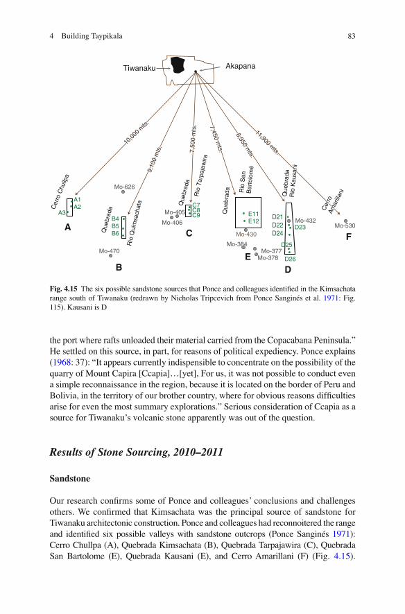
Our research con fi rms some of Ponce and colleagues’ conclusions and challenges others. We con fi rmed that Kimsachata was the principal source of sandstone for Tiwanaku architectonic construction. Ponce and colleagues had reconnoitered the range and identi fi ed six possible valleys with sandstone outcrops (Ponce Sanginés 1971 ) : Cerro Chullpa (A), Quebrada Kimsachata (B), Quebrada Tarpajawira (C), Quebrada San Bartolome (E), Quebrada Kausani (E), and Cerro Amarillani (F) (Fig. 4.15 ).
Fig. 4.15 The six possible sandstone sources that Ponce and colleagues identi fi ed in the Kimsachata range south of Tiwanaku (redrawn by Nicholas Tripcevich from Ponce Sanginés et al. 1971 : Fig. 115). Kausani is D
10,00
0 mts.
10,00
0 mts.
Cer
roC
erro
Am
arill
ani
Am
arill
ani
Que
brad
a Q
uebr
ada
Rio
Kau
sani
Rio
Kau
sani9,10
0 m
ts.
9,10
0 m
ts.
7,50
0 m
ts.
7,50
0 m
ts.
8,950 mts.
8,950 mts.
11,900 mts.
11,900 mts.
10,00
0 mts.
Cer
roA
mar
illan
i
Cer
ro C
hullp
a
Rio
Qui
msa
chat
a Que
brad
a
Que
brad
a Rio
San
Bar
tolo
mé
Que
brad
a R
io K
ausa
ni
Que
brad
a
Rio
Tar
paja
wira
9,10
0 m
ts.
7,50
0 m
ts. 7,450 m
ts.
7,450 mts.
7,450 mts.
8,950 mts.
11,900 mts.
A
B
C
ED
F
Mo-405
Mo-406
Mo-626
Mo-470
B4B5B6
A1A2
E11E12
C7C8C9
Mo-430
Mo-384Mo-377
Mo-378
D21D22D24
Mo-432Mo-530
A3
D26
D25
D23
Tiwanaku Akapana

84 J.W. Janusek et al.
Petrographic (Castaños Echazú 1971 ) , X-ray diffraction (Avila Salinas 1971 ) , and geochemical (Urquidi Barrau 1971 ) analysis converged on the conclusion that Kausani Valley was the principal sandstone source for Pumapunku (Ponce Sanginés 1971 ) . The co-editors present a photo of the base of the valley, just as the stream enters the altiplano pampa (Ponce Sanginés et al. 1971 : 316), and a photo of the upper valley that shows a dense fi eld of large, rectangular sandstone blocks (Ponce Sanginés et al. 1971 : 324). The caption concludes that Tiwanaku took advantage of geologically fractured sandstone outcrops to mine stones for Pumapunku (Ponce Sanginés et al. 1971 : Fig. 128). Knowing Ponce’s acuity in other aspects of Tiwanaku archaeology, we suspect that he never visited—or at least never more than cursorily inspected—this quarry. The quarry is known locally as Kaliri.
Janusek initiated reconnaissance in Kimsachata with Julio Condori and Manuel Choque in 2010, and continued in 2011 with Carlos Lémuz and Andy Roddick (McMaster University). We located only one positive source of sandstone for Tiwanaku in the Kimsachata range; that is, only one source where partially carved stones had been left behind. Kaliri was likely the major source of Tiwanaku’s sand-stone (Fig. 4.16 ). Reconnaissance located several potential minor sources in the range, including distant outcrops in the San Bartolome Valley southeast of Tiwanaku, nearer outcrops in the Tarpa Jawira Valley, and outcrops in the large Kimsachata Valley southwest of Tiwanaku. Each valley presented relatively small outcrops that may have been quarried in the past. Few of them revealed extant quarried stones. None of them revealed extant quarried stones to the extent located in Kaliri.
Fig. 4.16 Kaliri sandstone quarry. Location on Google Map ( inset ) and view from the south (photo by J. Janusek)
854 Building Taypikala
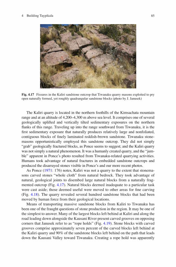
The Kaliri quarry is located in the northern foothills of the Kimsachata mountain range and at an altitude of 4,200–4,300 m above sea level. It comprises one of several geologically uplifted and vertically tilted sedimentary exposures on the northern fl anks of this range. Traveling up into the range southward from Tiwanaku, it is the fi rst sedimentary exposure that naturally produces relatively large and nonfoliated, contiguous blocks of fi nely laminated reddish-brown sandstone. Tiwanaku stone-masons opportunistically employed this sandstone outcrop. They did not simply “grab” geologically fractured blocks, as Ponce seems to suggest; and the Kaliri quarry was not simply a natural phenomenon. It was a humanly created quarry, and the “jum-ble” apparent in Ponce’s photo resulted from Tiwanaku-related quarrying activities. Humans took advantage of natural fractures in embedded sandstone outcrops and produced the disarrayed stones visible in Ponce’s and our more recent photos.
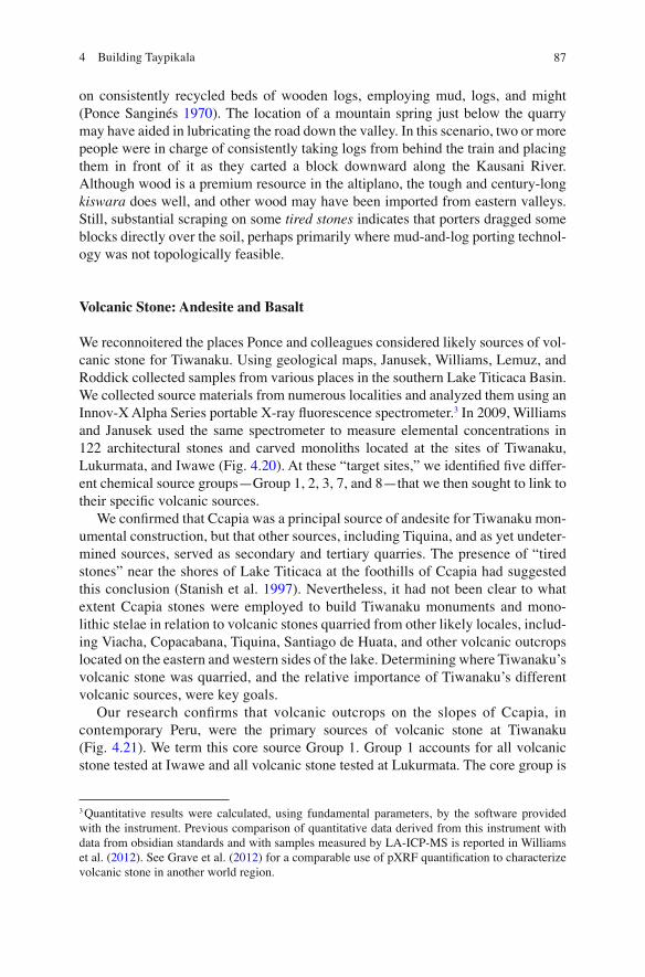
As Ponce ( 1971 : 176) notes, Kaliri was not a quarry to the extent that stonema-sons carved stones “whole cloth” from natural bedrock. They took advantage of natural, geological joints to disembed large natural blocks from a naturally frag-mented outcrop (Fig. 4.17 ). Natural blocks deemed inadequate to a particular task were cast aside; those deemed useful were moved to other areas for fi ne carving (Fig. 4.18 ). The quarry revealed several hundred sandstone blocks that had been moved by human force from their geological locations.
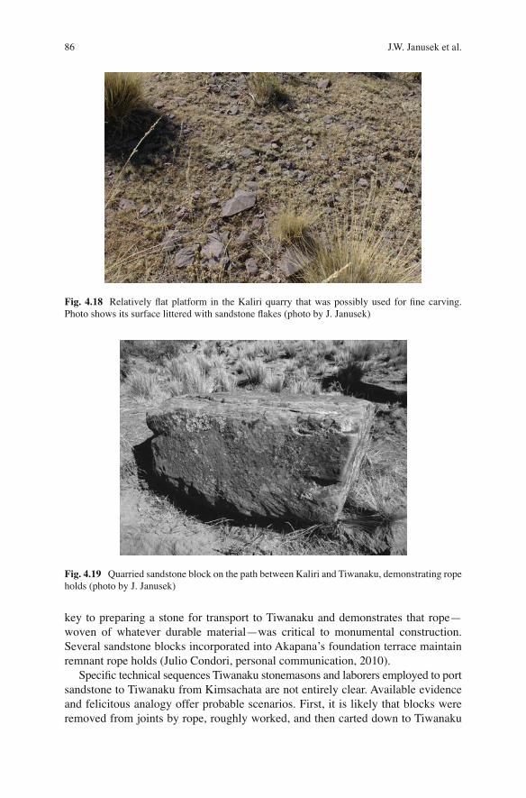
Means of transporting massive sandstone blocks from Kaliri to Tiwanaku has been one of the fraught questions of stone production in the region. It may be one of the simplest to answer. Many of the largest blocks left behind at Kaliri and along the road leading down alongside the Kausani River present carved grooves on opposing corners that Janusek refer to as “rope holds” (Fig. 4.19 ). Stone blocks with carved grooves comprise approximately seven percent of the carved blocks left behind at the Kaliri quarry and 90% of the sandstone blocks left behind on the path that leads down the Kausani Valley toward Tiwanaku. Creating a rope hold was apparently
Fig. 4.17 Fissures in the Kaliri sandstone outcrop that Tiwanaku quarry masons exploited to pry open naturally formed, yet roughly quadrangular sandstone blocks (photo by J. Janusek)
86 J.W. Janusek et al.
key to preparing a stone for transport to Tiwanaku and demonstrates that rope—woven of whatever durable material—was critical to monumental construction. Several sandstone blocks incorporated into Akapana’s foundation terrace maintain remnant rope holds (Julio Condori, personal communication, 2010).
Speci fi c technical sequences Tiwanaku stonemasons and laborers employed to port sandstone to Tiwanaku from Kimsachata are not entirely clear. Available evidence and felicitous analogy offer probable scenarios. First, it is likely that blocks were removed from joints by rope, roughly worked, and then carted down to Tiwanaku
Fig. 4.18 Relatively fl at platform in the Kaliri quarry that was possibly used for fi ne carving. Photo shows its surface littered with sandstone fl akes (photo by J. Janusek)
Fig. 4.19 Quarried sandstone block on the path between Kaliri and Tiwanaku, demonstrating rope holds (photo by J. Janusek)
874 Building Taypikala
on consistently recycled beds of wooden logs, employing mud, logs, and might (Ponce Sanginés 1970 ) . The location of a mountain spring just below the quarry may have aided in lubricating the road down the valley. In this scenario, two or more people were in charge of consistently taking logs from behind the train and placing them in front of it as they carted a block downward along the Kausani River. Although wood is a premium resource in the altiplano, the tough and century-long kiswara does well, and other wood may have been imported from eastern valleys. Still, substantial scraping on some tired stones indicates that porters dragged some blocks directly over the soil, perhaps primarily where mud-and-log porting technol-ogy was not topologically feasible.
Volcanic Stone: Andesite and Basalt
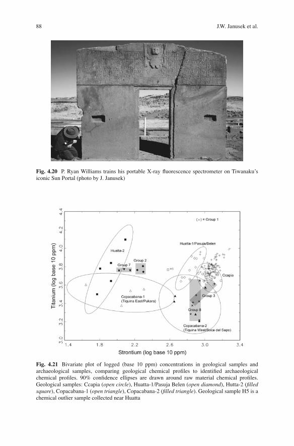
We reconnoitered the places Ponce and colleagues considered likely sources of vol-canic stone for Tiwanaku. Using geological maps, Janusek, Williams, Lemuz, and Roddick collected samples from various places in the southern Lake Titicaca Basin. We collected source materials from numerous localities and analyzed them using an Innov-X Alpha Series portable X-ray fl uorescence spectrometer. 3 In 2009, Williams and Janusek used the same spectrometer to measure elemental concentrations in 122 architectural stones and carved monoliths located at the sites of Tiwanaku, Lukurmata, and Iwawe (Fig. 4.20 ). At these “target sites,” we identi fi ed fi ve differ-ent chemical source groups—Group 1, 2, 3, 7, and 8—that we then sought to link to their speci fi c volcanic sources.
We con fi rmed that Ccapia was a principal source of andesite for Tiwanaku mon-umental construction, but that other sources, including Tiquina, and as yet undeter-mined sources, served as secondary and tertiary quarries. The presence of “tired stones” near the shores of Lake Titicaca at the foothills of Ccapia had suggested this conclusion (Stanish et al. 1997 ) . Nevertheless, it had not been clear to what extent Ccapia stones were employed to build Tiwanaku monuments and mono-lithic stelae in relation to volcanic stones quarried from other likely locales, includ-ing Viacha, Copacabana, Tiquina, Santiago de Huata, and other volcanic outcrops located on the eastern and western sides of the lake. Determining where Tiwanaku’s volcanic stone was quarried, and the relative importance of Tiwanaku’s different volcanic sources, were key goals .
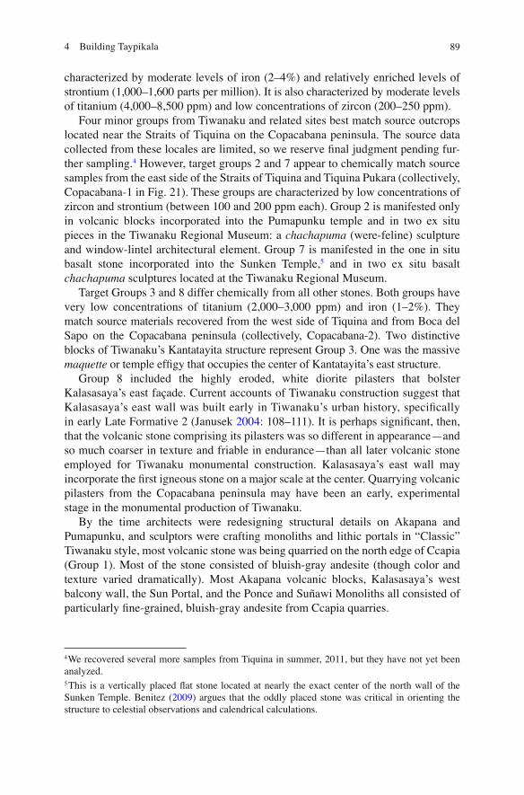
Our research con fi rms that volcanic outcrops on the slopes of Ccapia, in contemporary Peru, were the primary sources of volcanic stone at Tiwanaku (Fig. 4.21 ). We term this core source Group 1. Group 1 accounts for all volcanic stone tested at Iwawe and all volcanic stone tested at Lukurmata. The core group is
3 Quantitative results were calculated, using fundamental parameters, by the software provided with the instrument. Previous comparison of quantitative data derived from this instrument with data from obsidian standards and with samples measured by LA-ICP-MS is reported in Williams et al. ( 2012 ) . See Grave et al. ( 2012 ) for a comparable use of pXRF quanti fi cation to characterize volcanic stone in another world region.
88 J.W. Janusek et al.
Fig. 4.20 P. Ryan Williams trains his portable X-ray fl uorescence spectrometer on Tiwanaku’s iconic Sun Portal (photo by J. Janusek)
Fig. 4.21 Bivariate plot of logged (base 10 ppm) concentrations in geological samples and archaeological samples, comparing geological chemical pro fi les to identi fi ed archaeological chemical pro fi les. 90% con fi dence ellipses are drawn around raw material chemical pro fi les. Geological samples: Ccapia ( open circle ), Huatta-1/Pasuja Belen ( open diamond ), Hutta-2 ( fi lled square ), Copacabana-1 ( open triangle ), Copacabana-2 ( fi lled triangle ). Geological sample H5 is a chemical outlier sample collected near Huatta
894 Building Taypikala
characterized by moderate levels of iron (2–4%) and relatively enriched levels of strontium (1,000–1,600 parts per million). It is also characterized by moderate levels of titanium (4,000–8,500 ppm) and low concentrations of zircon (200–250 ppm).
Four minor groups from Tiwanaku and related sites best match source outcrops located near the Straits of Tiquina on the Copacabana peninsula. The source data collected from these locales are limited, so we reserve fi nal judgment pending fur-ther sampling. 4 However, target groups 2 and 7 appear to chemically match source samples from the east side of the Straits of Tiquina and Tiquina Pukara (collectively, Copacabana-1 in Fig. 21). These groups are characterized by low concentrations of zircon and strontium (between 100 and 200 ppm each). Group 2 is manifested only in volcanic blocks incorporated into the Pumapunku temple and in two ex situ pieces in the Tiwanaku Regional Museum: a chachapuma (were-feline) sculpture and window-lintel architectural element. Group 7 is manifested in the one in situ basalt stone incorporated into the Sunken Temple, 5 and in two ex situ basalt chachapuma sculptures located at the Tiwanaku Regional Museum.
Target Groups 3 and 8 differ chemically from all other stones. Both groups have very low concentrations of titanium (2,000–3,000 ppm) and iron (1–2%). They match source materials recovered from the west side of Tiquina and from Boca del Sapo on the Copacabana peninsula (collectively, Copacabana-2). Two distinctive blocks of Tiwanaku’s Kantatayita structure represent Group 3. One was the massive maquette or temple ef fi gy that occupies the center of Kantatayita’s east structure.
Group 8 included the highly eroded, white diorite pilasters that bolster Kalasasaya’s east façade. Current accounts of Tiwanaku construction suggest that Kalasasaya’s east wall was built early in Tiwanaku’s urban history, speci fi cally in early Late Formative 2 (Janusek 2004 : 108–111). It is perhaps signi fi cant, then, that the volcanic stone comprising its pilasters was so different in appearance—and so much coarser in texture and friable in endurance—than all later volcanic stone employed for Tiwanaku monumental construction. Kalasasaya’s east wall may incorporate the fi rst igneous stone on a major scale at the center. Quarrying volcanic pilasters from the Copacabana peninsula may have been an early, experimental stage in the monumental production of Tiwanaku.
By the time architects were redesigning structural details on Akapana and Pumapunku, and sculptors were crafting monoliths and lithic portals in “Classic” Tiwanaku style, most volcanic stone was being quarried on the north edge of Ccapia (Group 1). Most of the stone consisted of bluish-gray andesite (though color and texture varied dramatically). Most Akapana volcanic blocks, Kalasasaya’s west balcony wall, the Sun Portal, and the Ponce and Suñawi Monoliths all consisted of particularly fi ne-grained, bluish-gray andesite from Ccapia quarries.
4 We recovered several more samples from Tiquina in summer, 2011, but they have not yet been analyzed.
5 This is a vertically placed fl at stone located at nearly the exact center of the north wall of the Sunken Temple. Benitez ( 2009 ) argues that the oddly placed stone was critical in orienting the structure to celestial observations and calendrical calculations.
90 J.W. Janusek et al.
Other sources provided stones for speci fi c places and purposes. Kantayita’s miniature ef fi gy temple, surrounded by stones quarried from Ccapia, was quarried somewhere on the Copacabana peninsula. This monolithic sculpture was a key focus of ritual activity in the temple, raising the question of whether its source, or other aspects of its materiality, was important to its being chosen as Kantayita’s focal carved stone.
The mountain range east of Tiquina, including our East Tiquina and Tiquina Pukara (Copacabana 1) sources (Groups 2 and 7), provided some of the heavier, denser basalt for Tiwanaku’s fi ne architectural elements and sculptures. Basalt was quarried to form very particular architectural elements; notably architectural stones in Pumapunku’s east portico and the narrow, vertically oriented stone located in the center of the Sunken Temple’s north wall (Benitez 2009 ) . Basalt was also quarried to form several of the chachapuma , or were-feline, personages that punctuated Tiwanaku’s monumental core.
Discussion: Sandstone, Andesite, and the Shifting Production of Taypikala
Stone was essential to Tiwanaku. It was essential to the ballooning fame of the center and to coordinating the actions and identities of the many communities that identi fi ed with it. Stone for monumental construction and monolithic erection had a long history in the southern Lake Titicaca Basin. It began during the Early or Middle Formative (800–100 bc ; Bennett 1936 ; Cohen and Roddick 2007 ; Hastorf 2003 ; Lemuz 2001 ; Chávez 1988 ) . It became a primary component of monumental con-struction during the Late Formative (100 bc – ad 500), at sites such as Khonkho Wankane (Ohnstad n.d.) and Tiwanaku (Janusek 2008 ) . Local stone fueled an increasing appetite for monumental permanence and mass. It served to embody key ancestral personages, crafted as monolithic sculptures to which local populations made offerings and attributed causality to ongoing events in the world (Janusek 2006, 2008 , 2010 ). Stone continued to be quarried, carved, and incorporated into monumental structures and monolithic sculptures throughout the Tiwanaku Period.
Tiwanaku’s incorporation of stone changed dramatically at the beginning of the Tiwanaku Period ( ad 500–1100), just as its regional prestige began to explode. Sandstone quarrying and sculpting practices, focused on the Kimsachata range south of Tiwanaku, shifted as stoneworkers and masons began to incorporate heavier volcanic stone from more distant ancient volcanoes and igneous outcrops in Ccapia, Copacabana, and beyond. This was a momentous transformation with technical, esthetic, and ultimately, spiritual dimensions (Janusek 2006 ) .
Sandstone was quarried in the Kimsachata range south of Tiwanaku. Our reconnais-sance located one clear sandstone quarry in the upper Kausani Valley of that range and a number of other possible quarry sites. Our research con fi rms some of the results of analyses conducted under the direction of Carlos Ponce Sanginés in the 1960s and 1970s (Ponce Sanginés and Mogrovejo Terrazas 1970 ; Ponce Sanginés et al. 1971 ) . Ponce and colleagues determined, fi rst, that Tiwanaku’s sandstone derived from
914 Building Taypikala
sandstone quarries located in narrow valleys of the Kimsachata range south of the site. Based on a conjunction of analyses, they suggested that sandstone for the Pumapunku derived from the Kausani Valley southeast of Tiwanaku (Ponce Sanginés et al. 1971 ) .
Our reconnaissance con fi rmed that the Kausani Valley quarry was Tiwanaku’s primary sandstone quarry. We located several other possible secondary quarries in nearby narrow valleys in the Kimsachata range. We can also update Ponce’s thoughts about the process of sandstone quarrying (Ponce Sanginés et al. 1971 : 324). Ponce concluded that Tiwanaku builders took advantage of naturally fi ssured sandstone outcrops to mine blocks for Tiwanaku constructions. He suggests that Tiwanaku builders did not quarry in the strict sense. We fi nd that this is only partly true. Tiwanaku quarrysmiths took advantage of natural outcrop fi ssures to mine sand-stone blocks, as Ponce argues, but the disarrayed stone blocks currently found in the Kaliri quarry of Kausani are the product of long-term, intensive stone quarrying. Tiwanaku quarrysmiths mined blocks from natural fi ssures, leaving behind a disar-rayed fi eld of blocks of varying size. The lithic landscape Ponce depicts was not naturally produced; it was the product of human stone quarrying and carving.
We also recovered evidence pertinent to the technical practice of moving stone blocks from Kaliri down the narrow Kausani Valley, across a wide stretch of alti-plano pampa, and ultimately into Tiwanaku. Stonemasons carved sandstone blocks to roughly desired rectangular shapes on fl at areas near the fi ssured sandstone out-crops. They then carved 7–10 cm wide divets into the edges of the blocks, usually located on opposing edges just below (~10–15 cm) the corners of the block. Janusek terms these “rope holds.” Some blocks had two opposing divets, others had four. Less than ten percent of the carved sandstone blocks found in preparation areas of Kaliri yielded rope holds. Approximately ninety percent of the blocks found along the road leading down from Kaliri to the altiplano pampa yielded rope holds. We believe this is compelling evidence that multiple persons used strong hemp to trans-port each block from Kaliri to Tiwanaku.
Volcanic andesite began to be employed in Tiwanaku construction early in the Tiwanaku period. Our analysis determined that, by far, most of Tiwanaku’s andesite derived from Mount Ccapia, across Lake Wiñaymarka and northwest of the site. Smaller proportions of andesite derived from other sources, including volcanic out-crops near the straits of Tiquina and on the Copacabana peninsula. Ponce consid-ered the latter Tiwanaku’s primary sources. We believe he did this, in part, because as he notes, he was unable to conduct research in the Ccapia region just across the border in Peru. But we believe he did this also because Mount Ccapia is located in Peru. Ponce’s Bolivian archaeology was vehemently nationalistic ( 1978a, b ) . It would have been distasteful for him to acknowledge that stone for Tiwanaku’s mon-umental constructions, which he was simultaneously reconstructing and recreating as Bolivian national patrimony (Ponce Sanginés 1961, 1990 ) , derived from sources currently located (however circumstantially) in Peru.
Volcanic andesite was employed in Kalasasaya’s West Balcony, Akapana’s front west face, and in Pumapunku’s east portico. These structures all date to the early generations of the Tiwanaku period, sometime between ad 500 and 700. Later structures such as the Putuni and Kerikala continued to employ volcanic stone.
92 J.W. Janusek et al.
Stonemasons employed volcanic stone, and principally andesite, strategically in Tiwanaku’s early monumental structures. Andesite pilasters punctuated Akapana’s façade, andesite comprised mono- and multilithic portals in Pumapunku’s portico, and massive andesite blocks bolstered Kalasasaya’s impressive west balcony wall.
This balcony wall, a structural addition to a Late Formative structure (Ponce Sanginés 1981 ) , may have been a critical turning point in the use of quarried andesite (Janusek 2010 ) . Its 11 andesite pilasters apparently marked solar setting points, solstice to solstice, on the distant west horizon as viewed from a monolithic andes-ite staircase on the east edge of the west platform extension (Benitez 2009 ) . Viewed from the staircase, the sun on June solstice set over the northernmost andesite pilaster, and simultaneously over the peak of Mount Ccapia, its source. The very materiality of andesite tied Tiwanaku monumental construction to key terrestrial features—Ccapia—and celestial movements. It linked Tiwanaku to major cosmic forces and rhythms.
Monolithic sculptures also manifested a dramatic shift in iconographic composi-tion. Most Tiwanaku sandstone monoliths depict ancestral personages rendered in Late Formative style (Browman 1972 ; Janusek and Ohnstad n.d.). These can be eas-ily cross-dated to monoliths at other Late Formative sites, in particular Khonkho Wankane. Monoliths feature impassive personages with arms crossed over chest, high-relief carving, and serpentine zoomorphs. All Tiwanaku andesite monoliths depict personages rendered in Classical Tiwanaku style. Many depict impassive personages with arms presenting two objects—a kero and a probable snuff tablet— fi ne low-relief carving, and pro fi le “attendants.” Sandstone monoliths embody personages with minimal clothing (emphasizing headdress and sash), while andesite monoliths embody personages wearing elaborate garments. Most sandstone monoliths are quadrangular in form, while andesite monoliths emphasize three-dimensional shoulders, head, arms, legs, and feet (Janusek and Ohnstad n.d.).
There are, of course, many exceptions to this chronological/material distinction. Standing on the Kalasasaya platform, the Fraile monolith, carved of sandstone, depicts a three-dimensional personage in high relief who grasps a kero and snuff tablet and wears minimal clothing including a sash decorated with crustaceans. Pumapunku’s Stela Four, also carved of sandstone, depicts a more rigidly carved personage in high relief who grasps a kero and snuff tablet in his hands (Ponce Sanginés et al. 1971 : Figs. 84–86). This personage wears far more elaborate cloth-ing, as depicted in its three-dimensional, high-relief sculpture; a squared headdress topped with feathers, ear ornaments, and almost fully clothed torso (now highly eroded). Just as andesite came to accompany sandstone construction in Tiwanaku’s later monumental buildings, sandstone monoliths continued to be crafted and stood alongside andesite monolithic personages in these buildings during the Tiwanaku Period.
Yet relative signi fi cance in the differentiated materiality of sandstone and andes-ite may be more complex. Most impressive among monoliths is the well-known Bennett Monolith, which until 2002 stood in an ef fi gy sunken temple designed by Arthur Posnansky in the city of La Paz. Bennett, crafted of sandstone, is the largest extant monolith known from Tiwanaku. Though crafted of sandstone, the personage
934 Building Taypikala
presents a kero and snuff tablet, wears elaborate clothing, much of its body is three-dimensionally rendered, and is decorated with pro fi le attendants and other Classical Tiwanaku lithic imagery. Like Kalassaya’s Fraile and Pumapunku’s Stela Four, the Bennett Monolith is a Tiwanaku Period sculpture. Yet its context may help explain its sandstone materiality.
The Bennett Monolith stood inside the Sunken Temple (Bennett 1934 ; Ponce Sanginés 1981, 1990 ) . This structure dated to the Late Formative and is Tiwanaku’s earliest documented monumental construction. Unlike all of Tiwanaku’s monumen-tal structures, the Late Formative Sunken Temple was aligned north–south, with a north-facing staircase entrance that framed Mount Kimsachata to the south (Benitez 2009 ) . All later monumental buildings, including Kalasasaya, Akapana, and Pumapunku, were aligned east–west. Thus, the Sunken Temple was “retro- fi tted” with a classical Tiwanaku period sculpture; the most immense sculpture in the south-ern Lake Titicaca Basin. It stood beside, and essentially dwarfed, two smaller sand-stone sculptures depicting Late Formative personages. Why was the Bennett placed in the Sunken Temple? Perhaps, sandstone attracted sandstone in the early Tiwanaku period. That is, sandstone monoliths were carved in an emergent Tiwanaku style early in the Tiwanaku period, and they were placed in key ritual locales between ad 500 and 700. Most of these locales still maintained substantial sandstone founda-tions, and some Late Formative sandstone monoliths (such as the Sunken Temple). The Sunken Temple, in particular, appears to have been converted into a place for recreating Tiwanaku “historical patrimony” in the Tiwanaku Period (Janusek 2006 ) . Emplacing the massive Bennett in the Temple, thereby dwar fi ng its predecessor monoliths “in the eyes” of surrounding tenoned head sculptures, may have been a critical architectonic movement in this direction.
Archaeologists cite the Bennett Monolith to demonstrate that the sandstone/volcanic stone distinction has no chronological signi fi cance. The caution is well taken. Sandstone and andesite are not absolute determinants of Late Formative or Tiwanaku Period lithic production, as witnessed in Tiwanaku architectural construction over the long term. During the Tiwanaku period, sandstone and andesite came to serve com-plementary, highly strategic purposes in monumental construction and monolithic production. Stonemasons integrated andesite blocks into particularly visible facades or public spaces such as Akapana’s front and Pumapunku’s portico. Excavations in Putuni indicate that early sandstone blocks forming the inner courtyard façade were later swapped out for andesite blocks. Volcanic andesite came to complement sand-stone as Tiwanaku’s novel public esthetic and spiritual technology.
In other venues, Janusek ( 2006, 2008 : 134–135) suggests that during the Tiwanaku period, sandstone and andesite accrued complementary material semiotic qualities. Relatively friable, sandstone from local Kimsachata outcrops was red in color. More durable, andesite from more distant volcanic outcrops was bluish-gray in color. Andesite production demanded an entirely new technological sequence (or chaîne opératoire ) of production: from quarrying, through movement across the lake, to fi nal fi tting in structures such as Akapana. Examining this sequence is a primary objective of our ongoing research. Andesite came from more distant volcanic sources that had been more recently incorporated into Tiwanaku’s ritual–political
94 J.W. Janusek et al.
sphere. Red, friable sandstone came to index Tiwanaku’s telluric ancestors and Late Formative heritage, as perfectly manifested in the Sunken Temple with its imposing sandstone Bennett Monolith. Bluish-gray, durable andesite came to index Tiwanaku’s newly incorporated landscapes, communities, and sacred places, as strikingly mani-fested in the Kalasasaya west balcony, which created visual relations to Mount Ccapia, the origin of most of Tiwanaku’s andesite, and the andesite Ponce Monolith newly emplaced in Kalasasaya’s sunken courtyard. The juxtaposition of the Sunken Temple and Kalasasaya, and the mutual visual relation of their central monoliths - Bennett and Ponce - spatially con fi gured Tiwanaku’s emergent historical narrative, rendering it concise and eminently legible. Part of the message must have been: Tiwanaku has arrived, and we have a mission .
Conclusions
Whether or not taypikala was an original name for Tiwanaku, the term captures its lithic essence. Indeed, those who identify with Tiwanaku—those who were born there, and even politicians who (despite well-reasoned commentary to the contrary) legitimize their power there—continue to af fi rm the power of the site and its stone-founded constructions. People continue to identify as kalawawa , authentic persons “born of stone.” Visits to Tiwanaku have become analogous to Catholic or Muslim pilgrimage but grounded in contemporary interpretations of native Andean faith (now usually meshed with fantastic Atlantean and other New Age interpretations of the past).
We identi fi ed Tiwanaku’s primary sandstone and andesite sources. Tiwanaku’s primary sandstone source was the Kaliri quarry located in the upper Kausani Valley, some 15 km southeast of Tiwanaku, and its primary andesite source consisted of (as yet undocumented) quarries located on Mount Ccapia, across the small lake to the west. The shift from the Late Formative to the Tiwanaku Period was, in part, a shift from primarily sandstone to the strategic addition of volcanic stone in Tiwanaku stone construction and monolithic production. In the Tiwanaku Period, stonema-sons employed andesite for relatively public facades and communal spaces in otherwise largely soil and sandstone buildings. Use of andesite and other volcanic stone, notably basalt for small stone sculptures, corresponded with tectonic socio-political shifts. Volcanic stone quarrying and construction corresponded with the incorporation of more distant landscapes on Lake Titicaca, including those that pro-duced volcanic stone. Volcanic stone production enacted and propelled Tiwanaku’s emergent imperialism and its ascent to power.
Acknowledgments We thank Nico and Kevin for inviting us to present a paper in the SAA panel that generated this volume. The fi eldwork on which this paper is based is indebted to the help of many people. Andy Roddick (the archaeologist, not the tennis player) helped during most phases of the project. Others include Manuel Choque, our guide in the Kausani Valley, Julio Condori, Charee Peters, and Michelle Young. Project funding derived in part from a Vanderbilt University
954 Building Taypikala
Discovery grant and a grant from the Curtiss T. and Mary G. Brennan Foundation. The Innov-X PXRF device used in this study (project EAF076) was purchased with a grant from the Field Museum’s Grainger Fund for Scienti fi c Research.
References
Abercrombie, T. A. (1998). Pathways of memory and power: Ethnography and history among an Andean people . Madison: University of Wisconsin Press.
Avila Salinas, W. (1971). Estudio comparativo por diffraccíon de rayos X de las areniscas de Pumapunku. In Procedencia de las areniscas utilizadas en el temple Precolombino de Pumapunku (Tiwanaku), No. 22 (pp. 221–230). La Paz: Academia nacional de Ciencias de Bolivia.
Benitez, L. (2009). Descendants of the sun: Calendars, myth, and the Tiwanaku State. In S. J. Chávez & K. L. Mohr Chávez (Eds.), Tiwanaku: Papers from the 2005 Mayer center symposium at the Denver Art Museum , (pp. 49–81), Edited by Margaret Young-Sanchez. Denver, CO: Denver Art Museum.
Bennett, W. C. (1934). Excavations at Tiahuanaco. Anthropological Papers of the American Museum of Natural History, XXXIV (Part III), 359–494.
Bennett, W. C. (1936). Excavations in Bolivia. Anthropological Papers of the American Museum of Natural History, 35 , 329–507.
Bergt, W. (1894). Die Gesteine der Ruinenstatte von Tiahuanaco im Alten Peru (Bolivia). Abhandlungen der Naturwissenschaftlechen Gesselschaft ISIS, 5 , 35–52.
Browman, D.L. (1972). Asiruni, Pucara-Pokotia and Pajano: Pre-Tiahuanaco South Andean mono-lithic stone styles. Paper presented at the 34th Annual Conference of the Society for American Archae ology, St. Louis.
Castaños Echazú, A. (1971). Estudio petrográ fi co comparativo de las areniscas de Pumapunku. In Procedencia de las areniscas utilizadas en el temple Precolombino de Pumapunku (Tiwanaku), No. 22 (pp. 209–220). La Paz: Academia nacional de Ciencias de Bolivia.
Chávez, K. L. M. (1988). The signi fi cance of Chiripa in Lake Titicaca basin developments. Expedition, 30 , 17–26.
Chávez, S. J., & Chávez, K. L. M. (1970). Newly discovered monoliths from the highlands of Puno, Peru. Expedition, 12 (4), 25–39.
Cobo, F. B. (1990 [1653]). Inca religion and customs (Selections from Historia del Nuevo Mundo) (R. Hamilton, Trans. and ed.) . Austin: University of Texas Press.
Cohen, A., & Roddick, A. (2007). Excavations in the AC (Achachi Coa Kkollu) sector. In M. S. Bandy & C. A. Hastorf (Eds.), Kala Uyuni: An early political center in the Southern Lake Titicaca Basin (pp. 25–34). Berkeley: University of California Archaeological Research Facility.
Courty, G. (1907). Explorations géologiques dans l’Amérique du Sud. Mission Scienti fi que G. der Créqui-Monfort et E. Sénéchal de la Grange . Paris: Impremerie Nationale.
Couture, N. C. (2002). The construction of power: monumental space and an elite residence at Tiwanaku, Bolivia (Unpublished Ph.D. dissertation). University of Chicago.
Couture, N. C., & Sampeck, K. (2003). Putuni: A history of palace archietcture in Tiwanaku. In A. L. Kolata (Ed.), Tiwanaku and its hinterland: Archaeology and paleecology of an Andean civilization (Vol. 2, pp. 226–263). Washington, DC: Smithsonian Institution Press.
Créqui-Montfort, Count G. de (1904). Fouilles de la Mission Scienti fi que française à Tiahuanaco. Internationaler Amerikanisten-Kongerss. Verzehnte Tagung Stuttgart 1904, 531–550. Stuttgart: Druck und verlag von W. Kohlhammer.
Escalante Moscoso, J. F. (1997). Arquitectura Prehispanica en los Andes Bolivianos . La Paz: CIMA.
96 J.W. Janusek et al.
Forbes, D. (1870). On the Aymara Indians of Bolivia and Peru. Journal of the Ethnological Society of London, 2 (3), 193–305.
Grave, P., Attenbrow, V., Sutherland, L., Pogson, R., & Forster, N. (2012). Non-destructive pXRF of ma fi c stone tools. Journal of Archaeological Science, 39 , 1674–1686.
Hastorf, C. A. (2003). Community with the ancestors: ceremonies and social memory in the middle formative at Chiripa, Bolivia. Journal of Anthropological Archaeology, 22 , 305–332.
Isbell, W. H., & Burkholder, J. (2002). Iwawi and Tiwanaku. In H. Silverman & W. H. Isbell (Eds.), Andean archaeology I: Variations in sociopolitical organization (pp. 199–242). New York: Kluwer Academic / Plenum Publishers.
Janusek, J. W. (2003a). Vessels, time, and society: Toward a chronology of ceramic style in the Tiwanaku heartland. In A. L. Kolata (Ed.), Tiwanaku and its hinterland: Archaeology and paleoecology of an Andean civilization (Vol. 2, pp. 30–92). Washington, DC: Smithsonian Institution Press.
Janusek, J. W. (2003b). The changing face of Tiwanaku residential life: State and social identity in an Andean city. In A. L. Kolata (Ed.), Tiwanaku and its hinterland: Archaeology and paleo-ecology of an Andean civilization (Vol. 2, pp. 264–295). Washington, DC: Smithsonian Institution Press.
Janusek, J. W. (2004). Identity and power in the ancient Andes: Tiwanaku cities through time . London: Routledge.
Janusek, J. W. (2006). The changing ‘nature’ of Andean religion and the rise of an Andean state. World Archaeology, 38 (3), 469–492.
Janusek, J. W. (2008). Ancient Tiwanaku . Cambridge: Cambridge University Press. Janusek, J. W. (2010). El surgimiento del urbanismo en Tiwanaku y del poder político en el altiplano
andino. In K. Makowski (Ed.), Señores de los Imperios del Sol (pp. 39–56). Lima: Banco de Crédito de Peru.
Janusek, J. W., & Ohnstad A. T. (n.d.). Stone Stelae of the Southern Lake Titicaca Basin: A stylistic chronology of ancestral personages. In W. A. Isbell (Ed.), The Southern Andean iconographic series . Washington, D.C.: Dumbarton Oaks (in press).
Kolata, A. L. (1993). Tiwanaku: Portrait of an Andean civilization . Cambridge: Blackwell. Lemuz, A. C. (2001). Patrones de Asentamiento Arqueologico en la Peninsula de Santiago de
Huata, Boliva (Unpublished Licenciatura thesis). Universidad Mayor de San Andres. Mille, M., & Carlos Ponce, S. (1968). Las andesitas de Tiwanaku , No. 18. La Paz: Academia
Nacional de Ciencias. Mogrovejo Terrazas, G. (1970). Estudio Geológico petrográ fi co. In Acerca de la Procedencia del
material lítico de los monumentos de Tiwanaku , No. 21 (pp. 189–258). La Paz: Academica Nacional de Ciencias de Bolivia.
Nestler, J. (1913). Beitrage zur Kenntnis der Ruinenstatte von Tiahuanaco. Mitteilungen der Kais. Konigl. Geographischen Gesselschaft in Wein, 56 (4), 267–291.
Ogburn, D. (2004a). Power in stone: the long-distance of building blocks in the Inca empire. Ethnoshistory, 51 , 101–135.
Ogburn, D. (2004b). Evidence for long-distance transportation of building stones in the Inka Empire, from Cuzco, Peru, to Saraguro, Ecuador. Latin American Antiquity, 15 (4), 419–439.
Ohnstad, A. T. (n.d.). Monoliths and Monolithic Iconography at Khonkho Wankane. In J. W. Janusek (Ed.), Khonkho Wankane and its Hinterland: Early Complexity in the South-Central Andes . Los Angeles: Cotsen Archaeological Institute, University of California at Los Angeles.
Ohnstad, A. T., & Janusek, J. W. (n.d.). The development of ‘Tiwanaku Style’ out of the ideological and political landscapes of the formative lake Titicaca basin. Paper presented at the conference, The Southern Andean Iconographic Series: A Colloquium in Pre-Columbian Art and Archaeology , Santiago, Chile.
Ponce Sanginés, C. (1961). Informe de Labores . La Paz: Centro de Investigaciones Arqueológicas en Tiwanaku.
Ponce Sanginés, C. (1968). Perspectiva arqueológica. In Las andesitas de Tiwanaku , No. 18 (pp. 25–43). La Paz: Academia Nacional de Ciencias.
974 Building Taypikala
Ponce Sanginés, C. (1970). Examen Arqueológico. In Acerca de la Procedencia del material lítico de los monumentos de Tiwanaku , No. 21 (pp. 11–188). La Paz: Academica Nacional de Ciencias de Bolivia.
Ponce Sanginés, C. (1971). Exam arqueológico de las ruinas Precolombinas de Tiwanaku. In Procedencia de las areniscas utilizadas en el temple Precolombino de Pumapunku (Tiwanaku), No. 22 (pp. 13–206). La Paz: Academia nacional de Ciencias de Bolivia.
Ponce Sanginés, C. (1978a). El Instituto Nacional de Arqueologia de Bolivia: su organizacion y proyeccione . La Paz: Instituto Nacional de Arqueología.
Ponce Sanginés, C. (1978b). Apuntes Sobre Dearrollo Nacional y Arqueologia . La Paz: Instituto Nacional de Arqueología.
Ponce Sanginés, C. (1981). Tiwanaku: Espacio, tiempo, y cultura . La Paz: Los Amigos del Libro. Ponce Sanginés, C. (1990). Descripción sumaria del template Semisubterraneo de Tiwanaku
(6th ed.). La Paz: Juventud. Ponce Sanginés, C., Castaños Echazu, A., Avila Salinas, W., & Urquidi Barrau, F. (1971).
Procedencia de las areniscas utilizadas en el temple Precolombino de Pumapunku (Tiwanaku) , No. 22 . La Paz: Academia Nacional de Ciencias de Bolivia
Ponce Sanginés, C., & Mogrovejo Terrazas, G. (1970). Acerca de la Procedencia del material lítico de los monumentos de Tiwanaku . La Paz: Academia nacional de Ciencias de Bolivia.
Posnansky, A. (1904). Petrografía de Tiahuanacu. Boletín de la Sociedad Geográ fi ca de La Paz, 18–20 , 207–211.
Posnansky, A. (1945). Tihuanacu: The cradle of American man (Vol. I and II). New York: J. J. Augustin.
Protzen, J.-P. (1983). Inca quarrying and stonecutting. Ñawpa Pacha, 21 , 183–214. Stanish, C., Edmundo de la Vega, M., Steadman, L., Chávez Justo, C., Frye, K. L., Onofre Mamani,
L., Seddon, M. T., & Calisaya Chuquimia, P. (1997). Archaeological survey in the Juli-Desaguadero region of the Lake Titicaca Basin, Southern Peru . Chicago: Field Museum of Natural History.
Torres, C., M., & Repke, D. B. (2006). Anadenanthera: Visionary Plant of Ancient South America. New York: Haworth Herbal Press.
Urquidi Barrau, F. (1971). Geoquímica de las areniscas de Pumapunku. In Procedencia de las areniscas utilizadas en el temple Precolombino de Pumapunku (Tiwanaku), No. 22 (pp. 231–240). La Paz: Academia nacional de Ciencias de Bolivia.
Vranich, A. (1999). Interpreting the meaning of ritual spaces: the temple complex of Pumapunku, Tiwanaku, Bolivia (Unpublished Ph.D. dissertation). University of Pennsylvania.
Vranich, A. (2009). The development of the ritual core of Tiwanaku. In M. Young-Sanchez (Ed.), Tiwanaku: Papers from the 2005 Mayer Center Symposium at the Denver Art Museum (pp. 11–34). Denver, CO: Denver Art Museum.
Williams, P. R., Dussubieux, L., & Nash, D. J. (2012). Provenance of Peruvian Wari Obsidian: Comparing INAA, LA-ICP-MS, and portable XRF. In I. Liritzis & C. Stevenson (Eds.), Obsidian and ancient manufactured glasses (pp. 75–96). Albuquerque, NM: University of New Mexico Press.