petroleum systems of the deepwater mannar basin, offshore sri lanka
TRANSCRIPT

DFE04-PO-015
INDONESIAN PETROLEUM ASSOCIATION Proceedings, Deepwater and Frontier Exploration in Asia & Australasia Symposium, December 2004
PETROLEUM SYSTEMS OF THE DEEPWATER MANNAR BASIN, OFFSHORE SRI LANKA
Peter Baillie*
P.M. Barber** Ian Deighton***
Paul A. Gilleran* W.A. Jinadasa****
R.D. Shaw***** ABSTRACT The Mannar Basin lies between south-western Sri Lanka and the Indian coastline, in water depths ranging from 50–3000m. Seismic data indicates that this is a failed rift basin containing over 5 seconds TWT of inferred Late Jurassic–Early Cretaceous to Recent sediments constituting four discrete tectono-stratigraphic packages. The postulated petroleum system comprises: • Source – late Jurassic lacustrine or marginal
marine shale and coal; early Cretaceous marginal marine or marine shale and coal.
• Reservoir – late Cretaceous marine sandstones, Tertiary turbidites.
• Seal – Paleocene regional shale or intraformational shale.
• Trap – basement-related horst and tilted fault blocks within the synrift and rift and sag megasequences; Neogene compressional structures; three major periods of Cenozoic basin-floor and slope fan deposition provide stacked fan floor and slope deposits up to 1.0 second (TWT) thick and represent a major stratigraphic fairway in an apron of sediments tracking along the basin floor and lower slope parallel to the Sri Lankan margin.
Synthetic burial history modelling indicates that the inferred Late Jurassic to Early Cretaceous synrift source rocks commenced oil generation around 120 Ma, peaking at 105–100 Ma within the uppermost Cretaceous. Modelling also predicts a second, minor generative phase in the Neogene. A currently-active petroleum system is confirmed by a satellite seep study. * TGS-NOPEC Geophysical Company ** Isis Petroleum Consultants *** Burytech Pty. Ltd. **** Ceylon Petroleum Corporation ***** Great Artesian Oil & Gas
INTRODUCTION Located between south-western Sri Lanka and southern India (Figure 1) in water depths ranging from 50 m to greater than 3,000 m, the Mannar Basin lies immediately to the south of the Cauvery Basin, a basin productive for both oil and gas within its Indian jurisdiction. The Sri Lankan sector of the Mannar Basin was first extensively delineated by the 2001 TGS-NOPEC Sri Lanka Phase One Seismic Survey (SL01), designed to investigate the deep-water potential of the Gulf of Mannar. Shallow water areas adjacent to the Sri Lankan margin had previously been explored during the 1970’s and early 1980’s, but lack of seismic penetration and poor control led to the erroneous belief that the Gulf of Mannar might be floored by oceanic crust. The SL01 seismic survey indicates that the Gulf of Mannar probably contains thinned continental basement overlain by a thick (>5km) Late Palaeozoic and Mesozoic–Cenozoic succession, which is believed to be prospective for petroleum exploration.
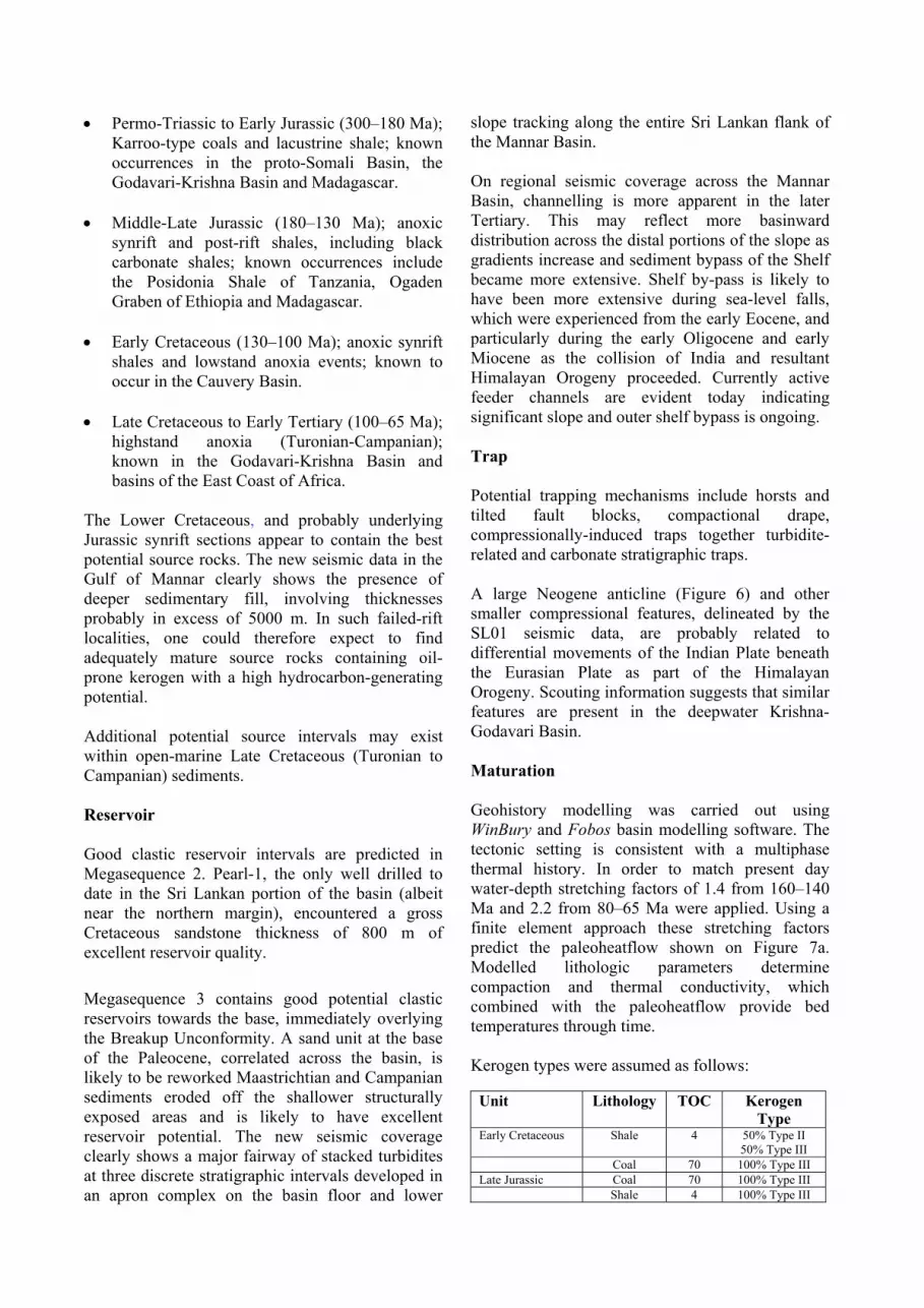
GEOLOGICAL DEVELOPMENT The Mannar Basin developed during multiphase rifting and associated continental breakup as part of the Mesozoic breakup of Gondwanaland (Figure 2). In summary, the first phase of this breakup within the Mannar Basin region began around 160 Ma and was followed by the separation of West and East Gondwanaland along a major developing rift system which extended from close to the present Horn of Africa to south of the present Falkland Islands. East Gondwanaland started to break up the mid-Cretaceous around 125 Ma, when a block comprising India-Seychelles-Madagascar detached from Australia-Antarctica as a precursor to the commencement of seafloor spreading in what is

now the oceanic Bay of Bengal. At around 100 Ma the India-Seychelles block separated from Madagascar; followed by the dispersal of India and the Seychelles around 65 Ma (Uchupi and Emery, 1991; Metcalfe, 1996; Gnos et al., 1997; Scotese, 2004; Fig. 2). Collision between India continental block (including Greater India now hidden beneath the Himalayas) and Eurasia occurred in the lower Eocene, beginning around 50 Ma. Accompanying uplift and erosion of the Himalayas resulted in rapid deposition of sediments into the Bay of Bengal and a sudden influx of terrigenous sediments into other depocentres bordering the Indian landmass, including the Cauvery and Mannar basins. Periodic intra-plate deformation resulted in uplift and punctuated the overall subsidence history with discrete episodes of erosion and rapid deposition of terrigenous sediments. MANNAR BASIN STRATIGRAPHY The Mannar Basin, lying between south-western Sri Lanka and southern India, contains over six seconds of Late Jurassic–Early Cretaceous to Recent (?) sediments. Consistent with the tectonic setting of the region, four discrete tectono-stratigraphic packages have been recognized (NewSouth, 2001; Shaw, 2002; Fig. 3). The oldest package, Megasequence 1, assumed to be of Late Jurassic to Early Cretaceous age, was deposited during the initial synrift phase of basin development. The succession is at least two second TWT thick with local unconformities developed. Depositional environments include continental, restricted marginal marine and marine systems. The succession is in part equivalent to the Upper Gondwana Group of India (Sivaganga Beds) and Tabbowa Series in Sri Lanka. A regional unconformity at the top of Megasequence 1 may be of Albian/Aptian age. Megasequence 2 sediments, of probable Late Cretaceous age were deposited in shallow and deeper (outer neritic to upper bathyal) water environments during the rift and sag phase, after the commencement of seafloor spreading in the Bay of Bengal but before the onset of spreading about the West Indian Ridge. The succession, up to 1 km in thickness, may contain local unconformities. High amplitude seismic events at the top of the succession are interpreted to be basalts, possibly equivalent to the Deccan traps of western India. It should be noted that although there has long been
debate on the age and duration of Deccan trap volcanism, recent 40Ar/39Ar dating suggests a relatively narrow range of volcanism, less than one million years in duration and close to 65.5 Ma (Hofmann et al., 2000). Megasequence 3, two seconds thick in the Mannar Basin, was deposited during a Paleocene to Late Middle Miocene sag phase of basin development. The succession is likely to comprise deepwater shale and carbonate with mounded coarser-grained turbidite facies apparent on seismic sections. Subsequent basin-wide regression resulted in deposition of Megasequence 4 comprising coarse sediment derived from the eastern and western margins of Gulf of Mannar and redistributed by turbidity currents flowing down the basin axis. The only direct stratigraphic information from the Sri Lankan sector of the basin is provided by the Pearl-1 well, drilled by Cities Services in 1981 to a TD of 3050 m on the extreme north-eastern edge of the basin (Figure 1). Well control in Indian waters is provided by Mannar-1. Stratigraphic columns for the latter well and Pearl-1 are shown in Figure 4. Pearl-1 was drilled on a faulted low-relief structure and encountered a thick sandstone sequence with minimal seal (Lipstreuer and Frey, 1982). The well terminated in “olivine diabase” (dolerite), first encountered at 2992 m. The well completion report reports a K/Ar age of 76±4.5 Ma for the rock. Given the uncertainties with respect to sampling and the applicability of the K/Ar radiometric method to altered basaltic rocks, we interpret this rock as a doleritic sill of Deccan trap age injected into the section and not the base of the sedimentary section as originally postulated by previous workers. Similar basalts are understood to be present in Mannar-1 (Figure 4) – although the authors have not been able to confirm this.
PETROLEUM SYSTEM Source With the exception of Pearl-1 drilled on the basin margin, the Mannar Basin is undrilled and knowledge of petroleum systems is necessarily conjectural. Regional plate tectonic geological considerations suggest several source rock sequences may exist in the basin, related to successive rifting and breakup of Eastern Gondwanaland (Figure 5):
• Permo-Triassic to Early Jurassic (300–180 Ma); Karroo-type coals and lacustrine shale; known occurrences in the proto-Somali Basin, the Godavari-Krishna Basin and Madagascar.
• Middle-Late Jurassic (180–130 Ma); anoxic
synrift and post-rift shales, including black carbonate shales; known occurrences include the Posidonia Shale of Tanzania, Ogaden Graben of Ethiopia and Madagascar.
• Early Cretaceous (130–100 Ma); anoxic synrift
shales and lowstand anoxia events; known to occur in the Cauvery Basin.
• Late Cretaceous to Early Tertiary (100–65 Ma);
highstand anoxia (Turonian-Campanian); known in the Godavari-Krishna Basin and basins of the East Coast of Africa.
The Lower Cretaceous, and probably underlying Jurassic synrift sections appear to contain the best potential source rocks. The new seismic data in the Gulf of Mannar clearly shows the presence of deeper sedimentary fill, involving thicknesses probably in excess of 5000 m. In such failed-rift localities, one could therefore expect to find adequately mature source rocks containing oil-prone kerogen with a high hydrocarbon-generating potential. Additional potential source intervals may exist within open-marine Late Cretaceous (Turonian to Campanian) sediments. Reservoir Good clastic reservoir intervals are predicted in Megasequence 2. Pearl-1, the only well drilled to date in the Sri Lankan portion of the basin (albeit near the northern margin), encountered a gross Cretaceous sandstone thickness of 800 m of excellent reservoir quality. Megasequence 3 contains good potential clastic reservoirs towards the base, immediately overlying the Breakup Unconformity. A sand unit at the base of the Paleocene, correlated across the basin, is likely to be reworked Maastrichtian and Campanian sediments eroded off the shallower structurally exposed areas and is likely to have excellent reservoir potential. The new seismic coverage clearly shows a major fairway of stacked turbidites at three discrete stratigraphic intervals developed in an apron complex on the basin floor and lower
slope tracking along the entire Sri Lankan flank of the Mannar Basin. On regional seismic coverage across the Mannar Basin, channelling is more apparent in the later Tertiary. This may reflect more basinward distribution across the distal portions of the slope as gradients increase and sediment bypass of the Shelf became more extensive. Shelf by-pass is likely to have been more extensive during sea-level falls, which were experienced from the early Eocene, and particularly during the early Oligocene and early Miocene as the collision of India and resultant Himalayan Orogeny proceeded. Currently active feeder channels are evident today indicating significant slope and outer shelf bypass is ongoing. Trap Potential trapping mechanisms include horsts and tilted fault blocks, compactional drape, compressionally-induced traps together turbidite-related and carbonate stratigraphic traps. A large Neogene anticline (Figure 6) and other smaller compressional features, delineated by the SL01 seismic data, are probably related to differential movements of the Indian Plate beneath the Eurasian Plate as part of the Himalayan Orogeny. Scouting information suggests that similar features are present in the deepwater Krishna-Godavari Basin. Maturation Geohistory modelling was carried out using WinBury and Fobos basin modelling software. The tectonic setting is consistent with a multiphase thermal history. In order to match present day water-depth stretching factors of 1.4 from 160–140 Ma and 2.2 from 80–65 Ma were applied. Using a finite element approach these stretching factors predict the paleoheatflow shown on Figure 7a. Modelled lithologic parameters determine compaction and thermal conductivity, which combined with the paleoheatflow provide bed temperatures through time. Kerogen types were assumed as follows:
Unit Lithology TOC Kerogen Type
Early Cretaceous Shale 4 50% Type II 50% Type III
Coal 70 100% Type III Late Jurassic Coal 70 100% Type III Shale 4 100% Type III
The modelling is summarised as Figure 7. The assumed kerogen types are typical of those expected in a basin in this tectonic setting. Away from the basin margins, the Early Cretaceous is within the oil and gas maturity windows. Figure 7c and d shows the predicted timing of oil and gas expulsion from each of the putative source rock successions. A series of cross-sections (SL01 Line 9 to Pearl 1; Figure 7e-g) shows instantaneous rates of oil and gas expulsion calculated for 76, 14 and 0 Ma. Of interest is the late Neogene phase of hydrocarbon generation (Figure 7g) which could facilitate migration of hydrocarbons into recent compressional features. In summary, synthetic burial history modelling suggests that the Megasequence 1 section is within the oil and gas maturity windows, with peak generation and expulsion in the Late Cretaceous and minor generation and expulsion in the Late Tertiary. Multiple peaks of generation and expulsion are a consequence of multiple high temperature events and deposition of thick post-breakup (sag) phase sediments. The presence of a currently-active petroleum system has been confirmed by satellite seep analysis (Infoterra, 2002), which indicates the presence of several seeps over the main synrift section in the Mannar Basin depocentre. PLAY CONCEPTS Sequence-stratigraphic play concepts show potential for several hydrocarbon play types in the Mannar Basin (Figure 8). More pronounced hydrocarbon charge is expected in the Mannar Basin than in the Cauvery Basin due to wider fetch and drainage area. Expected plays are: • Basement highs and rotated fault blocks with
Cretaceous sands sealed by intraformational or regional shales.
• Nested slope valley channel and distributary
channel-lobe turbidite fan reservoirs of Cainozoic age in four-way dip rollovers and compaction-drape features, sealed by local flood-back hemipelagic basinal shales.
• Ponded turbidite reservoirs of Cainozoic age
(and possibly additional ponding in older section) sealed by hemipelagic basinal shales.
• Cainozoic channel lobe turbidite reservoir sands in Late Tertiary inversion anticlines.
• Stratigraphic pinchout traps are inferred at all
levels of turbidite fan deposition. DISCUSSION AND CONCLUSIONS The Mannar Basin contains in excess of 5 km of Late Jurassic to Recent sedimentary section with potential for older Karroo section pre-dating the Late Jurassic in deeper parts of basin. New seismic data clearly dispels earlier interpretations that the basin is devoid of rift basin architecture and thick synrift sedimentary infill. As such the Mannar Basin represents a new, previously unidentified failed rift basin. Numerous basement-related horst and tilted fault blocks provide abundant trapping mechanisms within the synrift and rift and sag megasequences, as well as drape potential within the overlying basal units of Megasequence 3. Three major periods of major floor and slope turbidite deposition during Paleocene, Eocene and early Miocene provide stacked deposits up to 1.0 second (TWT) thick and represent a major stratigraphic fairway along the basin floor and lower slope of the Sri Lankan margin. Large compressional structures are present in the Neogene section. Although there has been not yet been drilling in the deepwater sector of the basin, burial history modelling suggests that a spectrum of Late Jurassic to Early Cretaceous synrift source rocks have generated hydrocarbons. Seeps testify to a currently active petroleum system. We consider the Mannar Basin to be an attractive frontier exploration opportunity close to markets. ACKNOWLEDGEMENTS TGS-NOPEC Geophysical Company is thanked for access to proprietary data. REFERENCES CITED Gnos, E., Immenhauser, A. and Peters, T., 1997. Late Cretaceous/early Tertiary convergence between the Indian and Arabian plates recorded in

ophiolites and related sediments, Tectonophysics, v. 271, p. 1–19. Hofmann, C., Feraud, G. and Courtillot, V., 2000. 40Ar/39Ar dating of mineral separates and whole rocks from the Western Ghats lava pile: further constraints on duration and age of the deccan traps. Earth and Planetary Science Letters, v. 180, p. 13–27. Infoterra Ltd., 2002. Global Seeps – Gulf of Mannar. Infoterra Report No. OF62696 (unpublished). Lipstreuer, K. A., and Frey, J. W., 1982. Pearl No 1 Final Well Report, Citco Sri Lanka Petroleum Corporation. Ceylon Petroleum Corporation Petroleum Library Report SC7/C11/R2/3. Metcalfe, I., 1996. Gondwanaland dispersion, Asian accretion and evolution of eastern Tethys, breakup
of Rodinia and Gondwanaland and assembly of Asia. Australian Journal of Earth Sciences, v. 43, p. 605–623. NewSouth Global Pty Ltd., 2001. Final Report - Component A-Review of Sri Lanka’s Hydrocarbon Prospects. Report Asian Development Bank Technical Assistance Project 3450–SRI (unpublished). Scotese, C.R., 2004. PALEOMAP Project, http://www.scotese.com/earth.htm Shaw, R. D., 2002. TGS-NOPEC SL01 – Phase 1 Offshore Sri Lanka Seismic Survey Interpretation Report. Prepared for TGS-NOPEC by NewSouth Global Pty Ltd January 2002 (unpublished). Uchupi, E., and Emery, K. O., 1991. Pangean divergent margin: historical perspective. Marine Geology, v. 102, p. 1–28.

Figure 1 - Locality map with SL01 seismic lines indicated. Also shown are positions of Pearl-1, Mannar-1 and Line 7 synthetic well used in geohistory modelling.
Figure 2 - Gondwanaland tectonic reconstructions for 160 Ma, 100 Ma and 50 Ma showing major regional rifting and spreading events.

Figure 3 - Mannar Basin prognosed stratigraphy.
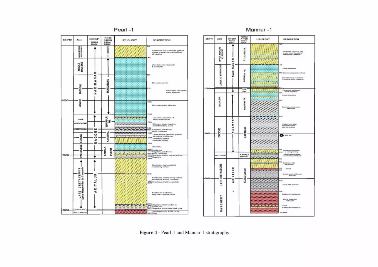
Figure 4 - Pearl-1 and Mannar-1 stratigraphy.
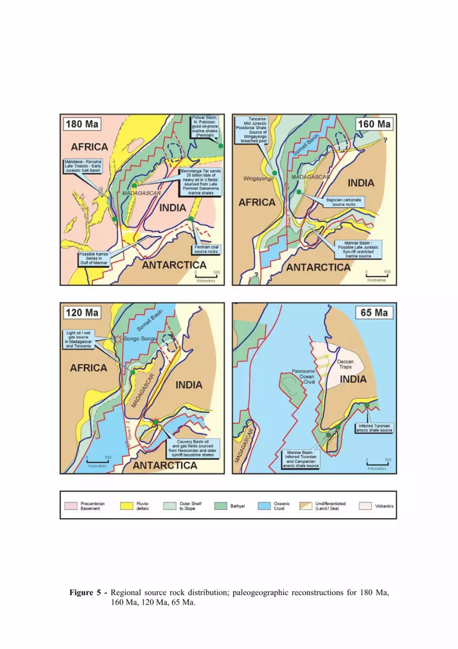
Figure 5 - Regional source rock distribution; paleogeographic reconstructions for 180 Ma,
160 Ma, 120 Ma, 65 Ma.

Figure 6 - Neogene anticline, Mannar Basin; two-way-time (TWT) shown on left hand side, scale bar length is 12.5 km.
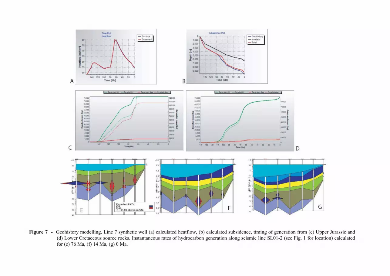
Figure 7 - Geohistory modelling. Line 7 synthetic well (a) calculated heatflow, (b) calculated subsidence, timing of generation from (c) Upper Jurassic and (d) Lower Cretaceous source rocks. Instantaneous rates of hydrocarbon generation along seismic line SL01-2 (see Fig. 1 for location) calculated for (e) 76 Ma, (f) 14 Ma, (g) 0 Ma.

Figure 8 - Mannar Basin play concepts.