paup sample study area 2 – oshr and esplanade reserve
TRANSCRIPT
DRAFT (141213) – Ian Lawlor ‘archaeology and Mana Whenua provisions review’ Auckland Council PAUP (30 Sep 2013) Sample Study Area 2 (SA2) – OSHR and Esplanade Reserve
1
PAUP Sample Study Area 2 – OSHR and Esplanade Reserve
Introduction This study (numbered SA2) focuses on the Otuataua Stonefields Historic Reserve (OSHR) and adjacent coastal esplanade reserve (i.e. that land comprising the Otuataua and Puketapapa (Pukeiti) volcanic cones and lava flows). It includes two lists of historic heritage (see Attachments Figs.1 and 2) showing past and proposed protection provisions (i.e. plan scheduling and registration) and a series of maps and aerial photos (Figs. 3 to 13) illustrating the distribution of archaeological sites and other historic places, structures and features. The maps show data from lead agencies and repositories (i.e. the Manukau City Council (2002) District Plan (DP), the NZ Historic Places Trust (NZHPT) Register, the New Zealand Archaeological Association (NZAA) Site Recording Scheme (SRS) archaeological Site Record File (SRF), and the Auckland Council (AC) Cultural Heritage Inventory (CHI) which, like the NZAA site file, is accessible through a computer database or GIS Viewer). (Hyperlinks have been attached throughout this report to facilitate further work.)
It is important to note that the records used in this study do not include those held by iwi authorities associated with the OSHR including Te Akitai, Te Ahiwaru and Waikato-Tainui (refer to Mar 2012 Section A 11 The Auckland Plan). There are many wahi tapu (sacred places), and sites, and areas of significance to tangata whenua and mana whenua that have been identified over the last 30 years during the acquisition and development of the reserve. These were recognised and provided for through the day-to-day Manukau City Council (MCC) Parks management and work of the OSHR ‘Consultative Committee’ (e.g. wahi tapu, mahinga maataitai, taonga raranga and tauranga waka), but they have not been made part of the public record so as to safeguard them from itinerant modification and disturbance (refer to Lawlor 4 Dec 2009 pp.13 and 107). (For more discussion see ‘Facts and Figures’ below.)
Background The OSHR is a 101.2-hectare area located 4km north of the Auckland International Airport on the eastern shores of the Manukau Harbour (refer to Lawlor 30 Apr 2010 p.5 for a review of ‘land parcels and adjacent blocks’). The Reserve has harbour views, but for the most part (with the exception of a 600-metre boundary on the Manukau Harbour), it is land-locked being bordered by a coastal marginal strip that was previously owned and managed by Watercare Services Limited as a buffer for the Mangere wastewater treatment ponds (see Attachments Figs. 5 and 6 for PAUP maps showing OSHR historic heritage including sites and places of significance and value to Mana Whenua). Under the OSHR is zoned ‘Public Open Space – Conservation ‘(POS-C) PAUP the esplanade reserve is zoned ‘Coastal Transition’ (CT).
Over the last decade the Reserve has been the subject of comprehensive study that was part of a MCC legacy project to build a visitor heritage centre, and it is now part of the AC ‘Mangere Gateway’ planning initiative linked through ‘Nga Tapuwae o Mataoho – Footsteps of Mataoho’; the MCC was granted a NZHPT Authority (Application No. 2010/210) to undertake a small archaeological site excavation that was completed in the summer of 2012-13. More recently, the AC, after careful deliberation of all the facts (refer to Lawlor 9 Nov 2011), supported the development (refer to AC 3 Apr 2012; also see Thompson 23 Mar 2012). However centre construction has been delayed through a case being brought, either before the Maori Land Court or the Waitangi Tribunal, between Te Akitai and Te Ahiwaru concerning
DRAFT (131213) – Ian Lawlor ‘archaeology and Mana Whenua provisions review’ Auckland Council PAUP (30 Sep 2013) Sample Study Area 2 (SA2) – OSHR and Esplanade Reserves
2
the mana whenua status (authority) over the OSHR. Further clarification is currently being sought from the Chairs of both Pukaki and Makaurau Marae regarding these matters (pers. comm. to Julie and Wade and Janice Roberts 11 Dec 2013).
Facts and Figures Reference to SA2 Attachments Fig.1, an excel spreadsheet recording ‘facts and figures’ for the historic heritage located across the Otuataua and Puketapapa (Pukeiti) volcanic cones and lava fields, will be helpful in the following discussion.
Within SA2 there are 108 historic heritage places formally recorded (see Attachments Figs. 8 and 11). Of these:
• 28 are located on the esplanade reserve adjacent to the OSHR (with 6 of these running across the boundary)
o 20 (CT – coastal transition) o 1 (FU – future urban) o 2 (LI – light industry) o 4 (RP – rural production) o 1 (SP – special purpose Makaurau Marae)
• 73 are within the OSHR (POS-Con – Public Open Space – Conservation); • 6 are located on the OSHR boundary with the adjacent esplanade reserve;
o 1 (FU), and o 5 (POS-Con).
Of the 79 historic heritage sites and places within the OSHR or on the boundary:
• 15 are of historic European being house or temporary seasonal bach sites, orchards, and farm rubbish dumps;
• 52 are of prehistoric Maori (PM) (two sites, R11/1759 and R11/1762, comprise 8 and 5 sub-areas of structures and features respectively);
• 11 are of both prehistoric Maori and historic European (i.e. where historic European drystone walls were built across earlier prehistoric Maori occupation areas); and
• 1 record has been removed because it rejected by the Auckland region NZAA SRF Filekeeper and Trust Archaeologist as inappropriate given Trust policy and practice (refer to Lawlor 4 Dec 2009 Endnote 67 p.174-175) – this record was originally completed for all of the OSHR archaeological sites by a heritage consultant (refer to NZHPT HPA93 Authority Application No. 2003/65).
The following sections review these facts and figures in more detail and relate the OSHR historic heritage to sources and repositories.
AC (30 Sep 2013) – PAUP Within the PAUP the OSHR is zoned ‘Public Open Space - Conservation’ and there are three ‘overlays’ (see Attachments Figs. 1 and 2 historic heritage lists and Figs. 5 and 6 for maps):
• 3 ‘sites and places of significance to Mana Whenua’ (SPSMW); • 43 ‘site and places of value to Mana Whenua’ (SPVMW); and • 10 ‘significant historic heritage places’ (SHHP).
There are no ‘historic heritage extents’ shown and all these historic places and sites are reported to be sourced from MCC (2002) ‘Manukau District Plan’ and the ARC (5 Aug 2004) ‘Regional Plan: Coastal’ (e.g. [dp/rcp] notation on the PAUP GIS Viewer Map legend and within the relevant chapters and schedules.
DRAFT (131213) – Ian Lawlor ‘archaeology and Mana Whenua provisions review’ Auckland Council PAUP (30 Sep 2013) Sample Study Area 2 (SA2) – OSHR and Esplanade Reserves
3
Within the AC (30 Sep 2013) PAUP the following provisions apply to SA2 historic heritage:
• all SA2 historic places located across the Otuataua (schedule ID 147) and Puke Taapapa (Pukeiti) cones and lava fields (Schedule ID 168) (refer to Appendices pp. 50 and 54 respectively), including those that sit outside the OSHR boundary that also sit on the lava derived from these two cones, are associated with the PAUP Appendix 3.1 ‘Schedule of the Outstanding Natural Features (ONF) overlay’, and are recognised as having underlying natural heritage significance (criteria a, c, d, e, f, g, h and i);
• eighty-six historic places (i.e. records from all repositories), by virtue of their being named ‘Otuataua/Puke Taapapa (Pukeiti)’ and located at ‘545 Oruarangi Road, 14R Quarry Road, 53 & 56 Ihumatao Quarry Road and 367, 325 and 303 Ihumatao Road, are associated with the PAUP (Appendices p.300) Appendix 4.1 ‘Schedule of sites and places of significance to Mana Whenua’ (SPSMW);
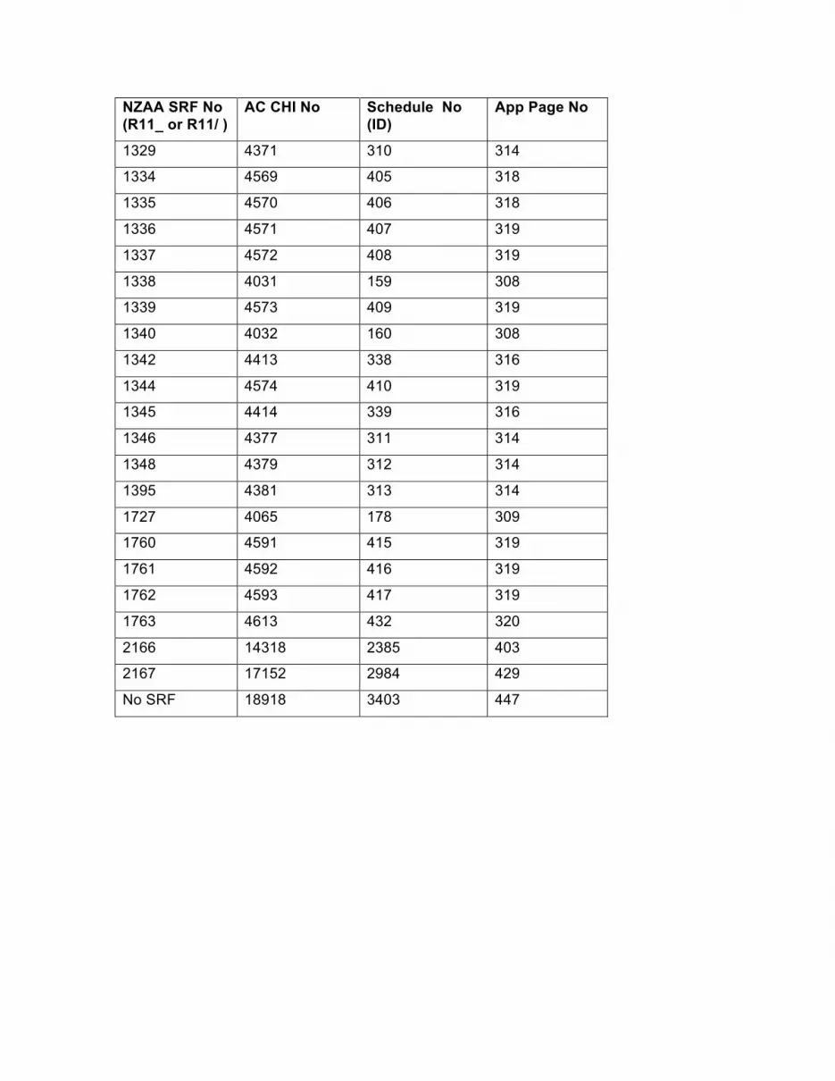
• fifty archaeological sites are scheduled in the PAUP (Appendices pp.308-309, 314-316, 318-320, 378, 389, 403, 429 and 447) Appendix 4.2 ‘Sites and places of value to Mana Whenua’ (SPVMW); and
• Nine archaeological sites Appendix (9.1 ‘Schedule of Significant Historic Heritage Places’ (SHHP);
The listed PAUP Appendix 3.1 ONF overlay criteria for the Otuataua and Puke Taapapa (Pukeiti) cones and lava fields exclude:
• rarity [b], historical association with a natural event; • geologically related industry or individual involved with earth science research
[j]; • the importance of the feature or site to Mana Whenua [k]; and • contribution of the feature to the more publically valued groups of landform
and geological sites associated with the region’s volcanoes etc., [l];
It could be argued on present evidence, particularly with criterion k given Appendices 4.1 and 4.2 within the PAUP, that all of these criteria, possibly with the exception of ‘l’, are relevant to these ONF schedules.
Four scheduled sites being identified as ‘Archaeology of Maori origin’ (Appendix 4.2 Schedule number ID312, ID338, ID404, ID 406) are no longer part of the NZAA SRF having been removed following their identification as duplicate records (see pink highlighted cells on Attachments Fig.1).
(Note: Currently, the issue of duplicate records is being addressed by Nicola Molloy the NZAA Central Filekeeper in Wellington pers. comm. 6 Dec 2013.)
Eighteen archaeological sites have been identified is this study as being of prehistoric Maori (PM) in origin and are not included in PAUP Schedule 4.2 (see fawn highlighted cells on Attachments Fig.1), possibly because they were wrongly associated with historic European drystone walls which overly prehistoric Maori structures and features (see NZAA SRF numbers R11/1290, 1294, 1299, 1303, 1314, 1315, 1317, 1321, 1331-1333, 1341, 1347, 1349, 1350, 1727, 1760 and 1761 – the latter two are within the esplanade reserve adjacent to the OSHR and one R11/1727 is located on the boundary).
Te Waiohua (Makaurau and Pukaki Marae) To date, Makaurau Marae at Ihumatao have represented the interests of Waiohua and Waikato (Tainui) Iwi in the management of the OSHR (refer to Lawlor 4 Dec 2009 pp.10-11 for discussion). This relationship is recognised in a purchase ‘Memorandum of Agreement’ (MOA) (25 May 1999; addendum 24 Feb 2000)
DRAFT (131213) – Ian Lawlor ‘archaeology and Mana Whenua provisions review’ Auckland Council PAUP (30 Sep 2013) Sample Study Area 2 (SA2) – OSHR and Esplanade Reserves
4
between the MCC, the Crown (Minister of Conservation) and the Auckland Regional Council (ARC). It is also recognised in the ‘Official Opening Commemorative Brochure’ (10 Feb 2001; refer to pp.5, 15 and back cover).
Over the last 14 years kaumatua (elders) and rangatahi (youth) from Makaurau Marae have participated as one of the ‘Consultative Committee’ parties (MOU cl.5) to provide technical and related assistance to the purchasing parties (i.e. the MCC, ARC now the AC, and the Department of Conservation) in connection with administration, management and development of the Reserve. A number of Marae members have identified sites of significance and value including Maurice Wilson, Mavis Roberts, Danny Roberts and his daughter Kowhai Roberts, Robert Roberts and his son Saul Roberts. These have included burials, springs, caves, settlement and garden areas, sacred and revered places, and resource gathering areas on the land and within the adjacent harbour. These places of significance and value have been recognised and provided for during development, but, for the most part (with the exception of the larger Puketapapa (Pukeiti) and Otuataua volcanic cone pa), the structures and features have not been formally recorded. Park Rangers and managers have relied on personal relationships developed through the Consultative (Advisory) Committee to promote the recognition, protection and conservation of sites of significance and value to Waiohua during Reserve development and maintenance.
Since Auckland local government restructuring, with the replacement of the MCC by the AC, the OSHR has not received the same level of management and the Consultative Committee has discontinued to meet on a regular basis. Subsequently the OSHR has not received the same management attention as it did during the period when managed by MCC Parks (see Attachments Fig. 13 for a record of site modification and damage that has occurred over the last decade).
With the death of kaumatua Maurice Wilson in February this year, the Reserve mana whenua status (authority over the land) has been challenged and is being addressed either through Maori Land Court or the Waitangi Tribunal; Maurice was the lead kaumatua to Sir Barry Curtis and was the source and inspiration for the development of a visitor centre on the Reserve. Subsequently the building of the visitor centre has been delayed until this issue is resolved through the Court or Tribunal.
AC DP Operative Manukau Section (2002) Within the legacy MCC (2002) Manukau Operative District Plan (Reprinted 2008) the OSHR was proposed to be zoned as ‘Public Open Space 1 – Heritage‘ for protection purposes and is zoned - Mangere Puhinui Heritage‘, this being the underlying zone (refer to DP Chapter 5 designation number 196 p.93). The heritage resources on the Reserve are also scheduled for protection three times (see Attachments Fig.3 for map):
• once in total for the geological features and areas (for scientific and educational importance);
• once in total being recognised as wahi tapu (a sacred place to Maori); and • once in part for some archaeological sites which extend from the adjacent
coastal marginal strip across the boundary into the Reserve (discussed further below).
In respect of the two designations the MCC was the original requiring authority. The Otuataua volcanic cone remnant, which in Reserve management practices of the last decade by Parks Manukau is considered to be part of the OSHR, is zoned ‘MCC Quarry Mangere‘ (refer to District Plan Chapter 5 designation number 225 p.94 and Maps 3 and 4). The MCC was also the requiring authority for this designation.
DRAFT (131213) – Ian Lawlor ‘archaeology and Mana Whenua provisions review’ Auckland Council PAUP (30 Sep 2013) Sample Study Area 2 (SA2) – OSHR and Esplanade Reserves
5
The Manukau Operative District Plan 2002 (Chapter 6 – Heritage) identifies particular heritage resources that are considered significant to Manukau City and worthy of protection in the public interest. These resources are listed in Plan schedules and mapped (see Attachments Figs.1 MCC DP columns and Fig.3 respectively), and in the case of the OSHR, encompass the following:
• the complete OSHR for the geological features and areas being of educational and scientific importance (refer to Schedule 6E identification number 8 and District Plan maps 3 and 7 ‘square‘ symbol);
• the complete OSHR as a wahi tapu or a sacred place to Maori (refer to Schedule 6F identification number 8 and maps 3, 4 and 7 ‘triangle‘ symbol); and
• in part where five of 12 recorded archaeological sites extend across the boundary from the adjacent Water Care Services coastal strip into the OSHR (refer to Schedule 6G and maps 3 and 7 identification numbers 9 and 11 to 14 ‘star‘ symbol).
Here it is important to note that the archaeological sites located within the OSHR (i.e. those not on the boundary but contained inside the boundaries of the reserve) were not scheduled individually; the ARC made a submission (Lawlor 8 May 2002) on the draft DP to have them all included, but at the time the relief sought was rejected on the grounds that the Reserve was a historic reserve with a draft management plan (refer to MCC 31 Oct 2002) which recognised and provided for the archaeological sites and values.
AC Regional Plan: Coastal (RCP or RPC) (4 Oct 2004) (Note: The legacy ARC Regional Plan: Coastal (4 Oct 2004) is referred to variously within the PAUP and on the AC web site as the RCP, RPC or RP:C; for convenience I have chosen to use RCP standing for Regional Coastal Plan. These variations may cause confusion and all PAUP references should be standardized so that they are consistent with the original published document (refer to Auckland Council Regional Plan: Coastal.)
The RCP identifies for conservation (i.e. protection and preservation) places of natural significance including stretches of coast and harbour and important geological sites (e.g. the harbour fossil forest remnants at the end of Renton Road). However, there are no historic places scheduled in the RCP in either the ‘Cultural Heritage Sites for Preservation’ (pp. S1-1 to S1-2 after p.43-2) or ‘Cultural Heritage Sites for Protection’ (pp. S2-1 to S2-4 after p.43-2) (also refer to RCP Map Series 1 Sheets 11 and 12).
To date, few maritime cultural or historical places of interest have been identified regionally (refer to Taylor Mar 1994; also refer to the RCP 2004 schedules for protection and preservation) and work needs to be promoted to review this shortcoming. (At the time the ARC treated the RCP and a regional plan when in fact it was a district plan for the region.) This is because ‘Coastal Marine Area’ (CMA) historic places are expected or known to be present within SA2 (personal communication Te Warena Taua and Saul Roberts), particularly in the vicinity of the wastewater treatment ponds that were decommissioned in 2005 and the coastal strip immediately south of the OSHR leading to the Auckland International Airport. These places include wahi tapu, mahinga maataitai, taonga raranga and tauranga waka (canoe landing sites), some of which are historic boat landings associated with the Christian missionaries and historic villages of the wider Ihumatao area (refer to the DoC New Zealand Coastal Policy Statement 1994 for over-arching policies and definitions).
DRAFT (131213) – Ian Lawlor ‘archaeology and Mana Whenua provisions review’ Auckland Council PAUP (30 Sep 2013) Sample Study Area 2 (SA2) – OSHR and Esplanade Reserves
6
ICOMOS New Zealand Charter The ‘International Council on Monuments and Sites‘ (ICOMOS) is a non-governmental organisation of heritage professionals engaged in the conservation of places of cultural heritage value and dedicated to the conservation of the world's historic monuments and sites. The organisation is UNESCO's principal advisor in matters concerning the conservation and protection of historic monuments and sites; for example, it advises the World Heritage Committee on the administration of the World Heritage Convention (to which New Zealand is a signatory). The New Zealand National Committee (ICOMOS New Zealand /Te Mana O Nga Pouwhenua O Te Ao) was incorporated in 1987.
The ICOMOS New Zealand (7 Mar 1993) ‘Charter for the Conservation of Places of Cultural Heritage Value‘, also known as ‘Te Pumanawa o ICOMOS o Aotearoa Hei Taiki i Nga Taonga Whenua Heke Iho o Nehe‘. This is the acknowledged national benchmark for historic and cultural heritage management, conservation standards and best practice; it covers the purpose, principles and processes of conservation providing useful definitions of key terms (e.g. maintenance, preservation, reconstruction, reinstatement, repair and restoration). Under the Charter the purpose of conservation is to care for places of cultural heritage value, their structures, materials and cultural meaning. In respect of the OSHR, the New Zealand Charter provides over-arching direction for protection measures which are linked to international standards of best practice.
Reference to the ICOMOS NZ Charter first appears in the PAUP in Chapter E. However, given that this is one of the primary links with international standards it is important that this is recognised and provided for in the substantive chapters (e.g. Chapter B ‘Protecting or historic heritage’).
NZHPT Register The NZHPT Register is primarily a national information and advocacy tool to identify important local heritage (refer to NZHPT Register web site for more information). Registration does not provide automatic protection or directly create regulatory consequences or legal obligations (other than those referenced within the RMA91), and nor does it create specific rights or control over property. It can however provide heritage-funding opportunities.
For the related links between the Resource Management Act 1991 (RMA91) and the HPA93 refer to: RMA91 s.61(2)(a)(iia) – preparation and change of regional policy statement; s.66(2)(c)(iia) – preparation and change of regional plans; s.74(2)(b)(iia) – prepare and change of district plans; and s.93(1)(c)(ii) – notification of resource consent applications to be served by the consent authority (e.g. the MCC) on the NZHPT if the application affects a registered place; also note the amended RMA91 definition of the term ‘prohibited activity‘ and link to the HPA93 s.105(2)(b).
It is important to note that the ‘trigger‘ for these RMA links to be made is a resource consent application, and in the case of the proposed Visitor Centre development, only an Outline Plan of Works was required. This is a significant gap within the historic heritage protection provisions of our current legislation and it is recommended that provision be made within the PAUP to uphold a collegiate approach where development promoted by Council does not require consent.
The Otuataua Stonefields are a ‘Historic Place - Category 2‘ type (Register Number 6055) being a place of historical and cultural heritage significance and value. The following archaeological sites are listed by the Trust as being part of this historic place: R11/29, 30, 73, 843, 864, 1282, 1283, 1284, 1285, 1286, 1287, 1288, 1289, 1290, 1291, 1292, 1293, 1294, 1297, 1298, 1299, 1300, 1303, 1314, 1315, 1317, 1318, 1320, 1321, 1322, 1323, 1324, 1325, 1327, 1328, 1329, 1332, 1333, 1334,
DRAFT (131213) – Ian Lawlor ‘archaeology and Mana Whenua provisions review’ Auckland Council PAUP (30 Sep 2013) Sample Study Area 2 (SA2) – OSHR and Esplanade Reserves
7
1336, 1338, 1341, 1344, 1345, 1347, 1349, 1350, 1395, 1727, 1759, 1760, 1761, 1762 and 1763. The seven underlined sites were identified as being duplicate records, and a recommendation was made that they be removed from the Register in 2009, however, an examination of the NZHPT Register web site indicates that the duplicate records remain. In addition, it should be noted that within the NZAA SRF there are a further 11 duplicate site records but these are not listed on the Register; R11/1296, 1316, 1319, 1331, 1335, 1337, 1339, 1342, 1343, 1346 and 1348. (This duplication issue is being addressed by the NZAA Central Filekeeper in Wellington and more discussion is provided below.)
The OSHR registration means that any work on the reserve needs to be in keeping with the purpose and principles of the HPA93 (refer to s.4). In brief, these are promotion of the identification, protection, preservation, and conservation of the historical and cultural heritage of New Zealand, while not only recognising that historic places have lasting value in their own right, providing evidence of the origins of New Zealand‘s distinct society, but also accounting for all relevant cultural values, knowledge and disciplines, and accounting for material of cultural heritage value and involve the least possible alteration or loss of it. Options for present and future generations are to be safeguarded and work is to be fully researched, documented, and recorded, and where culturally appropriate, this is to recognise the relationship of Maori and their cultural and traditions with their ancestral lands, water, sites, wahi tapu, and other taonga (compare RMA91 s.6e).
Consideration should be given to upgrading the OSHR from the current Category 2 status to Category 1.
NZAA SRF The NZAA SRF provides the most comprehensive archaeological site information for the OSHR (Attachments Fig.1 for a list and Fig.4 for a map). When examining the distribution records for the historic places recorded on the OSHR additional archaeological sites were identified that cut across the boundary and run into Watercare Services Limited coastal land. Besides those identified in the MCC DP Schedule 6G (Chapter 6 – Heritage pp.47-49) as being ‘part‘ (i.e. on the OSHR boundary) the following sites should be added to this list: R11/1287, R11/2166, R11/2167, R11/1292, R11/1293, R11/1324, R11/1325, R11/1336, R11/1349 and R11/1350. All of these sites have structures, features and deposits that extend across the boundary or have been recorded on Watercare Services land since the DP was notified.
In the final analysis, following the removal of records that do not exist and duplicate records, a total 47 archaeological sites remain recorded on the OSHR. There is some additional variation in the numbers for OSHR sites because some have variously been recognised as either being on the adjacent coastal strip of Watercare Services Limited land, rather than on the Reserve itself, or running across the boundary of the Reserve.
It is important to note that the OSHR archaeological site numbers are more indicative of the recording system of the NZAA SRF, together with the history of site survey and mapping on the OSHR, rather than the actual extent and relationship of the archaeological structures and features present (refer to Lawlor 4 Dec 2009 pp.105-113 and Lawlor 30 Apr 2001 p.1). The OSHR and adjacent esplanade reserve is a continuous cultural historic landscape comprising stoneworks, earthworks, shell middens and plants, and any protection provisions should focus on this perspective rather than one based on one imposed by a set of arbitrary file numbers. It is therefore recommended that, rather than individual archaeological sites being scheduled in the PAUP, the whole OSHR is classed as a historic area and the lava flows derived from the Otuataua and Puke Taapapa (Pukeiti) cones are used to
DRAFT (131213) – Ian Lawlor ‘archaeology and Mana Whenua provisions review’ Auckland Council PAUP (30 Sep 2013) Sample Study Area 2 (SA2) – OSHR and Esplanade Reserves
8
define this extent. Consultation with Makaurau Marae will need to take place given the PAUP overlay rules.
ISSUES (arising from SA2 Study) SA2 study, like that completed for SA1 – Kauri Point Birkenhead, raises a number of issues in respect of the PAUP protection provisions for historic heritage, and sites and places of significance and value to Mana Whenua. These have been summarily related to: duplication NZAA archaeological site records; (the related issue of) incorrect site locations; site recording in a contiguous ‘coast-to-cone’ historic landscape; European historic structures disguising ‘Archaeology of Maori origin’; multiple scheduling; and lack of scheduling of a nationally significant NZHPT Category 2 historic area. These issues are discussed in more detail below.
Duplicate NZAA Site Records and Incorrect Site Locations (The following section has been abstracted from Lawlor 4 Dec 2009 with some minor editing. It has been included here because the record problems can be applied to the region as a whole. However, it should be pointed out that the OSHR is a relatively unique archaeological landscape and the recording problems have been mainly related to the incredible density of structures and features present.)
At the time of the Visitor Centre study, the NZAA archaeological site records for the OSHR were in a ‘somewhat messy‘ state (Walton 1991) and included multiple records for identical sites. To check how extensive these problems were, trial graphic plots were completed using 20 years of personal field recording experience and knowledge of the OSHR landscape, and in the worst-case scenario, sites were found to be miss-located on the ground by up to 380 metres (the usual error is + 100 metres; see Attachments Fig.4 for standard examples, and compare with Fig. 9 for discovered examples). Using available grid references, it was discovered that nearly all previously recorded sites were not located on their true ground positions. Subsequently, it was not possible, with any certainty, to identify those sites directly affected by the proposed OSHR development without first completing a more detailed review of the OSHR historic place and archaeological site records
The methodology used to resolve this problem, was to access and copy relevant NZAA archaeological site records and to create three sets of historic place grid reference and position plots so as to complete cross-checks using the Google Earth computer application. This application is a universal free software option which enables any PC user with Web access to create their own GIS layers, with a reasonable degree of accuracy, including: ‘placemarks‘ (like the ‗centroids‘ of archaeological of sites); polygons (like areas of sites or places); paths (like stonework alignments and walls); and image overlays (like plans, maps or photographs) together with the placement of oblique historic images in 3D which then provided an additional opportunity to estimate height of now destroyed landscape features. (The clear and opaque transparency option for overlay images, when matched with good aerial photographic coverage, as is available for the OSHR, courtesy of Auckland International Airport Limited 2009, proved invaluable for obtaining a ‘best-fit‘ for site sketch plans with the aerial photographs.)
The three data sets were:
(1) an ‘old‘ set (created anew) based on best grid references and scanned maps and aerial photographs contained within the NZAA SRFs for the OSHR;
(2) a second set based on the ARCs CHI including Kim Tatton‘s Oct 2005 OSHR Oral history record (see Attachments Fig. 7); and
(3) a third set from the current NZAA Site Recording Scheme ‘ArchSite‘ web page provided by Greg Walter (NZHPT Auckland Archaeologist).
DRAFT (131213) – Ian Lawlor ‘archaeology and Mana Whenua provisions review’ Auckland Council PAUP (30 Sep 2013) Sample Study Area 2 (SA2) – OSHR and Esplanade Reserves
9
In addition, so as to provide the most accurate and current map grid references, the New Zealand Government Land Information (LINZ) Web site was used to assist with coordinate conversions from the old metric NZ Map Grid (NZMG), most commonly used for archaeological sites recorded within the NZAA Site Record File, to the new NZ Transverse Mercator Projection (NZTM2000).
The results of this analysis comprised:
• a Microsoft Excel computer application spreadsheet to summarise and simplify cross-tabulations of attributes and variables, primarily to highlight duplicate records for removal from the record system by the NZAA Central SRF Filekeeper, at the DoC Wellington (refer to Lawlor 4 Dec 2009 Appendix 5 and see ‘References’ below for a web hyperlink to a copy of this file) (refer to Attachments Fig.1, for example);
• a single revised plot of best-fit locations for all historic places within the OSHR (see Attachments Fig. 11), including historic places on the adjacent lands where associated historic structures are known to be located (i.e. those that were originally sited on the Reserve but shifted off in the recent past);
• a Google Earth ‗My Places‘ KMZ and KML data file, to be made available to other heritage users and managers to gain the benefit of the time taken to resolve this ‘mess‘; and
• an accurate map showing previously recorded historic places located within the proposed OSHR Visitor Centre development ‘footprint‘.
Here it is important to make some comments about the observed NZAA record problems so that others might gain from this experience and have the benefit of the time and resources spent to unravel them. I believe the record problems came about for a number of reasons linked primarily to the fieldwork, monitoring, recording and filing processes. These included the following:
• work was completed by undergraduate university students with minimal field experience and limited supervision under a government temporary employment scheme;
• surveying focused on recording structure and feature elements within more-or-less continuous heritage landscapes where it was difficult to determine where one site ended and another began (the NZAA SRF records discrete sites rather than whole landscapes);
• access to all of the OSHR lands was constrained in the 1970s and 80s (e.g. with some land owners like Trevor Ellett refusing access) forcing surveyors to use aerial photographs to record archaeological structures and features ‘remotely‘ off-site;
• there were sometimes significant time-gaps (up to seven years) between the actual field recording and the filing of the complete SRFs (identified through comparing the date of recording with the date of file submission and acceptance by the File Keepers) resulting in miss-matches between descriptions, plans, maps and location references;
• field records were not completed and filed by the original recorders, with subsequent loss of first-hand field knowledge, resulting in location errors and record miss-matches;
• there were limited large-scale maps and plans available at the time to accurately record site locations, for example, a single 18cm square B/W aerial photograph covering nine square kilometres on the ground, being a
DRAFT (131213) – Ian Lawlor ‘archaeology and Mana Whenua provisions review’ Auckland Council PAUP (30 Sep 2013) Sample Study Area 2 (SA2) – OSHR and Esplanade Reserves
10
1:16700 scale record (i.e. one cm on the aerial photograph is equal to 167 metres on the ground), was used with an estimated 20-metre + location error);
• work was complicated because the recording and file submissions occurred during the imperial to metric map use transition (from the NZ Topographic 1:63,360 scale 1 inch to 1 mile map to the NZMS260 1:50,000 scale map); and finally
• subsequent recording continued to duplicate records and compound the problems without the earlier errors being identified or sorted (single sets of structures and features were recorded more than once under different numbers, and conversely, extensive stone and earthwork areas were later re-recorded with smaller areas being given separate numbers).
This said, it is important to point out that Glen White‘s first recording of the OSHR sites was exemplary given the circumstances, resources and time available (see Attachments Fig.10 for site R11/1329 example, and Fig.11 for Reserve examples). The sketch plans and broader aerial photograph tracings of area layouts, sometimes including whole farm allotments with thousands of individual structures and features present, have been relied upon heavily here to resolve some of the problems and identify true on-the-ground ‘site‘ (i.e. structures and feature) locations. I am also grateful to Susan Bulmer who has made available her personal records and spent time in discussion to help resolve some of the problems; Russell Foster has also contributed to discussions to help resolve issues around the survey, mapping and recording completed in the vicinity of the Wilkins and Davies Quarry of 1984.
I believe, that a simple solution to all of these issues, and one that was identified during the development of the ARC‘S cultural heritage resource monitoring strategy (Ross and Foster 1996, Mackintosh 2001, and Lawlor and Tatton 2002), is that there needs to be a much more rigorous monitoring, review and vetting of new records by the NZAA Filekeepers when they are first entered in to the Site Recording Scheme. The fact that recording is now being digitised and made accessible over the Web (refer to http://www.archsite.org.nz/) might help here. However, at the end of the day, it is the ‘keeper‘ (Central or otherwise) of the records who will have to accept the completeness, quality and accuracy of submitted forms regardless of the format that is used. Most importantly, the solving of many of these old problems relies on the availability of good quality high resolution aerial photographs, like that provided by the Auckland International Airport Limited for the OSHR through the Google Earth GIS computer application. Had this aerial photography not been available for the Reserve area some of the problems may not have been so easily resolved.
A Contiguous ‘Cost -‐to-‐cone’ Historic Landscape As noted in the introduction to this ‘Issues’ discussion, the OSHR is continuous landscape (i.e. historic area) with archaeological structures and features distributed across the entire remnant Otuataua and Puketapapa (Pukeiti) volcanic cones and their associated lava flows (see Attachments Fig.12). The archaeology of Maori origin is based on a radial ‘organic’ pattern of landuse (like the spokes of a wheel), that stretches from the Manukau Harbour shoreline to the tops of the cones (‘coast-to-cone’), with the main stonework structures comprising long discontinuous boundary walls that also functioned as community right-of-ways (paths) being a ‘no-mans land’ and direct line of access (refer to Lawlor 4 Dec 2009 pp.97-99 and 101). On the raised volcanic plateau below the cones villages were located comprising complexes of houses, open spaces (marae), cooking areas and food storage structures (see Attachments Fig.12 shaded areas – red, brown, green and orange
DRAFT (131213) – Ian Lawlor ‘archaeology and Mana Whenua provisions review’ Auckland Council PAUP (30 Sep 2013) Sample Study Area 2 (SA2) – OSHR and Esplanade Reserves
11
respectively). Small family garden plots were located in between the larger radial stonewall boundaries.
When European missionaries arrived and set up stations, like the Manukau Mission at Ihumatao 600 metres south of the OSHR, the traditional Maori landuse activities started to change. This occurred the introduction of different beliefs, new technologies, animals, materials, crops, and the related gardening and cultivation practices. More particularly, following the 1863 wars, and the land confiscations and surveying, the early radial landuse pattern, as evidenced by the archaeological record, was replaced with a ‘mechanic’ grid of English-styled farm block boundary walls (see Attachments Fig.12 green alignments). These drystone walls overlaid the earthworks and shell middens of earlier Maori occupation, and in the process, the building activities deconstructed and modified the underlying Maori stoneworks. Subsequently, the OSHR is best viewed as a heritage landscape comprising ruins of prehistoric age and historic age. Waiohua iwi continue to live at Otuataua today.
To summarise (Lawlor 4 Dec 2009 p.104): All these activities left their ‘marks‘ on the landscape, and each successive event modified, deconstructed, borrowed from, or disturbed the preceding ‘layers‘. The resulting historic landscape and seascape is therefore a ‘patch-work‘ and the surface structures and features an amalgam of evidence covering the entire period of human occupation and landuse in Aotearoa New Zealand. This said, the concomitant scientific advantage of these impacts, as they are evidenced in the archaeological record, must also be recognised and appreciated. This is because they provide indicators or ‗benchmarks‘ through time that help to relate disparate parts of landscape to one another. New Zealand archaeology is generally handicapped by the lack of ability to relate objects and structures through time, and the OSHR has a significant advantage over other areas where the contiguous stoneworks and earthworks are not present.
Historic European Structures Disguise ‘Archaeology of Maori Origin’ Consequently, following from the ‘layers’ of structure and feature ruins recorded across the OSHR, some archaeological site records disguise the fact that there are prehistoric Maori (PM), historic Maori (HM) and historic European (HE) evidence present. A simply GIS analysis using the NZAA SRF and AC CHI is therefore flawed because it has wrongly used the site-type age descriptor ‘HISTORIC’ and removed ‘Archaeology of Maori Origin’ (refer to PAUP Appendix 4.2).
Conclusion A review and analysis of the historic heritage located across the Otuataua and Puke Taapapa (Pukeiti) volcanic cones and their associated lava flows (i.e. ‘the stonefields’) (SA2) has shown that there are some underlying flaws within the information used for scheduling archaeological sites within Appendix 4.2 ‘Sites and Places of Value to Mana Whenua’ (SPVMW). It has also highlighted the fact that a significant nationally recognised historic area has not been recognised and provided for within the PAUP as a ‘Significant Historic Heritage Place’ (Appendix 9.1).
In summary, the following issues have been raised through this study:
(1) inclusion of sites and places not previously scheduled in either the Regional Coastal Plan or District Plans (contrary to Appendix notations);
(2) historic European sites identified as archaeological sites of Maori origin; (3) most sites and places miss-located from their true ground points; (4) sites and places of significance to Maori miss-located from their true ground
points; (5) some archaeological site extents not reflecting the true area of recorded
structures and features; (6) the same sites scheduled in both Appendix 4.2 and 9.1 given different
locations (the latter being more accurate); and
DRAFT (131213) – Ian Lawlor ‘archaeology and Mana Whenua provisions review’ Auckland Council PAUP (30 Sep 2013) Sample Study Area 2 (SA2) – OSHR and Esplanade Reserves
12
(7) a nationally significant Registered Category 2 historic reserve (the OSHR) not scheduled as a significant historic heritage place (in Appendix 9.1).
Regarding Appendix 9.1 ‘Significant Historic Heritage Places’ (SHHP), it is deficient in that it only recognises and provides for those archaeological sites that were scheduled in the MCC DP and are located across the Reserve boundary.
Given the detail of work completed on the OSHR the area provides one of the best regional examples of a veracious analysis of historic heritage identification and evaluation. It highlights the underlying location issues, the problems of defining archaeological site extent in a contiguous historic landscape, and most importantly, it underscores the fact that our historic heritage information is continually updated and improved with comprehensive focused study and application of new technologies.
Above all, the SA2 study of the OSHR reinforces one of the primary requirements of good historic heritage resource management, being the need for ‘review’ and updating of information by trained specialists and scientists. Without the ongoing enrichment of these primary historic heritage information repositories the PAUP objectives and policies promoting a holistic and integrated approach cannot be achieved.

DRAFT (131213) – Ian Lawlor ‘archaeology and Mana Whenua provisions review’ Auckland Council PAUP (30 Sep 2013) Sample Study Area 2 (SA2) – OSHR and Esplanade Reserves
13
References (Hyperlinks below provide access to report and data file copies ‘published’ to the ‘Academia.edu’ web site https://auckland.academia.edu/IanLawlor ).
Auckland Council (2002). District Plan – Operative Manukau Section 2002. Auckland Council, 1 Greys Avenue, Private Bag 923000, Auckland 1142, New Zealand.
Auckland Council (4 Oct 2004). Regional Plan: Coastal. Auckland Council, 1 Greys Avenue, Private Bag 923000, Auckland 1142, New Zealand.
Auckland Council (Mar 2012). The Auckland Plan. Auckland Council, 1 Greys Avenue, Private Bag 923000, Auckland 1142, New Zealand.
Auckland Council (3 Apr 2012). Minutes of a meeting of the Strategy and Finance Committee Tue 3 April 2013 (point 14 p.7 resolution SF/2012/46 approval of a total of $971,000 spend over five years to run the Otuataua Stonefields Visitor Centre for the period 2013-2018, be included in the 2012-2021 Long-term Plan). Auckland Council, 1 Greys Avenue, Private Bag 923000, Auckland 1142, New Zealand.
Auckland Council (30 Sep 2013). Proposed Auckland Unitary Plan. Auckland Council, 1 Greys Avenue, Private Bag 923000, Auckland 1142, New Zealand.
Auckland Council (Dec 2013). Cultural Heritage Inventory (CHI)). Heritage Information and Advisory Services, Cultural and Built Heritage, 560 Mt Albert Road, Three Kings, Auckland, New Zealand.
Auckland Council (Dec 2013). Mangere Gateway. Auckland Council, 1 Greys Avenue, Private Bag 923000, Auckland 1142, New Zealand.
Department of Conservation (1994). New Zealand Coastal Policy Statement 1994. Department of Conservation, Te Papa Atawhai, PO Box 10-420, Wellington.
Hayward, B. W., G. Murdoch, and G. Maitland with aerial photography by A. Jamieson (2013). Volcanoes of Auckland The Essential Guide. Auckland University Press, Auckland, NZ.
ICOMOS New Zealand (1995). ICOMOS New Zealand Charter for the Conservation of Places of Cultural Heritage Value – Te Pumanawa o ICOMOS o Aotearoa Hei Taiki I Nga Taonga Whenua Heke Iho o Nehe. Te Mana o Nga Pouwhenua o Te Ao – The New Zealand National Committee of the International Council on Monuments and Sites, PO Box 90 851, Auckland 1033, New Zealand.
Lawlor, I. T. 11 Jan 2008. Well-beings and the Mangere Visitor Development Project: A Working Draft. Report prepared for Vickie Allan, Economic Directorate, Manukau City Council, Manukau City, NZ.
Lawlor, I. T. 21 Jul 2009. Lost Villages of Manukau. Presentation (Microsoft PowerPoint) to Mangere Historical Society, St James Church Hall, Mangere, Manukau, NZ.
Lawlor, I. T. 21 Jul 2009. Destroying the Past in the Present: Promoting a Respect for a Better Future. Presentation (Handout) to Mangere Historical Society, St James Church Hall, Mangere, Manukau, NZ.
Lawlor, I. T. 15 Sep 2009. Otuataua Stonefields Historic Reserve. Presentation (Microsoft PowerPoint) to Papatoetoe Historical Society, Papatoetoe Hunters Corner Bowling Club, 247 Great South Road, Papatoetoe, Manukau.
Lawlor, I. T. 15 Sep 2009. Otuataua Stonefields Historic Reserve. Presentation (Handout), to Papatoetoe Historical Society, Papatoetoe Hunters Corner Bowling Club, 247 Great South Road, Papatoetoe, Manukau, NZ.
DRAFT (131213) – Ian Lawlor ‘archaeology and Mana Whenua provisions review’ Auckland Council PAUP (30 Sep 2013) Sample Study Area 2 (SA2) – OSHR and Esplanade Reserves
14
Lawlor, I. T. (4 Dec 2009). An Assessment of Heritage Resources Located within the Proposed Otuataua Stonefields Historic Reserve Visitor Centre Development ‘Footprint’, and Measures to Avoid, Remedy and Mitigate Effects. Report prepared for Vickie Bowers (Economic, Manukau City Council) and the OSHR Visitor Centre Design Team (Charissa Snijders Architect Limited and Crosson Clarke Carnachan Architects Limited (Auckland) with Saul Roberts for Makaurau Marae). Sustainable Heritage Consultants (SHC) Limited, Auckland, NZ.
Lawlor, I. T. (4 Dec 2009). Appendix 5 from ‘An Assessment of Heritage Resources Located within the Proposed Otuataua Stonefields Historic Reserve Visitor Centre Development ‘Footprint’, and Measures to Avoid, Remedy and Mitigate Effects’. (Imprint as above.) (Use this hyperlink to access the data excel spreadsheet - CHI OSHR Historic Places (300709).xlsx).
Lawlor, I. T. with Geometria Limited (30 Apr 2010). Archaeological Values and Effects Assessment: Manukau City Council Historic Places Act 1993 s.11 Authority Application (14 Dec 2009) No. 2010/210 additional information request (21 Jan 2010) under HPA93 s.11(2)(c) by Bev Parslow New Zealand Historic Places Trust Auckland Area Archaeologist. Report prepared for Vickie Bowers, Economic, Manukau City Council, Manukau, NZ.
Lawlor, I.T. (SHC Limited) and Russell Gibb (Geometria Limited) (15 Mar 2011). DRAFT Cultural Heritage Resource Management Programme: Stage 1 Otuataua Stonefields Historic Reserve Heritage (Visitor) Centre Development (Archaeological Research Strategy and Management Plan. SHC Limited with Geometria Limited, Auckland, NZ.
Lawlor, I. T. (SHC Limited) with contributions from the OSHR Visitor (Heritage) Centre Development Project Team (9 Nov 2011). Report on the Auckland Council peer review titled ‘Heritage Unit Comments on Proposed Otuataua Visitor Centre’ written by Tony Barnes with Robert Brassey 6 Oct 2011. Report to John Duguid (Manager Plan Development, Auckland Council) and Noel Reardon (Manager Heritage, Auckland Council) SHC Limited, Auckland.
Lawlor, I. T. (8 May 2002). Statement of evidence by Ian Thomas Lawlor in the matter of the Resource Management Act 1991 and in the matter of a reference pursuant to Clause 14 of the First Schedule to the Resource Management Act 1991 RMA 1645/98 between Auckland Regional Council (Appellant) and Manukau City Council (Respondent). Unpublished statement of evidence, Auckland Regional Council, Auckland, New Zealand.
Lawlor, T. T. (1 Feb 2013). (Lecture Notes) Otuataua Stonefields Historic Reserve: A new Heritage Centre Development. Presentation to GEOG 2005 ‘Environmental Process and Management’ University of Auckland, New Zealand.
Lawlor, T. T. (1 Feb 2013). (PowerPoint) Otuataua Stonefields Historic Reserve: A new Heritage Centre Development. Presentation to GEOG 2005 ‘Environmental Process and Management’ University of Auckland, New Zealand.
Lawlor, I.T. and K. Tatton (14 Feb 2002). ‘Cultural Heritage Strategic Research: Monitoring and Resource Survey and Assessment‘. Report prepared for the Parks and Heritage Committee (refer to Minutes Section C: pp.100-108), Auckland Regional Council, Auckland.
Mackintosh, L. (Mar 2001). ‘A Cultural Heritage Monitoring Network for the Auckland Region‘. Heritage Department, Auckland Regional Council, Private Bag 92 012, Auckland.
Manukau City Council (25 May 1999). Memorandum of Agreement (Otuataua Stonefields). (Copy contained within the OSHR Management Plan 2003.)
DRAFT (131213) – Ian Lawlor ‘archaeology and Mana Whenua provisions review’ Auckland Council PAUP (30 Sep 2013) Sample Study Area 2 (SA2) – OSHR and Esplanade Reserves
15
Manukau City Council (25 Feb 2000). Addendum to Memorandum of Agreement (Otuataua Stonefields). (Copy contained within the OSHR Management Plan 2003.)
Manukau City Council (10 Feb 2001). The Otuataua Stonefields Historic Reserve Official Opening Commemorative Brochure. Manukau City Council, Manukau.
Manukau City Council (2002). Manukau Operative District Plan 2002 (Reprinted 2008). Manukau City Council, Manukau, New Zealand.
Manukau City Council (31 Oct 2002). Otuataua Stonefields Historic Reserve Management Plan. Manukau City Council, Manukau, New Zealand. (Approved by Minister of Conservation 9 Jun 2003).
New Zealand Archaeological Association (NZAA) (Dec 2013). Archaeological Site Recording Scheme archaeological site record file (SRF). NZAA Central Filekeeper, c/- Te Papa Atawhai Department of Conservation, PO Box 10420, The Terrace, Wellington 6143, New Zealand.
Manukau City Council (25 May 1999). Memorandum of Agreement (Otuataua Stonefields). (Copy contained within the OSHR Management Plan 2003.)
Ross, S.C.L. and R.S. Foster (1996). ‘Cultural Heritage Inventory: The State and Condition of Archaeological Sites in the Auckland Region‘. Russell Foster and Associates, 18 Rarawa Street, Mount Eden, Auckland.
Simmons, D. (2013). Greater Maori Auckland including the Maori Place Names of Auckland collected by George Graham. Bush Press, Auckland, New Zealand.
Tatton, K. (Oct 2005). Otuataua Stonefields Historic Reserve Oral History Interviews With Prior European Landowners. Auckland Regional Council Technical Publication No. 297, Auckland Regional Council, Auckland, NZ.
Taylor, M. (Mar 1994). Cultural Heritage Inventory: A Maritime Inventory for the Auckland Region. Environment Division, Technical Publication No.35, Auckland Regional Council, Auckland.
Thompson, W. (23 Mar 2012). ‘Backing for Maori centre at quarry’. NZ Herald p.A7).
Walton, (Tony) A. (19 Nov 1991). Central NZAA Filekeeper handwritten notes on site record numbers R11/864 [N42/907], R11/1283 [N42/1064] and R11/1316.
DRAFT (131213) – Ian Lawlor ‘archaeology and Mana Whenua provisions review’ Auckland Council PAUP (30 Sep 2013) Sample Study Area 2 (SA2) – OSHR and Esplanade Reserves
16
Attachments Fig 1 Table of Historic Heritage ‘Facts and Figures’.
Fig 2 AC PAUP Appendices - OSHR Historic Heritage.
Fig 3 MCC (2002) District Plan maps 3 and 11 – OSHR zones and scheduled historic heritage.
Fig 4 NZAA ArchSite map of archaeological sites - OSHR and adjacent esplanade reserves.
Fig 5 PAUP map (with zones and overlays) OSHR historic heritage.
Fig 6 PAUP aerial photo AC CHI OSHR sites and places of value to Mana Whenua.
Fig 7 Google Earth aerial photo OSHR historic heritage (including oral history places).
Fig 8 Google Earth map of OSHR archaeological site relocations.
Fig 9 Google Earth close-up map of OSHR archaeological site relocations with shift lines (over the Otuataua and Puketapapa (Pukeiti) cone remnants).
Fig 10 Google Earth close-up map of OSHR archaeological site relocations with shift lines (over the Ellett and Mendelssohn farm Blocks).
Fig 11 Google Earth map of OSHR showing recorded historic heritage, and quarries or highly modified areas.
Fig 12 Google Earth map of OSHR archaeological interpretation of some structures and features (‘coast to cone’ and the prehistoric radial and historic geometric patterns).
Fig 13 Google Earth map of OSHR showing the archaeological site modification and deconstruction of the last decade.
Attachments: Figures (SA2) - Otuataua Stonefields Historic Reserve (OSHR)
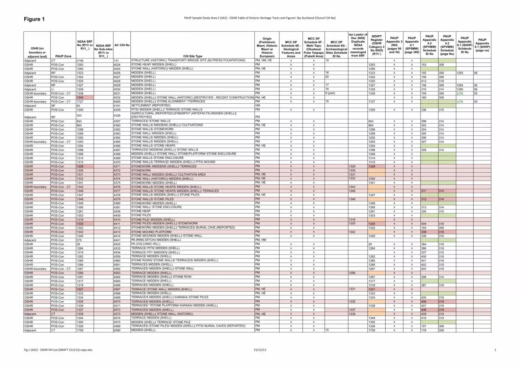
Figure 1 PAUP Sample Study Area 2 (SA2) -‐ OSHR Table of Historic Heritage 'Facts and Figures' (by Auckland COuncil CHI No)
Fig 1 (SA2) -‐ OSHR HH List (DRAFT 151213) copy.xlsx 15/12/13 1
OSHR (on boundary or adjacent land) PAUP Zone
NZAA SRF No (R11/ or
R11_ )NZAA SRF
No Sub-sites (R11/ or R11_ )
AC CHI No
CHI Site Type
Origin (Prehistoric
Maori, Historic Maori or Historic
European)
MCC DP Schedule 6E -
Geological Features and
Areas
MCC DP Schedule 6F -
Wahi Tapu (Otuataua/
Puke Taapapa (Pukeiti Area)
MCC DP Schedule 6G - Archaeological Sites Schedule
ID No
Ian Lawlor (4 Dec 2009) Duplicate
NZAA records
reassinged from SRF
NZHPT Register (OSHR
Category 2 No 6055)
(R11/ )
PAUP Appendix 3
(NH) (pages 50
and 54)
PAUP Appendix
4.1 (SPSMW) (page 300)
PAUP Appendix
4.2 (SPVMW) Schedule
ID No
PAUP Appendix
4.2 (SPVMW) Schedule (page No)
PAUP Appendix 9.1 (SHHP) Schdeule
ID No
PAUP Appendix 9.1 (SHHP) (page no)
Adjacent CT 2146 131 STRUCTURE (HISTORIC) TRANSPORT/ BRIDGE SITE (BUTRESS FOUNTATIONS) PM, HM, HE x x 19 x xOSHR POS-Con 1283 4024 STONE HEAP/ MIDDEN (SHELL) PM x x 1283 x x 153 308OSHR POS-Con 1290 4025 STONE WALL (HISTORIC)/ MIDDEN (SHELL) PM, HE x x 1290 x xAdjacent RP 1323 4026 MIDDEN (SHELL) PM x x 16 1323 x x 155 308 1283 56OSHR POS-Con 1324 4027 MIDDEN (SHELL) PM x x 20 1324 x x 156 308OSHR POS-Con 1325 4028 MIDDEN (SHELL) PM x x 1325 x x 413 319Adjacent RP 1327 4029 MIDDEN (SHELL) PM x x 17 1327 x x 158 308 1284 56Adjacent LI 1328 4030 MIDDEN (SHELL) PM x x 18 1328 x x 310 314 1285 56OSHR-boundary POS-Con - CT 1338 4031 MIDDEN (SHELL) PM x x 9 (part) 1338 x x 159 308 1276 55OSHR POS-Con 1340 4032 MIDDEN (SHELL)/ STONE WALL (HISTORIC) [DESTROYED - RECENT CONSTRUCTION] PM, HE x x x x 160 308OSHR-boundary POS-Con - CT 1727 4065 MIDDEN (SHELL)/ STONE ALIGNMENT/ ?TERRACES PM x x 10 1727 x x 1276 55Adjacent SP 65 4191 SETTLEMENT (REPORTED) HMOSHR POS-Con 1300 4209 PITS/ MIDDEN (SHELL)/ TERRACE/ STONE WALLS PM x x 1300 x x 336 315
Adjacent RP 353 4328AGRICULTURAL (REPORTED) [FINDSPOT (ARTEFACTS) MIDDEN (SHELL)] [DESTROYED] PM
OSHR POS-Con 843 4357 TERRACES/ STONE WALLS PM x x 843 x x 299 314OSHR POS-Con 864 4360 STONE WALLS/ MIDDENS (SHELL)/ CULTIVATIONS PM, HE x x 864 x x 302 314OSHR POS-Con 1288 4362 STONE WALLS/ STONEWORK PM x x 1288 x x 304 314OSHR POS-Con 1289 4363 STONE WALL/ MIDDEN (SHELL) PM x x 1289 x x 305 314OSHR POS-Con 1292 4364 STONE WALLS/ MIDDEN (SHELL) PM x x 1292 x x 306 314OSHR-boundary POS-Con - CT 1293 4365 STONE WALLS/ MIDDEN (SHELL) PM x x 1293 x x 307 314OSHR POS-Con 1294 4366 STONE WALLS/ STONE HEAPS PM, HE x x 1294 x xOSHR POS-Con 1298 4367 TERRACES/ MIDDENS (SHELL)/ STONE WALLS PM x x 1298 x x 309 314OSHR POS-Con 1299 4368 MIDDEN (SHELL)/ STONE WALL/ STONE/PLATFORM/ STONE ENCLOSURE PM x x 1299 x xOSHR POS-Con 1314 4369 STONE WALLS /STONE ENCLOSURE PM x x 1314 x xOSHR POS-Con 1315 4370 STONE WALLS/ TERRACE/ MIDDEN (SHELL/) PITS/ MOUND PM x x 1315 x xOSHR POS-Con 1329 4371 STONEWORK /MIDDENS (SHELL)/ TERRACES PM x x 1329 1329 x xOSHR POS-Con 1330 4372 STONEWORK PM x x 1330 x xOSHR POS-Con 1331 4373 STONE WALL/ MIDDEN (SHELL)/ CULTIVATION AREA PM, HE x x 1331 x xOSHR POS-Con 1332 4374 STONE WALL (HISTORIC)/ MIDDEN (SHELL) PM, HE x x 1332 1332 x xOSHR POS-Con 1341 4375 STONEWORK/ MIDDEN (SHELL) PM, HE x x 1341 x xOSHR-boundary POS-Con - CT 1343 4376 STONE WALLS/ STONE HEAPS/ MIDDEN (SHELL) PM x x 1343 x xOSHR POS-Con 1346 4377 STONE WALLS/ STONE HEAPS/ MIDDEN (SHELL)/ TERRACES PM x x 1346 x x 311 314OSHR POS-Con 1347 4378 STONE WALLS/ MIDDEN (SHELL/) STONE PILES PM, HE x x 1347 x xOSHR POS-Con 1348 4379 STONE WALLS/ STONE PILES PM x x 1348 x x 312 314OSHR POS-Con 1349 4380 STONEWORK/ MIDDEN (SHELL) PM x x 1349 x xOSHR POS-Con 1395 4381 STONE WALL/ STONE ENCLOSURE PM x x 1395 x x 313 314OSHR POS-Con 1291 4408 STONE HEAP PM x x 1291 x x 335 315OSHR POS-Con 1303 4409 STONE PILES PM x x 1303 x xOSHR POS-Con 1316 4410 STONE PILE/ MIDDEN (SHELL) PM x x 1316 x xOSHR POS-Con 1320 4411 STONE PILES/ MIDDEN (SHELL)/ STONEWORK PM x x 1320 1320 x x 404 318OSHR POS-Con 1322 4412 STONEWORK/ MIDDEN (SHELL)/ TERRACES/ BURIAL CAVE (REPORTED) PM x x 1322 x x 154 308OSHR POS-Con 1342 4413 STONE MOUND/ PLATFORM PM x x 1342 x x 338 316OSHR POS-Con 1345 4414 STONE MOUNDS/ MIDDEN (SHELL)/ STONE WALL PM x x 1345 x x 339 316Adjacent POS-Con 575 4441 PA (RING DITCH)/ MIDDEN (SHELL) PM, HMOSHR POS-Con 29 4525 PA (VOLCANIC HILL) PM x x 29 x x 384 318OSHR POS-Con 1284 4533 TERRACE/ PITS/ MIDDEN (SHELL) PM x x 1284 x x 386 318OSHR POS-Con 1319 4534 TERRACE/ PIT/ SMIDDEN (SHELL) PM x x x x 337 315OSHR POS-Con 1282 4559 TERRACE/ MIDDEN (SHELL) PM x x 1282 x x 400 318OSHR POS-Con 1285 4560 STONE ROWS/ STONE WALLS/ TERRACES/ MIDDEN (SHELL) PM x x 1285 x x 401 318OSHR POS-Con 1286 4561 TERRACES MIDDEN (SHELL) PM x x 1286 x x 402 318OSHR-boundary POS-Con - CT 1287 4562 TERRACES/ MIDDEN (SHELL)/ STONE WALL PM x x 1287 x x 403 318OSHR POS-Con 1296 4563 TERRACE/ MIDDEN (SHELL) PM x x 1296 x xOSHR POS-Con 1297 4564 TERRACE/ MIDDEN (SHELL)/ STONE ROW PM x x 1297 x x 308 314OSHR POS-Con 1317 4565 TERRACE/ MIDDEN (SHELL) PM x x 1317 x xOSHR POS-Con 1318 4566 TERRACES/ MIDDEN (SHELL) PM x x 1318 x x 387 318OSHR POS-Con 1321 4567 TERRACE/ STONE WALL/ MIDDEN (SHELL) PM, HE x x 1321 1321 x xOSHR POS-Con 1333 4568 TERRACE/ MIDDEN (SHELL) PM, HE x x 1333 x xOSHR POS-Con 1334 4569 TERRACE/S MIDDEN (SHELL/) KARAKA/ STONE PILES PM x x 1334 x x 405 318OSHR POS-Con 1335 4570 TERRACES/ MIDDEN (SHELL) PM x x 1335 x x 406 318OSHR POS-Con 1336 4571 TERRACES/ ?STONE PLATFORM/ KARAKA/ MIDDEN (SHELL) PM x x 1336 x x 407 319OSHR POS-Con 1337 4572 TERRACES/ MIDDEN (SHELL) PM x x 1337 x x 408 319Adjacent CT 1339 4573 MIDDEN (SHELL)/ STONE WALL (HISTORIC) PM, HE x x 1339 x x 409 319OSHR POS-Con 1344 4574 TERRACE/ MIDDEN (SHELL) PM x x 1344 x x 410 319OSHR POS-Con 1350 4575 MIDDEN (SHELL)/ TERRACE/ STONE PILE PM x x 1350 x xOSHR POS-Con 1326 4589 TERRACES/ STONE PILES/ MIDDEN (SHELL)/ PITS/ BURIAL CAVES (REPORTED) PM x x 1326 x x 157 308Adjacent CT 1759 4590 MIDDEN (SHELL) PM x x 15 1759 x x 178 309
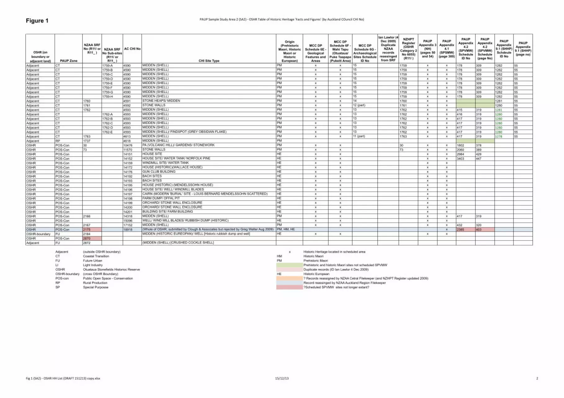
Figure 1 PAUP Sample Study Area 2 (SA2) -‐ OSHR Table of Historic Heritage 'Facts and Figures' (by Auckland COuncil CHI No)
Fig 1 (SA2) -‐ OSHR HH List (DRAFT 151213) copy.xlsx 15/12/13 2
OSHR (on boundary or adjacent land) PAUP Zone
NZAA SRF No (R11/ or
R11_ )NZAA SRF
No Sub-sites (R11/ or R11_ )
AC CHI No
CHI Site Type
Origin (Prehistoric
Maori, Historic Maori or Historic
European)
MCC DP Schedule 6E -
Geological Features and
Areas
MCC DP Schedule 6F -
Wahi Tapu (Otuataua/
Puke Taapapa (Pukeiti Area)
MCC DP Schedule 6G - Archaeological Sites Schedule
ID No
Ian Lawlor (4 Dec 2009) Duplicate
NZAA records
reassinged from SRF
NZHPT Register (OSHR
Category 2 No 6055)
(R11/ )
PAUP Appendix 3
(NH) (pages 50
and 54)
PAUP Appendix
4.1 (SPSMW) (page 300)
PAUP Appendix
4.2 (SPVMW) Schedule
ID No
PAUP Appendix
4.2 (SPVMW) Schedule (page No)
PAUP Appendix 9.1 (SHHP) Schdeule
ID No
PAUP Appendix 9.1 (SHHP) (page no)
Adjacent CT 1759-A 4590 MIDDEN (SHELL) PM x x 15 1759 x x 178 309 1282 55Adjacent CT 1759-B 4590 MIDDEN (SHELL) PM x x 15 1759 x x 178 309 1282 55Adjacent CT 1759-C 4590 MIDDEN (SHELL) PM x x 15 1759 x x 178 309 1282 55Adjacent CT 1759-D 4590 MIDDEN (SHELL) PM x x 15 1759 x x 178 309 1282 55Adjacent CT 1759-E 4590 MIDDEN (SHELL) PM x x 15 1759 x x 178 309 1282 55Adjacent CT 1759-F 4590 MIDDEN (SHELL) PM x x 15 1759 x x 178 309 1282 55Adjacent CT 1759-G 4590 MIDDEN (SHELL) PM x x 15 1759 x x 178 309 1282 55Adjacent CT 1759-H 4590 MIDDEN (SHELL) PM x x 15 1759 x x 178 309 1282 55Adjacent CT 1760 4591 STONE HEAPS/ MIDDEN PM x x 14 1760 x x 1281 55Adjacent CT 1761 4592 STONE WALLS PM x x 12 (part) 1761 x x 1280 55Adjacent CT 1762 4593 MIDDEN (SHELL) PM x x 13 1762 x x 415 319 1281 55Adjacent CT 1762-A 4593 MIDDEN (SHELL) PM x x 13 1762 x x 416 319 1280 55Adjacent CT 1762-B 4593 MIDDEN (SHELL) PM x x 13 1762 x x 417 319 1280 55Adjacent CT 1762-C 4593 MIDDEN (SHELL) PM x x 13 1762 x x 417 319 1280 55Adjacent CT 1762-D 4593 MIDDEN (SHELL) PM x x 13 1762 x x 417 319 1280 55Adjacent CT 1762-E 4593 MIDDEN (SHELL)/ FINDSPOT (GREY OBSIDIAN FLAKE) PM x x 13 1762 x x 417 319 1280 55Adjacent CT 1763 4613 MIDDEN (SHELL) PM x x 11 (part) 1763 x x 417 319 1278 55Adjacent RP 1737 4618 MIDDEN (SHELL) PMOSHR POS-Con 30 10476 PA (VOLCANIC HILL)/ GARDENS/ STONEWORK PM x x 30 x x 1802 378OSHR POS-Con 73 11570 STONE WALLS PM x x 73 x x 2060 389OSHR POS-Con 14151 HOUSE SITE HE x x x x 2984 429OSHR POS-Con 14152 HOUSE SITE/ WATER TANK/ NORFOLK PINE HE x x x x 3403 447OSHR POS-Con 14159 WINDMILL SITE/ WATER TANK HE x x x xOSHR POS-Con 14172 HOUSE (HISTORIC)(WALLACE HOUSE) HE x x x xOSHR POS-Con 14176 GUN CLUB BUILDING HE x x x xOSHR POS-Con 14192 BACH SITES HE x x x xOSHR POS-Con 14193 BACH SITES HE x x x xOSHR POS-Con 14195 HOUSE (HISTORIC) (MENDELSSOHN HOUSE) HE x x x xOSHR POS-Con 14196 HOUSE SITE/ WELL/ WINDMILL BLADES HE x x x xOSHR POS-Con 14197 CAIRN (MODERN 'BURIAL' SITE - LOUIS BERNARD MENDELSSOHN SCATTERED) HE x x x xOSHR POS-Con 14198 FARM DUMP/ OFFAL PIT HE x x x xOSHR POS-Con 14199 ORCHARD/ STONE WALL ENCLOSURE HE x x x xOSHR POS-Con 14200 ORCHARD/ STONE WALL ENCLOSURE HE x x x xOSHR POS-Con 14201 BUILDING SITE/ FARM BUILDING HE x x x xOSHR POS-Con 2166 14318 MIDDEN (SHELL) PM x x x x 417 319OSHR POS-Con 15096 WELL/ WIND MILL BLADES/ RUBBISH DUMP (HISTORIC) HE x x x xOSHR POS-Con 2167 17152 MIDDEN (SHELL) PM x x x x 432 320OSHR POS-Con 2175 18918 (Whole of OSHR; submitted by Clough & Associates but rejected by Greg Walter Aug 2009) PM, HM, HE x 2385 403OSHR-boundary FU 2184 MIDDEN (HISTORIC EUREOPAN)/ WELL [Historic rubbish dump and well] HE x x x xOSHR POS-Con 2870Adjacent FU 2872 (MIDDEN (SHELL) [CRUSHED COCKLE SHELL]
Adjacent (outside OSHR boundary) x Historic Heritage located in scheduled areaCT Coastal Transition HM Historic MaoriFU Future Urban PM Prehistoric MaoriLI Light Industry Prehistoric and historic Maori sites not scheduled SPVMWOSHR Otuataua Stonefields Historioc Reserve Duplicate records (ID Ian Lawlor 4 Dec 2009)OSHR-boundary (cross OSHR Boundary) HE Historic EuropeanPOS-con Public Open Space - Conservation ? Records reassigned by NZAA Cetral Filekeeper (and NZHPT Register updated 2009)RP Rural Production Record reassinged by NZAA Auckland Region FilekeeperSP Special Purposse ?Scheduled SPVMW sites not longer extant?
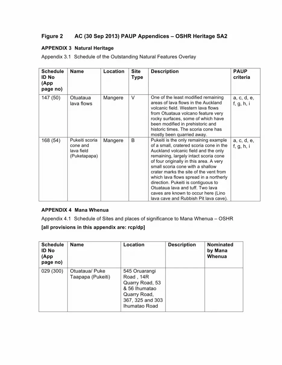
Figure 2 AC (30 Sep 2013) PAUP Appendices – OSHR Heritage SA2 APPENDIX 3 Natural Heritage Appendix 3.1 Schedule of the Outstanding Natural Features Overlay
Schedule ID No (App page no)
Name Location Site Type
Description PAUP criteria
147 (50) Otuataua lava flows
Mangere V One of the least modified remaining areas of lava flows in the Auckland volcanic field. Western lava flows from Otuataua volcano feature very rocky surfaces, some of which have been modified in prehistoric and historic times. The scoria cone has mostly been quarried away.
a, c, d, e, f, g, h, i
168 (54) Pukeiti scoria cone and lava field (Puketapapa)
Mangere B Pukeiti is the only remaining example of a small, cratered scoria cone in the Auckland volcanic field and the only remaining, largely intact scoria cone of four originally in this area. A very small scoria cone with a shallow crater marks the site of the vent from which lava flows spread in a northerly direction. Pukeiti is contiguous to Otuataua lava and tuff. Two lava caves are known to occur here (Lino lava cave and Rubbish Pit lava cave).
a, c, d, e, f, g, h, i
APPENDIX 4 Mana Whenua Appendix 4.1 Schedule of Sites and places of significance to Mana Whenua – OSHR
[all provisions in this appendix are: rcp/dp]
Schedule ID No (App page no)
Name Location Description Nominated by Mana Whenua
029 (300) Otuataua/ Puke Taapapa (Pukeiti)
545 Oruarangi Road , 14R Quarry Road, 53 & 56 Ihumatao Quarry Road, 367, 325 and 303 Ihumatao Road
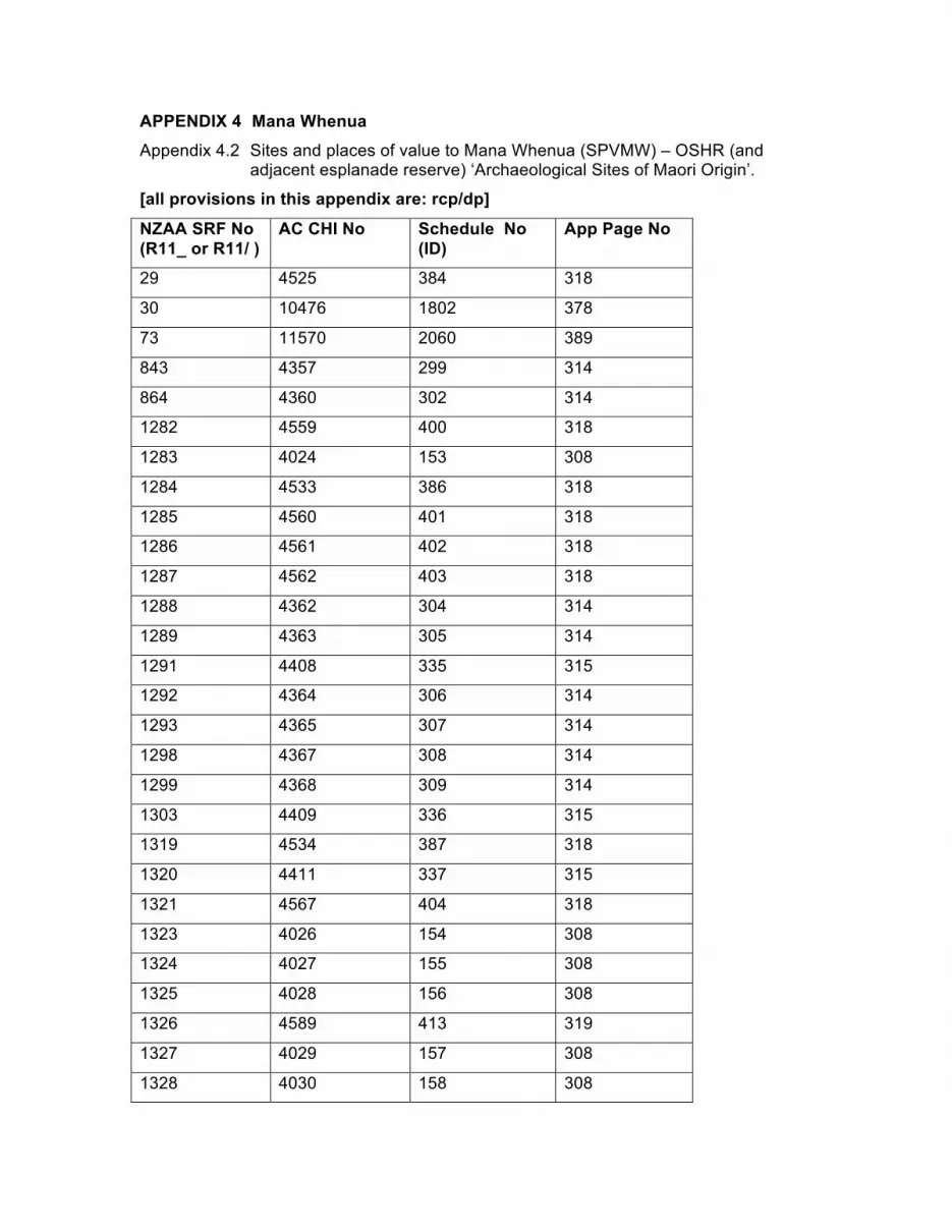
APPENDIX 4 Mana Whenua Appendix 4.2 Sites and places of value to Mana Whenua (SPVMW) – OSHR (and
adjacent esplanade reserve) ‘Archaeological Sites of Maori Origin’.
[all provisions in this appendix are: rcp/dp]
NZAA SRF No (R11_ or R11/ )
AC CHI No Schedule No (ID)
App Page No
29 4525 384 318
30 10476 1802 378
73 11570 2060 389
843 4357 299 314
864 4360 302 314
1282 4559 400 318
1283 4024 153 308
1284 4533 386 318
1285 4560 401 318
1286 4561 402 318
1287 4562 403 318
1288 4362 304 314
1289 4363 305 314
1291 4408 335 315
1292 4364 306 314
1293 4365 307 314
1298 4367 308 314
1299 4368 309 314
1303 4409 336 315
1319 4534 387 318
1320 4411 337 315
1321 4567 404 318
1323 4026 154 308
1324 4027 155 308
1325 4028 156 308
1326 4589 413 319
1327 4029 157 308
1328 4030 158 308
NZAA SRF No (R11_ or R11/ )
AC CHI No Schedule No (ID)
App Page No
1329 4371 310 314
1334 4569 405 318
1335 4570 406 318
1336 4571 407 319
1337 4572 408 319
1338 4031 159 308
1339 4573 409 319
1340 4032 160 308
1342 4413 338 316
1344 4574 410 319
1345 4414 339 316
1346 4377 311 314
1348 4379 312 314
1395 4381 313 314
1727 4065 178 309
1760 4591 415 319
1761 4592 416 319
1762 4593 417 319
1763 4613 432 320
2166 14318 2385 403
2167 17152 2984 429
No SRF 18918 3403 447
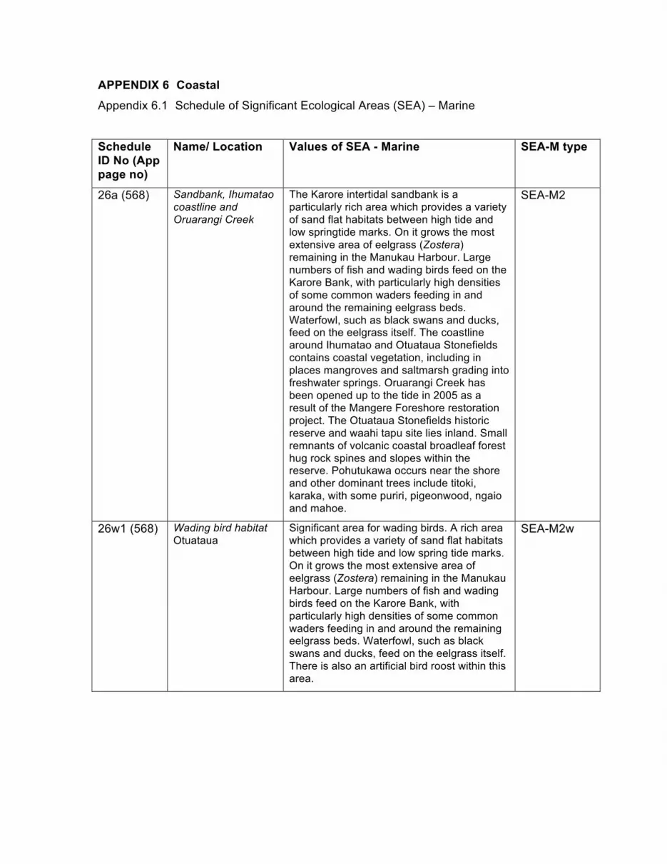
APPENDIX 6 Coastal Appendix 6.1 Schedule of Significant Ecological Areas (SEA) – Marine
Schedule ID No (App page no)
Name/ Location Values of SEA - Marine SEA-M type
26a (568) Sandbank, Ihumatao coastline and Oruarangi Creek
The Karore intertidal sandbank is a particularly rich area which provides a variety of sand flat habitats between high tide and low springtide marks. On it grows the most extensive area of eelgrass (Zostera) remaining in the Manukau Harbour. Large numbers of fish and wading birds feed on the Karore Bank, with particularly high densities of some common waders feeding in and around the remaining eelgrass beds. Waterfowl, such as black swans and ducks, feed on the eelgrass itself. The coastline around Ihumatao and Otuataua Stonefields contains coastal vegetation, including in places mangroves and saltmarsh grading into freshwater springs. Oruarangi Creek has been opened up to the tide in 2005 as a result of the Mangere Foreshore restoration project. The Otuataua Stonefields historic reserve and waahi tapu site lies inland. Small remnants of volcanic coastal broadleaf forest hug rock spines and slopes within the reserve. Pohutukawa occurs near the shore and other dominant trees include titoki, karaka, with some puriri, pigeonwood, ngaio and mahoe.
SEA-M2
26w1 (568) Wading bird habitat Otuataua
Significant area for wading birds. A rich area which provides a variety of sand flat habitats between high tide and low spring tide marks. On it grows the most extensive area of eelgrass (Zostera) remaining in the Manukau Harbour. Large numbers of fish and wading birds feed on the Karore Bank, with particularly high densities of some common waders feeding in and around the remaining eelgrass beds. Waterfowl, such as black swans and ducks, feed on the eelgrass itself. There is also an artificial bird roost within this area.
SEA-M2w
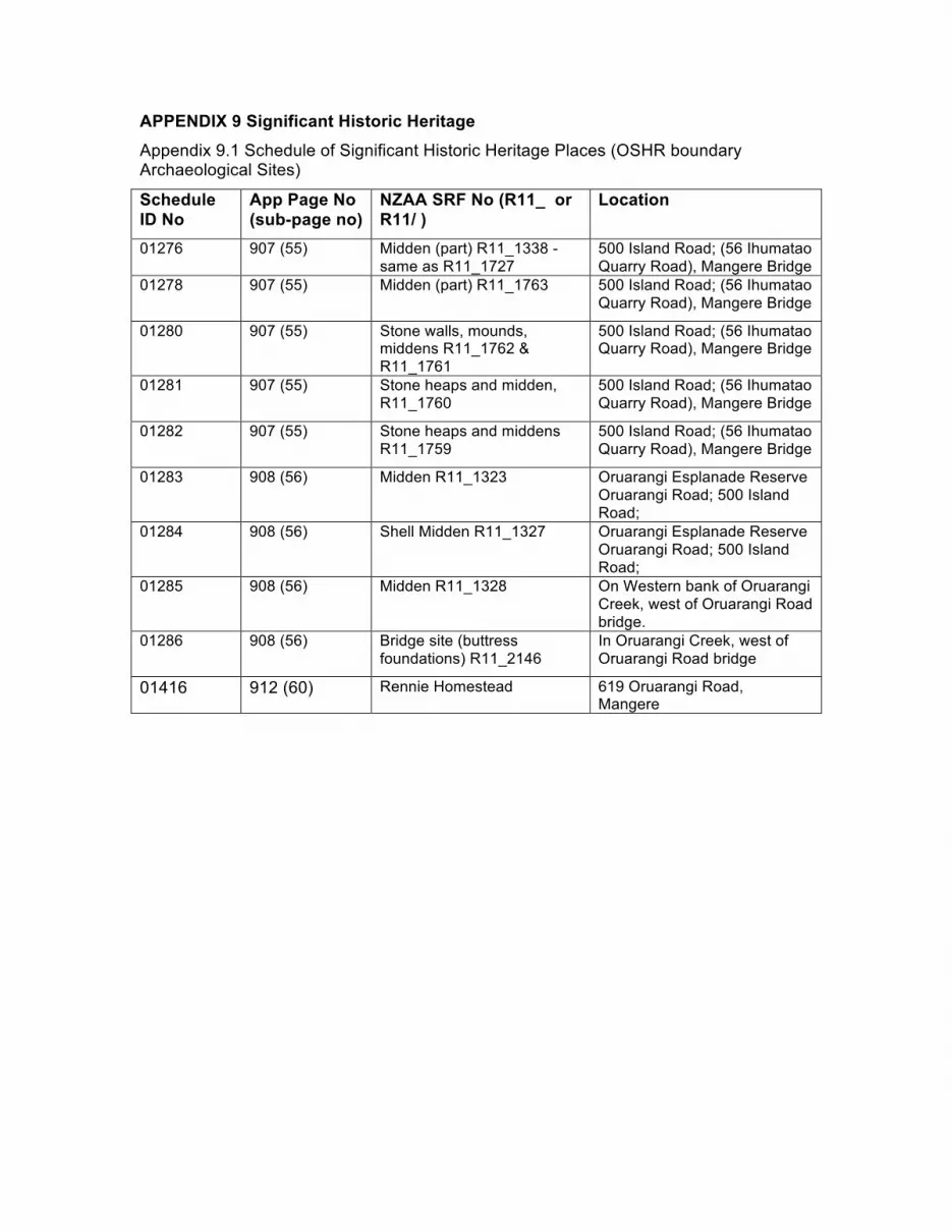
APPENDIX 9 Significant Historic Heritage Appendix 9.1 Schedule of Significant Historic Heritage Places (OSHR boundary Archaeological Sites)
Schedule ID No
App Page No (sub-page no)
NZAA SRF No (R11_ or R11/ )
Location
01276 907 (55) Midden (part) R11_1338 - same as R11_1727
500 Island Road; (56 Ihumatao Quarry Road), Mangere Bridge
01278 907 (55) Midden (part) R11_1763 500 Island Road; (56 Ihumatao Quarry Road), Mangere Bridge
01280 907 (55) Stone walls, mounds, middens R11_1762 & R11_1761
500 Island Road; (56 Ihumatao Quarry Road), Mangere Bridge
01281 907 (55) Stone heaps and midden, R11_1760
500 Island Road; (56 Ihumatao Quarry Road), Mangere Bridge
01282 907 (55) Stone heaps and middens R11_1759
500 Island Road; (56 Ihumatao Quarry Road), Mangere Bridge
01283 908 (56) Midden R11_1323 Oruarangi Esplanade Reserve Oruarangi Road; 500 Island Road;
01284 908 (56) Shell Midden R11_1327 Oruarangi Esplanade Reserve Oruarangi Road; 500 Island Road;
01285 908 (56) Midden R11_1328 On Western bank of Oruarangi Creek, west of Oruarangi Road bridge.
01286 908 (56) Bridge site (buttress foundations) R11_2146
In Oruarangi Creek, west of Oruarangi Road bridge
01416 912 (60) Rennie Homestead 619 Oruarangi Road, Mangere
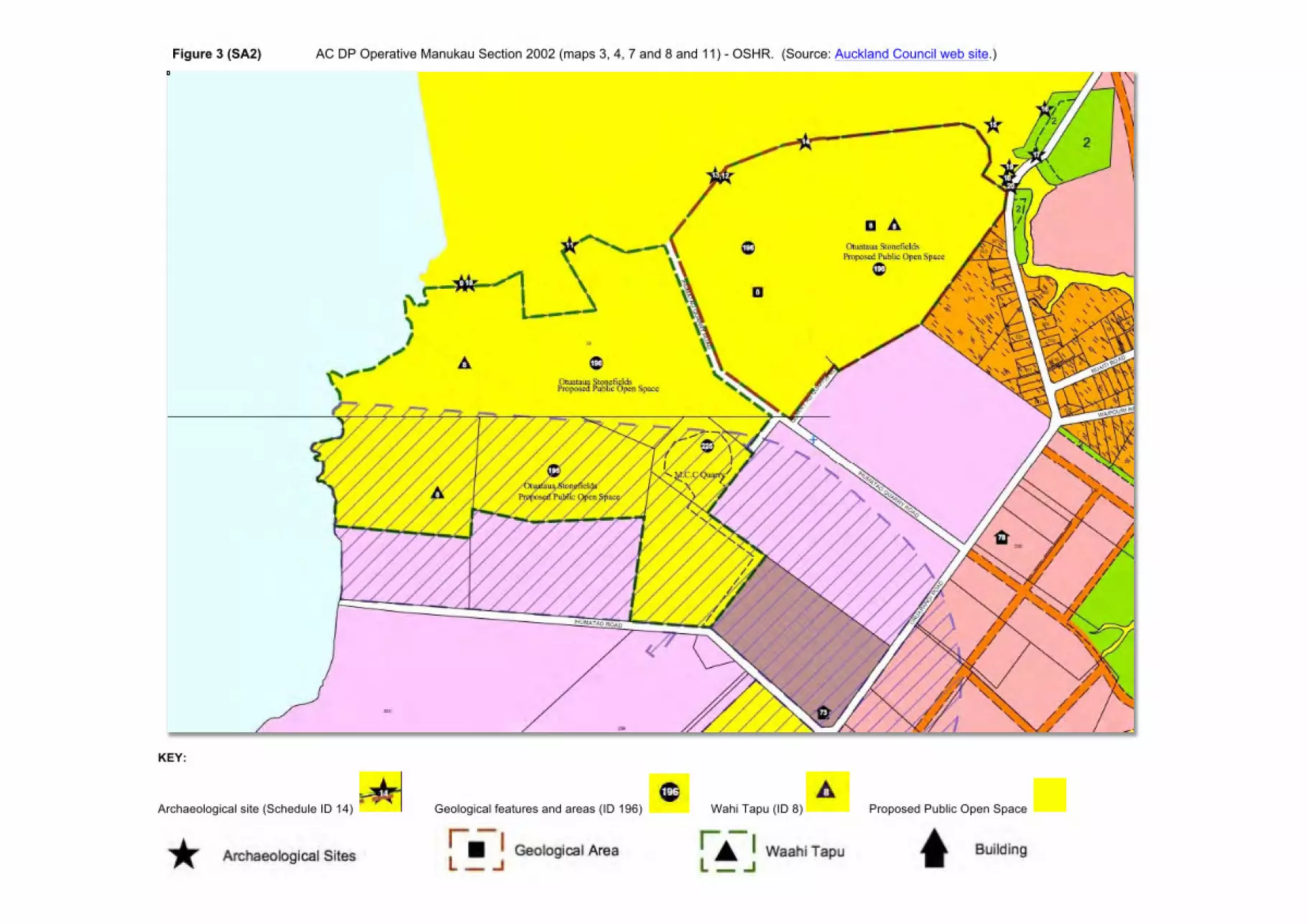
Figure 3 (SA2) AC DP Operative Manukau Section 2002 (maps 3, 4, 7 and 8 and 11) - OSHR. (Source: Auckland Council web site.)
KEY:
Archaeological site (Schedule ID 14) Geological features and areas (ID 196) Wahi Tapu (ID 8) Proposed Public Open Space
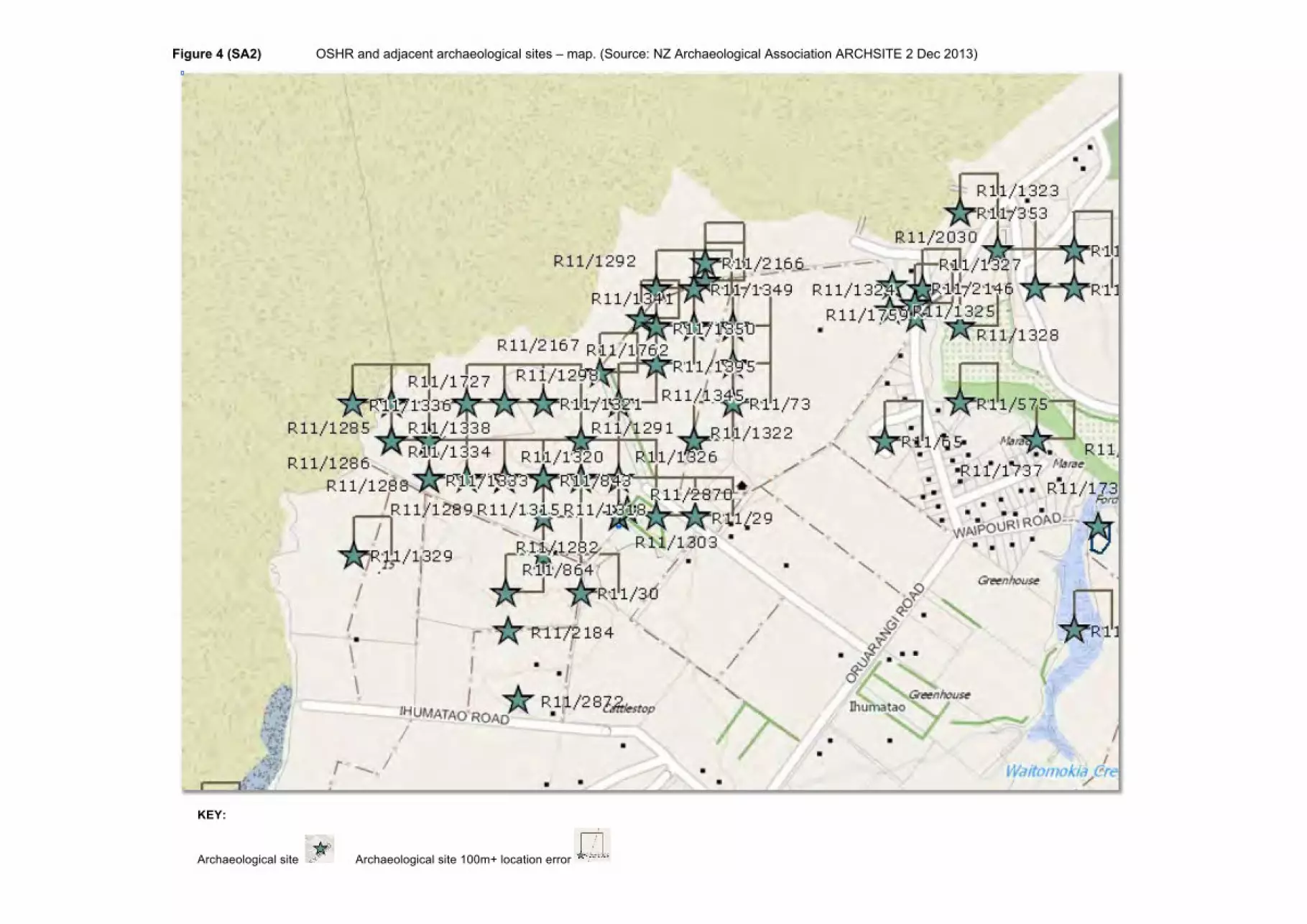
Figure 4 (SA2) OSHR and adjacent archaeological sites – map. (Source: NZ Archaeological Association ARCHSITE 2 Dec 2013)
KEY:
Archaeological site Archaeological site 100m+ location error
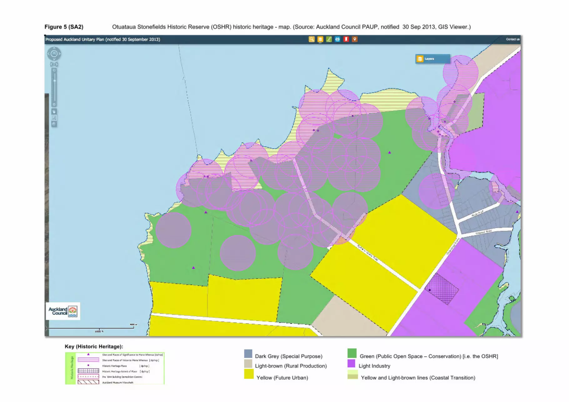
Figure 5 (SA2) Otuataua Stonefields Historic Reserve (OSHR) historic heritage - map. (Source: Auckland Council PAUP, notified 30 Sep 2013, GIS Viewer.)
Key (Historic Heritage):
Dark Grey (Special Purpose) Green (Public Open Space – Conservation) [i.e. the OSHR]
Light-brown (Rural Production) Light Industry
Yellow (Future Urban) Yellow and Light-brown lines (Coastal Transition)
Figure 6 (SA2) Otuataua Stonefields Historic Reserve (OSHR) historic heritage – aerial photo. (Source: Auckland Council PAUP GIS Viewer, notified 30 Sep 2013.)
Key (Historic Heritage):
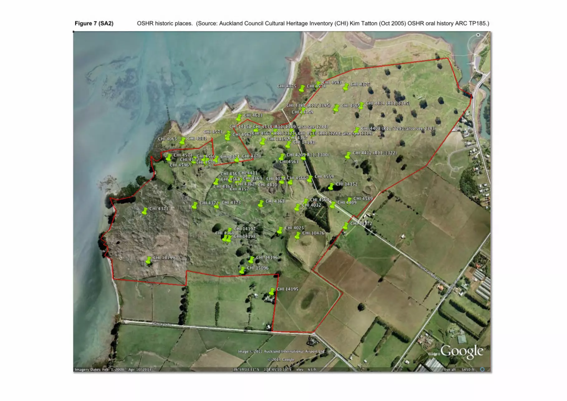
Figure 7 (SA2) OSHR historic places. (Source: Auckland Council Cultural Heritage Inventory (CHI) Kim Tatton (Oct 2005) OSHR oral history ARC TP185.)
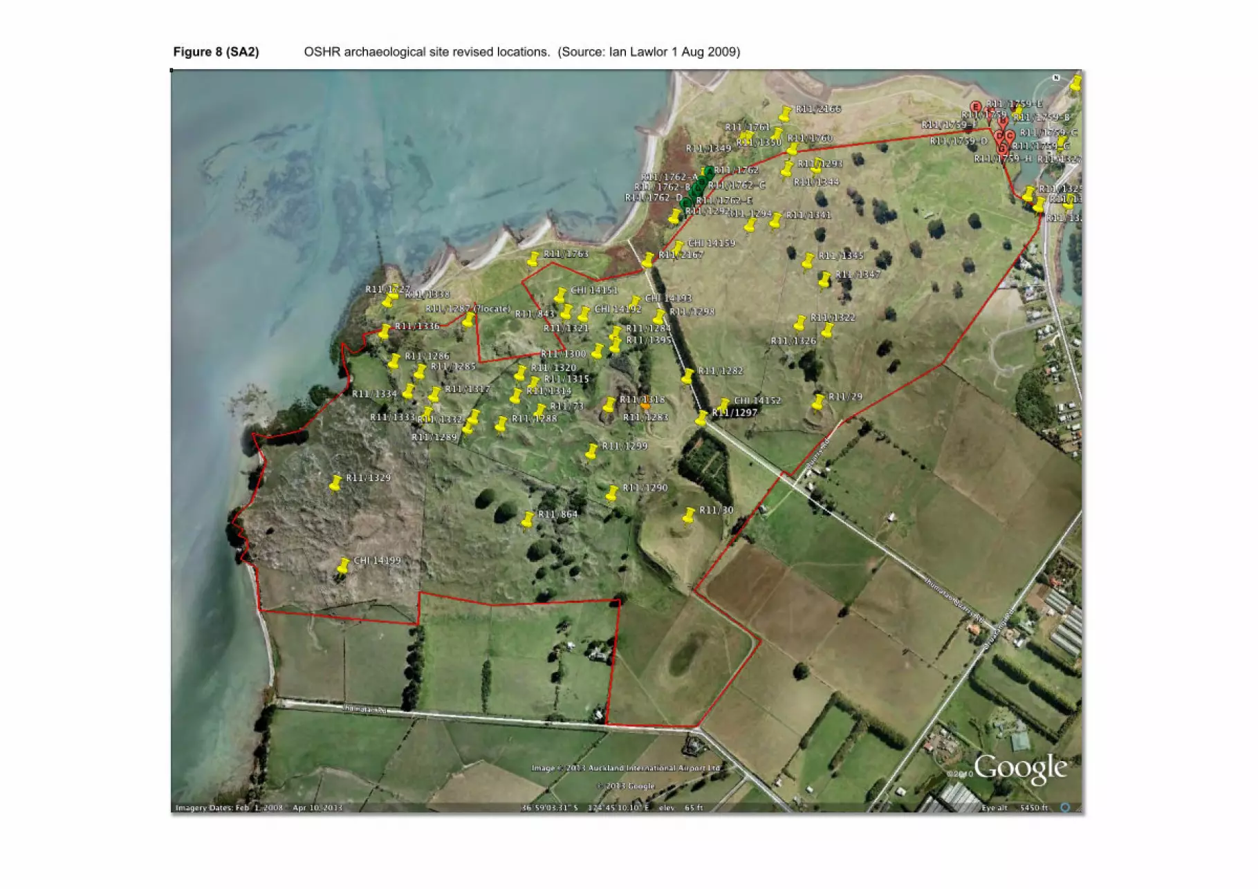
Figure 8 (SA2) OSHR archaeological site revised locations. (Source: Ian Lawlor 1 Aug 2009)
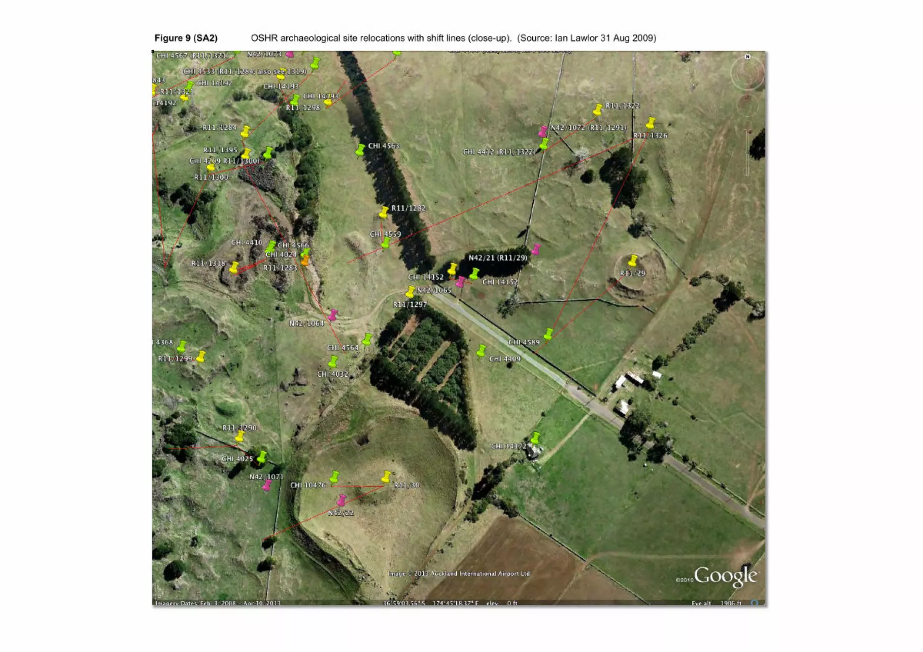
Figure 9 (SA2) OSHR archaeological site relocations with shift lines (close-up). (Source: Ian Lawlor 31 Aug 2009)
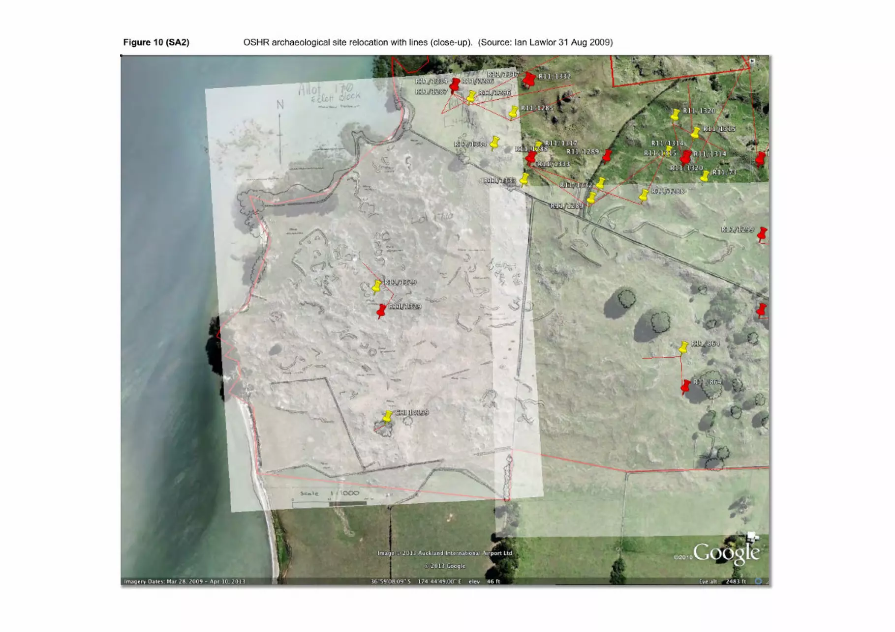
Figure 10 (SA2) OSHR archaeological site relocation with lines (close-up). (Source: Ian Lawlor 31 Aug 2009)
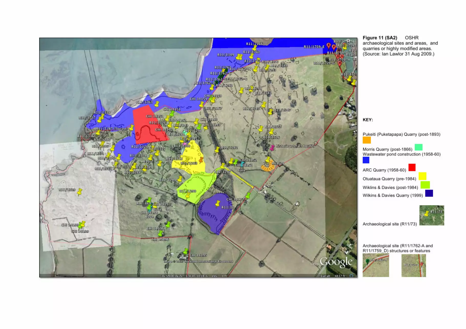
Figure 11 (SA2) OSHR archaeological sites and areas, and quarries or highly modified areas. (Source: Ian Lawlor 31 Aug 2009.)
KEY:
Pukeiti (Puketapapa) Quarry (post-1893)
Morris Quarry (post-1866) Wastewater pond construction (1958-60)
ARC Quarry (1958-60)
Otuataua Quarry (pre-1984)
Wiklins & Davies (post-1984)
Wilkins & Davies Quarry (1999)
Archaeological site (R11/73)
Archaeological site (R11/1762-A and R11/1759_D) structures or features
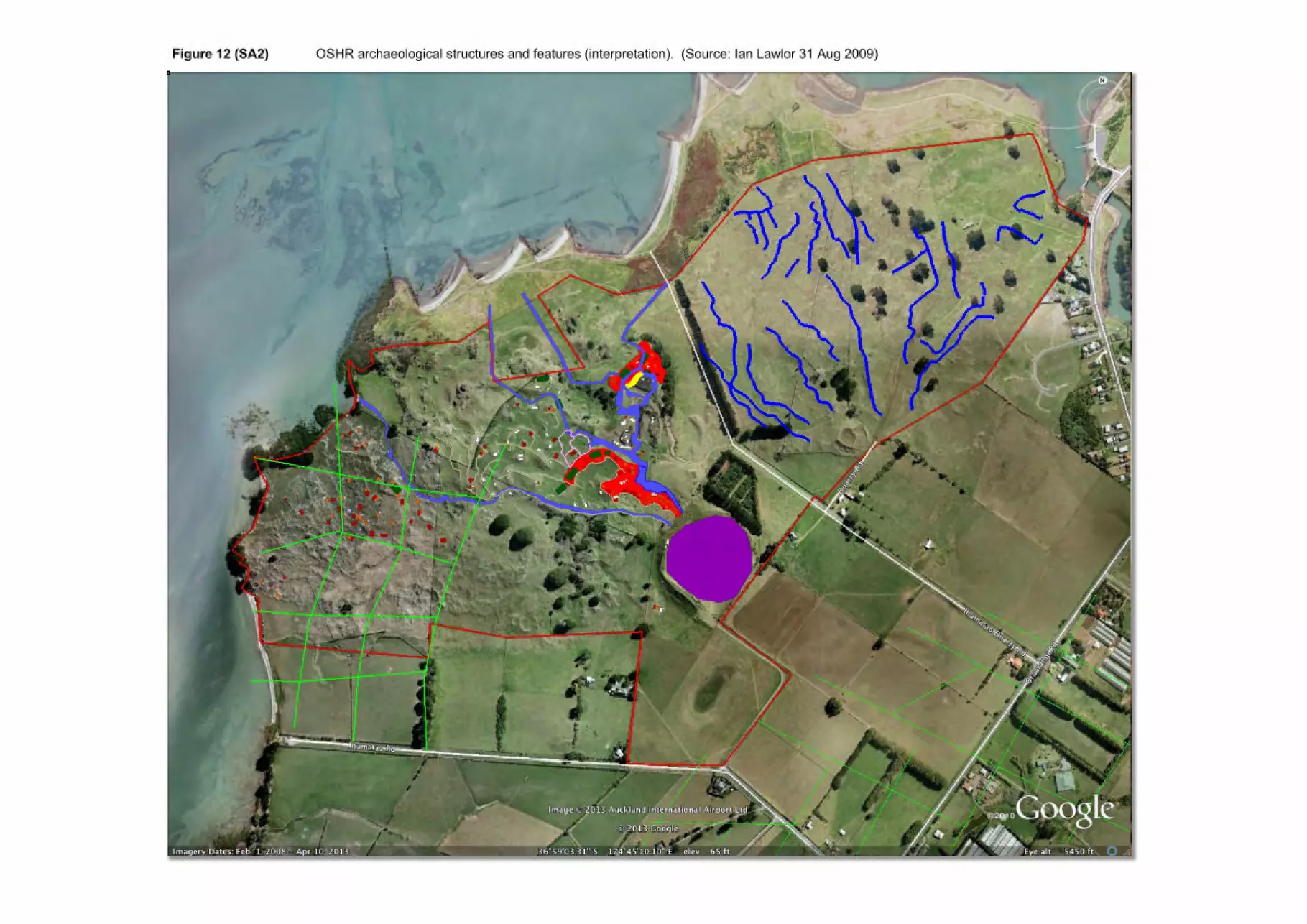
Figure 12 (SA2) OSHR archaeological structures and features (interpretation). (Source: Ian Lawlor 31 Aug 2009)
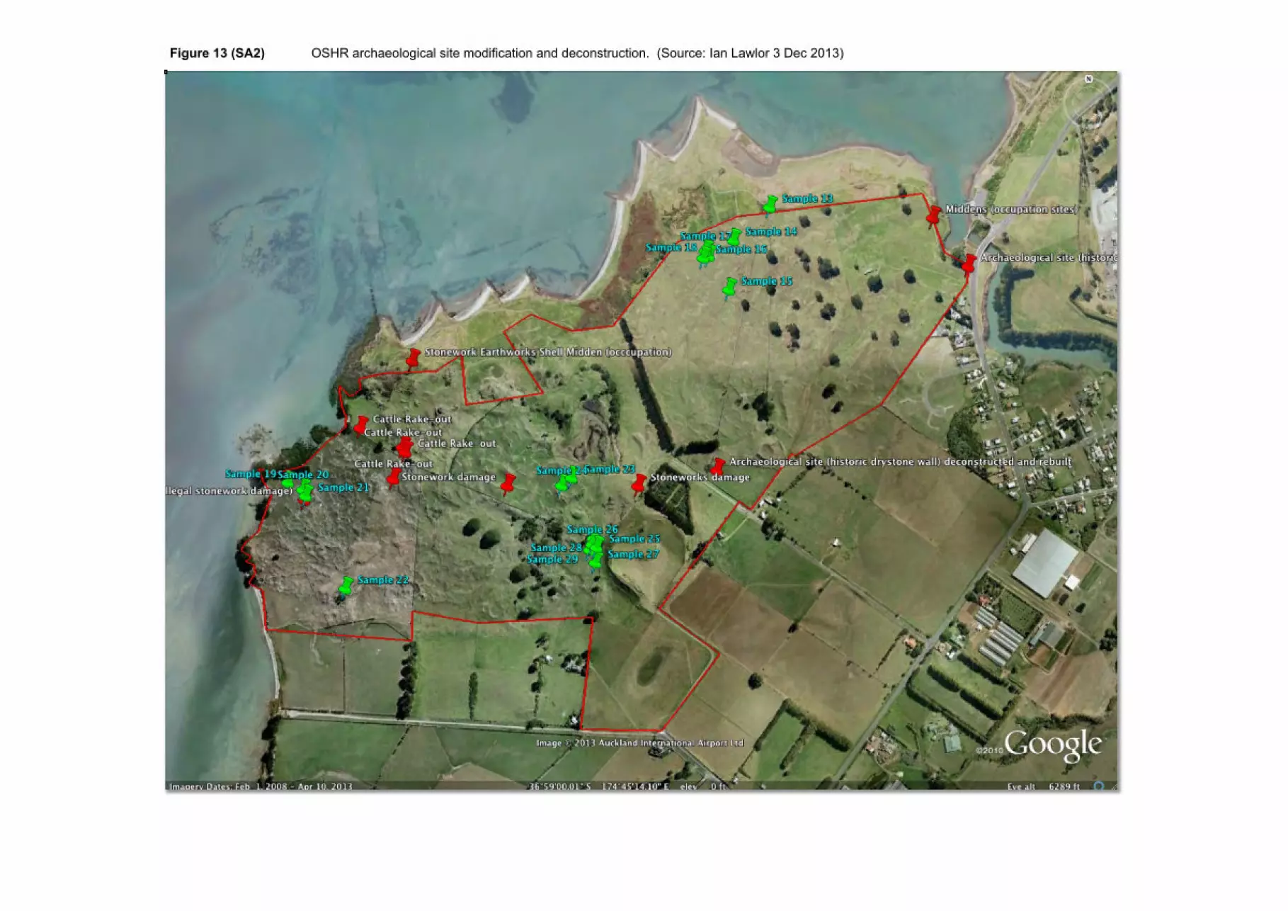
Figure 13 (SA2) OSHR archaeological site modification and deconstruction. (Source: Ian Lawlor 3 Dec 2013)