part 2 revised draft eir - county of san diego
TRANSCRIPT
STATEMENT OF LOCATION AND CUSTODIAN OF DOCUMENTS OR OTHER MATERIALS THAT CONSTITUTE A RECORD OF PROCEEDINGS
July 14, 2010
Project Name: Tiered Winery Zoning Ordinance Amendment Reference Case Numbers: POD08-012; GPA 10-003;ER Log No. 08-00-004; SCH
No. 2008101047 The CEQA [Section 21081.6(a)(2)] requires that the lead agency (in this case the County of San Diego) specify the location and custodian of the documents or other material that constitute the record of proceedings upon which it decision is based. It is the purpose of this statement to satisfy this requirement. Location of Documents and Other Materials That Constitute the Record of Proceedings: County of San Diego, Department of Planning and Land Use Project Processing Center 5201 Ruffin Road, Suite B San Diego, California 92123 Custodian: County of San Diego, Department of Planning and Land Use Project Processing Center 5201 Ruffin Road, Suite B San Diego, California 92123

DRAFT FINAL ENVIRONMENTAL IMPACT REPORT Part 2 Revised Draft EIR
Project EIR Tiered Winery Zoning Ordinance Amendment
POD 08-012; LOG No. 08-00-004 State Clearinghouse (SCH) No. 2008101047
Lead Agency/Project Proponent:
County of San Diego Department of Planning and Land Use
5201 Ruffin Road, Suite B San Diego, CA 92123
July 14, 2010

Table of Contents
TABLE OF CONTENTS
COVER
COVER PAGE I
TABLE OF CONTENTS III
LIST OF ABBREVIATIONS AND ACRONYMS IX
SUMMARY
S.1 Project Synopsis S-1
S.1.1 Project Description S-1 S.1.2 Project Location S-1 S.1.3 Environmental Setting S-1
S.2 Summary of Significant Effects and Mitigation Measures That Reduce or Avoid the Significant Effects S-1
S.3 Areas of Controversy S-2
S.4 Issues to Be Resolved by the Decision-Making Body S-3
S.5 Project Alternatives S-3
S.5.1 Enhanced Ministerial Enforcement Alternative S-3 S.5.2 Limited Five-Year By-Right Ordinance Alternative S-4 S.5.3 No Project (No Amendment) Alternative S-4 S.5.4 Environmentally Superior Alternative S-4
CHAPTER 1.0 PROJECT DESCRIPTION, LOCATION, AND ENVIRONMENTAL SETTING
1.1 Project Objectives 1-1
1.2 Project Description 1-1
1.2.1 Project’s Component Parts 1-3 1.2.2 Technical, Economic, and Environmental Characteristics 1-7
1.3 Project Location 1-9
1.4 Environmental Setting 1-11
iii

Table of Contents
1.5 Intended Uses of the EIR 1-12
1.5.1 Project Approvals/Permits 1-12 1.5.2 Related Environmental Review & Consultation Requirements 1-15
1.6 Project Inconsistencies with Applicable Regional and General Plans 1-16
1.7 Cumulative Impacts Analysis Methodology - Buildout Projections of the County of San Diego General Plan(Summary of Projections) 1-16
1.8 Grow th-Inducing Effects 1-18
CHAPTER 2.0 SIGNIFICANT ENVIRONMENTAL EFFECTS OF THE PROPOSED PROJECT
2.1 Air Quality 2.1-1
2.1.1 Existing Conditions 2.1-1 2.1.2 Analysis of Project Effects and Determination as to Significance 2.1-15 2.1.3 Cumulative Impact Analysis 2.1-22 2.1.4 Significance of Impacts Prior to Mitigation 2.1-26 2.1.5 Mitigation 2.1-27 2.1.6 Conclusion 2.1-27
2.2 Biological Resources 2.2-1
2.2.1 Existing Conditions 2.2-1 2.2.2 Analysis of Project Effects and Determination as to Significance 2.2-17 2.2.3 Cumulative Impact Analysis 2.2-24 2.2.4 Significance of Impacts Prior to Mitigation 2.2-26 2.2.5 Mitigation 2.2-27 2.2.6 Conclusion 2.2-27
2.3 Cultural Resources 2.3-1
2.3.1 Existing Conditions 2.3-1 2.3.2 Analysis of Project Effects and Determination as to Significance 2.3-7 2.3.3 Cumulative Impact Analysis 2.3-11 2.3.4 Significance of Impacts Prior to Mitigation 2.3-12 2.3.5 Mitigation 2.3-12 2.3.6 Conclusion 2.3-12
2.4 Hydrology and Water Quality 2.4-1
2.4.1 Existing Conditions 2.4-1 2.4.2 Analysis of Project Effects and Determination as to Significance 2.4-12 2.4.3 Cumulative Impact Analysis 2.4-19 2.4.4 Significance of Impacts Prior to Mitigation 2.4-21 2.4.5 Mitigation 2.4-22 2.4.6 Conclusion 2.4-22
2.5 Noise 2.5-1
2.5.1 Existing Conditions 2.5-1
iv

Table of Contents
2.5.2 Analysis of Project Effects and Determination as to Significance 2.5-3 2.5.3 Cumulative Impact Analysis 2.5-11 2.5.4 Significance of Impacts Prior to Mitigation 2.5-12 2.5.5 Mitigation 2.5-12 2.5.6 Conclusion 2.5-13
2.6 Transportation/Traffic 2.6-1
2.6.1 Existing Conditions 2.6-1 2.6.2 Analysis of Project Effects and Determination as to Significance 2.6-9 2.6.3 Cumulative Impact Analysis 2.6-15 2.6.4 Significance of Impacts Prior to Mitigation 2.6-17 2.6.5 Mitigation 2.6-18 2.6.6 Conclusion 2.6-18
2.7 Water Supply and Groundwater Supply 2.7-1
2.7.1 Existing Conditions 2.7-1 2.7.2 Analysis of Project Effects and Determination as to Significance 2.7-9 2.7.3 Cumulative Impact Analysis 2.7-12 2.7.4 Significance of Impacts Prior to Mitigation 2.7-15 2.7.5 Mitigation 2.7-15 2.7.6 Conclusion 2.7-16
2.8 Significant Irreversible Environmental Changes Resultant from Project Implementation 2.8-1
2.8.1 Irreversible Environmental Changes 2.8-1 2.8.2 Potential Environmental Damage from Accidents 2.8-2 2.8.3 Irreversible Commitment of Resources 2.8-2
CHAPTER 3.0 ENVIRONMENTAL EFFECTS FOUND NOT TO BE SIGNIFICANT 3-1
3.1 Effects Found Not Significant as Part of the EIR Process 3-1
3.1.1 Agriculture Resources 3-1 3.1.2 Land Use and Neighborhood Character 3-9 3.1.3 Contamination and Hazardous Materials 3-18 3.1.4 Paleontolog y Resources 3-26 3.1.5 Public Safety and Emergency Services 3-30
3.2 Effects Found Not Significant During Initial Study 3-33
3.2.1 Aesthetics 3-34 3.2.2 Airport Hazards 3-34 3.2.3 Emergency Response Plans 3-35 3.2.4 Geologic Hazards 3-35 3.2.5 Groundborne Vibration/Noise 3-36 3.2.6 Mineral Resources 3-37 3.2.7 Odors 3-37 3.2.8 Population and Housing 3-37 3.2.9 Public Services 3-38 3.2.10 Recreation 3-38 3.2.11 Utilities and Service Systems 3-39 3.2.12 Vectors 3-40
v

Table of Contents
3.2.13 Wildland Fires 3-40
CHAPTER 4.0 PROJECT ALTERNATIVES 4-1
4.1 Rationale for Alternative Section 4-1
4.2 Analysis of the Enhanced Ministerial Enforcement Alternative 4-2
4.2.1 Enhanced Ministerial Enforcement Alternative Description and Setting 4-2
4.2.2 Comparison of the Effects of the Enhanced Ministerial Enforcement Alternative to the Project 4-3
4.3 Analysis of the Limited Five-Year By-Right Alternative 4-7
4.3.1 Limited Five-Year By-Right Alternative Description and Setting 4-7 4.3.2 Comparison of the Effects of the Limited Five-Year By-Right
Alternative to the Project 4-8 4.4 Analysis of the No Project (No Amendment) Alternative 4-9
4.4.1 No Project (No Amendment) Alternative Description and Setting 4-9 4.4.2 Comparison of the Effects of the Project (No Amendment) Alternative
to the Project 4-10 4.5 Environmentally Superior Alternative 4-11
CHAPTER 5.0 LIST OF REFERENCES 5-1
CHAPTER 6.0 LIST OF EIR PREPARERS AND PERSONS AND ORGANIZATIONS CONTACTED 6-1
CHAPTER 7.0 LIST OF MITIGATION MEASURES AND ENVIRONMENTAL DESIGN CONSIDERATIONS 7-1
7.1 Mitigation Measures 7-1
7.1.1 Air Quality 7-1 7.1.2 Biolo gical Resources 7-1 7.1.3 Cultur al Resources 7-2 7.1.4 Hydrology and Water Quality 7-2 7.1.5 No ise 7-3 7.1.6 Trans portation/Traffic 7-3 7.1.7 W ater Supply 7-4
7.2 Environmental Design Considerations/Conditions of Approval Required to Ensure Implementation of Design Features 7-5
7.2.1 Land Use and Neighborhood Character 7-5 7.2.2 No ise 7-6 7.2.3 Trans portation/Traffic 7-6
vi

Table of Contents
TECHNICAL APPENDICES
Appendix A: Zoning Ordinance Draft Amendment Appendix A1: Existing Agricultural Grading and Clearing Ordinance Appendix B: County of San Diego Winery Operations Survey Results Appendix C: Notice of Preparation with CEQA Initial Study and Responses Appendix D: Traffic Impact Analysis, Winery Zoning Ordinance Amendment Appendix E: Responses from County Sheriff’s Department Appendix F: Response to Comment I9 from Coast Law Group
FIGURES
1-1: Project Area 1-20 1-2: Vicinity Map 1-21 1-3: Location of Wineries 1-22 1-4: Location of Grape Growers 1-23 1-5: Wineries and Grape Growers in Ramona 1-24 2.2-1: Vegetation Communities and Land Cover Types 2.2-29 2.2-2: Pre-Approved Mitigation Areas 2.2-30 2.3-1: Historic Resources 2.3-14 2.4-1: Aquifer Types 2.4-23 2.5-1: Measurement Locations 1 and 2 2.5-14 3.1-1: Important Farmland 3-42 3.1-2: A70 and A72 Zoning Regulations 3-43 3.1-3: Agricultural Preserves and Williamson Act Contract Lands 3-44
TABLES
S-1: Summary of Significant Effects S-6 S-2: Comparison of Project Alternative Impacts to Significant Proposed Project
Impacts S-13 1-1: Proposed Amendments to the Zoning Ordinance 1-25 1-2: Summary of Existing Winery Regulations 1-33 1-3: Summary of Draft Tiered Winery Ordinance Amendment 1-35 1-4: Environmental Design Considerations to Reduce/Avoid Impacts from
Boutique Wineries 1-37 1-5: Wineries within the Project Area 1-10 1-6: San Diego County Grape Production 1-38 1-7: Matrix of Project Approvals 1-39 1-8: Number of Permit Applications from 2003 through 2008 1-40 2.1-1: Ambient Air Quality Standards 2.1-28 2.1-2: Ambient Air Quality Summary – San Diego Air Basin 2.1-30 2.1-3: Summary of Air Quality Measurements Recorded at the Escondido
East Valley Parkway Monitoring Station 2.1-31 2.1-4: Summary of Air Quality Measurements Recorded at the
El Cajon-Redwood Avenue Monitoring Station 2.1-32 2.1-5: Summary of Air Quality Measurements Recorded at the
Alpine-Victoria Drive Monitoring Station 2.1-33 2.1-6: Screening-Level Thresholds for Air Quality Impact Analysis 2.1-16 2.1-7: Summary of Worst-Case Construction Emissions for a Single
Speculative Structure 2.1-19 2.1-8: Observed Trip Generation and Calculated Rates 2.1-20
vii

Table of Contents
viii
TABLES (Cont.)
2.1-9: Project (Year 2010) Average Daily Emissions to the San Diego Air Basin (Pounds/Day) 2.1-21
2.1-10: GHG Emission Factors 2.1-24 2.1-11: Estimated GHG Vehicular Emissions (metric tons/year) 2.1-25 2.2-1: Vegetation Communities within the Project Area 2.2-7 2.2-2: Sensitive Plant Species Observed or With the Potential for Occurrence 2.2-31 2.2-3: Sensitive Wildlife Species Occurring or With the Potential to Occur 2.2-49 2.4-1: Criteria for Rating Soil Erodibility 2.4-12 2.5-1: Noise Level Limit 2.5-2 2.5-2: Observed Trip Generation and Calculated Rates 2.5-5 2.5-3: Roadway Traffic Volumes and Number of Wineries that may be
Constructed before a Significant Impact Occurs 2.5-15 2.6-1: Existing Roadways and Classifications 2.6-20 2.6-2: Roadway Lane Miles by Level of Service Existing Conditions 2.6-2 2.6-3: Existing Street Segment Operations 2.6-23 2.6-4: Roadway Lane Miles by Level of Service Build-Out Conditions 2.6-3 2.6-5: Buildout Street Segment Operations 2.6-24 2.6-6: Summary Comparison Observed Trip Generation and Calculated Rates 2.6-8 2.6-7: Measures of Significant Project Impacts to Congestion on Road
Segments Allowable Increases on Congested Road Segments 2.6-10 2.6-8: Near Term Segment Operation 2.6-26 2.6-9: Buildout Segment Operations 2.6-27 3.1-1: Acres of FMMP Farmland and as a Percent of the Entire Project Area 3-3 3.1-2: Wine Grape Production in the County Of San Diego 3-7 3.1-3: Distribution of A70 and A72 Lands per Community Plan Area 3-10 4-1: Enhanced Ministerial Enforcement Alternative 4-12

List of Abbreviations and Acronyms
LIST OF ABBREVIATIONS AND ACRONYMS A70 Limited Agriculture Use Regulation A72 General Agriculture Use Regulation AAQS Ambient Air Quality Standards AB Assembly Bill ABC California Department of Alcoholic Beverage Control ADT Average Daily Trip AF Acre-foot ALUCP Airport Land Use Compatibility Plans AQIA Air Quality Impact Assessments AVA American Viticultural Areas AWM County Department of Agriculture Weights and Measures BMO Biological Mitigation Ordinance BMP Best Management Practice BRCA Biological Resource Core Area CAA Clean Air Act CAAQS California Ambient Air Quality Standards CAC County Agricultural Commissioner CARB California Air Resources Board CDFG California Department of Fish and Game CE San Diego County General Plan Circulation Element CEC California Education Code CEQA California Environmental Quality Act CHHSLs California Human Health Screening Levels CNDDB California Natural Diversity Data Base CNEL Community Noise Equivalent Level CNPS California Native Plant Society CO Carbon monoxide CO2 Carbon dioxide CPA Community Planning Area CBC California Building Code CWA Clean Water Act CY cubic yards dB Decibels dB(A) A-weighted decibels DEH Department of Environmental Health DPR Department of Pesticide Regulation EIR Environmental Impact Report EMS Emergency Medical Services ESA Endangered Species Act OR Environmental Site Assessment (as per
Chapter 3) F Fahrenheit FMMP Farmland Mapping and Monitoring Program FR Federal Register
ix

List of Abbreviations and Acronyms
HCP Habitat Conservation Plan HLP Habitat Loss Permit HMBP Hazardous Materials Business Plan HMD Hazardous Materials Division IAWP Interim Agricultural Water Program LARA Local Agricultural Resource Assessment LEAD Licensee Education on Alcohol and Drugs Leq Equivalent sound level Leq(1) Hourly Equivalent Sound Level LID Low Impact Development LOS Level of Service MBTA Migratory Bird Treaty Act MSCP Multiple Species Conservation Program MRPP Monitoring and Reporting Program Plan MSL Mean Sea Level MWD Metropolitan Water District NAAQS National Ambient Air Quality Standards NAHC Native American Heritage Commission NCCP Natural Community Conservation Plan NOP Notice of Preparation NOx Nitrogen oxide NO2 Nitrogen dioxide NPDES National Pollutant Discharge Elimination System NSLU noise-sensitive land use O3 Ozone PM2.5 Particulate matter less than or equal to 2.5 microns PM10 Particulate matter less than or equal to 10 microns Pphm Parts per hundred million PRC Public Resources Code RAQS Regional Air Quality Strategy RBS Responsible Beverage Service Training Provider Program RC Residential-Commercial RCP Regional Comprehensive Plan ROC Reactive organic compound ROG Reactive organic gas RPO Resource Protection Ordinance RR Rural Residential RRO Recreation-oriented RWQCB Regional Water Quality Control Board S87 Limited Control Use Regulation S88 Specific Plan Area Use Regulation S92 General Rural Use Regulation SAM Site Assessment and Mitigation
x
List of Abbreviations and Acronyms
SANDAG San Diego Association of Governments SAWR Special Agricultural Water Rate SB Senate Bill SCAQMD South Coast Air Quality Management District SDAB San Diego Air Basin SDAPCD San Diego Air Pollution Control District SDCWA San Diego County Water Authority SEDAB Southeast Desert Air Basin SIP State Implementation Plan SO2 Sulfur dioxide SWRCB State Water Resources Control Board SWPPP Stormwater Pollution Prevention Plan TAC Toxic air contaminants TCM Transportation control measures TDS Total Dissolved Solids TIF Transportation Impact Fee TTB U.S. Department of the Treasury Alcohol and Tobacco Tax and Trade
Bureau U.S.C. United States Code URMP Urban Runoff Management Program USACE U.S. Army Corps of Engineers USEPA U.S. Environmental Protection Agency USFWS U.S. Fish and Wildlife Service UST Underground Storage Tank UWMP Urban Water Management Plan VOC Volatile organic compound WPO Watershed Protection, Stormwater Management, and Discharge
Control Ordinance
xi

S.0 Summary
S-1
SUMMARY
S.1 Project Synopsis
S.1.1 Project Description
The Proposed Project is an amendment to the San Diego County Zoning Ordinance and General Plan to introduce a new winery classification and to revise the regulations for two existing winery classifications.
The proposed amendment to the Zoning Ordinance would introduce a new “Packing and Processing: Small Winery” Use Type (Small Winery) that would be allowed subject to limitations and with an approved Administrative Permit in the A70 (Limited Agriculture) and the A72 (General Agriculture) Use Regulations (A70 and A72 Zones). The proposed amendment would also revise the existing regulations for the “Packing and Processing: Wholesale Limited Winery” (Wholesale Limited Winery) and for the “Packing and Processing: Boutique Winery” (Boutique Winery) Use Types to allow these uses by right but subject to specified standards and limitations in the A70 and the A72 Zones. The Wholesale Limited Winery is currently allowed by right and the Boutique Winery is currently allowed with an approved Administrative Permit. Proposed organizational changes would locate the standards and limitations for Wholesale Limited, Boutique, and Small Wineries in one section of the Zoning Ordinance.
The proposed amendment to the General Plan would amend the language describing the (18) Multiple Rural Use and (24) Impact Sensitive Land Use Designations of the Regional Land Use Element (RLUE), to allow land uses to occur in these two designations related to the proposed Zoning Ordinance Amendment.
S.1.2 Project Location
The proposed amendment would apply to approximately 441,000 acres of privately-owned property within unincorporated areas of San Diego County within the A70 and A72 Zones. These agriculture zones, located in the eastern portion of the County of San Diego, are unincorporated and mostly undeveloped. The areas that have been developed have been predominantly developed in a rural fashion, with large lot sizes, agricultural or related uses, and limited infrastructure and service availability.
S.1.3 Environmental Setting
San Diego County is a generally semi-arid environment and supports habitats and vegetation communities which range from grasslands to shrublands to coniferous forests. Additionally, these habitats and communities vary greatly depending on the ecoregion, soils and substrate, and elevation and topography.
The eastern area of the County of San Diego is serviced by Interstate 8 that runs east and west throughout the southern portion of the County, State Highways 76, 78, and 94 that all run east/west across the County, and State Highways 67 and 79 that run north/south throughout the western and eastern sides of the County of San Diego, respectively.

S.0 Summary
S-2
S.2 Summary of Significant Effects and Mitigation Measures That Reduce or Avoid the Significant Effects
Table S-1 summarizes the results of the environmental analysis completed for the project. Detailed analysis of significant environmental effects is discussed in Chapter 2.0. Chapter 3.0 discusses effects found to not be significant during preparation of the Environmental Impact Report (EIR) or the initial study.
Technical, economic and environmental characteristics of the project are described in Section 1.2.2. Chapter 7 of this EIR includes a list of mitigation measures and environmental design considerations. These include standard measures to reduce environmental impacts associated with air quality, erosion, and water quality during any future grading or construction that may occur as a result of the project. Additional measures specifically related to the project to address impacts associated with biology, cultural resources, noise, water quality, and traffic are also included although as proposed, there is currently no mechanism to ensure implementation of mitigation for by right operations. All of these environmental design measures are detailed in Chapter 2.0 and are also included in Chapter 7.0 of this EIR.
S.3 Areas of Controversy
Currently, the Zoning Ordinance identifies three categories of use types relating to the winery industry. Each existing category is regulated on a tiered scale, based primarily on the amount of wine produced. Other factors include on-site sales, tasting facilities, and public event availability. The three existing categories are as follows:
A Wholesale Limited Winery can produce up to 7,500 gallons of wine per year and is allowed by right within A70 and A72 Zones. This category of winery is limited to production only and is not allowed to provide on-site tastings.
A Boutique Winery can produce up to 12,000 gallons of wine per year and entertain public tastings subject to an Administrative Permit.
A Winery has no limits on the production of wine and can provide an array of public events and sales subject to a Major Use Permit.
The Zoning Ordinance regulations relating to wineries were most recently amended by the Board of Supervisors in June 2008. This most recent amendment (POD 07-001) created the Boutique Winery Use Type and established the need for an approved Administrative Permit to establish and operate a Boutique Winery in the A70 and A72 Zones. The current description of wineries is contained in Section 1700 (Agricultural Use Types) of the County of San Diego Zoning Ordinance. Specifically, Section 1735 (Packing and Processing) describes three types of wineries based on their production levels, operations, and grape origin requirements. Sections 2703 and 2723 (Permitted Uses Subject to Limitations), Section 2722 (Permitted Uses), and Section 2980 (Limitations on Permitted Uses) define the agricultural, residential, commercial, and civic use types allowed in A70 and A72 Zones. Section 6910 (Boutique Wineries) establishes the Administrative Permit requirement for Boutique Wineries. As explained further in Section 1.2.2 of the Project Description, all wineries in operation in the County of San Diego must also comply with state and federal laws regarding the growing of grapes and the production and sale of wine.

S.0 Summary
S-3
Among the areas of controversy are the difficulty in monitoring weekend activities, complaints about traffic or use violations, and measures to ensure compliance with regulations. There is public concern about traffic in rural areas, especially the condition and safety of privately maintained roads and the mitigation of cumulative impacts. There has also been concern about groundwater supplies, water quality from irrigation runoff, health concerns of pesticide use, commercial activity in agricultural use areas, preservation of neighborhood character in rural areas, and effects of additional retail sales and wine-tasting events. It was also noted that the EIR needs to address potential impacts from individual wineries and the collective impact of the total number of wineries that could be established.
S.4 Issues to Be Resolved by the Decision-Making Body
Issues to be resolved by the decision-makers include whether or how to mitigate the significant effects of the project, whether to reject or approve one of the alternatives to the Proposed Project and other environmental findings, and whether to reject or approve the Proposed Project.
The decision-makers would decide if the significant and unmitigated effects associated with air quality, biological resources, cultural resources, water quality, noise, transportation/traffic, and water supply and groundwater supply can be reduced. Because the Proposed Project removes a requirement for discretionary review for Boutique Winery operations, there would be no means to ensure mitigation of significant effects associated with the by right use. Therefore, significant impacts associated with the environmental issues listed above cannot be fully mitigated to below a level of significance and the decision-makers would need to decide whether any of the project alternatives would substantially reduce significant impacts, while still meeting the key project objectives, or whether to adopt a statement of overriding considerations in order to approve the project. The decision-makers also would also need to decide whether there are any revisions to the Zoning Ordinance that would substantially reduce significant impacts.
S.5 Project Alternatives
A number of alternatives were considered during preparation of this EIR. Pursuant to the California Environmental Quality Act (CEQA) Guidelines [Section 15126.6 (e)(3)(A)], the analysis considers the No Project (No Amendment) Alternative as well as the Enhanced Enforcement and Limited 5-year By-Right Alternatives. A summary of the conclusions is provided below with the full analysis found in Chapter 4.0 of this EIR. A comparison of project alternative impacts to the significant Proposed Project impacts can be found in Table S-2.
S.5.1 Enhanced Ministerial Enforcement Alternative
The Proposed Project creates the Small Winery Use Type and revises the regulations for two existing categories, the Wholesale Limited Winery and Boutique Winery Use Types. A discretionary Administrative Permit would be required for the Small Winery. No land use permit would be required for an existing Wholesale Limited Winery to increase production pursuant to this amendment or for a Boutique Winery to commence operations.

S.0 Summary
S-4
The Enhanced Ministerial Enforcement Alternative includes the same amendments to the Zoning Ordinance and General Plan as the Proposed Project, and also involves the adoption of a Compliance Checklist to provide documentation that the specific standards and limitations written into the Zoning Ordinance, including those that avoid or mitigate significant impacts, have been met prior to operations. Future Wholesale Limited or Boutique Winery operators would be responsible for completing the checklist and, provided all identified conditions have been met, allowed to proceed. Where the checklist shows that conditions cannot be met, the operator would have the option to pursue approval through the discretionary permit process (Administrative Permit or Major Use Permit) depending on the project. Implementation of the Enhanced Ministerial Enforcement Alternative would provide assurance that significant impacts would be avoided. This alternative would therefore be the Environmentally Preferred Alternative.
S.5.2 Limited Five-Year By-Right Ordinance Alternative
Over the past five years, there has been an increase in wine grape production in the County of San Diego. However, there is limited information available on the projected growth of the grape growing and wine industry in the County of San Diego. Specific information on the potential expansion of vineyards, trends for crop conversion within the county, as well as the potential expansion of the local wine industry and the market for locally grown grapes and locally produced wine is not available. The Limited Five-Year By-Right Alternative would require the County of San Diego to evaluate the effect of the proposed changes to the Zoning Ordinance and General Plan over a five-year period from the time that the ordinance is adopted. This would require comparable data on grape growing and vineyard operations, winemaking operations, and wine selling. This would allow the County of San Diego to collect and evaluate specific data to document the location and growth of winery operations throughout the A70 and A72 Zones. The continuation of the ordinance or any necessary modifications to by right categories for small tasting operations would also be evaluated.
This alternative would not reduce potentially significant and unmitigated impacts that may occur to biological resources, cultural resources, noise, water quality, and traffic from future actions that occur during the five-year evaluation period but would provide a mechanism for re-evaluation and amendment of the ordinance if future specific project impacts are found to exceed acceptable levels.
S.5.3 No Project (No Amendment) Alternative
In accordance with Section 15126.6(e) of the State CEQA Guidelines, the No Project Alternative includes a discussion of the existing conditions at the time the Notice of Preparation (NOP) was published as well as a discussion of what could be reasonably expected to occur in a circumstance in which the project does not proceed in the foreseeable future.
Under the No Project Alternative, neither the San Diego County Zoning Ordinance nor General Plan would be amended. The zoning classifications for wineries would not change, and standards and limitations for Wholesale Limited and Small Wineries would be retained in Section 1735. However, the No Project Alternative does not meet any of the project objectives.

S.0 Summary
S-5
S.5.4 Environmentally Superior Alternative
Each of the above alternatives would result in reduced environmental impacts compared to the Proposed Project since there would be no discretionary review of future by-right development and operation of Boutique Wineries under the Proposed Project results in significant impacts to air quality, biology, cultural resources, water quality, noise, transportation/traffic, and water supply/groundwater supply. The No Project (No Amendment) Alternative is the environmentally preferred alternative primarily because it provides an opportunity to identify and mitigate significant impacts by requiring discretionary approval prior to development of any new Boutique Winery. Section 15126.6(e)(2) of the State CEQA Guidelines requires identification of an alternative other than the No Project Alternative as the environmentally superior alternative. As such, the Enhanced Ministerial Enforcement Alternative presented in Subchapter 4.2 would be considered the environmentally superior alternative because it provides an enforcement mechanism to ensure that impacts are reduced while still meeting the objectives identified for the Proposed Project.

TABLE S-1 SUMMARY OF SIGNIFICANT EFFECTS
SIGNIFICANT AND UNAVOIDABLE IMPACTS
Project-Level Impacts 2.1 Air Quality
Impact No. Impact Analysis Conclusion and Mitigation Effectiveness 2.1.2.1 Conformance to Federal and State Ambient Air Quality Standards Impact No.: AQ-1 Impact: Emissions of ROG from
simultaneous construction of eight Wholesale Limited and Boutique Wineries
Analysis: Impacts of specific future winery projects cannot be determined at this stage, nor can appropriate mitigation measures be identified or enforced
Conclusion and Mitigation Effectiveness: Significant and unmitigated
Impact No.: AQ-2 Impact: Emissions of CO in excess of maximum daily mobile emissions thresholds from addition of traffic traveling to as few as three additional Boutique Wineries
Analysis: Impacts of specific future winery projects cannot be determined at this stage, nor can appropriate mitigation measures be identified or enforced
Conclusion and Mitigation Effectiveness: Significant and unmitigated
Cumulative-Level Impacts Impact No. Impact Analysis Conclusion and Mitigation Effectiveness 2.1.3 Cumulative Impact Analysis Impact No.: AQ-3 Impact: Incremental increase of
greenhouse gas emissions resulting from co-emissions generated by vehicle trips to four or more new Boutique Wineries
Analysis: Impacts of specific future winery projects cannot be determined at this stage, nor can appropriate mitigation measures be identified or enforced
Conclusion and Mitigation Effectiveness: Significant and unmitigated
Project-Level Impacts 2.2 Biological Resources
Impact No. Impact Analysis Conclusion and Mitigation Effectiveness 2.2.2.1 Candidate, Sensitive, or Special Status Species Impact No.: BR-1 Impact: Grading in areas with
candidate, sensitive, or special status plant or wildlife species
Analysis: Impacts of specific future winery projects cannot be determined at this stage, nor can appropriate mitigation measures be identified or enforced
Conclusion and Mitigation Effectiveness: Significant and unmitigated
2.2.2.2 Riparian Habitat/Sensitive Natural Community
S-6

TABLE S-1 SUMMARY OF SIGNIFICANT EFFECTS
(continued)
Impact No.: BR-2 Impact: Grading in areas that may contain riparian habitat and other sensitive natural communities
Analysis: Impacts of specific future winery projects cannot be determined at this stage, nor can appropriate mitigation measures be identified or enforced
Conclusion and Mitigation Effectiveness: Significant and unmitigated
2.2.2.3 Wetlands Impact No.: BR-3 Impact: Grading in areas that may
contain wetlands regulated by federal and state agencies
Analysis: Impacts of specific future winery projects cannot be determined at this stage, nor can appropriate mitigation measures be identified or enforced
Conclusion and Mitigation Effectiveness: Significant and unmitigated
2.2.2.4 Wildlife Movement Impact No.: BR-4 Impact: Grading in areas that may
act as wildlife corridors or nursery sites
Analysis: Impacts of specific future winery projects cannot be determined at this stage, nor can appropriate mitigation measures be identified or enforced
Conclusion and Mitigation Effectiveness: Significant and unmitigated
Cumulative-Level Impacts 2.2 Biological Resources
Impact No. Impact Analysis Conclusion and Mitigation Effectiveness 2.2.3 Cumulative Impact Analysis Impact No.: BR-5 Impact: Grading in areas with
candidate, sensitive, or special status plant or wildlife species, riparian habitat, other sensitive natural communities, wetlands, wildlife movement corridors, or nursery sites
Analysis: Impacts of specific future winery projects cannot be determined at this stage, nor can appropriate mitigation measures be identified or enforced
Conclusion and Mitigation Effectiveness: Significant and unmitigated
Project-Level Impacts 2.3 Cultural Resources
Impact No. Impact Analysis Conclusion and Mitigation Effectiveness 2.3.2.1 Historic Resources Impact No.: CR-1 Impact: Grading in areas that may
contain important historic resources
Analysis: Impacts of specific future winery projects cannot be determined at this stage, nor can appropriate mitigation measures be identified or enforced
Conclusion and Mitigation Effectiveness: Significant and unmitigated
S-7

TABLE S-1 SUMMARY OF SIGNIFICANT EFFECTS
(continued)
2.3.2.2 Archaeological Resources Impact No.: CR-1 Impact: Grading in areas that may
contain important prehistoric resources
Analysis: Impacts of specific future winery projects cannot be determined at this stage, nor can appropriate mitigation measures be identified or enforced
Conclusion and Mitigation Effectiveness: Significant and unmitigated
Cumulative-Level Impacts 2.3 Cultural Resources
Impact No. Impact Analysis Conclusion and Mitigation Effectiveness 2.2.3 Cumulative Impact Analysis Impact No.: CR-2 Impact: Clearing, grading, or
construction in areas that may contain prehistoric or historic resources
Analysis: Impacts of specific future winery projects cannot be determined at this stage, nor can appropriate mitigation measures be identified or enforced
Conclusion and Mitigation Effectiveness: Significant and unmitigated
Project-Level Impacts 2.4 Hydrology and Water Quality
Impact No. Impact Analysis Conclusion and Mitigation Effectiveness 2.4.2.1 Surface Water Quality Impact No.: HY-1 Impact: Degrade water quality
because additional measures in Conditional Waiver No. 4 would not be fully enforced until January 2012
Analysis: Impacts of specific future winery projects cannot be determined at this stage, nor can appropriate mitigation measures be identified or enforced
Conclusion and Mitigation Effectiveness: Significant and unmitigated
Impact No.: HY-2 Impact: Increase sedimentation and degrade water quality from increased traffic on off-site unpaved roads or activities required to maintain these roads
Analysis: Impacts of specific future winery projects cannot be determined at this stage, nor can appropriate mitigation measures be identified or enforced
Conclusion and Mitigation Effectiveness: Significant and unmitigated
2.4.2.2 Erosion/Siltation Impact No.: HY-2 Impact: Increase sedimentation and
degrade water quality from increased traffic on off-site unpaved roads or activities required to maintain these roads
Analysis: Impacts of specific future winery projects cannot be determined at this stage, nor can appropriate mitigation measures be identified or enforced
Conclusion and Mitigation Effectiveness: Significant and unmitigated
S-8

TABLE S-1 SUMMARY OF SIGNIFICANT EFFECTS
(continued)
Cumulative-Level Impacts 2.4 Hydrology and Water Quality
2.4.3 Cumulative Impact Analysis Impact No.: HY-3 Impact: Degrade water quality
because additional measures in Conditional Waiver No. 4 would not be fully enforced until January 2012
Analysis: Impacts of specific future winery projects cannot be determined at this stage, nor can appropriate mitigation measures be identified or enforced
Conclusion and Mitigation Effectiveness: Significant and unmitigated
Impact No.: HY-4 Impact: Increase sedimentation and degrade water quality from increased traffic on off-site unpaved roads or activities required to maintain these roads
Analysis: Impacts of specific future winery projects cannot be determined at this stage, nor can appropriate mitigation measures be identified or enforced
Conclusion and Mitigation Effectiveness: Significant and unmitigated
Project-Level Impacts 2.5 Noise
Impact No. Impact Analysis Conclusion and Mitigation Effectiveness 2.5.2.1 Noise Exposure Impact No.: NO-1 Impact: Cause a perceptible
increase in noise levels due to the addition of traffic to area roadways
Analysis: Impacts of specific future winery projects cannot be determined at this stage, nor can appropriate mitigation measures be identified or enforced
Conclusion and Mitigation Effectiveness: Significant and unmitigated
2.5.2.2 Permanent Increase to Ambient Noise Impact No.: NO-1 Impact: Generate traffic to area
roadways which would cause substantial permanent increase in ambient noise levels
Analysis: Impacts of specific future winery projects cannot be determined at this stage, nor can appropriate mitigation measures be identified or enforced
Conclusion and Mitigation Effectiveness: Significant and unmitigated
Cumulative-Level Impacts 2.5 Noise
Impact No. Impact Analysis Conclusion and Mitigation Effectiveness 2.5.3 Vehicle Traffic Noise
S-9
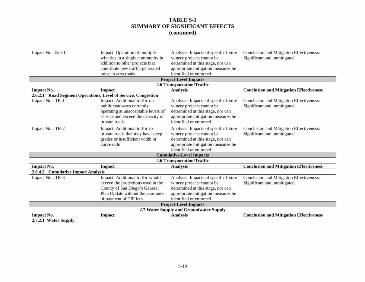
TABLE S-1 SUMMARY OF SIGNIFICANT EFFECTS
(continued)
Impact No.: NO-1 Impact: Operation of multiple wineries in a single community in addition to other projects that contribute new traffic-generated noise to area roads
Analysis: Impacts of specific future winery projects cannot be determined at this stage, nor can appropriate mitigation measures be identified or enforced
Conclusion and Mitigation Effectiveness: Significant and unmitigated
Project-Level Impacts 2.6 Transportation/Traffic
Impact No. Impact Analysis Conclusion and Mitigation Effectiveness 2.6.2.1 Road Segment Operations, Level of Service, Congestion Impact No.: TR-1 Impact: Additional traffic on
public roadways currently operating at unacceptable levels of service and exceed the capacity of private roads
Analysis: Impacts of specific future winery projects cannot be determined at this stage, nor can appropriate mitigation measures be identified or enforced
Conclusion and Mitigation Effectiveness: Significant and unmitigated
Impact No.: TR-2 Impact: Additional traffic to private roads that may have steep grades or insufficient width or curve radii
Analysis: Impacts of specific future winery projects cannot be determined at this stage, nor can appropriate mitigation measures be identified or enforced
Conclusion and Mitigation Effectiveness: Significant and unmitigated
Cumulative-Level Impacts 2.6 Transportation/Traffic
Impact No. Impact Analysis Conclusion and Mitigation Effectiveness 2.6.4.2 Cumulative Impact Analysis Impact No.: TR-3 Impact: Additional traffic would
exceed the projections used in the County of San Diego’s General Plan Update without the assurance of payment of TIF fees
Analysis: Impacts of specific future winery projects cannot be determined at this stage, nor can appropriate mitigation measures be identified or enforced
Conclusion and Mitigation Effectiveness: Significant and unmitigated
Project-Level Impacts 2.7 Water Supply and Groundwater Supply
Impact No. Impact Analysis Conclusion and Mitigation Effectiveness 2.7.2.1 Water Supply
S-10

TABLE S-1 SUMMARY OF SIGNIFICANT EFFECTS
(continued)
S-11
Impact No.: WS-1 and WS-3 Impact: Increase in water demand on lands not currently irrigated from existing entitlements and resources
Analysis: Impacts of specific future winery projects cannot be determined at this stage, nor can appropriate mitigation measures be identified or enforced
Conclusion and Mitigation Effectiveness: Significant and unmitigated
2.7.2.2 Groundwater Supply Impact No.: WS-2 and WS-4 Impact: Increase in groundwater
demand where none currently exists or where groundwater supplies are limited and/or yields of groundwater are low
Analysis: Impacts of specific future winery projects cannot be determined at this stage, nor can appropriate mitigation measures be identified or enforced
Conclusion and Mitigation Effectiveness: Significant and unmitigated

TABLE S-2 COMPARISON OF PROJECT ALTERNATIVE IMPACTS TO SIGNIFICANT PROPOSED PROJECT IMPACTS
Impact Category No Project (No Amendment)
Alternative Enhanced Ministerial Enforcement
Alternative Limited Five-Year By-Right
Alternative Air Quality Less Similar (Simultaneous Construction)
Less (Emissions from Traffic) Similar-Near Term
Less-Beyond Five Years Biology Less Less Similar-Near Term
Less-Beyond Five Years Cultural Resources Less Less Similar-Near Term
Less-Beyond Five Years Water Quality Less Less (Agricultural Runoff)
Similar (Erosion/Sedimentation) Similar-Near Term
Less-Beyond Five Years Noise Less Similar Similar - Near Term
Less Beyond Five Years Traffic Less Similar Similar-Near Term
Less-Beyond Five Years Water Supply / Groundwater Supply Less Less (Potable Water Supply)
Similar (Groundwater Supply) Similar-Near Term
Less-Beyond Five Years
S-13

1.0 Project Description, Location, and Environmental Setting
1-1
CHAPTER 1.0 PROJECT DESCRIPTION, LOCATION, AND ENVIRONMENTAL SETTING
1.1 Project Objectives
The County of San Diego recognizes the significance of agriculture as an important local industry, ranking fifth as a component of San Diego County’s economy. The County of San Diego also recognizes that within the agricultural industry there is a potential to assist development of local wineries to make greater use of a locally grown crop. The allowance of some wineries to provide tasting rooms and on-site sales to the public would help the economic growth of the San Diego wine industry resulting in the increase in the production of a competitive agricultural commodity. A byproduct of this growth is that landowners may be encouraged to retain agricultural lands in production as vineyards due to the potentially increased economic viability of the crop. Because vineyards typically require less irrigation than many other field crops, the County of San Diego could experience a decrease in agricultural water consumption.
The specific objectives for the Proposed Project are as follows:
1. Encourage the growth of the wine industry in the County of San Diego.
2. Streamline and clarify the approval process for the operation of wineries.
3. Provide regulatory tiers that correspond to the different major phases in the growth of a winery, while providing for operational flexibility and incremental growth within each tier.
4. Encourage property owners to retain agricultural lands in production.
5. Encourage the farming of crops that use less water.
6. Provide a winery category that allows wine tasting and direct sales to the public by right.
7. Minimize the potential for conflicts between winery operations and adjacent land uses.
8. Support local agriculture and encourage the production of local grapes.
9. Create a market for the use of locally grown grapes.
In order to allow the County of San Diego to compete successfully with other known wine-producing areas, the County of San Diego is proposing to amend the existing regulations and encourage the growth of the winery industry.
1.2 Project Description
The Proposed Project is an amendment to the County of San Diego Zoning Ordinance introducing a new category, “Packing and Processing: Small Winery” Use Type (Small Winery). The proposed amendment also revises the regulations for two existing categories, “Packing and Processing: Wholesale Limited Winery” (Wholesale Limited

1.0 Project Description, Location, and Environmental Setting
1-2
Winery) and “Packing and Processing: Boutique Winery” (Boutique Winery) Use Types. The Project also proposes to revise text contained in the descriptions of the (18) Multiple Rural Use and (24) Impact Sensitive Land Use Designations of the Regional Land Use Element. By itself, the proposed Zoning Ordinance amendment would have no direct impacts on the environment because the project includes no specific proposals for new or expanded wineries. Therefore, this Environmental Impact Report (EIR) focuses on the indirect impacts that could result from new or expanded winery projects that could be proposed in the future under the Zoning Ordinance amendment.
Background of the Wine Industry in the County of San Diego
According to the 2007 County of San Diego Crop Statistics and Annual Report, agriculture occurs on approximately 308,000 acres within the County of San Diego. With the second highest number of farms of all counties in the U.S (5,255), agriculture is conducted differently in San Diego County than agricultural operations in the majority of California because economically successful farming is conducted primarily on small farms producing high dollar value per acre crops. The County of San Diego ranks number one in California in dollar value per acre ($4,973 per acre) (County of San Diego 2007). The median farm size in San Diego County is five acres, with approximately 63 percent of San Diego farms ranging between one and nine acres in size. According to the American Farmland Trust (April 2009), the median size of farms statewide is 374 acres.
As urbanization expands into the unincorporated areas, land becomes increasingly scarce and land values climb. According to the California Chapter of the American Society of Farmland Managers and Rural Appraisers, the value of avocado and citrus farmland in the County of San Diego can range from $15,000 to $170,000 per acre depending on its potential for future urban development. The high land prices make land purchase for expansion infeasible for the majority of farmers. Additionally, high land prices make it prohibitive for new farmers to begin operations. Therefore, the ability to farm small parcels is crucial to the success of San Diego based agricultural enterprises, specifically the wine industry.
In San Diego County, the average grape yield is generally lower than the statewide average, which is estimated at approximately six tons per acre (http://calag.ucop.edu/ 0801JFM/pdfs/ca06201p12.pdf). Based on the County of San Diego Department of Agriculture Weights and Measures (AWM) crop reports over the last five years, local vineyards produce approximately two tons of grapes per acre. As described in greater detail below, the proposed amendments to the Zoning Ordinance would allow the production of up to 12,000 gallons of wine by right within agricultural zones. The proposed 12,000-gallon limit is equal to approximately 5,000 cases of wine. One case of wine includes twelve 0.750-liter bottles, or 2.38 gallons. The amount of wine produced by a ton of grapes is approximately 120 gallons. Consequently, it would take an estimated 100 tons or 50 acres of grapes to produce 12,000 gallons, the maximum allowed for the proposed Wholesale Limited and Boutique Winery use categories. Since 25 percent of grapes need be grown on-site under the proposed ordinance, it is estimated that future by-right wineries would need to produce a minimum of 25 tons of grapes on site (requiring a minimum of 12.5 acres) to reach the maximum allowed annual production level of 12,000 gallons of wine. The remainder for wine grapes may be imported in accordance with the ordinance.

1.0 Project Description, Location, and Environmental Setting
1-3
In the County of San Diego, grapes are usually harvested in the fall, from early September until the beginning of November. Harvesting is the picking of the grapes and is the first step in wine production. Harvesting can be performed by hand or by mechanical means. However, the small size of the average San Diego agricultural operation means that most harvesting is done manually. The cost of mechanical grape harvesters ($100,000 to $200,000 new), the fact that their use still requires workers, and the need to maintain the high quality of premium wine grapes makes their use in San Diego County unlikely. Grapes are traditionally picked into 30 pound boxes, and in most cases these boxes are consolidated into ½- or 2-ton bins for transport to the winery.
The process of winemaking begins with de-stemming and crushing of the grapes. De-stemming is the process of removing the grapes from the stem which holds the grapes and crushing is the process of gently squeezing the grapes and breaking the skins to start to release the contents of the grapes. In traditional and smaller-scale wine making, the harvested grapes are sometimes crushed by the use of inexpensive small-scale crushers which can de-stem at the same time. The next few steps in the winemaking process involve the fermentation of the grapes. During the fermentation process, yeast feeds on added sugars, producing carbon dioxide gas and alcohol. Thereafter, the wine is aged in either large stainless steel vessels or oak barrels for anywhere between three to six months. The wine is kept under an airlock in order to protect from oxidation. A process called cold stabilization is then used to reduce tartrate crystals in the wine, changing the appearance from a cloudy to clear liquid. A final dose of sulfite is then added to help preserve the wine and prevent unwanted additional fermentation in the bottle. The wine bottles are then sealed, traditionally with a cork, although other methods such as screw caps may also be used.
In addition to the vineyard harvest and making the wine, the winery business involves selling the wine. Wineries are required to be bonded by the U.S. Department of the Treasury, Alcohol and Tobacco Tax and Trade Bureau (TTB) and licensed by the California Department of Alcoholic Beverage Control (ABC) to produce, advertise, and sell wine or offer wines for tasting produced by other bonded wineries. A tasting room allows the public to taste wines and purchase wine directly from the winery.
Typical commercial grape crops require three years before the quality of the grapes is known. The quality of the grapes grown by individual growers and the region as a whole are factors in the marketing of wine produced. The TTB designates certain areas as American Viticultural Areas (AVA) to recognize that the grapes grown in a particular region are distinct. An AVA designation allows wines produced with grapes grown in a designated AVA to be labeled accordingly. San Pasqual Viticultural Area and Ramona Viticultural Area are the two recognized AVAs within the County of San Diego.
Recognition of AVAs assists winemakers in establishing a reputation for quality grape and wine production. Due to factors such as the varietals grown as well as the wine produced, a region can become known for quality wines and a destination for wine connoisseurs and the visitor industry. In established wine regions in California, such as Napa Valley, the wine industry draws visitors and has been an important component in the local economy and agricultural production (MFK Research 2005).

1.0 Project Description, Location, and Environmental Setting
1-4
1.2.1 Project’s Component Parts
Currently, the Zoning Ordinance identifies three categories of use types relating to the winery industry. Each category is regulated on a tiered scale, based primarily on the amount of wine produced. Other factors include on-site sales, tasting facilities, and public event availability. The three existing categories are as follows:
A Wholesale Limited Winery can produce less than or equal to 7,500 gallons of wine per year and is allowed by right within Limited Agriculture (A70) and General Agriculture (A72) Zones. This category of winery is limited to production only and is not allowed to provide on-site tastings.
A Boutique Winery can produce less than or equal to 12,000 gallons of wine per year and entertain public tastings subject to an Administrative Permit.
A Winery has no limits on the production of wine and can provide an array of public events and sales subject to a Major Use Permit.
The proposed amendments to the Zoning Ordinance are included as Appendix A. The text of the revised ordinance for various sections of the Zoning Ordinance is also displayed in Table 1-1. The text in both Appendix A and Table 1-1 is presented in strikeout and/or underline text to indicate deleted or proposed new language, respectively.
Table 1-2 provides a summary of the existing winery regulations. The proposed amendments do not affect Winery operations that may exist within other zones. Table 1-3 provides a summary of the proposed winery regulations. Most notably, the proposed amendments would allow certain activities for Wholesale and Boutique Wineries to occur by right. By right means that no discretionary zoning permit is required. By right does not mean that no other permits are required. Other permits or other regulations that may still be required include but are not limited to ministerial building permits and discretionary Grading Permits. These uses would also be subject to regulations from other agencies, including those relating to water quality and pesticide application. In addition, all wineries are required to hold a valid permit and bond issued by the TTB and a current 02 Winegrowers license issued by the ABC. The components of the proposed amendments are summarized below.
Proposed changes in the Zoning Ordinance shown in Table 1-1 would provide consistency for both A70 and A72 Zones and clarification that the ordinance applies to Small, Boutique, and Wholesale Limited Wineries.
The description of the Wholesale Limited, Boutique, and Winery Use Types are now in Section 1735 (Packing and Processing) of the Zoning Ordinance. Under this proposal, text has been added to establish maximum production for a Small Winery of less than or equal to 120,000 gallons of wine per year. A Small Winery may also include a tasting room and retail outlet as secondary uses. Information about the source of wine grapes, on-site structures, and other limitations has been consolidated into Section 6910 (Wholesale Limited, Boutique and Small Wineries) and is discussed below. Section 6252 (Exempt On-premise Signs) of the ordinance is proposed to be amended to allow for placement of one sign up to 12 square feet in size for Small Wineries.

1.0 Project Description, Location, and Environmental Setting
1-5
Proposed amendments to the Zoning Ordinance would also involve more substantive changes. As seen in Table 1-1, Section 6910 (Wholesale Limited, Boutique and Small Wineries) includes changes in the discretionary permit requirements, operations, and other limitations. All operating wineries in the County of San Diego must also comply with state and federal laws regarding the growing of grapes and the production and sale of wine (see Section 1.2.2 below). The proposed amendments are described below for each of the winery use types:
Wholesale Limited
Increase allowed production from 7,500 to less than or equal to 12,000 gallons of wine per year.
Wording has been added to clarify that on-site sales to the public are prohibited with regard to wine and other goods from the winery.
All of the existing standards and limitations are proposed to be relocated to Section 6910 from Section 1735.
The general result of these changes would be to increase the amount of wine production from 7,500 gallons per year to less than or equal to 12,000 gallons per year that could be done by right. Consistent with the existing conditions, no discretionary permit would be required for an existing Wholesale Limited Winery to increase production pursuant to this amendment.
Boutique
A Boutique Winery must operate as a Wholesale Limited Winery for at least one year prior to operating as a Boutique Winery.
The existing wine production limit (less than or equal to 12,000 gallons annually) remains unchanged.
Of the total fruit used in winemaking, a minimum of 75 percent shall be grown within San Diego County, a minimum of 25 percent shall be grown on the premises, and a maximum of 25 percent may be grown outside of San Diego County.
Boutique Wineries continue to share the same limitations on the size of on-site structure(s) used in the production of wine as Wholesale Limited Wineries, but are allowed one on-site tasting/retail sales room that may operate from 10:00 A.M. until legal sunset seven days a week. The tasting/retail sales room shall be accessory to wine production and shall not exceed 30 percent of the total square footage of the structure used for wine production.
Events, including but not limited to weddings and parties, and amplified sound are prohibited.
The sale and consumption of pre-packaged food is allowed on the premises. Catered food service is allowed, but no food preparation is allowed at a Boutique Winery.

1.0 Project Description, Location, and Environmental Setting
1-6
A minimum of six parking spaces shall be provided for customers and a minimum of three spaces shall be provided for employees and operations. No parking is allowed off the premises.
The on-site driveway and parking area shall not be dirt. The on-site driveway and parking area may be surfaced with chip seal, gravel, or an alternative surfacing material such as recycled asphalt suitable for lower traffic volumes.
Outdoor eating areas shall be limited to a maximum of five tables and provide seating capacity for no more than 20.
Vehicles with a capacity in excess of 12 passengers are not allowed.
The general result of these changes would be the allowance of a Boutique Winery to provide on-site tasting and direct sales to the public by right. No discretionary permit would be required for the establishment of a Boutique Winery or for an existing Wholesale Limited Winery to become a Boutique Winery. There would be no change to the maximum allowed wine production, which would remain at less than or equal to 12,000 gallons or approximately 5,000 cases.
Small Winery
A Small Winery shall have a valid permit and bond issued by the U.S. Department of the Treasury Alcohol and Tobacco Tax and Trade Bureau, and a current 02 Winegrowers license issued by the California Department of Alcoholic Beverage Control. The applicant shall disclose if any other licenses issued by the California Department of Alcoholic Beverage Control will be relied upon for operations at the Small Winery.
Wine production shall be limited to less than or equal to 120,000 gallons annually.
Of the total fruit used in winemaking, a minimum of 50 percent shall be grown within San Diego County, a minimum of 25 percent shall be grown on the premises, and a maximum of 50 percent may be grown outside of San Diego County.
The sale and consumption of pre-packaged food is allowed on the premises. Refrigeration shall be approved by the County of San Diego Department of Environmental Health. Catered food service is allowed, but no food preparation is allowed at a Small Winery. Catered food service includes the provision of food that is ready to eat and that has been prepared off the Small Winery premises.
Events, including but not limited to weddings and parties, may be allowed upon the making of the findings for approval of an Administrative Permit (see Section 1.5.1. Project Approvals/Permits).
The type of operation proposed to be classified as a Small Winery is currently classified as a Winery Use Type and is allowed with a Major Use Permit. The Proposed Project would change the type of permit required to an Administrative Permit. The processing requirements for an Administrative Permit are similar to those for a Major Use Permit.

1.0 Project Description, Location, and Environmental Setting
1-7
Each application for a Small Winery would be evaluated under the neighborhood compatibility, General Plan, and California Environmental Quality Act (CEQA) findings as required in the Zoning Ordinance for a Major Use Permit, and conditions could be added to an Administrative Permit to address any site specific concerns, just as conditions are added to a Major Use Permit.
In addition, the Small Winery Use Type would be more restrictive than the Winery Use Type in that a Small Winery has a specific limit on wine production (less than or equal to 120,000 gallons/50,000 cases per year) while the Winery Use Type does not have this limitation. Furthermore, the Small Winery would be allowed only in the A70 and A72 Zones with an Administrative Permit, whereas the Winery is allowed in many more zones with a Major Use Permit, and is allowed by right in the Industrial Zones. The Administrative Permit is a discretionary permit that would be subject to CEQA. The type of CEQA review required would be determined on a case-by-case basis, just as it is for a Major Use Permit. Therefore, the permit process for the proposed Administrative Permit would require CEQA review similar to the existing permit process for a Major Use Permit. Because the proposed Zoning Ordinance Amendment relating to Small Wineries would not change this process, the proposal would have no impact.
It should be noted that no changes are proposed to the “Packing and Processing: Winery” (Winery) Use Type. This includes the crushing of grapes, berries, and other fruits and fermentation, storage, and bottling of wine from fruit grown on or off the premises. A Winery may also include a tasting room and retail outlet as secondary uses. The Winery Use Type is allowed upon approval of a Major Use Permit in the Rural Residential (RR), Recreation-Oriented (RRO), Residential-Commercial (RC), A70, A72, Limited Control (S87), Specific Plan Area (S88) and General Rural (S92) Use Regulations. A Winery is allowed by right in all Industrial Use Regulations.
Although the proposed amendment would allow a Boutique Winery by right, all Boutique Wineries would be subject to specified standards and limitations. Certain standards for Boutique Wineries, listed as environmental design considerations in Table 1-4, have been incorporated into the proposed ordinance language and would reduce impacts associated with land use and neighborhood character, noise, and traffic. In addition, Small Wineries would be required to meet the conditions of an Administrative Permit, and Wineries would be required to meet the conditions of a Major Use Permit. As discussed below in Section 1.5.1, additional permits may be required based on the site conditions, proposed grading and construction, or pesticide use. In addition, active agricultural activities must comply with requirements of the Regional Water Quality Control Board (RWQCB).
General Plan Amendment - Regional Land Use Element (RLUE)
The Project proposes to amend the (18) Multiple Rural Use Land Use Designation of the RLUE, to add the text underlined below to the fourth paragraph on page II-21:
“Other than a single-family home on an existing lot, it is not intended that any development occur unless the proposed development has been carefully examined to assure that there will be no significant adverse environmental impacts, erosion and fire problems will be minimal, and no urban levels of service will be required. Notwithstanding any provision of this paragraph to the contrary, a public improvement project may be approved when there are significant adverse

1.0 Project Description, Location, and Environmental Setting
1-8
environmental impacts if the County decision-maker adopts findings which demonstrate that the significant adverse environmental impacts have been mitigated to the greatest extent feasible and that the project is necessary to protect the public health and safety. This paragraph does not apply to Ordinance No. ______, an amendment to the Zoning Ordinance related to the Small Winery, Wholesale Limited Winery and Boutique Winery use classifications, or to any uses allowed pursuant to this ordinance.”
The Project also proposes to amend the (24) Impact Sensitive Land Use Designation of the RLUE to add the text underlined below to the fourth paragraph on page II-31:
“Other than a single-family home on an existing lot, it is not intended that any development occur unless the proposed development has been carefully examined to assure that there will be no significant adverse environmental impacts, and erosion and fire problems will be minimal. This paragraph does not apply to Ordinance No. ______, an amendment to the Zoning Ordinance related to the Small Winery, Wholesale Limited Winery and Boutique Winery use classifications, or to any uses allowed pursuant to this ordinance.”
1.2.2 Technical, Economic, and Environmental Characteristics
Wineries are subject to local, State and Federal regulations. The growing of grapes and other fruit in vineyards and orchards is classified in the Row and Field Crops Use Type (Zoning Ordinance, Section 1720). The Row and Field Crops Use Type is a use that is allowed by right in the A70 and A72 Zones. No discretionary permit is required to grow these crops within these zones.
Currently, Wholesale Limited wineries which produce more than 7,500 gallons per year and Boutique Wineries producing more than 12,000 gallons per year require either an Administrative Permit or a Major Use Permit from the County of San Diego. If the winery produces less than or equal to 7,500 gallons and also operates with on-site sales to the public, tasting room, food service, events, or similar public activities, a discretionary permit would also be required (see Table 1-2).
Federal and State regulations require wineries to be bonded and licensed. A bonded and licensed winery is an operation with a permit from the TTB. Formerly the Bureau of Alcohol, Tobacco and Firearms, the TTB collects taxes and enforces production and advertising of alcohol. Wineries are required to hold a 02 Winegrower license from ABC, the agency which regulates the sales and manufacture of alcoholic beverages in California. The ABC Act is contained within Section 23000 of the Business and Professions Code of the California Code of Regulations. Also, in order to offer wines for tasting produced by other bonded wineries in the County of San Diego, a winery must have been issued and comply with the requirements of a Duplicate Winegrowers Type 02 license from the ABC.
In order to analyze potential impacts associated with implementation of the Proposed Project, it was necessary to collect information pertaining to existing winery operations within the County of San Diego. Interviews were conducted with representatives of three existing wineries. The purpose of the interviews was to determine the following:

1.0 Project Description, Location, and Environmental Setting
1-9
Potential for expansion—if there was a potential for expansion of land for vineyards, if an expansion would affect native habitat or sensitive resources in undisturbed areas, and what actions would be required for the expansion;
Operations of a retail and wine-tasting component—if the addition of a retail and wine-tasting component would involve additional equipment, staff, and visitors, and times of year and hours during the week when these activities would likely take place; and
Process of grape growing and wine production—what types of permit conditions and environmental studies are associated with the winery, what is the estimated water use, wastewater production, pesticide application, etc. associated with vineyards.
To further collect information about representative characteristics of local vineyards the County of San Diego conducted a survey of existing permitted wineries in San Diego and Temecula. Of the 27 surveys sent out to wineries in San Diego, 19 surveys were returned. Twenty-three surveys were sent to wineries in Temecula and six responses were returned. Several of the returned surveys omitted the name and location of the winery as providing this information was made optional. The surveys were also made available on the County of San Diego’s website. Winery owners in the County of San Diego who completed the surveys represented operations that ranged in size from six to 70 acres. Their production ranges from 188 cases per year to 20,000 cases per year. The largest to respond was Orfila Vineyards and Winery, located outside the unincorporated area, within the City of San Diego. The majority of the respondents produce less than 3,600 gallons/1,500 cases per year. For comparison, this is less than the approximate 12,000 gallons/5,000 cases per year that would be allowed under the proposed Tiered Winery Ordinance Amendment for the Wholesale Limited Winery Use Type which currently limits operations to less than or equal to 7,500 gallons or approximately 3,150 cases. The allowable production level for Boutique Wineries would remain the same with or without the proposed amendment.
The information collected in the surveys included the following topics and offer insight on the variability of winery and vineyard operations in the region. Survey results providing a general reference were used. The complete survey results are included as Appendix B of this EIR.
Years in operation Size of the parcel of land winery is located on Size of winery facility and buildings Number of acres of vineyards Amount of wine produced per year (total gallons and cases) Tons of grapes produced per year Amount of grapes that are imported and from where Public tasting room or wholesale winery Times/Days that tasting room is open to the public Busiest month for visitors Number of visitors per day/week Type, frequency, and size of events are held at the winery

1.0 Project Description, Location, and Environmental Setting
1-10
Visitors from nearby communities, the County of San Diego or outside of the County of San Diego
Number of employees and their hours/shifts Number of deliveries or other vehicle trips per day/week (excluding customers) Increases/Decreases in vineyard acres in the last 1, 5 or 10 years Potential to increase vineyard size in near future Whether the vineyard converted natural vegetation, fallow fields, or another crop Type, application method, and frequency of fertilizer and pesticide use Type and size (horsepower) of equipment used to make or bottle wine Whether or not winery operator and/or employees have completed the voluntary
California Department of Alcoholic Beverage Control server awareness training (Licensee Education on Alcohol and Drugs [LEAD])
In order to specifically study the traffic on major roadways associated with the Proposed Project, wineries were categorized based on their location and setting as “Backcountry–Destination,” “Backcountry–Rural,” and “Suburban.” Backcountry–Destination winery types are located in a rural area with a variety of economic and tourist attractions. Backcountry—Destination wineries are estimated to be located an hour from metropolitan San Diego. Backcountry–Rural wineries are also estimated to be located an hour from metropolitan San Diego but because tourists and visitors perceive that these areas are more removed from metropolitan centers, Backcountry–Rural winery types are areas with a less developed tourism industry. Suburban wineries are located within an hour of metropolitan centers.
Traffic counts were conducted for wineries in each of the three categories. Because there are no wineries currently in operation in the County of San Diego which would fall under the suburban category, a winery in Temecula was used for performing traffic counts. This allowed collection of traffic counts for a winery producing less than or equal to 12,000 gallons (or equivalent 5,000 cases) per year, the maximum allowed under the proposed amendments to the Wholesale Limited and Boutique Winery Use Types.
1.3 Project Location
The proposed amendment would apply only to the A70 and A72 Zones in the unincorporated areas of the County of San Diego. Currently, there are 269,700 acres of privately-owned land zoned A70 and 171,300 acres of privately-owned land zoned A72; therefore, the total project area is approximately 441,000 acres. These areas are located primarily in the eastern portion of the County of San Diego as shown on Figure 1-1.
The County of San Diego is divided into 24 Community Plan Areas (CPAs) or Subregional Plan Areas. The project area is located within multiple CPAs as shown on Figure 1-2. Of the 24 plan areas, Otay and Pepper Drive–Bostonia do not contain a portion of the project area. All other CPAs contain lands zoned A70 and/or A72. The location of wineries is shown on Figure 1-3. The number of existing wineries in each area (i.e., A70 and A72 Zones) is listed on Table 1-5.
TABLE 1-5 WINERIES WITHIN THE PROJECT AREA
Area Winery Type Number
Alpine Wholesale Limited 2

1.0 Project Description, Location, and Environmental Setting
1-11
Bonsall Wholesale Limited 1 Fallbrook Wholesale Limited 2 Jamul-Dulzura Wholesale Limited 2* Julian Major Use Permit 3*
Major Use Permit 2 North County Metro
Wholesale Limited 1 Major Use Permit 2
North Mountain Wholesale Limited 2 Major Use Permit 1
Ramona Wholesale Limited 17
Boutique 1 Valley Center Wholesale Limited 1 Pala–Pauma Wholesale Limited 1
Total 38 *Number of permitted wineries includes non-operational wineries.
Five wineries located within the project area are operating under a Major Use Permit and include tasting rooms. A Major Use Permit may restrict the amount of wine produced, the sale of wine produced off-site, and/or the number of public events and the hours of admission for visitors. Additional requirements such as those listed below are common conditions for individual Major Use Permit permits:
Outdoor light fixtures shall reflect light downward and away from adjacent uses;
Parking areas and driveways shall be maintained; and
Loudspeakers and sound amplification systems shall be prohibited.
Due to the conditions or character of roadways and driveways, some Major Use Permit conditions limit the size of delivery trucks, the number of deliveries per year, the type of vehicles on the roads, and parking areas. The conditions may also require winery operators to install signage or safety lighting, improve intersections or roadways, or restrict visitors during period of heavy rain.
Grapes are grown in the majority of communities in the County of San Diego. Table 1-6 shows the acres of grapes grown in each area. Shaded text identifies those locations where grapes are grown within the project area (A70 and A72 Zones). As shown in Table 1-6, there are approximately 179.5 acres of grapes grown within the project area. Of these, almost half of the grapes are grown in North Mountain and Ramona. Combined with Fallbrook and Valley Center, these four areas grow 80 percent of the grapes within the project area and approximately 50 percent of the total acres of grapes grown in all of the County of San Diego. Figure 1-4 shows the approximate distribution of grape growers currently registered with the AWM. Vineyards located outside the A70 and A72 Zones (currently about 89 acres) are allowed by right in almost every other zone.
Wine production at Wholesale Limited and Boutique Wineries would be limited to less than or equal to 12,000 gallons under the proposed ordinance amendment. Based on estimated yield per acre and responses received during interviews with local operators, an estimated 13 acres of grapes would be required to produce 12,000 gallons of wine. Since 25 percent of a winery’s grapes must be grown on-site, wineries operating at maximum production levels would be expected to require just over three acres of vineyards. However, most if not all of the operating wineries in the unincorporated areas of the County (including those operating under an existing Major Use Permit and

1.0 Project Description, Location, and Environmental Setting
1-12
interviewed for this EIR) produce less than 12,000 gallons of wine. Consequently, the number of acres of on-site vineyards would be expected to vary (Appendix B).
The highest number of Wholesale Limited Wineries (17) in the County of San Diego are located in Ramona. Ramona also has the second largest area of grape crops within the project area and is located within a designated AVA. The location of both wineries and grape growers are shown on Figure 1-5. For the above reasons, Ramona represents a good example of the current trends in the wine-producing areas of the County of San Diego.
1.4 Environmental Setting
The County of San Diego is bordered on the west by the Pacific Ocean, on the east by Imperial County, on the north by Orange and Riverside Counties, and on the south by Mexico. The County of San Diego terrain varies from west to east, sloping up from the ocean, transitioning to rolling hills and then steep mountains that finally give way to flat to gently sloping deserts.
The urban areas of the County of San Diego are predominantly in the west, either surrounding the City of San Diego or interspersed between the City of San Diego and the cities in Orange and Riverside Counties. Further east, the land is less developed, with the largest developed area in the eastern portion of the County of San Diego being the community of Borrego Springs. The eastern portion of the County of San Diego is unincorporated and mostly undeveloped. The areas that have been developed in the eastern portion of the County of San Diego have been predominantly developed in a rural fashion, with large lot sizes, agricultural or related uses, and limited infrastructure and service availability.
The County of San Diego is serviced by the Interstates 5, 15, 163, and 805 that all run north/ south throughout the western portion of the County of San Diego; Interstate 8 runs east/west throughout the southern portion of the County. Additionally, the County of San Diego is serviced by State Highways 76, 78 and 94 that all run east/west across the County of San Diego, and State Highways 67 and 79 run north/south throughout the western and eastern portions of the County of San Diego, respectively.
The County of San Diego is a generally semi-arid environment and supports a wide range of habitats and biological communities. These habitats and communities range from grasslands to shrublands to coniferous forests. Additionally, these habitats and communities vary greatly depending on the ecoregion, soils and substrate, elevation, and topography.
The County of San Diego is the most southwestern county in the state and enjoys a subtropical climate that optimizes the production of a variety of crops that may be more difficult to produce elsewhere. The mild climatic conditions allow agricultural production to occur year-round in most of the western areas of the County of San Diego; that is, the Coastal Plains and the Foothills. However, the County of San Diego’s unique and varied topography creates a wide variety of microclimates or “plant climate zones.” Several factors play a role in determining plant climate zones, including elevation; minimum winter temperature and frost occurrence; maximum summer temperatures; rainfall amount and distribution; humidity; length of day light, and light intensity.

1.0 Project Description, Location, and Environmental Setting
1-13
The project area, much like the County of San Diego, lies within several plant climate zones, which is reflected in the diversity of agricultural commodities. Farmers in the County of San Diego produced 45 different crops with a value of over $1 million dollars in 2007. With more than 308,000 acres across the entire County of San Diego in agricultural production, grape crops are a small percentage of all crops, totaling only 328 acres both in and out of the project area (County of San Diego 2007).
1.5 Intended Uses of the EIR
This Project EIR is an informational document which will inform public agency decision-makers and the public generally of the significant environmental effects of a project, identify possible ways to minimize the significant effects, and describe reasonable alternatives to the project. A project EIR has been prepared because the proposed Tiered Winery Ordinance Amendment would allow the by-right operation of expanded Wholesale Limited wineries, and by-right operation (including retail sales and wine tasting to the public) of Boutique Wineries in conformance with limitations without further discretionary approval.
This EIR has been prepared in accordance with the requirements of the County of San Diego Environmental Impact Report Format and General Content Requirements (2006), and the statute and guidelines of the CEQA Public Resources Code Sections 21000 et seq., and the California Code of Regulations, Sections 15000, et seq. As the lead agency, the County of San Diego will use this EIR to decide whether to approve the Proposed Project.
The Notice of Preparation (NOP) released for public review in October 2008 is included as Appendix C. The Initial Study prepared for the Proposed Project is also included as Appendix C to this EIR. This EIR addresses issues identified in the Initial Study and comments received regarding the NOP.
1.5.1 Project Approvals/Permits
As shown in Table 1-7, the only discretionary action associated with the Proposed Project is approval of an amendment to the Zoning Ordinance and certification of this EIR by the County of San Diego. Table 1-7 shows the range of additional approvals that could be required for future projects under the amended ordinance. For example, any agricultural grading or clearing would require a permit based on the amount of soil to be moved or the vegetation to be cleared (Appendix A1). Active agricultural activities would be required to comply with water quality regulations and, as of January 1, 2012, implement a water quality reporting program in conformance with RWQCB Conditional Waiver No. 4. In addition, growers must obtain authorization for pesticide application from AWM. More detailed description of requirements is included in the applicable issue discussion in Chapter 2 (e.g., land use, water quality, hazards/hazardous resources).
Some existing and future Wholesale Limited and Boutique Wineries would be operated out of existing buildings on developed lots. Some future winery facilities may be built on lands that have been previously cleared or developed. However, some new or expanded vineyards or wineries would require ground disturbance or expansion into lands that contain sensitive resources (i.e., jurisdictional resources, native habitats, historic structures, etc.). In these cases additional environmental review and/or discretionary permits would be required.

1.0 Project Description, Location, and Environmental Setting
1-14
County of San Diego and RWQCB permits are discussed below and referenced in the environmental issue sections discussed in this EIR. The discussion of additional permits that would be required when biological resources are present is included under Subchapter 2.2, Biological Resources. Depending on site conditions and proposed improvements, other permits may be required for future projects (e.g., on-site wastewater system permits and well permits); therefore, the list in Table 1-7 is not exhaustive. Discretionary and ministerial permits are subject to regional surface water and storm water permitting regulations including the County of San Diego’s Watershed Protection, Stormwater Management, and Discharge Control Ordinance (WPO).
Administrative and Major Use Permits. Wholesale Limited and Boutique Wineries, which could open and operate by right, would be located in areas zoned A70 or A72 within the County of San Diego. Small Wineries and Wineries would be subject to the Administrative Permit process and Major Use Permit process, respectively. Administrative and Major Use Permits are discretionary actions. Although the timing of the permit applications differ, the processing requirements are similar in that each application would be evaluated under the neighborhood compatibility and General Plan findings as required in the Zoning Ordinance. Both Administrative and Major Use Permits may contain conditions of approval to address any site specific concerns. The process for Administrative and Major Use Permits involves a review under CEQA and findings that the project complies with zoning requirements and is compatible with adjacent uses. Both permits also require public noticing to property owners within 300 feet and to a minimum of 20 different property owners.
These two permits differ in that Major Use Permits require an initial submittal that includes concept landscaping and grading plans. Administrative Permits do not require the preparation of a Stormwater Management Plan, although they are still subject to all applicable stormwater regulations (enforced during building permit process). Decisions to grant Administrative Permits do not require a public hearing unless specifically requested by the applicant or other affected person; whereas Major Use Permits are under the jurisdiction of the County Planning Commission. Both permit types are subject to the Resource Protection Ordinance (RPO). Currently, applicants requesting an Administrative Permit for a Boutique Winery must submit information and photographs demonstrating that there is a productive vineyard on the site which meets the fruit-origin requirements. Information in the application must also detail where the fruit used in wine making comes from and how much is grown on premises.
Future projects for specific winery operations would also be subject to the requirements listed for each classification in Table 1-3.
Building and Demolition Permits. If building or removal of any structure is required in order to construct a tasting room or expand winery operations, future projects may require either a building or demolition permit. These are ministerial permits from the County of San Diego, but applicants must adhere to applicable regulations. The exact requirement for a building permit depends on the type of structure being proposed (e.g., farm building, residence, commercial structure, etc.). At a minimum, improvements would need to be completed to existing buildings to meet the Building Code requirements for public occupancy.
Among the various conditions that must be met for a demolition permit, pursuant to the Integrated Waste Management Act, the County of San Diego diverts at least 50 percent

1.0 Project Description, Location, and Environmental Setting
1-15
of solid waste from landfills by requiring applicants to develop a plan for recycling construction and demolition debris. Applicants estimate the volume or weight of materials for disposal in order to develop a plan for diversion, recycling, or reuse, also known as a Debris Management Plan.
Grading Permits. The County of San Diego’s Grading, Clearing and Watercourses Ordinance (Grading Ordinance) is contained in Title 8, Division 7 of the Code of Regulatory Ordinances. A permit is required under certain circumstances for projects involving grading, clearing, and/or removal of natural vegetation. An Agricultural Grading Permit (Section 87.205) or Agricultural Clearing Permit (Section 87.506) would be required if the area to be graded or cleared is to be used exclusively for agricultural production, and has not been in agricultural production for at least one of the last five years. Also, the proposed agricultural grading must meet other requirements of the Grading Ordinance, including requirements regarding sensitive areas, setbacks, and stormwater and dust control standards. Under the ordinance, there are requirements for grading that might affect a watercourse or result in cut slopes steeper than 1.5:1. Compliance with the WPO must also be demonstrated. Agricultural Grading and Clearing Permits are considered under the Administrative Permits process by the County of San Diego and would therefore require discretionary review and compliance with CEQA.
Pesticide Regulation Application Permit. AWM administers the Pesticide Regulation Program in the County of San Diego. The Pesticide Regulation Program is discussed further in Section 3.1.3.1 as an existing regulation under Contamination and Hazardous Materials. This program is in place to ensure that pesticides are used in an appropriate and responsible manner that protects the environment, the public, and the employees of businesses that handle pesticides. Permits are required anytime pesticides are applied to agricultural lands, whether by an owner/operator or a contracted entity. If the agricultural commissioner determines that the permit would likely cause a substantial adverse impact, the commissioner must determine if there is a feasible alternative (including no pesticide application) or a feasible mitigation measure that would substantially reduce the adverse impact. The AWM maintains a database of pesticide applications in the County which includes the name and address of the applicant, date of application, crop type, and type of pesticide used. AWM also performs inspections to ensure that required records are kept and that pesticides are stored and applied properly.
Conditional Waiver No. 4. Section 13269 of the Porter-Cologne Water Quality Control Act allows the San Diego RWQCB to waive the requirements for specific discharges or specific types of discharge, provided the waiver is consistent with the Water Quality Control Plan for the San Diego Basin (9) (Basin Plan) and is in the public interest. Particularly applicable to the Proposed Project is Conditional Waiver No. 4 which pertains to discharges from agricultural (and nursery) operations. Under Conditional Waiver No. 4, specific types of discharges that may be eligible include: discharges of plant crop residues to land; discharges of storm water runoff; discharge of amendments or mulches to soil; and discharges of agricultural or nursery irrigation return water. The waiver requires the use of BMPs to ensure that no pollutants leave the farm in irrigation or storm-water discharges. In addition, agricultural and nursery operations must prepare a Monitoring and Reporting Program Plan (MRPP) and Quality Assurance Project Plan, conduct monitoring, and submit a Monitoring Program Report. Implementation of required plans and reports are in place to protect water quality.

1.0 Project Description, Location, and Environmental Setting
1-16
Section 402 Permit. Section 402 of the Clean Water Act (CWA) and Section 13370 of the California Porter Cologne Water Quality Control Act establish the National Pollutant Discharge Elimination System (NPDES) permit system to regulate point and nonpoint source waste discharges to surface waters. The program requires that NPDES permits prescribe conditions of discharge to protect beneficial uses of receiving water. The NPDES program requires projects that disturb more than one acre of land to obtain coverage under the general permit governing construction activities. In these cases, project applicants are required to prepare a Storm Water Pollution Prevention Plan (SWPPP) and submit it for review to the RWQCB prior to commencing construction. The SWPPP details the site-specific BMPs that control erosion and sedimentation and maintain water quality during the construction phase. The SWPPP also contains a summary of the structural and non-structural BMPs to be implemented during the post-construction period. A comprehensive listing of erosion and sediment control BMPs may be found in the WPO. The NPDES program is discussed further in Section 2.4.1.1, Hydrology and Water Quality.
Section 401 Water Quality Certification. The RWQCB acts to protect the quality of surface waters through water quality certification as specified in Section 401 of the CWA (33 United States Code [U.S.C.] 466 et seq.). Section 401 specifies that certification from the State is required for any applicant requesting a federal license or permit to conduct any activity including, but not limited to, the construction or operation of facilities that may result in any discharge into navigable waters. As part of this process, the applicant must obtain certification from the state verifying that the activity complies with the state's water quality standards included in the Basin Plan. These standards apply to water quality objectives for constituent concentrations or narrative statements about water quality levels needed to support the most sensitive beneficial uses that have been designated for a water body. The objectives vary in applicability depending on the beneficial uses of the particular water body.
1.5.2 Related Environmental Review & Consultation Requirements
Proposed amendments to the Zoning Ordinance do not require related environmental review or consultation by any other agencies. Future actions taken in accordance with the proposed amendments may require clearing, Grading, or building permit approvals from the County of San Diego for new construction or other coordination depending on the action.
1.6 Project Inconsistencies with Applicable Regional and General Plans
Future operations in accordance with the proposed amendments would not result in any inconsistencies with applicable Regional or General Plan documents as they relate to plan objectives and policies applicable to the Agricultural Use Regulations. The Proposed Project involves an amendment to existing Zoning Ordinance language governing the growing and packing and processing of wine grapes within lands already zoned for agriculture and provides for retail and wine-tasting operations at existing wineries producing less than or equal to 12,000 gallons/5,000 cases of wine annually. These changes are intended to encourage the expansion of winery operations and vineyards to accommodate a growing agricultural use in conformance with the adopted plan. The proposed amendments would modify the Zoning Ordinance as it relates to winery operations only.

1.0 Project Description, Location, and Environmental Setting
1-17
Much of the area zoned A70 or A72 that would be affected by the proposed Zoning Ordinance Amendment, occurs within the (18) Multiple Rural Use and (24) Impact Sensitive Land Use Designations of the RLUE. The descriptions for these two designations state that it is not intended that any development occur (other than a single family home) unless that development has been carefully examined to assure there will be no significant adverse environmental impacts. However, the EIR concludes that the Proposed Project may have significant and unmitigable impacts to air quality, biological resources, cultural resources, water quality, noise, transportation/traffic, water supply and groundwater supply. Therefore, the Project is inconsistent with the description of these two Land Use Designations in the RLUE. The General Plan Amendment is proposed to amend the text contained in the descriptions of the (18) Multiple Rural Use and (24) Impact Sensitive Land Use Designations of the Regional Land Use Element to allow land uses to occur in these two designations related to the proposed Zoning Ordinance Amendment.
1.7 Cumulative Impacts Analysis Methodology - Buildout Projections of the County of San Diego General Plan (Summary of Projections)
The State CEQA Guidelines (Section 15355) define a cumulative impact as “an impact which is created as a result of the combination of the project evaluated in the EIR together with other projects causing related impacts.” The Guidelines further state that “an EIR should not discuss impacts which do not result in part from the evaluated project.”
Section 15130(a) of the State CEQA Guidelines requires a discussion of cumulative impacts of a project “when the project’s incremental effect is cumulatively considerable.” Cumulatively considerable, as defined in Section 15065(c), “means that the incremental effects of an individual project are considerable when viewed in connection with the effects of past projects, the effects of other current projects, and the effects of probable future projects.”
The evaluation of cumulative impacts is required by Section 15130(b)(1) to be based on either (A) “a list of past, present, and probable future projects producing related or cumulative impacts, including, if necessary, those impacts outside the control of the agency,” or (B) “a summary of projections contained in an adopted plan or related planning document, or in a prior environmental document which has been adopted or certified, which described or evaluated regional or area wide conditions contributing to the cumulative impact.” Since lands zoned A70 and A72 are located throughout the County of San Diego, it is difficult to use the list of projects approach. Between March 2004 and July 2008, more than 2,450 permit applications for discretionary projects were processed for the unincorporated portion of the County of San Diego (Table 1-8). Discretionary projects include Administrative Permits, Tentative Parcel Maps (four lots or fewer or four lots plus a Designated Remainder Parcel), Tentative Maps, Major and Minor Use Permits, Reclamation Plans, Site Plans, Rezones, General Plan Amendments, Specific Plans, Agricultural Preserves, Vacations, Habitat Loss Permits and Noise Variances.
It is difficult to set reliable criteria to determine which projects should be considered for analysis purposes and which should be excluded given the Proposed Project’s broad geographic application. Within the County of San Diego, many projects are proposed which never go forward. Some are approved, but never developed. Consequently, this

1.0 Project Description, Location, and Environmental Setting
1-18
analysis relies on regional planning documents to provide a summary of projections, in accordance with Section 15130(b)(1)(B), to serve as a basis for the analysis of the cumulative effects of the Proposed Project.
The discussion of each issue includes an assessment of the potential cumulative impacts. For each issue the cumulative threshold is identified, the analysis/report on which the summary of projections is based is identified, and the potential for the project to represent a cumulatively considerable contribution to those projections is analyzed.
Regional planning and environmental documents that serve as the basis for the summary of projections include the following. For each issue, these are identified as they are employed.
County of San Diego EIR for Agricultural Issues General Plan Amendment and Implementing Rezone, as amended (Agricultural General Plan Amendment EIR),
Multiple Species Conservation Program (MSCP);
RWQCB Water Quality Control Plan for the San Diego Basin (Basin Plan);
San Diego Air Pollution Control District (SDAPCD) Regional Air Quality Strategies (RAQS) and portions of the State Implementation Plan (SIP) that relate to the San Diego air basin;
Metropolitan Water District (MWD) Regional Water Facilities Master Plan and San Diego County Water Authority (SDCWA) Urban Water Management Plans (UWMP); and
San Diego Association of Governments (SANDAG) Regional Comprehensive Plan (RCP).
Consistent with CEQA Guidelines, the EIR discusses incremental impacts of the project that are “cumulatively considerable” (Section 15130[a]). “Cumulatively considerable” means that the incremental effects of the project are considerable when viewed in connection with the effects of other past, current and probable future projects (Section 15065[c]). Where a cumulative impact is found not to be cumulatively considerable, the effect is not considered significant and a brief explanation is provided to explain the conclusion (Section 15130[a]).
The planning documents identified above, except for the SANDAG RCP, are available for review at the County of San Diego, Department of Planning and Land Use, 5201 Ruffin Road, Suite B San Diego, CA 92123. The SANDAG RCP is available for review at the SANDAG office located at 401 B Street, Suite 800, San Diego, California 92101 or on the SANDAG website http://www.sandag.org/?projectid=1&fuseaction=projects.detail)
SANDAG’s RCP considers individual jurisdictional land use decisions throughout San Diego County as a whole, assesses their collective impacts, and analyzes cumulative development trends into the future. The RCP builds upon elements of existing local

1.0 Project Description, Location, and Environmental Setting
1-19
general plans (including the County of San Diego General Plan) and regional infrastructure plans, and provides a model for future growth in the County.
Since its adoption in 1979, the County of San Diego General Plan has provided the long-term planning framework for future growth and the land use development pattern within the unincorporated areas of the County of San Diego. The Zoning Ordinance is a tool for implementation of General Plan policies. The General Plan is currently in the process of being updated, but the update has not been adopted. An EIR for the proposed General Plan is currently being prepared, but has not been released. Consequently, the proposed Tiered Winery Ordinance is being reviewed pursuant to the existing general plan, which is comprised of multiple documents containing regional elements, community/subregional plans, and Land Use and Circulation Element maps.
A broad examination of cumulative impacts involves considering the Proposed Project together with growth in the region. Development pursuant to the proposed Zoning Ordinance Amendment would occur in the context of the existing A70 and A72 Zones. It should be noted that processing and packing facilities necessary to support winery operations (planting, crop irrigation, harvesting, crushing, fermenting, bottling, and wholesale sales) are currently allowed uses within the A70 and A72 Zones. There is no restriction on the number of acres of grapes that may be planted, irrigated (other than cost or mandatory cutbacks by water agencies), or harvested. Construction of new buildings may currently be approved through a ministerial permit process (building permits). However, wine production requires additional permits from federal and state regulatory agencies as discussed above (see Section 1.5.1 above). For the purpose of this cumulative discussion, the major difference between activities that are currently allowed and the Proposed Project is that the maximum production of wine would be increased (from 7,500 gallons to less than or equal to 12,000 gallons) for Wholesale Limited Wineries and, for Boutique Wineries, retail sales and wine tasting would be allowed by right rather than requiring a discretionary Administrative Permit which would require additional environmental review.
1.8 Growth Inducing Effects
As described in Section 16162.2(d) of the CEQA Guidelines, growth inducing effects concern the ways in which the Proposed Project could foster economic or population growth, or the construction of additional housing, either directly or indirectly, in the surrounding environment. Projects that would remove obstacles to population growth are discussed if relevant. Characteristics of the Proposed Project that may encourage and facilitate other activities that could significantly affect the environment, either individually or cumulatively, are also addressed.
The Proposed Project would encourage production and winery growth on agricultural land within the county. Based on industry growth in other wine growing regions of the state, it is likely to result in an increase in the overall number of acres producing wine grapes and demand for wine tasting facilities. The anticipated growth of the local wine industry from the proposed ordinance amendments may result in an incremental increase in the acreage of agricultural production within the A70 and A72 Zones. While the proposed amendment would likely result in growth of the wine industry and create additional jobs, the resulting growth inducing effect within the County of San Diego would be minimal. Even with growth of the number of acres in production for grape crops or an increase in the number of wineries in the County of San Diego, existing

1.0 Project Description, Location, and Environmental Setting
1-20
winery and grape growing operations in the County of San Diego are seasonal. The limited scale and seasonal nature of winery operations would have little effect on base employment within the San Diego region and would not result in unanticipated housing/growth demands within the County of San Diego.
Furthermore, while the allowance of wineries to provide tasting rooms and on-site sales and expand vineyards would help the growth of the San Diego wine industry, it is also recognized that a byproduct of this wine industry growth may be the retention of agricultural lands. Landowners may be encouraged to retain agricultural lands in production as vineyards due to the potentially increased economic viability of the crop, thereby limiting the conversion of agricultural land to other urban land uses typically associated with growth inducement. Thus, the Proposed Project is not expected to result in an increased number of future housing units as compared to existing General Plan projections. If anything, the Proposed Project would encourage retention of agricultural land for agricultural use and serve to limit housing growth potential in the County of San Diego.

FIGURE 1-1
Project Area
·|}þ163
|ÿ56
|ÿ52
|ÿ94
|ÿ78
§̈¦15§̈¦5
§̈¦8
|ÿ78
§̈¦08 5
M E X I C O
·|}þ163
|ÿ56
|ÿ52
|ÿ94
|ÿ78
§̈¦15§̈¦5
§̈¦8
|ÿ78
§̈¦08 5
M E X I C O
M:\jobs3\4745\common_gis\fig1-1_ProjectAreamxd 02/04/09
0 10Miles[
RIVERSIDE COUNTY
SAN DIEGO COUNTY
P a c i f i c
O c e a n
Project Area
SA
N D
IEG
O C
OU
NT
Y
IMP
ER
IAL C
OU
NT
Y
ORANGECOUNTY

FIGURE 1-2
Vicinity Map
·|}þ163
|ÿ56
|ÿ52
|ÿ94
|ÿ78
§̈¦15§̈¦5
§̈¦8
|ÿ78
§̈¦08 5
M E X I C O
Desert
North Mountain
Mountain Empire
Central Mountain
Alpine
Ramona
Pendleton-De Luz
Jamul-Dulzura
Pala-Pauma
Otay
Julian
Lakeside
Valley Center
Fallbrook
Bonsall
San Dieguito
Crest-Dehesa
Rainbow
Valle De Oro
North County Metro
Sweetwater
Barona
Spring Valley
Pepper Drive-Bostonia
M:\jobs3\4745\common_gis\fig1-2_Vicinity.mxd 04/20/09
0 10Miles[
RIVERSIDE COUNTY
SAN DIEGO COUNTY
P a c i f i c
O c e a n
Project Area
SA
N D
IEG
O C
OU
NT
Y
IMP
ER
IAL C
OU
NT
Y
ORANGECOUNTY

FIGURE 1-3
Location of Wineries
!(
!(
#*
!(
#*
#*
#*
#*
#*
#*
#*
#*
#*#*
#*
#*
#*
#*
#*
#*
#*
!(!(
!(
!(
!(
#*
#*
#*
#*
#*
#*
#*
#*#*
#*
#*
!(
#*·|}þ163
|ÿ56
|ÿ52
|ÿ94
|ÿ78
§̈¦15§̈¦5
§̈¦8
|ÿ78
§̈¦08 5
M E X I C O
Desert
North Mountain
Mountain Empire
Central Mountain
Alpine
Ramona
Pendleton-De Luz
Jamul-Dulzura
Pala-Pauma
Otay
Julian
Lakeside
Valley Center
Fallbrook
Bonsall
San Dieguito
Crest-Dehesa
Rainbow
Valle De Oro
North County Metro
Sweetwater
Barona
Spring Valley
Pepper Drive-Bostonia
!(
!(
#*
!(
#*
#*
#*
#*
#*
#*
#*
#*
#*#*
#*
#*
#*
#*
#*
#*
#*
!(!(
!(
!(
!(
#*
#*
#*
#*
#*
#*
#*
#*#*
#*
#*
!(
#*·|}þ163
|ÿ56
|ÿ52
|ÿ94
|ÿ78
§̈¦15§̈¦5
§̈¦8
|ÿ78
§̈¦08 5
M E X I C O
Desert
North Mountain
Mountain Empire
Central Mountain
Alpine
Ramona
Pendleton-De Luz
Jamul-Dulzura
Pala-Pauma
Otay
Julian
Lakeside
Valley Center
Fallbrook
Bonsall
San Dieguito
Crest-Dehesa
Rainbow
Valle De Oro
North County Metro
Sweetwater
Barona
Spring Valley
Pepper Drive-Bostonia
M:\jobs3\4745\common_gis\fig1-3_Wineries.mxd 04/20/09
0 10Miles[
RIVERSIDE COUNTY
SAN DIEGO COUNTY
P a c i f i c
O c e a n
Project Area
Operational Wineries
!( Existing Major Use Permit Wineries
#* Wholesale Limited Wineries
Wineries Not in Operation
!( Existing Major Use Permit Wineries
#* Wholesale Limited Wineries
SA
N D
IEG
O C
OU
NT
Y
IMP
ER
IAL C
OU
NT
Y
ORANGECOUNTY

FIGURE 1-4
Location of Grape Growers
!(
!(
!(
!(
!(!(!(
!(
!(
!(
!(
!(
!(!(
!(
!(
!(!(
!(
!(
!(
!(
!(
!(
!(
!(
!(!(
!(
!(
!(!(
!(
!(
!(
!(
!(
!(
!(
!(!( !(
!(
!(!(
!(
!(
!(
!(
!(
!(
!(
!(
!(!( !(
!(!(
!(
!(
!(
!(
!(!(
!(
!(
!(!(!(
!(
!(
!(
!(
!(
!(
!(
!(
!(!(
!(
!(
!(
!(
!(
!(!(
!(
!(
!(
!(!(!(
!(!(
!(!(
!(
!(!(
·|}þ163
|ÿ56
|ÿ52
|ÿ94
|ÿ78
§̈¦15§̈¦5
§̈¦8
|ÿ78
§̈¦08 5
M E X I C O
Desert
North Mountain
Mountain Empire
Central Mountain
Alpine
Ramona
Pendleton-De Luz
Jamul-Dulzura
Pala-Pauma
Otay
Julian
Lakeside
Valley Center
Fallbrook
Bonsall
San Dieguito
Crest-Dehesa
Rainbow
Valle De Oro
North County Metro
Sweetwater
Barona
Spring Valley
Pepper Drive-Bostonia
!(
!(
!(
!(
!(!(!(
!(
!(
!(
!(
!(
!(!(
!(
!(
!(!(
!(
!(
!(
!(
!(
!(
!(
!(
!(!(
!(
!(
!(!(
!(
!(
!(
!(
!(
!(
!(
!(!( !(
!(
!(!(
!(
!(
!(
!(
!(
!(
!(
!(
!(!( !(
!(!(
!(
!(
!(
!(
!(!(
!(
!(
!(!(!(
!(
!(
!(
!(
!(
!(
!(
!(
!(!(
!(
!(
!(
!(
!(
!(!(
!(
!(
!(
!(!(!(
!(!(
!(!(
!(
!(!(
·|}þ163
|ÿ56
|ÿ52
|ÿ94
|ÿ78
§̈¦15§̈¦5
§̈¦8
|ÿ78
§̈¦08 5
M E X I C O
Desert
North Mountain
Mountain Empire
Central Mountain
Alpine
Ramona
Pendleton-De Luz
Jamul-Dulzura
Pala-Pauma
Otay
Julian
Lakeside
Valley Center
Fallbrook
Bonsall
San Dieguito
Crest-Dehesa
Rainbow
Valle De Oro
North County Metro
Sweetwater
Barona
Spring Valley
Pepper Drive-Bostonia
M:\jobs3\4745\common_gis\fig1-4_GrapeGrowers.mxd 04/20/09
0 10Miles[
RIVERSIDE COUNTY
SAN DIEGO COUNTY
P a c i f i c
O c e a n
Project Area
!( Grape Growers
SA
N D
IEG
O C
OU
NT
Y
IMP
ER
IAL C
OU
NT
Y
ORANGECOUNTY

FIGURE 1-5
Wineries and Grape Growers in Ramona
!(
!(
!(
!(
!(
!(
!(
!(
!(
!(
!(
!(!(
!(
!(!(
!(
!(
!(
!(
!(
!(
!(
!(!(
!(
!(
!(
#*
#*
#*
#*
#*
#*
#*
#*
#*
#*
#*
!(
#*
#*
#*#*
#*
Ramona
Central Mountain
North Mountain
Lakeside
Julian
North County Metro
Barona
Alpine
San Diego
Poway
San Diego
Escondido
Santee
Poway R
d
Po
mera
do
Rd
Espola Rd
Be
ar
Valley
Py
Scripps Poway Py
San Vicente Rd
Mu
sse
y G
rade R
d
S an Pasqual
R
d Sr-78
Pom
era
do
Rd
!(
!(
!(
!(
!(
!(
!(
!(
!(
!(
!(
!(!(
!(
!(!(
!(
!(
!(
!(
!(
!(
!(
!(!(
!(
!(
!(
#*
#*
#*
#*
#*
#*
#*
#*
#*
#*
#*
!(
#*
#*
#*#*
#*
Ramona
Central Mountain
North Mountain
Lakeside
Julian
North County Metro
Barona
Alpine
San Diego
Poway
San Diego
Escondido
Santee
Poway R
d
Po
mera
do
Rd
Espola Rd
Be
ar
Valley
Py
Scripps Poway Py
San Vicente Rd
Mu
sse
y G
rade R
d
S an Pasqual
R
d Sr-78
Pom
era
do
Rd
M:\jobs3\4745\common_gis\fig1-5_Ramona.mxd 04/19/10
0 2Miles[
Project Area
!( Grape Growers
Operational Wineries
!( Existing Major Use Permit Wineries
#*Wholesale Limited Wineries(required to grow grapes on-site)
!(Existing Major Use PermitWineries Not in Operation
§̈¦15|ÿ78
|ÿ67
footnote: All existing Wholesale Limited Wineries are also grape growers as required by both the existing and amended ordinance (proposed).

1-25
TABLE 1-1 PROPOSED AMENDMENTS TO THE ZONING ORDINANCE
SECTION 1205 LISTING OF USE CLASSIFICATIONS e. Agricultural Use Types. Horticulture: Cultivation
Horticulture: Storage Tree Crops Row and Field Crops Animal Raising Animal Waste Processing Packing and Processing: Limited Packing and Processing: General Packing and Processing: Support Packing and Processing: Winery Packing and Processing: Small Winery Packing and Processing: Boutique Winery Packing and Processing: Wholesale Limited Winery Agricultural Equipment Storage
SECTION 1735 PACKING AND PROCESSING Packing and Processing refers to packing and processing of fresh agricultural products and does not include cooking, canning, tanning, rendering and reducing operations which are general industrial uses. Following are categories of Packing and Processing use types: a. Packing and Processing: Limited. The customary preparation for market of fresh
produce, flowers, feed, fiber, milk, eggs, rabbits, poultry and other similarly sized small or specialty animals raised for human consumption, produced on the same premises as the packing and processing operation.
b. Packing and Processing: General. The customary preparation for market of fresh
produce, flowers, feed, fiber, milk, eggs, rabbits, poultry and other similarly sized small or specialty animals raised for human consumption, produced on premises other than that upon which the packing and processing operation is located.
c. Packing and Processing: Support. Fabrication, assembly, reconditioning and sale of
boxes, cartons, crates and pallets for handling and transporting crops provided this use is secondary to agricultural or horticultural production on the premises.
d. Packing and Processing: Winery. Crushing of grapes, berries and other fruits and
fermentation, storage and bottling of wine from fruit grown on or off the premises. A Winery may also include a tasting room and retail outlet as secondary uses.
e. Packing and Processing: Small Winery. Crushing of grapes, berries and other fruits and
fermentation, storage and bottling of less than or equal to 120,000 gallon of wine per year. A Small Winery may also include a tasting room and retail outlet as secondary uses.
ef. Packing and Processing: Boutique Winery. Crushing of grapes, berries and other fruits
and fermentation, storage and bottling of less than or equal up to 12,000 gallons of wine per year. Of the total fruit used in winemaking: a minimum of 50% shall be grown within San Diego County, a minimum of 25% shall be grown on the premises and a maximum of 50% may be grown outside of San Diego County. A Boutique Winery may also include a tasting room and retail outlet as secondary uses.

TABLE 1-1 PROPOSED AMENDMENTS TO THE ZONING ORDINANCE (continued)
1-26
fg. Packing and Processing: Wholesale Limited Winery. Crushing of grapes, berries and other fruits for the fermentation, storage, bottling and wholesaling of less than or equal to 12,000 gallons of wine per year from fruit grown on or off the premises, subject to the following criteria.
1. On-site sales to the public, tasting rooms, and/or special events associated with
the winery operation are prohibited. Internet sales, phone sales and mail-order sales are allowed.
2. The maximum floor area of non-residential structure(s) used to crush, ferment,
store and bottle fruit, wine and other products and equipment used in winemaking is limited to 1,000 square feet where the lot is less than one gross acre. A maximum floor area of 1,500 square feet is permitted where the lot is one acre or more but less than 2 acres gross, and 2,000 square feet of floor area is permitted where the lot is 2 to 4 acres gross. An additional 200 square feet of floor area is permitted for each acre over 4 acres, up to a maximum of 5,000 square feet.
3. Up to 75 percent of the fruit used in winemaking may be imported from off the
premises while the remainder shall be grown on the premises.
4. Wine production shall be limited to not more than 7,500 gallons annually. SECTION 2702 PERMITTED USES The following use types are permitted by the A70 Use Regulations: a. Residential Use Types. Family Residential b. Civic Use Types. Essential Services Fire Protection Services (see Section 6905) c. Agricultural Use Types. Horticulture (all types) Tree Crops Row and Field Crops Packing and Processing: Limited Packing and Processing: Wholesale Limited Winery
SECTION 2703 PERMITTED USES SUBJECT TO LIMITATIONS The following use types are permitted by the A70 Use Regulations subject to the applicable provisions of Section 2980. The number in quotes following the use type refers to the subsection of Section 2980 which applies. a. Residential Use Types Mobilehome Residential "18" b. Commercial Use Types

TABLE 1-1 PROPOSED AMENDMENTS TO THE ZONING ORDINANCE (continued)
1-27
Animal Sales and Services: Veterinary (Large Animals) "6" Animal Sales and Services: Veterinary (Small Animals) "6" Cottage Industries "17" (see Section 6920) Recycling Collection Facility, Small "2" Recycling Processing Facility, Wood and Green Materials "3" c. Agricultural Use Types Packing and Processing: Small Winery “22” (see Section 6910) Packing and Processing: Boutique Winery “22” (see Section 6910) Packing and Processing: Wholesale Limited Winery “22” (see Section 6910) SECTION 2722 PERMITTED USES The following use types are permitted by the A72 Use Regulations: a. Residential Use Types. Family Residential b. Civic Use Types. Essential Services Fire Protection Services (see Section 6905) Law Enforcement Services (see Section 6905) c. Agricultural Use Types. Horticulture (all types) Tree Crops Row and Field Crops Packing and Processing: Limited Packing and Processing: Wholesale Limited Winery SECTION 2723 PERMITTED USES SUBJECT TO LIMITATIONS The following use types are permitted by the A72 Use Regulations subject to the applicable provisions of Section 2980. The number in quotes following the use type refers to the subsection of Section 2980 which applies. a. Residential Use Types Mobilehome Residential "18" b. Commercial Use Types Animal Sales and Services: Veterinary (Large Animals) "6" Animal Sales and Services: Veterinary (Small Animals) "6" Cottage Industries "17" (see Section 6920) Recycling Collection Facility, Small "2" Recycling Processing Facility, Wood and Green Materials "3" c. Agricultural Use Types

TABLE 1-1 PROPOSED AMENDMENTS TO THE ZONING ORDINANCE (continued)
1-28
Packing and Processing: Small Winery “22” (see Section 6910) Packing and Processing: Boutique Winery “22” (see Section 6910) Packing and Processing: Wholesale Limited Winery “22” (see Section 6910) SECTION 2980 LIMITATIONS ON PERMITTED USES The following limitations apply to the uses indicated by the corresponding number in quotes in the previous sections entitled "Permitted Uses Subject to Limitations." "1" Dwellings as Secondary Uses. Limited to dwellings which are secondary uses of a
structure, lot or parcel primarily used for business purposes. "2" Recycling Collection Facilities shall comply with the applicable provisions of Section
6970. "3" Recycling Processing Facilities shall comply with the applicable provisions of Section
6975. "4" Secondary Use. Permitted only as a secondary use within a dwelling. No such use shall
have a floor area greater than the floor area devoted to residential purposes. "5" Same Lot. Permitted only if located on the same lot as the industrial use it serves. "6" Veterinary Hospitals. Hospital must be located on a parcel of land not less than 2 acres
in size. Indoor treatment areas must be located at least 100 feet from the nearest property line, and out door treatment or confinement areas must be located at least 200 feet from the nearest property line.
"7" Limitation on Enclosed Storage. All operations, including the storage of materials and
equipment, shall be entirely within an enclosed building, and the area devoted to storage shall not be greater than the area devoted to sales and administrative offices.
"8" Enclosed Building. All operations, including the storage of materials and equipment, shall
be entirely within an enclosed building. "9" Enclosed Building or Walls. All operations, including the storage of materials and
equipment, shall be entirely within an enclosed building or inside walls or solid fences not less than 6 feet in height.
"10" Retail Establishments. Limited to retail establishments intended for the convenience of
permitted establishments and/or clients thereof, provided no such retail establishment occupies more than 15 percent of the total floor area of the building in which it is located and has no entrance except from the lobby or interior of said building, or from a patio entirely surrounded by said building.
"11" Insurance and Real Estate Offices. Limited to insurance and real estate offices as a
secondary use within a dwelling. No such office shall have a floor area greater than the floor area devoted to residential purposes.
"12" Gasoline Sales. There shall be no open storage of goods or materials, and all repair and
lubrication services shall take place in an enclosed building.

TABLE 1-1 PROPOSED AMENDMENTS TO THE ZONING ORDINANCE (continued)
1-29
"13" Drycleaning Plants and Laundries. Limited to drycleaning plants and laundries which
provide retail services only, use only non-flammable solvents, and employ not more than 10 people.
"14" Performance Standards. Subject to meeting the applicable provisions of the performance
standards specified in Section 6300. "15" Performance Standards and Power. Subject to meeting the applicable provisions of the
performance standards specified in Section 6300. Prior to the installation or operation of electric or other power sources in excess of 20 horsepower, the proposed use shall be reviewed pursuant to Section 6304 and the Director shall certify that the use complies with the applicable performance standards.
"16" Animal Related Activities. Animal related activities may be permitted subject to the
Animal Regulations commencing at Section 3000. "17" Cottage Industries. Permitted subject to the provisions of Section 6920. "18" Mobilehome Residential. Subject to the Mobilehome Park Regulations commencing at
Section 6500 or the Planned Development Standards commencing at Section 6600. "19" Adult Entertainment Establishments. Subject to meeting the applicable provisions of the
regulations and performance standards specified in Section 6930 and upon issuance of an Administrative Permit as specified in Section 6930.
"20" Secondary Use: On building sites 5 acres or less in size, the use shall be restricted to
locations above the first story of a building or buildings the first story of which is reserved for permitted principal uses. On building sites larger than 5 acres, the use may, as an alternate to the foregoing, be located in a building or buildings intended and located solely for secondary uses provided that not less than 50 percent of the site area is devoted exclusively to permitted principal uses.
"21" Drug Paraphernalia Establishments. Subject to meeting the applicable provisions of the
standards specified in Section 6932 and upon issuance by the Director of an Administrative Permit.
“22” Small, Boutique and Wholesale Limited Wineries. Allowed subject to the provisions of
Section 6910. SECTION 6252 EXEMPT ON-PREMISE SIGNS u. One sign up less than or equal to 12 square feet in area for a permitted an allowed
roadside sales stand or a, Small Winery or bBoutique wWinery identifying and advertising agricultural products produced on the premises.
SECTION 6910 WHOLESALE LIMITED, BOUTIQUE AND SMALL WINERIES a. Wholesale Limited Winery. A Wholesale Limited Winery shall comply with the following
provisions:
1. A Wholesale Limited Winery shall have a valid permit and bond issued by the U.S. Department of the Treasury Alcohol and Tobacco Tax and Trade Bureau,

TABLE 1-1 PROPOSED AMENDMENTS TO THE ZONING ORDINANCE (continued)
1-30
and a current 02 Winegrowers license issued by the California Department of Alcoholic Beverage Control. Licenses issued by the California Department of Alcoholic Beverage Control that allow other types of alcohol sales are prohibited.
2. On-site sales to the public of wine and other goods (such as food service) from
the winery, tasting rooms, and/or special events, including but not limited to weddings and parties, are prohibited. Internet sales, phone sales and mail-order sales are allowed.
3. The maximum floor area of non-residential structure(s) used to crush, ferment,
store and bottle fruit, wine and other products and equipment used in winemaking is limited to 1,000 square feet where the lot is less than one gross acre. A maximum floor area of 1,500 square feet is allowed where the lot is one acre or more but less than two acres gross, and a maximum of 2,000 square feet of floor area is allowed where the lot is two to four acres gross. An additional 200 square feet of floor area is allowed for each acre over four acres, up to a maximum of 5,000 square feet of allowed floor area.
4. Up to 75 percent of the fruit used in winemaking may be imported from off the
premises while the remainder shall be grown on the premises.
5. Wine production shall be less than 12,000 gallons annually. 6. All operations shall comply with the provisions of Section 36.401 et seq. of the
San Diego County Code of Regulatory Ordinances relating to Noise Abatement and Control.
b. Boutique Winery. A Boutique Winery shall comply with the following provisions:
1. A Boutique Winery shall have a valid permit and bond issued by the U.S. Department of the Treasury Alcohol and Tobacco Tax and Trade Bureau, and a current 02 Winegrowers license issued by the California Department of Alcoholic Beverage Control. Licenses issued by the California Department of Alcoholic Beverage Control that allow other types of alcohol sales are prohibited.
2. Wine production shall be less than or equal to 12,000 gallons annually. 3. Of the total fruit used in winemaking a minimum of 75% shall be grown within
San Diego County, a minimum of 25% shall be grown on the premises and a maximum of 25% may be grown outside of San Diego County.
4. The maximum floor area of non-residential structure(s) used to crush, ferment,
store and bottle fruit, wine and other products and equipment used in winemaking is limited to 1,000 square feet where the lot is less than one gross acre. A maximum floor area of 1,500 square feet is allowed where the lot is one acre or more but less than two acres gross, and a maximum of 2,000 square feet of floor area is allowed where the lot is two to four acres gross. An additional 200 square feet of floor area is allowed for each acre over four acres, up to a maximum of 5,000 square feet of allowed floor area.
5. One tasting/retail sales room is allowed. The tasting/retail sales room shall be
accessory to wine production and shall not exceed 30% of the total square

TABLE 1-1 PROPOSED AMENDMENTS TO THE ZONING ORDINANCE (continued)
1-31
footage of the structure used for wine production. Internet sales, phone sales and mail-order sales are allowed.
6. Events, including but not limited to weddings and parties, are prohibited. 7. The sale and consumption of pre-packaged food is allowed on the premises.
Refrigeration shall be approved by the County of San Diego Department of Environmental Health. Catered food service is allowed, but no food preparation is allowed at a Boutique Winery. Catered food service includes the provision of food that is ready to eat and that has been prepared off the Boutique Winery premises.
8. A tasting/retail sales room is allowed to operate from 10 a.m. until legal sunset
seven days a week. 9. A minimum of six parking spaces shall be provided for customers and a minimum
of three spaces shall be provided for employees and Boutique Winery operations. No parking for a Boutique Winery is allowed off the premises.
10. The on-site driveway and parking area shall not be dirt. The on-site driveway
and parking area may be surfaced with Chip Seal, gravel, or an alternative surfacing material such as recycled asphalt suitable for lower traffic volumes.
11. Amplified sound is not allowed. 12. All operations shall comply with the provisions of Section 36.401 et seq. of the
San Diego County Code of Regulatory Ordinances relating to Noise Abatement and Control.
13. Outdoor eating areas shall be limited to a maximum of five tables and seating for
no more than 20 people. 14. Vehicles with a capacity in excess of 12 passengers are not allowed.
c. Small Winery. A Small Winery shall comply with the following provisions:
1. A Small Winery shall have a valid permit and bond issued by the U.S. Department of the Treasury Alcohol and Tobacco Tax and Trade Bureau, and a current 02 Winegrowers license issued by the California Department of Alcoholic Beverage Control. The applicant shall disclose if any other licenses issued by the California Department of Alcoholic Beverage Control will be relied upon for operations at the Small Winery.
2. Wine production shall be less than or equal to 120,000 gallons annually. 3. Of the total fruit used in winemaking a minimum of 50% shall be grown within
San Diego County, a minimum of 25% shall be grown on the premises and a maximum of 50% may be grown outside of San Diego County.
4. The sale and consumption of pre-packaged food is allowed on the premises.
Refrigeration shall be approved by the County of San Diego Department of

TABLE 1-1 PROPOSED AMENDMENTS TO THE ZONING ORDINANCE (continued)
1-32
Environmental Health. Catered food service is allowed, but no food preparation is allowed at a Small Winery. Catered food service includes the provision of food that is ready to eat and that has been prepared off the Small Winery premises.
5. Events, including but not limited to weddings and parties, may be allowed upon
the making of the findings in Section 6910.c.6. 6. a. An Administrative Permit for a Packing and Processing: Boutique
Winery may is required and may be approved in accordance with the Administrative Permit Procedure commencing at Section 7050 if it is found:
1i. That the location, size, design, and operating characteristics of the
proposed use will be compatible with adjacent uses, residents, buildings, or structures, with consideration given to:
a) Harmony in scale, bulk, coverage and density;.
b) The availability of public facilities, services and utilities;.
c) The harmful effect, if any, upon desirable neighborhood
character;.
d) The generation of traffic and the capacity and physical character of surrounding streets;.
e) The suitability of the site for the type and intensity of use or
development which is proposed; and to.
f) Any other relevant impact of the proposed use; and.
2ii. That the impacts, as described in paragraph "1i" of this section, and the location of the proposed use will be consistent with the San Diego County General Plan; and.
3iii. That the requirements of the California Environmental Quality Act have
been complied with.
B8. Notice of the Administrative Permit application shall be given to owners of property within 300 feet of the exterior boundaries of the a proposed Boutique Small Winery and a minimum of 20 different owners pursuant to Section 7060.c. No hearing is required unless requested by the applicant or other affected person pursuant to Section 7060.d.
Prepared by County of San Diego, Department of Planning and Land Use.

TABLE 1-2 SUMMARY OF EXISTING WINERY REGULATIONS1
Wholesale Limited Boutique Winery
Location in Zoning Ordinance 1735.f 1735.e 1735.d
Requirements Discretionary Permit
None
Administrative Permit
Major Use Permit
Production ≤7,500 gallons per year ≤12,000 gallons per year No minimum or maximum
Origin of Grapes On-premises origin for grapes San Diego County grapes No restriction
At least 25% of total
N/A Up to 75%
At least 25% of total At least 50% of total
Up to 50%
No origin required No origin required No origin required
Sales Internet, phone, mail sales On-site Sales to Public Tasting Room Tasting Room Size
Allowed
Prohibited Prohibited
Not applicable
Allowed Allowed Allowed
Defined in Administrative Permit
Allowed Allowed Allowed
Defined in Major Use Permit
Wine Production Structure Per Accessory Use Regulations Defined in Administrative Permit Defined in Major Use Permit
Food Service Prohibited Defined in Administrative Permit Defined in Major Use Permit
Public Events Prohibited Prohibited Outdoor events only per Major Use
Permit for Participant Sports and Recreation (1505.b)
Signs Up to 4 sq. ft. Up to 12 sq. ft. Defined in Major Use Permit
Hours of Operation Not applicable Defined in Administrative Permit Defined in Major Use Permit
Driveway and Parking Not applicable Defined in Administrative Permit Defined in Major Use Permit
Amplified Sound Prohibited Prohibited Defined in Major Use Permit
Eating Areas Prohibited Defined in Administrative Permit Defined in Major Use Permit
Tour Buses Prohibited Defined in Administrative Permit Defined in Major Use Permit
1-33

TABLE 1-2 SUMMARY OF EXISTING WINERY REGULATIONS1 (continued)
1-34
Wholesale Limited Boutique Winery
Other Compliance Federal State County
Hold permits to produce and sell wine issued by TTB
Hold 02 Winegrower's permit issued by ABC Obtain required permits for any new grading, construction, or conversion of structures
Prepared by County of San Diego, Department of Planning and Land Use. 1All other applicable County codes not addressed apply. sq. ft. = square feet TTB = U.S. Dept of the Treasury Alcohol Tobacco Tax and Trade Bureau ABC = California Department of Alcoholic Beverage Control

TABLE 1-3 SUMMARY OF DRAFT TIERED WINERY ORDINANCE AMENDMENT1
Wholesale Limited Boutique Small Winery Location in Zoning Ordinance 6910 6910 6910 1735.d
Requirements Discretionary Permit Additional
None None
None
Must operate as Wholesale
Limited Winery for one year
Administrative Permit
None
Major Use Permit
None
Production Equivalent cases
≤12,000 gallons per year ≤5,000 cases per year
≤12,000 gallons per year ≤5,000 cases per year
≤120,000 gallons per year ≤50,000 cases per year
No minimum or maximum No minimum or maximum
Origin of Grapes On-premises origin
San Diego County No restriction
At least 25% of total
Not applicable 75%
At least 25% of total At least 75% of total
Up to 25%
At least 25% of total At least 50% of total
Up to 50%
No origin required No origin required No origin required
Sales Internet, phone, mail sales On-site Sales to Public Tasting Room Tasting Room Size
Allowed
Prohibited Prohibited
Not applicable
Allowed Allowed Allowed
Limited to 30% of the square footage of the structure dedicated
to wine production
Allowed Allowed Allowed
Defined in Administrative Permit
Allowed Allowed Allowed
Defined in Major Use Permit
Wine Production Structure2
<1 ac. = 1,000 sq. ft. ≥1 ac. and <2 ac. = 1,500 sq. ft. ≥2 ac. and ≤4 ac. = 2,000 sq. ft add 200 sq. ft for each ac. >4
with a maximum of 5,000 sq. ft.
<1 ac. = 1000 sq. ft. ≥1 ac. and <2 ac. = 1,500 sq. ft. ≥2 ac. and ≤4 ac. = 2,000 sq. ft add 200 sq. ft for each ac. >4
with a maximum of 5,000 sq. ft.
Defined in Administrative Permit Defined in Major Use Permit
Food Service Prohibited Pre-packaged and catered food only
Pre-packaged and catered food only Defined in Major Use Permit
Public Events Prohibited Prohibited Defined in Administrative Permit if findings can be made
Outdoor events only per Major Use Permit for Participant Sports
and Recreation (1505.b) Signs Up to 4 sq. ft. Up to 12 sq. ft. Up to 12 sq. ft. Defined in Major Use Permit
Hours of Operation Not applicable
10 A.M. to sunset, seven days a week Defined in Administrative Permit Defined in Major Use Permit
1-35

TABLE 1-3 SUMMARY OF DRAFT TIERED WINERY ORDINANCE AMENDMENT1 (continued)
1-36
Wholesale Limited Boutique Small Winery
Driveway and Parking Not applicable
Chip seal, gravel, recycled asphalt, etc.; six spaces for
customers and three spaces for operations
Defined in Administrative Permit Defined in Major Use Permit
Amplified Sound Prohibited Prohibited Defined in Administrative Permit Defined in Major Use Permit
Eating Areas Prohibited Outdoors and maximum of five tables Defined in Administrative Permit Defined in Major Use Permit
Tour Buses Prohibited Passenger capacity >12 prohibited Defined in Administrative Permit Defined in Major Use Permit
Other Compliance Federal State County
Hold permits to produce and sell wine issued by TTB
Hold 02 Winegrower's permit issued by ABC Obtain required permits for any new grading, construction, or conversion of structures
Prepared by County of San Diego, Department of Planning and Land Use. 1 All other applicable County codes not addressed apply. 2 Based on gross lot size. ac. = acre sq. ft. = square feet TTB = U.S. Department of the Treasury, Bureau of Alcohol and Tobacco Tax and Trade ABC = California Department of Alcoholic Beverage Control

1.0 Project Description, Location, and Environmental Setting
TABLE 1-4 ENVIRONMENTAL DESIGN CONSIDERATIONS TO REDUCE/AVOID IMPACTS FROM
BOUTIQUE WINERIES
Issue Environmental Design Consideration
Land Use and Neighborhood Character
To ensure consistency with land use and compatibility to surrounding areas, building sizes are limited as follows:
The maximum floor area of non-residential structure(s) to house equipment and winery operations is limited to 1,000 square feet where the lot is less than 1 gross acre; to 1,500 square feet where the lot is 1 acre or more but less than 2 acres gross; to 2,000 square feet where the lot is 2 to 4 acres with an additional 200 square feet of floor area is allowed for each 1 acre over 4 acres, up to a maximum of 5,000 square feet.
One tasting/retail sales room that shall not exceed 30 percent of the total square footage of the structure used for wine production.
Noise To reduce impacts from noise pollution: Amplified sound is not allowed. A tasting/retail sales room is allowed to operate from 10 a.m. until
legal sunset seven days a week. Events, including but not limited to weddings and parties, are
prohibited. Outdoor eating areas shall be limited to a maximum of five tables.
Transportation/Traffic
To reduce impacts from increased traffic, parking areas and vehicles are limited. Design considerations include:
Six parking spaces shall be provided for customers, and three spaces shall be provided for employees. No parking is allowed off the premises.
The on-site driveway and parking area shall be surfaced with chip seal, gravel, or an alternative surfacing material such as recycled asphalt suitable for lower traffic volumes.
Vehicles with a capacity in excess of 12 passengers are not allowed.
A tasting/retail sales room is allowed to operate from 10 a.m. until legal sunset seven days a week.
Events, including but not limited to weddings and parties, are prohibited.
Outdoor eating areas shall be limited to a maximum of five tables.
1-37

1.0 Project Description, Location, and Environmental Setting
TABLE 1-6 SAN DIEGO COUNTY GRAPE PRODUCTION
Area Acres Within Project Area
Acres Outside Project Area Total Acres Percent
Bonsall 11.1 0.6 11.6 3.7Central Mountain 0.6 0.6 0.2Crest–Dehesa 0.7 0.7 0.2Desert 14.2 14.2 4.5Fallbrook 28.3 3.5 31.8 10.1Jamul-Dulzura 2.5 2.5 0.8Julian 7.8 7.8 2.5Mountain Empire 7.7 7.7 2.5North County Metro 7.7 3.3 11.0 3.5North Mountain 49.9 16.5 66.5 21.2Pala–Pauma 6.1 35.4 41.5 13.2Pepper Drive–Bostonia 0.2 0.2 0.0Ramona 43.7 43.7 13.9San Dieguito 5.4 5.4 1.7Valley Center 21.2 2.3 23.5 7.5Subtotal – County Unincorporated Area 179.6 89.1 268.7 85.5
Incorporated Cities: Escondido* 3.2 3.2 1.0Poway* 3.7 3.7 1.2San Diego* 35.4 35.4 11.3San Marcos* 3.1 3.1 1.0
Total Acres-Countywide ** 179.6 134.5 314.1 100.0
*The cities of Escondido, Poway, San Diego and San Marcos are incorporated cities and are therefore not within the jurisdiction of the County of San Diego **Information provided in this table is based on data for grape crops associated with pesticide use provided by the County of San Diego/SanGIS; therefore, the total acres of organic grape crops are not included. The 2007 Crop Report which compiles data from a variety of sources indicates that 328 acres were harvested for wine grapes.
1-38

1-39
TABLE 1-7 MATRIX OF PROJECT APPROVALS
Discretionary Approval/Permit Approving Agency
Primary Discretionary Actions
Approval of the Tiered Winery Ordinance Amendment (POD 08-012)
County of San Diego
Certification of EIR County of San Diego Subsequent Approvals/Permits Required by
Individual Operators as Applicable Major Use Permit (Winery)* County of San Diego Administrative Permit (Small Winery)* Building Permit County of San Diego Site Plan Review County of San Diego Demolition Permit County of San Diego Grading/Clearing Activities Minor (200 – 2,500 cubic yards) Grading Permit County of San Diego Major (2,500+ cubic yards) Grading Permit County of San Diego Active Agricultural Activities Conditional Waiver No. 4 (requires monitoring if active agricultural operation)
Regional Water Quality Control Board
Pesticide application permit Department of Agriculture, Weights and Measures
Sensitive Biological Resources Habitat Loss Permit County of San Diego Endangered Species Act - Section 7 Permit U.S. Fish and Wildlife Service Projects Impacting Jurisdictional Waters Streambed Alteration Agreement, Section 1603, California Fish and Game Code
California Department of Fish and Game
Clean Water Act - Section 404 Permit U.S. Army Corps of Engineers Statewide National Pollutant Discharge Elimination System (NPDES) General Construction Activity Storm Water Permit
Regional Water Quality Control Board
Clean Water Act - Section 401 Water Quality Certification
Regional Water Quality Control Board
* Administrative or Major Use Permit may be required for Boutique Wineries who intend to host events or conduct other activities not allowed by-right.

1.0 Project Description, Location, and Environmental Setting
1-40
TABLE 1-8 NUMBER OF PERMIT APPLICATIONS FROM 2003 THROUGH 2008
Permit Type Total 3000 Admin. Permit 339 3001 Admin. Permit – Modification/Deviation 11 3100 Tentative Map 304 3182 Tentative Map – Revised Map 6 3183 Tentative Map – Resolution Amendment 4 3185 Tentative Map – Expired map 3 3200 Tentative Parcel Map 446 3282 Tentative Parcel Map – Revised Map 1 3283 Tentative Parcel Map - Resolution Amendment 16 3285 Tentative Parcel Map – Expired map 5 3300 Major Use Permit 357 3301 Major Use Permit - Modification/Deviation 14 3310 Reclamation Plan 16 3311 Reclamation Plan - Modification/Deviation 5 3400 Minor Use Permit 66 3401 Minor Use Permit - Modification/Deviation 333 3500 Site Plan 142 3501 Site Plan - Modification/Deviation 98 3600 Rezone 55 3800 General Plan Amendment 22 3810 Specific Plan 28 3813 Specific Plan - Amendment 14 3921 Agricultural Preserve 33 3940 Vacation 40 3950 Habitat Loss Permit 10 3973 Noise Variance Permit 0 Total 2,368

Subchapter 2.1 Air Quality
2.1 Air Quality
The assessment of the Proposed Project’s potential to have an adverse effect on air quality is based on a review of existing technical data and applicable laws, regulations, and guidelines.
2.1.1 Existing Conditions
2.1.1.1 Existing Regulations
Federal Regulations
Ambient Air Quality Standards (AAQS) represent the maximum levels of background pollution considered safe, with an adequate margin of safety, to protect the public health and welfare. The federal Clean Air Act (CAA) was enacted in 1970 and amended in 1977 and 1990 [42 U.S.C. 7401] for the purposes of protecting and enhancing the quality of the nation’s air resources to benefit public health, welfare, and productivity. In 1971, in order to achieve the purposes of Section 109 of the CAA [42 U.S.C. 7409], the U.S. Environmental Protection Agency (USEPA) developed primary and secondary national ambient air quality standards (NAAQS).
Seven pollutants of primary concern were designated: ozone (O3), carbon monoxide (CO), sulfur dioxide (SO2), nitrogen dioxide (NO2), lead (Pb), and suspended particulates PM10 and PM2.5. The primary NAAQS “…in the judgment of the Administrator, based on such criteria and allowing an adequate margin of safety, are requisite to protect the public health….” and the secondary standards “…protect the public welfare from any known or anticipated adverse effects associated with the presence of such air pollutant in the ambient air” (42 U.S.C. 7409(b)(2)). The primary standards were established, with a margin of safety, considering long-term exposure for the most sensitive groups in the general population (i.e., children, senior citizens, and people with breathing difficulties).
In 1997, the USEPA promulgated a new eight-hour ozone standard of eight parts per 100 million (pphm) to replace the existing one-hour standard of 12 pphm, and a new standard for “fine” particulate matter that is 2.5 microns or less in diameter (PM2.5). The existing federal standard for PM10 was retained. In 2008, the USEPA revised the primary standard for lead from 1.5 micrograms per cubic meter (μg/m3) to 0.15 μg/m3 over a rolling three-month period, and revised the secondary standard to be identical to the primary standard. The 1978 lead NAAQS will be retained until one year after designations for the new standards, except in current nonattainment areas. States are required to make recommendations for areas to be designated attainment, non-attainment, or unclassifiable by October 2009. The San Diego Air Basin (SDAB) is in attainment of the 1978 lead NAAQS (66964 Federal Register [FR] Vol. 73, No. 219).
That portion of the SDAB containing the project area has been designated a “basic” non-attainment area for the eight-hour ozone standard under Subpart 1 of Part D of the CAA (USEPA 2004a). Using the discretion provided by Section 172(a)(1) of the CAA, the USEPA has chosen not to classify the basin (e.g., moderate, serious, etc.). For areas subject to Subpart 1, consistent with Section 172(a)(2)(A) of the CAA, the period of attainment will be no more than five years from the effective date of designation (USEPA 2004b). Consequently, the SDAB must demonstrate attainment by June 15,
2.1-1

Subchapter 2.1 Air Quality
2009. If warranted, the USEPA may grant an extension of the attainment date to no more than 10 years after designation (June 15, 2014).
Also, per the USEPA’s final rule for implementing the eight-hour ozone standard, the one-hour ozone standard was to be revoked “in full, including the associated designations and classifications, one year following the effective date of the designations for the eight-hour NAAQS [for ozone]” (69 FR 23951). As such, the one-hour ozone standard was revoked in the SDAB on June 15, 2005. Requirements for transitioning from the one-hour to eight-hour ozone standard are described in the final rule.
The SDAB was initially classified as a non-attainment area for the federal PM2.5 standard. However, it has since been reclassified as an attainment area. The SDAB is a non-attainment area for the state PM2.5 standard (State of California 2005a).
On September 21, 2006, the USEPA revised the NAAQS for particulate matter. The 24-hour PM2.5 standard was strengthened from 65 μg/m3 to 35 μg/m3. The existing standards for annual PM2.5 of 15 μg/m3 remained the same. In addition, the USEPA also revised the standards for PM10. Due to a lack of evidence linking health problems to long-term exposure to coarse particle pollution, the agency revoked the annual PM10 standard (effective December 17, 2006).
States had until December 18, 2007, to make recommendations for areas to be designated attainment and non-attainment. It was recommended that the SDAB be designated as an attainment area for the revised standards (State of California 2007a). The USEPA will make the final designations by late 2009, and those designations will become effective in April 2010. For areas designated as non-attainment, SIPs for meeting the new standard will be due three years after the designations. States must meet the standards by April 2015, with a possible extension to April 2020.
On March 12, 2008, the USEPA further revised the eight-hour ozone standard to 7.5 pphm. No later than March 2009, the State must make recommendations to the USEPA for areas to be designated attainment, non-attainment, or unclassifiable. USEPA will issue final area designations no later than March 2010 (if there is insufficient information to make these designation, the USEPA will issue designations no later than March 2011). California must then submit a SIP outlining how the state will meet the standards by a date that USEPA will establish in a separate rule. That date will be no later than three years after USEPA’s final designations (e.g., if final designations are made in 2010, the SIP must be submitted by 2013). The deadline for attaining the standard may vary based on the severity of the problem in the area.
Table 2.1-1 summarizes the current federal and state ambient air quality standards.
State Regulations
The USEPA allows the states the option to develop different (stricter) standards. The state of California generally has set more stringent limits on the seven criteria pollutants of national concern (see Table 2.1-1). Assembly Bill (AB) 2595 became effective on January 1, 1989, and requires that districts implement regulations to reduce emissions from mobile sources through the adoption and enforcement of transportation control measures (South Coast Air Quality Management District [SCAQMD] 2003) and:
2.1-2

Subchapter 2.1 Air Quality
Demonstrate the overall effectiveness of the air quality program;
Reduce non-attainment pollutants at a rate of five percent per year, or include all feasible measures and expeditious adoption schedule;
Ensure no net increase in emissions from new or modified stationary sources;
Reduce population exposure to severe non-attainment pollutants according to a prescribed schedule;
Include any other feasible controls that can be implemented, or for which implementation can begin, within 10 years of adoption of the most recent air quality plan; and
Rank control measures by cost-effectiveness.
Toxic Air Contaminants
The public’s exposure to toxic air contaminants (TACs) is a significant public health issue in California. In 1983, the California Legislature enacted a program to identify the health effects of TACs and to reduce exposure to these contaminants to protect the public health (AB-1807: Health and Safety Code sections 39650-39674). The Legislature established a two-step process to address the potential health effects from TACs. The first step is the risk assessment (or identification) phase. The second step is the risk management (or control) phase of the process.
In April 2005, the California Air Resources Board (CARB) published the Air Quality and Land Use Handbook: A Community Health Perspective. The handbook makes recommendations directed at protecting sensitive land uses while balancing a myriad of other land use issues (e.g., housing, transportation needs, economics). It notes that the handbook is not regulatory or binding on local agencies and recognizes that application takes a qualitative approach. As reflected in the CARB handbook, there is currently no adopted standard for the significance of health effects from mobile sources. Therefore, the CARB has provided guidelines for the siting of land uses near heavily traveled roadways. Of pertinence to this study, the CARB guidelines indicate that siting new sensitive land uses within 500 feet of a freeway, urban roads with 100,000 vehicles/day, or rural roads with 50,000 vehicles/day should be avoided when possible.
As an ongoing process, the CARB will continue to establish new programs and regulations for the control of diesel particulate emissions as appropriate. The continued development and implementation of these programs and policies will ensure that the public exposure to diesel particulate matter will continue to decline.
State Implementation Plan
The SIP is a collection of documents that set forth the state’s strategies for achieving air quality standards. The SDAPCD is responsible for preparing and implementing the portion of the SIP applicable to the SDAB. The SDAPCD adopts rules, regulations, and programs to attain state and federal air quality standards, and appropriates money (including permit fees) to achieve these objectives.
2.1-3

Subchapter 2.1 Air Quality
The SIP also considers mobile sources and the emissions and reduction strategies related to them, which are regulated by the USEPA and CARB. If a project proposes development that is anticipated in SANDAG’s growth projections, the project would not be in conflict with the SIP, and would not have a potentially significant impact on air quality.
Local Regulations
The SDAPCD is the agency that regulates air quality in the SDAB. The SDAPCD prepared the 1991/1992 RAQS in response to the requirements set forth in AB-2595. The draft was adopted, with amendments, on June 30, 1992 (County of San Diego 1992). Attached as part of the RAQS are the transportation control measures (TCM) for the air quality plan prepared by SANDAG in accordance with AB-2595 and adopted by SANDAG on March 27, 1992, as Resolution Number 92-49 and Addendum. The required triennial update of the RAQS and corresponding TCM was adopted on December 12, 1995, 1998, 2001, and 2004. The RAQS and TCM plan set forth the steps needed to accomplish attainment of state and federal ambient air quality standards.
The SDAPCD has also established a set of rules and regulations initially adopted on January 1, 1969, and periodically reviewed and updated. The rules and regulations define requirements regarding stationary sources of air pollutants and fugitive dust.
As discussed, the RAQS rely on information from CARB and SANDAG in order to project future emissions and determine strategies necessary for the reduction of stationary source emissions through regulatory controls. CARB mobile source emission projections and SANDAG growth projections are based on population and vehicle trends and land use plans developed by the cities and by the County of San Diego. If a project proposes development that is anticipated in SANDAG’s growth projections, the project would not be in conflict with the RAQS, and would not have a potentially significant impact on air quality.
Greenhouse Gas (GHG) Regulatory Plans and Policies
Because global climate change is a global concern, much work has been conducted by the international community to address the issue of climate change.
Montreal Protocol
In response to these concerns, the Coordinating Committee on the Ozone Layer was established by the United Nations Environment Programme (UNEP) in 1977, and UNEP's Governing Council adopted the World Plan of Action on the Ozone Layer. Continuing efforts led to the signing in 1985 of the Vienna Convention on the Protection of the Ozone Layer. This led to the creation of the Montreal Protocol on Substances That Deplete the Ozone Layer (Montreal Protocol), an international treaty designed to protect the stratospheric ozone layer by phasing out production of ozone depleting substances (ODSs). The treaty was adopted on September 16, 1987 and went into effect on January 1, 1989.
2.1-4

Subchapter 2.1 Air Quality
United Nations Framework Convention on Climate Change (UNFCCC)
In response to growing concern about the problem of potential global climate change, the World Meteorological Organization (WMO) and the UNEP established the Intergovernmental Panel on Climate Change (IPCC) in 1988. Similar to the events that led to the Montreal Protocol, to address growing concern about global climate change, many nations joined an international treaty known as the UNFCCC. The UNFCCC (the “Convention”) recognizes that the global climate is a shared resource that can be affected by industrial and other emissions of greenhouses gases, and that set an overall framework for intergovernmental efforts to tackle the challenges posed by global climate change. As with the Montreal Protocol, this treaty has been ratified by 191 countries, including the United States. Under this treaty, governments (UNFCCC 2007a):
Gather and share information on greenhouse gas emissions, national policies and best practices;
Launch national strategies for addressing greenhouse gas emissions and adapting to expected impacts, including the provision of financial and technological support to developing countries; and
Cooperate in preparing for adaptation to the impacts of climate change.
Kyoto Protocol
Knowing that the UNFCCC did not contain the legally binding measures that would be required to seriously tackle global climate change, at the first Conference of the Parties held in Berlin in 1995, the Parties agreed to launch a new round of discussions to determine more detailed and stronger commitments for industrialized countries (the Berlin Mandate). After two and a half years of negotiations, the Parties adopted the Kyoto Protocol in December 1997 (UNFCCC 2007b).
As of May 13, 2008, 182 Parties have become Parties to the Protocol. Of these, 35 countries and the Eastern European Countries (EEC) are required to reduce greenhouse gas emissions below levels specified for each of them in the treaty. The individual targets for Annex I Parties are listed in the Kyoto Protocol’s Annex B and add up to a total cut in greenhouse-gas emissions of at least 5 percent from 1990 levels in the commitment period 2008-2012 (UNFCCC 2007b).
Although a signer to the Kyoto Protocol, to date the United States has decided not to ratify the Kyoto Protocol because it does not mandate emissions reductions from all countries (non-Annex I Parties are not subject to the same emission reduction goals), some of which are major trading partners. As a result, committing to the Protocol could damage the US economy. Recent analysis from the U.S. Climate Change Science Program suggests that GHG emissions from developing countries are expected to exceed emissions from developed countries within the next 25 years (USEPA 2007a).
Clean Air Act (CAA)
The Montreal Protocol discussed above is the basis on which Title VI of the CAA was established (USEPA 2007b). The intent of Title VI of the CAA (Stratospheric Ozone Protection) is to protect stratospheric ozone by phasing out the manufacture of ODSs,
2.1-5

Subchapter 2.1 Air Quality
and by restricting their use and distribution. Under Title VI, ODSs are divided into two classes: Class I substances, which have an “ozone-depletion potential” of 0.2 or greater (the ozone-depletion potential is a metric similar to the GWP discussed above), and Class II substances, which have an ozone-depletion potential less than 0.2.
The United States has not ratified the Kyoto Protocol. Rather, the U.S. developed the Climate Change Action Plan (CCAP). The CCAP consists of initiatives that involve all economic sectors and aim at reducing all significant greenhouse gases. The CCAP, backed by federal funding, cultivates cooperative partnerships between the government and the private sector to establish flexible and cost-effective ways to reduce greenhouse gas emissions within each sector. The CCAP encourages investments in new technologies, but also relies on previous actions and programs focused on saving energy and reducing emissions. Below is a brief overview of the focus of some CCAP actions (U.S. Global Change Research Information Office 1993).
Energy De mand Actions: In 1990, energy consumption in the commercial, residential, and industrial sectors accounted for 30, 19, and 33 percent of all U.S. carbon dioxide (CO2) emissions, respectively. Partnerships have been formed to accelerate the use of existing energy saving technologies and encourage the development of more advanced technologies. Commercial actions are focused on installing efficient heating and cooling systems in commercial buildings and upgrading to energy-efficient lighting systems (the Green Lights program). The State Buildings Energy Incentive Fund provides funding to states for the development of public building energy management programs. Residential actions are aimed at developing new residential energy standards and building codes and providing money-saving energy efficient options to homeowners. Industrial actions develop partnerships with industries to put energy efficiency and waste reduction technologies into action using incentives and recognition programs.
Energy Su pply Actions: In addition to reducing energy demand, the CCAP includes actions that aim at reducing emissions from energy supply. These actions focus on increasing the use of natural gas, which emits less CO2 than coal or oil, and investing in renewable energy sources, such as solar and wind power, which result in zero net CO2 emissions. Energy supply strategies also focus on reducing the amount of energy lost during distribution from power plants to consumers.
Transportation Actions: Transportation and the combustion of fossil fuels is the fastest growing source of U.S. CO2 emissions. Actions to reduce transportation related emissions are focused on investing in cleaner fuels and more efficient technologies and on reducing vehicle miles traveled (VMT). The USEPA and Department of Transportation (DOT) draft guidance documents for reducing VMTs that are to be used for developing local clean air programs.
Forestry Actions: Trees absorb and store atmospheric CO2. The CO2 stored in trees is released into the atmosphere during forest harvesting and burning. The CCAP provides assistance to small private landowners for developing better management of forestry operations and encourages more tree planting programs. In addition, actions are also focused on establishing more recycling programs and researching new recycling technologies.
2.1-6

Subchapter 2.1 Air Quality
The GHG Emissions Intensity is the ratio of GHG emissions to economic output. In 2002, the GHG Emissions Intensity was 183 metric tons per million dollars of Gross Domestic Product (USEPA 2007c). In February 2002, the U.S. set a goal to reduce this GHG Emissions Intensity by 18 percent by 2012. The approach to achieving this reduction is to improve energy efficiency, focus on technological improvements, and implement voluntary programs that encourage industries to use cleaner fuels. A number of voluntary programs have been instituted to reduce greenhouse gas emissions from the US. These include (USEPA 2007c):
Climate VISION Pa rtnership: In 2003, this program established a partnership between 12 major industries with the Department of Energy, the USEPA, the DOT, and the U.S. Department of Agriculture. The involved industries include “electric utilities; petroleum refiners and natural gas producers; automobile, iron and steel, chemical and magnesium manufacturers; forest and paper producers; railroads; and cement, mining, aluminum, and semiconductor industries.” These industries are working with the four agencies to reduce their GHG emissions over the next decade by developing cost-effective solutions, measuring and reporting emissions, developing strategies for the adoption of advanced technologies, and recognizing voluntary mitigation actions.
Cleaner En ergy-Environment State Partners hip: This program establishes a partnership between federal and state agencies to support states in implementing strategies and policies that promote renewable energy, energy efficiency, and other cost-effective clean energy sources. States receive technical assistance from the USEPA.
Climate Leaders: Climate Leaders is an USEPA voluntary program that establishes partnerships with individual companies. Together they establish individual corporate goals for GHG emissions reduction and monitor their emissions to measure progress. More than 100 corporations that represent eight percent of U.S. GHG emissions are involved in Climate Leaders. More than half have reached their emissions goals so far.
Energy Star: Energy Star was established in 1992 by the USEPA and became a joint program with the U.S. Department of Energy in 1996. Energy Star is a program that labels energy efficient products with the Energy Star label. Energy Star enables consumers to choose energy efficient and cost saving products. More than 1,400 manufacturers use Energy Star labels on their energy efficient products.
Green Power Partnership: This program establishes partnerships between the USEPA and companies and organizations that have bought or are considering buying green power, which is power generated from renewable energy sources. The USEPA offers recognition and promotion to organizations that replace electricity consumption with green power.
There are several laws and regulations in California that address Greenhouse gases and global climate change. Several of the more significant ones include:
California Code of Regulations, Title 24 , Part 6. California Code of Regulations, Title 24, Part 6 is the California Energy Code. This code, originally
2.1-7

Subchapter 2.1 Air Quality
enacted in 1978 in response to legislative mandates, establishes energy efficiency standards for residential and non-residential buildings in order to reduce California’s energy consumption. The Code is updated periodically to incorporate and consider new energy efficiency technologies and methodologies as they because available. The recent amendments to the Code are dated June 2007. By reducing California’s energy consumptions, emissions of greenhouse gases may also be reduced.
Assembly Bill 32 (AB-32). The California legislature passed AB-32 (Nuñez), the “California Global Warming Solutions Act of 2006”, which was signed by the governor on September 27, 2006. It requires the CARB to adopt rules and regulations that would reduce GHG emissions to 1990 levels by 2020. As required, the CARB published a list of discrete GHG emission reduction measures. Specifically, AB-32, the California Global Warming Solutions Act of 2006, requires CARB to (State of California 2006):
1. Establish a statewide greenhouse gas emissions cap for 2020, based on 1990 emissions, by January 1, 2008.
2. Adopt mandatory reporting rules for significant sources of greenhouse gases by January 1, 2009.
3. Adopt a plan by January 1, 2009, indicating how emission reductions will be achieved from significant greenhouse gas sources via regulations, market mechanisms, and other actions.
4. Adopt regulations by January 1, 2011, to achieve the maximum technologically feasible and cost-effective reductions in greenhouse gas, including provisions for using both market mechanisms and alternative compliance mechanisms.
5. Convene an Environmental Justice Advisory Committee and an Economic and Technology Advancement Advisory Committee to advise CARB.
6. Ensure public notice and opportunity for comment for all CARB actions.
7. Prior to imposing any mandates or authorizing market mechanisms, CARB must evaluate several factors, including but not limited to impacts on California's economy, the environment, and public health; equity between regulated entities; electricity reliability; conformance with other environmental laws; and ensure that the rules do not disproportionately impact low-income communities.
Senate Bill 1368 (SB 1368). SB 1368 (Parata), passed by the legislature and signed by the governor on September 29, 2006, requires the California Energy Commission (CEC) to set emission standards for those entities providing electricity in the state. The bill further requires that the California Public Utilities Commission (CPUC) prohibit electricity providers and corporations from entering into long-term contracts if those providers and corporations do not meet the CEC’s standards.
2.1-8

Subchapter 2.1 Air Quality
Senate Bill 97 (SB 97). SB 97 (Dutton), passed by the legislature and signed by the governor on August 24, 2007, requires the Office of Planning and Research (OPR) on or before July 1, 2009, to prepare, develop, and transmit to the Resources Agency amendments to the CEQA guidelines to assist public agencies in the mitigation of GHGs or the effects of GHGs as required under CEQA, including the effects associated with transportation and energy consumption, and requires the Resources Agency to certify and adopt those guidelines by January 1, 2010.
In effect, this law also confirms that Global Climate Change is subject to CEQA analysis, although certain transportation infrastructure and flood control projects are temporarily exempt until CEQA guidelines have been developed in 2010 as required by the law.
2.1.1.2 Environmental Setting
Geographic Setting
The proposed amendment would apply to the unincorporated areas of the County of San Diego within the A70 and A72 Zones. Within the County of San Diego, there are 269,700 acres of land zoned as A70 and 171,372 acres of land zoned as A72; therefore, the total project area is approximately 441,000 acres. These agricultural areas are mainly concentrated in Alpine, Bonsall, Fallbrook, Jamul/Dulzura, Julian, Lakeside, Mountain Empire, North County Metro, North Mountain, Pala/Pauma, Pendleton/De Luz, Rainbow, Ramona, and Valley Center.
Climate
The project area, like the rest of the County of San Diego’s inland valley areas, has a Mediterranean climate characterized by warm, dry summers and mild, wet winters. The mean annual temperature for the project area is 74 degrees Fahrenheit (F). The average annual precipitation is 13 inches, falling primarily from November to April. Winter low temperatures in the project area average about 44 degrees F, and summer high temperatures average about 81 degrees F (U.S. Department of Commerce 2006).
The dominant meteorological feature affecting the region is the Pacific High Pressure Zone, which produces the prevailing westerly to northwesterly winds. These winds tend to blow pollutants away from the coast toward the inland areas. Consequently, air quality near the coast is generally better than that which occurs at the base of the coastal mountain range.
Fluctuations in the strength and pattern of winds from the Pacific High Pressure Zone interacting with the daily local cycle produce periodic temperature inversions that influence the dispersal or containment of air pollutants in the SDAB. Beneath the inversion layer, pollutants become “trapped” as their ability to disperse diminishes. The mixing depth is the area under the inversion layer. Generally, the morning inversion layer is lower than the afternoon inversion layer. The greater the change between the morning and afternoon mixing depths, the greater the ability of the atmosphere to disperse pollutants.
2.1-9
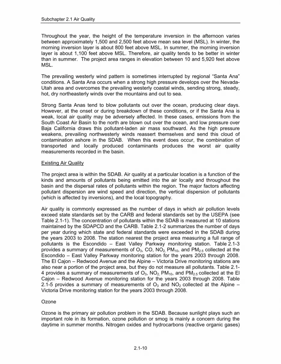
Subchapter 2.1 Air Quality
Throughout the year, the height of the temperature inversion in the afternoon varies between approximately 1,500 and 2,500 feet above mean sea level (MSL). In winter, the morning inversion layer is about 800 feet above MSL. In summer, the morning inversion layer is about 1,100 feet above MSL. Therefore, air quality tends to be better in winter than in summer. The project area ranges in elevation between 10 and 5,920 feet above MSL.
The prevailing westerly wind pattern is sometimes interrupted by regional “Santa Ana” conditions. A Santa Ana occurs when a strong high pressure develops over the Nevada-Utah area and overcomes the prevailing westerly coastal winds, sending strong, steady, hot, dry northeasterly winds over the mountains and out to sea.
Strong Santa Anas tend to blow pollutants out over the ocean, producing clear days. However, at the onset or during breakdown of these conditions, or if the Santa Ana is weak, local air quality may be adversely affected. In these cases, emissions from the South Coast Air Basin to the north are blown out over the ocean, and low pressure over Baja California draws this pollutant-laden air mass southward. As the high pressure weakens, prevailing northwesterly winds reassert themselves and send this cloud of contamination ashore in the SDAB. When this event does occur, the combination of transported and locally produced contaminants produces the worst air quality measurements recorded in the basin.
Existing Air Quality
The project area is within the SDAB. Air quality at a particular location is a function of the kinds and amounts of pollutants being emitted into the air locally and throughout the basin and the dispersal rates of pollutants within the region. The major factors affecting pollutant dispersion are wind speed and direction, the vertical dispersion of pollutants (which is affected by inversions), and the local topography.
Air quality is commonly expressed as the number of days in which air pollution levels exceed state standards set by the CARB and federal standards set by the USEPA (see Table 2.1-1). The concentration of pollutants within the SDAB is measured at 10 stations maintained by the SDAPCD and the CARB. Table 2.1-2 summarizes the number of days per year during which state and federal standards were exceeded in the SDAB during the years 2003 to 2008. The station nearest the project area measuring a full range of pollutants is the Escondido – East Valley Parkway monitoring station. Table 2.1-3 provides a summary of measurements of O3, CO, NO2, PM10, and PM2.5 collected at the Escondido – East Valley Parkway monitoring station for the years 2003 through 2008. The El Cajon – Redwood Avenue and the Alpine – Victoria Drive monitoring stations are also near a portion of the project area, but they do not measure all pollutants. Table 2.1-4 provides a summary of measurements of O3, NO2, PM10, and PM2.5 collected at the El Cajon – Redwood Avenue monitoring station for the years 2003 through 2008. Table 2.1-5 provides a summary of measurements of O3 and NO2 collected at the Alpine – Victoria Drive monitoring station for the years 2003 through 2008.
Ozone
Ozone is the primary air pollution problem in the SDAB. Because sunlight plays such an important role in its formation, ozone pollution or smog is mainly a concern during the daytime in summer months. Nitrogen oxides and hydrocarbons (reactive organic gases)
2.1-10

Subchapter 2.1 Air Quality
are known as the chief “precursors” of ozone. These compounds react in the presence of sunlight to produce ozone. The SDAB is currently designated a federal and state non-attainment area for ozone. Ozone concentration measurements recorded in the SDAB dating back to the late 1970s show a distinctive downward trend with occasional peaks due primarily to meteorological influences (County of San Diego 2002).
About half of smog-forming emissions come from automobiles (County of San Diego 2004). Population growth in San Diego has resulted in a large increase in the number of automobiles expelling ozone-forming pollutants while operating on area roadways. In addition, the occasional transport of smog-filled air from Los Angeles only adds to the SDAB’s ozone problem. More strict automobile emission controls, including more efficient automobile engines, have played a large role in why ozone levels have steadily decreased.
The former national one-hour ozone standard was not exceeded at the Escondido – East Valley Parkway and the El Cajon – Redwood Avenue monitoring stations during the six-year period of 2003 to 2008. However, it was exceeded at the Alpine – Victoria Drive monitoring station once in 2003 and 2007 and twice in 2008.
The stricter state standard for ozone was exceeded at the Escondido – East Valley Parkway monitoring station three days in 2003, two days in 2004, one day in 2005, three days in 2006, and nine days in 2008 (State of California 2008a). The standard was exceeded one day in 2003, one day in 2004, two days in 2006, and three days each in 2007 and 2008 at the El Cajon – Redwood Avenue monitoring Station. The standard was exceeded 18 days in 2003, five days in 2004, 13 days in 2005, 21 days in 2006, 18 days in 2007, and 13 days in 2008 at the Alpine – Victoria Drive monitoring station (State of California 2008a).
In order to address adverse health effects due to prolonged exposure, the USEPA phased out the national one-hour ozone standard and replaced it with the more protective eight-hour ozone standard. The SDAB is currently a non-attainment area for the national eight-hour standard. The national eight-hour standard was exceeded twice in 2004, twice in 2006, and seven times in 2008 at the Escondido – East Valley Parkway monitoring station (see Table 2.1-3). The standard was exceeded once in 2006 and three times in 2008 at the El Cajon – Redwood Avenue monitoring Station (see Table 2.1-4). The standard was exceeded between two and 14 times each year between 2003 and 2008 at the Alpine – Victoria Drive monitoring station (see Table 2.1-5). The national eight-hour ozone standard has been changed to 7.5 pphm. However, this does not apply to the monitoring from 2003 to 2008.
Not all of the ozone within the SDAB is derived from local sources. Under certain meteorological conditions, such as during Santa Ana wind events, ozone and other pollutants are transported from the Los Angeles Basin and combine with ozone formed from local emissions sources to produce elevated ozone levels in the SDAB. According to SANDAG, on average approximately 42 percent of the days that had ozone concentrations over the state standard between 1987 and 1994 were attributable to pollution transported from Los Angeles (SANDAG 1994:249-250). According to the SDAPCD, ozone transported into the SDAB from the South Coast Air Basin (Los Angeles Area) was the primary cause for the SDAB exceeding national ozone thresholds on 27 of a total of 33 days from 1994 to 1998 (County of San Diego 2000).
2.1-11

Subchapter 2.1 Air Quality
Local agencies can control neither the source nor the transportation of pollutants from outside the SDAB. The SDAPCD’s policy, therefore, has been to control local sources effectively enough to reduce locally produced contamination to clean air standards. Through the use of air pollution control measures outlined in the RAQS, the SDAPCD has effectively reduced ozone levels in the SDAB.
Carbon Monoxide
The SDAB is classified as a state and federal attainment area for carbon monoxide (County of San Diego 1998). Until 2003, no violations of the state standard for CO had been recorded in the SDAB since 1991, and no violations of the national standard had been recorded in the SDAB since 1989. As seen in Table 2.1-2, both the federal and state eight-hour CO standards were exceeded in the County of San Diego on one day in 2003. This exceedance occurred on October 28, 2003, at a time when major wildfires were raging throughout the county. Consequently, this exceedance was likely caused by the wildfires and would be considered beyond the control of the SDAPCD.
Small-scale, localized concentrations of CO above the state and national standards have the potential to occur at intersections with stagnation points, such as those that occur on major highways and heavily traveled and congested roadways. Localized high concentrations of CO are referred to as “CO hot spots” and are a concern at congested intersections when automobile engines burn fuel less efficiently and their exhaust contains more CO.
PM10
PM10 is a particulate matter with an aerodynamic diameter of 10 microns or less. Ten microns is about one-seventh of the diameter of a human hair. Particulate matter is a complex mixture of very tiny solid or liquid particles composed of chemicals, soot, and dust. Sources of PM10 emissions in the SDAB consist mainly of urban activities, dust suspended by vehicle traffic, and secondary aerosols formed by reactions in the atmosphere.
Under typical conditions (i.e., no wildfires), particles classified under the PM10 category are mainly emitted directly from activities that disturb the soil, including travel on roads and construction, mining, or agricultural operations. Other sources include windblown dust, salts, brake dust, and tire wear (County of San Diego 1998). For several reasons hinging on the area’s dry climate and coastal location, the SDAB has special difficulty in developing adequate tactics to meet present state particulate standards.
As of 2003, the national standards for PM10 had never been exceeded in the SDAB since the standards were established. Therefore, the USEPA has designated the SDAB unclassifiable for PM10. In 2003, the measured federal PM10 standard was exceeded twice in the SDAB. These two exceedances result in a calculated number of days that the federal standard was exceeded of approximately nine days for the year (see Table 2.1-2). The first exceedance occurred on October 29, 2003, at a time when major wildfires were raging throughout the county. The second exceedance occurred on November 23, 2003, during high winds which caused large amounts of ash from the previous fires to be resuspended.
2.1-12

Subchapter 2.1 Air Quality
Consequently, these exceedances were likely caused by or were a subsequent result of the wildfires and would be beyond the control of the SDAPCD. As such, these events are covered under the USEPA’s Natural Events Policy that permits, under certain circumstances, the exclusion of air quality data attributable to uncontrollable natural events (e.g., volcanic activity, wildland fires, and high wind events).
In 2005, the measured federal PM10 standard was exceeded once in the SDAB on October 13. This exceedance results in a calculated number of days that the federal standards were exceeded of approximately six days for the year (see Table 2.1-2).
At the Escondido – East Valley Parkway monitoring station, the national 24-hour PM10 standard was exceeded once in 2003. This exceedance resulted in a calculated number of days that the federal standard was exceeded of 3.3 for 2003. The stricter state 24-hour standard was exceeded five days in 2003, one day in 2004, one day in 2006, one day in 2007, and one day in 2008 (State of California 2008b). These exceedances resulted in a calculated number of days that the state standard was exceeded of 30.7 days in 2003, 6.1 days in 2004, 5.8 days in 2006, and 11.5 days in 2007.
PM2.5
Airborne, inhalable particles with aerodynamic diameters of 2.5 microns or less (PM2.5) have been recognized as an air quality concern requiring regular monitoring. Federal regulations required that PM2.5 monitoring begin January 1, 1999 (County of San Diego 1999). The Escondido – East Valley Parkway monitoring station is one of five stations in the SDAB that monitors PM2.5. Federal PM2.5 standards established in 1997 include an annual arithmetic mean of 15 g/m3 and a 24-hour concentration of 65 g/m3. As discussed above, the 24-hour PM2.5 standard has been changed to 35 g/m3. However, this does not apply to the monitoring from 2002 to 2006. State PM2.5 standards established in 2002 are an annual arithmetic mean of 12 g/m3. The 24-hour PM2.5 standard was exceeded once in 2003 and once in 2004 at the Escondido – East Valley Parkway monitoring station. The data also indicate that the new federal standard would have been exceeded each year from 2003 to 2006.
The SDAB was initially classified as a non-attainment area; however, it was subsequently reclassified as an attainment area for the PM2.5 standard (USEPA 2004c). The SDAB is a non-attainment area for the state PM2.5 standard (State of California 2005a).
For the new particulate standard, state recommendations for area designations were due to the USEPA by December 18, 2007, and the USEPA will make the final designations by November 2009. It was recommended that the SDAB be designated as an attainment area for the revised standards (State of California 2007b).
Other Criteria Pollutants
The national and state standards for NO2, SO2, and lead are being met in the SDAB, and the latest pollutant trends suggest that these standards will not be exceeded in the foreseeable future.
2.1-13

Subchapter 2.1 Air Quality
Greenhouse Gasses
There are numerous GHGs, both naturally occurring and manmade. Carbon dioxide, methane, and nitrous oxide are produced by both natural and anthropogenic (human) sources. The remaining gases (hydrofluorocarbons [HFCs; such as HFC-23], perfluorocarbons [PFCs; such as CF4], and sulfur hexafluoride [SF6]) are the result of human processes.
The potential of a gas to trap heat and warm the atmosphere is measured by its “global warming potential,” or GWP. Specifically, GWP is defined as the cumulative radiative forcing—both direct and indirect effects—integrated over a period of time from the emission of a unit mass of gas relative to some reference gas (USEPA 2002).
Greenhouse gases breakdown or are absorbed over time. Thus, the potential for a gas to contribute to global warming is limited by the time it is in the atmosphere, its “atmospheric lifetime.” To account for these effects, global warming potentials (GWPs) are calculated over a specific period of time, such as 20, 100, or 500 years. The parties to the UNFCCC agreed to use consistent GWPs based upon a 100-year time horizon (USEPA 2002). Because of its relative abundance in the atmosphere and its relatively long atmospheric lifetime, carbon dioxide has been designated the reference gas for comparing GWPs. Thus the 100-year GWP of CO2 is equal to one.
The importance of these gases to climate change is expressed in terms of the amount (concentration) in the atmosphere and the gas’ GWP. For comparison, emissions of all greenhouse gases are often expressed in terms of teragrams of carbon dioxide equivalent (Tg CO2 Eq.). The relationship between gigagrams (Gg) of a gas and Tg CO2 Equation is determined by the following (USEPA 2002):
Gg
TgxGWPxgasofGgEqCOTg
000,1.2
where:
Tg CO2 Eq. = teragrams of carbon dioxide equivalents
Gg = gigagrams (equivalent to a thousand metric tons)
GWP = global warming potential
Tg = teragrams
There are other greenhouse gases typically not considered when evaluating the effects on global climate change. These are short-lived gases such as carbon monoxide, water vapor, tropospheric ozone, tropospheric aerosols (e.g, sulfur dioxide products and black carbon), and other ambient air pollutants such as NOX and non-methane volatile organic compounds. Because they are short-lived, concentrations of these gases tend to vary spatially, and it is difficult to determine their global radiative forcing impacts. Therefore, GWPs are typically not attributed to these short-lived, spatially inhomogeneous atmospheric gases (USEPA 2002).
2.1-14

Subchapter 2.1 Air Quality
2.1.2 Analysis of Project Effects and Determination as to Significance
For the purpose of this EIR, the Guidelines for the Determination of Significance for air quality apply to both the project direct impacts analysis and the cumulative impact analysis. A significant impact to air quality would occur if the Proposed Project:
1. Conflicts with or obstructs implementation of the San Diego RAQS or applicable portions of the SIP.
2. Results in emissions that violate any air quality standard or contribute substantially to an existing or projected air quality violation.
3. Results in a cumulatively considerable net increase of any criteria pollutant for which the project region is non-attainment under an applicable federal or state ambient air quality standard (including releasing emissions which exceed quantitative thresholds for ozone precursors).
4. Exposes sensitive receptors to substantial pollutant concentrations.
The guidelines of significance listed above are from Appendix G of the State CEQA Guidelines and were selected from the Initial Study prepared for the Proposed Project; they are analyzed below.
SDAPCD Emissions Criteria
Emissions resulting from implementation of the Proposed Project would be due primarily to an increase in traffic associated with the construction and the daily operations of Wholesale Limited and Boutique Wineries. The SDAPCD does not provide specific numbers for determining the significance of mobile source-related impacts. However, the district does specify Air Quality Impact Analysis (AQIA) trigger levels for new or modified stationary sources (SDAPCD Rules 20.2 and 20.3). Although these trigger levels do not generally apply to mobile sources, for comparative purposes these levels are used to evaluate the increased emissions that would be discharged to the SDAB if the Proposed Project were approved. Since SDAPCD does not have AQIA thresholds for emissions of volatile organic compounds (VOCs), the use of the threshold for VOCs from the SCAQMD, which generally has stricter emissions standards, is appropriate. The AQIA trigger levels are shown in Table 2.1-6.
2.1-15

Subchapter 2.1 Air Quality
TABLE 2.1-6 SCREENING-LEVEL THRESHOLDS FOR AIR QUALITY IMPACT ANALYSIS
Emission Rate Pollutant lb/hour lb/day tons/yr
Respirable Particulate Matter (PM10) --- 100 15 Fine Particulate Matter (PM2.5) --- 55* 10* Oxides of Nitrogen (NOx) 25 250 40 Oxides of Sulfur (SOx) 25 250 40 Carbon Monoxide (CO) 100 550 100 Lead and Lead Compounds --- 3.2 0.6 Volatile Organic Compounds (VOCs) --- 75** 13.7***
Source: SDAPCD Rule 20.2 (12/17/1998) *EPA “Proposed Rule to Imlement the Fine Particle National Ambient Air Quaity Standards” published September 8, 2005. Also used by the SCAQMD.
**The threshold for VOCs is based on the threshold of significance for VOCs from the SCAQMD for the Coachella Valley (County of San Diego 2007c). This standard is appropriate because the meteorological data associated with the Proposed Project is similar to characteristics of the San oast Air Basin.
***13.7 Tons per Year threshold based on 75 lbs/day multiplied by 365 days/year and divided by 2000 lbs/ton
In the event that emissions exceed these thresholds, modeling would be required to demonstrate that the Proposed Project’s total air quality impacts result in ground-level concentrations that are below the State and Federal AAQS, including appropriate background levels. The State and Federal AAQS are listed in Table 2.1-1.
Global Climate Change
There are currently no published thresholds or recommended methodologies for determining the significance of a project’s potential contribution to global climate change in documents prepared pursuant to the CEQA, and no uniform accepted approach has been developed for assessing a project’s potential impacts relative to global climate change.
The California Air Pollution Control Officer’s Association (CAPCOA) has prepared a white paper to provide a common platform of information and tools to support local governments’ consideration of evaluating and addressing greenhouse gas emissions under CEQA (CAPCOA 2008). This paper is intended as a resource, not a guidance document. The analysis in this report includes an emissions assessment and a qualitative impact assessment based on recommendations in the CAPCOA report.
2.1.2.1 Conformance to the Regional Air Quality Strategy
Guideline for Determination of Significance
Air quality impacts would be significant if the Proposed Project conflicts with or obstructs the implementation of the San Diego RAQS and/or applicable portions of the SIP. The RAQS outlines SDAPCD's plans and control measures designed to attain the State air quality standards for ozone. In addition, the SDAPCD relies on the SIP, which includes the SDAPCD's plans and control measures for attaining the ozone NAAQS. If the Proposed Project includes development that is greater than that anticipated in the County of San Diego General Plan and SANDAG’s growth projections, the Proposed Project would be in conflict with the RAQS and SIP.
2.1-16

Subchapter 2.1 Air Quality
The SIP is a collection of documents that set forth the state’s strategies for achieving air quality standards. The SDAPCD is responsible for preparing and implementing the portion of the SIP applicable to the SDAB. The SDAPCD adopts rules, regulations, and programs to attain state and federal air quality standards, and appropriates money (including permit fees) to achieve these objectives. The RAQS outline SDAPCD's plans and control measures designed to attain the State air quality standards. The SIP and the RAQS are regional documents that demonstrate the means by which the California ambient air quality standards (CAAQS) and the NAAQS are achieved.
If the Proposed Project conforms to SANDAG’s growth projections, it would conform to the RAQS and SIP. SANDAG growth projections are based on population and vehicle trends and land use plans developed by the cities and by the County of San Diego. If a project proposes development that is anticipated in SANDAG’s growth projections, the project would not be in conflict with the RAQS, and would not have a potentially significant direct impact on air quality.
Analysis
SANDAG’s growth projections are based on the existing General Plan. The ordinance amendment does not change the land uses identified in the General Plan. Because the Proposed Project includes development that is consistent with the uses allowed by the Land Use Element and agricultural zones, the new development was anticipated in SANDAG growth projections used in development of the RAQS and SIP. Therefore, it conforms to the forecast and would not have a potentially significant cumulative impact on air quality. As such, adoption of the proposed ordinance would have a less than significant impact to air quality.
2.1.2.2 Conformance to Federal and State Ambient Air Quality Standards
Guideline for Determination of Significance
Air quality impacts will be significant if the Proposed Project would result in emissions that would violate any air quality standard or contribute substantially to an existing or projected air quality violation.
The SDAPCD specifies AQIA trigger levels for new or modified stationary sources (SDAPCD Rules 20.2 and 20.3). Although these trigger levels do not generally apply to mobile sources or general land development projects, for comparative purposes these levels are used to determine the potential for a significant adverse impact (see Table 2.1-6).
Air Impacts can result from construction and operation of any specific project.
Analysis
Construction
Construction related air quality emissions associated with the Proposed Project include emissions of PM10, nitrogen oxide (NOx), and VOCs from building and grading activities. The Proposed Project could result in the construction of new wine production structures and tasting rooms.
2.1-17

Subchapter 2.1 Air Quality
If, as a result of the Proposed Project, new buildings are proposed that would require clearing; the proposed clearing would be subject to the Grading Ordinance, which requires the implementation of dust control measures. Dust control measures include minimization of soil disturbance, applying mulch and establishing vegetation, water spraying, surface roughening, shrouding, barriers, control of vehicle speeds, paving of access areas, or other operational or technological measures.
Tasting rooms are limited to a square footage that is 30 percent of the size of the associated wine production structure. According to the standards for a Boutique Winery, the maximum floor area of non-residential structure(s) used to crush, ferment, store, and bottle fruit, wine, and other products and equipment used in winemaking is limited to 1,000 square feet where the lot is less than one gross acre. A maximum floor area of 1,500 square feet is allowed where the lot is one acre or more but less than two acres gross, and 2,000 square feet of floor area is allowed where the lot is two to four acres gross. An additional 200 square feet of floor area is allowed for each acre over four acres, up to a maximum of 5,000 square feet of allowed floor area. Only one tasting/retail sales room is allowed.
To illustrate the potential air quality effects from construction of a tasting room or other winery facilities that could occur in the project area, a speculative project was evaluated. This hypothetical worst case project includes the construction of a 5,000-square-foot building that could be allowed under the criteria for Wholesale Limited and Boutique Wineries.
Emissions associated with the construction of the speculative project were calculated using the URBEMIS 2007 computer program (Rimpo and Associates 2007) assuming that construction would begin in January 2010 and last approximately six months.
The URBEMIS 2007 computer program divides construction into seven phases; three phases were used. Fine site grading, building construction, and architectural coating were the phases chosen for the project, and the lengths of each phase were 20 days, 65 days, and 10 days, respectively. In general the defaults for the program parameters such as numbers and pieces of equipment were used.
Table 2.1-7 shows the anticipated emissions from each construction project.
2.1-18

Subchapter 2.1 Air Quality
TABLE 2.1-7 SUMMARY OF WORST-CASE CONSTRUCTION EMISSIONS
FOR A SINGLE SPECUALTIVE STRUCTURE
Pollutant Project Emissions (lb/day) SDAPCD Threshold2 (lb/day) ROG 10.71 75 NOx 25.05 250 CO 13.51 550 SOx1 0.00 250 PM10 – total 2.46 100 PM10 – exhaust 1.25 -- PM10 – fugitive dust 1.21 -- PM2.5 – total 1.40 55 PM2.5 – exhaust 1.15 -- PM2.5 – fugitive dust 0.25 -- 1Emissions calculated by URBEMIS 2007 are for SO2. 2Threholds for ROG and PM2.5 were obtained from the SCAQMD.
As seen from Table 2.1-7, emissions from construction of one maximum 5,000-square-foot building would not exceed the threshold of significance and would not have a direct effect. Thus, impacts would be less than significant.
There is the potential that multiple Wholesale Limited and Boutique Wineries could be constructed simultaneously. Air pollutants generated by the construction of individual Wholesale Limited and Boutique Wineries that conform to the proposed ordinance amendment would vary depending upon the number of wineries constructed simultaneously and the size of each individual Wholesale Limited or Boutique Winery. The exact number and timing of all construction that could occur as a result of the Proposed Project are unknown. From the emissions for a single construction shown in Table 2.1-7, it was calculated that seven simultaneous construction projects could occur before the thresholds for an individual construction would be exceeded. If eight Wholesale Limited and Boutique Wineries were to be constructed at the same time, then the collective emissions of ROG would be 85.68 pounds per day and would exceed the ROG threshold for an individual construction. It is anticipated that it would be highly unlikely that eight Wholesale Limited and Boutique Wineries would be constructed simultaneously. However, there is no mechanism available that would necessarily prevent the simultaneous construction of eight by-right Wholesale Limited and Boutique Wineries. As such, air impacts from simultaneous construction could be significant (AQ-1).
Operation
In general, air quality impacts from land use projects are the result of emissions from motor vehicles and from short-term construction activities associated with such projects. The SDAPCD has established screening-level thresholds for all new source review in SDAPCD Rule 20.2. For CEQA purposes, these screening-level thresholds can be used as numeric methods to demonstrate that a project’s total emissions (e.g. stationary and fugitive emissions, as well as emissions from mobile sources) would not result in a significant impact to air quality. Since SDAPCD does not have screening-level thresholds for emissions of VOCs, the use of the screening level for reactive organic compounds (ROCs) from the South Coast Air Basin, which has stricter standards for emissions of ROCs/VOCs than San Diego’s, is appropriate. However, the eastern
2.1-19

Subchapter 2.1 Air Quality
portions of the County of San Diego have atmospheric conditions that are characteristic of the Southeast Desert Air Basin (SEDAB). SEDAB is not classified as an extreme nonattainment area for ozone, and therefore has a less restrictive screening level. Projects located in the eastern portions of the County of San Diego can use the SEDAB screening level threshold for VOCs.
Unlike many agricultural operations, grape production does not require extensive or constant use of farming equipment. Given their minimal use, emission impacts from an increase in the use of farming equipment over current levels are unlikely. Agricultural uses are currently permitted in the existing zones, and use of properties to grow grapes would not increase operational emissions relative to the existing allowed use. Therefore, it is anticipated that operational impacts from wineries allowed under the Proposed Project will be due principally to project related traffic.
The EMission FACtors 2007 Model ([EMFAC2007], State of California 2007c) was used to assess the air quality impacts of winery-related traffic. EMFAC2007 is the most recent version of this model, which was developed by the CARB and used to calculate emission rates from motor vehicles and from light-duty passenger vehicles to heavy-duty trucks that operate on highways, freeways, and local roads in California. A traffic report was prepared for the Proposed Project to determine potential traffic impacts on area roadways due to operation of an increased number of wineries in the County of San Diego, and is discussed further in Section 2.6. In order to study the traffic on major roadways associated with the Proposed Project, wineries were categorized based on their location and setting. The study grouped the wineries into the following three categories: “backcountry; destination”, “backcountry; rural”, and “suburban”.
“Backcountry; destination” wineries are located more than an hour from metropolitan San Diego in rural areas that have a variety of economic and tourist attractions. “Backcountry; rural” wineries are also located more than an hour from metropolitan San Diego, but in rural areas that do not have a developed economic and tourist draw. “Suburban” area types are located in a suburban area within an hour of metropolitan San Diego.
Table 2.1-8 summarizes the observed traffic volumes on weekdays and weekend days at existing wineries that are representative of the three winery categories. The wineries used in the traffic report as representative of the winery categories are typical in their amount of annual wine production.
TABLE 2.1-8 OBSERVED TRIP GENERATION AND CALCULATED RATES
Observed Volumes (ADT) Calculated Trip Generation Rates
(Trips/2,380 gallons /year) Winery Category Size*
(gallons /year) Weekday Weekend Weekday Weekend
Backcountry; Destination
9,520 40 160 10.0 40.0
Backcountry; Rural 4,046 20 30 11.8 17.6 Suburban 11,900 60 110 6.0 22.0 Average 8,489 40 100 11.2 28.0
SOURCE: Linscott et al. 2009 *The wineries used as representatives for each winery category report an approximate annual wine production. Note: “Calculated Trip Generation Rates” are the observed volumes divided by the size of the wineries (per 2,380 gallons/year).
2.1-20

Subchapter 2.1 Air Quality
Mobile source emissions would originate from project-generated traffic. Mobile source emissions due to implementation of the Proposed Project were calculated using the EMFAC2007 computer program. For the purposes of computing the emissions, it was assumed that build-out of the Proposed Project would occur in 2010. Since state and federal mandates will cause exhaust emissions per vehicle to continue to improve in the future, Project emissions would be worse in 2010 than in year 2030. The average winter and summer temperatures used in EMFAC2007 were assumed to be 50° and 80° F, respectively. Trip length was estimated based on the distance of each winery category from metropolitan San Diego established in the traffic report (Linscott et al. 2009). The defaults for the other input parameters, such as vehicle fleet mix, were assumed. The Proposed Project is anticipated to generate a range of average daily trips to a single winery depending on the winery category and the day of the week (see Table 2.1-8). Trip generation rates from the traffic report were used in the EMFAC modeling.
A summary of the mobile source and emissions emitted to the SDAB for the Proposed Project is shown in Table 2.1-9.
TABLE 2.1-9 PROJECT (YEAR 2010) AVERAGE DAILY EMISSIONS TO THE SAN DIEGO AIR BASIN
(POUNDS/DAY)
Backcountry; Destination Backcountry; Rural Suburban Weekday Weekend Weekday Weekend Weekday Weekend
Pollutant (lbs/day)
SDAPCD Threshold2
(lb/day) Summer Winter Summer Winter Summer Winter Summer Winter Summer Winter Summer Winter VOC,ROG
75 1.81 1.81 7.25 7.25 1.11 1.11 1.67 1.67 1.67 1.67 3.07 3.07
CO 550 46.44 41.35 185.76 165.40 28.58 25.45 42.87 38.17 42.87 38.17 78.59 69.98 NOx 250 7.28 10.20 29.12 40.81 4.48 6.28 6.72 9.42 6.72 9.42 12.32 17.27 SOx1 250 0.06 0.05 0.23 0.18 0.04 0.03 0.05 0.04 0.05 0.04 0.10 0.08
PM10 100 0.37 0.37 1.47 1.47 0.23 0.23 0.34 0.34 0.34 0.34 0.62 0.62
PM2.5 55 0.34 0.34 1.38 1.38 1.38 0.21 0.21 0.32 0.32 0.32 0.58 0.58 1Emissions calculated by EMFAC2007 are for SO2. 2Threholds for ROG and PM2.5 were obtained from the SCAQMD. This standard is appropriate because the meteorological data associated with the Proposed Project is similar to characteristics of the San Coast Air Basin.
For assessing the significance of the air quality mobile emissions of the Proposed Project, the emissions were compared to the SDAPCD AQIA thresholds used for evaluating this project as discussed previously. The SDAPCD does not have thresholds for reactive organic gas (ROG) or PM2.5. The threshold for ROG/VOC was obtained from the County of San Diego Guidelines for Determining Significance for Air Quality which relies on the standard set by the SCAQMD (County of San Diego 2007c). The threshold for PM2.5 was obtained from the SCAQMD Final Methodology to Calculate PM2.5 and PM2.5 Significance Thresholds (SCAQMD 2006). As seen in Table 2.1-9, maximum daily mobile emissions due to the addition of traffic to area roadways for travel to a single Boutique Winery (the only by-right winery type that would generate additional traffic) regardless of the category are projected to be below the applicable thresholds of significance. However, as also seen in Table 2.1-9, the addition of as few as three additional Boutique Wineries could result in CO emissions that exceed the thresholds. The addition of three Boutique Wineries somewhere throughout the county as a result of this Proposed Project is likely. Therefore, impacts could be significant (AQ-2).
2.1-21

Subchapter 2.1 Air Quality
2.1.2.3 Impacts to Sensitive Receptors
Guideline for Determination of Significance
Air quality impacts would be significant if the Proposed Project exposes sensitive receptors to substantial pollutant concentrations.
Analysis
Air quality regulators typically define sensitive receptors as schools (Preschool-12th grade), hospitals, resident care facilities, day-care centers, or other facilities that may house individuals with health conditions that would be adversely impacted by changes in air quality. Under the Proposed Project, wineries will be allowed under specified standards and limitations or under specified standards and limitations and pursuant to an approved Administrative Permit in agricultural zones. The agricultural zones, A70 and A72, occur in varied areas throughout the unincorporated areas of the County of San Diego. There may be locations where a future winery would be located within a quarter-mile (the radius determined by the SCAQMD in which the dilution of pollutants is typically significant) of a sensitive receptor. However, neither Wholesale Limited nor Boutique Wineries agricultural uses would involve use of large industrial harvesting equipment or other substantial sources of pollutants. In addition, as discussed above, maximum daily mobile emissions due to the addition of traffic to area roadways for travel to a single Boutique Winery (the only by-right winery type that would generate additional traffic), regardless of the category, are projected to be below the applicable thresholds of significance. As such, localized concentrations of air pollutants are not anticipated to be substantial. Therefore, proposed by-right operations allowed by this ordinance amendment are not anticipated to propose uses or activities that would result in exposure of sensitive receptors to significant pollutant concentrations. Impacts would be less than significant.
2.1.3 Cumulative Impact Analysis
2.1.3.1 Air Quality Regional Guideline for Determination of Significance
Cumulative air quality impacts would be significant if the Proposed Project conflicts with or obstructs the implementation of the San Diego RAQS and applicable portions of the SIP.
Basis for the Assessment
The SIP is a collection of documents that set forth the state’s strategies for achieving air quality standards. The SDAPCD is responsible for preparing and implementing the portion of the SIP applicable to the SDAB. The SDAPCD adopts rules, regulations, and programs to attain state and federal air quality standards, and appropriates money (including permit fees) to achieve these objectives. The RAQS outline SDAPCD's plans and control measures designed to attain the State air quality standards. The SIP and the RAQS are regional documents that demonstrate the means by which the California ambient air quality standards (CAAQS) and the NAAQS are achieved.
If the Proposed Project conforms to SANDAG’s growth projections, it would conform to the RAQS and SIP. SANDAG growth projections are based on population and vehicle
2.1-22

Subchapter 2.1 Air Quality
trends and land use plans developed by the cities and by the County of San Diego. If a project proposes development that is anticipated in SANDAG’s growth projections, the project would not be in conflict with the RAQS, and would not have a potentially significant cumulative impact on air quality.
Analysis
SANDAG’s growth projections are based on the existing General Plan. The ordinance amendment does not change the land uses identified in the General Plan. Because the Proposed Project includes development that is consistent with the uses allowed by the Land Use Element and agricultural zones, the new development was anticipated in SANDAG growth projections used in development of the RAQS and SIP. Therefore, it conforms to the forecast and would not have a potentially significant cumulative impact on air quality. As such, adoption of the proposed ordinance would have a less than significant cumulative impact to air quality.
2.1.3.2 Air Quality Hot-Spot Guideline for Determination of Significance
Projects that cause road intersections to operate at or below a Level of Service (LOS) E when the addition of peak-hour trips from the Proposed Project and the surrounding projects exceeds 3,000 and create a CO “hotspot” create a cumulatively considerable net increase of CO.
Basis for the Assessment
The traffic analysis for the Proposed Project uses cumulative traffic projections on area roadways. The assessment of traffic related, hot-spot cumulative impacts is based on this traffic analysis.
Analysis
The contribution of peak-hour trips from the Proposed Project is not considerable. The traffic analysis determined that each future Boutique Winery will generate 40 weekday average daily trips (ADT) and 160 weekend ADT. Peak hour is the single busiest hour of traffic during the day and peak traffic hour at intersections vary from location to location, but generally occur in the timeframe from 6 A.M. to 9 A.M. and again from 4 P.M. to 7 P.M. Peak hour generally occurs during the weekday, and therefore only the 40 weekday ADT from the Proposed Project would contribute to the creation of a CO “hotspot”. Of the 40 weekday ADT, none would occur during the A.M. peak hour because Boutique Winery operating hours are limited from 10 A.M. to sunset and 10 A.M. is past the morning peak hour range. The 40 ADT would be spread throughout the day because wineries do not have peak operating hours and customer visits are spread throughout the day. In addition, during the winter, Boutique Wineries will not be open during a portion of the P.M. peak hour range because Boutique Winery hours end at sunset, which occurs as early as 4:40 P.M. If the 40 ADT are spread out over a sample seven hour period when the Boutique Winery is open for business, approximately six trips per hour would be generated. If five to ten Boutique Wineries contribute six peak hour trips each to an intersection, a total of 30-60 trips would be contributed per hour. This equals one to two percent of the minimum 3,000 trips needed to meet the threshold. Because the contribution could be one to two percent, the Proposed Project does not
2.1-23

Subchapter 2.1 Air Quality
create a cumulatively considerable net increase in CO, and the additional traffic represents a less than significant cumulative impact.
2.1.3.3 Greenhouse Gasses Guideline for Determination of Significance
Projects whose incremental contribution of greenhouse emissions are considerable and that would impede meeting the AB-32 targets for greenhouse gas reduction would have a significant cumulative impact.
Basis for the Assessment
There are currently no published thresholds or methodologies for determining the significance of a project’s potential contribution to global climate change in documents prepared pursuant to CEQA. Assembly Bill 32, the “California Global Warming Solutions Act of 2006”, requires the CARB to adopt rules and regulations that would reduce GHG emissions to 1990 levels by 2020. As noted above, the act required CARB to establish a statewide greenhouse gas emissions cap for 2020, based on 1990 emissions by January 1, 2008. In November 2007, CARB released California 1990 Greenhouse Gas Emissions Level and 2020 Emissions Limit (State of California 2007d). In this document, CARB recommends 427 million metric tones of carbon dioxide equivalent (MMTCO2e) as the total statewide aggregated greenhouse gas 1990 emissions level and 2020 emissions limit. This limit was approved in December 2007.
Analysis
Total GHG emissions that would be emitted as a result of operation of wineries under the proposed Ordinance Amendment would primarily be due to three sources: vehicular traffic on area roadways, emissions from the generation of electricity, and natural gas consumption/combustion associated with winery operations. The emissions from vehicular traffic on roadways can be calculated based on the traffic projections for only the community plan areas identified in the traffic analysis (Appendix D); however, the emissions from electricity and natural gas that could result from winery operations would depend on the size and type of equipment and facilities used and the production amount. Because the location and number of new or expanded wineries that could operate in A70/72 Zones is not known, the emissions from electricity use cannot be quantified.
The three primary GHGs that would be emitted by traffic related to the project are CO2, CH4, and N2O. These GHGs have varying amounts of GWP. The 100-year GWP for CO2, CH4, and N2O are 1, 21, and 310, respectively. GHG emission factors are summarized in Table 2.1-10.
TABLE 2-1.10 GHG EMISSION FACTORS
Gas Vehicle Emission Factors (pounds/gallon)
Carbon Dioxide 19.564 Methane 0.00055 Nitrous Oxide 0.0002
SOURCE: BAAQMD 2006.
2.1-24

Subchapter 2.1 Air Quality
Vehicle emissions were estimated using the emission factors above and the total VMT per day observed as detailed in the traffic report prepared for the Proposed Project (Appendix D). For a single Boutique Winery (the only by-right winery type that would generate additional traffic) the Proposed Project would generate 5,935; 3,656; and 9,652 yearly ADT for Backcountry, Destination; Backcountry, Rural; and Suburban categories, respectively.
The EPA estimates that the average fuel economy for passenger cars is 23.9 miles per gallon (mpg) and the average fuel economy for light trucks is 17.4 mpg (USEPA 2005). The vehicle population would likely consist of passenger cars and light trucks. To be conservative, a fuel economy of 17.4 mpg was used to calculate vehicle emissions. It should also be noted that fuel economy is likely to improve in future years.
Table 2.1-11 summarizes the projected GHG emissions, expressed as equivalent CO2 emissions, resulting from the Proposed Project for a single Boutique Winery (the only by-right winery type that would generate additional traffic) for each category.
TABLE 2-1.11 ESTIMATED GHG VEHICULAR EMISSIONS
(metric tons/year)
Emission Source CO2 N2O CH4 Total CO2 Eq1
Backcountry; Destination 1,104.810 0.011 0.031 1,108.96 Backcountry; Rural 680.571 0.007 0.019 683.13 Suburban 1,796.736 0.018 0.051 1,803.49 1 Equivalent - Totals may vary from the sum of the sources due to independent rounding.
As shown, the Suburban category results in the greatest GHG emissions at 1,803.46 metric tons of CO2 Eq per year.
There is no set threshold for GHG emissions. In October 2008, CARB released the document Preliminary Draft Staff Proposal: Recommended Approaches for Setting Interim Significance Thresholds for Greenhouse Gases under the California Environmental Quality Act (State of California 2008c). The document includes flowcharts summarizing interim threshold concepts for industrial projects and for residential and commercial projects. It proposes that climate change impacts due to residential and commercial projects be considered less than significant if the proposed project (1) meets interim performance standards for construction emissions and operation emissions, and (2) “will emit no more than X metric tons of CO2 Eq. per year.” The quantity for residential and commercial projects has yet to be established. For industrial projects, along with performance standards for construction and transportation, CARB recommends that this quantity be 7,000 metric tons of CO2 Eq. per year.
The preliminary draft industrial threshold was established as a means to screen out smaller projects that are not anticipated to contribute significantly to GHG emissions, and for whom GHG emission reductions would not result in a substantial improvement to climate change. It is estimated that 93 percent of proposed industrial projects would generate emissions that would exceed the 7,000 metric ton threshold. Although the by-right wineries that would be permitted under the proposed ordinance change are not strictly industrial projects, in the absence of other thresholds the industrial GHG
2.1-25

Subchapter 2.1 Air Quality
preliminary draft threshold is assumed to represent a reasonable cut-off for smaller projects whose emissions would not be considered significant.
Thus, for the purposes of this analysis, the recommended interim threshold of 7,000 metric tons of CO2 Eq. per year was assumed to be applicable. As shown, GHG emissions from a single by-right winery would not exceed 7,000 metric tons of CO2 Eq. per year. However, as with the operational criteria pollutant emissions discussed above, the addition of as few as four additional Boutique Wineries could result in CO emissions that exceed the thresholds. Emissions related to electricity generation and natural gas consumption would also add to these emissions. The addition of four Boutique Wineries somewhere throughout the County as a result of this Proposed Project is likely. Therefore, the incremental increase of greenhouse gas emissions resulting from operation of the Proposed Project is cumulatively significant (AQ-3).
2.1.3.4 Sensitive Receptor Guideline for Determination of Significance
Air quality impacts would be cumulatively significant if the Proposed Project exposes sensitive receptors to substantial pollutant concentrations.
Basis for the Assessment
The analysis of air quality impacts to sensitive receptors is based on cumulative traffic projections on area roadways.
Analysis
Air quality impacts at sensitive receptors could only occur if the Proposed Project would result in an incremental increase in traffic volumes that would cause intersections to operate at an unacceptable LOS and expose sensitive receptors to substantial pollutant concentrations. As discussed above, the Proposed Project does not create a cumulatively considerable net increase in CO and the additional traffic represents a less than significant cumulative impact. Therefore, sensitive receptors would not be exposed to substantial pollutant concentrations due to cumulative vehicle emissions. Thus, the exposure of sensitive receptors would be less than significant cumulative impact.
2.1.4 Significance of Impacts Prior to Mitigation
2.1.4.1 Conformance to Federal and State Ambient Air Quality Standards
AQ-1: Because there is the potential that multiple Wholesale Limited and Boutique Wineries could be constructed simultaneously, adoption of the proposed Zoning Ordinance Amendment could have a significant impact on air quality.
AQ-2: Because there is the potential for the addition of traffic to area roadways for travel to as few as three additional Boutique Wineries to result in CO emissions that exceed the maximum daily mobile emissions thresholds, adoption of the proposed Zoning Ordinance Amendment could have a significant impact on air quality.
2.1-26

Subchapter 2.1 Air Quality
2.1.4.2 Cumulative Impact Analysis
AQ-3: Significant cumulative impacts from the incremental increase of greenhouse gas emissions resulting from operation of the addition of as few as four additional Boutique Wineries could result from the proposed Zoning Ordinance Amendment.
2.1.5 Mitigation
The Proposed Project is a Zoning Ordinance Amendment and is not project specific. Therefore, the impacts of specific future winery projects cannot be determined at this stage, nor can appropriate mitigation measures be identified or enforced.
However, some of these unidentified future winery projects may be required to obtain a discretionary permit, such as a Grading Permit, which would trigger CEQA review of the future project. For such projects, feasible mitigation measures could be included in the permit, thus making them enforceable. Typical mitigation measures for these projects could include requirements to avoid increases in emissions from construction and operation, such as wetting disturbed soil during grading for dust control, and limiting idling of diesel-fueled construction equipment to 5 minutes or less. As a result, specific impacts to air quality would be analyzed and mitigated for these types of by-right projects.
At the same time, there may also be future by-right projects for which related discretionary permits are required, but for which mitigation would not be feasible, or for which no related discretionary permit is required at all (e.g. where grading is less than 200 CY, but which would impact native or fallow land). For such by-right projects, CEQA review would not be required, and appropriate mitigation would not be implemented.
As it cannot be concluded at this stage that impacts to air quality from all future winery projects allowed by the ordinance amendment would be avoided or mitigated, impacts would remain significant and unmitigated.
By-right uses would not be subject to discretionary approval, and thus, no additional environmental review would be conducted. Therefore, these impacts are significant and unmitigated because there would be no enforcement mechanism to guarantee resource avoidance or compliance with environmental regulations.
2.1.6 Conclusion
Because future development of an unknown number of new or expanded winery operations (Wholesale Limited or Boutique) at unknown locations could impact air quality, adoption of the proposed ordinance amendment could result in significant direct and cumulative impacts (see significant impacts AQ-1, AQ-2, and AQ-3).
By-right uses would not be subject to discretionary approval, and thus, no additional environmental review would be conducted. Therefore, these impacts are significant and unmitigated because there would be no enforcement mechanism to guarantee there would be no increase in emissions.
2.1-27

TABLE 2.1-1 AMBIENT AIR QUALITY STANDARDS
Averaging California Standards1 Federal Standards2
Pollutant Time Concentration3 Method4 Primary3,5 Secondary3,6 Method7
1 Hour 0.09 ppm
(180 µg/m3) --
Ozone (O3) 8 Hour
0.07 ppm (137 µg/m3)
Ultraviolet Photometry 0.075 ppm
(147 µg/m3)
Same as Primary Standard
Ultraviolet Photometry
24 Hour 50 µg/m3 150 µg/m3 Respirable Particulate Matter (PM10)
Annual Arithmetic Mean
20 µg/m3
Gravimetric or Beta Attenuation
--
Same as
Primary Standard
Inertial Separation
and Gravimetic Analysis
24 Hour No Separate State Standard 35 µg/m3 Fine Particulate Matter (PM2.5)
Annual Arithmetic Mean
12 µg/m3
Gravimetric or Beta Attenuation
15 µg/m3
Same as
Primary Standard
Inertial Separation
and Gravimetic Analysis
8 Hour 9.0 ppm
(10 mg/m3) 9 ppm
(10 mg/m3)
1 Hour 20 ppm
(23 mg/m3) 35 ppm
(40 mg/m3)
None
Non-dispersive
Infrared Photometry (NDIR)
Carbon Monoxide (CO)
8 Hour (Lake Tahoe)
6 ppm (7 mg/m3)
Non-dispersive Infrared
Photometry (NDIR)
-- -- --
Annual Arithmetic Mean
0.030 ppm (57 µg/m3)
0.053 ppm (100 µg/m3)
Nitrogen Dioxide (NO2) 1 Hour
0.18 ppm (339 µg/m3)
Gas Phase Chemilumine-
scence --
Same as
Primary Standard
Gas Phase Chemiluminescence
Annual Arithmetic Mean
-- 0.030 ppm (80 µg/m3)
--
24 Hour 0.04 ppm
(105 µg/m3) 0.14 ppm
(365 µg/m3) --
3 Hour -- -- 0.5 ppm
(1300 µg/m3)
Spectrophotomerty (Pararosoaniline
Method) Sulfur Dioxide (SO2)
1 Hour 0.25 ppm
(665 µg/m3)
Ultraviolet Fluorescence
-- -- --
30 days average 1.5 µg/m3 -- -- Calendar Quarter -- 1.15 µg/m3 Lead8 Rolling 3-Month
Average9 --
Atomic Absorption
0.15 µg/m3 Same as
Primary Standard
High Volume Sampler and
Atomic Absorption
Visibility Reducing Particles
8 Hour
Extinction coefficient of 0.23 per kilometer –visibility of 10 miles or more (0.07 – 30 miles or more for Lake Tahoe) due to particles when relative humidity is less than 70 percent. Method: Beta Attenuation and Transmittance through Filter Tape.
Sulfates 24 Hour 25 µg/m3 Ion Chroma-
tography Hydrogen Sulfide
1 Hour 0.03 ppm
(42 µg/m3) Ultraviolet
Fluorescence Vinyl Chloride8
24 Hour 0.01 ppm
(26 µg/m3) Gas Chroma-
tography
No
Federal
Standards
SOURCE: State of California 2008. See notes on next page.
2.1-28

2.1-29
TABLE 2.1-1 AMBIENT AIR QUALITY STANDARDS
(continued)
1 California standards for ozone, carbon monoxide (except Lake Tahoe), sulfur dioxide (1 and 24 hour),nitrogen dioxide, suspended
particulate matter—PM10, PM2.5, and visibility reducing particles, are values that are not to be exceeded. All others are not to be equaled or exceeded. California ambient air quality standards are listed in the Table of Standards in Section 70200 of Title 17 of the California Code of Regulations.
2 National standards (other than ozone, particulate matter, and those based on annual averages or annual arithmetic mean) are not to be exceeded more than once a year. The ozone standard is attained when the fourth highest eight hour concentration in a year, averaged over three years, is equal to or less than the standard. For PM10, the 24 hour standard is attained when the expected number of days per calendar year with a 24-hour average concentration above 150 µg/m3 is equal to or less than one. For PM2.5, the 24 hour standard is attained when 98 percent of the daily concentrations, averaged over three years, are equal to or less than the standard. Contact U.S. EPA for further clarification and current federal policies.
3 Concentration expressed first in units in which it was promulgated. Equivalent units given in parentheses are based upon a reference temperature of 25°C and a reference pressure of 760 torr. Most measurements of air quality are to be corrected to a reference temperature of 25°C and a reference pressure of 760 torr; ppm in this table refers to ppm by volume, or micromoles of pollutant per mole of gas.
4 Any equivalent procedure which can be shown to the satisfaction of the ARB to give equivalent results at or near the level of the air quality standard may be used.
5 National Primary Standards: The levels of air quality necessary, with an adequate margin of safety to protect the public health.
6 National Secondary Standards: The levels of air quality necessary to protect the public welfare from any known or anticipated adverse effects of a pollutant.
7 Reference method as described by the EPA. An “equivalent method” of measurement may be used but must have a “consistent relationship to the reference method” and must be approved by the EPA.
8 The ARB has identified lead and vinyl chloride as 'toxic air contaminants' with no threshold level of exposure for adverse health
effects determined. These actions allow for the implementation of control measures at levels below the ambient concentrations specified for these pollutants.
9 National lead standard, rolling 3-month average: final rule signed October 15, 2008.

TABLE 2.1-2 AMBIENT AIR QUALITY SUMMARY – SAN DIEGO AIR BASIN
Maximum Concentration Number of Days Exceeding State Standard Number of Days Exceeding National Standard
Pollutant Average Time
California Ambient
Air Quality Standardsa
Attainment Statusb
National Ambient
Air Quality Standardsb
AttainmentStatusc 2003 2004 2005 2006 2007 2008 2003 2004 2005 2006 2007 2008 2003 2004 2005 2006 2007 2008
O3 1 hour 0.09 ppm N N/A N/A 0.125 0.129 0.113 0.121 0.134 0.139 24 12 16 23 21 17 1 1 0 0 1 2
O3 8 hours 0.07ppm N 0.08 ppm† N 0.103 0.095 0.089 0.100 0.092 0.109 N/A N/A N/A N/A N/A N/A 6 8 5 14 7 11
CO 1 hour 20 ppm A 35 ppm A 12.7 6.9 Na Na Na Na 0 0 Na Na Na Na 0 0 Na Na Na Na
CO 8 hours 9.0 ppm A 9 ppm A 10.64 4.11 4.71 3.61 5.18 3.24 1 0 0 0 0 0 1 0 0 0 0 0
NO2 1 hour 0.18 ppm* A N/A N/A 0.148 0.125 0.109 0.097 0.101 0.123 0 0 0 0 0 0 N/A N/A N/A N/A N/A N/A
NO2 Annual 0.030 ppm* N/A 0.053 ppm A 0.019 0.017 0.015 0.017 0.015 N/A N/A N/A N/A N/A N/A N/A NX NX NX NX NX N/A
SO2 1 hour 25 pphm A N/A N/A 0.036 0.045 Na Na Na Na 0 0 Na Na Na Na N/A N/A N/A N/A Na Na
SO2 24 hours 4 pphm A 14 pphm A 0.02 0.016 Na Na Na Na 0 0 Na Na Na Na 0 0 Na Na Na Na
SO2 Annual N/A N/A 3 pphm A Na Na Na Na Na Na N/A N/A N/A N/A N/A N/A Na Na Na Na Na Na
PM10 24 hours 50 g/m3 N 150 g/m3 N 289 138 154 134 392 142 150.7 174.5 13.1 159.4 158.7 Na 9.2 0 5.8 Na Na Na
PM10 Annual 20 g/m3 N N/A N/A 52.6 51.7 28.6 54.1 58.5 Na EX EX EX EX EX EX N/A N/A N/A N/A N/A N/A
PM2.5 24 hours N/A N/A 35 g/m3 A Na Na Na Na Na Na Na Na Na Na Na Na Na Na Na Na Na Na
PM2.5 Annual 12 g/m3 A 15 g/m3 A Na Na Na Na Na Na Na Na Na Na Na Na Na Na Na Na Na Na
SOURCE: State of California 2006, 2008b.
† The federal 8-hour standard changed from 0.08 ppm to 0.075 ppm on March 12, 2008.
*This concentration was approved by the Air Resources Board on February 22, 2007. New 1-hour and annual concentrations would not have been exceeded during the years 2002 through 2006.
aCalifornia standards for ozone, carbon monoxide (except at Lake Tahoe), sulfur dioxide (1-hour and 24-hour), nitrogen dioxide, and PM10 are values that are not to be exceeded. Some measurements gathered for pollutants with air quality standards that are based upon 1-hour, 8-hour, or 24-hour averages, may be excluded if the CARB determines they would occur less than once per year on average.
bNational standards other than for ozone and particulates, and those based on annual averages or annual arithmetic means are not to be exceeded more than once a year. The 1-hour ozone standard is attained if, during the most recent 3-year period, the average number of days per year with maximum hourly concentrations above the standard is equal to or less than one.
cA = attainment; N = non-attainment; N/A = not applicable; Na = data not available; NX = annual average not exceeded; EX = annual average exceeded.
NOTE: Federal 1 hour ozone standard revoked in SDAB on June 15, 2005
ppm = parts per million, pphm = parts per hundred million, g/m3 = micrograms per cubic meter.
Calculated days are the estimated number of days that a measurement would have been greater than the level of the standard had measurements been collected every day. The number of days above the standard is not necessarily the number of violations of the standard for the year.
2.1-30

TABLE 2.1-3 SUMMARY OF AIR QUALITY MEASUREMENTS RECORDED
AT THE ESCONDIDO EAST VALLEY PARKWAY MONITORING STATION
Pollutant/Standard 2003 2004 2005 2006 2007 2008
Ozone Days State 1-hour Standard Exceeded (0.09 ppm) 3 2 1 3 0 9 Days Federal 1-hour Standard Exceeded (0.12 ppm) 0 0 0 0 0 0 Days Federal 8-hour Standard Exceeded (0.08 ppm)† 0 2 0 2 0 7 Days State 8-hour Standard Exceeded (0.07 ppm) 9 9 2 11 5 23 Max. 1-hr (ppm) 0.105 0.099 0.095 0.108 0.094 0.116 Max 8-hr (ppm) 0.083 0.086 0.079 0.096 0.077 0.098 Carbon Monoxide Days State 8-hour Standard Exceeded (20 ppm) 1 0 0 0 0 0 Days Federal 8-hour Standard Exceeded (35 ppm) 1 0 0 0 0 0 Max. 1-hr (ppm) 12.7* 6.3 5.9 5.7 5.2 5.6 Max. 8-hr (ppm) 10.64 3.61 3.10 3.61 3.19 2.81 Nitrogen Dioxide Days State 1-hour Standard Exceeded (0.18 ppm) 0 0 0 0 0 0 Max 1-hr (ppm) 0.135 0.080 0.076 0.071 0.072 .081 Annual Average (ppm) 0.020 0.018 0.016 0.017 0.016 Na PM10 Days State 24-hour Standard Exceeded (50 g/m3) 30.7 6.1 0 5.8 11.5 Na Days Federal 24-hour Standard Exceeded (150 g/m3) 3.3 0 0 0 0 Na Max. Daily (g/m3) 179* 57 42 51 68 82 State Annual Average (g/m3) 32.7 27.3 23.9 24.2 26.9 Na Federal Annual Average (g/m3) 31.6 27.5 23.9 24.1 26.7 24.7 PM2.5 Days Federal ’06 24-hour Standard Exceeded (35 g/m3)‡ 3.1 9.1 Na 1.1 11.4 Na Max. Daily (g/m3) 69.2* 67.3 43.1 40.6 126.2* 38.1 Annual Average (g/m3) 14.2 14.1 Na 11.5 13.3 Na
SOURCE: State of California 2006, 2008b. Na = not available Lead concentrations in the SDAB have not exceeded the state or federal standard during at least the past 10 years. † The federal 8-hour standard changed from 0.08 ppm to 0.075 ppm on March 12, 2008 ‡ Only exceeded the previous federal 1997-2006 standard of 65 g/m3 one day each in 2003 and 2004, and not at all in 2005 and 2006. *The measurement was taken during the San Diego County forest fire and, therefore, is not an accurate representation of ambient conditions.
2.1-31

TABLE 2.1-4 SUMMARY OF AIR QUALITY MEASUREMENTS RECORDED
AT THE EL CAJON-REDWOOD AVENUE MONITORING STATION
Pollutant/Standard 2003 2004 2005 2006 2007 2008
Ozone Days State 1-hour Standard Exceeded (0.09 ppm) 1 1 0 2 3 3
Days Federal 1-hour Standard Exceeded (0.12 ppm) 0 0 0 0 0 0
Days Federal 8-hour Standard Exceeded (0.08 ppm) † 0 0 0 1 0 3
Days State 8-hour Standard Exceeded (0.07 ppm) 3 5 5 9 4 12
Max. 1-hr (ppm) 0.102 0.096 0.092 0.106 0.11 0.107
Max 8-hr (ppm) 0.073 0.078 0.073 0.09 0.082 0.093
Nitrogen Dioxide Days State 1-hour Standard Exceeded (0.18 ppm) 0 0 0 0 0 0
Max 1-hr (ppm) 0.130 0.075 0.079 0.069 0.065 0.063
Annual Average (ppm) 0.020 0.019 0.019 0.018 0.016 Na PM10 Days State 24-hour Standard Exceeded (50 g/m3) 5 1 0 0 0 0
Days Federal 24-hour Standard Exceeded (150 g/m3) 1 0 0 0 1 0
Max. Sate Daily (g/m3) 240.0 56.0 50.0 49.0 61.0 41.4
Max. Federal Daily (g/m3) 230.0 55.0 48.0 47.0 61.0 40.2
State Annual Average (g/m3) 34.9 30.3 28.6 27.3 Na Na Federal Annual Average (g/m3) 34.4 30.1 28.2 27.0 26.0 27.4
PM2.5 Days Federal 24-hour Standard Exceeded (35 g/m3) 3 7 1 1 2 0
Max. Federal Daily (g/m3) 43.7‡ 44.4‡ 40.9‡ 37.6‡ 42.7 30.2
Annual Average (g/m3) 13.9 13.2 11.4 Na Na Na
SOURCE: State of California 2006, 2008b. Na = not available Lead concentrations in the SDAB have not exceeded the state or federal standard during at least the past 10 years. † The federal 8-hour standard changed from 0.08 ppm to 0.075 ppm on March 12, 2008 ‡ Did not exceed the previous 1997-2006 standard of 65 g/m3 but would have exceeded the new standard.
2.1-32

2.1-33
TABLE 2.1-5
SUMMARY OF AIR QUALITY MEASUREMENTS RECORDED AT THE ALPINE-VICTORIA DRIVE MONITORING STATION
Pollutant/Standard 2003 2004 2005 2006 2007 2008 Ozone Days State 1-hour Standard Exceeded (0.09 ppm) 18 5 13 21 18 13
Days Federal 1-hour Standard Exceeded (0.12 ppm) 1 0 0 0 1 2
Days Federal '97 8-hour Standard Exceeded (0.08 ppm) 6 2 5 14 6 10
Days Federal '08 8-hour Standard Exceeded (0.075 ppm) 34 14 23 37 23 31
Days State 8-hour Standard Exceeded (0.07 ppm) 51 34 48 63 46 61
Max. 1-hr (ppm) 0.125 0.106 0.113 0.121 0.134 0.139
Max 8-hr (ppm) 0.103 0.090 0.089 0.100 0.092 0.109
Nitrogen Dioxide Days State 1-hour Standard Exceeded (0.18 ppm) 0 0 0 0 0 0
Max 1-hr (ppm) 0.071 0.063 0.061 0.057 0.057 0.042
Annual Average (ppm) 0.014 0.011 0.011 0.011 0.010 0.008
SOURCE: State of California 2006, 2008b. Na = not available Lead concentrations in the SDAB have not exceeded the state or federal standard during at least the past 10 years. *The measurement was taken during the San Diego County forest fire and, therefore, is not an accurate representation of ambient conditions.

Subchapter 2.1 Air Quality
2.1-34
This page is intentionally blank.

Subchapter 2.2 Biological Resources
2.2-1
2.2 Biological Resources
The assessment of the Proposed Project’s potential to have an adverse effect on biological resources is based on a review of existing resources, technical data and applicable laws, regulations, and guidelines.
2.2.1 Existing Conditions
2.2.1.1 Biological Setting
The County of San Diego is recognized as one of the most biologically diverse regions in the United States. The wide variety of micro-climates, topography, soils, and other natural features found in the County of San Diego directly contribute to the high diversity of habitats and species, many of which are unique to the region (i.e., endemic).
Due to the limited distribution of many of the County of San Diego’s habitats and species, habitat loss from urban, rural, and agricultural development has resulted in rare and declining native habitats, numerous federally and state-listed plant and animal species, and an increasing amount of federally designated critical habitat for listed species within the County of San Diego. In addition, invasive plant and wildlife species further spread the impact of development and disrupt native habitat, posing a threat to conservation of native habitat and endemic species.
2.2.1.2 Existing Regulations
Biological resources are subject to regulatory oversight at three levels: federal, state, and local (County of San Diego 2008a).
Federal Regulations
Endangered Species Act
The federal Endangered Species Act (ESA) provides the legal framework for the listing and protection of species (and their habitats) identified as being endangered or threatened with extinction. Actions that jeopardize endangered or threatened species and the habitats upon which they rely are considered a ‘take’ under the ESA. Take of a federally listed threatened or endangered species is prohibited without a special permit. The ESA allows for take of a threatened or endangered species incidental to development activities once a Habitat Conservation Plan (HCP) has been prepared to the satisfaction of the U.S. Fish and Wildlife Service (USFWS) and an incidental take permit has been issued. The ESA also allows for the take of threatened or endangered species after consultation with the USFWS has deemed that development federal action associated with activities will not jeopardize the continued existence of the species.
“Critical Habitat” is a term within the federal ESA designed to guide actions by federal agencies (as opposed to state, local, or other agency actions) and defined as “an area occupied by a species listed as threatened or endangered within which are found physical or geographical features essential to the conservation of the species, or an area not currently occupied by the species which is itself essential to the conservation of the species.”

Subchapter 2.2 Biological Resources
2.2-2
Federal Water Pollution Control Act (Clean Water Act)
The CWA provides wetland regulation at the federal level as well as a structure for regulating discharges into the waters of the U.S. The purpose of the CWA is to restore and maintain the chemical, physical, and biological integrity of all waters of the U.S. Through this Act, the USEPA is given the authority to implement pollution control programs. These include setting wastewater standards for industry and water quality standards for contaminants in surface waters. The discharge of any pollutant from a point source into navigable waters is illegal unless a permit under its provisions is acquired. In California, the State Water Resources Control Board (SWRCB) and the nine RWQCBs are responsible for implementing the CWA.
Migratory Bird Treaty Act
The Migratory Bird Treaty Act (MBTA) (16 U.S.C. 703 et seq.) is a federal statute that implements treaties with several countries on the conservation and protection of migratory birds. All migratory bird species that are native to the U.S. or its territories are protected under the MBTA, as amended under the Migratory Bird Treaty Reform Act of 2004 (FR Doc. 05-5127; USFWS 2004). The MBTA is generally protective of migratory birds. The MBTA, which is enforced by USFWS, makes it unlawful “by any means or in any manner, to pursue, hunt, take, capture, [or] kill” any migratory bird, or attempt such actions, except as permitted by regulation. The applicable regulations prohibit the take, possession, import, export, transport, sale, purchase, barter, or offering of these activities, except under a valid permit or as permitted in the implementing regulations (50 Code of Federal Regulations [CFR] 21.11).
Bald and Golden Eagle Protection Act
Enacted in 1940, this Act prohibits the take, transport, sale, barter, trade, import, export, and possession of bald eagles, making it illegal for anyone to collect bald eagles and eagle parts, nests, or eggs without authorization from the Secretary of the Interior. The Act was amended in 1962 to extend the prohibitions to the golden eagle.
State of California
California Endangered Species Act
The California ESA, similar to the federal ESA, contains a process for listing of species and regulating potential impacts to listed species. State threatened and endangered species include both plants and wildlife, but do not include invertebrates. The designation “rare species” applies only to California native plants. State threatened and endangered plant species are regulated largely under the Native Plant Preservation Act in conjunction with the California ESA. State threatened and endangered animal species are legally protected against “take.” The California ESA authorizes the California Department of Fish and Game (CDFG) to enter into a memorandum of agreement for take of listed species to issue an incidental take permit for a state listed threatened and endangered species only if specific criteria are met.

Subchapter 2.2 Biological Resources
2.2-3
State Species of Special Concern
Species of special concern is an informal designation used by the CDFG for some declining wildlife species that are not officially listed as endangered, threatened, or rare. This designation does not provide legal protection, but signifies that these species are recognized as vulnerable by CDFG.
California Fully Protected Species
Species that are California fully protected include those protected by special legislation for various reasons, such as the white-tailed kite (Elanus leucurus).
California Fish and Game Code, Sections 1600 through 1603
Under Section 1602 of the California Fish and Game Code, CDFG regulates activities that would divert or obstruct the natural flow or substantially change the bed, channel, or bank of any river, stream, or lake that supports fish or wildlife. CDFG has jurisdiction over riparian habitats (e.g., southern willow scrub) associated with watercourses. Jurisdictional waters are delineated by the outer edge of riparian vegetation or at the top of the bank of streams or lakes, whichever is wider. CDFG jurisdiction does not include tidal areas or isolated resources. The California Fish and Game Code requires a Streambed Alteration Agreement with CDFG for projects affecting riparian and wetland habitats.
Porter-Cologne Water Quality Control Act
The act provides for statewide coordination of water quality regulations. The California SWRCB was established as the statewide authority, and nine separate RWQCBs were developed to oversee water quality on a day-to-day basis.
Natural Communities Conservation Planning
The Natural Communities Conservation Planning (NCCP) program (California Fish and Game Code Section 2800-2835—Natural Community Conservation Planning Act) is a statewide process for coordinated conservation and development planning at the regional level, including provisions for identification of core habitat areas and biological linkages. The NCCP program identifies and provides for the regional protection of plants, animals, and their habitats while allowing compatible and appropriate economic activity. It is a hierarchical process, with specific planning occurring at the Subregional and Subarea levels and coordination among planning areas at the same level. San Diego County’s Multiple Species Conservation Program or MSCP serves as, and is consistent with, a HCP at the Federal level, and as an NCCP at the state level.
County of San Diego
Multiple Species Conservation Program
The MSCP is a long-term regional conservation plan designed to establish a connected preserve system that ensures the long-term survival of sensitive plant and animal species and protects the native vegetation found throughout San Diego County. The MSCP addresses the impacts of urban growth, natural habitat loss, and species

Subchapter 2.2 Biological Resources
2.2-4
endangerment and is a plan that mitigates for the potential loss of sensitive species and their habitats. The goal of an MSCP is to maintain and enhance biological diversity in the region and maintain viable populations of endangered, threatened, and key sensitive species and their habitats while promoting regional economic viability through streamlining the land use permit process.
The MSCP Plan covers 582,243 acres over 12 jurisdictions. Each jurisdiction has its own Subarea Plan, and each differs in how it implements the MSCP Plan. The Subarea Plan for the County’s jurisdiction, adopted by the Board of Supervisors on October 22, 1997, covers 252,132 acres in the southwestern portion of the unincorporated area. The documents used to implement the MSCP include: the South County Subarea Plan (adopted October 1997); the Biological Mitigation Ordinance (BMO); the Final MSCP Plan (dated August 1998); and the Implementing Agreement (IA) between the County and Wildlife Agencies (signed March 1998). The IA, signed on March 17, 1998 between the USFWS, CDFG, and the County of San Diego, is a tool to fulfill the obligations of the MSCP. This 50-year cooperative agreement provides for the conservation of 85 plant and animal "covered species", establishes management conditions, and requires each of the parties to perform certain duties and responsibilities. It also provides for remedies and recourse should any of the parties fail to perform.
The protection of sensitive plant and animal species by the MSCP eliminates the need to list the species as endangered under Federal and State Endangered Species Acts and reduces the costly permit process for private landowners and public agencies. The overall effect of the MSCP is to provide a large, connected preserve system that addresses a number of species at the habitat level, rather than on a species-by-species and area-by-area basis, to create a more effective preserve system, as well as to better protect the rare, threatened, and endangered species.
The County of San Diego is currently in the process of creating MSCPs for the unincorporated areas of northern and eastern San Diego County (North County MSCP and East County MSCP, respectively). The programs are being modeled after the existing San Diego MSCP Plan.
A Draft North County MSCP Plan was released for public review on February 19, 2009. The final North County Plan is expected to be brought to the Board of Supervisors for approval by the end of 2010. The draft Plan covers 63 plant and animal species in a 294,849-acre area in North County stretching from Camp Pendleton and the Riverside County line to the community of Ramona. The East County MSCP is in the preliminary planning stages. Because the North and East County Plans have not been adopted, they have no authority, and projects do not have to comply with the Plans.
All discretionary projects within the South County Subarea Plan boundaries are subject to the MSCP and must mitigate for impacts to resources in accordance with requirements of the BMO discussed below. Ministerial projects and by-right uses are not required to show compliance with provisions of the MSCP or to mitigate for impacts.
Biological Mitigation Ordinance
The BMO (County Code Section 86.501) provides the regulatory basis for implementing the South County MSCP Subarea Plan. The BMO outlines the sensitive resources of concern and sets forth the specific criteria and requirements that all private and public

Subchapter 2.2 Biological Resources
2.2-5
discretionary projects must follow. The MSCP and BMO provide specific criteria for project design, impact allowances, and mitigation requirements and include specific project design criteria that must be incorporated into each project, such as protecting wildlife movement corridors and avoiding resources considered to be significant. The BMO also limits the amount of impacts that may occur to certain sensitive, rare, or endangered species, and sets the minimum amount of mitigation that must be implemented.
Discretionary projects within the South County MSCP Subarea Plan boundaries must comply with the BMO and mitigate for impacts to resources in accordance with requirements of the BMO. Ministerial projects and by-right uses are not required to show compliance with provisions of the BMO or to mitigate for impacts.
Habitat Loss Permit Ordinance
The County of San Diego regulates coastal sage scrub habitat loss through the Habitat Loss Permit (HLP) Ordinance (County Code Section 86.101). The HLP Ordinance establishes a process that enables the County of San Diego to issue "take" permits for the federally listed coastal California gnatcatcher (Polioptila californica californica), as allowed through the federal ESA pursuant to the Special 4(d) Rule. An HLP application must be filed with the County of San Diego, and approval requires concurrence from USFWS and CDFG. Approval is based on Findings made pursuant to the County of San Diego’s HLP Ordinance as required by the NCCP Process Guidelines. The HLP Ordinance states that applicable discretionary projects must obtain an HLP prior to the issuance of a Grading Permit, Clearing Permit, or improvement plan if the project will directly or indirectly impact any coastal sage scrub habitat types. The HLP is required if coastal sage scrub or related habitat will be impacted, regardless of whether or not the site is currently occupied by coastal California gnatcatcher. HLPs are not required for projects within the boundaries of an adopted MSCP Plan since take authorization is conveyed to those projects through compliance with the MSCP Plan.
As noted, applicable discretionary projects must comply with the HLP Ordinance and mitigate for impacts to coastal sage scrub and the coastal California gnatcatcher in accordance with requirements set forth in the NCCP Conservation Guidelines and Process Guidelines. A biological assessment and mitigation plan is submitted as part of the application for a Habitat Loss Permit. Ministerial projects and by-right uses are not required to mitigate for the loss of coastal sage scrub or obtain an HLP for impacts to resources if less than 200 CY of grading is involved and no Grading Permit is required. Any person may also voluntarily apply for a Habitat Loss Permit to obtain a “take” permit.
Resource Protection Ordinance
The RPO (County Code Section 86.601) was adopted by the County of San Diego in order to place special controls on development that could affect the County of San Diego’s wetlands, wetland buffers, floodplains, steep slopes, sensitive biological habitats, and prehistoric and historic sites. Certain discretionary permit types are subject to the requirement to prepare Resource Protection Studies under the RPO. Such discretionary permits include Tentative Maps, Tentative Parcel Maps, Revised Tentative Maps, Revised Tentative Parcel Maps, Rezones, Major Use Permits, Major Use Permit modifications, Site Plans and Administrative Permits. The RPO requires that wetlands and their adjacent wetland buffers be protected on sites where these permits are

Subchapter 2.2 Biological Resources
2.2-6
granted. However, it also sets forth certain allowable uses within these areas. In addition, the RPO requires that applicable discretionary projects protect sensitive habitat lands. Sensitive habitat lands include unique vegetation communities and/or the habitat that is either necessary to support a viable population of sensitive species, is critical to the proper functioning of a balanced natural ecosystem, or which serves as a functioning wildlife corridor.
County of San Diego Watershed Protection, Stormwater Management, and Discharge Control Ordinance (WPO)
Requirements in the WPO are intended to: 1) prohibit polluted non-stormwater discharges to the stormwater conveyance system and receiving waters; 2) establish requirements to prevent and reduce pollution to water resources; 3) establish requirements for development project site design to reduce stormwater pollution and erosion; 4) establish requirements for the management of stormwater flows from development projects to prevent erosion and to protect and enhance existing water-dependent habitats; 5) establish standards for the use of off-site facilities for stormwater management to supplement on-site practices at new development sties; and 6) establish notice procedures and standards for adjusting stormwater and non-stormwater management requirements, where necessary.
Special Area Regulations
The provisions of San Diego County Zoning Ordinance Sections 5000 through 5999 are known as the Special Area Regulations (SAR). The purpose of these provisions is to set forth specialized regulations which have limited application within San Diego County, but which assure that consideration is provided in those areas of special interest or unusual value. The SARs which may be particularly applicable to the Proposed Project are:
The Agricultural Pres erve Area or “A” Designator is used to aid in the implementation of the California Land Conservation Act of 1965 intended to encourage the preservation of productive agricultural lands. No use permits are granted within “A” designated lands unless they comply with the Land Conservation Act and are compatible with agricultural uses. There are 122,543 acres of “A” designated lands within the project area.
The Flood Plain Area or “F” Designator protects the public health, safety, and welfare and reduces the financial burden on the County and its inhabitants and property owners by eliminating or reducing the need for the construction of flood control channels, dikes, dams, and other flood control improvements that would be required if scattered and unplanned development is permitted to occur. There are 22,272 acres of “F” designated lands within the project area.
There are also Sensitive Resource Area or “G” and Vernal Pool Area or “V” Designators, but none of the land in the project area has one of these designations.
2.2.1.3 Vegetation Communities
The multiple vegetation types within the project area have been combined into nine vegetation community categories, which are described below. The extent and location of

Subchapter 2.2 Biological Resources
2.2-7
the vegetation communities present within the project area are shown in Figure 2.2-1, and the acreage of each vegetation community is listed below in Table 2.2-1.
TABLE 2.2-1 VEGETATION COMMUNITIES WITHIN THE PROJECT AREA
Vegetation Community Acreage Percent of Project Area
Scrub and Chaparral 201,560 45.7 Agriculture 77,422 17.6 Woodland 51,846 11.8 Developed Areas, Non-native Vegetation, and Unvegetated
42,742 9.7
Grassland, Meadow, Vernal Pool, and Other Herb Communities
34,248 7.8
Forest 21,127 4.8 Riparian 11,538 2.6 Bog and Marsh 117 <1 Dune 429 <1 TOTAL 441,029 100%
Based on 2007 regional vegetation data obtained from SanGIS.
Scrub and Chaparral
Scrub and chaparral comprise the dominant native plant community within the boundaries of the project area. This broad vegetation community category is comprised of 42 individual vegetation communities including southern mixed chaparral, northern mixed chaparral, coastal sage – chaparral scrub, chamise chaparral, and Diegan coastal and Riversidian sage scrub. The chaparral and scrub plant communities are described in greater detail below. Coastal sage scrub (CSS) is the dominant type of scrub in San Diego County and is habitat for the sensitive California gnatcatcher. Thus, the scrub discussion below focuses on CSS.
Scrub
Coastal sage scrub vegetation, which makes up the majority of scrub, is characterized by the presence of drought-tolerant, aromatic, and soft-leaved shrubs, most of which are also drought-deciduous. The predominant type of scrub within the County of San Diego is Diegan coastal sage scrub. The indicator species in this habitat type include California sage (Artemisia californica), flat-topped buckwheat (Eriogonum fasciculatum), black sage (Salvia mellifera), saw-tooth goldenbush (Hazardia squarrosa), laurel sumac (Malosma laurina), bladderpod (Isomeria arborea), and California encelia (Encelia californica).
The California gnatcatcher (Polioptila californica californica), California towhee (Pipilo crissalis), rufous-crowned sparrow (Aimophila ruficeps canescens), and California thrasher (Toxostoma redivivum redivivum) are representative birds of the coastal sage scrub communities. The orange-throated whiptail (Aspidoscelis hyperythra beldingi), San Diego horned lizard (Phrynosoma coronatum, blainvillii population), banded gecko (Coleonyx sp.), black-tailed jackrabbit (Lepus californicus bennettii), desert cottontail (Sylvilagus audubonii), and deer mouse (Peromyscus spp) also use coastal sage scrub habitats. Woodrats (Neotoma spp.) often form middens (wooden nests). Coyotes (Canis

Subchapter 2.2 Biological Resources
2.2-8
latrans) are common predators in this community, and mule deer (Odocoileus hemionus) may occasionally be seen.
Chaparral
The chaparral communities are typically characterized by deep-rooted evergreen leafy shrubs such as chamise (Adenostoma fasciculatum) that form dense and often impenetrable canopy. Chaparral plant communities frequently occur on dry, rocky, and steep terrain, and generally grow from four to 15 feet in height with little to no understory, due to the uniformly dense canopy.
Chaparral is home to a wide variety of birds, such as the spotted towhee (Pipilo maculatus), wrentit (Chamaea fasciata henshawi), Bell’s sage sparrow (Amphispiza belli belli), and California thrasher. A number of reptiles also inhabit this community, including the coastal whiptail (Aspidoscelis tigris stejnegeri), granite spiny lizard (Sceloporus orcutti), San Diego horned lizard, and southern Pacific rattlesnake (Crotalus viridis helleri). In rocky, boulder-strewn terrain on the eastern side of the mountains, the barefoot gecko (Coleonyx switaki) lives in chaparral. Mammals include a number of species of bats, deer mice, pocket mice (Chaetodipus spp. and Perognathus spp.), the black tailed jackrabbit, the desert cottontail rabbit, coyote, bobcat (Lynx rufus), mule deer, and mountain lion (Puma concolor). In rocky areas, ringtails (Bassariscus astutus) also occur.
Agriculture
Agriculture refers to lands subject to routine and ongoing commercial operations associated with orchards and vineyards; intensively developed agriculture, such as dairies, nurseries, and chicken ranches; and extensive agriculture such as fields, pastures, and row crops. Well-managed, modern agricultural areas used for commercial row crops, orchards, and vineyards can be devoid of wildlife. However, fields and pastures can provide habitat for native small mammals and foraging habitat for raptors, especially northern harriers (Circus cyaneus hudsonius) and red-tailed hawks (Buteo jamaicensis). White-faced ibises (Plegadis chihi), egrets (Ardea alba, Bubulcus ibis ibis, and Egretta spp.), American crows (Corvus brachyrhynchos hesperis), and killdeer (Charadrius vociferous vociferous) often use fallow or active fields.
Woodland
Woodlands within the project area generally include black oak, coast live oak, and Engelmann oak woodlands, as well as mixed oak woodlands and undifferentiated open and dense woodlands. Oak woodlands occur in a variety of locations where soil conditions are moister than the soils that host coastal sage scrub and chaparral vegetation. In the lowlands, they are mostly confined to stream and canyon bottoms, but in the foothills and mountains they occur in areas with good soil, especially on north- and east-facing slopes. Woodlands have an open canopy, whereas in forests the trees are dense enough to form a closed canopy. Black oak woodland dominated by California black oak (Quercus kelloggii) occurs in the foothills and mountains, including Cuyamaca and Mesa Grande, at elevations up to about 7,200 feet where annual rainfall can reach 30-50 inches. The coast live oak woodlands grow on the coast and in the foothills, and the Engelmann oak (Quercus engelmannii) grows only in the foothills. Canyon live oak (Q. chrysolepis) may occur as woodlands in canyons and on shady slopes in the

Subchapter 2.2 Biological Resources
2.2-9
mountains up to 7,800 feet, and interior live oak (Q. wislizenii) may occur up to 6,000 feet. Oak woodlands often have an understory of poison oak (Toxicodendron diversilobum), gooseberry (Ribes spp.), and various herbs.
Oak woodlands serve as habitat for bird species including oak titmouse (Baeolophus inomatus transpositus), mountain chickadee (Poecilie gambeli baileyae), Nuttall’s woodpecker (Picoides nuttallii), northern flicker (Colaptes auratus), western scrub-jay (Aphelocoma californica), and a variety of flycatchers and owls. Since oak woodlands often occur as linear features along drainages, the mammals that inhabit them are often the same ones that occur in the surrounding chaparral habitat, including coyote, bobcat, and the occasional mountain lion. In addition, raccoons (Procyon lotor), striped and spotted skunks (Mephitis mephitis and Spilogale gracilis), opossums (Didelphus virginiana), and several species of bats make their homes within this plant community. Shrews and long-tailed weasels (Mustela frenata) tend to prefer oak woodland areas that provide more moisture.
Developed Areas, Non-native Vegetation, and Unvegetated
Developed
Developed areas, or urban land, consist of all residential, commercial, and industrial development, and land covered by non-native vegetation (except grasslands or agriculture). Most urban types of development provide little habitat for native species but do support several non-native species, such as rock doves (Columba livia), European starlings (Sturnus vulgaris), house sparrows (Passer domesticus), mice, and rats. Native species that exemplify adaptability to urban development include the northern mockingbird (Mimus polyglottos polyglottos), mourning dove (Zenaida macroura marginella), house finch (Carpodacus mexicanus frontalis), black phoebe (Sayornis nigricans semiatra), opossum, and striped skunk. During the past decade, American crows have moved into urban areas of the County of San Diego. Migrating songbirds use large stands of ornamental plantings during spring or fall, and some species, such as white-crowned sparrow (Zonotrichia leucophrys) and cedar waxwing (Bombycilla cedrorum), spend the winter in residential neighborhoods of the coastal lowlands.
Unvegetated
Disturbed land includes unvegetated areas or areas in which there is sparse vegetative cover and where there is evidence of soil surface disturbance and compaction from previous human activity and/or the presence of building foundations and debris. Vegetation on disturbed land (if present) has a high predominance of non-native and/or weedy species that are indicators of surface disturbance and soil compaction, such as Russian thistle (Salsola tragus), telegraph weed (Heterotheca grandiflora), horehound (Marrubium vulgare), and sow-thistle (Sonchus oleraceus).
Non-native Vegetation
Non-native vegetation includes many ornamental plant species such as eucalyptus trees (Eucalyptus spp.), which are not native but occur within the County of San Diego because they were planted. Eucalyptus trees produce a large amount of leaf and bark litter. The chemical and physical characteristics of this litter limit the ability of other species to grow in the understory, and floristic diversity decreases beneath the canopy

Subchapter 2.2 Biological Resources
2.2-10
of these trees. If sufficient moisture is available, eucalyptus becomes naturalized and is able to reproduce and expand its range.
Grassland, Meadows, Vernal Pool, and Other Herb Communities
Grasslands
Grasslands in the County of San Diego can be divided into two types: (1) one that is composed mostly of native perennial grasses and herbs, and (2) one that consists of non-native annual grass species that originated in the Mediterranean region. Due to urbanization and agricultural activities, non-native annual grasslands have predominantly replaced native grasslands and shrublands, including coastal sage scrub and chaparral. However, as development progresses, both the native and non-native grasslands are becoming limited.
Native (perennial) grassland plants include several species of bunch grasses (Nassella spp.), blue-eyed grass (Sisyrinchium bellum), checker-bloom (Sidalcea malvaeflora spp. sparsifolia), wild hyacinth (Dichelostemma pulchra), and golden stars (Bloomeria crocea and Muilla clevelandii).
Non-native grassland is a mixture of annual grasses and broad-leaved, herbaceous species. Characteristic non-native grassland species include non-native species such as foxtail chess (Bromus madritensis ssp. rubens), ripgut grass (Bromus diandrus), wild oats (Avena spp.), fescues (Vulpia spp.), red-stem filaree (Erodium cicutarium), mustards (Brassica spp.), and native species such as lupines (Lupinus spp.) and goldfields (Lasthenia spp.).
Both native and non-native grasslands are important for a variety of wildlife, including grasshopper sparrows (Ammodramus savannarum perpallidus), horned larks (Eremophila alpestris), western meadowlarks (Sturnella neglecta), and small mammals that include the endangered Stephens’ kangaroo rat (Dipodomys stephensi). Grasslands are especially important as habitat for reptiles and small mammals and as foraging habitat for raptors, which feed on small mammals.
Meadows
The meadows classification includes montane meadows, alkali meadows and seeps, freshwater seeps, and vernal pools. Naturally occurring meadows exist primarily in the mountains and foothills, where they form in areas of fine silty soils with groundwater close to the surface. Foothill valleys, such as Campo Valley, McCain Valley, and the area surrounding Lake Henshaw, support extensive meadows. Laguna Meadow in the Laguna Mountains and the area surrounding Cuyamaca Lake in the Cuyamaca Mountains are examples of montane meadows. Montane meadows are dominated by bunchgrasses, sedges, and spike-sedges. During spring, they may be somewhat boggy and moist, and they may remain green long after the herbaceous vegetation of their surroundings has dried. Many of the plants and animals of the deserts rely on water from mountain runoff, and from springs, seeps, meadows, marshes, and other wet areas scattered on the desert floor and the desert slopes of the mountains. Dense growths of vegetation generally surround these wet areas, and the temperature is usually cooler than the surrounding arid lands, thus providing wildlife some respite from the dry desert summer heat.

Subchapter 2.2 Biological Resources
2.2-11
Vernal Pools
Vernal pools are one of the most unique habitats occurring in the County of San Diego. Often found in grasslands and meadows, they sit above clay or hardpan subsoils. Vernal pools fill during winter and spring rains and dry during the early summer, which has caused unique assemblages of plant and animal life to have evolved with this wetting and drying regime. The plants and animals have adapted in a variety of ways. The plants germinate when the pools are full and set seed as the pools dry. In San Diego County the pools are rarely more than six inches deep when full, and during the dry season, they appear as lifeless bare spots surrounded by chaparral or coastal sage scrub. Each pool has its own, special combination of plants; changing from year to year as environmental conditions vary. In San Diego County a species that is well adapted to conditions within a vernal pool is the San Diego mesa mint (Pogogyne abramsii).
Fairy shrimp (Branchinecta spp., Streptocephalus spp.) hatch from cysts hardened to protect the animal during the dry season and complete their life cycles within a couple of weeks. Other pond animals, such as tadpoles and very small crustaceans, hatch when the pools are full. In their resting states (cysts, eggs, and seeds), plant and animal species can remain dormant in the soils for years until conditions are right to support the completion of their life cycles.
Forest
Both coniferous and oak forest vegetation communities can be found within the project area. Coniferous forests generally occur above an elevation of 3,500 feet and grow in areas that receive more than 20 inches of precipitation each year, including some snow. Coniferous forests are identified by the presence of one or a number of species of pines, including Coulter (Pinus coulteri), Jeffrey (P. jeffreyi), Pacific ponderosa (P. ponderosa), and sugar (P. lambertiana). The California black oak, canyon live oak, and coast live oak (Q. agrifolia) also characterize the coniferous forests within the project area. This habitat is very important for wildlife. Common birds that inhabit coniferous forests include Steller’s jay (Cyanocitta stelleri frontalis), American robin (Turdus migratorius), western bluebird (Sialia mexicana occidentalis), black-headed grosbeak (Pheucticus melanocephalus maculatus), mountain chickadee, oak titmouse, and a variety of flycatchers. It is also important for mammals, including southern mule deer, bobcat, bat, and rodent species. Reptiles in coniferous forest include ringneck snake (Diadophis punctatus) and mountain king snake (Lampropeltis zonata). The brightly colored large-blotched ensatina (Ensatina eschscholtzii klauberi) also occurs within this habitat.
Oak forest represents a community with specific characteristics that may be found near or blending in with other forest vegetation. Meant to describe a true forest of substantial trees growing in a manner that produces a closed canopy of tree cover, oak forest is characterized by coast live oak, California black oak, and canyon live oak. In many locations, these species grow into massive trees that are hundreds of years old. This habitat is often found adjacent to and intermixes with coniferous forest and oak woodland vegetation. The primary locations for oak forest are the northern end of Palomar Mountain, the slopes and canyons on Hot Springs Mountain, and parts of the Cuyamaca and Laguna Mountain ranges. Animal species found in oak forest include acorn woodpeckers (Melanerpes formicivorus bairdi), western bluebirds, oak titmouse, and mountain chickadees. Western gray squirrels (Sciurus griseus) and Merriam’s

Subchapter 2.2 Biological Resources
2.2-12
chipmunks (Neotamias merriami) are also known to inhabit these forests, as well as southern mule deer, bobcats, coyotes, and mountain lions.
Riparian
Riparian vegetation occurs along rivers, streams, and other drainages within the project area, and includes riparian forest, riparian scrub, and riparian woodland. Willows (Salix spp.), cottonwoods (Populus spp.), sycamore (Platanus racemosa), and mule fat (Baccharis salicifolia) provide the structure of riparian habitats. Oaks (e.g., Quercus agrifolia and Q. engelmannii) may also be present.
Riparian vegetation communities are one of the most sensitive habitats in California and one of the most significant vegetation communities for wildlife. The endangered least Bell’s vireo (Vireo bellii pusillus) and southwestern willow flycatcher (Empidonax traillii extimus), as well as the more common yellow-breasted chat (Icteria virens auricollis) and common yellowthroat (Geothlypis trichas), are completely dependent on riparian habitats. Other bird species, such as the American goldfinch (Carduelis tristis salicamans), yellow warbler (Dendroica petechia), and long-eared owl (Asio otus wilsonianus), also frequent riparian scrubs and woodlands. Small carnivores that inhabit riparian vegetation include spotted and striped skunks, raccoons, and bobcats. Riparian vegetation and associated stream courses are critical for a variety of amphibians, including the Pacific tree frog (Pseudacris regilla) and the federally endangered arroyo southwestern toad (Bufo californicus) that inhabit the water and damp banks of water courses. California legless lizards (Anniella pulchra) live in the leaf litter. During the dry summer months, species from nearby arid terrestrial habitats use the riparian areas for respite from the heat. Riparian vegetation in the desert region includes unusually large mesquite bosque forests in Borrego Valley near the Borrego Sink. Mesquite bosques are dense woodlands of honey mesquite (Prosopis glandulosa var. torreyana) and mesquite (P. pubescens) trees.
At one time, all of the major riverbeds in the County of San Diego supported extensive areas of riparian forests and woodlands. Good examples of riparian vegetation still exist along the major rivers of the County of San Diego, including the Santa Margarita, San Luis Rey, San Dieguito, San Diego, Sweetwater, and Tijuana Rivers. Riparian vegetation exists along stream and valley bottoms as well as deep canyons in areas where the water table is not far below the soil surface.
Bog and Marsh
Most of the marshes in the County of San Diego are freshwater, with alkali marsh in areas where the soil is more alkaline and saltmarsh directly along the coast. Freshwater marshes are found along rivers and their tributaries, around the edges of water bodies, and also near natural springs and ponded areas within major stream channels. Marshes are very important for wildlife and have been extensively reduced by channelization, dredging, and development. Rushes (Juncus spp.), bulrushes (Scirpus spp.), and sedges (Carex spp. and Scirpus spp.) are commonly occurring plant species, and cattails (Typha spp.) are often found in the shallower water near the margins of the freshwater marsh. Willow trees such as arroyo willow (Salix lasiolepis), black willow (S. gooddingii), and red willow (S. lasiandra) are also often found in freshwater marshes. Open water may stand in depressions or natural springs, and duckweeds (Family: Limnaceae) often form floating mats. Plant species that typify alkali marsh are yerba

Subchapter 2.2 Biological Resources
2.2-13
mansa (Anemopsis californica), alkali heath (Frankenia salina), and pickleweed (Salicornia spp.). Mule fat may be found around the margins of freshwater or alkali marsh.
Freshwater marshes are home to a number of animal species, including the common yellowthroat, red-winged and tricolor blackbirds (Agelaius phoeniceus and A. tricolor), and several species of egrets and rails (Rallus spp.). Many migratory shorebirds also use freshwater and alkali marshes. Northern harriers hunt over marshes and grasslands and also nest within them.
Dune
This community occurs primarily within the Borrego Valley and consists of small active, stabilized, and partially stabilized dunes. Plants that grow on desert dune habitats are adapted to conditions of shifting sand. Plants such as acacia (e.g., Acacia greggii) have long root systems to tap into the moisture from seasonal rainfall that lies deep within the dunes.
Dune communities support various wildlife species, including reptiles such as Colorado Desert fringe-toed lizard (Uma notata), western shovel-nosed snake (Chionactis occipitalis annulata), and Colorado Desert sidewinder (Crotalus cerastes laterorepens).
2.2.1.4 Sensitive Biological Resources
Special status biological resources include declining habitats and species that have been accorded special recognition by federal, state, or local conservation agencies and organizations as endangered, threatened, rare, or otherwise of concern. Databases of such resources are maintained by the CDFG, the USFWS, and special groups such as the California Native Plant Society (CNPS). Sensitive biological resources are defined as the following: 1) habitat areas of vegetation communities that are unique, of relatively limited distribution, or of particular values to wildlife; and 2) species that have been given special recognition by federal or state agencies, or are included in regional plans due to limited, declining, or threatened populations.
Federal listing of endangered and threatened wildlife and plants is administered by the USFWS for terrestrial and freshwater species, and by the National Marine Fisheries Service for marine and anadromous species. The USFWS and National Marine Fisheries Service also recognize species of special concern that are candidates for listing. Before a plant or animal species can receive protection under the federal ESA, it must first be placed on the federal list. The program follows a strict legal process to determine whether to list a species. An “endangered” species is defined as one that is in danger of extinction throughout all or a significant portion of its range. A “threatened” species is one that is likely to become endangered in the foreseeable future. The USFWS also maintains a list of plants and animals native to the United States that are species of special concern for possible addition to the federal list but that are not currently regulated.
The CDFG implements the California ESA, which is a program that is similar in structure to, but different in detail from, the USFWS program implementing the federal ESA. The CDFG maintains a list of designated endangered, threatened, and rare plant and animal species. Listed species are either designated under the Native Plant Protection Act or

Subchapter 2.2 Biological Resources
2.2-14
designated by the Fish and Game Commission. In addition to recognizing three levels of endangerment, the CDFG affords interim protection to candidate species while they are being reviewed by the Fish and Game Commission. The CDFG also maintains a list of “Species of Special Concern,” most of which are species whose breeding populations in California may face extirpation. Although these species have no legal status, the CDFG recommends consideration of them during analysis of the impacts of a proposed project to protect declining populations and avoid the need to list them as endangered in the future. The California ESA also protects plant species, which the federal ESA does not.
Under the provisions of Section 15380(d) of the CEQA Guidelines, the lead agency, in making a determination of significance, must treat rare non-listed plant and animal species as equivalent to listed species if such species satisfy the minimum biological criteria for listing. In general, the CDFG considers species on Lists 1A, 1B, or 2 of the Inventory of Rare and Endangered Vascular Plants of California (CNPS 2001) as qualifying for consideration under this CEQA provision. Species on the CNPS List 3 or 4 may, but generally do not, qualify for protection under this provision. Species on CNPS List 1A are "presumed extinct in California." Species on List 1B are "rare or endangered in California and elsewhere." Species on List 2 are "rare or endangered in California and are more common elsewhere." Species on Lists 3 and 4 are those which require more information to determine status and plants of limited distribution, respectively.
The primary information source on the distribution of special status species in California is the California Natural Diversity Database (CNDDB) inventory, which is maintained by the Wildlife and Habitat Data Analysis Branch of the CDFG. The CNDDB inventory provides the most comprehensive statewide information on the location and distribution of special-status species and sensitive natural communities. Occurrence data are obtained from a variety of scientific, academic, and professional organizations; private consulting firms; and knowledgeable individuals; and is entered into the inventory as expeditiously as possible. The occurrence of a species of concern in a particular region is an indication that an additional population may occur at another location if habitat conditions are suitable. However, the absence of an occurrence in a particular location does not necessarily mean that special-status species are absent from the area in question, only that no data has been entered into the CNDDB inventory.
Sensitive Vegetation Communities
Of the vegetation communities listed above in Section 2.2.1.2, the following are considered sensitive by CDFG (State of California 2009a; Holland 1986) or the County of San Diego (2008a): scrub and chaparral; woodland; grassland, meadow, vernal pool, and other herb communities; forest; riparian and bottomland; bog and marsh; and dune. Therefore, approximately 72.8 percent of the project area is comprised of sensitive vegetation communities. These communities are considered sensitive whether or not they have been disturbed.
Special Status Plant and Wildlife Species
Plant or wildlife species are considered sensitive if they are: (1) on List A, B, C, or D of the County of San Diego Sensitive Plant List or in Group 1 or 2 of the County of San Diego Sensitive Animal List (County of San Diego 2008a); (2) covered or listed as a narrow endemic under the South County MSCP Subarea Plan (County of San Diego 1997); (3) listed by state or federal agencies as threatened or endangered or are

Subchapter 2.2 Biological Resources
2.2-15
proposed for listing; (4) on List 1B (considered endangered throughout its range) or List 2 (considered endangered in California but more common elsewhere) of the CNPS Inventory of Rare and Endangered Vascular Plants of California (2001); or (5) considered rare, endangered, or threatened by the CNDDB (State of California 2008d and 2009a-c) or local conservation organizations or specialists.
Raptors (birds of prey) and active raptor nests are protected by the California Fish and Game Code 3503.5, which states that it is “unlawful to take, possess, or destroy any birds of prey or to take, possess, or destroy the nest or eggs of any such bird” unless authorized (State of California 1991).
Special Status Plant Species
Table 2.2-2 lists the 121 special-status plant species that occur, or have potential to occur, in the project area based on a search of the CNDDB (State of California 2009d). Of these species, one is non-vascular (bryophytes), two are gynosperms, ten are monocots, and 108 are dicots.
Thirteen of the potentially occurring plant species within the project area are federally endangered. Five are federally threatened, and one is a candidate for federal listing. Eighteen of these species are recognized under the California ESA as state endangered. One is listed as state threatened under the California ESA, and five are listed under the California Native Plant Protection Act as rare. Most of the potentially occurring plant species are CNPS List 1B or 2 species. Three are on List 3, and eight are on List 4.
Special Status Wildlife Species
Table 2.2-3 lists the 78 special-status wildlife species that occur, or have potential to occur, in the project area based on a search of the CNDDB (State of California 2009d). Of these species, seven are invertebrates, two are fish, six are amphibians, 13 are reptiles, 28 are birds, and 22 are mammals.
Fifteen of the potentially occurring wildlife species within the project area are federally endangered. Three are federally threatened, and one is a candidate for federal listing. Six of these species are recognized under the California ESA as state-endangered. Two are listed as state-threatened under the California ESA, and 54 are listed as California Species of Special Concern.
Critical Habitats
Six plant species and seven wildlife species have federally designated critical habitat within the project area. The project area contains Critical Habitat for the following plant species: thread-leaved brodiaea (Brodiaea filifolia; 13 acres), willowy monardella (Monardella linoides; 415 square feet), Moran’s (spreading) navarretia (Navarretia fossalis; 27 acres), San Bernardino blue grass (Poa atropurpurea; 131 acres), San Diego thorn-mint (Acanthomintha ilicifolia; 50 acres), and Otay tarplant (Deinandra conjugens; 98 acres). The project area includes Critical Habitat for the following wildlife species: San Diego fairy shrimp (Branchinecta sandiegonensis; 71 acres), quino checkerspot butterfly (Euphydryas editha quino; 7,601 acres), California red-legged frog (Rana aurora draytonii; 1,037 acres), Peninsular bighorn sheep (Ovis canadensis

Subchapter 2.2 Biological Resources
2.2-16
cremnobates; 516 acres), coastal California gnatcatcher (23,374 acres), least Bell’s vireo (3,895 acres), and southwestern willow flycatcher (1,959 acres).
Jurisdictional Wetlands and Waterways
All wetland areas, wetland buffer areas, and non-wetland waters of the U.S. are considered sensitive biological resources. Disturbance to wetlands is regulated by several agencies, each of which has very specific definitions and considerable overlap. In general, wetlands and non-wetland waters are under the jurisdiction of the U.S. Army Corps of Engineers (USACE). Streambeds and associated vegetation are under the jurisdiction of the CDFG. Waters of the state and waters of the U.S. are under the jurisdiction of the RWQCB, and wetlands and wetland buffer areas are under the jurisdiction of the County of San Diego RPO.
Jurisdictional wetlands and waterways occur throughout the project area. Formal jurisdictional delineations would be required to determine the extent of jurisdictional areas. However, the following vegetation communities within the project area would likely fall under one or all of the jurisdictions listed above: vernal pool, riparian and bottomland, and bog and marsh.
The project area is located within the following watersheds: San Juan, Santa Margarita, San Luis Rey, Carlsbad, San Dieguito, Peñasquitos, San Diego River, Sweetwater, Otay, Tijuana, and Anza-Borrego (i.e., all but Pueblo).
Wildlife Movement and Habitat Connectivity
Wildlife corridors are linear features that connect large patches of natural open space and provide avenues for dispersal or migration of animals, as well as dispersal of plants. Wildlife corridors contribute to population viability in several ways: (1) they ensure continual exchange of genes between populations, which helps maintain genetic diversity; (2) they provide access to adjacent habitat areas representing additional territory for foraging and mating; (3) they allow for a greater carrying capacity; and (4) they provide routes for colonization of habitat lands following local population extinctions or habitat recovery from ecological catastrophes (also known as the rescue effect).
Habitat linkages are patches of natural habitat that join two larger patches of habitat. They serve as connections between habitat patches and help reduce the adverse effects of habitat fragmentation. Habitat linkages may serve both as habitat and avenues of gene flow for small animals, such as reptiles, amphibians, and rodents. Habitat linkages may be represented by continuous patches of habitat or by nearby habitat “islands” that function as stepping stones for dispersal and movement (especially for birds and flying insects). Some types of these corridors and habitat linkages are natural features such as drainages, rivers, streams, ridgelines, or other areas with vegetation cover.
The South County MSCP Subarea Plan defines core habitat areas (i.e., Biological Resource Core Areas [BRCAs]) and linkages between them (i.e., Habitat Linkages).

Subchapter 2.2 Biological Resources
2.2-17
2.2.2 Analysis of Project Effects and Determination as to Significance
Under the proposed amendment, Wholesale Limited Wineries could expand their operations and Boutique Wineries would be able to open and operate a retail and wine tasting component by right without discretionary review. Therefore, the impact analysis section for each sensitive biological resource discussed below addresses impacts related to future Wholesale Limited and Boutique Wineries (by-right wineries).
Field surveys for biological resources were not conducted for the Proposed Project for several reasons. First, the project area covers approximately 441,000 acres scattered throughout the unincorporated area as shown on Figure 1-1. If ten percent of the project area was surveyed as a representative sample, this would require a survey of 44,100 acres of land. Such a survey would not be reasonable because of the size of the area. If four biologists worked to survey land for general vegetation and habitats and each covered approximately 100 acres per day, it would take more than 110 days to complete the biological field surveys. This would not include a species-specific survey that would add to the required time to complete such surveys. In addition, it is unlikely that the County could obtain legal permission to access this much private land to conduct such biological surveys. Second, information on biological resources within the project area was obtained using the County’s Geographic Information Systems (GIS) database, and this information is a reliable source of regional biological information. The accuracy of the GIS data has never been challenged and is widely accepted by the biological community, other public agencies, and planning professionals to be accurate. GIS data was used to determine vegetation communities, sensitive plant and wildlife species, and critical habitats that occur within the project area.
The vegetation information from the GIS database was originally created in 1995 and contains both 1990 and 1995 vegetation attributes. The original data came from aerial photo interpretation with some field checks completed to provide “ground truthing” for the aerial photo interpretation. The file has been refined (to include more detailed vegetation information, where available), expanded (to include vegetation data outside of the MSCP/MSCP study areas), and updated to reflect vegetation conditions in 1995. The Holland vegetation classification system is used in the San Diego region. The Holland codes use a hierarchical classification system, providing flexibility in the level of vegetation detail which can be mapped. For example; 37000 is the code for chaparral, and 37120 and 37130 are subcategories of chaparral; southern and northern mixed chaparral, respectively. The northern and southern mixed chaparral types can be further broken down into granitic and mafic versions, 37121, 37122 and 37131, 37132, respectively. More detailed vegetation mapping generally requires more detailed source data and more extensive fieldwork. The vegetation file contains a mixed level of vegetation information. Some areas contain more detailed vegetation information (both categorical and positional) obtained from digital project-level vegetation surveys. Other areas contain more generalized vegetation information, as was collected as part of the MSCP and MHCP. In areas where more detailed vegetation information was incorporated into the vegetation file, care was taken to edge-match (where possible) the vegetation inside the project with areas outside the project, thus creating a seamless database. This edge-matching effort provided both positional and categorical consistency across project boundaries. The location of vernal pools and vernal pool complexes are not contained in the vegetation data, even though there are Holland codes for them in the Holland Classification system. Because vernal pools tend to be small and seasonal, their locations are contained in a separate set of data.

Subchapter 2.2 Biological Resources
2.2-18
2.2.2.1 Candidate, Sensitive, or Special Status Species
Guidelines for the Determination of Significance
For the purpose of this EIR, the County of San Diego’s Guidelines for Determining Significance – Biological Resources apply to both the direct impacts analysis and the cumulative impact analysis. A significant impact to biological resources would occur if the Proposed Project:
1. Has a substantial adverse effect, either directly or through habitat modifications, on any species identified as a candidate, sensitive, or special status species in local or regional plans, policies, or regulations, or by the CDFG or USFWS.
This guideline listed above is from Appendix G of the State CEQA Guidelines and the County of San Diego’s Guidelines for Determining Significance-Biological Resources, and is intended to protect sensitive species.
Analysis
Some existing and future Wholesale Limited and Boutique Wineries would be operated out of existing buildings on developed lots. In these cases, there would be no related ground-disturbing activity or removal of native vegetation. Therefore, no substantial adverse effects to candidate, sensitive or special status plant or wildlife species would be anticipated.
Existing crop land may be converted to grape production and vineyards may be tilled and cultivated (subject to limitations in Section 87.202(d)(1) of the Grading Ordinance) without a Grading or Clearing Permit. Because it has already been disturbed and does not contain native habitat, the conversion, tilling or cultivating of existing crop land would have no impact on candidate, sensitive, or special status species.
Tilling or cultivating of native or fallow land, however, would be subject to the Grading Ordinance if the land has not been used for agricultural production at least one year in the last five years. In addition, clearing of land for non-agricultural purposes requires a discretionary Administrative Permit pursuant to Section 87.501 of the Grading Ordinance. Grading Ordinance Section 87.506 contains provisions to assure the avoidance of significant impacts for agricultural grading and clearing if the land to be cleared or graded is intended to be used exclusively for agricultural purposes. The agricultural grading/clearing provisions of the Grading Ordinance are discussed in greater detail within Section 1.5.1 of this document (see also Appendix A1 for specific provisions). Grading Ordinance Section 87.504 includes provision for non-agricultural clearing to assure the avoidance of significant impacts. Administrative Permits and Grading Permits are discretionary actions which are subject to CEQA as well as the MSCP, BMO, NCCP, Fish and Game Code, ESA, CWA, and other local or regional plans, policies, or regulations. Compliance with these regulations will avoid substantial adverse effects to candidate, sensitive, or special status plant or wildlife species.
Nonetheless, because the Proposed Project (ordinance amendment) is intended to encourage winery activity within the A70 and A72 zones, development of any number of future wineries could be expected to require grading. Grading of up to 200 CY of

Subchapter 2.2 Biological Resources
2.2-19
material for non-agricultural uses would not require further review or discretionary approval (Section 87.202 of the Grading Ordinance) although grading of up to 200 CY of material or other types of exempt grading could occur in areas with candidate, sensitive, or special status species. In addition, no environmental review would be required prior to development of these types of projects. Substantial adverse effects may result, either directly or through habitat modifications, to candidate, sensitive, or special status species if a single or multiple wineries develop as proposed. Because the number, location, or size of specific future projects are not currently known, specific impacts to candidate, sensitive, or special status species from their development are unknown.
Based on the above discussions, where development is by right and no additional review process is available (i.e., grading less than 200 CY of material or other types of exempt grading), avoidance of impacts would not be possible. Therefore, because there is the potential for the development of a new winery or the expansion of an existing winery to grade in areas that may contain candidate, sensitive, or special status species, the project could impact candidate, sensitive, or special status plant or wildlife species and the adoption of the proposed ordinance amendment would have a significant impact (BR-1).
2.2.2.2 Riparian Habitat/Sensitive Natural Community
Guidelines for the Determination of Significance
For the purpose of this EIR, the County of San Diego’s Guidelines for Determining Significance – Biological Resources apply to both the direct impacts analysis and the cumulative impact analysis. A significant impact to biological resources would occur if the Proposed Project:
1. Has a substantial adverse effect on any riparian habitat or other sensitive natural community identified in local or regional plans, policies, regulations or by the CDFG or USFWS.
This guideline listed above is from Appendix G of the State CEQA Guidelines and the County of San Diego’s Guidelines for Determining Significance-Biological Resources, and is intended to protect riparian or other sensitive habitats.
Analysis
The Proposed Project is not subject to the RPO which has provisions for protection of sensitive habitat lands, including riparian resources, because the RPO does not apply to Zoning Ordinance amendments, ministerial projects (e.g. operation of by-right Wholesale Limited and Boutique Wineries as proposed), Administrative Permits for clearing, or for Grading Permits (Section 86.603(a)).
The Proposed Project may result in the establishment or expansion of future or existing wineries onto land that contains riparian habitat or other sensitive natural communities as defined by the County of San Diego MSCP, County of San Diego RPO, NCCP, Fish and Game Code, ESA, CWA, or other local or regional plans, policies or regulations. However, some existing and future Wholesale Limited and Boutique Wineries would be operated out of existing buildings on developed lots. In these cases, there would be no related ground-disturbing activity, or removal of native vegetation. Therefore, no

Subchapter 2.2 Biological Resources
2.2-20
substantial adverse effects to riparian habitat or other sensitive natural communities would be anticipated.
In the event that existing crop land is converted to grape production and when vineyards are tilled or cultivated (subject to limitations in Section 87.202(d)(1) of the Grading Ordinance), a Grading Permit or Administrative Permit for clearing is not required. One of the limitations in Section 87.202(d)(1) of the Grading Ordinance states that tilling or cultivating will not block or divert any natural drainage way. Because it has already been disturbed, does not contain native habitat such as riparian habitat or other sensitive natural community, and will not block or divert any natural drainage way that may contain riparian habitat or other sensitive natural community, the conversion, tilling or cultivating of existing crop land would have no impact on riparian habitat or other sensitive natural community.
Where native habitat would be removed to accommodate grape crops or other winery operations, or in the event of tilling or cultivating of native or fallow land, the clearing, tilling, and cultivating would be subject to the Grading Ordinance if the land has not been used for agricultural production at least one year in the last five years. In addition, clearing of land for non-agricultural purposes requires a discretionary Administrative Permit pursuant to Section 87.501 of the Grading Ordinance. Grading Ordinance Section 87.506 contains provisions to assure the avoidance of significant impacts for agricultural grading and clearing if the land to be cleared or graded is intended to be used exclusively for agricultural purposes. The agricultural grading/clearing provisions of the Grading Ordinance are discussed in greater detail within Section 1.5.1 of this document. Grading Ordinance Section 87.504 includes provision for non-agricultural clearing to assure the avoidance of significant impacts. Administrative Permits and Grading Permits are discretionary actions which are subject to CEQA as well as the MSCP, BMO, NCCP, Fish and Game Code, ESA, CWA, and other local or regional plans, policies and regulations. Compliance with these regulations will avoid substantial adverse impacts to riparian habitat or other sensitive natural communities.
Nonetheless, the grading of up to 200 CY of material or other types of exempt grading could occur in areas with riparian habitat or other sensitive natural community and no environmental review would be required prior to development of these types of projects. Substantial adverse effects may result, either directly or through habitat modifications, to riparian habitat or other sensitive natural communities if a single or multiple wineries develop by right as proposed.
Consequently, where development is by right and no additional review process is available (i.e., grading less than 200 CY of material or other types of exempt grading), avoidance of impacts that could result from a particular project would not be possible. Therefore, because there is the potential for the development of a new winery or the expansion of an existing winery to impact riparian habitat and other sensitive natural communities; adoption of the proposed ordinance amendment would have a significant impact (BR-2).

Subchapter 2.2 Biological Resources
2.2-21
2.2.2.3 Wetlands
Guidelines for the Determination of Significance
For the purpose of this EIR, the County of San Diego’s Guidelines for Determining Significance—Biological Resources apply to both the direct impacts analysis and the cumulative impact analysis. A significant impact to biological resources would occur if the Proposed Project:
1. Has a substantial adverse effect on federally protected wetlands as defined by Section 404 of the CWA (including, but not limited to, marsh, vernal pool, coastal, etc.) through direct removal, filling, hydrological interruption, or other means.
This guideline listed above is from Appendix G of the State CEQA Guidelines and the County of San Diego’s Guidelines for Determining Significance-Biological Resources, and is intended to ensure conformance with wetland regulations, including wetlands regulated by federal and state agencies.
Analysis
The Proposed Project may result in the establishment or expansion of future or existing wineries onto land that contains federally protected wetlands as defined by Section 404 of the CWA. All projects are required to meet federal and state wetland regulations, regardless of the size or the amount of grading being proposed.
Some existing and future Wholesale Limited and Boutique Wineries would be operated out of existing buildings on developed lots. In these cases, there would be no direct removal, filling, hydrological interruption, or other impacts to federally protected wetlands from construction, expansion or other winery operations. Therefore, no substantial adverse effects to federally regulated wetlands would be anticipated.
Furthermore, a discretionary permit would be required for any action that blocks or diverts a natural drainage way or for any grading that occurs in or affects a watercourse or drainage (Section 87.214 of the County of San Diego Code of Regulatory Ordinances). Tilling or cultivating of native or fallow land would also be subject to the Grading Ordinance if the land has not been used for agricultural production at least one year in the last five years. Therefore, discretionary review and a CEQA document would be required for any impacts to federally-regulated wetlands that could occur from tilling or cultivating of native or fallow land. In addition, impacts to jurisdictional wetlands or waterways would require a 404 Permit pursuant to the CWA, a 1600 Streambed Alteration Agreement from CDFG, and a 401 state water quality certification from the California RWQCB. Section 87.214 of the Grading Ordinance requires the County to insure that the required federal and state approvals listed above have been issued for grading in an area that is suspected to contain wetlands prior to approval of grading plans. Compliance with these permit requirements and regulations will avoid substantial adverse effect on federally protected wetlands.
Nonetheless, if wetland habitat would be removed to accommodate grape crops or other winery operations, substantial adverse effects may result to federal/state regulated

Subchapter 2.2 Biological Resources
2.2-22
wetlands. Because the number, location, or size of specific future projects are not currently known, specific impacts to wetlands from their development are unknown.
Because there is the potential for the development of a new winery or the expansion of an existing winery to impact wetlands regulated by federal and state agencies, adoption of the proposed ordinance amendment would have a significant impact (BR-3). Where subsequent review occurs through the application of a discretionary permit, impacts from the development of any particular winery may be avoided. Where development is by right and no additional review process is available (i.e., grading less than 200 CY of material or other types of exempt grading), avoidance of impacts that could result from a particular project would not be possible.
2.2.2.4 Wildlife Movement
Guidelines for the Determination of Significance
For the purpose of this EIR, the County of San Diego’s Guidelines for Determining Significance—Biological Resources apply to both the direct impacts analysis and the cumulative impact analysis. A significant impact to biological resources would occur if the Proposed Project:
1. Interferes substantially with the movement of any native resident or migratory fish or wildlife species or with established native resident or migratory wildlife corridors, or impede the use of native wildlife nursery sites.
This guideline listed above is from Appendix G of the State CEQA Guidelines and the County of San Diego’s Guidelines for Determining Significance-Biological Resources, and is intended to ensure wildlife movement.
Analysis
The Proposed Project may result in the establishment or expansion of future or existing wineries onto land that contains native habitat and possibly on land that provides corridors or native wildlife nursery sites. Therefore, the Proposed Project may result in impacts to the movement of native resident or migratory fish or wildlife species or with established native resident or migratory wildlife corridors, or impede the use of native wildlife nursery sites
Some existing and future Wholesale Limited and Boutique Wineries would be operated out of existing buildings on developed lots. In these cases, there would be no related ground-disturbing activity, or interference with wildlife movement. Therefore, no substantial adverse effects to wildlife movement or nursery sites would be anticipated.
Existing crop land may be converted to grape production and vineyards may be tilled and cultivated (subject to limitations in Section 87.202(d)(1) of the Grading Ordinance) without a Grading Permit or Clearing Permit. Because it has already been disturbed and does not contain native habitat, the conversion, tilling, or cultivating of existing crop land would have no impact on wildlife movement or nursery sites.
Tilling or cultivating of native or fallow land, however, would be subject to the Grading Ordinance if the land has not been used for agricultural production at least one year in

Subchapter 2.2 Biological Resources
2.2-23
the last five years. In addition, clearing of land for non-agricultural purposes requires a discretionary Administrative Permit pursuant to Section 87.501 of the Grading Ordinance. Grading Ordinance Section 87.506 contains provisions to assure the avoidance of significant impacts for agricultural grading and clearing if the land to be cleared or graded is intended to be used exclusively for agricultural purposes. The agricultural grading/clearing provisions of the Grading Ordinance are discussed in greater detail within Section 1.5.1 of this document. Grading Ordinance Section 87.504 includes provision for non-agricultural clearing to assure the avoidance of significant impacts. Administrative Permits and Grading Permits are discretionary actions which are subject to CEQA as well as the MSCP, BMO, NCCP, Fish and Game Code, ESA, CWA, and other local or regional plans, policies, or regulations. Compliance with these regulations will avoid substantial adverse effects to wildlife movement and nursery sites.
Nonetheless, development for a future winery may include grading up to 200 CY of material for non-agricultural uses without requiring further review or discretionary approval (Section 87.202 of the Grading Ordinance).The clearing or grading of up to 200 CY of material or other types of exempt grading could occur in areas that act as wildlife movement corridors or nursery sites and no environmental review would be required prior to development under these circumstances. Substantial adverse effects may result, either directly or through habitat modifications, to wildlife corridors or nursery sites if a single or multiple wineries develop as proposed. Because the number, location, or size of specific future projects are not currently known, specific impacts to candidate, sensitive, or special status species from their development are unknown.
Based on the preceding paragraphs, where development is by right and no additional review process is available (i.e., grading less than 200 CY of material or other types of exempt grading), avoidance of impacts would not be possible. Therefore, because there is the potential for the development of a new winery or the expansion of an existing winery to grade in areas that may act as wildlife corridors or nursery sites, the project could impact wildlife corridors, movement and nursery sites and the adoption of the proposed ordinance amendment would have a significant impact (BR-4).
2.2.2.5 Conflict with HCP or NCCP (Guideline 5)
Guidelines for the Determination of Significance
For the purpose of this EIR, the County of San Diego’s Guidelines for Determining Significance – Biological Resources apply to both the direct impacts analysis and the cumulative impact analysis. A significant impact to biological resources would occur if the Proposed Project:
1. Conflicts with the provisions of an adopted HCP, NCCP, other approved local, regional, or state habitat conservation plan, or any other local policies or ordinances that protect biological resources.
This guideline listed above is from Appendix G of the State CEQA Guidelines and the County of San Diego’s Guidelines for Determining Significance-Biological Resources, and is intended to ensure conformance with applicable regional plans.

Subchapter 2.2 Biological Resources
2.2-24
Analysis
The proposed Zoning Ordinance amendment is not subject to the regulations of the BMO [per Section 86.503(a)(3)], the RPO (per Section 86.603(a)) or the HLP ordinance (per Section 86.102), because a Zoning Ordinance amendment is not a type of discretionary land development permit that is subject to these ordinances. Therefore, the Proposed Project does not have to comply with the provision of these regulations. Project related impacts to the environment that could result from new by-right wineries or the expansion of existing wineries in A70/A72 zones are discussed throughout this document; but in any event, the Project does not affect the future applicability of the BMO, RPO, or HLP ordinance in protecting biological resources.
Other applicable plans, policies and ordinances include the approved South County MSCP, 87,225 acres of which lie within the project area. Approximately 22,363 acres are within a pre-approved mitigation area (PAMA) and 2,370 acres lie within hardline preserves. Also within the project area are 33,061 acres of BRCA. The Proposed Project would not conflict with the South County MSCP because the MSCP takes agriculture into account. Section 4.3.4.1 of the MSCP discusses “exemptions” for clearing and grading for agricultural purposes provided the property owner can meet certain requirements.
These requirements include: demonstrating that the land has been farmed during three of the last five years and will be retained in agriculture for the next five years or that an agricultural operation will be established on the particular parcel of land within one year and retained in agriculture for at least ten years. Additionally, the parcel must not be within a PAMA or a floodplain. Applicants who meet the requirements for an exemption and do not have an existing agricultural operation are required to obtain a discretionary Administrative Permit, which will assure the avoidance of significant impacts. Land that has been farmed during three of the last five years is not considered critical to the goals of the MSCP and continued farming of these lands does not conflict with the MSCP. These requirements would not change or be superseded under the Proposed Project; therefore, the Proposed Project will not conflict with the MSCP and impacts would be less than significant.
2.2.3 Cumulative Impact Analysis
Biology Regional Guideline for Determination of Significance
A significant impact to biological resources would occur if the Proposed Project:
1. Would have impacts that are individually limited but cumulatively considerable, and would have the potential to substantially reduce the habitat of a fish or wildlife species, cause a fish or wildlife population to drop below self-sustaining levels, threaten to eliminate a plant or animal community, or reduce the number or restrict the range of a rare or endangered plant or animal species.
This guideline listed above is from the County of San Diego’s Guidelines for Determining Significance-Biological Resources, and is intended to preserve biological resources.
Basis for the Assessment

Subchapter 2.2 Biological Resources
2.2-25
The cumulative assessment of biological resources impacts considers whether development under the proposed ordinance would conform to applicable planning documents. The RCP provides the basis for the cumulative analysis. Because the project proposes development that is consistent with the uses allowed by the Land Use Element and agricultural zones, the new development was anticipated in SANDAG growth projections used for the RCP (SANDAG 2004). In addition, the adopted County of San Diego General Plan anticipates and provides for on-going agricultural activity on lands designated for agriculture. The EIR for the RCP determined that impacts from implementation of the plan contribute to cumulatively significant and unavoidable impacts to biological resources. The RCP determined that because the acquisition of undeveloped land for new development is often less expensive to acquire and develop than acquiring a redevelopment site, there is increased pressure to convert large open blocks of sensitive resource lands, including lands zoned for agriculture, which may include coastal sage scrub, wetlands and associated habitats, native and non-native grasslands, and southern mixed chaparral. The RCP concluded that this pattern will continue to result in cumulatively significant and unmitigable impacts to sensitive biological resources.
Analysis
For the purposes of this analysis, the multiple vegetation types within the project area have been combined into nine vegetation community categories. The extent and location of the vegetation communities present within the project area are shown in Figure 2.2-1, and the acreage of each vegetation community is listed in Table 2.2-1. Approximately 72.8 percent of the project area is comprised of sensitive vegetation communities.
In accordance with Section 15064 h(3) of the State CEQA Guidelines:
. . . a project's incremental contribution to a cumulative effect is not cumulatively considerable if the project will comply with the requirements in a previously approved plan or mitigation program which provides specific requirements that will avoid or substantially lessen the cumulative problem within the geographic area in which the project is located.
The MSCP addresses biological resources and provides protection of plants, animals, and their habitats at a regional level while also allowing economic activity where compatible and appropriate to reduce cumulative effects of individual projects.
Only a portion of the area under consideration is subject to an adopted MSCP Subarea Plan. In the areas where there is a plan, conformance with that plan would limit cumulative effects. However, in the project areas not subject to the adopted MSCP Subarea Plan, a comprehensive regional plan for habitat and species conservation does not exist, and incremental contributions to the impacts assessed in the RCP from the development of multiple winery projects could result in cumulatively considerable impacts as projects are approved and constructed. Since ministerial projects are not subject to additional review, even within the approved South County MSCP Subarea Plan area, there is also a potential for multiple future projects to incrementally impact sensitive resources as by-right operations develop or expand.

Subchapter 2.2 Biological Resources
2.2-26
Agricultural uses and facilities that support agricultural operations may provide buffers between open space and encroaching development. Nevertheless, expansion of wineries throughout the A70 and A72 Zones could have impacts that are individually limited but cumulatively considerable whether located within the MSCP or not by substantially reducing the habitat of a fish or wildlife species, causing a fish or wildlife population to drop below self-sustaining levels, threatening to eliminate a plant or animal community, or reducing the number or restricting the range of a rare or endangered plant or animal species, thereby resulting in impacts that are cumulatively considerable (BR-5).
2.2.4 Significance of Impacts Prior to Mitigation
2.2.4.1 Candidate, Sensitive, or Special Status Species
BR-1: Because there is the potential for the development of a new winery or the expansion of an existing winery to grade in areas that may contain candidate, sensitive, or special status species, the project could impact candidate, sensitive, or special status plant or wildlife species, and the adoption of the proposed ordinance amendment would have a significant impact.
2.2.4.2 Riparian Habitat/Sensitive Natural Community
BR-2: Because there is the potential for the development of a new winery or the expansion of an existing winery to impact riparian habitat and other sensitive natural communities, adoption of the proposed ordinance amendment would have a significant impact.
2.2.4.3 Wetlands
BR-3: Because there is the potential for the development of a new winery or the expansion of an existing winery to impact wetlands regulated by federal and state agencies, adoption of the proposed ordinance amendment would have a significant impact.
2.2.4.4 Wildlife Movement
BR-4: Because there is the potential for the development of a new winery or the expansion of an existing winery to grade in areas that may act as wildlife corridors or nursery sites, the Proposed Project could impact wildlife corridors and movement and nursery sites, and the adoption of the proposed ordinance amendment would have a significant impact.
2.2.4.5 Cumulative Impact Analysis
BR-5: Because there is the potential for development of an unknown number of future new or expanded winery operations (Wholesale Limited and Boutique) at unknown locations to impact candidate, sensitive, or special status plant or wildlife species, riparian habitat, other sensitive natural communities, wetlands, wildlife movement corridors, or nursery sites, adoption of the proposed ordinance amendment would be cumulatively considerable.

Subchapter 2.2 Biological Resources
2.2-27
2.2.5 Mitigation
The Proposed Project is a Zoning Ordinance Amendment and is not project specific. Therefore, the impacts of specific future winery projects cannot be determined at this stage, nor can appropriate mitigation measures be identified or enforced.
However, some of these unidentified future winery projects may be required to obtain a discretionary permit, such as a Grading Permit, which would trigger CEQA review of the future winery project. For such projects, feasible mitigation measures could be included in the permit, thus making them enforceable. Typical mitigation measures to be implemented would include avoidance, preservation, or replacement of sensitive resources, habitats, species, or natural communities. Where a Proposed Project has the potential to conflict with wildlife movement, local ordinances, or an HCP/NCCP/MSCP, mitigation such as open space easements, buffers, and adjacency guidelines (among others) may be used to mitigate impacts. As a result, specific impacts to biological resources would be analyzed and mitigated for these types of by-right projects.
At the same time, there may also be future by-right projects for which related discretionary permits are required, but for which mitigation would not be feasible, or for which no related discretionary permit is required at all (e.g. where grading is less than 200 CY, but which would impact native or fallow land). For such by-right projects, CEQA review would not be required, and appropriate mitigation would not be enforced.
As it cannot be concluded at this stage that impacts to biological resources from all future winery projects allowed by the ordinance amendment would be avoided or mitigated, impacts would remain significant and unmitigated.
By-right uses would not be subject to discretionary approval, and thus, no additional environmental review would be conducted. Therefore, these impacts are significant and unmitigated because there would be no enforcement mechanism to guarantee resource avoidance or compliance with environmental regulations.
2.2.6 Conclusion
Because development of an unknown number of future new or expanded winery operations (Wholesale Limited or Boutique), at unknown locations, could result in direct or cumulative impacts to candidate, sensitive, or special status plant or wildlife species; riparian habitat or other sensitive natural communities; wetlands; wildlife movement corridors; or nursery sites, adoption of the proposed ordinance amendment could result in significant direct and cumulative impacts (BR-1, BR-2, BR-3, BR-4, and BR-5).
By-right uses would not be subject to discretionary approval (and thus, no additional environmental review). Therefore, these impacts are significant and unmitigated because there would be no enforcement mechanism to guarantee resource avoidance or compliance with environmental regulations.

FIGURE 2.2-1
Vegetation Communities
and Land Cover Types
·|}þ163
|ÿ56
|ÿ52
|ÿ94
|ÿ78
§̈¦15§̈¦5
§̈¦8
|ÿ78
§̈¦08 5
M E X I C O
·|}þ163
|ÿ56
|ÿ52
|ÿ94
|ÿ78
§̈¦15§̈¦5
§̈¦8
|ÿ78
§̈¦08 5
M E X I C O
M:\jobs3\4745\common_gis\fig2.2-1_Veg.mxd 04/22/09
0 10Miles[
RIVERSIDE COUNTY
SAN DIEGO COUNTY
P a c i f i c
O c e a n
ORANGECOUNTY
SA
N D
IEG
O C
OU
NT
Y
IMP
ER
IAL C
OU
NT
Y
Vegetation Communities/Land Cover Types(Source: SanGIS 2007)
Scrub and Chaparral(45.7%, 201,560 ac)
Project Area
Dune Community (< 1%, 429 ac)
Forest (4.8%, 21,127 ac)
Woodland (11.8%, 51,846 ac)
Riparian and Bottomland Habitat(2.6%, 11,538 ac)
Non-Native Vegetation, DevelopedAreas, or Unvegetated Habitat(9.7%, 42,742 ac)
Grasslands, Vernal Pools, Meadows,and Other Herb Communities(7.8%, 34,248 ac)
Agriculture (17.6%, 77,422 ac)
Bog and Marsh (< 1%, 117 ac)

FIGURE 2.2-2
Pre-Approved Mitigation Areas
·|}þ163
|ÿ56
|ÿ52
|ÿ94
|ÿ78
§̈¦15§̈¦5
§̈¦8
|ÿ78
§̈¦08 5
M E X I C O
·|}þ163
|ÿ56
|ÿ52
|ÿ94
|ÿ78
§̈¦15§̈¦5
§̈¦8
|ÿ78
§̈¦08 5
M E X I C O
M:\jobs3\4745\common_gis\fig2.2-2_MSCP.mxd 06/11/09
0 10Miles[
RIVERSIDE COUNTY
SAN DIEGO COUNTY
P a c i f i c
O c e a n
Project Area
North County Draft MSCP
Pre-Approved Mitigation Areas
South County MSCP
Pre-Approved Mitigation Area
SA
N D
IEG
O C
OU
NT
Y
IMP
ER
IAL C
OU
NT
Y
ORANGECOUNTY

TABLE 2.2-2 SENSITIVE PLANT SPECIES
OBSERVED OR WITH THE POTENTIAL FOR OCCURRENCE
Species
State/Federal Status
CNPSList
County/ City of San
Diego
Habitat/Blooming Period
BRYOPHYTES POTTIACEAE
Triquetrella californica (Lesq.) Grout coastal triquetrella
–/– 1B.2 – Moss; coastal bluff scrub, coastal sage scrub; elevation below 350 feet. Known in California from fewer than 10 small coastal occurrences.
GYMNOSPERMS CUPRESSACEAE CYPRESS FAMILY
Callitropsis [=Cupressus] forbesii (Jeps.) D.P. Little Tecate cypress
–/– 1B.1 MSCP, List A
Evergreen tree; closed-cone coniferous forest, chaparral, gabbroic or metavolcanic; elevation 800–5,000 feet.
Callitropsis [=Cupressus] stephensonii (C.B. Wolf) D.P. Little Cuyamaca cypress
–/– 1B.1 List A Evergreen tree; closed-cone coniferous forest, cismontane woodland, chaparral, riparian forest, gabbroic; elevation 3,400–5,600 feet.
ANGIOSPERMS: DICOTS AMARANTHACEAE AMARANTH FAMILY
Atriplex coulteri (Moq.) D. Dietr. Coulter’s saltbush
–/– 1B.2 List A Perennial herb; coastal bluff scrub, coastal dunes, coastal sage scrub, valley and foothill grassland, alkaline or clay soil; blooms March–Oct; elevation less than 1,500 feet.
Atriplex pacifica A. Nelson south coast saltscale
–/– 1B.2 – Annual herb; coastal bluff scrub, coastal dunes, coastal sage scrub, playas; blooms March–Oct.; elevation less than 500 feet.
Atriplex parishii S. Watson Parish’s brittlescale
–/– 1B.1 List A Annual herb; chenopod scrub, playas, vernal pools, alkaline soil; blooms June–Oct.; elevation 100–6,500 feet.
2.2-31

TABLE 2.2-2 SENSITIVE PLANT SPECIES
OBSERVED OR WITH THE POTENTIAL FOR OCCURRENCE (continued)
2.2-32
Species
State/Federal Status
CNPSList
County/ City of San
Diego
Habitat/Blooming Period
APIACEAE CARROT FAMILY
Eryngium aristulatum Jeps. var. parishii (J.M. Coult. & Rose) Mathias & Constance San Diego button-celery
CE/FE 1B.1 MSCP, List A
Annual/perennial herb; vernal pools, mesic areas of coastal sage scrub and valley and foothill grasslands, blooms April–June; elevation less than 2,000 feet.
ASTERACEAE SUNFLOWER FAMILY
Ambrosia chenopodiifolia (Benth.) Payne San Diego bur-sage
–/– 2.1 – Shrub; coastal sage scrub, cobbly loam soils; blooms April–June; elevation 150–500 feet. Approximately 10 occurrences known in San Diego. Additional populations in Baja California, Mexico.
Ambrosia pumila (Nutt.) A. Gray dwarf burr ambrosia
–/FE 1B.1 MSCP, List A
Rhizomatous herb; chaparral, coastal sage scrub, valley and foothill grassland, vernal pools, often in disturbed areas, sometimes alkaline; blooms April–Oct.; elevation less than 1,400 feet. Many occurrences extirpated in San Diego County.
Artemisia palmeri A. Gray San Diego sagewort
–/– 4.2 List D Deciduous shrub; coastal sage scrub, chaparral, riparian forest, riparian scrub, riparian woodland, mesic, sandy areas; blooms May–Sept.; elevation less than 3,000 feet.
Baccharis vanessae R.M. Beauch Encinitas baccharis
CE/FT 1B.1 NE, MSCP, List A
Deciduous shrub; chaparral; maritime, cismontane woodland, sandstone; blooms Aug.–Nov.; elevation less than 2,500 feet. Known from fewer than 20 occurrences.
Centromadia [=Hemizonia] parryi (Greene) Greene ssp. australis (D.D. Keck) B.G. Baldwin southern tarplant
–/– 1B.1 List A Annual herb; margins of marshes and swamps, valley and foothill grassland, vernal pools; blooms May–Nov.; elevation less than 1,400 feet.
Chaenactis glabriuscula DC. var. orcuttiana (Greene) H.M. Hall Orcutt’s pincushion
–/– 1B.1 _ Annual herb; coastal bluff scrub, sandy, coastal dunes; blooms Jan.–Aug.; elevation less than 350 feet.

TABLE 2.2-2 SENSITIVE PLANT SPECIES
OBSERVED OR WITH THE POTENTIAL FOR OCCURRENCE (continued)
2.2-33
Species
State/Federal Status
CNPSList
County/ City of San
Diego
Habitat/Blooming Period
Chaenactis parishii A. Gray Parish’s chaenactis
–/– 1B.3 – Perennial herb; chaparral, rocky substrate; blooms May–July; elevation 4,300–8,300 feet.
Leptosyne [=Coreopsis] maritima (Nutt.) A. Gray sea dahlia
–/– 2.2 – Perennial herb; coastal bluff scrub, coastal sage scrub; blooms March–May; elevation less than 500 feet.
Corethrogyne filaginifolia (Hook. & Arn.) Nutt. var. linifolia [=Lessingia filaginifolia] H.M. Hall Del Mar Mesa sand aster
–/– 1B.1 MSCP Perennial herb; coastal bluff scrub, openings in southern maritime chaparral and coastal sage scrub, sandy soil; blooms May–Sept.; elevation less than 500 feet.
Deinandra [=Hemizonia] conjugens (D.D. Keck) B.G. Baldwin Otay tarplant
CE/FT 1B.1 NE, MSCP
Annual herb; coastal sage scrub, valley and foothill grassland, clay soils; blooms May–June, elevation less than 1,000 feet.
Deinandra [=Hemizonia] floribunda (A. Gray) Davidson & Moxley Tecate tarplant
–/– 1B.2 List A Annual herb; chaparral, coastal sage scrub; blooms Aug.–Oct.; elevation less than 4,000 feet.
Deinandra [=Hemizonia] mohavensis (D.D. Keck) B.G. Baldwin Mojave tarplant
CE/– 1B.3 – Annual herb; chaparral, coastal sage scrub, riparian scrub; blooms July–Oct.; elevation 2,000–5,300 feet.
Dieteria [=Machaeranthera] asteroides Torr. var. lagunensis (D.D. Keck) D.R. Morgan & R.L. Hartm. Mount Laguna aster
CR/– 2.1 – Perennial herb; lower montane coniferous forest, cismontane woodland; blooms July–Aug; elevation 2,600–8,000 feet. Known from approximately five occurrences in the Wooded Hill area of Mount Laguna.

TABLE 2.2-2 SENSITIVE PLANT SPECIES
OBSERVED OR WITH THE POTENTIAL FOR OCCURRENCE (continued)
2.2-34
Species
State/Federal Status
CNPSList
County/ City of San
Diego
Habitat/Blooming Period
Ericameria cuneata (A. Gray) McClatchie var. macrocephala Urbatsch Laguna Mountains goldenbush
–/– 1B.3 – Shrub; chaparral; Laguna Mountains, granitic; blooms Sept.–Dec.; elevation 4,000–6,000 feet.
Ericameria palmeri (A.Gray) H.M. Hall var. palmeri Palmer’s goldenbush
–/– 2.2 MSCP, NE
Evergreen shrub; chaparral coastal sage scrub, typically in mesic areas; blooms Sept.–Nov.; elevation less than 2,000 feet. Known from six occurrences in California.
Geraea viscida (A. Gray) S.F. Blake sticky geraea
–/– 2.3 List B Perennial herb; chaparral, disturbed areas; blooms May–June; elevation 1,500–5,600 feet.
Grindelia hirsutula Hook. & Arn. var. hallii (Steyerm.) M.A. Lane San Diego gumplant
–/– 1B.2 List A Perennial herb; chaparral, lower montane coniferous forest, meadow, seep, valley and foothill grassland; blooms July–Oct.; elevation 600–5,800 feet.
Hazardia orcuttii (A. Gray) Greene Orcutt’s hazardia
CT/FC 1B.1 – Evergreen shrub; chaparral, coastal sage scrub, often clay soil; blooms Aug.–Oct.; elevation 280 feet. One occurrence known in California, Lux Canyon.
Hulsea californica Torr. & A. Gray San Diego sunflower
–/– 1B.3 List A Perennial herb; chaparral, openings and burned areas of montane coniferous forest; blooms April–June; elevation 3,000–10,000 feet.
Hulsea mexicana Rydb. Mexican hulsea
–/– 2.3 – Annual/perennial herb; chaparral, volcanic soils, often on burns or disturbed areas; blooms April–June; elevation 4,000 feet. Known in U.S. only from one population near Jacumba on Table Mountain.

TABLE 2.2-2 SENSITIVE PLANT SPECIES
OBSERVED OR WITH THE POTENTIAL FOR OCCURRENCE (continued)
2.2-35
Species
State/Federal Status
CNPSList
County/ City of San
Diego
Habitat/Blooming Period
Isocoma menziesii (Hook. & Arn.) G.L. Nesom var. decumbens (Greene) G.L. Nesom decumbent goldenbush
–/– 1B.2 List A Shrub; chaparral, coastal sage scrub, sandy soils, often in disturbed areas; blooms April–Nov.; elevation less than 450 feet.
Iva hayesiana A. Gray San Diego marsh-elder
–/– 2.2 List B Perennial herb; marshes and swamps, playas, riparian areas; blooms April–Oct..; elevation below 1,700 feet.
Lasthenia glabrata Lindl. ssp. coulteri (A. Gray) Ornduff Coulter’s goldfields
–/– 1B.1 – Annual herb; coastal salt marsh and swamps, vernal pools, playas; blooms Feb.–June; elevation less than 4,000 feet.
Lessingia glandulifera A. Gray var. tomentosa (Greene) Ferris Warner Springs lessingia
–/– 1B.3 List A Annual herb; chaparral, sandy areas; blooms Aug.–Oct.; elevation 2,800–4,000 feet.
Packera [=Senecio] ganderi (T.M. Barkley & R.M. Beauch.) W.A. Weber & Á. Löve Gander’s ragwort
CR/– 1B.2 MSCP, List A
Perennial herb; chaparral, burn areas, gabbroic outcrops; blooms April–June; elevation 1,300–4,000 feet. Known from fewer than 20 occurrences.
Senecio aphanactis Greene chaparral ragwort
–/– 2.2 List B Annual herb; chaparral, cismontane woodland, coastal sage scrub, sometimes alkaline soils; blooms Jan.–April; elevation 50-2,700 feet.
BERBERIDACEAE BARBERRY FAMILY
Berberis fremontii Torr. Fremont barberry
–/– 3 – Evergreen shrub; chaparral, Joshua tree “woodland”, pinyon and juniper woodland, rocky substrate; blooms April–June; elevation 2,700–6,000 feet.
Berberis [=Mahonia] nevinii A. Gray Nevin’s barberry
CE/FE IB.1 MSCP, NE, List
A
Evergreen shrub; chaparral, cismontane woodland, coastal sage scrub, riparian scrub, sandy or gravelly; blooms March–June; elevation 900–2,700 feet.

TABLE 2.2-2 SENSITIVE PLANT SPECIES
OBSERVED OR WITH THE POTENTIAL FOR OCCURRENCE (continued)
2.2-36
Species
State/Federal Status
CNPSList
County/ City of San
Diego
Habitat/Blooming Period
BORAGINACEAE BORAGE FAMILY
Harpagonella palmeri A. Gray Palmer’s grapplinghook
–/– 4.2 List D Annual herb; chaparral, coastal sage scrub, valley and foothill grassland; clay soils; blooms March–May; elevation 60-3,100 feet. Inconspicuous and easily overlooked.
Nama stenocarpum A. Gray mud nama
–/– 2.2 – Annual/perennial herb; marshes and swamps, lake margins, riverbanks; blooms Jan.–July; elevation less than 1,700 feet.
BRASSICACEAE MUSTARD FAMILY
Boechera [=Arabis] hirshbergiae (S. Boyd) Al-Shehbaz Hirshberg’s rock-cress
–/– 1B.2 List A Perennial herb; pebble plain (pavement), blooms March–May; elevation 4,600 feet. Known from two occurrences near Cuyamaca Lake.
Caulanthus heterophyllus (Nutt.) Payson var. heterophyllus [=C. stenocarpus] slender-pod jewelflower
–/– – MSCP Annual herb; chaparral, coastal sage scrub, often in recent burns; rocky sandy loam; blooms March-May; elevation below 3,000 feet.
Caulanthus simulans Payson Payson’s jewelflower
–/– 4.2 List D Annual herb; chaparral, coastal sage scrub, sandy, granitic substrate; blooms March–May; elevation 300-7,300 feet.
Lepidium flavum var. felipense Borrego Valley pepper- grass
Lepidium virginicum L. var. robinsonii (Thell.) C.L. Hitch. Robinson’s pepper-grass
–/– 1B.2 List A Annual herb; coastal sage scrub, chaparral; blooms Jan.–July; elevation less than 2,900 feet.
Sibaropsis hammittii S.D. Boyd & T.S. Ross Hammitt’s clay-cress
–/– 1B.2 List A Annual herb; openings in chaparral, valley and foothill grassland, clay soils; blooms March–April; elevation 2,400–3,500 feet.

TABLE 2.2-2 SENSITIVE PLANT SPECIES
OBSERVED OR WITH THE POTENTIAL FOR OCCURRENCE (continued)
2.2-37
Species
State/Federal Status
CNPSList
County/ City of San
Diego
Habitat/Blooming Period
Streptanthus bernardinus (Greene) Parish Laguna Mountains jewelflower
–/– 4.3 List D Perennial herb; chaparral, lower montane coniferous forest; May–Aug.; elevation 2,200-8,200 feet.
Streptanthus campestris S. Watson southern jewelflower
–/– 1B.3 List A Perennial herb; chaparral, lower montane coniferous forest, pinyon and juniper woodland, rocky areas; blooms May–July; elevation 3,000–7,600 feet.
CACTACEAE CACTUS FAMILY
Bergerocactus emoryi (Engelm.) Britton & Rose golden-spined cereus
–/– 2.2 – Stem succulent; closed-cone coniferous forest, chaparral, coastal sage scrub, sandy; blooms May–June; elevation less than 1,300 feet.
Cylindropuntia californica [=Opuntia californica var. californica, O. parryi var. serpentina] (Torr. & A. Gray) F.M. Knuth snake cholla
–/– 1B.1 NE, MSCP
Stem succulent shrub; chaparral, coastal sage scrub; blooms April–May; elevation 100–500 feet.
Ferocactus viridescens (Torr. & A. Gray) Britton & Rose San Diego barrel cactus
–/– 2.1 MSCP, List B
Stem succulent; chaparral, coastal sage scrub, valley and foothill grassland, vernal pools; blooms May–June; elevation less than 1,500 feet.
CAMPANULACEAE BELLFLOWER FAMILY
Downingia concolor Greene var. brevior McVaugh Cuyamaca Lake downingia
CE/– 1B.1 – Annual herb; vernals pools, vernally mesic meadows and seeps; blooms May–July; elevation 4,600–4,950 feet. Known from seven occurrences on the shores of Cuyamaca Lake.

TABLE 2.2-2 SENSITIVE PLANT SPECIES
OBSERVED OR WITH THE POTENTIAL FOR OCCURRENCE (continued)
2.2-38
Species
State/Federal Status
CNPSList
County/ City of San
Diego
Habitat/Blooming Period
Githopsis diffusa A. Gray ssp. filicaulis (Ewan) Morin Mission Canyon bluecup
–/– 3.1 List C Annual herb; chaparral, mesic and disturbed areas; blooms April–June; elevation 1,500–2,300 feet. Known in California from fewer than five occurrences.
CRASSULACEAE STONECROP FAMILY
Dudleya brevifolia [=D. blochmaniae ssp. brevifolia] (Moran) Moran short-leaved dudleya
CE/– 1B.1 NE, MSCP, List A
Perennial herb; southern maritime chaparral in openings, coastal sage scrub on Torrey sandstone; blooms in April; elevation less than 1,000 feet. Known from fewer than five occurrences in the Del Mar and La Jolla areas of San Diego.
Dudleya variegata (S. Watson) Moran variegated dudleya
–/– 1B.2 NE, MSCP, List A
Perennial herb; chaparral, cismontane woodland, coastal sage scrub, valley and foothill grasslands, vernal pools, clay substrate; blooms April–June; elevation less than 2,000 feet.
Dudleya viscida (S. Watson) Moran sticky dudleya
–/– 1B.2 MSCP, List A
Perennial herb; coastal sage scrub, coastal bluff scrub, chaparral, cismontane woodland, mesic, north-facing slopes in shade, gabbroic rock; blooms May–June; elevation less than 1,800 feet. Known from fewer than 20 occurrences.
ERICACEAE HEATH FAMILY
Arctostaphylos glandulosa Eastw. ssp. crassifolia (Jeps.) P.V. Wells Del Mar manzanita
–/FE 1B.1 MSCP, List A
Evergreen shrub; southern maritime chaparral; sandy soil; blooms Dec.–June; elevation less than 1,200 feet.
Arctostaphylos otayensis Wiesl. & B. Schreib. Otay manzanita
–/– 1B.2 MSCP, List A
Evergreen shrub; chaparral and cismontane woodland on metavolcanic peaks, blooms Jan.–April; elevation 900–5,600 feet. San Miguel, Otay, and Jamul Mountains.
Arctostaphylos rainbowensis J.E. Keeley & Massihi Rainbow manzanita
–/– 1B.1 List A Evergreen shrub; chaparral; rocky Cieneba and Las Posas soil, Pala; blooms Dec.–March; elevation 700–2,200 feet.

TABLE 2.2-2 SENSITIVE PLANT SPECIES
OBSERVED OR WITH THE POTENTIAL FOR OCCURRENCE (continued)
2.2-39
Species
State/Federal Status
CNPSList
County/ City of San
Diego
Habitat/Blooming Period
Comarostaphylis diversifolia (Parry) Greene ssp. diversifolia summer holly
–/– 1B.2 List A Evergreen shrub; chaparral, cismontane woodland; blooms April–June; elevation 100-1,800 feet.
EUPHORBIACEAE SPURGE FAMILY
Euphorbia misera Benth. cliff spurge
–/– 2.2 – Shrub; coastal sage scrub, maritime succulent scrub, coastal bluff scrub, Mojavean desert scrub; blooms Dec.–Aug.; elevation less than 2,000 feet.
Tetracoccus dioicus Parry Parry’s tetracoccus
–/– 1B.2 MSCP, List A
Deciduous shrub; chaparral, coastal sage scrub; blooms April–May; elevation 500–3,500 feet.
FABACEAE LEGUME FAMILY
Astragalus deanei (Rydb.) Barneby Dean’s milk-vetch
–/– 1B.1 List A Perennial herb; chaparral, coastal sage scrub, cismontane woodland, riparian forest, blooms Feb.–May, elevation 250–2,200 feet.
Astragalus douglasii (Torr. & A. Gray) var. perstrictus (Rydb.) Munz & McBurney Jacumba milk-vetch
–/– 1B.2 List A Perennial herb; chaparral, valley and foothill grassland, cismontane woodland, riparian scrub, pinyon and juniper woodland, rocky substrate; blooms April–June; elevation 3,000–4,500 feet.
Astragalus oocarpus A. Gray San Diego milk-vetch
–/– 1B.2 List A Perennial herb; chaparral openings, cismontane woodland; blooms May–Aug.; elevation 1,000–5,000 feet; known from approximately 20 occurrences.
Astragalus pachypus Greene var. jaegeri Munz & McBurney Jaeger’s milk-vetch
–/– 1B.1 _ Shrub; chaparral, cismontane woodland, coastal sage scrub, valley and foothill grassland, sandy or rocky substrate; blooms Dec.–June; elevation 1,200–3,000 feet.
Lotus crassifolius (Benth.) Greene var. otayensis Isley Otay Mountain lotus
–/– 1B.1 – Perennial herb; chaparral, metavolcanic substrate, often in disturbed areas; blooms May–Aug.; elevation 3,000–3,300 feet. Known only from Otay Mountain and one occurrence in Baja California.

TABLE 2.2-2 SENSITIVE PLANT SPECIES
OBSERVED OR WITH THE POTENTIAL FOR OCCURRENCE (continued)
2.2-40
Species
State/Federal Status
CNPSList
County/ City of San
Diego
Habitat/Blooming Period
Thermopsis californica S. Watson [=macrophylla] var. semota (Jeps) C.J. Chen & B.L. Turner velvety false lupine
–/– 1B.2 List A Rhizomatous herb; cismontane woodland, lower montane coniferous forest, meadows and seeps, valley and foothill grassland; blooms March–June; elevation 3,400–6,200 feet.
FAGACEAE OAK FAMILY
Quercus cedrosensis C.H. Mull. Cedros Island oak
–/– 2.2 List B Evergreen tree; closed-cone coniferous forest, chaparral, coastal sage scrub; blooms April–May; elevation 800–1,600 feet. Known in CA from only four occurrences near Otay Mountain.
Quercus dumosa Nutt. Nuttall’s scrub oak
–/– 1B.1 List A Evergreen shrub; closed-cone coniferous forest, coastal chaparral, coastal sage scrub, sandy and clay loam soils; blooms Feb.–April; elevation 50-1,300 feet.
Quercus engelmannii Greene Engelmann oak
–/– 4.2 List D Deciduous tree; cismontane and riparian woodland, valley and foothill grasslands, chaparral; blooms March–June; elevation 160–4,300 feet.
GERANIACEAE GERANIUM FAMILY
California macrophylla (Hook. & Arn.) J.J. Aldasoro, et al. round-leaved filaree
–/– 1B.1 – Annual herb; cismontane woodland, valley and foothill grassland, clay soils; blooms March–May; elevation 50-4,000 feet.
GROSSULARIACEAE GOOSEBERRY FAMILY
Ribes canthariforme Wiggins Moreno currant
–/– 1B.3 List A Deciduous shrub; chaparral, riparian scrub; blooms Feb.–April; elevation 1,100–4,000 feet.
LAMIACEAE MINT FAMILY
Acanthomintha ilicifolia (A. Gray) A. Gray San Diego thorn-mint
CE/FT 1B.1 NE, MSCP, List A
Annual herb; chaparral, coastal sage scrub, and grasslands on friable or broken clay soils; blooms April–June; elevation less than 3,100 feet.

TABLE 2.2-2 SENSITIVE PLANT SPECIES
OBSERVED OR WITH THE POTENTIAL FOR OCCURRENCE (continued)
2.2-41
Species
State/Federal Status
CNPSList
County/ City of San
Diego
Habitat/Blooming Period
Lepechinia cardiophylla Epling heart-leaved pitcher sage
–/– 1B.2 MSCP, NE, List
A
Shrub; closed-cone coniferous forest, chaparral, cismontane woodland; blooms April–July; elevation 1,500–4,500 feet.
Lepechinia ganderi Epling Gander’s pitcher sage
–/– 1B.3 MSCP, List A
Shrub; closed-cone coniferous forest, chaparral, coastal sage scrub, valley and foothill grassland, blooms June–July; elevation 1,000–3,500 feet. Known in California from fewer than 10 occurrences.
Monardella hypoleuca A. Gray ssp. lanata (Abrams) Munz felt-leaved monardella
–/– 1B.2 MSCP, List A
Rhizomatous herb; chaparral, cismontane woodland; blooms June–Aug.; elevation 1,000–5,200 feet.
Monardella linoides A. Gray ssp. viminea [=M. viminea] (Greene) Abrams willowy monardella
CE/FE 1B.1 MSCP, NE, List
A
Perennial herb; chaparral, coastal sage scrub, riparian scrub, riparian woodlands, sandy seasonal dry washes; blooms June–Aug; elevation 160–750 feet. Known in California from only three extended occurrences in the Miramar area.
Monardella macrantha A. Gray ssp. hallii (Abrams) Abrams Hall’s monardella
–/– 1B.3 – Rhizomatous herb; broad-leaved upland forest, chaparral, cismontane woodland, lower montane coniferous forest, valley and foothill grasslands; blooms June–Aug.; elevation 2,400–7,200 feet.
Monardella nana A. Gray ssp. leptosiphon (Torr.) Abrams San Felipe monardella
–/– 1B.2 List A Rhizomatous herb; chaparral, lower montane coniferous forest; blooms June–July; elevation 4,000–6,100 feet.
Pogogyne abramsii J.T. Howell San Diego mesa mint
CE/FE 1B.1 NE, MSCP
Annual herb; vernal pools; blooms March–July; elevation 300–700 feet.
Pogogyne nudiuscula A. Gray Otay mesa mint
CE/FE 1B.1 NE, MSCP
Annual herb; vernal pools; blooms May–July; elevation 300–800 feet. Known from six occurrences in Otay Mesa.
Salvia munzii Epling Munz’s sage
–/– 2.2 List B Evergreen shrub; chaparral, coastal sage scrub, blooms Feb.–April; elevation 400-3,500 feet.

TABLE 2.2-2 SENSITIVE PLANT SPECIES
OBSERVED OR WITH THE POTENTIAL FOR OCCURRENCE (continued)
2.2-42
Species
State/Federal Status
CNPSList
County/ City of San
Diego
Habitat/Blooming Period
Satureja chandleri (Brandegee) Druce San Miguel savory
–/– 1B.2 MSCP, List A
Shrub; chaparral, cismontane woodland, coastal sage scrub, riparian woodland, valley and foothill grassland; rocky, gabbroic, or metavolcanic substrate; blooms March–July; elevation 400-3,500 feet.
Scutellaria bolanderi A. Gray ssp. austromontana Epling southern mountains skullcap
–/– 1B.2 List A Rhizomatous herb; chaparral, cismontane woodland, lower coniferous forest, mesic; blooms June–Aug.; elevation 1,400–6,600 feet.
LIMNANTHACEAE MEADOWFOAM FAMILY
Limnanthes alba Benth. ssp. parishii (Jeps.) Morin [=L. gracilis var. parishii] Parish’s meadowfoam
CE/– 1B.2 List A Annual herb; lower montane coniferous forest, meadows and seeps, vernal pools, vernally mesic areas; blooms April–June; elevation 2,000–6,500 feet.
NYCTAGINACEAE FOUR O’CLOCK FAMILY
Abronia villosa S. Watson var. aurita (Abrams) Jeps. chaparral sand-verbena
–/– 1B.1 List A Annual herb; sandy floodplains in inland, arid areas of coastal sage scrub and open chaparral, desert dunes, sandy substrate; blooms Jan.–Aug.; elevation 300–5,300 feet.
ONAGRACEAE EVENING-PRIMROSE FAMILY
Clarkia delicata (Abrams) A. Nelson & J.F. Macbr. delicate clarkia
–/– 1B.2 List A Annual herb; cismontane woodland, chaparral, often gabbroic; blooms April–June; elevation 780–3,300 feet.
OROBANCHACEAE BROOM-RAPE FAMILY
Orobanche parishii (Jeps.) Heckard ssp. brachyloba Heckard short-lobed broom-rape
–/– 4.2 – Perennial parasitic herb; coastal bluff scrub, coastal sage scrub, coastal dunes, sandy soils; blooms April–October; elevation less than 1,000 feet.

TABLE 2.2-2 SENSITIVE PLANT SPECIES
OBSERVED OR WITH THE POTENTIAL FOR OCCURRENCE (continued)
2.2-43
Species
State/Federal Status
CNPSList
County/ City of San
Diego
Habitat/Blooming Period
PHRYMACEAE [=SCROPHULARIACEAE]
Mimulus aurantiacus Curtis var. aridus [=M. aridus] (Abrams) D.M. Thomps. low bush monkeyflower
–/– 4.3 – Evergreen shrub; chaparral in rocky areas; blooms April–July; elevation 2,500–3,600 feet.
POLEMONIACEAE PHLOX FAMILY
Linanthus bellus (A. Gray) Greene desert beauty
–/– 2.3 – Annual herb; chaparral on sandy soils; blooms April–May; elevation 3,000–4,500 feet.
Linanthus orcuttii (Parry & A. Gray) Jeps. Orcutt’s linanthus
–/– 1B.3 List A Annual herb; openings in chaparral, lower montane coniferous forest, pinyon and juniper woodland; blooms May–June; elevation 3,000–7,000 feet.
Navarretia fossalis Moran Moran’s navarretia
–/FT 1B.1 MSCP, List A
Annual herb; vernal pools, marshes and swamps, shallow freshwater playas, chenopod scrub; blooms April–June; elevation 100–4,300 feet.
Navarretia peninsularis Greene Baja navarretia
–/– 1B.2 – Annual herb; mesic openings in chaparral on mild slopes adjacent to Cuyamaca Lake, lower montane coniferous forests, meadows and seeps, mesic areas of pinyon and juniper woodland; blooms June–Aug.; elevation 5,000–7,600 feet.
Navarretia prostrata (A. Gray) Greene prostrate vernal pool navarretia
–/– 1B.1 – Annual herb; coastal sage scrub, valley and foothill alkaline grasslands, vernal pools, meadows and seeps; blooms April–July; elevation 50–2,300 feet.
POLYGONACEAE BUCKWHEAT FAMILY
Chorizanthe orcuttiana Parry Orcutt’s spineflower
CE/FE 1B.1 List A Annual herb; maritime chaparral, closed-cone coniferous forest, coastal sage scrub, sandy openings; blooms March–May; elevation less than 400 feet. Known from only three occurrences in Encinitas and Point Loma.

TABLE 2.2-2 SENSITIVE PLANT SPECIES
OBSERVED OR WITH THE POTENTIAL FOR OCCURRENCE (continued)
2.2-44
Species
State/Federal Status
CNPSList
County/ City of San
Diego
Habitat/Blooming Period
Chorizanthe polygonoides Torr. & A. Gray var. longispina (Goodman) Munz long-spined spineflower
–/– 1B.2 List A Annual herb; clay soils; openings in chaparral, coastal sage scrub, near vernal pools and montane meadows, valley and foothill grasslands, April–July; elevation 100-5,000 feet.
Dodecahema leptoceras slender-horned spineflower
CE/FE 1B _ Annual herb; chaparral, cismontane woodland, coastal sage scrub, alluvial fans and sandy areas; blooms April–June; elevation 600–2,500 feet.
Nemacaulis denudata Nutt. var. denudata coast woolly-heads
–/– 1B.2 – Annual herb; coastal dunes; blooms April–Sept.; elevation less than 300 feet.
RANUNCULACEAE BUTTERCUP FAMILY
Delphinium hesperium A. Gray ssp. cuyamacae (Abrams) H. Lewis & Epling Cuyamaca larkspur
CR/– 1B.2 List A Perennial herb; lower montane coniferous forest, meadows and seeps, vernal pools, mesic; blooms May–July; elevation 4,000–5,400 feet.
Myosurus minimus L. ssp. apus (Greene) G.R. Campb. Little mousetail
–/– 3.1 List C Annual herb; alkaline vernal pools, valley and foothill grasslands; blooms March–June; elevation 70–2,100 feet.
RHAMNACEAE BUCKTHORN FAMILY
Adolphia californica S. Watson California adolphia
–/– 2.1 List B Deciduous shrub; Diegan coastal sage scrub, chaparral, valley and foothill grasslands; clay soils; blooms Dec.–May; elevation 150–2,500 feet.
Ceanothus cyaneus Eastw. Lakeside ceanothus
–/– 1B.2 MSCP, NE, List
A
Evergreen shrub; closed-cone coniferous forest, chaparral; blooms April–June; elevation 800–2,500 feet.
Ceanothus otayensis McMinn Otay Mountain ceanothus
–/– 1B.2 – Evergreen shrub; chaparral, metavolcanic or gabbroic; blooms Jan.–April; elevation 2,000–3,600 feet. Known only from the San Miguel and Otay Mountains.

TABLE 2.2-2 SENSITIVE PLANT SPECIES
OBSERVED OR WITH THE POTENTIAL FOR OCCURRENCE (continued)
2.2-45
Species
State/Federal Status
CNPSList
County/ City of San
Diego
Habitat/Blooming Period
Ceanothus verrucosus Nutt. wart-stemmed ceanothus
–/– 2.2 MSCP, List B
Evergreen shrub; chaparral; blooms Dec.–May; elevation less than 1,300 feet.
ROSACEAE ROSE FAMILY
Horkelia cuneata Lindl. ssp. puberula (Rydb.) D.D. Keck mesa horkelia
–/– 1B.1 List A Perennial herb; maritime chaparral, coastal sage scrub, cismontane woodland, sandy or gravelly substrate; blooms Feb.–July.; elevation 230-2,700 feet.
Horkelia truncata Rydb. Ramona horkelia
–/– 1B.3 List A Perennial herb; cismontane woodland, chaparral, clay soils, gabbroic; blooms May–June; elevation 1,300–4,300 feet.
Rubus glaucifolius Kellogg var. ganderi (L.H. Bailey) Munz Cuyamaca raspberry
–/– 1B.3 – Evergreen shrub; lower montane coniferous forest, gabbroic; blooms May–June; elevation 4,000–5,600 feet. Known from only two occurrences on Middle Peak and North Peak in the Cuyamaca Mountains.
SAXIFRAGACEAE SAXIFRAGE FAMILY
Heuchera brevistaminea Wiggins Laguna Mountains alumroot
–/– 1B.3 – Perennial herb (rhizomatous); broad-leaved upland forest, chaparral, cismontane woodland, riparian forest, rocky substrate; blooms April–July; elevation 4,520–6,600 feet.
Heuchera rubescens Torr. var. versicolor (Greene) M.G. Stewart San Diego County alumroot
–/– 2.3 – Rhizomatous herb; chaparral, lower montane coniferous forest, rocky, Cuyamaca Peak, Hot Springs Mountain; blooms May–June; elevation 5,000–13,200 feet.
SCROPHULARIACEAE FIGWORT FAMILY
Cordylanthus maritimus Benth. ssp. maritimus salt marsh bird’s-beak
CE/FE 1B.2 MSCP Annual hemiparasitic herb; coastal dunes, coastal salt marshes and swamps; blooms May–Oct.; elevation less than 100 feet.

TABLE 2.2-2 SENSITIVE PLANT SPECIES
OBSERVED OR WITH THE POTENTIAL FOR OCCURRENCE (continued)
2.2-46
Species
State/Federal Status
CNPSList
County/ City of San
Diego
Habitat/Blooming Period
Cordylanthus orcuttianus A. Gray Orcutt’s bird’s-beak
–/– 2.1 MSCP Annual hemiparasitic herb; coastal sage scrub; blooms April–July; elevation less than 1,200 feet.
STERCULIACEAE CACAO FAMILY
Fremontodendron mexicanum Davidson Mexican flannelbush
CR/FE 1B.1 List A Evergreen shrub; closed-cone coniferous forest, chaparral, cismontane woodland; gabbroic, metavolcanic or serpentine substrate; Otay Mountain; blooms March–June; elevation 30-2,400 feet. Known from fewer than 15 occurrences.
VIOLACEAE VIOLET FAMILY
Viola purpurea Kellogg ssp. aurea (Kellogg) J.C. Clausen [=V. aurea] golden violet
–/– 2.2 – Perennial herb; Great Basin scrub, pinyon and juniper woodland, sandy substrate; blooms April–June; elevation 3,300–6,700 feet.
ANGIOSPERMS: MONOCOTS JUNCACEAE RUSH FAMILY
Juncus acutus L. ssp. leopoldii (Parl.) Snogerup southwestern spiny rush
–/– 4.2 – Rhizomatous herb; coastal dunes, meadows and seeps, alkaline seeps and swamps, coastal salt marsh; blooms May–June; elevation 10-3,000 feet.
LILIACEAE LILY FAMILY
Calochortus dunnii Purdy Dunn’s mariposa-lily
CR/– 1B.2 MSCP, NE, List
A
Perennial herb (bulbiferous); closed-cone coniferous forest, chaparral, valley and foothill grasslands, gabbroic or metavolcanic, rocky substrate; blooms April–June; elevation 1,200–6,000 feet.
Lilium parryi S. Watson lemon lily
–/– 1B.2 List A Perennial herb (bulbiferous); lower and upper montane coniferous forest, meadows and seeps, riparian forest, mesic; blooms July–Aug.; elevation 4,000–9,000 feet. Known from one occurrence near Palomar Mountain State Park.

TABLE 2.2-2 SENSITIVE PLANT SPECIES
OBSERVED OR WITH THE POTENTIAL FOR OCCURRENCE (continued)
2.2-47
Species
State/Federal Status
CNPSList
County/ City of San
Diego
Habitat/Blooming Period
Nolina cismontana Dice peninsular nolina
–/– 1B.2 List A Evergreen shrub; coastal sage scrub and open chaparral, sandstone or gabbro soils; blooms May–July; elevation 500–4,200 feet.
Nolina interrata Gentry Dehesa nolina
CE/– 1B.1 MSCP, NE, List
A
Perennial herb; chaparral, metavolcanic, gabbroic, serpentine; blooms June–July; elevation 600–2,800 feet. Known in CA from approximately 10 occurrences in the Dehesa Valley.
POACEAE GRASS FAMILY
Orcuttia californica Vasey California Orcutt grass
CE/FE 1B.1 NE, MSCP
Annual herb; vernal pools; blooms April–August; elevation 50–2,200 feet. Known from fewer than 20 occurrences.
Poa atropurpurea Scribn. San Bernardino blue grass
–/FE 1B.2 – Perennial herb (rhizomatous); meadows and seeps, mesic; blooms May–July; elevation 4,500–8,100 feet. San Bernardino Mountains and Laguna Mountains.
THEMIDACEAE
Brodiaea filifolia S. Watson thread-leaved brodiaea
CE/FT 1B.1 MSCP, NE, List
A
Perennial herb (bulbiferous); chaparral, cismontane woodland, coastal sage scrub, playas, valley and foothill grassland, vernal pools, often clay; blooms March–June; elevation less than 4,000 feet.
Brodiaea orcuttii (Greene) Baker Orcutt’s brodiaea
–/– 1B.1 MSCP, List A
Perennial herb (bulbiferous); closed cone coniferous forest, chaparral, meadows and seeps, valley and foothill grassland, vernal pools, mesic, clay soil, sometimes serpentine; blooms May–July; elevation 100-5,600 feet.
Muilla clevelandii (S. Watson) Hoover San Diego goldenstar
–/– 1B.1 MSCP, List A
Perennial herb (bulbiferous); chaparral, coastal sage scrub, valley and foothill grassland, vernal pools, clay soils; blooms April-May; elevation 170–1,500 feet.
FEDERAL CANDIDATES AND LISTED PLANTS STATE LISTED PLANTS FE = Federally listed endangered CE = State listed endangered FT = Federally listed threatened CR = State listed rare FC = Federal candidate for listing as endangered or threatened CT = State listed threatened

TABLE 2.2-2 SENSITIVE PLANT SPECIES
OBSERVED OR WITH THE POTENTIAL FOR OCCURRENCE (continued)
2.2-48
CALIFORNIA NATIVE PLANT SOCIETY LISTS 1B = Species rare, threatened, or endangered in California and elsewhere. These species are eligible for state listing. 2 = Species rare, threatened, or endangered in California but more common elsewhere. These species are eligible for state listing. 3 = Species for which more information is needed. Distribution, endangerment, and/or taxonomic information is needed. 4 = A watch list of species of limited distribution. These species need to be monitored for changes in the status of their populations. 0.1 = Seriously endangered in California. 0.2 = Fairly endangered in California. 0.3 = Not very endangered in California. COUNTY OF SAN DIEGO MSCP = Multiple Species Conservation Program covered species List A = Species rare, threatened, or endangered in California and elsewhere List B = Species rare, threatened, or endangered in California but more common elsewhere List C = Species which may be quite rare but need more information to determine their true rarity status List D = Species of limited distribution and are uncommon but not presently rare or endangered CITY OF SAN DIEGO NE = Narrow endemic

TABLE 2.2-3
SENSITIVE WILDLIFE SPECIES OCCURRING OR WITH THE POTENTIAL TO OCCUR
Species’ Scientific Name/ Common Name
Sensitivity Code & Status
Habitat Preference/ Requirements
INVERTEBRATES (Nomenclature from Eriksen and Belk 1999; Mattoni 1990 and Opler and Wright 1999)
ANOSTRACANS FAIRY SHRIMP
San Diego fairy shrimp Branchinecta sandiegonensis
FE, MSCP, *, Group 1 Vernal pools.
Riverside fairy shrimp Streptocephalus woottoni
FE, MSCP, *, Group 1 Vernal pools.
HESPERIIDAE SKIPPERS
Harbison’s dun skipper Euphyes vestris harbisoni
* Woodland meadows, bogs, grasslands. Host plant Carex spissa. Adult emergence late May–early July.
Laguna Mountains skipper Pyrqus ruralis laguna
FE Meadows in pine forests. Host plant Horkelia bolanderi. Adult emergence April–late July.
LYCAENIDAE BLUES, COPPERS, & HAIRSTREAKS
Hermes copper Lycaena hermes
*, Group 1 Chaparral and coastal sage scrub where host plant Rhamnus crocea occurs. Adult emergence late May to July.
Thorne’s hairstreak butterfly Mitoura thornei
MSCP, Group 1 Southern interior cypress forest. Host plant Cupressus forbesii. Only known from Otay Mountain Tecate cypress stands.
NYMPHALIDAE BRUSH-FOOTED BUTTERFLIES
Quino checkerspot butterfly Euphydryas editha quino
FE, Group 1 Open, dry areas in foothills, mesas, lake margins. Larval host plant Plantago erecta. Adult emergence mid-January through April.
2.2-49

TABLE 2.2-3 SENSITIVE WILDLIFE SPECIES OCCURRING OR WITH THE POTENTIAL TO OCCUR
(continued)
2.2-50
Species’ Scientific Name/ Common Name
Sensitivity Code & Status
Habitat Preference/ Requirements
FISHES (Nomenclature from State of California 2000)
SALMONIDAE SALMON & TROUT
Southern California steelhead trout Oncorhynchus mykiss irideus
FE, CSC, Group 1 Freshwater streams and rivers.
CYPRINIDAE MINNOWS
Arroyo chub Gila orcutti
CSC, *, Group 1 Slow-moving or backwater sections of streams, mud, or sand substrate.
AMPHIBIANS (Nomenclature from Crother 2001 and Crother et al. 2003)
SALIMANDRIDAE NEWTS
Coast range newt Taricha torosa torosa
CSC, Group 2 Under rocks, in or under logs, in rodent burrows. In or near streams, ponds, and reservoirs.
PLETHODONTINAE LUNGLESS SALAMANDERS
Large-blotched ensatina Ensatina eschscholtzii klauberi
FSS, CSC, Group 1 Forest and woodlands, oaks and mature chaparral in mountains of San Diego and Riverside counties.
PELOBATIDAE SPADEFOOT TOADS
Western spadefoot Spea hammondii
FSS, CSC, Group 2 Vernal pools, floodplains, and alkali flats within areas of open vegetation.
BUFONIDAE TRUE TOADS

TABLE 2.2-3 SENSITIVE WILDLIFE SPECIES OCCURRING OR WITH THE POTENTIAL TO OCCUR
(continued)
2.2-51
Species’ Scientific Name/ Common Name
Sensitivity Code & Status
Habitat Preference/ Requirements
Arroyo toad Bufo californicus
FE, CSC, MSCP, Group 1
Open streamside sand/gravel flats. Quiet, shallow pools along stream edges are breeding habitat. Nocturnal except during breeding season (March–July).
RANIDAE TRUE FROGS
California red-legged frog Rana aurora draytonii
FT, CSC, MSCP, Group 1
Slow-moving streams, ponds, etc., with dense vegetation cover providing shade over water surface.
Mountain yellow-legged frog Rana muscosa
FE, FSS, CSC, Group 1 San Diego County’s only known population (in 1985) was at Mt. Palomar.
REPTILES (Nomenclature from Crother 2001 and Crother et al. 2003)
EMYDIDAE BOX AND WATER TURTLES
Southern Pacific pond turtle Actinemys [=Clemmys] marmorata pallida
FSS, MSCP, Group 1 Ponds, small lakes, marshes, slow-moving, sometimes brackish water.
GEKKONIDAE GECKOS
San Diego banded gecko Coleonyx variegatus abbotti
*, Group 1 Granite and rocky outcrops in coastal sage scrub and chaparral.
IGUANIDAE IGUANID LIZARDS
Coast horned lizard Phrynosoma coronatum (San Diego/blainvillii population)
FSS, CSC, MSCP, *, Group 2
Chaparral, coastal sage scrub with fine, loose soil. Partially dependent on harvester ants for forage.
SCINCIDAE SKINKS

TABLE 2.2-3 SENSITIVE WILDLIFE SPECIES OCCURRING OR WITH THE POTENTIAL TO OCCUR
(continued)
2.2-52
Species’ Scientific Name/ Common Name
Sensitivity Code & Status
Habitat Preference/ Requirements
Coronado skink Eumeces skiltonianus interparietalis
FSS, CSC, Group 2 Grasslands, open woodlands and forest, broken chaparral. Rocky habitats near streams.
TEIIDAE WHIPTAIL LIZARDS
Belding’s orange-throated whiptail Aspidoscelis hyperythra beldingi
CSC, MSCP, Group 2 Chaparral, coastal sage scrub with coarse sandy soils and scattered brush.
Coastal western whiptail Aspidoscelis tigris stejnegeri
*, Group 2 Coastal sage scrub, chaparral, woodlands, and streamsides where plants are sparsely distributed.
ANNIELLIDAE LEGLESS LIZARDS
California legless lizard Anniella pulchra
FSS, CSC, Group 2 Herbaceous layers with loose soil in coastal scrub, chaparral, and open riparian. Prefers dunes and sandy washes near moist soil.
BOIDAE BOAS
Coastal rosy boa Lichanura trivirgata roseofusca
FSS, *, Group 2 Coastal sage scrub, chaparral in inland and desert locales with rocky soils.
COLUBRIDAE COLUBRID SNAKES
San Diego ringneck snake Diadophis punctatus similis
FSS, *, Group 2 Rocky areas in wet locales, such as swamps, damp forests, or riparian woodlands.
Coast patch-nosed snake Salvadora hexalepis virgultea
CSC, Group 2 Grasslands, chaparral, sagebrush, desert scrub. Found in sandy and rocky areas.

TABLE 2.2-3 SENSITIVE WILDLIFE SPECIES OCCURRING OR WITH THE POTENTIAL TO OCCUR
(continued)
2.2-53
Species’ Scientific Name/ Common Name
Sensitivity Code & Status
Habitat Preference/ Requirements
California mountain kingsnake Lampropeltis zonata (pulchra; San Diego population)
FSS, CSC, *, Group 2 Moist woods—coniferous forest, woodland, and chaparral. Well-lit rocky streams in wooded areas.
Two-striped garter snake Thamnophis hammondii
FSS, CSC, *, Group 1 Permanent freshwater streams with rocky bottoms. Mesic areas.
CROTALIDAE RATTLESNAKES
Red diamond rattlesnake Crotalus ruber
CSC, * Desert scrub and riparian, coastal sage scrub, open chaparral, grassland, and agricultural fields.
BIRDS (Nomenclature from American Ornithologists’ Union 1998 and Unitt 1984)
PHALACROCORACIDAE CORMORANTS
Double-crested cormorant (rookery site) Phalacrocorax auritus albociliatus
CSC, Group 2 Bays, lagoons, estuaries. Non-breeding year-round visitor.
ARDEIDAE HERONS & BITTERNS
Western least bittern (nesting) Ixobrychus exilis hesperis
CSC, Group 2 Brackish and freshwater marshes in the coastal lowland. Rare summer resident, rare in winter.
CICONIIDAE STORKS
White-faced ibis (rookery site) Plegadis chihi
CSC, MSCP, Group 1 Freshwater ponds, irrigated fields, brackish lagoons. Migrant and winter visitor, rare in summer. Very localized breeding.
ACCIPITRIDAE HAWKS, KITES, & EAGLES

TABLE 2.2-3 SENSITIVE WILDLIFE SPECIES OCCURRING OR WITH THE POTENTIAL TO OCCUR
(continued)
2.2-54
Species’ Scientific Name/ Common Name
Sensitivity Code & Status
Habitat Preference/ Requirements
Osprey (nesting) Pandion haliaetus
CSC, Group 1 Coast, lowland lakes, rarely foothills and mountain lakes. Uncommon fall/winter resident, rare in spring and summer. Fish are the primary prey item.
White-tailed kite (nesting) Elanus leucurus
CFP, *, Group 1 Nest in riparian woodland, oaks, sycamores. Forage in open, grassy areas. Year-round resident.
Cooper’s hawk (nesting) Accipiter cooperii
CSC, MSCP, Group 1 Mature forest, open woodlands, wood edges, river groves. Parks and residential areas. Migrant and winter visitor.
Ferruginous hawk (wintering) Buteo regalis
FSS, BCC, CSC, MSCP, Group 1
Require large foraging areas. Grasslands, agricultural fields. Uncommon winter resident.
Golden eagle (nesting & wintering) Aquila chrysaetos
FSS, BCC, CSC, CFP, BEPA, MSCP, Group 1
Require vast foraging areas in grassland, broken chaparral, or sage scrub. Nest in cliffs and boulders. Uncommon resident.
FALCONIDAE FALCONS & CARACARAS
Prairie falcon (nesting) Falco mexicanus
BCC, CSC, Group 1 Grassland, agricultural fields, desert scrub. Uncommon winter resident. Rare breeding resident.
RALLIDAE RAILS, GALLINULES, & COOTS
Light-footed clapper rail Rallus longirostris levipes
FE, SE, CFP, MSCP, Group 1
Salt marshes supporting Spartina foliosa. Localized resident.
CHARADRIIDAE LAPWINGS & PLOVERS
Western snowy plover (nesting) Charadrius alexandrinus nivosus
FT, CSC, BCC, MSCP, Group 1
Sandy beaches, lagoon margins, tidal mud flats. Migrant and winter resident. Localized breeding.

TABLE 2.2-3 SENSITIVE WILDLIFE SPECIES OCCURRING OR WITH THE POTENTIAL TO OCCUR
(continued)
2.2-55
Species’ Scientific Name/ Common Name
Sensitivity Code & Status
Habitat Preference/ Requirements
LARIDAE GULLS, TERNS, & SKIMMERS
California least tern (nesting colony) Sternula antillarum browni
FE, SE, CFP, MSCP, Group 1
Bays, estuaries, lagoons, shoreline. Resident. Localized breeding.
CUCULIDAE CUCKOOS, & ROADRUNNERS
Western yellow-billed cuckoo (nesting)Coccyzus americanus occidentalis
FC, FSS, SE, BCC, Group 1
Riparian woodlands. Summer resident. Very localized breeding.
STRIGIDAE TYPICAL OWLS
Western burrowing owl (burrow sites & some wintering sites) Athene cunicularia hypugaea
FSS, BCC, CSC, MSCP, Group 1
Grassland, agricultural land, coastal dunes. Require rodent burrows. Declining resident.
TYRANNIDAE TYRANT FLYCATCHERS
Southwestern willow flycatcher (nesting) Empidonax traillii extimus
FE, SE, MSCP, Group 1 Nesting restricted to willow thickets. Also occupies other woodlands. Rare spring and fall migrant, rare summer resident. Extremely localized breeding.
LANIIDAE SHRIKES
Loggerhead shrike Lanius ludovicianus
CSC, BCC, Group 1 Open foraging areas near scattered bushes and low trees.
VIREONIDAE VIREOS
Least Bell’s vireo (nesting) Vireo bellii pusillus
FE, SE, BCC, MSCP, Group 1
Willow riparian woodlands. Summer resident.

TABLE 2.2-3 SENSITIVE WILDLIFE SPECIES OCCURRING OR WITH THE POTENTIAL TO OCCUR
(continued)
2.2-56
Species’ Scientific Name/ Common Name
Sensitivity Code & Status
Habitat Preference/ Requirements
ALAUDIDAE LARKS
California horned lark Eremophila alpestris actia
CSC, Group 2 Sandy shores, mesas, disturbed areas, grasslands, agricultural lands, sparse creosote bush scrub.
HIRUNDINIDAE SWALLOWS
Purple martin (nesting) Progne subris
CSC, Group 1 Breed in coniferous woodland. Occur in coastal lowland, foothill, and mountain zones. Localized breeding.
TROGLODYTIDAE WRENS
Coastal cactus wren Campylorhynchus brunneicapillus sandiegensis
FSS, BCC, CSC, MSCP, *, Group 1
Maritime succulent scrub, coastal sage scrub with Opuntia thickets. Rare localized resident.
SYLVIIDAE GNATCATCHERS
Coastal California gnatcatcher Polioptila californica californica
FT, CSC, MSCP, Group 1
Coastal sage scrub, maritime succulent scrub. Resident.
PARULIDAE WOOD WARBLERS
Yellow warbler (nesting) Dendroica petechia brewsteri
CSC, Group 2 Breeding restricted to riparian woodland. Spring and fall migrant, localized summer resident, rare winter visitor.
Yellow-breasted chat (nesting) Icteria virens
CSC, Group 1 Dense riparian woodland. Localized summer resident.

TABLE 2.2-3 SENSITIVE WILDLIFE SPECIES OCCURRING OR WITH THE POTENTIAL TO OCCUR
(continued)
2.2-57
Species’ Scientific Name/ Common Name
Sensitivity Code & Status
Habitat Preference/ Requirements
EMBERIZIDAE EMBERIZIDS
Southern California rufous-crowned sparrow Aimophila ruficeps canescens
CSC, MSCP, Group 1 Coastal sage scrub, chaparral, grassland. Resident.
Bell’s sage sparrow (nesting) Amphispiza belli belli
CSC, BCC, Group 1 Chaparral, coastal sage scrub. Localized resident.
Belding’s savannah sparrow Passerculus sandwichensis beldingi
SE, MSCP, Group 1 Salt marshes, lagoons dominated by Salicornia. Resident.
Grasshopper sparrow (nesting) Ammodramus savannarum
*, Group 1 Tall grass areas. Localized summer resident, rare in winter.
ICTERIDAE BLACKBIRDS & NEW WORLD ORIOLES
Tricolored blackbird (nesting colony) Agelaius tricolor
FSS, BCC, CSC, MSCP, Group 1
Freshwater marshes, agricultural areas, lakeshores, parks. Localized resident.
MAMMALS (Nomenclature from Jones et al. 1997 and Hall 1981)
PHYLLOSTOMIDAE NEW WORLD LEAF-NOSED BATS
California leaf-nosed bat Macrotus californicus
FSS, CSC, Group 2 Low deserts. Caves, mines, buildings. Colonial. Migrational. Mostly near Colorado River in California.
Mexican long-tongued bat Choeronycteris mexicana
CSC, Group 2 Sightings in San Diego County very rare. Migratory.
VESPERTILIONIDAE VESPER BATS

TABLE 2.2-3 SENSITIVE WILDLIFE SPECIES OCCURRING OR WITH THE POTENTIAL TO OCCUR
(continued)
2.2-58
Species’ Scientific Name/ Common Name
Sensitivity Code & Status
Habitat Preference/ Requirements
Townsend’s western big-eared bat Corynorhinus townsendii townsendii
FSS, CSC, Group 2 Caves, mines, buildings. Found in a variety of habitats, arid and mesic. Individual or colonial. Extremely sensitive to disturbance.
Pallid bat Antrozous pallidus
FSS, CSC, Group 2 Arid deserts and grasslands. Shallow caves, crevices, rock outcrops, buildings, tree cavities. Especially near water. Colonial. Audible echolocation signal.
MOLOSSIDAE FREE-TAILED BATS
Pocketed free-tailed bat Nyctinomops femorosaccus
CSC, Group 2 Normally roost in crevice in rocks, slopes, cliffs. Lower elevations in San Diego and Imperial Counties. Colonial. Leave roosts well after dark.
Big free-tailed bat Nyctinomops macrotis
CSC, Group 2 Rugged, rocky terrain. Roost in crevices, buildings, caves, tree holes. Very rare in San Diego County. Colonial. Migratory.
Western bonneted bat Eumops perotis californicus
FSS, CSC, *, Group 2 Woodlands, rocky habitat, arid and semiarid lowlands, cliffs, crevices, buildings, tree hollows. Audible echolocation signal.
LEPORIDAE HARES & RABBITS
San Diego black-tailed jackrabbit Lepus californicus bennettii
CSC, Group 2 Open areas of scrub, grasslands, agricultural fields.
HETEROMYIDAE POCKET MICE & KANGAROO RATS
Pacific pocket mouse Perognathus longimembris pacificus
FE, CSC, Group 1 Open coastal sage scrub; fine, alluvial sands near ocean.

TABLE 2.2-3 SENSITIVE WILDLIFE SPECIES OCCURRING OR WITH THE POTENTIAL TO OCCUR
(continued)
2.2-59
Species’ Scientific Name/ Common Name
Sensitivity Code & Status
Habitat Preference/ Requirements
Jacumba little pocket mouse Perognathus longimembris internationalis
CSC, Group 2 Desert riparian, desert scrub, desert wash, coastal scrub, and sagebrush.
Los Angeles little pocket mouse Perognathus longimembris brevinasus
CSC, Group 2 Desert riparian, scrub, wash. Coastal scrub and sagebrush. Localized.
Dulzura California pocket mouse Chaetodipus californicus femoralis
CSC, Group 2 Brushy areas of coastal sage scrub, chamise-redshank & montane chaparral, sagebrush, annual grassland, valley foothill hardwood, valley foothill hardwood–conifer & montane hardwood. Probably most attracted to interface of grassland and brush.
Northwestern San Diego pocket mouse Chaetodipus fallax fallax
CSC, Group 2 San Diego County west of mountains in sparse, disturbed coastal sage scrub or grasslands with sandy soils.
Pallid San Diego pocket mouse Chaetodipus fallax pallidus
CSC, Group 2 Along eastern slope of coast range mountains: Victorville–Twenty-nine Palms–Jacumba.
Stephens’ kangaroo rat Dipodomys stephensi
FE, ST, Group 1 Grassland, open areas.
San Bernardino Merriam’s kangaroo ratDipodomys merriami parvus
FE, CSC Open scrub vegetation (coastal sage scrub, chaparral, & desert) in sandy loam substrates of alluvial fans and floodplains.
MURIDAE MICE, RATS, & VOLES
Southern grasshopper mouse Onychomys torridus ramona
CSC, Group 2 Alkali desert scrub & desert scrub preferred. Can also occur in succulent shrub, wash, & riparian areas; coastal sage scrub, mixed chaparral, sagebrush, low sage, and bitterbrush. Low to moderate shrub cover preferred.

TABLE 2.2-3 SENSITIVE WILDLIFE SPECIES OCCURRING OR WITH THE POTENTIAL TO OCCUR
(continued)
2.2-60
Species’ Scientific Name/ Common Name
Sensitivity Code & Status
Habitat Preference/ Requirements
San Diego desert woodrat Neotoma lepida intermedia
CSC, Group 2 Coastal sage scrub and chaparral.
MUSTELIDAE WEASELS, OTTERS, & BADGERS
American badger Taxidea taxus
CSC, MSCP, Group 2 Grasslands, Sonoran desert scrub.
FELIDAE CATS
Mountain lion Puma concolor
MSCP, Group 2 Many habitats.
CERVIDAE DEER
Southern mule deer Odocoileus hemionus fuliginata
MSCP, Group 2 Many habitats.
BOVIDAE CATTLE, ANTELOPE, SHEEP, & GOATS
Peninsular bighorn sheep Ovis canadensis cremnobates
FE, ST, CFP, Group 1 Open, rocky habitat, sparse vegetated desert slopes. Rocky ridges. Mainly within San Jacintos, Santa Rosas, San Ysidros (San Diego County).
STATUS CODES LISTED/PROPOSED FE = Listed as endangered by the federal government FT = Listed as threatened by the federal government SE = Listed as endangered by the state of California ST = Listed as threatened by the state of California OTHER

TABLE 2.2-3 SENSITIVE WILDLIFE SPECIES OCCURRING OR WITH THE POTENTIAL TO OCCUR
(continued)
2.2-61
BEPA = Bald and Golden Eagle Protection Act FSS = Federal (BLM or USFS) sensitive species CFP = California fully protected species CSC = California Department of Fish and Game species of special concern FC = Federal candidate for listing (taxa for which the U.S. Fish and Wildlife Service has on file sufficient information on biological vulnerability and threat(s) to support proposals to list as endangered or threatened; development and publication of proposed rules for these taxa are anticipated) * = Taxa listed with an asterisk fall into one or more of the following categories: • Taxa considered endangered or rare under Section 15380(d) of CEQA guidelines • Taxa that are biologically rare, very restricted in distribution, or declining throughout their range • Population(s) in California that may be peripheral to the major portion of a taxon’s range, but which are threatened with extirpation within California • Taxa closely associated with a habitat that is declining in California at an alarming rate (e.g., wetlands, riparian, old growth forests, desert aquatic systems, native grasslands) COUNTY OF SAN DIEGO SENSITIVE SPECIES MSCP = Multiple Species Conservation Program covered species Group 1 = Species rare, threatened, or endangered in California Group 2 = Species that are becoming less common but are not yet so rare that extirpation or extinction is imminent without immediate action

Subchapter 2.3 Cultural Resources
2.3 Cultural Resources
The assessment of the Proposed Project’s potential to have an adverse effect on cultural resources is based on a review of the applicable laws, regulations, and guidelines.
2.3.1 Existing Conditions
The presence and significance of existing cultural resources in the project area are based on a review of the location of surveyed historic and archaeological resources within the project area and applicable laws, regulations, and guidelines. These records only cover areas previously surveyed for cultural resources.
2.3.1.1 Existing Regulations
California Register of Historic Resources
The significance of historic and prehistoric resources in the California planning process is based on the site’s ability to satisfy criteria for listing on the California Register of Historic Resources. Heritage resources are eligible for listing on the California Register of Historic Resources if they:
1. Are associated with events that have made a significant contribution to the broad patterns of local or regional history and cultural heritage of California or the United States.
2. Are associated with the lives of persons important to the nation or to California’s past.
3. Embody the distinctive characteristics of a type, period, region, or method of construction, or represents the work of an important creative individual, or possesses high artistic values.
4. Have yielded, or may be likely to yield, information important in prehistory or history of the state or nation.
County of San Diego Local Register of Historic Resources
The County of San Diego also has a series of criteria to determine the significance of historical resources for inclusion on their Local Register of Historic Resources. These guidelines closely follow those for CEQA, but are focused on resources of County significance. Historic resources are eligible for this local register if they:
1. Are associated with events that have made a significant contribution to the broad patterns of San Diego County’s history and cultural heritage;
2. Are associated with the lives of persons important to the history of San Diego County or its communities;
3. Embody the distinctive characteristics of a type, period, San Diego County region, or method of construction, or represents the work of an important creative individual, or possesses high artistic values; or
2.3-1

Subchapter 2.3 Cultural Resources
4. Have yielded, or may be likely to yield, information important in prehistory or history.
County of San Diego Resource Protection Ordinance
The County of San Diego RPO has a set of criteria for addressing the significance of cultural resources encountered in the county. A resource is significant in the jurisdiction of the County of San Diego, if it is:
1. A location of past intense human occupation where buried deposits can provide information regarding important scientific research questions about prehistoric or historic activities that have scientific, religious, or other ethnic value of local, regional, state, or federal importance.
2. A prehistoric or historic district, site, interrelated collection of features or artifacts, building, structure, or object included in or eligible for inclusion in the National Register of Historic Places or the State Landmark register.
3. Included or eligible for inclusion, but not previously rejected, for the San Diego County Historical Site Board List.
4. A location of past or current sacred religious or ceremonial observances protected under Public Law 95-341, the American Indian Religious Freedom Act or Public Resources Code 5097.9, such as burial(s), pictographs, petroglyphs, solstice observatory sites, sacred shrines, religious ground figure, and natural rocks or places which are of ritual, ceremonial, or sacred value to any prehistoric or historic ethnic group.
County of San Diego Grading, Clearing and Watercourses Ordinance
The County of San Diego’s Grading Ordinance requires that projects involving grading, clearing, and/or removal of natural vegetation for agricultural production obtain a Grading Permit, Agricultural Grading Permit, Administrative Permit for clearing, or an Administrative Permit for agricultural clearing (see Section 1.5.1, Project Approvals/Permits). The Grading and Administrative Permits are discretionary and require compliance with CEQA. Section 87.216 of the Grading Ordinance also requires a modification to a Grading Permit when “information has been received indicating that previously unknown historical resources or unique archaeological resources may be located on the site.” A permit modification would be issued to protect or preserve sensitive historical or archaeological resources.
Section 87.429 of the Grading Ordinance also addresses the treatment of human remains or Native American artifacts. The ordinance requires grading activities to be suspended if human remains or Native American artifacts are discovered during grading operations. Health and Safety Code Section 7050.5 and Public Resources Code Section 5097.99 require notification of the County Official.
County of San Diego Zoning Ordinance
Sections 5700 to 5749 of the County Zoning Ordinance entitled “Historic/Archaeological Landmark and District Area Regulations” are intended to identify, preserve, and protect
2.3-2

Subchapter 2.3 Cultural Resources
the historic, cultural, archaeological, and/or architectural resource values of designated landmarks and districts and encourage compatible uses and architectural design (County of San Diego 2008c). Certain specific historic districts have resources that are protected under this section and require approval of a Site Plan prior to any activity or use that may be potentially damaging to the designated Archaeological or Historic Landmark or District. A Site Plan is a discretionary permit that is subject to environmental review under CEQA and review by a specific historic district review board. The regulations limit impacts to archaeological and historic landmarks and districts including those with a special use designation of “H” (Historic/Archaeological Landmark or District) or “J” (Specific/Julian Historic District).
Activities such as excavation, grading, removal of archaeological features or artifacts, alteration of a building or structure, or any other activity that could potentially damage a designated archaeological landmark or district protected under the Zoning Ordinance are prohibited without an approved Site Plan, including a review by the San Diego County Historic Site Board.
California Native American Graves Protection and Repatriation Act of 2001
The California Native American Graves Protection and Repatriation Act conveys to American Indians, of demonstrated lineal descendence, human remains and funerary items that are held by state agencies and museums. Human remains require special handling, and must be treated with dignity. Procedures are pursuant to CEQA Guidelines Section 15064.5e, Public Resources Code (PRC) Section 5097.98 and Section 87.429 of the Grading Ordinance. In the event of the discovery of human remains and/or funerary items, the following procedures as outlined by the Native American Heritage Commission (NAHC) shall be followed:
1. There shall be no further excavation or disturbance of the site or any nearby area reasonably suspected to overlie adjacent human remains until: A. The County Medical Examiner must be contacted to determine that no
investigation of the cause of death is required, and B. If the Medical Examiner determines that the remains are Native American,
i. the Medical Examiner shall contact the Native American Heritage Commission within 24 hours.
ii. The NAHC shall identify the person or persons it believes to be the most likely descended from the deceased Native American.
iii. The Mostly Likely Descendent may make the recommendations to the landowner or the person responsible for the excavation work, for means of treating or disposing of, with appropriate dignity, the human remains and any associated grave goods as provided in PRC Section 5097.98, or
2. Where the following conditions occur, the landowner or his authorized representative shall rebury the Native American human remains and associated grave goods with appropriate dignity on the property in a location not subject to further disturbance. A. The NAHC is unable to identify a most likely descendent or the most likely
descendent failed to make a recommendation within 24 hours after being notified by the commission.
B. The descendent identified fails to make a recommendation; or C. The landowner or his authorized representative rejects the recommendation of
the descendent, and the mediation by the NAHC fails to provide measures acceptable to the landowner.
2.3-3

Subchapter 2.3 Cultural Resources
2.3.1.2 Archaeological Setting
The prehistoric cultural sequence in San Diego County is generally conceived as comprising three basic periods: the Early Holocene Period, dated between about 11,500 and 8,500 years ago and manifested by the artifacts of the San Dieguito Complex; the Middle Holocene Period, lasting from about 8,500 to 1,500 years ago (A.D. 500) and manifested by the cobble and core technology of the La Jollan and Pauma complexes; and the Late Holocene Period, lasting from about 1,500 years ago to historic contact (i.e., A.D. 500 to 1769) and represented by the Cuyamaca and San Luis Rey complexes. The latter complexes are marked by the appearance of ceramics, small arrow points, and cremation burial practices.
Early Holocene Period
The Early Holocene Period in San Diego County is most closely associated with the San Dieguito Complex, as identified by Rogers (1939, 1966) and Warren (1966, 1967). The San Dieguito assemblage consists of finely flaked scraper planes, choppers, scraping tools, crescentics, elongated bifacial knives, and leaf-shaped projectile points. Warren et al. (1993) suggest that the San Dieguito Complex assemblage is identical to the Lake Mojave Complex, but the former lack the Lake Mojave and Silver Lake projectile points. The San Dieguito Complex is thought to represent an early emphasis on hunting (Warren et al. 1993:III-33).
Middle Holocene Period
The Middle Holocene Period is represented by the La Jolla Complex along coastal San Diego County and the Pauma Complex inland. Both are local manifestations of the widespread Millingstone Horizon. This period brings an apparent shift toward a more generalized economy and an increased emphasis on seed resources, small game, and shellfish. Both La Jolla and Pauma Complex sites have a high frequency of slab and basin metates, suggesting the dietary importance of hard seeds. The assemblage also contains mixed cobble/core-based tools including crudely made choppers, scrapers, and cobble hammerstones. Elko series projectile points are introduced from the desert (Justice 2002). Pauma Complex sites lack the shell that dominates many La Jollan sites.
Along with an economic focus on gathering plant resources, the settlement system appears to have been more sedentary. There seems to have been some reorientation in settlement from coastal to inland settings during the latter portion of this period in northern San Diego County. This settlement shift appears to have occurred around 4,000 years ago, and is thought to relate to the final phases of Holocene sea level rise and the resulting siltation of coastal lagoons. Prior to this time, the lagoons had been highly productive sources of shellfish for La Jollan people (Masters and Gallegos 1997).
Late Holocene Period
Near the coast and in the Peninsular Mountains beginning approximately 1,500 years ago, patterns began to emerge which suggest the ethnohistoric Kumeyaay. This period is characterized by higher population densities and elaborations in social, political, and technological systems. Economic systems diversify and intensify during this period, with the continued elaboration of trade networks, the use of shell-bead currency, and the appearance of more labor-intensive but effective technological innovations. The late
2.3-4

Subchapter 2.3 Cultural Resources
prehistoric archaeology of the San Diego coast and foothills is characterized by the Cuyamaca Complex. It is primarily known from the work of D.L. True (1970) at Cuyamaca Rancho State Park. The Cuyamaca Complex is characterized by the presence of steatite arrowshaft straighteners, steatite pendants, steatite comales (heating stones), Tizon Brownware pottery, ceramic figurines reminiscent of Hohokam styles, ceramic “Yuman bow pipes,” ceramic rattles, miniature pottery various cobble-based tools (e.g., scrapers, choppers, hammerstones), bone awls, manos and metates, mortars and pestles, and Desert Side-Notched (more common) and Cottonwood Series projectile points.
The Late Holocene Period in northern San Diego County is represented by the San Luis Rey Complex (Meighan 1954; True et al. 1974). This was first described by Meighan (1954) based on excavations at Pala, located on the middle range of the San Luis Rey River. San Luis Rey I sites are associated with bedrock milling features and often have recognizable midden soils. The artifact assemblage includes manos, metates, Cottonwood Triangular series projectile points and less frequently the Desert Side-notched series, drills, bifacially flaked knives, bone awls, occasional steatite arrow shaft straighteners, and bone and shell ornaments (True and Waugh 1981:87). San Luis Rey II consists of the San Luis Rey I assemblage with the addition of Tizon Brown Ware ceramics, red and black pictographs, cremation remains in urns, and historic materials such as glass beads, and metal objects.
Ethnographic Reconstruction
San Diego County encompasses the traditional tribal territories for both the Kumeyaay and the Luiseño. The Kumeyaay (also known as Kamia, Ipai, Tipai, and Diegueño) occupied the southern two-thirds of San Diego County while the Luiseño occupied much of northern San Diego, southern Orange, and southeastern Riverside counties.
The Kumeyaay lived in semi-sedentary, politically autonomous villages or rancherias. A settlement system typically consisted of two or more seasonal villages with temporary camps radiating away from these central places (Cline 1984). Their economic system consisted of hunting and gathering, with a focus on small game, acorns, grass seeds, and other plant resources. The most basic social and economic unit was the patrilocal extended family. A wide range of tools was made of locally available and imported materials. A simple shoulder-height bow was used for hunting. Numerous other flaked-stone tools were made, including scrapers, choppers, flake-based cutting tools, and biface knives. Preferred stone types were locally available metavolcanics, cherts, and quartz. Obsidian was imported from the deserts to the north and east. Ground stone objects include mortars and pestles typically made of locally available fine-grained granite. Both portable and bedrock types are known. The Kumeyaay made fine baskets. These employed either coiled or twined construction. The Kumeyaay also made pottery, using the paddle-and-anvil technique. Most were a plain brown utility ware called Tizon Brownware, but some were decorated (Meighan 1954; May 1978; Spier 1923).
The Luiseño lived the clan triblet, the basic unit of social structure. The triblet was composed of patrilineally-related people who were politically and economically autonomous from neighboring triblets. Unlike other Takic-speaking tribes that surround them, the Luiseño do not appear to have been organized into exogamous moieties, but may have been loosely divided into mountain-oriented groups and ocean-oriented groups (Bean and Shipek 1978). One or more clans would reside together in a village
2.3-5

Subchapter 2.3 Cultural Resources
(Oxendine 1983). A heredity village chief held a position that controlled economic, religious, and warfare powers (Bean and Shipek 1978).
Luiseño settlement systems have been carefully reconstructed on the basis of extensive ethnographic and ethnohistoric research (Bean and Shipek 1978; Kroeber 1953 [1925]; Sparkman 1908; Strong 1929; White 1963). White (1963:117) suggested that the average inland rancheria had a territory of approximately 30 square miles. He suggested that the Luiseño settlement system consisted of a series of villages or rancherias located on terraces above a valley bottom watercourse (e.g., the San Luis Rey River). The rancheria owned territory in a contiguous strip leading from the valley bottom to upland areas. This vertical pattern of rancheria territory facilitated gathering plant foods through the year. In early spring, tubers and berries first ripened along the watercourse below the rancheria. As spring turned to summer, chaparral plants near the rancheria became ripe. Later, plants at a higher elevation above the rancheria matured. In fall, the whole village moved temporarily to higher elevations (e.g., Palomar Mountain) for the acorn harvest (White 1963:121).
Historic Period
San Diego was first settled by Spanish colonists in A.D. 1769, when the Mission San Diego de Alcalá and Presidio de San Diego were founded. Mission San Luis Rey de Francia was established in 1798 (Rolle 1998). The Spanish period (1769–1820) economy was based on cattle grazing. Missions were major population centers, and mission cattle roamed freely over open range and were tended by Indian vaqueros. European contact substantially and pervasively stressed the social, political, and economic fabric of aboriginal culture (Shipek 1986, 1991). The first grape cuttings were introduced into southern California by the missionaries because of the need for wine during their religious ceremonies (Pourade 1961). Disease, starvation, and a general institutional collapse caused emigration, birth rate declines, and high adult and infant mortality levels for the aboriginal groups in San Diego County (Shipek 1991).
The citizens of Mexico successfully revolted against the Spanish in 1821. The Mexican Period (1821–1848) retained many of the Spanish institutions and laws. Major conflicts existed between the new Mexican government and the Catholic Church, resulting in the secularization of the missions in 1834. This opened vast tracts of former mission lands for private use and settlement.
The American Period (1848 to present) began when the U.S took over the northern half of Mexico when Mexico ceded California to the United States under the Treaty of Guadalupe Hidalgo as a result of the Mexican-American War in 1848 (Rolle 1998). California became a state in 1850. The homestead system encouraged American settlement beyond the coastal plain, but settlement was slow in San Diego County when compared to northern California’s dramatic population explosion due to the Gold Rush. Most communities and ranches were not established until the land booms of the 1880s following completion of the Santa Fe and Southern Pacific railroads. By the late 1800s, the County witnessed the beginnings of a recognizable downtown San Diego area and the gradual development of a number of outlying communities, many of which were established around previously defined ranchos and land grants. These communities composed of an aggregate of people who lived on scattered farmsteads tied together through a common school district, church, post office, and country store (Hector and Van Wormer 1986, Pourade 1963).
2.3-6

Subchapter 2.3 Cultural Resources
2.3.1.3 Archaeological Sensitivity
The first documented human presence in County San Diego dates to earlier than 9,030 years ago. San Diego County has been inhabited continuously since that time. More than 19,000 historic and prehistoric sites have been recorded in San Diego County. While major prehistoric sites are typically found near major water resources, important historic and prehistoric archaeological evidence has turned up in almost all undisturbed areas in the county. As shown in Figure 2.3-1, archaeological sites have been found in a range of land forms and vegetation communities and are widely dispersed throughout the project area. Because the entire project area has not been surveyed, Figure 2.3-1 represents the recorded site data. The relative density of archaeological sites is represented by the clustering of points on the map. The greater the number of points, the greater the recorded site density in the area.
Areas of alluvial deposition may have older sites that have been buried by slope wash and sediments deposited along the water course. Areas with ridge slopes and hill slopes with a gradient of greater than 25 degrees were generally not used for prehistoric settlements or campsites but rather for gathering or other resource procurement activities. These areas of excessive slope have a low potential for archaeological sites. Archaeologists have been unable to develop a valid and reliable predictive model to tell planners and project proponents where sites will be found, so any permitted ground disturbing activities must be preceded by a heritage resources survey and possibly other measures, as appropriate.
2.3.2 Analysis of Project Effects and Determination as to Significance
2.3.2.1 Historic Resources
Guidelines for the Determination of Significance
Following the federal lead (e.g., the National Historic Preservation Act, the term historic resources under CEQA and in this document encompasses both historic and prehistoric resources. These are also collectively known as cultural resources or heritage resources. The County of San Diego’s Guidelines for Determining Significance – Cultural Resources: Archaeological and Historic Resources (2007a) are consistent with Appendix G of the CEQA Guidelines and are intended to provide consistency in the environmental process. The Guidelines of Significance apply to both the project’s direct impacts analysis and the cumulative impact analysis. A significant impact would occur to historic resources if the Proposed Project:
Causes a substantial adverse change in the significance of a historical resource as defined in Section 15064.5 of the State CEQA Guidelines.
Analysis
Some existing and future Wholesale Limited and Boutique Wineries would be operated out of existing buildings on developed lots. In these cases, there would be no alteration to structures or related ground-disturbing activity that could cause a substantial adverse change in the significance of a historical resource.
2.3-7

Subchapter 2.3 Cultural Resources
Historic resources are found throughout the County of San Diego (see Figure 2.3-1) and include a range of resources, from ceramic scatters to historic trash scatters and structures. Some future winery facilities may be built on lands that contain significant historic resources, or they may be expanded into lands that contain such resources. Depending on plans for specific development and the potential for new activities and facilities to affect existing resources, a proposed winery could result in a substantial adverse change to a historic resource.
Under the Proposed Project, existing crop land may be converted to grape production and vineyards may be tilled and cultivated (subject to limitations in the Grading Ordinance) without a Grading or Clearing Permit. However, an Agricultural Grading Permit or Agricultural Clearing Permit would be required if the land has not been used for agricultural production (at least one year in the last five years) or if the clearing of land is for non-agricultural purposes. Administrative Permits and Grading Permits are discretionary actions which are subject to CEQA. If significant resources are present, the Permit conditions would be developed to protect or preserve the significant resources and would include measures to mitigate impacts to historical resources. For these reasons, compliance with CEQA and the Grading Ordinance would avoid significant adverse impacts to an historical resource.
Development for a future winery may include grading up to 200 CY of material for non-agricultural uses without requiring further review or discretionary approval (Section 87.202 of the Grading Ordinance). The grading of up to 200 CY of material or other types of exempt grading could occur in areas with historic resources and no environmental review would be required prior to development of these types of projects. Because specific future Wholesale Limited and Boutique Winery projects are not currently known, specific impacts to cultural resources from their development are unknown. However, it is possible that new development or expansion of existing facilities could cause a significant impact to historic resources.
Sections 5700 to 5749 of the County Zoning Ordinance limits impacts to archaeological and historic landmarks and districts if they have “H” or “J” Special Area Regulation applied to the zoning for a property. If there is not a Special Area Regulation on a property containing an historic resource and no discretionary actions are involved, then historic resources are not specifically protected. For example, demolition permits in the County of San Diego are ministerial. Therefore, demolition of a building is not subject to environmental review. If a proposed winery development or expansion required the demolition of an historic structure which did not have an “H” designator, no CEQA review would be required. There would be no mechanism to identify the historic resource and require measures to mitigate the effects of that demolition.
Because there is the potential for the development of a new winery or the expansion of an existing winery to impact an important cultural resource, adoption of the proposed ordinance amendment could have a significant impact (CR-1). Operation of future by-right Wholesale Limited and Boutique Wineries that do not require grading in excess of 200 CY would not be subject to an Administrative Permit for grading or agricultural clearing. For Wholesale Limited and Boutique Wineries, where development is by right and a discretionary permit may not be needed, identification and mitigation of impacts that could result from a particular project would not be possible or assured.
2.3-8

Subchapter 2.3 Cultural Resources
2.3.2.2 Archaeological Resources
Guidelines for the Determination of Significance
The County of San Diego’s Guidelines for Determining Significance – Cultural Resources: Archaeological and Historic Resources (2007a) are consistent with Appendix G of the CEQA Guidelines and are intended to provide consistency in the environmental process. The Guidelines of Significance apply to both the project’s direct impacts analysis and the cumulative impact analysis. A significant impact would occur to archaeological resources if the Proposed Project:
Causes a substantial adverse change in the significance of an archaeological resource pursuant to Section 15064.5 of the State CEQA Guidelines.
Analysis
Important archaeological resources are found throughout the County of San Diego (see Figure 2.3-1) and include prehistoric bedrock milling features, hearth features, lithic scatters, and rock art sites, among others. Some existing and future Wholesale Limited and Boutique Wineries could operate on developed lots. In these cases, there would be no ground-disturbing activity that could cause destruction or disturbance of an important archaeological site that contains or has the potential to contain information important to history or prehistory.
Some future winery facilities may be built on lands that contain significant archaeological resources or they may be expanded into lands that contain such resources. Depending on plans for specific development and the potential for new activities and facilities to affect existing resources, a by-right winery which is established could result in a substantial adverse change to an archaeological resource.
Because specific future Wholesale Limited and Boutique Winery developments are not currently known, specific impacts to cultural resources from their development are unknown. Consequently, it is possible that new development or expansion of existing development could cause a significant impact to cultural resources from grading of up to 200 CY of material or other types of exempt grading that do not require discretionary permits or environmental review.
In situations where grading exceeds 200 cubic yards, the Grading Ordinance requires a Grading Permit or an Administrative Permit for agricultural grading, prior to any grading activities. The Grading Ordinance also requires an Administrative Permit for agricultural clearing that would establish new agricultural areas or expand existing agriculture onto areas that have not been in agricultural production at least one of the preceding five years. A Grading Permit and an Administrative Permit for clearing are discretionary permits, and therefore require environmental review. Environmental review of these discretionary Grading and Administrative Permits will determine if a project site contains significant archaeological resources. If significant resources are present, the Permit conditions would be developed to protect or preserve the significant resources and would include measures to mitigate impacts to archaeological resources. For these reasons, compliance with CEQA and the Grading Ordinance will avoid significant adverse changes to an archaeological resource.
2.3-9

Subchapter 2.3 Cultural Resources
Because there is the potential for the development of a new winery or the expansion of an existing winery to impact an important cultural resource, adoption of the proposed ordinance amendment could have a significant impact (CR-1) . Operation of future by right Wholesale Limited and Boutique Wineries that do not require grading in excess of 200 CY would not be subject to an Administrative Permit for grading or agricultural clearing. For Wholesale Limited and Boutique Wineries, where development is by right and a discretionary permit may not be needed, identification and mitigation of impacts that could result from a particular project would not be possible or assured.
2.3.2.3 Human Remains
Guidelines for the Determination of Significance
As mentioned previously, the County of San Diego Guidelines for Determining Significance – Cultural Resources: Archaeological and Historic Resources (2007a) are consistent with Appendix G of CEQA. The County Guidelines of Significance apply to both the project’s direct impacts analysis and the cumulative impact analysis. For the purposes of this EIR, a significant cultural resource impact would occur if the Proposed Project:
Disturbs any human remains, including those interred outside of formal cemeteries.
The guideline listed above is from the County of San Diego’s Guidelines for Determining Significance – Cultural Resources: Archaeological and Historic Resources (2007a).
Analysis
Because the location is a future Wholesale Limited or Boutique developments are not currently known, specific impacts to human remains outside of formal cemeteries are unknown. It is possible that new development or expansion of existing development could result in impacts to human remains.
In situations where where grading exceeds 200 cubic yards, the Grading Ordinance requires a Grading Permit or an Administrative Permit for agricultural grading prior to any grading activities. The Grading Ordinance also requires an Administrative Permit for agricultural clearing that would establish new agricultural areas or expand existing agriculture onto areas that have not been in agricultural production at least one of the preceding five years. A Grading Permit and an Administrative Permit for clearing are discretionary permits, and therefore require environmental review. In addition, Section 87.429 of the Grading Ordinance requires all grading activities to be suspended and the County Official to be notified if human remains or Native American artifacts are discovered during grading operations. Environmental review of these discretionary Grading and Administrative Permits, and compliance with Section 87.429 of the Grading Ordinance, will determine if a project site might contain human remains and provides the opportunity to mitigate impacts to archaeological resources. Therefore, compliance with CEQA and the Grading Ordinance will avoid disturbance of human remains.
2.3-10

Subchapter 2.3 Cultural Resources
2.3.3 Cumulative Impact Analysis
Cultural Resources Guideline for Determination of Significance
Would the project have impacts that are individually limited but cumulatively considerable, and would the project have the potential to considerably contribute to the loss of information or representations of significant periods of the past?
Basis for the Assessment
The Final EIR for the RCP prepared by SANDAG is the document providing the summary of projections for addressing cumulative impacts to cultural resources both in the incorporated and unincorporated areas of the County.
Analysis
The RCP anticipates more than a million new residents through 2030 and determined that future grading and construction activities associated with development necessary to accommodate this growth has the potential to impact prehistoric habitation sites, temporary camps, bedrock and milling features, and lithic scatters. In addition, old farmsteads, houses, and other buildings may be affected. Since the precise location or scale of future activities or development is not known, these impacts were determined to be significant.
In responding to comments on the effects of implementation of the RCP, SANDAG acknowledged that although there are mitigation measures that would reduce some impacts to below a level of significance, “…some historical resources could be destroyed during implementation…“
The Final EIR for the RCP indicates that:
The loss of historic or prehistoric resources from the past, present, and probable future projects in the Southern California/Northern Baja areas would contribute to cumulatively significant impacts to cultural resources. (SANDAG 2004: 7-12)
The future expansion of by-right winery operations that could occur consistent with the Wholesale Limited and Boutique Winery classifications could also result in potential impacts to prehistoric or historic resources during clearing, grading, or construction for new facilities. These impacts could be cumulatively considerable when considered in light of the conclusion drawn in the RCP, which noted that:
Although individual projects implement site-specific mitigation programs (excavation, photo-documentation, and some archiving of materials), the overall trend of development in undeveloped areas and redevelopment of historical features is resulting in a loss of these resources. Therefore, implementation of the RCP, in conjunction with other future projects in the cumulative analysis areas will result in a significant cumulative impact to cultural resources. (SANDAG June 2004)
2.3-11

Subchapter 2.3 Cultural Resources
Because the Proposed Project represents a potentially cumulatively considerable impact on cultural resources, the cumulative impact of the adoption of the proposed ordinance is significant (CR-2).
2.3.4 Significance of Impacts Prior to Mitigation
2.3.4.1 Historic Resources
CR-1: Because there is the potential for the development of a new winery or the expansion of an existing winery to impact an important cultural resource (historic or prehistoric), adoption of the proposed Zoning Ordinance Amendment could have a significant impact on important cultural resources.
2.3.4.2 Cumulative Impact Analysis
CR-2: Cumulative impacts to prehistoric and historic resources, including human remains, when considered on a cumulative basis within the County of San Diego, would be significant as a result of the proposed Zoning Ordinance Amendment.
2.3.5 Mitigation
The Proposed Project is a Zoning Ordinance Amendment and is not project specific. Therefore, the impacts of specific future winery projects cannot be determined at this stage, nor can appropriate mitigation measures be identified or enforced.
However, some of these unidentified future winery projects may be required to obtain a discretionary permit, such as a Grading Permit, which would trigger CEQA review of the specific proposed future project. For such projects, feasible mitigation measures could be included in the permit, thus making them enforceable. Typical mitigation measures for these projects could include: avoidance; preservation; replacement of sensitive archaeological and historical resources or human remains; project re-location/redesign; capping; data recovery; and measures to control erosion and increased public use. As a result, specific impacts to cultural resources would be analyzed and mitigated for these types of by-right projects.
At the same time, there may also be future by-right projects for which related discretionary permits are required, but for which mitigation would not be feasible, or for which no related discretionary permit is required at all (e.g. where grading is less than 200 CY, but which would impact native or fallow land). For such by-right projects, CEQA review would not be required, and appropriate mitigation would not occur.
As it cannot be concluded at this stage that impacts to cultural resources from all future winery projects allowed by the ordinance amendment would be avoided or mitigated, impacts would remain significant and unmitigated.
2.3.6 Conclusion
Because future development of an unknown number of new or expanded winery operations (Wholesale Limited or Boutique) at unknown locations could impact historic resources or human remains, adoption of the proposed ordinance amendment could
2.3-12

Subchapter 2.3 Cultural Resources
result in significant direct and cumulative impacts (see significant impacts CR-1 and CR-2).
By-right uses would not be subject to discretionary approval, and thus, no additional environmental review would be conducted. Therefore, these impacts are significant and unmitigated because there would be no enforcement mechanism to guarantee resource avoidance or compliance with environmental regulations.
2.3-13

FIGURE 2.3-1
Historic Resources
·|}þ163
|ÿ56
|ÿ52
|ÿ94
|ÿ78
§̈¦15§̈¦5
§̈¦8
|ÿ78
§̈¦08 5
M E X I C O
·|}þ163
|ÿ56
|ÿ52
|ÿ94
|ÿ78
§̈¦15§̈¦5
§̈¦8
|ÿ78
§̈¦08 5
M E X I C O
M:\jobs3\4745\common_gis\fig2.3-1_Cultural.mxd 06/12/09
0 10Miles[
RIVERSIDE COUNTY
SAN DIEGO COUNTY
P a c i f i c
O c e a n
A70 Limited Agriculture
A72 General Agriculture
SA
N D
IEG
O C
OU
NT
Y
IMP
ER
IAL C
OU
NT
Y
ORANGECOUNTY
" Historic Resource

Subchapter 2.4 Hydrology and Water Quality
2.4 Hydrology and Water Quality
This discussion of hydrology and water quality focuses on the characteristics and regulations for surface water quality, groundwater resources, and flood hazards. Soil erosion is closely related to the conditions which affect surface water quality and is also discussed in this section. All other geologic and soil conditions are discussed in Section 3.2.4.
2.4.1 Existing Conditions
2.4.1.1 Existing Regulations
Federal
Clean Water Act
The 1972 CWA was designed to restore and maintain the chemical, physical, and biological integrity of the waters of the U.S. The CWA also directs states to establish water quality standards for all waters of the U.S. and to review and update such standards on a triennial basis. The USEPA has delegated responsibility for implementation of portions of the CWA in California to the SWRCB and the RWQCBs. This includes water quality control planning and control programs such as the NPDES, which seeks to control water pollution through the issuance of permits regulating the discharge of pollutants into waters of the U.S. Section 303 of the CWA requires states to adopt water quality standards for all intrastate waters of the U.S. Permits for impacts to wetlands or jurisdictional non-wetland waters from discharges of dredged or fill material into waters of the U.S. are issued by USACE through Section 404 of the CWA.
Pollution that impacts water quality is divided into point and non-point source pollution. Point sources are regulated by the NPDES permit program, as authorized by the CWA, which controls water pollution that discharges pollutants into waters of the U.S. Point sources which require an NPDES permit are discrete conveyances such as pipes or man-made ditches. Individual homes that are connected to a municipal system, use a septic system, or do not have a surface discharge do not need an NPDES permit; however, industrial, municipal, and other facilities must obtain permits if their discharges go directly to surface waters. Additionally, water quality permits issued by the SWRCB and the RWQCB, such as storm water permits for new construction, would continue to be required for uses that may result from the proposed ordinance amendment such as expanded vineyard/winery operations and/or construction of tasting rooms. For example, General Construction Storm Water Permits, which regulate polluted runoff during construction, would be required for all future winery development (including tasting rooms) projects larger than one acre. However, runoff from irrigation return flows and storm water discharges from irrigated agricultural lands are exempt from the NPDES permit program.
Federal Maximum Contaminant Levels (MCL)
To protect public health related to known contaminants in drinking water supplies, the EPA sets the highest level of a contaminant or Maximum Contaminant Levels (MCLs) for a range of contaminants, including microorganisms, disinfectants and disinfection byproducts, and chemicals, among others. There are two tiers: primary and secondary
2.4-1

Subchapter 2.4 Hydrology and Water Quality
standards. National Primary Drinking Water Regulations (NPDWRs, or primary standards) are enforceable standards. National Secondary Drinking Water Regulations (NSDWRs, or secondary standards) are guidelines related to contaminants that could cause aesthetic (such as taste, odor, or color) or cosmetic effects (such as skin or tooth discoloration).
State Porter-Cologne Water Quality Control Act
The Porter-Cologne Water Quality Control Act, enacted in 1969, authorizes the SWRCB to adopt, review, and revise policies for all waters of the state (including both surface and ground waters) and directs the RWQCBs to develop region-specific Basin Plans. Section 13170 of the California Water Code also authorizes the SWRCB to adopt water quality control plans on its own initiative. The purpose of these plans is to designate beneficial uses of the region’s surface and ground waters, designate water quality objectives for the reasonable protection of those uses, and establish an implementation plan to achieve the objectives.
Water Quality Control Plan for the San Diego Basin (Basin Plan)
The Water Quality Control Plan for the San Diego Basin (Basin Plan), most recently amended in 2007, sets forth water quality objectives for constituents that could potentially cause an adverse effect or impact on the beneficial uses of water. Specifically, the Basin Plan is designed to accomplish the following: 1) designate beneficial uses for surface and ground waters; 2) set the narrative and numerical objectives that must be attained or maintained to protect the designated beneficial uses and conform to the State’s anti-degradation policy; 3) describe implementation programs to protect the beneficial uses of all waters within the region; and 4) describe surveillance and monitoring activities to evaluate the effectiveness of the Basin Plan. The Basin Plan incorporates by reference all applicable SWRCB and RWQCB plans and policies.
National Pollution Discharge Elimination System Permits
In California, the SWRCB and its RWQCBs administer the NPDES permit program. The NPDES permit system was established in the CWA to regulate point source discharges to surface waters of the U.S. The NPDES program consists of characterizing receiving water quality, identifying harmful constituents, targeting potential sources of pollutants, and implementing a comprehensive stormwater management program. Construction and industrial activities are typically regulated under statewide general permits that are issued by the SWRCB. In November 1990, under Phase I of the urban runoff management strategy, the EPA published NPDES permit application requirements for municipal, industrial, and construction stormwater discharges. With regard to municipalities, the permit application requirements were directed at jurisdictions owning or operating municipal separate storm sewer systems (MS4s) serving populations of 100,000 or more, or contributing significant pollutants to waters of the U.S. Such municipalities were required to obtain coverage under an NPDES municipal stormwater permit as well as to develop and implement an urban runoff management program to reduce pollutants in urban runoff and stormwater discharges.
As part of compliance with the NPDES program, a Stormwater Pollution Prevention Plan (SWPPP) is required for project sites to comply with stormwater discharge regulations. An SWPPP is a site-specific document which outlines the best management practices
2.4-2

Subchapter 2.4 Hydrology and Water Quality
(BMPs) that are required to control erosion and sedimentation and maintain water quality during the construction phase. The SWPPP must identify potential sources of pollutants at the construction site, describe practices to reduce pollutants in stormwater discharges from the construction site, and identify procedures the operator will implement to comply with the terms and conditions of the construction permit.
The RWQCB also issues Waste Discharge Requirements that serve as NPDES permits under the authority delegated to the RWQCBs under the CWA. Section 13269 of the Porter-Cologne Water Quality Control Act allows the San Diego RWQCB to waive the requirements of sections 13260(a) and (c), 13263(a), and 13264(a) for specific discharges or specific types of discharge, provided the waiver is consistent with the Water Quality Control Plan for the San Diego Basin (9) (Basin Plan) and is in the public interest. Therefore, the RWQCB has issued waivers for agricultural operations, and growers are exempt from the requirements of obtaining a Waste Discharge Permit. However, agricultural activities such as irrigation and runoff are expected to be properly managed and contained on-site in order to protect water quality.
As the next phase of the waiver program, Resolution No. R9-2007-0104 amends the Basin Plan to renew and issue the revised conditional waivers. There are 11 conditional waivers that may be available for 34 specific types of discharge within the San Diego Region. Particularly applicable to the Proposed Project is Conditional Waiver No. 4, which pertains to discharges from agricultural (and nursery) operations. Specifically, the waiver requires the use of BMPs to ensure that no pollutants leave the farm in irrigation or storm-water discharges. The main revision to this waiver is that agricultural and nursery operations that would like to be enrolled under Conditional Waiver No. 4 must prepare a Monitoring and Reporting Program Plan Resolution No. R9-2007-0104 October 10, 2007 (MRPP) and Quality Assurance Project Plan, conduct monitoring, and submit a Monitoring Program Report. Only agricultural and nursery operations are eligible for Conditional Waiver No. 4, and specific types of discharges that are eligible include: discharges of plant crop residues to land; discharges of storm water runoff; discharge of amendments or mulches to soil; and discharges of agricultural or nursery irrigation return water.
Previously, the RWQCB did not have the resources to monitor individual agricultural operations in the County, which are generally very small (less than 10 acres on average). Thus, it was assumed that agricultural operations were complying with waiver conditions. Pursuant to Resolution No. R9-2007-0104, the San Diego RWQCB is implementing a waiver program that includes enrollment, monitoring, and reporting. When the conditions of the waiver are being actively enforced and monitored (beginning January 2012), growers have two options to fulfill runoff monitoring requirements. They may choose to work one-on-one with the RWQCB and pay $18,000 for the program, or they may join a monitoring group made up of other growers belonging to the San Diego County Farm Bureau. The San Diego County Farm Bureau monitoring group has established a fee program to fund staff and consultants that sample, test, and monitor agricultural runoff of the members to prove compliance with Conditional Waiver No. 4.
Fish and Game Code
At the State level, alteration of streambeds requires a Streambed Alteration Agreement under Section 1600 et seq. of the Fish and Game Code from the CDFG. This code applies to all lakes, rivers, streams, and streambeds that show signs of intermittent water
2.4-3

Subchapter 2.4 Hydrology and Water Quality
flow. This process is subject to CEQA, and may include project changes and mitigation measures.
State Maximum Contaminant Levels (MCLs)
As part of the California Safe Drinking Water Act, the State Department of Health Services (DHS) sets primary and secondary standards for drinking water supplies. MCLs set by DHS are either as stringent or more stringent than federal MCLs.
Regional/Local
Agricultural Grading/Clearing Permit Requirements
The County of San Diego’s Grading Ordinance requires that projects involving more than 200 CY of grading, clearing, and/or removal of natural vegetation for agricultural production obtain either a Grading Permit, Agricultural Grading Permit, Administrative Permit for clearing, or an Administrative Permit for agricultural clearing (see Section 1.5.1, Project Approvals/Permits). The Grading and Administrative Permits are discretionary and require compliance with CEQA.
County of San Diego Resource Protection Ordinance
For certain discretionary permit types, the RPO prohibits development of permanent structures for human habitation or as a place of work in a floodway. Uses permitted in a floodway pursuant to Section 86.604(c) of the RPO include aquaculture and existing agriculture, recreational, and other such low-intensity uses provided that no use shall be permitted which will substantially harm the environmental values of a particular floodway area. It should be noted that the RPO does not allow for the expansion of or development of new agricultural uses. Mineral resource extraction is also permitted in a floodway, with an approved Major Use Permit and Reclamation Plan, provided that mitigation measures are required which produce a net gain in the functional wetlands and riparian habitat. Additionally, Section 86.604(d) of the RPO allows uses in the floodplain fringe if they are permitted by zoning and are allowable in the floodway, as long as specific criteria are met.
County of San Diego Watershed Protection, Stormwater Management, and Discharge Control Ordinance (WPO)
The San Diego Municipal Stormwater Permit, Order No. 2001-01, issued by the RWQCB on February 21, 2001, mandated that the County of San Diego develop new stormwater ordinances and/or amend existing ordinances. The intent of the mandate was to require the County and other copermittees to reduce the discharge of pollutants in urban runoff to the maximum extent practicable. Consequently, the County adopted the WPO in 2002. The purpose and intent of the WPO is to protect the water resources and to improve water quality by controlling the non-stormwater conveyance system and receiving waters, to cause the use of management practices by the County and its citizens that will reduce the adverse effects of polluted run-off discharges on waters of the state, to secure benefits from the use of stormwater as a resource, and to ensure the County is compliant with applicable state and federal law.
2.4-4

Subchapter 2.4 Hydrology and Water Quality
Projects which include a need for a permit (e.g., Administrative Permit for grading, building, well, etc.) are required to demonstrate compliance with the WPO. Section 67.804 of the WPO specifically addresses waste discharge. According to this section, discharges of pollutants to the stormwater system are prohibited unless permitted through the NPDES program. The code also requires that materials, including sediment, must be stored to ensure that they do not enter into the storm drain system. Non-stormwater agricultural discharges allowed by the RWQCB are exempt from the waste discharge requirements (see Conditional Waiver No. 4 above).
Low Impact Development. As part of the revised Municipal Stormwater Permit, San Diego jurisdictions must encourage developments to incorporate minimal Low Impact Development (LID) techniques into Priority Development Projects by January 2008. Adopted in 2008, the LID Handbook is intended to complement the WPO by providing guidance in incorporating LID techniques and practices. LID is a storm water management approach that maintains the natural hydrologic character of a site or region by using design techniques that infiltrate, filter, store, evaporate, and detain runoff on-site. LID design considerations for proposed private projects may include the following: 1) draining runoff from impervious areas into pervious areas based on the capacity to treat/hold runoff; 2) designing pervious areas to receive and treat runoff by using swales, detention, and/or bioretention, and using amended soils to increase infiltration; 3) using porous pavements where appropriate; 4) conserving natural areas, trees, vegetation, and soils; 5) constructing streets, sidewalks, and parking areas to the minimum widths necessary for public safety, thereby retaining pervious areas; 6) minimizing the impervious footprint of the project and disconnecting impervious surfaces; 7) minimizing soil compaction (under planned green/open areas); and 8) minimizing disturbance to natural drainages.
Pesticide Regulation Program
The County’s Pesticide Regulation Program (also discussed in Section 2.1) is the local program overseen by the County Agricultural Commissioner (CAC) and AWM. Permits are required anytime pesticides are applied to agricultural lands, whether by an owner/operator or a contracted entity. When applying for a permit, the applicant must provide information including the location and acreage of the property to be treated, and known locations nearby that could be adversely impacts by the pesticide use such as lakes, waterways, and reservoirs. If the agricultural commissioner determines that the permit would likely cause a substantial adverse impact, the commissioner must determine if there is a feasible alternative (including no pesticide application) or a feasible mitigation measure that would substantially reduce the adverse impact. If there is no feasible alternative or mitigation measure, the commissioner must deny the permit. The AWM maintains a database of pesticide applications in the County which includes the name and address of the applicant, date of application, crop type, and type of pesticide used.
County Code of Regulations related to Groundwater Well Water Quality
Section 67.401 of the County Code of Regulations provides restrictions and regulations for wells. The standards in the code apply to the construction and maintenance of wells to ensure that groundwater will not be polluted or contaminated. Private drinking water wells require a permit from DEH. As part of this process, new wells are sampled for bacteriological constituents and nitrate.
2.4-5

Subchapter 2.4 Hydrology and Water Quality
County Code and Zoning Ordinance related to Flood Hazard Areas and Flood Protection
The County Code Title 8 Division 7 Grading, Clearing and Watercourses echoes protections at the federal level by prohibiting any actions or development that would impede water flows. Title 8 Division 7 Grading, Clearing and Watercourses addresses grading and clearing near watercourses. This section of the County Code exists to protect persons and property against flood hazards by prohibiting the alteration of the surface of land so as to reduce the capacity of a watercourse and prohibit any action that impairs the flow of water in a watercourse. Enforcement occurs at the time that grading plans or improvement plans are reviewed during the Grading Permit process.
Lands within close proximity to major rivers and streams, as well as reservoirs and dams, are within a 100-year floodplain. A review of the flood hazards areas indicate that the flood zones for the project area are primarily located along major surface waters, including the Sweetwater River in the south, the San Diego River and San Dieguito River in the central area, and the San Luis Rey River in the north. However, there are also flood hazard areas along minor streams and rivers throughout the project area.
In addition to the 100-year flood hazard areas, the terms floodplain, floodway, and floodplain fringe are used to describe low-lying areas near rivers and other water courses that could be affected by occasional flooding. Although agricultural uses are allowed, regulations are in place to minimize hazards to people and structures from flood events.
For example, Sections 5307(b) and (c) of the Sensitive Resource Area Regulations in the County’s Zoning Ordinance prohibit permanent, occupied structures in the floodway and floodplain fringe and require any structures to be constructed to withstand periodic flooding, not cause significant adverse water quality impacts related to quality or quantify of flow on property with an “F” Flood Plain Special Area Regulation in the zoning. In acknowledgement that certain areas are subject to periodic inundation, the County of San Diego’s Flood Damage Prevention Ordinance contained in Section 811.101 of the County Code exists to minimize the risk associated with flood events. This ordinance applies to all areas of special flood hazards and areas of flood-related erosion hazards. It seeks to control the alteration of natural flood plains, stream channels, and natural protective barriers, which help accommodate or channel flood waters.
2.4.1.2 Surface and Groundwater Water Quality
San Diego County includes many surface water bodies (e.g. estuaries, lagoons, bays, lakes, reservoirs, rivers and creeks) which capture the flow of the region’s surface water runoff and become a blend of natural runoff and imported water. Many of these water bodies support natural habitat and recreational areas in addition to acting as storage reservoirs for the County’s water supply.
The San Diego Basin Plan identifies water quality objectives in order to protect the designated beneficial uses of the water bodies. Section 303(d) of the federal CWA requires states to identify waters that do not meet water quality standards after applying certain required technology-based effluent limits. These are referred to as “impaired” water bodies. States are required to compile this information in a list and submit the list to the USEPA for review and approval. Within the project area, the following water bodies are listed on the USEPA’s 2006 303(d) list as having impaired status for one or
2.4-6

Subchapter 2.4 Hydrology and Water Quality
more contaminants: Buena Creek, Cloverdale Creek, De Luz Creek, Escondido Creek, Pine Valley Creek (Upper), Rainbow Creek, Reidy Canyon Creek, San Luis Rey River, Santa Margarita River (Upper), and Temecula Creek. Several of the Reservoirs (lakes) in the County are also on the current list as well, including Otay Reservoir and Lake Morena.
Current water quality measures and planning efforts focus on hydrologically defined drainage basins, including watersheds or hydrologic units. The Proposed Project covers various hydrologic subareas within the various hydrologic units throughout the unincorporated areas of the County. According to the 2006 CWA Act Section 303(d) list, these water bodies are impaired for numerous pollutants. The RWQCB has designated water quality objectives for waters of the San Diego Region as outlined in the Water Quality Control Plan for the San Diego Basin (also referenced as the Basin Plan). The water quality objectives are necessary to protect the existing and potential beneficial uses of each hydrologic unit.
Certain contaminants associated with agricultural activities can contribute to water quality issues within the County’s surface water bodies. As an agricultural activity, vineyard operations are potential sources for all the contaminants described below to some degree, and thus have the potential to increase the amounts of each of these pollutants entering surface water bodies. The primary contaminants of concern that may result from vineyards and wineries include herbicides, pesticides, sediments, pathogens, nutrients, and TDS.
Metals can impact surface water quality by accumulating in sediments and fish tissues. This poses risks of toxicity such as lowering the reproductive rates and life spans of aquatic animals and animals up the food chain. Metals can also alter photosynthesis in aquatic plants and form deposits in pipes. Metals in urban runoff can result from automobile use, industrial activities, water supply infrastructure corrosion, mining, or pesticide application. Atmospheric deposition can also contribute metals to water bodies.
High levels of nitrogen and phosphorus (nutrients) in surface waters can produce harmful algal blooms. In turn, these blooms can produce "dead zones" in water bodies where dissolved oxygen levels are so low that most aquatic life cannot survive. Typical sources of nutrients in surface waters are improper fertilizer usage (both agricultural and residential), discharges from failing or improperly maintained septic systems, and accidental sanitary sewer overflows. Nitrate, which is composed of nitrogen and oxygen, occurs naturally in soil and water. Nitrate is an important constituent in fertilizers used for agricultural purposes and is present in human and animal wastes. Typical sources of elevated nitrates in groundwater are failing septic tanks, feed lots, or farming operations. Infants, young livestock, and pets are extremely susceptible to potential health effects from drinking water with nitrates above regulated levels and could become seriously ill. If untreated, the condition can be fatal.
Petroleum products such as oil and grease are characterized as high molecular weight organic compounds. Primary sources of oil and grease are petroleum hydrocarbon products, motor products from leaking vehicles, esters, oils, fats, waxes, and high molecular-weight fatty acids. Introduction of these pollutants to water bodies is typical due to the widespread use and application of these products in municipal, residential, commercial, industrial, and construction areas. Elevated oil and grease content can
2.4-7

Subchapter 2.4 Hydrology and Water Quality
decrease the aesthetic value of a water body, as well as its water quality. Although MTBE is currently outlawed, previous uses of petroleum products can be a source of contamination. Current use regulations for VOCs ensure these chemicals are not used in any amounts that would impact groundwater. Similarly, residual concentrations from petroleum products are a concern for water quality.
Water contaminated with pathogens such as bacteria and viruses can introduce diseases to humans and animals. This can have significant public health implications, particularly related to water used for drinking and recreational uses such as swimming, surfing, and shellfish harvesting. Common sources of pathogens in surface water include wild and domesticated animals, urban and agricultural activities, and accidental sanitary sewer overflows. Elevated bacteria in groundwater occur primarily from human and animal wastes. Sources of bacteriological contamination include septic tanks, natural soil/plant bacteria, feed lots, pastures, and other land areas where animal wastes are deposited. Old wells with large openings, including hand dug wells and wells with inadequate seals, are most susceptible to bacteriological contamination from insects, rodents, or animals entering the well.
Pesticides and herbicides can enter surface water from both agricultural and urban areas. Typical impacts include accumulation in sediments and bioaccumulation in the food chain. Pesticides and herbicides can be toxic to both aquatic life and humans. Before a pesticide can be sold in the state, it must obtain certification of registration from the California Department of Pesticide Regulation (DPR). Certification and licensing of commercial pesticide applicators falls to the Department of Pesticide Regulation while certification of private applicators is carried out by the CAC. The DPR or CAC will deny the registration if it finds that the pesticide may cause environmental damage, including interference with the attainment of water quality objectives and toxicity to aquatic biota or wildlife. Restricted pesticides (determined by specific criteria established by the DPR) may only be used for agricultural purposes pursuant to a written permit issued by the CAC. The CAC must consider local conditions and each permit must include written conditions for pesticide use.
Increased amounts of sediments, over and above the amount that enters the water system by natural erosion, can cause many adverse impacts on aquatic organisms, water supply, and wetlands. Sedimentation can decrease transmission of light, which affects plant production and leads to loss of food and cover for aquatic organisms. It can change behavioral activities (nesting, feeding, mating), and adversely affect respiration, digestion, and reproduction. Contaminants and toxic substances can also be transported in sediments. Sediments can damage water treatment equipment, increasing treatment costs. They can reduce reservoir volume and flood storage and increase peak discharges.
Total dissolved solids (TDS) refer to the total concentration of all minerals, salts, metals, or cations/anions (positive and negative charged ions) that are dissolved in water. TDS is composed of inorganic salts (principally calcium, magnesium, potassium, sodium, bicarbonate, carbonate, chloride and sulfate), and some small amounts of organic matter that are dissolved in water. The primary source of TDS in groundwater is the natural dissolution of rocks and minerals, but septic tanks, agricultural runoff, and stormwater runoff also contribute. Increased salts in regional freshwater resources from mining, urban runoff, and construction can create stressful environments and even destroy habitat and food sources for wetland animals in aquatic and wetland habitats, as
2.4-8

Subchapter 2.4 Hydrology and Water Quality
well as favoring salt tolerant species; reduce the quality of drinking water; and may cause skin or eye irritations in people. It is important to note that much of the water that is imported to the San Diego region is relatively high in TDS content.
2.4.1.3 Groundwater Hydrology
San Diego County overlies a complex groundwater resource that varies greatly throughout the region. The western portion of the project area is mostly supplied with imported water from member agencies of the SDCWA. The remaining portion of the County is completely dependent on groundwater resources. Of the approximately 441,000 acre project area, 240,259 acres lie outside the SDCWA boundary. Thus, approximately 55 percent of the project area would be considered groundwater dependent.
The project area contains two of the three types of groundwater aquifers present within the County of San Diego including fractured rock aquifers and alluvial/sedimentary aquifers (the third type - Desert basin aquifers are not represented within the project area). Figure 2.4-1 shows the distribution of these aquifer types throughout the County of San Diego. Aquifer characteristics are discussed below in addition to a discussion of groundwater hydrology issues that currently exist in the County of San Diego.
Fractured Rock
Fractured rock underlies approximately 90 percent (391,032 acres) of the project area and 88 percent of the portion of the project area that is “groundwater dependent”. Fractured rock aquifers are generally found within the foothills and mountains. Because these areas generally receive more precipitation than the lower elevations, the recharge rates are relatively high. However, the storage capacity of fractured rock aquifers is low, thus pumping from wells can cause the water table to decline much more quickly than alluvial or sedimentary aquifers and drought conditions also produce more dramatic effects. Wells drilled in a fractured rock aquifer typically yield relatively low volumes of water. In some instances, wells may derive water from only a few water-bearing fractures. Additionally, it is difficult to estimate potential production rates for any new wells drilled in fractured rock aquifers, and wells drilled close together may have significantly different water production rates. This is because water-producing fracture locations are difficult to identify and predict, and fractures intersected by one well may not be intersected by nearby wells. In short, if groundwater is the only available water source, a fractured rock aquifer is the less desirable source. This is evidenced by the County’s Local Agricultural Resource Assessment (LARA) model for agricultural resources, which gives lower ratings to cropland that utilizes groundwater from a fractured rock aquifer.
Alluvial and Sedimentary
Alluvial and sedimentary aquifers are found in approximately 10 percent (45,629 acres) of the project area. Of the project area which is “groundwater dependent” alluvial and sedimentary aquifers make up an estimated 12 percent of the total. These aquifers are typically found in river and stream valleys, around lagoons, near the coastline, and in the intermountain valleys. Sediments in these aquifers are composed of mostly consolidated (defined as sedimentary rock) or unconsolidated (defined as alluvium or colluvium) gravel, sand, silt, and clay. Because of the high hydraulic conductivity, porosity, and
2.4-9

Subchapter 2.4 Hydrology and Water Quality
storage they are considered good aquifers. However, while alluvial and sedimentary aquifers usually have greater storage than fractured rock aquifers, they sometimes have low recharge rates because they are located in areas of the County that receive less precipitation. Many alluvial basins occur in low-lying areas of a watershed, thus surface water runoff accumulates in streams, lakes, or other surface depressions within alluvial basins and provides additional recharge sources. Wells in an alluvial or sedimentary aquifer typically yield relatively high volumes of water. Coarse-grained sediments such as sand or gravel typically produce higher volumes of water than finer-grained sediments such as silts or clays. In coarse-grained sediments, well yields may be hundreds of gallons per minute and limited by inefficiencies in the well itself, rather than by limitations in the aquifer’s ability to produce water. Overall, alluvial and sedimentary aquifers are more reliable and desirable as a groundwater source compared to fractured rock aquifers. Accordingly, cropland overlying an alluvial or sedimentary aquifer receives a higher rating by the LARA model.
2.4.1.4 Groundwater Quality
Groundwater obtained from San Diego County aquifers has traditionally been very high quality. However, naturally-occurring and more recently man-made sources of contamination have caused the quality of groundwater to be adversely effected in localized areas. The most common man-made sources of groundwater contamination include leaking underground fuel tanks, sewer and septic systems, agricultural applications, and facilities producing animal wastes. The most common contaminants in groundwater within San Diego County include elevated nitrate, naturally-occurring radionuclides, TDS, and bacteria.
Nitrate impacts in the County are most common from small parcels and/or areas of shallow groundwater on septic systems or excess nitrate used in agricultural applications and feed lots. Naturally-occurring radionuclides (atoms with unstable nuclei and which may emit gamma rays or subatomic particles during the process of decay) are present to some extent in nearly all rocks and soil throughout the world and leach into groundwater from natural mineral deposits. TDS originate naturally from the dissolution of rocks and minerals, and also can be from septic systems, agricultural runoff, and storm water runoff. Elevated bacteria levels in groundwater occur primarily from human and animal wastes. Old wells with large openings and wells with inadequate seals are most susceptible to bacteriological contamination from insects, rodents, or animals entering the wells. Groundwater contaminants of concern that may result from agricultural operations such as vineyards and wineries may include: herbicides, pesticides and other complex organics; petroleum products including Methyl Tertiary Butyl Ether (MTBE) and volatile organic compounds; and metals.
2.4.1.5 Soil Erosion and Sedimentation
Soils
Soils and sediment are composed of small pieces of decomposed rock material such as sand, gravel, loam, clay or silt that also contain varying amounts of organic materials. Topsoil is the uppermost layer of soil, usually comprised of the top six to eight inches below the ground surface, and has the highest concentration of organic matter and microorganisms. Plants generally concentrate their roots in, and obtain most of their nutrients from, this layer of soil. Topsoil erosion is of concern when the topsoil layer is
2.4-10

Subchapter 2.4 Hydrology and Water Quality
blown or washed away. This creates an environment that doesn't support the plants and animals otherwise present in topsoil and disrupts the food chain and local ecosystem. It can also increase the rate of pollutants that become airborne or are delivered to watersheds.
Erosion
Erosion is a natural process caused by water, wind, mechanical, or chemical forces acting on exposed natural landforms. The natural process of erosion removes soil, sediment and rock from exposed areas and transports the resulting topsoil and sediment. The water and its sediment load can cause erosion in terrestrial and fluvial environments
The terrestrial environment consists of landforms that are usually not inundated with water, such as ridges, hill slopes, mesas, and valleys. Water, primarily as precipitation runoff, is the primary cause of erosion on these types of landforms. Generally, steeper slopes experience greater rates of erosion because the energy level of the flowing water that passes over the slope is higher. Soil and sediment composition of the ground can also affect the rate of erosion. The presence of vegetative cover, root systems, and/or organic material in the near subsurface prevents the detachment of particles from the ground surface and reduces the rate of erosion. The texture and structure of the sediment that is dependent on the particle size and the composition and age of the sediment layer also has a strong effect on the erosion potential of a sediment layer.
The fluvial environment consists of features that are normally inundated with water such as rivers, streams, creeks, canyons, washes, and floodplains; all of which are landforms that are defined by the erosion process. They are shaped by the amount and velocity of water and the surface material in which they occur. The balance of erosion and deposition within the fluvial environment changes the shape of these landforms slowly over time, except during storm events that cause more drastic effects as water energy is increased. Sediment can be suspended within the water because of the scouring and erosion process, and this condition worsens as the speed of the water increases. This condition is intensified when the transport capacity of the stream is exceeded.
Measuring Erosion
The rate of erosion is dependent on the type of material that is eroded, the type and amount of erosive forces, and the shape of the landform involved. The impact of raindrops on the soil surface can break down soil aggregates and disperse the aggregate material. Lighter aggregate materials such as very fine sand, silt, clay and organic matter can be easily removed by the raindrop splash and runoff water; greater raindrop energy or runoff amounts might be required to move the larger sand and gravel particles. The type and amount of erosional force affects the erosional rate and is primarily affected by the duration and intensity of a precipitation event and by the slope of the site.
Runoff occurs whenever excess water on a slope cannot be absorbed into the soil or trapped on the surface. The amount of runoff can be increased if infiltration is reduced due to soil compaction. Runoff from agricultural land may be greatest during spring months when soils may be saturated and vegetative cover is minimal.
2.4-11

Subchapter 2.4 Hydrology and Water Quality
The U.S. Department of Agriculture’s Soil Survey for the San Diego Area conducted in 1973 rated and classified each soil’s level of erodibility typical of that class. A rating of slight, moderate, or severe was applied to each classification based on the criteria shown in Table 2.4-1 below. The table identifies four factors that affect the erodibility of a soil type. Note that climate, plant cover and physiographic features are not a part of the rating system for erodibility since these factors vary independent of the soil classification type.
TABLE 2.4-1 CRITERIA FOR RATING SOIL ERODIBILITY
Erodibility Soil Properties Affecting
Erodibility Slight Moderate1 Severe2,3
Surface Layer Texture (sediment composition)3
Clay Clay loam, sandy loams, or loam
Sands, or loamy sands
Grade of granular, crumb, or blocky structure in the surface layer (particle size and strength
Strong Moderate Weak and massive and single grain
Depth to material that restricts permeability
More than 40 inches
20 to 40 inches Less than 20 inches
Slope Less than 15 percent
15 to 30 percent More than 30 percent
Table 12 from Soil Survey, San Diego Area, California Part II 1 Rating is slight for clay loam, sandy loams, loam, sands and loamy sands if coarse fragments cover more than 75 percent of surface. 2 Rating is moderate for sands and loamy sands if coarse fragments cover 25 to 75 percent of surface. 3 Rating is according to surface layer texture if coarse fragments cover only 1 to 25 percent of surface.
Based on the 1973 soil survey, approximately 74 percent (325,464 acres) of the project area contains soils that are considered to be susceptible to erosion while only 26% (115,318 acres) are considered non-erodible.
2.4.2 Analysis of Project Effects and Determination as to Significance
2.4.2.1 Surface Water Quality
Guidelines for the Determination of Significance
A significant impact would occur if the Proposed Project:
Violates waste discharge requirements or water quality objectives.
Results in an increase in any pollutant or polluted runoff.
The guidelines listed above are from Appendix G of the State CEQA Guidelines and are intended to protect surface water quality.
Analysis
The implementation of the Proposed Project would not itself cause a significant impact to water quality. However, under the proposed amendment, Wholesale Limited Wineries
2.4-12

Subchapter 2.4 Hydrology and Water Quality
could expand their operations from the existing annual limit of 7,500 gallons to produce up to 12,000 gallons of wine; Boutique Wineries, which currently have a 12,000 gallon annual production limit pursuant to an Administrative Permit process, would be able to open and operate a retail and wine tasting component by right. The following discussion, analyzes the potential for future Wholesale Limited and Boutique Wineries to impact surface water quality.
As stated in Section 1.1, the County recognizes that the climate, soils, and topography of much of the County are appropriate for grape production. One of the primary objectives of the Proposed Project is to streamline and clarify the approval process in order to encourage the growth of the wine industry in San Diego. Indeed, the Proposed Project is anticipated to stimulate growth of the wine industry in the County and increase demand for locally-produced grapes, resulting in new wineries, increased capacity of existing wineries, and increased consumer demand, including additional visitors that may be attracted to new or expanded wineries and wine tasting opportunities in the County.
In conjunction with increasing water costs, increasing commodity prices (grapes and wine), the average small size of the existing agricultural land, and other market forces, the proposed ordinance amendment is likely to facilitate additional grape production in the County. These additional agricultural operations have the potential to contribute pollutants such as fertilizers, herbicides, or insecticides into surface water bodies during the growing season. Grapevines are dormant from approximately late fall until spring, and fertilizers, herbicides, and insecticides are not applied during this time, which corresponds with the rainy season in San Diego County. Pollutants entering surface water bodies during the growing season could potentially violate water quality standards.
The growth in agricultural operations likely facilitated by the proposed ordinance amendment could be accommodated either by converting existing water intensive crops, such as avocados, to grapes which are a lower water demand crop, or by tilling land that was previously fallowed or is undisturbed and has never been used for agricultural production. Conversion of existing cropland would not require any additional permits or discretionary actions from the County of San Diego. However, the use of pesticides (which include herbicides, insecticides, fungicides, and rodenticides) in agricultural operations is regulated by the DPR. In the process of reviewing applications for pesticide use, the DPR must determine either that no adverse impacts would result or that feasible mitigation would substantially reduce the adverse impact. If there is no feasible alternative or mitigation measure, the pesticide application permit would be denied.
In addition, pursuant to the San Diego Regional Board Resolution No. R9-2007-0104 AMENDMENT TO THE WATER QUALITY CONTROL PLAN FOR THE SAN DIEGO BASIN (9) TO INCORPORATE THE REVISED CONDITIONAL WAIVERS OF WASTE DISCHARGE REQUIREMENTS FOR SPECIFIC TYPES OF DISCHARGE WITHIN THE SAN DIEGO REGION (Conditional Waivers), all growers in the County are required to implement BMPs to ensure that no pollutants leave the farm in irrigation or storm water discharges, and are subject to enrollment, monitoring, and reporting requirements in the RWQCBs Conditional Waiver No. 4 in order to ensure that BMP requirements are being met to protect water quality. The Resolution applies to all future wineries in the Wholesale Limited Winery and Boutique Winery classifications because these wineries are required to grow at least a portion of the grapes used in winemaking on the premises of the winery.
2.4-13

Subchapter 2.4 Hydrology and Water Quality
The San Diego RWQCB has issued waivers (e.g. Conditional Waiver No. 4) that may allow growers to avoid the need to have a valid Waste Discharge Permit. The exemption requires growers to manage irrigation and employ appropriate BMPs to prevent pollutants from leaving the property in irrigation or storm-water runoff. The recently approved resolution provides greater enforcement and oversight. Specifically, Conditional Waiver No. 4 was revised to require every grower to monitor water quality compliance either by joining a monitoring group or reporting directly to the RWQCB by December 31, 2010. Implementation of these enrollment, monitoring, and reporting requirements would ensure that existing agricultural cropland, would not significantly impact water quality. However, the added measures in Conditional Waiver No. 4 will not be in effect and fully enforced until January 2012, and therefore cannot be relied upon as a monitor of water quality levels to avoid impacts from vineyard runoff.
Tilling of native or fallow land for grape production would be subject to the Grading Ordinance and would require an Administrative Permit for clearing if the area was not in agricultural production at least one of the previous five years. This permit is discretionary and is subject to review under both CEQA and the WPO. Among the many requirements that must be completed before an Administrative Permit can be issued is compliance with Part F.3, Standards Applicable to Discretionary Permit Activities of the County Stormwater Standards Manual. Part F.3 provides performance standards including a list of BMP options, a number of which must be incorporated from the following categories: 1) erosion control; 2) sediment control; 3) off-site sediment control; 4) velocity reduction; 5) materials management; and 6) structural BMPs. However, land that was in agricultural production for at least one of the preceding five years is considered active agriculture and would not require a clearing permit.
Therefore, where the proposed ordinance amendment would allow new or expanded Wholesale Limited and Boutique Wineries and no additional discretionary permits are required, there would be a potential for pollutants or violations of water quality standards. Because the additional measures in Conditional Waiver No. 4 would not be fully enforced until January 2012, there is the potential for the development of new wineries or the expansion of existing wineries to impact water quality. Therefore, adoption of the proposed ordinance amendment could have a significant impact (HY-1).
Furthermore, while compliance with existing regulations of the RWQCB (including Conditional Waiver No. 4) and the County Grading Ordinance would reduce or eliminate most surface water quality impacts, there also exists a potential for off-site and indirect impacts resulting from future new or expanded by-right wineries. The addition of future by-right wineries could occur along unpaved rural roads used to access the site. Depending on a range of factors including, but not limited to, road conditions, absorption rates, slope, and the frequency and duration of storm events, increased traffic on unimproved roads from the addition of by-right wineries could degrade the quality of the road surface. Increased erosion and sedimentation could result in adverse impacts to surface waters and drainages near unimproved roads. As discussed in Section 2.4.1.2, contaminants related to automobiles on roadways can be transported in sediments. While the SWPPP and BMPs would be applied to sites where new development is proposed, these regulations would not apply to off-site roads. These indirect and off-site impacts would be associated with increased traffic on off-site unpaved roads, as well as activities required to maintain these roads. Therefore, adoption of the proposed ordinance amendment could cause a significant impact (HY-2).
2.4-14

Subchapter 2.4 Hydrology and Water Quality
2.4.2.2 Groundwater Quality
Guidelines for the Determination of Significance
A significant impact would occur if groundwater resources for the Proposed Project:
Exceed the Primary State or Federal Maximum Contaminant Levels (MCLs).
The guideline listed above is from the County of San Diego’s Guidelines for Determining Significance – Groundwater Resources.
Analysis
Wells required to supply water to expanded or new winery operations would require a permit from DEH. As part of this process, new wells are tested for bacteria and other contaminants in accordance with federal and state laws protecting water quality. Groundwater supplies must not exceed primary or secondary drinking water standards as measured by the State and Federal MCLs. Groundwater supplies must conform to standards to be considered for potable use. Because groundwater in wells is tested for known contaminants, impacts to groundwater quality would not be significant.
Groundwater contamination can result when man-made products such as gasoline, oil, and chemicals get into groundwater. When this occurs, groundwater may be rendered unsafe and unfit for human use. Major sources of contamination include storage tanks, septic systems, hazardous waste sites, landfills and widespread use of fertilizers, pesticides, and other chemicals.
The primary contaminants of concern that could leach into groundwater supplies as a result of vineyard and winery operations would be from use of fertilizers, herbicides, pesticides, petroleum products, and volatile organic compounds. These contaminants, if present, have the potential to be absorbed and could contaminate groundwater during the growing season. As noted previously, grapevines are dormant from approximately late fall until spring, and fertilizers, herbicides, and pesticides are not applied during this time, which corresponds to the rainy season in San Diego County. In addition, vineyards use significantly less irrigation water and chemicals to control weeds and pests, or to fertilize, as compared to other major crops produced in the region. Furthermore, future winery projects that include a need for a permit (e.g. Administrative Permit for grading, building, wells, etc.) are required to demonstrate compliance with the WPO, which regulates waste discharge. Impacts to groundwater from vineyard operations and maintenance would be less tha n significa nt because vineyards require reduced application of chemicals and irrigation as compared to most other food and ornamental crops grown in the area.
2.4.2.3 Erosion/Siltation
Guidelines for the Determination of Significance
A significant impact would occur if the Proposed Project would:
2.4-15

Subchapter 2.4 Hydrology and Water Quality
Substantially alter the existing drainage pattern of the site or area, including through the alteration of the course of a stream or river, in a manner which would result in substantial erosion or siltation on- or off-site.
This guideline listed above is from Appendix G of the State CEQA Guidelines and is intended to protect water quality.
Analysis
Implementation of the Proposed Project may result in the alteration of drainage patterns during and after agricultural grading/clearing associated with the expansion of winery operations and with the grading and construction associated with the construction of tasting rooms. The following discussion describes the potential impacts that may result from these activities that could alter the existing drainage pattern of sites within the project area in a manner which would result in substantial erosion or siltation on or off site.
Increasing the maximum production limits for the Wholesale Limited classification of wineries could result in an increase in agricultural clearing and grading as producers expand their operations. These clearing and grading activities have the potential to result in localized temporary or permanent alteration of drainage patterns. This can lead to indirect effects on communities and sensitive biological resources downstream in the watershed, including: the deposition of pollutants and sediment to the watershed outlets; an increase in polluted runoff to receiving bodies, and an increase in the flood potential downstream.
However, agricultural grading and clearing activities are subject to County permitting requirements when exceeding certain limitations. Clearing of native or fallow land for new or expanded vineyards requires a discretionary Administrative Permit for agricultural clearing under certain circumstances. As mentioned in the water quality discussion above, issuance of a Grading or Administrative Permit is a discretionary action which requires environmental review. These permits also requires adherence to the WPO and Part F.3 of the Storm Water Standards Manual, which includes provisions for erosion control BMPs. These BMPs would ensure that erosion/sedimentation impacts are avoided.
Additionally, typical vineyard grading/clearing practices involve minimal contour grading and minimal or no alteration to topography compared to other crops that require more level, tilled fields, or compared to the typical urban subdivision which would involve significant alteration of topography and cut/fill activity for developing flat building pads. Tilling across an entire field is only done when a vineyard is initially planted. Once planted, growers prefer not to till the soil, and instead keep vegetation on the vineyard floor to help absorb rain and irrigation water, to provide temperature control for the soil and roots of the vines, and to limit dust. Grapes do not ripen properly if covered with dust, and since grapes are not washed before they are crushed, growers strive to minimize dust. Vineyards also use very little hardscaping or impervious areas (tasting rooms discussed below). Thus, the proposed ordinance amendment would not significantly increase the amount of impervious surface area through expanded grape growing operations.
2.4-16

Subchapter 2.4 Hydrology and Water Quality
Allowing Boutique Wineries to have tasting rooms as a by-right use could result in construction of new tasting structures, parking, landscaping, access improvements and other features within the project area. New facilities could result in permanent alterations to existing drainage patterns by converting areas from pervious surfaces to impervious surfaces. These additional impervious surfaces could increase runoff and potentially result in new erosion problems or the worsening of existing erosion problems. Increased vehicle trips and maintenance activities on dirt roads leading to the wineries also have the potential to increase erosion and siltation, especially during the wet season when muddy conditions require extra maintenance to keep the roads in satisfactory condition. Future wineries would be required by the WPO to implement site design measures, source control, and/or treatment control BMPs to reduce potential pollutants, including sediment from erosion or siltation, to the maximum extent practicable from entering storm water runoff. These BMPs for erosion control are a part of the requirement for a building permit and are regulated and enforced as part of the building inspection process. In addition, the WPO and Part F.4.7.1 of the Storm Water Standards require that all grading, even grading that is exempt from a Grading Permit requirement, implements BMPs to avoid impacts. Compliance with the WPO and Part F.4 and Part F.4.7.1 of the Storm Water Standards Manual will ensure that development of wineries will not result in substantial erosion or siltation on-site.
It is also important to note that the tasting rooms are limited to a square footage that is 30 percent of the size of the associated wine production structure. The proposed ordinance limits the size of the wine production structure based on the acreage of the lot, but the maximum is 5,000 square feet. The maximum allowable size of a tasting room would thus be 1,500 square feet. The Proposed Project does not change the existing regulations related to the size of allowable structures. This size is consistent with what is currently allowed by right for Wholesale Limited Wineries under the existing Zoning Ordinance. Future projects that propose structures larger than the allowable size would require a permit and be subject to the WPO, including preparation of a SWPPP and site-specific BMPs and LID techniques to reduce impacts to water quality. As with the expansion of grape production operations, should the construction of new wine production structures and tasting rooms require clearing or grading that exceeds 200 CY, a discretionary Grading and/or Administrative Permit for clearing would be required. These activities would be subject to the NPDES construction stormwater general permit program, which requires a SWPPP to be prepared and BMPs to be identified for construction sites greater than one acre. The implementation of appropriate BMPs would reduce erosion by minimizing site disturbance and controlling internal construction erosion.
Much like the water quality discussion (Section 2.4.2.1 above), there are several layers of protection available that would help prevent erosion/siltation impacts, such as the BMPs required in conjunction with a building permit, Grading Permit, or Administrative Permit for clearing. These protections even apply to on-site activities that are exempt from permit requirements. However, the Proposed Project would result in two winery categories which would allow by-right uses that could cause a significant impact with respect to off-site indirect impacts (see significant impact HY-2). These impacts result because of the sedimentation and erosion resulting from increased traffic and maintenance requirements on rural County roads which are sometimes unpaved.
2.4-17

Subchapter 2.4 Hydrology and Water Quality
2.4.2.4 Drainage
Guidelines for the Determination of Significance
Significant impacts would occur if the Proposed Project:
Substantially alters existing drainage patterns or contributes runoff water which would exceed the capacity of existing or planned storm water drainage systems.
This guideline listed above is from Appendix G of the State CEQA Guidelines and is intended to ensure adequate drainage.
Analysis
Although the exact location of future wineries is not known, proposed development may affect the existing topography, the location or amount of impervious surfaces, and drainage patterns. Any new structure built by-right pursuant to this Zoning Ordinance Amendment would be restricted in size to that allowed for any other property in the A70 and A72 Zones, and the proposed ordinance itself also includes language that limits the size of a wine production structure to 5,000 square feet or less and wine tasting structures to 1,500 square feet or less under the worst case scenario. The Proposed Project does not change the existing regulations related to the size of allowable structures. This size is consistent with what is currently allowed by right for Wholesale Limited Wineries under the existing Zoning Ordinance. Future projects that propose structures larger than the allowable size would require a permit and be subject to the WPO, including preparation of a SWPPP and site-specific BMPs and LID techniques to reduce impacts to water quality. Therefore, the Proposed Project would not result in a significant increase in water runoff considering the amount of impervious surface that would be constructed.
The Proposed Project requires that winery operators provide a minimum of nine parking spaces on the premises. Some existing and future wineries may have existing areas that are not dirt that can accommodate the parking requirement. Other wineries may require paving for an on-site driveway and parking. The addition of parking lots could increase the amount of impervious surface, and impervious surfaces could affect the rate and flow of runoff. However, future Wholesale Limited and Boutique wineries which propose grading in excess of 200 cubic yards would be subject to the Grading Ordinance. The Grading Permit would ensure that applicants demonstrate compliance with regulations established in Title 8, Division 7 (Grading, Clearing and Watercourses), Chapter 6 (Watercourses) that prohibit, in part, the alteration of the surface of land so as to reduce the capacity of a watercourse and prohibit any action that impairs the flow of water in a watercourse. Actions which could potentially affect drainage patters or contribute runoff water would also be subject to the WPO, which includes requirements for the management of stormwater flows. Adherence to the aforementioned permits and regulatory requirements would ensure that impacts would be less than significant.
2.4.2.5 Flooding
Guidelines for the Determination of Significance
Significant impacts would occur if the Proposed Project:
2.4-18

Subchapter 2.4 Hydrology and Water Quality
Places housing or structures within a flood hazard area which would impede or redirect flood flows. Significant impacts would also occur if the project exposes people or structures to a significant risk of loss, injury or death involving flooding.
This guideline listed above is from Appendix G of the State CEQA Guidelines and is intended to protect against flood hazards.
Analysis
Future wineries may be located on property that is identified as being in a 100-year flood hazard area. Development of new or expanded wineries may have the potential to place structures, including access roads or other improvements, in flood hazard areas. Any of these wine producing structures or tasting rooms that are located in a flood hazard area listed above may be required to obtain and comply with the following:
Army Corps of Engineers, CWA - 404 Permit
Regional Board; 401 certification
California Department of Fish and Game, Streambed Alteration Agreement - 1600 Permit
County of San Diego, Grading Ordinance, Flood Damage Prevention Ordinance, Watershed Protection Ordinance
The development of any structure requiring a grading or building permit within a special flood hazard area as identified on the Flood Insurance Rate Map, County Flood Plain Map, or Alluvial Fan Map would be prohibited or would have to be located at an elevation that would prevent exposure of people or property to flooding. Additionally, grading or construction would be precluded within certain drainage features. Compliance with applicable permit conditions and existing regulations would ensure that structures within a flood hazard area would not impede or redirect flood flows and that the project would not expose people or structures to a significant risk of loss, injury, or death involving flooding. Therefore, impacts from the Proposed Project would be less than significant.
Future by-right wineries may be located within a mapped dam inundation area for a major dam/reservoir within San Diego County as identified on an inundation map prepared by the dam owner. However, the San Diego County Office of Emergency Preparedness has an established emergency evacuation plan for each area. As the Ordinance Amendment would not affect housing or population density, the project would have no effect on the implementation of this plan. Impacts to emergency evacuation plans in the event of dam inundation would be less than significant.
2.4.3 Cumulative Impact Analysis
Water Quality Guideline for Determination of Significance
Cumulative water quality impacts would be significant if the Proposed Project groundwater and surface water quality impacts significantly exceed standards and levels in the Basin Plan.
2.4-19

Subchapter 2.4 Hydrology and Water Quality
This guideline is from Appendix G of the State CEQA Guidelines
Basis for the Assessment
The Basin Plan, most recently amended in 2007, sets forth water quality objectives (including MCL’s) on a regional basis for constituents that could potentially cause an adverse effect or impact on the beneficial uses of ground water and surface water. The Basin Plan incorporates by reference all applicable SWRCB and RWQCB plans and policies.
Analysis
Each future project considered in the cumulative analysis is subject to the Basin Plan and the policies and regulations identified above. All growers in the County are required to implement BMPs to ensure that no pollutants leave a farm in irrigation or storm water discharges. Currently, no discharge is allowed to leave a farm. As a means to address impaired waters, revisions to Conditional Waiver No. 4 increase the monitoring and reporting requirements for growers to reduce impacts to water quality. However, the added measures in Conditional Waiver No. 4 will not be in effect and fully enforced until January 2012, and therefore cannot be relied upon as a monitor of water quality levels to avoid impacts from agricultural runoff in the project area. Therefore, direct surface water quality impacts are cumulatively considerable (see significant impact HY-3).
The WPO and the Storm Water Standards Manual require that all grading must implement BMPs to avoid impacts from erosion or siltation on-site. This ensures that all future development is required to comply with measures that reduce cumulative impacts from erosion or siltation to a less than significant level.
Future development, when combined with future winery projects, could increase traffic on unimproved roads. The sedimentation and erosion that could result might contribute to surface water quality impacts that might exceed the Basin Plan’s water quality objective for sediment in some locations. These indirect and off-site impacts could cause surface water quality impacts which are cumulatively considerable (see significant impact HY-4).
Wells required to supply water to expanded or new winery operations (including tasting rooms) would require a permit from DEH. As part of this process, new wells are tested for bacteria and other contaminants in accordance with federal and state laws protecting water quality. Groundwater supplies must not exceed primary or secondary drinking water standards as measured by the State and Federal MCLs. Groundwater supplies must conform to standards to be considered for potable use. Because groundwater in wells is tested for known contaminants, impacts to groundwater quality would not be significant.
Potential sources of groundwater contamination from vineyard and winery operations would be from the use of fertilizers, pesticides, petroleum products, and volatile organic compounds. These contaminants have the potential to enter the soil and could contaminate groundwater. However, grapevines are dormant from approximately late fall until spring, and fertilizers and pesticides are sparingly applied by hand during spring and summer, which does not correspond to the rainy season in San Diego County. As vineyards use significantly less irrigation water compared to other major crops produced
2.4-20

Subchapter 2.4 Hydrology and Water Quality
in the region, the timing of the application of fertilizers and pesticides can be such as for maximum benefit to the vine, with very little if any loss to the soil substrate. Vineyard operators are required to be registered with the County Department of Agriculture’s Pesticide Regulation Program, and must have operator and applicator licenses. Furthermore, future winery projects that include a need for certain discretionary permits (e.g. Grading Permit, Administrative Permit for clearing, etc.) are required to demonstrate compliance with the WPO, which regulates stormwater discharges. As a result, the Project would not make a cumulatively considerable contribution to any cumulative groundwater impacts. Therefore, potential cumulative groundwater impacts are determined to be less than significant.
2.4.4 Significance of Impacts Prior to Mitigation
2.4.4.1 Surface Water Quality
HY-1: Because the additional measures in Conditional Waiver No. 4 would not be fully enforced until January 2012, there is the potential for the development of new wineries or the expansion of existing wineries to impact water quality. Therefore, adoption of the proposed ordinance amendment could have a significant impact.
HY-2: Because indirect and off-site impacts would be associated with increased traffic on off-site unpaved roads, as well as activities required to maintain these roads, adoption of the proposed ordinance amendment could increase sedimentation and degrade surface water quality, resulting in a significant impact.
2.4.4.2 Erosion/Siltation
HY-2: Because the proposed ordinance amendment could result in sedimentation and erosion resulting from increased traffic and maintenance requirements on rural County roads which are sometimes unpaved, the development of new or expanded by-right wineries would create significant erosion and siltation impacts.
2.4.4.3 Cumulative Impact Analysis
HY-3: Because new or expanded Wholesale Limited and Boutique Wineries and other projects could operate without needing additional discretionary permits, and Conditional Waiver No. 4 cannot be relied upon as a monitor of water quality levels to avoid impacts from agricultural runoff in the project area because it won’t be in effect and fully enforced until January 2012, impacts to surface water quality are cumulatively significant.
HY-4: Future development, when combined with future winery projects, could increase traffic on unimproved roads. While the SWPPP and BMPs would be applied to sites where new development is proposed, these regulations would not apply to off-site roads. The sedimentation and erosion associated with increased traffic on off-site unpaved roads throughout the region, as well as activities required to maintain these roads, would impact surface water quality. These indirect and off-site impacts could cause surface water quality impacts which are cumulatively considerable
2.4-21

Subchapter 2.4 Hydrology and Water Quality
2.4.5 Mitigation
The Proposed Project is a zoning ordinance amendment and is not project specific. Therefore, the impacts of specific future winery projects cannot be determined at this stage, nor can appropriate mitigation measures be identified or enforced.
However, some of these unidentified future winery projects may be required to obtain a discretionary permit such as a Grading Permit, which would trigger CEQA review of the specific Proposed Project. For such projects, feasible mitigation measures could be included in the permit, thus making them enforceable.
Typical mitigation measures for these projects could include requirements for project applicants to: demonstrate waste discharge requirements have been met in accordance with RWQCB NPDES permit conditions; implement project design measures such as construction stormwater BMPs for erosion and sediment control, road improvement and paving, runoff catchment and filtration; and limit use of toxic compounds (fertilizers and pesticides) to minimize impacts. As a result, specific impacts to water quality would be analyzed and mitigated for these types of by-right projects.
At the same time, there may also be future by-right projects for which related discretionary permits are required but for which mitigation would not be feasible, or for which no related discretionary permit is required at all (e.g. where grading is less than 200 CY, but which would impact native or fallow land). For example, it may not be feasible to require a winery project needing a Grading Permit to fund public or private roadway improvements and paving due to cost based on existing road conditions, topography, and other site conditions such as adjacent slopes, stream crossings, and the length of required improvements. For such by-right projects, CEQA review would not be required and appropriate mitigation would not be possible.
As it cannot be concluded at this stage that impacts to water quality from all future winery projects allowed by the ordinance amendment would be avoided or mitigated, impacts would remain significant and unmitigated.
2.4.6 Conclusion
Because future development of an unknown number of new or expanded winery operations (Wholesale Limited or Boutique) at unknown locations could cause impacts to surface water quality and erosion/siltation, adoption of the proposed ordinance amendment could result in significant direct, indirect, and cumulative impacts (see significant impacts HY-1, HY-2, HY-3 and HY-4).
By-right uses would not be subject to discretionary approval, and thus, no additional environmental review would be conducted. Therefore, these impacts are significant and unmitigated because there would be no enforcement mechanism to guarantee avoidance or compliance with environmental regulations.
Compliance with all applicable regulations including the NPDES, CBC, and the County Grading Ordinance, would ensure that drainage impacts are less than significant. No mitigation would be required. While additional facilities may be constructed as a result of the by-right components of the Proposed Project, any construction within a mapped floodplain or dam inundation area would be subject to review and approval by a number
2.4-22

Subchapter 2.4 Hydrology and Water Quality
agencies in order to obtain a Clearing and Grading Permit or subsequent building permit to ensure compliance with existing CWA Section 404 regulations, State Fish and Game Code Section 1600, and the County’s Flood Damage Prevention Ordinance and Watercourse Ordinance as appropriate. Impacts would be less than significant and no mitigation is required.
2.4-23

FIGURE 2.4-1Aquifer Types
·|}þ163
|ÿ56
|ÿ52
|ÿ94
|ÿ78
§̈¦15§̈¦5
§̈¦8
|ÿ78
§̈¦08 5
M E X I C O
·|}þ163
|ÿ56
|ÿ52
|ÿ94
|ÿ78
§̈¦15§̈¦5
§̈¦8
|ÿ78
§̈¦08 5
M E X I C O
M:\jobs3\4745\common_gis\fig2.4-1_Aquifers.mxd 02/25/09
0 10Miles[
RIVERSIDE COUNTY
SAN DIEGO COUNTY
P a c i f i c
O c e a n
Project Area
County Water AuthorityService Area
Aquifer Types(Source: County of San Diego DPLU 2008)
Alluvial and Sedimentary Aquifer
Fractured Crystalline Rock
SA
N D
IEG
O C
OU
NT
Y
IMP
ER
IAL C
OU
NT
Y
ORANGECOUNTY

Subchapter 2.5 Noise
2.5 Noise
This section analyzes the potential noise impacts due to the Proposed Project. Noise impacts could result from traffic on area roadways and operations at wineries. Impacts are assessed in accordance with the guidelines, policies, and standards established by the County of San Diego. Measures that would reduce significant impacts are discussed.
2.5.1 Existing Conditions
2.5.1.1 Existing Regulations
Noise standards in the County of San Diego are based on the hourly equivalent sound level [dB(A) Leq] and the community noise equivalent level (CNEL). The hourly equivalent sound level (Leq[1]) is the average A-weighted decibel [dB(A)] sound level over a one-hour period. A-weighting is a frequency correction that often correlates well with the subjective response of humans to noise. The CNEL is a 24-hour A-weighted average sound level from midnight to midnight obtained after the addition of five dB to sound levels occurring between 7:00 P.M. and 10:00 P.M., and of 10 dB to the sound levels occurring between 10:00 P.M. and 7:00 A.M. Adding five dB and 10 dB to the evening and nighttime hours, respectively, accounts for the added sensitivity of humans to noise during these time periods.
Impacts to sensitive receivers were evaluated in relation to the noise level standards promulgated in the County of San Diego’s General Plan Noise Element (County of San Diego 1980) and in the County of San Diego’s Noise Ordinance (County of San Diego 2009a). The County of San Diego Noise Element regulates transportation noise levels associated with development, and the County of San Diego Noise Ordinance regulates noise levels associated with operation and construction.
General Plan – Noise Element
The County of San Diego General Plan Noise Element, Policy 4b addresses noise-sensitive land uses and requires an acoustical study to be prepared for any use that may expose noise sensitive land uses to noise in excess of 60 CNEL. Moreover, if the project is in excess of 60 CNEL, modifications must be made to the project to reduce noise levels. Noise-sensitive land uses include residences, hospitals, schools, libraries, or similar facilities where quietness is an important attribute. Wineries are not considered noise-sensitive land uses.
Ramona Community Plan
The Ramona Community Plan contains additional noise standards for residential developments. Residential development proposed within 55 CNEL projected noise contours near main circulation roadways, airports, and other noise sources shall be permitted only when noise impacts can be mitigated. The Ramona Community Plan does not contain additional standards for wineries or agricultural uses.
County of San Diego Noise Ordinance
The County of San Diego Noise Ordinance applies to on-site generated noise. Table 2.5-1 summarizes the noise level limits contained in the County of San Diego
2.5-1

Subchapter 2.5 Noise
Noise Ordinance. Noise levels generated on-site shall not exceed the one-hour average noise levels summarized in Table 2.5-1 at the property line of the property on which the noise is produced or at any location on an adjacent property. If the measured ambient noise level exceeds the applicable limit in Table 2.5-1, the allowable one-hour average noise level limit shall be the one-hour average ambient noise level, plus three decibels. The noise level limit at a location on a boundary between two zones is the arithmetic mean of the respective limits for the two zones.
TABLE 2.5-1 NOISE LEVEL LIMIT
Zone Time
One-Hour Average Noise
Level Limit [dB(A) Leq(1)]
RS, RD, RR, RMH, A70, A72, S80, S81, S87, S90, S92, RV, and RU with a density of less than 11 dwelling units per acre
7:00 A.M. to 10:00 P.M. 10:00 P.M. to 7:00 A.M.
50 45
RRO, RC, RM, S86, V5, RV, and RU with a density of 11 or more dwelling units per acre
7:00 A.M. to 10:00 P.M. 10:00 P.M. to 7:00 A.M.
55 50
S94, V4, and all commercial zones 7:00 A.M. to 10:00 P.M. 10:00 P.M. to 7:00 A.M.
60 55
V1 7:00 A.M. to 7:00 P.M. 7:00 P.M. to 7:00 A.M.
60 55
V2 7:00 A.M. to 7:00 P.M. 7:00 P.M. to 10:00 P.M. 10:00 P.M. to 7:00 A.M.
60 55 50
V3 7:00 A.M. to 10:00 P.M. 10:00 P.M. to 7:00 A.M.
70 65
M50, M52, and M54 Anytime 70 S82, M56, and M58 Anytime 75
The Proposed Project ordinance amendment is applicable to the A70 and the A72 Zones. As shown in Table 2.5-1, the applicable noise ordinance limits for A70 and A72 are hourly noise limits of 50 dB(A) Leq(1) from 7:00 A.M. to 10:00 P.M. and 45 dB(A) Leq(1) from 10:00 P.M. to 7:00 A.M. at the property boundary.
Section 36.417 of the County of San Diego Noise Ordinance includes agricultural exemptions to the noise level limits summarized above. The noise level limits do not apply to:
Equipment associated with agricultural operations, provided that each piece of equipment and machinery powered by an internal-combustion engine is equipped with an appropriate muffler and air intake silencer in good working order and one of the following applies:
a. Operations do not take place between 7:00 P.M. and 7:00 A.M. of the following day.
b. The operations and equipment are utilized for the preparation, planting, harvesting, protection, or salvage of agricultural crops during periods of potential or actual frost damage or other adverse weather conditions.
2.5-2

Subchapter 2.5 Noise
c. The operations and equipment are used for agricultural pest control in accordance with regulations and procedures administered by the County Department of Agriculture.
The County of San Diego Noise Ordinance also covers construction noise. Section 36.409 states:
Except for emergency work, it shall be unlawful for any person to operate construction equipment or cause construction equipment to be operated, that exceeds an average sound level of 75 dB for an eight-hour period, between 7:00 A.M. and 7:00 P.M., when measured at the boundary line of the property where the noise source is located or on any occupied property where the noise is being received.
2.5.1.2 Existing Agricultural and Winery Operations
Active agricultural uses in the County of San Diego account for approximately 366,500 acres of 2.73 million acres of land. These agricultural areas are mainly concentrated in Bonsall, Fallbrook, Jamul–Dulzura, Lakeside, Mountain Empire, North County Metro, North Mountain, Pala–Pauma, Pendleton–De Luz, Rainbow, Ramona, and Valley Center. Noise-producing equipment used in agricultural areas includes, but is not limited to, tractors and heavy machinery, aircraft used for crop dusting, woodworking machinery, processing equipment, bird-scaring devices, grain and hay dryers and fans, and mechanical ventilation fans. A noise survey was conducted as a part of the County of San Diego General Plan Update. Some of the lowest noise levels measured in the County of San Diego were located in agricultural areas. The community noise survey identified agricultural operations as having a noise level range of 44.4 to 68.3 dB(A) (County of San Diego 2008b).
Noise levels associated with wineries are similar to those associated with other agricultural uses. Small tractors, utility vehicles, and pick-up trucks would likely operate during the harvest months. The process of winemaking begins with de-stemming and crushing of the grapes. De-stemming is the process of removing the grapes from the rachis (the stem which holds the grapes). In traditional and smaller-scale wine making, the harvested grapes are sometimes crushed by the use of inexpensive small-scale crushers which can de-stem at the same time. Other noise generating equipment would include refrigeration units used to keep wine at a consistent temperature. Crushers and refrigeration units may or may not be enclosed.
2.5.2 Analysis of Project Effects and Determination as to Significance
For the purposes of this EIR, a significant noise impact would occur if the Proposed Project:
1. Causes exposure of persons to or generation of noise levels in excess of standards established in the local general plan or noise ordinance, or applicable standards of other agencies.
2. Causes a substantial permanent increase in ambient noise levels in the project vicinity above levels existing without the project.
2.5-3

Subchapter 2.5 Noise
3. Causes a substantial temporary or periodic increase in ambient noise levels in the project vicinity above levels existing without the project.
The basis for the determination of significance is based on the County of San Diego Guidelines for Determination of Significance and Report Format and Content Requirements (County of San Diego 2009b).
2.5.2.1 Noise Exposure
Guideline for the Determination of Significance
Noise impacts would be significant, if the Proposed Project would:
Cause exposure of persons to or generation of noise levels in excess of standards established in the County of San Diego General Plan or Noise Ordinance.
The County of San Diego Noise Element regulates transportation noise levels associated with development, and the County of San Diego Noise Ordinance regulates noise levels associated with on-site operation and construction.
Analysis
The future Wholesale Limited and Boutique Wineries allowed by right by the Proposed Project will be occupied by winery customers and employees. Wineries may be located throughout the unincorporated areas of the County of San Diego in various settings and locations. The Proposed Project may expose people to potentially significant direct and cumulative noise levels that exceed the allowable limits of the County of San Diego General Plan, County of San Diego Noise Ordinance, and other applicable standards by increasing agricultural processing operations and by introducing a use that is currently not allowed and that increases the number of vehicles and people at the winery.
Vehicle Traffic Noise
A traffic report was prepared for the Proposed Project to determine potential traffic impacts on area roadways due to operation of an increased number of wineries in the County of San Diego (Linscott et al. 2009). To determine the number of trips generated by a typical winery, the traffic analysis chose three wineries to study that represented the potential types of wineries affected by the Proposed Project. The Menghini Winery was selected as a representative Backcountry–Destination winery. Backcountry–Destination area types are located in rural areas—more than an hour from metropolitan San Diego—and in areas that have a variety of economic and tourist attractions. Shadow Mountain Vineyards and Winery was selected as a representative Backcountry–Rural winery. Backcountry–Rural area types are located in rural areas that do not have a developed economic and tourist draw. The Hart Family Winery was selected as a representative Suburban winery. Suburban area types are located in a suburban area within an hour of metropolitan centers. The Menghini Winery, Shadow Mountain Vineyards and Winery, and the Hart Family Winery all have operating tasting rooms. Traffic was observed on a weekday and a weekend day at these three wineries. Table 2.5-2 summarizes the observed traffic volumes.
2.5-4

Subchapter 2.5 Noise
TABLE 2.5-2 OBSERVED TRIP GENERATION AND CALCULATED RATES
Observed Volumes (ADT)
Calculated Trip Generation Rates
(Trips/1,000 cases/year)
Winery Size
(cases/year) Weekday Weekend Weekday Weekend Backcountry– Destination 4,000 40 160 10.0 40.0 Backcountry–Rural 1,700 20 30 11.8 17.6 Suburban 5,000 60 110 6.0 22.0 Average 3,570 40 100 11.2 28.0 SOURCE: Linscott et al. 2009
The trips shown in Table 2.5-2 include visitor trips, employee trips, and deliveries. Deliveries at the Menghini Winery and the Shadow Mountain Vineyards and Winery include FedEx once per week, bottle delivery three times per year, and grape pick up eight times per year. Deliveries at the Hart Family Winery include UPS once per day and bottle delivery and grape pick up similar to the Menghini Winery and the Shadow Mountain Vineyards and Winery. Trips associated with deliveries are insignificant when compared to visitor trips.
As shown in Table 2.5-2, the greatest number of trips on a weekday is 60 ADT and the greatest number of trips on a weekend day is 160 ADT. Therefore, the worst case trip generation used for this study is 60 weekday ADT and 160 weekend ADT.
This noise analysis examines noise impacts to a few primary plan areas within the County of San Diego as representative samples of potential impacts that could occur over the larger project area. These areas are the communities of Fallbrook, Bonsall, Valley Center, Ramona, Jamul–Dulzura, Julian, and the North Mountain Communities such as Warner Springs. These areas were selected because they “have areas of agricultural zoning to permit wineries to develop, sustain climate, soil and other geographical/agricultural features suitable for winery operation, and represent areas where there are existing wineries” (Linscott et al. 2009). The key Circulation Element roadways within each plan area were examined. Private roads were not specifically examined as they (i) are not part of the public road network, (ii) generally are not designed or intended to carry through traffic,(iii) typically experience low traffic volumes and low vehicle speeds and (iv) may not meet County design standards.
For comparing the change in ambient noise levels along roadways that would have traffic increases due to implementation of the Proposed Project, a change in exterior noise levels of three dB is considered perceptible; changes of less than three dB in general are not noticeable in the outdoor environment (Bolt et al.1973:1-20). For the purposes of this analysis, a traffic noise increase of three dB or more would have a significant impact. Table 2.5-3 summarizes the existing and year 2030 traffic volumes for the key representative Circulation Element roadways and the number of wineries that could operate in each community before a significant impact occurs (i.e., the number of wineries that could be operating before the noise increase on the key Circulation Element roadways exceeds three dB). For each community, shaded text is used to indicate the lowest number of wineries that could open in the near term and at buildout.
2.5-5

Subchapter 2.5 Noise
The increase in noise due to the increase in traffic on area roadways was calculated by comparing traffic volumes without the Proposed Project to traffic volumes with the Proposed Project. The number of wineries that could open in the near term before there is a significant impact was calculated by solving for W in the following equation. Because sound levels use a logarithmic scale, this equation calculates change in sound levels logarithmically with traffic change ratios.
TExistingAD
WineryADTWTExistingADdecibels
)(log103
where W = number of wineries Existing ADT = the existing traffic volume without the Proposed Project Winery ADT = trips generated per winery (40 weekday ADT and 160 weekend ADT)
To calculate the number of wineries that could open at buildout before there is a significant impact, this exercise was repeated using the future year 2030 ADT in place of the existing ADT. The lowest number calculated for each community is the number of wineries that could be constructed prior to significant noise impacts occurring.
As shown in Table 2.5-3, the number of wineries that could open in the near term before there is a significant noise impact varies from eight to 78, depending on existing ADT for the roadway segments analyzed. For example, if eight wineries open in Julian in the near term, traffic noise impacts on SR-78 east of Wynola Road would be significant. The number of wineries that could open at buildout of the Proposed Project before there is a significant noise impact varies from 23 to 376. The number of wineries that would open as a result of the Proposed Project is not known. The number of wineries that could open in a community could exceed the number of wineries shown for each roadway in Table 2.5-3. If so, then the increase in noise due to additional traffic on area roadways would exceed three dB. This is a significant impact (NO-1).
The County of San Diego General Plan Noise Element addresses noise-sensitive land uses and requires additional studies and possibly project modifications for any use that may expose these noise-sensitive land uses to noise in excess of 60 CNEL. Because wineries are not noise-sensitive land uses, noise from roadway traffic that may be heard at a winery is not subject to the requirements of the General Plan Noise Element, and impacts are less than significant.
On-Site Generated Noise
Noise levels associated with wineries are similar to those associated with other agricultural uses. Small tractors, utility vehicles, and pick-up trucks would likely operate during the harvest months. In the County of San Diego, grapes are usually harvested in the fall, from early September until the beginning of November. Harvesting is the picking of the grapes and is the first step in wine production. Harvesting can be performed by hand or by mechanical means. However, the small size of the average County of San Diego agricultural operation means that most harvesting is done manually.
The process of winemaking begins with de-stemming and crushing of the grapes. De-stemming is the process of removing the grapes from the rachis (the stem which holds the grapes). Crushing is the process of gently squeezing the berries and breaking the
2.5-6

Subchapter 2.5 Noise
skin to start to liberate the contents of the berries. In traditional and smaller-scale wine making, the harvested grapes are sometimes crushed by trampling them bare foot or by the use of small scale crushers which can de-stem at the same time. Other noise-generating equipment would include refrigeration units used to keep wine at a consistent temperature.
The County identified three wineries that provided information about typical operations. Interviews with these operators indicated that similar activities occurred at each. One winery with typical operations was selected to characterize noise levels from those operations. Three noise measurements were taken of a grape crusher and a refrigeration unit at the Menghini Winery on Thursday, October 23, 2008. The Menghini Winery was assumed to represent typical winery operations because there is a wine tasting and retail component that generates the greatest amount of traffic of the three winery types studied in the traffic analysis, grapes are both grown on site and imported, and the equipment used is typical of what would operate at Boutique Wineries. The grape crusher and refrigeration unit were not enclosed and therefore were assumed to represent a worst case scenario for the purpose of this analysis.
Two simultaneous measurements were taken while the grape crusher was running. Measurement 1 was taken 5 feet from the drum barrel on the west side of the crusher, at the height of the drum barrel approximately 2 feet above ground level. Measurement 2 was taken 5 feet from the north side of the crusher at 5 feet above ground level. Measurements were taken for 10 minutes. The noise level at Measurement Location 1 was 94.1 dB(A) Leq and the noise level at Measurement Location 2 was 88.9 dB(A) Leq. Figure 2.5-1 shows a photo of Measurement Locations 1 and 2.
Measurement 3 was taken 10 feet from the Menghini refrigeration unit at five feet above ground level. The refrigeration unit operates 24 hours per day to keep wine in the vats chilled. Noise levels were measured for ten minutes. The noise level at Measurement Location 3 was 72.0 dB(A) Leq.
As shown in Table 2.5-1, the applicable standard for the A70 and A72 Zones is an hourly noise limit of 50 dB(A) Leq(1) from 7:00 A.M. to 10:00 P.M. and 45 dB(A) Leq(1) from 10:00 P.M. to 7:00 A.M. at the property boundary.
The grape crusher that was measured at the Menghini winery can hold two tons of grapes (Menghini pers. com. 2009). It takes approximately 20 minutes to crush two tons of grapes. After they are crushed, it takes approximately one hour to press the crushed grapes. The grape crusher is not operating while the grapes are being pressed. This process is repeated, until all the grapes have been crushed and pressed. The crusher would only be operating for a maximum of 20 minutes per hour. The measured noise level of the grape crusher was 94.1 dB(A) Leq at five feet. If the crusher were to operate for 20 minutes per hour, the average hourly noise level would be 89.3 dB(A) Leq(1) at 5 feet. This noise level would attenuate to 50 dB(A) Leq at 460 feet.
Refrigeration units would operate 24 hours a day. Therefore, the most restrictive noise level limit would be the nighttime limit of 45 dB(A) Leq(1). A noise level of 72.0 dB(A) Leq at 10 feet would attenuate to 45 dB(A) Leq(1) at 225 feet.
The Proposed Ordinance includes a requirement that
2.5-7

Subchapter 2.5 Noise
“All operations shall comply with the provisions of Section 36.401 et seq. of the San Diego County Code of Regulatory Ordinances relating to Noise Abatement and Control.”
Based on the measurements described above, grape crushers that operate 460 feet or further from the property line, and refrigeration units that operate 225 feet or further from the property line would comply with the Noise Ordinance and would not exceed the applicable limits. Regardless of the specific distances demonstrated in the example above, under the Proposed Ordinance, each winery must conduct their operations to comply with the noise level limits of the Noise Ordinance. The Proposed Project also prohibits amplified sound at by-right Wholesale Limited and Boutique Wineries. Impacts are less than significant.
If operating at the same time, the grape crusher and refrigeration unit would produce a combined noise level. When combining two noise levels where their difference is 10 or more decibels, there will be a net increase of less than half a decibel in the resulting level. The grape crusher produces a noise level of 89.3 dB(A) Leq at five feet, which attenuates to 83.3 dB(A) Leq at 10 feet. This is 11.3 dB greater than the noise produced by the refrigeration unit. As a result, the combined noise level for one grape crusher and one refrigeration unit operating simultaneously at 10 feet would be undetectable to the human ear compared to the grape crusher operating alone (i.e. 83.6 vs 83.3 dB(A) Leq). Therefore, when operating simultaneously, it would require at least 14 refrigeration units to exceed the sound pressure level produced by a typical grape crusher at the same distance, and there would be no change in the distance limitations discussed above.
Other noise levels generated on-site include those associated with pest control. Cannons and air guns are allowed for agricultural operations for the purposes of pest control. However, use of these is currently uncommon because cannons are not compatible with being a good neighbor and better technology is available. More recent technology includes nets and bird alarms. Bird alarms are most commonly used. Bird alarms are electronic devices that can be programmed to emit different noises according to the types of birds that are problematic in the region. At the Menghini Winery, a bird alarm is programmed to simulate the noise made by a wounded or dying bird. The bird alarm is also used at the Shadow Mountain Vineyards and Winery and is programmed to simulate predator birds. These devices are only used the last two weeks before harvest and do not operate during the nighttime hours. Noises associated with pest control are exempt from the noise ordinance because these devices would not operate during the hours from 7:00 P.M. to 7:00 A.M. of the following day, and because the noise is used for agricultural pest control pursuant to Section 36.417(b)(2) of the Noise Ordinance. Therefore, noise impacts from these sources are less than significant.
2.5.2.2 Permanent Increase to Ambient Noise
Guideline for the Determination of Significance
Noise impacts would be significant if the Proposed Project would:
Cause a substantial permanent increase in ambient noise levels in the project vicinity above levels existing without the Proposed Project.
2.5-8

Subchapter 2.5 Noise
Permanent increases in noise levels would be due to the permanent increase in traffic associated with winery-generated vehicle trips. The County of San Diego Noise Element regulates transportation noise levels associated with development.
Analysis
As discussed above, for the purposes of this analysis, a traffic noise increase of three dB or more would be a significant impact. In addition, a significant impact would occur if the Proposed Project would result in the exposure of any on- or off-site NSLU to noise in excess of (1) 60 CNEL, or (2) an increase of 10 decibels over pre-existing noise.
Vehicle Traffic Noise
As discussed above, the number of wineries that could open in each community is not known. It is possible that the number of wineries that open in a community could exceed the numbers shown in Table 2.5-3. The additional traffic from new wineries could also result in the exposure of NSLUs to noise in excess of 60 CNEL. The increase in noise due to the addition of traffic to area roadways could result in a significant impact (NO-1).
On-Site Generated Noise
As discussed above, noise levels associated with wineries are similar to those associated with other agricultural uses. The noise producing equipment that may operate at a winery are grape crushers, refrigeration units, and pest control devices, such as bird alarms. This equipment is regulated by the Noise Ordinance and is discussed above.
To determine the permanent increase in noise due to the grape crusher and the refrigeration unit, an average annual CNEL was calculated. Based on a review of existing winery operations, the grape crusher would operate for eight hours a day for two weeks per year, and the refrigeration unit would operate 24 hours a day all year long. If a grape crusher were to operate at least 460 feet from the property line as demonstrated at the Menghini Winery, the annual average CNEL at the property line would be 31 CNEL. If a refrigeration unit were to operate at least 225 feet from the property line as demonstrated at the Menghini Winery, the annual average CNEL at the property line would be 46 CNEL. This results in a combined noise level of 46 CNEL. Therefore, adjacent NSLU would not be exposed to noise in excess of 60 CNEL. As discussed above, the community noise survey conducted as a part of the County of San Diego General Plan Update Draft EIR identified agricultural operations as having a noise level range of 44.4 to 68.3 dB(A) (County of San Diego 2008b). Regardless of the specific distances demonstrated in the example above, under the Proposed Ordinance, each winery must conduct their operations to comply with the noise level limits of the Noise Ordinance. Therefore, noise levels due to on-site operations would not be 10 decibels greater than pre-existing noise. Impacts are less than significant.
The Proposed Project could also result in an increased number of people at a Boutique Winery. However, while there could be more people, it is not anticipated that general conversation would result in significant noise levels. In addition, amplified noise and events are prohibited, eliminating these potential sources of noise. Therefore, on-site noise generated by the Proposed Project would not exposed NSLU to noise in excess of
2.5-9

Subchapter 2.5 Noise
60 CNEL or increase noise levels 10 decibels over pre-existing noise. Impacts are less than significant.
2.5.2.3 Temporary or Periodic Increase to Ambient Noise
Guideline for the Determination of Significance
Noise impacts would be significant, if the Proposed Project would:
Cause a substantial temporary or periodic increase in ambient noise levels in the project vicinity above levels existing without the Proposed Project.
Temporary or periodic increases in noise levels would be due to periodic operation of equipment on-site and temporary on-site construction. The County of San Diego Noise Ordinance regulates noise levels associated with on-site operation and construction
Analysis
On-Site Generated Noise
As discussed above, the Proposed Project involves temporary and seasonal harvesting of grapes and producing of wine. It was assumed that grape crushing would take placing during the daytime hours. Therefore, the applicable noise level limit would be the daytime limit of 50 dB(A) Leq(1). A noise level of 89.3 dB(A) Leq at 5 feet would attenuate to 50 dB(A) Leq at 460 feet. Refrigeration units would operate 24 hours a day. Therefore, the most restrictive noise level limit would be the nighttime limit of 45 dB(A) Leq(1). A noise level of 72.0 dB(A) Leq at 10 feet would attenuate to 45 dB(A) Leq(1) at 225 feet.
The Proposed Ordinance includes a requirement that
“All operations shall comply with the provisions of Section 36.401 et seq. of the San Diego County Code of Regulatory Ordinances relating to Noise Abatement and Control.”
As discussed above, grape crushers that operate 460 feet or further from the property line, and refrigeration units that operate 225 feet or further from the property line would comply with ordinance and would not exceed the applicable noise ordinance limits. Regardless of the specific distances demonstrated in the example, under the Proposed Ordinance, each winery must conduct their operations to comply with the noise level limits of the Noise Ordinance. In addition, public events and amplified sound are prohibited at Wholesale Limited or Boutique Wineries, eliminating these potential sources of temporary or periodic noise. Impacts are less than significant.
Construction
Allowing new and expanding Boutique Wineries to have tasting rooms as a use by right would result in construction of wine production structures, new tasting structures, parking, landscaping, access improvements, and other features within the unincorporated County of San Diego. The maximum floor area of a wine production structure is limited to 1,000 square feet where the lot is less than one gross acre, 1,500 square feet where the lot is between one and two acres, and 2,000 square feet
2.5-10

Subchapter 2.5 Noise
where the lot is two to four acres. An additional 200 square feet of floor area is allowed for each acre over four acres, up to a maximum of 5,000 square feet of allowed floor area. Tasting rooms are limited to a square footage that is 30 percent of the size of the associated wine production structure.
Construction of tasting rooms, production buildings, and any other structure associated with new or expanding Boutique Wineries is estimated to generate an average noise level of 65 dB(A) Leq at 50 feet from the site of construction with the minimum required equipment on-site (Bolt et al. 1971). The noise level with the minimum required equipment on-site is applicable, since the structures to be built are relatively small. This value is based on empirical data on the number and types of equipment at a construction site and their average cycle of operation.
The County of San Diego Noise Ordinance specifies a construction noise limit of 75 dB over an eight-hour period at the boundary line of the property where the noise source is located or on any occupied property where the noise is being received. Construction noise generally can be treated as a point source and would attenuate at approximately six dB(A) for every doubling of distance. Because construction at a winery must conform to the hours of operations of construction equipment (Section 36.408) and the sound level limits on construction equipment (Section 36.409), construction noise impacts would be less than significant.
2.5.3 Cumulative Impact Analysis
Noise Guideline for Determination of Significance
Cumulative noise impacts would be significant if the Proposed Project when considered with other projects represent the potential for a cumulatively considerable contribution to an adverse noise condition.
Basis for the Assessment
The traffic analysis for the Proposed Project uses cumulative traffic projections on area roadways and operational noise at wineries based on the specifications of common equipment used in winemaking. The assessment of traffic related, noise cumulative impacts is based on this traffic analysis.
Analysis
Vehicle Traffic Noise
Cumulative noise levels would result from vehicle traffic due to the operation of multiple wineries in a single community. Table 2.5-3 above shows the cumulative year 2030 plus project traffic volumes and indicates the number of wineries that can operate before there is a significant impact. As discussed above, it is possible that the number of wineries that opens in a community, in addition to other projects that develop and contribute new traffic to the same roads, exceeds the numbers shown in Table 2.5-3. If so, then the increase in noise due to additional traffic on area roadways would exceed three dB. This is a significant cumulative impact (NO-1).
2.5-11

Subchapter 2.5 Noise
On-Site Generated Noise
Cumulative on-site generated noise levels would result from the simultaneous operation of grape crushers, refrigeration units, and pest control devices on neighboring wineries.
As discussed above, the combined average annual noise level at the property line of a grape crusher and refrigeration unit operating at 460 feet and 225 feet from the property line, respectively, is 46 CNEL. If adjacent properties were to each operate grape crushers and refrigeration units simultaneously, the worst case noise level at the adjoining property line would be 49 CNEL. Therefore, if a third receiving property were located near this adjoining property line, then adjacent NSLU would not be exposed to noise in excess of 60 CNEL and, as discussed above, noise levels would not be 10 decibels greater than pre-existing noise. Impacts are less than significant.
As discussed above, because noises associated with pest control are exempt from the noise ordinance and because these devices would not operate during the nighttime hours, noise impacts are less than significant.
2.5.4 Significance of Impacts Prior to Mitigation
2.5.4.1 Noise Exposure
NO-1: Because there is the potential for the development of a new winery or the expansion of an existing winery to generate traffic to area roadways which would cause a perceptible increase in noise levels, adoption of the proposed Zoning Ordinance Amendment could have a significant impact on noise.
2.5.4.2 Permanent Increase to Ambient Noise
NO-1: Because there is the potential for the development of a new winery or the expansion of an existing winery to generate traffic to area roadways which would cause substantial permanent increase in ambient noise levels, adoption of the proposed Zoning Ordinance Amendment could have a significant impact on noise.
2.5.4.3 Cumulative Impact Analysis
NO-1: The proposed Zoning Ordinance Amendment could result in significant cumulative impacts to noise due to vehicle traffic from multiple wineries in a single community, in addition to other projects that develop and contribute new traffic to the same roads.
2.5.5 Mitigation
The Proposed Project is a Zoning Ordinance Amendment and is not project specific. Therefore, the impacts of specific future winery projects cannot be determined at this stage, nor can appropriate mitigation measures be identified or enforced.
However, some of these unidentified future winery projects may be required to obtain a discretionary permit, such as a Grading Permit, which would trigger CEQA review of the specific Proposed Project. For such projects, feasible mitigation measures could be included in the permit, thus making them enforceable. Typical mitigation measures for
2.5-12

Subchapter 2.5 Noise
these projects could include: demonstrate that there would be no increase in noise on area roadways. As a result, specific impacts to noise would be analyzed and mitigated for these types of by-right projects.
At the same time, there may also be future by-right projects for which related discretionary permits are required, but for which mitigation would not be feasible, or for which no related discretionary permit is required at all. For such by-right projects, CEQA review would not be required, and appropriate mitigation would not be possible.
As it cannot be concluded at this stage that noise impacts on area roadways from all future winery projects allowed by the ordinance amendment would be avoided or mitigated, impacts would remain significant and unmitigated.
2.5.6 Conclusion
Because future development of an unknown number of new or expanded winery operations (Wholesale Limited or Boutique) at unknown locations could generate additional traffic on area roadways that would exceed the noise levels by more than three dB, adoption of the proposed ordinance amendment could result in significant direct and cumulative impacts (see significant impact NO-1).
By-right uses would not be subject to discretionary approval, and thus, no additional environmental review would be conducted. Therefore, this impact is significant and unmitigated because there would be no enforcement mechanism to guarantee no impacts to noise.
2.5-13

FIGURE 2.5-1Measurement Locations 1 and 2
M:\JOBS3\4745\nos\graphics\photos\photos.indd 02/25/09
MeasurementMeasurementLocation 1Location 1
MeasurementMeasurementLocation 2Location 2
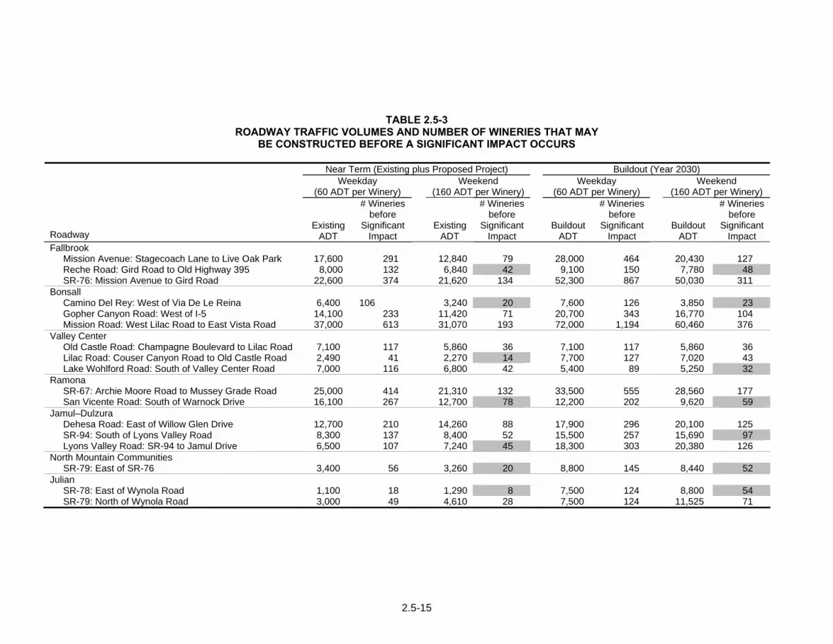
2.5-15
TABLE 2.5-3 ROADWAY TRAFFIC VOLUMES AND NUMBER OF WINERIES THAT MAY
BE CONSTRUCTED BEFORE A SIGNIFICANT IMPACT OCCURS
Near Term (Existing plus Proposed Project) Buildout (Year 2030) Weekday
(60 ADT per Winery) Weekend
(160 ADT per Winery) Weekday
(60 ADT per Winery) Weekend
(160 ADT per Winery)
Roadway
Existing ADT
# Wineries before
Significant Impact
Existing ADT
# Wineries before
Significant Impact
Buildout ADT
# Wineries before
Significant Impact
Buildout ADT
# Wineries before
Significant Impact
Fallbrook Mission Avenue: Stagecoach Lane to Live Oak Park 17,600 291 12,840 79 28,000 464 20,430 127 Reche Road: Gird Road to Old Highway 395 8,000 132 6,840 42 9,100 150 7,780 48 SR-76: Mission Avenue to Gird Road 22,600 374 21,620 134 52,300 867 50,030 311
Bonsall Camino Del Rey: West of Via De Le Reina 6,400 106 3,240 20 7,600 126 3,850 23 Gopher Canyon Road: West of I-5 14,100 233 11,420 71 20,700 343 16,770 104 Mission Road: West Lilac Road to East Vista Road 37,000 613 31,070 193 72,000 1,194 60,460 376
Valley Center Old Castle Road: Champagne Boulevard to Lilac Road 7,100 117 5,860 36 7,100 117 5,860 36 Lilac Road: Couser Canyon Road to Old Castle Road 2,490 41 2,270 14 7,700 127 7,020 43 Lake Wohlford Road: South of Valley Center Road 7,000 116 6,800 42 5,400 89 5,250 32
Ramona SR-67: Archie Moore Road to Mussey Grade Road 25,000 414 21,310 132 33,500 555 28,560 177 San Vicente Road: South of Warnock Drive 16,100 267 12,700 78 12,200 202 9,620 59
Jamul–Dulzura Dehesa Road: East of Willow Glen Drive 12,700 210 14,260 88 17,900 296 20,100 125 SR-94: South of Lyons Valley Road 8,300 137 8,400 52 15,500 257 15,690 97 Lyons Valley Road: SR-94 to Jamul Drive 6,500 107 7,240 45 18,300 303 20,380 126
North Mountain Communities SR-79: East of SR-76 3,400 56 3,260 20 8,800 145 8,440 52
Julian SR-78: East of Wynola Road 1,100 18 1,290 8 7,500 124 8,800 54 SR-79: North of Wynola Road 3,000 49 4,610 28 7,500 124 11,525 71

Subchapter 2.6 Transportation/Traffic
2.6-1
2.6 Transportation/Traffic
The following discussion is based on the Traffic Impact Analysis prepared by Linscott et al. (2009) to assess the traffic impacts associated with the Proposed Project. The complete traffic study is included in this EIR as Appendix D.
2.6.1 Existing Conditions
2.6.1.1 Key Roadway Segments Analyzed
The following analysis examines the potential impacts to specific, representative Circulation Element roadways in representative primary community plan areas in the County of San Diego where wineries currently exist. These plan areas were selected because they; a) have areas of agricultural zoning to permit wineries to develop; b) sustain climate, soil, and other geographic/agricultural features suitable for winery operations, and/or; c) represent areas where there are existing wineries.
Within each community plan area, key representative Circulation Element roadways were selected that would be affected by winery development in that plan area. These roadway segments include arterial roadways that link communities in the plan area with larger, regional roadways and were chosen for analysis based on several factors, including the streets leading to rural communities, accessibility to arterials and freeways, and location of land designated and zoned (A70 and A72) for agriculture. Existing and proposed roadway classifications and key segment characteristics for each of the selected community plan roadways are shown in Table 2.6-1.
As part of the ongoing General Plan Update, the County of San Diego has identified the existing roadways throughout the County of San Diego that are operating at or below County of San Diego standards (Level of Service (LOS) D). Table 2.6-2 presents the summary table from the General Plan Update which illustrates the total lane miles on roadway segments that are operating at LOS E or F within each of the selected CPAs in the county.
2.6.1.2 Traffic Volumes
Existing weekday ADT were obtained from County of San Diego records and recent traffic studies for the study area roadways in the various community plan areas. Based on site-specific data and surveys received from local wineries; it was determined that wineries generate the majority of their patron traffic on the weekends. Therefore, bi-directional 24-hour daily traffic counts were conducted on the majority of the key street segments in the seven community plan areas on Saturday January 10, 2009. The remaining traffic volumes were provided by Caltrans.

Subchapter 2.6 Transportation/Traffic
2.6-2
TABLE 2.6–2 ROADWAY LANE MILES BY LEVEL OF SERVICE
EXISTING CONDITIONS
Lane Miles LOS E LOS F
CPA State
Highway CE
Roads Total State
Highway CE
Roads Total North County
Fallbrook 4.0 16.7 20.7 4.4 12.6 17.0 Bonsall 0.0 10.8 10.8 8.7 9.6 18.3
Valley Center 0.0 14.4 14.4 0.0 7.4 7.4
Ramona 4.0 9.0 13.0 11.5 15.9 27.4 East County
Jamul–Dulzura 0.0 2.5 2.5 6.1 6.1 12.2 Backcountry
North Mountain* 0.0 0.0 0.0 0.0 0.0 0.0
Julian 0.0 0.0 0.0 0.0 0.0 0.0 Total 8.0 53.4 61.4 30.7 51.6 82.3
Source: County of San Diego General Plan Update Circulation Element Framework 2006 Values shown are miles of roadway. CPA = Community Plan Area LOS = level of service CE Roads = Circulation Element Roadways. * North Mountain Community Plan Area includes Warner Springs.
2.6.1.3 Existing Roadway Segment Operations
The following is a discussion of the existing daily roadway operations, based on existing weekday and weekend traffic volumes, and existing roadway capacities. Table 2.6–3 summarizes the existing roadway segment operations. Table 2.6-3 shows seven existing segments operating at LOS E or F as indicated in shaded text.
2.6.1.4 Year 2030 Street Segment Operations
Table 2.6-4 shows that more than 114 roadway lane miles throughout the county are calculated to operate at below County of San Diego standards (LOS D) in the Year 2030, assuming that the Circulation Element is implemented. Using this information, a Horizon Year 2030 street segment analysis was completed (Table 2.6-5). Implementation of the County of San Diego’s proposed General Plan Update Circulation Element Framework (November 2006) was assumed as the basis for the Year 2030 street segment analysis because it provides the most up to date projections for future conditions based on SANDAG models. The Circulation Element was also used because it can be reasonably expected that the proposed improvements would be in place. In addition, for the cumulative impacts analysis, the list of projects method was not feasible because of the size of the study area and the number of projects that could contribute to impacts. Therefore, the analysis relied upon the Circulation Element as the most recent data available.
Based on the analysis as shown on Table 2.6-5, segment operations on Mission Avenue and SR-76 in the Fallbrook Community Planning Area, on Mission Road in the Bonsall Community Planning Area, on SR-67 in the Ramona Community Planning Area, and on

Subchapter 2.6 Transportation/Traffic
2.6-3
SR-94 and Lyons Valley Road in the Jamul-Dulzura Subregional Plan Area would operate at LOS E or F by the year 2030 despite the anticipated increase in capacity at buildout that would result from implementation of the Circulation Element.
TABLE 2.6-4 ROADWAY LANE MILES BY LEVEL OF SERVICE
BUILD-OUT CONDITIONS
Lane Miles LOS E LOS F
CPA State
Highway CE
Roads Total State
Highway CE
Roads Total North County
Fallbrook 0.0 23.3 23.3 0.6 4.1 4.7 Bonsall 2.7 8.7 11.4 9.0 9.5 18.5
Valley Center 0.0 17.9 17.9 0.0 15.1 15.1 Ramona 0.5 6.3 6.8 1.7 1.8 3.5
East County Jamul–Dulzura 4.4 7.3 11.7 14.1 14.1 28.2
Backcountry North Mountain* 0.0 0.0 0.0 0.0 0.0 0.0 Julian 0.0 0.0 0.0 0.0 0.0 0.0
Total 7.6 63.5 71.1 25.4 44.6 114.6 Source: County of San Diego General Plan Update Circulation Element Framework 2006. The information in this table is current as of the date of the date on the Traffic Impact Analysis. Values shown are miles of roadway. CPA = Community Plan Area CE Roads = Circulation Element Roadways. *North Mountain Community Plan Area includes Warner Springs.
2.6.1.5 Trip Generation
There are no published trip generation rates for wineries either in the national Institute of Transportation Engineers Trip Generation Manual, or in the regional SANDAG Brief Guide to Vehicular Traffic Generation Rates for the San Diego Region. Research was conducted in California counties known for wineries, including Napa, Sonoma, Santa Barbara, San Luis Obispo, Placer and Amador counties and none had developed formal trip generation rates for wineries for use in determining traffic impacts.
Thus, the traffic study prepared for this analysis selected three representative winery types and considered trip generation rates to determine a typical winery’s trip generation. The wineries selected for study were chosen because they best represent the variety of operations that could occur under the by-right Boutique Winery classification if the amendment is approved. One operating winery was selected from outside the study area (Temecula) but in an area easily accessible from more urban areas because it currently produces the maximum amount of wine (12,000 gallons/5,000 cases annually) allowed for Boutique Wineries. It should be noted that owners of wineries of all three types studied live on-site within a single-family home. Although individually not a big generator of traffic, each single-family home generates approximately 10 ADT based on SANDAG’s Brief Guide to Vehicular Traffic Generation Rates for the San Diego Region. The following provides a more detailed description of the three wineries studied, and estimated trip generation rates.

Subchapter 2.6 Transportation/Traffic
2.6-4
Study Winery Selection
It was determined that for traffic generating purposes, there are three general settings in the County of San Diego where wineries could be expected to occur: Backcountry-Destination, Backcountry-Rural, and Suburban. Each is described below.
Backcountry-Destination
Backcountry-Destination is considered a rural area with a variety of economic attractions that draw visitors. The Julian Community Planning Area is an example. Located over an hour from metropolitan San Diego, Julian has a well-developed reputation as a destination for art, antiques, and agriculture among others. Julian is both an established destination on its own, as well as a popular stop for tourists traveling to the neighboring desert and mountains. Wineries located in “Backcountry–Destination” areas would likely experience higher trip generation due to the economy of scale of the adjacent tourist destination(s).
For this study, the Menghini Winery located near Julian was chosen as representative of a “Backcountry-Destination” winery.
Backcountry-Rural
A Backcountry-Rural setting, for this discussion, is a rural area that does not have a well-known or developed economic draw, primarily because of the real or perceived geographic separation from metropolitan centers. The community of Warner Springs is an example. Also located over an hour from metropolitan San Diego, Warner Springs has a less developed reputation as a tourist destination, although there are resorts in the vicinity that attract tourists. Warner Springs is not as ideally situated between tourist destinations as Julian, although it too is a well-known stop for travelers in the backcountry. Wineries located in “Backcountry–Rural” areas would not likely experience as high of a trip generation as “Backcountry–Destination” areas because of the lack adjacent tourist draw. “Backcountry–Rural” wineries may themselves be the destination for travelers, rather than part of a series of destinations in the same general vicinity.
For this study, the Shadow Mountain Vineyards and Winery located near Warner Springs was chosen as representative of a “Backcountry–Rural” winery.
Suburban
Suburban is an area type located close (within an hour) to metropolitan centers. The surrounding area may still be rural in appearance, however wineries located in “Suburban” areas would benefit from closer proximity to customers, as well as their geographic proximity to major roads/freeways. The Temecula Valley is an example. Temecula has a well-developed reputation as a wine-growing area, and is located along the busy I-15 and I-215 corridors. In addition to the benefit of fast and convenient regional access, Temecula wineries enjoy the benefits of an “industry” economy of scale. That is, some tourists to Temecula come expressly for the wine industry (tasting, etc) and will tour the many wineries in the area on a single trip. In this respect, Suburban and Backcountry-Destination areas are alike. However, Suburban areas would still be expected to generate higher traffic volumes simply due to their proximity to urban centers and the ease of access.

Subchapter 2.6 Transportation/Traffic
2.6-5
For this study, the Hart Family Winery located in Temecula was chosen as representative of a “Suburban” winery. The Hart Family winery, with its suburban location, was also selected because current production levels generally match the maximum allowed by the proposed ordinance revision for the Wholesale Limited and Boutique Wineries (approximately 12,000 gallons or 5,000 cases of wine annually).
It should also be noted that each of the existing wineries selected above operates pursuant to an approved Major Use Permit which allows some activities (e.g., outdoor events) that would not be allowed by right under the proposed Tiered Winery Zoning Ordinance Amendment. Therefore, even though these wineries provide the best available existing comparison and representative example of the traffic that would be generated by the proposed winery types, they may not be an exact model.
Estimated Trip Generation
Survey data were obtained for the three wineries selected for the study. The types of trip generating information in these surveys included the following:
a. Number of cases produced/year (i.e., relative size of winery)
b. Hours of operation
c. Number of visitors per day/week (either vehicle trips or persons)
d. Average number of persons per vehicle
e. Busiest month for visitors
f. Number and types of events
g. Number of employees/shifts
h. Number of deliveries/types
From this information, the approximate number of ADT for each location was estimated for typical operations on a weekday and weekend. The following is a brief description of the trip generation and other characteristics for each of these wineries.
Menghini Winery
The Menghini Winery is located three miles north of downtown Julian at 1150 Julian Orchards Drive in the Julian Community Planning Area in the County of San Diego. The Menghini Winery has a six-acre vineyard and reports annual production of approximately 3,000 to 4,000 cases or approximately 7,100 to 9,500 gallons of wine.
Hours of Operation The typical hours of operation are from 10 A.M. to 4 P.M. weekdays, and 10 A.M. to 5 P.M. on weekends.
Visitor Trips Based on survey responses provided by the operator, the winery receives approximately 30 weekday visitor-vehicles (60 ADT) and 60 weekend visitor-vehicles (120 ADT) on average. The winery estimates its busiest times to be weekends and “Julian Apple

Subchapter 2.6 Transportation/Traffic
2.6-6
Days” in October. Summer months are less busy with approximately half the number of visitors
Vehicle Occupancy The average occupancy of each vehicle is estimated at two persons.
Employees Owners plus two additional staff two days/week.
Deliveries FedEx: once per week; bottle delivery: three times/year; grapes pickup: eight times/year
Shadow Mountain Vineyards and Winery
The Shadow Mountain Vineyards and Winery is located northwest of Warner Springs at 34680 Highway 79 in the Community of Warner Springs in the County of San Diego. The Shadow Mountain Winery reports production of approximately 1,700 cases or 4,000 gallons of wine per year.
Hours of Operation The typical hours of operation for the tasting room are from 10 A.M. to 5 P.M., Wednesdays through Sundays.
Visitor Trips Based on survey responses provided by the operator, the winery receives approximately five weekday visitor-vehicles (10 ADT) and 10 weekend visitor-vehicles (20 ADT) on average. The winery estimates its busiest months of operation to be March, November, and December. Slower months see about half of the volume as compared to trips generated during these months.
Vehicle Occupancy The average occupancy of each vehicle is two persons.
Employees Owners plus one additional full time employee. Seven seasonal employees are hired for a two-month period during the harvest in September/October.
Deliveries FedEx: once per week; bottle delivery: three times/year; grapes pickup: eight times/year
Hart Family Winery
The Hart Family Winery is located on a 10-acre property west of Butterfield Stage Road and north of Rancho California at 41300 Avenida Biona. The site is located in the Temecula Valley, in the County of Riverside. The Hart Family Winery reports production of approximately 5,000 cases or 12,000 gallons of wine per year.
Hours of Operation The typical hours of operation are from 9 A.M. to 4:30 P.M. daily.
Visitor Trips Based on survey responses provided by the operator, the winery receives approximately 14 weekday visitor-vehicles (28 ADT) and 49 weekend visitor-vehicles (98 ADT) on average.
Vehicle Occupancy The average occupancy of each vehicle is two persons.

Subchapter 2.6 Transportation/Traffic
2.6-7
Employees Three full time and four part time employees are reported.
Deliveries UPS: once per day; other unspecified deliveries several times/year.
“Observed” Trip Generation
For each of the three wineries, counts were conducted at on site driveways where conditions were considered favorable (e.g., paved surface, well-throated driveways, etc.) to collect the total traffic counts that enter and exit a location over a 24-hour period. Where unimproved driveways were present, data was collected adjacent to the site’s driveway(s) on the cross street and the project traffic count was estimated.
The following summarizes the ADT traffic-count trip generation conducted for the three-winery sites.
Menghini Winery
The Menghini Winery has three driveways, identified for this study as the West Driveway, Main Driveway and East Driveway. None of these were deemed suitable to set up counting equipment, so counts were taken on the adjacent street; Julian Orchards Lane. Counters were set west of the West Driveway, and east of the Main Driveway to best capture site traffic. The counters showed site generation of approximately 40 weekday ADT and 160 weekend ADT.
Shadow Mountain Vineyards and Winery
The Shadow Mountain Winery has a main driveway that was suitable for counting equipment. ADT counts were conducted on the driveway for both weekday and weekend time frames. Inbound and outbound site traffic was measured. The average measured volumes on the Shadow Mountain Winery driveway were 20 weekday ADT and 30 weekend ADT, rounded to the nearest “10”.
Hart Family Winery
The Hart Family Winery has a main access via Biona Road that was suitable for counting equipment. ADT counts were conducted on the driveway for both weekday and weekend time frames. Inbound and outbound site traffic was measured. The average measured volumes on the Hart Winery driveway were 60 weekday ADT and 110 weekend ADT, rounded to the nearest “10”.
As can be seen, measured counts at each of the three sample locations were generally higher than reported trip generation estimates obtained during interviews.
“Observed” Trip Generation Summary/Comparison
Table 2.6-6 shows a comparative summary of the three sites’ trip generation based on traffic counts. The table also shows the calculated trip generation rates based on the size of each winery and its estimated or observed ADT.

Subchapter 2.6 Transportation/Traffic
2.6-8
TABLE 2.6-6 SUMMARY COMPARISON
OBSERVED TRIP GENERATION AND CALCULATED RATES
Observed Volumes (ADT)
Calculated Trip Generation Rates
(Trips/1,000 cases/year) Winery
Size (cases/year) Weekday Weekend Weekday Weekend
Menghini 4,000 40 160 10.0 40.0 Shadow Mountain 1,700 20 30 11.8 17.6 Hart 5,000 60 110 6.0 22.0 Average 3,570 40 100 11.2 28.0 Source: Appendix D Calculated Trip Generation Rates are the observed volumes divided by the size of the wineries (per thousand cases/year).
Based on this analysis, wineries located in “Backcountry–Destination” areas could be expected to have the highest relative trip generation characteristics of the three. “Backcountry–Rural” wineries could be expected to have the lowest trip generation, and “Suburban” wineries could be expected to have trip generation somewhere in between.
The observed trip generation (taken from on-site counts) was equal to or higher than the estimated trip generation for each winery, except for the Hart Winery (weekday). A decision was made to base the analysis on the winery with the highest observed site traffic. Because the minor difference in observed weekday volumes would not substantially change the analysis or projected LOS on area roadways selected for study, observed operations at the Menghini winery were selected to best represent the worst-case observed trip generation among the three winery-types/locations. Therefore the worst-case site generation used for the traffic analysis was 40 weekday ADT and 160 weekend ADT.
2.6.1.6 County of San Diego Standards and Regulations
Public Road Standards
These standards provide design and construction requirements for public road improvement projects located within the unincorporated areas of the County of San Diego. These standards apply to County of San Diego -initiated public road improvement projects as well as privately-initiated public road improvement projects. These standards provide minimum design and construction requirements for public roads.
Private Road Standards
These standards provide minimum design and construction requirements for private road improvements required as conditions of land development approval in unincorporated areas of the County of San Diego. Levels of service are not established for private roads. Minimum design and construction requirements, however, are established based upon the projected ADT volume on the road.

Subchapter 2.6 Transportation/Traffic
2.6-9
County of San Diego Consolidated Fire Code (CFC)
The County of San Diego, in collaboration with the local fire protection districts, created the first CFC in 2001. The CFC contains the County of San Diego’s and fire protection districts’ amendments to the California Fire Code. Emergency ingress/egress is established by County of San Diego’s CFC. Ingress/egress is necessary for both citizen evacuation and to provide access for emergency vehicles in the event of a fire or other emergency. Section 902.2 of the CFC dictates minimum design standards for “Fire Apparatus Access Roads” and includes minimum road standards, secondary access requirements, and restrictions for gated roads and gated communities. Road standard requirements for emergency vehicles specify a minimum 12-foot paved lane or 24-foot travel-way.
County of San Diego Transportation Impact Fee (TIF) Ordinance
The County of San Diego has developed an overall programmatic solution that addresses existing and projected future road deficiencies in the unincorporated portion of San Diego County. This program commits the County of San Diego to construct additional capacity on identified deficient roadways and includes the adoption of a TIF program to fund improvements to roadways necessary to mitigate potential cumulative impacts caused by traffic from future development. The fees are collected at issuance of a development permit (including building permits) and at the time that a change of occupancy occurs. The fees are used to fund identified transportation facilities, or portions thereof, that provide increased road capacity necessitated by the cumulative impacts of future development. This program is based on a summary of projections contained in an adopted planning document which evaluates regional or area wide conditions contributing to cumulative transportation impacts. Although the program does not address every road in the unincorporated County of San Diego, it is considered to be a broad-based approach to mitigation of cumulative traffic impacts from additional traffic generated by a project or series of projects.
2.6.2 Analysis of Project Effects and Determination as to Significance
2.6.2.1 Road Segment Operations, Level of Service, Congestion
Guidelines for the Determination of Significance
To ensure that future development impacts are addressed, the County of San Diego has created guidelines to evaluate likely traffic impacts of a project for road segments and intersections serving a given project site, for purposes of determining whether the development would "significantly impact congestion" on the referenced LOS E and F roads. Table 2.6-7 provides a summary of the threshold guidelines which were developed based upon average operating conditions on County of San Diego roadways. A significant impact would occur if the Proposed Project contributes more than the number of ADT listed in Table 2.6-7. These thresholds only establish general guidelines, and a specific project’s location must be taken into account in conducting an analysis of traffic impact from new development.

Subchapter 2.6 Transportation/Traffic
2.6-10
TABLE 2.6-7 MEASURES OF SIGNIFICANT PROJECT IMPACTS TO CONGESTION ON ROAD SEGMENTS
ALLOWABLE INCREASES ON CONGESTED ROAD SEGMENTS
Level of Service Two-Lane Road Four-Lane Road Six-Lane Road LOS E 200 ADT 400 ADT 600 ADT LOS F 100 ADT 200 ADT 300 ADT
By adding Proposed Project trips to all other trips from a list of projects, this same table must be used to determine if total cumulative impacts are significant. If cumulative impacts are found to be significant, each project that contributes any trips must mitigate a share of the cumulative impacts. The County of San Diego may also determine impacts have occurred on roads even when a project’s traffic or cumulative impacts do not trigger an unacceptable level of service, when such traffic uses a significant amount of remaining road capacity.
In addition, pursuant to the County’s General Plan Public Facilities Element, a significant impact would occur if the Proposed Project results in a reduction in LOS below “C” for onsite Circulation Element roads during peak traffic hours.
The County of San Diego does not provide guidelines for determining significant impacts on private roads based on LOS. This is due to several factors, including low volumes, the fact they are often unpaved, and the fact that these roadways are not designed to carry through traffic. It should be noted that once a private road is determined to carry more than 2,500 trips per day, the County may require that the roadway be dedicated and improved to County of San Diego Public Road standards. However, a significant impact could occur if the project increases traffic volumes that affect the safety of a roadway, such as on roads with steep grades, insufficient width or curve radii.
Analysis
Wholesale Limited Winery
Amendment to the existing ordinance to allow an increase in wine production from 7,500 gallons annually to 12,000 gallons annually (4,500 gallons or less than 80 cases) for the Wholesale Limited Winery use would not result in a significant increase in traffic on project area roadways because small scale vineyards are typically managed by the winery operator/owner and do not require full-time staff to maintain. Seasonal workers may be employed during the harvest period of September and October and, according to the interviews with winery operators, are employed for approximately one to three weeks per year. Workers often carpool to the site. Operations within the A70 or A72 Zones for the Proposed Project would be consistent with uses allowed by right in the agricultural zone. Furthermore, any increase of imported grapes, bottles, packing/shipping supplies, or miscellaneous business-related products could be accommodated by approximately the same number of deliveries as for the current condition. Winery operators interviewed for this study indicated that supply orders are typically combined for several wineries, with the same truck delivering to each since an individual order does not fill the truck. Consistent with the existing condition, retail sales and wine tasting would not be allowed under the amended ordinance, so there would be no increase in traffic due to visitors. Impacts would be less than significant.
Boutique Winery
Because future Boutique Wineries could occur anywhere within the A70 or A72 Zones countywide, there is no way to determine whether one or more specific future projects

Subchapter 2.6 Transportation/Traffic
2.6-11
(as discussed in Section 2.6.1.5 above) might reduce operations to on-site Circulation Element roadways currently operating at LOS C or better to below LOS C, or to below LOS D for off-site and on-site abutting Circulation Element roads, or cause a residential street to exceed its design capacity. Clearly, if the objectives of the Proposed Project are met, it is conceivable that multiple wineries within a given community could be located in close proximity, thereby requiring visitors to travel the same route. Many of these trips would be shared trips as a single car may visit several wineries in close proximity. Nevertheless, the impact to existing LOS on regional Circulation Elements could be significant depending on the location, site conditions, and development proposed. Consequently, impacts to future on- and off-site Circulation Element roads from development of Boutique Wineries would be significant (TR-1).
Table 2.6-8 summarizes the near-term traffic conditions on representative roads within study area communities with and without additional wineries that offer retail sales and wine tasting. For each of the representative roadways, remaining “reserve capacity” is shown. Reserve capacity is the amount of roadway capacity (in ADT) that is available for development until the LOS E threshold is reached. Where roadways are currently operating at LOS E or LOS F, the amount of reserve capacity is measured as the allowable increase in ADT until a significant impact would occur, as stated in the County of San Diego’s significance criteria.
Also shown on Table 2.6-8 is the number of wineries which could be developed assuming the identified worst case trip generation (40 ADT/site (weekday), and 160 ADT/site [weekend] as discussed in Section 2.6.1.5 above). To calculate the number of Boutique Wineries that could be constructed in a particular community before a significant impact would occur, the reserve capacity for each roadway was divided by the number of trips/winery. The lowest number calculated for each community is the number of wineries that could be constructed prior to significant impacts occurring.
Because development of specific future Boutique Wineries are not currently known, specific impacts to roadway LOS from their development are unknown. As can be seen on Table 2.6-8, there is minimal reserve capacity remaining for several key roadways and an increase of even one additional winery in the communities of Fallbrook, Bonsall, Ramona or Jamul–Dulzura would result in a significant impact. Because this analysis presents a representative sample, significant impacts to other roads with minimal reserve capacity could occur in a number of locations. The Proposed Project removes the requirement for any future discretionary review for future Boutique Wineries, which could result in an unknown number of new tasting and sales operations opening anywhere within the approximate 440,000 acres zoned A70 and A72. Currently, there are more than 30 Wholesale Limited Winery operations within the County of San Diego’s jurisdiction, and a significant number of these are in the Ramona community. It’s reasonable to expect that a number of existing Wholesale Limited Winery operators would seize the opportunity to offer wine tasting and sales if allowed by right as proposed and that the number of Boutique Wineries will increase.
By revising the existing Zoning Ordinance, the County of San Diego would no longer have the ability to review the specific conditions of a given Boutique Winery operation to ensure adequate mitigation for impacts to specific public roadways, some of which are currently operating at unacceptable levels of service.

Subchapter 2.6 Transportation/Traffic
2.6-12
Furthermore the Proposed Project could add traffic to many private roads, depending on the specific location of a new Boutique Winery. Some of these private roads may be dirt and may not meet County of San Diego Private Road Standards and may have steep grades or insufficient width or curve radii. Given the fact that (i) increased traffic volumes generated from one or more Boutique Wineries developed on a private road may exceed a private road’s designed capacity, (ii) new or expanded wineries may be established on private roads which do not meet County Design Standards, and (iii) the exact location of future wineries cannot be predicted, impacts from increased traffic on private roads are considered significant (TR-1).
Finally, many existing Wholesale Limited Wineries can only be accessed via private roads, a number of which are dirt and may not meet County of San Diego Private Road Standards. If these Wholesale Limited Wineries are converted to Boutique Wineries, increased traffic on dirt roads (if regular maintenance is even performed) or on roads with steep grades or insufficient width or curve radii to handle increased traffic from visitors could also result in a significant impact (TR-2).
The following is a summary of the results for each community addressed in the study:
Fallbrook
Table 2.6–8shows that two of the two-lane roadway segments in the Fallbrook Community Planning Area are currently failing. The lowest reserve capacity is therefore 100 ADT for both the weekday and weekend. The weekday trip generation is 40 ADT/winery, and the weekend trip generation is established at 160 ADT/winery. Based on the weekday reserve capacity, up to two wineries could be constructed. However, based on weekend reserve capacity, construction of one Boutique Winery that would add traffic to SR-76 would result in a significant impact in the Fallbrook Community Planning Area.
Bonsall
Two of the two-lane roadway segments in the Bonsall Community Planning Area are currently failing, and the lowest reserve capacity is therefore 100 ADT. Utilizing a weekday trip generation of 40 ADT per winery and a weekend trip generation of 160 ADT per winery, construction of two wineries (weekday) or one winery (weekend) would result in a significant impact to at least one roadway segment in Bonsall.
Valley Center
All of the roadways in the Valley Center Community Planning Area are calculated to operate at acceptable LOS D or better. The reserve capacity on these roadways could accommodate up to 25 wineries based on the trip generation established in this report. However, were 25 wineries to be constructed, the collective traffic of these projects would usurp all reserve capacity on the key Lake Wohlford Road segment. While theoretically feasible, the development of 25 wineries that would use up the subject area’s reserve roadway capacity is unlikely to occur because the 25 wineries would have to be constructed at roughly the same time.

Subchapter 2.6 Transportation/Traffic
2.6-13
Ramona
As shown in Table 2.6–8, two of the two-lane roadway segments in the Ramona Community Planning Area are currently failing. The lowest reserve capacity is therefore 100 ADT. Using a weekend trip generation rate of 160 ADT per winery, no additional wineries could be constructed without a significant impact occurring to the SR-67 roadway segment in Ramona. Since it is expected that some of Julian’s traffic would travel through neighboring Ramona, which is constrained by poorly operating segments, the winery limits identified for Ramona stated here would also apply to Julian and the North Mountain Subregional Plan Subarea as well.
Jamul–Dulzura
One of the two-lane roadway segments in the Jamul Subregional Plan Area is currently operating at LOS E. The reserve capacity is therefore 200 ADT. The weekend trip generation is established at 160 ADT/winery. Therefore, construction of more than five wineries (weekday) or one winery (weekend) could result in a significant impact to at least one roadway segment in Jamul.
North Mountain Communities (including Warner Springs)
The key roadway segment in Warner Springs currently operates at an acceptable LOS B. Technically, 47 additional wineries could be accommodated within the key segments’ reserve capacity. However, much of Warner Springs traffic comes through neighboring Ramona, which is constrained by road segments operating at low levels of service. Therefore, based on the weekday (2) and weekend (0) reserve capacity for Ramona, it was calculated that no (0) wineries could be constructed for the North Mountain Subregional Plan Area without a significant impact occurring to at least one roadway segment in Ramona.
Julian
Both of the key roadway segments in the Julian Community Planning Area are currently operating at LOS D or better. Technically, 39 additional wineries could be accommodated within the key segments’ reserve capacity. However, much of Julian’s traffic comes through neighboring Ramona, which is constrained by road segments operating at low levels of service. Therefore, based on the weekday (2) and weekend (0) reserve capacity for Ramona, it was calculated that for Julian, no (0) wineries could be constructed without a significant impact occurring to at least one roadway segment in Ramona.
Private Roads–(All Communities)
Any private road within San Diego County that serves land in the A70 or A72 Zones could potentially be impacted by approval of the proposed ordinance amendment. The County categorizes private roads as local roads that have not been declared or accepted for public use and/or County-maintenance by the County Board of Supervisors. It should be noted that levels of service are not applicable to private roads since these roads are not intended to carry through traffic. The design of private roads varies from area to area within the County. In rural areas such as Warner Springs and Julian (and others), these roads are typically designed as two–lane undivided, unpaved roadways ranging in

Subchapter 2.6 Transportation/Traffic
2.6-14
width between 20 and 30 feet. Other areas of the County have private roads paved with concrete or asphalt. It should be noted that once a private road is determined to carry more than 2,500 trips per day, the County may require that the roadway be dedicated and improved to County of San Diego Public Road standards. Increased traffic on private roads could be significant.
In summary, there are roadway segments within the County of San Diego where a significant direct impact would occur with the addition of just one winery. For other communities, development of considerably more wineries would be required before a significant impact would result. However, since the ordinance would allow by-right operations for Boutique Wineries without further consideration of location within the A70 or A72 Zones, there is no way to predict whether the maximum number would be exceeded.
2.6.2.2 Parking Capacity
A significant impact would occur if the Proposed Project would result in inadequate parking capacity.
Wholesale Limited Winery
Wholesale Limited Wineries would not be open to the public and would not increase the need for additional parking for visitors. Regarding employee parking, none of the three San Diego County wineries studied, each of which operates in accordance with an approved Major Use Permit and offers retail sales and wine tasting, had more than one full-time employee and one part-time employee. One of the wineries studied had no employees except for the owners. Smaller wineries of this size typically employ five to ten seasonal employees for the once-yearly harvest. The number of employees needed for Wholesale Limited Wineries, which would not be allowed to offer on-site sales or wine tasting to the public, would therefore be expected to be similar to or less than the number of employees needed for the study wineries. Based on the wineries studied and the seasonal nature of wine production, the number of employees needed would not be expected to increase if annual production is allowed to increase to 12,000 gallons. Thus, the Proposed Project is not anticipated to increase employee parking demand associated with planting or harvesting of grapes or wine making operations. Impacts would be less than significant.
Boutique Winery
Future Boutique Wineries would be required to provide a minimum of six parking spaces for customers and three spaces for employees/operations. This number of spaces would provide adequate parking capacity because operations are smaller and are not expected to draw large numbers of guests at any one time. In addition, it is common for a single car to carry multiple guests, thereby reducing the parking demand. Special events would not be allowed. The proposed amendment would also prohibit off-site parking for the winery. Parking impacts would be less than significant.

Subchapter 2.6 Transportation/Traffic
2.6-15
2.6.3 Cumulative Impact Analysis
Traffic Guideline for Determination of Significance
Cumulative traffic impacts would be significant if traffic resulting from the adoption of the Proposed Project exceeds the projections based on full buildout of the County’s General Plan Update.
Basis for the Assessment
The analysis of cumulative impacts relies on the projections of the General Plan Update as the most recent regional traffic data. The traffic data in the General Plan Update is based on SANDAG regional growth and land use forecasts. The SANDAG Regional Transportation Model was also used by the General Plan Update to analyze projected build-out (year 2030) development conditions on the existing Circulation Element roadway network throughout the unincorporated area of the County of San Diego.
Analysis
Wholesale Limited Wineries
Operations of a Wholesale Limited Winery would be consistent with the land use assumptions for agricultural land and would not result in a significant number of new trips to area roadways. Therefore, no cumulative impacts would result.
Boutique Wineries
The increase in agricultural uses in agricultural zones was included in the analysis for the General Plan Update while the addition of uses open to the public (such as a tasting room) was not. The Proposed Project would allow Boutique Wineries to open a tasting room that would generate additional ADT. A summary of the projected buildout (horizon year 2030) traffic conditions both with and without additional wineries is shown in Table 2.6-9. This table also shows how many Boutique Wineries could be developed at build-out (Year 2030) assuming a worst-case winery trip generation of 40 ADT/site (weekday) and 160 ADT/site (weekend). These trips generated by the Proposed Project would be distributed on Circulation Element roadways in the unincorporated area.
Traffic from multiple wineries that could open and operate under the Proposed Project could therefore generate traffic that may exceed the projections used for designated roads or highways in the General Plan Update, thereby contributing to a potential cumulative impact. Not all of the potential growth represented by the Proposed Project was included in the SANDAG growth projections and addressed in the TIF program. In addition, the TIF program does not address every road in the unincorporated County of San Diego. Therefore, the payment of TIF fees as a condition for obtaining a building permit and for all changes in occupancy would only partially mitigate the Proposed Project’s cumulative impact. Thus, the cumulative traffic impact of these future wineries not mitigated by the payment of TIF fees is considered to be a cumulatively significant impact (TR-3).

Subchapter 2.6 Transportation/Traffic
2.6-16
Buildout (Horizon Year 2030) Impacts
Fallbrook
Table 2.6–9 shows that one of the four-lane roadway segments in the Fallbrook Community Planning Area is calculated to fail with future traffic volumes. The reserve capacity is therefore 200 ADT. Using the established generation of 40 ADT/site (weekday), and 160 ADT/site (weekend), a significant impact would result to a least one roadway segment in the community if more than five additional wineries (weekday) or one additional winery (weekend) were constructed.
Bonsall
One of the six-lane roadway segments in the Bonsall Community Planning Area is forecasted to fail with future traffic volumes. The reserve capacity is therefore 300 ADT; thus a significant impact to at least one roadway segment in Bonsall would result if more than seven wineries (weekday) or one winery (weekend) were constructed.
Valley Center
All of the roadways in the Valley Center Community Planning Area are forecasted to operate at acceptable LOS D or better. The reserve capacity on these roadways could accommodate up to 38 wineries based on the trip generation established in this report. However, were 38 wineries to be constructed, the collective traffic of these projects would usurp all reserve capacity on the key Lilac Road segment, thereby denying any additional capacity for other cumulative projects. Thus, while technically possible, 38 wineries would be too much for this community and would result in a significant cumulative impact.
Ramona
One of the four-lane roadway segments in the Ramona Community Planning Area is projected to operate at LOS E under weekday build-out conditions. The reserve capacity is therefore 400 ADT. Using a weekday trip generation 40 ADT per winery, development of more than 10 wineries would result in a significant cumulative impact to SR-67 on the segment between Archie Moore Road and Mussey Grade Road in the Ramona Community Planning Area. Since there are currently more than 10 Wholesale Limited Wineries operating in the community currently, and the Proposed Project would allow these facilities to operate as Boutique Wineries by right or as larger Small Wineries with an Administrative Permit, the addition of 10 or more wineries offering wine tasting and retail sales facilities would be a significant cumulative impact.
Jamul–Dulzura
Table 2.6–9 shows that Lyons Valley road from SR 94 to Jamul Drive is projected to operate at LOS F at buildout. The reserve capacity is therefore 100 ADT. For weekdays, up to five wineries could be constructed before significant impacts would occur. The weekend trip generation is established at 160 ADT/winery. Therefore, during the weekend no wineries could be constructed without a calculated significant impact occurring to at least one roadway segment in Jamul.

Subchapter 2.6 Transportation/Traffic
2.6-17
North Mountain Communities (e.g., Warner Springs)
The key roadway segment in Warner Springs currently operates at an acceptable LOS C. This indicates a large amount of reserve capacity for development, including wineries. Technically, over 50 additional wineries could be accommodated within the key segments’ reserve capacity. However, much of Warner Springs traffic comes through neighboring Ramona, which is constrained by poorly operating segments. Therefore, based on the weekday (10) and weekend (24) reserve capacity for Ramona, a total of 10 new Boutique wineries can be accommodated in the combined Ramona Community Plan and North Mountain Subregional Plan areas. If no new wineries are constructed in Ramona, it was calculated that for the North Mountain Subregional Plan Area, up to 10 wineries could be constructed without a significant impact occurring to at least one roadway segment in Ramona.
Julian
Both of the key roadway segments in the Julian Community Planning Area are projected to operate at LOS D or better operations (Table 2.6-9). Based on the minimum reserve capacity of these roadways, over 50 wineries could be constructed during the weekday or up to 12 additional wineries could be accommodated on the weekend. However, much of Julian’s traffic comes through neighboring Ramona, which is constrained by poorly operating segments. Therefore, based on the weekday (10) and weekend (24) reserve capacity for Ramona, it was calculated that for Julian, up to 10 wineries could be constructed without a significant impact occurring to at least one roadway segment in Ramona.
In summary, because the implementation of the proposed ordinance amendment may result in the addition of new wineries and tasting rooms, the exact number of which cannot be determined traffic impacts would be significant. As discussed in the build-out (horizon year 2030) analysis above, these new wineries are estimated to generate 40 ADT (weekday) or 160 ADT (weekend) per winery. While the total number of new wineries which would occur as a result of the Proposed Project is unknown and speculative, many of the roadways analyzed would reach capacity after the addition of just one or two wineries.
Future wineries under the Zoning Ordinance Amendment could add traffic to private roads. However, additional traffic generated by Boutique Wineries would not result in a cumulatively considerable impact to private roads, because private roads are intended to provide limited access to adjacent parcels only. Private roads are not used for local or regional traffic flow and would therefore not be considered in regional traffic projections of the General Plan Update. Therefore, the Proposed Project would not result in a cumulative impact to private roads.
2.6.4 Significance of Impacts Prior to Mitigation
2.6.4.1 Road Segment Operations, Level of Service, Congestion
TR-1: Because the Proposed Project would add traffic on public roadways currently operating at unacceptable LOS and exceed the capacity of private roads, adoption of the proposed Zoning Ordinance Amendment could have a significant impact on traffic.

Subchapter 2.6 Transportation/Traffic
2.6-18
TR-2: Because the Proposed Project would add traffic to private roads that may have steep grades or insufficient width or curve radii, the Zoning Ordinance Amendment could have a significant impact on traffic.
2.6.4.2 Cumulative Impact Analysis
TR-3: The addition of a retail component would generate traffic that may exceed the projections used in the County of San Diego’s General Plan Update. Because the payment of TIF fees to mitigate cumulative impacts is not ensured for all future wineries under the Proposed Project, adoption of the proposed Zoning Ordinance Amendment could result in significant cumulative impacts to traffic.
2.6.5 Mitigation
The Proposed Project is a Zoning Ordinance Amendment and is not project specific. There is no way at this stage to know which specific future wineries may result in direct and cumulative impacts caused by adoption of the proposed ordinance due to variables such as winery size, location, access road conditions, and existing roadway LOS. Therefore, the impacts of specific future winery projects cannot be determined at this stage, nor can appropriate mitigation measures be identified or enforced.
However, some of these unidentified future winery projects may be required to obtain a discretionary permit such as a Grading Permit, which would trigger CEQA review of the specific future project. For such projects, feasible mitigation measures could be included in the permit, thus making them enforceable. Typical mitigation measures for these projects could include payment of TIF for cumulative impacts or specific road segment or intersection improvements for direct impacts, such as providing a turn lane, signalization, signage, road widening, re-striping, paving, or other road enhancements to accommodate traffic generated by future projects. As a result, specific impacts to traffic would be analyzed and mitigated for these types of by-right projects.
At the same time, there may also be future by-right projects for which related discretionary permits are required, but for which mitigation would not be feasible, or for which no related discretionary permit is required at all. For example, it may not be feasible to require a winery needing a Grading Permit to fund public or private roadway improvements due to cost based on existing road conditions, topography, and other site conditions such as adjacent slopes, stream crossings, and the length of required improvements. In addition, no Grading Permit would be required where grading is less than 200 CY. For such by-right projects, either appropriate mitigation would not be feasible, or CEQA review would not be required and no mitigation would be identified.
As it cannot be concluded at this stage that impacts to traffic from all future winery projects allowed by the ordinance amendment would be avoided or mitigated, impacts to public and private roadways would remain significant and unmitigated.
2.6.6 Conclusion
The proposed ordinance amendment would result in the addition of new wineries, expansion of existing wineries, and additional tasting rooms at existing wineries. However, the traffic study prepared for the Proposed Project was able to determine the capacity for additional winery growth in seven of the County of San Diego’s community

Subchapter 2.6 Transportation/Traffic
2.6-19
plan areas as a representative sample of County-wide conditions. While several of the seven CPAs analyzed would be able to accommodate some additional growth, significant near-term direct impacts would occur to community Circulation Element Roads with the addition of even one Boutique Winery in the communities of Fallbrook, Bonsall, Julian, and Ramona, and with the addition of more than one winery in the Jamul-Dulzura community (see Table 2.6-8). Conditions on SR-67 are of particular concern since the Ramona area would be unable to accommodate additional wineries because of the existing low levels of service on this roadway. Julian CPA would also face limitations on additional wineries because of the low level of service on SR-67 in the Ramona area.
Because this is a Zoning Ordinance Amendment, there is no way at this stage to know which specific future wineries may result in impacts. Some future winery projects may be required to obtain a discretionary permit such as a Grading Permit, which would trigger CEQA review of the specific future project. However, mitigation may not always be feasible for these projects, while other future projects may not even require a discretionary permit. Over the longer term, significant direct impacts would be reduced as improvements consistent with the Circulation Element are implemented, but would remain significant and unmitigated . Private roads where future wineries are located would also experience an increase in traffic that would be significant and unmitigated.
Furthermore, the Proposed Project would create significant cumulative impacts. Payment of TIF fees would mitigate some, but not all, cumulative impacts. Those which cannot be mitigated through the TIF program would remain significant and unmitigated. Requiring individual wineries to contribute TIF fees at the time of building permits or change in occupancy status toward the improvement of Circulation Element roadways, including SR-67, would also fully mitigate cumulative impacts. However, cumulative impacts to roads where the TIF program is difficult to enforce would remain significant and unmitigated.

2.6-20
TABLE 2.6-1 EXISTING ROADWAYS AND CLASSIFICATIONS
Roadway Existing Lanes Existing CE
Classification
Posted Speed Limit
Bike Lanes
Curbside Parking
Proposed GPU Classification
Community of Fallbrook Mission Ave 2-lane, undivided E/W facility Major 40 mph None
Provided
Prohibited -
both sides
Boulevard (4.2B)
Reche Rd 2-lane, undivided E/W facility Rural Collector None
posted
None
Provided
Prohibited –
both sides
Light Collector
(2.2C)
Expressway - S.
Mission Rd,
south of East
Vista Way
40 mph None
Provided
Prohibited –
both sides
Prime Arterial
(6.2)
Prime Arterial - I-
15 to S. Mission
Rd
40 mph None
Provided
Prohibited –
both sides
Major (4.1A)
SR 76
2-lanes, one travel lane each
direction, between East Vista Way
and Old Hwy 395 and east of I-15.
4-lanes between Old Hwy 395 and
I-15 and 4-lanes at key
intersections along SR-76 to
provide additional capacity at
intersections. Major –
East of I-15
40 mph None
Provided
Prohibited –
both sides
Community
Collector (2.1)
Community of Bonsall Camino Del Rey 2-lane undivided east-west facility Rural Collector None
Provided
None
Provided
Light Collector
(2.2C)
Gopher Canyon
Road
2-lane undivided east/west facility Collector None
posted
Provided Major (4.1B)
S. Mission Road 2-lane undivided east/west facility Major Generally
50 mph
None
Provided
Prohibited Prime Arterial
(6.2)

TABLE 2.6-1 EXISTING ROADWAYS AND CLASSIFICATIONS (CONT.)
2.6-21
Roadway Existing Lanes Existing CE
Classification
Posted Speed Limit
Bike Lanes
Curbside Parking
Proposed GPU Classification
Community of Valley Center Old Castle Road 2-lane undivided east/west facility Collector Road None
posted
Provided Prohibited Light Collector
(2.2D)
Lilac Road 2-lane undivided north/south facility Rural Light
Collector
None
posted
No bike
lanes or
bus stops
Prohibited Light Collector
(2.2E)
Lake Wohlford
Road
2-lane undivided facility Collector Generally
50 mph
None
Provided
None
Provided
Light Collector
(2.2C)
Community of Ramona SR 67 2-lane undivided facility Collector (Archie
Moore Rd. to
Ramona St.)
Generally
40 mph
Provided
(both sides
of road)
Prohibited Major (4.1A)
San Vicente Road 2-lane undivided facility south of Warnock Dr.
Major 50 mph No bike lanes or bus stops
Prohibited – both sides
Community Collector (2.1C)
Community of Jamul-Dulzura Dehesa Road 2-lane, narrow, winding undivided
east/west facility
Major Arterial Generally
45 mph
None
Provided
Prohibited Major (4.1B)
SR 94 2-lane undivided east/west facility Major
(south of Lyons
Valley Road)
Generally
50 mph
None
Provided
Prohibited Community
Collector (2.1D)
Lyons Valley
Road
2-lane undivided facility Collector Generally
45 mph
Provided
(both sides
of road)
Prohibited Light Collector
(2.2D)

TABLE 2.6-1 EXISTING ROADWAYS AND CLASSIFICATIONS (CONT.)
2.6-22
Roadway Existing Lanes Existing CE
Classification
Posted Speed Limit
Bike Lanes
Curbside Parking
Proposed GPU Classification
North Mountain Communities (e.g., Warner Springs) SR 79 2-lane, winding, undivided facility State Highway 55 mph None
Provided
None
Provided
Light Collector
(2.1D)
Community of Julian SR 78 2-lane, winding, undivided facility State Highway 40 mph None
Provided
None
Provided
Light Collector
(2.2D)
SR 79 2-lane, winding, undivided facility State Highway 55 mph None
Provided
None
Provided
Light Collector
(2.1D)

2.6-23
TABLE 2.6–3 EXISTING STREET SEGMENT OPERATIONS
Existing Traffic Volumes
Weekday Weekend
CPA/Street Segment
Existing
Capacity
(LOS D) ADT LOS ADT LOS
Fallbrook
Mission Avenue: Stagecoach Lane to Live Oak Park 10,900 17,600E F 12,840 E
Reche Road: Gird Road to Old Highway 395 10,900 8,000 D 6,840 C
SR 76: Mission Avenue to Gird Road 10,900 22,600 F 21,620 F
Bonsall
Camino Del Rey: West of Via De La Reina 10,900 6,400E C 3,240 B
Gopher Canyon Road: West of I–15 10,900 14,100 E 11,420 E
Mission Road: West Lilac Road to East Vista Way 10,900 37,000 F 31,070 F
Valley Center
Old Castle Road: Champagne Boulevard to Lilac Road 10,900 7,100 C 5,860 C
Lilac Road: Couser Canyon Road to Old Castle Road 10,900 2,490 B 2,270 B
Lake Wohlford Road: South of Valley Center Road 10,900 7,000 C 6,800 C
Ramona
SR 67: Archie Moore Road to Mussey Grade Road 10,900 25,000 F 21,310 F
San Vicente Road: South of Warnock Drive 10,900 16,100 E 12,700 E
Jamul–Duzura
Dehesa Road: East of Willow Glen Drive 10,900 12,700 E 14,260 E
SR 94: South of Lyons Valley Road 10,900 8,300 D 8,400 D
Lyons Valley Road: SR 94 to Jamul Drive 10,900 6,500 C 7,240 D
North Mountain Communities*
SR 79: East of SR 76 10,900 3,400 B 3,260 B
Julian
SR 78: East of Wynola Road 10,900 1,100 A 1,290 A
SR 79: North of Wynola Road 10,900 3,000 B 4,610 C
Capacities based on County of San Diego Roadway Classification Table
CPA= community plan area
E = Estimated volume based on historical data obtained from County of San Diego traffic volumes records.
ADT= Average Daily Traffic Volumes. Weekday ADT are from County of San Diego records and from recent traffic
studies conducted in these areas. The majority of the weekend ADT counts were conducted on Saturday,
January 10, 2009. Caltrans staff provided the remaining traffic volumes.
LOS= Level of Service.
* = North Mountain Community Plan Area includes Warner Springs.

2.6-24
TABLE 2.6-5 BUILDOUT STREET SEGMENT OPERATIONS
Buildout (General Plan Update) – Year 2030
Weekday Weekend
CPA/Street Segment
General Plan Update
Classification
Buildout
Capacity
(LOS D) ADT LOS ADT LOS
Fallbrook
Mission Avenue: Stagecoach Lane to Live Oak Park Boulevard (4.2B) 25,000 28,000 F 20,430 E
Reche Road: Gird Road to Old Highway 395 Light Collector (2.2C) 13,500 9,100 C 7,780 C
SR 76:Mission Avenue to Gird Road Major Road (4.1A) 33,400 52,300 F 50,030 F
Bonsall
Camino Del Rey: West of Via De La Reina Light Collector (2.2C) 13,500 7,600 C 3,850 B
Gopher Canyon Road: West of I–15 Major Road (4.1B) 30,800 20,700 B 16,770 B
Mission Road: West Lilac Road to East Vista Way Prime Arterial (6.2) 50,000 72,000 F 60,460 F
Valley Center
Old Castle Road: Champagne Boulevard to Lilac Road Light Collector (2.2D) 13,500 7,100 C 5,860 B
Lilac Road: Couser Canyon Road to Old Castle Road Light Collector (2.2E) 10,900 7,700 D 7,020 C
Lake Wohlford Road: South of Valley Center Road Light Collector (2.2C) 13,500 5,400 B 5,250 B
Ramona
SR 67: Archie Moore Road to Mussey Grade Road Major Road (4.1A) 33,400 33,500 E 28,560 C
San Vicente Road: South of Warnock Drive Community Collector (2.1C) 13,500 12,200 D 9,620 D
Jamul–Dulzura
Dehesa Road: East of Willow Glen Drive Major Road (4.1B) 30,800 17,900 B 20,100 B
SR 94: South of Lyons Valley Road Community Collector (2.1D) 13,500 15,500 E 15,690 E
Lyons Valley Road: SR 94 to Jamul Drive Light Collector (2.2D) 13,500 18,300 E 20,380 F
North Mountain*
SR 79: East of SR 76 Light Collector (2.1D) 13,500 8,800 C 8,440 C

TABLE 2.6-5 BUILDOUT STREET SEGMENT OPERATIONS (CONT.)
2.6-25
Buildout (General Plan Update) – Year 2030
Weekday Weekend
CPA/Street Segment
General Plan Update
Classification
Buildout
Capacity
(LOS D) ADT LOS ADT LOS
Julian
SR 78: East of Wynola Road Light Collector (2.2D) 13,500 7,500 C 8,800 C
SR 79: North of Wynola Road Light Collector (2.2D) 13,500 7,500 C 11,525 D
Capacities based on County of San Diego Roadway Classification Table.
Future classification based on San Diego General Plan Update Roadway Classifications.
ADT = Average Daily Traffic Volumes. Weekday ADT are from the County of San Diego’s “General Plan Update Board Endorsed LOS and Volume Plot” Model
(November 2006). Buildout weekend ADTs are estimated based on relationship of existing weekday to existing weekend ADTs.
LOS = Level of Service
*North Mountain Community Plan Area includes Warner Springs.

2.6-26
TABLE 2.6-8 NEAR TERM SEGMENT OPERATION
Weekend
Weekday Existing Existing
CPA/ Street Segment
ExistingCapacity(LOS D) ADT LOS
Reserve Capacity
(ADT until LOS E)*
# Wineries before
Significant Impact ** ADT LOS
Reserve Capacity
(ADT until LOS E)
# Wineries before
Significant Impact ***
Fallbrook Mission Avenue: Stagecoach Lane to Live Oak Park 10,900 17,600 F 100 2 12,840 E 200 1Reche Road: Gird Road to Old Highway 395 10,900 8,000 D 2,900 >50 6,840 C 4,060 25SR 76: Mission Avenue to Gird Road 10,900 22,600 F 100 2 21,620 F 100 0
Bonsall Camino Del Rey: West of Via De La Reina 10,900 6,400 C 4,500 >50 3,240 B 7,660 47Gopher Canyon Road: West of I–15 10,900 14,100 E 200 5 11,420 E 200 1Mission Road: West Lilac Road to East Vista Way 10,900 37,000 F 100 2 31,070 F 100 0
Valley Center Old Castle Road: Champagne Boulevard to Lilac Road 10,900 7,100 C 3,800 >50 5,860 C 5,040 31Lilac Road: Couser Canyon Road to Old Castle Road 10,900 2,490 B 8,410 >50 2,270 B 8,630 53Lake Wohlford Road: South of Valley Center Road 10,900 7,000 C 3,900 >50 6,800 C 4,100 25
Ramona SR 67: Archie Moore Road to Mussey Grade Road 10,900 25,000 F 100 2 21,310 F 100 0San Vicente Road: South of Warnock Drive 10,900 16,100 E 200 5 12,700 E 200 1
Jamul–Dulzura Dehesa Road: East of Willow Glen Drive 10,900 12,700 E 200 5 14,260 E 200 1SR 94: South of Lyons Valley Road 10,900 8,300 D 2,600 >50 8,400 D 2,500 15Lyons Valley Road: SR 94 to Jamul Drive 10,900 6,500 C 4,400 >50 7,240 D 3,660 22
North Mountain Communities**** SR 79: East of SR 76 10,900 3,400 B 7,500 >50 3,260 B 7,640 47
Julian SR 78: East of Wynola Road 10,900 1,100 A 9,800 >50 1,290 A 9,610 >50SR 79: North of Wynola Road 10,900 3,000 B 7,900 >50 4,610 C 6,290 39
Capacities based on County of San Diego Roadway Classification Table.
ADT = Average Daily Traffic Volumes. Weekday ADT are from County records and from recent traffic studies conducted in these areas. Weekend ADT counts were conducted on
Saturday, January 10, 2009.
LOS = Level of Service.
* Or until significant impact it already LOS E or LOS F.
** Worst-case weekday winery trip generation is 40 ADT on average, based on observed traffic volumes at 3 wineries. See Table 2.11-6 for details.
***Worst-case weekend winery trip generation is 160 ADT on average, based on observed traffic volumes at 3 wineries. See Table 2.11-6 for details.
**** North Mountain Community Plan Area includes Warner Springs.

2.6-27
TABLE 2.6-9 BUILDOUT SEGMENT OPERATIONS
Weekday Weekend
Buildout 2030 Buildout 2030
CPA/Street Segment
Buildout
Capacity
(LOS D) ADT LOS
Reserve
Capacity
(ADT until
LOS E)*
# Wineries
before
Significant
Impact** ADT LOS
Reserve
Capacity
(ADT until
LOS E)
# Wineries
before
Significant
Impact***
Fallbrook
Mission Avenue: Stagecoach Lane to Live Oak Park 25,000 28,000 F 200 5 20,430 E 200 1
Reche Road: Gird Road to Old Highway 395 13,500 9,100 C 4,400 >50 7,780 C 5,720 35
SR 76: Mission Avenue to Gird Road 33,400 52,300 F 200 5 50,030 F 200 1
Bonsall
Camino Del Rey: West of Via De La Reina 13,500 7,600 C 5,900 >50 3,850 B 9,650 >50
Gopher Canyon Road: West of I–15 30,800 20,700 B 10,100 >50 16,770 B 14,030 >50
Mission Road: West Lilac Road to East Vista Way 50,000 72,000 F 300 7 60,460 F 300 1
Valley Center
Old Castle Road: Champagne Boulevard to Lilac Road 13,500 7,100 C 6,400 >50 5,860 B 7,640 47
Lilac Road: Couser Canyon Road to Old Castle Road 10,900 7,700 D 3,200 >50 7,020 C 3,880 38
Lake Wohlford Road: South of Valley Center Road 13,500 5,400 B 8,100 >50 5,250 B 8,250 >50
Ramona
SR 67: Archie Moore Road to Mussey Grade Road 33,400 33,500 E 400 10 28,560 C 4,840 30
San Vicente Road: South of Warnock Drive 13,500 12,200 D 1,300 32 9,620 D 3,880 24
Jamul–Dulzura
Dehesa Road: East of Willow Glen Drive 30,800 17,900 B 12,900 >50 20,100 B 10,700 >50 SR 94: South of Lyons Valley Road 13,500 15,500 E 200 5 15,690 E 200 1
Lyons Valley Road: SR 94 to Jamul Drive 13,500 18,300 E 200 5 20,380 F 100 0
North Mountain Communities****

TABLE 2.6-9 BUILDOUT SEGMENT OPERATIONS (CONT.)
2.6-28
Weekday Weekend
Buildout 2030 Buildout 2030
CPA/Street Segment
Buildout
Capacity
(LOS D) ADT LOS
Reserve
Capacity
(ADT until
LOS E)*
# Wineries
before
Significant
Impact** ADT LOS
Reserve
Capacity
(ADT until
LOS E)
# Wineries
before
Significant
Impact***
SR 79: East of SR 76 13,500 8,800 C 4,700 >50 8,440 C 5,060 >50
Julian
SR 78: East of Wynola Road 13,500 7,500 C 6,000 >50 8,800 C 4,700 29
SR 79: North of Wynola Road 13,500 7,500 C 6,000 >50 11,525 D 1,970 12
Capacities based on County of San Diego Roadway Classification Table.
ADT = Average Daily Traffic Volumes. Weekday Buildout ADT are from the County of San Diego’s “General Plan Update Board Endorsed LOS and Volume Plot” Model and from recent traffic
studies conducted in these areas. Weekend ADT counts were estimated based on the relationship between Existing Weekday and Existing Weekend ADT.
LOS = Level of Service.
*Or until significant impact it already LOS E or LOS F.
**Worst-case weekday winery trip generation is 40 ADT on average, based on observed traffic volumes at 3 wineries. See Table 2.11-6 for details.
***Worst-case weekend winery trip generation is 160 ADT on average, based on observed traffic volumes at 3 wineries. See Table 2.11-6 for details.
**** North Mountain Community Plan Area includes Warner Springs.

Subchapter 2.7 Water Supply and Groundwater Supply
2.7-1
2.7 Water Supply and Groundwater Supply
This discussion focuses on the supply of both potable water and groundwater. Other issues related to utilities and service systems, such as wastewater treatment, storm-water drainage, and solid waste are discussed in Section 3.2.11 as effects found not significant during the Initial Study. Water Quality issues associated with groundwater were previously discussed in Subchapter 2.4 Hydrology and Water Quality.
2.7.1 Existing Conditions
Imported Water
Water imported to the San Diego region comes from two primary sources, the Colorado River through the Colorado River Aqueduct, and the State Water Project from Northern California through the Sacramento-San Joaquin River Delta and the California Aqueduct, which is owned and operated by the Department of Water Resources. These sources deliver water to the MWD, which then distributes water supplies on a wholesale basis to water agencies, including the SDCWA. The mission of the SDCWA is to provide a safe and reliable supply of water to its member agencies serving the San Diego region. The SDCWA receives purchased water that is further distributed to member water agencies that serve the County of San Diego.
If the projected MWD, SDCWA, and member agency supplies are developed as planned, no water shortages are anticipated within the SDCWA service area under normal water year, single dry water year, or multiple dry water year conditions through 2030 (SDCWA 2007). However, the planning document in which MWD analyzes regional water supplies, the Urban Water Management Plan (UWMP), is almost five years old, is due for an update, and does not account for issues such as imported water cutbacks (i.e., delta smelt [Hypomesus transpacificus]) or drought conditions. The water shortage condition caused by the current multiple-year drought is discussed in greater detail within Section 2.7.1.2 below.
Groundwater
The imported water delivered by MWD and distributed locally by SDCWA only serves a portion of the total unincorporated population. Geographically, the majority (65 percent) of the unincorporated area (which includes more than half of the project area) is reliant upon either separate groundwater dependent districts or private wells, which are unaffiliated with SDCWA. Groundwater supplies for the areas outside of the SDCWA’s service area have never been accurately quantified. Groundwater in the region is limited by the geology and by the semi-arid hydrologic conditions present. Narrow river valleys with shallow alluvial deposits are characteristic of many of the most productive groundwater basins. However, outside of these basins, much of the geology consists of fractured crystalline bedrock and fine-grained sedimentary deposits that are generally capable of producing only small amounts of groundwater to private wells. Water use is discussed further in section 2.7.1.3 below.
Subchapter 2.7 Water Supply and Groundwater Supply
2.7-2
2.7.1.1 Existing Regulations
Water Code
Section 10900 et seq. of the Water Code outlines the Agricultural Water Suppliers Efficient Water Management Practices. The intent is to provide assistance and technical consultation to address additional efficiency in agricultural water use. The California Legislature has adopted legislation to address water supply planning efforts. The legislation commonly referred to as SB 610 and SB 221 is now codified in Water Code Sections 10910-10914. The new law places requirements on individual projects and requires consideration of water supplies and demands for a project.
Section 10910, et seq. requires that the water purveyor of a public water system prepare a water supply assessment to be included in the environmental documentation for certain projects subject to CEQA, as specified in Water Code Section 10912. These projects include, among others, those that would demand an amount of water equivalent to, or greater than, that of a commercial project employing more than 1,000 persons or having more than 250,000 square feet of floor space, and a residential project with 500 dwelling units. A water supply assessment would also be required for a project which would increase the number of connections by 10 percent for a public water system that has fewer than 5,000 service connections (Water Code Section 10912(b)). Where large scale projects are proposed, proof of a sufficient supply of water is based on a written verification from the applicable water service provider.
Urban Water Management Planning Act
The state Urban Water Management Planning Act requires water utilities that provide water to more than 3,000 customers or supply more than 3,000 AF per year to prepare and update an UWMP every five years (Water Code Sections 10610 - 10656). These plans are prepared according to guidelines released by the Department of Water Resources. A UWMP is required in order for a water supplier to be eligible for Department of Water Resources administered state grants, loans, and drought assistance. A UWMP provides useful information on water demand, water supply, recycled water, water quality, reliability planning, demand management measures, best management practices and water shortage contingency planning. The UWMP Act requires preparation of a UWMP that:
1. Accomplishes water supply planning over a 20-year period in five year increments;
2. Identifies and quantifies adequate water supplies, including recycled water, for existing and future demands, in normal, single-dry and multiple-dry years; and
3. Implements conservation and efficient use of urban water supplies.
Agencies preparing an UWMP are required to include an urban water contingency analysis. The Department of Water Resources also offers guidance on this analysis (State of California 2009e). Some of the components of the contingency analysis include:

Subchapter 2.7 Water Supply and Groundwater Supply
2.7-3
Stages of action an agency will take in response to water shortages, including achievable levels for voluntary and mandatory rationing during water supply shortages to help control consumption;
An estimate of supply for three consecutive dry years (quantify the minimum water supply available during the next three years based on the driest three-year historic sequence for your water supply); and
How it will monitor and document water cutbacks.
The Department of Water Resources’ Office of Water Use Efficiency and Transfers also published a guidebook for local agencies to be better prepared for drought conditions. In this guidebook, it was reported that educational efforts and rationing policies established in water shortage contingency plans can affect water use patterns during dry years (State of California 2005b).
San Diego County Groundwater Ordinance
The County of San Diego currently manages anticipated future groundwater demand through County Code Section 67.701 et seq. (Groundwater Ordinance). This Ordinance does not limit the number of wells or the amount of groundwater extraction from existing landowners. However, the Ordinance does identify specific measures to mitigate potential groundwater impacts of projects requiring specified discretionary permits. Existing land uses are not subject to the Groundwater Ordinance unless a listed discretionary permit is required. Additionally, Major Use Permits or Major Use Permit Modifications which involve construction of agricultural and ranch support facilities or those involving new or expanded agricultural land uses are among the exemptions from the Groundwater Ordinance. Also, the Groundwater Ordinance does not apply to by-right agricultural uses or operations. However, the agricultural exemptions do not supersede or limit the application of any law or regulation, including CEQA.
General Plan - Conservation Element
The County of San Diego recognizes that the continued growth and development of San Diego County is dependent on the availability of an adequate supply of potable water, and on the region’s ability to treat and dispose of wastewater. San Diego County is almost entirely dependent upon imported water. Because of these facts, the General Plan Conservation Element includes a chapter which sets forth policies pertaining to water. Two policies in particular are applicable to the Proposed Project:
POLICY 3: The County shall support programs which assure an adequate supply and quality of water to meet the present and future population needs and to ensure this water is provided in concert with environmental and growth management policies.
POLICY 5: Water distribution systems should be designed and constructed to economically accommodate future use of reclaimed or desalinized water when technologically and economically feasible.

Subchapter 2.7 Water Supply and Groundwater Supply
2.7-4
Urban Water Management Planning
In 2005, the MWD adopted its current Regional Urban Water Management Plan. MWD's reliability assessment showed that MWD can maintain reliable water supplies to meet projected demand through 2030. MWD identified buffer supplies, including other State Water Project groundwater storage and transfers that could serve to supply additional water needs. MWD also has an Integrated Resource Plan that outlines a strategy to increase water supplies and lower demands. The plan update, currently being prepared to include projections and planning through 2035, is scheduled to be completed in 2009.
SDCWA adopted its current UWMP in April 2007. SDCWA and its member agencies have made considerable progress in conserving and diversifying its supplies. SDCWA's UWMP documents existing and planned water supplies, including MWD supplies (imported Colorado River water and State Water Project water), SDCWA supplies (water transfer supplies, canal lining project water supplies, and seawater desalination supplies), and local member agency supplies (surface water reservoirs, water recycling, groundwater and groundwater recovery). The SDCWA's UWMP reports that the San Diego region has conserved an average 40,500 AF per year over the last five years. Part of this conservation came as a result of the implementation of several water conservation and transfer agreements, including the SDCWA/Imperial Irrigation District transfer agreement.
Based on SDCWA's water supply reliability assessment as contained in its current UWMP, SDCWA concludes that if the SDCWA and member agency water supplies are developed as planned, along with implementation of MWD's Integrated Resources Plan, supplies will be adequate to serve existing and projected demands within SDCWA's service area under average, single-dry or multiple-dry years through 2030. The SDCWA's UWMP also discloses that SDCWA is at risk for water shortages should supplies identified by MWD not be developed as planned. To alleviate this risk, the SDCWA is pursuing development of additional storage programs, and development of additional seawater desalination. However, the UWMP also states:
A small but growing share of local supply comes from recycled water and groundwater recovery projects, with additional local supply planned from seawater desalination. Yield from these projects are considered drought-proof since they are primarily independent of precipitation (SDCWA 2007).
The 2004 Regional Water Master Plan prepared by SDCWA presents both long-term options and recommendations to meet future water demands as well as the plan for implementing major capital improvements to meet demands through 2030. According to SDCWA, a combination of storage and new supplies would provide a reliable solution to alleviating risks during a dry period.
2.7.1.2 Water Shortage
Drought occurs as a result of lower than average annual rainfall for an extended period of time. Drought is measured by a series of hydrologic indicators, recorded data, and local climactic conditions. The severity of drought ranges from abnormally dry and moderate to severe, extreme, and exceptional. The SDCWA and member agencies classify local conditions as part of a drought response plan: Level 1 - Drought Watch

Subchapter 2.7 Water Supply and Groundwater Supply
2.7-5
calls for 10 percent voluntary conservation; Level 2 – Drought Alert requires up to 20 percent mandatory conservation; Level 3 – Drought Critical requires up to 40 percent mandatory conservation; and Level 4 – Drought Emergency requires more than 40 percent mandatory conservation (SDCWA 2009a). San Diego is currently operating at a Level 2, which requires mandatory conservation. As a result of global climate change factors, drought patterns may change or intensify. Extended periods of low precipitation have an effect on local and state water supplies and storage levels.
California is currently experiencing a multi-year drought. According to the State of California Department of Water Resources:
As of February 1, 2009, statewide hydrologic conditions were as follows: precipitation, 65 percent of average to date; runoff, 35 percent of average to date; and reservoir storage, 65 percent of average for the date. Sacramento River unimpaired runoff observed through January 31, 2009 was about 2.1 million AF, which is about 36 percent of average.
Although current weather conditions change and water resources vary from year to year, the period of low rainfall over the past three years has reduced available water supplies and lowered groundwater levels. In 2008, the Department of Water Resources also restricted pumping for the State Water Project in response to a court order protecting the delta smelt, a Federal Threatened and State Endangered listed fish species. In March 2008, the SDCWA issued a model drought ordinance to assist member agencies in implementing voluntary and mandatory use restrictions to respond to progressive stages of a drought in the region. While there are varying levels of certainty regarding water supplies across the state, California is experiencing severe drought conditions in some areas. In mid-2008, the Governor responded to severe water shortages by declaring a state of emergency in several Central Valley counties.
In July 2008, the SDCWA issued this response: “…the region’s water supplies remain impacted by extremely dry conditions around California over the last year that significantly reduced storage in key reservoirs, as well as by an eight-year drought in the Colorado River basin” (SDCWA 2008). The SDCWA also reported that pumping restrictions on the State Water Project reduced water delivery by nearly one million AF of water statewide. Pumping restrictions affected approximately 300,000 AF of MWD’s supplies. Because San Diego receives water from the State Water Project, local jurisdictions and water agencies are now planning for additional storage capacity while increasing conservation programs and diversifying water supplies including recycled water. Planning for reliability of supplies to meet current and projected demands is conducted, in part, through the preparation and five-year updates of UWMP.
Although water conservation programs are expected to reduce total demand for water in the San Diego region, overall demand for water is expected to grow. Water districts throughout the County of San Diego are also required to prepare an UWMP that indicates how the projected water supply will meet projected demand under normal water years, single dry water year, and multiple water year conditions until 2030. Population and growth projections from the land use jurisdictions are used to determine water demand. Although the individual and regional UWMP conclude that supplies are available to meet the demand, recent water cutbacks at the state level have affected local supplies in the short-term and increased the call for water efficiency and conservation.

Subchapter 2.7 Water Supply and Groundwater Supply
2.7-6
Most recently, in April 2009, MWD announced that water deliveries to San Diego will be reduced by 13 percent and rates will be increased in response to the drought conditions. In turn, SDCWA will reduce supplies to member agencies by 13 percent. A news release from SDCWA stated “residents and businesses will face mandatory water use restrictions designed to ensure the region does not exceed its water supply allocation from MWD” (SDCWA 2009b). Subsequently, the SDCWA reported: “Growers and farmers will have agricultural water supplies cut between an estimated 13 percent and 30 percent, depending on the agricultural water program in which they are enrolled” (2009c). As part of the drought response by member agencies, commercial growers not already participating in the Interim Agricultural Water Program (IAWP) could be required to limit irrigation of crops to certain time periods (i.e., before 10:00 A.M. and after 6:00 p.M. only) (SDCWA 2009a).
Urban water management planning continues to address changes in state and local conditions. The UWMPs are scheduled to be updated in 2010 (State of California 2009e). Based on the 2005 Guidelines, the 2010 updates to the UWMPs will likely address recent developments, including consecutive years of reduced precipitation and cutbacks in the regional imported water supply due to the severity of California’s drought and recent case rulings that place limits on the distribution of water from the State Water Project. However, the guidelines for the update have not been released.
2.7.1.3 Water Use
The project area includes lands within and outside of the SDCWA service area. Within the service area, retail water service is provided by more than 20 water districts. Of those, the service areas for Rainbow Municipal Water District, Valley Center Municipal Water District, Ramona Municipal Water District, and Padre Dam Municipal Water District cover major portions of the north, central, and southern portions of the project area. Like other water districts in the County of San Diego, these water districts obtain their water supplies from the SDCWA. The remaining portion of the County of San Diego, primarily the eastern portion, is completely dependent on groundwater resources. As discussed in Section 2.4, Hydrology and Water Quality, 55 percent of the project area is groundwater-dependent. A large percentage of the County’s agricultural land is involved in the active production of citrus and avocado crops, because they are suited to growing on the steep slopes that are so common in the County of San Diego. Grapes are grown on just over 300 acres throughout the County of San Diego (see Figure 1-5). This is an increase of nearly 50 percent over the last five years. Like citrus and avocado crops, wine grapes can grow on relatively steep slopes and in relatively poor quality soils, but utilize significantly less water to do so. Soil texture and capacity of soil to hold water, slope and soil erosion potential, drainage potential, or high water table are all factors which would affect the water use at individual vineyards.
Various crops produced in the County of San Diego have differing water needs. Crop coefficients are used by growers and scientists to estimate and manage irrigation methods for specific crops. Information about efficient crop watering, timing, and methods has not been calculated to develop a crop coefficient or standard for wine grape crops in the San Diego region. However, the County of San Diego estimates that water use for irrigation could be as high as 2.1-2.9 AF per acre per year (684,300-945,000 gallons). The actual amount of water used varies throughout the year. For example, most irrigation would occur during the growing season (mid-April to October), and it is expected that the vines would not be watered from November through February.

Subchapter 2.7 Water Supply and Groundwater Supply
2.7-7
According to the Farm and Home Advisors Office, grape growers use less water than the above numbers indicate. In a comparison between grapes and avocados, avocados (a water-intensive crop) can require up to 3-4 AF per year per acre (977,500-1,303,400 gallons) for optimum production. On the opposite end of the spectrum, grapes (not a water-intensive crop), require about 1.5 AF per year per acre (488,800 gallons) (Bender pers. com. 2009).
Existing winery operators were also consulted about their water use. Irrigation for crops is actually less than one AF per year per acre (50,000 to 300,000 gallons). The range of water use at existing wineries is explained by the variation in elevation, rainfall, and soil conditions. Further, studies have shown that vines growing under water “stress” or deficit conditions can often produce fruit with superior winemaking characteristics. A water-deficit condition causes the production of a chemical which signals the plant to switch from foliage making to survival mode, or fruit growth (Goode 2006). This is an important characteristic in a region with increased scarcity of and competition for water resources.
In addition to crop irrigation, water is used for wine production, cleaning, and visitor services (i.e., restrooms). The peak months of water use in wine processing are the harvest season (August through September). During this time, water use in wine production is estimated at six gallons of water for every gallon of wine produced (County of Napa pers. com. 2009). Local water use for wine production could be as high as 10 gallons of water for each gallon of wine produced (McGeary pers. com 2009).
Approximately 45 percent of the project area lies within the SDCWA boundary and would be able to obtain a water supply from one of the water districts that distributes water from surface reservoirs or other imported water sources subject to existing agreements with providers. For the wineries that lie within the SDCWA boundary, imported water would be available for winery uses including irrigation, domestic, or commercial demands and the winery would not have to rely upon groundwater supplies. Water availability would be subject to agricultural agreements already in place. In many cases, conversion to wine grapes may provide the producer with a viable lower water use crop.
An important factor in any agricultural operation within the County of San Diego is the cost of water due to the reliance on imported water. Limited water supply, conservation incentives, importation costs, and energy costs are reasons for high water costs. To illustrate and compare water costs in the County of San Diego with nearby farming counties, the cost for imported water is $15 per acre foot in Imperial County and $379 per AF in Ventura County, compared to $650 per AF in County of San Diego. In addition, while most farmers in the County of San Diego face high costs of water, others are faced with a limited supply. As discussed in Section 2.7.1.2, Water Shortage, in areas such as Borrego Springs and Julian, farmers rely entirely on groundwater sources to irrigate crops. Water scarcity is a continuous problem for farmers in Borrego Springs given the arid climate of the region and its location outside the boundary of the SDCWA. In particular, groundwater in the Borrego Springs area is subject to an annual decline where recharge does not replace extraction.
The MWD UWMP notes a decline in agricultural water use since 1970 within its service area. Based on crop data, including watering requirements, the SDCWA projects the percentage of water demand for agricultural uses to decrease to 6 percent of the total demand over the next 25 years (SDCWA 2007).

Subchapter 2.7 Water Supply and Groundwater Supply
2.7-8
2.7.1.4 Agricultural Programs
Interim Agricultural Water Program (IAWP)
The IAWP is a program of the MWD for agricultural customers to receive discounted water supplies in exchange for cut backs in low water years. Eligible water district customers directly opt into the IAWP which is administered by individual water agencies. The program is voluntary but for those growers who sign up, imported treated and untreated water for local agriculture is provided with certain stipulations. One important component is that farmers receive water at a discounted rate in exchange for mandatory water reduction (up to 30 percent) during periods of shortage, prior to cuts in industrial and municipal supplies.
It was estimated that cutbacks in availability in 2008 would affect approximately 5,000 San Diego County growers who participate in IAWP (SDCWA 2009a). As an example, the Ramona Municipal Water District has over 250 IAWP participants within their service area. In exchange for receiving discounted rates on their water supply, participants were asked to cut their water use in 2008 as mandated by MWD. This action was a result of the State of California’s declaration of a water shortage. In October of 2008, the Metropolitan Water District approved a phase out of its IAWP by January 2013 and no new IAWP customers are being accepted.
Special Agricultural Water Rate
The Special Agricultural Water Rate (SAWR) was implemented in 1998 and arose out of the recognition that agricultural water users would be significantly impacted by the costs of the SDCWA's Emergency Storage Project, which was designed to make water available to the San Diego region in the event of an interruption in imported water deliveries. In response, the SAWR was created to provide agricultural customers with a discounted water rate in exchange for a reduced level of service during an emergency shortage. The SAWR discount has two major components: (1) Storage Charge discount, and (2) Melded Supply and Treatment Rate discount.
Under the Storage Charge discount, agricultural customers do not pay the commodity based portion, or Storage Charge, of the Emergency Storage Project but do pay the Infrastructure Access Charge portion. In return, during an emergency shortage, agricultural customers would receive only 50 percent of their normal use while full-price customers would receive 75 percent.
In addition, agricultural customers do not pay the SDCWA's Melded Supply Rate or Melded Treatment Surcharge. As a result, growers (1) do not have to pay for costs associated with the SDCWA's transfer agreements, the All-American - Coachella Canal Lining Projects, and the Central Valley Transfer and Groundwater Storage Assets, which they would not have access to during shortage conditions and (2) pay the Metropolitan IAWP treatment rate.

Subchapter 2.7 Water Supply and Groundwater Supply
2.7-9
2.7.2 Analysis of Project Effects and Determination as to Significance
2.7.2.1 Water Supply
Guidelines for the Determination of Significance
For the purposes of this EIR, a significant impact on water supply would occur if:
Sufficient water supplies are not available to serve the project from existing entitlements and resources, and new or expanded entitlements are needed.
The guideline of significance is derived from Appendix G of the State CEQA Guidelines. The intent of the evaluation of this guideline is intended to determine whether or not the Proposed Project would affect water supplies. Water quality was previously addressed under Subchapter 2.4, Hydrology and Water Quality.
Analysis
This discussion applies to new or expanded entitlements from future Wholesale Limited and Boutique Wineries which require water services from a water district. Two of the three wineries consulted in the preparation of this EIR rely on groundwater. The third winery is currently using public water and plans to supplement supplies with well water. Future wineries which would rely on groundwater are analyzed under Section 2.7.2.2, Groundwater Supply. Some future wineries could require or already have water service from a water district, while others may need to make a new connection or change their status to accommodate the retail and wine tasting component. The majority of the winery operators who responded to a survey produce less than 1,500 cases per year and are located on less than 25 acres (Appendix B). Under the proposed ordinance, a winery operating by right as a Wholesale Limited or Boutique Winery would be limited to a maximum floor area of 5,000 square feet for non-residential structure(s) to house equipment used in winemaking. Large scale projects such as those with more than 250,000 square feet of floor space or 500 residential units would be subject to the water supply assessment requirements contained in Sections 10910-10914 of the Water Code to determine whether sufficient water supply is available to meet expected project demand. However, Wholesale Limited and Boutique Wineries would not be of a size and scale that would be affected by these water supply assessment requirements.
The Proposed Project could involve the expansion of agriculture on agriculturally-zoned lands. One of the project objectives is to encourage the farming of crops that use less water. Although vineyards generally require less water than many other crops grown within the County of San Diego, irrigation requirements for future wineries are not yet known. Currently, the average water use for vineyards is expected to be less than water intensive crops. Wineries could use up to 1.5 AF of water per year per acre.
Based on the estimate that 6-10 gallons of water used for every gallon of wine produced, a Boutique Winery producing 12,000 gallons of wine per year could use an additional 72,000-120,000 gallons of water per year for wine production. The main water use within a winery itself is for washing down floors and areas throughout the winery, cleaning equipment including the receiving lines, the presses, the tanks, and the bottling lines, and to wash the barrels or other storage containers at various stages of the winemaking process.

Subchapter 2.7 Water Supply and Groundwater Supply
2.7-10
Water can be used as a frost preventative by growers near rivers or in a valley. Existing winery operators indicated that they are not using water as a frost preventative either because it is not necessary or it is not effective in higher elevations and sloped areas. For Boutique Wineries which would operate by right, additional water supplies would be needed for non-production uses at the winery, like toilets and sinks, to accommodate the tasting room component.
Although irrigation and water demand requirements for vineyards and wine production would be comparable to or less than for other crops grown in the region, it is not known whether grape crops would replace water intensive crops or non-irrigated land. The water usage from irrigation, wine production, and other uses at individual wineries varies among existing wineries in operation depending on site conditions and irrigation techniques.
SDCWA is the supplier of water for the San Diego region and the individual water agencies that have a portion of their service area within the project area. SDCWA, like other water districts, relies on the population projections and analysis conducted by local and regional land use agencies to develop information for water demand. In their 2005 UWMP, SDCWA estimated that between 2005 and 2030, the percentage of water used for agriculture is going to decrease, while the percentage for water use for commercial and industrial and residential is projected to increase (SDCWA 2007). The 2010 update to the UWMP would also need to identify a contingency analysis based on current conditions, including changes to supply estimates based on the driest three-year historic sequence, projected water use based on land use characteristics, etc. Because the Proposed Project is an extension of agricultural uses in A70 and A72 Zones, replacement of existing crops and expansion of winery operations to allow retail sales and wine tasting would not change the growth projections or demand for resources on which water supply and availability are measured in the UWMP for the SDCWA.
Information about the planned response to prolonged drought conditions indicates that commercial growers could be required to limit irrigation of crops to certain time periods or observe other mandatory conservation measures. However, the effect on individual water agencies has not been determined. In response to the NOP, Ramona Municipal Water District indicated that drought conditions could lead individual water agencies to place a moratorium on new or expanded service (Appendix C). For development of new wineries or expansion of existing wineries on lands not currently irrigated, there is a potential to significantly increase demand for water at a time when rainfall levels are below average and statewide drought conditions have resulted in cutbacks of imported water. There is a lack of certainty of water supplies available to serve the project area from individual water agencies. Where vineyards are planted as replacement for a higher water use crop (e.g., avocado, citrus, etc), new or expanded wineries could result in a decrease in water use. However, the location and number of new or expanded water service connections that could be required from Wholesale Limited or Boutique Wineries operating by right under the amended Zoning Ordinance are not known and could result in a demand for water where currently none exists. Therefore, with respect to imported water supplies, the Proposed Project could result in significant impacts (WS-1).

Subchapter 2.7 Water Supply and Groundwater Supply
2.7-11
2.7.2.2 Groundwater Supply
Guidelines for the Determination of Significance
A significant impact would occur if the Proposed Project would:
Substantially deplete groundwater supplies or interfere substantially with groundwater recharge such that there would be a net deficit in aquifer volume or a lowering of the local groundwater table level.
This guideline listed above is from Appendix G of the State CEQA Guidelines and is intended to protect groundwater supplies.
Analysis
As stated in Section 2.4.1.3 above, approximately 45 percent of the project area lies within the SDCWA boundary and would be able to obtain a water supply from one of the water districts that distributes water from surface reservoirs or other imported water sources subject to existing agreements with providers. For the wineries that lie within the SDCWA boundary, imported water would be available for winery uses including irrigation, domestic, or commercial demands, and the winery would not have to rely upon groundwater supplies. Some of this 45 percent may lie within the boundaries of a water district but have an on-site well and use a combination of imported water and groundwater. For these areas within the SDCWA boundary, water availability would be subject to agricultural agreements already in place. In many cases, conversion to wine grapes may provide the producer with a viable lower water use crop.
Conversely, approximately 55 percent of the project area lies outside of the SDCWA boundary and would rely on groundwater for irrigation and wine-making purposes. Because one of the objectives of the proposed ordinance amendment is to encourage the growth of the wine industry in the County and because a large portion of the project area is groundwater dependent, an increase in the number of wineries and vineyards in groundwater dependent areas may impact groundwater supplies. In some cases, the impacts would not be significant because the increase in water use would not substantially deplete groundwater supplies. As noted in a report entitled Best Winery Guidebook: Benchmarking and Energy and Water Savings Tool for the Wine Industry, prepared by the Lawrence Berkeley National Laboratory for the California Energy Commission Public Interest Energy Research Program, the main water use within a winery itself is for cleaning. This was confirmed by local winemakers who were interviewed for this EIR and by winemakers in San Diego and Riverside Counties who responded to a County survey conducted in the fall of 2008 (Appendix B). The major water use areas are the crush pad and press area, the fermentation tanks, barrel washing, barrel soaking, the bottling line, and the cellars and barrel storage areas. Water is used to wash down floors and areas throughout the winery, to clean equipment including the receiving lines, the presses, the tanks, and the bottling lines, and to wash the barrels or other storage containers at various stages of the winemaking process.
Water is also used for humidification in the cellars and barrel storage areas, and other non-production uses at the winery, like toilets and sinks in office buildings and maintenance workshops. The majority of water use in the winery itself occurs during the initial crushing, fermenting, and bottling of wine. These activities occur over a limited

Subchapter 2.7 Water Supply and Groundwater Supply
2.7-12
period of time when grapes are harvested, typically September and October. Water use in the winery would be reduced throughout the remainder of the year. Production of wine grapes requires significantly less water than many other crops grown within the County. Based on the interviews with three representative producers in the County, estimated water use for irrigation ranged between 50,000 and 300,000 gallons per acre annually. As previously noted, a number of factors can influence irrigation requirements, including elevation, rainfall, and soil conditions. On the opposite end of the water use range are avocados, which can require up to three to four AF per acre (970,000 – 1,303,400 gallons per acre).
Therefore, the water use required to operate these newly allowed uses would be limited in duration and would not be substantial compared to the amount used by other crops, especially avocado and citrus, because irrigation requirements are significantly less per acre. Further, it is likely that the replacement of existing crops and expansion of winery operations to allow retail sales and wine tasting would not substantially increase demand for groundwater or deplete groundwater supplies to a level which would not support existing land uses or planned uses for which permits have been granted. However, as with imported water supplies, the number and location of new or expanded wineries which may be relying on groundwater for their primary water source is unknown. Therefore, the Proposed Project may result in additional demand for groundwater where none currently exists, or where groundwater supplies are limited and/or yields of groundwater are low. Consequently, with respect to groundwater supplies, impacts would be significant (WS-2).
Because the proposed ordinance includes language limiting the square footage of winery production and tasting room structures, the amount of increased impervious surface areas would be minimal. Thus, new wineries would not involve operations that would interfere substantially with groundwater recharge. Furthermore, the replacement of an existing crop in order to grow wine grapes or construction of tasting rooms as allowed for Wholesale Limited or Boutique Wineries would not involve regional diversion of water to another groundwater basin, or diversion or channelization of a stream course or waterway with impervious layers, such as concrete lining or culverts, for substantial distances (e.g., ¼ mile). Therefore, no impact to groundwater recharge is anticipated.
2.7.3 Cumulative Impact Analysis
Imported Water Supply Guideline for Determination of Significance
Cumulative imported water supply impacts would be significant if the Proposed Project’s water supply demands significantly exceed those planned for in the MWD UWMP.
Basis for the Assessment
In 2005, the MWD adopted its current Regional Urban Water Management Plan. MWD's reliability assessment showed that MWD can maintain reliable water supplies to meet projected demand through 2030. MWD identified buffer supplies, including other State Water Project groundwater storage and transfers that could serve to supply additional water needs. MWD also has an Integrated Resource Plan that outlines a strategy to increase water supplies and lower demands. The plan update, currently being prepared

Subchapter 2.7 Water Supply and Groundwater Supply
2.7-13
to include projections and planning through 2035, is scheduled to be completed in 2009. MWD supplies water to wholesalers including the SDCWA.
Water supplies for the County of San Diego within the SDCWA boundaries are provided mainly by SDCWA to it’s member agencies. In order to project and plan for future water needs, SDCWA has entered into a Memorandum of Agreement with SANDAG to use the most recent regional growth forecast for developing the UWMP and Regional Water Facilities Master Plan (RWFMP). Because the information in the UWMP is based on regional growth forecasts by SANDAG, the basis of those forecasts is critical to supply and demand projections. SANDAG projects growth based in part on local general plans. To the extent that development occurs in accordance with the general plans used to prepare the growth forecasts, future water supply and demand for the underlying land use designations in the general plans are addressed by the SDCWA’s UWMP and RWFMP.
Analysis
The Proposed Project does not amend the General Plan as it relates to growth projections or alter the growth projections used by SDCWA and therfore, conforms to the assumptions used in the UWMP and RWFMP. Replacement of existing crops and expansion of winery operations to allow retail sales and wine tasting would not change the underlying land use designations upon which water supply and availability are planned for in the UWMP. Although irrigation and water demand requirements for vineyards and wine production would be comparable to, or less than for other crops that can be grown on A70 and A72 lands, there is a potential to significantly increase demand for water on lands not currently irrigated, at a time when rainfall levels are below average and statewide drought conditions have resulted in cutbacks of imported water (similar to the discussion regarding WS-1 above). There is a lack of certainty of water supplies available to serve the project area from individual water agencies. Where vineyards are planted as replacement for a higher water use crop (e.g., avocado, citrus, etc), new or expanded wineries could result in a decrease in water use. However, the location and number of new or expanded water service connections that could be required from Wholesale Limited or Boutique Wineries operating by right under the amended Zoning Ordinance are not known and could result in a demand for water where currently none exists. Therefore, with respect to imported water supplies, the Proposed Project could result in a significant cumulative impact (WS-3).
Groundwater Supply Guideline for Determination of Significance
A significant cumulative impact would occur if the Proposed Project would:
Substantially contribute to the depletion of groundwater supplies or interfere substantially with groundwater recharge such that there would be a net deficit in aquifer volume or a lowering of the local groundwater table level.
This guideline is from Appendix G of the State CEQA Guidelines and is intended to protect groundwater supplies.
Basis for the Assessment

Subchapter 2.7 Water Supply and Groundwater Supply
2.7-14
As stated above in Section 2.7.2.2, approximately 45% of the project area lies within the SDCWA area and would have access to imported water, and 55% of the project area lies outside the SDCWA area and is dependent on naturally occurring groundwater resources. Within the SDCWA, groundwater may also be used but can more easily be supplemented with imported water as needed. Conversely, imported water may be supplemented with groundwater when agricultural concerns are subject to restrictions on the use of imported water and groundwater is available.
Groundwater availability is subject to many factors within San Diego County such as physical geological properties and amount of groundwater recharge and storage. Fractured rock aquifers are the prevailing aquifer type in the County of San Diego. This type of aquifer has low groundwater storage capacity and groundwater levels can fluctuate widely due to differences in annual precipitation and groundwater use. There are also extensive areas of alluvial aquifers (such as the Ramona area) which have large groundwater storage capacity and groundwater levels are not subject to drastic variations. However, where groundwater demand exceeds the rate of recharge, historical groundwater levels demonstate a trend of decline.
Analysis
As stated above in Chapter 2.7.2.2., one of the objectives of the proposed ordinance amendment is to encourage the growth of the wine industry in the County which could result in new and/or expanded vineyards and new tasting rooms. This would cause a corresponding increase in the demand for groundwater for irrigation, wine production, and customer needs associated with a tasting room.
The severity of any impacts associated with increased groundwater use as a result of the project in conjunction with other existing and planned uses will be dependent upon several factors including but not limited to the following:
Physical properties of the underlying aquifer; Whether irrigation demands are increased for new or expanded vineyards and
wine production, or reduced by converting from a higher water demanding crop; and,
Cumulative demands on the aquifer from nearby agricultural or other types of land uses.
Locations of groundwater supply issues (such as declines in the groundwater table, poor grondwater recovery, low well yield, poor groundwater quality, etc.) are described in the General Plan Update Groundwater Study (Revised December 1, 2009). However, localized groundwater supply problems are not limited to these areas and are possible throughout the County where there is excessive groundwater use by a single user, or due to the unique physical geologic properties affecting the groundwater storage for a particular site. Since the number and location of new or expanded wineries which will rely on groundwater for their primary water source is unknown, the Proposed Project may cause or contribute to depletion of groundwater supplies where supplies are limited and/or yields of groundwater are low. Consequently, with respect to groundwater supplies, cumulative impacts would be significant (WS-4).Because the proposed ordinance includes language limiting the square footage of winery production and tasting room structures, the amount of increased impervious surface areas would be minimal. Thus, new wineries individually and in combination with other types of land uses in the

Subchapter 2.7 Water Supply and Groundwater Supply
2.7-15
groundwater dependent portion of the county would not interfere substantially with groundwater recharge. Therefore, no impact to groundwater recharge is anticipated.
2.7.4 Significance of Impacts Prior to Mitigation
2.7.4.1 Water Supply
WS-1 and WS-3: Direct and cumulative impacts from a lack of water available from existing entitlements and resources to serve new wineries or expansion of existing wineries on lands not currently irrigated would be significant.
2.7.4.2 Groundwater Supply
WS-2 and WS-4: Because of the potential for the development of future new or expanded wineries to create additional demand for groundwater, direct and cumulative impacts related to the adoption of the Proposed Project would be significant.
2.7.5 Mitigation
The Proposed Project is a zoning ordinance amendment and is not project specific. The proposed zoning ordinance amendment would allow specified winery projects by right within A70 and A72 Zones, including the opening and operation of Boutique Wineries and the operational expansion of Wholesale Limited Wineries. The impacts of specific future winery projects cannot be determined at this stage, nor can appropriate specific mitigation measures be identified or enforced.
Some of these unidentified future winery projects may be required to obtain a discretionary permit, such as a Grading Permit, which would trigger CEQA review of the specific proposed winery project. For such winery projects, feasible mitigation measures could be included in the permit, thus making them enforceable. Typical mitigation measures for future winery projects having impacts on water supply could include:
Voluntary participation by the project applicant in the IAWP to reduce water use by 30 percent (or more) in exchange for a discounted water rate;
Agreement by the project applicant to the SWAR conditions to receive only 50 percent (or less) of normal water use during emergency water shortages in exchange for a discounted water rate;
Prohibition of the conversion of any dryland agricultural or non-irrigated lands to grape production;
Project design that incorporates advanced water conservation measures to the maximum extent feasible, including but not limited to grape crop selection for restricted irrigation, highly-efficient irrigation technologies to prevent evaporative loss, irrigation and civil water systems that maximize on-site recirculation or recharge for non-potable uses, limited use of toxic compounds (fertilizers and pesticides) combined with runoff catchment and filtration systems to maximize groundwater recharge, and other highly water efficient landscape modification and visitor structure design.

Subchapter 2.7 Water Supply and Groundwater Supply
2.7-16
Thus, for by-right future winery project subject to CEQA review, specific impacts to water supply resources would be analyzed and mitigated when feasible.
However, there may also be future by-right winery projects for which related discretionary permits are required but for which mitigation would not be feasible, or future by-right winery projects for which no related discretionary permit is required at all (e.g., where grading volume is less than 200 CY). For such by-right winery projects, CEQA review would not be required, and appropriate mitigation would not be possible.
As it cannot be concluded at this stage that impacts to water supply from all future winery projects allowed by the ordinance amendment would be avoided or mitigated, impacts would remain significant and unmitigated.
2.7.6 Conclusion
The proposed ordinance amendment could result in the addition of new wineries, expansion of existing wineries, and additional tasting rooms at existing wineries. The expansion and opening of new Boutique and Wholesale Limited Wineries could occur by right without the need for a discretionary permit. Although the Proposed Project would involve agricultural uses on agricultural lands and grape crops are expected to require less irrigation than water intensive crops, impacts could result from new or expanded wineries on lands not currently irrigated or where groundwater supplies are limited and/or yields of groundwater are low (WS-1 through WS-4).
Some future winery projects, in accordance with the Proposed Project zoning ordinance amendment, may be required to obtain a discretionary permit which would trigger CEQA review of the specific Proposed Project, and mitigation measures could be included in the permit, thus making them enforceable. However, there may also be future by-right winery projects for which no related discretionary permit would be required, or future winery projects for which mitigation measures are infeasible. Thus, without a mechanism to demonstrate that all impacts have been reduced to below a level of significance, impacts remain significant and unmitigated.

Subchapter 2.7 Water Supply and Groundwater Supply
2.7-17
This page is intentionally blank.

Subchapter 2.8 Significant Irreversible Environmental Changes Resultant from Project Implementation
2.8 Significant Irreversible Environmental Changes Resultant from Project Implementation
The CEQA Guidelines require that an EIR address any significant irreversible environmental changes that would be involved in a project should it be implemented (Sections 15126(c) and 15126.2(c)). CEQA Guidelines Section 15126.2(c) indicates that “uses of nonrenewable resources during the initial and continued phases of the project may be irreversible since a large commitment of such resources makes removal or nonuse thereafter likely. Primary impacts and, particularly, secondary impacts (such as highway improvement which provides access to a previously inaccessible area) generally commit future generations to similar uses. Also, irreversible damage can result from environmental accidents associated with the project. Irretrievable commitments of resources should be evaluated to assure that such current consumption is justified.”
2.8.1 Irreversible Environmental Changes
The project proposes an amendment to the existing Zoning Ordinance governing allowable winery uses and required permitting. Approval would allow an increase in the amount of wine a Wholesale Limited Winery would be allowed to produce annually (from 7,500 gallons to 12,000 gallons) and would allow Boutique Wineries to open on A70 and A72 lands by right. Small Wineries would be allowed subject to approval of a discretionary Administrative Permit. Irreversible long-term environmental changes associated with the Proposed Project would include those potential significant impacts described in Chapters 2.1 through 2.7 of this EIR. These changes may include increased amounts of traffic on local roads (for wine tasting or employees traveling to work), and increased noise from equipment operations to list some examples.
Thus, implementation of the Proposed Project would involve the following irreversible environmental changes:
Incremental increases in vehicular activity within the A70 and A72 Zones, resulting in associated increases in air emissions and noise levels.
Temporary and permanent commitment of energy and water resources as a result of the construction, long-term operation, and maintenance of new operations, which may be considered a permanent investment;
Utilization of various new raw materials (such as lumber, sand, and gravel) for construction.
Utilization of other non-renewable materials for maintenance and operations, such as pesticides and fertilizers which are made with petroleum.
Alteration of the human environment as a consequence of developing and expanding winery operations. These new operations, while generally agricultural in nature and consistent with the zoning, would still intensify land uses when considering the existing rural character of many portions of the project area.
Where grape producing operations are expanded, there would be a potential for destruction of sensitive biological or cultural resources.
2.8-1

Subchapter 2.8 Significant Irreversible Environmental Changes Resultant from Project Implementation
2.8-2
Soil erosion as a result of grading and construction activities.
2.8.2 Potential Environmental Damage from Accidents
Implementation of the Proposed Project would not involve any uniquely hazardous uses, and its operation would not be expected to cause environmental accidents that would affect other areas. Future wineries would involve the use of pesticides and/or the use and storage of other chemicals and substances related to agricultural and winemaking operations such as yeast (used in the fermentation process) and sulfite (used for preservation). The use and storage of hazardous materials is discussed in Chapter 3.0 (Environmental Effects Found Not To Be Significant) and is not anticipated to create a significant impact.
The County of San Diego is located within a seismically active region and areas affected by the Proposed Project would be exposed to ground shaking during seismic events. Winery facilities and tasting rooms, even those constructed as a use by right, would require, at minimum, a building permit. Conformance with regulatory provisions of the County and the Uniform Building Code pertaining to construction standards would minimize damage and injuries in the event of a seismic occurrence.
2.8.3 Irreversible Commitment of Resources
As described in Chapter 1 (Project Description, Location, And Environmental Setting), the objectives of the Proposed Project include encouraging the growth of the wine industry in the County of San Diego. Implementation of the Ordinance Amendment to allow new uses by right would facilitate this growth which would likely include an incremental increase in the use of agricultural land in the A70 and A72 Zones for grape production, as well as the construction of new winery facilities and tasting rooms. This growth in the wine industry would entail the commitment of nonrenewable resources, such as natural gas, petroleum products, asphalt, steel, copper, and other metals, and sand and gravel. The commitment of these resources would be irreversible as the processes that created them occurred over a very long period of time. There would also be an incremental increase in demand for both renewable (e.g., lumber) and non-renewable resources as a result of the Proposed Project.
In addition to the primary impacts, such as the construction of new winery facilities, long-term impacts would also result from an increase in vehicular traffic and the associated air pollutant and noise emissions. This commitment of resources would be a long-term obligation in view of the fact that, practically speaking, it is difficult to return the land to its original condition once it has been developed.
In summary, while the Proposed Project is expected to incrementally increase the use of both renewable and non-renewable resources, the demand for these resources is expected to increase regardless of whether the Proposed Project is approved. If not consumed as a result of this project, these resources would likely be committed to other projects in the region. Use of these resources to provide tasting rooms and on-site sales and expand vineyards would help the growth of the San Diego wine industry, a byproduct of which may be the retention of agricultural lands. The retention of these lands for agriculture is recognized as a valuable and appropriate use for San Diego County. In addition, the development of winery facilities would be expected to commit fewer resources than other forms of development, such as housing.

3.0 Environmental Effects Found Not To Be Significant
3-1
CHAPTER 3.0 ENVIRONMENTAL EFFECTS FOUND NOT TO BE SIGNIFICANT
3.1 Effects Found Not Significant as Part of the EIR Process
This section of the EIR provides discussions of those effects that through the course of analyzing the environmental affects associated with the Proposed Project were identified as not significant or less than significant.
3.1.1 Agricultural Resources
The purpose of this section is to describe agricultural resources in the project area and identify any impacts that are likely to result with implementation of the proposed amendment to the County of San Diego Zoning Ordinance. Impacts are assessed on the basis of existing agricultural resources and applicable policies.
3.1.1.1 Existing Conditions
Regulatory Framework
California Civil Code Section 3482.5 (The Right to Farm Act)
The Right to Farm Act is designed to protect commercial agricultural operations from nuisance complaints that may arise when an agricultural operation is conducting business in a “manner consistent with proper and accepted customs.” The code specifies that established operations that have been in business for three or more years that were not nuisances at the time they began shall not be considered a nuisance as a result of a new land use.
California Department of Conservation, Division of Land Resource Protection’s Farmland Mapping and Monitoring Program (FMMP)
The goal of FMMP is to provide consistent and impartial data to decision makers for use in assessing present status, reviewing trends, and planning for the future of California’s agricultural land resources. FMMP produces Important Farmland Maps, which are a hybrid of resource (soils) and land use information. Agricultural lands are rated according to soil quality and irrigation status, with Important Farmland Maps updated every two years based on aerial photograph review, computer mapping analysis, public input, and field reconnaissance.
The program does not necessarily reflect local General Plan actions, urban needs, changing economic conditions, proximity to market and other factors that may be taken into consideration when government considers agricultural land use policies. The data is also released in statistical formats, principally the biennial California Farmland Conversion Report (California Department of Conservation 2006).
The Important Farmland Map Categories and the acreage of the FMMP categories present in the project area are described below.
Prime Farmland has the most favorable combination of physical and chemical features, enabling it to sustain long-term production of agricultural crops. This land possesses the

3.0 Environmental Effects Found Not To Be Significant
3-2
soil quality, growing season, and moisture supply needed to produce sustained high yields. In order to qualify for this classification, the land must have produced irrigated crops at some point during the two update cycles prior to Natural Resources Conservation Service mapping. The project area contains 3,051 acres designated Prime Farmland, or about 0.69 percent of the total project acreage.
Farmland of Statewide Importance is similar to Prime Farmland; however, it possesses minor shortcomings, such as greater slopes and/or less ability to store moisture. In order to qualify for this classification, the land must have produced irrigated crops at some point during the two update cycles prior to Natural Resources Conservation Service mapping. The project area contains approximately 4,630 acres designated Farmland of Statewide Importance (1.1 percent of the total project acreage).
Unique Farmland is of lesser quality soils used for the production of the state’s leading agricultural crops. Unique Farmland does not meet the above-stated criteria for Prime Farmland or Farmland of Statewide Importance, but consists of areas that have been used for the production of specific high economic value crops during the two update cycles prior to the mapping date. It has the special combination of soil quality, location, growing season, and moisture supply needed to produce sustained high-quality crop and/or high yields of a specific crop when treated and managed according to current farming methods. This land is usually irrigated, but may include non-irrigated orchards or vineyards as found in some climatic zones in California. Land must have been cropped at some time during the four years prior to the mapping date. The project area contains approximately 40,852 acres designated as Unique Farmland (9.3 percent of the total project acreage).
Farmland of Local Importance is important to the local agricultural economy, as determined by the County of San Diego Board of Supervisors and a local advisory committee. The County of San Diego defines Farmland of Local Importance as land with the same characteristics as Prime Farmland or Farmland of Statewide Importance with the exception of irrigation. Approximately 50,129 acres of the project area is designated Farmland of Local Importance (about 11.4 percent of the total project acreage).
Grazing Land is land on which the existing vegetation is suited to the grazing of livestock. This category was developed in cooperation with the California Cattlemen’s Association, University of California Cooperative Extension, and other groups interested in the extent of grazing activities. The minimum mapping unit for Grazing Land is 40 acres. Approximately 27,945 acres of the project area is designated Grazing Land (about 6.3 percent of the total project acreage).
Urban and Built-up Land consists of land occupied by structures with a building density of at least one unit to 1.5 acres, or approximately six structures to a 10-acre parcel. This land is used for residential, industrial, commercial, construction, institutional, public administration, railroad and other transportation yards, cemeteries, airports, golf courses, sanitary landfills, sewage treatment, water control structures, and other developed purposes. Currently, there are 13,796 acres of urban and built-up land in the project area (3.13 percent of the total).
Other Land consists of land not included in any other mapping category. Common examples include low density rural developments; brush, timber, wetland, and riparian areas not suitable for livestock grazing; confined livestock, poultry or aquaculture

3.0 Environmental Effects Found Not To Be Significant
3-3
facilities; strip mines, borrow pits; and water bodies smaller than 40 acres. Vacant and nonagricultural land surrounded on all sides by urban development and greater than 40 acres is mapped as Other Land. There is approximately 300,342 acres of land designated as Other Land in the project area (about 68 percent of the total project acreage).
Figure 3.1-1 shows the most recent farmland data for the important farmland types within the project area (FMMP 2006). Table 3.1-1 depicts the approximate acreage for each of the FMMP categories within the project area and shows them as a percentage of the total acreage.
TABLE 3.1-1 ACRES OF FMMP FARMLAND AND
AS A PERCENT OF THE ENTIRE PROJECT AREA
Category Total Acres Total Percent
of Project Area Prime Farmland 3,051 0.69 Farmland of Statewide Importance 4,630 1.05 Unique Farmland 40,852 9.26 Farmland of Local Importance 50,129 11.37 Grazing Land 27,944 6.34 Urban and Built-up Land 13,796 3.13 Other Land 300,342 68.10 Not Mapped 256 0.06 Total 441,000 100.00
California Land Conservation (Williamson) Act
The California Land Conservation Act of 1965, better known as the Williamson Act (California Administrative Code Section 51200 et. seq.), creates an arrangement whereby private landowners contract with counties and cities to voluntarily restrict land to agricultural and open space uses. In return, restricted parcels are assessed for property tax purposes at a rate consistent with their actual use, rather than potential market value, which saves landowners from 20 percent to 75 percent in property tax liability each year. Contracts issued under the Williamson Act automatically renew each year for a new 10-year period, unless the landowner files a notice of non-renewal to terminate the contract at the end of the current 10-year period. During the 10-year cancellation period, property taxes are gradually raised to the appropriate level for developable land.
County of San Diego Board of Supervisors Policy I-38
The County of San Diego Board of Supervisors is committed to supporting and encouraging farming in San Diego County through establishment of partnerships with landowners and other stakeholders to identify, secure, and implement incentives that support the continuation of farming as a major industry in San Diego. Specific elements of this policy include criteria for preserve establishment (e.g., eligibility and size), terms (i.e., contract duration), renewal/non-renewal and cancellation, as well as provisions for implementing eminent domain and fee/tax schedules.

3.0 Environmental Effects Found Not To Be Significant
3-4
San Diego County Agricultural Enterprises and Consumer Information Ordinance, Section 63.401 et seq.
This ordinance recognizes that the commercial agricultural industry in the county of San Diego is a significant element of the County of San Diego's economy and a valuable open space/greenbelt resource for residents in the County of San Diego. The ordinance also recognizes that a majority of agricultural operations within the county are family-operated, and are located throughout the unincorporated area. To further this purpose, this ordinance recognizes that conflicts can occur between agriculture and certain other land uses; and it defines and limits the circumstances under which agricultural enterprise activities, operations, and facilities constitute a nuisance. The ordinance requires that sellers of real property in unincorporated areas inform prospective buyers that the property could potentially be near an agricultural operation and may experience related inconveniences, irritations, and discomforts. These conditions include, but are not limited to, noise, odors, dust, insects, rodents, and chemicals.
County of San Diego Board of Supervisor’s Policy I-133 Support and Encouragement of Farming in San Diego County
In 2005, the Board of Supervisors adopted Policy I-133 to establish the County of San Diego’s support of agriculture. The policy recognizes the Board’s commitment, support, and encouragement of farming in San Diego County through the establishment of partnerships with landowners and other stakeholders to identify, secure, and implement incentives that support the continuation of farming as a major industry in San Diego. The intent is to develop and implement programs designed to support and encourage farming in County of San Diego.
County of San Diego Farming Program
The County of San Diego has completed a contract with American Farmland Trust to help develop the Farming Program. The Farming Program is intended to create the framework for an economically and environmentally sustainable farming industry for the County of San Diego. The Plan, if adopted, would include land use policies and programs to keep land available and affordable for farming on a voluntary basis. It would also include economic development tools to help improve farm profitability.
Agricultural Grading/Clearing Permit Requirements
A Grading Permit or an Administrative Permit from the County of San Diego for agricultural grading or clearing is required for projects involving grading, clearing, and/or removal of natural vegetation for agricultural uses. The establishment of a new agricultural operation within or the expansion of an existing operation into any area that has not been in agricultural production for at least one of the preceding five years is also required to obtain a Grading Permit or an Administrative Permit for agricultural grading or clearing. Agriculturally related clearing within the MSCP boundary would also require an Administrative Permit. Future projects do not require a Grading Permit where they meet the criteria listed in County Code section 87.202, including: excavations or fills which are less than eight feet in height and do not result in the movement of more than 200 CY of material; excavations for basements, retaining walls, swimming pools, septic tanks, and leaching systems; or tilling or cultivating of land exclusively for agricultural production when the land has been in agricultural production for at least one of the

3.0 Environmental Effects Found Not To Be Significant
3-5
preceding five years. Grading Permits and Administrative Permits for agricultural grading and clearing are discretionary permits subject to CEQA.
Local Agricultural Resource Assessment (LARA) Model
The LARA model has been developed by the County of San Diego Department of Planning and Land Use to assess the relative value of agricultural resources in the County of San Diego. The LARA model serves as the local agricultural model that accounts for the variability of local agricultural resources and conditions. County of San Diego has chosen to use the LARA model to determine the importance of agricultural resources, rather than the Land Evaluation and Site Assessment model, because the LARA model accounts for the large number of farms in the County of San Diego that are less than 10 acres in size and takes into account the County of San Diego’s unique soil conditions. The Land Evaluation and Site Assessment model does not account for agricultural resources less than 10 acres in size. The County of San Diego uses the LARA model to determine the importance of agricultural resources in the context of discretionary land use projects. The LARA model considers soils, climate, and water as primary model factors, while also considering the presence of Williamson Act Contracts, other preserved lands, and existing land uses in the surrounding area.
Agricultural Soils
The FMMP publishes a list of soils that meet the soil quality criteria for Prime Farmland soils and soils of Statewide Importance. Soils in the San Diego region are generally considered poor, because of the County of San Diego’s generally steep terrain and erodible soils. Only 6 percent of the County of San Diego’s soils are considered “Prime soils as defined by the Williamson Act. In the County of San Diego, 44 local soils qualify for the Prime Farmland designation. While prime soils comprise only 6 percent of the County of San Diego’s soils, 7.5 percent (33,197 acres) of the soils within the project area are considered “prime.” The FMMP soil criteria include a much broader range of soils than the Prime Agricultural soils identified in the Williamson Act. Descriptions of various measures of soil quality are presented below.
Existing Agricultural Land Uses, Designations, and Zoning
Agricultural Zoning
Approximately 31 percent of the unincorporated area in the County of San Diego is zoned A70 or A72. Encompassing all A70- and A72-zoned land within the County of San Diego (Figure 3.1-2), the entire project area is zoned for agriculture. Approximately 441,000 acres of the project area is currently privately-owned and has historically been committed to various agricultural activities or is intended for agricultural purposes.
Specifically, the A70 Use Regulations are “intended to create and preserve areas intended primarily for agricultural crop production and would be applied to areas throughout the County of San Diego to protect moderate- to high-quality agricultural land.” The A72 Use Regulation is intended for both crops and animals.

3.0 Environmental Effects Found Not To Be Significant
3-6
Agricultural Land Use Designations
The General Plan (1978) identifies two agricultural land use designations: General Agricultural and Intensive Agricultural. The General Agricultural designation is applied to areas where agricultural use is encouraged, protected, and facilitated. The General Agriculture designation is intended to facilitate agricultural use as the dominant land use. Uses supportive of and/or compatible with agriculture, including low-density residential, are also permitted under this designation. The Intensive Agriculture designation promotes a variety of agricultural uses including minor commercial, industrial, and public facility uses appropriate to agricultural operations or supportive of the agricultural population. Approximately 10 percent of the County of San Diego’s unincorporated area is designated as Intensive Agriculture or General Agriculture. However, many of the County of San Diego’s existing productive agricultural uses are located outside of areas designated for Intensive Agriculture and General Agriculture.
Agricultural Preserves
Agricultural preserves are areas devoted to agricultural use, open space use, recreational use, or any combination of such uses, and compatible uses that are designated by the County of San Diego. Agricultural preserves are regulated by rules and restrictions designated to ensure that the land within a preserve is maintained for agricultural or open space use. Preserves are established for the purpose of defining the boundaries of areas where the County of San Diego is willing to enter into a contract pursuant to the Williamson Act, which is further discussed below. Landowners within a preserve area may, but are not required to, enter into a contract with the County of San Diego to restrict their land to the uses stated above whereby the tax assessment on their land will be based on its restricted use rather than on its market value. The minimum parcel size to qualify for an agricultural preserve is 10 acres for groves or croplands, 80 acres for grazing land, and 40 acres for mixed land uses. Only land located within an agricultural preserve is eligible for a Williamson Act Contract, as discussed below. Figure 3.1-3 shows the location of agricultural preserve areas within the County of San Diego.
Williamson Act Contract Lands
The California Land Conservation Act of 1965, also referred to as the Williamson Act, is an agricultural protection program that currently protects more than 16 million of the State’s 30 million acres of farm and ranch land. Under the act, a private landowner may voluntarily enter into a rolling 10-year term contract with the local government for the purpose of restricting specific parcels of land to agricultural or compatible open space use. Lands must be located within an agricultural preserve area and be a minimum of 100 acres in size, unless the local government authorizes a smaller size. In order to remove Williamson Act-imposed development restrictions, the landowner must apply for non-renewal. The non-renewal process takes 10 years to complete, during which time property taxes are incrementally raised to remove the tax benefit, and at the end of the 10-year period restrictions to development are lifted.
The project area contains 58,980 acres of active Williamson Act contracts (see Figure 3.1-3).

3.0 Environmental Effects Found Not To Be Significant
3-7
3.1.1.2 Analysis of Project Effects and Determination as to Significance
Conversion of Farmland
Guidelines for the Determination of Significance
A significant impact to agricultural resources would occur if the Proposed Project would convert Prime Farmland, Unique Farmland, or Farmland of Statewide Importance to non-agricultural use.
Analysis
The proposed amendments to the existing Zoning Ordinance would increase the allowed production level for Wholesale Limited Wineries. Additionally, the proposed amendments would also create a new category of winery—Small Winery.
These changes would not result in the conversion of any designated category of farmland because the amendments only authorize agricultural activities on agricultural lands.
A large percentage of the County of San Diego’s agricultural land is involved in the active production of citrus and avocado crops, because they are suited to growing on the steep slopes that are so common in the County of San Diego. Like citrus and avocado crops, wine grapes can grow on relatively steep slopes and in relatively poor quality soils; but utilize significantly less water to do so. Wine grape production in the County of San Diego has increased steadily since 2002 as shown in Table 3.1-2 below. This trend seems to parallel the wine grape production trend in California overall. The proposed amendments provide for the preservation and expansion of vineyards for growing wine grapes and associated agricultural-related operations for the processing of grapes into wine.
TABLE 3.1-2 WINE GRAPE PRODUCTION IN THE COUNTY OF SAN DIEGO
Year Acreage Tons Value 2007 328 623 $620,084 2006 309 649 $517,822 2005 268 616 $390,798 2004 140 540 $378,000 2003 150 632 $240,274 2002 173 239 $61,823
Therefore, there would be no impact associated with the conversion of Prime Farmland, Unique Farmland, Farmland of Statewide Importance or Farmland of Local Importance to a non-agricultural use.

3.0 Environmental Effects Found Not To Be Significant
3-8
Agricultural Zoning and Williamson Act Contracts
Guidelines for the Determination of Significance
A significant impact to agriculture resources would occur if the Proposed Project would conflict with existing zoning for agricultural use, or a Williamson Act contract.
Analysis
The proposed amendments to the Zoning Ordinance would allow Wholesale Limited and Boutique Wineries to operate by right under specified standards and limitations and allow Small Wineries to operate under specified standards and limitations pursuant to an approved Administrative Permit. The Proposed Project would not result in a conflict in zoning for agricultural use, because the Proposed Project would allow the establishment and growth of an agricultural use within agricultural zones.
There are approximately 130,323 acres of agricultural preserves within the project area, and of that acreage there are 58,981 acres under Williamson Act contracts. Although future wineries may be located on or adjacent to land that is included as a part of a Williamson Act contract, the uses identified within the proposed amendments are for agriculture and would be consistent with lands subject to a Williamson Act contract.
Therefore, there would be no impact due to conflicts with existing zoning for agricultural use or a Williamson Act contract.
Indirect Impacts
Guidelines for the Determination of Significance
A significant impact to agriculture resources would occur if the Proposed Project would involve other changes in the existing environment, which, due to their location or nature, could result in conversion of Farmland to non-agricultural use.
Analysis
The proposed amendments could lead to an increase in the number of vineyards within the County of San Diego. As a result, existing crop land currently producing other crops may be converted to grapes and other winemaking fruit. Should farmers determine they can achieve higher returns through replacing other high-value crops (such as citrus, flowers, etc) by wine grape production, there is a potential for the proposed amendment to affect the type and value of various crops produced in County of San Diego. This changeover to vineyards and wineries would be a reflection of market demands and, although there may be a conversion of the character of local farming, the result would not be a conversion to non-agricultural use.
Therefore, there would be no impact due to changes in the existing environment resulting from approval of the proposed amendments.

3.0 Environmental Effects Found Not To Be Significant
3-9
3.1.1.3 Cumulative Impact Analysis
As discussed above, wine grapes can successfully tolerate a wide variety of soil and climatic conditions, and generally use less irrigation water and pesticides than many other crops. By allowing the by right operation of Wholesale Limited and Boutique Wineries, the latter of which includes wine tasting in conformance with limitations, small farmers would have more flexibility and lower costs. This in turn could allow them to better respond to market conditions, climate change, and the growing water crisis, while at the same time maintaining agricultural productivity on their land. While it is anticipated that overall wine grape production and wine tasting at facilities producing less than 12,000 gallons of wine annually would likely increase, it is also anticipated that this increase would not substantially decrease the overall number of acres available for agricultural production and, in fact, may incrementally increase production on land designated and zoned for agriculture. Therefore, the Proposed Project would not result in a significant cumulative impact.
3.1.1.4 Conclusion
Since one of the objectives of the Proposed Project is to encourage and facilitate the growth of the wine industry in the County, it is anticipated that any conversion of agricultural lands would be from one crop type to another (based on market conditions) rather than to non-agricultural uses.
The expansion of vineyards is consistent with the A70/A72 agricultural zoning designations and is an agricultural use that would be consistent with Williamson Act Contract lands within the project area.
Thus, the Proposed Project involves only agricultural activities within agriculturally zoned lands (the A70 and A72 Zones), and would have no impact relative to agricultural resources.
3.1.2 Land Use and Neighborhood Character
3.1.2.1 Existing Conditions
Project Area and Surrounding Land Uses
Of the approximate three million acres of land in the unincorporated portion of the County of San Diego, privately owned agricultural zones occupy approximately 441,000 acres and are located within each of the County of San Diego’s 24 plan areas, except the Otay Subregional Plan Area and the Pepper Drive-Bostonia Plan Area. As can be seen in Table 3.1-3, the plan areas with the highest acreage of land zoned A70 or A72 are Jamul–Dulzura, North Mountain, Pala–Pauma, Ramona, and Valley Center. The lowest acreage of land zoned A70 or A72 is in the County Islands Plan Area, with 87 acres.

3.0 Environmental Effects Found Not To Be Significant
3-10
TABLE 3.1-3 DISTRIBUTION OF A70 AND A72 LANDS PER COMMUNITY PLAN AREA*
Community Plan Area A70 (acres) A72 (acres) Total Alpine 14,113 10,238 24,350 Bonsall 9,911 297 10,208 Central Mountain 4,745 14,432 19,177 County Islands 86 1 87 Crest–Dehesa 4,628 6,291 10,919 Desert 42 768 810 Fallbrook 24,761 1,276 26,037 Jamul–Dulzura 3,623 38,840 42,462 Julian 8,418 12,816 21,234 Lakeside 15,726 1,328 17,054 Mountain Empire 1,023 9,383 10,406 North County Metro 19,774 7,571 27,345 North Mountain 41,067 24,870 65,937 Otay 0 0 0 Pala–Pauma 27,555 14,656 42,211 Pendleton-De Luz 12,209 2,758 14,967 Rainbow 8,546 0 8,546 Ramona 34,867 21,030 55,897 San Dieguito 1001 0 1001 Spring Valley 40 106 146 Sweetwater 231 0 231 Valle De Oro 1,392 251 1,643 Valley Center 35,942 4,460 40,402 Grand Total 269,700 171,372 441,072 *Numbers may not add up due to rounding errors. Plan areas showing 0 acre include less than one acre of land zoned A70 or A72
Lands designated and zoned for agriculture are generally rural in character and support a wide range of use types in addition to agricultural activities (e.g., crop production, and packing and processing that supports winery operations), including by right uses such as residences and essential public services. Adjacent and nearby uses may include low- to medium-density residential, commercial, or industrial uses; utilities; and public facilities such as sheriff and fire stations. Uses such as administrative services, commercial uses, utilities, schools, churches, libraries, group care facilities, gasoline sales, campgrounds, and sports and recreation facilities may be located in the A70 and A72 Zones subject to discretionary permit approval.
In January 2006, approximately 89,000 acres covering an estimated 139 square miles of primarily rural area within the CPA of Ramona was designated as an AVA by the FTT. At the time, the designated AVA supported more than 20 commercial vineyards covering over 60 acres, nine bonded wineries, and two tasting rooms open to the public.
The Ramona Valley is the second AVA to be designated in the County of San Diego and the third in the South Coast region, which includes the Southern California area south of Santa Barbara (2009). The other two AVAs in the South Coast region are the San Pasqual Valley (San Diego County, designated in 1981) and Temecula Valley (Riverside County, designated in 1986).

3.0 Environmental Effects Found Not To Be Significant
3-11
Existing Regulations
The regulations relating to use and development of land within the County of San Diego, applicable to the Proposed Project are briefly described below.
County of San Diego General Plan
The County of San Diego General Plan is a broad-based planning document that contains text, maps, and diagrams explaining the County of San Diego’s long-range growth and development goals and policies. The adopted General Plan consists of 12 countywide elements: Open Space, Regional Land Use, Circulation, Recreation, Conservation, Seismic Safety, Scenic Highways, Public Safety, Noise, Housing, Energy, and Public Facility.
The Regional Land Use Element includes eight regional categories and the following goals pertinent to the proposed ordinance amendment.
Land Use Goals
o 2.2: Retain the rural character of non-urban lands
o 2.5: Encourage continuance and expansion of agricultural uses in appropriate portions of the unincorporated area.
Economic and Fiscal Goals
o 7.3: Promote access to employment opportunities which minimize unemployment and return the maximum income to the residents of the region.
The County of San Diego is currently in the process of preparing the General Plan Update, which is a comprehensive update of the adopted General Plan. The General Plan Update will form a framework into which the unincorporated communities will grow. The General Plan Update is in draft form and has not been adopted by the County of San Diego (County of San Diego 2008c). However, on January 10, 2001, the County of San Diego Board of Supervisors endorsed goals and policies prepared by the Steering Committee for use as a guide during the General Plan Update planning process. Because the process is ongoing and the General Plan Update has yet to be adopted, the analysis within this document relies upon the existing General Plan rather than the proposed General Plan.
Community/Subregional Plans
As discussed previously, the unincorporated portion of the County of San Diego is divided into 24 Community/Subregional Plan Areas. Each plan area has a Community Plan or Subregional Plan that supplements the County of San Diego General Plan, providing focused information relevant for each particular plan area, including policies concerning land use, housing, circulation, conservation, public facilities and services, recreation, and community character. Other issues may be addressed depending on the circumstances in a particular community. The policies and programs contained in a Community or Subregional Plan, which must be consistent with the General Plan, are

3.0 Environmental Effects Found Not To Be Significant
3-12
intended to provide long-term guidance and stability in implementing the goals of the plan. Relevant policies from representative Community Plan Areas most likely to be affected by the Proposed Project are listed as follows:
Ramona Community Plan Area
Residential Policy #3: Maintain the existing rural lifestyle by continuing the existing pattern of residential and agricultural uses on large lots outside of the Town Center and San Diego Country Estates.
Agricultural Policy #1: The County will promote and preserve viable agricultural land uses within the Ramona Planning Area.
Valley Center
Agricultural Policy #1: Support agricultural uses and activities throughout the Community Plan Area by providing appropriately zoned areas in order to ensure the continuation of an important rural lifestyle in Valley Center.
Fallbrook
Residential Policy #5: Country estates which combine residential and light agricultural uses, especially groves should be encouraged.
Agricultural Policy #1: The development of agricultural estates combining residential with light agricultural uses should be encouraged.
Jamul-Dulzura
Policy #8: Agricultural activities are essential in maintaining the existing rural life of the community. Therefore, all agricultural activities, large or small, which provide a local or regional source of food/fiber/fuel will be encouraged where water and land resources are available.
County of San Diego Zoning Ordinance
The County of San Diego Zoning Ordinance provides detailed regulatory provisions for development of all unincorporated lands within the County of San Diego (County of San Diego 2008e). County of San Diego zoning is used to implement the goals and objectives of the adopted General Plan in accordance with state law, which requires that the General Plan and corresponding zoning be consistent with one another.
Agricultural use regulations are included in Section 2700 et seq. These sections address the intent, permitted uses, permitted uses subject to limitations, and uses allowed only after approval of a minor or major use permit. For the purpose of the Proposed Project, discussion will be limited to the ordinance as it relates to the cultivation of wine grapes (row/field crop), processing, and sale of wine on lands zoned A70 and A72, as described in Chapter 1.0 of this EIR.

3.0 Environmental Effects Found Not To Be Significant
3-13
A70 Limited Agricultural Use Regulations
The A70 Use Regulations are intended to create and preserve areas intended primarily for agricultural crop production or the keeping of a limited number of small farm animals. Application of the A70 Use Regulations is intended to protect moderate to high quality agricultural land.
A72 General Agricultural Use Regulations
The A72 General Agricultural Use Regulations are intended to “create and preserve areas for the raising of crops and animals”. Permitted activities include the “processing of products produced or raised on the premises as well as certain commercial activities associated with crop and animal raising.” The A72 Zone is typically applied to “areas distant from large urban centers where the dust, odor, and noise of agricultural operations would not interfere with urban uses and where urban development would not encroach on agricultural uses”.
Permitted uses (allowed by right) include family residential, essential services, and fire protection services, as well as row and field crop and packing and processing for the Wholesale Limited Winery use type (producing 7,500 gallons or less annually). An Administrative Permit is currently required for operation of a Boutique Winery use type producing up to 12,000 gallons annually. Larger wineries or those wishing to provide a venue for weddings or similar activities may be allowed pursuant to a Major Use Permit. Zoning Ordinance Section 2990 (Use & Enclosure Matrix) provides a summary of permitted and conditional uses within the A70 and A72 Zones.
Accessory uses allowed within the A70 and A72 Zones are described in Zoning Ordinance Section 6150. Allowed accessory uses include barns, agricultural storage buildings, offices, guest living quarters, and roadside sales of agricultural products, among other uses.
Existing Use Regulations Governing Growing of Grapes and Winery Production
Wine grapes are a “Row and Field Crop” as defined by Zoning Ordinance Section 1720. Packing and processing of fresh agricultural products as described in Zoning Ordinance Section 1735 includes the following use types related to wine production:
Wholesale Limited Winery
Wholesale Limited Winery operations allow the by right crushing of grapes, berries, and other fruits for the fermentation, storage, bottling, and wholesaling of wine from fruit grown on or off the premises subject to specific criteria. There is no maximum number of acres of grapes that may be grown on-site, but wine production is limited to 7,500 gallons annually. Of this total, twenty-five percent or more of the grapes used must be grown on the premises. No more than 75 percent of the fruit may be imported from off the premises. Facilities operating in this category are also prohibited from providing on-site sales to the public, tasting rooms, or special events. Internet sales, phone sales, and mail-order sales are allowed. The size of non-residential structures used for wine making ranges between 1,000 and 5,000 square feet, depending on the total property acreage.

3.0 Environmental Effects Found Not To Be Significant
3-14
Boutique Winery
Boutique Winery operations include all the activities allowed for the Wholesale Limited Winery, but can produce up to 12,000 gallons of wine per year. Additional criteria require that 25 percent of fruit used for winemaking be produced on the premises, and a minimum of 50 percent be grown in the County of San Diego. The remaining 50 percent may be imported from outside the County of San Diego. Boutique Winery operations may be open to the public and allow on-site retail sales and wine tasting subject to conditions outlined in an approved Administrative Permit.
Winery
Winery operations allow all of the activities associated with the Wholesale Limited or Boutique Wineries but do not restrict the number of gallons that can be produced annually. Operations in this category are subject to Major Use Permit limitations and may include a range of activities, retail operations, wine tasting, and outdoor events, including weddings.
Figure 3.1-2 shows the distribution of existing land zoned A70 and A72 throughout the County of San Diego.
Board of Supervisors Policy I-133—Support and Encouragement of Farming in San Diego County
Board Policy I-133 recognizes the importance of farming to the region’s economy and role in maintaining environmental quality. Board Policy I-133 establishes the County of San Diego’s commitment to support and encourage farming in the County of San Diego through the establishment of partnerships with landowners and other stakeholders to identify, secure, and implement incentives that support the continuation of farming as a major industry in San Diego. The County of San Diego has the third highest number of farms in the United States, and its production is ranked eighth in the state of California based on gross value.
Resource Protection Ordinance
The RPO establishes special controls on certain discretionary projects for the protection of environmentally sensitive resources, including wetlands, steep slopes, sensitive biological habitats, floodplains, and prehistoric and historic sites. The RPO allows development on sensitive lands “only when all feasible mitigation measures to protect the habitat are required as a condition of approval and mitigation provides an equal or greater benefit to the affected species. Where the project has been modified to the greatest extent possible to preserve sensitive habitat, on-site or off-site mitigation may be allowed.”
Land within the A70 and A72 zones may contain wetlands, sensitive biological habitat, prehistoric and historic resources, steep slopes, and floodplains. Discussion of RPO conformance as it relates to these issues is included in the Biological Resources section of this document (Section 2.2) and Cultural Resources section (Section 2.3).

3.0 Environmental Effects Found Not To Be Significant
3-15
Natural Community Conservation Plan/Multiple Species Conservation Programs
The County of San Diego participates in the NCCP planning process and is committed to the development of MSCPs. The MSCP is a long-term regional conservation plan designed to establish a connected preserve system that ensures the long-term survival of sensitive plant and animal species and protects the native vegetation found throughout the County of San Diego. The MSCP addresses the potential impacts of urban growth, natural habitat loss, and species endangerment, and creates a plan to mitigate for the potential loss of sensitive species and their habitats. The MSCP covers 582,243 acres over 12 jurisdictions. Individual jurisdictions can prepare Subarea Plans to implement the MSCP within its boundaries.
The County of San Diego has prepared, or is in the process of preparing, three Subarea Plans that apply to different areas of the County of San Diego. The only subarea plan that has been adopted is the South County Subarea Plan, which was adopted by the Board of Supervisors on October 22, 1997. This Subarea Plan covers 252,132 acres in the southwestern portion of the unincorporated area. The County of San Diego is currently developing additional Subarea Plans for North County and East County. The BMO (adopted March 1998), the Final MSCP Plan (dated August 1998), and the Implementing Agreement between the County of San Diego and Wildlife Agencies (signed March 1998) are the documents used to implement the MSCP.
Until an MSCP is adopted, sensitive species and habitat resource documentation, impact assessment, and mitigation fall under the guidelines set forth by the County of San Diego’s RPO, the NCCP guidelines, and CEQA.
Regional Comprehensive Plan
The RCP is prepared by SANDAG to be the strategic planning framework for the San Diego region. It creates a regional vision and provides a broad context in which local and regional decisions can be made that foster a healthy environment, a vibrant economy, and a high quality of life for all residents. The RCP balances regional population, housing, and employment growth with habitat preservation, agriculture, open space, and infrastructure needs. The RCP considers the general plans of all the jurisdictions in the region, examines regional growth patterns, and provides a blueprint for growth in the County of San Diego, including where and how growth would occur.
Neighborhood Character
Lands zoned A70 and A72 are generally rural in nature but may accommodate a wide range of uses in addition to strictly agricultural uses. These may include rural residential uses, open space/parks, wetlands and other sensitive resource lands, mining operations, and utilities and other infrastructure. Operations associated with the growing and processing of wine grapes contribute to the rural agricultural character of lands within the A70 and A72 Zones and immediate surrounding area. Typical activities associated with the planting, harvesting, and processing of row or field crops include the use of heavy equipment to prepare the soil; travel to and from the site by farm workers and other business operations that may include delivery supply trucks; use of fertilizer, herbicides, and pesticides; operations of equipment for processing, refrigeration, or general air conditioning; and possibly the operation of an accessory farm stand that allows direct sales to customers.

3.0 Environmental Effects Found Not To Be Significant
3-16
The neighborhood character of agricultural lands is defined by the activities and uses that occur on-site. Neighborhood character is also defined by large open space areas and a pastoral setting. The presence of historic or classically designed structures may establish the character of the area.
Traditional farming activities in a different setting could be considered a nuisance. Planting, growing, and harvesting of wine grapes may require preparation and planting of the soil, which could generate dust and noise. Maintenance of the planted fields could involve the use of pesticides, herbicides, or fertilizer. Additional farm workers may travel to and from the site during planting and harvest time and to coordinate processing of harvested fruit. Noise from equipment operations would be expected. Trucks may travel public and private roads for delivery and pickup. Passers-by may visit roadside farm stands to purchase fresh picked produce or locally produced goods. All of these factors may affect neighborhood character and have been addressed in the appropriate chapter elsewhere within this document. For example, impacts as a result of increased noise or traffic are discussed in Subchapters 2.5 and 2.6, respectively.
3.1.2.2 Analysis of Project Effects and Determination as to Significance
Conflict with Plans, Policies and Regulations
Guidelines for the Determination of Significance
For the purpose of this EIR, the determination of significance is based on CEQA Guidelines, Appendix G. A significant impact to land use and planning would occur if the Proposed Project would result in a:
Direct conflict with applicable land use plan, policy, or regulation of an agency with jurisdiction over the project (e.g., General Plan; Community or Subregional Plans, including the I-15 Corridor Subregional Plan with its Scenic Preservation Guidelines; Zoning Ordinance; Subdivision Ordinance; RPO; and the NCCP), adopted for the purpose of avoiding or mitigating an environmental effect.
Analysis
The proposed amendments to the Zoning Ordinance would specifically allow an increase in the by-right production of wine from 7,500 gallons per year to 12,000 gallons per year for Wholesale Limited Wineries and remove the requirement for an Administrative Permit for Boutique Wineries. The proposed GPA would make the Proposed Project consistent with the General Plan by amending the text of the (18) Multiple Rural Use and (24) Impact Sensitive Land Use Designations of the Regional Land Use Element to allow certain land uses, as affected by the proposed Zoning Ordinance revisions, to occur in these two designations, even if there are potentially significant environmental impacts. Potentially significant environmental impacts of the Proposed Project have been analyzed in other chapters of this EIR.
By increasing allowable uses within County of San Diego agricultural zones, Land Use Goals 2.2, 2.3 and 2.5, as well as the Board of Supervisors Policy I-133 are fulfilled. These land use initiatives all look for long-term retention of agricultural land for agricultural use and the expansion of agricultural uses. Likewise, the introduction of a new and expanded winery use type supports Economic and Fiscal Goal 7.3 through the

3.0 Environmental Effects Found Not To Be Significant
3-17
encouragement of growth of a higher value crop. A higher return for the producer over the longer term would benefit the community through new employment opportunities and increased sales. Furthermore, none of the County of San Diego’s Community Plans include policies that discourage agriculture.
Implementation of the proposed amendments to the Zoning Ordinance would foster the type of benefits and growth the County of San Diego seeks to promote through its specified Goals and Policies, as anticipated in the General Plan. Therefore, there is no conflict with General Plan goals and policies encouraging retention of agricultural land, expansion of agricultural uses, and the growth of higher value crops. Because there will be no conflicts with the General Plan, as amended by the Proposed Project, Community Plan, Zoning regulations, and Board Policy I-133, the Proposed Project would not result in impacts to land use plans and policies. The applicability of plans and policies such as the MSCP, RPO, and BMO which protect biological resources has been previously addressed in Subchapter 2.2, Biological Resources.
Physically Divide a Community
Guidelines for the Determination of Significance
For the purpose of this EIR, the basis for the determination of significance is based on CEQA Guidelines, Appendix G. A significant impact to land use and planning would occur if the Proposed Project would:
Physically divide an established community.
Analysis
The proposed amendments to the Zoning Ordinance would not introduce new infrastructure such as major roadways, water supply systems, or utilities to the area. Existing agricultural producers are not restricted as to the crops that can be grown. There are currently no restrictions that would prevent local farmers from replacing existing crops with wine grapes or from expanding existing wine grape production on agriculturally zoned lands. Ongoing use or future expansion of acreage for growing wine grapes or construction of new facilities for wine making would help to retain productive agricultural lands for agricultural use in appropriate and planned locations. The retention of land in an agricultural use would not divide a community. In addition, standards and limitations in the draft Zoning Ordinance Amendment related to limitations on building sizes, prohibitions of events, hours of operation, and limitations on outdoor eating areas would also ensure that future development is compatible with uses in the agricultural zones. Therefore, there are no impacts associated with the physical division of an established community.
3.1.2.3 Cumulative Impact Analysis
Expanded or new vineyards planted to support existing and future Wholesale Limited and Boutique Winery operations as allowed by the proposed amendments, could result in the incremental conversion of sensitive resource lands, increased erosion, or other impacts. The potential for cumulative impacts associated with these issues is discussed in the cumulative impacts analysis for the applicable sections of Chapter 2 (e.g., air quality, biological resources, cultural resources, surface/groundwater quality, noise, and

3.0 Environmental Effects Found Not To Be Significant
3-18
transportation). As noted above in Section 3.1.2.2, the Proposed Project would retain agricultural uses in A70/72 Zones. The Proposed Project does not alter the underlying zoning and General Plan land uses. Because the Proposed Project is consistent with the existing land use plans, zoning, and character of the agricultural zones, no cumulative impacts to land use would result.
3.1.2.5 Significance of Impacts Prior to Mitigation
Land use impacts would not be significant, as no uses would be developed that divide an established community, the Proposed Project would be consistent with adopted plans and policies, and maintenance or expansion of wine grape acreage would be consistent with the existing agricultural designation and zoning.
3.1.2.6 Mitigation
No mitigation is required
3.1.2.7 Conclusion
Impacts from on-going or expanded winery operations, including wine tasting and sales at Boutique Wineries to land use, are not significant.
3.1.3 Contamination and Hazardous Materials
3.1.3.1 Existing Conditions
Existing Regulations
California Human Health Screening Levels (CHHSLs or “Chisels”)
The CHHSLs or “Chisels” are concentrations of 54 hazardous chemicals in soil or soil gas that the CalEPA considers to be below thresholds of concern for risks to human health. The CHHSLs were developed by the Office of Environmental Health Hazard Assessment on behalf of CalEPA, and are contained in their report entitled Human-Exposure-Based Screening Numbers Developed to Aid Estimation of Cleanup Costs for Contaminated Soil. The thresholds of concern used to develop the CHHSLs are an excess lifetime cancer risk of one in a million (10-6) and a hazard quotient of 1.0 for non-cancer health effects. The CHHSLs were developed using standard exposure assumptions and chemical toxicity values published by the USEPA and CalEPA. The CHHSLs can be used to screen sites for potential human health concerns where releases of hazardous chemicals to soils have occurred. Under most circumstances, the presence of a chemical in soil, soil gas, or indoor air at concentrations below the corresponding CHHSLs can be assumed not to pose a significant health risk to people who may live (residential CHHSLs) or work (commercial/industrial CHHSLs) at the site.
County of San Diego, Site Assessment and Mitigation Program
The County of San Diego Site Assessment and Mitigation (SAM) Program, within the Land and Water Quality Division of the Department of Environmental Health (DEH), consists of project managers, field technicians, supervisors, and support staff whose primary purpose is to protect human health, water resources, and the environment within

3.0 Environmental Effects Found Not To Be Significant
3-19
the County of San Diego by providing oversight of assessments and cleanups in accordance with the California Health and Safety Code and the California Code of Regulations. The SAM’s Voluntary Assistance Program also provides staff consultation, project oversight, and technical or environmental report evaluation and concurrence (when appropriate) on projects pertaining to properties contaminated with hazardous substances.
County of San Diego, Underground Storage Tank (UST) Program
The DEH’s Hazardous Materials Division’s (HMD) UST Program administers and enforces federal and state laws and regulations and local ordinances for the construction/installation, modification, upgrade, and removal of USTs in the County of San Diego. If contamination is discovered or likely to be present, owners or operators of USTs are required by law to report the contamination to the DEH HMD and SAM Programs and to take corrective action.
Title 22
A complicated issue relative to pesticide-contaminated sites is the definition of a hazardous waste. Although in some instances concentrations in soil may exceed the Title 22 levels for a hazardous waste, legally applied pesticides, and the resulting residues in soil, the soil is not regulated as hazardous waste unless transported off the subject property (California Health and Safety Code Section 25117). Constituents of concern at former agricultural sites include organochlorine pesticides and metals which may pose a human health risk.
California Health and Safety Code
Division 20, Chapter 6.95 of the California Health and Safety Code requires the preparation of a Hazardous Materials Business Plan (HMBP) for any business handling, storing, or disposing of a hazardous substance at or above the designated threshold quantity. HMBPs are required to include three sections: (1) an inventory of hazardous materials on-site; (2) an emergency response plan; and (3) an employee training program. The preparation of an HMBP is intended to aid both employers and employees in managing emergencies at a given facility, as well as to better prepare emergency response personnel for handling a wide range of emergencies that could potentially occur. The HMD is responsible for regulating hazardous materials business plans and chemical inventories, hazardous wastes, permitting, and risk management plans. The preparation of an HMBP is a regulatory requirement that would be implemented for any operation involving the use or storage of hazardous materials as described, prior to issuance of a building permit.
Pesticide Regulation Program
California has one of the strongest programs of pesticide regulation in the country. Although pesticide laws are established at the state and federal levels, the local Agricultural Commissioner is responsible for their implementation. California Worker Protection Standards regulations have been in effect since 1997 and included regulations for decontamination facilities, posting, and training by a qualified trainer. These regulations completed a multi-year process of integrating the Federal Worker Protection Standards with existing California pesticide laws. Inspectors continue to work

3.0 Environmental Effects Found Not To Be Significant
3-20
with local growers and the State DPR to implement conditions for the safe use of methyl bromide.
Pesticides are utilized in agricultural areas, restaurants, hospitals, homes, and many public buildings. This wide variety of uses means that inspectors must work with many types of businesses and the general public to ensure safe pesticide application.
The AWM administers the Pesticide Regulation Program in the County of San Diego, which ensures that pesticides are used in an appropriate and responsible manner that protects the environment, the public, and the employees of businesses that handle pesticides.
Inspectors issue permits for the use of materials that are restricted; visit farms to be sure that pesticides do not endanger workers, the public, and nearby sensitive habitats; and investigate complaints and reports of illnesses due to pesticides. The Pesticide Regulation Program also works with growers and their neighbors to mitigate problems that develop when agriculture and urban areas are in close proximity.
The California Education Code (CEC)
On January 1, 2000, two laws affecting proposed school sites became effective: AB-387 (Wildman) and SB 162 (Escutia). The bills amended the CEC sections 17070.50 and 17268, and added sections 17072.13, 17210, 17210.1, 17213.1, 17213.2, and 17213.3. The CEC requires that the Department of Toxic Substances Control be involved in the environmental review process for the proposed acquisition and/or construction of school properties that will use state funding. The intent of this regulation is to address concerns over school site properties that are or may be contaminated by hazardous materials and may pose a health threat to children and school faculty.
The CEC requires a Phase I Environmental Site Assessment be completed prior to acquiring a school site or engaging in a construction project. Depending on the outcome of the assessment, remediation may be required. Considering the strict requirements for school safety set by the CEC for school site selection, it is important that where schools already exist or are planned, new land uses are not permitted that would represent a significant hazard to the safety of children.
Hazardous Materials Transport, Storage, Use, or Disposal
Chemicals applied or released have the potential to build up in soils and can contaminate groundwater when not properly used and managed. However, the application, storage, and transport of chemicals and hazardous material are regulated to protect public health and the environment.
Agricultural Activities
The Proposed Project applies only to designated agricultural lands zoned A70 and A72. Agricultural activities within these zones may include the application of fertilizers, herbicides, and pesticides. Use of chemicals associated with these products to control weeds and pests or to enhance crop production has the potential to contaminate soil and groundwater. Soils contaminated by past agricultural activities are a growing concern, generally because of land use changes involving proposed housing developments on

3.0 Environmental Effects Found Not To Be Significant
3-21
former agricultural lands. Properties suspected of pesticide or other contamination proposed for development typically require soil and groundwater sampling in areas where materials were stored, handled, and mixed in addition to identifying the historical crops grown, pesticides applied, and the methods of application. Any recognized contaminate from historic or nearby land uses has the potential to leach into groundwater resources and cause contamination in public or private drinking water wells. The investigation and any remedial actions related to contamination focus on the elimination of human or environmental exposure.
Constituents of concern at former agricultural sites include organochlorine pesticides and metals, which may pose a human health risk. Figure 1-1 shows the existing agricultural lands within the County of San Diego. Agricultural resources on these lands are defined as any land with an active agricultural operation or any site with a history of agricultural production, including land used for the raising of livestock, fur bearing animals, fish or poultry, and dairying. Much of the agricultural land within the County of San Diego is used for grazing or dry-land-farming activities that typically do not require significant pesticide use.
Agriculture-Related Programs
Water Wells
The County of San Diego DEH Land Use Program regulates the design, construction, maintenance, and destruction of water wells throughout San Diego County to protect San Diego County's groundwater resource. Water wells are commonly used as the only potable water supply in the eastern areas of San Diego County.
Monitoring Well Program
The County of San Diego DEH Monitoring Well Program administers and enforces State standards and local ordinances pertaining to the construction, alteration, maintenance, and destruction of monitoring wells, inclinometers, vapor probes, and cathodic protection wells. The goals of the County of San Diego DEH Monitoring Well Program are:
To permit the drilling, installation, and destruction of borings and wells.
To educate the public regarding potential monitoring well hazards.
To minimize any risks to public health with compliance in bringing deficient monitoring wells to proper standards.
3.1.3.2 Analysis of Project Effects and Determination as to Significance
Transport, Storage, Use, or Disposal
Guidelines for the Determination of Significance
A significant impact would occur if the Proposed Project would:
Creates a significant hazard to the public or environment through the routine transport, use, or disposal of hazardous materials.

3.0 Environmental Effects Found Not To Be Significant
3-22
This guideline listed above is from Appendix G of the State CEQA Guidelines and is intended to protect public health.
Analysis
Wine Production and Storage
With the exception of pesticides (discussed separately below), the Proposed Project would not involve the use, transport, emission, or disposal of hazardous substances. According to Section 306 of the CBC, facilities that produce alcoholic beverages are classified in the F-1 Moderate Hazard occupancy type. According to Section 311 of the CBC, facilities that store beer or wine in metal, glass, or ceramic containers are classified in the S-1 Moderate Hazard Storage occupancy type. Because the requirements are similar, the County classifies both the production and storage of wine in the S-1 occupancy type. This approach is similar to the system used in other California jurisdictions, including San Luis Obispo, Santa Barbara, and Sonoma counties.
The CBC occupancy type sets construction standards and does not imply that wine is considered a hazardous material as intended in the State CEQA Guidelines. The CEQA Guidelines rely on the definition of hazardous material in the Health and Safety Code that generally defines hazardous materials as any material that because of its quantity, concentration, or physical or chemical characteristics, poses a significant present or future hazard to human health and safety or to the environment if released into the workplace or the environment (Health and Safety Code Section 25501(o)). The Health and Safety Code also includes wastes that pose a substantial present or potential hazard to human health or the environment, due to factors including, but not limited to, carcinogenicity, acute toxicity, chronic toxicity, bioaccumulative properties, or persistence in the environment when improperly treated, stored, transported, disposed of, or otherwise managed. Hazardous materials typically require special handling, reuse, and disposal because of their potential to harm human health and the environment. Wine clearly does not meet these definitions and therefore, the Proposed Project does not create a significant hazard to the public or environment through the routine transport, use, or disposal of hazardous materials, and impacts are less than significant.
Pesticides
One of the main objectives of the Proposed Project is to “streamline and clarify the approval process to encourage growth of the wine industry in San Diego County.” Thus, implementation of the Proposed Project increases the acreage of vineyards within the County. Some of this acreage could include areas that previously have never been used for agricultural production. Wine grape production typically requires the use of pesticides for the control of fungal diseases, weeds, rodents, and insects; thus, the Proposed Project could potentially increase the use of pesticides within the project area. For agricultural operators to apply pesticides, the operator must obtain an operator identification number from AWM, give a copy of the operator identification number to the pesticide dealer when purchasing pesticides, and report the pesticide use to AWM using a pesticide use report form. Contractors who apply pesticides to buildings or agricultural lands as a service are required to meet the same requirements.

3.0 Environmental Effects Found Not To Be Significant
3-23
As reported by the AWM on Table 3.1-4, pesticides used within the past year on wine grapes in the project area included a range of insecticides, herbicides, rodenticides, and fungicides.
TABLE 3.1-4 PESTICIDES USED ON GRAPE CROPS
Insecticide Herbicide Rodenticide Fungicide
Admire 2 Glyfos Bulk PCQ Pelleted rodent bait Elevate 50 Admire Flow Glyfos X-tra Ramik Flint Dipel BF Biological Goal 2XL Wilco Gopher Getter Kaligreen Gourmet (ant bait) Mirage Plus Kocide 101/2000 Microthiol Disperss Mon 3539 Kumulus DF Provado Mon 52239 Pristine Success Mon 65005 Rally 40W Surround Roundup Ultra Rubigan E.C. Thiolux (also used on mildew)
Roundup Weathermax Quintec
Dimethoate 400 Princep Caliber 90 Serenade Max
Although there is a trend nationwide toward the growth of sustainable agriculture and the use of organic methods of pest control, the technology is not always available and organic methods are not always effective. For example, County of San Diego currently has a problem with the glassy winged sharpshooter, a large leafhopper insect from the family Cicadellidae. The sharpshooter is responsible for spreading Pierce’s disease which has no known cure and is devastating to vineyards.
While it is not feasible to prepare an Environmental Site Assessment for all 441,000 acres affected by the proposed ordinance amendment, conclusions can be reached regarding the potential for pesticides to be applied or stored within the project area. All use, storage, and disposal of pesticides within the project area are subject to federal, state, and local regulations, including the requirement to prepare a HMBP if quantities exceed certain amounts (55 gallons for liquids; 500 pounds for solids). Facilities with an HMBP are subject to regulatory requirements and regular inspections by the DEH. All agricultural operations using pesticides within the County of San Diego (even those utilizing less than the threshold requiring an HMBP) are required to register with the AWM which administers the Pesticide Regulation Program described above.
In summary, the main source of hazardous materials associated with the Proposed Project would consist of chemical pesticides, herbicides, fungicides, and fertilizers related to grape growing operations. All use, storage, and disposal of pesticides would be subject to specific applicable regulations, including requirements for application methods and rates and safe handling procedures, pursuant to legal requirements and manufacturer’s specifications. The use, storage, and disposal of hazardous materials would be subject to the AWM Pesticide Regulation program and/or HMBP requirements if applicable, pursuant to the regulatory threshold quantities previously described. These requirements and regulatory programs would ensure that impacts related to pesticide use or storage within the project area would be less than significant.

3.0 Environmental Effects Found Not To Be Significant
3-24
Hazardous Materials Sites
Guidelines for the Determination of Significance
A significant impact would occur if the Proposed Project would:
Release hazardous materials or be located on a site that is included on a list of hazardous materials sites compiled pursuant to Government Code Section 65963.1.3 and, as a result, would create a significant hazard to the public or the environment.
This guideline listed above is from Appendix G of the State CEQA Guidelines and is intended to protect public health.
Analysis
As mentioned above, the process of winemaking and the operation of a winery do not involve the storage, use, transport, emission, or disposal of hazardous substances.
The project area encompasses all privately-owned lands zoned A70 or A72 in the County of San Diego. Future wineries may be listed in the State of California Hazardous Waste and Substances sites list compiled pursuant to Government Code Section 65963.1.3. However, the Proposed Project would not create significant hazard to the public or the environment because if a property is on the list, the County of San Diego would not issue a building permit until any significant hazard has been referred to and remediated to the satisfaction of the DEH. Future wineries are expected to be required to obtain building permits because, at a minimum, improvements would need to be completed to even existing buildings to meet the Building Code requirements for the S-1/F-1 occupancy type. Therefore, because remediation of the site would occur prior to issuance of building permit, the Proposed Project would not create a significant hazard to the public or the environment.
Emit/Handle Hazardous Materials
Guidelines for the Determination of Significance
Significant impacts would occur if the Proposed Project would:
Emit hazardous emissions or handle hazardous or acutely hazardous materials, substances, or wastes within one-quarter mile of an existing or proposed school.
This guideline listed above is from Appendix G of the State CEQA Guidelines and is intended to protect public health.
Analysis
As discussed in Section 3.1.3.1 above, prior to the siting of a school, the local education agency is required to consult with local officials to identify facilities within a one-quarter mile of the proposed site that might reasonably be anticipated to emit hazardous air emissions or handle hazardous materials, substances, or wastes. Where such facilities are present within one-quarter mile of a proposed school site, the local education agency

3.0 Environmental Effects Found Not To Be Significant
3-25
is required to make a finding that the health risks do not or would not constitute an actual or potential endangerment of public health at the site or that corrective measures would be taken that would result in emissions mitigation to levels that would not constitute endangerment. In addition, the placement of schools within one-quarter mile of existing grape producing operations that utilize pesticides would be subject to the requirements of the CEC as described in Section 3.1.3.1. These requirements and regulatory programs would ensure that impacts related to hazardous materials use or storage within one-quarter mile of a school would be less than significant.
3.1.3.3 Cumulative Impact Analysis
As part of determining the potential for hazardous materials, a Phase I Environmental Site Assessment and site remediation is required prior to issuance of building permit for a school site or other construction projects that could be located on a site with hazardous materials. In addition, as discussed above, future wineries listed in the State of California Hazardous Waste and Substances sites list would not be issued a building permit until any significant hazard has been remediated to the satisfaction of the DEH. Future wineries which require building permits are required to comply with Building Code requirements for the S-1/F-1 occupancy type. These measures ensure that future wineries that are established or expanded by right under the Proposed Project would not create a significant hazard to the public because compliance with policies and existing regulations for Phase I Site Assessments and for sites on the California Hazardous Waste and Substances sites list would reduce impacts to a level below significance. Because potential impacts would be reduced and avoided through conformance with existing state and federal regulations which protect public health, the Proposed Project would not contribute to a cumulatively considerable impact.
The Proposed Project would also result in less than significant impacts with regard to the use, disposal, or storage of hazardous materials, specifically pesticides, within one-quarter mile of an existing or proposed school. As with the Proposed Project, any future projects proposed within agriculture lands in the project area considered under buildout of the General Plan also would be subject to the same regulations and requirements, including regular inspections as part of the County of San Diego’s Pesticide Regulation Program. Based on these requirements, the Proposed Project would not contribute to any significant cumulative impacts related to pesticides within one-quarter mile of existing or proposed schools.
3.1.3.4 Significance of Impacts Prior to Mitigation
Based on conformance with the described regulations and requirements, potential impacts related to the use, storage, and disposal of hazardous materials within the project area or within one-quarter mile of schools would be avoided or reduced to less than significant levels.
3.1.3.5 Mitigation
No mitigation is required.

3.0 Environmental Effects Found Not To Be Significant
3-26
3.1.3.6 Conclusion
Because the Proposed Project involves lands that could have been in agricultural production or are currently in agricultural production, there is a potential for hazardous materials in the project area. The nature and extent of potential contamination of agricultural lands depends in part on the number of years that land was in agricultural production and the past activities and chemical application. Any hazardous materials on contaminated sites from the State of California Hazardous Waste and Substances sites list within the project area proposed for future development or expansion of winery operations would be subject to additional review. Potential impacts related to hazardous materials released from historic uses or release or contamination that is recorded in a local, state, or federal database would be addressed at the time that new development or land changes are proposed. Sites that have not been evaluated would be required to comply with regulations in place to protect the health of the public and the environment, including protection from pesticide application which is regulated by the County of San Diego. Thus, impacts would be less than significant.
3.1.4 Paleontology Resources
3.1.4.1 Existing Conditions
Unique Resources
Fossil remains may include marine shells, bones, teeth, leaves, and petrified wood, while fossil traces include molds, footprints, borrows, and nests. The fossils and the geologic formations where they are collected provide information about prehistoric plant and animal life. Important considerations in the potential for paleontological resources to occur in areas within the County of San Diego are the geologic formations present. Based on the type of rock and the location of previously recorded fossil finds, the San Diego County Paleontological Resource Potential and Sensitivity Map categorizes areas with the potential for paleontological resources as high sensitivity, moderate sensitivity, low sensitivity, marginal sensitivity. The majority of the County of San Diego is shown as having no potential for sensitive paleontological resources.
The land area for the County of San Diego covers varying landforms and geologic formations. Because the project area is a large area spread over the County of San Diego, several geomorphic regions are found, including the Coastal Plain Region and the Peninsular Ranges Region. Within these regions are geologic formations that have developed over a long period of time. Most of the project area includes lands classified as having a low or marginal potential for resources or no resources.
According to the County of San Diego Guidelines for Determining Significance – Paleontological Resources, high resource sensitivity indicates areas with geologic formations known to contain paleontological localities with rare, well preserved critical fossil materials (County of San Diego 2009c). Areas with high sensitivity are scattered throughout the project area. These areas include: Pliocene-Pleistocene Non-marine formation within the northern portion of the Pala–Pauma; Pliocene-Pleistocene Non-marine and Quaternary Alluvium formations in the North Mountain; Cretaceous Plutonic formations dispersed in the Ramona; Cretaceous Plutonic formations in the westernmost portion of the Bonsall; Eocene Marine and Non-marine in the North County Metro; Eocene Marine and Non-marine and Quaternary Alluvium formations in the San

3.0 Environmental Effects Found Not To Be Significant
3-27
Dieguito; the Upper Jurassic and Lower Cretaceous formations in the Jamul-Dulzura; and Eocene Marine and Non-marine and Upper Jurassic and Lower Cretaceous formations within the Spring Valley Community Plan Area. There are also areas of high sensitivity in the varied formations of the Sweetwater Community Plan Area. These formations include the Eocene Marine and Non-marine in the center, Quaternary Alluvium in the southwest and northeast, and Quaternary Marine and River Terrace in the south near the border with the city of Chula Vista. Finally, Eocene Marine and Non-marine formation within the westernmost area of Lakeside near the border with the cities of Santee and San Diego contain the largest areas of high sensitivity. Together these areas make up approximately 4,600 acres (approximately 1 percent of the total land within the entire project area).
A moderate sensitivity is assigned to geologic formations known to contain paleontological localities. Areas with a moderate sensitivity make up approximately 4,500 acres and include the following: Cretaceous Plutonic formations in the southern portion of the Ramona and northern portion of the Lakeside Community Plan Area; Upper Cretaceous Non-marine formations in central Alpine; Eocene Marine and Non-marine and Upper Jurassic and Lower Cretaceous formations in Sweetwater; and Quaternary Alluvium formation in the southwestern area of the Desert Community Plan Area. The largest concentration of moderate sensitivity are two areas of 1,200 acres and 2,200 acres of Quaternary Alluvial Fan deposits in the in the northern portion of the Pala-Pauma Community Plan Area.
Within areas of resource sensitivity, unique paleontological resources refer to fossils, assemblage of fossils, and/or the sedimentary rocks where fossils were preserved which meet any of the following criteria (County of San Diego 2009c):
Is the best example of its kind locally or regionally;
Illustrates a paleontological or evolutionary principle;
Provides a critical piece of paleobiological data;
Encompasses any part of a “type locality” of a fossil or formation;
Contains a unique or particularly unusual assemblage of fossils;
Occupies a unique position stratigraphically within a formation; or
Occupies a unique position, proximally, distally, or laterally within a formation’s extent or distribution.
Existing Regulations
Fossils have been discovered in rock outcrops which are naturally exposed and in rocks exposed during grading or erosion. To protect resources that could be exposed during grading activities, Section 87.430 of the County of San Diego’s Grading Ordinance requires a paleontological monitor at the discretion of the County of San Diego. According to the Guidelines for Determining Significance – Paleontological Resources, monitoring is appropriate for initial cutting, grading, or excavation into the substratum in areas of moderate or high resource sensitivity. If fossil remains greater than 12 inches in

3.0 Environmental Effects Found Not To Be Significant
3-28
any dimension or other unique geologic formations are exposed during grading, all activities must be suspended. In these cases, notification of an official at the County of San Diego is required and the County Official shall investigate and determine the appropriate resource recovery operations, which the permittee shall carry out prior to the County’s Official’s authorization to resume normal grading operations.
The Conservation Element in the General Plan for the County of San Diego addresses paleontological resources by calling for the protection of geologic formations where fossils and other discoveries could occur to the extent practical.
3.1.4.2 Analysis of Project Effects and Determination as to Significance
Unique Resource
Guidelines for the Determination of Significance
For the purposes of this EIR, a significant impact to paleontological resource would occur if the Proposed Project:
Proposes activities directly or indirectly damaging to a unique paleontological resource or site.
The guideline listed above is from the County of San Diego’s Guidelines for Determining Significance – Paleontological Resources. As noted in the Guidelines, this guideline is derived from Appendix G of the State CEQA Guidelines and was considered in the Initial Study prepared for the Proposed Project. The intent of the evaluation of this guideline is to determine whether or not the Proposed Project would affect an identified paleontological resource or area with a sensitivity for paleontology resources.
Analysis
For all winery classifications, a significant impact to paleontological resources may occur if project-related grading or excavation would disturb the substratum or parent material below the major soil horizons in any paleontologically sensitive area of the county, as shown on the San Diego County Paleontological Resource Potential and Sensitivity Map.
Since an impact to paleontological resources does not typically occur until the substratum is excavated, monitoring for this level of excavation is the essential measure to mitigate significant impacts to paleontological resources to a level below significance. County of San Diego requirements specify the type of monitoring required is based on the amount of excavation and the site’s paleontological resource potential and sensitivity.
As described in Chapter 6.1 of the County’s Guidelines for Determining Significance – Paleontological Resources, when the volume of excavation exceeds 2,500 CY, the potential loss of paleontological resources is increased. The development of wineries could result in excavation in excess of 2,500 CY. If more than 200 CY of undisturbed substratum or deeper bedrock are excavated, a Grading Permit is required. The 200 CY threshold for requiring a Grading Permit is far below the 2,500 CY of excavation that is considered a volume that could result in increased potential for the loss of

3.0 Environmental Effects Found Not To Be Significant
3-29
paleontological resources. In addition, all grading is subject to the specific regulations of Section 87.430 that allow the County to require a qualified paleontologist to monitor grading for the presence of paleontological resources. Section 87.430 also requires all grading operations to be suspended if fossils greater than 12 inches in any dimension are encountered, and requires the County to determine and carry out appropriate recovery operations. In addition, page 16 of the Guidelines requires monitoring for paleontological resources by a Standard Monitor for excavations of less than 2500 cubic yards in areas of High or Moderate paleontological resources potential. Because the regulations require monitoring, grading suspension, and appropriate recovery operations where paleontological resources are likely or are actually found, compliance with these specific regulations would avoid significant impacts.
3.1.4.3 Cumulative Impact Analysis
Cumulative impacts to paleontological resources from future ground-disturbing activities were considered with projects evaluated by the RCP. Significant impacts identified by the RCP EIR were primarily the result of new residential development to accommodate the predicted growth of approximately one million additional residents countywide. The RCP concluded that mitigation was required for development in areas with moderate to high paleontological resource potential to reduce impacts to less than significant. The Proposed Project would not contribute to the increase in housing units or population. The Proposed Project would affect agricultural lands within the County of San Diego, but would not be expected to impact paleontological resources because ground disturbance for future wineries and their operation is not anticipated to substantially affect the strata in which valuable resources occur based on the accepted threshold (i.e., more than 2,500 CY of excavation). In addition, any ground disturbing activities which would affect more than 200 CY would require a Grading Permit and be subject to Section 87.430 of the Grading Ordinance, which requires monitoring and notification to avoid paleontological resources. Because future projects implemented under the proposed Zoning Ordinance would avoid paleontological resources or be required to comply with Section 87.430 of the Grading Ordinance, the Proposed Project’s incremental effect would not be cumulatively considerable. No cumulative significant effects are identified.
3.1.4.4 Significance of Impacts Prior to Mitigation
Disturbance or excavation of more than 200 CY of undisturbed substratum or deeper bedrock requires applicants to obtain a Grading Permit that is subject to Section 87.430 of the Grading Ordinance. Future projects would be required to conform to these regulations to reduce impacts to paleontological resources to a level less than significant. Thus, impacts would be less than significant.
3.1.4.5 Mitigation
No significant impacts to paleontological resources were identified. Therefore, no mitigation is required.
3.1.4.6 Conclusion
The Proposed Project would not result in a significant impact on paleontological resources.

3.0 Environmental Effects Found Not To Be Significant
3-30
3.1.5 Public Safety and Emergency Services
3.1.5.1 Existing Conditions
Existing Regulations
Public safety addresses police protection and emergency services. Other public services, such as fire protection, schools, and parks and other public facilities such as libraries are addressed in Subchapter 3.2.9, Public Services.
To produce and sell wine, wineries must hold a valid permit and bond issued by the TTB and a current 02 Winegrowers license issued by the ABC. Direct sales to the public and wine sample tasting are activities allowed at bonded wineries permitted by the ABC. Wineries are required to produce at least 50 percent of their wine on the premises. Section 23358(c) of the Business and Professions Code states: “A winegrower shall actually produce on his or her licensed premises by conversion of grapes, berries, or other fruit, into wine, not less than 50 percent of all wines sold to consumers on his or her licensed premise or premises and any licensed branch premise or premises.”
Other aspects of the wine industry, including wine tasting, are also regulated by state law. For example, a “tasting” is no more than one ounce and is measured by a pouring device placed on top of open bottles. Wineries are allowed to conduct tasting at off-site tasting rooms if the winery holds a duplicate winegrowers license for the satellite location. Each winery offering tasting at a tasting room must have a separate license.
Section 25503.5(c) of the Business and Professions Code allows winegrowers or wineries at an on-site retail licensed premises to educate and inform consumers. Section 25503.5(c) indicates that “the instruction may include, without limitation, the history, nature, values, and characteristics of the product and the methods of presenting and serving the product.” This instruction may include not more than three tastings to any individual in one day. A single tasting of wine is a measured amount not to exceed one ounce.” Section 25503.5(c) also requires the following: “The winegrower or distilled spirits manufacturer, or its authorized agent shall remove any unfinished alcoholic beverages that he or she provided following the instruction.” Wine tasting is also addressed in Section 23386 which allows licensed wineries to give away of samples of the alcoholic beverages that are authorized to be sold by the license under the rules that may be prescribed by the department in the context of wine tasting and instruction.
However, State law also prohibits wine tasting and sales to intoxicated individuals. Section 25602(a) clearly states: “Every person who sells, furnishes, gives, or causes to be sold, furnished, or given away, any alcoholic beverage to any habitual or common drunkard or to any obviously intoxicated person is guilty of a misdemeanor.” Wineries which are not operating in compliance with their license and Federal and State laws risk suspension or revocation of their license, fines, or other actions.
At the State level, there are multiple programs to encourage responsible practices, provide training to servers, and educate licensees about regulations. Among these programs are the LEAD and the Responsible Beverage Service Training Provider Program (RBS), both under ABC. LEAD is a voluntary educational program intended to educate licensees, managers, and employees who serve alcohol about regulations and responsible practices. RBS trains people who serve alcohol and is in the process of

3.0 Environmental Effects Found Not To Be Significant
3-31
reviewing and updating the training standard and policies for servers. The certification for RBS must be renewed every two years. There are three levels of certification depending on the venue and license. One level applies to direct sales during temporary special events, a second level applies to direct service or sales at a licensed establishment, and a third level is geared to managers at licensed establishments (State of California 2008e). These programs are operated in order to reduce the risks and injuries associated with alcohol consumption, provide education, and partner with law enforcement, local agencies, and community groups.
Law Enforcement
The County of San Diego Sheriff’s Department has a number of Stations and Substations distributed throughout the County of San Diego’s unincorporated land. The Sheriff's Department provides generalized patrol services, as well as law enforcement and investigative services, to the unincorporated communities and rural areas within the county, including the project area. Response times vary based on the location and availability of law enforcement officers and patrol schedules.
The California Highway Patrol is responsible for traffic safety on highways maintained by the state. The California Highway Patrol is divided into eight field divisions; The County of San Diego is within the Border Division. The Border Division maintains 12 Area Offices, four Resident Posts, five Commercial Inspection Facilities, two Transportation Management Centers, 900 Uniformed Officers, and 380 Non-Uniformed Personnel.
The Public Facilities Element of the County of San Diego’s General Plan requires the County of San Diego to ensure that adequate facilities are available concurrent with need before giving final approval to subdivisions and certain other projects requiring discretionary approval. Board of Supervisor’s Policy I-84 requires the use of standardized service letters to ensure that information obtained from special districts and other facility providers is consistent, timely, and is provided to the appropriate decision making body.
Emergency Services
Emergency medical services throughout the County of San Diego are managed by 45 agencies. These agencies include, but not limited to, municipalities, port districts, exclusive operating areas, and fire protection districts. All 45 managing agencies are regulated by The Division of Emergency Medical Services (EMS), which is a division of the County of San Diego Health and Human Services Agency's Public Health Services.
The purpose of EMS is to ensure that the quality of emergency medical services, which includes 9-1-1 ambulance services, trauma care services, and non-emergency ambulance services, is of the highest quality. As the regulatory agency for emergency medical services, EMS certifies/accredits prehospital personnel and approves training programs for prehospital personnel; designates participants in the countywide EMS system (base hospitals, advanced life support providers, trauma centers, etc.); monitors system activity with a large data collection network; develops policies and protocols governing the delivery of emergency medical services in the county; and provides the framework for medical quality improvement activities. In addition to being the regulatory agency for emergency medical services in the county, EMS is also the contracting agent for two ambulance districts; County Service Areas 17 and 69.

3.0 Environmental Effects Found Not To Be Significant
3-32
3.1.5.1 Analysis of Project Effects and Determination as to Significance
Facility Construction
Guidelines for the Determination of Significance
For the purposes of this EIR, a significant impact to public safety and emergency services would occur if the Proposed Project:
Results in substantial adverse physical impacts associated with the provision of new or physically altered governmental facilities, need for new or physically altered governmental facilities, the construction of which could cause significant environmental impacts, in order to maintain acceptable service ratios, response times or other performance service ratios, response times or other performance objectives for any of the public services:
i. Police protection
ii. Emergency services
The guideline, derived from Appendix G of the State CEQA Guidelines, is intended to determine whether or not the Proposed Project would require new or altered police and emergency services facilities in order to maintain adequate service levels due to the increase in patrons to the wineries. Other public services (fire protection, schools, parks, and libraries) are addressed in Subchapter 3.2.9, Public Services.
Analysis
Expansion of existing winery operations to include a retail and wine tasting component or the addition of new wineries and tasting rooms in the project area would bring additional visitors to individual winery locations. As such, there is a concern for public safety due to this increased visitorship, and the potential for increased accidents by drivers who may be impaired after leaving a winery. Although wineries may provide tastings of their wines at licensed facilities, the State of California prohibits winery operators from providing a taste or selling alcohol to an intoxicated individual. The State also provides training and certification to managers and servers in order to reduce the risks associated with alcohol consumption.
Staff at the Julian Sheriff's Substation, San Marcos Sheriff's Substation, Ramona Substation, and California Highway Patrol were consulted, and all stated that no increase in services would occur from the proposed changes to the Zoning Ordinance. No issues were raised about providing law enforcement services to wineries The responses from the County Sheriff’s Department are included as Appendix E.
There is no definitive record indicating the types of services usually provided to wineries (Long pers. com. 2009). The response from the Julian Sherriff’s Station stated very few problems at wineries have been documented, all of which have been minor (Long pers. com. 2009). The San Marcos Sheriff’s Substation is unaware of any specific impacts wineries have on the ability of their agency to provide adequate law enforcement services (Stumfhauser pers. com. 2009).

3.0 Environmental Effects Found Not To Be Significant
3-33
Therefore, the Proposed Project would not require the construction of new or physically altered governmental facilities, including but not limited to sheriff facilities, in order to maintain acceptable service ratios, response times, or other performance service ratios or objectives. Therefore, the Proposed Project would not have an adverse physical effect on the environment because the Proposed Project does not require new or significantly altered services or facilities to be constructed. Impacts are less than significant.
3.1.5.3 Cumulative Impact Analysis
The RCP EIR considered the need for new or expanded services and facilities as a result of the additional demand for emergency and public services. Based on the production of additional housing and concurrent population growth, the RCP EIR identified a potentially significant impact associated with the provision of police and fire services. The Proposed Project would not contribute to the increase in housing units, population, or, based on responses from service providers, be expected to create an increased need for law enforcement or emergency services. Therefore, the Proposed Project’s incremental effect would not be cumulatively considerable. No cumulative significant effects are identified.
3.1.5.4 Significance of Impacts Prior to Mitigation
The growing of grapes in vineyards and the production and selling of wine that could result from new or expanded wineries would not result in a need for new or expanded facilities associated with public services such as police protection or emergency services. Impacts are less than significant.
3.1.5.5 Mitigation
No mitigation is required.
3.1.5.6 Conclusion
The Proposed Project does not have a potential need to increase services to be provided to Wholesale Limited, Boutique or Small Wineries. The current law enforcement can provide adequate service to current and future wineries, and therefore the Proposed Project will not require new or substantially altered facilities and impacts would be less than significant.
3.2 Effects Found Not Significant During Initial Study
This section of the EIR provides discussions of those effects that were identified as not significant or less than significant during the Initial Study and did not require further analysis. The Initial Study is included as Appendix C. Each issue addressed includes a brief discussion of existing conditions for the Proposed Project area and, where applicable, a description of regulations or policies. For the purpose of this EIR, the Guidelines of Determination of Significance apply to both the direct/indirect impacts analysis and the cumulative impact analysis.
For all of the environmental issues below, the action to approve an amendment to the Zoning Ordinance as it relates to winery classification and production would not be

3.0 Environmental Effects Found Not To Be Significant
3-34
significant. However, the analysis considers the implementation of the proposed ordinance amendment and the future development of wineries that could result.
3.2.1 Aesthetics
The project area spans a large area in the eastern portion of the unincorporated areas of the County of San Diego and includes lands zoned for agriculture which are mostly undeveloped. The areas that have been developed have been predominantly developed in a rural fashion, with large lot sizes, agricultural or related uses, and have limited infrastructure and service availability. A significant impact would occur if the Proposed Project causes a substantial effect on a scenic vista, substantially damages scenic resources, substantially degrades the existing visual character or quality of the site, or creates a new source of substantial light or glare, which would adversely affect day or nighttime views in the area
Future wineries built pursuant to this Zoning Ordinance Amendment may potentially be visible from a designated scenic vista. However, because the structures associated with the Wholesale Limited and Boutique Winery would be subject to the size, height, and setback limitations applicable to all other properties located in the A70 and A72 Zones, the impact would be no greater than for any other accessory structure customarily found in agricultural zones.
Furthermore, if a future proposed Wholesale Limited or Boutique Winery facility involves substantial landform modification/grading that may have an adverse visual impact on a scenic vista, a discretionary Grading Permit would be required and would require further environmental review. The Proposed Project is expected to be compatible with the existing visual environments in terms of visual character and quality because the structures associated with the Wholesale Limited and Boutique Winery would be subject to the size, height, and setback limitations applicable to all other properties located in the A70 and A72 Zones, and the impact would be no greater than for any other accessory structure customarily found in agricultural zones. The winery must also include a vineyard, which would make the facility more compatible with the visual environment found in agricultural areas. Additionally, Wholesale Limited and Boutique Wineries are agricultural uses and would be limited in size and in the level of activity so as to be compatible in scale and character with other uses allowed in the A70 and A72 Zones.
With regards to light and glare; any outdoor lighting pursuant to this Proposed Project is required to meet the provisions of the County of San Diego Zoning Ordinance (Section 6322-6326) and the Light Pollution Code (Section 59.101-59.115) that were established to minimize the impact of new sources light pollution on nighttime views. For this reason, the Proposed Project would not create a new source of substantial light or glare which would adversely affect day or nighttime views.
3.2.2 Airport Hazards
The San Diego County Regional Airport Authority is responsible for developing Airport Land Use Compatibility Plans (ALUCPs) for public airports to promote land use compatibility and ensure operations are not restricted by encroachment of incompatible land uses. Specifically, the purpose of an ALUCP is to: (1) provide for the orderly growth of each public airport and the area surrounding the airport; and (2) safeguard the general welfare of the inhabitants within the vicinity of the airport and the public in general.

3.0 Environmental Effects Found Not To Be Significant
3-35
Currently, there are six adopted ALUCPs for public airports in the County of San Diego: Agua Caliente, Borrego Valley, Fallbrook Airpark, Jacumba, Ocotillo Wells, and Ramona Airport.
Future wineries built pursuant to the proposed Zoning Ordinance amendment may be located within an airport land use plan. However, the future wineries would not impact these areas or the general welfare of the inhabitants within the vicinity of an airport and the public in general for the following reasons:
Wineries are agricultural uses and typically do not include any distracting visual hazards. Therefore, the Proposed Project complies with the Federal Aviation Administration Runway Approach Protection Standards.
The size and height limits applicable to all structures in the A70 and A72 Zones would apply to winery buildings. Building heights would be limited to 35 feet and would not include construction of any structure equal to or greater than 150 feet in height.
Wineries are agricultural uses and typically do not include any artificial bird attractor, including but not limited to reservoirs, golf courses with water hazards, large detention and retention basins, wetlands, landscaping with water features, or wildlife refuges.
Therefore, the Proposed Project would not constitute a safety hazard for people residing or working in the project area.
3.2.3 Emergency Response Plans
Emergency response plans are maintained at the federal, state and local level for all types of disasters, including human-made and natural. To address disasters and emergency situations at the local level, the Unified Disaster Council is the governing body of the Unified San Diego County Emergency Services Organization.
Emergency response plans are in place to ensure planning for disaster preparedness and a coordinated response in the case of emergency situations. Similar to other agricultural operations, wineries developed under the Proposed Project would not interfere with emergency response plans, including the Operational Area Emergency Plan, San Diego County Nuclear Power Station Emergency Response Plan, Oil Spill Contingency Element, Emergency Water Contingencies Annex and Energy Shortage Response Plan, or Dam Evacuation Plan.
3.2.4 Geologic Hazards
Geologic hazards are related to the type of materials that make up the earth and the movement and processes that occur through time. The topographic conditions, landforms, and geological formations vary greatly across the project area. Significant impacts would occur if the Proposed Project exposes people or structures to geologic hazards or produces unstable geological conditions. Adverse impacts can result from strong seismic shaking, landslides, mudslides, and ground failure including liquefaction, landslides, lateral spreading, and subsidence. Some future wineries built pursuant to this Zoning Ordinance amendment may be located within a fault-rupture hazard zone as

3.0 Environmental Effects Found Not To Be Significant
3-36
identified by the Alquist–Priolo Earthquake Fault Zoning Act, Special Publication 42, Revised 1997, Fault-rupture Hazards Zones in California or within an area with substantial evidence of a known fault. However, structures that would be built pursuant this Zoning Ordinance amendment would be required to comply with the County of San Diego Building Code requirements.
Included in the Building Code are requirements that address seismic events through engineering requirements prior to the issuance of a building permit. Therefore, due to these requirements, the Proposed Project does not have the potential to expose people or structures to potential substantial adverse effects.
Future winery buildings may be located on expansive soils as defined within Table 18-I-B of the Uniform Building Code (1994). However, the Proposed Project would not have any significant impacts because all new construction is required to comply with the improvement requirements identified in the 1997 Uniform Building Code, Division III – Design Standard for Design of Slab-On-Ground Foundations to Resist the Effects of Expansive Soils and Compressible Soils, which ensure suitable structure safety in areas with expansive soils. Therefore, these soils would not create substantial risks to life or property.
3.2.5 Groundborne Vibration/Noise
Ground-borne vibration can be a concern for nearby neighbors of a transit system route or maintenance facility, causing buildings to shake and rumbling sounds to be heard. Ground-borne vibration is not a common environmental problem. Some common sources of ground-borne vibration are trains, buses on rough roads, and construction activities such as blasting, pile-driving, and operating heavy earth-moving equipment.
The Proposed Project does not propose any of the following land uses that can be impacted by groundborne vibration or groundborne noise levels:
Buildings where low ambient vibration is essential for interior operation, including research and manufacturing facilities with special vibration constraints.
Residences and buildings where people normally sleep, including hotels, hospitals, residences, and where low ambient vibration is preferred.
Civic and institutional land uses, including schools, churches, libraries, other institutions, and quiet offices, where low ambient vibration is preferred.
Concert halls for symphonies or other special use facilities where low ambient vibration is preferred.
Also, the Proposed Project does not propose any major, new, or expanded infrastructure, such as mass transit, highways, or major roadways, or intensive extractive industry that could generate excessive groundborne vibration or groundborne noise levels on-site or in the surrounding area.

3.0 Environmental Effects Found Not To Be Significant
3-37
3.2.6 Mineral Resources
A significant impact would occur if the Proposed Project results in a loss of a known or locally important mineral resource. Future wineries may be located on land that has any of the following classifications as identified in Update of Mineral Land Classification: Aggregate Materials in the Western San Diego Production-Consumption Region (State Department of Conservation, Division of Mines and Geology 1997): Mineral Land Classification MRZ-1, which are lands located within an area where geologic information indicates no significant mineral deposits are present; MRZ-2 which is an area of “Identified Mineral Resource Significance”; or MRZ-3 which is an area of undetermined mineral resources.
Wine production at Wholesale Limited and Boutique Wineries would be limited to 12,000 gallons per year under the proposed ordinance amendment. Approximately 50 acres would be required in order to produce this amount of wine. It is estimated that based on the additional requirement that a percentage of grapes are grown on-site, wineries operating at this maximum production would require just over 12.5 acres of vineyards (see Section 1.3). Based on the scale of future wineries, the proposed amendment would not result in the future inaccessibility for recovery of the on-site mineral resources. Further, the Proposed Project does not involve extractive uses that would impact mineral resources; thus, no significant impacts would result.
3.2.7 Odors
Odors are one of the most obvious forms of air pollution to the general public. While offensive odors seldom cause physical harm, they can present a significant problem for both the source and the surrounding community. Offensive odors may cause agitation, anger, and concern to the public about the possibility of health effects, especially in residential neighborhoods located near sources. Most people respond to offensive odors as objectionable if they are sensed over the duration of a single human breath, typically two to five seconds.
Odors generated from equipment exhaust used in agricultural operations are usually temporary, localized, and removed from urban centers. Unlike some agricultural operations, such as meat and dairy farms or large farming operations with livestock, winemaking is not a source of offensive odor and the Proposed Project would not result in a concentration of odor that would affect sensitive receptors. As such, no impact from odors is anticipated.
3.2.8 Population and Housing
Planning for residential needs is done as part of the comprehensive planning process for the General Plan for the County of San Diego. The General Plan, and especially the Housing Element, together with individual Community Plans, provides goals, policies, and programs to accommodate housing needs throughout the County of San Diego. The project area involves a large portion of the unincorporated area of the County of San Diego which is zoned for agriculture. A range of uses on these lands include agricultural activities as well as residential, parks, and public facilities.
A significant impact could occur if the Proposed Project induces substantial population growth. The Proposed Project would not induce substantial population growth in an area

3.0 Environmental Effects Found Not To Be Significant
3-38
because the Proposed Project does not propose any physical or regulatory change that would remove a restriction to or encourage population growth in an area including, but limited to, the following: new or extended infrastructure or public facilities; new commercial or industrial facilities; large-scale residential development; accelerated conversion of homes to commercial or multi-family use; regulatory changes including General Plan amendments encouraging population growth, specific plan amendments, zone reclassifications, sewer or water annexations; or Local Agency Formation Commission annexation actions. Nor would the Proposed Project displace a substantial number of housing or people that would require construction of housing. Therefore, the Proposed Project would not result in a significant impact to population and housing.
3.2.9 Public Services
Public services include basic support systems necessary for a functioning community. Due to the large project area that spans the County of San Diego from the northern border with Orange County to the southern border with Mexico, there are multiple service providers for public services such as fire protection, schools, and parks and other public facilities such as libraries. Police protection and emergency services are addressed in Subchapter 3.1.5, Public Safety and Emergency Services.
A significant impact would occur if the Proposed Project results in substantial adverse physical impacts associated with the provision of new or physically altered facilities. The Proposed Project involves an amendment to the County of San Diego’s Zoning Ordinance as it relates to wineries. The growing of grapes in vineyards and the production and selling of wine that could result from new or expanded wineries would not result in a need for new or expanded facilities associated with public services such as fire protection, school, and parks. No impacts are identified.
3.2.10 Recreation
Recreational opportunities are provided by parks and open space while maintaining and preserving valuable cultural and natural resources. The County of San Diego Department of Parks and Recreation aids in the maintenance and enhancement of the quality of life for both residents and visitor. The Department of Parks and Recreation achieves this through a comprehensive program of acquisition, development and maintenance of recreation facilities including local and regional parks, fishing lakes, community centers, trails, special use facilities, and open spaces preserves. In addition, a system of regional and local trails further enhances public recreational opportunities and experiences throughout the San Diego region. County of San Diego staff, volunteers, and service contractors operate and maintain the facilities which cover more than 40,000 acres.
A significant impact would occur if the Proposed Project increases the use of parks or other recreational facilities or requires the construction or expansion of recreational facilities. The Proposed Project does not propose any residential use, included but not limited to a residential subdivision, mobile home park, or construction for a single-family residence that may increase the use of existing neighborhood and regional parks or other recreational facilities in the vicinity. The Proposed Project also does not include recreational facilities or require the construction or expansion of recreational facilities. Therefore, the construction or expansion of recreational facilities cannot have an adverse physical effect on the environment.

3.0 Environmental Effects Found Not To Be Significant
3-39
3.2.11 Utilities and Service Systems
3.2.11.1 Wastewater Treatment
Of the three wineries studied, all have on-site septic systems. In some cases, the septic systems in place for the visitor restrooms are separate from the septic system used for the winemaking facility. Similarly, most future wineries in the project area would rely upon on-site wastewater systems for wastewater treatment because the agricultural zones primarily occur in areas without urban services, such as sewers.
However, not all future wineries would be located in rural areas without access to urban services. Some future wineries may be located within the service area of a sewer service provider and some of that wastewater could be generated in areas with treatment plants that are operating at capacity. For example, in the Ramona Municipal Water District, there are lands zoned A70 and A72 that are also in the Santa Maria sewer service area. These lands are primarily east of the Ramona Airport and west of Main Street in downtown Ramona. According to the Ramona Municipal Water District, the Santa Maria Treatment Plant is at capacity (Appendix C), although currently there are no proposals for new or expanded winery facilities for this area. In addition, the ordinance does not specify the number or locations of wineries that could operate by right or limit the volume of wastewater that could be generated. However, the number of wineries in areas that have existing sewer service that could expand under the Proposed Project and increase the amount of wastewater that is generated is small, and therefore the increase from existing levels of wastewater generation is expected to be small and not considerable.
New operations that would generate wastewater in excess of existing capacity would need a new sewer connection. New construction would be subject to an Administrative Permit which includes environmental review to determine if a project exceeds the wastewater treatment requirements. In addition, if connections are not available because a treatment plant has no capacity, no building permit would be issued until adequate wastewater disposal was demonstrated. Because new wineries would not be allowed where no sewer service is available because of lack of capacity, impacts would be less than significant.
3.2.11.2 Storm Water Drainage
As discussed in Section 1.5.1, Project Approvals/Permits, Conditional Waiver No. 4 enforced by the RWQCB is intended to control agricultural runoff. A monitoring program is being implemented that ensures the use of BMPs so that no pollutants leave the farm in irrigation or stormwater discharges. Operation of a future winery from an existing building would not significantly increase the amount of impermeable surface and runoff on the project area. Although the proposed ordinance amendment does not specify the location or number of locations of wineries that could operate by right, wineries operating from existing buildings on developed lots would not increase or change the amount of impermeable surface or runoff. Therefore, these wineries operating by-right under the Proposed Project would not require new or expanded storm water drainage facilities.
If a project involves the construction of new buildings and/or landform modification or grading, adequacy of storm water drainage facilities would be evaluated during review of the building permit or Grading Permit and required by the County of San Diego if determined to be necessary. Therefore, the Proposed Project would not require any

3.0 Environmental Effects Found Not To Be Significant
3-40
construction of new or expanded facilities which could cause significant environmental effects.
3.2.11.3 Landfill Capacity and Solid Waste
Implementation of the Proposed Project would generate solid waste, but wineries are not uses that produce excessive amounts of solid waste. It is common practice for the seeds and stems leftover from the crushing process to be composted back to the vineyards, which reduces the amount of waste generated. Future projects implemented under the proposed Zoning Ordinance would deposit all solid waste at a permitted solid waste facility, and therefore would comply with federal, state, and local statutes and regulations related to solid waste. There are five permitted active landfills in San Diego with remaining capacity. Therefore, there is sufficient existing permitted solid waste capacity to accommodate the Proposed Project’s solid waste disposal needs.
3.2.12 Vectors
Vectors are insects, arthropods, rodents, or other animals of public health significance that may cause human discomfort, injury, or are capable of harboring or transmitting human disease. The most common vectors in San Diego are mosquitoes, rodents, flies, and fleas. Vector sources occur where site conditions provide habitat suitable for breeding.
Wineries and vineyards do not involve or support uses that allow water to stand for a period of 72 hours (three days) or more (e.g., artificial lakes, agricultural irrigation ponds). Also, the Proposed Project does not involve or support uses that would produce or collect animal waste, such as equestrian facilities, animal raising operations (chicken coops, dairies etc.), solid waste facilities, or other similar uses. Therefore, the Proposed Project would not substantially increase current or future resident’s exposure to vectors, including mosquitoes, rats or flies.
3.2.13 Wildland Fires
Wildland areas are defined as undeveloped lands that support natural habitats such as grasslands, sage scrub, chaparral, and coniferous forest. The Wildland Urban Interface is an area where structures and other human developments meet or intermingle with undeveloped wildland. A separation zone between wildlands and structures that reduce fire speed, intensity, flame lengths, and limits the spread of wildfire is known as Defensible Space. The loss of lives and property increases in areas where people and structures are placed within the wildlands that are naturally subject to high intensity fires. The conditions of the vegetation and climate can influence the intensity of a wildland fire.
Future wineries may be located in the A70 and A72 Zones in many areas throughout the unincorporated areas of the County of San Diego that are in a variety of settings listed as follows: 1) for projects surrounded by urban or irrigated lands, the Proposed Project would not expose people or structures to a significant risk of loss, injury, or death involving hazardous wildland fires because urban areas and agricultural fields with irrigation contain less vegetation that can act as fuel during a wildfire or less dense vegetation compared to other settings; 2) those existing and future wineries served by independent fire protection districts and also located adjacent to wildlands would be subject to the existing regulations relating to emergency access, water supply, and

3.0 Environmental Effects Found Not To Be Significant
3-41
defensible space specified in the Consolidated Fire Code for the 17 Fire Protection Districts; 3) those existing and future wineries served by a County of San Diego service area fire protection district and also located adjacent to wildlands must comply with the regulations relating to emergency access, water supply, and defensible space specified in the County of San Diego Code of Regulatory Ordinances, Title 3, Division 5, Chapter 3 and Appendix II-A of the Uniform Fire Code; and 4) those future wineries which may be located within State Responsibility Areas and served by the California Department of Forestry and Fire Protection (CalFire) must comply with the regulations relating to emergency access, water supply, and defensible space specified in Public Resources Code Sections 4290 and 4291.
Implementation of these fire safety standards would occur during the building permit process. Therefore, through compliance with the above listed regulations, codes and ordinances, it is not anticipated that the Proposed Project would expose people or structures to a significant risk of loss, injury or death involving hazardous wildland fires.

FIGURE 3.1-1
Important Farmland
·|}þ163
|ÿ56
|ÿ52
|ÿ94
|ÿ78
§̈¦15§̈¦5
§̈¦8
|ÿ78
§̈¦08 5
M E X I C O
·|}þ163
|ÿ56
|ÿ52
|ÿ94
|ÿ78
§̈¦15§̈¦5
§̈¦8
|ÿ78
§̈¦08 5
M E X I C O
M:\jobs3\4745\common_gis\fig3.1-1_FMMP.mxd 02/25/09
0 10Miles[
RIVERSIDE COUNTY
SAN DIEGO COUNTY
P a c i f i c
O c e a n
Project Area
Farmland Mapping and Monitoring Program(Source: CDC 2007)
Farmland
Farmland of Statewide Importance
Prime Farmland
Grazing Land
Unique Farmland
SA
N D
IEG
O C
OU
NT
Y
IMP
ER
IAL C
OU
NT
Y
ORANGECOUNTY

FIGURE 3.1-2
A70 and A72 Zoning Regulations
·|}þ163
|ÿ56
|ÿ52
|ÿ94
|ÿ78
§̈¦15§̈¦5
§̈¦8
|ÿ78
§̈¦08 5
M E X I C O
|ÿ79
Desert
North Mountain
Mountain Empire
Central Mountain
Alpine
Ramona
Pendleton-De Luz
Jamul-Dulzura
Pala-Pauma
Otay
Julian
Lakeside
Valley Center
Fallbrook
Bonsall
San Dieguito
Crest-Dehesa
Rainbow
Valle De Oro
North County Metro
Sweetwater
Barona
Spring Valley
Pepper Drive-Bostonia
M:\jobs3\4745\common_gis\fig3.1-2_A70_A72.mxd 02/25/09
0 10Miles[
RIVERSIDE COUNTY
SAN DIEGO COUNTY
P a c i f i c
O c e a n
Project Area
Agricultural Zoning Categories
A70 Limited Agricultural
A72 General Agricultural
SA
N D
IEG
O C
OU
NT
Y
IMP
ER
IAL C
OU
NT
Y
ORANGECOUNTY

FIGURE 3.1-3Agricultural Preserves and
Williamson Act Contract Lands
·|}þ163
|ÿ56
|ÿ52
|ÿ94
|ÿ78
§̈¦15§̈¦5
§̈¦8
|ÿ78
§̈¦08 5
M E X I C O
·|}þ163
|ÿ56
|ÿ52
|ÿ94
|ÿ78
§̈¦15§̈¦5
§̈¦8
|ÿ78
§̈¦08 5
M E X I C O
M:\jobs3\4745\common_gis\fig3.1-3_Williamson.mxd 02/25/09
0 10Miles[
RIVERSIDE COUNTY
SAN DIEGO COUNTY
P a c i f i c
O c e a n
Project Area
Williamson Act Contract Lands
Agricultural Preserves
SA
N D
IEG
O C
OU
NT
Y
IMP
ER
IAL C
OU
NT
Y
ORANGECOUNTY

4.0 Project Alternatives
CHAPTER 4.0 - PROJECT ALTERNATIVES
4.1 Rationale for Alternative Selection
In accordance with Section 15126(d)(2) of the State CEQA Guidelines, a range of reasonable alternatives which could attain the basic objectives of the Proposed Project and that are capable of avoiding or substantially lessening any of the significant effects of the Proposed Project must be addressed. The comparative merits of each alternative must also be evaluated.
The Proposed Project would result in potentially significant and unavoidable adverse impacts for which feasible mitigation measures would not reduce the impacts to below a level of significance for the following issues: air quality, biological resources, cultural resources, water quality, noise, transportation/traffic, and water and groundwater supply. Potential impacts to the following were determined not to be significant after further evaluation: agriculture, land use and neighborhood character, hazardous materials and contamination, paleontological resources, and public safety and emergency services. The following issues were determined to be not significant or have no impact in the Initial Study process: aesthetics, airport hazards, emergency response plans, geologic hazards, groundborne vibration/noise, hydrology/flooding, mineral resources, odors, population and housing, public services (fire protection, schools, recreation), utilities and service systems (wastewater treatment, stormwater drainage, landfill/solid waste), vector control, and wildland fires.
According to the CEQA Guidelines Section 15126.6(d), discussion of each alternative should be sufficient “to allow meaningful evaluation, analysis, and comparison with the proposed project.” Therefore, the significant effects of each alternative are discussed in less detail than those of the Proposed Project, but in enough detail to provide decision-makers perspective and a reasoned choice among alternatives to the Proposed Project.
The CEQA Guidelines list several factors that should be considered in regard to the determination of feasibility of an alternative. These factors include: (1) site suitability; (2) economic viability; (3) availability of infrastructure; (4) general plan consistency; (5) other plans or regulatory limitations; (6) jurisdictional boundaries; and (7) whether the project applicant can reasonably acquire, control, or otherwise have access to the alternative site (if an off-site alternative is evaluated).
In addition to the project alternatives described below, a traffic-related project alternative was considered, but rejected as it would not meet the objectives of the Proposed Project. Specifically, the traffic study prepared for the Proposed Project analyzed the capacity for additional winery growth in seven of the County of San Diego’s CPAs. While several of the seven CPAs analyzed would be able to accommodate some additional growth, significant near-term direct impacts would occur to community Circulation Element Roads with the addition of even one Boutique or Small Winery in the communities of Fallbrook, Bonsall, Julian, and Ramona, and with the addition of more than one winery in the Jamul-Dulzura community. Based on the results of the traffic analysis, an alternative which focused on the maximum number of wineries that could be added to certain community planning areas before a significant traffic impact would occur was considered. However, because no new wineries could be added to the major viticultural areas of the County (e.g., Bonsall, Fallbrook, and Ramona, and Julian), this
4-1

4.0 Project Alternatives
alternative was rejected as infeasible as it would not accomplish the objectives of the Proposed Project.
The project alternatives evaluated in detail are addressed in Subsections 4.1, 4.2 and 4.3 within this chapter, and include:
Enhanced Ministerial Enforcement Alternative
Limited Five-Year By-Right Alternative (re-evaluate after five years during which time specific data is collected to document the location and growth of winery operations throughout the county)
No Project (No Amendment) Alternative (retains Administrative Permit requirement for Boutique Wineries)
The above alternatives were selected to reduce significant impacts associated with the proposed by-right winery operations while still meeting the majority of project objectives. These alternatives represent a reasonable range of alternatives as required by CEQA. The alternatives are compared to the impacts of the Proposed Project and are assessed relative to their ability to meet the basic objectives of the Proposed Project. As described in Chapter 1.0, the project objectives include the following:
1. Encourage the growth of the wine industry in the County of San Diego.
2. Streamline and clarify the approval process for the operation of wineries.
3. Provide regulatory tiers that correspond to the different major phases in the growth of a winery, while providing for operational flexibility and incremental growth within each tier.
4. Encourage property owners to retain agricultural lands in production.
5. Encourage the farming of crops that use less water.
6. Provide a winery category that allows wine tasting and direct sales to the public by right.
7. Minimize the potential for conflicts between winery operations and adjacent land uses.
8. Support local agriculture and encourage the production of local grapes.
9. Create a market for the use of locally grown grapes.
4.2 Analysis of the Enhanced Ministerial Enforcement Alternative
4.2.1 Enhanced Ministerial Enforcement Alternative Description and Setting
The Enhanced Ministerial Enforcement Alternative involves the adoption of a Compliance Checklist (Table 4-1) providing documentation that the measures identified are met and a requirement for its review.
4-2

4.0 Project Alternatives
The Proposed Project creates the Small Winery and revises the regulations for two existing categories, the Wholesale Limited Winery and Boutique Winery Use Types. A discretionary Administrative Permit is required for the Small Winery. Typically, no land use permit would be required for an existing Wholesale Limited Winery to increase production pursuant to this amendment or for a Boutique Winery.
Significant impacts were identified for air quality, biology, cultural resources, water quality, noise, traffic, and surface water/groundwater supply for which measures are available to avoid adverse effects, but which lacked any enforcement mechanism. A discretionary permit is the vehicle used to make mitigation measures enforceable through conditions of the permit. However, the Proposed Project is a zoning ordinance and is not project specific. Absent a discretionary permit, there is no means to demonstrate that mitigation measures will be enforceable.
The Enhanced Ministerial Enforcement Alternative would include the adoption of a Compliance Checklist. The Compliance Checklist would include specific standards and limitations with which Wholesale Limited and Boutique Winery projects would have to comply and that would avoid or mitigate significant impacts. The Compliance Checklist would be included in the Zoning Ordinance amendment and would be the enforcement mechanism to ensure that any necessary mitigation measures would be implemented for Wholesale Limited and Boutique Winery projects.
The adoption of the Enhanced Ministerial Enforcement Alternative provides a means to demonstrate that some of the mitigation measures described in this EIR could be implemented. Under this alternative, the Compliance Checklist would be added to the Zoning Ordinance with compliance triggered at the time any ministerial request is submitted. All new Boutique Wineries, and some Wholesale Limited Wineries, would be subject to a ministerial action. A building permit would be required for a new Boutique Winery, while Wholesale Limited Wineries would require a building permit for all new structures, but may in some cases not require a building permit for an existing structure converted to a Wholesale Limited Winery use. If a Wholesale Limited or Boutique Winery proposal does not comply with the Compliance Checklist, the project proponent can provide additional technical information to show compliance. In the event compliance cannot be established, then a discretionary permit (i.e., Administrative Permit or Major Use Permit) and subsequent environmental review would be required. The Compliance Checklist would list the requirements and specific performance standards that need to be met to ensure that the potential adverse impacts identified for Wholesale Limited and Boutique Wineries are avoided. These standards are listed for each issue discussed below.
4.2.2 Comparison of the Effects of the Enhanced Ministerial Enforcement Alternative to the Project
The Enhanced Ministerial Enforcement Alternative would be environmentally superior to the Proposed Project and would mitigate or avoid significant impacts that result from the fact that development by right provides no enforcement mechanism for mitigation or avoidance measures:
4-3

4.0 Project Alternatives
4.2.2.1 Air Quality
For the Proposed Project, future development of new wineries or the expansion of existing wineries would create significant air quality impacts from the simultaneous construction of eight or more Wholesale Limited and Boutique Wineries which would cause exceedance of the ROG threshold; from additional traffic generated by three or more new Boutique Wineries which would exceed maximum daily mobile emissions thresholds for CO; and from the incremental increase in GHG emissions from the operation of as few as four additional Boutique Wineries. Where future wineries would require a discretionary permit, impacts would be mitigated. However, where development is by right and no additional review process is available, mitigation of impacts that could result from a future project may not be enforceable and impacts would remain significant and unmitigated.
Selection of the Enhanced Ministerial Enforcement Alternative would provide an enforcement mechanism for implementation of mitigation measures to reduce vehicular emissions through a ministerial process while still providing for streamlined approval. Prior to operations, future project proponents would be required to show, by completing a Compliance Checklist (Table 4-1), that potential impacts to air quality have been avoided by design (e.g., providing incentives for visitors arriving by bicycle, public transit, hybrid or electric vehicles, or to vehicles carrying four to six passengers). Where the potential for air quality impacts has been identified by the County of San Diego DPLU, a letter report may be required to demonstrate that proposed facilities would avoid or reduce impacts.
Where the future project does not comply with the Compliance Checklist and significant impacts from vehicular emissions cannot be substantially reduced or avoided through design or mitigation, the future winery operator would have the option to pursue the project through the discretionary review process. Thus, compared to the Proposed Project, this alternative would reduce air quality impacts from vehicular emissions.
4.2.2.2 Biology
Because there is the potential for development of an unknown number of future new or expanded winery operations (Wholesale Limited or Boutique) to impact candidate, sensitive, or special status plant or wildlife species, riparian habitat, other sensitive natural communities, wetlands, wildlife movement corridors, or nursery sites at unknown locations, adoption of the proposed ordinance amendment could result in significant direct and cumulative impacts to biological resources. Mitigation measures are available to reduce the significant impacts identified. However, since future development of Wholesale Limited and Boutique Wineries would be allowed by right, there would be no enforcement mechanism to ensure that specific performance standards would be met. Impacts associated with these uses would remain significant and unmitigated.
Adoption of the Enhanced Ministerial Enforcement Alternative would require each proposed winery site to be initially checked for significant biology resources using the Compliance Checklist and GIS data, and would require confirmation that resources would be protected or avoided as specified in the Compliance Checklist set forth below in Table 4-1. Thus, this alternative would have decreased biology impacts compared to the Proposed Project.
4-4

4.0 Project Alternatives
Selection of the Enhanced Ministerial Enforcement Alternative would reduce or avoid potential impacts of the Proposed Project to biological resources by providing a mechanism to assure that potentially significant impacts are avoided or mitigated, while providing a ministerial process and streamlining approval of future winery operations. Where impacts cannot be avoided or mitigated and potentially significant impacts are identified, the future winery operator would have the option to pursue the project through the discretionary review process. To complete the Compliance Checklist, a qualified biologist may be required to verify that no direct, indirect, or cumulative impacts to biological resources would result.
4.2.2.3 Cultural Resources
The Proposed Project has the potential for an unmitigated significant impact to cultural resources because Wholesale Limited and Boutique Wineries would be permitted by right with no enforcement mechanism to insure compliance with potential mitigation measures.
The Enhanced Ministerial Enforcement Alternative would require Wholesale Limited and Boutique Winery proposals that would modify existing buildings or propose an amount of grading that does not require a Grading Permit to be reviewed for historic and prehistoric resources pursuant to the Compliance Checklist. Prior to operations, future project proponents would be required to show that potential impacts to historic or prehistoric resources have been avoided by design. Where the potential for resources has been identified by the County of San Diego DPLU, a map and/or a letter report may be required to show that proposed facilities would avoid any mapped resources. If required, mapping and technical work would be performed by a qualified cultural resource specialist/archaeologist from the County approved list. This review process would ensure that the Proposed Project does not adversely affect any cultural resources. Where the future project does not conform to the Compliance Checklist and significant impacts cannot be avoided or mitigated, the future winery operator would have the option to pursue the project through the discretionary review process.
With the adoption of this alternative, mitigation or avoidance measures would be enforceable and there would be no significant impact to cultural resources. Thus, impacts to cultural resources would be decreased compared to the Proposed Project.
4.2.2.4 Hydrology and Water Quality
The development of new wineries or the expansion of existing wineries would create significant water quality and erosion/siltation impacts from new or expanded activities or increased traffic on unimproved roads. Where future wineries would require a discretionary permit, impacts would be mitigated. However, where development is by right and no additional review process is available, mitigation of impacts that could result from a particular future project may not be enforceable and impacts would remain significant and unmitigated. For example, where a building permit for only a change of occupancy is requested, and no physical improvements are proposed, applications would not be reviewed for conformance to the WPO (Section 67.818(a) of the WPO). The Enhanced Ministerial Enforcement Alternative would allow a project proponent to voluntarily include design measures into their project that would ensure avoidance of significant impacts on water quality. Prior to operations, future project proponents would be required to show that significant impacts to hydrologic/water resources have been
4-5

4.0 Project Alternatives
avoided by design via the future project’s conformance with the Compliance Checklist. A map and/or a letter report may be required to show that proposed facilities would avoid any impact. If required, mapping and technical work would be performed by a qualified hydrologist/water quality specialist from the County approved list.
Although BMPs would be required for any project requiring a building permit, this alternative would allow future applicants to propose site-specific BMPs and LID techniques to reduce significant impacts to water quality through a Compliance Checklist process. Responses would be verified to ensure that impacts are avoided or reduced to less than significant via the future project’s conformance with the Compliance Checklist. Where the future project does not conform to the Compliance Checklist and significant impacts cannot be avoided or mitigated, the future winery operator would have the option to pursue the project through the discretionary review process.
As compared to the Proposed Project, significant water quality impacts associated with agricultural runoff would be reduced to less than significant. Impacts to water quality due to erosion/sedimentation from increased traffic and maintenance on rural unimproved roads remain significant compared to the Proposed Project since the ministerial approval process can only assure that design elements are implemented, but cannot provide for ongoing monitoring of uses.
4.2.2.5 Noise
On-site generated noise from Wholesale Limited and Boutique Wineries that may result from the amended ordinance would not be significant because all operations must comply with the limits in the Noise Ordinance. Unlimited growth of Boutique Wineries in communities would result in significant and unmitigated traffic-generated noise impacts.
For the Enhanced Ministerial Enforcement Alternative, noise impacts from increased traffic would be similar to the Proposed Project because there is no mechanism in place under the ministerial review process to limit future project-generated traffic prior to ministerial approval. Since the ministerial review process is limited to ensuring that physical measures are in place prior to approval, noise impacts from increased traffic would remain significant and unmitigated.
4.2.2.6 Traffic
For the Proposed Project, mitigation measures would not be enforceable for by-right wineries, and impacts would remain significant and unmitigated. The Enhanced Ministerial Enforcement Alternative would require confirmation that traffic associated with future by-right wineries would not contribute additional trips to impacted roadways, or that mitigation measures are implemented to reduce impacts to below a level of significance, including the payment of TIF fees to reduce cumulative impacts. However, there is no method to evaluate potential traffic impacts from specific future projects on area roadways during the ministerial review process because information on LOS for public roads or the condition of private roads is not easily available to reviewers. Consequently, impacts from future new or expanded Boutique Winery operations would be the same as for the Proposed Project.
4-6

4.0 Project Alternatives
4.2.2.7 Water Supply/Groundwater Supply
For the Proposed Project, mitigation measures would not be enforceable for by-right wineries, and impacts would remain significant and unmitigated. The Enhanced Ministerial Enforcement Alternative would require confirmation that potable water demand from future by-right wineries would not exceed projected supply or that mitigation measures are implemented to reduce impacts. Prior to operations, future project proponents would be required to show that potential impacts to water supply have been avoided or reduced to less than significant. Where the potential for impacts has been identified by the County of San Diego DPLU, a service availability letter from the water supplier may be required to show that proposed facilities would avoid any impacts. If the water supplier confirms that sufficient water is available to serve the future project, impacts would be less than significant and therefore this alternative would result in reduced impacts compared to the Proposed Project. Where the future project does not conform to the Compliance Checklist and significant impacts cannot be avoided or mitigated, the future winery operator would have the option to pursue the project through the discretionary review process.
Determining available groundwater supply and potential effects from increased use of groundwater from existing wells cannot be easily confirmed since information on groundwater limitations is not readily available for ministerial review. Consequently, as for the Proposed Project, potential impacts to groundwater supply would remain significant.
4.3 Analysis of the Limited Five-Year By-Right Alternative
4.3.1 Limited Five-Year By-Right Alternative Description and Setting
The Limited Five-Year By-Right Alternative represents a procedural alternative to the Proposed Project as it would require that the proposed amendments to the Zoning Ordinance affecting the by-right provisions for the Wholesale and Boutique Winery classifications be limited to a five-year period. After five years, the by-right provisions would be re-evaluated based on specific data collected to document the location and growth of new winery operations throughout the County. The intent of this alternative would be to evaluate the extent and magnitude of the potential impacts that result from winery projects that proceed under the by-right provisions for the Wholesale and Boutique Winery classifications. Ultimately, this alternative could allow the decision-maker to re-evaluate the ordinance at the end of five years and determine if the ordinance should be modified, kept as adopted, or rescinded. As with the Proposed Project, this alternative would only apply to wineries that were developed or modified after the ordinance amendments become effective.
The Proposed Project creates the Small Winery category and revises the regulations for two existing categories, the Wholesale Limited Winery and Boutique Winery Use Types. No discretionary permit would be required for an existing Wholesale Limited Winery to increase production pursuant to this amendment or for a Boutique Winery to expand operations. Under the Proposed Project, significant impacts have been identified for air quality, biology, cultural resources, noise, water quality, traffic, and water and groundwater supply associated with the by-right provisions as there would be no enforcement mechanism to avoid potentially adverse effects. As such, the potential
4-7

4.0 Project Alternatives
impacts for these environmental issues must be considered significant and unmitigated for the by-right provisions of the proposed ordinance amendment.
It is recognized that over the past five years, there has been an increase in wine grape production in the County. However, there is limited information available on the projected growth of the grape growing and wine industry in the County of San Diego. There is no specific information available that addresses the potential expansion of vineyards, trends for crop conversion within the County of San Diego, potential expansion of the local wine industry, or market for locally grown grapes and locally produced wine. Undoubtedly, the industry would continue to change over the next five years.
Under the Limited Five-Year By-Right Alternative, the County of San Diego would collect data on an annual basis in order to evaluate the effect of the changes to the ordinance over a five-year period from the time that the ordinance is adopted. The goal of this alternative would be to evaluate the environmental effects that actually occur over a five-year period. To do this, a range of data could be collected to document the specific changes that occur with expansion of the industry. The types of data to be collected under the by-right provisions during the five-year period could include the following:
Existing agricultural land converted to vineyards
Conversion of previously undisturbed land to vineyards and estimated resource impacts
Winery access modifications and estimated resource impacts
Number of new wineries
Number of expanded wineries
Increase in production at Boutique and Wholesale Wineries
This type of data could be collected on an annual basis to provide a comprehensive picture of changes that have occurred in the wine-making industry during the initial five years under the proposed ordinance amendment. The data would also provide documentation of the relative environmental impacts that may or may not have occurred during the period under the by-right provisions. This alternative would meet all of the objectives of the Proposed Project, but would allow the decision-maker to re-evaluate the ordinance at the end of five years to determine if the ordinance should be modified, kept as adopted, or rescinded.
4.3.2 Comparison of the Effects of the Limited Five-Year By-Right Alternative to the Project
The Limited Five-Year By-Right Alternative represents a procedural alternative which would allow the potentially significant and unmitigated impacts associated with the Proposed Project to be re-evaluated based on data collected during the five-year period. Based on the results of the data collected, this alternative could allow County of San Diego decision-makers to determine whether modifications to or rescission of the ordinance should be considered at the end of the five-year period relative to the by-right provisions.
4-8

4.0 Project Alternatives
Under the Proposed Project, impacts are significant and unmitigated for the issues of air quality, biology, cultural resources, noise, water quality, traffic, and water and groundwater supply because there would be no enforcement mechanism (e.g., permit) to ensure that adverse impacts that may occur under the by-right provisions are avoided. This alternative would allow for a procedural review of the by-right provisions after five years to evaluate the collected data and determine if any changes should be made to the ordinance or whether the ordinance should remain as proposed.
Any comparative analysis of impacts between the Proposed Project and this procedural Limited Five-Year By-Right Alternative would depend on the results of the collected data. Depending on the data collected and associated impacts over the five-year period, it is possible that this alternative approach to implementation of the Proposed Project would result in modifications to the ordinance that would ensure that the identified potentially significant impacts would be mitigated. An example of such an ordinance modification could include requiring a permit similar to the Enhanced Ministerial Enforcement Alternative described above. Conversely, should the data collected indicate that the significant impacts have not occurred under the by-right provisions for the Wholesale and Boutique Winery classifications, the ordinance would remain unchanged. Under either scenario, this alternative would allow the proposed by-right provisions to be checked after five years and ultimately provide assurances that the impacts from Wholesale Limited and Boutique Wineries started after the five-year review would be mitigated through ordinance modifications or confirmation that adverse effects will not occur. However, the County would not be able to mitigate any environmental impacts generated by the by-right wineries and tasting rooms constructed during the five years unless a future specific project requires a discretionary permit.
4.4 Analysis of the No Project (No Amendment) Alternative
4.4.1 No Project (No Amendment) Alternative Description and Setting
Under the No Project (No Zoning Ordinance Amendment) Alternative, the Zoning Ordinance related to winery classifications and permitting requirements would remain as it is today. The existing three winery classifications, Wholesale Limited Winery, Boutique Winery, and Winery, would be retained, but the Small Winery tier would not be added. The Wholesale Limited would be the only winery classification that would be allowed by right. The maximum Wholesale Limited Winery production would remain at 7,500 gallons annually and operators would be required to obtain an Administrative Permit to become a Boutique Winery and offer wine tasting, or a Major Use Permit to become a Winery and offer wine tasting and/or to hold events.
As discussed in Chapter 2.0, significant impacts relative to the Proposed Project were identified for air quality, biology, cultural resources, noise, water quality, transportation/traffic, and water and groundwater supply for which measures were available to avoid adverse effects, but which lacked any enforcement mechanism. A discretionary permit is the vehicle used to make mitigation measures enforceable through conditions of the permit. Absent a discretionary permit, there is no means to demonstrate that the mitigation measures will be enforceable. The No Project Alternative would retain the existing regulations, in which only the Wholesale Limited Winery is allowed by right. Wine production would remain at 7,500 gallons annually, and no wine tasting or direct sales to the public would be allowed. Thus, impacts related to the by-right expansion of existing wineries or the addition of tasting rooms would be avoided.
4-9

4.0 Project Alternatives
4.4.2 Comparison of the Effects of the Project (No Amendment) Alternative to the Project
The No Project (No Amendment) Alternative would be environmentally superior to the Proposed Project and would avoid all significant impacts identified for the Proposed Project, including the following:
4.4.2.1 Air Quality
For the Proposed Project, direct air quality impacts from both construction and operations of Wholesale Limited and Boutique Wineries are projected to exceed the applicable thresholds due to construction of multiple wineries at the same time, an increase in vehicle trips, and the Proposed Project’s cumulative GHG emissions, and would be significant. Where development is by right and no additional review process is available, mitigation of impacts from a specific future project may not be enforceable. Consequently, impacts would remain significant and unmitigated. Cumulative air quality impacts from CO hotspots would be less than significant.
The No Project (No Amendment) Alternative would maintain the existing condition and would not significantly impact air quality. Where future wineries would require a discretionary permit, impacts would be mitigated. Because agricultural activities (which include grape growing and wineries) are anticipated in the County of San Diego General Plan and SANDAG’s growth projections, the No Project (No Amendment) Alternative would not conflict with the RAQS and SIP. There would be no impacts compared to the significant unmitigated impacts of the Proposed Project.
4.4.2.2 Biological Resources
The Proposed Project has the potential to significantly impact sensitive species and plant communities, wildlife corridors, riparian habitat, or federally protected wetlands. For the by-right wineries, impacts would be significant and unmitigated. The No Project Alternative would maintain the existing condition and would not significantly impact sensitive species or other biological resources. Thus, impacts would be decreased as compared to the Proposed Project.
4.4.2.3 Cultural Resources
Adoption of the No Project Alternative would retain the existing condition in which only wine production up to 7,500 gallons is allowed by-right, thus eliminating the potentially significant and unmitigable impacts of constructing new by-right wineries.
4.4.2.4 Hydrology and Water Quality `
The Proposed Project was found to have a significant impact on water quality with respect to expanded operations and/or new facilities such as tasting rooms. Adoption of the No Project Alternative would maintain the existing condition and water quality impacts would be decreased when compared to the Proposed Project.
4-10

4.0 Project Alternatives
4.4.2.5 Noise
The No Project Alternative would preserve the existing condition in which only the Wholesale Limited tier is allowed by right. Thus, noise from expanded operations and/or traffic from tasting rooms would be avoided and impacts would be decreased as compared to the Proposed Project.
4.4.2.6 Transportation/Traffic
Under the No Project Alternative, by-right wine production would remain at 7,500 gallons annually, and no wine tasting would be allowed without a discretionary permit. Thus, traffic impacts would not be significant and would be decreased when compared to the Proposed Project.
4.4.2.11 Water Supply/Groundwater Supply
Because the Proposed Project could result in the addition of new wineries and the expansion of existing wineries and additional tasting rooms by right without the need for a discretionary permit, there is a potential to increase water demand from available potable and groundwater supplies. Without a mechanism to demonstrate that all impacts have been reduced to below a level of significance, impacts remain significant and unmitigated, especially if new or expanded wineries are developed on lands not currently irrigated or where groundwater supplies are limited and/or yields of groundwater are low.
These impacts would not necessarily be avoided by selection of the No Project (No Amendment) Alternative, since vineyards are currently allowed on agricultural lands and would not be prohibited or subject to discretionary approval unless the lands have not been previously in agricultural production for a specified period of time. However, impacts would be less than for the Proposed Project because no wine tasting or expansion of production above 7,500 gallons per year would be allowed without a discretionary approval and compliance with CEQA.
4.5 Environmentally Superior Alternative
As compared to the Proposed Project, the Enhanced Ministerial Enforcement Alternative, Five-Year By-Right Alternative, and No Project (No Amendment) Alternative would result in reduced environmental impacts. Since there would be no discretionary review of future by-right development and operation of Boutique Wineries under the Proposed Project, significant impacts were identified. The No Project (No Amendment) Alternative is the environmentally preferred alternative primarily because it provides an opportunity to identify and mitigate significant impacts by requiring discretionary approval prior to development of any new Boutique Winery. Section 15126.6 (e) of the CEQA Guidelines requires identification of an alternative other than the No Project as the environmentally superior alternative. As such, the Enhanced Ministerial Enforcement Alternative is considered to be the environmentally superior alternative because it provides an enforcement mechanism to ensure that impacts are reduced while still meeting the objectives identified for the Proposed Project. Table S-2 provides a summary comparison of each of the alternatives to the Proposed Project.
4-11

4-12
TABLE 4-1 ENHANCED MINISTERIAL ENFORCEMENT ALTERNATIVE
Issue Conditio n Met Not Met Documentation / Explanation
Air Quality Reduce the projected number of vehicle emissions. Examples to achieve a reduction may include:
• Provide bicycle stands for visitors
• Provide incentives for visitors to carpool or use public transit
Biology No disturbance of candidate, sensitive or special status species natural habitat
No disturbance of native riparian habitat or sensitive natural communities
No modification of a stream or placement of fill in a wetland regulated by federal or state agencies
No modification of a wildlife corridor
Cultural Resources
Project area has been previously evaluated for cultural resources
No effects to historic or prehistoric resources
Hydrology/Water Quality
Meets the San Diego RWQCB requirements for Conditional Waiver No. 4 (retention basin or other facilities to retain agricultural runoff)
Complies with the County Stormwater Standards Manual
Meets waste discharge requirements as required by the San Diego Municipal Permit (San Diego RWQCB Order No. 2001-01), as implemented by the Jurisdictional Urban Runoff Management Program and Standard Urban Storm Water Mitigation Plan.

TABLE 4-1 ENHANCED MINISTERIAL ENFORCEMENT ALTERNATIVE
(continued)
4-13
Noise Reduce the projected number of vehicle trips and associated noise impacts. Measures to achieve a reduction may include:
• Provide bicycle stands for visitors
• Limit days or hours of operations
Traffic Reduce the projected number of vehicle trips. Measures to achieve a reduction may include:
• Provide bicycle stands to for visitors
• Limit days or hours of operations
Required TIF fees have been or will be paid
Water Supply/ Groundwater Supply
Public water agency provided written confirmation that there is an adequate water supply to serve the new or expanded winery.

4.0 Project Alternatives
4-14
This page is intentionally blank

5.0 List of References
5-1
CHAPTER 5.0 – LIST OF REFERENCES
The following documents were used, referenced, or relied on in preparing this EIR. American Farmland Trust 2009 Farming on the Edge: California.http://www.farmland.org/resources/fote/
states/top20.asp#california Bay Area Air Quality Management District 2006 Source Inventory of Bay Area Greenhouse Gas Emissions. November. Bean, Lowell John and Florence C. Shipek 1978 Luiseno. In California, edited by Robert F. Heizer. Handbook of North
American Indians, vol. 8, William G. Sturtevant, general editor. Smithsonian Institution, Washington, D.C.
Bender, Gary 2009 Personal communication with Gary Bender, Farm Advisor, Farm and Home
Advisors Office, and Donna Steel, Lance Unverzagt, and Lisa Lind, RECON. January 21.
Bolt, Beranek, and Newman, Inc. 1971 Noise from Construction Equipment and Operations, Building Equipment, and
Home Appliances. Prepared for the U.S. Environmental Protection Agency, Office of Noise Abatement and Control. NTID300.1. December 31. Cambridge, Mass.
1973 Fundamentals and Abatement of Highway Traffic Noise. Prepared for the
Federal Highway Administration. Report No. PB-222-703. June. California Native Plant Society (CNPS) 2001 Inventory of Rare and Endangered Vascular Plants of California. 6th ed. Rare
Plant Scientific Advisory Committee, D. P. Tibor, convening editor. California Department of Conservation 2004 California Farmland Conversion Report. California Department of Conservation 2006 Division of Land Resource Protection’s Farmland Mapping and Monitoring
Program (FMMP). California, State of 1991 Fish and Game Code of California. 2005a The California Almanac of Emissions and Air Quality—2005 Edition. Planning
and Technical Support Division. California Air Resources Board. 2005b Guidebook to Assist Water Suppliers in the Preparation of a 2005 Urban Water
Management Plan. Department of Water Resources. January 18. http://www.owue.water.ca.gov/urbanplan/docs/GuidebookUrban.pdf. Accessed April 22, 2009.
2006 California Ambient Air Quality Data 1980-2004. CD number PTSD-06-022-CD.

5.0 List of References
5-2
2006 Farmland Mapping and Monitoring Program, Important Farmland Mapping Series GIS Data.
2006 Press Release - Gov. Schwarzenegger Signs Landmark Legislation to Reduce Greenhouse Gas Emissions. Office of the Governor. September 27. Obtained from the Governor’s website at http://gov.ca.gov/index.php?/press-release/4111/ on May 24, 2007.
2007a Letter to Wayne Nastri, EPA Regional Administrator, from James Goldstene, CARB Executive Officer, regarding PM2.5 designation recommendations. December 17.
2007b California Air Resources Board Programs. California Air Resources Board Internet Site. http://www.arb.ca.gov/html/programs.htm. Accessed August 3, 2007.
2007c On-Road Emissions Inventory Program. EMFAC2007. California Air Resources Board Internet Site: http://www.arb.ca.gov/msei/ onroad/latest_version.htm.
2007d Staff Report: California 1990 Greenhouse Gas Emissions Level and 2020 Emissions Limit. Public Release Date November 16.
2008a California Air Quality Data Statistics. California Air Resources Board Internet Site. http://www.arb.ca.gov/adam/welcome.html. Accessed August 11, 2008.
2008b Ambient Air Quality Standards. California Air Resources Board. November 17. 2008c Preliminary Draft Staff Proposal: Recommended Approaches for Setting
Interim Significance Thresholds for Greenhouse Gases under the California Environmental Quality Act. October 24.
2008d Special Animals. Natural Diversity Database. Department of Fish and Game. February.
2008e Department of Alcoholic Beverage Control. Prevention and Education Programs. http://www.abc.ca.gov/programs/programs_PE.html. Accessed February 2009.
2009a State and Federally Listed Endangered, Threatened, and Rare Plants of California. Natural Diversity Database. Department of Fish and Game. January.
2009b Special Vascular Plants, Bryophytes, and Lichens List. Natural Diversity Database. Department of Fish and Game. January.
2009c State and Federally Listed Endangered and Threatened Animals of California. Natural Diversity Database. Department of Fish and Game. February.
2009d California Natural Diversity Database: Electronic Database with Annual Updates. Wildlife & Habitat Data Analysis Branch, Department of Fish and Game.
2009e Urban Water Management Planning Program. Department of Water Resources. http://www.owue.water.ca.gov/urbanplan/index.cfm and http://www.owue.water.ca.gov/docs/UrbanDroughtGuide.pdf. Accessed April 2009.
Cline, Lora L. 1984 Just Before Sunset. J and L Enterprises, Jacumba, California. Goode, Jamie 2006 The Science of Wine: From Vine to Glass. University of California Press.

5.0 List of References
5-3
Haessly, Justin. 2009 Personal communication with Justin Haessly, Mission Resource Conservation
District and Lisa Lind, RECON. February 23. Hector, Susan M. and Stephen R. Van Wormer 1986 Broken Fragments of Past Lifeways: Archaeological Excavations at Los
Penasquitos Ranch House, Volumes I and II. RECON. Holland, R F. 1986 Preliminary Descriptions of the Terrestrial Natural Communities of California.
Nongame-Heritage Program, California Department of Fish and Game. October.
Justice, Noel D. 2002 Stone Age Spear and Arrow Points of California and the Great Basin. Indiana
University Press, Bloomington. Kroeber, A. L. 1953 [1925] Handbook of the Indians of California. California Book Company, Ldt.,
Berkeley. Linscott, Law, & Greenspan Engineers 2009 Traffic Impact Analysis for the Winery Zoning Ordinance Amendment. POD 0-
711. LLG Ref. 3-08-1854. January 20. Long, Joe 2009 Personal communication with Joe Long, Julian Sheriff’s Substation and Karyl
Palmer, RECON. January 21. Masters, Patricia and Dennis Gallegos 1997 Environmental Change and Coastal Adaptations in San Diego County during
the Middle Holocene. In Archaeology of the California Coast during the Middle Holocene, edited by J.M. Erlands and M.A. Glassow, pp. 11-22. Institute of Archaeology, University of California, Los Angeles.
May, Ronald V. 1978 A Southern California Indigenous Ceramic Typology: A Contribution to
Malcolm J. Rogers Research. ASA Journal 2:2. McGeary, Alex. 2009 Personal communication with Alex McGeary, Shadow Mountain Vineyards and
Winery, and Lance Unverzagt, RECON. April 15. Meighan, Clement W. 1954 A Late Complex in Southern California Prehistory. Southwestern Journal of
Anthropology 10:215-227. Menghini, Mike 2009 Personal communication with Mike Menghini, Menghini Winery and Jessica
Fleming, RECON. February 19.

5.0 List of References
5-4
Metropolitan Water District of Southern California (MWD) 2005 Regional Urban Water Management Plan. November. MFK Research 2005 Economic Impact of Wine and Vineyards in Napa County. Prepared for Jack L.
Davies Napa Valley Agricultural Land Preservation Fund and Napa Valley Vintners. June
Napa, County of 2009 Personal communication with Bob Nelson, Planner, and Lory Nagem, County
of San Diego Department of Planning and Land Use. April. Oxendine, J. 1983 The Luiseno Village During the Late Prehistoric Era. Ph.D. dissertation,
University of California, Riverside. Pourade, Richard F. (editor) 1961 Time of the Bells. The History of San Diego. Union-Tribune Publishing, San
Diego, California. 1963 The Silver Dons. The History of San Diego. Union-Tribune Publishing, San
Diego, California. Ramona Valley Vineyard Association 2009 Website http://www.ramonavalleyvineyards. org/rvva_about/RVVA_about.html.
Accessed February 12, 2009. Rimpo and Associates 2007 URBEMIS 2007 for Windows, Version 9.2 Emissions Estimation for Land Use
Development Projects. September. Rogers, Malcolm J. 1939 Early Lithic Industries of the Lower Basin of the Colorado River and Adjacent
Desert Areas. San Diego Museum of Man Papers 3. 1966 Ancient Hunters of the Far West, edited by Richard F. Pourade.
Union-Tribune. San Diego, California. Rolle, Andrew 1998 California: A History. Harlan Davidson, Inc. Wheeling, Illinois. San Diego, County of 1980 County of San Diego’s General Plan Noise Element 1992 1991/1992 Regional Air Quality Strategies. Air Pollution Control District. June. 1997 Multiple Species Conservation Program, County of San Diego Subarea Plan.
October 22. 1998 Air Quality in San Diego County. 1997 Annual Report. San Diego Air Pollution
Control District. 1999 Air Quality in San Diego County. 1998 Annual Report. San Diego Air Pollution
Control District. 2000 Air Quality in San Diego County. 1999 Annual Report. San Diego Air Pollution
Control District.

5.0 List of References
5-5
2002 Fact Sheet – Public Complaint Program dated November 12. Accessed from the San Diego Air Pollution Control District Internet Site at http://www.sdapcd.org/comply/cplt/english.pdf on June 22, 2004.
2004 Air Quality in 2003 – Fact Sheet. San Diego Air Pollution Control District. April 4.
2006 General Plan Update Circulation Element (CE) Framework. November. 2007a County of San Diego Guidelines for Determining Significance and Report
Format and Content Requirements, Cultural Resources: Archaeological and Historical Resources. December 5.
2007b Department of Agriculture, Weights and Measures; Crop Statistics & Annual Report.
2007c Guidelines for Determining Significance and Report Format and Content: Requirements Air Quality. Land Use and Environmental Group. Department of Planning and Land Use and Department of Public Works. March 19.
2008a Guidelines for Determining Significance and Report Format and Content Requirements - Biological Resources. July. .
2008b County of San Diego: 2008. Draft General Plan Update. November. 2008c Zoning Ordinance. http://www.sdcounty.ca.gov/dplu/zoning/z2000.pdf.
Accessed September 2008. 2009a County of San Diego Noise Ordinance. County Code Section 36.401 et seq. 2009b County of San Diego Guidelines for Determining Significance and Report
Format and Content Requirements, Noise. Department of Planning and Land Use. January 27.
2009c Guidelines for Determining Significance and Report Format and Content Requirements – Paleontological Resources. January 15.
2009d The Zoning Ordinance of San Diego County. San Diego Association of Governments (SANDAG) 1994 Regional Transportation Plan. February. 2004 Regional Comprehensive Plan. San Diego County Water Authority (SDCWA) Updated 2005 Urban Water Management Plan. April. 2008 Governor's Drought Declaration Underscores Urgent Call for Water
Conservation Water Authority actions over past several years designed to increase conservation and prepare for potential shortages. http://www.sdcwa.org/news/2008_0604_droughtdeclaration.phtml. Accessed April 2009.
2009a Drought Management. http://www.sdcwa.org/manage/drought.phtml. Accessed February 2009.
2009b News Release: Metropolitan Water District Approves Water Supply Cutbacks, Significant Rate Hike San Diego County to see 13 percent cut in water deliveries, 20 percent rise in rates this year. April 14. http://www.sdcwa.org/news/2009_0414_mwdapprovescutbacks.phtml. Accessed April 2009.
2009c News Release: Water Authority to Cut Water Deliveries to Local Agencies by 8 Percent Level 2 ‘Drought Alert’ condition declared, enabling local mandatory water restrictions. April 23. http://www.sdcwa.org/news/2009_0423_sdcwa8 percentcutback.phtml. Accessed April 2009.

5.0 List of References
5-6
San Diego Natural History Museum 1994 Paleontological Resources – County of San Diego. Department of
Paleontology. Shipek, Florence C. 1991 Delfina Cuero: Her Autobiography. Ballena Press, Menlo Park. 1986 The Impact of Europeans upon Kumeyaay Culture. In The Impact of European
Exploration and Settlement on Location Native Americans, edited by Raymond Starr, pp. 13-25. Cabrillo Historical Association, San Diego.
South Coast Air Quality Management District (SCAQMD) 2003 Final 2003 Air Quality Management Plan. August 1. 2006 Final Methodology to Calculate Particulate Matter (PM)2.5 and PM2.5
Significance Thresholds. October. 2007 URBEMIS 2007 for Windows with Enhanced Construction Module, Version 9.2
Emissions Estimation for Land Use Development Projects. November. Sparkman, Philip Stedman 1908 The Culture of the Luiseno Indians. University of California Publications in
American Archaeology and Ethnology 8(4):187-234. Berkeley. Spier, Leslie 1923 Southern Diegueno Customs. University of California Publications in American
Archaeology and Ethnology 20(16):295-358. Berkeley. Strong, William D. 1929 Aboriginal Society in Southern California. UC (Berkley) Publications in
American Archaeology and Ethnology 26(1):1-358. University of California, Berkeley.
Stumpfhauser, Alfred 2009 Personal communication with Alfred Stumpfhauser, San Marcos Sheriff’s
Substation and Karyl Palmer, RECON. January 20. True, Delbert L. 1970 Investigation of a Late Prehistoric Complex in Cuyamaca Rancho State Park,
San Diego County, California. Department of Anthropology Publications, University of California, Los Angeles.
True, D. L., C. W. Meighan, and H. Crew 1974 Archaeological Investigations at Molpa, San Diego County, California.
University of California Press, Berkeley, California. True, D. L., and G. Waugh 1981 Archaeological Investigations in Northern San Diego County, California: Frey
Creek. Journal of California and Great Basin Anthropology 3(1):84-115. United Nations Framework Convention on Climate Change (UNFCCC) 2007a The United Nations Framework Convention on Climate Change. Obtained
from the UNFCCC website at http://unfccc.int/essential_background/ convention/items/2627.php. Accessed May 23, 2007.

5.0 List of References
5-7
2007b Kyoto Protocol. Obtained from the UNFCCC website at http://unfccc.int/ kyoto_protocol/items/2830.php. Accessed May 24, 2007.
U.S. Army Corps of Engineers (USACE) 1987 Corps of Engineers Wetlands Delineation Manual. Technical Report Y-87-1,
Department of the Army. January. 2006 Interim Regional Supplement to the Corps of Engineers Wetland Delineation
Manual: Arid West Region. Prepared by U.S. Army Engineer Research and Development Center. December.
U.S. Department of Commerce 2006 San Diego County Climate Archives, National Weather Service San Diego,
National Oceanic and Atmospheric Administration Internet site URL http://www.weather.gov/climate/local_data.php?wfo=sgx. Accessed August 2006.
U.S. Environmental Protection Agency 2002 Greenhouse Gases and Global Warming Potential Values – Excerpt from the
Inventory of U.S. Greenhouse Emissions and Sinks: 1990-2000. U.S. Greenhouse Gas Inventory Program, Office of Atmospheric Programs. April.
2004a Air Quality Designations and Classifications for the 8-Hour Ozone National Ambient Air Quality Standards; Early Action Compact Areas With Deferred Effective Dates; Final Rule. Federal Register 69(84):23857-23951, April 30.
2004b Final Rule To Implement the 8-Hour Ozone National Ambient Air Quality Standard – Phase 1; Final Rule. Federal Register 69(84):23951-24000, April 30.
2004c Air Quality Designations and Classifications for the Fine Particles (PM2.5) National Ambient Air Quality Standards; Final Rule. Federal Register 70(3):944-1019, January 5.
2005 Emission Facts. Greenhouse Gas Emissions from a Typical Passenger Vehicle. Office of Transportation and Air Quality. EPA420-F-05-004. February.
2007a International Cooperation. Obtained from the EPA Climate Change website at http://www.epa.gov/climatechange/policy/internationalcooperation.html. Accessed May 24, 2007.
2007b Ozone Depletion Rule and Regulations. Obtained from the EPA Ozone Depletion website at http://www.epa.gov/ozone/title6/index.html. Accessed May 23, 2007.
2007c U.S. Climate Policy and Actions. Obtained from the EPA Climate Change website at http://www.epa.gov/climatechange/policy/index.html. Accessed May 25, 2007.
U.S. Global Change Research Information Office (GCRIO) 1993 U.S. Climate Change Action Plan. Obtained from GCRIO website at
http://www.gcrio.org/USCCAP/toc.html. Accessed May 31, 2007. Warren, Claude N. 1966 The San Dieguito Type Site: M. J. Rogers 1938 Excavation on the San
Dieguito River. San Diego Museum of Man Papers 5. 1967 The San Dieguito Complex: A Review and Hypothesis. American Antiquity
32(2):168-185. Society for American Archaeology, Salt Lake City.

5.0 List of References
5-8
Warren, Claude N., Gretchen Siegler, and Frank Dittmer 1993 Paleoindian and Early Archaic Periods. In Historic Properties Background
Study for the City of San Diego Clean Water Program. On file with City of San Diego Clean Water Program and Mooney and Associates, San Diego.
White, Raymond C. 1963 Luiseño Social Organization. University of California Press, Berkeley.

6.0 List of EIR Preparers and Persons and Organizations Contacted
6-1
CHAPTER 6.0 LIST OF EIR PREPARERS AND PERSONS AND ORGANIZATIONS CONTACTED
6.1 EIR Preparers
This environmental impact report was prepared by the County of San Diego, Department of Land Use and Planning. The following professional staff participated in its preparation.
6.1.1 County of San Diego
Devon Muto, Chief, Department of Planning and Land Use Joe Farace, Planning Manager, Department of Planning and Land Use Matthew Schneider, Land Use Environmental Planner, Department of
Planning and Land Use Mindy Fogg, Biologist, Department of Planning and Land Use Robert Hingten, EIR Coordinator, Department of Planning and Land Use John Bennett, Noise Specialist, Department of Planning and Land Use Heather Kwiatkowski, Cultural Resource Specialist, Department of Planning and Land
Use Tracy Cline, Water Quality Specialist, Department of Public Works Bob Goralka, Traffic Engineer, Department of Public Works 6.1.2 RECON Environmental, Inc.
Donna Steel, Project Manager/Senior Planner Charles Bull, CEO/CEQA Advisor Lee Sherwood, Regional Director/CEQA Advisor Paul Fromer, Principal/Senior Biologist Bobbi Herdes, Principal/Senior Planner Lori Spar, Senior Environmental Analyst Jackson Underwood, Senior Archaeologist Karen Bowling, Environmental Analyst Lance Unverzagt, AICP, Environmental Analyst Lisa Lind, Environmental Analyst Jesse Fleming, Acoustical Analyst Karyl Palmer, Environmental Analyst Daniela Fromer, Environmental Analyst Colin Waters, Environmental Analyst Brenna Ogg, Biologist Frank McDermott, GIS Coordinator Vince Martinez, Graphic Designer Eija Blocker, Production Specialist Steven Gaughran, Production Specialist 6.1.3 Linscott, Law & Greenspan, Engineers
John Boarman, P.E., Principal Jose Nunez, Transportation Planner

6.0 List of EIR Preparers and Persons and Organizations Contacted
6-2
6.2 Persons and Organizations Contacted
Gary Bender, Farm Advisor, Farm and Home Advisors Office Justin Haessly, Mission Resource Conservation District Dianne Kilwein, Valley Center Municipal Water District Alex and Pam McGeary, Owners, Shadow Mountain Vineyards and Winery Mike Menghini, Owner, Menghini Winery Dawn Nielsen, Deputy Agricultural Commissioner, AWM Ted Olson, Senior Agriculture Inspector, AWM John Schwaesdall, Owner, Schwaesdall Winery Philip Dauben, P.E., Ramona Municipal Water District Dave Barnum, Chief Financial Officer, Ramona Municipal Water District Jody Mays, Sheriff's Project Manager, San Diego County Sheriff's Department Facilities
and Special Projects Joe Long, Sergeant, Julian Sheriff's Substation Alfred Stumpfhauser, Crime Analyst, San Marcos Sheriff's Station Don Crist, Captain, Sheriff's San Marcos Station

7.0 List of Mitigation Measures and Environmental Design Considerations
CHAPTER 7.0 LIST OF MITIGATION MEASURES AND ENVIRONMENTAL DESIGN CONSIDERATIONS
7.1 Mitigation Measures
7.1.1 Air Quality
The Proposed Project is a Zoning Ordinance Amendment and is not project specific. Therefore, the impacts of specific future winery projects cannot be determined at this stage, nor can appropriate mitigation measures be identified or enforced.
However, some of these unidentified future winery projects may be required to obtain a discretionary permit, such as a Grading Permit, which would trigger CEQA review of the specific proposed project. For such projects, feasible mitigation measures could be included in the permit, thus making them enforceable. Typical mitigation measures for these projects could include requirements to avoid increases in emissions from construction and operation. As a result, specific impacts to air quality would be analyzed and mitigated for these types of by-right projects.
At the same time, there may also be future by-right projects for which related discretionary permits are required, but for which mitigation would not be feasible, or for which no related discretionary permit is required at all (e.g. where grading is less than 200 CY, but which would impact native or fallow land). For such by-right projects, CEQA review would not be required, and appropriate mitigation would not be possible.
As it cannot be concluded at this stage that impacts to air quality from all future winery projects allowed by the ordinance amendment would be avoided or mitigated, impacts would remain significant and unmitigated.
By-right uses would not be subject to discretionary approval, and thus, no additional environmental review would be conducted. Therefore, these impacts are significant and unmitigated because there would be no enforcement mechanism to guarantee resource avoidance or compliance with environmental regulations.
7.1.2 Biological Resources
The Proposed Project is a Zoning Ordinance Amendment and is not project specific. Therefore, the impacts of specific future winery projects cannot be determined at this stage, nor can appropriate mitigation measures be identified or enforced.
However, some of these unidentified future winery projects may be required to obtain a discretionary permit, such as a Grading Permit, which would trigger CEQA review of the specific proposed project. For such projects, feasible mitigation measures could be included in the permit, thus making them enforceable. Typical mitigation measures to be implemented for a project which would have the potential to impact biological resources would include avoidance, preservation, or replacement of sensitive resources, habitats, species, or natural communities. Where a Proposed Project has the potential to conflict with wildlife movement, local ordinances, or an HCP/NCCP/MSCP, mitigation such as open space easements, buffers, and adjacency guidelines (among others) may be used to mitigate impacts. As a result, specific impacts to biological resources would be analyzed and mitigated for these types of by-right projects.
7-1

7.0 List of Mitigation Measures and Environmental Design Considerations
At the same time, there may also be future by-right projects for which related discretionary permits are required, but for which mitigation would not be feasible, or for which no related discretionary permit is required at all (e.g. where grading is less than 200 CY, but which would impact native or fallow land). For such by-right projects, CEQA review would not be required, and appropriate mitigation would not be possible.
As it cannot be concluded at this stage that impacts to biological resources from all future winery projects allowed by the ordinance amendment would be avoided or mitigated, impacts would remain significant and unmitigated.
By-right uses would not be subject to discretionary approval, and thus, no additional environmental review would be conducted. Therefore, these impacts are significant and unmitigated because there would be no enforcement mechanism to guarantee resource avoidance or compliance with environmental regulations.
7.1.3 Cultural Resources
The Proposed Project is a Zoning Ordinance Amendment and is not project specific. Therefore, the impacts of specific future winery projects cannot be determined at this stage, nor can appropriate mitigation measures be identified or enforced.
However, some of these unidentified future winery projects may be required to obtain a discretionary permit, such as a Grading Permit, which would trigger CEQA review of the specific proposed future project. For such projects, feasible mitigation measures could be included in the permit, thus making them enforceable. Typical mitigation measures for these projects could include: avoidance, preservation, replacement of sensitive archaeological and historical resources or human remains, project re-location/redesign, capping, data recovery, and measures to control erosion and increased public use. As a result, specific impacts to cultural resources would be analyzed and mitigated for these types of by-right projects.
At the same time, there may also be future by-right projects for which related discretionary permits are required, but for which mitigation would not be feasible, or for which no related discretionary permit is required at all (e.g. where grading is less than 200 CY, but which would impact native or fallow land). For such by-right projects, CEQA review would not be required, and appropriate mitigation would not be possible.
As it cannot be concluded at this stage that impacts to cultural resources from all future winery projects allowed by the ordinance amendment would be avoided or mitigated, impacts would remain significant and unmitigated.
7.1.4 Hydrology and Water Quality
The Proposed Project is a zoning ordinance amendment and is not project specific. Therefore, the impacts of specific future winery projects cannot be determined at this stage, nor can appropriate mitigation measures be identified or enforced.
However, some of these unidentified future winery projects may be required to obtain a discretionary permit such as a Grading Permit, which would trigger CEQA review of the specific Proposed Project. For such projects, feasible mitigation measures could be included in the permit, thus making them enforceable.
7-2

7.0 List of Mitigation Measures and Environmental Design Considerations
Typical mitigation measures for these projects could include requirements for project applicants to: demonstrate waste discharge requirements have been met in accordance with RWQCB NPDES permit conditions; implement project design measures such as construction stormwater BMPs for erosion and sediment control, road improvement and paving, runoff catchment, and filtration; and limit use of toxic compounds (fertilizers and pesticides) to minimize impacts to surface waters or groundwater. As a result, specific impacts to water quality would be analyzed and mitigated for these types of by-right projects.
At the same time, there may also be future by-right projects for which related discretionary permits are required but for which mitigation would not be feasible, or for which no related discretionary permit is required at all (e.g. where grading is less than 200 CY, but which would impact native or fallow land). For example, it may not be feasible to require a winery project needing a Grading Permit to fund public or private roadway improvements and paving due to cost based on existing road conditions, topography, and other site conditions such as adjacent slopes, stream crossings, and the length of required improvements. For such by-right projects, CEQA review would not be required and appropriate mitigation would not be possible.
As it cannot be concluded at this stage that impacts to water quality from all future winery projects allowed by the ordinance amendment would be avoided or mitigated, impacts would remain significant and unmitigated.
7.1.5 Noise
The Proposed Project is a Zoning Ordinance Amendment and is not project specific. Therefore, the impacts of specific future winery projects cannot be determined at this stage, nor can appropriate mitigation measures be identified or enforced.
However, some of these unidentified future winery projects may be required to obtain a discretionary permit, such as a Grading Permit, which would trigger CEQA review of the specific Proposed Project. For such projects, feasible mitigation measures could be included in the permit, thus making them enforceable. Typical mitigation measures for these projects could include: demonstrate that there would be no increase in noise on area roadways. As a result, specific impacts to noise would be analyzed and mitigated for these types of by-right projects.
At the same time, there may also be future by-right projects for which related discretionary permits are required, but for which mitigation would not be feasible, or for which no related discretionary permit is required at all. For such by-right projects, CEQA review would not be required, and appropriate mitigation would not be possible.
As it cannot be concluded at this stage that noise impacts on area roadways from all future winery projects allowed by the ordinance amendment would be avoided or mitigated, impacts would remain significant and unmitigated.
7.1.6 Transportation/Traffic
The Proposed Project is a Zoning Ordinance Amendment and is not project specific. There is no way at this stage to know which specific future wineries may result in direct and cumulative impacts caused by adoption of the proposed ordinance due to variables
7-3

7.0 List of Mitigation Measures and Environmental Design Considerations
such as winery size, location, access road conditions, and existing roadway LOS. Therefore, the impacts of specific future winery projects cannot be determined at this stage, nor can appropriate mitigation measures be identified or enforced.
However, some of these unidentified future winery projects may be required to obtain a discretionary permit such as a Grading Permit, which would trigger CEQA review of the specific future project. For such projects, feasible mitigation measures could be included in the permit, thus making them enforceable. Typical mitigation measures for these projects could include payment of TIF for cumulative impacts or specific road segment or intersection improvements for direct impacts, such as providing a turn lane, signalization, signage, road widening, re-striping, paving, or other road enhancements to accommodate traffic generated by future projects. As a result, specific impacts to traffic would be analyzed and mitigated for these types of by-right projects.
At the same time, there may also be future by-right projects for which related discretionary permits are required, but for which mitigation would not be feasible, or for which no related discretionary permit is required at all. For example, it may not be feasible to require a winery needing a Grading Permit to fund public or private roadway improvements due to cost based on existing road conditions, topography, and other site conditions such as adjacent slopes, stream crossings, and the length of required improvements. In addition, no Grading Permit would be required where grading is less than 200 CY. For such by-right projects, either appropriate mitigation would not be feasible, or CEQA review would not be required and no mitigation would be identified.
As it cannot be concluded at this stage that impacts to traffic from all future winery projects allowed by the ordinance amendment would be avoided or mitigated, impacts to public and private roadways would remain significant and unmitigated.
7.1.7 Water Supply
The Proposed Project is a zoning ordinance amendment and is not project specific. The proposed zoning ordinance amendment would allow specified winery projects by right within A70 and A72 zones, including the opening and operation of Boutique Wineries and the operational expansion of Wholesale Limited Wineries. The impacts of specific future winery projects cannot be determined at this stage, nor can appropriate specific mitigation measures be identified or enforced.
Some of these unidentified future winery projects may be required to obtain a discretionary permit, such as a Grading Permit, which would trigger CEQA review of the specific proposed winery project. For such winery projects, feasible mitigation measures could be included in the permit, thus making them enforceable. Typical mitigation measures for future winery projects having impacts on water supply could include:
Voluntary participation by the project applicant in the IAWP to reduce water use by 30 percent (or more) in exchange for a discounted water rate;
Agreement by the project applicant to the SWAR conditions to receive only 50 percent (or less) of normal water use during emergency water shortages in exchange for a discounted water rate;
7-4

7.0 List of Mitigation Measures and Environmental Design Considerations
Prohibition of the conversion of any dryland agricultural or non-irrigated lands to grape production;
Project design that incorporates advanced water conservation measures to the maximum extent feasible, including but not limited to grape crop selection for restricted irrigation, highly-efficient irrigation technologies to prevent evaporative loss, irrigation and civil water systems that maximize on-site recirculation or recharge for non-potable uses, limited use of toxic compounds (fertilizers and pesticides) combined with runoff catchment and filtration systems to maximize groundwater recharge, and other highly water efficient landscape modification and visitor structure design.
Thus, for by-right future winery projects subject to CEQA review, specific impacts to water supply resources would be analyzed and mitigated when feasible.
However, there may also be future by-right winery projects for which related discretionary permits are required but for which mitigation would not be feasible, or future by-right winery projects for which no related discretionary permit is required at all (e.g., where grading volume is less than 200 CY). For such by-right winery projects, CEQA review would not be required, and appropriate mitigation would not be possible.
As it cannot be concluded at this stage that impacts to water supply from all future winery projects allowed by the ordinance amendment would be avoided or mitigated, impacts would remain significant and unmitigated.
7.2 Environmental Design Considerations/Conditions of Approval Required to Ensure Implementation of Design Features
Environmental design considerations are standard measures proposed to reduce environmental effects and impacts. The environmental design considerations included as part of the standards for Boutique Wineries allowed by right in the project description are as follows:
7.2.1 Land Use and Neighborhood Character
To ensure consistency with land use and compatibility to surrounding areas:
The maximum floor area of non-residential structure(s) to house equipment and winery operations is limited to 1,000 square feet where the lot is less than one gross acre; to 1,500 square feet where the lot is one acre or more but less than two acres gross; to 2,000 square feet where the lot is two to four acres with an additional 200 square feet of floor area is allowed for each one acre over four acres, up to a maximum of 5,000 square feet.
One tasting/retail sales room that shall not exceed 30 percent of the total square footage of the structure used for wine production.
Onsite tasting/retail room may operate from 10:00am until legal sunset, seven days per week.
Events, including but not limited to weddings and parties, and amplified sound are prohibited.
7-5

7.0 List of Mitigation Measures and Environmental Design Considerations
7-6
The sale and consumption of pre-packaged food is allowed on the premises. Catered food service is allowed, but no food preparation is allowed at a Boutique Winery.
Outdoor eating areas shall be limited to a maximum of five tables and provide
seating capacity for no more than 20.
No parking is allowed off the premises.
Vehicles with a capacity in excess of 12 passengers are not allowed.
7.2.2 Noise
To reduce impacts from noise pollution:
Amplified sound is not allowed.
A tasting/retail sales room is allowed to operate from 10:00 A.M. until legal sunset seven days a week.
Events, including but not limited to weddings and parties, are prohibited.
Outdoor eating areas shall be limited to a maximum of five tables.
All operations must comply with the provisions of Section 36.401 et seq. of the San Diego County Code of Regulatory Ordinances relating to Noise Abatement and Control.
7.2.3 Transportation/Traffic
To reduce impacts from increased traffic, parking areas and vehicles are limited. Design considerations include:
Six parking spaces shall be provided for customers, and three spaces shall be provided for employees. No parking is allowed off the premises.
The on-site driveway and parking area shall be surfaced with chip seal, gravel, or an alternative surfacing material such as recycled asphalt suitable for lower traffic volumes.
Vehicles with a capacity in excess of 12 passengers are not allowed.
A tasting/retail sales room is allowed to operate from 10:00 A.M. until legal sunset seven days a week.
Events, including but not limited to weddings and parties, are prohibited.
Outdoor eating areas shall be limited to a maximum of five tables.