draft eir for vineyard properties general wdrs.pdf
TRANSCRIPT

i July 2016
DRAFT ENVIRONMENTAL IMPACT REPORT
GENERAL WASTE DISCHARGE REQUIREMENTS FOR
VINEYARD PROPERTIES LOCATED IN THE NAPA
RIVER AND SONOMA CREEK WATERSHEDS
July 15, 2016
Prepared by:
San Francisco Bay
Regional Water Quality Control Board
1515 Clay Street #1400
Oakland, CA 94612

ii July 2016
THIS PAGE INTENTIONALLY LEFT BLANK
iii July 2016
Table of Contents
EXECUTIVE SUMMARY ............................................................................ 1
1. INTRODUCTION AND BACKGROUND ............................................. 30
1.1. EXISTING PHYSICAL CONDITIONS AT VINEYARD PROPERTIES IN THE PROJECT AREA .................................................................................................................. 31
1.2. EXISTING REGULATION OF VINEYARD PROPERTIES .......................................... 36
1.3. EXISTING LOCAL VOLUNTARY FARM WATER QUALITY PROTECTION PROGRAMS ......................................................................................................................... 38
1.4. RELATIONSHIP BETWEEN LOCAL REGULATORY PROGRAMS AND THE GENERAL PERMIT .............................................................................................................. 40
1.5. PURPOSE OF THE EIR ............................................................................................. 41
1.6. SCOPING PROCESS ................................................................................................. 41
1.7. PUBLIC INVOLVEMENT ............................................................................................ 42
1.8. REPORT ORGANIZATION ......................................................................................... 42
2. PROJECT DESCRIPTION ................................................................ 45
2.1. PROJECT LOCATION ................................................................................................ 45
2.2. PROJECT OBJECTIVES ............................................................................................ 45
2.3. OVERVIEW OF THE GENERAL PERMIT (THE PROJECT) ...................................... 47
2.4. PROJECT CHARACTERISTICS ................................................................................. 53
2.5. REASONABLY FORESEEABLE MEANS OF COMPLIANCE ..................................... 53 BMP-1 Planting and maintaining no-till or winter cover crops ............................................ 60 BMP-2 Application of composted mulch to provide ground cover ...................................... 60 BMP-3 Establishing and maintaining a vegetated filter strip .............................................. 61 BMP-4 Implementing conservation tillage .......................................................................... 62 BMP-5 Grassed waterway ................................................................................................. 62 BMP-6 Diversion ditch ....................................................................................................... 62 BMP-7 Subsurface drainage system ................................................................................. 63 BMP-8 Disconnection and/or removal of drainage pipes ................................................... 64 BMP-9 Construction of Level Spreaders ............................................................................ 64 BMP-10 Stormwater detention basin or constructed wetland ............................................. 65 BMP-11 Soil Bioengineering Techniques (that do not involve use of rip-rap or toe-rock, and/or heavy equipment operation in channels) ................................................................ 67 BMP-12 Soil Bioengineering Techniques (that may involve use of rip-rap or toe-rock, and/or heavy equipment operation in channels) ................................................................ 67 BMP-13 Installation of single-post culvert inlet trash racks ................................................ 75 BMP-14 Construction of water bars (only appropriate for road closed in the wet season).. 76 BMP-15 Removal of unstable road fill and/or unstable side-cast materials ........................ 76 BMP-16 Road surface outsloping and construction of rolling dips ..................................... 76 BMP-17 Installation of ditch relief culvert ........................................................................... 77 BMP-18 Construction of a critical dip ................................................................................. 78 BMP-19 Decommissioning and stabilizing a problem road segment .................................. 79 BMP-20 Constructing a new storm-proofed road segment (to replace a problem road) ..... 80 BMP-21 Plant tissue or soil sampling ................................................................................ 80

iv July 2016
BMP-22 Calibration of agrichemical sprayers and protocols to avoid drift .......................... 81 BMP-23 Integrated pest management ............................................................................... 81 BMP-24 Construction of concrete pads and/or berms to contain chemical spills ............... 81 BMP-25 Safe pesticide storage ......................................................................................... 81 BMP-26 Implementation of fertigation practices ................................................................ 81
2.6. INTENDED USES OF THIS DRAFT EIR .................................................................... 82
3. IMPACT ANALYSIS APPROACH ...................................................... 85
3.1. SCOPE OF THE ANALYSIS ....................................................................................... 85
3.2. APPROACH TO IMPACTS AND MITIGATION MEASURES ...................................... 86
3.3. ECONOMIC CONSIDERATIONS ............................................................................... 86
3.4. IDENTIFYING IMPACT SIGNIFICANCE ..................................................................... 88
3.5. IMPACTS DETERMINED TO BE LESS THAN SIGNIFICANT .................................... 89
3.6. MITIGATION MEASURES .......................................................................................... 89
4. AGRICULTURE AND FORESTRY RESOURCES ............................. 91
4.1. REGIONAL SETTING ................................................................................................. 91
4.2. REGULATORY SETTING ........................................................................................... 94 4.2.1. Federal Regulations ............................................................................................. 94 4.2.2. State Regulations ................................................................................................ 94 4.2.3. Local Regulations ............................................................................................. 100
4.3. ENVIRONMENTAL ANALYSIS ................................................................................. 110 4.3.1. Impact Analysis Approach and Methods ............................................................ 110 4.3.2. Thresholds of Significance ................................................................................. 110 4.3.3. Impacts and Mitigation Measures ....................................................................... 111
5. AIR QUALITY AND GREENHOUSE GASES ................................... 116
5.1. AIR POLLUTION AND AMBIENT STANDARDS ....................................................... 116
5.2. REGULATORY SETTING ......................................................................................... 120
5.3. ENVIRONMENTAL SETTING ................................................................................... 123
5.4. IMPACT ANALYSIS METHODS ............................................................................... 134
5.5. AIR QUALITY IMPACTS AND MITIGATION MEASURES ........................................ 137
5.6. GREENHOUSE GAS EMISSIONS ........................................................................... 142 5.6.1. Environmental Setting ........................................................................................ 143 5.6.2. Regulatory Setting ............................................................................................. 148 5.6.3. Federal Regulations ........................................................................................... 148 5.6.4. State Greenhouse Gas Regulations. .................................................................. 149 5.6.5. Local Greenhouse Gas Regulations .................................................................. 153 5.6.6. Napa County Climate Action Plan ...................................................................... 153 5.6.7. Sonoma County Climate Action Plan ................................................................. 155
5.7. IMPACT ANALYSIS METHODS AND THRESHOLDS OF SIGNIFICANCE .............. 155 5.7.1. Impacts and Mitigation Measures ....................................................................... 157
5.8. ENERGY CONSUMPTION ....................................................................................... 162
6. BIOLOGICAL RESOURCES ............................................................ 167
v July 2016
6.1. REGIONAL SETTING ............................................................................................... 167 6.1.1. Biotic Communities ............................................................................................ 169 6.1.2. Special-Status Species ...................................................................................... 174 6.1.3. Wildlife Habitat and Movement Corridors ........................................................... 177
6.2. REGULATORY SETTING ......................................................................................... 179 6.2.1. Federal Regulations ........................................................................................... 179 6.2.2. State or Local Regulations ................................................................................. 181 6.2.3. County Regulations and Policies........................................................................ 184
6.3. ENVIRONMENTAL ANALYSIS ................................................................................. 185 6.3.1. Approach and Methods ...................................................................................... 185
7. CULTURAL RESOURCES ............................................................... 206
7.1. REGIONAL SETTING............................................................................................... 206 7.2. ETHNOGRAPHY ...................................................................................................... 207 7.3. EARLY HISTORY ..................................................................................................... 208 7.4. HISTORIC COMMUNITIES OF THE NAPA AND SONOMA WATERSHEDS ........... 213 7.5. PALEONTOLOGICAL RESOURCES ....................................................................... 214 7.6. REGULATORY SETTING ........................................................................................ 215
7.6.1. Cultural Resources Obligations under CEQA………………………………………215 7.6.2. Napa County General Plan……………………………………………………………216 7.6.3. Sonoma County General Plan……………………………………………………..…218
7.7. ENVIRONMENTAL ANALYSIS ................................................................................ 220
7.7.1. Impact Analysis Approach and Methods…………………………………………….220
7.7.2. Impact Analysis through Cultural Context and Sensitivity ………………………...222
7.7.3. Thresholds of Significance……………………………………………………………222
7.7.4. Impacts and Mitigation Measures……………………………………………………223
8. HYDROLOGY AND WATER QUALITY ........................................... 231
8.1. REGIONAL SETTING ............................................................................................... 231
8.2. WATER QUALITY..................................................................................................... 233
8.3. GROUNDWATER RESOURCES .............................................................................. 234
8.4. FLOODING ............................................................................................................... 236
8.5. REGULATORY SETTING ......................................................................................... 237 8.5.1. Water Quality ..................................................................................................... 237 8.5.2. Groundwater Resources .................................................................................... 241 8.5.3. Flooding ............................................................................................................. 243
8.6. IMPACT ANALYSIS METHODS ............................................................................... 244
8.7. HYDROLOGY AND WATER QUALITY IMPACTS AND MITIGATION MEASURES 244
9. CUMULATIVE IMPACTS ................................................................. 261
10. ALTERNATIVES ANALYSIS ........................................................ 275
10.1. FACTORS FOR SELECTING ALTERNATIVES ........................................................ 275
10.2. ALTERNATIVES THAT WERE CONSIDERED BUT NOT FURTHER ANALYZED ... 275 10.2.1. Defer WDRs Pending Demonstration of Continued Progress ............................ 275 10.2.2. Reduced Scope of Roads Regulated Project Alternative ................................... 276 10.2.3. 40-Acre or Larger Vineyards Project Alternative ................................................ 277
vi July 2016
10.2.4. Waiver Enrollment Criteria Project Alternative .................................................... 278 10.2.5. Hillslope Vineyards Lacking Erosion Control Plans and Vineyard Property Roads Alternative ....................................................................................................................... 278 10.2.6. Expanded Low Sediment Delivery Exemption Alternative .................................. 279
10.3. ALTERNATIVES CONSIDERED FOR FURTHER CONSIDERATION ...................... 280 10.3.1. Alternative 1: No Project .................................................................................... 281 10.3.2. Alternative 2: Enroll Vineyard Properties Where ≥ 10 acres Planted in Vineyard 281 10.3.3. Alternative 3: Enroll Vineyards ≥ 5 acres throughout Project area, except those Upstream of Reservoirs ................................................................................................... 284
10.4. COMPARISON OF THE ENVIRONMENTAL CONSEQUENCES OF THE PROJECT ALTERNATIVES ................................................................................................................. 284
10.5. ENVIRONMENTALLY SUPERIOR PROJECT ALTERNATIVE .................................. 307
11. OTHER CEQA-REQUIRED SECTIONS ........................................ 310
11.1. GROWTH INDUCING IMPACTS .............................................................................. 310
11.2. SIGNIFICANT IRREVERSIBLE ENVIRONMENTAL EFFECTS ............................... 311
11.3. SIGNIFICANT AND UNAVOIDABLE ENVIRONMENTAL EFFECTS ....................... 312
12. LIST OF PREPARERS ................................................................. 314
vii July 2016
FIGURES
Figure 2-1 Project Area Boundary
Figure 2-2 Existing Vineyard Properties
Figure 2-3 Winter Cover Crops Established Under Vines and Beneath Vine Rows at this Site
Figure 2-4 Application of Composted Mulch as Ground Cover in a Vineyard
Figure 2-5 An Example of a Vegetated Filter Strip Adjacent to Row Crops
Figure 2-6 Drainage Pipe Installation at a Vineyard in Mendocino County
Figure 2-7 Conceptual Layout of a Level Spreader
Figure 2-8 Conceptual Layout of a Sediment/Detention Basin
Figure 2-9 Cross-section of Constructed Wetland Schematic of Subsurface-flow
Figure 2-10 Example Soil Bioengineering Techniques
Figure 2-11 Schematic of Single-post Trash Rack Including
Figure 2-12 Out-sloped Road with Rolling Dip in View Below the Vehicle
Figure 2-13 Schematic Illustration of a Typical Ditch Relief Culvert
Figure 2-14 Schematic Illustration of a Critical Dip
Figure 2-15 Schematic of Road Decommissioning and Stabilization
Figure 4-1 Farmland Mapping and Monitoring Program-2012 Napa County Map
Figure 4-2 Farmland Mapping and Monitoring Program- 2012 Sonoma County Map
Figure 4-3 Williamson Act Parcels
Figure 6-1 HUC 12 Watersheds
Figure 6-2 Vegetation Communities
Figure 6-3 CNDDB Occurrences of Special Status Plant Species
Figure 6-4 Critical Habitat
Figure 6-5 CNDDB Occurrences of Special Status Wildlife Species
TABLES
Table E-1 Summary of Impacts, Mitigation Measures, and CEQA Findings for the Action Alternatives
Table 2-1 Summary of General Permit Eligibility, Exclusion, and Exemption Criteria
Table 2-3 Compliance Actions and Possible Environmental Effects
Table 4-1 Commercial Timer Species
Table 5-1 Ambient Air Quality Standards
Table 5-2 Air Quality Attainment Status Designations for San Francisco Bay Area Air Basin
Table 5-3 Ozone and Carbon Monoxide Air Quality Monitoring Results- Napa River Watershed
Table 5-4 Particulate Matter Air Quality Monitoring Results - Napa River Watershed
Table 5-6 Napa County - Emissions Inventory for 2012

viii July 2016
Table 5-7 Ozone and Carbon Monoxide Air Quality Monitoring Results - Sonoma Creek Watershed
Table 5-8 Particulate Matter Air Quality Monitoring Results - Sonoma Creek Watershed
Table 5-9 San Francisco Bay Area Air Basin Portion of Sonoma County - Emissions Inventory for 2012
Table 5-10 California Greenhouse Gas Inventory for 2000-2010
Table 5-11 California Greenhouse Gas Emissions Forecast (2008-2020)
Table 5-12 Napa County GHG Emissions in 2005 and Project Emissions in 2020
Table 5-13 Construction-Related Energy Consumption
Table 9-1 Summary of Related Projects
Table 9-2 Summary of Cumulative Impacts and the Proposed Project’s Contribution
Table 10-1 Summary of Enrollment, Benefits, and Potential Impacts of Proposed Alternatives for Vineyard Properties in the Napa River Watershed
Table 10-2 Comparison of Project Alternatives
Table 10-3 Alternatives Comparison: Ability to Meet Project Objectives
APPENDICES
Appendix A. Draft General Permit for Vineyard Properties
Appendix B. GIS Analysis
Appendix C. Notice of Preparation including attached Initial Study
ix July 2016
ACRONYMS AND ABBREVIATIONS
ABAG Association of Bay Area Governments
AP agricultural preserve
APS Alternative Planning Strategy
AR agricultural resource
Army Corps US Army Corps of Engineers
ATCM Airborne Toxic Control Measures
AW agricultural watershed
AWOS watershed and open space
BA biological assessment
BAAQMD Bay Area Air Quality Management District
Basin Plan Water Quality Control Plan for the San Francisco Bay Basin
BMPs best management practices
BP before present
CAAQS California ambient air quality standards
CAL FIRE California Department of Forestry and Fire Protection
CAP clean air plans
CARB California Air Resources Board
CCAA California Clean Air Act
CCC Civilian Conservation Corps
CCR California Code of Regulations
CCTS Central California Taxonomic System
CDFW California Department of Fish and Wildlife
CEC California Energy Commission
CEQA California Environmental Quality Act
CESA California Endangered Species Act
CFCs chlorofluorocarbons
CH4 methane
CLSI California Land Stewardship Institute
CNDDB California Natural Diversity Database
CNPS California Native Plant Society
CO2 carbon dioxide
Conservation Regulations Napa County Conservation Regulations
CRA California Resources Agency
CRHR California Register of Historical Resources

x July 2016
CRLF California red-legged frog
CRPR California Rare Plant Rank
CWA Clean Water Act
DBH diameter at breast height
DOC California Department of Conservation
DPM diesel particulate matter
DWR California Department of Water Resources
ECP Erosion Control Plan
EIR Environmental Impact Report
EPA Environmental Protection Agency
F Fahrenheit
Farmland Farmland of Statewide Importance
FCAA Federal Clean Air Act
FCAAA Federal Clean Air Act Amendments of 1990
FESA Federal Endangered Species Act
FFF Fish Friendly Farming Certification Program
FIP Federal Implementation Plan
FMMP Farmland Mapping and Monitoring Program
FPPA Farmland Protection Policy Act
FPRs Forest Practice Rules
FREFs fabric reinforced earth fills
General Permit General Waste Discharge Requirements
GHG greenhouse gases
GIS geographic information system
GWP Global Warming Potential
HCFCs hydrochlorofluorocarbons
HFCs hydrofluorocarbons
IPM integrated pest management
LCFS Low-Carbon Fuel Standard
MBTA Migratory Bird Treaty Act
MMT million metric tons
MPH miles per hour
MPOs Metropolitan Planning Organizations
MST Milliken-Sarco-Tulocay
MT metric tons
N2O nitrous oxide
xi July 2016
NAAQS national ambient air quality standards
NESHAPS National Emission Standards for Hazardous Air Pollutants
NMFS National Marine Fisheries Service
NOA naturally occurring asbestos
NOI Notice of Intent
NOP Notice of Preparation
NPDES National Pollutant Discharge Elimination System
NPPA Native Plant Protection Act
NPS program nonpoint source pollution control program
NRHP National Register of Historic Places
NSPS New Source Performance Standards
NVRR Napa Valley Railroad
OAP ozone attainment plans
OPR Office of Planning and Research
PBES Planning, Building, and Environmental Services
PFCs perfluorocarbons
PM particulate matter
PM10 Fine particulate matter
Porter-Cologne Porter-Cologne Water Quality Control Act
ppb parts per billion
ppm parts per million
PRC Public Resources Code
PUC Public Utilities Commission
RC residential country
RCD Resource Conservation District
RCPA Regional Climate Protection Authority
RNHA Regional Housing Needs Allocation
ROG reactive organic gases
ROG reactive organic gases
RR rural residential
RTP Regional Transportation Plan
SAA Streambed Alteration Application
SCAQMD South Coast Air Quality Management Districts
SCS Sustainable Communities Strategy
SF6 sulfur hexafluoride
SFBAAB San Francisco Bay Area Air Basin
xii July 2016
SIP State Implementation Plan
SMAQMD Sacramento Metropolitan Air Quality Management District’s
SSC Species of Special Concern
SWPPP Storm Water Pollution Prevention Plan
TAC toxic air contaminant
TCP Timberland Conversion Permit
the Project area Napa River Watershed and the Sonoma Creek Watershed
The Project General Permit
THP Timber Harvesting Plan
TMDLs Total Maximum Daily Loads
TPA Timberland Productivity Act
TPZs Timberland Production Zones
U.S. EPA U.S. Environmental Protection Agency
UCMP University of California Museum of Paleontology
USACE U.S. Army Corps of Engineers
USFWS United States Fish and Wildlife Service
USGS United States Geological Survey
VESCO Vineyard and Orchard Site Development Ordinance
Water Board San Francisco Bay Regional Water Quality Control Board
WDRs waste discharge requirements
WQC water quality certification
1 July 2016
EXECUTIVE SUMMARY
Introduction
The San Francisco Bay Regional Water Quality Control Board (Water Board) prepared this Draft
Environmental Impact Report (EIR) to assess potential environmental effects that may result from
actions taken to comply with the proposed General Waste Discharge Requirements for Vineyard
Properties located in the Napa River and Sonoma Creek watersheds (General Permit). For the
purpose of this EIR and the General Permit, the term “vineyard property” includes the vineyard
facility as well as adjacent parcels under the same ownership, and all roads located throughout the
property. The “vineyard facility” is defined by the permanent, semi-permanent, or temporary physical
features of a vineyard, such as land, crops, drainage systems, roads, reservoirs, water diversion
structures/equipment, etc., that are established or maintained for the purpose of growing grapes.
Throughout this document, the adoption and implementation of the General Permit will be referred to
as the “proposed project” or “project.”
The proposed General Permit would regulate discharges from vineyard properties located in the
Napa River and Sonoma Creek watersheds. These watersheds contain an estimated 162,000 acres
of vineyard properties, with 59,000 acres planted in grapes, from which there are or may be
discharges of sediment and concentrated storm runoff that affect water quality. Most vineyard
properties, where 5 acres-or-more are planted in wine grapes, would be required to enroll in the
proposed General Permit. Based on GIS analysis, Water Board staff estimates that vineyard
properties totaling about 109,000 acres, and including as many as 54,000 acres that are planted in
wine grapes, could be regulated under the proposed Water Board General Permit (Appendix A). The
General Permit would regulate discharges from vineyard properties to achieve discharge
performance standards for sediment and storm runoff set forth in the Napa River and Sonoma Creek
sediment Total Maximum Daily Loads (TMDLs) in the Water Quality Control Plan for the San
Francisco Bay Basin (Basin Plan), and control pesticide and nutrient discharges. Achieving the
performance standards for discharge ultimately would meet the load allocations identified in the
sediment TMDLs adopted for the Sonoma Creek and the Napa River watersheds.
The proposed General Permit would establish a regulatory mechanism, in the form of general waste
discharge requirements, to regulate sediment discharges, reduce erosion, and to attenuate
significant increases in storm runoff from existing and future vineyard properties in the Napa River
and Sonoma Creek watersheds. The General Permit contains prohibitions, specifications, and
general procedures to protect surface water and groundwater related to vineyard operations.
Vineyard property owners/operators (Dischargers) required to enroll in the General Permit would:
Submit a Notice of Intent (NOI) and pay required fees to the Water Board
Develop a Farm Water Quality Protection Plan (Farm Plan)
Implement and maintain best management practices (BMPs) and other improvements as
specified in the Farm Plan to meet the requirements of the General Permit
Conduct BMP and/or water quality monitoring
Submit Compliance reports to the Water Board
The Water Board would review the NOI to confirm that the vineyard property meets all of the terms
and conditions of the General Permit.
2 July 2016
The General Permit is consistent with the State Water Resources Control Board’s 2004 Policy for
Implementation and Enforcement of the Nonpoint Source Pollution Control Program (NPS Policy),
which requires that all sources of nonpoint source pollution that could affect water quality be
regulated through waste discharge requirements (WDRs), waivers of WDRs, and/or prohibitions.
The General Permit also is consistent with requirements contained in the Basin Plan, including the
TMDLs completed for sediment in the Napa River and Sonoma Creek.
For the purpose of this EIR and General Permit, a “landowner/operator” is defined as a landowner
and/or operator of a vineyard property meeting the size and slope thresholds in the General Permit
in the Napa River or Sonoma Creek watersheds.
Project Objectives
The fundamental project objective is as follows:
To implement the Napa River and Sonoma Creek sediment TMDLs including achievement of
vineyard property discharge performance standards for sediment and storm runoff, and
ultimately to meet the TMDLs’ sediment allocations and targets as needed to restore
properly functioning substrate conditions in channel reaches that provide habitat for
anadromous salmonids.
Secondary project objectives include the following:
To control discharges of sediment and/or storm runoff from vineyards into channel reaches
that provide habitat for other native fishes
To promote stream-riparian habitat protection and restoration
To promote actions to restore fish passage at road crossings and streamflow diversions
To promote management decisions and actions to maintain adequate in-stream temperature,
and
To encourage voluntary conservation programs to assist vineyard owners/operators in
meeting the requirements and objectives of the General Permit.
Summary of Impacts and Mitigation Measures
The EIR identifies that the direct and indirect impacts of the General Permit are primarily related to
the reasonably foreseeable methods, or BMPs, that vineyard property owners/operators may
construct or install and maintain to comply with the General Permit. Because the General Permit
would apply to both existing vineyard properties as well as new vineyard properties that might in the
future enroll for coverage under the General Permit, this EIR also assesses the impacts that would
occur from a new operation’s compliance with the General Permit.
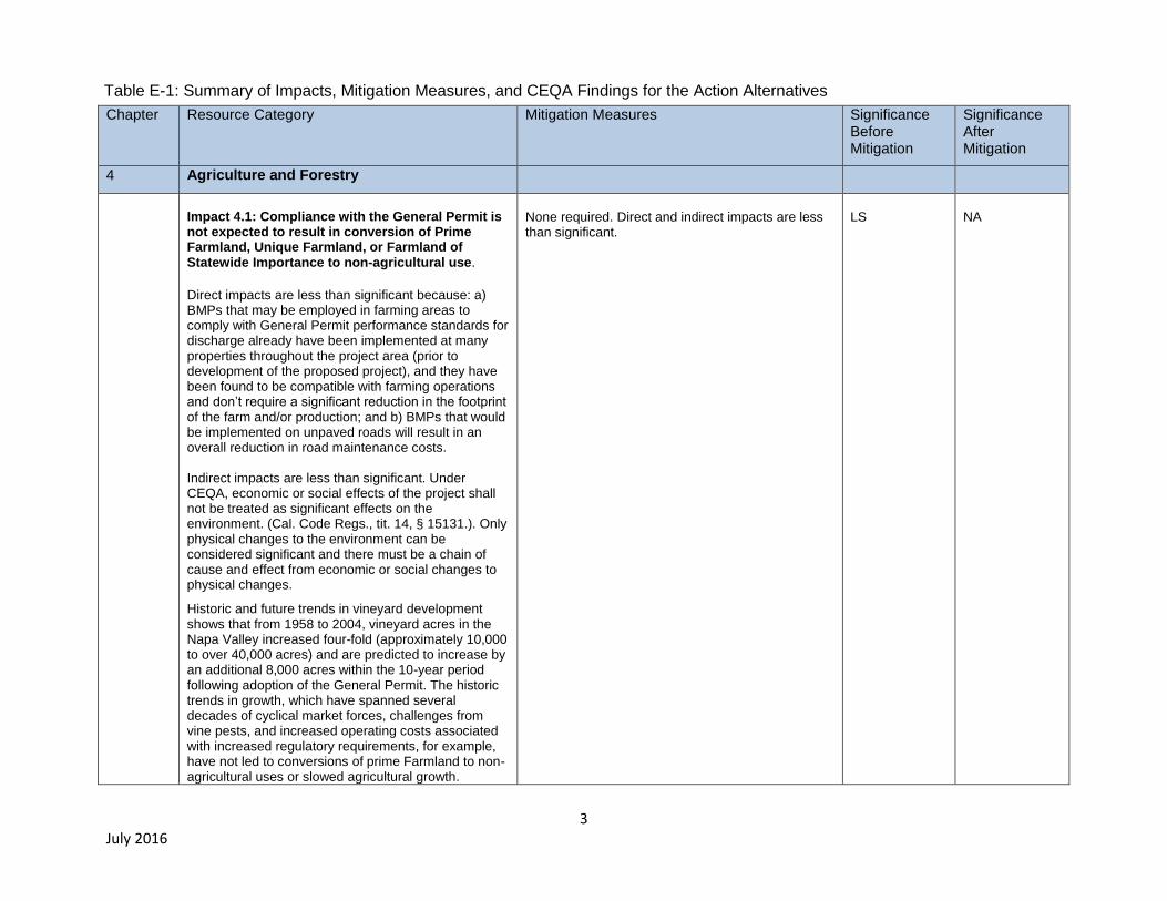
Potential environmental impacts of the project are summarized in Table ES-1. Refer to chapters 4
through 9 in this EIR for a complete discussion of each impact.
3 July 2016
Chapter Resource Category Mitigation Measures Significance Before Mitigation
Significance After Mitigation
4 Agriculture and Forestry
Impact 4.1: Compliance with the General Permit is not expected to result in conversion of Prime Farmland, Unique Farmland, or Farmland of Statewide Importance to non-agricultural use.
Direct impacts are less than significant because: a) BMPs that may be employed in farming areas to comply with General Permit performance standards for discharge already have been implemented at many properties throughout the project area (prior to development of the proposed project), and they have been found to be compatible with farming operations and don’t require a significant reduction in the footprint of the farm and/or production; and b) BMPs that would be implemented on unpaved roads will result in an overall reduction in road maintenance costs. Indirect impacts are less than significant. Under CEQA, economic or social effects of the project shall not be treated as significant effects on the environment. (Cal. Code Regs., tit. 14, § 15131.). Only physical changes to the environment can be considered significant and there must be a chain of cause and effect from economic or social changes to physical changes.
Historic and future trends in vineyard development shows that from 1958 to 2004, vineyard acres in the Napa Valley increased four-fold (approximately 10,000 to over 40,000 acres) and are predicted to increase by an additional 8,000 acres within the 10-year period following adoption of the General Permit. The historic trends in growth, which have spanned several decades of cyclical market forces, challenges from vine pests, and increased operating costs associated with increased regulatory requirements, for example, have not led to conversions of prime Farmland to non-agricultural uses or slowed agricultural growth.
None required. Direct and indirect impacts are less than significant.
LS
NA
Table E-1: Summary of Impacts, Mitigation Measures, and CEQA Findings for the Action Alternatives
4 July 2016
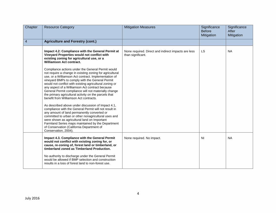
Chapter Resource Category Mitigation Measures Significance Before Mitigation
Significance After Mitigation
4 Agriculture and Forestry (cont.)
Impact 4.2: Compliance with the General Permit at Vineyard Properties would not conflict with existing zoning for agricultural use, or a Williamson Act contract.
Compliance actions under the General Permit would not require a change in existing zoning for agricultural use, or a Williamson Act contract. Implementation of vineyard BMPs to comply with the General Permit would not conflict with existing agricultural zoning or any aspect of a Williamson Act contract because General Permit compliance will not materially change the primary agricultural activity on the parcels that benefit from Williamson Act contracts. As described above under discussion of Impact 4.1, compliance with the General Permit will not result in any amount of land permanently converted or committed to urban or other nonagricultural uses and were shown as agricultural land on Important Farmland Series maps maintained by the Department of Conservation (California Department of Conservation, 2004).
None required. Direct and indirect impacts are less than significant.
LS
NA
Impact 4.3. Compliance with the General Permit would not conflict with existing zoning for, or cause, re-zoning of, forest land or timberland, or timberland zoned as Timberland Production.
No authority to discharge under the General Permit would be allowed if BMP selection and construction results in a loss of forest land to non-forest use.
None required. No impact.
NI
NA
5 July 2016
Chapter Resource Category Mitigation Measures Significance Before Mitigation
Significance After Mitigation
4 Agriculture and Forestry (cont.)
Impact 4.4. Compliance with the General Permit is not expected to result in the loss of forest land or conversion of forest land to non-forest use.
If compliance with the General Permit would involve conversion of forest lands, there is no authority to discharge under the General Permit.
None required. No impact.
NI
NA
Impact 4.5. Compliance with the General Permit is not expected to involve other changes in the existing environment which, due to their location or nature, could result in conversion of Farmland, to non-agricultural use or conversion of forest land to non-forest use.
Compliance with the General Permit would not result in conversion of significant portions of farmland to non-agricultural use or conversion of forest land to non-forest use because a) no authority to discharge under the General Permit would be granted if BMP selection and construction results in the loss of forest land or the conversion of forest land to non-forest use, and b) actions undertaken to comply with the General Permit (e.g., construction of sheds, pipes, trash racks, culvert replacement, road work, etc.), would be compatible with existing vineyard facility operations, throughout the Project Area.
None required. No impact.
NI NA

6 July 2016
Chapter Resource Category Mitigation Measures Significance Before Mitigation
Significance After Mitigation
5 Air Quality
Impact 5.1: Compliance with the General Permit could conflict or obstruct implementation of the applicable air quality plan.
Compliance actions (e.g., construction of BMPs that involve earth moving) completed at Vineyard Properties throughout the project area may have the potential to conflict with implementation of an applicable air quality plan. The primary pollutant of concern is PM10 - fine particulate matter. Also, at some Vineyard Properties, BMP construction that involves earth-moving may have the potential to entrain naturally occurring asbestos.
AQ-1 Basic Criteria Pollutant Emission Control Measures
Water all active construction areas at least twice daily.
Cover all trucks hauling soil, sand, and other loose materials or require all trucks to maintain at least two feet of freeboard.
Pave, apply water three times daily, or apply (non-toxic) soil stabilizers on all unpaved access roads, parking areas and staging areas at construction sites.
Sweep daily (with water sweepers) all paved access roads, parking areas and staging areas at construction sites.
Sweep streets daily (with water sweepers) if visible soil material is carried onto adjacent public streets.
AQ-2 Enhanced Criteria Pollutant Emission Control Measures
All “Basic” control measures listed above.
Hydro-seed or apply (non-toxic) soil stabilizers to inactive construction areas (previously graded areas inactive for ten days or more).
Enclose, cover, water twice daily or apply (non-toxic) soil binders to exposed stockpiles (dirt, sand, etc.).
Limit traffic speeds on unpaved roads to 15 mph.
Install sandbags or other erosion control measures to prevent silt runoff to public roadways.
Replant vegetation in disturbed areas as quickly as possible.
S
SU*
7 July 2016
Chapter Resource Category Mitigation Measures Significance Before Mitigation
Significance After Mitigation
5 Air Quality
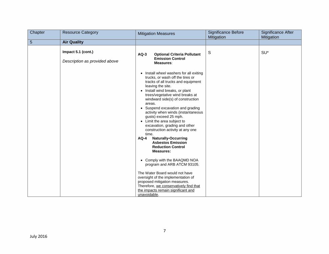
Impact 5.1 (cont.)
Description as provided above
AQ-3 Optional Criteria Pollutant Emission Control Measures:
Install wheel washers for all exiting trucks, or wash off the tires or tracks of all trucks and equipment leaving the site.
Install wind breaks, or plant trees/vegetative wind breaks at windward side(s) of construction areas.
Suspend excavation and grading activity when winds (instantaneous gusts) exceed 25 mph.
Limit the area subject to excavation, grading and other construction activity at any one time.
AQ-4 Naturally-Occurring Asbestos Emission Reduction Control Measures:
Comply with the BAAQMD NOA program and ARB ATCM 93105.
The Water Board would not have oversight of the implementation of proposed mitigation measures. Therefore, we conservatively find that the impacts remain significant and unavoidable.
S
SU*
8 July 2016
Chapter
Impact Mitigation Measures Significance Before
Mitigation Significance After Mitigation
5 Air Quality (cont.)
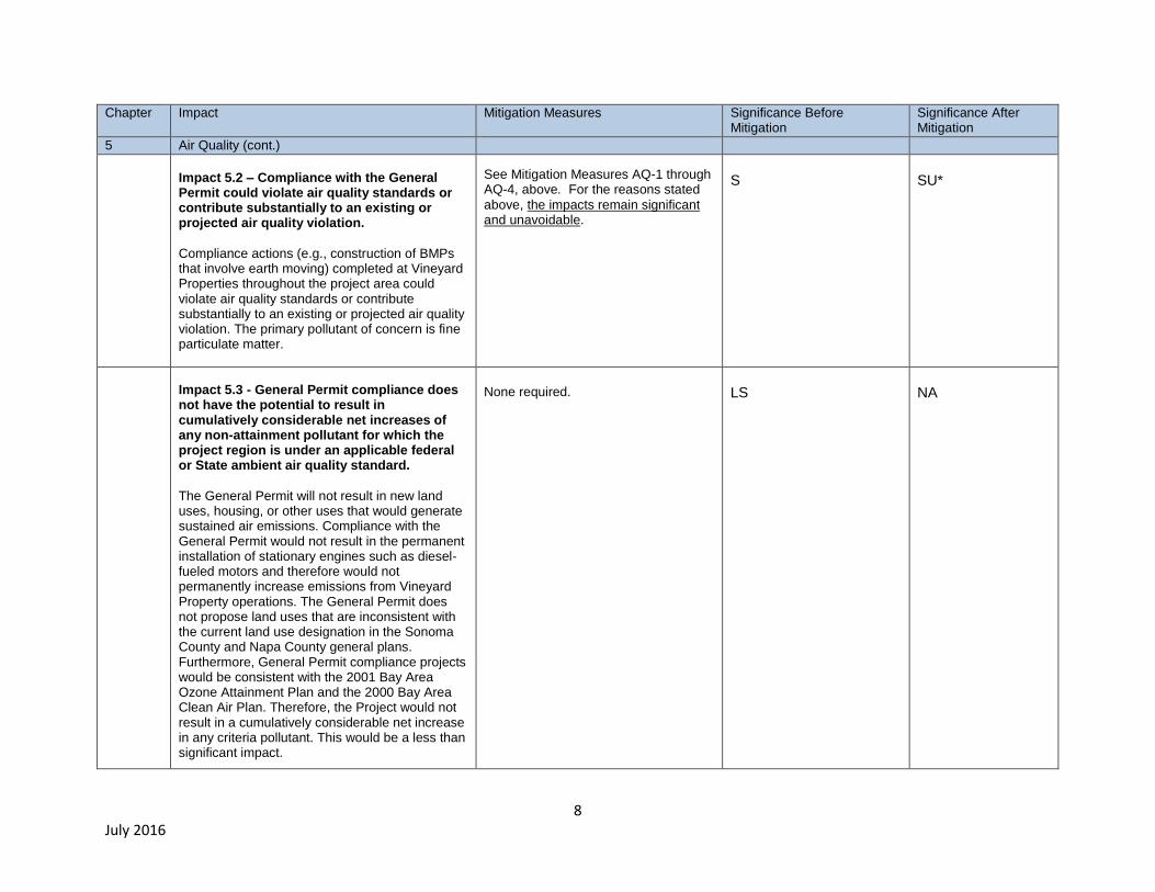
Impact 5.2 – Compliance with the General Permit could violate air quality standards or contribute substantially to an existing or projected air quality violation.
Compliance actions (e.g., construction of BMPs that involve earth moving) completed at Vineyard Properties throughout the project area could violate air quality standards or contribute substantially to an existing or projected air quality violation. The primary pollutant of concern is fine particulate matter.
See Mitigation Measures AQ-1 through AQ-4, above. For the reasons stated
above, the impacts remain significant and unavoidable.
S
SU*
Impact 5.3 - General Permit compliance does not have the potential to result in cumulatively considerable net increases of any non-attainment pollutant for which the project region is under an applicable federal or State ambient air quality standard.
The General Permit will not result in new land uses, housing, or other uses that would generate sustained air emissions. Compliance with the General Permit would not result in the permanent installation of stationary engines such as diesel-fueled motors and therefore would not permanently increase emissions from Vineyard Property operations. The General Permit does not propose land uses that are inconsistent with the current land use designation in the Sonoma County and Napa County general plans. Furthermore, General Permit compliance projects would be consistent with the 2001 Bay Area Ozone Attainment Plan and the 2000 Bay Area Clean Air Plan. Therefore, the Project would not result in a cumulatively considerable net increase in any criteria pollutant. This would be a less than significant impact.
None required.
LS
NA

9 July 2016
Chapter
Impact Mitigation Measures Significance Before Mitigation
Significance After Mitigation
5 Air Quality (cont.)
Impact 5.4 - Compliance with the General Permit may have the potential to expose sensitive receptors to substantial pollutant concentrations.
Emissions of diesel particulate matter (DPM) can occur from diesel-fueled equipment used for construction activities in compliance with the requirements of the General Permit. Although diesel-operated equipment such as tractors and trucks are routinely used at vineyard facilities as part of normal operations, large construction projects, such as road reshaping/repair and/or detention basin construction, could last several weeks and therefore possibly result in increases in short-term diesel emissions above baseline conditions. CARB has identified a relationship between diesel exhaust exposure and lung cancer and other adverse health effects. Vineyard Properties enrolled under the General Permit are located within a Project area of approximately 600 square miles and residential uses in these agriculturally-zoned districts are very low density. Although vineyards are generally located in rural areas, given the sheer size of the Project area, it is possible some vineyard properties may be located near schools, hospitals, and other sensitive land uses. Although compliance with the General Permit should not result in construction or operation of new, stationary sources of air emissions, construction undertaken to implement the requirements of the General Permit could result in increases in particulates in the air in the immediate vicinity of the grading and construction operation, and could thus expose sensitive receptors to substantial pollutant concentrations. This impact would be significant.
See Mitigation Measures AQ-1 through AQ-4, above. For the reasons stated above, the impacts remain significant and unavoidable.
S
SU*
10 July 2016
Chapter
Impact Mitigation Measures Significance Before Mitigation
Significance After Mitigation
5 Air Quality (cont.)
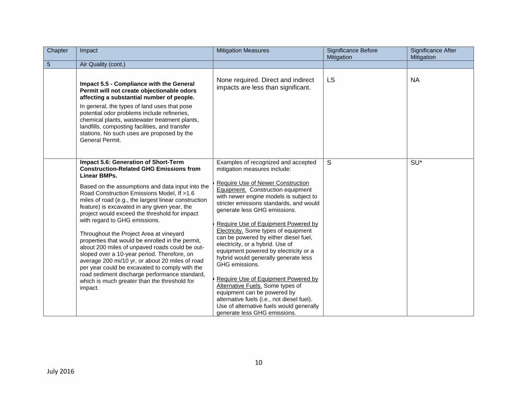
Impact 5.5 - Compliance with the General Permit will not create objectionable odors affecting a substantial number of people.
In general, the types of land uses that pose potential odor problems include refineries, chemical plants, wastewater treatment plants, landfills, composting facilities, and transfer stations. No such uses are proposed by the General Permit.
None required. Direct and indirect impacts are less than significant.
LS
NA
Impact 5.6: Generation of Short-Term Construction-Related GHG Emissions from Linear BMPs.
Based on the assumptions and data input into the Road Construction Emissions Model, If >1.6 miles of road (e.g., the largest linear construction feature) is excavated in any given year, the project would exceed the threshold for impact with regard to GHG emissions. Throughout the Project Area at vineyard properties that would be enrolled in the permit, about 200 miles of unpaved roads could be out-sloped over a 10-year period. Therefore, on average 200 mi/10 yr, or about 20 miles of road per year could be excavated to comply with the road sediment discharge performance standard, which is much greater than the threshold for impact.
Examples of recognized and accepted mitigation measures include:
Require Use of Newer Construction Equipment. Construction equipment with newer engine models is subject to stricter emissions standards, and would generate less GHG emissions.
Require Use of Equipment Powered by Electricity. Some types of equipment can be powered by either diesel fuel, electricity, or a hybrid. Use of equipment powered by electricity or a hybrid would generally generate less GHG emissions.
Require Use of Equipment Powered by Alternative Fuels. Some types of equipment can be powered by alternative fuels (i.e., not diesel fuel). Use of alternative fuels would generally generate less GHG emissions.
S SU*
11 July 2016
Chapter Impact Mitigation Measures Significance Before Mitigation Significance After Mitigation
5 Air Quality (cont.)
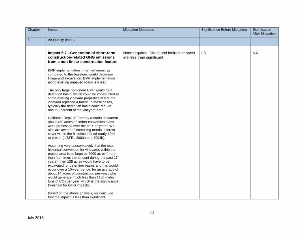
Impact 5.7 - Generation of short-term construction-related GHG emissions from a non-linear construction feature BMP implementation in farmed areas, as compared to the baseline, would decrease tillage and excavation. BMP implementation along existing unpaved roads is linear. The only large non-linear BMP would be a detention basin, which could be constructed at some existing vineyard properties where the vineyard replaced a forest. In these cases, typically the detention basin could require about 3 percent of the vineyard area. California Dept. of Forestry records document about 450 acres of timber conversion plans were processed over the past 17 years. We also are aware of increasing trends in forest cover within the historical period (early 1940 to present) (SFEI, 2003a and 2003b). Assuming very conservatively that the total historical conversion for vineyards within the project area is as large as 2000 acres (more than four times the amount during the past 17 years), then 135 acres would have to be excavated for detention basins and this would occur over a 10-year period, for an average of about 14 acres of construction per year, which would generate much less than 1100 metric tons of CO2 per year, which is the significance threshold for GHG impacts. Based on the above analysis, we conclude that the impact is less than significant.
None required. Direct and indirect impacts are less than significant.
LS
NA

12 July 2016
Chapter Impact Mitigation Measures Significance Before Mitigation Significance After Mitigation
5 Air Quality (cont.)
Impact 5.8 - Generation of long-term operational (e.g., BMP maintenance) GHG emissions from maintenance of all BMPs
Threshold of significance is > 735 additional vehicle trips/day occurring at properties implementing BMPs to comply with the General Permit. For the Permit to exceed this threshold, a new BMP maintenance task that was event-related would have to occur at nearly all properties enrolled, and all would have to occur on the same day. The most likely scenario would be inspection and/or emergency repairs of BMPs during or soon after a large storm. Although this is a plausible scenario for estimating the maximum number of vehicle trips related to BMP maintenance, under the baseline, these types of storm-related inspections of BMPs in farm areas and/or roads are typical at sites vulnerable to erosion. New BMPs in these areas, presumably if they are at least as effective, would not result in > 735 new (additional) vehicle trips per day (even during a storm event).
None required. Impacts are less than significant.
LS
NA
13 July 2016
Chapter
Impact Mitigation Measures Significance Before Mitigation
Significance After Mitigation
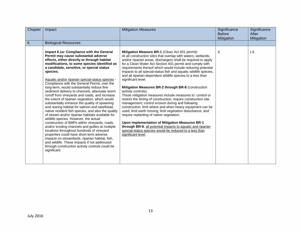
6 Biological Resources
Impact 6.1a: Compliance with the General Permit may cause substantial adverse effects, either directly or through habitat modifications, to some species identified as a candidate, sensitive, or special status species.
Aquatic and/or riparian special-status species - Compliance with the General Permit, over the long-term, would substantially reduce fine sediment delivery to channels, attenuate storm runoff from vineyards and roads, and increase the extent of riparian vegetation, which would substantially enhance the quality of spawning and rearing habitat for salmon and steelhead, native resident fish species, and also the quality of stream and/or riparian habitats available for wildlife species. However, the actual construction of BMPs within vineyards, roads, and/or eroding channels and gullies at multiple locations throughout hundreds of vineyard properties could have short-term adverse impacts on streambeds, riparian habitat, fish, and wildlife. These impacts if not addressed through construction activity controls could be significant.
Mitigation Measure BR-1 (Clean Act 401 permit):
At all construction sites that overlap with waters, wetlands, and/or riparian areas, dischargers shall be required to apply for a Clean Water Act Section 401 permit and comply with requirements thereof which would include reducing potential impacts to all special-status fish and aquatic wildlife species, and all riparian-dependent wildlife species to a less than significant level. Mitigation Measures BR-2 through BR-8 (construction
activity controls): These mitigation measures include measures to: control or restrict the timing of construction; require construction site management; control erosion during and following construction; limit where and when heavy equipment can be used; limit earth moving; limit vegetation disturbance; and require replanting of native vegetation. Upon implementation of Mitigation Measures BR-1 through BR-8, all potential impacts to aquatic and riparian
special-status species would be reduced to a less than significant level.
S
LS
14 July 2016
Chapter
Impact Mitigation Measures Significance Before Mitigation
Significance After Mitigation
6 Biological Resources (continued)
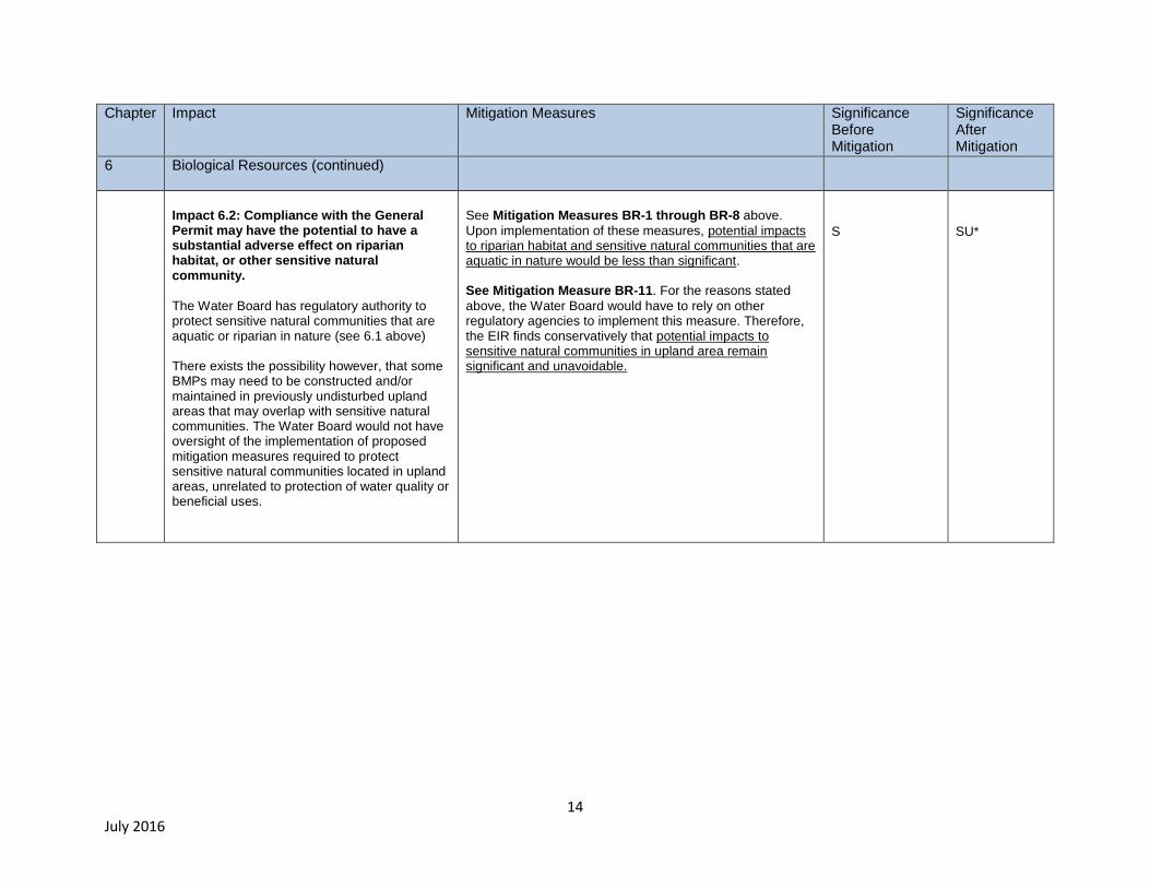
Impact 6.2: Compliance with the General Permit may have the potential to have a substantial adverse effect on riparian habitat, or other sensitive natural community.
The Water Board has regulatory authority to protect sensitive natural communities that are aquatic or riparian in nature (see 6.1 above) There exists the possibility however, that some BMPs may need to be constructed and/or maintained in previously undisturbed upland areas that may overlap with sensitive natural communities. The Water Board would not have oversight of the implementation of proposed mitigation measures required to protect sensitive natural communities located in upland areas, unrelated to protection of water quality or beneficial uses.
See Mitigation Measures BR-1 through BR-8 above.
Upon implementation of these measures, potential impacts to riparian habitat and sensitive natural communities that are aquatic in nature would be less than significant. See Mitigation Measure BR-11. For the reasons stated
above, the Water Board would have to rely on other regulatory agencies to implement this measure. Therefore, the EIR finds conservatively that potential impacts to sensitive natural communities in upland area remain significant and unavoidable.
S
SU*
15 July 2016
Chapter
Impact Mitigation Measures Significance Before Mitigation
Significance After Mitigation
6 Biological Resources (continued)
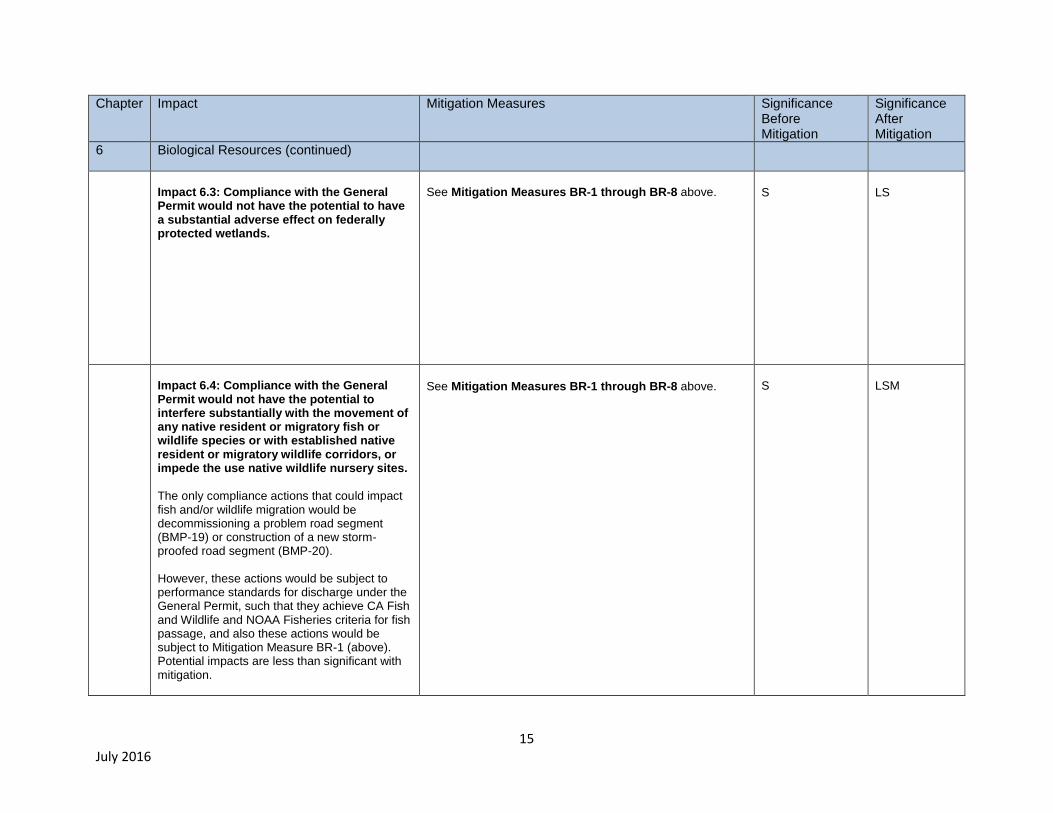
Impact 6.3: Compliance with the General Permit would not have the potential to have a substantial adverse effect on federally protected wetlands.
See Mitigation Measures BR-1 through BR-8 above.
S
LS
Impact 6.4: Compliance with the General Permit would not have the potential to interfere substantially with the movement of any native resident or migratory fish or wildlife species or with established native resident or migratory wildlife corridors, or impede the use native wildlife nursery sites.
The only compliance actions that could impact fish and/or wildlife migration would be decommissioning a problem road segment (BMP-19) or construction of a new storm-proofed road segment (BMP-20). However, these actions would be subject to performance standards for discharge under the General Permit, such that they achieve CA Fish and Wildlife and NOAA Fisheries criteria for fish passage, and also these actions would be subject to Mitigation Measure BR-1 (above). Potential impacts are less than significant with mitigation.
See Mitigation Measures BR-1 through BR-8 above.
S
LSM
16 July 2016
Chapter
Impact Mitigation Measures Significance Before Mitigation
Significance After Mitigation
6 Biological Resources (continued)
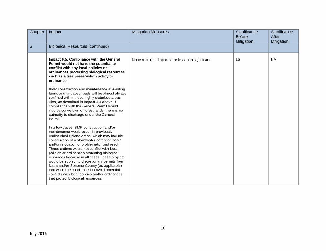
Impact 6.5: Compliance with the General Permit would not have the potential to conflict with any local policies or ordinances protecting biological resources such as a tree preservation policy or ordinance.
BMP construction and maintenance at existing farms and unpaved roads will be almost always confined within these highly disturbed areas. Also, as described in Impact 4.4 above, if compliance with the General Permit would involve conversion of forest lands, there is no authority to discharge under the General Permit. In a few cases, BMP construction and/or maintenance would occur in previously undisturbed upland areas, which may include construction of a stormwater detention basin and/or relocation of problematic road reach. These actions would not conflict with local policies or ordinances protecting biological resources because in all cases, these projects would be subject to discretionary permits from Napa and/or Sonoma County (as applicable) that would be conditioned to avoid potential conflicts with local policies and/or ordinances that protect biological resources.
None required. Impacts are less than significant.
LS
NA

17 July 2016
Chapter
Impact Mitigation Measures Significance Before Mitigation
Significance After Mitigation
6 Biological Resources (continued)
Impact 6.6: Compliance with the General Permit would not have the potential to conflict with the provisions of an adopted Habitat Conservation Plan, Natural Community Conservation Plan or other approved local, regional, or state habitat conservation plan.
Not aware of any potential conflicts.
LS
NA
Chapter
Impact Mitigation Measures Significance Before Mitigation
Significance After Mitigation
7 Cultural Resources
Impact 7.1- Compliance with the General Permit may have the potential to cause a substantial adverse change in the significance of a historical resource as defined in § 15064.5
Construction may occur in stream channels where nineteenth century and/or early twentieth century rock walls or Civilian Conservation Corps (CCC) erosion control structures (e.g., stream bank or bed stabilization structures, check-dams, detention basins, etc.) are present, however, erosion control practices required under the General Permit are not likely to result in substantial adverse alteration of these features. Grading and construction usually would occur in vineyards and on roads that have been previously disturbed by recent agricultural human activity, not at, or in areas containing historical resources as defined by section 15064.5 of the CEQA Guidelines.
None required. Impacts are less than significant.
LS
LS
18 July 2016
Chapter
Impact Mitigation Measures Significance Before Mitigation
Significance After Mitigation
7 Cultural Resources (continued)
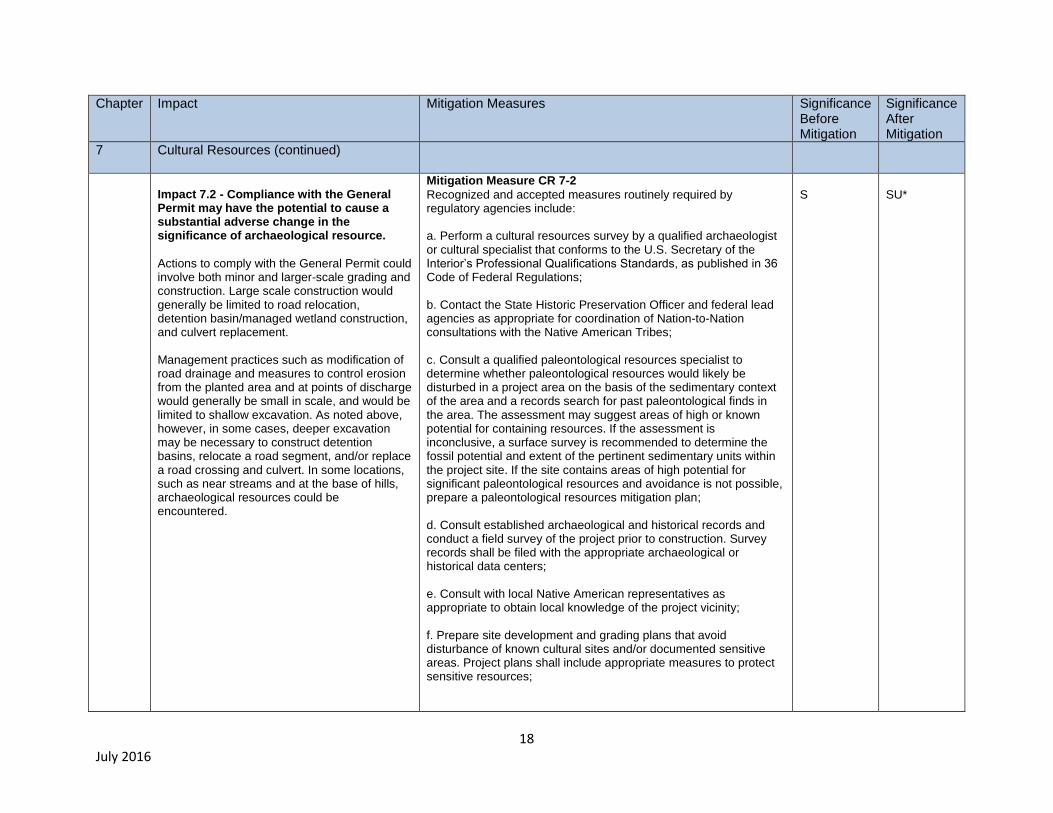
Impact 7.2 - Compliance with the General Permit may have the potential to cause a substantial adverse change in the significance of archaeological resource.
Actions to comply with the General Permit could involve both minor and larger-scale grading and construction. Large scale construction would generally be limited to road relocation, detention basin/managed wetland construction, and culvert replacement. Management practices such as modification of road drainage and measures to control erosion from the planted area and at points of discharge would generally be small in scale, and would be limited to shallow excavation. As noted above, however, in some cases, deeper excavation may be necessary to construct detention basins, relocate a road segment, and/or replace a road crossing and culvert. In some locations, such as near streams and at the base of hills, archaeological resources could be encountered.
Mitigation Measure CR 7-2
Recognized and accepted measures routinely required by regulatory agencies include: a. Perform a cultural resources survey by a qualified archaeologist or cultural specialist that conforms to the U.S. Secretary of the Interior’s Professional Qualifications Standards, as published in 36 Code of Federal Regulations; b. Contact the State Historic Preservation Officer and federal lead agencies as appropriate for coordination of Nation-to-Nation consultations with the Native American Tribes; c. Consult a qualified paleontological resources specialist to determine whether paleontological resources would likely be disturbed in a project area on the basis of the sedimentary context of the area and a records search for past paleontological finds in the area. The assessment may suggest areas of high or known potential for containing resources. If the assessment is inconclusive, a surface survey is recommended to determine the fossil potential and extent of the pertinent sedimentary units within the project site. If the site contains areas of high potential for significant paleontological resources and avoidance is not possible, prepare a paleontological resources mitigation plan; d. Consult established archaeological and historical records and conduct a field survey of the project prior to construction. Survey records shall be filed with the appropriate archaeological or historical data centers; e. Consult with local Native American representatives as appropriate to obtain local knowledge of the project vicinity; f. Prepare site development and grading plans that avoid disturbance of known cultural sites and/or documented sensitive areas. Project plans shall include appropriate measures to protect sensitive resources;
S
SU*

19 July 2016
Chapter
Impact Mitigation Measures Significance Before Mitigation
Significance After Mitigation
7 Cultural Resources (continued)
Impact 7.2 - Compliance with the General Permit may have the potential to cause a substantial adverse change in the significance of archaeological resource (cont.)
See description on previous page
Mitigation Measure CR 7-2
Recognized and accepted measures routinely required by regulatory agencies include (cont.): g. Retain a qualified archaeologist or Native American representative to monitor site development activities, particularly grading and trenching. If artifacts are observed during construction, require that construction be halted until a qualified archaeologist has been consulted; h. Alert onsite workers to the possibility of encountering human remains during construction activities, and prepare appropriate procedures. It is usually required that all construction activities near the location of identified human skeletal remains are halted until proper consultation and mitigation is arranged. The Water Board would not have oversight of the implementation of proposed mitigation measures required to protect cultural resources. Because authority to require project-level mitigation lies with the local land use authority, there is inherent uncertainty in the degree of mitigation that may ultimately be implemented. Therefore the EIR conservatively finds that impacts to cultural resources remain significant and unavoidable.
S
SU*
Impact 7.3: Compliance with the General Permit may have the potential to directly or indirectly destroy a unique paleontological resource or site, or unique geologic feature.
For the reasons stated in impact 7.2, this impact may have the potential to be significant.
See Mitigation Measure CR 7-2
For the same reasons as stated above, per Impact 7.2, the EIR conservatively finds that impacts to paleontological resources and unique geologic features remain significant and unavoidable.
S
SU*
20 July 2016
Chapter
Impact Mitigation Measures Significance Before Mitigation
Significance After Mitigation
7 Cultural Resources (continued)
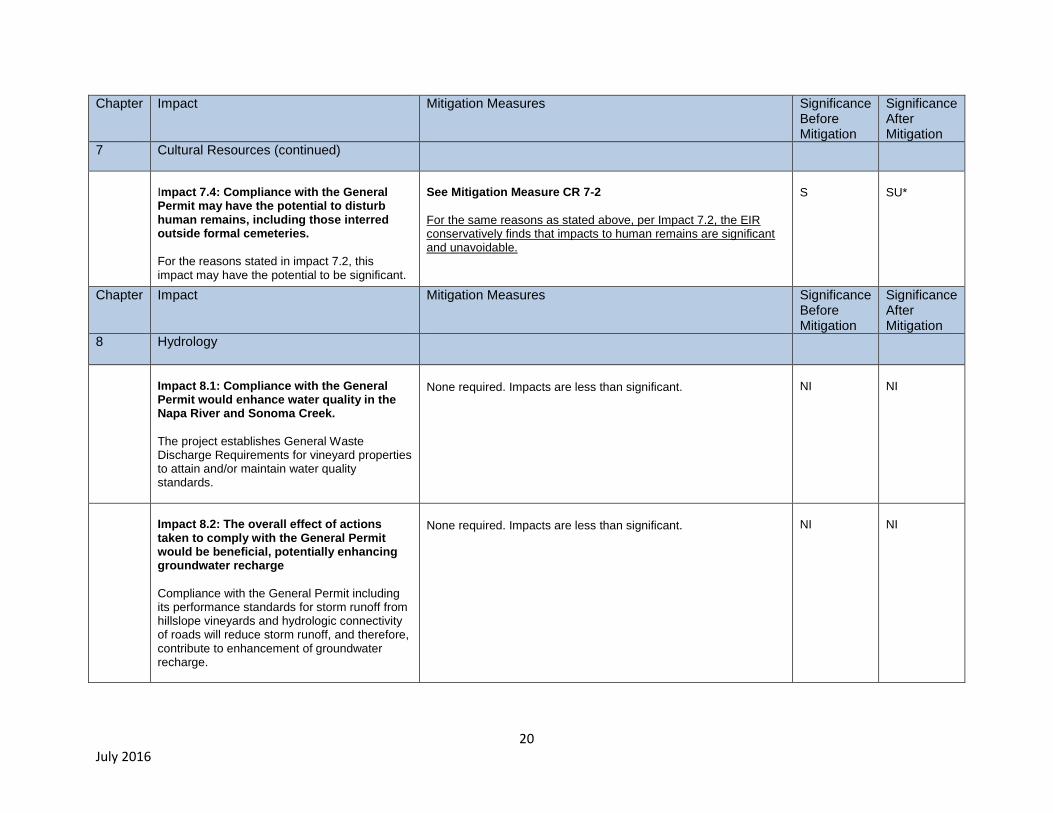
Impact 7.4: Compliance with the General Permit may have the potential to disturb human remains, including those interred outside formal cemeteries.
For the reasons stated in impact 7.2, this impact may have the potential to be significant.
See Mitigation Measure CR 7-2
For the same reasons as stated above, per Impact 7.2, the EIR conservatively finds that impacts to human remains are significant and unavoidable.
S
SU*
Chapter
Impact Mitigation Measures Significance Before Mitigation
Significance After Mitigation
8 Hydrology
Impact 8.1: Compliance with the General Permit would enhance water quality in the Napa River and Sonoma Creek.
The project establishes General Waste Discharge Requirements for vineyard properties to attain and/or maintain water quality standards.
None required. Impacts are less than significant.
NI
NI
Impact 8.2: The overall effect of actions taken to comply with the General Permit would be beneficial, potentially enhancing groundwater recharge
Compliance with the General Permit including its performance standards for storm runoff from hillslope vineyards and hydrologic connectivity of roads will reduce storm runoff, and therefore, contribute to enhancement of groundwater recharge.
None required. Impacts are less than significant.
NI
NI

21 July 2016
Chapter
Impact Mitigation Measures Significance Before Mitigation
Significance After Mitigation
8 Hydrology (continued)
Impact 8.3: Actions taken to comply with the General Permit would result in a beneficial reduction in storm runoff.
See discussion of impact 8.2
None required. Impacts are less than significant.
NI
NI
Impact 8.4: Actions taken to comply with the General Permit would over the long-term, result in beneficial reductions in erosion and siltation to the Napa River, Sonoma Creek, and to their tributaries.
Long-term effects: The General Permit requires actions to control sediment discharges and storm runoff increases from farms and roads, toward the goal of achieving 50 percent reductions in sediment delivery to channels within vineyard properties in the Napa River and Sonoma Creek watersheds as called for in the sediment TMDLs. At a minimum, the EIR conservatively estimates that sediment savings over the long-term as a result of farm plan implementation actions would reduce sediment delivery to channels by approximately 33,000 metric tons per year. Short-term effects: Although the long-term effect of General Permit compliance would be a substantial reduction in delivery of sand and finer sediment to stream channels, short-term erosional adjustments could occur at some BMP construction sites, which could cause eroded sediment could be deposited in stream channels that support sensitive and/or listed aquatic species, and these potential short-term and temporary increases in fine sediment delivery to channels are considered a significant impact.
Mitigation Measures BR-2 through BR-8 (construction activity
controls): These mitigation measures include measures to: control or restrict the timing of construction; require construction site management; control erosion during and following construction; limit where and when heavy equipment can be used; limit earth moving; limit vegetation disturbance; and require replanting of native vegetation. Upon implementation of BR-2 through BR-8, potential short-term construction-related erosion and sedimentation impacts would be reduced to a less than significant level. The overall effect of the project on erosion and sedimentation would be a beneficial reduction in erosion and siltation.
S
LS
22 July 2016
Chapter
Impact Mitigation Measures Significance Before Mitigation
Significance After Mitigation
8 Hydrology (continued)
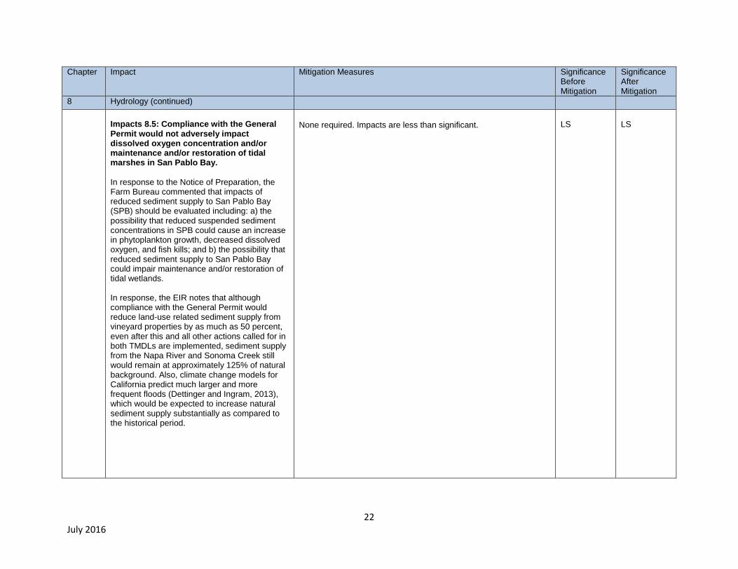
Impacts 8.5: Compliance with the General Permit would not adversely impact dissolved oxygen concentration and/or maintenance and/or restoration of tidal marshes in San Pablo Bay.
In response to the Notice of Preparation, the Farm Bureau commented that impacts of reduced sediment supply to San Pablo Bay (SPB) should be evaluated including: a) the possibility that reduced suspended sediment concentrations in SPB could cause an increase in phytoplankton growth, decreased dissolved oxygen, and fish kills; and b) the possibility that reduced sediment supply to San Pablo Bay could impair maintenance and/or restoration of tidal wetlands. In response, the EIR notes that although compliance with the General Permit would reduce land-use related sediment supply from vineyard properties by as much as 50 percent, even after this and all other actions called for in both TMDLs are implemented, sediment supply from the Napa River and Sonoma Creek still would remain at approximately 125% of natural background. Also, climate change models for California predict much larger and more frequent floods (Dettinger and Ingram, 2013), which would be expected to increase natural sediment supply substantially as compared to the historical period.
None required. Impacts are less than significant.
LS
LS
23 July 2016
Chapter
Impact Mitigation Measures Significance Before Mitigation
Significance After Mitigation
8 Hydrology (continued)
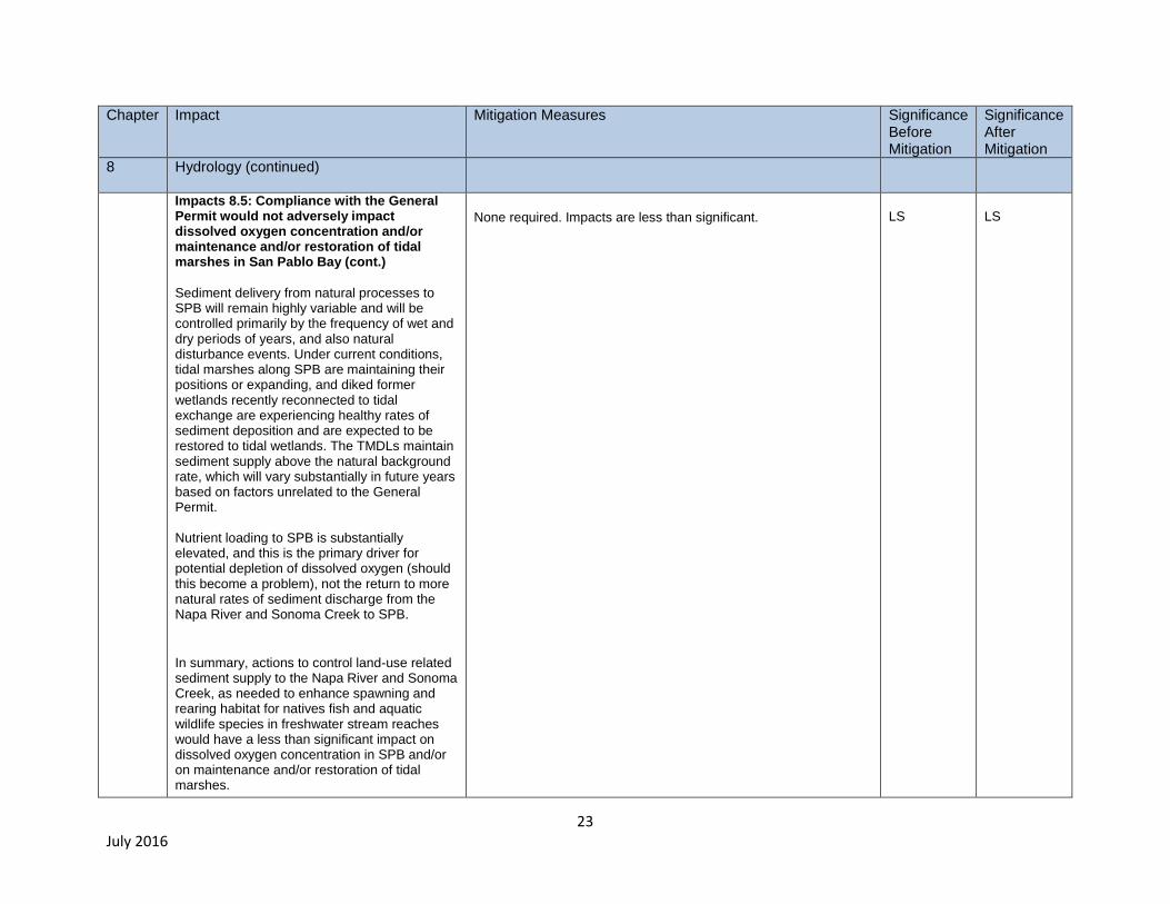
Impacts 8.5: Compliance with the General Permit would not adversely impact dissolved oxygen concentration and/or maintenance and/or restoration of tidal marshes in San Pablo Bay (cont.)
Sediment delivery from natural processes to SPB will remain highly variable and will be controlled primarily by the frequency of wet and dry periods of years, and also natural disturbance events. Under current conditions, tidal marshes along SPB are maintaining their positions or expanding, and diked former wetlands recently reconnected to tidal exchange are experiencing healthy rates of sediment deposition and are expected to be restored to tidal wetlands. The TMDLs maintain sediment supply above the natural background rate, which will vary substantially in future years based on factors unrelated to the General Permit. Nutrient loading to SPB is substantially elevated, and this is the primary driver for potential depletion of dissolved oxygen (should this become a problem), not the return to more natural rates of sediment discharge from the Napa River and Sonoma Creek to SPB.
In summary, actions to control land-use related sediment supply to the Napa River and Sonoma Creek, as needed to enhance spawning and rearing habitat for natives fish and aquatic wildlife species in freshwater stream reaches would have a less than significant impact on dissolved oxygen concentration in SPB and/or on maintenance and/or restoration of tidal marshes.
None required. Impacts are less than significant.
LS
LS

24 July 2016
Chapter
Impact Mitigation Measures Significance Before Mitigation
Significance After Mitigation
8 Hydrology (continued)
Impact 8.6: General Permit compliance actions would not cause the capacity of a stormwater drainage system to be exceeded.
The overall effect of compliance actions on storm runoff would be a beneficial and substantial decrease in storm runoff peak from vineyard properties. Therefore, compliance actions would not cause additional runoff water which could exceed the capacity of a stormwater drainage system.
No impact
NI
NI
Impact 8.7: General Permit compliance actions would not increase polluted runoff and/or degrade water quality.
The project establishes Waste Discharge Requirements for vineyard properties to attain or maintain water quality standards. The effect of the project on attainment of water quality will be beneficial.
N/A
NI
NI
Impact 8.8: General Permit compliance actions would not affect placement of housing in flood hazard areas.
The General Permit does not affect placement of housing. There is no impact.
N/A
NI
NI
25 July 2016
Chapter
Impact Mitigation Measures Significance Before Mitigation
Significance After Mitigation
8 Hydrology (continued)
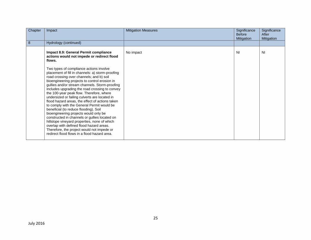
Impact 8.9: General Permit compliance actions would not impede or redirect flood flows.
Two types of compliance actions involve placement of fill in channels: a) storm-proofing road crossing over channels; and b) soil bioengineering projects to control erosion in gullies and/or stream channels. Storm-proofing includes upgrading the road crossing to convey the 100-year peak flow. Therefore, where undersized or failing culverts are located in flood hazard areas, the effect of actions taken to comply with the General Permit would be beneficial (to reduce flooding). Soil bioengineering projects would only be constructed in channels or gullies located on hillslope vineyard properties, none of which overlap with defined flood hazard areas. Therefore, the project would not impede or redirect flood flows in a flood hazard area.
No impact
NI
NI
26 July 2016
Chapter
Impact Mitigation Measures Significance Before Mitigation
Significance After Mitigation
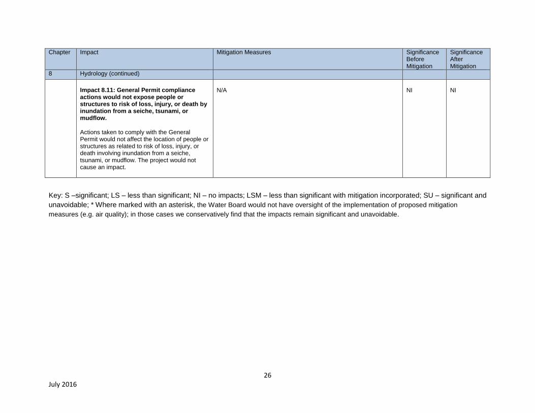
8 Hydrology (continued)
Impact 8.11: General Permit compliance actions would not expose people or structures to risk of loss, injury, or death by inundation from a seiche, tsunami, or mudflow.
Actions taken to comply with the General Permit would not affect the location of people or structures as related to risk of loss, injury, or death involving inundation from a seiche, tsunami, or mudflow. The project would not cause an impact.
N/A
NI
NI
Key: S –significant; LS – less than significant; NI – no impacts; LSM – less than significant with mitigation incorporated; SU – significant and
unavoidable; * Where marked with an asterisk, the Water Board would not have oversight of the implementation of proposed mitigation
measures (e.g. air quality); in those cases we conservatively find that the impacts remain significant and unavoidable.
27 DRAFT 3/11/16
Areas of Controversy
The General Permit was developed with input from stakeholders. On July 23, 2014, the Water Board
held a public scoping meeting for the Environmental Impact Report, during which the public was asked
to comment on specific topics that they felt should be discussed in the environmental analysis. The
following issues were expressed in comment letters and comments provided during the meeting:
Concerns on the effects of the General Permit on agricultural resources, specifically that any
added regulation may lead to conversion of agricultural lands to non-agricultural uses.
Concerns regarding the costs of BMP implementation and requests that the environmental
review includes a cost evaluation and identify funding sources to defray expenses.
Concerns with the efficiency and feasibility of the implementation of the General Permit in light
of the existing local, vineyard regulatory programs, and third-party efforts.
Concerns over the acreage threshold of the proposed General Permit with recommendations to
limit the Permit to vineyards versus vineyard properties, exclude large property parcels with few
acres planted but many miles of roads, and to focus the permitting effort on high erosion
potential problem areas.
Concern over the impact of reduced sediment to San Pablo Bay on phytoplankton growth, and
maintenance and restoration of tidal wetlands.
Concerns over including the nutrient and pesticide stormwater performance standards in the
General Permit.
Concerns that the EIR provides a complete assessment of habitats, flora and fauna within and
adjacent to the Project area.
Concern that the environmental review includes evaluation of voluminous comments previously
submitted on the Policy for Maintaining Instream Flow in Northern California Coastal Streams
(February 2014), and the Napa River sediment TMDL Basin Plan amendment, including an
evaluation of groundwater resources.
Issues to be Resolved
CEQA Guidelines Section 15123(b)(3) requires identification of “issues to be resolved, which in this
case includes the Water Board making a choice among project alternatives, and also making decisions
regarding whether and how to mitigate significant impacts of actions taken to comply with the proposed
general Permit.
Alternatives
The purpose of the alternatives analysis in an EIR is to describe a range of reasonable alternatives to
the project that could feasibly attain the objective of the project, and to evaluate the comparative merits
of the alternatives (CEQA Guidelines, §15126.6, subd. (a).). Additionally, CEQA Guidelines section
15126.6. subd. (b) requires consideration of alternatives that could avoid or substantially lessen any
significant adverse environmental effects of the proposed project, including alternatives that may be
more costly or could otherwise impede the project’s objectives, and the No Project Alternative. The
28 June 2016
range of alternatives considered must include those that offer substantial environmental advantages
over the proposed project and may be feasibly accomplished in a successful manner considering
economic, environmental, social, technological and legal factors. Six alternatives suggested through
comment on the Notice of Preparation (for details, see Section 10.2), all of which would have
significantly reduced the scope of required erosion control actions were rejected because it is unlikely
that they would achieve the fundamental objective of the proposed General Permit, which is:
To implement the Napa River and Sonoma Creek sediment TMDLs including achievement of
vineyard property discharge performance standards for sediment and storm runoff, and
ultimately to meet the TMDLs’ sediment allocations and targets as needed to restore properly
functioning substrate conditions in channel reaches that provide habitat for anadromous
salmonids.
The following alternatives were selected for analysis, and evaluated as discussed in in Chapter 10:
Alternative 1: No Project Alternative. Under the No Project Alternative, the Water Board
would not develop a General Permit for vineyard properties within the Project area. Absent
adoption of the proposed General Permit, it is unlikely that its fundamental objective, which is to
meet the TMDLs’ sediment allocations and targets, and restore properly functioning substrate
conditions in channel reaches that provide habitat for anadromous salmonids, would be
achieved by the deadlines specified in the TMDLS (i.e., Sonoma Creek, December 2028 and
Napa River, September 2029). It is highly probable that sediment impairments in the Napa River
and Sonoma Creek watersheds would not be resolved. Consequently, degraded streambed
substrate conditions and spawning habitat and rearing habitat for endangered Steelhead
populations and locally rare Chinook salmon populations would persist.
Alternative 2: Regulate Vineyard Properties where 10 acres-or-more are planted in wine
grapes. Under this alternative, the enrollment criteria would be relaxed to Vineyard Properties
that include ≥10 acres planted vineyard. The relative scale of compliance actions to achieve the
performance standards contained in the General Permit would be reduced. This alternative
would enroll up to 60 percent of the total vineyard property acreage, and up to 85 percent of the
planted acreage that occurs within the project area. As compared to the Proposed Project, this
alternative would be anticipated to reduce both the amount of sediment discharge control, and
also the magnitude of significant impacts by about 10 percent.
Alternative 3: Exempt vineyard properties located upstream of municipal reservoirs from
the requirement to enroll in the General Permit. This alternative is identical to the proposed
project except that it would exclude those Vineyard Properties located above five municipal
reservoirs1 located in the Napa River watershed and thus reduce the project area within the
Napa River watershed by approximately 83 square miles. The Sonoma Creek watershed
Project area would remain unchanged. Although this alternative would achieve the fundamental
objective of the proposed project, this alternative would not protect substrate channel conditions
in channel reaches located upstream of these reservoirs and would therefore not achieve a
secondary project objective. Impacts and sediment reduction benefits are about 20 percent less
than under the Proposed Project.
1 These reservoirs are Kimball Canyon Reservoir, Bell Canyon Reservoir, Rector Reservoir, Lake
Hennessey, and Milliken Canyon Reservoir.

29 June 2016
The alternatives analysis found that differences in impacts are directly correlated to the land area
enrolled in the General Permit. The potential adverse impacts of the Proposed Project, Alternative 2 or
Alternative 3, all would be similar because they all involve construction of the same types of BMPs; the
primary differences being in the total land area and locations where the BMPs would be constructed.
Under Alternative 3, approximately 20 percent of the proposed project area, or 20,000 acres, would be
excluded from General Permit coverage. In simple terms, this reduction in project area could translate
into a roughly 20 percent reduction in potential impacts.
What sets Alternatives 2 and 3 apart, is that Alternative 2 would not protect the beneficial uses
associated with the reservoirs and/or the channel reaches draining into the reservoirs. Protection of
beneficial uses of the waters of the State is the fundamental mission of the Water Board.
30 June 2016
1. INTRODUCTION AND BACKGROUND
The proposed General Waste Discharge Requirements (General Permit) for vineyard properties in the
Napa River and Sonoma Creek watersheds (Figure 2-1) would require actions to control sediment
discharges and storm runoff increases from farms and roads, and also to control pesticide and nutrient
discharges from farms. The General Permit also provides incentives for voluntary implementation of
habitat enhancement actions in incised channel reaches. The draft General Permit is included as
Appendix A. The potential environmental impacts of the General Permit are considered in this
Environmental Impact Report (EIR).
The Napa River, Sonoma Creek, and their tributaries provide habitat for federally listed steelhead
populations, locally rare Chinook salmon populations, and exceptionally diverse native fish
assemblages (Leidy, 2007, pp. 50, 146-155, 157-158, and 192). Too much sand in streambeds and
channel incision (the progressive lowering of the streambed as a result of erosion) are significant
threats to fisheries in these watersheds (Water Board, 2008a, pp. 8-12; Water Board, 2009a, p. 21).
Channel incision is a significant fine sediment source, and the primary mechanism for habitat
simplification in the Napa River, Sonoma Creek, and alluvial reaches of their tributaries. As channels
have incised, spawning and rearing habitats have been substantially reduced. Channel incision also
has separated the channels from floodplains, and reduced baseflow persistence and the extent and
diversity of riparian vegetation (Stillwater Sciences and Dietrich, 2002).
The Water Board has listed the Napa River and Sonoma Creek as impaired by too much fine sediment
and also by channel incision2, and has developed sediment total maximum daily loads (TMDLs) and
habitat enhancement plans to address these problems (Water Board 2008b, and Water Board, 2009b).
Across both watersheds, the TMDLs require 50 percent-or-more reduction in human-caused sediment
inputs. To achieve these reductions, the TMDL implementation plans list regulatory actions and
schedules to achieve water quality objectives and restore beneficial uses. The TMDLs contemplate
regulation of vineyard properties as a means to reduce sediment loads.
Vineyard properties, including farming areas and extensive unpaved roads, have been identified as
significant sources of sand and finer sediment discharge to the Napa River, Sonoma Creek, and their
tributaries (Water Board, 2008a, p. 43; Water Board, 2009a, p.57). Also, storm runoff increases
generated by vineyards and roads have been identified as two of several causes for channel incision3
2 Channel incision degrades habitat and it is a controllable water quality factor that results in non-attainment
of the water quality objective for population and community ecology.
3 Channel incision reflects and integrates multiple historical and ongoing disturbances including: a) direct
alterations to the Napa River, Sonoma Creek, alluvial reaches of tributaries, and to their floodplains (e.g.,
levee building, channel straightening, side channel filling, connecting naturally disconnected tributaries,
removal of debris jams, ditching and draining floodplain wetlands, historical gravel mining, and dredging); b)
in the Napa River watershed, construction of four large tributary dams between 1939 and 1959 that capture
runoff and coarse sediment delivered from approximately 20% of the watershed; and c) in both watersheds,
land-cover changes that have increased peak flows in the river (e.g., vineyards, logging of old-growth
redwood forests, rural residences, intensive historical grazing, commercial buildings, and roads) (Water
Board, 2008, p.23; Water Board, 2009, p.46).

31 June 2016
(Water Board, 2008a, pp. 23-24; Water Board 2009a, p. 39). Incised channel reaches are common
where channels flow through alluvial valleys within vineyard properties and elsewhere in these same
settings throughout the Napa River and Sonoma Creek watersheds (see, e.g., Water Board, 2009, pp.
49-50).
In addition to requiring actions to control storm runoff increases, the General Permit also would include
incentives for Vineyard Property owners to voluntarily establish stream setbacks to facilitate passive
restoration of stream-riparian habitat.4 Impacts of channel incision also are being addressed through
voluntary implementation of large-scale channel restoration projects, examples of which include the
Rutherford Napa River restoration Project and the Oak Knoll to Oakville Restoration Project5.
1.1. Existing Physical Conditions at Vineyard Properties in the Project Area The background information provided below in Sections 1.1 through 1.3, together with the detailed
descriptions of environmental setting contained in each of the resources chapters (Chapters 4 through
8) constitute the environmental baseline and setting for the project.
The Napa and Sonoma Valleys are two of the best places on earth to grow wine grapes. As a result,
viticulture is the predominant form of agriculture in both watersheds. Vineyard properties constitute
about 162,000 acres, or 40 percent of the total land area in the Napa River and Sonoma Creek
watersheds (Appendix B, GIS Analysis). Vineyard properties include: a) 59,000 acres of planted wine
grapes; b) farm avenues, buildings, and infrastructure; c) extensive networks of property-wide access
roads (most of which are unpaved); and d) adjacent open-spaces under natural vegetation cover6. The
59,000 acres of planted wine grapes correspond to about 16 percent of the land area in these two
watersheds. Based on GIS analysis, Water Board staff estimates that vineyard properties totaling
about 109,000 acres, and including as many as 54,000 acres of planted wine grapes, could be
regulated under the proposed Water Board General Permit (Appendix B).
Although there is a long history of wine grape cultivation in the Napa and Sonoma valleys that dates
back to the mid-nineteenth century, most of the vineyard development in both watersheds has occurred
since the early 1980s, soon after a Napa Valley Cabernet Sauvignon was judged the best red wine at
the 1976 Paris Competition (San Francisco Chronicle, 2005; see also, Swinchatt and Howell, 2004, p. 2
and p. 8). Between 1970 and 1996, in the Napa River watershed, wine grape cultivation increased from
about 10,000 acres to about 30,000 acres (Napa County RCD, 1997, as cited in Stillwater Sciences and
Dietrich, 2002). At present, there are an estimated 45,000 acres of wine grapes planted in the Napa
River watershed and 14,000 acres in the Sonoma Creek watershed (Appendix B).
4 Passive restoration is defined by “the cessation of the management activities that are causing degradation
or preventing recovery” (Kauffman, 1997). In incised channel reaches, passive restoration would involve
voluntary establishment of stream setbacks wide enough to maintain or re-establish pool-riffle bedforms, and
also an interconnected floodplain and riparian corridor. (See Appendix A)
5 Other large-scale channel restoration projects along the Carneros and Bear Canyon creeks, which are
tributaries to the Napa River, are being planned.
6 In many cases, these adjacent open-spaces were/are managed for other uses including rural residential,
livestock grazing, timber production, water supply, and/or recreation.
32 June 2016
As hillslope vineyard development7 began to become widespread beginning in the early 1980s,
development and management practices at many sites did not recognize and/or address the potential
for significant erosion. As a result, during the 1980s, erosion rates were very high-to-extreme at most
hillslope vineyard sites (Soil Conservation Service, 1985, p. 1-6, 43-63). Public attention became
focused on this problem during a large storm in 1989, when a hillslope vineyard collapsed into Bell
Canyon Reservoir, threatening the water supply for the City of St. Helena (Poirier Locke, 2002, pp.31-
32, 36, and 38). Soon thereafter, Napa County established an ordinance requiring erosion control plans
and establishing stream setbacks to regulate the development of vineyards and other ground-disturbing
activities on slopes greater than 5 percent. Sonoma County adopted a similar ordinance in 2000.
Following adoption of these local ordinances, and as a result of the technical assistance and outreach
by local conservation agency staff, substantial progress has been made during the past few decades in
controlling soil erosion within vineyards throughout the project area. Almost all hillslope and valley floor
vineyards now plant cover crops prior to the start of the rainy season, and/or maintain no-till cover
crops. Some valley floor sites have established vegetated filter strips and/or berms in-place that are
effective in filtering sediment that erodes from the vineyards (Napolitano, 2008).
At some hillslope sites, the process of vineyard development and/or the use of engineered drainage to
control vineyard soil erosion (see discussion that follows below) have caused significant increases in
storm runoff, and consequent erosion of gullies, landslides, and/or channels downslope of farming
areas (Water Board, 2008, p.18; Napolitano, 2008). Concentration of storm runoff from hillslope
vineyards and roads are two of several causes of channel incision occurring further downstream in
alluvial channel reaches (Water Board, 2008, p. 39). Typically, vineyard properties also include
extensive unpaved roads (average road density8 is about 4.5 miles of road per square mile of land
area) that are significant sources of sediment delivery to channels. Road-related erosion and storm
runoff increases from hillslope vineyards and roads remain unaddressed at most vineyard properties
within the project area.
Effects of vineyard and road development & management on erosion and storm runoff
In the following section, we describe how development and management practices for both vineyards
and roads can cause significant increases in storm runoff and rates of sediment delivery to channels in
the Napa River and Sonoma Creek watersheds. We also describe the persistent impact of intensive
historical grazing at some present-day vineyard properties on storm runoff and sediment delivery to
channels. The General Permit is intended to substantially reduce and control these land-use related
sediment sources.
Deep ripping of soils to develop and/or replant a vineyard
Within the project area, when a vineyard is developed or replanted, it is a common practice for the soil
to be deeply ripped, that is for the soil to be loosened, broken-up, and/or tilled with a tractor mounted
disk harrow or rototiller to a depth typically of 3 feet-or-more in order to: a) break up restrictive soil
layers to promote root growth; and b) help create more uniform conditions for grape cultivation, because
soil under the natural condition is not uniform in depth or permeability (White, 2015, p. 55-59; AES,
7 Hillslopes are natural raised areas of land that slope toward adjacent low-lying areas or valleys. Previously
most vineyards had been developed in the Napa Valley, Sonoma Valley, and/or Chiles Valley (located in the northeastern part of the Napa River watershed).
8 Within a given watershed, the “road density” is the length of road per unit watershed area. For example,
the Napa River watershed drains a 426 mi2 area, and has an estimated 1917 miles of roads, which
corresponds to an average road density of 4.5 mi/mi2.
33 June 2016
2014, p. 3-28; AES, 2012a, Appendix F, p. 11; AES, 2012b, 4.8-17, County of Napa, 2015, p.1). The
following video documents deep ripping of a replanted vineyard in the Napa Valley:
https://www.youtube.com/watch?v=YQ8rwcCljqk (Michael Neal Viticultural Services, 2013). At most
hillslope sites, the soil profile is quite shallow, often 2 feet-or-less (USDA Soil Service, 1978, pp. 3-5).
Therefore, at many hillslope sites deep ripping also penetrates into weathered bedrock (see also
Swinchatt and Howell, 2004, p. 32 and pp. 80-81).
Deep ripping and/or conventional soil tillage acts to break up the soil, creating a new agriculturally
developed network of large openings in the soil (e.g., soil macropores) that provide preferential
pathways for the movement of water9. However, ripping also fundamentally disrupts the natural soil
structure and its hydrologic response. Under undisturbed conditions, natural soil macropores - large
open voids created by biological activity – including, for example, those created by burrowing and root
growth10
, often provide the dominate pathways for the movement of water during storms (Beven and
Germann, 2013; Black, 1996). There is a strong correlation between macropore space and continuity
and soil infiltration capacity (Beven and Germann, 1982; Watson and Luxmore, 1986, as cited in Beven
and Germann, 2013).
Tillage has been documented to disrupt natural soil macropores and their interconnections causing a
substantial reduction in soil infiltration capacity and hydraulic conductivity (Ehlers, 1975, as cited in
Beven and Germann, 1982, p. 1314; Shipitalo et al., 2000; Azooz and Arshad, 1996). As deep ripping
is a deeper and more intensive form of tillage, it is likely that the adverse effects on occurrence and
connectivity of natural macropores, and hence soil infiltration capacity and hydraulic conductivity, are
even greater.
The benefits of ripping on root development and growth and/or soil infiltration capacity have only been
demonstrated for compacted soils (primarily at agricultural sites), as a before and after comparison;
however, even at these sites, these benefits with regard to the growth and vigor of grapevines and/or
soil infiltration capacity are expected to diminish within a period of a few to several years (Hamza and
Anderson, 2005, pp. 134-137; Blanco and Lal, 2010, p. 215 and 403). Furthermore, ripping, as typically
practiced to develop hillslope vineyards within the project area, also shatters and mixes weathered
bedrock because ripping extends beyond the soil profile. Therefore, deep ripping also can alter
subsurface flow through weathered bedrock, which is an important pathway for storm flow, and also can
govern dry-season baseflow in streams draining hillslopes (see discussion in Rempe and Dietrich,
2014). In the Napa River and Sonoma Creek watersheds, dry-season baseflow in all stream reaches
except those that traverse unconfined alluvial valleys, likely is provided in part or mostly by this type of
subsurface flow (i.e., through the weathered fractured bedrock that occurs beneath hillslopes).
In summary, deep ripping of soils and also in some cases weathered bedrock beneath the soils has
occurred over extensive areas to develop and/or replant vineyards within the project area, and this
practice has caused significant changes in the way that water moves through the soil and/or weather
fractured bedrock. As described above, deep ripping can significantly diminish soil infiltration capacity
and hydraulic conductivity, and therefore it is plausible at some hillslope vineyard sites, that deep
ripping also has significantly diminished groundwater recharge, and/or increased storm runoff.
9 The macropores created by tillage, as compared to natural macropores, typically are much more poorly
connected (Rosenberg and McCoy, 1992, as cited in Shipitalo et al., 2000), and tend to collapse much more quickly (Schumacher and Riedell, 2008).
10 Natural macropores also are created by physical processes including wetting and drying and freezing and
thawing of soils.
34 June 2016
Conversion of a forest to a vineyard
When a forest is converted to a vineyard, rainfall interception, soil infiltration capacity,
evapotranspiration, and root strength all can be substantially reduced with the potential for consequent
significant increases in storm runoff and erosion. At forested sites, almost all of the water discharged to
stream channels comes from subsurface flow that moves through hillslope soils and/or weathered
fractured bedrock (Harr, 1977, as cited in Ziemer and Lisle, 1998, p. 48). Soil macropores and natural
soil pipes, created by the growth and decay of tree roots in forested areas may provide half-or-more of
the total runoff to stream channels during storms (Ziemer and Lisle, 1998, pp. 48-49). Where a forest is
replaced by a vineyard, it is likely that soil infiltration capacity will be substantially reduced (Neary et al.,
2009).
Converting a forest to a vineyard also contributes to significant increases in storm runoff peak and
volume because: a) forests are much more effective than vineyards in intercepting rainfall (so rainfall
gets into the ground much more slowly in a forest); b) forests also have higher rates of
evapotranspiration (because trees consume more water, less remains stored in the hillslopes, and
therefore, soil infiltration capacity is enhanced early in the wet season); and c) the tree canopy and leaf
litter protects the soil surface from rain splash and soil crusting, which also helps to keep infiltration
capacity high during storms.
Finally, root strength provided by trees in most circumstances also greatly increases mechanical
resistance to shear stress (Selby, pp. 275-278, 1993). Therefore, reduction in root strength resulting
conversion from forest cover to vineyard also may increase landslide activity.
Soil compaction through agricultural activities
In growing wine grapes, primary uses of tractors are for tillage, seeding cover corps, applying soil
amendments, and/or spraying of fertilizers, Sulphur, or pesticides. Although tractors designed for
vineyards often are much smaller than for most other types of row crops, vineyard tractors still are
heavy vehicles and exert significant pressure (force per unit area) on the soil. Tractor use when soils
are moist can cause soil crusting and/or increases in soil bulk density, with consequent reduction of
infiltration and water-holding capacity of the soil (Hamza and Anderson, 2005). Soil compaction
through heavy equipment traffic (Chappell, 2010, as cited in Beven and Germann, 2013) and/or tillage
(Ehlers, 1975, as cited in Beven and Germann, 1982) also disrupts or destroys natural soil macropores
formed by biological activity. Crusting, increases in bulk density, and disruption of macropores all can
contribute to significant increases in storm runoff.
Intensive use of engineered drainage to control vineyard erosion
Many vineyard sites use engineered subsurface drainage pipes to control erosion within the vineyard by
intercepting surface runoff before it can become sufficiently concentrated to cause significant soil
erosion. Engineered subsurface drainage pipes are a common best management practice within the
project area for vineyard soil erosion control11
. However, installation of subsurface drainage pipes also
11
At a proposed vineyard, drainage pipes only would be permissible where hydrologic modeling indicates
that the vineyard development wouldn’t increase storm runoff, and the proposed vineyard doesn’t discharge into an unstable channel. At all vineyards, if an erosional reaction occurs along the hillslope vineyard runoff pathway, at any time subsequent to vineyard development, additional BMPs would be required to reduce storm runoff including possibly, the capping or removal of the drainage pipes, and application of soil bioengineering techniques to stabilize the erosion site(s) (see Chapter 2, Project Description for additional details).

35 June 2016
can cause storm runoff to be substantially concentrated in time and/or space. Where intensive
engineered drainage is installed at a sensitive site – including hillslope sites underlain by soft
sedimentary bedrock types and/or where a forest is converted to develop a vineyard – storm runoff
increases are substantial, often causing gully and/or landslide erosion along hillslope overland flow
pathways and/or head-cutting and/or downcutting in channels at/or near the point(s) of discharge from
the vineyard (Water Board, 2009a, p.18; Napolitano, 2008).
Soil compaction caused by intensive historical grazing
Within both watersheds, many grassland sites were intensively grazed during the historical period,
causing or contributing to gully, landslide, and channel erosion that has persisted and is at present
producing a significant amount of fine sediment delivery to channels (Water Board, 2008). Hillslope
vineyards subsequently developed at these sites are discharging into these actively eroding unstable
hillslope and channel features, which are quite sensitive to an acceleration of erosion rates as a result
of subsequent vineyard-related changes in the locations and/or amount of storm runoff (e.g., intensive
use of engineered drainage, soil compaction through agricultural activity, deep ripping of soils, etc.).
These intensively eroding sites are most common within the Carneros Region, where clayey soils are
widespread, and which, up until recent decades, were very heavily grazed (see Grossinger et al., 2004).
Heavy grazing caused these clayey soils to become severely compacted and vegetation cover density
to be substantially reduced. Severe soil compaction acting in concert with reduced ground cover during
the period of grazing greatly increased overland flow runoff during storms, providing the impetus for
gullies and shallow landslides to form. Once erosion starts in these inter-connected gullies and shallow
landslides, there is positive feedback for the erosion process to continue for a very long period of time
(e.g., a few decades-to-centuries). Therefore, even modest changes in the location and/or intensity of
peak runoff caused by vineyard development and/or use of engineered drainage, can accelerate this
erosion.
In addition to the Carneros Region, soils developed on hard lava flow units of the Sonoma Volcanics
Formation, which are extensive within the project area, also are clay-rich and are vulnerable to
compaction. However, because cobbles and boulders are also abundant in these soils, and these soils
are typically very thin, gullies and/or shallow landslides formed on soils covering the hard volcanic flows
are usually much smaller features.
Effects of roads on storm runoff and sediment delivery to channels
There are a number of mechanisms by which roads can increase storm-runoff and/or sediment delivery
to channels. Road cuts intercept subsurface drainage, speeding up runoff rate. Roads also usually
change the distribution of runoff along the hillslope. Inboard ditches and compacted road surfaces
substantially increase the rate, volume, and locations of direct runoff from these areas, which can cause
the road surfaces and ditches to rapidly erode. Road cuts and fills alter drainage pathways and the
distribution of mass on the hillslope, often contributing to greater rates of landslide activity. Also, road
crossings (over channels), may be undersized for the conveyance of peak runoff rates, and/or may be
easily plugged by large debris during storms causing overtopping and/or diversion of channel flows,
with resulting road crossing erosion, and/or gully erosion through diversion of channel flows to another
channel or hillslope location. Within the project area, road-related erosion - largely extensive networks
of unpaved roads – is one of the largest sources of human-caused sediment delivery to channels
(Water Board, 2009a, p. 72; Water Board, 2008a, p. 43).
In defining the baseline condition under CEQA, we also note that existing unpaved roads in the project
area are highly disturbed features. Through the process of original construction, including grubbing and
clearing of native vegetation, grading (cut and fill of soils to a depth of several feet) and then
36 June 2016
compaction of the constructed road prism, vegetation and soils have been intensively disturbed.
Vegetation and/or soils in or directly adjacent to the road prism experience frequent and intensive
ongoing disturbances through:
a) Vehicle traffic that wears down and deforms the unpaved road surface;
b) Sheetwash, fluvial and/or mass wasting erosion processes acting on the cut banks, road
surface, ditches, berms, and/or shoulders; and
c) Road maintenance activities that involve regular vegetation and soil disturbance within the road
prism (e.g., re-grading to smooth or reshape the road surface or restore drainage through
roadside ditches, and vegetation management to maintain drainage along inboard ditches, tree
removal to maintain safe driving conditions along the road, and functionality of
pullouts/shoulders).
1.2. Existing Regulation of Vineyard Properties The Water Board has not previously regulated pollutant discharges from vineyard properties in the
Napa River and/or Sonoma Creek watersheds. Certain aspects of vineyard erosion have, however,
been regulated through county-level programs, which are discussed below. Many erosion control and/or
habitat protection actions already have occurred through implementation of these local regulations. The
Water Board’s proposed General Permit, while recognizing these county-level regulations, is intended
to attain the performance standards for vineyard properties that are specified in the Napa River and
Sonoma Creek sediment TMDLs including those for soil erosion in farmed areas, sediment delivery
from unpaved roads, and storm runoff from hillslope vineyards12
.
In addition to the county-level regulatory programs, local voluntary conservation programs have been
implemented at a large scale under the leadership of Resource Conservation Districts (based in Napa
and Sonoma counties), the USDA Natural Resources Conservation Service, and private nonprofit
groups (i.e., the California Land Stewardship Institute) to provide another mechanism for adoption of
best management practices at vineyards to minimize fine sediment inputs and restore stream-riparian
habitat. The following sections provide general descriptions of the contributions of these existing local
programs.
Summary of Napa County Regulatory Program for Vineyards
The Napa County Planning Division regulates development of new vineyards and vineyard replants
located on hillslopes. Its process is guided by the Napa County Conservation Regulations
(Conservation Regulations) enacted in 1991 (Napa County Code, Chapter 18.108). Beginning in 2000,
the County also has conducted a broader review of environmental impacts under CEQA.
The Conservation Regulations set the requirements and guidelines for preparing, reviewing, and
approving Erosion Control Plans (ECPs) for grading and vegetation removal associated with new or
replanted vineyards on slopes greater than five percent. New vineyards and replants on valley floor
12
The Water Board permit would control discharges from three significant sediment sources associated with
vineyard properties: 1) soil erosion in the farmed area; 2) hillslope and/or channel erosion via concentration of storm runoff caused at some sites by vineyard development or management practices; and 3) erosion from extensive property-wide, unpaved road networks. Local regulatory programs have focused largely on soil erosion in farmed areas.
37 June 2016
sites (slopes of less than five percent) are exempt from the erosion control plan requirements of the
Conservation Regulations.
The Napa County ECP process can follow one of two paths (Napa County Code, Chapter 18.108):
Track I – Applies to new vineyards and those developed since 2000, and requires discretionary
approval by Napa County (subject to CEQA review).
Track II – Applies to vineyard replants and is a ministerial action, provided the replant falls within
the existing vineyard footprint and there are no substantial changes to site drainage or layout. Most
replanted vineyards proceed through the Track II process.
Track I requires hydrologic and erosion analyses to demonstrate that no net increases in soil loss and
peak runoff13
will occur over pre-project conditions. Furthermore, the county’s Conservation Regulations
require stream setbacks for new vineyards that range from 35-to-150 feet, depending on stream
designation and the slope of the land adjacent to the stream channel (35-feet for valley floor sites, and
up to 150 feet where steep slopes abut channels). Replants, if completed within the original vineyard
footprint, are not required to meet the stream setback criteria.
Napa County-required stream setbacks apply to watercourses designated by a solid or dashed blue-line
on United States Geological Survey (USGS) topographic maps, and/or other watercourses that have: a)
a well-defined channel with a depth greater than four feet, b) banks steeper than 3:1, and c) contains
hydrophilic or riparian vegetation. Many headwater channels do not meet the county’s definition of a
watercourse, including most cascade and some step-pool channel reaches that provide spawning and
rearing habitat for steelhead (Dietrich et al., 2004). This is because many of these channels are not
designated by a solid or dashed blue-line on USGS maps, and/or they are less than four feet deep.
There are no requirements for retroactive erosion controls on vineyards that existed on hillslopes prior
to enactment of the ordinance in 1991. However, these existing vineyards are required to submit ECPs
at the time of replanting. New vineyard projects proposed on slopes exceeding 30 percent also require
issuance of a County use permit, and new vineyards proposed on slopes exceeding 50 percent require
a variance.
Road-related erosion and storm runoff increases from hillslope vineyards and roads remain
unaddressed by local regulations at most vineyard properties within the Napa River watershed. The
proposed General Permit has been developed primarily to address these regulatory gaps.
Summary of Sonoma County Regulatory Program for Vineyards
New vineyard development and replants in Sonoma County are guided by the Grading, Drainage, and
Vineyard and Orchard Site Development Ordinance (VESCO). The Sonoma County Agricultural
Commissioner’s Office implements and enforces VESCO. Currently, the VESCO process does not
require CEQA project-level analysis.
VESCO requires a permit for any grading, drainage improvement, or site development associated with
new or replanted vineyards. VESCO’s permits are issued at two levels that take into account soil type,
soil erosivity, and slope as follows (Sonoma County Code, Chapter 11.08.010):
Level I – Applies to new vineyards or replants developed on slopes less than or equal to 10 to 15
percent and does not require ECP documentation or verification of project completion.
13
The peak runoff requirement was established more recently as an implementation action, following the
update of the County General Plan in 2008.
38 June 2016
Level II – Applies to new vineyards or replants on slopes greater than 10 or 15 percent and
requires the project proponent to submit an ECP that is reviewed by the VESCO staff. VESCO staff
conducts post-construction review to confirm that ECP design plans were followed and implemented
appropriately.
Both Level I and Level II projects are required to adhere to the best management practices and
standards described in the Best Management Practices for Agricultural Erosion and Sediment Control
manual (Sonoma County Agricultural Commissioner’s Office, 2013).
VESCO and the County General Plan establish stream setback requirements that range from 25 feet to
50 feet, depending on slope of the adjacent land, soil type, and stream designation.
New vineyards on slopes greater than 50 percent are prohibited and there are no retroactive erosion
control requirements for vineyards constructed prior to VESCO. Existing vineyards are required to
comply with VESCO at the time of replanting with more oversight occurring on properties containing
highly erodible soils.
As in Napa County, road-related erosion and storm runoff increases from hillslope vineyards and roads,
in most cases, have not been subject to local regulation in the Sonoma Creek watershed. The
proposed General Permit has been developed primarily to address these gaps.
1.3. Existing Local Voluntary Farm Water Quality Protection Programs Local voluntary conservation programs have been implemented at a large scale under the leadership of
the Napa County and Sonoma County Resource Conservation Districts, the USDA Natural Resources
Conservation Service, and the California Land Stewardship Institute, providing another mechanism
within the project area to minimize fine sediment inputs and restore stream-riparian habitat. The
following section provides a general description of these programs.
Fish Friendly Farming Environmental Certification Program
The Fish Friendly Farming Certification Program (FFF) is a voluntary program developed by the
California Land Stewardship Institute (CLSI), a non-profit organization that provides technical
assistance to vineyard property owners to help them develop and implement best management
practices to protect and/or restore water quality and stream and riparian habitat (California Land
Stewardship Institute, 2009). FFF was established within the project area beginning in the fall of 2004.
The CLSI certification process involves enrollment by vineyard operators, participation in educational
workshops, and preparation of a detailed Farm Conservation Plan that covers the entire property14
.
Once the farm plan is completed, in order to receive certification, the plan must be reviewed/approved
by participating regulatory agencies (which have included the Water Board, National Marine Fisheries
Service, and County Agricultural Commissioner). Participating regulatory agencies also conduct a site
inspection to verify conditions documented in the plan, and to independently evaluate BMPs. Once the
plan is certified, the owner implements the farm plan15
. Photo documentation is used to validate that
14
With regard to sediment, the farm plan evaluates the entire property including: a) delineation of all natural
and engineered drainage features; b) location of all significant/active human‐caused sediment sources; and c) specification/delineation of the erosion control and management practices employed throughout the property (including for all roads, channel erosion sites, upland legacy erosion sites, and within the vineyard footprint).
15 At the time of certification, BMPs must be in-place throughout the farmed area. Within five years of
certification, BMPs to control significant road-related sediment sources also must be in-place. A longer

39 June 2016
the plan is being implemented. Plans are updated regularly and recertified by CLSI every 5-7 years.
BMPs in place to control soil erosion within farming areas at certified sites would be considered fully
compliant with the performance standards for vineyard soil erosion, pesticides, and nutrients that are
conditions of the proposed General Permit.
As of the fall 2015, approximately 34,800 acres of vineyard properties had been certified, including
approximately 17,900 acres planted in grapes, under the Fish Friendly Farming Program corresponding
to about 30% of the planted vineyard area and about 20% of the total Vineyard Property area within the
Napa River and Sonoma Creek watershed (CSLI unpublished data, 2015), which is a significant
accomplishment that will simplify compliance with the proposed General Permit at most of these
properties16
.
LandSmart
The Sonoma Resource Conservation District (RCD), in collaboration with the Napa County RCD, and
other partners, recently developed LandSmart, a technical assistance program for grape growers and
other farmers to help them to develop plans to protect and/or restore water quality and habitat
conditions throughout their property (http://www.landsmart.org). This farm water quality and habitat
protection program has multiple goals, including helping landowners to comply with existing regulations
and the proposed General Permit. Similar to FFF, the LandSmart program provides technical
assistance with inventory of agricultural and natural resources, and with documentation and/or
implementation of practices property-wide that are effective for control of fine sediment discharge and
for protection and/or enhancement of stream and riparian habitat conditions. Like FFF, it also evaluates
and provides technical assistance related to: water resources management; agricultural chemical
management; control of invasive species; fish passage; and other resource management issues.
As of the fall of 2015, farm plans have been developed covering approximately 10,000 acres of
vineyard properties (LandSmart, unpublished data). BMPs in place within farm areas for the control of
soil erosion within the vineyard and/or to control chemical and nutrient discharges at LandSmart
certified sites would be fully compliant with the proposed General Permit.
Other Programs
Other non-profits organizations and local government agencies also have expressed interest in
providing technical assistance to grape growers to help them develop and implement Farm Plans to
comply with the proposed General Permit including: a) the Vineyard Team (which has developed the
Sustainability in Practice program); b) the Wine Institute (which has developed the Code of Sustainable
Winemaking program), and c) the County of Sonoma, Agricultural Commissioner’s Office.
period of time is provided to implement BMPs to address sediment sources related to historical land-use activities that have resulted in large gullies or landslides (up to 10 years - if permits and/or grant funding would be required in order to address the problem; otherwise within 5 year of certification). Similarly, a stream-riparian corridor of sufficient width to maintain and/or to facilitate restoration of habitat complexity is fully established within a 10-year-or-shorter period (e.g., vineyard blocks and/or roads are moved back over time where the corridor width is not sufficient to facilitate restoration). Minimum corridor width in most cases is ≥ three-times bankfull channel width.
16 At some hillslope vineyard properties that have been certified, additional management practices may need
to be implemented to achieve the performance standards for unpaved roads and/or for vineyard storm runoff.

40 June 2016
1.4. Relationship between local regulatory programs and the General Permit The primary focus of county regulatory programs has been the control soil erosion in farming areas at
properties where vineyards are developed on hillslopes (Napa County Code, Chapter 18.108, and
Sonoma County Code, Chapter 11.08.010). Vineyards planted on hillslopes prior to the adoption of
County ordinances, and/or planted on valley floor sites, in most cases have been exempt from the
requirement to prepare an erosion control plan.
More recently, following adoption of the Napa County General Plan in 2008, new hillslope vineyards
also are required to achieve a no-net increase standard for peak storm runoff, as compared to the
baseline condition preceding vineyard development (Napa County, 2009, Policy CON-50(c), p. CON-
39). There is no similar requirement in Sonoma County.
At present, there is little or no regulation in either county of discharges from existing unpaved roads.
The proposed General Permit for Vineyard Properties is intended to fill gaps in local regulation of
pollutant discharge from vineyards and roads in the Napa River and Sonoma Creek watersheds. Under
the General Permit, a Vineyard Property is defined by a parcel or contiguous parcels under the same
ownership, where grapevines are planted on part of the property. Vineyard Properties where ≥ 5 acres
are planted in grapevines, in most cases, would be required to enroll in the proposed General Permit,
and to achieve its performance standards for discharge of sediment and storm runoff from vineyards
and unpaved roads, and also for discharge of pesticide and nutrient discharges from vineyards.
Third Party Programs
The Nonpoint Source Policy (State Board, 2004) encourages the State Water Resources Control Board
(State Water Board) and the Regional Water Quality Control Boards (Water Boards) to “be as creative
and efficient as possible in devising approaches to control nonpoint source pollution.” This includes
development of “Third-Party Programs,” including coalitions of dischargers in cooperation with a
representative, organization, or government agency to assist the dischargers in complying with permit
requirements, and to assure the Water Board and the public that effective programs are developed and
implemented to reduce nonpoint source pollution.
The Water Board will consider and approve Third-Party Programs and Qualified Professionals17
to
assist Dischargers in complying with this Order if the Third-Party Program or Qualified Professional
meets the requirements as set forth in the Attachment C to the General Permit (Appendix A). Entities
interested in forming a Third-Party Program or being approved as a Qualified Professional must
document their capabilities and request approval for their program from the Water Board’s Executive
Officer. Each proposed Third-Party Program and Qualified Professional will be judged individually on its
merits, including the program’s technical ability to work with regulated entities and experience in
developing and implementing nonpoint source pollution control programs.
Discharger participation in a Third-Party Program or Qualified Professional is optional; farm plans
implemented under Third-Party Programs or Qualified Professional provide an equivalent or greater
level of water quality protection, and do not change the impact analysis.
17
A “Qualified Professional” is defined to include a California registered professional in a discipline
associated with erosion and sediment control including for example a professional engineer, licensed geologist, or certified professional in erosion and sediment control.
41 June 2016
1.5. Purpose of the EIR CEQA requires that State and local government agencies consider environmental consequences of
projects over which they have discretionary authority before taking action on those projects (Public
Resources Code, § 21000 et seq.). The EIR is an informational document which will inform public
agency decision-makers and the public generally of the potential significant environmental effects of a
project, discuss possible ways to minimize significant effects, and describe reasonable alternatives to
the project.
The project proposed in this EIR is the Water Board’s discretionary action to adopt the proposed
General Permit for the protection of water quality associated with vineyard properties. The Water Board
will prepare responses to comments received on this draft EIR in preparation of the Final EIR. The
Water Board will review the EIR before certifying it as meeting the requirements of CEQA. Once the
EIR is certified, it will be considered by the Water Board along with other important information which
may be presented at the time it considers adoption of the proposed General Permit.
1.6. Scoping Process CEQA encourages a consultation or scoping process to help identify the range of actions, alternatives,
mitigation measures, and significant effects to be analyzed in an EIR, and to help resolve concerns of
affected agencies and individuals. The intent of the scoping process is to identify significant issues for
study in the EIR and to determine the scope of the analysis of each issue. Scoping is designed to
explore issues for environmental assessment to ensure that important considerations are not
overlooked, and to uncover concerns that might otherwise go unrecognized. Scoping has allowed the
Water Board to make the EIR as complete and informative as possible for decision makers and those
affected by the proposed action and its alternatives. This section describes the scoping activities
sponsored by the Water Board.
The Notice of Preparation (NOP), which is required by CEQA, is the first formal effort to involve the
public and interested agencies in the scoping process for preparation of the EIR. The NOP describes
the proposed project, indicates the types of environmental effects that could result from implementation
of the project, and announces the start of an EIR review process under CEQA. The NOP encourages
public participation in the environmental evaluation.
On July 7, 2014, The Water Board sent an NOP, which included an attached Initial Study, to public
agencies and persons with potential interest in the project. Copies of the NOP and Initial Study were
available for review at the Water Board’s Oakland office. Additionally, the NOP and Attached Initial
Study were posted at the Water Board’s webpage
(http://www.waterboards.ca.gov/sanfranciscobay/public_notices/) and an announcement of its
availability was forwarded to individuals that subscribed to the electronic mailing lists relevant to
information on the proposed General Permit. The NOP and the attached Initial Study, and distribution
list for the NOP are included in Appendix C.
On July 23, 2014, the Water Board held a scoping meeting in Napa, California, to solicit input from
agencies and interested parties on issues to be addressed in the EIR. The scoping meeting included a
description of the meeting’s purpose, proposed requirements, and presented an overview of the
environmental review process and preparation of the EIR, and included a public comment period.
Those in attendance made comments on issues related to the proposed General Permit requirements.
42 June 2016
1.7. Public Involvement The EIR is being circulated for public review and comment. In addition, the Water Board will be
conducting one or more public meetings on the EIR. Comments received at public meetings or received
in written form will be considered in development of a final EIR. Once the final EIR has been circulated,
the Water Board will receive and respond to public testimony on the final EIR and General Permit
before official action is taken upon its adoption or denial.
1.8. Report Organization The EIR is organized into the following chapters so that the reader can easily obtain information about
the project and its specific environmental issues:
Executive Summary presents a summary of the General Permit, a description of impacts and
mitigation measures presented in a table format, and impact conclusions.
Chapter 1, “Introduction and Background,” provides a brief overview of the EIR’s purpose.
Chapter 2, “Project Description,” provides information on the project including location, objectives,
technical, economic, and environmental characteristics, and intended uses.
Chapter 3, “Impact Analysis Approach” discusses assumptions, parameters, and methodology
used for analyzing potential impacts.
Chapters 4 through 8 provide discussion on environmental factors provided in the CEQA
Guidelines’ Environmental Checklist. Each of these chapters describes environmental settings, a range
of potential impacts, including significant environmental effects and unavoidable significant
environmental effects that would result from the General Permit, and potential mitigation measures.
Chapter 9, “Cumulative Impacts,” summarizes cumulative impacts.
Chapter 10, “Alternatives Analysis,” presents project alternatives (including the No-Project
Alternative) and provides an evaluation of each alternative in comparison with the project. Table 10-2
provides a summary of each alternative and relative environmental effects.
Chapter 11”Long-ter Implications” presents growth-inducing impacts, significant irreversible
environmental effects, and significant and unavoidable environmental impacts of the proposed project.
Chapter 12, “Document Preparation,” lists individuals involved in preparing the EIR.
Appendix A: Draft General Permit for Vineyard Properties
Appendix B: GIS Analysis
Appendix C: Notice of Preparation and Initial Study for the General Permit for Vineyard Properties
43 June 2016
References
AES, 2012a. Walt Ranch Erosion Control Application P-11-00205-ECPA, Draft Environmental Impact
Report.
AES, 2012b. Draft environmental impact report, Jasud Estates Vineyard timber conversion plan.
Prepared for the California Department of Forestry and Fire Protection, Sacramento, California.
Prepared by Analytical Environmental Services, Sacramento, California.
Azooz, R.H., and M. A. Arshad, 1996. Soil infiltration and hydraulic conductivity under long-term no-
tillage and conventional tillage systems. Canadian Journal of Soil Science, 1996: 143-152.
Beven, K. and P. Germann, 1982. Macropores and water flow in soils. Water Resources Research,
Vol. 18, No. 5: 1311-1325.
Beven, K. and P. Germann, 2013. Macropores and water flow in soils revisited. Water Resource
Research, Vol. 49: 3071-3092.
Blanco, H. and R. Lal, 2010. Principles of soil conservation and management. First soft cover printing.
Springer: New York, New York.
California Land Stewardship Institute, 2009. Fish Friendly farming Environmental Certification Program,
Napa County, Farm Conservation Plan Workbook and Beneficial Management Practices.
California Land Stewardship Institute, 2015. Unpublished data regarding farm plan certifications.
County of Napa, 2015. Kongsgaard Wine LLC, Atlas Peak Vineyard Conversion: Agricultural Erosion
Control Plan (ECPA) #P14-00069-ECPA, Initial Study. County of Napa, Department of
Conservation, Development, and Planning: Napa. CA.
Dietrich, W.E. et al., 2004. The use of airborne laser swath mapping data in watershed analysis to guide
restoration priorities: the Napa River watershed study. EOS, Transactions, Fall Meeting 2004,
Abstract 85(47).
Grossinger, R., C. Striplen, and E. Brewster, 2004. Ecological, Geomorphic, and Land Use History of
the Carneros Creek Watershed. SFEI: Richmond, CA.
Hamza, M.A., and W.K. Anderson, 2005. Soil compaction in cropping systems, a review of the nature,
causes, and possible solutions. Soil & Tillage Research (82): 121-145.
Kauffman, J.B., R.L. Beschta, and N. Otting, 1997. An ecological perspective of riparian and stream
restoration in the western United States. Fisheries, Volume 22 (5): 12-24.
Leidy, R.A., 2007. Ecology, Assemblage Structure, and Status of Fishes in Streams Tributary to the
San Francisco Estuary, California. pp. 50, 146-155, 157-158, and 192.
Michael Neal Viticultural Services, 2013. You Tube video titled “Vineyard Site Prep for Planting: Stage
One.” https://www.youtube.com/watch?v=YQ8rwcCljqk . Video published on September 4, 2013.
Napa Valley Register, 2013. Napa Valley remain most expensive in U.S. Napa Valley Register, April 3,
2013.
Napolitano, M., 2008. Unpublished note to file, “Vineyard design/management and relationships to on-
site surface erosion rates and off-site erosion via concentrated runoff.” Water Board: Oakland, CA.
Neary, D. G., G. G. Ice, and C. R. Jackson, 2009. Linkage between forest soils and water quality and
quantity. Forest Ecology and Management 258 (2009): 2269-2281.
44 June 2016
Poirier-Locke, J., 2002. Vineyards in the watershed, sustainable winegrowing in Napa County. Napa
Sustainable Winegrowing Group: Napa, CA. pp. 31-32, 36, and 38.
Rempe, D.M., and W.E. Dietrich, 2014. A bottom up control on fresh-bedrock topography under
landscapes. Proceedings of the National Academy of Sciences, Vol. 111, No. 18: 6576-6581.
San Francisco Chronicle, 2005. “The story behind the story that made wine history.” W. Blake Gray,
June 16, 2005.
Schumacher, T.E. and W.E. Riedell, 2008. Soil structure examined. PP. 398-405 in “Leading Edge –
The Journal of No-Till Agriculture”, Volume 7, Number 1. January, 2008. Wamego, KS.
Shipitalo, M. J. and W. A. Dick, 2000. Conservation tillage and macropore factors that affect water
movement and the fate of chemicals. Soil and Tillage Research, 53: 167-183.
Selby, M.J., 1993. Hillslope materials and processes. Second Edition. Oxford University Press: New
York, New York. pp. 275-278.
Sonoma County Agricultural Commissioner’s Office, 2013. Best Management Practices for Agricultural
Erosion and Sediment Control. County of Sonoma, Agricultural Commissioner’s Office: Santa Rosa,
CA.
Stillwater Sciences and W. Dietrich, 2002. Napa River Basin Limiting Factors Analysis, Final Technical
Report.
Swinchatt, J. and D.G. Howell, 2004. The Winemaker’s Dance, Exploring Terroir in the Napa Valley.
University of California Press: Berkeley, CA. pp. 2, 8, 32, 80-81.
USDA Soil Service, 1978. Soil Survey of Napa County, California. US Government Printing Office
1978 0-230-729.
USDA (Soil Conservation Service), 1985. Hillside Vineyards Unit. Redwood Empire Target Area: Napa
and Sonoma Counties, California. pp. 1-6, and 43-63.
Water Board, 2008a. Sonoma Creek Watershed Sediment TMDL and Habitat Enhancement Plan, Staff
Report.
Water Board, 2008b. Sonoma Creek Watershed Sediment TMDL and Habitat Enhancement Plan,
Basin Plan amendment.
Water Board, 2009a. Napa River Sediment TMDL and Habitat Enhancement Plan, Staff Report.
Water Board, 2009b. Napa River Sediment TMDL and Habitat Enhancement Plan, Basin Plan
amendment.
White, R.E., 2015. Understanding Vineyard Soils. Chapter 2, Site Selection and Soil Preparation,
Modifying the Soil-Vine Environment, pp. 74-78. Second Edition. Oxford University Press: New
York, New York.
Ziemer, R.R., and T.E. Lisle, 1998. Hydrology. Chapter 3 in “River Ecology and Management, Lessons
from the Pacific Coastal Ecoregion.” Editors: R.E. Naiman and R.E. Bilby. Spring: New York, New
York.
45 June 2016
2. PROJECT DESCRIPTION The Water Board proposes to adopt and implement a General Permit for Vineyard Properties in the
Napa River and the Sonoma Creek watersheds (Figure 2-1). Under the General Permit, a Vineyard
Property is defined to include all contiguous parcels under the same ownership, where 5 acres or more
are planted in wine grapes. The proposed General Permit is included as Appendix A. This chapter
provides: a description of the project location; project objectives; the requirements of the General
Permit; project characteristics; agencies that will use this document; and anticipated conditions
following adoption of the General Permit.
2.1. Project Location The boundaries of the adjacent Napa River and Sonoma Creek watersheds, located in the northern San
Francisco Bay Area, define the project area (Figure 2-1). These watersheds drain approximately
380,000 acres. They are the two largest watersheds discharging into San Pablo Bay.
2.2. Project Objectives The fundamental project objective is to implement the Napa River and Sonoma Creek sediment TMDLs
including achievement of vineyard property discharge performance standards for sediment and storm
runoff, and ultimately to meet the TMDLs’ sediment allocations and targets as needed to restore
properly functioning substrate conditions in channel reaches that provide habitat for anadromous
salmonids.
Secondary project objectives include the following:
To control discharges of sediment and/or storm runoff from vineyards into channel reaches that
provide habitat for other native fishes
To promote stream-riparian habitat protection and restoration
To promote actions to restore fish passage at road crossings and streamflow diversions
To promote management decisions and actions to maintain adequate in-stream temperature,
and
To encourage voluntary conservation programs to assist vineyard owners/operators in meeting
the requirements and objectives of the General Permit.

46 June 2016
47 June 2016
2.3. Overview of the General Permit (The Project) The General Permit specifies that vineyard properties achieve performance standards for discharge of
sediment, storm runoff, nutrients, and pesticides from areas of agricultural cultivation, for the discharge
of sediment and storm runoff from unpaved roads that occur adjacent to vineyards and also throughout
vineyard properties.
Applicability
For the purposes of the General Permit, the term “Vineyard Property” is defined to include all
contiguous parcels under the same ownership, where some part is planted in grapes. A “Discharger” is
any person who discharges waste (e.g., a pollutant) that could affect the quality of waters of the state,
and includes any person who owns a Vineyard Property, or is responsible for its operation. Point source
discharges from on-site winery production facilities are not included in this General Permit.
The General Permit conditionally authorizes discharges of pollutants to the waters of the State that
originate on vineyard properties. It does not authorize, approve, or permit construction of a vineyard
and/or related infrastructure. To apply for coverage under the General Permit, a Discharger would
submit a Notice of Intent (NOI) and filing fee to the Water Board. A complete NOI provides the Water
Board with specific information related to the Vineyard Property.
Within the project area, the proposed General Permit would regulate discharges from the following
types of vineyard properties as shown in Figure 2-2 and as described in Table 2-1:
All existing vineyard properties (including replants) where five acres or more are planted in grapes.
All new vineyards of five acres or more, developed on slopes ≤ 30 percent, except for “high
potential sediment delivery” vineyard properties (which given their higher potential risk, would be
required to apply for individual permits), as described further below.
Any Vineyard Property, regardless of acreage, deemed by Water Board staff to discharge waste
that could adversely affect water quality and which could be adequately regulated through enrollment in
the proposed General Permit.
Based on GIS analysis, up to an estimated 70 percent of the total Vineyard Property acreage and 90
percent of the planted vineyard acreage within the project area would be required to enroll in the
proposed General Permit (Appendix A).
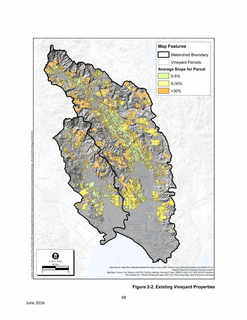
48 June 2016
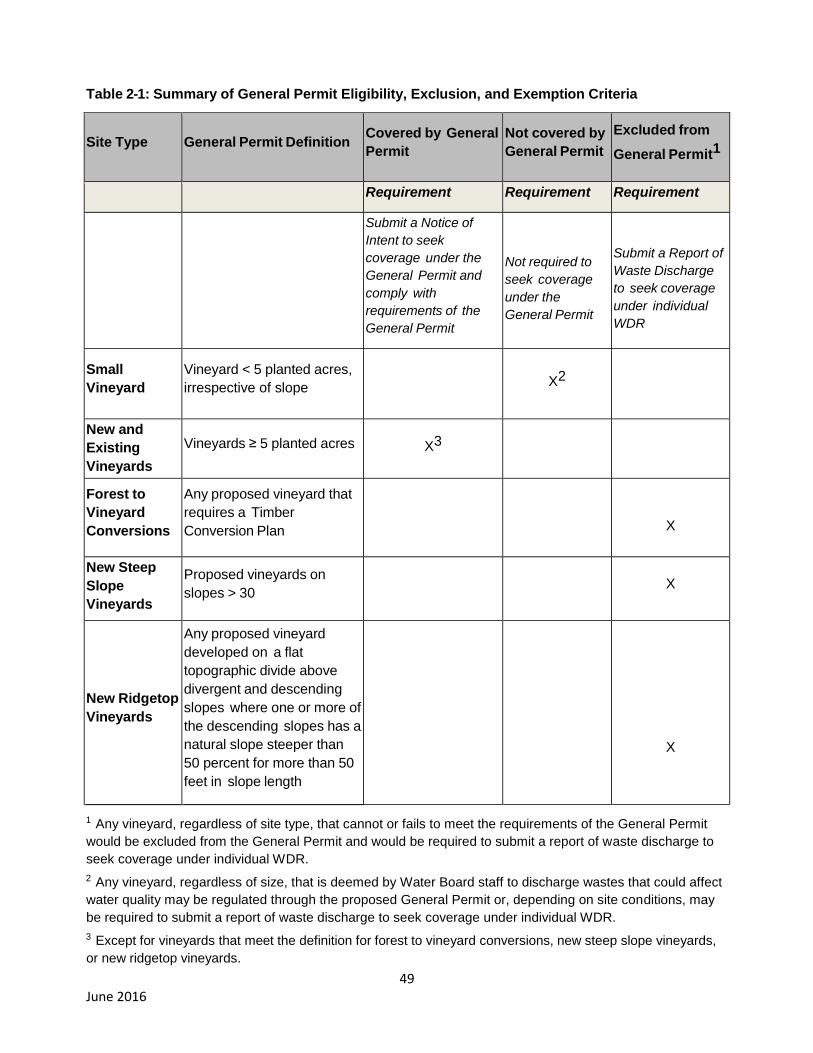
49 June 2016
Table 2-1: Summary of General Permit Eligibility, Exclusion, and Exemption Criteria
Site Type General Permit Definition Covered by General
Permit
Not covered by
General Permit
Excluded from
General Permit1
Requirement Requirement Requirement
Submit a Notice of
Intent to seek
coverage under the
General Permit and
comply with
requirements of the
General Permit
Not required to
seek coverage
under the
General Permit
Submit a Report of
Waste Discharge
to seek coverage
under individual
WDR
Small
Vineyard
Vineyard < 5 planted acres,
irrespective of slope X2
New and
Existing
Vineyards
Vineyards ≥ 5 planted acres X3
Forest to
Vineyard
Conversions
Any proposed vineyard that
requires a Timber
Conversion Plan
X
New Steep
Slope
Vineyards
Proposed vineyards on
slopes > 30 X
New Ridgetop
Vineyards
Any proposed vineyard
developed on a flat
topographic divide above
divergent and descending
slopes where one or more of
the descending slopes has a
natural slope steeper than
50 percent for more than 50
feet in slope length
X
1 Any vineyard, regardless of site type, that cannot or fails to meet the requirements of the General Permit
would be excluded from the General Permit and would be required to submit a report of waste discharge to
seek coverage under individual WDR.
2 Any vineyard, regardless of size, that is deemed by Water Board staff to discharge wastes that could affect
water quality may be regulated through the proposed General Permit or, depending on site conditions, may
be required to submit a report of waste discharge to seek coverage under individual WDR.
3 Except for vineyards that meet the definition for forest to vineyard conversions, new steep slope vineyards,
or new ridgetop vineyards.
50 June 2016
The following “high potential sediment delivery” vineyard properties would not qualify for coverage
under the proposed General Permit, given their higher potential impact on the existing habitat and
increased potential for soil erosion. These properties would instead be required to submit applications
for an individual WDR:
Any proposed vineyards that require a Timber Conversion Plan or ;
Vineyards proposed on ridgetop areas; or
New vineyards on slopes of 30 percent or more.
The distribution of existing vineyard properties across both watersheds, by slope categories, is shown in
Figure 2-2. Some of the existing vineyards in the 0-to-5 percent slope range would meet the “low
sediment delivery” criteria described above. Existing vineyards on slopes greater than 30 percent are
highlighted to identify areas expected to have a higher potential for erosion.
As discussed above, based on the five acre-or-more planted in grapes criteria, up to 90 percent of the
total acreage planted and up to two-thirds of the total Vineyard Property acreage, could be regulated by
the Water Board via the proposed General Permit.
General Permit Requirements
The General Permit requires Dischargers to prepare a Farm Water Quality Protection Plan (Farm Plan),
as specified in Appendix A, and as described below. The Farm Plan documents natural features,
developed areas, and best management practices (BMPs) implemented to achieve the following
performance standards:
a) Soil Erosion in the farm area18
: soil loss rate ≤ tolerable soil loss rate. The tolerable soil
loss rate is as defined by the USDA Soil Conservation Service (1994)19
.
b) Sediment delivery from existing unpaved roads: a) culvert inlets have low plug
potential20
; b) critical dips are installed at crossings with diversion potential; and c) ≤ 25
percent of the total length of unpaved roads is hydrologically connected21
.
c) Sediment delivery from new/proposed roads: entire road is storm-proofed (see Table 2-
2 below).
18
The Farm Area at a minimum includes all vineyard blocks, lanes, and avenues. Vineyard lanes and avenues are the field roads along the edges and/or in between the vineyard blocks.
19 A “hillslope vineyard” is defined by an area where grapes are planted on an average slope > 5 percent.
Hillslope vineyards, in addition to achieving the performance standard for soil erosion in the farm area, must also achieve the performance standard(s) for storm runoff as specified immediately below. 20
Trash barriers or deflectors are installed where needed. For additional guidance, please see Weaver et al., (2014), “Culvert Inlet and Outlet Treatments”, pp. 137-143.
21
Hydrologic connectivity refers to the length or proportion of a road that drains runoff directly to streams or other water bodies. Any road segment that has a continuous surface flow path to a natural stream channel during a storm runoff event is termed a hydrologically connected road or road reach. Connectivity usually occurs through road ditches, road surfaces, gullies, or other drainage structures or disturbed surfaces. Road located on valley-floor vineyard properties are located on gently sloping terrain (≤ 5 percent). Therefore, erosion rates are much lower and runoff and/or entrained sediment is often stored or detained in surface depressions and/or in vegetated areas.

51 June 2016
d) Storm Runoff from an existing hillslope vineyard22
: shall not cause or contribute to
downstream increases in bed and/or bank erosion (see below, Attainment of Runoff
Performance Standard).
e) Storm runoff from a new hillslope vineyard23
: a) peak storm runoff in 2-, 10-, 50-, and
100-year (24-hour duration) events following vineyard development shall not be greater
than pre-development; and b) shall not cause or contribute to downstream increases in bed
and/or bank erosion (see below, Attainment of Runoff Performance Standard).
f) Pesticide management: an integrated pest management program shall be developed and
implemented for the vineyard, and effective practices shall be implemented to avoid mixing,
storing, or applying pesticides near wells and surface waters, or in ways that could
contribute to receiving water toxicity.
g) Nutrient management: best management practices to guide nutrient applications (e.g.,
fertigation, cover crops, soil amendments, plant and/or soil testing) shall be implemented
such that discharges do not contribute to a violation of water quality standards.
Table 2-2: Characteristics of Storm-Proofed Roads
Stream Crossings
All stream crossings have a drainage structure designed for the 100-year flood flow
(including woody debris and sediment).
Stream crossings have no diversion potential.
Culvert inlets have a low plug potential (trash barriers or deflectors are installed where
needed).
Culverts are installed at the base of the fill and in line with the natural channel.
Deep fills (deeper than a backhoe can reach from the roadbed) with undersized culverts
or culverts with high plugging potential are fitted with an emergency overflow culvert.
Emergency overflow culverts (as applicable; see immediately above) have full round,
anchored downspouts that extend to the natural channel.
Bridges have stable, non-eroding abutments and do not significantly restrict 100-year
flood flow.
Stream crossing fills are stable.
Approaching road surfaces and ditches are “disconnected” from streams and stream
crossing culverts to the maximum extent feasible using road shaping and road drainage
structures.
22
A hillside vineyard is one where the area of cultivation occurs on an average slope ≥ 5 percent. A vineyard developed entirely on a slope less than 5 percent is referred to as “valley floor vineyard”.
23 A “new vineyard” is any vineyard that is ≥ 5 acres that is established subsequent to adoption of this Order.

52 June 2016
Class I (fish-bearing) stream crossings meet State Fish and Wildlife and National Marine
Fisheries Service fish passage criteria.
Road Surface Drainage
Road surfaces and ditches are hydrologically “disconnected” from streams and stream
crossing culverts. Road surface runoff is dispersed, rather than collected and
concentrated.
Ditches are drained frequently by functional ditch relief culverts and/or rolling dips.
Outflow from ditch relief culverts does not discharge to streams.
Ditches and road surfaces drainage does not discharge (through culverts and/or rolling
dips) onto active or potential landslides, and/or into gullies.
Fine sediment contributions from roads, cutbanks, and ditches are minimized by utilizing
seasonal closures and installing a variety of surface drainage techniques including road
surface shaping (outsloping, insloping or crowning), rolling dips, ditch relief culverts,
water bars and other measures to disperse road surface runoff and reduce or eliminate
sediment delivery to the stream.
Attainment of the Storm Runoff Performance Standard for Hillslope Vineyards
Attainment of the performance standard for bed and bank erosion would be evaluated through: a)
review of available information (e.g., property land-use and natural disturbance history, vineyard design
and management practices, mapping of natural and engineered drainage features, soil and geologic
mapping, and topographic mapping); and b) field survey beginning at the point(s) of discharge from the
vineyard along hillslope overland flow pathways and into the receiving channel, downstream to the first
response reach (e.g., gravel-bedded channel reach with a streambed slope ≤ 0.02), and/or to the
property boundary (whichever is encountered first).
At sites where hillslope vineyards discharge into an unstable area24
(whether or not concentrated runoff
from the vineyard is the primary cause or could be a contributing factor to the erosion), as a precaution,
the Water Board may require that additional BMPs be implemented to attenuate vineyard storm runoff.
For example, these may include no-till cover crops, application of composted mulch, soil amendments
to increase organic matter content (e.g., crop residues, manure, and/or compost), installation of level-
spreaders, disconnecting existing drainage pipe systems, and/or construction of detention basins and/or
wetlands. The Water Board also may require soil bioengineering and/or biotechnical techniques to
control erosion in actively eroding gullies and landslides, and also in channel reaches that are down-
cutting and/or head-cutting. Examples of soil bioengineering and/or biotechnical techniques are
described in in Marin Resource Conservation District (2007).
Farm Plans
As specified in Appendix A, Vineyard Property Dischargers would be required to prepare a Farm Water
Quality Protection Plan (Farm Plan). The Farm Plan would be based on an inventory of the vineyards,
roads, reservoirs, and waterways located throughout the Vineyard Property to document the
conservation practices already in-place, and/or to prescribe additional best management practices
(BMPs) that will be implemented and maintained to comply with all conditions of this Order including
24
These include hillslope vineyard discharges into down-cutting and/or head-cutting channels, gullies, and/or or landslides,
53 June 2016
achievement of applicable performance standards for discharge, and also to document the actions
taken to protect and/or enhance stream-riparian habitat complexity and connectivity. . Management
practices and implementation projects must address all sources of pollutants related to vineyard
facilities and roads, including: surface erosion and excessive runoff from vineyards, road sediment
discharge, nutrient and pesticide use and management; and sediment delivery from unstable areas
such as gullies, incised channel reaches, and landslides. The Farm Plan also includes a specific time
schedule and corresponding milestones to measure progress toward attainment of the Vineyard
Property performance standards, and a monitoring plan to document BMP implementation and assess
the effectiveness of BMPs.
2.4. Project Characteristics CEQA requires that the EIR include a general description of the project’s technical, economic and
environmental characteristics (CEQA Guidelines Section 15124). The General Permit sets forth
requirements for the protection of water quality from vineyard properties. Through compliance with
those requirements, Dischargers could cause a physical change to the environment. As such, the
“project characteristics” are the standards required in the General Permit and the reasonably
foreseeable methods that Dischargers may use to satisfy the General Permit requirements. The project
does not include the specific project features or site-specific impacts of the development and operation
of any new vineyard or new unpaved road because the General Permit does not authorize, approve, or
in any way support development of any new vineyard or road. Approval of new vineyard and/or road
development projects would require a project-specific CEQA analysis performed by the appropriate lead
agency. The EIR does anticipate that those types of developments will occur, however, and evaluates
them as part of the potential cumulative impacts.
The General Permit regulates Vineyard Properties that have the potential to affect waters of the state
including from areas of agricultural cultivation, reservoirs, and unpaved roads. It is not possible to
foresee with a reasonable level of certainty the exact actions that would be taken by specific
Dischargers to comply with their respective obligations in a particular location. Therefore, the EIR
presents an evaluation that describes reasonably foreseeable impacts, but does not speculate on all
possible impacts that might occur from the methods that could be used at a particular site or project
specific level. For purposes of the EIR, the most likely methods of compliance were evaluated based
on current industry practice.
The following methods for compliance have been selected as reasonably foreseeable actions and
provide the basis for a reasoned, good-faith assessment of the potential significant environmental
impacts of the General Permit.
2.5. Reasonably Foreseeable Means of Compliance A wide array of best management practices (BMPs) to control erosion, reduce storm runoff, control
nutrient discharges, and/or control pesticide discharges could be implemented throughout vineyard
properties in the Napa River and Sonoma Creek watersheds in order to meet performance standards
for discharge that are included as conditions of the General Permit. BMPs that could be implemented
and affect the environment, regardless of level of impact, are listed in Table 2-3. This list of BMPs is
based on review of: a) best management practices and site conditions observed at more than 100
vineyard properties where Water Board staff have conducted site inspections and/or reviewed farm
plans prepared under the Fish Friendly Farming Program; b) the Farm Plan Template for the

54 June 2016
LandSmart (Sonoma County RCD et al., 2015); c) “Best Management Practices for Agricultural Erosion
and Sediment Control” (Sonoma County Agricultural Commissioner, 2013); d) “Groundwork, a
Handbook for Small-Scale Erosion Control in Coastal California” (Marin RCD, 2007); e) “Handbook of
Forest, Ranch, and Rural Roads” (Kleeman, 2014); and f) other sources as cited in the section that
follows.
Many of the BMPs described below already are have been implemented at many vineyard properties in
the Napa River and/or Sonoma Creek watersheds including: a) those that have previously implemented
farm water quality protection plans under the Fish Friendly Farming Program (covering more than
34,700 acres) and/or the LandSmart Program (about 10,000 acres); b) road-erosion control projects
and/or other erosion control projects completed in partnership with the Napa County and/or Sonoma
Resource Conservation Districts, the USDA Natural Resources Conservation Service; and or c) those
that have implemented erosion control plans for vineyards, as needed to comply with Conservation
Regulations in Napa County, and/or the VESCO Ordinance in Sonoma County.
BMPs in Table 2-3 which follows are organized by pollutant source control category. Immediately
following Table 2-3, each BMP is described in detail.
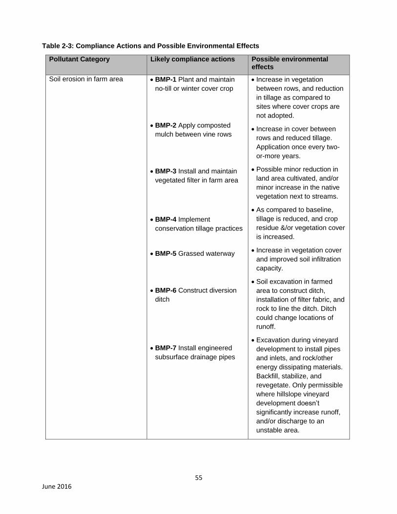
55 June 2016
Table 2-3: Compliance Actions and Possible Environmental Effects
Pollutant Category Likely compliance actions Possible environmental effects
Soil erosion in farm area BMP-1 Plant and maintain
no-till or winter cover crop
BMP-2 Apply composted
mulch between vine rows
BMP-3 Install and maintain
vegetated filter in farm area
BMP-4 Implement
conservation tillage practices
BMP-5 Grassed waterway
BMP-6 Construct diversion
ditch
BMP-7 Install engineered
subsurface drainage pipes
Increase in vegetation
between rows, and reduction
in tillage as compared to
sites where cover crops are
not adopted.
Increase in cover between
rows and reduced tillage.
Application once every two-
or-more years.
Possible minor reduction in
land area cultivated, and/or
minor increase in the native
vegetation next to streams.
As compared to baseline,
tillage is reduced, and crop
residue &/or vegetation cover
is increased.
Increase in vegetation cover
and improved soil infiltration
capacity.
Soil excavation in farmed
area to construct ditch,
installation of filter fabric, and
rock to line the ditch. Ditch
could change locations of
runoff.
Excavation during vineyard
development to install pipes
and inlets, and rock/other
energy dissipating materials.
Backfill, stabilize, and
revegetate. Only permissible
where hillslope vineyard
development doesn’t
significantly increase runoff,
and/or discharge to an
unstable area.

56 June 2016
Table 2-3 (cont.): Compliance Actions and Possible Environmental Effects
Pollutant Category Likely compliance actions Possible environmental changes
Increases in storm runoff from hillside vineyards
BMP-1 Plant & maintain
no-till &/or winter cover
crop
BMP-2 Apply composted
mulch between vine rows
BMP-3 Install and
maintain vegetated filter
strips
BMP-4 Implement
conservation tillage
BMP-5 Grassed waterway
BMP-8 Disconnect and/or
remove subsurface
drainage pipes at an
existing vineyard
BMP-9 Construct level spreaders
BMP-10 Detention basin
and/or constructed
wetlands
See description above
See description above
See description above
See description above
See description above
Soil excavation in farm area
during vineyard replant to
remove pipes; add local or
imported soil to backfill
holes/trenches; and minor
grading to stabilize disturbed
area.
Use of on-site materials or
importation of rock and level
spreaders. May involve minor
excavation and fill in uplands.
Mobilization/use of heavy
equipment to remove
vegetation and excavate
detention basin or constructed
wetland. Install pipes, valves,
and inlet/outlet for detention
basin. Backfill, stabilize, and
revegetate after earth moving.
May reduce vineyard footprint
or be constructed in
undeveloped uplands.
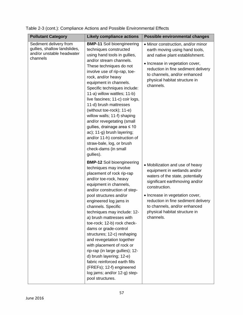
57 June 2016
Table 2-3 (cont.): Compliance Actions and Possible Environmental Effects
Pollutant Category Likely compliance actions Possible environmental changes
Sediment delivery from gullies, shallow landslides, and/or unstable headwater channels
BMP-11 Soil bioengineering
techniques constructed
using hand tools in gullies,
and/or stream channels.
These techniques do not
involve use of rip-rap, toe-
rock, and/or heavy
equipment in channels.
Specific techniques include:
11-a) willow wattles; 11-b)
live fascines; 11-c) coir logs,
11-d) brush mattresses
(without toe-rock); 11-e)
willow walls; 11-f) shaping
and/or revegetating (small
gullies, drainage area ≤ 10
ac); 11-g) brush layering;
and/or 11-h) construction of
straw-bale, log, or brush
check-dams (in small
gullies).
BMP-12 Soil bioengineering
techniques may involve
placement of rock rip-rap
and/or toe-rock, heavy
equipment in channels,
and/or construction of step-
pool structures and/or
engineered log jams in
channels. Specific
techniques may include: 12-
a) brush mattresses with
toe-rock; 12-b) rock check-
dams or grade-control
structures; 12-c) reshaping
and revegetation together
with placement of rock or
rip-rap (in large gullies); 12-
d) brush layering; 12-e)
fabric reinforced earth fills
(FREFs); 12-f) engineered
log jams; and/or 12-g) step-
pool structures.
Minor construction, and/or minor
earth moving using hand tools,
and native plant establishment.
Increase in vegetation cover,
reduction in fine sediment delivery
to channels, and/or enhanced
physical habitat structure in
channels.
Mobilization and use of heavy
equipment in wetlands and/or
waters of the state, potentially
significant earthmoving and/or
construction.
Increase in vegetation cover,
reduction in fine sediment delivery
to channels, and/or enhanced
physical habitat structure in
channels.
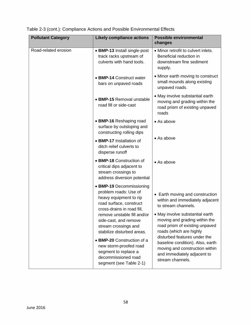
58 June 2016
Table 2-3 (cont.): Compliance Actions and Possible Environmental Effects
Pollutant Category Likely compliance actions Possible environmental changes
Road-related erosion BMP-13 Install single-post
track racks upstream of
culverts with hand tools.
BMP-14 Construct water
bars on unpaved roads
BMP-15 Removal unstable
road fill or side-cast
BMP-16 Reshaping road
surface by outsloping and
constructing rolling dips
BMP-17 Installation of
ditch relief culverts to
disperse runoff
BMP-18 Construction of
critical dips adjacent to
stream crossings to
address diversion potential
BMP-19 Decommissioning
problem roads: Use of
heavy equipment to rip
road surface, construct
cross-drains in road fill,
remove unstable fill and/or
side-cast, and remove
stream crossings and
stabilize disturbed areas.
BMP-20 Construction of a
new storm-proofed road
segment to replace a
decommissioned road
segment (see Table 2-1)
Minor retrofit to culvert inlets.
Beneficial reduction in
downstream fine sediment
supply.
Minor earth moving to construct
small mounds along existing
unpaved roads.
May involve substantial earth
moving and grading within the
road prism of existing unpaved
roads
As above
As above
As above
Earth moving and construction
within and immediately adjacent
to stream channels.
May involve substantial earth
moving and grading within the
road prism of existing unpaved
roads (which are highly
disturbed features under the
baseline condition). Also, earth
moving and construction within
and immediately adjacent to
stream channels.
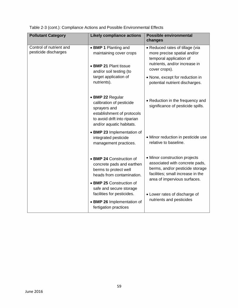
59 June 2016
Table 2-3 (cont.): Compliance Actions and Possible Environmental Effects
Pollutant Category Likely compliance actions Possible environmental changes
Control of nutrient and pesticide discharges
BMP 1 Planting and
maintaining cover crops
BMP 21 Plant tissue
and/or soil testing (to
target application of
nutrients).
BMP 22 Regular
calibration of pesticide
sprayers and
establishment of protocols
to avoid drift into riparian
and/or aquatic habitats.
BMP 23 Implementation of
integrated pesticide
management practices.
BMP 24 Construction of
concrete pads and earthen
berms to protect well
heads from contamination.
BMP 25 Construction of
safe and secure storage
facilities for pesticides.
BMP 26 Implementation of
fertigation practices
Reduced rates of tillage (via
more precise spatial and/or
temporal application of
nutrients, and/or increase in
cover crops).
None, except for reduction in
potential nutrient discharges.
Reduction in the frequency and
significance of pesticide spills.
Minor reduction in pesticide use
relative to baseline.
Minor construction projects
associated with concrete pads,
berms, and/or pesticide storage
facilities; small increase in the
area of impervious surfaces.
Lower rates of discharge of
nutrients and pesticides
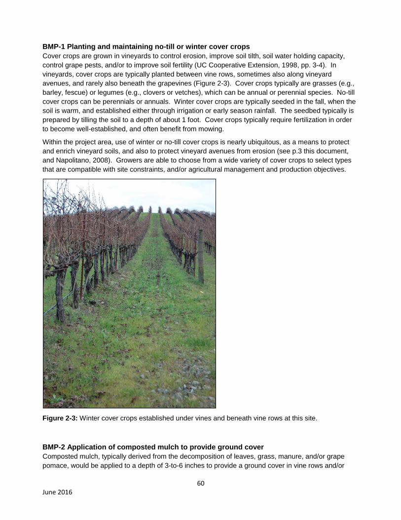
60 June 2016
BMP-1 Planting and maintaining no-till or winter cover crops
Cover crops are grown in vineyards to control erosion, improve soil tilth, soil water holding capacity,
control grape pests, and/or to improve soil fertility (UC Cooperative Extension, 1998, pp. 3-4). In
vineyards, cover crops are typically planted between vine rows, sometimes also along vineyard
avenues, and rarely also beneath the grapevines (Figure 2-3). Cover crops typically are grasses (e.g.,
barley, fescue) or legumes (e.g., clovers or vetches), which can be annual or perennial species. No-till
cover crops can be perennials or annuals. Winter cover crops are typically seeded in the fall, when the
soil is warm, and established either through irrigation or early season rainfall. The seedbed typically is
prepared by tilling the soil to a depth of about 1 foot. Cover crops typically require fertilization in order
to become well-established, and often benefit from mowing.
Within the project area, use of winter or no-till cover crops is nearly ubiquitous, as a means to protect
and enrich vineyard soils, and also to protect vineyard avenues from erosion (see p.3 this document,
and Napolitano, 2008). Growers are able to choose from a wide variety of cover crops to select types
that are compatible with site constraints, and/or agricultural management and production objectives.
Figure 2-3: Winter cover crops established under vines and beneath vine rows at this site.
BMP-2 Application of composted mulch to provide ground cover
Composted mulch, typically derived from the decomposition of leaves, grass, manure, and/or grape
pomace, would be applied to a depth of 3-to-6 inches to provide a ground cover in vine rows and/or
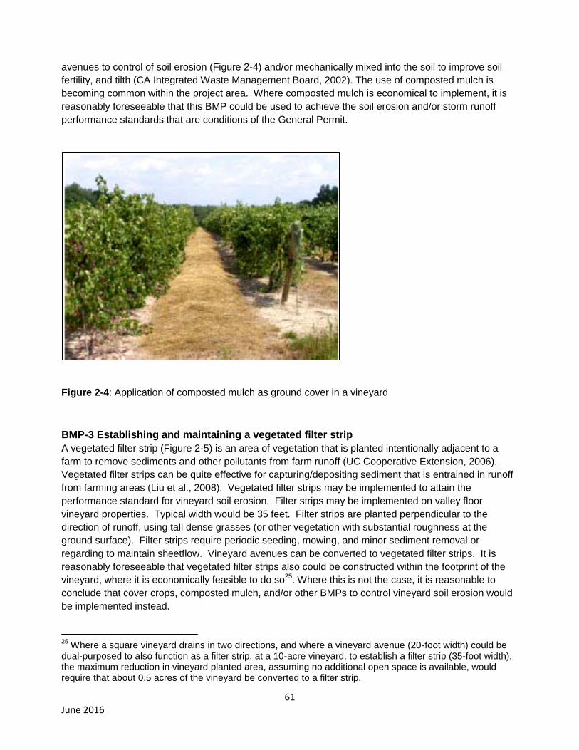
61 June 2016
avenues to control of soil erosion (Figure 2-4) and/or mechanically mixed into the soil to improve soil
fertility, and tilth (CA Integrated Waste Management Board, 2002). The use of composted mulch is
becoming common within the project area. Where composted mulch is economical to implement, it is
reasonably foreseeable that this BMP could be used to achieve the soil erosion and/or storm runoff
performance standards that are conditions of the General Permit.
Figure 2-4: Application of composted mulch as ground cover in a vineyard
BMP-3 Establishing and maintaining a vegetated filter strip
A vegetated filter strip (Figure 2-5) is an area of vegetation that is planted intentionally adjacent to a
farm to remove sediments and other pollutants from farm runoff (UC Cooperative Extension, 2006).
Vegetated filter strips can be quite effective for capturing/depositing sediment that is entrained in runoff
from farming areas (Liu et al., 2008). Vegetated filter strips may be implemented to attain the
performance standard for vineyard soil erosion. Filter strips may be implemented on valley floor
vineyard properties. Typical width would be 35 feet. Filter strips are planted perpendicular to the
direction of runoff, using tall dense grasses (or other vegetation with substantial roughness at the
ground surface). Filter strips require periodic seeding, mowing, and minor sediment removal or
regarding to maintain sheetflow. Vineyard avenues can be converted to vegetated filter strips. It is
reasonably foreseeable that vegetated filter strips also could be constructed within the footprint of the
vineyard, where it is economically feasible to do so25
. Where this is not the case, it is reasonable to
conclude that cover crops, composted mulch, and/or other BMPs to control vineyard soil erosion would
be implemented instead.
25
Where a square vineyard drains in two directions, and where a vineyard avenue (20-foot width) could be dual-purposed to also function as a filter strip, at a 10-acre vineyard, to establish a filter strip (35-foot width), the maximum reduction in vineyard planted area, assuming no additional open space is available, would require that about 0.5 acres of the vineyard be converted to a filter strip.
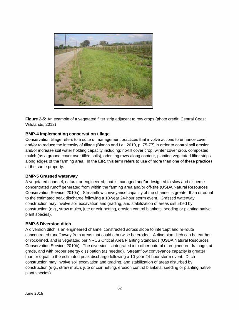
62 June 2016
Figure 2-5: An example of a vegetated filter strip adjacent to row crops (photo credit: Central Coast
Wildlands, 2012)
BMP-4 Implementing conservation tillage
Conservation tillage refers to a suite of management practices that involve actions to enhance cover
and/or to reduce the intensity of tillage (Blanco and Lal, 2010, p. 75-77) in order to control soil erosion
and/or increase soil water holding capacity including: no-till cover crop, winter cover crop, composted
mulch (as a ground cover over tilled soils), orienting rows along contour, planting vegetated filter strips
along edges of the farming area. In the EIR, this term refers to use of more than one of these practices
at the same property.
BMP-5 Grassed waterway
A vegetated channel, natural or engineered, that is managed and/or designed to slow and disperse
concentrated runoff generated from within the farming area and/or off-site (USDA Natural Resources
Conservation Service, 2010a). Streamflow conveyance capacity of the channel is greater than or equal
to the estimated peak discharge following a 10-year 24-hour storm event. Grassed waterway
construction may involve soil excavation and grading, and stabilization of areas disturbed by
construction (e.g., straw mulch, jute or coir netting, erosion control blankets, seeding or planting native
plant species).
BMP-6 Diversion ditch
A diversion ditch is an engineered channel constructed across slope to intercept and re-route
concentrated runoff away from areas that could otherwise be eroded. A diversion ditch can be earthen
or rock-lined, and is vegetated per NRCS Critical Area Planting Standards (USDA Natural Resources
Conservation Service, 2010b). The diversion is integrated into other natural or engineered drainage, at
grade, and with proper energy dissipation (as needed). Streamflow conveyance capacity is greater
than or equal to the estimated peak discharge following a 10-year 24-hour storm event. Ditch
construction may involve soil excavation and grading, and stabilization of areas disturbed by
construction (e.g., straw mulch, jute or coir netting, erosion control blankets, seeding or planting native
plant species).
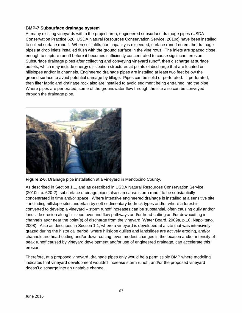
63 June 2016
BMP-7 Subsurface drainage system
At many existing vineyards within the project area, engineered subsurface drainage pipes (USDA
Conservation Practice 620, USDA Natural Resources Conservation Service, 2010c) have been installed
to collect surface runoff. When soil infiltration capacity is exceeded, surface runoff enters the drainage
pipes at drop inlets installed flush with the ground surface in the vine rows. The inlets are spaced close
enough to capture runoff before it becomes sufficiently concentrated to cause significant erosion.
Subsurface drainage pipes after collecting and conveying vineyard runoff, then discharge at surface
outlets, which may include energy dissipation structures at points of discharge that are located on
hillslopes and/or in channels. Engineered drainage pipes are installed at least two feet below the
ground surface to avoid potential damage by tillage. Pipes can be solid or perforated. If perforated,
then filter fabric and drainage rock also are installed to avoid sediment being entrained into the pipe.
Where pipes are perforated, some of the groundwater flow through the site also can be conveyed
through the drainage pipe.
Figure 2-6: Drainage pipe installation at a vineyard in Mendocino County.
As described in Section 1.1, and as described in USDA Natural Resources Conservation Service
(2010c, p. 620-2), subsurface drainage pipes also can cause storm runoff to be substantially
concentrated in time and/or space. Where intensive engineered drainage is installed at a sensitive site
– including hillslope sites underlain by soft sedimentary bedrock types and/or where a forest is
converted to develop a vineyard – storm runoff increases can be substantial, often causing gully and/or
landslide erosion along hillslope overland flow pathways and/or head-cutting and/or downcutting in
channels at/or near the point(s) of discharge from the vineyard (Water Board, 2009a, p.18; Napolitano,
2008). Also as described in Section 1.1, where a vineyard is developed at a site that was intensively
grazed during the historical period, where hillslope gullies and landslides are actively eroding, and/or
channels are head-cutting and/or down-cutting, even modest changes in the location and/or intensity of
peak runoff caused by vineyard development and/or use of engineered drainage, can accelerate this
erosion.
Therefore, at a proposed vineyard, drainage pipes only would be a permissible BMP where modeling
indicates that vineyard development wouldn’t increase storm runoff, and/or the proposed vineyard
doesn’t discharge into an unstable channel.
64 June 2016
BMP-8 Disconnection and/or removal of drainage pipes
As needed, the effect of the subsurface drainage pipes on storm runoff can be addressed by capping
the drop inlets (to the pipes) that are located on the ground surface in the vine rows, and/or by removing
the pipes. Considering costs of excavation and the potential for significant disturbance to the vineyard,
it is reasonably foreseeable that removal of drainage pipes, where this occurs, would coincide with the
timing of a vineyard replant. During a vineyard replant, vines and trellises are removed, and typically the
soil is deeply ripped (Cooper et al., 2012). Excavation at that time would be confined within the farming
area. A backhoe or excavator and dump truck would be used to excavate and remove the pipes. The
excavator or backhoe would then be used to backfill the voids resulting from pipe removal; local
stockpiled soil or imported soil would be use. The disturbed areas would then be graded, to conform to
the layout of the vine rows.
BMP-9 Construction of Level Spreaders
A level spreader (Figure 2-7) is a small depression excavated perpendicular to a point of discharge of
storm runoff (in this case form a hillslope vineyard) that is designed to slow the runoff and then allow it
to be dispersed uniformly over a wider area to enhance potential infiltration and dissipate the energy of
the sheetflow. This BMP could be implemented to attain the performance standards for vineyard soil
erosion and/or storm runoff that are conditions of the General Permit (Appendix A). Level spreaders
only are designed to accommodate low volumes of runoff, and they require regular maintenance/repairs
(e.g., minor sediment removal, occasional regarding, vegetation management, etc.) in order to continue
to function correctly. Level spreader construction involves:
Use of on-site earth materials or importation of rock and sheet-flow spreaders to construct
features to disperse storm runoff.
May involve minor excavation and fill in upland areas
Excavation of soil to construct the level spreader may involve use of heavy-equipment. Excavation or
construction would occur adjacent to the vineyard in previously undisturbed upland habitats.

65 June 2016
Figure 2-7: Conceptual layout of a level spreader
BMP-10 Stormwater detention basin or constructed wetland
A stormwater detention basin is an impoundment (i.e., dam) that is constructed to provide short-term
detention of storm runoff in order to attenuate peak runoff magnitude and to control hillslope erosion
and/or channel scouring (Figure 2-7). This BMP could be implemented at some vineyard properties to
achieve the storm runoff performance standards that are included as conditions of the General Permit
(Appendix A). Construction of a detention basin could occur within the developed footprint of the
hillslope vineyard, and/or in adjacent undeveloped areas26
. Detention basin construction may involve
significant earth moving, excavation, and grading. If constructed in a previously undeveloped hillslope
site, it also would involve vegetation clearing and grubbing. A general rule, basin size equals about 2-
to-3 percent of the contributing drainage area (USEPA, 2014), which in this case would be the vineyard.
In summary detention basin construction involves:
Surface grading/natural vegetation removal or vine removal
Basin excavation using typical construction equipment (excavator, backhoe, dump truck)
Soil stockpiling/disposal/reuse
Groundwater dewatering (if needed due to site-specific conditions)
Drainage pipe/inflow ditch installation
Final grading
Erosion control actions/Bank reseeding
26
However, where compliance with the General Permit would require conversion of timberlands, there is no authority to discharge under the General Permit. These vineyard properties would be required instead to obtain coverage under individual waste discharge requirements.
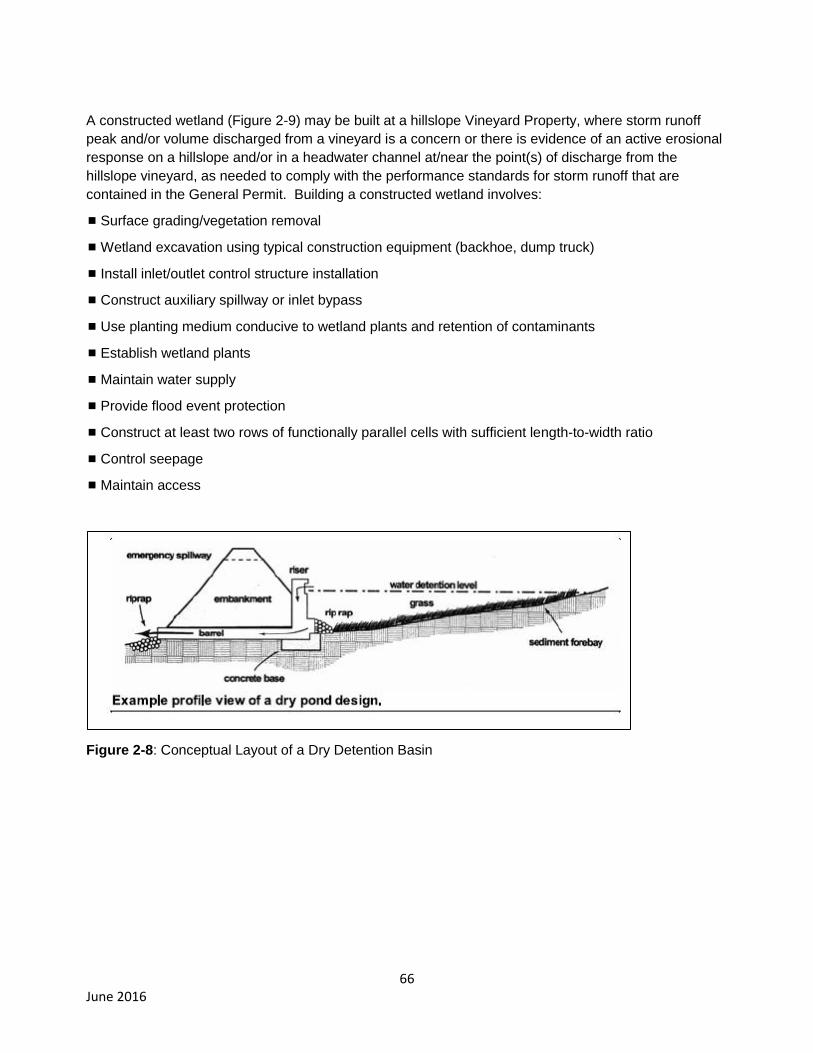
66 June 2016
A constructed wetland (Figure 2-9) may be built at a hillslope Vineyard Property, where storm runoff
peak and/or volume discharged from a vineyard is a concern or there is evidence of an active erosional
response on a hillslope and/or in a headwater channel at/near the point(s) of discharge from the
hillslope vineyard, as needed to comply with the performance standards for storm runoff that are
contained in the General Permit. Building a constructed wetland involves:
Surface grading/vegetation removal
Wetland excavation using typical construction equipment (backhoe, dump truck)
Install inlet/outlet control structure installation
Construct auxiliary spillway or inlet bypass
Use planting medium conducive to wetland plants and retention of contaminants
Establish wetland plants
Maintain water supply
Provide flood event protection
Construct at least two rows of functionally parallel cells with sufficient length-to-width ratio
Control seepage
Maintain access
Figure 2-8: Conceptual Layout of a Dry Detention Basin

67 June 2016
Figure 2-9: Cross-section of Constructed Wetland Schematic of Subsurface-flow
BMP-11 Soil Bioengineering Techniques (that do not involve use of rip-rap or toe-rock,
and/or heavy equipment operation in channels)
Soil bioengineering is “an applied science that combines structural, biological, and ecological concepts
to construct living structures (plant communities) for erosion, sediment, and flood control” (USDA Forest
Service, 2002). Soil bioengineering is an effective tool for treatment of a variety of unstable and/or
eroding sites. Soil bioengineering may be used at some vineyard properties to control erosion in
unstable headwater channels and/or to stabilize landslides or gullies, as needed at some sites to satisfy
the performance standard for storm runoff from hillslope vineyards. All of the techniques presented
below do not involve use heavy-equipment, and/or placement of rip-rap and/or toe-rock:
a) Construction of willow wattles, live fascines, brush mattresses, willow walls, coir logs to control
bank erosion in gullies or headwater channels;
b) Reshaping of slopes and revegetation with native plant species at head-cuts in small gullies
(drainage area ≤ 10 acres); and
c) Construction of straw-bale, brush or log check-dams to control knickpoint erosion in small
gullies (drainage area ≤ 10 acres).
BMP-12 Soil Bioengineering Techniques (that may involve use of rip-rap or toe-rock, and/or
heavy equipment operation in channels)
BMP-12 is identical to BMP-11 except that the following soil bioengineering techniques may also
involve use of rip-rap and/or toe-rock, and in some cases also the use of heavy equipment in channels
(to place rock and/or large woody debris, and/or to key these materials into stream banks and/or the
stream bed):
a) Construction of brush mattresses using toe-rock to control bank erosion;
b) Construction of rock check-dams or grade-control structures in large gullies;
c) Reshaping and revegetation of head-cuts together with placement of rock or rip-rap (in large
gullies);
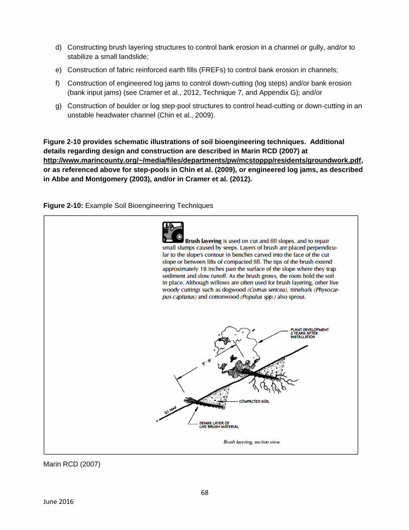
68 June 2016
d) Constructing brush layering structures to control bank erosion in a channel or gully, and/or to
stabilize a small landslide;
e) Construction of fabric reinforced earth fills (FREFs) to control bank erosion in channels;
f) Construction of engineered log jams to control down-cutting (log steps) and/or bank erosion
(bank input jams) (see Cramer et al., 2012, Technique 7, and Appendix G); and/or
g) Construction of boulder or log step-pool structures to control head-cutting or down-cutting in an
unstable headwater channel (Chin et al., 2009).
Figure 2-10 provides schematic illustrations of soil bioengineering techniques. Additional
details regarding design and construction are described in Marin RCD (2007) at
http://www.marincounty.org/~/media/files/departments/pw/mcstoppp/residents/groundwork.pdf,
or as referenced above for step-pools in Chin et al. (2009), or engineered log jams, as described
in Abbe and Montgomery (2003), and/or in Cramer et al. (2012).
Figure 2-10: Example Soil Bioengineering Techniques
Marin RCD (2007)
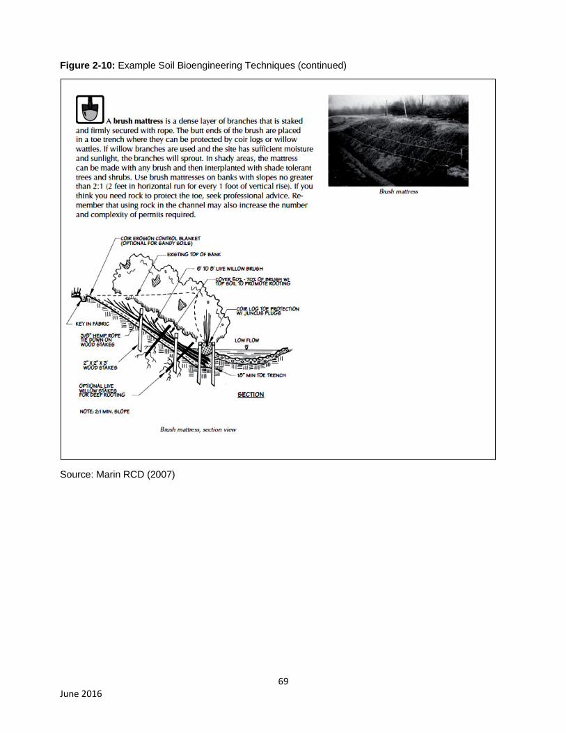
69 June 2016
Figure 2-10: Example Soil Bioengineering Techniques (continued)
Source: Marin RCD (2007)
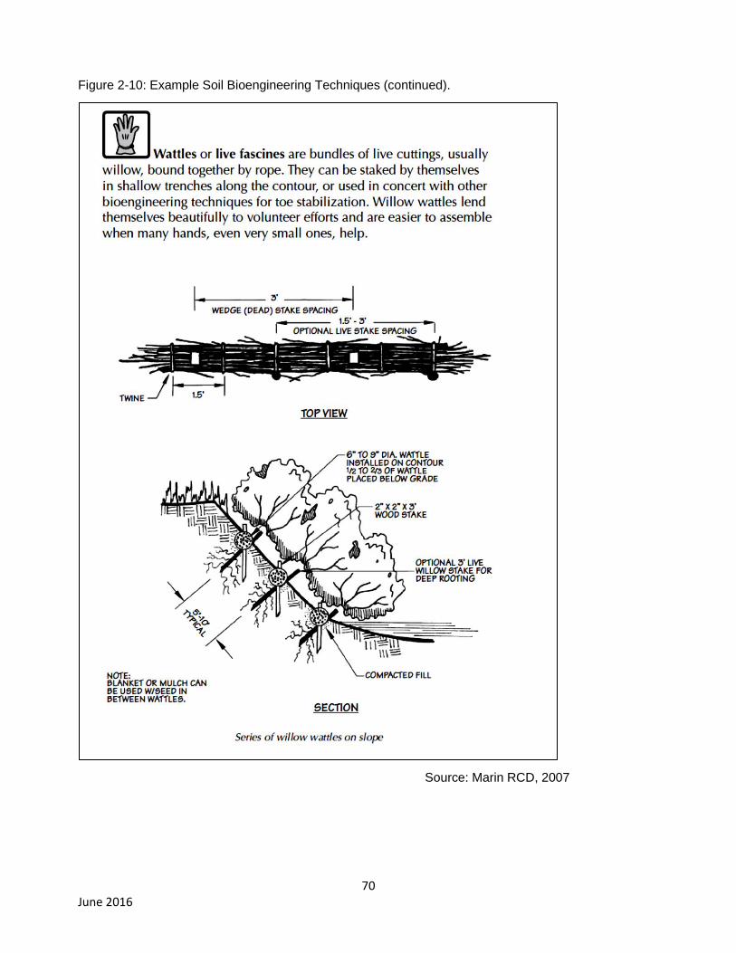
70 June 2016
Figure 2-10: Example Soil Bioengineering Techniques (continued).
Source: Marin RCD, 2007
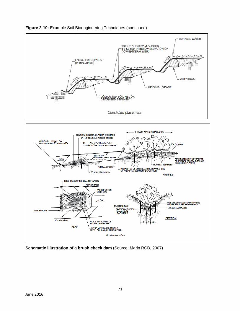
71 June 2016
Figure 2-10: Example Soil Bioengineering Techniques (continued)
Schematic illustration of a brush check dam (Source: Marin RCD, 2007)

72 June 2016
Figure 2-10: Example Soil Bioengineering Techniques (continued)
Source: Marin RCD, 2007
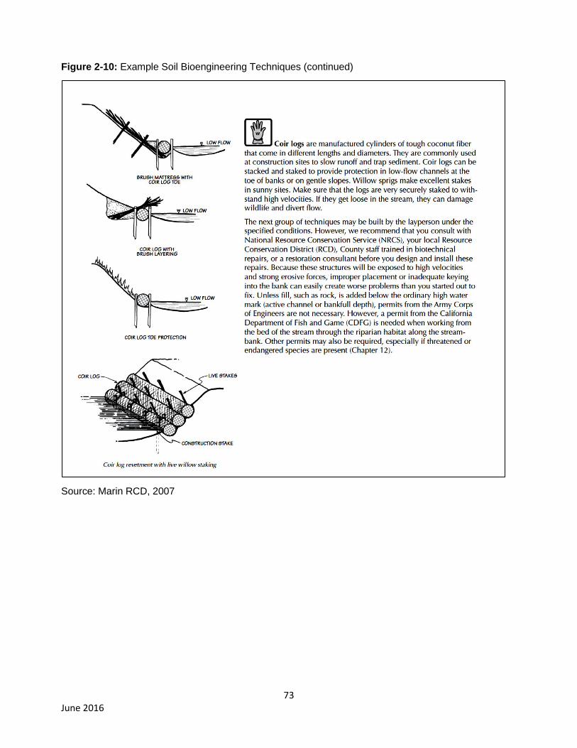
73 June 2016
Figure 2-10: Example Soil Bioengineering Techniques (continued)
Source: Marin RCD, 2007

74 June 2016
Figure 2-10: Example Soil Bioengineering Techniques (continued)
Source: Marin RCD, 2007

75 June 2016
BMP-13 Installation of single-post culvert inlet trash racks
A single metal post would be installed in channel upstream of a culverted stream crossing to help keep
the culvert inlet from becoming plugged. This BMP (Figure 2-11) would be installed at all culverted
crossings that drain forested areas, as indicated in the performance standards for sediment discharge
from roads, which are conditions of the General Permit. Trash racks require regular maintenance (e.g.,
removal of debris and deposited sediment) during storm periods to maintain proper function. Trash
rack installation is accomplished:
Using hand tools to drive a metal post (e.g., steel fence posts, galvanized pipe, etc.) into a streambed
upstream of the culvert at a distance approximately equal to the culvert diameter.
Figure 2-11: Schematic of single-post trash rack including design (Source: Pacific Watershed
Associates, unpublished data, as cited in Napa RCD, 2014).
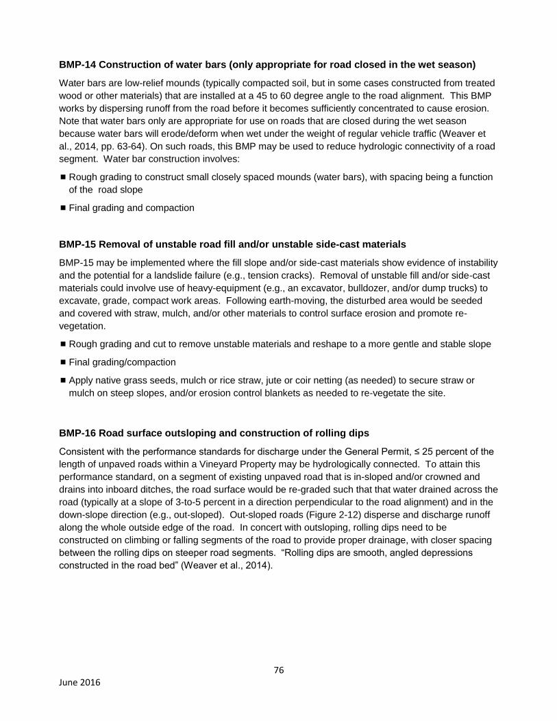
76 June 2016
BMP-14 Construction of water bars (only appropriate for road closed in the wet season)
Water bars are low-relief mounds (typically compacted soil, but in some cases constructed from treated
wood or other materials) that are installed at a 45 to 60 degree angle to the road alignment. This BMP
works by dispersing runoff from the road before it becomes sufficiently concentrated to cause erosion.
Note that water bars only are appropriate for use on roads that are closed during the wet season
because water bars will erode/deform when wet under the weight of regular vehicle traffic (Weaver et
al., 2014, pp. 63-64). On such roads, this BMP may be used to reduce hydrologic connectivity of a road
segment. Water bar construction involves:
Rough grading to construct small closely spaced mounds (water bars), with spacing being a function
of the road slope
Final grading and compaction
BMP-15 Removal of unstable road fill and/or unstable side-cast materials
BMP-15 may be implemented where the fill slope and/or side-cast materials show evidence of instability
and the potential for a landslide failure (e.g., tension cracks). Removal of unstable fill and/or side-cast
materials could involve use of heavy-equipment (e.g., an excavator, bulldozer, and/or dump trucks) to
excavate, grade, compact work areas. Following earth-moving, the disturbed area would be seeded
and covered with straw, mulch, and/or other materials to control surface erosion and promote re-
vegetation.
Rough grading and cut to remove unstable materials and reshape to a more gentle and stable slope
Final grading/compaction
Apply native grass seeds, mulch or rice straw, jute or coir netting (as needed) to secure straw or
mulch on steep slopes, and/or erosion control blankets as needed to re-vegetate the site.
BMP-16 Road surface outsloping and construction of rolling dips
Consistent with the performance standards for discharge under the General Permit, ≤ 25 percent of the
length of unpaved roads within a Vineyard Property may be hydrologically connected. To attain this
performance standard, on a segment of existing unpaved road that is in-sloped and/or crowned and
drains into inboard ditches, the road surface would be re-graded such that that water drained across the
road (typically at a slope of 3-to-5 percent in a direction perpendicular to the road alignment) and in the
down-slope direction (e.g., out-sloped). Out-sloped roads (Figure 2-12) disperse and discharge runoff
along the whole outside edge of the road. In concert with outsloping, rolling dips need to be
constructed on climbing or falling segments of the road to provide proper drainage, with closer spacing
between the rolling dips on steeper road segments. “Rolling dips are smooth, angled depressions
constructed in the road bed” (Weaver et al., 2014).
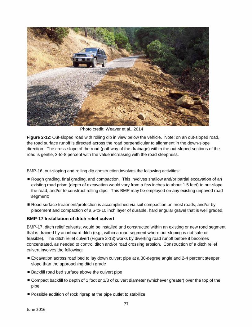
77 June 2016
Photo credit: Weaver et al., 2014
Figure 2-12: Out-sloped road with rolling dip in view below the vehicle. Note: on an out-sloped road,
the road surface runoff is directed across the road perpendicular to alignment in the down-slope
direction. The cross-slope of the road (pathway of the drainage) within the out-sloped sections of the
road is gentle, 3-to-8 percent with the value increasing with the road steepness.
BMP-16, out-sloping and rolling dip construction involves the following activities:
Rough grading, final grading, and compaction. This involves shallow and/or partial excavation of an
existing road prism (depth of excavation would vary from a few inches to about 1.5 feet) to out-slope
the road, and/or to construct rolling dips. This BMP may be employed on any existing unpaved road
segment;
Road surface treatment/protection is accomplished via soil compaction on most roads, and/or by
placement and compaction of a 6-to-10 inch layer of durable, hard angular gravel that is well graded.
BMP-17 Installation of ditch relief culvert
BMP-17, ditch relief culverts, would be installed and constructed within an existing or new road segment
that is drained by an inboard ditch (e.g., within a road segment where out-sloping is not safe or
feasible). The ditch relief culvert (Figure 2-13) works by diverting road runoff before it becomes
concentrated, as needed to control ditch and/or road crossing erosion. Construction of a ditch relief
culvert involves the following:
Excavation across road bed to lay down culvert pipe at a 30-degree angle and 2-4 percent steeper
slope than the approaching ditch grade
Backfill road bed surface above the culvert pipe
Compact backfill to depth of 1 foot or 1/3 of culvert diameter (whichever greater) over the top of the
pipe
Possible addition of rock riprap at the pipe outlet to stabilize

78 June 2016
Source: Weaver et al., 2014
Figure 2-13: Schematic illustration of a typical ditch relief culvert. Note: The ditch relief culvert is
installed at the base of the road fill.
BMP-18 Construction of a critical dip
A critical dip (Figure 2-14) is installed at a road crossing where there is the potential for diversion of a
stream channel along the road if/when a crossing is overtopped. Diversion potential exists where a
falling segment of road (one that slopes away from the crossing) is adjacent to a crossing. Stream
channel diversions along roads create the potential for erosion of a large gullies or landslides, and
significant sediment delivery to channels. A critical dip is excavated to create a dip in the road bed and
act, in essence, like overflow structure or spillway of sufficient capacity to allow flood flows to be
directed immediately back into its channel in the event of overtopping of the crossing during a large
storm. Where the probability of a crossing being overtopped is high, the critical dip also may be
armored with appropriately sized rip-rap. Critical dip construction typically involves the use of heavy
equipment, which may include an excavator, bulldozer, and/or dump truck(s). This BMP could be
installed on an existing or a new/storm-proofed road. Critical dip construction involves:
Vegetation grubbing and removal (where a new storm-proofed road is constructed to replace a
problem road)
Rough grading, final grading, and compaction to excavate and construct the dip
Installation of rip-rap as needed in the dip across the road and also along the downslope surface of
the road fill to grade with the stream channel.

79 June 2016
Figure 2-14: Schematic illustration of a critical dip (Source: Pacific Watershed Associates, unpublished
data, as cited in Napa RCD, 2014).
BMP-19 Decommissioning and stabilizing a problem road segment
BMP used where an existing road segment generates very high rates of sediment delivery, is very
expensive to maintain, and/or the road is no longer needed. Road decommissioning and stabilization
(Figure 2-15) involves using heavy equipment to rip the road surface, excavators to remove crossings
and unstable fill or side-cast and construct cross drains where needed, and dump trucks to haul away
excavated materials.
Rip road surface
Excavate and remove road fill and side-cast where these materials are unstable
Excavate and construct cross-drains
Excavate and completely remove all stream crossings
Apply native grass seeds, mulch or rice straw, jute or coir netting (as needed) to secure straw or
mulch on steep slopes, and/or erosion control blankets on road surface and areas of excavation at
former crossings and at constructed cross drains
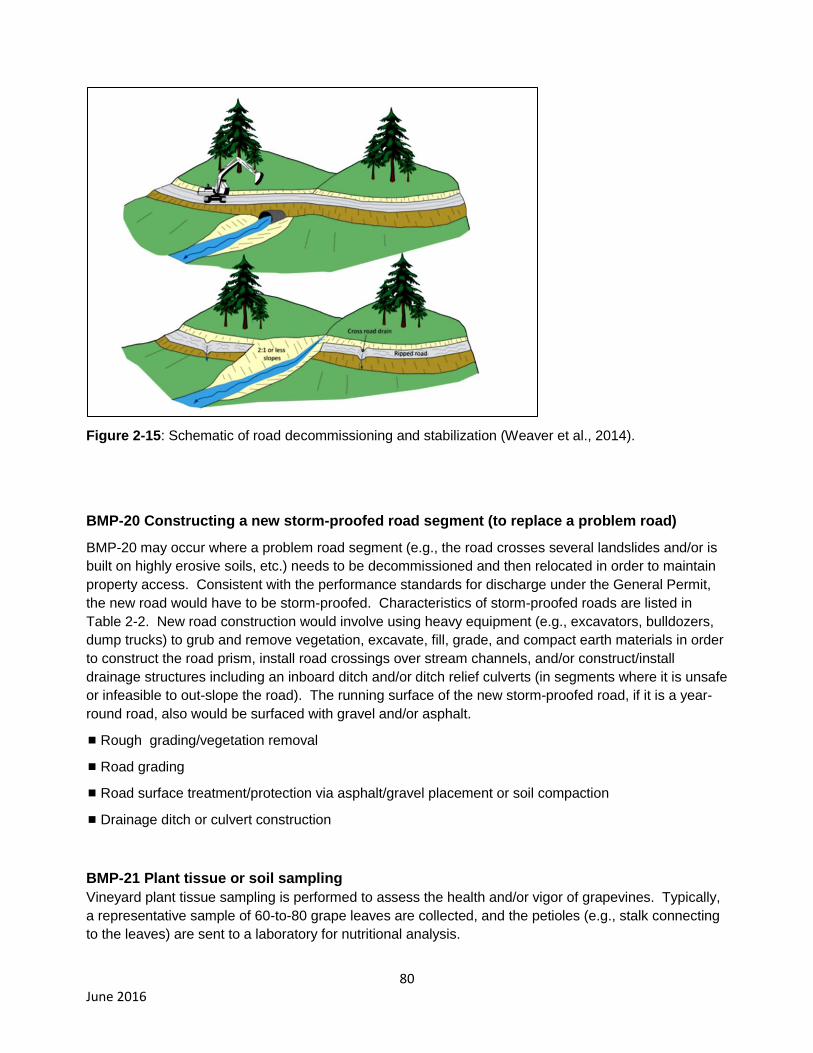
80 June 2016
Figure 2-15: Schematic of road decommissioning and stabilization (Weaver et al., 2014).
BMP-20 Constructing a new storm-proofed road segment (to replace a problem road)
BMP-20 may occur where a problem road segment (e.g., the road crosses several landslides and/or is
built on highly erosive soils, etc.) needs to be decommissioned and then relocated in order to maintain
property access. Consistent with the performance standards for discharge under the General Permit,
the new road would have to be storm-proofed. Characteristics of storm-proofed roads are listed in
Table 2-2. New road construction would involve using heavy equipment (e.g., excavators, bulldozers,
dump trucks) to grub and remove vegetation, excavate, fill, grade, and compact earth materials in order
to construct the road prism, install road crossings over stream channels, and/or construct/install
drainage structures including an inboard ditch and/or ditch relief culverts (in segments where it is unsafe
or infeasible to out-slope the road). The running surface of the new storm-proofed road, if it is a year-
round road, also would be surfaced with gravel and/or asphalt.
Rough grading/vegetation removal
Road grading
Road surface treatment/protection via asphalt/gravel placement or soil compaction
Drainage ditch or culvert construction
BMP-21 Plant tissue or soil sampling
Vineyard plant tissue sampling is performed to assess the health and/or vigor of grapevines. Typically,
a representative sample of 60-to-80 grape leaves are collected, and the petioles (e.g., stalk connecting
to the leaves) are sent to a laboratory for nutritional analysis.
81 June 2016
Vineyard soil sampling typically is performed to identify problems related to chemical imbalances and/or
to determine if there are extremes in mineral nutrient levels (Christiansen, 2002). Soil samples typically
are collected in the winter with a small hand-held soil core over representative areas within the
vineyard.
BMP-22 Calibration of agrichemical sprayers and protocols to avoid drift
These BMPs relate to the maintenance and use of agrochemical sprayers to avoid over application
during spraying through regular calibration of sprayers (UC Davis Weed Science Program and UC
Cooperative Extension, unpublished guidance) and/or to avoid discharge to waterways and/or riparian
areas (e.g., only spraying during appropriate weather conditions, turning sprayers off when operating
adjacent to riparian areas and/or during equipment turn-around, etc.). Most vineyard owners and/or
managers within the project area already have implemented these BMPs. Therefore, the overall effect
of this BMP relative to the CEQA baseline would be a modest reduction in pesticide discharges to
waterways and/or riparian areas.
BMP-23 Integrated pest management
“Integrated pest management (IPM) is an ecosystem-based strategy that focuses on long-term
prevention of pests or their damage through a combination of techniques such as biological control,
habitat manipulation, modification of cultural practices, and use of resistant varieties. Pesticides are
used only after monitoring indicates they are needed according to established guidelines, and
treatments are made with the goal of removing only the target organism. Pest control materials are
selected and applied in a manner that minimizes risks to: human health; beneficial and non-target
organisms; and the environment” (University of California, Statewide Integrated Pest Management
Program, 2014). IPM is in widespread use at vineyards within the project area. The overall effect of
IPM as compared to the baseline would be a modest decrease in pesticide use and/or discharge.
BMP-24 Construction of concrete pads and/or berms to contain chemical spills
This BMP involves ensuring that agrichemical mixing/handling occurs at a location where spills, should
they occur, can be contained without discharging to surface waters and/or wells. Agrichemical mixing
and/or handling should occur far away from waterways and wells, and ideally on an impervious
concrete pad. Wellheads would be protected with berms to avoid potential discharge of chemicals into
the well.
BMP-25 Safe pesticide storage
Pesticides need to be stored in a building or shed that has a foundation to contain spills, where there is
good lighting and ventilation, and adequate insulation or other controls to maintain suitable temperature
conditions for storage. At most vineyard properties proper pesticide storage facilities are in place.
Where this is not the case, existing farm buildings would be modified to provide proper conditions for
storage, and/or suitable new storage facilities would be constructed within the farming area.
BMP-26 Implementation of fertigation practices
Fertigation involves application of dissolved fertilizers with irrigation water. Within the project area,
irrigation is applied via drip-irrigation systems, and fertilizer is injected through the irrigation system. As
a result fertilizers are delivered efficiently to root systems of the grapevines. Application of this BMP in
concert with plant tissue and/or soil sampling, and soil moisture monitoring (e.g., soil moisture probes)
allows for targeted spatial and temporal application of fertilizer and irrigation water.
82 June 2016
2.6. Intended Uses of this Draft EIR In general, a CEQA document: a) is an informational document that informs a public agency’s decision-
makers and the public generally, of significant adverse environmental effects of a Project; b) identifies
possible ways to avoid or minimize significant effects; and c) describes reasonable alternatives to the
Project (CEQA Guidelines Section 15121). A public agency’s decision-makers must consider the
information in a CEQA document prior to making a decision on the project. Accordingly, this draft EIR
is intended to:
Provide the Water Board and the public with information on the environmental effects of the
proposed project (i.e., General Permit), and
Be used as a tool by the Water Board to facilitate decision-making on the proposed General
Permit.
The Water Board’s General Permit EIR is intended to provide the necessary information for various
State and local agencies to issue approvals for the wide range of projects that may be implemented by
the Dischargers to comply with the General Permit and the watershed performance goals in the Napa
River and Sonoma Creek TMDL Implementation Plans. In some select cases, additional CEQA
compliance may be needed by other State or local agencies for specific BMP projects that have unique
or substantial impacts that require additional CEQA disclosure. In these cases, other agencies would
use this EIR in their CEQA compliance. The overarching goal is for General Permit Dischargers to
include various mitigation measures developed as part of this EIR process into their site-specific plans
to ensure environmental protection.
In addition to the Water Board (Lead Agency), this draft EIR may be used by other agencies, including
Responsible Agencies to determine the effects of the proposed action. (Pub. Res. Code §§ 21069 and
21070; Cal. Code Regs., tit. 14, § 15096.) The following is a list of the potential agencies that may
utilize this document for subsequent approvals:
California Department of Fish and Wildlife Lake and Streambed Alteration Agreements,
Water Board Clean Water Act Section 401 certifications
Sonoma County Department of Planning approvals
Napa County Department of Planning approvals,
Local Air Pollution Control District s and approvals (if required)
California State Office of Historic Preservation, and
California State Water Resources Control Board.
Federal agencies that may utilize this document for subsequent approvals include:
The National Marine Fisheries Service; United States Fish and Wildlife Service; and the United
States Army Corps of Engineers San Francisco District. Each Discharger would need to
determine whether federal approvals are needed for their sediment compliance project.

83 June 2016
References
Abbe, T.B. and D.R. Montgomery, 2003. Patterns and Processes of Woody Debris Accumulation in
Queets River basin, Washington. Geomorphology 51: 81-107.
Blanco, H. and R. Lal, 2010. Principles of soil conservation and management. First soft cover printing.
Springer: New York, New York.
Cafferata, P., T. Spittler, M. Wopat, G. Bundros, and S. Flanagan, 2004. Designing Watercourse
Crossings for Passage of 100-Year Flood Flows, Wood, and Sediment. California Department of
Forestry and Fire Protection: Sacramento, CA.
California Integrated Waste Management Board, 2002. Vineyards Benefit from Compost and Mulch.
Publication #443-99-005, Integrated Waste Management Board: Sacramento, CA.
Christensen, L. P. 2002. Monitoring and Interpreting Vine Mineral Nutrition Status for Wine
Grapes (PDF). Proceedings of the Central Coast Wine Grape Symposium, Salinas, CA.
Chin, A., S. Anderson, A. Collison, B.J. Ellis-Sugai, J.P. Haltiner, J.P. Hogervorst, G.M. Kondolf, L.S.
O’Hirok, A.H. Purcell, A.L. Riley, and E. Wohl, 2009. Linking Theory and Practice in Restoration of
Step-Pool Streams. Environmental Management 43: 645-661.
Cooper, M.L., K.M. Klonsky, and R.L. De Moura, 2012. Sample Costs to Establish and Vineyard and
Produce Winegrapes (Cabernet Sauvignon), North Coast Region, Napa County. UC Cooperative
Extension, Napa County: Napa, CA.
Cramer, M.L., 2012. Stream Habitat Restoration Guidelines. Co-Published by the Washington
Departments of Fish and Wildlife, Natural Resources, Transportation and Ecology, Washington State
Conservation and Recreation Office, Puget Sound Partnership, and the US Fish and Wildlife
Service, Olympia, WA. Technique 7, Large Wood and Log Jams, and Appendix G, Anchoring and
Placement of Large Wood.
Liu, X,, X. Zhang, and M. Zhang, 2008. Major Factors Influencing the Efficacy of Vegetated Buffers on
Sediment Trapping. Journal of Environmental Quality (37): 1667-1674.
Marin Resource Conservation District, 2007. Groundwork, a Handbook for Small Scale Erosion Control
in Coastal California. Second Edition. Marin County RCD: Point Reyes Station, CA.
Napa County Resource Conservation District, 2014. Unpublished presentation materials, Road Erosion
Control Workshop, Typical Design of a Single-Post Culvert Inlet Trash Rack (Pacific Watershed
Associates, unpublished data).
Napolitano, M., 2008. Unpublished Memo to File, Vineyard design/management and relationships to on-
site surface erosion rates and off-site erosion via concentrated runoff. San Francisco Bay Regional
Water Quality Control Board: Oakland, CA.
Sonoma County Agricultural Commissioner’s Office, 2013. Best Management Practices for Agricultural
Erosion and Sediment Control. County of Sonoma, Agricultural Commissioner’s Office: Santa Rosa,
CA.
Sonoma County RCD, Napa County RCD, Mendocino County RCD, Gold Ridge RCD, and USDA
Natural Resources Conservation Service, 2015. LANDSMART for Vineyards, Farm Plan Template,
Version 2.0, January 2015. Sonoma County RCD: Petaluma, CA.
84 June 2016
UC Cooperative Extension, 1998. Cover Cropping in Vineyards, a Grower’s Handbook. University of
California, Division of Agriculture and Natural Resources, Publication 3338. University of California,
Agriculture and Natural Resources: Oakland, CA.
UC Cooperative Extension, 2006. Vegetated Filter Strips for Nonpoint Source Pollution Control in
Agriculture. ANR Publication 8195. University of California, Agriculture and Natural Resources:
Oakland, CA.
UC Davis, Weed Science Program, and UC Cooperative Extension, Napa County, no date. Calibrating
an ATV Sprayer for Broadcast Applications. Unpublished guidance.
University of California Statewide Integrated Pest Management Program, 2014. Definition of Integrated
Pest Management. http://www.ipm.ucdavis.edu/GENERAL/ipmdefinition.html.
USDA Natural Resources Conservation Service, 2010a. Natural Resources Conservation Service,
Conservation Practice Standard, Grassed Waterway, Code 412. April 2010.
USDA Natural Resources Conservation Service, 2010b. Natural Resources Conservation Service,
Conservation Practice Standard, Diversion, Code 362. April 2010.
USDA Natural Resources Conservation Service, 2010a. Natural Resources Conservation Service,
Conservation Practice Standard, Underground Outlet, Code 620. September 2010.
USDA Natural Resources Conservation Service, 2010c. Natural Resources Conservation Service,
Conservation Practice Standard, Underground Outlet, Code 620.
USDA Soil Conservation Service, 1994. The Universal Soil Loss Equation (USLE), Special Applications
for Napa County, California, May 1994.
USEPA, 2014. Division of Water, Best Management Practices, Dry Detention Basins. As accessed on
28 October 2015 at http://water.epa.gov/polwaste/npdes/swbmp/Dry-Detention-Ponds.cfm . US
Environmental Protection Agency, Division of Water: Washington, D.C.
Water Board, 2009a. Napa River Sediment TMDL and Habitat Enhancement Plan, Staff Report.
Weaver, W., E. Weppner, D. Hagans, 2014. Handbook of Forest, Ranch, and Rural Roads, A
Guide for Planning, Designing, Constructing, Reconstructing, Upgrading, Maintaining, and
Closing Wildland Roads. Mendocino RCD: Ukiah, CA. http://mcrcd.org/wp-
content/uploads/Handbook_for_Forest_Ranch&Rural_Roads.pdf
85 July 2016
3. IMPACT ANALYSIS APPROACH
The EIR presents the Water Board’s analysis of potential impacts on the physical environment that may
result from adoption and implementation of the General Permit. Project impacts are related to the
potential environmental consequences resulting from actions that Dischargers are expected to take to
comply with the General Permit. The General Permit would also provide incentives for voluntary
implementation of habitat enhancement actions in incised channel reaches.
As described in this chapter, the General Permit would require actions to control sediment discharges,
storm runoff increases, to control nutrient and pesticide discharges, and to reduce water quality impacts
from vineyard properties in the Napa River and Sonoma Creek watersheds. Such actions may include
the implementation of management practices to reduce and control:
surface erosion from vineyards
unpaved road-related erosion
stormwater runoff and peak flow attenuation
gully and shallow landslide erosion
nutrient and pesticide discharges to surface and groundwater.
The EIR also identifies potential mitigation that could feasibly be implemented to alleviate, minimize, or
avoid any significant environmental impacts.
3.1. Scope of the Analysis
When taking a discretionary action, CEQA requires the Water Board to conduct an environmental
analysis of the reasonably foreseeable means of compliance with that rule or regulation (CEQA
Guidelines, § 15187, subd. (a).). The analysis is required to include reasonably foreseeable
environmental impacts of the methods of compliance, reasonably foreseeable feasible mitigation
measures relating to those impacts, and reasonably foreseeable alternative means of compliance that
would avoid or eliminate potential significant impacts. The analysis should not engage in speculation,
nor is the detail of a project-level analysis required.
CEQA Guidelines section 15131, subdivision (a) also provides direction, and states that:
“An EIR may trace a chain of cause and effect from a decision on a project through anticipated
economic or social changes resulting from the project to physical changes caused in turn by the
economic or social changes. The intermediate economic or social changes need not be analyzed in any
detail greater than necessary to trace the chain of cause and effect. The focus of the analysis shall be
on the physical changes.”
(CEQA Guidelines, § 15131, subd. (a).). Consistent with CEQA Guidelines section 15131, subdivision
(a) and section 15187, the EIR impact analysis focuses on physical changes and consequent
environmental impacts that could result from reasonably foreseeable compliance methods.
Section 3.2 presents an economics overview and provides support for the conclusion that it is unlikely
that a large number of vineyard operations would close due to economic considerations related to
additional costs to comply with the General Permit. Therefore, the scope of the impact analysis does
not include possible environmental impacts that could be caused by the closure of operations.

86 July 2016
Methods for compliance are the implementation of best management practices (BMPs) undertaken by
dischargers to satisfy the General Permit’s requirements, including actions that protect surface water
and groundwater quality. For purposes of the EIR, the most likely BMPs expected to be used to comply
with the General Permit are based on current industry practices and are discussed in Chapter 2. The
General Permit does not stipulate how a discharger must comply. Individual dischargers may choose to
implement other methods based on site-specific considerations.
In many cases, future actions cannot be definitively predicted, and although CEQA allows forecasting, it
discourages speculation. An agency must make a good faith effort to anticipate and assess significant
environmental impacts. If after thorough investigation, a lead agency finds that a particular impact is too
speculative for evaluation, the agency should note its conclusion and terminate discussion of the
impact.
Because the General Permit would apply to both existing vineyard properties as well as new vineyard
properties operations that may enroll for coverage in the future, the EIR assesses both the impacts from
an existing vineyard properties due to retrofits for compliance, as well as impacts that would occur from
a new operation’s compliance with the General Permit. This analysis is necessarily at a generalized
level because it would be speculative for the Water Board to predict the actual choices for compliance
at any specific location and estimate the magnitude of impacts for a site-specific vineyard property
operation within the project area.
Although the EIR analyzes whether the General Permit might create new significant impacts at existing
and new vineyard properties, the General Permit would not authorize, approve, permit, or in any way
support the location, construction, or operation of a vineyard property.
3.2. Approach to Impacts and Mitigation Measures
The EIR evaluates potential adverse environmental effects of adoption and implementation of the
General Permit for the resources discussed in Chapters 4 through 8. Each chapter includes a
discussion of existing environmental settings, and regulatory requirements.
CEQA Guidelines section 15125, subdivision (a) states that the EIR must include a description of the
physical environmental conditions as they exist at the time the notice of preparation was published. For
purposes of the EIR’s environmental analysis, existing conditions are characterized by available data at
the time the NOP was released on July 7, 2014. Baseline of vineyard property operations is discussed
in Sections 1.1 – 1.3.
3.3. Economic Considerations
Under CEQA, economic or social effects of the project shall not be treated as significant effects on the
environment. (Cal. Code Regs., tit. 14, § 15131.). Only physical changes to the environment can be
considered significant and there must be a chain of cause and effect from economic or social changes
to physical changes. Commenters have stated that the costs are too high, but have not provided a
chain of cause and effect to physical changes.
Interested parties have submitted comments with regards to the economic pressure the General Permit
would place on them. Interested parties speculated that the costs of complying with the General Permit
may be so high that a grower would be forced to sell their land or would be forced out of business
resulting in conversion of prime farmland to other non-agricultural uses.
87 July 2016
Potential costs to comply with the proposed General Permit would fall into four categories:
1) Costs to implement BMPs in the farming area;
2) Administrative costs (enrollment, farm plan preparation, reporting, and monitoring);
3) Costs to implement BMPs to attenuate storm runoff and control gully and/or channel erosion
(only applicable at some hillslope vineyard properties); and
4) Costs to implement BMPs on unpaved roads.
The first cost category relates to achievement of performance standards for vineyard soil erosion, and
pesticide and nutrient discharges. Since the performance standards aren’t prescriptive, a wide variety of
BMPs may be employed (see Section 2.3) within the context of site-specific resource and/or agricultural
constraints (e.g., vineyard maturity, soil type, available water resources, etc.), and vineyard production
objectives. In advance of General Permit adoption, throughout the project area at most vineyard
properties, effective practices have been implemented to control vineyard soil erosion, pesticide
discharges, and nutrient discharges. This suggests that these BMP costs are reasonable, already
accounted for in existing business plans at most sites, and therefore should not be an economic burden
to implement at the minority of vineyard properties that have not already done so.
The second category, administrative costs, would include: enrollment fees, coalition group fees, and/or
monitoring and reporting fees, and the cost of developing a farm plan. Water Board staff estimate that
the total for all of these administrative costs would average less than $300 per acre of planted grapes
per year (Napolitano, 2016a)27
. In 2014, the average gross for winegrapes grown in Napa County was
approximately $16,500 per acre and approximately $9500 per acre in Sonoma County. Therefore,
potential administrative costs in most locations would represent less than 3 percent of the gross
revenue, suggesting these costs would not be a burden.
The third category is for implementation of BMPs to reduce storm runoff from hillslope vineyards and to
control related gully and/or channel erosion. As many as 10-to-20 percent of all hillslope vineyard
properties may need to implement additional storm runoff control measures (BMP-1 through BMP-5
and/or BMP-8 through BMP-10), and soil bioengineering projects to control gully and/or channel erosion
(BMP-11 and/or BMP-12) (see Section 2.3 for BMP descriptions). Note that the performance standard
for discharge of storm runoff control is predicated on BMP implementation being economically feasible.
Therefore by definition this category of costs would not present a significant economic burden.
The fourth category of costs is for implementation of road erosion and runoff control BMPs that would
have an average cost of about $23,000 per mile of road28
. Although road BMP implementation would
represent additional near-term costs at most vineyard properties, these costs could be spread out over
a 10-year period (the timeframe under the General Permit for achieving the road performance
standards), and the net result of the investment in road BMPs would be roads that over the long-term, in
addition to meeting water quality standards, are much cheaper to operate and maintain.
27
$300 per acre is the highest value for the estimated administrative costs that would be applicable to a very small vineyard. Economies of scale significantly reduce costs per acre to prepare a farm plan and/or to preparing monitoring and reporting submittals.
28 In almost all cases, valley floor properties would not need to implemented additional road erosion and
runoff control BMPs (because they typically discharge sediment at rates below the performance standard). These costs would apply primarily to hillslope properties. Attainment of performance standards for roads would reduce future sediment delivery by approximately 500 cubic yards per mile per 20-year period, at an average estimated cost of $40 cubic yard of sediment savings: $40/yd
3 x 500 yd
3 = $20,000. Road inventory
costs are estimated at approximately $2500 per mile. Total estimated cost is approximately $23,000. (Birmingham, 2016, personal communication)
88 July 2016
Considering all of the above cost categories together, Water Board staff concludes that the overall cost
of complying with the proposed General Permit would not indirectly contribute to a significant
conversion of Prime farmland, Unique Farmland, and/or farmland of Statewide Significance to a non-
agricultural use.
The EIR also notes that many Vineyard Properties are designated as agricultural lands through city and
county ordinances. These ordinances typically protect agricultural resources and zoning. Additionally,
many Vineyard Properties are in areas directly adjacent to a creek where the land would be not be able
to be developed into other land uses because of the proximity to a waterbody.
Historic and future trends in vineyard development are depicted on Figure CON-4 (Napa County
General Plan, 2009). Figure CON-4 shows that from 1958 to 2004, vineyard acres in the Napa Valley
increased four-fold (approximately 10,000 to over 40,000 acres) and are predicted to increase by an
additional 10,000 acres by 2030. The historic trends in growth, which have spanned several decades of
cyclical market forces, challenges from vine pests, and increased operating costs associated with
increased regulatory requirements, have not led to conversions of prime Farmland to non-agricultural
uses or slowed agricultural growth. Napa Valley agricultural lands remain some of the most expensive
in the nation (Napa Valley Register, April 2013), where one acre of vineyard can sell from $50,000 to
$300,000, depending on its location.
While for some Dischargers the General Permit will result in increased costs of compliance, these
economic effects do not translate into direct physical impacts on the environment. There are many cost-
effective practices growers can implement to comply with the General Permit. Furthermore, successful
implementation of BMPs could enhance agricultural productivity by strengthening erosion control
methods already in place, resulting in a beneficial impact.
Considering all of the above, the EIR concludes that it is therefore highly unlikely that the General
Permit would render a Vineyard Property economically nonviable.
3.4. Identifying Impact Significance
The analysis first determines the extent to which each of the resources could be affected by the
General Permit. The analysis then applies a set of specific significance criteria (Thresholds of
Significance) based on the CEQA Guidelines Appendix G Environmental Checklist Form. The
“threshold of significance” for a given environmental effect is that level at which the lead agency finds
effects of the project to be significant. The threshold can be defined as a quantitative or qualitative
standard, or a set of criteria, pursuant to which the significance of a given environmental effect may be
determined.
The range of potential impacts is as follows:
No Impact – where the General Permit is not expected to create a physical adverse change in
the environment or the project would result in only a beneficial impact.
Less-Than-Significant Impact – where the General Permit would not create a substantial
adverse change in the environment and for which no mitigation measures are required.
Significant Impact – where the General Permit is anticipated to create a substantial adverse
effect on the environment but feasible mitigation measures are available to reduce it to a less-
than-significant level.
89 July 2016
Significant and Unavoidable Impact – where the General Permit is expected to create a
substantial adverse effect on the environment and for which there are no feasible mitigation
measures available to reduce it to a less-than-significant level.
Because the General Permit would apply to both existing vineyard properties as well as new vineyard
properties that might in the future enroll for coverage under the General Permit, this EIR also assesses
the impacts that would occur from a new operation’s compliance with the General Permit.
3.5. Impacts Determined to be Less Than Significant
On July 7, 2014, The Water Board transmitted a Notice of Preparation, which included an attached
Initial Study, to public agencies and persons with potential interest in the project (Appendix C). The
Initial Study identified impacts that were determined to be less than significant including all impacts to:
Agriculture and Forestry Resources, Aesthetics, Geology and Soils, Hazards and Hazardous Materials,
Land Use and Planning, Mineral Resources, Noise, Population and Housing, Public Services,
Recreation, Transportation/Traffic, and Utilities and Service Systems. In response to comments on the
Notice of Preparation, Agriculture and Forestry Resources subsequently was added to the list of
resource categories evaluated in this EIR.
3.6. Mitigation Measures
Where significant adverse impacts are identified for the General Permit, the EIR must “describe feasible
measures which could minimize” those impacts to a less-than-significant level (CEQA Guidelines, §
15126.4). For each significant impact, mitigation measures are identified. In some cases, the EIR
includes a list of alternative mitigation measures, which could reduce the impact to a less-than-
significant level, or contribute to doing so. Where multiple measures are required to reduce an impact to
a less-than-significant level, the discussion clearly identifies which combination or permutation of
measures would be necessary to achieve the appropriate level of mitigation.
Where measures are available that can reduce the magnitude of a potential significant impact of the
General Permit, but not to a less-than significant level, these are also identified. The EIR strives not to
include measures that are clearly infeasible. Under CEQA, “feasible means capable of being
accomplished in a successful manner within a reasonable period of time, taking into account economic,
environmental, legal, social, and technological factors” (CEQA Guidelines, § 15364).
If, even with imposition of mitigation measures, the project will generate unavoidable significant effects,
the Water Board can only approve the project if it makes a written statement of overriding
considerations and finds that benefits of the project outweigh the occurrence of those unavoidable
effects (CEQA Guidelines, §§15092,15093).

90 July 2016
References
Birmingham, B., 2015. Personal communication to Mike Napolitano, Water Board, regarding typical
costs for road-erosion control actions in the Napa River watershed.
Napolitano, M, 2016a. Unpublished estimates for administrative costs under the proposed General
Permit. Water Board: Oakland, CA.
91 July 2016
4. AGRICULTURE AND FORESTRY RESOURCES
On July 7, 2014, a Notice of Preparation and attached Initial Study were distributed to the public and
public agencies to solicit comments on the scope and content of the EIR for the Project. The primary
potential impacts of concern were anticipated to include, but not limited to the following categories:
Air Quality
Biological Resources
Cultural Resources
Greenhouse Gas Emissions
Hydrology and Water Quality
In response to comments from the California Farm Bureau Federation (Farm Bureau), agriculture and
forestry resources have been added to the list of primary impacts of concern to be addressed in the
EIR. No significant impacts to agricultural resources are expected to occur as a result of actions taken
in response to the General Permit, with supporting rationale as provided below.
The purpose of this section is to present an overview of agriculture and forestry resources within the
Napa River and Sonoma Creek watersheds. In addition, this section presents: relevant laws and
policies that provide for the protection of agriculture and forestry resources; and evaluates potential
impacts to agriculture and forestry resources that may result from project implementation. Since the
Project is specific to Vineyard Properties, the primary focus of this section will be on aspects of the
environmental setting, and impacts that are relevant to Vineyard Properties.
4.1. Regional Setting
The Project area is defined by the 426 square-mile Napa River watershed and adjacent 166 square-
mile Sonoma Creek watershed, located within the northern San Francisco Bay Area counties of Napa
and Sonoma. These watersheds feature a substantial amount of agriculture and forestry resources.
Land cover in the Napa River watershed, for instance, is 19 percent agricultural and 35 percent
forested. Land cover in the remainder of the watershed is 23 percent grasslands and just eight percent
developed (ABAG, 2000). Similarly, land cover in the Sonoma Creek watershed is 30 percent
agricultural and 30 percent forested with 20 percent grassland and 15 percent developed. In both
watersheds, vineyards comprise the largest and fastest growing portion of the agricultural land use
(ABAG, 2000).
The Napa and Sonoma Valleys are two of the best places on earth to grow wine grapes. As a result,
viticulture is the predominant form of agriculture in both watersheds. Vineyard properties constitute
about 162,000 acres, or 40 percent of the total land area in the Napa River and Sonoma Creek
watersheds (Appendix B, GIS Analysis). Vineyard properties include: a) 59,000 acres of planted wine
grapes; b) farm avenues, buildings, and infrastructure; c) extensive networks of property-wide access
roads (most of which are unpaved); and d) adjacent open-spaces under natural vegetation cover29
. The
59,000 acres of planted wine grapes correspond to about 16 percent of the land area in these two
watersheds. Based on GIS analysis, Water Board staff estimates that vineyard properties totaling
29
In many cases, these adjacent open-spaces were/are managed for other uses including rural residential, livestock grazing, timber production, water supply, and/or recreation.
92 July 2016
about 109,000 acres, and including as many as 54,000 acres of planted wine grapes, could be
regulated under the proposed Water Board General Permit (Appendix A).
From 1982 to 2007, Napa County saw an increase in wine grape production, which resulted in a
doubling in total crop value (Napa County, 2007). During that time, wine grape production accounted for
the highest economic contribution to Napa County’s agricultural economy. From 1992 to 2012, Napa
County experienced a net increase of 2,463 acres of Important Farm Land, as defined by the California
Department of Conservation (Department of Conservation, 1994 and 2012), and an increase of 12,052
acres planted in wine grapes (Napa County,1993 and 2013).
Between 1992 and 2002, Sonoma County’s supply of agricultural land, while increasing in several
categories, experienced a net decrease (Sonoma County, 2006). Between 1992 and 2002 the amount
of Prime Farmland, Farmland of Statewide Importance and Unique Farmland increased (gain of 16,349
acres), while the amount of Farmland of Local Importance decreased (loss of 22,812 acres) for a net
loss of 6,463 acres of Important Farmland. Part of this change is due to adjustments by the California
Department of Conservation to boundaries and corrections made to soil unit identification throughout
the county. The primary reason for the increase in the amount of farmland is due to vineyard additions.
The loss of Grazing Land (21,258 acres between 1992 and 2002) was primarily due to a reclassification
of lands. Neither the adjustments and corrections, nor the reclassification, was the result of farmland
conversion to non-agricultural use during this period. As a result, it is likely that these data actually
indicate a net increase in agricultural land (Sonoma County, 2006). The agriculture baseline is on a
positive growth trend, not contracting in size. The General Permit will not diminish this trend.
Furthermore, even in light of increased regulations over this period of time the county experienced an
expansion in agricultural lands.
Although commercial timber operations are active in the northern part of Napa and Sonoma Counties,
and forests make up the largest percentages of land cover in the Napa River and Sonoma Creek
watersheds, there are no significant commercial timber operations in these watersheds. Timber
harvesting within the watersheds is generally limited to salvage operations in conjunction with vineyard
conversions of forested land. The California Department of Forestry and Fire Protection (CAL FIRE)
Forest Practice Program oversees timber harvesting in Napa County and Sonoma County. The
program adheres to the California Forest Practice Rules, Title 14, California Code of Regulations,
Chapters 4, 4.5, and 10 (Napa County, 2007). As described in section 895.1 of the Rules, “commercial
timber species” are all of the species listed in Group A and those in Group B (Table 1) that are found on
lands where the species in Group A are now growing naturally or have grown historically in the
recorded past for the Coast and Northern Forest Districts (Napa County, 2007).
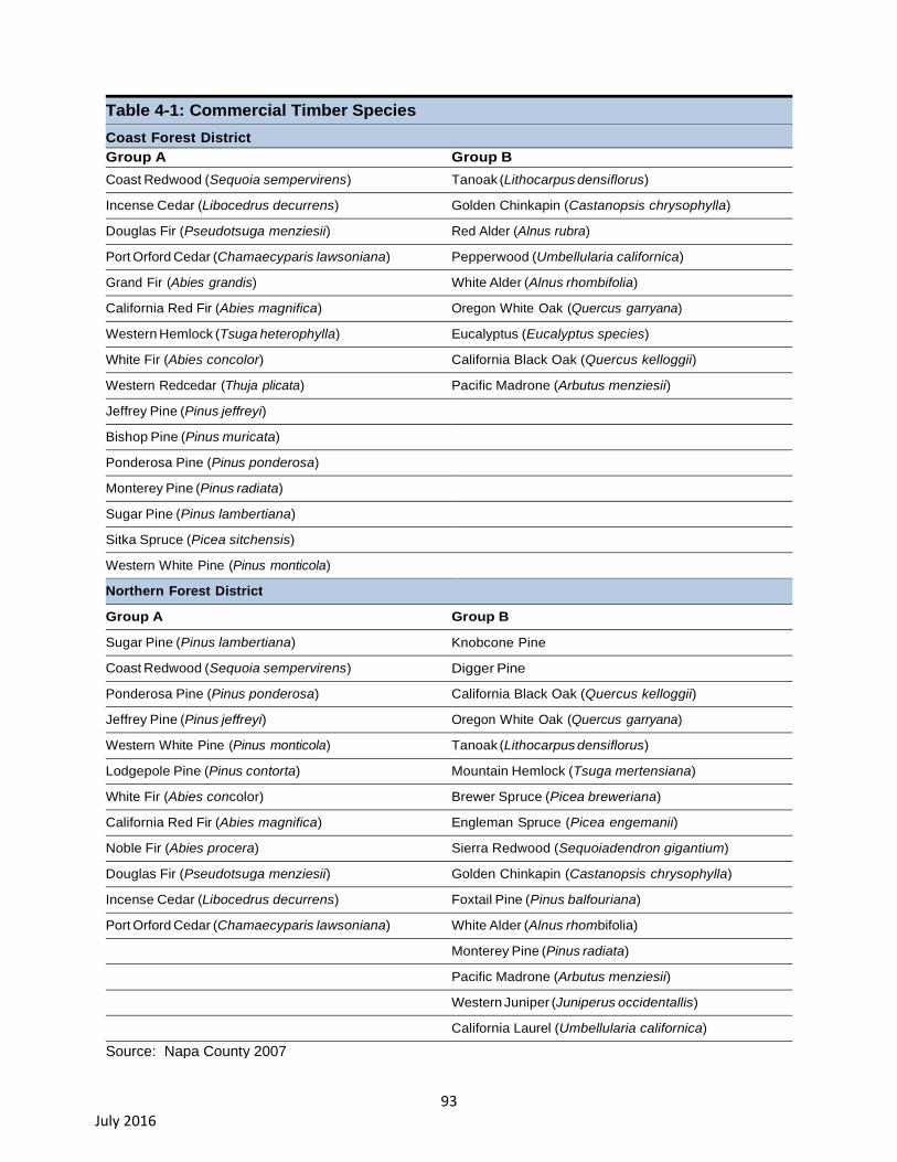
93 July 2016
Table 4-1: Commercial Timber Species
Coast Forest District
Group A Group B
Coast Redwood (Sequoia sempervirens) Tanoak (Lithocarpus densiflorus)
Incense Cedar (Libocedrus decurrens) Golden Chinkapin (Castanopsis chrysophylla)
Douglas Fir (Pseudotsuga menziesii) Red Alder (Alnus rubra)
Port Orford Cedar (Chamaecyparis lawsoniana) Pepperwood (Umbellularia californica)
Grand Fir (Abies grandis) White Alder (Alnus rhombifolia)
California Red Fir (Abies magnifica) Oregon White Oak (Quercus garryana)
Western Hemlock (Tsuga heterophylla) Eucalyptus (Eucalyptus species)
White Fir (Abies concolor) California Black Oak (Quercus kelloggii)
Western Redcedar (Thuja plicata) Pacific Madrone (Arbutus menziesii)
Jeffrey Pine (Pinus jeffreyi)
Bishop Pine (Pinus muricata)
Ponderosa Pine (Pinus ponderosa)
Monterey Pine (Pinus radiata)
Sugar Pine (Pinus lambertiana)
Sitka Spruce (Picea sitchensis)
Western White Pine (Pinus monticola)
Northern Forest District
Group A Group B
Sugar Pine (Pinus lambertiana) Knobcone Pine
Coast Redwood (Sequoia sempervirens) Digger Pine
Ponderosa Pine (Pinus ponderosa) California Black Oak (Quercus kelloggii)
Jeffrey Pine (Pinus jeffreyi) Oregon White Oak (Quercus garryana)
Western White Pine (Pinus monticola) Tanoak (Lithocarpus densiflorus)
Lodgepole Pine (Pinus contorta) Mountain Hemlock (Tsuga mertensiana)
White Fir (Abies concolor) Brewer Spruce (Picea breweriana)
California Red Fir (Abies magnifica) Engleman Spruce (Picea engemanii)
Noble Fir (Abies procera) Sierra Redwood (Sequoiadendron gigantium)
Douglas Fir (Pseudotsuga menziesii) Golden Chinkapin (Castanopsis chrysophylla)
Incense Cedar (Libocedrus decurrens) Foxtail Pine (Pinus balfouriana)
Port Orford Cedar (Chamaecyparis lawsoniana) White Alder (Alnus rhombifolia)
Monterey Pine (Pinus radiata)
Pacific Madrone (Arbutus menziesii)
Western Juniper (Juniperus occidentallis)
California Laurel (Umbellularia californica)
Source: Napa County 2007

94 July 2016
4.2. Regulatory Setting
4.2.1. Federal Regulations
Farmland Protection Policy Act (7 United States Code [USC] Section 4201)
The Farmland Protection Policy Act (FPPA) was established to minimize the extent to which federal
programs contribute to the unnecessary and irreversible conversion of farmland to nonagricultural uses.
It also directs federal programs to be compatible with State and local policies for the protection of
farmland. Under the FPPA, the term “farmland” includes Prime Farmland, Unique Farmland, and
Farmland of Statewide or Local Importance. Farmland does not have to be currently used as cropland
to be subject to FPPA requirements. It can be forest land, pasture land, or other land, but not urban and
built-up land or water. FPPA assures that, to the extent possible, federal programs are administered to
be compatible with state, local units of government, and private programs and policies to protect
farmland.
In 1981, Congress passed the Agriculture and Food Act (Public Law 97-98), which contained the FPPA,
Subtitle I of Title XV, Sections 1539–1549. The final rules and regulations were published in the Federal
Register on June 17, 1994. Federal agencies are required to develop and review their policies and
procedures related to implementing the FPPA every two years.
The FPPA does not authorize the federal government to regulate the use of private or non-federal land
or in any way affect the rights of property owners. Projects are subject to FPPA requirements if they
irreversibly convert farmland (directly or indirectly) to nonagricultural use and are completed by a
federal agency or rely on assistance from a federal agency.
4.2.2. State Regulations
California Department of Conservation (DOC), Division of Land Resource Protection
The California Department of Conservation (DOC) applies the Natural Resources Conservation Service
soil classifications to identify agricultural lands. These agricultural designations are used to plan present
and future uses for California’s agricultural land resources. The DOC uses a minimum mapping unit
area of ten acres, and parcels that are less than ten acres are incorporated into adjacent land use
classifications.
The list below includes all farmland categories mapped by the DOC. (Figures 4-1 and 4-2), showing
Farmland Mapping and Monitoring Program (FMMP) Categories within the Napa River and Sonoma
Creek watersheds.
Prime Farmland. Land that has the ideal combination of physical and chemical features. This
land has the soil quality, growing season, and moisture content needed to sustain high yields and
long-term agricultural production. The land must have been used for irrigated agricultural
production at some time during the four years prior to the mapping date.
Farmland of Statewide Importance. Land that is similar to Prime Farmland but has minor
shortcomings, such as steeper slopes or lower moisture content. The land must have been used
for irrigated agricultural production at some time during the four years prior to the mapping date.
Unique Farmland. Land with lesser quality soils but still used for the production of the state’s
leading agricultural crops. This land is usually irrigated but may include land that supports non-
95 July 2016
irrigated orchards or vineyards, as found in some climatic zones in California. The land must have
been used for crop production at some time during the four years prior to the mapping date.
Farmland of Local Importance. Land that is important to the local agricultural economy, as
determined by each county’s board of supervisors and a local advisory committee.
Grazing Land. Land on which the existing vegetation is suited to grazing livestock. This category
was developed in cooperation with the California Cattlemen’s Association, University of California
Cooperative Extension, and other groups with an interest in grazing. The minimum mapping unit
for Grazing Land is 40 acres.
Urban and Built-Up Land. Land that is developed with structures that have been built to a
density of at least one unit to 1.5 acres, or about six structures to a ten-acre parcel. This land
supports residential, industrial, commercial, institutional, and public administrative uses; railroad
and other transportation yards; cemeteries, airports, golf courses, sanitary landfills, sewage
treatment facilities, water control structures, and other developed uses.
Other Land. Land that is not included in any other mapping category. Common examples include
low-density rural developments; brush, timber, wetland, and riparian areas that are not suitable for
livestock grazing; confined livestock, poultry, or aquaculture facilities; strip mines and borrow pits,
and water bodies smaller than 40 acres. Vacant and nonagricultural lands that are surrounded on
all sides by urban development and greater than 40 acres are mapped as Other Land.

96 July 2016
Figure 4-1: Farmland Mapping and Monitoring Program – 2012 Napa County Map
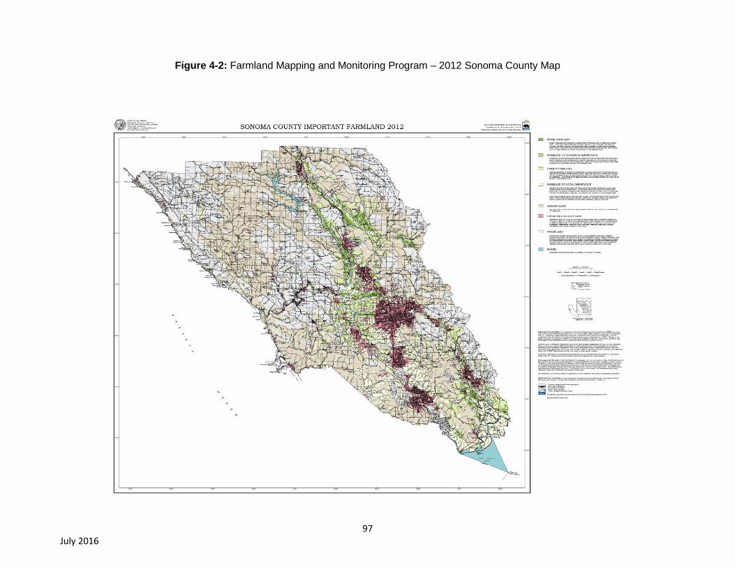
97 July 2016
Figure 4-2: Farmland Mapping and Monitoring Program – 2012 Sonoma County Map

98 July 2016
Figure 4-3 Williamson Act Parcels

99 July 2016
Figure 4-3 Williamson Act Parcels shows mapped parcels under Williamson Act contracts within the
Napa River and Sonoma Creek watersheds.
Land Conservation Act (Williamson Act)
The California Land Conservation Act of 1965, typically referred to as the Williamson Act (Gov’t Code
§§ 51200–51297.4), enables local governments to enter into contracts with private landowners for the
purpose of restricting specific parcels of land to agricultural or related open space use (Napa County,
2007). Landowners participating in these contracts receive property tax assessments which are much
lower than normal because they are based upon farming and open space uses rather than full market
value (Napa County, 2007).
Farmland Security Zone Act
The Farmland Security Zone Act, sometimes referred to as “super Williamson Act contracts,” was
passed in 1999 by California legislature to guarantee long-term preservation of farmland throughout the
State. A land owner currently under a Williamson Act contract may apply for Farmland Security Zone
status by entering into a contract with a county. The Farmland Security Zone classification renew
automatically each year for a 20-year period. In return for an additional 35 percent reduction in the
taxable value of the land and improvements (in addition to Williamson Act tax benefits), the owner of the
property agrees not to convert the property to non-agricultural uses (Kern County, 2014).
Public Resources Code (PRC) Section 21060.1
PRC section 21060.1 uses the FMMP to classify agricultural land for the purposes of analyzing potential
environmental impacts. Established in 1982, the FMMP was designed to assess the location, quality,
and quantity of agricultural lands and analyze the conversion of such lands. The FMMP provides
analysis pertaining to agricultural land use and land use changes throughout California (Kern County,
2014).
Forest Practices Rules
The California Department of Forestry and Fire Protection (CAL FIRE) implements the laws that
regulate timber harvesting on privately-owned lands. These laws are contained in the Z’berg- Nejedly
Forest Practice Act of 1973 which established a set of rules known as the Forest Practice Rules (FPRs)
to be applied to forest management-related activities (i.e. timber harvests, timberland conversions, fire
hazard removal, etc.) The FPRs are intended to preserve and protect fish, wildlife, forests and streams
during timber harvesting activities. Under the Forest Practices Act, a Timber Harvesting Plan (THP) is
submitted to CAL FIRE by the landowner summarizing the details of which species of trees are to be
harvested, harvesting method, and the actions that will be taken to prevent adverse effects to the
environment. If the landowner intends to convert timberland to non-timberland uses, such as a winery or
vineyard, a Timberland Conversion Permit (TCP) is required in addition to the THP. CAL FIRE shall not
approve a THP that fails to adopt feasible mitigation measures or alternatives from the range of
measures in the FPRs, which would substantially reduce or avoid significant adverse environmental
impacts resulting from timber harvest activities. THPs are required to be prepared by Registered
Professional Foresters who are licensed to prepare these plans (Napa County 2007). For projects
involving TCPs, CAL FIRE acts as lead agency under CEQA, and the county acts as a responsible
agency.
Timberland Production Zones
In 1976, the California legislature adopted the Forest Taxation Reform Act. This act requires counties to
zone parcels for the growing and harvesting of timber as Timberland Production Zones (TPZs). A TPZ
100 July 2016
restricts the use of the land to the growing and harvesting of timber and compatible uses approved by
the county in return for tax assessment benefits (Napa County 2007).
Timberland Productivity Act
In 1982, the California Legislature adopted the California Timberland Productivity Act (TPA). The TPA
was enacted to protect compliant timber operations from being prohibited or restricted due to a conflict
or potential conflict with surrounding land uses. The TPA directs counties to designate and zone lands
or “timber production (TP) districts.” Within a TP district, land uses are limited to the growing and
harvesting of timber and compatible uses. However, timber harvest operations may also be conducted
on timberlands outside of the TP zone in compliance with a THP that has been approved by CAL FIRE
(Sonoma County, 2006).
4.2.3. Local Regulations
Napa County General Plan
The Napa County General Plan has several goals and policies geared toward the preservation of
agriculture and forestry resources within Napa County. Following is a list of goals and polices that may
be applicable to the Project. A full description of all goals and polices pertaining to agriculture and
forestry resources can be found in the Agriculture Preservation and Land Use Element and
Conservation Element of the Napa County General Plan (Napa County, 2008).
Agricultural Preservation and Land Use Goals and Policies
Goal AG/LU-1: Preserve existing agricultural land uses and plan for agriculture and related activities as
the primary land uses in Napa County.
Goal AG/LU-3: Support the economic viability of agriculture, including grape growing, winemaking,
other types of agriculture, and supporting industries to ensure the preservation of agricultural lands.
Goal AG/LU-6: Create a stable and predictable regulatory environment that encourages investment by
the private sector and balances the rights of individuals with those of the community and the needs of
the environment.
Open Space Conservation Goals and Policies
Goal CON-1: The County of Napa will conserve resources by determining the most appropriate use of
land, matching land uses and activities to the land’s natural suitability, and minimizing conflicts with the
natural environment and the agriculture it supports.
Policy CON-1: The County will preserve land for greenbelts, forest, recreation, flood control, adequate
water supply, air quality improvement, habitat for fish, wildlife and wildlife movement, native vegetation,
and natural beauty. The County will encourage management of these areas in ways that promote
wildlife habitat renewal, diversification, and protection.
Policy CON-2: The County shall identify, improve, and conserve Napa County’s agricultural land
through the following measures:
a) Limit growth to minimize urban development on agricultural land and reduce conflict with the
agricultural operations and economy.
b) Provide a permanent means of preservation of open space land for agricultural production.
Require that existing significant vegetation be retained and incorporated into agricultural

101 July 2016
projects to reduce soil erosion and to retain wildlife habitat. When retention is found to be
infeasible, replanting of native or non-invasive vegetation shall be required.
c) Encourage the use of recycled water, particularly within groundwater deficient areas, for
vegetation enhancement, frost protection, and irrigation to enhance agriculture and grazing.
d) Encourage inter-agency and inter-disciplinary cooperation, recognizing the agricultural
commissioner’s role as a liaison and the need to monitor and evaluate pesticide and herbicide
programs over time and to potentially develop air quality, wildlife habitat, or other programs if
needed to prevent environmental degradation.
e) Minimize pesticide and herbicide use and encourage research and use of integrated pest
control methods such as cultural practices, biological control, host resistance, and other factors.
f) Encourage the use of Williamson Act contracts and use techniques to preserve agricultural
lands.
g) Coordinate with municipalities’ adopting and implementing policies, such as large lot zoning and
urban limit lines, to limit urban expansion and encourage development of vacant land in areas
already urbanized.
Policy CON-3: The County shall support sustainable agricultural practices, private stewardship
programs and activities, and the formation and activities of volunteer stewardship groups in all three
major watersheds, particularly agricultural appellation, river, and watershed-based organizations by:
a) Supporting grant applications,
b) Facilitating access to data, and
c) Working to achieve increased landowner participation in sustainable practices and stewardship
groups as needed.
Policy CON-4: The County recognizes that preserving watershed open space is consistent with and
critical to the support of agriculture and agricultural preservation goals.
Policy CON-6: The County shall impose conditions on discretionary projects which limit development in
environmentally sensitive areas such as those adjacent to rivers or streamside areas and physically
hazardous areas such as floodplains, steep slopes, high fire risk areas and geologically hazardous
areas.
Policy CON-7: The County shall enact and enforce regulations which maintain or improve the current
level of environmental quality found in Napa County. The County shall uniformly and fairly enforce
codes and regulations and shall, with respect to enforcing regulations related to environmental quality,
assign high priority to abatement of violations that may constitute actual or potential threats to public
health or safety or that may cause significant environmental damage. Enforcement actions shall be
designed to discourage significant damage and future violations.
Policy CON-8: The County will use financial and other incentives to encourage voluntary dedication in
easement or fee title to the County of Napa or its designee (such as a local non-profit land trust) of
significant habitat areas, as appropriate, to ensure long-term protection for fish and wildlife resources
and protection of agricultural lands and open space.
Policy CON-9: The County shall pursue a variety of techniques and practices to achieve the County’s
Open Space Conservation policies, including:
a) Exclusive agriculture zoning or Transfer of Development Rights.
102 July 2016
b) Acquisition through purchase, gift, grant, bequest, devise, lease, or otherwise, the fee or any
lesser interest or right in real property.
c) Williamson Act or other incentives to maintain land in agricultural production or other open
space uses.
d) Requirements for mitigation of development impacts, either on-site or at other locations in the
county or through the payment of in-lieu fees in limited circumstances when impacts cannot be
avoided.
Napa County Code of Ordinances
The following ordinances are taken from the Napa County Code of Ordinances and may be applicable
to the Proposed Project (Napa County, 2014).
18.104.220 – Wineries located in open space areas – Coverage
The maximum coverage of new or expanded wineries shall be twenty-five percent of the existing parcel
or fifteen acres, whichever is less. Coverage for the purposes of this measure shall be the aggregate
paved or impervious ground surface areas of the production facility, storage areas (except caves),
offices, laboratories, kitchens, tasting rooms, paved areas and access roads to public or private roads
or rights-of-way and aboveground sewage disposal systems.
Notwithstanding subsection (E)(2) of Section 18.08.040, the calculation of coverage for wineries shall
not include farm management uses.
16.08.150 – Timberland conversion conditions
Any application for a permit to engage in timber operations which shows, by satisfactory evidence, that
the timberlands to be cut are to be devoted to bona fide use as a vineyard, or other agricultural
activities, may be approved for removal of substantially all trees, but shall otherwise comply with the
forest practice rules. Conditions may be imposed on any timberland conversion permit requiring
retention of such trees as may be reasonably necessary for protection of wildlife habitats, watersheds
and aesthetic values, provided such conditions may not impose restrictions more stringent than forest
practice rules.
Chapter 18.16 – AP Agricultural Preserve District
18.16.010 – Intent of classification
The AP district classification is intended to be applied in the fertile valley and foothill areas of Napa
County in which agriculture is and should continue to be the predominant land use, where uses
incompatible to agriculture should be precluded and where the development of urban-type uses would
be detrimental to the continuance of agriculture and the maintenance of open space which are
economic and aesthetic attributes and assets of the county.
Chapter 18.20 – AW Agricultural Watershed District
18.16.010 – Intent of classification
The AW district classification is intended to be applied in the fertile valley and foothill areas of Napa
County in which agriculture is and should continue to be the predominant land use, where uses
incompatible to agriculture should be precluded and where the development of urban-type uses would
be detrimental to the continuance of agriculture and the maintenance of open space which are
economic and aesthetic attributes and assets of the county.
103 July 2016
Chapter 18.102 - :PS Agricultural Produce Stand Combination District
18.102.010 - Intent of classification
The :PS combination district classification is intended to be applied in Agricultural Watershed districts
where the sale of agricultural produce, fruits, vegetables, and Christmas trees, grown on or off
premises, and items related thereto, as well as the recreational and educational use by children of
animals, such as children's pony rides and petting zoos, occurs. Only lands that have been historically
used for such purposes are eligible for the :PS combination district classification.
Napa County Code Chapter 2.94 – Right to Farm Ordinance
2.94.010 – Definitions
Unless the context otherwise requires, the following definitions govern the construction of this chapter:
"Adjacent land" means land located within one mile of the exterior boundaries of a parcel that qualifies
as agricultural land.
"Agriculture" shall have the same meaning as "agriculture" as defined in Section 18.08.040 of this code.
"Agricultural land" means real property located within the boundaries of Napa County which falls into
one or more of the following categories:
1. Is designated on the county general plan as agricultural resource (AR), agriculture, watershed and
open space (AWOS), or rural residential (RR) and is included in a zoning district that is primarily or
substantially devoted to agricultural uses including, but not limited to, the following zoning districts:
agricultural preserve (AP), agricultural watershed (AW), residential country (RC), timber preserve
(TP);
2. Is included in an overlay zoning district that is devoted primarily to agriculture;
3. Is designated in the general plan for an urban use but has been zoned AW or AP as an interim zone
to maximize the economic use of the land for agricultural purposes while retaining the land in large
parcel sizes pending eventual permanent development for urban use;
4. While not presently zoned or designated on the general plan for primarily agricultural use, the land
contains an existing agricultural operation of a type that would be obvious to an uninformed
observer after a physical inspection of the property, and that operation began at a time when such
use was lawful.
"Agricultural operation" means all operations necessary to conduct agriculture as defined in Section
18.08.040 of this code and shall include, but not be limited to, preparation, tillage, and maintenance of
the soil or other growing medium, the production, irrigation, frost protection, cultivation, growing, raising,
breeding, harvesting, or processing of any living organism having value as an agricultural commodity or
product, and any commercial practices performed incident to or in conjunction with such operations on
the site where the agricultural product is being produced, including preparation for market, delivery to
storage or to market, or to carriers for transportation to market.
"Transfer" means and includes, but is not limited to, the following: sale, exchange, installment, land sale
contract, lease with option to purchase, any other option to purchase, or ground lease coupled with
improvements, or residential stock cooperative improved with dwelling units.
104 July 2016
2.94.020 – Right to Farm Conditions
No existing or future agricultural activity, operation or facility, or any of its appurtenances, conducted or
maintained for commercial purposes in a manner consistent with proper and accepted customs and
standards, as established and followed by similar agricultural operations in the same locality, shall be or
become a nuisance, public or private, due to any changed condition in or about the county, after the
same has been in operation for more than three years if it was not a nuisance at the time it began.
Provided, however, that such agricultural operations must comply with all provisions of this code and
further provided that the provisions of this section shall not apply whenever a nuisance results from the
negligent or improper operation of any agricultural operation.
Sonoma County General Plan
The Open Space and Conservation Element of the Sonoma County General Plan 2020 have several
goals, objectives and policies to promote conservation and preservation of agriculture and forestry
resources within Sonoma County. Following is a list of goals, objectives and policies that may be
applicable to the Proposed Project. A full description of all goals and objectives pertaining to agriculture
and forestry resources can be found in Open Space and Conservation Element Sonoma County
General Plan (Sonoma County, 2010).
GOAL OSRC-10: Encourage the conservation of soil resources to protect their long term productivity
and economic value.
GOAL OSRC-11: Promote and encourage soil conservation and management practices that maintain
the productivity of soil resources.
Objective OSRC-11.1: Ensure that permitted uses are compatible with reducing potential damage due
to soil erosion.
Objective OSRC-11.2: Establish ways to prevent soil erosion and restore areas damaged by erosion.
The following policies shall be used to achieve these objectives:
Policy OSRC-11a: Design discretionary projects so that structures and roads are not located on slopes
of 30 percent or greater. This requirement is not intended to make any existing parcel unbuildable if
Health and Building requirements can be met.
Policy OSRC-11b: Include erosion control measures for any discretionary project involving construction
or grading near waterways or on lands with slopes over 10 percent.
Policy OSRC-11c: Encourage agricultural land owners to work closely with the N.R.C.S. and local
Resource Conservation Districts to reduce soil erosion and to encourage soil restoration.
Policy OSRC-11d: Require a soil conservation program to reduce soil erosion impacts for discretionary
projects that could increase waterway or hillside erosion. Design improvements such as roads and
driveways to retain natural vegetation and topography to the extent feasible.
Policy OSRC-11e: Retain natural vegetation and topography to the extent economically feasible for
any discretionary project improvements near waterways or in areas with a high risk of erosion as noted
in the Sonoma County Soil Survey.
Policy OSRC-11f: Prepare and submit to the Board of Supervisors an erosion and sediment control
report.
Policy OSRC-11g: Continue to enforce the Uniform Building Code to reduce erosion and slope
instability problems.
105 July 2016
GOAL OSRC-12: Preserve, sustain and restore forestry resources for their economic, conservation,
recreation, and open space values.
Objective OSRC-12.1: Identify and preserve areas with timber soils and commercial timber stands for
timber production. Reduce incompatible uses and the conversion of timberlands to agriculture and other
uses that effectively prevent future timber production in these areas.
Objective OSRC-12.2: Minimize the potential adverse impacts of timber harvesting on economic,
conservation, recreation and open space values and restore harvested areas to production for a future
yield.
Policy OSRC-12a: Apply the “Resources and Rural Development” category to designate all lands in a
“Timberland Production Zone” and adjacent parcels with timber soils or commercial timber stands.
Policy OSRC-12b: Review all timber harvest plans for compatibility with General Plan policies and
economic viability of the industry.
Policy OSRC-12c: Where applicable, comment on timber harvest plans in support of increased
protection of Class III streams.
Policy OSRC-12d: Review timber harvest plans adjacent to designated Riparian Corridors and request
that clear cutting not occur within streamside conservation areas. Where clear cutting is approved by
the applicable State or Federal agency along designated Riparian Corridors, ensure that at least 50
percent of the overstory canopy and at least 50 percent of the understory vegetation be retained.
Policy OSRC-12e: Revise the districts of the Zoning Code that implement the Resources and Rural
Development land use category to reduce the potential for conversion of timberland to non-timber uses.
Sonoma County Code of Ordinances
The following ordinances are taken from the Sonoma County Code of Ordinances and may be
applicable to the Proposed Project (Sonoma County, 2014a).
Article 04 – LIA Land Intensive Agriculture District
Sec. 26-04-005 – Purpose
Purpose: to enhance and protect lands best suited for permanent agricultural use and capable of
relatively high production per acre of land; and to implement the provisions of the land intensive
agriculture land use category of the General Plan and the policies of the agricultural resources element.
Article 06 – LEA Land Extensive Agriculture District
Sec. 26-06-005 – Purpose
Purpose: To enhance and protect lands best suited for permanent agricultural use and capable of
relatively low production per acre of land; and to implement the provisions of the Land Extensive
Agriculture land use category of the General Plan and the policies of the Ag
Agricultural Resources Element.
Article 08 – DA Diverse Agriculture District
Sec. 26-08-005 – Purpose
Purpose: to enhance and protect those land areas where soil, climate and water conditions support
farming but where small acreage intensive farming and part-time farming activities are predominant, but
where farming may not be the principal occupation of the farmer; and to implement the provisions of the

106 July 2016
diverse agriculture land use category of the General Plan and the policies of the Agricultural Resource
Element.
Article 10 – RRD Resources and Rural Development
Sec. 26-10-005 – Purpose
Purpose: to implement the provisions of the resources and rural development land use category of the
General Plan, namely to provide protection of lands needed for commercial timber production,
geothermal production, aggregate resources production; lands needed for protection of watershed, fish
and wildlife habitat, biotic resources, and for agricultural production activities that are not subject to all
of the policies contained in the agricultural resources element of the General Plan. The resources and
rural development district is also intended to allow very low density residential development and
recreational and visitor-serving uses where compatible with resource use and available public services.
Article 14 – TP Timberland Production District
Sec. 26-14-005 – Purpose
Purpose: to provide for timberland zoning, a yield tax imposed at the time of harvest, and the
conservation and protection of land capable of producing timber and forest products. The compatible
uses specified in this section will be included in this zone and are consistent with the Forest Taxation
Reform Act of 1976.
Ordinance NO. 5203: Right to Farm Ordinance
Article 11. Right to Farm, Sec. 30-20. Short Title.
This article shall be known and may be cited as the Sonoma County Right to Farm Ordinance or the
Right to Farm Ordinance.
Sec. 30-21. Findings.
(a) It is the declared policy of this county to conserve, protect, enhance, and encourage agricultural
operations on agricultural land within the unincorporated area of the county. Further, it is the intent
of this county to provide its residents proper notification of the county's recognition and support,
through this article, of the right to farm.
(b) Where non-agricultural land uses, particularly residential and commercial development, extend onto
agricultural land or exist side by side, agricultural operations are frequently the subject of nuisance
complaints. As a result, some agricultural operations are forced to cease or curtail their operations
and many others are discouraged from making investments in improvements to their operations, all
to the detriment of adjacent agricultural uses and the economic viability of the county's agricultural
industry as a whole. It is the purpose and intent of this article to reduce the loss to the county of its
agricultural resources by limiting the circumstances under which properly conducted agricultural
operations on agricultural land may be considered a nuisance.
(c) It is the further purpose and intent of this article to promote a good-neighbor policy by requiring
notification of owners, purchasers, residents, and users of property adjacent to or near agricultural
operations on agricultural land of the inherent potential problems associated with being located near
such operations, including, without limitation, noise, odors, fumes, dust, smoke, insects, operation
of machinery during any time of day or night, storage and disposal of manure, and ground or aerial
application of fertilizers, soil amendments, seeds, and pesticides. It is intended that, through
mandatory disclosures, owners, purchasers, residents, and users will better understand the impact
107 July 2016
of living or working near agricultural operations and be prepared to accept attendant conditions from
properly conducted agricultural operations as a normal and necessary aspect of living in a county
with a strong rural character and an active agricultural sector.
(d) It is the further purpose and intent of this article to carry out and advance the goals, objectives,
policies, and implementation programs of the agricultural resources element of the general plan
(Sonoma County 2014b).
Sec. 26C-260 – Permitted uses, subject to site development & erosion control standards
The following uses are permitted except within a sensitive area, riparian corridor, critical habitat area, or
unique feature designated in the general plan or coastal plan in which case a use permit is required. All
clearing of vegetation, grading, excavation, fill or construction in association with these uses shall
conform to the site development and erosion control standards.
a) Resource Management Uses:
1) Geotechnical studies involving no grading or construction of new roads or pads.
2) Timber management including planting, raising, and harvesting of trees and logs for lumber
or fuel woods subject to requirements of California Department of Forestry and Fire
Protection.
3) Raising, grazing, maintaining and breeding of horses, cattle, sheep, goats and similar
animals.
4) The outdoor growing and harvesting of plants, flowers, fruits, vegetables, shrubs, vines,
trees, hay, grain and other similar food and fiber crops. Except as noted below, agricultural
cultivation shall not be permitted in the following areas:
a. Within one hundred feet (100′) from the top of the bank in the "Russian River Riparian
Corridor."
b. Within fifty feet (50′) from the top of the bank in designated "flatland riparian corridors."
c. Within twenty-five feet (25′) from the top of the bank on designated "upland riparian
corridors."
Agricultural cultivation may be allowed in subsections a. through c. above upon approval of a
management plan which includes appropriate mitigation for potential erosion, bank stabilization, and
biotic impacts. This plan may be approved by the director of the permit and resource management
department or by use permit pursuant to Section 26C-261(b)(8).
The indoor growing and harvesting of shrubs, vines, trees, hay, grain and similar food and
fiber crops provided that the greenhouse or similar structure for indoor growing is less than
eight hundred (800) square feet.
Incidental cleaning, grading, packing, polishing, sizing or similar preparation of crops which
are grown on the site but not including agricultural processing.
Temporary or seasonal sales and promotion, and incidental storage of crops or fuel woods
which are grown on the site.
Temporary or seasonal sales and promotion of livestock which have been raised on the site.
Beekeeping.
108 July 2016
Other non-residential uses which in the opinion of the director of the permit and resource
management department are of a similar and compatible nature to those uses listed
in Section 26C-260
Sec. 11.02.040 – Applicability
a) Compliance required. The provisions of this chapter shall apply to all grading, drainage
improvement, and vineyard and orchard site development occurring within the unincorporated area
of the county, except for grading and drainage improvement for timber operations conducted under
an approved timber harvesting plan or nonindustrial timber management plan. The permit
requirements in this chapter shall apply to all grading, drainage improvement, and vineyard and
orchard site development subject to the provisions of this chapter, unless exempted from permit
requirements by section 11.04.020, 11.06.020, or 11.08.020. The standards in article 16 shall apply
to all grading, drainage improvement, and vineyard and orchard site development subject to the
provisions of this chapter, regardless of whether a permit is required by this chapter.
b) Liability. Nothing in this chapter, nor the issuance of a permit pursuant to this chapter, nor
compliance with the provisions of this chapter or with any permit conditions, shall relieve any person
from responsibility for damage to other persons or property, or impose any liability upon the county,
its officers, agents, or employees, for damage to other persons or property.
c) Relationship to other laws. The provisions of this chapter are not intended to and shall not be
construed or given effect in a manner that conflicts with state or federal law, or interferes with the
achievement of state or federal regulatory objectives. The provisions of this chapter shall be
interpreted to be supplementary to and compatible with state and federal enactments, and in
furtherance of the public purposes those enactments express. Compliance with the provisions of
this chapter, however, does not ensure compliance with state and federal requirements. Further, the
provisions of this chapter are not intended to and shall not be construed or given effect in a manner
that supersedes other provisions of this code. Where another provision of this code establishes a
stricter requirement than a provision of this chapter, that stricter requirement shall prevail.
d) Other permits. Nothing in this chapter shall eliminate the need for any person undertaking any
grading, drainage improvement, or vineyard or orchard site development to obtain any other
permits, approvals, or authorizations required by this code or state or federal agencies.
Sec. 26C-327 – Minor timberland conversions
a) All minor timberland conversions shall require a zoning permit. Notice of the permit shall be mailed
to all owners of real property as shown on the latest equalized assessment roll within three hundred
feet (300′) of the subject property and posted in at least three (3) public places on or near the
subject property at least ten (10) days prior to issuance of the permit. The notice shall include an
explanation of the procedure to appeal issuance of the permit. In addition to such other plans and
date as are necessary to determine compliance with this chapter, the application for the permit shall
be accompanied by all of the following:
1) A statement of the approximate number, size, species, age, and condition of the trees to be
included in the minor timberland conversion, the amount of land clearing to be done, the
equipment to be used, the method by which slash and debris are to be removed or disposed of,
and a schedule of daily operations.
109 July 2016
2) A copy of the notice of conversion exemption timber operations prepared by a registered
professional forester and submitted to the California Department of Forestry and Fire Protection
for the minor timberland conversion.
3) A statement by the owner of subject property consenting to the minor timberland conversion,
certifying that the conversion is a one-time conversion to a non-timber growing use and that
there is a bona fide intent to undertake and complete the conversion in conformance with the
provisions of this chapter, and specifying what the new non-timber growing use will be after the
conversion. The statement shall include evidence acceptable to the director of the permit and
resource management department of the bona fide intent to undertake and complete the
conversion. Such evidence shall include, but not be limited to, a valid use permit, building
permit, or septic permit, approved grading plans for road construction, or an agricultural
management plan or soil capability study demonstrating the feasibility of the new non-
timber growing use.
4) Any other information the director of the permit and resource management department deems
necessary to make a decision on the application. Such information may include, but shall not be
limited to, drainage or erosion control details and biotic studies.
b) No zoning permit shall be issued for a minor timberland conversion unless it is determined that the
conversion is a one-time conversion to a non-timber growing use and that there is a bona fide intent
to undertake and complete the conversion in conformance with the provisions of this chapter. The
determination of bona fide intent shall include consideration of the economic feasibility of the
conversion, including, but not limited to, the suitability of soils, slope, aspect, quality and quantity of
water, and micro-climate, and any other foreseeable factors necessary for successful conversion to
the new non-timber growing use.
c) All minor timberland conversions shall be conducted in accordance with the provisions of Title 14,
California Code of Regulations, Section 1104.1.
d) All minor timberland conversions shall be completed and the new non-timber growing use underway
within two (2) years after the zoning permit is granted.
e) All minor timberland conversions shall minimize damage to soils, residual trees, young growth, and
other vegetation, and prevent erosion and damage to neighboring properties.
f) No minor timberland conversion shall be conducted during the winter period unless it is carried out
in accordance with Title 14, California Code of Regulations, Section 914.7, subsections (a) and (b).
g) No minor timberland conversion shall be conducted without a valid on-site copy of the zoning permit
issued for the conversion.
h) No minor timberland conversion shall include the cutting or removal of any old growth redwood
unless a registered professional forester certifies in writing that the tree poses a serious danger to
persons or property.

110 July 2016
4.3. Environmental Analysis
4.3.1. Impact Analysis Approach and Methods
The Project (General Permit) does not propose or require any person to take agricultural lands out of
production. Rather, the General Permit would require Dischargers to comply with the Water Code and
the Basin Plan by reducing discharges of sediment and storm runoff (including roads and points of
direct discharge into streams), nutrients, and pesticides to receiving waters from Vineyard Properties,
and by protecting and enhancing beneficial uses of waterways, including the protection of anadromous
fish habitat, through the use of best management practices.
The Project would require controls on discharges from the Vineyard Properties. Compliance with the
General Permit is expected to result in an increase in the implementation of commonly used, effective,
and conventional agricultural BMPs to control and reduce erosion and other discharges from vineyard
facilities and their associated networks of roads. Many of the Vineyard Properties in the Project area are
already implementing a wide variety of erosion control BMPs in accordance with local regulations and
with assistance provided by established technical assistance groups and voluntary conservation
programs (see Sections 1.2 and 1.3).
The timing of implementation of BMPs would vary depending on the level of farm planning and water
quality management completed at each property at the time the General Permit is adopted. As
discussed in Section 1.3, significant numbers of landowners/operators have completed farm plan
assessments and have already implemented effective BMPs that would comply with the General
Permit. For those facilities, no additional BMPs would be needed beyond regular maintenance,
effectiveness monitoring, and reporting. For landowners/operators who have not initiated farm planning
at adoption, the General Permit would specify the timeline for completion of Farm Water Quality Plan
and its implementation. It is expected that many of the BMPs constructed to achieve the requirements
of the General Permit would be phased/constructed as part of normal, future site operations and
improvements.
The following evaluation of agriculture and forestry impacts was prepared by considering applicable
regulations and guidelines, and typical construction activities attributable to compliance with the
General Permit. The assessment of potential impacts included review of documents, maps, and data;
observation of existing vineyard operations; and consultation with persons currently involved with
permitting or environmental documentation of vineyard operations.
4.3.2. Thresholds of Significance
According to Appendix G of the CEQA Guidelines, an impact to agriculture and forestry is considered
significant if the Project would:
Convert Prime Farmland, Unique Farmland, or Farmland of Statewide Importance (Farmland),
as shown on the maps prepared pursuant to the Farmland Mapping and Monitoring Program of
the California Resources Agency to non-agricultural uses.
Conflict with existing zoning for agricultural use, or a Williamson Act contract;
Conflict with existing zoning for, or cause rezoning of, forest land (as defined in Public
Resources Code section 12220(g)), timberland (as defined by Public Resources Code section
4526), or timberland zoned Timberland Production (as defined by Government Code section
51104(g)); or
111 July 2016
Result in the loss of forest land or conversion of forest land to non-forest use.
Involve other changes in the existing environment, which due to their location or nature, could
result in conversion of Farmland to non-agricultural use or conversion of forest land to non-
forest use.
4.3.3. Impacts and Mitigation Measures
Impact 4.1: Compliance with the General Permit at Vineyard Properties would have a less than
significant impact with regard to potential conversion of Prime Farmland, Unique Farmland, or
Farmland of Statewide Importance Farmland to non-agricultural uses.
As described in detail in Section 2.5 and summarized in Table 2-3, a wide array of BMPs may be
employed to comply with the performance standards for discharge that are conditions of the General
Permit. Because the performance standards are not prescriptive, BMPs implemented at a given
property can be selected within the context of site-specific constraints (e.g., vineyard maturity, soil type,
available water resources, etc.), and vineyard production objectives. This flexibility and the widespread
adoption throughout the project area in advance of adoption of the General Permit of a wide variety of
cover crop types, integrated pest management practices, fertigation, wellhead protection measures, and
composted mulch, support the conclusion that installation and maintenance of BMPs is compatible and
in some cases beneficial with regard to agricultural production and therefore would not lead to
conversion of Farmland to a non-agricultural use.
Other BMPs that may be implemented to comply with the General Permit relate to attenuation of storm
runoff and/or gully and channel erosion controls, which would be implemented at perhaps 10-to-20
percent of all hillslope vineyards (for details, see evaluation of Impact 6.3), where hillslope vineyards
discharge into unstable areas. In these cases, BMP implementation is predicated on technical and
economic feasibility. Therefore, these compliance actions would not contribute directly or indirectly to
potential for conversion of farmlands to other uses.
In addition to the above, the General Permit also specifies performance standards for sediment
discharge from roads. Road BMPs would be constructed and maintained within the footprint of existing
roads, or within the footprint of new roads where they are constructed, and therefore, would not have
any direct effect on agricultural production or present any direct potential for conversion of farmlands to
other uses.
Potential for Farmland Conversion due to Compliance Costs
Interested parties submitted comments expressing the concern that the costs of complying with the
General Permit could be so high, that a grower would be forced to sell their land or would be forced out
of business resulting in conversion of prime farmland to other non-agricultural uses. Commenters,
however, did not provide additional information to suggest how this would occur.
As described in Section 3.3, the primary costs of compliance would be for road erosion and/or runoff
control BMPs which typically only would be required at hillslope properties. Road erosion and/or runoff
control BMPs although requiring additional near-term investment to upgrade the roads, yield long-term
cost savings through reduced road maintenance and reconstruction costs. Other costs associated with
compliance are expected to be insignificant. Therefore, the EIR concludes that the overall cost of
complying with the proposed General Permit would not indirectly contribute to a significant conversion

112 July 2016
of Prime farmland, Unique Farmland, and/or farmland of Statewide Significance to a non-agricultural
use.
Local Government Planning Designations to Protect Farmlands
Many of these agricultural lands are in areas that are designated as agricultural lands through city and
county ordinances. These ordinances typically protect agricultural resources and zoning. Additionally,
many of these agricultural lands are in areas directly adjacent to a creek where the land would be not
be able to be developed into other land uses because of the proximity to a waterbody. Even if the
grower succumbs to economic pressure and is forced to sell their land or be forced out of business, the
most likely possibility is that the land would be sold to another grower, resulting in a similar
environmental impact.30
Trends in Vineyard Cultivation within the Project Area
Historic and future trends in vineyard development are depicted on Figure CON-4 (Napa County
General Plan, 2008). Figure CON-4 shows that from 1958 to 2004 vineyard acres in the Napa Valley
increased four-fold (approximately 10,000 to over 40,000 acres) and are predicted to increase by an
additional 10,000 acres by 2030. The historic trends in growth, which have spanned several decades of
cyclical market forces, challenges from vine pests, and increased operating costs associated with
increased regulatory requirements, for example, have not led to conversions of prime Farmland to non-
agricultural uses or slowed agricultural growth. Napa Valley agricultural lands remain some of the most
expensive in the nation (Napa Valley Register, 2013), where one acre of vineyard can sell from $50,000
to $300,000, depending on its location.
Summary
It is therefore highly unlikely that the General Permit would render a vineyard operation economically
unviable. In the unique circumstance where the cost of BMP installation may be too great or the loss of
production of displaced planted areas would make the operation unprofitable, neither scenario would
permanently or irretrievably convert the affected Farmland to non-agricultural use. The land would still
be available for agricultural uses and therefore implementation of BMPs would be considered a less
than significant impact. Furthermore, successful implementation of BMPs could enhance agricultural
productivity by strengthening erosion control methods already in place, resulting in a beneficial impact.
While for some Dischargers, the General Permit will result in increased costs of compliance these
economic effects do not translate into direct physical impacts on the environment. There are many cost-
effective practices growers can implement to comply with the General Permit. Therefore, the economic
effects, in light of historic trends, are considered less than significant.
Impact 4.2: Compliance with the General Permit at Vineyard Properties would not conflict with
existing zoning for agricultural use, or a Williamson Act contract.
Implementation of the BMP as described above is designed to reduce erosion, sedimentation, and the
discharge of pollutants from Vineyard Properties into the Napa River and Sonoma Creek watersheds
and would not require a change in existing zoning for agricultural use, or a Williamson Act contract.
30
14 CCR Section 15382 - A social or economic change by itself shall not be considered a significant effect
on the environment. A social or economic change related to a physical change may be considered in
determining whether the physical change is significant.
113 July 2016
Implementation of vineyard BMPs to comply with the General Permit would not conflict with existing
agricultural zoning or any aspect of a Williamson Act contract because General Permit compliance will
not materially change the primary agricultural activity on the parcels that benefit from Williamson Act
contracts. As described above under discussion of Impact 4.1, compliance with the General Permit will
not result in any amount of land permanently converted or committed to urban or other nonagricultural
uses and were shown as agricultural land on Important Farmland Series maps maintained by the
Department of Conservation (California Department of Conservation, 2004).
Impact 4.3: Compliance with the General Permit would not conflict with existing zoning for or
cause rezoning of forest land, timberland, or timberland zoned timberland production.
In almost all cases, BMP implementation and maintenance would occur within the footprint of the
vineyard and/or property-wide roads. Should a Discharger in order to comply with the General Permit,
choose to locate and construct a sediment basin, wetland, and/or level spreader, or any other BMP in
an adjacent, undeveloped area, if such action requires conversion of timberlands, no authority to
discharge under the General Permit is allowed. In that situation, the discharger would either need to
relocate the feature (e.g., basin, wetland, and/or level spreader) onto the vineyard proper to avoid the
timberlands, or obtain coverage under individual waste discharge requirements from the Water Board.
Therefore, implementation of BMPs in compliance with the General Permit would not require a change
in existing zoning for, or cause rezoning of, forest land, timberland, or timberland zoned Timberland
Production.
Impact 4.4: Implementation of BMPs would not result in the loss of forest land or conversion of
forest land to non-forest use.
See the discussion above of Impacts 4.1and 4.3. The Proposed Project would not otherwise result in
conversion of significant portions of farmland to non-agricultural use or conversion of forest land to non-
forest use. No authority to discharge under the General Permit would be allowed if BMP selection and
construction results in the loss of forest land or the conversion of forest land to non-forest use.

114 July 2016
References
Association of Bay Area Governments, 2000. Bay Area spatial Information system (BASIS) files for
existing land use in 2000 for the San Francisco Bay Area (GIS layer). Oakland, CA.
California Department of Conservation,1994. Farmland Mapping and Monitoring Program – Napa
County 1992-1994 Land Use Conversion. Table 16.
California Department of Conservation,1994. Farmland Mapping and Monitoring Program – Sonoma
County 1992-1994 Land Use Conversion. Table A-35.California Department of Conservation.
(2012). Farmland Mapping and Monitoring Program – Napa County 2010-2012 Land Use
Conversion. Table A-21.
California Department of Conservation, 2004. Guide to the Farmland Mapping and Monitoring
Program, California Department of Conservation, Division of Land Resource Protection.
California Department of Conservation,2012. Farmland Mapping and Monitoring Program – Sonoma
County 2010-2012 Land Use Conversion. Table A-40.
Environmental Protection Agency, 2015. Water: Best Management Practices. Available at
http://water.epa.gov/polwaste/npdes/swbmp/Dry-Detention-Ponds.cfm.
Kern County, 2014. Draft Environmental Impact Report. ( (SCH No. 2014051032), Volume 1 Chapters
1 through 11 Castor Solar Project (PP14163) Conditional Use Permit No. 5, Map 139-22.
Napa County Agricultural Commissioner,1993. Agricultural Crop Report for 1992.
Napa County,2007. Napa County General Plan Update, Draft Environmental Impact Report (SCH No.
2005102088)
Napa County, 2008. Napa County General Plan.
Napa County Agricultural Commissioner, 2013. Agricultural Crop Report for 2012.
Napa County, 2014. Code of Ordinances. Available at:
https://www.municode.com/library/ca/napa_county/codes/code_of_ordinances .
Napa County General Plan, 2008. Department of Conservation, Development, and Planning, County of
Napa, Napa, CA.
Napa Valley Register, 2013. Napa Valley remain most expensive in U.S.. Napa Valley Register, April
3, 2013.
Sonoma County Agricultural Commissioner,1993. 1992 Sonoma County Crop Report.
Sonoma County Agricultural Commissioner,2013. 2012 Sonoma County Crop Report,.
Sonoma County, 2006. Sonoma County General Plan 2020, Draft Environmental Impact Report (SCH
No. 2003012020). page 4.8 – 4.
Sonoma County, 2010. Sonoma County General Plan 2020, Open Space and Conservation Element.
Available at: http://www.sonoma-county.org/prmd/divpages/compplandiv.htm.
Sonoma County, 2014a. Municipal Code. Available at: http://codepublishing.com/ca/sonoma/. Sonoma
County, 2014b. Appendix D, Right to Farm Ordinance. Ordinance NO. 5203. Available at:
http://www.sonoma-county.org/prmd/docs/lcp/lcp_apdx_d.pdf.
115 July 2016
Sonoma Ecology Center, 2004. Sonoma Creek Watershed Map 5 Land. Available at:
http://knowledge.sonomacreek.net/node/71.
Water Board, 2012. Conditional Waiver of Waste Discharge Requirements for Discharges from
Vineyard Properties in the Napa River and Sonoma Creek Watersheds. Initial Study and
Proposed Mitigated Negative Declaration.

116 July 2016
5. AIR QUALITY AND GREENHOUSE GASES
This section discusses the potential impacts of the implementation of the General Permit on air quality.
Specifically, it summarizes relevant federal, State, and local policies; describes existing environmental
conditions in the Project area with respect to air quality, and identifies significant impacts that may result
from implementation of the Project.
5.1. Air Pollution and Ambient Standards
This section discusses federal, State, and local regulations related to air quality that apply to the
Project.
Both the U.S. Environmental Protection Agency (U.S. EPA) and the California Air Resources Board
(CARB) have established ambient air quality standards for common pollutants. These ambient air
quality standards constitute levels of contaminants that represent safe levels, to avoid specific adverse
health effects associated with each pollutant. The ambient air quality standards cover what are called
“criteria” pollutants which are comprised of six pollutants (ozone, carbon monoxide, particulate matter,
sulfur dioxide, lead and nitrogen oxide) for which the U.S. EPA has set standards to protect human
health and welfare. They are used as indicators of air quality. The federal and State ambient air quality
standards are presented in Table 5-1. The federal and State ambient standards were developed
independently with differing purposes and methods, although both processes attempted to avoid health-
related effects. As a result, the federal and State standards differ in some cases. In general, the State
standards are more stringent, as is the case for ozone, inhalable particulate matter smaller than 10
microns in diameter (PM10), and fine particulate matter smaller than 2.5 microns in diameter (PM2.5).
Geographic areas are assigned designation categories. There are three basic designation categories:
nonattainment, attainment, and unclassified. A “nonattainment” designation indicates that the air quality
violates an ambient air quality standard. Although a number of areas may be designated as
nonattainment for a particular pollutant, the severity of the problem can vary greatly. To identify the
severity of the problem and the extent of planning required, nonattainment areas are assigned a
classification that is commensurate with the severity of their air quality problem (e.g., moderate, serious
or severe). In contrast to nonattainment, an “attainment” designation indicates that the air quality does
not violate the established standard. Finally, an “unclassified” designation indicates that there are
insufficient data for determining attainment or nonattainment. U.S. EPA combines unclassified and
attainment into one designation for ozone, carbon monoxide (CO), PM10 and PM2.5.
Pollutants of Concern
For projects similar to the General Permit, air quality pollutants that are of greatest concern are ozone,
particulate matter, CO, and naturally occurring asbestos (NOA).
Ozone. Prior to 2005, both State and federal standards for ozone were set for a one-hour averaging
time. The State ozone standard is 0.09 parts per million (ppm), not to be exceeded. The federal
one-hour standard was 0.12 ppm and was not to be exceeded more than three times in any three-
year period. A federal eight-hour standard for ozone was issued in July 1997 by Executive Order of
the President. The eight-hour ozone standard has been set at a concentration of 0.075 ppm ozone
measured over eight hours. As of June 15, 2005, the federal one-hour ozone standard was
revoked. In setting the eight-hour ozone standard, U.S. EPA concluded that replacing the existing
117 July 2016
one-hour standard with an eight-hour standard was appropriate to provide adequate and uniform
protection of public health from both short-term (one to three hours) and prolonged (six to eight
hours) exposures to ozone.
Ozone is not emitted directly into the air, but is formed by a photochemical reaction in the
atmosphere. Ozone precursors, which include reactive organic gases (ROG) and nitrogen oxides
(NOx), react in the atmosphere in the presence of sunlight to form ozone. Because photochemical
reaction rates depend on the intensity of ultraviolet light and air temperature, ozone is primarily a
summer air pollution problem. Ozone is a respiratory irritant and an oxidant that increases
susceptibility to respiratory infections and can cause substantial damage to vegetation and other
materials. Once formed, ozone remains in the atmosphere for one or two days. It is then eliminated
through chemical reaction with plants and by rainfall and rain wash-down.
Particulate Matter. State and federal standards for particulate matter are based on micrograms per
cubic meter (μg/m3) for a 24-hour average and as an annual geometric mean.
PM10 is sometimes referred to as “inhalable particulate matter” or “respirable particulate matter”.
The State standards for PM10 are 50 μg/m3 24-hour average, and 20 μg/m
3 annual geometric mean.
The federal PM10 standard is a 24-hour average of 150 μg/m3.
A federal standard for PM2.5 was issued in July 1997 by Executive Order of the President. PM2.5 is
sometimes referred to as “fine particulate matter.” The PM2.5 standard has been set at a
concentration of 15 μg/m3 annually and 35 μg/m
3 daily. The federal standards for PM10 are being
maintained so that relatively larger particulate matter continues to be regulated. The State PM2.5
standard is an annual average of 12 μg/m3.
PM10 and PM2.5 can reach the lungs when inhaled, resulting in health concerns related to
respiratory disease. Suspended particulate matter can also affect vision or contribute to eye
irritation. PM10 can remain in the atmosphere for up to seven days before removal by gravitational
settling, rainfall, and wash-down.
Carbon Monoxide. State and federal CO standards have been set for both one-hour and eight-
hour averaging times. The State one-hour standard is 20 ppm by volume, while the federal one-
hour standard is 35 ppm. Both State and federal standards are 9 ppm for the eight-hour averaging
period. CO is a public health concern because it combines readily with hemoglobin and thus
reduces the amount of oxygen transported in the bloodstream.
Motor vehicles are the dominant source of CO emissions in most areas. High CO levels develop
primarily during winter when periods of light winds combine with the formation of ground level
temperature inversions (typically from the evening through early morning). These conditions result
in reduced dispersion of vehicle emissions. Motor vehicles also exhibit increased CO emission rates
at low air temperatures.
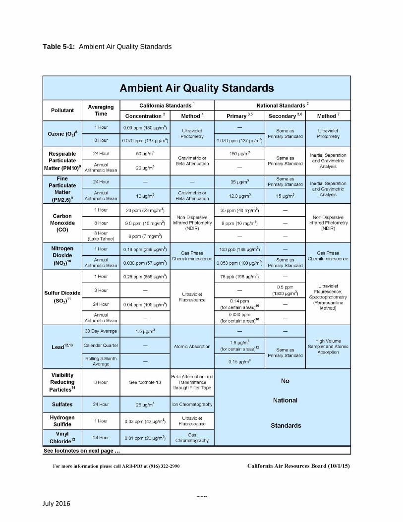
118 July 2016
Table 5-1: Ambient Air Quality Standards
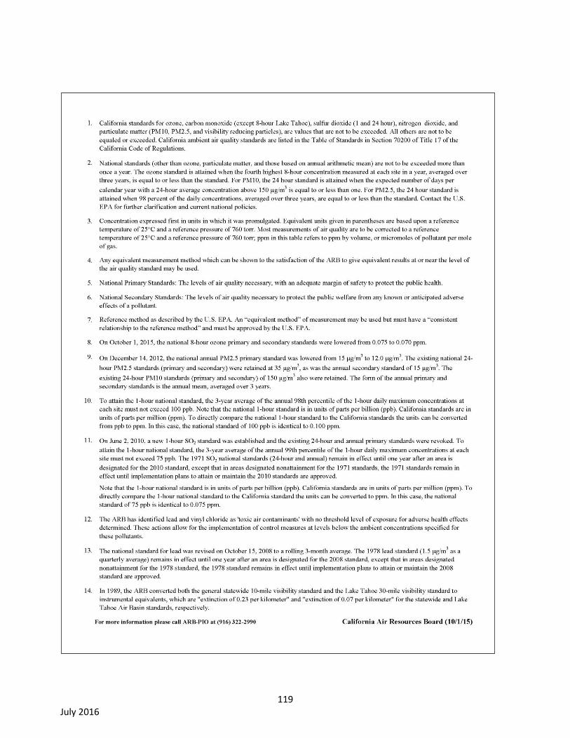
119 July 2016

120 July 2016
Naturally-Occurring Asbestos. Naturally occurring asbestos (NOA) was identified as a toxic air
contaminant (TAC) in 1986 by CARB. NOA is located in many parts of California and is commonly
associated with ultramafic rocks. “Asbestos” is the common name for a group of naturally-occurring
fibrous silicate minerals that can separate into thin but strong and durable fibers. Ultramafic rocks
form in high-temperature environments well below the surface of the earth. By the time they are
exposed at the surface by geologic uplift and erosion, ultramafic rocks may be partially to
completely altered into a type of metamorphic rock called “serpentinite.” Sometimes the
metamorphic conditions are right for the formation of chrysotile asbestos or tremolite-actinolite
asbestos in the bodies of these rocks, along their boundaries, or in the soil.
For individuals living in areas with naturally occurring asbestos, there are many potential pathways
for airborne exposure. Exposures to soil dust containing asbestos can occur under a variety of
scenarios, including children playing in the dirt; dust raised from unpaved roads and driveways
covered with crushed serpentine; grading and earth disturbance associated with construction
activity; quarrying; gardening; and other human activities. For homes built on asbestos
outcroppings, asbestos can be tracked into the home and can also enter as fibers suspended in the
air. Once such fibers are indoors, they can be entrained into the air by normal household activities,
such as vacuuming (as many inhalable fibers will simply pass through vacuum cleaner bags).
People exposed to low levels of asbestos may be at elevated risk (e.g., above background rates) of
lung cancer and mesothelioma. The risk is proportional to the cumulative inhaled dose (quantity of
fibers), and also increases with the time since first exposure. Although there are a number of factors
that influence the disease-causing potency of any given asbestos (such as fiber length and width,
fiber type, and fiber chemistry), all forms are carcinogens.
5.2. Regulatory Setting
The following description of regulatory setting is based on material presented in the BAAQMD
document California Environmental Quality Act Air Quality Guidelines (Bay Area Air Quality
Management District, 2012). Both the Napa River watershed and the Sonoma Creek watershed (the
Project area) fall within the jurisdiction of the BAAQMD.
Air quality within the SFBAAB is regulated by such agencies as the BAAQMD, CARB, and U.S. EPA.
Each of these agencies develops rules, regulations, policies, and/or goals to attain the goals or
directives imposed through legislation. Although the U.S. EPA regulations may not be superseded, both
State and local regulations may be more stringent.
Bay Area is currently designated as a nonattainment area for State and federal ozone standards and as
a nonattainment area for the State particulate matter (particles with diameter 10 micrometers or less,
referred to as PM10 and particles with diameter 2.5 micrometers or less, referred to as PM2.5) standards.
As required by federal and State air quality laws, the 2001 Bay Area Ozone Attainment Plan and the
2000 Bay Area Clean Air Plan have been prepared to address ozone nonattainment issues. In addition,
the BAAQMD, in cooperation with the Metropolitan Transportation Commission and the Association of
Bay Area Governments, prepared the Bay Area 2005 Ozone Strategy. This report describes the Bay
Area’s strategy for compliance with State one-hour ozone standard planning requirements and how to
improve air quality in the region and reduce transport of air emissions to neighboring air basins. No
PM10 plan has been prepared nor is one currently required under State air quality planning law.
121 July 2016
Federal Air Quality Regulations
U.S. EPA is charged with implementing federal air quality programs. U.S. EPA’s air quality mandates
are drawn primarily from the Federal Clean Air Act (FCAA), which was enacted in 1963. The FCAA was
amended in 1970, 1977, and 1990.
The FCAA required U.S. EPA to establish primary and secondary federal ambient air quality standards
(NAAQS), which are shown in Table 5-1. The FCAA also required each state to prepare an air quality
control plan referred to as a State Implementation Plan (SIP). The Federal Clean Air Act Amendments
of 1990 (FCAAA) added requirements for states with nonattainment areas to revise their SIPs to
incorporate additional control measures to reduce air pollution. The SIP is periodically modified to
reflect the latest emissions inventories, planning documents, and rules and regulations of the air basins
as reported by their jurisdictional agencies. U.S. EPA has responsibility to review all state SIPs to
determine conformance with the mandates of the FCAAA and determine if implementation will achieve
air quality goals. If the U.S. EPA determines a SIP to be inadequate, a Federal Implementation Plan
(FIP) may be prepared for the nonattainment area that imposes additional control measures. Failure to
submit an approvable SIP or to implement the plan within the mandated timeframe may result in
sanctions being applied to transportation funding and stationary air pollution sources in the air basin.
State Air Quality Regulations
CARB is the agency responsible for coordination and oversight of state and local air pollution control
programs in California and for implementing the California Clean Air Act (CCAA), which was adopted in
1988. The CCAA requires that all air districts in the State endeavor to achieve and maintain the
California ambient air quality standards (CAAQS) by the earliest practical date. The act specifies that
districts should focus particular attention on reducing the emissions from transportation and area-wide
emission sources, and provides districts with the authority to regulate indirect sources.
CARB is primarily responsible for developing and implementing air pollution control plans to achieve
and maintain the NAAQS. CARB is primarily responsible for statewide pollution sources and produces a
major part of the SIP. Local air districts are still relied upon to provide additional strategies for sources
under their jurisdiction. CARB combines these data and submits the completed SIP to U.S. EPA.
Other CARB duties include monitoring air quality (in conjunction with air monitoring networks
maintained by air pollution control and air quality management districts), establishing CAAQS (which in
many cases are more stringent than the NAAQS), determining and updating area designations and
maps, and setting emissions standards for new mobile sources, consumer products, small utility
engines, and off-road vehicles.
In 1992 and 1993, CARB requested delegation of authority for the implementation and enforcement of
specified New Source Performance Standards (NSPS) and Federal Emission Standards for Hazardous
Air Pollutants (NESHAPS) to the following local agencies: the BAAQMD and the South Coast Air
Quality Management Districts (SCAQMD). U.S. EPA's review of the State of California's laws, rules,
and regulations showed them to be adequate for the implementation and enforcement of these federal
standards, and U.S. EPA granted the delegations as requested.
The California Clean Air Act, section 39610 (a), directs CARB to “identify each district in which
transported air pollutants from upwind areas outside the district cause or contribute to a violation of the
ozone standard and to identify the district of origin of transported pollutants.” The information regarding
the transport of air pollutants from one basin to another was to be quantified to assist interrelated basins
in the preparation of plans for the attainment of State ambient air quality standards. Numerous studies
conducted by CARB have identified air basins that are impacted by pollutants transported from other air
122 July 2016
basins (as of 1993). Among the air basins affected by air pollution transport from the SFBAAB are the
North Central Coast Air Basin, the Mountain Counties Air Basin, the San Joaquin Valley Air Basin, and
the Sacramento Valley Air Basin. The SFBAAB was also identified as an area affected by the transport
of air pollutants from the Sacramento region.
Local Air Quality Regulations
Both the Napa River watershed and the Sonoma Creek watershed (the entire Project area) fall within
the jurisdiction of the BAAQMD.
The BAAQMD attains and maintains air quality conditions in the SFBAAB through a comprehensive
program of planning, regulation, enforcement, technical innovation, and promotion of the understanding
of air quality issues. The clean air strategy of the BAAQMD includes the preparation of plans for the
attainment of ambient air quality standards, adoption and enforcement of rules and regulations
concerning sources of air pollution, and issuance of permits for stationary sources of air pollution. The
BAAQMD also inspects stationary sources of air pollution and responds to citizen complaints, monitors
ambient air quality and meteorological conditions, and implements programs and regulations required
by the FCAA, FCAAA, and the CCAA.
California Environmental Quality Act (CEQA) Air Quality Guidelines
In 2012, the BAAQMD released its latest update to its California Environmental Quality Act Air Quality
Guidelines (Bay Area Air Quality Management District, 2012). This is an advisory document that
provides the lead agency, consultants, and project applicants with uniform procedures for addressing
air quality in environmental documents. The handbook contains the following applicable components:
1. Criteria and thresholds for determining whether a project may have a significant
adverse air quality impact;
2. Specific procedures and modeling protocols for quantifying and analyzing air quality
impacts;
3. Methods available to mitigate air quality impacts; and
4. Information for use in air quality assessments and environmental documents that will
be updated more frequently such as air quality data, regulatory setting, climate,
topography.
Air Quality Plans
As stated above, the BAAQMD prepares plans to attain ambient air quality standards in the SFBAAB.
The BAAQMD prepares ozone attainment plans (OAP) for the federal ozone standard and clean air
plans (CAP) for the California standard both in coordination with the Metropolitan Transportation
Commission and the Association of Bay Area Governments (ABAG).
With respect to applicable air quality plans, the BAAQMD prepared the Bay Area 2010 Clean Air Plan
(Bay Area Air Quality Management District 2010a) to address nonattainment of the federal 1-hour
ozone standard in the SFBAAB. The purpose of the 2010 Clean Air Plan is to:
1. Update the Bay Area 2005 Ozone Strategy (Bay Area Air Quality Management
District, 2006) in accordance with the requirements of the California Clean Air Act to
implement “all feasible measures” to reduce ozone;
2. Consider the impacts of ozone control measures on particulate matter (PM), air
toxics, and greenhouse gases in a single, integrated plan;
123 July 2016
3. Review progress in improving air quality in recent years; and
4. Establish emission control measures to be adopted or implemented in the 2009-2012
timeframe.
Similarly, the BAAQMD prepared the 2010 Clean Air Plan to address nonattainment of the CAAQS.
Naturally-Occurring Asbestos
The following description of the NOA regulatory setting is from the BAAQMD California Environmental
Quality Act Air Quality Guidelines (Bay Area Air Quality Management District, 2012).
The BAAQMD enforces the ARB Airborne Toxic Control Measures (ATCM), which regulate NOA
emissions from grading, quarrying, and surface mining operations at sites, which contain ultramafic
rock. The provisions that cover these operations are found specifically in Title 17 of the California Code
of Regulations, section 93105. The ATCM for Construction, Grading, Quarrying and Surface Mining
Operations was signed into State law on July 22, 2002, and became effective in the SFBAAB on
November 19, 2002. The purpose of this regulation is to reduce public exposure to NOA from
construction and mining activities that emit or re-suspend dust that may contain NOA.
The ATCM requires regulated operations engaged in road construction and maintenance activities,
construction and grading operations, and quarrying and surface mining operations in areas where NOA
is likely to be found, to employ the best available dust mitigation measures to reduce and control dust
emissions.
The BAAQMD NOA program requires that the applicable notification forms from the Air District’s
website be submitted by qualifying operations in accordance with the procedures detailed in the ATCM
Inspection Guidelines Policies and Procedures. The CEQA lead agency should reference BAAQMD’s
ATCM Policies and Procedures to determine which NOA Notification Form is applicable to the proposed
project.
Using the geologic map of the SFBAAB (http://geomaps.wr.usgs.gov/sfgeo/geologic/details.html), the
lead agency should discuss whether a proposed project would be located in “areas moderately likely to
contain NOA.” If a project would not involve earth-disturbing construction activity in one of these areas
or would not locate receptors in one of these areas then it can be assumed that the project would not
have the potential to expose people to airborne asbestos particles.
Asbestos occurs naturally in certain geologic settings in California, most commonly associated with
ultramafic rocks and along associated faults. According to the Division of Mines and Geology, naturally
occurring asbestos has been associated with ultramafic rock outcroppings in scattered locations within
Napa County and within the Project Area.
5.3. Environmental Setting
Climate & Meteorology
The summer climate of the West Coast is dominated by a semi-permanent high-pressure area centered
over the northeastern Pacific Ocean. Because this high-pressure cell is quite persistent, storms rarely
affect the California coast during the summer. Thus, the conditions that persist along coastal California
during summer are a northwest airflow and negligible precipitation. A thermal low pressure area from
the Sonoran-Mojave Desert also causes air to flow onshore over the San Francisco Bay Area much of
the summer.
124 July 2016
The steady northwesterly flow around the eastern edge of the Pacific high-pressure cell exerts a stress
on the ocean surface along the west coast. This induces upwelling of cold water from below. Upwelling
produces a band of cold water that is approximately 80 miles wide off San Francisco. During July, the
surface waters off San Francisco are 30 degrees Fahrenheit (F) cooler than those off Vancouver, more
than 700 miles farther north.
Air approaching the California coast, already cool and moisture-laden from its long trajectory over the
Pacific, is further cooled as it flows across this cold bank of water near the coast, thus accentuating the
temperature contrast across the coastline. This cooling is often sufficient to produce condensation - a
high incidence of fog and stratus clouds along the Northern California coast in summer.
In winter, the Pacific High weakens and shifts southward, upwelling ceases, and winter storms become
frequent. Almost all of the Bay Area's annual precipitation takes place in the November through April
period. During the winter rainy periods, inversions are weak or nonexistent, winds are often moderate,
and air pollution potential is very low. During winter periods when the Pacific High becomes dominant,
inversions become strong and often are surface-based; winds are light and pollution potential is high.
These periods are characterized by winds that flow out of the Central Valley into the Bay Area and often
include tule fog.
More detailed descriptions of climate and meteorology in the Napa River watershed and Sonoma Creek
watershed areas are presented below.
Attainment Designations
The Project area is in the San Francisco Bay Area Air Basin (SFBAAB). The current air quality
attainment designations for the SFBAAB are summarized in Table 5-2.

125 July 2016
Table 5-2: Air Quality Attainment Status Designations for San Francisco Bay Area Air
Basin
Pollutant State Standards 1 Federal Standards
2
Ozone Nonattainment Nonattainment
Carbon Monoxide Attainment Attainment
Nitrogen Dioxide Attainment Unclassifiable/Attainment
Sulfur Dioxide Attainment Attainment
Inhalable Particulate Matter (PM10) Nonattainment Unclassifiable
Fine Particulate Matter (PM2.5) Nonattainment Nonattainment
Sulfates Attainment N/A
Lead N/A Attainment
Hydrogen Sulfide Unclassified N/A
Visibility Reducing Particles Unclassified N/A
Notes: N/A – not applicable, standard does not exist for the pollutant.
1 Unclassified: a pollutant is designated unclassified if the data are incomplete and do not support a
designation of attainment or nonattainment. Attainment: a pollutant is designated attainment if the state
standard for that pollutant was not violated at any site in the area during a 3-year period. Nonattainment:
a pollutant is designated nonattainment if there was a least one violation of a state standard for that
pollutant in the area.
2 Nonattainment: any area that does not meet (or that contributes to ambient air quality in a nearby area
that does not meet) the federal primary or secondary ambient air quality standard for the pollutant.
Attainment: any area that meets the federal primary or secondary ambient air quality standard for the
pollutant. Unclassifiable: any area that cannot be classified on the basis of available information as
meeting or not meeting the federal primary or secondary ambient air quality standard or the pollutant.
Source: Bay Area Air Quality Management District
Napa River Watershed
Climate & Meteorology. The Napa Valley is nestled between the Mayacamas Mountains to the west
and the Vaca Mountains to the east. These mountains are effective barriers to the prevailing
northwesterly winds with an average ridgeline height of about 2,000 feet, some peaks approaching
3,000 feet and 4,344-foot Mt. Saint Helena. The valley is 27 miles long, with Napa and Calistoga
defining its southern and northern ends, respectively. It is widest, 4.75 miles, at its southern end and
narrows northward to less than a mile at Calistoga. A minor pass, Knight's Valley, links the northern end
of the valley to the Alexander Valley north of Healdsburg.
126 July 2016
An up-valley wind frequently develops during warm summer afternoons, drawing from air flowing
through the San Pablo Bay. During the evening, especially in the winter, down-valley drainage flow can
occur. At the Bay Area Air Quality Management District (BAAQMD) monitoring station in Napa, the
prevailing winds are up-valley, southwest through south southeasterly, and occur about 53 percent of
the time. The second most common winds are down-valley drainage winds, north northwesterly through
northeasterly, which occur 26 percent of the time.
Wind speeds are low with almost 50 percent of the winds between calm and four miles per hour (mph)
and an average speed of about five mph. Only five percent of the winds are between 16 and 18 mph,
which represent strong summer time up-valley winds and winter storm winds. Summer average
maximum temperatures at the southern end of the valley are in the low 80s F with extremes in the high
80s F, and at the northern end are in the low 90s F with extremes in the high 90s F. Summer minima
are in the low 50s F. Winter maxima are in the high 50s F and low 60s F with minima in the high to mid-
30s F, with the slightly cooler temperatures favoring the northern end. Winter minima extremes range
from the high 20s F to the mid-20s F. Sunshine is plentiful and annual precipitation averages range
from 43 inches at Angwin in the mountains at 1,820 feet, 38 inches at Calistoga, to 24 inches at Napa.
Air pollution potential is high. Summer and fall prevailing winds can transport non-local and locally
generated ozone precursors northward where the valley narrows, effectively trapping and concentrating
the pollutants under stable conditions. The local upslope and downslope flows set up by the
surrounding mountains may also recirculate pollutants adding to the total burden. In addition, the high
frequency of light winds and associated stable conditions during the late fall and winter contributes to
the buildup of particulates and carbon monoxide from automobiles, agricultural burning and fireplace
burning.
Air Quality Monitoring. Table 5-3 presents monitoring data for ozone and CO. Table 5-4 presents
monitoring data for PM10, and PM2.5. Data for the latest available three-year period (2011 through 2013)
are presented for the representative monitoring stations closest to the Napa River Watershed portion of
the Project area.

127 July 2016
Table 5-3: Ozone and Carbon Monoxide Air Quality Monitoring Results – Napa River
Watershed
Pollutant Concentration by
Year
Pollutant Type, Station and Measurement
Air Quality
Standard 2011 2012 2013
Ozone at Napa - Jefferson Avenue
Highest 1-Hour Average (parts per million) 0.09 0.083 0.082 0.089
Second Highest 1-Hour Average (parts per million) (State) 0.082 0.081 0.077
Highest 8-Hour Average (parts per million) 0.070 0.070 0.064 0.076
Second Highest 8-Hour Average (parts per million) (State) 0.065 0.061 0.071
Carbon Monoxide at Napa - Jefferson Avenue
Highest 8-Hour Average (parts per million) 9.0 2.05 1.48 *
Second Highest 8-Hour Average (parts per million) (State) 1.52 1.43 *
Source: California Air Resources Board website: http://www.arb.ca.gov/
Note: Data are shown for the station that is most representative of conditions at Vineyard
Properties.
Asterisk (" * ") indicates insufficient data are available.
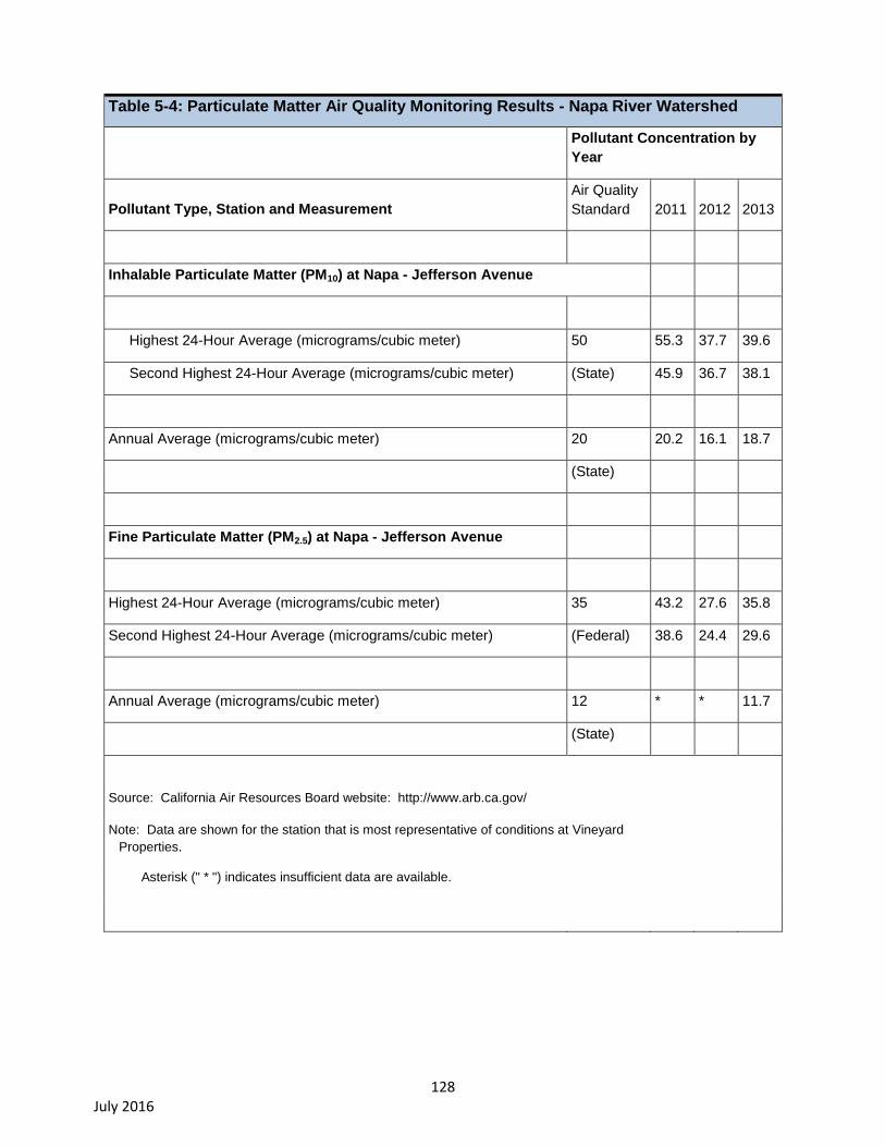
128 July 2016
Table 5-4: Particulate Matter Air Quality Monitoring Results - Napa River Watershed
Pollutant Concentration by
Year
Pollutant Type, Station and Measurement
Air Quality
Standard 2011 2012 2013
Inhalable Particulate Matter (PM10) at Napa - Jefferson Avenue
Highest 24-Hour Average (micrograms/cubic meter) 50 55.3 37.7 39.6
Second Highest 24-Hour Average (micrograms/cubic meter) (State) 45.9 36.7 38.1
Annual Average (micrograms/cubic meter) 20 20.2 16.1 18.7
(State)
Fine Particulate Matter (PM2.5) at Napa - Jefferson Avenue
Highest 24-Hour Average (micrograms/cubic meter) 35 43.2 27.6 35.8
Second Highest 24-Hour Average (micrograms/cubic meter) (Federal) 38.6 24.4 29.6
Annual Average (micrograms/cubic meter) 12 * * 11.7
(State)
Source: California Air Resources Board website: http://www.arb.ca.gov/
Note: Data are shown for the station that is most representative of conditions at Vineyard
Properties.
Asterisk (" * ") indicates insufficient data are available.
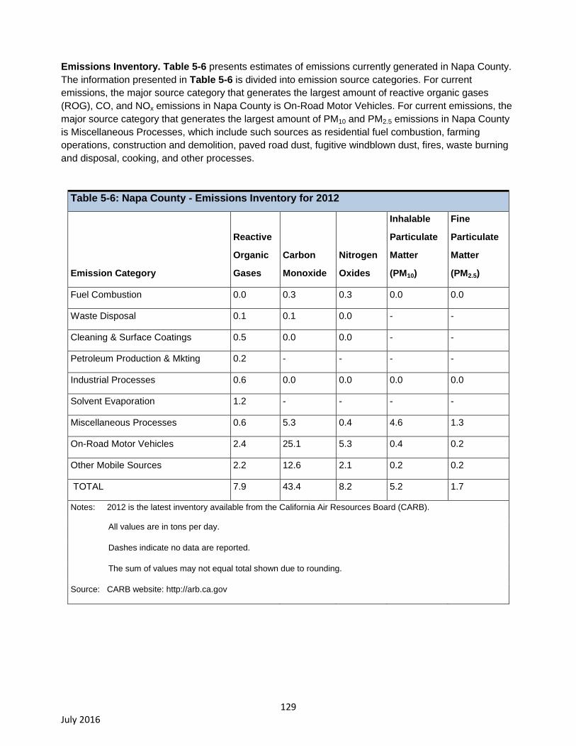
129 July 2016
Emissions Inventory. Table 5-6 presents estimates of emissions currently generated in Napa County.
The information presented in Table 5-6 is divided into emission source categories. For current
emissions, the major source category that generates the largest amount of reactive organic gases
(ROG), CO, and NOx emissions in Napa County is On-Road Motor Vehicles. For current emissions, the
major source category that generates the largest amount of PM10 and PM2.5 emissions in Napa County
is Miscellaneous Processes, which include such sources as residential fuel combustion, farming
operations, construction and demolition, paved road dust, fugitive windblown dust, fires, waste burning
and disposal, cooking, and other processes.
Table 5-6: Napa County - Emissions Inventory for 2012
Emission Category
Reactive
Organic
Gases
Carbon
Monoxide
Nitrogen
Oxides
Inhalable
Particulate
Matter
(PM10)
Fine
Particulate
Matter
(PM2.5)
Fuel Combustion 0.0 0.3 0.3 0.0 0.0
Waste Disposal 0.1 0.1 0.0 - -
Cleaning & Surface Coatings 0.5 0.0 0.0 - -
Petroleum Production & Mkting 0.2 - - - -
Industrial Processes 0.6 0.0 0.0 0.0 0.0
Solvent Evaporation 1.2 - - - -
Miscellaneous Processes 0.6 5.3 0.4 4.6 1.3
On-Road Motor Vehicles 2.4 25.1 5.3 0.4 0.2
Other Mobile Sources 2.2 12.6 2.1 0.2 0.2
TOTAL 7.9 43.4 8.2 5.2 1.7
Notes: 2012 is the latest inventory available from the California Air Resources Board (CARB).
All values are in tons per day.
Dashes indicate no data are reported.
The sum of values may not equal total shown due to rounding.
Source: CARB website: http://arb.ca.gov

130 July 2016
Sonoma Creek Watershed
Climate & Meteorology. The valley that stretches from Santa Rosa to the San Pablo Bay is known as
the Cotati Valley at the north end and the Petaluma Valley at the south end. Some maps show the
whole area as the Petaluma Valley. The Sonoma Creek Watershed is along the eastern edge of this
area, and is influenced by climate and meteorology in this area. The largest city in the Cotati Valley is
Santa Rosa, and in the Petaluma Valley is Petaluma. To the east, the valley is bordered by the Sonoma
Mountains, with the San Pablo Bay at the southeast end of the valley. To the immediate west are a
series of low hills and further west are the Estero Lowlands, which opens to the Pacific Ocean. The
region from the Estero Lowlands to the San Pablo Bay is known as the Petaluma Gap. This low-terrain
area is a major transport corridor, allowing marine air to pass into the Bay Area.
Wind patterns in the Petaluma and Cotati Valleys are strongly influenced by the Petaluma Gap. The
predominant wind pattern in this region is for marine air to move eastward through the Petaluma Gap,
then to split into northward and southward paths as it moves into the Cotati and Petaluma Valleys. The
southward path crosses the San Pablo Bay and moves eastward through the Carquinez Straits.
Consequently, although Santa Rosa and Petaluma are only 16 miles apart, predominate wind patterns
in these areas are quite different. Santa Rosa's prevailing winds are out of the south and southeast,
while Petaluma's prevailing winds are out of the northwest. When the ocean breeze is weak, a bay
breeze pattern can also occur, resulting in east winds near the bay. Strong winds from the east occur as
part of a larger scale pattern and often carry pollutants picked up along the trajectory through the
Central Valley and the Carquinez Straits. During these periods, up-valley flows can carry the polluted air
as far north as Santa Rosa.
Winds are usually stronger in the Petaluma Valley than the Cotati Valley because it is part of the
Petaluma Gap. The low terrain in the Petaluma Gap does not offer much resistance to the marine air as
it flows to the San Pablo Bay. Consequently, even though Petaluma is 28 miles from the ocean, its
climate is similar to areas closer to the coast. Average annual wind speed at the Petaluma Airport is
seven mph. This is almost identical to the average annual wind speed measured in Valley Ford, five
miles from the coast. Winds are light in the morning in the Petaluma Valley, and become windy in the
afternoon as the sea breeze arrives. The Cotati Valley, being slightly north of the Petaluma Gap
experiences lower wind speeds. In Santa Rosa, the annual average wind speed is 5.4 mph.
During summer afternoons, the fetch across the Petaluma Gap is sufficiently long so that the marine air
is warmed and the fog evaporated before it reaches the Petaluma and Cotati valleys. As the surface
heating weakens in the late afternoon, the marine layer becomes less heated with distance, and
eventually fog is able to form in these valleys. The fog may then persist until late in the morning the next
day.
Air temperatures are very similar in the two valleys. Average maximum temperatures in Santa Rosa are
1 degree F higher than in Petaluma. Summer maximum temperatures for this region are in the low 80's
F, while winter maximum temperatures are in the high 50s F to low 60s F. The reverse is true for
average minimum temperatures, with Petaluma being 1 degree F warmer than Santa Rosa. Summer
minimum temperatures are 50-51 degrees F, and wintertime minimum temperatures are 36-40 degrees
F.
Rainfall averages are 24 inches per year at Petaluma, and 30 inches at Santa Rosa. Santa Rosa's
rainfall is higher because the air is lifted and cooled in advance of the Sonoma Mountains, thereby
causing condensation of the moisture. Consistent with the Bay Area Mediterranean climate, Santa Rosa
receives 81 percent of its annual rainfall from November through March; and at Petaluma, 83 percent
during that same period.
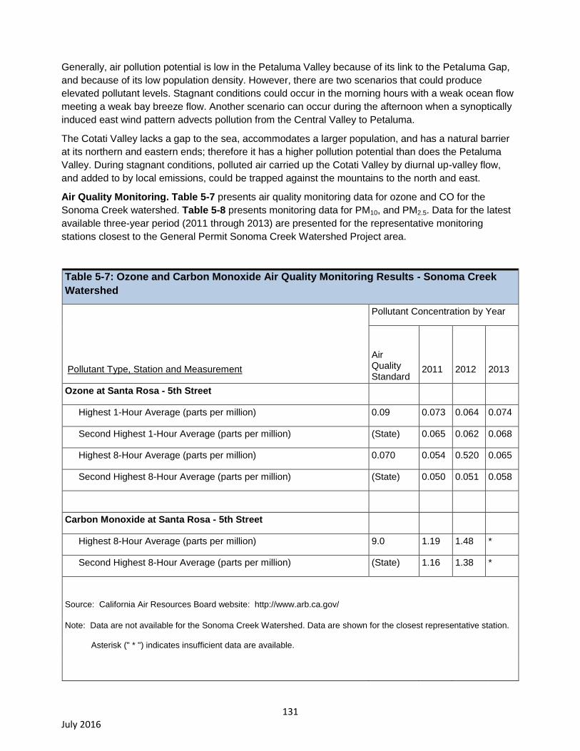
131 July 2016
Generally, air pollution potential is low in the Petaluma Valley because of its link to the Petaluma Gap,
and because of its low population density. However, there are two scenarios that could produce
elevated pollutant levels. Stagnant conditions could occur in the morning hours with a weak ocean flow
meeting a weak bay breeze flow. Another scenario can occur during the afternoon when a synoptically
induced east wind pattern advects pollution from the Central Valley to Petaluma.
The Cotati Valley lacks a gap to the sea, accommodates a larger population, and has a natural barrier
at its northern and eastern ends; therefore it has a higher pollution potential than does the Petaluma
Valley. During stagnant conditions, polluted air carried up the Cotati Valley by diurnal up-valley flow,
and added to by local emissions, could be trapped against the mountains to the north and east.
Air Quality Monitoring. Table 5-7 presents air quality monitoring data for ozone and CO for the
Sonoma Creek watershed. Table 5-8 presents monitoring data for PM10, and PM2.5. Data for the latest
available three-year period (2011 through 2013) are presented for the representative monitoring
stations closest to the General Permit Sonoma Creek Watershed Project area.
Table 5-7: Ozone and Carbon Monoxide Air Quality Monitoring Results - Sonoma Creek
Watershed
Pollutant Type, Station and Measurement
Pollutant Concentration by Year
Air Quality Standard
2011 2012
2013
Ozone at Santa Rosa - 5th Street
Highest 1-Hour Average (parts per million) 0.09 0.073 0.064 0.074
Second Highest 1-Hour Average (parts per million) (State) 0.065 0.062 0.068
Highest 8-Hour Average (parts per million) 0.070 0.054 0.520 0.065
Second Highest 8-Hour Average (parts per million) (State) 0.050 0.051 0.058
Carbon Monoxide at Santa Rosa - 5th Street
Highest 8-Hour Average (parts per million) 9.0 1.19 1.48 *
Second Highest 8-Hour Average (parts per million) (State) 1.16 1.38 *
Source: California Air Resources Board website: http://www.arb.ca.gov/
Note: Data are not available for the Sonoma Creek Watershed. Data are shown for the closest representative station.
Asterisk (" * ") indicates insufficient data are available.
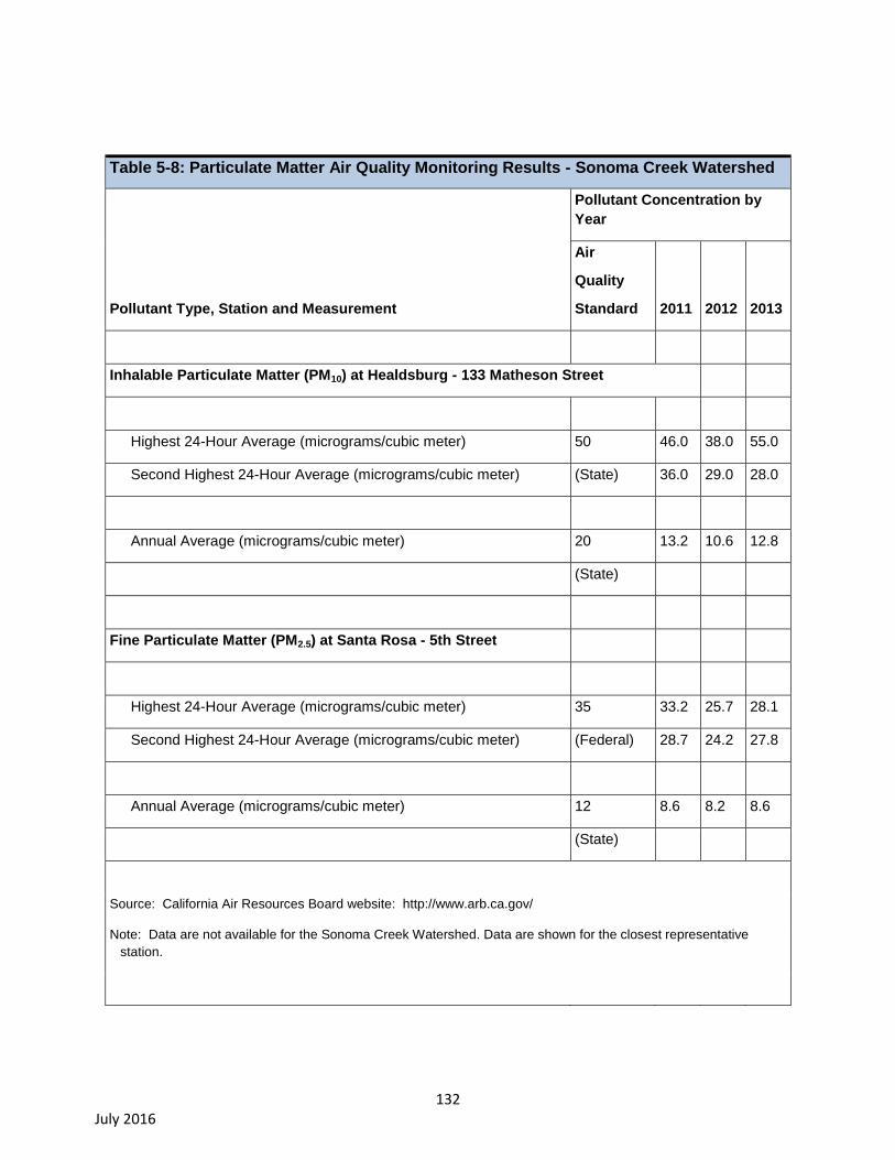
132 July 2016
Table 5-8: Particulate Matter Air Quality Monitoring Results - Sonoma Creek Watershed
Pollutant Type, Station and Measurement
Pollutant Concentration by
Year
Air
Quality
Standard 2011 2012
2013
Inhalable Particulate Matter (PM10) at Healdsburg - 133 Matheson Street
Highest 24-Hour Average (micrograms/cubic meter) 50 46.0 38.0 55.0
Second Highest 24-Hour Average (micrograms/cubic meter) (State) 36.0 29.0 28.0
Annual Average (micrograms/cubic meter) 20 13.2 10.6 12.8
(State)
Fine Particulate Matter (PM2.5) at Santa Rosa - 5th Street
Highest 24-Hour Average (micrograms/cubic meter) 35 33.2 25.7 28.1
Second Highest 24-Hour Average (micrograms/cubic meter) (Federal) 28.7 24.2 27.8
Annual Average (micrograms/cubic meter) 12 8.6 8.2 8.6
(State)
Source: California Air Resources Board website: http://www.arb.ca.gov/
Note: Data are not available for the Sonoma Creek Watershed. Data are shown for the closest representative
station.

133 July 2016
Emissions Inventory. Table 5-9 presents estimates of emissions currently generated in the SFBAAB
portion of Sonoma County. As previously noted, the entire Sonoma County portion of the Project area
falls within the SFBAAB district boundary. The information presented in Table 5-9 is divided into
emission source categories. For current emissions, shown in Table 5-9, the major source category that
generates the largest amount of ROG, CO, and NOx emissions in the SFBAAB portion of Sonoma
County is On-Road Motor Vehicles. For current emissions, the major source category that generates
the largest amount of PM10 and PM2.5 emissions in the SFBAAB portion of Sonoma County is
Miscellaneous Processes which include sources such as farming, paved road dust, residential fuel
consumption, and construction and demolition.
Table 5-9: San Francisco Bay Area Air Basin Portion of Sonoma County - Emissions
Inventory for 2012
Emission Category
Reactive
Organic
Gases
Carbon
Monoxide
Nitrogen
Oxides
Inhalable
Particulate
Matter
(PM10)
Fine
Particulate
Matter
(PM2.5)
Fuel Combustion 0.1 0.6 0.6 0.0 0.0
Waste Disposal 0.1 0.0 0.0 - -
Cleaning & Surface Coatings 1.5 0.0 0.0 - -
Petroleum Production & Mkting 0.6 - - - -
Industrial Processes 0.5 0.0 0.0 0.5 0.2
Solvent Evaporation 3.5 - - - -
Miscellaneous Processes 2.6 17.5 1.1 8.5 3.4
On-Road Motor Vehicles 5.8 52.4 10.5 0.8 0.4
Other Mobile Sources 2.9 22.9 3.8 0.3 0.3
17.6 93.5 16.0 10.1 4.3
Notes: 2012 is the latest inventory available from the California Air Resources Board (CARB).
All values are in tons per day.
Dashes indicate no data are reported.
The sum of values may not equal total shown due to rounding.
Source: CARB website: http://arb.ca.gov
134 July 2016
5.4. Impact Analysis Methods
Thresholds of Significance
The following evaluation of air quality impacts was prepared by considering potential locations for BMP
construction, applicable regulations and guidelines, and typical construction activities and operations
that would be attributable to the General Permit. The assessment of potential impacts include review of
documents, maps, and observation of existing vineyard operations, and consultation with persons
currently involved with permitting or environmental documentation for vineyard operations (e.g., local
government planning department staff, county agricultural commissioner’s office staff, etc.). The
following description of air quality impacts and mitigation measures is common to all BMPs in both the
Napa River and Sonoma Creek watersheds.
For this analysis, an impact pertaining to Air Quality was considered significant under CEQA if it would
result in any of the following environmental effects, which are based on professional practice and CEQA
Guidelines Appendix G (Cal. Code Regs., tit. 14, §§ 15000 et seq.). Thus, a significant impact would
result if the Project would:
a) Conflict with or obstruct implementation of the applicable air quality plan;
b) Violate any air quality standard or contribute substantially to an existing or projected air quality
violation;
c) Result in a cumulatively considerable net increase of any criteria pollutant for which the project
region is nonattainment under an applicable federal or state ambient air quality standard
(including releasing emissions which exceed quantitative thresholds for ozone precursors);
d) Expose sensitive receptors to substantial pollutant concentrations; or,
e) Create objectionable odors affecting a substantial number of people.
Furthermore the EIR notes note the following guidance provided by the BAAQMD (Bay Area Air Quality
Management District 2014):
On June 2, 2010, the Bay Area Air Quality Management District’s Board of Directors
unanimously adopted thresholds of significance to assist in the review of projects under
the California Environmental Quality Act. These Thresholds are designed to establish the
level at which the District believed air pollution emissions would cause significant
environmental impacts under CEQA and were posted on the Air District’s website and
included in the Air District's updated CEQA Guidelines (updated May 2012).
On March 5, 2012 the Alameda County Superior Court issued a judgment finding that the
Air District had failed to comply with CEQA when it adopted the Thresholds (California
Building Industry Association v. Bay Area Air Quality Management District (CBIA v.
BAAQMD)). The court did not determine whether the Thresholds were valid on the merits,
but found that the adoption of the Thresholds was a project under CEQA. The court
issued a writ of mandate ordering the District to set aside the Thresholds and cease
dissemination of them until the Air District had complied with CEQA. The Air District has
appealed the Alameda County Superior Court’s decision. The Court of Appeal of the State
of California, First Appellate District, reversed the trial court's decision. The Court of
Appeal's decision was appealed to the California Supreme Court, which granted limited
review.
135 July 2016
In view of the trial court’s order which remains in place pending final resolution of the
case, the Air District is no longer recommending that the Thresholds be used as a
generally applicable measure of a project’s significant air quality impacts. Lead agencies
will need to determine appropriate air quality thresholds of significance based on
substantial evidence in the record. Although lead agencies may rely on the Air District’s
updated CEQA Guidelines (updated May 2012) for assistance in calculating air pollution
emissions, obtaining information regarding the health impacts of air pollutants, and
identifying potential mitigation measures, the Air District has been ordered to set aside the
Thresholds and is no longer recommending that these Thresholds be used as a general
measure of project’s significant air quality impacts. Lead agencies may continue to rely on
the Air District’s 1999 Thresholds of Significance and they may continue to make
determinations regarding the significance of an individual project’s air quality impacts
based on the substantial evidence in the record for that project.
In December 2015, the California Supreme Court issued its opinion in CBIA v. BAAQMD. Ultimately,
the Supreme Court reversed the Court of Appeal's decision. The Court remanded the matter back to the
appellate court to reconsider the case in light of the Supreme Court's opinion. In light of this ruling, the
evaluations of impacts to air rely on the Air District’s 1999 Thresholds of Significance, as described
below.
Thresholds of Significance for Short-Term Construction-Related Emissions. The following text
from the 1999 BAAQMD CEQA Guidelines (Bay Area Air Quality Management District 1999) provide
procedures, methods of analyzing air quality impacts, thresholds of significance, and mitigation
measures for assessing the air quality impacts of proposed projects and plans. The thresholds of
significance for construction-related criteria pollutant emissions, as described below, are applied to this
EIR.
“As noted previously in these Guidelines, the District does not expect Lead Agencies to
provide detailed quantification of construction emissions. Similarly, Lead Agencies need
not quantify emission reductions from construction-related mitigation measures. The
District’s recommended approach to mitigating construction emissions focuses on a
consideration of whether all feasible control measures are being implemented.”
“Construction-related emissions are generally short-term in duration, but may still cause
adverse air quality impacts. Fine particulate matter (PM10) is the pollutant of greatest
concern with respect to construction activities.31
PM10 emissions can result from a variety
of construction activities, including excavation, grading, demolition, vehicle travel on
paved and unpaved surfaces, and vehicle and equipment exhaust. Construction-related
emissions can cause substantial increases in localized concentrations of PM10. Particulate
emissions from construction activities can lead to adverse health effects as well as
nuisance concerns such as reduced visibility and soiling of exposed surfaces.
“Construction emissions of PM10 can vary greatly depending on the level of activity, the
specific operations taking place, the equipment being operated, local soils, weather
conditions and other factors. Despite this variability in emissions, experience has shown
that there are a number of feasible control measures that can be reasonably implemented
31
Construction equipment emits carbon monoxide and ozone precursors. However, these emissions are included in the emission inventory that is the basis for regional air quality plans, and are not expected to impede attainment or maintenance of ozone and carbon monoxide standards in the Bay Area.
136 July 2016
to significantly reduce PM10 emissions from construction. The District’s approach to CEQA
analyses of construction impacts is to emphasize implementation of effective and
comprehensive control measures rather than detailed quantification of emissions.
“The District has identified a set of feasible PM10 control measures for construction
activities. These control measures are listed in Table 2. As noted in the table, some
measures (“Basic Measures”) should be implemented at all construction sites, regardless
of size. Additional measures (“Enhanced Measures”) should be implemented at larger
construction sites (greater than 4 acres) where PM10 emissions generally will be higher.
Table 2 also lists other PM10 controls (“Optional Measures”) that may be implemented if
further emission reductions are deemed necessary by the Lead Agency.
“The determination of significance with respect to construction emissions should be based
on a consideration of the control measures to be implemented. From the District’s
perspective, quantification of construction emissions is not necessary (although a Lead
Agency may elect to do so - see Section 3.3 of these Guidelines, “Calculating
Construction Emissions,” for guidance). The Lead Agency should review Table 2. If all of
the control measures indicated in Table 2 (as appropriate, depending on the size of the
project area) will be implemented, then air pollutant emissions from construction activities
would be considered a less than significant impact. If all of the appropriate measures in
Table 2 will not be implemented, then construction impacts would be considered to be
significant (unless the Lead Agency provides a detailed explanation as to why a specific
measure is unnecessary or not feasible).”
Thresholds of Significance for Long-Term Operational Emissions. The 1999 BAAQMD CEQA
Guidelines (Bay Area Air Quality Management District, 1999) present thresholds of significance for
long-term operational emissions. In addition to quantitative mass emission thresholds, the guidelines
provide screening thresholds. The screening thresholds identify when project emissions are expected to
be so low, the District does not recommend quantification of emissions. The following is from the 1999
BAAQMD CEQA Guidelines.
“For one of the thresholds of significance (total emissions from project operations),
project screening may provide a simple indication of whether a project may exceed the
threshold. . . The District generally does not recommend a detailed air quality analysis
for projects generating less than 2,000 vehicle trips per day, unless warranted by the
specific nature of the project or project setting.”
The screening threshold described above is applied in this EIR. If a project is expected to generate
fewer than 2,000 vehicle trips per day, criteria pollutant emission impacts are considered to be less than
significant.
Thresholds of Significance for Naturally-Occurring Asbestos. Naturally-occurring asbestos has
been identified as a toxic air contaminant by CARB. No quantitative significance thresholds have been
set for NOA. However, as noted earlier in this EIR, the BAAQMD provides a map that may be used as a
screening-level indicator of the likelihood of NOA being present in construction areas. In addition, the
California Department of Conservation document titled “A General Location Guide For Ultramafic Rocks
in California - Areas More Likely to Contain Naturally Occurring Asbestos” (California Department of
Conservation, 2000) provides a map showing areas more likely to contain Naturally occurring asbestos.
Most land areas that could be disturbed by construction activities occurring to comply with the General
Permit do include soil and/or bedrock areas, which contain naturally occurring asbestos. However, large
137 July 2016
subareas of the Lake Hennessey, Bear Creek, Sulphur Creek, and Bear Canyon Creek watersheds are
underlain by mélange and/or serpentinite bedrock types that contain naturally occurring asbestos in the
soil and/or bedrock.
If an individual BMP project is located outside of areas considered more likely to contain naturally
occurring asbestos, it may be considered to have a relatively lower probability of containing asbestos
and, in this EIR, will be considered to have a less-than-significant impact.
If an individual BMP project is located within an area considered more likely to contain naturally
occurring asbestos, it may be considered to have an elevated probability of containing asbestos and, in
this EIR, will be considered to have a significant impact.
Implementation of mitigation measures to reduce asbestos emissions during construction activities
would reduce the impact to a less-than-significant level.
5.5. Air Quality Impacts and Mitigation Measures
Impact 5.1 The Project could conflict with or obstruct implementation of the applicable air
quality plans.
The BAAQMD monitors priority air pollutants at stations throughout the Bay Area. The Napa monitoring
station (the only BAAQMD station in the area affected by the General Permit) is the most representative
of air quality conditions in the North Bay where vineyard management practices would be implemented
under the General Permit. Criteria air pollutants routinely measured at the Napa Station include ozone,
carbon monoxide, nitrogen dioxide, sulfur dioxide, and particulate matter (PM10). Smaller particle size,
PM2.5, is not monitored at the Napa Station. Combustion exhaust from the operation of vehicles, such
as cars, trucks, and farm equipment may contribute to concentrations of these pollutants. Earthmoving
for construction and road work can generate dust that is a source of particulate matter.
The Napa monitoring station data for the years 2007 through 2011 shows that carbon monoxide,
nitrogen dioxide, and ozone concentrations are well below State and federal standards. The
concentrations of PM10 varies throughout the year and is typically below the State standard of 50
micrograms per cubic meter (two days of exceedances in 5 years) and are well below the federal
standard of 150 micrograms per cubic meter. Other air quality monitoring stations in the North Bay (San
Rafael and Santa Rosa) also report concentrations of all criteria pollutants well below the standards.
Ozone is a respiratory irritant and an oxidant that increases susceptibility to respiratory infections and
can cause substantial damage to vegetation and other materials. PM10 and PM2.5 can reach the lungs
when inhaled, resulting in health concerns related to respiratory disease. Suspended particulate matter
can also affect vision or contribute to eye irritation. CO is a public health concern because it combines
readily with hemoglobin and thus reduces the amount of oxygen transported in the bloodstream.
The BAAQMD is responsible for preparing regional air quality plans applicable to the SFBAAB. The
BAAQMD states in their CEQA Guidelines,
"In developing thresholds of significance for air pollutants, BAAQMD considered the
emission levels for which a project‘s individual emissions would be cumulatively
considerable. If a project exceeds the identified significance thresholds, its emissions
would be cumulatively considerable, resulting in significant adverse air quality impacts to
the region‘s existing air quality conditions."
138 July 2016
Therefore, if a project exceeds the BAAQMD significance thresholds, the project would be considered
to conflict with applicable air quality plans.
Short-term impacts
Implementation of BMPs would require various temporary or short-term construction activities,
including, site preparation, site grading, trenching, and placement of landscaping/cover crops/vegetated
buffers, road shaping, and installation of erosion control features. These construction activities would
result in the temporary generation of criteria pollutant emissions. The General Permit could result in
minor construction-related emissions of exhaust and dust if grading is needed to construct BMPs, repair
or replacement of existing facilities, or repair roads to reduce sediment delivery to receiving waters.
Earthmoving produces dust that is mostly PM10. These larger dust particles quickly settle to the ground
and when associated with small scale construction pose minor air quality impacts. However, larger
scale site improvements (such as road repair, re-contouring, shaping, road relocation, etc.) could result
in temporary air emissions at levels that may conflict with exceed or contribute to existing or projected
limits, result or contribute to a net increase in non-attainment areas, or expose sensitive receptors to
significant, short-term, pollutant concentrations. As a result, the EIR conservatively estimates that short-
term, larger scale construction-related criteria pollutant emissions could result in a significant impact.
Long-term impacts
Implementation of BMPs would generate a minor amount of vehicle trips during long-term operations.
The vehicle trips would be generated, for example, by:
Vineyard Property site inspections and compliance monitoring
Inspecting and maintaining drainage facilities,
Cover crop maintenance, and
Maintaining roads that service vineyard facilities.
If a project is expected to generate fewer than 2,000 vehicle trips per day, criteria pollutant emission
impacts are considered to be less than significant. While implementation of BMPs would generate
vehicle trips, long-term maintenance of BMPs is not expected to generate 2,000 vehicle trips per day.
Therefore the impact of long-term maintenance of BMPs on long-term operational criteria pollutant
emissions is considered to be less than significant. Mitigation measures are not required.
Construction-Related Entrainment of Naturally-Occurring Asbestos
The exact location of individual BMP construction sites is unknown. Therefore, it is not possible at this
stage to identify exactly which sites would be in areas identified as more likely to contain naturally
occurring asbestos. As farm plans are completed and planning occurs regarding implementation of
additional BMPs, individual sites with high potential for naturally occurring asbestos could be identified.
As described earlier, the naturally occurring asbestos screening maps developed by the California
Department of Conservation (California Department of Conservation, 2000), should be used by General
Permit enrollees to identify whether their BMP project site is in an area considered more likely to
contain naturally occurring asbestos.
If an individual BMP construction site is not in an area considered more likely to contain asbestos, this
impact is considered less than significant, and no mitigation measures are required.
139 July 2016
If an individual BMP construction site is in an area considered more likely to contain asbestos, soil-
disturbing construction activity in these areas would result in an elevated risk of entraining asbestos,
and this impact is considered to be significant.
Mitigation Measure 5.1 (AQ-1 through AQ-4):
For this EIR, consistent with the approach described in the BAAQMD 1999 CEQA Guidelines, the
impact of construction-related emissions for all projects is considered initially significant. For
implementation of BMPs with a construction site size of four acres or less, implementation of the Basic
Measures (mitigation measure AQ-1) described below would reduce this impact to a less than
significant level. For implementation of BMPs with a construction site size greater than four acres,
implementation of the Enhanced Measures (mitigation measure AQ-2) described below would reduce
this impact to a less than significant level. For implementation of BMPs that are large in area, located
near sensitive receptors, or which for other reasons may warrant additional emissions reductions,
implementation of the Optional Measures (mitigation measure AQ-3) described below would reduce this
impact to a less than significant level. Implementation of mitigation measure AQ-4, described below, is
recommended in areas considered likely to contain NOA.
The following are the Basic Measures from Table 2 of the 1999 BAAQMD CEQA Guidelines, which
describes the measures as those that would be implemented at all construction sites, with AQ-4 being
implemented at sites likely to contain NOA. The following descriptions are directly from the BAAQMD
CEQA Guidelines and describe measures for the wide range of land use and infrastructure projects that
may not be applicable to all BMPS evaluated in this EIR. However, because detailed information on
implementation of specific BMPs to comply with the General Permit is not available, the following list is
cited to be as inclusive as possible.
AQ-1 Basic Criteria Pollutant Emission Control Measures
The following are the Basic Measures from Table 2 of the 1999 BAAQMD CEQA Guidelines.
Water all active construction areas at least twice daily.
Cover all trucks hauling soil, sand, and other loose materials or require all trucks to maintain at
least two feet of freeboard.
Pave, apply water three times daily, or apply (non-toxic) soil stabilizers on all unpaved access
roads, parking areas and staging areas at construction sites.
Sweep daily (with water sweepers) all paved access roads, parking areas and staging areas at
construction sites.
Sweep streets daily (with water sweepers) if visible soil material is carried onto adjacent public
streets.
AQ-2 Enhanced Criteria Pollutant Emission Control Measures
The following are the Enhanced Measures from Table 2 of the 1999 BAAQMD CEQA Guidelines.
All “Basic” control measures listed above.
Hydro-seed or apply (non-toxic) soil stabilizers to inactive construction areas (previously graded
areas inactive for ten days or more).
Enclose, cover, water twice daily or apply (non-toxic) soil binders to exposed stockpiles (dirt,
sand, etc.)
140 July 2016
Limit traffic speeds on unpaved roads to 15 mph.
Install sandbags or other erosion control measures to prevent silt runoff to public roadways.
Replant vegetation in disturbed areas as quickly as possible.
AQ-3 Optional Criteria Pollutant Emission Control Measures
The following are the Optional Measures from Table 2 of the 1999 BAAQMD CEQA Guidelines, which
describes the measures as those that are strongly encouraged at construction sites that are large in
area, located near sensitive receptors or which for any reason may warrant additional emissions
reductions:
Install wheel washers for all exiting trucks, or wash off the tires or tracks of all trucks and
equipment leaving the site.
Install wind breaks, or plant trees/vegetative wind breaks at windward side(s) of construction
areas.
Suspend excavation and grading activity when winds (instantaneous gusts) exceed 25 mph.
Limit the area subject to excavation, grading and other construction activity at any one time.
AQ-4 Naturally-Occurring Asbestos Emission Reduction Control Measures
Implementation of the following mitigation measure would reduce this impact to a less than significant
level.
Comply with the BAAQMD NOA program and ARB ATCM 93105. Complying with these
regulations would reduce the potential for entraining NOA, and reduce this impact to a less
than significant level.
Impact Significance after mitigation
Although AQ-1 through AQ-4 would reduce potential construction-related air emissions impacts to less
than significant levels, the Water Board would not have oversight of the implementation of proposed
mitigation measures related to the air quality impacts of actions to comply with the General Permit. The
ability to require such measures is within the purview of jurisdictions with local land use approval and/or
permitting authority. In all cases where compliance actions at an individual Vineyard Property meet the
CEQA definition of a “Project,” the local land-use authority would issue a CEQA document. In some of
those cases, local land use agencies have determined that a categorical exemption applies to the
action (e.g. construction of erosion control BMPs within the footprint of existing unpaved roads) or has a
streamlined CEQA process in place (e.g. VESCO).
Because authority to determine project-level impacts and to require project-level mitigation lies with the
local land use and/or permitting agency for individual projects, there is inherent uncertainty in the
degree of mitigation that may ultimately be implemented to reduce significant impacts.
Even with mitigation, construction activities could still temporarily exceed local air district threshold
levels of significance, depending on the magnitude of the construction activities.
Consequently, the EIR takes a conservative approach in its post-mitigation significance conclusion and
discloses, for CEQA compliance purposes, that air quality impacts resulting from BMP construction to
comply with the General Permit could be significant and unavoidable.
141 July 2016
Impact 5.2 Actions taken to comply with the proposed General Permit have the potential to
violate air quality standards and/or contribute substantially to an existing or projected air quality
violation.
For reasons stated in Impact 5.1, temporary air quality impacts, including emissions of PM10 at most
construction sites and at some construction sites naturally occurring asbestos, resulting from
compliance with the General Permit could be significant.
Mitigation Measure 5.2. See Mitigation Measures AQ-1 – AQ-4, above.
Impact Significance after mitigation
For the reasons stated in Impact 5.1, the EIR takes a conservative approach in its post-mitigation
significance conclusion and discloses, for CEQA compliance purposes, that air quality impacts resulting
from BMP construction to comply with the General Permit could be significant and unavoidable.
Impact 5.3 Compliance with the General Permit does not have the potential to result in
considerable net increases of any non-attainment pollutant for which the project region is under
an applicable federal or State ambient air quality standard (including releasing emissions with
exceed quantitative thresholds for ozone precursors).
In accordance with BAAQMD CEQA Guidelines, for any project that does not individually have
significant operational air quality impacts, the determination of significant cumulative impact should be
based on an evaluation of the consistency of the project with the local general plan and of the general
plan with the regional air quality plan.
The General Permit will not result in new land uses, housing, or other uses that would generate
sustained air emissions. Compliance with the General Permit would not result in the permanent
installation of stationary engines such as diesel-fueled motors and therefore would not permanently
increase emissions from Vineyard Property operations. The General Permit does not propose land uses
that are inconsistent with the current land use designation in the Sonoma County and Napa County
general plans (refer to Section X, Land Use and Planning, below). Furthermore, General Permit
compliance projects would be consistent with the 2001 Bay Area Ozone Attainment Plan and the 2000
Bay Area Clean Air Plan. Therefore, the Project would not result in a cumulatively considerable net
increase in any criteria pollutant. This would be a less than significant impact.
Impact 5.4 Compliance with the General Permit may have the potential to expose sensitive
receptors to substantial pollutant concentrations.
Emissions of toxics, for example diesel particulate matter (DPM), can occur from diesel-fueled
equipment used for site preparation and construction activities to modify existing roads and road
crossings, or to construct new facilities such as detention basins, to manage stormwater discharges, in
compliance with the requirements of the General Permit. Although diesel-operated equipment such as
tractors and trucks are routinely used at vineyard facilities as part of normal operations, large
construction projects, such as road reshaping/repair/realignment and/or detention basin construction,
could last several weeks and therefore possibly result in increases in short-term diesel emissions above
baseline conditions.
DPM has been identified by CARB as a TAC, based on published evidence of a relationship between
diesel exhaust exposure and lung cancer and other adverse health effects. DPM differs from other
TACs in that it is not a single substance but rather a complex mixture of hundreds of substances. Health
effects include cardiovascular and respiratory hospitalizations, exacerbated chronic heart and lung
142 July 2016
disease including asthma, increased respiratory symptoms, decreased lung function in children, and
premature death.
Vineyard Properties regulated by the General Permit are located within a Project area of approximately
600 square miles (mi2) and residential uses in these agriculturally-zoned districts are very low density,
typically containing only a few residences. Although vineyards are generally located in rural areas, given
the sheer size of the Project area, it is possible that some vineyard properties requiring coverage under
the General Permit may be located near schools, hospitals, and other sensitive land uses. Although
compliance with the General Permit should not result in the construction and/or operation of new,
stationary sources of air emissions, such as diesel engines, construction undertaken to implement the
requirements of the General Permit could result in increases in particulates in the air in the immediate
vicinity of the grading and construction operation, and could thus expose sensitive receptors to
substantial pollutant concentrations. This impact would be significant.
Mitigation Measure 5.3. See Mitigation Measures AQ-1 – AQ-4, above.
Impact Significance after mitigation
For the reasons stated in Impact 5.1, the EIR takes a conservative approach in its post-mitigation
significance conclusion and discloses, for CEQA compliance purposes, that air quality impacts
associated with BMP construction to comply with the General Permit could be significant and
unavoidable.
Impact 5.5 Compliance with the General Permit will not create objectionable odors affecting a
substantial number of people.
The BAAQMD defines public exposure to offensive odors as a significant impact. In general, the types
of land uses that pose potential odor problems include refineries, chemical plants, wastewater treatment
plants, landfills, composting facilities, and transfer stations. No such uses are proposed by the General
Permit.
Diesel engines may be used for some construction equipment. Odors generated by construction
equipment would be variable, depending on the location and duration of use. Diesel odors may be
noticeable to some individuals at certain times, but would not affect a substantial number of people
given that agriculturally zoned districts contain a low population density. The impact of the Project with
regard to odors is considered to be less than significant.
5.6. Greenhouse Gas Emissions
The average surface temperature of the Earth has risen by about one degree Fahrenheit (F) in the past
century, with most of that occurring during the past two decades (World Meteorological Organization,
2005). There is evidence that most of the warming over the last 50 years is due to human activities.
Human activities, such as energy production and internal combustion vehicles, have increased the
amount of climate-changing gases in the atmosphere, which in turn is causing the Earth’s average
temperature to rise. Rises in average temperature are leading to changes in climate patterns, shrinking
polar ice caps and a rise in sea level, with a host of corresponding impacts to humans and ecosystems.

143 July 2016
Gases which affect global climate are referred to as greenhouse gases (GHG). GHG are atmospheric
gases that act as global insulators by reflecting visible light and infrared radiation back to Earth. Some
GHG, such as water vapor, carbon dioxide (CO2), methane (CH4), and nitrous oxide (N2O), occur
naturally and are emitted to the atmosphere through natural processes. Although CO2, CH4, and N2O
occur naturally in the atmosphere, human activities have changed their atmospheric concentrations.
From 1750 to 2004, concentrations of CO2, CH4, and N2O have increased globally by 35, 143, and 18
percent, respectively. Other GHG, such as fluorinated gases, are created and emitted solely through
human activities. (U.S. Environmental Protection Agency 2006)
5.6.1. Environmental Setting
The principal GHG that enter the atmosphere because of human activities are CO2, CH4, N2O, and
fluorinated gases. Carbon dioxide is the gas that is most commonly referenced when discussing climate
change because it is the most commonly emitted gas. While some of the less common gases do make
up less of the total GHG emitted to the atmosphere, some have more effect per molecule than CO2.
Carbon Dioxide
The natural production and absorption of CO2 is achieved through the terrestrial biosphere and the
ocean. However, humankind has altered the natural carbon cycle by burning coal, oil, natural gas, and
wood. Since the industrial revolution began in the mid-1700s, each of these activities has increased in
scale and distribution. Carbon dioxide was the first GHG demonstrated to be increasing in atmospheric
concentration, with the first conclusive measurements being made in the last half of the 20th century.
Prior to the industrial revolution, concentrations were fairly stable at 280 ppm. Today, they are around
370 ppm, an increase of well over 30 percent (U.S. Environmental Protection Agency 2006). Left
unchecked, the concentration of CO2 in the atmosphere is projected to increase to a minimum of 535
ppm by 2100 as a direct result of anthropogenic (manmade) sources. This could result in an average
global temperature rise of at least two degrees Celsius (Intergovernmental Panel on Climate Change
2007). The California Energy Commission (CEC) estimates that CO2 emissions account for 84 percent
of California’s anthropogenic GHG emissions, nearly all of which is associated with fossil fuel
combustion (California Energy Commission 2005).
Methane
Methane is an extremely effective absorber of radiation, though its atmospheric concentration is less
than CO2 and its lifetime in the atmosphere is brief (10 – 12 years), compared to some other GHG
(such as CO2, N2O, and chlorofluorocarbons). Methane has both natural and anthropogenic sources.
Landfills, natural gas distribution systems, agricultural activities, fireplaces and wood stoves, stationary
and mobile fuel combustion, and gas and oil production field categories are the major sources of these
emissions (U.S. Environmental Protection Agency 2006). The CEC estimates that CH4 emissions from
various sources represent 6.2 percent of California’s total GHG emissions (California Energy
Commission 2005).
Nitrous Oxide
Concentrations of N2O also began to rise at the beginning of the industrial revolution. Nitrous oxide is
produced by microbial processes in soil and water, including those reactions that occur in fertilizers that
contain nitrogen. Use of these fertilizers has increased over the last century. Global concentration for
N2O in 1998 was 314 parts per billion (ppb), and in addition to agricultural sources for the gas, some
industrial processes (fossil fuel fired power plants, nylon production, nitric acid production, and vehicle

144 July 2016
emissions) also contribute to its atmospheric load (U.S. Environmental Protection Agency, 2006). The
CEC estimates that N2O emissions from various sources represent 6.6 percent of California’s total GHG
emissions (California Energy Commission, 2005).
Fluorinated Gases
Fluorinated gases, such as hydrofluorocarbons (HFCs), perfluorocarbons (PFCs) and sulfur
hexafluoride (SF6), are powerful GHG emissions that are emitted from a variety of industrial processes.
Fluorinated gases are occasionally used as substitutes for ozone-depleting substances such as
chlorofluorocarbons (CFCs), hydrochlorofluorocarbons (HCFCs), and halons, which have been
regulated since the mid-1980s because of their ozone destroying potential. Fluorinated gases are
typically emitted in smaller quantities than CO2, CH4, and N2O, but each molecule can have a much
greater global warming effect. Therefore, fluorinated gases are sometimes referred to as High Global
Warming Potential (GWP) gases (U.S. Environmental Protection Agency, 2006). The primary sources
of fluorinated gas emissions in the United States include the production of HCFC-22 electrical
transmission and distribution systems, semiconductor manufacturing, aluminum production, magnesium
production and processing, and substitution for ozone-depleting substances. The CEC estimates that
fluorinated gas emissions from various sources represent 3.4 percent of California’s total GHG
emissions (California Energy Commission, 2005).
Greenhouse Gas Emissions Inventory and Forecast
Table 5.9 presents estimates of GHG emissions generated in California during the years 2000 through
2010. The data are expressed as “million tonnes of CO2 equivalent” per year. One tonne is sometimes
referred to as a “metric ton” and is equal to 2,204.6 pounds.
While CO2 is the most common component of GHG, several different compounds are components of
overall GHG. The different compounds contribute to climate change with varying intensities. The term
“CO2 equivalent” (CO2e) refers to a weighted composite of these several compounds, expressed as the
equivalent amount of CO2.
Table 5.9 presents estimates of GHG emissions disaggregated into the following four major source
categories:
Transportation,
Electric Power,
Commercial and Residential, and
Industrial.
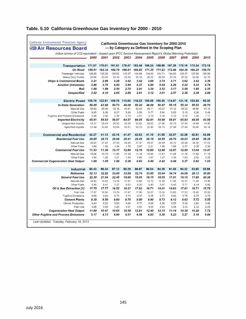
145 July 2016
Table. 5.10 California Greenhouse Gas Inventory for 2000 - 2010
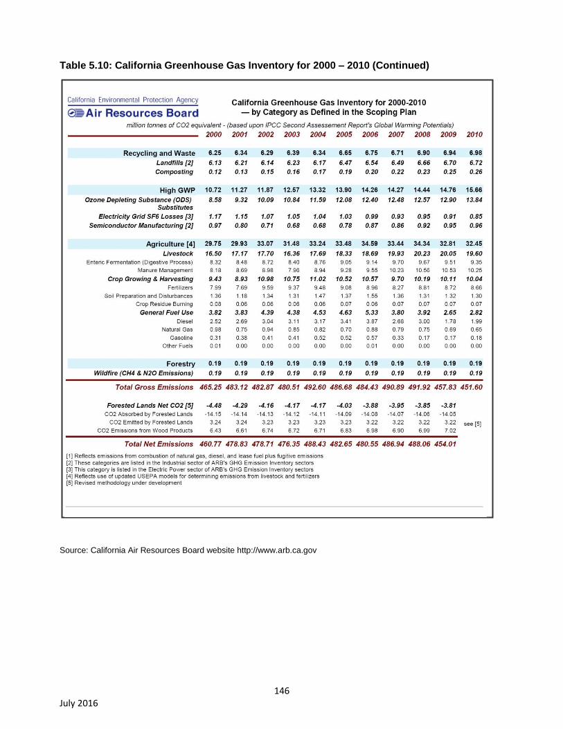
146 July 2016
Table 5.10: California Greenhouse Gas Inventory for 2000 – 2010 (Continued)
Source: California Air Resources Board website http://www.arb.ca.gov

147 July 2016
Table 5.11: California Greenhouse Gas Emissions Forecast (2008 – 2020)
Source: California Air Resources Board website http://www.arb.ca.gov

148 July 2016
Each major source category is further disaggregated into minor source categories.
As shown in Table 5.9, Transportation and Electric Power are the two larger major source categories of
GHG emissions in California. Industrial and Commercial and Residential activities are relatively smaller
sources of GHG emissions.
Table 5.10 presents forecasts of GHG emissions expected to be generated in California during the
years 2008 through 2020.
5.6.2. Regulatory Setting
The following describes Federal, State, and local regulation of GHG emissions.
5.6.3. Federal Regulations
The following describes Federal regulations related to global climate change and GHG emissions.
Supreme Court Ruling. The U.S. Environmental Protection Agency (EPA) is the Federal agency
responsible for implementing the Federal Clean Air Act (FCAA). The U.S. Supreme Court ruled
in its decision in Massachusetts et al. v. Environmental Protection Agency et al. (2007) 549 U.S.
05-1120, that CO2 is an air pollutant as defined under the FCAA, and that U.S. EPA has the
authority to regulate emissions of GHG.
In response to the mounting issue of climate change, U.S. EPA has taken actions to regulate,
monitor, and potentially reduce GHG emissions.
Mandatory Greenhouse Gas Reporting Rule. On September 22, 2009, U.S. EPA issued a final
rule for mandatory reporting of GHG from large GHG emissions sources in the United States. In
general, this federal reporting requirement will provide U.S. EPA with accurate and timely GHG
emissions data from facilities that emit 25,000 metric tons or more of CO2 per year. This publicly
available data will allow the reporters to track their own emissions, compare them to similar
facilities, and aid in identifying cost-effective opportunities to reduce emissions in the future.
Reporting is at the facility level, except that certain suppliers of fossil fuels and industrial GHG,
along with vehicle and engine manufacturers, will report at the corporate level. An estimated
85% of the total U.S. GHG emissions, from approximately 10,000 facilities, are covered by this
final rule.
Proposed Endangerment and Cause or Contribute Findings for GHG under the Clean Air Act.
On April 23, 2009, U.S. EPA published their Proposed Endangerment and Cause or Contribute
Findings for Greenhouse Gases under the FCCA (Endangerment Finding) in the Federal
Register. The Endangerment Finding is based on section 202(a) of the FCAA, which states that
the U.S. EPA Administrator should regulate and develop standards for “emission[s] of air
pollution from any class of classes of new motor vehicles or new motor vehicle engines, which
in [its] judgment cause, or contribute to, air pollution which may reasonably be anticipated to
endanger public health or welfare.” The proposed rule addresses section 202(a) in two distinct
findings. The first addresses whether or not the concentrations of the six key GHG (i.e., CO2,
CH4, N2O, HFCs, PFCs, and SF6) in the atmosphere threaten the public health and welfare of
current and future generations. The second addresses whether or not the combined emissions
of GHG from new motor vehicles and motor vehicle engines contribute to atmospheric
concentrations of GHG and to the threat of climate change.
149 July 2016
The Administrator proposed the finding that atmospheric concentrations of GHG endanger the
public health and welfare within the meaning of section 202(a) of the FCCA. The evidence
supporting this finding consists of human activity resulting in “high atmospheric levels” of GHG
emissions, which are very likely responsible for increases in average temperatures and other
climatic changes. Furthermore, the observed and projected results of climate change (e.g.,
higher likelihood of heat waves, wild fires, droughts, sea level rise, higher intensity storms) are a
threat to the public health and welfare. Therefore, GHG were found to endanger the public
health and welfare of current and future generations.
The Administrator also proposed the finding that GHG emissions from new motor vehicles and
motor vehicle engines are contributing to air pollution, which is endangering public health and
welfare. The proposed finding cites that in 2006, motor vehicles were the second largest
contributor to domestic GHG emissions (24 percent of total) behind electricity generation.
Furthermore, in 2005, the U.S. was responsible for 18 percent of global GHG emissions.
Therefore, GHG emissions from motor vehicles and motor vehicle engines were found to
contribute to air pollution that endangers public health and welfare.
5.6.4. State Greenhouse Gas Regulations.
The following describes State regulations related to global climate change and GHG emissions.
Assembly Bill 1493 (2002). AB 1493 (Stats. 2002, ch. 200; Pavley I) required CARB to develop
and adopt, by January 1, 2005, regulations that achieve “the maximum feasible reduction of
GHGs emitted by passenger vehicles and light-duty truck and other vehicles determined by the
ARB to be vehicles whose primary use is noncommercial personal transportation in the state.”
To meet the requirements of AB 1493, CARB approved amendments to the California Code of
Regulations adding GHG emission standards to California’s existing motor vehicle emission
standards in 2004. Amendments to Title 13 of the California Code of Regulations, sections 1900
and 1961, and adoption of section 1961.1, require automobile manufacturers to meet fleet
average GHG emission limits for all passenger cars, light-duty trucks within various weight
criteria, and medium-duty passenger vehicle weight classes beginning with the 2009 model
year. Emission limits are further reduced each model year through 2016. For passenger cars
and light-duty trucks 3,750 pounds or less loaded vehicle weight (LVW), the 2016 GHG
emission limits are approximately 37 percent lower than the during the first year of the
regulations in 2009. For medium-duty passenger vehicles and light-duty trucks 3,751 LVW to
8,500 pounds gross vehicle weight (GVW), GHG emissions are reduced approximately 24
percent between 2009 and 2016.
In 2012, CARB approved an update to AB 1493, creating new vehicle emission controls
standards for model years 2017 to 2025. The update takes a series of measures and combines
them into one policy called Advanced Clean Cars (Pavley II). By 2025, the new standards call
for new automobiles to emit 34 percent fewer GHG emissions and 75 percent fewer smog-
forming emissions, compared to projected vehicle emission levels in 2016 under the previous
rule.
Assembly Bill 32 (2006), California Global Warming Solutions Act. In September 2006, then-
Governor Schwarzenegger signed AB 32 (Chapter 488, Statutes of 2006), the California Global
Warming Solutions Act of 2006, which enacted sections 38500–38599 of the Health and Safety
Code. AB 32 requires the reduction of statewide GHG emissions to 1990 levels by 2020. This
150 July 2016
equates to an approximate 15 percent reduction compared to existing statewide GHG emission
levels or a 30 percent reduction from projected 2020 “business as usual” emission levels. The
required reduction will be accomplished through an enforceable statewide cap on GHG
emissions that began in 2012.
To effectively implement the statewide cap on GHG emissions, AB 32 directs ARB to develop
and implement regulations that reduce statewide GHG emissions generated by stationary
sources. Specific actions required of ARB under AB 32 include adoption of a quantified cap on
GHG emissions that represent 1990 emissions levels along with disclosing how the cap was
quantified, institution of a schedule to meet the emissions cap, and development of tracking,
reporting, and enforcement mechanisms to ensure that the state achieves the reductions in
GHG emissions needed to meet the cap.
In addition, AB 32 states that if any regulations established under AB 1493 (2002) cannot be
implemented, then ARB is required to develop additional, new regulations to control GHG
emissions from vehicles as part of AB 32.
AB 32 Climate Change Scoping Plan. In December 2008, ARB adopted its Climate Change
Scoping Plan (California Air Resources Board, 2008b), which contains the main strategies
California will implement to achieve reduction of approximately 169 million metric tons (MMT) of
CO2e or approximately 30 percent from the state’s projected 2020 emission level of 596 MMT of
CO2e under a business-as-usual scenario (this is a reduction of 42 MMT CO2e, or almost 10
percent from 2002-2004 average emissions). The Scoping Plan also includes ARB-
recommended GHG reductions for each emissions sector of the state’s GHG inventory. The
Scoping Plan calls for the largest reductions in GHG emissions to be achieved by implementing
the following measures and standards:
improved emissions standards for light-duty vehicles (estimated reductions of 31.7 MMT
CO2e);
the Low-Carbon Fuel Standard (15.0 MMT CO2e);
energy efficiency measures in buildings and appliances and the widespread
development of combined heat and power systems (26.3 MMT CO2e); and
a renewable portfolio standard for electricity production (21.3 MMT CO2e).
ARB has not yet determined what amount of GHG reductions it recommends from local
government operations; however, the Scoping Plan does state that land use planning and urban
growth decisions will play an important role in the state’s GHG reductions because local
governments have primary authority to plan, zone, approve, and permit how land is developed
to accommodate population growth and the changing needs of their jurisdictions (meanwhile,
ARB is also developing an additional protocol for community emissions). ARB further
acknowledges that decisions on how land is used will have large impacts on the GHG
emissions that will result from the transportation, housing, industry, forestry, water, agriculture,
electricity, and natural gas emission sectors. The Scoping Plan states that the ultimate GHG
reduction assignment to local government operations is to be determined. With regard to land
use planning, the Scoping Plan expects approximately 5.0 MMT CO2e will be achieved
associated with implementation of SB 375, which is discussed further below.
Senate Bills 1078 and 107 and Executive Order S-14-08. SB 1078 (Chapter 516, Statutes of
2002) requires retail sellers of electricity, including investor-owned utilities and community

151 July 2016
choice aggregators, to provide at least 20 percent of their supply from renewable sources by
2017. SB 107 (Chapter 464, Statutes of 2006) changed the target date to 2010. In November
2008 then-Governor Schwarzenegger signed Executive Order S-14-08, which expands the
state’s Renewable Energy Standard to 33 percent renewable power by 2020.
Senate Bill 1368 (2006). SB 1368 is the companion bill of AB 32 and was signed by then-
Governor Schwarzenegger in September 2006. SB 1368 requires the California Public Utilities
Commission (PUC) to establish a GHG emission performance standard for baseload generation
from investor-owned utilities by February 1, 2007. The California Energy Commission (CEC)
must establish a similar standard for local publicly-owned utilities by June 30, 2007. These
standards cannot exceed the GHG emission rate from a baseload combined-cycle natural gas
fired plant. The legislation further requires that all electricity provided to California, including
imported electricity, must be generated from plants that meet the standards set by the PUC and
CEC.
Senate Bill 97 (2007). SB 97, signed by then-Governor Schwarzenegger in August 2007
(Chapter 185, Statutes of 2007; Pub. Res. Code, §§ 21083.05 and 21097), acknowledges
climate change is a prominent environmental issue that requires analysis under CEQA. This bill
directed the Governor’s Office of Planning and Research (OPR) to prepare, develop, and
transmit to the California Resources Agency (CRA) by July 1, 2009, guidelines for mitigating
GHG emissions or the effects of GHG emissions, as required by CEQA. The CRA was required
to certify and adopt these guidelines by January 1, 2010.
This bill also removes, both retroactively and prospectively, as legitimate causes of action in
litigation, any claim of inadequate CEQA analysis of effects of GHG emissions associated with
environmental review for projects funded by the Highway Safety, Traffic Reduction, Air Quality
and Port Security Bond Act of 2006 (Proposition 1B) or the Disaster Preparedness and Flood
Protection Bond Act of 2006 (Proposition 1E). This provision will be repealed by provision of law
on January 1, 2010, and at that time, any unapproved projects will no longer enjoy protection
against litigation claims based on failure to adequately address issues related to GHG
emissions.
Senate Bill 375 (2008). SB 375, signed by then-Governor Schwarzenegger in September 2008,
aligns regional transportation planning efforts, regional GHG reduction targets, and land use
and housing allocation. As part of the alignment, SB 375 requires Metropolitan Planning
Organizations (MPOs) to adopt a Sustainable Communities Strategy (SCS) or Alternative
Planning Strategy (APS), which prescribes land use allocation in that MPO’s Regional
Transportation Plan (RTP). The ARB, in consultation with MPOs, is required to provide each
affected region with reduction targets for GHG emitted by passenger cars and light trucks in the
region for the years 2020 and 2035. These reduction targets will be updated every eight years,
but can be updated every four years if advancements in emissions technologies affect the
reduction strategies to achieve the targets. The ARB is also charged with reviewing each MPO’s
SCS or APS for consistency with its assigned GHG emission reduction targets. If MPOs do not
meet the GHG reduction targets, transportation projects located in the MPO boundaries would
not be eligible for funding programmed after January 1, 2012.
This bill also extends the minimum time period for the Regional Housing Needs Allocation
(RNHA) cycle from five years to eight years for local governments located in an MPO that meets
certain requirements. City or County land use policies (e.g., General Plans) are not required to
be consistent with the RTP including associated SCSs or APSs. Projects consistent with an
152 July 2016
approved SCS or APS and categorized as “transit priority projects” would receive incentives
under new provisions of CEQA.
Executive Order S-3-05 (2005). Then-Governor Schwarzenegger signed Executive Order S-3-
05 on June 1, 2005, which proclaimed California is vulnerable to the impacts of climate change.
The executive order declared increased temperatures could reduce snowpack in the Sierra
Nevada Mountains, further exacerbate California’s air quality problems, and potentially cause a
rise in sea levels. To combat those concerns, the executive order established targets for total
GHG emissions, which include reducing GHG emissions to the 2000 level by 2010, to the 1990
level by 2020, and to 80 percent below the 1990 level by 2050.
The executive order also directed the secretary of the California Environmental Protection
Agency to coordinate a multiagency effort to reduce GHG emissions to the target levels. The
secretary will submit biannual reports to the governor and legislature describing progress made
toward reaching the emission targets; impacts of global warming on California’s resources; and
mitigation and adaptation plans to combat impacts of global warming.
To comply with the executive order, the Secretary of the California Environmental Protection
Agency created the California Climate Action Team, which is made up of members from various
state agencies and commissions. The California Climate Action Team released its first report in
March 2006, of which proposed achieving the GHG emissions targets by building on voluntary
actions of California businesses and actions by local governments and communities along with
continued implementation of state incentive and regulatory programs.
Executive Order S-13-08. Then-Governor Schwarzenegger signed Executive Order S-13-08 on
November 14, 2008, which directs California to develop methods for adapting to climate change
through preparation of a statewide plan. The executive order directs OPR, in cooperation with
the CRA, to provide land use planning guidance related to sea level rise and other climate
change impacts by May 30, 2009. The order also directs the CRA to develop a state Climate
Adaptation Strategy by June 30, 2009 and to convene an independent panel to complete the
first California Sea Level Rise Assessment Report. The assessment report is required to be
completed by December 1, 2010, and required to include the following four items:
1. project the relative sea level rise specific to California by taking into account issues
such as coastal erosion rates, tidal impacts, El Niño and La Niña events, storm surge, and
land subsidence rates;
2. identify the range of uncertainty in selected sea level rise projections;
3. synthesize existing information on projected sea level rise impacts to state
infrastructure (e.g., roads, public facilities, beaches), natural areas, and coastal and marine
ecosystems; and
4. discuss future research needs relating to sea level rise in California.
Executive Order S-1-07. Then-Governor Schwarzenegger signed Executive Order S-1-07 in
2007, which proclaimed the transportation sector as the main source of GHG emissions in
California. The executive order proclaims the transportation sector accounts for over 40 percent
of statewide GHG emissions. The executive order also establishes a goal to reduce the carbon
intensity of transportation fuels sold in California by a minimum of 10 percent by 2020.
In particular, the executive order established a Low-Carbon Fuel Standard (LCFS) and directed
the Secretary for Environmental Protection to coordinate the actions of the CEC, the CARB, the

153 July 2016
University of California, and other agencies to develop and propose protocols for measuring the
“life-cycle carbon intensity” of transportation fuels. This analysis, supporting development of the
protocols, was included in the State Implementation Plan for alternative fuels (State Alternative
Fuels Plan adopted by CEC on December 24, 2007) and submitted to CARB for consideration
as an “early action” item under AB 32. The CARB adopted the LCFS on April 23, 2009.
Executive Order B-30-15. On April 29, 2015, Governor Brown signed Executive Order B-30-15.
The executive order:
establishes a California greenhouse gas reduction target of 40 percent below 1990
levels by 2030,
directs the CARB to update the Climate Change Scoping Plan to express the 2030
target,
directs the California Natural Resources Agency to update the state's climate adaptation
strategy every three years,
directs state agencies to take climate change into account in their planning and
investment decisions,
directs the state's Five Year Infrastructure Plan to take current and future climate
change impacts into account in all infrastructure projects, and
directs the Governor's Office of Planning and Research to establish a technical advisory
group to help state agencies incorporate climate change impacts into planning and
investment decisions.
5.6.5. Local Greenhouse Gas Regulations
The following describes local regulations related to global climate change and GHG emissions.
Bay Area Air Quality Management District Climate Protection Program. The BAAQMD established a
climate protection program to reduce pollutants that contribute to global climate change and affect air
quality in the SFBAAB. The climate protection program includes measures that promote energy
efficiency, reduce vehicle miles traveled, and develop alternative sources of energy all of which assist in
reducing GHG emissions and in reducing air pollutants that affect the health of residents. BAAQMD
also seeks to support current climate protection programs in the region and to stimulate additional
efforts through public education and outreach, technical assistance to local governments and other
interested parties, and promotion of collaborative efforts among stakeholders.
5.6.6. Napa County Climate Action Plan
The Napa County Department of Planning, Building, and Environmental Services (PBES) has been
working to develop a Climate Action Plan for the County for several years. The Climate Action Plan is
intended to quantify and reduce GHG emissions in unincorporated Napa County, and its adoption would
implement an “action item” from the County’s 2008 General Plan Update.
A proposed Climate Action Plan was recommended for adoption by the Planning Commission in early
2012 and later considered by the Board of Supervisors, who sent the plan back to staff for
modifications. Among other things, the Board requested that the plan be revised to better address
transportation emissions, and to “credit” past accomplishments and voluntary efforts. The Board also
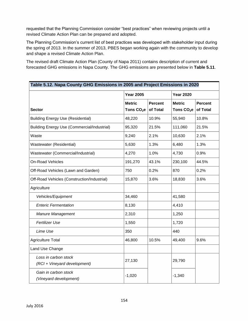
154 July 2016
requested that the Planning Commission consider “best practices” when reviewing projects until a
revised Climate Action Plan can be prepared and adopted.
The Planning Commission’s current list of best practices was developed with stakeholder input during
the spring of 2013. In the summer of 2013, PBES began working again with the community to develop
and shape a revised Climate Action Plan.
The revised draft Climate Action Plan (County of Napa 2011) contains description of current and
forecasted GHG emissions in Napa County. The GHG emissions are presented below in Table 5.11.
Table 5.12. Napa County GHG Emissions in 2005 and Project Emissions in 2020
Sector
Year 2005 Year 2020
Metric
Tons CO2e
Percent
of Total
Metric
Tons CO2e
Percent
of Total
Building Energy Use (Residential) 48,220 10.9% 55,940 10.8%
Building Energy Use (Commercial/Industrial) 95,320 21.5% 111,060 21.5%
Waste 9,240 2.1% 10,630 2.1%
Wastewater (Residential) 5,630 1.3% 6,480 1.3%
Wastewater (Commercial/Industrial) 4,270 1.0% 4,730 0.9%
On-Road Vehicles 191,270 43.1% 230,100 44.5%
Off-Road Vehicles (Lawn and Garden) 750 0.2% 870 0.2%
Off-Road Vehicles (Construction/Industrial) 15,870 3.6% 18,830 3.6%
Agriculture
Vehicles/Equipment 34,460 41,580
Enteric Fermentation 8,130 4,410
Manure Management 2,310 1,250
Fertilizer Use 1,550 1,720
Lime Use 350 440
Agriculture Total 46,800 10.5% 49,400 9.6%
Land Use Change
Loss in carbon stock
(RCI + Vineyard development) 27,130
29,790
Gain in carbon stock
(Vineyard development) -1,020 -1,340

155 July 2016
Loss in annual sequestration capacity
(RCI and Vineyard development) 190 180
Land Use Change Total 26,300 5.9% 28,630 5.5%
TOTAL EMISSIONS 443,670 100.0% 516,670 100.0%
Source: Napa County Revised Draft Climate Action Plan
5.6.7. Sonoma County Climate Action Plan
In 2005, nine cities and the County of Sonoma pledged to reduce GHG emissions to 25 percent below
1990 levels by 2015. The Regional Climate Protection Authority (RCPA) was created in 2009 to help
each jurisdiction reach its goal. The RCPA includes representatives from each of the nine cities in
Sonoma County and the Board of Supervisors.
Climate Action 2020 is a collaborative effort led by the RCPA and including all nine cities and the
County of Sonoma and several partner entities to take further actions to reduce GHG emissions
community-wide and respond to the threats of climate change. RCPA will work with each jurisdiction to
develop a Community Climate Action Plan that will provide a comprehensive assessment of GHG
emission sources as well possible measures that jurisdictions can take to reduce GHG emissions
and/or adapt to climate change.
5.7. Impact Analysis Methods and Thresholds of Significance
Impact Analysis Methods. Two software analysis tools were applied in estimating GHG emissions for
this EIR: the Road Construction Emissions Model and the CalEEMod model.
As specified in Appendix B of the BAAQMD document California Environmental Quality Act Air Quality
Guidelines (Bay Area Air Quality Management District, 2012)32
,
“For proposed projects that are linear in nature (e.g., road or levee construction, pipeline
installation, transmission lines), use the most current version of Sacramento
Metropolitan Air Quality Management District’s (SMAQMD) Road Construction
Emissions Model (RoadMod) to quantify construction-related criteria air pollutants and
precursors. . . Use RoadMod in accordance with the user instructions and default
assumptions unless project-specific information is available. The default assumptions
are applicable to projects located within the SFBAAB.”
The amount of project-related GHG emissions due to construction activities for linear features of BMPs
was calculated using Version 7.1.5 of the Road Construction Emissions Model.
The CalEEMod emissions model (http://www.caleemod.com/) is most commonly used to estimate
emissions associated with a wide range of land use development projects, including industrial and
recreational facilities. Aspects of the CalEEMod model estimate emissions associated with construction
and operation of industrial and recreational facilities. These aspects of the model were used in this EIR
to estimate emissions associated with construction of non-linear BMP features and operation of the
General Permit Project.
32
Water Board staff finds that thresholds of significance for determining air quality impacts as developed by the BAAQMD (2012) to be technically sound based on unanimous adoption of these guidelines by the Air District in 2012.
156 July 2016
For analysis of construction-related emissions generated by non-linear BMP features (e.g., detention
basins, sedimentation basins, constructed wetlands), construction activity technical assumptions (e.g.,
construction equipment and schedule) were based on previous analysis of the Alamo Creek Detention
Basin in Solano County (Federal Emergency Management Agency 2011). The assumptions used in this
project were deemed reasonable and prudent for this programmatic analysis.
Output reports from the Road Construction Emissions Model and the CalEEMod emissions model are
available upon request (Shijo, unpublished data, 2014).
Thresholds of Significance. Section 15064.4(a) of the CEQA Guidelines states:
“The determination of the significance of greenhouse gas emissions calls for a careful
judgment by the lead agency consistent with the provisions in section 15064. A lead
agency should make a good-faith effort, based to the extent possible on scientific and
factual data, to describe, calculate or estimate the amount of greenhouse gas emissions
resulting from a project.”
Section 15064.4(b) of the CEQA Guidelines states,
“A lead agency should consider the following factors, among others, when assessing the
significance of impacts from greenhouse gas emissions on the environment:
(1) The extent to which the project may increase or reduce greenhouse gas
emissions as compared to the existing environmental setting;
(2) Whether the project emissions exceed a threshold of significance that the
lead agency determines applies to the project.”
Neither section 15064.4(a) nor section 15064.4(b) of the CEQA Guidelines make a distinction between
construction-related and operational GHG emissions.
As previously noted in section 5.4 of this EIR, Impact Analysis Methods, thresholds of significance from
the 1999 BAAQMD CEQA Guidelines (Bay Area Air Quality Management District, 1999) are applied to
criteria pollutant emissions. The use of the 1999 thresholds is consistent with the approach suggested
by the air district (Bay Area Air Quality Management District, 2014). While the 1999 BAAQMD CEQA
Guidelines presented recommended thresholds of significance for criteria pollutant emissions, the 1999
guidelines did not present recommended thresholds for GHG emissions. Therefore, the RWQCB
reviewed and considered thresholds of significance for GHG emissions adopted by the BAAQMD in
2010. The RWQCB independently reviewed BAAQMD studies supporting the GHG thresholds and find
they are supported by substantial evidence.
The BAAQMD does not specify a significance threshold for construction-related GHG emissions. For
operational GHG emissions, the BAAQMD provides three alternative thresholds. The following three
alternative significance thresholds are provided by the BAAQMD for operational GHG emissions:
compliance with a qualified Greenhouse Gas Reduction Strategy,
1,100 metric tons (MT) of CO2e per year, or
4.6 MT of CO2e per service population per year.
While the BAAQMD significance thresholds for GHG emissions apply to operational emissions, rather
than construction-related emissions, the BAAQMD GHG thresholds are applied in this EIR to both
project-related construction emissions and operational emissions. This approach is applied to provide a
quantitative basis for determining the significance of project-related GHG emissions. Applying this
157 July 2016
approach to construction-related emissions is considered conservatively strict (erring on the side
of over- as opposed to under-estimation of potential impacts) because the BAAQMD operational
significance thresholds for GHG emissions are intended to apply to annual emissions from operational
sources, which would repeatedly occur every year for the lifetime of a project. Conversely, the
construction-related emissions would only be generated once, during the finite construction period.
The first and third alternative thresholds listed above can be applied to GHG emissions generated by
typical urban and suburban land use development projects (e.g., residential housing, retail commercial,
and office uses). However, the first and third alternative thresholds have only limited applicability to
infrastructure projects, industrial facilities, and agricultural land uses such as the General Permit. As a
result, the second alternative threshold listed above is applied in this EIR. If implementation of General
Permit would generate more than 1,100 MT of CO2e per year, the project is considered to have a
significant impact on GHG emissions.
The Road Construction Emissions Model was used to estimate GHG emissions that would be
generated by construction of linear feature BMPs. The model was used to determine the largest linear
feature BMP that would result in less than 1,100 MT of CO2e per year. Linear feature BMPs that would
result in construction areas less than 1.1 miles in length and an average of 36 feet in width would result
in construction-related GHG emissions less than 1,100 MT of CO2e per year. Therefore, based on the
BAAQMD GHG emissions significance threshold, for this EIR, linear feature BMPs less than 1.1 miles
in length and an average of 36 feet in width are considered to have a less than significant impact on
construction-related GHG emissions.
The CalEEMod emissions model was used to estimate GHG emissions that would be generated by
construction of non-linear feature BMPs, such as detention basins. The model was used to determine
the largest non-linear feature BMP that would result in less than 1,100 MT of CO2e per year. Non-linear
feature BMPs that would result in construction areas less than 35 acres in size would result
construction-related GHG emissions less than 1,100 MT of CO2e per year. Therefore, based on the
BAAQMD GHG emissions significance threshold, for this EIR, non-linear feature BMPs less than 35
acres in size are considered to have a less than significant impact on construction-related GHG
emissions.
The CalEEMod emissions model was also used to estimate long-term operational GHG emissions that
would be generated by vehicle trips. The model was used to determine the largest number of
operational vehicle trips that would result in less than 1,100 MT of CO2e per year. The generation of
less than 735 vehicle trips per day would result in long-term operational GHG emissions less than 1,100
MT of CO2e per year. Therefore, based on the BAAQMD GHG emissions significance threshold, for this
EIR, BMPs that would generate fewer than 735 long-term operational vehicle trips per day are
considered to have a less than significant impact on long-term operational GHG emissions.
Finally, it is also important to note that significant beneficial reductions in GHG emissions (carbon
sequestration) that would occur as a result of BMP implementation including increases in the land area
under no-till cover crops, and significant reductions in road and vineyard related erosion processes
have not been quantified or considered in the analysis of the impacts of the project on GHG emissions.
5.7.1. Impacts and Mitigation Measures
The following description of GHG emission impacts and mitigation measures is common to both the
Napa River and the Sonoma Creek watersheds.
158 July 2016
The impacts and mitigation measures are divided into short-term construction-related and long-term
operational impacts and mitigation measures. Short-term construction-related impacts and mitigation
measures are also divided into BMPs that would result in the construction of linear features and those
that would result in the non-linear features. This results in the following three categories of impacts and
mitigation measures:
short-term construction-related GHG emissions from linear feature BMPs,
short-term construction-related GHG emissions from non-linear feature BMPs, and
long-term operational GHG emissions from all BMPs.
The following BMPs (see Table 2-3) are those that would result in the construction of linear features:
BMP-3 Vegetated filter strips (install and maintain)
BMP-6 Diversion ditch (construction)
BMP-7 Engineered subsurface drainage pipes (install)
BMP-8 Engineered subsurface drainage pipes (remove)
BMP- 9 Level spreader
BMP-14 Water Bar (construction)
BMP-15 Unstable road fill or side-cast removal
BMP-16 Road reshaping
BMP-17 Ditch relief culvert (install)
BMP-18 Critical dips (construction)
BMP-19 Road crossing (repair or replacement)
BMP-20 Road decommissioning
BMP-21 Road storm-proofing (construction of new road)
The following BMPs are those that would result in the construction of non-linear features:
BMP-1 Cover crop (plant and maintain)
BMP-2 Compost (application)
BMP-4 Conservation tillage
BMP-5 Grassed waterway
BMP-10 Stormwater detention basin and/or constructed wetlands
BMP–11 Soil bioengineering techniques (no rip rap)
BMP-12 Soil bioengineering techniques (may involve rip rap)
BMP-13 Single post trash rack (installation)
BMP-25 Concrete pad and earthen berm (construction)
BMP-26 Pesticide storage facility (construction)

159 July 2016
Impact 5.6: Generation of Short-Term Construction-Related GHG Emissions from Linear BMPs
Implementation of BMPs that would result in the construction of linear features, such as roads, would
generate short-term GHG emissions. The magnitude of construction activities would vary widely
between types of BMPs and, for each type of BMP, would vary widely between individual sites,
therefore the EIR adopted a conservative approach towards impact analysis, accounting for this
variation. Typical earth-moving equipment that may be necessary for construction include: graders,
scrapers, backhoes, front-end loaders, generators, water trucks and dump trucks. Construction
activities would include site preparation, materials transport, grading, trenching, and placement of
landscaping and erosion control features.
As noted above, section 15064.4(a) of the CEQA Guidelines, CEQA lead agencies should make a good
faith effort to estimate GHG emissions resulting from a project. Because the magnitude of construction
activities would vary widely between types of BMPs and individual sites, quantification of GHG
emissions for the General Permit is not possible. However, it is possible to estimate the approximate
size of a linear feature BMP that would result in a significant impact.
Unpaved road treatment (e.g., retrofit, relocation, decommissioning, etc.), of the linear BMPs listed,
constitutes the largest linear set of construction actions to be undertaken to comply with the General
Permit in the Project area. Up to 800 miles of unpaved roads occur on hillslope Vineyard Properties that
could be enrolled in the General Permit. Based on review of existing road erosion surveys conducted in
the Project area under the baseline, an estimated 50 percent of the length of these unpaved roads are
hydrologically connected (Water Board, 2009a, p.26). Therefore, to achieve the General Permit
performance standard of ≤ 25 percent of the length of unpaved roads being hydrologically connected,
about ¼ of the lengths of unpaved roads would need to be treated, which equals as many as 200 miles
of roads that would be treated over an approximately 10-year implementation period.
As noted above in the Thresholds of Significance section, the Road Construction Emissions Model was
used in this EIR to estimate GHG emissions that would be generated by construction of linear feature
BMPs. The modeling effort concluded that linear feature BMPs that would result in construction areas
less than 1.1 miles in length, and an average of 36 feet in width, would result in construction-related
GHG emissions less than 1,100 MT of CO2e per year. Therefore, based on the BAAQMD GHG
emissions significance threshold, linear feature BMPs less than 1.1 miles in length and an average of
36 feet in width would result in a less than significant impact on construction-related GHG emissions
and no mitigation measures would be required.
However, as described above, the amount of road length/width expected to be treated to control
erosion, is estimated at 200 miles over a 10 year General Permit implementation period. This translates
to an estimated 20 miles of roads to be treated per year. The estimate exceeds the modeled GHG
emissions significance threshold (i.e., construction areas less than 1.1 miles in length or an average of
36 feet in width) and could result in GHG emissions greater than 1,100 MT of CO2e per year. This is
considered a significant impact. Because the amount of GHG emissions generated by an individual
BMP at an individual site cannot be determined, the specific types and magnitude of mitigation
measures needed to reduce the impact to a less than significant level cannot be determined. However,
the following types of mitigation measures will reduce the amount of GHG emissions, and can reduce
the impact to a less than significant level.

160 July 2016
Mitigation Measure 5.6
Mitigation Measure GHG-1, described below, can reduce the amount of construction-related GHG
emissions.
Require Use of Newer Construction Equipment. Construction equipment with newer engine
models is subject to stricter emissions standards, and would generate less GHG emissions. The
stricter emissions standards are generally based on criteria pollutant emissions, rather than
GHG emissions. However, some of control measures to reduce criteria pollutant emissions
(e.g., increasing the energy efficient of engines) also reduce GHG emissions.
Require Use of Equipment Powered by Electricity. Some types of equipment can be powered by
either diesel fuel, electricity, or a hybrid. The degree to which use of electricity reduces GHG
emissions depends on the source of the electricity. Using electricity generated from fossil fuels
would not necessarily reduce GHG emissions. Conversely, using electricity generated from
renewable sources (e.g., hydroelectric, geothermal, wind, or solar) would reduce GHG
emissions. Overall, use of equipment powered by electricity or a hybrid would involve a mix of
sources and generally generate less GHG emissions, compared to use of only diesel fuel.
Require Use of Equipment Powered by Alternative Fuels. Some types of equipment can be
powered by alternative fuels (i.e., not diesel fuel). There are many different types of alternative
fuels. Use of some alternative fuels would generally generate less GHG emissions. For
example, the CARB has found that compressed natural gas generates lower amounts of GHG
emissions for the same amount of fuel energy (California Air Resources Board 2014).
Impact Significance after mitigation
Although GHG-1 would reduce potential impact related to GHG emissions to less than significant
levels, the Water Board would not have oversight of the implementation of proposed mitigation
measures described above. The ability to require such measures is within the purview of jurisdictions
with local land use approval and/or permitting authority. In all cases where compliance actions at an
individual Vineyard Property meet the CEQA definition of a “Project,” the local land-use authority would
issue a CEQA document. In some of those cases, local land use agencies have determined that a
categorical exemption applies to the action (e.g. construction of erosion control BMPs within the
footprint of existing unpaved roads) or has a streamlined CEQA process in place (e.g. VESCO).
Therefore, there is inherent uncertainty in the degree of mitigation ultimately implemented to reduce
significant impacts. Even with mitigation, GHG emissions may exceed threshold requirements for the
local air districts. Consequently, the EIR takes a conservative approach in its post-mitigation
significance conclusion and discloses for CEQA compliance purposes, that GHG emission impacts
could be significant and unavoidable.
Impact 5.7: Generation of Short-Term Construction-Related GHG Emissions from Non-Linear
Feature BMPs
Implementation of various types of non-linear BMPs would require construction activities that would
generate air emissions. The magnitude of construction activities would vary widely between types of
BMPs and, for each type of BMP, would vary widely between individual sites. Construction activities
would include site preparation, grading, trenching, and placement of landscaping and erosion control
features. The construction activities would result in the generation of GHG emissions.
161 July 2016
As noted above, section 15064.4(a) of the CEQA Guidelines, CEQA lead agencies should make a good
faith effort to estimate GHG emissions resulting from a project. Because the magnitude of construction
activities would vary widely between types of BMPs and individual sites, quantification of GHG
emissions for the General Permit Project is not possible. However, it is possible to estimate the
approximate size of a non-linear feature BMP that would result in a significant impact.
As noted above in the Thresholds of Significance section, the CalEEMod emissions model was used in
this EIR to estimate GHG emissions that would be generated by construction of non-linear feature
BMPs. Non-linear feature BMPs that would result in construction areas less than 35 acres in size would
result construction-related GHG emissions less than 1,100 MT of CO2e per year. Therefore, based on
the BAAQMD GHG emissions significance threshold, non-linear feature BMPs less than 35 acres in
size would result in a less than significant impact on construction-related GHG emissions.
The largest, non-linear BMP to be constructed to comply with the General Permit would be a detention
basin. Detention basins could be constructed at some existing vineyard properties where the vineyard
replaced a forest. In these cases, typically the detention basin could require about 3 percent of the
vineyard area for proper sizing and function. California Department of Forestry records document about
450 acres of timber conversion plans were processed over the past 17 years. We also are aware of
increasing trends in forest cover within the historical period (early 1940 to present) that can be
characterized by aerial photographs (SFEI, 2003a and 2003b).
Assuming very conservatively that the total historical conversion for vineyards within the project area is
as large as 2,000 acres (more than four times the amount during the past 17 years), then 135 acres
would have to be excavated for detention basins and this would occur over a 10-year period, for an
average of about 14 acres of construction per year. This non-linear acreage construction estimate falls
below the 35-acre GHG emissions significance threshold and the impact is considered less than
significant.
Impact Significance after mitigation
Although GHG-1 would reduce potential impact related to GHG emissions to less than significant
levels, the Water Board would not have oversight of the implementation of proposed mitigation
measures described above. The ability to require such measures is within the purview of jurisdictions
with local land use approval and/or permitting authority. In all cases where compliance actions at an
individual Vineyard Property meet the CEQA definition of a “Project,” the local land-use authority would
issue a CEQA document. In some of those cases, local land use agencies have determined that a
categorical exemption applies to the action (e.g. construction of erosion control BMPs within the
footprint of existing unpaved roads) or has a streamlined CEQA process in place (e.g. VESCO).
Therefore, there is inherent uncertainty in the degree of mitigation ultimately implemented to reduce
significant impacts. Even with mitigation, GHG emissions may exceed threshold requirements for the
local air districts. Consequently, the EIR takes a conservative approach in its post-mitigation
significance conclusion and discloses for CEQA compliance purposes, that GHG emission impacts
could be significant and unavoidable.
Impact 5.8: Generation of Long-Term Operational GHG Emissions from all BMPs
Implementation of sediment control BMPs would generate a minor amount of vehicle trips during long-
term operations for the purposes of:
Vineyard Property site inspections and compliance monitoring
162 July 2016
inspecting and maintaining drainage facilities
maintaining cover crops, and
maintaining roads that service vineyard facilities.
These long-term operational vehicle trips would generate GHG emissions. The number of vehicle trips
would vary between types of BMPs and, for each type of BMP, would vary between individual sites.
Section 15064.4(a) of the CEQA Guidelines, CEQA lead agencies should make a good faith effort to
estimate GHG emissions resulting from a project. Because the magnitude of operational GHG
emissions would vary between types of BMPs and individual sites, quantification of GHG emissions for
the General Permit is not possible. However, it is possible to estimate the approximate number of
vehicle trips that would result in a significant impact.
As noted above in the Thresholds of Significance section, the CalEEMod emissions model was used in
this EIR to estimate long-term operational GHG emissions that would be generated by vehicle trips. If a
project is expected to generate more than 1,100 MT of CO2e per year, GHG emission impacts are
considered to be significant. The generation of less than 735 vehicle trips per day would result in long-
term operational GHG emissions less than 1,100 MT of CO2e per year threshold.
In order to exceed CO2e per year threshold, a new BMP maintenance task that was event-related would
have to occur at nearly all vineyard properties enrolled, and it would have to occur on the same day.
The most likely scenario would be inspection and/or emergency repairs of BMPs during or soon after a
large storm. Although this is a plausible scenario for estimating the maximum number of vehicle trips
related to BMP maintenance, under the baseline, these types of storm-related inspections of BMPs in
farm areas and/or roads are typical at sites vulnerable to erosion. New BMPs in these areas,
presumably if they are at least as effective, would not result in > 735 new (additional) vehicle trips per
day (even during a storm event). Therefore, based on the BAAQMD GHG emissions significance
threshold, BMPs that would generate fewer than 735 long-term operational vehicle trips per day would
result in a less than significant impact on long-term operational GHG emissions.. Mitigation measures
are not required.
5.8. Energy Consumption
The goal of conserving energy implies the wise and efficient use of energy. The means of achieving this
goal include: 1) decreasing overall per capita energy consumption; 2) decreasing reliance on fossil fuels
such as coal, natural gas and oil; and 3) increasing reliance on renewable energy sources.
In order to assure that energy implications are considered in project decisions, CEQA requires that
EIRs include a discussion of the potential energy impacts of proposed projects, with particular emphasis
on avoiding or reducing inefficient, wasteful and unnecessary consumption of energy (see Public
Resources Code section 21100(b)(3)).
A. Construction Energy Consumption
Construction of BMPs would require the use of heavy equipment to conduct temporary or short-term
construction activities (e.g., site grading, road shaping, installation of erosion control features, etc.).
Construction would utilize equipment that consumes diesel and gasoline fuel. The amount of fuel use
anticipated to construct BMPs to comply with the General Permit is typical for the type of construction

163 July 2016
common to the operation and maintenance activities associated with vineyard operation and
management. There are no aspects of the General Permit’s proposed construction process that would
require an on-going or permanent commitment of energy or diesel resources. Further, it is not expected
that soil or other materials will require off-haul from the vineyard properties, but will instead, be reused
on site. Estimates of energy consumption during construction activities include both:
Off-road equipment (e.g., grading and earth-moving equipment), and
On-road travel (e.g., construction worker commute travel).
The overall approach applied in quantifying energy consumption is to start with construction activity
data, and then to apply energy consumption rates to the activity data. The construction activity data
(Napolitano, 2016a) were then supplemented with data from the Road Construction Emissions Model
and CalEEMod model. Energy consumption rates are estimated as described in KD Anderson and
Associates (2016) and presented in Table 5.12.
Table 5.13. Construction-Related Energy Consumption
Type of Construction
Gallons of Diesel Fuel
Gallons of Gasoline
Reshaping and/or improving the drainage of roads
80,698
5,207
Construction of Detention Basins
23,010
44
Stabilizing Eroding Gullies and Channels
18,698
1,250
Total
122,406
6,501
Source: KD Anderson and Associates (2016)
In summary, construction related to actions undertaken to comply with the General Permit is estimated
to consume 122,406 gallons of diesel fuel and 6,501 gallons of gasoline for the operation of
construction equipment. Diesel fuel would be supplied by regional commercial vendors.
Comparing our estimates of total BMP construction-related energy consumption (which would take
place over a ten-year period) to total estimated energy consumption by off-road vehicles within the
unincorporated area of Napa County in 2014 (Ascent Environmental, 2016), energy consumption from
BMP construction would equate to less than 0.3 % of the total baseline energy consumption in this
category of use, and less than 0.02 % of total energy consumption within the unincorporated area of
Napa County during 2014.
164 July 2016
B. Operational Energy Consumption
Compliance actions are expected to result in net negative fuel consumption as compared to the
baseline at the Vineyard Properties that would be enrolled in the general Permit.
For example, BMP implementation in farming areas would reduce tillage, increase ground cover, and
increase soil organic matter through increased application of no-till cover crops, composted mulch, and
vegetated filter strips. The net result as compared to the baseline would be a significant decrease in
operational energy consumption in farming areas, and also a significant increase in carbon
sequestration. Assuming that approximately 10 percent of the acreage that would be enrolled in the
General Permit – about 5,000 acres - converted to no-till, using fuel consumption estimates for tillage
developed by USDA (http://ecat.sc.egov.usda.gov/), there would be a reduction of approximately
15,000 gallons per year in diesel fuel consumption in farm areas, which within only a 10 year period
would off-set construction related fuel consumption.
Implementation of road erosion control projects also would reduce the frequency and extent of road
maintenance actions through improved drainage and a reduction in road surface erosion. The net
result would be a decrease in operational energy consumption along Vineyard Property roads, as
compared to the baseline.
Compliance actions to reduce peak runoff (e.g., detention basins) and/or to stabilize eroding gullies and
channels would increase vegetation cover, reduce soil erosion rates, and/or enhance soil organic
matter. Energy consumption associated with maintenance of these BMPs would be small as compared
to construction of these BMPs.
Summary
Considering all of the above analysis, the EIR finds that the overall energy consumption related to
actions taken to comply with the General Permit, considering both construction and operational
emissions, is less than significant.

165 July 2016
References
Ascent Environmental, 2016. Draft Technical memorandum #1 Greenhouse Gas Emissions Inventory
and Forecasts, February 2, 2016. Prepared for County of Napa.
Bay Area Air Quality Management District. (1999). BAAQMD CEQA Guidelines – Assessing the Air
Quality Impacts of Projects and Plans. San Francisco, CA.
Bay Area Air Quality Management District. (2006). Bay Area 2005 Ozone Strategy. San Francisco, CA.
Bay Area Air Quality Management District. (2010a). Bay Area 2010 Clean Air Plan. San Francisco, CA.
Bay Area Air Quality Management District. (2010b). Adopted Air Quality CEQA Thresholds of
Significance - June 2, 2010. San Francisco, CA.
Bay Area Air Quality Management District. (2011). California Environmental Quality Act Air Quality
Guidelines – Updated May 2011. San Francisco, CA.
Bay Area Air Quality Management District. (2012). California Environmental Quality Act Air Quality
Guidelines. San Francisco, CA.
Bay Area Air Quality Management District. (2014). Bay Area Air Quality Management District Internet
Website. http://www.baaqmd.gov/.
California Air Resources Board. (2008a). Comparison of Greenhouse Gas Reductions for the United
States and Canada Under the U.S. CAFE Standard and California Air Resources Board
Greenhouse Gas Regulations. Sacramento, CA.
California Air Resources Board. (2008b). Climate Change Scoping Plan. Sacramento, CA.
California Air Resources Board. (2011). Final Supplement to the AB 32 Scoping Plan Functional
Equivalent Document. Sacramento, CA.
California Air Resources Board. (2014). California Air Resources Board Website http://www.arb.ca.gov
California Department of Conservation. (2000). A General Location Guide For Ultramafic Rocks in
California - Areas More Likely to Contain Naturally Occurring Asbestos. Sacramento, CA.
California Energy Commission. (2005). Inventory of California Greenhouse Gas Emissions and Sinks:
1990 to 2002 Update. Sacramento, CA.
County of Napa. (2011). Napa County Climate Action Plan. Revised October 31, 2011. Napa, CA.
Federal Emergency Management Agency. (2011). Draft Environmental Assessment Alamo Creek
Detention Basin. Oakland, CA.
Intergovernmental Panel on Climate Change, United Nations. (2007). Climate Change 2007: The
Physical Science Basis. Contribution of Working Group I to the Fourth Assessment Report of
the IPCC. Geneva, Switzerland.
Shijo, W., 2014. Output reports from the Road Construction Emissions Model and the CalEEMod
emissions model for Water Board General Permit for Vineyard Properties. Unpublished model
results.
KD Anderson and Associates, 2016. State Water Boards Napa River and Sonoma Creek Vineyards
WDR Energy Analysis. Unpublished memo and calculations, prepared for the San Francisco
Bay Regional Water Quality Control Board.
166 July 2016
Napolitano, M., 2016a. Email correspondence to Wayne Shijo, KD Anderson and Associates, regarding
heavy equipment hours associated with construction of road erosion control and gully and
channel erosion control BMPs.
U. S. Environmental Protection Agency. (2006). Inventory of U.S. Greenhouse Gas Emissions and
Sinks: 1990-2004. Washington, DC.
World Meteorological Organization. (2005). Statement on the Status of the Global Climate in 2005:
Geneva, 15 December 2005. Geneva, Switzerland.

167 July 2016
6. Biological Resources
The purpose of this section is to present an overview of biological resources within Napa and Sonoma
counties and to assess the potential for occurrence of special-status plant and animal species, or their
habitat, and sensitive habitats such as wetlands within the proposed project area. In addition, this
section presents relevant laws and policies that provide for biological resources protection, evaluates
the potential impacts to biological resources that may result with project implementation, and develops
mitigation measures to reduce these impacts.
The Napa River and Sonoma Creek watersheds constitute the boundary of the Project area. These two
watersheds encompass a wide range of diverse wildlife habitats, land uses, including urban, rural, and
natural communities that support a variety of plant and wildlife species. Due to the size of the Project
area, the approach to analyzing impacts to biological resources is focused on assessing the broader
biotic communities, groups of interdependent plant and wildlife species inhabiting a range of
environmental conditions across a region, and providing mitigation that would be applicable to future
projects located throughout the Proposed Project area to reduce impacts to biological resources in most
cases to a less than significant level.
6.1. Regional Setting
Napa and Sonoma counties are located within the central Coast Range, which is characterized by a
series of long, linear, major and lesser valleys, separated by steep ridge and hill systems of moderate
relief that have been deeply incised by their drainage systems. Both counties are located within the
California Floristic Province, with several endemic plant species residing in the counties (Jones &
Stokes, 2005a; Sonoma County 2006).
Napa River Watershed
The Napa River watershed is approximately 426 square miles, located in the western portion of Napa
County and drains into the San Pablo Bay (Figure 6-1) (Water Board, 2014). The watershed is primarily
rural and agricultural with several fast-growing urban areas. The major land cover types within the
watershed include forest, grassland/rangeland, and agriculture (Water Board, 2014). Major creeks,
tributaries, and water bodies in the Napa River watershed include Upper, Middle, and Lower Napa
River; Lake Hennessey-Upper Conn Creek; Chiles Creek; Rector Creek-Lower Conn Creek; Milliken
Creek; Dry Creek; Carneros Creek-Frontal San Pablo Bay Estuaries; Tulocay Creek-Frontal San Pablo
By Estuaries; and American Canyon Creek-Frontal San Pablo Bay Estuaries.

168 July 2016
Figure 6-1: HUC 12 Watersheds
169 July 2016
Sonoma Creek Watershed
The Sonoma Creek watershed is approximately 166 square miles, located in the southeastern portion
of Sonoma County and drains into the San Pablo Bay (Figure 6-1). Major creeks, tributaries, and water
bodies in the Sonoma Creek watershed include Upper and Lower Sonoma Creek, Fowler Creek, Schell
Creek, Schell Creek-Frontal San Pablo Bay estuaries, Tolay Creek, and Tolay Creek-Frontal San Pablo
Bay Estuaries (Figure 6-1). The central portion of the watershed consists of urban development, with
the majority of lower creek valley used for agriculture production (Sonoma County, 2006).
6.1.1. Biotic Communities
Biotic communities are characteristic assemblages of plants and animals found in a given range of soil,
climate, and topographic conditions across a region. Descriptions of typical biotic communities found in
Napa and Sonoma counties are provided below.
Napa County
A total of 59 natural and human-influenced biotic communities have been identified in Napa County,
and 23 of these communities are considered sensitive by California Department of Fish and Wildlife
(CDFW) due to their rarity, high biological diversity, and/or susceptibility to disturbance or destruction.
Sensitive natural communities according to CDFW of Napa County include:
Serpentine bunchgrass grassland
Wildflower field (located within native grassland)
Creeping ryegrass grassland
Purple needlegrass grassland
One-sided bluegrass grassland
Mixed serpentine chaparral
McNab cypress woodland
Oregon white oak woodland
California bay forests and woodlands
Fremont cottonwood riparian forests
Arroyo willow riparian forests
Black willow riparian forests
Pacific willow riparian forests
Red willow riparian forests
Narrowleaf willow riparian forests
Mixed willow riparian forests
Sargent cypress woodland
Douglas-fir–ponderosa pine forest (old-growth)
170 July 2016
Redwood forest
Coastal and valley freshwater marsh
Coastal brackish marsh
Northern coastal salt marsh
Northern vernal pool
Six of the 59 biotic communities are considered locally sensitive by Napa County due to the
limited local distribution and less than 500 acres land cover within the County. These include:
Native grassland (perennial grassland, bunch grassland)
Tan bark oak alliance
Brewer willow alliance
Ponderosa pine alliance
Riverine, lacustrine, and tidal mudflats
Wet meadow grasses NFD super alliance
Sonoma County
Similar to Napa County, Sonoma County encompasses a diverse variety of biotic communities that
support a high number of special-status species, including a high number of sensitive natural
communities (Sonoma County, 2006; Sonoma County, 2010). Sensitive natural community types
identified in the Sonoma County General Plan include the following:
Freshwater marsh
Freshwater seeps
Native grasslands
Mixed oak woodland (i.e. Oregon white oak [Quercus garryana], black oak [Quercus kellogii],
and California buckeye [Aesculus californica])
Oak savanna (i.e. valley oak (Quercus lobata)
Riparian woodland
Pygmy cypress forest
Old growth redwood forest
Mixed conifer forest
Mixed serpentine chaparral
Coastal scrub
Prairie
Bluff
Dunes

171 July 2016
The filling of marshlands, leveling and conversion of vernal pools for agriculture, overgrazing and
introduction of non-native grass species, and an overall increase in urban development has greatly
reduced the historical land cover of these sensitive natural communities (Sonoma County, 2006). Eight
primary sensitive natural community types have been identified by the California Natural Diversity
Database (CNDDB) and are provided below:
Coastal salt marsh
Coastal brackish water marsh
Coastal terrace prairie
Coastal freshwater marsh
Central dune scrub
Northern vernal pool
Valley needlegrass grassland
Valley freshwater marsh
Vegetation Communities
The biotic communities and sensitive natural communities in Napa and Sonoma counties, as identified
above, have been compressed into seven primary vegetation communities for the Napa River and
Sonoma Creek watersheds. A description of each of the seven primary vegetation communities is
provided below, and the distribution of the vegetation communities is provided in Figure 6-2. Vegetation
Communities.
Agricultural Cropland
Agricultural cropland includes vineyards, walnut orchards, olive orchards, hay, apple orchards, peach
orchards, kiwi, and a variety of mixed organic vegetables; however, the primary cropland type is
vineyards33
. The majority of the agricultural cropland within the proposed project occurs on the Napa
and Sonoma valley floors. Depending of the location of the cropland and the nature of the activities,
agricultural cropland may provide corridors between natural habitats for mammals and birds (Napa
County, 2007; Sonoma County, 2006).
33
Approximately 98 percent of the croplands in Napa County are vineyards (Napa County Agricultural Commissioner, 2013).
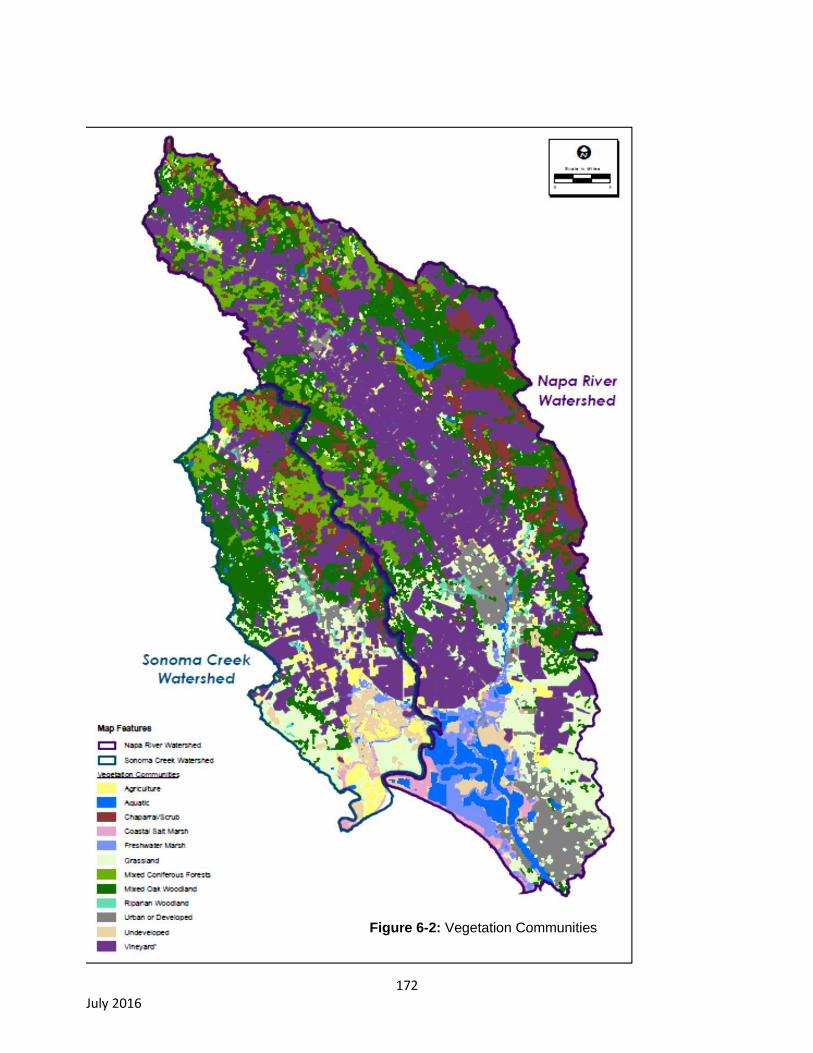
172 July 2016
Figure 6-2: Vegetation Communities

173 July 2016
Aquatic (including wetlands, springs, pools, creeks/streams, and open water)
The aquatic biotic community consists of freshwater wetland, salt marsh, streams, and reservoirs.
Wetlands (freshwater and salt marsh) of a variety of sizes and types occur throughout the Napa River
and Sonoma Creek watersheds. Freshwater wetlands are typically smaller in size and are distributed
through both watersheds. The unique wetlands occurring in the watersheds include vernal pools,
springs, and seeps. Salt marshes occur in the southern portion of the watersheds and cover a large
area at the entrance to San Pablo Bay (Figure 6-2.) (Jones & Stokes Associates, 2005a; Sonoma
County 2006). Further discussion of salt marshes is discussed below.
Diverse open water aquatic habitats occur throughout the Napa River and Sonoma Creek watersheds.
These include streams ranging from narrow mountain streams to broad lowland rivers and several
drainages with no riparian vegetation present supporting anadromous fisheries (Napa County, 2007;
Sonoma County, 2006).
Coastal Salt Marsh
Coastal salt marsh is a biotic community found at the most southern portion of the Napa River and
Sonoma Creek watersheds along the edge of the San Pablo Bay. Salt marshes include saltgrass-
pickleweed salt marsh and the related habitat of riverine, lacustrine, and tidal mudflats. Salt marsh in
both watersheds is typically dominated by salt grass (Distichlis spicata) and pickleweed (Salicornia sp.).
Wildlife species such as California black rail (Laterallus jamaicensis coturniculus), endangered
California clapper rail (Rallus longirostris), and endangered salt marsh harvest mouse
(Reithrodontomys raviventris) are endemic to coastal salt marsh (Napa County, 2007; Sonoma County,
2006).
Freshwater Marsh
Freshwater wetlands are distributed in most major valleys throughout the Napa River and Sonoma
Creek watersheds in low depressions and swales. Freshwater wetlands include bulrush-cattail
freshwater marsh and Carex-Juncus wet meadow grasses. Vernal pools are a subcategory of
freshwater wetlands.
Chaparral/Scrub
Chaparral/scrub is also a common biotic community within the Napa River and Sonoma Creek
watersheds. Chaparral/scrub is dominated by woody shrubs with few trees occurring mostly on south
and southwest-facing slopes. Common chaparral/scrub communities may include: chamise chaparral,
leather oak-white leaf manzanita-chamise (serpentine chaparral), and scrub interior live oak-scrub oak
(Jones & Stokes Associates, 2005a; Sonoma County 2006).
Grassland
Grassland is a common biotic community within the Napa River and Sonoma Creek watersheds. Four
common grassland communities may occur within the counties: annual grassland, native grassland,
valley needlegrass, and serpentine (bunchgrass) grassland. Native grassland and serpentine
(bunchgrass) grassland are considered sensitive natural communities by CDFW, and vernal pools
(another sensitive natural community) are also found in some of the grassland areas. Vernal pools
provide habitat for several special-status species (Jones & Stokes Associates, 2005a; Sonoma County
2006).
174 July 2016
Mixed Coniferous Forests
Coniferous forests are also a relatively common biotic community within the Napa River and Sonoma
Creek watersheds. There are 11 types of coniferous forest that may occur within the watersheds: four
are Douglas-fir/redwood forest types, five are pine forest types, and two are cypress woodland. Four
types of forest are considered sensitive communities by CDFW: Sargent cypress woodland, McNab
cypress woodland, redwood forest, and old-growth Douglas-fir-Ponderosa pine forest. Additionally,
Ponderosa pine forests are considered local sensitive communities because they are rare within the
counties, and foothill pine forests are also considered rare within the counties (Jones & Stokes
Associates, 2005a; Sonoma County 2006).
Mixed Oak Woodland
Oak woodland is the most common biotic community within the Napa River and Sonoma Creek
watersheds. Common oak woodland types are mixed oak, coast live oak (Quercus agrifolia), interior live
oak (Quercus wislizini), and blue oak (Quercus doulgasii) (Jones & Stokes Associates, 2005a; Sonoma
County 2006).
Riparian Woodland
Riparian woodlands and forest are considered rare biotic communities within the Napa River and
Sonoma Creek watersheds (Figure 6-2.). Riparian woodlands and forests occur along riparian and
stream corridors. Common riparian woodland types include valley oak woodland, California coast
redwood forest, and Douglas-fir forest (Jones & Stokes Associates, 2005a; Sonoma County, 2006).
6.1.2. Special-Status Species
Special-Status Plants
A high level of native plant diversity occurs in Napa and Sonoma counties. Several special-status plant
species have potential to occur within Napa and Sonoma counties. Documented occurrences according
to the CNDDB of special-status species within the Napa River and Sonoma Creek watersheds are
shown in Figure 6-3 (CNDDB Occurrences of Special-Status Plant Species).
A total of 59 special-status plant species have been documented within the Napa River watershed
and/or the Sonoma Creek watershed. Of the species documented, four are federally-listed endangered
and nine are federally-listed and state-listed endangered (Figure 6-3) (CDFW, 2014). There is also
critical habitat designated for federally listed endangered Contra Costa goldfields (Lasthenia conjugens)
and federally listed endangered Soft bird’s beak (Chloropyron molle ssp. molle) within the Napa River
watershed (Figure 6-4: Critical Habitat). Several of the special-status plants occur on specific substrates
such as alkaline or serpentine soils or within specific biotic communities such as oak woodlands or
chaparral (Napa County 2007). Thus, some areas within the watersheds provide better habitat for
special-status plants, and may have a higher chance for special-status species to occur. These areas
may include native grassland, serpentine (bunchgrass) grassland, and vernal pools, and wetlands
within grasslands, chaparral/scrub, and oak woodland.
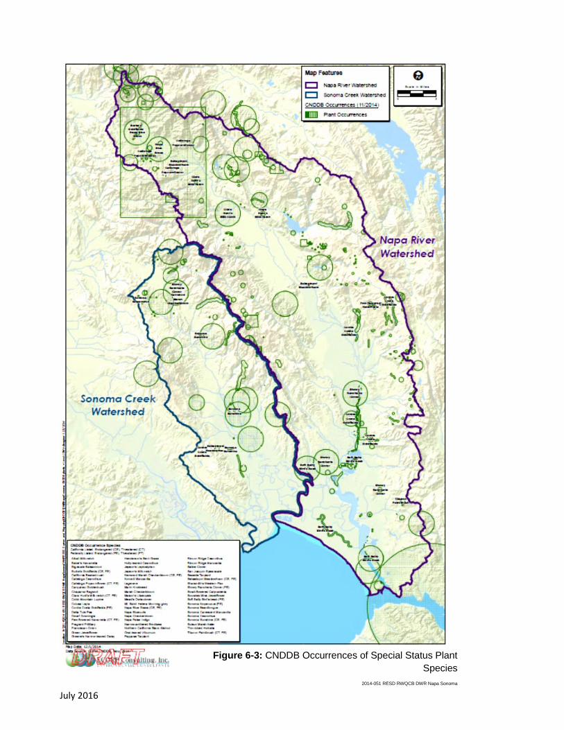
175 July 2016
Figure 6-3: CNDDB Occurrences of Special Status Plant
Species
2014-051 RESD RWQCB DWR Napa Sonoma

176 July 2016
Figure 6-4: Critical Habitat
2014-051 RESD RWQCB DWR Napa Sonoma
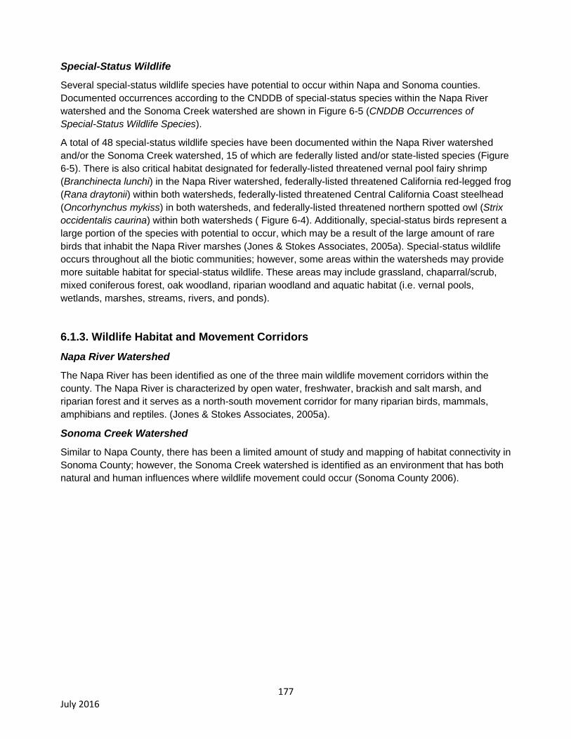
177 July 2016
Special-Status Wildlife
Several special-status wildlife species have potential to occur within Napa and Sonoma counties.
Documented occurrences according to the CNDDB of special-status species within the Napa River
watershed and the Sonoma Creek watershed are shown in Figure 6-5 (CNDDB Occurrences of
Special-Status Wildlife Species).
A total of 48 special-status wildlife species have been documented within the Napa River watershed
and/or the Sonoma Creek watershed, 15 of which are federally listed and/or state-listed species (Figure
6-5). There is also critical habitat designated for federally-listed threatened vernal pool fairy shrimp
(Branchinecta lunchi) in the Napa River watershed, federally-listed threatened California red-legged frog
(Rana draytonii) within both watersheds, federally-listed threatened Central California Coast steelhead
(Oncorhynchus mykiss) in both watersheds, and federally-listed threatened northern spotted owl (Strix
occidentalis caurina) within both watersheds ( Figure 6-4). Additionally, special-status birds represent a
large portion of the species with potential to occur, which may be a result of the large amount of rare
birds that inhabit the Napa River marshes (Jones & Stokes Associates, 2005a). Special-status wildlife
occurs throughout all the biotic communities; however, some areas within the watersheds may provide
more suitable habitat for special-status wildlife. These areas may include grassland, chaparral/scrub,
mixed coniferous forest, oak woodland, riparian woodland and aquatic habitat (i.e. vernal pools,
wetlands, marshes, streams, rivers, and ponds).
6.1.3. Wildlife Habitat and Movement Corridors
Napa River Watershed
The Napa River has been identified as one of the three main wildlife movement corridors within the
county. The Napa River is characterized by open water, freshwater, brackish and salt marsh, and
riparian forest and it serves as a north-south movement corridor for many riparian birds, mammals,
amphibians and reptiles. (Jones & Stokes Associates, 2005a).
Sonoma Creek Watershed
Similar to Napa County, there has been a limited amount of study and mapping of habitat connectivity in
Sonoma County; however, the Sonoma Creek watershed is identified as an environment that has both
natural and human influences where wildlife movement could occur (Sonoma County 2006).
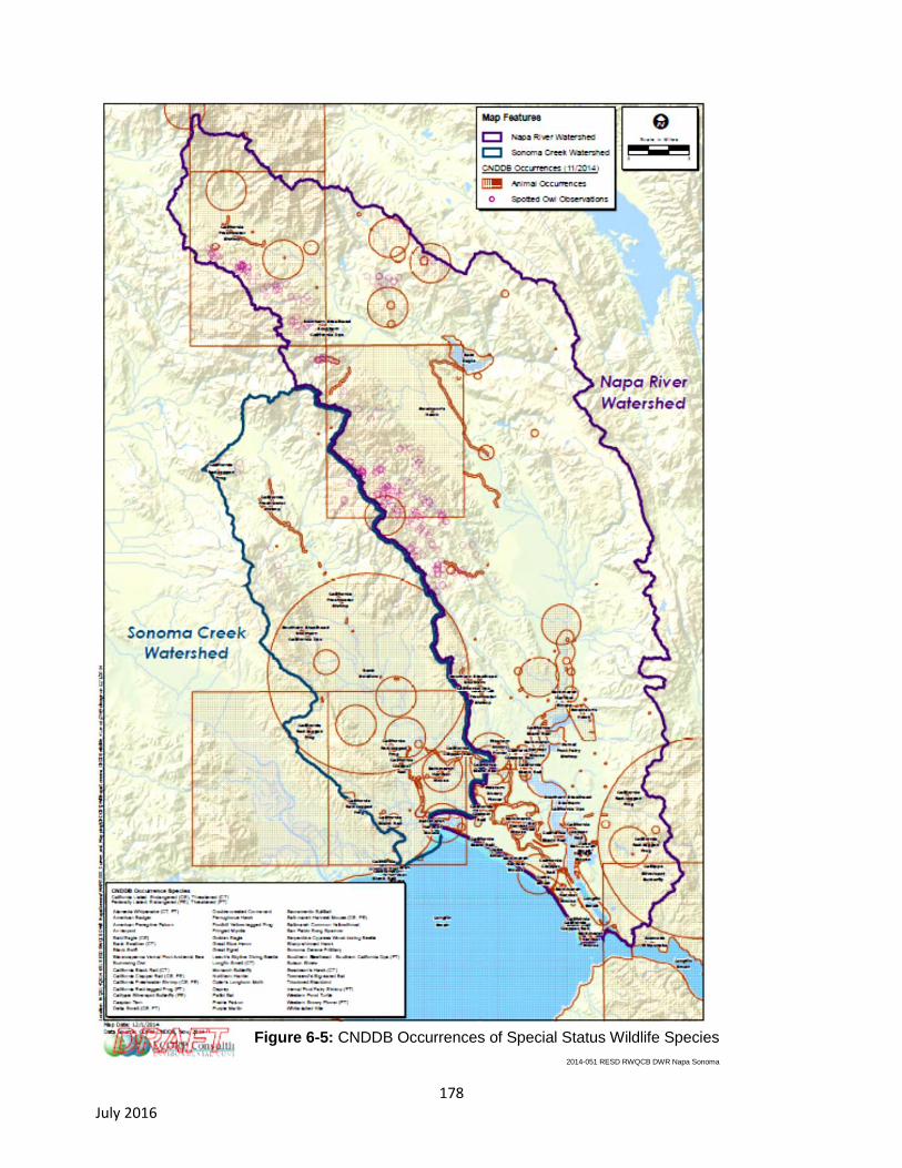
178 July 2016
Figure 6-5: CNDDB Occurrences of Special Status Wildlife Species
2014-051 RESD RWQCB DWR Napa Sonoma
179 July 2016
6.2. Regulatory Setting
The following local, state, and federal government agencies have regulatory authorities that govern the
protection of biological resources.
6.2.1. Federal Regulations
Federal Endangered Species Act
The Federal Endangered Species Act (FESA) protects plants and animals that are listed as endangered
or threatened by the United States Fish and Wildlife Service (USFWS) and the National Marine
Fisheries Service (NMFS). Section 9 of FESA prohibits the taking of listed wildlife, where take is defined
as “harass, harm, pursue, hunt, shoot, wound, kill, trap, capture, collect, or attempt to engage in such
conduct” (16 U.S.C §§ 1532(1), 1538.). For plants, this statute governs removing, possessing,
maliciously damaging, or destroying any listed plant on federal land and removing, cutting, digging up,
damaging, or destroying any listed plant on non-federal land in knowing violation of state law. Under
Section 7 of FESA, federal agencies are required to consult with the USFWS if their actions, including
permit approvals or funding, could adversely affect a listed (or proposed) species (including plants) or
its critical habitat. (16 U.S.C. § 1536.) Through consultation and the issuance of a biological opinion
(BO), the USFWS may issue an incidental take statement allowing take of the species that is incidental
to an otherwise lawful activity provided the activity will not jeopardize the continued existence of the
species. Section 10 of FESA provides for issuance of incidental take permits for non-federal activities,
provided a habitat conservation plan is developed. (16 U.S.C. § 1539.)
Section 7
Section 7 of the FESA mandates that all federal agencies consult with USFWS and/or NMFS to ensure
that federal agencies’ actions do not jeopardize the continued existence of a listed species or adversely
modify critical habitat for listed species. If direct and/or indirect effects will occur to critical habitat that
appreciably diminish the value of critical habitat for both the survival and recovery of a species, the
adverse modifications will require formal consultation with USFWS or NMFS. If adverse effects are
likely, the applicant must conduct a biological assessment (BA) for the purpose of analyzing the
potential effects of the project on listed species and critical habitat to establish and justify an "effect
determination." The federal agency reviews the BA; if it concludes that the project may adversely affect
a listed species or its habitat, it prepares a BO. The BO may recommend "reasonable and prudent
alternatives" to the project to avoid jeopardizing or adversely modifying habitat.
Critical Habitat and Essential Habitat
Critical habitat is defined in Section 3 of the FESA as (1) the specific areas within the geographical area
occupied by a species, at the time it is listed in accordance with the FESA, on which are found those
physical or biological features essential to the conservation of the species and that may require special
management considerations or protection; and (2) specific areas outside the geographical area
occupied by a species at the time it is listed, upon a determination that such areas are essential for the
conservation of the species. For inclusion in a critical habitat designation, habitat within the
geographical area occupied by the species at the time it was listed must first have features that are
essential to the conservation of the species. Critical habitat designations identify, to the extent known
and using the best scientific data available, habitat areas that provide essential life cycle needs of the
species (areas on which are found the primary constituent elements). Primary constituent elements are
180 July 2016
the physical and biological features that are essential to the conservation of the species and that may
require special management considerations or protection. These include but are not limited to the
following:
Space for individual and population growth and for normal behavior;
Food, water, air, light, minerals, or other nutritional or physiological requirements;
Cover or shelter;
Sites for breeding, reproduction, or rearing (or development) of offspring; and
Habitats that are protected from disturbance or are representative of the historic, geographical,
and ecological distributions of a species.
Excluded essential habitat is defined as areas that were found to be essential habitat for the survival of
a species and assumed to contain at least one of the primary constituent elements for the species but
were excluded from the critical habitat designation. The USFWS has stated that any action within the
excluded essential habitat that triggers a federal nexus will be required to undergo the Section 7(a)(1)
process, and the species covered under the specific critical habitat designation would be afforded
protection under Section 7(a)(2) of the FESA. As illustrated in Figure 6-4, critical habitat has been
designated within the project area for California red-legged frog, northern spotted owl, vernal pool fairy
shrimp, Contra Costa goldfields, soft bird’s beak, and central California coast steelhead.
Migratory Bird Treaty Act
The Migratory Bird Treaty Act (MBTA) implements international treaties between the United States and
other nations devised to protect migratory birds, any of their parts, eggs, and nests from activities such
as hunting, pursuing, capturing, killing, selling, and shipping, unless expressly authorized in the
regulations or by permit. As authorized by the MBTA, the USFWS issues permits to qualified applicants
for the following types of activities: falconry, raptor propagation, scientific collecting, special purposes
(rehabilitation, education, migratory game bird propagation, and salvage), take of depredating birds,
taxidermy, and waterfowl sale and disposal. The regulations governing migratory bird permits can be
found in 50 CFR part 13 General Permit Procedures and 50 CFR part 21 Migratory Bird Permits. The
State of California has incorporated the protection of birds of prey in Sections 3800, 3513, and 3503.5
of the California Department of Fish and Game (CDFG) Code.
Federal Clean Water Act
The federal Clean Water Act’s (CWA) purpose is to “restore and maintain the chemical, physical, and
biological integrity of the nation’s waters.” The federal Clean Water Act establishes water quality
standards including beneficial uses, as described in the Basin Plan for the San Francisco Bay Region
that have been adopted in part to protect uses of water that relate to biological resources including
areas of special biological significance; rare, threatened, or endangered species; cold freshwater
habitat; marine habitat; fish migration; fish spawning; warm freshwater habitat; and wildlife habitat
(Water Board, 2015).
Section 404 of the CWA prohibits the discharge of dredged or fill material into “waters of the United
States” without a permit from the U.S. Army Corps of Engineers (USACE). The definition of waters of
the U.S. includes rivers, streams, estuaries, the territorial seas, ponds, lakes, and wetlands. Wetlands
are defined as those areas “that are inundated or saturated by surface or ground water at a frequency
and duration sufficient to support, and that under normal circumstances do support, a prevalence of
vegetation typically adapted for life in saturated soil conditions” (33 CFR § 328.3 7b). The U.S.
181 July 2016
Environmental Protection Agency (EPA) also has authority over wetlands and may override a USACE
permit.
Impacts to wetlands may require an individual permit. Projects that only minimally affect wetlands may
meet the conditions of one of the existing Nationwide Permits. A Water Quality Certification or waiver
pursuant to Section 401 of the CWA is required for Section 404 permit actions; this certification or
waiver is issued by the Water Board.
The CWA regulations require compliance with the National Pollutant Discharge Elimination System
(NPDES), including compliance with the California Storm Water NPDES General Construction Permit
for discharges of storm water runoff associated with construction activities. General Construction
Permits for projects that disturb one or more acres of land require development and implementation of a
Storm Water Pollution Prevention Plan (SWPPP).
6.2.2. State or Local Regulations
California Fish and Game Code
California Endangered Species Act
The California Endangered Species Act (CESA) (Fish and Game Code sections 2050-2116) generally
parallels the main provisions of the FESA, but unlike its federal counterpart, CESA applies the take
prohibitions to species proposed for listing (called “candidates” by the state). Section 2080 of the CDFG
Code prohibits the taking, possession, purchase, sale, and import or export of endangered, threatened,
or candidate species, unless otherwise authorized by permit or in the regulations. Take is defined in
section 86 of the Fish and Game Code as “hunt, pursue, catch, capture, or kill, or attempt to hunt,
pursue, catch, capture, or kill.” CESA allows for take incidental to otherwise lawful development projects
only as permitted under the conditions of an incidental take permit issued by the California Department
of Fish and Wildlife. The Water Board has no authority to permit take of any protected species. State
lead agencies are required to consult with the California Department of Fish and Wildlife (CDFW) to
ensure that any action they undertake is not likely to jeopardize the continued existence of any
endangered, threatened or candidate species or result in destruction or adverse modification of
essential habitat.
Fully Protected Species
The State of California first began to designate species as “fully protected” prior to the creation of the
CESA and FESA. Lists of fully protected species were initially developed to provide protection to those
animals that were rare or faced possible extinction, and included fish, amphibians and reptiles, birds,
and mammals. Most fully protected species have since been listed as threatened or endangered under
CESA and/or FESA. The regulations that implement the Fully Protected Species Statute (Fish and
Game Code section 4700 for mammals, section 3511 for birds, section 5050 for reptiles and
amphibians, and section 5515 for fish) provide that fully protected species may not be taken or
possessed at any time. Furthermore, CDFW prohibits any state agency from issuing incidental take
permits for fully protected species (CDFW Code Section 2053). CDFW will issue licenses or permits for
take of these species for necessary scientific research or live capture and relocation pursuant to the
permit.

182 July 2016
Native Plant Protection Act
The Native Plant Protection Act (NPPA) of 1977 was created with the intent to “preserve, protect and
enhance rare and endangered plants in this State.” The NPPA is administered by CDFW and governed
by Fish and Game Code Sections 1900-1913. The Fish and Wildlife Commission has the authority to
designate native plants as “endangered” or “rare” and to protect endangered and rare plants from take.
The CESA of 1984 (Fish and Game Code sections 2050-2116) provided further protection for rare and
endangered plant species, but the NPPA remains part of the Fish and Game Code.
Birds of Prey
Sections 3800, 3513, and 3503 of the California Department of Fish and Game (CDFG) Code
specifically protect birds of prey. Section 3800 states that it is unlawful to take nongame birds, such as
those occurring naturally in California that are not resident game birds, migratory game birds, or fully
protected birds, except when in accordance with regulations of the commission or a mitigation plan
approved by CDFW for mining operations. Section 3513 specifically prohibits the take or possession of
any migratory nongame bird as designated in the MBTA.
Section 3503 of the Fish and Game Code prohibits the take, possession, or needless destruction of the
nest or eggs of any bird. Additionally, section 3503.5 prohibits the take, possession, or destruction of
any birds and their nests in the orders Strigiformes (owls) or Falconiformes (hawks and eagles). These
provisions, along with the federal MBTA, serve to protect nesting native birds.
California Streambed Alteration Notification/Agreement
Section 1602 of the Fish and Game Code requires that a Streambed Alteration Application (SAA) be
submitted to CDFW for “any activity that may substantially divert or obstruct the natural flow or
substantially change the bed, channel, or bank of any river, stream, or lake.” CDFW reviews the
proposed actions and, if necessary, submits proposed measures to protect affected fish and wildlife
resources to the applicant. The final proposal that is mutually agreed-upon by CDFW and the Applicant
is the SAA. Often, projects that require a SAA also require a permit from the USACE under section 404
of the CWA. In these instances, the conditions of the section 404 permit and the SAA overlap.
Species of Special Concern
Species of Special Concern (SSC) are defined by the CDFW (e.g., Pacific lamprey and Sacramento
hitch, CDFW, 2015; western pond turtle, CDFG, 1994) as a species, subspecies, or distinct population
of an animal native to California that are not legally protected under FESA, CESA or the Fish and Game
Code, but currently satisfies one or more of the following criteria:
the species has been completely extirpated from the state or, as in the case of birds, it has been
extirpated from its primary seasonal or breeding role;
the species is listed as federally (but not state) threatened or endangered, or meets the state
definition of threatened or endangered but has not formally been listed;
the species has or is experiencing serious (noncyclical) population declines or range retractions
(not reversed) that, if continued or resumed, could cause it to qualify for state threatened or
endangered status;
the species has naturally small populations that exhibit high susceptibility to risk from any factor
that, if realized, could lead to declines that could cause it to qualify for state threatened or
endangered status.

183 July 2016
SSC are typically associated with habitats that have been fragmented and/or significantly reduced in
area and/or quality as a result of development. Project-related impacts to SSC, state-threatened or
endangered species are considered “significant” under the California Environmental Quality Act
(CEQA).
California Plant Ranks
The California Native Plant Society (CNPS) maintains the Inventory of Rare and Endangered Plants of
California (CNPS, 2014), which provides a list of plant species native to California that are threatened
with extinction, have limited distributions, and/or low populations. Plant species meeting one of these
criteria are assigned to one of six California Rare Plant Ranks that range from a “watch” list to those
presume extirpated in California. The rank system was developed in collaboration with government,
academia, non-governmental organizations, and private sector botanists, and is jointly managed by
CDFW and the CNPS. The California Rare Plant Ranks are currently recognized in the California
Natural Diversity Database (CNDDB).
Additionally, the CNPS has defined Threat Ranks that are added to the California Rare Plant Rank as
an extension. Threat Ranks designate the level of threat on a scale of one through three, with one being
the most threatened and three being the least threatened.
Factors, such as habitat vulnerability and specificity, distribution, and condition of occurrences, are
considered in setting the Threat Rank, and differences in Threat Ranks do not constitute additional or
different protection (CNPS, 2014).
Substantial impacts to plants ranked 1A, 1B, or 2 are considered significant under CEQA Guidelines
Section 15380. Significance under CEQA is typically evaluated on a case-by-case basis for plants
ranked 3 or 4.
Porter-Cologne Water Quality Control Act
The Water Board implements water quality laws and regulations under the federal CWA (discussed
above) and the State Porter-Cologne Water Quality Control Act (Porter-Cologne). Under Porter-
Cologne, the Water Board is the principal state agency with responsibility for the coordination and
control of water quality in the San Francisco Bay area, including issuing waste discharge requirements
(WDRs) to any person “discharging waste, or proposing to discharge waste, with any region that could
affect the water of the state” (Water Code, § 13260(a)). Waters of the State are defined as “any surface
water or groundwater, including saline waters, within the boundaries of the state” (Water Code, §
13050(e)). The Water Board also regulates dredging, filling, or discharging materials into waters of the
State that are not regulated by the USACE due to a lack of connectivity with a navigable water body.
The Water Board may require issuance of WDRs for these activities. The Water Board is authorized to
prescribe General Permit for a category of discharges (such as vineyards) if it determines that the
discharges are produced by the same or similar operations, involve similar types of waste, require the
same or similar treatment standards and are more appropriately regulated under general discharge
requirements than individual discharge requirements.
California Environmental Quality Act
Per the CEQA Guidelines’ Section 15380 a species not protected on a federal or state list may be
considered rare or endangered if the species meets certain specified criteria. These criteria follow the
definitions in FESA, CESA and Sections 1900-1913 of the Fish and Game Code, which deal with rare
or endangered plants or animals. Section 15380 was included in the Guidelines primarily to deal with
184 July 2016
situations where a project under review may have a significant effect on a rare or endangered species
that has not yet been listed by either the USFWS or CDFW.
6.2.3. County Regulations and Policies
Napa County General Plan
The Conservation Element of the Napa County General Plan has several goals and policies geared
towards to conservation and preservation of natural resources within Napa County. The following is a
list of ordinances that may be applicable to the Proposed Project. A full description of all goals and
polices pertaining to natural resources can be found in Conservation Element Napa County General
Plan.
Napa County Code of Ordinances
The following ordinances are taken from the Napa County Code of Ordinances and may be applicable
to the Proposed Project (Napa County, 2014).
Chapter 18.108 – Conservation Regulations
18.108.100 0 Erosion hazard areas – Vegetation preservation and replacement
Whenever a project within an erosion hazard area requires issuance of a discretionary permit such as a
use permit or an administrative permit including, but not limited to, building permits, grading permits,
erosion control plans, permits in compliance with the NPDES program and sewage disposal system
permits, the permit shall be subject to conditions governing preservation of existing vegetation, removal
of vegetation where necessary and authorized, and replanting of vegetation.
Sonoma County General Plan
The Open Space and Conservation Element of the Sonoma County General Plan 2020 has several
goals, objectives and policies geared towards to conservation and preservation of natural resources
within Sonoma County. The following is a list of ordinances that may be applicable to the Proposed
Project. A full description of all goals and objectives pertaining to natural resources can be found in
Open Space and Conservation Element Sonoma County General Plan.
Sonoma County Code of Ordinances
The following ordinance is taken from the Sonoma County Code of Ordinances and may be applicable
to the Proposed Project (Sonoma County, 2014).
Chapter 11 – Grading, Drainage, and Vineyard and Orchard Site Development
New vineyard development and replants in Sonoma County are guided by the Grading, Drainage, and
Vineyard and Orchard Site Development Ordinance (VESCO). The Sonoma County Agricultural
Commissioner’s Office implements and enforces VESCO. In most cases, permits are ministerial
provided that standard terms and conditions of the permits that are intended to protect the environment
are incorporated including the requirement to prepare a biological survey to protect all listed species
from significant impacts.
VESCO requires a permit for any grading, drainage improvement, or site development associated with
new or replanted vineyards. VESCO permits are issued at two levels that take into account soil type,
soil erosivity, and slope as follows (Sonoma County Code, Chapter 11.08.010):

185 July 2016
Level I – Applies to new vineyards or replants developed on slopes less than or equal to 10 to 15
percent and does not require ECP documentation or verification of project completion.
Level II – Applies to new vineyards or replants on slopes greater than 10 or 15 percent and
requires the project proponent to submit an ECP that is reviewed by the VESCO staff. VESCO staff
conducts post-construction review to confirm that ECP design plans were followed and implemented
appropriately.
Both Level I and Level II projects are required to adhere to the best management practices and
standards described in the Best Management Practices for Agricultural Erosion and Sediment Control
manual (Sonoma County Agricultural Commissioner’s Office, 2010).
Chapter 26D – Heritage or Landmark Trees
Sec. 26D-5. – Permit processing procedures.
This ordinance establishes procedures governing removal of or possible damage to a heritage or
landmark tree or trees.
6.3. Environmental Analysis
6.3.1. Approach and Methods
The purpose of this section is to (1) assess the potential for occurrence of special-status plant and
animal species, or their habitat, and sensitive habitats such as wetlands within the project area and (2)
determine whether the Project would have a significant impact on these resources. Due to the large
size of the proposed project area, spanning two counties, a site reconnaissance survey is not
practicable and was not conducted. The analysis is based upon a literature review and database
queries.
In this section, special-status species are defined as plants or animals that:
Are listed, proposed for listing, or candidates for future listing as threatened or endangered
under the federal ESA;
Are listed or candidates for future listing as threatened or endangered under the California ESA;
Meet the definitions of endangered or rare under Section 15380 of CEQA;
Are identified as a species of special concern by CDFW;
Are birds identified as birds of conservation concern by the USFWS;
Are plants considered by the CNPS to be "rare, threatened, or endangered in California"
[California Rare Plant Rank (CRPR) 1 and 2];
Are plants listed as rare under the California Native Plant Protection Act (Fish and Game Code
of California, Section 1900 et seq.); or
Are fully protected in California in accordance with the Fish and Game Code of California,
Sections 3511 (birds), 4700 (mammals), 5050 (amphibians and reptiles), and 5515 (fishes).
Only species that fall into one of the above listed groups were considered for this assessment.
While other species (i.e. CRPR 3 or 4 species) are sometimes found in database searches or
186 July 2016
within the literature, these were not included within this analysis because these species are
considered part of the CNPS Watch List and there is limited data available regarding the
distribution of the species.
The following lists were queried to provide an overview of potential special-status species that
may occur in Napa and Sonoma counties:
USFWS Federal Endangered and Threatened Species that may be affected by projects in Napa
and Sonoma counties
CNPS electronic Inventory of Rare and Endangered Plants of California was queried for the
Napa and Sonoma counties
To narrow the focus of potential special-status species to the vicinity of the proposed project area, the
CDFW CNDDB was also queried to determine the special-status species that had been documented
within the boundaries of the Napa River and Sonoma Creek watersheds.
Additional background information was reviewed regarding the documented or potential occurrence of
special-status species and descriptions of biotic communities within or in the vicinity of the proposed
project area from the following sources:
Napa County General Plan Draft Environmental Impact Report
Napa County General Plan
Sonoma County General Plan Draft Environmental Impact Report
Sonoma County General Plan
6.3.2. Thresholds of Significance
An impact to biological resources is considered significant if it would result in any of the following
issues:
Have a substantial adverse effect, either directly or through habitat modifications on any species
identified as a candidate, sensitive, or special-status species in local or regional plans, policies,
or regulations, or by CDFW or USFWS;
Have a substantial adverse effect on any riparian habitat or sensitive natural community
identified in local or regional plans, policies, regulations, or by CDFW or USFWS;
Have a substantial adverse effect on federally protected wetlands as defined by Section 404 of
the Clean Water Act (including, but not limited to, marsh, vernal pool, coastal, etc.) through
direct removal, filling, hydrological interruption, or other means;
Interfere substantially with the movement of any native resident or migratory fish or wildlife
species or with established native resident or migratory wildlife corridors, or impede the use of
native wildlife nursery sites;
Conflict with any local policies or ordinances protecting biological resources, such as at tree
preservation policy or ordinance;
Conflict with the provisions of an adopted Habitat Conservation Plan, Natural Community
Conservation Plan, or other approved local, regional, or state habitat conservation plan.
187 July 2016
6.3.3. Impacts and Mitigation Measures
In the section that follows, we evaluate and identify potential impacts to biological resources that could
occur as a result of actions taken to comply with the proposed project (General Permit) or any of the
project alternatives (e.g., implementation of the General Permit at fewer sites and/or over a more limited
geographic area). As described in detail below, at almost all Vineyard Properties, potential impacts to
biological resources would be less than significant. However, two types of potential impacts to biological
resources could occur under the proposed project or any of the project alternatives including:
1) At a small number of vineyard properties, noise generated by heavy equipment used to
construct BMPs on existing or new unpaved roads, and/or to construct detention basins, could
disrupt breeding and/or nesting by special-status bird species, where heavy equipment is
used in the nesting season and within ¼-mile of a nest site; and
2) At a small number of hillslope vineyard properties and none of the valley-floor vineyard
properties, detention basins could be built in previously undeveloped sites, a fraction of
which may overlap with defined sensitive natural communities and/or special-status
species or their habitats.
Also, as described below, we note that the proposed project or any of the project alternatives will have a
significant beneficial effect on aquatic and riparian habitat conditions, and defined sensitive natural
communities and special-status species therein, as a result of a significant reduction in fine sediment
deposition in channels and an increase in the extent of riparian vegetation.
Impact 6-1a Compliance with the General Permit will reduce sand and finer sediment delivery to
stream channels benefiting aquatic wildlife species
Road sediment discharge, and land-use related channel erosion, gullying, and landsliding will all be
reduced substantially (on average by 50 percent) within the vineyard properties enrolled in the permit.
We estimate that as much as 90 percent of planted vineyard acreage and about 70 percent of the total
vineyard property acreage would be enrolled in the permit or otherwise meet sediment and storm runoff
discharge performance standards.
As a result, sand concentration in the stream bed will be reduced, which in turn will enhance the quality
of spawning habitat and survival-to-emergence for Chinook salmon and steelhead (Water Board,
2009a, pp. 8, 9, 14, 42, and 60-67) and also for foothill yellow-legged frog (Ashton, 1997), which also
spawn and deposit their eggs in the streambed. The quality of rearing habitat for steelhead and Chinook
salmon also would be enhanced because a reduction in sand supply would:
a) Reduce the embeddedness of cobble and boulder substrate, making these spaces (between
the cobble and boulder substrate) available as refuges from predators (Suttle et al., 2004; and
also as described in Water Board, 2009a, p. 9);
b) Increase pool depth (Lisle and Hilton, 1999); and
c) Increase the biomass of invertebrates that are the preferred prey species for juvenile salmonids
(Suttle et al., 2004).
All of these changes would be beneficial with regard to growth and survival of juvenile salmonids.
Similarly, reduced embeddedness of cobble and boulder substrate and/or increase in pool depth would
enhance rearing conditions through improved cover and resultant reduction in predation for several
188 July 2016
other special status aquatic species including foothill yellow-legged frog (Ashton, 1997), California red-
legged frog (USFWS, 2002), California freshwater shrimp34
(Martin et al., 2009), and western pond
turtle (CDFW, no date).
The reduction in stream sedimentation would have a significant long-term beneficial impact on special
status aquatic wildlife species including steelhead, foothill yellow-legged frog, California red-legged frog,
western pond turtle; and also on populations of Chinook salmon, that are locally rare in Bay Area
streams.
Impact 6-1b Construction of BMPs could result in short-term erosion at construction sites,
temporary increases in fine sediment delivery to stream channels, and resultant sedimentation.
Short-term sedimentation increases could adversely affect some special-status aquatic wildlife
species.
As described in the evaluation of Impact 6-1a, although the long-term effect of BMP construction would
be a substantial reduction in the delivery of sand and finer sediment to stream channels, short-term
erosional adjustments could occur at some BMP sites following construction, which could cause
temporary increases in fine sediment delivery to channels. In particular, BMP construction projects in
channels including soil bioengineering techniques (BMP-12), decommissioning problem roads (BMP-
19), and/or construction of a new storm-proofed road (BMP-20) may be vulnerable to some erosional
adjustments during and soon after construction period until vegetation re-establishes at these sites.
Eroded sediment could be deposited in stream reaches that provide spawning and/or rearing habitat for
special-status including steelhead, California red-legged frog, foothill yellow-legged frog, and/or western
pond turtle, and/or Chinook salmon, which are locally rare in Bay Area streams. As discussed
previously in Impact 6-1a., the quality of spawning and/or rearing habitats for all of the above listed
these species can be significantly altered by sedimentation.
Summary
Increases in sedimentation could occur through erosional adjustments at BMP construction sites that
could adversely affect streambed characteristics for steelhead, Chinook salmon, California red-legged
frog, California freshwater shrimp, foothill yellow-legged frog, and/or western pond turtle. While these
impacts would be expected to be short-term and limited in scope, compliance actions that could have a
substantial adverse impact on habitat conditions for any of the special-status aquatic wildlife species
listed above would be considered a significant impact.
Mitigation Measures
Where BMP construction overlaps with and/or disturbs a stream channel, riparian area, and/or other
wetlands or waters of the United States35
, the Water Board would require the project proponent to
comply with Mitigation Measure BR-1: Where BMP construction and/or installation would overlap with
aquatic or riparian habitats, Mitigation Measure BR-1 requires project proponents to apply for a Clean
34
Increases in fine sediment deposition would reduce the rearing area within undercut banks that California freshwater shrimp use as refugia habitat.
35 Detention basins and constructed wetlands (BMP-10), Soil bioengineering techniques (BMP-11 and BMP-
12), decommissioning roads (BMP-19), and/or construction of new storm-proofed roads (BMP-20) all may overlap with jurisdictional areas.

189 July 2016
Water Act Section 401 permit authorization and waste discharge requirements, and also to comply with
the requirements thereof. Standard conditions of the Water Board CWA Section 401 permit and waste
discharge requirements include the requirements to comply with the terms and conditions of the CDFW
Streambed Alteration Agreement and the Section 7 consultations.
Projects subject to CWA Section 401 permits also are subject to Clean Water Act Section 404 permits
issued by the US Army Corps of Engineers, and also to Endangered Species Act Section 7
Consultations where species listed under the federal Endangered Species Act have the potential to
occur.
Where BMP construction activities overlap at all with aquatic and/or riparian habitats, they also are
subject to Streambed Alteration Agreements issued by the California Department of Fish and Wildlife
(CDFW), which would reduce impacts to all special-status species to a less than significant level.
To avoid significant increases in sediment delivery to channels (and resultant sedimentation) that could
arise from any construction activities undertaken to comply with the General Permit, the General Permit
also incorporates a suite of Construction Activity Controls (Mitigation Measures BR-2 through BR-8) to
avoid and minimize potential pollutant discharges that may be associated with construction activities
and/or post-construction erosion in areas that were disturbed including all of the following conditions
that are enforceable under the General Permit, as applicable to a given site.
Temporal Limitations on Construction (Mitigation Measure BR-2):
1. The timing of construction activities will take into consideration fisheries and other aquatic wildlife
usage in the project area. Construction activities will occur in the period between June 1 and October
15, unless (as applicable36
) CDFW, US Fish & Wildlife Service, and/or NOAA Fisheries define an
alternative work window to avoid site specific impacts on special-status species. Work in and around
streams that support anadromous fish populations or California freshwater shrimp may not begin until
June 15. Work beyond October 15 may be authorized on a site-specific basis with approval (as
applicable) from the Water Board, CDFW, USFWS, and/or NOAA Fisheries and provided the work
would be completed prior to first winter rains. Planting may occur after October 15, if success of
vegetation establishment is increased due to more favorable environmental conditions. Planting above
the ordinary high water line may occur at any time of the year.
2. Excavation and grading activities will occur only in dry weather periods. Upon completion of grading,
slope protection of all disturbed sites will be installed prior to the onset of rain.
3. Construction within 75 feet of established riparian vegetation will be avoided during the migratory bird
nesting season (February 15 to August 15). If work must occur during this period, a qualified biologist or
individual approved by CDFW will conduct a pre-construction survey for bird nests or nesting activity in
the project area. If active nests or nesting behavior are observed (for any species other than starlings
and house sparrows) an exclusion zone of 75 feet will be established to protect the nesting birds. If any
listed or sensitive bird species are identified, CDFW must be notified prior to further action. Take of
active bird nests is prohibited.
4. To protect California red-legged frog (CRLF) and/or foothill yellow-legged frog, all construction within
stream channels will take place during daylight hours. If suitable habitat is present for CRLF or foothill
yellow-legged frog, project activities will begin after July 1 to avoid impacts on breeding or egg masses.
36
In describing requirements under Mitigation Measures BR-2 through BR-8, “as applicable” refers to all projects (BMP construction/maintenance actions) that are subject to the requirement to obtain a permit from the agency that is indicated in the text that follows.
190 July 2016
Requirements for Construction Site Management (Mitigation Measure BR-3)
1. As feasible, use existing ingress or egress points. Placement of temporary access road, staging
areas, and other facilities will avoid or limit disturbance to habitat and will be restored to preconstruction
conditions.
2. Disturbance to existing grades and vegetation will be limited to the actual site of the conservation
project and necessary access routes.
3. Trash, litter, construction debris, cigarette butts, etc., will be stored in a designated portion of the
construction site (that does not overlap with or impact natural habitat areas), and/or will be removed
from the site at the end of each working day. Upon completion of work, contractor is responsible for
removing all trash, litter, construction debris, cigarette butts, etc.
4. All construction debris and sediments will be taken to appropriate landfills or, in the case of
sediments, disposed of in upland areas on- or offsite.
5. No petroleum products, chemicals, silt, fine soils, and any substances deleterious to fish, amphibian,
plant, or bird life will be allowed to pass into, or be placed where it can pass into the waters of the state.
6. Contractors will have emergency spill cleanup gear (spill containment and absorption materials) and
fire equipment available on site at all times.
7. The use or storage of petroleum-powered equipment will be accomplished in a manner to prevent the
potential release of petroleum materials into waters of the state (Fish and Game Code §5650).
8. All vehicles and equipment on the site must not leak any type of hazardous materials such as oil,
hydraulic fluid, or fuel. Fueling will take place outside of the riparian corridor.
9. As needed, a contained area located at least 50 feet from a watercourse will be designated for
equipment storage, short-term maintenance, and refueling. If possible, these activities will not take
place on the project site.
10. Vehicles will be inspected for leaks and repaired immediately. Leaks, drips, and other spill will be
cleaned up immediately to avoid soil or groundwater contamination. Major vehicle maintenance and
washing will be done off site. All spent fluids, including motor oil, radiator coolant, or other fluids, and
used vehicle batteries will be collected, stored, and recycled as hazardous waste off site. Dry cleanup
methods (i.e., absorbent materials, cat litter, and/or rags) will be available on site. Spilled dry materials
will be swept up immediately
11. Best management practices for construction period runoff and erosion control will be employed as
described in Requirements for Erosion Control below.
Requirements for Erosion Control (Mitigation Measure BR-4)
1. Best management practices for construction period runoff and erosion control will be employed.
2. Erosion control and/or sediment detention devices will be incorporated into the project design and
implemented at the time of construction. These devices will be in place prior to October 15 for the
purposes of minimizing fine sediment input to flowing water. These devices will be placed at all
locations where the likelihood of sediment input exists. Sediment collected in these devices will be
191 July 2016
disposed of away from the collection site and above the normal high water mark. These devices will be
inspected regularly to ensure they are functioning properly.
3. The project site will be restored to pre-construction condition or better. Disturbed areas will be
revegetated prior to the onset of rain by live planting, native seed casting, or hydro-seeding. See also
Limitations on Construction Equipment, Earthmoving, and Vegetation Removal sections below.
4. When implementing or maintaining a critical area planting37
above the high water line, a filter fabric
fence, biodegradable fiber rolls, gravel bars, and/or hay bales will be utilized, if needed, to keep
sediment from flowing into the adjacent waterbody. At the time vegetation is sufficiently mature to
provide erosion control, it may be appropriate to remove the fence, fiber rolls and/or hay bales. Annual
review by the vineyard owner/operator and/or their representative(s) will occur until the critical area
planting is established to control erosion.
5. All debris, sediment, rubbish, vegetation, or other material removed from the channel banks, channel
bottom, or sediment basins will be removed to a location where they will not re-enter the waters of the
state.
6. Soil exposed as a result of construction and soil above rock riprap will be revegetated using native
seed casting or by hydro-seeding prior to the onset of rain. In general, interstitial spaces between rocks
will be planted with riparian vegetation such as willows rather than hydro-seeded.
7. Discharge of decant water from any onsite temporary sediment stockpile or storage areas or any
other discharge of construction dewatering flows to surface waters, except as described in Limitations
to Work in Streams and Permanently Ponded Areas below, outside of the active dredging site is
prohibited.
8. Inspect performance of sediment control devices at least once each day during construction to
ensure the devices are functioning properly.
Limitations on Construction Equipment (Mitigation Measure BR-5)
1. When possible, use existing ingress or egress points, and work will be performed from the top of
creek banks.
2. When heavy equipment is used, woody debris and vegetation on banks and in the channel will not be
disturbed if outside of the project’s scope.
3. Heavy equipment will not be used in a flowing stream, creek, or ponded area, except to cross a
stream or pond to access the work site.
4. Heavy equipment use in a streambed is only permissible when the streambed is dry. The amount of
time heavy equipment is stationed, working, or traveling within the creek bed will be minimized.
5. Use of heavy equipment will be avoided in a channel bottom with rocky or cobbled substrate. If
access to the work site requires heavy equipment to travel on a rocky or cobbled substrate, a rubber tire
loader/backhoe is the preferred vehicle.
Limitations on Earthmoving (Mitigation Measure BR-6)
1. Finished grades will not exceed 2:1 side slopes.
37
A critical area planting involves establishing permanent vegetation on sites that have or are expected to have, high erosion rates.
192 July 2016
2. Excavated material not used in the implementation of the BMP will be removed out of the 100-year
flood plain.
3. Placement of temporary access roads, staging areas, and other facilities will avoid or limit
disturbance to habitat and will be restored to pre-construction conditions.
4. Road improvement projects will be modeled on the “Handbook for Forest and Ranch Roads: A Guide
for planning, designing, constructing, reconstructing, maintaining and closing wildland roads,” (Weaver
et al., 2014).
5. If the substrate of a seasonal pond, creek, stream or waterbody is altered during work activities, it will
be returned to approximate pre-construction conditions after the work is completed, unless (as
applicable) NOAA Fisheries and/or CDFW determine that other measures should be implemented.
6. Overhanging banks within potential California freshwater shrimp habitat will remain undisturbed.
Limitations on Vegetation Removal and Replanting Requirements (Mitigation Measure BR-7)
1. The spread or introduction of exotic plant species will be avoided to the maximum extent possible by
avoiding areas with established native vegetation during project activities, restoring disturbed areas with
native species where appropriate, and performing post-project monitoring and control of exotic species.
2. Removal of invasive exotic species is strongly recommended. Removal using hand tools, including
chainsaws and weed-whackers, and hand pulling of exotics will be done in preparation for
establishment of native plantings. To the extent possible, revegetation will be implemented at the same
time removal of exotic vegetation occurs. If giant reed (Arundo donax) is removed, cuttings will be
disposed of in a manner that will not allow reseeding to occur.
3. Disturbance of native shrubs or woody perennials or removal of trees from streambanks or stream
channels will be avoided or minimized; if native riparian vegetation will be disturbed, it will be replaced
with similar native species.
4. Except (as applicable) with approval from CDFW, there will be no cutting or removal of native trees 4”
or greater diameter at breast height (DBH), except willows, for which there will be no cutting or removal
of trees 6” or greater DBH. Exotic trees that are causing habitat damage or hazardous situations may
be removed with approval of the project biologist. Any exotic trees removed will be replaced with
appropriate natives. For any permitted tree removal, the root structure will be left intact unless (as
applicable) removal is authorized by CDFW.
5. If native trees over 6” DBH are to be removed (with approval from CDFW), they will be replaced at a
3:1 ratio.
6. Projects within potential California red-legged frog habitat will be designed to minimize disturbance to
vegetation near or in permanent and seasonal pools of streams, marshes, ponds, or shorelines with
extensive emergent or weedy vegetation.
7. Project activities in areas of potential California freshwater shrimp habitat will avoid removal of or
damage to overhanging vegetation along stream channels.
8. Hand labor will be used to trim vegetation within the channel or on the bank. Handheld equipment
such a weed-whackers and chainsaws are authorized.
9. Native plants characteristic of the local habitat type will be the preferred alternative when
implementing and maintaining the BMPs in natural areas. When specified, as required by the regulatory
193 July 2016
agencies, only native plant species will be used. Under special circumstances, regulators may allow for
the use of non-invasive, non-persistent grass species.
10. All areas disturbed by the project or in which vegetation was removed will be restored to a natural
state with native trees, shrubs, and/or grasses. Barren areas will typically be planted with a combination
of willow stakes, native shrubs, and trees and/or erosion control grass mixes.
11. For projects that have removed native vegetation, post-construction revegetation success will be
equivalent to or better than the pre-project conditions. If, after 5 years, that level of success has not
been achieved, the vineyard owner/operator or their representative(s) will consult with CDFW to
develop and implement measures to achieve success.
12. If needed, an irrigation system will be installed to ensure establishment of vegetation; when
vegetation is sufficiently established, irrigation materials will be removed.
13. The project area will be restored to pre-construction conditions or better.
Limitations on Work in Streams and Permanently Ponded Areas (Mitigation Measure BR-8)
1. In specific cases where it is deemed necessary to work in a flowing stream/creek, the work area will
be isolated, and all flowing water will be temporarily diverted around the work site to maintain
downstream flows during construction. A qualified biologist will prepare a species protection and
dewatering plan and be present for all dewatering and re-watering events. The plan will be prepared
with guidance (as applicable) from NOAA Fisheries and/or CDFW. When construction is completed, the
flow diversion structure will be removed in a manner that will allow flow to resume with the least
disturbance to the substrate and water quality.
Impact significance after mitigation
Mitigation Measures BR-1 through BR-8 would reduce the amount of sediment transported to streams
as a result of BMP construction to a less than significant level. The small amount of sediment that would
enter streams after implementing the construction activity controls would not be expected to adversely
affect any special-status aquatic wildlife species. As a result, the short-term construction-related
impacts would be reduced to a less than significant level. As previously noted in discussion of Impact
6-1a., the long-term impacts of actions take to comply with the General Permit would be beneficial for
all special-status aquatic wildlife species.
Impact 6-2 Compliance actions could directly disturb riparian habitats, and/or special-status
species therein
The only compliance actions that could directly disturb riparian habitats and/or special-status species
therein are: a) soil bioengineering techniques (BMP-11 and BMP-12) implemented to reduce erosion
and revegetate unstable areas (including gullies, landslides, and/or actively down-cutting or actively
head-cutting stream channels); b) removal and stabilization of a stream crossing as part of a road
decommissioning project (BMP-19); and/or c) construction of a stream crossing along a new storm-
proofed road segment (that could be constructed to maintain property access, where a problem road
segment needs to be decommissioned) (BMP-20).
Soil bioengineering techniques could be implemented at up to 10-to-20 percent of all hillslope vineyard
properties (see footnote 8 below), where hillslope vineyards discharge into unstable areas; in most
cases these techniques would not involve the use of heavy equipment and/or placement of rock in
194 July 2016
channels. Construction activities at or near stream crossings that would be associated with
decommissioning a problem road segment and/or construction of a new storm-proofed road segment
(to maintain property access where a problem road segment is decommissioned) are only expected to
occur at a very small number of hillslope vineyard properties38
.
Riparian areas that could be disturbed by compliance actions provide potential habitat for several
special-status plant species and/or California red-legged frog, foothill yellow-legged frog, western pond
turtle, ringtailed cat, and potential nesting areas for special-status bird species including yellow warbler,
white-tailed kite, Swainson’s hawk, Cooper’s hawk, sharp-shinned hawk.
Absent measures to control construction activities and/or stabilize areas where earth moving and/or
vegetation removal occurs, it is possible that significant disturbance of riparian habitats could occur,
and/or special-status species or their habitats could be directly impacted. These impacts would be
considered significant.
Mitigation Measures
Upon implementation of Mitigation Measures BR-1 through BR-8 potential impacts to California
red-legged frog, foothill yellow-legged frog, ringtailed cat, western pond turtle, and riparian nesting
areas for special-status bird species would be reduced to less than significant levels. Compliance
actions occurring in riparian areas also would be subject to the terms and conditions of a Streambed
Alteration Agreement issued by the California Department of Fish and Wildlife, which would also
evaluate potential impacts to riparian habitats and/or all special-status animal species, and also all
special-status plant species, which would reduce potential impacts to special-status plant species
to a less than significant level.
Impact 6-3 Noise generated by heavy equipment used to construct/install BMPs could disrupt
breeding and/or nesting by special-status bird species
Nesting areas for several special-status bird species have been documented throughout the project
area, as indicated in the California Natural Diversity Database, and/or as are associated with a variety
of sensitive natural community types as listed in Table 6-1 and described in detail in Jones and Stokes
Associates (2005). Nesting areas for most of these species are strongly associated with distinct
vegetation cover types and/or ecotones (where two vegetation types or communities meet or join).
Nesting areas for most of the special-status bird species are found within distinct biotic communities
including a variety of wetland habitats, riparian communities, oak woodlands, forests, and/or rock
outcrops/cliffs. Some of special-status bird species also nest in grasslands and/or scrublands.
In evaluating the potential for noise generated by BMP construction activities to disrupt nesting by
special-status bird species, we consider the following:
a) The use of heavy equipment already occurs frequently within existing vineyards under the
baseline to conduct agricultural operations (e.g., tractors are used to till soils, seed cover corps,
apply soil amendments, and/or spray fertilizers, Sulphur, and pesticides). Actions taken to
comply with the General Permit would reduce or maintain the same amount of heavy equipment
use in vineyards because BMPs employed (BMP-1, 2, 3, 4, 5, 6, 7, 8, and 9) to comply with the
General Permit either maintain or reduce tillage, maintain or reduce pesticide applications
38
Water Board staff have reviewed farm plans and conducted field inspections of more than 100 vineyard properties within the project area, and of these, only 2 of the more than 100 properties inspected included problem road segments that would be candidates for decommissioning and/or relocation.
195 July 2016
(BMP-22, 23), and/or would have a less than significant effect on noise generation from
vineyards (BMP-21, 24, 25, and 26).
b) At up to 10 percent39
of hillslope vineyards, detention basins could be constructed (BMP-10).
Detention basins typically require an area equal to about 2-to-3% of area they receive runoff
from (USEPA, 2014). In some cases, considering slope stability or other constraints, it will not
be feasible to construct a detention basin within the developed footprint of a vineyard. In
evaluating potential impacts, wherever a detention basin is constructed outside of the vineyard
footprint, construction of these detention basins would be considered a new source of noise that
could have the potential to effect nesting activities, where construction occurs within ¼ mile of a
nesting site.
c) To attain the performance standards for vineyard runoff, soil bioengineering structures will be
constructed at some hillslope vineyard properties to control erosion and revegetate unstable
areas40
. In most cases, soil bioengineering structures will be constructed with hand tools (BMP-
11). However in a few cases, soil bioengineering structures would involve the use of heavy-
equipment (BMP-12). Where these construction activities (BMP-12) occur within ¼ mile of a
nesting site for a special-status bird species, they could have the potential to disrupt nesting
activities.
d) At most vineyard properties, in order to meet the road-erosion performance standards that are
conditions of the General Permit, some combination of BMPs would be constructed or installed
including reshaping of the surface of existing unpaved roads, removal of unstable road fills,
installation of single-post trash racks41
at culvert inlets, construction of water bars, and/or
installation of cross drains at seeps/springs (i.e., BMP-13, 14, 15, 16, 17, and/or 18).
Construction of these BMPs constitutes a new noise source that could have the potential to
effect nesting activities, where BMPs are constructed within ¼-mile of a nesting site.
e) At a small percentage of vineyard properties, problem roads with very high rates of sediment
delivery to channels will be decommissioned (BMP-19) through ripping the road surface,
excavating stream crossing and unstable fill, and excavating and constructing cross drains. In
some cases, at these same properties a new storm-proofed road (BMP-20) also would be
39
Detention basins would be required to achieve the performance standards for storm runoff (which apply to hillslope vineyards), typically where vineyard development involves conversion forest or wetland habitats. We estimate about 2000-of-18000 acres of existing hillslope vineyards that could be enrolled in the General Permit may have involved conversion of forested areas, and 500-of-8000 acres of projected future hillslope vineyard development that could occur within the next 20-years, may involve conversion of forest or wetland area (Napolitano, 2016). 2500-of-26,000 acres equals about 10 percent. It is likely that the actual percentage of sites where detention basins are constructed will be lower because since 2009, Napa County has required no-net increase in storm runoff (as a condition of hillslope vineyard development), and prior to this requirement, in some cases detention basins already were constructed at some hillslope vineyards, where forest conversions occurred (including large hillslope vineyards in the Mount Veeder area).
40 Vineyard storm runoff performance standards only apply to hillslope vineyards. Based on site inspections
and farm plan reviews conducted by Water Board staff at hillslope vineyard properties within the project area, we estimate at 10-to-20 percent of hillslope vineyard properties, there is one or more outlet or diversion ditch that directs vineyard runoff into a gully or an actively eroding channel, where soil bioengineering structures could be installed/constructed. At most of these sites, soil bioengineering structures would be constructed using hand tools. At a few of the eroding gullies or channels, it would be necessary to use heavy equipment to construct the soil bioengineering structures.
41 Typically, these would be installed with hand tools and would not disrupt nesting activities.
196 July 2016
constructed to maintain property access. Based on property inspections and farm plan reviews
conducted at more than 100 vineyard properties within the project area, Water Board staff
project that decommissioning of problem roads would be an uncommon BMP that would occur
at 1 percent-or-less of all vineyard properties42
. In almost all cases, decommissioned roads
and/or new storm-proofed roads would include construction activities at stream crossings, which
would expand the scope of environmental review and permitting. BMP-19 and BMP-20 are
considered new noise sources that could have the potential to disrupt nesting activity, where
these construction activities occur within ¼ mile of a nesting site.
f) All Douglas fir and/or redwood forest habitat is considered potential nesting habitat for northern
spotted owl. Within the project area, most of this forest habitat is located in the Mayacamas
Mountains and/or in the Howell Mountain area.
g) Compliance actions that result in significant new sources of noise will not occur in close
proximity to freshwater, brackish, or tidal wetlands43
, which may provide nesting areas for
several special-status species including tricolored blackbird, great blue heron, short-eared owl,
western snowy plover, northern harrier, American peregrine falcon, saltmarsh common
yellowthroat, California black rail, marbeled godwit, San Pablo song sparrow, long-billed curlew,
whimbrel, double-crested cormorant, California clapper rail, and/or yellow-headed blackbird.
Therefore, actions taken to comply with the General Permit will not interfere with nesting by any
of these special-status bird species.
In summary, noise generated by heavy-equipment operation to construct or install BMPs on unpaved
roads, to construct soil bioengineering structures in gullies and/or channels, and/or to construct a
detention basin (outside of the developed footprint of a vineyard), where this occurs within ¼-mile or
less of a nesting site for a special status bird species have the potential to disrupt nesting of special-
status bird species, which is considered a significant impact.
Mitigation Measures
Where BMP construction and/or installation involves the use of heavy equipment including for
detention basins (BMP-10), soil bioengineering structures to control erosion in gullies and stream
channels (BMP-12), decommissioning problem roads (BMP-19), and/or construction of new storm-
proofed roads (BMP-20), and these project sites overlap all or in part with aquatic or riparian
habitats, Mitigation Measure BR-1 would apply. Mitigation Measure BR-1 requires project proponents
to apply for a Clean Water Act Section 401 permit authorization and waste discharge requirements, and
to comply with the requirements thereof. Standard conditions of the Water Board CWA Section 401
permit and waste discharge requirements include the requirements to comply with the terms and
conditions of the CDFW Streambed Alteration Agreement and the Section 7 consultations.
42
Of the more than one hundred vineyard properties where Water Board staff have conducted site inspections and reviewed vineyard property farm plans that apply to the whole property including all unpaved roads, problem road segments were identified at only two properties, and at both sites, it was possible to substantially reduce road-related sediment delivery to channels by addressing diversion potential at crossings, minimizing hydrologic connectivity, and limiting vehicle traffic during the wet season. For these reasons, we conclude that decommissioning problem road segments and/or constructing new storm-proofed road segments will be a very uncommon compliance action.
43 All of these types of wetlands occur either on the valley floor (e.g., freshwater marsh) and/or in the
estuarine reach (e.g., tidal or brackish marsh) of the Napa River
197 July 2016
Projects subject to CWA Section 401 permits also are subject to Clean Water Act Section 404 permits
issued by the US Army Corps of Engineers, and also to Endangered Species Act Section 7
Consultations where species listed under the federal Endangered Species Act have the potential to
occur. Where BMP construction activities overlap at all with aquatic and/or riparian habitats, they also
are subject to Streambed Alteration Agreements issued by the California Department of Fish and
Wildlife (CDFW), which would reduce impacts to all special-status species to a less than significant
level. Standard terms and conditions of the Streambed Alteration Agreement and/or Section 7
Consultation, with regard to mitigating noise-related disruption of nesting by special-status birds, where
project sites occur within ¼ mile of potential nesting habitat, would include either restricting the work
window for heavy equipment use, so that it does not overlap with the nesting period (construction
activities could not begin prior to August 1 or continue past October 15), or requiring that a protocol
survey be conducted to determine whether special-status bird species are present, and if so, to
implement appropriate mitigation measures to reduce potential impact to a less than significant level.
Upon implementation of Mitigation Measure BR-1, potential noise related impacts on nesting by
special-status bird species caused by the construction of soil bioengineering structures (BMP-
12), decommissioning problem roads (BMP-19), and/or constructing new storm-proofed roads
(BMP-20) would be reduced to a less than significant level.
However, noise generated by heavy equipment used to construct or install BMPs on existing unpaved
roads (BMPs 14-18), and/or to construct detention basins (BMP-10) outside of the footprint of a
vineyard, wouldn’t be controlled or reduced through Mitigation Measure BR-1 because BMP 10, and
BMPs 14-18 are constructed in upland areas that don’t overlap with or include wetlands, waters, or
riparian areas. Hence these compliance actions are not subject to CWA permits, Section 7
Consultations, or Streambed Alteration Agreements.
Routine and recognized mitigation measures that are commonly employed by regulatory agencies to
reduce noise-related impacts of these compliance actions to breeding and/or nesting activity by special-
status bird species to a less than significant level include the following:
Mitigation Measure BR-9: wherever road erosion control BMPs and/or detention basins are
constructed using heavy equipment, and these projects occur within ¼ -mile of Douglas fir or redwood
forest habitat, construction activities shall be restricted to August 1st through October 15
th to avoid
overlapping with nesting periods of all special-status bird species including northern spotted owl; or if a
protocol survey determines that suitable nesting habitat is unoccupied, construction activities may occur
throughout the standard work window for compliance actions under the General Permit, which is June
15-October 15.
Mitigation Measure BR-10: Wherever road erosion control BMPs and/or detention basins are
constructed using heavy equipment, and these projects occur within ¼-mile of any mapped sensitive
natural community (that may provide potential breeding and/or nesting habitat for special-status birds)
and/or there has been a documented occurrence of any special-status bird species, the work window
for heavy equipment use shall be restricted to August 1st through October 15
th to greatly reduce the
potential for overlap with breeding and nesting periods of special-status bird species. Alternatively, if a
protocol survey determines that potentially suitable nesting habitat is not present or unoccupied then
construction activities may occur throughout the standard work window for compliance actions under
the General Permit, which corresponds to June 15-October 15.
198 July 2016
However, the Water Board would not have oversight of the implementation of proposed
Mitigation Measures BR-9 and BR-10 as described above. The ability to require such measures is
within the purview of jurisdictions with local land use approval and/or permitting authority. In all cases
where compliance actions at an individual Vineyard Property meet the CEQA definition of a “Project,”
the local land-use authority would issue a CEQA document. In some of those cases, local land use
agencies have determined that a categorical exemption applies to the action (e.g. construction of
erosion control BMPs within the footprint of existing unpaved roads) or has a streamlined CEQA
process in place (e.g. VESCO). Therefore, there is inherent uncertainty in the degree of mitigation that
ultimately would be implemented to reduce significant impacts44
. Consequently, the EIR takes a
conservative approach in its post-mitigation significance conclusion and discloses, for CEQA
compliance purposes, that significant environmental impacts to biological resources resulting
from site disturbance activities may be unavoidable.
Impact 6.4 Detention basins and/or new storm-proofed roads could be sited in upland areas
that provide habitat for special-status species and/or sensitive natural communities
As described in the evaluation of Impact 6.3, at a small percentage of hillslope vineyard properties,
detention basins and/or new storm-proofed road segments could be constructed in previously
undeveloped upland areas45
, which in some locations may overlap with sensitive natural communities
and/or special-status species or their habitats.
The California Department of Fish and Wildlife has designated several types of natural vegetation
communities as “special status natural communities” based on their high biological diversity,
susceptibility to disturbance or destruction, and/or limited distribution in a local area and/or statewide
(CDFW, 2010).
44
In the Napa River watershed, construction of erosion control BMPs on existing roads typically would be
exempt from permitting and/or CEQA review by the local land-use authority. However, construction of a
detention basin in an environmentally sensitive area, which includes all mapped sensitive natural
communities and known occurrences of special-status species, the project proponent would require a
grading permit (which involves discretionary review) from Napa County, and the project also would be
subject to CEQA review. As part of the CEQA review, a biological survey would be required to identify and
describe resources, to evaluate potential impacts, and where impacts are significant, to implement avoidance
and/or mitigation measures to reduce impacts to a less than significant level. Also, to be consistent with the
Napa County General Plan, all discretionary permits must “require temporary or permanent buffers of
adequate size (based on the requirements of the subject special-status species) to avoid nest abandonment
by birds and raptors associated with construction and site development activities” (Napa County, 2009,
Policy CON-13, g).
Within the Sonoma Creek watershed, construction of erosion control BMPs on existing roads typically would
be exempt from permitting and/or CEQA review by the local land-use authority. However, construction of a
detention basin involving grading ≥ 50 yd3 would require a grading permit from the county, which includes a
requirement to prepare a biological resources study to: determine the presence/absence of species listed as
threatened or endangered under the state or federal Endangered Species Act, determine the impacts of the
project, and incorporate avoidance and/or mitigation measures to insure that no take of a listed species
occurs. This requirement would not protect bird species of special-concern from significant impacts.
45 “Upland areas” refers to the land areas that drain into wetlands, waters, and/or riparian habitats.
199 July 2016
In Napa County, twenty-three types of sensitive natural communities occur at locations throughout the
county, many of which are in the Napa River watershed (Jones & Stokes, 2005). In addition to the
twenty-three sensitive natural communities designated by CDFW, there are six other types of natural
communities within Napa County that are ≤ 500 acres in extent, and therefore considered locally rare
including: native grasslands; tanbark-oak alliance; Brewer willow alliance; ponderosa pine alliance;
riverine; lacustrine, and tidal marsh habitats, and wet meadow grasses NFD super alliance. Similarly, as
part of the environmental analysis for the Sonoma County General Plan update, sensitive natural
communities have delineated throughout the county including within the Sonoma Creek watershed
(Sonoma County, 2006, Figure OSRC-5i).
The Napa River and Sonoma Creek watersheds are prime locations for special-status plant species,
many of which are associated with alkali, volcanic, and/or serpentine soils. Twenty-nine of the eighty-
one special status plant species found in Napa County are associated with serpentine grasslands,
which occur over less than ½ percent of the land area of the county (Jones & Stokes, 2005). Serpentine
chapparal is another sensitive natural community type that also includes several special-status plant
species. Although a large number of special-status plant species are associated with serpentine soils,
all of the principal biotic communities found within the project area may contain special-status plant
species (Jones & Stokes, 2005). Also, in most cases, special-status plant species only have been
documented in ten-or-fewer sites (Jones & Stokes Associates, 2005).
Pallid bat, a state-listed species of special concern, forage over a variety of habitat types, and utilize
oak woodlands and redwood forests for roosting areas within the project area (Jones & Stokes, 2005;
CDFW, no date). Western-red-eared bat, a state-listed species of special concern, roosts in woodlands,
mixed conifer forests, and/or riparian habitats (Yolo County Conservancy, 2009). Detention basin or
wetland construction and/or relocation of a road segments that may occur at some hillslope vineyard
properties could involve removal of trees, which in some cases could provide roosting sites for western
red-bat or pallid bat46
.
The California red-legged frog (CRLF), listed as threated under the federal Endangered Species Act
and also listed under the California Endangered Species Act as a species of special concern, relies on
aquatic habitats and riparian areas primarily in small coastal streams and ponds, and/or man-made
stock ponds for breeding and rearing, and also adjacent upland habitats during the wet season
(USFWS, 2002). Critical habitat for CRLF has been designated within the project area in the American
Canyon area and also the northwestern headwaters of the Sonoma Creek watershed (see, Figure 6.4).
Dispersal from breeding habitats to nonbreeding habitats - which must be moist, temperate, and have
good cover to protect frogs from predation (Fellers and Kleeman, 2007) - occurs during wet weather
periods when CRLF may migrate up to a few miles from aquatic breeding areas to nonbreeding areas
(USFWS, 2002). Nonbreeding habitats may include riparian areas, ponds, and seasonal seeps and
springs (Fellers and Kleeman, 2007). Typical migration distances are a few tens-to-several-hundred
meters (Bulger et al., 2003; Fellers and Kleeman, 2007) and likely dependent on site specific distances
between suitable breeding and nonbreeding habitats (Fellers and Kleeman, 2007). Detention basins
constructed to comply with the General Permit would be sited either within the developed footprint of a
vineyard or in adjacent undeveloped upland areas. Detention basins would be designed to only pond
water intermittently during the wet season (see USEPA, 2014). Therefore, potential impacts of detention
basin construction (which would be subject to Mitigation Measures BR-2 through BR-8) would be less
46
Other special-status bat species that have been documented within the project area, including Townsend’s big-eared bat, roost in caves, buildings, and mines (CDFW, no date) that would not be disturbed by compliance actions.

200 July 2016
than significant on California red-legged frog, and/or their habitat. In some cases, detention basins
would function to provide additional suitable nonbreeding habitat.
Although there are no documented occurrences of California tiger salamander within the project area,
habitats that support California red-legged frog typically possess all of the attributes that California tiger
salamanders need to meet their life history requirements (USFWS, 2014). Critical habitat for California
red-legged frog has been designated within the project area in the American Canyon area, and also in
the northeastern headwaters of the Sonoma Creek watershed. California tiger salamanders are
naturally associated with vernal pools and adjacent upland habitats, which they utilize for breeding
(USFWS, 2014). The California tiger salamander also utilizes stock ponds and/or other modified
ephemeral or permanent ponds for breeding (USFWS, 2014). The California tiger salamander, except
during breeding-related dispersal which occurs in the wet season, occupies underground burrows
constructed by small mammals. Burrows are located primarily in annual grasslands, oak savannahs, or
oak woodlands.
Although vernal pool habitats were historically common within the project area along the Sonoma and
Napa valleys, there has been 95 percent-or-greater reduction in the extent of vernal pool habitats, as a
result of agricultural and urban development (Grossinger, 2012, pp. 74-75 and 78-79; Dawson et al.,
2008). Although there have been no documented occurrence of California tiger salamander within the
project area, the highest probability for their occurrence would be within intact vernal pool habitats
and/or adjacent uplands located within the Napa and/or Sonoma valleys. In all cases, for the vineyard
properties that are located within the Napa and/or Sonoma valleys, actions taken to comply with the
General Permit would be located within the existing developed footprint of vineyards and/or vineyard
property roads. Therefore, the EIR concludes that the potential impact of compliance actions on
California tiger salamander is less than significant.
Callippe silverspot butterfly rely on patches of California native grasslands, several acres-or-more in
area that include hilltops or ridge lines, and have Johnny Jump-Ups as a component species (USFWS,
2009). Johnny Jump-Ups are the native host plant, where the butterfly deposits its eggs and where
caterpillars reside in the summer, winter, and spring before emerging as butterflies in May or June
(USFWS, 2009; LSA Associates, 2004). There are only two documented populations of Callippe
silverspot butterflies, one of which resides a few miles east of the project area (USFWS, 2009). An
unknown amount of suitable native grassland may exist in the project area that could support additional
Callippe silverspot butterfly populations not previously documented.
As described in the evaluation of Impact 6.3, a wide variety of special-status bird species may breed or
nest in upland habitats including forests, woodlands, grasslands, and/or scrublands where detention
basins and/or new storm-proofed roads could be constructed.
Where detention basins and/or new storm-proofed roads are sited in previously undeveloped upland
areas,47
habitats that are defined as sensitive natural communities and/or that provide habitat for
special-status species may experience direct disturbance or be lost, resulting in significant impacts
to several special-status and sensitive natural communities.
47
The total area required for detention basins is 2-to-3 percent of the 2500 acres of forested areas converted to vineyards or about 50-to-75 acres throughout the project area. However, at some of the existing vineyards (where development involved forest conversion) detention basins already have been constructed. Also, it is reasonable to conclude that it will be feasible to construct detention basins within the footprint of some existing or proposed vineyards. Therefore, the total upland area under natural vegetation cover that could be disturbed by construction of detention basins, likely is much less than 75 acres, a fraction of which would overlap with sensitive natural communities or potential habitat for special-status species.

201 July 2016
Mitigation Measures
Detention basins or new roads constructed at sites that include upland areas, and aquatic and/or
riparian habitats
Where detention basin construction (BMP-10) and/or new storm-proofed roads48
(BMP-20) are
constructed in upland areas that overlap in part with aquatic or riparian habitats, Mitigation Measure
BR-1 would apply. Mitigation Measure BR-1 requires project proponents to apply for a Clean Water
Act Section 401 permit authorization and waste discharge requirements, and to comply with the
requirements thereof. Projects subject to CWA Section 401 permits also are subject to Clean Water Act
Section 404 permits issued by the US Army Corps of Engineers, and also to Endangered Species Act
Section 7 Consultations where species listed under the federal Endangered Species Act have the
potential to occur. Where BMP construction activities overlap at all with aquatic and/or riparian habitats,
they also are subject to Streambed Alteration Agreements49
issued by the California Department of Fish
and Wildlife (CDFW), which would reduce impacts to all special-status species and all sensitive
natural communities to a less than significant level.
Detention basins constructed entirely within upland areas
Although detention basins constructed entirely with upland habitat areas, would be subject to waste
discharge requirements issued by the Water Board that would be conditioned to protect water quality
and beneficial uses, such projects would not be subject to CWA Section 401 and/or CWA 404 permits;
Section 7 consultation(s); and/or a Streambed Alteration Agreement. Therefore, where detention basins
are constructed entirely within upland areas, the Water Board would need to rely on other public
agencies with regulatory jurisdiction to condition these projects to protect special-status species and/or
sensitive natural communities that occur within or rely upon upland habitats (including grasslands,
scrublands, woodlands, and forest habitats) as needed to avoid significant impacts to these biological
resources.
Routine and recognized mitigation measures that are commonly employed by regulatory agencies to
reduce impacts of these compliance actions to all special-status species and/or sensitive biotic
communities to a less than significant level include the following:
Mitigation Measure BR-11: Preparation of a biological inventory of site resources by a qualified
biologist prior to ground disturbance or construction. If protected species or their habitats are present,
comply with applicable federal and state endangered species acts and regulations. Ensure that
important fish or wildlife movement corridors or nursery sites are not impeded by project activities
However, the Water Board would not have oversight of the implementation of proposed
Mitigation Measure BR-11 as described above. The ability to require such measures is within the
purview of jurisdictions with local land use approval and/or permitting authority. In all cases where
compliance actions at an individual Vineyard Property meet the CEQA definition of a “Project,” the local
land-use authority would issue a CEQA document. In some of those cases, local land use agencies
have determined that a categorical exemption applies to the action (e.g. construction of erosion control
48
In all cases, we conclude that new-storm proofed roads would overlap at least in part with stream and riparian habitats.
49 Standard conditions of the Water Board CWA Section 401 permit and waste discharge requirements
include the requirements to comply with the terms and conditions of the CDFW Streambed Alteration Agreement and the Section 7 consultations.

202 July 2016
BMPs within the footprint of existing unpaved roads) or has a streamlined CEQA process in place (e.g.
VESCO). Therefore, there is inherent uncertainty in the degree of mitigation that ultimately would be
implemented to reduce significant impacts. Consequently, the EIR takes a conservative approach in
its post-mitigation significance conclusion and discloses, for CEQA compliance purposes, that
significant environmental impacts to biological resources resulting from site disturbance
activities may be unavoidable.
Impact 6.5: Compliance with the General Permit at vineyard properties would not have a
substantial adverse effect on federally protected wetlands as defined by Section 404 of the
Clean Water Act (including, but not limited to marsh, vernal pool, coastal, etc.) through direct
removal, -filling, hydrological interruption or other means.
At almost all Vineyard Properties enrolled under the General Permit, compliance actions would not
overlap with and/or affect wetlands. At a few Vineyard Properties: a) problem roads may need to be
decommissioned (BMP-19), which would include excavation and removal of road crossings over stream
channels; b) new storm-proofed roads may be constructed (BMP-20), which would include construction
of new road crossings over stream channels; and/or c) detention basins (BMP-10) may need to be
constructed, and at a few of these properties the only feasible location for construction could be within a
wetland area. Also, soil bioengineering projects (BMP-11 and BMP-12) could be constructed in gullies
and/or channels to control erosion where Hillslope Vineyards have increased bed and/or bank erosion,
as result of significant increases in runoff.
In the cases described above, if BMP construction overlapped with federally protected wetlands, there
could be significant impacts.
Mitigation Measures
Mitigation measures BR-1 (the requirement to obtain and comply with the terms and condition of a
Clean Water Act Section 401 permit and waste discharge requirements) and BR-2 through BR-8
(construction activity controls) all would apply to any BMP construction or maintenance project that
overlapped at least in part with a federally protected wetland.
For the reasons stated above in discussion of Impact 6.1b through 6.3, the requirement to apply for a
Clean Water Act Section 401 permit authorization and waste discharge requirements and to comply
with the requirements thereof (BR-1), and the requirements to comply with construction activity controls
(BR-2 through BR-8), compliance with the General Permit is not expected to have a substantial adverse
effect on federally-protected wetlands. Therefore, the potential impact of actions taken to comply
with the General Permit on federally protected wetlands would be less than significant.
203 July 2016
Impact 6.6: Compliance with the General Permit at vineyard properties is not expected to
interfere substantially with the movement of any native resident or migratory fish or wildlife
species or with established native resident or migratory wildlife corridors, or impede the use
native wildlife nursery sites.
The only compliance actions that could change fish or wildlife movement are construction of BMP-19
(decommissioning problem roads), and/or BMP-20 (construction of a new storm-proofed road segment).
In both cases, road crossings are required to be storm-proofed, which includes meeting NOAA
Fisheries and the California Department of Fish and Wildlife’s fish passage criteria (see Table 2-2).
Therefore the impact would be less than significant.
Also, we note that although the impact would be less than significant, these compliance actions also
would be subject to Mitigation Measures BR-1 through BR-8 (which are described in detail above).
Impact 6.7: Compliance with the General Permit at vineyard properties is not expected to
conflict with any local policies or ordinances protecting biological resources such as a tree
preservation policy or ordinance.
Actions taken to comply with the General Permit would not conflict with any local policies or ordinances
protecting biological resources such as trees, or with any adopted Habitat Conservation Plan, Natural
Community Plan, or other approved local, regional or state habitat conservation plan. There is no
evidence to suggest that projects proposed to comply with the proposed General Permit would conflict
with these plans.
Impact 6.8: Compliance with the General Permit at vineyard properties is not expected to
conflict with the provisions of an adopted Habitat Conservation Plan, Natural Community
Conservation Plan or other approved local, regional, or state habitat conservation plan.
Actions taken to comply with the General Permit would not conflict with any known Habitat
Conservation Plans, Natural Conservation Community Plans, or any approved local, regional, or State
habitat conservation plans. By reducing elevated level of fine sediment delivery to stream channels,
and/or attenuating significant increases in storm runoff (where these occur at vineyard properties),
compliance with the General Permit would improve aquatic and riparian habitat conditions.
204 July 2016
References
Ashton, D.T., A. J. Lind, and K.T. Schlick. (1997). Foothill yellow-legged frog natural history. USDA
Forest Service Redwood Sciences Lab: Arcata, CA.
Bulger, J.B., N.J. Scott, and R.B Seymour. (2003). Terrestrial activity and conservation of adult red-
legged frogs Rana aurora draytonii in coastal forests and grasslands. Conservation Biology (110)
(2003): 85-95.
California Department of Fish and Wildlife. (no date). Wildlife Habitat Relationships, Life History
Account, Western Pond Turtle. CFDW: Sacramento, CA.
California Department of Fish and Wildlife. (no date). Wildlife Habitat Relationships, Life History
Account, Pallid Bat. CFDW: Sacramento, CA.
California Department of Fish and Wildlife. (no date). Wildlife Habitat Relationships, Life History
Account, Townsend’s Big-Eared Bat. CFDW: Sacramento, CA.
California Department of Fish and Wildlife. (2014). Mitigated Negative Declaration, prepared for the
2015 Fisheries Grant Restoration Program, Appendix B, Mitigation Measures, Monitoring and
Reporting Program. CFDW, Fisheries Grant Restoration Program: Sacramento, CA.
Cooper, M.L., Klonsky, K.M., and R.L. De Moura. (2012). Sample costs to establish a vineyard and
produce winegrapes (Cabernet Sauvignon), North Coast Region, Napa County. UC Cooperative
Extension. University of California at Davis, Department of Agricultural and Resource Economics:
Davis, CA.
Dawson, A., M. Salomon, A. Whipple, and R. Grossinger, 2008. An Introduction to the Historical
Ecology of the Sonoma Creek Watershed. Sonoma Ecology Center, Sonoma, CA and San
Francisco Estuary Institute, Richmond, CA.
Dietrich, W.E. et al. (2004). The use of airborne laser swath mapping data in watershed analysis to
guide restoration priorities: the Napa River watershed study. EOS, Transactions, Fall Meeting 2004,
Abstract 85(47).
Fellers, G.M and P.M. Kleeman. (2007). California red-legged frog (Rana draytonii) movement and
habitat use: implications for conservation. Journal of Herpetology, Vol 41, No. 2: 276-286.
Grossinger, R.. (2012). Napa Valley historical ecology atlas, exploring a hidden landscape of
transformation and resilience. UC Press: Berkeley, CA. pp. 74-75, and pp. 78-79.
Jones & Stokes Associates. (2005). Napa County Baseline Data Report, Chapter 4, Biological
Resources. Jones & Stokes: Oakland, CA
Lisle, T.E. and S. Hilton. (1999). Fine bed material in pools of natural gravel-bed channels. Water
Resources Research Vol. 35 (4): 1291-1304.
LSA Associates. (2003). Public Draft Habitat Conservation Plan for the Solano County Water Agency,
Natural Communities and Species Accounts, Callippe Silverspot Butterfly. LSA Associates:
Berkeley, CA.
Martin, B.A, M.K. Saiki, and D. Fong. (2009). Habitat requirements of endangered California freshwater
shrimp (Syncaris pacifica) in Lagunitas and Olema creeks, Marin County, California, USA. Journal of
Crustacean Biology 29 (4): 595-604.
205 July 2016
Napa County. (2007). Napa County General Plan Update, Final EIR, Preferred Plan. County of Napa,
Department of Planning, Building, and Environmental Services, Planning Division: Napa, CA.
Napa County Agricultural Commissioner, 2013. Agricultural Crop Report for 2012.
Pacific Watershed Associates. (2003a). Sediment source assessment, a component of a watershed
management plan for the Carneros Creek watershed. Pacific Watershed Associates: Arcata, CA.
Pacific Watershed Associates. (2003b). Sediment source assessment, a component of a watershed
management plan for the Sulphur Creek watershed. Pacific Watershed Associates: Arcata, CA.
Pacific Watershed Associates. (2007). San Geronimo upland inventory and assessment, Marin County
Open Space District, Marin County, CA.
Sonoma County. (2006). Sonoma County General Plan 2020, General Plan Update, Draft
Environmental Impact Report. County of Sonoma, Permit and Resource Management Department:
Sonoma, CA.
Sonoma County, 2010. Sonoma County General Plan 2020, Open Space and resource Conservation
Element, Figure OSRC-5i, Open Space Map, Sonoma Valley.
Sonoma County Agricultural Commissioner, 2013. Best management practices for agricultural erosion
and sediment control. County of Sonoma: Santa Rosa, CA.
Suttle, K.B., M.E. Power, J.M. Levine, and C. McNeely. (2004). How fine sediment in riverbeds impairs
growth and survival of juvenile salmonids. Ecological Applications 14 (4): 969-974.
USEPA. (2014). Division of Water, Best Management Practices, Dry Detention Basins. As accessed on
28 October 2015 at http://water.epa.gov/polwaste/npdes/swbmp/Dry-Detention-Ponds.cfm. US
Environmental Protection Agency, Division of Water: Washington, D.C.
US Fish and Wildlife Service. (2002). Recovery plan for the California red-legged frog. Region 1, US
Fish and Wildlife Service: Portland, OR.
US Fish and Wildlife Service. (2009). Callippe Silverspot Butterfly, Five-Year Review: Summary and
Evaluation. US Fish & Wildlife Service: Sacramento, CA.
US Fish and Wildlife Service. (2014). California Tiger Salamander, Central California Distinct Population
Segment, Five-Year Review: Summary and Evaluation. US Fish & Wildlife Service: Sacramento, CA.
Water Board. (2009a). Napa River Sediment TMDL and Habitat Enhancement Plan, Staff Report.
Water Board. (2014). Initial Study for General Waste Discharge Requirements for Vineyard Discharges
in the Napa River and Sonoma Creek Watersheds. Water Board: Oakland, CA.
Water Board, 2015. San Francisco Bay Basin (Region 2) Water Quality Control Plan (Basin Plan).
Incorporating all amendments approved by the Office of Administrative Law, as of March 20, 2015.
Water Board: Oakland, CA.
Weaver, W., E. Weppner, D. Hagans, 2014. Handbook of Forest, Ranch, and Rural Roads, a Guide for
Planning, Designing, Constructing, Reconstructing, Upgrading, Maintaining, and Closing Wildland
Roads. Mendocino RCD: Ukiah, CA. http://mcrcd.org/wp-
content/uploads/Handbook_for_Forest_Ranch&Rural_Roads.pdf
Yolo County Conservancy. (2009). Yolo Natural Heritage Program, Species Description and Life
History, Western Red Bat.

206 July 2016
7. CULTURAL RESOURCES
This section describes existing conditions for cultural and paleontological resources within the Project
area, including applicable plans and policies, and evaluates the potential impacts to these resources
resulting from project implementation, and develops mitigation measures to reduce these impacts.
The Napa River and Sonoma Creek watersheds constitute the boundary of the Project area. This
territory historically consisted of valleys and foothills with plentiful resources and a temperate climate,
and as described in detail below, was home to many thousands of Native Americans stretching back for
thousands of years. The ethnographic record of the region shows the cultural complexity at the time of
European-American contact.
7.1. Regional Setting
California Prehistory
It is generally believed that human occupation of California began at least 10,000 years before present
(BP). The archaeological record indicates that between approximately 10,000 and 8,000 years BP, a
predominantly hunting economy existed, characterized by archaeological sites containing numerous
projectile points and butchered large animal bones. Animals that were hunted probably consisted
mostly of large species still alive today. Bones of extinct species have been found, but cannot definitely
be associated with human artifacts. A lack of deep cultural deposits from this period suggests that
groups included only small numbers of individuals who did not often stay in one place for extended
periods (Wallace, 1978).
Around 8,000 years BP, there was a shift from hunting toward a greater reliance on plant resources, as
evidenced by a much greater number of milling tools (e.g., metates and manos) for processing seeds
and other vegetable matter. This period, sometimes referred to as the “Millingstone Horizon,” extended
until around 5,000 years BP (Wallace, 1978). An increase in the size of groups and the stability of
settlements is indicated by deep, extensive middens at some sites from this period (Wallace, 1978).
Archaeological evidence indicates that reliance on both plant gathering and hunting continued as in the
previous period, with more specialized adaptation to particular environments in sites dating to after
about 5,000 years BP. Mortars and pestles were added to metates and manos for grinding seeds and
other vegetable material. Flaked-stone tools became more refined and specialized, and bone tools were
more common. During this period, indigenous peoples from the Great Basin (i.e., almost all of the
present-day states of Utah and Nevada, as well as substantial portions of Oregon, Idaho, Wyoming and
Colorado, and smaller portions of Arizona, Montana, and California) began entering southern California.
Regional subcultures also started to develop, each with its own geographical territory and language or
dialect (Kroeber, 1925; McCawley, 1996; Moratto, 1984). These were most likely the basis for the
groups encountered by the first Europeans during the eighteenth century (Wallace, 1978). Despite the
regional differences, many material culture traits were shared among groups, indicating a great deal of
interaction (Erlandson, 1994). The introduction of the bow and arrow into the region sometime around
2,000 years BP is indicated by the presence of small projectile points (Wallace, 1978; Moratto, 1984).
Regional Prehistory
Research by Nels C. Nelson in 1909 and Jeremiah B. Lillard, Robert F. Heizer, and Franklin Fenega in
1939, indicated that human occupation started around 12,000 BP in the central California region
(Elsasser 1978). In 1948, Richard K. Beardsley developed a comprehensive Central California
207 July 2016
Taxonomic System (CCTS), which attempted to correlate archaeological cultures in the Sacramento
and San Joaquin Delta with those in the Bay Area. In the 1970s, new research by David A.
Frederickson led to refinements of the prehistoric chronology of the Napa and Sonoma regions
(Fredrickson, 1974).
7.2. Ethnography
At the time of European contact, the Napa River and Sonoma Creek watersheds overlapped the
traditional territories of multiple tribal communities. Ethnographic data from this time period indicate that
the largest tribal communities within the watershed areas consisted of the Patwin, Wappo, and the
Coast Miwok.
Patwin
Portions of the Napa River watershed are located in the territory occupied by the Penutian-speaking Hill
Patwin. The Patwin territory included both the River and Hill Patwin and extended from the southern
portion of the Sacramento River Valley to the west of the Sacramento river, and from the town of
Princeton south to San Pablo and Suisun Bays. The Hill Patwin territory included the lower hills of the
eastern Coast Range mountain slope (Long, Indian, Bear, Capay, Cortina, and Napa Valley). Between
there and the foothills, the grassy plains were largely unsettled, used mainly as a foraging ground by
both valley and hill groups (Johnson, 1978). Patwin pre-contact population numbers are not precise, but
Kroeber (1976) estimates 12,500 for the Wintu, Nomlaki, and Patwin groups. These numbers reflect
groups prior to the 1833 malaria epidemic, which inflicted an approximate 75 percent mortality rate on
tribal communities in and around the Sacramento and San Joaquin river valleys (Cook, 1995). The
“Southern Patwins” lived between what is now Suisun, Vacaville, and Putah Creek. By 1800 they had
been forced by Spanish and other European invaders into small tribal units: Ululatos (Vacaville),
Labaytos (Putah Creek), Malaca (Lagoon Valley), Tolenas (Upper Suisun Valley) and Suisunes (Suisun
Marsh and Plain).
Wappo
The area surrounding the northern Napa River was occupied by the Yukian-speaking Wappo (Sawyer,
1978). The Wappo territories were geographically separate from other Yukian speaking groups. This
isolation may explain the divergence of the Wappo language from the other Yukian dialects.
The Wappo were among the first groups to occupy the Napa Glass Mountain area beginning around
4,000 BP (Heizer, 1953; Elmendorf, 1963). The Wappo traveled heavily outside of their territory, even
making annual trips to the Pacific Ocean (Sawyer, 1978). The Wappo traded with their non-Yukain
speaking neighbors and were particularly known for their decorated basketwork, which is currently
considered some of the best in the world (Sawyer, 1978).
Typical Wappo sociopolitical units consisted of a village, containing a dozen or so households, located
along a creek or a water source. Subsistence depended heavily on a mixture of freshwater and
saltwater crustaceans, fish, and reptiles. In addition, they harvested a variety of local plant foods
including acorns, buckeye and local roots. The Wappo also harvested seaweed during their trips to the
coast, which they dried and brought back to villages to add flavor to their food (Sawyer, 1978).
In 1854, the Wappo of the Russian River Valley, whose population is believed to have included Wappo
from the Napa County area, were moved to the reservation in Mendocino. The Wappo population in the
Napa River watershed area in 1855 was estimated at over 500 but by 1856 nearly half of the population
208 July 2016
had died (Sawyer, 1978). The 2010 U.S. Census reported a population of 151 for Wappo Native
Americans currently living in California.
Coast Miwok
The western portion of the Sonoma Creek watershed is in the territory of the Coast Miwok. Coast Miwok
territory stretched from Duncan’s Point in the north, to Sausalito in the south, and from Sonoma in the
east, to the Pacific Ocean (Kelly, 1978). The Coast Miwok language is considered one of the California
Penutian languages.
Subsistence of the Coast Miwok consisted of a wide variety of plants, seafood, and game found near
the sea as well as inland. Due to the Miwok’s diversified terrain, they were well-rounded in game
hunting, fishing, and foraging, adapting to what was plentiful at different times of the year. During the
winter months, there was a heavy reliance on geese and dried stored foods such as acorns, kelp, and
seeds. Salmon running in the winter were also caught using circular dip nets, weirs, and spears. During
the summer, larger game such as deer, bear and elk were hunted in the hills. Summer also gave way to
plant gathering, which was used to offset the winter months when large game was scarce (Kelly, 1978).
The Coast Miwok population, according to Kroeber, has always been small, at an average of 1,500
people during aboriginal times. Like the other tribal groups in the area, the Coast Miwok were forced to
relocate to the Mendocino and Round Valley reservations in the 1950s. By 1851, their population had
plummeted to about 250 and by 1920 it was down to five. The drastic population decrease coincided
with the decreases in all California Indian populations during early Euro-American incursion. Some
remaining coastal Miwok people, along with the Southern Pomo group, belong to the Federated Indians
of Graton Rancheria, who successfully attained tribal federal status from Congress in 2000.
7.3. Early History
The effect of Spanish settlement and establishment of missions in California marks the beginning of a
devastating disruption of native culture, with forced population movements, loss of lands and territory
(including traditional hunting and gathering locales), enslavement, and decline in population numbers of
native inhabitants from disease, malnutrition, starvation, and violence.
The first European to visit California was Spanish maritime explorer Juan Rodriguez Cabrillo in 1542.
Cabrillo was sent north by the Viceroy of New Spain (Mexico) to look for the Northwest Passage. The
English adventurer Francis Drake visited the Miwok Native American group at Drake’s Bay or Bodega
Bay in 1579.
Colonization of California began with the Spanish Portolá land expedition. The expedition, led by
Captain Gaspar de Portolá of the Spanish army and Father Junipero Serra, a Franciscan missionary,
explored the California coast beginning in San Diego and arriving in the Monterey Bay Area in 1769. As
a result of this expedition, Spanish missions to convert the native population, presidios (forts), and
pueblos (towns) were established.
After Mexico became independent from Spain in 1821, what is now California became the Mexican
province of Alta California with its capital being established in Monterey. The Mexican government
closed the missions in the 1830s and former mission lands, as well as previously unoccupied areas,
were granted to retired soldiers and other Mexican citizens for use as cattle ranches. According to
historical maps, Napa, Sonoma, and Solano counties each contained several historical ranchos. Many
of the ranchos in the watershed areas were granted by Mexican Governor Mariano Guadalupe Vallejo.
209 July 2016
Vallejo was responsible for several changes to the watershed areas prior to the establishment of
California. Vallejo founded the town of Sonoma and oversaw the secularization of Mission San
Francisco Solano. He also was granted the Rancho Petaluma by Governor Jose Figueroa in 1834.
Eventually, the Bear Flag Revolt of 1846 ended the Petaluma Rancho’s period of prosperity under
General Vallejo. The Mexican Period concluded in 1848.
Mining
In 1848, shortly after California became a territory of the United States, gold was discovered at Sutter’s
Mill, a lumber mill at Coloma on the South Fork of the American River (Marshall, 1971). That same
year, the Mexican-American War ended and marked the beginning of the American Period (1848 to
present).
Mining is an early, yet relatively minor, historical theme in the Napa River and Sonoma Creek
watersheds and in the surrounding lands. The region was placer mined during the Gold Rush, though
not as extensively as in the foothills of the Sierra Nevada. These activities were often initially
concentrated along drainages and riverbanks (such as Napa River and Sonoma Creek). Ground
sluicing, a technique which uses water (not under pressure) to break down gold-bearing gravels, could
have occurred any time from the 1850s up until the beginning of the 20th century. Low-pressure
hydraulic mining also took place in the watershed areas.
Despite the occurrence of early gold mining in the Napa River and Sonoma Creek watershed areas, the
efforts showed little success. The only notable successful mining in the watershed areas was
quicksilver mining. Miners discovered mercury ore areas (cinnabar deposits) on the northern slope of
Mount St. Helena in the late 1850s. By 1861, mining claims and several cinnabar mines in the Napa
River watershed were developed to produce mercury, also referred to as “quicksilver” because of its
natural liquid form. This region continued to serve as one of California’s main quicksilver producers
through the end of World War I (Yerger, 2013).
Ranching and Agriculture
Ranching and farming have been dominant economic forces in the Napa River and Sonoma Creek
watersheds. Expansive grasslands, annual winter rains, and unending miles of land made cattle
ranching a profitable business. Prior to the Gold Rush, cattle were historically raised for hides and
tallow. At the onset of the Gold Rush, however, cattle were used to supply the new influx of miners with
fresh meat. Cattle became a significant commodity in California as prices jumped, from $4.00 per head
prior to the Gold Rush, to several hundred dollars per head for the highest quality steer by 1849 (Jelinek
1982). This new booming industry required significant tracts of land to raise crops for feed and
livestock.
During the 1850s, cattle were primarily raised using free-range methods on large open ranchos. Cattle
ranching moved from the free-range style of the ranchos to the European style of feedlots and fenced
areas within the decade of the Gold Rush, when competition for land was fierce. A “no-fence” law was
passed in 1872, which made ranchers responsible for the damages caused by their livestock if they
were unfenced (Jelinek, 1982). This law and the other restrictions on ranching combined to virtually end
the cattle industry in the area by the 1860s. By the 1970s, raising livestock in Napa and Sonoma
counties no longer consisted of vast cattle ranches, but instead was replaced with smaller dairies.
The earliest agriculture in the watershed area began during the rancho period, nearly a decade before
the Gold Rush, with the development of wheat farms. Napa and Sonoma county farmers utilized new
technologies such as the American plow (1846), the fanning-mill (1846), and the threshing machine

210 July 2016
(1852), to grow the farming industry in the area. In addition, many miners were left with nothing after the
initial rush to the gold fields ended. These miners quickly took up claims on public land, previously held
by Mexican titles, and gradually started building their own wheat farms. Eventually, the production of
wheat grown in California crowded out the need for imported grain (Napa County, 2007).
After California was brought into the United States, the large ranchos started breaking up and
developed into smaller farms and ranches and agricultural production significantly increased. The Napa
River watershed area was used to grow a diverse selection of products including hops, raisins, mulberry
trees to produce silk, rice fields, and even tea. In the Sonoma Creek watershed area, fruit orchards
were common and included apples, cherries, apricots, peaches, pears, and plums. Other crops
throughout the Sonoma Creek watershed area included tomatoes, olives, almonds, and walnuts.
Despite these other agricultural endeavors taking place in Napa and Sonoma County, much of the
agricultural production in the area still consisted of wheat, and Napa County was the second largest
wheat producing county in California in 1889 (King, 1967).
Agricultural production was further aided by the expansion of major competing railroads and the advent
of the refrigerated railroad car by the early 20th century. As orchard crops from Napa and Sonoma
counties were sold throughout the United States and world markets, fruit quickly became one of the
region’s most valuable cash crops. Wheat prices slowly declined and the vast acreages of wheat fields
were subdivided for use with other crops (King, 1967).
Viticulture
Although the earliest agriculture of the two watershed areas consisted primarily of wheat production, it
was the transition into viticulture, rather than wheat and other products that was the area’s most
profitable agricultural endeavor. Generally, the California mission system is responsible for creating the
wine industry in the two watershed regions. Grapevines were planted and grapes grown first for the
production of sacramental wine. Mission wine, however, was never produced on any large scale and
was primarily restricted to mission use. Commercial wine production in the Sonoma Creek watershed
area didn’t take root until the 1850s (Jones and Stokes, 2005).
The first successfully transplanted wine grapes from Europe were grown in Sonoma County directly
within the Sonoma Creek watershed area. Hungarian immigrant Colonel Agoston Haraszthy established
what became known as the Buena Vista ranch in 1856, employing Chinese workers to dig extensive
tunnels into the ranch’s hillside, where he stored thousands of gallons of wine. He planted 86,000 vines
and rooted 462,000 cuttings in his nursery with 8,000 mission vines. By 1857, Haraszthy had
established 165 different varieties of wine grapes. The Buena Vista ranch is located within the Sonoma
Creek watershed northeast of the City of Sonoma (Sonoma County Master Gardeners, 2014).
The Sebastiani Winery is another famous historical winery located in the Sonoma Creek watershed.
The Sebastiani Winery was originally a vineyard of the Mission San Francisco Solano, originally planted
in 1825. Many prizewinning wines were produced from the vineyard after the mission was secularized in
the 1830s by General Mariano Vallejo. Around 1900, Samuele Sebastiani purchased the original
vineyard, located within the City of Sonoma, and continued to produce wine under the name Sebastiani
Vineyards and Winery (Sonoma County Master Gardeners, 2014).
The earliest known grape vine planted in the Napa River watershed is credited to George Yount, who
planted table grapes in 1838. Yount built a homestead in the Napa Valley, but his wine production was
very small scale. In 1859, Charles Krug, one of the most prominent early wine producers in the Napa
River watershed area, established a reputation as a wine maker by producing several thousand gallons
of wine in Napa, at St. Helena, and in Yountville, at different property owners’ vineyards. He started
211 July 2016
building a stone wine cellar north of St. Helena in 1868, and continued adding to it until finished in 1884,
making it a center of the popular Napa wine industry (Jones and Stokes, 2005).
The 1870s was a decade of significant growth in viticulture for the Napa area. One major reason was
the increase in the use of Chinese laborers. Around this time, many wine cellars were built that provided
constant temperature, allowing the wine to mature evenly, thus improving taste. Some famous wineries
that were started in the 1800’s that still exist within the Napa River watershed area include Hanns
Kornell cellars and Frank-Rombauer cellars at Larkmead, Christian Brothers, Beringer Winery, Chateau
Montelena Winery, Schramsberg Vineyard, Beaulieu Winery, and Inglenook Winery, now known as
Niebaum-Coppola (Napa County, 2007).
By the 1870s and 1880s, the wine industry grew exceedingly large for the market, causing the product
to be extremely overproduced in Napa Valley. The overproduction led to poor quality wine products. In
order to address these challenges, many Napa Valley wine producers removed old or diseased vines
and extended their vineyards into the hillier terrain where the grapes would escape the valley frost. The
hills along the Napa and Sonoma creeks provided perfect terrain for these vineyards to grow. By the
end of the 1880s, several varieties of wines were produced in the two watershed regions including
zinfandel, cabernet sauvignon, cabernet franc, and merlot (Sonoma County Historical Society, 2014).
The wine production within the two watershed areas took a substantial blow when a phylloxera
infestation hit the vineyards in the 1890s. The phylloxera, an insect that feeds on the roots of
grapevines, caused production of wine to decrease from about five million gallons in 1890 to about two
million gallons in 1892. Despite the major economic hit to the industry, the use of resistant grapevine
rootstock successfully warded off the infestation to a manageable level and the wine industry recovered
by the mid-1890s (Jones and Stokes, 2005).
The phylloxera infestation, however brief, did have a lasting effect on the agricultural industry of the
Napa River and Sonoma Creek watershed areas. When the wine industry decreased during the early
1890s, other agricultural industries, particularly fruit-growing orchards and hops fields, responded by
increasing production. In the Sonoma Creek Watershed area, the rich floodplains allowed hops to
become one of the area’s major crops. The seasonal flooding from the watershed, once a significant
disadvantage for certain agricultural industries, assisted with hops production. Many grapevine growers
transitioned to growing hops during the phylloxera outbreak and were so successful that, by 1899,
Sonoma was a world leader in hops production (Jones and Stokes, 2005).
Despite the increase in these agricultural endeavors, the wine industry remained the dominant
economic industry of the two watersheds. The wine industry in the area has survived several
catastrophic events. The 1906 San Francisco earthquake destroyed California’s transportation facilities
in the Bay Area, including wine shipping and trading centers, and caused millions of gallons of wine to
be destroyed. Just as the wine industry in the area was beginning to recover, Prohibition was enacted in
1920. Few viticulturists in the Napa River and Sonoma Creek watershed area survived this period. The
few that did survive devised creative ways to produce and sell their wine, including producing limited
amounts for legal purposes such as medicinal, sacramental, or cooking purposes. The wine industry
eventually recovered, and today the two watersheds are well known for their vineyards and wines
(Sonoma County Historical Society, 2014).
Transportation
The Napa River acted as a primary transportation system during the earliest years of growth and
development in the Napa River watershed area. Prior to the construction of the railroads, the river
supported commerce along the waterfront years before the major cities developed around it. The Napa

212 July 2016
River flows into San Pablo Bay, which leads directly through San Francisco, connecting with the ports
along the Pacific Ocean.
One of the earliest developments along the Napa River was the establishment of a steamboat landing
in 1847. The landing was located in the area of what is now Brown Street along the Napa River in
downtown Napa. The location was at the uppermost point of large ship river navigation and quickly
became the transportation center for travelers and the sale of agricultural, commercial, and industrial
goods and supplies. Despite the construction of the landing, the large ships from San Francisco could
not navigate the Napa River north beyond the landing point. Eventually, in 1850 a smaller steamboat,
named the “Dolphin”, navigated the Napa River from San Francisco and was shortly followed by the use
of many smaller river ferry boats. The use of the river ferry and steamboats greatly influenced the
growth of Napa as freight and passenger traffic were carried by these boats from the ports of San
Francisco to the Napa area. A series of steamboats connected Napa with San Francisco between the
1850s and the early 1870s, around the establishment of the Napa Valley Railroad (King, 1967).
Sonoma Creek also flows into San Pablo Bay and is one of the principle drainages of Sonoma County.
The creek, however, is too small to allow adequate room for ship or steamboat transportation. Due to its
small size, Sonoma Creek could not be used to the extent that the Napa River was used as a
commercial route for transporting travelers and supplies. Therefore, the Sonoma Creek watershed area
was slower to develop than the Napa River watershed area until the establishment of the railroads in
the area (Sonoma County Historical Society, 2014a).
One of the most significant developments in the Napa River and Sonoma Creek watershed areas was
the establishment of the Napa Valley Railroad (NVRR). The NVRR was approved for construction by a
voter-passed bill in 1864 that issued $225,000 in bonds to be sold for the construction of the railroad.
The railway was completed from Soscol to Napa in 1865, and reached St. Helena and Calistoga in
1868. At Calistoga, the NVRR Depot was built that same year. The Depot is still located in town and is
listed on the National Register and is a California Historical Landmark. The NVRR, however, declined
as an independent company and was eventually sold to the California Pacific Railroad during a
foreclosure in 1869 (Gregory, 1912).
At the turn of the century, another railroad came to the Napa Valley. The Vallejo, Benicia and Napa
Valley Railroad Company were incorporated in 1902 for the purpose of constructing an electric railroad
from Benicia through Vallejo and into the Napa Valley. The electric railroad was a success, largely as a
commuter railroad, operating six round-trip services per day in conjunction with a steamboat service.
The line was so popular that another similar railroad, the San Francisco, Vallejo, and Napa Valley
Railroad, was constructed in 1908 and operated between St. Helena and Vallejo. This railroad had the
capacity of over sixty people and operated at a high enough speed that over thirty train cycles per day
were maintained. This railroad further reorganized and expanded in 1911, extending past St. Helena to
Calistoga (Gregory, 1912).
The Napa Valley Railroad allowed farmers and viticulturists to sell their products outside of local
markets and distribute them nationwide, utilizing the ports of San Francisco and connection with the
cross-country railroad system. In addition, the electric commuter train system easily transported people
from the cities of San Francisco to the watershed areas, which greatly assisted economic growth.
213 July 2016
7.4. Historic Communities of the Napa and Sonoma Watersheds
Napa
Nathan Coombs designed the layout of Napa City in 1847 Mr. Coombs picked a spot at the
northernmost navigable point of the Napa River for the town’s location. The first city government was
formed in 1850. The construction of the Napa Valley Railroad brought rapid growth to the town, which
had a population approaching 7,000 by the early 1870s (King, 1967). In 1875, the Napa State Hospital
opened. The California Gold Rush of the late 1850s expanded Napa City, and the cattle ranching and
lumber industries expanded during this time. Sawmills in the valley were in operation, supplying timber
that was shipped out on the Napa River to San Francisco and other destinations.
In 1858, the great silver rush began in the Napa Valley. Many mines were in operation during this
period, the most famous being the Silverado Mine. The first wave of foreign laborers from China arrived
in California and in Napa County to work the mines, taking on the manual jobs needed to build the
area’s infrastructure. Around this time, concerns over Chinese labor led to the passing of the 1882
Chinese Exclusion Act by U.S. Congress. The need for additional labor to expand commerce changed
the source of labor to Southern Europeans who signed contracts with shipping companies for passage
to work in Napa County silver mines. While silver mining was not successful, it led to the discovery of
red cinnabar, an ore that contains quicksilver or mercury. Mercury was marketable and was used by
gold miners to extract gold from ore. Quicksilver mining was expensive and few mines operated longer
than six years. By the 1890s, most quicksilver mines ceased operations.
By the 20th century, Napa had become the primary business and economic center for the Napa Valley.
As agricultural and wine interests developed in the Valley, light industry, banking, commercial and retail
activity gained prominence in the City of Napa.
Although dairy products, various crops, and sheep continued to be produced and raised in Napa County
throughout the 20th century, its reputation as a world-class wine-growing region continued to grow.
Today, agricultural pursuits other than viticulture are minimal throughout the area; however vineyards
continue to expand, further establishing wineries and their support industries as the economic
foundation in Napa County. Today Napa City is predominantly known as one of the main wine
producers in California and boasts a population of approximately 70,000 people (City of Napa n.d.).
Sonoma
In 1823, Father Junipero Sera founded the Mission San Francisco Solano de Sonoma, the only mission
founded after Mexican independence. Sonoma was recognized as a city in 1835. Future Governor
Mariano Vallejo led the transition from a mission-based community into a Mexican Pueblo with a central
plaza and street grid. In 1846, Sonoma was at the center of the short-lived Bear Flag rebellion against
Mexico. The town was named the capital of the Bear Flag Republic for a period of 25 days. The Bear
Flag Republic ended when California was annexed by the United States. During the early American
period, Sonoma was named the county seat and was incorporated as a U.S. city in 1883 (City of
Sonoma n.d.). In 1884, Sonoma was replaced by Santa Rosa as the county seat, despite objections
from prominent citizens such as Vallejo. Sonoma calls itself the birthplace of California’s wine industry
(Sonoma Valley Visitor’s Bureau, 2012). Grapes were planted in the community of Sonoma by
Franciscan Friars as early as 1824. Today, Sonoma is one of the premier wine producing regions in the
country.
214 July 2016
Calistoga
Settlers first came to the Calistoga region in the 1840s in order to take advantage of natural hot springs
thought to have healing qualities. In 1872, Samuel Brannan purchased 2,000 acres of land around the
springs and founded The Calistoga, a hot springs resort designed to rival Saratoga Springs in New
York. In order to facilitate travel to his resort, Mr. Brannan and a group of businessmen in the area built
a railroad that would bring passengers into the upper Napa Valley. In the 1920’s, while drilling a cold
water well, Guiseppe Musante, a local candy store owner struck a hot springs geyser. He began a
bottling company that sold the sparkling mineral water from the geyser and the business thrived. In
1970, Mr. Musante’s company was purchased by Elwood Springer who turned the Calistoga Beverage
Company into a national brand. Today, Calistoga remains a resort destination (City of Calistoga, 2014).
St. Helena
Prior to European settlement, St. Helena was the location of a Wappo village called Annakotanoma.
European settlers began moving into the area in the early 19th Century and, in the 1840s, Dr. Edward
Turner Bale received a land grant from the Mexican government for approximately 18,000 acres of the
central Napa Valley. After Dr. Bale died in 1849, his family began selling portions of their large holdings
to settlers moving into the area. The town of St. Helena was founded on land formerly owned by the
Bale family. The railroad came through the area in 1868 and the city was incorporated in 1876, at which
time it boasted a population of 1,800 people. The 1860s brought settlers who began planting vineyards,
and the wine industry thrived, attracting more people to the area.
Vallejo
The Rancho Suscol was established by General Mariano Vallejo in 1835. An agreement with a local
Suisun Indian chief allowed the area to remain primarily Native through the 1840’s. In 1850, after
California became a state, General Vallejo donated 156 acres of his land to form a new state capital,
and the City of Vallejo became the seat of the California government in 1852. Rough living conditions
prompted the state legislature to move the capital to Sacramento soon after. Although Vallejo briefly
held the state seat once more following floods in Sacramento in 1862, the city lost the capital to
Sacramento permanently and Vallejo became a virtual ghost town. In 1858, the town was revived after
the United States Navy purchased Mare Island for its first west coast installation. Vallejo became an
important Navy post and shipyard for almost 150 years, drawing people to the area and allowing the city
to grow. Following World War II, the city had a population of nearly 100,000. The Navy Mare Island was
closed in 1996 (Vallejo Convention and Visitors Bureau, 2007).
7.5. Paleontological Resources
Paleontological resources include mineralized (fossilized) or un-mineralized bones, teeth, soft tissues,
shells, wood, leaf impressions, footprints, burrows, and microscopic remains.
Napa County
According to the Napa County General Plan Update Draft EIR (Napa County, 2007), a search of the
University of California Museum of Paleontology (UCMP) collections database identified eight locations
in Napa County where paleontological resources have been identified. A total of fifty-two specimens,
primarily plants (i.e., 38 specimens) were identified at eight paleontological sites in the County.
However, not all specimens in the UCMP collections have been catalogued and digitized, and other
specimens have been recorded in the vicinity of the Project area. Nearly all of these specimens have

215 July 2016
been identified in the Sonoma Formation with a few specimens being identified in the San Pablo,
Venado, and Tehama Formations.
Sonoma County
According to the Sonoma County General Plan 2020 Draft EIR (Sonoma County, 2006), paleontological
remains within the county are fairly common and have been primarily recovered from the following
geologic formations:
Franciscan complex (Jurassic) – This formation largely covers the northern part of the county,
with the exception of the Alexander Valley and northern Santa Rosa plain;
Wilson Grove Formation (Miocene-Pliocene) – This is a common location for paleontological
remains, and is largely located in the western part of the county, along with the Ohlson Ranch
Formation (Miocene-Pliocene), and the Petaluma Formation. The boundaries of this area are
Occidental, Sebastopol, Petaluma, and the Pacific Coast. These formations are also present
around the base of the Sonoma Mountains; and
Sonoma Volcanics (Miocene-Pliocene) – This is the formation of the Sonoma Mountains and
the Sonoma/ Napa Mountains which form the western border of the county. This formation
serves as the parent material for many of the soils in the Napa and Sonoma wine regions.
7.6. Regulatory Setting
7.6.1. Cultural Resources Obligations under CEQA
Any project that causes or has the potential to cause, a substantial adverse change in the significance
of a cultural resource, including tribal cultural resources, either directly or indirectly, is a project that may
have a significant effect on the environment. As a result, such a project would require avoidance or
mitigation of impacts to those affected resources.
Cultural resources encompass historical resources (Cal. Code Regs., tit. 14, § 15064.5), including sites
listed on the California Register of Historical Resources (CRHR) (Pub. Res. Code § 5024.1; Cal. Code
Regs., tit. 14, § 4852) and the National Register of Historic Places (NRHP) (36 CFR 60.4);
archaeological resources (Pub. Res. Code § 21083.2(g)); and tribal cultural resources (Pub. Res. Code
§ 21074(a)).). Cultural resources eligible for listing on the NRHP are automatically eligible for the
CRHR, and resources listed on or eligible for inclusion in the CRHR must be considered in CEQA
analyses. The lead agency is responsible for ensuring compliance with avoidance or mitigation
measures for Historical Resources, in order to reduce impacts. CEQA Guidelines section 15097,
Mitigation Monitoring or Reporting, requires that “the public agency shall adopt a program for monitoring
or reporting on the revisions which it has required in the Project and the measures it has imposed to
mitigate or avoid significant environmental effects. A public agency may delegate reporting or
monitoring responsibilities to another public agency or to a private entity which accepts the delegation;
however, until mitigation measures have been completed the lead agency remains responsible for
ensuring that implementation of the mitigation measures occurs in accordance with the program.”
To address effects on tribal cultural resources, specifically, the lead agency must also fulfill the
requirements of Assembly Bill 52 (AB 52). AB 52 requires a lead agency to notify tribes traditionally and
culturally affiliated with a project area of the details of the proposed project, provided the tribes have
requested such notification (Pub. Res. Code § 21080.3.1(d)). If any of the notified tribes requests
216 July 2016
consultation, then the lead agency must consult with the tribe to discuss avoidance and mitigation of
significant impacts to tribal cultural resources (Pub. Res. Code § 21080.3.2).
Here, the notification and/or consultation requirements of AB 52 were not triggered because the Notice
of Preparation was issued prior to July 1, 2015. Therefore, the agency has satisfied its obligations under
the statute.
7.6.2. Napa County General Plan
The Community Character Element of the Napa County General Plan (Napa County, 2008) has several
goals and policies geared towards preservation of cultural and paleontological resources within Napa
County. The following is a list of goals and polices that may be applicable to the Proposed Project. A full
description of all goals and polices pertaining to natural resources can be found in the Community
Character Element of the Napa County General Plan.
Cultural and Paleontological Resources Goals and Policies
Goal CC-4: Identify and preserve Napa County’s irreplaceable cultural and historic resources for
present and future generations to appreciate and enjoy.
Goal CC-5: Encourage the reuse of historic buildings by providing incentives for their rehabilitation and
reuse.
Policy CC-17: Significant cultural resources are sites that are listed in or eligible for listing in either the
NRHP or the CRHR due to their potential to yield new information regarding prehistoric or historic
people and events or due to their intrinsic or traditional cultural value.
Policy CC-18: Significant historical resources are building s, structures, districts, and cultural
landscapes that are designated Napa County Landmarks or listed in or eligible for listing in either the
NRHP or the CRHR. Owner consent is a prerequisite for designation as a County Landmark.
Policy CC-19: The County supports the identification and preservation of resources from the County’s
historic and prehistoric periods.
Action Item CC-19.1: In partnership with interested historic preservation organizations, seek
funding to undertake a comprehensive inventory of the County’s significant cultural and historic
resources using the highest standard of professional practices.
Action Item CC-19.2: Consider amendments to the County zoning and building codes to
improve the procedures and standards for property owner-initiated designation of County
Landmarks, to provide for the preservation and appropriate rehabilitation of significant
resources, and to incorporate incentives for historic preservation.
Policy CC-20: The County shall support and strengthen public awareness of cultural and historic
preservation through education, public outreach, and partnership with public and private groups
involved in historic preservation. Example programs include:
Providing information to the public on historic preservation efforts and financial incentive
programs.
Creating a historic preservation page on the County’s Web site with links to federal and
state historic preservation programs and financial incentive programs.
217 July 2016
Distributing pamphlets that outline and discuss historic preservation programs available to
property owners.
Policy CC-21: Rock walls constructed prior to 1920 are important reminders of the County’s agricultural
past. Those walls which follow property lines or designated scenic roadways shall be retained to the
extent feasible and modified only to permit required repairs and allow for openings necessary to provide
for access.
Policy CC-22: The County supports efforts to recognize and perpetuate historic vineyard uses and
should consider ways to provide formal recognition of “heritage” landscapes, trees, and other landscape
features with owner consent.
Policy CC-23: The County supports continued research into and documentation of the county’s history
and prehistory, and shall protect significant cultural resources from inadvertent damage during grading,
excavation, and construction activities.
Action Item CC-23.1: In areas identified in the Baseline Data Report as having a significant
potential for containing significant archaeological resources, require completion of an archival
study and, if warranted by the archival study, a detailed on-site survey or other work as part of
the environmental review process for discretionary projects.
Action Item CC-23.2: Impose the following conditions on all discretionary projects in areas
which do not have a significant potential for containing archaeological or paleontological
resources:
“The Planning Department shall be notified immediately if any prehistoric, archaeologic [sic],
or paleontologic [sic] artifact is uncovered during construction. All construction must stop
and an archaeologist meeting the Secretary of the Interior’s Professional Qualifications
Standards in prehistoric or historical archaeology shall be retained to evaluate the finds and
recommend appropriate action.”
“All construction must stop if any human remains are uncovered, and the County Coroner
must be notified according to Section 7050.5 of California’s Health and Safety Code. If the
remains are determined to be Native American, the procedures outlined in CEQA Section
15064.5 (d) and (e) shall be followed.”
Policy CC-24: Promote the County’s historic and cultural resources as a means to enhance the
County’s identity as the nation’s premier wine country and a top tourist destination, recognizing that
“heritage tourism” allows tourists to have an authentic experience and makes good business sense.
Policy CC-25: Promote the use of recreational trails following historic alignments such as the Oat Hill
Mine Road, and make every effort to include historical information at all trail heads and in trail maps and
brochures. Also provide historical information about roads that follow historic trails where feasible, such
as Silverado Trail, Old Sonoma Road, Glass Mountain Road, and others. Provide access for the elderly
and disabled to interpretive information, trail segments, and trail heads as required by law.
Policy CC-26: Projects which follow the Secretary of the Interior’s Standards for Preservation Projects
shall be considered to have mitigated their impact on the historic resource.
Policy CC-26.5: When discretionary projects involve potential historic architectural resources, the
County shall require an evaluation of the eligibility of the potential resources for inclusion in the NRHP
and the CRHR by a qualified architectural historian. When historic architectural resources that are either
listed in or determined eligible for inclusion in the NRHP or the CRHR are proposed for demolition or
218 July 2016
modification, the County shall require an evaluation of the proposal by a qualified preservation architect
to determine whether it complies with the Secretary of the Interior’s Standards for Preservation Projects.
In the event that the proposal is determined not to comply with the Secretary of the Interior’s Standards,
the preservation architect shall recommend modifications to the project design for consideration by the
County and for consideration and possible implementation by the project proponent. These
recommendations may include modification of the design, re-use of the structure, or avoidance of the
structure.
Policy CC-27: Offer incentives for the appropriate rehabilitation and reuse of historic buildings and
disseminate information regarding incentives available at the state and federal level. Such incentives
shall include but are not limited to the following:
a) Apply the State Historical Building Code when building modifications are proposed.
b) Reduce County building permit fees when qualified preservation professionals are retained by
applicants to verify conformance with the SHBC and the Secretary of the Interior’s Standards.
c) Use of the federal historic preservation tax credit for qualified rehabilitation projects.
d) Income tax deductions for qualified donations of historic preservation easements.
Policy CC-28: As an additional incentive for historic preservation, owners of existing buildings within
agricultural areas of the County that are either designated as Napa County Landmarks or listed in the
CRHR or the NRHP may apply for permission to reuse these buildings for their historic use or a
compatible new use regardless of the land uses that would otherwise be permitted in the area so long
as the use is compatible with agriculture, provided that the historic building is rehabilitated and
maintained in conformance with the U.S. Secretary of the Interior’s Standards for Preservation Projects.
This policy recognizes that, due to the small number of existing historic buildings in the County and the
requirement that their historic reuse be compatible with agriculture, such limited development will not be
detrimental to the Agriculture, Watershed or Open Space policies of the General Plan. Therefore such
development is consistent with all of the goals and policies of the General Plan.
Action Item CC-28.1: Amend the Zoning Ordinance to provide a discretionary process such as a
use permit by which property owners may seek approval consistent with Policy CC-28, for an
additional incentive for historic preservation. The process shall preclude reuse of buildings
which have lost their historic integrity and prohibit new uses that are incompatible with the
historic building or that require inappropriate new construction.
Policy CC-29: Significant historic resources that are damaged by flood, fire, neglect, earthquake, or
other natural disaster should be carefully evaluated by a structural engineer with preservation
experience before they are determined to be beyond repair and destroyed.
Policy CC-30: Because the County encourages preservation of historic buildings and structures in
place and those buildings and structure must retain “integrity” to be considered historically significant,
the County shall discourage scavenging of materials from pre-1920 walls and other structures unless
they are beyond repair.
7.6.3. Sonoma County General Plan
The Open Space and Conservation Element of the Sonoma County General Plan 2020 (Sonoma
County 2010) has several goals, objectives and policies geared towards to conservation and
preservation of cultural resources and protection of paleontological resources within Sonoma County.

219 July 2016
The following is a list of goals, objectives and policies that may be applicable to the Proposed Project. A
full description of all goals and objectives pertaining to natural resources can be found in Open Space
and Conservation Element Sonoma County General Plan.
Cultural and Paleontological Resources Goals and Policies
GOAL OSRC-19: Protect and preserve significant archaeological and historical sites that represent the
ethnic, cultural, and economic groups that have lived and worked in Sonoma County, including Native
American populations. Preserve unique or historically significant heritage or landmark trees.
Objective OSRC-19.1: Encourage the preservation and conservation of historic structures by
promoting their rehabilitation or adaptation to new uses.
Objective OSRC-19.2: Encourage preservation of historic building or cemeteries by maintaining a
Landmarks Commission to review projects that may affect historic structures or other cultural resources.
Objective OSRC-19.3: Encourage protection and preservation of archaeological and cultural resources
by reviewing all development projects in archaeologically sensitive areas.
Objective OSRC-19.4: Identify and preserve heritage and landmark trees.
Objective OSRC-19.5: Encourage the identification, preservation, and protection of Native American
cultural resources, sacred sites, places, features, and objects, including historic or prehistoric ruins,
burial grounds, cemeteries, and ceremonial sites. Ensure appropriate treatment of Native American and
other human remains discovered during a project.
Objective OSRC-19.6: Develop and employ procedures to protect the confidentiality and prevent
inappropriate public exposure of sensitive archaeological resources and Native American cultural
resources, sacred sites, places, features, or objects.
Policy OSRC-19a: Designate the County Landmarks Commission to review projects within designated
historic districts.*
Policy OSRC-19b: Refer proposals for County Landmark status and rezoning to the Historic Combining
District to the County Landmarks Commission.*
Policy OSRC-19c: The County Landmarks Commission shall review Historic Building Surveys and
make recommendations for designation of structures or cemeteries as County landmarks.*
Policy OSRC-19d: Include a list of historic structures proposed for designation as County landmarks in
Specific or Area Plans or Local Area Development Guidelines and refer the list to the Landmarks
Commission for their recommendations.*
Policy OSRC-19e: Refer applications that involve the removal, destruction or alteration of a structure or
cemetery identified in a historic building survey to the Landmarks Commission for mitigation. Measures
may include reuse, relocation, or photo documentation.*
Policy OSRC-19f: Use the Heritage or Landmark Tree Ordinance and the design review process to
protect trees.
Policy OSRC-19g: Pursue grant funding for the preparation and updating of historic resource
inventories.*
Policy OSRC-19h: Designate the County Landmarks Commission to administer a preservation
program for stabilization, rehabilitation, and restoration of historic structures.*
220 July 2016
Policy OSRC-19i: Develop a historic resources protection program that provides for an ongoing
process of updating the inventory of historic resources. Such a program should include:
(1) Periodic historic building surveys,
(2) Formalized recognition of the inventory of historic resources as recommended by the State
Office of Historic Preservation, including rezoning to the Historic Combining District (HD), and
(3) Procedures for the protection of recognized historic resources for both ministerial and
discretionary permits *
Policy OSRC-19j: Develop an archaeological and paleontological resource protection program that
provides:
(1) Guidelines for land uses and development on parcels identified as containing such resources,
(2) Standard project review procedures for protection of such resources when discovered during
excavation and site disturbance, and
(3) Educational materials for the building industry and the general public on the identification and
protection of such resources.*
Policy OSRC-19k: Refer applications for discretionary permits to the Northwest Information Center to
determine if the project site might contain archaeological or historical resources. If a site is likely to have
these resources, require a field survey and preparation of an archaeological report containing the
results of the survey and include mitigation measures if needed.*
Policy OSRC-19l: If a project site is determined to contain Native American cultural resources, such as
sacred sites, places, features, or objects, including historic or prehistoric ruins, burial grounds,
cemeteries, and ceremonial sites, notify and offer to consult with the tribe or tribes that have been
identified as having cultural ties and affiliation with that geographic area.*
Policy OSRC-19m: Develop procedures for consulting with appropriate Native American tribes during
the General Plan adoption and amendment process.*
Policy OSRC-19n: Develop procedures for complying with the provisions of State Health and Safety
Code Section 7050.5 and Public Resources Code Section 5097.98, if applicable, in the event of the
discovery of a burial or suspected human bone. Develop procedures for consultation with the Most
Likely Descendant as identified by the California Native American Heritage Commission, in the event
that the remains are determined to be Native American.*
Footnote: *Mitigating Policy
7.7. Environmental Analysis
7.7.1. Impact Analysis Approach and Methods
The impact analysis considers the types of commonly used BMPs to control erosion from vineyard
properties and the approach conservatively estimates the use of those BMPs and related impacts.
BMPs include:
1. BMPs implemented on existing unpaved roads with the exception of BMPs at road crossings;
2. BMPs implemented on existing unpaved roads at road crossings;
3. BMPs implemented within existing farmed areas;
221 July 2016
4. BMPs implemented to control erosion at landslides, gullies, and/or actively eroding headwater
channels where land-use related increases in storm runoff has contributed to the erosional
response, and there is the potential for sediment delivery to a channel reach that provides
habitat for anadromous salmonids; and
5. BMPs implemented outside of the existing unpaved roads and/or existing farmed areas.
The following evaluation of cultural resource impacts was prepared considering applicable regulations
and guidelines, and typical construction activities attributable to compliance with the General Permit.
The assessment of potential impacts included review of documents, maps, and data; observation of
existing vineyard operations; and consultation with persons currently involved with permitting or
environmental documentation for vineyards. Additional consideration was given to direct impact
mechanisms for disturbing, materially altering, or demolishing cultural resources, including buried
human remains, as a result of upgrading existing roads, road crossings and erosion controls, or from
construction of new BMPs and related ground-disturbing activities.
Actions to comply with the General Permit could involve both minor and larger-scale grading and
construction activities. Although a majority of these construction activities are expected to fall within the
existing, developed vineyard footprint, due to either technical feasibility and/or space constraints, some
could be located in adjacent, undeveloped portions of the vineyard property.
Construction of most BMPs shown on Table 2-3, with the exception of BMP-21 (plant tissue tests),
BMP-22 (pesticide applications), BMP-23 (integrated pest management), BMP-24 (wellhead
protection), BMP-25 (pesticide storage, and BMP- 26 (fertigation), would involve earth
moving/disturbance. The scale of the earth moving activity will depend on the BMP being implemented.
For example, all BMPs listed on Table 2-3 will involve shallow soil excavation, somewhere on the order
of 1 foot depth or less, with the exception of those BMPs linked to:
road improvements
road relocation
culvert replacements and stream crossing work
detention basin and/or managed wetland construction
drainage pipe installation and/or disconnection
level spreader installation.
As Section 1.1 describes, when a vineyard is first developed, it is standard practice to prepare the site
for the vineyard by removing all natural vegetation cover and deep ripping the soil and shallow bedrock
in places, to a depth of 3 feet-or-more to create a uniform growing horizon. The end result is a highly
disturbed environment that is not conducive to the preservation of cultural resources.
Because of the highly disturbed baseline condition of the vineyard proper, implementation actions taken
to comply with the General Permit that are both shallow (less than 1 foot) and/or deep (greater than 1
foot), that are located on existing vineyards will result in no impact to cultural resources. As previously
discussed, the General Permit does not authorize the approval or development of new vineyards.
By contrast, the EIR conservatively concludes that some actions undertaken to comply with the General
Permit, because of their possible siting and deeper excavation on previously undisturbed portions of
vineyard properties, exhibit the potential for significant and unavoidable impacts to cultural resources.
This analysis of potential significant impacts to cultural resources takes into consideration the questions
and mandatory findings of significance as outlined in section 15065 of the CEQA Guidelines.
222 July 2016
7.7.2. Impact Analysis through Cultural Context and Sensitivity
Based on the historic context of the Project area, areas considered highest in sensitivity for prehistoric
(Native American) archaeological resources include:
Areas adjacent to ancient water sources, including the former riparian belts, terraces, and
watercourses of rivers and creeks, which may now lie beneath developed or agricultural land
Areas in or along the periphery of naturally occurring meadows
Hilltops and ridge tops that provide good visibility of the surrounding area, or that provide
separation from flood waters
Bedrock outcrops.
Areas considered highest in sensitivity for historic (Euro-American) archaeological resources include:
Current or former silver-bearing alluvial deposits (primarily sands and gravels) along and within
current waterways
Locations of recorded homesteads and land patents
Locations of recorded mine claims
Areas adjacent to former house sites or existing historic buildings, such as privies, refuse
deposits, and cellars
Areas along the Napa Valley Railroad and transportation corridors, including bridges or road
crossings of the same
Historic vineyards and wineries.
Areas considered highest in sensitivity for historic, built-environment resources (buildings and
structures) are the following areas:
Historic-era town sites, including, but not limited to, Napa, Sonoma, Glen Ellen, and Calistoga
Known historic districts
Within historic-age wineries and vineyards
Depots along historic railroads.
7.7.3. Thresholds of Significance
An impact related to cultural resources is considered significant if it would result in any of the following
issues (Appendix G of the CEQA Guidelines):
Cause a substantial adverse change in the significance of historical resource as defined in
CEQA Guidelines section 15064.5;
Cause a substantial adverse change in the significance of an archaeological resource pursuant
to CEQA Guidelines section 15064.5;
Directly or indirectly destroy a unique paleontological resource; or site of unique geologic
feature;
Disturb any human remains, including those interred outside of formal cemeteries.
CEQA Guidelines section 15064.5 provides that, in general, a resource not listed on state or local
registers of historical resources shall be considered by the lead agency to be historically significant if
the resource meets criteria for listing on the California Register of Historical Resources. CEQA
Guidelines section 15064.5 also provides standards for determining what constitutes a “substantial
adverse change” that must be considered a significant impact on archaeological or historic resources.

223 July 2016
For example, a “significant adverse change in the significance of an historical resource means physical
demolition, destruction, relocation, or alteration of the resource or its immediate surroundings such that
the significance of an historical resource would be materially impaired” (CEQA Guidelines, section
15064.5, subd. (b)(1).).
7.7.4. Impacts and Mitigation Measures
This section identifies potential impacts to cultural resources that could result during BMP
implementation. Ground-disturbing activities, such as excavation, grading, filling, compaction, or re-
vegetation, may potentially impact archaeological resources, which are typically on or beneath the
ground surface.
Although there always remains the potential for ground-disturbing activities to expose previously
unrecorded cultural resources, impacts to cultural resources would be relatively rare because most
BMPs involve the construction of small features that would be sited within previously disturbed areas,
such as existing unpaved roads and vineyard areas, and within previously disturbed depths. On
relatively few occasions, BMPs may require ground disturbing activities outside of previously disturbed
areas, as would be the case with roadway realignments, or at greater depths within previously
undisturbed areas, such as the installation of detention basins. Some BMPs, however, may require
excavation or grading deeper into undisturbed soils within these areas, raising the possibility of
impacting cultural resources buried at greater depths. Furthermore, BMPs could be installed outside of
existing vineyards and roadways, and potentially alter or destroy historical, archaeological, or
paleontological resources or human remains.
Impact 7.1: Compliance with the General Permit does not have the potential to cause a
substantial adverse change in the significance of a historical resource as defined in § 15064.5.
The impact being evaluated is impacts on historic structures that may be considered “historic
resources” as defined by CEQA Guidelines Section 15064.5(a).
Implementation of the General Permit will likely involve grading and construction at existing vineyard
properties or on agriculturally zoned parcels proposed for future vineyard development. It would not
include removal or demolition of structures, bridges, walls, or other potentially historic structures and
features. Construction would occur on agricultural land or on open space and would generally be limited
in scale, and would include planting of cover crops, placement of mulch, installation of vegetated filter
strips, road repair and resurfacing, drainage facilities, repair of culverts, eroding gullies, and stream
banks.
Construction may occur in stream channels where nineteenth century and/or early twentieth century
rock walls or Civilian Conservation Corps (CCC) erosion control structures (e.g., stream bank or bed
stabilization structures, check-dams, detention basins, etc.) are present, however, erosion control
practices required under the General Permit are not likely to result in substantial adverse alteration of
these features. Grading and construction usually would occur in vineyards and on roads that have been
previously disturbed by recent agricultural human activity, not at, or in areas containing historical
resources as defined by section 15064.5 of the CEQA Guidelines. The General Permit does not
authorize the approval or development of new vineyards which are approved by local governing
authorities that impose mitigation measures as part of their environmental review process. The

224 July 2016
respective county processes environmental review of vineyard development and replants are
summarized in Section 1.2.
Because the Project neither proposes demolition of existing structures nor introduction of elements that
could affect the historic setting of the built environment, impacts to historical resources would be
less than significant.
Impact 7.2: Compliance with the General Permit may have potential to cause a substantial
adverse change in the significance of archaeological resources pursuant to section 15064.5.
The impact being evaluated is impacts on (pre-historic) archaeological resources that may be
considered either “historic resources” as defined by CEQA Guidelines Section 15064.5 (s) or “unique
archeological resources” as defined by Guidelines Section 15064(c) (3).
Actions to comply with the General Permit could involve both minor and larger-scale grading and
construction. Large scale construction would generally be limited to road relocation, detention
basin/managed wetland construction, and culvert replacement. Management practices such as
modification of road drainage and measures to control erosion from the planted area and at points of
discharge would generally be small in scale, and would be limited to shallow excavation. As noted
above, however, in some cases, deeper excavation may be necessary to construct detention basins,
relocate a road segment, and/or replace a road crossing and culvert. In some locations, such as near
streams and at the base of hills (see Section 7.6.3, above), archaeological resources could be
encountered. As such, actions taken to comply with the General Permit present potentially
significant impacts to archeological resources.
Mitigation Measure CR-7.2
Landowners subject to the General Permit shall implement the following recognized and accepted
measures that are routinely required by regulatory agencies that include:
Perform a cultural resources survey by a qualified archaeologist or cultural specialist that
conforms to the U.S. Secretary of the Interior’s Professional Qualifications Standards, as
published in 36 Code of Federal Regulations;
Contact the state Historic Preservation Officer and federal lead agencies as appropriate for
coordination of Nation-to-Nation consultations with the Native American Tribes;
Consult a qualified paleontological resources specialist to determine whether paleontological
resources would likely be disturbed in a project area on the basis of the sedimentary context of
the area and a records search for past paleontological finds in the area. The assessment may
suggest areas of high or known potential for containing resources. If the assessment is
inconclusive, a surface survey is recommended to determine the fossil potential and extent of
the pertinent sedimentary units within the project site. If the site contains areas of high potential
for significant paleontological resources and avoidance is not possible, prepare a
paleontological resources mitigation plan;
Consult established archaeological and historical records and conduct a field survey of the
project prior to construction. Survey records shall be filed with the appropriate archaeological or
historical data centers;
225 July 2016
Consult with local Native American representatives as appropriate to obtain local knowledge of
the project vicinity;
Prepare site development and grading plans that avoid disturbance of known cultural sites
and/or documented sensitive areas. Project plans shall include appropriate measures to protect
sensitive resources;
Retain a qualified archaeologist or Native American representative to monitor site development
activities, particularly grading and trenching. If artifacts are observed during construction,
require that construction be halted until a qualified archaeologist has been consulted;
Alert onsite workers to the possibility of encountering human remains during construction
activities, and prepare appropriate procedures. It is usually required that all construction
activities near the location of identified human skeletal remains are halted until proper
consultation and mitigation is arranged.
Preservation in place is the preferred manner of mitigating impacts to archaeological sites.
Preservation place maintains the relationship between the artifacts and the archaeological
context. Preservation in place may be accomplished by, but not limited to:
o Planning construction to avoid archaeological sites
o Incorporation of sites with open space
o Covering the archaeological site with a layer of chemically stable soil before building
facilities on the site.
o Deeding the site into a permanent conservation easement.
When data recovery through excavation is the only feasible mitigation, a data recovery plan,
which makes provision for adequately recovering eh scientifically consequential information
from and about the historic resource shall be prepared and adopted before any excavation is
undertaken. Such studies shall be deposited with the California Historical Resources Regional
Information Center. Archaeological sites known to contain human remains shall be treated in
accordance with the provisions of Section 7050.5, Health and Safety Code. If an artifact is
removed during project excavation or testing, curation may be an appropriate mitigation.
Data recovery shall not be required for an historical resource if the Lead Agency determines
that testing or studies already completed have adequately recovered the scientifically
consequential information from and about the archaeological or historical resource, provided
that the determination is documented in the EIR and that the studies are deposited with the
California Historical Resources Regional Information Center.
Impact significance after mitigation
Impacts to cultural resources and archaeological resources can be reduced to a less than significant
level with the implementation of the mitigation measures described above. However, the Water Board
would not have oversight of the implementation of proposed mitigation measures described above.
226 July 2016
The ability to require such measures is within the purview of jurisdictions with local land use approval
and/or permitting authority. In all cases where compliance actions at an individual Vineyard Property
meet the CEQA definition of a “Project,” the local land-use authority would issue a CEQA document. In
some of those cases, local land use agencies have determined that a categorical exemption applies to
the action (e.g. construction of erosion control BMPs within the footprint of existing unpaved roads) or
has a streamlined CEQA process in place (e.g. VESCO). Therefore, there is inherent uncertainty in the
degree of mitigation the counties will ultimately implement to reduce potential significant impacts.
Consequently, the EIR takes a conservative approach in its post-mitigation significance
conclusion and discloses, for CEQA compliance purposes, that potentially significant
environmental impacts to cultural resources resulting from disturbances such as grading and
trenching may be significant and unavoidable.
Impact 7.3: Compliance with the General Permit may have the potential to directly or indirectly
destroy a unique paleontological resource or site, or unique geologic feature.
In almost all cases, excavation related to BMP construction and/or maintenance that would occur
to comply with the General Permit would be confined to soils and/or alluvial deposits, neither of
which are known to contain unique geologic features and/or unique paleontological resources.
At a small number of hillslope vineyard properties where detention basins may need to be
constructed, it is plausible though highly improbable that geological materials (bedrock units) would
be excavated and/or disturbed, and in those few cases where geologic materials would be
disturbed, the probability of overlapping with a unique geologic feature or paleontological resource
is very small. Nevertheless, considering the size of the project area and large number of
properties that would be enrolled in the General Permit, it is not possible to definitively conclude at
this time that there would be no impact to geologic or paleontological resources. Therefore, the EIR
finds conservatively that impacts to a unique paleontological resource or unique geologic
feature are potentially significant.
Impact significance after mitigation
Impacts to a unique paleontological resource or site, or unique geologic feature can be reduced to a
less than significant level with the implementation of the mitigation measure CR-7.2, described above.
However, the Water Board would not have oversight of the implementation of proposed mitigation
measures described above. The ability to require such measures is within the purview of jurisdictions
with local land use approval and/or permitting authority. In all cases where compliance actions at an
individual Vineyard Property meet the CEQA definition of a “Project,” the local land-use authority would
issue a CEQA document. In some of those cases, local land use agencies have determined that a
categorical exemption applies to the action (e.g. construction of erosion control BMPs within the
footprint of existing unpaved roads) or has a streamlined CEQA process in place (e.g.
VESCO). Therefore, there is inherent uncertainty in the degree of mitigation the counties will ultimately
implement to reduce potential significant impacts. Consequently, the EIR takes a conservative
approach in its post-mitigation significance conclusion and discloses, for CEQA compliance
purposes, that potentially significant environmental impacts to cultural resources resulting from
disturbances such as grading and trenching may be significant and unavoidable.
227 July 2016
Impact 7.4: Compliance with the General Permit may have the potential to disturb human
remains, including those interred outside formal cemeteries.
Actions to comply with the General Permit could involve minor and larger-scale grading and
construction. Large scale construction would generally be limited to road relocation, detention
basin/managed wetland construction, and culvert replacement. Management practices such as
modification of road drainage and measures to control erosion from the planted area and at points of
discharge would generally be small in scale, and would be limited to shallow excavation. In some
cases, deeper excavation may be necessary to construct detention basins, relocate a road segment,
and/or replace a road crossing and culvert. In some locations, such as near streams and at the base of
hills (see Section 7.6.3, above), there is the potential for human remains to be encountered. As such,
actions taken to comply with the General Permit present the potential to disturb human remains
and this impact is potentially significant.
Impact significance after mitigation
Impacts to human remains can be reduced to a less than significant level with the implementation of the
mitigation measure CR-7.2, described above. However, the Water Board would not have oversight of
the implementation of proposed mitigation measures described above. The ability to require such
measures is within the purview of jurisdictions with local land use approval and/or permitting authority.
In all cases where compliance actions at an individual Vineyard Property meet the CEQA definition of a
“Project,” the local land-use authority would issue a CEQA document. In some of those cases, local
land use agencies have determined that a categorical exemption applies to the action (e.g. construction
of erosion control BMPs within the footprint of existing unpaved roads) or has a streamlined CEQA
process in place (e.g. VESCO). Therefore, there is inherent uncertainty in the degree of mitigation the
counties will ultimately implement to reduce potential significant impacts. Consequently, the EIR takes
a conservative approach in its post-mitigation significance conclusion and discloses, for CEQA
compliance purposes, that potentially significant environmental impacts to cultural resources
resulting from disturbances such as grading and trenching may be significant and unavoidable.
228 July 2016
References
Beardsley, Richard K. (1948). Culture Sequences in Central California Archaeology. In American
Antiquity, Volume 14, pages 1-28.
California Department of State Hospitals
Department of State Hospitals- Napa. (no date). Electronic document, http://www.dsh.ca.gov/napa/
accessed 5 December, 2014.
California Missions Online. (n.d.). Mission History. California Missions.net. Electronic document,
http://www.california missionsonline.com/
Castillo, Edward D. (1978). The Impact of Euro-American Exploration and Settlement. In Handbook of
North American Indians, Volume 8, California, edited by R.F. Heizer, pp. 99-127. William C.
Sturtevant, general editor. Smithsonian Institution, Washington D.C.
City of Calistoga. (2014). History. In the City of Calistoga website. Electronic document.
http://www.ci.calistoga.ca.us/Index.aspx?page=35, accessed 8 December 2014
City of Napa. (n.d.). About Napa Today. Electronic document,
http://www.cityofnapa.org/index.php?Itemid=300&id=221&option=com_content&task=view,
accessed 5 December, 2014.
City of Sonoma. (n.d.). Visiting Sonoma, History, electronic document,
http://www.sonomacity.org/default.aspx?PageId=3, accessed 5 December 2014.
City of St. Helena. (n.d.). Our History. In the St. Helena California website, Electronic document,
http://www.ci.st-helena.ca.us/content/our-history, accessed 5 December 2014
Cook, S. F. (1955). The Epidemic of 1830-1833 in California and Oregon, University of California
Publications in American Archaeology and Ethnology. Volume 43, No. 3, pp. 303-326. University of
California Press Berkeley and Los Angeles.
Elmendorf, William. (1963). Yukonian-Siouan Lexical Similarities. International Journal of American
Linguistics.
Elsasser, Albert A. (1978). Development of Regional Prehistoric Cultures. In Handbook of North
American Indians, Volume 8, California, edited by R.F. Heizer, pp. 37-57. William C. Sturtevant,
general editor. Smithsonian Institution, Washington D.C.
Erlandson, J. M. (1994). Early Hunter-Gatherers of the California Coast. Plenum Press, New York.
Foster, John W. (1995). A Cultural Resource Survey and Assessment of the Off-Channel Mining Project
Site, Capay, California. Foothill Archeological Services, Fair Oaks, California. Report on file at the
Northwest Information Center, CSU Sonoma.
Fredrickson, David A. (1974). Cultural Diversity in Early Central California: A View from the North Coast
Ranges. In The Journal of California Anthropology, Volume 1, pp. 41-53.
Gregory, Thomas Jefferson. (1912). History of the Solano and Napa Counties, California: With
Biographical Sketches of the Leading Men and Women. Historic Record Company Publisher.
Heizer, Robert F. (1953). Archaeology of the Napa Region. Anthropological Records Vol. 12. University
of California Press, Berkeley and Los Angeles.
229 July 2016
Jelinek, Lawrence. (1982). Harvest Empire, A History of California Agriculture. Heinle and Heinle
Publishers.
Johnson, Patti. (1978). Patwin, in R. F. Heizer, ed., Handbook of North American Indians, Volume 8:
California, pp. 350-360. Smithsonian Institution, Washington.
Jones and Stokes. (2005). Chapter 14, Napa County Baseline Data Report, Cultural Resources.
http://www.napawatersheds.org/img/managed/Document/2318/Ch14_CulturalResources.pdf,
accessed 13 November, 2014.
Kelly, Isabel Truesdell. (1978). “Coast Miwok.” In Handbook of North American Indians, Vol 8.,
California. Edited by R.F. Heizer. Smithsonian Institution, Washington, D.C.
King, Norton. (1967). “The History of Napa.” In Napa County: An Historical Overview.
http://www.cityofnapa.org/index.php?Itemid=300&id=221&option=com_content&task=view,
accessed 13 November, 2014.
Kroeber, Alfred L.
(1925) Handbook of the Indians of California. Bureau of American Ethnology Bulletin 78.
Washington.
(1932) The Patwin and their Neighbors. University of California Publications in American
Archaeology and Ethnology.
(1976) Handbook of the Indians of California. Dover Publications, Inc., New York.
Kyle, Douglas. (2002). Historic Spots in California. Stanford University Press. Stanford, California.
Loeb, Edwin M. (1933). The Western Kuksu Cult. University of California Publications in American
Archaeology and Ethnology 33(1): 1-137.
Marshall, James W. (1971). The Discovery. In California Heritage: An Anthology of History and
Literature, edited by John and Laree Caughey, pp. 191-192. F. E. Peacock Publishers, Itasca,
Illinois. Revised Edition.
McCawley, William. (1996). The First Angelinos: the Gabrielino Indians of Los Angeles. Malki Museum
Press, Ballena Press, Banning, California.
Milliken, Randall. (1995). A Time of Little Choice: The Disintegrations of the Tribal Culture in the San
Francisco Bay Area, 1769-1810. Ballena Press Anthropological Papers No. 43, Ballena Press,
Novato.
Moratto, M. J.(1984) California Archaeology. Academic Press, San Francisco.
Napa County (2007) Napa County General Plan, Draft Environmental Impact Report (SCH No.
Available at: http://www.countyofnapa.org/. February 16.
Napa County General Plan (2008). Available at: http://www.countyofnapa.org/GeneralPlan/. June 3.
Powers, Stephen. (1976). Tribes of California. University of California Press, Berkeley. Reprint of 1877
edition.
Robinson, W. W. (1948). Land in California: The Story of Mission Lands, Ranchos, Squatters, Mining
Claims, Railroad Grants, Land Scrip, Homesteads. University of California Press, Berkeley.
Sawyer, Jesse. (1978). “Wappo.” In Handbook of North American Indians, Vol. 8. California, edited by
R.F. Heizer, pp.256-263. Smithsonian Institution, Washington, D.C.
230 July 2016
Sonoma County.
(2010). Sonoma County General Plan 2020 Open Space and Conservation Element. Available at:
http://www.sonoma-county.org/prmd/divpages/compplandiv.htm. August 24.
(2006). Sonoma County General Plan 2020 Draft Environmental Impact Report (SCH No.
2003012020). Available at: http://www.sonoma-county.org/prmd/divpages/compplandiv.htm.
January.
Sonoma County Historical Society
(2014). Agriculture/timber in Sonoma County, No. 3. The Historian, Sonoma County Historical
Society. http://www.sonomacountyhistory.org/historian/cumulative-index/, accessed 14 November,
2014.
(2014a). Earthquake 1906 special issue, No. 1. The Historian, Sonoma County Historical Society.
http://www.sonomacountyhistory.org/historian/cumulative-index/, accessed 14 November, 2014.
Sonoma County Master Gardeners. (2014). Agriculture in Sonoma County: A Story of Change.
University of California Cooperative Extension, Sonoma County Master Gardeners.
http://ucanr.edu/sites/scmg/files/36511.pdf, accessed 14 November, 2014.
Sonoma.net. (2014). Parks and Recreation in Sonoma County website. Electronic Document,
http://www.parks.sonoma.net/, accessed 14 November 2014.
Sonoma Valley Visitor’s Bureau. (2012). Recent History. In the Sonoma Valley Visitors Bureau website.
Electronic document. http://www.sonomavalley.com/sonoma-recent-history.html, accessed 8
December 2014.
State Parks. (2014). Bale Grist Mill, State Historic Park. California Department of Parks and Recreation.
http://www.parks.ca.gov/?page_id=482, accessed 13 November 2014.
Thompson, T.H. and A.A. West. (1880). History of Napa and Solano Counties. Reproduced by Howell-
North, 1960, Berkeley.
U.S. Census Bureau. (2010). 2010 Census CPH-T-6. American Indian and Alaskan Native Tribes in the
United States and Puerto Rico, 2010 Census.
Vallejo Convention and Visitors Bureau. (2007). About Vallejo. In the Visit Vallejo California website.
Electronic document, http://www.visitvallejo.com/about-vallejo, accessed 8 December 2014.
Wallace, William J. (1978). "Post-Pleistocene Archeology, 9000 to 2000 BC." In Handbook of North
American Indians, Vol. 8: California, edited by R.F. Heizer, pp. 25-36. Smithsonian Institution,
Washington, D.C.
Yerger, Rebecca. (2013). Mercury Mining in Napa County. In the Napa Valley Register website.
Electronic document, http://napavalleyregister.com/lifestyles/real-napa/columnists/rebecca-
yerger/mercury-mining-in-napa-county/article_95ecd9de-a3ce-11e2-8bbb-0019bb2963f4.html,
accessed 8 December 2014.
231 July 2016
8. HYDROLOGY AND WATER QUALITY
This section presents: a) baseline physical conditions with regard to hydrology, groundwater, and water
quality in the Napa River and Sonoma Creek watersheds including the effects of natural processes and
land-use activities on the baseline conditions; b) relevant laws and policies that provide for water
quality, groundwater, and flood protection; and c) potential impacts to hydrology and water quality that
may result from project implementation and mitigation measures to lessen those impacts.
8.1. Regional Setting
The Napa River and Sonoma Creek watersheds are located in the Central California Coast Range,
which is characterized by northwest trending ridges and valleys including the Sonoma, Mayacama, and
Vaca mountains, and the Sonoma and Napa valleys, which are structurally aligned by displacement
along the San Andreas Fault system (Harden, 2004, pp. 280-283). The Mayacama and Vaca mountains
are being actively uplifted as a result of slight component of compression along the San Andreas Fault
System along the Mayacama and Green Valley faults, which are major branches of the San Andreas
Fault system (Swinchatt and Howell, 2004). The modern day Napa and Sonoma valleys are
geologically recent features, likely deposited and formed within the past 6,000 years, as the rate of sea-
level rise slowed following the end of the most recent glacial epoch, and sea-level approached its
current level (Swinchatt and Howell, 2004).
Natural rates of sediment delivery to channels within the project area vary by almost two orders of
magnitude from about 50-to-3000 metric tons/km2/year, as a function of bedrock geology type and
geomorphic setting (Water Board, 2009, pp. 42-47). Lowest rates are associated with hard volcanic flow
rock terrain (Sonoma Volcanic Formation, Lava Flow Deposits). Highest rates of sediment delivery to
channels are associated with Franciscan Mélange, which is renowned for its high-to-extreme rates of
erosion (Brown and Ritter, 1971; Kelsey, 1980; and Lehre, 1982). Both the Napa River and Sonoma
Creek watersheds are being actively uplifted. In such active landscapes, hills underlain by erosion-
resistant hard bedrock maintain steep slopes, and those underlain by softer bedrock become gentle,
eroding at much faster rates. Sonoma has much more of the hard lava flow bedrock type. Napa has
much more of the softer sedimentary rock types. Within a given bedrock or alluvial deposit type, land-
use activities exert a significant influence on total sediment supply to channels, and in all cases,
regardless of terrain type, half-or-more of total sediment supply to channels is associated with land-use
activities50
– primarily intensive historical grazing, viticulture, and/or roads (Water Board, 2009, pp. 42-
47; Water Board, 2008, Table 5, p. 43). The Napa River and Sonoma Creek, and alluvial reaches of
their tributaries, are deeply incised and erosion of their beds and banks also is a significant sediment
source that is the result of a wide array of direct and indirect land-use related disturbances (e.g., levee
construction; ditching to connect natural disconnected tributaries to the mainstem channels; removal of
50
In the stream channels draining hard volcanic bedrock, where natural supply is very low, a doubling of supply causes high quality winter refuge habitat for salmonids to be significantly degraded (i.e., with the increase in sediment supply, sand and fine gravel fills in the spaces between cobble-boulder bedforms making them no longer suitable as refuge habitats for juvenile steelhead and other aquatic wildlife species). This is one example of why we have not focused our permit program “on high sediment supply problem sites.” We need to restore the refuge habitats, as well as improve the overall condition of the Napa River and Sonoma Creek in order to support recovery of large resilient steelhead populations in the Napa River and Sonoma Creek watersheds.
232 July 2016
large woody debris jams; runoff increases related to urban and/or agricultural development; dredging for
flood control; construction of large tributary reservoir in the Napa River watershed., etc.).
The project area has a Mediterranean climate defined by cool rainy season from October through April
when ≥ 90 percent of annual precipitation occurs, and a warm dry season during the summer and early
fall (NOAA Online Weather Data, for Napa California, at
http://www.nws.noaa.gov/climate/xmacis.php?wfo=mtr). Average annual precipitation, almost all of
which falls as rain, is between 20 and 50 inches within both watersheds. Variability in average annual
precipitation is primarily a function of elevation and orographic effects (Rantz, 1971). Higher values of
average annual precipitation occur locally in the higher elevations of the Mayacama and/or Sonoma
Mountains including Mt. St. Helena, which defines the headwaters of the Napa River, and is the highest
peak in the project area. In an average rainfall year, about 35 percent of precipitation is discharged as
surface runoff. In a wet year or location, annual precipitation can exceed 50 inches, ≥ 60 percent of
which will be discharged as runoff.
Napa River Watershed
From its headwaters on Mt. St. Helena (elevation 4343 feet) to its mouth at San Pablo Bay
approximately at sea level, the Napa River drains a 426 mi2 watershed. The Mayacama Mountains
define the western boundary of the watershed, where elevations vary between about 1000 and 2700
feet. Mt. St. Helena defines the northern boundary, and the Vaca Mountains, which generally are about
2000 feet in elevation, define the eastern boundary. The Napa River (approximately 55 miles long)
flows through the Napa Valley, a structural valley where sediments have been deposited on a down-
dropped fault block. The Napa Valley is about 4 miles wide over most of its length, before it begins to
narrow rapidly and become about one mile wide, a short distance north of City of St. Helena. The Napa
Valley retains its narrower form upstream to its terminus, immediately to the north of the Town of
Calistoga.
Tributary channels drain small steep watersheds (drainage area ≤ 20 mi2) that experience an abrupt
reduction in slope and confinement where their channels exit the mountain front and traverse the floor
of the Napa Valley. Prior to Euro-American settlement, many tributary channels were naturally
disconnected and ended in alluvial fans without reaching/connecting to the Napa River. In order to
accommodate agricultural and residential development, these naturally disconnected channels were
ditched and connected to the Napa River, which eliminated the natural flood storage basins causing
peak flows and sediment yields to the Napa River to greatly increase (Grossinger, 2012, pp. 52-53).
Almost all of Conn Creek, the largest tributary to the Napa River, drains into Lake Hennessey Reservoir
(constructed in 1946), which provides most of the municipal water supply for the City of Napa. Municipal
water supply reservoirs also have been built on Kimball Canyon Creek, Rector Creek, Bell Canyon
Creek, and Milliken Creek51
. About 20 percent of the Napa River watershed drains into the above
municipal reservoirs52
. In addition to the five large municipal reservoirs, there are approximately 1100
small private agricultural water supply reservoirs in the watershed, more than 400 of which have been
constructed on channels (Dietrich et al., 2004). Considering the municipal and agricultural reservoirs
51
With completion of a fish passage restoration project on Milliken Creek within the Silverado Country Club, expected by 2016, a significant proportion of Milliken Creek once again will be accessible to steelhead.
52 In October 1989 a vineyard recently constructed on a hillslope slid into Bell Canyon Reservoir delivering
and estimated 2000 tons of sediment and causing severe turbidity to effect the primary drinking water supply for the City of St. Helena (Poirier Locke, 2002, pp. 31-32, and 36-38). This event was a trigger for adoption of the Napa County Conservation Regulations in 1991.

233 July 2016
together, approximately 30 percent of the Napa River watershed area drains into reservoirs53
, which
exert a profound influence on the movement of fish and the discharge and routing of sediment,
nutrients, large woody debris, and streamflow (Dietrich et al., 2004).
Sonoma Creek Watershed
Sonoma Creek drains an approximately 166 square mile watershed that ranges in elevation from sea
level to the summit of Bald Mountain (2,739 ft.). It lies in a valley bounded by Sonoma Mountain to the
west and the Mayacamas Mountains to the east. The mainstem of Sonoma Creek flows in a
southeasterly direction from headwaters on Sugarloaf Ridge through Sonoma Valley before discharging
to San Pablo Bay. Numerous tributaries enter the main stem from the mountains that rise on both sides
of the valley (SEC et al., 2004).
Major land cover types in the watershed are forest (approximately 30 percent), grassland/rangeland (20
percent); agriculture (30 percent; almost all of which are vineyard properties); and wetlands and
sparsely vegetated land (which together constitute 5 percent). Developed land (residential, industrial, or
commercial) accounts for approximately 15 percent of the watershed (ABAG, 2000, as cited in Water
Board, 2008a).
Compared to other San Francisco Bay Area streams, the watershed is relatively free of concrete
channelization, major flood control projects, and water supply structures (dams). However, historical
ditching and draining of the valley floor has fundamentally altered the routing of peak flows and
sediment in lower Sonoma Creek, with consequent and significant increases in sediment delivery,
flooding and degradation of aquatic habitat quality. Early maps and accounts describe a large 400‐acre
marsh complex known as the Kenwood Marsh. The Kenwood Marsh stored winter rain and runoff, and
released the water over many months, reducing downstream flooding and increasing summer flows in
Sonoma Creek. Freshwater wetland loss is estimated to be greater than 95 percent in the watershed.
Napa-Sonoma Marsh Complex
The Napa-Sonoma Marsh complex, one of the largest remaining contiguous tidal marshes within San
Francisco Bay, is located adjacent to San Pablo Bay, where the Napa River and Sonoma Creek
discharge into the bay. A 10,000 acre project is in-progress to restore former wetlands that were
converted into salt ponds in the nineteenth century (California State Coastal Conservancy 2015, p.
141).
8.2. Water Quality
Low flows and stressful water temperatures during the spring and summer, high concentrations of sand
(and fine gravel) in streambeds, fish migration barriers, and habitat simplification are primary water-
quality stressors for: a) steelhead in both watersheds; b) a locally rare Chinook salmon run in the Napa
River watershed; and c) exceptionally diverse assemblages of native fish species that occur in both
watersheds (Water Board, 2009a, pp. 8-12; Water Board, 2008a, pp. 21-27; Leidy, 2007).
As described in the Introduction and Background to this EIR (Section 1.0), channel incision is a
significant fine sediment source, and also the primary mechanism for habitat simplification in the Napa
River, Sonoma Creek, and alluvial reaches of their tributaries (Water Board, 2009a, pp. 9-10, 52, and
53
About 20 percent of the land area drains into the five municipal reservoirs, and many of the smaller agricultural reservoirs are nested upstream of these. An additional 10 percent of the watershed area drains into the smaller reservoirs in channel locations outside of the area captured by the municipal reservoirs.
234 July 2016
57). As channels have incised, spawning and rearing habitats have been substantially reduced.
Channel incision also has separated the channel from its floodplain, and reduced baseflow persistence
and the extent and diversity of riparian vegetation (Stillwater Sciences and Dietrich, 2002). Many effects
of watershed development, including land-use related increases in storm runoff, reservoir storage,
groundwater pumping, streamflow diversions, and channel incision likely have caused or contributed to
a reduction in baseflow persistence and magnitude (Water Board, 2009a, pp. 9, 11, 88-90; USFWS,
1968; Emig and Rugg, 2000).
Channel incision has many causes including: a) direct alterations to channels and floodplains that have
occurred in both watersheds; b) in the Napa River watershed, construction of four large tributary dams
that capture runoff and coarse sediment delivered from approximately 20% of the watershed; and c) in
both watersheds, land-cover changes that have increased peak flows in the river (e.g., vineyards,
logging of old-growth forests, rural residential development, intensive historical grazing, urban
development, and roads) (Water Board, 2008, p.23; Water Board, 2009, p.46).
In addition to channel incision, other significant land-use related fine sediment sources in the Napa
River and Sonoma Creek watersheds include soil erosion in vineyards and rangelands; gully erosion,
landslides, and headwater channel erosion caused by vineyard development and/or intensive historical
grazing; and fine sediment delivery from erosion of unpaved roads (Water Board, 2009a, p. 57; Water
Board, 2008a, p. 43).
The Water Board has listed the Napa River and Sonoma Creek as impaired by too much fine sediment
and also by channel incision54
, and has developed sediment total maximum daily loads (TMDLs) and
habitat enhancement plans to address these problems (Water Board 2008b, and Water Board, 2009b).
Across both watersheds, the TMDLs call for 50 percent-or-more reduction in human-caused sediment
inputs. To achieve these reductions, the TMDLs implementation plans list regulatory and voluntary
actions and schedules to achieve water quality objectives and restore beneficial uses.
In addition to fisheries-related water-quality problems described above, water-contact recreation has
been threatened by pathogen and nutrient pollution. In 1976, the Sonoma Creek and Napa River
watersheds both were designated as impaired by excessive pathogen and nutrient loads. The Water
Board has prepared pathogen TMDLs for both watersheds that were adopted in the mid-2000s. In
February of 2014, the Regional Board also adopted a resolution finding the Napa River and Sonoma
Creek to be no longer impaired by nutrients (this decision also must be reviewed and approved by the
Water Board and the U.S. Environmental Protection Agency). The General Permit, in addition to
requiring actions to control sediment discharges and attenuate storm runoff increases, also requires
effective management practices to control nutrient discharges, in order to maintain and/or improve
water quality conditions with regard to nutrient pollution.
8.3. Groundwater Resources
Groundwater recharge within the project area occurs from:
Direct infiltration of precipitation into highly permeable alluvial deposits of the Napa Valley and
the Sonoma Valley, and also other smaller valley fills (e.g., Chiles Valley);
Percolation of streamflow into the beds and banks of channels; and
54
Channel incision degrades habitat complexity and connectivity, and it is a controllable water quality factor
that results in a violation of the water quality objective for population and community ecology.

235 July 2016
Deep percolation of rainfall into fractured weathered bedrock55
that underlies shallow hillslope
soils (Luhdorff and Scalmanini, 2011; Farrar et al., 2006).
The relative importance of deep percolation into fractured weathered bedrock as fraction of the total
recharge within the project area has not been accounted for in groundwater studies to-date, perhaps
because the highly variable nature of fracturing, joints, and faults makes this source difficult to quantify
(Luhdorff and Scalmanini, 2011).
The long-term trends in groundwater levels typically appear to be stable within the Napa Valley56
and
elsewhere within Napa River watershed, except for within the central portion of the Milliken-Sarco-
Tulocay subarea, where there has been a significant decline (Luhdorff and Scalmanini, 2011). A
groundwater model prepared for the Sonoma Creek watershed suggests that groundwater storage in
the Sonoma Valley declined by about 10 percent between 1975 and 2000, which is consistent with
moderate declines in groundwater levels that have been documented near El Verano, Carriger Creek,
and southeast of the City of Sonoma (Farrar et. al., 2006).
The California Department of Water Resources (DWR), as directed under the Sustainable Groundwater
Management Act that was adopted into state law in 2014, has designated the Sonoma Valley and Napa
Valley as medium priority basins, with regard to development and implementation of Groundwater
Sustainability Plans57
.
Within the project area, groundwater provides most of the water supply for vineyards, and almost all of
the water supply for rural residential users and wineries (West Yost & Associates, 2005; Farrar et al.,
2006). Demand for groundwater, total acreage planted in vineyards, and density of cultivation all are
projected to increase by a significant amount over the next few decades (West Yost & Associates,
2005).
In the Sonoma Creek watershed, the Sonoma County Water Agency is developing an integrated
approach to increase groundwater recharge and reduce flooding, which emphasizes stormwater
recharge as a primary action (ESA et al., 2012). Through this process, construction of off-line
Storage/detention basins and infiltration galleries have been identified as potentially promising
approaches to decrease flooding and increase groundwater recharge.
55
Based on the results of seepage experiments performed along local stream channels (Farrar and Metzger, 2003. and Johnson, 1977, as cited in Luhdorff and Scalmanini, 2011), hillslopes underlain by the ash-flow tuff and/or sedimentary units of the Sonoma Volcanics Formation are hypothesized to have the greatest recharge potential.
56 The alluvial deposits that the valley is comprised of are highly permeable and there is significant recharge
in most years. Groundwater levels typically recover from dry periods in subsequent wet or normal water years. Spring groundwater levels in the Upper Napa Valley are typically about 10 feet below the ground surface, and seasonal fluctuations on average are about 10 feet. In the lower Napa Valley, typical spring groundwater levels are about 20-to-30 feet below the ground surface, and seasonal fluctuations average about 10-to-25 feet.
57 Initial prioritization by DWR is based on an assessment of current and projected future groundwater use as
compared to available supply and an assessment of significant environmental, social, and/or economic impacts of groundwater use. DWR notes at the time of the initial prioritization in July of 2015, data were not readily available to consider impacts of groundwater use on streamflow and/or habitat conditions. Designations may change at a future date as this data becomes available. All high or medium priority basins must be managed by Groundwater Sustainability Plans by January 31, 2022, and must achieve sustainable groundwater use by 2042.

236 July 2016
In the Napa River watershed, Napa County recently adopted a plan to expand its groundwater
monitoring program, to better understand groundwater occurrence and movement including influences
of natural recharge and discharge processes, and management actions on groundwater conditions
(Luhdorff and Scalmanini, 2013).
8.4. Flooding
Major floods within the project occur in response to atmospheric river events (Ralph et al., 2006; NOAA
Atmospheric River Information Page; http://www.esrl.noaa.gov/psd/atmrivers/). Atmospheric rivers are
long narrow streams of warm air characterized by high water vapor content, that occur about one-mile
up in the atmosphere, and which carry the moisture equivalent of ten-to-fifteen Mississippi Rivers, up
from the tropics across the middle latitudes (Dettinger and Ingram, 2013). The largest floods during the
period of record for the Napa River and/or Sonoma Creek, which for the Napa River extends back
through water year 1940, have occurred within the past three decades on February 17,1986, March 9,
1995, and December 31, 2005.
Flooding can be rapid and intense along the Napa River and Sonoma Creek as a result of the intensity
of atmospheric-river storm events, and also the ridge and valley topography that characterizes the
project area. Hillslopes within the project area receive more rainfall than adjacent areas in the Napa
Valley and/or Sonoma Valley, as a result of orographic effects. Hillslope soils are shallow and runoff
often is rapid into steep, confined tributary channels that drain small catchments (typical drainage areas
are 2-to-20 mi2). These tributaries rapidly reduce their gradients and become unconfined when they exit
the mountain fronts to the Napa Valley and/or Sonoma Valley. These topographic attributes, the very
high rainfall intensities associated with atmospheric river events, and watershed development58
interact
to influence the nature and location of flooding problems.
In the Sonoma Creek watershed, flood hazard/problem areas have been identified near the Town of
Kenwood, within the City of Sonoma, and downstream of Schellville (Sonoma County Water Agency,
2011). In the Napa River watershed, flood hazard/problem areas include the City of Napa along the
Napa River and also along Napa Creek, along the Napa River within the City of St. Helena, and on
small tributaries to the Napa River within the Town of Yountville (Manhard Consulting, 2011). The Napa
County Flood Control and Water Conservation District completed approximately 70 percent of the
planned construction for the Napa River/Napa Creek Flood Protection Project. Remaining work includes
several flood walls and one pump station, the schedule for which is uncertain and dependent upon
funding from the US Army Corps of Engineers (Rick Thomasser, County of Napa, personal
communication, 2016).
The City of St. Helena recently completed its Napa River flood protection project, and the Town of
Yountville also recently completed its flood protection projects on Hopper Creek, and projects
recommended along Hinman Creek have not been initiated yet (Town of Yountville, 2014).
58
Vineyard development, roads, intensive historical grazing, historical logging of old-growth redwood forests, urban development, and rural residential development have all contributed to increases storm runoff peak and volume (Water board, 2009a, p. 39; Water Board, 2008a, p. 24). In addition to these development-related changes in runoff, during the period of Euro-American settlement during the mid-to-late nineteenth century, naturally disconnected tributary channels in the Napa River and Sonoma Creek watersheds were ditched and connected to the mainstem channels; side channels were filled; and floodplain wetlands were ditched and drained (Grossinger, 2012; Dawson and Grossinger, 2002), all of which would have increased streamflow peak in the mainstem channels (i.e., the Napa River and Sonoma Creek).
237 July 2016
8.5. Regulatory Setting
8.5.1. Water Quality
Federal Regulations
Applicable laws and regulations related to reasonably foreseeable actions to comply with the proposed
WDR permit for Vineyard Properties are described below.
Clean Water Act
The federal Clean Water Act (CWA) (33 U.S.C. § 1257 et seq.) requires states to set standards to
protect water quality. The objective of the federal CWA is to restore and maintain the chemical,
physical, and biological integrity of the nation’s waters. Specific sections of the CWA control discharge
of pollutants and wastes into marine and aquatic environments, as further discussed below.
Under the CWA, EPA has implemented pollution control programs such as setting wastewater
standards for industry. The CWA made it unlawful to discharge any pollutant from a point source into
navigable waters, unless a permit was obtained. EPA's National Pollution Discharge Elimination
Program (NPDES) controls discharges. Point sources are discrete conveyances such as pipes or man-
made ditches. Individual homes that are connected to a municipal system, use a septic system, or do
not have a surface discharge do not need an NPDES permit; however, industrial, municipal, and other
facilities must obtain permits if their discharges go directly to surface waters.
(USEPA website, as accessed on 30 November 2015 at http://www2.epa.gov/laws-
regulations/summary-clean-water-act)
Most agricultural discharges are defined as nonpoint sources, including all of the sources that would be
regulated under the General Permit. The authority to regulate these nonpoint sources comes from the
state Water Quality Control Act (Porter-Cologne Act), which is discussed below under state authorities.
Clean Water Act Section 303 – Water Quality Standards and Implementation Plans
Title 40 of the C.F.R. pt. 131.2, describes water quality standards as the water quality goals for a
particular water body. These water quality goals are the designated uses for the water and the criteria
to protect those uses.
A water quality standard defines the water quality goals of a water body, or portion thereof, by
designating the use or uses to be made of the water, and by setting criteria necessary to protect the
uses. States adopt water quality standards to protect public health or welfare, enhance the quality of
water, and serve the purposes of the CWA. To serve the purposes of the CWA, as defined in sections
101(a)(2) and 303(c), means that water quality standards should, wherever attainable, provide water
quality for the protection and propagation of fish, shellfish, and wildlife, and provide water quality for
recreation in and on the water. The standards should consider the use and value of public water
supplies, propagation of fish, shellfish, and wildlife, recreation in and on the water, and agricultural,
industrial, and other uses including navigation. Such standards serve the dual purposes of both
establishing the water quality goals for a specific water body and also serving as the regulatory basis for
the establishment of water-quality–based treatment controls and strategies beyond the technology-
based levels of treatment required by sections 301(b) and 306 of the CWA.
Title 40 of the C.F.R. § 131.4, states: “Water quality standards consist of a designated use and water
quality criteria for such waters based upon such uses.” CWA Section 303 states that water quality
238 July 2016
standards adopted by the state and approved by the United States Environmental Protection Agency
(USEPA) govern actions that affect navigable waters. Pursuant to the CWA, the Water Board adopted
the Water Quality Control Plan for the San Francisco Bay Basin (Basin Plan). The Basin Plan includes
rare and endangered species as a protected beneficial use, stating that: “The water quality criteria to be
achieved that would encourage development and protection of rare and endangered species should be
the same as those for protection of fish and wildlife habitats generally. However, where rare or
endangered species exist, special control requirements may be necessary to assure attainment and
maintenance of particular quality criteria, which may vary slightly with the environmental needs of each
particular species. The Basin Plan also includes fish migration as a beneficial use, defined as: “Uses of
water that support habitats necessary for migration.” Finally, the Basin Plan’s water quality objective
relating to population and community ecology states: “[T]he health and life history characteristics of
aquatic organisms in waters affected by controllable water quality factors shall not differ significantly
from those for the same waters in areas unaffected by controllable water quality factors.”
Total Maximum Daily Loads
Pursuant to Section 303d of the Clean Water Act, each state is required to identify those waters within
its boundaries for which effluent limits required by Section 301 are not stringent enough to meet water
quality standards. The state must establish priority rankings for these waters, and develop Total
Maximum Daily Loads (TMDLs) to maintain beneficial uses and improve water quality. In California, the
Water Boards prepare the CWA Section 303(d) List of Water Quality Limited Segments Requiring
TMDLs. The state must define the pollutants and the sources responsible for the degradation of each
listed waterbody, establish Total Maximum Daily Loads (TMDLs) necessary to secure those standards,
and allocate responsibility to sources for reducing their pollutant releases. For each impaired
waterbody, the state must identify the amount by which both point and nonpoint source pollutants need
to be reduced in order for the waterbody to meet ambient water quality standards. Seasonal variations
in loading and a margin of safety are considered when TMDLs are established.
As described in detail earlier in this chapter, Total Maximum Daily Loads have been established for
sediment and also for pathogens in both the Napa River and Sonoma Creek watersheds, and the
proposed WDR permit for Vineyard Properties is a key action specified in the implementation plans for
both sediment TMDLs.
The Napa River and Sonoma Creek are listed as impaired by nutrients. However, there have been
substantial efforts since the early 1970s to regulate and control municipal sewage and other industrial
discharges into the Napa River and Sonoma Creek. Based on the results of spatially extensive
sampling programs conducted in 2004, 2009, and 2011-2012 to characterize water quality conditions
with regard to nutrients, in February of 2014 the Water Board adopted a resolution finding the Napa
River to be no longer impaired by nutrients. This decision now also must be reviewed and approved by
the State Water Board and the U.S. Environmental Protection Agency to remove the Napa River and
Sonoma Creek from the 303(d) list as impaired by nutrients. The General Permit, in addition to requiring
actions to control sediment discharges and attenuate storm runoff increases, also requires effective
management practices to control nutrient discharges, in order to maintain and/or improve water quality
conditions with regard to nutrient pollution.
Section 404 of the Clean Water Act
Under Section 404 of the Clean Water Act, the US Army Corps of Engineers (Army Corps) regulates
the discharge of dredged and fill material (e.g. fill, pier supports and piles) into waters of the United
States, including the Napa River and Sonoma Creek, tributaries to each, and adjacent wetlands. The
Army Corps issues pre-written permits with general conditions for several categories of dredge and/or

239 July 2016
fill activities under its Nationwide and Regional General Permit Programs, and also through individual
permits for larger or more sensitive projects. More information can be found on the website for the San
Francisco District Office of the Army Corps at:
http://www.spn.usace.army.mil/Missions/Regulatory/HowtoApplyforaPermit.aspx. The Army Corps
implements Section 404 of the CWA, and USEPA has oversight authority. Section 404(b)(1) of the
CWA establishes procedures for the evaluation of permits for discharge of dredged or fill material into
waters of the United States.
With regard to the General Permit, BMPs installed or constructed in waters and/or wetlands including
road crossings, and biotechnical erosion control techniques likely would qualify for coverage under one
or more of the Nationwide Permits (e.g., for maintenance activities, bank stabilization, minor discharges,
etc.). Dischargers would be required to comply with the general conditions for discharge as specified
therein, including standard conditions for protection of water quality during and following construction, to
minimize the amount of fill and/or impact to the functions of wetlands and waters, and the requirement
to obtain a Clean Water Act Section 401 permit from the Regional Water Quality Control Board.
Section 401 of the Clean Water Act
Under Section 401 of the CWA, water quality certification (WQC) is required for any activity that
requires a federal permit or license, and that may result in discharge into navigable waters. To receive
certification under Section 401, an application must demonstrate that activities or discharges into waters
are consistent with state effluent limitations (CWA Section 301), water quality effluent limitations (CWA
Section 302), water quality standards and implementation plans (CWA Section 303), national standards
of performance (CWA Section 306), toxic and pretreatment effluent standards (CWA Section 307), and
“any other appropriate requirements of State law set forth in such certification” (CWA Section 401). In
California, the authority to grant water quality certification is delegated to the State Board, and in the
San Francisco Bay area, applications for certification under CWA Section 401 are processed by the
Water Board. The Water Board certifies that the proposed fill or dredge activity would not violate water
quality standards, and/or further condition the discharge as needed to protect water quality.
In addition to complying with the terms and conditions of the General Permit for Vineyard Properties,
the Water Board also would require Section 401 permit applications for the following BMPs:
decommissioning roads, soil biotechnical stabilization projects in stream channels and/or gullies,
building a detention basin (where the construction site overlaps with wetlands and/or waters), and/or
building a new storm-proofed road segment. Through the conditions for discharge under the WDR
permit for vineyard properties and/or as applicable related Section 401 Water Quality Certification
permit(s), the Water Board would impose conditions on the activity to minimize, avoid and mitigate
potential impacts to water quality and hydrology.
State Regulations
Porter-Cologne Water Quality Control Act
The Water Board’s legal authorities to require water pollution control actions are derived from the
State’s Porter-Cologne Water Quality Control Act (Porter-Cologne) and the federal Clean Water Act.
Porter-Cologne gives the Water Boards the authority to issue waste discharge prohibitions, waste
240 July 2016
discharge requirements (WDRs), and/or waivers thereof, to control discharge of pollutants from point-
and-nonpoint sources59
into the waters of the State (California Water Code 13000 et seq).
In 2004, the State adopted a policy for implementation and enforcement of its nonpoint source pollution
control program (NPS program), which requires all nonpoint pollution sources that could affect water
quality shall be regulated under waste discharge requirements or waivers, and/or waste discharge
prohibitions. Under the adopted NPS program, waivers of waste discharge requirements must be
conditioned on a monitoring program to ensure that water quality is protected. The proposed WDR for
vineyard properties is consistent with the Nonpoint Source Pollution Control Policy.
Local Regulations
Napa County
The Napa County Planning Division regulates development of new vineyards and vineyard replants
located on hillsides. Its process is guided by the Napa County Conservation Regulations (Conservation
Regulations) that were enacted in 1991 (Napa County Code, Chapter 18.108). Beginning in 2000, the
County also has conducted a broader review of environmental impacts of the development of new
vineyard under CEQA. The Conservation Regulations set the requirements and guidelines for
preparing, reviewing, and approving Erosion Control Plans (ECPs) for grading and vegetation removal
associated with new or replanted vineyards on slopes greater than five percent. New vineyards and
replants on valley floor sites (slopes of less than five percent) are exempt from the erosion control plan
requirements of the Conservation Regulations.
The Napa County ECP process can follow one of two paths (Napa County Code, Chapter 18.108):
Track I – Applies to new vineyards and those developed since 2000, and requires discretionary
approval by Napa County (subject to CEQA review).
Track II – Applies to vineyard replants and is a ministerial action, provided the replant falls
within the existing vineyard footprint and there are no substantial changes to site drainage or
layout. Most replanted vineyards proceed through the Track II process.
Track I requires hydrologic and erosion analyses to demonstrate that no net increases in soil loss and
peak runoff60
will occur over pre-project conditions. Furthermore, the county’s Conservation Regulations
require stream setbacks for new vineyards that range from 35-to-150 feet, depending on stream
designation and the slope of the land adjacent to the stream channel (35-feet for valley floor sites, and
up to 150 feet where steep slopes abut channels). Replants, if completed within the original vineyard
footprint, are not required to meet the stream setback criteria.
Napa County-required stream setbacks apply to all watercourses designated by a solid or dashed blue-
line on United States Geological Survey (USGS) topographic maps, and/or any watercourse that has: a)
a well-defined channel with a depth greater than four feet, b) banks steeper than 3:1, and c) contains
hydrophilic or riparian vegetation. Many headwater channels do not meet the county’s definition of a
watercourse, including most cascade and some step-pool channel reaches that provide spawning and
59
Point sources typically are discharges of pollutants from a discrete conveyance (or pipe). Nonpoint sources are everything else that has not been defined as a point source (e.g., vineyards, rangelands, roads, etc.).
60 The peak runoff requirement was established more recently as an implementation action, following update
of the County General Plan in 2008.
241 July 2016
rearing habitat for steelhead. This is because many of these channels are not designated by a solid or
dashed blue-line on USGS maps, and/or they are less than four feet deep (Dietrich et al., 2004).
There are no requirements for retroactive erosion controls on vineyards that existed on hillsides prior to
enactment of the ordinance in 1991. However, these existing vineyards are required to submit ECPs at
the time of replanting. New vineyard projects proposed on slopes exceeding 30 percent also require
issuance of a County use permit, and new vineyards proposed on slopes exceeding 50 percent require
a variance.
Sonoma County
New vineyard development and replants in Sonoma County are guided by the Grading, Drainage, and
Vineyard and Orchard Site Development Ordinance (VESCO). The Sonoma County Agricultural
Commissioner’s Office implements and enforces VESCO. VESCO requires a permit for any grading,
drainage improvement, or site development associated with new or replanted vineyards. VESCO
permits are issued at two levels that take into account soil type, soil erosivity, and slope as follows
(Sonoma County Code, Chapter 11.08.010):
Level I – Applies to new vineyards or replants developed on slopes less than or equal to 10 to
15 percent and does not require ECP documentation or verification of project completion.
Level II – Applies to new vineyards or replants on slopes greater than 10 or 15 percent and
requires the project proponent to submit an ECP that is reviewed by the VESCO staff. VESCO
staff conducts post-construction review to confirm that ECP design plans were followed and
implemented appropriately.
Both Level I and Level II projects are required to adhere to the best management practices and
standards described in the Best Management Practices for Agricultural Erosion and Sediment
Control manual (Sonoma County Agricultural Commissioner’s Office, 2013).
VESCO and the County General Plan establish stream setback requirements that range from 25 feet to
50 feet, depending on slope of the adjacent land, soil type, and stream designation.
New vineyards on slopes greater than 50 percent are prohibited and there are no retroactive erosion
control requirements for vineyards constructed prior to VESCO. Existing vineyards are required to
comply with VESCO at the time of replanting with more oversight occurring on properties containing
highly erodible soils.
Although permits issued through VESCO typically are ministerial (and therefore exempt from review
under CEQA), VESCO includes an extensive pre-application process and standard terms and
conditions that are intended to reduce potential environmental impact to a less than significant level.
8.5.2. Groundwater Resources
State Regulations
Sustainable Groundwater Management Act – adopted in 2014, establishes role of local government
agencies to develop plans for sustainable management of groundwater aquifers by 2020/2022, and to
achieve groundwater sustainability by 2040/2042 (the earlier dates apply to basins that are designated
by DWR as being in critical overdraft). Groundwater sustainability plans must consider all beneficial
uses and users of groundwater within a basin. Plans must include measureable objectives and interim
milestones that ensure sustainable uses of groundwater (Water Education Foundation, 2015).
242 July 2016
Local Regulations
Napa County
The Napa County Board of Supervisors adopted a groundwater ordinance in 1996 (County Code
Chapter 13.15), revised in 2003, to regulate the extraction, use, and preservation of the County’s
groundwater resources. Compliance with this ordinance applies to development of new water systems
or improvements to an existing water system that may use groundwater. The ordinance contains
specific requirements for agricultural land development or re-development activities located on parcels
within groundwater deficient areas. The ordinance identifies issuance of groundwater permits based on
three types of applications (exempt, ministerial, and required) and the process by which compliance
with the ordinance is determined. Applications for a groundwater permit require identification of existing
and future uses of any existing water system which is supplied by groundwater, potential alternative
water sources, the number of existing and future connections, intent of groundwater use, and an
assessment of the potential impacts to the affected groundwater basin. Because groundwater
resources are highly valued in the County, further guidance for activities conducted within the Milliken-
Sarco-Tulocay (MST) groundwater deficient area have been developed, as detailed below.
Guidelines for Projects within the Milliken-Sarco-Tulocay Groundwater Deficient Area
The Milliken-Sarco-Tulocay area is a groundwater deficient area. Due to the sensitive nature of the
MST groundwater basin, the County requires special consultation to determine the need for a
groundwater permit. This particularly applies to construction projects, erosion control plans for new or
expanded agricultural projects, and new or expanded wineries that intend to use groundwater from the
MST basin. Depending on the governing authority (either the Environmental Management or
Conservation Development and Planning Department), the appropriate department will determine which
of the following three situations is applicable to the proposed project and its potential effect on the MST
groundwater basin.
No groundwater permit required
A groundwater permit would not be required if agricultural land development is less than or equal to a
0.25 acre, for additions or alterations to existing dwellings, or for swimming pools that are not filled with
water from the MST.
Ministerial groundwater permit is required
Ministerial groundwater permits for new residential units and agricultural land re-development require
compliance with water use conditions. For new residential units, the total amount of water used on the
parcel must be less than 0.6 acre-feet per year (ac-ft/yr). Re-development of agricultural land must limit
the total water use on the parcel to an average of 0.3 acre feet per acre per year calculated as an
average over a three year period, with no yearly use exceeding the total average by more than 15
percent. All water use must be reported to the Department of Public Works under both types of
development where a ministerial groundwater permit is issued.
A groundwater permit is required
Groundwater permits are issued upon compliance with the “no net increase” and “fair share” standards.
The “no net increase” standard encourages applicants to reduce their impact on the MST by giving up
an existing groundwater use, changing practices to reduce consumption, or by importing water from
outside the MST (only applies for agricultural activities). If the additional water required by the proposed
243 July 2016
use would not meet the “no net increase” standard, the Planning Department or applicant must conduct
a California Environmental Quality Act (CEQA) review to assess the potential environmental impacts of
the proposed use. Additionally, the proposed use must comply with the “fair share” standard that no
more than 0.3 acre-feet (ac-ft) of groundwater per acre of land owned are used.
8.5.3. Flooding
Federal Regulations
Federal Flood Insurance Program
Congress, alarmed by increasing costs of disaster relief, passed the National Flood Insurance Act of
1968 and the Flood Disaster Protection Act of 1973. The intent of these acts is to reduce the need for
large publicly funded flood control structures and disaster relief by restricting development on
floodplains.
The Federal Emergency Management Agency (FEMA) administers the National Flood Insurance
Program (NFIP) to provide subsidized flood insurance to communities that comply with FEMA
regulations limiting development on floodplains. FEMA issues Flood Insurance Rate Maps (FIRMs) for
communities participating in the NFIP. FIRMs delineate flood hazard zones in the community.
Local Regulations
Napa County
Napa County Code, Section 16.04.260 defines floodplain management as “… the operation of an
overall program of corrective and preventive measures for reducing flood damage and preserving and
enhancing, where possible, natural resources in the floodplain, including but not limited to emergency
preparedness plans, flood-control works and floodplain management regulations”. Floodplain
management regulations are designed to control development in flood-prone areas by providing
standards for the purpose of flood damage prevention and reduction. Floodplain management permits
are part of this process for the purpose of ensuring that all proposed development in a special flood
hazard area (SFHA) is designed in compliance with floodplain management standards. The County
Board of Supervisors adopted this section of the Code on February 5, 1980. Adoption of the code
allowed Napa County to participate in the Flood Insurance Program developed by the Federal
Emergency Management Agency (FEMA) thereby making flood insurance available to Napa County
residents. The following activities within a SFHA require a floodplain management permit: 1) Depositing
or removing any material; 2) Excavation; 3) Constructing, installing, altering or removing any structure
or facility; or 4) Altering any embankment. Agricultural activities as defined in Section 16.04.090 of Napa
County Code are exempt from floodplain management permits.
Sonoma County
Chapter 11 of the Sonoma County Code sets forth regulations designed to maintain the free flow of
flood waters through waterways and channels by restricting construction, deposition of materials, or any
other act, which would obstruct or diminish the flood flows. It requires a permit for any project that could
potentially impair, impede or obstruct the natural flow of storm waters or other water running in a
defined channel, natural or man-made, or cause the obstruction of any such channel. The ordinance
also requires a permit for any activity that deposits any material in the channel, or alters the land
surface in a way that reduces the channel carrying capacity. Additional provisions include requiring a
permit to construct, alter or repair any storm water drainage structure, facility or channel.

244 July 2016
8.6. Impact Analysis Methods
Thresholds of Significance
For this analysis, an impact pertaining to Hydrology and/or Water Quality was considered significant
under CEQA if it would result in any of the following environmental effects, which are based on
professional practice and State CEQA Guidelines Appendix G (14 CCR 15000 et seq.). Thus, a
significant impact would result if:
a) The Proposed Project would violate any water quality standards or waste discharge
requirements;
b) The Proposed Project would substantially deplete groundwater supplies or interfere
substantially with groundwater recharge such that there would be a net deficit in aquifer volume or a
lowering of the local groundwater table level;
c) The Proposed Project would substantially alter the existing drainage pattern of the site or area,
including through the alteration of the course of a stream or river, in a manner which would result in
substantial erosion or siltation on-or-off-site;
d) The Proposed Project would substantially alter the existing drainage pattern of the site or area,
including through the alteration of the course of a stream or river, or substantially increase the rate
or amount of surface runoff in a manner which would result in flooding on- or off-site;
e) The Proposed Project would create or contribute runoff water which would exceed the
capacity of existing or planned stormwater drainage systems or provide substantial additional
sources of polluted runoff;
f) The Proposed Project would otherwise substantially degrade water quality;
g) The Proposed Project would place housing within a 100-year flood hazard area as mapped on
a federal Flood Hazard Boundary or Flood Insurance Rate Map or other flood hazard delineation
map;
h) The Proposed Project would place within a 100-year flood hazard area structures which would
impede or redirect flood flows;
i) The Proposed Project would expose people or structures to a significant risk of loss, injury or
death involving flooding, including flooding as a result of the failure of a levee or dam; or
j) The Proposed Project would expose people or structures to inundation by seiche, tsunami, or
mudflow.
8.7. Hydrology and Water Quality Impacts and Mitigation Measures
Impact 8.1 Compliance with the General Permit would enhance water quality in the Napa River
and Sonoma Creek watersheds.
The project establishes General Waste Discharge Requirements for vineyard properties to attain and/or
maintain water quality standards. As described in the discussion of Impact 6.1a, road sediment
discharge, and land-use related erosion of headwater channels, gullies, and landslides will all be
reduced substantially (on average by 50 percent) within the Vineyard Properties enrolled in the permit.
We estimate that 90 percent of planted vineyard acreage and about 70 percent of the total vineyard
property acreage would be enrolled in the permit or otherwise meet sediment and storm runoff
245 July 2016
discharge performance standards. This represents a significant contribution toward achievement of the
load reductions called for in the sediment TMDLs. The effect of the project on attainment of water
quality objectives will be beneficial.
Impact 8.2 The overall effect of actions taken to comply with the General Permit would be
beneficial, enhancing groundwater recharge.
The General Permit requires actions to control sediment discharges and attenuate storm runoff
increases that occur as a result of development and management of farms and roads, and also to
control pesticide and nutrient discharges from farms (See Section 1.0, Introduction). Actions to control
(attenuate) storm runoff increases by definition also enhance groundwater recharge. BMPs to achieve
nutrient and pesticide performance standards would not reduce groundwater recharge: these BMPs
include calibrating pesticide sprayers, testing plant tissue and soils (for nutrients), applying fertilizers via
drip irrigation systems, integrated pest management practices (to reduce use of pesticides), safe
storage of pesticides, planting cover crops (which could increase recharge), and/or wellhead protection
(See Section 2.5, Reasonably Foreseeable Means of Compliance).
BMPs that may be employed on unpaved roads, by design, will disperse storm runoff that is
concentrated by the roads, and as a result, also will enhance infiltration of runoff into soils by reducing
runoff velocity, volume, and peak at a given location, and/or by increasing the hillslope length over
which the runoff travels, and therefore, contributing to local increases in groundwater recharge These
beneficial effects on groundwater recharge would be very large in scale, because up to 200 miles (see
Discussion of Impact 8.4a) of unpaved roads could be treated to disperse runoff at hillslope vineyard
properties that would be enrolled in the General Permit.
BMPs that may be employed to stabilize eroding gullies, landslides, and/or head-cutting or down-cutting
channels would enhance vegetation cover and local sediment deposition in landslides, gullies, and
headwater channels contributing to modest local increases in infiltration of rainfall and/or surface runoff,
and consequently modest local enhancement of groundwater recharge.
In vineyards, BMPs that would be employed to enhance ground cover, reduce tillage, and/or slow or
detain storm runoff, also would enhance local groundwater recharge. The only other BMPs that could
be employed at some new or existing vineyards are diversion ditches and/or engineered subsurface
drainage pipes, which are constructed for the purpose of controlling soil erosion within the vineyard. As
compared to the baseline, construction of a diversion ditch and/or installation of subsurface drainage
pipes would increase runoff velocity, and as such (when implemented in isolation, without also
implementing complimentary measures to spread, sink, or slow the runoff), could result in a local
decrease in groundwater recharge.
Diversion ditches, by design, redirect surface runoff that discharges into a vineyard or redirect surface
runoff generated within the vineyard. Engineered subsurface drainage pipes are designed to control
vineyard soil erosion by intercepting surface sheetflow before it becomes concentrated. Drop inlets
installed at the ground surface are connected into the subsurface pipes, which then intercept and
rapidly convey runoff through the vineyard.
The effects and relative significance of engineered drainage (e.g., diversion ditches and subsurface
drainage pipes) as a mechanism or cause of storm runoff increases (and therefore, also decreases in
groundwater recharge) are an issue of some controversy (California Court of Appeal, Living Rivers
Council vs. State Water Resources Control Board, 2014). Based on extensive field surveys throughout
the Napa River watershed, Water Board staff concludes that drainage pipes and ditches can contribute
246 July 2016
to significant increases in storm runoff (and consequently also to decreases in groundwater recharge),
where a hillslope vineyard replaces forest cover and/or is developed on soft sedimentary bedrock
(Water Board, 2009a, p. 18; Napolitano, 2008). Also, as described in Section 1.1, other significant
changes to vegetation and/or soil attributes also have occurred at vineyard properties: a) as part of the
process of vineyard development; c) to develop and maintain unpaved roads; and/or d) as a result of
intensive historical grazing (see also, Water Board, 2009a, pp. 16-21, and pp. 42-45). Prominent among
these changes, in terms of effects on recharge, runoff, and erosion (and also with regard to response
potential) are when:
a) A forest is converted to vineyard, greatly reducing rainfall interception, evapotranspiration, and
soil permeability and infiltration capacity;
b) Where soils and weathered bedrock are deeply ripped - to develop a fairly homogenous,
deeper, and more favorable environment for vineyard root growth-, which fundamentally
disrupts natural drainage through soil macropores and/or deep infiltration into bedrock;
c) Use of tractors and other heavy equipment to conduct agricultural activities, which causes soil
compaction and also disrupts connections between natural soil macropores; and/or
d) Development and maintenance of extensive networks of roads (typical road density on vineyard
properties is about 4.5 miles per mi2 of property)
61.
Where hillslope sites were intensively grazed during the historical period, the soil permeability and
infiltration capacity in many cases has not recovered yet, and gullies and shallow landslides often are
actively eroding, and/or channels are actively downcutting and/or head-cutting, making these sites
extremely vulnerable to additional temporal and/or spatial concentration of runoff that may occur as a
result of vineyard development and agricultural activities.
Therefore considering all of the above potential causes of storm runoff increases, in developing the
General Permit the Water Board has specified the following performance standards to attenuate storm
runoff increases (and also conversely to enhance groundwater recharge) at existing and new hillslope
vineyards:
Storm Runoff from an existing hillside vineyard: shall not cause or contribute to downstream
increases in bed and/or bank erosion. At sites where hillslope vineyards discharge into an
unstable area62
whether or not concentrated runoff from the vineyard is the primary cause or
could be a contributing factor to the erosion, as a precaution the Water Board shall require as
technically and economically feasible that additional BMPs be implemented to attenuate
vineyard storm runoff. For example, these may include no-till cover crops, application of
composted mulch, soil amendments to increase organic matter content (e.g., crop residues,
manure, and/or compost), installation of level-spreaders, disconnecting existing drainage pipe
systems, and/or construction of detention basins and/or wetlands. Also, as technically and
economically feasible, the vineyard owner/operator shall implement soil bioengineering and/or
biotechnical techniques to control erosion in actively eroding gullies and landslides, and also in
channel reaches that are down-cutting and/or head-cutting. Examples soil bioengineering
and/or biotechnical techniques are described in in Marin Resource Conservation District (2007).
61
Road cuts intercept subsurface drainage, speeding up runoff rate. Roads also usually change the distribution of runoff along the hillslope, and/or the distribution of mass along a hillslope.
62 These include hillslope vineyard discharges into down-cutting and/or head-cutting channels, gullies, and/or
or landslides,
247 July 2016
Storm runoff from a new/proposed hillside vineyard: a) the peak storm runoff in 2-, 10-, 50-,
and 100-year (24-hour duration) events following vineyard development shall not be greater
than the pre-development values; and b) the vineyard shall not cause or contribute to
downstream increases in bed and/or bank erosion.
In evaluating the potential impacts of engineered drainage on the hydrology of the site, we note that if
engineered subsurface drainage pipes are not already in-place, few if any existing vineyards would be
expected to install subsurface drainage pipes following adoption of the General Permit. This is because,
with the exception of timing installation with a replant, earth moving and excavation associated with
installation of subsurface drainage pipes would be very disruptive and quite damaging to an existing
vineyard. Also, at the time of a replant, if engineered drainage was installed, it would have to meet the
performance standards for soil erosion and storm runoff. At existing hillslope vineyards discharging into
a gully, landslide, and/or head-cutting or down-cutting channels, in order to attain the performance
standard for storm runoff, additional BMPs to sink, spread, and/or slow runoff would need to be
implemented (as technically feasible and economically practicable). Therefore, the net result, as
compared to the baseline, would be to enhance groundwater recharge.
At new/proposed vineyards however, it is possible that engineered drainage could be adopted at sites
as part of an overall approach/strategy to control vineyard erosion. Based on projections contained in
the General Permit updates for Napa and Sonoma counties, as many as 2000 acres of additional
vineyards could be planted in the Sonoma Creek watershed, and up to 6,000 acres in the Napa River
watershed63
. Therefore, it is possible that subsurface engineered drainage pipes could be installed on
several thousand acres-or-more of new vineyards. However, because all new/proposed hillslope
vineyards also must meet the performance standards for storm runoff, at sites where engineered
drainage is employed, at worst, the effect on groundwater recharge would be neutral (because if peak
runoff does not increase, groundwater recharge does not decrease). As a result, engineered drainage
facilities that do not meet the storm runoff performance standard are not a reasonably foreseeable
means of compliance.
Considering all of the above, the effect on groundwater recharge of actions taken to comply with
the General Permit at any individual vineyard property at worst would be neutral, and at most
vineyard properties would be beneficial - groundwater recharge would increase. At the scale of the
project area, the overall effect of compliance actions on groundwater recharge would be
beneficial, increasing groundwater recharge.
63
The General Plan update for Sonoma County (provides a projection for additional vineyard development from 2002 through 2020 in the Sonoma Creek watershed, which is ≤ 1500 acres (Sonoma County, 2006). Lacking more recent projections, we assume this rate (approximately 100 acres per year) applies also to the 20-year period following adoption of the General Permit. The Climate Action Plan for Napa County (ICF, 2012) includes an estimate of approximately 7500 aces of additional vineyard development throughout Napa County between 2005 through 2030, or about 300 acres per year. Because this estimate is not further subdivided geographically, and lacking more recent projections, we assume this rate (300 acres per year) also will apply to the 20-year period following General Permit adoption, and that all of the project vineyard development would occur in the Napa River watershed. Our assumptions likely overestimate the acreage of projected future vineyard development within the project area that could be enrolled in the General Permit.

248 July 2016
Impact 8.3 Actions taken to comply with the General Permit would result in a beneficial
reduction in storm runoff.
As presented in the discussion of Impact 8.2, the effect on storm runoff of actions taken to comply with
the General Permit at any individual vineyard property at worst would be neutral, and at most vineyard
properties would be beneficial – storm runoff would be attenuated. At the scale of the project area, the
overall effect of compliance actions on storm runoff would be beneficial, attenuating storm
runoff peak.
Impact 8.4a Actions taken to comply with the General Permit would result in substantial long-
term beneficial reductions in erosion and siltation.
The General Permit requires actions to control sediment discharges and storm runoff increases from
farms and roads, toward the goal of achieving 50 percent reductions in sediment delivery to channels
within vineyard properties in the Napa River and Sonoma Creek watersheds as called for in the
sediment TMDLs (Water Board, 2008b and 2009b).
As presented in Impact 8.2, as many as approximately 170 miles of unpaved roads would be
hydrologically disconnected, and diversion and plug potential at road crossings64
would be addressed,
resulting in a 50 percent-or-greater reduction in road-related sediment delivery to channels at vineyard
properties enrolled in the General Permit. Total reduction in sediment delivery to channels (sediment
savings) from efforts to control road-related erosion is estimated as follows:
Area of vineyard properties enrolled in the General Permit ≤ 125,000 ac65
, which is 195 mi2
Average Road Density (mi/m2) ≈ 4.5 mi/mi
2 (Napolitano, 2006)
% length of roads that are unpaved ≥ 90 percent
Miles of unpaved vineyard property road (mi) = (195 mi2)*(4.5 mi/mi2)*(0.9) = 690
Minimum Sediment Savings66
(metric tons) = (31 t/mi/yr)*(791 mi unpaved) = 24,000 metric tons per
year.
The General Permit would require implementation and/or maintenance of effective soil erosion control
practices at approximately 54,000 acres of existing vineyards. This corresponds to slightly more than 90
percent of the total planted acreage in the project area. The General Permit would also apply to all new
vineyards ≥ 5 acres in size, affecting an estimated several thousand acres of additional new vineyards
that are projected to be planted. As indicated in the Introduction to the EIR, within the project area, it is
64
Diversion potential is addressed through construction of a critical dip on the road prism at the approach to the crossing, but does not involve any excavation of the crossing itself. Plug potential is addressed through installation of a single-post trash rack (e.g., a piece of rebar) near the culvert inlet. These BMPs are described in detail in Section 2.5.
65This includes 109,000 acres of existing vineyard properties and an estimated 16,000 acres of
new/proposed vineyard properties that may be developed in future years and would be enrolled in the General Permit.
66 Baseline value for sediment delivery from unpaved roads is approximately 50 yd
3 per mi per year (Water
Board, 2009b), and 1 yd3 of sediment equals 1.22 metric tons (assuming bulk density 1.6 tons/m
3). In our
analysis, we estimate that attainment of performance standards for percent hydrologic connectivity, trash racks, and diversion potential, will result in a 50% reduction in sediment delivery to channels. Calculations are as follows: 50 yd
3 per mi per yr * 1.22 metric tons per yd
3 * 0.5 (fraction reduced) = 31 metric tons per
mile per year.
249 July 2016
the typical practice for winter cover crops to be planted at all vineyards. Valley floor vineyards, which
constitute about two-thirds of the total acreage are not subject to county requirements to prepare
erosion control plans, which typically involve planting cover crops. Because the General Permit would
require valley floor vineyards to meet performance standards for erosion control, additional sediment
savings are anticipated under the General Permit. Minimum sediment savings at valley floor vineyards
are estimated as follows:
Acreage of valley floor vineyards enrolled in the General Permit ≤ 54000 ac * 2/3 = 36,000 ac
Sediment savings per acre under General Permit67
= 0.1 metric tons per ac per year
Total = 36,000 ac * 0.1 metric tons per acre per year = 3,000 metric tons per year
In addition to the above, the General Permit includes performance standards for storm runoff. Where an
existing hillslope vineyard discharges into an unstable area68
, soil bioengineering or biotechnical
techniques will be implemented to control erosion. Therefore, the effect of compliance with the storm
runoff standard would be to reduce erosion and siltation at existing vineyards that are discharging into
unstable areas. Minimum sediment savings from management actions to control gully, landslide, and
headwater channel erosion, under the General Permit are calculated as follows:
Hillslope Vineyard Properties: ≥1/3 of total enrolled = 125000 ac *1/3 = 41,700 ac = 169 km2
Estimated current rate of sediment delivery to channels from gullies, shallow landslides, and/or
headwater channel erosion caused by concentration of storm runoff at hillslope vineyard properties69
=
80 metric tons/km2/yr
Estimated reduction in erosion rate following BMP implementation = 50%
Total sediment savings = 80 metric tons/km2/yr x 169 km
2 x 50% ≈ 6,700 metric tons per year
Other sediment savings also will occur including: a) reduction in the rate of channel incision (as a result
of the requirements to achieve the hillslope vineyard runoff and the road performance standards); and
b) additional sediment savings at new/proposed vineyards (and also at existing roads on these
properties) that would occur as a result of the requirement to attain the General Permit performance
standards. However, it is not possible to estimate either of categories of sediment savings without
engaging in speculation. Therefore, at a minimum, total sediment savings from the General Permit
would be ≥ 33,700 metric tons per year.
Finally, we note that although engineered drainage could be installed at some new/proposed vineyards
(as presented in discussion of Impact 8.2), where engineered drainage would be installed, it would have
to meet the performance standards for soil erosion and storm runoff. The performance standard for
storm runoff reads as follows:
67
Through the requirement to establish ground cover prior to onset of rainy season, we assume an average reduction in erosion rate at valley floor vineyards = 0.9 metric tons per acre (1 English ton per acre), and a sediment delivery ratio (SDR) equal to 10 percent: 0.9 t/ac/yr * SDR (0.1) ≈ 0.1 metric tons per acre per year.
68 Unstable areas include head-cutting and/or down-cutting channels, gullies, and landslides.
69 The average value for sediment delivery to channels from these processes at all hillslope properties in the
Napa River watershed approx. 80 metric tons/km2/yr (see Water Board, 2009a, Table 7a, “Gullies and
Shallow Landslides …”). This value is calculated as follows: 30,000 metric tons per year/584 km2 (drainage
area of Napa River at Soda Creek) ÷ (0.62, fraction of land area downstream of reservoirs) = 83 metric tons per km
2 per year.
250 July 2016
Storm runoff from a new/proposed hillside vineyard: a) following vineyard development, the
peak storm runoff in 2-, 10-, 50-, and 100-year (24-hour duration) events shall not be greater
than the pre-development values; and b) following development, the vineyard shall not cause or
contribute to downstream increases in bed and/or bank erosion.
Considering all of the above actions to reduce sediment discharges and attenuate storm runoff from
vineyard and unpaved roads, the EIR concludes that the actions taken to comply with the General
Permit would result in substantial long-term beneficial reductions in erosion and siltation.
Impact 8.4b Construction activities that would occur to comply with the General Permit could
result in temporary increases in fine sediment delivery to stream channels, and resultant
sedimentation.
Although the long-term effect of actions taken to comply with the General Permit, including BMP
construction, would be a substantial reduction in the delivery of sand and finer sediment to stream
channels, short-term erosional adjustments could occur at some BMP sites following construction,
which could cause temporary increases in fine sediment delivery to channels. In particular, construction,
repair, replacement, and/or retrofit of road crossings over stream channels (that could occur when
decommissioning a road segment, and/or constructing a new storm-proofed road segment), and/or soil
bioengineering projects, where heavy equipment is used to reshape and stabilize eroding banks and/or
down-cutting channels may be vulnerable to some erosional adjustments during and soon after
construction until vegetation becomes well established at these sites.
Eroded sediment could be deposited in water bodies, including stream channels that support sensitive
and/or listed aquatic wildlife species, and these potential short-term and temporary increases in erosion
and fine sediment delivery to channels are considered a significant impact.
Mitigation Measure 8.4b
As presented in Chapter 6, Biological Resources (Impact 6.1b), to avoid significant increases in
sediment delivery to channels and resultant sedimentation that could arise from construction activities
undertaken to comply with the General Permit, the General Permit incorporates a suite of Construction
Activity Controls to avoid and minimize potential pollutant discharges that may be associated with
construction activities and/or post-construction erosion in areas that were disturbed including all of the
following conditions that are enforceable under the General Permit, as applicable to a given site.
Mitigation Measures, BR-2 through BR-8 (as described in detail in Section 6.3.3), also apply to address
potential short-term construction-related increases in erosion and sedimentation impacts, which involve:
temporal limits on construction activities (BR-2), construction site management actions (BR-3),
requirements for erosion control (BR-4), limitations on heavy-equipment use (BR-5), limitations on earth
moving/grading (BR-6), limitations on vegetation removal and requirements for replanting (BR-7), and
limitations on work in streams and/or p0nded areas (BR-8).
Impact significance after mitigation
Mitigation Measures BR-2 through BR-8 would reduce the amount of erosion and sediment deposition
in streams that could occur as a result of BMP construction activities taken to comply with the General
Permit to a less than significant level. The small amount of sediment that would enter streams after
implementing the construction activity controls would not be expected to cause adverse impacts. As a
result, the short-term construction-related impacts would be reduced to a less than significant level.

251 July 2016
Impact 8.5 Compliance with the General Permit over the long-term will reduce sediment
delivery to San Pablo Bay which could increase algal blooms and/or adversely impact
maintenance and/or restoration of tidal wetlands.
In response to the Notice of Preparation for the EIR, the California Farm Bureau Federation commented
that potential impacts of reduced sediment supply to San Pablo Bay, resulting from actions taken to
comply with the General Permit, should be evaluated including: a) the possibility that reduced
suspended sediment concentrations in San Pablo Bay could cause an increase in phytoplankton
growth, decreased dissolved oxygen, and fish kills; and b) the possibility that reduced sediment supply
to San Pablo Bay could impair maintenance and/or restoration of tidal wetlands.
Potential impacts of a reduction in sediment supply to San Pablo Bay resulting from compliance with the
General Permit are evaluated herein. As explained in more detail below, neither of these conditions is
expected to occur as a result of actions taken to comply with the General Permit.
Potential Impacts of Sediment Supply Reduction on Dissolved Oxygen and Fish Kills
Conceptually, the potential for a decrease in suspended sediment concentration to impact dissolved
oxygen concentration, would operate as follows: as suspended sediment concentration decreases, a)
water clarity increases; b) light penetration into the water is enhanced; c) phytoplankton growth
increases70
; d) resulting in greater respiration by the phytoplankton; e) which in turn demands greater
oxygen; and e) resulting in a decline in dissolved oxygen concentration in the water column. If dissolved
oxygen concentration becomes very low, it can cause fish kills.
Under current conditions in San Pablo Bay, turbidity is lowest (water clarity is highest) during the spring
and the fall when tidal energy is at a minimum. These are the times of the year when phytoplankton
growth is a potential concern (Senn et al., 2014). At all other times of the year, turbidity is usually very
high as a result of wind and tidally-driven re-suspension of fine sediment, and as a result, phytoplankton
growth is limited. In turbid waters, light penetration is the limiting factor controlling phytoplankton
growth. In clearer waters, photosynthesis is not restricted and nutrient loading becomes the limiting
factor for phytoplankton growth.
Beginning in 1999, a significant and persistent decline in suspended sediment concentration in San
Pablo Bay was documented (Shoellhamer, 2009). Schoellhamer notes that the most plausible
explanation for the significant decrease in suspended sediment concentration (about a 33 percent
decrease in 1999-2008 as compared to 1975-1998) – and conversely a significant increase in water
clarity (and potential phytoplankton growth71
) – is:
“the depletion of an erodible pool of sediment, with origins dating back to the Gold Rush. This
erodible pool consisted of fine-grained particles that were washed out of ancient Sierra Nevada
river beds that were exposed by the hydraulic mining water cannons” (Schoellhamer, 2009).
70
Most importantly, we note that San Francisco Bay (SFB), including San Pablo Bay, is a nutrient-enriched estuary (Senn et al., 2014). Enrichment of nutrients is the primary underlying driver for potential water quality impacts including depression of dissolved oxygen concentration. “Research and monitoring in SFB over the last forty years have identified several factors that have historically imparted resistance to the adverse effects of high nutrient loads: high turbidity, strong tidal mixing, and abundant filter-feeding clam populations” … (Senn et al., 2014).
71 Even with the significant decrease in suspended sediment concentration that has been documented in
recent decades, phytoplankton growth in San Francisco Bay remains strongly limited by the amount of light penetration (Senn et al., 2014).
252 July 2016
From the 1850s until the late 1990s, suspended sediment concentration and turbidity in San Pablo Bay
were artificially and substantially elevated in response to the delivery and subsequent erosion of a
massive slug of sediment that was the product of hydraulic mining in the Sierra Nevada (Gilbert, 1917).
The peak of hydraulic mining-related sediment delivery continued from the 1850s through the 1890s,
when sediment storage in San Pablo Bay increased by an average of 8,000,000 cubic yards per year
(Jaffe et al., 1998). Following the prohibition of hydraulic mining and efforts to stabilize and contain
mining deposits in debris basins (Gilbert, 1917, pp. 11-13, and pp. 64-67), sediment deposition72
in San
Pablo Bay then declined in the 1890s through the early 1950s to about 2,000,000 cubic yards per year
(Jaffe et al., 1998). Beginning in the early 1950s, shortly after the construction of several major
reservoirs in the Sacramento-San Joaquin watershed, sediment supply to the Bay was substantially
reduced (below the natural background value), and San Pablo Bay switched from being depositional to
erosional (Jaffe et al., 1998). By 1999, it appears the supply of easily erodible sediment on the bottom
of San Pablo Bay was ultimately exhausted (Shoellhamer, 2009, p. 63).
Prior to the influx of the huge slug of hydraulic-mining sediment, under natural conditions, San Pablo
Bay and other parts of San Francisco Bay were much deeper (Gilbert, 1917, pp. 32-37). The erodible
pool of sediment at the bottom of San Pablo Bay was much smaller, and water clarity was greater.
Fundamental, large-scale changes in sediment supply from the Sacramento-San Joaquin watershed
controlled both the creation and then the depletion of the erodible pool of sediment in San Pablo Bay73
.
Now that the erodible pool of sediment has been exhausted, San Pablo Bay has returned to more
natural conditions with regard to suspended sediment concentration and water clarity.
Although compliance with the General Permit would reduce land-use related sediment loads from
vineyard properties by as much as 50 percent, even after this and all of the other actions called for in
both TMDLs have been implemented, sediment supply from the Napa River and Sonoma Creek still
would remain at approximately 125 percent of natural background, as needed to restore
properly functioning substrate conditions for native fishes in freshwater reaches of the Napa
River, Sonoma Creek, and their tributaries. Sediment delivery from natural processes also will
remain highly variable, and will be controlled primarily by the frequency of wet and dry periods of years,
and also natural disturbance events.
Restoring properly functioning conditions with regard to sediment supply and substrate conditions is not
at cross-purposes with protecting water quality in San Pablo Bay. Nutrient loading to San Pablo Bay is
substantially elevated, and this is the primary driver for potential depletion of dissolved oxygen (not the
return to natural rates of sediment discharge from the Napa River and Sonoma Creek to San Pablo
Bay). To address this potential problem and maintain suitable conditions with regard to dissolved
oxygen concentrations in all types of aquatic habitats in San Pablo Bay and elsewhere with the San
Francisco Bay, the Water Board is engaged in efforts to update its water quality objectives for dissolved
oxygen, and also to develop nutrient numeric endpoints (indicators of properly functioning conditions
with regard to nutrients) and an implementation plan to achieve, as needed, the nutrient endpoints and
dissolved oxygen objectives (Water Board, 2015).
72
By definition, in order for sediment deposition to occur sediment supply must exceed transport capacity.
73 Furthermore, we note that the erodible pool of sediment was exhausted while at the same time the inferred
sediment loads from the Napa River and Sonoma Creek to San Pablo Bay were about 200 percent of the Natural background (Water Board, 2009a, and Water Board, 2008a). Absent another severe watershed disturbance, it is unlikely that the erodible pool of sediment will reform, and hence suspended sediment concentrations will remain lower than they were during the historical period (Shoellhamer, 2009).

253 July 2016
Considering all of the above, the EIR finds that compliance with the General Permit will have a less
than significant impact on water clarity and potential phytoplankton growth.
Potential Impacts of Reduced Sediment Supply on Maintenance and Restoration of Tidal Wetlands
along San Pablo Bay
Although sediment supply is an important variable with regard to maintaining and/or forming tidal
marshes, whether sediment deposition occurs reflects a balance between local transport capacity and
supply. Where mudflats are shielded from the erosive forces of waves and currents, sediment
deposition can be relatively rapid and tidal marsh plains will begin to form and expand (Gunnell et al.,
2013). Monitoring of recently-breached salt ponds located near the mouth of the Napa River documents
that, under present-day conditions, sediment deposition rates are high throughout the ponds, very high
in sheltered areas, and that tidal marshes are expected to become re-established at these large
restoration sites (Brand et al., 2012). Similarly, a recent study analyzing changes in the position of the
shoreline along San Pablo Bay documented that, over the past two decades, tidal marshes either
maintained their positon or have expanded into the Bay, and that the greatest rates of expansion have
occurred at stream mouth deltas74
including along Sonoma Creek and the Napa River, and also along
the Petaluma River, where unit sediment discharge rate ≤ 50 percent of the Napa River and/or Sonoma
Creek (Beagle et al., 2015).
Under current conditions, the Napa River and Sonoma Creek are discharging the highest and second
highest yields (both in terms of total yield and per unit watershed area) of any of the major tributaries
that drain directly into San Francisco Bay (McKee et al., 2013, Table 3). Following attainment of both
TMDLs, which establish sediment loads at 125 percent of natural background, the Napa River and
Sonoma Creek still will have the highest and second highest sediment yields (in terms of total and/or
per unit watershed area) of any of the major tributaries draining directly into San Francisco Bay.
As described in Water Board (2009a) and Water Board (2008a), the sediment TMDLs for the Napa
River and Sonoma Creek are expressed as a percentage of the natural background rate in
consideration of:
a) the Mediterranean climate and active tectonic setting, which result in natural sediment
loads being highly variable, and the native stream biota being adapted large infrequent
sediment pulses associated with natural disturbances (e.g., large storms, wildfires, major
earthquakes); and
b) the fact that native stream biota are not adapted to chronic increases in fine sediment
loads that are associated with land-use activities. Under the natural sediment regime, fine
sediment delivery to streams would be low in most years, and the amount of fine
sediment stored in gravel-bedded channels would be rapidly reduced following a large
disturbance event, back to levels more favorable for spawning and rearing.
The Water Board expressed the TMDLs as 125 percent of natural background to emulate the natural
pattern and magnitude of sediment discharge that native fishes and aquatic wildlife have adapted to.
Therefore, although land-use related sediment discharges would be reduced by about 50 percent as a
result of TMDL implementation in the Napa River (as compared to the 1994-to-2003 baseline period),
sediment delivery from natural processes will remain highly variable and to be controlled primarily by
the frequency of wet and dry periods of years, and also natural disturbance events.
74
The study also concludes stream deltas and their connectivity to adjacent tidal marshes may be one of the most important factors influencing tidal marsh persistence and/or restoration feasibility (Beagle et al., 2015).
254 July 2016
Although there is considerable uncertainty regarding the effects of climate change on future sediment
supply in the California Coast Range, climate change models project that average annual precipitation
in California will increase by about 10 percent, the frequency of atmospheric-river storm events that are
associated with mega-floods also will increase, and that the largest atmospheric-river storms will be
bigger than anything we have experienced during the historical period (Dettinger and Ingram, 2013). A
wetter climate and larger and more frequent floods would be expected to increase the natural sediment
supply rate, as compared to the historical period.
Also, large sediment pulses have occurred repeatedly during the historical period in response to large
atmospheric-river storms including the well documented January 1982 storm that caused extensive
landsliding throughout the San Francisco Bay Area, and significant sediment deposition in tidal marshes
along Tomales Bay (Ellen and Wieczorek, 1988).
In summary, tidal marshes along San Pablo Bay have formed and been maintained under a highly
variable sediment supply. Under current conditions, tidal marshes along San Pablo Bay are maintaining
their positions or expanding, and diked former wetlands recently reconnected to tidal exchange are
experiencing healthy rates of sediment deposition and are expected to be restored to tidal wetlands.
The TMDLs maintain sediment supply above the natural background rate, which will vary substantially
in future years based on factors unrelated to the General Permit. Climate change models project an
increase in average annual precipitation, and in the frequency and magnitude of mega-floods (Dettinger
and Ingram, 2013), which both are expected to increase sediment supply as compared to the historical
period.
Therefore, we conclude that sediment control measures taken to comply with the General Permit,
considered together with all other TMDL implementation actions, would result in a less than
significant impact on maintenance and restoration of tidal marshes in San Pablo Bay.
Impact 8.6 Actions taken to comply with the General Permit would not cause the capacity of a
stormwater drainage system to be exceeded.
The CEQA Guidelines include “create or contribute runoff water which would exceed the capacity of
existing or planned stormwater drainage systems” as a potential impact that must be considered. Storm
drainage systems, or storm sewers, drain roads throughout the project area and also urban areas. Most
development projects increase the amount of impervious surfaces, and therefore, can cause significant
increases in storm runoff peak and/or volume that in some cases could exceed the capacity of a pre-
existing municipal storm sewer. However, as presented in discussion of Impact 8.3, the effect on storm
runoff of actions taken to comply with the General Permit at any individual vineyard property, at worst,
would be neutral, and at most vineyard properties would be beneficial – storm runoff is expected to be
attenuated. Dischargers are expected to implement BMPs that will control runoff and increase
percolation. At the scale of the project area, the overall effect of compliance actions on storm runoff
would be a beneficial and substantial attenuation of storm runoff peak. Therefore, the EIR concludes
that compliance actions would not cause additional runoff water which could exceed the
capacity of a stormwater drainage system.
255 July 2016
Impact 8.7 Actions taken to comply with the General Permit would result in substantial
beneficial reductions in the discharge of polluted runoff and enhancement of water quality.
The project establishes General Waste Discharge Requirements for vineyard properties to attain and/or
maintain water quality standards. As described in the discussion of Impact 8.4a, road sediment
discharge, and land-use related channel erosion, gullying, and landsliding will all be reduced
substantially (on average by 50 percent) within the vineyard properties enrolled in the permit. We
estimate that 90 percent of planted vineyard acreage and about 70 percent of the total vineyard
property acreage would be enrolled in the permit or otherwise meet sediment and storm runoff
discharge performance standards. This represents a substantial contribution toward achievement of the
load reductions called for in the sediment TMDLs. The effect of the project on attainment of water
quality will be beneficial.
Impact 8.8 Actions taken to comply with the General Permit would not affect placement of
housing in flood hazard areas.
The General Permit requires actions to control sediment discharges and storm runoff increases from
farms and roads, and also to control pesticide and nutrient discharges from farms (See Section 1.0,
Introduction). It does not affect placement or location of housing in any way. Actions taken to comply
with the General Permit would have no impact on placement of housing in a flood hazard area.
Impact 8.9 Actions taken to comply with the General Permit would not impede or redirect flood
flows.
Two types of BMPs that may be employed to comply with the General Permit involve placement of fill in
channels: a) storm-proofing road crossing over channels (that could occur when decommissioning a
road segment and/or constructing a new storm-proofed road segment); and b) soil bioengineering
and/or biotechnical techniques to control erosion in gullies and/or stream channels. Storm-proofing
includes upgrading the road crossing to convey the 100-year peak flow as well as the inferred sediment
and large woody debris loads. Therefore, where such undersized or failing culverts are located in flood
hazard areas, the effect of actions taken to comply with the General Permit would be beneficial (to
reduce flooding). Soil bioengineering and/or biotechnical techniques would only be installed or
constructed in channels or gullies located on hillslope vineyard properties, none of which overlap with
defined flood hazard areas. Therefore, the project would not impede or redirect flood flows in a
flood hazard area.
Impact 8.10 Actions taken to comply with the General Permit would not expose people or
structures to a significant risk of loss, injury or death involving flooding, including flooding as a
result of the failure of a levee or dam.
In order to comply with the General Permit, it is possible that detention basins (i.e., small dams) would
be constructed at some hillslope vineyard properties in order to attain the performance standards for
storm runoff. Any detention basin with a height ≥ 25 feet and/or a storage capacity ≥ 50 ac-ft, would be
subject to permit and inspection programs administered by the California Department of Water
Resources, Division of Safety of Dams, developed “to prevent (dam) failure, to safeguard human life,
and to protect property from damage” (CA Department of Water Resources, Statutes and Regulations
Pertaining to Dams and Reservoirs, No Date).
256 July 2016
The Division of Safety of Dams has several programs to ensure that jurisdictional dams (height ≥ 25
feet and/or storage ≥ 50 ac-ft) are safe. Division engineers and geologists review dam site conditions,
plans and specifications, and dam construction is contingent upon agency approval. During
construction, division staff conducts site visits to confirm that the work is consistent with approved plans
and specifications. Following construction, dams are inspected annually to confirm that the dam is safe.
In addition to state review and approval of jurisdictional dams, local government reviews and approvals
also are required for smaller dams in Sonoma County and Napa County. Sonoma County requires that
plans for a detention basin be prepared by a licensed civil engineer, and that the California Division of
Safety of Dams “Guidelines for Small Dams” (Division of Safety of Dams, 1993) be followed in design of
such structures, in addition to County requirements for minimum freeboard and compaction of earthen
fill (Sonoma County Grading, Drainage, & Vineyard & Orchard Site Development Ordinance, Section
11.16.030). In Napa County, to construct a detention basin, a grading permit would be required from the
Engineering Services Division, plans would have to be stamped by a licensed civil engineer and soil
engineering and geology reports also would be required.
Considering existing state and local regulations, actions taken to comply with the General Permit,
including at some hillslope vineyard properties the construction of detention basins would not expose
people or structures to risk of loss, injury or death involving flooding, including flooding as a
result of the failure of a levee or dam.
Impact 8.11 Actions taken to comply with the General Permit would not expose people or
structures to risk of loss, injury, or death by inundation from a seiche, tsunami, or mudflow
Actions taken to comply with the General permit would not affect the location of people or structures as
related to risk of loss, injury, or death involving inundation from a seiche, tsunami, or mudflow. The
project would not cause an impact.
257 July 2016
References
Beagle, J. and M. Salmon. (2015). Marsh expansion and retreat in San Pablo Bay. Report
prepared by the San Francisco Estuary Institute-Aquatic Science Center, SFEI-ASC
Publication # 751, June 2015. SFEI-ASC: Richmond, CA.
Brand, L. A., L.M. Smith, J.Y. Takekawa, N.D. Athearn, K. Taylor, G.G. Shellenbarger, D.H.
Shoellhamer, and R. Spenst. (2012). Trajectory of early marsh restoration: elevation,
sedimentation, and colonization of breached salt ponds in northern San Francisco Bay.
Ecological Engineering 42 (2012): 19-29.
Brown, W.M. and J.R. Ritter. (1971). “Sediment transport and turbidity in the Eel River basin,
California.” US Geological Survey Water Supply Paper 1986: Washington, D.C.
California Court of Appeal. (2014). Court Decision in the case of the Living Rivers Council vs. State
Water Resources Control Board, A137082, Alameda County Super. Ct. No. RG11560171
California State Coastal Conservancy. (2015). The Baylands and Climate Change. What We Can Do.
Baylands Ecosystem Habitat Goals Update 2105. State Coastal Conservancy: Oakland, CA. p. 141.
Dawson, A. and R. Grossinger. (2002). Sonoma Valley Historical Ecology Project, Phase I Final Report.
Sonoma Ecology Center: Eldridge, CA.
Dettinger, M.D. and B.L. Ingram. (2013). The Coming Megafloods. Scientific American, January 2013.
Dietrich, W.E. et al. (2004). The use of airborne laser swath mapping data in watershed analysis to
guide restoration priorities: the Napa River watershed study. EOS, Transactions, Fall Meeting 2004,
Abstract 85(47).
Division of Safety of Dams, 1993. Guidelines for the construction of small embankment dams.
California Department of Water Resources, Division of Safety of Dams.
Ellen, S.D. and G.F. Wieczorek. (1988). Landslides, floods, and marine effects of the storm of
January 3-5, 1982 in the San Francisco Bay region. US Geological Survey Professional
Paper 1434.
Emig, J. and M. Rugg, (2000). Personal communication from John Emig and Mike Rugg, Senior
Fisheries Biologists with CDFG, Yountville, Calif. to Mike Napolitano, RWQCB, Oakland,
Calif. July 2000.
ESA Associates et al. (2012). Sonoma Valley Stormwater Management and Groundwater Recharge
Scoping Study, Screening Evaluation and Prioritization Memorandum.
Farrar. C.D, L.F. Metzger, T. Nishikawa, K.M. Koczot, and E.G. Reichard. (2006). Geohydrological
characterization, water chemistry, and groundwater flow simulation model of the Sonoma Valley
area, Sonoma County, California. US Geological Survey, Scientific Investigations Report, 2006-
5092.
Gilbert, G.K. (1917). Hydraulic-mining debris in the Sierra Nevada. US Geological Survey Professional
Paper 105.
Grossinger, R.. (2012). Napa Valley historical ecology atlas, exploring a hidden landscape of
transformation and resilience. UC Press: Berkeley, CA. pp. 52-53, pp. 74-75, and pp. 78-79.
Gunnell, J.R., and A.B. Rodriguez, and B. A. McKee. (2013). How a marsh is built from the bottom up.
Geology, doi: 10.1130/G34582.1.
258 July 2016
Harden, D.R. (2004). California Geology. Second Edition. Pearson Prentice Hall: Upper Saddle River,
NJ. Pp. 280-283
ICF International. (2012). Napa County Climate Action Plan. Prepared for Napa County Department of
Conservation, Development, and Planning.
Jaffe, B.E., R.E. Smith, and L. Zink Torresan. (1998). Sedimentation and bathymetric change in San
Pablo Bay: 1856-1983. US Geological Survey Open-File Report 98-759.
Kelsey, H.M. (1980). “A sediment budget and an analysis of geomorphic process in the Van Duzen
River basin, coastal California, 1941–1975: Summary.” Geological Society of America Bulletin, Part
1, Vol. 91: 190–195.
Lehre, A.K. (1982). “Sediment budget for a small Coast Range drainage basin in north-central,
California.” In Sediment budgets and routing in forested drainage basins. USDA Forest Service
General Technical Report, PNW–141, pp. 67-77.
Leidy, R.A. (2007). Ecology, Assemblage Structure, and Status of Fishes in Streams Tributary to the
San Francisco Estuary, California.
Luhdorff and Scalmanini Consulting Engineers. (2011). Napa Valley Groundwater Conditions and
Groundwater Monitoring Recommendations. Final Report prepared for Napa County Department of
Public Works.
Luhdorff and Scalmanini Consulting Engineers. (2013). Updated Hydrogeologic Conceptualization and
Characterization of Conditions. Final Report prepared for Napa County.
Manhard Consulting. (2011). Final hydrologic and Hydraulic report, Hopper and Hinman Creeks, Phase
II alternatives analysis. Prepare for the Town of Yountville.
Marin Resource Conservation District. (2007). Groundwork, a Handbook for Small Scale Erosion
Control in Coastal California. Second Edition. Marin County RCD: Point Reyes Station, CA.
McKee, L.M., M. Lewicki, D.H. Shoellhamer, and N.K. Ganju. (2013). Comparison of sediment supply to
San Francisco Bay from watersheds draining the Bay Area and the Central Valley of California.
Marine Geology 345 (2013): 47-62.
Napa County Flood Control District. (2015). Construction Schedule for the Napa River/Napa Creek
Flood Protection Protect, as downloaded on 30 November 2015 at
http://www.countyofnapa.org/Pages/DepartmentContent.aspx?id=4294968278
Napolitano, M.B, 2008. Unpublished memo to file, Vineyard design/management and relationships to on-site surface erosion rates and off-site erosion via concentrated runoff.
NOAA Online Weather Data. (2015). Monthly Climate Norms for Napa State Hospital, 1981-2010, as
downloaded on 30 November 2015 at http://w2.weather.gov/climate/xmacis.php?wfo=mtr
NOAA Atmospheric River Information Page. (2015). As downloaded on 30 November 2015 at
http://www.esrl.noaa.gov/psd/atmrivers/.
PMC. (2007). Draft EIR for the Napa County General Plan, Volume I. Prepared for Napa County
Department of Conservation, Development, and Planning: Napa, CA.
Poirier-Locke, J. (2002). Vineyards in the watershed, sustainable winegrowing in Napa County. Napa
Sustainable Winegrowing Group: Napa, CA.
259 July 2016
Ralph, F.M, T. Coleman, P.J Neiman, R.J. Zamora, and M.D. Dettinger. (2013). Observed impacts of
duration and seasonality of atmospheric-river landfalls on soil moisture and runoff in coastal northern
California. American Meteorological Society, State of the Science of Precipitation, Special Collection,
DOI:10.1175/JHM-D-12-076.1
Ralph, F.M., P.J. Neiman, G.A. Wick, and S.I. Gutman, 2006. Flooding on California’s Russian River:
Role of Atmospheric River Events. Geophysical Research Letter (33), L13801, doi:
10.1029/2006GL026689, 2006.
Rantz, S.E. (1971). Mean annual precipitation depth-duration frequency data for the San Francisco Bay
Region, California. US Geological Survey, Basic Data Contribution, 32.
Senn. D.B., and E. Novick. (2014). Scientific foundation for the San Francisco Bay nutrient
management strategy. Draft final, October 2014. Report prepare for the San Francisco Bay Regional
Monitoring Program
Shoellhamer, D.H. (2009). Suspended sediment in the bay: past a tipping point. Pulse of the Estuary
2009, Bay Sediments: Past a Tipping Point. San Francisco Estuary Institute, Contribution 583:
Richmond, CA, pp. 56-65.
Sonoma County. (2006). Sonoma County General Plan 2020, General Plan Update, Draft
Environmental Impact Report. County of Sonoma, Permit and Resource Management Department:
Sonoma, CA.
Sonoma County Agricultural Commissioner, 2013. Best management practices for agricultural erosion
and sediment control. County of Sonoma: Santa Rosa, CA.
Sonoma County Water Agency. (2011). Sonoma Valley Stormwater Management and Groundwater
Recharge Scoping Study, Issues Assessment. Unpublished memorandum. Sonoma County Water
Agency: Santa Rosa, CA.
Sonoma Ecology Center et al. (2004). Sonoma County Watershed Limiting Factors Analysis. Prepared
by the Sonoma Ecology Center with the assistance of Stillwater Sciences and the UC Berkeley
Department of Earth and Planetary Sciences. Sonoma Ecology Center: Eldridge, CA.
Stillwater Sciences and W. Dietrich. (2002). Napa River Basin Limiting Factors Analysis, Final Technical
Report.
Swinchatt, J. and D.G. Howell. (2004). The Winemaker’s Dance, Exploring Terroir in the Napa Valley.
University of California Press: Berkeley, CA. pp. 2, 8, 32, 80-81.
Town of Yountville, 2014. Town of Yountville, Capital Improvement Projects, 2015-2019.
USEPA. (2015). Summary of the Clean Water Act, as downloaded on 30 November 2015 at
http://www2.epa.gov/laws-regulations/summary-clean-water-act
U.S. Fish and Wildlife Service. (1968). Analysis of fish habitat of the Napa River and tributaries, Napa
County, California with emphasis given to steelhead trout production. USFWS: Sacramento,
California
Water Board. (2008a). Sonoma Creek Watershed Sediment TMDL and Habitat Enhancement Plan,
Staff Report.
Water Board. (2008b). Sonoma Creek Watershed Sediment TMDL and Habitat Enhancement Plan,
Basin Plan amendment.

260 July 2016
Water Board. (2009a). Napa River Sediment TMDL and Habitat Enhancement Plan, Staff Report.
Water Board. (2009b). Napa River Sediment TMDL and Habitat Enhancement Plan, Basin Plan
amendment.
Water Board. (2015). San Francisco Bay Basin, Water Quality Control Plan, Triennial Review 2015.
Water Education Foundation, 2015. The 2014 Sustainable Groundwater Management Act: A
handbook to understanding and implementing the law.
Weaver, W., E. Weppner, D. Hagans. (2014). Handbook of Forest, Ranch, and Rural Roads, A Guide
for Planning, Designing, Constructing, Reconstructing, Upgrading, Maintaining, and Closing Wildland
Roads. Mendocino RCD: Ukiah, CA. http://mcrcd.org/wp-
content/uploads/Handbook_for_Forest_Ranch&Rural_Roads.pdf
West Yost & Associates. (2005). Technical Memorandum, No. 5, 2050 Napa Valley Water Resources
Study Project Unincorporated Area water Supplies. Prepared for Napa County Department of Public
Works. West Yost & Associates: Pleasanton, CA.
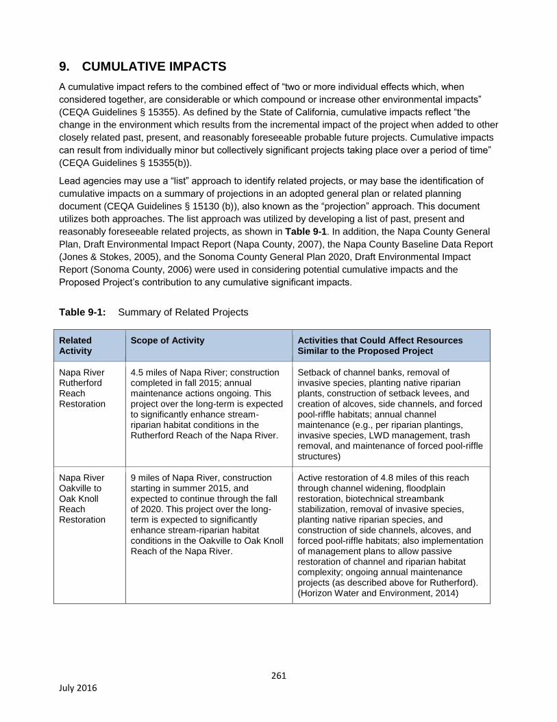
261 July 2016
9. CUMULATIVE IMPACTS
A cumulative impact refers to the combined effect of “two or more individual effects which, when
considered together, are considerable or which compound or increase other environmental impacts”
(CEQA Guidelines § 15355). As defined by the State of California, cumulative impacts reflect “the
change in the environment which results from the incremental impact of the project when added to other
closely related past, present, and reasonably foreseeable probable future projects. Cumulative impacts
can result from individually minor but collectively significant projects taking place over a period of time”
(CEQA Guidelines § 15355(b)).
Lead agencies may use a “list” approach to identify related projects, or may base the identification of
cumulative impacts on a summary of projections in an adopted general plan or related planning
document (CEQA Guidelines § 15130 (b)), also known as the “projection” approach. This document
utilizes both approaches. The list approach was utilized by developing a list of past, present and
reasonably foreseeable related projects, as shown in Table 9-1. In addition, the Napa County General
Plan, Draft Environmental Impact Report (Napa County, 2007), the Napa County Baseline Data Report
(Jones & Stokes, 2005), and the Sonoma County General Plan 2020, Draft Environmental Impact
Report (Sonoma County, 2006) were used in considering potential cumulative impacts and the
Proposed Project’s contribution to any cumulative significant impacts.
Table 9-1: Summary of Related Projects
Related Activity
Scope of Activity Activities that Could Affect Resources Similar to the Proposed Project
Napa River Rutherford Reach Restoration
4.5 miles of Napa River; construction completed in fall 2015; annual maintenance actions ongoing. This project over the long-term is expected to significantly enhance stream-riparian habitat conditions in the Rutherford Reach of the Napa River.
Setback of channel banks, removal of invasive species, planting native riparian plants, construction of setback levees, and creation of alcoves, side channels, and forced pool-riffle habitats; annual channel maintenance (e.g., per riparian plantings, invasive species, LWD management, trash removal, and maintenance of forced pool-riffle structures)
Napa River Oakville to Oak Knoll Reach Restoration
9 miles of Napa River, construction starting in summer 2015, and expected to continue through the fall of 2020. This project over the long-term is expected to significantly enhance stream-riparian habitat conditions in the Oakville to Oak Knoll Reach of the Napa River.
Active restoration of 4.8 miles of this reach through channel widening, floodplain restoration, biotechnical streambank stabilization, removal of invasive species, planting native riparian species, and construction of side channels, alcoves, and forced pool-riffle habitats; also implementation of management plans to allow passive restoration of channel and riparian habitat complexity; ongoing annual maintenance projects (as described above for Rutherford). (Horizon Water and Environment, 2014)
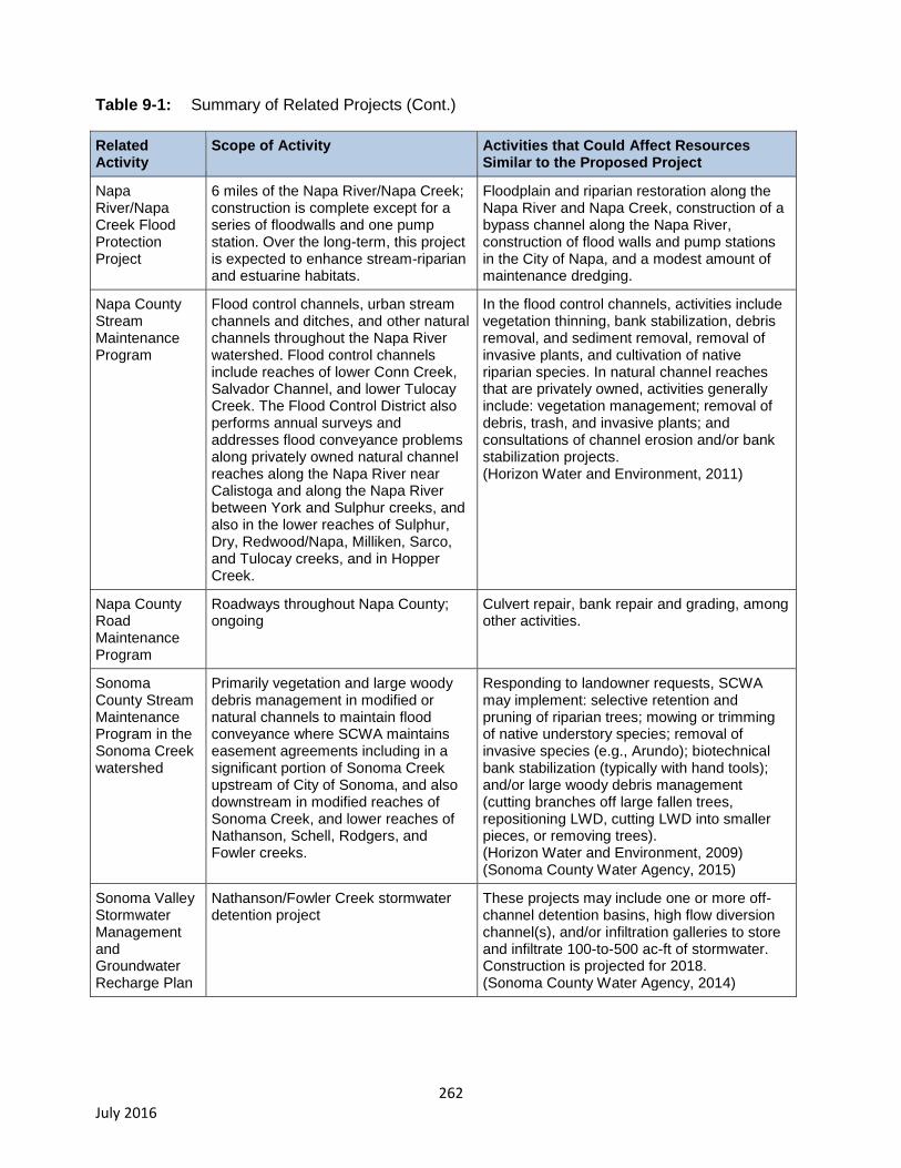
262 July 2016
Table 9-1: Summary of Related Projects (Cont.)
Related Activity
Scope of Activity Activities that Could Affect Resources Similar to the Proposed Project
Napa River/Napa Creek Flood Protection Project
6 miles of the Napa River/Napa Creek; construction is complete except for a series of floodwalls and one pump station. Over the long-term, this project is expected to enhance stream-riparian and estuarine habitats.
Floodplain and riparian restoration along the Napa River and Napa Creek, construction of a bypass channel along the Napa River, construction of flood walls and pump stations in the City of Napa, and a modest amount of maintenance dredging.
Napa County Stream Maintenance Program
Flood control channels, urban stream channels and ditches, and other natural channels throughout the Napa River watershed. Flood control channels include reaches of lower Conn Creek, Salvador Channel, and lower Tulocay Creek. The Flood Control District also performs annual surveys and addresses flood conveyance problems along privately owned natural channel reaches along the Napa River near Calistoga and along the Napa River between York and Sulphur creeks, and also in the lower reaches of Sulphur, Dry, Redwood/Napa, Milliken, Sarco, and Tulocay creeks, and in Hopper Creek.
In the flood control channels, activities include vegetation thinning, bank stabilization, debris removal, and sediment removal, removal of invasive plants, and cultivation of native riparian species. In natural channel reaches that are privately owned, activities generally include: vegetation management; removal of debris, trash, and invasive plants; and consultations of channel erosion and/or bank stabilization projects. (Horizon Water and Environment, 2011)
Napa County Road Maintenance Program
Roadways throughout Napa County; ongoing
Culvert repair, bank repair and grading, among other activities.
Sonoma County Stream Maintenance Program in the Sonoma Creek watershed
Primarily vegetation and large woody debris management in modified or natural channels to maintain flood conveyance where SCWA maintains easement agreements including in a significant portion of Sonoma Creek upstream of City of Sonoma, and also downstream in modified reaches of Sonoma Creek, and lower reaches of Nathanson, Schell, Rodgers, and Fowler creeks.
Responding to landowner requests, SCWA may implement: selective retention and pruning of riparian trees; mowing or trimming of native understory species; removal of invasive species (e.g., Arundo); biotechnical bank stabilization (typically with hand tools); and/or large woody debris management (cutting branches off large fallen trees, repositioning LWD, cutting LWD into smaller pieces, or removing trees). (Horizon Water and Environment, 2009) (Sonoma County Water Agency, 2015)
Sonoma Valley Stormwater Management and Groundwater Recharge Plan
Nathanson/Fowler Creek stormwater detention project
These projects may include one or more off-channel detention basins, high flow diversion channel(s), and/or infiltration galleries to store and infiltrate 100-to-500 ac-ft of stormwater. Construction is projected for 2018. (Sonoma County Water Agency, 2014)

263 July 2016
Table 9-1: Summary of Related Projects (Cont.)
Related Activity
Scope of Activity Activities that Could Affect Resources Similar to the Proposed Project
Projected Future Vineyard Development Project
8,000 acres of additional vineyard development within the project area. Future vineyard developed is expected to significantly impact biological resources including special-status species (in Sonoma County) and sensitive natural communities (in Sonoma and Napa counties) (Sonoma County, 2006) (Napa County, 2007)
Based on vineyard development projections through 2020 in Sonoma, and through 2030 in Napa, contained in the environmental impact reports for recent updates to the Napa County and Sonoma County General Plans (Napa County, 2007; Sonoma County, 2006) and/or in the Napa County Climate Action Plan (ICF, 2012), we assume the same rates of vineyard development will occur in future years throughout the lifecycle of the permit. Considering the above, over the next 20 years, up to 6,000 acres of vineyards could be developed in the Napa River watershed, and up to 2,000 acres in the Sonoma Creek watershed. Most of these vineyards would be on hillslopes, and up to 500 acres of the projected vineyard development could involve conversion of forest and/or wetland habitats.
Projected Future Structural Development
Approximately 4300 residential units plus 325 acres of non-residential development built primarily in urban areas
Most of this development would be concentrated in existing urban areas or adjacent unincorporated areas in the Napa and/or Sonoma valleys.
Other Sediment TMDL implementation actions
Development and implementation of Water Board permits for discharges from grazing areas, parks and open spaces, rural residential areas, and publically owned roads.
The Water Board has already adopted a permit for grazing areas throughout the project area. Water Board permits to regulate sediment discharges (primarily from roads) also are anticipated for parks and open space, public roads, and rural residential properties.
Detailed analysis of a project’s contribution to cumulative impacts is required when (1) a cumulative
impact is expected to be significant, and (2) the project’s contribution to the cumulative impact is
expected to be cumulatively considerable, or significant in the context of the overall (cumulative) level of
effect. Table 9-2 summarizes cumulatively significant impacts and identifies the Proposed Project’s
contribution. Additional analysis is provided below the table for those impacts that the Proposed Project
contributes to significant impacts.

264 July 2016
Table 9-2: Summary of Cumulative Impacts and the Proposed Project’s Contribution
Resource Topic Cumulatively Significant Impacts Proposed Project’s Contribution
Aesthetics
None identified. General Plan’s for both counties are strongly protective of aesthetic resources.
No analysis required.
Agricultural Resources
None identified. The General Plan’s for both counties designate agriculture as the primary land use. Growth is strictly regulated by local land use authorities to preserve and protect agricultural lands including by concentration of growth within existing boundaries of incorporated towns and cities.
No analysis required.
Air Quality
Ozone and fine particulate matter (PM2.5) are the primary air pollutants of concern in the San Francisco Bay Area. Ozone typically is a concern during the summer and is generated primarily by vehicle use. PM2.5 is a problem occasionally during the winter and is related primarily to wood smoke from fireplaces. Sonoma County has some of the lowest ozone and PM2.5
levels in the Bay Area, and standards for these constituents are rarely exceeded. In Napa County, health standards for ozone also are rarely exceeded and only occasionally exceeded during the wintertime for PM2.5.
(BAAQMD, 2016a and 2016b)
Actions taken to comply with the General Permit, primarily related to the use of heavy equipment that would be used to reshape existing unpaved roads, as needed to reduce storm runoff and sediment delivery from roads, would contribute to fine particulate matter and ozone precursor emissions. The project would contribute to an increase in the emissions of ozone precursors and/or particulate matter, which already occasionally violate air quality standards. The project’s contribution toward any violation therefore would be considered cumulatively considerable. Further analysis is provided below.

265 July 2016
Table 9-2: Summary of Cumulative Impacts and the Proposed Project’s Contribution (cont.)
Resource Topic Cumulatively Significant Impacts Proposed Project’s Contribution
Biological Resources
Past and present land and/or water resources development have significantly impacted native steelhead and salmon populations and their habitat in the Napa River and the Sonoma Creek watersheds, (USFWS, 1968; Emig and Rugg, 2000; Leidy, 2007). Development and land use changes in both watersheds could further decrease water quality and quantity, introduce invasive species, and/or impede migration. These impacts would be considered cumulatively significant. Over the past 150 years, various land use practices in the Napa River and Sonoma Creek watersheds have resulted in a significant reduction in the quantity and quality of riparian habitats, freshwater and estuarine wetlands, oak woodlands, native grasslands, and other sensitive natural communities (Grossinger, 2012, pp. 42, 58-59, 78-79).
Actions taken to comply with the General Permit are expected to significantly enhance spawning and rearing habitat for steelhead and salmon in the Napa River and Sonoma Creek watersheds, and have a neutral or beneficial impact on riparian habitat. Within the project area, as many as 75 acres of previously undeveloped upland habitats could be directly impacted by detention basins that could be constructed to comply with the vineyard performance standards for storm runoff. An unknown fraction of these 75 acres may be defined as sensitive natural communities including a variety of forest, woodland, scrubland, and native grassland habitats, and/or special-status species or their habitats that occur at these sites. Project-related actions that contribute to additional reduction in the quantity and quality of oak woodlands, native grasslands, and other sensitive natural communities (located in upland areas) would be considered cumulatively considerable. Further analysis is provided below.
Cultural Resources
Over the past 150 years, land uses and development within the Napa River and Sonoma Creek watersheds have caused substantial adverse changes to the significance of historical, paleontological, and/or archeological resources. Projected future development (vineyards and/or structural development projects), flood control, stormwater detention and/or groundwater recharge, and/or channel restoration projects could lead to cumulative loss of significant historical, archeological, and/or paleontological resources.
Where compliance with the General Permit would involve construction of a detention basin and/or constructing a new property access road in previously undeveloped locations, these compliance actions have the potential to significantly impact archeological resources, and considering other past, present, and future projects, these impacts would rise to the cumulatively considerable level. Further discussion is provided below.
Geology and Soils
None identified
No analysis required.
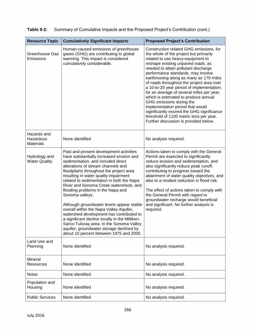
266 July 2016
Table 9-2: Summary of Cumulative Impacts and the Proposed Project’s Contribution (cont.)
Resource Topic Cumulatively Significant Impacts Proposed Project’s Contribution
Greenhouse Gas Emissions
Human-caused emissions of greenhouse gases (GHG) are contributing to global warming. This impact is considered cumulatively considerable.
Construction related GHG emissions, for the whole of the project but primarily related to use heavy-equipment to reshape existing unpaved roads, as needed to attain pollutant discharge performance standards, may involve earthmoving along as many as 170 miles of roads throughout the project area over a 10-to-20 year period of implementation, for an average of several miles per year, which is estimated to produce annual GHG emissions during the implementation period that would significantly exceed the GHG significance threshold of 1100 metric tons per year. Further discussion is provided below.
Hazards and Hazardous Materials
None identified
No analysis required.
Hydrology and Water Quality
Past and present development activities have substantially increased erosion and sedimentation, and included direct alterations of stream channels and floodplains throughout the project area resulting in water quality impairment related to sedimentation in both the Napa River and Sonoma Creek watersheds, and flooding problems in the Napa and Sonoma valleys. Although groundwater levels appear stable overall within the Napa Valley Aquifer, watershed development has contributed to a significant decline locally in the Milliken-Sarco-Tulocay area. In the Sonoma Valley aquifer, groundwater storage declined by about 10 percent between 1975 and 2000.
Actions taken to comply with the General Permit are expected to significantly reduce erosion and sedimentation, and also significantly reduce peak runoff, contributing to progress toward the attainment of water quality objectives, and also to a modest reduction in flood risk. The effect of actions taken to comply with the General Permit with regard to groundwater recharge would beneficial and significant. No further analysis is required.
Land Use and Planning
None identified
No analysis required.
Mineral Resources
None identified
No analysis required.
Noise None identified No analysis required.
Population and Housing
None identified
No analysis required.
Public Services None identified No analysis required.
267 July 2016
Table 9-2: Summary of Cumulative Impacts and the Proposed Project’s Contribution (cont.)
Resource Topic Cumulatively Significant Impacts Proposed Project’s Contribution
Recreation
None identified
No analysis required.
Transportation and Traffic
None identified
No analysis required.
Utilities and Service Systems
None identified
No analysis required.
The following sections provide a detailed analysis of the Proposed Project’s contribution to existing
significant cumulative impacts. As identified in Table 9-2, the following resource issues are discussed:
air quality, biological resources, cultural resources, and global climate change.
Air Quality: Emissions of Criteria Air Pollutants —Significant and Unavoidable
Principal air quality concerns for BMP construction and maintenance relate to (1) generation of fugitive
dust during earthmoving and (2) exhaust emissions from construction equipment.
As discussed in the Air Quality Impact Analysis (Section 5.4), given implementation of construction dust
control Mitigation Measures AQ-1 through AQ-4, which are consistent with the BAAQMD’s guidance
(Bay Area Air Quality Management District, 1999), construction-related emissions of criteria pollutants
and air quality impacts on sensitive receptors near work sites would be less than significant at the
project level for all criteria pollutants. The BAAQMD thresholds of significance are designed also to
serve as cumulative thresholds of significance.
Although impacts to air quality can be reduced to a less than significant level with the implementation of
the mitigation measures described above, the Water Board would not have oversight of the
implementation of proposed mitigation measures. Because project-level mitigation lies with the local
land use authority, there is inherent uncertainty in the degree of mitigation that may ultimately be
implemented to reduce significant impacts associated with actions taken to comply with the General
Permit. Therefore, the EIR takes a conservative approach in its post-mitigation significance conclusion
and discloses, for CEQA compliance purposes, that impacts to air quality from actions taken to comply
with the General Permit may be significant and unavoidable. To reduce potential air quality impacts, the
Water Board will work with approved Third-Party Programs and/or Qualified Professionals to inform
Dischargers about BAAQMD mitigation measures that can be implemented to reduce air emissions
associated with construction activities to levels below significance thresholds.
In summary, air quality impacts resulting from actions taken to comply with the General Permit
may be cumulatively considerable.
268 July 2016
Biological Resources: Impacts to Upland Associated Special-Status Species and Sensitive
Natural Communities –Significant and Unavoidable
Special-status fish and aquatic wildlife species, streams, and riparian habitats – Historical and/or
current land-use activities have caused or contributed to stream and riparian habitat simplification75
,
substantial increases in the amount of fine sediment in streambeds, barriers to fish migration, stressful
stream temperatures, and poor baseflow persistence, which together have interacted to substantially
reduce salmon and steelhead populations, and also have impacted exceptionally diverse native fish
assemblages in the Napa River and Sonoma Creek watersheds (Water Board, 2009a, and Water
Board, 2008a).
Actions taken to comply with the General Permit, over the long-term, would substantially reduce fine
sediment delivery to channels, attenuate storm runoff from vineyards and roads, and increase the
extent of riparian vegetation, which would substantially enhance the quality of spawning and rearing
habitat for salmon and steelhead, native resident fish species, and also the quality of stream and/or
riparian habitats available for California freshwater shrimp, foothill yellow-legged frog, California red-
legged frog, and western pond turtle (See Section 6.3.3, Discussion of Impact 6-1a and Impact 6-2).
The actual construction of BMP projects within vineyards, roads, and/or eroding channels and gullies at
multiple locations throughout hundreds of vineyard properties could have short-term adverse impacts
on streambeds, riparian habitat, fish, and wildlife. The mitigation measures included in the Draft EIR
(Mitigation Measures BR-1 through BR-8) would be expected to reduce these short-term, construction-
related impacts to a less than significant level. With these measures in place, the overall contribution
of the Proposed Project would be beneficial with regard to its effects on stream and/or riparian
habitats and associated special-status species.
Special-status bird species – Historical development of farms and urban areas in both watersheds
has substantially reduced the extent, quality, and connectivity of tidal and freshwater wetlands, riparian
habitats, old-growth redwood-Douglas fir forests, and Valley Oak savannas (see Grossinger, 2012;
SEC, 2002; Grossinger et al., 2003). These and other sensitive natural communities, including several
types of woodlands, chaparral, and native grasslands, provide essential habitats for several special-
status bird species that occur throughout the project area.
In addition to historical impacts of habitat loss and degradation, future vineyard and/or urban
development in the project area is projected to cause a significant reduction in the extent and
connectivity of the habitats that remain (Sonoma County, 2006; Napa County, 2007).
75
Habitat simplification has occurred as a result of channel incision. Channel incision reflects and integrates multiple historical and ongoing disturbances including: a) direct alterations to the Napa River, Sonoma Creek, alluvial reaches of tributaries (e.g., levee building, channel straightening, side channel filling, connecting naturally disconnected tributaries, removal of debris jams, ditching/draining floodplain wetlands, historical gravel mining, and dredging); b) in the Napa River watershed, construction of four large tributary dams between 1939 and 1959; and c) in both watersheds, land-cover changes that have increased peak flows (e.g., vineyards, logging of old-growth redwoods, intensive historical grazing, buildings, and roads) (Water Board, 2008a, p.23; Water Board, 2009a, p.46).
269 July 2016
Although the General Permit does not authorize construction of new vineyards, as described in detail in
Section 6.3.3, there are two types of potential impacts to special-status birds that could occur as the
result of actions taken to comply with the General Permit at new vineyards:
1) Noise generated by heavy equipment used to construct BMPs in a few cases would have the
potential to disrupt breeding and/or nesting by special-status bird species; and
2) Construction of detention basins, although this would occur at only a few vineyard properties, in
some cases sites could overlap with nesting or other habitats for special status birds.
Where construction activities would overlap at least in part with wetlands, streams, and/or riparian
areas, to reduce all potential impacts to nesting birds to a less than significant level, the Water Board,
acting within its statutory authority to protect water quality and beneficial uses of water, would
implement Mitigation Measure BR-1: to issue a Clean Water Act Section 401 Permit, conditioned to
protect water quality and all beneficial uses (see Section 6.3.3 for additional details). Protection of
special-status bird species that dwell within wetlands, waters, and/or riparian habitats is included within
the definition of the wildlife habitat beneficial use of water.
Elsewhere, at BMP construction sites that do not overlap with wetlands, stream, or riparian habitats, as
discussed in Section 6.3.3, Mitigation Measures BR-9, BR-10, and BR-11 could be implemented. These
mitigations involve: a) restricting the construction period at sites located within ¼-mile of potential
nesting sites so that construction does not overlap with nesting periods or conducting a protocol survey
to confirm suitable nesting habitat is not occupied; and/or b) preparing a biological inventory, and if
protected species or their habitats are present, to comply with applicable federal and state endangered
species acts and regulations. Upon implementation Mitigation Measures BR-9, BR-10, and BR-11
significant impacts to special-status birds in upland areas would be reduced to a less than significant
level. However the Water Board would not have oversight of the implementation of proposed
mitigation measures because protection of wildlife habitat in upland areas is not included within the
definition of the wildlife habitat beneficial use. Implementation of these mitigation measures therefore
would fall within the jurisdiction of the local land use authority. Because project-level mitigation lies with
the local land use authority, there is inherent uncertainty in the degree of mitigation that may ultimately
be implemented. Therefore, the EIR takes a conservative approach in its post-mitigation significance
conclusion and discloses, for CEQA compliance purposes, that actions taken to comply with the
General Permit may cause significant and unavoidable impacts to special-status bird species in upland
areas.
Considering the historical impacts of agricultural and urban development in both watersheds, and the
projected impacts of future vineyard and urban development, together with the Proposed Project, the
potential impacts of the Proposed Project on special-status bird species may be cumulatively
considerable.
Other special-status species and sensitive natural communities in upland areas
As discussed immediately above, historical development for agriculture and urban areas has
significantly reduced the extent, quality, and/or connectivity of sensitive natural communities that occur
within upland areas including old growth forests, valley oak savannas, other oak woodlands, and native
grasslands. Future vineyard and urban development is projected to significantly impact these and other
sensitive natural communities that occur throughout the project area. A broad array of special-status
plant species may occur within upland areas and/or several listed animal species including pallid bat,
western red-eared bat, California red-legged frog, California tiger salamander, and Callippe silverspot
butterfly (see Section 6.3.3 for additional information).
270 July 2016
At the hillslope vineyard properties where detention basins would be constructed in order to comply with
the General Permit, there is the potential to impact sensitive natural communities and/or special status
species associated with some upland habitat types including several types of chapparal, native
grasslands, and/or a variety of woodland types. Considering the entire 592 mi2 project area, the EIR
conservatively estimates that up to 78 acres of upland habitat under natural vegetation cover may be
converted to detention basins, and an unknown fraction of which may overlap with areas defined as
sensitive natural communities and/or that contain special status species and/or their habitats. As
described above, given implementation of Mitigation Measure BR-11, these potential impacts would be
reduced to a less than significant level. However, the Water Board would not have oversight of the
implementation of proposed mitigation measures because impacts to wildlife species habitat in
upland areas fall outside of the definition of the wildlife beneficial use, and/or the protection of water
quality. Implementation of these mitigation measures therefore would fall within the jurisdiction of the
local land use authority. Because project-level mitigation lies with the local land use authority, there is
inherent uncertainty in the degree of mitigation that may ultimately be implemented. Therefore, the EIR
conservatively finds that impacts of the Proposed Project on sensitive natural communities
and/or special status species in uplands areas may be cumulatively considerable.
Cultural Resources: Impacts to Archeological Resources and/or Human Remains –
Significant and Unavoidable
Historical development of agriculture, roads, and urban areas throughout the project area has
substantially impacted archeological resources throughout the project area.
Actions to comply with the General Permit could involve both minor and larger-scale grading and
construction. Large scale construction would generally be limited to road relocation, detention
basin/managed wetland construction, and culvert replacement. Management practices such as
modification of road drainage and measures to control erosion from the planted area and at points of
discharge would generally be small in scale, and would be limited to shallow excavation. In some
cases, deeper excavation may be necessary to construct detention basins (BMP-10), and/or to remove
a road crossing located along a problematic road segment that is decommissioned (BMP-19) and/or to
construct a road crossing along a new storm proofed road segment (BMP-20). In some locations, such
as near streams and at the base of hills (see Section 7.6.3), archaeological resources and/or human
remains could be encountered. Recognized and accepted mitigation measures routinely required by
regulatory agencies (Mitigation Measure 7.2) include to:
Perform a cultural resources survey by a qualified archaeologist or cultural specialist that
conforms to the U.S. Secretary of the Interior’s Professional Qualifications Standards, as
published in 36 Code of Federal Regulations;
Contact the state Historic Preservation Officer and federal lead agencies as appropriate for
coordination of Nation-to-Nation consultations with the Native American Tribes;
Consult a qualified paleontological resources specialist to determine whether paleontological
resources would likely be disturbed in a project area on the basis of the sedimentary context of
the area and a records search for past paleontological finds in the area. The assessment may
suggest areas of high or known potential for containing resources. If the assessment is
inconclusive, a surface survey is recommended to determine the fossil potential and extend of
the pertinent sedimentary units within the project site. If the site contains areas of high potential
271 July 2016
for significant paleontological resources and avoidance is not possible, prepare a
paleontological resources mitigation plan;
Consult established archaeological and historical records and conduct a field survey of the
project prior to construction. Survey records shall be filed with the appropriate archaeological or
historical data centers;
Consult with local Native American representatives as appropriate to obtain local knowledge of
the project vicinity;
Prepare site development and grading plans that avoid disturbance of known cultural sites
and/or documented sensitive areas. Project plans shall include appropriate measures to protect
sensitive resources;
Retain a qualified archaeologist or Native American tribal representative to monitor site
development activities, particularly grading and trenching. If artifacts are observed during
construction, require that construction be halted until a qualified archaeologist has been
consulted;
Alert onsite workers to the possibility of encountering human remains during construction
activities, and prepare appropriate procedures. It is usually required that all construction
activities near the location of identified human skeletal remains are halted until proper
consultation and mitigation is arranged.
Although impacts to cultural resources and archaeological resources and/or to human remains can be
reduced to a less than significant level with the implementation of the mitigation measure described
above, the Water Board would not have oversight of the implementation of proposed mitigation
measures. Because project-level mitigation lies with the local land use authority, there is inherent
uncertainty in the degree of mitigation that may ultimately be implemented. Therefore, the EIR takes a
conservative approach in its post-mitigation significance conclusion and discloses, for CEQA
compliance purposes, that significant environmental impacts to cultural resources and/or human
remains resulting from disturbance such as grading and trenching to comply with the General Permit
may be significant and unavoidable. Considering historical impacts to archeological resources and/or to
human remains together with the Proposed Project, the EIR conservatively finds that impacts may
be cumulatively considerable and unavoidable.
272 July 2016
Greenhouse Gas Emissions: Significant and Unavoidable
Construction related GHG emissions for the whole of the project, which are primarily related to use
heavy-equipment that would be used to reshape existing unpaved roads (to attain water quality
discharge standards), may involve earthmoving on up to 200 miles of unpaved roads throughout the
project area over a 10-to-20 year period of implementation, for an average of 10-to-20 miles of road per
year, which is estimated to produce annual GHG emissions during the implementation period
(associated with construction of BMPs) that would significantly exceed the GHG significance threshold
of 1100 metric tons per year76
. Implementation of the following types of mitigation measures (GHG-1)
would reduce the amount of GHG emissions, and can reduce the impact to a less than significant level:
Require Use of Newer Construction Equipment. Construction equipment with newer engine
models is subject to stricter emissions standards, and would generate less GHG emissions.
Require Use of Equipment Powered by Electricity. Some types of equipment can be powered by
either diesel fuel, electricity, or a hybrid. Use of equipment powered by electricity or a hybrid
would generally generate less GHG emissions.
Require Use of Equipment Powered by Alternative Fuels. Some types of equipment can be
powered by alternative fuels (i.e., not diesel fuel). Use of alternative fuels would generally
generate less GHG emissions.
Although GHG-1 would reduce potential impact related to GHG emissions to less than significant levels,
because project-level mitigation lies with the local land use authority, there is inherent uncertainty in the
degree of mitigation that may ultimately be implemented. Therefore, the EIR takes a conservative
approach in its post-mitigation significance conclusion and discloses, for CEQA compliance purposes,
that significant environmental impacts to GHG emissions. Considering the effect of past and projected
future development projects, the EIR conservatively concludes that the impacts of the Proposed
Project may be cumulatively considerable and are unavoidable.
76
The BAAQMD significance threshold was developed to apply to operational emissions generated by construction activities, and not to GHG emissions generated from construction of projects. For example, for a new shopping center, the “operational emissions” of greenhouse gases would relate to additional vehicle trips, energy demands, etc. associated with operation of the facility throughout its projected operational lifetime. Considering the nature of actions taken to comply with the General Permit, where significant construction activities may continue for a 10-to-20 year implementation period, the EIR conservatively applies the significance threshold for operational emissions of GHGs to these construction activities. We note however that once the roads have been reshaped and detention basins constructed (by far and away the largest earth moving activities that would occur to comply with the General Permit), long-term “operational emissions” associated with maintenance of BMPs are expected to fall below the BAAQMD threshold of significance. Also, GHG reductions that will occur as a result of decreases in tillage and increases in cover crops at vineyards, substantial reductions in soil erosion throughout vineyard properties, and increases in riparian vegetation are not accounted for in the analysis of the overall effect of the Proposed Project on GHG emissions.
273 July 2016
References
Bay Area Air Quality Management District (BAAQMD). (1999). CEQA Guidelines – Assessing the Air
Quality Impacts of Projects and Plans. San Francisco, CA.
Bay Area Air Quality Management District (BAAQMD). (2016a). About air Quality in your community:
Sonoma County. BAAQMD website accessed on 4 March 2016 at http://www.baaqmd.gov/in-
your-community/sonoma-county
Bay Area Air Quality Management District (BAAQMD). (2016b). About air Quality in your community:
Napa County. BAAQMD website accessed on 4 March 2016 at http://www.baaqmd.gov/in-your-
community/napa-county
Dawson, A., M. Solomon, A. Whipple, and R. Grossinger. (2008). An introduction to the historical
ecology of the Sonoma Creek watershed. Sonoma Ecology Center: Eldridge, CA.
Emig, J. and M. Rugg. (2000). Personal communication from John Emig and Mike Rugg, Senior
Fisheries Biologists with the California Department of Fish and Game, Yountville, CA to Mike
Napolitano, Water Board, Oakland, CA.
Grossinger, R., C. Striplen, E. Brewster, and L. McKee. (2003). Ecological, Geomorphic, and Land Use
History of the Sulphur Creek Watershed. San Francisco Estuary Institute: Richmond, CA.
Grossinger, R. (2012). Napa Valley historical ecology atlas, exploring a hidden landscape of
transformation and resilience. UC Press: Berkeley, CA.
Horizon Water and Environment. (2009). Stream Maintenance Program, Draft Environmental Impact
Report. Prepared for the Sonoma County Water Agency.
Horizon Water and Environment. (2011). Napa County Flood Control and Water Conservation District,
Napa County Stream Maintenance Program, Initial Study/Mitigated Negative Declaration. Prepared
for Napa County Department of Conservation, Development, and Planning.
Horizon Water and Environment. (2014). Napa River Restoration: Oakville to Oak Knoll. Initial
Study/Mitigated Negative Declaration. Prepared for Napa County Department of Conservation,
Development, and Planning.
ICF International. (2012). Napa County Climate Action Plan. Prepared for Napa County Department of
Conservation, Development, and Planning.
Jones & Stokes Associates. (2005). Napa County Baseline Data Report, Chapter 4, Biological
Resources. Prepared for Napa County Department of Conservation, Development, and Planning.
Leidy, R.A. (2007). Ecology, Assemblage Structure, and Status of Fishes in Streams Tributary to the
San Francisco Estuary, California.
Napa County. (2007). Draft Environmental Impact Report for the Napa County General Plan. State
Clearinghouse No. 2005102088. County of Napa, Department of Conservation, Development, and
Planning.
Sonoma County. (2006). Draft Environmental Impact Report, Sonoma County General Plan 2020,
General Plan Update. State Clearinghouse No. 2003012020
Sonoma Ecology. (2002). The Oral History Project: A report on the findings of the Sonoma Ecology
Center’s Oral History Project, focusing on Sonoma Creek and the historical ecology of Sonoma
Valley. Sonoma Ecology Center: Eldridge, CA.
274 July 2016
Sonoma County Water Agency. (2014). Sonoma Valley Groundwater Management Plan. Five Year
Review and Update, Final Report.
Sonoma County Water Agency. (2015). Zones 2A and 3A, Natural Channels Maintenance Project,
Initial Study/Mitigated Negative Declaration. Sonoma County Water Agency: Santa Rosa, CA.
USFWS. (1968). Analysis of the Fish Habitat in the Napa River and Tributaries, Napa County, CA, with
Emphasis Given to Steelhead trout Production. USFWS Memo to File. USFWS: Sacramento, CA.
Water Board. (2008a). Sonoma Creek Watershed Sediment TMDL and Habitat Enhancement Plan,
Staff Report.
Water Board. (2009a). Napa River Sediment TMDL and Habitat Enhancement Plan, Staff Report.
275 July 2016
10. ALTERNATIVES ANALYSIS
10.1. Factors for Selecting Alternatives
CEQA Guidelines section 15126.6, subdivision (c) recommends that an EIR describe the rationale for
selecting each of the alternatives. A reasonable range of alternatives is considered for this analysis.
The following factors were considered in identifying a reasonable range of alternatives to the project:
Does the alternative accomplish the fundamental, and all, or most of the secondary (other)
project objectives?
Is the alternative feasible from an economic, environmental, legal, social, and technological
standpoint?
Does the alternative avoid or lessen any significant negative environmental effects of the
project?
As stated in Chapter 2, the fundamental objective of the General Permit is to:
Implement the Napa River and Sonoma Creek sediment TMDLs to achieve their vineyard
property discharge performance standards for sediment and storm runoff and to ultimately meet
the TMDLs’ sediment allocations and targets and restore properly functioning substrate
conditions in channel reaches that provide habitat for anadromous salmonids.
Secondary project objectives include the following:
1. Protect and/or restore habitat for other native fish species in addition to anadromous
salmonids;
2. Promote stream-riparian habitat protection and restoration;
3. Promote actions to restore fish passage at road crossings and streamflow diversions;
4. Promote management decisions and actions to maintain adequate in-stream temperature;
and
5. Leverage voluntary conservation programs to assist vineyard owners/operators in meeting
the requirements and objective of the proposed General Permit.
10.2. Alternatives that were Considered but not Further Analyzed
CEQA Guidelines section 15126.6, subdivision (a) requires that an EIR describe the rationale for
selecting the alternatives to be discussed, and suggests that an EIR also identify any alternatives that
were considered by the lead agency, but were rejected as infeasible (CEQA Guidelines, § 15126.6,
subd. (c)). Following alternatives were considered, but were eliminated from further consideration and
analysis for reasons expressed below.
10.2.1. Defer WDRs Pending Demonstration of Continued Progress
An alternative provided by agricultural landowner groups suggests it is reasonable for the Water Board
to defer adoption of the WDRs, provided that continued progress is demonstrated through
implementation of best management practices by vineyard property owners and/or operators. They
276 July 2016
cited evidence of improved water quality77
and stated that there has been large-scale implementation of
best management practices, and both have occurred absent Water Board permit adoption (California
Farm Bureau Federation, 2014, p.4; Napa Valley Grape Growers, 2014, p.1; and Winegrowers of Napa
County, 2014, pp. 1-2).
This alternative is essentially a “Deferred Project” alternative and is not feasible because it does not
meet project objectives. Absent adoption of the proposed General Permit, it is unlikely that the
fundamental objective of the General Permit, which is to meet the TMDLs’ sediment allocations and
targets, and restore properly functioning substrate conditions in channel reaches that provide habitat for
anadromous salmonids, would be achieved by the deadlines specified in the TMDLS (i.e., Sonoma
Creek, December 2028 and Napa River, September 2029).
Furthermore, although, to date, farm plans have been completed on roughly 40 percent of the vineyard
property acreage prior to proposed General Permit adoption, many of the BMPs to control sediment
discharges from unpaved roads, and/or from gullies or unstable headwater channels (that are eroding in
response to concentrated storm runoff that is discharged from hillslope vineyards) have not yet been
implemented.
Lastly, this alternative is not consistent with Water Board policies including:
1. The implementation plans for the Napa River and Sonoma Creek sediment TMDLs which have
been adopted into the Basin Plan, and which reference application of waste discharge
requirements and/or waivers of waste discharge requirements to achieve sediment load
reductions from Vineyard Properties; and
2. Policy for Implementation and Enforcement of the Nonpoint Source Pollution Control Program
(State Nonpoint Source Policy), which requires the Water Board apply one of its regulatory tools
(i.e., discharge prohibition, waiver of waste discharge requirements, and waste discharge
requirements (WDRs)) to ensure that nonpoint source discharges that affect water quality are
adequately controlled.
Therefore, considering the voluntary nature of the alternative, it was rejected from further analysis
because, absent a program of regulatory oversight, including mandated deadlines for completion of
necessary management actions, it is unclear whether TMDL allocations and targets will be achieved by
the deadlines established in the Basin Plan amendments.
10.2.2. Reduced Scope of Roads Regulated Project Alternative
A reduced scope of roads project alternative was suggested by the California Farm Bureau, Napa
Valley Grape Growers, and Winegrowers of Napa County. This alternative would reduce the scope and
extent of the unpaved roads to be regulated under the proposed General Permit.
77
We believe that the Napa Valley Grape Growers are referring to the pilot sediment TMDL monitoring program (Stillwater Sciences, 2013) in stating that “the most recent data we have seen indicates that all our work has dramatically improved the health of the Napa River watershed” (Napa Valley Grape growers, 2014, p.1).
277 July 2016
Under this alternative, the discharger would identify and prioritize high- and moderate-high priority
erosion sites (CFBF, 2014, p.5); and/or limit roads subject to regulation to those that serve the vineyard
facility and/or operation, as opposed to the larger, vineyard property road network that is proposed in
the General Permit. (California Farm Bureau Federation, 2014, p.5; Napa Valley Grape Growers, 2014,
p.1; and Winegrowers of Napa County, 2014, p. 2).
This alternative proposes a reduced geographic scope that would result in a significant amount of
property being excluded from the proposed General Permit. Given its reduced geographic scope, this
alternative is not feasible because it does not support achievement of the 50 percent or greater
reduction in road-related sediment delivery specified in both sediment TMDLs, a fundamental project
objective. Similarly, limiting road erosion control actions to only discharger identified high- or medium-
high priority sites would not support the fundamental project objective.
Unpaved road-related erosion is one of the largest sources of sediment to channels within the Project
area (Water Board, 2009a; Water Board, 2008a; Napa County, 2014, p.1).
Surface erosion is chronic and ubiquitous on unpaved roads, and therefore, is a high priority for
treatment, particularly wherever a significant length of an unpaved road drains runoff directly to streams
or other waterbodies. Any road segment that has a continuous surface flow path to a natural stream
channel during a ‘design’ runoff event is termed a hydrologically-connected road or road reach.
Connectivity usually occurs through road ditches, road surfaces, gullies, or other drainage structures or
disturbed surfaces. The TMDLs estimate that about 50 percent of the total length of unpaved roads in
the Project area are hydrologically-connected (i.e., drain directly to streams and other water bodies)
(Water Board, 2009b, p. 26; Water Board 2008b, p. 57). In order to achieve the 50 percent reduction in
hydrologically-connected road length, the General Permit proposes a road sediment discharge
performance standard of no more than 25 percent of the total length of unpaved roads be
hydrologically-connected. A reduced road alternative is therefore rejected for further analysis because it
would not achieve the discharge performance standard (i.e., ≤ 25 percent hydrologic connection) nor
the sediment savings required by the TMDLs.
For the reasons provided above, this alternative was rejected from further analysis.
10.2.3. 40-Acre or Larger Vineyards Project Alternative
Agricultural landowner groups also suggested that the Water Board consider an alternative, in which
only those properties of 40 acres or greater in size, which are planted in vineyard, would be required to
enroll in the proposed General Permit (Napa Valley Grapegrowers, 2014, p.2; Winegrowers of Napa
County, 2014, p.3). Water Board staff estimate that this proposed alternative would capture less than
half of the planted vineyard acreage and only about 25 of the length of unpaved roads that occur on
Vineyard Properties within the project area (Appendix B). Therefore, staff concludes that the
fundamental project objectives – to meet the TMDLs sediment allocations and targets, and restore
properly functioning substrate conditions in channel reaches that provide habitat for anadromous
salmonids, would be achieved by the deadlines specified in the Basin Plan amendments. Hence, this
alternative was rejected from further analysis.
278 July 2016
10.2.4. Waiver Enrollment Criteria Project Alternative
This alternative responds to the California Farm Bureau Federation’s suggestion that the Water Board
apply the enrollment criteria proposed for an earlier, terminated waiver of WDRs permitting effort, to the
proposed General Permit as the criteria for enrollment. Proposed enrollment criteria are as follows:
a) For valley floor vineyards (e.g., planted on slope ≤ 5 percent), the criteria for enrollment
would be planted area ≥ 5 acres, and total property area ≥ 40 acres; and
b) For hillslope vineyard properties (e.g., any part of the vineyard is planted on a > 5
percent slope), the criteria for enrollment would be planted area ≥ 5 acres, and total
property area ≥ 20 acres.
California Farm Bureau Federation states that the Technical Advisory Committee convened for the prior
waiver of WDRs effort had previously indicated that by using these criteria, an estimated 85 percent of
the vineyard parcels and cultivated acres in the Napa River and Sonoma Creek watersheds would be
enrolled (California Farm Bureau Federation, 2014, p. 7).
We note, however, that the earlier waiver of WDRs effort relied on less detailed geographic information
system (GIS) data and a much less detailed GIS analysis as compared to the information being used to
inform the proposed General Permit. It now appears, through integration of more detailed and accurate
GIS watershed information, that the actual values for enrollment would be closer to 70 percent of
planted acreage and 50 percent of the total property acreage (Appendix B). As such, it is unlikely that
TMDL to meet the TMDLs’ sediment allocations load allocations for roads and for unstable areas, which
is a fundamental project objective. Therefore this alternative is not considered further.
10.2.5. Hillslope Vineyards Lacking Erosion Control Plans and Vineyard Property
Roads Alternative
This reduced-scope alternative was suggested by the County of Napa. This alternative would focus the
General Permit exclusively on sediment sources which exhibit high potential for erosion and/or runoff
increases, such as: a) hillside vineyards not already subject to county-approved erosion control plans;
b) vineyard property roads; and c) restoration of riparian areas along Class I-III watercourses (Napa
County, 2014, p.1).
Most vineyards developed with county-approved erosion control plans discharge low-to-moderate rates
of sediment delivery to channels from soil erosion in the farmed area78
, however, staff also have
observed instances (at these same sites) where engineered drainage systems are used, in some
cases, storm runoff is concentrated and contributes to an erosional response along the hillslope
overland flow pathway (e.g., gullying and/or shallow landsliding), and/or to active bed and bank erosion
in headwater channels at-or-near the point(s) of discharge from the vineyard (Water Board, 2009a and
2009b, and Napolitano, 2008). Also, until recently, analysis and management actions to control runoff
increases were not a required part of Napa County’s review of proposed vineyards under its
Conservation Regulations (this requirement came into effect in 2009), and are not currently a part of the
Sonoma County process.
78
The primary areas where new/additional BMPs will be implemented are areas where concentrated runoff from hillside vineyards, and/or excessive erosion along unpaved roads occurs.

279 July 2016
As noted earlier, sediment delivery to channels caused by concentration of storm runoff is one of the
largest land-use related sediment sources in both the Napa River and Sonoma Creek watersheds
(Water Board, 2008a; Water Board, 2009a). Absent inclusion of all hillslope Vineyard Properties, it is
highly unlikely that this significant source of sediment delivery to channels will be reduced by 50 percent
by the 2028 and 2029 attainment dates specified in the Napa River and Sonoma Creek sediment
TMDLs. Hence the fundamental project objective is unlikely to be achieved.
We concur with Napa County that vineyard property roads need to be regulated to control and
substantially reduce sediment discharges, and this source category is already included in the proposed
General Permit.
We also agree with Napa County on the need to restore riparian areas along watercourses, not only in
the Napa River watershed but the Sonoma Creek watershed as well, which is part of the Project area.
Over the years, the Water Board has provided grant funding towards planning and restoration efforts
and has partnered with the Napa County and other stakeholders towards a coordinated approach on
projects that provide watershed-wide benefits. Collaborative efforts have proven successful. Several
reach-wide river and riparian restoration projects, undertaken as a result of the sediment Napa River
sediment TMDL, grants, and collaboration, have led to improvements to channel condition and riparian
habitat in the Napa River watershed. These include the voluntary restoration of the Napa River of the
Rutherford reach (4.5 miles) and the Oakville to Oak Knoll reach (9 miles). In general, significantly less
restoration work to date has been done in the Sonoma Creek watershed, with the exceptions of
Carriger and Nathanson Creeks in Sonoma Valley.
Therefore, the General Permit advocates a voluntary approach across the entire Project area towards
restoration of stream channels and/or riparian areas. Voluntary, collaborative programs are incentivized
by the General Permit as a means to address channel incision and its deleterious effects on sediment
delivery, and habitat complexity and connectivity (for additional information, see Section 2.1).
For these reasons, the EIR does not consider the County’s suggested alternative further.
10.2.6. Expanded Low Sediment Delivery Exemption Alternative
This alternative responds to the Napa Valley Grape Growers and the Winegrowers of Napa County who
commented that the Water Board should consider qualifying the following types of vineyard properties
for the “Low Sediment Delivery” exemption79
:
a) If there are no waterways on the property and/or all water could be retained onsite (Napa
Valley Grape Growers, 2014, p. 2; Winegrowers of Napa County, 2014, p. 3);
b) If vineyard property owners have participated in stream-riparian restoration projects (e.g., the
Rutherford Reach Restoration, the Oakville-to-Oak Knoll Project, etc.) along their property
(Winegrowers of Napa County, 2014, p. 3); and/or
c) A certified farm plan has been completed under the Fish Friendly Farming, Code of
Sustainable Winegrowing, and/or the property operates under a county-approved erosion
control plan (Napa Valley Grape Growers, 2014, p. 2).
79
The “Low Sediment Delivery” exemption is not included in the public review draft of the proposed General Permit.
280 July 2016
Insufficient information has been provided to determine the location of the acreage that would
potentially qualify for exemption under the “Low Sediment Delivery” exemption as proposed. Therefore,
the draft EIR conservatively evaluates BMP implementation at all properties that otherwise match the
enrollment criteria, regardless of whether some fraction of these might in fact qualify for a low sediment
delivery exemption.
Stream-riparian restoration actions are not required under the proposed General Permit; although the
General Permit provides incentives for voluntary participation in such efforts. In any event, for the
purposes of impact analysis, the EIR conservatively includes all Vineyard Properties that meet the
enrollment criteria, whether or not they would in fact qualify for the “Low Sediment Delivery” exemption
as proposed, or an expanded or revised version of this exemption that would include participation in
stream-riparian restoration projects.
With regard to having completed a certified farm plan under the Fish Friendly Farming Program, and/or
the Code of Sustainable Winegrowing, and/or a county-approved erosion control plan as a basis for
qualifying for the “Low Sediment Delivery” exemption, completion of a farm plan alone does not equate
to full implementation of a farm plan. Full implementation of a farm plan that meets the performance
standards of the General Permit is necessary to meet Project objectives. Planning alone, without full
implementation does not qualify for exemption. Lastly, approval of Third-Party Programs or Qualified
Professionals by the Executive Officer of the Water Board will occur following adoption of the proposed
General Permit. For these reasons, this alternative was not considered further.
10.3. Alternatives Considered for Further Consideration
This EIR considers the following alternatives:
a) The No Project alternative;
b) An alternative, that would raise the threshold for regulation of a Vineyard Property to ≥10 acres
planted in grapes (smaller vineyards would not be required to enroll); and
c) An alternative that would exclude vineyard properties that discharge into municipal reservoirs,
from the requirement to participate in the Water Board permit program (vineyards upstream of
municipal reservoirs would not be required to enroll). Five municipal reservoirs are located in
the Napa River watershed (Kimball Canyon Reservoir, Bell Canyon Reservoir, Rector
Reservoir, Lake Hennessey, and Milliken Canyon Reservoir).
281 July 2016
10.3.1. Alternative 1: No Project
State CEQA Guidelines section 15126.6, subdivision (e) provides that a No Project Alternative shall
also be evaluated along with its impact. The No Project Alternative shall discuss existing conditions at
the time the Notice of Preparation was published, as well as what would be reasonably expected to
occur in the foreseeable future if the project were not approved, based on current plans, and consistent
with available infrastructure and community services.
Under the No Project Alternative, Vineyard Property sediment discharges as identified in the sediment
TMDLs, would not be regulated. It is highly probable that sediment impairments in the Napa River and
Sonoma Creek watersheds would not be resolved. Degraded streambed substrate conditions would
persist, and cause significant adverse impacts to spawning and rearing habitat for:
a) Steelhead populations listed under the federal Endangered Species Act;
b) Locally rare Chinook salmon populations; and c) exceptionally diverse native resident fish
species assemblages (Leidy, 2007, pp. 146-160 and Appendix III).
As such, the fundamental objective of the proposed project would not be achieved.
Under the No Project alternative, significant impacts to river habitat and to dependent native fish would
persist. Because the No Project alternative fails to meet the basic objectives, this EIR does not consider
the No Project alternative in further detail.
10.3.2. Alternative 2: Enroll Vineyard Properties Where ≥ 10 acres Planted in
Vineyard
As included in the Notice of Preparation, Alternative 2 relaxes the criteria for enrollment to ≥ 10 acres
planted in vineyard. This alternative would enroll approximately 60 percent of the total vineyard property
acreage, and approximately 85 percent of the planted vineyard acreage that occurs within the project
area. Table 10-1 provides a summary of the expected environmental benefits and the scale of
significant impacts of the proposed project and also of alternatives at sites within the Napa River
watershed80
.
As a tool for evaluation of potential impacts of compliance actions, we used available GIS information to
estimate the relative scale of compliance actions under the preferred project and also the alternatives,
that would be associated with actions to achieve performance standards for sediment discharge from
roads and concentrated runoff from hillslope vineyards81
. Hillslope planted vineyard acreage and total
80
Table 10-1 characterizes total vineyard property and planted vineyard acreage in the Napa River watershed, where 82 percent of the estimated total vineyard property acreage within the entire project area occurs. Table 10-1 does not characterize planted acreage of vineyards in the Sonoma Creek watershed because no GIS information is available that can be validated (based on a description of metadata). Lacking this information, we assume that the ratio of property acreage to planted acreage, and hillslope vineyard acreage to valley floor vineyard acreage that have been estimated for Napa, also approximately characterize the conditions in Sonoma.
81 Based on extensive field surveys and review of farm water quality protection plans for more than 100
Vineyard Properties including more than 10,000 acres of planted grapes, Water Board staff conclude that it is likely that almost all Vineyard Properties within the project area already have implemented effective BMPs, as needed to achieve the performance standards for vineyard surface erosion and discharge of nutrients and pesticides. Also, at sites that do not meet these performance standards already, BMP implementation
282 July 2016
vineyard property acreage are used as a primary indices both for assessing the magnitude of sediment
reductions that would be achieved and also for assessing the scale of potentially significant impacts to
Air Quality, Biological Resources, and Cultural Resources82
.
As shown in Table 10-1, Alternative 2 is similar to the Proposed Project. Significant impacts and
potential sediment reductions, both are about 10 percent lower than the Proposed Project because
Alternative 2 would enroll about 10 percent less hillslope vineyard acreage, as compared to the
Proposed Project.
Alternative 2 would be almost as effective in achieving the fundamental objective of the project - to
facilitate resolution of the sediment in the Napa River and Sonoma Creek watersheds- and also almost
as effective in achieving the secondary project objectives including protection of substrate conditions in
channels reaches located upstream of municipal reservoirs and also sediment conditions in the
reservoirs.
potential impacts with mitigation incorporated would be less than significant to all resource categories (See Chapter 3 of this draft EIR).
82 There are two types of scenarios where BMP construction/installation may occur in previously undisturbed
areas located within hillslope Vineyard Properties (e.g., a detention basin must be constructed, and/or a problematic road segment must be relocated), where in some locations after full implementation of all feasible mitigation measures, that such construction could result in significant impacts to Biological Resources and/or Cultural Resources. These significant impacts are discussed in detail in Sections 3.2 and 3.4.
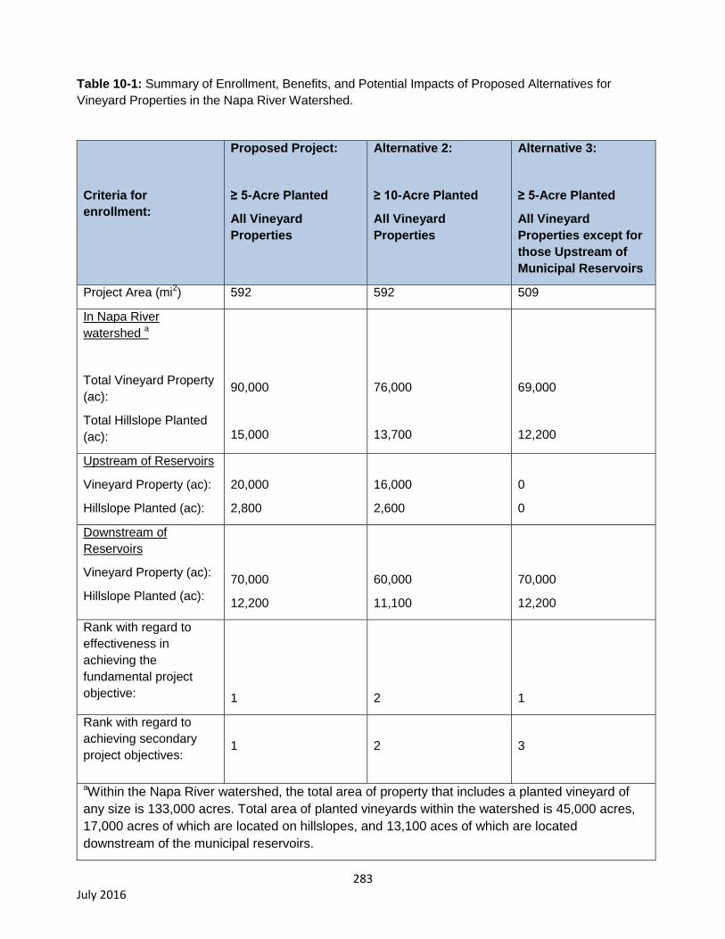
283 July 2016
Table 10-1: Summary of Enrollment, Benefits, and Potential Impacts of Proposed Alternatives for
Vineyard Properties in the Napa River Watershed.
Criteria for
enrollment:
Proposed Project:
≥ 5-Acre Planted
All Vineyard
Properties
Alternative 2:
≥ 10-Acre Planted
All Vineyard
Properties
Alternative 3:
≥ 5-Acre Planted
All Vineyard
Properties except for
those Upstream of
Municipal Reservoirs
Project Area (mi2) 592 592 509
In Napa River
watershed a
Total Vineyard Property
(ac):
Total Hillslope Planted
(ac):
90,000
15,000
76,000
13,700
69,000
12,200
Upstream of Reservoirs
Vineyard Property (ac):
Hillslope Planted (ac):
20,000
2,800
16,000
2,600
0
0
Downstream of
Reservoirs
Vineyard Property (ac):
Hillslope Planted (ac):
70,000
12,200
60,000
11,100
70,000
12,200
Rank with regard to
effectiveness in
achieving the
fundamental project
objective:
1
2
1
Rank with regard to
achieving secondary
project objectives:
1
2
3
aWithin the Napa River watershed, the total area of property that includes a planted vineyard of
any size is 133,000 acres. Total area of planted vineyards within the watershed is 45,000 acres,
17,000 acres of which are located on hillslopes, and 13,100 aces of which are located
downstream of the municipal reservoirs.
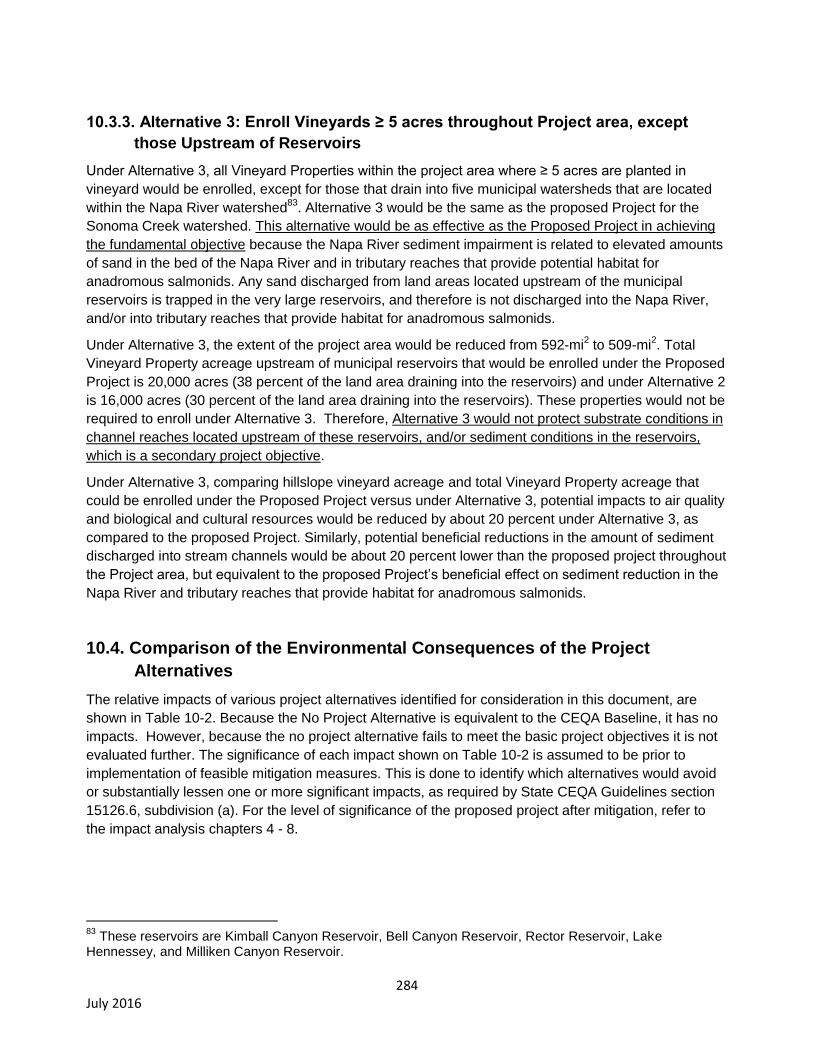
284 July 2016
10.3.3. Alternative 3: Enroll Vineyards ≥ 5 acres throughout Project area, except
those Upstream of Reservoirs
Under Alternative 3, all Vineyard Properties within the project area where ≥ 5 acres are planted in
vineyard would be enrolled, except for those that drain into five municipal watersheds that are located
within the Napa River watershed83
. Alternative 3 would be the same as the proposed Project for the
Sonoma Creek watershed. This alternative would be as effective as the Proposed Project in achieving
the fundamental objective because the Napa River sediment impairment is related to elevated amounts
of sand in the bed of the Napa River and in tributary reaches that provide potential habitat for
anadromous salmonids. Any sand discharged from land areas located upstream of the municipal
reservoirs is trapped in the very large reservoirs, and therefore is not discharged into the Napa River,
and/or into tributary reaches that provide habitat for anadromous salmonids.
Under Alternative 3, the extent of the project area would be reduced from 592-mi2 to 509-mi
2. Total
Vineyard Property acreage upstream of municipal reservoirs that would be enrolled under the Proposed
Project is 20,000 acres (38 percent of the land area draining into the reservoirs) and under Alternative 2
is 16,000 acres (30 percent of the land area draining into the reservoirs). These properties would not be
required to enroll under Alternative 3. Therefore, Alternative 3 would not protect substrate conditions in
channel reaches located upstream of these reservoirs, and/or sediment conditions in the reservoirs,
which is a secondary project objective.
Under Alternative 3, comparing hillslope vineyard acreage and total Vineyard Property acreage that
could be enrolled under the Proposed Project versus under Alternative 3, potential impacts to air quality
and biological and cultural resources would be reduced by about 20 percent under Alternative 3, as
compared to the proposed Project. Similarly, potential beneficial reductions in the amount of sediment
discharged into stream channels would be about 20 percent lower than the proposed project throughout
the Project area, but equivalent to the proposed Project’s beneficial effect on sediment reduction in the
Napa River and tributary reaches that provide habitat for anadromous salmonids.
10.4. Comparison of the Environmental Consequences of the Project
Alternatives
The relative impacts of various project alternatives identified for consideration in this document, are
shown in Table 10-2. Because the No Project Alternative is equivalent to the CEQA Baseline, it has no
impacts. However, because the no project alternative fails to meet the basic project objectives it is not
evaluated further. The significance of each impact shown on Table 10-2 is assumed to be prior to
implementation of feasible mitigation measures. This is done to identify which alternatives would avoid
or substantially lessen one or more significant impacts, as required by State CEQA Guidelines section
15126.6, subdivision (a). For the level of significance of the proposed project after mitigation, refer to
the impact analysis chapters 4 - 8.
83
These reservoirs are Kimball Canyon Reservoir, Bell Canyon Reservoir, Rector Reservoir, Lake Hennessey, and Milliken Canyon Reservoir.
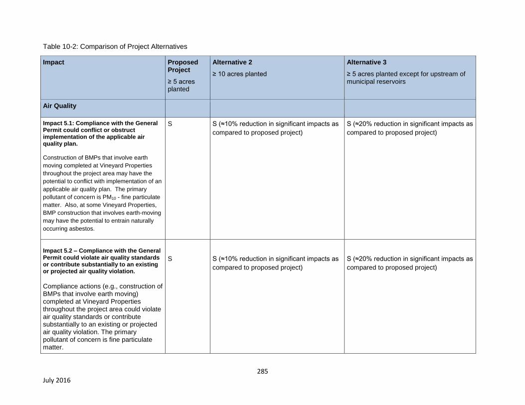
285 July 2016
Table 10-2: Comparison of Project Alternatives
Impact Proposed Project
≥ 5 acres planted
Alternative 2
≥ 10 acres planted
Alternative 3
≥ 5 acres planted except for upstream of municipal reservoirs
Air Quality
Impact 5.1: Compliance with the General Permit could conflict or obstruct implementation of the applicable air quality plan.
Construction of BMPs that involve earth
moving completed at Vineyard Properties
throughout the project area may have the
potential to conflict with implementation of an
applicable air quality plan. The primary
pollutant of concern is PM10 - fine particulate
matter. Also, at some Vineyard Properties,
BMP construction that involves earth-moving
may have the potential to entrain naturally
occurring asbestos.
S S (≈10% reduction in significant impacts as
compared to proposed project)
S (≈20% reduction in significant impacts as
compared to proposed project)
Impact 5.2 – Compliance with the General Permit could violate air quality standards or contribute substantially to an existing or projected air quality violation.
Compliance actions (e.g., construction of BMPs that involve earth moving) completed at Vineyard Properties throughout the project area could violate air quality standards or contribute substantially to an existing or projected air quality violation. The primary pollutant of concern is fine particulate matter.
S
S (≈10% reduction in significant impacts as
compared to proposed project)
S (≈20% reduction in significant impacts as
compared to proposed project)
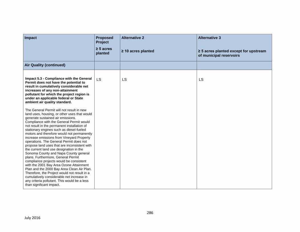
286 July 2016
Impact Proposed Project
≥ 5 acres planted
Alternative 2
≥ 10 acres planted
Alternative 3
≥ 5 acres planted except for upstream of municipal reservoirs
Air Quality (continued)
Impact 5.3 - Compliance with the General Permit does not have the potential to result in cumulatively considerable net increases of any non-attainment pollutant for which the project region is under an applicable federal or State ambient air quality standard.
The General Permit will not result in new land uses, housing, or other uses that would generate sustained air emissions. Compliance with the General Permit would not result in the permanent installation of stationary engines such as diesel-fueled motors and therefore would not permanently increase emissions from Vineyard Property operations. The General Permit does not propose land uses that are inconsistent with the current land use designation in the Sonoma County and Napa County general plans. Furthermore, General Permit compliance projects would be consistent with the 2001 Bay Area Ozone Attainment Plan and the 2000 Bay Area Clean Air Plan. Therefore, the Project would not result in a cumulatively considerable net increase in any criteria pollutant. This would be a less than significant impact.
LS
LS
LS
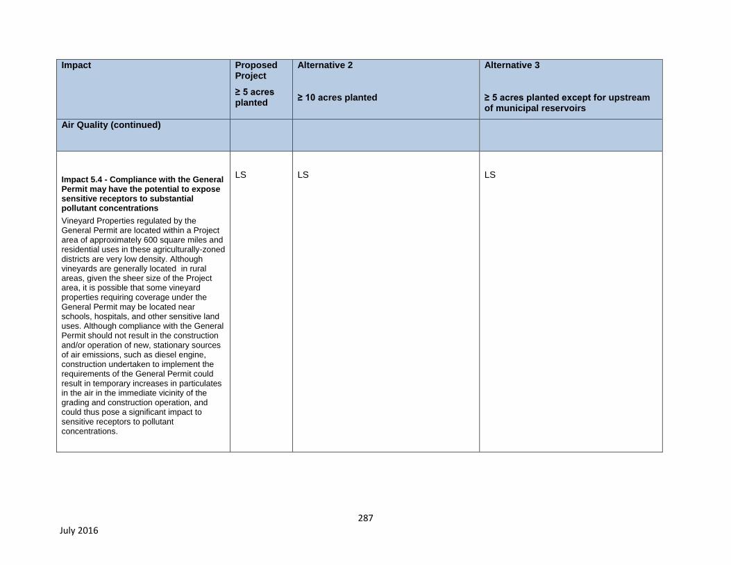
287 July 2016
Impact Proposed Project
≥ 5 acres planted
Alternative 2
≥ 10 acres planted
Alternative 3
≥ 5 acres planted except for upstream of municipal reservoirs
Air Quality (continued)
Impact 5.4 - Compliance with the General Permit may have the potential to expose sensitive receptors to substantial pollutant concentrations
Vineyard Properties regulated by the General Permit are located within a Project area of approximately 600 square miles and residential uses in these agriculturally-zoned districts are very low density. Although vineyards are generally located in rural areas, given the sheer size of the Project area, it is possible that some vineyard properties requiring coverage under the General Permit may be located near schools, hospitals, and other sensitive land uses. Although compliance with the General Permit should not result in the construction and/or operation of new, stationary sources of air emissions, such as diesel engine, construction undertaken to implement the requirements of the General Permit could result in temporary increases in particulates in the air in the immediate vicinity of the grading and construction operation, and could thus pose a significant impact to sensitive receptors to pollutant concentrations.
LS
LS
LS
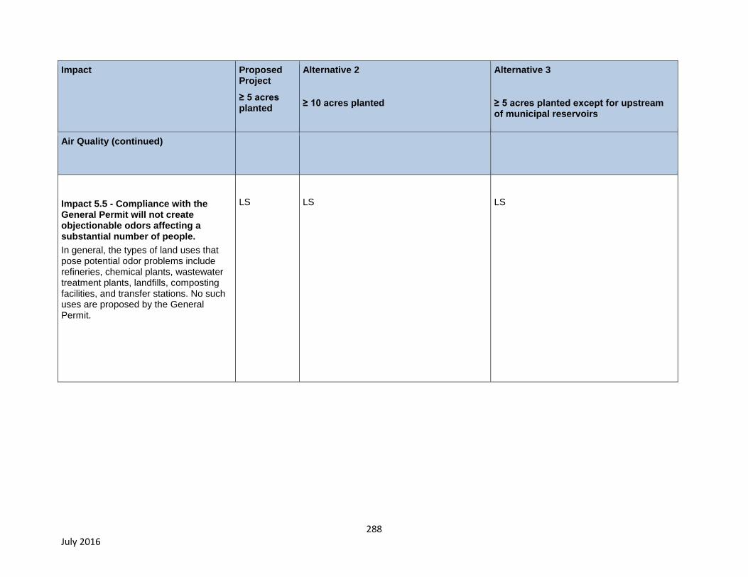
288 July 2016
Impact Proposed Project
≥ 5 acres planted
Alternative 2
≥ 10 acres planted
Alternative 3
≥ 5 acres planted except for upstream of municipal reservoirs
Air Quality (continued)
Impact 5.5 - Compliance with the General Permit will not create objectionable odors affecting a substantial number of people.
In general, the types of land uses that pose potential odor problems include refineries, chemical plants, wastewater treatment plants, landfills, composting facilities, and transfer stations. No such uses are proposed by the General Permit.
LS
LS
LS
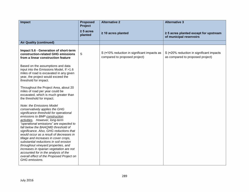
289 July 2016
Impact Proposed Project
≥ 5 acres planted
Alternative 2
≥ 10 acres planted
Alternative 3
≥ 5 acres planted except for upstream of municipal reservoirs
Air Quality (continued)
Impact 5.6 - Generation of short-term construction-related GHG emissions from a linear construction feature
Based on the assumptions and data input into the Emissions Model, If >1.6 miles of road is excavated in any given year, the project would exceed the threshold for impact. Throughout the Project Area, about 20 miles of road per year could be excavated, which is much greater than the threshold for impact. Note: the Emissions Model conservatively applies the GHG significance threshold for operational emissions to BMP construction activities. However, long-term “operational emissions” are expected to fall below the BAAQMD threshold of significance. Also, GHG reductions that would occur as a result of decreases in tillage and increases in cover crops, substantial reductions in soil erosion throughout vineyard properties, and increases in riparian vegetation are not accounted for in the analysis of the overall effect of the Proposed Project on GHG emissions.
S
S (≈10% reduction in significant impacts as
compared to proposed project)
S (≈20% reduction in significant impacts
as compared to proposed project)
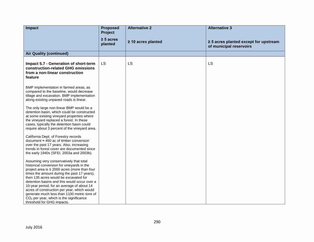
290 July 2016
Impact Proposed Project
≥ 5 acres planted
Alternative 2
≥ 10 acres planted
Alternative 3
≥ 5 acres planted except for upstream of municipal reservoirs
Air Quality (continued)
Impact 5.7 - Generation of short-term construction-related GHG emissions from a non-linear construction feature
BMP implementation in farmed areas, as compared to the baseline, would decrease tillage and excavation. BMP implementation along existing unpaved roads is linear. The only large non-linear BMP would be a detention basin, which could be constructed at some existing vineyard properties where the vineyard replaced a forest. In these cases, typically the detention basin could require about 3 percent of the vineyard area. California Dept. of Forestry records document ≈ 450 ac of timber conversion over the past 17 years. Also, increasing trends in forest cover are documented since the early 1940s (SFEI, 2003a and 2003b). Assuming very conservatively that total historical conversion for vineyards in the project area is ≤ 2000 acres (more than four times the amount during the past 17 years), then 135 acres would be excavated for detention basins and this would occur over a 10-year period, for an average of about 14 acres of construction per year, which would generate much less than 1100 metric tons of CO2 per year, which is the significance threshold for GHG impacts.
LS
LS
LS
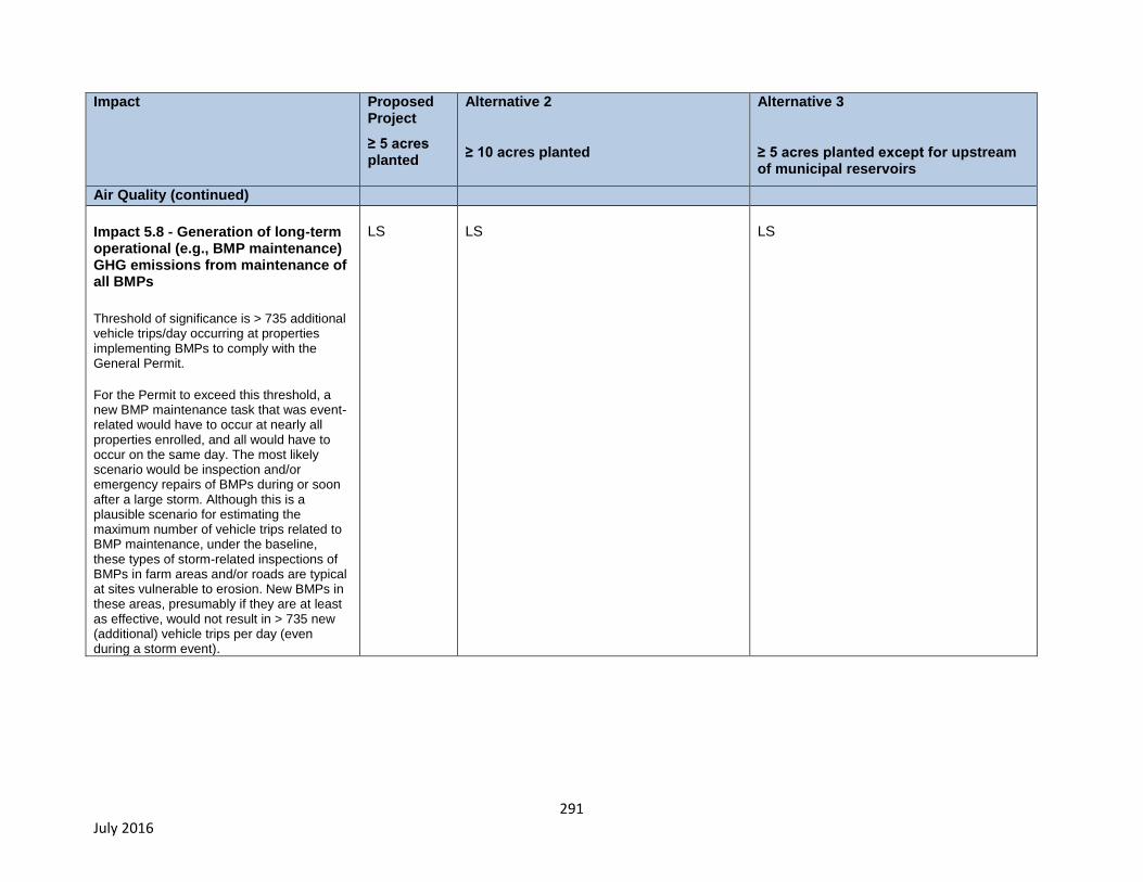
291 July 2016
Impact Proposed Project
≥ 5 acres planted
Alternative 2
≥ 10 acres planted
Alternative 3
≥ 5 acres planted except for upstream of municipal reservoirs
Air Quality (continued)
Impact 5.8 - Generation of long-term operational (e.g., BMP maintenance) GHG emissions from maintenance of all BMPs
Threshold of significance is > 735 additional vehicle trips/day occurring at properties implementing BMPs to comply with the General Permit.
For the Permit to exceed this threshold, a new BMP maintenance task that was event-related would have to occur at nearly all properties enrolled, and all would have to occur on the same day. The most likely scenario would be inspection and/or emergency repairs of BMPs during or soon after a large storm. Although this is a plausible scenario for estimating the maximum number of vehicle trips related to BMP maintenance, under the baseline, these types of storm-related inspections of BMPs in farm areas and/or roads are typical at sites vulnerable to erosion. New BMPs in these areas, presumably if they are at least as effective, would not result in > 735 new (additional) vehicle trips per day (even during a storm event).
LS
LS
LS
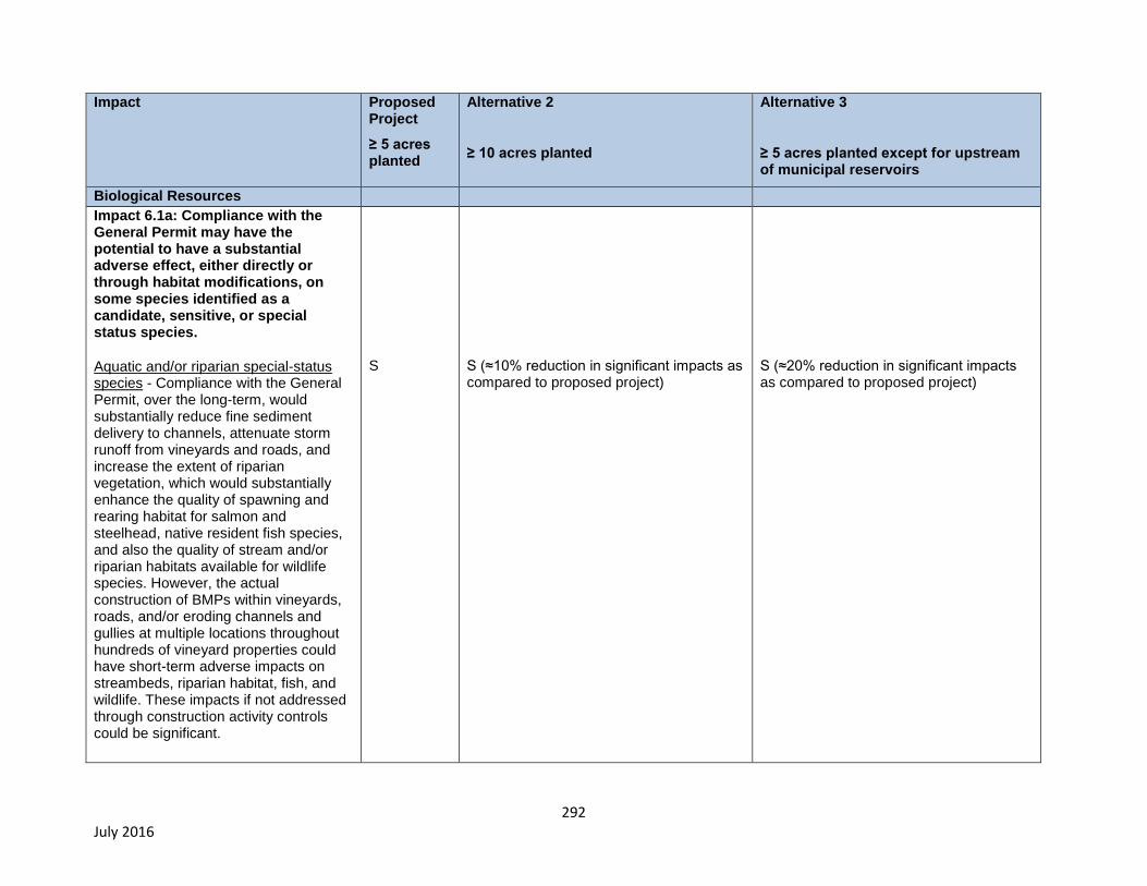
292 July 2016
Impact Proposed Project
≥ 5 acres planted
Alternative 2
≥ 10 acres planted
Alternative 3
≥ 5 acres planted except for upstream of municipal reservoirs
Biological Resources
Impact 6.1a: Compliance with the General Permit may have the potential to have a substantial adverse effect, either directly or through habitat modifications, on some species identified as a candidate, sensitive, or special status species.
Aquatic and/or riparian special-status species - Compliance with the General Permit, over the long-term, would substantially reduce fine sediment delivery to channels, attenuate storm runoff from vineyards and roads, and increase the extent of riparian vegetation, which would substantially enhance the quality of spawning and rearing habitat for salmon and steelhead, native resident fish species, and also the quality of stream and/or riparian habitats available for wildlife species. However, the actual construction of BMPs within vineyards, roads, and/or eroding channels and gullies at multiple locations throughout hundreds of vineyard properties could have short-term adverse impacts on streambeds, riparian habitat, fish, and wildlife. These impacts if not addressed through construction activity controls could be significant.
S
S (≈10% reduction in significant impacts as compared to proposed project)
S (≈20% reduction in significant impacts as compared to proposed project)
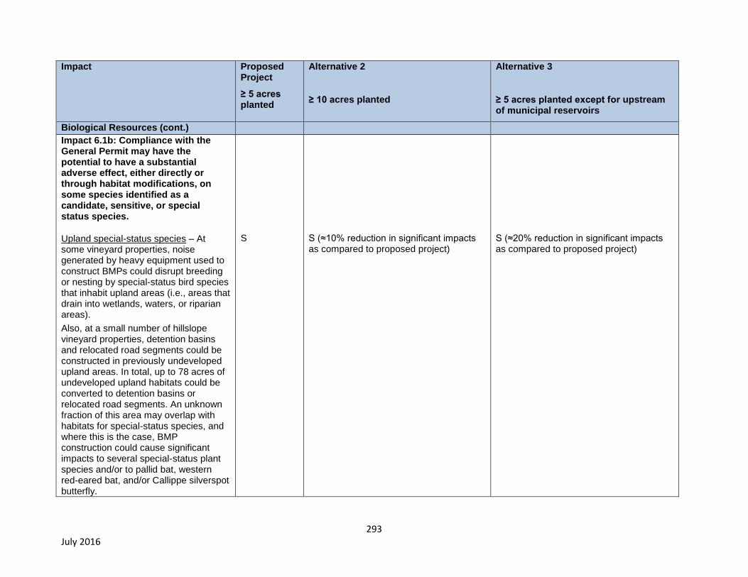
293 July 2016
Impact Proposed Project
≥ 5 acres planted
Alternative 2
≥ 10 acres planted
Alternative 3
≥ 5 acres planted except for upstream of municipal reservoirs
Biological Resources (cont.)
Impact 6.1b: Compliance with the General Permit may have the potential to have a substantial adverse effect, either directly or through habitat modifications, on some species identified as a candidate, sensitive, or special status species.
Upland special-status species – At some vineyard properties, noise generated by heavy equipment used to construct BMPs could disrupt breeding or nesting by special-status bird species that inhabit upland areas (i.e., areas that drain into wetlands, waters, or riparian areas).
Also, at a small number of hillslope vineyard properties, detention basins and relocated road segments could be constructed in previously undeveloped upland areas. In total, up to 78 acres of undeveloped upland habitats could be converted to detention basins or relocated road segments. An unknown fraction of this area may overlap with habitats for special-status species, and where this is the case, BMP construction could cause significant impacts to several special-status plant species and/or to pallid bat, western red-eared bat, and/or Callippe silverspot butterfly.
S
S (≈10% reduction in significant impacts as compared to proposed project)
S (≈20% reduction in significant impacts as compared to proposed project)
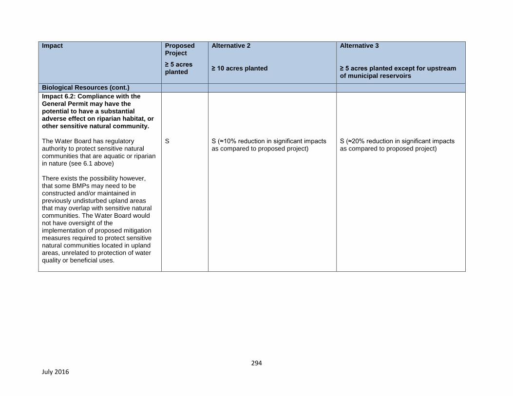
294 July 2016
Impact Proposed Project
≥ 5 acres planted
Alternative 2
≥ 10 acres planted
Alternative 3
≥ 5 acres planted except for upstream of municipal reservoirs
Biological Resources (cont.)
Impact 6.2: Compliance with the General Permit may have the potential to have a substantial adverse effect on riparian habitat, or other sensitive natural community. The Water Board has regulatory authority to protect sensitive natural communities that are aquatic or riparian in nature (see 6.1 above) There exists the possibility however, that some BMPs may need to be constructed and/or maintained in previously undisturbed upland areas that may overlap with sensitive natural communities. The Water Board would not have oversight of the implementation of proposed mitigation measures required to protect sensitive natural communities located in upland areas, unrelated to protection of water quality or beneficial uses.
S
S (≈10% reduction in significant impacts as compared to proposed project)
S (≈20% reduction in significant impacts as compared to proposed project)

295 July 2016
Impact Proposed Project
≥ 5 acres planted
Alternative 2
≥ 10 acres planted
Alternative 3
≥ 5 acres planted except for upstream of municipal reservoirs
Biological Resources (cont.)
Impact 6.3: Compliance with the General Permit has the potential to cause a substantial adverse effect on federally protected wetlands. Some construction activities to comply with the General Permit would be occur in stream channels including removal of road crossings where problem roads are decommissioned (BMP-19), construction of road crossings over stream channels where new storm-proofed roads are constructed (BMP-20), and construction of soil biotechnical erosion control projects in eroding gullies and stream channels. Absent specification of construction activity controls and measures to avoid, minimize, and mitigate impacts to wetlands and other waters impacts could be significant.
S
S (≈10% reduction in significant impacts as compared to proposed project)
S (≈20% reduction in significant impacts as compared to proposed project)
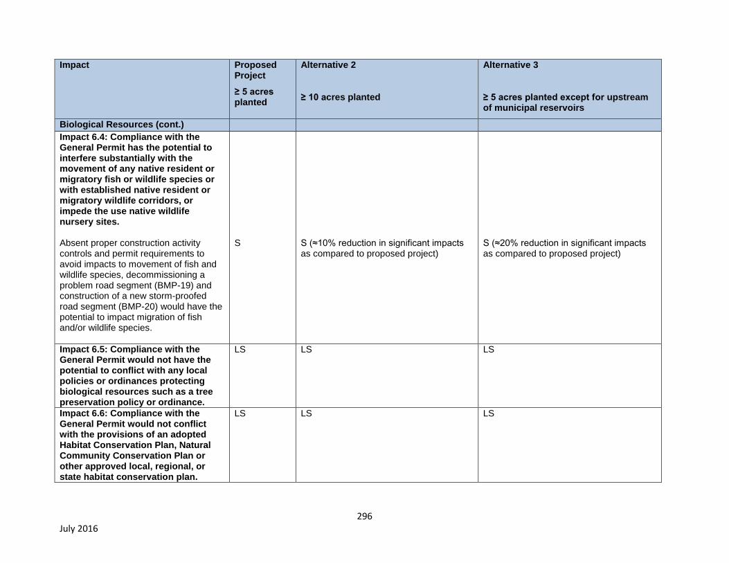
296 July 2016
Impact Proposed Project
≥ 5 acres planted
Alternative 2
≥ 10 acres planted
Alternative 3
≥ 5 acres planted except for upstream of municipal reservoirs
Biological Resources (cont.)
Impact 6.4: Compliance with the General Permit has the potential to interfere substantially with the movement of any native resident or migratory fish or wildlife species or with established native resident or migratory wildlife corridors, or impede the use native wildlife nursery sites. Absent proper construction activity controls and permit requirements to avoid impacts to movement of fish and wildlife species, decommissioning a problem road segment (BMP-19) and construction of a new storm-proofed road segment (BMP-20) would have the potential to impact migration of fish and/or wildlife species.
S
S (≈10% reduction in significant impacts as compared to proposed project)
S (≈20% reduction in significant impacts as compared to proposed project)
Impact 6.5: Compliance with the General Permit would not have the potential to conflict with any local policies or ordinances protecting biological resources such as a tree preservation policy or ordinance.
LS LS LS
Impact 6.6: Compliance with the General Permit would not conflict with the provisions of an adopted Habitat Conservation Plan, Natural Community Conservation Plan or other approved local, regional, or state habitat conservation plan.
LS LS LS
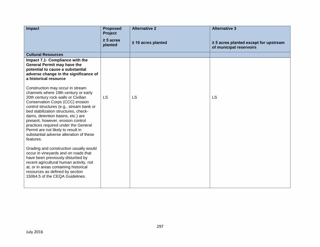
297 July 2016
Impact Proposed Project
≥ 5 acres planted
Alternative 2
≥ 10 acres planted
Alternative 3
≥ 5 acres planted except for upstream of municipal reservoirs
Cultural Resources
Impact 7.1- Compliance with the General Permit may have the potential to cause a substantial adverse change in the significance of a historical resource Construction may occur in stream channels where 19th century or early 20th century rock walls or Civilian Conservation Corps (CCC) erosion control structures (e.g., stream bank or bed stabilization structures, check-dams, detention basins, etc.) are present, however, erosion control practices required under the General Permit are not likely to result in substantial adverse alteration of these features. Grading and construction usually would occur in vineyards and on roads that have been previously disturbed by recent agricultural human activity, not at, or in areas containing historical resources as defined by section 15064.5 of the CEQA Guidelines.
LS
LS
LS
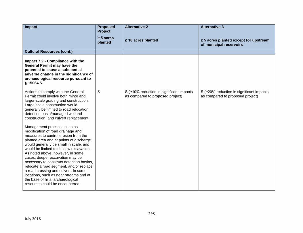
298 July 2016
Impact Proposed Project
≥ 5 acres planted
Alternative 2
≥ 10 acres planted
Alternative 3
≥ 5 acres planted except for upstream of municipal reservoirs
Cultural Resources (cont.)
Impact 7.2 - Compliance with the General Permit may have the potential to cause a substantial adverse change in the significance of archaeological resource pursuant to § 15064.5. Actions to comply with the General Permit could involve both minor and larger-scale grading and construction. Large scale construction would generally be limited to road relocation, detention basin/managed wetland construction, and culvert replacement. Management practices such as modification of road drainage and measures to control erosion from the planted area and at points of discharge would generally be small in scale, and would be limited to shallow excavation. As noted above, however, in some cases, deeper excavation may be necessary to construct detention basins, relocate a road segment, and/or replace a road crossing and culvert. In some locations, such as near streams and at the base of hills, archaeological resources could be encountered.
S
S (≈10% reduction in significant impacts as compared to proposed project)
S (≈20% reduction in significant impacts as compared to proposed project)
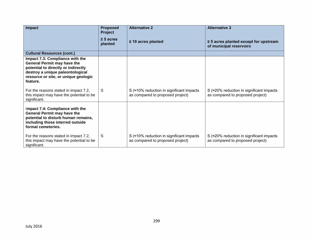
299 July 2016
Impact Proposed Project
≥ 5 acres planted
Alternative 2
≥ 10 acres planted
Alternative 3
≥ 5 acres planted except for upstream of municipal reservoirs
Cultural Resources (cont.)
Impact 7.3: Compliance with the General Permit may have the potential to directly or indirectly destroy a unique paleontological resource or site, or unique geologic feature. For the reasons stated in impact 7.2, this impact may have the potential to be significant.
S
S (≈10% reduction in significant impacts as compared to proposed project)
S (≈20% reduction in significant impacts as compared to proposed project)
Impact 7.4: Compliance with the General Permit may have the potential to disturb human remains, including those interred outside formal cemeteries. For the reasons stated in impact 7.2, this impact may have the potential to be significant.
S
S (≈10% reduction in significant impacts as compared to proposed project)
S (≈20% reduction in significant impacts as compared to proposed project)
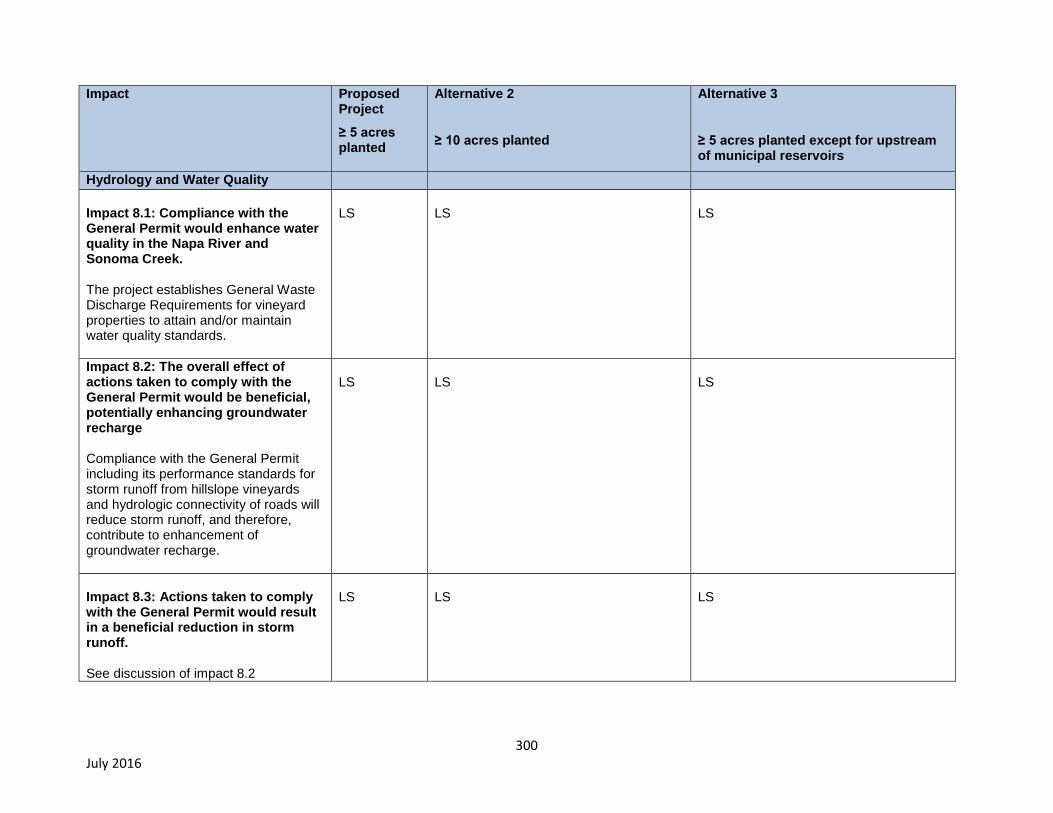
300 July 2016
Impact Proposed Project
≥ 5 acres planted
Alternative 2
≥ 10 acres planted
Alternative 3
≥ 5 acres planted except for upstream of municipal reservoirs
Hydrology and Water Quality
Impact 8.1: Compliance with the General Permit would enhance water quality in the Napa River and Sonoma Creek. The project establishes General Waste Discharge Requirements for vineyard properties to attain and/or maintain water quality standards.
LS
LS
LS
Impact 8.2: The overall effect of actions taken to comply with the General Permit would be beneficial, potentially enhancing groundwater recharge Compliance with the General Permit including its performance standards for storm runoff from hillslope vineyards and hydrologic connectivity of roads will reduce storm runoff, and therefore, contribute to enhancement of groundwater recharge.
LS
LS
LS
Impact 8.3: Actions taken to comply with the General Permit would result in a beneficial reduction in storm runoff. See discussion of impact 8.2
LS
LS
LS

301 July 2016
Impact Proposed Project
≥ 5 acres planted
Alternative 2
≥ 10 acres planted
Alternative 3
≥ 5 acres planted except for upstream of municipal reservoirs
Hydrology and Water Quality (cont.)
Impact 8.4: Actions taken to comply with the General Permit would over the long-term, result in beneficial reductions in erosion and siltation to the Napa River, Sonoma Creek, and to their tributaries. Long-term effects: General Permit requires compliance actions to control sediment discharges and storm runoff increases from farms and roads, toward the goal of achieving 50 percent reductions in sediment delivery to channels within vineyard properties in the Napa River and Sonoma Creek watersheds. The long-term effect would be beneficial and significant. Short-term effects: Absent the requirement to implement effective construction activity controls, short-term erosion at some BMP sites following construction, could cause sediment to be deposited in water bodies, including stream channels that support sensitive and/or listed aquatic species, and these potential short-term and temporary impacts if they occurred, could be significant
LS (Significant beneficial effect) S
LS (beneficial effect = 90% of that under Proposed Project) S (≈10% reduction in significant impacts as compared to proposed project)
LS (beneficial effect = 80% of that under the Proposed Project) S (≈20% reduction in significant impacts as compared to proposed project)

302 July 2016
Impact Proposed Project
≥ 5 acres planted
Alternative 2
≥ 10 acres planted
Alternative 3
≥ 5 acres planted except for upstream of municipal reservoirs
Hydrology and Water Quality (cont.)
Impacts 8.5: Compliance with the General Permit would reduce sediment delivery to San Pablo Bay, adversely impacting dissolved oxygen concentration therein, and maintenance and/or restoration of tidal marshes
The Farm Bureau commented on the NOP that impacts of reduced sediment supply to San Pablo Bay (SPB) should be evaluated including: a) the possibility that reduced suspended sediment concentration in SPB could cause increased phytoplankton growth, decreased dissolved oxygen, and fish kills; and b) that reduced sediment supply to San Pablo Bay could impair tidal wetland maintenance & restoration.
Although compliance with the General Permit would reduce land-use related sediment from vineyard properties by as much as 50%, even after this and all other actions called for in both TMDLs are implemented, sediment supply from the Napa River and Sonoma Creek still would remain at approximately 125% of natural background. Also, climate change models for CA predict much larger and more frequent floods, which would be expected to increase natural sediment supply substantially as compared to the historical period.
LS
LS
LS
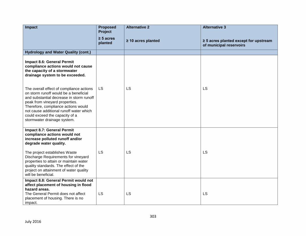
303 July 2016
Impact Proposed Project
≥ 5 acres planted
Alternative 2
≥ 10 acres planted
Alternative 3
≥ 5 acres planted except for upstream of municipal reservoirs
Hydrology and Water Quality (cont.)
Impact 8.6: General Permit compliance actions would not cause the capacity of a stormwater drainage system to be exceeded.
The overall effect of compliance actions on storm runoff would be a beneficial and substantial decrease in storm runoff peak from vineyard properties. Therefore, compliance actions would not cause additional runoff water which could exceed the capacity of a stormwater drainage system.
LS
LS
LS
Impact 8.7: General Permit compliance actions would not increase polluted runoff and/or degrade water quality.
The project establishes Waste Discharge Requirements for vineyard properties to attain or maintain water quality standards. The effect of the project on attainment of water quality will be beneficial.
LS
LS
LS
Impact 8.8: General Permit would not affect placement of housing in flood hazard areas. The General Permit does not affect placement of housing. There is no impact.
LS
LS
LS
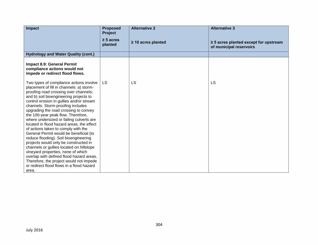
304 July 2016
Impact Proposed Project
≥ 5 acres planted
Alternative 2
≥ 10 acres planted
Alternative 3
≥ 5 acres planted except for upstream of municipal reservoirs
Hydrology and Water Quality (cont.)
Impact 8.9: General Permit compliance actions would not impede or redirect flood flows. Two types of compliance actions involve placement of fill in channels: a) storm-proofing road crossing over channels; and b) soil bioengineering projects to control erosion in gullies and/or stream channels. Storm-proofing includes upgrading the road crossing to convey the 100-year peak flow. Therefore, where undersized or failing culverts are located in flood hazard areas, the effect of actions taken to comply with the General Permit would be beneficial (to reduce flooding). Soil bioengineering projects would only be constructed in channels or gullies located on hillslope vineyard properties, none of which overlap with defined flood hazard areas. Therefore, the project would not impede or redirect flood flows in a flood hazard area.
LS
LS
LS
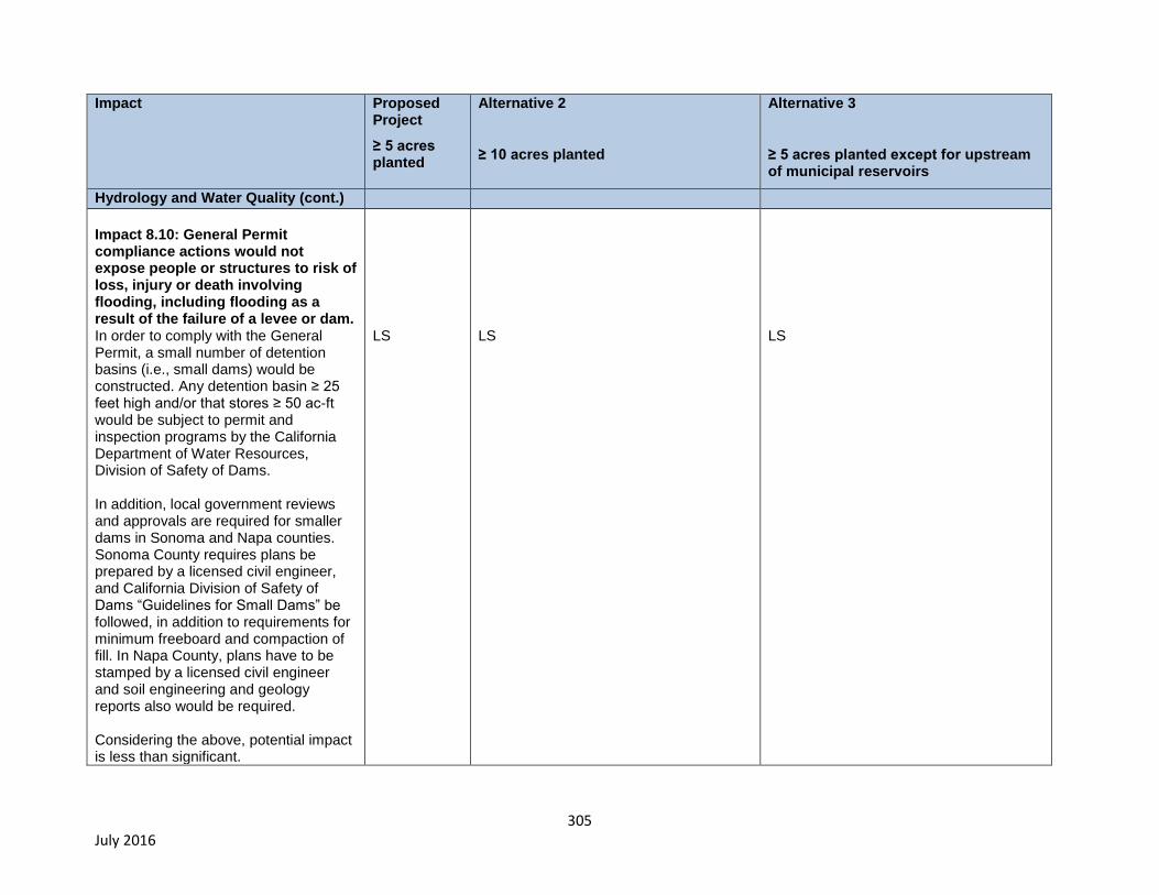
305 July 2016
Impact Proposed Project
≥ 5 acres planted
Alternative 2
≥ 10 acres planted
Alternative 3
≥ 5 acres planted except for upstream of municipal reservoirs
Hydrology and Water Quality (cont.)
Impact 8.10: General Permit compliance actions would not expose people or structures to risk of loss, injury or death involving flooding, including flooding as a result of the failure of a levee or dam. In order to comply with the General Permit, a small number of detention basins (i.e., small dams) would be constructed. Any detention basin ≥ 25 feet high and/or that stores ≥ 50 ac-ft would be subject to permit and inspection programs by the California Department of Water Resources, Division of Safety of Dams. In addition, local government reviews and approvals are required for smaller dams in Sonoma and Napa counties. Sonoma County requires plans be prepared by a licensed civil engineer, and California Division of Safety of Dams “Guidelines for Small Dams” be followed, in addition to requirements for minimum freeboard and compaction of fill. In Napa County, plans have to be stamped by a licensed civil engineer and soil engineering and geology reports also would be required. Considering the above, potential impact is less than significant.
LS
LS
LS
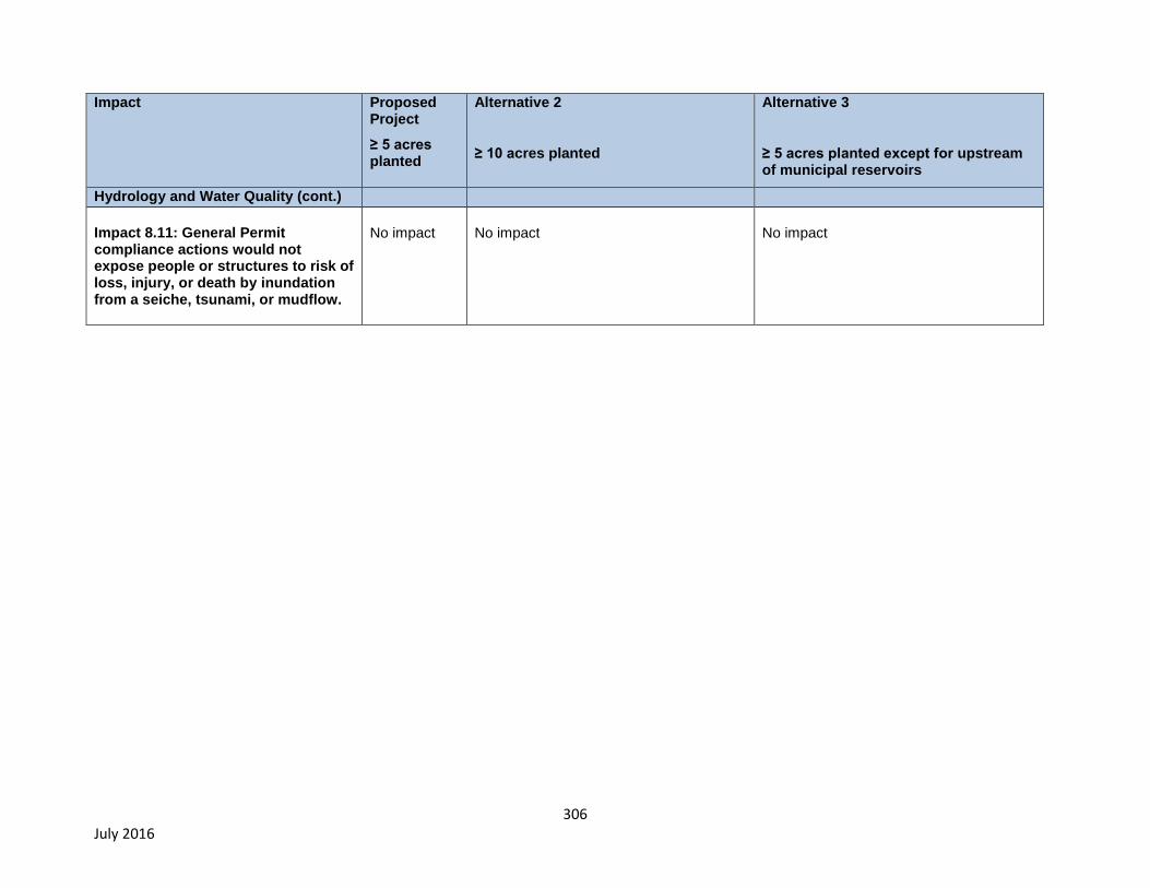
306 July 2016
Impact Proposed Project
≥ 5 acres planted
Alternative 2
≥ 10 acres planted
Alternative 3
≥ 5 acres planted except for upstream of municipal reservoirs
Hydrology and Water Quality (cont.)
Impact 8.11: General Permit compliance actions would not expose people or structures to risk of loss, injury, or death by inundation from a seiche, tsunami, or mudflow.
No impact
No impact
No impact

307
To summarize, the General Permit would result in increases in the implementation of commonly-used
BMPs and construction of structural controls (such as cover crops, erosion control facilities, unpaved
road repair and reshaping, and stormwater runoff controls) to meet water quality requirements.
Implementation of BMPs could result in short-term impacts related to construction activities (grading,
vegetation removal, stockpiling of soils, and mobilizing heavy equipment). Maintenance of selected
BMPs (e.g., site inspections, compliance monitoring, inspecting and maintaining drainage facilities,
cover crop maintenance, and maintaining roads that service the vineyard facilities) will not result in any
long-term environmental impacts.
The General Permit would have no or negligible impacts on aesthetics, geology and soils, hazards and
hazardous materials, hydrology and water quality, land use and planning, mineral resources, noise,
population and housing, public services, recreation, transportation, traffic, and utilities and service
systems. All project alternatives would have potential impacts on air quality/greenhouse gas emissions,
biological resources, and cultural resources because compliance with each alternative would require
the use of the same types of equipment and the construction of the same types of commonly used,
industry-supported BMPs to implement the General Permit. Potential impacts would be greater for the
Proposed Project (≥ 5-acre planted above and below municipal reservoirs) because General Permit
implementation would result in construction over a larger geographic area as compared to the two,
reduced geographic scope alternatives (i.e., ≥ 10-Acre Planted or ≥ 5-Acre Planted at all Vineyard
Properties located below upstream of municipal reservoirs). However, beneficial effects on water
quality and aquatic and riparian habitats, also are greatest under the Proposed Project because its
performance standards are achieved over a wider geographic area.
10.5. Environmentally Superior Project Alternative
The ultimate goal of the project is water quality improvements, including restoration of fish habitat and
preservation of endangered species. The EIR identifies impacts associated with temporary construction
measures that will be necessary to implement sediment controls on Vineyard Properties. In this case,
there is an inverse relationship between the effects caused by temporary construction activities and
overall water quality improvements. That is, the more Vineyard Properties enrolled in the Order, the
more construction activities will occur to control sediment (and thus environmental effects), but
ultimately, the greater the expected improvements to sediment conditions in the creeks and overall
water quality.
The environmentally superior project is, “on balance, the alternative with the least significant effect.”
(Bass, et al., CEQA Deskbook (2012) Identifying the Environmentally Superior Alternative, p. 178.)
Strictly interpreting this definition of “environmentally superior project” to only refer to significant effects
with negative impacts on the environment, the alternative that would result in the fewest impacts is the
No Project alternative. The No Project alternative would result in no impacts because no construction
of sediment controls would occur. The No Project alternative, however, does not meet the fundamental
or secondary project objectives of improving water quality to the point where the Napa River and
Sonoma Creek may be removed from the Clean Water Act section 303(d) list for sediment impairments.
Constructing the phrase “environmentally superior project” in this manner, which omits consideration of
long-term beneficial environmental impacts, fails to achieve CEQA’s primary goal: the “preservation and
enhancement of the environment.” (Pub. Res. Code § 21000(e).) CEQA directs governmental
agencies to “take all action necessary to provide the people of this state with clean … water” and

308
identify ways that environmental damage can be avoided or significantly reduced.” (Pub. Res. Code §
21001(b) and CEQA Guideline § 15002(a)(2).)
Considering the primary purpose and directives of CEQA, on balance, the environmental benefits that
will occur as a result of implementation of the control measures is greater than the potential
environmental impacts associated with the construction of the controls. The environmentally superior
project, therefore, is the project with the greatest environmental benefits, which is the Proposed
Project.
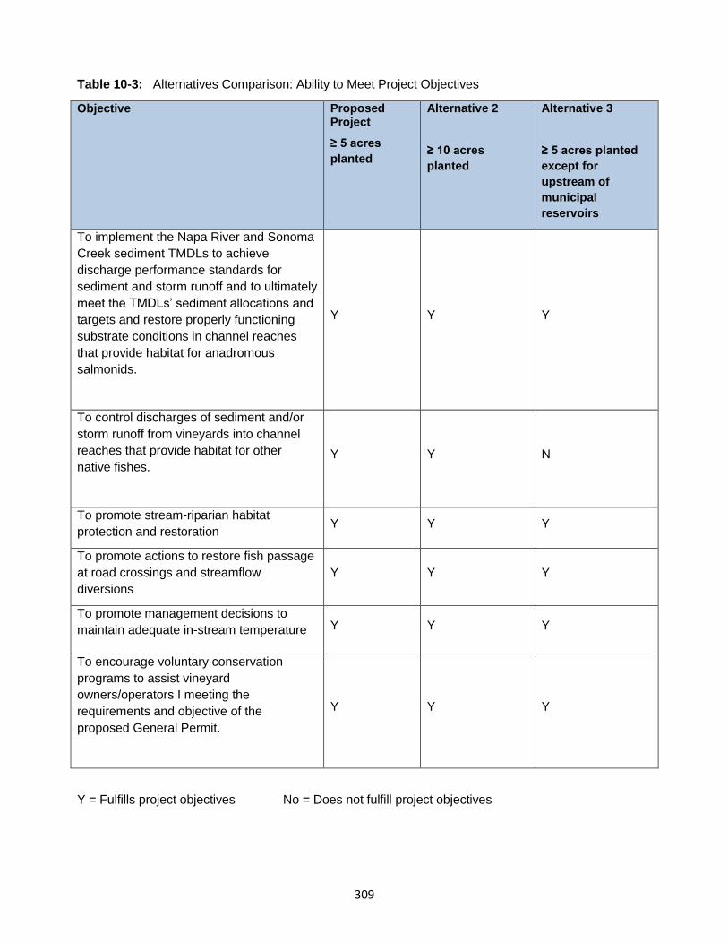
309
Table 10-3: Alternatives Comparison: Ability to Meet Project Objectives
Objective Proposed Project
≥ 5 acres
planted
Alternative 2
≥ 10 acres
planted
Alternative 3
≥ 5 acres planted
except for
upstream of
municipal
reservoirs
To implement the Napa River and Sonoma
Creek sediment TMDLs to achieve
discharge performance standards for
sediment and storm runoff and to ultimately
meet the TMDLs’ sediment allocations and
targets and restore properly functioning
substrate conditions in channel reaches
that provide habitat for anadromous
salmonids.
Y Y Y
To control discharges of sediment and/or
storm runoff from vineyards into channel
reaches that provide habitat for other
native fishes.
Y Y N
To promote stream-riparian habitat
protection and restoration Y Y Y
To promote actions to restore fish passage
at road crossings and streamflow
diversions
Y Y Y
To promote management decisions to
maintain adequate in-stream temperature Y Y Y
To encourage voluntary conservation
programs to assist vineyard
owners/operators I meeting the
requirements and objective of the
proposed General Permit.
Y Y Y
Y = Fulfills project objectives No = Does not fulfill project objectives
310
11. Other CEQA-Required Sections
11.1. Growth Inducing Impacts
Introduction
The California Environmental Quality Act (CEQA) State Guidelines Section 15126.2(d) requires that an
Environmental Impact Report (EIR) evaluate the growth-inducing impacts of a proposed action. A
growth-inducing impact is defined by the State CEQA Guidelines as:
“The way in which a proposed project could foster economic or population growth, or the
construction of additional housing, either directly or indirectly, in the surrounding environment.
Included in this are projects which would remove obstacles to population growth…It is not
assumed that growth in an area is necessarily beneficial, detrimental, or of little significance to
the environment.”
As described in the draft EIR for the Napa County General Plan Update (Napa County, 2007):
“A project can have a direct and/or indirect potential to induce population and/or economic
growth. For example, a direct effect on growth would be from the construction of new housing. A
project would have indirect effect on potential growth, for example, if it established substantial
new permanent employment opportunities (e.g., commercial, industrial or governmental
enterprises) or if it would involve a construction effort with substantial short-term employment
opportunities that would indirectly stimulate the need for additional housing and services to
support the new employment demand (Napa Citizens for Honest Government v. Napa County
Board of Supervisors). Similarly, a project would indirectly induce growth if it would remove an
obstacle to additional growth and development, such as removing a constraint on a required
public service. A project providing an increased water supply in an area where water service
historically limited growth could be considered growth inducing.
The CEQA Guidelines further explain that the environmental effects of induced growth are
considered indirect impacts of the proposed action. These indirect impacts or secondary effects
of growth may result in significant, adverse environmental impacts. Potential secondary effects
of growth include increased demand on other community and public services and infrastructure,
increased traffic and noise, and adverse environmental impacts such as degradation of air and
water quality, degradation or loss of plant and animal habitat, and conversion of agricultural and
open space land to developed uses.
Growth inducement may constitute an adverse impact if the growth is not consistent with or
accommodated by the land use plans and growth management plans and policies for the area
affected. Local land use plans provide for land use development patterns and growth policies
that allow for the orderly expansion of urban development supported by adequate urban public
services, such as water supply, roadway infrastructure, sewer service, and solid waste service.”
Growth Effects of the Project
The proposed project, a general permit to control pollutant discharges from vineyard properties, would
have a very small - less than significant - effect on population and/or economic growth, which would
be related to small increases in employment at local resource conservation districts, non-
311
profits, local government agencies, and/or environmental consulting firms to provide services
related to farm plan development and implementation, and BMP reporting and monitoring.
Several hundred properties would be enrolled in the proposed General Permit. Half-or-more of these
properties already have developed farm plans that are being implemented with the assistance of current
employees at public and/or private enterprise located within the project area. In order to develop and
implement farm plans at properties that do not already have plans developed, and to provide assistance
with farm plan implementation, monitoring and reporting, we estimate that up to an additional 10 full-
time jobs could be created to meet the demands for technical and/or administrative assistance to
comply with the proposed General Permit. Even if the actual number just for the sake of argument, was
an order of magnitude larger, compliance actions would have a very small overall effect on job creation
that would result in a less than significant effect on economic and/or population growth within the project
area. Therefore, the Proposed Project would not have growth inducing impacts.
11.2. Significant Irreversible Environmental Effects CEQA Sections 21100(b) (2) and 21100.1(a) require that EIRs prepared for the adoption of plan, policy,
or ordinance of a public agency must include a discussion of significant irreversible environmental
changes of project implementation. In addition, CEQA Guidelines Section 15126.2(c) describes
irreversible environmental changes as:
“Uses of nonrenewable resources during the initial and continued phases of the project may be
irreversible since a large commitment of such resources makes removal or nonuse thereafter
unlikely. Primary impacts and, particularly, secondary impacts (such as highway improvement
which provides access to a previously inaccessible area) generally commit future generations to
similar uses. Also irreversible damage can result from environmental accidents associated with
the project. Irretrievable commitments of resources should be evaluated to assure that such
current consumption is justified.”
The General Permit does not permit development of new vineyards, which is solely within the purview
of the local land use authorities. The impact of compliance with the proposed General Permit, if any,
would be to slightly increase the cost of: a) management of existing vineyard properties; and b)
development and management of new vineyard properties, which based on economic considerations
(Section 3.3), would result in a neutral effect on future vineyard development within the project area.
Implementation of the proposed General Permit would have no effect on the conversion of undeveloped
open space land areas to residential, commercial, industrial, office, public and recreational uses.
Through the construction and/or maintenance of BMPs and/or other compliance actions associated with
the proposed General Permit consumption of renewable, nonrenewable, and limited resources would
include, but are not limited to: oil, gasoline, lumber, sand and gravel, water, steel, and similar materials.
In addition, the proposed project would also result in significant unavoidable effects related to air
emissions, including emissions of greenhouse gases (see Chapter 4, Air Quality).
312
11.3. Significant and Unavoidable Environmental Effects CEQA Guidelines Section 15126.2(b) requires an EIR to discuss unavoidable significant environmental
effects, including those that can be mitigated but not reduced to a level of insignificance. In addition,
Section 15093(a) of the CEQA Guidelines allows the decision-making agency to determine the benefits
of a proposed project outweigh the unavoidable adverse environmental impacts of implementing the
project. The Water Board can approve a project with unavoidable adverse impacts if it prepares a
“Statement of Overriding Considerations” setting forth the specific reasons for making such a judgment.
The following significant and unavoidable impacts, both project and cumulative, of the proposed
General Permit and/or Project Alternatives are specifically identified in Sections 4 through 10 of this
EIR. The reader is referred to the various environmental issue areas of these sections for further details
and analysis of the significant and unavoidable impacts identified below.
Air Quality
Impact 5.1: Actions taken to comply with the General Permit could conflict with or obstruct
implementation of the applicable air quality plans.
Impact 5.2: Actions taken to comply with the General Permit have the potential to violate air
quality standards and/or to contribute to an existing or projected air quality violation.
Impact 5.4: Actions taken to comply with the General Permit have the potential to exposed
sensitive receptors to substantial pollutant concentrations.
Impact 5.6: Actions taken to comply with the General Permit have the potential to generate
significant GHG emissions.
Biological Resources
Impact 6.3: Noise generated by heavy equipment used to construct BMPs could disrupt
breeding and/or nesting by special-status bird species.
Impact 6.4: Detention basins and/or new storm-proofed roads constructed to comply with
the General Permit sited in undeveloped upland areas could impact special-status species
and/or their habitats, and/or some sensitive natural communities.
Cultural Resources
Impact 7.2: Actions taken to comply with the General Permit may have the potential to
cause a substantial adverse change to the significance of archeological resources.
313
Cultural Resources (cont.)
Impact 7.3: Actions taken to comply with the General Permit may have the potential to
destroy unique paleontological resources or unique geological features.
Impact 7.4: Actions taken to comply with the General Permit may have the potential to
disturb human remains, including those interred outside of formal cemeteries.
314
12. LIST OF PREPARERS
San Francisco Bay Regional Water Quality Control Board
Tamarin Austin – Legal Review
Paul Modrell – Agricultural and Forestry Resources
James Ponton – Approach to Impact Analysis, Agricultural and Forestry Resources, Air
Quality, and Project Alternatives
Mike Napolitano – Introduction, Project Description, Biological Resources, Hydrology, and
Cumulative Effects
Brewer Environmental
Doug Brewer – Project Description
ECORP Consulting
Chris Stabenfeldt, AICP - Project Management
Dave Krolick - GIS
Dorienne Mendoza - Agricultural and Biological Resources
Emily Mecke - Biological Resources
Tamara Gallentine - Cultural Resources
Jeremy Adams- Cultural Resources
Lisa Westwood- Cultural Resources
Brian Fedrow - Technical Editor
KD Anderson
Wayne Shijo - Air Quality

Appendix A. Draft General Permit for Vineyard Properties
Draft Waste Discharge Requirements for Vineyard Properties Order No. R2-2016-XX
1
CALIFORNIA REGIONAL WATER QUALITY CONTROL BOARD SAN FRANCISCO BAY REGION
TENTATIVE ORDER NO. R2-2016-XXXX
GENERAL WASTE DISCHARGE REQUIREMENTS
FOR VINEYARD PROPERTIES IN THE NAPA RIVER AND SONOMA CREEK WATERSHEDS
The California Regional Water Quality Control Board, San Francisco Bay Region, (Water Board), finds that:
Scope of Coverage 1. Order No. R2-2016-00XX (hereafter, Order) specifies general waste discharge requirements
(WDRs) for existing and potential discharges of waste from Vineyard Properties located in the Napa River and/or the Sonoma Creek watersheds that meet the terms and conditions of this Order.
2. For purposes of this Order, a “Vineyard Property” is defined as the entire parcel or contiguous parcels under the same ownership, where grapevines are planted on part of the property. Landowners and operators of Vineyard Properties discharging, or proposing to discharge waste from a Vineyard Property are hereinafter referred to as “Dischargers”.
3. Existing and potential discharges of waste from Vineyard Properties include storm runoff
from vineyards and unpaved roads that contain elevated levels of sediment, pesticides or nutrients or excess runoff that may cause a condition of pollution or nuisance due to erosion or flooding. This Order also regulates Vineyard Properties with on-channel reservoirs that receive treated wastewater. Only a few such reservoirs are known to occur within the Sonoma Creek and/or Napa River watersheds. Discharges from these reservoirs also are defined as “waste discharges.”
4. This Order regulates discharges from Vineyard Properties that meet the following criteria:
a. Any existing Vineyard Property (including a replant) where ≥ 5 acres are planted in grapevines;
b. Any new Vineyard Property where ≥ 5 acres are planted in grapevines on a slope ≤ 30 percent; or
c. Any existing or new Vineyard Property where < 5 acres are planted in grapevines that is deemed by Water Board staff to discharge waste that could affect water quality and could be adequately regulated through this Order.
5. This Order does not apply to any new Vineyard Property where: a) vineyard development
involves a timber conversion plan or permit; b) any part of a vineyard is located on a slope >
Draft Waste Discharge Requirements for Vineyard Properties Order No. R2-2016-XX
2
30 percent; or c) the proposed vineyard would be constructed on a Ridgetop1. A new Vineyard Property that meets any of these criteria must submit a report of waste discharge (ROWD) in accordance with Water Code section 13260 to be regulated through individual WDRs.
6. This Order contains three tiers that are based on the administrative costs to regulate Vineyard Properties and considers relative risk to water quality, as needed to achieve all water quality standards. Tier 1 through Tier 3 are defined as follows:
Tier 1 (Stewardship Tier): A Discharger may qualify for enrollment under Tier 1 (Stewardship Tier), if the Farm Plan for the Vineyard Property, as described in Section F.1 and Attachment A, has been completed and Certified2, the Certified Farm Plan is fully implemented to achieve all applicable performance standards for discharge, and (as applicable) the Vineyard Property establishes stream setbacks and/or participates in a tributary or reach-based stewardship (as specified in Attachment A).
Tier 2: A Discharger may qualify for enrollment under Tier 2 if it has developed a Certified Farm Plan or is working with an approved Third-Party Program3 or Qualified Professional4 to develop a Certified Farm Plan for the Vineyard Property.
Tier 3: Tier 3 Dischargers are those who elect to develop a Farm Plan for a Vineyard Property independently - without the Farm Plan being certified by an approved Third-Party Program or a Qualified Professional. Attachment A (Farm Plan Requirements) and Attachment E (Monitoring and Reporting requirements) provide additional information and specific details regarding conditions for compliance for Dischargers enrolled under Tiers 1, 2, and 3.
Water Quality Concerns 7. The Napa River, Sonoma Creek, and their tributaries provide habitat for federally listed
steelhead populations, locally rare Chinook salmon populations, and exceptionally diverse native fish assemblages. Elevated concentrations of fine sediment (primarily sand) in streambeds and channel incision, defined by the progressive lowering of the streambed as a result of net erosion over the long-term, are significant threats to watershed fish populations and other special-status aquatic species including California freshwater shrimp, foothill yellow-legged frog, and western pond turtle.
1 A Ridgetop is as defined per Sonoma County Code (Chapter 11): “A relatively flat topographic divide above divergent and descending slopes where one (1) or more of the descending slopes has a natural slope steeper than fifty (50) percent for more than fifty (50) feet in slope length.” 2 “Certified” is defined as the Farm Plan being complete, and upon its full implementation the Vineyard Property would achieve all applicable performance standards for discharge. 3 Third-Party Programs provide technical assistance/expertise to help Dischargers comply with requirements of this Order. See Attachment C for description of Third-Party Programs. 4 A “Qualified Professional” is defined to include a California registered professional in a discipline associated with erosion and sediment control including for example a professional engineer, licensed geologist, or certified professional in erosion and sediment control.

Draft Waste Discharge Requirements for Vineyard Properties Order No. R2-2016-XX
3
8. Channel incision is a significant fine sediment source, and is the primary mechanism for
habitat simplification in the Napa River, Sonoma Creek, and alluvial reaches of their tributaries. As channels have incised, spawning and rearing habitats have been substantially reduced. Channel incision has separated the channels from floodplains, and reduced baseflow persistence and the extent and diversity of riparian vegetation.
9. Vineyard Properties, including farming areas and extensive unpaved roads, have been
identified as significant sources of fine sediment discharges to the Napa River, Sonoma Creek, and their tributaries. Storm runoff increases resulting from infiltration losses in vineyards and roads are two of several causes for channel incision.
10. Vineyard Property development and management practices, including but not limited to: 1) deep ripping of soils to develop and/or replant a vineyard, 2) conversion of natural vegetation cover, 3) soil compaction as a result of the use of tractors to conduct agricultural activities, 4) establishment of engineered surface and subsurface drainage, and 5) the development and maintenance of property access roads, may cause or contribute to significant increases in erosion and/or storm runoff, which are direct or indirect sources of elevated rates of fine sediment delivery to channels, and/or in some cases a contributing factor to downstream channel incision.
11. Unpaved roads are a water quality concern because of their hydrologic connectivity to streams or other water bodies. Any road segment that has a continuous surface flow path to a natural stream channel during a storm runoff event is termed a “hydrologically connected” road or road reach. Connectivity usually occurs through road ditches, road surfaces, gullies, or other drainage structures or disturbed surfaces. Road-related erosion has been identified as a significant sediment source in both the Napa River and Sonoma Creek watersheds.
12. Vineyard Properties are a potential source of toxicity or bio-stimulatory substances where the
application rate and/or discharge of agrichemicals and/or fertilizers are not properly controlled to limit discharges to the surface and/or groundwater.
13. Vineyards developed on slopes > 30 percent present a much higher potential for significant
landslide, fluvial, and surface erosion as a consequence of vineyard construction and management actions including removal of natural vegetation cover, grading, deep ripping of soils, engineered drainage, additional road development on steep slopes. Therefore, new Vineyard Properties developed on slopes > 30 percent, as described earlier, must submit a report of waste discharge (ROWD) in accordance with Water Code section 13260 to be regulated through individual WDRs.
14. When a forest is converted to a vineyard, rainfall interception, soil infiltration capacity, evapotranspiration, and root strength all can be substantially reduced with the potential for consequent significant increases in storm runoff and erosion. Also, tree root strength, in most circumstances, also greatly increases mechanical resistance to shear stress, and therefore, conversion from forest cover to vineyard also can significantly increase landslide activity. Therefore, new Vineyard Properties that involve a timber conversion plan or permit,
Draft Waste Discharge Requirements for Vineyard Properties Order No. R2-2016-XX
4
as described earlier, must submit a ROWD in accordance with Water Code section 13260 to be regulated through individual WDRs.
15. New vineyard constructed on a Ridgetop (as defined earlier) also pose high risk of significant sediment delivery to channels as a result of their discharge into colluvial swales and headwater channels that are especially sensitive to development-related changes in storm runoff. Therefore, new Vineyard Properties that are constructed on a Ridgetop, as described earlier, must submit a ROWD in accordance with Water Code section 13260 to be regulated through individual WDRs.
Background 16. This Order implements the sediment Total Maximum Daily Loads (TMDLs) for the Napa
River and Sonoma Creek Watersheds that are included in Chapter 7 of the Water Quality Control Plan for the San Francisco Bay Basin Plan (Basin Plan). These TMDLs include load allocations to sediment sources and implementation plans that call for the adoption of pollutant control programs to control sediment discharges from Vineyard Properties, and discharges from other significant land-use related sediment sources. The implementation plans also recommend developing and implementing plans to enhance stream-riparian habitat conditions and reduce sediment supply.
17. Vineyard Properties constitute about 162,000 acres, or 40 percent of the total land area in the Napa River and Sonoma Creek watersheds. Vineyard Properties include: planted grapevines, which cover approximately 59,000 acres; farm buildings; adjacent open-spaces under natural vegetation cover; and property-wide road networks - most of which are unpaved. The 59,000 acres of planted grapevines correspond to about 16 percent of the total land area in these two watersheds.
18. In order to achieve load allocations for soil erosion in farmed areas, as specified in the Basin Plan, effective erosion and/or sediment control measures need to be in place at almost all Vineyard Properties in these watersheds. Based on GIS analysis, establishing a five-acre vineyard size threshold as the primary criteria for enrollment under the Order will result in approximately 90 percent of the vineyard acreage and two-thirds of total property acreage (i.e., a Vineyard Property includes the Farm Area, property-wide access roads, reservoirs, undeveloped areas) having effective Best Management Practices (BMPs) in place for the control pollutant discharges.
19. Monitoring and reporting under Tier 1 are reduced as compared to Tier 2 and 3 because Dischargers enrolled under Tier 1 have: a) fully implemented a certified Farm Plan to meet all applicable performance standards for discharge, in some cases in advance of the deadlines for compliance; and b) also as applicable, have achieved the performance standards for Fully Protected Stream-Riparian Corridors (as specified in Attachment A). Actions taken to protect and/or restore stream-riparian corridors significantly enhance habitat complexity and connectivity, contributing to resolution of impacts as related to channel incision.
Draft Waste Discharge Requirements for Vineyard Properties Order No. R2-2016-XX
5
Regulatory Framework 20. The State Water Resources Control Board (State Water Board) and the Regional Water
Boards are the primary agencies with responsibility for the protection of water quality pursuant to the Porter-Cologne Water Quality Control Act (Porter-Cologne Act, codified in Water Code Division 7). The Legislature declared that the activities and factors that may affect the quality of the waters of the State shall be regulated to attain the highest water quality that is reasonable, considering all demands being made on it (Water Code § 13000).
21. Water Code (CWC) section 13260 (a) requires that any person discharging waste or
proposing to discharge waste that could affect the quality of the waters of the State, other than into a community sewer system, file with the Water Board a ROWD containing such information and data as may be required by the Water Board, unless the Water Board waives such requirement pursuant to CWC section 13269.
22. CWC section 13263 (i) authorizes the Water Board to prescribe general WDRs for a category of discharges if the discharges are produced by the same or similar operations; involve the same or similar types of waste; require the same or similar treatment standards; and are more appropriately regulated under general WDRs. The WDRs must implement relevant water quality control plans and take into consideration, among other things, the beneficial uses of water to be protected, the water quality objectives reasonably required for that purpose, and the need to prevent nuisance.
23. It is appropriate to issue general WDRs that apply to Vineyard Properties in the Napa River and the Sonoma Creek watersheds because:
a. Vineyard Properties in these two watersheds have similar development and management practices, and consequently they have similar pollutant discharges;
b. Vineyard Properties in these two watersheds pose similar threats to water quality, requiring the same or similar treatment standards, pollutant control, and monitoring programs; and
c. Given the time and resources needed for regulatory oversight, most Vineyard Properties in these two watersheds are more appropriately regulated under general WDRs rather than individual WDRs.
24. Pursuant to this Order and CWC section 13267, Dischargers must implement a Monitoring and Reporting Program as specified in Attachment E. The burden, including costs, of the Monitoring and Reporting Program bears a reasonable relationship to the need for the Program and the benefits to be obtained from it. Specifically, the Monitoring and Reporting Program is necessary to ensure compliance with this Order’s terms and provisions in order to protect water quality. The Program requires regular BMP implementation monitoring, BMP effectiveness monitoring, reporting regarding Farm Plan completion and progress per implementation and achievement of performance standards, and record-keeping.

Draft Waste Discharge Requirements for Vineyard Properties Order No. R2-2016-XX
6
25. This Order is consistent with the State Water Board’s 2004 Policy for the Implementation and Enforcement of the Nonpoint Source Pollution Control Program (NPS Policy) because it regulates nonpoint source discharges that may adversely affect water quality.
Water Quality Control Plan for the San Francisco Bay Basin 26. The Basin Plan is the Water Board’s master water quality control planning document. It
designates beneficial uses and water quality objectives (WQOs) for waters of the State, including surface waters and groundwater. The Region’s TMDLs and associated implementation plans to achieve WQOs are also part of the Basin Plan. The Basin Plan was duly adopted by the Water Board and approved by the State Water Board, the Office of Administrative Law, and U.S. EPA. The latest version can be found on the Water Board’s website at http://www.waterboards.ca.gov/sanfranciscobay/basin_planning.shtml.
27. Pursuant to the Basin Plan, the existing and potential beneficial uses of waters in the San Francisco Bay Region that could be impacted by the discharge of wastes include:
Beneficial Use Napa River Sonoma Creek
Agricultural Supply (AGR) X
Cold Freshwater Habitat (COLD) X X
Ocean, Commercial, and Sport Fishing (COMM)
Estuarine Habitat (EST)
Industrial Service Supply (IND)
Fish Migration (MIGR) X X
Municipal and Domestic Supply (MUN) X
Navigation ( NAV) X
Preservation of Rare and Endangered Species (RARE) X X
Water Contact Recreation (REC-1) X X
Non-contact Recreation (REC-2) X X
Shellfish Harvesting (SHELL)
Fish Spawning (SPWN) X X
Warm Freshwater Habitat (WARM) X X
Wildlife Habitat (WILD) X X
28. The Basin Plan provides a framework for actions needed to achieve water quality objectives for sediment, settleable material and population and community ecology to address elevated concentrations of fine sediment (primarily sand) in the bed of the Napa River, Sonoma Creek and their tributaries and pervasive channel incision. These actions translate into 50 percent-or-greater reduction in human-caused sediment inputs as identified in the TMDLs.
29. In order to protect beneficial uses, this Order includes requirements to implement the Basin Plan.
Draft Waste Discharge Requirements for Vineyard Properties Order No. R2-2016-XX
7
Anti-Degradation 30. State Water Board Resolution 68-16 (“Statement of Policy with Respect to Maintaining High
Quality of Waters in California”) requires whenever the existing quality of water is better than the quality established in policies as of the date on which such policies become effective, such existing high quality must be maintained. Resolution 68-16 only allows change in the existing high quality if it has been demonstrated to the Water Board that the change is consistent with maximum benefit to the people of the State, will not unreasonably affect present and anticipated beneficial uses of such water, and will not result in water quality less than that prescribed in the policies. Resolution 68-16 further requires that discharges meet WDRs which will result in the best practicable treatment or control of the discharge necessary to assure that (a) pollution or nuisance will not occur and (b) the highest water quality consistent with the maximum benefit to the people of the State will be maintained. Resolution 68-16 incorporates the federal “antidegradation” policy (Cal. Code Regs., tit. 40, § 131.12). This Order is consistent with these policies because its implementation will result in improved water quality and achievement of TMDL sediment load allocations.
31. This Order will result in the best practicable treatment or control (BPT) of discharges to prevent pollution or nuisance and the maintenance of the highest water quality consistent with the maximum benefit to the people of the State. The management practices required under the Order are BPT because they reflect the state-of-the-art methods for Vineyard Property controls that integrate soil and site management practices for pest management and weed control, nutrient management, pesticide storage, handling and modern spray techniques, vineyard and road erosion, and road runoff control. The methods have proven to be effective where implemented in vineyards and associated roads.
California Environmental Quality Act (CEQA) 32. The Water Board is the lead agency pursuant to the California Environmental Quality Act
(CEQA) (Public Resources Code section 21000 et seq.).
33. The Water Board has satisfied its obligation to address tribal cultural resources under AB 52. The notification and consultation provisions of that statute were not applicable, because no tribes in the project area had requested notification at the time of the decision to undertake the general WDRs.
34. On July 7, 2014, the Water Board filed a Notice of Preparation (NOP) with the State Clearinghouse, which included an Initial Study to public agencies and persons with interest in the Order. Copies of the NOP and Initial Study were available for review at the Water Board’s Oakland office. Additionally, the NOP and Initial Study were posted at the Water Board’s webpage and an announcement of its availability was forwarded to individuals that subscribed to the electronic mailing lists relevant to information on the Order. Filing of the NOP started a 30-day comment period that closed on August 6, 2014.
35. On July 23, 2014, the Water Board conducted a CEQA scoping meeting in the Napa County Agricultural Commissioner’s Office, for the Environmental Impact Report (EIR) to solicit input from agencies and interested parties on issues to be addressed in the EIR.
Draft Waste Discharge Requirements for Vineyard Properties Order No. R2-2016-XX
8
On July 15, 2016, the Water Board issued a draft Environmental Impact Report (DEIR) for public review and filed a Notice of Completion with the State Clearinghouse (SCH). (Cal. Code Regs., tit. 14, § 15085.) The public comment period for the DEIR (SCH No. 2014072013) was from July 15, 2016 to August 29, 2016. The Water Board received and evaluated comments on the DEIR from public agencies and the other interested parties. The Water Board has considered, certified, and approved the final EIR (FEIR) pursuant to California Code of Regulations, title 14, sections 15090 - 15092.
36. Impacts and mitigation measures identified in the EIR are included in Attachment F. Mitigation measures identified in the EIR for this Order, and required to be implemented as described in Attachment F, will substantially reduce environmental effects of the project. The mitigation measures included in this Order has eliminated or substantially lessened all significant effects on the environment, where feasible. Where noted, some of the mitigation measures are within the responsibility and jurisdiction of other public agencies. The mitigation measures discussed herein can and should be adopted, as applicable, by those other agencies. Pursuant to California Code of Regulations, title 14, sections 15091 and 15093, the Water Board makes the following Statement of Overriding Considerations in conjunction with the approval of this Order.
37. Statement of Overriding Considerations Supporting Approval of the Order. The Water Board has duly considered the EIR, which conservatively identifies significant and unavoidable impacts resulting from adoption and implementation of the Order. Consistent with CEQA Guidelines section 15093, subsection (a), the Water Board has considered and balanced the economic, legal, social, technological, and other benefits of this Order, including region-wide environmental benefits, against the unavoidable environmental risks. The benefits outweigh the potentially unavoidable adverse environmental effects, and that the unavoidable adverse environmental effects are acceptable because:
• Adoption of this Order will greatly improve water quality through compliance actions to reduce sediment and storm runoff discharges from vineyards and roads, to restore properly functioning substrate conditions in freshwater channel reaches that provide critical habitat for listed populations of steelhead, locally rare Chinook salmon populations, and exceptionally diverse assemblages of native fish species.
• Compliance with this Order will result in effective pollutant discharge control measures for pesticides and nutrients being implemented and maintained at vineyard properties throughout the Napa River and Sonoma Creek watersheds, reducing potential impacts to beneficial uses including all native aquatic and riparian species.
• Compliance with the Order, including performance standards for storm runoff from Hillslope Vineyards5 and roads, will significantly reduce storm runoff, and therefore, also contribute to a significant enhancement of groundwater recharge.
5 A “Hillslope Vineyard” is defined by grapes planted on an average slope > 5 percent. The method for determining slope is as specified by Napa County: file:///C:/Users/mnapolitano/Downloads/1On%20Line%20ECP%20(1).pdf. An “existing” Hillslope Vineyard is one that was planted prior to adoption of this Order.
Draft Waste Discharge Requirements for Vineyard Properties Order No. R2-2016-XX
9
• Compliance with the Order would significantly reduce operational GHG emissions through decreases in tillage and increases in cover crops at vineyards, substantial reductions in soil erosion throughout vineyard properties (including extensive networks of property access roads), and increases in riparian vegetation resulting from the implementation of soil biotechnical projects.
• Implementation of BMPs would enhance agricultural productivity through increases in soil organic matter, enhanced soil infiltration capacity, and a reduction in soil erosion both within and adjacent to farm areas.
After balancing the above benefits of the Order against its unavoidable environmental risks, the benefits of the Order outweigh the unavoidable adverse environmental effects, and these adverse environmental effects are considered “acceptable.”
38. In accordance with Title 14 of the California Code of Regulations, section 15094, the Water Board will file a Notice of Determination with the State Clearinghouse, along with payment of applicable fees as required by the Department of Fish and Wildlife (https://www.wildlife.ca.gov/Conservation/CEQA/Fees) within five working days from the issuance of the Order.
Annual Fees 39. Water Code section 13260 authorizes the Water Board to include as a condition of general
WDRs the payment of an annual fee. The Discharger shall pay an annual fee to the State Water Board in accordance with the fee schedule for each fiscal year. (Cal. Code Regs., tit. 23, § 2200).
Third-Party Programs 40. The NPS Policy encourages the Water Boards to “be as creative and efficient as possible in
devising approaches to prevent or control nonpoint source pollution.” This includes development of third-party programs, including coalitions of dischargers in cooperation with a third-party representative, organization, or government agency to assist the dischargers in complying with the requirements and assure the Water Board and the public that actions have been taken to reduce nonpoint source pollution.
41. The Water Board supports the use of third-party programs that have been approved by the Executive Officer to assist Dischargers in filing required forms, and to provide technical assistance to Dischargers in preparing Farm Plans, implementing non-point source pollutant control projects, and/or to assist Dischargers with the monitoring and reporting requirements described in Attachment E. Third-party programs may also opt to collect fees on behalf of its members.
42. Attachment C explains the roles, responsibilities, and prerequisite qualifications of third-party programs, and provides guidance on the types of information needed for Third-Party Program approval.
Draft Waste Discharge Requirements for Vineyard Properties Order No. R2-2016-XX
10
43. The Water Board will review a third-party program’s performance to ensure that adequate Farm Plans are being consistently prepared by Dischargers subject to this Order and that all monitoring and reporting requirements are being met.
Safe Drinking Water Act 44. It is the policy of the State of California that every human being has the right to safe, clean,
affordable, and accessible water adequate for human consumption, cooking, and sanitary purposes. This Order promotes that policy by requiring Dischargers to meet water quality objectives, as applicable, designed to protect human health and ensure that water is safe for domestic uses.
California Endangered Species Act 45. This Order does not allow for the take, or incidental take, of any special status species. The
applicant shall use the appropriate protocols, as approved by the California Department of Fish and Wildlife and/or the U.S. Fish and Wildlife Service, to ensure that activities do not impact the beneficial use of the Preservation of Rare and Endangered Species.
Public Notice 46. The Water Board has notified Dischargers, interested agencies, and the public of its intent to
adopt this Order and has provided them the opportunity to attend a public meeting and to submit their written comments.
47. The Water Board, in a public meeting, heard and considered all comments pertaining to this
matter.
Draft Waste Discharge Requirements for Vineyard Properties Order No. R2-2016-XX
11
IT IS HEREBY ORDERED that in order to meet the provisions contained in Division 7 of the California Water Code and regulations adopted thereunder, all Dischargers of Vineyard Properties that meet the criteria described in the above findings shall comply with the following:
A. DISCHARGE PROHIBITIONS 1. The discharge of waste to waters of the State other than as defined in this Order is
prohibited.
2. The discharge of hazardous waste, as defined in CWC section 13173 and Title 23 CCR section 2521(a), respectively, is prohibited.
3. The discharge of wastes (e.g., fertilizers, fumigants, pesticides) into groundwater via backflow through a water supply well is prohibited.
4. The discharge of any wastes (e.g., fertilizers, fumigants, pesticides) down a groundwater well casing is prohibited.
B. PERFORMANCE STANDARDS: The Discharger shall install, maintain, and
evaluate effectiveness of BMPs as needed throughout the Vineyard Property to attain the following discharge performance standards:
1. Soil erosion in the farm area: soil loss rate ≤ tolerable soil loss rate. The tolerable soil loss rate is as defined by the USDA Soil Conservation Service (1994).
2. Sediment delivery from existing unpaved roads: a) culvert inlets have a low plug
potential6; b) critical dips shall be installed at culverted crossings that have a diversion potential; and c) ≤ 25 percent of the total length of unpaved roads are hydrologically connected7.
3. Sediment delivery from new roads: all new roads (unpaved and/or paved) shall be storm-
proofed roads (as specified in Attachment A). 4. Storm runoff from an existing Hillslope Vineyard8: shall not cause or contribute to
downstream increases in bed and/or bank erosion (as specified in Attachment A). 5. Storm runoff from a new Hillslope Vineyard9: a) peak storm runoff in 2-, 10-, 50-, and
100-year (24-hour duration) rainfall events following vineyard development shall not be
6Trash barriers or deflectors are installed where needed. For additional guidance, please see Weaver et al. (2014), “Culvert Inlet and Outlet Treatments”, pp. 137-143. 7 Hydrologic connectivity refers to the length or proportion of a road that drains runoff directly to streams or other water bodies. Any road segment that has a continuous surface flow path to a natural stream channel during a storm runoff event is termed a hydrologically connected road or road reach. Connectivity usually occurs through road ditches, road surfaces, gullies, or other drainage structures or disturbed surfaces. 8 A “Hillslope Vineyard” is defined by an area where grapes are planted on an average slope > 5 percent. 9 A “new vineyard” is any vineyard that is 5 acres or more in size that is established subsequent to adoption of this Order.
Draft Waste Discharge Requirements for Vineyard Properties Order No. R2-2016-XX
12
greater than pre-development peak storm runoff10; and b) shall not cause or contribute to downstream increases in bed and/or bank erosion (as specified in Attachment A).
6. Pesticide management: an integrated pest management program shall be developed and
implemented for the vineyard (UC Statewide IPM Program, 2016), and effective practices implemented to avoid mixing, storage, or application of pesticides near wells and surface waters, or in ways that could contribute to receiving water toxicity.
7. Nutrient management: best management practices to guide nutrient applications (e.g.,
fertigation, cover crops, soil amendments, plant and/or soil testing) shall be implemented such that discharges do not contribute to violation of water quality standards.
C. PROVISIONS
1. Time Schedule for Achievement of Performance Standards a. Existing Vineyard Property: Performance standards for soil erosion in the Farm
Area, pesticide management and nutrient management must be achieved within three years of adoption of the Order. The Performance standard for storm runoff from Hillslope Vineyards – as related to bed and bank erosion - must be attained within six years of adoption of this Order. The performance standards for sediment and storm runoff discharges from existing unpaved roads must be achieved within ten years of adoption of this Order.
b. New Vineyard Property: Performance standards for soil erosion in the Farm Area,
pesticide management and nutrient management must be achieved by the date of vineyard construction. The performance standard for storm runoff from new Hillslope Vineyards –as related to peak storm runoff change - must be achieved by the date of vineyard construction. The performance standard for storm runoff – as related to bed and bank erosion – must be achieved within six years of vineyard construction. The performance standards for sediment discharge and storm runoff from existing unpaved roads must be achieved within ten years of construction of the new vineyard.
c. All Vineyard Properties: where a new road – paved or unpaved - is constructed
following adoption of this Order, at the time of construction, the new road must achieve all applicable performance standards for storm-proofed roads (as specified in Attachment A).
2. Monitoring and Reporting
a. Discharger shall conduct monitoring and site inspections of the entire Vineyard Property to document that discharge control actions implemented consistent with the Farm Plan are in-place and functioning properly such that the performance standards in B.1 through B.7 are being met.
10 Attainment of this performance standard shall be evaluated through site-specific hydrologic modeling and subsequent to development, group or site-specific BMP effectiveness monitoring (see Attachment E). In modeling runoff change, deep ripping of soils cannot be credited for a reduction in peak runoff.

Draft Waste Discharge Requirements for Vineyard Properties Order No. R2-2016-XX
13
b. Representative photo-points shall be established and monitored to document winter
readiness, demonstrate annual maintenance practices and BMP implementation, and to document habitat and water quality conditions in receiving waters at and/or near points of discharge from the vineyard, as specified in Attachment E.
c. Site readiness inspections shall be completed annually, prior to the beginning of the
rainy season and shall encompass the farm area and property access roads to ensure the facility’s readiness for the rainy season. Vineyard Property inspections shall be conducted periodically throughout the rainy season and after storm events to confirm that management practices have functioned as designed, and to determine if additional management measures are required.
d. Required reporting is as specified in Attachment E. Tier 2 and Tier 3 discharges
also must conduct BMP effectiveness monitoring as specified in Attachment E. The Executive Officer may modify Attachment E, as necessary or appropriate. Public Notice of the modification of Attachment E would be provided, and revised requirements would be posted on the Water Board website.
e. This Order does not require a Discharger to perform inspections or take other
implementation actions during dangerous weather conditions or when a storm begins after scheduled facility operating hours or when there is heavy flooding.
f. The Discharger shall maintain records of inspections, monitoring observations, and
any responses taken to reduce potential sources of pollutants from the Vineyard Property. These records shall be maintained at the same location as the Farm Plan. If excessive rates of erosion are observed during the inspection, the Discharger shall record the source and cause of erosion (based on available information), note the management practices taken to correct it, and report it in the Annual Reporting Form.
3. CEQA Required Mitigation
Mitigation measures identified in the EIR for this Order shall be implemented as described in Attachment F (CEQA Mitigation Measures).
D. ENFORCEMENT
1. The Discharger shall comply with all of the conditions of this Order. Any noncompliance with this Order constitutes grounds for an enforcement actions, and/or termination of enrollment.
2. CWC section 13387(e) of the provides that any person who knowingly makes any false
statement, representation, or certification in any record, report, plan, notice to comply, or other document filed with a regional water board or the State Water Board, or who knowingly falsifies, tampers with, or renders inaccurate any monitoring device or method required under this division shall be punished by a fine of not more than $25,000, or by imprisonment in state prison for not more than two years, or by both.

Draft Waste Discharge Requirements for Vineyard Properties Order No. R2-2016-XX
14
E. PERMIT REOPENING, REVISIONS, REVOCATION, TERMINATION AND
REISSUANCE 1. The Water Board may modify or revoke and reissue this Order at any time.
2. An authorization to discharge wastes under this Order is not transferable to any person. In
the event of any change in operation, control or ownership of land or waste discharge facilities, the Discharger shall notify any succeeding owner/operator of its responsibility to enroll under this Order by letter at least 30 days in advance of such change of ownership. A copy of such letter shall be submitted to the Water Board, along with a Notice of Termination (NOT), Attachment D, in order for the original Discharger to be relieved of its responsibility to comply with this Order.
3. To enroll under this Order, the succeeding owner/operator must submit a completed
Notice of Intent to the Water Board within 15 days of receipt of the letter referenced in E.2, and request approval from the Executive Officer to discharge under this Order. The succeeding owner/operator is not authorized to discharge under the Order and may be subject to enforcement until written approval of the coverage transfer from the Executive Officer.
4. In the event of closure or change in land use of the Discharger’s facility, the Discharger
shall file an NOT (see Attachment D) that explains the extent of the change in operation, measures taken to close and/or change the operation, and owner/operator contact information.
5. Water Board staff shall review the NOT and determine its appropriateness. The review may include a field staff inspection to verify project completion and water quality protection. The Executive Officer shall notify the Discharger regarding approval or disapproval of the NOT.
6. This Order may be reopened to address any changes in State or federal plans, policies, or
regulations that would affect the quality requirements for the discharges and as authorized by federal and State law.
7. The Executive Officer may, at any time, terminate coverage under this Order as to a particular Discharger where the Discharger fails to comply with this Order; such termination is in the public interest; the activities could adversely affect beneficial uses of waters of the State; or the Executive Officer determines, based on changes to the Discharger’s facility, that coverage under individual WDRs is more appropriate.
8. If an owner or operator of a Vineyard Property can demonstrate that the Vineyard Property does not discharge to surface waters of the State, and that existing and anticipated uses of waters of the State are fully protected from Vineyard Property operations, the owner or operator may request an exemption from this Order.
Draft Waste Discharge Requirements for Vineyard Properties Order No. R2-2016-XX
15
The request shall be made in writing and will be subject to Water Board verification and Executive Officer approval. If future conditions or Vineyard Property operations change, or the potential for water quality impacts is found, the owner or operator of the Vineyard Property may need to obtain coverage under this Order, or in certain circumstances, individual WDRs.
F. REQUIRED REPORTS AND NOTICES
The Discharger must complete the following tasks in accordance with the time schedule required to achieve the performance standards.
1. Farm Water Quality Protection Plan a. The Farm Water Quality Protection Plan (Farm Plan) must include a comprehensive
inventory of vineyards, roads, reservoirs, and waterways located throughout the Vineyard Property to document the BMPs already in-place and/or to prescribe additional BMPs that shall be implemented and maintained to comply with all conditions of this order, including but not limited to, attainment of all applicable performance standards for discharge, and also to document the actions implemented to protect and/or enhance stream-riparian habitat complexity and connectivity. The Farm Plan also must include a specific time schedule and corresponding milestones to measure progress toward attainment of the performance standards, and a monitoring plan to document BMP implementation and assess effectiveness.
b. For all existing Vineyard Properties, the Farm Plan must be completed and
certified consistent with the requirements in Attachment A, within 3 years following adoption of this Order. At a new Vineyard Property, the Farm Plan shall completed and certified consistent with the requirements in Attachment A, by the date of completion of vineyard construction or within 3 years following adoption of this Order, whichever date is later.
2. Annual Report
a. The Discharger shall submit an Annual Compliance Form to the Water Board. The Annual Compliance Form shall certify that the facility meets the conditions of this Order and that the Farm Plan is being implemented according to the schedule established in the Farm Plan. A sample Annual Compliance Reporting Form is included in Attachment E (Table E-1).
b. Annual Reporting Forms shall be submitted electronically each year no later than
October 15th. G. APPLICATION REQUIREMENTS
1. In order to obtain coverage under this Order, the Discharger shall apply for coverage by submitting an electronic Notice of Intent form (NOI) for an existing Vineyard Property within one year of the date of adoption of this Order. For a new Vineyard Property, that is one where a vineyard ≥ 5 acres is developed following adoption of the Order, the Discharger shall apply for coverage by submitting an electronic Notice of Intent form
Draft Waste Discharge Requirements for Vineyard Properties Order No. R2-2016-XX
16
(NOI), as specified above, one year prior to construction of the new vineyard or within one year of adoption of this Order, whichever date is later. A web-based electronic enrollment form shall be developed and activated following adoption of this Order.
2. If the Discharger becomes aware that a relevant fact was omitted in a Notice of Intent, or incorrect information was submitted in a Notice of Intent or in any report to the Water Board, it shall promptly submit the correct facts or information. Completed forms shall be sent to the Water Board at the following address:
San Francisco Bay Regional Water Board ATTN: Vineyard Program 1515 Clay Street, Suite 1400 Oakland, CA 94612
3. Coverage under this Order is subject to fees as determined by the State Water Board. The annual fee schedule is developed by the State Water Board. The Discharger shall pay all required annual fees either directly to the State Water Board or through established discharger groups.
4. Any fee reduction established by State Water Board for group reporting shall only be applicable to those Dischargers reporting through Executive Officer-approved Third- Party Program.
I, BRUCE H. WOLFE Executive Officer, do hereby certify the foregoing is a full, true, and correct copy of an Order adopted by the California Regional Water Quality Control Board, San Francisco Bay Region, on DATE, 2016.
_____________________________ BRUCE H. WOLFE Executive Officer
Attachment A – Farm Plan Requirements Attachment B – Notice of Intent Form Attachment C –Third-Party Program Roles, Responsibilities and Approval Process Attachment D – Notice of Termination Attachment E – Monitoring and Reporting Attachment F – CEQA Mitigation Measures Attachment G - Glossary

Draft Waste Discharge Requirements for Vineyard Properties Order No. R2-2016-XX
1
ATTACHMENT A California Regional Water Quality Control Board
San Francisco Bay Region
General Waste Discharge Requirements Order No. R2-2016-00XX
Farm Plan Requirements
Introduction This Order requires Dischargers to prepare and implement a Farm Plan1 that controls sediment discharges and storm runoff increases from vineyards and roads, and also controls pesticide and nutrient discharges from vineyards, as needed to attain the performance standards described in this attachment. Once the Farm Plan has been Certified2 by an approved Third-Party Program, an approved Qualified Professional3, and/or by Water Board staff, a copy of the Farm Plan shall be kept at the Vineyard Property and be available for review by Water Board staff upon request. The process for approval of a Third-Party Program and/or a Qualified Professional is as specified in Attachment C to this Order. Except in cases of an unauthorized discharge or emergency circumstances, Water Board staff will typically provide Dischargers a minimum of 72 hours advance notice prior to inspection. Only Water Board staff, or other individuals authorized by the Discharger will inspect the Vineyard Property.
1. Approach and Scope The Farm Plan shall be based on an inventory of the vineyards, roads, reservoirs, and waterways located throughout the Vineyard Property4 to document the conservation practices already in-place, and/or to prescribe additional best management practices (BMPs) that will be implemented and maintained to comply with all conditions of this Order. As follows “existing” (e.g., Vineyard Property, vineyard, road) means the feature is in-place prior to adoption of this Order, and “new” refers to the feature being constructed subsequent to adoption.
2. Base Map
The base map for the Farm Plan shall include the entire Vineyard Property and may be an aerial photograph, topographic map, LiDAR derived shaded relief map, Google Earth image, or
1 The “Farm Plan” documents natural features, developed areas, and best management practices (BMPs) implemented to achieve applicable performance standards for discharge. Its scope and contents are as defined herein. 2 “Certified” is defined as the Farm Plan being complete, and upon its full implementation that the Vineyard Property would achieve all applicable performance standards for discharge. 3 A “Qualified Professional” is defined to include a California registered professional in a discipline associated with erosion and sediment control (e.g., professional engineer, licensed geologist, or certified professional in erosion and sediment control). 4 A “Vineyard Property” is defined by a parcel or contiguous parcels under the same ownership, where grapevines are planted on part of the property.
Draft Waste Discharge Requirements for Vineyard Properties Order No. R2-2016-XX
2
equivalent that depicts features at 1:6000 or larger scale (a 1:2400 scale base map is recommended so that smaller features including stream channels, riparian corridors, vineyard drainage structures, reservoirs, roads, etc. can be discerned and delineated accurately). Topography shall be delineated to distinguish the land areas where the average ground surface slope is < 5 percent, 5-to-30 percent, and those areas > 30 percent, and also shall include 5-to-40 foot (consistent with US Geological Survey 7.5 minute quadrangle conventions), or higher resolution contour intervals. The Vineyard Property base map(s) shall delineate the following:
• Property boundaries; • Parcel boundaries and identifiers (APN numbers); • Geomorphic terrane units (see Water Board, 2009, pp. 19-21) and/or soil series (with
series identifier and erosion potential rating); • Boundaries of vineyard blocks (showing row direction, slope, and block ID); • Engineered drainage structures (e.g., subsurface drainage systems, underground outlets,
diversion ditches, lined waterways or outlets, etc.); • Vineyard avenues; • Non-vineyard land uses (grazing areas; winery area, etc.); • Farm buildings, agrichemical handling and mixing sites, agrichemical storage facilities,
and equipment yards and/or staging areas; • All channels including Class I, II, and III, and also human-made waterways/ditches; • Water wells and streamflow diversion structures; • Springs and seeps; • Reservoirs, ponds, and lakes; • All roads and road crossings, with road surface type (paved or unpaved) and crossing
type (culvert, bridge, ford, etc.) also delineated; and • Known active or potentially active landslides 5, soils with high erosion hazards, and
known active or potentially active gullies.
5 Mapped landslides and/or areas with a high potential for future landsliding may be identified based on field observations, aerial photo interpretation, and/or review of published information including: California Geological Survey (2016), US Geological Survey (1997a), and US Geological Survey (1997b). Also, a Debris Flow Potential Map developed for the Water Board by UC Berkeley is available upon request.
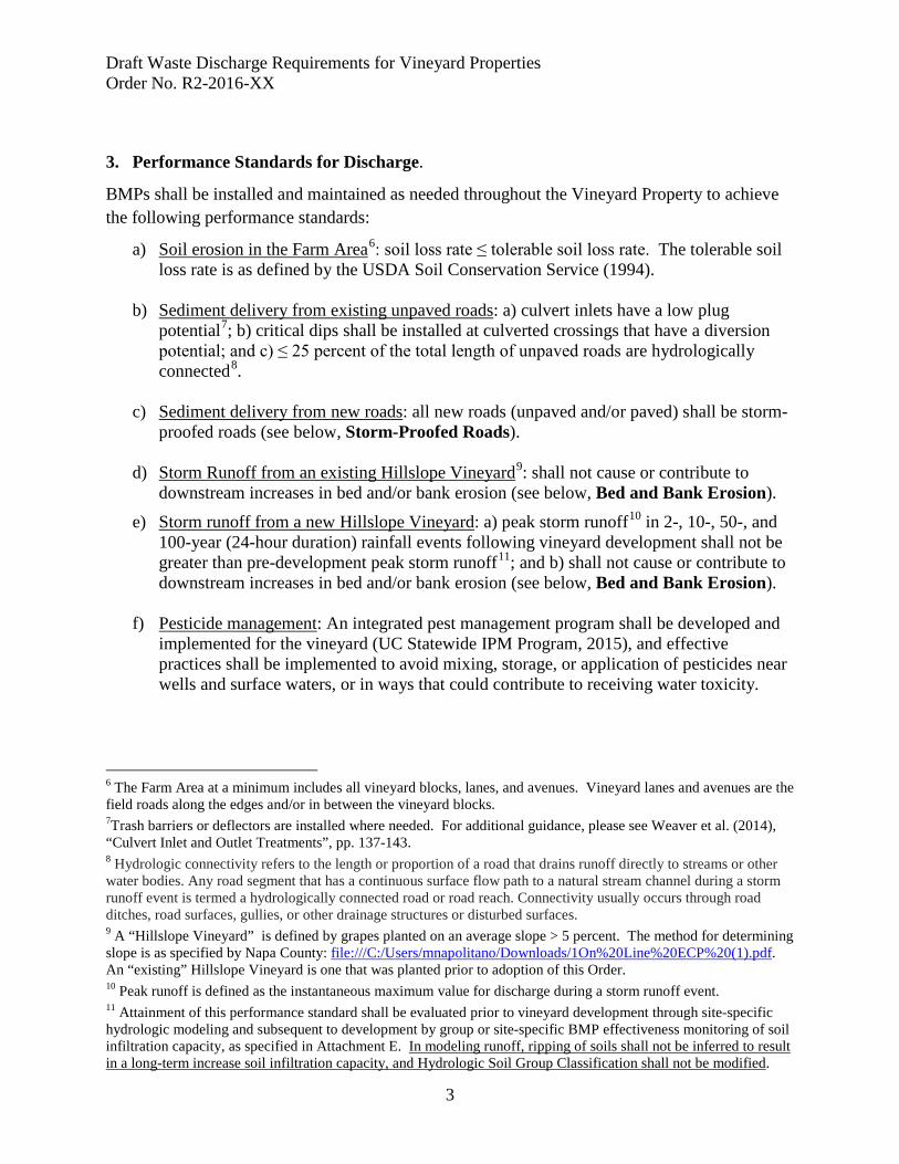
Draft Waste Discharge Requirements for Vineyard Properties Order No. R2-2016-XX
3
3. Performance Standards for Discharge.
BMPs shall be installed and maintained as needed throughout the Vineyard Property to achieve the following performance standards:
a) Soil erosion in the Farm Area6: soil loss rate ≤ tolerable soil loss rate. The tolerable soil loss rate is as defined by the USDA Soil Conservation Service (1994).
b) Sediment delivery from existing unpaved roads: a) culvert inlets have a low plug
potential7; b) critical dips shall be installed at culverted crossings that have a diversion potential; and c) ≤ 25 percent of the total length of unpaved roads are hydrologically connected8.
c) Sediment delivery from new roads: all new roads (unpaved and/or paved) shall be storm-
proofed roads (see below, Storm-Proofed Roads). d) Storm Runoff from an existing Hillslope Vineyard9: shall not cause or contribute to
downstream increases in bed and/or bank erosion (see below, Bed and Bank Erosion).
e) Storm runoff from a new Hillslope Vineyard: a) peak storm runoff10 in 2-, 10-, 50-, and 100-year (24-hour duration) rainfall events following vineyard development shall not be greater than pre-development peak storm runoff11; and b) shall not cause or contribute to downstream increases in bed and/or bank erosion (see below, Bed and Bank Erosion).
f) Pesticide management: An integrated pest management program shall be developed and
implemented for the vineyard (UC Statewide IPM Program, 2015), and effective practices shall be implemented to avoid mixing, storage, or application of pesticides near wells and surface waters, or in ways that could contribute to receiving water toxicity.
6 The Farm Area at a minimum includes all vineyard blocks, lanes, and avenues. Vineyard lanes and avenues are the field roads along the edges and/or in between the vineyard blocks. 7Trash barriers or deflectors are installed where needed. For additional guidance, please see Weaver et al. (2014), “Culvert Inlet and Outlet Treatments”, pp. 137-143. 8 Hydrologic connectivity refers to the length or proportion of a road that drains runoff directly to streams or other water bodies. Any road segment that has a continuous surface flow path to a natural stream channel during a storm runoff event is termed a hydrologically connected road or road reach. Connectivity usually occurs through road ditches, road surfaces, gullies, or other drainage structures or disturbed surfaces. 9 A “Hillslope Vineyard” is defined by grapes planted on an average slope > 5 percent. The method for determining slope is as specified by Napa County: file:///C:/Users/mnapolitano/Downloads/1On%20Line%20ECP%20(1).pdf. An “existing” Hillslope Vineyard is one that was planted prior to adoption of this Order. 10 Peak runoff is defined as the instantaneous maximum value for discharge during a storm runoff event. 11 Attainment of this performance standard shall be evaluated prior to vineyard development through site-specific hydrologic modeling and subsequent to development by group or site-specific BMP effectiveness monitoring of soil infiltration capacity, as specified in Attachment E. In modeling runoff, ripping of soils shall not be inferred to result in a long-term increase soil infiltration capacity, and Hydrologic Soil Group Classification shall not be modified.

Draft Waste Discharge Requirements for Vineyard Properties Order No. R2-2016-XX
4
g) Nutrient management: Best management practices to guide nutrient applications (e.g., fertigation, cover crops, soil amendments, plant and/or soil testing) shall be implemented as needed to protect water quality.
Storm-Proofed Roads (as defined by Weaver et al., 2014) shall meet the following specifications (as applicable):
• Stream crossings have a drainage structure designed for the 100-year flood flow including woody debris and sediment (Cafferata et al, 2004).
• Stream crossings do not have diversion potential. • Culvert inlets have a low plug potential (trash barriers or deflectors are installed where
needed). • Culverts are installed at the base of the fill and in line with the natural channel. • Emergency overflow culverts that emerge higher in the fill have full round, anchored
downspouts that extend to the natural channel. • Deep fills (deeper than a backhoe can reach from the roadbed) with undersized culverts
or culverts with high plugging potential are fitted with an emergency overflow culvert. • Bridges have stable, non-eroding abutments and do not significantly restrict 100-year
flood flow. • Stream crossing fills are stable. • Approaching road surfaces and ditches are “disconnected” from streams and stream
crossing culverts to the maximum extent feasible using road shaping and road drainage structures.
• Class I (fish-bearing) stream crossings meet State Fish and Wildlife and National Marine Fisheries Service fish passage criteria.
• Road surfaces and ditches are hydrologically “disconnected” from streams and stream crossing culverts. Road surface runoff is dispersed, rather than collected and concentrated.
• Ditches are drained frequently by functional ditch relief culverts and/or rolling dips. • Outflow from ditch relief culverts does not discharge to streams. • Ditches and road surfaces drainage does not discharge (through culverts and/or rolling
dips) onto active or potential landslides, and/or into gullies. • Fine sediment contributions from roads, cutbanks, and ditches are minimized by utilizing
seasonal closures and installing a variety of surface drainage techniques including road surface shaping (outsloping, insloping or crowning), rolling dips, ditch relief culverts, water bars and other measures to disperse road surface runoff and reduce or eliminate sediment delivery to the stream.
Bed and Bank Erosion: the performance standard for bed and bank erosion downslope of a Hillslope Vineyard is evaluated and achieved as follows:
1. Review available information including: property land-use and natural disturbance history; vineyard design and management practices; natural and engineered drainage features; and soil, geology, landslide, and topographic maps.
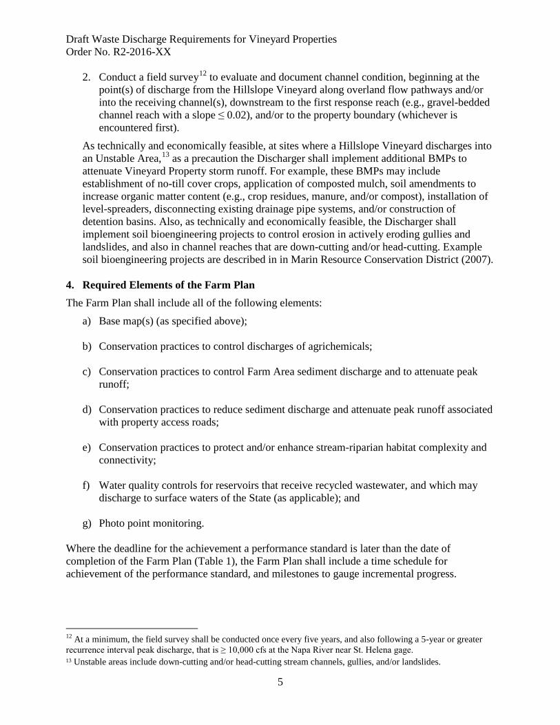
Draft Waste Discharge Requirements for Vineyard Properties Order No. R2-2016-XX
5
2. Conduct a field survey12 to evaluate and document channel condition, beginning at the point(s) of discharge from the Hillslope Vineyard along overland flow pathways and/or into the receiving channel(s), downstream to the first response reach (e.g., gravel-bedded channel reach with a slope ≤ 0.02), and/or to the property boundary (whichever is encountered first).
As technically and economically feasible, at sites where a Hillslope Vineyard discharges into an Unstable Area,13 as a precaution the Discharger shall implement additional BMPs to attenuate Vineyard Property storm runoff. For example, these BMPs may include establishment of no-till cover crops, application of composted mulch, soil amendments to increase organic matter content (e.g., crop residues, manure, and/or compost), installation of level-spreaders, disconnecting existing drainage pipe systems, and/or construction of detention basins. Also, as technically and economically feasible, the Discharger shall implement soil bioengineering projects to control erosion in actively eroding gullies and landslides, and also in channel reaches that are down-cutting and/or head-cutting. Example soil bioengineering projects are described in in Marin Resource Conservation District (2007).
4. Required Elements of the Farm Plan The Farm Plan shall include all of the following elements:
a) Base map(s) (as specified above);
b) Conservation practices to control discharges of agrichemicals;
c) Conservation practices to control Farm Area sediment discharge and to attenuate peak runoff;
d) Conservation practices to reduce sediment discharge and attenuate peak runoff associated with property access roads;
e) Conservation practices to protect and/or enhance stream-riparian habitat complexity and connectivity;
f) Water quality controls for reservoirs that receive recycled wastewater, and which may discharge to surface waters of the State (as applicable); and
g) Photo point monitoring. Where the deadline for the achievement a performance standard is later than the date of completion of the Farm Plan (Table 1), the Farm Plan shall include a time schedule for achievement of the performance standard, and milestones to gauge incremental progress.
12 At a minimum, the field survey shall be conducted once every five years, and also following a 5-year or greater recurrence interval peak discharge, that is ≥ 10,000 cfs at the Napa River near St. Helena gage. 13 Unstable areas include down-cutting and/or head-cutting stream channels, gullies, and/or landslides.
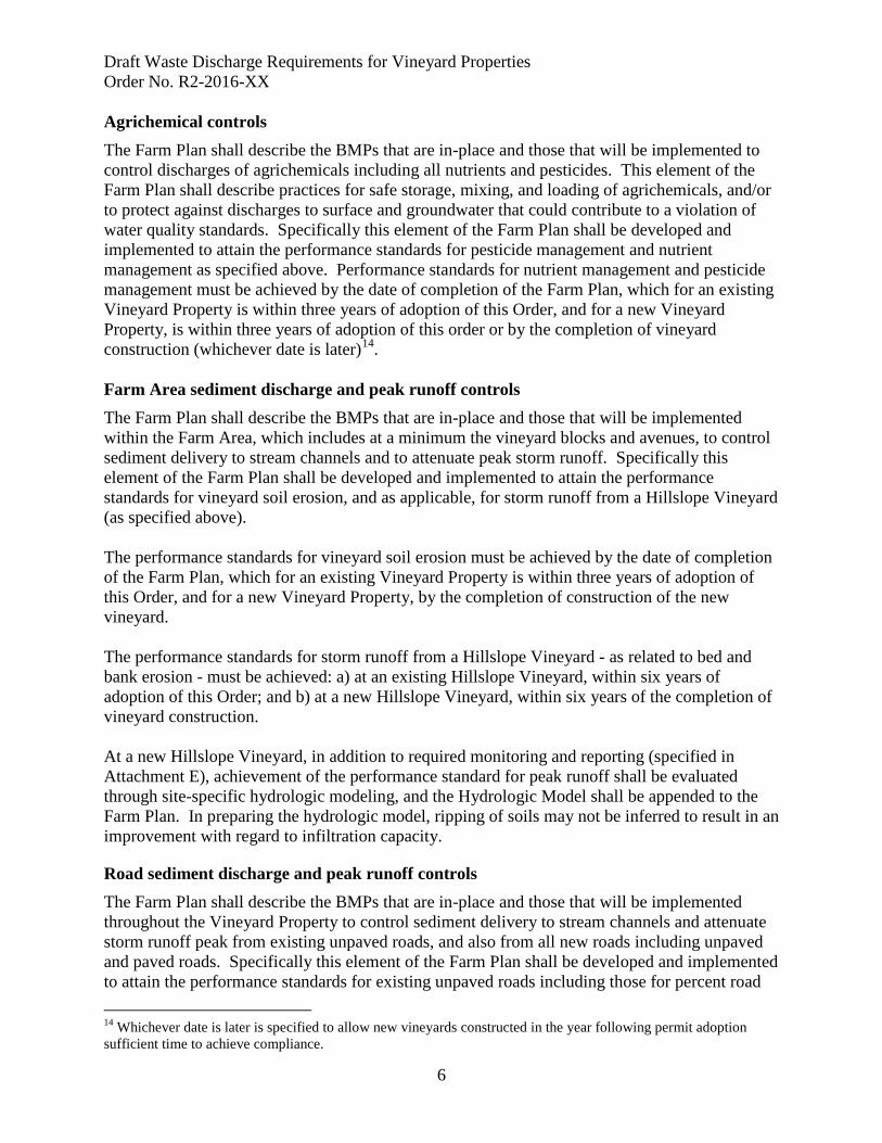
Draft Waste Discharge Requirements for Vineyard Properties Order No. R2-2016-XX
6
Agrichemical controls The Farm Plan shall describe the BMPs that are in-place and those that will be implemented to control discharges of agrichemicals including all nutrients and pesticides. This element of the Farm Plan shall describe practices for safe storage, mixing, and loading of agrichemicals, and/or to protect against discharges to surface and groundwater that could contribute to a violation of water quality standards. Specifically this element of the Farm Plan shall be developed and implemented to attain the performance standards for pesticide management and nutrient management as specified above. Performance standards for nutrient management and pesticide management must be achieved by the date of completion of the Farm Plan, which for an existing Vineyard Property is within three years of adoption of this Order, and for a new Vineyard Property, is within three years of adoption of this order or by the completion of vineyard construction (whichever date is later)14. Farm Area sediment discharge and peak runoff controls The Farm Plan shall describe the BMPs that are in-place and those that will be implemented within the Farm Area, which includes at a minimum the vineyard blocks and avenues, to control sediment delivery to stream channels and to attenuate peak storm runoff. Specifically this element of the Farm Plan shall be developed and implemented to attain the performance standards for vineyard soil erosion, and as applicable, for storm runoff from a Hillslope Vineyard (as specified above). The performance standards for vineyard soil erosion must be achieved by the date of completion of the Farm Plan, which for an existing Vineyard Property is within three years of adoption of this Order, and for a new Vineyard Property, by the completion of construction of the new vineyard. The performance standards for storm runoff from a Hillslope Vineyard - as related to bed and bank erosion - must be achieved: a) at an existing Hillslope Vineyard, within six years of adoption of this Order; and b) at a new Hillslope Vineyard, within six years of the completion of vineyard construction. At a new Hillslope Vineyard, in addition to required monitoring and reporting (specified in Attachment E), achievement of the performance standard for peak runoff shall be evaluated through site-specific hydrologic modeling, and the Hydrologic Model shall be appended to the Farm Plan. In preparing the hydrologic model, ripping of soils may not be inferred to result in an improvement with regard to infiltration capacity.
Road sediment discharge and peak runoff controls The Farm Plan shall describe the BMPs that are in-place and those that will be implemented throughout the Vineyard Property to control sediment delivery to stream channels and attenuate storm runoff peak from existing unpaved roads, and also from all new roads including unpaved and paved roads. Specifically this element of the Farm Plan shall be developed and implemented to attain the performance standards for existing unpaved roads including those for percent road 14 Whichever date is later is specified to allow new vineyards constructed in the year following permit adoption sufficient time to achieve compliance.

Draft Waste Discharge Requirements for Vineyard Properties Order No. R2-2016-XX
7
length that is hydrologically connected, plug potential, stream diversion potential, and also for storm-proofing of all new roads (as specified above). At an existing Vineyard Property, road-related performance standards for existing unpaved roads must be achieved within ten years of adoption of this order. At a new Vineyard Property, road-related performance standards for existing unpaved roads must be achieved within ten years of completion of construction of the vineyard. All new roads must be storm-proofed by the completion of construction. Stream-Riparian Habitat Protection and Enhancement Actions The entire stream network including swales, ephemeral channel reaches, intermittent channel reaches, and perennial channel reaches shall be delineated throughout the Vineyard Property. All channel reaches shall be classified and delineated as confined, moderately confined (alluvial), and unconfined (alluvial). Channel condition within alluvial channel reaches (e.g., those that are moderately confined or unconfined) shall be assessed to describe the active channel including:
• Active channel width, • Bars, pools, and riffles, • Large woody debris, • Summer baseflow, • Flood levels, • Bank heights, • Bank erosion areas, • Riparian corridor width and proximity to the Farm Area, • Description of the vegetation types and sizes within the riparian corridor including the
extent of non-native/invasive species, • Observations of fish and wildlife, • Locations of roads, on- or off-channel reservoirs, and/or other features upstream or
downstream (e.g., grade control structures, bank stabilization structures, road crossings, etc.) that may affect bed and bank erosion locally or at reach scale, and
• Description of the management regime for the channel and/or corridor management.
An example of an acceptable approach, with regard to level of detail15 is as described in Sonoma County RCD et al. (2016).
15 Please note that LandSmart is revising the Farm Plan Template (Version 3.0) to include information regarding summer baseflow, and also flood levels.
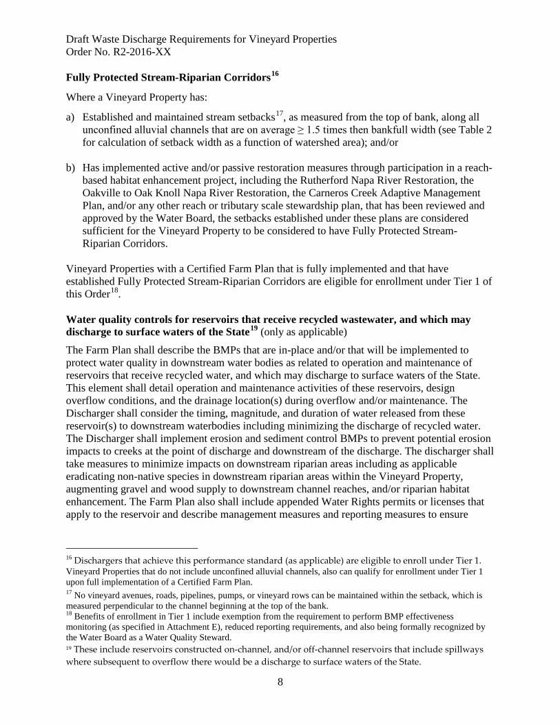
Draft Waste Discharge Requirements for Vineyard Properties Order No. R2-2016-XX
8
Fully Protected Stream-Riparian Corridors16
Where a Vineyard Property has:
a) Established and maintained stream setbacks17, as measured from the top of bank, along all unconfined alluvial channels that are on average ≥ 1.5 times then bankfull width (see Table 2 for calculation of setback width as a function of watershed area); and/or
b) Has implemented active and/or passive restoration measures through participation in a reach-
based habitat enhancement project, including the Rutherford Napa River Restoration, the Oakville to Oak Knoll Napa River Restoration, the Carneros Creek Adaptive Management Plan, and/or any other reach or tributary scale stewardship plan, that has been reviewed and approved by the Water Board, the setbacks established under these plans are considered sufficient for the Vineyard Property to be considered to have Fully Protected Stream-Riparian Corridors.
Vineyard Properties with a Certified Farm Plan that is fully implemented and that have established Fully Protected Stream-Riparian Corridors are eligible for enrollment under Tier 1 of this Order18. Water quality controls for reservoirs that receive recycled wastewater, and which may discharge to surface waters of the State19 (only as applicable)
The Farm Plan shall describe the BMPs that are in-place and/or that will be implemented to protect water quality in downstream water bodies as related to operation and maintenance of reservoirs that receive recycled water, and which may discharge to surface waters of the State. This element shall detail operation and maintenance activities of these reservoirs, design overflow conditions, and the drainage location(s) during overflow and/or maintenance. The Discharger shall consider the timing, magnitude, and duration of water released from these reservoir(s) to downstream waterbodies including minimizing the discharge of recycled water. The Discharger shall implement erosion and sediment control BMPs to prevent potential erosion impacts to creeks at the point of discharge and downstream of the discharge. The discharger shall take measures to minimize impacts on downstream riparian areas including as applicable eradicating non-native species in downstream riparian areas within the Vineyard Property, augmenting gravel and wood supply to downstream channel reaches, and/or riparian habitat enhancement. The Farm Plan also shall include appended Water Rights permits or licenses that apply to the reservoir and describe management measures and reporting measures to ensure
16 Dischargers that achieve this performance standard (as applicable) are eligible to enroll under Tier 1. Vineyard Properties that do not include unconfined alluvial channels, also can qualify for enrollment under Tier 1 upon full implementation of a Certified Farm Plan. 17 No vineyard avenues, roads, pipelines, pumps, or vineyard rows can be maintained within the setback, which is measured perpendicular to the channel beginning at the top of the bank. 18 Benefits of enrollment in Tier 1 include exemption from the requirement to perform BMP effectiveness monitoring (as specified in Attachment E), reduced reporting requirements, and also being formally recognized by the Water Board as a Water Quality Steward. 19 These include reservoirs constructed on-channel, and/or off-channel reservoirs that include spillways where subsequent to overflow there would be a discharge to surface waters of the State.
Draft Waste Discharge Requirements for Vineyard Properties Order No. R2-2016-XX
9
compliance with any bypass requirements and ensure net environment benefit associated with the use and storage of recycled water. Photo point monitoring The Farm Plan shall include photo point monitoring data as specified in Attachment E (Monitoring and Reporting). Time Schedule for Farm Plan Completion For all existing Vineyard Properties, the Farm Plan shall be completed and certified within three years of adoption of this Order. For all new Vineyard Properties, the Farm Plan shall be completed and certified by the date of the completion of vineyard construction or within three years of adoption of this Order, whichever date is later. Thereafter, the Farm Plan shall be kept at the Vineyard Property and be available for review by Water Board staff upon request. If a Discharger elects to develop and implement Farm Plan independently, that is without the Farm Plan being certified by an approved Third-Party Program or an approved Qualified Professional, the Farm Plan must be submitted to the Executive Officer to confirm compliance with all conditions specified herein. In this case, the time schedule for submittal at an existing vineyard property is within two years of adoption of this Order, and at a new Vineyard Property is within one year prior of the projected date for the initiation of vineyard construction. References
Cafferata, P., T. Spittler, M. Wopat, G. Bundros, and S. Flanagan, 2004. Designing Watercourse Crossings for Passage of 100-Year Flood Flows, Wood, and Sediment. California Department of Forestry and Fire Protection: Sacramento, CA. http://calfire.ca.gov/resource_mgt/downloads/reports/ForestryReport1.pdf
California Geological Survey, 2016. Information Warehouse for Landslides:
http://maps.conservation.ca.gov/cgs/informationwarehouse/index.html?map=landslides. Marin Resource Conservation District, 2007. Groundwork, a Handbook for Small Scale Erosion
Control in Coastal California. Second Edition. Marin County RCD: Point Reyes Station, CA. http://www.marincounty.org/~/media/files/departments/pw/mcstoppp/residents/groundwork.pdf Sonoma County RCD et al. (2016). LandSmart for Vineyards Farm Plan (Version 3.0),
Managing Natural Waterways, Ditches, and Spillways, pp. 27-32. http://landsmart.org/wp-content/uploads/2016/05/LandSmart_Vineyards_TemplateV3.pdf
UC Statewide IPM Program, 2015. UC IPM Pest Management Guidelines: Grape. University of
California at Davis, Department of Agriculture and Natural Resources, Statewide Integrated Pest Management Program. http://www.ipm.ucdavis.edu/PDF/PMG/pmggrape.pdf
USDA Soil Conservation Service, 1994. The Universal Soil Loss Equation (USLE), Special
Applications for Napa County, California, May 1994.

Draft Waste Discharge Requirements for Vineyard Properties Order No. R2-2016-XX
10
US Geological Survey, 1997a. US Geological Survey Open-File Report 97-745D, Index to Detailed Maps of Landslides in the San Francisco Bay Region, California). Available at http://pubs.usgs.gov/of/1997/of97-745/of97-745d.html.
US Geological Survey, 1997b. US Geological Survey Open-File Report 97-745 E, Map of
Debris Flow Source Areas in the San Francisco Bay Region, California) at http://pubs.usgs.gov/of/1997/of97-745/of97-745e.html.
Water Board, 2009. Napa River Sediment TMDL and Habitat Enhancement Plan, Staff Report. http://www.waterboards.ca.gov/sanfranciscobay/water_issues/programs/TMDLs/napasediment/C
_NS_Staff_Report_09-09.pdf Weaver, W., E. Weppner, D. Hagans, 2014. Handbook of Forest, Ranch, and Rural Roads, A
Guide for Planning, Designing, Constructing, Reconstructing, Upgrading, Maintaining, and Closing Wildland Roads. Mendocino RCD: Ukiah, CA. http://mcrcd.org/wp-content/uploads/Handbook_for_Forest_Ranch&Rural_Roads.pdf

Draft Waste Discharge Requirements for Vineyard Properties Order No. R2-2016-XX
11
Table 1. Summary of Deadlines for Compliance (underlined if a document must be submitted)
Existing Vineyard Property New Vineyard Property Farm Plan: completed and Certified20
Within three years of adoption of this Order
Farm Plan: completed and Certified
By completion of vineyard construction or within three years of adoption of this Order (whichever date is later)
Performance Standards for new roads
By completion of construction
Performance Standards for new roads
By completion of vineyard construction
Performance Standards for Soil erosion in the Farm Area, Pesticide Management, and Nutrient Management
Within three years of adoption of this Order
Performance Standards for Soil erosion in the Farm Area, Pesticide Management, and Nutrient Management
By completion of vineyard construction
Performance Standards for Bed and Bank Erosion
Within six years of adoption of this Order (see note below)
Performance Standards for Bed and Bank Erosion
Within six years of vineyard construction (see note below)
Performance Standards for Peak Runoff
(see note below)
Performance Standards For Peak Runoff
Assessed via modeling By completion of vineyard construction (see note below)
Performance Standards for existing unpaved roads
Within ten years of adoption of this Order
Performance Standards for existing unpaved roads
Within ten years of adoption of vineyard construction
Performance Standards for new roads
By completion of construction
Performance Standards for new roads
By completion of construction
Note: The effectiveness of BMPs implemented to attain performance standards for storm runoff from Hillslope Vineyards also shall be validated via required monitoring (see Attachment E).
20If a Discharger chooses to develop the Farm Plan independently, the Farm Plan must be submitted to the Water Board for review/approval. For an existing Vineyard Property, the deadline for submittal is within two years of adoption of this Order. For a new Vineyard Property, the deadline for submittal is within two years of adoption of this Order, or one year prior to vineyard constriction, whichever date is later.

Draft Waste Discharge Requirements for Vineyard Properties Order No. R2-2016-XX
12
Table 2. Relationship between Bankfull Channel Width and Watershed Area (Jackson, unpublished data, as cited in CLSI, 2009)
(Bankfull Width in feet = 13.03 * [Watershed Area, mi2]0.494; R2 = 0.76; N = 50 sites)
Watershed Area (mi2) Estimated Bankfull Channel Width (ft)
0.1 4
0.2 6
0.5 9
1 13
2 18.5
3 23
4 26
5 29
8 37
10 41
15 50
20 59
50 93
100 131
Draft Waste Discharge Requirements for Vineyard Properties Order No. R2-2016-XX
13
ATTACHMENT B
Notice of Intent Form
(Draft Version of Form)
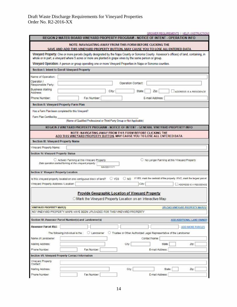
Draft Waste Discharge Requirements for Vineyard Properties Order No. R2-2016-XX
14

Draft Waste Discharge Requirements for Vineyard Properties Order No. R2-2016-XX
15

Draft Waste Discharge Requirements for Vineyard Properties Order No. R2-2016-XX
16
ATTACHMENT C California Regional Water Quality Control Board
San Francisco Bay Region
General Waste Discharge Requirements Order No. R2-2016-00XX
Agricultural Third-Party Program and Qualified Professional
Roles, Responsibilities, and Approval Process
The Water Board encourages Dischargers to work with Third-Party Programs21 and Qualified Professionals22 in the development and implementation of Farm Plans. This document explains the roles, responsibilities, and prerequisite qualifications of Third-Party Programs and Qualified Professionals and provides guidance on the types of information needed for Water Board approval of Third-Party Programs and Qualified Professional technical service providers.
1. What are the roles of a Third-Party Program or Qualified Professional?
Third-Party Programs and Qualified Professionals provide technical assistance/expertise to help dischargers comply with requirements of this Order. Third-Party Programs must fulfill all of the following roles:
• Assist dischargers with development and implementation of Farm Plans as needed to achieve the performance standards in this Order;
• Verify that a Farm Plan prepared under your program, or professional oversight, is complete and that upon full implementation it will achieve all applicable performance standards for discharge, as described in this Order.
Optional roles may also include:
• Assist dischargers with the filing of Notice of Intent and/or other required paperwork;
• Assisting dischargers in securing the necessary permits for projects implemented to comply with this order;
• Assisting dischargers with BMP implementation monitoring and reporting; • Assisting dischargers with preparation and/or submittal of annual reports; • Assisting dischargers with applications for grants or other financial assistance; 21 Third-Party Programs provide technical assistance/expertise to help Dischargers comply with requirements of this Order. 22 “Qualified Professional” is defined to include a California registered professional in a discipline associated with erosion and sediment control including for example a professional engineer, licensed geologist, or certified professional in erosion and sediment control.
Draft Waste Discharge Requirements for Vineyard Properties Order No. R2-2016-XX
17
• Conducting BMP effectiveness monitoring; and/or
• Managing fee collection and payment to the State Water Board.
2. Who can qualify to be an approved Third-Party Program or Qualified Professional technical service provider?
At a minimum, one of the staff or consultants of a Third-Party Program must be a California registered professional in a discipline associated with erosion and sediment control (e.g., a professional engineer, licensed geologist, certified erosion control specialist, and licensed landscape architect) and be available to provide technical input and review as needed. Similarly, a Qualified Professional must be a California register professional (as described above), and demonstrate proficiency in erosion and sediment control.
To be eligible for approval, Third-Party Programs and Qualified Professionals must demonstrate that they have experience working with Vineyard Property owners and/or managers, and technical expertise and experience in developing and implementing non-point source pollution control programs. Third-Party Programs and Qualified Professionals providing technical assistance must provide objective input.
Groups and Individuals that may apply for approval • Local public agencies • Resource Conservation Districts • UC Cooperative Extension • Non-profit organizations • Water quality coalitions or other watershed groups
• Licensed professional engineer, licensed geologist, licensed landscape architect, or certified professional in erosion and sediment control
Groups and Individuals that will not be approved
• Entities that own or operate a Vineyard Property regulated by the Water Board (except in those cases where the vineyard is operated primarily for public education, research, or demonstration purposes).
• Entities or individuals that have a conflict of interest. A conflict of interest is a situation in which financial or other personal considerations have the potential to compromise or bias professional judgment and objectivity in verifying that a Farm Plan is complete and/or upon full implementation that it would attain the performance standards for discharge (as applicable) that are contained in this Order. An individual is considered to have a financial conflict of interest if they have a financial stake/interest in the facility for which they are providing technical assistance. Entities that collect fees from program participants to sustain or administer third party technical assistance programs or assist with State Water Board fee collection are not considered to have a financial conflict of interest.
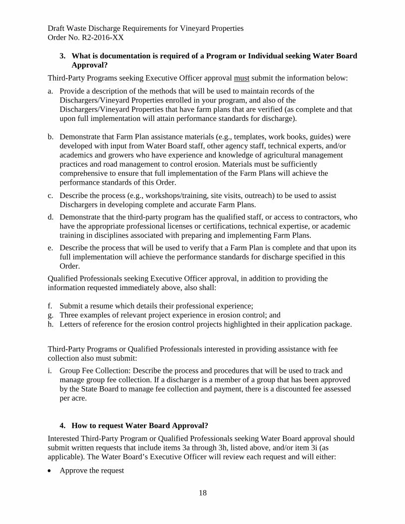
Draft Waste Discharge Requirements for Vineyard Properties Order No. R2-2016-XX
18
3. What is documentation is required of a Program or Individual seeking Water Board Approval?
Third-Party Programs seeking Executive Officer approval must submit the information below:
a. Provide a description of the methods that will be used to maintain records of the Dischargers/Vineyard Properties enrolled in your program, and also of the Dischargers/Vineyard Properties that have farm plans that are verified (as complete and that upon full implementation will attain performance standards for discharge).
b. Demonstrate that Farm Plan assistance materials (e.g., templates, work books, guides) were developed with input from Water Board staff, other agency staff, technical experts, and/or academics and growers who have experience and knowledge of agricultural management practices and road management to control erosion. Materials must be sufficiently comprehensive to ensure that full implementation of the Farm Plans will achieve the performance standards of this Order.
c. Describe the process (e.g., workshops/training, site visits, outreach) to be used to assist Dischargers in developing complete and accurate Farm Plans.
d. Demonstrate that the third-party program has the qualified staff, or access to contractors, who have the appropriate professional licenses or certifications, technical expertise, or academic training in disciplines associated with preparing and implementing Farm Plans.
e. Describe the process that will be used to verify that a Farm Plan is complete and that upon its full implementation will achieve the performance standards for discharge specified in this Order.
Qualified Professionals seeking Executive Officer approval, in addition to providing the information requested immediately above, also shall: f. Submit a resume which details their professional experience; g. Three examples of relevant project experience in erosion control; and h. Letters of reference for the erosion control projects highlighted in their application package. Third-Party Programs or Qualified Professionals interested in providing assistance with fee collection also must submit: i. Group Fee Collection: Describe the process and procedures that will be used to track and
manage group fee collection. If a discharger is a member of a group that has been approved by the State Board to manage fee collection and payment, there is a discounted fee assessed per acre.
4. How to request Water Board Approval?
Interested Third-Party Program or Qualified Professionals seeking Water Board approval should submit written requests that include items 3a through 3h, listed above, and/or item 3i (as applicable). The Water Board’s Executive Officer will review each request and will either:
• Approve the request

Draft Waste Discharge Requirements for Vineyard Properties Order No. R2-2016-XX
19
• Request additional information if the application package is incomplete and additional information is needed to complete the submittal, or
• Disapprove the request if items 3s-3h cannot be adequately addressed.
Following Executive Officer approval of the request, electronic copies of the Executive Officer-approved Third-Party Program’s and/or Qualified Professionals Farm Plan templates and assistance materials will be made available to the public upon request.
A request for approval must be submitted electronically to [electronic mailbox to be provided].
5. How will the Water Board review and evaluate Third-Party Program and Qualified Professional performance?
Water Board staff will periodically review and evaluate the performance of approved Third-Party Programs and Qualified Professionals to ensure that the program and services provided meet the requirements specified above, that any required documentation is complete, submittals for group reporting and fee collection (optional) are accurate and timely, and that adequate Farm Plans are consistently being prepared by the group’s regulated entities. The Executive Officer may terminate its approval of a Third-Party Program or Qualified Professional if it is determined that the Water Board’s requirements are not being met.
Nonpoint Source Policy The State Water Board’s Policy for Implementation and Enforcement of the Nonpoint Source Pollution Control Program adopted on May 20, 2004 (NPS Policy) requires regulation of nonpoint source pollution in California through WDRs, WDR waiver programs, or discharge prohibitions.
The NPS Policy specifically allows for third-party groups or coalitions of dischargers to work collaboratively to improve water quality and allows the Water Board to evaluate third-party group performance. Each proposed program will be judged individually on its merits.
Draft Waste Discharge Requirements for Vineyard Properties Order No. R2-2016-XX
20
ATTACHMENT D California Regional Water Quality Control Board
San Francisco Bay Region
General Waste Discharge Requirements Order No. R2-2016-00XX
NOTICE OF TERMINATION
Signed forms must be submitted to:
San Francisco Bay Regional Water Quality Control Board 1515 Clay Street, Suite 1400 Oakland, CA 94612 ATTN: Vineyard Program
SECTION I. FACILITY OPERATOR INFORMATION
Name:
Contact E-mail:
Mailing Address:
City:
State: CA
Zip Code:
Name of Contact Person:
Contact Phone:
SECTION II. LANDOWNER INFORMATION (IF OPERATOR IS NOT THE OWNER)
Name:
Contact E-mail:
Mailing Address:
City:
State:
Zip Code:
Name of Contact Person:
Contact Phone:
SECTION III. FACILITY INFORMATION
A. Facility Name
County:
Mailing Address:
Contact E-mail:
City:
State: CA
Zip Code:

Draft Waste Discharge Requirements for Vineyard Properties Order No. R2-2016-XX
21
Name of the Contact Person for the Vineyard Property : ________________________________________________________________________________________________________________________________________________________________________________________________________________________________________________________________________________________________________________________________________________________
Contact Phone: Email:
Facility County Assessor’s Parcel Number
A. Total Vineyard Property Parcel(s) Size: __________________ acres B. Total area planted in grapes: _________________ acres
SECTION IV. BASIS OF TERMINATION
A. CHANGE OF VINEYARD PROPERTY OWNERSHIP or CHANGE IN CONTROL OF VINEYARD PROPERTY (check if true) [ ] The control or ownership of this Vineyard Property changed on the following date: ____________________________________
The contact information for the succeeding Vineyard Owner or Operator is :
_________________________________________________________________________________________________________ ___________________________________________________________________________________________________________________________________________________________________________________________________________________________________________________________________________________________________________________________ B. VINEYARD PROPERTY CLOSURE or CHANGE IN LAND USE [ ] The use of the Vineyard Property changed and the Vineyard Property no longer meets the eligibility requirements of the General Waste Discharge Requirements for the following reasons _____________________________________________________________________________________________________________________________________________________________________________________________________________________________________________________________________________________________________________________________________________________________________________________________________________________________________________________________________________________________________________________________________________as of the following date: _____________________________________________________________________________________
SECTION V. LANDOWNER NOTIFICATION If the facility is leased or operated by someone other than the owner, this section must be signed by the operator. I certify that the owner of the facility has been notified of these General Waste Discharge Requirements and that I have been designated by the owner as the “Authorized Representative.” Operator’s Printed Name:____________________________ Signature:_________________________________________________________ Title: Date: _______________________________________________________

Draft Waste Discharge Requirements for Vineyard Properties Order No. R2-2016-XX
22
SECTION VI. CERTIFICATION
“I certify under penalty of law that this document and all attachments were prepared under my direction and supervision in accordance with a system designed to assure that qualified personnel properly gather and evaluate the information submitted. Based on my inquiry of the person or persons who manage the system, or those persons directly responsible for gathering the information, the information submitted is, to the best of my knowledge and belief, true, accurate and complete. I am aware that there are significant penalties for submitting false information, including the possibility of fine and imprisonment.
Owner or Authorized Representative Printed Name:______________________________________________
Owner or Authorized Representative Signature:_____________________ ____________________________
Date:_________________________________
Telephone Number:____________________________ Email:_____________________________________________________________
Draft Waste Discharge Requirements for Vineyard Properties Order No. R2-2016-XX
23
ATTACHMENT E California Regional Water Quality Control Board
San Francisco Bay Region
General Waste Discharge Requirements Order No. R2-2016-00XX
MONITORING AND REPORTING REQUIREMENTS
This Monitoring and Reporting Program (MRP) is issued pursuant to Order No. R2-2016-00XX (Order) and California Water Code (CWC) section 13267. The Discharger shall not implement any changes to this MRP unless, and until, a revised MRP is approved by the Executive Officer. To allow the Water Board to evaluate compliance with the terms and conditions of the Order, this MRP requires that monitoring, sampling, and record-keeping be conducted by vineyard property owners and operators (hereinafter, Dischargers). This MRP requires preparation of an Annual Report of compliance, to be submitted to the Water Board by November 15 of each year. The Annual Report shall document pre-rainy season preparations, individual monitoring data (if not participating in a group monitoring program), compliance schedule progress, an evaluation of the effectiveness of management practices, and records of any inspections where a water quality problem was identified, as well as the management practices taken to correct these problems. DISCHARGER TIER REQUIREMENTS The extent of water quality monitoring and reporting required of each Discharger is a function of the Discharger’s designated tier (as defined in Order No. R2-2016-00XX). Tiers established under this Order relate to the anticipated effort by Water Board staff, per incremental improvement in water quality. The tier-specific requirements are as follows:
A. Tier 1 Dischargers (Stewardship Tier33): 1. BMP Implementation Monitoring
Photo-points provide a qualitative indication of BMP performance and habitat and water quality conditions in receiving waters. Photo-points shall be established and monitored to document winter readiness, demonstrate annual maintenance practices and BMP implementation, and to document habitat and water quality conditions in receiving waters at and/or near points of discharge from the vineyard. Photo-points shall be numbered and depicted on maps contained in the Farm Plan (requirements and specifications for the Farm Plan are included in Attachment A). Photo-point records and field notes shall be
33 To qualify for the Stewardship Tier, a Vineyard Property must: 1) develop a Farm Plan that is Certified by an approved Third-Party Program or a Qualified Professional; 2) the Farm Plan must be fully implemented and have attained all applicable performance standards for discharge; and 3) (as applicable) effective management actions also must be implemented to protect and/or restore stream-riparian habitat complexity and connectivity (as described in detail in Attachment A, Fully Protected Stream-Riparian Corridors).
Draft Waste Discharge Requirements for Vineyard Properties Order No. R2-2016-XX
24
appended to the Farm Plan. Guidance regarding establishment and protocols for photo-point monitoring are provided in OWEB (2007) and NRCS (2009).
2. Reporting A letter certifying that: a) the Farm Plan has been fully implemented; b) the Vineyard Property has attained performance standards for discharge; and c) passive and/or active restoration measures34 have been implemented (as defined in Attachment A), must be submitted to the Water Board by an approved Third-Party Program or a Qualified Professional. Once every five years thereafter, a letter of recertification must be submitted.
B. Tier 2 Dischargers (Farm Plan certified by a Third-Party Program or a Qualified
Professional): Dischargers permitted under Tier 2 are required to perform BMP Implementation Monitoring, and as specified below also are required to perform BMP Effectiveness Monitoring.
1. BMP Implementation Monitoring: as specified under the requirements for Tier 1.
2. BMP Effectiveness Monitoring35: Tier 2 Dischargers that include Hillslope Vineyards
shall perform either: a) Property-specific monitoring of the effectiveness of vineyard BMPs implemented to
achieve the performance standards for storm runoff (as specified below under the requirements for Tier 3); or
b) Participate in a Group Monitoring Program as described immediately below. A Group Monitoring Program can be developed and administered by an approved Third-Party Program or a fee collection group. All dischargers who have completed a Farm Plan that has been Certified by an approved Third-Party Program or Qualified Professional are eligible to participate in a Group Monitoring Program subject to terms and conditions established by the organization conducting the Group Monitoring Program.
Group Monitoring Program Option: To assess effectiveness of BMPs implemented to achieve the performance standards for storm runoff from Hillslope Vineyards36, the Group Monitoring Program shall:
34 The stream-riparian restoration measures are only applicable where the Vineyard Property includes unconfined alluvial channels (see Attachment A for details). 35 Within the project area, in almost all cases, vineyard storm runoff estimates have been based solely upon modeling. Vineyard BMP monitoring is intended to evaluate whether the key assumptions of these models are valid, and also to confirm that results are accurate. 36 Where soil infiltration values in vineyards (as specified below) are similar or greater to values in paired sites under natural vegetation cover, the performance standards for storm runoff from Hillslope Vineyards shall be considered achieved.
Draft Waste Discharge Requirements for Vineyard Properties Order No. R2-2016-XX
25
Characterize Hillslope Vineyard soil infiltration capacity: characterize Hillslope Vineyard soil infiltration capacity37 as a function of geomorphic terrane type, slope class, and BMP type. This characterization can be developed from a stratified sample of vineyard properties. At a minimum, five vineyard properties in each defined geomorphic terrane type (Water Board, 2009, pp. 19-21) must be characterized; the alluvial fan and valley terrane type may be further subdivided based on the texture, age, or alluvial depositional environment. The field sampling protocol should be guided by Nimmo et al. (2009) or Bagarello et al. (2004). Other field sampling protocols also may be proposed for review and approval. The investigation shall be conducted under the supervision of a professional geologist or a professional engineer licensed to practice in the State of California, who has professional experience in conducting infiltration and/or groundwater testing programs.
Sample location and density: at a minimum, field saturated hydraulic conductivity (FSHC) shall be measured at ten randomly selected sites located within the inter-rows of each vineyard block. If the coefficient of variation (CV) for measured values of FSHC is > 100%, then additional sites shall be sampled until the CV is ≤ 100%. At Hillslope Vineyard sites, FSHC also shall be measured at a minimum of ten undeveloped hillslope sampling sites under natural vegetation cover to characterize pre-vineyard development site conditions. If the coefficient of variation (CV) for measured values of FSHC is > 100%, then additional sites shall be sampled until the CV is ≤ 100%. Also, at all properties that are sampled, a soil profile description must be prepared in each mapped soil series that is planted in vineyard. The soil profile description shall be developed based on sampling and description of one-or-more soil pits, the locations of which shall be referenced. At Hillslope Vineyards, in addition to the description of the soil profile in each vineyard block, a soil profile description also must be prepared to characterize all of the delineated soil series under natural vegetation cover where FSHC is measured. Soil profile descriptions should be prepared by an experienced professional soil scientist. Within two years of adoption of this Order, a study plan shall be submitted to the Executive Officer for review and approval. Within five years of adoption of this Order, a final report shall be submitted to the Water Board that presents and evaluates the field-saturated hydraulic conductivity and soil profile data. The report also shall evaluate the effectiveness of BMPs with regard to soil infiltration capacity. Where geometric mean values of soil infiltration capacity in Hillslope Vineyards are statistically similar or significantly greater than values at paired sites under natural vegetation cover, the
37 “Infiltration is the movement of water into soil. There is a maximum rate at which the soil in a given condition can absorb water; this upper limit is called the infiltration capacity. Water that does not infiltrate, runs quickly over the ground surface, whereas water entering into the soil moves much more slowly underground. The soil, therefore, plays a major part in determining the volume of storm runoff, its timing, and its peak rate of flow.” (Dunne and Leopold, 1978, p. 163) Soil infiltration capacity is sensitive to management practices and vegetation cover changes, and as such provides a useful basis for evaluation of the effects of vineyard development and management practices on storm runoff from Hillslope Vineyards.
Draft Waste Discharge Requirements for Vineyard Properties Order No. R2-2016-XX
26
performance standards for Hillslope Vineyard storm runoff (as related to BMP implementation to attenuate runoff) shall be considered achieved. Where geometric mean values for soil infiltration capacity in vineyards are significantly lower than in the paired sites under natural cover, consultation with a Qualified Professional and/or approved Third-Party Program is required under this Order to direct implementation of refined and/or supplemental BMPs to further attenuate storm runoff peak, and six years thereafter soil infiltration capacity shall be re-evaluated as specified above.
3. Reporting
Following permit adoption, each year by November 15 all Dischargers must submit an annual compliance report that documents progress toward completion of the Farm Plan and progress toward attainment of the performance standards for discharge. The Annual Compliance Form is included as Table E-1 in this attachment.
C. Tier 3 Dischargers (Farm Plan developed independently):
1. BMP Implementation Monitoring: as specified under Tier 1. 2. BMP Effectiveness Monitoring:
Tier 3 Dischargers that include Hillslope Vineyards shall assess performance of vineyard erosion control and runoff attenuation BMPs, the discharger shall develop a property-specific characterization of the soil infiltration capacity (i.e., field-saturated hydraulic conductivity) in the vineyard. The field sampling protocol should be guided by Nimmo et al. (2009) or Bagarello et al. (2004). Other field sampling protocols also may be proposed for review and approval. The investigation shall be conducted under the supervision of a professional geologist or a professional engineer licensed to practice in the State of California, who has experience in infiltration and groundwater testing.
Sample location and density: at a minimum, field saturated hydraulic conductivity (FSHC) shall be measured at ten randomly selected sites located within the inter-rows of each vineyard block. If the coefficient of variation (CV) for measured values of FSHC is > 100%, then additional sites shall be sampled until the CV is ≤ 100%.
At Hillslope Vineyard sites, FSHC also shall be measured at a minimum of 10 undeveloped hillslope sampling sites under natural vegetation cover to characterize pre-vineyard development site conditions. If the coefficient of variation (CV) for measured values of FSHC is > 100%, then additional sites shall be sampled until the CV is ≤ 100%.
At all sites a soil profile description also must be prepared for each mapped soil series that is planted in vineyard. The soil profile description shall be developed based on sampling and description of one-or-more soil pits, the locations of which shall be referenced. At Hillslope Vineyards, in addition to the description of the soil profile in each vineyard block, a soil profile description also must be prepared to characterize the all of the delineated soil series under natural vegetation cover where FSHC is measured. Within two years of adoption of this Order, a study plan shall be submitted to the Executive Officer for review and approval. Within five years of adoption of this Order, a final report shall be submitted to the Water Board that presents and evaluates the field-
Draft Waste Discharge Requirements for Vineyard Properties Order No. R2-2016-XX
27
saturated hydraulic conductivity and soil profile data. The report also shall evaluate the effectiveness of BMPs with regard to soil infiltration capacity. Where geometric mean values of soil infiltration capacity in Hillslope Vineyards are statistically similar or significantly greater than values at paired sites under natural vegetation cover, the performance standards for Hillslope Vineyard storm runoff (as related to BMP implementation to attenuate runoff) shall be considered achieved. Where geometric mean values for soil infiltration capacity in vineyards are significantly lower than in the paired sites under natural cover, consultation with a Qualified Professional and/or approved Third-Party Program is required under this Order to direct implementation of refined and/or supplemental BMPs to further attenuate storm runoff peak, and six years thereafter soil infiltration capacity shall be re-evaluated as specified above.
3. Reporting Following permit adoption, each year by November 15 all Dischargers must submit an annual report that documents progress toward completion of the Farm Plan and progress toward attainment of the performance standards for discharge. The Annual Reporting Form and Schedule for Compliance are included as Table E-1 to this attachment.
Tier 3 Dischargers also must submit a completed Farm Plan (as specified in Attachment A) to the Water Board for review and approval in conformance with the schedule for compliance specified in Attachment A.
References
Bagarello, V., M. Iovino, and D. Elrick, 2004. A simple falling-head technique for rapid determination of field-saturated hydraulic conductivity. Journal of the Soil Science Society of America (68): 66-73.
Dunne, T. and L. B. Leopold, 1978. Water and Environmental Planning. p. 163. Nimmo, J.R., K. M. Schmidt, K. S. Perkins, and J. D. Stock, 2009. Rapid
measurement of field-saturated hydraulic conductivity for areal characterization. Vadose Zone Journal (8): 142-149.
NRCS, 2009. Conservation Planning Technical Note #5: Guidance on establishing
photo points and plots for monitoring. USDA Natural Resources Conservation Service, Pacific Islands Area.
Oregon Watershed Enhancement Board (OWEB), 2007. OWEB guide to photo point
monitoring. Oregon watershed Enhancement Board: Salem, OR. Water Board, 2009. Napa sediment TMDL and habitat Enhancement Plan, Staff
Report. Water Board: Oakland, CA pp. 19-21.
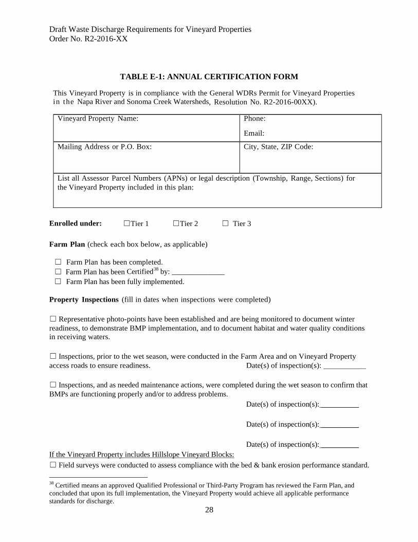
Draft Waste Discharge Requirements for Vineyard Properties Order No. R2-2016-XX
28
TABLE E-1: ANNUAL CERTIFICATION FORM This Vineyard Property is in compliance with the General WDRs Permit for Vineyard Properties in the Napa River and Sonoma Creek Watersheds, Resolution No. R2-2016-00XX).
Vineyard Property Name: Phone: Email:
Mailing Address or P.O. Box: City, State, ZIP Code:
List all Assessor Parcel Numbers (APNs) or legal description (Township, Range, Sections) for the Vineyard Property included in this plan:
Enrolled under: ☐Tier 1 ☐Tier 2 ☐ Tier 3 Farm Plan (check each box below, as applicable)
☐ Farm Plan has been completed. ☐ Farm Plan has been Certified38 by: ______________ ☐ Farm Plan has been fully implemented.
Property Inspections (fill in dates when inspections were completed) ☐ Representative photo-points have been established and are being monitored to document winter readiness, to demonstrate BMP implementation, and to document habitat and water quality conditions in receiving waters. ☐ Inspections, prior to the wet season, were conducted in the Farm Area and on Vineyard Property access roads to ensure readiness. Date(s) of inspection(s): __ ☐ Inspections, and as needed maintenance actions, were completed during the wet season to confirm that BMPs are functioning properly and/or to address problems.
Date(s) of inspection(s): __________ Date(s) of inspection(s): __________ Date(s) of inspection(s): __________ If the Vineyard Property includes Hillslope Vineyard Blocks: ☐ Field surveys were conducted to assess compliance with the bed & bank erosion performance standard. 38 Certified means an approved Qualified Professional or Third-Party Program has reviewed the Farm Plan, and concluded that upon its full implementation, the Vineyard Property would achieve all applicable performance standards for discharge.
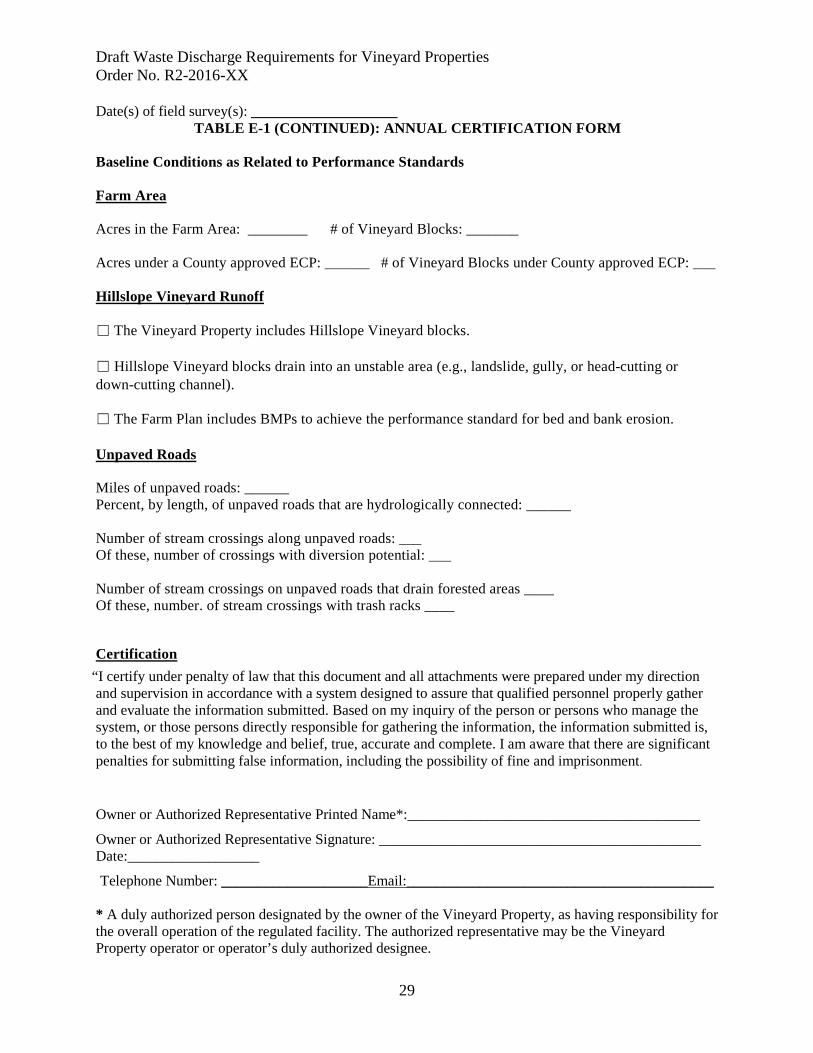
Draft Waste Discharge Requirements for Vineyard Properties Order No. R2-2016-XX
29
Date(s) of field survey(s): ____________________ TABLE E-1 (CONTINUED): ANNUAL CERTIFICATION FORM
Baseline Conditions as Related to Performance Standards Farm Area Acres in the Farm Area: ________ # of Vineyard Blocks: _______ Acres under a County approved ECP: ______ # of Vineyard Blocks under County approved ECP: ___ Hillslope Vineyard Runoff ☐ The Vineyard Property includes Hillslope Vineyard blocks. ☐ Hillslope Vineyard blocks drain into an unstable area (e.g., landslide, gully, or head-cutting or down-cutting channel). ☐ The Farm Plan includes BMPs to achieve the performance standard for bed and bank erosion. Unpaved Roads Miles of unpaved roads: ______ Percent, by length, of unpaved roads that are hydrologically connected: ______ Number of stream crossings along unpaved roads: ___ Of these, number of crossings with diversion potential: ___ Number of stream crossings on unpaved roads that drain forested areas ____ Of these, number. of stream crossings with trash racks ____ Certification
“I certify under penalty of law that this document and all attachments were prepared under my direction and supervision in accordance with a system designed to assure that qualified personnel properly gather and evaluate the information submitted. Based on my inquiry of the person or persons who manage the system, or those persons directly responsible for gathering the information, the information submitted is, to the best of my knowledge and belief, true, accurate and complete. I am aware that there are significant penalties for submitting false information, including the possibility of fine and imprisonment. Owner or Authorized Representative Printed Name*:________________________________________
Owner or Authorized Representative Signature: ____________________________________________ Date:__________________
Telephone Number: ____________________Email:__________________________________________ * A duly authorized person designated by the owner of the Vineyard Property, as having responsibility for the overall operation of the regulated facility. The authorized representative may be the Vineyard Property operator or operator’s duly authorized designee.

Draft Waste Discharge Requirements for Vineyard Properties Order No. R2-2016-XX
30
ATTACHMENT F California Regional Water Quality Control Board
San Francisco Bay Region
General Waste Discharge Requirements Order No. R2-2016-00XX
CEQA Impacts and Mitigation Measures
Table F-1 provides a summary of impacts and mitigation measures, which are presented in detail in the Environmental Impact Report. Table F-1: Summary of CEQA Impacts and Mitigation Measures Category: Air Quality and Greenhouse Gases EIR Impact No.
Impact Summary General Order Mitigation Measures
Impact 5.1
Compliance actions (e.g., construction of BMPs that involve earth moving) completed at Vineyard Properties throughout the project area could conflict with implementation of an applicable air quality plan. The primary pollutant of concern is fine particulate matter.
Where compliance actions are subject to the requirement to obtain a discretionary permit from the local land-use authority and/or from another State or federal agency, as applicable, the Discharger shall implement Mitigation Measures AQ-1 through AQ-4.
Impact 5.2
Compliance actions (e.g., construction of BMPs that involve earth moving) completed at Vineyard Properties throughout the project area could violate air quality standards or contribute substantially to an existing or projected air quality violation. The primary pollutant of concern is fine particulate matter.
Where compliance actions are subject to the requirement to obtain a discretionary permit from the local land-use authority and/or from another State or federal agency, as applicable, the Discharger shall implement Mitigation Measures AQ-1 through AQ-4.
Impact 5.4
Compliance actions (e.g., construction of BMPs that involve earth moving) completed at Vineyard Properties throughout the project area may have the potential to expose sensitive receptors to substantial pollutant concentrations. The primary pollutant of concern is fine particulate matter.
Where compliance actions are subject to the requirement to obtain a discretionary permit from the local land-use authority and/or from another State or federal agency, as applicable, the Discharger shall implement Mitigation Measures AQ-1 through AQ-4.
Impact 5.6
Compliance actions (e.g., construction of BMPs that involve earth moving) completed at Vineyard Properties throughout the project area may generate significant GHG emissions.
Where compliance actions are subject to the requirement to obtain a discretionary permit from the local land-use authority and/or from another State or federal agency, as applicable, the Discharger shall implement Mitigation Measure GHG-1.
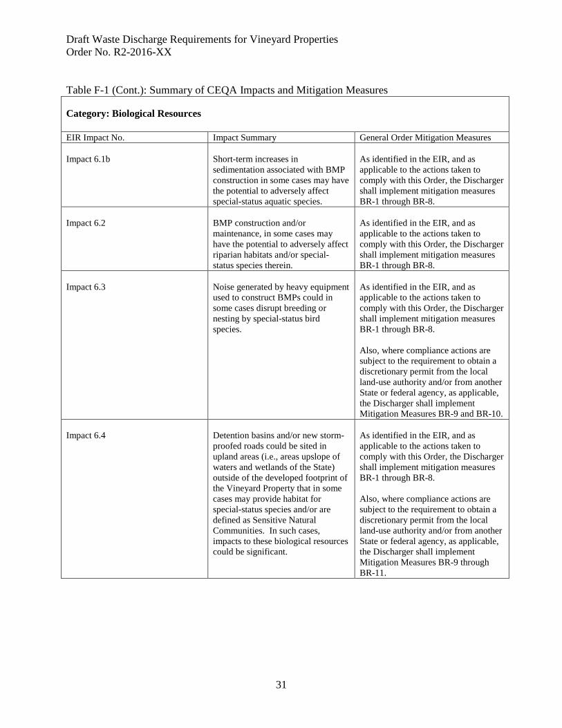
Draft Waste Discharge Requirements for Vineyard Properties Order No. R2-2016-XX
31
Table F-1 (Cont.): Summary of CEQA Impacts and Mitigation Measures Category: Biological Resources EIR Impact No. Impact Summary General Order Mitigation Measures Impact 6.1b
Short-term increases in sedimentation associated with BMP construction in some cases may have the potential to adversely affect special-status aquatic species.
As identified in the EIR, and as applicable to the actions taken to comply with this Order, the Discharger shall implement mitigation measures BR-1 through BR-8.
Impact 6.2
BMP construction and/or maintenance, in some cases may have the potential to adversely affect riparian habitats and/or special-status species therein.
As identified in the EIR, and as applicable to the actions taken to comply with this Order, the Discharger shall implement mitigation measures BR-1 through BR-8.
Impact 6.3
Noise generated by heavy equipment used to construct BMPs could in some cases disrupt breeding or nesting by special-status bird species.
As identified in the EIR, and as applicable to the actions taken to comply with this Order, the Discharger shall implement mitigation measures BR-1 through BR-8. Also, where compliance actions are subject to the requirement to obtain a discretionary permit from the local land-use authority and/or from another State or federal agency, as applicable, the Discharger shall implement Mitigation Measures BR-9 and BR-10.
Impact 6.4
Detention basins and/or new storm-proofed roads could be sited in upland areas (i.e., areas upslope of waters and wetlands of the State) outside of the developed footprint of the Vineyard Property that in some cases may provide habitat for special-status species and/or are defined as Sensitive Natural Communities. In such cases, impacts to these biological resources could be significant.
As identified in the EIR, and as applicable to the actions taken to comply with this Order, the Discharger shall implement mitigation measures BR-1 through BR-8. Also, where compliance actions are subject to the requirement to obtain a discretionary permit from the local land-use authority and/or from another State or federal agency, as applicable, the Discharger shall implement Mitigation Measures BR-9 through BR-11.

Draft Waste Discharge Requirements for Vineyard Properties Order No. R2-2016-XX
32
Table F-1 (continued): Summary of CEQA Impacts and Mitigation Measures Category: Cultural Resources EIR Impact No. Impact Summary Impact 7.2
Compliance actions (e.g., construction of BMPs that involve earth moving) may have the potential at some Vineyard Properties to cause a substantial adverse change in the significance of an archeological resource.
Where compliance actions are subject to the requirement to obtain a discretionary permit from the local land-use authority and/or from another State or federal agency, as applicable, the Discharger shall implement Mitigation Measure CR 7-2.
Impact 7.3
Compliance actions (e.g., construction of BMPs that involve earth moving) may have the potential at some Vineyard Properties to directly or indirectly destroy a unique paleontological or geologic feature.
Where compliance actions are subject to the requirement to obtain a discretionary permit from the local land-use authority and/or from another State or federal agency, as applicable, the Discharger shall implement Mitigation Measure CR 7-2.
Impact 7.4
Compliance actions (e.g., construction of BMPs that involve earth moving) may have the potential at some Vineyard Properties to disturb human remains including those interred outside of formal cemeteries.
Where compliance actions are subject to the requirement to obtain a discretionary permit from the local land-use authority and/or from another State or federal agency, as applicable, the Discharger shall implement Mitigation Measure CR 7-2.
Category: Hydrology and Water Quality EIR Impact No. Impact Summary General Order Mitigation Measures Impact 8.4b
Construction activities on unpaved roads and/or outside of the developed footprint of the vineyard that would occur in order to comply with the general WDRs, which could result in temporary increases in fine sediment delivery to stream channels, and resultant sedimentation.
As identified in the EIR, and as applicable to the actions taken to comply with this Order, the Discharger shall implement mitigation measures BR-1 through BR-8.
Note: all compliance actions listed above that are subject to the requirement to obtain a discretionary permit from the local land-use authority and/or from another state or federal agency, as applicable, can and should be adopted by other agencies as part of their respective approval processes (See CEQA Guideline 15091 and 15126.4.).
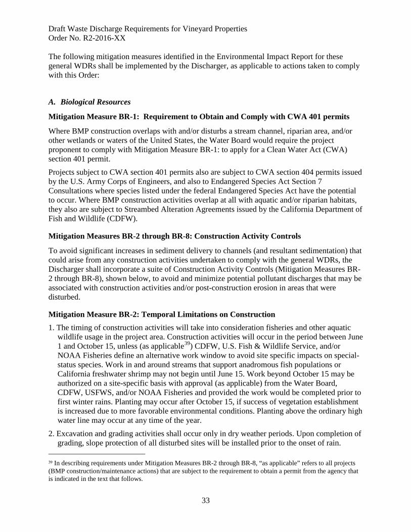
Draft Waste Discharge Requirements for Vineyard Properties Order No. R2-2016-XX
33
The following mitigation measures identified in the Environmental Impact Report for these general WDRs shall be implemented by the Discharger, as applicable to actions taken to comply with this Order:
A. Biological Resources
Mitigation Measure BR-1: Requirement to Obtain and Comply with CWA 401 permits
Where BMP construction overlaps with and/or disturbs a stream channel, riparian area, and/or other wetlands or waters of the United States, the Water Board would require the project proponent to comply with Mitigation Measure BR-1: to apply for a Clean Water Act (CWA) section 401 permit.
Projects subject to CWA section 401 permits also are subject to CWA section 404 permits issued by the U.S. Army Corps of Engineers, and also to Endangered Species Act Section 7 Consultations where species listed under the federal Endangered Species Act have the potential to occur. Where BMP construction activities overlap at all with aquatic and/or riparian habitats, they also are subject to Streambed Alteration Agreements issued by the California Department of Fish and Wildlife (CDFW).
Mitigation Measures BR-2 through BR-8: Construction Activity Controls
To avoid significant increases in sediment delivery to channels (and resultant sedimentation) that could arise from any construction activities undertaken to comply with the general WDRs, the Discharger shall incorporate a suite of Construction Activity Controls (Mitigation Measures BR-2 through BR-8), shown below, to avoid and minimize potential pollutant discharges that may be associated with construction activities and/or post-construction erosion in areas that were disturbed.
Mitigation Measure BR-2: Temporal Limitations on Construction 1. The timing of construction activities will take into consideration fisheries and other aquatic
wildlife usage in the project area. Construction activities will occur in the period between June 1 and October 15, unless (as applicable39) CDFW, U.S. Fish & Wildlife Service, and/or NOAA Fisheries define an alternative work window to avoid site specific impacts on special-status species. Work in and around streams that support anadromous fish populations or California freshwater shrimp may not begin until June 15. Work beyond October 15 may be authorized on a site-specific basis with approval (as applicable) from the Water Board, CDFW, USFWS, and/or NOAA Fisheries and provided the work would be completed prior to first winter rains. Planting may occur after October 15, if success of vegetation establishment is increased due to more favorable environmental conditions. Planting above the ordinary high water line may occur at any time of the year.
2. Excavation and grading activities shall occur only in dry weather periods. Upon completion of grading, slope protection of all disturbed sites will be installed prior to the onset of rain.
39 In describing requirements under Mitigation Measures BR-2 through BR-8, “as applicable” refers to all projects (BMP construction/maintenance actions) that are subject to the requirement to obtain a permit from the agency that is indicated in the text that follows.

Draft Waste Discharge Requirements for Vineyard Properties Order No. R2-2016-XX
34
3. Construction within 75 feet of established riparian vegetation shall be avoided during the migratory bird nesting season (February 15 to August 15). If work must occur during this period, a qualified biologist or individual approved by CDFW will conduct a pre-construction survey for bird nests or nesting activity in the project area. If active nests or nesting behavior are observed (for any species other than starlings and house sparrows) an exclusion zone of 75 feet will be established to protect the nesting birds. If any listed or sensitive bird species are identified, CDFW must be notified prior to further action. Take of active bird nests is prohibited.
4. To protect California red-legged frog (CRLF) and/or foothill yellow-legged frog, all construction within stream channels shall take place during daylight hours. If suitable habitat is present for CRLF or foothill yellow-legged frog, project activities will begin after July 1 to avoid impacts on breeding or egg masses.
Mitigation Measure BR-3: Construction Site Management Controls
1. As feasible, the Discharger shall use existing ingress or egress points. Placement of temporary access road, staging areas, and other facilities shall avoid or limit disturbance to habitat and will be restored to preconstruction conditions.
2. Disturbance to existing grades and vegetation shall be limited to the actual site of the conservation project and necessary access routes.
3. Trash, litter, construction debris, cigarette butts, etc., shall be stored in a designated portion of the construction site (that does not overlap with or impact natural habitat areas), and/or shall be removed from the site at the end of each working day. Upon completion of work, the Discharger is responsible for removing all trash, litter, construction debris, cigarette butts, etc.
4. All construction debris and sediments shall be taken to appropriate landfills or, in the case of sediments, disposed of in upland areas on- or offsite.
5. No petroleum products, chemicals, silt, fine soils, and any substances deleterious to fish, amphibian, plant, or bird life shall be allowed to pass into, or be placed where it can pass into the waters of the state.
6. Contractors shall have emergency spill cleanup gear (spill containment and absorption materials) and fire equipment available on site at all times.
7. The use or storage of petroleum-powered equipment shall be accomplished in a manner to prevent the potential release of petroleum materials into waters of the state (Fish and Game Code §5650).
8. All vehicles and equipment on the site must not leak any type of hazardous materials such as oil, hydraulic fluid, or fuel. Fueling shall take place outside of the riparian corridor.
9. As needed, a contained area located at least 50 feet from a watercourse shall be designated for equipment storage, short-term maintenance, and refueling. If possible, these activities will not take place on the project site.
10. Vehicles shall be inspected for leaks and repaired immediately. Leaks, drips, and other spill will be cleaned up immediately to avoid soil or groundwater contamination. Major vehicle maintenance and washing will be done off site. All spent fluids, including motor oil, radiator coolant, or other fluids, and used vehicle batteries will be collected, stored, and recycled as
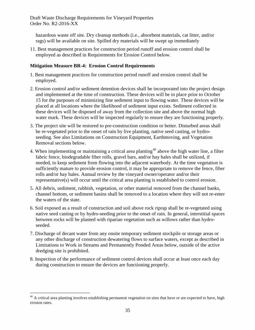
Draft Waste Discharge Requirements for Vineyard Properties Order No. R2-2016-XX
35
hazardous waste off site. Dry cleanup methods (i.e., absorbent materials, cat litter, and/or rags) will be available on site. Spilled dry materials will be swept up immediately
11. Best management practices for construction period runoff and erosion control shall be employed as described in Requirements for Erosion Control below.
Mitigation Measure BR-4: Erosion Control Requirements
1. Best management practices for construction period runoff and erosion control shall be employed.
2. Erosion control and/or sediment detention devices shall be incorporated into the project design and implemented at the time of construction. These devices will be in place prior to October 15 for the purposes of minimizing fine sediment input to flowing water. These devices will be placed at all locations where the likelihood of sediment input exists. Sediment collected in these devices will be disposed of away from the collection site and above the normal high water mark. These devices will be inspected regularly to ensure they are functioning properly.
3. The project site will be restored to pre-construction condition or better. Disturbed areas shall be re-vegetated prior to the onset of rain by live planting, native seed casting, or hydro-seeding. See also Limitations on Construction Equipment, Earthmoving, and Vegetation Removal sections below.
4. When implementing or maintaining a critical area planting40 above the high water line, a filter fabric fence, biodegradable fiber rolls, gravel bars, and/or hay bales shall be utilized, if needed, to keep sediment from flowing into the adjacent waterbody. At the time vegetation is sufficiently mature to provide erosion control, it may be appropriate to remove the fence, fiber rolls and/or hay bales. Annual review by the vineyard owner/operator and/or their representative(s) will occur until the critical area planting is established to control erosion.
5. All debris, sediment, rubbish, vegetation, or other material removed from the channel banks, channel bottom, or sediment basins shall be removed to a location where they will not re-enter the waters of the state.
6. Soil exposed as a result of construction and soil above rock riprap shall be re-vegetated using native seed casting or by hydro-seeding prior to the onset of rain. In general, interstitial spaces between rocks will be planted with riparian vegetation such as willows rather than hydro-seeded.
7. Discharge of decant water from any onsite temporary sediment stockpile or storage areas or any other discharge of construction dewatering flows to surface waters, except as described in Limitations to Work in Streams and Permanently Ponded Areas below, outside of the active dredging site is prohibited.
8. Inspection of the performance of sediment control devices shall occur at least once each day during construction to ensure the devices are functioning properly.
40 A critical area planting involves establishing permanent vegetation on sites that have or are expected to have, high erosion rates.
Draft Waste Discharge Requirements for Vineyard Properties Order No. R2-2016-XX
36
Mitigation Measure BR-5: Limitations on Construction Equipment
1. As feasible, the Discharger shall use existing ingress or egress points, and work will be performed from the top of creek banks.
2. When heavy equipment is used, woody debris and vegetation on banks and in the channel shall not be disturbed if outside of the project’s scope.
3. Heavy equipment shall not be used in a flowing stream, creek, or ponded area, except to cross a stream or pond to access the work site.
4. Heavy equipment use in a streambed is only permissible when the streambed is dry. The amount of time heavy equipment is stationed, working, or traveling within the creek bed shall be minimized.
5. Use of heavy equipment shall be avoided in a channel bottom with rocky or cobbled substrate. If access to the work site requires heavy equipment to travel on a rocky or cobbled substrate, a rubber tire loader/backhoe is the preferred vehicle.
Mitigation Measure BR-6: Limitations on Earthmoving
1. Finished grades shall not exceed 2:1 side slopes.
2. Excavated material not used in the implementation of the BMP shall be removed out of the 100-year flood plain.
3. Placement of temporary access roads, staging areas, and other facilities shall avoid or limit disturbance to habitat and shall be restored to pre-construction conditions.
4. Road improvement projects shall be modeled on the “Handbook for Forest and Ranch Roads: A Guide for planning, designing, constructing, reconstructing, maintaining and closing wildland roads,” (Weaver et al., 2014).
5. If the substrate of a seasonal pond, creek, stream or waterbody is altered during work activities, it shall be returned to approximate pre-construction conditions after the work is completed, unless (as applicable) NOAA Fisheries and/or CDFW determine that other measures should be implemented.
6. Overhanging banks within potential California freshwater shrimp habitat shall remain undisturbed.
Mitigation Measure BR-7: Limitations on Vegetation Removal and Replanting
1. The spread or introduction of exotic plant species shall be avoided to the maximum extent possible by avoiding areas with established native vegetation during project activities, restoring disturbed areas with native species where appropriate, and performing post-project monitoring and control of exotic species.
2. Removal of invasive exotic species is strongly recommended. Removal using hand tools, including chainsaws and weed-whackers, and hand pulling of exotics shall be done in preparation for establishment of native plantings. To the extent possible, re-vegetation will be implemented at the same time removal of exotic vegetation occurs. If giant reed (Arundo donax) is removed, cuttings will be disposed of in a manner that shall not allow reseeding to occur.

Draft Waste Discharge Requirements for Vineyard Properties Order No. R2-2016-XX
37
3. Disturbance of native shrubs or woody perennials or removal of trees from streambanks or stream channels will be avoided or minimized; if native riparian vegetation will be disturbed, it will be replaced with similar native species.
4. Except (as applicable) with approval from CDFW, there will be no cutting or removal of native trees 4” or greater diameter at breast height (DBH), except willows, for which there will be no cutting or removal of trees 6” or greater DBH. Exotic trees that are causing habitat damage or hazardous situations may be removed with approval of the project biologist. Any exotic trees removed will be replaced with appropriate natives. For any permitted tree removal, the root structure will be left intact unless (as applicable) removal is authorized by CDFW.
5. If native trees over 6” DBH are to be removed (with approval from CDFW), they will be replaced at a 3:1 ratio.
6. Projects within potential California red-legged frog habitat will be designed to minimize disturbance to vegetation near or in permanent and seasonal pools of streams, marshes, ponds, or shorelines with extensive emergent or weedy vegetation.
7. Project activities in areas of potential California freshwater shrimp habitat will avoid removal of or damage to overhanging vegetation along stream channels.
8. Hand labor will be used to trim vegetation within the channel or on the bank. Handheld equipment such a weed-whackers and chainsaws are authorized.
9. Native plants characteristic of the local habitat type will be the preferred alternative when implementing and maintaining the BMPs in natural areas. When specified, as required by the regulatory agencies, only native plant species will be used. Under special circumstances, regulators may allow for the use of non-invasive, non-persistent grass species.
10. All areas disturbed by the project or in which vegetation was removed will be restored to a natural state with native trees, shrubs, and/or grasses. Barren areas will typically be planted with a combination of willow stakes, native shrubs, and trees and/or erosion control grass mixes.
11. For projects that have removed native vegetation, post-construction re-vegetation success shall be equivalent to or better than the pre-project conditions. If, after 5 years, that level of success has not been achieved, the vineyard owner/operator or their representative(s) shall consult with CDFW to develop and implement measures to achieve success.
12. If needed, an irrigation system shall be installed to ensure establishment of vegetation; when vegetation is sufficiently established, irrigation materials will be removed.
13. The project area shall be restored to pre-construction conditions or better.
Mitigation Measure BR-8: Limitations on Work in Streams and Permanently Ponded Areas
1. In specific cases where it is deemed necessary to work in a flowing stream/creek, the work area shall be isolated, and all flowing water shall be temporarily diverted around the work site to maintain downstream flows during construction. A qualified biologist shall prepare a species protection and dewatering plan and be present for all dewatering and re-watering events. The plan shall be prepared with guidance (as applicable) from NOAA Fisheries
Draft Waste Discharge Requirements for Vineyard Properties Order No. R2-2016-XX
38
and/or CDFW. When construction is completed, the flow diversion structure shall be removed in a manner that will allow flow to resume with the least disturbance to the substrate and water quality.
B. Hydrology and Water Quality
Dischargers shall comply with Mitigation Measures, BR-2 through BR-8 (described above), which address potential short-term construction-related increases in erosion and sedimentation impacts. These include:
• Temporal limits on construction activities (BR-2)
• Construction site management actions (BR-3)
• Requirements for erosion control (BR-4)
• Limitations on heavy-equipment use (BR-5)
• Limitations on earth moving/grading (BR-6)
• Limitations on vegetation removal and requirements for replanting (BR-7), and
• Limitations on work in streams and/or ponded areas (BR-8).
Draft Waste Discharge Requirements for Vineyard Properties Order No. R2-2016-XX
39
Where compliance actions are subject to the requirement to obtain a discretionary permit from the local land-use authority and/or from another State or federal agency, the following mitigation measures (AQ-1 through AQ-4, GHG-1, BR-9 through BR-11, and CR-1) shall be implemented by the Discharger, as applicable. These mitigation measures can and should be adopted by other agencies as part of their respective approval processes (See CEQA Guideline 15091 and 15126.4.).
C. Air Resources - Mitigation Measures
For implementation of BMPs with a construction site size of four acres or less, implementation of the Basic Measures (mitigation measure AQ-1) described below would reduce this impact to a less than significant level. For implementation of BMPs with a construction site size greater than four acres, implementation of the Enhanced Measures (mitigation measure AQ-2) described below would reduce this impact to a less than significant level. For implementation of BMPs that are large in area, located near sensitive receptors, or which for other reasons may warrant additional emissions reductions, implementation of the Optional Measures (mitigation measure AQ-3) described below would reduce this impact to a less than significant level. Implementation of mitigation measure AQ-4, described below, is recommended in areas considered likely to contain naturally occurring asbestos (NOA). The following are the Basic Measures from Table 2 of the 1999 BAAQMD CEQA Guidelines, which describes the measures as those that would be implemented at all construction sites, with AQ-4 being implemented at sites likely to contain NOA. The following descriptions are directly from the BAAQMD CEQA Guidelines and describe measures for the wide range of land use and infrastructure projects that may not be applicable to all BMPs. However, because detailed information on implementation of specific BMPs to comply with these general WDRs is not available, the following list is cited to be as inclusive as possible.
Mitigation Measure AQ-1: Basic Criteria Pollutant Emission Controls
The following Basic Measures from Table 2 of the 1999 BAAQMD CEQA Guidelines shall be implemented during construction at sites 4 acres or less in size:
• Water all active construction areas at least twice daily. • Cover all trucks hauling soil, sand, and other loose materials or require all trucks to
maintain at least two feet of freeboard. • Pave, apply water three times daily, or apply (non-toxic) soil stabilizers on all unpaved
access roads, parking areas and staging areas at construction sites. • Sweep daily (with water sweepers) all paved access roads, parking areas and staging
areas at construction sites. • Sweep streets daily (with water sweepers) if visible soil material is carried onto adjacent
public streets.
Mitigation Measure AQ-2: Enhanced Criteria Pollutant Emission Controls
The following Enhanced Measures from Table 2 of the 1999 BAAQMD CEQA Guidelines shall be utilized at construction sites larger than 4 acres in size:
• All “Basic” control measures listed above.
Draft Waste Discharge Requirements for Vineyard Properties Order No. R2-2016-XX
40
• Hydro-seed or apply (non-toxic) soil stabilizers to inactive construction areas (previously graded areas inactive for ten days or more).
• Enclose, cover, water twice daily or apply (non-toxic) soil binders to exposed stockpiles (dirt, sand, etc.)
• Limit traffic speeds on unpaved roads to 15 mph.
• Install sandbags or other erosion control measures to prevent silt runoff to public roadways.
• Replant vegetation in disturbed areas as quickly as possible.
Mitigation Measure AQ-3: Optional Criteria Pollutant Emission Controls
The following are the Optional Measures from Table 2 of the 1999 BAAQMD CEQA Guidelines, which describes the measures as those that are strongly encouraged at construction sites that are large in area, located near sensitive receptors or which for any reason may warrant additional emissions reductions:
• Install wheel washers for all exiting trucks, or wash off the tires or tracks of all trucks and equipment leaving the site.
• Install wind breaks, or plant trees/vegetative wind breaks at windward side(s) of construction areas.
• Suspend excavation and grading activity when winds (instantaneous gusts) exceed 25 mph.
• Limit the area subject to excavation, grading and other construction activity at any one time.
Mitigation Measure AQ-4: Naturally-Occurring Asbestos Emission Reduction Controls
The following mitigation measure shall be implemented at sites containing naturally occurring asbestos. Implementation of the following mitigation measure would reduce this impact to a less than significant level.
• Comply with the BAAQMD NOA program and ARB ATCM 93105. Complying with these regulations would reduce the potential for entraining NOA, and reduce this impact to a less than significant level.
D. Greenhouse Gas Emissions (GHG-1)
The following mitigation measures can reduce the amount of construction-related GHG emissions:
Mitigation Measure GHG-1: Greenhouse Gas Emissions Controls
• Use Newer Construction Equipment. Construction equipment with newer engine models is subject to stricter emissions standards, and would generate less GHG emissions.
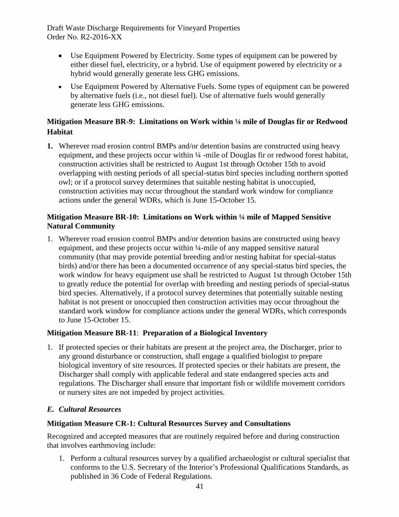
Draft Waste Discharge Requirements for Vineyard Properties Order No. R2-2016-XX
41
• Use Equipment Powered by Electricity. Some types of equipment can be powered by either diesel fuel, electricity, or a hybrid. Use of equipment powered by electricity or a hybrid would generally generate less GHG emissions.
• Use Equipment Powered by Alternative Fuels. Some types of equipment can be powered by alternative fuels (i.e., not diesel fuel). Use of alternative fuels would generally generate less GHG emissions.
Mitigation Measure BR-9: Limitations on Work within ¼ mile of Douglas fir or Redwood Habitat
1. Wherever road erosion control BMPs and/or detention basins are constructed using heavy equipment, and these projects occur within ¼ -mile of Douglas fir or redwood forest habitat, construction activities shall be restricted to August 1st through October 15th to avoid overlapping with nesting periods of all special-status bird species including northern spotted owl; or if a protocol survey determines that suitable nesting habitat is unoccupied, construction activities may occur throughout the standard work window for compliance actions under the general WDRs, which is June 15-October 15.
Mitigation Measure BR-10: Limitations on Work within ¼ mile of Mapped Sensitive Natural Community 1. Wherever road erosion control BMPs and/or detention basins are constructed using heavy
equipment, and these projects occur within ¼-mile of any mapped sensitive natural community (that may provide potential breeding and/or nesting habitat for special-status birds) and/or there has been a documented occurrence of any special-status bird species, the work window for heavy equipment use shall be restricted to August 1st through October 15th to greatly reduce the potential for overlap with breeding and nesting periods of special-status bird species. Alternatively, if a protocol survey determines that potentially suitable nesting habitat is not present or unoccupied then construction activities may occur throughout the standard work window for compliance actions under the general WDRs, which corresponds to June 15-October 15.
Mitigation Measure BR-11: Preparation of a Biological Inventory
1. If protected species or their habitats are present at the project area, the Discharger, prior to any ground disturbance or construction, shall engage a qualified biologist to prepare biological inventory of site resources. If protected species or their habitats are present, the Discharger shall comply with applicable federal and state endangered species acts and regulations. The Discharger shall ensure that important fish or wildlife movement corridors or nursery sites are not impeded by project activities.
E. Cultural Resources
Mitigation Measure CR-1: Cultural Resources Survey and Consultations Recognized and accepted measures that are routinely required before and during construction that involves earthmoving include:
1. Perform a cultural resources survey by a qualified archaeologist or cultural specialist that conforms to the U.S. Secretary of the Interior’s Professional Qualifications Standards, as published in 36 Code of Federal Regulations.
Draft Waste Discharge Requirements for Vineyard Properties Order No. R2-2016-XX
42
2. Contact the State Historic Preservation Officer and federal lead agencies as appropriate
for coordination of Nation-to-Nation consultations with the Native American Tribes.
3. Consult a qualified paleontological resources specialist to determine whether paleontological resources would likely be disturbed in a project area on the basis of the sedimentary context of the area and a records search for past paleontological finds in the area. The assessment may suggest areas of high or known potential for containing resources. If the assessment is inconclusive, a surface survey is recommended to determine the fossil potential and extent of the pertinent sedimentary units within the project site. If the site contains areas of high potential for significant paleontological resources and avoidance is not possible, prepare a paleontological resources mitigation plan.
4. Consult established archaeological and historical records and conduct a field survey of the project prior to construction. Survey records shall be filed with the appropriate archaeological or historical data centers.
5. Consult with local Native American representatives as appropriate to obtain local
knowledge of the project vicinity.
6. Prepare site development and grading plans that avoid disturbance of known cultural sites and/or documented sensitive areas. Project plans shall include appropriate measures to protect sensitive resources.
7. Retain a qualified archaeologist or Native American representative to monitor site development activities, particularly grading and trenching. If artifacts are observed during construction, require that construction be halted until a qualified archaeologist has been consulted.
8. Alert onsite workers to the possibility of encountering human remains during construction activities, and prepare appropriate procedures. It is usually required that all construction activities near the location of identified human skeletal remains are halted until proper consultation and mitigation is arranged.

Draft Waste Discharge Requirements for Vineyard Properties Order No. R2-2016-XX
43
ATTACHMENT G California Regional Water Quality Control Board
San Francisco Bay Region
General Waste Discharge Requirements Order No. R2-2016-00XX
GLOSSARY OF TERMS
Annual Certification Form
A form submitted to the Water Board annually, documenting progress with regard to development of a Certified Farm Plan, required monitoring, and water quality conditions as compared to Performance Standards.
Beneficial Use The uses of water protected against degradation, such as: domestic, municipal, agricultural and industrial supply; power generation; recreation; aesthetic enjoyment; navigation and preservation of fish and wildlife, and other aquatic resources or preserves. Existing beneficial uses are uses that were attained in the surface or groundwater after Nov. 28, 1975 and potential beneficial uses are uses that would develop in the future through control measures.
Best Management Practice (BMP)
Methods or measures designed and selected to effectively control the discharge of pollutants from point and nonpoint source discharges.
California Environmental Quality Act (CEQA)
The California Environmental Quality Act (CEQA) establishes a duty for public agencies to avoid or minimize environmental damage where feasible, recognizing that a public agency has an obligation to balance a variety of public objectives. Passed into law in 1970, CEQA sets statewide policies that require both state and local agencies to consider the environmental consequences of decisions that involve changes to the environment. It applies to projects that require discretionary approval by a government agency.
Certified Farm Plan Certified Farm Plan means an approved Qualified Professional or Third-Party Program has reviewed the Farm Plan, and concluded that upon its full implementation, the Vineyard Property would achieve all applicable performance standards for discharge.
Draft Waste Discharge Requirements for Vineyard Properties Order No. R2-2016-XX
44
Discharger Landowner and operator of Vineyard Property discharging, or proposing to discharge waste from a Vineyard Property.
Erosion
The detachment and movement of soil and rock fragments by water or under the force of gravity, which result in the wearing away of the land. When water is the eroding agent, erosional processes include sheet and rill erosion, gully erosion, and channel erosion.
Farm Area The area that includes at a minimum, the vineyard blocks, and also vineyard lanes, and avenues (i.e., the field roads along the edges and/or in between the vineyard blocks).
Farm Plan The plan described in Attachment A of this Order documenting natural features, developed areas, and best management practices implemented to achieve applicable performance standards for discharge.
Field Saturated Hydraulic Conductivity
Field saturated hydraulic connectivity is the hydraulic connectivity of the soil when it has been brought to a near-saturated state by water applied abundantly at the land surface, typically by processes such as ponded infiltration or copious rainfall or irrigation. This term is roughly analogous with infiltration capacity.
Hillslope Vineyard
An area where grapes are planted on an average slope that is greater than 5 percent.
Hydrologic Connectivity
Having a continuous surface flow path (road ditches, road surfaces, gullies, or other drainage structures or disturbed surfaces) to a natural stream channel during a storm runoff event.
Incision Infiltration
The progressive lowering over time of streambed elevation, as a result of net erosion. The movement of water into soil.
Infiltration capacity The maximum rate at which the soil can absorb water.
Landowner An owner or proprietor of land.
Monitoring and Reporting Program
The monitoring and reporting required by a Discharger enrolled under this Order.
Nonpoint Source
The Clean Water Act focuses on two possible sources of pollution: point and nonpoint. “Point” sources refer to discrete discharges, such as from a pipe. “Nonpoint” refers to everything else, including agricultural runoff.
Draft Waste Discharge Requirements for Vineyard Properties Order No. R2-2016-XX
45
Non-Point Source Policy
Adopted in 2004, the NPS Policy is designed to assist all responsible and/or interested parties in understanding how the State’s NPS water quality control requirements will be implemented and enforced. The parties involved include the State Water Resources Control Board and the Regional Water Quality Control Boards, and also other federal, state and local agencies, individual dischargers, Third-party Programs and any other stakeholders.
Notice of Intent (NOI)
A document that must be completed by the Discharger or their representative, as required to enroll a Vineyard Property into the General WDRs permit.
Operator Person(s) responsible for management decisions made in the
operation of the Vineyard Property. Photo-point Monitoring Peak Runoff
Photo monitoring is a qualitative tool for documenting the current management of a farm or ranch, as well as, conditions or events that may assist in its management. Monitoring is based on the establishment of permanent photo locations or photographs, which can be revisited at regular intervals to reflect changes that have occurred over time at the same location. The instantaneous maximum value for discharge during a storm runoff event, usually expressed as cubic feet per second.
Performance Standards
Standards for pollutant discharge control that are specified as conditions for discharge under this Order.
Qualified Professional
California registered professional in a discipline associated with erosion and sediment control including for example a professional engineer, licensed geologist, registered landscape architect or certified professional in erosion and sediment control.
Reach Report of Waste Discharge
A subdivision of a drainage system consisting of a discreet portion of a channel. The California Water Code Section 13260 states that persons discharging or proposing to discharge waste that could affect the quality of waters of the State, other than into a community sewer system, shall file a report of waste discharge (ROWD) with the appropriate Water Board, that completely characterizes the discharge. A complete characterization includes, but is not limited to, design and actual flows, a list of constituents and the
Draft Waste Discharge Requirements for Vineyard Properties Order No. R2-2016-XX
46
discharge concentrations of each constituent, a list of other appropriate waste discharge characteristics, a description and schematic of all treatment processes, a description of best management practices used, and a description of disposal methods. The ROWD is used to start the application process for all waste discharge requirements except for general waste discharge requirements that use a Notice of Intent to satisfy the requirements of the ROWD.
Restoration Ridgetop
The returning of the natural/historic functions and values to a former or degraded site. A relatively flat topographic divide above divergent and descending slopes where one or more of the descending slopes has a natural slope steeper than fifty percent for more than fifty feet in slope length.
Riparian San Francisco Bay Basin Plan
Located along the edge of a channel, generally on the floodplain. Characterized by access to and influence of the channel, but not in it. A riparian zone or riparian area is the interface between land and a river system. Riparian habitat is composed of trees, and other vegetation and physical features normally found on the stream banks and flood plains associated with streams, lakes, or other bodies of water. The Water Board’s master water quality control planning document, designating beneficial uses and water quality objectives for waters of the State, including surface waters and groundwater.
Section 401 Water Quality Certifications Section 404 Soil bioengineering
Water Quality Certifications are issued by the Water Board pursuant to Clean Water Act Section 401 to certify that projects permitted by the U.S. Army Corps of Engineers pursuant to Clean Water Act Section 404 meet State law, regulations, and policy. Refers to a section of the Clean Water Act establishing a permit program for the discharge of dredged or fill materials into waters of the United States. A method of bank stabilization emphasizing the incorporation of biological materials such as plants, plant parts (e.g., root wads), or a combination of vegetation and inert materials (e.g., brush mats/sills, wattles, fascines, or branch packing/layering).

Draft Waste Discharge Requirements for Vineyard Properties Order No. R2-2016-XX
47
Third-Party Program
An individual Qualified Professional or a Group with at least one staff recognized as a Qualified Professional that provides technical assistance/expertise to help dischargers comply with requirements of this Order.
Tier 1
Farms where the Farm Water Quality Protection Plan for the Vineyard Property, as described in Section F.1 and Attachment A, has been completed and Certified, the Certified Farm Plan is fully implemented to achieve all applicable performance standards for discharge, and the Vineyard Property establishes stream setbacks and/or participates in tributary or reach-based stewardship (as specified in Attachment A).
Tier 2 Discharger is working with an approved Third-Party Program or Qualified Professional to develop a Certified Farm Plan for the Vineyard Property.
Tier 3 Discharger that elects to develop a Farm Plan for a Vineyard Property independently - without the Farm Plan being certified by an approved Third-Party Program or Qualified Professional.
Total Maximum Daily Load
An evaluation of the condition of an impaired surface water on the Section 303(d) List that establishes limitations on the amount of pollution that water can be exposed to without adversely affecting its beneficial uses, and allocating proportions of the total limitation among dischargers to the impaired surface water.
Vineyard Properties The entire parcel or contiguous parcels under the same ownership, where grapevines are planted on part of the property.
Waste Discharge The discharge of any waste, including sewage and any and all other waste substances, liquid, solid, gaseous, or radioactive, associated with human habitation, or of human or animal origin, or from any producing, manufacturing, or processing operation, including waste placed within containers of whatever nature prior to, and for purposes of, disposal.
Waste Discharge Requirement
State regulations pertaining to the treatment, storage, processing, or disposal of waste discharges.
Water Quality Objective The limits or levels of water quality elements or biological characteristics established to reasonably protect the beneficial uses of water or the prevent problems within a specific area. Water quality objectives may be numeric or narrative.

Appendix B. GIS Analysis
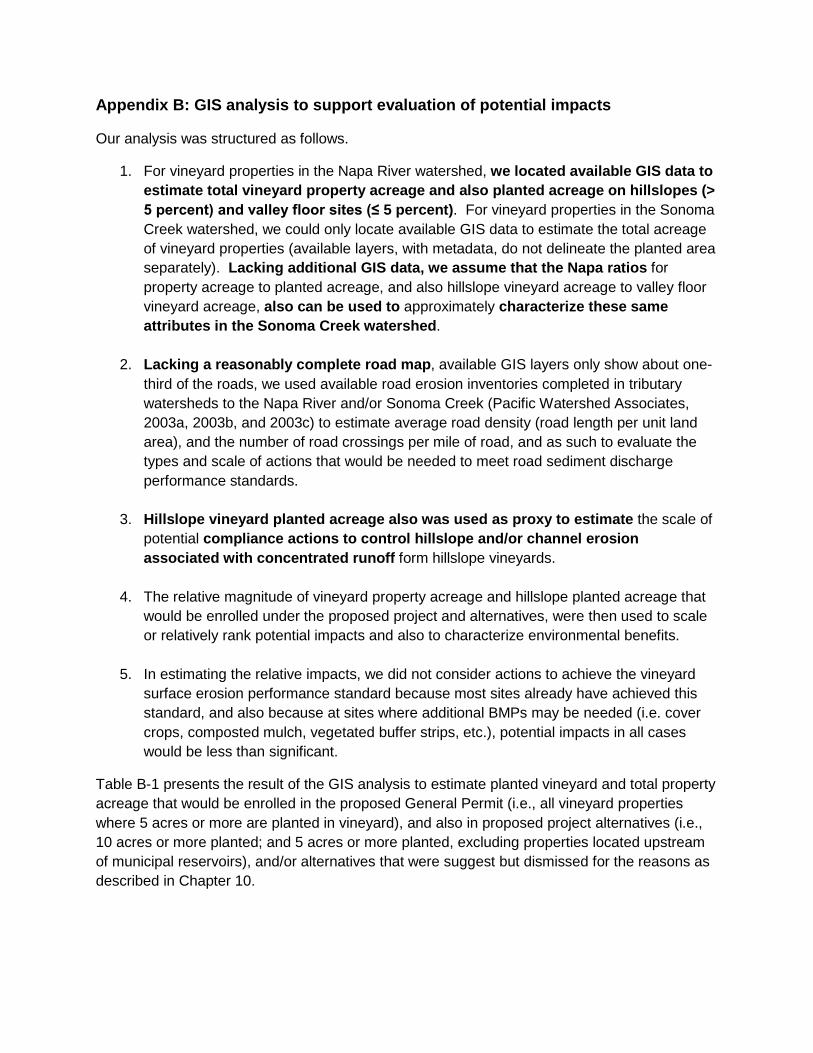
Appendix B: GIS analysis to support evaluation of potential impacts
Our analysis was structured as follows.
1. For vineyard properties in the Napa River watershed, we located available GIS data to estimate total vineyard property acreage and also planted acreage on hillslopes (> 5 percent) and valley floor sites (≤ 5 percent). For vineyard properties in the Sonoma Creek watershed, we could only locate available GIS data to estimate the total acreage of vineyard properties (available layers, with metadata, do not delineate the planted area separately). Lacking additional GIS data, we assume that the Napa ratios for property acreage to planted acreage, and also hillslope vineyard acreage to valley floor vineyard acreage, also can be used to approximately characterize these same attributes in the Sonoma Creek watershed.
2. Lacking a reasonably complete road map, available GIS layers only show about one-third of the roads, we used available road erosion inventories completed in tributary watersheds to the Napa River and/or Sonoma Creek (Pacific Watershed Associates, 2003a, 2003b, and 2003c) to estimate average road density (road length per unit land area), and the number of road crossings per mile of road, and as such to evaluate the types and scale of actions that would be needed to meet road sediment discharge performance standards.
3. Hillslope vineyard planted acreage also was used as proxy to estimate the scale of potential compliance actions to control hillslope and/or channel erosion associated with concentrated runoff form hillslope vineyards.
4. The relative magnitude of vineyard property acreage and hillslope planted acreage that would be enrolled under the proposed project and alternatives, were then used to scale or relatively rank potential impacts and also to characterize environmental benefits.
5. In estimating the relative impacts, we did not consider actions to achieve the vineyard surface erosion performance standard because most sites already have achieved this standard, and also because at sites where additional BMPs may be needed (i.e. cover crops, composted mulch, vegetated buffer strips, etc.), potential impacts in all cases would be less than significant.
Table B-1 presents the result of the GIS analysis to estimate planted vineyard and total property acreage that would be enrolled in the proposed General Permit (i.e., all vineyard properties where 5 acres or more are planted in vineyard), and also in proposed project alternatives (i.e., 10 acres or more planted; and 5 acres or more planted, excluding properties located upstream of municipal reservoirs), and/or alternatives that were suggest but dismissed for the reasons as described in Chapter 10.
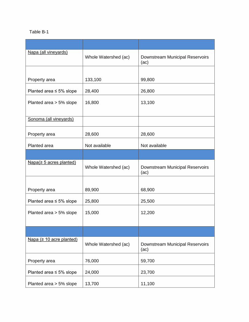
Table B-1
Napa (all vineyards) Whole Watershed (ac) Downstream Municipal Reservoirs
(ac)
Property area
133,100
99,800
Planted area ≤ 5% slope 28,400 26,800
Planted area > 5% slope
16,800 13,100
Sonoma (all vineyards)
Property area 28,600 28,600
Planted area Not available Not available
Napa(≥ 5 acres planted) Whole Watershed (ac) Downstream Municipal Reservoirs
(ac)
Property area
89,900
68,900
Planted area ≤ 5% slope 25,800 25,500
Planted area > 5% slope
15,000 12,200
Napa (≥ 10 acre planted) Whole Watershed (ac) Downstream Municipal Reservoirs
(ac)
Property area 76,000 59,700
Planted area ≤ 5% slope 24,000 23,700
Planted area > 5% slope 13,700 11,100

Table B-1 (continued)
Napa (≥ 40 acre property) Whole Watershed (ac) % of total
Property area
104,500
79
Planted area ≤ 5% slope 18,300 64
Planted area > 5% slope
13,200 79
Sonoma (≥ 40 acre property)
Property area
25,100 88
Napa (≥ 40 acres planted)
Property area
33,100
25
Planted area ≤ 5% slope 13,200
46
Planted area > 5% slope
7,600 45
2012 WDR waiver criteria
Property area
66,600
50
Planted area ≤ 5% slope 17,300 61
Planted area > 5% slope 14,100 84

Appendix C. Notice of Preparation and Initial Study
Notice Date: July 7, 2014
NOTICE OF PREPARATION OF A DRAFT ENVIRONMENTAL IMPACT REPORT
AND CALIFORNIA ENVIRONMENTAL QUALITY ACT
SCOPING MEETING
GENERAL WASTE DISCHARGE REQUIREMENTS FOR VINEYARD DISCHARGES IN
THE NAPA RIVER AND SONOMA CREEK WATERSHEDS
NOTICE IS HEREBY GIVEN that the San Francisco Bay Regional Water Quality Control Board (Water Board), as the Lead Agency, is planning to prepare an Environmental Impact Report (EIR) pursuant to the California Environmental Quality Act of 1970 (CEQA), State CEQA Guidelines (California Code of Regulations CCR, Title 14, Div. 6, Chap. 3), and the State Water Resource Control Board’s CEQA regulations (CCR, Title 23, Sections 3720-3782).
Project Title: General Waste Discharge Requirements for Vineyard Discharges in the Napa River and Sonoma Creek Watersheds
Project Location: The proposed project will apply to existing and future vineyard properties in the Napa River and Sonoma Creek watersheds as depicted on Figure 1, which meet certain criteria relative to size and slope (see Table 1 in the Initial Study).
Project Summary: The proposed project consists of the Water Board establishing General Waste Discharge Requirements (General WDRs) that regulate discharges of sediment and storm water runoff originating from vineyard properties located within the boundaries shown in Figure 1. The proposed General WDRs will require dischargers to assess, plan, and implement a suite of site-specific actions and best management practices targeted towards reducing erosion from:
• Vineyards and related facilities and road networks • Gullies and shallow landslides, and • Points of concentrated stormwater runoff.
The project is described in more detail under the Project Description section on page 6.

Notice of Preparation - 2 - Notice Date: July 7, 2014 Purpose of the Notice of Preparation: This Notice of Preparation (NOP) serves to:
1) Solicit information on the scope of the environmental analysis for the proposed project, and 2) Notify the public and regulatory agencies that the Water Board will prepare a draft EIR to
assess potential adverse environmental impacts that may result from implementing the proposed project.
SUBMISSION OF WRITTEN COMMENTS
The Water Board is requesting comments from the public and public agencies on the scope and content of the environmental information to be included in the EIR. For public agencies, the Board is interested in your views as to the scope and content of the environmental information which is germane to your agency’s statutory responsibilities, if any, in connection with the proposed project.
Due to the time limits mandated by State law, your response must be sent at the earliest possible date, but no later than 30 days after receipt of this notice. Please send your response to the Water Board, as directed below, along with the name of a contact person, if you are a public agency.
In order to be fully considered, written comments focusing on the issues related to the environmental analysis for the proposed project must be received by 5:00 pm on Wednesday, August 6, 2014. Written comments should be sent to the address below or by fax to (510) 622-2426.
San Francisco Bay Regional Water Quality Control Board 1515 Clay Street, Suite 1400
Oakland, California, 94612-1482 ATTN: Anya Starovoytov
SCOPING MEETING
In order for the public and regulatory agencies to have an opportunity to submit comments on the scope of the EIR, a meeting will be held during the 30-day NOP scoping period. The date, time, and meeting location are as follows:
Scoping Meeting Date and Time
Scoping Meeting Location
Wednesday, July 23, 2014 3:00 PM – 5:00 PM
Napa County Agricultural Commissioner’s Office Ag/UC Conference Room Soscol Professional Plaza
1710 Soscol Avenue, Suite 3 Napa, California 94559
Notice of Preparation - 3 - Notice Date: July 7, 2014 If you would like to request a reasonable accommodation for a disability, please contact Ms. Anya Starovoytov, of the Water Board, at [email protected] or (510) 622-2506.
PROJECT BACKGROUND AND HISTORY
The Napa River and Sonoma Creek watersheds contain an estimated 131,500 acres of vineyard properties, with greater than 59,000 acres planted in grapes. The Napa River and Sonoma Creek watershed and its tributaries are listed on the Clean Water Act Section 303(d) list as impaired by excess sediment, pathogens, and nutrients, meaning that these waters do not meet water quality standards.
Sediment total maximum daily loads (TMDLs), completed for each watershed, identified vineyards as one of several land uses that, if improperly managed, can discharge sediment and concentrated storm runoff that can adversely affect water quality and contribute to the sediment impairment. The sediment TMDLs are described in detail below.
Staff intends to recommend that the Water Board adopt General WDRs for vineyard properties located within these watersheds to control discharges of sediment and concentrated storm runoff. The proposed WDRs will implement the sediment TMDLs while also considering appropriate water quality objectives to protect the beneficial uses of these receiving waters. The designated beneficial uses of water for Napa River and Sonoma Creek include recreation (fishing, swimming, boating, etc.), fish migration and spawning, cold and warm freshwater habitats, wildlife habitat, and preservation of rare and endangered species. Beneficial uses for Napa River also include water supply (agricultural, municipal, and domestic) and navigation. Of these, the beneficial uses adversely affected by excess sediment consist of recreation (i.e. fishing), cold freshwater habitat, fish spawning, and preservation of rare and endangered species.
Napa River and Sonoma Creek TMDLs
In the 2000s, based on evidence of widespread erosion and concern regarding adverse impacts to fish habitat, the Water Board listed Napa River and Sonoma Creek as impaired by sedimentation. At roughly the same time period, both watersheds were also designated as impaired by excess pathogen and nutrient inputs. To address these impairments and to restore beneficial uses, the Water Board prepared pathogen and sediment TMDLs for both watersheds in the mid to late 2000s. In 2014, the Water Board approved the de-listing for the nutrient impairment (pending approval by the State Water Board and the U.S. Environmental Protection Agency).
The sediment TMDLs for these watersheds address water quality objectives for sediment, settleable materials, and population and community ecology that are impaired due to elevated concentrations of fine sediment in the bed of the Napa River, Sonoma Creek, and their tributaries. The TMDLs specify that greater than half of all sediment delivered to these

Notice of Preparation - 4 - Notice Date: July 7, 2014 watersheds comes from anthropogenic (i.e., human-caused) activities associated with roads and road drainage systems, stream bed and bank erosion, vineyard surface runoff and erosion, and historical grazing. Across both watersheds, the TMDLs require an approximate 50 percent reduction in anthropogenic sediment inputs.
To achieve these sediment reductions, the TMDLs contain implementation plans that provide a framework for actions needed to meet water quality objectives and to restore beneficial uses. The proposed project, issuance of General WDRs, will regulate discharges associated with the vineyard source category, as identified in the TMDLs. The proposed General WDRs will also address potential nutrients and pesticides discharges from vineyards.
2012 Draft Conditional Waiver Initial Study and Proposed Mitigated Negative Declaration
In 2012, in an effort to regulate the vineyard source category identified in the sediment TMDLs, the Water Board staff circulated a draft Conditional Waiver of WDRs (Conditional Waiver) and a draft Initial Study/Mitigated Negative Declaration for public comment. However, based on the comments received and other regulatory considerations, the Water Board terminated the Conditional Waiver project in early 2013.
The proposed General WDRs are needed to regulate vineyard discharges and implement the above-referenced TMDLs. It is a new project for which the proposed EIR will be prepared.
EXISTING REGULATORY FRAMEWORK
Discharges from planted vineyards in the Napa River and Sonoma Creek watersheds have not yet been regulated by the Water Board either via WDRs, waivers of WDRs, or prohibitions. Certain aspects of vineyard erosion have, however, been regulated through County-level permit programs, which are discussed below. Many actions have already been taken to implement these local programs and have led to on the ground, physical changes to the environment.
Summary of Napa County Regulatory Program for Vineyards
The Napa County Planning Division regulates new vineyard facility development and vineyard replants. Its process is guided by 1) the Napa County Conservation Regulations, 2) the Napa County General Plan, and since 2000, 3) compliance with CEQA for any new vineyard development. These regulations establish the requirements and guidelines for preparing, reviewing, and approving Erosion Control Plans (ECPs) for grading and vegetation removal associated with new or replanted vineyards on slopes greater than five percent. New vineyards and replants on slopes of less than five percent are exempt from the ECP requirements.

Notice of Preparation - 5 - Notice Date: July 7, 2014 The ECP process can follow one of two paths:
• Track I – Applies to new vineyards and those developed since 2000, and requires discretionary approval by the County (subject to CEQA review).
• Track II – Applies to vineyard replants and is a ministerial action, provided the replant falls within the existing vineyard footprint and there are no substantial changes to site drainage or layout. Most replanted vineyards proceed through the Track II process.
Track I requires hydrologic and erosion analyses to demonstrate that no net increases in soil loss and peak runoff will occur over pre-project conditions. Furthermore, the Conservation Regulations require stream setbacks for new vineyards that range from 35 to 150 feet, depending on stream designation and the slope of the adjacent land, as it exists at the time of the agricultural activity. Stream setbacks apply to all watercourses designated by a solid or dashed line on United States Geological Survey (USGS) maps, as well as any watercourse that has a) well-defined channel with a depth greater than four feet, b) banks steeper than 3:1, and c) contains hydrophilic or riparian vegetation. Replants, if completed within the original vineyard footprint, are not required to meet these setback criteria.
There are no requirements for retroactive erosion controls for existing vineyards. Existing vineyards are only required to submit ECPs at the time of replanting. New vineyard projects proposed on slopes exceeding 30 percent require the issuance of a County use permit, and new vineyards proposed on slopes exceeding 50 percent require a variance.
Summary of Sonoma County Regulatory Program for Vineyards
New vineyard development and replants in Sonoma County are guided by the Grading, Drainage, and Vineyard and Orchard Site Development Ordinance (VESCO). The Sonoma County Agricultural Commissioner’s Office implements and enforces VESCO. Currently, the VESCO permit process does not require CEQA project analysis.
VESCO requires a permit for any grading, drainage improvement, or site development associated with new or replanted vineyards. VESCO permits are issued at two levels that take into account soil type, soil erosivity, and slope as follows:
• Level I – Applies to new vineyards or replants developed on slopes less than or equal to 10 to 15 percent and does not require ECP documentation or verification of project completion.
• Level II – Applies to new vineyards or replants on slopes greater than 10 or 15 percent and requires the project proponent to submit an ECP that is reviewed by the VESCO staff. VESCO staff conducts post-construction review to confirm that ECP design plans were followed and implemented appropriately.
Notice of Preparation - 6 - Notice Date: July 7, 2014 Both Level I and Level II projects are required to adhere to the best management practices and standards described in the Best Management Practices for Agricultural Erosion and Sediment Control manual (Sonoma County Agricultural Commissioner’s Office, 2010). For Level II projects, the engineers preparing the vineyard plans are required to document pre-construction peak runoff calculations and demonstrate that post-construction conditions will not increase runoff from pre-construction conditions and will not modify pre-existing drainage patterns. VESCO and the County General Plan establish stream setback requirements that range from 25 feet to 50 feet, depending on slope of the adjacent land, soil type, and stream designation. New vineyards on slopes greater than 50% are prohibited and there are no retroactive erosion control requirements for vineyards constructed prior to VESCO. Existing vineyards are required to comply with VESCO at the time of replanting with more oversight occurring on properties containing highly-erodible soils.
The proposed General WDRs recognize the existence of county regulations, but is a separate program to implement the performance standards for vineyard properties in the Napa River and Sonoma Creek sediment TMDLs. The proposed General WDRs are described below.
PROJECT DESCRIPTION
Project Objectives
The fundamental objective of the proposed project is:
• To implement the Napa River and Sonoma Creek sediment TMDLs to achieve their vineyard discharge performance standards for sediment and storm runoff and to ultimately meet the TMDLs’ sediment allocations and targets and restore properly functioning substrate conditions in channel reaches that provide habitat for anadromous salmonids.
Other objectives include the following:
1) To control discharges of sediment and/or storm runoff from vineyards into channel reaches that provide habitat for other native fishes;
2) To promote stream-riparian habitat protection and restoration;
3) To promote actions to restore fish passage at road crossings and streamflow diversions;
4) To promote management decisions and actions to maintain adequate in-stream temperature; and

Notice of Preparation - 7 - Notice Date: July 7, 2014
5) To encourage voluntary conservation programs to assist vineyard owners/operators in meeting the requirements and objective of the proposed General WDRs.
Proposed General WDRs
The proposed General WDRs would regulate discharges from the following types of vineyard properties within the project area shown on Figure 1:
• All existing vineyard properties (including replants) where 5 acres-or-more are planted in vineyard, except for “low sediment delivery” properties that meet the exemption criteria (described below).
• All proposed vineyards of 5 acres or more and developed on slopes ≤ 30 percent, except for “low sediment delivery” properties or “high potential sediment delivery” properties (described below) ;
• Any facility, regardless of planted acreage, that is deemed by Water Board staff to discharge waste that could affect water quality and could be adequately regulated through the proposed General WDRs.
The proposed General WDRs would require controls for discharges from the vineyard facility and the roads located throughout the vineyard property. A vineyard facility includes all permanent, semi-permanent, or temporary physical features of a vineyard such as land, crops, drainage systems, roads, reservoirs, diversion structures/equipment, etc., that are established or maintained for the purpose of growing grapes. Discharges from on-site winery production facilities are not included in this permit.
The following “high potential sediment delivery” vineyard properties would not qualify for coverage under the proposed General WDRs, given their higher potential impact on the existing habitat and increased potential for soil erosion. These properties would instead be required to submit applications for individual WDRs:
• Any proposed vineyards that require a Timber Conversion Plan or Permit; • Vineyards proposed on ridgetop1 areas; or • New vineyards on slopes of 30 percent or more.
“Low sediment delivery” vineyard properties are those that are not expected to contribute a significant amount of sediment. These properties would be exempt from the requirement to be permitted under proposed General WDRs by filing a notice of non-applicability, if they meet all of the following criteria: 1 Ridgetop is defined as a relatively flat topographic divide above divergent and descending slopes where one or more of the descending slopes has a natural slope steeper than 50 percent for more than 50 feet in slope length.

Notice of Preparation - 8 - Notice Date: July 7, 2014
• The vineyard is developed on a slope ≤ 5 percent; • A stream setback in the form of a vegetated buffer is in-place (i.e., established) that is at
least 35 feet wide, measured from top-of-bank, along the entire length of the Class I, II, III, or Class IV watercourse (as defined by California Forest Practice Rules) located on or adjacent to the vineyard property, and the vegetated buffer is effective with regard to removal of sediment and other pollutants from surface runoff; and
• There are no visible signs of erosion at any points of direct discharge (i.e., pipe outlets, ditch outlets, etc.) into waterways located on or adjacent to the vineyard property.
The distribution of existing vineyard properties across both watersheds, by slope categories, is shown in Figure 2. Existing vineyards in the 0 to 5 percent slope range may meet the “low sediment delivery” criteria described above. Existing vineyards on slopes greater than 30 percent are highlighted to identify areas that are expected to have a higher tendency for erosion, given the steep topography. Based on the proposed exemption criteria for “low sediment delivery” vineyard properties, it is anticipated that approximately 38,000 acres of existing vineyards could be eligible for enrollment in the General WDRs within the Napa River watershed. Approximately 24,000 acres of existing vineyards could be eligible for enrollment within Sonoma Creek watershed.
Proposed performance standards for the General WDRs are summarized below.
Vineyard Performance Standard
Vineyard owners/operators would be required to complete a Farm Water Quality Plan (Farm Plan) that describes existing conditions and best management practices on their vineyard property. The Farm Plan would include an evaluation and assessment of road networks on a property-wide scale (beyond the planted vineyard). The Farm Plan must include documentation of nutrient and pest management practices as well as a summary of all existing or potential erosional features that may be contributing sediment into adjacent waterways.
Surface Erosion Performance Standard
Based on the above assessment, the vineyard owner/operator would be required to implement a suite of appropriate best management practices to protect soil from erosion, prevent excessive rates of sediment delivery from surface erosion of vineyards and associated road networks, and effectively attenuate storm runoff (described below). Rates of sediment delivery are excessive when the predicted soil loss rate exceeds the tolerable soil loss rate (T), as defined in the Universal Soil Loss Equation or Revised Universal Soil Loss Equation (USDA-ARS, http://www.ars.usda.gov/Research/docs.htm?docid=6010). The effectiveness of these actions would be required to be evaluated by field inspection, visual observation and, in some cases,
Notice of Preparation - 9 - Notice Date: July 7, 2014 calculating soil loss rates. Calculations completed as part of the Napa or Sonoma County vineyard erosion permit processes may be acceptable to meet some of these requirements.
Vineyard owners/operators would be required to maintain photo documentation to confirm that selected best management practices are working as designed, are being maintained, and to document any new water quality-related issues that arise. Annual reporting to the Water Board would be required.
Road Performance Standard
The TMDLs require control of road-related sediment delivery to receiving waters. The proposed General WDRs would require a road network assessment, at a property-wide scale, to identify points of discharge from roads and to assess road conditions. The survey would identify all locations where roadways have a potential to discharge sediment directly into a waterway (or a ditch that conveys water to a waterway) and any on-site culverts and stream crossings. Following the survey, the vineyard owner/operator would be required to develop and implement a prioritization scheme to reduce or eliminate direct discharges from roads using best management practices so that no more than 25 percent2 of on-site roads are directly connected to a waterway within a 20-year timeframe. An annual compliance form would be required to document annual actions taken to address road-related sediment delivery. In addition, in the vicinity of culverts, critical dips and trash racks would be required to be installed, where appropriate, in order to avoid potential culvert failure due to debris clogging and/or stream diversion.
Unstable Areas and Stormwater Runoff Performance Standard
Vineyard owners/operators would be required to assess their property and on-site or adjacent streams to identify unstable areas such as gullies, mass wasting (e.g., landslides, rock fall, mud flows, etc.), and bank erosion that have resulted from past or current roads or vineyard facility operations. The owners/operators would then be required to implement best management practices to accelerate natural recovery and prevent human-caused increases in sediment delivery from unstable areas.
In addition to controlling surface erosion, vineyard owners/operators would be required to effectively attenuate significant increases in storm runoff, so that the runoff from vineyards shall not cause or contribute to downstream increases in rates of bank or bed erosion. Evidence of active down-cutting or head-cutting, and/or anomalous patterns or intensity of bank erosion (e.g., extensive bank erosion along one or both banks), at or near the point of discharge or in the first 2 Road assessments previously performed in the Napa River and Sonoma Creek watersheds indicate that approximately 50 percent of roads are directly connected to waterways. Reducing the length of connected roads by half (to 25 percent) is expected to meet the sediment TMDL reduction goal and numeric performance standard of 500 cubic yards per mile of road over the 20-year implementation period (i.e. by 2028 and 2029 for Sonoma Creek and Napa River, respectively).
Notice of Preparation - 10 - Notice Date: July 7, 2014 downstream response reach will be interpreted to indicate that the upstream vineyard may be contributing to damaging increases in bed and/or bank erosion.
Nutrient and Pesticide Stormwater Runoff Performance Standard
The proposed General WDRs would require an assessment of pesticide and nutrient storage, mixing, and application practices and require actions to minimize potential discharges of pesticides and nutrients to receiving waters from vineyards as described in Table 2 of the IS.
Stewardship Tier
The Water Board is considering establishing a “Stewardship Tier” for permittees who have completed all BMPs and demonstrate continued compliance with the General WDRs. The Stewardship Tier may include reduction in reporting requirements or a certificate being issued by the Water Board to vineyard owners/operators with an exceptional compliance record.
Anticipated Compliance Actions
A suite of best management practices are expected to be implemented on vineyard properties throughout Napa and Sonoma Counties in order to comply with the performance criteria for the General WDRs, as described above. Anticipated compliance actions that implicate possible environmental effects are summarized on Table 2 of the IS. Due to the local regulations described above, many of these best management practices have already been implemented on the ground and are part of the existing setting.
PROBABLE ENVIRONMENTAL EFFECTS
The purpose of the EIR process is to analyze, through a public process, the potentially significant impacts associated with the proposed project, to identify potentially feasible mitigation measures, and to identify and evaluate a range of reasonable alternatives to the proposed project. Considered alternatives should be feasible, attain most of the project objectives, and avoid or substantially lessen any of the significant adverse effects of the project.
The primary impacts of concern for the EIR are anticipated to include but not be limited to:
• Air Quality • Biological Resources • Cultural Resources • Greenhouse Gas Emissions • Hydrology and Water Quality
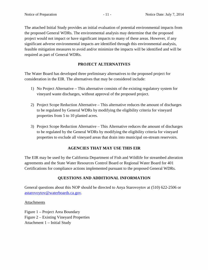
Notice of Preparation - 11 - Notice Date: July 7, 2014 The attached Initial Study provides an initial evaluation of potential environmental impacts from the proposed General WDRs. The environmental analysis may determine that the proposed project would not impact or have significant impacts to many of these areas. However, if any significant adverse environmental impacts are identified through this environmental analysis, feasible mitigation measures to avoid and/or minimize the impacts will be identified and will be required as part of General WDRs.
PROJECT ALTERNATIVES
The Water Board has developed three preliminary alternatives to the proposed project for consideration in the EIR. The alternatives that may be considered include:
1) No Project Alternative – This alternative consists of the existing regulatory system for vineyard waste discharges, without approval of the proposed project.
2) Project Scope Reduction Alternative – This alternative reduces the amount of discharges to be regulated by General WDRs by modifying the eligibility criteria for vineyard properties from 5 to 10 planted acres.
3) Project Scope Reduction Alternative – This Alternative reduces the amount of discharges to be regulated by the General WDRs by modifying the eligibility criteria for vineyard properties to exclude all vineyard areas that drain into municipal on-stream reservoirs.
AGENCIES THAT MAY USE THIS EIR
The EIR may be used by the California Department of Fish and Wildlife for streambed alteration agreements and the State Water Resources Control Board or Regional Water Board for 401 Certifications for compliance actions implemented pursuant to the proposed General WDRs.
QUESTIONS AND ADDITIONAL INFORMATION
General questions about this NOP should be directed to Anya Starovoytov at (510) 622-2506 or [email protected].
Attachments
Figure 1 – Project Area Boundary Figure 2 – Existing Vineyard Properties Attachment 1 – Initial Study
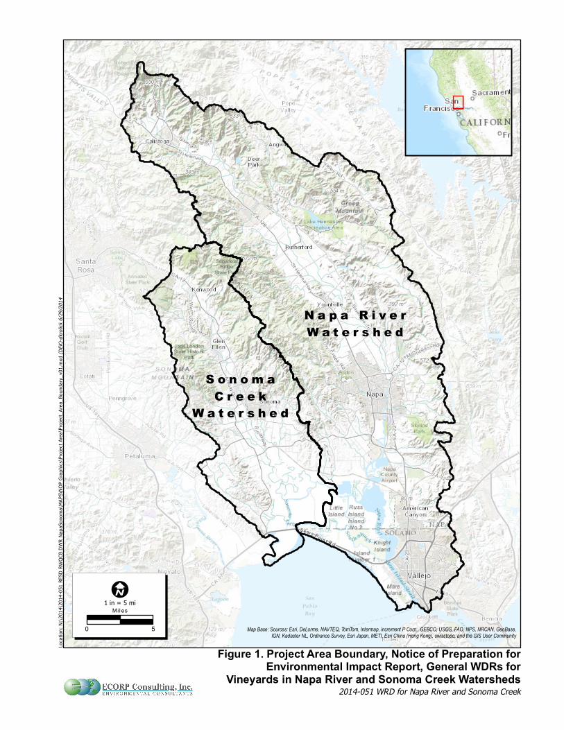
N a p a R i v e rW a t e r s h e d
S o n o m aC r e e kW a t e r s h e d
Figure 1. Project Area Boundary, Notice of Preparation forEnvironmental Impact Report, General WDRs for
Vineyards in Napa River and Sonoma Creek Watersheds
1 in = 5 mi
2014-051 WRD for Napa River and Sonoma Creek
Loca
tion:
N:\2
014\2
014-0
51 R
ESD
RWQC
B DWR
Nap
aSon
oma\M
APS\N
OP G
raphic
s\Proj
ect A
rea\P
rojec
t_Area
_Bou
ndary
_v01
.mxd
(DEK
)-dkro
lick 6/
29/20
14
Map Base: Sources: Esri, DeLorme, NAVTEQ, TomTom, Intermap, increment P Corp., GEBCO, USGS, FAO, NPS, NRCAN, GeoBase,IGN, Kadaster NL, Ordnance Survey, Esri Japan, METI, Esri China (Hong Kong), swisstopo, and the GIS User Community
I
0 5
Mil es
Figure 2. Existing Vineyard Properties, Notice of Preparationfor Environmental Impact Report, General WDRs for Vineyard
in Napa River and Sonoma Creek Watersheds
1 in = 5 mi
2014-051 WRD for Napa River and Sonoma Creek
Loca
tion:
N:\2
014\2
014-0
51 R
ESD
RWQC
B DWR
Nap
aSon
oma\M
APS\N
OP G
raphic
s\Vine
yardD
istrib
ution
\Vine
yardD
istrib
ution
Slope
_v01
.mxd
(DEK
)-dkro
lick 6/
29/20
14
Data Sources: Napa River Watershed derived from Napa County LIDAR, Sonoma Creek Watershed boundary from BAARI v01 9.3,Vineyard Parcels from Napa and Somoma Counties.
Map Base: Sources: Esri, DeLorme, NAVTEQ, TomTom, Intermap, increment P Corp., GEBCO, USGS, FAO, NPS, NRCAN, GeoBase,IGN, Kadaster NL, Ordnance Survey, Esri Japan, METI, Esri China (Hong Kong), swisstopo, and the GIS User Community
I
0 5
Mil es
Map FeaturesWatershed BoundaryVineyard Parcels
Average Slope for Parcel0-5%5-30%>30%

INITIAL STUDY
GENERAL WASTE DISCHARGE REQUIREMENTS FOR
VINEYARD DISCHARGES IN THE NAPA RIVER AND SONOMA CREEK WATERSHEDS
PREPARED BY:
California Regional Water Quality Control Board San Francisco Bay Region
1515 Clay Street, Suite 1400 Oakland, CA 94612
July 07, 2014

ii
(This page intentionally left blank)

iii
TABLE OF CONTENTS
1. PROJECT BACKGROUND AND HISTORY ..........................................................1
2. INTRODUCTION ......................................................................................................2
3. SUMMARY ................................................................................................................5
4. PROJECT OBJECTIVES AND DESCRIPTION ......................................................8
5. EXISTING CONDITIONS .......................................................................................17
6. ENVIRONMENTAL IMPACT ANAYLSIS ...........................................................21 I. AESTHETICS ......................................................................................................30 II. AGRICULTURE AND FOREST RESOURCES ............................................33 III. AIR QUALITY .................................................................................................36 IV. BIOLOGICAL RESOURCES .........................................................................38 V. CULTURAL RESOURCES ..............................................................................40 VI. GEOLOGY AND SOILS ..................................................................................42 VII. GREENHOUSE GAS EMISSIONS ...............................................................45 VIII. HAZARDS AND HAZARDOUS MATERIALS .........................................46 IX. HYDROLOGY AND WATER QUALITY .....................................................49 X. LAND USE AND PLANNING ..........................................................................52 XI. MINERAL RESOURCES ................................................................................58 XII. NOISE ..............................................................................................................59 XIII. POPULATION AND HOUSING ..................................................................62 XIV. PUBLIC SERVICES ......................................................................................63 XV. RECREATION ................................................................................................65 XVI. TRANSPORTATION/TRAFFIC .................................................................66 XVII. UTILITIES AND SERVICE SYSTEMS ....................................................69 XVIII. MANDATORY FINDINGS OF SIGNIFICANCE ...................................71
REFERENCES, PERSONS CONTACTED, AND REPORT PREPARERS ......................73
iv
TABLES
Table 1. Summary of General WDRs Eligibility, Exclusion, and Exemption Criteria ......... 4 Table 2. Likely Compliance Actions and Types of Physical Environmental Changes ....... 12 Table 3. Existing Sediment Inputs to Channels in the Napa River Watershed Downstream of Major Dams ..................................................................................................................... 18 Table 4. Existing Sediment Inputs to Channels in the Sonoma Creek Watershed .............. 18 Table 5. Acreage of Vineyard Parcels in the Napa River and Sonoma Creek Watersheds and Percentage Certified under Fish Friendly Farming (Napa Green) Program ................. 19 Table 6. Beneficial Uses for the Napa River, Sonoma Creek and their tributaries ............. 51 Table 7. Napa County Water-Related General Plan Policies .............................................. 54 Table 8. Sonoma County Water-related General Plan Policies ........................................... 56 FIGURES Figure 1. Project Area Boundary ...........................................................................................24
Initial Study for General WDRs for Vineyard Discharges in the Napa River and Sonoma Creek watersheds
1
1. PROJECT BACKGROUND AND HISTORY
San Francisco Bay Regional Water Quality Control Board (Water Board) staff intends to recommend that the Water Board adopt General Waste Discharge Requirements (General WDRs) for vineyard discharges located in the Napa River and Sonoma Creek watersheds (Figure 1). These watersheds contain an estimated 141,400 acres of vineyard properties, with greater than 69,000 acres planted in grapes, from which there are or may be discharges of sediment and concentrated storm runoff that affect water quality.
The General WDRs would regulate discharges from vineyard properties in order to achieve the vineyard discharge performance standards for sediment and storm runoff set forth in the sediment total maximum daily loads (TMDLs) in the Water Quality Control Plan for the San Francisco Bay Basin (Basin Plan). Achieving these performance standards would ultimately meet the numeric targets and load allocations identified in the Sonoma Creek Sediment TMDL and the Napa River Sediment TMDL, adopted by the Water Board on September 8, 2010 and September 9, 2009, respectively. The U.S. Environmental Protection Agency (EPA) subsequently approved these TMDLs on December 10, 2010, and January 21, 2011, respectively.
The sediment TMDLs address water quality objectives for sediment, settleable materials, and population and community ecology that have been impaired due to elevated concentrations of fine sediment in the bed of the Napa River, Sonoma Creek, and their tributaries. The Water Board found that greater than half of all sediment delivered to streams in these watersheds comes from several land use categories, including:
a) Vineyard operations (erosion from vineyard surface, private roads, gullies and shallow landslides and concentrated storm runoff)
b) Grazing operations (erosion from pasture lands, private roads, and gullies and landslides)
c) Rural lands (erosion from private roads and gullies and shallow landslides)
d) Parks, open space, and municipal public works, which include public roads and related infrastructure (erosion from public trails and roads and gullies and shallow landslides).
The TMDLs contain implementation plans that provide a framework for actions needed to restore beneficial uses and to achieve an approximate 50 percent reduction in human-caused sediment inputs, across both watersheds, from the four major sediment source categories identified above. The proposed General WDRs are part of implementing the TMDLs.
Initial Study for General WDRs for Vineyard Discharges in the Napa River and Sonoma Creek watersheds
2
2. INTRODUCTION
This Initial Study (IS) has been prepared pursuant to the California Environmental Quality Act of 1970 (CEQA), and State CEQA Guidelines (California Code of Regulations CCR, Title 14, Div. 6, Chap. 3) and the State Water Resources Control Board’s CEQA regulations (CCR, Title 23, Section 3720 -3782). The Lead Agency for the project, as defined by CEQA, is the California Regional Water Quality Control Board, San Francisco Bay Region (Water Board).
Improperly managed vineyard operations can pose threats to surface and groundwater and stormwater runoff may result in soil erosion and contribute excess sediment to nearby streams. Runoff may also exhibit the potential to carry additional pollutants adhered to soil particles, such as agricultural pesticides and fertilizers to receiving waters.
The proposed project consists of establishing a regulatory mechanism, in the form of General WDRs, to regulate sediment discharges and to effectively attenuate significant increases in storm runoff from existing, replanted, and future vineyard properties in the Napa River and Sonoma Creek watersheds that meet certain criteria (Table 1).
The project is consistent with the State Water Resources Control Board’s 2004 Policy for Implementation and Enforcement of the Nonpoint Source Pollution Control Program (NPS Policy), which requires that all sources of nonpoint source pollution be regulated through waste discharge requirements (WDRs), waivers of WDRs, and/or prohibitions. The proposed project is also consistent with requirements contained in the Basin Plan, including the TMDLs completed for sediment in the Napa River and Sonoma Creek.
This IS analysis considers the potential environmental impacts of the General WDRs including:
• Implementation of best management practices (BMPs) and changes in vineyard operations that may be employed by landowners/operators to comply with the General WDRs.
• Environmental changes resulting from long-term compliance with the General WDRs.
All potential impacts of the General WDRs are evaluated relative to the existing physical conditions (i.e. “baseline conditions”) described in the Existing Setting section below. The types of on-the-ground actions that would be undertaken by landowners/operators subject to the General WDRs would be consistent with commonly used and effective vineyard BMPs that have already been employed in both watersheds. The potential environmental impacts of discharges from vineyard properties that are not eligible for coverage under the General WDRs are not evaluated in this IS because they are not part of the project. Vineyard dischargers who are not eligible for coverage under the General WDRs and who must apply for individual WDRs would be subject to CEQA.

Initial Study for General WDRs for Vineyard Discharges in the Napa River and Sonoma Creek watersheds
3
For the purpose of this IS and the proposed General WDRs, the term “vineyard property” includes the vineyard facility as well as all roads on the property. The “vineyard facility” includes the permanent, semi-permanent, or temporary physical features of a vineyard, such as land, crops, drainage systems, roads, reservoirs, diversion structures/equipment, etc., that are established or maintained for the purpose of growing grapes. The vineyard facility does not include winery facilities subject to an industrial stormwater permit or other WDRs or conditional waivers of WDRs.
For the purpose of this IS and the proposed General WDRs, a “landowner/operator” is defined as a landowner and/or operator of a vineyard property meeting the size and slope thresholds (defined in Table 1) in the proposed General WDRs in the Napa River or Sonoma Creek watersheds.
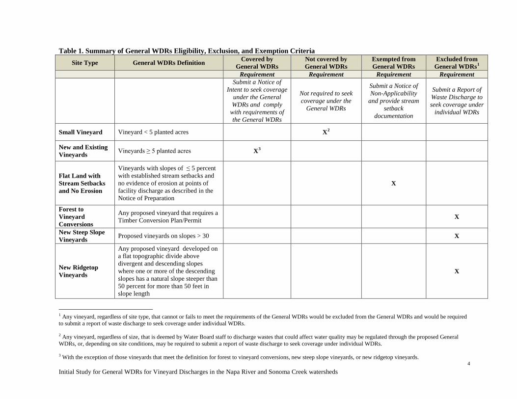
Initial Study for General WDRs for Vineyard Discharges in the Napa River and Sonoma Creek watersheds
4
Table 1. Summary of General WDRs Eligibility, Exclusion, and Exemption Criteria Site Type General WDRs Definition Covered by
General WDRs Not covered by General WDRs
Exempted from General WDRs
Excluded from General WDRs1
Requirement Requirement Requirement Requirement
Submit a Notice of Intent to seek coverage
under the General WDRs and comply
with requirements of the General WDRs
Not required to seek coverage under the
General WDRs
Submit a Notice of Non-Applicability
and provide stream setback
documentation
Submit a Report of Waste Discharge to seek coverage under
individual WDRs
Small Vineyard Vineyard < 5 planted acres X2
New and Existing Vineyards Vineyards ≥ 5 planted acres X3
Flat Land with Stream Setbacks and No Erosion
Vineyards with slopes of ≤ 5 percent with established stream setbacks and no evidence of erosion at points of facility discharge as described in the Notice of Preparation
X
Forest to Vineyard Conversions
Any proposed vineyard that requires a Timber Conversion Plan/Permit X
New Steep Slope Vineyards Proposed vineyards on slopes > 30 X
New Ridgetop Vineyards
Any proposed vineyard developed on a flat topographic divide above divergent and descending slopes where one or more of the descending slopes has a natural slope steeper than 50 percent for more than 50 feet in slope length
X
1 Any vineyard, regardless of site type, that cannot or fails to meet the requirements of the General WDRs would be excluded from the General WDRs and would be required to submit a report of waste discharge to seek coverage under individual WDRs. 2 Any vineyard, regardless of size, that is deemed by Water Board staff to discharge wastes that could affect water quality may be regulated through the proposed General WDRs, or, depending on site conditions, may be required to submit a report of waste discharge to seek coverage under individual WDRs. 3 With the exception of those vineyards that meet the definition for forest to vineyard conversions, new steep slope vineyards, or new ridgetop vineyards.

Initial Study for Napa River and Sonoma Creek watersheds Vineyard Property General WDRs
5
3. SUMMARY
Project Summary The proposed General WDRs would implement the Napa River and Sonoma Creek sediment TMDLs with the overarching goals of reducing sediment and other nonpoint source pollutant discharges from vineyard properties and protecting and enhancing beneficial uses of these waterways, including the protection of anadromous fish habitat.
The proposed General WDRs would regulate discharges from the following types of vineyard properties within the project area shown on Figure 1:
• All existing vineyard properties (including replants) where 5 acres or more are planted in vineyard, except for “low sediment delivery” properties that meet the exemption criteria (as described below);
• All proposed vineyards of 5 acres-or-more, developed on slopes ≤ 30 percent, except for “low sediment delivery” properties or “high potential sediment delivery” properties (as defined below);
• Any vineyard property, regardless of planted acreage, that is deemed by Water Board staff to discharge waste that could affect water quality and could be adequately regulated through the proposed General WDRs.
The proposed General WDRs would require controls for discharges from the vineyard facility and the roads located throughout the vineyard property. A vineyard facility includes all permanent, semi-permanent, or temporary physical features of a vineyard such as land, crops, drainage systems, roads, reservoirs, diversion structures/equipment, etc., that are established or maintained for the purpose of growing grapes. Discharges from on-site winery production facilities are not included in this permit.
The following “high potential sediment delivery” vineyard properties would not qualify for coverage under the proposed General WDRs, given their higher potential impact on the existing habitat and increased potential for soil erosion. These properties would instead be required to submit applications (i.e., reports of waste discharge or ROWDs) for individual WDRs:
• Any proposed vineyards that require a Timber Conversion Plan or Permit; • Vineyards proposed on ridgetop1 areas; and • New vineyards on slopes of more than 30 percent.
“Low sediment delivery” vineyard properties are those that are not expected to contribute
1 Ridgetop is defined as a relatively flat topographic divide above divergent and descending slopes where one or more of the descending slopes has a natural slope steeper than 50 percent for more than 50 feet in slope length.
Initial Study for Napa River and Sonoma Creek watersheds Vineyard Property General WDRs
6
a significant amount of sediment. These properties would be exempt from the requirement to be permitted under proposed General WDRs by filing a notice of non-applicability, if they meet all of the following criteria:
• The vineyard is developed on a slope ≤ 5 percent; and • A stream setback in the form of a vegetated buffer is in-place (established) that is
at least 35 feet wide, measured from top-of-bank, along the entire length of the Class I, II, III, or Class IV watercourse (as defined by California Forest Practice Rules) located on or adjacent to the vineyard property, and the vegetated buffer is effective with regard to removal of sediment and other pollutants from surface runoff; and
• There are no visible signs of erosion at any points of direct discharge (i.e. pipe outlets, ditch outlets, etc.) into waterways located on or adjacent to the vineyard property.
The General WDRs would require the landowners/operators of eligible vineyard properties to:
• Seek coverage under the General WDRs by submitting a Notice of Intent (NOI) to comply to the Water Board
• Develop a Farm Water Quality Plan • Implement and maintain BMPs and other improvements as specified in the Farm
Water Quality Plan to meet the requirements of the General WDRs • Conduct vineyard property site inspections and compliance monitoring • Submit an Annual Compliance Form to the Water Board
This IS evaluates the environmental impacts of physical changes resulting from likely actions to comply with the proposed General WDRs that, over time, would result in reduction in erosion, sedimentation, and storm runoff from vineyard properties. These changes will occur gradually as landowners/operators continue to implement BMPs, in increasing numbers and on a more watershed-wide basis. The likely compliance actions and possible associated changes to the physical environment are summarized in Table 2.
As more fully discussed in the response to the IS checklist questions, adoption of the General WDRs are intended to result in:
• Improvements to the environment including reductions in fine sediment input to channels and enhancement of fish habitat conditions
• Implementation of some BMPs that may have the potential for associated short-term physical changes to the environment during their construction phases, but no long-term, permanent changes in land use, community structure, pollution, or public services
Initial Study for Napa River and Sonoma Creek watersheds Vineyard Property General WDRs
7
• No increases in stormwater runoff rates above existing conditions, or any other long term adverse environmental impacts
Summary of Impacts and Mitigation Measures The proposed General WDRs would result in increases in the use of BMPs and construction of structural controls (such as cover crops, drainage facilities, erosion control facilities, and stormwater runoff controls) to meet water quality requirements. Implementation of BMPs could result in short-term impacts related to construction activities (grading, vegetation removal, stockpiling soils, and mobilizing heavy equipment). Based on existing available information and evidence provided in this IS, compliance with the proposed General WDRs would result in “Less Than Significant” or “No Impact” in the following CEQA topic areas:
• Aesthetics • Agriculture and Forest Resources • Geology and Soils • Hazards and Hazardous Materials • Land Use and Planning • Mineral Resources • Noise • Population and Housing • Public Services • Recreation • Transportation/Traffic • Utilities and Service Systems
Based on this IS, the EIR for the proposed General WDRs will cover the following CEQA topic areas due to the potential for significant environmental impacts:
• Air Quality • Biological Resources • Cultural Resources • Greenhouse Gas Emissions • Hydrology and Water Quality • Mandatory Findings
Initial Study for Napa River and Sonoma Creek watersheds Vineyard Property General WDRs
8
4. PROJECT OBJECTIVES AND DESCRIPTION
The project is the proposed adoption of the General WDRs for discharges from vineyard properties that meet the eligibility requirements in Table 1 in the Napa River and Sonoma Creek watersheds (Figure 1). The fundamental objective of the General WDRs is as follows:
• To implement the Napa River and Sonoma Creek sediment TMDLs to achieve their vineyard discharge performance standards for sediment and storm runoff and to ultimately meet the TMDLs’ sediment allocations and targets and restore properly functioning substrate conditions in channel reaches that provide habitat for anadromous salmonids.
Other objectives include the following:
1) To control discharges of sediment and/or storm runoff from vineyards into channel reaches that provide habitat for other native fishes;
2) To promote stream-riparian habitat protection and restoration;
3) To promote actions to restore fish passage at road crossings and streamflow diversions;
4) To promote management decisions and actions to maintain adequate in-stream temperature; and
5) To encourage voluntary conservation programs to assist vineyard owners/operators in meeting the requirements and objective of the proposed General WDRs.
The proposed performance standards for the General WDRs are summarized below.
Vineyard Performance Standards
Vineyard owners/operators would be required to complete a Farm Water Quality Plan that describes existing conditions and management practices on their vineyard property, including documentation of nutrient and pest management practices as well as a summary of all existing or potential erosional features that may be contributing sediment into on-site or adjacent waterways.
Surface Erosion Performance Standard
Based on the above assessment, the vineyard owner/operator would be required to implement a suite of appropriate BMPs to protect soil from erosion, prevent excessive rates of sediment delivery from surface erosion of vineyards and associated road networks, and effectively attenuate storm runoff (described below). Rates of sediment delivery are excessive when the predicted soil loss rate exceeds the tolerable soil loss rate (T), as defined in the Universal Soil Loss Equation or Revised Universal Soil Loss
Initial Study for Napa River and Sonoma Creek watersheds Vineyard Property General WDRs
9
Equation (USDA-ARS, http://www.ars.usda.gov/Research/docs.htm?docid=6010). The effectiveness of these actions would be required to be evaluated by field inspection, regular visual observation, and photo documentation. Annual compliance would be required to document annual actions taken to address potential sediment losses from the vineyard.
Road Performance Standard
The TMDLs require control of road-related sediment delivery to receiving waters. The proposed General WDRs would require a property-wide road network assessment to identify points of discharge from roads and to assess road conditions. The survey would identify all locations where roadways have a potential to discharge sediment directly into a waterway (or a ditch that conveys water to a waterway) and locations of any on-site culverts and stream crossings. Following the survey, the vineyard owner/operator would be required to develop and implement a prioritization scheme to reduce or eliminate direct discharges from roads using best management practices so that no more than 25 percent2 of on-site roads are directly connected to a waterway. In addition, in the vicinity of culverts, critical dips and trash racks would be required to be installed, where appropriate, in order to avoid potential culvert failure due to debris clogging and/or stream diversion. Annual compliance would be required to document annual actions taken to address road-related sediment delivery.
Unstable Areas and Stormwater Runoff Performance Standards
Vineyard owners/operators would be required to assess their property and on-site or adjacent streams to identify unstable areas such as gullies, mass wasting (e.g., landslides, rock fall, mud flows, etc.), and bank erosion that have resulted from past or current roads or vineyard facility operations. The owners/operators would then be required to implement BMPs to accelerate natural recovery and prevent human-caused increases in sediment delivery from unstable areas.
In addition to controlling surface erosion, vineyard owners/operators would be required to effectively attenuate significant increases storm runoff, so that the runoff from vineyards shall not cause or contribute to downstream increases in rates of bank or bed erosion. Evidence of active down-cutting or head-cutting, and/or anomalous patterns or intensity of bank erosion (e.g., extensive bank erosion along one or both banks), at or near the point of discharge or in the first downstream response reach will be interpreted to indicate that the upstream vineyard may be contributing to damaging increases in bed 2 Road assessments previously performed in the Napa River and Sonoma Creek watersheds indicate that approximately 50 percent of roads are directly connected to waterways. Reducing the length of connected roads by half (to 25 percent) is expected to meet the sediment TMDL reduction goal and numeric performance standard of 500 cubic yards per mile of road over the 20-year implementation period (i.e. by 2028 and 2029 for Sonoma Creek and Napa River, respectively).

Initial Study for Napa River and Sonoma Creek watersheds Vineyard Property General WDRs
10
and/or bank erosion.
Nutrient and Pesticide Stormwater Runoff Performance Standard
The proposed General WDRs would require an assessment of pesticide and nutrient storage, mixing, and application practices and require actions to minimize potential discharges of pesticides and nutrients to receiving waters from vineyards as described in Table 2 of the IS.
Farm Water Quality Plans may be developed and implemented in cooperation with technical assistance groups such as the Resource Conservation Districts (RCDs), Natural Resources Conservation Service (NRCS), U.C. Cooperative Extension as well as Fish Friendly Farming or other Water Board approved third-party groups.
Actions to Comply with General WDRs Many vineyard properties in the Napa River and Sonoma Creek watersheds are already implementing a variety of erosion control BMPs in accordance with local regulations and with assistance provided by established technical assistance groups and voluntary conservation programs. Compliance with the General WDRs is expected to result in an increase in the implementation of many commonly used, effective, and conventional agricultural BMPs to control and reduce erosion and other discharges from vineyards properties and their associated road networks.
Measures that have proved problematic, such as intensive engineered drainages that concentrate flow and increase storm runoff, would not continue because they would violate the runoff control requirements identified in the proposed General WDRs. The objective of runoff controls is to sink, slow, and spread or capture runoff instead of concentrating flow or increasing storm flow velocities.
Although it is impossible to predict the exact locations or nature of actual BMPs that will be implemented as a result of the General WDRs, the types of on-the-ground actions that may occur would be consistent with those commonly used at existing vineyards within the Napa River and Sonoma Creek watersheds that are effective in reducing erosion and runoff.
This IS considers the potential environmental impacts associated with two categories of possible actions that include:
1. Implementation of BMPs. The General WDRs would result in implementation of numerous vineyard and road BMPs that will, over time, result in reduction in erosion, sedimentation, and storm runoff from vineyard properties. These changes will occur gradually as landowners/operators continue to implement BMPs, in increasing numbers and on a more watershed-wide basis. Table 2
Initial Study for Napa River and Sonoma Creek watersheds Vineyard Property General WDRs
11
includes likely compliance actions that consist of the most common and effective BMPs for minimizing and controlling the delivery of sediment and storm runoff (including roads and points of discharges to streams), nutrients, and pesticides to receiving waters. Site-specific BMPs would take into account existing farm operations, farm layout, identified sediment sources and their proximity and connection to water bodies, and the effectiveness of currently deployed BMPs.
2. Control of Discharges from New Vineyards. If approved by a local land use agency, future new vineyards meeting General WDRs eligibility criteria would need to be constructed and operated in compliance with the General WDRs requirements. All proposed vineyard development projects would need to demonstrate that the vineyard development would not result in increases in sediment delivery or runoff above existing conditions. It is important to note that the General WDRs does not authorize or permit new vineyards, vineyard expansions, or vineyard replants. Local land use agencies are the entities with authority to process applications for and authorize new vineyards, vineyard expansions, and vineyard replanting under their local regulations (general plan goals and policies, municipal codes and ordinances). These local regulations may require implementation of BMPs, issuance of permits (e.g. grading permits, erosion control permits, or use permits) or other approvals determined by the city or county. The local decision-making body would serve as lead agency under CEQA in connection with authorizing any new vineyard land uses.
A summary of the likely General WDRs implementation actions and the associated physical changes to the environment that may occur are listed in Table 2 at the end of this section, and are discussed in greater detail in the IS checklist and responses.
Implementation Phasing The timing of implementation of BMPs will vary depending on the level of farm planning and water quality management at each property at the time that the General WDRs would be adopted. As discussed in the Baseline Conditions section below, a significant number of landowners/operators have completed farm plans and have already implemented effective BMPs that comply with the General WDRs. For those facilities, no additional BMPs will be needed beyond regular maintenance, effectiveness monitoring, and reporting.
For landowner/operators who have not initiated farm planning at adoption, the General WDRs would specify the timeline for completion of the Farm Water Quality Plan and its implementation.
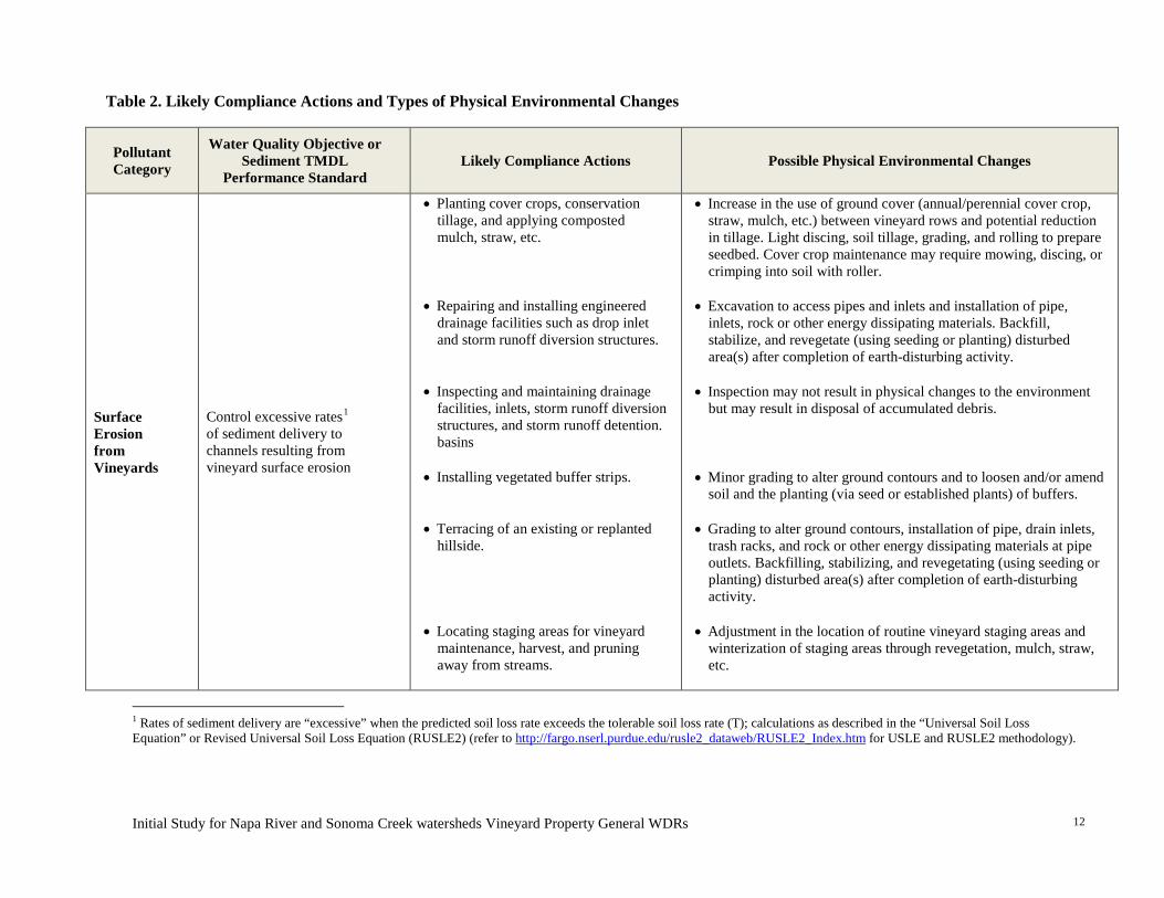
Initial Study for Napa River and Sonoma Creek watersheds Vineyard Property General WDRs
12
Table 2. Likely Compliance Actions and Types of Physical Environmental Changes
Pollutant Category
Water Quality Objective or Sediment TMDL
Performance Standard Likely Compliance Actions Possible Physical Environmental Changes
Surface Erosion from Vineyards
Control excessive rates1 of sediment delivery to channels resulting from vineyard surface erosion
• Planting cover crops, conservation tillage, and applying composted mulch, straw, etc.
• Repairing and installing engineered drainage facilities such as drop inlet and storm runoff diversion structures.
• Inspecting and maintaining drainage
facilities, inlets, storm runoff diversion structures, and storm runoff detention. basins
• Installing vegetated buffer strips.
• Terracing of an existing or replanted
hillside. • Locating staging areas for vineyard
maintenance, harvest, and pruning away from streams.
• Increase in the use of ground cover (annual/perennial cover crop, straw, mulch, etc.) between vineyard rows and potential reduction in tillage. Light discing, soil tillage, grading, and rolling to prepare seedbed. Cover crop maintenance may require mowing, discing, or crimping into soil with roller.
• Excavation to access pipes and inlets and installation of pipe,
inlets, rock or other energy dissipating materials. Backfill, stabilize, and revegetate (using seeding or planting) disturbed area(s) after completion of earth-disturbing activity.
• Inspection may not result in physical changes to the environment
but may result in disposal of accumulated debris. • Minor grading to alter ground contours and to loosen and/or amend
soil and the planting (via seed or established plants) of buffers.
• Grading to alter ground contours, installation of pipe, drain inlets, trash racks, and rock or other energy dissipating materials at pipe outlets. Backfilling, stabilizing, and revegetating (using seeding or planting) disturbed area(s) after completion of earth-disturbing activity.
• Adjustment in the location of routine vineyard staging areas and
winterization of staging areas through revegetation, mulch, straw, etc.
1 Rates of sediment delivery are “excessive” when the predicted soil loss rate exceeds the tolerable soil loss rate (T); calculations as described in the “Universal Soil Loss Equation” or Revised Universal Soil Loss Equation (RUSLE2) (refer to http://fargo.nserl.purdue.edu/rusle2_dataweb/RUSLE2_Index.htm for USLE and RUSLE2 methodology).
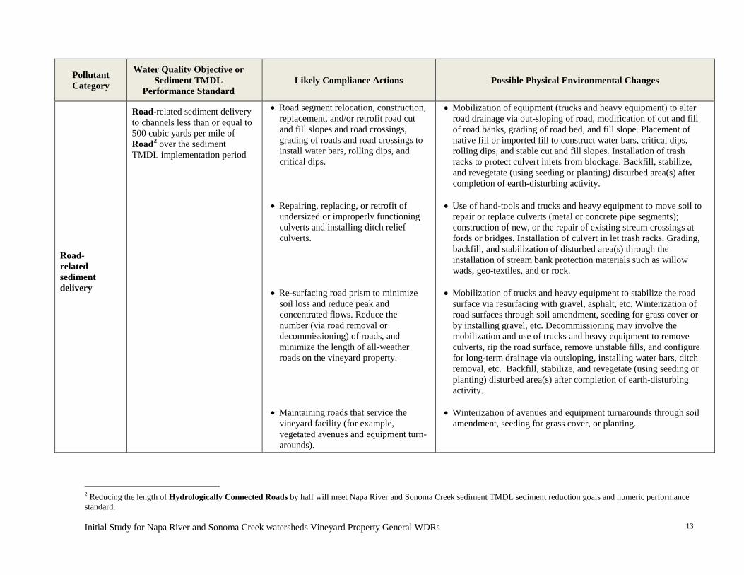
Initial Study for Napa River and Sonoma Creek watersheds Vineyard Property General WDRs
13
Pollutant Category
Water Quality Objective or Sediment TMDL
Performance Standard Likely Compliance Actions Possible Physical Environmental Changes
Road-related sediment delivery
Road-related sediment delivery to channels less than or equal to 500 cubic yards per mile of Road2 over the sediment TMDL implementation period
• Road segment relocation, construction, replacement, and/or retrofit road cut and fill slopes and road crossings, grading of roads and road crossings to install water bars, rolling dips, and critical dips.
• Repairing, replacing, or retrofit of
undersized or improperly functioning culverts and installing ditch relief culverts.
• Re-surfacing road prism to minimize
soil loss and reduce peak and concentrated flows. Reduce the number (via road removal or decommissioning) of roads, and minimize the length of all-weather roads on the vineyard property.
• Maintaining roads that service the
vineyard facility (for example, vegetated avenues and equipment turn-arounds).
• Mobilization of equipment (trucks and heavy equipment) to alter road drainage via out-sloping of road, modification of cut and fill of road banks, grading of road bed, and fill slope. Placement of native fill or imported fill to construct water bars, critical dips, rolling dips, and stable cut and fill slopes. Installation of trash racks to protect culvert inlets from blockage. Backfill, stabilize, and revegetate (using seeding or planting) disturbed area(s) after completion of earth-disturbing activity.
• Use of hand-tools and trucks and heavy equipment to move soil to repair or replace culverts (metal or concrete pipe segments); construction of new, or the repair of existing stream crossings at fords or bridges. Installation of culvert in let trash racks. Grading, backfill, and stabilization of disturbed area(s) through the installation of stream bank protection materials such as willow wads, geo-textiles, and or rock.
• Mobilization of trucks and heavy equipment to stabilize the road
surface via resurfacing with gravel, asphalt, etc. Winterization of road surfaces through soil amendment, seeding for grass cover or by installing gravel, etc. Decommissioning may involve the mobilization and use of trucks and heavy equipment to remove culverts, rip the road surface, remove unstable fills, and configure for long-term drainage via outsloping, installing water bars, ditch removal, etc. Backfill, stabilize, and revegetate (using seeding or planting) disturbed area(s) after completion of earth-disturbing activity.
• Winterization of avenues and equipment turnarounds through soil
amendment, seeding for grass cover, or planting.
2 Reducing the length of Hydrologically Connected Roads by half will meet Napa River and Sonoma Creek sediment TMDL sediment reduction goals and numeric performance standard.
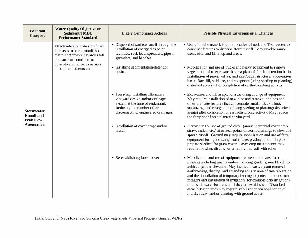
Initial Study for Napa River and Sonoma Creek watersheds Vineyard Property General WDRs
14
Pollutant Category
Water Quality Objective or Sediment TMDL
Performance Standard Likely Compliance Actions Possible Physical Environmental Changes
Stormwater Runoff and Peak Flow Attenuation
Effectively attenuate significant increases in storm runoff, so that runoff from vineyards shall not cause or contribute to downstream increases in rates of bank or bed erosion
• Dispersal of surface runoff through the installation of energy dissipater facilities, rock level spreaders, pipe T-spreaders, and benches.
• Installing sedimentation/detention
basins.
• Terracing, installing alternative
vineyard design and/or drainage system at the time of replanting. Reducing the number of, or disconnecting, engineered drainages.
• Installation of cover crops and/or mulch
• Re-establishing forest cover
• Use of on-site materials or importation of rock and T-spreaders to construct features to disperse storm runoff. May involve minor excavation and fill in upland areas.
• Mobilization and use of trucks and heavy equipment to remove vegetation and to excavate the area planned for the detention basin. Installation of pipes, valves, and inlet/outlet structures at detention basin. Backfill, stabilize, and revegetate (using seeding or planting) disturbed area(s) after completion of earth-disturbing activity.
• Excavation and fill in upland areas using a range of equipment.
May require installation of new pipe and removal of pipes and other drainage features that concentrate runoff. Backfilling, stabilizing, and revegetating (using seeding or planting) disturbed area(s) after completion of earth-disturbing activity. May reduce the footprint of area planted as vineyard.
• Increase in the use of ground cover (annual/perennial cover crop,
straw, mulch, etc.) at or near points of storm discharge to slow and spread runoff. Ground may require mobilization and use of farm equipment for light discing, soil tillage, grading, and rolling to prepare seedbed for grass cover. Cover crop maintenance may require mowing, discing, or crimping into soil with roller.
• Mobilization and use of equipment to prepare the area for re-
planting including raising and/or reducing grade (ground level) to achieve proper elevation. May involve invasive plant removal, earthmoving, discing, and amending soils in area of tree replanting and the installation of temporary fencing to protect the trees from foragers and installation of irrigation (for example drip irrigation) to provide water for trees until they are established. Disturbed areas between trees may require stabilization via application of mulch, straw, and/or planting with ground cover.
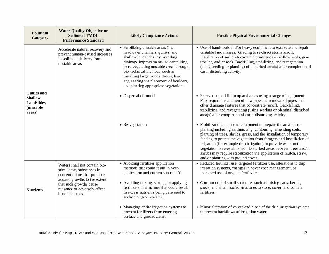
Initial Study for Napa River and Sonoma Creek watersheds Vineyard Property General WDRs
15
Pollutant Category
Water Quality Objective or Sediment TMDL
Performance Standard Likely Compliance Actions Possible Physical Environmental Changes
Gullies and Shallow Landslides (unstable areas)
Accelerate natural recovery and prevent human-caused increases in sediment delivery from unstable areas
• Stabilizing unstable areas (i.e. headwater channels, gullies, and shallow landslides) by installing drainage improvements, re-contouring, or re-vegetating unstable areas through bio-technical methods, such as installing large woody debris, hard engineering via placement of boulders, and planting appropriate vegetation.
• Dispersal of runoff
• Re-vegetation
• Use of hand-tools and/or heavy equipment to excavate and repair unstable land masses. Grading to re-direct storm runoff. Installation of soil protection materials such as willow wads, geo-textiles, and or rock. Backfilling, stabilizing, and revegetation (using seeding or planting) of disturbed area(s) after completion of earth-disturbing activity.
• Excavation and fill in upland areas using a range of equipment.
May require installation of new pipe and removal of pipes and other drainage features that concentrate runoff. Backfilling, stabilizing, and revegetating (using seeding or planting) disturbed area(s) after completion of earth-disturbing activity.
• Mobilization and use of equipment to prepare the area for re-planting including earthmoving, contouring, amending soils, planting of trees, shrubs, grass, and the installation of temporary fencing to protect the vegetation from foragers and installation of irrigation (for example drip irrigation) to provide water until vegetation is re-established. Disturbed areas between trees and/or shrubs may require stabilization via application of mulch, straw, and/or planting with ground cover.
Nutrients
Waters shall not contain bio-stimulatory substances in concentrations that promote aquatic growths to the extent that such growths cause nuisance or adversely affect beneficial uses.
• Avoiding fertilizer application methods that could result in over-application and nutrients in runoff.
• Avoiding mixing, storing, or applying fertilizers in a manner that could result in excess nutrients being delivered to surface or groundwater.
• Managing onsite irrigation systems to
prevent fertilizers from entering surface and groundwater.
• Reduced fertilizer use, targeted fertilizer use, alterations to drip irrigation systems, changes in cover crop management, or increased use of organic fertilizers.
• Construction of small structures such as mixing pads, berms, sheds, and small roofed structures to store, cover, and contain fertilizer.
• Minor alteration of valves and pipes of the drip irrigation systems to prevent backflows of irrigation water.
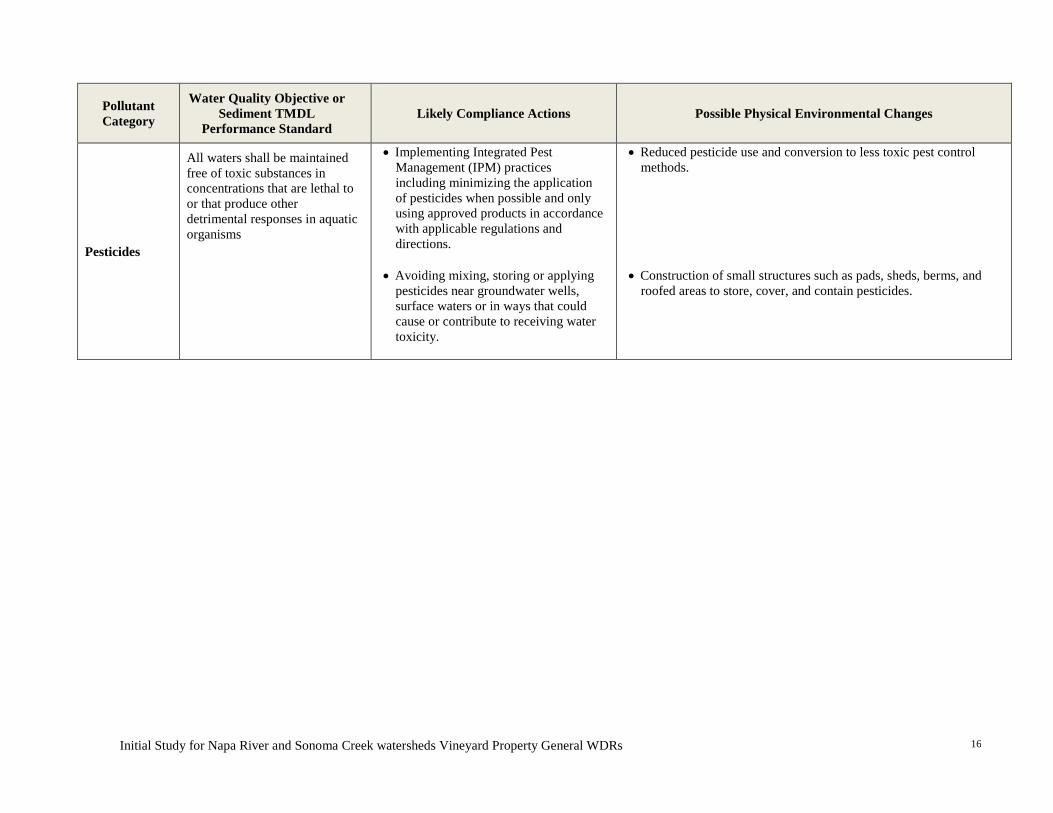
Initial Study for Napa River and Sonoma Creek watersheds Vineyard Property General WDRs
16
Pollutant Category
Water Quality Objective or Sediment TMDL
Performance Standard Likely Compliance Actions Possible Physical Environmental Changes
Pesticides
All waters shall be maintained free of toxic substances in concentrations that are lethal to or that produce other detrimental responses in aquatic organisms
• Implementing Integrated Pest Management (IPM) practices including minimizing the application of pesticides when possible and only using approved products in accordance with applicable regulations and directions.
• Avoiding mixing, storing or applying pesticides near groundwater wells, surface waters or in ways that could cause or contribute to receiving water toxicity.
• Reduced pesticide use and conversion to less toxic pest control methods.
• Construction of small structures such as pads, sheds, berms, and
roofed areas to store, cover, and contain pesticides.
Initial Study for General WDRs for Vineyard Discharges in the Napa River and Sonoma Creek Watersheds
17
5. EXISTING CONDITIONS
Environmental Setting The Napa River watershed, which drains about 425 square miles, is located in the northern portion of the San Francisco Bay area and drains into San Pablo Bay. The 170 square mile Sonoma Creek watershed is located immediately west of the Napa River watershed and also drains into San Pablo Bay. The Napa River and Sonoma Creek watersheds are designated as impaired for excess sediment, nutrients and pathogens. The sediment TMDLs for these watersheds document the presence of excess fine sediment (sand, silt, and clay particles), incised stream channels, and diminished fisheries, specifically for anadromous steelhead and Chinook salmon.
Both TMDLs indicate that viticulture is the predominant land use in both valleys and is one of several major sources of fine sediment in the two watersheds. Vineyards make up most land cover in the valleys and are becoming more extensive on hillsides in some tributary watersheds. Vineyards may yield fine sediment and other pollutants through surface erosion, road runoff, unstable areas (such as gullies and landslides), and from excessive storm runoff.
Roadway networks, including both paved roads and unpaved roads, contribute fine sediment via direct erosion of the roadbed surface and inboard ditches. Surface erosion of the roadbed, caused by wind erosion, or formation of rills and gullies on the surface is common in these watersheds. Roads are either impervious (paved) or highly compact (unpaved) and they tend to generate large volumes of runoff. This runoff can cause erosion of the roadway’s inboard ditch, hillslopes, and channels that receive this runoff. Bridges and culverts can also be a source of sediment. In locations were culverts are undersized or become blocked with sediment and debris, bank erosion may occur.
Historical and ongoing reduction in coarse sediment inputs (from hydrologic changes including large dams) plus the overall increase in runoff and peak annual flows from developments in the valleys have caused Napa River and Sonoma Creek and many of their tributaries to erode their bed and banks. These adjustments result in headcutting, gully and landslide formation, and channel incision (SFEI, 2012).
A description of existing conditions relative to each CEQA topic area is provided in the initial study checklist in the “background” discussion at the beginning of each environmental topic within Section 5, Environmental Impact Analysis, below.
Baseline Conditions This environmental analysis considers potential environmental impacts of adoption of the proposed General WDRs. It considers actions that may be taken to comply with the General WDRs, beyond those actions that have already been implemented voluntarily or under existing local regulations.

Initial Study for General WDRs for Vineyard Discharges in the Napa River and Sonoma Creek Watersheds
18
The baseline conditions for the purpose of this environmental analysis include:
• Discharges from all existing vineyards in the Napa River and Sonoma Creek watersheds;
• Existing physical conditions, including BMPs that have already been implemented on the ground, as a result of policies, laws, and regulations of local cities and counties pertaining to vineyards, roads, vegetation removal, and stream setbacks; and
• Existing physical conditions as a result of existing permits, WDRs, and waivers of WDRs issued by the Water Board or the State Water Board (e.g. State Water Board Order 2009-0009-DWQ for Stormwater Discharges associated with Construction and other Land Use Activities).
Based on the sediment TMDL, an estimated 159,000 metric tonnes of fine sediment is delivered to the Napa River annually (Table 3). The smaller Sonoma Creek watershed produces an estimated 63,000 tons of fine sediment each year (Table 4). The estimated amount of fine sediment that is currently delivered to the Napa River and Sonoma Creek best represent baseline water quality and habitat conditions in the watersheds as it relates to adoption of the proposed General WDRs.
Table 3. Existing Sediment Inputs to Channels in the Napa River Watershed Downstream of Major Dams
Sediment Source Mean Annual Sediment Delivery(metric tonnes1/year)
Surface erosion from Vineyards2 37,000
Roadway-related processes 55,000
Gullies and landslides 30,000
Channel Incision and bank erosion 37,000
TOTALS 159,000 1A metric tonne equals 1,000 kilograms and about 2,205 pounds 2Includes some grazing land (estimated to be a small fraction, less than 10 percent, of the total) Table 4. Existing Sediment Inputs to Channels in the Sonoma Creek Watershed
Sediment Source Mean Annual Sediment Delivery (tons1/year)
Surface erosion from Vineyards 7,600
Roadway-related processes 11,200
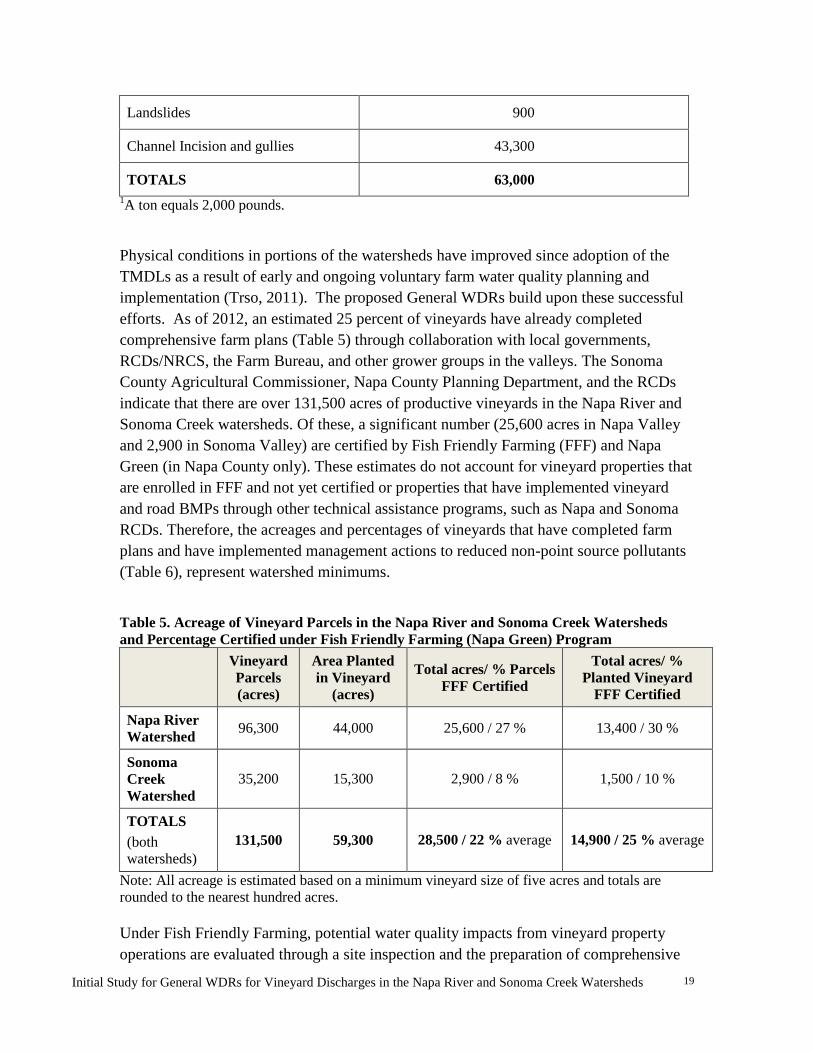
Initial Study for General WDRs for Vineyard Discharges in the Napa River and Sonoma Creek Watersheds
19
Landslides 900
Channel Incision and gullies 43,300
TOTALS 63,000 1A ton equals 2,000 pounds.
Physical conditions in portions of the watersheds have improved since adoption of the TMDLs as a result of early and ongoing voluntary farm water quality planning and implementation (Trso, 2011). The proposed General WDRs build upon these successful efforts. As of 2012, an estimated 25 percent of vineyards have already completed comprehensive farm plans (Table 5) through collaboration with local governments, RCDs/NRCS, the Farm Bureau, and other grower groups in the valleys. The Sonoma County Agricultural Commissioner, Napa County Planning Department, and the RCDs indicate that there are over 131,500 acres of productive vineyards in the Napa River and Sonoma Creek watersheds. Of these, a significant number (25,600 acres in Napa Valley and 2,900 in Sonoma Valley) are certified by Fish Friendly Farming (FFF) and Napa Green (in Napa County only). These estimates do not account for vineyard properties that are enrolled in FFF and not yet certified or properties that have implemented vineyard and road BMPs through other technical assistance programs, such as Napa and Sonoma RCDs. Therefore, the acreages and percentages of vineyards that have completed farm plans and have implemented management actions to reduced non-point source pollutants (Table 6), represent watershed minimums.
Table 5. Acreage of Vineyard Parcels in the Napa River and Sonoma Creek Watersheds and Percentage Certified under Fish Friendly Farming (Napa Green) Program
Vineyard Parcels (acres)
Area Planted in Vineyard
(acres)
Total acres/ % Parcels FFF Certified
Total acres/ % Planted Vineyard
FFF Certified
Napa River Watershed 96,300 44,000 25,600 / 27 % 13,400 / 30 %
Sonoma Creek Watershed
35,200 15,300 2,900 / 8 % 1,500 / 10 %
TOTALS (both watersheds)
131,500 59,300 28,500 / 22 % average 14,900 / 25 % average
Note: All acreage is estimated based on a minimum vineyard size of five acres and totals are rounded to the nearest hundred acres. Under Fish Friendly Farming, potential water quality impacts from vineyard property operations are evaluated through a site inspection and the preparation of comprehensive
Initial Study for General WDRs for Vineyard Discharges in the Napa River and Sonoma Creek Watersheds
20
farm plan that chronicles the inspection findings. Potential issues of concern to water quality are identified in the farm plan and are corrected through the implementation of proper, site-specific BMPs. These BMPs are comparable to those actions that will occur through landowner/operator compliance with the proposed General WDRs. To the extent that BMPs were implemented on vineyard properties prior to development of the General WDRs, these features and facilities are considered to be part of the baseline physical conditions.
In addition, several significant reach-wide river and riparian restoration projects, undertaken as a result of the sediment TMDLs, have led to improvements in channel condition and riparian habitat in the Napa River and Sonoma Creek watersheds. These include the voluntary collaborative restoration of the Napa River of the Rutherford reach (4.5 miles), the Oakville to Oak Knoll reach (9 miles), and Carriger and Nathanson creeks in Sonoma Valley. Furthermore, a fish passage barrier removal project at the Zinfandel Lane Bridge in Napa has increased habitat for anadromous fish.
Despite these improvements, the Napa River and Sonoma Creek remain impaired by excess fine sediment. The proposed General WDRs require implementation of vineyard operation and road BMPs that are intended to correct, over time, sediment and associated water quality impairments. Vineyards are not identified as a source of pathogens in the Napa River and Sonoma Creek Pathogen TMDLs (Water Board, 2006 a, 2006b).

Initial Study for General WDRs for Vineyard Discharges in the Napa River and Sonoma Creek Watersheds
21
6. ENVIRONMENTAL IMPACT ANAYLSIS
Initial Study pursuant to the California Environmental Quality Act
A. PROJECT DESCRIPTION 1. Project title General WDRs for Vineyard Discharges in
the Napa River and Sonoma Creek Watersheds
2. Lead agency name and address California Regional Water Quality Control Board, San Francisco Bay Region 1515 Clay Street, Suite 1400 Oakland, CA 94612
3. Contact person and phone number Anya Starovoytov, Environmental Scientist (510) 622-2506 [email protected]
4. Project location Napa River and Sonoma Creek watersheds, San Francisco Bay Region
5. Project sponsor’s name and address California Regional Water Quality Control Board, San Francisco Bay Region 1515 Clay Street, Suite 1400 Oakland, CA 94612
6. General plan designation Not applicable 7. Zoning Not applicable 8. Summary Description of Project:
The project is the proposed adoption of the General WDRs for vineyard discharges in the Napa River and Sonoma Creek watersheds to control discharges and comply with the implementation plans for the Napa River and Sonoma Creek Sediment TMDLs. The proposed General WDRs would specify requirements necessary to protect and restore beneficial uses in the Napa River and Sonoma Creek watersheds. These actions are consistent with the requirements of the NPS Policy. The General WDRs would require implementation of vineyard operation and road BMPs which are expected to result in water quality improvements. The General WDRs would apply to discharges from vineyard properties in Napa River and Sonoma Creek watersheds that meet the proposed General WDRs eligibility criteria described in Table 1, above. They would require the landowners/operators of eligible vineyard properties to:
• Seek coverage under the General WDRs by submitting a Notice of Intent (NOI) to comply with the permit to the Water Board
• Develop a Farm Water Quality Plan • Implement and maintain BMPs and other improvement projects as specified in the Farm Water
Quality Plan to meet the General WDR requirements • Conduct vineyard property site inspections and compliance monitoring • Submit an Annual Compliance Form to the Water Board
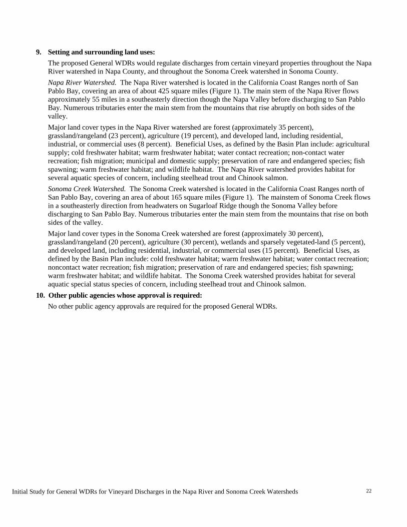
Initial Study for General WDRs for Vineyard Discharges in the Napa River and Sonoma Creek Watersheds
22
9. Setting and surrounding land uses:
The proposed General WDRs would regulate discharges from certain vineyard properties throughout the Napa River watershed in Napa County, and throughout the Sonoma Creek watershed in Sonoma County. Napa River Watershed. The Napa River watershed is located in the California Coast Ranges north of San Pablo Bay, covering an area of about 425 square miles (Figure 1). The main stem of the Napa River flows approximately 55 miles in a southeasterly direction though the Napa Valley before discharging to San Pablo Bay. Numerous tributaries enter the main stem from the mountains that rise abruptly on both sides of the valley. Major land cover types in the Napa River watershed are forest (approximately 35 percent), grassland/rangeland (23 percent), agriculture (19 percent), and developed land, including residential, industrial, or commercial uses (8 percent). Beneficial Uses, as defined by the Basin Plan include: agricultural supply; cold freshwater habitat; warm freshwater habitat; water contact recreation; non-contact water recreation; fish migration; municipal and domestic supply; preservation of rare and endangered species; fish spawning; warm freshwater habitat; and wildlife habitat. The Napa River watershed provides habitat for several aquatic species of concern, including steelhead trout and Chinook salmon. Sonoma Creek Watershed. The Sonoma Creek watershed is located in the California Coast Ranges north of San Pablo Bay, covering an area of about 165 square miles (Figure 1). The mainstem of Sonoma Creek flows in a southeasterly direction from headwaters on Sugarloaf Ridge though the Sonoma Valley before discharging to San Pablo Bay. Numerous tributaries enter the main stem from the mountains that rise on both sides of the valley. Major land cover types in the Sonoma Creek watershed are forest (approximately 30 percent), grassland/rangeland (20 percent), agriculture (30 percent), wetlands and sparsely vegetated-land (5 percent), and developed land, including residential, industrial, or commercial uses (15 percent). Beneficial Uses, as defined by the Basin Plan include: cold freshwater habitat; warm freshwater habitat; water contact recreation; noncontact water recreation; fish migration; preservation of rare and endangered species; fish spawning; warm freshwater habitat; and wildlife habitat. The Sonoma Creek watershed provides habitat for several aquatic special status species of concern, including steelhead trout and Chinook salmon.
10. Other public agencies whose approval is required: No other public agency approvals are required for the proposed General WDRs.
N a p a R i v e rW a t e r s h e d
S o n o m aC r e e kW a t e r s h e d
Figure 1. Project Area Boundary, Notice of Preparation forEnvironmental Impact Report, General WDRs for
Vineyards in Napa River and Sonoma Creek Watersheds
1 in = 5 mi
2014-051 WRD for Napa River and Sonoma Creek
Loca
tion:
N:\2
014\2
014-0
51 R
ESD
RWQC
B DWR
Nap
aSon
oma\M
APS\N
OP G
raphic
s\Proj
ect A
rea\P
rojec
t_Area
_Bou
ndary
_v01
.mxd
(DEK
)-dkro
lick 6/
29/20
14
Map Base: Sources: Esri, DeLorme, NAVTEQ, TomTom, Intermap, increment P Corp., GEBCO, USGS, FAO, NPS, NRCAN, GeoBase,IGN, Kadaster NL, Ordnance Survey, Esri Japan, METI, Esri China (Hong Kong), swisstopo, and the GIS User Community
I
0 5
Mil es
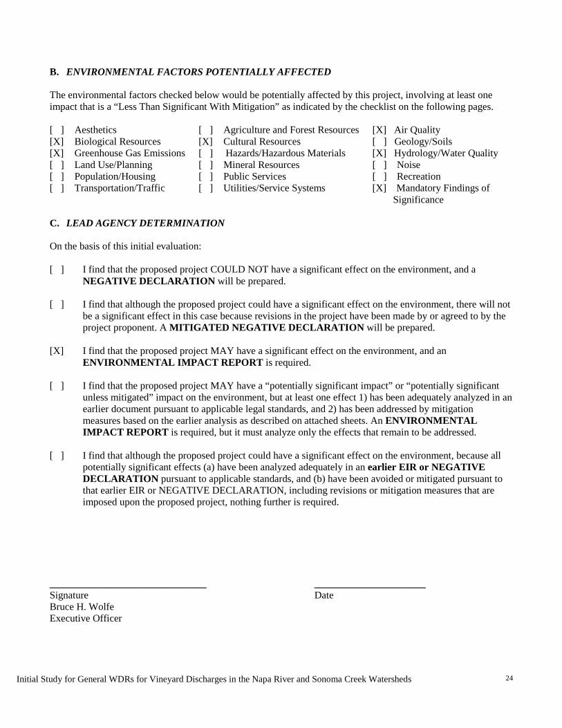
Initial Study for General WDRs for Vineyard Discharges in the Napa River and Sonoma Creek Watersheds
24
B. ENVIRONMENTAL FACTORS POTENTIALLY AFFECTED The environmental factors checked below would be potentially affected by this project, involving at least one impact that is a “Less Than Significant With Mitigation” as indicated by the checklist on the following pages. [ ] Aesthetics [ ] Agriculture and Forest Resources [X] Air Quality [X] Biological Resources [X] Cultural Resources [ ] Geology/Soils [X] Greenhouse Gas Emissions [ ] Hazards/Hazardous Materials [X] Hydrology/Water Quality [ ] Land Use/Planning [ ] Mineral Resources [ ] Noise [ ] Population/Housing [ ] Public Services [ ] Recreation [ ] Transportation/Traffic [ ] Utilities/Service Systems [X] Mandatory Findings of
Significance C. LEAD AGENCY DETERMINATION On the basis of this initial evaluation: [ ] I find that the proposed project COULD NOT have a significant effect on the environment, and a
NEGATIVE DECLARATION will be prepared. [ ] I find that although the proposed project could have a significant effect on the environment, there will not
be a significant effect in this case because revisions in the project have been made by or agreed to by the project proponent. A MITIGATED NEGATIVE DECLARATION will be prepared.
[X] I find that the proposed project MAY have a significant effect on the environment, and an
ENVIRONMENTAL IMPACT REPORT is required. [ ] I find that the proposed project MAY have a “potentially significant impact” or “potentially significant
unless mitigated” impact on the environment, but at least one effect 1) has been adequately analyzed in an earlier document pursuant to applicable legal standards, and 2) has been addressed by mitigation measures based on the earlier analysis as described on attached sheets. An ENVIRONMENTAL IMPACT REPORT is required, but it must analyze only the effects that remain to be addressed.
[ ] I find that although the proposed project could have a significant effect on the environment, because all
potentially significant effects (a) have been analyzed adequately in an earlier EIR or NEGATIVE DECLARATION pursuant to applicable standards, and (b) have been avoided or mitigated pursuant to that earlier EIR or NEGATIVE DECLARATION, including revisions or mitigation measures that are imposed upon the proposed project, nothing further is required.
_______________________________ ______________________ Signature Date Bruce H. Wolfe Executive Officer

Initial Study for General WDRs for Vineyard Discharges in the Napa River and Sonoma Creek Watersheds
25
D. EVALUATION OF ENVIRONMENTAL EFFECTS
The Environmental Checklist and discussion that follows is based on sample questions provided in the CEQA Guidelines (Appendix G) which focus on various individual concerns within 17 different broad environmental categories, such as air quality, cultural resources, land use, and traffic (and arranged in alphabetical order). The Guidelines also provide specific direction and guidance for preparing responses to the Environmental Checklist. Each question in the Checklist essentially requires a “yes” or “no” reply as to whether or not the project will have a potentially significant environmental impact of a certain type, and, following a Checklist table with all of the questions in each major environmental heading, citations, information and/or discussion that supports that determination. The Checklist table provides, in addition to a clear “yes” reply and a clear “no” reply, two possible “in-between” replies, including one that is equivalent to “yes, but with changes to the project that the Lead Agency has made to, no”, and another “no” reply that requires a greater degree of discussion, supported by citations and analysis of existing conditions, threshold(s) of significance used and project effects than required for a simple “no” reply. Each possible answer to the questions in the Checklist, and the different types of discussion required, are discussed below:
Potentially Significant Impact. Checked if a discussion of the existing setting (including relevant regulations or policies pertaining to the subject) and project characteristics with regard to the environmental topic demonstrates, based on substantial evidence, supporting information, previously prepared and adopted environmental documents, and specific criteria or thresholds used to assess significance, that the project will have a potentially significant impact of the type described in the question. Less Than Significant With Mitigation. Checked if the discussion of existing conditions and specific project characteristics, also adequately supported with citations of relevant research or documents, determine that the project clearly will or is likely to have particular physical impacts that will exceed the given threshold or criteria by which significance is determined, but that with the incorporation of clearly defined mitigation measures into the project such impacts will be avoided or reduced to less-than-significant levels. Less Than Significant Impact. Checked if a more detailed discussion of existing conditions and specific project features, also citing relevant information, reports or studies, demonstrates that, while some effects may be discernible with regard to the individual environmental topic of the question, the effect would not exceed a threshold of significance which has been established by the Lead or a Responsible Agency. The discussion may note that due to the evidence that a given impact would not occur or would be less than significant, no mitigation measures are required. No Impact. Checked if brief statements (one or two sentences) or cited reference materials (maps, reports or studies) clearly show that the type of impact could not be reasonably expected to occur due to the specific characteristics of the project or its location (e.g. the project falls outside the nearest fault rupture zone, or is several hundred feet from a 100-year flood zone, and relevant citations are provided). The referenced sources or information may also show that the impact simply does not apply to projects like the one involved. A response to the question may also be "No Impact" with a brief explanation that the basis of adequately supported project-specific factors or general standards (e.g., the project will not expose sensitive receptors to pollutants, based on a basic screening of the specific project).
Initial Study for General WDRs for Vineyard Discharges in the Napa River and Sonoma Creek Watersheds
26
Impact Evaluation This Initial Study considers the environmental impacts of physical changes to the environmental over existing conditions (i.e., baseline conditions) as described in the Project Description, above. Potential environmental impacts resulting from the proposed adoption of the General WDRs are discussed below and evaluated in the Initial Study checklist and responses. Long term, the goal of the proposed General WDRs is to achieve reductions in nonpoint source pollution, specifically fine sediment, to the Napa River and Sonoma Creek watersheds. Short term incremental physical changes to the environment may include:
• Increases in the implementation of non-point source pollution control BMPs • Expansion of vegetated stream setbacks • Permitting of discharges from future new vineyards approved by local land use
authorities Adoption of the General WDRs would result in the implementation of BMPs on existing vineyards, vineyard replants, and new vineyards. Although an estimated 25 percent of planted vineyards are already operating under BMPs that reduce pollutants in discharges from vineyards and roads (Table 6), some landowners/operators of vineyards that do not currently meet all of the proposed General WDRs requirements will need to take actions to reduce pollutant sources in order to obtain coverage under the General WDRs. Given that landowners/operators can choose which management measures are best suited given the physical condition of their property, a wide range of BMPs may therefore be applicable at each vineyard. To date, some landowners/operators have completed farm planning and have implemented BMPs to a sufficient degree so as to prevent excessive soil loss or excessive storm runoff from their vineyard properties and otherwise comply with the General WDRs. In these cases, where work required by the General WDRs is essentially complete, no environmental impacts would result from the adoption of the General WDRs. Where owners/operators are implementing some but not all of the required management actions (as identified in their Farm Water Quality Plan), remaining actions may involve minor grading or construction and could therefore result in less than significant impacts. For vineyards with uncontrolled sediment and runoff sources for which no management actions have been undertaken to date, extensive water quality protection controls may be needed. Installation of such controls could involve substantial road rehabilitation or construction of detention basins, resulting in potentially significant environmental impacts. Although the General WDRs would result in the Water Board permitting discharges from eligible new vineyards, the General WDRs would not grant approval for new vineyard land uses. It would only approve discharges from a property after local approval is granted for all aspects of new vineyard’s construction. Current regulations for the development of new vineyards are more stringent than those for existing older vineyards and therefore, new vineyards are likely to require fewer new BMPs to abate pollutant sources. To be covered under the General WDRs, new vineyards would be required to meet all water quality requirements and be designed so that there are no increases in storm runoff rates over existing conditions. Therefore, the incremental water quality impact of additional discharges from these future facilities would be minimal. Likely physical changes to the environment associated with possible General WDRs implementation actions are listed in Table 2 above. Categories of likely actions and their likely environmental impacts are discussed in the Initial Study checklist and responses and can be summarized as follows:
Initial Study for General WDRs for Vineyard Discharges in the Napa River and Sonoma Creek Watersheds
27
1. Inspection and Routine Maintenance of Existing Facilities. Inspection and routine maintenance of existing facilities (inlets, diversion structures, ditches, and small sediment basins) could result in collection and disposal of small amounts of sediment and debris. This is an existing practice that is likely to increase in frequency as a consequence of the proposed General WDRs. Disposal of small amounts of debris from inspection and routine maintenance at vineyard properties does not result in adverse impacts to the environment and is not evaluated further in the IS.
2. Changes in the Use of Agricultural Chemicals. The General WDRs are likely to result in modifications in the use of fertilizers and pesticides in a manner that prevents excessive amounts of these chemicals from entering streams. Possible actions to comply with this requirement may include improved timing of nutrient application, reduction in the amount of fertilizer applied, or changes in the type of fertilizer used. Vineyard landowners/operators may elect to use integrated pest management (IPM) practices as alternatives to the use of traditional pesticides and herbicides. IPM techniques may involve physical, biological, or mechanical methods that reduce the presence of pests. Examples include removing weeds by hand, introducing insects or host plants that provide pest management without the use of chemicals, or construction of perches or nesting boxes to encourage raptors that prey on rodents. Management actions would be identified and developed through the farm planning process and would include less-toxic pest control methods recommended by UC Cooperative Extension or similar guidance (UC Davis, NCCE). Reduction in the use of agricultural chemicals would result in beneficial impacts to water quality and are not further evaluated in the IS.
3. Modification of Vineyard Floor Cover and Tillage Practices. The General WDRs would require implementation of BMPs to protect soil from erosion, to promote onsite stormwater runoff dispersal, slowing, infiltration, or capture, and to prevent excessive rates of sediment delivery. Many landowners/operators will meet this requirement by limiting tillage and planting cover crops such as grasses, legumes, and native ground covers. These modifications would result in beneficial impacts to water quality and are not further evaluated in the IS.
4. Construction of Small Structures. Actions to comply with the General WDRs may include construction of small structures or facilities (sheds, pipes, energy dissipaters, trash racks, culverts, etc.). This type of construction could result in minor, temporary impacts during earth moving; however, these structures will typically be located in upland areas that have already been disturbed by vineyard cultivation. Impacts from dust, noise, and traffic are considered less than significant as discussed in the IS.
5. Road Modification. The General WDRs may result in actions to reduce sediment delivery from roads by reducing hydrological connections (direct connections such as culverts and stream crossings) between roads and streams. Techniques to achieve this may include resurfacing or regrading roads, and installing rolling dips or water bars. These actions may result in impacts from the operation of heavy equipment, earthmoving, and vegetation removal. Road repair could also generate minor amounts of dust, noise, and traffic during construction, which could result in less than significant impacts as discussed in the IS. Construction activities have the potential to generate air emissions and pollutants that will be evaluated in the EIR. The most common activities include earthmoving, grading, trenching and cut and fill operations. In cases where road repair occurs near streams, the construction could result in potentially significant impacts to biological resources if not properly planned, permitted and
Initial Study for General WDRs for Vineyard Discharges in the Napa River and Sonoma Creek Watersheds
28
executed. Road work that occurs near streams and that requires deep excavation (greater than six inches) could encounter archeological artifacts and could result in potentially significant impacts to cultural resources. Road repair projects would be developed through the farm planning process and be planned and conducted in accordance with Water Quality and Stream Habitat Protection Manual for County Road Maintenance in Northwestern California Watersheds (Five Counties, 2002) approved by National Oceanic and Atmospheric Administration as protective of water quality and anadromous fish habitat.
6. Repairs to Gullies and Landslides; Channel Erosion. Activities to stabilize gullies, shallow landslides and channel banks may require operation of heavy equipment, earthmoving, and vegetation removal. Most of these repairs will occur on land that has already been disturbed by vineyard agricultural land uses. In cases where work occurs near streams, it could result in potentially significant impacts to biological resources if not properly planned, permitted and executed. The level of impact will depend on the scale of the project, the proximity of the project to water bodies, and specific methods used, in most cases unstable areas are expected to be small in size (i.e., small gullies, rills, eroded banks, and small shallow landslides). Minor, short-term impacts could result from earthmoving and from importing construction materials, such as large rocks and woody debris (logs). If repair of unstable areas requires construction in stream channels, these actions could result in impacts to wetlands and other sensitive habitats and mitigation measures may be required, as described below. Management actions will be developed and implemented through the farm planning process and will include appropriate gully stabilization and channel and culvert repair methods that follow current practice standards and guidance from local technical groups such as the Natural Resource Conservation Service, local Resource Conservation Districts, and the U.C. Cooperative Extension.
7. Construction of Detention Basins and Engineered Drainage Facilities. Since the Water Board cannot dictate the manner of compliance with its requirements, landowners/operators, through the farm planning process, will have the flexibility to select BMPs needed to meet General WDRs water quality requirements. One option for controlling stormwater runoff from vineyards is through the construction of stormwater detention or retention basins to slow the velocity and rate of peak stormwater flow originating from a vineyard property. Based on extensive experience by the resource conservation districts, Fish Friendly Farming, and other groups, existing vineyards can usually meet the proposed General WDRs water quality requirements for stormwater runoff and surface erosion without building large new detention basins. Detention basins that are likely to be built will typically be small and constructed on already disturbed soils. Occasionally, however, a new large detention basin may be proposed for construction. According to the Napa County Resource Conservation District (Steiner, 2012), detention basins may exceed 4,000 square feet in area and may be as deep as 6 feet. Construction may involve vegetation removal, grading, and alteration of hydrology that could result in temporary, less-than-significant construction-related dust, noise and traffic impacts. Deep excavation near or adjacent to water may encounter archeological artifacts, resulting in potentially significant impacts and the requirement for mitigation measures. As required in the Napa River Sediment TMDL, the construction of detention basins (or any compliance action) in this watershed on areas beyond the development footprint authorized by the local
Initial Study for General WDRs for Vineyard Discharges in the Napa River and Sonoma Creek Watersheds
29
land use authority would not be allowed in the following sensitive natural communities: redwood forest, Ponderosa Pine alliance, Tanbark Oak alliance, Oregon white oak woodland, mixed serpentine chaparral, and wet meadow grasses NFD super alliance. Dischargers may seek to construct new engineered drainage facilities in order to reduce the potential for surface erosion, but such facilities must be constructed in a manner so as not to result in increased runoff leading to downstream increases in rates of bed or bank erosion in order to comply with the General WDRs runoff performance standard. Existing engineered drainage facilities that are problematic in terms of concentrating runoff would have to be corrected and/or retrofitted in order to meet the runoff performance standard. New vineyards approved by the local land use authority are subject to the General WDRs’ requirement that there be no increases in storm runoff rates over existing conditions.
8. Establishing Vegetated Buffers and Setbacks. The creation of stream setbacks is not required by the General WDRs, but is voluntary. The General WDRs provides incentives to owners/operators of vineyards developed on a slope less or equal to 5 percent that border or contain streams to establish setbacks that promote water quality improvements. Setbacks allow stormwater to flow overland, slowing, spreading, and infiltrating runoff before entering receiving waters. Creation of stream setbacks provides a water quality and habitat function that is compatible with agricultural uses, while resulting in more riparian habitat and fishery benefits. Although the creation of stream setbacks could potentially result in removal of some grape vines, setbacks would not result in conversion of farmland to non-agricultural use. The decision to create desired setbacks within a vineyard parcel is entirely within individual landowner’s discretion and not a requirement of the program. This action along with other program implementation measures may allow vineyard owners to be exempt from the requirement to apply for coverage under the proposed General WDRs.
Actions to comply with the proposed General WDRs would result in a multitude of environmental benefits, including reducing sediment inputs to creeks and streams, improving water quality, reducing erosive forces from stormwater runoff, improving channel stability, improving fish habitat, and enhancing riparian habitat. In some cases, however, it is possible that the adoption of the WDRs could lead to potentially significant impacts that will be evaluated in the EIR and mitigated where required.
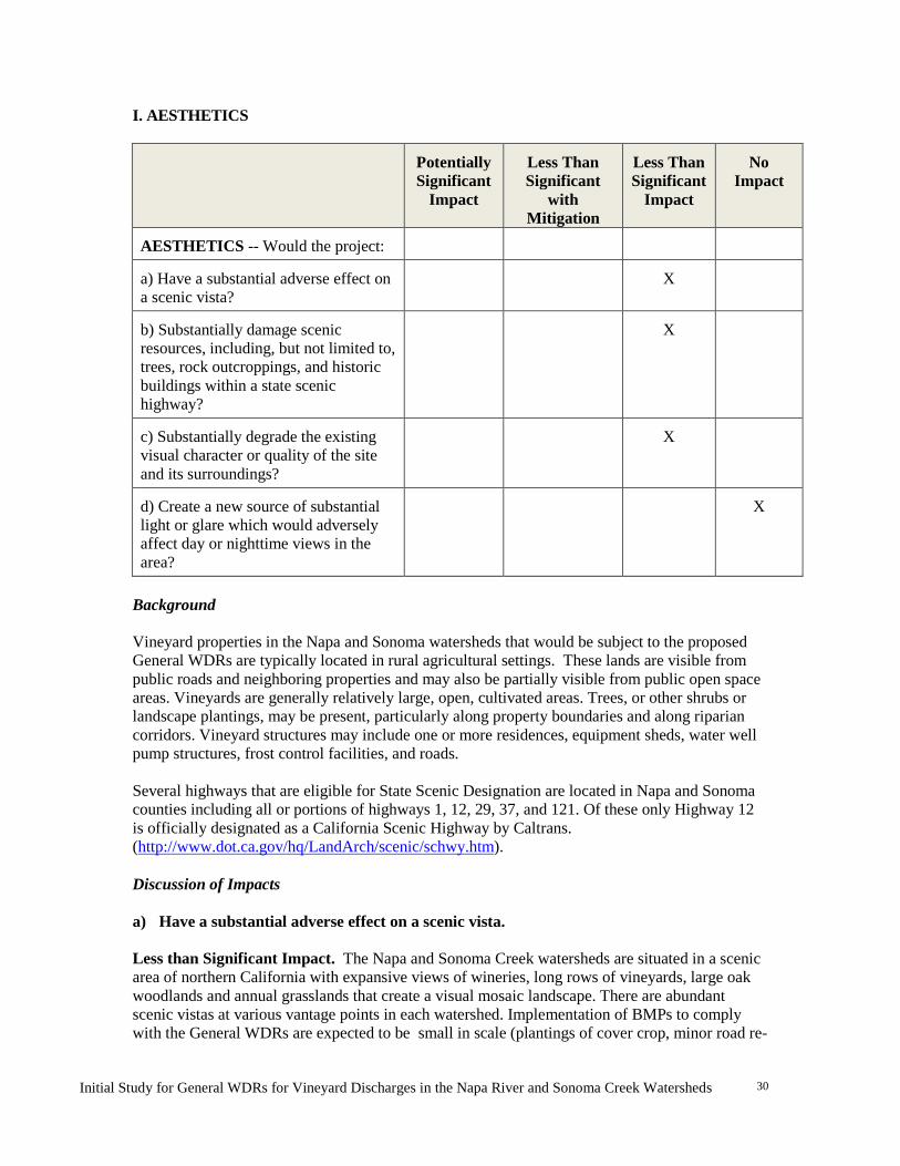
Initial Study for General WDRs for Vineyard Discharges in the Napa River and Sonoma Creek Watersheds
30
I. AESTHETICS
Potentially Significant
Impact
Less Than Significant
with Mitigation
Less Than Significant
Impact
No
Impact
AESTHETICS -- Would the project:
a) Have a substantial adverse effect on a scenic vista?
X
b) Substantially damage scenic resources, including, but not limited to, trees, rock outcroppings, and historic buildings within a state scenic highway?
X
c) Substantially degrade the existing visual character or quality of the site and its surroundings?
X
d) Create a new source of substantial light or glare which would adversely affect day or nighttime views in the area?
X
Background Vineyard properties in the Napa and Sonoma watersheds that would be subject to the proposed General WDRs are typically located in rural agricultural settings. These lands are visible from public roads and neighboring properties and may also be partially visible from public open space areas. Vineyards are generally relatively large, open, cultivated areas. Trees, or other shrubs or landscape plantings, may be present, particularly along property boundaries and along riparian corridors. Vineyard structures may include one or more residences, equipment sheds, water well pump structures, frost control facilities, and roads. Several highways that are eligible for State Scenic Designation are located in Napa and Sonoma counties including all or portions of highways 1, 12, 29, 37, and 121. Of these only Highway 12 is officially designated as a California Scenic Highway by Caltrans. (http://www.dot.ca.gov/hq/LandArch/scenic/schwy.htm). Discussion of Impacts a) Have a substantial adverse effect on a scenic vista. Less than Significant Impact. The Napa and Sonoma Creek watersheds are situated in a scenic area of northern California with expansive views of wineries, long rows of vineyards, large oak woodlands and annual grasslands that create a visual mosaic landscape. There are abundant scenic vistas at various vantage points in each watershed. Implementation of BMPs to comply with the General WDRs are expected to be small in scale (plantings of cover crop, minor road re-

Initial Study for General WDRs for Vineyard Discharges in the Napa River and Sonoma Creek Watersheds
31
grading or repair, installation of small-scale structures such as culvert-protection trash racks, and no large building construction would occur. On-the-ground changes that could result from compliance with the General WDRs would consist of minor alterations to vegetation and topography that are low in profile (i.e., located near the ground surface) and will therefore blend into the existing landscape. Implementation of the General WDRs would require minor grading or regrading of existing roads that drain to the Napa River or Sonoma Creek which could require the temporary clearing of land followed by re-vegetation. Grading and road erosion control activities would be short-term and could result in minor impacts to scenic views in various viewshed locations in both watersheds. Exposed soils would be visible along with earth-moving equipment. However, exposed areas would be replanted to blend into the landscape. Within weeks or months following construction, it is expected that the replanted vegetation will become established and blend in with the surrounding landscape. Given that anticipated actions are expected to be small in scale (from a regional context), low in profile, are short-term, and affected areas would be fully restored to blend into the existing environment, impacts to scenic vistas would be less than significant. b) Substantially damage scenic resources, including, but not limited to, trees, rock outcroppings, and historic buildings within a state scenic highway. Less than Significant Impact. Both Napa and Sonoma watersheds have abundant scenic resources with the flat valley topography, established vineyards and winery buildings, wildlands and Mayacamas Mountains as a backdrop. Highway 12 is the only designated State Scenic Highway in the project area. While some unique trees or rock outcroppings may be present on some vineyard properties, the types of BMPs that would be implemented to comply with the General WDRs would not affect these features. The anticipated compliance actions for the General WDRs are intended to preserve and enhance riparian areas, including large trees, promote vegetated buffers, and to prevent erosion, both of soil and rock outcrops. Vineyard management actions to comply with the General WDRs may affect some parcels of land adjacent to Highway 12, a designated State scenic highway; however, these actions would typically be small in scale. Such compliance actions would not require the construction of facilities that could substantially damage scenic resources within this scenic corridor. Therefore, because the anticipated actions are small in scale (from a regional perspective), and no construction of major facilities are expected in the scenic corridor, the potential scenic resource impacts of the proposed project are considered less than significant. c) Substantially degrade the existing visual character or quality of the site and its surroundings. Less than Significant Impact. As described above, the General WDRs would be implemented on vineyard properties located in predominantly rural areas. The visual character of the area is generally open, typified by cultivated rows of vines, intervening cover crops, and surrounding natural hillside vegetation. Implementation of vineyard and road BMPs could result in small scale, temporary alteration of ground cover vegetation or topography that would not be highly visible and would not degrade or change the overall visual character of vineyard sites or the surrounding regional viewshed areas. Therefore, the impacts to scenic resources would be less than significant.
Initial Study for General WDRs for Vineyard Discharges in the Napa River and Sonoma Creek Watersheds
32
d) Create a new source of substantial light or glare, which would adversely affect day or nighttime views in the area.
No Impact. The project would not require those complying with the General WDRs to install any lighting or structures that could create light or glare and impair day or night time views. Therefore, it would have no impact to light and glare.
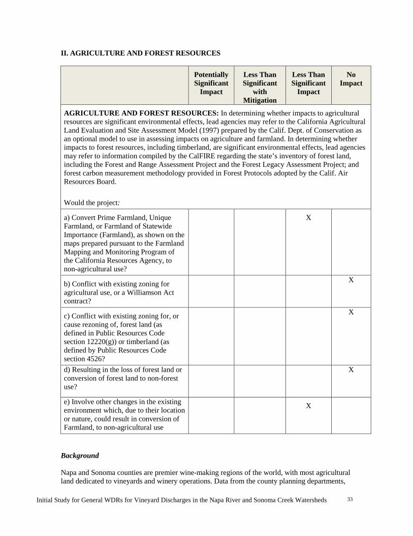
Initial Study for General WDRs for Vineyard Discharges in the Napa River and Sonoma Creek Watersheds
33
II. AGRICULTURE AND FOREST RESOURCES
Potentially Significant
Impact
Less Than Significant
with Mitigation
Less Than Significant
Impact
No
Impact
AGRICULTURE AND FOREST RESOURCES: In determining whether impacts to agricultural resources are significant environmental effects, lead agencies may refer to the California Agricultural Land Evaluation and Site Assessment Model (1997) prepared by the Calif. Dept. of Conservation as an optional model to use in assessing impacts on agriculture and farmland. In determining whether impacts to forest resources, including timberland, are significant environmental effects, lead agencies may refer to information compiled by the CalFIRE regarding the state’s inventory of forest land, including the Forest and Range Assessment Project and the Forest Legacy Assessment Project; and forest carbon measurement methodology provided in Forest Protocols adopted by the Calif. Air Resources Board. Would the project: a) Convert Prime Farmland, Unique Farmland, or Farmland of Statewide Importance (Farmland), as shown on the maps prepared pursuant to the Farmland Mapping and Monitoring Program of the California Resources Agency, to non-agricultural use?
X
b) Conflict with existing zoning for agricultural use, or a Williamson Act contract?
X
c) Conflict with existing zoning for, or cause rezoning of, forest land (as defined in Public Resources Code section 12220(g)) or timberland (as defined by Public Resources Code section 4526?
X
d) Resulting in the loss of forest land or conversion of forest land to non-forest use?
X
e) Involve other changes in the existing environment which, due to their location or nature, could result in conversion of Farmland, to non-agricultural use
X
Background Napa and Sonoma counties are premier wine-making regions of the world, with most agricultural land dedicated to vineyards and winery operations. Data from the county planning departments,

Initial Study for General WDRs for Vineyard Discharges in the Napa River and Sonoma Creek Watersheds
34
Agricultural Commissioner, and the RCDs indicate that greater than 60,000 acres of vineyards are actively producing in the Napa River and Sonoma Creek watersheds. The General WDRs would apply, based on the eligibility and exemption criteria, to an estimated 89 percent of the existing vineyards in the Napa River and the Sonoma Creek watersheds. The General WDRs would require implementation of vineyard BMPs that will result in reductions in erosion, sedimentation, and the discharge of pollutants from vineyard properties. These in turn will lead to an improvement of water quality, stream function, and riparian health. Implementation of the proposed General WDRs is consistent with Napa County’s conservation goals and policies (Napa County General Plan) and Sonoma County’s Policy and Goals for Reduction of Soil Erosion (Sonoma County General Plan) that encourage and support agriculture through implementation of programs that increase the sustainability of resources, conserve energy, and protect water and soil (refer to Section X, Land Use and Planning). The General WDRs are also consistent with many conservation policies and regulations of cities located within the two watersheds. Discussion of Impacts
a) Convert Prime Farmland, Unique Farmland, or Farmland of Statewide Importance (Farmland), as shown on the maps prepared pursuant to the Farmland Mapping and Monitoring Program of the California Resources Agency, to non-agricultural use. Less than significant. Many vineyard properties in the Napa and Sonoma Valleys are mapped by California Department of Conservation (www.conservation.ca.gov) as Unique Farmland; however, implementation of vineyard BMPs would not result in the conversion of Prime Farmland, Unique Farmland or Farmland of Statewide Importance to non-agricultural use for the following reasons:
• Individual landowners/operators may choose to implement BMPs (including creating setbacks or buffers of vineyards from riparian areas or constructing on-site drainage facilities such as detention basins) that could remove or relocate portions of some vineyard blocks. Removal of grapevines from production would not result in conversion to non-agricultural uses since all foreseeable uses on vineyard property under the General WDRs would be compatible with, and ancillary to, existing vineyard agricultural uses.
• It is possible for landowners/operators of vineyards to comply with the General WDRs without changing the total area of vineyard (e.g. implementation of BMPs that do not impact existing vineyard row layouts or adjusting vine and row spacing to allow for setbacks).
• Voluntary creation of stream setbacks at existing vineyards in flat areas adjacent to streams may cause loss of grape production areas which the landowner must take into account in deciding this compliance option. However, the establishment of a stream setback on a portion of a vineyard is not considered to be a significant impact given that this action is compatible with and ancillary to maintaining existing agriculture uses. In addition, establishment of setbacks is voluntary and not a required compliance action.
The General WDRs would not result in the conversion of existing vineyards for non-agricultural uses such as residential, commercial or industrial land uses. Therefore, impacts are considered less than significant. b) Conflict with existing zoning for agricultural use, or a Williamson Act contract. No Impact. Implementation of vineyard BMPs in the General WDRs would not affect existing agricultural zoning or any aspect of a Williamson Act contract because the actions are relatively
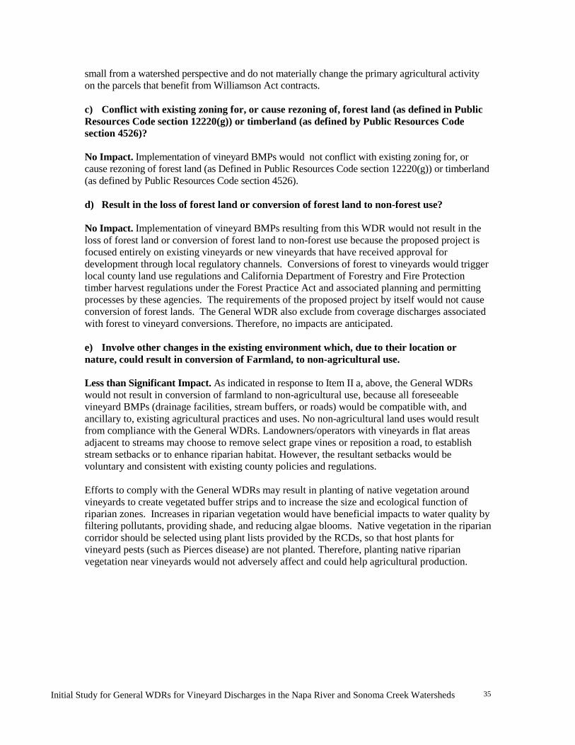
Initial Study for General WDRs for Vineyard Discharges in the Napa River and Sonoma Creek Watersheds
35
small from a watershed perspective and do not materially change the primary agricultural activity on the parcels that benefit from Williamson Act contracts. c) Conflict with existing zoning for, or cause rezoning of, forest land (as defined in Public Resources Code section 12220(g)) or timberland (as defined by Public Resources Code section 4526)? No Impact. Implementation of vineyard BMPs would not conflict with existing zoning for, or cause rezoning of forest land (as Defined in Public Resources Code section 12220(g)) or timberland (as defined by Public Resources Code section 4526). d) Result in the loss of forest land or conversion of forest land to non-forest use? No Impact. Implementation of vineyard BMPs resulting from this WDR would not result in the loss of forest land or conversion of forest land to non-forest use because the proposed project is focused entirely on existing vineyards or new vineyards that have received approval for development through local regulatory channels. Conversions of forest to vineyards would trigger local county land use regulations and California Department of Forestry and Fire Protection timber harvest regulations under the Forest Practice Act and associated planning and permitting processes by these agencies. The requirements of the proposed project by itself would not cause conversion of forest lands. The General WDR also exclude from coverage discharges associated with forest to vineyard conversions. Therefore, no impacts are anticipated. e) Involve other changes in the existing environment which, due to their location or nature, could result in conversion of Farmland, to non-agricultural use. Less than Significant Impact. As indicated in response to Item II a, above, the General WDRs would not result in conversion of farmland to non-agricultural use, because all foreseeable vineyard BMPs (drainage facilities, stream buffers, or roads) would be compatible with, and ancillary to, existing agricultural practices and uses. No non-agricultural land uses would result from compliance with the General WDRs. Landowners/operators with vineyards in flat areas adjacent to streams may choose to remove select grape vines or reposition a road, to establish stream setbacks or to enhance riparian habitat. However, the resultant setbacks would be voluntary and consistent with existing county policies and regulations. Efforts to comply with the General WDRs may result in planting of native vegetation around vineyards to create vegetated buffer strips and to increase the size and ecological function of riparian zones. Increases in riparian vegetation would have beneficial impacts to water quality by filtering pollutants, providing shade, and reducing algae blooms. Native vegetation in the riparian corridor should be selected using plant lists provided by the RCDs, so that host plants for vineyard pests (such as Pierces disease) are not planted. Therefore, planting native riparian vegetation near vineyards would not adversely affect and could help agricultural production.

Initial Study for General WDRs for Vineyard Discharges in the Napa River and Sonoma Creek Watersheds
36
III. AIR QUALITY
Potentially Significant
Impact
Less Than Significant
with Mitigation
Less Than Significant
Impact
No
Impact
AIR QUALITY -- Where available, the significance criteria established by the applicable air quality management or air pollution control district may be relied upon to make the following determinations. Would the project: a) Conflict with or obstruct implementation of the applicable air quality plan?
X
b) Violate any air quality standard or contribute substantially to an existing or projected air quality violation?
X
c) Result in a cumulatively considerable net increase of any criteria pollutant for which the project region is non-attainment under an applicable federal or state ambient air quality standard (including releasing emissions that exceed quantitative thresholds for ozone precursors)?
X
d) Expose sensitive receptors to substantial pollutant concentrations?
X
e) Create objectionable odors affecting a substantial number of people?
X
Background
Napa and Sonoma counties are located in the jurisdiction of the Bay Area Air Quality Management District (BAAQMD). These counties are situated in the northern part of the greater San Francisco Bay area and are bound on the west by Marin County, to the south by San Pablo Bay, and to the east by the Central Valley (Figure 1). The prevailing wind directions at the Napa County Airport are generally from the south to southwest and average wind speeds are about nine miles per hour. Average high temperatures are usually in the 50s in the winter and the 70s in the summer. The warmest months are August and September. Climate conditions in Sonoma Valley are similar to those in the adjacent Napa Valley. The Bay Area is currently designated as a nonattainment area for State and national ozone standards and as a nonattainment area for the State particulate matter (particles with diameter 10 micrometers or less, referred to as PM10 and particles with diameter 2.5 micrometers or less, referred to as PM2.5) standards. As required by federal and State air quality laws, the 2001 Bay
Initial Study for General WDRs for Vineyard Discharges in the Napa River and Sonoma Creek Watersheds
37
Area Ozone Attainment Plan and the 2000 Bay Area Clean Air Plan have been prepared to address ozone nonattainment issues. In addition, the BAAQMD, in cooperation with the Metropolitan Transportation Commission and the Association of Bay Area Governments, prepared the Bay Area 2005 Ozone Strategy. This report describes the Bay Area’s strategy for compliance with State one-hour ozone standard planning requirements and how to improve air quality in the region and reduce transport of air emissions to neighboring air basins. No PM10 plan has been prepared nor is one currently required under State air quality planning law. The BAAQMD monitors priority air pollutants at stations throughout the Bay Area. The Napa monitoring station (the only BAAQMD station in the area affected by the General WDRs) is the most representative of air quality conditions in the North Bay where vineyard BMPs would be implemented under the General WDRs. Criteria air pollutants routinely measured at the Napa Station include ozone, carbon monoxide, nitrogen dioxide, sulfur dioxide, and particulate matter (PM10). Smaller particle size, PM 25, is not monitored at the Napa Station. Combustion exhaust from the operation of vehicles, such as cars, trucks, and farm equipment may contribute to concentrations of these pollutants. Earthmoving for construction and road work can generate dust that is a source of particulate matter.
The 2007 through 2011 Napa air monitoring station data shows that carbon monoxide, nitrogen dioxide, and ozone concentrations are well below State and federal standards. The concentrations of PM10 varies throughout the year and is typically below the State standard of 50 micrograms per cubic meter (two days of exceedances in 5 years) and are well below the federal standard of 150 micrograms per cubic meter. Other air quality monitoring stations in the North Bay (San Rafael and Santa Rosa) also report concentrations of all criteria pollutants well below the standards. Actions to comply with the General WDRs may generate particulates and other air pollutants from construction equipment exhaust and earth disturbance. Discussion of Impacts
a-e. An analysis of potential air quality impacts due to the proposed project will be provided in the EIR.
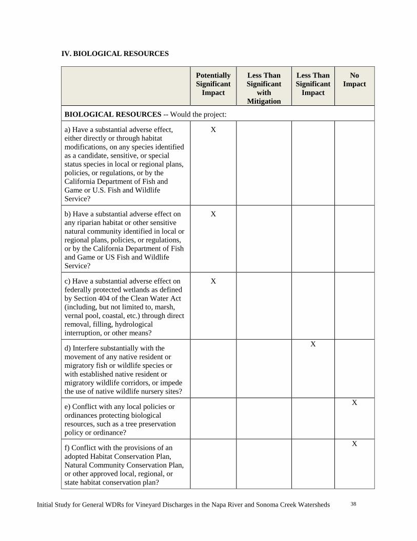
Initial Study for General WDRs for Vineyard Discharges in the Napa River and Sonoma Creek Watersheds
38
IV. BIOLOGICAL RESOURCES
Potentially Significant
Impact
Less Than Significant
with Mitigation
Less Than Significant
Impact
No
Impact
BIOLOGICAL RESOURCES -- Would the project: a) Have a substantial adverse effect, either directly or through habitat modifications, on any species identified as a candidate, sensitive, or special status species in local or regional plans, policies, or regulations, or by the California Department of Fish and Game or U.S. Fish and Wildlife Service?
X
b) Have a substantial adverse effect on any riparian habitat or other sensitive natural community identified in local or regional plans, policies, or regulations, or by the California Department of Fish and Game or US Fish and Wildlife Service?
X
c) Have a substantial adverse effect on federally protected wetlands as defined by Section 404 of the Clean Water Act (including, but not limited to, marsh, vernal pool, coastal, etc.) through direct removal, filling, hydrological interruption, or other means?
X
d) Interfere substantially with the movement of any native resident or migratory fish or wildlife species or with established native resident or migratory wildlife corridors, or impede the use of native wildlife nursery sites?
X
e) Conflict with any local policies or ordinances protecting biological resources, such as a tree preservation policy or ordinance?
X
f) Conflict with the provisions of an adopted Habitat Conservation Plan, Natural Community Conservation Plan, or other approved local, regional, or state habitat conservation plan?
X

Initial Study for General WDRs for Vineyard Discharges in the Napa River and Sonoma Creek Watersheds
39
Background The Napa River and Sonoma Creek watersheds support a wide diversity of plant and animal species, including a number of special status species and sensitive natural communities. These communities include mixed evergreen forests, oak woodlands and savanna, native and non-native grasslands, chaparral, and riparian scrub and woodland. The watersheds provide habitat for several threatened aquatic species including steelhead trout (Oncorhynchus mykiss) and Chinook salmon (Oncorhynchus tshawytscha) that are protected under the Federal Endangered Species Act. The proposed General WDRs would implement the sediment TMDLs, which were developed specifically to benefit biological resources in the watersheds, including fish, wildlife, and rare and endangered species, which have been adversely affected by sediment. Actions to comply with the General WDRs would primarily occur on land that is currently in vineyard production, or on existing roads in open space areas on vineyard properties. These areas have already been disturbed by land cultivation and by road construction. Some BMPs could, however, involve work in streams and riparian or wetland areas. Discussion of Impacts a-f. An analysis of potential biological impacts from the proposed project will be provided in the EIR.
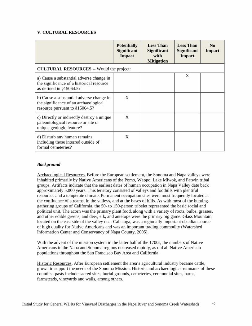
Initial Study for General WDRs for Vineyard Discharges in the Napa River and Sonoma Creek Watersheds
40
V. CULTURAL RESOURCES
Potentially Significant
Impact
Less Than Significant
with Mitigation
Less Than Significant
Impact
No
Impact
CULTURAL RESOURCES -- Would the project: a) Cause a substantial adverse change in the significance of a historical resource as defined in §15064.5?
X
b) Cause a substantial adverse change in the significance of an archaeological resource pursuant to §15064.5?
X
c) Directly or indirectly destroy a unique paleontological resource or site or unique geologic feature?
X
d) Disturb any human remains, including those interred outside of formal cemeteries?
X
Background Archaeological Resources. Before the European settlement, the Sonoma and Napa valleys were inhabited primarily by Native Americans of the Pomo, Wappo, Lake Miwok, and Patwin tribal groups. Artifacts indicate that the earliest dates of human occupation in Napa Valley date back approximately 5,000 years. This territory consisted of valleys and foothills with plentiful resources and a temperate climate. Permanent occupation sites were most frequently located at the confluence of streams, in the valleys, and at the bases of hills. As with most of the hunting-gathering groups of California, the 50- to 150-person tribelet represented the basic social and political unit. The acorn was the primary plant food, along with a variety of roots, bulbs, grasses, and other edible greens; and deer, elk, and antelope were the primary big game. Glass Mountain, located on the east side of the valley near Calistoga, was a regionally important obsidian source of high quality for Native Americans and was an important trading commodity (Watershed Information Center and Conservancy of Napa County, 2005). With the advent of the mission system in the latter half of the 1700s, the numbers of Native Americans in the Napa and Sonoma regions decreased rapidly, as did all Native American populations throughout the San Francisco Bay Area and California. Historic Resources. After European settlement the area’s agricultural industry became cattle, grown to support the needs of the Sonoma Mission. Historic and archaeological remnants of these counties’ pasts include sacred sites, burial grounds, cemeteries, ceremonial sites, barns, farmsteads, vineyards and walls, among others.
Initial Study for General WDRs for Vineyard Discharges in the Napa River and Sonoma Creek Watersheds
41
Historical resources, as distinguished from archaeological resources, include antiques, buildings, structures, and sites generally of the past two centuries, marking the successive eras of Russian, Mexican, and North American occupation of Sonoma and Napa counties, and are present in both watersheds. CEQA §15064.5 considers historic resources significant if they are eligible for, or are listed in, the California Register of Historical Resources. Historic resources must meet one of the following criteria to be eligible:
It is associated with events that have made a significant contribution to the broad patterns
of local or regional history, or the cultural heritage of California or the United States;
It is associated with the lives of persons important to local, California, or national history; It embodies the distinctive characteristics of a type, period, region, or method of
construction, or represents the work of a master or possesses high artistic values; or It has yielded, or has the potential to yield, information important to the pre-history or
history of the local area, California, or the nation. Discussion of Impacts a-d An analysis of potential impacts to cultural resources from the proposed project will be provided in the EIR.
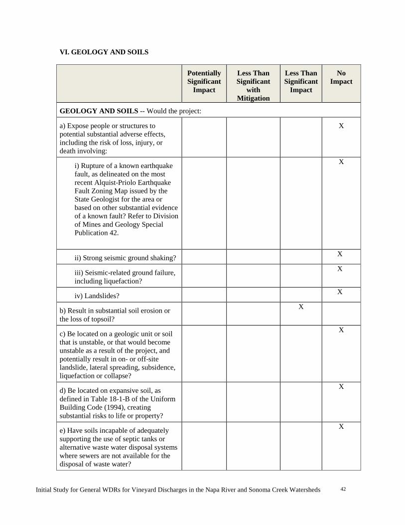
Initial Study for General WDRs for Vineyard Discharges in the Napa River and Sonoma Creek Watersheds
42
VI. GEOLOGY AND SOILS
Potentially Significant
Impact
Less Than Significant
with Mitigation
Less Than Significant
Impact
No
Impact
GEOLOGY AND SOILS -- Would the project: a) Expose people or structures to potential substantial adverse effects, including the risk of loss, injury, or death involving:
X
i) Rupture of a known earthquake fault, as delineated on the most recent Alquist-Priolo Earthquake Fault Zoning Map issued by the State Geologist for the area or based on other substantial evidence of a known fault? Refer to Division of Mines and Geology Special Publication 42.
X
ii) Strong seismic ground shaking?
X
iii) Seismic-related ground failure, including liquefaction?
X
iv) Landslides? X
b) Result in substantial soil erosion or the loss of topsoil?
X
c) Be located on a geologic unit or soil that is unstable, or that would become unstable as a result of the project, and potentially result in on- or off-site landslide, lateral spreading, subsidence, liquefaction or collapse?
X
d) Be located on expansive soil, as defined in Table 18-1-B of the Uniform Building Code (1994), creating substantial risks to life or property?
X
e) Have soils incapable of adequately supporting the use of septic tanks or alternative waste water disposal systems where sewers are not available for the disposal of waste water?
X
Initial Study for General WDRs for Vineyard Discharges in the Napa River and Sonoma Creek Watersheds
43
Background
Napa River Watershed: The Napa River watershed consists of Mesozoic and Cenozoic volcanic rocks with younger sedimentary rocks in the valley floor area. The watershed is located at the southern end of the northern California Coast Range province, an active zone of tectonic deformation and activity that is associated with the San Andreas Fault system. The San Andreas Fault is located about 35 miles (56 km) southwest of the watershed. The watershed is more locally bound by two major faults: the north-west striking Green Valley Fault in the east (about 7 miles [11 km] to the northeast of the watershed boundary), and northwest striking Healdsburg-Rodgers Fault in the west (about 15 miles to the southwest of the watershed boundary).
Sonoma Creek Watershed: The Sonoma Creek watershed, located in the Sonoma Valley, is also part of the Coast Range Physiographic province. The west side of the valley consists of young sedimentary rocks and the east side is predominantly older volcanic rocks of the Mayacama Mountains. Similar to the Napa Valley, the Sonoma Creek watershed lies in an active zone of tectonic activity that is associated with the San Andreas Fault system.
Several notable faults are aligned roughly southeast – northwest influencing the Sonoma Creek.
Discussion of Impacts a) Expose people or structures to potential substantial adverse effects, including the risk of loss, injury, or death involving:
i) Rupture of a known earthquake fault, as delineated on the most recent Alquist-Priolo Earthquake Fault Zoning Map issued by the State Geologist for the area or based on other substantial evidence of a known fault? Refer to Division of Mines and Geology Special Publication 42. ii) Strong seismic shaking?
iii) Seismic-related ground failure?
iv) Landslides?
No impact. The proposed General WDRs would not involve the construction of habitable structures; therefore, it would not result in any human safety risks related to fault rupture, seismic ground-shaking, ground failure, or landslides.
b) Result in substantial soil erosion or the loss of topsoil?
Less than significant. The purpose of the General WDRs is to reduce soil erosion. Anticipated compliance actions consist of erosion management strategies such as increasing ground cover, stabilizing eroding areas, and repairing failing roadways or erosional features to eliminate sediment sources. Installation of anticipated compliance actions such as the construction of small structures or facilities (pipes, inlets, energy dissipaters, trash racks, drainage facilities, storm runoff diversion structures, etc.) could result in small scale earth moving from construction vehicles and equipment used during installation. Although these types of actions are routinely used in existing vineyard operations, the proposed General WDRs would likely result in increases in the installation and
Initial Study for General WDRs for Vineyard Discharges in the Napa River and Sonoma Creek Watersheds
44
maintenance of the above-mentioned structures. Such activities (e.g., promoting infiltration of rainfall on vineyards, the repair of erosion features, minor road rehabilitation or decommissioning, etc.) would not result in substantial soil erosion or the loss of topsoil because these actions are anticipated to be limited in size and scope and earth disturbance would be temporary. Some of these projects may also be subject to the requirements of the Napa or Sonoma County grading ordinances, which would reduce potential erosion impacts from earthmoving. Therefore, potential soil erosion or loss of topsoil from the proposed project is considered less than significant because actions are expected to be temporary, limited in size and scope, and must comply with existing country grading ordinance requirements. c) Be located on a geologic unit or soil that is unstable, or that would become unstable as a result of the project, and potentially result in on- or off-site landslide, lateral spreading, subsidence, liquefaction or collapse?
Less than significant. The General WDRs is intended to reduce soil erosion. Geologic units or soils that are known to be unstable under various conditions in both watersheds have been identified by the Water Board as part of developing the proposed General WDRs. A map indicating where unstable conditions may exist on a watershed scale will be provided as part of the EIR. Site-specific areas of instability will be identified as part of the Farm Water Quality Plan preparation and will be avoided (to promote natural recovery and revegetation) or stabilized through selected BMPs and during planning for new vineyards or replanting on unstable geologic units or highly erosive soil areas. Because the General WDRs requires actions to stabilize existing sources of sediment, some grading and remedial actions, such as installation of retaining walls, stream bank repairs, and/or gully repair, could occur to stabilize these unstable areas. Outgrowth stabilization actions could include improvements to roads and creek crossings, and other projects located on unstable terrain. These projects would be designed to increase stability, both on-site and off-site, and to reduce erosion and sedimentation. Grading would be designed to minimize any potential for landslides, lateral spreading, subsidence, liquefaction, or collapse.
d) Be located on expansive soil, as defined in Table 18-1-B of the Uniform Building Code (1994), creating substantial risks to life or property? No impact. Landowner/operator compliance with the General WDRs would not involve construction of buildings (as defined in the Uniform Building Code) or any habitable structures. Minor grading and construction could occur in areas with expansive soils but this activity would not create a substantial risk to life or property. e) Have soils incapable of adequately supporting the use of septic tanks or alternative waste water disposal systems where sewers are not available for the disposal of waste water? No impact. Compliance actions associated with the General WDRs would not require the installation of wastewater disposal systems; therefore, affected soils need not be capable of supporting the use of septic tanks or alternative wastewater disposal systems.
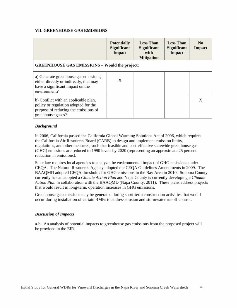
Initial Study for General WDRs for Vineyard Discharges in the Napa River and Sonoma Creek Watersheds
45
VII. GREENHOUSE GAS EMISSIONS
Potentially Significant
Impact
Less Than Significant
with Mitigation
Less Than Significant
Impact
No
Impact
GREENHOUSE GAS EMISSIONS – Would the project: a) Generate greenhouse gas emissions, either directly or indirectly, that may have a significant impact on the environment?
X
b) Conflict with an applicable plan, policy or regulation adopted for the purpose of reducing the emissions of greenhouse gases?
X
Background In 2006, California passed the California Global Warming Solutions Act of 2006, which requires the California Air Resources Board (CARB) to design and implement emission limits, regulations, and other measures, such that feasible and cost-effective statewide greenhouse gas (GHG) emissions are reduced to 1990 levels by 2020 (representing an approximate 25 percent reduction in emissions).
State law requires local agencies to analyze the environmental impact of GHG emissions under CEQA. The Natural Resources Agency adopted the CEQA Guidelines Amendments in 2009. The BAAQMD adopted CEQA thresholds for GHG emissions in the Bay Area in 2010. Sonoma County currently has an adopted a Climate Action Plan and Napa County is currently developing a Climate Action Plan in collaboration with the BAAQMD (Napa County, 2011). These plans address projects that would result in long-term, operation increases in GHG emissions.
Greenhouse gas emissions may be generated during short-term construction activities that would occur during installation of certain BMPs to address erosion and stormwater runoff control.
Discussion of Impacts a-b. An analysis of potential impacts to greenhouse gas emissions from the proposed project will be provided in the EIR.

Initial Study for General WDRs for Vineyard Discharges in the Napa River and Sonoma Creek Watersheds
46
VIII. HAZARDS AND HAZARDOUS MATERIALS
Potentially Significant
Impact
Less Than Significant
with Mitigation
Less Than Significant
Impact
No
Impact
HAZARDS AND HAZARDOUS MATERIALS -- Would the project: a) Create a significant hazard to the public or the environment through the routine transport, use, or disposal of hazardous materials?
X
b) Create a significant hazard to the public or the environment through reasonably foreseeable upset and accident conditions involving the release of hazardous materials into the environment?
X
c) Emit hazardous emissions or handle hazardous or acutely hazardous materials, substances, or waste within one-quarter mile of an existing or proposed school?
X
d) Be located on a site which is included on a list of hazardous materials sites compiled pursuant to Government Code Section 65962.5 and, as a result, would it create a significant hazard to the public or the environment?
X
e) For a project located within an airport land use plan or, where such a plan has not been adopted, within two miles of a public airport or public use airport, would the project result in a safety hazard for people residing or working in the project area?
X
f) For a project within the vicinity of a private airstrip, would the project result in a safety hazard for people residing or working in the project area?
X
g) Impair implementation of or physically interfere with an adopted emergency response plan or emergency evacuation plan?
X
h) Expose people or structures to a significant risk of loss, injury or death
Initial Study for General WDRs for Vineyard Discharges in the Napa River and Sonoma Creek Watersheds
47
involving wildland fires, including where wildlands are adjacent to urbanized areas or where residences are intermixed with wildlands?
X
Background Routine operations at vineyard facilities may involve the storage and use of a number of potentially hazardous materials such as agricultural chemicals and petroleum products. Vineyards typically contain facilities to store and mix agricultural chemicals such as pesticides, fungicides, herbicides, and fertilizers. These chemicals are a potential source of pollution to surface and groundwater if not properly stored, applied, and managed. The production, use, disposal and management of registered agricultural chemicals used at vineyards and associated farm operations are regulated by the Napa and Sonoma County Agricultural Commissioners and California Department of Food and Agriculture and the EPA. Hazardous chemicals and materials used at existing vineyard or as part of vineyard operations are covered by multiple state and federal laws including Resource Conservation and Recovery Act (RCRA) and the Comprehensive Environmental Response, Compensation and Liability Act (CERCLA). The federal Insecticide, Fungicide and Rodenticide Act (FIFRA) is the primary federal regulation overseeing the production and use of beneficial poisons. Hazardous materials business plans (HMBP) are enforced by local county fire and emergency response divisions. California Department of Toxic Substances Control (DTSC) regulates hazardous waste sites that are not within federal jurisdiction. The proposed General WDRs do not require additional environmental protective measures dealing with hazardous wastes beyond those already being required and enforced under current state or federal laws. Discussion of Impacts a) Create a significant hazard to the public or the environment through the routine transport, use, or disposal of hazardous materials? Less than Significant Impact: Construction associated with implementing vineyard BMPs and road erosion control (e.g., promoting infiltration on vineyards, repair of erosion features, road rehabilitation or retirement, etc.) would not involve the use or transport of hazardous materials, aside from those fuels (e.g., gasoline, diesel) and lubricants typically used for heavy construction equipment. Fuels and lubricant quantities used to implement selected vineyard BMPs would be small in quantity and their application would be limited to the operation of construction-related equipment and vehicles. These types of hazardous materials are currently used at most vineyards to power farm equipment such as trucks and tractors, and any impacts from their use during construction would be less than significant. Compliance with the General WDRs would not affect the transportation or potential release of hazardous materials, nor create a significant public safety or environmental hazard beyond any hazards currently in existence. Actions to implement the General WDRs would not interfere with adopted local or State emergency response plans or emergency evacuation plans and would not affect the potential for wild-land fires. The proposed General WDRs would require that pesticides be used in accordance with all applicable laws, regulations, and labeling requirements and allows for landowners/operators to meet
Initial Study for General WDRs for Vineyard Discharges in the Napa River and Sonoma Creek Watersheds
48
this requirement through a pesticide certificate issued by the County Agricultural Commission. The County Agricultural Commissioner is authorized to regulate and enforce federal and state laws regulating the storage and use of pesticides. The proposed General WDRs would not involve hazardous emissions or acutely hazardous materials of waste within one quarter mile of existing or proposed schools in Napa or Sonoma Valley. b) Create a significant hazard to the public or the environment through reasonably foreseeable upset and accident conditions involving the release of hazardous materials into the environment? No Impact. Refer to response to Item VIII a), above. c) Emit hazardous emissions or handle hazardous or acutely hazardous materials, substances, or waste within one-quarter mile of an existing or proposed school? No Impact. Refer to response to Item VIII a), above. d) Be located on a site which is included on a list of hazardous materials sites compiled pursuant to Government Code Section 65962.5 and, as a result, would it create a significant hazard to the public or the environment? No Impact. Refer to response to Item VIII a), above. e) For a project located within an airport land use plan or, where such a plan has not been adopted, within two miles of a public airport or public use airport, would the project result in a safety hazard for people residing or working in the project area? f) For a project within the vicinity of a private airstrip, would the project result in a safety hazard for people residing or working in the project area? e) & f) No Impact. There are two airports located in the Napa and Sonoma Valleys. The Sonoma Valley/Schellville Airport is located at 23980 Arnold Drive, about 4 mile south of town of Sonoma. The Napa County Airport is located about 3 miles south of downtown Napa. Although the Napa Valley Airport is adjacent to a business park, both airports are also adjacent to, or nearby to vineyards. Regardless of vineyard proximity to these airports, the General WDRs would not require implementation actions on vineyards that could result in increasing existing safety hazards affecting residents residing within the vicinity of these airports. g) Impair implementation of or physically interfere with an adopted emergency response plan or emergency evacuation plan? h) Expose people or structures to a significant risk of loss, injury or death involving wildland fires, including where wildlands are adjacent to urbanized areas or where residences are intermixed with wildlands? g) and h) No Impact. Refer to response to Item VIII a), above.
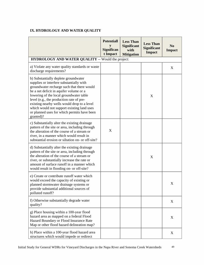
Initial Study for General WDRs for Vineyard Discharges in the Napa River and Sonoma Creek Watersheds
49
IX. HYDROLOGY AND WATER QUALITY
Potentiall
y Significant Impact
Less Than Significant
with Mitigation
Less Than Significant
Impact
No
Impact
HYDROLOGY AND WATER QUALITY -- Would the project: a) Violate any water quality standards or waste discharge requirements?
X
b) Substantially deplete groundwater supplies or interfere substantially with groundwater recharge such that there would be a net deficit in aquifer volume or a lowering of the local groundwater table level (e.g., the production rate of pre-existing nearby wells would drop to a level which would not support existing land uses or planned uses for which permits have been granted)?
X
c) Substantially alter the existing drainage pattern of the site or area, including through the alteration of the course of a stream or river, in a manner which would result in substantial erosion or siltation on- or off-site?
X
d) Substantially alter the existing drainage pattern of the site or area, including through the alteration of the course of a stream or river, or substantially increase the rate or amount of surface runoff in a manner which would result in flooding on- or off-site?
X
e) Create or contribute runoff water which would exceed the capacity of existing or planned stormwater drainage systems or provide substantial additional sources of polluted runoff?
X
f) Otherwise substantially degrade water quality?
X
g) Place housing within a 100-year flood hazard area as mapped on a federal Flood Hazard Boundary or Flood Insurance Rate Map or other flood hazard delineation map?
X
h) Place within a 100-year flood hazard area structures which would impede or redirect
X

Initial Study for General WDRs for Vineyard Discharges in the Napa River and Sonoma Creek Watersheds
50
flood flows? i) Expose people or structures to a significant risk of loss, injury or death involving flooding, including flooding as a result of the failure of a levee or dam?
X
j) Inundation by seiche, tsunami, or mudflow? X
Background Napa River. The Napa River watershed encompasses about 425 square miles (Figure 1). The Napa River and its tributaries drain the western portion of Napa County discharging into San Pablo Bay. The northeastern part of the county drains into Lake Berryessa, by way of Putah Creek and its tributaries. Flow volume in the Napa River varies markedly between dry and wet years. The long-term average discharge of the Napa River is approximately 66,000 acre feet (af); however, the minimum recorded annual discharge (about 5,000 af) occurred in 1931, and the maximum recorded annual discharge (in excess of 200,000 af) occurred in 1986 (U.S. Geological Survey 2001). The Napa Valley is a depositional basin filled to varying depths with unconsolidated and semi-consolidated alluvial material consisting of Mesozoic marine sediments, and metamorphic and igneous rocks, derived from nearby mountains. The largest volumes of groundwater reside the alluvium, with the Mesozoic rocks acting as confining units that generally restrict the flow of groundwater. Groundwater in the alluvium occurs primarily under unconfined aquifer conditions, while groundwater in the tuffaceous volcanic rocks occurs under both confined and unconfined aquifer conditions. Groundwater in the Napa Valley is not a significant municipal use source of water. Less than one percent of the total volume of groundwater extracted from the Napa Valley is used for municipal use, chiefly by the city of Calistoga. About 70 percent of all groundwater is used for irrigation purposes (mainly for vineyards), and 30 percent for rural domestic use.
Sonoma Creek. The Sonoma Creek watershed encompasses about 165 square miles (Figure 1). The watershed is commonly divided into three subbasins: Fowler Creek and the smaller creeks west of the City of Sonoma; Nathanson Creek and the creeks east of Schellville; and the mainstem of Sonoma Creek. The headwaters of the western tributaries lie in the Sonoma Mountains and flow into Fowler Creek, which eventually drains to Sonoma Creek near Sonoma. The eastern tributaries drain the hills to the north and east of Sonoma and join Schell Creek just south of Sonoma. Sonoma Creek flows into San Pablo Bay via a number of circular sloughs and channels that have been highly modified over the last 150 years by dredging, levees, and realignment. Flows from Sonoma Creek also vary markedly between dry and wet years. The long-term average annual discharge of Sonoma Creek is approximately 43,000 af; however, the minimum recorded annual discharge (about 3,000 af) occurred in 1939, and the maximum recorded annual discharge (in excess of 115,000 af) occurred in 1956 (U.S. Geological Survey 2001).
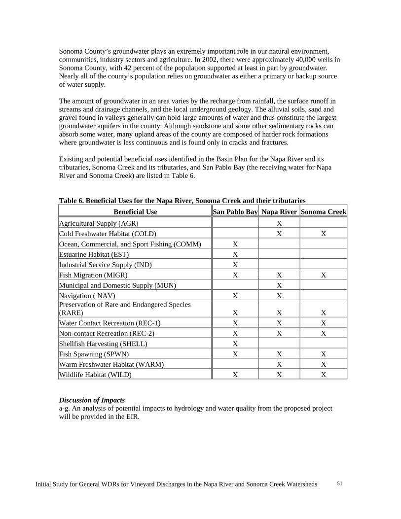
Initial Study for General WDRs for Vineyard Discharges in the Napa River and Sonoma Creek Watersheds
51
Sonoma County’s groundwater plays an extremely important role in our natural environment, communities, industry sectors and agriculture. In 2002, there were approximately 40,000 wells in Sonoma County, with 42 percent of the population supported at least in part by groundwater. Nearly all of the county’s population relies on groundwater as either a primary or backup source of water supply. The amount of groundwater in an area varies by the recharge from rainfall, the surface runoff in streams and drainage channels, and the local underground geology. The alluvial soils, sand and gravel found in valleys generally can hold large amounts of water and thus constitute the largest groundwater aquifers in the county. Although sandstone and some other sedimentary rocks can absorb some water, many upland areas of the county are composed of harder rock formations where groundwater is less continuous and is found only in cracks and fractures. Existing and potential beneficial uses identified in the Basin Plan for the Napa River and its tributaries, Sonoma Creek and its tributaries, and San Pablo Bay (the receiving water for Napa River and Sonoma Creek) are listed in Table 6.
Table 6. Beneficial Uses for the Napa River, Sonoma Creek and their tributaries
Beneficial Use San Pablo Bay Napa River Sonoma Creek Agricultural Supply (AGR) X Cold Freshwater Habitat (COLD) X X Ocean, Commercial, and Sport Fishing (COMM) X Estuarine Habitat (EST) X Industrial Service Supply (IND) X Fish Migration (MIGR) X X X Municipal and Domestic Supply (MUN) X Navigation ( NAV) X X Preservation of Rare and Endangered Species (RARE) X X X Water Contact Recreation (REC-1) X X X Non-contact Recreation (REC-2) X X X Shellfish Harvesting (SHELL) X Fish Spawning (SPWN) X X X Warm Freshwater Habitat (WARM) X X Wildlife Habitat (WILD) X X X Discussion of Impacts a-g. An analysis of potential impacts to hydrology and water quality from the proposed project will be provided in the EIR.

Initial Study for General WDRs for Vineyard Discharges in the Napa River and Sonoma Creek Watersheds
52
X. LAND USE AND PLANNING
Potentially Significant
Impact
Less Than Significant
with Mitigation
Less Than Significant
Impact
No
Impact
LAND USE AND PLANNING - Would the project: a) Physically divide an established community?
X
b) Conflict with any applicable land use plan, policy, or regulation of an agency with jurisdiction over the project (including, but not limited to the general plan, specific plan, local coastal program, or zoning ordinance) adopted for the purpose of avoiding or mitigating an environmental effect?
X
c) Conflict with any applicable habitat conservation plan or natural community conservation plan?
X
Background The General WDRs would apply to vineyard properties in the Napa and Sonoma valleys that meet the established eligibility criteria (Table 1). The zoning ordinances for these counties stipulate requirements for agricultural land uses, including vineyards. The general plan policies relevant to vineyards and water quality for Napa and Sonoma counties are summarized in Tables 7 and 8, respectively. Napa County. Napa County has for many years been committed to the conservation of sensitive resources and has been at the forefront of both protecting agricultural land and providing for the conservation of natural resources including surface and ground water, soils, fisheries, wildlife, important plant species, and habitats. Napa County’s Conservation Regulations, approved by the Board of Supervisors in 1991 established procedures for review of projects that might have an effect on water quality or other natural resources issues. In 2008, the Napa County Board of Supervisor’s adopted an updated General Plan, which includes several Goals and Policies aimed at protecting and enhancing the natural resources within the County (Napa County 2008). The County’s Conservation Regulations, discretionary Erosion Control Plan process, and applicable General Plan goals and policies make up the regulatory framework, which collectively regulate erosion and peak flow from new vineyard development on slopes greater than 5 percent.
Napa County Conservation Regulations require stream setbacks for development adjacent to streams designated in the Napa County General Plan. County designated streams require 35 to 150 foot setbacks depending on slope, which is measured from the top of bank to the outer edge of the area to be graded. Discretionary projects, including new vineyard development on slopes greater than 5 percent, are required to meet performance standards designed to ensure that peak

Initial Study for General WDRs for Vineyard Discharges in the Napa River and Sonoma Creek Watersheds
53
runoff from post-development projects is not greater than pre-development conditions for 2, 10, 50, and 100-year storm events.
Sonoma County. Though Napa County was the first to require erosion control for new vineyards, Sonoma County has its own version and regulates vineyards in accordance with the 2000 Grading, Drainage, & Vineyard & Orchard Site Development Ordinance, also known as “VESCO.” Growers planting new vineyards, orchards or replanting existing vineyards or orchards are required to meet standards within the Sonoma County Code and comply with requirements including BMPs, as established in the Agricultural Commissioner's BMPs guidelines.
The County General Plan requires stream setbacks on all new developments. The setback is determined by slope and soil type. Stream setbacks in areas with gentle slope and more stable soils are 25 feet while steeper slopes with erodible soils require a minimum 50 foot setback. Additional regulations, adopted by the Board of Supervisors in 2012, require that BMPs be implemented for projects that propose to remove more than one half acre of trees on slopes greater than 10 percent or 15 percent, based on soil type. These updated BMPs require slope stability analysis as well as identification of soil types prone to slides. The use of predictive models is also required to show that the development will not increase erosion or sediment delivery from the pre-existing site conditions.
Discussion of Impacts a) Physically divide an established community? No impact. The General WDRs is not a land use approval regulation and new vineyards will not be approved by this regulation. The General WDRs requires that where vineyards exist or are proposed, the owners/operators of these existing or proposed vineyards implement BMPs to reduce non-point source pollutants and to control erosion, runoff and sedimentation. These BMPs will not include the construction of large permanent structures or other features that could divide a community, nor would they physically divide an established community. b) Conflict with any applicable land use plan, policy, or regulation of an agency with jurisdiction over the project (including, but not limited to the general plan, specific plan, local coastal program, or zoning ordinance) adopted for the purpose of avoiding or mitigating an environmental effect? No Impact. The General WDRs would not affect any land use plan, policy, or regulation and would therefore not conflict with any zoning ordinances. On the contrary, the general plans for Napa County and Sonoma County include a number of policies relevant to the Water Board that articulate support for sediment TMDL compliance. These policies are summarized in Tables 7 and 8 below, along with an assessment of the General WDRs’ compliance with general plans. As the tables show, the General WDRs would comply with, and in some cases, augment general plan goals and policies for both Sonoma and Napa counties.
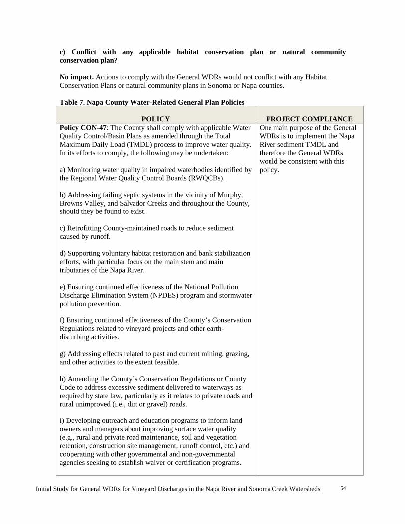
Initial Study for General WDRs for Vineyard Discharges in the Napa River and Sonoma Creek Watersheds
54
c) Conflict with any applicable habitat conservation plan or natural community conservation plan? No impact. Actions to comply with the General WDRs would not conflict with any Habitat Conservation Plans or natural community plans in Sonoma or Napa counties. Table 7. Napa County Water-Related General Plan Policies
POLICY
PROJECT COMPLIANCE
Policy CON-47: The County shall comply with applicable Water Quality Control/Basin Plans as amended through the Total Maximum Daily Load (TMDL) process to improve water quality. In its efforts to comply, the following may be undertaken: a) Monitoring water quality in impaired waterbodies identified by the Regional Water Quality Control Boards (RWQCBs). b) Addressing failing septic systems in the vicinity of Murphy, Browns Valley, and Salvador Creeks and throughout the County, should they be found to exist. c) Retrofitting County-maintained roads to reduce sediment caused by runoff. d) Supporting voluntary habitat restoration and bank stabilization efforts, with particular focus on the main stem and main tributaries of the Napa River. e) Ensuring continued effectiveness of the National Pollution Discharge Elimination System (NPDES) program and stormwater pollution prevention. f) Ensuring continued effectiveness of the County’s Conservation Regulations related to vineyard projects and other earth-disturbing activities. g) Addressing effects related to past and current mining, grazing, and other activities to the extent feasible. h) Amending the County’s Conservation Regulations or County Code to address excessive sediment delivered to waterways as required by state law, particularly as it relates to private roads and rural unimproved (i.e., dirt or gravel) roads. i) Developing outreach and education programs to inform land owners and managers about improving surface water quality (e.g., rural and private road maintenance, soil and vegetation retention, construction site management, runoff control, etc.) and cooperating with other governmental and non-governmental agencies seeking to establish waiver or certification programs.
One main purpose of the General WDRs is to implement the Napa River sediment TMDL and therefore the General WDRs would be consistent with this policy.

Initial Study for General WDRs for Vineyard Discharges in the Napa River and Sonoma Creek Watersheds
55
Policy CON-49: The County shall develop and implement a water quality monitoring program (or programs) to track the effectiveness of temporary and permanent Best Management Practices (BMPs) to control soil erosion and sedimentation within watershed areas and employ corrective actions for identified water quality issues (in violation of Basin Plans and/or associated TMDLs) identified during monitoring.
The General WDRs would support the Water Board’s efforts to implement BMPs to control soil erosion and sedimentation. Furthermore, the General WDRs will require annual reporting to the Water Board on the BMPs deployed and their effectiveness. Actions to implement the requirements of the General WDRs are therefore consistent with this policy.
Policy CON-50: The County will take appropriate steps to protect surface water quality and quantity, including the following: a) Preserve riparian areas through adequate buffering and pursue retention, maintenance, and enhancement of existing native vegetation along all intermittent and perennial streams through existing stream setbacks in the County’s Conservation Regulations b) Encourage flood control reduction projects to give full consideration to scenic, fish, wildlife, and other environmental benefits when computing costs of alternative methods of flood control. c) The County shall require discretionary projects to meet performance standards designed to ensure peak runoff in 2-, 10-, 50-, and 100-year events following development is not greater than predevelopment conditions. d) Maintain minimum lot sizes of not less than 160 acres in Agriculture, Watershed, and Open Space (AWOS) designated areas to reflect desirable densities based on access, slope, productive capabilities for agriculture and forestry, sewage disposal, water supply, wildlife habitat, and other environmental considerations. e) In conformance with National Pollution Discharge Elimination System (NPDES) requirements, prohibit grading and excavation unless it can be demonstrated that such activities will not result in significant soil erosion, silting of lower slopes or waterways, slide damage, flooding problems, or damage to wildlife and fishery habitats.
a) Not Applicable
b) Not Applicable
The General WDRs would support the Water Board’s efforts to reduce erosion from vineyard properties, including their associated road networks, and to incentivize the creation of stream setbacks. These actions are therefore consistent with this policy.
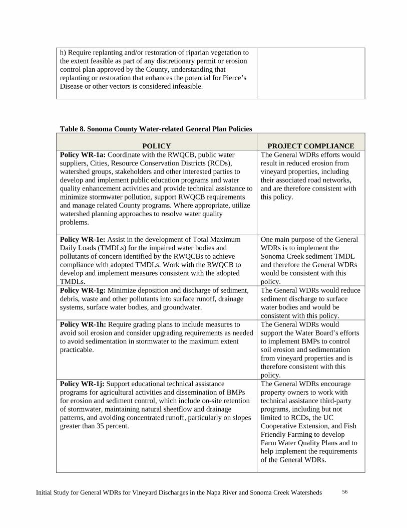
Initial Study for General WDRs for Vineyard Discharges in the Napa River and Sonoma Creek Watersheds
56
h) Require replanting and/or restoration of riparian vegetation to the extent feasible as part of any discretionary permit or erosion control plan approved by the County, understanding that replanting or restoration that enhances the potential for Pierce’s Disease or other vectors is considered infeasible. Table 8. Sonoma County Water-related General Plan Policies
POLICY
PROJECT COMPLIANCE
Policy WR-1a: Coordinate with the RWQCB, public water suppliers, Cities, Resource Conservation Districts (RCDs), watershed groups, stakeholders and other interested parties to develop and implement public education programs and water quality enhancement activities and provide technical assistance to minimize stormwater pollution, support RWQCB requirements and manage related County programs. Where appropriate, utilize watershed planning approaches to resolve water quality problems.
The General WDRs efforts would result in reduced erosion from vineyard properties, including their associated road networks, and are therefore consistent with this policy.
Policy WR-1e: Assist in the development of Total Maximum Daily Loads (TMDLs) for the impaired water bodies and pollutants of concern identified by the RWQCBs to achieve compliance with adopted TMDLs. Work with the RWQCB to develop and implement measures consistent with the adopted TMDLs.
One main purpose of the General WDRs is to implement the Sonoma Creek sediment TMDL and therefore the General WDRs would be consistent with this policy.
Policy WR-1g: Minimize deposition and discharge of sediment, debris, waste and other pollutants into surface runoff, drainage systems, surface water bodies, and groundwater.
The General WDRs would reduce sediment discharge to surface water bodies and would be consistent with this policy.
Policy WR-1h: Require grading plans to include measures to avoid soil erosion and consider upgrading requirements as needed to avoid sedimentation in stormwater to the maximum extent practicable.
The General WDRs would support the Water Board’s efforts to implement BMPs to control soil erosion and sedimentation from vineyard properties and is therefore consistent with this policy.
Policy WR-1j: Support educational technical assistance programs for agricultural activities and dissemination of BMPs for erosion and sediment control, which include on-site retention of stormwater, maintaining natural sheetflow and drainage patterns, and avoiding concentrated runoff, particularly on slopes greater than 35 percent.
The General WDRs encourage property owners to work with technical assistance third-party programs, including but not limited to RCDs, the UC Cooperative Extension, and Fish Friendly Farming to develop Farm Water Quality Plans and to help implement the requirements of the General WDRs.

Initial Study for General WDRs for Vineyard Discharges in the Napa River and Sonoma Creek Watersheds
57
The General WDRs requires the sediment control and minimization of erosive, concentrated stormwater flows through the implementation of site-specific BMPs that might include on-site stormwater retention, stormwater dispersion, etc. These actions are consistent with this policy.
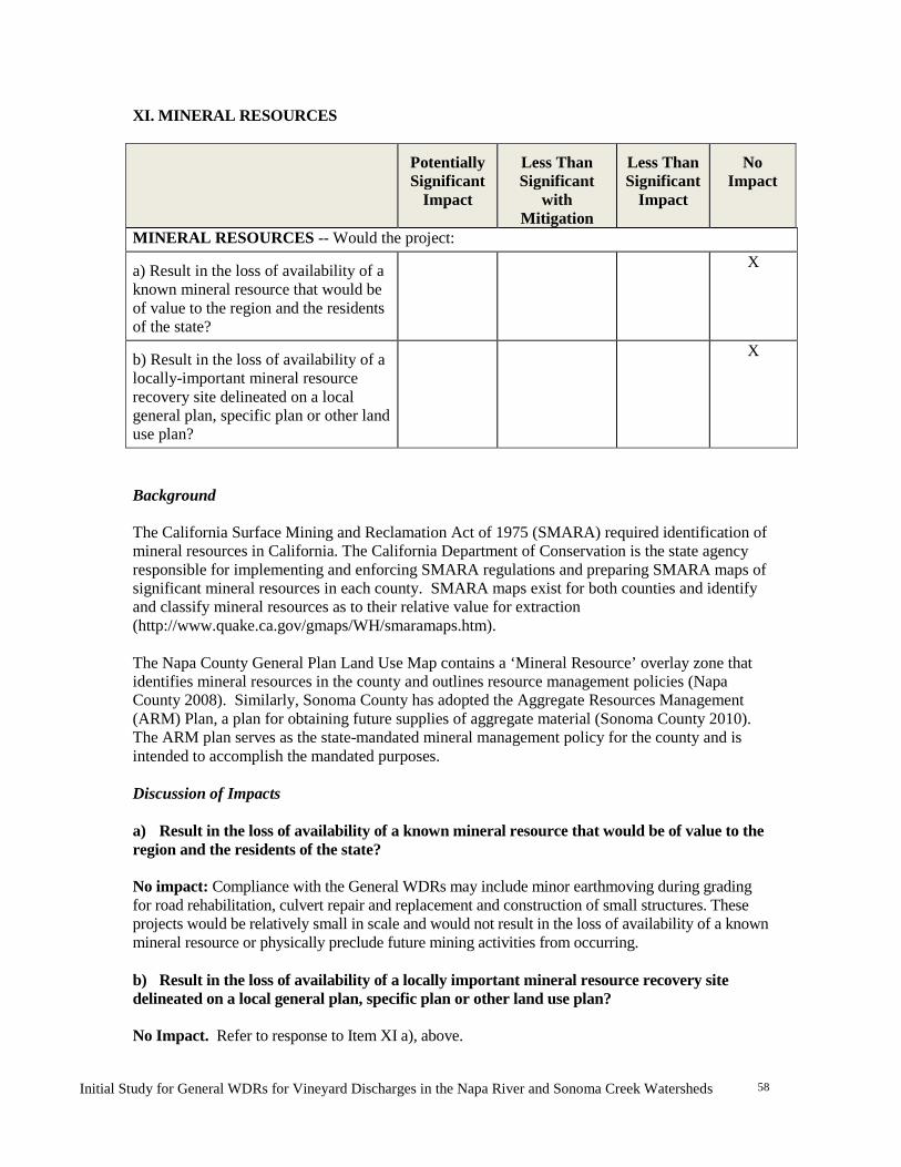
Initial Study for General WDRs for Vineyard Discharges in the Napa River and Sonoma Creek Watersheds
58
XI. MINERAL RESOURCES
Potentially Significant
Impact
Less Than Significant
with Mitigation
Less Than Significant
Impact
No
Impact
MINERAL RESOURCES -- Would the project: a) Result in the loss of availability of a known mineral resource that would be of value to the region and the residents of the state?
X
b) Result in the loss of availability of a locally-important mineral resource recovery site delineated on a local general plan, specific plan or other land use plan?
X
Background The California Surface Mining and Reclamation Act of 1975 (SMARA) required identification of mineral resources in California. The California Department of Conservation is the state agency responsible for implementing and enforcing SMARA regulations and preparing SMARA maps of significant mineral resources in each county. SMARA maps exist for both counties and identify and classify mineral resources as to their relative value for extraction (http://www.quake.ca.gov/gmaps/WH/smaramaps.htm). The Napa County General Plan Land Use Map contains a ‘Mineral Resource’ overlay zone that identifies mineral resources in the county and outlines resource management policies (Napa County 2008). Similarly, Sonoma County has adopted the Aggregate Resources Management (ARM) Plan, a plan for obtaining future supplies of aggregate material (Sonoma County 2010). The ARM plan serves as the state-mandated mineral management policy for the county and is intended to accomplish the mandated purposes. Discussion of Impacts a) Result in the loss of availability of a known mineral resource that would be of value to the region and the residents of the state? No impact: Compliance with the General WDRs may include minor earthmoving during grading for road rehabilitation, culvert repair and replacement and construction of small structures. These projects would be relatively small in scale and would not result in the loss of availability of a known mineral resource or physically preclude future mining activities from occurring. b) Result in the loss of availability of a locally important mineral resource recovery site delineated on a local general plan, specific plan or other land use plan?
No Impact. Refer to response to Item XI a), above.
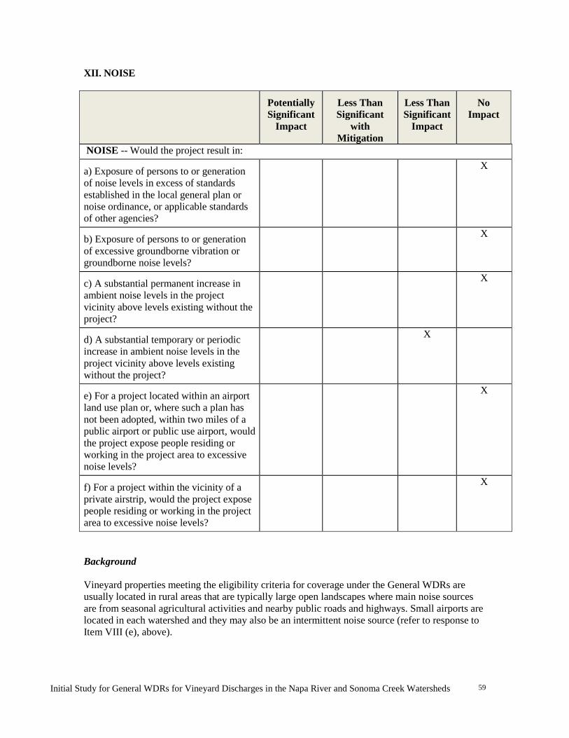
Initial Study for General WDRs for Vineyard Discharges in the Napa River and Sonoma Creek Watersheds
59
XII. NOISE
Potentially Significant
Impact
Less Than Significant
with Mitigation
Less Than Significant
Impact
No
Impact
NOISE -- Would the project result in: a) Exposure of persons to or generation of noise levels in excess of standards established in the local general plan or noise ordinance, or applicable standards of other agencies?
X
b) Exposure of persons to or generation of excessive groundborne vibration or groundborne noise levels?
X
c) A substantial permanent increase in ambient noise levels in the project vicinity above levels existing without the project?
X
d) A substantial temporary or periodic increase in ambient noise levels in the project vicinity above levels existing without the project?
X
e) For a project located within an airport land use plan or, where such a plan has not been adopted, within two miles of a public airport or public use airport, would the project expose people residing or working in the project area to excessive noise levels?
X
f) For a project within the vicinity of a private airstrip, would the project expose people residing or working in the project area to excessive noise levels?
X
Background Vineyard properties meeting the eligibility criteria for coverage under the General WDRs are usually located in rural areas that are typically large open landscapes where main noise sources are from seasonal agricultural activities and nearby public roads and highways. Small airports are located in each watershed and they may also be an intermittent noise source (refer to response to Item VIII (e), above).
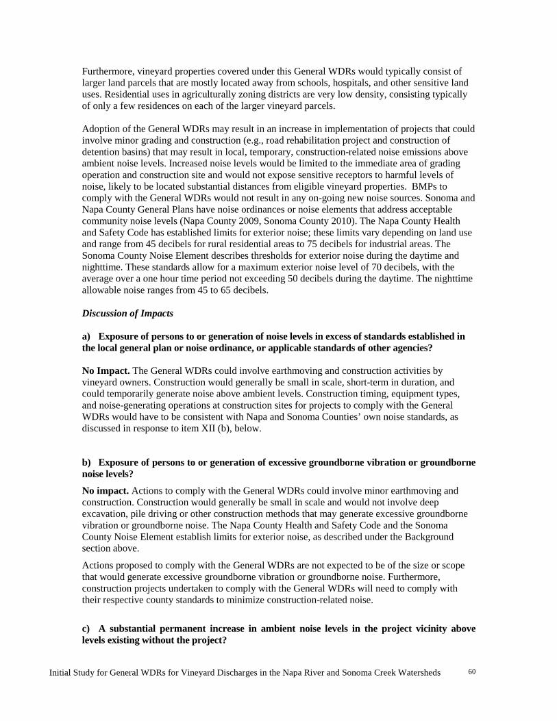
Initial Study for General WDRs for Vineyard Discharges in the Napa River and Sonoma Creek Watersheds
60
Furthermore, vineyard properties covered under this General WDRs would typically consist of larger land parcels that are mostly located away from schools, hospitals, and other sensitive land uses. Residential uses in agriculturally zoning districts are very low density, consisting typically of only a few residences on each of the larger vineyard parcels. Adoption of the General WDRs may result in an increase in implementation of projects that could involve minor grading and construction (e.g., road rehabilitation project and construction of detention basins) that may result in local, temporary, construction-related noise emissions above ambient noise levels. Increased noise levels would be limited to the immediate area of grading operation and construction site and would not expose sensitive receptors to harmful levels of noise, likely to be located substantial distances from eligible vineyard properties. BMPs to comply with the General WDRs would not result in any on-going new noise sources. Sonoma and Napa County General Plans have noise ordinances or noise elements that address acceptable community noise levels (Napa County 2009, Sonoma County 2010). The Napa County Health and Safety Code has established limits for exterior noise; these limits vary depending on land use and range from 45 decibels for rural residential areas to 75 decibels for industrial areas. The Sonoma County Noise Element describes thresholds for exterior noise during the daytime and nighttime. These standards allow for a maximum exterior noise level of 70 decibels, with the average over a one hour time period not exceeding 50 decibels during the daytime. The nighttime allowable noise ranges from 45 to 65 decibels. Discussion of Impacts
a) Exposure of persons to or generation of noise levels in excess of standards established in the local general plan or noise ordinance, or applicable standards of other agencies? No Impact. The General WDRs could involve earthmoving and construction activities by vineyard owners. Construction would generally be small in scale, short-term in duration, and could temporarily generate noise above ambient levels. Construction timing, equipment types, and noise-generating operations at construction sites for projects to comply with the General WDRs would have to be consistent with Napa and Sonoma Counties’ own noise standards, as discussed in response to item XII (b), below.
b) Exposure of persons to or generation of excessive groundborne vibration or groundborne noise levels?
No impact. Actions to comply with the General WDRs could involve minor earthmoving and construction. Construction would generally be small in scale and would not involve deep excavation, pile driving or other construction methods that may generate excessive groundborne vibration or groundborne noise. The Napa County Health and Safety Code and the Sonoma County Noise Element establish limits for exterior noise, as described under the Background section above.
Actions proposed to comply with the General WDRs are not expected to be of the size or scope that would generate excessive groundborne vibration or groundborne noise. Furthermore, construction projects undertaken to comply with the General WDRs will need to comply with their respective county standards to minimize construction-related noise.
c) A substantial permanent increase in ambient noise levels in the project vicinity above levels existing without the project?
Initial Study for General WDRs for Vineyard Discharges in the Napa River and Sonoma Creek Watersheds
61
No Impact. As described above, actions to comply with the General WDRs would not include new, permanent noise generating sources and would not cause any permanent increases in ambient noise levels. Any noise would be short-term in nature.
d) A substantial temporary or periodic increase in ambient noise levels in the project vicinity above levels existing without the project?
Less than Significant Impact. Actions to comply with the General WDRs could involve minor earthmoving and construction that would generate increased noise above ambient levels. Although construction activities would generally be small in scale, they could temporarily generate noise. Noise generating activities would, however, have to comply with their respective county standards to keep noise levels to less than significant levels. Construction activities would occur on rural land generally located away from schools, hospitals, and other sensitive receptors. Therefore, construction activities that may result from compliance with the General WDRs would not result in substantial noise, and the impacts would be less than significant.
e) For a project located within an airport land use plan or, where such a plan has not been adopted, within two miles of a public airport or public use airport, would the project expose people residing or working in the project area to excessive noise levels?
No impact. The General WDRs would not cause any permanent increase in ambient noise levels, including aircraft noise. Therefore, it would not expose people living within an area subject to an airport land use plan to excessive noise and thus, no impact would occur.
f) For a project within the vicinity of a private airstrip, would the project expose people residing or working in the project area to excessive noise levels?
No impact. The General WDRs would not cause any permanent increase in ambient noise levels, including aircraft noise. Therefore, it would not expose people living in the vicinity of a private airstrip to excessive noise and thus, no impact would occur.

Initial Study for General WDRs for Vineyard Discharges in the Napa River and Sonoma Creek Watersheds
62
XIII. POPULATION AND HOUSING
Potentially Significant
Impact
Less Than Significant
with Mitigation
Less Than Significant
Impact
No
Impact
POPULATION AND HOUSING -- Would the project: a) Induce substantial population growth in an area, either directly (for example, by proposing new homes and businesses) or indirectly (for example, through extension of roads or other infrastructure)?
X
b) Displace substantial numbers of existing housing, necessitating the construction of replacement housing elsewhere?
X
c) Displace substantial numbers of people, necessitating the construction of replacement housing elsewhere?
X
Background Implementation of the General WDRs would occur in areas where the dominant land use is agriculture. Vineyard properties typically contain structures including one or more residences, equipment sheds, wells, roads and road crossings. Discussion of Impacts a) Induce substantial population growth in an area, either directly (for example, by proposing new homes and businesses) or indirectly (for example, through extension of roads or other infrastructure)? No Impact. Actions to implement the General WDRs would not affect the population of the Sonoma Creek and Napa River Watersheds. It will not induce growth through such means as constructing new housing or businesses, or by extending roads or infrastructure. Implementation of the General WDRs would not displace any existing housing or any people that would need replacement housing. b) Displace substantial numbers of existing housing, necessitating the construction of replacement housing elsewhere? No impact. Refer to response to Item XIII a), above. c) Displace substantial numbers of people, necessitating the construction of replacement housing elsewhere? No impact. Refer to response to Item XIII a), above.
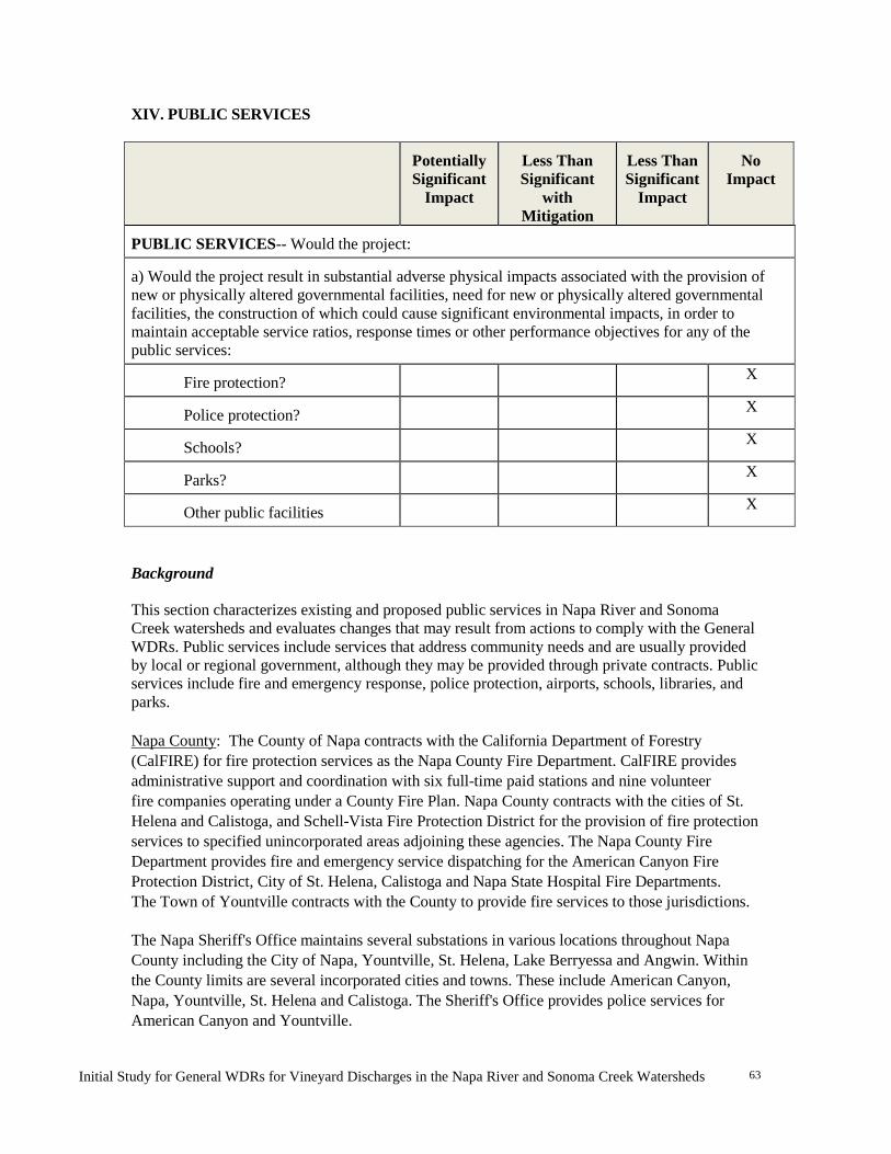
Initial Study for General WDRs for Vineyard Discharges in the Napa River and Sonoma Creek Watersheds
63
XIV. PUBLIC SERVICES
Potentially Significant
Impact
Less Than Significant
with Mitigation
Less Than Significant
Impact
No
Impact
PUBLIC SERVICES-- Would the project: a) Would the project result in substantial adverse physical impacts associated with the provision of new or physically altered governmental facilities, need for new or physically altered governmental facilities, the construction of which could cause significant environmental impacts, in order to maintain acceptable service ratios, response times or other performance objectives for any of the public services:
Fire protection? X
Police protection? X
Schools? X
Parks? X
Other public facilities X
Background This section characterizes existing and proposed public services in Napa River and Sonoma Creek watersheds and evaluates changes that may result from actions to comply with the General WDRs. Public services include services that address community needs and are usually provided by local or regional government, although they may be provided through private contracts. Public services include fire and emergency response, police protection, airports, schools, libraries, and parks. Napa County: The County of Napa contracts with the California Department of Forestry (CalFIRE) for fire protection services as the Napa County Fire Department. CalFIRE provides administrative support and coordination with six full-time paid stations and nine volunteer fire companies operating under a County Fire Plan. Napa County contracts with the cities of St. Helena and Calistoga, and Schell-Vista Fire Protection District for the provision of fire protection services to specified unincorporated areas adjoining these agencies. The Napa County Fire Department provides fire and emergency service dispatching for the American Canyon Fire Protection District, City of St. Helena, Calistoga and Napa State Hospital Fire Departments. The Town of Yountville contracts with the County to provide fire services to those jurisdictions. The Napa Sheriff's Office maintains several substations in various locations throughout Napa County including the City of Napa, Yountville, St. Helena, Lake Berryessa and Angwin. Within the County limits are several incorporated cities and towns. These include American Canyon, Napa, Yountville, St. Helena and Calistoga. The Sheriff's Office provides police services for American Canyon and Yountville.

Initial Study for General WDRs for Vineyard Discharges in the Napa River and Sonoma Creek Watersheds
64
Sonoma County. Land located in unincorporated Sonoma County is under the jurisdiction of the Sonoma County Department of Emergency Services, Fire Services Division, and County Service Area #40. Fifteen volunteer fire companies comprise CSA #40. In addition, 17 Fire Protection Districts are operated by the Fire Division of the Department of Emergency Services. Additional fire protection in the unincorporated areas of the county is provided by the California Department of Forestry and Fire Protection. Emergency Medical Service (EMS) systems in Sonoma County is a blend of First Responder agencies, ground and air ambulance providers, EMS – Fire Dispatch Center, and acute care receiving facilities. Unincorporated Sonoma County receives police protection and coroner and correctional services from the Sonoma County Sheriff’s Department. The Sheriff maintains 24-hour patrol from five substations and a main office. Peace officers work in patrol, administration, the helicopter unit, boating, civil bureau, and investigations. The City of Sonoma provides police services in their jurisdiction. Discussion of Impacts a) Result in substantial adverse physical impacts associated with the provision of new or physically altered governmental facilities, need for new or physically altered governmental facilities, the construction of which could cause significant environmental impacts, in order to maintain acceptable service ratios, response times or other performance objectives for any of the following public services: i) Fire protection ii) Police protection iii) Schools iv) Parks v) Other public services No Impact. The General WDRs would not result in adverse impacts on fire protection or police services or on schools and parks since this General WDRs is not growth inducing nor do they involve construction of substantial new government facilities or the need for physically-altered government facilities. While the General WDRs includes provisions that may result in construction activity on roads or elimination of some unused roads on vineyard properties, the General WDRs requires work on private roads only and would not affect roads used for public safety or fire protection service vehicles. Actions to comply with road-specific water quality requirements in the General WDRs, such as road resurfacing and the installation of rolling dips and water bars, would not limit emergency access to private property. Therefore, the General WDRs would not result in changes to roadway networks on private property that would affect service ratios, response times, or other performance objectives for any public services.

Initial Study for General WDRs for Vineyard Discharges in the Napa River and Sonoma Creek Watersheds
65
XV. RECREATION
Potentially Significant
Impact
Less Than Significant
with Mitigation
Less Than Significant
Impact
No Impact
RECREATION – -- Would the project: a) Would the project increase the use of existing neighborhood and regional parks or other recreational facilities such that substantial physical deterioration of the facility would occur or be accelerated?
X
b) Does the project include recreational facilities or require the construction or expansion of recreational facilities which might have an adverse physical effect on the environment?
X
Background The California Department of Parks and Recreation, Sonoma County Agricultural Preservation and Open Space District, Napa County Regional Park and Open Space District, municipalities, and other private parties own and operate numerous park and recreational facilities in the counties. These facilities provide a variety of outdoor recreational, educational, and sporting opportunities for local residents, Bay Area residents, and visitors for around the world. The open space surrounding these parks and the many vineyards are an integral part of the rural agricultural and open space experience. Discussion of Impacts a) Would the project increase the use of existing neighborhood and regional parks or other recreational facilities such that substantial physical deterioration of the facility would occur or be accelerated? No Impact. Actions to comply with the General WDRs would affect only vineyard facilities and private roads and would have no effect on existing neighborhood and regional parks or other recreational facilities. Therefore, no impacts would occur. b) Does the project include recreational facilities or require the construction or expansion of recreational facilities which might have an adverse physical effect on the environment? No Impact. Refer to response to Item XV a), above.
Initial Study for General WDRs for Vineyard Discharges in the Napa River and Sonoma Creek Watersheds
66
XVI. TRANSPORTATION/TRAFFIC
Potentially Significant
Impact
Less Than Significant
with Mitigation
Less Than Significant
Impact
No Impact
TRANSPORTATION/TRAFFIC -- Would the project
a) Exceed the capacity of the existing circulation system, based on applicable measures of effectiveness (as designated in a general plan policy, ordinance, etc.), taking into account all relevant components of the circulation system, including but not limited to intersections, streets, highways and freeways, pedestrian and bicycle paths, and mass transit?
X
b) Conflict with an applicable congestion management program, including but not limited to, level of service standards and travel demand measures and other standards established by the county congestion management agency for designated roads or highways?
X
c) Result in a change in air traffic patterns, including either an increase in traffic levels or a change in location that results in substantial safety risks?
X
d) Substantially increase hazards due to a design feature (e.g., sharp curves or dangerous intersections) or incompatible uses (e.g., farm equipment)?
X
e) Result in inadequate emergency access?
X
g) Conflict with adopted policies, plans, or programs supporting alternative transportation (e.g., bus turnouts, bicycle racks)?
X
Initial Study for General WDRs for Vineyard Discharges in the Napa River and Sonoma Creek Watersheds
67
Background
Highway 29 is the main highway through the Napa River Watershed. The Silverado Trail, which runs along the east side of the valley, is used mostly by locals to avoid tourist traffic. Two-lane highways lead into Napa County from both the east (Highway 12) and west (Highway 12/121). Highway 12 is the main highway through the Sonoma Creek Watershed. In addition, Sonoma County's highway network includes Highways 116 and 121. Highways 12/121 and 37 connect Sonoma and Napa Counties. Outside of urban areas, most roadways are two-lane rural roads.
General WDRs’ water quality requirements could result in modifications to vineyard property roadway networks that are owned and under the control of private landowners/operators and would not affect public roads or maintenance easements.
Discussion of Impacts
a) Exceed the capacity of the existing circulation system, based on applicable measures of effectiveness (as designated in a general plan policy, ordinance, etc.), taking into account all relevant components of the circulation system, including but not limited to intersections, streets, highways and freeways, pedestrian and bicycle paths, and mass transit? No Impact. The General WDRs may result in an increase in truck traffic. Where BMPs require construction to erect small structures, modify roadway networks, or install detention ponds, minor short-term additional vehicular traffic could increase on individual vineyard parcels. Construction may require importing construction materials such as gravel, pipe, rock, or cement and would require the use of heavy equipment and trucks to move soil, logs, or other materials needed for road repair and/or stream crossings. Minor construction-related truck traffic is likely to be limited in number and duration, be located in rural settings, and would likely not occur during peak traffic periods. Any increase in traffic would be minor, temporary and would be limited to local areas in the vicinity of individual projects and would not create substantial traffic increases on existing street systems. b) Conflict with an applicable congestion management program, including but not limited to, level of service standards and travel demand measures and other standards established by the county congestion management agency for designated roads or highways? No Impact. See response to Item XVI a), above. Levels of service would be unchanged. c) Result in a change in air traffic patterns, including either an increase in traffic levels or a change in location that results in substantial safety risks? No impact. The General WDRs would not result in increased air travel or otherwise affect air travel. d) Substantially increase hazards due to a design feature (e.g., sharp curves or dangerous intersections) or incompatible uses (e.g., farm equipment)? No impact. Although private vineyard roads may require erosion control treatment, compliance actions taken under the General WDRs do not require the construction of new roads, generate new hazards, or result in roads that are incompatible with vineyard operational uses. No road design or construction hazards would occur.
Initial Study for General WDRs for Vineyard Discharges in the Napa River and Sonoma Creek Watersheds
68
e) Result in inadequate emergency access? No Impact. The General WDRs would result in grading and erosion control actions on unpaved roads that are not typically used for emergency access. Therefore, the General WDRs would not result in inadequate emergency access and no impacts would occur. Refer also to response to item XIV (a), Public Services, above. f) Result in inadequate parking capacity? No Impact. Because the General WDRs would not increase population or provide employment, it would not affect parking demand or supply, and no impacts would occur. g) Conflict with adopted policies, plans, or programs supporting alternative transportation (e.g., bus turnouts, bicycle racks)? No impact. Because the General WDRs would not generate ongoing motor vehicle trips, it would not conflict with adopted policies, plans, or programs supporting alternative transportation.
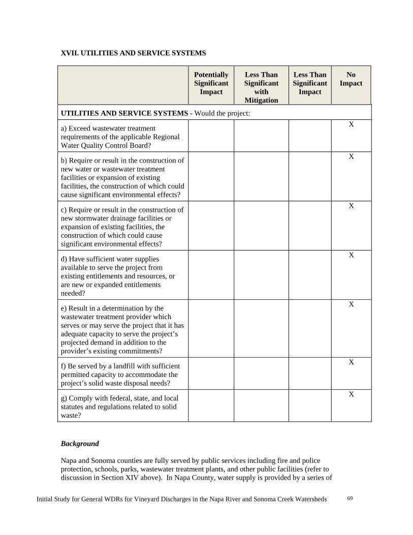
Initial Study for General WDRs for Vineyard Discharges in the Napa River and Sonoma Creek Watersheds
69
XVII. UTILITIES AND SERVICE SYSTEMS
Potentially Significant
Impact
Less Than Significant
with Mitigation
Less Than Significant
Impact
No
Impact
UTILITIES AND SERVICE SYSTEMS - Would the project: a) Exceed wastewater treatment requirements of the applicable Regional Water Quality Control Board?
X
b) Require or result in the construction of new water or wastewater treatment facilities or expansion of existing facilities, the construction of which could cause significant environmental effects?
X
c) Require or result in the construction of new stormwater drainage facilities or expansion of existing facilities, the construction of which could cause significant environmental effects?
X
d) Have sufficient water supplies available to serve the project from existing entitlements and resources, or are new or expanded entitlements needed?
X
e) Result in a determination by the wastewater treatment provider which serves or may serve the project that it has adequate capacity to serve the project’s projected demand in addition to the provider’s existing commitments?
X
f) Be served by a landfill with sufficient permitted capacity to accommodate the project’s solid waste disposal needs?
X
g) Comply with federal, state, and local statutes and regulations related to solid waste?
X
Background Napa and Sonoma counties are fully served by public services including fire and police protection, schools, parks, wastewater treatment plants, and other public facilities (refer to discussion in Section XIV above). In Napa County, water supply is provided by a series of

Initial Study for General WDRs for Vineyard Discharges in the Napa River and Sonoma Creek Watersheds
70
municipal dams and groundwater wells. In Sonoma County, the Sonoma County Water Agency provides surface and groundwater derived mainly from the Russian River watershed. Discussion of Impacts a) Exceed wastewater treatment requirements of the applicable Regional Water Quality Control Board? No Impact. The General WDRs do not include changes to wastewater treatment facilities and no impacts would occur. b) Require or result in the construction of new water or wastewater treatment facilities or expansion of existing facilities, the construction of which could cause significant environmental effects? No Impact. Refer to response to Item XVII a), above. c) Require or result in the construction of new stormwater drainage facilities or expansion of existing facilities, the construction of which could cause significant environmental effects? No Impact. The General WDRs would not include construction of new or expanded municipal stormwater drainage facilities or other drainage system affecting any non-agricultural activities and no impacts would occur. The changes to vineyard and road drainage systems that would result from the General WDRs would reduce erosion, sedimentation, peak runoff, and flooding, all beneficial environmental effects. d) Have sufficient water supplies available to serve the project from existing entitlements and resources, or are new or expanded entitlements needed? No Impact. Because the General WDRs would not increase population or provide employment, it would not require an ongoing water supply. It would also not require ongoing wastewater treatment services and no impacts would occur. e) Result in a determination by the wastewater treatment provider which serves or may serve the project that it has adequate capacity to serve the project’s projected demand in addition to the provider’s existing commitments? No Impact. See response to Item XVII d), above. f) Be served by a landfill with sufficient permitted capacity to accommodate the project’s solid waste disposal needs? No Impact. The General WDRs would not substantially affect municipal solid waste generation or landfill capacities and no impacts would occur. g) Comply with federal, state, and local statutes and regulations related to solid waste? No Impact. See response to Item XVII f), above.
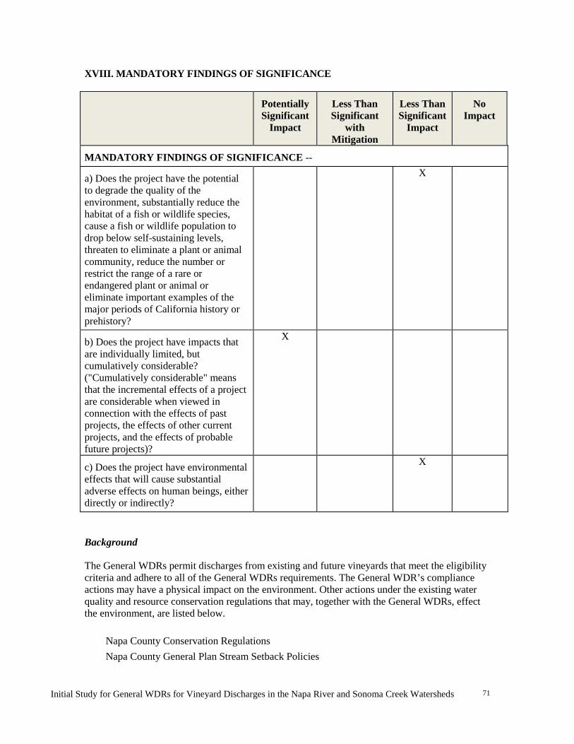
Initial Study for General WDRs for Vineyard Discharges in the Napa River and Sonoma Creek Watersheds
71
XVIII. MANDATORY FINDINGS OF SIGNIFICANCE
Potentially Significant
Impact
Less Than Significant
with Mitigation
Less Than Significant
Impact
No
Impact
MANDATORY FINDINGS OF SIGNIFICANCE -- a) Does the project have the potential to degrade the quality of the environment, substantially reduce the habitat of a fish or wildlife species, cause a fish or wildlife population to drop below self-sustaining levels, threaten to eliminate a plant or animal community, reduce the number or restrict the range of a rare or endangered plant or animal or eliminate important examples of the major periods of California history or prehistory?
X
b) Does the project have impacts that are individually limited, but cumulatively considerable? ("Cumulatively considerable" means that the incremental effects of a project are considerable when viewed in connection with the effects of past projects, the effects of other current projects, and the effects of probable future projects)?
X
c) Does the project have environmental effects that will cause substantial adverse effects on human beings, either directly or indirectly?
X
Background The General WDRs permit discharges from existing and future vineyards that meet the eligibility criteria and adhere to all of the General WDRs requirements. The General WDR’s compliance actions may have a physical impact on the environment. Other actions under the existing water quality and resource conservation regulations that may, together with the General WDRs, effect the environment, are listed below.
Napa County Conservation Regulations Napa County General Plan Stream Setback Policies
Initial Study for General WDRs for Vineyard Discharges in the Napa River and Sonoma Creek Watersheds
72
Sonoma County Vineyard Erosion and Sediment Control Ordinance (VESCO) Sonoma County Stream Setback Ordinance Sonoma County Tree Removal Ordinance Sonoma County General Plan Water Resources Element Policies General Plan policies and other vineyard regulation in the cities of Calistoga, Napa, Sonoma, St. Helena, and Yountville.
The adoption of the General WDRs would not result in the relaxation of water quality standards and would reduce non-point source pollutant discharge from existing vineyards and roads (existing conditions). New vineyards covered by the General WDRs would not be allowed to increase erosion and runoff. Discussion of Impacts a-c A complete analysis of mandatory findings of significance, including cumulative impacts of the proposed project, will be provided in the EIR.
Initial Study for General WDRs for Vineyard Discharges in the Napa River and Sonoma Creek Watersheds
73
REFERENCES, PERSONS CONTACTED, AND REPORT PREPARERS Association of Bay Area Governments (ABAG), Bay Area 2005 Ozone Strategy, 2005 Bay Area Air Quality Management District, A Resolution of the Directors of the Bay Area Air Quality Management District Adopting Thresholds For Use In Determining The Significance of Project’s Environmental Effects under the California Environmental Quality Act, Resolution 2010-06, 2010. California Regional Water Quality Control Board, San Francisco Bay Region (Water Board). Staff Report - Napa River Sediment TMDL and Habitat Enhancement Plan, 2009. California Regional Water Quality Control Board, San Francisco Bay Region (Water Board). Staff Report - Sonoma Creek Watershed Sediment TMDL and Habitat Enhancement Plan, 2008. California Regional Water Quality Control Board, San Francisco Bay Region (Water Board). Staff Report - Napa River Pathogen TMDL, 2006a. California Regional Water Quality Control Board, San Francisco Bay Region (Water Board). Staff Report - Sonoma Creek Watershed Pathogen TMDL, 2006b. California Regional Water Quality Control Board, San Francisco Bay Region (Water Board). San Francisco Bay Basin Water Quality Control Plan (Basin Plan), 2007. Five Counties Salmon Conservation Program. 2002. A Water Quality and Stream Habitat Protection Manual for County Road Maintenance in Northwestern California Watersheds. September. Marcus, L. Personal communication, November 13, 2012. Napa County, Environmental Management Department, Draft Napa County Climate Action Plan, 2011. Napa County, General Plan, June 2009. North Carolina Cooperative Extension Service (NCCE). 1997. Best Management Practices for Agricultural Nutrients, Publication AG-439-20. (http://www.soil.ncsu.edu/publications/Soilfacts/AG-439-20/) San Francisco Estuary Institute, Napa River Watershed Profile: Past and Present Characteristics with Implications for Future Management of the Changing Napa river Valley, 2012 State of California, Public Resources Code 21000–21177, California Environmental Quality Act, 2009. State of California, California Code of Regulations, Title 14, Division 6, Chapter 3, Sections 15000–15387, California Environmental Quality Act (CEQA) Guidelines, 2010. State Water Resources Control Board (State Board) 2004. Policy for Implementation and Enforcement of the Nonpoint Source Pollution Control Program, May 20, 2004. Sacramento, California: California Environmental Protection Agency, State Water Resources Control Board.
Initial Study for General WDRs for Vineyard Discharges in the Napa River and Sonoma Creek Watersheds
74
Sonoma County Agricultural Commissioner’s Office. 2010. Best Management Practices for Agricultural Erosion and Sediment Control. Sonoma County, General Plan, Resolution No. 10-0920, 2010. Steiner, D. Personal Communication (e-mail), October 4, 2012. Trso, Martin, Abstract for Vineyard Property Storm Runoff Impact Assessment, 2011 University of California, Davis (UC Davis). Statewide Integrated Pest Management Program. http://www.ipm.ucdavis.edu/PMG/selectnewpest.grapes.html U.S. Geological Survey, 2001 Watershed Information Center and Conservancy of Napa County, Baseline Data Report, November 2005.
Initial Study for General WDRs for Vineyard Discharges in the Napa River and Sonoma Creek Watersheds
75
Report Preparers and Contacts California Regional Water Quality Control Board, San Francisco Bay Region 1515 Clay Street, Suite 1400 Oakland, CA 94612 James D. Ponton, PG Senior Engineering Geologist 510-622-2492 [email protected] Anya Starovoytov, Environmental Scientist 510-622-2506 [email protected]