paleogeography and andean structural geometry
TRANSCRIPT
TECTONICS, VOL. 2, NO. 1, PAGES 1-16, FEBRUARY 1983
PALEOGEOGRAPHY AND ANDEAN STRUCTURAL
GEOMETRY, NORTHWEST ARGENTINA
Richard W. Allmendinger 1 Victor A. ' 1 Ramos, 2 Teresa E. Jprdan, Miguel Palma 2 and Bryan L. Isacks •
Abstract. Neogene tectonic segmentation of the Andean Cordillera in northwestern Argentina is a function of both the dip of the subducted plate and of major paleogeographic structures and sedimentary basins. Vergence, fault dip, and lateral continuity of Neogene structures can be related to the character
and pre-existing geometries and structures of the materials in which they form. South of 27øS the thick-skinned Sierras
Pampeanas, which occur mostly over a flat segment of the subducted Nazca Plate, formed where little sedimentary cover overlay crystalline basement. North of 24øS, the thin-skinned Subandean belt, overlying an inclined slab segment, formed within a thick, elongate, eastward-tapering trough of Pa!eozoic and Mesozoic sediments that may represent a complex of pre-Andean foreland basin deposits. The transitional region between 24ø-27øS (the Santa Barbara System and
1 Department of Geological Sciences,
Cornell University, Ithaca, New York 14853.
2Servicio Geologico Nacional, Buenos Aires, Argentina.
Copyright 1983 by the American Geophysical Union.
Paper number 3T0132. 0278-7407 / 83/003T-0132510.00
Cordillera Oriental) is characterized paleogeographically by complex cross-trending structures and irregular basin geometries, and the Neogene structures are equally complex and variable. The paleogeographic features of NW Argentina are a product of compres- sional tectonism during much of the Paleozoic that resulted in an orogenic belt oriented obliquely to the modern Andes. This earlier orogen was disrupted by several zones of transverse structures and by Cretaceous extensional or pull- apart basins. These features clearly influence the geometry of the superposed Andean structures. More intriguing, however, is the possibility that preexisting structures of the continental lithosphere may in some way help to modify the geometry of the subducted plate.
INTRODUCTION
Major tectonic changes along strike in a Cordilleran or Andean type mountain belt correlate with changes in the dip of a subduction zone beneath a continental
margin [Dickinson and Snyder, 1978; Jordan et al., 1983]. Such changes occur across the width of the orogenic system from the trench to the stable craton, with pronounced variations in the arc and backarc regions. In northwestern Argentina, longitudinal transitions in Andean magmatism and structural style appear to arise from a well documented
2 Allmendinger et al.: Andean Structural Geometry
78 ø
Arequipa Massif
72 ø 66 ø 60 ø
PERU
8 o
24 ø
Area of
Figs. 2 & 5
ARGENTINA ß
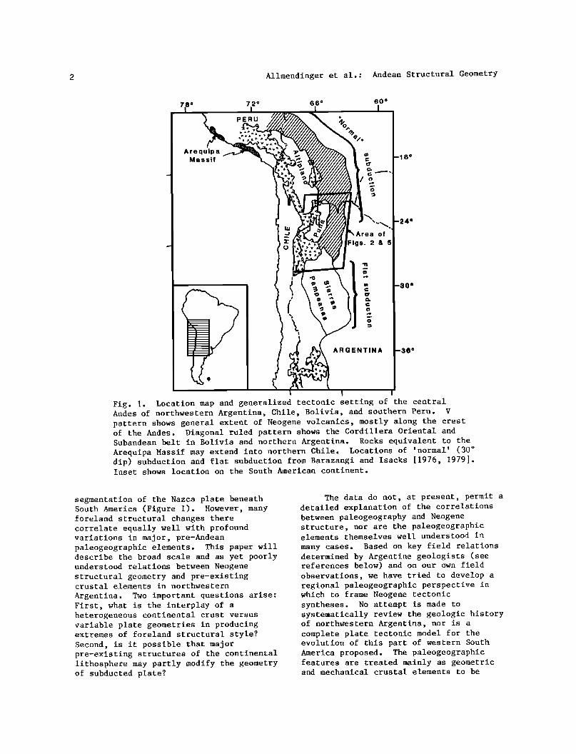
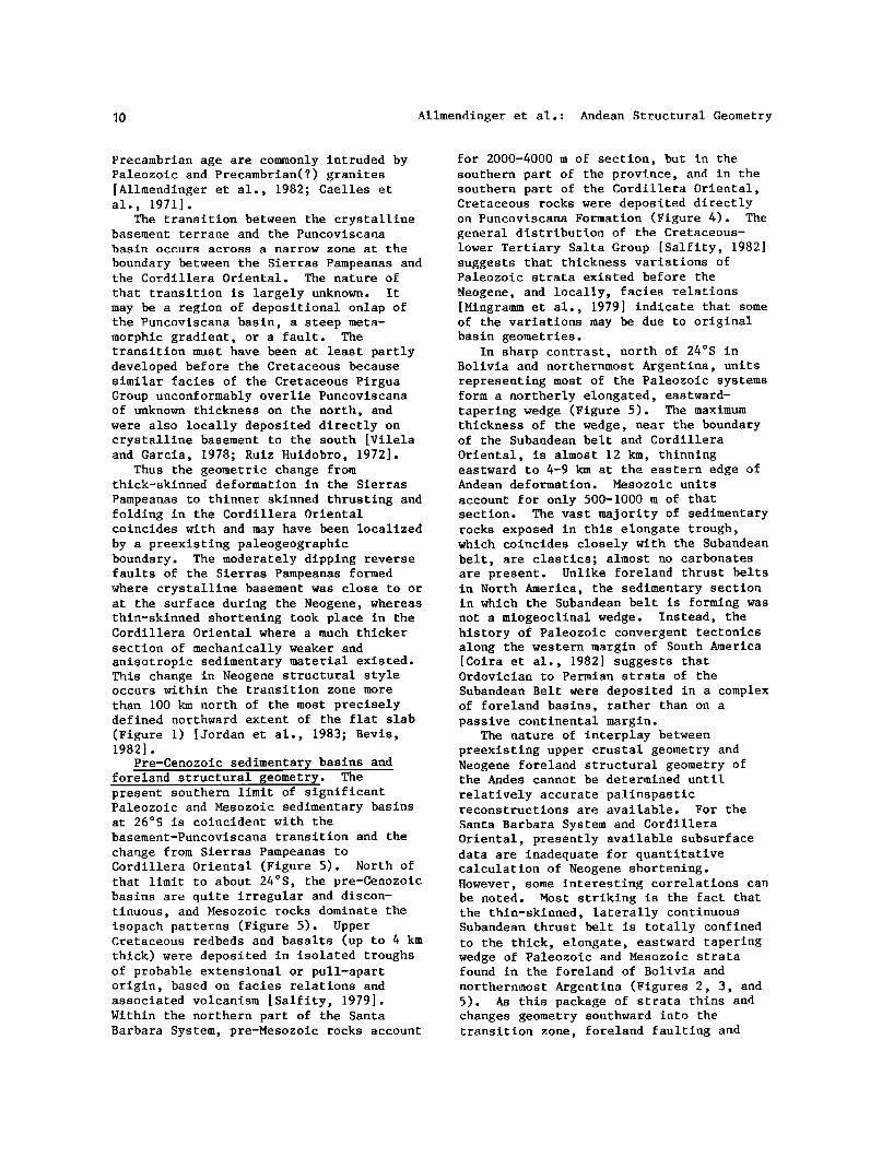
Fig. l. Location map and generalized tectonic setting of the central Andes of northwestern Argentina, Chile, Bolivia, and southern Peru. V pattern shows general extent of Neogene volcanics, mostly along the crest of the Andes. Diagonal ruled pattern shows the Cordillera Oriental and Subandean belt in Bolivia and northern Argentina. Rocks equivalent to the Arequipa Massif may extend into northern Chile. Locations of 'normal' (30 ø dip) subduction and flat subduction from Barazangi and Isacks [1976, 1979]. Inset shows location on the South American continent.
segmentation of the Nazca plate beneath South America (Figure 1). However, many foreland structural changes there correlate equally well with profound variations in major, pre-Andean paleogeographic elements. This paper will describe the broad scale and as yet poorly understood relations between Neogene
structural geometry and pre-existing crustal elements in northwestern
Argentina. Two important questions arise: First, what is the interplay of a heterogeneous continental crust versus variable plate geometries in producing extremes of foreland structural style? Second, is it possible that major pre-existing structures of the continental lithosphere may partly modify the geometry of subducted plate?
The data do not, at present, permit a detailed explanation of the correlations between paleogeography and Neogene structure, nor are the paleogeographic elements themselves well understood in many cases. Based on key field relations determined by Argentine geologists (see references below) and on our own field observations, we have tried to develop a regional paleogeographic perspective in which to frame Neogene tectonic syntheses. No attempt is made to systematically review the geologic history of northwestern Argentina, nor is a complete plate tectonic model for the evolution of this part of western South America proposed. The paleogeographic features are treated mainly as geometric and mechanical crustal elements to be
Allmendinger et al.: Andean Structural Geometry
considered when trying to understand the tectonics of the Andes.
The segmentation of the Benioff zone beneath the Andes has been well documented
[Barazangi and Isacks, 1976, 1979; Isacks and Barazangi, 1977; Bevis, 1982], and will be referred to but not reviewed
here. The broad scale segments of the subducted plate are shown on Figure 1. The region described below straddles the transition from a 30 ø east dipping segment (north of 24øS) to a nearly flat segment (between 27o30 ' and 33øS latitude).
NEOGENE STRUCTURAL PROVINCES
OF NORTHWEST ARGENTINA
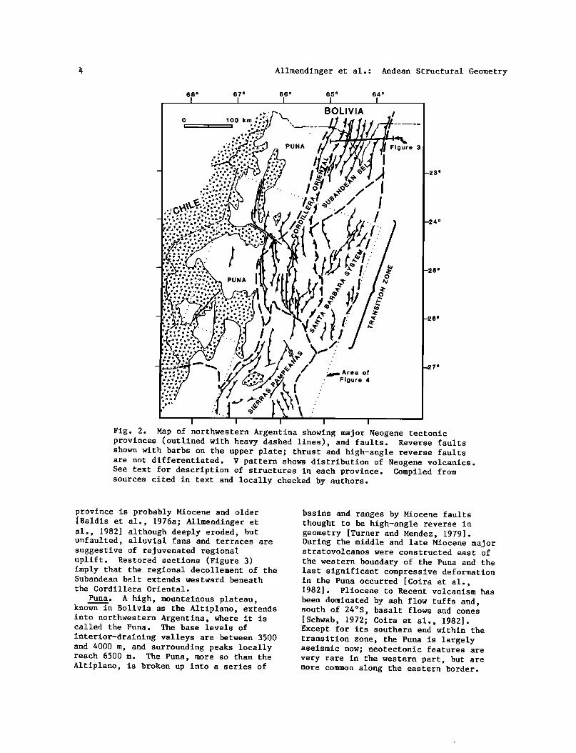
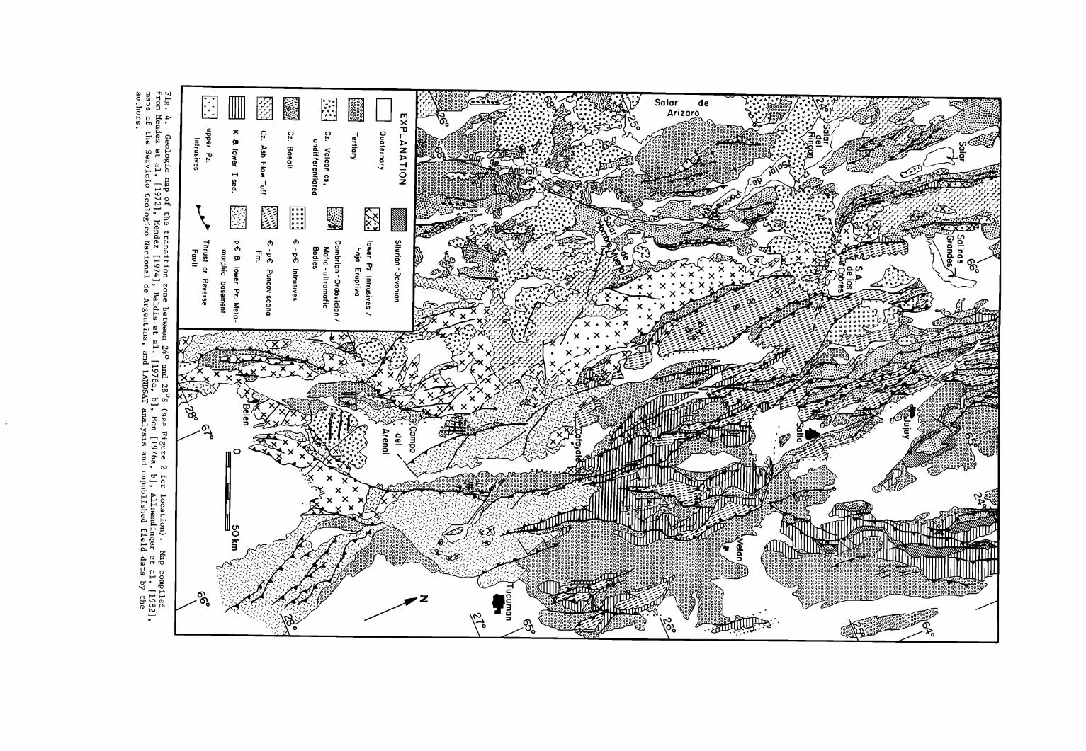
The Andean orogeny spans the Jurassic to Recent [Coira et al., 1982], but in northwestern Argentina, the Neogene phases are most pronounced [Turner, 1970]. We review the most general characteristics of the Neogene structural geometry in this part of the Andes (Figure 2). More complete descriptions in English may be found in the work of Turner [1970], Mon [1976a], Schwab [1972], Coira et al. [1982], and Jordan et al. [1983]; comprehensive reviews in Spanish have been published by Mendez [ 1974] , Turner and Mendez [1979], Mon [1976b], Turner and Mon [1979], Mingramm et al. [1979], Caminos [1979], Baldis et al. [1976a and b], and Allmendinger et al. [1982].
Subandean belt. This classic example of a thin-skinned foreland thrust belt
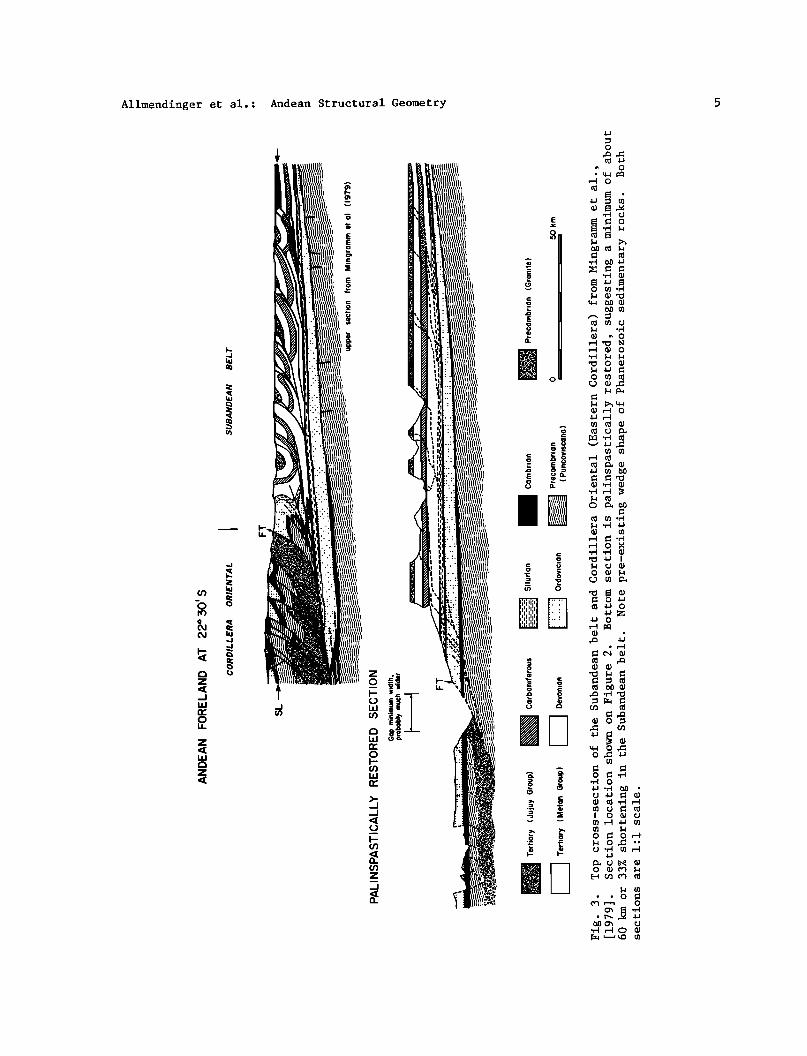
forms a narrow zone along the eastern margin of the Andes, north of 23ø30'S (Figure 2) [Mingramm et al., 1979; Martinez and Tomasi, 1978]. Laterally continuous folds and primarily west- dipping listric thrusts deform middle Paleozoic and younger sedimentary rocks, above a basal detachment in the Silurian
System [Mingramm et al., 1979]. Our restored sections suggest a minimum of 60 km of shortening or about 33% (Figure 3). Deformation locally may have begun in the late Miocene, but did not become fully developed until the Pliocene, and is continuing at present, as suggested by upper crustal seismicity [Jordan et al., •s3].
Santa Barbara system. The structural geometry of the Andean foreland between 24 ø and 26ø30'S is markedly different [Rolleri, 1976]. This short segment is characterized by large wavelength, asymetric west-verging folds and faults (Figure 4) that are laterally much less
continuous than are the folds in the
Subandean belt to the north (Figure 2). These structures expose lower Paleozoic strata, and at the south end of the province, Precambrian low to moderate grade metamorphics as well. Field mapping, seismic reflection profiles, and earthquake seismicity indicate that the dominant fault set in the Santa Barbara
System is composed of moderately to steeply dipping reverse faults that are probably active today [Jordan et al., 1983]. The Benioff zone is not well defined beneath this segment of the Andes, which we refer to as the 'transition zone'
(Figures 2 and 4). Sierras Pampeanas. South of 26 ø30'S,
the Andean foreland is broader than to the
north (Figure 1) and is comprised of a series of high, discontinuous, north-trending mountain blocks separated by wide, flat basins. The Sierras Pampeanas, uplifted along reverse or thrust faults that dip moderately eastward and westward (Figures 2 and 4), expose mostly Precambrian and lower Paleozoic crystalline basement. Although some uplift on the east side of the province occurred in the Early Tertiary, the main differential uplift was achieved in the Pliocene or Pleistocene. Earthquake seismicity shows that the province is currently being shortened in an east-west direction [Jordan et al., 1983]. The structure of the Sierras Pampeanas is very similar to the Laramide uplifts of Wyoming and Colorado [Pilger, 1981; Jordan et al., 1983]. The Sierras Pampeanas are located above the nearly flat segment of the Nazca plate, a similar tectonic setting to that proposed by Dickinson and Snyder [1978] for the Laramide uplifts.
Cordillera Oriental (Eastern Cordillera). The Cordillera Oriental, located west of the foreland Subandean
Belt and Santa Barbara System, is a narrow, complex zone of imbricated thrusts and reverse faults of both Andean and
Paleozoic ages [Baldis et al., 1976a; Turner and Mon, 1979]. Extensive exposures of Precambrian low-grade metasedimentary and granitic rocks distinguish this province from the foreland provinces to the east (Figure 4). The boundary between the Cordillera Oriental and the Subandean belt is a
major, seismically active thrust or reverse fault with a large amount of stratigraphic throw [Jordan et al., 1983]. Most of the deformation within the
4 Allmendinger et al.: Andean Structural Geometry
68 • I
67 ø 66 ø 65 ø 64 ø I I I I
BOLIVIA I
100 km ''"' 'k...•, /•• •.•r•/////,_••/_i____- PUNA // • ß ' !!•'• Figure 3 ',3 ø •..•
o PUNA I • 0
\ -
5 o
/' .•,,= Area of / Figure 4
ß
I ß
ß
7 ø
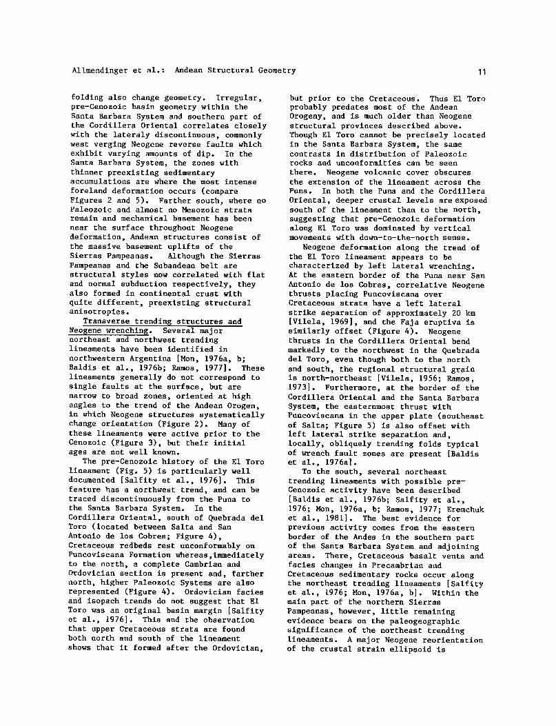
Fig. 2. Map of northwestern Argentina showing major Neogene tectonic provinces (outlined with heavy dashed lines), and faults. Reverse faults shown with barbs on the upper plate; thrust and high-angle reverse faults are not differentiated. V pattern shows distribution of Neogene volcanics. See text for description of structures in each province. Compiled from sources cited in text and locally checked by authors.
province is probably Miocene and older [Baldis et al., 1976a; Allmendinger et al., 1982] although deeply eroded, but unfaulted, alluvial fans and terraces are suggestive of rejuvenated regional uplift. Restored sections (Figure 3) imply that the regional decollement of the Subandean belt extends westward beneath the Cordillera Oriental.
Puna. A high, mountainous plateau, known in Bolivia as the Altiplano, extends into northwestern Argentina, where it is called the Puna. The base levels of
interior-draining valleys are between 3500 and 4000 m, and surrounding peaks locally reach 6500 m. The Puna, more so than the Altiplano, is broken up into a series of
basins and ranges by Miocene faults thought to be high-angle reverse in geometry [Turner and Mendez, 1979]. During the middle and late Miocene major stratovolcanos were constructed east of the western boundary of the Puna and the last significant compressive deformation in the Puna occurred [Coira et al., 1982]. Pliocene to Recent volcanism has been dominated by ash flow tuffs and, south of 24øS, basalt flows and cones [Schwab, 1972; Coira et al., 1982]. Except for its southern end within the transition zone, the Puna is largely aseismic now; neotectonic features are very rare in the western part, but are more common along the eastern border.
Allmendinger et al.: Andean Structural Geometry
z
z
LIJ
0
6 Allmendinger et al.: Andean Structural Geometry
68 ø 670 66 ø 65 ø I
,•;,{:i BOLIVIA / o o o m -
I' II
64 ø
3 ø
4 ø
6 o
_ i / ,- •--:/-. •-• ISOPACHS' ..,_ •_• L• L-• o Lq TOTAL PALEOZOIC
• L"; • Lq/•'• L-•/.-'• '---} • & MESOZOIC
•Lq • L• • Lq i• L• L• • '• F ( m e t e r s ) -• ........... CRYSTALLINE
-• ....... • BASEMENT i i
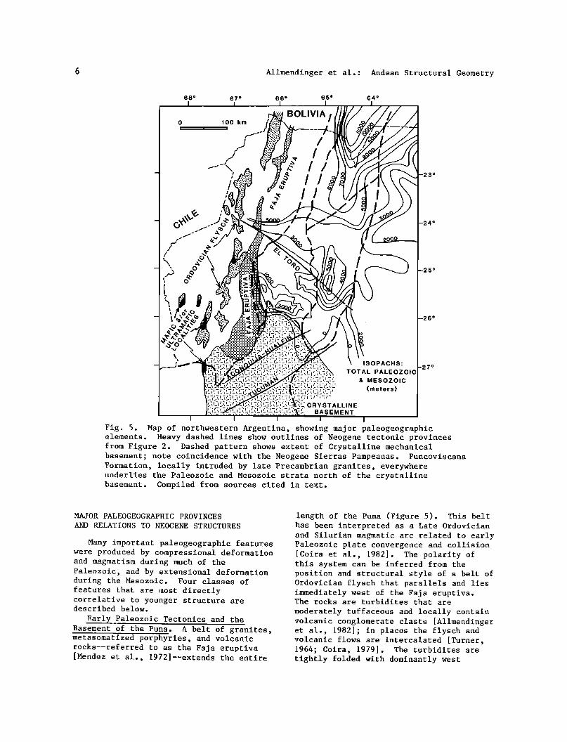
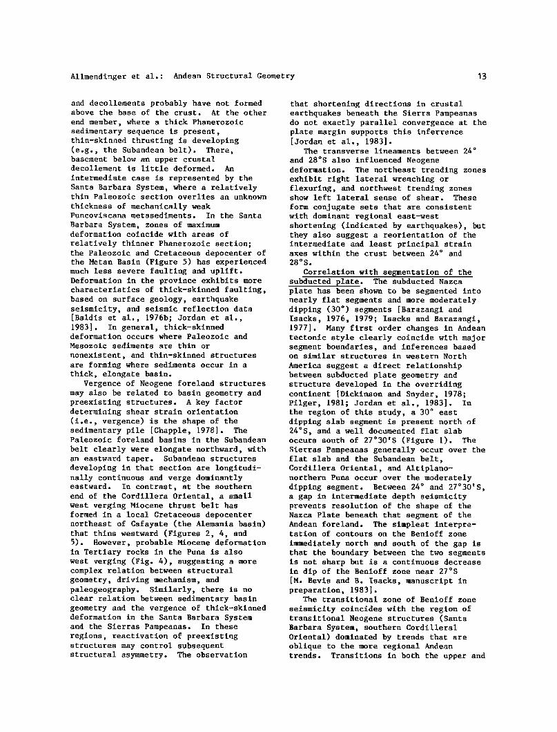
Fig. 5. Hap o• no•Eh•esEe•n A•ge•i•a, showlng majo• paleogeog•aphlc elements. •eavy dashed 11nes show ou•llnes o• Neogene •ec•onlc p•ovlnces •om Flgu•e 2. Dashed pa•e•n shows exEea• o• C•ysEalllne mechanical basemenE; no•e coincidence wl•h •he Neogene Sle•as •ampeanas. Puncovlscana Formation, locally •n•uded by la•e P•ecamb•lan g•anl•es, everywhere underlies •he •aleo•oie and •eso•olc basement. Complled •om sources clEed
MAJOR PALEOGEOGRAPHIC PROVINCES AND RELATIONS TO NEOGENE STRUCTURES
Many important paleogeographic features were produced by compressional deformation and magmatism during much of the Paleozoic, and by extensional deformation during the Mesozoic. Four classes of features that are most directly correlative to younger structure are described below.
Early Paleozoic Tectonics and the Basement of the Puna. A belt of granites, metasomatized porphyries, and volcanic rocks--referred to as the Faja eruptiva [Mendez et al., 1972]--extends the entire
length of the Puna (Figure 5). This belt has been interpreted as a Late Ordovician and Silurian magmatic arc related to early Paleozoic plate convergence and collision [Coira et al., 1982]. The polarity of this system can be inferred from the position and structural style of a belt of Ordovician flysch that parallels and lies immediately west of the Faja eruptiva. The rocks are turbidites that are
moderately tuffaceous and locally contain volcanic conglomerate clasts [Allmendinger et al., 1982]; in places the flysch and volcanic flows are intercalated [Turner, 1964; Coira, 1979]. The turbidites are tightly folded with dominantly west

Allmendinger et al.: Andean Structural Geometry 9
vergence. Unconformable relations in the
northern part of the Puna indicate that the intense folding is mostly early or middle Paleozoic [Mendez, 1974]. At several localities (Figures 4 and 5) interbedded chert and greenstone, massive altered gabbros, serpentinites, and various other ultramafics have been
observed by or reported to us [Arganaraz et al., 1972; Allmendinger et al., 1982]. The origin of these rocks is unknown, but the association of interbedded chert and
basalt underlain by massive greens tone at a locality west of Salar de Antofalla (Figure 4) is suggestive of the top part of an ophiolite sequence. These mafic and ultramafic rocks generally occur in fault contact with highly deformed turbidites, locally resembling broken formation or tectonic melanges.
In contrast, Ordovician strata east of the Faja eruptiva are clastic, shallow water facies rocks, which preliminary provenance studies indicate have only a minor volcanic component. In the Cordillera Oriental, these sediments exceed 5000 m in thickness, and have been deformed by both Andean and pre-Andean thrusting and folding [Baldis et al., 1976a; Salfity et al., 1976]. The contact between these eastern facies and the Faja eruptiva is everywhere a fault. Although an ocean basin could originally have lain between the two, evidence of a major suture (e.g. ultramafics, etc.) east of the Faja eruptiva is lacking. Thus, we prefer to interpret the eastern facies of the Ordovician as being deposited in a back arc setting relative to the Faja eruptiva.
We infer that during the early and middle(?) Paleozoic, oceanic crust was subducted eastward beneath the South
American continent, which, at that time, probably extended no farther west than the Faja eruptiva. The Ordovician flysch west of the Faja eruptiva is best interpreted as forearc sediments that were deformed
and accreted, along with slices of oceanic crust, during subduction and subsequent collision. Thus oceanic crust may have underlain much of the Puna during the lower Paleozoic.
High SrS?/Sr 86 ratios in Cenozoic volcanics [Francis et al., 1977, 1980; Coira et al., 1982] suggest that conti- nental crust presently underlies all of the Puna and probably extends somewhat farther west. Crystalline basement is
also exposed in the Arequipa massif of southwestern Peru [Shackleton et al., 1979] and has been reported in northern- most Chile [?acci et al., 1980]. If our interpretation of the paleotectonics is correct, then the continental crust now located west of the Faja eruptiva was emplaced after the early Paleozoic. This continental crust could represent part of an accreted terrane or microcontinent, sutured to the continental margin prior to initiation of Andean subduction in the
middle Mesozoic. Alternatively, South American craton may have been underthrust beneath the Puna along west-dipping faults at some time after the middle Paleozoic. We favor a combination of these two
possibilities. Complicating this picture is a belt
of Carboniferous and Permian plutons that crop out in the Puna west of the Faja eruptiva (Figure 4). The tectonic significance of this belt is little known, though much disputed, perhaps because of its variability along trend [Noble et al., 1978; Coira et al., 1982]. Regardless of its genesis, the belt demonstrates continuing tectonic activity of the western margin of South America during the Late Paleozoic and prior to Andean deformation.
Basement-Puncoviscana transition and
thick- versus thin-skinned thrusting. North of approximately 26øS, the deepest crustal exposures in the Andean foreland and hinterland reveal the clastic meta-
sedimentary rocks of the upper Precambrian and Lower Cambrian Puncoviscana basin
(Figure 4) [Salfity et al., 1976; Acenolaza and Toselli, 1981]. The original thickness of the basin is unknown, but it must have been considerable, based on occurrences of Puncoviscana sediments at a wide range of structural levels. Though the Puncovi$cana is locally intruded by latest Precambrian granites, the sediments are generally metamorphosed only to greenschist facies, and sedimentary structures, trace fossils, and original clastic grain shapes are well preserved [Acenolaza and Toselli, 1981; Schwab, 1982] . Crystalline (mechanical) basement is nowhere exposed at the surface in the Cordillera Oriental, Subandean belt, or north of 26øS in the Puna (Figures 4 and 5). South of 26øS, crystalline basement is widely exposed (Figures 4 and 5). Gneisses and migmatites of probable
l0 Allmendinger et al.: Andean Structural Geometry
Precambrian age are commonly intruded by Paleozoic and Precambrian(?) granites [Allmendinger et al., 1982; Caelles et al., 1971].
The transition between the crystalline basement terrane and the Puncoviscana
basin occurs across a narrow zone at the
boundary between the Sierras Pampeanas and the Cordillera Oriental. The nature of
that transition is largely unknown. It may be a region of depositional onlap of the Puncoviscana basin, a steep meta- morphic gradient, or a fault. The transition must have been at least partly developed before the Cretaceous because similar facies of the Cretaceous Pirgua Group unconformably overlie Puncoviscana of unknown thickness on the north, and were also locally deposited directly on crystalline basement to the south [Vilela and Garcia, 1978; Ruiz Huidobro, 1972].
Thus the geometric change from thick-skinned deformation in the Sierras
Pampeanas to thinner skinned thrusting and folding in the Cordillera Oriental coincides with and may have been localized by a preexisting paleogeographic boundary. The moderately dipping reverse faults of the Sierras Pampeanas formed where crystalline basement was close to or at the surface during the Neogene, whereas thin-skinned shortening took place in the Cordillera Oriental where a much thicker
section of mechanically weaker and anisotropic sedimentary material existed. This change in Neogene structural style occurs within the transition zone more
than 100 km north of the most precisely defined northward extent of the flat slab
(Figure 1) [Jordan et al., 1983; Beyis, 1982].
Pre-Cenozoic sedimentary basins and foreland structural geometry. The present southern limit of significant Paleozoic and Mesozoic sedimentary basins at 26øS is coincident with the basement-Puncoviscana transition and the
change from Sierras Pampeanas to Cordillera Oriental (Figure 5). North of that limit to about 24øS, the pre-Cenozoic basins are quite irregular and discon- tinuous, and Mesozoic rocks dominate the isopach patterns (Figure 5). Upper Cretaceous redbeds and basalts (up to 4 km thick) were deposited in isolated troughs of probable extensional or pull-apart origin, based on facies relations and associated volcanism [Salfity, 1979]. Within the northern part of the Santa Barbara System, pre-Mesozoic rocks account
for 2000-4000 m of section, but in the southern part of the province, and in the southern part of the Cordillera Oriental, Cretaceous rocks were deposited directly on Puncoviscana Formation (Figure 4). The general distribution of the Cretaceous- lower Tertiary Salta Group [Salfity, 1982] suggests that thickness variations of Paleozoic strata existed before the
Neogene, and locally, facies relations [Mingramm et al., 1979] indicate that some of the variations may be due to original basin geometries.
In sharp contrast, north of 24øS in Bolivia and northernmost Argentina, units representing most of the Paleozoic systems form a northerly elongated, eastward- tapering wedge (Figure 5). The maximum thickness of the wedge, near the boundary of the Subandean belt and Cordillera
Oriental, is almost 12 km, thinning eastward to 4-9 km at the eastern edge of Andean deformation. Mesozoic units
account for only 500-1000 m of that section. The vast majority of sedimentary rocks exposed in this elongate trough, which coincides closely with the Subandean belt, are clastics; almost no carbonates are present. Unlike foreland thrust belts in North America, the sedimentary section in which the Subandean belt is forming was not a miogeoclinal wedge. Instead, the history of Paleozoic convergent tectonics along the western margin of South America [Coira et al., 1982] suggests that Ordovician to Permian strata of the
Subandean Belt were deposited in a complex of foreland basins, rather than on a passive continental margin.
The nature of interplay between preexisting upper crustal geometry and Neogene foreland structural geometry of the Andes cannot be determined until
relatively accurate palinspastic reconstructions are available. For the
Santa Barbara System and Cordillera Oriental, presently available subsurface data are inadequate for quantitative calculation of Neogene shortening. However, some interesting correlations can be noted. Most striking is the fact that the thin-skinned, laterally continuous Subandean thrust belt is totally confined to the thick, elongate, eastward tapering wedge of Paleozoic and Mesozoic strata found in the foreland of Bolivia and
northernmost Argentina (Figures 2, 3, and 5). As this package of strata thins and changes geometry southward into the transition zone, foreland faulting and
Allmendinger et al.: Andean Structural Geometry
folding also change geometry. Irregular, pre-Cenozoic basin geometry within the Santa Barbara System and southern part of the Cordillera Oriental correlates closely with the lateraly discontinuous, commonly west verging Neogene reverse faults which exhibit varying amounts of dip. In the Santa Barbara System, the zones with thinner preexisting sedimentary accumulations are where the most intense
foreland deformation occurs (compare Figures 2 and 5). Farther south, where no Paleozoic and almost no Mesozoic strata remain and mechanical basement has been
near the surface throughout Neogene deformation, Andean structures consist of the massive basement uplifts of the Sierras Pampeanas. Although the Sierras Pampeanas and the Subandean belt are structural styles now correlated with flat and normal subduction respectively, they also formed in continental crust with
quite different, preexisting structural anisotropies.
Transverse trending structures and Neogene wrenching. Several major northeast and northwest trending lineaments have been identified in
northwestern Argentina [Mon, 1976a, b; Baldis et al., 1976b; Ramos, 1977]. These lineaments generally do not correspond to single faults at the surface, but are narrow to broad zones, oriented at high angles to the trend of the Andean Orogen, in which Neogene structures systematically change orientation (Figure 2). Many of these lineaments were active prior to the Cenozoic (Figure 3), but their initial ages are not well known.
The pre-Cenozoic history of the E1 Toro lineament (Fig. 5) is particularly well documented [Salfity et al., 1976]. This feature has a northwest trend, and can be traced discontinuously from the Puna to the Santa Barbara System. In the Cordillera Oriental, south of Quebrada del Toro (located between Salta and San Antonio de los Cobres; Figure 4), Cretaceous redbeds rest unconformably on Puncoviscana Formation whereas,immediately to the north, a complete Cambrian and Ordovician section is present and, farther north, higher Paleozoic Systems are also represented (Figure 4). Ordovician facies and isopach trends do not suggest that E1 Toro was an original basin margin [Salfity et al., 1976]. This and the observation that upper Cretaceous strata are found both north and south of the lineament
shows that it formed after the Ordovician,
but prior to the Cretaceous. Thus E1 Toro probably predates most of the Andean Orogeny, and is much older than Neogene structural provinces described above. Though E1 Toro cannot be precisely located in the Santa Barbara System, the same contrasts in distribution of Paleozoic rocks and unconformities can be seen
there. Neogene volcanic cover obscures the extension of the lineament across the
Puna. In both the Puna and the Cordillera
Oriental, deeper crustal levels are exposed south of the lineament than to the north, suggesting that pre-Cenozoic deformation along E1 Toro was dominated by vertical movements with down-to-the-north sense.
Neogene deformation along the trend of the E1 Toro lineament appears to be characterized by left lateral wrenching. At the eastern border of the Puna near San
Antonio de los Cobres, correlative Neogene thrusts placing Puncoviscana over Cretaceous strata have a left lateral
strike separation of approximately 20 km [Vilela, 1969], and the Faja eruptiva is similarly offset (Figure 4). Neogene thrusts in the Cordillera Oriental bend
markedly to the northwest in the Quebrada del Toro, even though both to the north and south, the regional structural grain is north-northeast [Vilela, 1956; Rmmos, 1973]. Furthermore, at the border of the Cordillera Oriental and the Santa Barbara System, the easternmost thrust with Puncoviscana in the upper plate (southeast of Salta; Figure 5) is also offset with left lateral strike separation and, locally, obliquely trending folds typical of wrench fault zones are present [Baldis et al., 1976a].
To the south, several northeast trending lineaments with possible pre- Cenozoic activity have been described [Baldis et al., 1976b; Salfity et al., 1976; Mon, 1976a, b; Ramos, 1977; Eremchuk et al., 1981]. The best evidence for previous activity comes from the eastern border of the Andes in the southern part of the Santa Barbara System and adjoining areas. There, Cretaceous basalt vents and facies changes in Precambrian and Cretaceous sedimentary rocks occur along the northeast trending lineaments [Salfity et al., 1976; Mon, 1976a, b]. Within the main part of the northern Sierras Pampeanas, however, little remaining evidence bears on the paleogeographic significance of the northeast trending lineaments. A major Neogene reorientation of the crustal strain ellipsoid is
lP Allmendinger et al.: Andean Structural Geometry
apparent in the 100 km wide zone outlined by the Tucuman and Aconquija-Hualfin lineaments (Figure 5). Neogene thrust and reverse faults cutting crystalline basement take a notable northeastward bend that contrasts with their regional northerly trend (Figures 2 and 4). At the Farallon Negro volcanic center northeast of Belen, latest Miocene (6 m.y.) andesite dikes strike northwesterly [Ramos, 1977; Llambias, 1972; Caelles et al., 1971], suggesting extension in a northeast direction.
Neogene structural geometry between the Tucuman and Aconquija-Hualfin lineaments is probably indicative of deep-seated crustal wrenching, rather than shallow oblique-slip on thrust faults. This conclusion is based on the diffuse nature
of the zone, the control of volcanic features, and the radical change in structural geometry across the zone (between the Sierras Pampeanas and the Santa Barbara System-Cordillera Oriental). The northernmost known limit of the nearly flat Benioff zone lies directly beneath this zone of northeast trending lineaments at about 27øS (compare Figures 1, 2, and 5). Thus Neogene segmentation of the subducted plate, in combination with the paleogeographic lineaments, must be responsible for the reorientation of the crustal strain
ellipsoid, manifest in both Neogene structural and volcanic features.
DISCUSSION
Synthesis of paleogeographic setting. Important crustal inhomogeneities were created by a complex Paleozoic orogeny (or series of orogenies). The Sierras Pampeanas basement and the Faja eruptiva de la Puna probably represent, respec- tively, the roots and the structurally higher levels of an early-middle Paleozoic magmatic arc. During the time that arc was active, the subduction zone probably dipped eastward beneath South America. Subsequent or perhaps continued subduction is implied by the discontinuous remnants of the poorly known Permian-Carboniferous magmatic belt [Forsythe, 1982; Coira et al., 1982]. North of 24øS, the eastern limit of foreland (backarc?) deformation during Paleozoic convergent tectonics approximately coincides with the present Cordillera Oriental-Subandean belt
boundary [Baldis et al., 1976a]. Finally, the westward thickening wedge of Paleozoic
clastics, now located in the Bolivia- northernmost Argentina Subandean belt, probably represents a complex of Paleozoic foreland basins, related mostly to Paleozoic shortening in the mountain belt to the west.
The original trend of this Paleozoic orogen with respect to Andean trends can be estimated, though superimposed deformations and lack of adequate subsurface control introduce
uncertainties. The general trend of Andean structures in northwestern
Argentina is N20øE. The present trend of the Paleozoic paleogeographic elements is more northerly, varying between due north and N15øE, for the Faja eruptiva. Structural geometries suggest that Neogene shortening in the foreland decreases from the Subandean belt in the north to the
Sierras Pampeanas in the south [Jordan et al., 1983]. If so, then the pre-Neogene trend of the Paleozoic features must have
been even more oblique to present Andean trends, and may have been oriented to the northwest [Bracaccini, 1960]. Thus, some of the along strike variations in Neogene structural geometry may be due to the oblique intersection of the Andean and the Paleozoic orogens. The clearest example of this may be the formation of the thin-skinned Subandean thrust belt within
the thick Paleozoic foreland basin complex (see below).
The transverse-trending lineaments and the discontinuous Cretaceaus basins have
been superimposed on the Paleozoic orogen between 24 ø and 28øS, imparting additional crustal heterogeneities within the transition zone. Though the lineaments cannot yet be put in a plate tectonic context, across both E1 Toro and the northwest trending basement-Puncoviscana transition, the crust has been uplifted on the south side. The Cretaceous basins may be related to initial opening of the South Atlantic or perhaps to an early phase of back arc rifting. The Mesozoic fault geometries of these extensional basins are not known.
Basement-basin geometry and Neogene foreland structures. Two end-member
correlations between paleogeography and subsequent structural style can be made: Where crystalline basement is at or near the surface, Andean foreland deformation is of a thick-skinned type (e.g., Sierras Pampeanas). In this case, as in the Laramide uplifts of the western United States, reverse faults have moderate dips
Allmendinger et al.: Andean Structural Geometry
and decollements probably have not formed above the base of the crust. At the other
end member, where a thick Phanerozoic sedimentary sequence is present, thin-skinned thrusting is developing (e.g., the Subandean belt). There, basement below an upper crustal decollement is little deformed. An
intermediate case is represented by the Santa Barbara System, where a relatively thin Paleozoic section overlies an unknown
thickness of mechanically weak Puncoviscana metasediments. In the Santa
Barbara System, zones of maximum deformation coincide with areas of
relatively thinner Phanerozoic section; the Paleozoic and Cretaceous depocenter of the Metan Basin (Figure 5) has experienced much less severe faulting and uplift. Deformation in the province exhibits more characteristics of thick-skinned faulting, based on surface geology, earthquake seismicity, and seismic reflection data [Baldis et al., 1976b; Jordan et al., 1983]. In general, thick-skinned deformation occurs where Paleozoic and
Mesozoic sediments are thin or
nonexistent, and thin-skinned structures are forming where sediments occur in a thick, elongate basin.
Vergence of Neogene foreland structures may also be related to basin geometry and preexisting structures. A key factor determining shear strain orientation (i.e., vergence) is the shape of the sedimentary pile [Chappie, 1978]. The Paleozoic foreland basins in the Subandean
belt clearly were elongate northward, with an eastward taper. Subandean structures developing in that section are longitudi- nally continuous and verge dominantly eastward. In contrast, at the southern end of the Cordillera Oriental, a small west verging Miocene thrust belt has formed in a local Cretaceous depocenter northeast of Cafayate (the Alemania basin) that thins westward (Figures 2, 4, and 5). However, probable Miocene deformation in Tertiary rocks in the Puna is also west verging (Fig. 4), suggesting a more complex relation between structural geometry, driving mechanism, and paleogeography. Similarly, there is no clear relation between sedimentary basin geometry and the vergence of thick-skinned deformation in the Santa Barbara System and the Sierras Pampeanas. In these regions, reactivation of preexisting structures may control subsequent structural asymmetry. The observation
that shortening directions in crustal earthquakes beneath the Sierra Pampeanas do not exactly parallel convergence at the plate margin supports this inferrence [Jordan et al., 1983].
The transverse lineaments between 24 ø
and 28øS also influenced Neogene deformation. The northeast trending zones exhibit right lateral wrenching or flexuring, and northwest trending zones show left lateral sense of shear. These
form conjugate sets that are consistent with dominant regional east-west shortening (indicated by earthquakes), but they also suggest a reorientation of the intermediate and least principal strain axes within the crust between 24 ø and 28øS.
Correlation with segmentation of the subducted plate. The subducted Nazca plate has been shown to be segmented into nearly flat segments and more moderately dipping (30 ø ) segments [Barazangi and Isacks, 1976, 1979; Isacks and Barazangi, 1977]. Many first order changes in Andean tectonic style clearly coincide with major segment boundaries, and inferences based on similar structures in western North
America suggest a direct relationship between subducted plate geometry and structure developed in the overriding continent [Dickinson and Snyder, 1978; Pilger, 1981; Jordan et al., 1983]. In the region of this study, a 30 ø east dipping slab segment is present north of 24øS, and a well documented flat slab occurs south of 27ø30'S (Figure 1). The Sierras Pampeanas generally occur over the flat slab and the Subandean belt, Cordillera Oriental, and Altiplano- northern Puna occur over the moderately dipping segment. Between 24 ø and 27ø30'S, a gap in intermediate depth seismicity prevents resolution of the shape of the Nazca Plate beneath that segment of the Andean foreland. The simplest interpre- tation of contours on the Benioff zone
immediately north and south of the gap is that the boundary between the two segments is not sharp but is a continuous decrease in dip of the Benioff zone near 27øS [M. Bevis and B. Isacks, manuscript in preparation, 1983].
The transitional zone of Benioff zone
seismicity coincides with the region of transitional Neogene structures (Santa Barbara System, southern Cordilleral Oriental) dominated by trends that are oblique to the more regional Andean trends. Transitions in both the upper and
14 Allmendinger et al.: Andean Structural Geometry
the lower plate occur where there are profound north-south changes in major paleogeographic features. Those features predate the Neogene foreland deformation and at least partly predate Mesozoic initiation of Andean subduction.
The coincidence of changes in subducted plate geometry, Neogene structural geometry, and paleogeography shows that these three elements are intimately related and cannot be considered
separately. Because the paleogeographic features existed long before the other two, they must make a significant contribution to the rheological character of the crust that determines the geometry of foreland deformation. More
speculatively, is it only random coincidence that the Neogene segmentation of the subducted plate occurs beneath a part of the continent that contains such major paleogeographic changes? Changes in subducted plate dip are most commonly thought to be controlled by features or characteristics of the lower (oceanic) plate [Pilger, 1981]. However, a possibility that must be considered is that preexisting tectonic features that penetrate the continental lithosphere of the upper plate may also modify to an unknown extent the geometry of the subducted plate.
Acknowledgments. This paper is an outgrowth of a joint research effort between Cornell and the Servicio Geologico Nacional of Argentina. We thank O. Ruiz Huidobro, R. Caminos, B. Coira, J. Salfity, A. Mingra•mm, R. Mon, C. Mombru, N. Zilli, E. Freytes, J. Robbiano, F. G. Acenolaza, E. Barber, M. Bevis, and P. Francis for improving our understanding of the geology of northwestern Argentina. Discussions of South American paleo- geography with I. Dalziel, R. Forsythe, A. Ortiz, and D. Seeley have also been most helpful. R. Mon kindly reviewed an earlier version of this paper. This study was supported by Cornell Program for the Study of the Continents (COPSTOC), the Servicio Geologico Nacional de Argentina, National Science Foundation grants EAR-7911876, and EAR-8025890 and EAR-8206172, and a grant from the Petroleum Research Fund of the American
Chemical Society. Cornell contribution 743.
REFERENCES
Acenolaza, F. G. and A. J. Toselli, Geologia del noroeste Argentino: Publ. 1287, 212 pp., Univ. Nac. Tucuman, Fac. de Cienc. Nat., Tucuman, Argentina, 1981.
Allmendinger, R. W., T. E. Jordan, M. Palma, and V. A. _Ramos, Perfil estructural en la Puna Catamarquena (25-27øS), Argentina, $th Congr. Latino. Geol. Actas, 1, 499-518, 1982.
Arganaraz, R., J. C. Viramonte, and L. Salazar, Sobre el hallazgo de serpentinitas en la Puna Argentina, 5th Congr. Geol. Argent., Actas, 1, 23-32, 1972.
Baldis, B. A. J., A. Gorrono, J. V. Ploszkiewicz, and R. M. Sarudiansky, Geotectonica de la Cordillera Oriental, Sierras Subandinas y comarcas adyacentes, 6th Congr. Geol. Argent. Actas, 1, 3-22, 1976a.
Baldis, B. A., J. G. Viramonte, and J. A. Salfity, Geotectonica de la comarca comprendida entre el Cratogeno Central Argentino y el borde austral de la Puna, 2nd Congr. Ibero Am., 4, 25-44, 1976b.
Barazangi, M., and B. L. Isacks, Spatial distribution of earthquakes and subduction of the Nazca plate beneath South America, Geology, 4, 686-692, 1976.
Barazangi, M., and B. L. Isacks, Subduction of the Nazca plate beneath Peru: Evidence from spatial distribution of earthquakes, Geophys. J. R. Astron. Soc., 57, 537-555, 1979.
Bevis, M., Hypocentral trend surface analysis: Regional and fine structure of selected intermediate depth Benioff zones, Ph.D. Dissertation, 113 pp., Cornell Univ., Ithaca, N.Y., 1982.
Bracaccini, A., Lineamientos principales de la evolucion estructural de la
Argentina, Petrotec. Rev. Inst. Argent.Pet., 10, 57-69, 1960.
Cael-•e• •'•] •. •ark, E. Farmar, S. McBride, and S. Quirt, Potassium-Argon ages of porphyry copper deposits and associated rocks in the Farallon Negro, Capillitas, District Catamarca, Argentina, Econ. Geol., 66, 961-964, 1971.
Caminos, R., Sierras Pampeanas noroccidentales, Salta, Tucuman, Catamarca, La Rioja y San Juan, Segundo Simp. Geol. Reg. Argent.,
Allmendinger et al.: Andean Structural Geometry
Cordoba, Acad. Nac. Cienc., 1, pp. 225-292, 1979.
Chappie, W. M., Mechanics of thin-skinned fold and thrust belts, Geol. Soc. Am. Bull., 89, 1189-1198, 1978.
Coira, B. L., Descripcion geologica de la hoja 3c, Abra Pampa, provincia de Jujuy, Serv. Geol. Nac. Bol., 170, 85 p., 1979.
Coira, B., J. Davidson, C. Mpodozis, and V. Ramos, Tectonic and magmatic evolution of the Andes of northern
Argnetina and Chile, A Symposium on the Magmatic Evolution of the Andes, edited by E. Linares, Earth Sci. Rev., 18, 303-332, 1982.
Dickinson, W. R., and W. S. Snyder, Laramide folding associated with basement block faulting in the western United States, Plate Tectonics of the Laramide Orogeny, Mem. Geol. Soc. Am., 151,355-366, 1978.
Eremchuk, J. G., R. Mort, L. E. Suayter, and M. M. Zossi, Sismicidad y tectonica en los Andes del Norte
Argentino, Asoc. Geol. Argent. Rev., 3•6, 197-203, 1981.
Forsythe, R. D., The Late Paleozoic to early Mesozoic evolution of southern South America: A plate tectonic interpretation, J. Geol. Soc. London, 139. 671-683, 1982.
Francis, P. W., S. Moorbath, and R. S. Thorpe, Strontium isotope data for recent andesites in Ecuador and north
Chile, Earth Planet. Sci. Lett., 37, 197-202, 1977.
Francis, P. W. R. S. Thorpe, S. Moorbath, G. A. Kretzchmar, and M. Hammill, Strontium isotope evidence for crustal contamination of calc-alkaline volcanic
rocks from Cerro Galan, northwest Argentina, Earth Planet. Sci. Lett., 48, 257-267, 1980.
Isacks, B., and M. Barazangi, Geometry of Benioff zones: Lateral segmentation and downwards bending of the subducted lithosphere, in Island Arcs, Deep Sea Trenches and Back Arc Basins, Maurice Ewign Ser., vol. 1, edited by M. Talwani and W. Pitman, pp. 99-114, AGU, Washington, D.C., 1977.
Jordan, T. E., B. L. Isacks, R. W. Allmendinger, J. A. Brewer, V. Ramos, and C. J. Ando, Andean tectonics: Lateral segmentation in central Andes related to geometry of subducted plate, Geol. Soc. Am. Bull.,
Llambias, E. J., Estructura del grupo volcanico Farallon Negro Catamarca, Republic Argentina, Asoc. Geol. Argent. Rev., 27, 161-169, 1972.
Martinez, C., and P. Tomasi, Carte structurale des Andes septentrionales de Bolivie a 1:1,000,000, et notice explicative, ORSTOM Serv. Geol. Bol., 77, 1978.
Mendez, V., Estructuras de las provincias de Salta y Jujuy a partit del meridiano 65o30 ' oeste, hasta el limite con las Republicas de Bolivia y Chile, Assoc. Geol. Argent., 29, 391-424, 1974.
Mendez, V., A. Navarini, D. Plaza, and V. Viera, Faja eruptiva de la Puna oriental, 5th Congr. Geol. Argent. Actas, 4, 89-100, 1972.
Mingramm, A., A. Russo, A. Pozzo, and L. Cazau, Sierras Subandianas, Segundo Simp. Geol. Reg. Argent., Cordoba, Acad. Nac. Cienc., 1, 95-138, 1979.
Mon, R., Th• structure of the eastern border of the Andes in northwestern
Argentina, Geol. Rundsch., 75, 211-222, 1976a.
Mon, R., La tectonica del borde oriental de los Andes en las provincias de Salta, Tucuman y Catamarca, Republœca Argentina, Asoc. Geol. Argent. Rev., 31, 65-72, 1976b.
Noble, D. C., L. S. Miles, F. •egard, and H. Bowman, Comendite (peralkaline rhyolite) and basalt in the Mitu Group, Peru: Evidence for Permian-Triassic
lithospheric extension in the central Andes, U.S. Geol. Surv. J. Res., 6, 453-457, 1978.
Pacci, D., F. Munizaga, F. Herve, K. Kawashita, and U. G. Cordani, Acerca de la edad Rb/Sr precambrica de rocas de la Formacion Esquistos de Belen, Departamento de Parinacota, Chile, Rev. Geol. Chile, 11, 43-50, 1980.
Piiger, R. H., Jr., Plate reconstructions, aseismic ridges, and low-angle subduction beneath the Andes, Geol.
Soc. Am. Bull., 92, part I, 448-456, 1981.
Ramos, V. A.. Estructura de los primeros contrafuertes de la Puna Salto-Jujena y sus manifestaciones volcanicas
asociadas, 5th Congr. Geol. Argent. Actas, 4, 159-202, 1973.
Ramos, V. A., Basement tectonics from LANDSAT imagery in mining exploration, Geol. Mijnbouw., 56, 243-252, 1977.
Rolleri, E. 0., Sistema de Santa Barbara, una nueva provincia geologica
16 Allmendinger et al.: Andean Structural Geometry
Argentina, 6th Congr. Geol. Argent. ,
Actas, 1, 239-255, 1976. Ruiz Huidobro, O. J., Discripcion
geologica de la hoja 11e, Santa Maria: Serv. Nac. Min. Geol. Argent. Bol., 134, 64 p., 1972.
Salfity, J. A., Paleogeologia de la cuenca del Grupo Salta (Cretacico-Eogenico) del Norte de Argentina, 7th Congr. Geol. Argent., 1, 505-515, 1979.
Salfity, J. A., Evolucion paleogeographica del grupo Salta (Cretacico-Eogenico), Argentina, 5th Congr. Latino Am. Geol. Actas, 1, 11-26, 1982.
Salfity, J. A., R. Omarini, B. Baldis, and W. J. Gutierrez, Consideraciones sobre la evolucion geologica del Precambrico y Paleozoico del norte Argentino, 2nd Congr. Ibero Am. Geol., 4, 341-353, 1976.
Schwab, K., Cenozoic volcanism in the Argentine Puna and its relationship to tectonic movements, Int. Geol. Congr. Rep. Sess., Sect. 2, 24th, 211-221, 1972.
Schwab, K., Plegamiento sinsedimentiario en la formacion Puncoviscana
(Precambrico-cambrico inferior) en al noroeste de la Argentina, 5th Congr. Latino Am. Geol. Actas, 1, 555-564, 1982.
Shackleton, R. M., A. C. Ries, M.P. Coward, P.R. Cobold, Structure,
metamorphism, and geochronology of the Arequipa Massif, coastal Peru, J. Geol. Soc. London, 136, 195-214• 1979.
Turner, J. C. M., Descripcion geologica de la hoja 7c, Nevado de Cachi, Dir. Nac. Geol. Min. Bol., 99, 75 p., 1964.
Turner, J. C. M., The Andes of north- western Argentina, Geol. Rundsch., 59, 1028-1063, 1970.
Turner, J. C. M., and V. Mendez, Puna, Segundo Simp. Geol. Reg. Argent., Cordoba, Acad. Nac. Cienc., 1, 13-56, 1979.
Turner, J. C. M., and R. Mon, Cordillera Oriental, Segundo Simp. Geol. Reg. Argent., Cordoba, Acad. Nac. Cienc., 1, 57-94, 1979.
Vilela, C. R., Descripcion geologica de la hoja 7d, Rosario de Lerma, provincia de Salta, Dir. Nac. Min. Bol., 84, 60 p., 1956.
Vilela, C. R., Descripcion geologica de la hoja 6c, San Antonio de los Cobres, Dir. Nac. Geol. Min. Bol., 110, 64 p., 1969.
Vilela, C. R., and J. Garcia, Descripcion geologica de la hoja 9e, Amblayo, Serv. Geol. Nac. Bol., 150, 66 p., 1978.
(Received December 20, 1982; accepted January 18, 1983.)