andean past 12 2016
TRANSCRIPT


ANDEAN PAST
Volume 122016
Editors
MONICA BARNES
American Museum of Natural History
and
DANIEL H. SANDWEISS
University of Maine
Associate Editor
RUTH ANNE PHILLIPS
St. Mary’s College, Maryland
Editorial Advisory Board
RICHARD L. BURGER
Yale University
THOMAS F. LYNCH
Brazos Valley Museum of Natural History
MICHAEL E. MOSELEY
University of Florida
JAMES B. RICHARDSON IIIUniversity of Pittsburgh

Copyright 2016 by DigitalCommons@UMaine
ISSN 1055-08756
First edition: 1 June 2016
ANDEAN PAST is a peer-reviewed, numbered publication series dedicated to research in the archaeology andethnohistory of western South America. However, research reports, obituaries, and autobiographies aresubject to editorial review only. Although ANDEAN PAST focuses on precolumbian times, it includes articleson the colonial period that enhance understanding of indigenous cultures prior to direct contact withEuropean and African cultures. ANDEAN PAST encourages data-based submissions, contributions to thehistory of Andean archaeology, papers grounded in environmental archaeology, fresh interpretationssupported by accompanying data, interim and field reports, and the publication of short documents.
The Department of Anthropology, University of Maine, Orono is the publishing institution for ANDEAN
PAST. ANDEAN PAST is associated with the Northeast Conference on Andean Archaeology andEthnohistory. Copyright for ANDEAN PAST resides with DigitalCommons@UMaine on behalf of the authorsand editors unless a specific portion, for example, an illustration, is noted as copyrighted by another party.ANDEAN PAST takes the “green” route to open access. Current and past issues of Andean Past are freelyavailable to all on DigitalCommons@UMaine. Authors may re-publish or otherwise distribute their ANDEAN
PAST articles, obituaries, or reports, in English, or in translation, in print, or in electronic format, providedthat prior publication in ANDEAN PAST is indicated in the republication, that copyright byDigitalCommons@Umaine is acknowledged, and that the editors of ANDEAN PAST are notified of therepublication. If a portion of an article is copyrighted by a third party, authors must request specific writtenpermission from that party to republish.
Cover: Partial plan of Incahuasi, Cañete Valley, Peru, courtesy of Alejandro Chu.

ANDEAN PAST
Volume 122016
TABLE OF CONTENTS
Editor’s Preface by Monica Barnes . . . . . . . . . . . . . . . . . . . . . . . . . . . . . . . . . . . . . . . . . . . . . . . . v
OBITUARIES
Donald Frederick Solá by Monica Barnes. . . . . . . . . . . . . . . . . . . . . . . . . . . . . . . . . . . . . . . . . . . 1
Paulina Mercedes Ledergerber-Crespo by A. Jorge Arellano-López. . . . . . . . . . . . . . . . . . . . . . . 9
Death Notices (Robert Ascher, Bernd Lambert, Daniel W. Gade, and George Bankes)compiled by Monica Barnes and Bill Sillar.. . . . . . . . . . . . . . . . . . . . . . . . . . . . . . . . . . . . . . . . . 15
ARTICLES
Obsidian Procurement and Cosmopolitanism at the Middle Horizon Settlement ofConchopata, Peru by Richard L. Burger, Catherine M. Bencic, and Michael D. Glascock.. . . . 21
Characteristics and Significance of Tapia Walls and the Mochica Presence at Santa Rosa dePucalá in the Mid-Lambayeque Valley by Edgar Bracamonte. . . . . . . . . . . . . . . . . . . . . . . . . . 45
Health at the Edge of the Wari Empire: An Analysis of Skeletal Remains from HatunCotuyoc, Huaro, Peru by Sara L. Juengst and Maeve Skidmore. . . . . . . . . . . . . . . . . . . . . . . . 101
Demographic Analysis of a Looted Late Intermediate Period Tomb, Chincha Valley, Peru byCamille Weinberg, Benjamin T. Nigra, Maria Cecilia Lozada, Charles Stanish, Henry Tantaleán,Jacob Bongers, and Terrah Jones. . . . . . . . . . . . . . . . . . . . . . . . . . . . . . . . . . . . . . . . . . . . . 133
RESEARCH REPORTS
Macrobotanical Remains from the 2009 Season at Caylán: Preliminary Insights into EarlyHorizon Plant Use in the Nepeña Valley, North-Central Coast of Peru by by David Chicoine,Beverly Clement, and Kyle Stich. . . . . . . . . . . . . . . . . . . . . . . . . . . . . . . . . . . . . . . . . . . . . . . . . 155
Obsidian Technology at the Wari Site of Conchopata in Ayacucho, Peru by Catherine M. Bencic. . . . . . . . . . . . . . . . . . . . . . . . . . . . . . . . . . . . . . . . . . . . . . . . . . . . . . . . 161
Incahuasi, Cañete by Alejandro Chu. . . . . . . . . . . . . . . . . . . . . . . . . . . . . . . . . . . . . . . . . . . . . 172
Luis Barreda Murillo’s Excavations at Huánuco Pampa, 1965 by Monica Barnes. . . . . . . . . 178

Early Village Formation in Desert Areas of Tarapacá, Northern Chile (Eleventh CenturyB.C.– Thirteenth Century A.D.) by Simón Urbina, Leonor Adán, Constanza Pellegrino , andEstefanía Vidal. . . . . . . . . . . . . . . . . . . . . . . . . . . . . . . . . . . . . . . . . . . . . . . . . . . . . . . . . . . . . . . 188
Don Mateo-El Cerro, a Newly Rediscovered Late Period Settlement in Yocavil (Catamarca,Argentina) by Alina Álvarez Larrain.. . . . . . . . . . . . . . . . . . . . . . . . . . . . . . . . . . . . . . . . . . . . . 203 Addresses of Authors (Articles and Obituaries). . . . . . . . . . . . . . . . . . . . . . . . . . . . . . . . . . . 211

EDITOR’S PREFACE
ANDEAN PAST 12
My fellow editors Daniel H. Sandweiss andRuth Anne Phillips, and Andean Past editorialboard members Richard L. Burger, Thomas F.Lynch, Michael E. Moseley, and James B. Rich-ardson III join me in presenting the twelfthvolume of our series, Andean Past. This Prefacesummarizes the contents of that volume andannounces our present and future initiatives.
Richard L. Burger has contributed toAndean Past from its outset. Along with ThomasF. Lynch, and the late Craig Morris, he is one ofour original editorial board members. Burger andLynch collaborated on an obituary of Gary S.Vescelius for Andean Past 1. In Andean Past 2Burger, with nuclear chemists Frank Asaro andHelen V. Michel, reported on an aspect of theirstudies of the provenience of prehispanic obsid-ian artifacts from the Central Andes, begun in1974 at the Ernest Orlando Lawrence BerkeleyNational Laboratory. They have continued topublish the results of their work within the pagesof Andean Past and elsewhere. In Andean Past 2they identified the sources of obsidian for arti-facts found in Ecuador’s Chobschi Cave, exca-vated by Tom Lynch in 1972, and published byLynch in that volume. In Andean Past 5 Burger,Asaro, Paul Trawick, and Fred Stross revealedthat the source of a chemical type of obsidianused in making tools with a distribution cen-tered in the Cusco Region is an outcrop on thenorthern slope of the Cerro Santa Rosa, nearthe village of Alca in the northern portion ofArequipa Region. In the same issue Burger,Asaro, Guido Salas, and Stross also announcedthat the raw material for Titicaca Basin Typeobsidian artifacts came from the Chivay area ofPeru’s Collca Valley. Burger, Katharina J.Schreiber, Glascock, and José Ccencho wereable to match the previously identified PampasType obsidian to the Jampatilla source near thetown of Huaycahuacho in the Lucanas Province
of the Ayacucho Region. Sadly, Andean Past 5also included an obituary Burger wrote of hisstudent Heidy Fogel. Fogel died young, but,nevertheless, was already a leading expert on theGallinazo Culture of ancient Peru. In AP 6Burger and Michael D. Glascock announced theidentification of an obsidian source utilized fortools found in the Ayacucho Basin by theAyacucho-Huanta Archaeological-BotanicalProject lead by Richard S. MacNeish in the1970s. This is in the zone between Chupas andCerro Campanayocc, within the central Aya-cucho Basin. In Andean Past 8 Burger analyzeda collection of obsidian bifaces and flakes col-lected by Lawrence Dawson at the OcucajePhase 9 site of Animas Altas in the Ica Valley.AP 8 also contained Burger’s obituary of hismentor, John H. Rowe.
Here, in “Obsidian Procurement and Cos-mopolitanism at the Middle Horizon Settlementof Conchopata, Peru” Burger, Catherine M.Bencic, and Glascock reconstruct and interpret the obtaining of lithic raw material for Concho-pata, a very important Wari heartland site.Burger et al. base themselves on obsidian arti-facts recovered during the 1999-2003 excava-tions of the Conchopata Archaeological Project(CAP), directed by William H. Isbell, Anita G.Cook, José Ochatoma, and Martha CabreraRomero. Chemical analysis revealed thatConchopata residents obtained almost all theirobsidian from the Quispisisa source some eightykilometers away, even though the minor, butinferior, Ayacucho/Puzolana Source is nearby,and other sources exist in the central Andes.The authors consider the implications thispattern has for the concept of cosmopolitanismat Conchopata. They point out that cosmopoli-tanism “has been applied to the culture of thosesocieties in which groups with different historiesand values live side-by-side with each other
ANDEAN PAST 12 (2016):v-x.

ANDEAN PAST 12 (2016) - vi
despite their differences.” This concept, ofcourse, excludes any of the negative connota-tions the word “cosmopolitan” has accrued overthe years. Burger and his colleagues considerwhether Conchopata can be thought to be acosmopolitan center like other prehispanicurban settlements including Chavín de Huántar,Tiwanaku, Cusco, and Teotihuacan. They arguethat Tiffiny Tung’s strontium isotope and an-cient mtDNA studies, as well as their ownobsidian source analysis, fail to support thenotion of Conchopata as a cosmopolitan center.
In “Characteristics and Significance of TapiaWalls and the Mochica Presence at Santa Rosade Pucalá in the Mid-Lambayeque Valley” Edgar Bracamonte describes and analyses wallsmade of a material (sometimes called “rammedearth” in English) that he uncovered during hisexcavation of a Mochica site. The walls arefound incorporated into a ceremonial structure.Both adobe and tapia were used at Santa Rosa,and Bracamonte postulates that they may havebeen employed by different elites. He reviewsMoche architecture in the Lambayeque and LaLeche Valleys and describes Santa Rosa asrevealed by his excavations.
The effects that state expansion has uponthe health of its citizens is much in the newstoday. Sara L. Juengst and Maeve Skidmoreshow that even an ancient polity can impactindividual and population well-being. In “Healthat the Edge of the Wari Empire: An Analysis ofSkeletal Remains from Hatun Cotuyoc, Huaro,Peru”, they look at the impact of Wari expan-sion on a colony in the Huaro Valley of theCusco Region. Under the suzerainty of Wari, theagriculturalists and possible members of thelower ranks of the elite who occupied this sitesuffered adverse effects both on their dentalhealth and in terms of infectious disease andchildhood mortality.
Examination of prehispanic populations contin-ues with “Demographic Analysis of a LootedLate Intermediate Period Tomb, Chincha Val-ley, Peru” by Camille Weinberg, Benjamin T.Nigra, Maria Cecilia Lozada, Charles Stanish,Henry Tantaleán, Jacob Bongers, and TerrahJones. They present results obtained during theongoing Programa Arqueológico Chincha. Inthe narrow valley neck, just below the pointwhere the San Juan River bifurcates, they en-countered over five hundred tombs associatedwith the Chincha kingdom. Although looted,Weinberg and colleagues were able to conductbasic demographic tests on the occupants of oneof these tombs. The tomb population exhibitshigh juvenile mortality.
Andean Past 12 includes six Research Re-ports, four on the archaeology of Peru, one onthat of Chile, and one on that of Argentina. ForPeru, David Chicoine, Beverly Clement, andKyle Stich present the “Macrobotanical Re-mains from the 2009 Season at Caylán: Prelimi-nary Insights into Early Horizon Plant Use in theNepeña Valley, North-Central Coast of Peru”.This follows an earlier report by Chicoine andCarol Rojas on environmental remains in Ne-peña, “Marine Exploitation and Paleo-environment as Viewed through MolluscanResources at the Early Horizon Center of Huam-bacho, Nepeña Valley, Coastal Ancash” pub-lished in Andean Past 10.
Catherine M. Bencic provides a researchreport that amplifies her article in this volumeco-written with Richard Burger and MichaelGlascock. In “Obsidian Technology at the WariSite of Conchopata in Ayacucho, Peru” Bencicpresents results from the Conchopata Archaeo-logical Project which took place from 1999 to2003. She analyzed lithic materials from all areasexcavated by the CAP, demonstrating thatobsidian biface production did not occur inexcavated areas, and that there is no evidence oflithic workshops in the architectural core.

vii - Editor’s Preface
Alejandro Chu reports on his 2013 excava-tions at Incahuasi, an Inca site in Peru’s CañeteValley. Incahuasi has been studied by the lateJohn Hyslop, among others, but Chu and histeam are the first to excavate there. They dis-cuss their excavation tactics and reveal theirfinds, including an ushnu in the main plaza, asort of checkerboard in the floor of that plaza,similar to the one they report in Latin AmericanAntiquity (2015), and a post-Inca occupation ofthe site.
In this volume I (Monica Barnes) discuss“Luis Barreda Murillo’s excavations at HuánucoPampa, 1965”. This continues my reporting onarchaeological work done at that Inca site in themid-1960s under the auspices of John VictorMurra. As part of Murra’s project, Barredaexcavated major portions of the monumentalportion of Huánuco Pampa including areasaround the portals to the east of the ushnu plaza,the ritual bath, and the so-called, “UnfinishedTemple”. In Andean Past 10 Catherine Gaither,Robert A. Benfer, Jr., the late Daniel E. Shea,and I describe and analyze a colonial humanburial found near one of the portals and exca-vated by Shea when he was working on hismaster’s degree under Murra’s aegis. In AndeanPast 11 I reported on John L. Cotter’s briefarchaeological research in Huánuco as part ofMurra’s team.
Simón Urbina, Leonor Adán, ConstanzaPellegrino, and Estefanía Vidal write about“Early Village Formation in Desert Areas ofTarapacá, Northern Chile (Eleventh CenturyB.C.–Thirteenth Century A.D.)”. This report,based upon the recovery and recording of settle-ment architecture, and its analysis from a Marx-ist perspective, follows on from the report on thearchitecture of Chile’s northern desert thatUrbina and his colleagues published in AndeanPast 10. They postulate two different kinshipand social structures as evinced by two separatesettlement patterns, villages whose buildings
have circular ground plans and those withrectangular ground plans. In both cases familiesremained scattered for most of the year, follow-ing a pattern of seasonal mobility, but theygathered at large sites for festive and ceremonialpurposes. At these communal celebrations they institutionalized their lineage ties.
Alina Álvarez Larrain reports on her recentfield-work at “Don Mateo-El Cerro, a NewlyRediscovered Late Period Settlement in Yocavil(Catamarca, Argentina)”. This is the first timethat Álvarez Larrain has published in AndeanPast and we welcome her to our circle of au-thors. As part of her archeological surveyÁlvarez rediscovered Don Mateo, a Late Periodhilltop settlement, that she believes correspondsto the site of El Cerro, published without exactcoordinates, in 1960.
Andean Past 12 contains two obituaries ofwell-known and well-liked colleagues. The firstis of Donald Frederick Solá and is written byme, from my perspective as one of his students.Don’s research centered on Quechua linguistics, language acquisition, government languagepolicy and planing, and bilingualism. He taughtQuechua at Cornell for many years and alsodeveloped teaching materials in Quechua,Spanish, French, Portuguese, and English thatare used by many other teachers and theirstudents.
We also honor Paulina MercedesLedergerber-Crespo with a tribute written byher Smithsonian Institution colleague A. JorgeArellano-López. Paulina dedicated her profes-sional life to Ecuadorian archaeology as JorgeArrelano explains.
In this volume we begin a new section,“Death Notices”. These are intended to markthe passing of colleagues in a format shorterthan that of our full obituaries. In Andean Past12 we include memorials of people who have

ANDEAN PAST 12 (2016) - viii
died since 1 January 2014. Here we write aboutRobert Ascher, author, along with his belovedwife Marcia, of Code of the Quipu, a path-break-ing book. For many years Bob was a vivid pres-ence in the Cornell University AnthropologyDepartment. We also note the life of BerndLambert, another Cornell professor emeritus.Although Bernd was primarily an Oceanist, hemade an important contribution to AndeanStudies with his article, “Bilaterality in theAndes” in Andean Kinship and Marriage, editedby Cornell graduates Ralph Bolton and EnriqueMayer and published by the American Anthro-pological Association in 1977. Daniel W. Gadewas a geographer with wide-ranging interests.He made significant contributions to our under-standing of Andean cultures. In particular hefocused on human interactions with theenvironment. George Bankes was known for hisstudies of both Moche and twentieth centuryPeruvian North Coast pottery. As Keeper ofEthnography, first at the Brighton Museum andthen at the Manchester Museum (both in theUnited Kingdom), George made solid contribu-tions to museology.
From the very first issue of Andean Past wehave published the developing work of RichardE. Daggett on Julio C. Tello, one of the found-ing fathers of Peruvian archaeology. During hislifetime Tello published frequently in the popu-lar press of his country. Daggett has beenexamining Tello’s work by gathering thesearticles, which appeared largely, but not ex-clusively, in Lima’s El Comercio. By doing this,he is able to recover “lost” aspects of Tello’sfundamental work. Daggett credits the editors ofAndean Past as one of his sources of encourage-ment. In turn we can state that Daggett hashelped shape the development of this journal.
Latin American periodicals, especially news-paper Sunday supplements, have long beenimportant outlets for intellectual exchange inmany fields, including archaeology, anthropol-
ogy, literature, art, history, popular science, andpolitics. I learned this from the late Argentinianphilosopher Juan Adolfo Vásquez. In his im-portant book, The Inka Road System, JohnHyslop made good use of the illustrated articleson sites that Geraldine Byrne de Caballeropublished in Bolivian papers. However, oldSouth American newspaper articles are oftendifficult to find, and Daggett has done Andeanarchaeology a good service by locating, summa-rizing, and analyzing as many of Tello’s as possi-ble.
Andean Past 1 included Daggett’s “Recon-structing the Evidence for Cerro Blanco andPunkurí” with transcriptions of articles from ElComercio relevant to those sites.1 In Andean Past4 we published Daggett’s “The Paracas MummyBundles of the Great Necropolis of Wari Kayan:A History” along with a relevant El Comercioarticle by Rebeca Carrión Cachot de Girard.Andean Past 8 contains another of Daggett’scontributions, “Tello’s ‘Lost Years’ 1931-1935”,as well as an additional piece relevant to Julio C.Tello, the “Introduction” to Gordon R. Willey’s“Experiences with the Institute of AndeanResearch 1941-42 and 1946”.
Although we have published articles as longas ninety-seven pages, we have never beforepublished a monograph. However, Dick Dag-gett’s work has expanded, and print-on-demandhas increased the viability of the monographpublication form. Therefore, in 2016 we willlaunch the first of what we hope will become aseries, Andean Past Monographs. Given hishistory of publication in our journal, we think itespecially appropriate that this new endeavorbegins with Daggett’s Julio C. Tello, Politics, andPeruvian Archaeology (1930-1936). Andean PastMonographs will be distributed by the Depart-
1 Punkurí has also been discussed in the pages of AndeanPast by Henning Bischof (AP 4) and by Víctor FalcónHuayta (AP 9).

ix - Editor’s Preface
ment of Anthropology, University of Maine,Orono, the publisher of Andean Past, digitallyvia Creative Commons and as print-on-demand.Readers who are interested in submitting workfor inclusion in this series are invited to contactthe editors.
From Volume 12 forward Andean Past willhave a new publisher, the Department ofAnthropology of the University of Maine,Orono. From the initial volume of Andean Past,(1987), our journal was been published by theCornell University Latin American StudiesProgram. Cornell LASP also published threevolumes of papers from the first three NortheastConferences on Andean Archaeology andEthnohistory, Investigations of the Andean Past(1983), edited by my fellow editor Daniel H.Sandweiss; Recent Studies in Andean Prehistoryand Protohistory (1985) edited by D. PeterKvietok and Sandweiss; and Perspectives onAndean Prehistory and Protohistory edited bySandweiss and Kvietok. However, administra-tive and staffing changes have made it impossi-ble for Cornell LASP to continue its academicsponsorship. Fortunately, the University ofMaine is able to assume this role. We thankGregory Zaro, Chair of the Department ofAnthropology, for his role in facilitating thistransition which as been a very quick andsmooth one. We would like to take this opportu-nity to thank all those directors and staff mem-bers of Cornell LASP who have supported ourpublication projects over more than three de-cades. Most recently this has included formerdirector Timothy J. DeVoogt, current directorGustavo A. Flores-Macias, and administrativeassistant Rebecca M. DeRoller.
With Andean Past 12 we are also makingthe transition to digital publication. All issues ofAndean Past will be available free of charge toauthors and editors on the University of Maine Digital Commons. Volumes 1-11 and the papersfrom the Northeast Conference are posted on
Digital Commons with the kind permission ofthe Cornell Latin American Studies Program. As each volume is published authors will be freeimmediately to republish or otherwise distribute their work in print, or on the Internet, in theoriginal, or in translation provided that priorpublication in Andean Past is acknowledged.
Increasingly, funding is tied to a commit-ment to make research results freely accessibleto all within a relatively short period of time.Although practices are evolving, essentiallythere are two routes to public access. The first isthe “gold route”. This path requires scholars (ortheir institutions) to pay a publisher in exchangefor posting an article on-line. At Andean Past wenow follow the second route, the “green” route.That is, we do not charge authors fees inexchange for on-line publication and we do notcharge readers for on-line access.
Every volume of Andean Past incorporatesthe work of many people. In addition to thosenamed as authors, editors, and editorial boardmembers, I would like to thank Tom Dillehay,David Fleming, Doris Kurella, Markus Reindel,and Karen Stothert for their good advice duringthe preparation of this volume. I also thankthose reviewers and advisors who chose toremain anonymous.
Monica BarnesJersey City, New Jersey
1 June 2016

ANDEAN PAST 12 (2016) - x
“Now let’s see if Yuputki can walk the monkey without stepping outside the lines after drinking five keros of chicha.”
Editorial cartoon from El Pasado Absurdo by Grace Katterman and Alina Aparicio De La Riva(Turlock, California and Arequipa, Peru: The California Institute of Peruvian Studies, 2008).

DONALD FREDERICK SOLÁ (24 February 1922-29 July 2008)
Monica BarnesAndean Past and American Museum of Natural History
Portrait of Donald F. Solá with his Runa Simi Quechua learning software running on his computer.Photograph by Jill Peltzman, October 1988, courtesy of the Rare Books and Manuscripts Department,
Kroch Library, Cornell University.
Don Solá was in Brazil on 19 April 1969,when approximately forty students seized con-trol of Cornell University’s Willard StraightHall, the student union. Don saw a Brazilian
newspaper with a breathless headline proclaim-ing that 40,000 armed Black liberationists were occupying the building. Solá, who knew therewere not that many Afro-Americans in the
ANDEAN PAST 12 (2016):1-8.

ANDEAN PAST 12 (2016) - 2
entire Finger Lakes region of New York State,was able to shrug off the exaggerations of thereport. However, for years, just a few hundredyards from “the Straight”, Solá had been ad-vancing the cause of human liberation in hisown way, employing the indirect, but effective,means of linguistics.
Before moving to Ithaca, New York in 1950and beginning his academic career at Cornell,Solá served in India as part of the United StatesArmy Air Corps Signal Intelligence. He alsoworked at the New York Herald Tribune, devel-oping his interests in quality journalism, history,and political affairs. At Cornell he earned hisbachelor’s degree in Spanish linguistics, and, in1958, he was awarded his doctorate in linguis-tics with anthropology and social psychology asminor fields. Even while still a student, heanticipated a long career in linguistics, becom-ing a life member of the Linguistic Society ofAmerica in 1954.1 He taught both Quechua andSpanish in the Cornell Faculty of Linguistics,starting as an instructor in 1953 and becomingan Assistant Professor from 1958. He retired asa professor emeritus.
During the 1960s, Solá’s linguistic researchin Peru was sponsored by the Ford and Rocke-feller Foundations (Hall 1976:338). Althoughmost people associated him with the study of theQuechua language, it was an interest in linguis-tics that brought him to Quechua, rather thanvice versa. While casting about for a doctoraldissertation topic, Solá encountered AugustoEscribens, a Quechua-speaking janitor fromHuánuco, Peru who worked in Morrill Hall,long the seat of Cornell’s language and linguis-tics instruction. Solá realized that in spite ofearly colonial grammars and dictionaries likethose of Fray Domingo de Santo Tomás (1560)and Diego González Holguín (1608), and later
work, including that of Jorge A. Lira (1944), thevarious dialects of the Quechua language (alsocalled Kechua, Quichua, and Runa Simi) remained incompletely recorded and described.Working with Escribens as the first of manyinformants, Solá began his initial systematicdescription of a Quechua dialect. This was ananalysis of words and phrases in Huánuco Que-chua (Solá 1958, 1966b, 1967a), work that wasfundamental to Solá’s later studies of otherdialects. Around this time he also collaboratedwith Dr. Eduardo Soler Bustamente, then 28years old, and a native of the town of Llata inthe Huamalies province of the Department ofHuánuco (Solá 1966b:46). Soler provided Soláwith a folk tale, autobiographical material, andSoler’s side of a conversation with Dr. MarioVásquez Varela, a speaker of Ancash Quechua.Soler also wrote twenty-four dialogues specifi-cally for teaching Quechua at the introductorylevel. Antonio Cusihuaman G. of Chinchero also collaborated with Solá in producing CuscoQuechua teaching materials and became a closefriend. Unfortunately, Cusihuaman died shortlyafter completing his formal education in theUnited States, thus cutting short a promisingcareer. Later Solá worked with Marco FloresArestegui.
The importance of Don’s work in developingmaterials for the teaching of Quechua to bothEnglish and Spanish speakers cannot be exag-gerated. When he began there were no suchbooks and recordings available in English andfew in Spanish. In 1958 the U.S. Congresspassed the National Defense Educational Actwhich supported the teaching of languages,including Quechua, that were deemed to bepotentially critical for defense. This assisted Donin his creation of teaching materials.
Over the course of his long career Soláproduced extensive Quechua reference andteaching materials including grammars, text-
1 http://www.lsadc.org/info/lsa-lifemembers-year.cfm(consulted 30 July 2009).

3 - Barnes: Donald Solá
books, readers, and sound recordings.2 In thesehe explored the dialects of Ayacucho (Solá andParker 1963), Cusco (Solá 1975; Solá and Cus-ihuamán 1967), and Cochabamba, Bolivia (Solá1970; Solá and Lastra 1964a, 1964b), as well asthat of Huánuco. He was also the editor of aseries of Spanish dictionaries published byRandom House.3 By the mid-1980s he wasdeeply involved in computer assisted languagelearning (Boettcher 1993), designing award-winning computer software to assist studentsand teachers of Quechua, Spanish (Solá 1999a,1999b; Solá, Pet, and Noblitt 1990), French(Noblitt, Solá, and Pet 1987), Portuguese (Solá2000a), and English (Solá 2000b). Solá mar-keted his products in an entrepreneurial fashion.
Don was proud of his Puerto Rican heritageand encouraged students to spend time on theisland, improving their Spanish, if necessary, butin any case learning to appreciate its rich cul-ture. Don built on his own early experience in abilingual environment to become an expert in,and an advocate of, bilingual education (Solá1962). Don promoted bilingualism through hisdictionaries, through the other printed learningmaterials he developed, through his teaching,and through his pioneering computer-assistedlearning materials. Don also worked to increasebilingualism in Peru so that native Quechua andAymara speakers could have access to the widerHispanic world, and so that native Spanishspeakers would appreciate the Indian minorities.
Don’s expertise led to his involvement withvarious UNESCO and U.S. government projectsfocusing on language development and literacyin Peru and elsewhere (Solá 1966a, 2001; Solá,
editor 1984; Solá and Weber 1978; Weber andSolá 1980; Wolff et al. n.d.). He developedbilingual education projects for Peruvian Que-chua speakers and assisted the professionalformation of Peruvian experts in bilingualismand applied linguistics. From 1961 to 1969 hedirected a joint Universidad Nacional Mayor deSan Marcos/Cornell University project in lin-guistics and language teaching. As part of thiseffort, Peruvian nationals came to Cornell forpost-graduate studies. A 1973 Fulbright grantallowed Don to continue his linguistic studies inCusco. He was also a consultant for the U.S.Agency for International Development. He wasa founder and director of the Inter-AmericanProgram for Linguistics and Language Teaching(PILEI).
Through his research into the Quechualanguage and support of Quechua study, Donattracted both emerging and prominent An-deanist scholars to the Cornell campus andhelped to make that university a powerhouse ofAndean studies in the 1960s, 70s, and 80s.4
Don equipped hundreds, perhaps thousands,of people with a deeper understanding of An-dean and Hispanic cultures and gave them toolsfor broadening their knowledge. He did this byboth personally instructing small groups ofstudents, and by making his instructional mate-rials available to other teachers. I was fortunateto have been one of his students in the 1980s,and I write this obituary from that perspective.In his introductory classes, whether taught as
2 Solá 1964, 1967a, 1967b, 1967c, 1975; Solá andCusihuamán 1967; Solá and Escribens 1967; Solá andLastra de Suárez 1964a, 1964b; Solá and Parker 1963;Solá and Tupac Yupanqui 1970.
3 Agard and Solá 1984; Solá 1954, 1967d, 1983; Solá andAgard 1991; Solá and Gold 1981, 1996.
4 Other well-known teachers at Cornell who madeimportant contributions to Andean anthropology orrelated subjects such as rural sociology or agriculture include Robert Ascher (Death Notices, this volume, pp.15-16), Allan Richard Holmberg (Kahn et al. 1966), BillieJean Isbell, Bernd Lambert (Death Notices, this volume,pp. 16-17), Thomas F. Lynch, Craig Morris (Lynch andBarnes 2009), John Victor Murra (Barnes 2009; Fajans etal. 2006), R. Brooke Thomas, H. David Thurston, and Frank Young.

ANDEAN PAST 12 (2016) - 4
intensive summer school courses, or as lessonsspread out over a semester, he instructed ac-cording to what was informally known as “TheSolá Method”. This involved the kind of directlanguage-learning that is available to smallchildren–listen, imitate, memorize, and try tomake sense of it all. During each class Don’sstudents recited dialogues designed to buildfluency. These were difficult exercises, especiallyif one had never before studied a non-Europeanlanguage. There were no friendly cognates, orcross-applicable grammatical rules to use asguide-posts. The experience of a six week inten-sive summer course, taken in the company ofsome very talented fellow-students, left mepermanently skeptical of the rapid languageproficiency claims of many anthropologists, suchas Margaret Mead. That skepticism has beenimportant to me in evaluating ethnographicmaterial.
Don’s intermediate level courses were verydifferent. As a text he used Jorge (George)Urioste’s transcription of the famous Huarochirímanuscript (Urioste 1983), an early seventeenthcentury account of local religion in Peru’s Sierrade Lima. Thus, in two years’ time, under Don’spatient direction, one could acquire familiaritywith both contemporary spoken Quechua, anda written colonial variety. Don often said thathis courses would not produce people whounderstood Quechua well and spoke it fluently,but would provide a basis on which to buildunderstanding. As someone who lived inQuechua-speaking communities before encoun-tering Don Solá, I had already realized that forspeakers of Indo-European languages only, it isvery difficult to pick up a non-Indo-Europeanone without good instruction. For example, Iheard the aspirations that often come at the endof words in Cusco Quechua, but I thought theywere individual idiosyncracies of pronunciation,never dreaming they were important in distin-guishing one word from another.
Don acknowledged that not everyone whotook his courses would learn to speak Quechua,but all would learn to speak “linguistics”. By thathe meant that in order to understand the pro-nunciation system and grammar of Quechua,students had to master the special linguisticterminology that described them. In determin-ing what was, and wasn’t, acceptable Quechuaspeech, Don would take into account both theintrinsic logic of the language as well as practice.“People talk like the people they talk with”, hewould say, and I began to grasp the liberatingpossibilities of linguistics. Don was rigorous ingetting students to develop comprehensiblepronunciation, an adequate vocabulary, andeffective grammar. However, instead of incul-cating a prescriptive grammar, Don explaineddescriptive linguistics. The modes of speech ofthe outwardly poor, humble, and illiterate wereneither better nor worse than those of well-to-do educated professionals. They were what theywere, and could be appreciated and understoodon their own terms. Furthermore, by learninglanguages like Quechua, one could participatemore directly in the lives and thought of peoplewhose interests are often overlooked by thewider society. This is truth that sets us free.
Although theoretically rigorous (Solá 1970,1971, 1986), Don never lost sight of the mainpurpose of language, which is to communicate.He suggested a technique for determining one’sown language prowess that I think of as the“Solá Test”. Don encouraged students to “formhypotheses” of what they thought was being saidand to say something in return. If a nativespeaker replies in a way that seems to be alogical response to what one thinks one has said,then effective communication is probably takingplace. If effective communication seems not tobe occurring, something else should be tried. Ihave posed the Solá Test for myself many times,and find it a good method of self-evaluation.

5 - Barnes: Donald Solá
For all his egalitarianism, Don also had away of nudging students towards achievement.Although I was never a particularly good stu-dent of Quechua, I was able to publish a paperbased on work I did for one of his classes(Barnes 1992) and a translation based on whatI had learned largely from him (Pantigozo 1992).I attribute much of my success in these instancesto Don’s effectiveness. He realized that few ofhis students would go on to become Quechuaexperts. He was, for the most part, offering aservice course to agronomists, historians, inter-national development experts, social anthropol-ogists, archaeologists, and others who would useQuechua in their work. He knew that in thecompetitive milieu of Cornell, a single B+ couldeliminate a student talented in his field from thepossibility of fellowships or graduate admission.Don was wise enough not to set up a situation inwhich students would avoid acquiring the skillsthey needed for fear of endangering their wholecareer plan. He, therefore, graded studentsaccording to his perceptions of how hard andwell they worked in relation to their naturalabilities. An A- indicated slight disappointmenton Don’s part, while an A+ showed that Donthought one was pushing oneself beyond one’slimitations. Don was one of the most supportiveprofessors I have ever had (and I have had manyexcellent ones). “The essence of learning isrepetition”, he would say, explaining that somestudents needed more repetition than others,but all could make progress.
For sixty-two years Don shared a maritalpartnership with Daphne Joyce Schuyler Solá.Daphne is, herself, a multi-talented individualwho, maintains a gallery in Ithaca’s Dewitt Mallfeaturing her own original prints. Many of theseare landscapes of Peru, or the Finger Lakes (seethe example at the end of this obituary).Daphne is also known as an accomplisheddancer who taught students of all generations.Don and Daphne shared their love of bothvisual and performance art, most especially
theater and jazz. Don was a spirited dancerhimself, as well as an avid and excellent trav-eler. I miss his vibrant personality.
The couple occupied a beautiful ramblingGreek Revival house on the jocularly namedSwamp College Road in the hamlet of Jackson-ville, New York. Their artistic natures madethem sensitive to their home’s quirks. Amongthem was its role in the Anti-Masonic Move-ment that blazed through upstate New Yorkafter the apparent murder of William Morgan in1826. As Frank Salomon has pointed out(2009:91), in the nineteenth century Masoniclodges often served as mutual education centers.These naturally attracted free-thinking profes-sionals and businessmen. Rumors developedthat this secret society favored its own and theresentments of outsiders grew. These centeredon dissident Mason William Morgan (1774-1826?) of Batavia, New York. When Morgan, anactual working stone cutter who claimed tohave been initiated into the York Rite of theMasonic Order, was denied admission to Bata-via’s lodges, he threatened to reveal Masonicsecrets. Morgan was abducted and apparentlymurdered. Morgan’s book, Illustrations of Ma-sonry (1827) published after his disappearance,sparked further anti-Masonic feeling. Wide-spread public reaction was such that it quicklybecame unwise to display Masonic symbols inupstate New York. As the Solás were renovatingtheir house, they stripped away numerous layersof wallpaper and paint from the interior walls.When they got back to the 1820s layer of theparlor, they discovered Masonic symbols, in-cluding the compass and set square, stenciledupon the walls. Don and Daphne carefullypreserved them and they made a wonderfultalking point at collegial parties. During thesehe often served one of his culinary specialities,the meat of a pig raised especially for him byAmish farmers.

ANDEAN PAST 12 (2016) - 6
In addition to his wife, Don is survived bythree of their children, Michele Solá, CristinaSolá Hills, and Mathew Solá, as well as by sons-in-law Adrian Bennett, C. Barry Hills, anddaughter-in-law Maki Amemiya, and by fivegrandchildren, Caitlin and Nicolas Hills, andOctavia, Christopher, and Lucy Solá, and by hisbrother Frank.
ACKNOWLEDGMENTS
The essay on John Victor Murra’s classes on Ameri-can archaeology published in Andean Past 9 by my fellowCornellian, Frank Salomon, inspired my recollections ofDon Solá’s Quechua classes. I regret that my fellowstudent of Quechua, Elayne Zorn, did not live to contrib-ute to this obituary.
REFERENCES CITED
Agard, Ferderick Browning and Donald F. Solá1984 The Random House Basic Dictionary: Spanish-
English, English-Spanish. New York: BallantineBooks.
Barnes, Monica1992 Catechisms and Confessionarios: Distorting
Mirrors of Andean Societies. In AndeanCosmologies through Time: Persistence and Emer-gence, edited by Robert V. H. Dover, KatharineE. Seibold, and John H. McDowell, pp. 67-94.Bloomington and Indianapolis: Indiana Uni-versity Press.
2009 John Victor Murra (August 24, 1916–October16, 2006): An Interpretative Biography. With abibliography by David Block and Monica BarnesAndean Past 9:1-64.
Barnes, Monica and Bill Sillar2016 Death Notices: Robert Ascher (28 April 1931–8
January, 2014), Bernd Lambert (28 December1932–3 January, 2015), Daniel Gade (28 Sep-tember 1936–15 June 2015), and George Bankes(23 April 1945–29 June 2015). Andean Past12:15-20.
Boettcher, Judith V., editor1993 101 Success Stories of Information Technology in
Higher Education: The Joe Wyatt Challenge. NewYork: McGraw Hill.
Fajans, Jane, Frederic W. Gleach, John Henderson, andBernd Lambert2006 John V. Murra: August 24, 1916–October 16,
2006. Cornell University Faculty MemorialStatement. http://ecommons.library.cornell.edu/handle/1813/17813 (consulted 19 June 2015).
González Holguín, Diego1608 Vocabvlario de la lengva general de todo el Perv
llamada lengva qqvichva o del Inca. Lima: Fran-cisco de Canto. Republished numerous times.
Hall, Robert A. Jr.1976 Linguistics and Language Teaching at Cornell.
The Modern Language Journal 60(7):335-339.Kahn, Alfred E., Morris E. Opler, and Lauriston Sharp1966 Allan Richard Holmberg October 15, 1909–
October 13, 1966. Cornell University FacultyMemorial Statement. http://ecommons.library.cornell.edu/handle/1813/17813 (consulted 19June 2015).
Lira, Jorge A.1944 Diccionario kkechuwa-español. Tucuman, Argen-
tina: Universidad Nacional de Tucumán,Departamento de Investigaciones Regionales,Instituto de Historia, Lingüística y Folklore XII.
Lynch, Thomas F. and Monica Barnes2007 Edward Craig Morris (October 7, 1936–June 14,
1906). Andean Past 8:61-67.Morgan, William1827 Illustrations of Masonry, By One of the Fraternity,
Who Has Devoted Thirty Years to the Subject.Rochester, New York: Privately Published.
Noblitt, James S., Donald F. Solá, and Willem J. A. Pet1987 Système-D: A Writing Assistant for French.
Computer file on 5.25 inch disk. Boston: Heinie& Heinie Publishers.
Pantigozo Monte, Jaime1992 Malika: A Quechua Story of the Andes, trans-
lated by Monica Barnes. Latin American IndianLiteratures Journal 8(2):165-177.
Salomon, Frank2009 “Kinsmen Resurrected”: John Victor Murra and
the History of Anthropology. Andean Past 9:87-103.
Santo Thomas, Fray Domingo de1560 Grammatica o Arte de la lengua general de los
Indios de los Reynos del Peru. Valladolid, Spain:Francisco Fernandez de Cordoua. Republishednumerous times.
Solá, Donald Frederick1954 Spanish Vest Pocket Dictionary: Spanish English,
English Spanish. New York: Random House.1958 Huanuco Kechua: The Grammar of Words and
Phrases. Ph.D. dissertation, Cornell University,Ithaca, New York.
1962 Conceptualizing and Quantifying Means and Endsin Language Planning. No place or publishergiven.
1964 Cuzco Reader. Eric Report Number BR-5-1231-3,Contract OEC-SAE-9513. Washington, D.C.:U.S. Department of Education, National Insti-

7 - Barnes: Donald Solá
tute of Education, Educational Resources Infor-mation Center.
1966a The U.N. Experimental World Literacy Programme.Ithaca, New York: Cornell University.
1966b Algunos párrafos de la grámatica del quechuahuanuqueño. In Cuadernos de Investigación,Universidad Nacional Hermilio Valdizán, Huánuco,Perú, Antropología 1:45-60 [parts of Chapters 1-3of Solá 1967a].
1967a Grámatica del Quechua de Huánuco. Lima:Universidad Nacional Mayor de San Marcos [aSpanish translation of Solá 1958].
1967b Spoken Cuzco Quechua. Lima: Academia deQuechua “Yachay Wasi”.
1967c Quechua Language Materials Project: Guide to theMaterials. Ithaca, New York: Cornell University.
1967d The Random House Spanish Dictionary: Spanish-English, English-Spanish. New York: RandomHouse.
1970 Review of Cochabamba Quechua Syntax byYolanda Lastra. American Anthropologist 72(5):1160-1162.
1971 Review of Jaqaru by M[artha] J. Hardman.International Journal of American Linguistics37(3):208-209.
1975 Quechua hablado del Cuzco. Ithaca, New York:Quechua Language Materials Project, LatinAmerican Studies Program, Cornell University.
1983 The Random House Spanish Dictionary: Spanish-English, English-Spanish; Español-Inglés, Inglés-Español. New York: Random House.
1986 Where is the Quechua Verb Phrase? In Languagein Global Perspective, edited by Benjamin F.Elson, pp. 395-406. Dallas: Summer Institute ofLinguistics.
1999a Salsera: Customizing Program for “Salsa”. Ithaca,New York: InterLex Associates, Inc.
1999b WinSalsa: Building your Spanish Knowledge-Base.Ithaca, New York: InterLex Associates, Inc.
2000a WinColega: Building your Portuguese Knowledge-Base. Ithaca, New York: InterLex Associates,Inc.,
2000b WinFriends: Building your English Knowledge-Base.Ithaca, New York: InterLex Associates, Inc.
2001 Setting Priorities for a “World Language Initia-tive”. In Language and Diplomacy, edited by JovanKurbalija and Hannah Slavik. Msida, Malta:Diplo Projects, Mediterranean Academy ofDiplomatic Studies, University of Malta.
Solá, Donald Frederick, editor1984 Language in the Americas: Proceedings of the Ninth
PILEI Symposium. Ithaca, New York: LanguagePolicy Research Program, Latin American Stud-ies Program, Cornell University.
Solá, Donald Frederick and David Browning Agard1991 The Random House Basic Dictionary: Spanish-
English, English-Spanish. New York: Ballantine. Solá, Donald Frederick and Antonio Cusihuamán G.1967 The Structure of Cuzco Quechua. Eric Report
Number BR-5-1231-4, Contract OEC-SAE-9513. Washington, D.C.: U.S. Department ofEducation, National Institute of Education,Educational Resources Information Center.
Solá, Donald Frederick and Augusto Escribens1967 Grámatica del quechua de Huánuco. Lima:
Universidad Nacional Mayor de San Marcos.Plan de Fomento Lingüístico, Serie Gramáticas2.
Solá, Donald Frederick and David L. Gold1981 Random House Essential Spanish Dictionary. New
York: Ballantine.1996 Random House Webster’s Pocket Spanish Dictio-
nary: Spanish-English, English-Spanish, Español-Inglés, Inglés-Español. New York: RandomHouse.
Solá, Donald Frederick and Yolanda Lastra de Suárez1964a Spoken Cochabamba Quechua. Ithaca, New York:
Cornell University.1964b The Structure of Cochabamba Quechua. Ithaca,
New York: Cornell University.Solá, Donald Frederick and Gary Parker1963 Spoken Ayacucho Quechua. Ithaca, New York:
Cornell University.Solá, Donald Frederick, Willem J. A. Pet, and James S.Noblitt 1990 Salsa: Writing Assistant for Spanish. Ithaca, New
York: InterLex Associates, Inc. Solá, Donald Frederick and Demetrio Tupac YupanquiMartínez1970 Quechua hablado. Lima: Academia de Quechua
“Yachay Wasi” [A Spanish-Quechua version of Spoken Cuzco Quechua].
Solá, Donald Frederick and Rose-Marie Weber1978 La planificación educativa en países multilingues:
Un informe sobre la reunión del trabajo del 14 al 20de enero de 1978, Cuzco y Lima, Perú. Ithaca,New York: Language Policy Research Program,Department of Modern Languages and Linguis-tics, Cornell University.
Urioste, Jorge1983 Hijos de Pariya Qaca: La tradición oral de Waru
Chiri (mitología, ritual y costumbres). SyracuseUniversity: Maxwell School of Citizenship andPublic Affairs.
Weber, Rose-Marie and Donald Frederick Solá1980 Developing Instructional Materials for a Bilingual
Education Program in the Peruvian Andes. Wash-ington, D.C. Eric Database of the U.S. Depart-ment of Education.

ANDEAN PAST 12 (2016) - 8
Wolff, John U., Richard L. Leed, and Margarita Suñern.d. Solá, Donald F. Individual Memorial State-
ments. Ithaca, New York: Office of the Dean ofFaculty, Cornell University. http://hdl.handle.net/1813/1926 (consulted 18 June 2015).
Cayuga Lake by Daphne Solá.

PAULINA MERCEDES LEDERGERBER-CRESPO (18 SEPTEMBER 1945-28 SEPTEMBER 2014)
A. Jorge Arellano-LópezSmithsonian Institution
Paulina Mercedes Ledergerber-Crespo. Photograph courtesy of Abelardo Sandoval.
With the death of Paulina MercedesLedergerber-Crespo Andean archaeology lostone of its preeminent South American scholars.For almost forty years, Ledergerber-Crespo waslinked to the study of the pre-Hispanic culturesof Ecuador.
I first met Paulina in 1988 at the symposiumentitled “Americans before Columbus: Prehis-toric South America”, sponsored by the Smith-sonian Institution and the Organization ofAmerican States. I came to know her well inCuenca, Ecuador in 1992 at the first “Interna-tional Symposium on the Formative Period inSouth America”, held in honor of Betty, J.
ANDEAN PAST 12 (2016):9-14.

ANDEAN PAST 12 (2016) - 10
Meggers and of Alberto Rex Gonzáles, theeminent Argentinean archaeologist. Paulinatook an active role in organizing this symposiumunder the sponsorship of the SmithsonianInstitution, the National Geographic Society,the Organization of American States, and theBanco Central del Ecuador. The symposium wasa groundbreaking event for South Americanarchaeology. It was highly successful due to theattendance of many prestigious Andean archae-ologists along with emerging research scientistsand students from South America. Present wereWilliam Barse, Richard Burger, GonzaloCorreal, Ondemar Diaz, Tom Dillehay, MarcosMichel, Eurico Miller, Lautaro Núñez, LucySalazar, Daniel Sandweiss, Mario Sanoja, Calo-gero Santoro, Iraida Vargas, and David Wilson,among others (see Ledergerber-Crespo, editor1999:21-23 for a list of participants). Theircontributions were later gathered together in avolume entitled Formativo sudaméricano: Unareevaluación, edited by Ledergerber-Crespo. Thisbook established a precedent by includingoriginal work by South American archaeologists.
Paulina was born on 18 September 1945 inCuenca, Ecuador. Her parents were AlbertoLedergerber Herrann and Raquel Crespo Toral.She attended Sacred Heart schools in Cuencaand Quito. In 1977 she earned her B.A. inanthropology, with a mention in archaeology,and a minor in Latin American Literature, fromthe George Washington University. Paulinabecame an archaeologist at a time when fewwomen in her native Ecuador participated inthis profession. The Anthropology Departmentof the Museum of Natural History at the Smith-sonian offered her unique opportunities to fulfillher professional goals. Also in 1977, she marriedHarinder S. Kholi-Anand, a World Bank profes-sional from India. They established their resi-dence in MacLean, Virginia. Coming fromEcuador, this was a major step in her life, but asin all that Paulina did, where her heart led shefollowed.
She had joined the Department of Anthro-pology of the Smithsonian Institution in 1974.There she worked as a research associate, firstwith Clifford Evans and later with Betty J.Meggers. Headed by Betty J. Meggers, the LatinAmerican Program at the Museum of NaturalHistory gave Paulina the opportunity to developa broad understanding of the importance ofcollecting data and cultural findings in the field.Building on her family’s long tradition, she tookparticular interest in the ancient cultures ofEcuador’s Southern Andes. Her family vacationson the coast of Esmeraldas Province in the early1950s had exposed her to archaeological mate-rial lying on the beaches. This was illuminatedby her in-depth readings of works by the well-known Ecuadorean scholars, Federico GonzálezSuaréz and Emilio Estrada. Stimulated by herexperience and study, Paulina undertook re-search in the Ecuadorian archaeological collec-tions at the Smithsonian Institution. The firstresult was a comparison of the pottery of Ecua-dor’s Guangala culture with that of Peru’s Nascaculture (Ledergerber-Crespo 1979). The secondwas a study of Jambelí funerary offerings foundon the Ecuadorian coast (Ubelaker 1983).
In addition to her work at the Smithsonian,Paulina Ledergerber-Crespo quickly became apoint of reference for Ecuadorian professionalscoming to the United States. Through theEcuadorian Embassy, she arranged interviewsand meetings and introduced a broad rangingnetwork to the Smithsonian Institution.Through her longstanding relationship withBetty J. Meggers, she was witness to the work ofmany scholars coming to do research there. Thisinteraction gave Paulina a broad understandingof different points of view on archaeologicalissues and the particular interpretations thatwere current in each region of Latin America.Her friendship with Meggers went beyondarchaeology and extended to concerts, opera,and theater which they enjoyed together.

11 - Arrellano-Lopez: Paulina Mercedes Ledergerber-Crespo
In 1981, when she was invited by the Orga-nization of America States (OAS) to give alecture in Quito, Ledergerber-Crespo proposedthe creation of an archaeology school in Ecua-dor. She recommended the establishment of aformal series of courses that would encompasseach region of her country, while also proposingthe establishment of the Ecuadorian Society ofArchaeology. This society was established in1995 in Ibarra, Ecuador at the “InternationalSymposium of Archaeological Investigations ofthe Northern Area of South America”(Ledergerber-Crespo et al.: 1996).
When Lederberger-Crespo initiated hercareer, Ecuadorian archaeology was primarilyfocused on the prehistory of the Andean andcoastal regions. The cultures of the sub-Andeanhills and lowlands near the Peruvian borderwere little known. Over the next decades thischanged. Groundwork in the southern lowlandswas laid by Pedro Porras in the Upano andPastaza River Valleys and at Los Tayos Cave(Porras 1975, 1978, 1987), by Ernesto Salazar inthe Alto Upano Valley including at Huapula(Salazar 1999), by Stephen Rostain in Huapula(Rostain 1999), by Donald Collier and JohnMurra in Azuay in the southern highlands ofAzuay (Collier and Murra 1943), and in Loja byJean Guffroy and colleagues (Guffroy et al.1987) and by Mathilde Temme (1982). Withthis in mind, in 1991 Lederberger-Crespo initi-ated her fieldwork in the southern, sub-Andeanhills of Morona-Santiago and Zamora-Chin-chipe, supported by a National GeographicSociety grant. She established her field camp inthe town of Gualaquiza where she hired workersand assistants from the Shuar tribe. They wereincredibly quick to learn and easily compre-hended the importance of this study of theircultural patrimony. They were especially inter-ested in cultural preservation. For this researchproject, Ledergerber-Crespo collaborated withBetty J. Meggers and Patricio Moncayo, anarchaeologist from the Catholic University in
Quito. This season represented Meggers’ finalfield-work, while, at the same time, it was Pauli-na’s first project in the southern provinces ofEcuador.
Subsequently, in 1992, 2002, and 2007, withthe support of the Anthropology Department ofthe Smithsonian, Ledergerber-Crespo docu-mented twelve sites in the ceja de selva or east-ern Andean cloud forest. From this body ofwork, two sites were especially important:Zapas-Cuyes in the Cuyes Valley and Remanso-Sagurima in the Cachipamba Valley. The latterwas previously described by Prieto (1885) as thecity of Logroño. Using John Murra’s verticalarchipelago model (1975, 1985) and Salomon’swork (1986) as her theoretical base, Paulinarevealed the relationship between the AndeanInca-Cañari and the Shuar Amazonian ethnicgroups. In her final research season, in 2007, herteam included Ecuadorian archaeologists, alongwith Dorothy Hosler (Massachusetts Institute ofTechnology [MIT]), and Eduardo Reyes-Pani-agua of Costa Rica (Anonymous 2007). Inregistering archaeological sites, Ledergerber-Crespo made significant contributions to thechronological sequence of the region, integrat-ing data on Formative cultures with informationabout cultures from later periods, including theInca-Cañari.
Especially noteworthy is Ledergerber-Crespo’s emphasis on the potential environmen-tal challenges that could reshape this area as aresult of the introduction of open pit copper andgold mining. These would impact not onlyimportant archaeological sites but also thebiodiversity and the way of life of the Shuarcommunities. This project became her veryspecial passion because she developed a bondwith the Shuar people and their impressiveheritage. She became an advocate for the pres-ervation of their éenvironment and was knownfor her outspokenness on the need for preserva-tion of the Shuar communities. Her constant

ANDEAN PAST 12 (2016) - 12
writings against open pit mining in newspapers,along with her letters to the President of theConstituent Assembly made her a trusted ally ofindigenous peoples in Ecuador. When indige-nous organizations undertook protest marchesfrom their communities to Quito in 2012, theywent out of their way to invite Paulina to jointhem. Ledergerber-Crespo did not shy awayfrom controversial issues when the future ofEcuador’s patrimony was at risk.
On 16 November 2011, she was inductedinto the National Academy of History of Ecua-dor. Her inaugural address was “Cañaris’ andShuars’ Ancestors: Cultural Landscapes in theMorona–Santiago Province”, in which shesuggests a strong relationship between theancestors of these two ethnic groups, starting inthe Formative Period.
At the time of her death from cancer on 28September 2014, Lederberger-Crespo was devel-oping a paper on the Inti Raymi festival in theCañari ethnic communities in the highlandsnear Cuenca. All who knew her recall Paulinaas a generous friend with an incredible spirit andlove for her family, for her profession, and forher country of birth. We remember her as a veryspecial colleague with a keen ability to ask thetough questions, while offering alternativesolutions. We will also remember Paulina for hercommitment to supporting and mentoringstudents from both the United States and SouthAmerica. She is survived by her husband, herson Harpaul, and her daughter Monica.
REFERENCES CITED
Anonymous2007 Anthropolog: Newsletter of the Department of
Anthropology, National Museum of Natural His-tory, Fall, pp. 16-17.
Collier, Donald and John V. Murra1943 Survey and Excavations in Southern Ecuador.
Fieldiana Anthropology 35(1). Chicago: FieldMuseum of Natural History.
Guffroy, Jean, Napoleón Almeida Durán, Patrice Lecoq,Chantal Caillavet, Francis Duverneil, Laure Emperaire,and Bernadette Arnand1987 Loja prehispanique: Recherches archéologiques dans
les Andes meridionales de l’Equateur. Travaux del’Institut Français de Études Andines 32.
Murra, John V. 1975 Formaciones económicas y políticas del mundo
andino. Lima: Instituto de Estudios Peruanos.1985 “El Archipiélago Vertical” Revisited. In Andean
Ecology and Civilization: An InterdisciplinaryPerspective on Andean Ecological Complementarity,edited by Shozo Masuda, Izumi Shimada, andCraig Morris. Tokyo: University of Tokyo Press,pp. 3-13.
Porras, Pedro1975 El formativo en el valle amazónico del Ecuador:
Fase Pastaza. Revista de la Universidad Católica10:74-134 (Quito).
1978 Arqueología de la Cueva de Los Tayos. Quito:Centro de Publicaciones, Pontificia UniversidadCatólica de Ecuador.
1987 Investigaciones arqueológicas a las faldas del Sangay:Tradición Upano. Quito: Centro de Investiga-ciones Arqueológicas, Pontificia UniversidadCatólica de Ecuador (PUCE).
Prieto, A. José1885 Descripción de la provincia de los jívaros, su
religión, costumbres y producciones. In Varonesilustres de la orden sefárica en el Ecuador desde lafundación de Quito hasta nuestros días, edited byFrancisco María. Quito: Imprenta del Clero, pp.63-68.
Rostain, Stephen1999 Excavación en área en un montículo de Huapu-
la, Amazonía Ecuatoriana (Proyecto Sangay-Upano). Memorias del Primer Congreso Ecuatori-ano de Antropología, Volume 3:227-256.
Salomon, Frank1986 Native Lords of Quito in the Age of the Incas: The
Political Economy of North-Andean Chiefdoms.Cambridge: Cambridge University Press.
Salazar, Ernesto1999 De vuelta al Sangay: Investigaciones arqueoló-
gicas en el Alto Upano. Memorias del PrimerCongreso Ecuatoriano de Antropología, Volume 3:183-225.
Temme, Mathilde1982 Excavaciones en el sitio precerámico de Cubilán,
Ecuador. Miscelánea Antropólogia Ecuatoriana2:135-164.
Ubelaker, Douglas H.1983 Prehistoric Demography of Coastal Ecuador.
National Geographic Research 15:695-704.

13 - Arrellano-Lopez: Paulina Mercedes Ledergerber-Crespo
BIBLIOGRAPHY OF WORKS BY AND ABOUT
PAULINA MERCEDES LEDERGERBER-CRESPO
Published works
1979 Comparación entre la cerámica Guangala (delEcuador) y Nazca (del Perú). Boletín de la Acade-mia Nacional de Historia 52(133-134):291-360(Quito).
1983a El orígen de más de un cuarto de siglo deinvestigaciones arqueológicas sobre la culturaValdivia. Boletín de la Academia de Historia45:139-140 (Quito).
1983b Tesis en antropología ecuatoriana aprobadas poruniversidades del Canada y los Estados Unidos.Miscelánea Antropológia Ecuatoriana 3:213-217.
1984 Point-Counterpoint, Ecuador Revisited Plantea-miento para proponer el desarrollo de laarqueología de rescate en América Latina.Boletín de Antropología Américana 10:109-117.
1986 Tesis en antropología y arqueología ecuatorianaaprobadas por universidades en Canada y Esta-dos Unidos. Miscelánea Antropológia Ecuatoriana6:189-191.
1992 El Uso de la coca durante el período de Desa-rrollo Regional en el Ecuador. In PrehistoriaSudaméricana: Nuevas Perspectivas, edited byBetty J. Meggers, pp. 369-381. Washington D.C.:Taraxacum.
1995 Factores geográficos en la localización de sitiosarqueológicos: El caso de Morona-Santiago,Ecuador. In: Cultura y medio ambiente en el areaandina septentrional, edited by Mercedes Guinea,Jean-François Bouchard, and Jorge Marcos, pp.127-148. Quito: Ediciones ABYA- YALA.
1997 Implicaciones de las ofrendas en cementeriosJambelí, en la costa de Ecuador. Sarance 24:99-118.
1999 Homenaje a Alberto Rex González y Betty J.Meggers. In Formativo Sudaméricano, UnaReevaluación, edited by Paulina Ledergerber-Crespo, pp. 9-19. Quito: Ediciones ABYA-YALA.
2004 Ecuador: Uno con el sol y la luna. In: Simbolismoy ritual en los Andes septentrionales, edited byMercedes Guinea, pp. 127-149. Quito: EdicionesABYA-YALA.
2006 Ecuador amazónico-andino: Apropiación depaisajes y relaciones culturales. In Pueblos ypaisajes antiguos de la selva amazónica, edited byGaspar Morcote, Santiago Mora, and CarlosFranky Calvo, pp. 131-156. Bogotá: UniversidadNacional de Colombia and Washington, D.C.:Taraxacum.
2007 Hitos de la expansión científica y cultural delEcuador por medio de la “Smithsonian Institu-tion”. In Ecuador y Estados Unidos: Tres siglos deamistad; las relaciones del Ecuador y Estados Uni-dos en contexto histórico; 7 ensayos, pp. 12-29.Quito: United States Embassy in Ecuador.
2007 Investigaciones arqueológicas en los valles delCantón Gualaquiza (Provincia Morona-Santi-ago). Arqueo-Ecuatoriana blog.
arqueo-ecuatoriana.ec/en/projects-presentations/oriente/8-investigaciones-arqueologicas-en-los-valles-del-canton-gualaquiza-provincia-morona-santiago (consulted 26November 2014). 2008 Sur oriente Ecuador: Apropiación de paisajes a
partir del Período Formativo Temprano. Miscelá-nea Antropológica Ecuatoriana: La Cultura Valdiv-ia y el Proceso Formativo Ecuatoriano. Segundaépoca 1(1):131-135.
Ledergerber-Crespo, Paulina Mercedes, editor1999 Formativo sudaméricano: Una reevaluación.
Quito: ABYA-YALA. Available on-line at:https://repository.unm.edu/handle/1928/11705 (Consulted12 December 2014).Ledergerber-Crespo, Paulina Mercedes and Betty J.Meggers2009 El rescate de la cultura. In Hernán Crespo-Toral,
edited by Carlos Pallares-Sevilla and AlfonsoOrtíz, pp. 335-346. Quito: Fondo de Salvamentodel Patrimonio Cultural-Trama Ediciones.
Ledergerber-Crespo, Patricio Moncayo, and José Eche-verría A.1996 Point-Counterpoint, First Point: Archaeology in
Ecuador. SAA Bulletin 14(3).http://www.saa.org/Portals/0/SAA/publications/SAAbulletin/14-3/SAA6.html (accessed 4 February 2015)Ledergerber-Crespo, Paulina Mercedes, E. Reyes-Pani-agua, and Patricio Tapia-Sarmiento2009 Gualaquiza: Síntesis prehistórica del cantón. In
Los Valores Humanos, pp. 1-11. Boletín delMunicipio de Gualaquiza 1:11.
Ledergerber-Crespo, Paulina Mercedes and PatricioTapia-Sarmiento2010 Cuyes y Cuchipamba: Nuevos datos arqueoló-
gicos sobre la complejidad social de los señoríosCañari. International Journal of South AmericanArchaeology 7:55-70.
Unpublished papers
Ledergerber-Crespo, Paulina Mercedes1991 Implicaciones culturales de las ofrendas en el
cementerio de San Lorenzo del Mate, Penínsulade Santa Elena, Ecuador. Ponencia al SimposioArqueología y Etnohistoria del Sur de Colombiay Norte de Ecuador, coordinated by Mercedes

ANDEAN PAST 12 (2016) - 14
Guinea. 47 Congreso Internacional de Ameri-canistas, New Orleans, Louisiana.
1992 Informe preliminar de la Expedición Arqueoló-gica a Morona–Santiago de Agosto de 1991.Quito: Instituto Nacional de Patrimonio Cul-tural.
1994 Informe del progreso de las investigacionesarqueológicas, 1992-1994, en la ProvinciaMorona– Santiago. Quito: Instituto Nacional dePatrimonio Cultural.
2011 Los ancestros Cañari y Shuar: Una aproximacióndesde la arqueología. Discurso de incorporacióna la Academia Nacional de Historia de Ecuador,Quito.
Ledergerber-Crespo, Paulina Mercedes and MarthaCappelletti1986 Ecuador in Precolumbian America: The Hub of
the Hemisphere. Proyecto de Exposición Iti-nerante del Ecuador. Washington, D.C.: Smith-sonian Archives.
Ledergerber-Crespo, Paulina Mercedes, Janet Douglas,and Robert Issac2003 Hacha de Gualaquiza: Informe de Laboratorio
para el Instituto Nacional de Patrimonio Cul-tural, Quito.
Ledergerber-Crespo, Paulina Mercedes and Amelia Logan2007 Gualaquiza County, S. E. Ecuador: Settlement
Patterns Starting in the Early Formative Period.Paper presented at the 26th Northeast Confer-ence on Andean Archaeology and Ethnohistory,Ithaca College, Ithaca, New York.
Ledergerber-Crespo, Paulina Mercedes and PatricioTapia-Sarmiento2008 Bronce del sureste ecuatoriano: Las hachas
ceremoniales de Gualaquiza y sus repercusiones.Paper presented at the III Congreso Ecuatorianode Antropología y Arqueología: Ecuador,Territorio de contacto y convergencias significa-tivas del pasado y presente. Guayaquil, October6-10.
Obituaries
Arellano-López, Jorge A.2015 Paulina Mercedes Ledergerber-Crespo. Chun-
gara 47(2):197-200.
Paulina Mercedes Ledergerber-Crespo in the field.

DEATH NOTICES
Compiled by Monica Barnes and Bill Sillar
Robert Ascher (28 April 1931–8 January2014)
Bob Ascher possessed one of the mostcreative minds in anthropology. He grew up inFar Rockaway, a seaside neighborhood in NewYork City’s borough of Queens. His undergradu-ate education was at Queens College. Early inhis career Bob established himself as a leader inexperimental archaeology with a doctoral disser-tation submitted to the University of California,Los Angeles entitled The Nature of the ImitativeExperiment in Archaeology (1960). Some of itssalient points are summarized in his article,“Experimental Archaeology”, published the nextyear in American Anthropologist. Bob did notinvent the idea of testing archaeological inter-pretations by experimenting with similar mod-ern materials. As he, himself, pointed out, suchactivities were carried out as early as the nine-teenth century. Nevertheless, Bob was one ofthe first people to critique and develop suchassays.
Even before Bob completed his dissertation,his article,“A Prehistoric Population EstimateUsing Midden Analysis and Two PopulationModels” was republished as a Bobbs-Merrillreprint (1959). “Analogy in ArchaeologicalInterpretation” was also reprinted by Bobbs-Merrill (1961). “Ethnography for Archeology: ACase from the Seri Indians” has been incorpo-rated into the Human Relations Area Files.
In 1970, in American Antiquity, he reportedon his long-range experiment aimed at sheddinglight on what happens within archaeologicalsites from abandonment to excavation. Ascherbuilt a structure in order to observe what hap-pened within it over time. Ascher’s work on the
design of archaeological experiments and onethnographic analogy is still cited.
In 1960 Bob became an assistant professor inCornell University’s Anthropology Department.He spent his whole career at that institution,being promoted to associate professor in 1963and to full professor in 1966. In 2002 he wasappointed professor emeritus.
In the course of his intellectual developmentBob moved from conventional scientific presen-tation of results to more humanistic approaches.This culminated with his report, written withCharles H. Fairbanks, on the excavation of anineteenth century Cumberland Island, Georgiaslave cabin, published in 1971 in HistoricalArchaeology. The article integrates standardarchaeological presentation and scientific analy-ses of soils and artifacts with slave narrativesand other written sources, to forge an integratedand moving whole. Bob considered this workthe pinnacle of his career in archaeology anddecided to do something quite different after-wards. He shifted to visual anthropology, focus-ing on sculpture and cinema. He developed amethod of camera-less animation by paintingdirectly on film. With this technique he pro-duced award-winning short films including Cycle(1986), Bar Yohai (1987), Blue, A Tlingit Odys-sey (1991), and The Golem (1995). Cycle isbased on a non-sacred myth of the Wulamba ofNortheastern Australia. Bar Yohai honors Shi-mon Bar Yohai who, according to popular belief,wrote the Zohar, the main Kabbalah text ofJewish mysticism. It incorporates symbols recall-ing how the world started and keeps going. Blueis a rendering of an odyssey from the Tlingitpeople who live in southeastern Alaska. Agolem, according to Hebrew tradition, is athreatening artificial person animated by magic.These films have been screened at a large num-ber of festivals and are still distributed. They arein the permanent collections of the Museum ofModern Art, the New Zealand National Art
ANDEAN PAST 12 (2016):15-20.

ANDEAN PAST 12 (2016) - 16
Gallery, New York City’s Jewish Museum, andthe Israel Film Archive. These films were thesubject of a presentation by Kathryn Ramey atthe international symposium, “New Visions:Experimental Film, Art and Anthropology” heldat the Musée du Quai Branly in Paris in Marchof 2012.
It was as an undergraduate at Queens Col-lege that Robert Ascher met his wife and col-league, mathematician Marcia Ascher (1935–2013). Andeanists are familiar with their bookThe Code of the Quipu (1981, updated in 1997).This was the first major advance in understand-ing Andean knot records since Leslie LelandLocke’s The Ancient Quipu (1923), and is afoundation of later work by Galen Brokaw,Sabine Hyland, Frank Solomon, Gary Urton,and others. Bob and Marcia were also earlydevelopers of computer applications to archaeol-ogy (“Chronological Ordering by Computer”,American Anthropologist, 1963). Ascher kept uphis knowledge of ancient South Americancultures. He contributed to Andean Past byproviding insightful peer reviews of paperssubmitted to us.
Bob will be remembered by colleagues andstudents for the innovation and enthusiasm hebrought to teaching, research, and artisticproduction. Many students considered hiscourses to be the most interesting ones they hadever taken. Although it’s been almost thirtyyears since I audited his course on AmericanIndians in Hollywood films, I still retain many ofhis insights. Bob was a warm, generous, andhumorous man who will continue to be missedby many. An obituary of Robert Ascher waspublished in the Ithaca Journal on 9 January2014.
(M.B.)
Bernd Lambert (28 December 1932–3 Janu-ary 2015)
Bernd Lambert (né Levy) was born in Frank-furt, Germany but lived as a small child in Sofia,Bulgaria until 1941, when he immigrated to theUnited States with his parents and sister. Ger-man troops had invaded and Bernd’s family fledeastward, first traveling on the Trans-SiberianRailroad and then by ship to San Francisco. Hereceived both his bachelor’s degree (1954) andhis doctorate (1963) in anthropology from theUniversity of California at Berkeley whereAndeanist John H. Rowe was among his teach-ers. Bernd’s university studies were interruptedby a stint in U.S. military intelligence in Ger-many. After a post-doctoral fellowship at theUniversity of Pittsburgh, where he had contactwith the prominent anthropologist and kinshipspecialist George Peter Murdock, he was ap-pointed to the faculty at Cornell University. Hetaught there from 1964 until his retirement asprofessor emeritus in 2003, having been pro-moted to full professor in 1979. He remainedengaged with the department until his death.
Bernd was primarily an Oceanist. He did hisanthropological field-work in what was theGilbert and Ellice Islands (now Kiribati). His dissertation is entitled Rank and Ramage in theNorthern Gilbert Islands. After earning his doc-torate he continued research into Ocean-ian/Micronesian kinship and linguistics. Amonghis important papers are “Fosterage in theNorthern Gilbert Islands” (Ethnology 1964) and“The Uses of Kinship Terms and PersonalNames in the Gilbert Islands” (presented at the1968 meeting of the American AnthropologicalAssociation).
Like his Cornell colleague John VictorMurra (see Andean Past 9), Bernd was initiallymost interested in Africa. However, funding wasonly available for field-work in Oceania, so thatis where Bernd went, just as John Murra con-

17 - Barnes and Sillar: Death Notices
centrated on the Andes in part for reasons of funding and permits.
For years Bernd was surrounded by Andean-ists, including Murra, Billie Jean Isbell, ThomasF. Lynch, Craig Morris, and Donald Solá (forthe latter see this volume of Andean Past), andtheir students. Bernd supported Andean studies,particularly in his long-time role as graduatefield coordinator. His article “Bilaterality in theAndes” in Andean Kinship and Marriage, editedby Ralph Bolton and Enrique Mayer and pub-lished in 1977, is an important contribution toAndean studies and is still in print in Spanish.With Robert Smith, he also taught the firstcourses on North America to be offered by theCornell Anthropology Department and was afounding member of Cornell’s American IndianProgram.
Bernd was a voracious reader with a photo-graphic memory. He could talk knowledgeablywith anyone on almost any subject. Dan Sand-weiss once heard him hold an in-depth discus-sion about bat biology with a biology doctoralstudent and Monica Barnes heard him digresson hand knitting. He was thus a great resourcefor grad students, for whom he cared deeply.Dan owes him a personal debt, not only as afriend during his student years, but also foradmitting him unilaterally to the doctoral pro-gram at Cornell. In typical Bernd fashion, he gotenthusiastic when interviewing Dan and toldhim he was in, without having consulted therest of the committee. Bernd was a uniqueindividual and it is sad to lose him.
Bernd is survived by his sister, MarionLambert Brackett, of Oakland, California; hisnephews; David Brackett of Montreal; JoePachinko of Ching Mai, Thailand; CharlesBrackett of Oakland, California; and his grand-niece Sophie Barg Brackett and grand-nephewFrederick Barg Brackett, both of Montreal.
On-line obituaries of Bernd appear on thefollowing web sites:
Ithaca Journal from January 6-10, 2015http://www.legacy.com/obituaries/theithacajournal/obituary.aspx?pid=173738467 (accessed 19June 2015).
Cornell Chronicle, January 9, 2015, by H. RogerSegelkenhttp://www.news.cornell.edu/stories/2015/01/cornell-anthropologist-bernd-lambert-dies-82(accessed 19 June 2015).
Cornell Daily Sun by Sofia Hu, January 21, 2015http://cornellsun.com/blog/2015/01/21/professor-emeritus-dies-at-82-after-40-years-at -cornell/(accessed 39 June 2015).
Anthropology Newshttp://www.anthropology-news.org/index.php/2015/03/10/bernd-lambert/ (accessed 31 March2015).
A two hour interview of Bernd Lambert byMark Turin was conducted on 31 August 2004as part of the World Oral Literature Project. Itis posted on YouTube at: https://www.youtube.com/watch?v=Dcewd3PUyNo(accessed 18 June 2015).
(M.B.)
Daniel W. Gade (28 September 1936–15June 2015)
Daniel W. Gade was a geographer whomade important contributions to our under-standing of the ecology and traditional agricul-tural of the Andes. He was born in NiagaraFalls, New York and died in Williston, Vermont.He received his B.A. degree from ValparaisoUniversity in Indiana in 1959, an M.A. from theUniversity of Illinois at Champaign-Urbana in1960, and an M.S. from the University of Wis-consin, Madison followed by a Ph.D. from that

ANDEAN PAST 12 (2016) - 18
institution in 1967. He began teaching at theUniversity of Vermont in 1966 as one of fouryoung geographers who established that subjectthere. This was particularly remarkable because,at the time, many colleges and universities wereclosing their geography departments. Gadetaught courses in cultural geography, culturalecology, and the geography of Latin America,often working in cooperation with anthropolo-gists. He also taught a popular course on thegeography of wine. In 1999 he retired as aprofessor emeritus but remained active untilshortly before his death. Illness prevented himfrom delivering the keynote address at the 33rd
Northeast Conference on Andean Archaeologyand Ethnohistory held at the University ofVermont in October 2014.
Gade assumed administrative roles, servingas chairman of the University of Vermont’sLatin American and Caribbean Studies Programand, from 1980 to 1981, he was the overseasdirector of the Vermont Overseas Study Pro-gram at the Université de Nice (France). Anenthusiastic field researcher, he undertookprojects in Latin America, Europe, Madagascar,Ethiopia, and Québec.
The importance of his research in LatinAmerica is reflected in the wide financial sup-port that it received. Gade was the recipient ofgrants from the National Academy of SciencesNational Research Council, the U.S. Office ofNaval Research, the Social Science ResearchCouncil, the American Council of LearnedSocieties, the National Geographic Society, thegovernment of Spain, the Fulbright Commis-sion, and the University of Vermont. In 1998-1999 the University of Vermont designated hima University Scholar in the Social Sciences andHumanities. In 2000 he was a residential fellowat the Camargo Foundation in Cassis, France.
Early field-work resulted in a book, Plants,Man, and the Land in the Vilcanota Valley of Peru
(1975), that is an essential handbook of plantsgrown in that important part of the old Incarealm. In 1999 Gade published Nature andCulture in the Andes, a collection of essays en-compassing topics such as urban environmentalchange, disease ecology, food plant biodiversity,and the relations between people and theirlandscapes. In Curiosity, Inquiry, and the Geo-graphical Imagination (2011) Gade muses onshamans and scholars, the Romantic imagina-tion, and the geographer Carl Sauer’s web ofinfluence. The conclusion of this book is enti-tled “The Long Journey to Scholarly Enchant-ment”. Gade never lost his sense of wonder.Shortly before his death he submitted anotherbook length manuscript to a publisher, this onecalled Spell of the Urubamba.
Gade has about two hundred shorter publi-cations to his credit, including some fifty bookreviews, a slim volume on Madagascar writtenfor the American Geographical Society (1996),and numerous book chapters and articles inscholarly journals. Among those relevant to theAndes are “Achira, the Edible Canna, Its Culti-vation and Use in the Peruvian Andes” inEconomic Botany (1966); “The Guinea Pig inAndean Folk Culture” in Geographical Review(1967); “Ethnobotany of Cañihua (Chenopodiumpallidicale), Rustic Seed Crop of the Altiplano”in Economic Botany (1970); “Regional Isolationof Ayacucho, A City in the Peruvian Andes” inthe Yearbook of Pacific Coast Geographers (1972);“Village Settlement and the Colonial Legacy inSouthern Peru” (with Mario Escobar) in Geo-graphical Review (1982); “Landscape, System,and Identity in the Post-Conquest Andes”published in the Annals of the American Associa-tion of Geographers (1992); “Names for Manihotesculenta: Geographical Variation and LexicalClarification” in Journal of Latin American Geog-raphy (2002); “Tapir Magic in the Andes and itsShamanic Origins” in Journal of Latin AmericanLore (2003); and “Albert A. Giesecke (1883-1968): A Philadelphian in the Land of the

19 - Barnes and Sillar: Death Notices
Incas” in Expedition (2006). For many years hewas the U.S. correspondent for the BibliographieGeographique Internationale and was an editor ofthe Library of Congress’s Handbook of LatinAmerican Studies.
Gade was the 1993 recipient of the Ameri-can Geographical Society’s Robert NettingAward in recognition of research that bridgedthe fields of geography and anthropology.
Daniel Gade is survived by his wife of manyyears, Mary Scott Killgore Gade, his son, Chris-topher Pierre Gade, his granddaughter SkylerScott Gade, and his sisters Elaine Birtch andBarbara Thompson. One of his last requests wasthat some of his ashes be buried on Camel’sHump in Vermont and in an Inca terrace in theUrubamba Valley.
An obituary of Daniel W. Gade was pub-lished in the Burlington Free Press on June 18,2015 and posted on-line at:
http://www.legacy.com/obituaries/burlingtonfreepress/obituary-search.aspx?daterange=180&firstname=Daniel&lastname=Gade&countryid=1&stateid=60&affiliateid=2506 (ac-cessed 1 July 2015).
(M.B.)
George H.A. Bankes (23 April 1945–29 June2015)
George H. A. Bankes was born on St.George’s Day, the feast of England’s patronsaint. He died shortly after a diagnosis of bonecancer. George’s passion for archaeology devel-oped early. In the late 1950’s he joined aninspiring school archaeological society in Bol-ton, England, with long trips to the SaxonShore, Offa’s Dyke, and the Hadrian and Anto-nine Walls in Britain, and to the Roman Limes(frontier forts) in Germany. However, even inhis teens his interests were drawn to South
America, partly from reading the “explorations”of Colonel Percy Fawcett.
For his undergraduate degree he went toWorcester College, Oxford University to studyPhilosophy, Politics, and Economics. Althoughmany who obtain this degree in Oxford go on tocareers in politics, business, or journalism,George’s primary passion remained archaeology.While studying for his degree, he participated inOxford University’s Archaeological Society. Hebecame the society’s president, and, in 1964,worked on Kathleen Kenyon’s excavations inJerusalem. In England he dug at Winchester.Nevertheless, his strongest interests remained inSouth American archaeology, which, at thattime, was not being taught in the United King-dom, so he went to study for a year at the Uni-versity of California at Berkeley, working withJohn Rowe and Dorothy Menzel on sequencingceramic collections there. It was at Berkeleythat he developed his interest in Moche pottery.
He returned to England to study for a Ph.D.at the Institute of Archaeology in London underWarwick Bray. Bray had just been appointed asthe first Lecturer in Latin American Archaeol-ogy in the U.K. George based his doctorate onfield-work he conducted within the Chan Chanproject directed by Michael E. Moseley. In 1969George married Catherine (née Chadwick), aCambridge classicist whom he met in the schoolarchaeological society. Catherine joined Georgein Trujillo where she nobly contributed to theChan Chan project as secretary, and by washing interminable amounts of pottery sherds. Georgecompleted his doctorate on Moche in 1971, andwent on to write Peru before Pizarro, a usefulgeneral introduction to Andean archaeology. In1994 George began ethnographic research withmodern potters, focusing first on North Coastpotters from Mórrope and Simbilá, comparingtheir paddle and anvil production techniques tothose used by ancient Moche ceramicists. From1997 he worked with potters in Ecuador.

ANDEAN PAST 12 (2016) - 20
In 1971 George was appointed Keeper ofEthnography at the Brighton Museum, launch-ing their first major ethnographic display. At thesame time, he contributed to the cataloguingand display of Moche pottery at the BritishMuseum. In 1980 he became Keeper of Ethnog-raphy at the Manchester Museum, within theUniversity of Manchester, where he stayed untilhis retirement in 2003. George developed theLiving Cultures Gallery at Manchester Museum,which opened in October 2003. This combinedarchaeological and ethnographic objects withaccounts from originating communities, pre-sented under four headings “Out of Clay”,“Weapons and Armour”, “Cloth and Clothing”,and “Masks and Carvings”. Where possible,George communicated with source communitiesabout how the objects and photographs werebeing used in the museum display, sending outimages and printed material relating to exhibi-tions, and eliciting responses. The “Living Cul-tures” Exhibition brought a new approach toManchester Museum, and George’s display andcollections continue to be used to explore issuesof cultural identity. George was a foundingmember of the Museum Ethnographers Group,in which he remained active after retirement,pursuing his interest in issues of museum prac-tice and ethics.
After retirement George suffered from a rareneurological condition which meant he wasconfined to a wheelchair and gradually lost theuse of his voice. For a man who enjoyed walk-ing and visiting sites, as well as detailed discus-sions, these were terrible setbacks. However,George had huge strength of will, as well as goodhumor, and with the aid of his wife, his daughterMary Jane, and his son Ralph, George took hiswheelchair on extensive travels throughoutEurope. Although he was not able to return toSouth America, he used his computer to com-municate by sound and text, so that he re-mained an articulate and generous support tomany of us working in the Andes and in mu-
seum professions. His thoughtful and detailedcomments on our writing and activities, wherehis kind words always softened any criticalcommentary, will be sadly missed.
(B.S.)
SELECTED WORKS BY GEORGE H.A. BANKES
1971 Some Aspects of the Moche Culture. Ph.D. disser-tation, Institute of Archaeology, University ofLondon.
1972 Settlement Patterns in the Lower Moche Valley,North Peru, with Special Reference to the EarlyHorizon and Early Intermediate Period. In: Man,Settlement and Urbanism, edited by Peter J. Ucko,Ruth Tringham, and G. W. Dimbleby, pp. 903-908. London: Duckworth.
1977 Peru before Pizarro. Oxford: Phaidon.1980 Moche Pottery from Peru. London: British Mu-
seum.1984 Peruvian Pottery in the Manchester Museum. In
Current Archaeological Projects in the CentralAndes: Some Approaches and Results, edited byAnn Kendall, pp. 19-44. Oxford: British Archae-ological Reports International Series 210.
1985 The Manufacture and Circulation of Paddle andAnvil Pottery on the North Coast of Peru. WorldArchaeology 17:269-277.
1988 Paddle and Anvil Potters on the North Coast ofPeru. In: Recent Studies in Pre-Columbian Archae-ology, edited by Nicholas J. Saunders and Olivierde Montmollin, pp. 545-563. Oxford: BritishArchaeological Reports International Series 421.
1989 Peruvian Pottery. Princes Risborough, England:Shire Press.
1995 Peruvian Pots, Crafts and Foreigners. Journal ofMuseum Ethnography 7:1-16.
2003 Modern Potters using Prehispanic Technology inNorth Peru and Southern Ecuador. In: Colec-ciones Latinoamericanas/Latin American Collec-tions: Essays in Honour of Ted J. J. Leyenaar,edited by Dorus Kop Jansen and Edward K. deBock, pp. 175-184. Leiden: Tell.
2006 From Explorers and Encounters to Living Cul-tures. Journal of Museum Ethnography 18:23-36.
Bankes, George H. A. and Elizabeth Baquedano1992 Sanuq and Toltecatl: Pre-Columbian Arts of Middle
and South America. Manchester, England: Man-chester Museum.

OBSIDIAN PROCUREMENT AND COSMOPOLITANISM AT THE MIDDLE HORIZON SETTLEMENT
OF CONCHOPATA, PERU
Richard L. BurgerYale University
Catherine M. BencicBinghamton University
Michael D. GlascockUniversity of Missouri Research Reactor
INTRODUCTION
Efforts to determine the sources of obsidianartifacts from Peru and Bolivia began in the1970s (Burger and Asaro 1977, 1979; Burger etal. 2000:271-272). In a multi-year pilot study atthe Lawrence Berkeley Laboratory (LBL) inBerkeley, California, the existence in Peru ofthree major and five minor obsidian sourcedeposits was posited on the basis of their chemi-cal signatures. These eight types of obsidiancomprised 97 percent of the 871 artifacts ana-lyzed by neutron activation (INAA) and X-rayfluorescence (XRF). It was not until 2003 thatthe geological sources for all of the major and allbut one of the minor chemical signatures werefinally discovered. This progress has made itpossible to identify the geological source foralmost all of the archaeological obsidian subse-quently studied from Peru. After the originalpilot study of Central Andean obsidian fourdecades ago, only a small number of new chemi-cal signatures such as Acangagua and Chumbi-vilcas have been encountered, and their use inprehistoric times appears to have been modestin scale and of mainly local significance (Burgeret al. 2000; Glascock et al. 2007).
The successful identification of the geologi-cal sources of Central Andean obsidian utilized
in antiquity has encouraged studies of obsidianexchange at different scales of analysis, includ-ing pan-regional surveys (Burger 2006, 2009),regional surveys (Burger et al. 2000; Burger et al.2006b; Eerkens et al. 2010), and valley surveys(DeLeonardis and Glascock 2013). In addition,intensive investigations at the largest of thePeruvian obsidian source areas were initiated.These have largely focused on extraction tech-nology and compositional variability (Jenningsand Glascock 2002; Rademaker et al. 2013;Tripcevich and Contreras 2011; Tripcevich andMackay 2011).
Another type of study with great promise isthe in-depth study of obsidian procurement anduse at individual sites. Such studies have thepotential to track changes in obsidian utilizationas the nature and economy of the site and theregion in question evolved. To be done well,such in-depth studies require the analysis of alarge sample of obsidian artifacts from controlledcontexts that span the history of the site understudy. Studies of this kind also require an under-standing of the cultural context in which obsid-ian was consumed at the site. A study followingsuch an approach was published for Marcaya inthe Nasca drainage (Vaughn and Glascock2005) and an even more extensive applicationof this approach exists for the Olmec site of San
ANDEAN PAST 12 (2016):21-44.

ANDEAN PAST 12 (2016) - 22
Lorenzo in Veracruz, Mexico (Hirth et al. 2013).The present study of Conchopata, a Huari sitein the Department of Ayacucho, providesanother example of this approach.
For this investigation, a large sample ofobsidian artifacts (n=93) from the MiddleHorizon site of Conchopata was analyzed todetermine the source of the volcanic glass byusing INAA at the University of Missouri Re-search Reactor (MURR). Prior to this,Catherine Bencic carried out lithic analysis ofthe obsidian and the other stone artifacts fromthe site (see Bencic 2016, this volume). Obsid-ian from Conchopata was of particular interestbecause of the complex patterning of obsidianexchange that occurred through much of theCentral Andes in conjunction with the expan-sion of the Huari state. In many Middle Horizonsites, such as Pikillaqta, the pattern of obsidianacquisition during the Middle Horizon differedboth from the earlier and later regional patternsof obsidian procurement (Burger 2006; Burger etal. 2000; Burger and Glascock 2000). Theincreased interregional interaction that charac-terizes the Middle Horizon in Peru had a clearimpact on the large-scale movement of obsidian,as did the close association of the Huari statewith Quispisisa, a massive obsidian source nearthe modern towns of Sacsamarca and HuancaSancos in the Ayacucho Region (Burger andGlascock 2000, 2002; Figure 1).
The site of Conchopata, which will bediscussed in more detail below, offers an intrigu-ing focus for study. It is located over eightykilometers from the Quispisisa obsidian source,but only a few kilometers from a minor source ofobsidian. The latter source, originally dubbedthe Ayacucho Type in the LBL pilot study, isnow known as the Puzolana Source, and itextends from the outskirts of the modern city ofAyacucho (Burger and Glascock 2000/2001) forat least 20 kilometers to the south of the city,and perhaps significantly farther. While the
obsidian nodules at the Quispisisa source can bequite large, up to thirty centimeters in diameter,those from the Puzolana source are rarely largerthan three to four centimeters. During Pre-ceramic, Initial Period, and Early Horizon times,the people of the Ayacucho Basin used both theQuispisisa and the Puzolana obsidian sourcesand over eighteen percent of the pre-Huariobsidian analyzed came from the Puzolanasource (Burger 1982; Burger and Asaro 1979;Burger and Glascock 2000/2001, 2002:362;Table 1). In contrast, previous analyses onartifacts from the site of Huari suggested thatthe Middle Horizon urban center ignored thePuzolana source in favor of the more distantquarries of obsidian at Quispisisa (Burger andGlascock 2000/2001).
One question that we hoped to address withthis study was whether a pattern of obsidianprocurement that focused almost exclusively onQuipisisa, typical of the site of Huari, was foundelsewhere in the Huari heartland at sites such asConchopata. A second question of interest iswhether the procurement and utilization ofobsidian changed during the occupation of theConchopata site. The Conchopata obsidiansample was carefully excavated by the Concho-pata Archaeological Project directed by WilliamIsbell, Anita Cook, José Ochatoma Paravicino,and Martha Cabrera Romero and it was thensubsequently studied by lithic analyst CatherineBencic. Judging from the radiocarbon evidence,the site appears to have been occupied for noless than four or five centuries. The controlledprovenience of the obsidian samples analyzedhere makes it possible to evaluate whether therewere shifts in obsidian procurement over time,and if so, to explore what socioeconomic factorswere responsible. A third question of concernwas the degree to which Conchopata could beconsidered a cosmopolitan community. Thistheme has been explored previously by WilliamIsbell and Tiffiny Tung using other classes ofarchaeological material, and we believed that

23 - Burger et al.: Obsidian at Conchopata
obsidian sourcing data could be a valuable toolin such a consideration.
Before presenting the results of the sourcingstudy and a discussion of its implications forthese three questions, we will provide back-ground information on the Conchopata site. Adescription of patterns of obsidian usage atConchopata, designed to complement thisarticle, is presented in a separate ResearchReport by Bencic (2016, this volume).
THE SITE OF CONCHOPATA
The site of Conchopata stands 2700 metersabove sea level on the northern edge of the cityof Ayacucho in the central Peruvian Andes.Although the site originally covered twentyhectares or more (Isbell and Cook 2002), theconstruction of an airport, an army base, and anextensive residential development have de-stroyed most of the archaeological site. Thethree and a half hectares that remain intactcontain the site’s architectural core. The surviv-ing area of the site is bisected by a paved roadknown as Avenida del Ejército, a street that isdotted with modern buildings, constructionwalls, and trenches.
The first scientific excavations at Concho-pata were conducted in 1942 by Julio C. Tello,who uncovered a group of elaborately deco-rated, oversized ceremonial urns in offeringcontexts that are unique to the site (Menzel1964, 1968). These ceramic vessels, assigned byDorothy Menzel to Middle Horizon Epoch 1A,depict religious icons that may have been intro-duced to Ayacucho from Tiwanaku. Of particu-lar note are the representations on the ceramicvessels of the staff god best known from Tiwana-ku’s Gateway of the Sun (Isbell and Cook 2002:256; Menzel 1964, 1977).
Later survey and excavations at Conchopataconducted by Luís Lumbreras in the 1960s and
early 1970s revealed stratified refuse that datedfrom the earliest phases of the Huari culture(Lumbreras 1974; Ochatoma 2007; Pozzi-Escot1991). A large midden containing pottery andproduction tools indicated specialized ceramicproduction, and Lumbreras proposed thatConchopata was primarily a settlement of ce-ramic specialists (Lumbreras 1974). In October1977, workmen digging a trench for a newpipeline along Conchopata’s main road uncov-ered a new ceremonial offering of ceramics in apit containing thousands of fragments of finelydecorated jars (Isbell 1987; Isbell and Cook1987). An emergency salvage operation wascarried out by the Huari Urban PrehistoryProject directed by William Isbell and AbelardoSandoval. The surrounding area was excavatedand visible surface architectural remains in thearea were mapped (Isbell 1987).
After the 1977 salvage project, no additionalwork was conducted at the site until June of1982, when area excavations were undertakenat Conchopata by Denise Pozzi-Escot as part ofan evaluation of Ayacucho’s archaeological andcolonial monuments (Pozzi-Escot 1991; Pozzi-Escot et al. 1998). These excavations, moreextensive than previous work at the site, werecarried out with a goal of evaluating Concho-pata’s role within the Huari state. Dense con-centrations of buildings and large numbers ofpottery production tools were recovered, con-firming that ceramic manufacture was a majoractivity at Conchopata. The variability in archi-tecture at the site was believed to indicate thatno formal urban plan had been followed (Pozzi-Escot 1991).
In the early 1990s, José Ochatoma Para-vicino and Ismael Pérez Calderón carried outadditional salvage excavations in the northernpart of the site. These revealed more architec-tural spaces associated with pottery production(Ochatoma 2007; Ochatoma and Cabrera 2001;Pérez 1998; Pérez and Ochatoma 1998). In

ANDEAN PAST 12 (2016) - 24
response to increased construction withinConchopata’s architectural core by local land-owners, Ochatoma and Martha Cabrera Romerobegan new excavations in August 1997. Thisproject was oriented toward gaining new knowl-edge about the use of space, activity areas, andthe manufacture, circulation, and consumptionof ceramics (Ochatoma 2007; Ochatoma andCabrera 2001). The most important goal, how-ever, was to recover as much cultural materialand information as possible before the site wastotally destroyed. The continuing threat led tothe formation of an international multi-yearemergency excavation project that was directedby Isbell, Cook, Ochatoma, and Cabrera. From1999 to 2003 the Conchopata ArchaeologicalProject excavated more than 200 architecturalspaces, and an enormous volume of artifacts wasrecovered. The sample of obsidian discussed inthis article comes from these excavations.
Analyses of the Conchopata materials fromthe 1999-2003 excavations have led to newinsights into the occupation of Conchopata. Itis currently one of the best dated Middle Hori-zon sites in the highlands of Peru, with radiocar-bon dates indicating that its occupation wascontinuous from A.D. 400-500 to at least A.D.900-1000, several centuries longer than previ-ously thought (Isbell 2001; Ketteman 2002).The research also demonstrates that Concho-pata’s architecture was more carefully plannedthan previously believed and that the entiresettlement had possibly been enclosed by perim-eter walls. The offerings of large pottery vessels,used for brewing and serving, were interpretedas demonstrating that feasting was a majoractivity at Conchopata (Isbell 2001; Isbell andCook 2002; Isbell and Groleau 2010). Studies ofceramic iconography and production have beencentral to understanding life at Conchopata andits role in Huari society (Cook and Benco 2001;Cook and Glowacki 2003; Isbell 2001, 2007,2009a, 2009b; Isbell and Cook 2002; Knobloch2000; Ochatoma 2007; Ochatoma and Cabrera
2002; Wolff 2012). Ongoing research has re-vealed a wealth of information about possibleactivity areas and ceremonial structures (Ocha-toma 2007; Ochatoma and Cabrera 2001, 2002;Tung and Cook 2006), architecture (Blacker2001; Isbell 2001; Isbell and Cook 2002; Ocha-toma 2007; Ochatoma and Cabrera 2001,2002), mortuary practices (Isbell 2004; Isbelland Cook 2002; Milliken 2006), warfare andtrophy heads (Tung 2008, 2012; Tung andKnudson 2008), ritual and depositional prac-tices (Groleau 2009, 2011) and diet (Finucaneet al. 2006; Rosenfeld 2012).
Based on the newly unearthed architectureand its contents, Isbell and his colleagues haveconcluded that Conchopata featured palacesbelonging to members of the Huari elite. Ac-cording to this view, although ceramic produc-tion was important throughout the history of thesite, Lumbreras was incorrect in believing thatthe site was a specialized village of potters(Tschauner and Isbell 2012). Given its large sizeand impressive architecture, Isbell considers itto have been “the second city” within the Huariheartland. He has emphasized the royal charac-ter of some of the residents, the presence ofpalaces where they resided, and the possiblepractice of polygamous marriage by these power-ful figures (Isbell 2007). Furthermore, Cook andGlowacki (2003:186) argue that Conchopatawas occupied by a cross-section of the Huariurban population that included elites of differ-ent rank, artisans, and religious specialists. Ofspecial relevance to our study, these Concho-pata residents utilized a wide range of stonetools that were manufactured from a variety ofraw materials, of which obsidian was among themost important (Bencic 2001, 2016 this vol-ume).
SOURCING RESULTS
A total of 93 artifacts from Conchopata were submitted to short-INAA at Missouri

25 - Burger et al.: Obsidian at Conchopata
University Research Reactor to measure theelements Al, Ba, Cl, Dy, K, Mn, and Na. Theresults are listed in Table 2. As shown in Figure2, the artifacts from Conchopata were an excel-lent match for the ninety-five percent confi-dence ellipse on a bivariate plot of Mn versus Bafor Quispisisa with the exception of one artifact(RLB446 - field ID=3957A) which came closestto the ninety-five percent confidence ellipse forPuzolana.
To confirm these results, two artifacts (i.e.,RLB446 and RLB495) were submitted to longirradiation where the measured elements wereLa, Lu, Nd, Sm, U, Yb, Ce, Co, Cs, Eu, Fe, Hf,Rb, Sb, Sc, Sr, Ta, Tb, Th, Zn, and Zr. Previousexperience has shown that the long-lived ele-ments are far more reliable than the short-livedelements for source determination. The long-INAA data for the two artifacts are listed inTable 3. As shown in the bivariate plot of Csversus Th (Figure 3), the artifacts are excellentmatches for the Puzolana and Quispisisasources, respectively.
OBSIDIAN PROCUREMENT AND USE AT
CONCHOPATA
As demonstrated by the INAA analysissummarized above, throughout its history, Conchopata residents had a strong preferencefor Quispisisa obsidian and they used materialfrom this source almost exclusively. Roughlyninety-nine percent of the obsidian used for thetools and debitage analyzed from the Concho-pata excavations came from the quarries atQuispisisa. Thus, the answer to the first ques-tion raised at the outset of this article is that theresidents of Conchopata followed a patternsimilar to the one adopted by the residents ofHuari. They focused on exploiting obsidian fromthe Quipisisa source and almost ignored theobsidian available from the nearby Puzolanasource. The deposits of volcanic glass at Quispi-sisa are located eighty-five kilometers to the
south of Conchopata. This would imply a jour-ney of at least five days, assuming that theobsidian was being moved by llama caravan(Flores 1968; Nicholas Tripcevich, personalcommunication 2014).
Yet, in spite of the distance and effort thatmust have been involved in procuring obsidianfrom the Quispisisa source, it was not carefullycurated. As seen in Bencic’s study (Bencic 2016,this volume), the obsidian assemblage atConchopata includes some expedient tool types,such as retouched flakes and unifacial tools, andmany large tool fragments were discarded ratherthan transformed into other tools. It is, there-fore, clear that obsidian was not being utilized ina technologically or functionally efficient man-ner at Conchopata. From a functional stand-point, this is surprising, considering the highvalue placed on Quispisisa obsidian. Perhapsthis pattern of technologically inefficient usagereflects a perception by the inhabitants ofConchopata that obsidian from Quispisisa wasreadily available, and that the supply chainprovisioning it was reliable. Given the consis-tently heavy utilization of obsidian throughoutthe Conchopata community during its longhistory, this perception seems to have beenjustified.
These findings provide an unambiguousanswer to the second question posed at theoutset of this article regarding whether changeswere observable in the patterns of source utiliza-tion during the four or five century history ofthe site. Quite simply, no changes through timewere observable in obsidian source utilization inthe sample analyzed. In all time periods, Quis-pisisa provided almost all of the obsidian thatwas utilized at the site. Bencic’s analysis simi-larly documented that the pervasive presence ofobsidian and its utilization in all sectors of thesite studied likewise seem to have continuedunchanged during the site’s lengthy occupation.

ANDEAN PAST 12 (2016) - 26
The analysis of obsidian trace elementcomposition using neutron activation (INAA)at MURR indicates that almost all of the obsid-ian used at Conchopata was obtained from theQuispisisa source and this pattern continuesthroughout the history of occupation atConchopata. As we have noted, if the glassnodules were carried from Quispisisa by llamasto a production site at or near Conchopata, thiswould imply a journey of nearly a week in eachdirection. In contrast, the Puzolana obsidiansource was only a short walk away fromConchopata and it would have taken no morethan a few hours to acquire raw materials there.Despite this, Puzolana source obsidian ac-counted for only a single artifact in our sample,which is to say only about one percent of thesamples tested.
Like the Quispisisa source deposits, thequality of the volcanic glass from the Puzolanasource is excellent, so from a technologicalperspective, the principal advantage of theQuispisisa source compared to the Puzolanasource is the large size of its nodules (Burger andGlascock 2000:293). With nodules rarely ex-ceeding three to four centimeters in diameter,the raw material from the Puzolana sourcewould not have been appropriate for producingmany tool types, regardless of the skill of theknapper. On the other hand, the frequency withwhich the Puzolana source was exploited bystone workers in Preceramic and Initial Pe-riod/Early Horizon times demonstrates thatPuzolana obsidian was transformed into sometypes of tools and utilized flakes (Table 1) forseveral millennia. At Conchopata, the presenceof the sole obsidian artifact, a flake, made fromPuzolana obsidian is significant. It demonstratesthat this nearby deposit of high quality obsidianwas known to the residents of Conchopataduring the Middle Horizon and that it wasoccasionally used, although not to the degreethat it was during the preceding millennia(Burger and Glascock 2001). Thus, the lack of
exploitation of the nearby Puzolana source wasa conscious choice rather than the result ofignorance.
The findings also suggest that the procure-ment of obsidian tools and nodules of Quispisisaobsidian by the residents of Conchopata wassufficiently reliable that the exploitation of thelarge neighboring Puzolana obsidian depositwith its tiny nodules was neither necessary norattractive. It is likely, of course, that the actualselection of the obsidian source to be exploitedmay have been made by lithic crafters ratherthan the Conchopata consumers.
But how was the obsidian acquired from theQuispisisa source, and who prepared the tools,cores, and crude bifaces? If the people quarryingand working the obsidian were mainly outsiders,as they appear to be, judging from the lithicanalysis, what was their relationship to thoseliving in the center of Conchopata? Thesequestions remain unresolved and should be thefocus of future investigations in the field.
Debitage analysis by Bencic (2016, thisvolume) revealed a great deal about lithic pro-duction technologies at Conchopata. All pro-duction technologies, from expedient flakeproduction to highly formalized technologiessuch as blade and biface production, produce adominance of small-size debitage (Ahler 1989;Magne 1989; Maudlin and Amick 1989). Therarity of this small-size debitage at Conchopatais a compelling reason to conclude that almostall production took place elsewhere. If so, thisimplies a degree of specialization in the produc-tion of obsidian tools linked to the high level oforganization that characterized Huari statesociety.
Bencic has concluded that the manufactureof most obsidian tools did not take place atConchopata itself, or at least not in the sectorssampled by archaeologists (2016, this volume).

27 - Burger et al.: Obsidian at Conchopata
Tool makers were either producing tools off-site,or in parts of the site that remain to be sampled,and it is likely that most obsidian bifaces wereimported as finished tools. There are severalformal tool types represented at the site, but asdemonstrated by the debitage analysis, produc-tion of these standardized tool types did notoccur at the household level.
There is evidence for a range of differenttechnologies that were utilized in the manufac-ture of the obsidian tools recovered at Concho-pata. Bifacial thinning flakes and flakes withabraded platforms were recovered, althoughthese are very rare. It is possible that some, orall, standardized types were imported as finishedtools and that biface production was carried outby skilled knappers. The evidence that blanksand crude bifaces were occasionally imported isconsistent with research at the obsidian sourcewhere evidence of early stages of tool produc-tion and the production of preforms has beenfound (Burger and Glascock 2000; Tripcevichand Contreras 2011). However, the productionof large bifaces such as those found at Concho-pata would have required very large blanks,much larger than any in the Conchopata lithicassemblage. Furthermore, the debitage analysisand lack of in-situ obsidian concentrationsindicate that biface production definitely did notoccur in the site center. This pattern of obsidianuse is similar to that found at the capital site ofHuari. Jane Stone’s analysis of surface collec-tions from Huari demonstrated that, based on alack of primary manufacturing debitage, formalobsidian tools were not produced in sampledareas (Stone 1983).
Expedient obsidian tools, in contrast, mayhave been created at Conchopata by non-spe-cialists at the household level, with each house-hold and/or individuals possibly having cores onhand for opportunistic production. The pres-ence of cores, and flakes with dorsal cortex andcortical platforms, indicates that obsidian was
not imported only as finished tools. Some corereduction and expedient flake production tookplace at the site, and the high proportion offlawed flake terminations indicates that thedebitage in the site center was produced bypeople who were not particularly skilled in toolproduction. While almost anyone can create anunmodified flake tool, the production of bifacesand other formal tool types require much moreskill and talent, and it is unlikely that mostConchopata residents possessed this knowledge.
The abundance and dependability of themovement of obsidian into Conchopata can beexplained by the existence of the Huari stateand its ability to sustain a stable economicenvironment and infrastructure in its heartland. It maintained a road system that would havefacilitated the safe movement of bulk goodssuch as obsidian (Edwards and Schreiber2014:229-230; Schreiber 1991, 1992). Nonethe-less, it would be unjustified to postulate thedirect involvement of the Huari state in eitherthe quarrying of the obsidian or its transforma-tion into tools. Research at the Quispisisaobsidian deposits has confirmed that the volca-nic glass deposits are vast, far too large to con-trol by coercive means. Moreover, surfaceexplorations at the Quispisisa source area haveyet to find evidence of a formal Middle Horizonadministrative presence in or around the geolog-ical source (Burger and Glascock 2002; Tripce-vich and Contreras 2011).
As detailed by Bencic (2016, this volume),obsidian was the preferred raw material forseveral different tool types. Obsidian was usedfor a variety of tasks, including cutting, drilling,scraping, and as tips of projectiles for hunting orwar. Indeed, obsidian must have permeatedeveryday life at Conchopata. Furthermore,obsidian tools and debitage at Conchopata arefrequently found in ritual deposits at the site,suggesting that obsidian was valued as a symbol.Obsidian artifacts probably carried multiple

ANDEAN PAST 12 (2016) - 28
levels of meaning, both religious and political,and the preference at Conchopata for obsidianfrom the Quispisisa source may have reflectedthe quarry’s special role in the Huari state (seeBradley 2000 for a discussion of how Neolithicartifacts carried special associations with quar-ries and production sites).
The symbolic value of obsidian is also at-tested at other Middle Horizon sites throughoutthe Central Andes, where it is often an impor-tant component of elaborate burials and ritualofferings. Its inclusion in the elite Middle Hori-zon burials at Espíritu Pampa in Cusco and SanJosé de Morro in the Jequetepeque Valley, aswell as the ritual offerings at Cerro Amaru inHuamachuco are some notable examples of thispattern (Castillo 2001; Ministerio de Cultura2011; Topic and Topic 2010:201-204).
In summary, based on the pervasive distribu-tion of obsidian artifacts throughout the differ-ent built environments of Conchopata, it can beconcluded that tools of Quispisisa obsidian seemto have been accessible to all members of thecommunity, regardless of their economic andsocial status. Similarly, the relatively high andconstant frequency of obsidian utilization duringsome four to five centuries of occupation atConchopata confirms that the provisioning ofthe site was reliable and shows no evidence ofhaving been disrupted during the site’s lifespan.
The analysis of the obsidian data consideredup to this point has shed some light on some ofthe everyday economic decisions made by theresidents of Conchopata as they acquired, used,modified, and discarded the stone tools neces-sary for daily life. This has implications for theorganization of production within Conchopataand it also provides an empirical basis for posit-ing the existence of specialized knappers respon-sible for manufacturing many of Conchopata’stools. The sourcing analysis has revealed anenduring link between Conchopata and the
geological source of obsidian some eighty-fivekilometers to the south. These themes resonatewith the issues of political and socioeconomicorganization that have traditionally dominatedresearch on the Middle Horizon. It is worthasking whether the obsidian evidence canilluminate other aspects of life at Conchopataduring the Middle Horizon.
COSMOPOLITANISM AND CONCHOPATA
In recent years, there has been increasinginterest in the concept of cosmopolitanism inarchaeology (Gosden 2012; Meskell 2011) andscholars working in the Central Andes havedrawn attention to its value for understandingdaily life in Huari times. This interest can beseen as a logical outgrowth of the long-standingconcern with economic and cultural interactionin the Middle Horizon (Lau 2005; Shady 1988).The latter concerns have sometimes beenframed within a world systems framework or,more recently, in relation to notions of global-ization that are popular in journalism and con-temporary social science analysis (Jennings2011). While these approaches have provideduseful insights into the Middle Horizon econom-ics and sociopolitical structure, the concern withcosmopolitanism offers a somewhat differentfocus by drawing attention to other aspects ofquotidian experience, aspects that are as closelylinked to individual identity and values as theyare to material exchange.
The term cosmopolitanism is an old one,going back to the Greek Stoics of the fourthcentury B.C. It has been applied to the cultureof those societies in which groups with differenthistories and values live side-by-side with eachother despite their differences. Inevitably, themembers of these groups enter into what philos-opher Kwame Anthony Appiah (2007) refers toas “conversations.” These “conversations” donot produce a homogenous society, but they dogenerate a world-view and cultural environment

29 - Burger et al.: Obsidian at Conchopata
that transcend the narrow loyalty of the localcity or polis that traditionally characterized manysocieties.
For the central Andes, scholars have arguedthat some prehispanic urban settlements, suchas Chavín de Huántar (Burger 2012) andTiwanaku (Janusek 2002, 2008) should beconsidered as cosmopolitan centers. CertainlyTeotihuacan in Central Mexico with its Oaxa-can and Guatemalan neighborhoods (Cowgill2004; Manzanilla 1997) and imperial Cusco,with its population drawn from throughoutTawantinsuyu, are likewise examples of cosmo-politan cities (Bauer 2004; Farrington 2013;Rowe 1968). Huari, the capital of the state thatincluded Conchopata, has been viewed as acosmopolitan center by William Isbell (2009b:213) and he has written the following:
By Moraduchayuq times, Huari had be-come . . . a place where residents encoun-tered and interacted with different kinds ofpeople–in religious, kin, status, age, gen-der, ethnicity, and great-house affilia-tion–who in the world of hamlets and vil-lages, would never encounter one another.
(2009b: 213)
The cosmopolitan atmosphere in theseprehispanic centers was not only produced bydiverse groups permanently living with eachother on a daily basis, but also by the continualflow of outsiders drawn to these urban centersfor reasons of trade, worship, friendship, educa-tion, and other purposes. Contacts of shortduration between these visitors and the resi-dents, which we will refer to here as ephemeralinteractions, are as typical of cosmopolitan cen-ters as the more enduring patterns of co-resi-dency that have attracted most attention fromarchaeologists, and such ephemeral interactionsmay have an impact that is comparable to, orperhaps even greater than, that of residentialdiversity.
Naturally, cosmopolitanism varies in itsdegree of intensity, and the presence of a cos-mopolitan society in one urban center does notimply that an equivalent situation existed atnearby communities, even if such settlementswere part of the same state or were character-ized by the same dominant culture. To use amodern analogy, today only a short distancefrom New York City, an urban center that is thevery embodiment of cosmopolitanism, oneencounters towns in New Jersey and upstateNew York that are anything but cosmopolitan.We would argue that the same uneven pattern-ing of cosmopolitanism probably existed inancient societies as well.
The site of Conchopata, referred to by Isbelland Cook (2002) as “Huari’s second city”, offersan interesting opportunity to consider thequestion of cosmopolitanism in the Huari heart-land. As already noted, based on the 1999-2003excavations at Conchopata, Isbell argued thatthe urban core of site consisted of elite resi-dences or palaces that were occupied by polyga-mous households (2007). The possibility thatwives were being acquired by the elite fromdistant lands raised the possibility of Concho-pata constituting a multi-ethnic urban centerthat was cosmopolitan in character.
However, subsequent work on Conchopata’sosteological collections by biological anthropolo-gist Tiffiny Tung produced a very differentpicture. Based on strontium isotope and ancientmtDNA data, Tung (2012:97) argued that thereis little to suggest that Conchopata was a cos-mopolitan center with migrants settling therefrom far away areas. Rather, Conchopata ap-pears to be a restricted settlement constitutedalmost exclusively of locals. Even the marriageor reproduction partners at Conchopata appearto have been from the local Ayacucho Basin.While the decapitated and preserved trophyheads recovered at Conchopata proved uponanalysis to belong to outsiders, this finding did

ANDEAN PAST 12 (2016) - 30
little to bolster the image of Conchopata as acosmopolitan center. As a consequence of thesefindings, Tung (2012:98) concluded:
Conchopata was an exclusive Wari com-munity that prevented the entrance andsocial integration of individuals from dis-tant geological zones; it was not a cosmo-politan center to which many Andeanpeoples migrated, like that observed atTiwanaku (Blom 2005).
Does the obsidian analysis shed any light onthe degree of cosmopolitanism that may haveonce existed at Conchopata? As has been dis-cussed, all of the obsidian utilized at Concho-pata came from the Ayacucho region and, withone exception, all of it came from a singlesource. Moreover, there is little evidence of anychange in the acquisition or usage of obsidianover the many centuries of Conchopata’s occu-pation. It is true that the obsidian came fromquarries located eighty-five kilometers to thesouth, but how much interaction would theConchopata households have had with thepeople responsible for mining the obsidiannodules in the Quispisisa outcrops, or thoseknappers responsible for producing the finishedtools or preforms from the nodules? The answerto this is uncertain but it is possible to hypothe-size that the impact of this interaction may havebeen quite limited, particularly given the findingthat the preparation of the tools seems to haveoccurred outside of the Conchopata centeritself. The lack of a large number of artifactsfrom a second or third obsidian source outsidethe Huari heartland is consistent with thepicture of a homogeneous settlement of localsthat Tung has hypothesized.
We believe that obsidian source analysis hasthe potential for picking up traces of ephemeralinteractions, as well as more enduring economiclinkages. During relatively brief visits toConchopata, outsiders might be expected to
have brought with them knives or other basictools crafted from the obsidian source favored bytheir home community. Because obsidian is sobrittle, it often suffers small breaks or requiresretouching to maintain the tool edge. Theseactions would produce a small amount of debi-tage (or tool fragments) that should be encoun-tered if the sample is large enough. We wouldsuggest that when small amounts of debitage ortool fragments from an exotic obsidian sourceare encountered (i.e. less than five percent),ephemeral interactions may be responsible.
In the case of Huari, posited as a cosmopoli-tan center by Isbell, samples of fifty-three arti-facts were analyzed from the surface. The major-ity (ninety-six percent) were of raw materialfrom the Quispisisa deposits. Significantly, therealso were single artifacts coming from thePotreropampa source in the Department ofApurímac and from the Alca source in theCotahuasi Valley of the Department of Are-quipa. These obsidian deposits are outside theAyacucho heartland, but within the territorydominated by the Huari state (Burger et al.2000, 2006b; Schreiber 1992). The two exoticobsidian artifacts, constituting less than fourpercent of the total obsidian analyzed, arevisually indistinguishable from the Quispisisaobsidian. Their presence at Huari suggests visitsfrom individuals from distant lands, a patternconsistent with the postulated cosmopolitannature of the urbanized Huari capital.
A similar pattern can be found at the largeHuari center of Pikillacta in Cusco. Unfortu-nately, only nine artifacts have been analyzedfrom this site. Of these, the preponderance(n=8) came from the Quispisisa source, but onewas of volcanic glass quarried at the Potrero-pampa deposit in Apurímac.
An even better example of this patterning,perhaps because the sample analyzed was larger,comes from the Huari center established at

31 - Burger et al.: Obsidian at Conchopata
Cerro Baúl, in the Moquegua Valley. Based onexcavations at the site, it was hypothesized(Williams et al. 2012) that many of the activitiesthere were related to banqueting and religiousworship by visitors to this remarkable spotlocated at the interface between Huari andTiwanaku spheres of influence. In an initialstudy of a sample of 89 surface artifacts usingINAA and XRF, it was found that the massivedeposit at Alca, located in the Cotahuasi Can-yon of Arequipa, was the principal sourceprovisioning Cerro Baúl; seventy-nine percentof the artifacts analyzed came from these depos-its located far to the north. Significantly, therewere also small numbers of obsidian artifactsfrom the Quispisisa source (eight percent), thePotreropampa source (eight percent), and theChivay source (three percent) (Burger 2006;Burger et al. 2006a). An even larger sample(n=276) of tools and debitage from Cerro Baúlwas subsequently studied by Patrick Ryan Wil-liams, Laure Dussubieux, and Donna Nash(2012) using other methods, specifically a porta-ble XRF and LA-ICP-MS. Their results con-firmed that the preponderance of obsidian camefrom the Alca source, and that small amounts ofobsidian also came from the Quispisisa andChivay sources. While the Williams et al. studydid not identify artifacts of Potreropampa obsid-ian from Apurímac, this is likely due to samplingstrategies. The pattern that emerges in bothstudies is that the Cerro Baúl obsidian assem-blage consists mainly of Alca obsidian, butartifactual obsidian also appears from at leastthree other sources. Once again, the consistencyof this pattern with predicted expectations for acosmopolitan society is noteworthy, and fits wellwith Williams’s model of a continual flow ofoutsiders to the site.
A final case worth considering is that ofTiwanaku because it has often been put forwardas a cosmopolitan Andean center occupied by amulti-ethnic residential population and visitedby a mix of pilgrims and traders involved in
ephemeral transactions. An initial study atLawrence Berkeley Laboratory of sixteen obsid-ian artifacts collected from the surface ofTiwanaku indicated that all of the samplesanalyzed came from the Chivay obsidian source, three hundred kilometers to the northwest(Burger and Asaro 1977, 1979). However, astudy of a much larger sample consisting of 147obsidian artifacts from eight different sectors ofTiwanaku revealed a much more complexpicture (Glascock and Giesso 2012). While themajority (eighty-six percent) of the obsidianassemblage came from the Chivay source, four-teen percent came from eleven other sources.None of these secondary sources constitutedmore than three percent of the sample. Many ofthem cannot yet be identified, but smallamounts of obsidian definitely came from thecentral Bolivian sources of Sora Sora (n=3),Charaña (n=3), and Sopocachi (n=1). An-other two obsidian artifacts were from CerroZapaleri near Bolivia’s southern frontier withChile and Argentina. The latter source is someeight hundred kilometers south of Tiwanaku(Glascock and Giesso 2012). All four of theserare sources fall within the sphere of Tiwanakuinfluence and would be in areas from whichpilgrims, traders and other visitors would beexpected to come. Moreover, the compositionsof artifacts from the remaining six unidentifiedsources do not match the chemical signatures ofany sources or artifacts from the Central Andes,and so it is likely that these artifacts likewisewere brought from other areas in the southcentral Andes within Tiwanaku’s sphere ofinteraction. Significantly, four artifacts producedfrom non-Chivay sources proved to be of obsid-ian obtained at the Quispisisa source. As alreadynoted, obsidian from this source dominated theHuari heartland and was closely associated withthe Huari state. During the Middle Horizon,artifacts of Quispisisa obsidian even becamecommon at the Huari center of Pikillacta nearCusco. Thus, despite the incomplete knowledgeof south-central Andean obsidian sources, the

ANDEAN PAST 12 (2016) - 32
presence of eleven types of obsidian at Tiwana-ku suggests a multiplicity of ephemeral interac-tions, including contacts with people comingfrom the Huari sphere of influence hundreds ofkilometers to the north.
It is intriguing that although Chivay sourceobsidian was the only kind that appears atTiwanaku’s largest public structure, theAkapana, small quantities of the minor obsidiantypes occur in all but two of the nine sectors ofthe site, including a local shrine. Glascock andGiesso (2012:94) interpret this as a result of thecontinuation of locally established exchangenetworks that were absorbed into the pattern oflong-distance exchange carried out by Tiwanakuresidents. We believe, however, that at leastsome of this rare obsidian can be ascribed to amultiplicity of ephemeral interactions thatbrought visitors to the sprawling six squarekilometer altiplano city for a variety of reasonsincluding worship and exchange. In our view,the presence of obsidian from twelve obsidiansources at Tiwanaku clearly supports the modelof this center as an Andean city that was cosmo-politan in character. Significantly, in the alti-plano heartland outside of Tiwanaku, all sitesexcept for Lukurmata and Khonkho Wankane show only evidence of Chivay obsidian (Glas-cock and Giesso 2012:93).
Given the above examples, it is striking thatin our analysis of 93 obsidian artifacts fromConchopata, there was not a single obsidianartifact made from volcanic glass quarriedoutside of the Ayacucho heartland. This lack ofdiversity occurred despite a conscious effortmade to select obsidian artifacts from a range ofactivity areas and building contexts at Concho-pata (Figure 4). To summarize, the obsidiananalysis described here provides no support fora model of Conchopata as a cosmopolitan urbancenter. As noted earlier, the sample of obsidiananalyzed spans the four to five century occupa-tion of Conchopata, and the sourcing results
provide no evidence that this pattern of insular-ity changed over time. Judging from the obsidianresults, Conchopata was significantly less cos-mopolitan than some of the other centers in theHuari and Tiwanaku spheres of interaction.
ACKNOWLEDGMENTS
We would like to thank Bill Isbell, Anita Cook,Sebastien LaCombe, Cynthia Dreier, and Edgar Alarcónfor their assistance with the research and manuscript. TheNational Science Foundation Doctoral DissertationImprovement Grant number 0230595, the Fulbright-HaysResearch Abroad Fellowship, and NSF grant number1110793 provided support for this research. The regionalmap is by Christopher Milan and the site map is by JuanCarlos Blacker and Bill Isbell and was modified by EdgarAlarcón. We also wish to express our appreciation to thereviewers of the original manuscript who recommendedthat we divide it into two separate publications, both ofwhich are published in this volume of Andean Past.
REFERENCES CITED
Ahler, Stanley A.1989 Mass Analysis of Flaking Debris: Studying the
Forest Rather than the Tree. In AlternativeApproaches to Lithic Analysis, edited by DonaldO. Henry and George H. Odell, pp. 85-118.Archaeological Papers of the American Anthropo-logical Association 1.
Appiah, Kwame Anthony2007 Cosmopolitanism: Ethics in a World of Strangers.
New York: W.W. Norton and Company.Bauer, Brian S.2004 Ancient Cuzco: Heartland of the Inca. Austin:
University of Texas Press.Bencic, Catherine M.2001 Industrias líticas de Huari y Tiwanaku. In Huari
y Tiwanaku: Modelos vs. evidencias; primera parte,edited by Peter Kaulicke and William H. Isbell.Boletín de Arqueología PUCP 4:89-118.
2016 Obsidian Technology at the Wari Site ofConchopata in Ayacucho, Peru. Andean Past12:161-172.
Blacker, Juan Carlos2001 Growing Up Huari: An Analysis of Architectural
Style, Technique, and History at the Middle HorizonSite of Conchopata, Ayacucho, Peru. M.A. thesis,Binghamton University, Binghamton, New York.

33 - Burger et al.: Obsidian at Conchopata
Blom, Deborah2005 Embodying Borders: Human Body Modification
and Diversity in Tiwanaku Society. Journal ofAnthropological Archaeology 24:1-34.
Bradley, Richard2000 An Archaeology of Natural Places. London and
New York: Routledge.Burger, Richard L. 1982 La procedencia de artefactos de obsidiana de los
sitios formativos en Ayacucho: Chupas y Wich-qana. Boletín del Museo Nacional de Antropologíay Arqueología 7:9-10.
2006 Interacción interregional entre los Andes cen-trales y los Andes centro sur: El caso de lacirculación de obsidiana. In Esferas de interacciónprehistóricas y fronteras nacionales modernas: LosAndes sur centrales, edited by Heather Lechtman,pp. 423-447. Lima: Instituto de Estudios Peru-anos/Institute of Andean Research.
2009 Intercambio prehistórico de obsidiana largadistancia en el norte peruano. Revista del Museode Arqueología de la Universidad de Trujillo 11:18-50.
2012 Central Andean Language Expansion and theChavín Sphere of Interaction. Proceedings of theBritish Academy 173:135-161.
Burger, Richard L. and Frank Asaro 1977 Trace Element Analysis of Obsidian Artifacts
from the Andes: New Perspective on Pre-His-panic Economic Interaction in Perú and Bolivia.Lawrence Berkeley Laboratory Report 6343:1-88.
1979 Análisis de rasgos significativos en la obsidianade los andes centrales. Revista del Museo Nacional43:281-326.
Burger, Richard L., Fidel Fajardo Rios, and Michael D.Glascock2006a Potreropampa and Lisahuacho Obsidian
Sources: Geological Origins of Andahuaylas Aand B Type Obsidians in the Province of Ay-maraes, Department of Apurimac, Peru. ÑawpaPacha 28:109-127.
Burger, Richard L. and Michael D. Glascock2000 Locating the Quispisisa Source in the Depart-
ment of Ayacucho, Peru. Latin American An-tiquity 11(3):258-268.
2000/01 The Puzolana Obsidian Source: Locating theGeologic Source of Ayacucho Type Obsidian.Andean Past 6:289-307.
2002 Tracking the Source of Quispisisa Obsidian fromHuancavelica to Ayacucho. In Andean Archaeol-ogy I: Variations in Sociopolitical Organization,edited by William H. Isbell and Helaine Silver-man, pp. 341-368. New York and London:Kluwer Academic/Plenum Publishers.
Burger, Richard L., George F. Lau, Victor Ponte, andMichael D. Glascock2006b The History of PreHispanic Obsidian Procure-
ment in Highland Ancash. In La complejidadsocial en la sierra de Ancash: Ensayos sobre paisaje,economía y continuidades culturales; Trabajos de laprimera y segunda mesa redonda de arqueología dela sierra de Ancash (Cambridge 2003–Milán2005), edited by Alexander Herrera Wassilowski,Kevin Lane, and Carolina Orsini, pp. 103-120.Milan: Civiche Raccolte d’Arte Applicata delCastello Sforzesco.
Burger, Richard L., Karen L. Mohr Chávez, and Sergio J.Chávez2000 Through the Glass Darkly: Prehispanic Obsidian
Procurement and Exchange in Southern Peruand Northern Bolivia. Journal of World Prehistory14(3):267-362.
Castillo, Luis Jaime2001 La presencia de Wari en San José de Moro. In
Huari y Tiwanaku: Modelos vs. evidencias; primeraparte, edited by Peter Kaulicke and William H.Isbell. Boletin de Arqueologia PUCP 4:143-179.
Cook, Anita G. and Nancy L. Benco2001 Vasijas para la fiesta y la fama: Producción
artesanal en un centro urbano huari. In Huari yTiwanaku: Modelos vs. evidencias; primera parte,edited by Peter Kaulicke and William H. Isbell.Boletín de Arqueología PUCP 4:489-504.
Cook, Anita G. and Mary Glowacki2003 Pots, Politics, and Power: Huari Ceramic Assem-
blages and Imperial Administration. In TheArchaeology and Politics of Food and Feasting inEarly States and Empires, edited by Tamara L.Bray, pp. 173-202. New York: Kluwer Aca-demic/Plenum Publishing.
Cowgill, George2004 Origins and Development of Urbanism: Archae-
ological Perspectives. Annual Review of Anthro-pology 33:525-549.
DeLeonardis, Lisa and Michael Glascock2013 From Queshqa to Callango: A Paracas Obsidian
Assemblage from the Lower Ica Valley. ÑawpaPacha 33(2):163-192.
Edwards, Matthew J. and Katharina Schreiber2014 Pataraya: The Archaeology of a Wari Outpost in
Nasca. Latin American Antiquity 25(2):215-233.Eerkens, Jelmer W., Kevin J. Vaughn, Moises Linares-Grados, Christina A. Conlee, Katharina Schreiber,Michael D. Glascock, and Nicholas Tripcevich2010 Spatio-temporal Patterns in Obsidian Consump-
tion in the Southern Nasca Region, Peru. Journalof Archaeological Science 37(4):825-832.

ANDEAN PAST 12 (2016) - 34
Farrington, Ian2013 Cusco: Urbanism and Archaeology in the Inka
World. University Press of Florida, Gainesville.Finucane, Brian, Patricia Maita Agurto, and William H.Isbell2006 Human and Animal Diet at Conchopata, Peru:
Stable Isotope Evidence for Maize Agricultureand Animal Management Practices during theMiddle Horizon. Journal of Archaeological Science33(12):1766-1776.
Flores Ochoa, Jorge A.1968 Los Pastores de Paratía: Una introducción a su
estudio. México, D.F.: Instituto IndígenistaInteramericano.
Glascock, Michael D., Richard L. Burger, and Robert J.Speakman2007 Sources of Archaeological Obsidian in Peru–
Descriptions and Geochemistry. In ArchaeologicalChemistry: Analytical Techniques and Archaeologi-cal Interpretation, edited by Michael D. Glascock,Robert J. Speakman, and Rachel S. Popelka-Filcoff, pp. 522-552. Washington, D.C.: Ameri-can Chemical Society.
Glascock, Michael D. and Martin Giesso2012 New Perspectives on Obsidian Procurement and
Exchange at Tiwanaku, Bolivia. In Obsidian andAncient Manufactured Glasses, edited by IoannesLiritzis and Christopher M. Stevenson, pp. 86-96. Albuquerque: University of New MexicoPress.
Gosden, Chris2012 Post-Colonial archaeology. In Archeological
Theory Today, edited by Ian Hodder, secondedition, pp. 251-266. Malden, Massachusetts:Polity Press.
Groleau, Amy B.2009 Special Finds: Locating Animism in the Archae-
ological Record. Cambridge Archaeological Journal19:398-406.
2011 Depositional Histories at Conchopata: Offering,Interment and Room Closure in a Wari City. Ph.D.dissertation, Binghamton University, Bingham-ton, New York.
Hirth, Kenneth, Ann Cyphers, Robert Cobean, Jason DeLeon, and Michael D. Glascock2013 Early Olmec Obsidian Trade and Economic
Organization at San Lorenzo. Journal of Archaeo-logical Science 40:2784-2798.
Isbell, William H.1987 Conchopata: Ideological Innovator in Middle
Horizon IA. Ñawpa Pacha 22-23:91-126.2001 Repensando el Horizonte Medio: El caso de
Conchopata, Ayacucho, Perú. In Huari y Tiwa-naku: Modelos vs. Evidencias; primera Parte, edited
by Peter Kaulicke and William H. Isbell, pp. 9-68. Boletín de Arqueología PUCP 4.
2004 Mortuary Preferences: A Huari Case Study fromMiddle Horizon Peru. Latin American Antiquity15(1):3-32.
2007 A Community of Potters or Multicrafting Wivesof Polygynous Lords? In Craft Production inComplex Societies, edited by Izumi Shimada, pp.68-97. University of Utah Press, Salt Lake City.
2009a Conchopata: Paisaje urbano, identidad, yproducción artesanal en una ciudad del hori-zonte medio. In Conchopata: Revista de Arqueolo-gía 2:13-56.
2009b Huari: A New Direction in Central AndeanUrban Evolution. In Domestic Life in PrehispanicCapitals: A Study of Specialization, Hierarchy, andEthnicity, edited by Linda R. Manzanilla andClaude Chapdelaine, pp. 197-219. Memoirs of theMuseum of Anthropology 46. Ann Arbor: Univer-sity of Michigan.
Isbell, William H. and Anita G. Cook1987 Ideological Origins of an Andean Conquest
State. Archaeology 40(4):27-33.2002 A New Perspective on Conchopata and the
Andean Middle Horizon. In Andean ArchaeologyII: Art, Landscape, and Society, edited by WilliamH. Isbell and Helaine Silverman, pp. 249-305.New York: Kluwer Academic/Plenum Publishers.
Isbell, William H. and Amy B. Groleau2010 The Wari Brewer Woman: Feasting, Gender,
Offerings, and Memory. In Inside Ancient Kitch-ens: New Directions in the Study of Daily Meals andFeasts, edited by Elizabeth A. Klarich, pp. 191-220. Boulder: University Press of Colorado.
Janusek, John Wayne2002 Out of One, Many: Style and Social Boundaries
in Tiwanaku. Latin American Antiquity 13(1):35-61.
2008 Ancient Tiwanaku. Cambridge: Cambridge Uni-versity Press.
Jennings, Justin2011 Globalizations and the Ancient World. Cambridge:
Cambridge University Press. Jennings, Justin and Michael D. Glascock2002 Description and Method of Exploitation of the
Alca Obsidian Source, Peru. Latin AmericanAntiquity 13(1):107-118.
Ketteman, William Gregory2002 New Dates from the Huari Empire: Chronometric
Dating of the Prehistoric Occupation of Conchopata,Ayacucho, Peru. M.A. thesis, Binghamton Uni-versity.

35 - Burger et al.: Obsidian at Conchopata
Knobloch, Patricia2000 Wari Ritual Power at Conchopata: An Interpre-
tation of Anadananthera Colubrina Iconography.Latin American Antiquity 11(4):387-402.
Lau, George2005 Core-Periphery Relations in the Recuay Hinter-
lands: Economic Interactions in Chinchawas,Peru. Antiquity 79:78-99.
Lumbreras, Luís1974 Las fundaciones de Huamanga. Lima: Editorial
Nueva Educación.Magne, Martin P. R.1989 Lithic Reduction Stages and Assemblage Forma-
tion Processes. In Experiments in Lithic Technol-ogy, edited by Daniel S. Amick and Raymond P.Maudlin, pp. 15-31. Oxford: BAR InternationalSeries 528.
Manzanilla, Linda1997 Teotihuacan: Urban Archetype, Cosmic Model.
In Emergence and Change in Early Urban Societies,edited by Linda Manzanilla, pp.3-39. New York:Plenum Press.
Maudlin, Raymond P. and Daniel S. Amick1989 Investigating Patterning in Debitage from Exper-
imental Bifacial Core Reduction. In Experimentsin Lithic Technology, edited by Daniel S. Amickand Raymond P. Maudlin, pp. 67-88. Oxford:BAR International Series 528.
Menzel, Dorothy1964 Style and Time in the Middle Horizon. Ñawpa
Pacha 2:1-105.1968 New Data on Middle Horizon Epoch 2A. Ñawpa
Pacha 6:47-114.1977 The Archaeology of Ancient Peru and the Work of
Max Uhle. R. H. Lowie Museum of Anthropol-ogy, University of California, Berkeley.
Meskell, Lynn2011 Ethnographic Interventions. In Handbook of
Postcolonial Archaeology, edited by Jane Lydonand Uzma Rizvi, pp. 445-457. Walnut Creek,California: Left Coast Press.
Milliken, Charlene Deborah2006 Ritual and Status: Mortuary Display at the House-
hold Level at the Middle Horizon Wari Site ofConchopata, Peru. Ph.D. dissertation, Universityof Pittsburgh, Pittsburgh, Pennsylvania.
Ministerio de Cultura, Perú2011 Espiritu Pampa: Una Nueva Historia. Dirección
Regional de Cultura, Ministerio de Cultura,Cusco.
Ochatoma Paravicino, José2007 Alfareros del imperio huari: Vida cotidiana y areas
de Actividad en Conchopata. Universidad Na-cional de San Cristóbal de Huamanga, Facultadde Ciencias Sociales, Ayacucho, Peru.
Ochatoma Paravicino, José and Martha Cabrera Romero2001 Arquitectura y areas de actividad en Concho-
pata. In Huari y Tiwanaku: Modelos vs. evidencias;primera parte, edited by Peter Kaulicke andWilliam H. Isbell, pp. 449-488. Boletín deArqueología PUCP 4.
2002 Religious Ideology and Military Organization inthe Iconography of a D-shaped CeremonialPrecinct at Conchopata. In Andean ArchaeologyII: Art, Landscape, and Society, edited by WilliamH. Isbell and Helaine Silverman, pp. 225-247.New York: Kluwer Academic/Plenum Publishers.
Perez Calderón, Ismael1998 Excavación y definición de un taller de alfareros
Huari en Conchopata. Conchopata: Revista deArqueología 1:93-137.
Perez Calderón, Ismael and José Ochatoma1998 Viviendas, talleres y hornos de producción
alfarera Huari en Conchopata. Conchopata:Revista de Arqueología 1:72-92.
Pozzi-Escot B., Denise1991 Conchopata: A Community of Potters. In Huari
Administrative Structure: Prehistoric MonumentalArchitecture and State Government, edited byWilliam H. Isbell and Gordon F. McEwan, pp.81-92. Washington, D.C.: Dumbarton Oaks.
Pozzi-Escot, Denise, Marleni Alarcón, and Cirilo VivancoPomacanchari1998 Wari Ceramics and Production Technology: The
View from Ayacucho. In Andean Ceramics:Technology, Organization, and Approaches, editedby Izumi Shimada, pp. 253-281. MASCA Re-search Papers, University Museum of Archaeol-ogy and Anthropology, University of Pennsylva-nia.
Rademaker, Kurt, Michael D. Glascock, Bruce Kaiser,Daniel Lux, and Martin Yates2013 Multi-Technique Geochemical Characterization
of the Alca Obsidian Source, Peruvian Andes.Geology 41(7):779-782.
Rosenfeld, Silvana A.2012 Animal Wealth and Local Power in the Huari
Empire. Ñawpa Pacha 32(1): 131164.Rowe, John Howland1968 What Kind of City was Inca Cuzco? Ñawpa
Pacha 6:59-76.Schreiber, Katharina1991 The Association between Roads and Polities:
Evidence for Wari Roads in Peru. In: AncientRoad Networks and Settlement Hierarchies in theNew World, edited by Charles D. Trombold, pp.243-252. Cambridge and New York: CambridgeUniversity Press.

ANDEAN PAST 12 (2016) - 36
1992 Wari Imperialism in Middle Horizon, Peru. Anthro-pological Papers, Museum of Anthropology, Univer-sity of Michigan 87.
Shady, Ruth 1988 Época Huari como interacción de las sociedades
regionales. Revista Andina 6(1):67-99.Stone, Jane R.1983 The Socio-Economic Implications of Lithic Evidence
from Huari, Peru. Ph.D. dissertation, BinghamtonUniversity, Binghamton, New York.
Topic, Theresa Lange and John Topic2010 Contextualizing the Huari-Huamachuco Rela-
tionship. In Beyond Wari Walls, edited by JustinJennings, pp.188-212. Albuquerque: Universityof New Mexico Press.
Tripcevich, Nicholas and Daniel A. Contreras2011 Quarrying Evidence at the Quispisisa Obsidian
Source, Ayacucho, Peru. Latin American An-tiquity 22(1):121-136.
Tripcevich, Nicholas and Alex Mackay 2011 Procurement at the Chivay Obsidian Source,
Arequipa, Peru. World Archaeology 43(2):271-297.
Tschauner, Hartmut and William H. Isbell2012 Conchopata: Urbanismo, producción artesanal e
interacción interregional en el Horizonte Medio.Boletín de Arqueología PUCP 16:131-163.
Tung, Tiffiny A.2008 Dismembering Bodies for Display: A
Bioarchaeological Study of Trophy Heads fromthe Wari Site of Conchopata, Peru. AmericanJournal of Physical Anthropology 136(3):294-308.
2012 Violence, Ritual and the Wari Empire: A SocialBioarchaeology of Imperialism in the Ancient Andes.Gainesville: University Press of Florida.
Tung, Tiffiny A. and Anita G. Cook 2006 Intermediate-Elite Agency in the Wari Empire:
The Bioarchaeological and Mortuary Evidence.In Intermediate Elites in Pre-Columbian States andEmpires, edited by Christina M. Elson and R.Alan Covey, pp. 68-93. Tucson: University ofArizona Press.
Tung, Tiffiny A. and Kelly J. Knudson2008 Social Identities and Geographical Origins of
Wari Trophy Heads from Conchopata, Peru.Current Anthropology 49(5):915-925.
Vaughn, Kevin and Michael D. Glascock2005 Exchange of Quispisisa Obsidian in Nasca: New
Evidence from Marcaya. Andean Past 7:93-110.Williams, Patrick Ryan, Laure Dussubieux, and Donna J.Nash 2012 Provenance of Peruvian Wari Obsidian: Com-
paring INAA, LA-ICP-MS and Portable XRF. InObsidian and Ancient Manufactured Glasses,edited by Ionnis Lirtzis and Christopher Steven-son, pp.75-85. Albuquerque: University of NewMexico Press.
Wolff, Barbara Lee2012 Potters, Power and Prestige: Early Intermediate
Period and Middle Horizon Ceramic Production atConchopata, Ayacucho, Peru (A.D. 400–1000).Ph.D. dissertation, Catholic University of Amer-ica, Washington D.C.

37 - Burger et al.: Obsidian at Conchopata
ANALYSIS OF OBSIDIAN FROM THE EXCAVATIONS OF PRE-HUARI SITES IN AYACUCHO
Sites sampled Elevation (masl) Ecozone
Ac100 (Pikimachay) 2850 Thorn forest scrubAc102 (Iyamachay) 3000 Thorn forest scrubAc158 (Puente Cave) 2582 Thorn forest riverineAc300 (Ruyru Rumi) 4032 PunaAc335 (Jaywamachay) 3350 Humid woodlandsAc351 (Tukumachay) 4350 PunaAc500 (Chupas Cave) 3496 Humid woodlandsAr23 (Chupas) 3600 Humid woodlandsAr18 (Wichqana) 2640 Thorn forest riverine
Obsidian sourceSite Zone Phase Estimated dates Quispisisa Puzolana
Ac100 f-2 Jaywa 6900 ± 300 BC 1Ac102 VIII Puente 7250 ± 350 BC 1
VII Piki 5610 ± 150 BC 2VI Chihua 3600 – 3000 BC 3
Ac158 XIII Jaywa 6950 ± 150 BC 1XII Jaywa 6500 ± 200 BC 1XI Jaywa 5900 ± 150 BC 2IX Piki 5250 ± 200 BC 1
VIII Piki 5210 ± 125 BC 1VII Piki 4900 ± 150 BC 2 1VI Piki 4720 ± 120 BC 1V Piki 4700 ± 200 BC 1
QH Chihua 4000 ± 120 BC 1Ac300 C-north Chihua 3400 – 2700 BC 6
C-south Chihua 3400 – 2700 BC 4Ac335 M-N Puente 9000 – 8400 BC 1
K Puente 9000 – 8400 BC 3J-2 Puente 8300 – 7500 BC 3I Puente 7500 – 7100 BC 2H Puente 7500 – 7100 BC 2G Jaywa 7100 – 6300 BC 2F Jaywa 7100 – 6300 BC 5E Jaywa 7100 – 6300 BC 1D Jaywa 7100 – 6300 BC 5C Jaywa 7100 – 6300 BC 4
Ac351 C-2 Cachi 2450 ± 250 BC 2C-1 Cachi 1950 – 1600 BC 1
Ac500 F Piki Approx. 5400 BC 2E Piki 4710 – 4610 BC 1
D-1 Cachi Approx. 2950 BC 1 2Ar23 EIP 1 – 350 AD 1
EH 400 – 100 BC 5 6Ar18 EH 800 – 300 BC 2
Table 1. Analysis of obsidian from the excavations of Pre-Huari Sites in Ayacucho.

ANDEAN PAST 12 (2016) - 38
ANID* FIELD_IDAl
(ppm)Ba
(ppm)Cl
(ppm)Dy
(ppm)K
(ppm)Mn
(ppm)Na
(ppm)SourceName
RLB439 3933A 68804 892 315 1.364 35189 366 28621 QuispisisaRLB440 2951A 65644 771 279 1.298 36944 361 28089 QuispisisaRLB441 3961A 70402 762 227 1.850 39101 365 28504 QuispisisaRLB442 3959A 67478 748 248 1.754 36977 360 27979 QuispisisaRLB443 3926A 65159 711 302 1.424 39421 360 27903 QuispisisaRLB444 3960A 65855 880 249 1.640 38350 364 28661 QuispisisaRLB445 3944A 65767 748 274 1.537 38178 359 27935 QuispisisaRLB446 3957A 72105 306 475 1.309 40341 446 31198 PuzolanaRLB447 3963A 69819 740 328 1.752 38795 367 28613 QuispisisaRLB448 3965A 68139 703 229 1.388 35697 365 28275 QuispisisaRLB449 2945A 69009 696 305 1.369 37003 376 29542 QuispisisaRLB450 3966A 68395 773 261 1.690 37285 361 28249 QuispisisaRLB451 3964A 62300 762 244 2.189 36563 362 28356 QuispisisaRLB452 3928A 66988 669 277 1.865 40086 357 26697 QuispisisaRLB453 2952A 66718 773 241 1.796 34717 361 28264 QuispisisaRLB454 2949A 71583 858 261 1.429 39455 367 28936 QuispisisaRLB455 2961A 69275 812 236 1.484 36569 365 27973 QuispisisaRLB456 2946A 66302 764 262 1.522 40685 365 27201 QuispisisaRLB457 2953A 69215 698 240 1.781 37860 373 28961 QuispisisaRLB458 2950A 66892 800 319 1.702 40143 378 29066 QuispisisaRLB459 3936A 71330 781 267 1.825 36607 363 28016 QuispisisaRLB460 2966A 70101 845 313 1.354 35696 367 28553 QuispisisaRLB461 2962A 67865 786 267 1.509 36803 366 28487 QuispisisaRLB462 2960A 65700 811 239 1.366 38652 367 28257 QuispisisaRLB463 2959A 69252 822 251 1.586 35370 363 28297 QuispisisaRLB464 2947A 71597 829 301 1.081 38316 370 28370 QuispisisaRLB465 2942A 67403 706 300 1.741 36665 371 28665 QuispisisaRLB466 2974A 67743 668 292 1.693 38003 368 28382 QuispisisaRLB467 3938A 68864 659 281 1.780 38546 372 28711 QuispisisaRLB468 3934A 73587 742 287 1.603 38021 372 29018 QuispisisaRLB469 3962A 74091 644 260 1.752 40039 373 29014 QuispisisaRLB470 2954A 68379 666 258 2.039 39133 370 29113 QuispisisaRLB471 2958A 70533 670 282 2.278 37351 365 27804 QuispisisaRLB472 2956A 70766 699 248 1.541 36478 366 28328 QuispisisaRLB473 2955A 69549 654 268 1.256 35802 366 28416 QuispisisaRLB474 3956A 66944 651 261 1.391 38155 368 28328 QuispisisaRLB475 3952A 68872 752 208 1.809 37275 374 28966 QuispisisaRLB476 3954A 65726 715 296 1.619 36133 366 28300 QuispisisaRLB477 3953A 67978 674 260 1.794 38771 370 28557 QuispisisaRLB478 3951A 68411 666 278 1.832 35694 366 28335 QuispisisaRLB479 3947A 67461 686 259 1.814 39339 376 28746 QuispisisaRLB480 3950A 70953 754 244 1.820 34149 370 28221 QuispisisaRLB481 3945A 70733 695 280 1.883 37654 366 28131 QuispisisaRLB482 3948A 72202 724 262 1.560 38177 374 28781 QuispisisaRLB483 3937A 66315 609 282 1.814 37242 360 27942 QuispisisaRLB484 2944A 65951 590 257 1.838 36280 358 27750 QuispisisaRLB485 3958A 72275 646 273 1.573 39650 370 28711 QuispisisaRLB486 3942A 67702 684 261 1.910 37049 369 28527 QuispisisaRLB487 3932A 72451 798 269 1.454 37101 367 28421 QuispisisaRLB488 3939A 72047 666 299 1.225 35812 371 28577 Quispisisa
Table 2 (Part 1). MURR short-INAA results for obsidian artifacts from the excavations at Conchapata, Ayacucho.

39 - Burger et al.: Obsidian at Conchopata
ANID FIELD_IDAl
(ppm)Ba
(ppm)Cl
(ppm)Dy
(ppm)K
(ppm)Mn
(ppm)Na
(ppm)SourceName
RLB489 3946A 70077 719 275 1.675 35065 373 28569 QuispisisaRLB490 3949A 67275 677 241 1.449 37560 367 28313 QuispisisaRLB491 3943A 68977 735 262 2.114 38389 369 28702 QuispisisaRLB492 2948A 63881 749 227 2.000 34193 367 28280 QuispisisaRLB493 2943A 69996 693 290 1.497 36124 370 28264 QuispisisaRLB494 3929A 68854 646 268 1.822 36559 364 28496 QuispisisaRLB495 3931A 72196 726 253 1.581 38303 366 28377 QuispisisaRLB496 3921A 69484 626 366 1.414 38648 371 28723 QuispisisaRLB497 2936A 65940 619 258 1.761 35884 364 28399 QuispisisaRLB498 2937A 72331 738 211 1.971 36616 370 28448 QuispisisaRLB499 2938A 70251 644 246 2.033 36387 364 28319 QuispisisaRLB500 3922A 75162 833 257 1.776 38792 375 29190 QuispisisaRLB501 2940A 63732 612 282 1.845 37114 362 28014 QuispisisaRLB502 3924A 73098 767 280 2.289 35622 366 28476 QuispisisaRLB503 3925A 72504 764 320 2.070 36378 364 28490 QuispisisaRLB504 3970A 67986 639 261 1.551 34309 363 28408 QuispisisaRLB505 2978A 71385 790 253 1.533 34765 359 28005 QuispisisaRLB506 2977A 69787 850 247 1.366 36942 372 29160 QuispisisaRLB507 2976A 73468 675 243 1.445 36367 372 28905 QuispisisaRLB508 2975A 68353 845 234 1.359 33483 367 28454 QuispisisaRLB509 2973A 68247 646 269 1.806 35591 365 28707 QuispisisaRLB510 2972A 69425 779 260 2.128 35643 365 28431 QuispisisaRLB511 2971A 71313 601 258 2.126 37067 370 28903 QuispisisaRLB512 2970A 69847 760 240 2.018 34608 359 28119 QuispisisaRLB513 2968A 69898 692 255 1.642 39130 369 28780 QuispisisaRLB514 2965A 74824 677 279 1.878 36500 370 29107 QuispisisaRLB515 2964A 75529 792 270 1.995 35902 375 29182 QuispisisaRLB516 2963A 68101 783 262 1.857 34607 364 28392 QuispisisaRLB517 2967A 73964 709 224 1.892 35174 366 28418 QuispisisaRLB518 3927A 73085 825 308 1.745 37206 369 28108 QuispisisaRLB519 2957A 68801 714 229 1.729 34540 366 28723 QuispisisaRLB520 3968A 69735 667 274 1.705 36519 365 28558 QuispisisaRLB521 3941A 69620 711 288 1.269 36284 367 28734 QuispisisaRLB522 3967A 71172 780 244 1.770 34571 369 28812 QuispisisaRLB523 3940A 72238 650 252 1.195 36323 371 28991 QuispisisaRLB524 2969A 71233 674 263 1.516 32727 365 28623 QuispisisaRLB525 3969A 69699 760 307 1.706 39688 373 28965 QuispisisaRLB526 3923A 70530 629 219 1.874 37649 372 28766 QuispisisaRLB527 2939A 69333 706 261 1.511 37746 374 28933 QuispisisaRLB528 3920A 69733 843 235 1.894 38184 372 28577 QuispisisaRLB529 2941A 69394 638 230 2.051 37816 372 28735 QuispisisaRLB530 3935A 70216 700 254 1.628 56197 370 19786 QuispisisaRLB531 3955A 68358 708 233 1.528 38968 367 28338 Quispisisa
Table 2 (Part 2).MURR short-INAA results for obsidian artifacts from the excavations at Conchapata, Ayacucho.
*ANID=Analytic Number Identification (lab number).

ANDEAN PAST 12 (2016) - 40
ANID* RLB446 RLB495FIELD_ID 3957A 3931ALa (ppm) 22.0 26.8Lu (ppm) 0.117 0.168Nd (ppm) 12.55 16.42Sm (ppm) 2.39 3.16U (ppm) 5.76 8.97Yb (ppm) 0.83 1.11Ce (ppm) 40.4 49.9Co (ppm) 0.186 0.482Cs (ppm) 3.78 11.00Eu (ppm) 0.301 0.420Fe (ppm) 5005 5617Hf (ppm) 3.83 3.24Rb (ppm) 115 176Sb (ppm) 0.257 1.269Sc (ppm) 1.56 1.36Sr (ppm) 69 143Ta (ppm) 1.89 1.18Tb (ppm) 0.213 0.265Th (ppm) 14.99 19.27Zn (ppm) 39 30Zr (ppm) 126 154
Table 3.MURR long-INAA results for two obsidian artifacts from the excavations at Conchapata,Ayacucho. *ANID=Analytic Number Identification (lab number).

41 - Burger et al.: Obsidian at Conchopata
Figure 1. Location of relevant archaeological sites and obsidian sources in Ayacucho.

ANDEAN PAST 12 (2016) - 42
Figure 2. Bivariate plot of Mn vs Ba for Conchopata artifacts analyzed by short-INAA showing 95%confidence ellipses for well-known sources.

43 - Burger et al.: Obsidian at Conchopata
Figure 3. Bivariate plot of Cs vs. Th for two Conchopata obsidian artifacts analyzed by long-INAAshowing 95% confidence ellipses for well-known sources.

AN
DE
AN
PA
ST
12
(2016)- 4
4
Figure 4. Shading indicates the provenience of obsidian artifacts analyzed from Conchopata.

CHARACTERISTICS AND SIGNIFICANCE OF TAPIA WALLS AND THE MOCHICA PRESENCE AT
SANTA ROSA DE PUCALÁ IN THE MID-LAMBAYEQUE VALLEY
Edgar BracamonteMuseo Tumbas Reales de Sipán
INTRODUCTION
From the start of research on the Mochicaculture, archaeologists have identified varioussubstances used to make large buildings andsimple dwellings. It is well-known that adobewas the principal construction material. Never-theless, stones set in mud, as well as wattle anddaub (quincha) were used in building the housesof the non-elite (Uceda 2004:152). Studies haveidentified the morphological characteristics andthe physical-chemical compositions of Mochicaadobes (Campana 2000; Franco et al. 1994;McClelland 1986), establishing, in most cases, aseriation based on morphological changes,dimensions, and manufacturing techniques. Theoldest adobes are in the form of parallelepipedsand were manufactured using cane molds whichhave left impressions on their sides. Parallele-piped adobes without cane mold impressions arefrom the Middle and Late Phases of Mochicasociety and are different from the adobes of theMiddle Horizon, the Lambayeque culture, andthe Chimú (Campana 2000; Donnan 1990;Shimada 1990, 1995:27; Tsai 2012). Studies ofMochica architecture have determined thattapia1 was a material sometimes used in elite
buildings. Its presence is due to the influence ofsouthern societies such as Wari and the MiddleHorizon states of the central coast (Campana2000; Chapdelaine and Pimentel 2002).
In this article I present data from a ceremo-nial architectural complex made of tapia walls,discovered at Santa Rosa de Pucalá in theLambayeque Valley, which displays singularspaces, and which was carefully sealed withprepared clay. The presence of this type ofarchitecture does not indicate the absence ofadobe as a Mochica construction material atSanta Rosa. On the contrary, as is logical, thelarge quantity of construction material known tohave been used in the building of platformsindicates that both materials coexisted and wereused under different circumstances, possibly bydifferent elites who controlled Santa Rosa dePucalá. Its presence suggests questions about theexistence of non-Mochica elite groups that mayhave developed in a form parallel to the Mochi-ca of Sipán. We are also forced to reexamine thepresence of foreign groups in the LambayequeValley during the Late Mochica Phase. Thetapia walls of Santa Rosa de Pucalá and theirsingular construction characteristics shed lighton an interesting research problem, directed atthe study of ethnicity, territoriality, culturalsyncretism, and, above all, cause us to re-evalu-ate the role that Sipán played, and that of its
1 Tapia constructions are “individual portions of wallwhich at one time were made with earth tamped into aform” (Cada uno de los trozos de pared que de una vez sehacen con tierra apisonada dentro de una horma;Campana 2000:143). Both the mold with which the wallsare made, and the walls themselves may be called“tapiales” in Spanish. The Diccionario de la Real Academiade la Lengua Española considers a “tapial” to be not only
the mold, but also the wall made with this technique; thatis to say, “tapial” is considered to be a synonym of “tapia”.
ANDEAN PAST 12 (2016):45-100.

ANDEAN PAST 12 (2016) - 46
splendid elite based only three kilometers fromSanta Rosa de Pucalá.
MOCHICA ARCHITECTURE IN THE
LAMBAYEQUE AND LA LECHE VALLEYS
Pampa Grande
To understand the role of the tapia architec-tural complexes discovered at Santa Rosa dePucalá and their relation to the Mochica con-struction traditions of Lambayeque, it is neces-sary to review the principal studies of Mochicaarchitectural techniques, materials, and con-struction styles in that valley. The first system-atic work that tackled building materials, in-cluding their manufacturing and constructiontechniques, pertains to Pampa Grande (Shimada1976:525-526, 1978). Izumi and Melody Shima-da (1981) produced a complete description ofthis complex, making a clear distinction be-tween Mochica popular architecture and that ofthe elite, as well as among the different con-struction materials employed. For her part,Martha Anders (1981) studied and character-ized deposits found in the lower sectors of thearchaeological complex. Jonathan Haas (1985)completed a detailed description of the con-struction techniques and architectural compo-nents of the Huaca Grande or Huaca Fortalezaof Pampa Grande, finding large enclosures of fillwith parallelepiped adobes placed as runnersand headers. Huaca Grande was constructed inonly two phases, on a foundation of large ter-races or platforms either superimposed or com-plementary, on top of which are small platformsand room compounds decorated with poly-chrome mural paintings, and with access viaramps.
The descriptions and architectural classifica-tions made by the research team of the RoyalOntario Museum Lambayeque Project in PampaGrande allows us to propose a preliminarydistinction between Mochica V construction
materials (as they define them), for both popularand elite constructions. The most importantsector is called the civic-ceremonial sector andconsists of the two principal huacas, the residen-tial complexes of the elite, and production areas.Quebradas separate this sector from the SouthPiedmont where it is believed that the commonpeople lived (Figures 1 and 2; Shimada 1994).
The archaeological compounds in the lowerpart of the complex are made principally ofordinary masonry. In some cases we can identifyadobe walls. Their rooms maintain the samelevel while following the topography of theground, and their spaces show many traces ofuse and wear which indicate their functions asresidences and storerooms.
The sector called the South Piedmont wasalso excavated by researchers from the Ponti-ficia Universidad Católica del Perú (PontificalCatholic University of Peru, PUCP) and theBrüning Museum who identified domestic areasand residential compounds. Concerning theformer, the PUCP/ Brüning researchers indicatethat:
The architecture of the South Piedmontconsists principally of small agglutinatedrooms made of small-to-medium field-stones. The domestic compound exca-vated during this season was made by firstconstructing long exterior walls ofmedium-to-large stones and a few longdividing walls consisting of stones of simi-lar size. The small internal rooms werebuilt later by adding walls made of smallfield stones set in a sandy clay mortar(Wester et al. 2006:73).2
2 “La arquitectura del Piedemonte Sur consiste principal-mente de pequeños cuartos aglutinados construidos depiedras del campo de pequeñas a medianas. El compuestodoméstico excavado en esta temporada fue construidolevantando primero largas paredes exteriores hechas depiedras medianas a grandes y unas pocas paredes divisoras

47 - Bracamonte: Tapia Walls at Santa Rosa de Pucalá
In relation to the residential compounds theystate:
They include areas with benches, smallstorage areas, a hearth, grinding stones,etc. which leads us to deduce their domes-tic character. These areas show an ortho-gonal structure and their arrangementevinces an architectural management orplanning of urban character. Articulatingelements such as large avenues and corri-dors which open into large open spaces arepresent in the plan (at least in the case ofCR31). These were functioning as organiz-ing elements. This plan is quite similar tothat of the Urban Nucleus of the Huacasde Moche, with notable differences indi-cated by the topography, as well as in itsbuilding elements, and differences in thecharacter of the site (ibid.: 76).3
Sipán
Since 1987, in Sipán, archaeological re-search has been oriented towards an under-standing of the funerary pattern, characteriza-tion of the elites, their complex organizationalsystems, and metallurgical production technolo-
gies. This allows us to understand the differ-ences between sacred architecture and domesticconstructions with more clarity, considering notonly the types of construction materials used,but also location and architectural details (Alva1994, 2004, 2008; Meneses and Chero 2004).
Research undertaken since 2007 in Sipán(Chero 2008, 2009, 2010, 2012) allows us tocharacterize Mochica architecture to an evengreater degree. Up to the present only parallele-piped adobes have been identified as construc-tion material at Sipán. Structures that arereligious or political in character and whichwere under the control of the elites are, as istypical of the Mochica tradition of the northcoast, large truncated pyramids of great volume,formed by the superposition of platforms which,at their apogee, displayed smooth façades with-out staircases, as at Huaca de la Luna or ElBrujo. An important aspect of the great trun-cated pyramids of Sipán is that, in their declin-ing phase, buttresses were constructed in variousspaces of the two principal constructions at thesite (Figure 3) with the intention of refurbishingthem and controlling collapses caused by themajor pluvial events documented at Sipánaround 550 A.D.
Luis Chero recorded important remains ofcorridors decorated with mural paintings on theFuneral Platform at Sipán (2010, 2012, 2013).One can discern geometric figures. He alsofound staircases that communicate with thecorridors and lead to small altar-like platforms(Figure 4). It is necessary to emphasize thediscovery of architectural compounds in Patio 1,between the Funerary Platform and the ceremo-nial Pyramid, that are made of parallelepipedadobes. Here one can discern rooms connectedby corridors, benches, small, altar-like platforms,and passageways that separate the variousarchitectural complexes (Figure 5).
largas con piedras de tamaño similar, los pequeño cuartosinternos fueron luego construidos añadiendo paredes depequeñas piedras del campo unidas con argamasa dearcilla arenosa.”
3 “Cuentan con ambientes que presentan banquetas,pequeñas depósitos, un fogón, batanes, etc. lo que noslleva a deducir su carácter doméstico. Dichos ambientespresentan estructura ortogonal y su disposición evidenciaun manejo o planeamiento arquitectónico de carácterurbano. En su trazo están presentes elementosarticuladores como grandes callejones y corredores, loscuales desembocan en amplios espacios libres (al menospara el caso del CR31) que estarían funcionando comoelemento organizador. Este planeamiento es bastantesimilar al del Núcleo Urbano de las Huacas de Moche, connotables diferencias marcadas por la topografía así comodiferencias en sus elementos constructivos y diferencias enel carácter del sitio.”

ANDEAN PAST 12 (2016) - 48
El Triunfo and El Chorro
Other evidence of Mochica buildings in theLambayeque Valley has been found at El Tri-unfo (Tumán District). Here elaborate platformswith adobes that show clear impressions of canemolds have been observed. These belong to theEarly Phase (Bracamonte et al. 2006). Evidenceof this Mochica phase has also been noted at theEl Chorro archaeological complex in the Pomal-ca District. Here there are rooms made ofparallelepiped adobes which show the impres-sions of cane molds (Figure 6; Alva and Braca-monte 2010).
As far as one can tell up to now, Mochicaarchitecture in the Lambayeque Valley exhibitstypical characteristics in which parallelepipedadobes are the only construction element em-ployed by the elite for their ritual buildings, withthe exception of a compound of Late MochicaPhase stone platforms in the political-adminis-trative pyramid at Sipán which apparently hada functional character.4 Stone was used in thelatest Mochica times for the construction ofdomestic areas and residential compounds likethose at Pampa Grande and in Sipán’s Sector II(Figure 7; Bracamonte 2008).
La Leche Valley
The La Leche Valley also has Mochicaarchitecture and possibly non-Mochica architec-ture of the Early Intermediate Period withsingular characteristics, in addition to importantsettlements of the Middle Horizon that areoutstanding because of their mural art. IzumiShimada and Adriana Maguiña (1994) havereported important architectural evidence from
the middle La Leche Valley, especially at Pare-dones–Huaca Letrada where the principalmound is flanked on both the east and the westby platform mounds that are smaller, but, never-theless, of large volume. These mounds weremade with tapia which enclose loose fill, as wellas with relatively small, rectangular tabularadobes with cane mold marks, and with workedstone masonry. It is interesting to note thatHuaca Letrada is the only Mochica settlementknown at present to exhibit tapia used as aconstruction material. It appears to correspondto the earliest phases of this culture and asShimada and Maguiña point out, it may berelated to the Early Gallinazo tradition as re-ported from the Virú Valley (Strong and Evans1952).
In the La Leche Valley, settlements withadobe architecture have also been identified.Their construction characteristics bring Mochi-ca patterns to mind, most significantly pictorialdecorations with clear Mochica icons, but withstylistic characteristics that appear to corre-spond to the Middle Horizon, particularly withmarked Wari influence, as suggested by DuccioBonavia (1985:100-101). Huaca Pintada deÍllimo (Schaedel 1978), Huaca Mayanga(Donnan 1972), and Huaca Bandera de Pacora(Curo 2014; Narváez 2011) are examples of thistype of settlement (Figure 8).
HUACA SANTA ROSA DE PUCALÁ AND
PLAIN 2 (PLANICIE 2)
The archaeological monument
Huaca Santa Rosa de Pucalá is in the ex-treme lower Lambayeque Valley (Figure 9). Ithas a north-south axis and stands on isolatedrocky promontories and foothills that mark thebeginning of the northern spurs of the Andes.The archaeological monument is 3.45 kilome-ters to the northeast of Huaca Rajada-Sipán and4.08 kilometers southwest of Cerro Pátapo. It is
4 At Sipán, the stone platform was constructed to level thesurface of adobes that had been highly eroded by pluvialevents that made the surface of the political-administrative pyramid unsuitable for use. Thisconstruction corresponds to the beginning of the LatePhases, between approximately A.D. 500 and 650.

49 - Bracamonte: Tapia Walls at Santa Rosa de Pucalá
in the District of Pucalá in Chiclayo Province,Lambayeque Region. This architectural complexwas built between A.D. 300 and 650.
Archaeological excavations made in thisimportant prehispanic site were part of a re-search program in the Lambayeque Valley that sought to contextualize ceramic material ofseveral Middle Horizon styles which had beenidentified in surface survey between 2006 and2008 (Bracamonte et al. 2006; Pasapera 2008).
We have defined a preliminary occupationalsequence for Huaca Santa Rosa based on ceram-ics and on stratigraphy and fill contents. Occu-pation was continuous from the Early Horizonuntil the Late Horizon (Figure 10; Bracamonte2011, 2012a). The importance of the monumentwas indicated by the intensive and extensive useof the area, producing a perfectly stratifiedsequence in which the early occupations wereonly evident in huaquero pits more than eightmeters deep. The continued use of spacethroughout the occupational history of the siteis an indicator of its importance and the role itmust have fulfilled in the socio-cultural develop-ment of the valley. In addition, our excavationsuncovered significant components of Mochica,Lambayeque, Chimú, and Inca occupations withritual elements, and the occupation by SantaRosa of a governing class as determined by thepresence of temples, altars, rooms decoratedwith mural paintings, and tombs with interestinggrave goods, including polychrome textiles,camelid offerings, and wooden objects.
Plain 2 (La Planicie 2)
Huaca Santa Rosa de Pucalá is an archaeo-logical complex consisting of three sectorsdifferentiated by the concentration of pyramidalmounds, platforms, and mounds without archi-tecture (Figure 11). Sector I, called the Monu-mental Area, is at the extreme east of thiscomplex and is composed of three principal
huacas, two platforms, and four flat areas or“plains”(Figure 12). Sector II is on the northside of the complex and includes the concentra-tion of three mounds composed of small adobeplatforms abutting artificial elevations withoutarchitecture. Sector III, at the southwest of thecomplex, consists of four artificial moundsconfigured in the same way as those recorded inSector II.
Plain 2 is found in Sector I, to the east of thecentral pyramid, and north of Platform E1.Today it is occupied by some corrals and housesabandoned by the population of the presentSanta Rosa community (Centro Poblado deSanta Rosa). It has a length of seventy metersalong its east-west axis and eighty-five metersalong its north-south axis (Figure 13).
Excavation of Unit 11
The archaeological excavation in Plain 2had the goal of understanding the occupationalsequence of this area and its relationship withPlain 1. There we discovered a large number ofChimú and Lambayeque tombs surmounted by enclosures, apparently domestic in character,and early in the temporal sequence of the site.These enclosures were used for rituals, probably related to ancestors.
In Unit 11 six layers were excavated withinan area of eighty-eight square meters. Excava-tion began after the removal of the surface layer.The first layer showed evidence of disturbance,especially in the western side, because of thepresence of the remains of a modern pigpen. Inspite of this, some traces of architecture pertain-ing to the Middle and Late Lambayeque occupa-tions were identified.
Below this first identified occupation wasLayer 2, which also showed evidence of distur-bance by modern human activities. Here sixwalls were identified, two in the northern part of

ANDEAN PAST 12 (2016) - 50
the unit and three on the east side. This layercorresponds to a Middle Horizon 2 occupationand evidence recovered in excavations tells usthat it was an area of temporary use with roomsfor rituals like secondary human burials (Tombs21 and 22) and camelid offerings.
By totally removing Layer 2 the walls werecompletely exposed, and Layer 3 appearedacross the entire unit. In this layer new roomswere identified where eleven camelid burialswere placed. In addition, Layer 3 was disturbedby the contents of the two tombs placed inLayer 2 (Figure 14). This third layer representsa new occupation related to the end of MiddleHorizon 1, in terms of the associated ceramicmaterial. It is important to emphasize that allthe architecture found shows strong signs ofpluvial erosion and layers of sediment.
Upon the removal of Layer 3 it was possibleto discern small layers of sediment associatedwith a new phase of occupation characterized byadobe walls that formed parts of rooms of differ-ent forms and dimensions, associated with floorsof yellowish clay of considerable thickness, thatserved to stabilize layers of loose fill. In Layer 4a hearth with traces of burning was identified,indicating important ritual events with incinera-tion of products. Associated ceramics indicatethat this pertains to a Middle Horizon 1 occu-pation where Middle Cajamarca pottery, LateMochica domestic wares, and Late Mochicafineline ceramics (San José de Moro style andpossible local styles) stood out.
Removal of Layer 4 permitted the exposureof Layers 5 and 6. Layer 5 occupied the centralpart of the unit, extending from the northeastside, having been formed by the concentratedand intense burning of some type of material, tojudge from its composition, the concentration ofground carbon, and the presence of ashes. Layer6 is complex. It contains deposits of Late Mochi-ca ceramics mixed with Middle Mochica,
Gallinazo, and Cupisnique pottery (Figures 15and 16). This layer covered tapia constructionsand, in some cases, was mixed with the fill thatsealed these architectural compounds (Layer 7).
Finally, the excavation terminated with thediscovery of the tapia architectural compoundswhose fill (Layer 7) on a base of lumpy clayrevealed fifteen post impressions associated withsix hearths (Figure 17).
THE TAPIA STRUCTURES OF SANTA ROSA DE
PUCALÁ
At Huaca Santa Rosa de Pucalá we discov-ered two areas with architecture made of tapia.The first was found on Plain 2 and was uncov-ered during excavations of Unit 11, while thesecond was located in a huaquero pit in thelower platform of the South Huaca, where largetapia walls that retained fill were identified(Figure 18). Associated with this wall, in an-other huaquero pit, three sets of Late Mochicaminiature ceramic cántaros, commonly calledcrisoles (crucibles), were found (Figure 19).
In this article I emphasize the results ofpreliminary analysis of stratigraphy, architec-ture, spacial distribution, and associations of thetapia ceremonial architectural compound foundin Plain 2 of the Santa Rosa de Pucalá archaeo-logical complex.
The tapia ceremonial architectural compound
The tapia ceremonial architecture com-pound has singular characteristics and wasdiscovered stratigraphically three levels belowTomb 21 (Figure 20), a funerary context withMiddle Horizon 2 ceramics (Bracamonte2012b). It is a group of rooms and platformsconnected by sunken corridors with staircases.These elements, in their totality, form spaceswith restricted access, that clearly indicate thespecial functions the compound fulfilled (Figure

51 - Bracamonte: Tapia Walls at Santa Rosa de Pucalá
21). At present we maintain the preliminaryhypothesis that this represents a temple orceremonial compound of great importancewithin the occupational sequence of Santa Rosade Pucalá, as we will see below.
The architectural structure required a greatcommitment and labor force to build, usingtapia (Figure 22). The walls that delimit each ofthe spaces were made with fine-textured tolumpy, light beige clay. Their dimensions varyaccording to their function, measuring between0.23 and 0.50 meters in width. The faces hadbeen plastered with a fine layer of clay (twenty to thirty millimeters), with a few exceptions.This suggests that these elements were added aspart of a second phase or stage of remodeling or construction. The walls are associated with afloor which covers, in an irregular manner, thewhole structure. The floor was made with a fineclay which is stained brown in places, as if it hasbeen oxidized. It is necessary to stress that theplatforms also exhibit floors, but in this casethey do not remain well preserved, because ofintrusions and post impressions in the struc-tures, as well as pluvial erosion. The fill thatseals the whole architectural compound iscomposed of pure clay material with a lumpytexture. The color varies from dark beige tolight beige, or yellow, in some cases. All the filltogether constitutes Layer 7. Up to the presentonly twelve architectural units have been dis-covered in this enigmatic space.5 We recognizedfive architectural units belonging to the lastphase (Phase 1; Figures 23 and 24).
Construction sequence and architectural configura-tion
At present we have defined three phases ofconstruction of the tapia architectural com-pound and one remodeling during Phase 3, theoldest phase discovered to date (Figure 25). ForPhase 3 we have identified large open spacesdelineated by long walls and articulated bycorridors oriented from east to west. A largeroom has been identified in the central part(Recinto 2A and 2B), accessible from Corridor1 via a staircase, or from Corridor 4 to thesouth. The southern section of Room 2 (2B)served as an anteroom. From there one couldaccess both a room to the south, not yet com-pletely delineated, as well as a possible largepatio to the east. To the west of Room 2 wehave identified three suites of constructions ofgreat height, possibly platforms made withlumpy fill, with a floor on the surface, andplastered exterior walls, where the corridors,stairs, and Room 2B are located. We haveplotted the height of these possible platforms asthree sections of different heights, where thestaircases indicate the presence of sunkenspaces. During this phase, the architecture musthave been altered slightly in relation to access toRoom 2A because to the north we have foundevidence of an access point that was closed,indicating, possibly, a circulation system towardsRoom 2A that was more complete and that, tojudge from its characteristics and location, musthave had special functions. Without doubt, theorigins of this complexity in the circulationtowards Room 2 must be related to an evenolder phase for which we have otherwise notlocated any evidence.
Phase 2 (Figure 26) shows a reduction of theample spaces of the previous phase as well as theconstruction of elements of apparent ritualcharacter in Room 2A. Corridors 1 and 4 areextended toward the east by the construction ofa new room (Room 1) which, at the same time,
5 We consider an architectural unit to be the set ofconstruction elements that form a unit or built space. Thiscriterion is simply descriptive and allows the detailedrecording of the components of an architecturalcompound which has not been completely excavated andunderstood. It avoids a priori functional designations ofthe architectural spaces and helps to set down veryparticular associations and descriptions in order toperform analysis later and establish functionalclassifications with greater precision.

ANDEAN PAST 12 (2016) - 52
reduces the space of the staircases, sealing somesteps and giving Corridor 1 an L-shaped form(Figures 27 and 28). The second significantchange occurred in Room 2A. In the northeastcorner a wall running from north to south wasbuilt, forming a small space which was filled,leaving a niche which was reached through areduced indirect access. The niche was con-structed against the fill and its walls. The sidesof the niche were plastered with a fine layer ofclay and show post impressions. It is 0.60 meterswide, 0.25 meters deep, and 0.20 meters high. Italso has a circular cavity in the middle of thehorizontal surface that has not yet been exca-vated to determine if it is a posthole or anoffering (Figure 29).
During Phase 1 (Figure 30), the last phase,the architectural configuration was furthermodified. Walls forming corridors were used tofurther restrict access to the open spaces. Room2 was made smaller towards the south by theconstruction of walls forming corridors, causingRoom 2A to disappear. The new corridors, C2and C3 communicated directly with Corridor 1,via the stairs, with Corridor 4, with the southernroom, and with the north section of Room 2.During this phase use of the possible platformson the west side continued, as well as the nichenext to Room 2. On the other side, the possiblelarge east side patio of the previous phases wassealed and filled to form a new space like aroom, with a finely plastered floor. To form thisarchitectural unit a large L-shaped wall wasconstructed that widened Wall 14 (M.T. 14)which formed Room 2. Towards the north, Wall16 (M.T. 16) was widened considerably, andWall 17 (M.T. 17) was also constructed. Theseare the perimeter walls of a new large room witha depth of 1.60 meters. Because of these charac-teristics we consider it to be a large, rectangular,sunken patio. On the floor of this large room orpatio, a large number of post impressions wereobserved, indicating the presence of a temporarycovering over this space.
Even if the excavated area is minimal, theconstruction characteristics and arrangement ofspace suggests that these are elite constructions,of three phases, and with a significant change ina central space including staircases and sunkenrooms. Although it is premature to define thefunctionality of the tapia architectural com-pound, it is necessary to indicate that the char-acteristics described above, the cleanliness ofthe rooms, and the special care taken with theclay seal prepared for this purpose, have onlybeen identified in areas related to religious orcourt activities. In this particular case we thinkthat this compound must have been part of theceremonial architecture of the settlement. It isimportant to emphasize the differences betweenPhases 1 and 3 in respect to the dimensions ofthe spaces and their access systems (Figures 25and 27). The reduction in size of the rooms andthe restriction of access has been identified atthe recent excavations at Pampa Grande forLate Mochica architecture, in contrast to thelarger spaces of the Early Mochica Phase.
THE MOCHICAS AND THE TAPIA WALLS OF
SANTA ROSA DE PUCALÁ
The Mochica occupation of Santa Rosa de Pucalá
At Santa Rosa, adobe architecture andceramic sherds, known from the JequetepequeValley to be Early Mochica, Middle Mochica,and Late Mochica (Castillo and Donnan 1994;Castillo et al. 2008) were found. On Platform 1of the South Huaca several huaquero pits havepartiallydestroyed buildings made of parallele-piped adobes with and without impressions ofcane molds. These buildings appear to be plat-forms and floors with post holes (Figure 31) associated with Early Mochica and MiddleMochica ceramics.
Within Level 9 of Plain 1, two tombs withMochica ceramics were discovered. The individ-uals were placed in pit graves, in supine posi-

53 - Bracamonte: Tapia Walls at Santa Rosa de Pucalá
tion, facing south (Figure 32). Perhaps the mostimportant Mochica occupation is found betweenPlain 2 and the East Platform, where there is avast construction made with parallelepipedadobes without mold impressions, that appar-ently had a domestic function, considering theassociation of hearths and sooted utilitarianvessels (Figure 33). At the North Huaca, eventhough no Mochica contexts were found, thepresence of Late Mochica style sherds (similar tothose of the Jequetepeque Valley) and MochicaV sherds (similar to those of the Chicama andMoche Valleys in the back-dirt left by huaquerosis evidence for the final Mochica phase at SantaRosa de Pucalá. These are closely related toMiddle Horizon contexts recorded for Unit 11of Plain 2. On Mound B in Sector II of SantaRosa de Pucalá there is a suite of buildings madeof parallelepiped adobes that are associated witha C-shaped structure where more than thirtygraffiti have been discovered. Their designsmaintain the artistic canons or the forms ofrepresentation of Mochica society (Figure 34).
At Santa Rosa, three phases of Mochicaculture have been identified with the Late Phasecovering the preponderance of the site, accord-ing to the data recovered up to date. All theevidence is for Mochica buildings made ofparallelepiped adobes (Figure 35) similar tothose discovered at other settlements of thistime in the Lambayeque Valley, such as Sipán(Alva 2004) and Huaca Bola de Oro–El Triunfo(Bracamonte 2008).
Chronology and function of the tapia architecturalcompound
The analysis of the tapia architectural com-pound presents two major issues which I willanalyze and discuss. The first relates to chronol-ogy and the second to functionality.
The chronological issue was tackled throughstratigraphic analysis, the correlation of ceramic
styles, architectural characteristics, and tworadiocarbon dates. Stratigraphically, the tapiawalls are found below a cap of construction filland debris flows caused by pluvial events (Lay-ers 5 and 6). In some cases these layers are notonly superimposed, but form part of the fill(Layer 7) which definitively seals the tapia walls.The ceramics associated with Layers 5 and 6belong to the Cupisnique, Gallinazo, MiddleMochica, Late Mochica, Middle Cajamarca, andNievería cultures. Without doubt, the layersuperimposed at the moment of the final sealingof the tapia architectural compound belongs tothe Late Mochica Phase, with the presence offoreign elements from the north coast andcentral coast belonging to Middle Horizon 1.Stratigraphically we identified a layer on theupper part (Layer 3) with adobe rooms thatwere highly eroded by intense pluvial events.Here we noted burials of juvenile camelids(Lama sp.) and the appearance of Wari, localWari, Mochica Polychrome, Late Mochica, andCajamarca ceramics. Above this layer we dis-cerned a new occupation with some adoberooms, camelid burials, spondylus offerings, andtombs. In one of these, Tomb 21, Middle Hori-zon 2 ceramics were found along with WariMonochrome, Post-Mochica, and Early Lam-bayeque styles (Figure 36).
In addition to stratigraphic studies and theidentification of ceramics styles, we obtainedtwo radiocarbon dates from the Beta Analyticlaboratory. The first sample (Beta 348702;Figure 37) comes from Hearth 12, located in thefill sealing the last construction phase of thetapia walls (Layer 7). The second sample (Beta348703; Figure 38) comes from Hearth 2, recov-ered between Layers 3 and 4 (the layer of thecamelids), superimposed on the sediment layers.The date of Hearth 12, calibrated to 2 sigmas, isA.D. 270 to 350 (Figure 37). For Hearth 2 thedate, calibrated to two sigmas is A.D. 540 to 650(Figure 38). The radiocarbon samples were, inboth cases, wood charcoal that seems to have

ANDEAN PAST 12 (2016) - 54
been burned slowly, with a ritual significance, asmuch for the event of sealing the tapia walls asfor the placement of offerings of camelids at thetime of intense rains. Without doubt the radio-carbon dates obtained are quite early in compar-ison with the stratigraphic sequence and theceramic correlations. This, perhaps, is due to thefact that the date obtained does not necessarilycorrespond to that of the event in which thecharcoal was used, but, rather, to the date atwhich the tree was cut or the years of growth ofthose parts of the tree that were burnt. Thissame problem occurred with the dates from thetomb of the Lord of Sipán. At first wood yieldeda date of A.D. 350, but on the basis of recentradiocarbon dates on the bones of those whoaccompanied the Lord of Sipán, and thermo-luminesce dates on the ceramics, it is said thatthe dates average around A.D. 600 (WalterAlva, personal communication 2014).
Reference to the dates mentioned allows usto propose that the maximum temporal limit forthe tapia architectural compound is A.D. 650,which sets it between A.D. 300 and A.D. 650.These dates permit us to relate the tapia com-pound at Santa Rosa with the kingdoms of theOld Lord and the Lord of Sipán, discovered atHuaca Rajado, near the modern village of Sipán,three kilometers south of Santa Rosa de Pucalá(Figure 39).
Functionality is the other issue that is diffi-cult to tackle, especially because archaeologicalmaterial that reflects the activities performed ineach of the areas has not been recovered. Onlythe presence of hearths, the architectural ar-rangements, the construction sequence, and theconstruction characteristics allow us to outlinefunctionality. The care of the rooms during theirperiod of use, the moment of abandonment, andthe process of final sealing, as well as the pres-ence of plaster on the walls, restricted access, aniche, sunken areas, and the location of theSanta Rosa de Pucalá compound itself allow us
to suggest that it represents elite architectureand activities that are ritual in character.
Identity and divergent Mochica developments
The chronological position and location inspace of this enigmatic tapia architecturalcompound suggest questions about the presenceof an elite group contemporary with the Mochi-cas of Sipán, based at Santa Rosa de Pucalá andexerting some autonomy. Perhaps they did notcontrol a territory, but they may have exercisedauthority or exercised important participation insocial, economic, and, above all, in ideologicalaspects of this part of the valley. It remains clearthat the type of construction material, thedistribution of architecture, and other charac-teristics already described indicate that thebuildings had their own identity and were dis-tinct from those that define the Mochica canons(adobe architecture), including at the SantaRosa de Pucalá complex itself.
Krzysztof Makowski has analyzed the Virú-Gallinazo and Mochica relationships in upperPiura, and has determined that an elite ofGallinazo origin existed there and that:
Nevertheless, the creation and consolida-tion of powerful territorial states, and con-secutive and indispensable negotiationwith conquered populations, as well asaccess to new “foreign” technologies, andan experienced workforce, soon caused therapid and profound transformation of theVirú-Gallinazo culture. This was graduallyreplaced by the Mochica culture betweenthe second and sixth centuries A.D. Elitesof different origins coexisted peacefully onthe boundaries of the Mochica states andmaintained access to ceremonial vessels,textiles, metal adornments, and arma-

55 - Bracamonte: Tapia Walls at Santa Rosa de Pucalá
ments produced in specialized workshops”(Makowski 2010: 99).6
It is necessary to analyze the Virú-Gallinazoand Mochica identities of Lambayeque, not onlyon the basis of ceramics, but also in terms ofconstruction materials, distribution of architec-ture, and the location of their possible occupa-tion areas within the settlements considered atpresent to be Mochica. To understand the fulldimensions of this issue in the LambayequeValley it is even necessary to develop researchinto the origins of the Mochica, their organiza-tional systems, the characteristics of their popu-lations, and, above all, understand the fate ofthe elites producing copper objects, antecedentsof the Mochicas, based at the El Chorro archae-ology complex, fifteen kilometers from SantaRosa de Pucalá (Alva and Bracamonte 2010).
At present, we know of the existence oftapia architecture contemporaneous with adobebuildings in the Mochica tradition at other siteson the north coast. We see the oldest evidenceat Huaca Letrada in the La Leche Valley(Shimada and Maguiña 1994) and at theCañoncillo archaeological complex in theJequetepeque Valley. Here Swenson et al. (2009,2010) described an important tapia architecturalcompound in the zone of Jatanca, that theyassociated with the Gallinazo tradition. Tapiaarchitecture was also described associated withthe end of the Mochica culture and the MiddleHorizon, especially in the Santa Valley (Chap-
delaine and Pimentel 2002) and at Castillo deHuarmey. At this latter archaeological complexZavaleta (2014) mentions the existence of atapia architectural compound in Area 4, locatedon the northern portion of the El Castillosector.7 These buildings are of low height, werebuilt on one level, and consisted of open spacesconnected by corridors. They had been assignedresidential and funerary uses, and were associ-ated in some cases with adobe walls.
There are no other reported finds of tapiaarchitecture in Mochica times on the NorthCoast, but one must note that recently, in thehighlands to the south, José Ochatoma (per-sonal communication 2013) has discoveredtapia walls associated with the Late HuarpaPhase and with Nasca 8 ceramics at the Vega-chayuq Moqo compound in the city of Huari(Figure 40).
Unfortunately, no ceramic sherds werefound within the Santa Rosa de Pucalá tapiarooms that would permit the identification oftheir builders and users. Chronological analysissuggests that the structure was built during thedevelopment of Mochica society, between A.D.300 and 650. It is possible that the oldest con-struction phase (Phase 3) of the tapia building isrelated to the Gallinazo tradition, distantlyrelated to the Mochicas. Large open spaces andloosely controlled access indicates a construc-tion layout in the north coastal tradition. Thelarge quantity of Middle Mochica and Gallinazoceramics in the back-dirt and fill that covers theseal of the tapia walls is noteworthy. From Phase2 and, in particular, during the last constructionphase (Phase 1) of the tapia building, the archi-tectural layout was extensively modified. Spaces
6 “No obstante, la creación y consolidación de poderososestados territoriales, y la consecutiva e indispensablenegociación con las poblaciones conquistadas, así como elacceso a nuevas tecnología ‘foráneas’ y a la mano de obraexperimentada, pronto han causado la rápida y profundatransformación de la cultura Virú-Gallinazo. Esta quedógradualmente sustituida por la cultura Moche entre elsiglo II y VI d.C. Las élites de distinto origen convivieronpacíficamente en las fronteras de los estados moche ymantuvieron accesos a vasijas ceremoniales, textiles,adornos metálico y armas producidas en los talleresespecializados.”
7 Recently, in this sector of Castillo de Huarmey,archaeologists from the University of Warsaw and thePontificia Universidad Católica del Perú discovered aMiddle Horizon tomb with abundant ceramics and otherobjects made by the Wari (Giersz 2014:68-99; Pringle2014).

ANDEAN PAST 12 (2016) - 56
were made smaller and access points were quiterestricted. In addition, sunken spaces such ascorridors, patios, and rooms were constructed.This final phase appears to correspond to theend of the Middle Mochica phase and to thebeginning of the Late Mochica phase, betweenA.D. 500 and 650, a time when social, political,and ideological changes were stressed, generat-ing territorial divisions, at least in the middleLambayeque Valley.
We hold the working hypothesis that afterapproximately A.D. 500, when a major pluvialevent occurred throughout the North Coast(Kaulicke 1993; Shimada et al. 1991; Uceda andCanziani 1993), organizational and constructionsystems at Sipán and Pampa Grande changed,indicating a long process of separation of themiddle part of the Lambayeque Valley. Thus, onthe north bank of the valley, Santa Rosa dePucalá and Pátapo were the centers of politicaland ideological power, while on the south bankthe elites of Sipán, Pampa Grande and, previ-ously, Saltur, controlled that territory (Figure9). We call this process the Mochica “divergentdevelopments” (Figure 40).
Because of this, our hypothetical scenarioallows for the presence of different unidentifiedelites coexisting at Santa Rosa de Pucalá duringthe Middle Mochica phase, taking into consid-eration that traditional Mochica architectureuses parallelepiped adobes and not tapia. Inaddition, from A.D. 500 to 550, when there wasa transformation of theocratic and secularorganizational systems at Sipán, the existence oftapia architecture appears to have influencedthe architectural planning and design of theneighboring Cajamarca sierra. The presence oflong corridors, sunken spaces, staircases, andniches has also been recorded at El Palacio, inthe Cajamarca Valley, during the Middle Hori-zon, by Shinya Watanabe (2010).
CONCLUSIONS
Santa Rosa de Pucalá is an archaeologicalcomplex that was continuously occupied fromthe Formative Period to the Inca epoch. All theevidence recovered in our excavations allowsme to propose that this place was constantlyoccupied as a ceremonial center with stages ofgreat growth, when it appears that it acquiredprestige in the Lambayeque Valley (Bracamonte2011). One of these stages of intense develop-ment was at the end of the Early IntermediatePeriod and during the Middle Horizon. At thistime a tapia architectural compound datingbetween A.D. 300 and 650 was constructed onPlain 2, according to the distribution of thearchitecture, the stratigraphic sequence, ce-ramic styles, and radiocarbon dates.
We think that the tapia construction func-tioned before A.D. 500, during the MiddleMochica Phase, and ceased to function beforeA.D. 650. For the first phase of construction ofthe tapia walls, the distribution of MiddleMochica and Gallinazo sherds found in the fillthat covered the final sealing of the templeallows us to suggest that it belonged to a non-Mochica elite that developed in parallel withthe Mochica elite and did not maintain author-ity, but rather, an identity. After A.D. 500 acatastrophic El Niño event determined the fateof the Mochica elites at Sipán and PampaGrande, marking a significant change in thepolitical, social, and ideological system, theabandonment of the theocratic model to begina process of secularization in the LambayequeValley (Walter Alva, personal communication2013). This transformation created a territorialdivision, with the Chancay-Lambayeque Valleyas its natural limit, and Santa Rosa de Pucalá asthe center of ideological power on the northbank of the Lambayeque Valley. In this context,the elites of Santa Rosa de Pucalá, who includedthe builders and users of the tapia structure,must have established tight connections with

57 - Bracamonte: Tapia Walls at Santa Rosa de Pucalá
chaupiyunga8 people and with the upper Chan-cay Valley (for example, with Chota, La Granja,Suro, and Santa Cruz). The material manifesta-tions of this are seen in the planning and layoutof the tapia structure with its reduced spaces,sunken rooms, restricted access points, and theextent and volume of its ritual areas.
The long occupational sequence of SantaRosa de Pucalá and the quality of its buildingsand occupations suggest that it is a settlementwith a ceremonial nature. This makes it tempt-ing to think that its characteristics were shapedby the transformational processes of the Mochi-ca elites of the Lambayeque Valley. There Sipánand Pampa Grande formed an indissoluble dyadcontrolling the south bank of the valley. Theirpower was based on castes, and upon ideologicaland political forces fundamental to the identityand homogeneity of its population. This con-trasts with the groups on the north bank, whereSanta Rosa de Pucalá is situated, which becamepermeable to foreign influences during theMiddle Horizon, generating not only stylisticheterogeneity, but also ethnic diversity.
It remains necessary to study the directconstruction associations of the tapia architec-ture to determine if it is a compound isolatedfrom the rest of the buildings present by meansof perimeter walls. Above all, it is important toknow the processes by which the cultural groupswere transformed at a site that was never aban-doned. If we consider a parallel development,that of the Gallinazo and Mochica groups, wemust ask ourselves what happened to them afterthe catastrophic El Niño (which took placebetween A.D. 500 and A.D. 550), when Sipánand Pampa Grande suffered great transforma-
tions. Finally, we must ask what happened tothese groups when contacts with Cajamarca andother foreign groups opened.
ACKNOWLEDGMENTS
The work reported upon here was accomplished in2011 as part of the research program of the Sipán RoyalTombs Museum (Museo Tumbas Reales de Sipán) andExecutive Unit 005, Naylamp-Lambayeque. I would liketo express my gratitude to Walter Alva, the director of themuseum and the official advisor to this research. I wouldalso like to thank archaeologists Hoover Rojas, MayraMedina, Carlos Zepata, and Rosa Zaveleta who partici-pated in the field and laboratory work. I also thankarchaeologists Luis Chero, Ceyra Pasapera, architectCésar Piscoya, and Shinya Watanabe for their advice and
help during the research.
Translation from the Spanish by Monica Barnes
REFERENCES CITED
Alva, Walter1994 Sipán. Colección Cultura y Artes del Perú. Lima:
Cervecería Backus & Johnston S. A.2004 Sipán: Descubrimiento e investigación. Divulgación
series. Lima: published by the author with thesupport of the Union de Cervecerías PeruanasBackus & Johnson.
2008 La excavación de las Tumbas Reales de Sipán(1987-2000). In Sipán: El tesoro de las tumbasreales, edited by Antonio Aimi, Walter Alva, andEmilia Perassi, pp. 60-87. Florence, Italy: Guinti.
Alva, Walter and Edgar Bracamonte2010 Intervención de emergencia en el Complejo
Arqueológico El Chorro. Final Report presented tothe Instituto Nacional de Cultura, Lima.
Anders, Martha B.1981 Investigation of State Storage Facilities in Pampa
Grande, Peru. Journal of Field Archaeology 8:391-404.
Bonavia, Duccio1985 Mural Painting in Ancient Peru. Bloomington,
Indiana: Indiana University Press.Boswell, Alicia, Evan Surridge, and Brian Billman2011 The Chaupiyunga in the Prehistory of the North
Coast of Peru: A Case Study from the MocheValley. Paper presented at the 51st AnnualInstitute of Andean Studies Meeting, Berkeley,California, January 8.
8 Chaupiyunga refers to the ecological niche on thewestern slope of the Peruvian Andes between thehighlands and the coast. It “bridges the gap betweencoastal irrigation networks and the more dispersedagricultural and demographic patterns of the sierra”(Boswell et al. 2011:2).

ANDEAN PAST 12 (2016) - 58
Bracamonte, Edgar2008 Secuencia cultural de los Sectores II y III del
Complejo Arqueológico Sipán: Caracterización eimportancia. Licenciatura thesis, Escuela deArqueología de la Universidad Nacional deTrujillo, Trujillo, Perú.
2011 Huaca Santa Rosa de Pucalá: Un centro ceremo-nial y de intercambio cultural en el valle deLambayeque. Lundero (cultural publication ofthe newspaper La Industria), 5 June, year 33,number 390, pp. 8-9. Chiclayo and Trujillo,Peru.
2012a Programa de mantenimiento, protección y excava-ciones exploratorias en Huaca Santa Rosa dePucalá, Cerro Pátapo y Cerro El Combo, Lamba-yeque. Final report presented to the Ministry ofCulture, Lambeyeque, Peru.
2012b La Tumba 21: Un contexto funerario del Hori-zonte Medio en Huaca Santa Rosa de Pucalá,Valle de Lambayeque. In: Actas del XVII Con-greso Peruano del Hombre y La Cultura Andina yAmazónica Alfredo Torero Fernández de Córdova,edited by Filomeno Zubieta Núñez. Huacho,Peru: Universidad José Faustino Sánchez Car-rión. Distributed on a CD-Rom.
Bracamonte, Edgar, Juan Bracamonte, Ceyra Pasapera,and Denis Echeverría2006 Estudio de la secuencia ocupacional y la presencia
Lambayeque en los sitios arqueológicos del distrito deTumán, valle bajo de Lambayeque. Final report onpre-professional practicum. Escuela de Arqueolo-gía de la Universidad Nacional de Trujillo, Tru-jillo, Peru.
Campana, Cristóbal2000 Tecnologías constructivas de tierra en la costa norte
prehispánica. Trujillo, Peru: A&B Editores S.A.for the Instituto Nacional de Cultura.
Castillo B., Luis Jaime and Christopher B. Donnan1994 Los Mochicas del norte y los Mochicas del sur:
Una perspectiva desde el Valle de Jequetepeque.In Vicús, edited by Cristóbal Makowski, pp. 143-181. Lima: Banco de Crédito del Perú.
Castillo B., Luis Jaime, Julio Rucabado Y., Martín delCarpio P., Katiusha Bernuy Q., Karim Ruiz R., CarlosRengifo Ch., Gabriel Prieto B., and Carole Fraresso2008 Ideología y poder en la consolidación, colapso y
reconstitución del estado mochica del Jequetepe-que: El Proyecto Arqueológico San José de Moro(1991-2006). Ñawpa Paccha 29:1-86.
Chapdelaine, Claude and Víctor Pimentel2002 La presencia moche en el valle del Santa, Costa
Norte del Perú: Report of the PSUM ArchaeologicalProject (Proyecto Santa de la Universidad de Mon-treal), 2001 field season. Presented to the Insti-tuto Nacional de Cultura, Lima.
Chero, Luis2008 El reinicio de los trabajos arqueológicos en
Sipán: Temporada 2007. In Sipán: El tesoro de lastumbas reales, edited by Antonio Aimi, WalterAlva, and Emilia Perassi, pp. 88-113. Florence,Italy: Giunti.
2009 Sipán: Reconstruyendo la historia y forjandoidentidad; Resultados preliminares de las excava-ciones 2007. TZHOECOEN (scientific journalof the Universidad Señor de Sipán, Chiclayo,Peruú) 1(2):182-189.
2010 Excavaciones arqueológicas en Sipán: Informe finalde la temporada 2009. Presented to the Ministeriode Cultura, Lambayeque, Peru.
2012 Excavaciones arqueológicas en Sipán: Informe finalde la temporada 2011. Presented to the Ministeriode Cultura, Lambayeque, Peru.
2013 Huaca Rajada/Sipán: Esplendor y complejidad.Sipán, Lambeyeque, Perú: Museo del SitioHuaca Rajada.
Curo Chambergo, Manuel2014 La etapa transicional en Huaca Bandera,
Pacora–Lambayeque. In Sumillas de ponencias delI Congreso Nacional de Arqueología Peruana, 20,21 y 22 de agosto de 2014, pp. 2-3. Lima: Minis-terio de Cultura.
Donnan, Christopher B.1972 Moche: Huari Murals from Northern Peru.
Archaeology 25(2):85-95.1990 An Assessment of the Validity of the Naymlap
Dynasty. In The Northern Dynasties: Kingship andStatecraft in Chimor, edited by Michael EdwardMoseley and Alana Cordy-Collins, pp. 243-276.Washington, D.C.: Dumbarton Oaks ResearchLibrary and Collection.
Franco, Régulo, César Gálvez, and Segundo Vásquez1994 Arquitectura y decoración mochica en la Huaca
Cao Viejo, Complejo El Brujo; Resultados pre-liminares. In Moche: Propuestas y perspectivas;actas del Primer Coloquio sobre la Cultura Moche,Trujillo, 12 al 16 de abril de 1993, edited bySantiago Uceda and Elías Mujica, pp. 147-180.Travaux de l’Institute Français d’Études Andines79, Trujillo, Perú: Universidad de La Libertad,and Lima: Asociación Peruana para el Fomentode las Ciencias Sociales.
Giersz, Milosz2014 El hallazgo del mausoleo imperial. In Castillo de
Huarmey: El mausoleo imperial Wari, edited byMilosz Giersz and Cecilia Pardo, pp. 68-99. Lima:Museo de Arte de Lima (MALI), AsociaciónMuseo de Arte de Lima.

59 - Bracamonte: Tapia Walls at Santa Rosa de Pucalá
Haas, Jonathan1985 Excavations on Huaca Grande: An Initial View
of the Elite at Pampa Grande, Peru. Journal ofField Archaeology 12(4):391-409.
Kaulicke, Peter1993 Evidencias paleoclimáticas en asentamientos del
Alto Piura durante el período Intermedio Tem-prano. Bulletin de l’Institute Français d’ÉtudesAndines 22(1):283-311.
McClelland, Donna1986 Brick Seriation at Pacatnamu. In The Pacatnamu
Papers, Volume 1, edited by Christopher B. Don-nan and Guillermo A. Cock, pp. 26-46. LosAngeles: Museum of Cultural History, Universityof California, Los Angeles.
Makowski, Krzysztof2010 Las relaciones entre Virú y Moche desde la
perspectiva del alto Piura. In Arqueología en elPerú: Nuevos aportes para el estudio de las socie-dades andinas prehispánicas, edited by RubénRomero Velarde and Trine Pavel Svendsen, pp.1-104. Lima: Universidad Nacional FedericoVillarreal.
Meneses, Susana and Luis Chero2004 La Arquitectura de Sipán. In Sipán: Descubri-
miento e investigación by Walter Alva, pp. 201-209. Lima: Published by the author with thesupport of the Unión de Cervecerías PeruanasBackus & Johnson.
Narváez, Alfredo2011 Arte mural moche en Túcume y Pacora. In
Huaca Las Balsas de Túcume: Arte MuralLambayeque, edited by Alfredo Narváez andBernarda Delgado, pp. 25-54. Túcume, Peru:Museo del Sitio Túcume.
Pasapera, Ceyra2008 Secuencia cultural de Huaca Santa Rosa y su
importancia en el valle de Lambayeque. Licencia-ture Tesis, Universidad Nacional de Trujillo,Peru.
Pringle, Heather2014 Treasures of a Long-Lost Peru Tomb. With
photographs by Robert Clark. National Geo-graphic June: 54-77.
Schaedel, Richard1978 The Huaca Pintada of Illimo. Archaeology
(31)1:27-37.Shimada, Izumi1976 Socioeconomic Organization at Moche V Pampa
Grande, Peru: Prelude to a Major Transformationto Come. Ph.D. dissertation, University of Ari-zona, Tucson.
1978 Economy of a Prehistoric Urban Context: Com-modity and Labor Flow at Moche V PampaGrande, Peru. American Antiquity 43(4):569-592.
1990 Cultural Continuities and Discontinuities on theNorth Coast of Peru, Middle-Late Horizons. InThe Northern Dynasties: Kingship and Statecraft inChimor, edited by Michael Edward Moseley andAlana Cordy-Collins, pp. 297-392. Washington,D.C.: Dumbarton Oaks Research Library andCollection.
1994 Pampa Grande and the Mochica Culture. Austin:University of Texas Press.
1995 Cultura Sicán: Dios, Riqueza y Poder en la CostaNorte del Perú. Lima: Fundación del BancoContinental para el Fomento de la Educación yla Cultura, Edubanco.
Shimada, Izumi and Melody Shimada1981 Explotación y manejo de los recursos naturales
en Pampa Grande, sitio Moche V: Significadodel análisis orgánico. Revista del Museo Nacional45:19-73.
Shimada, Izumi and Adriana Maguiña1994 Nueva visión sobre la cultura Gallinazo y su
relación con la Cultura Moche. In Moche: Pro-puestas y perspectivas; actas del Primer Coloquiosobre la Cultura Moche, Trujillo, 12 al 16 de abrilde 1993, edited by Santiago Uceda and ElíasMujica, pp. 31-58. Travaux de l’Institute Françaisd’Études Andines 79, Universidad de La Libertad,Trujillo, Perú, and Asociación Peruana para elFomento de las Ciencias Sociales.
Shimada, Izumi, Crystal Barker Schaaf, Lonnie G. Thomp-son, and Ellen Moseley-Thompson1991 Cultural Impacts of Severe Droughts in the
Prehistoric Andes: Application of a 1500-yearIce Core Precipitation Record. World Archaeology22(3):247-270.
Strong, William Duncan and Clifford Evans1952 Cultural Stratigraphy in the Virú Valley, Northern
Perú: The Formative and Florescent Epoch. Colum-bian Studies in Archaeology and Ethnology. NewYork: Columbia University Press.
Swenson, Edward, Jorge Chiguala, and John Warner2009 Informe sobre la Investigación Arqueológica del
Proyecto Jatanca en el Valle de Jequetepeque,Campaña de 2008. Technical report presented tothe Instituto Nacional de Cultura, Lima, Peru.
2010 Informe sobre la investigación arqueológica delProyecto Jatanca en el Valle de Jequetepeque,campaña de 2009. Technical report presented tothe Instituto Nacional de Cultura, Lima, Peru.
Tsai, Howard2012 Adobe Bricks and Labor Organization on the
North Coast of Peru. Andean Past 10:133-169.Uceda, Santiago2004 La Cultura Moche: A manera de introducción.
In Desarrollo Arqueológico: Costa Norte del Perú,

ANDEAN PAST 12 (2016) - 60
edited by Luis Valle Álvarez, pp. 147-158.Trujillo, Peru: Ediciones SIAN.
Uceda Castillo, Santiago and José Canziani Amico1993 Evidencias de grandes precipitaciones en diversas
etapas constructivas de la Huaca de la Luna,costa norte del Perú. In Registros del fenómeno ElNiño y de eventos ENSO en América del Sur/Records of El Niño Phenomena and ENSO Eventsin South America/Enregistrements du phénomène ElNiño el d’événements ENSO en Amérique du Sud:International Symposium on Former ENSO Phe-nomena in Western South America; Records on ElNiño Events, Lima, 4-7 de marzo de 1992, editedby José Macharé and Luc Ortilieb. Bulletin delInstituto Francés de Estudios Andinos 22(1):313-343.
Watanabe, Shinya2010 Continuidad cultural y elementos foráneos en
Cajamarca, sierra norte del Perú: El caso delHorizonte Medio. Boletín de Arqueología PUCP14:221-238.
Wester, Carlos, Luis Jaime Castillo, and Santiago Uceda2006 Proyecto Arqueológico Pampa Grande: Informe
Final Temporada 2005. Report presented to theInstituto Nacional de Cultura, Lima, Peru.
Zaveleta, Rosa2014 Características arquitectónicas y estilos de cerámica
en el Castillo de Harmey, costa central. Report forthe professional competency exam, theoreticalanalysis, practicum, licenciate in archaeology,Universidad Nacional de Trujillo, Trujillo, Peru.

61 - Bracamonte: Tapia Walls at Santa Rosa de Pucalá
Figure 1: General plan of Pampa Grande showing sectors and buildings (after Shimada 1994:139, figure 7.3).
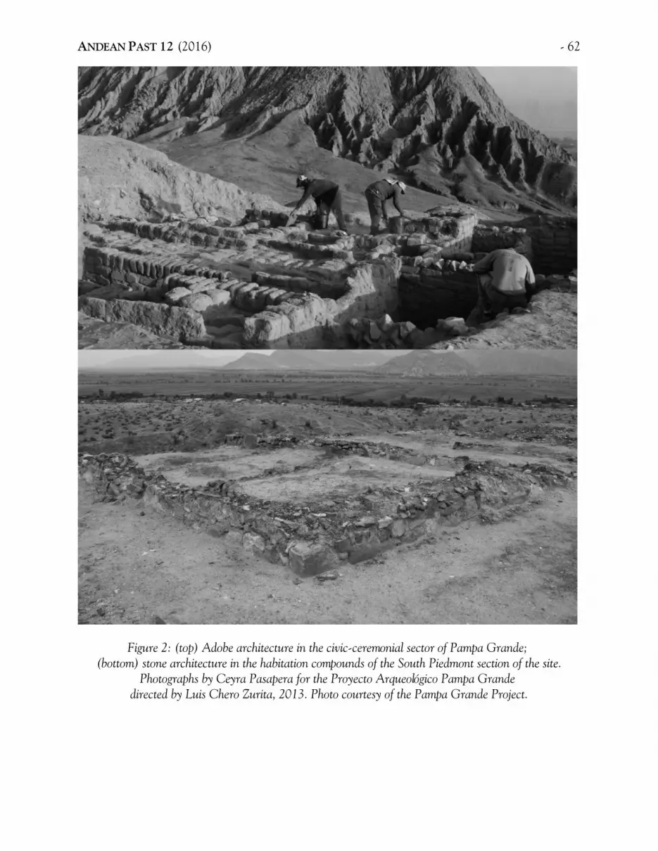
ANDEAN PAST 12 (2016) - 62
Figure 2: (top) Adobe architecture in the civic-ceremonial sector of Pampa Grande; (bottom) stone architecture in the habitation compounds of the South Piedmont section of the site.
Photographs by Ceyra Pasapera for the Proyecto Arqueológico Pampa Grande directed by Luis Chero Zurita, 2013. Photo courtesy of the Pampa Grande Project.

63 - Bracamonte: Tapia Walls at Santa Rosa de Pucalá
Figure 3: Late Moche buttresses built above a rubble cap on the inclined facade of the Middle Phaseadministrative pyramid at Sipán. Photograph courtesy of the Sipán Project.

ANDEAN PAST 12 (2016) - 64
Figure 4: Painted corridors, altars, and staircase found on the Funerary Platform of Sipán. Photograph courtesy of the Sipán Project.

65 - Bracamonte: Tapia Walls at Santa Rosa de Pucalá
Figure 5: Residential adobe compounds, Patio 1, Sipán. Photograph courtesy of the Sipán Project.
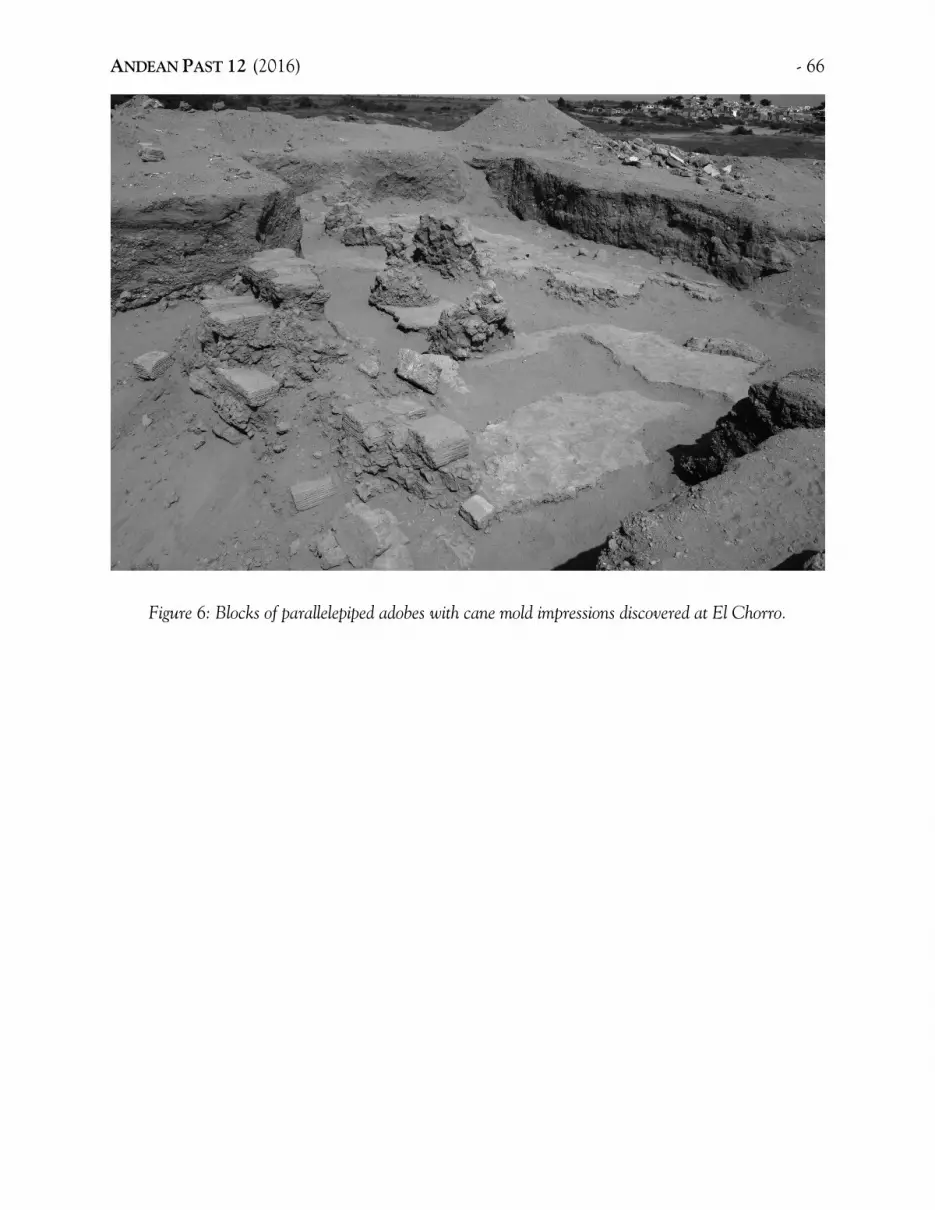
ANDEAN PAST 12 (2016) - 66
Figure 6: Blocks of parallelepiped adobes with cane mold impressions discovered at El Chorro.

67 - Bracamonte: Tapia Walls at Santa Rosa de Pucalá
Figure 7: Architectural compound made of dressed stone in the domestic area of Sector II of Sipán (fromBracamonte 2008: plate 9.1a).

ANDEAN PAST 12 (2016) - 68
Figure 8: Wall of the niches at Huaca Bandera (from Narváez 2011: figure 11).

69 - Bracamonte: Tapia Walls at Santa Rosa de Pucalá
Figure 9: Location of the Santa Rosa de Pucalá complex in the Lambayeque Valley.

ANDEAN PAST 12 (2016) - 70
Figure 10: Ceramic styles of Santa Rosa de Pucalá: (A) Formative; (B) Salinar; (C) Gallinazo;(D) Middle Mochica; (E)Mochica; (F) Mochica V; (G) Late Mochica; (H) Nievería; (I) Wari andWari-derivative styles; (J)Middle Cajamarca; (K) Impressed style; (L) Lambayeque; (M) Chimú;
(N) sherd from an Inca aryballos. Photographs courtesy of the Santa Rosa de Pucalá Project.

71 - Bracamonte: Tapia Walls at Santa Rosa de Pucalá
Figure 11: Sectors of the Santa Rosa de Pucalá complex (after a Google earth screenshot taken in 2013).
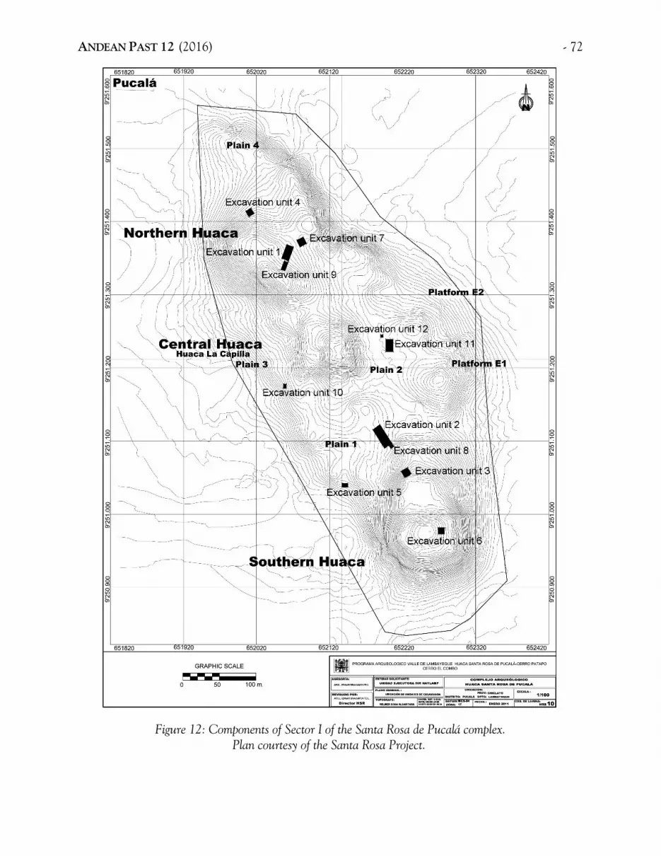
ANDEAN PAST 12 (2016) - 72
Figure 12: Components of Sector I of the Santa Rosa de Pucalá complex.Plan courtesy of the Santa Rosa Project.

73 - Bracamonte: Tapia Walls at Santa Rosa de Pucalá
Figure 13: Plain 2 to the east of the Huaca Central or Huaca La Capilla, Santa Rosa de Pucalá.The tapia architectural compound was found here (in Excavation Unit 11).
Photograph by Edgar Bracamonte for the Santa Rosa de Pucalá Project.

ANDEAN PAST 12 (2016) - 74
Figure 14: Layer 3 in Unit 11, the “layer of offerings” in which burials of camelids and Middle Horizontombs were found. Photograph by Edgar Bracamonte for the Santa Rosa de Pucalá Project.

75 - Bracamonte: Tapia Walls at Santa Rosa de Pucalá
Figure 15: Ceramic styles from Layers 5 and 6, Unit 11, Plain 2, Santa Rosa de Pucalá:(A) Cupisnique; (B) and (C) Gallinazo; (D) amd (E) Middle Mochica; (F) Nievería;
(G) Mochica tardío; (H) Horizonte Medio; (I)Cajamarca.Photographs courtesy of the Santa Rosa de Pucalá Project.

ANDEAN PAST 12 (2016) - 76
Figure 16: Ceramics from Layer 6, Unit 11, Plain 2, Santa Rosa de Pucalá: (A) Cupisnique; (B)Gallinazo; (C) Middle Moche olla; (D) Middle Mochica open vessels; (E) Late Mochica domestic vesselrims; (F) Late Mochica figure wearing a labret. Drawings courtesy of the Santa Rosa de Pucalá Project.

77 - Bracamonte: Tapia Walls at Santa Rosa de Pucalá
Figure 17: Layer 6, Unit 11. The tapia architectural compound was discovered in the upper part of thislayer, along with post impressions and hearths.
Photograph by Edgar Bracamonte for the Santa Rosa de Pucalá Project.

ANDEAN PAST 12 (2016) - 78
Figure 18: Remains of tapia walls identified in a huaquero pit in the South Huaca of the Santa Rosa de Pucalá complex.
Photograph by Edgar Bracamonte for the Santa Rosa de Pucalá Project.

79 - Bracamonte: Tapia Walls at Santa Rosa de Pucalá
Figure 19: Miniature cántaros found in the back-dirt from a huaquero pit dug into the South Huacaabove the tapia walls. Photograph by Edgar Bracamonte for the Santa Rosa de Pucalá Project.

ANDEAN PAST 12 (2016) - 80
Figure 20: Tomb 21 discovered in Unit 11. This is a Middle Horizon 2 secondary burial.Photograph by Edgar Bracamonte for the Santa Rosa de Pucalá Project.

81 - Bracamonte: Tapia Walls at Santa Rosa de Pucalá
Figure 21: Enclosures with niches and restricted access that are part of the tapia architectural compoundat Huaca Santa Rosa de Pucalá.
Photograph by Edgar Bracamonte for the Santa Rosa de Pucalá Project.

ANDEAN PAST 12 (2016) - 82
Figure 22: View of the tapia architectural compound found on Plain 2 at Huaca Santa Rosa de Pucalá.Photograph by Edgar Bracamonte for the Santa Rosa de Pucalá Project.

83 - Bracamonte: Tapia Walls at Santa Rosa de Pucalá
Figure 23: Plan of the tapia architectural compound, Plain 2, at Huaca Santa Rosa de Pucalá.

ANDEAN PAST 12 (2016) - 84
Figure 24: View from above of the tapia archaeological compound, Plain 2, Santa Rosa de Pucalá.

85 - Bracamonte: Tapia Walls at Santa Rosa de Pucalá
Figure 25: Construction phase 1, last construction phase of the tapia architectural complex at Santa Rosa de Pucalá.

ANDEAN PAST 12 (2016) - 86
Figure 26: Construction phase 2, penultimate construction phase of the tapia architectural complex at Santa Rosa de Pucalá.
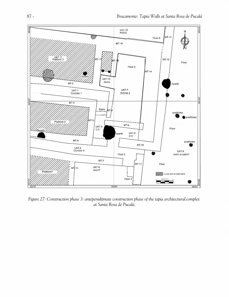
87 - Bracamonte: Tapia Walls at Santa Rosa de Pucalá
Figure 27: Construction phase 3: antepenultimate construction phase of the tapia architectural complex at Santa Rosa de Pucalá.

ANDEAN PAST 12 (2016) - 88
Figure 28: Access staircase of Corridor 1, second construction phase. Photograph by Edgar Bracamonte for the Santa Rosa de Pucalá Project.

89 - Bracamonte: Tapia Walls at Santa Rosa de Pucalá
Figure 29: Detail of the interior niche of Room 2, Phase 2.Photograph by Edgar Bracamonte for the Santa Rosa de Pucalá Project.

ANDEAN PAST 12 (2016) - 90
Figure 30: Reconstruction of the three building phases of the tapia compound at Santa Rosa de Pucaláthat have been discovered up to the present.
Drawing by César Piscoya, Santa Rosa de Pucalá Project.

91 - Bracamonte: Tapia Walls at Santa Rosa de Pucalá
Figure 31: Early Mochica architecture at the South Huaca.

ANDEAN PAST 12 (2016) - 92
Figure 32: Moche tomb discovered on Plain 1 of Santa Rosa de Pucalá that has the Sipán funerarypattern (body in extended position, lying on its back, and with the head towards the south).
Photograph by Edgar Bracamonte for the Santa Rosa de Pucalá Project.

93 - Bracamonte: Tapia Walls at Santa Rosa de Pucalá
Figure 33: Mochica domestic compound made of adobes. Here, sooted vessels, hearths, and impressionsof poles were found. Photograph by Edgar Bracamonte for the Santa Rosa de Pucalá Project.
Figure 34: Red and yellow, Middle Horizon painted mural, decorated with graffiti.Photograph and drawing by Edgar Bracamonte for the Santa Rosa de Pucalá Project.

ANDEAN PAST 12 (2016) - 94
Figure 35: Profile of a huaquero pit at the Huaca Bola de Oro–El Triunfo site where Early and MiddleMochica adobes have been identified. From Bracamonte et al. 2006: figure 3.

95 - Bracamonte: Tapia Walls at Santa Rosa de Pucalá
Figure 36: Offerings discovered in Tomb 21, Santa Rosa de Pucalá.(A) and (C) Post-Mochica; (B),(D), (E), and (G) Early Lambayeque; and (F) Wari.
Photograph courtesy of the Santa Rosa de Pucalá Project.

ANDEAN PAST 12 (2016) - 96
Figure 37: Radiocarbon date on material from Hearth 12, Santa Rosa de Pucalá.

97 - Bracamonte: Tapia Walls at Santa Rosa de Pucalá
Figure 38: Radiocarbon date on material from Hearth 2, Santa Rosa de Pucalá.

ANDEAN PAST 12 (2016) - 98
Figure 39: Proposed construction sequence of the Funerary Platform at Sipán.Drawing courtesy of the Sipán Project, 2013.

99 - Bracamonte: Tapia Walls at Santa Rosa de Pucalá
Figure 40: Tapia walls discovered at the architectural compound of Vegachayuq Moqo at Huari.Photograph courtesy of José Ochatoma.

ANDEAN PAST 12 (2016) - 100
Figure 41: Model of Mochica Divergent Developments in the middle Lambayeque Valley.Drawing by Bruno Alva after a concept by Edgar Bracamonte.

HEALTH AT THE EDGE OF THE WARI EMPIRE:AN ANALYSIS OF SKELETAL REMAINS FROM HATUN COTUYOC, HUARO, PERU
Sara L. JuengstAppalachian State University
andMaeve Skidmore
Southern Methodist University
INTRODUCTION
The expansion of states and empires affectsmore than politics and power relations across abroad area. This process also restructureshuman/environment interaction, bringing once-distinct populations into contact, introducingsocial hierarchies to new regions, putting under-utilized labor and land to use, and altering thescope of staple and exotic resources that peopleconsume and cultivate (Bray 2003; Dietler2010; Klaus et al. 2009; Tung 2003). All of thesefactors can impact individual and populationhealth in a variety of ways. For example, strictlyimposed social hierarchies may limit access todietary resources, putting certain segments of apopulation at greater risk for nutritionaldeficiencies, while diversified labor patterns maychange workloads, affecting overall wear andtear and stress levels. However, in situations ofloose political control, relative peace andcooperation with neighbors, and ability tomanage subsistence needs, populations may feellittle impact on their lives and maintain patternsof health and disease considered “normal”. Apopulation’s experience of politicalcircumstances can be thus reflected (at leastpartially) by the human skeleton, making bio-archaeological investigations a valuable avenueof inquiry into the impact of statecraft.
This paper investigates the impact of theexpansion of the Wari state, on the health ofpeople living at Hatun Cotuyoc, a Wari colonyin the Huaro Valley of the Cusco Region. Thissite was occupied by agriculturalist and possiblylow-level elite populations (discussed below)circa A.D. 700-1000. Based on the excavationand analysis of forty-one individuals from sixtombs and several domestic contexts at HatunCotuyoc, we asked if Wari colonists living in thevalley experienced health issues or violenttrauma related to state expansion. Our resultssuggest that health was adversely affected inseveral ways, particularly considering dentalhealth, infectious disease, and late childhoodmortality. However, violent interactions for thispopulation were infrequent overall.
WARI BACKGROUND
The Wari state formed in the AyacuchoValley of the Central Andes of Peru in the sixthcentury A.D. (Isbell and Schreiber 1978). Shortly following this (ca. A.D. 600-1000), theWari spread out from Ayacucho to colonizediverse and distant regions of Peru (Jennings2011:108-111; Schreiber 2004:241; Skidmore2014) (Figure 1). In some of these regions theWari state installed administrative centers andexerted political control over a local area (e.g.McEwan 1987, 1991; Nash 2002; Schreiber1992, 1999, 2004; Williams 2001). There is
ANDEAN PAST 12 (2016):101-131.

ANDEAN PAST 12 (2016) - 102
evidence that the Wari incorporated somepeoples and regions coercively (e.g. Schreiber1992), taking land away from local groups andreorganizing them so that they fell under Wariadministration. However, the Wari did notexact the same amount of control over allregions and peoples of Peru (e.g. Schreiber 1999;Topic and Topic 2000). Many regions werenever occupied by the Wari, or were occupiedless intensely, but the adoption of Wari styles ofmaterial culture indicate their regularinteraction with Wari people (e.g. Castillo 2012;Jennings 2006; Lau 2010). Wari hegemony maybe partially responsible for this phenomenon,but local groups also strove to attach themselvesin meaningful ways to the culture spread by thestate and its people (Jennings 2006). The Waritrajectory was a dynamic one; various lines ofevidence indicate that administrative focichanged and sometimes went unfulfilled(Jennings 2011:99-120; Schreiber 2001) andthat not all Wari colonization carried out acrossPeru may have been directly related toexpanding state administration (e.g. Owen 2010;Skidmore 2014:321-325).
Some of the best evidence of administrativecontrol implemented by the Wari in a colonysetting comes from the Cusco Region of Peru.Two of the largest Wari settlements abroad wereestablished there ca. A.D. 650, at Huaro andPikillacta (Figure 2) (Glowacki 2005:117; Skid-more 2014:158, 330-331). Each site wasamplified substantially over the 300-400 yearsthat it was occupied. Though these sites grew tobe large, and likely incorporated other localsettlements in their vicinity, creating a powerfuland perhaps metropolitan Wari outpost in theregion (McEwan 1987:59-61), it is important tokeep in mind that the Wari occupation of Cuscowas constructed over a long period of time. Forexample, it has been estimated that the massivecompound of Pikillacta was only one quarter ofits extant size for at least the first century (andperhaps two) of its occupation (McEwan 2005:
72; Skidmore 2014:176-178). Recent researchwithin Wari the settlement in Huaro hassimilarly highlighted how colonists settled ingradually, taking time to establish resource basesand organize community life (Skidmore 2014).
Of Wari settlements in the region, Piki-llacta is especially well-known, as it was thelargest and among the most impressive Wariadministrative complexes outside the heartlandand was built to follow a rigidly griddedarchitectural layout with walls towering two orthree stories (McEwan 1987). This complexaccom-modated Wari elite and ceremonialactivity (Glowacki 1996; McEwan 1991:118,1996), and may have also provided space forhousing and storage (McEwan 1987:51-54,1996:177). Few, if any, formal tombs have beenidentified at Pikillacta (cf. Bauer and Bauer1987; McEwan 1991:108-109; Verano 2005).
Huaro exhibits lesser degrees of settlementplanning, but also hosts ceremonial architectureand patio groups that probably served as eliteresidences, and perhaps had administrativefunctions (Glowacki 2002). Cemetery andresidential components of settlement are alsopresent in Huaro (ibid; Skidmore 2014; Zapata1997), offering an important opportunity toinvestigate the lifeways of Wari populations thatsettled in the region. Recent evaluation of thearchaeological record at Huaro indicates thatthis settlement does not follow Wari canons asclosely as the site of Pikillacta, with much of itsmaterial culture assuming localized, though stillWari-derived, styles (Skidmore 2014:184-202;280-312).
Settlements at Pikillacta and Huaro mayhave been important to the Wari for a variety ofreasons: to connect them to trading partnersand trade routes that brought importantresources from the south (e.g. minerals,camelids, coca, and other exotics) (Bauer2004:66; Bélisle 2011), to maintain a southern

103 - Juengst and Skidmore: Skeletal remains fron Hatun Cotuyoc
frontier with the Tiwanaku (McEwan 1987:68),to intensify production (agricultural andotherwise) for the Wari state (Schreiber 2001),and to provide opportunities for expandingpopulations to meet subsistence needs andcreate new civic arrangements (Covey et al.2013:550; Skidmore 2014:331-317). Throughtime, Wari settlements in the Cusco region tookon many of the characteristics of those in theheartland in terms of establishing similar modesof living, practices of daily life, agriculture andother production, and ritual and mortuarybehavior (Glowacki 2002; Skidmore 2014:280-309; Zapata 1997; cf. Leoni 2009; Milliken2006). Production of maize, a resource regularlyconsumed by Wari populations and one thatmay have served a special role in the productionof beer (Finucane 2009), was intensified in theregion (Bauer 2004:68), but at a smaller scalethan at other Wari colonies (cf. agriculturalterraces described by Schreiber 1992:149-152;Zegarra 2005).
We expect that as in other colony settings(e.g. Blanton 2003; Dietler 2010:157-182;Larsen et al. 1995), the people who establishednew Wari settlements in the region encounteredsome difficulties as they adapted to newenvironments, managed incipient and imperfectrisk-avoidance strategies, and navigatedsometimes hostile circumstances far beyond thesafety net offered by the heartland. Given thestrong administrative agenda of the Wari in theCusco region, people living in colonies therealso would have dealt with state demands forresources and labor. This paper investigateshuman skeletal remains from Hatun Cotuyoc, asector of the broader settlement in the HuaroValley, to evaluate how health of colonypopulations was affected by such factors. Also ofparticular interest for the Wari areconsiderations of how a proposed focus on maizeagriculture (e.g. Finucane 2009; Schreiber 2001)may have impacted local health. Recentresearch at Hatun Cotuyoc yielded a number of
tombs with human remains which wereevaluated for information regarding the healthof colony residents.
SITE BACKGROUND
Hatun Cotuyoc is located on the floor of theHuaro Valley, approximately 800 meters west ofthe center of the modern town (Figure 3).Calibrated radiocarbon dates place itsoccupation from circa A.D. 700-1000 (Skid-more 2014:330-332). Excavations at the site inthe 1990s by Mary Glowacki and Julinho Zapataidentified rustic architecture, utilitarian pottery,food refuse and artifacts used in its preparationand consumption, agricultural tools, and otherprosaic features. Glowacki (2002) posited thatthe site housed populations of Huaro whoworked in agriculture. One author of this paper,Skidmore, began additional research in 2010 tofurther elucidate the nature of settlement and tolook into the shape and experiences of daily lifeof the people who came to settle in the colony. Excavation and analysis of resultant materialculture by Skidmore have largely confirmed thepreliminary conclusions of Glowacki and Zapataand provide additional data on the domestic lifeof Wari agriculturalist populations in the Cuscoregion (see below). The study of the daily life ofpeople of different socioeconomic stationscomplements previous studies that havehighlighted Wari administration, ceremonialism,and the elite.
Excavations at Hatun Cotuyoc recoveredmaterial culture that is generally consistent withthat utilized in the Wari heartland. Residentialarchitecture consists of agglutinated multi-roomstructures associated with patio spaces, furniture(e.g. benches), and activity areas, especiallythose related to cooking and food processing.Artifacts associated with these contexts includelarge quantities of undecorated or crudelydecorated pottery, agricultural and huntingtools, and implements used in textile/garment

ANDEAN PAST 12 (2016) - 104
manufacture. Wari pottery was excavated at thesite, in addition to various local and foreignstyles (the latter in limited quantities). Floraland faunal remains, mostly food refuse, areubiquitous and include maize, beans, quinoa,and camelid and guinea pig remains. Severaltombs and domestic contexts yielded theremains of at least forty-one individuals; theirbones were analyzed by Juengst using standardsdescribed below.
The character of the tombs and the nearbyhouses provides a relative measure of expectedsocial status for the individuals interred. Thetombs at Hatun Cotuyoc are not exceptionallyelaborate when compared to contemporaneousones in the valley (cf. Glowacki 2002; Zapata1997), but variation in the embellishment ofgraves across the sample may indicate somestatus differences between individuals interredat the site (see below). However, structures andassociated toolkits and residues of activity in thevicinity of the tombs indicate that the peoplewho lived at Hatun Cotuyoc maintainedrelatively modest means overall. Residents likelyengaged in agriculture, complemented byperiodic craft production (Skidmore 2014:23-237).
BURIAL SAMPLE
The skeletal sample in this paper is a total offorty-one individuals excavated from six tombsand from architectural fill and trash contexts.Three tombs were relatively simple inpreparation, while another three showed moreelaboration in terms of construction, grave goodassociation, and number of interred individuals.The simple tombs were characterized by burialsin dug-out holes or in earthen fill, sometimeswith rocks lining or marking part of the grave.Two of these each contained the remains of asolitary and articulated individual, while thethird simple tomb was a secondary interment oftwo individuals. Some artifacts were found in
association with the three simple tombs, butnone were especially fine and they may havebeen part of the burial fill rather than itemsintentionally left as grave goods. All of thesimple burials were located below the floors ofrooms, or were in passageways.
The remaining tombs were more elaboratein terms of construction (Figure 4), the numberof individuals included, and the itemsaccompanying the deceased (Figure 5). Thesetombs were located within a small roundstructure. Two tombs were small, semi-subterranean, rectilinear chambers (with one totwo square meters of floor space in each, theirheights are unknown) built of stone and mudmortar, while the third was a circularsubterranean stone-lined cist (approximately0.85 meters in diameter and one meter deep).All of these tombs had been disturbed inantiquity, and at least one of them had beendisturbed more recently (discussed below).
Each of the more elaborate tombs containedbones of at least ten individuals. Because of thenumber of people in each tomb and thedisturbed nature of the remains, bodies mayhave been placed in the tombs over time, asopposed to during one burial event. In the Wariheartland, people frequently re-opened tombs tointer additional human remains, add andmanipulate offerings, or paint the bones of thedead in cinnabar (Cook 2004:159; Isbell 2004;Milliken 2006; Tung and Cook 2006). Evidencefor similar application of pigment to humanremains was identified within the elaboratetombs at Hatun Cotuyoc. However, disturbanceof these tombs in antiquity and recent timesprevents the reconstruction of the precisesequence of deposition for most individuals.Only one individual was found in primarycontext within the round structure. Thisindividual was fully articulated and buriedwithin one of the rectilinear chambers within a

105 - Juengst and Skidmore: Skeletal remains fron Hatun Cotuyoc
matrix that included the disarticulated remainsof several other people (Skidmore 2014).
The rectilinear chamber adjacent to theprimary burial and the cist tomb, also containeddisarticulated remains of numerous people. It ispossible that all of these tombs were disturbedaround the same time in antiquity (perhapsaround the time that the primary burial wasinterred), causing the co-mingled remains.However, because the small chambers areconsistent with Wari tombs from other parts ofPeru that contain multiple burials (cf. Isbell2004; Milliken 2006), Skidmore suggests thateach tomb (or perhaps other chambers nearbyyet to be excavated) would have containedmultiple individuals prior to their disturbance.
In comparisons of the burials excavated atHatun Cotuyoc, it is clear that more of aninvestment was made in the three tombs builtwithin the circular structure; not only are theyassociated with the construction of formal tombarchitecture, but they are also associated with afew exotic materials. This may indicate thatindividuals found within the more elaboratetombs maintained a higher socioeconomic statusthan individuals buried in simpler tombs.However, because of disturbance of all of themost elaborate tombs, it is difficult to parse outstatus distinctions between the individualsrepresented in the sample discussed below. Evenso, tomb architecture and associated finds arecomparatively modest if we consider them in thespectrum of tombs represented across the valleyand at Wari sites in general (Skidmore2014:303-307, 344-351; cf. Isbell 2004; Zapata1997). This indicates that the individualsevaluated in this study may represent a range ofstatus categories, but these probably do notinclude the highest elite of the local setting orbroader Wari society.
BIOARCHAEOLOGICAL METHODS
Because activity, disease, and diet can leaveindelible marks on the human skeleton, studyingburial remains is one important way toinvestigate daily life and health in the past(Buikstra 1977; Larsen 1995; Sofaer 2006).Lesions included in this study include porotichyperostosis, cribra orbitalia, periostealreactions, and osteomyelitis. Dentition wasobserved for evidence of dental cavities andabscesses. This selection of lesions allows forinvestigation of diet, infectious diseaseprevalence, and nutritional deficiencies inchildhood. Additionally, Juengst noted skeletaltrauma and osteoarthritis in order to investigateexperiences of violence and labor over the lifecourse.
It is important to note that in order formany skeletal lesions to form, the infection ornutritional problems must have been chronic, asbony reactions form fairly slowly. Acuteinfections or extreme nutritional stress maycause death prior to formation of diagnosticlesions, leaving them invisible in the bio-archaeological record (Wood et al. 1992).Acknowledging this, we recognize that ourinterpretations are limited in scope and misssome of the variety of health experiences atHatun Cotuyoc. We present evidence forsystemic stress, traumatic events, and patternsof labor as a preliminary step in identifyingoverall health status for this population.
Age and Sex
When possible, age was determined for eachindividual based on a number of dental andskeletal traits. Juengst scored dental eruptionand wear following methods in Buikstra andUbelaker (1994:49-53). When dentition was notavailable, Juengst estimated age based on cranialsuture closure, the appearance of the pubicsymphysis and fusion of the epiphyses of long

ANDEAN PAST 12 (2016) - 106
bones, all of which progressively change asindividuals get older (Brooks and Suchey 1990;Meindl and Lovejoy 1985; Suchey and Katz1986; Todd 1920, 1921).
The age categories used included fetus(prenatal), infant (0-2 years), young juvenile(3-6 years), older juvenile (7-15 years), youngadult (16-23 years), middle adult (24-40 years),and older adult (40+). When an age rangecould not be estimated or groups were lumpedfor analysis, Juengst used adult (over 15 years)and subadult (15 years and under). When anindividual’s age estimate crossed categories (i.e.an individual estimated to be 13-16 years old),they were included in the younger age group forconsistency. These age categories were selectedbecause they represent moments of significantbiological change over the life course whichoften have social consequences, such as weaningand puberty. Biological processes like weaningand puberty are often cross-culturally importantto social status as they reflect new periods ofindependence and a significant shift inrelationships between people (Halcrow andTayles 2011:336; Sofaer 2006, 2011).
Sex was estimated for each adult individualwhen cranial and pelvic elements were present.Juengst did not estimate sex for infant orjuvenile individuals as most reliable indicators ofsex develop during puberty. Pelvic and cranialtraits indicating sex were scored according tostandards in Buikstra and Ubelaker (1994:16-21) following methods developed by Bass(1987), Buikstra and Meilke (1985), and Pheni-ce (1969). Sex categories used includedindeterminate, probable female, female,probable male, and male (Buikstra andUbelaker 1994:21).
Dental Cavities and Abscesses
These dental indicators are generally linkedto diet. By assessing carious lesions (cavities)
and abscesses, it is possible to determine theamount of “stickiness” and grit present in thefood consumed. These factors can helpdetermine what was being processed and eaten.“Sticky” foods, such as maize, often adhere tothe enamel of teeth and lead to massive cariouslesions (Cucina et al. 2011; Hillson 2008:278;Larsen 1995). Chewing non-food items, such ascoca leaves, can also predispose dentition tocavities along the gumline (Indriati and Buikstra2001). If the pulp cavity of a tooth is exposed(either by caries or other pathologicalprocesses), bacteria can infiltrate thesurrounding bone and create an abscess (Hillson2008:284-285; Roberts and Manchester 2007:70). Importantly, neither of these processes(caries or abscess formation) is directly reflectiveof diet; both caries and abscess formation areaffected by a number of factors including oralmicro-flora and fauna, acidity, rate of salivaflow, and hormone levels (see Hillson 2008;Lukacs 2011; Lukacs and Largaespada 2006;Temple 2011). However, combining these datawith archaeological botanical remains and otherlines of evidence can help build a generalpicture of diet at the population level (Berryman2010; Hillson 2008:276-284; Larsen 1995;White et al. 2011:455).
Dental caries were recorded when dentinwas visible. Darkened spots of enamel were notconsidered cavities until the dentin was exposed(Cucina et al. 2011). Dental caries were scoredby location on tooth or tooth root, size of lesion,and depth of lesion (Buikstra and Ubelaker1994:55). Dental abscesses were recordedseparately from cavities, unless the edges of thecavity were still visible and obvious. Juengstnoted teeth lost antemortem in association withabscesses and cavities, but made no correctionfactors or assumptions about why teeth hadbeen lost (i.e. attributed tooth loss to caries)(Cucina et al. 2011). Aveolar resorbtion andhealing of abscesses and tooth loss were alsorecorded.

107 - Juengst and Skidmore: Skeletal remains fron Hatun Cotuyoc
Periosteal Reaction and Osteomyelitis
These nonspecific disease indicators allowinsight into adult health. Periosteal reactions(inflammation of the outer layer [periosteum] oflong bones) and osteomyelitis (infection andinflammation of the medullary cavity) signal thepresence of an infection or traumatic event(Roberts and Manchester 2007:172-174; Whiteet al. 2011:445-446). Relative healing, or lackthereof, can indicate the ability of the person torecover from these stressful events, therebyproviding a commentary upon overall individualhealth.
Juengst recorded periosteal reactions andosteomyelitis by skeletal element, location onelement, and extent of the lesion. Healing wasrecorded as fully healed (woven bone wasremodeled although defect was still notable),some healing (woven bone was partiallysmoothed but active areas were still observable),and active (no evidence for healing) (Buiskstraand Ubelaker 1994:118). Juengst additionallyrecorded osteomyelitis by obstruction of themarrow cavity (if observable) and the presenceof draining sinuses (ibid.:119).
Cribra Orbitalia and Porotic Hyperostosis
Periods of stress and nutrient deficiency inchildhood can have effects on the skeleton thatpersist into adulthood. Cribra orbitalia (CO)and porotic hyperostosis (PH) are lesions in theeye orbits and on the cranium, respectively, andcan co-occur or occur independently of oneanother. They are both generally considered tobe indicative of anemia or other nutritionaldeficiencies in childhood (Larsen 2002; Stuart-Macadam 1985, 1992; Walker et al. 2009;White et al. 2011:449) (although see Peckman2003 who found links between smallpox andPH). CO and PH can be caused by limitednutrition as well as by parasitic load, as anemicconditions can be brought on by either
insufficient diet or high levels of bodily parasites(Blom et al. 2005; Holland and O’Brien 1997;Kent 1986; Roberts and Manchester 2007:222-234; Stuart-Macadam 1992; Walker 1986).Evidence for healing of these lesions gives someindication of whether the dietary or parasiticstresses were relieved.
Porotic hyperostosis (PH) and cribraorbitalia (CO) were recorded by Juengstaccording to location and size of the defectfollowing standard methods in Buikstra andUbelaker (1994:120-121). Additionally, theselesions were observed for signs of healing,recorded as fully healed (smoothed bony surfacewithout remaining pits and remodeled diploicexpansion), some healing (some pits visible,diploie expanded), or active (no evidence forremodeling).
Osteoarthritis
Osteoarthritis (OA) is a complex disorderinvolving the accretion of bone surroundingskeletal joints and margins associated with lossof synovial cartilage on joint surfaces(Chamberlain 1994; Jurmain 1999; Larsen 1995,2002; White et al. 2011:441-443). Traditionally,these bony changes have been interpreted asmarkers of activity and occupation; recently,this has come under scrutiny as medical studiesshow that many variables impact this patho-physiological process. Human joints areamazingly efficient and often bear loadsthroughout the course of a lifetime withoutchange in friction. Individuals can also begenetically predisposed to OA, unrelated to thestress or repetition of their activities (Jurmain1999; Waldron 1994). However, observing OAon a population level eliminates some of theseindividual level factors and it is generallyaccepted that behavior and activity patternscontribute to the distribution and severity ofjoint disease, at least at the population level(Jurmain 1999; Larsen 1995, 2002; Roberts and

ANDEAN PAST 12 (2016) - 108
Manchester 2007:132-135, 143-144; White etal. 2011:441-443). Specifically, eburnation,caused by two bones coming into direct contactonce protective cartilage has been worn away, ishighly indicative of behavior, especially ofrepetitive motions (Chamberlain 1994; Jurmain1999). These degenerative changes can resultfrom repeated movements and physical bodilystresses over one’s lifetime. If the distribution ofOA is patterned across a population, it ispossible that this degenerative change is relatedto repetitive activity and workloads (Larsen2002; Roberts and Manchester 2007:143-144).
OA was recorded by joint surface and bydegree and extent of bony deformation. Inparticular, Juengst recorded lipping (bony spurdevelopment) as barely discernible, sharp,extensive, or full ankyloses or fusion of joint(especially on vertebrae). Eburnation wasrecorded by degree and extent of the polishingand labeled as barely discernible, polish only, orpolish with grooves (Buikstra and Ubelaker1994:122-123).
Trauma
Pre- or perimortem trauma representsinjuries that individuals sustained during lifefrom which they recovered or succumbed. Injuries can result from a variety of causes, suchas accidents, sporadic inter-personal conflict, orregular and routinized violence (Arkush andTung 2013; Martin and Frayer 1997; Tung2007; Walker 1997). Distinguishing betweenaccidental and intentional injury is importantbecause they reflect different experiences ofindividuals and populations. Intentional injuriesmay be caused by a range of behaviors, includingsocially sanctioned brutality (e.g. corporalpunishment, domestic assault, or ritualviolence) and those that are unwelcome andcome from outside sources (e.g. violenceassociated with warfare or raiding) (Arkush andTung 2013; Berryman and Haun 1996; Stone
2012; Walker 1997, 2001; Wheeler et al. 2013).A large sample of individuals that experiencetrauma can indicate intentionality in theirdelivery (Arkush and Tung 2013; Tung 2007;Walker 1997).
Location of trauma can indicate the type ofinteraction preceding the injury. Face-to-faceviolent conflicts are often reflected by traumaon the facial or frontal bones. Conversely,injuries sustained while fleeing or avoiding anattacker may more commonly occur on theposterior portion of the skull (Berryman andHaun 1996; Tung 2007; Walker 1997).Fractures of the distal ulna are often consideredto be defensive, as they can result from throwingup an arm to ward off a blow. Rib fractures areconsidered to result from interpersonal conflictas blows more commonly fall on the torso duringconflict. Finally, fractures of the hand bonesoften result from violence as hands are oftenused as weapons or defenses. While injuriessustained during violent conflict can be varied,this pattern of injuries on the cranium, ulnae,ribs, and hands have been shown to reliablyreflect incidents of interpersonal violence(Arkush and Tung 2013; Berryman and Haun1996; Martin and Frayer 1997; Tung 2007;Walker 1997, 2001).
Juengst observed the remains for evidence ofantemortem or perimortem trauma followingmethods described by Berryman and Haun(1996), Buikstra and Ubelaker (1994:119-120),and Walker (1997, 2001). Any trauma presenton cranial or postcranial elements was recordedand photographed. Fractures were described ascomplete or incomplete and any bonyremodeling was recorded as indicative of healingand timing of the injury. Healing was recordedas none (sharp fracture edges, no boneremodeling), partial (some new bone growthevident), or fully healed (extensive remodeling).

109 - Juengst and Skidmore: Skeletal remains fron Hatun Cotuyoc
RESULTS
Age
Twenty-three (56.1%) of forty-oneindividuals of the population were subadults,and the remaining eighteen individuals (43.9%)were adults. Amongst the subadults, there wasone fetus, six infants (0-2 years), seven youngjuveniles (3-6 years), and nine older juveniles(7-15 years). Amongst the adults, five wererecorded as young adults (16-23 years), elevenas middle adults (24-40 years), and two as olderadults (above forty years) (Table 1).
Age Category
Total Observed
Caries/Abscess
PH/CO Perio/Osteo
OA Trauma
Fetus 1 0 0 0 0 0
Infant 6 0 2(33.3%)
1(16.7%)
0 0
YoungJuvenile
7 2(28.6%)
0 1(14.3%)
0 0
Older Juvenile
9 0 0 2(22.2%)
0 0
Young Adult
5 3 (60%)
0 2 (40%)
0 1 (20%)
Middle Adult
11 7(62.7%)
0 4(36%)
2 (18%)
0
Older Adult
2 0 0 0 2(100%)
0
Totals 41 12(29.3%)
2 (4.9%)
10(24.4%)
4 (9.8%)
1 (2.5%)
Table 1. Frequency and percent of age groups with pathologyat Hatun Cotuyoc
Sex
Sex was estimated for 55.6 percent (10/18)of the adult remains (Figure 6). There were twofemales, two probable females, one male, andfive probable males. There were eight adults ofindeterminate sex. Although sex could only beestimated with certainty for about half of thepopulation, a fairly even sex distribution wasnoted.
Pathology
This skeletal sample included manyindividuals with pathology (Table 1). Dentalcavities were most common, with twelve
individuals (29.3% of observable individuals)presenting at least one cavity (Figure 8) and atotal of eighteen (10.1%) of 179 teeth affected.Seven of these individuals had more than onecarious lesion, although this is not especiallysurprising given that having a cavity willpredispose the surrounding teeth to caries(Gagnon and Weisen 2013; Hillson 2008:269).Notably, two individuals with cavities on firstmolars were around seven years of age. The firstadult molar erupts around age six, indicatingthese teeth must have been aggressively exposedto factors leading to cavity formation. All of thecarious lesions noted were on the occlusal(chewing) surfaces of premolars and molars.Two cavities were associated with severe dentalabscesses as well (Figure 9).
Thirty-two (78%) of forty-one individualswere observable for periosteal reactions andosteomyelitis. Of these, nine (28.1%) had per-iosteal reactions and one (3.1%) had osteo-myelitis (Table 1). Three affected individualswere under the age of ten, three were between14 and 23 years old, and four affected adultsaged 24-40 years. Femora were the mostcommonly affected bones (21.9% or 7/32femora), followed by tibiae (15.6% or 5/32) andhumeri (6.3% or 3/32) (Figure 10). Mostinfections (77.8% or 7/9) were active at the timeof death. Commingling of remains made itdifficult to observe if these lesions were bilateralor systemic for most individuals; however, twowell-preserved individuals both presentedbilateral periosteal lesions.
Twenty-four individuals had sufficientlypreserved crania and eye orbits to observe forPH and CO. Two (8.3%) of these twenty-fourpresented lesions (Figure 11). One infantaround three months old had active PH lesionson the cranial vault, while another infant,between six months and one year old, hadactive PH and CO lesions, on the parietals andeye orbits respectively. No adults showed

ANDEAN PAST 12 (2016) - 110
evidence for healed lesions from childhood,although mild cases may have become invisibleover time.
The eighteen adult individuals included inthis sample were observable for osteoarthritis;adults are most likely to accurately reflect OA,given that juvenile bones actively grow andcontinually remodel. Four (22%) of eighteenadults experienced OA (Figure 12). Two of theindividuals with severe OA were likely over 40years old, which is a somewhat normal result ofa lifetime of activity. However, the other two afflicted individuals were in a younger agecategory (24-40 years) and thus the OA heremay represent patterns of labor. The mostcommonly affected areas were bodies of lowerthoracic and lumbar vertebrae and joint surfacessurrounding hips and knees.
Trauma
Evidence for trauma was limited in thisskeletal sample. One male individual had twoantemortem wounds on the cranium (Figure13). One sharp force trauma on the rightparietal was almost entirely healed, withremodeling (Figure 14). The other blunt forcetrauma was also in the process of healing, higheron the right parietal (Figure 15). This woundhad not completely healed, either indicating alater time of injury or a higher severity of injury.Likely these injuries happened within monthsprior to death. This individual was buried face-down within the fill of the disturbed rectilinearburial chamber (described above), a pattern thatis not typical for the Wari, or for peopleindigenous to the region. This suggests thecircumstances surrounding his death wereabnormal and/or that he may have been buriedhastily and/or have been considered an outsiderby those who interred his body. As with indicesof pathologies, a lack of complete skeletons may
limit our ability to observe skeletal trauma inother individuals whose remains were excavatedat Hatun Cotuyoc.
DISCUSSION
From these results, we identify a few keypatterns. First, childhood seems to have been adifficult time. The largest age group representedin this sample was adults ages twenty-four toforty, but was closely followed by children agednine to fourteen years old. Young children andinfants often compose a large portion of burialpopulations as they struggle to combatmalnutrition after weaning and early childhooddiseases. Older children tend to be heartier andmore resilient. While the dearth of infant andyoung juvenile remains may reflect issues ofpreservation and taphonomy, it is interestingthat the older juvenile age category is so well-represented. Perhaps late childhood was a timeof higher exposure to pathogens or labordemands, resulting in increased death rates.Alternatively, it is possible that this reflectshigher birth rates for this age cohort;environmental or social factors may haveallowed for high fertility for their mothers(Buikstra et al. 1986; Klaus and Tam 2010;Wood et al. 1992). However, given that somejuvenile individuals did have skeletal stressmarkers, it seems likely that mortality frompathogens or systemic stress played an importantrole.
Indicators of systemic infection were presentin an active state on several children. Thissuggests two things: first, some children wereable to combat disease long enough to developskeletal lesions and second, recovery from thesedisease episodes (as shown by evidence ofhealing or lack thereof) was not common.Individuals without skeletal lesions may havesuccumbed to acute infection before lesionscould be formed and thus cannot be identifiedby this study. However, the low numbers of

111 - Juengst and Skidmore: Skeletal remains fron Hatun Cotuyoc
healed lesions overall indicates that fewindividuals fully recovered from chronicinfections, especially during childhood.
Young and middle-aged adults also dealtwith infectious disease regularly. In fact, thirtypercent (6/18) of adults had periosteal reactionson at least one long bone. Only one of theseinfections seemed to be trauma-related. Like thelesions noted on juvenile remains, adult lesionsreflect chronic illness or extended exposure topathogens, in order to create prolonged peri-osteal reactions, both active and healed. Alsolike the juvenile populations, most adults didnot fully recover from their infections, with onlytwo individuals showing evidence of healing.
Nutritional insults were relatively rare forthe entire population. Only two individuals(8.3% of the observable population) had lesionsassociated with nutritional deficiency. Both ofthese individuals were infants. Studies at otherWari sites have found generally higher rates ofCO and PH: forty percent of juveniles andtwenty-three percent of adults at Beringia andtwenty-two percent of adults at La Realexhibited these lesions (Tung and Del Castillo2005). Because these lesions form duringchildhood, it is not surprising that morejuveniles would present observable lesionsbecause lesions may heal entirely or be maskedby taphonomic changes to adult crania.However, even just comparing juvenile remains,the rates of CO/PH at Hatun Cotuyoc werelower than at other Wari sites.
At Hatun Cotuyoc, 24.4% of individuals and10.1% of teeth were affected by caries. Whiledental cavities result from a variety of causes,there is supporting evidence for dietary causes atthis site. First, young children developed severecavities in newly erupted teeth. This means thatwhatever was causing caries was present in theoral environment early in life and was notcaused by age, hormonal changes of puberty or
pregnancy, or activity. Secondly, cavitiesdeveloped primarily on the occlusal surface ofteeth, rather than close to the root or gum line.This indicates a dietary cause, rather than cocachewing, a common factor for caries in theAndes. Coca use tends to cause cavities on thebuccal side of teeth near the gum line where thewad of coca is usually held (Indriati andBuikstra 2001). However, because Huarocavities are located on the chewing surfaces ofteeth, coca is probably not the cause here.Finally, all age and sex categories were impactedby caries, indicating that other factors likehormones or saliva flow may not have been adriving force. Consumption of a cariogenic food,such as maize, is a better explanation for cavitiesamongst the Huaro burial population.
Studies from other sites under Wari controlor influence have found variable caries rateslinked to maize consumption. Buzon et al.(2012) found evidence for caries and dentalabscesses in the Nazca area and, combined withstable isotope analysis, interpreted these resultsas indicative of at least slightly increased maizeconsumption under Wari influence. In theMajes Valley of southern Peru, Tung and DelCastillo (2005) found extremely elevated ratesof caries with 56% of juveniles and 44% ofadults displaying carious lesions at one Warisite, Beringia. In the same valley, at the site LaReal, Tung and Del Castillo (ibid.) found acomparatively low rate of caries with 10.5% ofindividuals affected. These different caries rateshave several implications. First, the extremelyhigh rate of caries at Beringia is likely linked tothe Wari emphasis on maize production. Thelower status individuals cultivating maize at thissite may have been consuming a lot of thiscariogenic food, resulting in their high rate ofcarious lesions (ibid.). Comparatively, the lowerrate of caries at La Real and only slight increaseof caries at Nazca may reflect a more diversifieddiet associated with upper class individuals(Buzon et al. 2012; Tung and Del Castillo 2005).

ANDEAN PAST 12 (2016) - 112
Stable isotope analysis from Nazca by Kellnerand Schoeninger (2008) support thisinterpretation: Wari presence in Nazca wasfocused on status rather than maize extraction,resulting in relatively diverse diets for local Wariand native populations.
Caries at Hatun Cotuyoc fall between theseother Wari sites, with 24.4% of people and 10%of teeth affected. Perhaps this reflects a mixedstatus population, as suggested by the diversetomb types. Some individuals may have beenprotected from carious lesions by having morediverse diets while others relied more heavily onmaize, resulting in more lesions. Unfortunately,because so many remains were commingledwithin and between tombs, it is difficult to saywhether caries and tomb status were directlyrelated.
Osteoarthritis in this population was notextremely severe, affecting only four individuals.Preservation may be an issue here. While longbone shafts were commonly preserved, epiphysesand joint surfaces (where OA most commonlyoccurs) were not well-preserved and often notpresent. The OA that was observable suggests apattern of labor focused on the lower back, hip,and knee joints. Lower back arthritis is commonamongst pre-industrial populations (and modernones) due to progressive degeneration of theintervertebral cartilaginous discs (Bridges 1992;White et al. 2011:441-443). This degenerationcan be exacerbated by carrying heavy loads andactivities that include repeated bending at thewaist. Hip and knee arthritis indicates a laboringadult population, possibly in the realm ofagricultural production, although manyexplanations are certainly possible. Becker(2013) notes that maize agriculturalists in theMoguequa Valley, laboring under the influenceof the Tiwanaku states, had greatly increasedOA on the sacroiliac joint as well as high rateson the knee. This is similar to the pattern of OAat Hatun Cotuyoc, despite our minimal sample.
The relative lack of trauma at HatunCotuyoc contrasts with Tung’s findings in boththe Wari heartland and in the Arequipa region,where trauma (especially to crania) was fre-quently observed for both males and females(Arkush and Tung 2013; Kurin 2013; Tung2003, 2007, 2012). At least some of this traumawas interpreted as the result of inter-personalviolence. It is possible that the one instance ofcranial trauma from Hatun Cotuyoc wassustained by accident or by socially sanctionedviolence; however, the location and severity ofthe injuries are also consistent with receivingblows from an attacker. One wound had notcompletely healed at the time of death, eitherindicating a later time of injury or a higherseverity of injury. Given the unorthodox burialposition of this individual and his injuries, it istempting to say that this person representedsome sort of community outcast or warfarecaptive who was eventually killed. However, noevidence of perimortem trauma was found. Itmay be more likely that this individual died ofcomplications from his cranial injuries.
CONCLUSION
Overall, the population at Hatun Cotuyocstruggled with infectious disease while theymaintained relatively good nutrition, managedstrenuous labor, and experienced little violence.Unlike other areas of the Wari state that werehighly maize-focused, diet at Hatun Cotuyocwas varied, protecting some individuals fromcarious lesions and maintaining good nutritionfor all age groups. Wari colonists and localpeople living at Huaro may have grown maizefor export to the state capital and likelyconsumed maize on a semi-regular basis.However, they were not reliant on this resource;the lushness of the Huaro Valley seems to haveallowed for dietary diversity that insulated thispopulation from the nutritional stress and highrates of caries noted at other colonial Wari sites.

113 - Juengst and Skidmore: Skeletal remains fron Hatun Cotuyoc
Pathogens were an issue for the population,with many individuals, young and old, sufferingfrom, and succumbing to, infectious disease.Circulation of pathogens is often associated withhigh population densities and populationnucleation (Barrett et al. 1998). Perhaps Wariinfluence in the Huaro Valley drew people intolarge, centralized communities, promoting andsustaining the transmission of disease. If peoplehad previously lived in dispersed hamlets, livingin the Wari state’s colony may have decreasedthe health of these individuals.
Exactly how Hatun Cotuyoc peopleinteracted with those of other local Wari sitessuch as Pikillacta and the Wari heartlandremains unclear. Exchange with these otherpopulations may have been central tomaintaining a healthy diet; Wari colonists andother people living at Hatun Cotuyoc couldtrade locally grown maize for other foodstuffseither imported to the administrative centerPikillacta or produced there. Interaction withPikillacta and the heartland may have alsoexposed the Hatun Cotuyoc populations todisease, and vice versa, as people movedthemselves and their pathogens across thelandscape.
Overall, people living at Hatun Cotuyocshared many aspects of their lives with otherpeople living throughout the Wari state.Extractive colony strategies, which creatednucleated settlements and promoted maizeconsumption, impacted these populations inseveral notable ways: maintenance of circulatingdiseases, predictable patterns of labor andosteoarthritis, and regular presence of dentalcavities, even in very young individuals. Thispattern is reflected at other Wari sitesthroughout the state, to varying degrees. Whilewe cannot say that people living in the HuaroValley prior to Wari influence did notexperience these issues as well, it is clear theWari food values were shared and maintained at
Hatun Cotuyoc. Future research in the form ofstable isotope studies of diet and mobility andcontinued excavation will help identify theextent of maize consumption, social inequalitiesbetween individuals, and whether thispopulation was composed of relocated Waricitizens or local residents.
ACKNOWLEDGEMENTS
Analysis of skeletal material from Hatun Cotuyoc wasfunded by the Research Laboratories of Archaeology atthe University of North Carolina at Chapel Hill.Excavation at Hatun Cotuyoc was funded by the NationalScience Foundation (BCS-1127310) and by the Institutefor the Study of Earth and Man, Dedman College, and theDepartment of Anthropology at Southern MethodistUniversity. We wish to extend thanks to Marlene CastroFabre, R. Alan Covey, Brittany Fullen, Mary Glowacki,Sarah Kennedy, Yiling Lin, William “Buzz” Nanavati,Cam Tu Nguyen, Stephanie Pierce Terry, Kylie Quave,and Arturo Rivera Infante for the assistance they providedthe Hatun Cotuyoc Archaeological Project. We are alsograteful to the community of Huaro for hosting theresearch team over the past few years, especially LuzMarina Amanca, Julian Huarcaya, Ruth María Llollce,and Marcelino Ttupa. Thanks to María Farfán, TeodoroPillaka, and their families for allowing excavations in theirlands. We are grateful to our reviewers for their feedbackand advice which contributed greatly to this article.
REFERENCES CITED
Arkush, Elizabeth and Tiffiny A. Tung2013 Patterns of War in the Andes from the Archaic
to the Late Horizon: Insights from SettlementPatterns and Cranial Trauma. Journal of Archaeo-logical Research 21(4):307-369.
Barrett, Ronald, Christopher W. Kuzawa, ThomasMcDade, and George J. Armelagos1998 Emerging and Re-emerging Infectious Diseases:
The 3rd Epidemiologic Transition. AnnualReview of Anthropology 27:247-271.
Bass, William M. 1987 Human Osteology: A Laboratory and Field Manual
of the Human Skeleton, fourth edition. Columbia,Missouri: Missouri Archaeological Society.
Bauer, Brian S.2004 Ancient Cuzco: Heartland of the Inca. Austin:
University of Texas Press.Bauer, Thomas W. and Brian S. Bauer1987 Selected Aspects of Skulls Found by the
Pikillacta Archaeological Project 1982,

ANDEAN PAST 12 (2016) - 114
Appendix II. In The Middle Horizon in theValley of Cuzco, Peru: The Impact of the WariOccupation of the Lucre Basin, by Gordon F.McEwan, pp. 90-95. Oxford: BARInternational Series 372.
Becker, Sara K.2013 Labor and the Rise of the Tiwanaku State (AD 500-
1100): A Bioarchaeological Study of ActivityPatterns. Ph.D. dissertation, University of NorthCarolina, Chapel Hill.
Bélisle, Véronique2011 Ak’awillay: Wari State Expansion and Household
Change in Cusco, Peru (AD 600-1000). Ph.D.dissertation, University of Michigan.
Berryman, Carrie Anne 2010 Food, Feasts, and the Construction of Identity and
Power in Ancient Tiwanaku: A BioarchaeologicalPerspective. Ph.D. dissertation, VanderbiltUniversity.
Berryman, Hugh E. and Susan Jones Huan 1996 Applying Forensic Techniques to Interpret
Cranial Fracture Patterns in an ArchaeologicalSpecimen. International Journal of Osteo-archaeology 6(1):2-9.
Blanton, Dennis2003 The Weather Is Fine, Wish You Were Here,
Because I’m the Last One Alive: “Learning” theEnvironment in the English New WorldColonies. In Colonization of UnfamiliarLandscapes: The Archaeology of Adaptation, editedby Marcy Rockman and James Steele, pp. 190-200. London: Routledge.
Blom, Deborah E., Jane E. Buikstra, Linda Keng, Paula D.Tomczak, Eleanor Shoreman, and Debbie Stevens-Tuttle2005 Anemia and Childhood Mortality: Latitudinal
Patterning along the Coast of Pre-ColumbianPeru. American Journal of Physical Anthropology,127:(2)152-169.
Bray, Tamara2003 The Archaeology and Politics of Food and Feasting
in Early States and Empires. New York: KluwerScientific & Plenum Press.
Bridges, Patricia S. 1992 Prehistoric Arthritis in the Americas. Annual
Review of Anthropology 21:67-91.Brooks, Sheilagh Thompson and Judy Myers Suchey1990 Skeletal Age Determination Based on the Os
Pubis: A Comparison of the Acsádi-Nemeskériand Suchey-Brooks Methods. Human Evolution5(3):227-238.
Buikstra, Jane E. 1977 Biocultural Dimensions of Archaeological Study:
A Regional Perspective. In Biocultural Adaptationin Prehistoric America, edited by Robert L.Blakely, pp. 67-84. Athens: University of
Georgia Press.Buikstra, Jane E., Lyle W. Konigsberg, and Jill Bullington1986 Archaeology, Fertility, and the Development of
Agriculture in the Prehistoric Midwest. AmericanAntiquity 21(3):528-546.
Buikstra, Jane E. and James H. Meilke1985 Demography, Diet, and Health. In The Analysis
of Prehistoric Diets, edited by Robert I. Gilbert Jr.and James H. Mielke, pp 359-422. New York:Academic Press.
Buikstra, Jane E and Douglas H. Ubelaker, editors 1994 Standards for Data Collection from Human Skeletal
Remains. Fayetteville: Arkansas ArcheologicalSurvey.
Buzon, Michele R., Christina A. Conlee, Antonio Si-monetti, and Gabriel J. Bowen 2012 The Consequences of Wari Contact in the
Nasca Region during the Middle Horizon:Archaeological, Skeletal, and Isotopic Evidence. Journal of Archaeological Science 56(8):2637-2636.
Castillo Butters, Luis Jaime2012 Looking at the Wari Empire from the Outside
In. In Wari: Lords of the Ancient Andes, edited bySusan Bergh, pp. 47-61. New York: Thames andHudson.
Chamberlain, Andrew T.1994 Human Remains. Berkeley and Los Angeles:
University of California Press and London:British Museum.
Cook, Anita 2004 Wari Art and Society. In Andean Archaeology,
edited by Helaine Silverman, pp. 146-166. Mal-den, Massachusetts: Blackwell Publishing.
Covey, R. Alan, Brian S. Bauer, Véronique Bélisle, andLia Tsesmeli2013 Regional Perspectives on Wari State Influence in
Cusco, Peru (c. AD 600–1000). Journal ofAnthropological Archaeology, 32(4):538.
Cucina, Andrea, Cristina Perera Cantillo, Thelma SierraSosa, and Vera Tiesler2011 Carious Lesions and Maize Consumption among
the Prehispanic Maya: An Analysis of a CoastalCommunity in Northern Yucatan. AmericanJournal of Physical Anthropology 145(4):560-567.
Dietler, Michael2010 Archaeologies of Colonialism: Consumption,
Entanglement, and Violence in AncientMediterranean France. Berkeley: University ofCalifornia Press.
Finucane, Brian2009 Maize and Sociopolitical Complexity in the
Ayacucho Valley, Peru. Current Anthropology50(4):535-545.
Gagnon, Celeste M. and Chris Wiesen

115 - Juengst and Skidmore: Skeletal remains fron Hatun Cotuyoc
2013 Using General Estimating Equations to AnalyzeOral Health in the Moche Valley of Perú.International Journal of Osteoarchaeology23(5):557-572.
Glowacki, Mary1996 The Wari Occupation of the Southern Highlands of
Peru: A Ceramic Perspective from the Site of Piki-llacta. Ph.D. dissertation, University ofMassachusetts.
2002 The Huaro Archaeological Site Complex:Rethinking the Huari Occupation of Cuzco. InAndean Archaeology I: Variations of SociopoliticalOrganization, edited by William H. Isbell andHelaine Silverman, pp. 267-285. New York:Kluwer Academic.
2005 Dating Pikillacta. In Pikillacta: The Wari Empirein Cusco, edited by Gordon McEwan, pp. 115-124. Iowa City: University of Iowa Press.
Halcrow, Siân E. and Nancy Tayles 2011 The Bioarchaeological Investigation of Children
and Childhood. In Social Bioarchaeology, editedby Sabrina C. Agarwal and Bonnie A. Glencross,pp. 333-360. Oxford: Wiley-Blackwell.
Hillson, Simon2008 Dental Pathology. In Biological Anthropology of
the Human Skeleton, second edition, edited byMary Anne Katzenberg and Shelley RaeSaunders. New Jersey: John Wiley & Sons, Inc.
Holland, Thomas D. and Michael J. O’Brien 1997 Parasites, Porotic Hyperostosis, and the
Implications of Changing Perspectives. AmericanAntiquity 62(2):183-193.
Indriati, Etty and Jane E. Buikstra2001 Coca Chewing in Prehistoric Coastal Peru:
Dental Evidence. American Journal of PhysicalAnthropology 114(3):242-257.
Isbell, William H.2004 Mortuary Preferences: A Wari Culture Case
Study from Middle Horizon Peru. Latin AmericanAntiquity 15(1):3-32.
Isbell, William H. and Katharina J. Schreiber1978 Was Huari a State? American Antiquity
43(3):372-389.Jennings, Justin2006 Core, Peripheries, and Regional Realities in
Middle Horizon Peru. Journal of AnthropologicalArchaeology 25(3):346-370.
2011 Globalizations and the Ancient World. New York:Cambridge University Press.
Jurmain, Robert 1999 Stories from the Skeleton: Behavioral Reconstruction
in Human Osteology. Amsterdam: Gordon andBreach.
Kellner, Corina M. and Margaret J. Schoeninger2008 Wari’s Imperial Influence on Local Nasca Diet:
The Stable Isotope Evidence. Journal ofAnthropological Archaeology 27(2):226-243.
Kent, Susan 1986 The Influence of Sedentism and Aggregation on
Porotic Hyperostosis and Anaemia: A CaseStudy. Man 21(4):605-636.
Klaus, Haagen D., Clark Spencer Larsen, and Manuel E.Tam2009 Economic Intensification and Degenerative Joint
Disease: Life and Labor on the PostcontactNorth Coast of Peru. American Journal of PhysicalAnthropology, 139(2):204-221.
Klaus, Haagen D. and Manuel E. Tam 2010 Oral Health and the Postcontact Adaptive
Transition: A Contextual Reconstruction of Dietin Mórrope, Peru. American Journal of PhysicalAnthropology 141(4):594-609.
Kurin, Danielle S. 2013 Trepanation in South-Central Peru during the
Early Late Intermediate Period (ca. AD 1000-1250). American Journal of Physical Anthropology152(4):484-494.
Larsen, Clark Spencer 1995 Biological Changes in Human Populations with
Agriculture. Annual Review of Anthropology24:185-213.
2002 Bare Bones Archaeology: The Bioarchaeology ofHuman Remains. In Archaeology: OriginalReadings in Method and Practice, edited by PeterN. Peregrine, Carol R. Ember, and MelvinEmber. Upper Saddle River, New Jersey:Prentice Hall.
Larsen, Clark Spencer, Joseph Craig, Leslie E. Sering,Margaret J. Schoeninger, Katherine F. Russell, Dale L.Hutchinson, and Matthew A. Williamson1995 Cross Homestead: Life and Death on the
Midwestern Frontier. In Bodies of Evidence:Reconstructing History through Skeletal Analysis,edited by Anne L. Grauer, pp. 139-160. NewYork: Wiley-Liss.
Lau, George 2010 Ancient Community and Economy at Chinchawas
(Ancash, Peru). New Haven, Connecticut: YaleUniversity Department of Anthropology and theYale Peabody Museum of Natural History.
Leoni, Juan B. 2009 Archaeological Investigations at Ñawinpukyo:
Change and Continuity in an Early IntermediatePeriod and Middle Horizon Community in Aya-cucho, Peru. Oxford: BAR International Series1991.
Lukacs, John R.2011 Gender Differences in Oral Health in South
Asia: Metadata Imply Multifactorial Biologicaland Cultural Causes. American Journal of Human

ANDEAN PAST 12 (2016) - 116
Biology 23:398-411.Lukacs, John R. and Leah L. Largaespada2006 Explaining Sex Differences in Dental Caries
Prevalence: Saliva, Hormones, and “Life-History” Etiologies. American Journal of HumanBiology 18(4):540-555.
Martin, Debra L. and David W. Frayer1997 Troubled Times: Violence and Warfare in the Past.
Amsterdam: Gordan and Breach Publishers.McEwan, Gordon F.1987 The Middle Horizon in the Valley of Cuzco, Peru:
The Impact of the Wari Occupation of the LucreBasin. Oxford: BAR International Series 372.
1991 Investigations at the Pikillacta Site: A ProvincialHuari Center in the Valley of Cuzco. In HuariAdministrative Structure: Prehistoric MonumentalArchitecture and State Government, edited byWilliam H. Isbell and Gordon F. McEwan, pp.93-119. Washington, D.C.: Dumbarton OaksResearch Library and Collection.
1996 Archaeological Investigations in Pikillacta, aWari Site in Peru. Journal of Field Archaeology23(2):169-186.
2005 Pikillacta Architecture and Construction Re-quirements. In Pikillacta: The Wari Empire inCuzco, edited by Gordon F. McEwan, pp. 63-84.Iowa City: University of Iowa Press.
Meindl, Richard S. and C. Owen Lovejoy1985 Ectocranial Suture Closure: A Revised Method
for the Determination of Skeletal Age at DeathBased on the Lateral-Anterior Sutures. AmericanJournal of Physical Anthropology 68(1):57-66.
Milliken, Charlene D.2006 Ritual and Status: Mortuary Display at the
Household Level at the Middle Horizon Wari Site ofConchopata, Peru. Ph.D. dissertation, Universityof Pittsburgh, Pittsburgh, Pennsylvania.
Nash, Donna J.2002 The Archaeology of Space: Places of Power in the
Wari Empire. Ph.D. dissertation, University ofFlorida, Gainesville.
Owen, Bruce2010 Wari in the Majes-Camaná Valley: A Different
Kind of Horizon. In Beyond Wari Walls: RegionalPerspectives on Middle Horizon Peru, edited byJustin Jennings, pp. 57-77. Albuquerque:University of New Mexico Press.
Peckman, Tanya R.2003 Possible Relationship between Porotic Hyper-
ostosis and Smallpox Infections in Nineteenth-Century Populations in the Northern Frontier,South Africa. World Archaeology 35(2):289-305.
Phenice, Terrell1969 A Newly Developed Visual Method of Sexing
the Os Pubis. American Journal of Physical
Anthropology 30(2):297-301.Roberts, Charlotte and Keith Manchester 2007 The Archaeology of Disease, third edition. Ithaca,
New York: Cornell University Press.Schreiber, Katharina J.1992 Wari Imperialism in Middle Horizon Peru.
Foreword by Jeffrey R. Parsons. AnthropologicalPapers, Museum of Anthropology, University ofMichigan 87.
1999 Regional Approaches to the Study of PrehistoricEmpires: Examples from Ayacucho and Nasca,Peru. In Settlement Pattern Studies in the Americas:Fifty Years since Virú, edited by Brian R. Billmanand Gary M. Feinman, pp. 160-171.Washington, D.C.: Smithsonian InstitutionPress.
2001 The Wari Empire of Middle Horizon Peru: TheEpistemological Challenge of Documenting anEmpire without Documentary Evidence. InEmpires: Perspectives from Archaeology and His-tory, edited by Susan E. Alcock, Terence N.D’Altroy, Kathleen D. Morrison, Carla M. Simo-poli, pp. 70-92. Cambridge: CambridgeUniversity Press.
2004 Sacred Landscapes and Imperial Ideologies: TheWari Empire in Sondondo, Peru. In Foundationsof Power in the Prehispanic Andes, edited by KevinJ. Vaugh, Dennis Ogburn, and Christina A.Conlee. Archaeological Papers of the AmericanAnthropological Association 14:131-150.
Skidmore, Maeve 2014 Wari Power, Wari People: Building Critical
Perspectives on State Expansion at Hatun Cotuyoc,Huaro, Peru. Ph.D. dissertation, SouthernMethodist University, Dallas, Texas.
Sofaer, Joanna R. 2006 The Body as Material Culture: A Theoretical
Osteoarchaeology. Cambridge: CambridgeUniversity Press.
2011 Towards a Social Bioarchaeology of Age. InSocial Bioarchaeology, edited by Sabrina C.Agarwal and Bonnie A. Glencross, pp. 285-311.Oxford: Wiley-Blackwell.
Stone, Pamela K.2012 Binding Women: Ethnology, Skeletal
Deformations, and Violence against Women.International Journal of Paleopathology 2(2-3):53-60.
Stuart-Macadam, Patty1985 Porotic Hyperostosis: Representative of a
Childhood Condition. American Journal ofPhysical Anthropology 66(4):391-398.
1992 Porotic Hyperostosis: A New Perspective.American Journal of Physical Anthropology87(1):39-47

117 - Juengst and Skidmore: Skeletal remains fron Hatun Cotuyoc
Suchey, Judy Myers and Darryl Katz1986 Skeletal Age Standards Derived from Extensive
Multiracial Sample of Modern Americans.Abstract of paper to be presented at the Fifty-fifth Annual Meeting of the American Associa-tion of Physical Anthropologists, Albuquerque,New Mexico, April 9-12, 1986. American Journalof Physical Anthropology 69(2):269.
Temple, Daniel H.2011 Variability in Dental Caries Prevalence between
Male and Female Foragers from the Late/FinalJomon Period: Implications for Dietary Behaviorand Reproductive Ecology. American Journal ofHuman Biology 23(1):107-117.
Todd, T. Wingate1920 Age Changes in the Pubic Bone I: The Male
White Pubis. American Journal of PhysicalAnthropology 3(3):285-334.
1921b Age Changes in the Pubis Bone. AmericanJournal of Physical Anthropology 4(1):1-70.
Topic, John R. and Theresa Lange Topic2000 Hacia la Comprensión del Fenómeno Huari:
Una Prespectiva Norteña. In Huari y Tiwanaku:Modelos vs. Evidencias, Primera Parte, edited byPeter Kaulicke and William H. Isbell. Boletín deArqueología PUCP 4:181-217.
Tung, Tiffiny A.2003 A Bioarchaeological Perspective on Wari
Imperialism in the Andes of Peru: A View fromHeartland and Hinterland Skeletal Populations.Ph.D. dissertation, University of North Carolina-Chapel Hill.
2007 Trauma and Violence in the Wari Empire of thePeruvian Andes: Warfare, Raids, and RitualFights. American Journal of Physical Anthropology133(3):941-956.
2012 Violence, Ritual, and the Wari Empire: A SocialBioarchaeology of Imperialism in the Ancient Andes.Gainesville: University of Florida Press.
Tung, Tiffiny A. and Anita Cook 2006 Intermediate Elite Agency in the Wari Empire:
The Bioarchaeological and Mortuary Evidence.Intermediate Elites in Pre-Columbian States andEmpires, edited by Christina M. Elson and R.Alan Covey, pp. 68-93. Tucson: University ofArizona Press.
Tung, Tiffiny A. and Mirza Del Castillo 2005 Una visión de la salud comunitaria en el valle de
Majes durante la época wari. In Muerte y eviden-cias funerarias en los Andes centrales: Avances yperspectivas, edited by Claudio César Olaya and Marina A. Romero Bernales, pp. 149-172. Lima:Universidad Nacional de Federico Villareal.
Verano, John2005 Human Skeletal Remains from Pikillacta. In
Pikillacta: The Wari Empire in Cuzco, edited byGordon F. McEwan, pp. 125-130. Iowa City:University of Iowa Press.
Waldron, Tony1994 Counting the Dead: The Epidemiology of Skeletal
Populations. Chichester, U.K. and New York:John Wiley & Sons.
Walker, Phillip L.1986 Porotic Hyperostosis in a Marine-Dependent
California Indian Population. American Journal ofPhysical Anthropology 69(3):345-354.
1997 Wife Beating, Boxing, and Broken Noses:Skeletal Evidence for the Cultural Patterning ofViolence. In Troubled Times: Violence andWarfare in the Past, edited by Debra L. Martinand David W. Frayer. Amsterdam: Gordan andBreach Publishers.
2001 A Bioarchaeological Perspective on the Historyof Violence. Annual Review of Anthropology 30:573-596.
Walker, Phillip L., Rhonda R. Bathurst, Rebecca Rich-man, Thor Gjerdrum, and Valerie A. Andrushko2009 The Causes of Porotic Hyperostosis and Cribra
Orbitalia: A Reappraisal of the Iron-Deficiency-Anemia Hypothesis. American Journal of PhysicalAnthropology 139(2):109-125.
Wheeler, Sandra M., Lana Williams, Patrick Beauchesne,and Tosha L. Dupras 2013 Shattered Lives and Broken Childhoods:
Evidence of Physical Child Abuse in AncientEgypt. International Journal of Paleopathology3(2):71-82.
White, Tim D., Michael T. Black, and Pieter A. Folkens2011 Human Osteology, Third Edition. San Diego,
California: Academic Press.Williams, Patrick Ryan2001 Cerro Baúl: A Wari Center on the Tiwanaku
Frontier. Latin American Antiquity 12(1):67-83.Wood, James W., George R. Milner, Henry C.Harpending, and Kenneth M. Weiss 1992 The Osteological Paradox: Problems of Inferring
Prehistoric Health from Skeletal Samples.Current Anthropology 33(4):343-370.
Zapata Rodríguez, Julinho1997 Arquitectura y contextos funerarios wari en
Batan Urqu, Cusco. In La muerte en el antiguoPerú: Contextos y conceptos funerarios, edited byPeter Kaulicke. Boletín de Arqueología PUCP1:165-206.
Zegarra, Alfredo Valencia2005 Wari Hydraulic Works in the Lucre Basin. In
Pikillacta: The Wari Empire in Cuzco, edited byGordon F. McEwan, pp. 85–97. Iowa City: Uni-versity of Iowa Press.

ANDEAN PAST 12 (2016) - 118
Figure 1. Wari sites established throughout Peru: (1) Viracocha Pampa; (2) Honcopampa; (3) Wari Wilka; (4) various heartland settlements including Huari, Conchopata, and Azángaro;
(5) Espiritu Pampa; (6) Huaro and Pikillacta; (7) Jincamocco; (8) Pacheco and Pataraya; (9) Sonay;(10) Cerro Baúl and Cerro Mejia.

119 - Juengst and Skidmore: Skeletal remains fron Hatun Cotuyoc
Figure 2. The sites of Pikillacta and Huaro in relation to one another.

ANDEAN PAST 12 (2016) - 120
Figure 3. Position of Hatun Cotuyoc in the Huaro Valley and excavation units at the site. The grid nearthe right margin of the top map represents the present town of Huaro. The grid near the center of the top
map represents agricultural fields.

121 - Juengst and Skidmore: Skeletal remains fron Hatun Cotuyoc
Figure 4. Architecture of the three tombs within a round structure.

ANDEAN PAST 12 (2016) - 122
Figure 5. Sample of artifacts from rectilinear mortuary chambers, including fragments of a polychromedrinking vessel, turquoise beads, a miniature jar, and a silver adornment.

123 - Juengst and Skidmore: Skeletal remains fron Hatun Cotuyoc
Figure 6. Sex Distribution of the Adult Population at Hatun Cotuyoc.
Figure 7. Number of individuals in each age category.

ANDEAN PAST 12 (2016) - 124
Figure 8. Cavity on mandibular third molar from Hatun Cotuyoc.

125 - Juengst and Skidmore: Skeletal remains fron Hatun Cotuyoc
Figure 9. Mandibular dental abscess on second molar from Hatun Cotuyoc.

ANDEAN PAST 12 (2016) - 126
Figure 10. Periosteal reaction on right tibia from Hatun Cotuyoc.

127 - Juengst and Skidmore: Skeletal remains fron Hatun Cotuyoc
Figure 11. Porotic hyperostosis on infant parietal fragment from Hatun Cotuyoc.

ANDEAN PAST 12 (2016) - 128
Figure 12. Osteoarthritis of lumbar vertebrae from Hatun Cotuyoc.

129 - Juengst and Skidmore: Skeletal remains fron Hatun Cotuyoc
Figure 13. Relationship of two cranial wounds on right parietal.

ANDEAN PAST 12 (2016) - 130
Figure 14. Healed sharp force trauma on right parietal.

131 - Juengst and Skidmore: Skeletal remains fron Hatun Cotuyoc
Figure 15. Blunt force trauma on the superior portion of the right parietal.


DEMOGRAPHIC ANALYSIS OF A LOOTED LATE INTERMEDIATE PERIOD TOMB,CHINCHA VALLEY, PERU
CAMILLE WEINBERG
(University of California, Los Angeles)
BENJAMIN T. NIGRA
(Cotsen Institute of Archaeology, University of California, Los Angeles)
MARIA CECILIA LOZADA
(The University of Chicago)
CHARLES STANISH
(Cotsen Institute of Archaeology & Department of Anthropology, University of California, Los Angeles)
HENRY TANTALEÁN
(Cotsen Institute of Archaeology, University of California, Los Angeles)
JACOB BONGERS
(Cotsen Institute of Archaeology, University of California, Los Angeles)
TERRAH JONES
(Cotsen Institute of Archaeology, University of California, Los Angeles)
INTRODUCTION
The Programa Arqueológico Chincha(PACH) explores the development of precolum-bian settlement and society on Peru’s SouthCoast. Chincha is one of the largest and mostproductive coastal drainages in western SouthAmerica, and in antiquity was the seat of densehuman occupation from the Paracas Formativethrough the Spanish conquest (Canziani 1992;Engel 2010; Lumbreras 2001; Wallace 1971). In2013 we began a program of full-coverage surveyin the narrow valley neck, starting just belowthe point where the Río San Juan bifurcates intothe Ríos Chico and Matagente, and terminatingsome twenty-five kilometers upstream. Thischaupiyunga biome is an ecological, and in many
senses, a cultural transition area between thecoast and the Andean highlands. During thecourse of field-work we encountered a surprisingnumber of Late Intermediate Period (LIP)cemeteries associated with the Señorío deChincha or Kingdom of Chincha (C.E. 1200-1475), defined based on a comparison ofassociated artifacts with published analyses ofChincha ceramic styles and other forms ofmaterial culture (Kroeber and Strong 1924;Menzel 1966, 1976; Menzel and Rowe 1966). Intotal, across approximately seventy-five squarekilometers, we recorded over forty cemeteriescontaining over five hundred severely lootedtombs (Figure 1) (Bongers 2014). Althoughothers mention above-ground sepulchers in theupper valley (Lumbreras 2001:70; Wallace
ANDEAN PAST 12 (2016):133-154.

ANDEAN PAST 12 (2016) - 134
1971:80, 1991:258), we were surprised by theirabundance and density, as well as the amountand condition of human remains scattered onthe surface outside these collective tombs.
From an architectural perspective, middlevalley Chincha tombs appear strikingly similarto contemporaneous highland chullpas–stoneburial towers with multiple individualscontaining members of shared ethnic/lineageidentity groups. In the highlands, theappearance of these towers coincides with theLIP, a period of widespread politicalfragmentation (Arkush 2008:345). In thisregional context, chullpas are understood to belandscape markers which signal territoriality andsocial boundaries as independent corporategroups contend with one another for localsovereignty (Stanish 2012). The appearance ofchullpa-like structures less than twentykilometers upland from the Chincha politicalcenter at Huaca Centinela near the ocean ispuzzling. Both ethnohistorical andarchaeological evidence suggest that theChincha political landscape was highlycentralized and united under a carefullymanaged regional economy–a great contrast tothat of the LIP highlands (Castro and OrtegaMorejon 1934 [1558]; Lumbreras 2001;Rostworowski 1970; Sandweiss 1992). Whilethe burial towers themselves appear similar, thedemographic profile of the individuals occupyingChincha chullpas has never been examined. Thisreport provides the results from basicdemographic tests conducted on thissample–Minimum Number of Individuals(MNI), age profiles, and skeletal sex.
The results of our analysis suggest that LIPpeoples in the Chincha middle valley practicedcommunal interment in above-ground tombs formales and females of all ages. Age profilessuggest a higher mortality rate for subadultindividuals. All in all, we suggest that thesesepulchers may have served as meaningful,
accessible mortuary spaces for distinct socialunits over extended periods of time. Chullpabuilding is exclusive to middle valley contexts,as lower valley burial practices dating to the LIPcome in a variety of subterranean, distinct forms(Uhle 1924 [1901]). This is perhaps to beexpected near the polity’s urban core in thelower valley, where we would predict a highdegree of interaction between fishing, farming,and mercantile groups, as well as strong foreigninfluences from distant trading partners. Chin-cha tombs in the middle valley thus parallel thedemographic and architectural patterns ofhighland chullpas, suggesting a similar functionas markers of corporate territoriality–a workinghypothesis based on spatial analysis of tombclustering (Bongers 2014). Yet, in Chincha,interred individuals are linked exclusively withLIP material culture displaying typical motifsshared throughout the Señorío’s sphere ofinfluence. This implies regular interaction withlower valley populations, or at the very least,reason for heavy imitation, and the density ofburials in the narrow middle valley necksuggests a remarkably high population (ibid.).On one hand, the appearance of lineage-basedmortuary signaling practices so close to thepolitically centralized coast calls for areevaluation of Chincha territoriality. On theother, we must consider whether therelationship between political organization andlate pre-Hispanic mortuary monumentality isless straightforward than previously anticipated.
The unexpected abundance of material inthis single tomb required us to focus on this onecontext. The significance of the data recoveredin the tomb (only one of hundreds in thevalley), coupled with the success of thisinvestigation of demographic data, underlinesthe potential for future osteological analyses ingreater depth in this region. Additional work onthis and similar looted contexts will addresscranial modification patterns, measures ofbiological distance, ancient DNA (aDNA),

135 - Weinberg et al.: LIP tomb in the Chincha Valley
paleopathology, and other osteological analysesthat will allow us to profile the population thatoccupied the Chincha Valley prior to and afterthe arrival of the Incas.
MORTUARY MONUMENTALITY AS SIGNALING
The above-ground mortuary tradition ofmiddle valley Chincha during LIP times sharesstrong similarities with the practice of chullpabuilding in the contemporary southernhighlands in and around the Lake TiticacaBasin. While highland chullpas demonstratearchitectural variation (rectilinear vs. circularplans; heights ranging from one to five meters;materials including cut stone, field stone, andadobe), they are generally defined as above-ground or semi-subterranean burial towerscontaining multiple individuals. Severalchroniclers attest to the use of these structuresas sepulchers, particularly for high statusindividuals (Cobo 1976 [1653]; Guamán Pomade Ayala 2011 [c. 1615]:163-168). Anillustration by Guamán Poma de Ayala (ibid.:166) depicts the interment of multipleCollasuyu dead in stone towers, accompanied bythe offering of libations, and the introduction ofthe recently deceased. His image of a Chinchay-suyu burial procession depicts the deceasedapproaching an above-ground stone structurealready containing human remains.
Archaeological evidence indicates that asmany as two hundred individuals were interredin single, large chullpas (Nordenskiöld 1953;Rydén 1947:343-361), and aDNA analysis ofselect chullpas at the site of Tompullo 2 (Are-quipa Region) demonstrates genetic relatednessof tomb occupants (Baca et al. 2012). Accessinto these sepulchers allowed for continuousphysical interaction with the deceased, whetherby the deposition of offerings, removal of thedead for important events, or the addition ofnew individuals (Isbell 1997).
While ancestor veneration and mortuaryritual appear as the most proximate acts, thestrategic visibility of the structures themselvesbegs questions of territoriality and socialexclusivity. The geographical placement ofchullpas was conscious and patterned (Hyslop1979), an observation supported by GIS-basedanalysis of chullpa clustering and landscapeplacement in the western Lake Titicaca basin(Bongers et al. 2012). Explanations for chullpaspatial patterning favor geopolitical models.Following the collapse of the Middle HorizonWari and Tiwanaku states, the LIP is broadlyunderstood as a time of political balkanizationand territorial fragmentation (Arkush 2011).The increased use of chullpas as markers ofpolitical claims during this time fits this scenarioneatly. Hyslop (1979:152) cites an unpublisheddocument from the Archivo General de Indiasdescribing the use of chullpas as territorialboundary markers by Lupaca lords. Kesseli andPärssinen (2005) emphasize these burial towersas symbols of ethnic identity that reinforce thebounded territories of particular ethnic groups.While it is clear that chullpa constructionreaches its apogee in the LIP, the tradition tookroot in the Late Formative Period. Stanish(2012) suggests that above-ground burialtraditions appeared in the Titicaca Basin asearly as the third century C.E., and becamerestricted to political and ritual elite during theheight of Tiwanaku expansion.
Following the collapse of the Tiwanakustate, corporate or lineage-based groups seizedupon the former elite burial traditions as ameans of jockeying for status in thedecentralized LIP political landscape (Goldstein2005). The explosion of chullpa constructionduring the first half of the second millenniumC.E. is strongly linked to new politicalcircumstances and shifting regional stability.
Chullpas also reinforce social asymmetrieswithin groups that share common ethnic or

ANDEAN PAST 12 (2016) - 136
political identities. This extends to classdistinctions within societies under the control offoreign powers, as demonstrated by Tantaleán(2006) for Inca and Lupaca chullpas at the siteof Cutimbo. Rather than focusing on thereproduction of the ayllu as a whole, thedistribution of burial wealth and placement ofbodies in Cutimbo cemeteries suggests thatLupaca elites were concerned with reproducingsocial distinctions that separated them fromLupaca commoners, even as typically Incamaterials and practices were being introducedand adopted by Lupaca elites. In this case,chullpas strongly designate social boundarieswithin shared geopolitical or ethnic distinctions.In this regard it is clear, as Nielsen (2008)emphasizes, that chullpas simultaneously playmultiple roles: burial places for the dead,gathering places for ancestor veneration,markers of corporate ayllu organization, and asreference points for converting social memoryinto daily practice. The combination of multiplefunctions into a comprehensible materialityenables chullpas to effectively translate pastaction into present doxa.
Human actors are locked into a recursiverelationship with the built environments thatthey design, construct and use, includingarchitecture (Rapoport 2006). Key tounderstanding LIP chullpa-building is the factthat architecture readily transmits signals thatprescribe human action and participation(Blanton 1994; Moore 1996). Chullpas serve asindicators of political territoriality, promote rankand class distinctions, and provide referencepoints for the negotiation of individual andgroup identity, among other functions. Byphysically mapping present and past socialrelations on the landscape, they distribute theinformation necessary for group building andeffective cooperation. In the sense that thecontinuous revisitation and maintenance ofchullpas surpasses the pragmatic costs of otherforms of interment, and given that a group tomb
and the repeated ritual depositions associatedwith it would be expensive to “fake”, mortuarymonumentality serves as a form of costlysignaling (Gintis et al. 2001). As understood inthe southern highlands, ayllu groupsdemonstrate to potential cooperators orcompetitors that they possess the resources tomark and defend a territory. The chullpa is theapparatus by which the signal is sent, but thesignal’s desired effect can vary. Signal contentmay shift from region to region, may depend onthe particular social relationships that areemphasized, and may be more or less effective,depending on the familiarity of the recipient.
The regional context of middle valley Chin-cha chullpas, however, differs greatly from thatof their highland counterparts. The Chinchamiddle valley, within twenty kilometers of thedense and politically unified Señorío of Chincha,appears in sharp contrast with the regionaldestabilization occurring at the same time in thesouthern highlands. While the structuresthemselves are architecturally analogous, thenature of their content (the occupants) remainsunexplored in LIP coastal contexts. In order tocompare the contents of Chincha chullpas totheir highland counterparts, this study describesa basic battery of osteological tests aimed atuncovering aspects of the deceased’s socialidentities. We may consider the possibility that,in Chincha, the middle valley remained morepolitically contested than extant ethnohistoricaland archaeological data suggests. This would besupported by tomb demographics indicatinginterment of whole lineage/corporate groups.Alternatively, interment of only a few high-status individuals in Chincha chullpas wouldemphasize the prevalence of rank distinctions inthe middle valley, perhaps related to the abilityof those individuals to benefit from itineranttraders transporting goods between the coastand highlands.

137 - Weinberg et al.: LIP tomb in the Chincha Valley
THE CHINCHAS
The Chinchas, the Late Intermediate Periodregional señorío from which the valley takes itsname (C.E. 1200-1470), are a fascinating case inpre-Columbian Andean socioeconomic organi-zation. This politically centralized andeconomically differentiated late coastal polityoperated a large maritime trading networkconnecting southern Peru to what is nowEcuador, exchanging southern metals forvaluable sumptuary goods–valuable Spondylusprinceps shell, emeralds, and gold ornaments,among other commodities (Rostworowski1970:144-6).
Ethnohistorical sources suggest that theChinchas retained a significant degree ofautonomy following the arrival of Incaimperialism (Castro and Ortega Morejón 1934[1558]:135,140-1; Cieza de León 1959 [1553]:346; Pizarro 1921 [1571]:180-183,443), a factorperhaps related to the established productivepotential and maritime capital enjoyed by thekingdom. Corroborating archaeological explora-tions demonstrate significant continuity inChincha economic and settlement structure(Morris 2004; Sandweiss 1992) despite an influxof new, foreign stylistic tropes from elsewhere inthe Inca sphere of influence (Kroeber andStrong 1924; Menzel and Rowe 1966). Thebloodless capitulation of such a large and wellorganized polity was an uncommon event inInca geopolitics, demonstrating the empire’sflexible and locally-directed imperial strategies(Morris 1988, 1998; Morris and Covey 2006;Morris and Santillana 2007).
High population estimates from ethno-historical sources are used to emphasize thevalley’s productive potential and the efficient,centralized arrangement of economic tasks. Akey component of the Chincha case is therelationship between economic specialization,community identity, and demography. An
anonymous document written in the 1570s,titled Aviso de el modo que havia en el gobierno delos indios en tiempo del Inca y como se repartian lastierras y tributos (the Aviso for short), provideskey information on the organization ofproduction and trading practices in Chinchaunder Inca rule, suggesting that fisher people,farmers, and craft specialists occupied distinctsettlement clusters in the lower valley (Crespo1978; Rostworowski 1970:157). Settlementpattern studies and focused excavations supportthis claim (Alcalde et al. 2002; Lumbreras2001:57-8; Menzel and Rowe 1966; Sandweiss1992). As a Chincha-specific and widely citedsource, the Aviso places the Inca periodpopulation of the valley at 30,000 individualsdivided into segments of 12,000 farmers, 10,000fishermen, and 6,000 merchants (Rostworowski1970:137). Other chroniclers deemed thisinformation significant enough to venture theirown population estimates, though it is clear thatthere was much cross-pollination of material.Cieza de León provides a total number similar tothat of the Aviso–25,000 persons (1959[1553]:346). Both the Aviso and Cieza areclosely echoed by Reginaldo de Lizárraga, aSpanish cleric writing in the late sixteenthcentury, who subdivided this number into10,000 farmers, fishermen, and merchanttributaries each. However, he assumed that thehousehold was the basic unit of tribute, insteadof the individual, and estimated the real valleypopulation at around 100,000 (each householdcontaining an average of three persons)(Lizárraga 1968 [c. 1600/1909]:44), an approachto Andean household economy supported byarchaeological data elsewhere in southern Peru(Stanish 1992). Archaeologist Luis Lumbreras(2001:34) suggests a number of 84,000 personsby applying similar arithmetic to the exactnumbers provided by the Aviso, producingcommunity totals of 30,000 (fishing), 36,000(farming), and 18,000 (merchant/artisan).These numbers are substantial, and speak to theresource-richness of the region and the

ANDEAN PAST 12 (2016) - 138
management capacity of the Chincha as apolitical entity. However, considering thatLizárraga’s account appears linked to the samesource material as that in the Aviso (Rostwo-rowski 1970:36-7), we are left with significantlydisparate population estimates stemming fromthe same root information, based on whetherindividuals or households are tallied–anywherefrom 30,000 to 100,000 persons.
One means of establishing an empirical basisfor the Chincha population involves analysis ofcemetery populations, juxtaposition withsettlement data, and statistically supportedextrapolation across the time period in question.Bongers (2014) investigated the chullpasrecorded from the 2013 survey. He found thatthese tombs (all visibly open and disturbed)cluster throughout the survey zone and sharesimilarities in form, construction techniques,size, material contents, and placement on thelandscape, suggesting a shared mortuarytradition (ibid.). Generally speaking, cemeteriesare associated with specific, contemporaneousdomestic areas, with some settlementsassociated with multiple cemeteries. Our surveynoted a visible similarity in the amount ofhuman remains contained in each tomb. Nearlyall recorded Chincha mortuary contexts in theupper valley are collective tombs.
CEMETERY UC-012 (PV57-137)
Our team recorded cemetery UC-012 duringa survey of the Chincha middle and upper valleyin 2013 (Figures 1 and 2). The site was notrecorded by Wallace (1971) during his initialsurvey of the valley, but INDEA surveyorsprovided it with the designation PV57-137. Toour knowledge, the only mention of the site inthe archaeological literature is José Canziani’ssettlement maps of the valley (1992:88, 2009:159, 292, 411), an aerial photograph (Canziani1992:96), and a paragraph describing the site asa “true necropolis . . . where chullpas are
arranged on a natural platform in aligned setsforming a web of passages, and where weobserved the existence of a perimeter wall thatmust have restricted access to the mausoleums”(Canziani 2009:422). Canziani considers the siteas part of a broader upper valley Chinchamortuary tradition consisting of rectilinear,above-ground tombs that played key roles asdwellings for the dead and as stages for ancestorveneration. Unworked wooden beamssupporting mud-covered reed frames served asroofs over mud-plastered walls of irregular fieldstones set in mud mortar (ibid.: 420-421). Low,narrow doorways on the north or west side oftombs provided access for the living.
Canziani recorded an average measurementof four to five meters per side for these collectivetombs, although he notes that some largerspecimens may indicate socioeconomicdisparities between the “families” or “clans”contained in each tomb (Canziani 2009:421).He notes that these sepulchers have long beenthe object of intensive and persistent looting, anunfortunate consequence of the Spanish desirefor precious metals (Cieza de Leon 1959 [1553]:347; Lumbreras 2001:27-28; Menzel and Rowe1966:68; Rostworowski 1970:171; Sandweiss1992:6; Uhle 1924 [1901]:87-88; Wallace 1991:258).
Beyond Canziani’s brief architecturalanalysis, the only published study of a LIPmortuary context in Chincha comes from theearly collections of Max Uhle in six Chinchacemeteries (1924 [1901]) and subsequentreevaluation of his excavated materials (Kroeberand Strong 1924; Menzel 1966). Uhle describedfour types of tombs dating from the late LIPthrough early Spanish contact, but dedicatedlittle time to the spatial layout of cemeteries ortheir occupants. He does note that graves of hissecond type appeared to be family intermentscontaining up to thirty crania (Uhle 1924[1901]:89-90), but his architectural descriptions

139 - Weinberg et al.: LIP tomb in the Chincha Valley
do not match those given for upper valleysepulchers containing similar grave goods.
Our survey data corroborate Canziani’sarchitectural description of Chincha tombs atUC-012. We recorded a total of forty-eightdistinct tomb units. These structures appear toonce have been above ground or semi-subterranean, but aeolian fill and looters’backdirt covers most tombs to near the tops oftheir walls. Walls consist of irregular field stonesset in mud mortar on the interior, averagingapproximately forty centimeters thick. Someisolated and poorly preserved tapia elements arevisible near the tops of surviving walls. We addthat doorways are rectangular-to-trapezoidal inshape with stone lintels, and in some cases tombsappear to be connected to secondary chambersthrough these doorways. We observed that themajority of doorways share an orientation of 346degrees west of north. Tombs are tightlyclustered, forming blocks or rows, and in somecases multiple chambers share a common wall.
The cemetery is associated with a variety ofLIP Chincha material in addition to humanremains, including quantities of maize, textilenets and garment fragments, a small wooden oar,decorated and undecorated ceramics, marineshell used as a container for red cinnabarpigment, and a multitude of gourd bowls. Allsepulchers are badly looted, with removedhuman remains and artifacts scattered onto thesurrounding surface. We chose UC-012 as atarget cemetery because it demonstrates averagegeneral characteristics of the universe ofChincha cemeteries recorded and because it sitsclose enough to modern population centers to bethreatened by additional looting.
METHODS AND ANALYSIS
We selected a single looted tomb from thesouthern edge of cemetery UC-012 (UC-012 T-043) that by observation contained material
consistent with other tombs at the site. Thistomb was situated amongst others at the centerof the site, but was separated from its nearestneighbor by approximately four meters. Thisarrangement increased the likelihood that thetarget was the source of all surface material inour collection unit. This tomb measuresapproximately five square meters (2.1 by 2.4meters) and matches the orientation andconstruction techniques outlined above,including a doorway with a stone lintel on itsnorthern side (Figure 3). Looters dug a lowercavity in the northeast corner of the structure,resulting in an uneven surface within the tomb;we could not observe any type of floor, and weassume that this is obscured by the significantdeposition of aeolian and looted fill. Tomb depthranged from approximately 1.25 meters to 1.75meters.
The contents of this unit were thoroughlydisturbed but abundant, as is the case in themajority of UC-012 burials. It is clear thathuman remains were violently displaced andmixed together on at least one occasion,resulting in a tangled and disarranged pile ofskeletal elements (Figure 4). Apart from someelements still held together by soft tissue, therewas no association of elements that could bereasonably used to reconstruct the originalplacements, orientations, or relationships among tomb occupants. We placed a four by four metercollection unit around the structure to accountfor material within the tomb and one meterbeyond in each cardinal direction. We carefullycollected all loose surface material, but did notexcavate or free elements that remained partiallyburied; thus, our total sample slightly under-represents the total content of the tomb. Theassemblage was moved to a secure laboratory inChincha Alta for analysis. Non-osteologicalmaterials recorded include a cactus-spine comb,gourd bowls, white undecorated textiles used asmortuary wrappings, undecorated ceramics, andmaize cobs.

ANDEAN PAST 12 (2016) - 140
We carried out a basic osteological analysisto determine a general demographic profile forUC-012 T-043, considering the age, sex, andminimum number of individuals represented byour sample. The recovered collection comprisedbones representative of nearly all elements of thehuman skeleton, suggesting that our sample,though from a disturbed and commingledcontext, was suitable for the proposed analyses.Our methodology followed the standardprocedures developed by Buikstra and Ubelakerfor “Coding Commingled or IncompleteRemains” (1994:9).
MINIMUM NUMBER OF INDIVIDUALS (MNI)
Following procedures and reference pointsoutlined in Buikstra and Ubelaker (1994) foridentifying and siding skeletal elements, weestablished an MNI value for each elementpresent in the salvage collection. Due to ease ofcalculation and analytical precedent, MNIremains a widely used analytical technique bybioarchaeologists, osteologists, and physicalanthropologists.
Alternative metrics do exist which betteravoid under-counting, such as MLNI (MostLikely Number of Individuals), but these rely onpair-matching of right and left elements fromsingle individuals (Adams and Konigsberg 2008:140). The size of our sample and the extent ofdisarticulation in the field made MNI the mostanalytically appropriate technique.
A relatively high degree of organicpreservation and a very low incidence offragmentation aided in the identification andsiding of specimens. Low fragmentation alsomitigates the risk of double counting. Table 1shows the large variation in MNI values acrossall elements, reinforcing the logical propositionthat small bones, which are easily lost, are poorerindicators of MNI compared to robust longbones and cranial elements. However, we do
wish to note that overall, the reasonablycomplete distribution of elements in ourcollection unit suggests that the tomb was alocus of interment for relatively completeindividuals, rather than an ossuary for disparatehuman remains. Additionally, the lack of anyapparent selectivity toward particular elementsprovides evidence that the tomb was a site ofprimary rather than secondary burial.
Right femora provided the highest MNIestimate of all elements in our sample, and thusthe MNI of the collection unit population, with63 individuals represented (Table 1). High MNIfor other robust elements suggess that this is notan anomaly; for example, we recorded 54mandibles, 54 right humeri, 51 left tibiae, 46 leftulnae, and 51 complete right temporal bones.Less robust elements produced lower, butcomparatively significant values. For instance,we recorded an MNI of 41 based on left ribs(total number of left ribs divided by 12) and anMNI of 36 based on thoracic vertebrae (totalnumber of thoracic vertebrae divided by 12).Smaller elements were under-represented in oursample, likely due to loss and deterioration; wenoted MNI counts of 5 based on left patellae, 2based on hyoids, and counts below 10 for allcarpals and metacarpals. The only elements notrepresented in the sample are right lessermultangular and left navicular carpals.

141 - Weinberg et al.: LIP tomb in the Chincha Valley
Table 1. MNI estimates, by element, for thecomplete collection showing number of recordedspecimens per side, when applicable.
AGE ESTIMATION
We constructed an age profile for the tombsample based primarily on maxillary andmandibular dentition, using age categoriesdesignated by Buikstra and Ubelaker (1994:9).We used epiphyseal fusion of long bones, oscoxae, and scapulae as a supporting approach.While age estimates from multiple bones withina complete skeleton can corroborate an ageestimate for an individual, the comminglednature of this collection required that each boneprovide an independent age-at-death estimate.Therefore, we applied the most restrictive agecategories possible to each post-cranial element.Age categories necessarily vary depending oneach element’s individual developmentalmorphology.
Mandibular and maxillary dentition providedthe most restrictive probable age estimates forour sample. We recorded erupted dentition andpresent but non-erupted teeth for 57 disarticu-lated mandibles and 29 paired sets of maxillaeassociated with crania. All specimens werecomplete except for 12 mandibles and 3 maxillaethat were 50 percent complete. To avoid doublecounting, we insured that incomplete specimenscould not be paired to form complete elements.Probable age ranges were assigned according tothe formation and eruption sequence in teeth ofNative Americans (ibid. 1994:51). Specimenswith complete permanent dentition wereestimated as adults over 18 years of age, whileimmature specimens that had not reached thiseruption stage provided more specific probableage ranges within the categories of infant (0-2years), child (2-11 years), and adolescent (12-18years) provided by Buikstra and Ubelakerspecifically for classifying commingled remains(1994:9).
Table 2 depicts the quantities of specimenscomprising these life stages. Of twenty-nine complete maxillae, we identified 10 percent as

ANDEAN PAST 12 (2016) - 142
infants, 62 percent as children, 10 percent asadolescents, and 17 percent as adults. Of fifty-seven mandibles, we identified 33 percent asinfants, 32 percent as children, 9 percent as adolescents, and 26 percent as adults. For bothmaxillae and mandibles, the distribution of thesefrequencies across the four life stages wassignificantly different from the expected value of25 percent in each stage (Maxillae: Chisquared=21.62, df=3, p<0.001; Mandibles: Chisquared=8.61, df=3, p=0.035). The unequalproportion in each of the categories is due to ahigher frequency of child maxillae and a lowerfrequency of adolescent mandibles. Overall, 83percent of maxillae belonged to juveniles underthe age of 18 years and 17 percent to adults over18 years; mandibles were 74 percent juvenile and26 percent adult.
Table 2. Age categories for commingled remainsapplied to maxillae and mandibles (Buikstra andUbelaker 1994:9, 51).
We also characterized juvenile remains usingage categories proposed by Roksandic and Arm-strong (2011) that rely on dental markers (Table3). The authors characterized infancy by a lackof complete primary dentition, which typicallyaligns with the time before children are weaned.Early childhood was defined as the periodbetween the eruption of complete primary denti-tion and eruption of either the secondary firstmolar or central incisor. At this life stage,children are still dependent on parents andcannot yet process the complete adult diet (ibid.:341). Late childhood existed from this pointuntil eruption of the first canine and is
characterized by pre-puberty and a slow growthrate.
Table 3. Distribution of dental data across agecategories proposed by Roksandic and Armstrong(2011) for infancy and early and late childhood.Adolescence and adulthood categories are defined byBuikstra and Ubelaker (1994).
More mature age categories proposed by theauthors were bounded by markers reliant onmultiple skeletal features, making them notapplicable to our commingled collection.Therefore, the remainder of elements wereclassified by the same adolescence (12-18 years)and adulthood (>18 years) categories as usedbefore (Buikstra and Ubelaker 1994:51). Thismethod of categorization did not alter theoverall percentages of juveniles (includinginfant, early child, late child, and adolescent)and adults for both maxillae and mandibles.However, for mandibles, 30 percent representedinfancy, 26 percent early childhood, 9 percentlate childhood, 9 percent adolescence, and 26percent adulthood. For maxillae, 10 percentrepresented infancy, 24 percent early childhood,38 percent late childhood, 10 percentadolescence and 17 percent adulthood. Thisclassification scheme de-emphasizes the exactchronological ages that bound these categories;the authors propose that using biologicallyrelevant categories better describes a givenpopulation in terms of life history (Roksandicand Armstrong 2011:340). Both categorizationsapplied to this collection emphasize theabundance of juvenile remains present in thistomb.

143 - Weinberg et al.: LIP tomb in the Chincha Valley
The long bones within the tomb samplerepresented a range of life stages, and juvenileremains consistently outnumbered adult remainsfor these elements. A total of 553 long boneswere sorted by element and analyzed by stage ofdistal and proximal epiphyseal fusion to generateage-at-death estimates, as described by Buikstraand Ubelaker (1994:43). All analyzed long boneswere complete, except for 66 bones that lackeda single epiphysis (25 percent to 75 percentcomplete). Eight long bones were excluded fromthe age analysis because post-mortem erosionprevented epiphyseal analysis. We extendedfusion onset ages two years younger to accountfor the different male and female developmentalranges (ibid.: 42).
More precise age categories could be appliedto incompletely fused bones, though there werefew of these in the sample. Fusiondevelopmental stages designated most longbones as either less than 12 years or greater than19 years (Table 4). These limits shifted by 2 and3 years for radii (adults >17 years) and humeri(juveniles <9 years; adults >22 years). Forconsistency and in accordance with standards forcommingled remains, we termed these stages“juvenile” and “adult”. It should be noted,however, that due to the complexity ofreconciling multiple age categories, thesecategory names as applied to femora, fibulae,tibiae, radii, and humeri do not correspondexactly to the age ranges for the same category names applied to dentition.
Figure 5 displays the extent of age categoriesrequired to describe the entire osteologicalcollection from Tomb 043 using the mostrestrictive age categories, as well as thedifficulties in creating consistent age categoriesfor cross-comparison.
For the specimens that comprised thecategories of juvenile and adult defined above,femora were 63 percent juvenile and 37 percent
adult. Fibulae were 57 percent juvenile and 43percent adult, and tibiae were 59 percentjuvenile and 41 percent adult. Radii were 56percent juvenile and 44 percent adult. Humeriwere 67 percent juvenile and 33 percent adult.The constituent age categories specific to eachlong bone are shown in Table 4.
Table 4. Long bone age categories and specimencounts based on Buikstra and Ubelaker 1994:43.
We applied fusion onset ranges provided byBuikstra and Ubelaker to os coxae, scapulae, andvertebrae to provide supporting age data for thesample. These elements required additional agecategories specific to fusion onset ages (Table 5).Os coxae samples included full mature pelvicgirdles and unfused ilia, ischia, and pubes.Between ages 14 and 22, the ischium and pubisfuse and later join with the ilium (ibid.: 40-41).Our sample had 17 left and 16 right mature oscoxae representing adults of at least age 22 years.Fifty-eight ilia, 22 pubes, and 30 ischia wereunfused and therefore belonged to juveniles lessthan 14 years of age. We assigned an age range of

ANDEAN PAST 12 (2016) - 144
14-22 years to one ischium and one pubis thatshowed partial fusion. Of all ilia, 63 percent werejuvenile, 36 percent adult, and 1 percentadolescent (14-22 years).
Table 5. Age ranges (Buikstra and Ubelaker 1994:43) and defined age categories for analyzed os coxae,scapulae, and vertebrae.
Of 79 collected scapulae, we evaluated 78complete specimens relative to the age of 12years, when acromion fusion begins. For 36 leftand 42 right specimens, 59 percent wereincompletely fused and thus younger than 12years, and 41 percent were fused and older than12. These values are consistent with the generaltrend of a higher proportion of juvenilespecimens exhibited by crania, dentition, longbones, and os coxae in the collection; howeverthe need for element-specific age categoriesshould not be disregarded when examining thisresult in greater detail. For 704 lumbar, thoracic,and cervical vertebrae, we recorded incomplete,partial, or complete fusion between the neuralarches and then the centrum. Fusion beginsbetween ages 3 and 6 (ibid.: 43). Thirty percentwere unfused (0-3 years), 12 percent partiallyfused (2-6 years), and 58 percent completelyfused (greater than 3 years). Early vertebralfusion onset suggests that at least 42 percent ofvertebrae are associated with children under age6.
SKELETAL SEX
Sex was assessed for adult crania and oscoxae using sexually dimorphic features outlinedby Buikstra and Ubelaker (1994) and Bass(2005). Skeletal sex determination is aqualitative evaluation of multiple morphologicalfeatures that substantiate an overall specimen sexestimate. Sex estimates are indiscreet, as featuresare evaluated on a morphology scale ranging frommasculine to feminine. Within the sameindividual, different elements may present asmore masculine or more feminine. As this samplecomprised only disarticulated crania and oscoxae, estimates were restricted to eachspecimen. However, multiple morphologicalfeatures within each element were evaluated tobest support each estimate of skeletal sex.
Os coxae provide the most useful markers forestimating morphological or skeletal sex. Weused subpubic region morphologies and greatersciatic notch shape to analyze all 31 completeand 3 nearly complete adult os coxae. Femalesexpress a broadening of the greater sciatic notch,as well as signature subpubic region morphologiesin the ventral arc, subpubic concavity, and anischiopubic ramus ridge (Buikstra and Ubelaker1994:17-18). For the sample, os coxae wereevaluated to be 47% male (n=16) and 53%female (n=18) specimens.
The reliability of crania-based sex estimates ispopulation dependent, as cranial morphologydiffers between populations. Therefore, theassumption that male crania exhibit greaterrobusticity should be treated as a mere guidelinefor evaluating cranial dimorphic features. Weconsidered multiple aspects of skull morphologyincluding nuchal crest definition, mastoid processsize, glabella prominence, and mental eminenceto determine probable sex. All of these featuresexpress as larger and more robust in males. Oursex estimates for eight analyzed skulls suggest a1:1 sex ratio (male: n=4, female: n=4), a ratio

145 - Weinberg et al.: LIP tomb in the Chincha Valley
similar to the os coxae sample. One additionaladult crania was incomplete and therefore couldnot be sexed. Despite the inherent subjectivity ofbiological sex determination from cranialfeatures, the consistency between independentcrania and os coxae data confirm our findings.
DISCUSSION
In a similar analysis of looted cave-likemachay tombs in Ancash, Peru, Gerdau-Radonicand Herrera (2010) suggest that disturbed con-texts may provide data useful for characterizingancient mortuary populations and looting prac-tices. In a similar vein, Lozada, Cardona, andBarnard propose that considering looting eventsas parts of the archaeological analysis of mortuarycontexts expands social interpretations about theinteraction between living and dead at burial sites(2013:115). Our study of Late IntermediatePeriod mortuary populations in Chincha, the firstto systematically characterize Chincha burialcontexts in the upper valley, supports the valueof such approaches on the South Coast. The datareported here indicates that Tomb 043 of ceme-tery UC-012 contained adults and children, bothmale and female, with a minimum number of 63estimated individuals. Our MNI estimate for thecollection should be considered a true minimumfor quantifying the interred individuals, becausethe analysis is dependent on recovery factors.This collection represented only a surface recov-ery within Tomb 043, and we know that partiallyburied and uncollectable specimens remained.This was most likely not a secondary ossuary, aswe recovered a representative collection of nearlyall skeletal elements. Additionally, the architec-ture and visibility of these tombs, which compriseentire cemeteries, imply that mortuary practiceswere public and involved established ritual andcuration practices (Bongers 2014).
The age demographic represented by thiscollection potentially represents high juvenilemortality. For mandibles and maxillae, the collec-
tion contained more juvenile than adult speci-mens. For femora, humerii, radii, and tibiae,juvenile bones consistently outnumbered those ofadults by a ratio of approximately 3:2. Additionalsupport for this theory comes from the highproportions of juvenile scapulae, os coxae, andvertebrae within the collection. A potentialexplanation for the greater abundance of juvenileremains is that there were simply more juvenilesthan adults in the overall burial population,whether due to the demographics of the livingpopulation or to preferential mortuary treatmentfor juveniles. However, the difference in abun-dance poses the possibility that juvenile mortalityrates were greater than those of adults.
Drusini et al. (2001:166) calculated that two offive children died before the age of five years forWari and Nasca populations in the Nazca Valleyfollowing a zero-growth population model; thismortality rate decreased to approximately one infour children after applying a 2.5 percent annualpopulation increase. Under both models, reach-ing age 5 was a critical life stage because probabil-ity of death decreased between ages 5 and 20.Another study of Middle Horizon (C.E. 500-1000) cemeteries in the Moquegua Valley notedthe same sharp decrease in mortality after age 5;children and infants under 5 years of age at deathcomprised approximately 50 percent of the au-thor’s skeletal collections at each of three differ-ent sites (Baitzel 2008:46). Drusini et al. (2001:166) report that their population pyramids forthese cultures mirrored those of other pre-indus-trialized populations with high fertility and deathrates. Further research in the Chincha Valleycould investigate potential paleodemographicsimilarities between these precolumbian popula-tions.
While we suspect that high juvenile mortalityis responsible for the age distribution of ourcollection, alternative explanations could includethe possibility of secondary burial elsewhere forsome adults, high fertility in the population, or

ANDEAN PAST 12 (2016) - 146
post-depositional preservation factors. It is nota-ble that infants and children were present in thistomb alongside adults. This was not always thecase for juveniles in other pre-Hispanic Andeanpopulations. Kellner (2002) found subadultsunder-represented in a sample from three Nascacemeteries. She notes that this occurrence is notinfrequent in archaeology and posits it as apossible example of the Nasca mortuary practicesof interring some infants in unofficial cemeteriesand abandoned domestic sites (ibid.: 38). Theinclusion of juvenile remains in Chincha ceme-tery tombs suggests that juveniles underwentsimilar mortuary treatment to adults and pos-sessed community membership in the social unitsthat utilized such structures. Similarly, the equalpresence of male and female skeletons is consis-tent with Kurin’s (2012) findings for MiddleHorizon and LIP machay tombs in highland Peru.
A mixed tomb population of more than sixtymales and females ranging from infants to ma-ture adults suggests that social relatedness, notage or sex, likely governed inclusion in the burialstructure. Baca et al. (2012) proposed that LateHorizon chullpa interment in southern highlandPeru reflected patrilineal family group organiza-tion, based on mitochondrial DNA analyses showing that occupants were more closely re-lated within a single tomb than across tombs.There are no indicators of disproportionateaccess to high-value goods based on comparativesurvey observations of more than forty middlevalley Chincha cemeteries. The fact that ceme-tery UC-012 shows dozens of such structures inclose proximity indicates that these socialgroups, although distinct from one another, co-operated through use of shared cemetery areasand potentially shared domestic centers.
While the exclusive association with LIPChincha material culture at middle valley chull-pas suggests political affiliation with the Señorío,the scenario at the valley’s neck appears alto-gether different. Few mound complexes exist
here, and almost none of the exceptions showheavy LIP occupation. While publication of ourinitial survey data is forthcoming, we emphasizethat domestic-related sites in the middle valley areusually small, terraced hillsides, in some cases witha stone fortification wall or redoubt. These resi-dential areas are diminutive in size and appear tocorrespond with their own cemetery or set ofcemeteries. Each cemetery contains multiplechullpa tombs. The appearance of mortuary enclo-sures containing lineage groups in this scenariosuggests, in the model of highland chullpa buildingpractices, that distinguishing independent socialgroups was an important and necessary socialpractice. Combined with the relatively decentral-ized settlement patterns of the middle valley areaand the presence of defensive refuges near LIPassociated sites, we suggest that contemporarycommunities in the middle valley did not undergotop-down territorial management from the coastalSeñorío. Instead, by visibly marking territorialboundaries through multi-generational monumen-tal interment practices, they distinguished them-selves from neighboring communities, visitorstraveling to and from the highlands, and lowervalley populations.
CONCLUSIONS AND DIRECTIONS FOR FUTURE
RESEARCH
The tomb analyzed here is one of hundreds ofnearly identical structures in more than fortycemeteries clustered throughout the upper Chin-cha Valley. While the number of individualsrepresented in this tomb is surprisingly high, we donot believe that Tomb 043 of cemetery UC-012 isan outlier. Similar Chincha mortuary contextsshowing the same styles of material culture, com-mon architectural elements and constructiontechniques, and analogous positioning and orien-tation on the landscape, clearly once containedmultiple individuals. Expanding the sample oftombs through additional demographic analyseswould provide the larger database needed toattempt a reconstruction of LIP populations in the

147 - Weinberg et al.: LIP tomb in the Chincha Valley
upper valley. While we suggest that these tombsrepresent multiple generations and perhapsbiologically-linked social units, additional researchis required to support this hypothesis. Study ofaDNA, non-metric traits, and radiocarbon datingof osteological samples will provide information onthe lifespan of single tombs, the relatedness of theindividuals interred within singular tombs, and therelationship between disparate tombs in a singlecemetery. Future study can also compare bio-distance for the skeletal remains in the middlevalley and coast. While beyond the scope of thecurrent article, we observed a relevant amount ofcranial modification and cribra orbitalia in oursample; data related to these and other markers ofsocial and biological processes will aid in buildinghealth and pathological profiles and strengtheningour identification of social units in mortuarypopulations. Similarly, gathering data on redpigments found on human remains will comple-ment our understanding of LIP Chincha post-mortem ritual practices.
Osteological analyses of remains from com-mingled and/or looted contexts and proposedprotocols for analyzing these types of data recog-nize the potential richness of these data sources(Adams and Byrd 2008; Bauer-Clapp et al. 2012;Gerdau-Radonic and Herrera 2010; Lozada et al.2013; Valdez et al. 2002). Disturbed tombs arecompromised sites that are far from ideal in atraditional archaeological sense. However, a care-ful analytical study can still be performed bymaintaining an awareness of the inherent limita-tions of these site types. This osteological studyprovides new demographic data for LIP popula-tions in Chincha and will be expanded uponduring future seasons of research. Combined withethnohistorical demographic accounts, mortuarydata will not only profile the valley’s inhabitants,but also address questions about the politicalscenario before and during Inca rule. Particularlyin regions where looted sites are abundant, it isimportant to recognize that these contexts can stillserve as significant sources of archaeological data
as multidisciplinary approaches combining archae-ology, human osteology, and ethnohistory con-tinue to enrich our understanding of the pre-columbian past.
ACKNOWLEDGEMENTS
The authors thank the Institute for Field Research, theNational Geographic Society, and the Cotsen Institute ofArchaeology. Benjamin T. Nigra and Jacob Bongers ac-knowledge the support of the National Science FoundationGraduate Research Fellowship Program (DGE-1144087) andtravel support from Charlie Steinmetz. Camille Weinbergthanks Victoria R. Starczak for statistical advice, andexpresses gratitude to the staff and students of the 2013Programa Arqueológico Chincha field school. Jacob Bongersis grateful for support from the Ford Foundation FellowshipProgram, National Geographic Young Explorers GrantProgram, and Sigma Xi Grants-in-Aid of Research Program.
REFERENCES CITED
Adams, Bradley J. and Lyle W. Konigsberg2008 How Many People? Determining the Number of
Individuals Represented by Commingled HumanRemains. In Recovery, Analysis, and Identification ofCommingled Human Remains, edited by Bradley J.Adams and John E. Byrd, pp. 241-256. Totowa,New Jersey: Humana Press.
Adams, Bradley J. and John E. Byrd, editors2008 Recovery, Analysis, and Identification of Commingled
Human Remains. Totowa, New Jersey: HumanaPress.
Alcalde, Javier, Carlos del Águila, Fernando Fujita, andEnrique Retamozo2002 Plateros precoloniales tardíos en Tambo de Mora,
Valle de Chincha (Siglos XIV-XVI). Anales delMuseo de América 10:43-57.
Arkush, Elizabeth2008 War, Causality, and Chronology in the Titicaca
Basin. Latin American Antiquity 19(4):339-373.2011 Hillforts of the Ancient Andes: Colla Warfare, Society,
and Landscape. Gainesville: University Press of Flori-da.
Baca, Mateusz, Karolina Doan, Maciej Sobcyzk, AnnaStankovic, and Piotr W�gleski2012 Ancient DNA Reveals Kinship Burial Patterns of a
Pre-Columbian Andean Community. BioMedCentral Genetics 13:30, 11 pages.
Baitzel, Sarah I.2008 No Country for Old People: A Paleodemographic
Study of Tiwanaku Return Migration in Moquegua,Peru. Master’s Thesis, University of California, SanDiego.

ANDEAN PAST 12 (2016) - 148
Bass, William M.2005 Human Osteology: A Laboratory and Field Manual,
Fifth Edition. Columbia, Missouri: Missouri Archae-ological Society.
Bauer-Clapp, Heidi, Laura Solar Valverde, and Lisa Rios2012 The Blessing and the Curse of Taphonomic Pro-
cesses: A Bioarchaeological Analysis of a ShaftTomb from La Florida, Mexico. Landscapes ofViolence 2(2): Article 6.
Blanton, Richard E.1994 Houses and Households: A Comparative Study. New
York: Plenum.Bongers, Jacob2014 Mortuary Monuments, Ancestor Veneration, and
Community-Building in the Mid-Chincha Valley, Peru.Master’s thesis, University of California, Los An-geles.
Bongers, Jacob, Elizabeth Arkush, and Michael Harrower2012 Landscapes of Death: GIS-based Analyses of Chull-
pas in the Western Titicaca Basin. Journal of Ar-chaeological Science 39:1687-1693.
Buikstra, Jane E. and Douglas H. Ubelaker, editors1994 Standards for Data Collection from Human Skele-
tal Remains. Arkansas Archaeological Survey Re-search Series 44 (Fayetteville, Arkansas).
Canziani Amico, José1992 Arquitectura y urbanismo del período Paracas en el
valle de Chincha. Gaceta Arqueológica Andina 6:87-117.
2009 Ciudad y territorio en los Andes. Lima: Fondo Edito-rial del Pontifica Universidad Católica del Perú.
Castro, Cristóbal de and Diego de Ortega Morejón1934 [1558] Relación del sitio del Cusco y principio de las
guerras civiles del Perú hasta la muerte de Diego deAlmagro, 1535-1539: Relación sobre el gobierno de losincas, edited by Horacio H. Urteaga. Lima: Libreríae Imprenta Gil.
Cieza de León, Pedro1959 [1553] Crónicas del Perú. In Incas of Pedro Cieza de
León, translated by Harriet de Onis and edited byVictor W. von Hagen, pp. 17-352. Norman: Uni-versity of Oklahoma Press.
Cobo, Father Bernabe1976 [1653] History of the Inka Empire: An Account of the
Indians’ Customs and their Origin Together with aTreatise on Inca Legends, History, and Social Institu-tions. Austin: University of Texas Press.
Crespo, Juan Carlos1978 Chincha y el mundo andino en la relación de 1558.
Historia 2(2):185-212.Drusini, Andrea G., Nicola Carrara, Giuseppe Orefici, andMauricio Rippa Bonati2001 Palaeodemography of the Nasca Valley: Recon-
struction of the Human Ecology in the Southern
Peruvian Coast. HOMO–Journal of ComparativeHuman Biology 52(2):157-172.
Engel, Frédéric2010 Arqueología inédita de la costa peruana. Lima, Peru:
Asamblea Nacional de Rectores.Gerdau-Radonic, Karina and Alexander Herrera2010 Why Dig Looted Tombs? Two Examples and Some
Answers from Keushu (Ancash Highlands, Peru).Bulletins et Mémoires de la Société d’Anthropologie deParis 22(3-4):145-156.
Gintis, Herbert, Eric Alden Smith, and Samuel Bowles2001 Costly Signaling and Cooperation. Journal of Theo-
retical Biology 213:103-119.Goldstein, Paul2005 Andean Diaspora: The Tiwanaku Colonies and the
Origins of South American Empire. Gainesville:University Press of Florida.
Guamán Poma de Ayala, Phelipe2011 [c. 1615] Nueva crónica y buen gobierno. Lima: Ebisa
Ediciones.Hyslop, John1979 Chullpas of the Lupaca Zone of the Peruvian High
Plateau. Journal of Field Archaeology 4:149-170.Isbell, William. H.1997 Mummies and Mortuary Monuments: A Post-
processual Prehistory of Central Andean Social Organi-zation. Austin: University of Texas Press.
Kellner, Corina M.2002 Coping with Environmental and Social Challenges in
Prehistoric Peru: Bioarchaeological Analyses of NascaPopulations. Ph.D. dissertation, University of Cali-fornia, Santa Barbara. Ann Arbor, Michigan: UMIDissertation Publishing.
Kesseli, Risto and Martti Pärssinen2005 Identidad étnica y muerte: Torres funerarias (chull-
pas) como símbolos de poder étnico en el altiplanoboliviano de Pakasa. Bulletin de l’Institut Françaisd’Études Andines 34(3):379-410.
Kroeber, Alfred L. and William D. Strong1924 The Uhle Collections from Ica. In American Archae-
ology and Ethnology 21, edited by Alfred L. Kroeberand Robert H. Lowie, pp. 1-54. Berkeley: Universityof California Press.
Kurin, Danielle Shawn2012 The Bioarchaeology of Collapse: Ethnocide and Ethno-
genesis in Post-Imperial Andahuaylas, Peru (AD 900-1200). Ph.D. dissertation, Vanderbilt University,Nashville, Tennessee.
Lizárraga, Reginaldo de1968 [c. 1600/1909] Descripción breve de todo la tierra del
Perú, Tucumán, Río de la Plata y Chile. Madrid: RealAcademia Española.
Lozada, Maria Cecilia, Augusto Cardona Rosas, and HansBarnard2013 Looting: Another Phase in the Social History of a

149 - Weinberg et al.: LIP tomb in the Chincha Valley
Pre-Hispanic Cemetery in Southern Peru.Backdirt:115-123.
Lumbreras, Luis G.2001 Uhle y los asentamientos de Chincha en el Siglo
XVI. Revista del Museo Nacional 49:13-87.Menzel, Dorothy1966 The Pottery of Chincha. Ñawpa Pacha 4:77-144.1976 Pottery Style and Society in Ancient Peru. Los An-
geles: University of California Press.Menzel, Dorothy and John H. Rowe1966 The Role of Chincha in Late Pre-Spanish Peru.
Ñawpa Pacha 4:63-76.Moore, Jerry D.1996 Architecture and Power in the Ancient Andes: The
Archaeology of Public Buildings. New York: Cam-bridge University Press.
Morris, Craig1988 Más allá de las fronteras de Chincha. In La Frontera
del Estado Inca, edited by Tom D. Dillehay andPatricia J. Netherly, pp. 106-113. Oxford: BritishArchaeological Reports, International Series 442.
1998 Inka Strategies of Incorporation and Governance.In Archaic States, edited by Gary M. Feinman andJoyce Marcus, pp. 293-309. Santa Fe, New Mexico:School of American Research Press.
2004 Enclosures of Power: The Multiple Spaces of InkaAdministrative Palaces. In Palaces of the AncientNew World, edited by Susan Toby Evans andJoanne Pillsbury, pp. 299-323. Washington, D.C.:Dumbarton Oaks.
Morris, Craig and R. Alan Covey2006 The Management of Scale or the Creation of Scale:
Administrative Processes in Two Inka Provinces. InIntermediate Elites in Pre-Columbian States andEmpires, edited by Christina M. Elson and R. AlanCovey, pp. 136-153. Tucson: University of ArizonaPress.
Morris, Craig and Julian I. Santillana2007 The Inka Transformation of the Chincha Capital.
In Variations in the Expressions of Inka Power, editedby Richard L. Burger, Craig Morris, and RamiroMatos Mendieta, pp. 135-163. Washington, D.C.:Dumbarton Oaks.
Nielsen, Axel E.2008 The Materiality of Ancestors: Chullpas and Social
Memory in the Late Prehispanic History of theSouth Andes. In Memory Work: Archaeologies ofMaterial Practices, edited by Barbara Mills andWilliam H. Walker, pp. 207-232. Santa Fe, NewMexico: School of American Research Press.
Nordenskiöld, Erland1953 Investigaciones Arqueológicas en la Región Fronteriza
de Perú y Bolivia. La Paz: Biblioteca Paceña.Pizarro, Pedro1921 [1571] Relation of the Discovery and Conquest of the
Kingdoms of Peru, translated by Philip AinsworthMeans. New York: The Cortes Society.
Rapoport, Amos2006 Archaeology and Environment-Behavior Studies.
Archeological Papers of the American AnthropologicalAssociation 16:59-70.
Roksandic, Mirjana and Stephanie D. Armstrong2011 Using the Life History Model to Set the Stage(s) of
Growth and Senescence in Bioarchaeology andPaleodemography. American Journal of PhysicalAnthropology 145(3):337-347.
Rostworowski de Diez Canseco, María1970 Mercaderes del valle de Chincha en la época pre-
hispánica: Un documento y unos comentarios.Revista Española de Antropología Americana 5:135-177.
Rydén, Stig1947 Archeological Researches in the Highlands of Bolivia.
Göteborg, Sweden: Elanders BoktryckeriAktiebolag.
Sandweiss, Daniel H.1992 The Archaeology of Chincha Fishermen: Specialization
and Status in Inka Peru. Bulletin of the CarnegieMuseum of Natural History 29.
Stanish, Charles1992 Ancient Andean Political Economy. Austin: Univer-
sity of Texas Press.2012 Above-Ground Tombs in the Circum-Titicaca
Basin. In Advances in Titicaca Basin Archaeology III,edited by Elizabeth A. Klarich, Alexei Vranich, andCharles Stanish, pp. 203-220. Memoirs of the Mu-seum of Anthropology 51, Ann Arbor: University ofMichigan.
Tantaleán, Henry2006 Regresar para construir: Prácticas funerarias e
ideología(s) durante la ocupación inka en Cutimbo,Puno-Perú. Chungara, Revista de Antropología Chile-na 38(1):129-143.
Uhle, Max1924 [1901] Explorations at Chincha, edited by Alfred L.
Kroeber, pp. 55-94. Los Angeles: University ofCalifornia Publications in American Archaeology andEthnology 21(1).
Valdez, Lidio M., Katrina J. Bettcher, and J. Ernesto Valdez2002 New Wari Mortuary Structures in the Ayacucho
Valley, Peru. Journal of Anthropological Research58(3):389-407.
Wallace, Dwight T.1971 Valles de Pisco y de Chincha. Arqueológicas 13.
Lima: Museo Nacional de Antropología yArqueología.
1991 The Chincha Roads: Economics and Symbolism. InAncient Road Networks and Settlement Hierarchies inthe New World, edited by Charles D. Trombold, pp.253-263. New York: Cambridge University Press.

ANDEAN PAST 12 (2016) - 150
Figure 1. Locations of Late Intermediate Period cemeteries identified in the upper Chincha Valley, Peru.Base map redrawn after Canziani 1992.

151 - Weinberg et al.: LIP tomb in the Chincha Valley
Figure 2. Cemetery UC-012 in the Chincha Valley, Peru.

ANDEAN PAST 12 (2016) - 152
Figure 3. Tomb 043 at cemetery UC-012 prior to surface collection of human remains. This unit exhibits architectural characteristics, contents, and dimensions common to Late Intermediate Period
tombs in the upper Chincha Valley.

153 - Weinberg et al.: LIP tomb in the Chincha Valley
Figure 4. Interior of Tomb 043, showing disturbed contents including textiles and disarticulated human remains. The lower cavity was excavated by looters.

ANDEAN PAST 12 (2016) - 154
Figure 5. Distribution across (nearly) all age categories required for categorizing the complete collection; see Table 4 for several additional femora, fibulae, tibiae, radii, and humeri age categories needed to describe
those bones that were not in these juvenile or adult categories.

RESEARCH REPORTS ON ANDEAN ARCHAEOLOGY
PERU
Macrobotanical Remains from the 2009Season at Caylán: Preliminary Insights intoEarly Horizon Plant Use in the Nepeña Val-ley, North-Central Coast of Peru
David Chicoine ([email protected]), BeverlyClement ([email protected]), and Kyle Stich,all of the Department of Geography and An-thropology, Louisiana State University, BatonRouge, report on taxonomic analysis of themacrobotanical remains from the first season ofexcavation at the Early Horizon site of Caylán,Peru.
In coastal Ancash on the north-central coastof Peru, the transition into the Early Horizon isassociated with increasing intensification offarming practices and changes in botanicalassemblages. This report examines patterns ofplant exploitation and subsistence as viewedthrough the analysis of macroscopic botanicalremains found at the site of Caylán in theNepeña Valley. Since 2009, Chicoine has beendirecting a long-term excavation project at Cay-lán. Horizontal and vertical excavations haveyielded information about the material culture,chronology, and spatial organization at the site.Caylán is currently interpreted as an incipientEarly Horizon urban settlement with a signifi-cant permanent resident population (Chicoineand Ikehara 2010). This report presents anddiscusses preliminary results of macrobotanicalstudies carried out on the 2009 assemblage.Taxonomic and quantitative analyses of themacrobotanical remains were carried out byClement and Stich in 2010 and 2011. In thisreport, we explore the presence of differenttypes of plant remains across the areas exca-vated with the objective of investigating therelationship between socioeconomic activities,the use of plants, and their discard. Results shed
light on patterns of urban residency, trade, andthe changing role of plant crops in local diets.
Background: Socioeconomic Transformations inEarly Horizon Nepeña
Human-plant interactions are best exploredin relation to broader political and economictransformations (Hastorf 1999). In Early Hori-zon Nepeña such transformations include theestablishment of a major urban settlement at thesite of Caylán, the reorganization of exchangenetworks following the demise of Chavín andCupisnique influences, the intensification ofanimal husbandry (i.e. guinea pigs, camelids),and an increased reliance on maize.
In 2009, Chicoine excavated at the center ofCaylán to investigate the development of EarlyHorizon societies and the impact of incipienturbanism on patterns of exploitation and use ofnatural resources. With a dense architecturalcore of fifty hectares and a settlement extensionof more than eighty hectares, Caylán stands outas the largest archaeological site in Nepeña.Based on regional settlement data, the site isinterpreted as the primary center of an urbanpolity linked to the satellite sites of Sute Bajo,Samanco, Huambacho, and perhaps CerroBlanco during the Nepeña (800-450 cal BC)and Samanco (450-150 cal BC) phases. Thelower valley polity contrasts markedly withcommunities established in the upper reaches ofthe drainage, around the area of Moro (Ikehara2010). Here, a series of hilltop fortresses pointstowards competing communities of roughlysimilar sizes (Ikehara and Chicoine 2011:173-174).
Economically, both systems relied heavilyupon irrigation farming, the cultivation ofdomesticated crops, and the exploitation of wildand semi-wild plants and trees. Upper valley
ANDEAN PAST 12 (2016):155-210.

ANDEAN PAST 12 (2016) - 156
groups had special access to the yunga regions,areas with different ecological settings includinggreater possibilities for agriculture (Onuki1985). Coastal groups, meanwhile, exploitedmarine and lacustrine ecosystems throughfishing, as well as shellfish and algae collecting.Plant remains from Caylán bring preliminaryinsights into human-plant interactions in thelower portion of the coastal plain.
Macrobotanical Remains from Caylán
Caylán is on the northern margin of theNepeña River, fifteen kilometers from thePacific littoral. The site strategically sits in a drypampa surrounded by hills and gullies on thesouthern and western edges, and a small lagoonto the southeast. Based on soil type data(ONERN 1972), the lagoon is likely to havebeen more extensive in the past. To the north-east, Caylán is bordered by canals and cultivatedfields. Both the arable fields and marshlandsprovided critical plant resources to the Caylánresidents during the Early Horizon.
This report focuses on the macrobotanicalremains excavated in 2009 which representabout three kilograms of material. The analysisconsiders the taxonomic composition of theassemblage with the objective of defining thespecies processed and discarded on-site. Ulti-mately, plant remains can help build an under-standing of the nature of Caylán’s occupation,subsistence economy, and social organization.
Plant remains were found in three excava-tion units, five test pits, and one looter’s pit.The recording of the excavations was realizedthrough natural and cultural stratigraphic levels.All excavated materials were screened throughthree millimeter (one eighth inch) mesh. Flota-tion techniques have yet to be employed atCaylán. Hence, we need to be cautious with theresults of this report. Quantification proceduresfavor weight and Number of Identified Speci-
mens (NISP) for general observations on thepresence and absence of plant taxa. Wherepossible, a Minimum Number of plant Elements(MNE) was established in order to evaluate theubiquity and relative frequency of plant ele-ments used and discarded. MNE is defined asthe minimum number of plant elements (i.e.seed, stem, exocarp) for each taxon. Of the totalof 2,997 grams of plant remains, a total of 3,370NISP and 849 MNE were identified, of which2,488 NISP and 733 MNE were classified intomeaningful taxa (Table 1). NISP/MNE valueswere attributed to species when possible and togenus or family or broader category otherwise.Archaeobotanical determinations were madebased upon morphological consistency withmodern and pre-modern examples of plant taxa.
The plants processed, used, and discarded atCaylán fall into different categories. Non-foodindustrial species, mainly represented by variet-ies of canes, reeds, gourd, wood, and cotton,were used for several tasks including the produc-tion of tools, containers, baskets, mats, andtextiles; the construction of walls and roofs; aswell as fuel and fill. There is no clear evidenceof the consumption of industrial plants. Suchgrass roots were found with no trace of foodprocessing or mastication. No gourd (Lagenariasiceraria) seeds were recovered, and while someof the cotton seeds recovered display breakagealong their lateral axis, their damaged conditionis consistent with natural taphonomic factors.
Meanwhile, edible species were used in thepreparation of food and drink, and includecereals, tubers, fruits, and legumes. Besides thepresence of a single fragment of Erythrina sp.,little evidence exists for the presence of strictlynon-dietary edibles such as medicinal andhallucinogenic plants. The assemblage recov-ered is indicative of intensive agriculture andconsistent with a dual agronomic organizationcomprised of (1) plants that do well in disturbedlandscapes with direct sunlight (e.g. maize,

157 - Research Reports
cotton, squash), and (2) shade-producing plantsmore typical of arboriculture (e.g. avocado, lú-cuma). At the moment, it is unclear how mucheffort, land, water, and other resources EarlyHorizon farmers devoted to each of these twoproduction systems.
Taxa NISP % Weight(g)
% SumMNE
%
Food PlantsMaize (Zea mays) 895 78.65 610.0 78.27 402 76.43Peanut (Arachis hypogaea) 100 8.79 5.7 0.73 32 6.08Avocado (Persea americana) 45 3.95 113.8 14.60 38 7.22Pacae (Inga feuillei) 34 2.99 6.5 0.83 8 1.52Achira (Canna sp.) 15 1.32 28.8 3.70 10 1.90Common bean (Phaseolus vulgaris) 12 1.05 1.8 0.23 8 1.52Palillo (Campomanesia lineatifolia) 9 0.79 5.6 0.72 8 1.52Squash (Cucurbita cf moschata) 8 0.70 0.4 0.05 7 1.33Lima bean (Phaseolus lunatus) 4 0.35 2.0 0.26 4 0.76Lúcuma (Pouteria lucuma) 2 0.18 1.9 0.24 2 0.38Cansaboca (Bunchosia armeniaca) 2 0.18 0.6 0.08 2 0.38Jack bean (Canavalia sp.) 2 0.18 1.2 0.15 2 0.38Cherimoya (Annona cherimola) 9 0.79 0.9 0.12 2 0.38Chili pepper (Capsicum sp.) 1 0.09 0.2 0.03 1 0.19Total food plants 1138 100.00 779.4 100.00 526 100.00Nonfood PlantsBottle gourd (Lagenaria siceraria) 572 42.37 243.0 19.85 59 28.50Caña brava (Gynerium sagitattum) 332 24.59 244 19.93 42 20.29Caña guayaquil (Guadua angustifolia) 253 18.74 635 51.86 51 24.64Charcoal 60 4.44 43.1 3.52 14 6.76Junco (Juncus sp.) 42 3.11 4.9 0.40 3 1.45Cotton (Gossypium sp.) 34 2.52 4.8 0.39 17 8.21Bamboo (Chusquea sp.) 29 2.15 32.5 2.65 5 2.42Junco (Scirpus spp.) 25 1.85 15.4 1.26 13 6.28Horsetail (Equisetum giganteum) 2 0.15 0.3 0.02 2 0.97Erythrina sp. 1 0.07 1.4 0.11 1 0.48Total nonfood plants 1350 100.00 1224.4 100.00 207 100.00TOTAL 2488 2003.8 733
Table 1. Food and non-food plant taxa identified from the 2009 macrobotanical remains excavated at Caylán.
Food Plants
Maize (Zea mays) is the most abundant ofthe food plants, followed by peanut (Arachishypogaea), and avocado (Persea americana). Theover-representation of maize, peanut, andavocado is likely linked to taphonomic issuesbecause cobs, peanut shells, and avocado pitssurvive well in the archaeological record. Pacay(Inga feuillei), squash (Cucurbita cf. moschata),Guava or palillo (Campomanesia lineatifolia),common bean (Phaseolus vulgaris), lima bean(Phaseolus lunatus), lúcuma (Pouteria lucuma),cansaboca (Bunchosia armeniaca) achira (Cannasp.), jack bean (Canavalia sp.), cherimoya
(Annona cherimola), and chili pepper (Capsicumsp.) are also present (Table 1).
The measurement of 64 complete maizecobs indicates that the Early Horizon maize fromCaylán closely resemble varieties documented atneighboring sites in the Nepeña and CasmaValleys (Table 2; Pozorski and Pozorski 1987:64, figure 41). Preliminary morphometric obser-vations indicate the presence of different vari-etals of Early Horizon maize including a darkvariety. The Caylán maize cobs average 51.55 by14.66 milimeters with an average weight of 2.13grams. A more detailed analysis of the ubiquityof plant remains will have to be carried out

ANDEAN PAST 12 (2016) - 158
based on excavated volumes, but suffice it to saythat maize is present in all contexts except onetest pit. Maize is the most ubiquitous food planttaxon at the site. In contrast, for instance,peanut remains are less common. It is perhapssignificant that peanuts are considered by somescholars as a special food item, perhaps associ-ated with elite snacks and other special gather-ings.
Taxa Complete Mean weight
(g)
Mean length(mm)
Mean width(mm)
Zea mays (cob) 64 2.13 51.55 14.66Campomanesia lineatifolia (fruit) 7 0.85 11.88 15.25Cucurbita moschata (seed) 3 0.05 22.33 13.83Arachis hypogaea (legume) 1 0.60 25.50 12.00Canavalia sp. (seed) 1 0.90 23.00 17.00Persea americana (seed) 1 9.20 34.00 28.00Phaselous lunatus (seed) 1 1.60 26.00 14.00
Table 2. Average length, width, and weight of thecomplete specimens of plant taxa recovered at during the2009 excavations at Caylán.
Caylán residents also consumed and dis-carded squash. Morphometric observationsindicate that Early Horizon cucurbits are com-parable to the moschata taxon. Meanwhile,beans from Caylán were varied and includedcommon (Phaseolus vulgaris), lima (Phaseoluslunatus), and jack (Canavalia sp.) beans.
Arboreal fruits are represented by five spe-cies. This diversity suggests fruits were impor-tant in Early Horizon diets. Avocado is the mostcommon and ubiquitous due to the durabilityand high visibility of the hard fruit seeds. Mean-while, pacay seeds decay more rapidly. Thearchaeological visibility of pacay is increased bythe discard of the long and thick fruit casings.Most pacay remains were excavated in an openair midden located outside the urban core atCaylán.
Non-food Plants
Industrial plants are mostly represented byfragments of wood, bottle gourd, bamboo, sedge,
and cane/reed. Wood served myriad functionsincluding use as primary materials and fuel.Wood was also used to produce tools and arti-facts such as spinning rods, lids, digging sticks,spears, and figurines. It also served as construc-tion material, especially posts. Wood recoveredis consistent with leguminous hardwoods fromthe Fabacea family (e.g. Prosopis spp., Acaciaspp.) and members of the softer Capparidaceafamily (e.g. Capparis spp.). It is important tonote that these assignments are tentative. Asignificant portion of the wood recovered istentatively assigned to cf. Pouteria lucuma(NISP=204, 298.4 grams) and consists entirelyof stems that might be obtained by pruning.This interpretation is hampered by the uncer-tainty inherent in identifying wood by externalmarkings. Very little pyrolyzed wood was recov-ered (41.3 grams) and almost all of the woodrecovered was used as construction material.The use of thin sections to determine arborealtaxa with reasonable confidence is extremelydifficult without pyrolyzed remains, owing to theprevalence of dry rot on the Andean desertcoast.
Affine species of marshland-dwelling grassesand sedges were critical to the fabrication ofmats, baskets, and cordages. The Caylán canesand reeds pertain to several taxa including atleast three species of junco (Scirpus californicus,Scirpus americanus, Scirpus sp.), caña brava(Gynerium sagittatum), caña guayaquil (Guaduaangustifolia), and bamboos (e.g. Chusquea cf.scandens). Hereafter, bamboo is used to referspecifically to member of the Chusquea genus.Caña brava and caña guayaquil typically pro-vided the principal material for roof superstruc-tures. Young and flexible examples of cañaguayaquil were used for ropes and cordages. Oneexample of Stipa sp. of indeterminate functionwas recovered. It is morphologically consistentwith the common roof covering, cordage, andfodder ichu (Stipa ichu). In addition, excavationshave yielded several examples of sections of

159 - Research Reports
mud mortar with reed imprints. This evidencesuggests reed cordage was likely used in perish-able material superstructures, especially thetying up and binding of roof structures. Grasscordage (Poaceae sp.) was recovered. It is similarin morphology and use to the common reed(Phragmites australis). However, we prefer toavoid assigning species name based on the non-diagnostic character of the remains.
Deposition of these plants is not uniformacross the site. The roof structure of HP3,located along a major wall, is dominated by cañabrava, while bamboo is overwhelmingly found inUE1 (Excavation Unit 1). Meanwhile, cañaguayaquil is most common through UE2 (Exca-vation Unit 2) and UE3 (Excavation Unit 3).While this breakdown appears non-arbitrary, itis unclear whether it reflects differences inresource availability, access, or architecturalstrategies.
Domesticated bottle gourd is common.Fragments mainly came from broken containersand included stems and bodies. Elsewhere incoastal Peru, gourds were also used as covers forceramic vessels and floating devices for fishingnets. Gourd containers can take many formsincluding deep bowls, spherical jars (porongos),and even so-called corn-poppers (cancheros).Most are interpreted as storing and servingdevices for liquids.
Caylán residents were provided with cotton(NISP=34; MNE=19) which was used toproduce fishing nets, as well as woven textiles.In Nepeña, Early Horizon textiles are mainlyplainweaves made with beige cotton, and occa-sionally decorated with blue dyed fibers wovento create geometric designs.
Overall, the macroscopic remains align wellwith collections from neighboring Early Horizonsites in coastal Ancash (Chicoine 2006; Pozorskiand Pozorski 1987), although several plants like
nightshades (Solanum spp.), and manioc(Manihot esculenta) are noticeably lacking.Ongoing detailed analyses of the 2010 plantremains combined with the study of soil samplesand dried human feces recovered during field-work should help resolve the situation as wegain a more comprehensive understanding ofCaylán plant-human interactions.
Discussion: Preliminary insights into Early Horizonplant production and use in Nepeña
The Caylán research represents a first at-tempt at unraveling the changing relationshipsbetween Early Horizon economics and plantexploitation in the Nepeña Valley. Recentresearch in coastal Ancash has shed light on themajor reorganizations that marked the ninthand eighth centuries B.C., when late InitialPeriod ceremonial centers were deserted andpopulations realigned towards extensive enclo-sure settlements. For a few centuries, probablyuntil the second half of the Early Horizon orSamanco Phase in Nepeña, farming groupsextended irrigation networks and experimentedmore extensively with some crops, most salientlymaize. The increased visibility of plant domesti-cates in Early Horizon trash deposits indicate anintensification of farming strategies combinedwith an extension of the areas under cultivation.In Nepeña, shifts in political economies andelite strategies are most visible in the innova-tions in feasting practices and communal gather-ings. In the lower valley, groups clusteredaround the urban center of Caylán. Settlementpattern data point toward strong ties withsmaller secondary satellites. The placement ofthese satellites near strategic locations to con-trol irrigation canals confirms the relationshipbetween Early Horizon settlement reorganiza-tions and the intensification of irrigation prac-tices.
The analysis of the 2009 macrobotanicalremains from Caylán brings insight into the

ANDEAN PAST 12 (2016) - 160
plants processed, used, and discarded at anincipient Early Horizon urban center. Resultsindicate that Caylán dwellers relied heavily onwild trees, sedges, reeds, and canes. It is signifi-cant that the settlement is nowadays borderedby a lagoon. The recovery of large amounts ofmarshland-dwelling taxa suggests a dynamicexploitation of industrial species for the produc-tion of goods and the construction of habitationstructures. Industrial plant materials also camefrom domesticates as evidenced by the discoveryof cotton and bottle gourds. How specialized thefarming of industrial species was in relation tofood domesticates remains unclear.
Based on settlement patterns, architecture,and spatial organization, Caylán is preliminarilyinterpreted as an incipient urban center whereco-residents merged to organize defense andbuild and maintain agglutinated stone-and-mudwalled compounds (Chicoine and Ikehara2010). Macrobotanics help to further test thisworking hypothesis. From a traditional stand-point, sustained urbanism and dense humanoccupation should be visible in year-roundpatterns of residence, intensive storage, thepreparation, consumption, and discard of dailyfoodstuffs, as well as production activities re-lated to socioeconomic segments detached fromprimary subsistence activities. The strong ten-dency towards botanical detritus associated withconsumption (e.g. pits, cobs, pods) as opposed tostorage or secondary use of locally-producedplants (e.g. stems, leaves, inflorescence) arguesagainst the presence of residents in the site coreintensively engaging in primary farming andplant processing activities. Biases in the recoveryof specific plant elements may reflect differentialconsumption patterns or the increasingly com-plex nature of an incipient urban economy.
Preliminary results suggest that Caylánresidents were engaging in a mixed economythat was based in large part on imported marineresources and intensive agriculture. Groups
utilized a variety of arboreal species includingavocado, lúcuma, pacay, and palillo. These taxaare associated with a significant investment oftime and resources, especially in relation tospatial allotment. No tubers were recoveredduring the 2009 season, but this is likely due totheir low rate of preservation. Future field-workand botanical analyses should bring insights intotuber-based carbohydrate input. Peanuts werefound in two-thirds of the excavation areas, butappear more commonly in public and ritualcontexts. The exact dietary importance of maizeis unclear, but its provenience indicates that itwas highly significant politically. It served as apotentially major nutritional resource, and waslikely a source of social capital. The dispropor-tionate amount of maize recovered from Plaza Asuggests that its consumption was either linkedto feasting events or that it was preferred asconstruction fill relative to other taxa. Thehomogeneity of maize deposition in stratigraphicexcavations indicates that maize was utilizedfrom the earliest levels of occupation at Caylán,and is consistent with an increased prevalenceover time. Morphometric variability across theCaylán sample points to the existence of morethan one type of maize.
The deposition of botanical remains inurban systems is complex owing to processes ofwaste management, the tendency to recoverevidence of food preparation, as opposed toproduction, and the difficulty in identifyingimports and exports. The botanical remainsrecovered from Caylán are consistent with theintensification of agricultural process during theEarly Horizon on the north-central coast ofPeru. The development of urban lifeways isexpected to be associated with changes infoodways and nutrition. At the site of Caylán,these shifts are manifested by an increasedreliance upon trade, intensive agriculture,animal husbandry, and the likely importation ofsemi-processed botanical foodstuffs.

161 - Research Reports
ACKNOWLEDGEMENTS
Excavations at Caylán were made possible thanks tothe generous support of Louisiana State University’sOffice of Research and Economic Development and theDepartment of Geography and Anthropology. Theanalysis was funded by a grant from the Louisiana Boardof Regents. Analyses were carried out in the communityof Nepeña and we wish to acknowledge the warm hospi-tality of the Solari family. Thanks go to Hugo Ikehara whoco-directed the 2009 field season and to Rosario ÁmparoGomez Diaz for her help with taxonomic identification.
REFERENCES CITED
Chicoine, David2006 Early Horizon Architecture at Huambacho,
Nepeña Valley, Peru. Journal of Field Archaeology31(2):1-22.
Chicoine, David and Hugo Ikehara2010 Nuevas evidencias sobre el Formativo del valle
de Nepeña: Resultados preliminares de laprimera temporada de investigaciones en Caylán.Boletín de Arqueología PUCP 12(2008):349-370.
Hastorf, Christine A.1999 Cultural Implications of Crop Introductions in
Andean Prehistory. In The Prehistory of Food,edited by Chris Gosden and Jon G. Hather, pp.35-58. One World Archaeology 32. Cambridge: Cambridge University Press.
Ikehara, Hugo2010 Kushipampa: El final del Período Formativo en
el valle de Nepeña. Boletín de Arqueología PUCP12(2008):371-404.
Ikehara, Hugo and David Chicoine2011 Hacia una revaluación de Salinar a partir de la
evidencia del Formativo Final en Nepeña, costade Ancash. In Arqueología de la Costa de Ancash,edited by Mi»osz Giersz and Iván Ghezzi, pp. 153-184. ANDES Boletín del Centro de Estudios Pre-colombinos de la Universidad de Varsovia 8. War-saw: Centro de Estudios Precolombinos de laUniversidad de Varsovia and Lima: InstitutFrançais d’Études Andines.
ONERN1972 Inventario, evaluación y uso racional de los recursos
naturales de la costa: Cuencas de los ríos Santa,Lacramarca y Nepeña. Lima: Oficina Nacional deEvaluación de Recursos Naturales.
Onuki, Yoshio1985 The Yunga Zone in the Prehistory of the Central
Andes: Vertical and Horizontal Dimensions inAndean Ecological and Cultural Processes. InAndean Ecology and Civilizations: An Interdisci-
plinary Perspective on Andean EcologicalComplementarity, edited by Shozo Masuda, IzumiShimada and Craig Morris, pp. 339-356. Papersfrom Wenner-Gren Foundation for Anthropo-logical Research Symposium, 91. Tokyo: Univer-sity of Tokyo Press.
Pozorski, Shelia and Thomas Pozorski1987 Early Settlement and Subsistence in the Casma
Valley, Peru. Iowa City: University of Iowa Press.
OBSIDIAN TECHNOLOGY AT THE WARI SITE
OF CONCHOPATA IN AYACUCHO, PERU
Catherine M. Bencic (Binghamton University/ SUNY; email: [email protected])provides a lithic analysis based upon her disser-tation (Bencic 2015).
From 1999 until 2003, the ConchopataArchaeological Project (CAP), directed byWilliam H. Isbell, Anita G. Cook, José Ochato-ma Paravacino, and Martha Cabrera Romeroconducted five seasons of field-work at theWari1 site of Conchopata in the city of Aya-cucho in the central Peruvian Andes (Figures 1,2). Although the site has a long history ofresearch beginning in the 1940s, this project isthe most extensive at the site to date, with overtwo hundred architectural spaces excavated andmore cultural material recovered than everbefore (see Burger et al. 2016, this volume for asummary of investigations at Conchopata).During 2003, Bencic analyzed lithic materialsfrom all areas excavated by the CAP with thehelp of archaeology students from the Universi-dad Nacional San Cristóbal de Huamanga. Theresults of this analysis demonstrate that obsidianbiface production did not occur in excavatedareas, and that there is no evidence of lithicworkshops in the architectural core.
1 This report follows Isbell’s (2002) convention of usingthe spelling “Wari” for the culture and materialsassociated with it and “Huari” for the archaeological siteitself.

ANDEAN PAST 12 (2016) - 162
Figure 1. Aerial photo of Conchopata (from Bencic2015: Figure 1.1; photograph courtesy of WilliamH. Isbell).
A technological approach was employed toanalyze the processes involved in the productionand use of stone tools. Flaked stone was groupedinto debitage or retouched implements. Smalldebitage from heavy fractions of flotation sam-ples was analyzed separately using the samecriteria. Because less than half of all loci exca-vated contained lithic artifacts, all flaked stonerecovered from CAP excavations was analyzed. The site had been bulldozed in the late 1990s bylandowners building on the site. This resulted inheavily disturbed surface strata. Only materialsfrom these upper strata were excluded from theanalysis, unless recorded as special finds.
A total of 5,262 lithic artifacts was analyzed,consisting of 2,371 retouched tools and frag-ments and 2,891 artifacts grouped as debitage.Cores with no visible edge wear are included inthis latter category. Raw materials used forflaked tool production include andesite, obsid-ian, basalt, rhyolite, chert, chalcedony, quartz-ite, quartz, and unidentified raw materials.Obsidian is the second most common rawmaterial present in the assemblage and consti-tutes 25.1 percent (n=1,321) of all artifacts. Andesite, which was used mainly for the pro-duction of hoes (also known as azadas), is high-est in frequency and constitutes 37.3 percent(n=1,964) of the sample. Obsidian also com-
prises 34.6 percent (n=999) of all debitage,more than any other raw material, and 13.6percent of all tools, second only to andesite(68.1 percent).
Obsidian type collection
A total of 322 retouched obsidian artifactswas recovered. These include 177 fragments toosmall to categorize, with 88 of these fragmentsexhibiting bifacial retouch. Diagnostic artifactswere classified into 8 main types: bifacial pointswith lanceolate bodies, triangular points, ovoidtools, possible biface preforms, retouched flakes,gravers, unifacially retouched tools and irregularbifaces. Some types were further classified intosubtypes when appropriate.
Bifacial points with lanceolate bodies. Al-though these artifacts are well-known fromWari sites, they were first systematically ana-lyzed in Benjamin Vining’s preliminary typologyof bifacial tools from the predominantly WariMiddle Horizon site of Cerro Baúl nearMoquegua (Vining 2005). Two subtypes ofthese bifaces were recovered at Conchopata:points with straight and with convex bases(Figures 3, 4). The subtypes are identical toVining’s provisional types D (bifacial points withlanceolate, or leaf-shaped bodies and straightbases) (ibid.: 55, figure 7.5) and F (points withlanceolate bodies and convex bases; ibid.: 56,figure 7.6).
There are 13 complete lanceolate pointswith straight bases and one proximal fragmentin the Conchopata collection. These artifactsvary in size and range from 24.4 to 116.1 mm. inlength, 24.8 to 59.5 mm. in width and 3.6 to 9.3mm. in thickness. Lanceolate points with con-vex bases range from 39.2 to 83.0 mm. inlength, 23.2 to 55.8 mm. in width and 4.3 to 8.0mm. in thickness. There are 8 complete toolsand 2 proximal fragments of this subtype. Twocomplete points of the second type have cortex

163 - Research Reports
present, with one exhibiting a completely corti-cal face. Although the latter could be consid-ered a unifacial tool, all other diagnostic charac-teristics place it in this subtype.
Figure 2. Map of Conchopata. Shaded areas indicate the locations of architectural spaces mentioned in the text.

ANDEAN PAST 12 (2016) - 164
Figure 3. Obsidian bifacial points with lanceolatebodies and straight bases from Conchopata (fromBencic 2015: figure 4.1).
These points are generally consistent inshape and none exhibits retouch extending allthe way across both faces of the tool. All areasymmetrically retouched, so it is unlikely thatthey were used as projectiles. They may havebeen used as knives.
It is interesting to note that obsidian pointswith lanceolate bodies and concave bases(Vining’s provisional type B [ibid.: 53, figure7.3]) are not present in the assemblage analyzedfrom Conchopata, although these points arefrequently found at other Wari sites. There arealso eleven distal fragments of lanceolate pointsin the assemblage that cannot be classified intoa subtype due to missing bases.
Figure 4. Obsidian bifacial points with lanceolatebodies and convex bases from Conchopata (fromBencic 2015: figure 4.3).
Bifacial triangular points. There are 12 obsid-ian triangular points (including 3 proximalfragments) in the Conchopata collection (Figure5). All complete triangular points have straight bases, except one that is slightly concave. Com-plete triangular points range from 15.0 to 49.0mm. in length, 10.0 to 28.0 mm. in width and5.3 to 6.5 mm. in thickness. Two completeartifacts and the three fragments are symmetri-cal in shape and may have been used as projec-tiles. However, the majority of these points areasymmetrical. None exhibit the presence ofcortex. Some triangular points from Conchopataare similar to Vining’s provisional type C whichhe terms bifacial points with straight, triangularbodies and straight bases (ibid.: 54, figure 7.4),although the triangular points from Conchopataare more varied in size.

165 - Research Reports
Figure 5. Obsidian bifacial triangular points fromConchopata (from Bencic 2015: figure 4.5).
Bifacially retouched ovoid tools. There are 3complete bifacially retouched ovoid tools ofobsidian and 10 fragments in the Conchopatacollection. These tools are all round to oval inshape and relatively thin (Figure 6). One isslightly pointed. The 3 complete tools rangefrom 68.9 to 101.4 mm. in maximum dimensionand 7.1 to 19.2 mm. in thickness. None exhibitthe presence of cortex, and retouch does notextend across the face of the tool. These toolsare similar to what Vining calls “expedientbifaces” (ibid.:50, figure 7.1).
Figure 6. Obsidian ovoid tools from Conchopata(from Bencic 2015: figure 4.8).
Possible biface preforms. These obsidianbifaces are elongated and similar in size toexcurvate-sided points but they are much moreirregular in shape. There are 4 complete and 3fragmented artifacts of this type in the assem-blage. These tools correspond to provisionaltype J that Vining considers probable preforms(ibid.:57, figure 7.8).
Retouched flakes. A total of 29 obsidianartifacts are categorized as retouched flakes (19complete flakes and 10 fragments). All of theseflakes exhibit intentional retouch on at least oneedge, although some of this retouch may beattributed to trampling damage. These artifactsare expediently produced and vary greatly in sizeand shape. Measurements range from 15.2 mm.to 115.8 mm. in length, 14.4 to 58.8 mm. inwidth, and 3.5 to 17.1 mm. in thickness.
Gravers. There are 6 complete and 3 frag-mented obsidian tools of this type in theConchopata assemblage. Because the exactfunction of these artifacts is unknown, theterminology used here is based solely on mor-phology. They were expediently produced andall have a pointed projection indicating thatthey may have been used as gravers or drills.These tools range from 17.7 to 27.2 mm. inmaximum dimension.
Unifacial tools. There are 7 complete and 7fragmented obsidian unifacial tools in the collec-tion. These tools were expediently producedand are irregular in shape, ranging from 24.5 to82.8 mm. in maximum dimension. Some ofthese tools may have been used as scrapersbased on the presence of a steep working edge.
Irregular bifaces. A total of 15 complete and11 fragmented irregular bifaces of obsidian was analyzed (Figure 7). These implements are allbifacially retouched but are not standardized inshape, and they measure 18.3 to 48.8 mm. inmaximum dimension. Some of these artifacts,

ANDEAN PAST 12 (2016) - 166
especially the smallest specimens, may beheavily worn points or ovoid tools that wereretouched/recycled for other uses.
Figure 7. Irregular obsidian bifaces fromConchopata (from Bencic 2015: figure 4.16).
Obsidian debitage
A total of 985 macroartifacts categorized asobsidian debitage were analyzed, including 477flakes and 508 pieces of shatter (unretouchedangular fragments with no flake characteristics).Fourteen additional artifacts were classified ascores. Debitage attributes discussed here includesize grade, the presence/absence of cortex, flaketermination, and striking platform. The majorityof obsidian flakes analyzed (70 percent, n=332)are complete, with proximal, medial and distalfragments comprising the rest. Though they areincomplete, these broken flakes are useful forthe information they provide on types of strikingplatforms and flake terminations.
Size grade categories based on maximumdimensions were recorded for all flakes andshatter. Ranges used were 6.35 to 12.7 mm.,12.7 to 25.4 mm., and greater than 25.4 mm.The virtual absence of artifacts smaller than6.35 mm. reflects the use of 6.35 mm. screens inthe field during excavations. Generally flakestend to decrease in size throughout the processof tool production and greater amounts of small-size debitage tend to be produced in laterphases, particularly during biface manufacture.Also, all types of reduction strategies result inthe predominance of small-size debitage (Ahler1989; Magne 1989; Maudlin and Amick 1989).Assuming that waste produced from bifaceproduction remained undisturbed, on-site toolproduction would be expected to result in themajority of debris falling into the smallest sizecategory used in the analysis–between 6.35 and12.7 mm. At Conchopata, 5 percent (n=49) ofobsidian debitage is smaller than 12.7 mm., andthe majority falls into the larger size categories.Because 100 percent of excavated sediment wasscreened from all contexts, it is unlikely that anydebitage smaller than 12.7 mm. in size wouldnot have been recovered. The scarcity ofdebitage from the smallest size range suggeststhat most obsidian biface production was proba-bly carried out elsewhere.
The presence/absence of cortex was re-corded for all flakes and shatter. For flakes, thedorsal surface was examined and for angularfragments, any cortex present was recorded.Although the production of certain types ofstone tools results in lower frequencies of dorsalcortex than others, cortical pieces are usuallymore frequent in earlier phases of core prepara-tion and blank production (Kooyman 2000:60;Magne 1989; Maudlin and Amick 1989; Odell1989). Cortex alone, however, is not reliable fordistinguishing reduction stages because theamount of cortex cover on detached pieces canvary considerably throughout the tool manufac-turing process (Andrefsky 1998:114; Bradbury

167 - Research Reports
and Carr 1995; Odell 2004:127). Of the obsid-ian analyzed, 10 percent (n=28) of flakes mea-suring from 12.7 to 25.4 mm. and 21 percent(n=36) of flakes larger than 25.4 mm. exhibitcortex. The presence of cortex on a substantialamount of obsidian debitage suggests that rawmaterial with little to no modification may havebeen accessible to Conchopata residents. Re-maining cortex on several finished bifaces alsoindicates that its removal may not have been apriority in tool production.
Flake termination was recorded for completeflakes and distal fragments. Flakes with feath-ered terminations are the desirable outcome formost reduction strategies (including bifaceproduction), while other types are generallyconsidered errors (Odell 2004:57). Non-feath-ered terminations create irregular surfaces onthe core which affect the formation of subse-quent detached flakes, eventually rendering thecore unusable for producing flakes with predict-able forms (ibid.) and, from a technologicalperspective, leading to greater waste of valuableraw material. Experienced knappers make fewermistakes and possess knowledge that allowsthem to use raw materials for tool production inan efficient manner. Only 56 percent (n=262)of obsidian flakes exhibit a feathered termina-tion, while 44 percent (n=206) have stepped,hinged or plunging terminations. The highproportion of flakes with undesirable termina-tions suggests that Concho-pata people were nothighly skilled specialists in biface manufacture.
Striking platform type was recorded for allcomplete flakes and proximal fragments. Of theintact platforms, 16 percent (n=65) are cortical,33 percent (n=129) are flat, and 44 percent(n= 173) are complex. Complex, or faceted,platforms are generally associated with laterphases of biface production (Magne 1989; CarolMorrow 1984; Johnson 1989). Abraded plat-forms indicate the preparation of a surface fordetaching flakes during tool production,
strengthening the edge and allowing the tool-maker to control the size and shape of the flakesremoved (Andrefsky 1998:95-96). Although itcan be difficult to distinguish abrasion in plat-form preparation from abrasion resulting fromuse (Sheets 1973), when not taken in isolationit is a useful attribute for indicating later stagesof biface production. Abraded platforms areassociated with biface thinning techniques andhave been documented in Clovis lithic technol-ogy (Juliet Morrow 1995; Toby Morrow 1997).Only 2 percent (n=8) of the obsidian flakesfrom Conchopata have abraded platforms. Ascomplex and abraded platforms are found onless than half of all complete flakes and proxi-mal fragments, it is unlikely that much bifaceproduction was carried out in the site center.
There are 25 thinning flakes (larger than6.35 mm. in size) in the assemblage which areassociated with bifacial tool production. Al-though bifacial thinning flakes are scarce at thesite, their presence suggests that this technologywas familiar to Conchopata residents. Theseflakes come from 23 loci in 19 architecturalspaces. The contexts are varied and includedifferent types of fill, floors, ceramic smashes, apit, and a burial. The flakes are not concen-trated in any particular area which might indi-cate possible biface manufacturing activity.
Fourteen obsidian artifacts were classified ascores, ranging from 24.1 to 88.8 mm. in maxi-mum diameter. All cores exhibit multi-direc-tional flake scars and are not associated withbiface manufacture but were possibly used forexpedient flake tool production. The presenceof these artifacts at Conchopata suggests thatsome obsidian was obtained in the form of cores,although this raw material may also have beenimported to the site as nodules, blanks, pre-forms, and/or finished tools.

ANDEAN PAST 12 (2016) - 168
Table 1. Absolute chronology for Conchopata.
Soil samples for flotation were also collectedfrom most levels and features excavated. Lithicmaterial from heavy fractions was analyzed fromfloor contexts excavated from 1999-2003. Atotal of 132 additional pieces of obsidian debi-tage (flakes and shatter) was present in theanalyzed samples, with no contexts containingconcentrations of small debitage. Only 4 bifacialthinning flakes were recovered from thesesamples. The scarcity of small debitage furthersuggests that most obsidian tool production didnot occur in excavated areas.
The distribution of debitage was also exam-ined spatially by epoch in order to identifypossible activity areas related to lithic produc-tion and changes in obsidian manufacture, use,and discard over time. The results of this analy-sis revealed that few architectural spaces (alsoabbreviated here as “EA” for espaciosarquitectónicos) contained concentrations ofobsidian. Of 133 architectural spaces thatcontained obsidian debitage from any era, themajority (n=83) had fewer than 6 artifacts, and81.2 percent (n=108) had 10 artifacts or fewer.
Table 1 is derived from Wolff (2012: table5.6) and presents the Conchopata chronology.Wolff conducted a stylistic analysis of 17,940individually analyzed CAP ceramic artifacts anddetermined that radiocarbon dates fromConchopata corroborated this stylistic chronol-ogy. She was able to assign an epoch to 1,637 ofthe 2,689 loci excavated by the CAP (including“modern” for surface loci) (2012:111-117).Wolff’s chronology was used for the lithic analy-sis.
Early Intermediate Period loci that con-tained obsidian are present in only 15 architec-tural spaces across the site, and there were noconcentrations in any of these spaces. Thehighest quantity dating to the EIP yielded only17 artifacts from two different contexts: ceramicfill (5 artifacts) and ashy fill (12 artifacts), likelydeposited in the process of room closure. Thedistributions of obsidian in Middle Horizon 1(unknown subepoch), Middle Horizon 1A, andMiddle Horizon 1B loci showed patterns similarto that of the EIP obsidian. The majority ofMH1 architectural spaces contained only one tofive pieces of debitage for this time period; thehighest quantity is 17 pieces of debitage in onelocus classified as disturbed fill. There are also21 architectural spaces containing MH1A lociwith obsidian and 29 spaces with MH1B locithat had obsidian. No MH1A EA had morethan 5 total artifacts, and no MH1B EA hadmore than 10 artifacts.
The MH2 pattern differs slightly from thatof earlier eras. Of 93 spaces with MH2 loci withobsidian, 69.9 percent (n=65) contained 1 to 5artifacts, and 82.8 percent (n=77) had a maxi-mum of 10 pieces of debitage. There are morespaces, however, with higher quantities. Thesespaces consist of rooms, patios, and trash dis-posal areas and vary in size with each containingseveral different levels and features. Excavationswere conducted using the locus system followingnatural strata and features; thus the depths towhich the areas were excavated are irregular.The dimensions of these areas (discussed below)are given in Table 2, and their locations areindicated in Figure 2.

169 - Research Reports
Table 2. Dimensions of architectural spaces men-tioned in the text.
The largest quantity of obsidian debitagefrom MH2 loci comes from EA 41 with 56pieces from 6 different loci. Four floors con-tained MH2 obsidian debitage. One floor con-tained the highest concentration of obsidiandebitage from any locus excavated by the CAPwith a total of 34 pieces, including one bifacialthinning flake. Flakes exhibit flat and complexplatforms and 4 different types of flake termina-tions. This locus also contained an obsidianpoint, other lithic materials, and many toolsassociated with ceramic production such asmolds. Other artifacts include ceramic figurines,turquoise, copper tupus (women’s clothing pins),and shell beads. The artifacts found on this floormay be the remains of an activity area. It is alsopossible that artifacts associated with the func-tion of the room were intentionally placed asritual deposits before building later floors. Al-though this is the highest quantity of obsidianfrom any one locus, 34 pieces is a very smallamount of debitage in terms of tool production,especially when the brittle nature of obsidian isconsidered.
EA 208, an open patio that may have beenused by the adjacent rooms (Groleau 2011:208),contained 52 pieces of debris from MH2 lociconsisting of both flakes and shatter (from fill,the floor, the subfloor, and a pit leading into atomb). Flake platform and termination types aremixed, and 9 of the artifacts exhibit cortex. The
subfloor in this space included many small findssuch as shell beads, figurines, and tupu frag-ments. The artifacts in this context may havebeen ritually placed before the construction ofthe floor (ibid.). Thirty pieces of the obsidiancome from room fill. All the adjacent rooms alsocontained obsidian debitage from fill, the floors,a burial, and a subfloor (EA 204=21 pieces; EA205=29 pieces; EA 206=9 pieces) along withceramic offerings and many high-value itemssuch as a gold fragment, copper pins, and figu-rines (ibid.).
Large areas possibly used for trash disposalhad very little obsidian. EAs 33T, 33T2, and33T3 are adjacent excavated spaces forming thesame public patio which contained large quanti-ties of ceramic sherds. EAs 33T and 33T3 hadalmost no debitage and EA 33T2 contained 28pieces, the majority from disturbed fill. Thedebitage consists of shatter and flakes withcortical, flat and complex platforms, and feath-ered, stepped, and hinged terminations, and is avery low quantity for such a large area. EA 20,another large public patio likely used for trashdisposal, contained 21 pieces of obsidian debrisfrom various MH2 loci and a vast amount ofceramic sherds, andesite hoe fragments, andother cultural material. These patios are largerthan most rooms, and more debitage would beexpected if it had been discarded as waste.
Spatial analysis of obsidian tools revealedthat for loci dating to the EIP through the MH1B, 100 percent of loci contained 5 artifactsor fewer, and 97.5 percent of MH2 loci yielded1 to 5 artifacts. However, complete and brokentools were recovered from all types of contextsat Conchopata, including fill, floors, burials, andvarious types of ritual contexts such as small pitsand ceramic smashes. Based on its presence inall types of offering contexts, obsidian in allforms appears to have been frequently used inritual activity at the site from the EIP through toMH2.

ANDEAN PAST 12 (2016) - 170
Domestic areas at Conchopata have beendefined by Wolff, who based her categorizationon architectural features in conjunction withthe work of other researchers (2012:255). Thepresence of obsidian debitage in domestic areaswas examined by epoch to determine whetherany production activities occurred in domesticareas, and whether there were any changes inthese patterns over time (Table 3). More than50 percent of loci containing debitage in theEarly Intermediate Period are classified as do-mestic. This number slightly decreases over timeuntil Middle Horizon 1B, during which themajority of loci containing debitage are non-domestic. From MH1B to Middle Horizon 2, thepercentage of loci with debitage in domesticareas increases again to over 50 percent. Thedecrease in obsidian in domestic areas duringMH1B may reflect a possible change in access toand/or use of obsidian by Conchopata residentsduring this time.
Table 3. Loci with obsidian debitage in domesticarchitectural spaces.
Conclusions
The analysis of Conchopata obsidian dem-onstrates that biface production did not occur inareas excavated by the CAP, although Concho-pata people had access to high-quality rawmaterial and may have used obsidian cores toproduce simple expedient tools. I had previouslysuggested that Conchopata stone tools weremanufactured at the site based on a high pro-portion of obsidian debitage relative to otherraw materials; the preliminary analysis consistedof sorting a much smaller sample of artifacts, inwhich obsidian and other raw materials wereseparated into modified implements and debi-tage (Bencic 2001). The data presented here
provide multiple lines of evidence indicatingthat throughout the occupation of Conchopata,obsidian bifaces were either imported intoConchopata or produced in areas of the site thathave not been excavated. Debitage analysisdemonstrates that production of standardizedtools did not occur at the household level,implying formal control over obsidian toolproduction and raw material use–perhaps by thestate. Stone’s analysis of surface obsidian fromHuari also found no evidence of biface produc-tion at the nearby capital site (1983). CAPexcavations were concentrated in Conchopata’scenter, however, and areas where intense spe-cialized stone tool production took place wouldleave hazardous areas of very sharp obsidiandebitage. Thus, lithic workshops might beexpected to be located away from heavily popu-lated areas.
Wolff’s analysis of ceramic production atConchopata demonstrates that the intensity ofnon-domestic ceramic production under elitesupervision peaked during MH1A and especiallyMH1B. Elite control lessened during MH2(2012). Changes in the distribution of obsidianat the site over time reveals a possibly relatedpattern and may indicate that access to obsidianwas increasingly controlled by the state untilMH2, during which time the presence of thismaterial in domestic areas became more wide-spread. The trend possibly results from de-creased state control over lithic as well as ce-ramic production during MH2. This patternsupports the assertion that obsidian bifaceproduction at Conchopata was not household-based, and that standardized tools were pro-duced by skilled specialists.
The types of spaces in which small concen-trations of obsidian are found appear to havehad different functions, and obsidian is found inboth domestic and public areas of the site. Areaswith the highest concentrations, however,contained many exotic artifacts and these

171 - Research Reports
artifacts, including obsidian, may have beenintentionally placed in these contexts becausethey had special meaning. Obsidian is com-monly found in ritual pit deposits and burialsthroughout the site from the EIP through MH2.Also, most rooms at Conchopata were rituallyfilled and closed as part of the abandonmentprocess. Artifacts found on floors and the com-position of fill in the rooms is more likely toreflect room closure practices rather than in situactivity areas (Groleau 2011). It is possible thatsome obsidian debris was produced not neces-sarily as a by-product of tool production, butperhaps for the inclusion of the highly valuedraw material in deposits reflecting ritual activi-ties. The importance of stone and its symbolicmeanings in Andean societies has been welldocumented (see Giesso 2000:36-59). The finaldeposition of obsidian at Conchopata, includingdebitage, may inform us not only about lithictechnological organization but also about obsid-ian’s symbolic importance and the ritual rolethat it played in Wari culture.
ACKNOWLEDGMENTS
I thank William H. Isbell, Anita G. Cook, Richard L.Burger, Sebastien LaCombe, and Edgar Alarcón for theirsupport and very helpful comments on drafts of thisreport. This research was funded by National ScienceFoundation Doctoral Dissertation Improvement GrantNumber 0230595 and a Fulbright-Hays Doctoral Disserta-tion Research Abroad Fellowship. The photo and mapwere provided by Bill Isbell, and the map has been modi-fied by Edgar Alarcón. The illustrations of obsidian typesare by Oscar Huamán Lopez and Fredy Huamán Lira.
REFERENCES CITED
Ahler, Stanley A.1989 Mass Analysis of Flaking Debris: Studying the
Forest Rather Than the Tree. In AlternativeApproaches to Lithic Analysis, edited by DonaldO. Henry and George H. Odell, pp. 85-118.Washington, D.C.: Archaeological Papers of theAmerican Anthropological Association 1.
Andrefsky Jr., William 1998 Lithics: Macroscopic Approaches to Analysis.
Cambridge: Cambridge University Press.
Bencic, Catherine M.2001 Industrias líticas de Huari y Tiwanaku. In Huari
y Tiwanaku: Modelos vs. evidencias, primera parte,edited by Peter Kaulicke and William H. Isbell,pp. 89-118. Boletín de Arqueología PUCP 4.
2015 Lithic Production, Use and Deposition at the WariSite of Conchopata in Ayacucho, Peru. Ph.D.dissertation, Binghamton University, Bingham-ton, New York.
Bradbury, Andrew P. and Philip J. Carr1995 Flake Typologies and Alternative Approaches:
An Experimental Assessment. Lithic Technology20:100-115.
Burger, Richard L., Catherine M. Bencic, and Michael D.Glascock2016 Obsidian Procurement and Cosmopolitanism at
the Middle Horizon Settlement of Conchopata, Peru. Andean Past 12: 21-44.
Giesso, Martín2000 Stone Tool Production in the Tiwanaku Heartland:
The Impact of State Emergence and Expansion onLocal Households. Ph.D. dissertation, Universityof Chicago, Chicago, Illinois.
Groleau, Amy B.2011 Depositional Histories at Conchopata: Offering,
Interment and Room Closure in a Wari City. Ph.D.dissertation, Binghamton University, Bing-hamton, New York.
Isbell, William H.2002 Reflexiones finales. In Huari y Tiwanaku: Mode-
los vs. evidencias, segunda parte, edited by PeterKaulicke and William H. Isbell, pp. 455-479.Boletín de Arqueología PUCP 5.
Johnson, Jay K.1989 The Utility of Production Trajectory Modeling as
a Framework for Regional Analysis. In Alterna-tive Approaches to Lithic Analysis, edited by Don-ald O. Henry and George H. Odell, pp. 119-138.Washington, D.C.: Archaeological Papers of theAmerican Anthropological Association 1.
Kooyman, Brian P.2000 Understanding Stone Tools and Archaeological
Sites. Calgary, Alberta, Canada: University ofCalgary Press and Albuquerque: University ofNew Mexico Press.
Magne, Martin P. R.1989 Lithic Reduction Stages and Assemblage Forma-
tion Processes. In Experiments in Lithic Technol-ogy, edited by Daniel S. Amick and Raymond P.Maudlin, pp. 15-31. Oxford: BAR InternationalSeries 528.
Maudlin, Raymond P. and Daniel S. Amick1989 Investigating Patterning in Debitage from Exper-
imental Bifacial Core Reduction. In Experimentsin Lithic Technology, edited by Daniel S. Amick

ANDEAN PAST 12 (2016) - 172
and Raymond P. Maudlin, pp. 67-88. Oxford:BAR International Series 528.
Morrow, Carol A.1984 A Biface Production Model for Gravel-Based
Chipped Stone Industries. Lithic Technology13:20-28.
Morrow, Juliet E.1995 Clovis Projectile Point Manufacture: A Perspec-
tive from the Ready/Lincoln Hills Site, 11JY46,Jersey County, Illinois. Midcontinental Journal ofArchaeology 20(2):167-191.
Morrow, Toby A.1997 A Chip Off the Old Block: Alternative
Approaches to Debitage Analysis. Lithic Technol-ogy 22:51-69.
Odell, George H.1989 Experiments in Lithic Reduction. In Experiments
in Lithic Technology, edited by Daniel S. Amickand Raymond P. Maudlin, pp. 163-198. Oxford:BAR International Series 528.
2004 Lithic Analysis. New York: KluwerAcademic/Plenum Publishers.
Sheets, Payson D.1973 Edge Abrasion during Biface Manufacture.
American Antiquity 38(2):215-218.Stone, Jane R.1983 The Socio-economic Implications of Lithic Evidence
from Huari, Peru. Ph.D. dissertation, BinghamtonUniversity, Binghamton, New York.
Vining, Benjamin R.2005 Social Pluralism and Lithic Economy at Cerro Baúl,
Peru. Oxford: BAR International Series 1461.Wolff, Barbara L.2012 Potters, Power and Prestige: Early Intermediate
Period and Middle Horizon Ceramic Production atConchopata, Ayacucho, Peru (A.D. 400-1000).Ph.D. dissertation, Catholic University of Amer-ica, Washington D.C.
Incahuasi, Cañete
Alejandro Chu (Proyecto Arqueológico Inca-huasi; email: [email protected]) reportson his 2013 excavations at Incahuasi in Peru’sCañete Valley.
The Incas represent the pinnacle of thedevelopment of autochthonous Andean societ-ies before the Spanish invasion of 1532. TheInca empire, or Tawantinsuyu, included a terri-tory that stretched more than five thousand kilometers, extending from the present border of
Colombia and Ecuador to the center of Chile,and included Northwest Argentina and much ofwhat is now Bolivia. This extensive territory wassettled with imperial administrative centerslinked by a road network to Cusco, its capital.
The archaeological site of Incahuasi in themiddle Cañete Valley on the Peruvian CentralCoast is a clear example of the urbanism, milita-rism, and high degree of organization of the Incaempire. The particular situation of Incahuasi,constructed as a base of operations during thewar against the Guarcos, is reflected in its archi-tectural design and in its location.
Incahuasi, the new Cusco
Incahuasi is on the south bank of the CañeteValley, twenty-seven kilometers from the sea, atan altitude of 370 m.a.s.l., at the beginning ofthe chaupiyunga or middle valley. Politically, it isin the Paullco Annex of the Lunahuana Districtin the Cañete Province of the Lima Region(Figure 1).
The chronicler Pedro Cieza de León (1995,1996 [1553]) provides the earliest mention ofIncahuasi and the Inca campaign against theHuarcos. We find references both in the firstpart of Cieza’s account (Chapter 73) as well asin the second part (Chapter 60) of his CrónicaGeneral del Perú. It is believed that Cieza’schronicle is based on reliable first-hand informa-tion (Hyslop 1985:8). Cieza (1995 [1553]:215)mentions the construction of a new Cusco byInca Tupac Yupanqui because the war againstthe Huarcos lasted between three and fouryears. This new Cusco reproduced the streetsand neighborhoods of the imperial capital andonce the military campaign ended, it was aban-doned.

173 - Research Reports
Figure 1. Map of the Cañete Valley showing thelocation of Incahuasi and other Late Horizon sites(after Hyslop 1985:3). Circles indicate archaeologi-cal sites. Squares indicate communities occupied atpresent.
Later the site was the object of visits andstudies of its surface remains by various re-searchers (e.g. Harth-terré 1933; Larrabure1904; Strong and Willey 1943; Villar Córdova1935; Williams and Merino 1974; and, morerecently, Rivas 2011). The archaeologist JohnHyslop (1985) is the only researcher who madea detailed study of the site, but just of its sur-face, taking aerial photographs of the whole sitewith a balloon, and dividing it into eight sectors(Sectors A through H), correlating the architec-ture with astronomical alignments, and makinga systematic collection of the ceramics. Hyslop’sresearch (1985:76) determined that more thanjust reproducing Cusco, Incahuasi replicated thesymbolic and ideological concepts that wereexpressed in Inca architecture, confirming thatwhich Rostworowski (1978-1980:190) had sug-
gested earlier: that is, that the site reproducesInca mythical space.
During 2013 the research of the IncahuasiArchaeological Project allowed the first scien-tific excavations at the site, concentrating onSectors A, C, and E as defined by Hyslop. Thesesectors correspond to the areas known as Qolqa-wasi (Sector A) and the palace (Sector E)(cover, this volume). It was considered appropri-ate to employ Hyslop’s sector divisions becausethey are the most precise and are based on themorphological and functional characteristics ofthe sectors. The Incahuasi ArchaeologicalProject was included in the conservation planfor the site (puesta en valor) which permittedexcavation in both sectors, exposing almost allthe architecture in these sectors, enabling theidentification of the extent of the enclosuresand of the construction phases.
Sector C
Sector C of Incahuasi is composed of foursub-sectors differentiated by their architecturalcomponents and their possible functions assuggested by John Hyslop (1985). Sub-Sectors 1,2, and 3 were excavated by the Incahuasi Ar-chaeological Project. Sub-Sector 4, known asthe Guard House (Casa del Guardián) was notexcavated.
Sub-Sector 1 is on the north of Sector C andoccupies the entire northeastern corner of thesector. It is bounded on the south by Sub-Sector2, on the west by Sub-Sector 3, on the north bySector D, and on the east by the edge of thequebrada which also is the edge of Sector B.
Sub-Sector 1 consists mostly of a trapezoidalplaza running west to east, and accessible onlyat the extreme northwest. For the purposes ofthe present project, the structures locatedbeyond the north side of the plaza are part ofthis sub-sector because they are apparently

ANDEAN PAST 12 (2016) - 174
associated with the plaza. According to Hyslop:
The trapezoidal plaza is evidence for cere-monial activities. . . . Inka astronomicalsight lines define the shape of the plaza.This plaza is secondary to the main plazaof Sector E, and it is notable that, like thesecondary plazas at the Inka cities ofCuzco and Huánuco Pampa, it is locatedto the east of the main plaza (Hyslop 1985:19).
This plaza gives access to Sub-Sectors 2 and3, the only access to Sector C. Among the mostdistinctive elements of the plaza is a four meterwide platform about 40 centimeters high whichsurrounds the plaza, except that it is incompleteon the east side. At the center of the northplatform there is a bench 0.8 meters wide and20 centimeters tall, which widens to 2 meters inits central part, aligned with the access to Sub-Sector 2, forming a sort of dais.
Figure 2. Plan of the trapezoidal plaza (Sector C,Sub-Sector 1) after excavation, showing its divisioninto four architectural units: (a) ushnu, (b) remainsof the quadrangular floor, (c) remains of the squarefloor, (1) square column, (2) semicircular column,(3) square column.
Due to the nature of the sub-sector it isconsidered to be divided into four architecturalunits (Unidades Arquitectónicas or UA) de-scribed below (Figure 2):
Architectural Unit 1: Corresponds to thetrapezoidal plaza, being the largest architecturalunit in the sub-sector. The plaza is 67.40 meterslong and 27.56 meters wide on its short side and37.30 meters wide on its long side.
Architectural Unit 2: This is composed of astructure with a rectilineal plan of 5.12 by 5.16meters, comprising three rooms. It is outside theplaza.
Architectural Unit 3: A series of domesticstructures located outside the plaza (Architec-tural Unit 1) and associated with ArchitecturalUnit 2.
Architectural Unit 4: Corresponds to theentrance to the plaza. It is composed of a centralcorridor flanked by rectangular platforms. ThisArchitectural Unit has a square plan, eleven byeleven meters.
Methodology
A series of categories were defined that wereused generally in the areas of intervention.These categories permitted us to standardize ourterms and to define analytic units at differentscales. The term “Sector” was used for the mostgeneral unit. The site is composed of eightsectors according to Hyslop (1985). Each sectorreceived the same letter as assigned by Hyslop in1985. At the same time, a sector is composed ofsub-sectors, defined as spaces which had adefinite social use and which are delimited bythe structural elements that constitute them. Asub-sector can contain various architecturalcomplexes. Sub-sectors are defined according tothe architectural complexes they contain andthe spacial relationships of the architectural

175 - Research Reports
complexes. An architectural complex is definedas a series of interconnected components orarchitectural units which can be grouped to-gether as a unit. The second unit in terms ofscale is the architectural unit. This is, in turn,composed of architectural elements whichgenerally are delineated in very specific areas ascan be the case with rooms, patios, corridors,etc. In our classification the architectural unit isthe basic unit in terms of recording and descrip-tions of the excavations are made at the level ofthis unit.
The excavation was intended to providecontexts to let us understand the nature of theInca occupation of the site and define thecharacteristics of the occupation in the sectorsexcavated. Excavation was done in areas used toestablish a system of five by five meter squaresalong arbitrary north-south and east-west axes.This system of coordinates was laid out to cover all of Sector C. The object was to allow anefficient and orderly identification and recordingof the various architectural complexes, architec-tural units, and the stratigraphy during theprocess of archaeological intervention in Sub-Sectors 1, 2, 3 of Sector C.
The removal of layers was done by followingcultural and natural deposits. Strata and findswere recorded in three dimensions. The strata,both natural and cultural, were designated as“stratigraphic units” (unidades estratigráficas).They were numbered by assigning the abbrevia-tion “U.E.” and the number of the unit, usingArabic numerals, starting at the surface, andgoing until the end of the excavation. Sub-strata, elements, or other contexts identifiedreceived consecutive U.E. numbers. Duringexcavation both horizontal stratigraphy (floors, flattened areas, fill, etc.) and vertical stratigra-phy (walls) were considered. In the case of walls,these were coded with a different numerationsystem established by the area of conservationand restoration of structures. It is relevant that
walls received a unique code valid both in termsof excavation and conservation and, in thatway, duplication of codes and confusions wereavoided.
The method of nomenclature employedduring excavation has the advantage of avoidinginterpretations of the excavated contexts be-cause the U.E. only implies the numeration ofcontexts with the goal of orderly recording.
Results
The excavation of Sector C, Sub-Sector 1focused on defining the space of the trapezoidalplaza and determining whether the space of theplaza was occupied prior to the plaza’s construc-tion. The work entailed the removal of largequantities of rubble, the product of collapsedwalls which, once removed, allowed the deter-mination of the nature of the walls of the Sub-Sector. The interior of the plaza was found to becovered only by a surface layer that was theproduct of wind transport, erosion, and themovement of people and livestock.
In the center of the plaza there was the baseof a rectangular basin which had been sealed bythe clay floor of the plaza. Excavation revealedit to be an ushnu (Figure 4). On the south sideof the plaza against the bench sixteen columnswere identified, fourteen cylindrical ones, onethat is square in cross-section (Figure 2), andone that is semicircular in cross-section (Figure2). Likewise, in the northwest corner of theplaza a second square column was found (Figure2). The circular columns apparently had astro-nomical and ceremonial functions, because thesquare columns were found aligned perfectlywith the sides of the ushnu and the semi-circularcolumn on a small platform fulfills the functionsof a gnomon, just as has been reported for theplazas of Cusco.

ANDEAN PAST 12 (2016) - 176
Another important detail encounteredconsists of the remains of quadrangular floorswhich, due to erosion and modern interference,are only preserved in the extreme northeast ofthe plaza (Figure 2). These rectangles are com-posed of 20 to 24 centimeter blocks (Figure 3)and must have formed checkerboards of three orfour quadrangles running longitudinally alongthe surface of the platform, very similar to thosereported for Sector A (Urton and Chu 2015).As with the quadrangle of Sector A, the remainsthat we found on the platform show traces ofhaving been made with ropes.
Figure 3. Remains of the quadrilateral floor discov-ered in the northeast corner of the plaza platform.
In the central part of the plaza, excavationsrevealed a highly eroded mud floor which cov-ered a gravel fill. One notes large stones thatemerge from the floor and which were notremoved during the construction of the plaza. Inthe central part of the plaza a line of stones wasidentified at the beginning of work, so it was
decided to excavate a 3 by 3 meter test pit inthis area. Excavations permitted the definitionof a structure with a 2 meter by 1.25 meterrectangular plan and a 16E north orientation.The structure consisted of a double-faced wall40 centimeters wide (Figure 4).
This structure was built directly on sterilesoil, and was adjusted to the original terrain inwhich one can see large rocks of the alluvialterrace. It is because of this that the floor of theplaza is found at a higher level than the ushnu.In the interior of a basin one finds an evenlydistributed concentration of small, dark gray,round stones. The stones show a soft, fine-grained, dark brown soil which we believecorresponds to the remains of liquids pouredinto the basin. Samples were taken so thatfuture analysis can determine its composition.At some point in the use of the plaza it wasdecided to close the ushnu and it was dismantledto the floor level of the plaza (leaving its baseintact), a mud seal was put in place that coveredthe round stones and leveled the space to thatof the floor of the plaza.
Figure 4. View of the ushnu after excavation. Notethe fill of small round stones in its interior.
Through the excavation of this pit, as wellas in the others dug into the plaza, we were able

177 - Research Reports
to determine that the area was leveled using atleast two types of fill–a compact fill composed ofcoarse sand and angular stones lacking in cul-tural material and another with abundant cul-tural material intermixed with coarse sand,small stones, and sand of a semi-loose consis-tency. Some parts of this fill yielded large quan-tities of botanical remains due to the depth ofthe floor and the platform in the northeastcorner of the plaza. Equally, we observed thatthe double-faced walls of the plaza were filledwith loose material instead of with mud, and, insome cases, with garbage, which created unsta-ble walls that collapsed during seismic events.This reflects carelessness in the construction ofthis space, a response to the haste with whichbuilding was carried out, or perhaps reflectsconstruction by non-specialists.
Finally, the work conducted outside the plaza in Architectural Units 2 and 3 revealed alocal post-Inca occupation. This occupation wasof a domestic character and included areas offood preparation and consumption, storage,sleeping areas, and a guinea pig pen. The archi-tecture of these structures, in spite of beingmade with the same materials as the Inca archi-tecture, differed in that its walls were narrowerand less straight, its stones were irregularly laid,and its parameters were not as well elaborated.Excavations recovered abundant local ceramicsand subsistence remains. Maize, pacay, lucuma,and guanábana (soursop) were among the botan-ical remains, camelids and fish were among theanimal bones, and crayfish were among thecrustacean remains.
Conclusions
The work in the trapezoidal plaza of SectorC has allowed the identification of at least twooccupations of the sector. The first correspondsto the Inca occupation when the trapezoidalplaza was constructed. It was necessary to levelthe ground. For this a thick contention wall was
constructed at its northern edge. The wall hada gravel fill without cultural material and witha compact and homogeneous texture, that wasquarried from the site’s quebrada. In some partsof the plaza another type of fill was used. Thishas cultural material mixed with gravel andrubble. In this fill, subsistence remains domi-nate. The plaza with its clay floor and centralushnu was built above this fill. The ushnu waslater demolished and sealed. The sealing of theushnu was apparently done during the Incaoccupation and is associated with the construc-tion of other ushnus at the site (e.g. the ushnu inSector E, and the ushnu in Sector F, the aclla-wasi) and a change in the axis mundi of the site.The plaza did not function in isolation. It articu-lated with Sub-Sector C2 and Sub-Sector C3.
Later, on the exterior of the north side ofthe plaza, a series of domestic structures werebuilt which, according to the cultural remainsrecovered, pertained to a local post-Inca domes-tic unit.
The work at Incahuasi contradicts theethnohistoric data that talks about a shortperiod of occupation (three or four years) andan abandonment after the conquest of theGuarcos. Continuing research will reveal newdata that will help us understand this complexInca site in the Cañete Valley.
Translated from the Spanish by Monica Barnes
REFERENCES CITED
Cieza de León, Pedro1995 [1553] Crónica del Perú, Primera parte. Lima:
Pontificia Universidad Católica del Perú.1996 [1553] Crónica del Perú, Segunda parte. Lima:
Pontificia Universidad Católica del Perú.Harth-terré, Emilio1933 Incahuasi: Ruinas inkaicas del valle de Luna-
huaná. Revista del Museo Nacional 2:101-125.Hyslop, John1985 Inkawasi: The New Cuzco. Oxford: BAR Interna-
tional Series 234 and New York: Institute ofAndean Research.

ANDEAN PAST 12 (2016) - 178
Larrabure, Emilio1904 Incahuasi: Ruinas de un edificio peruano del siglo
XV. Lima: El Lucero.Rivas, Cora2011 Incahuasi: Poder y transformación de un centro
político-militar a un centro administrativo Inca.In Arquitectura prehispánica tardía: Construccióny poder en los Andes centrales, edited by KevinLane and Milton Luján, pp. 385-426. Lima:Fondo Editorial UCSS.
Rostworowski, María1978-80 Guarco y Lunahuaná: Dos señoríos prehispánicos
de la costa sur central del Perú. Revista del Museo Nacional 44:153-197.
Strong, William Duncan and Gordon R. Willey1943 The Southern Survey. Archaeological Studies in
Peru, 1941-1942. Columbia Studies in Archaeologyand Ethnology 1:18-25. New York: ColumbiaUniversity Press.
Urton, Gary and Alejandro Chu2015 The Inkawasi Khipu Archive: An Inka State
Storage Facility and Accounting Center on theSouth Coast of Peru. Latin American Antiquity26(4).
Villar Córdova, Pedro1935 Las culturas pre-hispánicas del Departamento de
Lima, Lima: Auspiciado por la H. Municipalidadde Lima.
Williams, Léon and Manuel Merino Jiménez1974 Inventario, catastro y delimitación del patrimonio
arqueológico del valle de Cañete. 2 volumes. Lima:Instituto Nacional de Cultura, Centro deInvestigación y Restauración de Bienes Monu-mentales.
LUIS BARREDA MURILLO’S EXCAVATIONS AT
HUÁNUCO PAMPA, 1965
Monica Barnes (Andean Past and AmericanMuseum of Natural History; e-mail: [email protected]) discusses Luis BarredaMurillo’s 1965 excavations at Huánuco Pampa.1
In 1965 Luis Barreda Murillo excavated andreconstructed some of the most spectacularportions of the monumental sector of Huánuco
Pampa, a large Inca site in Peru’s central high-lands. This work has remained unpublisheduntil now.
Luis Barreda Murillo’s background
Barreda was born in Ñuñoa, Peru in 1928.He died in 2009. Barreda undertook his second-ary schooling at the Colegio Mateo Pumacahuain Sicuani. There, his history and geographyteacher was Manuel Chávez Ballón, who laterhimself became famous as a Cusco archaeolo-gist. Together Barreda and Chávez visitedMaucallacta, a site near Ñuñoa already knownto Barreda. This visit confirmed Barreda’s inter-est in his country’s pre-Hispanic past.
After qualifying as a secondary school teach-er in the late 1940s, Barreda returned to Mauca-llacta to excavate five chullpas or burial towers.His career in archaeology was launched. Apartfrom his contact with Chávez, Barreda was self-instructed in archaeology. He, nevertheless,established and taught that subject at theUniversidad Nacional de San Antonio Abad inCusco while excavating more than eighty sitesin the Cusco area and beyond.2 In 1965 Barredajoined John Victor Murra’s “A Study of Provin-cial Inca Life”, a multidisciplinary project cen-tered on Huánuco Pampa. Thus, Barredabrought some twenty years of experience inhighland archaeology to Murra’s project.
“Cleaning” and “consolidation” of Huánuco Pampa
Murra was under political pressure at thetime. The senator from Huánuco, Carlos Show-ing Ferrari, practically forced Murra to accept70,000 soles from the Peruvian national govern-ment’s Patronato Nacional de Arqueología, thegovernment’s agency then in charge of archaeo-logy. This was to be used to make Huánuco
1 A version of this paper was presented at the 33rd
Northeast Conference on Andean Archaeology andEthnohistory at the University of Vermont, 18–19October 2014.
2 http://luisbarredamurillo.galeon.com/aficiones2170542.html (consulted 10 June 2015).

179 - Research Reports
Pampa more comprehensible and attractive tovisitors (Barnes 2013:556). Murra accepted thefunding, and the concomitant tasks, albeit withreluctance.
Murra agreed to undertake a “cleaning”(limpieza) and consolidation of monumentalportions of Huánuco Pampa. The cleaningamounted to small-scale excavation. Althoughthe grant was given to Murra as project leader,and Murra and Gordon J. Hadden signed andsubmitted the final report to the Peruviangovernment (Murra and Hadden 1966), Murrawas not physically present at Huánuco Pampaduring most, if not all, of the time the work wasundertaken (personal communication, MahlonA. Barash, 30 June 2014). Rather, he transferredresponsibility to archaeology graduate studentsincluding E. Craig Morris and Daniel Edward Shea, to Luis Barreda Murillo, and to PeaceCorps volunteers including Mahlon A. Barash,Gordon J. Hadden, Peter S. Jenson, and JamesStanton, who were assisted by Delfín ZúñigaDíaz, and local farmers (Figure 1). The grantofficially supported work from 20 July to 23November 1965 (Murra and Hadden 1966:129-130). Field operations began on 12 August 1965and terminated on 21 October of the same year(Barnes 2013:558).
Daniel Shea concentrated on the excavationof the ushnu for his master’s thesis (Barnes 2015:figure 6; Shea 1968: figures 9-17). In additionShea excavated a human skeleton found be-tween two of the monumental portals leadingfrom the Inca palace to the ushnu plaza (Barneset al. 2012) and several buildings in the ushnuplaza itself. Luis Barreda Murillo took charge ofother areas between the monumental portals.He also excavated a portion of the bath, orfountain complex (phajcha in Quechua) and abuilding dubbed the Unfinished Temple. CraigMorris excavated the North Kallanka or greathall (Barnes 2013: figure 1), as well as abouttwenty percent of the collcas or storehouses
(Morris 1967:89). In addition to the limitedexcavations, restorations of the stonework ofthe ushnu, the North Kallanka, the monumentalportals, the bath or fountain, the UnfinishedTemple, and a collca were undertaken by theteam as a whole (Barnes 2013:556-568).
Luis Barreda Murillo’s work at Huánuco Pampa
Very little can be recovered at present from Barreda’s work at Huánuco Pampa. Forty-tworolls of black and white film were shot forMurra’s “A Study of Provincial Inca Life” pro-ject and the Patronato Nacional de Arqueologíaduring the cleaning and consolidation. Thesewere retained by John Murra and transferred in1998 to the Junius Bird Laboratory of SouthAmerican Archaeology in the AnthropologyDivision of the American Museum of NaturalHistory (AMNH). Barreda was a good photog-rapher and made his own photographic record,but the location of his negatives is unknown,However, he gave six 35 mm contact sheets toJohn Murra and Murra also transferred these tothe AMNH. Color slides were taken by Barashand are retained by him. The AMNH has noneof Barreda’s written excavation records, assum-ing he made any. The artifacts recovered duringthis phase of work at Huánuco Pampa havebeen definitively lost (Barnes et al. 2012:268). However, the AMNH does possess two unpub-lished plans by Barreda, one of the bath orfountain (Figure 2) and one of the UnfinishedTemple (Figure 3).3
In their monograph, The Plaza and PalaceComplex at Huánuco Pampa, Craig Morris, R.Alan Covey, and Pat Stein (2011) mentionBarreda’s work only in passing (ibid.: 10). The “. . . unusual structure on a platform in the
3I was in error when I stated previously (Barnes 2013:565)that no plans were made during the time John Murra hadoverall direction of archaeological work at HuánucoPampa.

ANDEAN PAST 12 (2016) - 180
easternmost part of the administrative palace”that they note as having been excavated byBarreda is the so-called Unfinished Temple.They include a photograph of the bath, orfountain pool (ibid.: reproduced as figures 5.7and 10.2), but this was taken before Barredaexcavated and reconstructed it, and, thus, doesnot represent the present condition of thestructure. Their photograph of the UnfinishedTemple (ibid. figure 5.6) is not labeled as such,and was taken after Barreda excavated andrestored it.
All we know of Barreda’s excavations isderived from the visual record. Although this isless than desirable, I believe that it is importantto know where early work at Huánuco Pampawas undertaken. In addition, Shea’s plan of theushnu platform (reproduced as Barnes 2015:figure 6) and Barreda’s plans of the bath and theUnfinished Temple are among the very fewplans of Huánuco Pampa buildings that showarchitectural details such as niches.4
The monumental portals
At present six monumental portals connectHuánuco Pampa’s Inca palace in the sector ofthe site that Craig Morris and Donald Thomp-son designated Zone IIB (Morris and Thompson1985: figures 11, 13)5 with the central ushnuplaza. Barreda and Shea excavated the depositsaround those portals and in the buildings be-tween them. A colonial plan suggests that in thepast there may have been as many as nine ofthese gateways (Sobreviela and Sierra 1786:items 5, 11, 14, 17) but Huánuco Pampa haslong served as a stone quarry (Barnes 2015:69-71) and up to three of these may have been
removed. Deposits around the portals wereexceptionally thick, probably because of thesite’s use as a cattle ranch (Barnes 2013: figure6; Vázquez de Espinosa 1942 [1628]: item 1361,p. 486). In addition to photos, the AMNH hasShea’s notes on his excavation of the humanburial that had been placed in a canal runningbetween Portals 5 and 6 as designated by JohnMurra’s team (Barnes et al. 2012). There is noindication that either Shea or Barreda sieveddeposits, or that radiocarbon or environmentalsamples were taken from areas around theportals, or that sections or plans were drawn(ibid.: 268, note 3). However, the John Murraarchive at the AMNH preserves several rolls ofblack and white negatives documenting thisphase of work at Huánuco Pampa and Barashretains others in his private collection.
The bath (or fountain)
One of the features of Huánuco Pampa thathas attracted the attention of many visitors tothe site is a ritual bath or fountain in the Incapalace portion, and thus also in Zone IIB. Thismay have continued to function as late as theeighteenth century, to judge from the fact thatManuel Sobreviela and Alonso de la Sierraindicate its water flow on their measured andhand-drawn plan of the site (Sobreviela andSierra 1786; Figure 4). Padre Sobreviela, askilled map-maker, visited Huánuco Pampa inthe course of a project that attempted to find acombined land and water route from the PacificOcean to the Atlantic. Thus, Sobreviela had aparticular interest in water management. Fromtheir colophon, it is clear that Sobreviela andSierra considered the main feature of the Incapalace at Huánuco Pampa to be its bath. Morrisand colleagues comment that the part of the sitethat contains the bath or fountain, Zone IIB-4,yielded Spanish artifacts including an iron nail(Morris et al. 2011: figure 10.4), a glass sherd(ibid.: figure 10.5), glazed ceramic sherds (ibid.:figure 10.13), a horseshoe fragment, three
4 Among the others are Harth-terré 1964: figure X; Morriset al. 2011: figures 6.2, 8.13; and Sobreviela and Sierra1786 (Figure 3).
5 Known as “sector IIB” in Spanish language publications.

181 - Research Reports
colonial knives, a pendant, and a ring, butrelatively few Inca remains (ibid.: 199). Thisevidence of occupation reinforces Sobrevielaand Sierra’s hint that the bath was functioningin the late eighteenth century.6
Today most observers think of the bath orfountain as a small two-level pool made of fineInca ashlars and once fed by twin water spouts.However, Sobreviela and Sierra’s 1786 plansuggests that this was only one of several bathchambers. This idea is reinforced by photo-graphs taken during the course of Barreda’sexcavation and reconstruction. These accordfairly well with Sobreviela and Sierra’s plan, thussupporting the idea that in Inca times the bathwas not a single pool fed by a reservoir, but wasa complex of several rooms, corridors, andplazas.
Aided by local workmen, Barreda excavatedthe portion of the bath or fountain that includesthe surviving pool and its surround (Figure 5;Murra and Hadden 1966:134-135, unnumberedplates). The same limitations face us in evaluat-ing the work undertaken here as with Barreda’sexcavations of the portals. The finds have beenlost. Any field-notes that may have been maderemain unlocated, and there is no suggestionthat samples were taken. However, photographsmade when the work was in progress are pre-served in the John Murra Archive. These indi-cate that not only was the bath or fountainexcavated, but a partial reconstruction wasmade. A good 1:20 scale plan of the bath orfountain was made by Barreda and is preservedamong John Murra’s papers. Unfortunately, itshows the stonework after it was reconstructed,so we are largely dependent upon Barreda’sinterpretation in understanding the bath’s
architecture (Figure 2). However, this plan isvery useful because it shows the areas where heexcavated, indicates the underground canalsthat fed and drained the pool, and shows theinterior and exterior niches in the walls sur-rounding the pool.
The Unfinished Temple
Also in Zone IIB is a small building that wasleft incomplete when Huánuco Pampa wasabandoned by the Incas (Figures 3, 6, 7). Well-finished and shaped stone blocks had not yetbeen put into their final positions and a line ofshaped stones on the Pampa de Huánuco con-nects this building with a quarry (Morris andThompson 1985:60). Morris and Thompsonnote that “In terms of care of construction andelaboration of detail, it was to have been thefinest building in the city. The stones are pre-cisely cut and joined, and its exterior was tohave included several tall niches in its facade”(ibid.: 60-61). They point out that the locationof this building would also have enhanced itsimportance. Although its function is unknown,Murra’s team followed local traditions in dub-bing it the “Unfinished Temple” or the “Incom-plete Temple”. Morris and Thompson publishedtwo photographs of this building (ibid.: plates 32and XI), but they do not mention that it wasexcavated, partially reconstructed, and plannedby Luis Barreda Murillo in 1965 (Murra andHadden 1966:137, unnumbered plate).
In considering the Unfinished Temple weface the same limitations as with the bath orfountain. Artifacts have been lost and field-notes have not been found. However, as withthe bath or fountain, in addition to photographsmade before, during, and after Barreda’s workon the building, we have the measured groundplan he made, in this case to 1:50 scale. Thisplan was also drawn after the partial reconstruc-tion. By comparing it with photographs takenbefore Barreda began work, I consider it to be a
6 However, Sobreviela and Sierra depict the bath buildingsas roofless, in contrast to the hacienda structures on theirmap. On this map, rooflessness seems to indicate a ruinousstate.

ANDEAN PAST 12 (2016) - 182
plausible, but not necessarily reliable, represen-tation of the original building. That is, we canadd it to the known corpus of Inca architecture,but with the caveat that Barreda’s plan may notfully reflect Inca intentions. However, the planhas the virtue of showing clearly where Barredaexcavated, the new drainage he created, and thewalls he built to protect the building, as well asthe walls he considered to be original.
Conclusions
Even though little can be said about LuisBarreda Murillo’s excavations at HuánucoPampa, it is important to know that he con-ducted them. Although Huánuco Pampa isoften thought of as almost untouched, manychanges have been made at the site over thecenturies (Barnes 2015). One must, therefore,know as much as possible about these changesin order to form solid interpretations of whatremains at the site. It would be a mistake toconsider parts of the site to be unexcavatedwhen, in fact, their deposits had been removeddecades previously, and soil formation processeshad restarted. It would also be a mistake toassume that walls are standing exactly as theywere when the Inca left them when, in fact, theyhave been restored by previous workers. SinceJohn Murra’s team excavated at HuánucoPampa in the mid-1960s, and Craig Morrisexcavated there in the 1970s, there have beenat least four campaigns of archaeological work at the site. These have been led by Alfredo BarEsquivel in 2006-2007 (Monteverde 2010: note11; Ordóñez Inga 2015:7) and later by José LuisPino Matos beginning in 2007 (Ordóñez Inga2015:8; Pino 2004), who was succeeded byCarlo José Alonso Ordóñez Inga in 2013 asdirector of operations at Huánuco Pampa. In2015 Luis Enrique Paredes became director.
Bar Esquivel’s team re-erected the east wallwhich had collapsed since its repairs by JohnMurra’s team. Pino’s team re-excavated the
ushnu, digging in some of the same areas thathad previously been exposed by Shea. Fortu-nately, Shea’s plan of the ushnu, and Luis Barre-da Murillo’s plans of the bath and the Unfin-ished Temple indicate where some mid-twenti-eth century excavations occurred. Before andafter photographs allow us to estimate theextent to which deposits were removed, andwhich buildings were reconstructed. The photosand plans that resulted from Barreda’s work canbe added to the archaeological record of Huánu-co Pampa.
REFERENCES CITED
Barnes, Monica2013 John Victor Murra, arqueólogo accidental: De
Cerro Narrío a Huánuco Pampa. In: Historia dela Arqueología en el Perú del siglo XX, edited byHenry Tantaleán and César Astahuamán. Lima:Institut Francés de Estudios Andinos, Actes &Memoires 34:551-574.
2015 How Did Huánuco Pampa Become a Ruin? FromThriving Settlement to Disappearing Walls. InPerspectives on the Inca, a special issue of Tribus,edited by Monica Barnes, Inés de Castro, JavierFlores Espinoza, Doris Kurella, and KarolineNoack, pp. 88-109. Stuttgart, Germany: Linden-Museum.
Barnes, Monica, Catherine Gaither, Robert A. Benfer, Jr.,and Daniel Shea2012 A Colonial Human Burial Excavated in 1965
between Portals 5 and 6 at Huánuco Pampa.Andean Past 10:267-275.
Harth-terré, Emilio1964 El pueblo de Huánuco-Viejo. Arquitecto Peruano
230(21):1-20.Monteverde Sotil, Luis Rodolfo2010 La configuración arquitectónica de los ushnus
como espacios de libaciones y ofrendas líquidasdurante el Tahuantinsuyo. Bulletin de l’InstitutFrançais d’Études Andines 40(1):31-80.
Morris, Craig1967 Storage in Tawantinsuyu. Ph.D. dissertation,
University of Chicago.Morris, Craig, R. Alan Covey, and Pat Stein2011 The Huánuco Pampa Archaeological Project.
Volume 1. The Plaza and Palace Complex. Amer-ican Museum of Natural History AnthropologicalPapers 96.

183 - Research Reports
Morris, Craig and Donald Thompson1985 Huánuco Pampa: An Inca City and its Hinterland.
London: Thames and Hudson.Murra, John V. and Gordon J. Hadden1966 Informe presentado al Patronato Nacional de
Arqueología sobre la labor de limpieza yconsolidación de Huánuco Viejo (20 de julio a23 de noviembre de 1965). Cuadernos deInvestigación, Antropología 1:129-144. Huánuco,Perú: Universidad Nacional Hermilio Valdizán.
Ordóñez Inga, Carlo José Alonso2015 La arquitectura inca de los Subsectores IIB y VB
de Huánuco Pampa: Excavación, identificacióny registro de sus aspectos constructivos y es-tructurales. Revista Haucaypata 4(10):6-23.
Pino Matos, José Luis2004 Observatorios y alineamientos astronómicos en
el Tampu Inka de Huánuco Pampa. Arqueologíay Sociedad 15:173-190.
Shea, Daniel E.1968 The Plaza Complex of Huánuco Viejo. Master’s
thesis, University of Wisconsin, Madison.Sobreviela, Manuel and Alonso de la Sierra1786 Plan del Palacio destinado para Baño de los Yncas
en el Partido de Huamalies con el nombre deHuanuco el Viexo. London: British Library Add.MS. 17671.
Vázquez de Espinosa, Antonio1942 [1628] Compendium and Description of the West
Indes. Translated by Charles Upson Clark.Washington, D.C.: Smithsonian MiscellaneousCollections 102 (3646).
Figure 1. Luis Barreda Murillo at Huánuco Pampa,October 1965 during the reconstruction of one of thecollcas (storehouses). Barreda is the figure pointing withraised arm. The crouching figure on the viewer’s left isGordon D. Haddon. John Victor Murra Archive, JuniusBird Laboratory of South American Archaeology,Division of Anthropology, American Museum of NaturalHistory, Rollo 39, foto 5.

ANDEAN PAST 12 (2016) - 184
Figure 2. Luis Barreda Murillo’s plan of the bath or fountain, Huánuco Pampa. Reproduced courtesy ofthe Junius Bird Laboratory of South American Archaeology, Division of Anthropology, American
Museum of Natural History.

185 - Research Reports
Fig
ure
3: L
uis
Bar
reda
Mur
illo’
s pl
an o
f th
e U
nfin
ishe
d T
empl
e, H
uánu
co P
ampa
. Rep
rodu
ced
cour
tesy
of
the
Juni
us B
ird
Lab
orat
ory
of S
outh
Am
eric
an A
rcha
eolo
gy,
Div
isio
n of
Ant
hrop
olog
y, A
mer
ican
Mus
eum
of
Nat
ural
His
tory
.

ANDEAN PAST 12 (2016) - 186
Figure 4. Detail of the eastern portion of Huánuco Pampa, from Sobreviela and Sierra (1786). East is atthe bottom of the plan. Note water flow from the southwest, running beneath the Inca palace and into areservoir. (5) Main entrance into the eastern part of the site; (6) doors leading into what we now knowas the South Kallanka and the South Kallanka itself; (7) building now known as the North Kallanka;(8) doors leading into North Kallanka; (9) passage between kallankas; (10) “cloister” with five rooms;this has since disappeared, but traces are visible in some of Murra’s photographs; (11) passage to the
Inca palace; (12) main plaza of the Inca palace; (13) rooms around the main plaza of the palace; (14)passage; (15) secondary plaza; (16) rooms around the secondary plaza; (17) passage to the small bath
plaza; (18) portal leading into the bath plaza; (19) small bath plaza; (20) windows through which waterpasses into the baths; (21) the baths; (22) passage to the second bath plaza; (23) fountain or reservoir
that provides water to the baths; (26) ancient building.

187 - Research Reports
Figure 5. Workers under the immediate supervision ofLuis Barreda Murillo excavate bath at HuánucoPampa, October 1965. From a contact sheet byBarreda, courtesy of the Junius Bird Laboratory ofSouth American Archaeology, Anthropology Division,American Museum of Natural History.
Figure 6. The “Unfinished Temple”, HuánucoPampa, before partial reconstruction by LuisBarreda Murillo. Rollo 36, foto 10, John VictorMurra Archive, Junius Bird Laboratory of SouthAmerican Archaeology, Anthropology Division,American Museum of Natural History.
Figure 7. The “Unfinished Temple”, Huánuco Pampa,after partial reconstruction by Luis Barreda Murillo,Rollo 35, foto 9, John Victor Murra Archive, JuniusBird Laboratory of South American Archaeology,Anthropology Division, American Museum of NaturalHistory.

ANDEAN PAST 12 (2016) - 188
CHILE
EARLY VILLAGE FORMATION IN DESERT AR-EAS OF TARAPACÁ, NORTHERN CHILE
(ELEVENTH CENTURY B.C.–THIRTEENTH
CENTURY A.D.)
Simón Urbina (Universidad Austral de Chile;[email protected]), Leonor Adán (Univer-sidad Austral de Chile; [email protected]), Con-stanza Pellegrino ([email protected]), andEstefanía Vidal (University of Chicago;[email protected]) provide aninterpretation of architectural traditions andinnovations in residential settlements on thecoast, pampa, and highlands of Tarapacá. Thedistribution and variability of sites show thedevelopment of a residential pattern associatedwith a supra-domestic and inter-communitysociopolitical structure in a desert environment.There, beginning around the eleventh centuryB.C., and continuing for two millennia, threephases can be distinguished. To understand theprocess of village formation, the authors usechronological data from a network of small-scalenucleated settlements and dispersed camps. Thedynamics of segmentation (fission) and con-glomeration (fusion) reveal different degrees ofcompetition among extended pluriparentalfamily units and multigenerational lineageswithin the region.
The morphological and functional analysisof building elements and the construction of architectural typologies for thirteen habitationsites has allowed Urbina and colleagues torecover new information and to rethink thehistory of the populations residing in sequenceon what is at present known as the Pampa deTamarugal (Urbina, Adán, and Pellegrino 2012: figure 1, p. 35; Figure 1). From the ninthmillennium B.C., the residential architecture ofthis desert zone manifested and established aconcept of differentiated space, separatingfamily space from collective space. This is dem-
onstrated by the incorporation of public archi-tecture into agglutinated settlements, whichestablished a more institutionalized and hierar-chical social order (Adán et al. 2013:91). Thegoal of aggregation or residential nucleation wasdeveloped by means of a series of long-termgradual and radical transformations in thestructure of kinship (Engels 2007 [1884]:28).These had an impact upon the architecturaldesign of houses and upon the characteristics ofsettlements in general (Flannery 2002:417-418,431; McGuire and Schiffer 1983:284-287).Theanalysis presented here encompasses the archi-tectural study of settlements including extensiveand/or subdivided agglutinated sites, as well asdisbursed sites with isolated and/or expedientarchitecture (for example, camps or shelters),and better-made built environments that grewthrough additions and/or consisted of conglom-erated or contiguous rooms. A historical andcomparative glance at the diversity of types ofsettlements with architecture, their compo-nents, and their chronology permits an evalua-tion of Formative Period village dynamics in theregion (Tables 1 and 2).
Formative villages with circular ground plans
The authors of this report postulate an earlysocial structure that employed residential unitsthat were circular or ovoid in ground plan andwere made of stone. These occur at altitudesbetween 10 and 2800 masl. There are alsocircular or oval mud structures found at alti-tudes between 10 and 1380 masl. Some aredispersed and/or isolated while others are agglu-tinated around patios of various sizes and vari-able complexity. The stone-built settlements(the camps of Caleta Huelén Alto, Pircas,Tasma, and Quebrada Ancha) are representedby hundreds of single residential structures,while other, more agglutinated structures,isolated or dispersed throughout a large terri-tory, represent the nuclear family groups thatoccupied them seasonally, or for short periods of

189 - Research Reports
time. Sites of this latter type are both betterrepresented, and larger, in the region underdiscussion (Table 1). Exceeding a hundredstructures, they occupy between 0.11 percent(Tasma) and 9.6 percent (Caleta Huelén Alto)of their terrain. Their sizes range between 10and 180 hectares, and building density does notexceed 15 structures for every 100 square me-ters. The conglomerate structures are no largerthan 70 square meters, with the exception of thecentral sector of Pircas where buildings reachgreat size (more than 1146 square meters) andinternal complexity (up to 24 interconnectedand abutting structures).
Pircas. The case of Pircas evinces an exten-sive multi-parental family and lineage structurethat resulted in the modification of house de-sign. The extended families expanded andsubdivided their houses, investing more work intheir construction and maintenance, and se-lected more durable materials such as largefoundation blocks. The agglutinated sites joinvarious smaller structures (for example, bed-rooms, kitchens, storerooms, and others) arounda common space, perhaps a multifunctionalpatio, or a small open plaza delimited by walls,or by alignments of pillars, or by perimetral andcentral monoliths (Núñez 1984; Urbina, Adán,and Pellegrino 2012).
The central sector of Pircas (1230 masl) isthe best example of a mixed settlement. Withina dispersed and extensive camp of around ninetyhectares, with parapets, or shelters, or domesticstructures adjacent to small patios, a series ofresidential compounds were placed close to-gether, visible from each other, in the manner ofa segmented village. This sector is called Pircas-1 and is made up of large agglutinated com-pounds (Pircas-1 in Núñez 1984, figure 1, pp.120-121; Figure 2). The settlement in its totalityhas at least five of this type of compound, aswell as others of smaller size, in addition togeoglyphs and cemeteries in other places. One
must, therefore, inquire about the factors under-lying the differentiation between basic single ordouble houses and the large residential com-pounds.
At the level of its internal organization andscale, the central sector of Pircas is partiallyanalogous to the large compounds at the villageof Ramaditas (1120 masl; Rivera 2005; Figure 3)and, certainly, to judge by the superficial archi-tectural evidence at the site, to Pabellón de Picaon the coast. Pircas and Ramaditas share place-ment on flat ground near quebradas. Theirstructures are semi-subterranean. Because ofthis, the ground had first been leveled for theinstallation of foundational pillars. UnlikePircas, Ramaditas is notable for the skillful useof large prepared adobe bricks, mud applied in aplastic state, and systems of internal posts forthe placement of partial roofs, or tall conicalroofs covering a large surface area.
Ramaditas. The agglutinated complexes ofRamaditas achieved sizes similar to those of thecentral sector of Pircas (less than 950 squaremeters). Therefore, it can be affirmed that atthis location multi-parental lineages also devel-oped. These continued for generations amongthe people who inhabited or frequented theplace, who built “great houses”, each with itsown spaces for communal/ceremonial activities(patios or small plazas).The large mud houses ofRamaditas are surrounded by smaller, isolatedmud houses and others of dry stone masonry.These appear to be the normal or commonhouses of the population. From this it can beconcluded that, as with Pircas, Ramaditas has amixed settlement pattern, being a camp as wellas a village.
Guatacondo. The mud buildings with circu-lar ground plans reach a final level of complexityin the village or settlement of Guatacondo(Figure 4), where the complexes take the formof two large neighborhoods or moieties. The

ANDEAN PAST 12 (2016) - 190
surface area of the constructions of the SouthBarrio is 1382 square meters. That of the NorthBarrio is 995 square meters. The two barriossurround a large oval central plaza with an areaof 1838 square meters. This plaza has a signifi-cantly greater capacity than the patios or smallwalled plazas located within the residentialcompounds at Pircas and Ramaditas. These donot exceed 234 and 710 square meters, respec-tively. In all, the settlements adhering to thecircular pattern exhibit the structure of a net ofsettlements and populations that interacted ona regional level–villages or settlements, camps orsmall villages, camps or shelters, and caches.While the greater parts of the sites correspondto dispersed settlements with isolated andsimple houses, the central sector of Pircas andthe compounds of Ramaditas, as well as thevillage or settlement of Guatacondo, involvemulti-generational lineages grouped in villagebarrios whose occupation was not necessarilypermanent. The families who made up theselineages and constructed “great houses” of stoneand mud came from different localities wherethey lived during the course of the year, in anaustere manner, in circular stone houses, smallcompounds, or in shelters within extensivecamp grounds.
The greater elaboration of certain domesticunits at Pircas and Ramaditas, as with thepopulation complex at Guatacondo, makes uponly one portion of the panorama. At the lattersite, a strategic increase in the storage system inthe form of bodegas (excavated pits or recessesin the walls) increased the capacity for foodautonomy or for provisioning mass ceremonialevents, influencing the scale of public spaces,and the agglutinated form of the dwellings in anunprecedented manner (building density: 227;1
Soil Occupation Factor [Factor de Ocupaciónde Suelo or FOS]: 54 percent). In all, the specialnature of the large compounds and the barrioswith circular ground plans correspond, withinthe history of the regional Formative, to theempirical or symbolic structure of the lineages orfamilies dispersed during the greater part of theyear, being a demonstration of their wealth,staged according to large-scale congregationalpractice, where daily tasks are linked to rites,constructive labor, and the use of public spaces(plazas). Urbina and colleagues believe that thestructure and architectural capacity of thevillage or settlement of Guatacondo had festiveand ceremonial ends associated with the sched-ule of seasonal mobility in the regional desertenvironment and with the rhythms imposed bythe system of production and the exploration ofresources related to the pampa, the Prosopiswoods, and the environments of the high que-bradas (tolar), where the socio-parental base(families and lineages) remained, largely dis-persed in different campgrounds, shelters, andsmall sites during the annual cycle.
Formative villages with rectangular ground plans
The second type of social structure in theregion employed residential units based onmodular rooms with rectangular ground plans,or irregular orthogonal plans. Such stone-walledstructures occur at elevations between 10 and2800 masl, while anhydrite and mud structuresare found at altitudes between 830 and 1290masl. The rooms have internal subdivisions orcontiguous external additions comprising otherrooms or similar structures, maximizing thehabitable surface and the use of constructionmaterials. Dispersed, stone-built settlements arefound in the highlands or quebradas altas (forexample, at Tasma and Quebrada Ancha) and
1 Building density is calculated by dividing the number ofstructures by the settlement area in hectares. FOS, widelyused in hispanic real estate law, is that portion of a plot ofland that can be used for the purposes for which the land
is intended. The rest is open space. Here it refers to thepercentage of a settlement that is covered by roofedbuildings in relation to open space inside the settlements.

191 - Research Reports
at the mouth of the Loa River (Caleta HuelénAlto) while agglutinated sites on the PacificCoast (for example Pisagua Norte and Cho-mache) correspond to small villages adjacent tocoves on the rocky coast, built using contiguousrectangular units or orthogonal modules withinternal subdivisions. In the case of PisaguaNorte (density: 278; FOS: 48 percent), thevillage incorporates mortar and quincha (wattleand daub), while at Chomache (density: 238;FOS: 30 percent) stone walls (pirca) bonded with a very compact adhesive made of mortarbased on ashes, sand, and organic materials wereused (Urbina, Adán, and Vidal 2012). The traitsof the two settlements are congruent and in-clude their placement on low terraces built onslopes. Both dispersed and agglutinated sitesshow elements of shared design, with theirpattern of circular structures, as well as with theEarly Stone Construction Tradition (la Tradi-ción Temprana en Piedra; Adán and Urbina2007) including foundations of pillars or mono-liths, prepared floors, dedication burials (waki),and slightly curved corners in the structures.The compounds generally have internal connec-tions via small openings. There are larger struc-tures or multifunctional patios, and smallerstructures used as garbage dumps, storerooms,and external circulation paths. Urbina andcolleagues stress that Pisagua Norte and Cho-mache are villages with residential compoundsor agglutinated structural modules which werethe dwellings of nuclear family units or segmentsof extended families. These lived together orshared a single home with a specific economicorientation such as the collection of littoralresources including guano, molluscs, near-shoreresources, and those of the rocky crags, such asedible plants and moisture from fog, as well asnavigation, fishing, etc., that were part of thecostal-interior economic system (Urbina et al.2011:93; Urbina, Adán, and Vidal 2012).
The rectangular building pattern of thevalleys and interior oases appears on a much
larger scale at the village of Caserones in theQuebrada de Tarapacá (density: 171; FOS: 26percent) and at the village of La Capilla in themiddle Loa Valley (density: 96; FOS: 43 per-cent). Both correspond to agglutinated settle-ments with communal or public architecturemade of anhydrite and stone, and with mudused for coating the walls, and as mortar, withvarious storage systems including storeroomsand storage pits, and peripheric and internalposts to support sloping roofs. Sites stand on flatground (Caserones) or on gentle, artificiallyterraced slopes (La Capilla). Both of these areon elevated river terraces that permit visualcontrol of permanent or seasonal watercoursesand nearby Prosopis woods. La Capilla consists ofone or two large barrios of 1960 square metersformed by contiguous compounds organizedorthogonally on a surface of 7500 square meterson which corrals, patios, or plazas can be recog-nized. These reach sizes of up to 176 squaremeters.
Caserones (Figure 5) is constituted by atleast seven extensive barrios made up of com-pounds with irregular orthogonal plans (Pelle-grino et al. 2011; Urbina, Adán, and Pellegrino2012: table 10:51). These barrios, with groundsurfaces ranging from 972 to 2245 square me-ters, were placed from northeast to southwestwith respect to the quebrada. They are enclosedby a double perimeter wall that surrounds thesettlement and limited its growth to a surfacearea of 3.8 hectares. In the south-central por-tion of the site this wall enclosed two openplazas with walls forming spaces of 1480 and1452 square meters respectively.
In the extreme north-central part of the site,within the perimeter enclosure, and next to thequebrada, is another double complex of largestructures (254 and 229 meters square, respec-tively), that look like temples or partially roofedpatios and are six times smaller than the openplazas.

ANDEAN PAST 12 (2016) - 192
The area covered by Caserones is four timesthat of the settlement of Guatacondo. Theground surfaces covered by each of its sevenbarrios or sectors show a gradation in size frommoderate (972 square meters) to large scale(2245 square meters) with an average of 1642square meters. Comparable to the size of firstlevel of the barrios documented at Caserones(±900 to 1700 square meters) are those ofRamaditas (compounds 1 and 3), the two sec-tors of Guatacondo (South and North), andCompound 1 of Pircas (Urbina, Adán, andPellegrino 2012).
In summary, a regional network of settle-ments existed that employed rectangular dwell-ings, the majority being dispersed camps locatedbetween the coast and the high quebradas, inwhich simple, isolated dwellings were set upwith small groups of walled structures. At thesame time, small shelters or villages existed onthe coast, as well as a number of well-enclosedsettlements of greater importance and complex-ity in the interior. According to the hypothesisof Urbina and colleagues, enclosed or nuclearfamily units began to strengthen hereditary/generational and multi-parental links, imple-menting meeting points in villages used forpolitical or ceremonial ends during the annualcycle, through the construction of residentialsectors or barrios with large capacities for hous-ing affinal and/or consanguineous kin. Thiswould be the case at Caserones and at thevillage of La Capilla. There the scale of dwell-ings had been increased, as well as the capacityof storehouses and patios, with a modular orga-nization of the internal connections of thesettlement. This was accomplished by maximiz-ing the internal built surfaces. At Caseronescommunal works of enclosure (the doubleperimeter wall), public buildings, and restrictedaccess were executed for specific ceremonialfunctions. The presence of specialists in mudand anhydrite construction and a large laborforce gathered together, who converged to
construct “twin” compounds of plazas andtemples, can be inferred. This would have beencongruent with the settlement’s accommodationcapacity and a basic production surplus for theexecution of supra-domestic tasks of greatinspiration and length.
Looking at all this one may ask why, if thelarger part of the population lived in houses andsmall stone-built settlements in various parts ofthe region, a large and complex settlement ofmud and anhydrite was built next to theQuebrada of Tarapacá? As in the villages withcircular patterns, communities or lineages whosefamilies remained dispersed during the year,living in simple houses, shelters, and camps,appeared to institutionalize their kinship linksby means of seasonal fiestas and collectivesassociated with the exploitation of the Prosopiswoods and the economic regulation involved intheir use (Adán et al. 2013). There, where large,planned communal works, open and closedceremonial spaces in the form of temples and/orceremonial patios were constructed with urban-istic ends (Vidal 2012:235-238; Urbina, Adán,and Vidal 2012:53), their own organization wasmanifested and exhibited. That is to say, theposition and rank of each family, lineage, orcommunity (including those without access tooccupied spaces like Caserones) as well as itsplace in space with respect to the pampa’sresources, were demonstrated. These resources,without doubt fundamental to the economiccycle of the time, were institutionalized bygatherings and ceremonies in this conspicuoustype of settlement, within the lineage dis-aggregated during the rest of the year. This practice that appears to have persisted duringthe first millennium A.D. in spite of the sub-stantial changes in the Formative settlementpattern.

193 - Research Reports
Significant historical changes
In accordance with the absolute dates pre-sented in Table 2, Urbina and colleagues estab-lish the outline of a general thesis about thestructure and articulation of two formal archi-tectural patterns, the kinship structures thatsustained them, and the various degrees ofresidential integration registered at settlementsof the regional Formative Period. Fishing vil-lages and extensive camps with simple isolateddwellings, shelters, parapets, and agglutinatedsectors, like those of Caleta Huelén Alto, Pircas,Ramaditas, Tasma, and Quebrada Ancha,constitute the inhabited places of greatesteveryday importance, where it appears that thebulk of the Formative population of the regionresided, almost during the entire sequence(eighth through eleventh centuries A.D.). Insome cases, their occupation continued duringthe Late Intermediate Period (twelfth to four-teenth centuries A.D.).
The stone and mud buildings with circularground plans utilized by segmented and dis-persed villages developed during the first epoch,from the eighth to the ninth centuries A.D. inRamaditas and Pircas, and, it is supposed, in theQuillaqua Valley and at the Pica Oasis, as well.As early as the seventh century B.C. the spacewhere the large oval plaza was later built atGuatacondo was already inhabited, and it wasthe principal political center of the region fromthe fourth century A.D. There it appears that atcertain times of the year, communities, ex-tended families, and pluri-parental lineagesshowed up from simpler settlements near andfar. This architectural village or settlement planappears to have been abandoned on the pampaat the beginning of the present era. Neverthe-less, this seems not to have significantly affectedthe continuance of camps, refuges, or walledshelters on the coast, in the pampa, or in thehighlands.
A second epoch began with the emergenceof rectangular modules built of stone and anhy-drite, also dispersed regionally, with early dates,from the first century A.D., at Caleta HuelénAlto and Caserones. This pattern later dissemi-nated to the coast between the third and fourthcenturies A.D. (Pisagua Norte, Los Verdes, andTasma) and from the seventh to the eightcenturies A.D. to Chomache, La Capilla, andQuebrada Ancha). Meanwhile, in the Guata-condo Quebrada, the decline or abandonmentof the villages and settlements with circularground plans occurred from the first to thefourth centuries A.D., although they lasted untilthe eighth century A.D. in Pircas. The residen-tial concentration of Caserones increased fromthe third to the fourth centuries A.D., a productof the substantial investments in its housingcapacity and the implementation of communalworks such as perimetral enclosures and plazas.In spite of this, on the regional level, the coun-tryside–town dynamic persisted. Equally, thesimple, dispersed lifestyle in simple, isolated,circular, or rectangular dwellings, or somewhatnearby houses, in large occupied territories atvarious altitudinal niches persisted. It appearslogical to suggest that the political and ceremo-nial weight of the southern lineages (Guata-condo), and their calendar of festivities, wasshared and provided a model for other in-stances of institutional gatherings sponsored bycommunities now brought together periodicallyand with greater intensity in the lower valleyand drainage of the Tarapacá Quebrada.
Finally, between the sixth and eleventhcenturies A.D., the central sector of Pircas wasabandoned, while the seven principal barrios ofCaserones decided to build a perimeter wall,limiting its future growth and access by newmembers to the settlement space, storehouses,and public and religious buildings. This appearsto constitute a segmentation process that influ-enced the establishment during this time ofsettlements like La Capilla (Quillagua), where,

ANDEAN PAST 12 (2016) - 194
without the infrastructure of plazas or templesand walls, the architectural characteristics ofCaserones were reproduced, analogously to theconsolidation of villages made of anhydrite andmud built upstream from Caserones (Quebradade Tarapacá; Núñez 1983: figure 3:34).
Conclusion
During the Formative Period, enclosed anddispersed family units annually occupied minorsettlements, refuges, shelters, or extensivecamps on the coast, on the pampa, or in thehighlands. During two millennia, at certainpoints in the calendar year, political and institu-tional relations were established in segmentedvillages and agglutinated settlements adjacent tothe Pampa de Tamarugal, under a dynamic ofsupra-domestic and inter-community growthand segmentation that, throughout multiplegenerations, allowed the use of space and accessto the Pampa. The agglutinated/dispersed di-chotomy, sustained in categories like village orsettlement versus camp or shelter, appears tolead one away from the conclusion of this re-port, that the significant social units that havebeen documented at this point in the regionalresearch are those residential units that consti-tute and define the settlements, whether theyare transitory and precarious, or durable. Theprincipal challenges that the authors of thisreport have encountered during their researchproject in progress, as with the science of historyof the Tarapacá desert and its population ingeneral, are to deepen the comparative study ofFormative dwellings in order to comprehendnuclear and extended family kinship structures,to understand changes in daily life over la longuedurée, to give them more precise empiricaldimensions, and to provide ethnological com-parisons relevant from the cultural and geo-graphical points of view.
Translated from the Spanish by Monica Barnes
ACKNOWLEDGEMENTS
The authors of this report thank Mauricio Uribe, CarolinaAgüero, Alejandra Vidal, Gloria Cabello, Antonio Maldo-nado, and everyone who worked on the registration of thearchitecture and the creation of topographic plans. Thisarticle is a result of FONDECYT projects 1130279,1080458, and 1030923.
REFERENCES CITED
Adán, Leonor and Simón Urbina2007 Arquitectura formativa en San Pedro de Ata-
cama. Estudios Atacameños 34:7-30.Adán, Leonor, Simón Urbina, Constanza Pellegrino, and Carolina Agüero2013 Aldeas en los bosques de Prosopis: Arquitectura
residencial y congregacional en el períodoFormativo tarapaqueño (900 AC–900 DC).Estudios Atacameños 45:75-94.
Cervellino, Miguel and Francisco Téllez1980 Emergencia y desarrollo de una aldea pre-
hispánica de Quillagua, Antofagasta. Contribu-ción Arqueológica 1:1-235.
Engels, Friedrich2007 [1884] El origen de la familia, de la propiedad pri-
vada y del estado. Buenos Aires: Editorial Clari-dad.
Flannery, Kent2002 The Origins of the Village Revisited: From
Nuclear to Extended Households. AmericanAntiquity 67(3):417-433.
Gallardo, Francisco, Luis Cornejo, Rodrigo Sánchez,Bárbara Cases, Álaro Román and Ángel Deza1993 Una aproximación a la cronología y el asenta-
miento en el oasis de Quillagua (río Loa, IIregión). Actas XII Congreso Nacional de Arque-ología Chilena Temuco, 14 al 19 de octubre de1991, edited by Hans Niemeyer Fernández,Volume 1:41-60. Santiago de Chile: SociedadChilena de Arqueología and Temuco, Chile:Dirección de Bibliotecas, Archivos y Museos,Museo Regional de la Araucanía.
Heaton, T. J., P. G. Blackwell, and C. E. Buck2009 A Bayesian Approach to the Estimation of
Radiocarbon Calibration Curves: The IntCal09 Methodology. Radiocarbon 51(4):1151-1164.
McGuire, Randal and Michel Schiffer1983 A Theory of Architectural Design. Journal of
Anthropological Archaeology 2(3):227-303.Méndez-Quiróa, Pablo and Mauricio Uribe2010 Análisis estratigráfico y cronología del complejo
cultural Pica–Tarapacá (950–1450 d.C.). ActasXVII Congreso Nacional de Arqueología Chilena,

195 - Research Reports
Volume 1, pp. 47-57. Valdivia, Chile: Univer-sidad Austral de Chile.
Núñez, Lautaro1978 Northern Chile. In Chronologies in New World
Archaeology, edited by R. E. Taylor and ClementW. Meighan, pp. 483-511. New York: AcademicPress.
1984 El asentamiento Pircas: Nuevas evidencias detempranas ocupaciones agrarias en el norte deChile. Estudios Atacameños 7:152-167.
Núñez, Patricio1983 Aldeas tarapaqueños: Notas y comentarios.
Chungará 10:29-37.Oakland, Amy2000 Andean Textiles from Village and Cemetery:
Caserones in the Tarapaca Valley, North Chile.In Beyond Cloth and Cordage: ArchaeologicalTextile Research in the Americas, edited by Penel-ope B. Drooker and Laurie D. Webster, pp. 229-251. Salt Lake City: The University of UtahPress.
Oeschger, H., U. Siegenthaler, U. Schotterer, and A.Gugelmann1975 A Box Diffusion Model to Study the Carbon
Dioxide Exchange in Nature. Tellus 27(2):168-192.
Pellegrino H., Constanza, Jorge Labarca P., and IgnacioGutiérrez M.2011 Propuesta de intervención de sitios arqueológicos
en la quebrada de Tarapacá: El caso de la aldeade Caserones. Revista Werken 14(1):87-104.
Reimer, P. J., M. G. L. Bailie, E. Bard, A. Bayliss, J. W.Beck, P. G. Blackwell, C. Bronk Ramsey, C. E. Buck, G. S.Burr, R. L. Edwards, M. Friedrich, P. M. Grootes, T. P.Guilderson, I. Hajdas, T. J. Heaton, A. G. Hogg, K. A.Hughen, K. F. Kaiser, B. Kromer, F. G. McCormac, S. W.Manning, R. W. Reimer, D. A. Richards, J. R. Southon, S.Talamo, C. S. M. Turney, J. van der Plicht, and C. E.Weyhenmeyer2009 IntCal09 and Marine09 Radiocarbon Age Cali-
bration Curves, 0-50,000 Years cal BP. Radio-carbon 51(4):1111-1150.
Rivera, Mario2005 Arqueología del desierto de Atacama: La etapa
formativa en el área de Ramaditas/Guatacondo.Editorial Universidad Bolivariana Santiago:Colección Estudios Regionales y Locales.
Stuiver, M. and T. F. Braziunas1993 14C Ages of Marine Samples to 10,000 BC.
Radiocarbon 35(1):137-189.Tartaglia, Louis James1980 A Revised Chronology for Northern Chile. In
Prehistoric Trails of Atacama: Archaeology ofNorthern Chile, edited by Clement W. Meighanand D. L. True, pp. 5-22. Monumenta Archaeolo-
gica 7. Los Angeles: The Institute of Archaeol-ogy, University of California.
Urbina, Simón, Leonor Adán, Cora Moragas, SebastiánOlmos, and Rolando Ajata2011 Arquitectura de asentamientos de la costa de
Tarapacá, norte de Chile. Estudios Atacameños:Arqueología y Antropología Surandinas 41:63-96.
Urbina, Simón, Leonor Adán, and Constanza Pellegrino2012 Arquitecturas Formativas de las quebradas de
Guatacondo y Tarapacá a través del procesoaldeano (ca. 900 AC-1000 DC). Boletín delMuseo Chileno de Arte Precolombino 17(1):31-60.
Urbina, Simón, Leonor Adán, and Estefanía Vidal2012 Architecture in the Coastal Desert. Andean Past
10:289-294.Uribe, Mauricio, Lorena Sanhueza, and Francisco Baha-mondes2007 La cerámica prehispánica tardía de Tarapacá, sus
valles interiores y costa desértica, norte de Chile(ca. 900-1,450 d.C.): Una propuesta tipológica ycronológica. Chungara 39:143-170.
Uribe, Mauricio and Estefanía Vidal2012 Sobre la secuencia cerámica del Período Forma-
tivo de Tarapaca (900 a.C.–900 d.C.): Estudiosen Pircas, Caserones, Guatacondo y Ramaditas,Norte de Chile. Chungara 44(2):209-245.
Vidal, Estefanía2012 Etnoarqueología de la fiesta andina: El caso de la
región cultural de Tarapacá. Actas del XVIIICongreso Nacional de Arqueología Chilena, pp.229-240. Valparaíso: Sociedad Chilena deArqueología, Departamento de Antropología,Universidad de Chile.

ANDEAN PAST 12 (2016) - 196
Settlement Surface IndexesSite Type
(Components)Structures
(n°)[ST] SettlementArea (Hectares)
[SC] M2
BuiltDensity
(n° Str/Ha)FOS
(SC/STx100)Pisagua N Cove/Village 25 0.09 432 277.8 48.00Los Verdes Cove 1 n/ref.* 12 n/ref. n/ref.Pabellón de Pica Cove 1 n/ref. 88 n/ref. n/ref.Chomache Cove/Village 5 0.02 63 238.1 30.00Punta Blanca Cove/Shelter 8 0.13 78 64.0 6.24Caleta Huelén Alto Camp 159 10.68 1,300 14.9 9,6**La Capilla (Quillagua) Village/Town 72 0.75 1,960 96.0 26.13Ramaditas Camp/Village 83 9.23 2,370 9.0 2.57Guatacondo Village/Town 177 0.78 4,215 226.9 54.04Pircas Camp/Village 562 89.90 6,594 6.3 0.73Caserones Village/Town 640 3.75 15,996 170.7 42.66Tasma Camp 445 180.00 2,069 2.5 0.11Quebrada Ancha Camp 163 40.00 593 4.1 0.15
Architectural Tradition
Site Predominantground plan
Location/ Land Preparation
ConstructionMaterials
Pisagua N Rectangular Slope/Terraced Stone/Wattle and daubLos Verdes Rectangular Marine Terrace Stone/MortarPabellón de Pica Circular Marine Terrace Mud/StoneChomache Rectangular Slope/Terraced Stone/MortarPunta Blanca Rectangular Flat ground/Adjacent to rocks StoneCaleta Huelén Alto Rectangular/Circular Slope/Terraced/Cleared StoneLa Capilla (Quillagua) Rectangular Slope/Terraced Anhydrite/Mud/Stone/WoodRamaditas Circular Flat ground/Semi-subterranean Mud/Stone/WoodGuatacondo Circular Flat ground/Semi-subterranean Mud/Stone/WoodPircas Circular/Rectangular Flat ground/Semi-subterranean Stone/Wattle and daub/MortarCaserones Rectangular/Circular Flat ground/Cleared Anhydrite/Mud/Stone/WoodTasma Circular/Rectangular Slope/Cleared StoneQuebrada Ancha Circular/Rectangular Slope/Cleared Stone
Patterns of Growth
Site Conglomerates(n°)***
Barrio/Sector(n°)****
Size (surfaceoscillation in m2)
Communal Architecture
Pisagua N 1 - 432 -Los Verdes - - - -Pabellón de Pica - - - PatioChomache 1 - 63 -Punta Blanca 1 - 78 -Caleta Huelén Alto 4 - 11,75 - 69,7 -La Capilla (Quillagua) - n/ref. n/ref. PatiosRamaditas 3 - 315 - 950 PatiosGuatacondo - 2 995 - 1382 Patios/Central plazaPircas 5 - 124 - 1146 PatiosCaserones - 7 972 - 2245 Patios/Lateral plaza/Perimeter wallTasma 5 - 6,3 - 21,2 PatiosQuebrada Ancha 44 - 8,7 - 64,4 Patios
* Without reference. Preliminary information as no new architectural documentation, excavations, or sub-surface detection analyses have beenconducted.** FOS: Surface Occupation Factor (Factor de Ocupación de Suelo). Modified from the original (Urbina et al. 2011, Table 2:70).*** Conglomerates of three or more adjacent structures were considered. The maximum number of structures included is 30, as documented at thesite Pircas (Urbina, Adán and Pellegrino 2012, Table 9:51).**** Interconnected or adjacent groups of structures, conglomerates, and rooms with three or more internal subdivisions. The minimum number ofstructures documented in this category was approximately 50 (Urbina, Adán, and Pellegrino 2012, Table 9:51).
Table 1. Settlement features and architectonic indexes, by site.

197 - Research Reports
Location Period of occupation by Settlement (chronological range)
Site AreaAltitude(masl)
Thermolumi-nescence
dates
Lab [n° of samples]*
Radiocarbondates (14C)
Lab [n°of samples]
Reference
Pisagua N Coast 50290-
1420 ADUCTL [6]
1030-1250 AD
BETA [1]Uribe et al. 2007;Mendez-Quiroa & Uribe2010; Urbina et al. 2011.
Los Verdes Coast 10380-
1590 ADUCTL [3]
1160-1280 AD
BETA [1]FONDECYT 1080458,1130279.
Pabellón de Pica Coast 10 - - 1280-
1430 ADBETA [1]
FONDECYT 1080458.
Chomache Coast 10 - - 650-
1290 ADBETA [2]
FONDECYT 1080458
Punta Blanca Coast 221080-
1240 ADUCTL [1]
390-620 AD
BETA [2]FONDECYT 1080458,1130279.
Caleta Huelén AltoCoast/River mouth
6590-
1010 ADUCTL [3] - -
FONDECYT 1130279.
La Capilla (Quillagua) Valley/Oasis 830 - - 710-
1240 ADBETA [1]
Núñez 1978;Cervellino & Tellez1980 [discussed byGallardo et al. 1993]
RamaditasPampa/Quebrada
1120 - - 806 BC-
50 ADBETA/TO/
GX/AA [14]
Rivera 2005; Urbina,Adan & Pellegrino2012; Uribe & Vidal2012.
GuatacondoPampa/Quebrada
1380 - - 669 BC-384 AD
UCLA/BETA [11]
Tartaglia 1980; Urbina, Adan & Pelle-grino 2012; Uribe &Vidal 2012.
PircasPampa/Quebrada
1230785 BC-
1235 ADUCTL [9]
370 BC-722 AD
BETA [6]
Núñez 1984; Urbina, Adan & Pelle-grino 2012; Uribe &Vidal 2012; Fondecyt1130279.
CaseronesPampa/Quebrada
1290770-
1070 ADUCTL [4]
20-1020 AD
BETA/CAMS [22]
Oakland 2000; Mendez-Quiros & Uribe2010; Urbina, Adan &Pellegrino 2012; Uribe & Vidal 2012.
Tasma High quebradas 2500235 BC-
1035 ADUCTL [7]
380-1260 AD
BETA [3]FONDECYT 1080458,1130279.
Quebrada Ancha High quebradas 2800 435-
1030 ADUCTL [3]
640-1380 AD
BETA [2]FONDECYT 1080458,1130279.
* Dosimetry Laboratory, Universidad Católica de Chile (UCTL).
Table 2. Thermoluminescence and radiocarbon datings of the sites analyzed. Radiocarbon dates arecalibrated to two standard deviations using the programs INTCAL04 and INTCAL09 (Heaton et al.
2009; Oeschger et al. 1975; Reimer et al. 2009; Stuiver and Braziunas 1998).

ANDEAN PAST 12 (2016) - 198
Figure 1. Map of the Tarapacá region showing settlements mentioned in the text.

199 - Research Reports
Figure 2. The site of Pircas in the Tarapacá Valley. Note the scattered settlement pattern (top). AGoogle Earth satellite photo (2013) is at the bottom. A detailed plan of Compound 1 is at the lower
right. After Núñez (1984) figures 2-3, pp. 121-122.

ANDEAN PAST 12 (2016) - 200
Figure 3. Plan of Ramaditas in the Guatacondo Valley. Note the scattered settlement pattern and the compounds.

201 - Research Reports
Figure 4. Satellite photograph with superimposed plan of Guatacondo Village. Note the evidence of moiety or sector divisions as expressed in the settlement plan,
the agglutinated compounds, and the central open plaza.

ANDEAN PAST 12 (2016) - 202
Figure 5. Caserones village. Note peripheral wall, sectors or neighborhoods, open double plazas(southeast) and ceremonial enclosure or temple (northwest).

203 - Research Reports
Argentina
Don Mateo–El Cerro, a Newly RediscoveredLate Period Settlement in Yocavil (Cata-marca, Argentina)
Alina Álvarez Larrain (Museo Etnográfico, U n i v e r s i d a d d e B u e n o s A i r e s ;[email protected]) writes that shehas located a residential settlement called DonMateo in Northwest Argentina (NOA), proba-bly the site of El Cerro, first reported in 1960.
The Late Intermediate Period or LIP (A.D.900–1430) in the Andean area is a span of timethat runs from the fall of the Wari and Tiwa-naku states to the formation of the Inca state.The consensus is that this period is character-ized by population growth, political decentraliza-tion, complex social processes, and both cooper-ation and competition, including warfare, in thecontext of a changing political landscape(Arkush 2011). The socio-political decentraliza-tion at the beginning of the LIP appears to havegiven way during the second half of this periodto more concentrated settlements and theinvestment in defensive features due to anincrease in armed conflict as a possible responseto population growth, climatic fluctuations, andthe emergence of new ethnic and politicalgroups. Evidence from fortified sites (pukara)indicates that both inter-group conflict andpolitical integration increased towards A.D.1200, before the region came under the controlof the Inca (Arkush and Stanish 2005).
Particularly in Northwest Argentina(NOA), the beginning of the Late or RegionalDevelopment Period, contemporaneous withthe LIP, is characterized by an important growthin population, extensive agricultural areas withcomplex irrigation systems, new technology,specialized artisans, and the emergence ofregionally distinct material culture (Tarragó2000). During the first centuries of the second
millennium A.D., a clear settlement hierarchyappears to have been absent. However, aroundthe thirteenth century A.D., multiple nuclearsettlements developed with hundreds to thou-sands of inhabitants. The largest sites, locatedon hilltops and relying on defensive features,constituted administrative centers in complexsettlement hierarchies (Nielsen 1996; Tarragó2011). These fortified sites appeared to havearisen as places for the temporary gathering ofdispersed populations in times of externalthreat. Nevertheless, the pukara of the final LIPare usually characterized as places of permanentresidence.
The Yocavil or Santa María Valley formspart of the region of mountains and valleys ofNOA. It is one of the best known archaeologicalzones, and much work has occurred there. Thisis mainly because of the size and quantity ofLate Period sites, among them many pukara.The valley runs from Punta de Balasto in Cata-marca Province to its joining with the CalchaquíRiver Valley at Cafayate in Salta Province. It isbounded by the Sierra del Cajón or Quilmes onthe west and by the Calchaquíes Peaks (Cum-bres Calchaquíes) and the Sierra del Aconquijaon the east (Figure 1). In April 2011, as part ofher doctoral thesis on settlement patterns andarchaeological landscapes, Alina ÁlvarezLarrain conducted survey in the archaeologicalzone of Andalhuala, in the southeast of theYocavil Valley (Álvarez 2014). This allowedÁlvarez and her team to locate a Late Periodsettlement known as Don Mateo or Rincón delTío Mateo, that they believe is the settlementidentified in 1960 as El Cerro, and whose exactlocation had been previously unknown (Aroce-na and Carnevali 1960). Don Mateo stands at26E53'13.71" south, 66E2'2.63" west. This siteposes new questions about the relationshipbetween the pukara and settlements withoutdefensive features. It also offers new informationabout the beginning of the Late Period in Yoca-vil and the southern Andes.

ANDEAN PAST 12 (2016) - 204
Figure 1: Yocavil Valley with the cities and archaeo-logical sites mentioned in the text.
The archaeological location of Andalhuala
Andalhuala stands in what is today animportant zone of fincas dedicated to agricultureand ranching, in the southeastern portion of thevalley, twenty-five kilometers southeast of thetown of Santa María. Its location is in the midstof sandy Tertiary outcrops shaped by erosion inthe Quaternary. Glacis and piedmont terracesare geomorphological features of this micro-region (Ruíz 1972). These are the remains ofolder fans, the result of denudation of the land-scape, that have been covered by a light cap ofdetritus, and formed by colluvial material suchas angular clasts and pebbles, mixed and unitedwith a matrix that varies from coarse sand tofine muddy clay. Their surfaces can be large,flat, and slightly inclined. In general they aredivided by large gullies into islets at the same
altitude, on average between 2200 and 2300 m.a.s.l.
Even though Andalhuala is little-known inthe archaeological literature of NorthwestArgentina, this area has been visited frequentlyfrom the end of the nineteenth century untilrecently, with repeated allusions made to itsarchaeological richness (for a synthesis seeÁlvarez 2014). The main archaeological refer-ence point in the area is the site called LomaRica de Shiquimil (LRS), an agglutinated settle-ment with 189 structures on 2.45 hectares,occupying a small relict glacis that rises onehundred meters above the level of the valleyfloor, completely bounded by coarse sandstone(Tarragó et al. 1988). The characteristics of itsplacement, that make its ascent very risky, andthat permit full visual surveillance of the mainvalley, allow Loma Rica de Shiquimil to beconsidered as one of the clearest examples ofthe Late Period pukara type settlement inNorthwest Argentina.
In 1960 María L. Arocena and Blanca Carnevali explored the Andalhuala area, men-tioning a Late Period settlement atop an iso-lated peak of the main Aconquija chain, callingit El Cerro. There they noted retention walls,and three compounds of two rectangular en-closures each, staggered along the slope of thehill, and linked by passages. The work under-taken in Enclosure 1 (Recinto 1) of one of thecompounds (Unit U1), that measured 3.80meters by 5.30 meters, resulted in a surfacecollection of 72 ceramic sherds belonging tolocal Formative Period and Late Period styles(Arocena and Carnevali 1960:57). Excavationalso confirmed the presence of a well-consoli-dated occupation floor associated with a sub-globular olla covered with a bowl (Arocena andCarnevali 1960:60). The olla is 23.5 centimetershigh, 16 centimeters in maximum diameter, andis decorated with an anthropomorphic facewhose eyebrows and nose are modeled, andwhose mouth is represented by an oval painted

205 - Research Reports
in black with the teeth indicated. These stylisticcharacteristics allow one to think that this is anolla of the Rincón variant (personal communi-cation, Myriam Tarragó, August 2014), vesselsthat belong in the universe of the San Joséceramics from the beginning of the secondmillennium A.D. These are antecedents of theSanta María style, predominant during theRegional Development Period. Unfortunately,the geographical coordinates of this site areunknown and there is no locational map.
A low-lying settlement from the Late Period
As part of the pedestrian survey designed tostudy the settlement patterns of the Andalhualaarea, and with the objective of relocating the ElCerro settlement, a relict quaternary glacisimmediately to the east of the present town ofAndalhuala del Alto was traversed. Local peopleknow this settlement as Don Mateo or Rincóndel Tío Mateo, taking its name from the ownerof the modern finca at its base. This relictterrace is separate from the ridges of the Sierradel Aconquija and is surrounded by steep sand-stone hills that are difficult to ascend. Theexception is its western slope, that is in the formof a small alluvial fan cut longitudinally by alarge gully with an area of about 26 hectares,rising from about 2280 to 2323 m.a.s.l. On thisslope one can observe twelve architectural units,among them small habitation structures thatascend following the natural contours of the hill(Figure 2). It is possible that the site may in-clude a larger number of architectural unitscovering the whole alluvial fan. This must bedetermined in the future by complete mappingof the settlement that will require removal ofthe thick vegetation that covers the alluvial fan.
Figure 2: Satellite image showing the location ofDon Mateo–El Cerro.
The architectural units recorded were num-bered in accordance with their order of discov-ery. In each case their geographical coordinateswere measured using a geographical positioningsystem (GPS) and their main constructioncharacteristics were noted. The units registeredare the following:
Architectural Unit 1: 2290 m.a.s.l.; a rectangularenclosure measuring 11 meters on the long sidesand 6.5 meters on the short sides. There aredouble-faced walls filled with rubble and sedi-ment. These exceed 0.50 meters in both heightand width.
Architectural Unit 2: 2290 m.a.s.l.; an L-shapeddouble-faced wall filled with rubble and sedi-ment with arms measuring 10 meters and 20meters. It is a possible remnant of an agriculturalor retention terrace.
Architectural Unit 3: (2281 m.a.s.l.); a double-faced wall filled with rubble and sediment about5 meters long and 0.50 meters high and wide.

ANDEAN PAST 12 (2016) - 206
Architectural Unit 4: (2282 m.a.s.l.); an L-shapedwall, possibly the remains of a rectangular en-closure. The walls appear to be double-facedand to have had fill, but they have collapsed. Inthis structure one can observe abundant ceram-ics both of the local Formative Period and of theLate Period, such as Santa María style ceramics.
Architectural Unit 5: (2283 m.a.s.l.); a rectangu-lar enclosure made of double-faced walls withfill, 13 meters on its long sides and 5.7 meters onits short sides.
Figure 3: Sketch plan of Architectural Unit 6.
Architectural Unit 6: (2293 m.a.s.l.); aquadrilateral compound made up of three at-tached enclosures (Figure 3). The largest enclo-sure (E1) measures 7 meters by 9 meters in itslargest dimensions and has a possible looter’s pitin its north corner (Figure 4). The secondenclosure (E2) is about 5 meters along its sides.The third enclosure (E3) measures about threemeters. Enclosures E2 and E3 are connected bya 0.50 meter wide access passage. The entireunit was constructed with double-faced wallsfilled with rubble and sediment, about a meterwide, and excavated into the slope of the hill sothat Enclosures E2 and E3 are at a higher level
than Enclosure E1. Santa María style sherdswere observed on the surface.
Figure 4: General view of Enclosure 1 (E1) ofArchitectural Unit 6, looking from Enclosure 3(E3).
Architectural Unit 7: (2306 m.a.s.l.); a com-pound of two adjacent circular enclosures madeof double-faced walls with rubble and sedimentfill, one meter wide. Enclosure 1 measures 4.40meters in internal diameter, and Enclosure 2measures 3.10 meters in internal diameter.
Architectural Unit 8: (2307 m.a.s.l.); a com-pound of two adjacent quadrilateral enclosuresbuilt of double-faced walls with rubble andsediment fill. Enclosure 1 measures 5.70 metersby 6.20 meters and Enclosure 2 measures 2.50meters by 4.70 meters along their sides. Theenclosures are not at the same level. Enclosure2 is higher.
Architectural Unit 9: (2313 m.a.s.l.); a com-pound of two adjacent quadrilateral enclosuresbuilt of double-faced walls with rubble andsediment fill. Enclosure 1 measures 4.40 metersby 5.50 meters and Enclosure 2 measures 6.70meters by 7.20 meters along their sides.

207 - Research Reports
Figure 5: Sketch plan of Architectural Unit 10.
Architectural Unit 10: (2317 m.a.s.l.); a complexof five adjacent enclosures on the slope. En-closures 1 and 2 are lower than the rest (Figures5 and 6). Enclosure 1 is rectangular and mea-sures 10 meters along its long sides and 7.50meters along its short sides. Enclosures 2, 3, and4 (E2-E4) have quadrilateral ground plansmeasuring between 5 and 7 meters along theirsides. Enclosure 5 (E5) is circular with an inter-nal diameter of 5 meters. The entire compoundis made of double-faced walls with rubble andsediment fill, employing large blocks of stone.The common walls can reach one meter inwidth. The height of the walls varies accordingto their positions in the compound. In Enclo-sures 1 and 2 (E1 and E2) they are close to ameter high, and in Enclosures 4 and 5 (E4 andE5) there are low walls of only one or twocourses (Figure 6).
Architectural Unit 11: (2323 m.a.s.l.); a com-pound of two adjacent enclosures with double-faced walls with rubble and sediment fill. En-closure 1 has a circular ground plan with aninternal diameter of 5 meters (Figure 7), while Enclosure 2 is quadrangular, with walls measur-ing 5 meters along each side.
Figure 6: General view of Enclosures 1 and 2 ofArchitectural Unit 10 from Enclosure 3. In thebackground is the Loma Rica de Shiquimil.
Figure 7: Detail showing the height of the internalwall of Enclosure 1, Architectural Unit 11.
Architectural Unit 12: (2328 m.a.s.l.); a com-pound of two adjacent circular enclosures withdouble-faced walls with rubble and sediment fill.The compound has a stone block with fiveshallow depressions (Figure 8).

ANDEAN PAST 12 (2016) - 208
Figure 8: Shallow depressions on a block of stonefound in Architectural Unit 12.
All the units observed on the western slopeof Don Mateo exhibit the same constructionmethods–double-faced walls with rubble andsediment fill between 0.50 and 1 meters wide.They also have a ground plan consisting mainlyof quadrilateral enclosures. Both features are characteristic of habitation sites from the LatePeriod Santa María culture. The building stonesselected for use are of small-to-medium sizegneiss locally found in the form of round stones,like those used at the Loma Rica de Shiquimiland the majority of other sites built on theeastern slopes. These constitute, therefore, thefirst geo-referenced evidence of another lateresidential site in Andalhuala, in a radius of lessthan five kilometers from the pukara of LomaRica de Shiquimil.
Álvarez Larrain previously believed that atrait that distinguished the late settlement of thesoutheastern Yocavil Valley with respect to theopposite side of the river was the absence ofassociated enclosures on slopes typical of thesettlements on the alluvial fans of the Sierra delCajón. Considering that the presence of glaciswith sandstone walls on the eastern marginimpedes this type of installation, populationswere forced to settle on flat-topped hills, or on
the lower piedmont terraces near the rivers.Nevertheless, although Don Mateo presents amorphology typical of the southeastern part ofthe valley (terraces delimited by sandstonecrags), the sector chosen for the construction ofthe settlement was its small fan. In this sense,the units of two or more adjacent enclosureshalf-excavated in the slope and following itsnatural levels, resemble the sector of the popula-tion center on the alluvial fan at Rincón Chico,a town located on the opposite side of the river(Tarragó 2011).
Don Mateo–El Cerro
The cultural evidence observed at DonMateo presented above, and the topographic traits of the site, such as the fact that it is lo-cated on a lateral extension of the mainAconquija mountain chain, at an altitude ap-proximately four hundred meters above thevalley floor, and with a perfect view of the LomaRica de Shiquimil, make it highly probable thatDon Mateo and El Cerro are the same settle-ment. An interesting line of proposed futurework will allow, through the creation of a com-plete plan of the site, the identification of UnitUI, excavated in 1960, as a way to fully demon-strate that they are the same site.
In a preliminary, but convincing, way,evidence suggests that Don Mateo–El Cerroconstitutes another habitational area in a con-centrated pattern of the Late Period at Andal-huala. This population center could be linked tothe Loma Rica de Shiquimil both in culturalterms, revealing similar architectural practicesand ceramic styles (the Santa María style), andin terms of panoramic views and sight-lines,with both settlements having excellent inter-visibility from their highest parts (Figure 6).This allows one to suggest that the population ofDon Mateo–El Cerro may have been within thepolitical sphere of the Loma Rica de Shiquimil.

209 - Research Reports
The relationship between the pukara-typesettlements and subsidiary populations, or lowersettlements, has been tackled from differentperspectives which run from the simultaneoussettlement of differentiated population sectors,to the occupation of new segments in responseto population increase, or, as proposed forexample, by Axel E. Nielsen (1996:320-321) forthe Quebrada de Huamahuaca, settlementsmay, perhaps, be used from time to time andalternatively by the same population, in re-sponse to armed conflict. A recent study ofLoma de los Antiguos (Catamarca Province), afortified site, allowed Federico Wynveldt tosuggest that only a few family groups had accessto this fortress, drawing his conclusion from thelack of complete occupation of this protectedhill (Wynveldt 2009:319-320). Wynveldt pro-poses that the Loma de los Antiguos functionedas the seat of a local leadership that remainedeffectively integrated into the population dedi-cated to agricultural production in the Azampayarea.
In keeping with these suggestions, it can beemphasized that the Loma Rica de Shiquimil isat the “entrance” to the Andalhuala area, nearthe trunk road of the main valley, a characteris-tic that justifiably made it one of the best-knownand most-visited sites. In this manner, thepopulation of Loma Rica de Shiquimil, so easilydistinguishable on the landscape, enjoyed astrategic topographic location that gave it visualcontrol of the main valley, while, at the sametime, protected it. This could have been neces-sary for it to protect, in turn, other settlementsand the rural sector occupying the lower glacis.Strikingly, Don Mateo–El Cerro is found locatedwhere it is easily accessed, apparently withoutdefensive constructions, but in the interior ofthe area, in a hidden corner, visually protectedby the hills that surround the area of Andal-huala on the west. This settlement may havebeen in intimate spacial association with culti-vated fields created on the banks of the Yapes
River. In this sense, Loma Rica de Shiquimil, asa settlement with defensive features and visualcontrol of the main valley, may have protectedthe population settled at Don Mateo–El Cerro.Within a context of fragmented sociopoliticalunits, or small domains among which a dynamicrelationship of alliances and conflicts prevailed(Tarragó 2011), the evidence recovered atAndalhuala can be included within the sameterritorial unit whose political seat may havebeen located at Loma Rica de Shiquimil. Thisunit may have extended about five kilometersaround Loma Rica de Shiquimil, also includingthe lower settlements recorded to the north atEntre Ríos, or even farther away, to the pukaraLoma Rica de Jujuil (LRJ), within a system ofallied pukara.
Conclusions
Although the inclusion of Loma Rica deShiquimil and Don Mateo–El Cerro in theSanta María populations is irrefutable, futureexcavations must be undertaken to refine know-ledge of the occupation of the lower settlement.This will be a starting point for progress inknowing the possible connections with LomaRica de Shiquimil within the regional settlementpattern. At the moment, the view that is devel-oping of the spacial relationship between thesettlements is promising. Likewise, the associa-tion established between Don Mateo and ElCerro is of fundamental value, given that itwould be the first observed case for the YocavilValley of a domestic context with San Joséceramics, which, until now, had only been foundin cemeteries and as isolated burial finds.
Translated from the Spanish by Monica Barnes
REFERENCES CITED
Álvarez Larrain, Alina2014 Habitar una región: Espacialidad arquitectónica y
construcción de paisajes en Andalhuala, valle de

ANDEAN PAST 12 (2016) - 210
Yocavil (Catamarca, Argentina). Doctoral thesis,Universidad de Buenos Aires.
Arkush, Elizabeth2011 Hillforts of the Ancient Andes: Colla Warfare,
Society and Landscape. Gainesville: UniversityPress of Florida.
Arkush, Elizabeth and Charles Stanish2005 Interpreting Conflict in the Ancient Andes:
Implications for the Archaeology of Warfare.Current Anthropology 46(1):3-27.
Arocena, María L. and Blanca Carnevali 1960 Andalhuala. In Investigaciones arqueológicas en el
Valle de Santa María. Publicación 4:53-63. Rosa-rio, Argentina: Instituto de Antropología, Facul-tad de Filosofía y Letras, Universidad Nacionaldel Litoral.
Nielsen, Axel E. 1996 Demografía y cambio social en la Quebrada de
Humahuaca (Jujuy, Argentina) 700-1535 d. C.Relaciones de la Sociedad Argentina de Antropología21:307-385.
Ruíz Huidrobo, Oscar J. 1972 Descripción geológica de la hoja 11e, Santa
María. Boletín 134. Buenos Aires: Ministerio deIndustria y Minería, Subsecretaría de Minería,Servicio Nacional Minero Geológico.
Tarragó, Myriam Noemí 2000 Chacras y pukara: Desarrollos sociales tardíos. In
Nueva historia argentina: Los pueblos originarios yla Conquista I, edited by Myriam Noemí Tarragó,pp. 257-300. Buenos Aires: Editorial Sudameri-cana.
2011 Poblados tipo pukara en Yocavil: El plano deRincón Chico 1 (Catamarca, Argentina). Estu-dios sociales del NOA, Nueva Serie 11:33-61.
Tarragó, Myriam Noemí, Sergio Caviglia, María de lasMercedes Peralta Sanhuesa and Jorge Sosa 1988 Los grupos cerámicos del poblado de Loma Rica de
Shiquimil, Catamarca Argentina. Paper presentedat the IX Congreso Nacional de ArqueologíaArgentina. Buenos Aires.
Wynveldt, Federico2009 La Loma de los Antiguos de Azampay: Un sitio
defensivo del Valle de Hualfín (Catamarca, Argenti-na). Buenos Aires: Sociedad Argentina de An-tropología.

211 - Addresses and Advice to Contributors
ADDRESSES OF AUTHORS (ARTICLES AND OBITUARIES)
A. Jorge Arellano-López: 2200 17th Street NW, Apartment 220, Washington, D.C. 20009; e-mail:[email protected]
Monica Barnes: 1 Harborside Place 426, Jersey City, New Jersey 07311; e-mail:[email protected]
Catherine M. Bencic: Department of Anthropology, Binghamton University–SUNY, P.O. Box6000, Binghamton, New York 13902; e-mail: [email protected]
Jacob Bongers: Cotsen Institute of Archaeology, A210 Fowler Museum Building, University ofCalifornia, Los Angeles, California 90095; e-mail: [email protected]
Edgar Bracamonte: Avenida Juan Pablo Vizcardo y Guzmán 895, Lambayeque, distrito deLambayeque, provincia de Lambayeque, Departamento de Lambayeque, Perú; e-mail:[email protected]
Richard L. Burger: Department of Anthropology, Yale University, 10 Sachem Street, New Haven,Connecticut 06520-8277; e-mail: [email protected]
Michael D. Glascock: University of Missouri Research Reactor Center, 1513 Research Park Drive, Columbia, Missouri 65211; e-mail: [email protected]
Terrah Jones: Cotsen Institute of Archaeology, A210 Fowler Museum Building, University ofCalifornia, Los Angeles, California 90095; e-mail: [email protected]
Sara L. Juengst: Department of Anthropology, Appalachian State University, ASU Box 32016,Boone, North Carolina 28608-2016; e-mail: [email protected]
María Cecilia Lozada: Department of Anthropology, University of Chicago, 1126 59th Street,Chicago, Illinois 60637; e-mail: [email protected]
Benjamin T. Nigra: Cotsen Institute of Archaeology, A210 Fowler Museum Building, University ofCalifornia, Los Angeles, California 90095; e-mail: [email protected]
Bill Sillar: Institute of Archaeology, University College London, 31–34 Gordon Square, LondonWC1H0PY, United Kingdom; e-mail: [email protected]
Maeve Skidmore: Department of Anthropology, Southern Methodist University, PO Box 750336,Dallas, Texas 75275-0235l e-mail: [email protected]
Charles Stanish: Cotsen Institute of Archaeology, A210 Fowler Museum Building, University of California,Los Angeles, California 90095; e-mail: [email protected]
Henry Tantaleán: Cotsen Institute of Archaeology, A210 Fowler Museum Building, University of California,Los Angeles, California 90095; e-mail: [email protected]
Camille Weinberg: Department of Anthropology, College of Liberal Arts, CLA 4.418, The University of Texasat Austin, 2201 Speedway, C3200, Austin, Texas 78712; e-mail: cdsweinberg@utexas. edu