painting and photographing landscapes: pictorial conventions and gestalts
TRANSCRIPT


Landscapes have been painted and photographed, they are studied by geographers and ecologists, and they can be designed by land-scape architects. The concept of “landscape” hangs ambiguously be-tween a visual representation and a natural entity. Historically, the primacy was for the visual aspect. When we designate natural scen-ery as “landscape,” we are in fact using a metaphor. This metaphor is a visual metaphor, since the way we understand what a landscape is, is formed by the pictorial conventions associated with the origi-nal landscape-as-picture. This essay takes its point of departure in the juxtaposition of two very different conceptions of natural land-scapes: the holistic landscapes of Alexander von Humboldt, and the fragmented landscapes of geographers during the 1920s and ’30s. Both forms are intimately connected with different modes of picto-rial representation: paintings, in the case of the Humboldtian land-scape; and photography for the fragmented landscape. There are several ways in which we may think of the relation-ship between modes of visual representation (wholes or fragments) and the conceptualization of the natural entity called “landscape.” One is that the different techniques of visualization (painting, pho-tography) produce different realities. Suggestions to this extent, not specifically aimed at the (visual) landscape, have been made by Walter Benjamin and Roland Barthes. The other is that techniques of visualization are the neutral carriers of gestalts, or visual meta-phors, which shape our ideas of reality, in this case of the form of the land. A middle ground may be found in the historical—that is,
57
Painting and Photographing
Landscapes: Pictorial Conventions
and Gestalts
Chunglin Kwa University of Amsterdam
Configurations, 2008, 16:57–75 © 2009 by The Johns Hopkins University
Press and the Society for Literature and Science.

contingent—relationship between techniques or media of pictorial representation and the gestalts with which they are associated. We will return to this in the third section of this essay. First, let us ex-amine the emergence of the holistic and fragmented renderings of landscapes.
The Painted Landscape
The garden of Stourhead in Wiltshire, England, is perhaps the most famous example of the inverse relationship between land and its pictorial representation. According to legend, the garden was de-signed (around 1760) by replicating in three dimensions a painting by Claude Lorrain, and although this is most probably not literally the case, the owner-designer’s taste was much influenced by the paintings in his possession (among which were some by Claude).1 During the seventeenth century and much of the eighteenth, the term “landscape” denoted a work on canvass. By 1760, however, “landscape” was sometimes metaphorically applied to gardens and their surrounding vistas. The Leasowes, an English garden contem-poraneous with Stourhead, was said to form “a landskip [sic] fit to the pencil of Salvator Rosa.”2
We have to wait until Alexander von Humboldt, however, for the natural landscape to become established as a separate unity exist-ing in nature independent from its pictorial representation. Hum-boldt accomplished this by developing the natural landscape out of the painterly landscape.3 In his Ansichten der Natur (1807), which he wrote shortly after having accomplished his voyage through the Americas, and most of all in his Cosmos (1847–52), he praises the intuitive (“dark”) feeling of painters such as Jacob van Ruisdael to develop a feeling for the whole from particulars, such as the typical image of grouping of trees and their intertwined foliage. From an art-historical perspective, Humboldt was in the vanguard of the typical nineteenth-century realistic appreciation of Dutch seventeenth-century art. He “saw” something in the paintings that probably was not there in the eyes of their creators and contempo-rary spectators. Although Humboldt was well aware of the fact that Ruisdael’s landscapes were produced in the studio, and that they do not lay claim to topographical accuracy, he appreciated them for 1. John Dixon Hunt, The Picturesque Garden in Europe (London: Thames & Hudson, 2002), p. 52.
2. Ibid., p. 49.
3. See Chunglin Kwa, “Alexander von Humboldt’s Invention of the Natural Land-scape,” The European Legacy 10 (2005): 149–162.
58 Configurations
conveying a realism in the depiction of landscape elements that ex-tended over and beyond individual elements. In a word, he appre-ciated Ruisdael (and other painters) for their proto-ecological ren-dering of natural scenery. For Ruisdael and his viewers, however, a unity of a very different nature was at stake, although the extent to which Dutch landscape and genre paintings should be seen as spiri-tual allegories is a matter of ongoing debate. Ruisdael’s method of composition, like that of all his contempo-raries, was to group a limited number of pictorial elements, say four to six, in one painting. For some of the elements, he would rely on his own drawings “after nature,” in his own case, most importantly, trees. For other elements, he would draw on the work of other paint-ers. Ruisdael never viewed waterfalls with his own eyes (the Nether-lands do not have them), yet a number of his paintings show quite convincing ones in what otherwise could be “Dutch” landscapes.4
Ruisdael’s contemporaries did require naturalness in paintings, but the naturalness of a possible landscape, rather than topographi-cal accuracy, was good enough.5 It was probably more important to them that paintings showed a spiritual unity. Upon close inspec-tion, several of Ruisdael’s paintings reveal the presence of two tiny figures, apparently travelers. Art historians have identified these as pilgrims on their way to Jerusalem. During the eighteenth century, European viewers gradually lost the cultural competence to read al-legories such as these (and Dutch landscape painting was no longer in fashion anyway). Along with the early Romantics, Humboldt was therefore able to make a fresh start on Dutch seventeenth-century landscape painting. The modular structure of the landscape had no meaning for him; he did not see it, much like twenty-first-century viewers usually would not. In Ansichten der Natur Humboldt had written: “He who com-prehends nature at a single glance, and knows how to abstract from single phenomena, will easily perceive how . . . every zone of vegeta-tion has, besides its own attractions, a peculiar character. . . . As in different organic beings we recognize a distinct physiognomy.” In his Cosmos, written several decades later, Humboldt reiterates these words verbatim, and places them in a long discussion of landscape painting in which he suggests that a mind formed by the viewing of the art of landscaping is prepared to appreciate the unity of nature: 4. H. R. Hoetink, “Inleiding,” in Jacob van Ruisdael 1628/1629–1682, Exhibition Cata-logue (The Hague: Mauritshuis, 1981).
5. For some seventeen-century patrons, topographical accuracy was required, as in the case of wealthy proprietors who wanted to show off their estates.
Kwa / Painting and Photographing Landscapes 59
“To apprehend these characteristics, and to reproduce them visibly, is the province of landscape painting.”6
Humboldt does not designate natural scenery as “landscape,” which indicates that the word was not yet available for such usage. “Abstracting from single phenomena” means abstracting from sin-gle plants, and grouping them together in an ecological meaning-ful way.7 Paradoxically, what Humboldt found really important in natural scenery could be discovered by scientists only. Artists could feel, and suggest in their work, that an abstract unity lay hidden un-derneath observable phenomena; scientists could discover the social associations between species that gave rise to the visual unity of the landscape.
The Demise of Pictorial Rendering of the Landscape
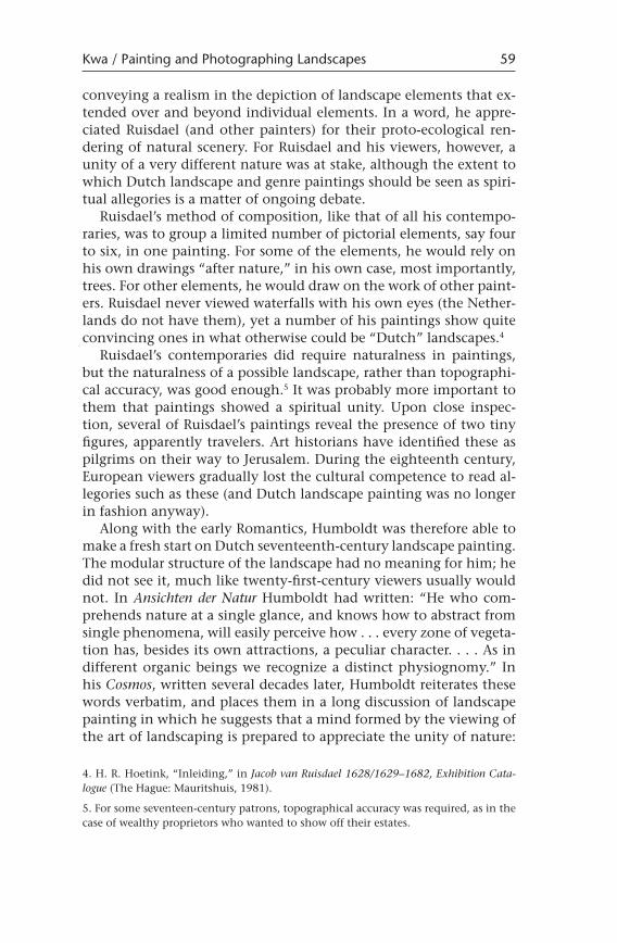
In the longer run, however, the Humboldtian logic would work against pictures as sources of knowledge. Many ecologists of gen-erations after Humboldt, beginning with August Grisebach, ac-cepted the unity of the landscape as a given, no longer in need of corroboration by visual means. Humboldt had vigorously promoted sending landscape artists on scientific voyages upon his return to Europe. During the first half of the nineteenth century, many scien-tific expeditions into the tropics, most of them carried out under ex-plicit Humboldtian inspiration, counted landscape painters among the participants. Landscape painting, at least initially, enjoyed the status of being among the means of gaining knowledge about the natural world. But when in around 1860, Frederick Church, Albert Bierstadt, and other painters of the Hudson School had put their art under the guidance of ecological scientific principles, their painting was no longer an independent route to knowledge. And by the time painting had been displaced by photography as a means of travel recording, from a scientific point of view, it had been relegated to illustrative functions only. There are as yet no studies of the use of black-and-white photogra-phy by the ecologists around 1900, the time when ecology appeared as a self-conscious academic field. A review of the first major ecologi-cal textbook, by Eugene Warming in Denmark, reveals that many pictures appear in the text, yet they serve only a supporting func-tion. Nowhere did Warming reflect on the information contained in the pictures, although their captions in some cases direct the viewer
6. Alexander von Humboldt, Cosmos, 5 vols., trans. E. C. Otté (London: Henry G. Bohn, 1849–52), p. 2:456.
7. The word “ecology” was not yet coined, but Humboldt may safely be regarded as the first ecologist.
60 Configurations

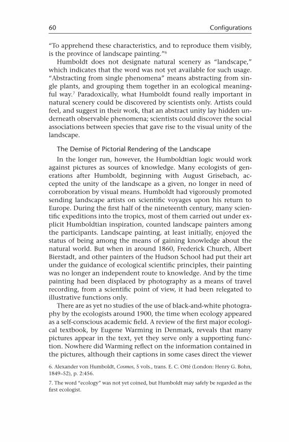
to significant details.8 The prevailing opinion on photographs at the time was that they did not distinguish between important and un-important aspects of the vegetation.9 In general, lists of plants with data on their relative abundance had epistemological priority over photographs and charts. Alone among his fellow ecologists, the American Frederick Cle-ments advocated the use of photography explicitly, and he devoted several sections of his Research Methods in Ecology (1905) on giving the ecologist detailed instructions as to how to handle the camera. “The camera is important for recording the structure of the vegeta-tion,” he said. “The ecological view should be a picture as well as a map.”10 But the panoramic maps produced by the help of the cam-era served to organize ecological knowledge acquired by the usual field methods, whereas photographs of vegetation on a more de-tailed scale apparently merely supplied documentary evidence on vegetational charts drawn by hand (Fig. 1).11 Clements was the dean of American ecology and had many disciples, but even this moder-ate use of photography did not find followers. The practice of using the pictorial information contained in pho-tographs of the landscape was initially not developed by ecologists. Instead, there was a slow though steady rise of use of the diagram. Some of the earliest diagrams, produced in 1895, were rendered as a visual translation of the information contained in tables.12 By 1949, ecological textbooks were dominated by diagrams of various kinds, ranging from simple graphs to complex renderings of food webs and ecosystems.13 (The history of the ecological diagram is beyond the scope of this essay.)14 Insofar as diagrams can be said to “depict” eco-
8. An interesting use of photography was made by Jean Massart, a Belgian follower of Warming, who in 1908 published two books documenting the vanishing Belgian land-scape by means of large photographic pictures. See Andreas Stynen, “Vaderlandse weelde op de kaart gezet,” The Low Countries Historical Review 121 (2006): 680–710.
9. Robert Kohler, Landscapes and Labscapes (Chicago: University of Chicago Press, 2002).
10. Frederick E. Clements, Research Methods in Ecology (Lincoln, Neb.: University Pub-lishing Company, 1905), pp. 188–196, quotes on pp. 188 and 191.
11. Ibid., pp. 167–170.
12. Astrid Schwarz, “Die Ökologie des Sees im Diagramm,” in Bildwelten des Wissens, Kunsthistorisches Jahrbuch für Bildkritik, bands 1–2 (Berlin: Akademie Verlag, 2003), pp. 64–74.
13. W. C. Allee et al., Principles of Animal Ecology (Philadelphia: Saunders, 1949); Eugene Odum, Fundamentals of Ecology (Philadelphia: Saunders, 1953).
14. Peter Taylor and Ann Blum, eds., “Special Issue on Pictorial Representation in Biol-ogy,” Biology & Philosophy 6 (1991).
Kwa / Painting and Photographing Landscapes 61
systems, they usually do so in much more abstract ways than more immediate visual renderings such as drawings, paintings, and pho-tography.15 It would appear, therefore, that pictorial renderings of the landscape (or of any part of an ecosystem) have not been sources of knowledge since the days of Humboldt and his immediate fol-lowers. But via a different route—the aerial survey—photographical renderings of the landscape re-entered ecology. Aerial surveys served mostly practical purposes, usually of a geographical nature. Although several leading ecologists responded enthusiastically to the possibili-ties of the “view from above,” the new aerial photography failed to have an impact on the conceptual development of mainstream ecology. Developing in a separate niche—an intermediate subfield between geography and ecology—the interpretation of photographs taken from the air would take a separate course.
15. One type of diagram is an immediate abstraction from a photograph, discussed below.
62 Configurations
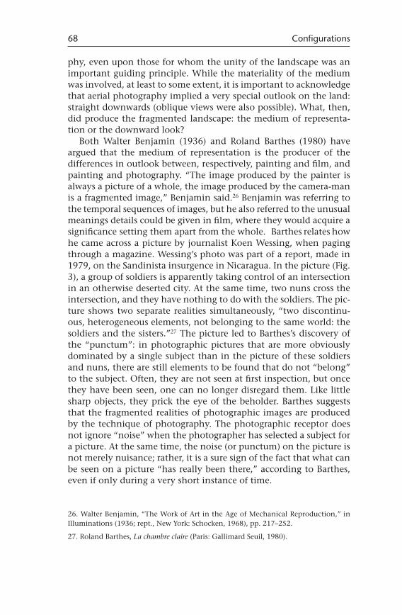
Figure 1. (a) Permanent chart quadrat, photograph taken by the author. (Source: Frederick E. Clements, Research Methods in Ecology [Lincoln, Neb.: University Publishing Company, 1905], p. 168.)
The Landscape Rendered through Photographs
Soon after World War I, a new technique of depicting the land-scape became available: aerial photography. In the UK, discharged pilots of the Royal Air Force set up private companies and offered commercial services to every interested civilian party. Among the first to profit were archaeologists. Whereas during the war aerial sur-veys had identified German trenches, they now revealed the out-lines of Roman villas. The Germans also had developed wartime ex-perience with reconnaissance from the air. By the 1920s, in the UK as well as in Germany, geographers, foresters, and ecologists made use of the advantages of aerial surveys. It was in the colonies of various European colonial powers that aerial photography found its most widespread application. Vast tracts of land, previously unexplored, could now be mapped system-atically and investigated for their hidden riches. Thus governments, of course, not individual researchers, were the driving force behind
Kwa / Painting and Photographing Landscapes 63
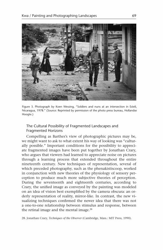
Figure 1. (b) Chart of the quadrat shown in figure 1a.
this application. The relationship between research from the air and Africa and Asia survived through postcolonial times, up until fairly recently.16
The earliest of such endeavors, in 1928, may well have been a project carried out for the Rhodesian Congo Border Concession. The (British) Aircraft Operating Company was to establish a border be-tween British Northern Rhodesia and the Belgian Congo, surveying an area of 20,000 to 30,000 square miles, resulting in a “fair” divi-sion of their natural resources between the two colonies. A British forester, Ray Bourne, was in charge of the project. Bourne brought together geological, climatic, and vegetational data, summarizing his findings in an “interdisciplinary” map. The map suggested areas for settlement and railroad tracks. He did not include data represent-ing native cultivation of the land.17
Arthur Tansley, a leading British ecologist, responded very posi-tively to Bourne’s results. In fact, another well-known Oxford-based ecologist, Charles Elton, had secretly made use of aerial photography during the latter’s Spitsbergen expedition in 1924. Historian of ecol-ogy Peder Anker argues that these two episodes mark the beginning of the globalization of ecology. Moreover, Tansley and Elton had been provided with “a view from above,” giving them the means to put ecology at the top of the knowledge hierarchy among various other forms of natural history.18
With due respect to Anker’s achievement, especially his historical reconstruction of South African ecology, I would like to take issue with him on “the view from above.” Aerial photography did not develop into a major research tool of ecologists until the 1980s, and when it did, it was in the form of remote-sensing from space, an altogether different technology. Not even Charles Elton used aer-ial pictures as input to his research, although he indeed had them made for other purposes.19 There are other ecologists who did, and even vigorously promoted it—Erich Wasmund in Germany is a case in point. But aerial photography did not become an acknowledged methodology within mainstream ecology. There was, however,
16. A case in point is the Dutch Internationaal Instituut voor Luchtkartering en Aard-kunde (ITC), in Enschedé, later renamed as the Internationaal Instituut voor Lucht- en Ruimtekartering.
17. Peder Anker, Imperial Ecology: Environmental Order in the British Empire, 1895–1945 (Cambridge, Mass.: Harvard University Press), 2001, pp. 82–86.
18. Ibid., p. 97.
19. And insofar as Elton did, his pictures are taken from rather low altitudes, showing, for instance, individual trees.
64 Configurations
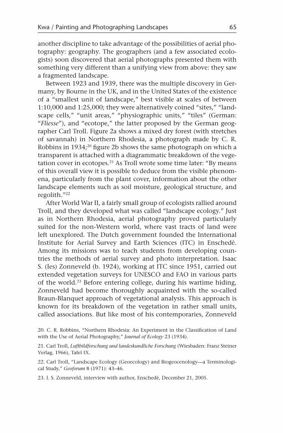
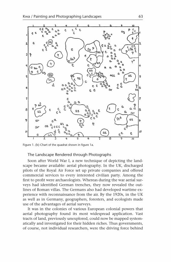
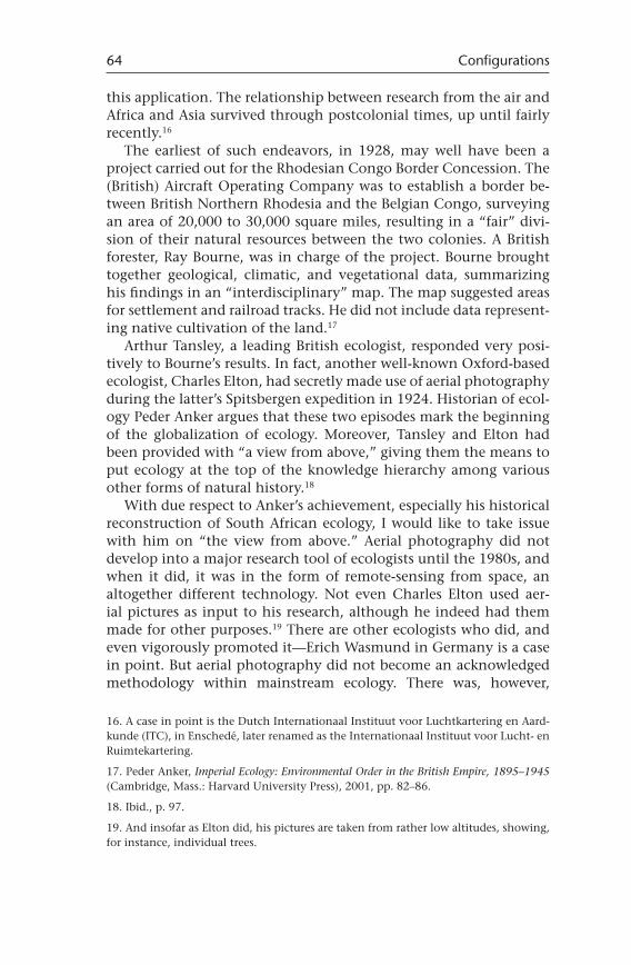
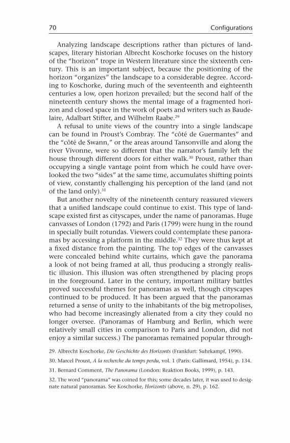
another discipline to take advantage of the possibilities of aerial pho-tography: geography. The geographers (and a few associated ecolo-gists) soon discovered that aerial photographs presented them with something very different than a unifying view from above: they saw a fragmented landscape. Between 1923 and 1939, there was the multiple discovery in Ger-many, by Bourne in the UK, and in the United States of the existence of a “smallest unit of landscape,” best visible at scales of between 1:10,000 and 1:25,000; they were alternatively coined “sites,” “land-scape cells,” “unit areas,” “physiographic units,” “tiles” (German: “Fliesse”), and “ecotope,” the latter proposed by the German geog-rapher Carl Troll. Figure 2a shows a mixed dry forest (with stretches of savannah) in Northern Rhodesia, a photograph made by C. R. Robbins in 1934;20 figure 2b shows the same photograph on which a transparent is attached with a diagrammatic breakdown of the vege-tation cover in ecotopes.21 As Troll wrote some time later: “By means of this overall view it is possible to deduce from the visible phenom-ena, particularly from the plant cover, information about the other landscape elements such as soil moisture, geological structure, and regolith.”22
After World War II, a fairly small group of ecologists rallied around Troll, and they developed what was called “landscape ecology.” Just as in Northern Rhodesia, aerial photography proved particularly suited for the non-Western world, where vast tracts of land were left unexplored. The Dutch government founded the International Institute for Aerial Survey and Earth Sciences (ITC) in Enschedé. Among its missions was to teach students from developing coun-tries the methods of aerial survey and photo interpretation. Isaac S. (Ies) Zonneveld (b. 1924), working at ITC since 1951, carried out extended vegetation surveys for UNESCO and FAO in various parts of the world.23 Before entering college, during his wartime hiding, Zonneveld had become thoroughly acquainted with the so-called Braun-Blanquet approach of vegetational analysis. This approach is known for its breakdown of the vegetation in rather small units, called associations. But like most of his contemporaries, Zonneveld 20. C. R. Robbins, “Northern Rhodesia: An Experiment in the Classification of Land with the Use of Aerial Photography,” Journal of Ecology 23 (1934).
21. Carl Troll, Luftbildforschung und landeskundliche Forschung (Wiesbaden: Franz Steiner Verlag, 1966), Tafel IX.
22. Carl Troll, “Landscape Ecology (Geoecology) and Biogeocenology—a Terminologi-cal Study,” Geoforum 8 (1971): 43–46.
23. I. S. Zonneveld, interview with author, Enschedé, December 21, 2005.
Kwa / Painting and Photographing Landscapes 65
later absorbed the basic tenets of ecosystem ecology, sharing its “faith in a natural equilibrium” as he put it.24 Homeostasis (“a hy-pothesis”) enabled landscapes to have a certain self-maintaining power, according to Zonneveld.25
However, the systems ecological research program had ignored spatial heterogeneity. When after around 1976, systems ecology was increasingly criticized for its confidence in asserting interdepen-dent and functional relationships among all the constituent parts of ecosystems (supposedly leading to homeostasis), the newly dis-
24. I. S. Zonneveld, “Landscape Ecology: A Science or a State of Mind?” in Proceedings of the International Congress of the Netherlands Society of Landscape Ecologists Veldhoven, 1981 (Wageningen: Pudoc, 1981), pp. 9–15, quote on p. 14.
25. Ibid., p. 11.
66 Configurations
Figure 2. (a) Aerial view of mixed dry forest in Northern Rhodesia, 1934. Photograph by C. R. Robbins.
covered spatial heterogeneity was cited as one reason among others for the untenability of the homeostasis hypothesis. Paradoxically, Zonneveld has known the fragmented landscape all his life, and he had searched continually to reconcile the concepts of “ecotope” and “ecosystem,” both implying very different views of the landscape. Around the time of Zonneveld’s retirement, however, the view of an ecosystem as a homogeneous entity fell into disregard and ecotopes (now usually designated as “patches and corridors”) became main-stream ecology.
The Medium of Representation
It appears that we can credit the medium of photography with the discovery of the smallest unit of landscape. The fragmented landscape imposed itself upon the practitioners of aerial photogra-
Kwa / Painting and Photographing Landscapes 67
Figure 2. (b) Diagram of figure 2a (tafel IX) drawn by Carl Troll, in Luftbildforschung und landeskundliche Forschung (Wiesbaden: Franz Steiner Verlag, 1966).
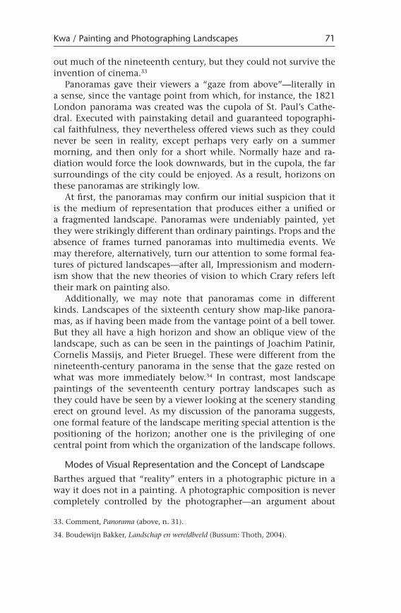
phy, even upon those for whom the unity of the landscape was an important guiding principle. While the materiality of the medium was involved, at least to some extent, it is important to acknowledge that aerial photography implied a very special outlook on the land: straight downwards (oblique views were also possible). What, then, did produce the fragmented landscape: the medium of representa-tion or the downward look? Both Walter Benjamin (1936) and Roland Barthes (1980) have argued that the medium of representation is the producer of the differences in outlook between, respectively, painting and film, and painting and photography. “The image produced by the painter is always a picture of a whole, the image produced by the camera-man is a fragmented image,” Benjamin said.26 Benjamin was referring to the temporal sequences of images, but he also referred to the unusual meanings details could be given in film, where they would acquire a significance setting them apart from the whole. Barthes relates how he came across a picture by journalist Koen Wessing, when paging through a magazine. Wessing’s photo was part of a report, made in 1979, on the Sandinista insurgence in Nicaragua. In the picture (Fig. 3), a group of soldiers is apparently taking control of an intersection in an otherwise deserted city. At the same time, two nuns cross the intersection, and they have nothing to do with the soldiers. The pic-ture shows two separate realities simultaneously, “two discontinu-ous, heterogeneous elements, not belonging to the same world: the soldiers and the sisters.”27 The picture led to Barthes’s discovery of the “punctum”: in photographic pictures that are more obviously dominated by a single subject than in the picture of these soldiers and nuns, there are still elements to be found that do not “belong” to the subject. Often, they are not seen at first inspection, but once they have been seen, one can no longer disregard them. Like little sharp objects, they prick the eye of the beholder. Barthes suggests that the fragmented realities of photographic images are produced by the technique of photography. The photographic receptor does not ignore “noise” when the photographer has selected a subject for a picture. At the same time, the noise (or punctum) on the picture is not merely nuisance; rather, it is a sure sign of the fact that what can be seen on a picture “has really been there,” according to Barthes, even if only during a very short instance of time.
26. Walter Benjamin, “The Work of Art in the Age of Mechanical Reproduction,” in Illuminations (1936; rept., New York: Schocken, 1968), pp. 217–252.
27. Roland Barthes, La chambre claire (Paris: Gallimard Seuil, 1980).
68 Configurations
The Cultural Possibility of Fragmented Landscapes and Fragmented Horizons
Compelling as Barthes’s view of photographic pictures may be, we might want to ask to what extent his way of looking was “cultur-ally possible.” Important conditions for the possibility to appreci-ate fragmented images have been put together by Jonathan Crary, who argues that viewers had learned to appreciate noise on pictures through a learning process that extended throughout the entire nineteenth century. New techniques of representation, several of which preceded photography, such as the phenakistiscoop, worked in conjunction with new theories of the physiology of sensory per-ception to produce much more subjective theories of perception. During the seventeenth and eighteenth centuries, according to Crary, the unified image as conveyed by the painting was modeled on an idea of vision best exemplified by the camera obscura: an or-derly representation of reality, mirror-like. In contrast, the new vi-sualizing techniques confirmed the newer idea that there was not a one-to-one relationship between stimulus and response, between the retinal image and the mental image.28
28. Jonathan Crary, Techniques of the Observer (Cambridge, Mass.: MIT Press, 1990).
Kwa / Painting and Photographing Landscapes 69
Figure 3. Photograph by Koen Wessing, “Soldiers and nuns at an intersection in Esteli, Nicaragua, 1978.” (Source: Reprinted by permission of the photo press bureau, Hollandse Hoogte.)
Analyzing landscape descriptions rather than pictures of land-scapes, literary historian Albrecht Koschorke focuses on the history of the “horizon” trope in Western literature since the sixteenth cen-tury. This is an important subject, because the positioning of the horizon “organizes” the landscape to a considerable degree. Accord-ing to Koschorke, during much of the seventeenth and eighteenth centuries a low, open horizon prevailed; but the second half of the nineteenth century shows the mental image of a fragmented hori-zon and closed space in the work of poets and writers such as Baude-laire, Adalbart Stifter, and Wilhelm Raabe.29
A refusal to unite views of the country into a single landscape can be found in Proust’s Combray. The “côté de Guermantes” and the “côté de Swann,” or the areas around Tansonville and along the river Vivonne, were so different that the narrator’s family left the house through different doors for either walk.30 Proust, rather than occupying a single vantage point from which he could have over-looked the two “sides” at the same time, accumulates shifting points of view, constantly challenging his perception of the land (and not of the land only).31
But another novelty of the nineteenth century reassured viewers that a unified landscape could continue to exist. This type of land-scape existed first as cityscapes, under the name of panoramas. Huge canvasses of London (1792) and Paris (1799) were hung in the round in specially built rotundas. Viewers could contemplate these panora-mas by accessing a platform in the middle.32 They were thus kept at a fixed distance from the painting. The top edges of the canvasses were concealed behind white curtains, which gave the panorama a look of not being framed at all, thus producing a strongly realis-tic illusion. This illusion was often strengthened by placing props in the foreground. Later in the century, important military battles proved successful themes for panoramas as well, though cityscapes continued to be produced. It has been argued that the panoramas returned a sense of unity to the inhabitants of the big metropolises, who had become increasingly alienated from a city they could no longer oversee. (Panoramas of Hamburg and Berlin, which were relatively small cities in comparison to Paris and London, did not enjoy a similar success.) The panoramas remained popular through-
29. Albrecht Koschorke, Die Geschichte des Horizonts (Frankfurt: Suhrkampf, 1990).
30. Marcel Proust, A la recherche du temps perdu, vol. 1 (Paris: Gallimard, 1954), p. 134.
31. Bernard Comment, The Panorama (London: Reaktion Books, 1999), p. 143.
32. The word “panorama” was coined for this; some decades later, it was used to desig-nate natural panoramas. See Koschorke, Horizonts (above, n. 29), p. 162.
70 Configurations
out much of the nineteenth century, but they could not survive the invention of cinema.33
Panoramas gave their viewers a “gaze from above”—literally in a sense, since the vantage point from which, for instance, the 1821 London panorama was created was the cupola of St. Paul’s Cathe-dral. Executed with painstaking detail and guaranteed topographi-cal faithfulness, they nevertheless offered views such as they could never be seen in reality, except perhaps very early on a summer morning, and then only for a short while. Normally haze and ra-diation would force the look downwards, but in the cupola, the far surroundings of the city could be enjoyed. As a result, horizons on these panoramas are strikingly low. At first, the panoramas may confirm our initial suspicion that it is the medium of representation that produces either a unified or a fragmented landscape. Panoramas were undeniably painted, yet they were strikingly different than ordinary paintings. Props and the absence of frames turned panoramas into multimedia events. We may therefore, alternatively, turn our attention to some formal fea-tures of pictured landscapes—after all, Impressionism and modern-ism show that the new theories of vision to which Crary refers left their mark on painting also. Additionally, we may note that panoramas come in different kinds. Landscapes of the sixteenth century show map-like panora-mas, as if having been made from the vantage point of a bell tower. But they all have a high horizon and show an oblique view of the landscape, such as can be seen in the paintings of Joachim Patinir, Cornelis Massijs, and Pieter Bruegel. These were different from the nineteenth-century panorama in the sense that the gaze rested on what was more immediately below.34 In contrast, most landscape paintings of the seventeenth century portray landscapes such as they could have be seen by a viewer looking at the scenery standing erect on ground level. As my discussion of the panorama suggests, one formal feature of the landscape meriting special attention is the positioning of the horizon; another one is the privileging of one central point from which the organization of the landscape follows.
Modes of Visual Representation and the Concept of Landscape
Barthes argued that “reality” enters in a photographic picture in a way it does not in a painting. A photographic composition is never completely controlled by the photographer—an argument about
33. Comment, Panorama (above, n. 31).
34. Boudewijn Bakker, Landschap en wereldbeeld (Bussum: Thoth, 2004).
Kwa / Painting and Photographing Landscapes 71
the materiality of photography. The painting has a camera obscura–like view, with indefinite aperture time, whereas the “snapshot” of the modern camera produces something inherently ephemeral and contingent. But a subtly different argument could be made that the materiality of the medium privileges a certain formal perspective on a subject, in this case the landscape.
The Horizon The horizon acts as the formal organizer of pictorial representa-tion: a low horizon “producing” unity in the landscape, a high hori-zon showing spatial fragmentation. The logical endpoint of the lat-ter is aerial photography, which produces pictures with no horizon at all. With a low horizon, landscape elements are projected onto one another and hence fused, at least to some extent. Distance mat-ters: long distance produces a high depth of field, further enhancing unity in the landscape.
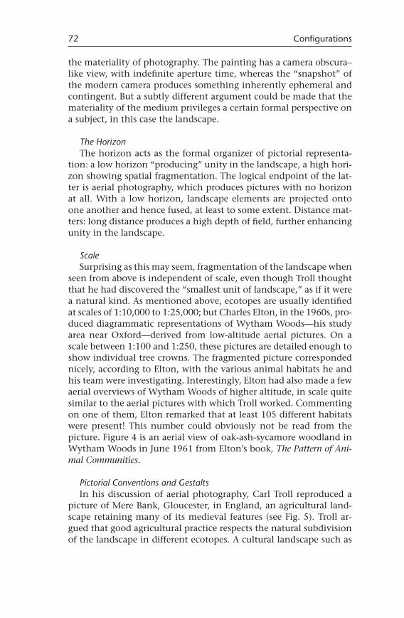
Scale Surprising as this may seem, fragmentation of the landscape when seen from above is independent of scale, even though Troll thought that he had discovered the “smallest unit of landscape,” as if it were a natural kind. As mentioned above, ecotopes are usually identified at scales of 1:10,000 to 1:25,000; but Charles Elton, in the 1960s, pro-duced diagrammatic representations of Wytham Woods—his study area near Oxford—derived from low-altitude aerial pictures. On a scale between 1:100 and 1:250, these pictures are detailed enough to show individual tree crowns. The fragmented picture corresponded nicely, according to Elton, with the various animal habitats he and his team were investigating. Interestingly, Elton had also made a few aerial overviews of Wytham Woods of higher altitude, in scale quite similar to the aerial pictures with which Troll worked. Commenting on one of them, Elton remarked that at least 105 different habitats were present! This number could obviously not be read from the picture. Figure 4 is an aerial view of oak-ash-sycamore woodland in Wytham Woods in June 1961 from Elton’s book, The Pattern of Ani-mal Communities.
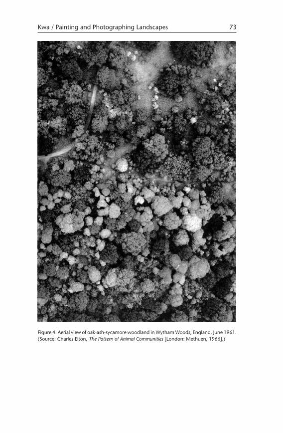
Pictorial Conventions and Gestalts In his discussion of aerial photography, Carl Troll reproduced a picture of Mere Bank, Gloucester, in England, an agricultural land-scape retaining many of its medieval features (see Fig. 5). Troll ar-gued that good agricultural practice respects the natural subdivision of the landscape in different ecotopes. A cultural landscape such as
72 Configurations
Kwa / Painting and Photographing Landscapes 73
Figure 4. Aerial view of oak-ash-sycamore woodland in Wytham Woods, England, June 1961. (Source: Charles Elton, The Pattern of Animal Communities [London: Methuen, 1966].)
this one of Mere Bank would then reflect the “natural” landscape, which large-scale agriculture would ignore at its peril. But it is pos-sible to turn Troll’s argument on its head: Could not his vision of the landscape be itself informed by the cultural gestalt of the typi-cal view of a landscape-in-culture, fields and meadows separated by hedgerows? The availability of gestalts can be considered as a prerequisite of recognizing patterns such as Troll and others discov-ered in aerial photography. Elton’s diagrammatic representations of low-altitude aerial pictures may be likewise informed by yet another gestalt: garden design.
Framing the Landscape Landscapes do not come by themselves either unified or frag-mented. But to say that they are framed by the theoretical assump-tions of the viewer, be he layperson or scientist, is, though irrefut-able, too easy at the same time. The medium of representation slips between the land and its representation in a picture. Various media come with their own ways of looking, involving angle, distance, and scale. Ways of looking often have their own histories, and these
74 Configurations
Figure 5. Aerial view of Mere Bank, Gloucester, England. (Source: Carl Troll, Luftbildforsc-hung und landeskundliche Forschung [Wiesbaden: Franz Steiner Verlag, 1966].)
histories may impose themselves on the new subject as if powerful metaphors. Innovations are possible, as in the case of Alexander von Humboldt, who provided a secular unity of the (Dutch) landscape that once had been read spiritually. Another case is aerial photog-raphy, which in a sense was a chance discovery by ecologists; its associated meanings took a long time to decipher before becoming the now culturally dominant manner of viewing landscapes.
Acknowledgments
My thanks go to Astrid Schwarz, John Law, and Joes Segal as well as to Cor van der Weele and the other members of the Metaphor Club for their suggestions.
Kwa / Painting and Photographing Landscapes 75