ongoing transport development projects 7.4
TRANSCRIPT
Project for Urban Transport Master Plan in Kinshasa City / PDTK Final Report: Volume 1 Urban Transport Master Plan in Kinshasa City
7-100
Ongoing Transport Development Projects 7.4
Road Development Plan 7.4.1
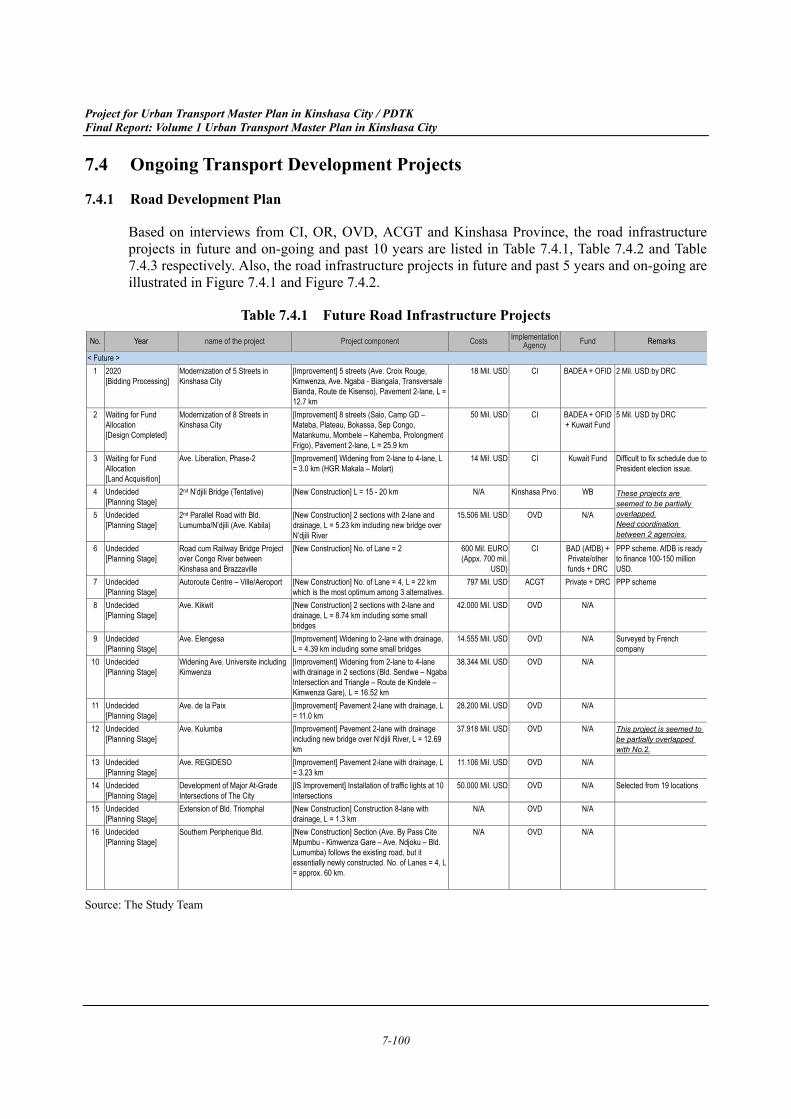
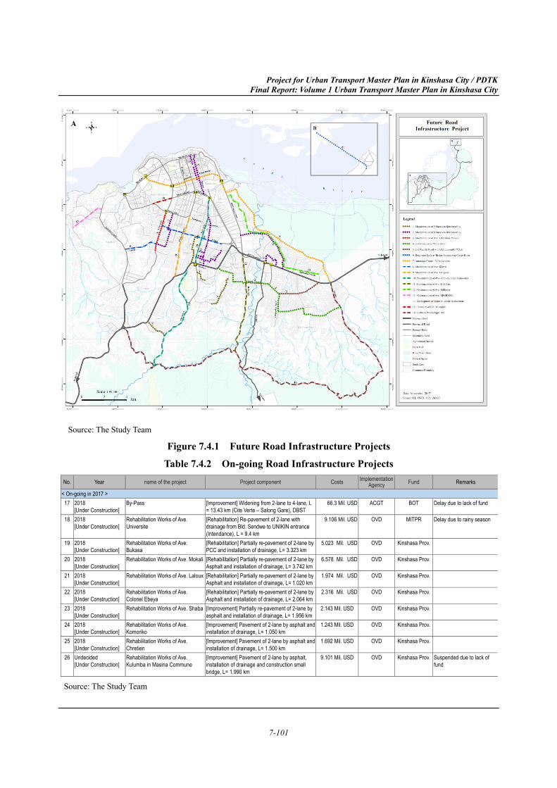
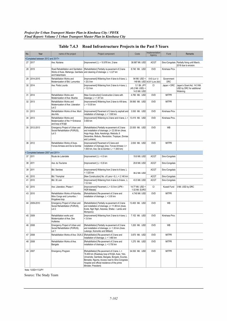
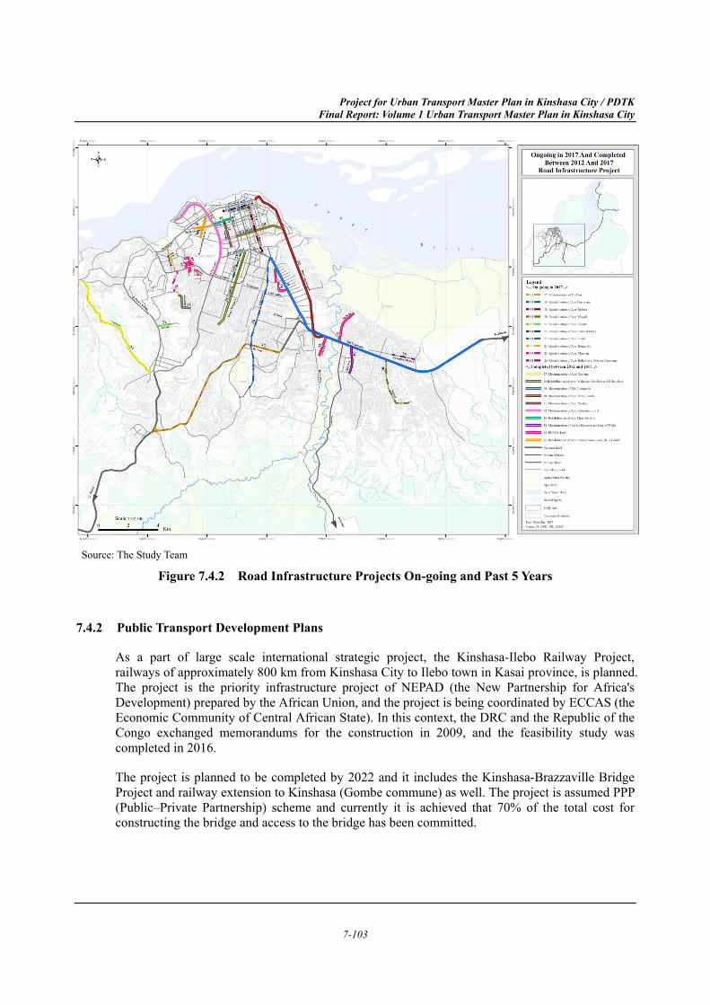
Based on interviews from CI, OR, OVD, ACGT and Kinshasa Province, the road infrastructure projects in future and on-going and past 10 years are listed in Table 7.4.1, Table 7.4.2 and Table 7.4.3 respectively. Also, the road infrastructure projects in future and past 5 years and on-going are illustrated in Figure 7.4.1 and Figure 7.4.2.
Table 7.4.1 Future Road Infrastructure Projects
Source: The Study Team
No. Year name of the project Project component Costs ImplementationAgency Fund Remarks
< Future >
1 2020 [Bidding Processing]
Modernization of 5 Streets in Kinshasa City
[Improvement] 5 streets (Ave. Croix Rouge, Kimwenza, Ave. Ngaba - Biangala, Transversale Bianda, Route de Kisenso), Pavement 2-lane, L = 12.7 km
18 Mil. USD CI BADEA + OFID 2 Mil. USD by DRC
2 Waiting for Fund Allocation [Design Completed]
Modernization of 8 Streets in Kinshasa City
[Improvement] 8 streets (Saio, Camp GD – Mateba, Plateau, Bokassa, Sep Congo, Matankumu, Mombele – Kahemba, Prolongment Frigo), Pavement 2-lane, L = 25.9 km
50 Mil. USD CI BADEA + OFID + Kuwait Fund
5 Mil. USD by DRC
3 Waiting for Fund Allocation [Land Acquisition]
Ave. Liberation, Phase-2 [Improvement] Widening from 2-lane to 4-lane, L = 3.0 km (HGR Makala – Molart)
14 Mil. USD CI Kuwait Fund Difficult to fix schedule due to President election issue.
4 Undecided [Planning Stage]
2nd N’djili Bridge (Tentative) [New Construction] L = 15 - 20 km N/A Kinshasa Prvo. WB These projects are seemed to be partially overlapped. Need coordination between 2 agencies.
5 Undecided [Planning Stage]
2nd Parallel Road with Bld. Lumumba/N’djili (Ave. Kabila)
[New Construction] 2 sections with 2-lane and drainage, L = 5.23 km including new bridge over N’djili River
15.506 Mil. USD OVD N/A
6 Undecided [Planning Stage]
Road cum Railway Bridge Project over Congo River between Kinshasa and Brazzaville
[New Construction] No. of Lane = 2 600 Mil. EURO (Appx. 700 mil.
USD)
CI BAD (AfDB) + Private/other funds + DRC
PPP scheme. AfDB is ready to finance 100-150 million USD.
7 Undecided [Planning Stage]
Autoroute Centre – Ville/Aeroport [New Construction] No. of Lane = 4, L = 22 km which is the most optimum among 3 alternatives.
797 Mil. USD ACGT Private + DRC PPP scheme
8 Undecided [Planning Stage]
Ave. Kikwit [New Construction] 2 sections with 2-lane and drainage, L = 8.74 km including some small bridges
42.000 Mil. USD OVD N/A
9 Undecided [Planning Stage]
Ave. Elengesa [Improvement] Widening to 2-lane with drainage, L = 4.39 km including some small bridges
14.555 Mil. USD OVD N/A Surveyed by French company
10 Undecided [Planning Stage]
Widening Ave. Universite including Kimwenza
[Improvement] Widening from 2-lane to 4-lane with drainage in 2 sections (Bld. Sendwe – Ngaba Intersection and Triangle – Route de Kindele – Kimwenza Gare), L = 16.52 km
38.344 Mil. USD OVD N/A
11 Undecided [Planning Stage]
Ave. de la Paix [Improvement] Pavement 2-lane with drainage, L = 11.0 km
28.200 Mil. USD OVD N/A
12 Undecided [Planning Stage]
Ave. Kulumba [Improvement] Pavement 2-lane with drainage including new bridge over N’djili River, L = 12.69 km
37.918 Mil. USD OVD N/A This project is seemed to be partially overlapped with No.2.
13 Undecided [Planning Stage]
Ave. REGIDESO [Improvement] Pavement 2-lane with drainage, L = 3.23 km
11.106 Mil. USD OVD N/A
14 Undecided [Planning Stage]
Development of Major At-Grade Intersections of The City
[IS Improvement] Installation of traffic lights at 10 Intersections
50.000 Mil. USD OVD N/A Selected from 19 locations
15 Undecided [Planning Stage]
Extension of Bld. Triomphal [New Construction] Construction 8-lane with drainage, L = 1.3 km
N/A OVD N/A
16 Undecided [Planning Stage]
Southern Peripherique Bld. [New Construction] Section (Ave. By Pass Cite Mpumbu - Kimwenza Gare – Ave. Ndjoku – Bld. Lumumba) follows the existing road, but it essentially newly constructed. No. of Lanes = 4, L = approx. 60 km.
N/A OVD N/A
Project for Urban Transport Master Plan in Kinshasa City / PDTK Final Report: Volume 1 Urban Transport Master Plan in Kinshasa City
7-101
Source: The Study Team
Figure 7.4.1 Future Road Infrastructure Projects Table 7.4.2 On-going Road Infrastructure Projects
Source: The Study Team
No. Year name of the project Project component Costs ImplementationAgency Fund Remarks
< On-going in 2017 >
17 2018 [Under Construction]
By-Pass [Improvement] Widening from 2-lane to 4-lane, L = 13.43 km (Cite Verte – Salong Gare), DBST
66.3 Mil. USD ACGT BOT Delay due to lack of fund
18 2018 [Under Construction]
Rehabilitation Works of Ave. Universite
[Rehabilitation] Re-pavement of 2-lane with drainage from Bld. Sendwe to UNIKIN entrance (Intendance), L = 9.4 km
9.106 Mil. USD OVD MITPR Delay due to rainy season
19 2018 [Under Construction]
Rehabilitation Works of Ave. Bukasa
[Rehabilitation] Partially re-pavement of 2-lane by PCC and installation of drainage, L= 3.323 km
5.023 Mil. USD OVD Kinshasa Prov.
20 2018 [Under Construction]
Rehabilitation Works of Ave. Mokali [Rehabilitation] Partially re-pavement of 2-lane by Asphalt and installation of drainage, L= 3.742 km
6.578 Mil. USD OVD Kinshasa Prov.
21 2018 [Under Construction]
Rehabilitation Works of Ave. Laloux [Rehabilitation] Partially re-pavement of 2-lane by Asphalt and installation of drainage, L= 1.020 km
1.974 Mil. USD OVD Kinshasa Prov.
22 2018 [Under Construction]
Rehabilitation Works of Ave. Colonel Ebeya
[Rehabilitation] Partially re-pavement of 2-lane by Asphalt and installation of drainage, L= 2.064 km
2.316 Mil. USD OVD Kinshasa Prov.
23 2018 [Under Construction]
Rehabilitation Works of Ave. Shaba [Improvement] Partially re-pavement of 2-lane by asphalt and installation of drainage, L= 1.956 km
2.143 Mil. USD OVD Kinshasa Prov.
24 2018 [Under Construction]
Rehabilitation Works of Ave. Komoriko
[Improvement] Pavement of 2-lane by asphalt and installation of drainage, L= 1.050 km
1.243 Mil. USD OVD Kinshasa Prov.
25 2018 [Under Construction]
Rehabilitation Works of Ave. Chretien
[Improvement] Pavement of 2-lane by asphalt and installation of drainage, L= 1.500 km
1.692 Mil. USD OVD Kinshasa Prov.
26 Undecided [Under Construction]
Rehabilitation Works of Ave. Kulumba in Masina Commune
[Improvement] Pavement of 2-lane by asphalt, installation of drainage and construction small bridge, L= 1.990 km
9.101 Mil. USD OVD Kinshasa Prov. Suspended due to lack of fund
Project for Urban Transport Master Plan in Kinshasa City / PDTK Final Report: Volume 1 Urban Transport Master Plan in Kinshasa City
7-102
Table 7.4.3 Road Infrastructure Projects in the Past 5 Years
Source: The Study Team
No. Year name of the project Project component Costs ImplementationAgency Fund Remarks
<Completed between 2012 and 2017>
27 2017 Ave. Nzolana [Improvement ] L = 10.976 km, 2-lane 38.987 Mil. USD ACGT Sino-Congolais Partially fixing until March, 2018 due to erosion.
28 2015 Road Rehabilitation and Sanitation Works of Aves. Mahenga, Gambela and Kabambare
[Rehabilitation] Partially re-pavement of 2-lane and cleaning of drainage. L = 2.27 km
8.740 Mil. USD OVD Kinshasa Prov.
29 2014-2015 Rehabilitation Works and Modernization of Bld. Lumumba
[Improvement] Widening from 4-lane to 8-lane, L = 20.0 km
94 Mil. USD + 149 Mil. USD
OVD (Lot 1)/ ACGT (Lots 2&3)
Government DRC
30 2014 Ave. Poids Lourds [Improvement] Widening from 2-lane to 4-lane, L = 12.0 km
5.1 Bil. JPY (45.2 Mil. USD) +
14.5 Mil. USD
CI Japan + DRC Japan’s Grant Aid, 14.5 Mil. USD by DRC for additional Widening
31 2014 Rehabilitation Works and Modernization of Ave. Mushie
[New Construction] Construction 2-lane with draiange, L = 1.87 km
4.780 Mil. USD OVD MITPR
32 2013 Rehabilitation Works and Modernization of Ave. Liberation Lot 2
[Improvement] Widening from 2-lane to 4/6-lane, L = 10.00 km
39.560 Mil. USD OVD MITPR
33 2013 Rehabilitation Works of Ave. Mont des Arts
[Improvement] Pavement of 2-lane by asphalt and installation of drainage, L = 1.500 km
3.550 Mil. USD OVD Kinshasa Prov.
34 2013 Rehabilitation Works and Modernization of the 1st Entrance and loop of N’djili
[Improvement] Widening to 2-lane and 4-lane, L = 3.500 km
13.415 Mil. USD OVD Kinshasa Prov.
35 2012-2013 Emergency Project of Urban and Social Rehabilitation (PURUS), Lot 3
[Rehabilitation] Partially re-pavement of 2-lane and installation of drainage, L= 22.06 km (Aves. Ango Ango, Bula, Assolongo, Maduda, 8 Decembre, Mobutu, Revolution, Tropique, Zinnias and Lumiere)
23.500 Mil. USD OVD WB
36 2012 Rehabilitation Works of Aves. Forces Armees and De la Gombe
[Improvement] Pavement of 2-lane and installation of drainage (Ave. Forces Armees: L= 1.500 km, Ave. De la Gombe: L = 1.000 km)
2.830 Mil. USD OVD MITPR
< Completed between 2007 and 2011>
37 2011 Route de Lutendele [Improvement ] L = 4.5 km
19.9 Mil. USD ACGT Sino-Congolais
38 2011 Ave. du Tourisme [Improvement ] L = 6.8 km
29.8 Mil. USD ACGT Sino-Congolais
39 2011 Bld. Sendwe [Improvement] Widening from 2-lane to 6-lane, L = 1.520 km 36.2 Mil. USD
ACGT Sino-Congolais
40 2010 Bld. Triomphal [New Construction] No. of Lane = 8, L = 2.140 km ACGT Sino-Congolais
41 2010 Bld. 30 Juin [Improvement] Widening from 4-lane to 8-lane , L = 5.0 km
43.5 Mil. USD ACGT Sino-Congolais
42 2010 Ave. Liberation, Phase-1 [Improvement] Pavement, L = 5.5 km (UPN – HGR Makala)
14.77 Mil. USD + 1.02 Mil. EURO
CI Kuwait Fund 3 Mil. USD by DRC
43 2010 Rehabilitation Works of Kulumba, Mino Congo and Lumumba. / Kingabwa loop
[Rehabilitation] Re-pavement of 2-lane and installation of drainage. L = 3.00 km
4.740 Mil. USD OVD MITPR
44 2009-2010 Emergency Project of Urban and Social Rehabilitation (PURUS), Lot 2
[Rehabilitation] Partially re-pavement of 2-lane and installation of drainage, L= 11.89 km (Aves. Ecole, Ngiri Ngiri, Assossa, Shaba – Landu and Mompono)
13.400 Mil. USD OVD WB
45 2009 Rehabilitation works and Modernization of Ave. Des Huilleries
[Improvement] Widening from 2-lane to 4-lane, L = 3.8 km
7.152 Mil. USD OVD Kinshasa Prov.
46 2008 Emergency Project of Urban and Social Rehabilitation (PURUS), Lot 1
[Rehabilitation] Partially re-pavement of 2-lane and installation of drainage, L= 1.30 km (Aves. Lukengo, Komoriko and Militant)
1.200 Mil. USD OVD WB
47 2008 Rehabilitation Works of Ave. OUA 2 [Rehabilitation] Re-pavement of 2-lane and installation of drainage, L = 1.460 km
3.870 Mil. USD OVD MITPR
48 2008 Rehabilitation Works of Ave. Bangala
[Rehabilitation] Re-pavement of 2-lane and installation of drainage, L = 0.750 km
1.270 Mil. USD OVD MITPR
49 2007 Emergency Program [Rehabilitation] Re-pavement of 2-lane, L = 15.400 km (Roadway loop of N’djili, Aves. Yolo, Universite, Gambela, Bangala, Bongolo, Ecuries, Benseke, Nguma, Access road to Sino-Congolais Hospital and official residence of the prime Minister, President)
34.550 Mil. USD OVD MITPR
Note: 1USD=113JPY
Project for Urban Transport Master Plan in Kinshasa City / PDTK Final Report: Volume 1 Urban Transport Master Plan in Kinshasa City
7-103
Source: The Study Team
Figure 7.4.2 Road Infrastructure Projects On-going and Past 5 Years
Public Transport Development Plans 7.4.2
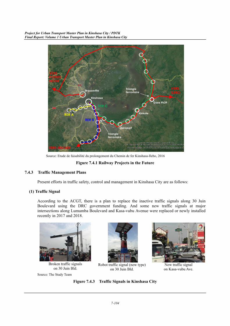
As a part of large scale international strategic project, the Kinshasa-Ilebo Railway Project, railways of approximately 800 km from Kinshasa City to Ilebo town in Kasai province, is planned. The project is the priority infrastructure project of NEPAD (the New Partnership for Africa's Development) prepared by the African Union, and the project is being coordinated by ECCAS (the Economic Community of Central African State). In this context, the DRC and the Republic of the Congo exchanged memorandums for the construction in 2009, and the feasibility study was completed in 2016.
The project is planned to be completed by 2022 and it includes the Kinshasa-Brazzaville Bridge Project and railway extension to Kinshasa (Gombe commune) as well. The project is assumed PPP (Public–Private Partnership) scheme and currently it is achieved that 70% of the total cost for constructing the bridge and access to the bridge has been committed.
Project for Urban Transport Master Plan in Kinshasa City / PDTK Final Report: Volume 1 Urban Transport Master Plan in Kinshasa City
7-104
Source: Etude de faisabilité du prolongement du Chemin de fer Kinshasa-Ilebo, 2016
Figure 7.4.1 Railway Projects in the Future
Traffic Management Plans 7.4.3
Present efforts in traffic safety, control and management in Kinshasa City are as follows:
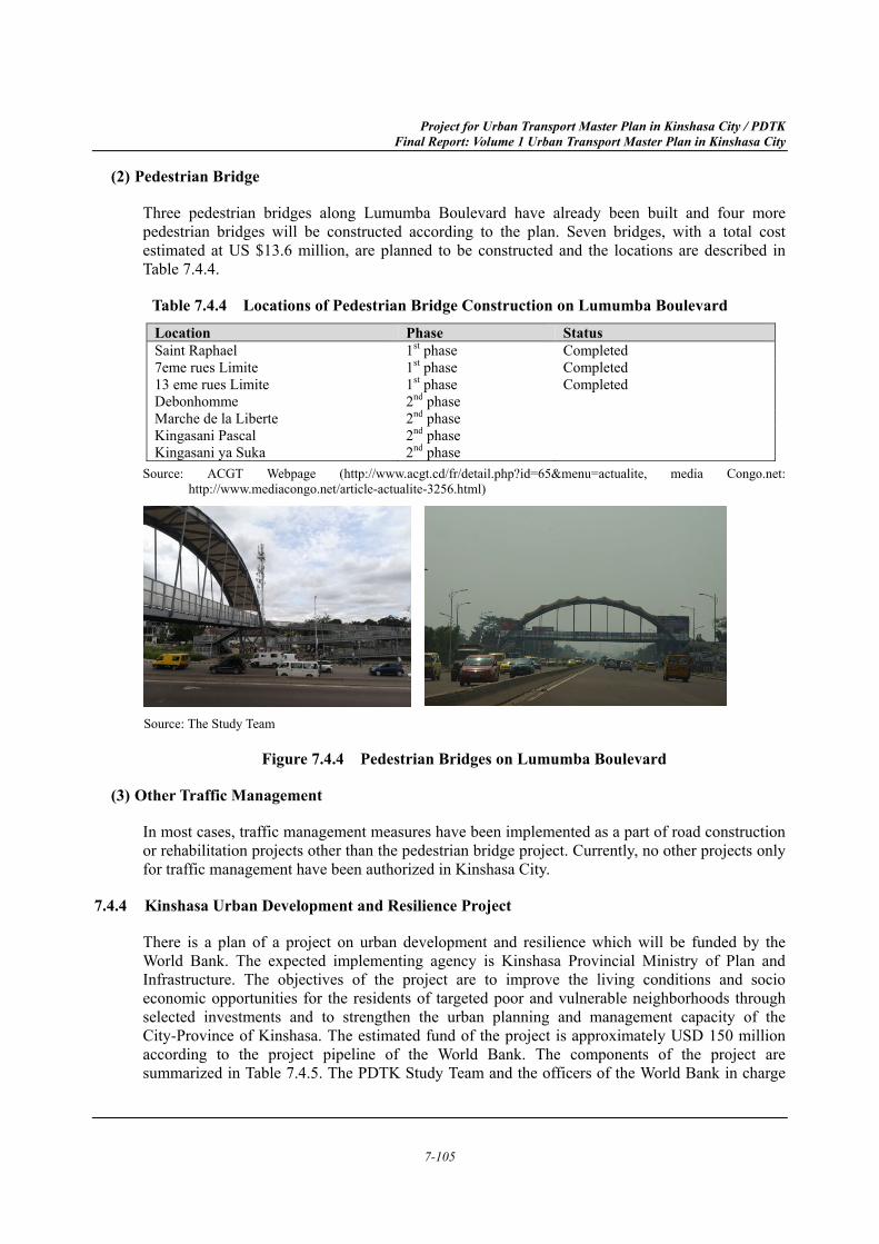
Traffic Signal (1)
According to the ACGT, there is a plan to replace the inactive traffic signals along 30 Juin Boulevard using the DRC government funding. And some new traffic signals at major intersections along Lumumba Boulevard and Kasa-vubu Avenue were replaced or newly installed recently in 2017 and 2018.
Broken traffic signals
on 30 Juin Bld.
Robot traffic signal (new type)
on 30 Juin Bld. New traffic signal on Kasa-vubu Ave.
Source: The Study Team
Figure 7.4.3 Traffic Signals in Kinshasa City
Project for Urban Transport Master Plan in Kinshasa City / PDTK Final Report: Volume 1 Urban Transport Master Plan in Kinshasa City
7-105
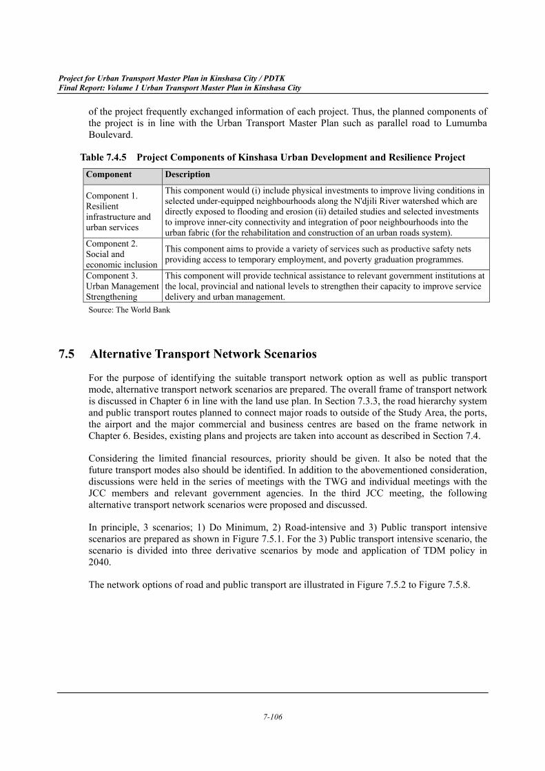
Pedestrian Bridge (2)
Three pedestrian bridges along Lumumba Boulevard have already been built and four more pedestrian bridges will be constructed according to the plan. Seven bridges, with a total cost estimated at US $13.6 million, are planned to be constructed and the locations are described in Table 7.4.4.
Table 7.4.4 Locations of Pedestrian Bridge Construction on Lumumba Boulevard Location Phase Status Saint Raphael 1st phase Completed 7eme rues Limite 1st phase Completed 13 eme rues Limite 1st phase Completed Debonhomme 2nd phase Marche de la Liberte 2nd phase Kingasani Pascal 2nd phase Kingasani ya Suka 2nd phase
Source: ACGT Webpage (http://www.acgt.cd/fr/detail.php?id=65&menu=actualite, media Congo.net: http://www.mediacongo.net/article-actualite-3256.html)
Source: The Study Team
Figure 7.4.4 Pedestrian Bridges on Lumumba Boulevard
Other Traffic Management (3)
In most cases, traffic management measures have been implemented as a part of road construction or rehabilitation projects other than the pedestrian bridge project. Currently, no other projects only for traffic management have been authorized in Kinshasa City.
Kinshasa Urban Development and Resilience Project 7.4.4
There is a plan of a project on urban development and resilience which will be funded by the World Bank. The expected implementing agency is Kinshasa Provincial Ministry of Plan and Infrastructure. The objectives of the project are to improve the living conditions and socio economic opportunities for the residents of targeted poor and vulnerable neighborhoods through selected investments and to strengthen the urban planning and management capacity of the City-Province of Kinshasa. The estimated fund of the project is approximately USD 150 million according to the project pipeline of the World Bank. The components of the project are summarized in Table 7.4.5. The PDTK Study Team and the officers of the World Bank in charge
Project for Urban Transport Master Plan in Kinshasa City / PDTK Final Report: Volume 1 Urban Transport Master Plan in Kinshasa City
7-106
of the project frequently exchanged information of each project. Thus, the planned components of the project is in line with the Urban Transport Master Plan such as parallel road to Lumumba Boulevard.
Table 7.4.5 Project Components of Kinshasa Urban Development and Resilience Project Component Description
Component 1. Resilient infrastructure and urban services
This component would (i) include physical investments to improve living conditions in selected under-equipped neighbourhoods along the N'djili River watershed which are directly exposed to flooding and erosion (ii) detailed studies and selected investments to improve inner-city connectivity and integration of poor neighbourhoods into the urban fabric (for the rehabilitation and construction of an urban roads system).
Component 2. Social and economic inclusion
This component aims to provide a variety of services such as productive safety nets providing access to temporary employment, and poverty graduation programmes.
Component 3. Urban Management Strengthening
This component will provide technical assistance to relevant government institutions at the local, provincial and national levels to strengthen their capacity to improve service delivery and urban management.
Source: The World Bank
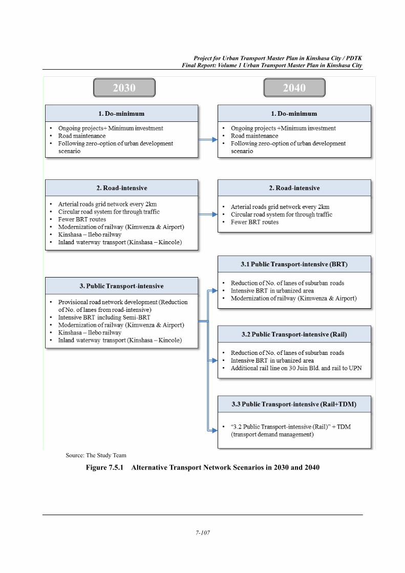
Alternative Transport Network Scenarios 7.5
For the purpose of identifying the suitable transport network option as well as public transport mode, alternative transport network scenarios are prepared. The overall frame of transport network is discussed in Chapter 6 in line with the land use plan. In Section 7.3.3, the road hierarchy system and public transport routes planned to connect major roads to outside of the Study Area, the ports, the airport and the major commercial and business centres are based on the frame network in Chapter 6. Besides, existing plans and projects are taken into account as described in Section 7.4.
Considering the limited financial resources, priority should be given. It also be noted that the future transport modes also should be identified. In addition to the abovementioned consideration, discussions were held in the series of meetings with the TWG and individual meetings with the JCC members and relevant government agencies. In the third JCC meeting, the following alternative transport network scenarios were proposed and discussed.
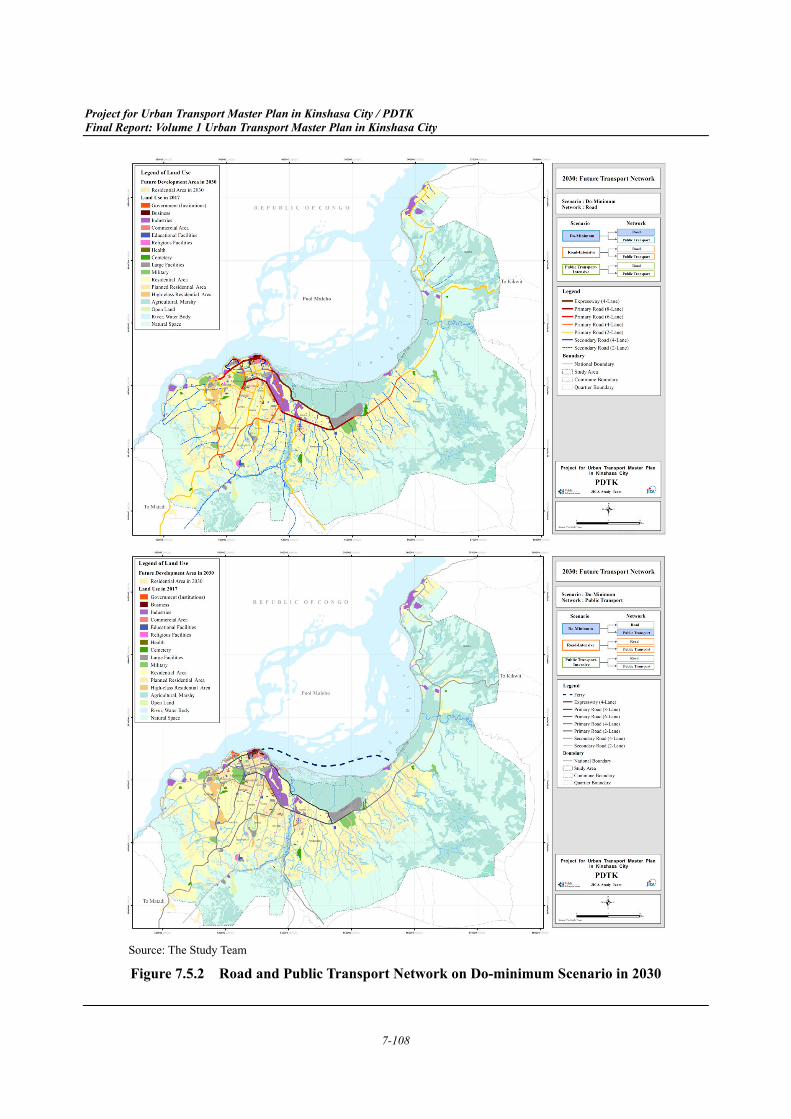
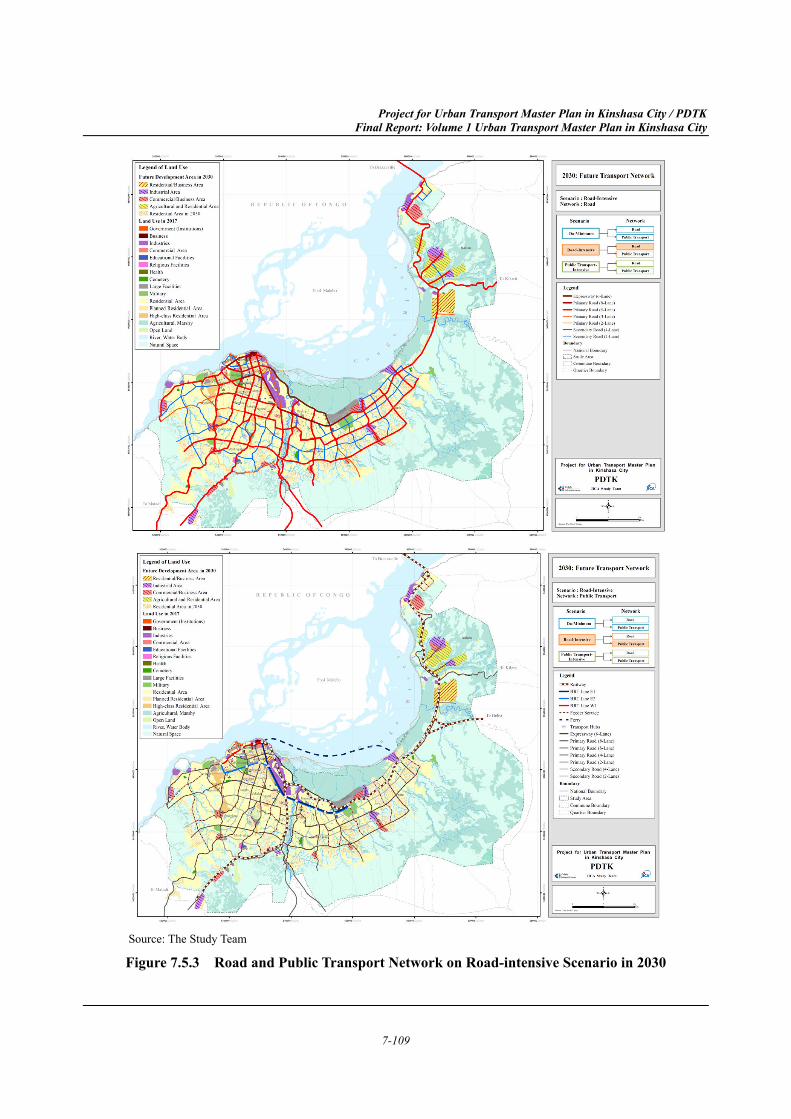
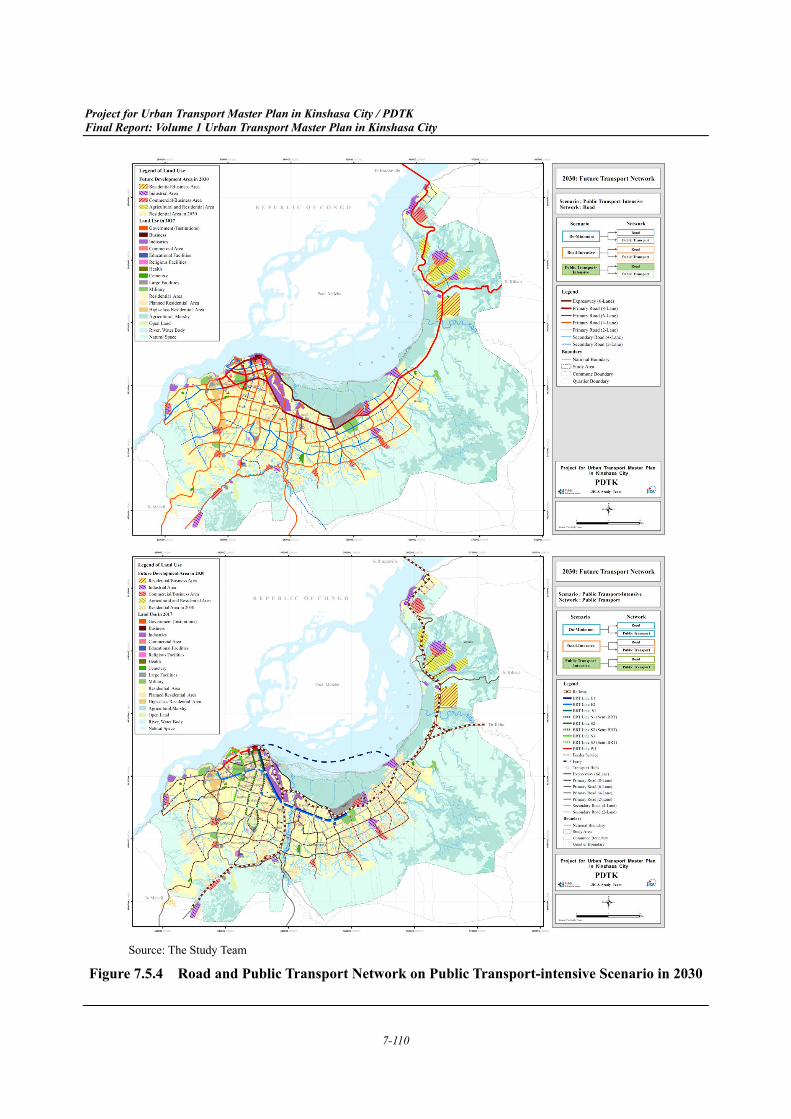
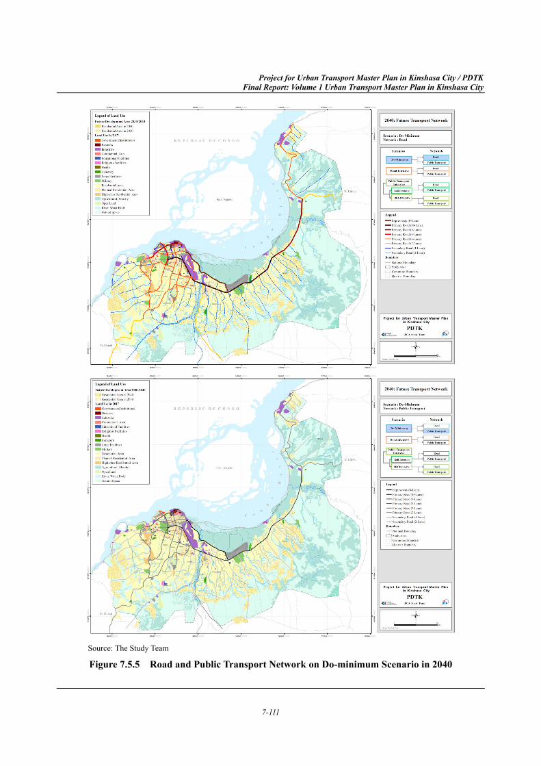
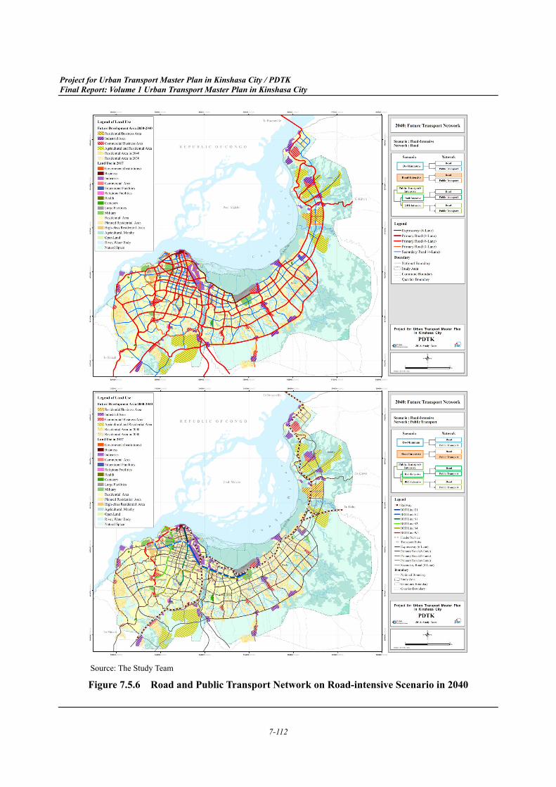
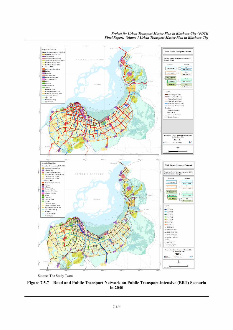
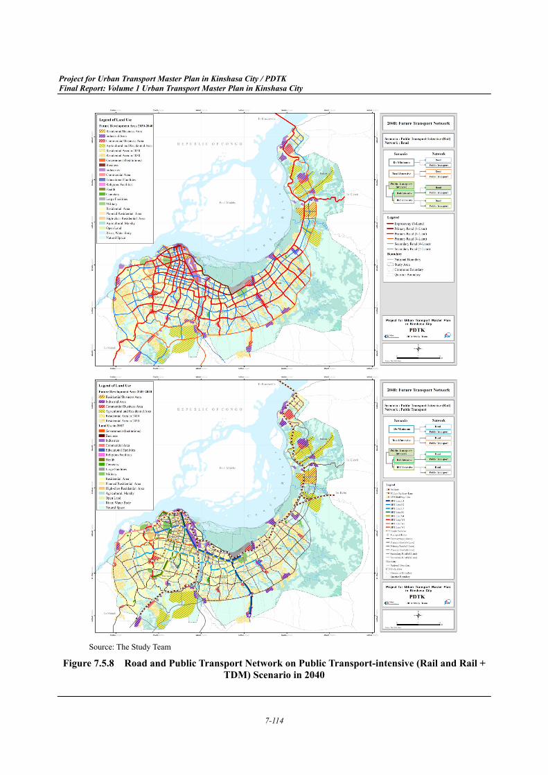
In principle, 3 scenarios; 1) Do Minimum, 2) Road-intensive and 3) Public transport intensive scenarios are prepared as shown in Figure 7.5.1. For the 3) Public transport intensive scenario, the scenario is divided into three derivative scenarios by mode and application of TDM policy in 2040.
The network options of road and public transport are illustrated in Figure 7.5.2 to Figure 7.5.8.
Project for Urban Transport Master Plan in Kinshasa City / PDTK Final Report: Volume 1 Urban Transport Master Plan in Kinshasa City
7-107
Source: The Study Team
Figure 7.5.1 Alternative Transport Network Scenarios in 2030 and 2040
Project for Urban Transport Master Plan in Kinshasa City / PDTK Final Report: Volume 1 Urban Transport Master Plan in Kinshasa City
7-108
Source: The Study Team
Figure 7.5.2 Road and Public Transport Network on Do-minimum Scenario in 2030
Project for Urban Transport Master Plan in Kinshasa City / PDTK Final Report: Volume 1 Urban Transport Master Plan in Kinshasa City
7-109
Source: The Study Team
Figure 7.5.3 Road and Public Transport Network on Road-intensive Scenario in 2030
Project for Urban Transport Master Plan in Kinshasa City / PDTK Final Report: Volume 1 Urban Transport Master Plan in Kinshasa City
7-110
Source: The Study Team
Figure 7.5.4 Road and Public Transport Network on Public Transport-intensive Scenario in 2030
Project for Urban Transport Master Plan in Kinshasa City / PDTK Final Report: Volume 1 Urban Transport Master Plan in Kinshasa City
7-111
Source: The Study Team
Figure 7.5.5 Road and Public Transport Network on Do-minimum Scenario in 2040
Project for Urban Transport Master Plan in Kinshasa City / PDTK Final Report: Volume 1 Urban Transport Master Plan in Kinshasa City
7-112
Source: The Study Team
Figure 7.5.6 Road and Public Transport Network on Road-intensive Scenario in 2040
Project for Urban Transport Master Plan in Kinshasa City / PDTK Final Report: Volume 1 Urban Transport Master Plan in Kinshasa City
7-113
Source: The Study Team
Figure 7.5.7 Road and Public Transport Network on Public Transport-intensive (BRT) Scenario in 2040
Project for Urban Transport Master Plan in Kinshasa City / PDTK Final Report: Volume 1 Urban Transport Master Plan in Kinshasa City
7-114
Source: The Study Team
Figure 7.5.8 Road and Public Transport Network on Public Transport-intensive (Rail and Rail + TDM) Scenario in 2040
Project for Urban Transport Master Plan in Kinshasa City / PDTK Final Report: Volume 1 Urban Transport Master Plan in Kinshasa City
7-115
Transport Demand Analysis and Future Projection 7.6
Assumptions 7.6.1
Network Conditions (1)
The network conditions for future transport projections are described in aforementioned Section 7.5. The networks were prepared to satisfy the urban transport policies.
As for the condition of those networks, all road surfaces were improved to smooth traffic flow and the road capacity was reduced to two lanes when BRT or railways were introduced.
Fare System (2)
As of 2017, there is a flat fare system with the price set by the government at CDF 500 per ride, regardless of travel distance. However, from the view of the operators, the result of BRS (Bus Route Survey) indicates that the government-designated fare system tends to disturb the flexibility of their operation and sustainability of their service. Additionally, from the passengers’ point of view, this fare system disadvantages those making short-distance trips, which are fairly common as of 2017 in the Study Area.
Thus, a distance-based fare system is recommended in the Study for public transport, which is assumed to include government modernized railways, BRT, feeder services, Transco and New Transkin. The suggested fare system for public transport is an initial fare of CDF 300 plus an additional CDF 40 for each kilometre travelled. This fare system was designed to bring in roughly the same amount of total revenue, while incentivizing short-distance trips and improving user-friendliness for riders. The private transport fare systems were assumed to be unchanged from current conditions.
Trips from External and Special Generator Zones (3)
The trips from external and special generator zones in 2030 and 2040 were estimated using 5 methods: 1) person trips on the roads, 2) freight trips on the roads, 3) trips to/from N'djili Airport, 4) Kinshasa-Brazzaville Bridge, and 5) person and freight trips at the port.
Person and freight trips on roads were estimated using a growth rate method based on the current number of trips. The number of person and freight trips in 2017 was obtained by cordon line surveys, and the growth rate for person trips was calculated using the results of the trip frequency model. There is significant amount of research on the relationship between GDP growth and freight trips which shows that their growth rates are generally parallel. Therefore, the projected GDP growth rate was used to calculate the growth in freight trips.
Air passenger growth rates tend to be related to, but are generally higher than, population growth rates. Using this relationship, future air passenger trips to and from N'djili Airport were estimated using elasticity values between the historical change of air passengers and population growth.
As shown in Table 7.6.2 and Table 7.6.1, the Ministry of Planning is conducting a study on the Kinshasa-Brazzaville Bridge which estimated freight demand in 2015 and 2025, and person trips in 2019 and 2025. These numbers were used by the Study to estimate trips in 2030 and 2040 using the linear interpolation method. It is noted that the majority of freight is expected to travel to the
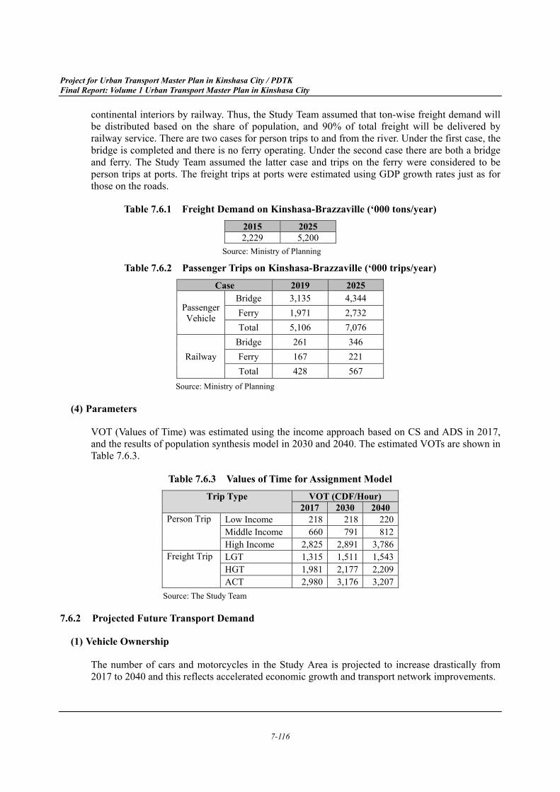
Project for Urban Transport Master Plan in Kinshasa City / PDTK Final Report: Volume 1 Urban Transport Master Plan in Kinshasa City
7-116
continental interiors by railway. Thus, the Study Team assumed that ton-wise freight demand will be distributed based on the share of population, and 90% of total freight will be delivered by railway service. There are two cases for person trips to and from the river. Under the first case, the bridge is completed and there is no ferry operating. Under the second case there are both a bridge and ferry. The Study Team assumed the latter case and trips on the ferry were considered to be person trips at ports. The freight trips at ports were estimated using GDP growth rates just as for those on the roads.
Table 7.6.1 Freight Demand on Kinshasa-Brazzaville (‘000 tons/year) 2015 2025 2,229 5,200
Source: Ministry of Planning
Table 7.6.2 Passenger Trips on Kinshasa-Brazzaville (‘000 trips/year) Case 2019 2025
Passenger Vehicle
Bridge 3,135 4,344 Ferry 1,971 2,732 Total 5,106 7,076
Railway Bridge 261 346 Ferry 167 221 Total 428 567
Source: Ministry of Planning
Parameters (4)
VOT (Values of Time) was estimated using the income approach based on CS and ADS in 2017, and the results of population synthesis model in 2030 and 2040. The estimated VOTs are shown in Table 7.6.3.
Table 7.6.3 Values of Time for Assignment Model Trip Type VOT (CDF/Hour)
2017 2030 2040Person Trip Low Income 218 218 220
Middle Income 660 791 812High Income 2,825 2,891 3,786
Freight Trip LGT 1,315 1,511 1,543HGT 1,981 2,177 2,209ACT 2,980 3,176 3,207
Source: The Study Team
Projected Future Transport Demand 7.6.2
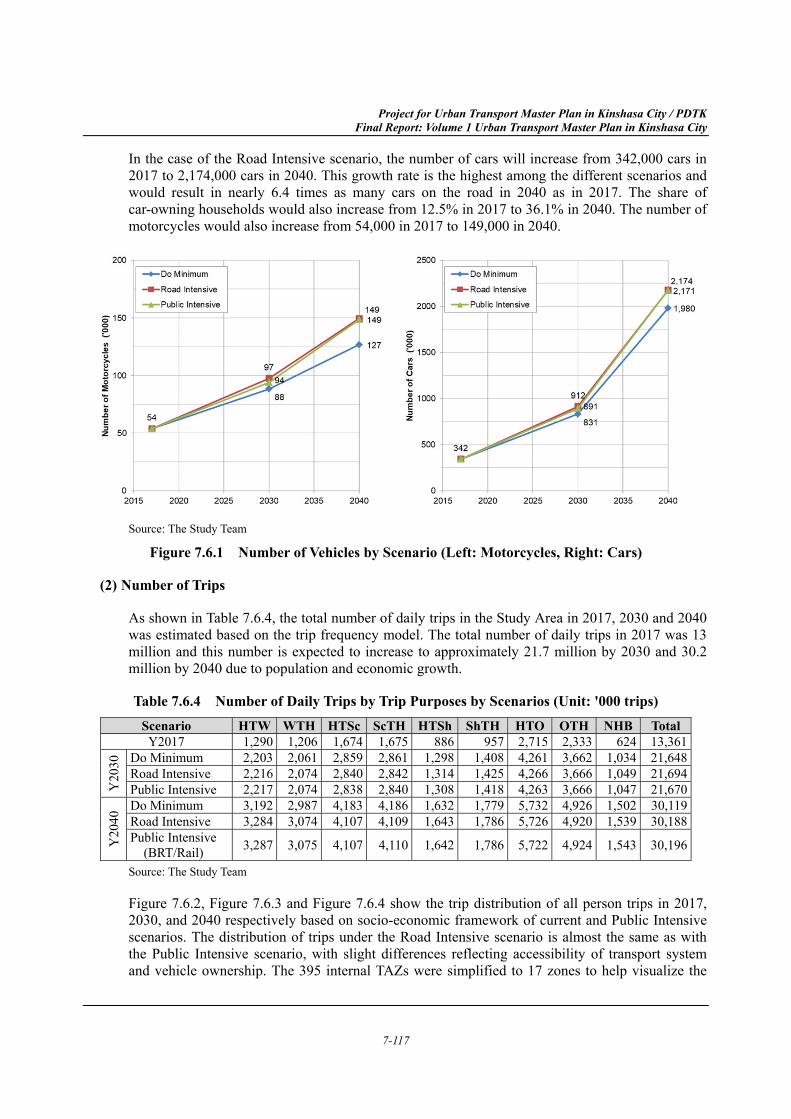
Vehicle Ownership (1)
The number of cars and motorcycles in the Study Area is projected to increase drastically from 2017 to 2040 and this reflects accelerated economic growth and transport network improvements.
Project for Urban Transport Master Plan in Kinshasa City / PDTK Final Report: Volume 1 Urban Transport Master Plan in Kinshasa City
7-117
In the case of the Road Intensive scenario, the number of cars will increase from 342,000 cars in 2017 to 2,174,000 cars in 2040. This growth rate is the highest among the different scenarios and would result in nearly 6.4 times as many cars on the road in 2040 as in 2017. The share of car-owning households would also increase from 12.5% in 2017 to 36.1% in 2040. The number of motorcycles would also increase from 54,000 in 2017 to 149,000 in 2040.
Source: The Study Team
Figure 7.6.1 Number of Vehicles by Scenario (Left: Motorcycles, Right: Cars)
Number of Trips (2)
As shown in Table 7.6.4, the total number of daily trips in the Study Area in 2017, 2030 and 2040 was estimated based on the trip frequency model. The total number of daily trips in 2017 was 13 million and this number is expected to increase to approximately 21.7 million by 2030 and 30.2 million by 2040 due to population and economic growth.
Table 7.6.4 Number of Daily Trips by Trip Purposes by Scenarios (Unit: '000 trips) Scenario HTW WTH HTSc ScTH HTSh ShTH HTO OTH NHB TotalY2017 1,290 1,206 1,674 1,675 886 957 2,715 2,333 624 13,361
Y20
30 Do Minimum 2,203 2,061 2,859 2,861 1,298 1,408 4,261 3,662 1,034 21,648
Road Intensive 2,216 2,074 2,840 2,842 1,314 1,425 4,266 3,666 1,049 21,694Public Intensive 2,217 2,074 2,838 2,840 1,308 1,418 4,263 3,666 1,047 21,670
Y20
40 Do Minimum 3,192 2,987 4,183 4,186 1,632 1,779 5,732 4,926 1,502 30,119
Road Intensive 3,284 3,074 4,107 4,109 1,643 1,786 5,726 4,920 1,539 30,188Public Intensive (BRT/Rail) 3,287 3,075 4,107 4,110 1,642 1,786 5,722 4,924 1,543 30,196
Source: The Study Team
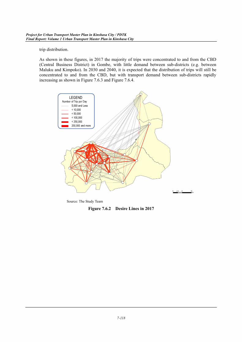
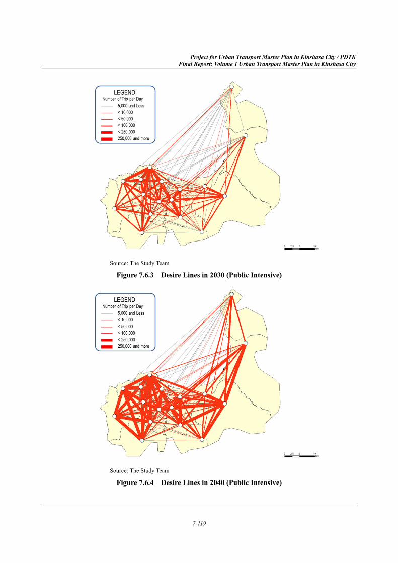
Figure 7.6.2, Figure 7.6.3 and Figure 7.6.4 show the trip distribution of all person trips in 2017, 2030, and 2040 respectively based on socio-economic framework of current and Public Intensive scenarios. The distribution of trips under the Road Intensive scenario is almost the same as with the Public Intensive scenario, with slight differences reflecting accessibility of transport system and vehicle ownership. The 395 internal TAZs were simplified to 17 zones to help visualize the
Project for Urban Transport Master Plan in Kinshasa City / PDTK Final Report: Volume 1 Urban Transport Master Plan in Kinshasa City
7-118
trip distribution.
As shown in these figures, in 2017 the majority of trips were concentrated to and from the CBD (Central Business District) in Gombe, with little demand between sub-districts (e.g. between Maluku and Kimpoko). In 2030 and 2040, it is expected that the distribution of trips will still be concentrated to and from the CBD, but with transport demand between sub-districts rapidly increasing as shown in Figure 7.6.3 and Figure 7.6.4.
Source: The Study Team
Figure 7.6.2 Desire Lines in 2017
Project for Urban Transport Master Plan in Kinshasa City / PDTK Final Report: Volume 1 Urban Transport Master Plan in Kinshasa City
7-119
Source: The Study Team
Figure 7.6.3 Desire Lines in 2030 (Public Intensive)
Source: The Study Team
Figure 7.6.4 Desire Lines in 2040 (Public Intensive)
Project for Urban Transport Master Plan in Kinshasa City / PDTK Final Report: Volume 1 Urban Transport Master Plan in Kinshasa City
7-120
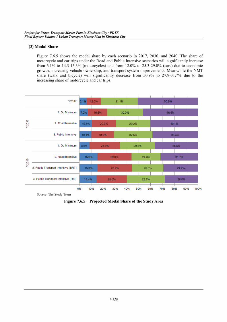
Modal Share (3)
Figure 7.6.5 shows the modal share by each scenario in 2017, 2030, and 2040. The share of motorcycle and car trips under the Road and Public Intensive scenarios will significantly increase from 6.1% to 14.3-15.3% (motorcycles) and from 12.0% to 25.3-29.0% (cars) due to economic growth, increasing vehicle ownership, and transport system improvements. Meanwhile the NMT share (walk and bicycle) will significantly decrease from 50.9% to 27.9-31.7% due to the increasing share of motorcycle and car trips.
Source: The Study Team
Figure 7.6.5 Projected Modal Share of the Study Area
Project for Urban Transport Master Plan in Kinshasa City / PDTK Final Report: Volume 1 Urban Transport Master Plan in Kinshasa City
7-121
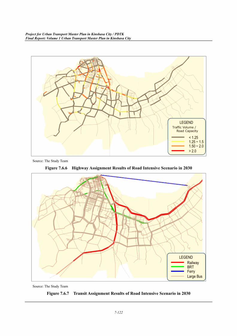
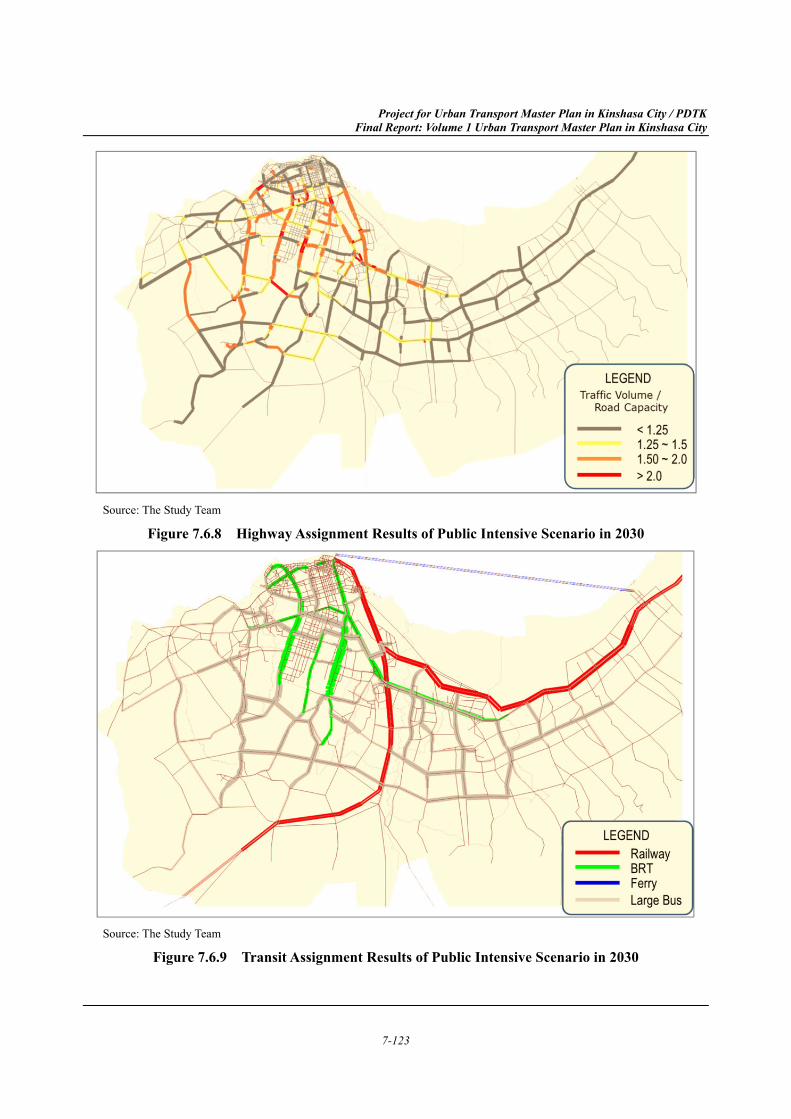
Impact of Transport Demand (4)
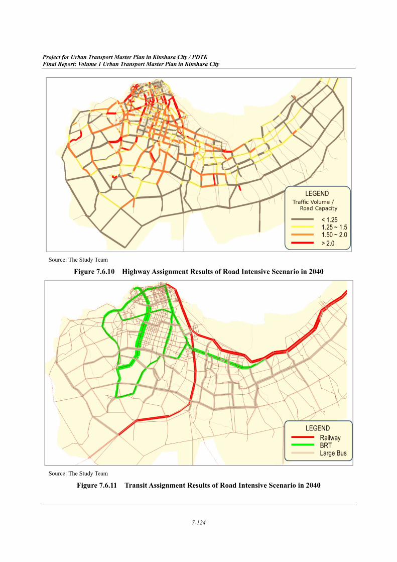
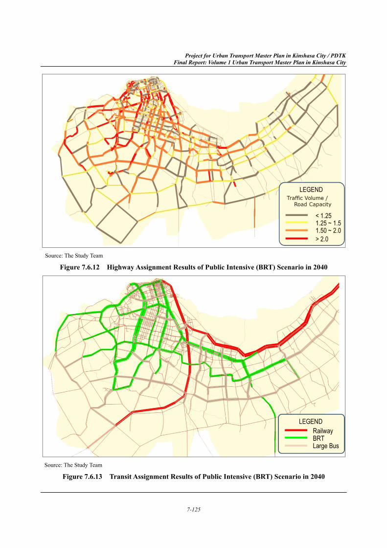
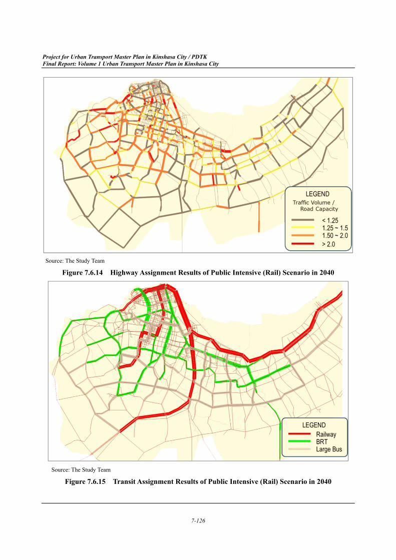
The results of future highway and transit assignment for the Road and Public Intensive scenarios are shown in Figure 7.6.6 to Figure 7.6.9 for 2030 and Figure 7.6.10 to Figure 7.6.17 for 2040. The highway assignment results of the Do Minimum scenario are shown in Section 7.1.2.
In 2030, if either the Road or Public Intensive scenarios are implemented, road congestion will be significantly worse than under the Do Minimum scenario. Road congestion under the Public Intensive scenario is slightly worse than the Road Intensive scenario due to the reduction of the number of lanes dedicated for BRT. However, the difference between the two scenarios is not significant.
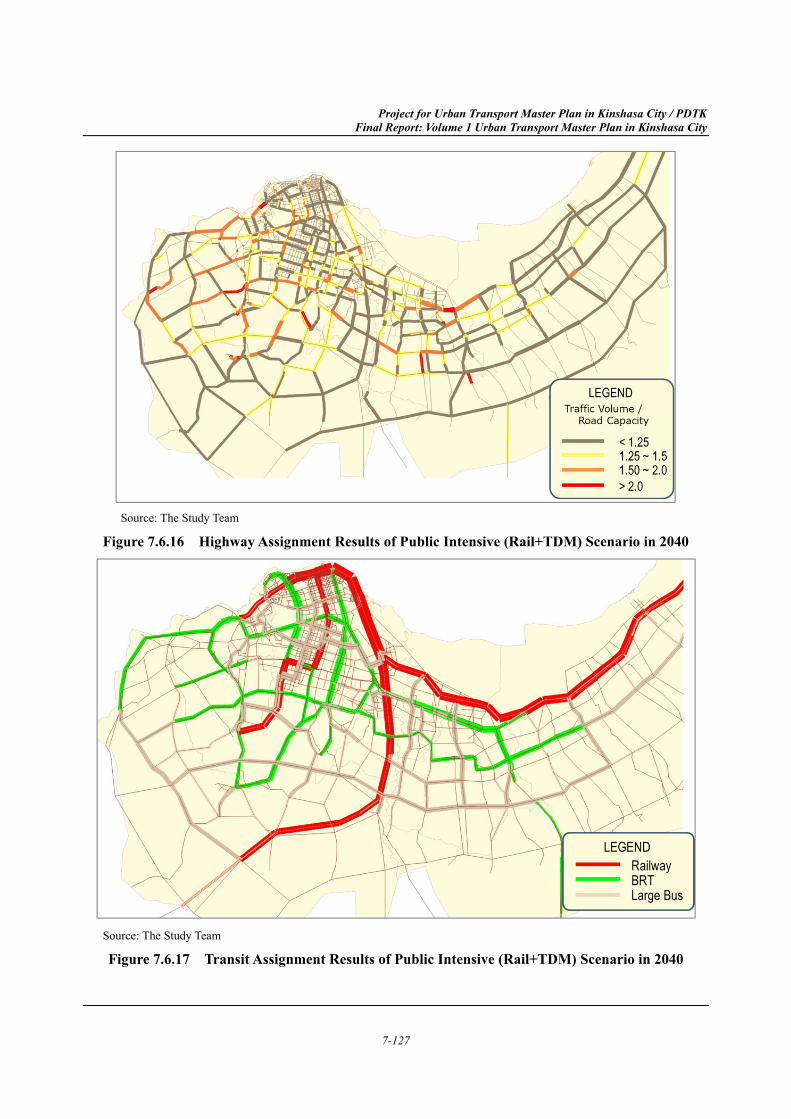
In 2040, road congestion under the Public Intensive scenario (Rail) is lowest. However, even with that scenario, the results indicate that both the road and public transport networks will be insufficient to fully absorb future demand, and additional projects and/or policies will be required to alleviate road congestion. Therefore, this study suggests introducing TDM schemes alongside the Public Intensive scenario (Rail) considering necessary budget for project implementation. The impacts of TDM with the Public Intensive scenario (Rail) are shown in the following section.
Project for Urban Transport Master Plan in Kinshasa City / PDTK Final Report: Volume 1 Urban Transport Master Plan in Kinshasa City
7-122
Source: The Study Team
Figure 7.6.6 Highway Assignment Results of Road Intensive Scenario in 2030
Source: The Study Team
Figure 7.6.7 Transit Assignment Results of Road Intensive Scenario in 2030
Project for Urban Transport Master Plan in Kinshasa City / PDTK Final Report: Volume 1 Urban Transport Master Plan in Kinshasa City
7-123
Source: The Study Team
Figure 7.6.8 Highway Assignment Results of Public Intensive Scenario in 2030
Source: The Study Team
Figure 7.6.9 Transit Assignment Results of Public Intensive Scenario in 2030
Project for Urban Transport Master Plan in Kinshasa City / PDTK Final Report: Volume 1 Urban Transport Master Plan in Kinshasa City
7-124
Source: The Study Team
Figure 7.6.10 Highway Assignment Results of Road Intensive Scenario in 2040
Source: The Study Team
Figure 7.6.11 Transit Assignment Results of Road Intensive Scenario in 2040
Project for Urban Transport Master Plan in Kinshasa City / PDTK Final Report: Volume 1 Urban Transport Master Plan in Kinshasa City
7-125
Source: The Study Team
Figure 7.6.12 Highway Assignment Results of Public Intensive (BRT) Scenario in 2040
Source: The Study Team
Figure 7.6.13 Transit Assignment Results of Public Intensive (BRT) Scenario in 2040
Project for Urban Transport Master Plan in Kinshasa City / PDTK Final Report: Volume 1 Urban Transport Master Plan in Kinshasa City
7-126
Source: The Study Team
Figure 7.6.14 Highway Assignment Results of Public Intensive (Rail) Scenario in 2040
Source: The Study Team
Figure 7.6.15 Transit Assignment Results of Public Intensive (Rail) Scenario in 2040
Project for Urban Transport Master Plan in Kinshasa City / PDTK Final Report: Volume 1 Urban Transport Master Plan in Kinshasa City
7-127
Source: The Study Team
Figure 7.6.16 Highway Assignment Results of Public Intensive (Rail+TDM) Scenario in 2040
Source: The Study Team
Figure 7.6.17 Transit Assignment Results of Public Intensive (Rail+TDM) Scenario in 2040
Project for Urban Transport Master Plan in Kinshasa City / PDTK Final Report: Volume 1 Urban Transport Master Plan in Kinshasa City
7-128
Impact of Transport Demand Management (5)
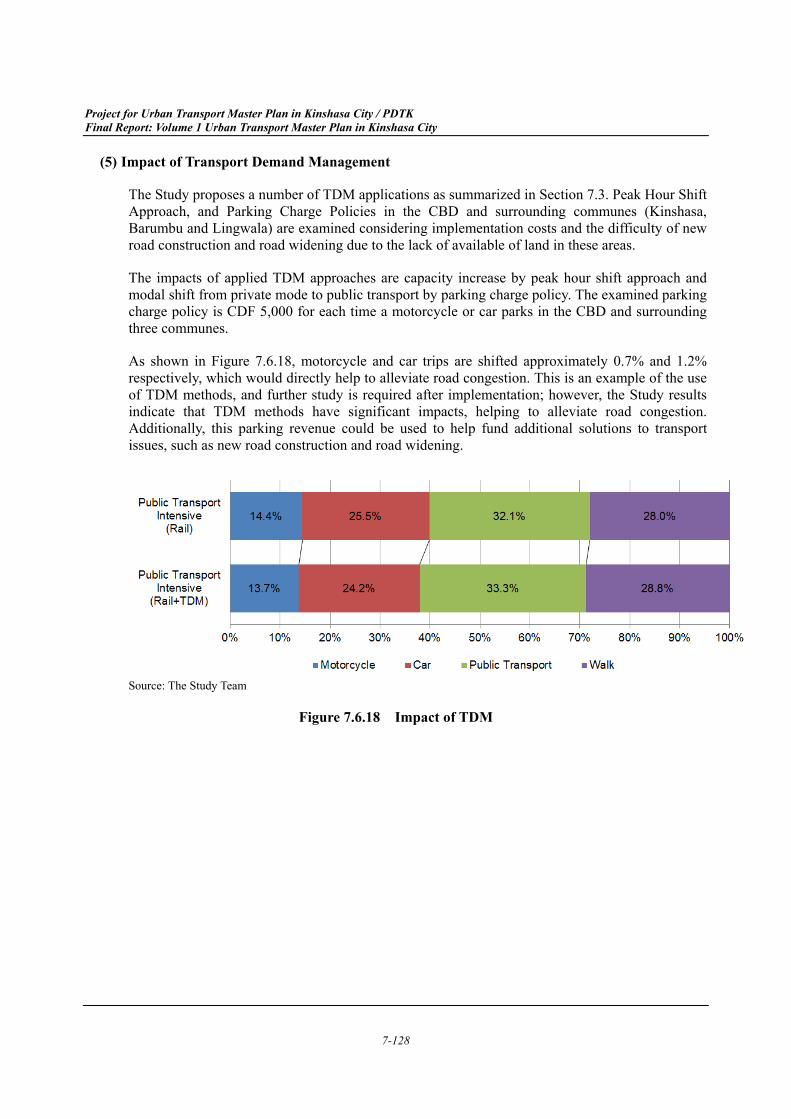
The Study proposes a number of TDM applications as summarized in Section 7.3. Peak Hour Shift Approach, and Parking Charge Policies in the CBD and surrounding communes (Kinshasa, Barumbu and Lingwala) are examined considering implementation costs and the difficulty of new road construction and road widening due to the lack of available of land in these areas.
The impacts of applied TDM approaches are capacity increase by peak hour shift approach and modal shift from private mode to public transport by parking charge policy. The examined parking charge policy is CDF 5,000 for each time a motorcycle or car parks in the CBD and surrounding three communes.
As shown in Figure 7.6.18, motorcycle and car trips are shifted approximately 0.7% and 1.2% respectively, which would directly help to alleviate road congestion. This is an example of the use of TDM methods, and further study is required after implementation; however, the Study results indicate that TDM methods have significant impacts, helping to alleviate road congestion. Additionally, this parking revenue could be used to help fund additional solutions to transport issues, such as new road construction and road widening.
Source: The Study Team
Figure 7.6.18 Impact of TDM
Project for Urban Transport Master Plan in Kinshasa City / PDTK Final Report: Volume 1 Urban Transport Master Plan in Kinshasa City
7-129
Strategic Environmental Assessment (SEA) on Alternative Scenarios 7.7
Full report of Strategic Environmental Assessment of the Master Plan is attached as Appendix 2 of Volume 1. In Appendix 2, Chapter 4 explains the potential impacts expected in the implementation phase of the Master Plan that must be considered during the development of the Master Plan. These potential are studied for each alternative scenario in the following 7.7.1 as well as in Chapter 5 of Appendix 2. Impacts from the preferred scenario are further studied in the following 7.7.2, as well as in Chapter 7 of Appendix 2. Measures to avoid and minimize these impacts are stated in the following 7.7.5, as well as in Chapter 8 of Appendix 2 of this Report.
Comparative Evaluation of Alternative Scenarios 7.7.1
Among the nineteen environmental items that are expected to be affected when the plan is to be implemented shown in Table 3.6.5 and Table 3.6.6, seven (7) items were not included in the following evaluations because suitable data that can be used as indices proposed in Table 3.6.6 was not available during the Study. The seven items omitted from further evaluation are as follows: water quality, sanitation, waste, ecosystem, land use, flood and inundation, and geology.
Remaining twelve (12) items were grouped into four, and the alternative scenarios were evaluated against each of the four environmental and social aspects in following (2), (3) and (4).
Preconditions (1)
a) Do Minimum Scenario as Baseline
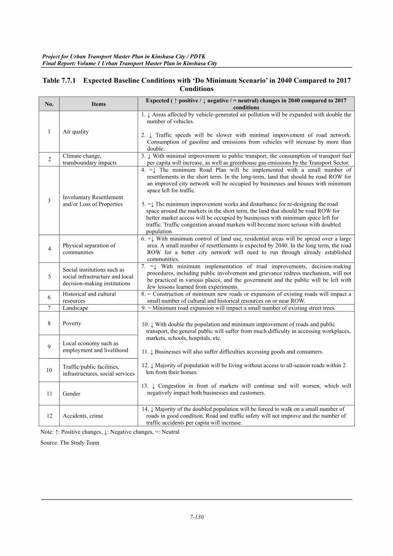
Since the population of Kinshasa is estimated to double by 2040, the existing 2017 condition is far different from the baseline condition in 2040 in every aspect of environment and society. Therefore, the ‘Do Minimum Scenario’ is used as the baseline, and the other alternative scenarios are then compared with the conditions expected from the ‘Do Minimum Scenario.’ Expected baseline conditions with implementation of the ‘Do Minimum Scenario’ in 2040 when compared to 2017 conditions are summarised in Table 7.7.1.
Project for Urban Transport Master Plan in Kinshasa City / PDTK Final Report: Volume 1 Urban Transport Master Plan in Kinshasa City
7-130
Table 7.7.1 Expected Baseline Conditions with ‘Do Minimum Scenario’ in 2040 Compared to 2017 Conditions
No. Items Expected ( ↑ positive / ↓ negative / = neutral) changes in 2040 compared to 2017 conditions
1 Air quality
1. ↓ Areas affected by vehicle-generated air pollution will be expanded with double the number of vehicles.
2. ↓ Traffic speeds will be slower with minimal improvement of road network.
Consumption of gasoline and emissions from vehicles will increase by more than double.
2 Climate change, transboundary impacts
3. ↓ With minimal improvement to public transport, the consumption of transport fuel per capita will increase, as well as greenhouse gas emissions by the Transport Sector.
3 Involuntary Resettlement and/or Loss of Properties
4. =↓ The minimum Road Plan will be implemented with a small number of resettlements in the short term. In the long-term, land that should be road ROW for an improved city network will be occupied by businesses and houses with minimum space left for traffic.
5. =↓ The minimum improvement works and disturbance for re-designing the road
space around the markets in the short term, the land that should be road ROW for better market access will be occupied by businesses with minimum space left for traffic. Traffic congestion around markets will become more serious with doubled population.
4 Physical separation of communities
6. =↓ With minimum control of land use, residential areas will be spread over a large area. A small number of resettlements is expected by 2040. In the long term, the road ROW for a better city network will need to run through already established communities.
5 Social institutions such as social infrastructure and local decision-making institutions
7. =↓ With minimum implementation of road improvements, decision-making procedures, including public involvement and grievance redress mechanism, will not be practiced in various places, and the government and the public will be left with few lessons learned from experiments.
6 Historical and cultural resources
8. = Construction of minimum new roads or expansion of existing roads will impact a small number of cultural and historical resources on or near ROW.
7 Landscape 9. = Minimum road expansion will impact a small number of existing street trees.
8 Poverty 10. ↓ With double the population and minimum improvement of roads and public transport, the general public will suffer from much difficulty in accessing workplaces, markets, schools, hospitals, etc.
11. ↓ Businesses will also suffer difficulties accessing goods and consumers. 12. ↓ Majority of population will be living without access to all-season roads within 2
km from their homes. 13. ↓ Congestion in front of markets will continue and will worsen, which will
negatively impact both businesses and customers.
9 Local economy such as employment and livelihood
10 Traffic/public facilities, infrastructures, social services
11 Gender
12 Accidents, crime 14. ↓ Majority of the doubled population will be forced to walk on a small number of
roads in good condition. Road and traffic safety will not improve and the number of traffic accidents per capita will increase.
Note: ↑: Positive changes, ↓: Negative changes, =: Neutral
Source: The Study Team
Project for Urban Transport Master Plan in Kinshasa City / PDTK Final Report: Volume 1 Urban Transport Master Plan in Kinshasa City
7-131
b) Quantitative Evaluation
Quantitative evaluation was calculated as differences of economic benefits between “Without” and “With” scenarios, based on the Highway Development and Management (HDM-4) Road Use Costs Model.
c) Qualitative Evaluation
In the qualitative evaluation, the baseline condition, ‘Do Minimum,’ is given a 0 (zero), with an improved condition given a +1 (plus one). When a much improved condition can be achieved than +1, a +2 (plus two) was given to the scenario. A worse condition was evaluated in the same manner; A -1 (minus one) was given to an expected condition worse than the ‘Do Minimum’ condition.
Table 7.7.2 Scenarios for Comparative Evaluation Evaluation Expected Condition
-2 Worse than -1 condition -1 Worse than the ‘Do Minimum’ Scenario condition 0 ‘Do Minimum’ Scenario condition
+1 Better than the ‘Do Minimum’ Scenario condition +2 Better than +1 condition
Source: The Study Team
d) Scenarios Evaluated in SEA
The ‘Public Transport Intensive’ scenario is divided into three detailed scenarios in the 2040 Master Plan. Although the mode of transport is different, the coverage areas of public transit are generally the same between the BRT-Intensive scenario, the Rail-Intensive scenario and the Rail-Intensive + TDM scenario. Therefore, in this report, the 2040 Public Transportation Intensive Scenario was evaluated as one scenario.
Table 7.7.3 Scenarios for Comparative Evaluation 2040 Scenario Scenarios compared in SEA
Do Minimum Do Minimum (Baseline (Table 7.7.1)) Road Intensive Road Intensive BRT Intensive
Public Transport Intensive Rail Intensive Rail Intensive + TDMSource: The Study Team
Project for Urban Transport Master Plan in Kinshasa City / PDTK Final Report: Volume 1 Urban Transport Master Plan in Kinshasa City
7-132
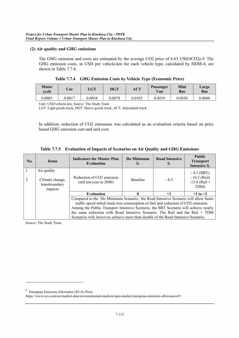
Air quality and GHG emissions (2)
The GHG emission and costs are estimated by the average CO2 price of 6.63 USD/tCO2e.9 The GHG emission costs, in USD per vehicle-km for each vehicle type, calculated by HDM-4, are shown in Table 7.7.4.
Table 7.7.4 GHG Emission Costs by Vehicle Type (Economic Price)
Motor cycle Car LGT HGT ACT Passenger
Van Mini Bus
Large Bus
0.0003 0.0017 0.0034 0.0078 0.0103 0.0019 0.0030 0.0060 Unit: USD/vehicle-km, Source: The Study Team LGT: Light goods truck, HGT: Heavy goods truck, ACT: Articulated truck
In addition, reduction of CO2 emissions was calculated as an evaluation criteria based on price based GHG emission cost and unit cost.
Table 7.7.5 Evaluation of Impacts of Scenarios on Air Quality and GHG Emissions
No. Items Indicators for Master Plan Evaluation
Do Minimum S.
Road Intensive S.
Public Transport
Intensive S. 1 2
Air quality Climate change, transboundary
impacts
Reduction of CO2 emission (mil ton/year in 2040) Baseline - 4.3
- 4.1 (BRT) - 10.2 (Rail) -13.8 (Rail +
TDM)
Evaluation 0 +1 +1 to +2
Compared to the ‘Do Minimum Scenario,’ the Road Intensive Scenario will allow faster traffic speed which leads less consumption of fuel and reduction of CO2 emission.
Among the Public Transport Intensive Scenario, the BRT Scenario will achieve nearly the same reduction with Road Intensive Scenario. The Rail and the Rail + TDM Scenarios will, however, achieve more than double of the Road Intensive Scenario.
Source: The Study Team
9 European Emission Allowance (EUA) Price https://www.eex.com/en/market-data/environmental-markets/spot-market/european-emission-allowances#!/
Project for Urban Transport Master Plan in Kinshasa City / PDTK Final Report: Volume 1 Urban Transport Master Plan in Kinshasa City
7-133
Necessity of land and community (3)
a) Qualitative evaluation
Although the ‘Do Minimum Scenario’ avoids disturbances of existing residences and businesses, with minimum control of land use, residential areas will spread over a large area by 2040. In the further long term, the road ROW for an improved city network will need land that is occupied with residences and businesses, and the road may need to physically separate already established communities. The other two scenarios will cause disturbances of the existing condition during their implementation, but the result will be a stronger infrastructure for better living and business environment.
At the same time, implementation of road improvements and new road construction with scenarios other than the ‘Do Minimum Scenario’ will require many decision-making procedures, including public involvement and a grievance redress mechanism. Both the government and the general public will experience trials and errors, and both sides will accumulate lessons learned from these experiments. Such lessons will strengthen the democratic public involvement and grievance redress mechanisms in the governance of all sectors.
b) Quantitative evaluation
The number of involuntary relocation was estimated using the numbers of population distribution in 2017, road coverage area in 2040 for new road construction and road widening, and average number of buildings per area.
The area was classified as urbanized area and non-urbanized area, and number of building per area was set as 21.71 building/ha and 1 building/ha respectively, based on result of Building Use Survey.
Project for Urban Transport Master Plan in Kinshasa City / PDTK Final Report: Volume 1 Urban Transport Master Plan in Kinshasa City
7-134
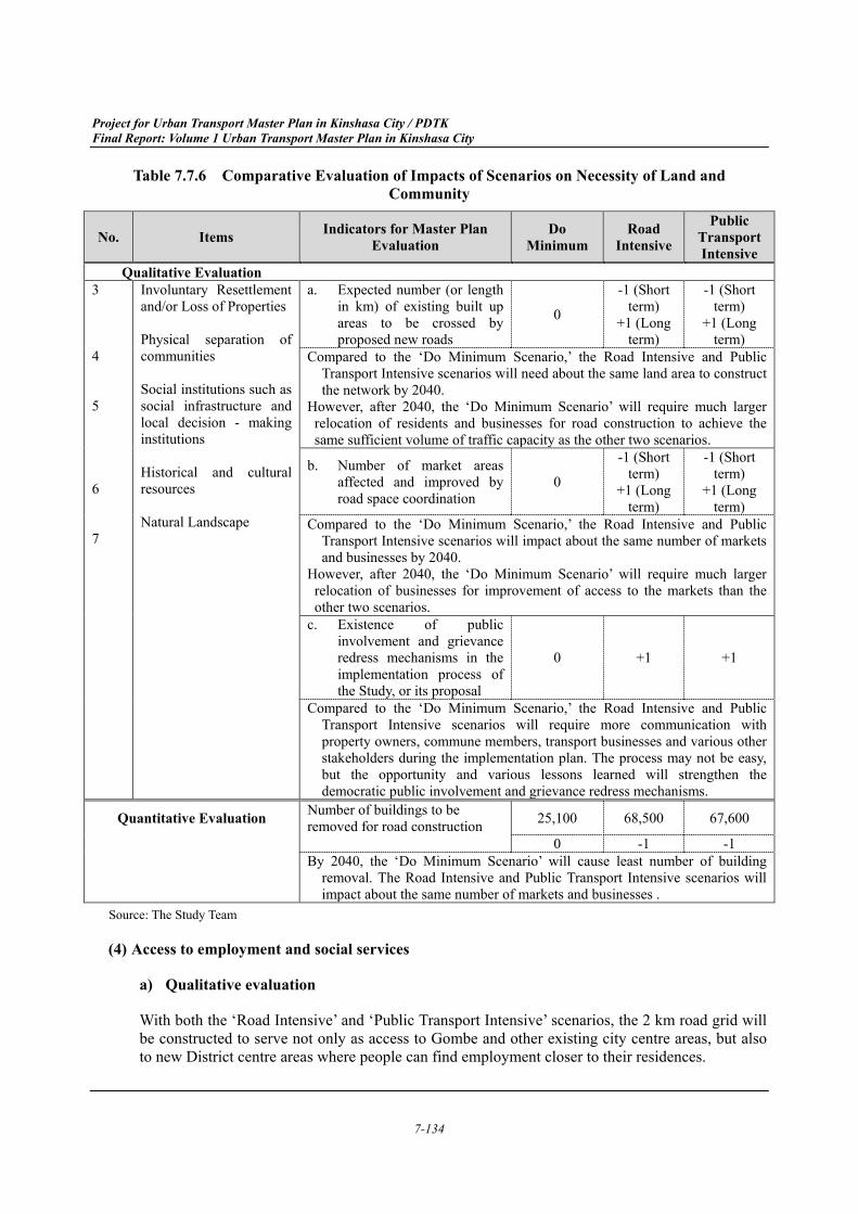
Table 7.7.6 Comparative Evaluation of Impacts of Scenarios on Necessity of Land and Community
Source: The Study Team
Access to employment and social services (4)
a) Qualitative evaluation
With both the ‘Road Intensive’ and ‘Public Transport Intensive’ scenarios, the 2 km road grid will be constructed to serve not only as access to Gombe and other existing city centre areas, but also to new District centre areas where people can find employment closer to their residences.
No. Items Indicators for Master Plan Evaluation
Do Minimum
Road Intensive
Public Transport Intensive
Qualitative Evaluation 3
4
5
6
7
Involuntary Resettlement and/or Loss of Properties
Physical separation of communities
Social institutions such as social infrastructure and local decision - making institutions
Historical and cultural resources
Natural Landscape
a. Expected number (or lengthin km) of existing built upareas to be crossed byproposed new roads
0
-1 (Short term)
+1 (Long term)
-1 (Short term)
+1 (Long term)
Compared to the ‘Do Minimum Scenario,’ the Road Intensive and Public Transport Intensive scenarios will need about the same land area to construct the network by 2040.
However, after 2040, the ‘Do Minimum Scenario’ will require much larger relocation of residents and businesses for road construction to achieve the same sufficient volume of traffic capacity as the other two scenarios.
b. Number of market areasaffected and improved byroad space coordination
0
-1 (Short term)
+1 (Long term)
-1 (Short term)
+1 (Long term)
Compared to the ‘Do Minimum Scenario,’ the Road Intensive and Public Transport Intensive scenarios will impact about the same number of markets and businesses by 2040.
However, after 2040, the ‘Do Minimum Scenario’ will require much larger relocation of businesses for improvement of access to the markets than the other two scenarios.
c. Existence of publicinvolvement and grievanceredress mechanisms in theimplementation process ofthe Study, or its proposal
0 +1 +1
Compared to the ‘Do Minimum Scenario,’ the Road Intensive and Public Transport Intensive scenarios will require more communication with property owners, commune members, transport businesses and various other stakeholders during the implementation plan. The process may not be easy, but the opportunity and various lessons learned will strengthen the democratic public involvement and grievance redress mechanisms.
Quantitative Evaluation Number of buildings to be removed for road construction 25,100 68,500 67,600
0 -1 -1 By 2040, the ‘Do Minimum Scenario’ will cause least number of building
removal. The Road Intensive and Public Transport Intensive scenarios will impact about the same number of markets and businesses .
Project for Urban Transport Master Plan in Kinshasa City / PDTK Final Report: Volume 1 Urban Transport Master Plan in Kinshasa City
7-135
The mass transit system developed by the ‘Public Transport Intensive Scenario’ will achieve the shortest commuting time for the population. Also with this same scenario, the short distance transportation to the District centres and transportation hubs will be separated from the long-distance cargo trucks and passenger buses, with the majority of car traffic used for short-distance trips.
b) Quantitative evaluation
The number of population in the service area of railway and BRT was estimated by GIS and quartier wise population distribution.
The service area was defined as the population in the area within 1.0 km radius from railway stations and BRT shelters.
Table 7.7.7 Comparative Evaluation of impacts of Scenarios on Access to Employment and Social Services
No. Items Indicators for Master Plan evaluation Do Minimum Road
Intensive
Public Transport Intensive
8 9 10 11
Poverty Local economy such as employment and livelihood Traffic/public facilities, infrastructures, social services Gender
The number of population in the service area of railway and
BRT (1 km radius from the station) (thousand persons)
0 8,089 12,050 (BRT) 12,024 (Rail) 12,024 (Rail +
TDM) Evaluation 0 +1 +2
Compared to the ‘Do Minimum Scenario,’ the Road Intensive Scenario will provide better access to railway stations. Public Transport Intensive Scenario will provide railway/BRT transport hubs near houses and work places. Being near to traffic hubs will benefit the residents and businesses by shorter, better access to works and customers. The benefit will be felt more among those who can not afford a private car. Also, compared to the ‘Do Minimum Scenario,’ the Road Intensive and Public Transport Intensive scenarios will both provide 100% access to all-season roads for every resident in Kinshasa. Securing access to all-season road will benefit those who do not have strong mobility, such as children and elderly.
Source: The Study Team
Road accidents (5)
The accidental costs, composed by fatality cost and injury cost, was estimated by the value of income one person could earn in 20 years, assuming a person had an accident at the age of 40 and he/she was expected to work for another 20 years. The fatality cost is estimated at USD 8,090 and the injury cost at USD 809, as the injury cost is 10% of fatality cost, according to the interview with a local insurance company.
The total accident costs, in USD per vehicle-km for each vehicle type, calculated by HDM-4, are shown in Table 7.7.8.
Project for Urban Transport Master Plan in Kinshasa City / PDTK Final Report: Volume 1 Urban Transport Master Plan in Kinshasa City
7-136
Table 7.7.8 Accident Costs by Vehicle Type (Economic Price)
Motor cycle Car LGT HGT ACT Passenger
Van Mini Bus
Large Bus
0.000792 0.000462 0.000594 0.000462 0.000462 0.000330 0.000330 0.000330Unit: USD/vehicle-km,
LGT: Light goods truck, HGT: Heavy goods truck, ACT: Articulated truck
Source: The Study Team
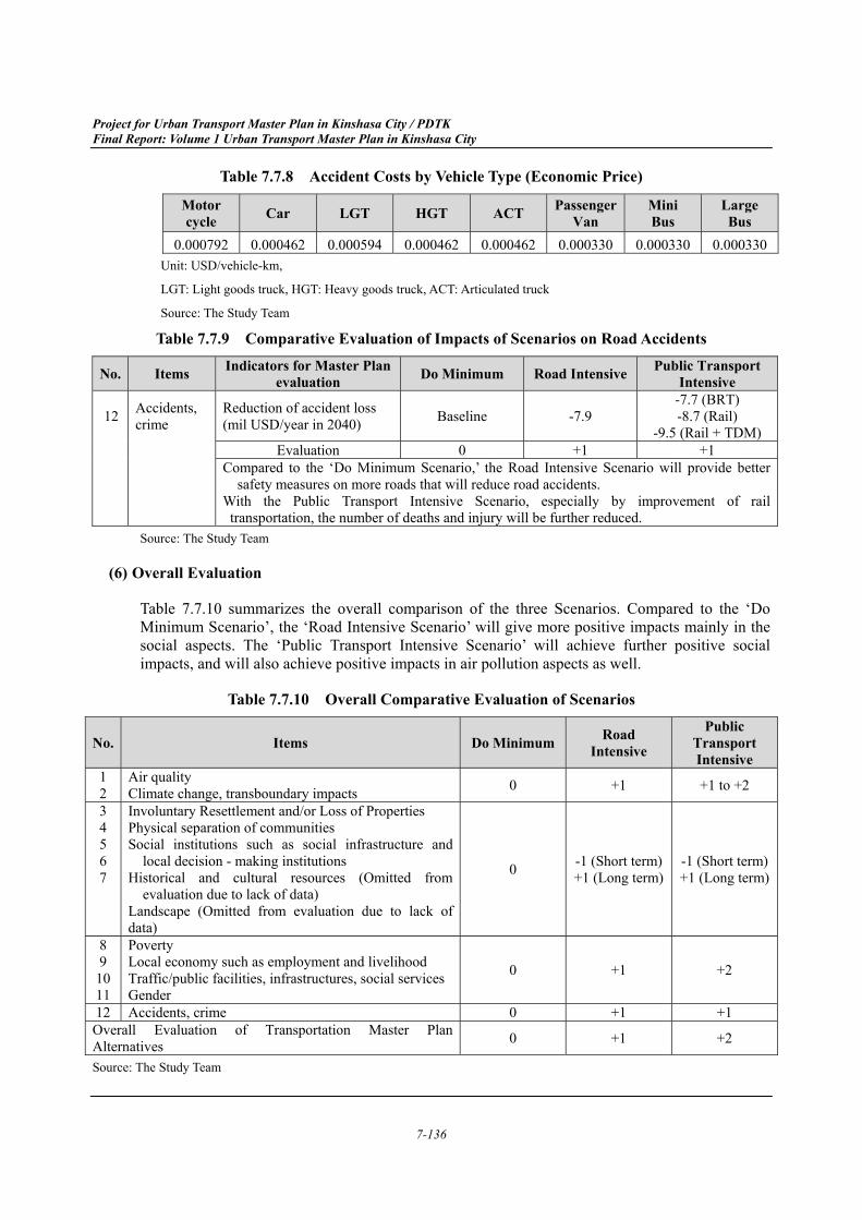
Table 7.7.9 Comparative Evaluation of Impacts of Scenarios on Road Accidents
No. Items Indicators for Master Plan evaluation Do Minimum Road Intensive Public Transport
Intensive
12 Accidents, crime
Reduction of accident loss (mil USD/year in 2040) Baseline -7.9
-7.7 (BRT) -8.7 (Rail)
-9.5 (Rail + TDM) Evaluation 0 +1 +1
Compared to the ‘Do Minimum Scenario,’ the Road Intensive Scenario will provide better safety measures on more roads that will reduce road accidents.
With the Public Transport Intensive Scenario, especially by improvement of rail transportation, the number of deaths and injury will be further reduced.
Source: The Study Team
Overall Evaluation (6)
Table 7.7.10 summarizes the overall comparison of the three Scenarios. Compared to the ‘Do Minimum Scenario’, the ‘Road Intensive Scenario’ will give more positive impacts mainly in the social aspects. The ‘Public Transport Intensive Scenario’ will achieve further positive social impacts, and will also achieve positive impacts in air pollution aspects as well.
Table 7.7.10 Overall Comparative Evaluation of Scenarios
No. Items Do Minimum Road Intensive
Public Transport Intensive
1 2
Air quality Climate change, transboundary impacts 0 +1 +1 to +2
3 4 5 6 7
Involuntary Resettlement and/or Loss of Properties Physical separation of communities Social institutions such as social infrastructure and
local decision - making institutions Historical and cultural resources (Omitted from
evaluation due to lack of data) Landscape (Omitted from evaluation due to lack of data)
0 -1 (Short term) +1 (Long term)
-1 (Short term)+1 (Long term)
8 9
10 11
Poverty Local economy such as employment and livelihood Traffic/public facilities, infrastructures, social services Gender
0 +1 +2
12 Accidents, crime 0 +1 +1 Overall Evaluation of Transportation Master Plan Alternatives 0 +1 +2
Source: The Study Team
Project for Urban Transport Master Plan in Kinshasa City / PDTK Final Report: Volume 1 Urban Transport Master Plan in Kinshasa City
7-137
Identification and Evaluation of Impacts of the Masterplan Implementation 7.7.2
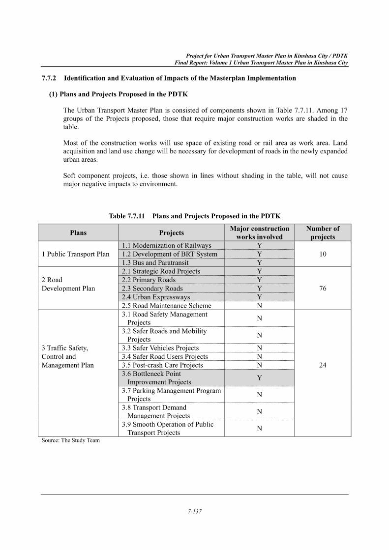
Plans and Projects Proposed in the PDTK (1)
The Urban Transport Master Plan is consisted of components shown in Table 7.7.11. Among 17 groups of the Projects proposed, those that require major construction works are shaded in the table.
Most of the construction works will use space of existing road or rail area as work area. Land acquisition and land use change will be necessary for development of roads in the newly expanded urban areas.
Soft component projects, i.e. those shown in lines without shading in the table, will not cause major negative impacts to environment.
Table 7.7.11 Plans and Projects Proposed in the PDTK
Source: The Study Team
Plans Projects Major construction works involved
Number of projects
1.1 Modernization of Railways Y 1 Public Transport Plan 1.2 Development of BRT System Y 10
1.3 Bus and Paratransit Y 2.1 Strategic Road Projects Y
2 Road 2.2 Primary Roads Y Development Plan 2.3 Secondary Roads Y 76
2.4 Urban Expressways Y 2.5 Road Maintenance Scheme N 3.1 Road Safety Management
Projects N
3.2 Safer Roads and Mobility Projects N
3 Traffic Safety, 3.3 Safer Vehicles Projects N Control and 3.4 Safer Road Users Projects N Management Plan 3.5 Post-crash Care Projects N 24
3.6 Bottleneck Point Improvement Projects Y
3.7 Parking Management Program Projects N
3.8 Transport Demand Management Projects N
3.9 Smooth Operation of Public Transport Projects N
Project for Urban Transport Master Plan in Kinshasa City / PDTK Final Report: Volume 1 Urban Transport Master Plan in Kinshasa City
7-138
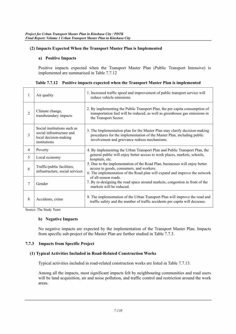
Impacts Expected When the Transport Master Plan is Implemented (2)
a) Positive Impacts
Positive impacts expected when the Transport Master Plan (Public Transport Intensive) is implemented are summarised in Table 7.7.12
Table 7.7.12 Positive impacts expected when the Transport Master Plan is implemented
1 Air quality 1. Increased traffic speed and improvement of public transport service will reduce vehicle emissions.
2 Climate change, transboundary impacts
2. By implementing the Public Transport Plan, the per capita consumption of transportation fuel will be reduced, as well as greenhouse gas emissions in the Transport Sector.
3
Social institutions such as social infrastructure and local decision-making institutions
3. The Implementation plan for the Master Plan may clarify decision-making procedures for the implementation of the Master Plan, including public involvement and grievance redress mechanisms.
4 Poverty 4. By implementing the Urban Transport Plan and Public Transport Plan, the general public will enjoy better access to work places, markets, schools, hospitals, etc.
5. Due to the implementation of the Road Plan, businesses will enjoy better access to goods, consumers, and workers.
6. The implementation of the Road plan will expand and improve the network of all-season roads.
7. By re-designing the road space around markets, congestion in front of the markets will be reduced.
5 Local economy
6 Traffic/public facilities, infrastructure, social services
7 Gender
8 Accidents, crime 8. The implementation of the Urban Transport Plan will improve the road and traffic safety and the number of traffic accidents per capita will decrease.
Source: The Study Team
b) Negative Impacts
No negative impacts are expected by the implementation of the Transport Master Plan. Impacts from specific sub-project of the Master Plan are further studied in Table 7.7.3.
Impacts from Specific Project 7.7.3
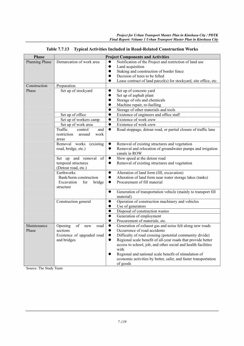
Typical Activities Included in Road-Related Construction Works (1)
Typical activities included in road-related construction works are listed in Table 7.7.13.
Among all the impacts, most significant impacts felt by neighbouring communities and road users will be land acquisition, air and noise pollution, and traffic control and restriction around the work areas.
Project for Urban Transport Master Plan in Kinshasa City / PDTK Final Report: Volume 1 Urban Transport Master Plan in Kinshasa City
7-139
Table 7.7.13 Typical Activities Included in Road-Related Construction Works
Source: The Study Team
Phase Project Components and Activities Planning Phase Demarcation of work area Notification of the Project and restriction of land use
Land acquisition Staking and construction of border fence Decision of trees to be felled Lease contract of land parcel(s) for stockyard, site office, etc.
Construction Preparation Phase Set up of stockyard Set up of concrete yard
Set up of asphalt plant Storage of oils and chemicals Machine repair, re-fuelling Storage of other materials and tools
Set up of office Existence of engineers and office staffSet up of workers camp Existence of work crewSet up of work area Existence of work crew
Traffic control and restriction around work areas
Road stoppage, detour road, or partial closure of traffic lane
Removal works (existing road, bridge, etc.)
Removal of existing structures and vegetation Removal and relocation of groundwater pumps and irrigation
canals in ROWSet up and removal of temporal structures (Detour road, etc.)
Slow speed at the detour road Removal of existing structures and vegetation
Earthworks Bank/berm construction
Excavation for bridge structure
Alteration of land form (fill, excavation) Alteration of land form near water storage lakes (tanks) Procurement of fill material
Generation of transportation vehicle (mainly to transport fillmaterial)
Construction general Operation of construction machinery and vehicles Use of generators Disposal of construction wastes Generation of employment Procurement of materials, etc.
Maintenance Phase
Opening of new road sections Existence of upgraded road and bridges
Generation of exhaust gas and noise felt along new roads Occurrence of road accidents Difficulty of road crossing (potential community divide) Regional scale benefit of all-year roads that provide better
access to school, job, and other social and health facilitieswith
Regional and national scale benefit of stimulation ofeconomic activities by better, safer, and faster transportationof goods
Project for Urban Transport Master Plan in Kinshasa City / PDTK Final Report: Volume 1 Urban Transport Master Plan in Kinshasa City
7-140
Planning Phase (2)
a) Negative Impacts
Land acquisition and marking of the project area will require relocation of businesses and residents along existing road space or on the land planned for new road. In case compensation and livelihood assistance are not adequate, affected persons or businesses may not be able to keep the same income or living standard they had before the project.
Construction Phase (3)
a) Positive Impacts
Positive impacts from implementation of the construction works of specific project proposed in the PDTK will include following economic impact.
Generation of employment
Development of services for workers
Procurement of construction materials, lease of vehicles and machineries
b) Negative Impacts
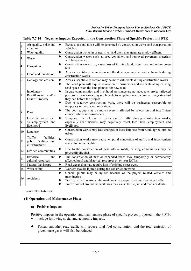
Negative impacts from implementation of the construction works of specific project proposed in the PDTK will include items listed in Table 7.7.14.
Expansion of existing road or construction of new road may lead to resettlement of residents, physical division of existing community, and loss of natural, historical, and cultural resources.
Project for Urban Transport Master Plan in Kinshasa City / PDTK Final Report: Volume 1 Urban Transport Master Plan in Kinshasa City
7-141
Table 7.7.14 Negative Impacts Expected in the Construction Phase of Specific Project in PDTK
1 Air quality, noise and vibration
Exhaust gas and noise will be generated by construction works and transportation vehicles.
2 Water quality Construction works in or near river and ditch may generate muddy effluent.
3 Waste Construction wastes such as used containers and removed pavement materials will be generated.
4 Ecosystem Construction works may cause loss of farming land, street trees and urban green belt.
5 Flood and inundation Areas susceptible to inundation and flood damage may be more vulnerable during construction works.
6 Geology and erosion Areas susceptible to erosion may be more vulnerable during construction works.
7 Involuntary Resettlement and/or Loss of Property
The Road plan will require relocation of businesses and residents along existing road space or on the land planned for new road
In case compensation and livelihood assistance are not adequate, project-affected persons or businesses may not be able to keep the same income or living standard they had before the project
Due to roadway construction work, there will be businesses susceptible to temporary or permanent relocation.
8 Poor The poor group may be more severely affected by relocation and insufficient compensations nor assistances.
9 Local economy such as employment and livelihood
Temporal road closure or restriction of traffic during construction works, especially near markets, may negatively affect local level employment and livelihood.
10 Land use Construction works may lead changes in local land use from rural, agricultural to urban.
11 Traffic facilities, public facilities and infrastructures
Construction works may cause temporal congestion of traffic and inconvenient access to public facilities.
12 Divided communities Due to the construction of new arterial roads, existing communities may be physically divided.
13 Historical and cultural resources
The construction of new or expanded roads may temporarily or permanently affect cultural and historical resources on or near ROWs.
14 Natural Landscape Road expansion may require loss of existing street trees. 15 Work safety Workers may be injured during the construction works
16 Accidents
General public may be injured because of the project related vehicles and machineries.
Traffic restriction around the work area may require detour of passing traffic. Traffic control around the work area may cause traffic jam and road accidents.
Source: The Study Team
Operation and Maintenance Phase (4)
a) Positive Impacts
Positive impacts in the operation and maintenance phase of specific project proposed in the PDTK will include following social and economic impacts.
Faster, smoother road traffic will reduce total fuel consumption, and the total emission of greenhouse gases will also be reduced.
Project for Urban Transport Master Plan in Kinshasa City / PDTK Final Report: Volume 1 Urban Transport Master Plan in Kinshasa City
7-142
Regional scale benefit of all-year roads that provide better access to school, job, and other social and health facilities with
Regional and national scale benefit of stimulation of economic activities by better, safer, and faster transportation of goods
b) Negative Impacts
Negative impacts in the operation and maintenance phase of specific project proposed in the PDTK will include followings.
Generation of exhaust gas and noise felt along new roads
Occurrence of road accidents
Difficulty of road crossing (potential community divide)
In case compensation and livelihood assistance are not adequate, project-affected persons or businesses may not be able to keep the same income or living standard they had before the project
Measures to Maximize the Positive Impacts 7.7.4
The two most basic necessary measures to maximize the positive impacts are to secure the necessary fund, and to organize strong implementation body.
Besides the above two measures, it is the key for the success of the Master Plan to synchronize transport development and urban development.
To maximize the positive impacts of the Master Plan, urban functions must be encouraged to concentrate along the transit corridor especially in the vicinity of transit stations. In the vicinity of a transit station, mixed-use land use must be enhanced. Thus, urban activities such as business and commercial activities are also observed to cluster along the transit corridor. Transit-oriented cities show higher density, more frequent transit trips and fewer vehicle-kilometres compared with car-oriented cities.
By introducing high density and mixed-use land uses near the transit nodes (stations) and along high capacity transit corridors, urban lifestyle based on non-motorized transport (walking and bicycling) and public transport can be achieved along the transit corridor. This significantly reduces use of a car, trip lengths and emission of air pollutants and greenhouse gases. In addition, public transport can capture higher ridership due to the transit-oriented lifestyle of people along the transit.
Already existing law and decree listed below must be actively implemented to achieve above goals.
Project for Urban Transport Master Plan in Kinshasa City / PDTK Final Report: Volume 1 Urban Transport Master Plan in Kinshasa City
7-143
Zoning regulations
Residential area, Commercial/ Business area, Industrial area and Rural area are defined as major zone in the “Decree of the 20 June 1957 on Urban Planning”.
Prevision of Natural Hazard area
Defined in the Article 4 and 5 of the “Decree of the 20 June 1957 on Urban Planning”.
Reserved land for public interest
Areas defined according to the development plan such as schools, health centre, green space, parks etc., defined in the Article 55 of the Land Law.
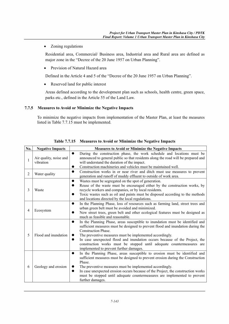
Measures to Avoid or Minimize the Negative Impacts 7.7.5
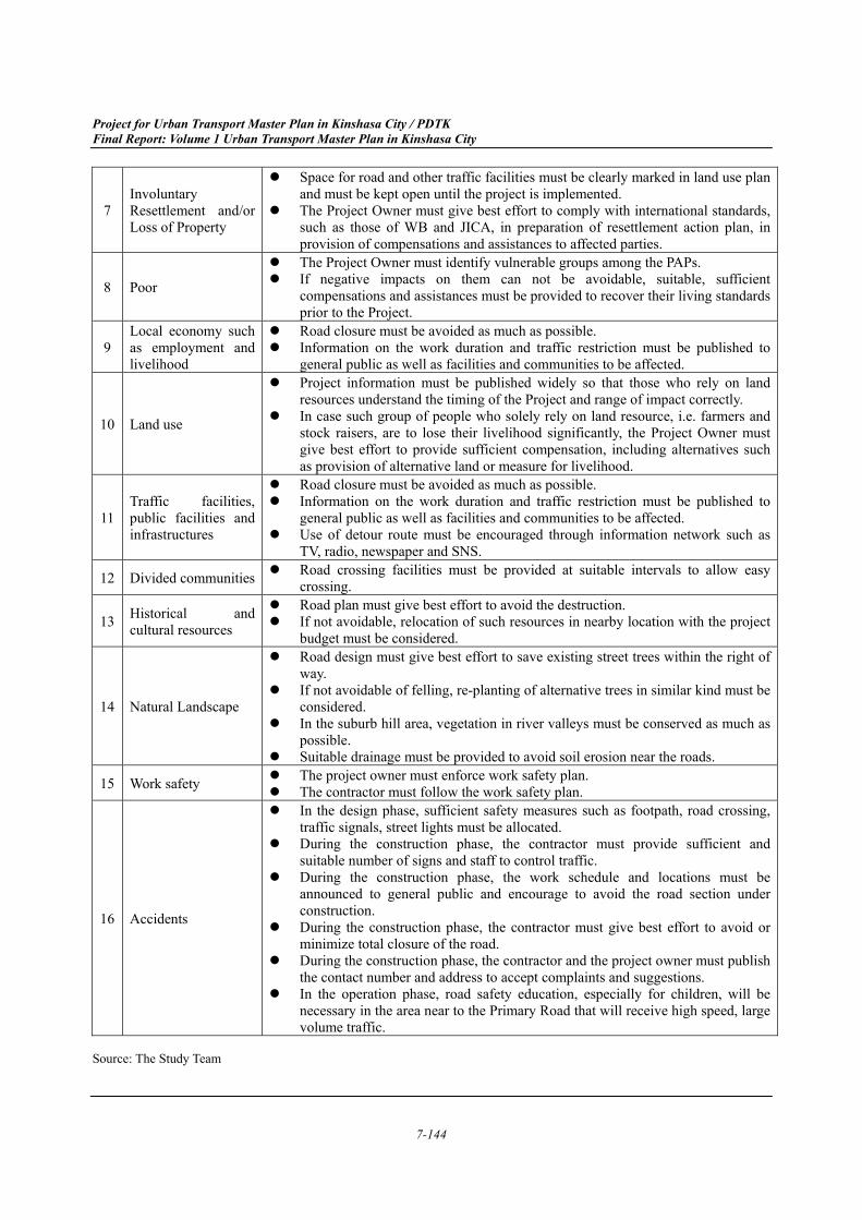
To minimize the negative impacts from implementation of the Master Plan, at least the measures listed in Table 7.7.15 must be implemented.
Table 7.7.15 Measures to Avoid or Minimize the Negative Impacts No. Negative Impacts Measures to Avoid or Minimize the Negative Impacts
1 Air quality, noise and vibration
During the construction phase, the work schedule and locations must be announced to general public so that residents along the road will be prepared and will understand the duration of the impact.
Construction machineries and vehicles must be maintained well.
2 Water quality Construction works in or near river and ditch must use measures to prevent generation and runoff of muddy effluent to outside of work area.
3 Waste
Wastes must be segregated on the spot of generation. Reuse of the waste must be encouraged either by the construction works, by
recycle workers and companies, or by local residents. Toxic wastes such as oil and paints must be disposed according to the methods
and locations directed by the local regulations.
4 Ecosystem
In the Planning Phase, loss of resources such as farming land, street trees and urban green belt must be avoided and minimized.
New street trees, green belt and other ecological features must be designed as much as feasible and reasonable.
5 Flood and inundation
In the Planning Phase, areas susceptible to inundation must be identified and sufficient measures must be designed to prevent flood and inundation during the Construction Phase.
The preventive measures must be implemented accordingly. In case unexpected flood and inundation occurs because of the Project, the
construction works must be stopped until adequate countermeasures are implemented to prevent further damages.
6 Geology and erosion
In the Planning Phase, areas susceptible to erosion must be identified and sufficient measures must be designed to prevent erosion during the Construction Phase.
The preventive measures must be implemented accordingly. In case unexpected erosion occurs because of the Project, the construction works
must be stopped until adequate countermeasures are implemented to prevent further damages.
Project for Urban Transport Master Plan in Kinshasa City / PDTK Final Report: Volume 1 Urban Transport Master Plan in Kinshasa City
7-144
7 Involuntary Resettlement and/or Loss of Property
Space for road and other traffic facilities must be clearly marked in land use plan and must be kept open until the project is implemented.
The Project Owner must give best effort to comply with international standards, such as those of WB and JICA, in preparation of resettlement action plan, in provision of compensations and assistances to affected parties.
8 Poor
The Project Owner must identify vulnerable groups among the PAPs. If negative impacts on them can not be avoidable, suitable, sufficient
compensations and assistances must be provided to recover their living standards prior to the Project.
9 Local economy such as employment and livelihood
Road closure must be avoided as much as possible. Information on the work duration and traffic restriction must be published to
general public as well as facilities and communities to be affected.
10 Land use
Project information must be published widely so that those who rely on land resources understand the timing of the Project and range of impact correctly.
In case such group of people who solely rely on land resource, i.e. farmers and stock raisers, are to lose their livelihood significantly, the Project Owner must give best effort to provide sufficient compensation, including alternatives such as provision of alternative land or measure for livelihood.
11 Traffic facilities, public facilities and infrastructures
Road closure must be avoided as much as possible. Information on the work duration and traffic restriction must be published to
general public as well as facilities and communities to be affected. Use of detour route must be encouraged through information network such as
TV, radio, newspaper and SNS.
12 Divided communities Road crossing facilities must be provided at suitable intervals to allow easy crossing.
13 Historical and cultural resources
Road plan must give best effort to avoid the destruction. If not avoidable, relocation of such resources in nearby location with the project
budget must be considered.
14 Natural Landscape
Road design must give best effort to save existing street trees within the right of way.
If not avoidable of felling, re-planting of alternative trees in similar kind must be considered.
In the suburb hill area, vegetation in river valleys must be conserved as much as possible.
Suitable drainage must be provided to avoid soil erosion near the roads.
15 Work safety The project owner must enforce work safety plan. The contractor must follow the work safety plan.
16 Accidents
In the design phase, sufficient safety measures such as footpath, road crossing, traffic signals, street lights must be allocated.
During the construction phase, the contractor must provide sufficient and suitable number of signs and staff to control traffic.
During the construction phase, the work schedule and locations must be announced to general public and encourage to avoid the road section under construction.
During the construction phase, the contractor must give best effort to avoid or minimize total closure of the road.
During the construction phase, the contractor and the project owner must publish the contact number and address to accept complaints and suggestions.
In the operation phase, road safety education, especially for children, will be necessary in the area near to the Primary Road that will receive high speed, large volume traffic.
Source: The Study Team
Project for Urban Transport Master Plan in Kinshasa City / PDTK Final Report: Volume 1 Urban Transport Master Plan in Kinshasa City
7-145
In addition, According to the Title III of the Decree on laying down the rules for the functioning of the procedural mechanisms for the protection of the environment (Décret no. 14/019 du 02 août 2014 fixant les règles de fonctionnement des mécanismes procéduraux de la protection de l'environnement), an environmental and social impact assessment, together with its management plan, must be submitted to any development, infrastructure or exploitation project of any industrial, commercial, agricultural, forestry, mining, hydrocarbons, cement, telecommunication or other materials likely to have an impact on the environment, including all road construction and development projects.
The Congolese Environment Agency (ACE, Agence Congolaise de l’Environnement) is responsible for screening development projects and ordering the project proponents in order to conduct environmental and social impact study, and to develop environmental management plans for implementation.
As described in Volume 2 and Volume 3 of this Report, when the University Avenue improvement project is to be implemented as the JICA grant project, an environmental impact assessment will be done according to the DRC laws and the JICA Guidelines so that the negative impacts from the project to be avoided and minimized.
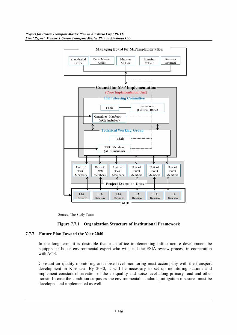
Institutional Arrangement 7.7.6
Proposed Implementation Framework Up to 2030 (1)
For implementation of the Master Plan, it is recommended to fully utilize the existing JCC and TWG, which were organized to execute the PDTK in co-ordination and cooperation with JICA. JCC will be converted as Joint Steering Committee. ACE will be represented both in Joint Steering Committee and in TWG to be updated about the progress of Master Plan implementation (Figure 7.7.1).
The Master Plan projects of various transport sub-sectors, such as roads, railways, buses, traffic safety, control and management will be implemented by various driving force organization. Before the implementation of the each projects proposed in the Master Plan, the project will be reviewed by ACE to determine whether an ESIA study is necessary or not (Figure 7.7.1).
The project owner, with assistance of environmental consultant, shall propose environmental management plan to avoid and minimize negative impacts. ACE shall advise and supervise the implementation of the management plan. The responsibility of implementation of the environmental management plan for specific projects will be beard by the project owner.
Project for Urban Transport Master Plan in Kinshasa City / PDTK Final Report: Volume 1 Urban Transport Master Plan in Kinshasa City
7-146
Source: The Study Team
Figure 7.7.1 Organization Structure of Institutional Framework
Future Plan Toward the Year 2040 7.7.7
In the long term, it is desirable that each office implementing infrastructure development be equipped in-house environmental expert who will lead the ESIA review process in cooperation with ACE.
Constant air quality monitoring and noise level monitoring must accompany with the transport development in Kinshasa. By 2030, it will be necessary to set up monitoring stations and implement constant observation of the air quality and noise level along primary road and other transit. In case the condition surpasses the environmental standards, mitigation measures must be developed and implemented as well.
Project for Urban Transport Master Plan in Kinshasa City / PDTK Final Report: Volume 1 Urban Transport Master Plan in Kinshasa City
7-147
In the early stage of developing the monitoring system, laboratories in public sector and private sector will need to cooperate to generate the data. The results will be published by Ministry of Environment, Conservation of Nature and Tourism. In the long term, each province office of the Ministry must be equipped with suitable number of monitoring stations to cover all the major cities and roads.
Selection of Optimum Network Scenario 7.8
Overview 7.8.1
This section explains the evaluation and selection of the proposed five transport network scenarios in the Study Area. Each transport network scenario was evaluated by the criteria of economic, financial, and environmental aspects such as economic benefits, transport development cost, and CO2 emissions. Then, the optimal network scenario was selected based on a multi-criteria analysis.
For the comparison of criteria, “1. Do Minimum” scenario is set as the “Base Case (Without Scenario)”, and other scenarios are set as “With Scenario”. The two With Scenarios of “2. Road-intensive” and “3. Public transport-intensive” are proposed for 2030, and the four With Scenarios of “2. Road-intensive”, “3-1. Public transport-intensive (BRT)”, “3-2. Public transport-intensive (Rail)” and “3-3. Public transport-intensive (Rail+TDM)” are proposed for 2040.
Assumption of Evaluation Criteria 7.8.2
Economic Benefit (1)
Economic benefit is one of the important criteria for the selection of an optimal transport network scenario. In this Study, the four major economic benefits were calculated as differences between “Without” and “With” scenarios, based on the Highway Development and Management (HDM-4) Road Use Costs Model. The following are the assumptions and results of the economic benefits
a) VOC (Vehicle Operating Cost) Savings
The HDM-4 Road Use Costs Model was applied in calculating the VOC, USD/vehicle-km in 2017 prices. The vehicle fleet data, representing the economic costs excluding the market distortions such as taxes, is the inputs of estimating the VOC. The vehicle fleet data of the nine vehicle types includes the following components:
Vehicle price (USD/vehicle)
New tyre (USD/tyre)
Fuel (USD/litre)
Lubricating oil (USD/litre)
Annual interest rate (%)
Annual kilometres driven (km)
Service life (years)
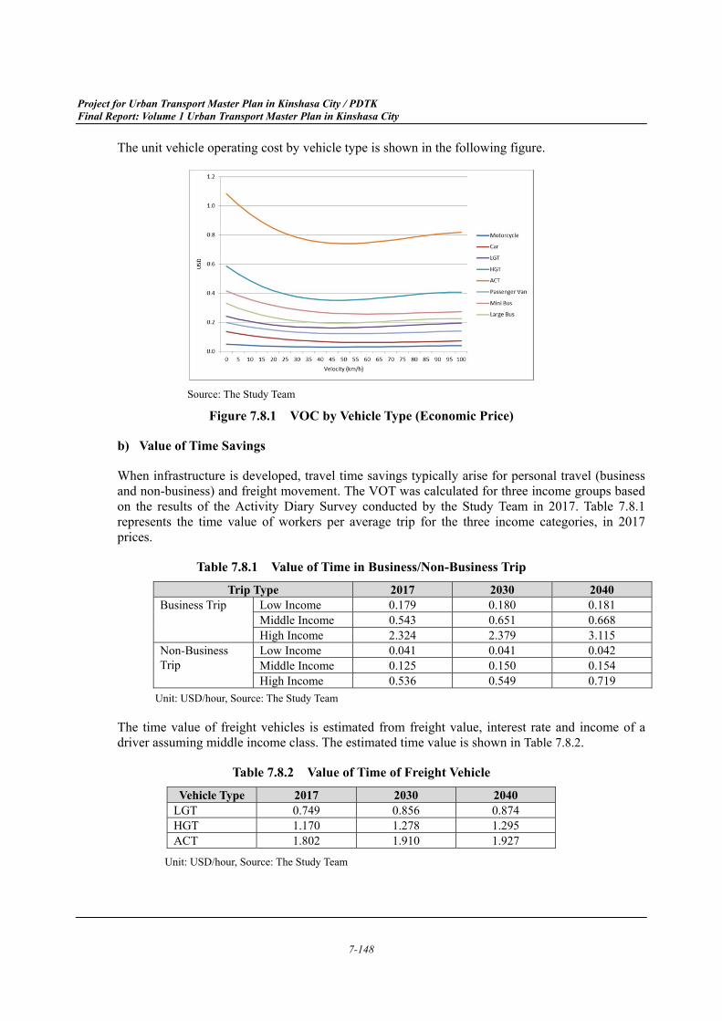
Project for Urban Transport Master Plan in Kinshasa City / PDTK Final Report: Volume 1 Urban Transport Master Plan in Kinshasa City
7-148
The unit vehicle operating cost by vehicle type is shown in the following figure.
Source: The Study Team
Figure 7.8.1 VOC by Vehicle Type (Economic Price)
b) Value of Time Savings
When infrastructure is developed, travel time savings typically arise for personal travel (business and non-business) and freight movement. The VOT was calculated for three income groups based on the results of the Activity Diary Survey conducted by the Study Team in 2017. Table 7.8.1 represents the time value of workers per average trip for the three income categories, in 2017 prices.
Table 7.8.1 Value of Time in Business/Non-Business Trip Trip Type 2017 2030 2040
Business Trip Low Income 0.179 0.180 0.181 Middle Income 0.543 0.651 0.668 High Income 2.324 2.379 3.115
Non-Business Trip
Low Income 0.041 0.041 0.042 Middle Income 0.125 0.150 0.154 High Income 0.536 0.549 0.719
Unit: USD/hour, Source: The Study Team
The time value of freight vehicles is estimated from freight value, interest rate and income of a driver assuming middle income class. The estimated time value is shown in Table 7.8.2.
Table 7.8.2 Value of Time of Freight Vehicle Vehicle Type 2017 2030 2040
LGT 0.749 0.856 0.874 HGT 1.170 1.278 1.295 ACT 1.802 1.910 1.927
Unit: USD/hour, Source: The Study Team
Project for Urban Transport Master Plan in Kinshasa City / PDTK Final Report: Volume 1 Urban Transport Master Plan in Kinshasa City
7-149
c) Savings of Accident Costs
The accidental costs, composed by fatality cost and injury cost, was estimated by the value of income one person could earn in 20 years, assuming a person had an accident at the age of 40 and he/she was expected to work for another 20 years. The fatality cost is estimated at USD 8,090 and the injury cost at USD 809, as the injury cost is 10% of fatality cost, according to the interview with a local insurance company.
The total accident costs, in USD per vehicle-km for each vehicle type, calculated by HDM-4, are shown in Table 7.8.3.
Table 7.8.3 Accident Costs by Vehicle Type (Economic Price)
Motor cycle Car LGT HGT ACT Passenger
Van Mini Bus
Large Bus
0.000792 0.000462 0.000594 0.000462 0.000462 0.000330 0.000330 0.000330Unit: USD/vehicle-km, Source: The Study Team
d) GHG (Green House Gas) Emission Savings
The GHG emission and costs are estimated by the average CO2 price of 6.63 USD/tCO2e.10 The GHG emission costs, in USD per vehicle-km for each vehicle type, calculated by HDM-4, are shown in Table 7.8.4.
Table 7.8.4 GHG Emission Costs by Vehicle Type (Economic Price)
Motor cycle Car LGT HGT ACT Passenger
Van Mini Bus
Large Bus
0.0003 0.0017 0.0034 0.0078 0.0103 0.0019 0.0030 0.0060 Unit: USD/vehicle-km, Source: The Study Team
In addition, reduction of CO2 emissions was calculated as an evaluation criteria based on price based GHG emission cost and unit cost.
Transport Development Cost (2)
The transport development cost of economic evaluation in the Study consists of infrastructure cost, O & M (operation and management) cost, and other costs such as traffic management project and traffic safety project.
a) Road Infrastructures
Project costs for urban road development are reviewed and analysed using observed road construction costs in Kinshasa City and neighbouring countries, and Congo-Japon Boulevard in particular.
10 European Emission Allowance (EUA) Price https://www.eex.com/en/market-data/environmental-markets/spot-market/european-emission-allowances#!/
Project for Urban Transport Master Plan in Kinshasa City / PDTK Final Report: Volume 1 Urban Transport Master Plan in Kinshasa City
7-150
Cong-Japon Boulevard had been designed as a two-lane road in the preparatory survey stage. However, it was upgraded to a four-lane road with street lights during construction. During the preparatory survey stage, the construction cost for the road was estimated at 4.0 billion JPY with a total project cost of 5.1 billion JPY, including detailed design, construction supervision and a contingency of 5%. Upgrading the road from two to four lanes added 640 million JPY to the final price tag.
The project summary for Congo-Japon Boulevard is listed in Table 7.8.5.
Table 7.8.5 Project Summary of Congo-Japon Bld.
Source: The Study Team based on the both project information
Based on typical cross sections, which were established in Section 7.3.4 and the information regarding project costs, the project unit costs of roads for the Master Plan Stage are estimated as shown in Table 7.8.6; hilly/mountainous area is set at a 25% increase because these roads will require more earthworks and structures such as slope protection and retaining walls. The O&M cost in this stage is set at 2% of project cost per year.
Table 7.8.6 Project Unit Costs of Roads for Master Plan Stage
Note: The price escalation was considered based on the consumer price index of DRC released by IMF
Source: The Study Team
Those per-unit project costs are part of a preliminary estimate that needs to be updated. However,
Items Preparatory Survey Stage Construction StageBasic Information
LengthNo. of Lanes 2 4Pavement Type
Cross SectionsCarriageway Width 3.50 m 3.25 mShoulder Width 2.00 m 0.50 mSidewalk Width 1.0 to 2.0 m 2.00 mOther Width 1.0 m + Ditches in both sides Ditches in both sides
Total Width 14.0 to 16.0 m + Ditches inboth sides 18.0 m + Ditches in both sides
Cross SectionsTime of Cost Estimation April 2009 2010Construction Cost 4.0 Billion JPY -Project Cost 5.1 Billion JPY Add. 640 Million JPY
12 km
Asphalt Concrete
Road Classification No. of Lanes Project Costs(USD/km)
8 19,000,0006 15,400,0004 12,600,0004 11,600,0002 9,000,000
Primary Network
Secondary Network
Project for Urban Transport Master Plan in Kinshasa City / PDTK Final Report: Volume 1 Urban Transport Master Plan in Kinshasa City
7-151
those cost estimates allow for an evaluation of project prioritization and scheduling.
b) Public Transport (Rail and BRT)
Based on past study in other countries, project unit costs and O&M costs for railway and BRT were estimated as shown in Table 7.8.7. The unit costs of railway consists civil works, E&M (Electrical & Mechanical) and rolling stocks (EMU).
Table 7.8.7 Project Unit Costs of Railway and BRT for Master Plan Stage Category Unit Costs
Railway (Elevated) 63.2 Million USD/km Railway (Ground) 31.6 Million USD/km Railway Depot 108.4 Million USD/Nom BRT 4.0 Million USD/km
Source: The Study Team
Table 7.8.8 O & M Costs of Railway and BRT for Master Plan Stage Category Unit Costs
Railway 5.0 USD/car-kmBRT 0.8 USD/car-km
Source: The Study Team
c) Other Project Costs
The following project costs were also included to all transport network scenarios. The project details were summarized in Chapter 9.
Bus and Paratransit Projects
Traffic Management Projects
Road Safety Projects
Waterborne Transport Project
Projects of Institutional and Financial Arrangement
Economic Evaluation (3)
The economic cost benefit analysis was conducted, and EIRR and the economic net present value (NPV) were calculated as parameters to measure the economic return on investment.
The following basic assumptions are set up for the economic analysis.
Base Year
The base year of the Project is 2017. The inflation factor is not considered during the evaluation period.
Evaluation Period
The evaluation period of 30 years of the project implementation is applied.
Project for Urban Transport Master Plan in Kinshasa City / PDTK Final Report: Volume 1 Urban Transport Master Plan in Kinshasa City
7-152
Exchange Rate
The exchange rate is set as follows.
- 1 USD = 1,580 CDF
- 1 CDF = 0.07008 JPY
Discount Rate
The discount rate is the rate of return used in a discounted cost benefit analysis to determine the present value of future cost benefit. The discount rate of 12%, used in other economic feasibility reports of DRC, is applied.
SCF (Standard Conversion Factor)
The SCF, converting from financial prices to economic prices, has been calculated from the recent trade statistics of DRC. The average SCF for the past five years is 0.94 and this figure is applied to the analysis.
Population in the Service Area of Railway and BRT (4)
The population in the service area of the railway and BRT was estimated by GIS and quartier wise population distribution. The service area was defined as the population in the area within 1.0 km radius from railway stations and BRT shelters.
Involuntary Relocation (5)
The involuntary relocation was estimated by population distribution in 2017, road coverage area in 2040 for new road construction and road widening, and average number of buildings per area. The area was classified as urbanized area and non-urbanized area zed, and number of building per area was set as 21.71 building/ha and 1 building/ha respectively, based on result of Building Use Survey.
Evaluation of Alternative Transport Scenario 7.8.3
To select the optimum transport network scenario, on whether the Road-intensive scenario is appropriate for the Study Area or Public-intensive (BRT, Rail or Rail+TDM) scenario is a more suitable scenario to meet future conditions, alternative transport network scenarios were prepared and analysed based on following viewpoints:
Supporting Urban Economic Activities;
Assuring Equity in Transport;
Improving Safety and Security; and,
Achieving Environmentally Sustainable Transport.
In conclusion, as shown in Table 7.8.9, the Public-intensive (Rail+TDM) scenario achieved the highest evaluation score, followed by Public-intensive (Rail) and Public-intensive (BRT). Therefore, the Study Team would recommend implementing the Public-intensive (Rail+TDM) scenario in Kinshasa City.
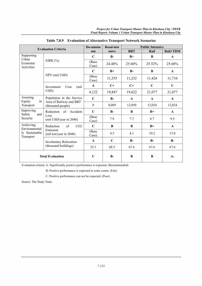
Project for Urban Transport Master Plan in Kinshasa City / PDTK Final Report: Volume 1 Urban Transport Master Plan in Kinshasa City
7-153
Table 7.8.9 Evaluation of Alternative Transport Network Scenarios
Evaluation Criteria Do-minimum
Road-intensive
Public Intensive BRT Rail Rail+TDM
Supporting Urban Economic Activities
EIRR (%) C B- B+ B A
(Base Case) 24.48% 25.60% 25.52% 25.68%
NPV (mil USD) C B+ B- B A
(Base Case) 11,555 11,232 11,424 11,716
Investment Cost (mil USD)
A C+ C+ C C
4,122 19,847 19,622 21,077 21,077 Assuring Equity in Transport
Population in the Service Area of Railway and BRT (thousand people)
C B- A A A
0 8,089 12,050 12,024 12,024 Improving Safety and Security
Reduction of Accident Loss (mil USD/year in 2040)
C B- B B+ A (Base Case) 7.9 7.7 8.7 9.5
Achieving Environmentally Sustainable Transport
Reduction of CO2 Emission (mil ton/year in 2040)
C B B B+ A (Base Case) 4.3 4.1 10.2 13.8
Involuntary Relocation (thousand buildings)
A C B- B- B-
25.1 68.5 67.6 67.6 67.6
Total Evaluation C B- B B A-
Evaluation criteria: A: Significantly positive performance is expected. (Recommended)
B: Positive performance is expected to some extent. (Fair)
C: Positive performance can not be expected. (Poor)
Source: The Study Team
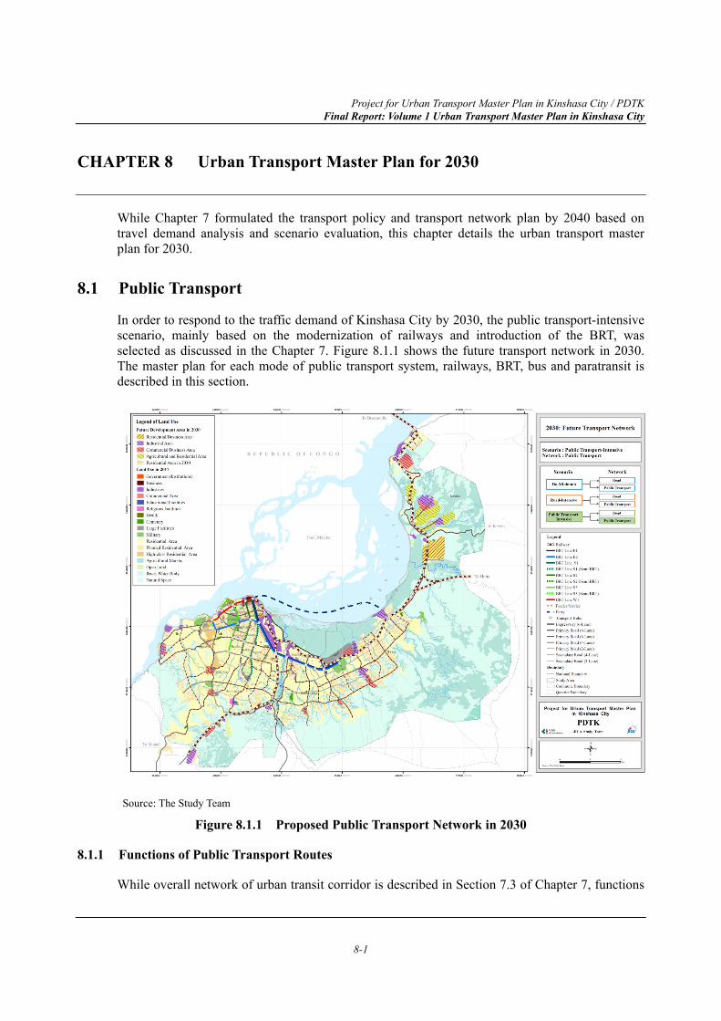
Project for Urban Transport Master Plan in Kinshasa City / PDTK Final Report: Volume 1 Urban Transport Master Plan in Kinshasa City
8-1
CHAPTER 8 Urban Transport Master Plan for 2030
While Chapter 7 formulated the transport policy and transport network plan by 2040 based on travel demand analysis and scenario evaluation, this chapter details the urban transport master plan for 2030.
8.1 Public Transport
In order to respond to the traffic demand of Kinshasa City by 2030, the public transport-intensive scenario, mainly based on the modernization of railways and introduction of the BRT, was selected as discussed in the Chapter 7. Figure 8.1.1 shows the future transport network in 2030. The master plan for each mode of public transport system, railways, BRT, bus and paratransit is described in this section.
Source: The Study Team
Figure 8.1.1 Proposed Public Transport Network in 2030
8.1.1 Functions of Public Transport Routes
While overall network of urban transit corridor is described in Section 7.3 of Chapter 7, functions
Project for Urban Transport Master Plan in Kinshasa City / PDTK Final Report: Volume 1 Urban Transport Master Plan in Kinshasa City
8-2
of each route of public transport network are described below.
(1) Railway (Kinshasa East to Kimwenza)
As railway has the highest capacity among all urban transport modes, several urban developments including commercial and industrial areas are planned along it. In addition to the current function of inter-city railway service between Kinshasa and Matadi, the railway line should function as an urban railway service connecting several urban development zones with the concept of TOD.
(2) Railway (Kinshasa East to Brazzaville and Ilebo)
The railway line to the N'djili Airport, which is in parallel with Lumumba Boulevard, has suspended operation since 2015. There is, however, a national plan of constructing railway from Kinshasa to Ilebo and extension line to the Kinshasa – Brazzaville bridge via Maluku as mentioned in Section 7.4.2 of Chapter 7. The Kinshasa – Ilebo railway will utilize the right of way of the Airport line. As the urban development is planned toward North-East direction, this railway also plays key role as an urban transit corridor connecting Gombe, Kinkole and Maluku.
(3) BRT (E1 and E2)
While the railway plays the role of connecting north-east region such as Kinkole and Maluku and the current urbanized area, the BRT to east direction, E1 and E2, serves for passengers between the Airport, Masina, N'djili and Limete and Gombe. As the current urban development is concentrated in the area along N1, these lines can capture passenger demand along these areas. The E1 route commences at the central station, and, serves passengers from the central station. The E2 route commences at Kintambo Magasin and utilizes Triomphal Boulevard.
(4) BRT (S1, S2 and S3)
The area located to the South of the CBD surrounded by Kasa-vubu Avenue, Liberation Avenue, Lumumba Boulevard and Bypass Avenue including some Communes such as Ngiri-ngiri, Bumbu, Selembao, Kalamu, Makala, Limete and Ngaba has less access to paved arterial roads, which means roads served by buses. Residents have to walk long distances to reach these surrounding roads served by buses. Therefore, serving this southern area is essential to provide access to fundamental urban functions.
(5) BRT (W1)
A number of office buildings, hotels, shops and government facilities are concentrated to the area along 30 Juin Boulevard. As lots of business and private trips are generated from this area, it is important to have high capacity transit corridor along the boulevard. The W1 route is planned to connect the Kinshasa East Station (central station), where railways and other BRT routes connect, and Kintambo Magasin. At Kintambo Magasin, passengers can also transfer to the E2 route and feeder bus services to western areas of the city.
(6) Waterborne Transport (Kinshasa to Kinkole)
In addition to railway service, waterborne transport service is planned between Kinkole and Gombe. As the new industrial development is planned in Kinkole, the service can serve for commuting and business trips from Gombe and surroundings to Kinkole industrial zone as well as
Project for Urban Transport Master Plan in Kinshasa City / PDTK Final Report: Volume 1 Urban Transport Master Plan in Kinshasa City
8-3
the opposite direction.
(7) Routes of Bus and Paratransit
In addition to the above trunk public transport routes, feeder services, which cover most of the future urbanized area, is planned along the arterial road network while the passenger demand is considered as lower compared to other trunk routes. It plays key role to provide public transport service for all the urbanized area in the Study Area.
8.1.2 Modernization of Railways
The existing railway facilities and the train operation in the Study Area are discussed in Chapter 7 and they are exhibited in Figure 8.1.2 and Figure 8.1.3, respectively. Furthermore, the development scenario of railway lines in Kinshasa City has been discussed in Section 7.5 in Chapter 7.
Among three railway lines in the Kinshasa urban area, there is only one line, South Line, which is under operation at present with one round trip from Kasangulu to Kinshasa East in the morning and Kinshasa East to Kasangulu in the evening. Total one-way trip travel time between Kinshasa East and Kasangulu is around 2 hours and 25 minutes as shown in the train operation diagram Figure 8.1.3.
The South Line is running through Kimwenza, which is the urban core city between Kinshasa East and Kasangulu. Total number of passengers on the South Line is recorded as 320,000 during the first half of the year 2017. Although this number includes passengers travelling between Kasangulu and Kimwenza, about 1,600 passengers per day are using the current South Line.
The South Line is operating in the direction of either from Kasangulu or Kimwenza to Kinshasa East in the morning and in the opposite direction during the evening. In addition, it is highly potential that this line will attract more passengers even in the daytime, since it lies beside Congo-Japon Boulevard, where industrial and residential land uses are observed.
Despite such a potential demand on the South Line, it is not operated in the daytime and it does not take a role of the urban railway function. Therefore, it is recommended to increase additional two round-trips between Kinshasa East and Kimwenza in the daytime without increasing the number of locomotives and wagons, as shown in Figure 8.1.4. As a consequence, four round trips will be realized on the South Line.
However, the frequency of the existing train operation is only achievable at every 4-hour interval, which is not appraised as a convenient urban railway service. Therefore, it should be proposed to procure one additional set of train for the additional service of three round trips between Kinshasa East and Kimwenza with the time interval of every two hours as shown in Figure 8.1.5, yet which might not be satisfactory as the urban railway service.
To achieve the level service as urban railway, two new trains are proposed. These two additional trains can be operated for six round-trips on the double track section between Kinshasa East and Matete every one hour as presented in Figure 8.1.6.
The type of train operating at present is a locomotive-hauled train (locomotive pulling passenger wagons). This system requires replacing the locomotive every time the train returns to the terminal
Project for Urban Transport Master Plan in Kinshasa City / PDTK Final Report: Volume 1 Urban Transport Master Plan in Kinshasa City
8-4
station. Therefore, DMU (Diesel Multiple Unit) is proposed, since Matete station at present is not accommodated with a siding for replacing the locomotive, for which frequent replacing will be required, and minimizing time loss for replacing the locomotive is desirable. Furthermore, it is also recommended to improve the current track condition and signal system in order to assure the safety and punctuality of train operation, when procuring the new trains. It is observed that the current track condition is not well maintained with satisfactory ballast and safety system is based on the wireless communications to identify train location. When operation frequency and speed are planned to increase, it is inevitable to improve the track condition and to introduce the signalling system for the new urban railway line. A detailed plan for the above-mentioned issues should be investigated by separate studies with following general works presented in Table 8.1.1.
Table 8.1.1 Proposed Work for Improvement of Track Condition and Signal System Projects Work Component
Track Improvement Main work component will be replacing ballast and may include replacing sleepers, rails and rail fastening system, if required
Introduction of Signalling System
Signalling system using the track circuit.
Source: The Study Team
Meanwhile, the N’djili Airport Line was supposed to be improved and operational by December 2017, but it has not been implemented yet as of July 2018. A large number of passenger demand on this line is expected even though the line is confined to the single track operation at present. Therefore, it is recommended, similar to the South Line, to improve the current track condition and to introduce a signal system in addition to the procurement of DMU.
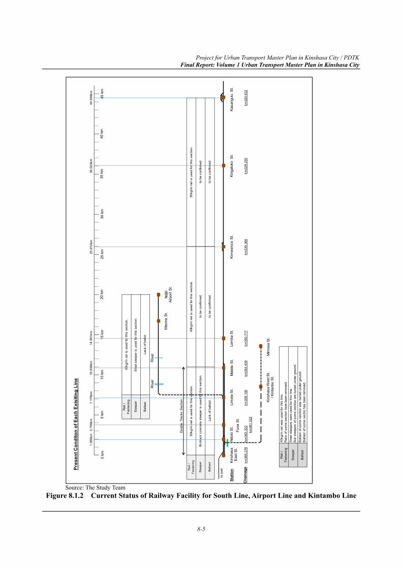
Project for Urban Transport Master Plan in Kinshasa City / PDTK Final Report: Volume 1 Urban Transport Master Plan in Kinshasa City
8-5
Source: The Study Team
Figure 8.1.2 Current Status of Railway Facility for South Line, Airport Line and Kintambo Line
Pres
ent C
ondi
ton
of E
ach
Exis
iting
Lin
e
Bal
last
of s
ome
sect
ion
was
bur
ied
unde
r gro
und.
Bal
last
of s
ome
sect
io h
as b
een
rem
oved
.
Ste
el s
leep
ers
wer
e us
ed fo
r thi
s lin
e.B
ut s
leep
ers
of s
ome
sect
ion
are
burie
d un
der g
roun
d.
40kg
/m ra
il w
as u
sed
for t
his
line.
Rai
ls o
f som
e se
ctio
n ha
ve b
een
rem
oved
.
Bal
last
Rai
l /Fa
sten
ing
Sle
eper
Balla
st
Rai
l /Fa
sten
ing
Sle
eper
to b
e co
nfirm
ed
to b
e co
nfirm
ed
to b
e co
nfirm
ed
to b
e co
nfirm
ed
Rai
l /Fa
sten
ing
Sle
eper
50kg
/m ra
il is
use
d fo
r thi
s se
ctio
n.
Bi-b
lock
con
cret
e sl
eepe
r is
used
for t
his
sect
ion.
Lack
of b
alla
st
Bal
last
40kg
/m ra
il is
use
d fo
r thi
s se
ctio
n.
Ste
el s
leep
er is
use
d fo
r thi
s se
ctio
n.
Lack
of b
alls
t
40kg
/m ra
il is
use
d fo
r thi
s se
ctio
n.50
kg/m
rail
is u
sed
for t
his
sect
ion.
0 km
5 km
10 k
m15
km
20 k
m25
km
35 k
m30
km
40 k
m45
km
Kim
wen
zaSt
.K
asan
gulu
St.
Kin
shas
aE
ast S
t.M
atet
e S
t.
Kin
shas
a W
est S
t./ K
inta
nbo
St.
Ndol
o S
t.Le
mba
St.M
asin
a S
t.Nd
jiliAi
rpor
t St.
Riv
erR
iver
Funa
St.
King
atok
oS
t.Li
met
e S
t.
km36
5.27
8km
363.
322
km36
1.52
2km
358.
100
km35
4.43
9km
350.
717
km33
9.36
6km
329.
255
km32
0.63
2
Stat
ion
Cha
inag
e
1.95
6km
3.75
6km
7.17
8km
10.8
38km
14.5
61km
25.9
12km
36.0
23km
44.6
46km
Mim
osa
St.
to p
ort
Dou
ble
Trac
ks S
ectio
n
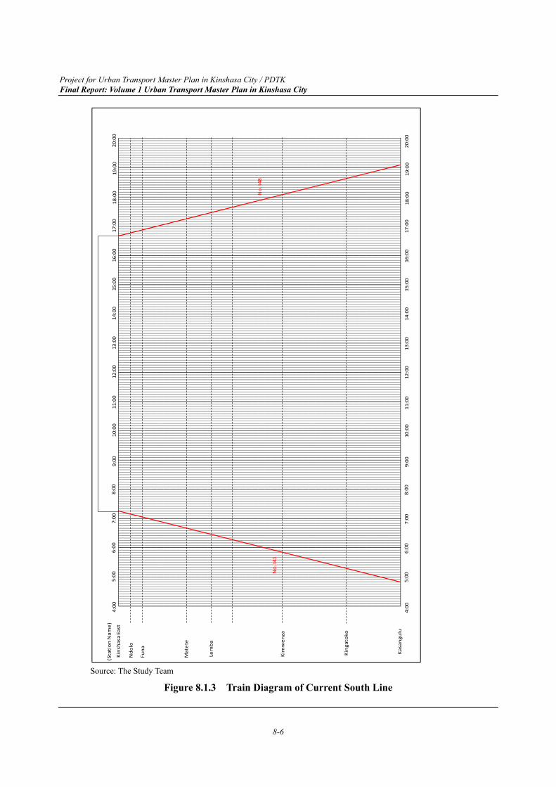
Project for Urban Transport Master Plan in Kinshasa City / PDTK Final Report: Volume 1 Urban Transport Master Plan in Kinshasa City
8-6
Source: The Study Team
Figure 8.1.3 Train Diagram of Current South Line
(Sta
tion
Nam
e)5:
006:
007:
008:
009:
0010
:00
11:0
012
:00
13:0
014
:00
15:0
016
:00
17:0
018
:00
Kins
hasa
Eas
t
Ndo
lo
Funa
Mat
ete
Lem
ba
Kim
wen
za
King
atok
o
Kasa
ngul
u
19:0
020
:00
4:00
No.
I48
No.
I41
5:00
6:00
7:00
8:00
9:00
10:0
011
:00
12:0
013
:00
14:0
015
:00
16:0
017
:00
18:0
019
:00
20:0
04:
00
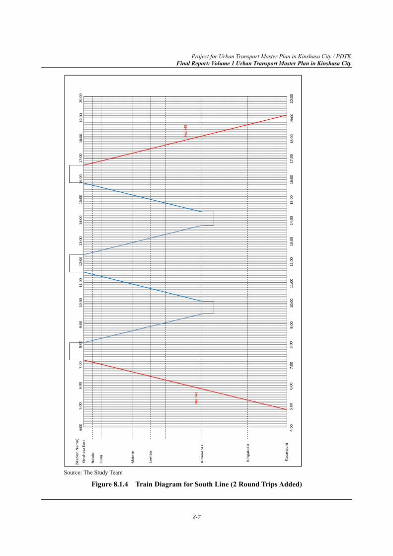
Project for Urban Transport Master Plan in Kinshasa City / PDTK Final Report: Volume 1 Urban Transport Master Plan in Kinshasa City
8-7
Source: The Study Team
Figure 8.1.4 Train Diagram for South Line (2 Round Trips Added)
(Sta
tion
Nam
e)5:
006:
007:
008:
009:
0010
:00
11:0
012
:00
13:0
014
:00
15:0
016
:00
17:0
018
:00
Kins
hasa
Eas
t
Ndo
lo
Funa
Mat
ete
Lem
ba
Kim
wen
za
King
atok
o
Kasa
ngul
u
19:0
020
:00
4:00
No.
I48
No.
I41
5:00
6:00
7:00
8:00
9:00
10:0
011
:00
12:0
013
:00
14:0
015
:00
16:0
017
:00
18:0
019
:00
20:0
04:
00
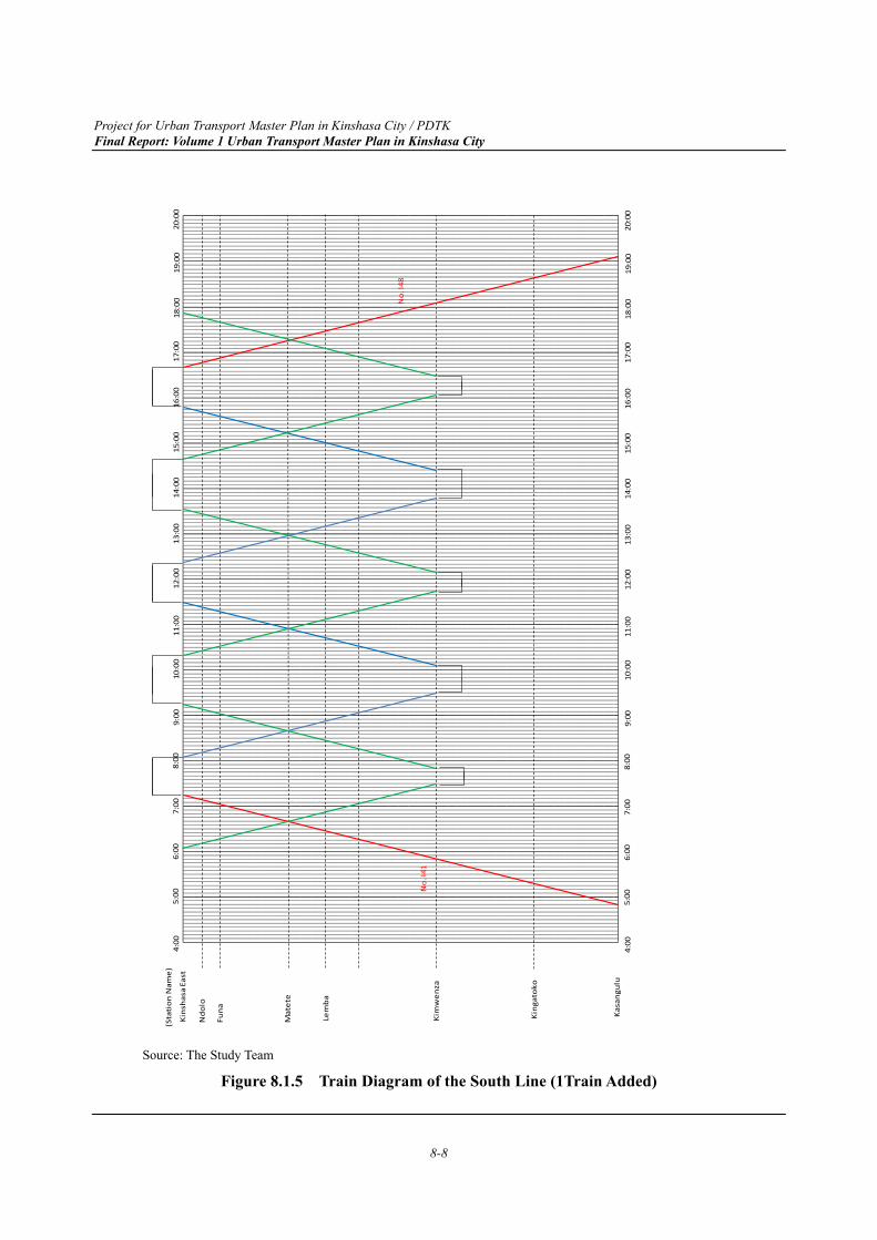
Project for Urban Transport Master Plan in Kinshasa City / PDTK Final Report: Volume 1 Urban Transport Master Plan in Kinshasa City
8-8
Source: The Study Team
Figure 8.1.5 Train Diagram of the South Line (1Train Added)
(Sta
tion
Nam
e)5:
006:
007:
008:
009:
0010
:00
11:0
012
:00
13:0
014
:00
15:0
016
:00
17:0
018
:00
Kins
hasa
Eas
t
Ndo
lo
Funa
Mat
ete
Lem
ba
Kim
wen
za
King
atok
o
Kasa
ngul
u
19:0
020
:00
4:00
No.
I48
No.
I41
5:00
6:00
7:00
8:00
9:00
10:0
011
:00
12:0
013
:00
14:0
015
:00
16:0
017
:00
18:0
019
:00
20:0
04:
00
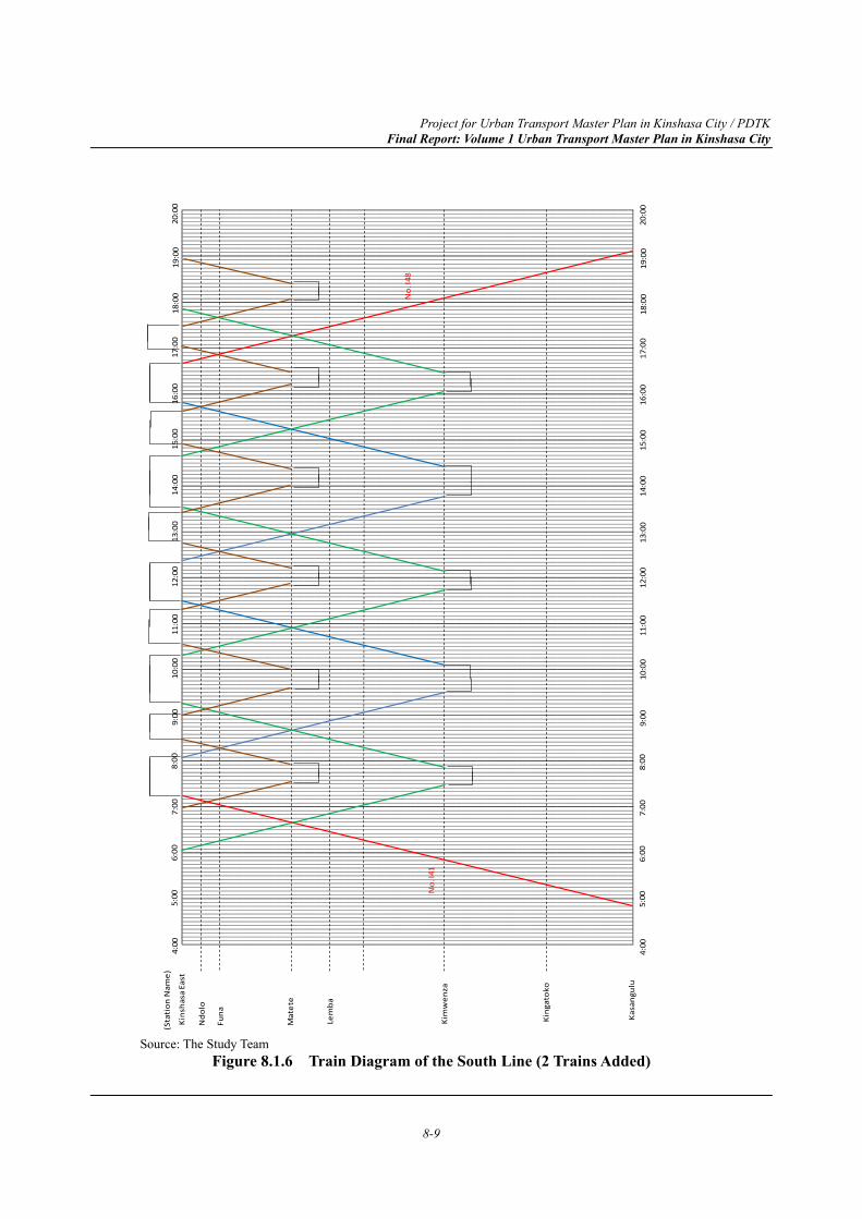
Project for Urban Transport Master Plan in Kinshasa City / PDTK Final Report: Volume 1 Urban Transport Master Plan in Kinshasa City
8-9
Source: The Study Team
Figure 8.1.6 Train Diagram of the South Line (2 Trains Added)
(Sta
tion
Nam
e)5:
006:
007:
008:
009:
0010
:00
11:0
012
:00
13:0
014
:00
15:0
016
:00
17:0
018
:00
Kins
hasa
Eas
t
Ndo
lo
Funa
Mat
ete
Lem
ba
Kim
wen
za
King
atok
o
Kasa
ngul
u
19:0
020
:00
4:00
No.
I48
No.
I41
5:00
6:00
7:00
8:00
9:00
10:0
011
:00
12:0
013
:00
14:0
015
:00
16:0
017
:00
18:0
019
:00
20:0
04:
00
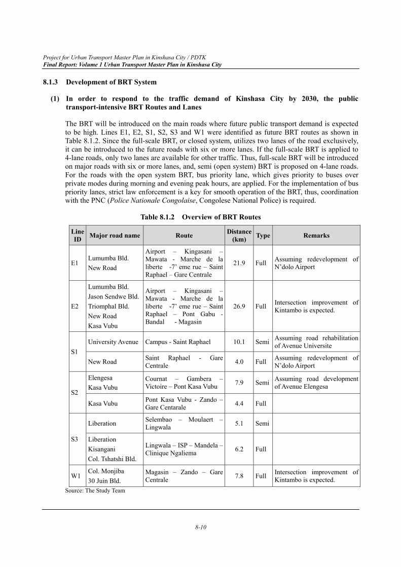
Project for Urban Transport Master Plan in Kinshasa City / PDTK Final Report: Volume 1 Urban Transport Master Plan in Kinshasa City
8-10
8.1.3 Development of BRT System
(1) In order to respond to the traffic demand of Kinshasa City by 2030, the public transport-intensive BRT Routes and Lanes
The BRT will be introduced on the main roads where future public transport demand is expected to be high. Lines E1, E2, S1, S2, S3 and W1 were identified as future BRT routes as shown in Table 8.1.2. Since the full-scale BRT, or closed system, utilizes two lanes of the road exclusively, it can be introduced to the future roads with six or more lanes. If the full-scale BRT is applied to 4-lane roads, only two lanes are available for other traffic. Thus, full-scale BRT will be introduced on major roads with six or more lanes, and, semi (open system) BRT is proposed on 4-lane roads. For the roads with the open system BRT, bus priority lane, which gives priority to buses over private modes during morning and evening peak hours, are applied. For the implementation of bus priority lanes, strict law enforcement is a key for smooth operation of the BRT, thus, coordination with the PNC (Police Nationale Congolaise, Congolese National Police) is required.
Table 8.1.2 Overview of BRT Routes
Line ID Major road name Route Distance
(km) Type Remarks
E1 Lumumba Bld. New Road
Airport – Kingasani – Mawata - Marche de la liberte -7’ eme rue – Saint Raphael – Gare Centrale
21.9 Full Assuming redevelopment of N’dolo Airport
E2
Lumumba Bld. Jason Sendwe Bld. Triomphal Bld. New Road Kasa Vubu
Airport – Kingasani – Mawata - Marche de la liberte -7’ eme rue – Saint Raphael – Pont Gabu - Bandal - Magasin
26.9 Full Intersection improvement of Kintambo is expected.
S1 University Avenue Campus - Saint Raphael 10.1 Semi Assuming road rehabilitation
of Avenue Universite
New Road Saint Raphael - Gare Centrale 4.0 Full Assuming redevelopment of
N’dolo Airport
S2
Elengesa Kasa Vubu
Cournat – Gambera – Victoire – Pont Kasa Vubu 7.9 Semi Assuming road development
of Avenue Elengesa
Kasa Vubu Pont Kasa Vubu - Zando – Gare Centarale 4.4 Full
S3
Liberation Selembao – Moulaert – Lingwala 5.1 Semi
Liberation Kisangani Col. Tshatshi Bld.
Lingwala – ISP – Mandela – Clinique Ngaliema 6.2 Full
W1 Col. Monjiba 30 Juin Bld.
Magasin – Zando – Gare Centrale 7.8 Full Intersection improvement of
Kintambo is expected. Source: The Study Team
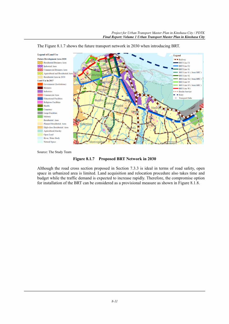
Project for Urban Transport Master Plan in Kinshasa City / PDTK Final Report: Volume 1 Urban Transport Master Plan in Kinshasa City
8-11
The Figure 8.1.7 shows the future transport network in 2030 when introducing BRT.
Source: The Study Team
Figure 8.1.7 Proposed BRT Network in 2030
Although the road cross section proposed in Section 7.3.3 is ideal in terms of road safety, open space in urbanized area is limited. Land acquisition and relocation procedure also takes time and budget while the traffic demand is expected to increase rapidly. Therefore, the compromise option for installation of the BRT can be considered as a provisional measure as shown in Figure 8.1.8.
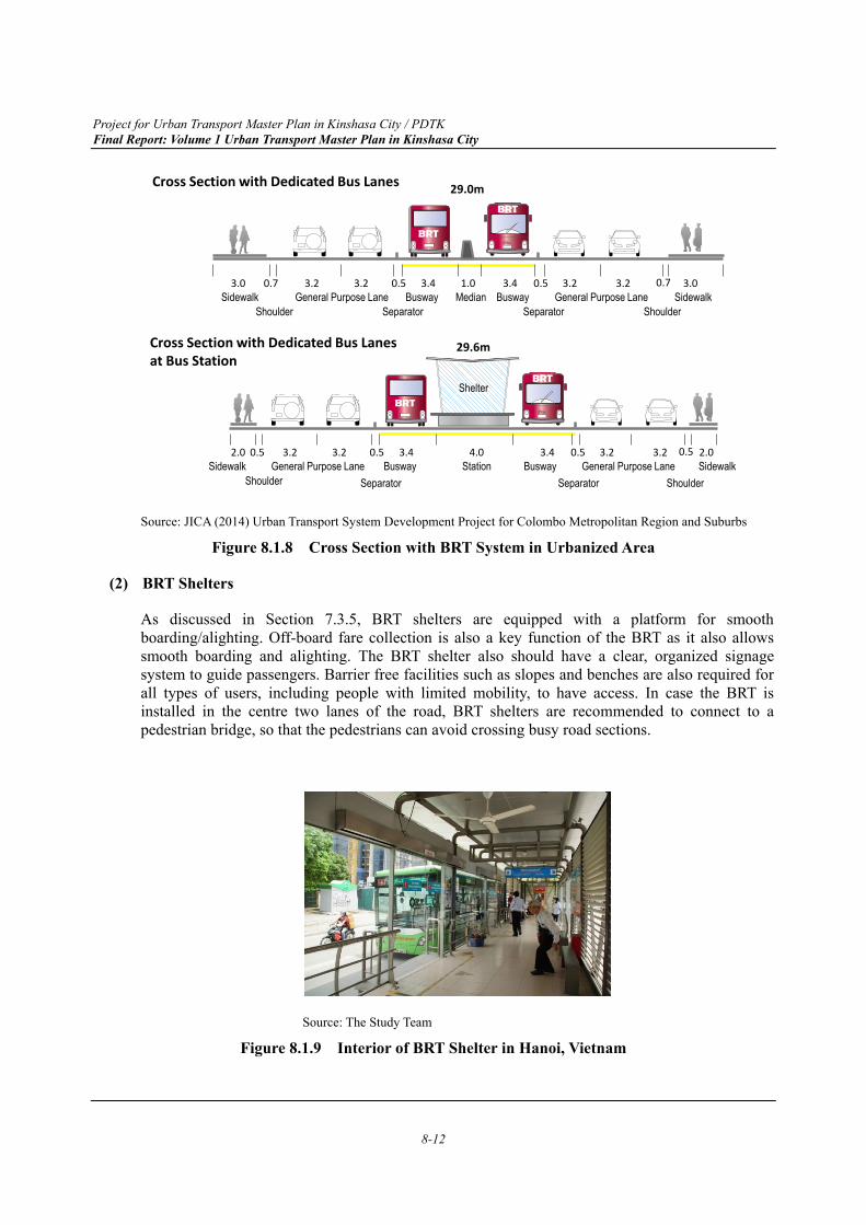
Project for Urban Transport Master Plan in Kinshasa City / PDTK Final Report: Volume 1 Urban Transport Master Plan in Kinshasa City
8-12
Source: JICA (2014) Urban Transport System Development Project for Colombo Metropolitan Region and Suburbs
Figure 8.1.8 Cross Section with BRT System in Urbanized Area
(2) BRT Shelters
As discussed in Section 7.3.5, BRT shelters are equipped with a platform for smooth boarding/alighting. Off-board fare collection is also a key function of the BRT as it also allows smooth boarding and alighting. The BRT shelter also should have a clear, organized signage system to guide passengers. Barrier free facilities such as slopes and benches are also required for all types of users, including people with limited mobility, to have access. In case the BRT is installed in the centre two lanes of the road, BRT shelters are recommended to connect to a pedestrian bridge, so that the pedestrians can avoid crossing busy road sections.
Source: The Study Team
Figure 8.1.9 Interior of BRT Shelter in Hanoi, Vietnam
Station BuswayBuswayGeneral Purpose LaneSeparator Separator
SidewalkSidewalk4.03.4 3.4 0.50.53.2 3.2 0.50.52.0 2.0
Cross Section with Dedicated Bus Lanes at Bus Station
Shelter
3.23.2
Median BuswayBuswayGeneral Purpose LaneSeparatorShoulder Separator
SidewalkSidewalk3.4 3.4 0.50.53.2 3.2 0.70.73.0 3.03.23.2 1.0
General Purpose Lane
General Purpose Lane
29.6m
Shoulder
29.0mCross Section with Dedicated Bus Lanes
Shoulder Shoulder
Project for Urban Transport Master Plan in Kinshasa City / PDTK Final Report: Volume 1 Urban Transport Master Plan in Kinshasa City
8-13
(3) BRT Fleet
The same chassis with a large bus can be utilized for the BRT fleet, though, the bus fleet for the BRT system usually requires platform-level door on the left or both sides of the vehicle for platform-level boarding. Thus, customization is required for bodies. Air conditioning is one option for improving the service level of passengers and to increase ridership while it consumes fuels. In case of BRT in Dar es Salaam, air conditioners are not equipped while most Asian and Latin American BRT are equipped with air conditioners.
(4) Fare Collection System
The same as urban railway service in many countries, off-board fare collection should be applied for the BRT to avoid fare collection in buses. Typically, integrated-circuit (IC) card is often utilized for fare transaction. In addition to reduce transaction time and improve convenience for passengers, the card can be utilized for other transactions such as urban railway service, parking fee payment and non-transport purposes such as shopping. This can generate revenues from transaction fees.
(5) Intersection Improvement for BRT
Even though the BRT utilizes exclusive lanes, the BRT operation is disrupted at intersections. This can cause significant delay of buses, and, it sometimes causes queues of buses. Thus, the Public Transport Priority System (PTPS) is recommended for the smooth operation of the BRT. The PTPS can extend green time for the direction of the BRT corridor in case a BRT bus is approaching. Although this cannot prevent stopping at intersections completely, the PTPS improves the travel speed of the BRT. It should be noted that this system should be a part of the traffic signalling system which will be discussed in Section 8.3. On-board equipment with GPS for BRT buses are also required to detect the approach of the bus.
(6) Institutional Setup
The operation system for the BRT and conventional buses operated by individuals are substantially different. Staff members require special skills such as driving, maintenance of a bus, maintenance of facilities, ticketing, customer service, accounting, ICT and management. The expected operator of the BRT should have staff in these fields, and, the company should be organized and well managed.
In the Study Area, the largest and the most organized bus operator is Transco with experience of operating approximately 500 buses. Considering Transco’s experience, it can be a potential candidate for operating the BRT while the agreement of other stakeholders is required.
It also should be mentioned that the expected operator and the regulator should be independent as it causes conflict of interest.
Project for Urban Transport Master Plan in Kinshasa City / PDTK Final Report: Volume 1 Urban Transport Master Plan in Kinshasa City
8-14
8.1.4 Bus and Paratransit
(1) Consolidation of Bus Routes
Since the modernized railway and the BRT covers corridors with high passenger demand, routes of other road-based public transport should be consolidated. In principle, conventional buses, minibuses, taxi-buses, shared taxis and motorcycle taxis should function as feeder services of trunk routes of the railway and the BRT. Conventional bus and minibus routes will be established in areas where BRT and feeder bus services are not available. Taxi-buses, shared taxis and motorcycle taxis should be limited to short distance services as feeders and to areas with lower travel demand to avoid unnecessary competition with the railway and the BRT. The size of bus and travel demand should be consistent to minimize impact on road traffic.
(2) Re-organization of Bus and Taxi Operators
As discussed in Section 7.1.4, current road-based public transport operation except for Transco and NewTransKin is market-oriented due to excessive competition among individual operators. While the scheme of Esprit de Vie contributed to renovate bus fleet, the fundamental issue of excessive competition among individual operators still remains. Therefore, it is expected to form a company or a union for bus operation. The company and the union should hire drivers as their employees to avoid any externalities caused. By gradually tightening the enforcement of the safety and service standard, it is expected that individual operators will shift to Transco, NewTransKin and new companies or unions. The other radical option is to prohibit sub-standard vehicles, and, the government purchase the vehicles. Drivers of these vehicles can be employed by Transco or NewTransKin.
(3) Bus Stop and Terminal Development
Although there are some bus stops, some stops are not utilized by bus and taxi operators. Passengers can get on and get off any place they want along the route so far. To increase the travel speed of buses, formalising bus stops is important. Especially for the transfer points and areas with high passenger demand, bus terminals should be located to manage significant volumes of passengers and vehicles.
(4) Law Enforcement
While the Kinshasa Province and the PNC commenced law enforcement programmes by colouring and registration sticker of shared taxis, further measures should be taken such as prohibition of all public transport vehicles from picking or dropping passengers at intersections and strict police control of illegal parking. For the control of parking, private sector also can participate. The details of parking control will be discussed in Section 8.3.8.
(5) Developing Regulatory Framework
The current route license and fare policy of road-based public transport is, in general, heuristic. The route license should be given based on the travel demand, compliance with safety and service standard and consistency with the Master Plan and government policy. The process also should be transparent and evidence-based to avoid corruption. The fare policy also should be transparent and evidence-based to avoid political intervention. For this purpose, data and information is essential for formulating policy on fares and route licensing. It is expected to formulate a department in
Project for Urban Transport Master Plan in Kinshasa City / PDTK Final Report: Volume 1 Urban Transport Master Plan in Kinshasa City
8-15
charge of data collection, analysis for policy making.
In terms of safe, convenient and comfortable operation of the buses, it is also required to formulate safety and service standard of road-based public transport.
8.2 Road Development Plan
8.2.1 Introduction
In Chapter 7, the Public Transport-Intensive Scenario was selected as the optimum one for 2030. Figure 8.2.1 shows the road network to be developed in 2030 for this scenario.
In developing the future road network plan, the applied hierarchical classification is primary and secondary roads in the Master Plan. As described in Chapter 7, in a broad sense, the primary road network is made up from strategic roads, urban expressways, and other primary roads. The strategic roads are defined as logistics routes and cover the international and regional trunk roads. Also, it formulates a fundamental road network to encourage and induce urban development of the Study Area.
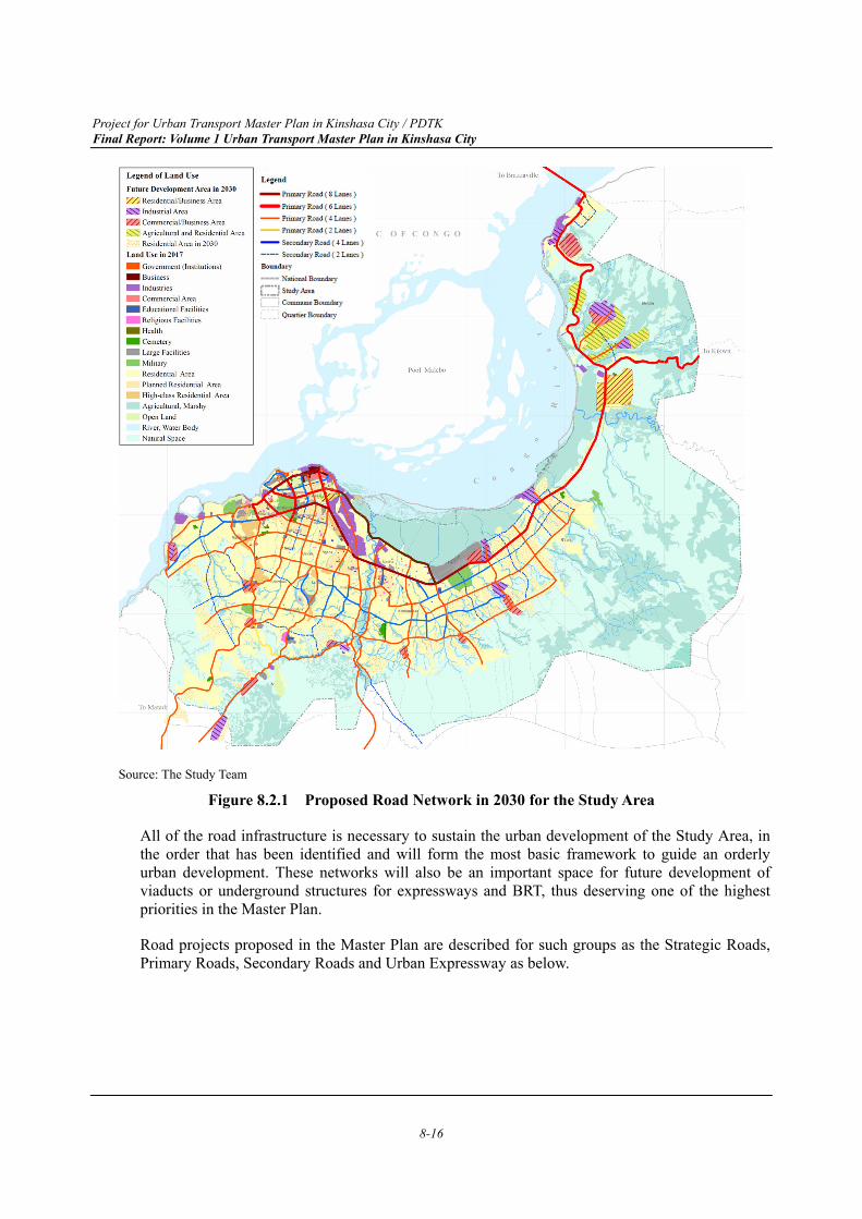
Project for Urban Transport Master Plan in Kinshasa City / PDTK Final Report: Volume 1 Urban Transport Master Plan in Kinshasa City
8-16
Source: The Study Team
Figure 8.2.1 Proposed Road Network in 2030 for the Study Area
All of the road infrastructure is necessary to sustain the urban development of the Study Area, in the order that has been identified and will form the most basic framework to guide an orderly urban development. These networks will also be an important space for future development of viaducts or underground structures for expressways and BRT, thus deserving one of the highest priorities in the Master Plan.
Road projects proposed in the Master Plan are described for such groups as the Strategic Roads, Primary Roads, Secondary Roads and Urban Expressway as below.
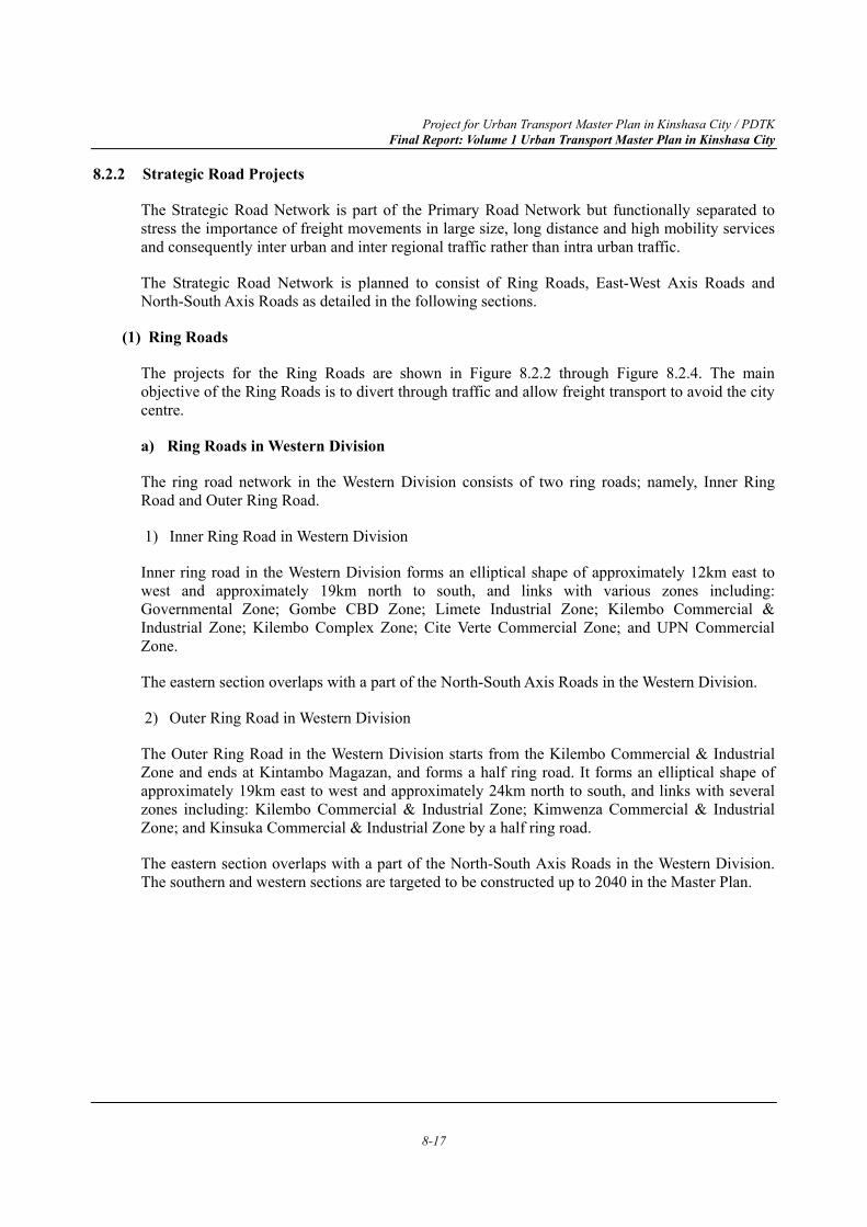
Project for Urban Transport Master Plan in Kinshasa City / PDTK Final Report: Volume 1 Urban Transport Master Plan in Kinshasa City
8-17
8.2.2 Strategic Road Projects
The Strategic Road Network is part of the Primary Road Network but functionally separated to stress the importance of freight movements in large size, long distance and high mobility services and consequently inter urban and inter regional traffic rather than intra urban traffic.
The Strategic Road Network is planned to consist of Ring Roads, East-West Axis Roads and North-South Axis Roads as detailed in the following sections.
(1) Ring Roads
The projects for the Ring Roads are shown in Figure 8.2.2 through Figure 8.2.4. The main objective of the Ring Roads is to divert through traffic and allow freight transport to avoid the city centre.
a) Ring Roads in Western Division
The ring road network in the Western Division consists of two ring roads; namely, Inner Ring Road and Outer Ring Road.
1) Inner Ring Road in Western Division
Inner ring road in the Western Division forms an elliptical shape of approximately 12km east to west and approximately 19km north to south, and links with various zones including: Governmental Zone; Gombe CBD Zone; Limete Industrial Zone; Kilembo Commercial & Industrial Zone; Kilembo Complex Zone; Cite Verte Commercial Zone; and UPN Commercial Zone.
The eastern section overlaps with a part of the North-South Axis Roads in the Western Division.
2) Outer Ring Road in Western Division
The Outer Ring Road in the Western Division starts from the Kilembo Commercial & Industrial Zone and ends at Kintambo Magazan, and forms a half ring road. It forms an elliptical shape of approximately 19km east to west and approximately 24km north to south, and links with several zones including: Kilembo Commercial & Industrial Zone; Kimwenza Commercial & Industrial Zone; and Kinsuka Commercial & Industrial Zone by a half ring road.
The eastern section overlaps with a part of the North-South Axis Roads in the Western Division. The southern and western sections are targeted to be constructed up to 2040 in the Master Plan.
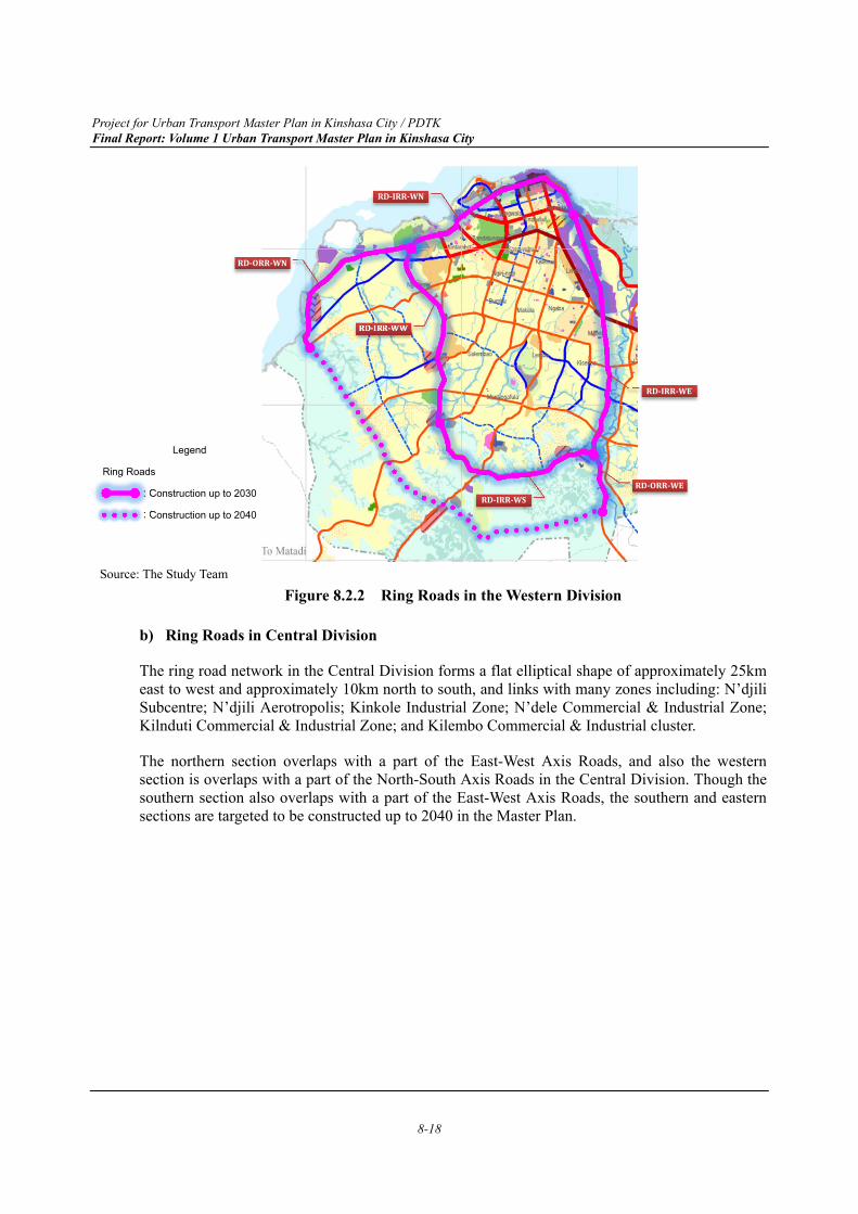
Project for Urban Transport Master Plan in Kinshasa City / PDTK Final Report: Volume 1 Urban Transport Master Plan in Kinshasa City
8-18
Source: The Study Team
Figure 8.2.2 Ring Roads in the Western Division
b) Ring Roads in Central Division
The ring road network in the Central Division forms a flat elliptical shape of approximately 25km east to west and approximately 10km north to south, and links with many zones including: N’djili Subcentre; N’djili Aerotropolis; Kinkole Industrial Zone; N’dele Commercial & Industrial Zone; Kilnduti Commercial & Industrial Zone; and Kilembo Commercial & Industrial cluster.
The northern section overlaps with a part of the East-West Axis Roads, and also the western section is overlaps with a part of the North-South Axis Roads in the Central Division. Though the southern section also overlaps with a part of the East-West Axis Roads, the southern and eastern sections are targeted to be constructed up to 2040 in the Master Plan.
Legend
Ring Roads
: Construction up to 2030
: Construction up to 2040
RD-IRR-WW
RD-IRR-WN
RD-ORR-WN
RD-ORR-WE
RD-IRR-WE
RD-IRR-WS
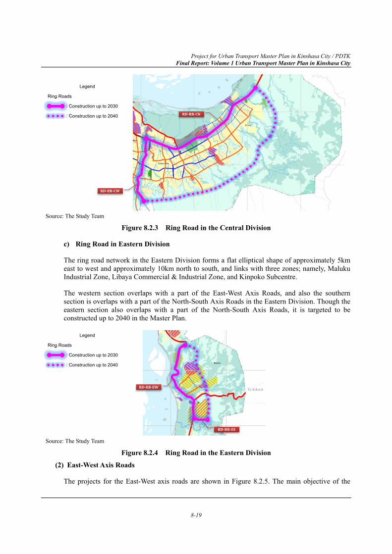
Project for Urban Transport Master Plan in Kinshasa City / PDTK Final Report: Volume 1 Urban Transport Master Plan in Kinshasa City
8-19
Source: The Study Team
Figure 8.2.3 Ring Road in the Central Division
c) Ring Road in Eastern Division
The ring road network in the Eastern Division forms a flat elliptical shape of approximately 5km east to west and approximately 10km north to south, and links with three zones; namely, Maluku Industrial Zone, Libaya Commercial & Industrial Zone, and Kinpoko Subcentre.
The western section overlaps with a part of the East-West Axis Roads, and also the southern section is overlaps with a part of the North-South Axis Roads in the Eastern Division. Though the eastern section also overlaps with a part of the North-South Axis Roads, it is targeted to be constructed up to 2040 in the Master Plan.
Source: The Study Team
Figure 8.2.4 Ring Road in the Eastern Division (2) East-West Axis Roads
The projects for the East-West axis roads are shown in Figure 8.2.5. The main objective of the
RD-RR-CW
Legend
Ring Roads
: Construction up to 2030
: Construction up to 2040
Legend
Ring Roads
: Construction up to 2030
: Construction up to 2040
RD-RR-CN
RD-RR-EW
RD-RR-ES
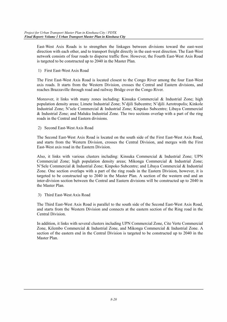
Project for Urban Transport Master Plan in Kinshasa City / PDTK Final Report: Volume 1 Urban Transport Master Plan in Kinshasa City
8-20
East-West Axis Roads is to strengthen the linkages between divisions toward the east-west direction with each other, and to transport freight directly in the east-west direction. The East-West network consists of four roads to disperse traffic flow. However, the Fourth East-West Axis Road is targeted to be constructed up to 2040 in the Master Plan.
1) First East-West Axis Road
The First East-West Axis Road is located closest to the Congo River among the four East-West axis roads. It starts from the Western Division, crosses the Central and Eastern divisions, and reaches Brazzaville through road and railway Bridge over the Congo River.
Moreover, it links with many zones including: Kinsuka Commercial & Industrial Zone; high population density areas; Limete Industrial Zone; N’djili Subcentre; N’djili Aerotropolis; Kinkole Industrial Zone; N’sele Commercial & Industrial Zone; Kinpoko Subcentre; Libaya Commercial & Industrial Zone; and Maluku Industrial Zone. The two sections overlap with a part of the ring roads in the Central and Eastern divisions.
2) Second East-West Axis Road
The Second East-West Axis Road is located on the south side of the First East-West Axis Road, and starts from the Western Division, crosses the Central Division, and merges with the First East-West axis road in the Eastern Division.
Also, it links with various clusters including: Kinsuka Commercial & Industrial Zone; UPN Commercial Zone; high population density areas; Mikonga Commercial & Industrial Zone; N’Sele Commercial & Industrial Zone; Kinpoko Subcentre; and Libaya Commercial & Industrial Zone. One section overlaps with a part of the ring roads in the Eastern Division, however, it is targeted to be constructed up to 2040 in the Master Plan. A section of the western end and an inter-division section between the Central and Eastern divisions will be constructed up to 2040 in the Master Plan.
3) Third East-West Axis Road
The Third East-West Axis Road is parallel to the south side of the Second East-West Axis Road, and starts from the Western Division and connects at the eastern section of the Ring road in the Central Division.
In addition, it links with several clusters including UPN Commercial Zone, Cite Verte Commercial Zone, Kilembo Commercial & Industrial Zone, and Mikonga Commercial & Industrial Zone. A section of the eastern end in the Central Division is targeted to be constructed up to 2040 in the Master Plan.
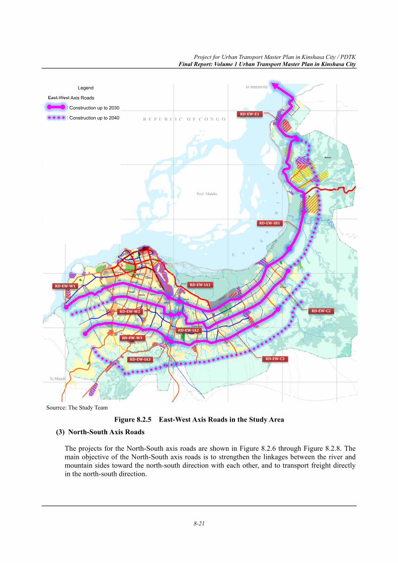
Project for Urban Transport Master Plan in Kinshasa City / PDTK Final Report: Volume 1 Urban Transport Master Plan in Kinshasa City
8-21
Sourrce: The Study Team
Figure 8.2.5 East-West Axis Roads in the Study Area (3) North-South Axis Roads
The projects for the North-South axis roads are shown in Figure 8.2.6 through Figure 8.2.8. The main objective of the North-South axis roads is to strengthen the linkages between the river and mountain sides toward the north-south direction with each other, and to transport freight directly in the north-south direction.
Legend
East-West Axis Roads
: Construction up to 2030
: Construction up to 2040
RD-EW-W1
RD-EW-W2
RD-EW-W3
RD-EW-C3
RD-EW-C2
RD-EW-IA2
RD-EW-IA3
RD-EW-E1
RD-EW-IB1
RD-EW-IA1
Project for Urban Transport Master Plan in Kinshasa City / PDTK Final Report: Volume 1 Urban Transport Master Plan in Kinshasa City
8-22
a) North-South Axis Roads in Western Division
The North-South Axis Road network in the Western Division consists of three roads to disperse traffic flow.
1) First North-South Axis Road in Western Division
The First North-South Axis Road in the Western Division enters westward from almost the centre of the existing urban area in the north-south direction. It starts from 30 Juin Boulevard, follows Kasa-Vubu Avenue, Elengesa Avenue, Bypass and reaches Route de Matadi of National Road No.1 toward Matadi Port. It also links with some clusters including Gombe CBD Zone, high population density areas, and Cite Verte Commercial Zone.
2) Second North-South Axis Road in Western Division
The Second North-South Axis Road in the Western Division enters eastward from almost the centre of the existing urban area in the north-south direction, which runs parallel with the First North-South Axis Road. It starts from 30 Juin Boulevard, follows University Avenue, reaches Kimwenza Railway Station, and connects toward Matadi Port. Also, it links with some clusters including Gombe CBD Zone, high population density areas, Kilembo Complex Zone, and Kimwenza Commercial & Industrial Zone.
3) Third North-South Axis Road in Western Division
The Third North-South Axis Road in the Western Division passes near the eastern edge of the existing urban area in the north-south direction. It starts from 30 Juin Boulevard, follows Congo-Japon Boulevard, La Paix Avenue in parallel with the railway, runs parallel to the west bank of the N’djili River, and connects toward Matadi Port. It also links with some clusters including Gombe CBD Zone, Limete Industrial Zone, high population density areas, and Kilembo Commercial & Industrial Zone. The northern section overlaps with a part of the Inner and Outer Ring roads.
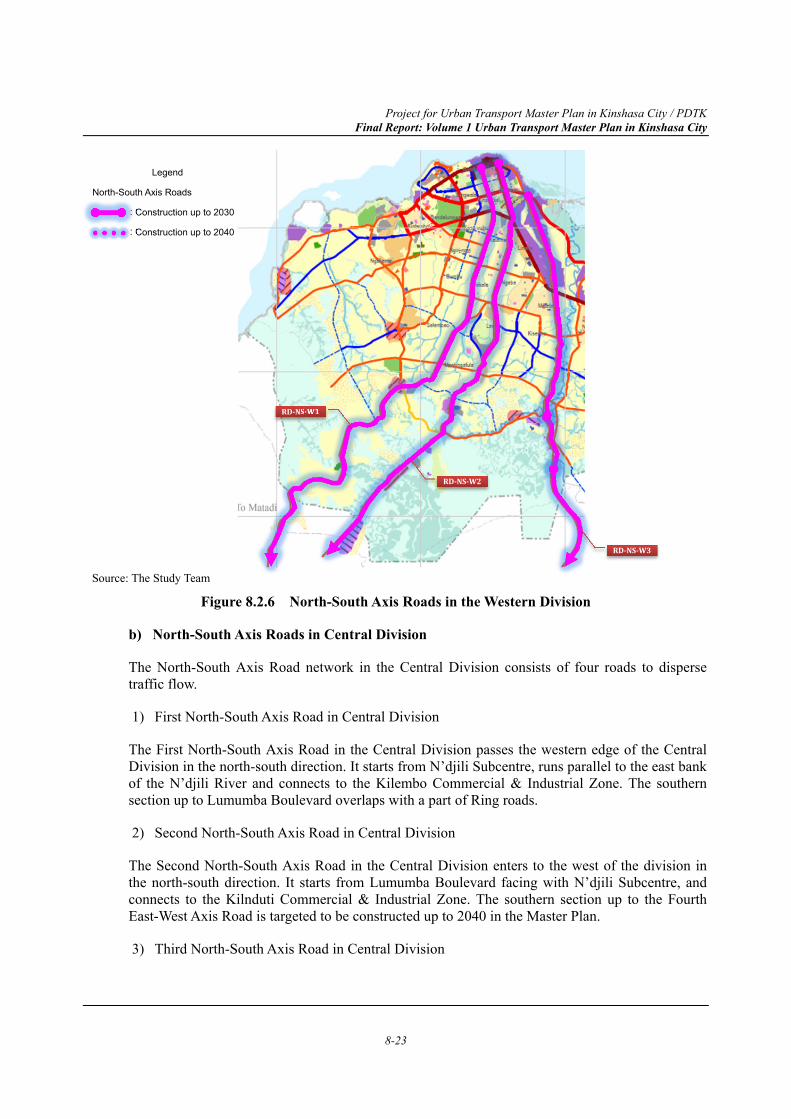
Project for Urban Transport Master Plan in Kinshasa City / PDTK Final Report: Volume 1 Urban Transport Master Plan in Kinshasa City
8-23
Source: The Study Team
Figure 8.2.6 North-South Axis Roads in the Western Division
b) North-South Axis Roads in Central Division
The North-South Axis Road network in the Central Division consists of four roads to disperse traffic flow.
1) First North-South Axis Road in Central Division
The First North-South Axis Road in the Central Division passes the western edge of the Central Division in the north-south direction. It starts from N’djili Subcentre, runs parallel to the east bank of the N’djili River and connects to the Kilembo Commercial & Industrial Zone. The southern section up to Lumumba Boulevard overlaps with a part of Ring roads.
2) Second North-South Axis Road in Central Division
The Second North-South Axis Road in the Central Division enters to the west of the division in the north-south direction. It starts from Lumumba Boulevard facing with N’djili Subcentre, and connects to the Kilnduti Commercial & Industrial Zone. The southern section up to the Fourth East-West Axis Road is targeted to be constructed up to 2040 in the Master Plan.
3) Third North-South Axis Road in Central Division
Legend
North-South Axis Roads
: Construction up to 2030
: Construction up to 2040
RD-NS-W1
RD-NS-W2
RD-NS-W3
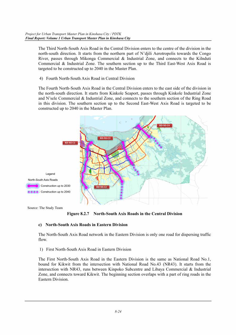
Project for Urban Transport Master Plan in Kinshasa City / PDTK Final Report: Volume 1 Urban Transport Master Plan in Kinshasa City
8-24
The Third North-South Axis Road in the Central Division enters to the centre of the division in the north-south direction. It starts from the northern part of N’djili Aerotropolis towards the Congo River, passes through Mikonga Commercial & Industrial Zone, and connects to the Kilnduti Commercial & Industrial Zone. The southern section up to the Third East-West Axis Road is targeted to be constructed up to 2040 in the Master Plan.
4) Fourth North-South Axis Road in Central Division
The Fourth North-South Axis Road in the Central Division enters to the east side of the division in the north-south direction. It starts from Kinkole Seaport, passes through Kinkole Industrial Zone and N’sele Commercial & Industrial Zone, and connects to the southern section of the Ring Road in this division. The southern section up to the Second East-West Axis Road is targeted to be constructed up to 2040 in the Master Plan.
Source: The Study Team
Figure 8.2.7 North-South Axis Roads in the Central Division
c) North-South Axis Roads in Eastern Division
The North-South Axis Road network in the Eastern Division is only one road for dispersing traffic flow.
1) First North-South Axis Road in Eastern Division
The First North-South Axis Road in the Eastern Division is the same as National Road No.1, bound for Kikwit from the intersection with National Road No.43 (NR43). It starts from the intersection with NR43, runs between Kinpoko Subcentre and Libaya Commercial & Industrial Zone, and connects toward Kikwit. The beginning section overlaps with a part of ring roads in the Eastern Division.
RD-NS-C4
RD-NS-C2
RD-NS-C3
RD-NS-C1
Legend
North-South Axis Roads
: Construction up to 2030
: Construction up to 2040
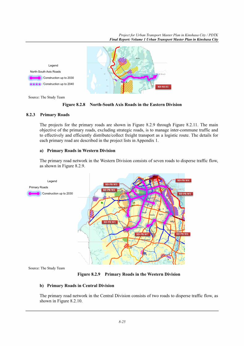
Project for Urban Transport Master Plan in Kinshasa City / PDTK Final Report: Volume 1 Urban Transport Master Plan in Kinshasa City
8-25
Source: The Study Team
Figure 8.2.8 North-South Axis Roads in the Eastern Division
8.2.3 Primary Roads
The projects for the primary roads are shown in Figure 8.2.9 through Figure 8.2.11. The main objective of the primary roads, excluding strategic roads, is to manage inter-commune traffic and to effectively and efficiently distribute/collect freight transport as a logistic route. The details for each primary road are described in the project lists in Appendix 1.
a) Primary Roads in Western Division
The primary road network in the Western Division consists of seven roads to disperse traffic flow, as shown in Figure 8.2.9.
Source: The Study Team
Figure 8.2.9 Primary Roads in the Western Division
b) Primary Roads in Central Division
The primary road network in the Central Division consists of two roads to disperse traffic flow, as shown in Figure 8.2.10.
Legend
Primary Roads
: Construction up to 2030RD-PR-W2
RD-PR-W3RD-PR-W4
RD-PR-W7
RD-PR-W5
RD-PR-W6
RD-PR-W1
Legend
North-South Axis Roads
: Construction up to 2030
: Construction up to 2040
RD-NS-E1
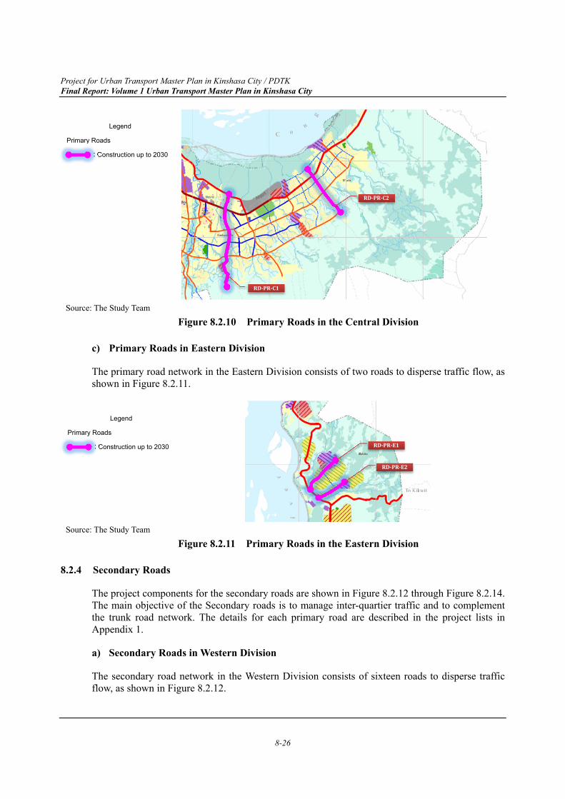
Project for Urban Transport Master Plan in Kinshasa City / PDTK Final Report: Volume 1 Urban Transport Master Plan in Kinshasa City
8-26
Source: The Study Team
Figure 8.2.10 Primary Roads in the Central Division
c) Primary Roads in Eastern Division
The primary road network in the Eastern Division consists of two roads to disperse traffic flow, as shown in Figure 8.2.11.
Source: The Study Team
Figure 8.2.11 Primary Roads in the Eastern Division
8.2.4 Secondary Roads
The project components for the secondary roads are shown in Figure 8.2.12 through Figure 8.2.14. The main objective of the Secondary roads is to manage inter-quartier traffic and to complement the trunk road network. The details for each primary road are described in the project lists in Appendix 1.
a) Secondary Roads in Western Division
The secondary road network in the Western Division consists of sixteen roads to disperse traffic flow, as shown in Figure 8.2.12.
RD-PR-C2
Legend
Primary Roads
: Construction up to 2030
Legend
Primary Roads
: Construction up to 2030 RD-PR-E1
RD-PR-C1
RD-PR-E2

Project for Urban Transport Master Plan in Kinshasa City / PDTK Final Report: Volume 1 Urban Transport Master Plan in Kinshasa City
8-27
Source: The Study Team
Figure 8.2.12 Secondary Roads in the Western Division
b) Secondary Roads in Central Division
The secondary road network in the Central Division consists of thirteen roads to disperse traffic flow, as shown in Figure 8.2.13.
Source: The Study Team
Figure 8.2.13 Secondary Roads in the Central Division
Legend
Secondary Roads
: Construction up to 2030
RD-SR-C1
RD-SR-C2
RD-SR-C8
RD-SR-C6
RD-SR-C13
RD-SR-C3
RD-SR-C4
Legend
Secondary Roads
: Construction up to 2030
RD-SR-C5
RD-SR-C7
RD-SR-C9
RD-SR-C10
RD-SR-C12
RD-SR-C11
RD-SR-W15 RD-SR-W4
RD-SR-W5
RD-SR-IA1
RD-SR-W1
RD-SR-W12
RD-SR-W10
RD-SR-W8
RD-SR-W13
RD-SR-W2
RD-SR-W3
RD-SR-W14
RD-SR-W11
RD-SR-W9
RD-SR-W6
RD-SR-W7
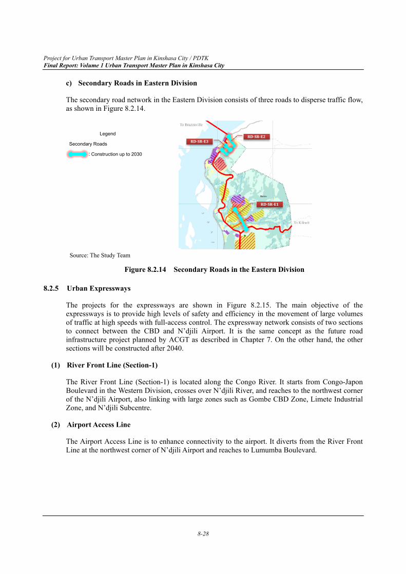
Project for Urban Transport Master Plan in Kinshasa City / PDTK Final Report: Volume 1 Urban Transport Master Plan in Kinshasa City
8-28
c) Secondary Roads in Eastern Division
The secondary road network in the Eastern Division consists of three roads to disperse traffic flow, as shown in Figure 8.2.14.
Source: The Study Team
Figure 8.2.14 Secondary Roads in the Eastern Division
8.2.5 Urban Expressways
The projects for the expressways are shown in Figure 8.2.15. The main objective of the expressways is to provide high levels of safety and efficiency in the movement of large volumes of traffic at high speeds with full-access control. The expressway network consists of two sections to connect between the CBD and N’djili Airport. It is the same concept as the future road infrastructure project planned by ACGT as described in Chapter 7. On the other hand, the other sections will be constructed after 2040.
(1) River Front Line (Section-1)
The River Front Line (Section-1) is located along the Congo River. It starts from Congo-Japon Boulevard in the Western Division, crosses over N’djili River, and reaches to the northwest corner of the N’djili Airport, also linking with large zones such as Gombe CBD Zone, Limete Industrial Zone, and N’djili Subcentre.
(2) Airport Access Line
The Airport Access Line is to enhance connectivity to the airport. It diverts from the River Front Line at the northwest corner of N’djili Airport and reaches to Lumumba Boulevard.
RD-SR-E2
RD-SR-E1
RD-SR-E3
Legend
Secondary Roads
: Construction up to 2030
Project for Urban Transport Master Plan in Kinshasa City / PDTK Final Report: Volume 1 Urban Transport Master Plan in Kinshasa City
8-29
Source: The Study Team
Figure 8.2.15 Urban Expressway in 2030
8.2.6 Road Maintenance Scheme
(1) Division of Roles
The main roles of road maintenance management are as shown in Table 8.2.1.
Table 8.2.1 Main Roles of Road Maintenance Management
Organization Roles
OR Maintenance of national roads passing through Kinshasa province and provincial roads connecting to neighbouring provinces
OVD Maintenance of Kinshasa province roads
FONER Collection of funds for road maintenance and allocation of budget for maintenance administration of target roads
Central Government Allocation of budget for maintenance administration of target roads Kinshasa Province Allocation of budget for maintenance administration of target roads
Source: The Study Team
(2) Required Road Maintenance Equipment
In order to address the shortage of road maintenance equipment, the following road maintenance equipment will be provided to OVD and OR with Grant Aid from Japan.
"Periodic maintenance equipment" that aims to carry out large-scale repairs that are necessary to attain the maintenance level,
"Equipment for daily maintenance work" that aims to fix potholes, make sealing repairs, etc.
The above-mentioned equipment will arrive in Kinshasa around March 2020.
The provided equipment and deployment plan is shown in Table 8.2.2 below.
RD-EX-N1
RD-EX-AA
Legend
Primary Roads
: Construction up to 2030
Project for Urban Transport Master Plan in Kinshasa City / PDTK Final Report: Volume 1 Urban Transport Master Plan in Kinshasa City
8-30
Table 8.2.2 Provided Equipment and Deployment Plan
No. Name of Equipment Organization
OVD OR 1 Road Stabilizer 2 2 Bulldozer 3 3 Motor Grader 3
4-1 Single Drum Roller 3 4-2 Tandem Roller 3 5 Crawler Excavator 3 6 Wheel Excavator 3 7 Water Tank 3 8 Asphalt Finisher 2 9 Asphalt Distributor 3
10 Tire Roller 3 11 Dump Truck 9 12 Pickup Truck 3 1 13 Asphalt Cutter 4 1 14 Vibratory Compactor 4 1 15 Hand Breaker 4 1 16 Air Compressor 4 1 17 Asphalt Sprayer 4 1 18 Hand Guide Roller 4 1 19 Mobile Asphalt Plant 1 1 20 Low Bed Trailer 1 21 Road Maintenance Truck 1 1 22 Line Marker 1 1 23 Truck with Crane 1 1 24 Mobile Workshop 1 25 Wheel Loader 1 26 Backhoe Loader 1
27-1 Sludge Suction Truck 1 27-2 High- Pressure Cleaning Truck 1 28 Maintenance Repair Equipment 1
Source:JICA Study for the Project for Improvement of Road Maintenance Equipment in Kinshasa City
Project for Urban Transport Master Plan in Kinshasa City / PDTK Final Report: Volume 1 Urban Transport Master Plan in Kinshasa City
8-31
(3) Capacity Development for Road Maintenance
Utilizing the training results by the PRCMR counterpart, the PRCMR counterpart will conduct training to OR and OVD technicians involved in road maintenance, with the aim of sharing/transferring knowledge and experience.
(4) Financial Resources
Currently, the allocation of the road maintenance budget from FONER is a major source of revenue.
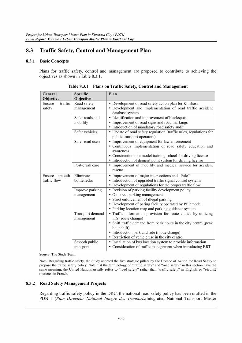
Project for Urban Transport Master Plan in Kinshasa City / PDTK Final Report: Volume 1 Urban Transport Master Plan in Kinshasa City
8-32
8.3 Traffic Safety, Control and Management Plan
8.3.1 Basic Concepts
Plans for traffic safety, control and management are proposed to contribute to achieving the objectives as shown in Table 8.3.1.
Table 8.3.1 Plans on Traffic Safety, Control and Management General Objective
Specific Objective
Plan
Ensure traffic safety
Road safety management
Development of road safety action plan for Kinshasa Development and implementation of road traffic accident
database system Safer roads and mobility
Identification and improvement of blackspots Improvement of road signs and road markings Introduction of mandatory road safety audit
Safer vehicles Update of road safety regulation (traffic rules, regulations for public transport operators)
Safer road users Improvement of equipment for law enforcement Continuous implementation of road safety education and
awareness Construction of a model training school for driving license Introduction of demerit point system for driving license
Post-crash care Improvement of mobility and medical service for accident rescue
Ensure smooth traffic flow
Eliminate bottlenecks
Improvement of major intersections and “Pole” Introduction of upgraded traffic signal control systems Development of regulations for the proper traffic flow
Improve parking management
Revision of parking facility development policy On-street parking management Strict enforcement of illegal parking Development of paring facility operated by PPP model Parking location map and parking guidance system
Transport demand management
Traffic information provision for route choice by utilizing ITS (route change) Shift traffic demand from peak hours in the city centre (peak
hour shift) Introduction park and ride (mode change) Restriction of vehicle use in the city centre
Smooth public transport
Installation of bus location system to provide information Consideration of traffic management when introducing BRT
Source: The Study Team
Note: Regarding traffic safety, the Study adopted the five strategic pillars by the Decade of Action for Road Safety to propose the traffic safety policy. Note that the terminology of “traffic safety” and “road safety” in this section have the same meaning; the United Nations usually refers to “road safety” rather than “traffic safety” in English, or “sécurité routière” in French.
8.3.2 Road Safety Management Projects
Regarding traffic safety policy in the DRC, the national road safety policy has been drafted in the PDNIT (Plan Directeur National Integre des Tranports/Integrated National Transport Master
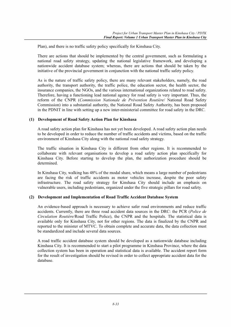
Project for Urban Transport Master Plan in Kinshasa City / PDTK Final Report: Volume 1 Urban Transport Master Plan in Kinshasa City
8-33
Plan), and there is no traffic safety policy specifically for Kinshasa City.
There are actions that should be implemented by the central government, such as formulating a national road safety strategy, updating the national legislative framework, and developing a nationwide accident database system; whereas, there are actions that should be taken by the initiative of the provincial government in conjunction with the national traffic safety policy.
As is the nature of traffic safety policy, there are many relevant stakeholders, namely, the road authority, the transport authority, the traffic police, the education sector, the health sector, the insurance companies, the NGOs, and the various international organizations related to road safety. Therefore, having a functioning lead national agency for road safety is very important. Thus, the reform of the CNPR (Commission Nationale de Prévention Routière/ National Road Safety Commission) into a substantial authority, the National Road Safety Authority, has been proposed in the PDNIT in line with setting up a new inter-ministerial committee for road safety in the DRC.
(1) Development of Road Safety Action Plan for Kinshasa
A road safety action plan for Kinshasa has not yet been developed. A road safety action plan needs to be developed in order to reduce the number of traffic accidents and victims, based on the traffic environment of Kinshasa City along with the national road safety strategy.
The traffic situation in Kinshasa City is different from other regions. It is recommended to collaborate with relevant organisations to develop a road safety action plan specifically for Kinshasa City. Before starting to develop the plan, the authorization procedure should be determined.
In Kinshasa City, walking has 48% of the modal share, which means a large number of pedestrians are facing the risk of traffic accidents as motor vehicles increase, despite the poor safety infrastructure. The road safety strategy for Kinshasa City should include an emphasis on vulnerable users, including pedestrians, organized under the five strategic pillars for road safety.
(2) Development and Implementation of Road Traffic Accident Database System
An evidence-based approach is necessary to achieve safer road environments and reduce traffic accidents. Currently, there are three road accident data sources in the DRC: the PCR (Police de Circulation Routière/Road Traffic Police), the CNPR and the hospitals. The statistical data is available only for Kinshasa City, not for other regions. The data is finalized by the CNPR and reported to the minister of MTVC. To obtain complete and accurate data, the data collection must be standardized and include several data sources.
A road traffic accident database system should be developed as a nationwide database including Kinshasa City. It is recommended to start a pilot programme in Kinshasa Province, where the data collection system has been in operation and statistical data is available. The accident report form for the result of investigation should be revised in order to collect appropriate accident data for the database.
Project for Urban Transport Master Plan in Kinshasa City / PDTK Final Report: Volume 1 Urban Transport Master Plan in Kinshasa City
8-34
Table 8.3.2 Example of Road Traffic Accident Database Contents Item Contents General information Province no. - Province code
Report no. - Accident report form numberTime and date of accident (When)
Time and date - Time, day of the week, dateDay or night - Daytime, night-time
Location information (Where)
Road class - Road class- Route number
Road surface - Paved, unpavedRoad condition - Wet, dirt, pothole, puddle
- Lane marking - Public lighting - Speed limit
Road location - Intersection type (roundabout, traffic light) - Straight section (bridge, etc.) - Others (railway crossing, etc.)
Road geometry - Curve (to right, to left)- Straight (slope)
Detail location - Latitude, longitude- Nearest Kilometre post - Cartier, district code
Vehicle information General info. - Vehicle damage severity- Vehicle type - Vehicle model - Registration no. - Vehicle ownership
Driver information Driver info. - Age, gender, occupation- Driving license
Purpose of travel - Commuting, business, driving for fun, others Vehicle movement
- Start, acceleration, deceleration, overtaking, lane change, left turn, right turn, parking, stop etc.
Injury - Injury severity, injury part- Seat-belt wearing - Motorcycle helmet wearing
Passenger information
Passenger info. - Age, gender, occupationInjury - Injury severity, location of injury
- Passenger position - Seat-belt wearing, child restraint wearing
Pedestrian information
Pedestrian info. - Age, gender, occupationInjury - Injury severity, location of injury
- Location of pedestrianAccident information Accident severity - Deaths, serious, slight injury (victim)
- Heavy, medium, light damage (property) Collision type - Pedestrian and vehicle
- Vehicle and vehicle - Vehicle alone
No of vehicle and person involved
- No. of vehicles involved, no. of vehicles damaged - No. of drivers killed, no. of drivers injured - No. of passengers killed, no. of passengers injured - No. of pedestrian killed, no. of pedestrian injured
Driver error - Violation of traffic rules: over speeding, traffic light neglect, drink driving, drug use, sleeping, mobile phone use
Vehicle error - Location of poor maintenanceSource: The Study Team
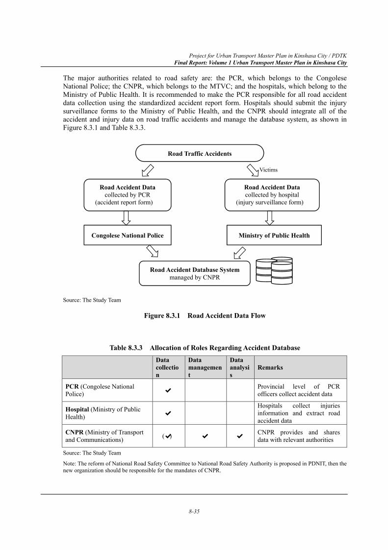
Project for Urban Transport Master Plan in Kinshasa City / PDTK Final Report: Volume 1 Urban Transport Master Plan in Kinshasa City
8-35
The major authorities related to road safety are: the PCR, which belongs to the Congolese National Police; the CNPR, which belongs to the MTVC; and the hospitals, which belong to the Ministry of Public Health. It is recommended to make the PCR responsible for all road accident data collection using the standardized accident report form. Hospitals should submit the injury surveillance forms to the Ministry of Public Health, and the CNPR should integrate all of the accident and injury data on road traffic accidents and manage the database system, as shown in Figure 8.3.1 and Table 8.3.3.
Source: The Study Team
Figure 8.3.1 Road Accident Data Flow
Table 8.3.3 Allocation of Roles Regarding Accident Database
Data collection
Data management
Data analysis
Remarks
PCR (Congolese National Police) ✔ Provincial level of PCR
officers collect accident data
Hospital (Ministry of Public Health) ✔
Hospitals collect injuries information and extract road accident data
CNPR (Ministry of Transport and Communications) ✔( ) ✔ ✔ CNPR provides and shares
data with relevant authorities
Source: The Study Team
Note: The reform of National Road Safety Committee to National Road Safety Authority is proposed in PDNIT, then the new organization should be responsible for the mandates of CNPR.
Road Traffic Accidents
Road Accident Data collected by hospital
(injury surveillance form)
Road Accident Database System managed by CNPR
Ministry of Public Health
Road Accident Data collected by PCR
(accident report form)
Congolese National Police
Victims
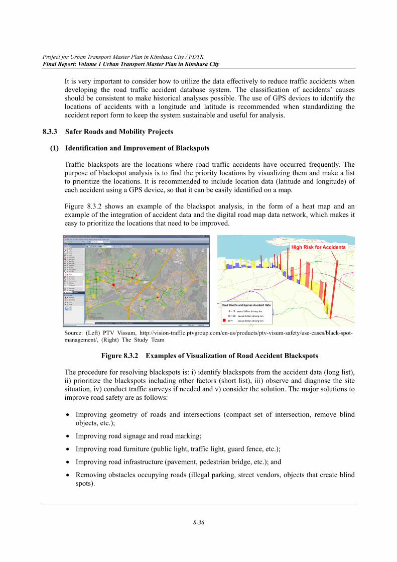
Project for Urban Transport Master Plan in Kinshasa City / PDTK Final Report: Volume 1 Urban Transport Master Plan in Kinshasa City
8-36
It is very important to consider how to utilize the data effectively to reduce traffic accidents when developing the road traffic accident database system. The classification of accidents’ causes should be consistent to make historical analyses possible. The use of GPS devices to identify the locations of accidents with a longitude and latitude is recommended when standardizing the accident report form to keep the system sustainable and useful for analysis.
8.3.3 Safer Roads and Mobility Projects
(1) Identification and Improvement of Blackspots
Traffic blackspots are the locations where road traffic accidents have occurred frequently. The purpose of blackspot analysis is to find the priority locations by visualizing them and make a list to prioritize the locations. It is recommended to include location data (latitude and longitude) of each accident using a GPS device, so that it can be easily identified on a map.
Figure 8.3.2 shows an example of the blackspot analysis, in the form of a heat map and an example of the integration of accident data and the digital road map data network, which makes it easy to prioritize the locations that need to be improved.
Source: (Left) PTV Vissum, http://vision-traffic.ptvgroup.com/en-us/products/ptv-visum-safety/use-cases/black-spot-management/, (Right) The Study Team
Figure 8.3.2 Examples of Visualization of Road Accident Blackspots
The procedure for resolving blackspots is: i) identify blackspots from the accident data (long list), ii) prioritize the blackspots including other factors (short list), iii) observe and diagnose the site situation, iv) conduct traffic surveys if needed and v) consider the solution. The major solutions to improve road safety are as follows:
Improving geometry of roads and intersections (compact set of intersection, remove blind objects, etc.);
Improving road signage and road marking;
Improving road furniture (public light, traffic light, guard fence, etc.);
Improving road infrastructure (pavement, pedestrian bridge, etc.); and
Removing obstacles occupying roads (illegal parking, street vendors, objects that create blind spots).
Road Deaths and Injuries Accident Rate
0~10 cases/billion driving-km
10~20 cases/billion driving-km
20~ cases/billion driving-km
High Risk for Accidents
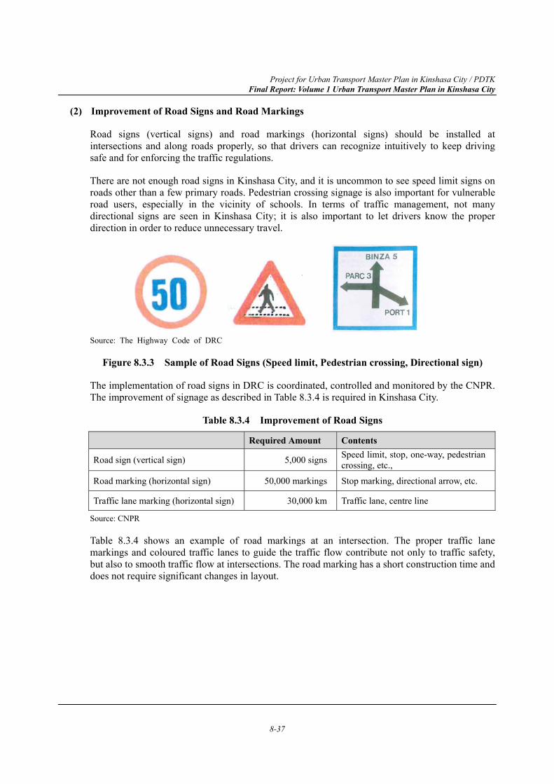
Project for Urban Transport Master Plan in Kinshasa City / PDTK Final Report: Volume 1 Urban Transport Master Plan in Kinshasa City
8-37
(2) Improvement of Road Signs and Road Markings
Road signs (vertical signs) and road markings (horizontal signs) should be installed at intersections and along roads properly, so that drivers can recognize intuitively to keep driving safe and for enforcing the traffic regulations.
There are not enough road signs in Kinshasa City, and it is uncommon to see speed limit signs on roads other than a few primary roads. Pedestrian crossing signage is also important for vulnerable road users, especially in the vicinity of schools. In terms of traffic management, not many directional signs are seen in Kinshasa City; it is also important to let drivers know the proper direction in order to reduce unnecessary travel.
Source: The Highway Code of DRC
Figure 8.3.3 Sample of Road Signs (Speed limit, Pedestrian crossing, Directional sign)
The implementation of road signs in DRC is coordinated, controlled and monitored by the CNPR. The improvement of signage as described in Table 8.3.4 is required in Kinshasa City.
Table 8.3.4 Improvement of Road Signs
Required Amount Contents
Road sign (vertical sign) 5,000 signs Speed limit, stop, one-way, pedestrian crossing, etc.,
Road marking (horizontal sign) 50,000 markings Stop marking, directional arrow, etc.
Traffic lane marking (horizontal sign) 30,000 km Traffic lane, centre line
Source: CNPR
Table 8.3.4 shows an example of road markings at an intersection. The proper traffic lane markings and coloured traffic lanes to guide the traffic flow contribute not only to traffic safety, but also to smooth traffic flow at intersections. The road marking has a short construction time and does not require significant changes in layout.
Project for Urban Transport Master Plan in Kinshasa City / PDTK Final Report: Volume 1 Urban Transport Master Plan in Kinshasa City
8-38
Source: Ministry of Land, Infrastructure, Transport and Tourism of Japan (modified by The Study Team)
Figure 8.3.4 Example of Road Marking at Intersection
(3) Introduction of Mandatory Road Safety Audit
In terms of building and maintaining safer road infrastructure, it is important to take actions from the design stage, the construction stage, and the operation and maintenance stage. Road Safety Audit (RSA) is a method to improve road safety, with a formal safety performance examination of an existing or future road or intersection by an independent, multidisciplinary team.
It is recommended to make RSAs mandatory for new road construction and rehabilitation projects as a part of the requirements to ensure road safety, as the first step to introduce RSAs in Kinshasa City.
The CNPR under the MTVC has a mission, by the Ordinance 78/478, of proposing road safety policy and ensuring the coordination of all studies and actions to create a better road environment. Therefore, the CNPR is responsible for road safety audits and assessments, but it is necessary to strengthen the capacity of the organization and collaboration between the MTVC and MITPR during construction and after the completion of road projects. In addition, as mentioned in the UN’s Decade of Action for Road Safety, at least 10% of the road infrastructure project budget should be allocated to road safety.
Project for Urban Transport Master Plan in Kinshasa City / PDTK Final Report: Volume 1 Urban Transport Master Plan in Kinshasa City
8-39
What is a Road Safety Audit? Road Safety Audit (RSA) is the formal safety performance examination of an existing or future road or intersection by an independent, multidisciplinary team. It qualitatively estimates and reports on potential road safety issues and identifies opportunities for improvements in safety for all road users. The FHWA works with State and local jurisdictions and Tribal Governments to integrate RSAs into the project development process for new roads and intersections, and also encourages RSAs on existing roads and intersections.
The aim of RSA is to answer the following questions: - What elements of the road may present a safety concern: to what extent, to which road users, and
under what circumstances? - What opportunities exist to eliminate or mitigate identified safety concerns?
Table 8.3.5 The difference between RSA and a Traditional Safety Review Road Safety Audit Traditional Safety Review
Performed by a team independent of the project The safety review team is usually not completely independent of the design team
Performed by a multi-disciplinary team Typically performed by a team with only design and/or safety expertise
Considers all potential road users Often concentrates on motorized traffic
Accounting for road user capabilities and limitations is an essential element of an RSA.
Safety Reviews do not normally consider human factor issues.
Always generates a formal RSA report Often does not generate a formal report A formal response report is an essential element of an RSA.
Often does not generate a formal response report
Source: Federal Highway Administration, US, https://safety.fhwa.dot.gov/rsa/
8.3.4 Safer Vehicles Projects
(1) Update of Road Safety Regulation
The Highway Code (Law no. 78/022) regulates the basic traffic regulations in DRC. In 2014, the draft bill of the law, which included regulations related to fastening seat-belts, using motorcycle helmets, driving under the influence of alcohol, and using mobile phone while driving, was proposed to the National Assembly but ultimately rejected. Although the draft bill was turned down in 2014, it is necessary to have up-to-date traffic regulation in DRC in a global context, to ensure the law enforcement for the better traffic environment.
Along some streets in the city centre of Kinshasa City, on-street parking vehicles occupy the shoulder of roads. Most of the on-street parking vehicles are illegally parked vehicles, and they are also dangerous as they block the view of drivers and pedestrians.
There are a number of ketches (taxis) and buses in Kinshasa City. The old types of minibuses have been called Esprit de Mort (Spirit of Death) and were notorious for disrupting traffic and dangerous to road users. Although they are shifting to a new type of vehicles called Esprit de Vie (Spirit of Life), the public transport vehicles must be controlled and assessed by the provincial government and the MTVC.
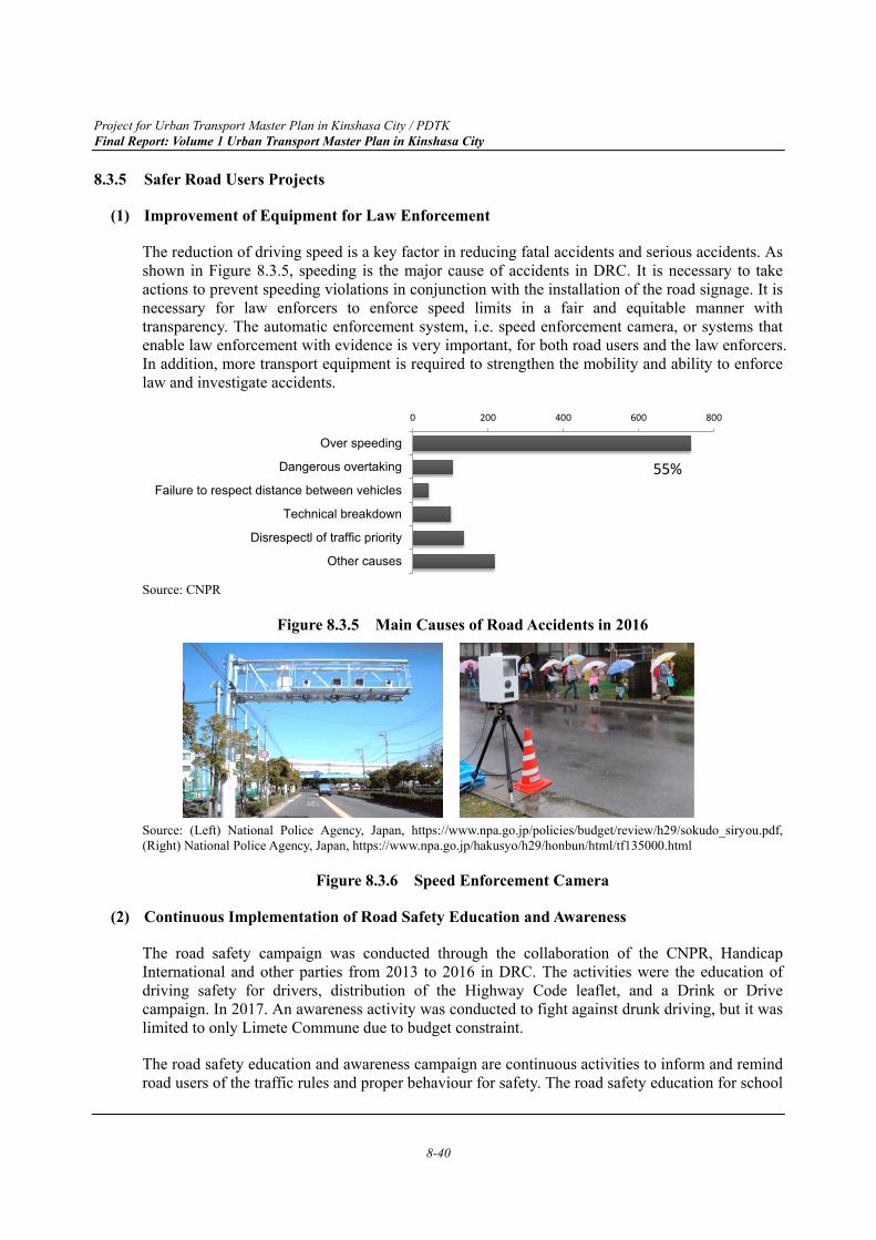
Project for Urban Transport Master Plan in Kinshasa City / PDTK Final Report: Volume 1 Urban Transport Master Plan in Kinshasa City
8-40
8.3.5 Safer Road Users Projects
(1) Improvement of Equipment for Law Enforcement
The reduction of driving speed is a key factor in reducing fatal accidents and serious accidents. As shown in Figure 8.3.5, speeding is the major cause of accidents in DRC. It is necessary to take actions to prevent speeding violations in conjunction with the installation of the road signage. It is necessary for law enforcers to enforce speed limits in a fair and equitable manner with transparency. The automatic enforcement system, i.e. speed enforcement camera, or systems that enable law enforcement with evidence is very important, for both road users and the law enforcers. In addition, more transport equipment is required to strengthen the mobility and ability to enforce law and investigate accidents.
Source: CNPR
Figure 8.3.5 Main Causes of Road Accidents in 2016
Source: (Left) National Police Agency, Japan, https://www.npa.go.jp/policies/budget/review/h29/sokudo_siryou.pdf, (Right) National Police Agency, Japan, https://www.npa.go.jp/hakusyo/h29/honbun/html/tf135000.html
Figure 8.3.6 Speed Enforcement Camera
(2) Continuous Implementation of Road Safety Education and Awareness
The road safety campaign was conducted through the collaboration of the CNPR, Handicap International and other parties from 2013 to 2016 in DRC. The activities were the education of driving safety for drivers, distribution of the Highway Code leaflet, and a Drink or Drive campaign. In 2017. An awareness activity was conducted to fight against drunk driving, but it was limited to only Limete Commune due to budget constraint.
The road safety education and awareness campaign are continuous activities to inform and remind road users of the traffic rules and proper behaviour for safety. The road safety education for school
0 200 400 600 800
Over speeding
Dangerous overtaking
Failure to respect distance between vehicles
Technical breakdown
Disrespectl of traffic priority
Other causes
55%
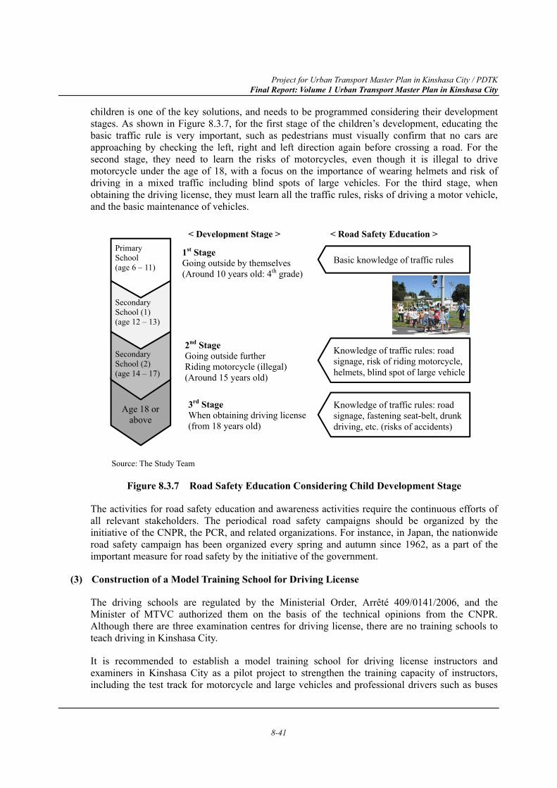
Project for Urban Transport Master Plan in Kinshasa City / PDTK Final Report: Volume 1 Urban Transport Master Plan in Kinshasa City
8-41
children is one of the key solutions, and needs to be programmed considering their development stages. As shown in Figure 8.3.7, for the first stage of the children’s development, educating the basic traffic rule is very important, such as pedestrians must visually confirm that no cars are approaching by checking the left, right and left direction again before crossing a road. For the second stage, they need to learn the risks of motorcycles, even though it is illegal to drive motorcycle under the age of 18, with a focus on the importance of wearing helmets and risk of driving in a mixed traffic including blind spots of large vehicles. For the third stage, when obtaining the driving license, they must learn all the traffic rules, risks of driving a motor vehicle, and the basic maintenance of vehicles.
Source: The Study Team
Figure 8.3.7 Road Safety Education Considering Child Development Stage
The activities for road safety education and awareness activities require the continuous efforts of all relevant stakeholders. The periodical road safety campaigns should be organized by the initiative of the CNPR, the PCR, and related organizations. For instance, in Japan, the nationwide road safety campaign has been organized every spring and autumn since 1962, as a part of the important measure for road safety by the initiative of the government.
(3) Construction of a Model Training School for Driving License
The driving schools are regulated by the Ministerial Order, Arrêté 409/0141/2006, and the Minister of MTVC authorized them on the basis of the technical opinions from the CNPR. Although there are three examination centres for driving license, there are no training schools to teach driving in Kinshasa City.
It is recommended to establish a model training school for driving license instructors and examiners in Kinshasa City as a pilot project to strengthen the training capacity of instructors, including the test track for motorcycle and large vehicles and professional drivers such as buses
1st Stage Going outside by themselves (Around 10 years old: 4th grade)
Primary School (age 6 – 11)
Secondary School (1) (age 12 – 13)
Secondary School (2) (age 14 – 17)
Age 18 or above
< Development Stage >
3rd Stage When obtaining driving license (from 18 years old)
2nd Stage Going outside further Riding motorcycle (illegal) (Around 15 years old)
Basic knowledge of traffic rules
< Road Safety Education >
Knowledge of traffic rules: road signage, risk of riding motorcycle, helmets, blind spot of large vehicle
Knowledge of traffic rules: road signage, fastening seat-belt, drunk driving, etc. (risks of accidents)
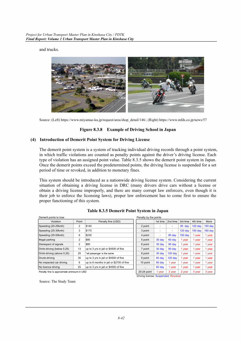
Project for Urban Transport Master Plan in Kinshasa City / PDTK Final Report: Volume 1 Urban Transport Master Plan in Kinshasa City
8-42
and trucks.
Source: (Left) https://www.miyamae-ku.jp/request/area/shop_detail/146/, (Right) https://www.mfds.co.jp/news/57
Figure 8.3.8 Example of Driving School in Japan
(4) Introduction of Demerit Point System for Driving License
The demerit point system is a system of tracking individual driving records through a point system, in which traffic violations are counted as penalty points against the driver’s driving license. Each type of violation has an assigned point value. Table 8.3.5 shows the demerit point system in Japan. Once the demerit points exceed the predetermined points, the driving license is suspended for a set period of time or revoked, in addition to monetary fines.
This system should be introduced as a nationwide driving license system. Considering the current situation of obtaining a driving license in DRC (many drivers drive cars without a license or obtain a driving license improperly, and there are many corrupt law enforcers, even though it is their job to enforce the licensing laws), proper law enforcement has to come first to ensure the proper functioning of this system.
Table 8.3.5 Demerit Point System in Japan
Source: The Study Team
Demerit points to lose Penalty by the pointsViolation Point Penalty fine (USD) 1st time 2nd time 3rd time 4th time More
Speeding (20-25kmh) 2 $140 2 point - - 90 day 120 day 150 day
Speeding (25-30kmh) 3 $170 3 point - - 120 day 150 day 180 day
Speeding (30-50kmh) 6 $230 4 point - 60 day 150 day 1 year 1 year
Illegal parking 2 $80 5 point 30 day 60 day 1 year 1 year 1 year
Disrespect of signals 2 $80 6 point 30 day 90 day 1 year 1 year 1 year
Drink-driving (below 0.25) 13 up to 3 yrs in jail or $4500 of fine 7 point 30 day 90 day 1 year 1 year 1 year
Drink-driving (above 0.25) 25 *all passenger is the same 8 point 30 day 120 day 1 year 1 year 1 year
Drunk-driving 35 up to 3 yrs in jail or $4500 of fine 9 point 60 day 120 day 1 year 1 year 1 year
No inspected car driving 6 up to 6 months in jail or $2700 of fine 10 point 60 day 1 year 1 year 1 year 1 year
No licence driving 25 up to 3 yrs in jail or $4500 of fine … 60 day 1 year 1 year 1 year 1 year
Penalty fine is approximate ammount in USD 20-24 point 1 year 2 year 2 year 3 year 3 yearDriving license: Suspended, Revoked
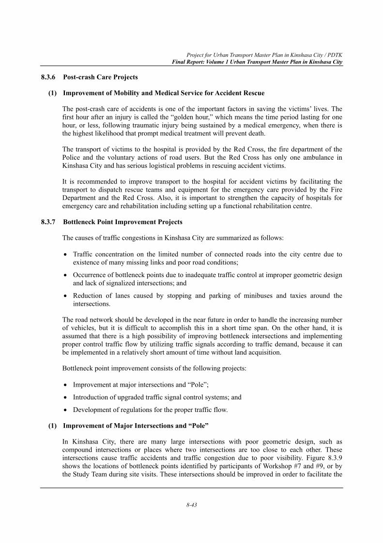
Project for Urban Transport Master Plan in Kinshasa City / PDTK Final Report: Volume 1 Urban Transport Master Plan in Kinshasa City
8-43
8.3.6 Post-crash Care Projects
(1) Improvement of Mobility and Medical Service for Accident Rescue
The post-crash care of accidents is one of the important factors in saving the victims’ lives. The first hour after an injury is called the “golden hour,” which means the time period lasting for one hour, or less, following traumatic injury being sustained by a medical emergency, when there is the highest likelihood that prompt medical treatment will prevent death.
The transport of victims to the hospital is provided by the Red Cross, the fire department of the Police and the voluntary actions of road users. But the Red Cross has only one ambulance in Kinshasa City and has serious logistical problems in rescuing accident victims.
It is recommended to improve transport to the hospital for accident victims by facilitating the transport to dispatch rescue teams and equipment for the emergency care provided by the Fire Department and the Red Cross. Also, it is important to strengthen the capacity of hospitals for emergency care and rehabilitation including setting up a functional rehabilitation centre.
8.3.7 Bottleneck Point Improvement Projects
The causes of traffic congestions in Kinshasa City are summarized as follows:
Traffic concentration on the limited number of connected roads into the city centre due to existence of many missing links and poor road conditions;
Occurrence of bottleneck points due to inadequate traffic control at improper geometric design and lack of signalized intersections; and
Reduction of lanes caused by stopping and parking of minibuses and taxies around the intersections.
The road network should be developed in the near future in order to handle the increasing number of vehicles, but it is difficult to accomplish this in a short time span. On the other hand, it is assumed that there is a high possibility of improving bottleneck intersections and implementing proper control traffic flow by utilizing traffic signals according to traffic demand, because it can be implemented in a relatively short amount of time without land acquisition.
Bottleneck point improvement consists of the following projects:
Improvement at major intersections and “Pole”;
Introduction of upgraded traffic signal control systems; and
Development of regulations for the proper traffic flow.
(1) Improvement of Major Intersections and “Pole”
In Kinshasa City, there are many large intersections with poor geometric design, such as compound intersections or places where two intersections are too close to each other. These intersections cause traffic accidents and traffic congestion due to poor visibility. Figure 8.3.9 shows the locations of bottleneck points identified by participants of Workshop #7 and #9, or by the Study Team during site visits. These intersections should be improved in order to facilitate the
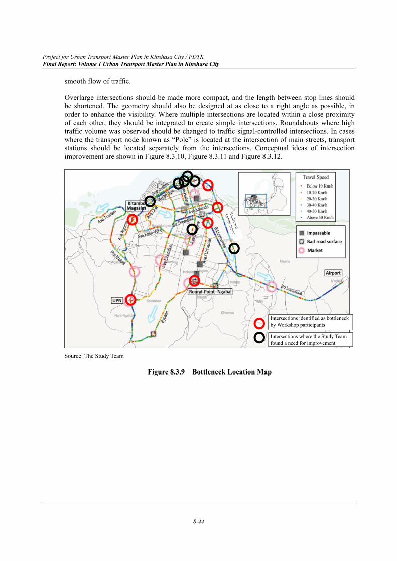
Project for Urban Transport Master Plan in Kinshasa City / PDTK Final Report: Volume 1 Urban Transport Master Plan in Kinshasa City
8-44
smooth flow of traffic.
Overlarge intersections should be made more compact, and the length between stop lines should be shortened. The geometry should also be designed at as close to a right angle as possible, in order to enhance the visibility. Where multiple intersections are located within a close proximity of each other, they should be integrated to create simple intersections. Roundabouts where high traffic volume was observed should be changed to traffic signal-controlled intersections. In cases where the transport node known as “Pole” is located at the intersection of main streets, transport stations should be located separately from the intersections. Conceptual ideas of intersection improvement are shown in Figure 8.3.10, Figure 8.3.11 and Figure 8.3.12.
Source: The Study Team
Figure 8.3.9 Bottleneck Location Map
Intersections identified as bottleneck by Workshop participants
Intersections where the Study Team found a need for improvement
Project for Urban Transport Master Plan in Kinshasa City / PDTK Final Report: Volume 1 Urban Transport Master Plan in Kinshasa City
8-45
Note: Lumumba Boulevard - Sendwe Boulevard
Source: Google and DigitalGlobe edited by the Study Team
Figure 8.3.10 Conceptual Idea of Intersection Improvement (Overlarge intersection)
Note:. 30 Juin Boulevard - Tchad Avenue
Source: Google and DigitalGlobe edited by the Study Team
Figure 8.3.11 Conceptual Idea of Intersection Improvement (Close intersections)
Project for Urban Transport Master Plan in Kinshasa City / PDTK Final Report: Volume 1 Urban Transport Master Plan in Kinshasa City
8-46
Note: Round-Point Ngaba
Source: Google and DigitalGlobe edited by the Study Team
Figure 8.3.12 Conceptual Idea of Intersection Improvement (Roundabouts)
Kintambo Magasin (one of the bottleneck points) consists of four intersections, and gridlock occurs during the peak hours due to poor operation that is unable to handle a large traffic volume, in spite of existing traffic signals. It is proposed to introduce a combination of one-way streets, in order to optimize traffic flow and reduce the conflict points as shown in Figure 8.3.13
Project for Urban Transport Master Plan in Kinshasa City / PDTK Final Report: Volume 1 Urban Transport Master Plan in Kinshasa City
8-47
Note: Kintambo – Magasin
Source: Google and DigitalGlobe edited by the Study Team
Figure 8.3.13 Conceptual Idea of Intersection Improvement (Kintambo Magasin)
Source: The Study Team
Figure 8.3.14 Current Situation in Kintambo Magasin
(2) Introduction of Upgraded Traffic Signal Control Systems
There are not many traffic signals in Kinshasa City, and most of the installed traffic signals are inactive due to breakdowns or electricity shortages. Traffic signals should be maintained or
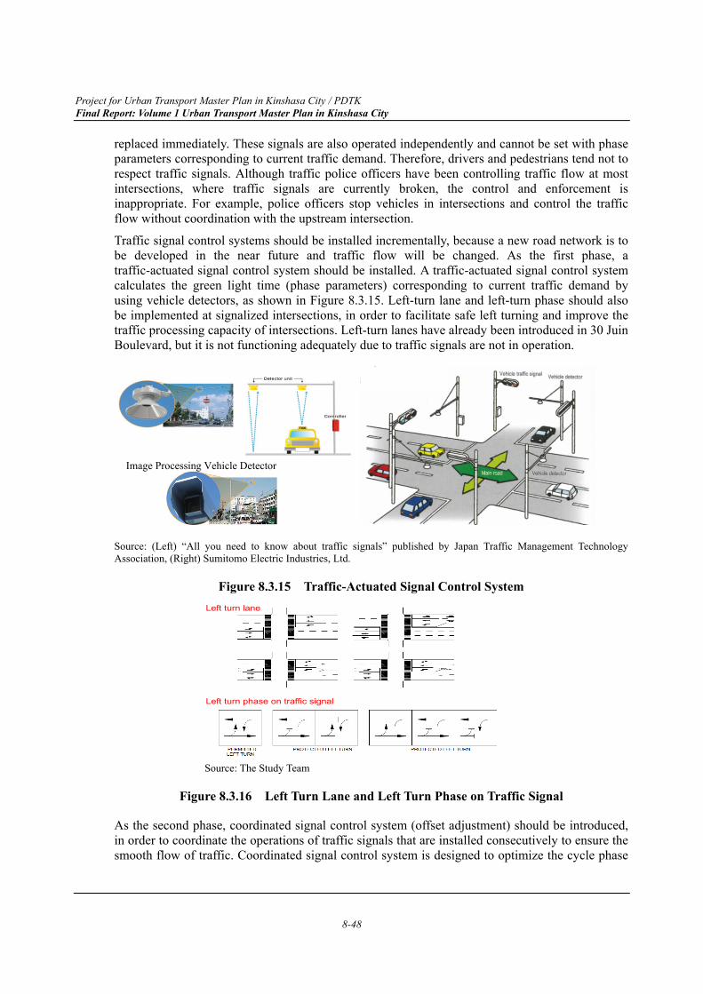
Project for Urban Transport Master Plan in Kinshasa City / PDTK Final Report: Volume 1 Urban Transport Master Plan in Kinshasa City
8-48
replaced immediately. These signals are also operated independently and cannot be set with phase parameters corresponding to current traffic demand. Therefore, drivers and pedestrians tend not to respect traffic signals. Although traffic police officers have been controlling traffic flow at most intersections, where traffic signals are currently broken, the control and enforcement is inappropriate. For example, police officers stop vehicles in intersections and control the traffic flow without coordination with the upstream intersection.
Traffic signal control systems should be installed incrementally, because a new road network is to be developed in the near future and traffic flow will be changed. As the first phase, a traffic-actuated signal control system should be installed. A traffic-actuated signal control system calculates the green light time (phase parameters) corresponding to current traffic demand by using vehicle detectors, as shown in Figure 8.3.15. Left-turn lane and left-turn phase should also be implemented at signalized intersections, in order to facilitate safe left turning and improve the traffic processing capacity of intersections. Left-turn lanes have already been introduced in 30 Juin Boulevard, but it is not functioning adequately due to traffic signals are not in operation.
Source: (Left) “All you need to know about traffic signals” published by Japan Traffic Management Technology Association, (Right) Sumitomo Electric Industries, Ltd.
Figure 8.3.15 Traffic-Actuated Signal Control System
Source: The Study Team
Figure 8.3.16 Left Turn Lane and Left Turn Phase on Traffic Signal
As the second phase, coordinated signal control system (offset adjustment) should be introduced, in order to coordinate the operations of traffic signals that are installed consecutively to ensure the smooth flow of traffic. Coordinated signal control system is designed to optimize the cycle phase
Image Processing Vehicle Detector
Left turn lane
Left turn phase on traffic signal
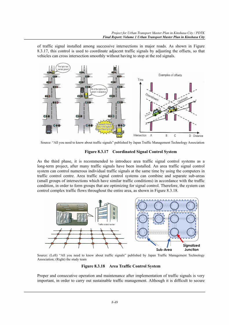
Project for Urban Transport Master Plan in Kinshasa City / PDTK Final Report: Volume 1 Urban Transport Master Plan in Kinshasa City
8-49
of traffic signal installed among successive intersections in major roads. As shown in Figure 8.3.17, this control is used to coordinate adjacent traffic signals by adjusting the offsets, so that vehicles can cross intersection smoothly without having to stop at the red signals.
Source: “All you need to know about traffic signals” published by Japan Traffic Management Technology Association
Figure 8.3.17 Coordinated Signal Control System
As the third phase, it is recommended to introduce area traffic signal control systems as a long-term project, after many traffic signals have been installed. An area traffic signal control system can control numerous individual traffic signals at the same time by using the computers in traffic control centre. Area traffic signal control systems can combine and separate sub-areas (small groups of intersections which have similar traffic conditions) in accordance with the traffic condition, in order to form groups that are optimizing for signal control. Therefore, the system can control complex traffic flows throughout the entire area, as shown in Figure 8.3.18.
Source: (Left) “All you need to know about traffic signals” published by Japan Traffic Management Technology Association; (Right) the study team
Figure 8.3.18 Area Traffic Control System
Proper and consecutive operation and maintenance after implementation of traffic signals is very important, in order to carry out sustainable traffic management. Although it is difficult to secure
Sub-AreaSignalized Junction
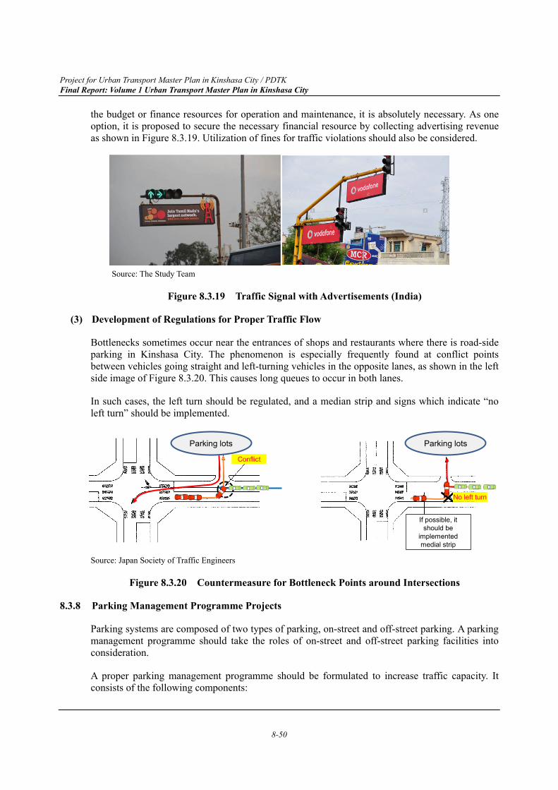
Project for Urban Transport Master Plan in Kinshasa City / PDTK Final Report: Volume 1 Urban Transport Master Plan in Kinshasa City
8-50
the budget or finance resources for operation and maintenance, it is absolutely necessary. As one option, it is proposed to secure the necessary financial resource by collecting advertising revenue as shown in Figure 8.3.19. Utilization of fines for traffic violations should also be considered.
Source: The Study Team
Figure 8.3.19 Traffic Signal with Advertisements (India)
(3) Development of Regulations for Proper Traffic Flow
Bottlenecks sometimes occur near the entrances of shops and restaurants where there is road-side parking in Kinshasa City. The phenomenon is especially frequently found at conflict points between vehicles going straight and left-turning vehicles in the opposite lanes, as shown in the left side image of Figure 8.3.20. This causes long queues to occur in both lanes.
In such cases, the left turn should be regulated, and a median strip and signs which indicate “no left turn” should be implemented.
Source: Japan Society of Traffic Engineers
Figure 8.3.20 Countermeasure for Bottleneck Points around Intersections
8.3.8 Parking Management Programme Projects
Parking systems are composed of two types of parking, on-street and off-street parking. A parking management programme should take the roles of on-street and off-street parking facilities into consideration.
A proper parking management programme should be formulated to increase traffic capacity. It consists of the following components:
Parking lots
Conflict
If possible, it should be
implemented medial strip
No left turn
Parking lots
Project for Urban Transport Master Plan in Kinshasa City / PDTK Final Report: Volume 1 Urban Transport Master Plan in Kinshasa City
8-51
Revision of parking facility development policy and planning;
On-street parking management, including control of taxies by proper registration system and installation of minibus and taxi parking facilities;
Law enforcement of illegal parking;
Development of off-street parking facility operated by private and public sector; and
Introduction of parking guidance system.
(1) Revision of Parking Facility Development Policy
Regulation and a parking tax system have already been implemented in Kinshasa City, but as they are ambiguous and enforcement is inadequate, citizens do not have adequate understanding of the rules.
New policies or guidelines regarding parking management should be developed. The areas where parking facility development is promoted or restricted should be clearly defined.
This policy should cover the following:
Definition and classification of parking;
Clarification of role between on-street and off-street parking facilities;
Review of regulation regarding the on-street parking system and prohibition of on-street parking outside of the designated area;
Role sharing and collaboration between public and private sectors;
Existing off-street parking facilities are utilized adequately;
Control and support of parking facility development by the private sector; and
Prohibition of on-street parking and stopping on primary road and bus priority lane and BRT route network.
(2) On-street Parking Management
The results of the parking survey in the central area of Gombe Commune indicated that on-street parking can be found on most streets, whereas empty space and capacity are remaining in existing off-street parking facilities.
Proper management of on-street parking is important not only for managing the parking supply, but also for ensuring smooth traffic flow.
The following policies should be applied to on-street parking management:
Designation of on-street parking space;
Introduction parking tax system for on-street parking at the designated area; and
Prohibition of on-street parking outside of the designated area.
Project for Urban Transport Master Plan in Kinshasa City / PDTK Final Report: Volume 1 Urban Transport Master Plan in Kinshasa City
8-52
Criteria should be established as to the provision of on-street parking for each class of road. In principle, vehicles should be parked in off-street parking facilities if the parking time is long (over 30 minutes). Outside of designated areas, on-street parking for a long period (i.e., for over 30 minutes) should be prohibited.
The selection of designated on-street parking areas should consider such factors as road classification, road geometry, road width, number of lanes, side clearance, traffic volume, congestion level, land use, and public transport routes. The fine for illegal parking should be set higher than the nearby off-street parking fees to promote to use the off-street parking facilities.
In addition, the results of the stopping vehicle survey indicated that many stopping vehicles, such as minibuses and taxis (Ketch), are observed at major intersections and around markets in Kinshasa City. They occupy traffic lanes and reduce the traffic capacity, as shown in Figure 8.3.21
Source: The Study Team
Figure 8.3.21 Occupation Traffic Lane by Stopping Vehicles around Intersections
Kinshasa Province should select locations for on-street parking which have little impact on traffic congestion—areas around intersections should be avoided. Parking spaces should not be located before a potential bottleneck point, as shown in Figure 8.3.22. The design of on-street parking areas should be easy for all users to understand.
Source: The Study Team
Figure 8.3.22 Impact by On-street Parking and Stopping Vehicles at Bottleneck Point
Kinshasa Province has already instituted “Arrêtés” regarding taxis and minibuses registration. However, many unlicensed taxis and minibuses are assumed to exist. Kinshasa Province should regulate unlicensed taxis and minibuses. In addition, mass transit such as BRT and railways should
Congestion
Bottleneck
Project for Urban Transport Master Plan in Kinshasa City / PDTK Final Report: Volume 1 Urban Transport Master Plan in Kinshasa City
8-53
be developed corresponding to the travel needs of residents, and the number of minibuses should be restricted on the major streets. Minibuses should operate as feeder transport. On the other hand, taxis need dedicated pick-up points in busy areas. Therefore, taxi stands should be developed at places, which would allow the development of potential bottleneck points to be avoided. Figure 8.3.23 shows a taxi stand that was designed at curb space on the street.
Source: (Left) The Study Team ; (Right) On-street Parking Management published by giz, SUTP
Figure 8.3.23 Taxi Stands on the Street
(3) Strict Enforcement of Illegal Parking
Stricter parking enforcement should be conducted, including the following actions in order to realize proper on-street parking management:
a) Clear and visible indication of no parking sections
As shown in Figure 8.3.24, placing more traffic signs along the prohibited section, together with coloured pavement or line markings, improves the visibility of indication of parking regulation. At the same time, on-street parking spaces should be marked clearly with paint as rectangular boxes.
b) Attaching stickers, clamps, or other devices to illegally parked vehicles
Traffic police should attach stickers, place clamps on illegally parked vehicle and charge a fine. These devices prevent vehicle owners from moving their vehicle without paying the penalty, and serve as a disincentive for illegal parking. At the same time, anti-bribery laws must be more strictly enforced, to prevent parking enforcement officers from accepting bribes.
c) Law enforcement of illegal parking using private companies
Enforcement has been entrusted to a private organization which has suitable qualification as practiced in some countries. They can crack down strictly on illegal parking. However, enforcers from private companies must be protected against disobedience of drivers or vehicle’s owner. Law enforcement procedures must be defined clearly, and staff must be trained.
Project for Urban Transport Master Plan in Kinshasa City / PDTK Final Report: Volume 1 Urban Transport Master Plan in Kinshasa City
8-54
Source: (Left) The Study Team, (Right) Ashima Co., Ltd. URL: http://www.e-asima.com/parking.html
Figure 8.3.24 No Parking in Red Lane Marking and Deputized Parking Enforcement Officer
(4) Development of Paring Facility Operated by PPP Model
Parking facilities are basically owned by the private sector as a part of buildings, and no companies exclusively manage parking facilities for the public in Kinshasa City. In the case of shopping malls, large supermarkets and hotels, their owners should provide the parking facilities for customers. In the case of local shopping areas or markets where it is difficult for shop owners to construct the parking facilities by themselves, the public and private sectors should develop the off-street parking facilities for visitors. Operators can gain income in the form of parking fees from drivers parked on the facilities. The government can apply the public-private partnership model to have a private company offer parking service and manage the facility as a long-term contract between a private party and a government entity. Figure 8.3.25 shows various types of off-street parking facilities in Japan. The introduction should be selected based on available space and cost.
Source: ARCLINK Co.,Ltd., Japan
Figure 8.3.25 Types of Off-street Parking Facilities in Japan
Ground-level parking lot Multi-story parking lot
Mechanical parking lot Time based parking lot
Project for Urban Transport Master Plan in Kinshasa City / PDTK Final Report: Volume 1 Urban Transport Master Plan in Kinshasa City
8-55
(5) Parking Location Map and Parking Guidance System
After the implementation of parking facilities, a parking location map should be provided to drivers, as shown in Figure 8.3.26. A parking guidance system is also recommended as an introduction to encourage more efficient use of the existing parking facilities. Figure 8.3.27 shows an internet-based parking guidance system, parking information boards and a mobile phone app that was developed as a social experiment in Istanbul, Turkey. This system provides information about locations, availability, and parking fees of parking lots outside the most congested area.
It is also recommended to set up parking information boards at the entrance(s) to the central area and provide information about parking locations and free spaces in real-time, so that drivers can easily search for parking spaces. This system is also beneficial for private parking operation companies, as their free spaces are displayed on boards, websites and smartphone apps, helping to draw in customers.
Source: Downtown Parking Strategy City of London Parking Management and Design Best Practices Figure 8.3.26 Example of Off-street Parking Location Map
Source: Traffic Demand Management of Historical Area in Istanbul (iSTDM) Final Report, JICA
Figure 8.3.27 Parking Guidance Service by Various Media
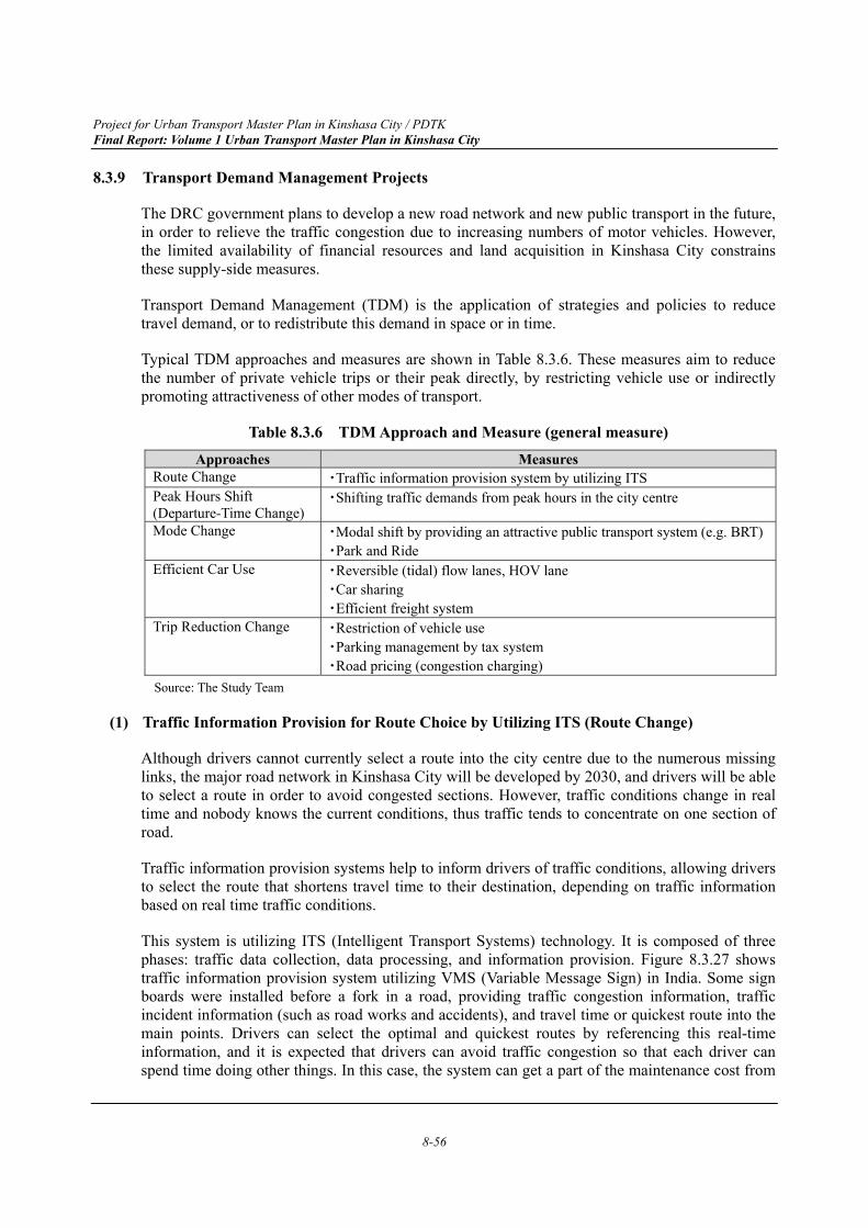
Project for Urban Transport Master Plan in Kinshasa City / PDTK Final Report: Volume 1 Urban Transport Master Plan in Kinshasa City
8-56
8.3.9 Transport Demand Management Projects
The DRC government plans to develop a new road network and new public transport in the future, in order to relieve the traffic congestion due to increasing numbers of motor vehicles. However, the limited availability of financial resources and land acquisition in Kinshasa City constrains these supply-side measures.
Transport Demand Management (TDM) is the application of strategies and policies to reduce travel demand, or to redistribute this demand in space or in time.
Typical TDM approaches and measures are shown in Table 8.3.6. These measures aim to reduce the number of private vehicle trips or their peak directly, by restricting vehicle use or indirectly promoting attractiveness of other modes of transport.
Table 8.3.6 TDM Approach and Measure (general measure) Approaches Measures
Route Change ・Traffic information provision system by utilizing ITS Peak Hours Shift (Departure-Time Change)
・Shifting traffic demands from peak hours in the city centre
Mode Change ・Modal shift by providing an attractive public transport system (e.g. BRT)・Park and Ride
Efficient Car Use
・Reversible (tidal) flow lanes, HOV lane ・Car sharing ・Efficient freight system
Trip Reduction Change ・Restriction of vehicle use ・Parking management by tax system ・Road pricing (congestion charging)
Source: The Study Team
(1) Traffic Information Provision for Route Choice by Utilizing ITS (Route Change)
Although drivers cannot currently select a route into the city centre due to the numerous missing links, the major road network in Kinshasa City will be developed by 2030, and drivers will be able to select a route in order to avoid congested sections. However, traffic conditions change in real time and nobody knows the current conditions, thus traffic tends to concentrate on one section of road.
Traffic information provision systems help to inform drivers of traffic conditions, allowing drivers to select the route that shortens travel time to their destination, depending on traffic information based on real time traffic conditions.
This system is utilizing ITS (Intelligent Transport Systems) technology. It is composed of three phases: traffic data collection, data processing, and information provision. Figure 8.3.27 shows traffic information provision system utilizing VMS (Variable Message Sign) in India. Some sign boards were installed before a fork in a road, providing traffic congestion information, traffic incident information (such as road works and accidents), and travel time or quickest route into the main points. Drivers can select the optimal and quickest routes by referencing this real-time information, and it is expected that drivers can avoid traffic congestion so that each driver can spend time doing other things. In this case, the system can get a part of the maintenance cost from
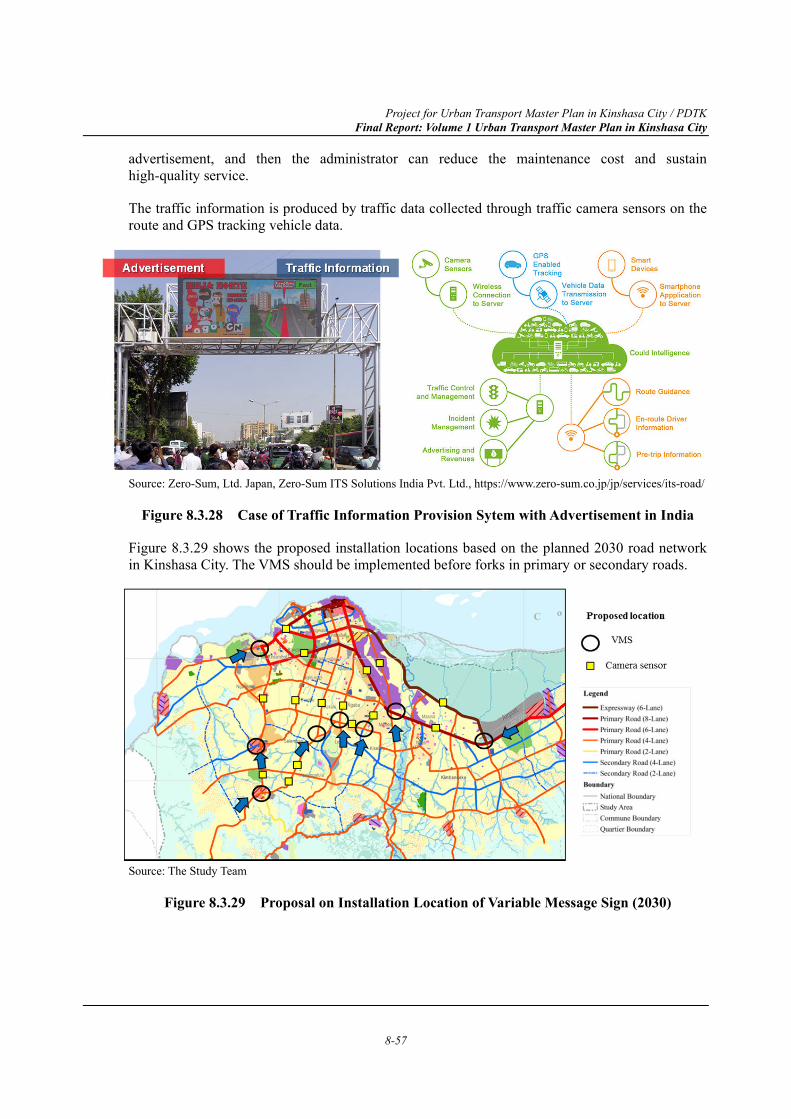
Project for Urban Transport Master Plan in Kinshasa City / PDTK Final Report: Volume 1 Urban Transport Master Plan in Kinshasa City
8-57
advertisement, and then the administrator can reduce the maintenance cost and sustain high-quality service.
The traffic information is produced by traffic data collected through traffic camera sensors on the route and GPS tracking vehicle data.
Source: Zero-Sum, Ltd. Japan, Zero-Sum ITS Solutions India Pvt. Ltd., https://www.zero-sum.co.jp/jp/services/its-road/
Figure 8.3.28 Case of Traffic Information Provision Sytem with Advertisement in India
Figure 8.3.29 shows the proposed installation locations based on the planned 2030 road network in Kinshasa City. The VMS should be implemented before forks in primary or secondary roads.
Source: The Study Team
Figure 8.3.29 Proposal on Installation Location of Variable Message Sign (2030)
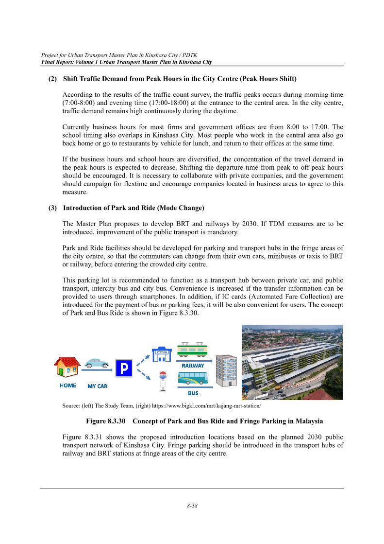
Project for Urban Transport Master Plan in Kinshasa City / PDTK Final Report: Volume 1 Urban Transport Master Plan in Kinshasa City
8-58
(2) Shift Traffic Demand from Peak Hours in the City Centre (Peak Hours Shift)
According to the results of the traffic count survey, the traffic peaks occurs during morning time (7:00-8:00) and evening time (17:00-18:00) at the entrance to the central area. In the city centre, traffic demand remains high continuously during the daytime.
Currently business hours for most firms and government offices are from 8:00 to 17:00. The school timing also overlaps in Kinshasa City. Most people who work in the central area also go back home or go to restaurants by vehicle for lunch, and return to their offices at the same time.
If the business hours and school hours are diversified, the concentration of the travel demand in the peak hours is expected to decrease. Shifting the departure time from peak to off-peak hours should be encouraged. It is necessary to collaborate with private companies, and the government should campaign for flextime and encourage companies located in business areas to agree to this measure.
(3) Introduction of Park and Ride (Mode Change)
The Master Plan proposes to develop BRT and railways by 2030. If TDM measures are to be introduced, improvement of the public transport is mandatory.
Park and Ride facilities should be developed for parking and transport hubs in the fringe areas of the city centre, so that the commuters can change from their own cars, minibuses or taxis to BRT or railway, before entering the crowded city centre.
This parking lot is recommended to function as a transport hub between private car, and public transport, intercity bus and city bus. Convenience is increased if the transfer information can be provided to users through smartphones. In addition, if IC cards (Automated Fare Collection) are introduced for the payment of bus or parking fees, it will be also convenient for users. The concept of Park and Bus Ride is shown in Figure 8.3.30.
Source: (left) The Study Team, (right) https://www.bigkl.com/mrt/kajang-mrt-station/
Figure 8.3.30 Concept of Park and Bus Ride and Fringe Parking in Malaysia
Figure 8.3.31 shows the proposed introduction locations based on the planned 2030 public transport network of Kinshasa City. Fringe parking should be introduced in the transport hubs of railway and BRT stations at fringe areas of the city centre.
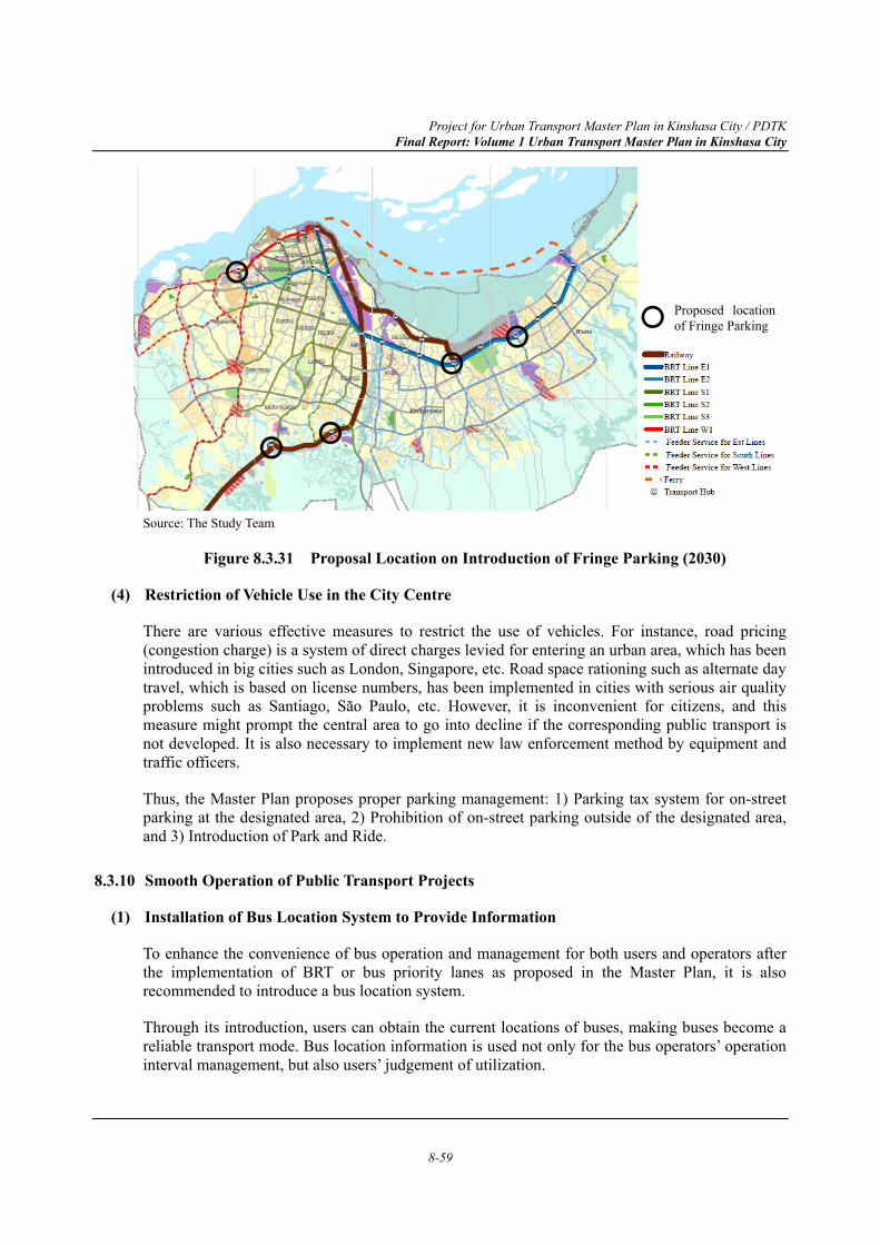
Project for Urban Transport Master Plan in Kinshasa City / PDTK Final Report: Volume 1 Urban Transport Master Plan in Kinshasa City
8-59
Source: The Study Team
Figure 8.3.31 Proposal Location on Introduction of Fringe Parking (2030)
(4) Restriction of Vehicle Use in the City Centre
There are various effective measures to restrict the use of vehicles. For instance, road pricing (congestion charge) is a system of direct charges levied for entering an urban area, which has been introduced in big cities such as London, Singapore, etc. Road space rationing such as alternate day travel, which is based on license numbers, has been implemented in cities with serious air quality problems such as Santiago, São Paulo, etc. However, it is inconvenient for citizens, and this measure might prompt the central area to go into decline if the corresponding public transport is not developed. It is also necessary to implement new law enforcement method by equipment and traffic officers.
Thus, the Master Plan proposes proper parking management: 1) Parking tax system for on-street parking at the designated area, 2) Prohibition of on-street parking outside of the designated area, and 3) Introduction of Park and Ride.
8.3.10 Smooth Operation of Public Transport Projects
(1) Installation of Bus Location System to Provide Information
To enhance the convenience of bus operation and management for both users and operators after the implementation of BRT or bus priority lanes as proposed in the Master Plan, it is also recommended to introduce a bus location system.
Through its introduction, users can obtain the current locations of buses, making buses become a reliable transport mode. Bus location information is used not only for the bus operators’ operation interval management, but also users’ judgement of utilization.
Proposed location of Fringe Parking
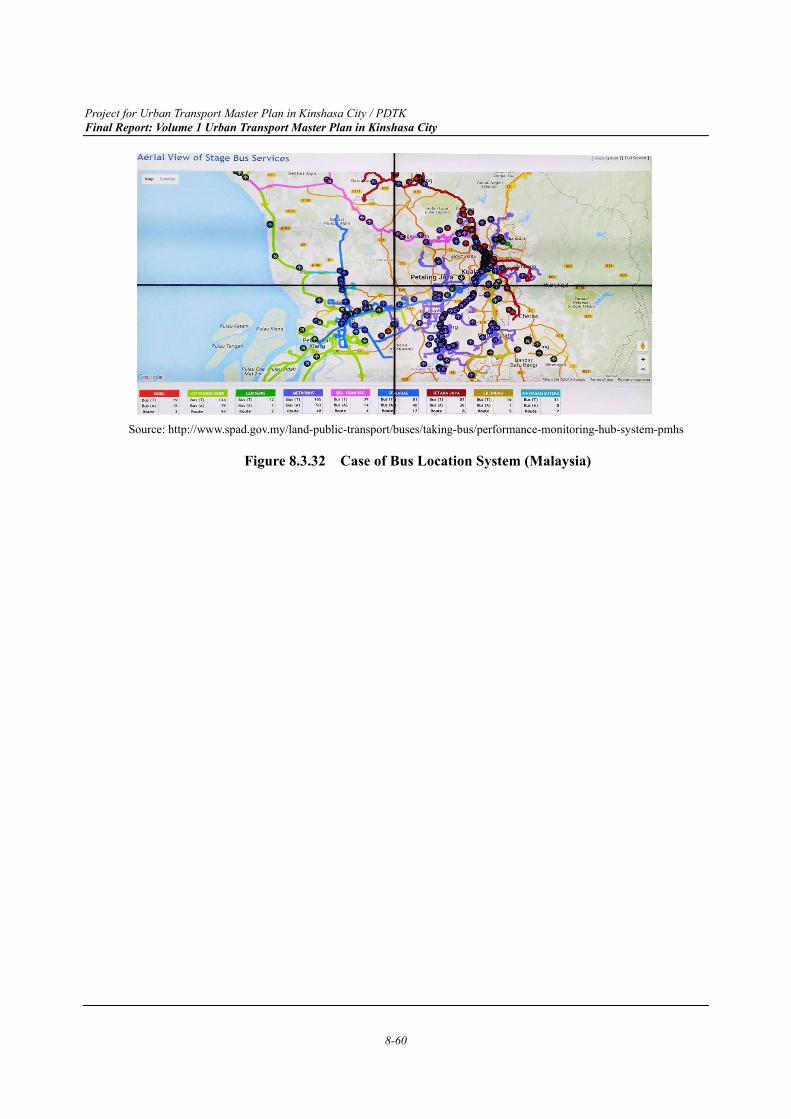
Project for Urban Transport Master Plan in Kinshasa City / PDTK Final Report: Volume 1 Urban Transport Master Plan in Kinshasa City
8-60
Source: http://www.spad.gov.my/land-public-transport/buses/taking-bus/performance-monitoring-hub-system-pmhs
Figure 8.3.32 Case of Bus Location System (Malaysia)
Project for Urban Transport Master Plan in Kinshasa City / PDTK Final Report: Volume 1 Urban Transport Master Plan in Kinshasa City
9-1
CHAPTER 9 Project Implementation Plan for 2030
9.1 Identification of Individual Project
Project implementation plan for 2030 is composed of 8 project sectors; namely “1) Railway Projects”, “2) BRT Projects”, “3) Bus and Paratransit Projects”, “4) Road Projects”, “5) Traffic Management Projects”, “6) Road Safety Projects”, “7) Waterborne Projects”, and “8) Projects of Institutional and Financial Arrangement”. Under these sectors, a total of 117 projects have been proposed considering objectives of the Master Plan and the Transport policies as mentioned in Chapter 7.
However, it is quite difficult to implement all the projects at the same time due to financial and institutional constraints, administrative period of land acquisition and so on. It is therefore essential that a robust strategy of project implementation is established to efficiently and effectively implement the projects. This section explains the relationship among individual projects, concepts of phasing development plans and a project list of individual projects integrated by the above-mentioned project sector.
9.1.1 Points to be Considered for Implementation of Projects
In terms of project prioritisation of the Master Plan, effective and efficient project implementation is important to meet surging traffic demands and address urban transport issues. For the implementation of each project described in Section 9.1.3, the following relations of each project needs to be taken into account. The concept of each project phase is explained in Section 9.1.2.
(1) Coordination between Urban Development and Transport Network Development
As discussed in Chapter 6 and Chapter 7, organized urban development in conjunction with transport network development is essential to secure space for future transport network development and also to control urban sprawl. In Kinshasa City, significant urban growth together with population increase has been expected by the years 2030 and 2040, but it is difficult to secure space for transport network development once unorganized urban sprawl has taken place. Especially, the road network, which is also a space for public transport such as railway and BRT, serves as the backbone of a city. Spaces for this road network cannot be created without a proper legal framework on land use.
(2) Efficient Utilization of Existing Infrastructures for Railway and BRT
For the preparation of the project list, proper utilization of present resources needs to be taken into account as it requires minimum initial investment cost for project implementation such as railways. In order to achieve a sustainable urban transport system, harmonization among different modes of transport, such as road, bus, rail and waterborne transport is essential. Especially for the development of public transport, currently available railway tracks will have to be renovated and modernized in the early stage. On the other hand, development of new railway lines requires huge initial investment as well as time for construction.
Project for Urban Transport Master Plan in Kinshasa City / PDTK Final Report: Volume 1 Urban Transport Master Plan in Kinshasa City
9-2
For roads with more than 4 lanes such as Lumumba Boulevard, Trionphal Boulevard and 30 Juin Boulevard, BRT can be a feasible option for expeditiously installing a new transit system as it can utilize road space with limited investment on bus coaches and shelters.
(3) Earlier Road Development to Secure Space for Development of BRT and Elevated Mass Transits
According to the result of transport demand projection, the development of Bus Rapid Transits (BRT) and elevated mass transits are essential till 2030 and 2040, respectively. These transport modes should be provided as scheduled to improve their safety and high-frequency services by using a dedicated space. However, there is a shortage of funding for the large-scale infrastructure development at the earlier stage as discussed in section 7.1.8. It is, therefore, important that related road projects should be implemented at the earlier stage to secure space for the development of BRT and elevated railway projects in future.
(4) Coordination of Road Development and Intersection Improvement
In order to improve bottleneck reduction at major intersections in Kinshasa City, intersection improvement projects have a significant potential to ensure smooth traffic flow. The projects could be completed at lower cost and shorter period, compared to implementation of road network development. However, it should be noted that this project aims temporary countermeasures in principal and it is necessary to coordinate with the relevant road development projects as much as possible to attain the comprehensive solution to the bottleneck problem.
(5) Coordination of Intersection Improvement and Traffic Signal Installation
The traffic signal installation and intersection improvement projects should be implemented at the same time to minimize the investment cost and maximize the effect of project implementation.
(6) Coordination between Flyover/Underpass and Elevated Transit Projects
Taking into account the efficient implementation of the Master Plan, space allocation of related projects should be based on a long-term perspective of the development. Flyover projects and elevated railway projects are typical projects which require close coordination in the future. In principle, elevated mass transit projects will be implemented in the later stage due to financial constraint. However, when a road flyover is planned to cross the existing railway, it should be considered how to conclude an optimum solution, whether by underpass or overpass.
(7) Transport Policy for Funding
Taking into account the financial constraint of the DRC government, the projects which require heavy investment at the initial stage should be implemented in the later stage, though appropriate transport policies or investment programmes for funding and temporal countermeasure to alleviate the current traffic congestion should be planned as the urgent- and short-term projects.
(8) Organization for Project Implementation
In order to successfully implement the Master Plan, it is desirable to set-up a special organization for planning the project implementation in the earlier stage. The Study Team recommends fully utilizing the existing JCC and TWG. The further details of the organization framework is
Project for Urban Transport Master Plan in Kinshasa City / PDTK Final Report: Volume 1 Urban Transport Master Plan in Kinshasa City
9-3
explained in section 9.3.
(9) Time Required for Land Acquisition and Resettlement
Some new network development projects such as road development requires a significant amount of land acquisition and resettlement. It is also recommended to follow international standards such as JICA’s Guideline for Environmental and Social Considerations to minimize disputes with land owners and residents as it further delays project implementation. It should be noted that these processes will take significant time. Therefore, projects which require land acquisition and resettlement are planned in the short-term and medium-term. Especially, projects requiring significant volume of land acquisition and resettlement are planned in the medium-term.
9.1.2 Concepts of Phasing the Development Plan
The Master Plan targeting the year of 2030 proposes the phased development programme for the urban transport system for urgent-term (Present~2020), short-term (2021~2024), and medium-term (2025~2030), based on the points explained in Section 9.1.1 as well as current progress of projects and required time for preparation. An outline of the expected future urban transport system at each phase and necessary actions to be taken are listed as follows:
(1) Urgent Development Plan (Present~2020)
Projects under the Urgent Development Plan are listed in consideration of minimizing the amount of funding is necessary, no land acquisition and resettlement is required, and the current financial capability of the DRC government is enough for the project implementation. These projects need to be completed by the year 2020.
Major developments to be implemented by 2020 include: Revision of Parking Facility Development Policy, Development and Implementation of Road Traffic Accident Database System, Continuous Implementation of Road Safety Education and Awareness and Establishment and Operation of the Institutional Framework and so forth.
(2) Short-term Development Plan (2021~2024)
Short-term Development Projects are planned to be completed from 2021 to 2024. However, the preparation activities should begin even before 2021. The projects under the Short-term Development Plan are selected considering the least amount of land acquisition and resettlement, and development of sustainable funding sources for the implementation of both Short- and Medium-term Projects. In this regards, the introduction of reliable public transport systems such as BRTs and parking management system is very much relevant and feasible as short-term development projects.
Some of the major projects which need to be completed by 2024 are: Development of Bus Rapid Transits (BRT), Development of Bus Terminals and Stops, Improvement of Major Intersections and “Pole”, On-street Parking Management, Introduction of Upgraded Traffic Signal Control Systems, etc. Although projects like the BRT will require a large amount of funding, those listed in the short-term plan are confined to the project section where land acquisition is not needed or is minimal. The section where a full phase BRT line is hardly implementable due to land constraint, will be operated as an open system, namely Semi-BRT, which means, common use of a vehicular lane with other traffic using bus priority rule. As there are several roads with more than 4 lanes are
Project for Urban Transport Master Plan in Kinshasa City / PDTK Final Report: Volume 1 Urban Transport Master Plan in Kinshasa City
9-4
in the CBD of the Study Area, a BRT project can be commenced as soon as it is ready for financial and institutional arrangement.
As all the projects are essential to be completed by 2024, priority orders are not assigned among the short-term development projects. Due to financial constraints, which as the result require a long period of land acquisition and resettlement, it might be difficult to start all the projects at the same time. Therefore, it is desirable to start the projects one by one, whenever the project becomes ready for implementation taking the points mentioned in Section 9.1.1 into consideration.
(3) Medium-term Development Plan (2025~2030)
The projects which require large-scale land acquisition and resettlement, and thus, a huge amount of investment needed to implement the projects, are considered as Medium-term Development Projects. Medium-term Projects are planned to be completed by 2030. However, the preparation should start even before 2025. As these projects will require more funding compared to Short-term Projects, it is important that the Short-term Projects will be implemented on time and earn enough funding for smooth implementation of Long-term Projects. Some high costing projects such as elevated mass transit projects and other remaining BRT lines will be implemented after 2030, when the funding can be confirmed.
In this list, as many as 76 road construction/improvement projects are included which will be essential to complete dense road network by fulfilling the missing road links. Some other major projects need to be completed by 2030 are: Traffic Information Provision for Route Choice by Utilizing ITS (Route Change), Introduction of Park and Ride (Mode Change), Installation of Bus Location System to provide updated bus operation information, etc.
Same as the Short-term Development Plan, due to fund constraints, it might be difficult to start all projects at the same time. Therefore, it is expected to start the projects one by one, whenever the project fund is available.
Project for Urban Transport Master Plan in Kinshasa City / PDTK Final Report: Volume 1 Urban Transport Master Plan in Kinshasa City
9-5
9.1.3 PDTK Project List: Identification of Individual Project
List of the proposed projects described in project profiles are summarized, according to different sectors in Section 9.1.3 from Table 9.1.1 to Table 9.1.8. The projects are colour coded in accordance with priority which is described in detail in Section 9.1.2. The colour codes shown below indicate phases of the development plan.
Preparation stage means the activities such as Feasibility Study, Confirmation of Funding, Loan Agreement, etc., which are essential prior to implementing a project. The implementation stage means the activities such as Detailed Design, Tendering, Construction, Commissioning, etc.
Railway projects to be completed by 2030 are shown in Table 9.1.1. In principle, the proposed two projects utilize existing railway tracks as it minimises initial investments. Among the two railway lines, minimum environmental and social impacts are expected from the Modernization of South Line (Kasangulu Line) (RL-M1) as it utilizes currently operating line. Since the Modernization of Railway of Airport Line (RL-M2) covers a densely populated area parallel to Boulevard Lumumba, higher travel demand can be expected for RL-M2. It also should be noted that environmental and social impacts might be somewhat significant as operation of Airport Line has been terminated in 2015.
Table 9.1.1 Railway Proposed Projects
Source: The Study Team
Six lines of BRT together with Public Transport Priority System (PTPS) has been proposed. All BRT projects proposed to be implemented in the short-term are expected to serve as trunk public transport lines of the Study Area. Especially, since a part of the roads utilized by Line E2 and W1 such as Boulevard Lumumba and Boulevard 30 Juin has enough width of right-of-way (ROW) to incorporate a BRT, it is expected that a part of those projects can start operation earlier than other projects. Line S3 also can be implemented with less social impacts.
Urgent
Preparation Stage for Short Term Project
Impementation Stage for Short Term Project
Preparation Stage for Medium Term Project
Implementation Stage for Medium Term Project
9.1.13 4 4 4
3 4 4 4
Proposed Project Initial Cost(mil USD)
O & M Cost(mil USD)
Railway Projects
ImplementingAuthority
RL-M1 Modernisation of South Line (Kasangulu Line)
Modernisation of Airport LineRL-M2
UrgentPresent ~
2020
Short-term 2021~ 2024
Medium-term2025~ 2030
5 USD/car-km
5 USD/car-kmSCTP
SCTP
150.50
96.00

Project for Urban Transport Master Plan in Kinshasa City / PDTK Final Report: Volume 1 Urban Transport Master Plan in Kinshasa City
9-6
Table 9.1.2 BRT Proposed Projects
Source: The Study Team
Note:
The cost for BRT-PTPS is included in the installation of traffic signals in traffic management projects DT - Director of Transport, Kinshasa Province MTVC - Ministère de Transport et Vies de Communications PNC- Police Nationale Congolaise CNPR- Commission Nationale de Prévention Routière
The share of buses and paratransits are highest among all motorized modes of transport. It will serve as a trunk public transport route before BRT and railway modernization start their operation. Therefore, reform of buses and paratransits service are crucial and urgent. It is also expected that buses and paratransits function as a feeder service of modernized railway and BRT lines. Since 2018, law enforcement of Minibus, Taxi-bus and Shared Taxi (Bus-2) has been tightened such as colour codes and registration number sticker. It is expected that the preparation of additional control measures will start from the urgent-term. Other bus projects are also expected to be completed during short-term period.
Table 9.1.3 Bus and Paratransit Proposed Projects
Source: The Study Team
Note:
DT - Director of Transport, Kinshasa Province PNC- Police Nationale Congolaise MTVC - Ministère de Transport et Vies de Communications
9.1.23 3 4 4
3 4 4
3 3 4 4
3 3 4 4
3 3 4 4
3 4 4
3 4 4 4PNC, CNPR 0.00 0.00BRT - PTPS
Development of Bus Rapid Transit (BRT) Line E2
Development of Bus Rapid Transit (BRT) Line S1
BRT E-1 Development of Bus Rapid Transit (BRT) Line E1
BRT E-2
BRT S-1
BRT S-2
BRT S-3
BRT W-1
DT; MTVC
DT; MTVC
DT; MTVC
DT; MTVC
Public Transportation Priority Systems (PTPS)
Development of Bus Rapid Transit (BRT) Line S2
Development of Bus Rapid Transit (BRT) Line S3
Development of Bus Rapid Transit (BRT) Line W1
BRT Projects
DT; MTVC
DT; MTVC
284.80 0.8 USD/car-km
Proposed Project ImplementingAuthority
UrgentPresent ~
2020
Short-term 2021~ 2024
Medium-term2025~ 2030
Initial Cost(mil USD)
O & M Cost(mil USD)
9.1.33 4 4 4
3 3 4 4 4
3 4 4 4
3 4 4 4
Bus-1
Bus-2
Bus-3
Bus-4
Development of Bus Terminals and Stops
Tight Control of Minibus, Taxi-bus and Shared Taxi
Institutional Reform of Bus and Taxi Industries
Reinforcement of Bus and Taxi Regulatory Body
Kinshasa Province
DT; PNC
DT; MTVC
DT
14.50
0.00
0.00
-
Bus and Paratransit Projects
3.00
0.20
Proposed Project ImplementingAuthority
UrgentPresent ~
2020
Short-term 2021~ 2024
Medium-term2025~ 2030
Initial Cost(mil USD)
O & M Cost(mil USD)
0.00
2.50
Project for Urban Transport Master Plan in Kinshasa City / PDTK Final Report: Volume 1 Urban Transport Master Plan in Kinshasa City
9-7
Proposed road projects can be separated into two parts, short-term projects and medium-term projects. Short-term projects are focused on projects with less environmental and social impacts considering the time required for preparation especially for the land acquisition and relocation process. Those roads are also truck routes in the current urbanized area.
For medium-term, lots of road projects are planned to formulate a grid-shaped road network system by 2030 including strategic roads, primary roads and secondary roads for the Western, Central and Eastern Divisions. In general, strategic roads composed of ring roads, north-south roads and east-west roads play a key role to form a grid-shaped trunk road network. Therefore, it is expected to start from strategic roads during the medium-term. In addition, it is recommended to start the land acquisition and relocation process of roads in the urbanized area as soon as possible even before the medium-term due to the time required for the administrative process. On the other hand, roads in suburban areas can be developed together with urban development projects.
Table 9.1.4 Road Proposed Projects
9.1.4
3 4 4 4
3 3 4 4 4
3 4 4 4
3 4 4 4
3 4 4 4
5 5 5 6 6
5 5 5 6 6 6
5 5 5 6 6 6
5 5 5 6 6 6
5 5 5 6 6 6
5 5 5 6 6 6
5 5 5 6 6
5 5 5 6 6 6
5 5 5 6 6 6
5 5 5 6 6 6
5 5 5 6 6 6
5 5 5 6 6 6
7.20
175.20 3.80
271.20 5.40
216.50 8.20
9.20403.00
31.90 0.60
2.90
1.40
RD-NS-W2
RD-NS-W3
Inner Ring Road in Western Division
Outer Ring Road in Western Division
CI; OVD
CI; OVD
CI; OVD
CI; OVD
24.50 3.70
142.80 4.60
3.90189.40
41.00 2.70
RD-IRR-WN Northern Section of Inner Ring Road in WesternDivision
RD-ORR-WN
RD-ORR-WE
Northern Section of Outer Ring Road in WesternDivisionEastern Section of Outer Ring Road in WesternDivision
CI; OVD
CI; OVD
138.90
69.10
CI; OVD; OR
CI; OVD
CI; OVD
307.60
0.20
0.30
0.40
RD-IRR-WE Eastern Section of Inner Ring Road in Western Division
RD-IRR-WS Southern Section of Inner Ring Road in WesternDivision
RD-IRR-WW Western Section of Inner Ring Road in WesternDivision
First East-West Axis Road in Western Division
Second East-West Axis Road in Western Division
Third East-West Axis Road in Western Division
First North-South Axis Road in Western Division
Second North-South Axis Road in Western Division
Third North-South Axis Road in Western Division
CI; OVD
CI; OVD
CI; OVD
Axis Road in Western Division
RD-ST-SR1
RD-ST-SR2
Enhancement of Traffic Distribution Function of RoadNetwork /Development of ItagaEnhancement of Traffic Distribution Function of RoadNetwork /Development of Bongolo Ave. + Rue de Busu
RD-ST-SR3 Enhancement of Traffic Distribution Function of RoadNetwork /Development of Assossa Ave.
CI; OVD
CI; OVD
CI; OVD
10.00
16.00
21.00
RD-EW-W1
RD-EW-W2
RD-EW-W3
RD-NS-W1
Enhancement of Mobility Function of Road Network /Development
Enhancement of Traffic Distribution Function of Road Network /Development
CI; OVDRD-ST-PR1 Enhancement of Mobility Function of Road Network/Development of Elengesa Ave.
RD-ST-PR2 Enhancement of Mobility Function of Road Network/Development of University Ave.
CI; OVD
17.10
36.60
0.30
0.70
Road Projects
Proposed Project ImplementingAuthority
UrgentPresent ~
2020
Short-term 2021~ 2024
Medium-term2025~ 2030
Initial Cost(mil USD)
O & M Cost(mil USD)
Project for Urban Transport Master Plan in Kinshasa City / PDTK Final Report: Volume 1 Urban Transport Master Plan in Kinshasa City
9-8
5 5 5 6 6
5 5 5 6 6 6
5 5 5 6 6 6
5 5 5 6 6 6
5 5 5 6 6 6
5 5 5 6 6 6
5 5 5 6 6
5 5 5 6 6
5 5 5 6 6
5 5 5 6 6 6
5 5 5 6 6 6
5 5 5 6 6 6
5 5 5 6 6 6
5 5 5 6 6 6
5 5 5 6 6 6
5 5 5 6 6 6
5 5 5 6 6 6
5 5 5 6 6 6
5 5 5 6 6 6
5 5 5 6 6 6
5 5 5 6 6 6
5 5 5 6 6
5 5 5 6 6 6
5 5 5 6 6
5 5 5 6 6 6
5 5 5 6 6 6
5 5 5 6 6 6
5 5 5 6 6 6
5 5 5 6 6 6
5 5 5 6 6 6
5 5 5 6 6RD-PR-C2
CI; OVD
CI; OVD
CI; OVD
CI; OVD
CI; OVD
CI; OVD
CI; OVD
CI; OVD
3.90
2.00
Second North-South Axis Road in Central Division
359.90
375.60
16.10
132.30
106.50
64.20
RD-EW-C2
RD-EW-C3
RD-NS-C1
RD-NS-C2
RD-NS-C3
RD-NS-C4 Forth North-South Axis Road in Central Division
Third North-South Axis Road in Central Division
First North-South Axis Road in Central Division
Third East-West Axis Road in Central Division
Second East-West Axis Road in Central Division
North-South Primary Road (1) in Central Division
North-South Primary Road (2) in Central Division
8.00
7.50
0.70
2.80
2.10
1.40
RD-PR-C1 180.90
99.90
154.60
45.80
34.80
46.40
129.60
64.60
22.90 1.10
1.20
3.10
0.90
1.90
1.10
2.70
1.30
RD-RR-CN
RD-RR-CW
Northern Section of Ring Road in Central Division
Western Section of Ring Road in Central Division
121.90 9.60
168.40 3.80
CI; OVD; OR
CI; OVD
RD-SR-W10
RD-SR-W11
RD-SR-W12
67.00 1.40
94.80 1.90
47.10 1.10
0.5022.90
88.10 1.80
65.20 1.30
86.00 1.80
59.90
RD-SR-W6
RD-SR-W7
RD-SR-W8
RD-SR-W9
CI; OVD
CI; OVD
CI; OVD
CI; OVD
CI; OVD
CI; OVD
CI; OVD
CI; OVD
CI; OVD
CI; OVD
CI; OVD
CI; OVD
CI; OVD
CI; OVD
CI; OVD
69.40
38.60
10.10
2.20
6.30
1.90
1.60
3.60
1.00
RD-SR-W13
RD-SR-W14
RD-SR-W15
East-West Secondary Road (1) in Western Division
East-West Secondary Road (2) in Western Division
East-West Secondary Road (3) in Western Division
East-West Secondary Road (4) in Western Division
East-West Secondary Road (5) in Western Division
East-West Secondary Road (6) in Western Division
East-West Secondary Road (7) in Western Division
East-West Secondary Road (8) in Western Division
North-South Secondary Road (1) in Western Division
North-South Secondary Road (2) in Western Division
North-South Secondary Road (3) in Western Division
North-South Secondary Road (4) in Western Division
North-South Secondary Road (5) in Western Division
North-South Secondary Road (6) in Western Division
Circular Secondary Road (1) in Western Division
RD-SR-W1
RD-SR-W2
RD-SR-W3
RD-SR-W4
RD-SR-W5
North-South Primary Road (1) in Western Division
North-South Primary Road (2) in Western Division
North-South Primary Road (3) in Western Division
East-West Primary Road (2) in Western Division
CI; OVD
CI; OVD
CI; OVD
CI; OVD
CI; OVD
CI; OVD
80.90
63.70
73.80
Primary Road in Western Division
Secondary Road in Western Division
Ring Road in Central Division
Axis Road in Central Division
Primary Road in Central Division
RD-PR-W1
RD-PR-W2
RD-PR-W3
RD-PR-W4
RD-PR-W5
RD-PR-W6
East-West Primary Road (1) in Western Division
East-West Primary Road (3) in Western Division
Proposed Project ImplementingAuthority
UrgentPresent ~
2020
Short-term 2021~ 2024
Medium-term2025~ 2030
Initial Cost(mil USD)
O & M Cost(mil USD)
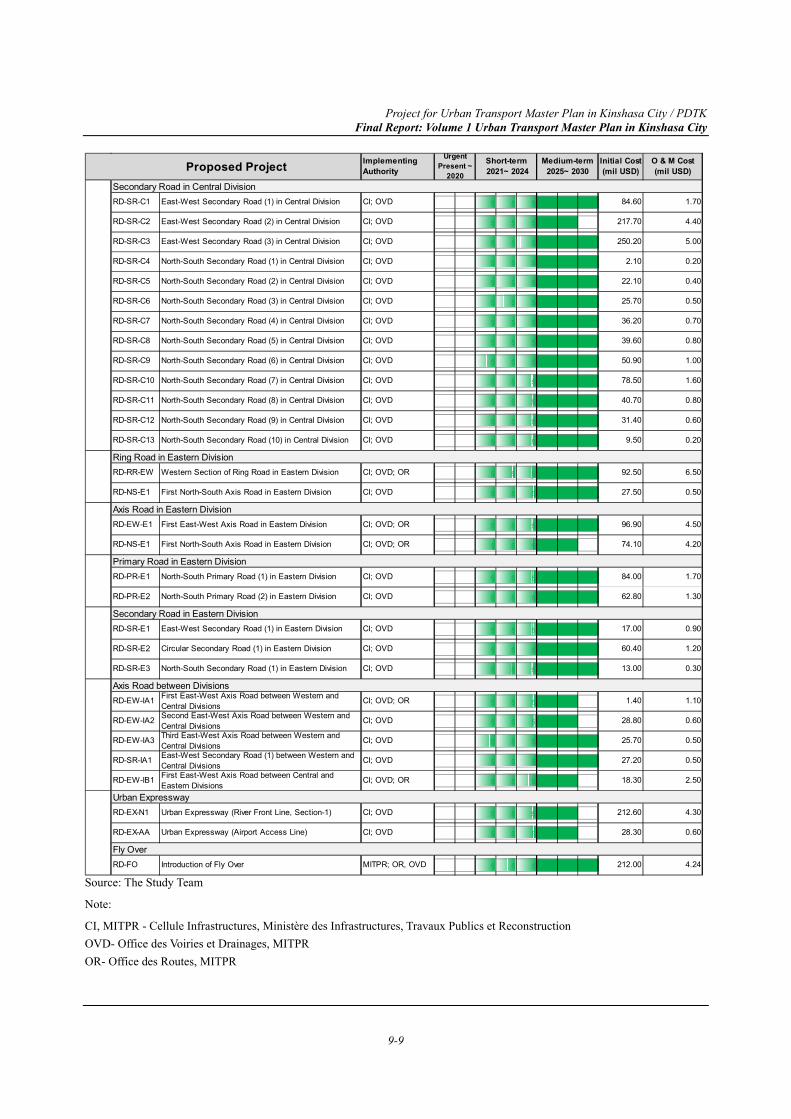
Project for Urban Transport Master Plan in Kinshasa City / PDTK Final Report: Volume 1 Urban Transport Master Plan in Kinshasa City
9-9
Source: The Study Team
Note:
CI, MITPR - Cellule Infrastructures, Ministère des Infrastructures, Travaux Publics et Reconstruction OVD- Office des Voiries et Drainages, MITPR OR- Office des Routes, MITPR
5 5 5 6 6 6
5 5 5 6 6
5 5 5 6 6 6
5 5 5 6 6 6
5 5 5 6 6 6
5 5 5 6 6 6
5 5 5 6 6 6
5 5 5 6 6 6
5 5 5 6 6 6
5 5 5 6 6 6
5 5 5 6 6 6
5 5 5 6 6 6
5 5 5 6 6 6
5 5 5 6 6 6
5 5 5 6 6 6
5 5 5 6 6 6
5 5 5 6 6
5 5 5 6 6 6
5 5 5 6 6 6
5 5 5 6 6 6
5 5 5 6 6 6
5 5 5 6 6 6
5 5 5 6 6
5 5 5 6 6
5 5 5 6 6 6
5 5 5 6 6 6
5 5 5 6 6
5 5 5 6 6
5 5 5 6 6
5 5 5 6 6 6
17.00
60.40
13.00
1.40
28.80
25.70
27.20
18.30
212.60
28.30
212.00 4.24
CI; OVD
CI; OVD; OR
CI; OVD; OR
CI; OVD
CI; OVD
CI; OVD
CI; OVD
CI; OVD
CI; OVD; OR
CI; OVD
CI; OVD
CI; OVD
CI; OVD; OR
CI; OVD
CI; OVD
6.50
0.50
4.50
4.20
1.70
1.30
0.90
1.20
0.30
MITPR; OR, OVD
92.50
27.50
96.90
74.10
84.00
62.80
Western Section of Ring Road in Eastern Division
First North-South Axis Road in Eastern Division
First East-West Axis Road in Eastern Division
First North-South Axis Road in Eastern Division
North-South Primary Road (1) in Eastern Division
North-South Primary Road (2) in Eastern Division
East-West Secondary Road (1) in Eastern Division
Circular Secondary Road (1) in Eastern Division
North-South Secondary Road (1) in Eastern Division
First East-West Axis Road between Western andCentral DivisionsSecond East-West Axis Road between Western andCentral DivisionsThird East-West Axis Road between Western andCentral Divisions
RD-SR-IA1
RD-EW-IB1
RD-EX-N1
RD-EX-AA
RD-FO Introduction of Fly Over
RD-PR-E2
RD-SR-E1
RD-SR-E2
RD-SR-E3
RD-EW-IA1
RD-EW-IA2
RD-EW-IA3
East-West Secondary Road (1) between Western andCentral DivisionsFirst East-West Axis Road between Central andEastern Divisions
Urban Expressway (River Front Line, Section-1)
0.60
0.20
North-South Secondary Road (9) in Central Division
North-South Secondary Road (10) in Central Division
Axis Road in Eastern Division
Primary Road in Eastern Division
Secondary Road in Eastern Division
Axis Road between Divisions1.10
0.60
0.50
RD-RR-EW
RD-NS-E1
RD-EW-E1
RD-NS-E1
CI; OVD
CI; OVD
North-South Secondary Road (8) in Central Division
Urban Expressway (Airport Access Line)
Urban Expressway
0.50
2.50
4.30
0.60
Fly Over
RD-PR-E1
CI; OVD; OR
84.60
217.70
250.20
2.10
CI; OVD
CI; OVD
CI; OVD
CI; OVD
CI; OVD
CI; OVD
CI; OVD
CI; OVD
CI; OVD
22.10
25.70
36.20
39.60
50.90
RD-SR-C2
RD-SR-C3
RD-SR-C4
RD-SR-C5
RD-SR-C6
RD-SR-C7
4.40
5.00
0.20
0.40
0.50
0.70
0.80
1.00
1.60
CI; OVD 0.80
East-West Secondary Road (2) in Central Division
East-West Secondary Road (3) in Central Division
North-South Secondary Road (1) in Central Division
North-South Secondary Road (2) in Central Division
North-South Secondary Road (3) in Central Division
North-South Secondary Road (4) in Central Division
North-South Secondary Road (5) in Central Division
North-South Secondary Road (6) in Central Division
North-South Secondary Road (7) in Central Division
RD-SR-C1 CI; OVD 1.70East-West Secondary Road (1) in Central Division
Proposed Project ImplementingAuthority
UrgentPresent ~
2020
Short-term 2021~ 2024
Medium-term2025~ 2030
Initial Cost(mil USD)
O & M Cost(mil USD)
9.50
Secondary Road in Central Division
Ring Road in Eastern Division
RD-SR-C8
RD-SR-C9
RD-SR-C10
RD-SR-C11
78.50
40.70
31.40RD-SR-C12
RD-SR-C13
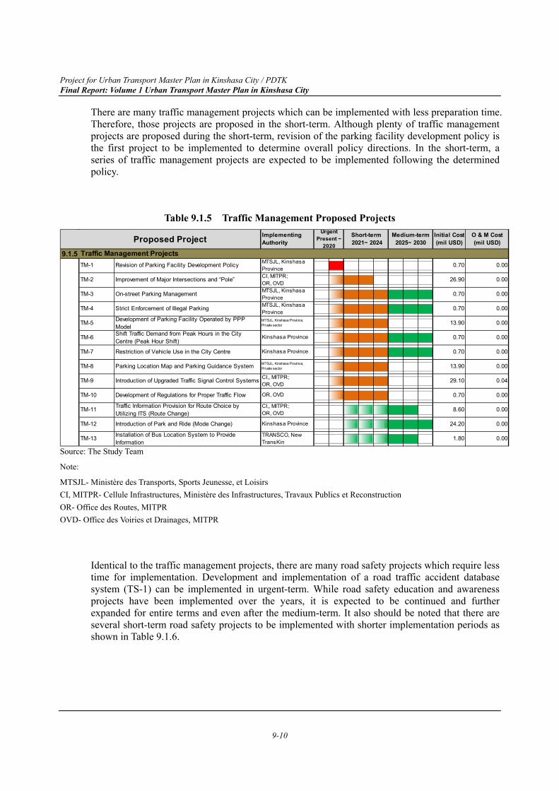
Project for Urban Transport Master Plan in Kinshasa City / PDTK Final Report: Volume 1 Urban Transport Master Plan in Kinshasa City
9-10
There are many traffic management projects which can be implemented with less preparation time. Therefore, those projects are proposed in the short-term. Although plenty of traffic management projects are proposed during the short-term, revision of the parking facility development policy is the first project to be implemented to determine overall policy directions. In the short-term, a series of traffic management projects are expected to be implemented following the determined policy.
Table 9.1.5 Traffic Management Proposed Projects
Source: The Study Team
Note:
MTSJL- Ministère des Transports, Sports Jeunesse, et Loisirs CI, MITPR- Cellule Infrastructures, Ministère des Infrastructures, Travaux Publics et Reconstruction OR- Office des Routes, MITPR OVD- Office des Voiries et Drainages, MITPR
Identical to the traffic management projects, there are many road safety projects which require less time for implementation. Development and implementation of a road traffic accident database system (TS-1) can be implemented in urgent-term. While road safety education and awareness projects have been implemented over the years, it is expected to be continued and further expanded for entire terms and even after the medium-term. It also should be noted that there are several short-term road safety projects to be implemented with shorter implementation periods as shown in Table 9.1.6.
9.1.52
3 4 4
3 4 4 4 6 6 6
3 4 4 4 6 6 6
3 4 4 4
3 4 4 4 6 6 6
3 4 4 4 6 6 6
3 4 4 4
3 4 4 4
3 4 4 4
5 5 5 6 6
5 5 5 6 6 6
5 5 5 6 6
0.70
13.90
0.70
0.70
13.90
29.10
MTSJL, KinshasaProvinceMTSJL, Kinshasa Province,Private sector
Kinshasa Province
Kinshasa Province
MTSJL, Kinshasa Province,Private sector
CI,, MITPR;OR, OVD
OR, OVD
0.70
26.90
0.70
0.00
0.00
0.00
CI,, MITPR;OR, OVD
Kinshasa Province
TRANSCO, NewTransKin
TM-4
0.00
0.04
0.00
0.00
0.00
0.00
0.00
0.00
0.00
0.00Installation of Bus Location System to ProvideInformation
TM-8
Traffic Management Projects
CI, MITPR;OR, OVDMTSJL, KinshasaProvince
Introduction of Park and Ride (Mode Change)
1.80
TM-9
TM-10
TM-11
TM-12
TM-13
0.70
8.60
24.20
Shift Traffic Demand from Peak Hours in the CityCentre (Peak Hour Shift)
Restriction of Vehicle Use in the City Centre
Parking Location Map and Parking Guidance System
Introduction of Upgraded Traffic Signal Control Systems
Development of Regulations for Proper Traffic Flow
Traffic Information Provision for Route Choice byUtilizing ITS (Route Change)
TM-1
TM-2
TM-3
Revision of Parking Facility Development Policy
Improvement of Major Intersections and “Pole”
On-street Parking Management
TM-5
TM-6
TM-7
Strict Enforcement of Illegal Parking
Development of Parking Facility Operated by PPPModel
MTSJL, KinshasaProvince
UrgentPresent ~
2020
Short-term 2021~ 2024
Medium-term2025~ 2030
Initial Cost(mil USD)
O & M Cost(mil USD)Proposed Project Implementing
Authority
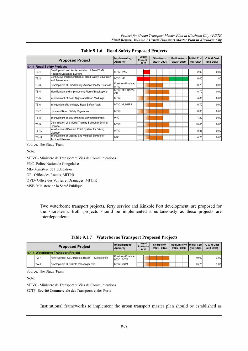
Project for Urban Transport Master Plan in Kinshasa City / PDTK Final Report: Volume 1 Urban Transport Master Plan in Kinshasa City
9-11
Table 9.1.6 Road Safety Proposed Projects
Source: The Study Team
Note:
MTVC- Ministère de Transport et Vies de Communications PNC- Police Nationale Congolaise ME- Ministère de l’Education OR- Office des Routes, MITPR OVD- Office des Voiries et Drainages, MITPR MSP- Ministère de la Santé Publique
Two waterborne transport projects, ferry service and Kinkole Port development, are proposed for the short-term. Both projects should be implemented simultaneously as these projects are interdependent.
Table 9.1.7 Waterborne Transport Proposed Projects
Source: The Study Team
Note:
MTVC- Ministère de Transport et Vies de Communications SCTP- Société Commerciale des Transports et des Ports
Institutional frameworks to implement the urban transport master plan should be established as
9.1.62
2 2 4 4 4 6 6 6
3 4 4
3 4 4 4
3 3 4 4 4
3 4 4
3 3 4 4 4
3 4 4
3 4 4 4
3 4 4 4
3 4 4
Continuous Implementation of Road Safety Educationand Awareness
Development of Road Safety Action Plan for Kinshasa
Identification and Improvement Plan of Blackspots
Improvement of Road Signs and Road Markings
Introduction of Mandatory Road Safety Audit
Update of Road Safety Regulation
TS-9
2.00
MTVC
MTVC
TS-8
MTVC, PNC
MTVC, ME
Kinshasa Province,MTVC,MTVC, MITPR/OVD,OR
MTVC
TS-1
TS-2
TS-3
TS-4
TS-5
TS-6
TS-7
O & M Cost(mil USD)
MTVC, MI, MITPR
MTVC
PNC
Road Safety Projects
Proposed Project ImplementingAuthority
UrgentPresent ~
2020
Short-term 2021~ 2024
Medium-term2025~ 2030
Initial Cost(mil USD)
0.03
0.00
0.00
0.00
0.00
0.00
0.00
0.00
0.00
Improvement of Equipment for Law Enforcement
Construction of a Model Training School for DrivingLicenseIntroduction of Demerit Point System for DrivingLicenseImprovement of Mobility and Medical Service forAccident Rescue
10.00
0.35
4.20
0.00
0.70
0.70
4.85
0.70
Development and Implementation of Road TrafficAccident Database System
TS-10
TS-11
0.35
1.20
MSP
0.00
1.00
9.1.73 4 4 4
3 4 4 4
Proposed Project ImplementingAuthority
UrgentPresent ~
2020
Short-term 2021~ 2024
Medium-term2025~ 2030
Initial Cost(mil USD)
O & M Cost(mil USD)
Waterborne Transport ProjectFerry Service: CBD (Ngobila Beach) – Kinkole Port
Development of Kinkole Passenger Port
3.00TW-1
1.80
19.00
45.20TW-2
Kinshasa Province,MTVC, SCTP
MTVC, SCPT
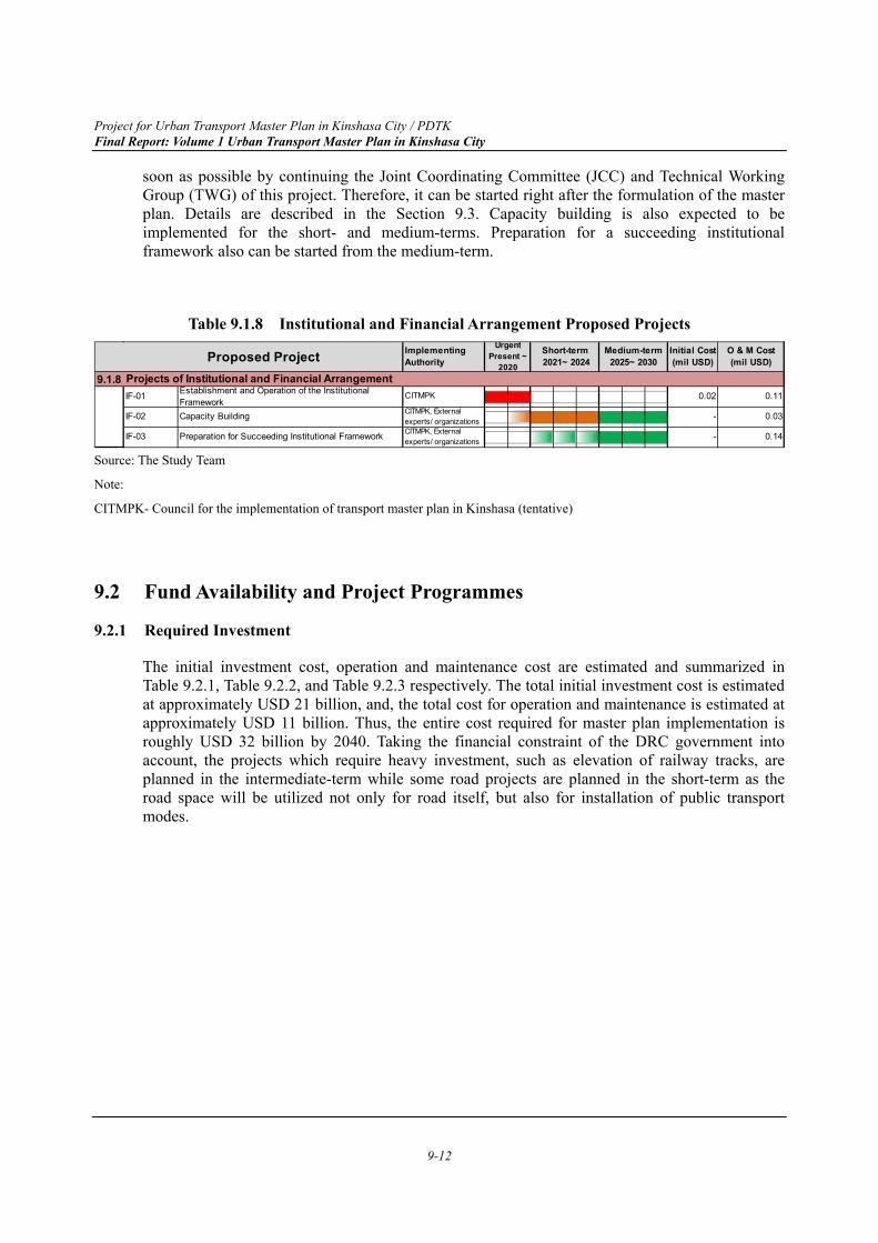
Project for Urban Transport Master Plan in Kinshasa City / PDTK Final Report: Volume 1 Urban Transport Master Plan in Kinshasa City
9-12
soon as possible by continuing the Joint Coordinating Committee (JCC) and Technical Working Group (TWG) of this project. Therefore, it can be started right after the formulation of the master plan. Details are described in the Section 9.3. Capacity building is also expected to be implemented for the short- and medium-terms. Preparation for a succeeding institutional framework also can be started from the medium-term.
Table 9.1.8 Institutional and Financial Arrangement Proposed Projects
Source: The Study Team
Note:
CITMPK- Council for the implementation of transport master plan in Kinshasa (tentative)
9.2 Fund Availability and Project Programmes
9.2.1 Required Investment
The initial investment cost, operation and maintenance cost are estimated and summarized in Table 9.2.1, Table 9.2.2, and Table 9.2.3 respectively. The total initial investment cost is estimated at approximately USD 21 billion, and, the total cost for operation and maintenance is estimated at approximately USD 11 billion. Thus, the entire cost required for master plan implementation is roughly USD 32 billion by 2040. Taking the financial constraint of the DRC government into account, the projects which require heavy investment, such as elevation of railway tracks, are planned in the intermediate-term while some road projects are planned in the short-term as the road space will be utilized not only for road itself, but also for installation of public transport modes.
9.1.82 2
3 4 4 4 6 6 6
5 5 5 6 6 6
Proposed Project ImplementingAuthority
UrgentPresent ~
2020
Short-term 2021~ 2024
Medium-term2025~ 2030
Initial Cost(mil USD)
O & M Cost(mil USD)
Projects of Institutional and Financial ArrangementEstablishment and Operation of the InstitutionalFramework
IF-02
IF-03
0.11
0.03
0.14
0.02
-
-
CITMPK, Externalexperts/ organizationsCITMPK, Externalexperts/ organizations
Capacity Building
Preparation for Succeeding Institutional Framework
IF-01 CITMPK
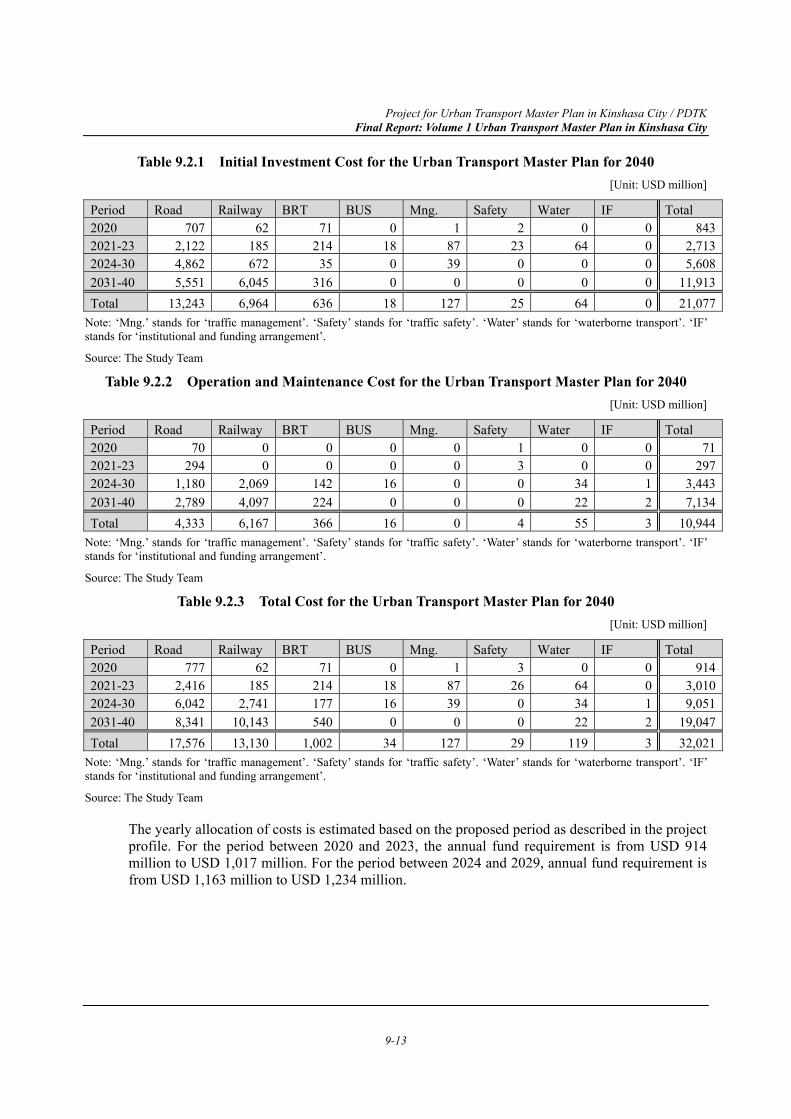
Project for Urban Transport Master Plan in Kinshasa City / PDTK Final Report: Volume 1 Urban Transport Master Plan in Kinshasa City
9-13
Table 9.2.1 Initial Investment Cost for the Urban Transport Master Plan for 2040 [Unit: USD million]
Period Road Railway BRT BUS Mng. Safety Water IF Total 2020 707 62 71 0 1 2 0 0 8432021-23 2,122 185 214 18 87 23 64 0 2,7132024-30 4,862 672 35 0 39 0 0 0 5,6082031-40 5,551 6,045 316 0 0 0 0 0 11,913Total 13,243 6,964 636 18 127 25 64 0 21,077
Note: ‘Mng.’ stands for ‘traffic management’. ‘Safety’ stands for ‘traffic safety’. ‘Water’ stands for ‘waterborne transport’. ‘IF’ stands for ‘institutional and funding arrangement’.
Source: The Study Team
Table 9.2.2 Operation and Maintenance Cost for the Urban Transport Master Plan for 2040 [Unit: USD million]
Period Road Railway BRT BUS Mng. Safety Water IF Total 2020 70 0 0 0 0 1 0 0 712021-23 294 0 0 0 0 3 0 0 2972024-30 1,180 2,069 142 16 0 0 34 1 3,4432031-40 2,789 4,097 224 0 0 0 22 2 7,134Total 4,333 6,167 366 16 0 4 55 3 10,944
Note: ‘Mng.’ stands for ‘traffic management’. ‘Safety’ stands for ‘traffic safety’. ‘Water’ stands for ‘waterborne transport’. ‘IF’ stands for ‘institutional and funding arrangement’.
Source: The Study Team
Table 9.2.3 Total Cost for the Urban Transport Master Plan for 2040 [Unit: USD million]
Period Road Railway BRT BUS Mng. Safety Water IF Total 2020 777 62 71 0 1 3 0 0 9142021-23 2,416 185 214 18 87 26 64 0 3,0102024-30 6,042 2,741 177 16 39 0 34 1 9,0512031-40 8,341 10,143 540 0 0 0 22 2 19,047Total 17,576 13,130 1,002 34 127 29 119 3 32,021
Note: ‘Mng.’ stands for ‘traffic management’. ‘Safety’ stands for ‘traffic safety’. ‘Water’ stands for ‘waterborne transport’. ‘IF’ stands for ‘institutional and funding arrangement’.
Source: The Study Team
The yearly allocation of costs is estimated based on the proposed period as described in the project profile. For the period between 2020 and 2023, the annual fund requirement is from USD 914 million to USD 1,017 million. For the period between 2024 and 2029, annual fund requirement is from USD 1,163 million to USD 1,234 million.
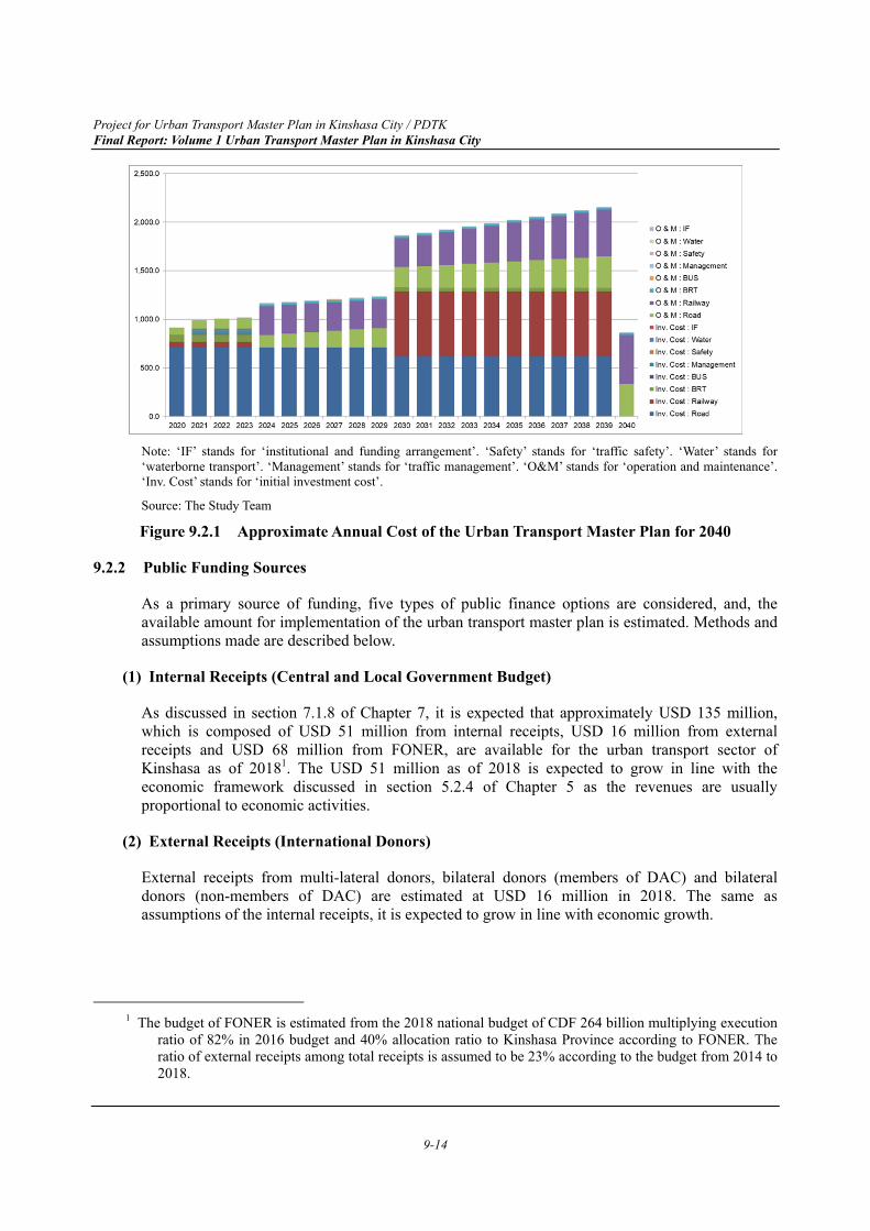
Project for Urban Transport Master Plan in Kinshasa City / PDTK Final Report: Volume 1 Urban Transport Master Plan in Kinshasa City
9-14
Note: ‘IF’ stands for ‘institutional and funding arrangement’. ‘Safety’ stands for ‘traffic safety’. ‘Water’ stands for ‘waterborne transport’. ‘Management’ stands for ‘traffic management’. ‘O&M’ stands for ‘operation and maintenance’. ‘Inv. Cost’ stands for ‘initial investment cost’.
Source: The Study Team
Figure 9.2.1 Approximate Annual Cost of the Urban Transport Master Plan for 2040
9.2.2 Public Funding Sources
As a primary source of funding, five types of public finance options are considered, and, the available amount for implementation of the urban transport master plan is estimated. Methods and assumptions made are described below.
(1) Internal Receipts (Central and Local Government Budget)
As discussed in section 7.1.8 of Chapter 7, it is expected that approximately USD 135 million, which is composed of USD 51 million from internal receipts, USD 16 million from external receipts and USD 68 million from FONER, are available for the urban transport sector of Kinshasa as of 20181. The USD 51 million as of 2018 is expected to grow in line with the economic framework discussed in section 5.2.4 of Chapter 5 as the revenues are usually proportional to economic activities.
(2) External Receipts (International Donors)
External receipts from multi-lateral donors, bilateral donors (members of DAC) and bilateral donors (non-members of DAC) are estimated at USD 16 million in 2018. The same as assumptions of the internal receipts, it is expected to grow in line with economic growth.
1 The budget of FONER is estimated from the 2018 national budget of CDF 264 billion multiplying execution
ratio of 82% in 2016 budget and 40% allocation ratio to Kinshasa Province according to FONER. The ratio of external receipts among total receipts is assumed to be 23% according to the budget from 2014 to 2018.
Project for Urban Transport Master Plan in Kinshasa City / PDTK Final Report: Volume 1 Urban Transport Master Plan in Kinshasa City
9-15
(3) FONER
The funding for the urban transport sector in Kinshasa from FONER is USD 69 million in 2018. It should be noted that the funding from FONER is earmarked for road maintenance only. Significant increase of budget can be expected due to motorization and increase of price per litre as automobiles are major causes of traffic congestion. The current tax of USD 0.10 per litre for fuel is assumed to be gradually raised to 0.40 per litre in 2030 considering economic externalities of motorized vehicles. Based on the travel demand forecast, the fuel consumption in 2018, 2030 and 2040 are estimated. It is also assumed that the laws and regulations need be revised, then, the funding from FONER can be utilized for all projects of the urban transport master plan.
(4) Travel Demand Management (TDM)
As mentioned in section 8.3 of Chapter 8 and section 9.1, revision of the parking facility development policy (TM-1), on-street parking management (TM-3), strict enforcement of illegal parking (TM-4), development of parking facility operated by PPP Model (TM-5) restriction of vehicle use in the city centre and (TM-7) are proposed. While the main objective of these traffic management policies is to control surging travel demand by private motorized transport modes during peak hours by charging fees and fines, this package of parking policy generates revenues from additional parking tax. It is assumed that the Government can receive tax revenues from the year 2020. While further detailed analysis is required for the price of the parking tax, the CDF 1,580 (equivalent to USD 5) and CDF 5,000 are assumed in 2020 and 2040 respectively considering affordability of vehicle users. The years between 2020 and 2040 are interpolated assuming the same growth rate. For the implementation of these projects, study on the revision of parking facility development policy (TM-1) should be implemented at first. In this study, details on restrictions on parking such as target area, enforcement method, required legal framework, price level, time, fines, financial scheme can be studied based on supply-demand balance of parking.
(5) Fares of Public Transport
While it is not possible to cover the entire initial investment and operation and maintenance cost for public transport, fares of public transport can be utilized for the master plan implementation. It is assumed that fare revenues from the high capacity public transit modes including railways, BRTs and buses are to be utilized mainly for the operation and maintenance of public transport. On the other hand, fare revenues from public transport modes operated by private sectors such as minibus, taxi-bus and taxi are not considered as sources of funding for master plan implementation.
9.2.3 Land Value Capture (LVC)
Land value capture (LVC) is a public financing method by the governments2 which are expected to:
Trigger an increase in land values via regulatory decisions, such as a change in land use or 2 Suzuki, Hiroaki, Jin Murakami, Yu-Hung Hong, and Beth Tamayose. 2015. Financing Transit-Oriented Development with Land Values: Adapting Land Value Capture in Developing Countries. Urban Development Series. Washington, DC: World Bank. doi:10.1596/978-1-4648-0149-5. License: Creative Commons Attribution CC BY 3.0 IGO
Project for Urban Transport Master Plan in Kinshasa City / PDTK Final Report: Volume 1 Urban Transport Master Plan in Kinshasa City
9-16
floor area ratio (FAR), or infrastructure investments, such as transit.
Institute a process to share this land value increment by capturing part or all of the change.
Use LVC proceeds to finance infrastructure investments, such as transit and TOD-related investment; fund any other improvements required to offset impacts related to the changes, such as densification; and implement public policies to promote social equity, such as provision of affordable housing to alleviate shortages and offset potential gentrification.
There are two types of LVC instruments: tax- or fee-based and nontax- or non-fee-based which is called “development-based LVC.”
In the case of Kinshasa, the development-based LVC can be a useful tool not only for funding but also for urban development considering rapid population increase in the near future and required urban developments, although the government should set up an implementing agency such as a state-owned enterprise for both urban and transport system development. Property tax or fees levied to private developers and private land owners are also an option for capturing added value.
The expected added land values are estimated for the new urban development areas mainly in the suburbs of the city until 2030 and 2040 as shown in Table 9.2.4 and Table 9.2.5. The current land price of new urban development area is assumed as same as the current land price of suburban fringe areas such as the southern area of Kimbanseke Commune. With the increase of floor area ratio (FAR) together with urban infrastructure development, the land price will significantly increase. The future FAR is set following typical examples in Japan and other developed countries by land use category. It also assumed that 70% of floors by land use category will be constructed and utilized compared with the planned FAR referring to examples in Tokyo, Japan.
However, it should be noted that LVC works only if FAR is properly regulated as a part of land use plans of the Kinshasa Province. This means that the Kinshasa Province has to formulate a legal framework for it, and, institutional setup as well as capacity development is also required for regulating building permits.
It is assumed that the future unit price per floor area by floor use is the same as the current price of the same land use category. The land price information is acquired from interviews with the Kinshasa Province. Significant added value is expected with the urban development together with infrastructure development. It also should be noted that infrastructure development cost and construction cost of urban areas should be borne by the added value, and, it also includes return to investors and land owners. Nevertheless, some part of the added value can be utilized for infrastructure development as infrastructure contributes land value increase.
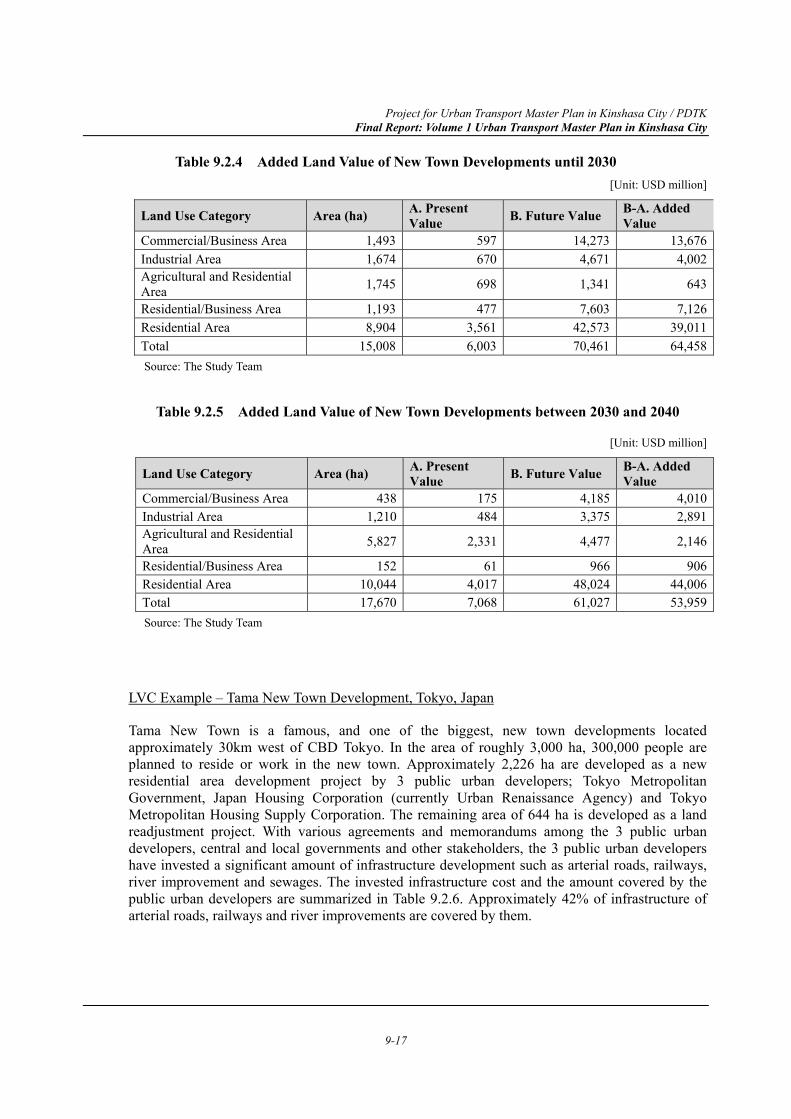
Project for Urban Transport Master Plan in Kinshasa City / PDTK Final Report: Volume 1 Urban Transport Master Plan in Kinshasa City
9-17
Table 9.2.4 Added Land Value of New Town Developments until 2030 [Unit: USD million]
Land Use Category Area (ha) A. Present Value B. Future Value B-A. Added
Value Commercial/Business Area 1,493 597 14,273 13,676Industrial Area 1,674 670 4,671 4,002Agricultural and Residential Area 1,745 698 1,341 643
Residential/Business Area 1,193 477 7,603 7,126Residential Area 8,904 3,561 42,573 39,011Total 15,008 6,003 70,461 64,458Source: The Study Team
Table 9.2.5 Added Land Value of New Town Developments between 2030 and 2040
[Unit: USD million]
Land Use Category Area (ha) A. Present Value B. Future Value B-A. Added
Value Commercial/Business Area 438 175 4,185 4,010Industrial Area 1,210 484 3,375 2,891Agricultural and Residential Area 5,827 2,331 4,477 2,146
Residential/Business Area 152 61 966 906Residential Area 10,044 4,017 48,024 44,006Total 17,670 7,068 61,027 53,959Source: The Study Team
LVC Example – Tama New Town Development, Tokyo, Japan
Tama New Town is a famous, and one of the biggest, new town developments located approximately 30km west of CBD Tokyo. In the area of roughly 3,000 ha, 300,000 people are planned to reside or work in the new town. Approximately 2,226 ha are developed as a new residential area development project by 3 public urban developers; Tokyo Metropolitan Government, Japan Housing Corporation (currently Urban Renaissance Agency) and Tokyo Metropolitan Housing Supply Corporation. The remaining area of 644 ha is developed as a land readjustment project. With various agreements and memorandums among the 3 public urban developers, central and local governments and other stakeholders, the 3 public urban developers have invested a significant amount of infrastructure development such as arterial roads, railways, river improvement and sewages. The invested infrastructure cost and the amount covered by the public urban developers are summarized in Table 9.2.6. Approximately 42% of infrastructure of arterial roads, railways and river improvements are covered by them.
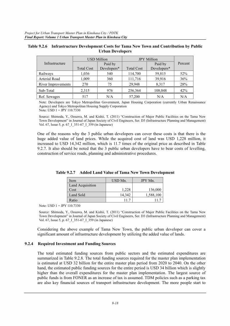
Project for Urban Transport Master Plan in Kinshasa City / PDTK Final Report: Volume 1 Urban Transport Master Plan in Kinshasa City
9-18
Table 9.2.6 Infrastructure Development Costs for Tama New Town and Contribution by Public Urban Developers
Infrastructure USD Million JPY Million
Percent Total Cost
Paid by Developers* Total Cost
Paid by Developers*
Railways 1,036 540 114,700 59,815 52% Arterial Road 1,009 360 111,716 39,916 36% River Improvements 270 75 29,948 8,317 28% Sub-Total 2,315 976 256,364 108,048 42% Ref. Sewages 517 N/A 57,200 N/A N/A Note: Developers are Tokyo Metropolitan Government, Japan Housing Corporation (currently Urban Renaissance Agency) and Tokyo Metropolitan Housing Supply Corporation Note: USD 1 = JPY 110.7330
Source: Shimoda, Y., Oosawa, M. and Kishii, T. (2011) “Construction of Major Public Facilities on the Tama New Town Development” in Journal of Japan Society of Civil Engineers, Ser. D3 (Infrastructure Planning and Management) Vol. 67, Issue 5, p. 67_I_351-67_I_359 (in Japanese)
One of the reasons why the 3 public urban developers can cover these costs is that there is the huge added value of land prices. While the acquired cost of land was USD 1,228 million, it increased to USD 14,342 million, which is 11.7 times of the original price as described in Table 9.2.7. It also should be noted that the 3 public urban developers have to bear costs of levelling, construction of service roads, planning and administrative procedures.
Table 9.2.7 Added Land Value of Tama New Town Development
Item USD Mn. JPY Mn. Land Acquisition Cost 1,228 136,000Land Sold 14,342 1,588,100Ratio 11.7 11.7
Note: USD 1 = JPY 110.7330
Source: Shimoda, Y., Oosawa, M. and Kishii, T. (2011) “Construction of Major Public Facilities on the Tama New Town Development” in Journal of Japan Society of Civil Engineers, Ser. D3 (Infrastructure Planning and Management) Vol. 67, Issue 5, p. 67_I_351-67_I_359 (in Japanese)
Considering the above example of Tama New Town, the public urban developer can cover a significant amount of infrastructure development by utilizing the added value of lands.
9.2.4 Required Investment and Funding Sources
The total estimated funding sources from public sectors and the estimated expenditures are summarized in Table 9.2.8. The total funding sources required for the master plan implementation is estimated at USD 32 billion for the entire master plan period from 2020 to 2040. On the other hand, the estimated public funding sources for the entire period is USD 34 billion which is slightly higher than the overall expenditures for the master plan implementation. The largest source of public funds is from FONER as an increase of tax is assumed. TDM policies such as a parking tax are also key financial sources of transport infrastructure development. The more people start to
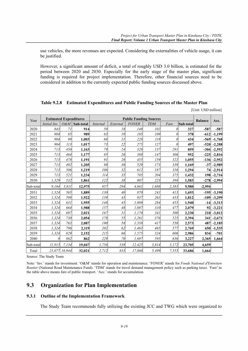
Project for Urban Transport Master Plan in Kinshasa City / PDTK Final Report: Volume 1 Urban Transport Master Plan in Kinshasa City
9-19
use vehicles, the more revenues are expected. Considering the externalities of vehicle usage, it can be justified.
However, a significant amount of deficit, a total of roughly USD 3.0 billion, is estimated for the period between 2020 and 2030. Especially for the early stage of the master plan, significant funding is required for project implementation. Therefore, other financial sources need to be considered in addition to the currently expected public funding sources discussed above.
Table 9.2.8 Estimated Expenditures and Public Funding Sources of the Master Plan [Unit: USD million]
Year Estimated Expenditures Public Funding Sources Balance Acc.Initial Inv. O&M Sub-total Internal External FONER TDM Fare Sub-total
2020 843 71 914 59 18 148 102 0 327 -587 -5872021 904 85 989 63 19 185 109 0 378 -612 -1,1992022 904 99 1,003 68 21 228 118 0 434 -569 -1,7682023 904 113 1,017 73 22 275 127 0 497 -520 -2,2882024 713 450 1,163 79 24 328 137 291 859 -304 -2,5922025 713 464 1,177 85 26 388 147 306 952 -225 -2,8162026 713 478 1,191 91 28 455 159 322 1,055 -136 -2,9522027 713 492 1,205 98 30 529 173 339 1,169 -37 -2,9892028 713 506 1,219 106 32 612 187 356 1,294 74 -2,9142029 713 521 1,234 114 35 705 204 375 1,432 198 -2,7162030 1,329 532 1,861 122 38 807 223 394 1,583 -278 -2,994
Sub-total 9,164 3,811 12,975 957 294 4,661 1,686 2,383 9,980 -2,994 2031 1,324 565 1,889 130 40 870 241 413 1,693 -195 -3,1902032 1,324 598 1,922 139 43 937 261 433 1,812 -109 -3,2992033 1,324 631 1,955 148 45 1,009 284 455 1,940 -14 -3,3132034 1,324 664 1,988 157 48 1,087 310 477 2,079 92 -3,2212035 1,324 697 2,021 167 51 1,170 341 500 2,230 210 -3,0122036 1,324 730 2,054 178 55 1,261 376 525 2,394 341 -2,6712037 1,324 763 2,087 190 58 1,358 417 550 2,573 487 -2,1852038 1,324 796 2,119 202 62 1,463 465 577 2,769 650 -1,5352039 1,324 829 2,152 215 66 1,575 524 606 2,986 834 -7012040 0 862 862 229 70 1,697 595 636 3,227 2,365 1,664
Sub-total 11,913 7,134 19,047 1,756 539 12,425 3,814 5,172 23,705 4,659 Total 21,077 10,944 32,021 2,712 833 17,086 5,499 7,555 33,686 1,664
Source: The Study Team
Note: ‘Inv.’ stands for investment. ‘O&M’ stands for operation and maintenance. ‘FONER’ stands for Fonds National d'Entretien Routier (National Road Maintenance Fund). ‘TDM’ stands for travel demand management policy such as parking taxes. ‘Fare’ in the table above means fare of public transport. ‘Acc.’ stands for accumulation.
9.3 Organization for Plan Implementation
9.3.1 Outline of the Implementation Framework
The Study Team recommends fully utilizing the existing JCC and TWG which were organized to
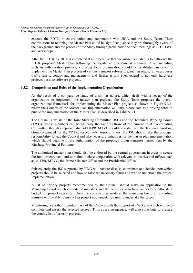
Project for Urban Transport Master Plan in Kinshasa City / PDTK Final Report: Volume 1 Urban Transport Master Plan in Kinshasa City
9-20
execute the PDTK in co-ordination and cooperation with JICA and the Study Team. Their contributions to realizing the Master Plan could be significant, since they are thoroughly aware of the background and the process of the Study through participation to such meetings as JCC, TWG and Workshops.
After the PDTK by JICA is completed it is imperative that the subsequent step is to authorize the PDTK proposed Master Plan following the legislative procedure as required. Even including such an authorization process, a driving force organization should be established in order to implement the Master Plan projects of various transport sub-sectors, such as roads, railways, buses, traffic safety, control and management, and further it will even extend to not only hardware projects but also software projects.
9.3.2 Composition and Roles of the Implementation Organization
As the result of a comparative study of a similar nature, which deals with a set-up of the organization to implement the master plan projects, the Study Team proposes the overall organizational framework for implementing the Master Plan projects as shown in Figure 9.3.1, where the Council of the Master Plan Implementation will take a core role as a driving force to pursue the implementation of the Master Plan as described in Table 9.3.1.
The Council consists of the Joint Steering Committee (JSC) and the Technical Working Group (TWG), whose members can be basically the same as those of the current Joint Coordinating Committee, though a representative of DEPR, MTVC should be added, and the Technical Working Group organized for the PDTK, respectively. Among others, the JSC should take the principal responsibility to lead the Council and take necessary initiatives for the master plan implementation, which should begin with the authorization of the proposed urban transport master plan by the Kinshasa Provincial Parliament.
The authorized master plan should also be endorsed by the central government in order to secure the fund procurement and to maintain close cooperation with relevant ministries and offices such as MITPR, MTVC, the Prime Minister Office and the Presidential Office.
Subsequently, the JSC supported by TWG will have to discuss, coordinate and decide upon which projects should be selected and how to raise the necessary funds and who to undertake the project implementation.
A list of priority projects recommended by the Council should make an application to the Managing Board which consists of ministers and the governor who have authority to allocate a budget for project execution. Once the consensus is made at the managing board an executing minister will be able to instruct its project implementation unit to undertake the project.
Monitoring is another important task of the Council with the support of TWG and which will help complete and assess the selected project. This, as a consequence, will also contribute to prepare the coming list of priority projects.
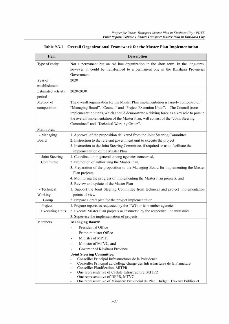
Project for Urban Transport Master Plan in Kinshasa City / PDTK Final Report: Volume 1 Urban Transport Master Plan in Kinshasa City
9-21
Table 9.3.1 Overall Organizational Framework for the Master Plan Implementation
Item Description
Type of entity Not a permanent but an Ad hoc organization in the short term. In the long-term, however, it could be transformed to a permanent one in the Kinshasa Provincial Government.
Year of establishment
2020
Estimated activity period
2020-2030
Method of composition
The overall organization for the Master Plan implementation is largely composed of “Managing Board”, “Council” and “Project Execution Units”. The Council (core implementation unit), which should demonstrate a driving force as a key role to pursue the overall implementation of the Master Plan, will consist of the “Joint Steering Committee” and “Technical Working Group”.
Main roles: - Managing Board
1. Approval of the proposition delivered from the Joint Steering Committee 2. Instruction to the relevant government unit to execute the project 3. Instruction to the Joint Steering Committee, if required so as to facilitate the
implementation of the Master Plan - Joint Steering Committee
1. Coordination in general among agencies concerned, 2. Promotion of authorizing the Master Plan, 3. Preparation of the proposition to the Managing Board for implementing the Master
Plan projects, 4. Monitoring the progress of implementing the Master Plan projects, and 5. Review and update of the Master Plan
- Technical Working Group
1. Support the Joint Steering Committee from technical and project implementation points of view
2. Prepare a draft plan for the project implementation - Project Executing Units
1. Prepare reports as requested by the TWG or its member agencies 2. Execute Master Plan projects as instructed by the respective line ministries 3. Supervise the implementation of projects
Members Managing Board: - Presidential Office - Prime-minister Office - Minister of MPTPI - Minister of MTVC, and - Governor of Kinshasa Province Joint Steering Committee: - Conseiller Principal Infrastructures de la Présidence - Conseiller Principal au Collège chargé des Infrastructures de la Primature - Conseiller Planification, MITPR - One representative of Cellule Infrastructure, MITPR - One representative of DEPR, MTVC - One representative of Ministère Provincial du Plan, Budget, Travaux Publics et
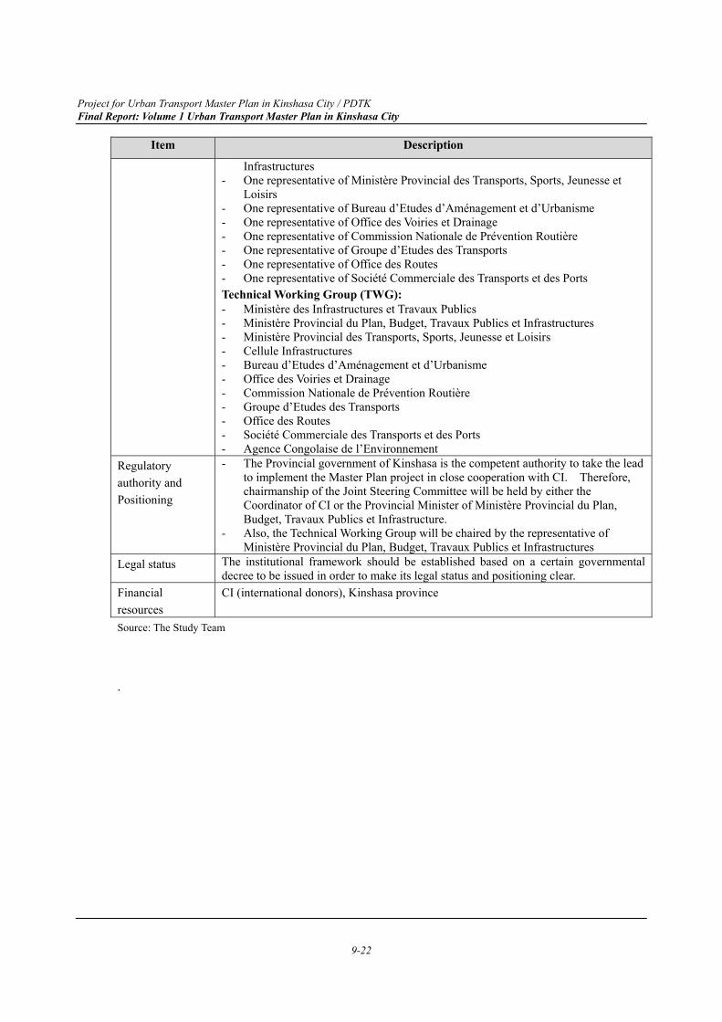
Project for Urban Transport Master Plan in Kinshasa City / PDTK Final Report: Volume 1 Urban Transport Master Plan in Kinshasa City
9-22
Item Description
Infrastructures - One representative of Ministère Provincial des Transports, Sports, Jeunesse et
Loisirs - One representative of Bureau d’Etudes d’Aménagement et d’Urbanisme - One representative of Office des Voiries et Drainage - One representative of Commission Nationale de Prévention Routière - One representative of Groupe d’Etudes des Transports - One representative of Office des Routes - One representative of Société Commerciale des Transports et des Ports Technical Working Group (TWG): - Ministère des Infrastructures et Travaux Publics - Ministère Provincial du Plan, Budget, Travaux Publics et Infrastructures - Ministère Provincial des Transports, Sports, Jeunesse et Loisirs - Cellule Infrastructures - Bureau d’Etudes d’Aménagement et d’Urbanisme - Office des Voiries et Drainage - Commission Nationale de Prévention Routière - Groupe d’Etudes des Transports - Office des Routes - Société Commerciale des Transports et des Ports - Agence Congolaise de l’Environnement
Regulatory authority and Positioning
- The Provincial government of Kinshasa is the competent authority to take the lead to implement the Master Plan project in close cooperation with CI. Therefore, chairmanship of the Joint Steering Committee will be held by either the Coordinator of CI or the Provincial Minister of Ministère Provincial du Plan, Budget, Travaux Publics et Infrastructure.
- Also, the Technical Working Group will be chaired by the representative of Ministère Provincial du Plan, Budget, Travaux Publics et Infrastructures
Legal status The institutional framework should be established based on a certain governmental decree to be issued in order to make its legal status and positioning clear.
Financial resources
CI (international donors), Kinshasa province
Source: The Study Team
.
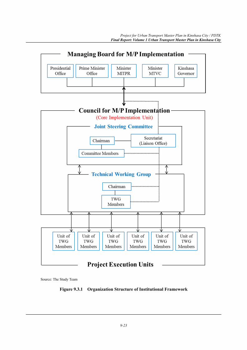
Project for Urban Transport Master Plan in Kinshasa City / PDTK Final Report: Volume 1 Urban Transport Master Plan in Kinshasa City
9-23
Source: The Study Team
Figure 9.3.1 Organization Structure of Institutional Framework
Project for Urban Transport Master Plan in Kinshasa City / PDTK Final Report: Volume 1 Urban Transport Master Plan in Kinshasa City
9-24
9.3.3 Future Plan toward the Year 2040
In order to enhance the institutional capability and sustainability of implementing the urban transport Master Plan in Kinshasa, the Study Team proposes that the institutional framework at the year 2030 be gradually succeeded by a permanent governmental agency which needs to be newly established as an authority with appropriate executing responsibilities and legal status.