nov 2 4 2015 - unesco world heritage centre
TRANSCRIPT
United States Department of the Interior
Mechtild Rossler Director World Heritage Centre UNESCO 7, Place de Fontenoy 75352 Paris 07 SP, France
Dear Ms. Rossler:
NATIONAL PARK SERVICE 1849 C Street, N.W.
Washington, DC 20240
NOV 2 4 2015
The United States is pleased to provide herewith a report on the implementation of the recommendations by the World Heritage Committee related to the inscription of the Monumental Earthworks of Poverty Point on the World Heritage List in 2014. The relevant decision is 38 COM 8B.39.
Sincerely,
Stephen A. Morris Chief, Office of International Affairs
Enclosure: Monumental Earthworks of Poverty Point, report to the 40th session of the World Heritage Committee
cc: Ambassador Crystal Nix-Hines, Permanent Representative to UNESCO Alexandra Fiebig, World Heritage Centre
Report to the 40th Session of the World Heritage Committee by the
United States of America
Monumental Earthworks
of Poverty Point
Implementation oflnscription Recommendations
November 2015
i
The UNESCO World Heritage Committee made three recommendations for further action by the State
Party as part of the inscription of the Monumental Earthworks of Poverty Point onto the World Heritage
List:
(a) Continue policy of land acquisition in parallel with scientific investigations with a view to
establishing favorable conditions to enlarge the limits of the property in case research results
suggest doing so;
(b) Continue implementing and assessing best management practices successful in minimizing the
impact of Louisiana Highway 577 on the visitor experience at the site; and
(c) Continue to build capacity and expertise within the management system to profit from the
existing Geographical Information Systems (GIS) approach.
Notably, each of the recommendations begins with “continue,” indicating the Committee recognized
that these activities were already ongoing prior to inscription, a reflection of the state of Louisiana’s own
priorities for managing and protecting Poverty Point.
Recommendation (a) is addressed in two parts: (1) scientific investigation of archaeological resources in
the surrounding area and (2) consideration of land acquisition. A five-pronged approach has been
initiated to expand understanding of archaeological resources in the wider setting around Poverty Point.
It appears that, although some sites may have research value in providing additional information about
the Poverty Point culture in the broader region, they will not enhance the Outstanding Universal Value
of the Monumental Earthworks of Poverty Point. However, there are other reasons to purchase land
(e.g., to provide “off-site” space for visitor facilities). The state has partnered with other organizations
that have the capability to purchase land as it becomes available. The 2014 Poverty Point Compatible
Use Zone influences planning decisions regarding the potential impact that development projects might
have upon the site and its Outstanding Universal Value.
In response to Recommendation (b), the Louisiana Department of Culture, Recreation and Tourism has
worked closely with the Department of Transportation and Development to enhance the safety of
Highway 577 where it passes through Poverty Point World Heritage Site. Changes include improved
crosswalk visibility, additional cautionary signage, and lowered speed limits. A permanent installation of
traffic recording equipment permits monitoring, on an ongoing basis, of vehicle counts and speeds. This
will facilitate recognition of deleterious changes in traffic patterns and implementation of corrective
measures. These carefully considered safety improvements have been undertaken with an eye to
maintaining the low visibility of the roadway throughout the park.
With respect to Recommendation (c), the Louisiana State Historic Preservation Office and the Poverty
Point Station Archaeology Program have continued to expand and utilize the capabilities of the
statewide and site-level GIS systems that existed prior to inscription.
ii
...................................................................................................................................... i
................................................................................................................................................. 1
................................................................................................................................... 3
................................................................................................................................. 14
................................................................................................................................. 20
................................................................................................................................................. 24
........................................................................................................................................ 25
.................................................................................................................. 27
1
The Monumental Earthworks of Poverty Point, United States of America (Id. No 1435), were inscribed on
the UNESCO World Heritage List on 22 June 2014. The Statement of Outstanding Universal Value was
approved in July 2015 by the World Heritage Committee in Decision 39 COM 8B.52, and it is presented
below. As part of the inscription decision (38 COM 8B.39), the World Heritage Committee requested a
report on the implementation of three recommendations. The remainder of this document, following
the Statement of Outstanding Universal Value, addresses each of those recommendations.
The Monumental Earthworks of Poverty Point is a publicly-owned and managed archaeological park in
the parish of West Carroll, State of Louisiana, United States of America. The site is located on the
eastern edge of an elevated landform, Macon Ridge, in the Lower Mississippi Valley. Today the ridge,
which is about 7-9 m higher than the adjacent lowlands to the east, overlooks and is abutted on its
eastern side by the Bayou Maҫon.
The site consists of an integrated complex of earthen monuments, in the main constructed 3,700-3,100
years ago in the Late Archaic period. The complex includes large mounds and associated borrow/quarry
areas, six semi-elliptical earthen ridges with an outer diameter of 1.14 km and a large flat plaza bordered
by the ridges. Mound A, one of the largest constructed earthen mounds in North America, dominates
the site. Collection and archaeological excavations have documented the rich material culture
associated with this complex.
The Poverty Point complex is recognised internationally as an important site not just because of its scale,
the integration of the earthworks and the extent to which the complex is intact, but crucially because it
was built by hunter-fisher-gatherers.
The elevated natural topography of the site above the Holocene alluvial lowlands provided a secure
place for human settlement in an area otherwise prone to flooding, and influenced the layout of the
complex and the placing of the earthworks: it helps to make it clear why the site was selected as the
location of the monumental complex.
All the singular elements that make up the complex as they survive in shape and substance – the
mounds, the system of ridges and swales, the aisles, the plaza with the posthole circles, the causeway,
the bisector ridge, the dock and the borrow areas – as well as their spatial organisation in relation to the
topography, illustrate the refined use of natural features and topography to create a designed
monumental landscape.
The extensive earth rearrangements beneath the above-ground structures attest to the extensive
earthmoving to combat soil erosion and to achieve the required design. The archaeological deposits
2
concealed below ground represent a repository of potential further information on the property and its
builders.
The meandering Bayou Maҫon, with its riverine vegetation, and the boggy and wooded areas, provide a
sense of the natural environment at the time Poverty Point was constructed.
Criterion (iii): Poverty Point Monumental Earthworks bear exceptional testimony to a vanished cultural
tradition, the Poverty Point culture, centred in the Lower Mississippi Valley during the Late Archaic
period, 4,000-2,500 years ago. This site, which dates to 3,700-3,100 BP, is an outstanding example of
landscape design and monumental earthwork construction by a population of hunter-fisher-gatherers.
The mound complex is a singular achievement in earthen construction in North America: it was not
surpassed for at least 2,000 years (and only then by people supported by a farming economy). The
particular layout of the complex is unique to this site. The natural setting of this inland settlement was
an important factor in the site’s establishment and longevity. The location provided easy access to the
Mississippi River valley and the hardwood forests along its margins. Although rich in edible resources,
the setting lacked stone, a critical raw material for tools and other objects. Thus, an extensive trade
network for rocks and minerals from hundreds of kilometers away played a key role in the Poverty Point
phenomenon.
The property is well preserved; repair and maintenance works are carried out regularly, especially to
counteract soil erosion. The current boundaries of the property correspond to those of the Poverty
Point State Historic Site: they include most of the elements that make up this monumental complex and
the visual and functional relationship between them. Elements that possibly relate to the cultural and
contextual setting of this complex also occur beyond the boundaries of the property; they act as a
functional support to Poverty Point’s significance. Highway 577 crosses the property from north to south
and minimization of its impact will be continued in the long term.
Physical and intangible attributes of the nominated property as they have survived down the millennia,
coupled with the extensive information obtained from the archaeological research conducted on the
site and with the rich and largely undisturbed buried deposits, bear exceptional and credible witness to
the Outstanding Universal Value of the Monumental Earthworks of Poverty Point and to the complex
socio-cultural pattern of the societies that built the complex. The tranquil agricultural character of the
landscape in the close and wider setting surrounding the property largely contributes to its
understanding and enjoyment.
Poverty Point Monumental Earthworks has been owned and managed by the State of Louisiana as a
state historic site open to the public since 1972. The management structure has been established under
the federal and state legal framework in force, further strengthened by a Station Archaeologist program
which ensures that research results be included in the scope of the management. Poverty Point’s
3
archaeological and visual setting and its agricultural character support the Outstanding Universal Value
of the property and require appropriate protection and management measures.
This recommendation has two components: (1) investigation to determine if it would be appropriate, on
scientific grounds, to expand the boundaries of the Monumental Earthworks of Poverty Point World
Heritage Site and (2) establishment of an agenda to purchase additional property if that action is
supported by the research results. Accordingly, we have examined surrounding property for
opportunities to strengthen the Outstanding Universal Value (OUV) of the site. Attention is focused on
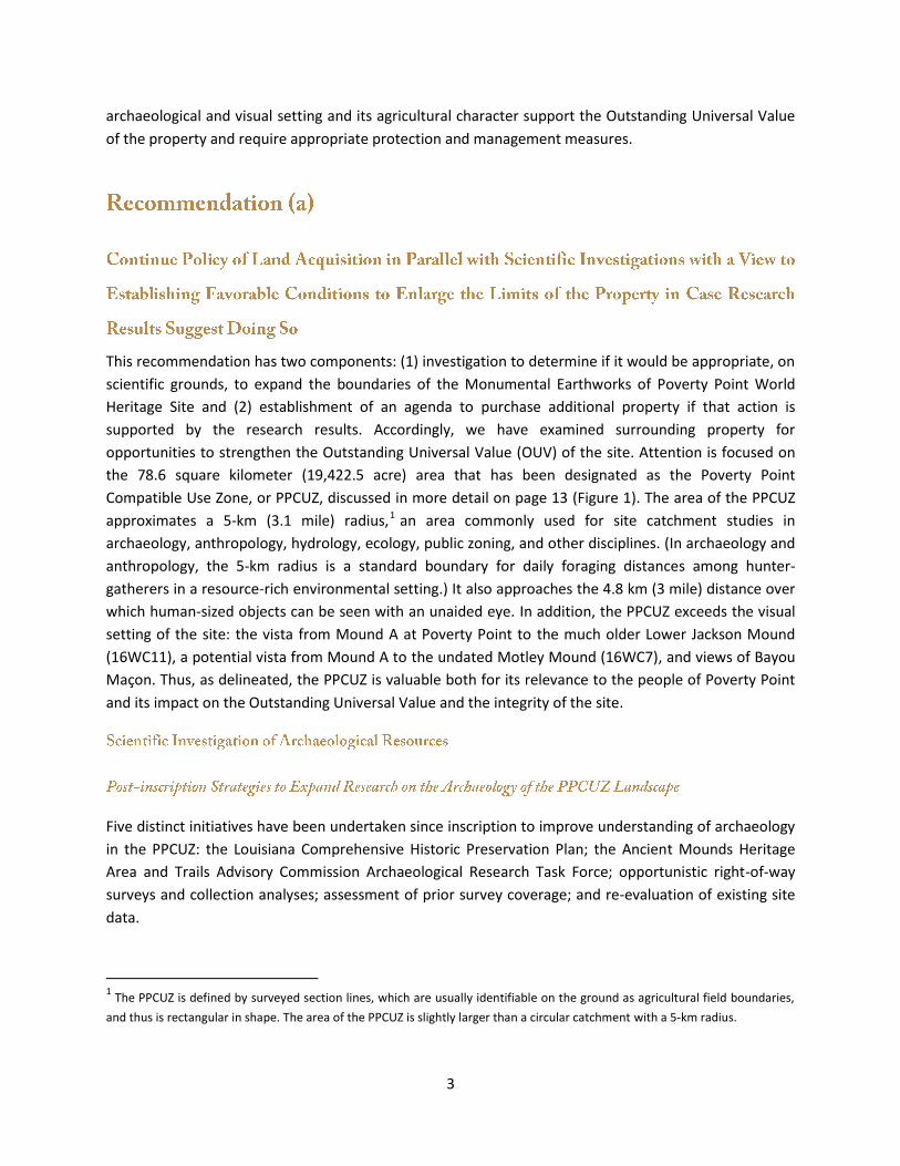
the 78.6 square kilometer (19,422.5 acre) area that has been designated as the Poverty Point
Compatible Use Zone, or PPCUZ, discussed in more detail on page 13 (Figure 1). The area of the PPCUZ
approximates a 5-km (3.1 mile) radius,1 an area commonly used for site catchment studies in
archaeology, anthropology, hydrology, ecology, public zoning, and other disciplines. (In archaeology and
anthropology, the 5-km radius is a standard boundary for daily foraging distances among hunter-
gatherers in a resource-rich environmental setting.) It also approaches the 4.8 km (3 mile) distance over
which human-sized objects can be seen with an unaided eye. In addition, the PPCUZ exceeds the visual
setting of the site: the vista from Mound A at Poverty Point to the much older Lower Jackson Mound
(16WC11), a potential vista from Mound A to the undated Motley Mound (16WC7), and views of Bayou
Maҫon. Thus, as delineated, the PPCUZ is valuable both for its relevance to the people of Poverty Point
and its impact on the Outstanding Universal Value and the integrity of the site.
Five distinct initiatives have been undertaken since inscription to improve understanding of archaeology
in the PPCUZ: the Louisiana Comprehensive Historic Preservation Plan; the Ancient Mounds Heritage
Area and Trails Advisory Commission Archaeological Research Task Force; opportunistic right-of-way
surveys and collection analyses; assessment of prior survey coverage; and re-evaluation of existing site
data.
1 The PPCUZ is defined by surveyed section lines, which are usually identifiable on the ground as agricultural field boundaries,
and thus is rectangular in shape. The area of the PPCUZ is slightly larger than a circular catchment with a 5-km radius.
4
Figure 1. The Poverty Point Compatible Use Zone (PPCUZ), ■, surrounding
Poverty Point World Heritage Site.
The Louisiana Office of Cultural Development is updating the state’s official Comprehensive Historic
Preservation Plan for the period 2016-2024. One of the plan’s major goals is to continue to build ways to
identify and protect historic properties. The issue of archaeological research in Poverty Point’s setting is
specifically addressed in one of the strategies, which calls for the state to “continue efforts in the
Compatible Use Zone surrounding Poverty Point World Heritage Site to identify archaeological sites that
may be related to Poverty Point and to assess their preservation and research potential.”
In June 2014, the state of Louisiana formed the Ancient Mounds Heritage Area and Trails Advisory
Commission to provide guidance about the Poverty Point World Heritage Site. The commission has
created task forces, one of which seeks to “foster archaeological research, educational opportunities,
and conservation of cultural resources.” The archaeological research task force, composed primarily of
professional archaeologists, is establishing strategies for fostering, expanding, and expediting scientific
archaeological investigations in the PPCUZ.
The local office of the Louisiana Department of Transportation and Development (DOTD) has agreed to
contact the Poverty Point Station Archaeology Program before conducting right-of-way work in the
Poverty Point vicinity. On a few occasions since inscription, sediments that would otherwise be
inaccessible have been exposed; no archaeological deposits were observed.
5
Avocational archaeologists and collectors often bring artifacts to the park to learn more about them and
to share information about their collections. Archaeologists are working with these local informants to
identify additional sites in the PPCUZ that may be Poverty Point-related.
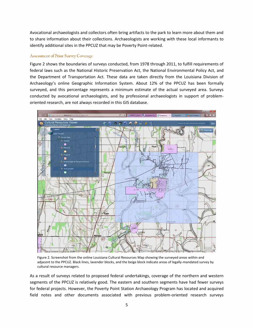
Figure 2 shows the boundaries of surveys conducted, from 1978 through 2011, to fulfill requirements of
federal laws such as the National Historic Preservation Act, the National Environmental Policy Act, and
the Department of Transportation Act. These data are taken directly from the Louisiana Division of
Archaeology’s online Geographic Information System. About 12% of the PPCUZ has been formally
surveyed, and this percentage represents a minimum estimate of the actual surveyed area. Surveys
conducted by avocational archaeologists, and by professional archaeologists in support of problem-
oriented research, are not always recorded in this GIS database.
Figure 2. Screenshot from the online Louisiana Cultural Resources Map showing the surveyed areas within and adjacent to the PPCUZ. Black lines, lavender blocks, and the beige block indicate areas of legally-mandated survey by cultural resource managers.
As a result of surveys related to proposed federal undertakings, coverage of the northern and western
segments of the PPCUZ is relatively good. The eastern and southern segments have had fewer surveys
for federal projects. However, the Poverty Point Station Archaeology Program has located and acquired
field notes and other documents associated with previous problem-oriented research surveys
6
conducted by universities in the eastern and southern parts of the PPCUZ. Assessment of that survey
coverage and the associated collections is ongoing.
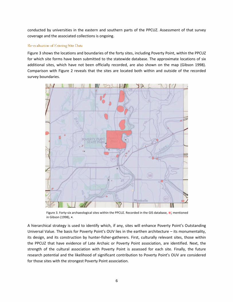
Figure 3 shows the locations and boundaries of the forty sites, including Poverty Point, within the PPCUZ
for which site forms have been submitted to the statewide database. The approximate locations of six
additional sites, which have not been officially recorded, are also shown on the map (Gibson 1998).
Comparison with Figure 2 reveals that the sites are located both within and outside of the recorded
survey boundaries.
Figure 3. Forty-six archaeological sites within the PPCUZ. Recorded in the GIS database, ■; mentioned
in Gibson (1998), ×.
A hierarchical strategy is used to identify which, if any, sites will enhance Poverty Point’s Outstanding
Universal Value. The basis for Poverty Point’s OUV lies in the earthen architecture – its monumentality,
its design, and its construction by hunter-fisher-gatherers. First, culturally relevant sites, those within
the PPCUZ that have evidence of Late Archaic or Poverty Point association, are identified. Next, the
strength of the cultural association with Poverty Point is assessed for each site. Finally, the future
research potential and the likelihood of significant contribution to Poverty Point’s OUV are considered
for those sites with the strongest Poverty Point association.

7
The time period(s) likely represented at each site are recorded on the official site forms and in reports.
This is most often based on analysis of recovered artifacts and, rarely, on radiometric dates. Recent re-
examination of several available artifact collections has proved valuable in confirming or establishing
new temporal assignments. As Table 1 demonstrates, a broad range of time periods is indicated for the
sites in the PPCUZ. People have been using the landscape around Poverty Point for more than 10,000
years, but the Late Archaic/Poverty Point and Woodland periods are the most frequently represented.
Table 1. Number of sites in the PPCUZ identified, on the basis of artifacts or radiocarbon dates, as having been used during various time periods. The age range for each time period is presented in years Before Present (BP, where “Present” = AD 1950), and is roughly equivalent to “years ago.” Most sites have evidence for multiple occupations.
Evidence
Pal
eo
ind
ian
13
,00
0-1
0,0
00
BP
Earl
y A
rch
aic
10
,00
0-7
00
0 B
P
Mid
dle
Arc
hai
c
70
00
-40
00
BP
Late
Arc
hai
c/P
ove
rty
Po
int
40
00
-25
00
BP
Wo
od
lan
d
25
00
-10
00
BP
Late
Pre
his
tori
c
10
00
-50
0 B
P
Pro
toh
isto
ric
50
0-3
00
BP
His
tori
c
30
0 B
P –
pre
sen
t
Un
kno
wn
Pre
his
tori
c
Artifacts 4 4 5 30 24 1 0 21 4
14C Dates 2 1
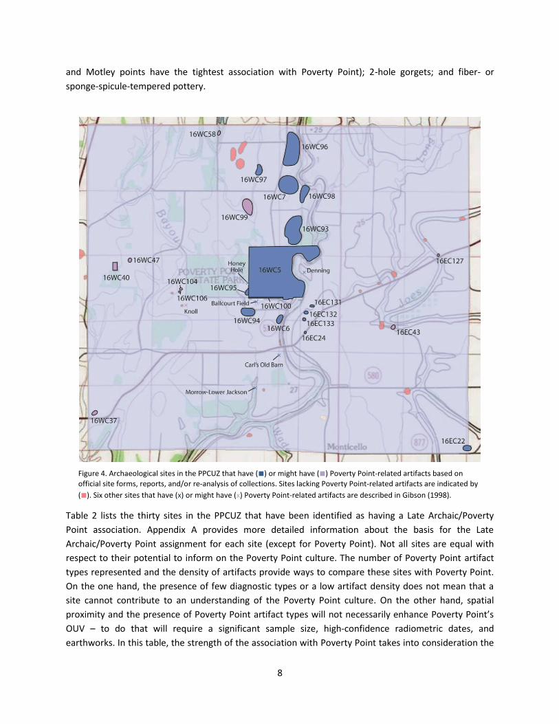
Figure 4 shows the location of the sites in the PPCUZ with reported evidence for a Late Archaic or
Poverty Point component. Those sites with a certain Late Archaic or Poverty Point attribution are
distinguished from those for which the records are not convincing. For most sites, the Late Archaic or
Poverty Point use of the locale was not the only occupation of the site and, for several, it was not the
dominant one (e.g., at Howington [16EC43] or Jackson Place Mounds [16WC6]).
Understanding of the Poverty Point culture has become more sophisticated since some of these sites
were reported. For example, some artifact collections were presumed to be Poverty Point-aged simply
because they contained stone tools or chipping debris made of non-local (exotic) lithic raw materials.
Recent analyses, however, have shown that later cultures also used exotic raw materials (Heller 2014).
At Poverty Point, a sample of twenty-nine projectile points that are characteristic of later time periods
was examined recently: ten were made of the locally-available chert, nine were made of non-local
cherts, and ten could not be confidently classified (the stones could be non-local chert, or heat-treated
local chert). Thus, the presence of non-local raw materials alone is not a sufficient basis for determining
if a site was used by people of the Poverty Point culture.
The presence of diagnostic artifact types is a key indicator of a Poverty Point-related site. Webb
(1982:70) listed nineteen primary and secondary diagnostic artifacts shared by many sites of the Poverty
Point culture. Of those, eleven are still considered strong indicators of the Poverty Point culture in
Louisiana (cf. Griffing 2010): Poverty Point Objects (PPOs); tubular pipes; clay figurines; steatite and
sandstone vessels; Jaketown perforators; parallel-sided greenstone celts; hematite/magnetite
plummets; jasper beads/pendants; temporally consistent projectile points (Delhi, Epps, Hale, Marshall,
8
and Motley points have the tightest association with Poverty Point); 2-hole gorgets; and fiber- or
sponge-spicule-tempered pottery.
Figure 4. Archaeological sites in the PPCUZ that have (■) or might have (■) Poverty Point-related artifacts based on
official site forms, reports, and/or re-analysis of collections. Sites lacking Poverty Point-related artifacts are indicated by
(■). Six other sites that have (x) or might have (x) Poverty Point-related artifacts are described in Gibson (1998).
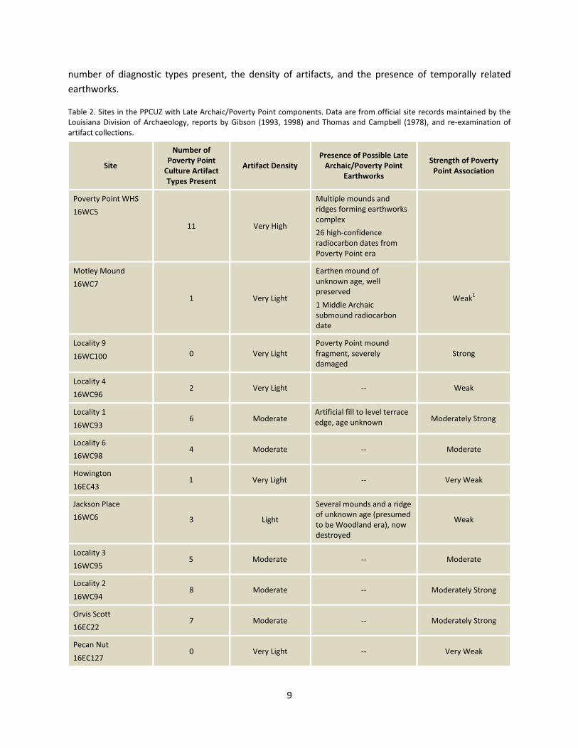
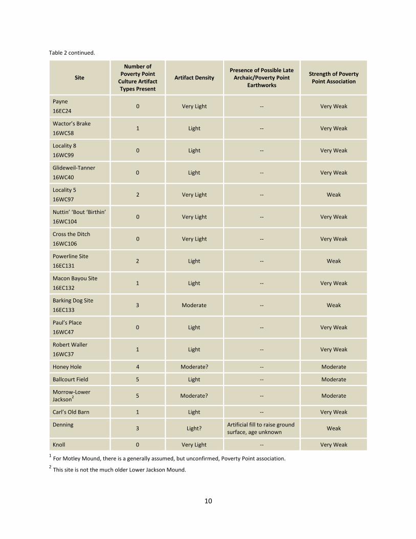
Table 2 lists the thirty sites in the PPCUZ that have been identified as having a Late Archaic/Poverty
Point association. Appendix A provides more detailed information about the basis for the Late
Archaic/Poverty Point assignment for each site (except for Poverty Point). Not all sites are equal with
respect to their potential to inform on the Poverty Point culture. The number of Poverty Point artifact
types represented and the density of artifacts provide ways to compare these sites with Poverty Point.
On the one hand, the presence of few diagnostic types or a low artifact density does not mean that a
site cannot contribute to an understanding of the Poverty Point culture. On the other hand, spatial
proximity and the presence of Poverty Point artifact types will not necessarily enhance Poverty Point’s
OUV – to do that will require a significant sample size, high-confidence radiometric dates, and
earthworks. In this table, the strength of the association with Poverty Point takes into consideration the
9
number of diagnostic types present, the density of artifacts, and the presence of temporally related
earthworks.
Table 2. Sites in the PPCUZ with Late Archaic/Poverty Point components. Data are from official site records maintained by the Louisiana Division of Archaeology, reports by Gibson (1993, 1998) and Thomas and Campbell (1978), and re-examination of artifact collections.
Site
Number of Poverty Point
Culture Artifact Types Present
Artifact Density Presence of Possible Late
Archaic/Poverty Point Earthworks
Strength of Poverty Point Association
Poverty Point WHS
16WC5
11 Very High
Multiple mounds and ridges forming earthworks complex
26 high-confidence radiocarbon dates from Poverty Point era
Motley Mound
16WC7
1 Very Light
Earthen mound of unknown age, well preserved
1 Middle Archaic submound radiocarbon date
Weak1
Locality 9
16WC100 0 Very Light Poverty Point mound fragment, severely damaged
Strong
Locality 4
16WC96 2 Very Light -- Weak
Locality 1
16WC93 6 Moderate
Artificial fill to level terrace edge, age unknown Moderately Strong
Locality 6
16WC98 4 Moderate -- Moderate
Howington
16EC43 1 Very Light -- Very Weak
Jackson Place
16WC6 3 Light
Several mounds and a ridge of unknown age (presumed to be Woodland era), now destroyed
Weak
Locality 3
16WC95 5 Moderate -- Moderate
Locality 2
16WC94 8 Moderate -- Moderately Strong
Orvis Scott
16EC22 7 Moderate -- Moderately Strong
Pecan Nut
16EC127 0 Very Light -- Very Weak
10
Table 2 continued.
Site
Number of Poverty Point
Culture Artifact Types Present
Artifact Density Presence of Possible Late
Archaic/Poverty Point Earthworks
Strength of Poverty Point Association
Payne
16EC24 0 Very Light -- Very Weak
Wactor’s Brake
16WC58 1 Light -- Very Weak
Locality 8
16WC99 0 Light -- Very Weak
Glideweil-Tanner
16WC40 0 Light -- Very Weak
Locality 5
16WC97 2 Very Light -- Weak
Nuttin’ ‘Bout ‘Birthin’
16WC104 0 Very Light -- Very Weak
Cross the Ditch
16WC106 0 Very Light -- Very Weak
Powerline Site
16EC131 2 Light -- Weak
Macon Bayou Site
16EC132 1 Light -- Very Weak
Barking Dog Site
16EC133 3 Moderate -- Weak
Paul’s Place
16WC47 0 Light -- Very Weak
Robert Waller
16WC37 1 Light -- Very Weak
Honey Hole 4 Moderate? -- Moderate
Ballcourt Field 5 Light -- Moderate
Morrow-Lower Jackson
2 5 Moderate? -- Moderate
Carl’s Old Barn 1 Light -- Very Weak
Denning 3 Light?
Artificial fill to raise ground surface, age unknown
Weak
Knoll 0 Very Light -- Very Weak
1 For Motley Mound, there is a generally assumed, but unconfirmed, Poverty Point association.
2 This site is not the much older Lower Jackson Mound.
11
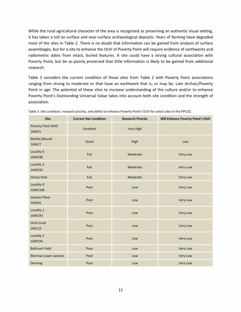
While the rural agricultural character of the area is recognized as preserving an authentic visual setting,
it has taken a toll on surface and near-surface archaeological deposits. Years of farming have degraded
most of the sites in Table 2. There is no doubt that information can be gained from analysis of surface
assemblages, but for a site to enhance the OUV of Poverty Point will require evidence of earthworks and
radiometric dates from intact, buried features. A site could have a strong cultural association with
Poverty Point, but be so poorly preserved that little information is likely to be gained from additional
research.
Table 3 considers the current condition of those sites from Table 2 with Poverty Point associations
ranging from strong to moderate or that have an earthwork that is, or may be, Late Archaic/Poverty
Point in age. The potential of these sites to increase understanding of the culture and/or to enhance
Poverty Point’s Outstanding Universal Value takes into account both site condition and the strength of
association.
Table 3. Site condition, research priority, and ability to enhance Poverty Point’s OUV for select sites in the PPCUZ.
Site Current Site Condition Research Priority Will Enhance Poverty Point’s OUV
Poverty Point WHS
16WC5 Excellent Very High
Motley Mound
16WC7 Good High Low
Locality 6
16WC98 Fair Moderate Very Low
Locality 3
16WC95 Fair Moderate Very Low
Honey Hole Fair Moderate Very Low
Locality 9
16WC100 Poor Low Very Low
Jackson Place
16WC6 Poor Low Very Low
Locality 1
16WC93 Poor Low Very Low
Orvis Scott
16EC22 Poor Low Very Low
Locality 2
16WC94 Poor Low Very Low
Ballcourt Field Poor Low Very Low
Morrow-Lower Jackson Poor Low Very Low
Denning Poor Low Very Low
12
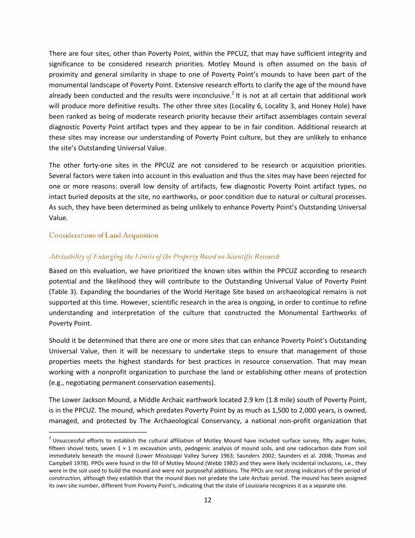
There are four sites, other than Poverty Point, within the PPCUZ, that may have sufficient integrity and
significance to be considered research priorities. Motley Mound is often assumed on the basis of
proximity and general similarity in shape to one of Poverty Point’s mounds to have been part of the
monumental landscape of Poverty Point. Extensive research efforts to clarify the age of the mound have
already been conducted and the results were inconclusive.2 It is not at all certain that additional work
will produce more definitive results. The other three sites (Locality 6, Locality 3, and Honey Hole) have
been ranked as being of moderate research priority because their artifact assemblages contain several
diagnostic Poverty Point artifact types and they appear to be in fair condition. Additional research at
these sites may increase our understanding of Poverty Point culture, but they are unlikely to enhance
the site’s Outstanding Universal Value.
The other forty-one sites in the PPCUZ are not considered to be research or acquisition priorities.
Several factors were taken into account in this evaluation and thus the sites may have been rejected for
one or more reasons: overall low density of artifacts, few diagnostic Poverty Point artifact types, no
intact buried deposits at the site, no earthworks, or poor condition due to natural or cultural processes.
As such, they have been determined as being unlikely to enhance Poverty Point’s Outstanding Universal
Value.
Based on this evaluation, we have prioritized the known sites within the PPCUZ according to research
potential and the likelihood they will contribute to the Outstanding Universal Value of Poverty Point
(Table 3). Expanding the boundaries of the World Heritage Site based on archaeological remains is not
supported at this time. However, scientific research in the area is ongoing, in order to continue to refine
understanding and interpretation of the culture that constructed the Monumental Earthworks of
Poverty Point.
Should it be determined that there are one or more sites that can enhance Poverty Point’s Outstanding
Universal Value, then it will be necessary to undertake steps to ensure that management of those
properties meets the highest standards for best practices in resource conservation. That may mean
working with a nonprofit organization to purchase the land or establishing other means of protection
(e.g., negotiating permanent conservation easements).
The Lower Jackson Mound, a Middle Archaic earthwork located 2.9 km (1.8 mile) south of Poverty Point,
is in the PPCUZ. The mound, which predates Poverty Point by as much as 1,500 to 2,000 years, is owned,
managed, and protected by The Archaeological Conservancy, a national non-profit organization that
2 Unsuccessful efforts to establish the cultural affiliation of Motley Mound have included surface survey, fifty auger holes,
fifteen shovel tests, seven 1 × 1 m excavation units, pedogenic analysis of mound soils, and one radiocarbon date from soil immediately beneath the mound (Lower Mississippi Valley Survey 1963; Saunders 2002; Saunders et al. 2008; Thomas and Campbell 1978). PPOs were found in the fill of Motley Mound (Webb 1982) and they were likely incidental inclusions, i.e., they were in the soil used to build the mound and were not purposeful additions. The PPOs are not strong indicators of the period of construction, although they establish that the mound does not predate the Late Archaic period. The mound has been assigned its own site number, different from Poverty Point’s, indicating that the state of Louisiana recognizes it as a separate site.
13
acquires and preserves archaeological sites. Likewise, there is great interest in purchasing Motley
Mound, an earthwork of unknown age located 2.2 km (1.4 mile) north of Poverty Point, should the
landowner be willing to sell.
The Louisiana Office of State Parks follows procedures for acquiring land as established by state law and
as conveyed by the Louisiana Office of State Lands. The most recent Louisiana State Parks Master Plan
(Reich Associates et al. 1997:10) states that “a state commemorative area will be of sufficient size to
encompass the area or feature being commemorated and of a sufficient size to adequately
commemorate the event, feature or culture for which the area is established. Sufficient buffer will be
provided to minimize any encroachments which may impair the values and inhibit public use and
appreciation of the area.” To enhance protection of the existing World Heritage Site and to provide
adequate “off-site” space for future visitor facilities, acquisition of adjacent property is a high priority.
The Ancient Mounds Heritage Area and Trails Commission has established a management task force
charged with “protecting and maintaining Poverty Point World Heritage Site and its setting with the
highest standards of management.” This task force has heritage management experts from the
Louisiana Office of State Parks, the Office of Cultural Development, and the Advocates for Poverty Point
(the official “friends” group of the Poverty Point World Heritage Site), and it is exploring ways to further
strengthen protections in the PPCUZ.
The state has working relationships with organizations such as The Archaeological Conservancy and The
Conservation Fund. These organizations can react more quickly than can the state to acquire property
when it becomes available. Once they have purchased land, and it is protected, the state can work to
buy that land from them. These organizations, and the Advocates for Poverty Point, have indicated their
willingness to assist when the time is right.
Land in the PPCUZ is privately owned. The state will not compel landowners to sell, but would like to
purchase additional property from willing sellers. Preliminary talks with the owners of property adjacent
to Poverty Point’s southern boundary have already taken place. The management task force established
by the Louisiana Ancient Mounds Heritage Area and Trail Advisory Commission includes land acquisition
surrounding Poverty Point as one of its most pressing responsibilities.
The Poverty Point Compatible Use Zone (PPCUZ) was established as a culturally sensitive, protected area
by the Northeast Louisiana Economic Alliance (NELEA) in June 2014 (just prior to the World Heritage
Committee’s decision to inscribe the Monumental Earthworks of Poverty Point). The NELEA does not
recommend properties within the PPCUZ for industrial or commercial development and works to ensure
that planned land use will be compatible with the goal of protecting Poverty Point and its setting. The
Louisiana State Historic Preservation Office conducts an extra level of review for all proposed projects in
14
this area that require a federal license, permit, or funding. Any possible direct or indirect effects on the
Monumental Earthworks of Poverty Point are thoroughly evaluated and adverse effects are avoided.
The PPCUZ not only provides significant additional protection for the Outstanding Universal Value and
integrity of the site, but it also encompasses the open, rural setting that is important for appreciating
Poverty Point. The West Carroll Parish Police Jury (an elected legislative body roughly equivalent to a
county council) has recognized the importance of maintaining this setting and supports the continuation
of traditional land use in this area.
Several sites in the PPCUZ have artifacts that can be attributed to the Poverty Point culture. The people
of Poverty Point certainly used the entire landscape and they did not restrict their activities to just the
mound complex. It is the earthen architecture – its monumentality, its design, and its construction by
hunter-fisher-gatherers – that is the basis for the site’s OUV. The temporally related sites in the PPCUZ
do not enhance that value, although they may provide additional information about the Poverty Point
culture.
Even if nearby cultural resources are not sufficient reason to purchase additional land, there are other
reasons to do so (e.g., to provide “off-site” space for visitor facilities). The state is partnering with other
organizations that have the capability to purchase land as it becomes available. The 2014 Poverty Point
Compatible Use Zone influences planning decisions regarding the potential impact that development
projects might have upon the site and its Outstanding Universal Value.
Efforts to minimize the impact of Louisiana Highway 577 on the visitor experience have two
complementary aims: (1) to enhance safety and (2) to reduce visual and/or audible distractions to visitor
enjoyment of the site.
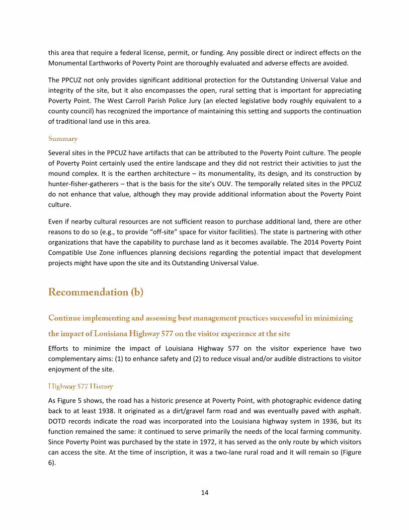
As Figure 5 shows, the road has a historic presence at Poverty Point, with photographic evidence dating
back to at least 1938. It originated as a dirt/gravel farm road and was eventually paved with asphalt.
DOTD records indicate the road was incorporated into the Louisiana highway system in 1936, but its
function remained the same: it continued to serve primarily the needs of the local farming community.
Since Poverty Point was purchased by the state in 1972, it has served as the only route by which visitors
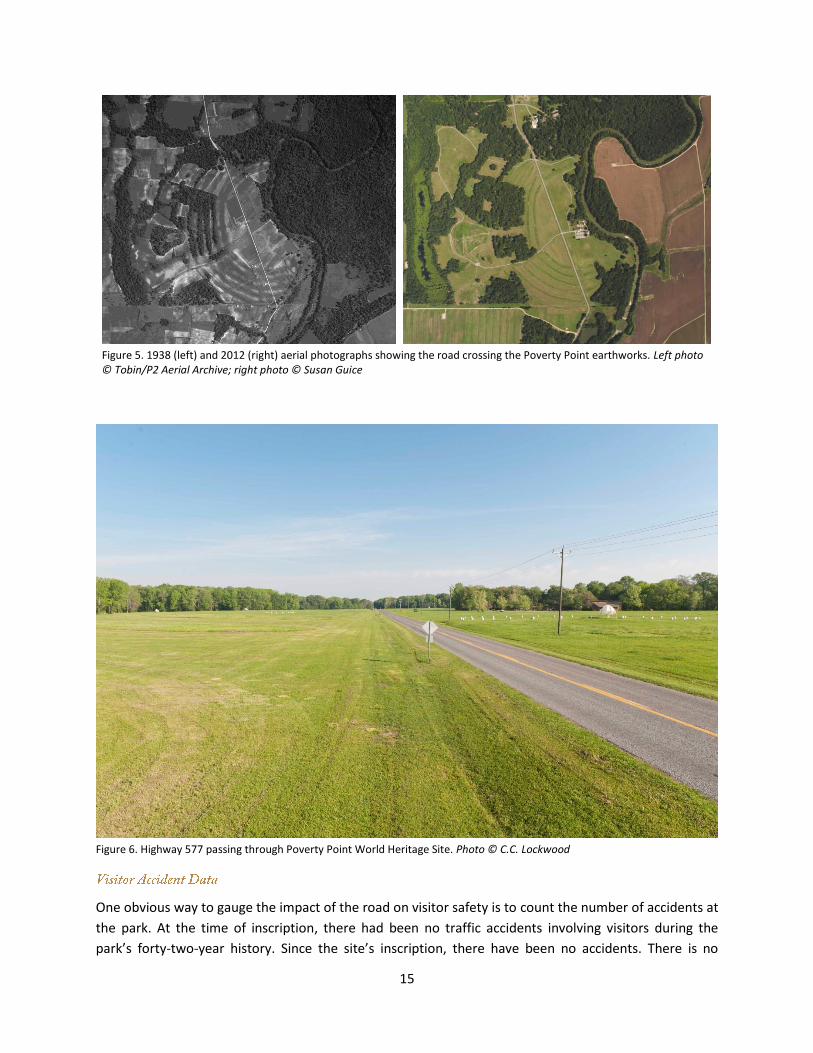
can access the site. At the time of inscription, it was a two-lane rural road and it will remain so (Figure
6).
15
Figure 5. 1938 (left) and 2012 (right) aerial photographs showing the road crossing the Poverty Point earthworks. Left photo © Tobin/P2 Aerial Archive; right photo © Susan Guice
Figure 6. Highway 577 passing through Poverty Point World Heritage Site. Photo © C.C. Lockwood
One obvious way to gauge the impact of the road on visitor safety is to count the number of accidents at
the park. At the time of inscription, there had been no traffic accidents involving visitors during the
park’s forty-two-year history. Since the site’s inscription, there have been no accidents. There is no
16
evidence that the road is a safety hazard to visitors. Excellent visibility (due to the straightness of the
road through the park) and low through-traffic counts are likely important factors.
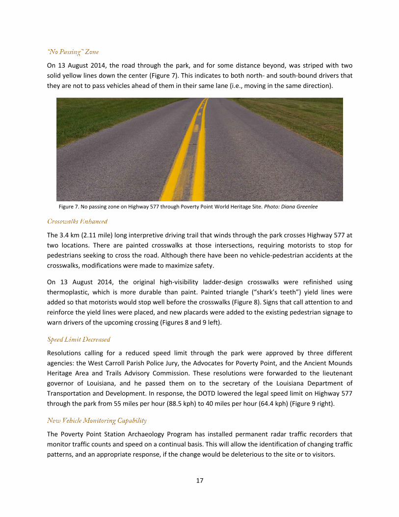
Prior to inscription, the Louisiana Department of Transportation and Development deployed a set of
pneumatic road tube traffic data recorders on the north and south ends of the park. They counted for
one week in October 2013. The count was repeated in the same locations for one week in March 2015.
The October count reflects vehicles travelling in both directions at each end of the park, whereas the
March count includes only northbound vehicles at the south end and southbound vehicles at the north
end. Table 4 summarizes the vehicle count data.
The adjusted Annual Average Daily Traffic (AADT) is an estimate of the daily vehicle traffic volume in
both directions on Highway 577. It includes both visitors to the park and through-traffic. Because this
segment of road was not counted daily for an entire year, traffic engineers use a factor based on
statewide averages to adjust the raw counts to account for seasonal or other biases. Using a statewide
factor to correct periodically-obtained raw counts at the site might not be the best approach to
monitoring through-traffic. The AADT estimates indicate that the average daily traffic volume on
Highway 577 is low, but also variable. Because most visitors enter and leave the park from the south, it
is not unexpected that a greater volume of traffic would be recorded at the southern end, especially
during times of higher visitation.
A key observation that can be drawn from the vehicle count data is when most of the traffic occurred.
Nearly half of the vehicle traffic on Highway 577 occurs outside of park hours, when members of the
local community are traveling to and from work and attending to the needs of their daily lives.
Table 4. Vehicle counts collected at locations on Highway 577 at the north and south ends of the park over a one week period in October 2013 and March 2015. For comparative purposes, the number of recorded visitors during the months of October 2013 and March 2015 are also provided.
Number of
Visitors
Annual Average Daily
Traffic (AADT)
One Week Vehicle Count
North End
One Week Vehicle Count
South End
North End South End 9am-5pm 5pm-9am 9am-5pm 5pm-9am
October 2013 1288 334 366 1243 (52%) 1138 (48%) 1444 (55%) 1178 (45%)
March 20151 790 428 408 738 (51%) 705 (49%) 839 (55%) 678 (45%)
1 Because the March 2015 traffic study only recorded a single direction of travel at each end of the park, the calculated
AADT has been doubled to provide a closer estimate to the true AADT. Since the relative percentage of traffic during park hours and off-hours is the relevant number, those counts have not been doubled.
Since inscription, the state has undertaken several measures to enhance road safety through Poverty
Point World Heritage Site for visitors, park staff, and through-traffic.
17
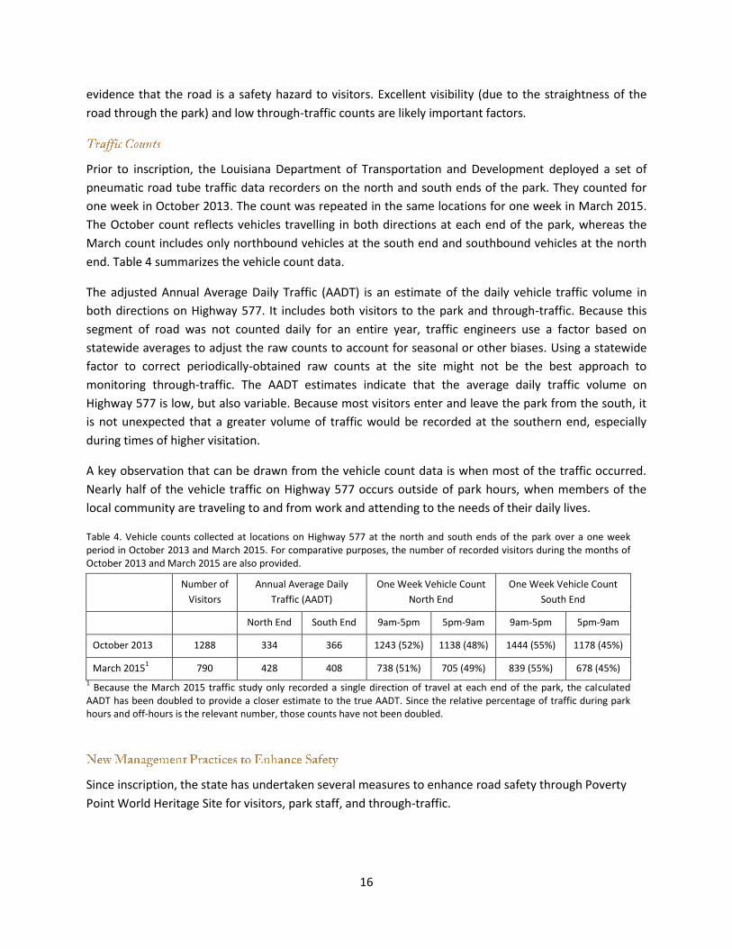
On 13 August 2014, the road through the park, and for some distance beyond, was striped with two
solid yellow lines down the center (Figure 7). This indicates to both north- and south-bound drivers that
they are not to pass vehicles ahead of them in their same lane (i.e., moving in the same direction).
Figure 7. No passing zone on Highway 577 through Poverty Point World Heritage Site. Photo: Diana Greenlee
The 3.4 km (2.11 mile) long interpretive driving trail that winds through the park crosses Highway 577 at
two locations. There are painted crosswalks at those intersections, requiring motorists to stop for
pedestrians seeking to cross the road. Although there have been no vehicle-pedestrian accidents at the
crosswalks, modifications were made to maximize safety.
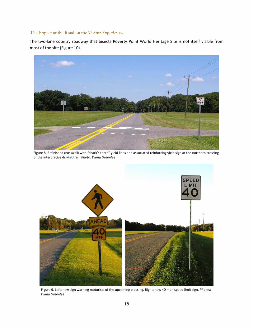
On 13 August 2014, the original high-visibility ladder-design crosswalks were refinished using
thermoplastic, which is more durable than paint. Painted triangle (“shark’s teeth”) yield lines were
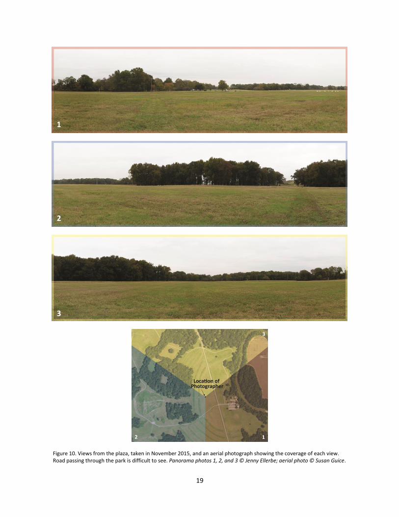
added so that motorists would stop well before the crosswalks (Figure 8). Signs that call attention to and
reinforce the yield lines were placed, and new placards were added to the existing pedestrian signage to
warn drivers of the upcoming crossing (Figures 8 and 9 left).
Resolutions calling for a reduced speed limit through the park were approved by three different
agencies: the West Carroll Parish Police Jury, the Advocates for Poverty Point, and the Ancient Mounds
Heritage Area and Trails Advisory Commission. These resolutions were forwarded to the lieutenant
governor of Louisiana, and he passed them on to the secretary of the Louisiana Department of
Transportation and Development. In response, the DOTD lowered the legal speed limit on Highway 577
through the park from 55 miles per hour (88.5 kph) to 40 miles per hour (64.4 kph) (Figure 9 right).
The Poverty Point Station Archaeology Program has installed permanent radar traffic recorders that
monitor traffic counts and speed on a continual basis. This will allow the identification of changing traffic
patterns, and an appropriate response, if the change would be deleterious to the site or to visitors.
18
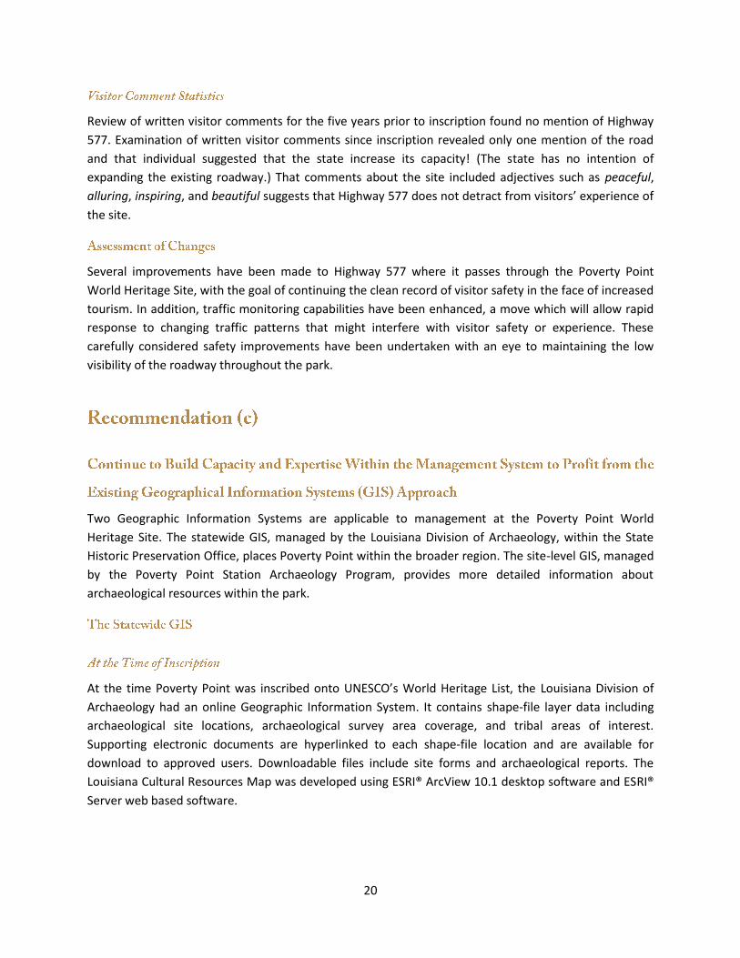
The two-lane country roadway that bisects Poverty Point World Heritage Site is not itself visible from
most of the site (Figure 10).
Figure 8. Refinished crosswalk with “shark’s teeth” yield lines and associated reinforcing yield sign at the northern crossing of the interpretive driving trail. Photo: Diana Greenlee
Figure 9. Left: new sign warning motorists of the upcoming crossing. Right: new 40 mph speed limit sign. Photos: Diana Greenlee
19
Figure 10. Views from the plaza, taken in November 2015, and an aerial photograph showing the coverage of each view. Road passing through the park is difficult to see. Panorama photos 1, 2, and 3 © Jenny Ellerbe; aerial photo © Susan Guice.
1 2
3
3
1
2
20
Review of written visitor comments for the five years prior to inscription found no mention of Highway
577. Examination of written visitor comments since inscription revealed only one mention of the road
and that individual suggested that the state increase its capacity! (The state has no intention of
expanding the existing roadway.) That comments about the site included adjectives such as peaceful,
alluring, inspiring, and beautiful suggests that Highway 577 does not detract from visitors’ experience of
the site.
Several improvements have been made to Highway 577 where it passes through the Poverty Point
World Heritage Site, with the goal of continuing the clean record of visitor safety in the face of increased
tourism. In addition, traffic monitoring capabilities have been enhanced, a move which will allow rapid
response to changing traffic patterns that might interfere with visitor safety or experience. These
carefully considered safety improvements have been undertaken with an eye to maintaining the low
visibility of the roadway throughout the park.
Two Geographic Information Systems are applicable to management at the Poverty Point World
Heritage Site. The statewide GIS, managed by the Louisiana Division of Archaeology, within the State
Historic Preservation Office, places Poverty Point within the broader region. The site-level GIS, managed
by the Poverty Point Station Archaeology Program, provides more detailed information about
archaeological resources within the park.
At the time Poverty Point was inscribed onto UNESCO’s World Heritage List, the Louisiana Division of
Archaeology had an online Geographic Information System. It contains shape-file layer data including
archaeological site locations, archaeological survey area coverage, and tribal areas of interest.
Supporting electronic documents are hyperlinked to each shape-file location and are available for
download to approved users. Downloadable files include site forms and archaeological reports. The
Louisiana Cultural Resources Map was developed using ESRI® ArcView 10.1 desktop software and ESRI®
Server web based software.
21
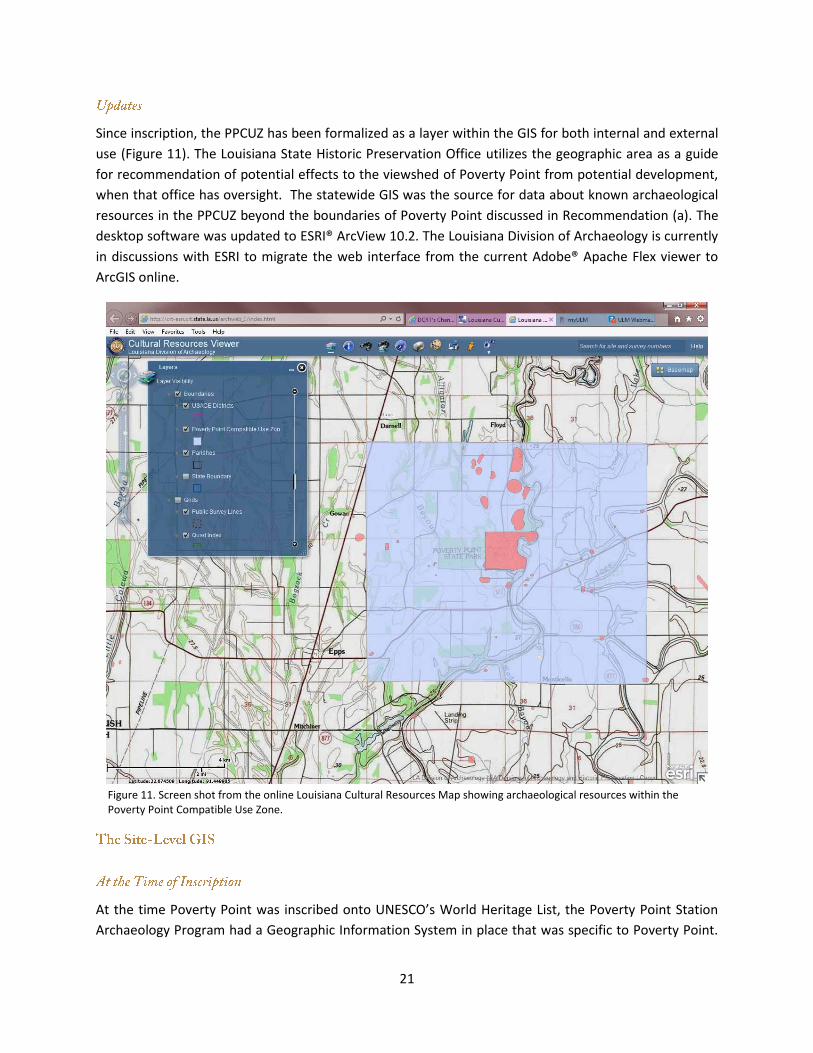
Since inscription, the PPCUZ has been formalized as a layer within the GIS for both internal and external
use (Figure 11). The Louisiana State Historic Preservation Office utilizes the geographic area as a guide
for recommendation of potential effects to the viewshed of Poverty Point from potential development,
when that office has oversight. The statewide GIS was the source for data about known archaeological
resources in the PPCUZ beyond the boundaries of Poverty Point discussed in Recommendation (a). The
desktop software was updated to ESRI® ArcView 10.2. The Louisiana Division of Archaeology is currently
in discussions with ESRI to migrate the web interface from the current Adobe® Apache Flex viewer to
ArcGIS online.
Figure 11. Screen shot from the online Louisiana Cultural Resources Map showing archaeological resources within the Poverty Point Compatible Use Zone.
At the time Poverty Point was inscribed onto UNESCO’s World Heritage List, the Poverty Point Station
Archaeology Program had a Geographic Information System in place that was specific to Poverty Point.
22
It included a series of eleven georectified historic aerial photographs, dating between 1938 and 1998;
topographic maps; geophysical surveys; excavations and soil cores; and historic intrusions. The GIS was
developed using ESRI’s ArcMap software, desktop version 10.1. The map, survey, excavation, and
historic feature data were also available in a format compatible with Golden Software’s Surfer 10.
Since inscription, the Poverty Point Station Archaeology Program has continued to incorporate data into
the Poverty Point GIS, using both ArcMap 10.1 and Surfer 12 formats. Data from new projects are added
as they are conducted and data from old projects are refined as information is gleaned from reports and
field documents. Also, modern utilities such as buried water, telephone, and electrical lines are added as
they are encountered (they were not documented when they were installed prior to the Poverty Point
Station Archaeology Program).
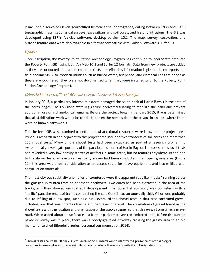
In January 2013, a particularly intense rainstorm damaged the south bank of Harlin Bayou in the area of
the north ridges. The Louisiana state legislature dedicated funding to stabilize the bank and prevent
additional loss of archaeological remains. Before the project began in January 2015, it was determined
that all stabilization work would be conducted from the north side of the bayou, in an area where there
were no known earthworks.
The site-level GIS was examined to determine what cultural resources were known in the project area.
Previous research in and adjacent to the project area included two transects of soil cores and more than
250 shovel tests.3 Many of the shovel tests had been excavated as part of a research program to
systematically investigate portions of the park located north of Harlin Bayou. The cores and shovel tests
had revealed a very low density scatter of artifacts in some areas, but no features anywhere. In addition
to the shovel tests, an electrical resistivity survey had been conducted in an open grassy area (Figure
12); this area was under consideration as an access route for heavy equipment and trucks filled with
construction materials.
The most obvious resistivity anomalies encountered were the apparent roadlike “tracks” running across
the grassy survey area from southeast to northwest. Two cores had been extracted in the area of the
tracks, and they showed unusual soil development. The Core 1 stratigraphy was consistent with a
“traffic” pan, the result of traffic compacting the soil. Core 2 had an unusually thick A horizon, probably
due to infilling of a low spot, such as a rut. Several of the shovel tests in that area contained gravel,
including one that was noted as having a buried layer of gravel. The correlation of gravel found in the
shovel tests with the location and orientation of the tracks suggested that this was, at one time, a gravel
road. When asked about these “tracks,” a former park employee remembered that, before the current
paved driveway was in place, there was a poorly-graveled driveway crossing the grassy area to an old
maintenance shed (Blondelle Surles, personal communication 2014).
3 Shovel tests are small (30 cm x 30 cm) excavations undertaken to identify the presence of archaeological
resources in areas where surface visibility is poor or where there is a possibility of buried deposits.
23
The old gravel road was the best route for trucks to access the job site. That location had already been
impacted by vehicle traffic and had a firm base to support the weight of the trucks. Prior to the start of
the stabilization project, the roadway was flagged using coordinates obtained from the georeferenced
resistivity data. Any future need to bring in big equipment on the north end of the park can use the
same path without compromising cultural resources.
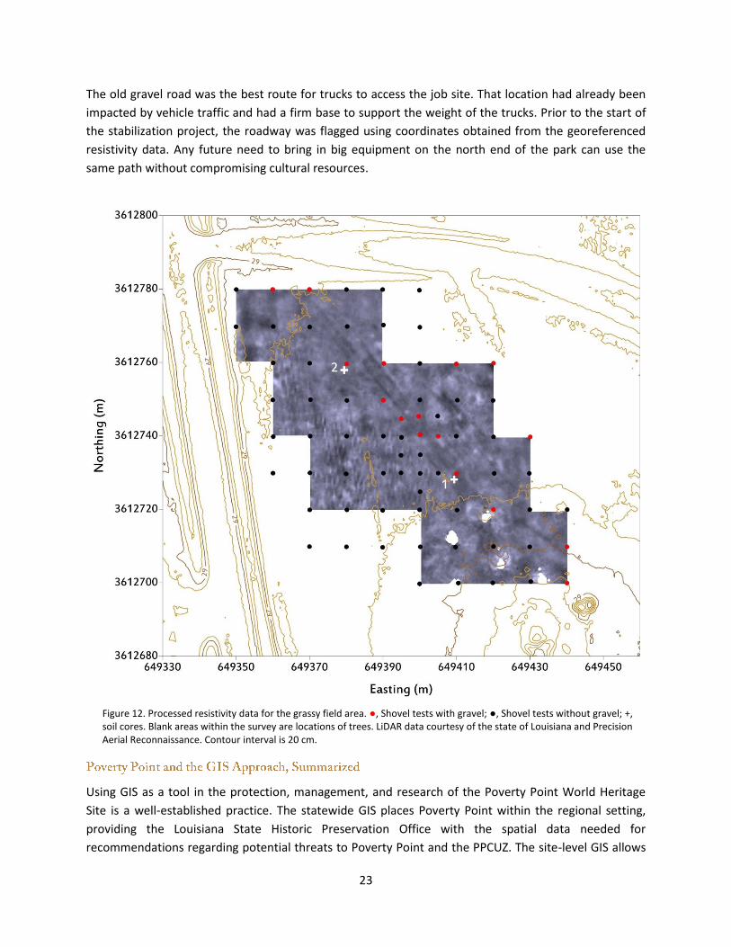
Figure 12. Processed resistivity data for the grassy field area. ●, Shovel tests with gravel; ●, Shovel tests without gravel; +, soil cores. Blank areas within the survey are locations of trees. LiDAR data courtesy of the state of Louisiana and Precision Aerial Reconnaissance. Contour interval is 20 cm.
Using GIS as a tool in the protection, management, and research of the Poverty Point World Heritage
Site is a well-established practice. The statewide GIS places Poverty Point within the regional setting,
providing the Louisiana State Historic Preservation Office with the spatial data needed for
recommendations regarding potential threats to Poverty Point and the PPCUZ. The site-level GIS allows
24
the station archaeologist to make recommendations to the Office of State Parks and archaeologists
regarding management and research at the site.
The UNESCO World Heritage Committee made three recommendations for further action by the State
Party following the inscription of the Monumental Earthworks of Poverty Point onto the World Heritage
List:
(a) Continue policy of land acquisition in parallel with scientific investigations with a view to
establishing favorable conditions to enlarge the limits of the property in case research results
suggest doing so;
(b) Continue implementing and assessing best management practices successful in minimizing the
impact of Louisiana Highway 577 on the visitor experience at the site; and
(c) Continue to build capacity and expertise within the management system to profit from the
existing Geographical Information Systems (GIS) approach.
Recommendation (a) is addressed in two parts: (1) scientific investigation of archaeological resources in
the surrounding area and (2) consideration of land acquisition. A five-pronged approach has been
initiated to expand understanding of archaeological resources in the wider setting around Poverty Point.
It appears that, although some sites may have research value in providing additional information about
the Poverty Point culture in the broader region, they will not enhance the Outstanding Universal Value
of the Monumental Earthworks of Poverty Point. However, there are other reasons to purchase land
(e.g., to provide “off-site” space for visitor facilities). The state has partnered with other organizations
that have the capability to purchase land as it becomes available. The 2014 Poverty Point Compatible
Use Zone influences planning decisions regarding the potential impact that development projects might
have upon the site and its Outstanding Universal Value.
In response to Recommendation (b), the Louisiana Department of Culture, Recreation and Tourism has
worked closely with the Department of Transportation and Development to enhance the safety of
Highway 577 where it passes through the Poverty Point World Heritage Site. Changes include improved
crosswalk visibility, additional cautionary signage, and lowered speed limits. A permanent installation of
traffic recording equipment permits monitoring, on an ongoing basis, of vehicle counts and speeds. This
will facilitate recognition of deleterious changes in traffic patterns and implementation of corrective
measures. These carefully considered safety improvements have been undertaken with an eye to
maintaining the low visibility of the roadway throughout the park.
With respect to Recommendation (c), the Louisiana State Historic Preservation Office and the Poverty
Point Station Archaeology Program have continued to expand and utilize the capabilities of the
statewide and site-level GIS systems that existed prior to inscription.
25
Gibson, Jon L. 1993. Beyond the Peripheries: A Cultural Resources Survey of a Tract of Land Adjoining the
Poverty Point Site in West Carroll Parish, Louisiana. Report prepared for Capital Bank of Delhi, Delhi, LA.
Gibson, Jon L. 1998. Elements and Organization of Poverty Point Political Economy: High-Water Fish,
Exotic Rocks, and Sacred Earth. Research in Economic Anthropology 19:291-340.
Greengo, Robert E. 1964. “Issaquena: An Archaeological Phase in the Yazoo Basin of the Lower
Mississippi Valley.” Memoirs of the Society for American Archaeology, Number 18. Washington, D.C.:
Society for American Archaeology.
Griffing, David L. 2010. Prehistoric Artifacts of the Macon Ridge Area, Northeast Louisiana: An
Identification Guide for Chipped Stone, Ground Stone, Earthware and Clay Artifacts. Epps, Louisiana.
Heller, Nathanael. 2014. Rethinking the Early Woodland Period Occupation of the Lake Pontchartrain
Basin. Paper presented at the 40th Annual Meeting of the Louisiana Archaeological Society,
Natchitoches, Louisiana.
Lower Mississippi Valley Survey. 1963. “Notes on Survey of Motley Mound.” Archives of the Peabody
Museum of Archaeology and Ethnology, Harvard University, Cambridge, Massachusetts.
Moore, Clarence B. (1913) 2003. “Some Aboriginal Sites in Louisiana and in Arkansas: Atchafalaya River,
Lake Larto, Tensas River, Bayou Maҫon, Bayou D’Arbonne, in Louisiana; Saline River, in Arkansas.” In The
Louisiana and Arkansas Expeditions of Clarence Bloomfield Moore, edited and with an introduction by
Richard A. Weinstein, David B. Kelley and Joe W. Saunders, 567-659. Facsimile of the 1913 publication.
Tuscaloosa, Alabama: University of Alabama Press.
Reich Associates, Daniel Earle, David Loughridge, Applied Technology Research Corporation, and Ashe,
Broussard, Wcinzettle. 1997. Louisiana State Parks Master Plan 1997-2012, Executive Summary. Report
prepared for the Louisiana Department of Culture, Recreation and Tourism, Office of State Parks, Baton
Rouge, Louisiana.
Saunders, Joe. 2002. 2002 Annual Report for Management Unit 2, Regional Archaeology Program.
Unpublished report submitted to the United States National Park Service. Department of Geosciences,
University of Louisiana at Monroe, Monroe Louisiana.
Saunders, Joe, Reca Bamburg Jones, Rinita Dalan, Jim Delahoussaye and Thurman Allen. 2008. 2008
Annual Report for Management Unit 2, Regional Archaeology Program. Unpublished report submitted
to the United States National Park Service. Department of Geosciences, University of Louisiana at
Monroe, Monroe, Louisiana.
Thomas, Jr., Prentice M. and L. Janice Campbell. 1978. The Peripheries of Poverty Point. Report of
Investigations No. 12. Fort Walton Beach, Florida: New World Research, Inc.
26
Webb, Clarence H. 1982. The Poverty Point Culture. Geoscience and Man, Volume 17, 2nd edition,
revised, Department of Geography and Anthropology, Louisiana State University, Baton Rouge,
Louisiana.
27
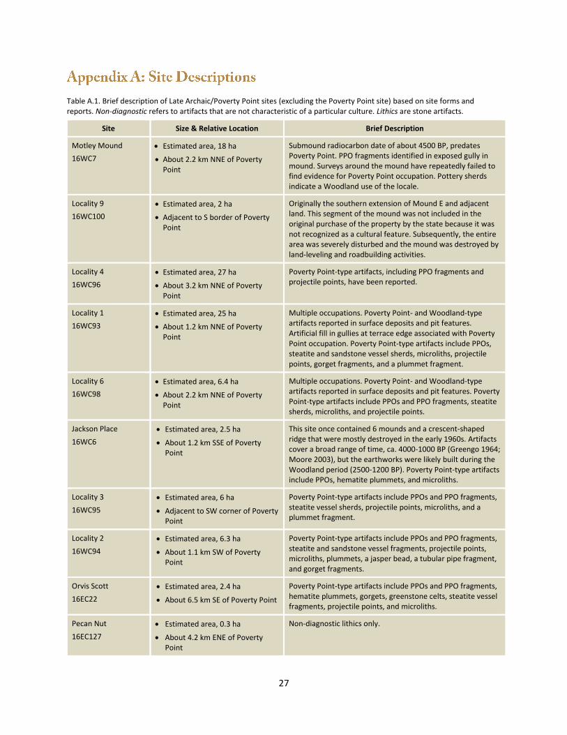
Table A.1. Brief description of Late Archaic/Poverty Point sites (excluding the Poverty Point site) based on site forms and reports. Non-diagnostic refers to artifacts that are not characteristic of a particular culture. Lithics are stone artifacts.
Site Size & Relative Location Brief Description
Motley Mound
16WC7
Estimated area, 18 ha
About 2.2 km NNE of Poverty Point
Submound radiocarbon date of about 4500 BP, predates Poverty Point. PPO fragments identified in exposed gully in mound. Surveys around the mound have repeatedly failed to find evidence for Poverty Point occupation. Pottery sherds indicate a Woodland use of the locale.
Locality 9
16WC100
Estimated area, 2 ha
Adjacent to S border of Poverty Point
Originally the southern extension of Mound E and adjacent land. This segment of the mound was not included in the original purchase of the property by the state because it was not recognized as a cultural feature. Subsequently, the entire area was severely disturbed and the mound was destroyed by land-leveling and roadbuilding activities.
Locality 4
16WC96
Estimated area, 27 ha
About 3.2 km NNE of Poverty Point
Poverty Point-type artifacts, including PPO fragments and projectile points, have been reported.
Locality 1
16WC93
Estimated area, 25 ha
About 1.2 km NNE of Poverty Point
Multiple occupations. Poverty Point- and Woodland-type artifacts reported in surface deposits and pit features. Artificial fill in gullies at terrace edge associated with Poverty Point occupation. Poverty Point-type artifacts include PPOs, steatite and sandstone vessel sherds, microliths, projectile points, gorget fragments, and a plummet fragment.
Locality 6
16WC98
Estimated area, 6.4 ha
About 2.2 km NNE of Poverty Point
Multiple occupations. Poverty Point- and Woodland-type artifacts reported in surface deposits and pit features. Poverty Point-type artifacts include PPOs and PPO fragments, steatite sherds, microliths, and projectile points.
Jackson Place
16WC6
Estimated area, 2.5 ha
About 1.2 km SSE of Poverty Point
This site once contained 6 mounds and a crescent-shaped ridge that were mostly destroyed in the early 1960s. Artifacts cover a broad range of time, ca. 4000-1000 BP (Greengo 1964; Moore 2003), but the earthworks were likely built during the Woodland period (2500-1200 BP). Poverty Point-type artifacts include PPOs, hematite plummets, and microliths.
Locality 3
16WC95
Estimated area, 6 ha
Adjacent to SW corner of Poverty Point
Poverty Point-type artifacts include PPOs and PPO fragments, steatite vessel sherds, projectile points, microliths, and a plummet fragment.
Locality 2
16WC94
Estimated area, 6.3 ha
About 1.1 km SW of Poverty Point
Poverty Point-type artifacts include PPOs and PPO fragments, steatite and sandstone vessel fragments, projectile points, microliths, plummets, a jasper bead, a tubular pipe fragment, and gorget fragments.
Orvis Scott
16EC22
Estimated area, 2.4 ha
About 6.5 km SE of Poverty Point
Poverty Point-type artifacts include PPOs and PPO fragments, hematite plummets, gorgets, greenstone celts, steatite vessel fragments, projectile points, and microliths.
Pecan Nut
16EC127
Estimated area, 0.3 ha
About 4.2 km ENE of Poverty Point
Non-diagnostic lithics only.
28
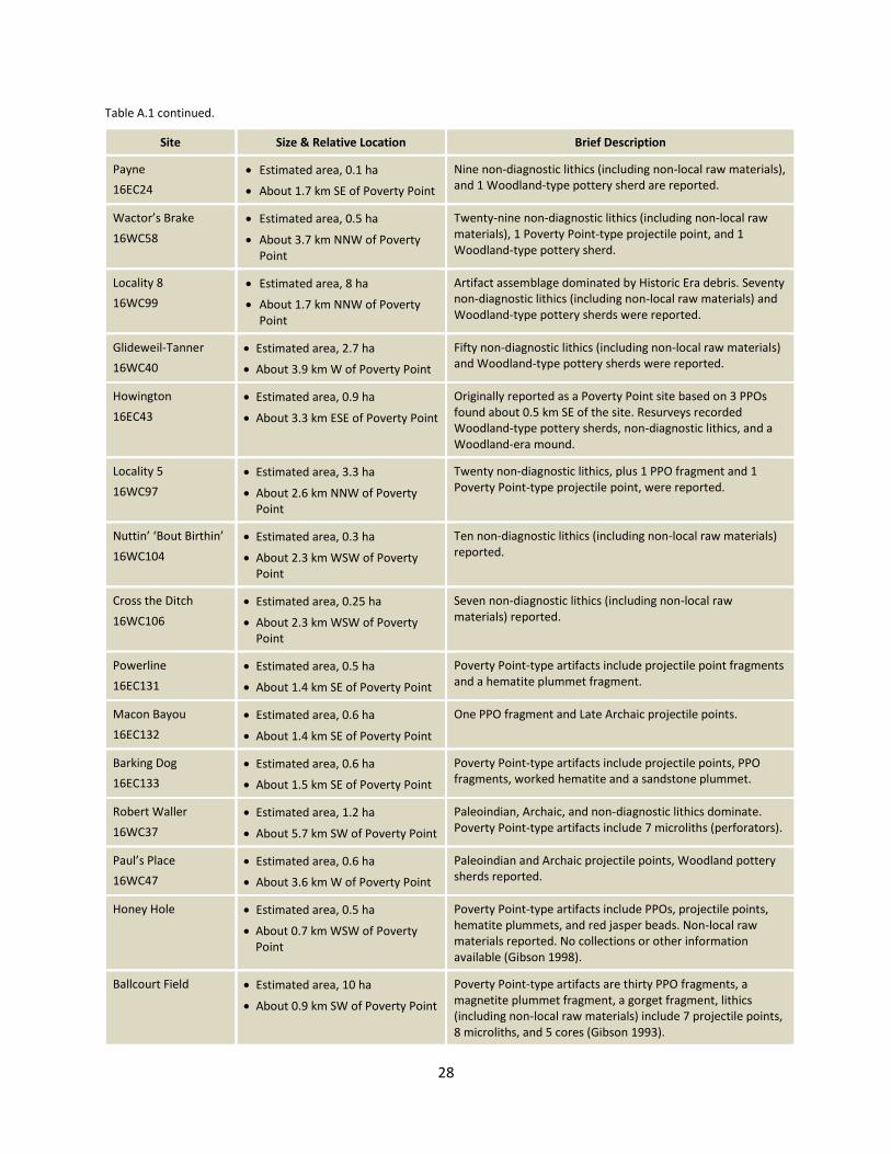
Table A.1 continued.
Site Size & Relative Location Brief Description
Payne
16EC24
Estimated area, 0.1 ha
About 1.7 km SE of Poverty Point
Nine non-diagnostic lithics (including non-local raw materials), and 1 Woodland-type pottery sherd are reported.
Wactor’s Brake
16WC58
Estimated area, 0.5 ha
About 3.7 km NNW of Poverty Point
Twenty-nine non-diagnostic lithics (including non-local raw materials), 1 Poverty Point-type projectile point, and 1 Woodland-type pottery sherd.
Locality 8
16WC99
Estimated area, 8 ha
About 1.7 km NNW of Poverty Point
Artifact assemblage dominated by Historic Era debris. Seventy non-diagnostic lithics (including non-local raw materials) and Woodland-type pottery sherds were reported.
Glideweil-Tanner
16WC40
Estimated area, 2.7 ha
About 3.9 km W of Poverty Point
Fifty non-diagnostic lithics (including non-local raw materials) and Woodland-type pottery sherds were reported.
Howington
16EC43
Estimated area, 0.9 ha
About 3.3 km ESE of Poverty Point
Originally reported as a Poverty Point site based on 3 PPOs found about 0.5 km SE of the site. Resurveys recorded Woodland-type pottery sherds, non-diagnostic lithics, and a Woodland-era mound.
Locality 5
16WC97
Estimated area, 3.3 ha
About 2.6 km NNW of Poverty Point
Twenty non-diagnostic lithics, plus 1 PPO fragment and 1 Poverty Point-type projectile point, were reported.
Nuttin’ ‘Bout Birthin’
16WC104
Estimated area, 0.3 ha
About 2.3 km WSW of Poverty Point
Ten non-diagnostic lithics (including non-local raw materials) reported.
Cross the Ditch
16WC106
Estimated area, 0.25 ha
About 2.3 km WSW of Poverty Point
Seven non-diagnostic lithics (including non-local raw materials) reported.
Powerline
16EC131
Estimated area, 0.5 ha
About 1.4 km SE of Poverty Point
Poverty Point-type artifacts include projectile point fragments and a hematite plummet fragment.
Macon Bayou
16EC132
Estimated area, 0.6 ha
About 1.4 km SE of Poverty Point
One PPO fragment and Late Archaic projectile points.
Barking Dog
16EC133
Estimated area, 0.6 ha
About 1.5 km SE of Poverty Point
Poverty Point-type artifacts include projectile points, PPO fragments, worked hematite and a sandstone plummet.
Robert Waller
16WC37
Estimated area, 1.2 ha
About 5.7 km SW of Poverty Point
Paleoindian, Archaic, and non-diagnostic lithics dominate. Poverty Point-type artifacts include 7 microliths (perforators).
Paul’s Place
16WC47
Estimated area, 0.6 ha
About 3.6 km W of Poverty Point
Paleoindian and Archaic projectile points, Woodland pottery sherds reported.
Honey Hole Estimated area, 0.5 ha
About 0.7 km WSW of Poverty Point
Poverty Point-type artifacts include PPOs, projectile points, hematite plummets, and red jasper beads. Non-local raw materials reported. No collections or other information available (Gibson 1998).
Ballcourt Field Estimated area, 10 ha
About 0.9 km SW of Poverty Point
Poverty Point-type artifacts are thirty PPO fragments, a magnetite plummet fragment, a gorget fragment, lithics (including non-local raw materials) include 7 projectile points, 8 microliths, and 5 cores (Gibson 1993).
29
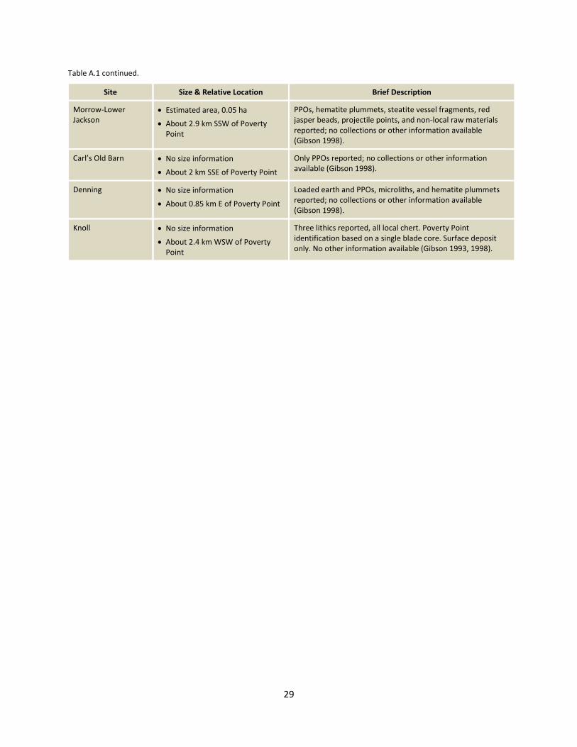
Table A.1 continued.
Site Size & Relative Location Brief Description
Morrow-Lower Jackson
Estimated area, 0.05 ha
About 2.9 km SSW of Poverty Point
PPOs, hematite plummets, steatite vessel fragments, red jasper beads, projectile points, and non-local raw materials reported; no collections or other information available (Gibson 1998).
Carl’s Old Barn No size information
About 2 km SSE of Poverty Point
Only PPOs reported; no collections or other information available (Gibson 1998).
Denning No size information
About 0.85 km E of Poverty Point
Loaded earth and PPOs, microliths, and hematite plummets reported; no collections or other information available (Gibson 1998).
Knoll No size information
About 2.4 km WSW of Poverty Point
Three lithics reported, all local chert. Poverty Point identification based on a single blade core. Surface deposit only. No other information available (Gibson 1993, 1998).