not to be taken away
TRANSCRIPT

ITEM NO:1877299
NOT TO BE TAKEN AWAY
INTRODUCTION
The following section presents the topographic surveys undertaken for this study. The surveys
were made using a Total Station, theodolite, and the data produced recorded and entered into a
civil engineering program. With the exception of CastelT Arnallt, Penrhos and Mouse Castle 1 all
data transfer was performed electronically direct from the Total Station. The three sites
mentioned above were recorded by hand and the data inputted manually because use of the
programme had not been acquired at that time. Once the data was added to the program it was
defined and allocated different graphic representations, base plot, contour, cross section, and 3d
mesh. The software used is entirely interactive allowing for three dimensional measurements to
be questioned at a later time. These engineering formats were then imported into various
software applications in order that a graphic image could be produced for display.
The equipment used throughout the survey program was a Topcon GTS 212, Total Station and
the data produced was downloaded into Civi/Cad 5.5 where it was given graphic attributes: red
lines were tops of banks, green bottoms of banks, blue water limits and purple walls and fences.
This basic information was then used in various ways to provide the survey presentations:
DATA PROCESSING
Contours:
Once the basic shapes had been separated into their colour codes, break lines were set and
entered. (Break lines are noticeable changes in slope used to aid in producing contour plots). The
prepared survey data was then triangulated (divided into surface triangle sections), to produce a
Digital Terrain Model, DTM. The DTM provides the three dimensional data needed to produce
contour lines. Each site was assessed as to the spacing of the contour lines with the need to show
features dictated by the need to produce an understandable display. In some cases certain
features were revealed with a 0.10 m contour spacing but unfortunately the entire site displayed
in such a small calibration rendered the image produced a blurred mess.
Once a suitable setting had been achieved, the contour plot was imported as a DXF file into
AutoCad 2000 where scale bars were set. The scales produced in the displays are accurate to the
contour drawings and should be scaled accordingly if reproduced Overall scale setting for each
display was dictated by the amount of graphics required on an A4 page.
Si
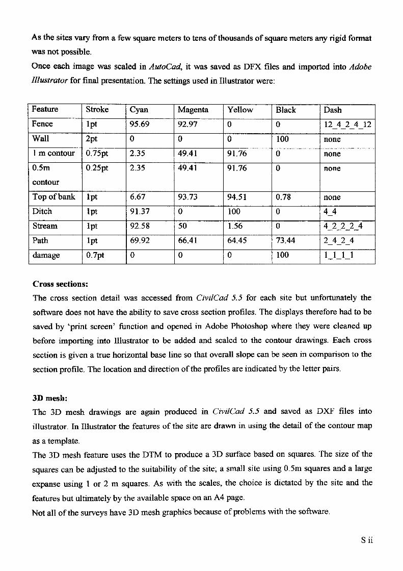
As the sites vary from a few square meters to tens of thousands of square meters any rigid format
was not possible.
Once each image was scaled in AutoCad, it was saved as DFX files and imported into Adobe
Illustrator for final presentation. The settings used in Illustrator were:
Feature
Fence
Wall
1 m contour
0.5m
contour
Top of bank
Ditch
Stream
Path
damage
Stroke
Ipt
2pt
0.75pt
0.25pt
Ipt
Ipt
Ipt
Ipt
0.7pt
Cyan
95.69
0
2.35
2.35
6.67
91.37
92.58
69.92
0
Magenta
92.97
0
49.41
49.41
93.73
0
50
66.41
0
Yellow
0
0
91.76
91.76
94.51
100
1.56
64.45
0
Black
0
100
0
0
0.78
0
0
73.44
100
Dash
12_4_2_4_12
none
none
none
none
4_4
4_2_2_2_4
2_4_2_4
1_1_1_1
Cross sections:
The cross section detail was accessed from CivilCad 5.5 for each site but unfortunately the
software does not have the ability to save cross section profiles. The displays therefore had to be
saved by 'print screen' function and opened in Adobe Photoshop where they were cleaned up
before importing into Illustrator to be added and scaled to the contour drawings. Each cross
section is given a true horizontal base line so that overall slope can be seen in comparison to the
section profile. The location and direction of the profiles are indicated by the letter pairs.
3D mesh:The 3D mesh drawings are again produced in CivilCad 5.5 and saved as DXF files into
illustrator. In Illustrator the features of the site are drawn in using the detail of the contour map
as a template.The 3D mesh feature uses the DTM to produce a 3D surface based on squares. The size of the
squares can be adjusted to the suitability of the site; a small site using 0.5m squares and a large
expanse using 1 or 2 m squares. As with the scales, the choice is dictated by the site and the
features but ultimately by the available space on an A4 page.
Not all of the surveys have 3D mesh graphics because of problems with the software.
Sii
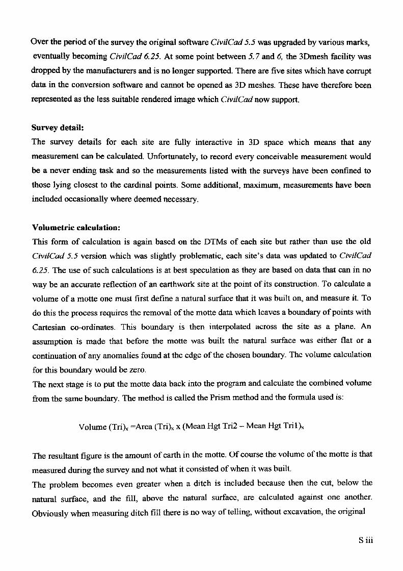
Over the period of the survey the original software CivilCad 5.5 was upgraded by various marks,
eventually becoming CivilCad 6.25. At some point between 5.7 and 6, the SDmesh facility was
dropped by the manufacturers and is no longer supported. There are five sites which have corrupt
data in the conversion software and cannot be opened as 3D meshes. These have therefore been
represented as the less suitable rendered image which CivilCad now support.
Survey detail:
The survey details for each site are fully interactive in 3D space which means that any
measurement can be calculated. Unfortunately, to record every conceivable measurement would
be a never ending task and so the measurements listed with the surveys have been confined to
those lying closest to the cardinal points. Some additional, maximum, measurements have been
included occasionally where deemed necessary.
Volumetric calculation:
This form of calculation is again based on the DTMs of each site but rather than use the old
CivilCad 5.5 version which was slightly problematic, each site's data was updated to CivilCad
6.25. The use of such calculations is at best speculation as they are based on data that can in no
way be an accurate reflection of an earthwork site at the point of its construction. To calculate a
volume of a motte one must first define a natural surface that it was built on, and measure it. To
do this the process requires the removal of the motte data which leaves a boundary of points with
Cartesian co-ordinates. This boundary is then interpolated across the site as a plane. An
assumption is made that before the motte was built the natural surface was either flat or a
continuation of any anomalies found at the edge of the chosen boundary. The volume calculation
for this boundary would be zero.
The next stage is to put the motte data back into the program and calculate the combined volume
from the same boundary. The method is called the Prism method and the formula used is:
Volume (Tri), =Area (Tri)* x (Mean Hgt Tri2 - Mean Hgt Tril)*
The resultant figure is the amount of earth in the motte. Of course the volume of the motte is that
measured during the survey and not what it consisted of when it was built.
The problem becomes even greater when a ditch is included because then the cut, below the
natural surface, and the fill, above the natural surface, are calculated against one another.
Obviously when measuring ditch fill there is no way of telling, without excavation, the original
Siii
depth of the ditch. In the situation where enough ditch is available, the method used is called
Sliced Prisms. Taking the natural surface plane as in the Prism method, set height/depth slices
are calculated within the range of the highest and lowest points within the boundary. The
formula for Sliced Prisms is:
Volume (Tri) = Area (Tri) x average delta z
The results are calculated as cut and fill from the bottom up. When the cut volume ceases, the
natural level has been reached. Earth above the natural level has been added and is recorded as
fill. When the depth is recording both cut and fill it can be assumed that the fill still represents
the natural as only the cut was made to produce a mound below surface level.
Another problem that highlighted itself during the work on volumes is that there is a difference
between the perceived bottom of a motte and the actual present bottom of the ditch. The
difference showed up when 'Cut Prism' methods were use for calculation and compared to
'Prism' calculations. The later Prism calculations were based on interpretation of the position of
a bank bottom which was different from the bottom of a ditch.
It will be noted that the contours are shown as calibrations with no recorded heights. The reason
is that survey heights were taken for the initial survey station on each site using a hand held
Global Positioning System, (GPS) Magellan 300XL. The accuracy of the height was greatly
reduced in the initial years of the survey due to restrictions on the system imposed by the
American Military. When the scramble effect was reduced the system was still not accurate
enough to state a height with any certainty. Rather than record inaccurate measurement it was
decided to list the height of the site in the detail table only.
Siv
THE SURVEYS
1) BachMotte (TheBage) Grid: SO 29787 434132) Bacton Grid: SO 37097 335543) Bryngwyn (Wern-y-cwrt) Grid: SO 39362 087994) Caer Licyn Grid: ST 38977 928285) Caerleon Grid: ST 34257 905536) Castell Arnallt Grid: SO 31942 100197) Chanstone Tump 1 Grid: SO 36547 358948) Chanstone Tump 2 Grid: SO 36462 357049) Colstar Motte (Craig Wood) Grid: ST 31872 9253310) Cothill Farm Mound Grid: SO 33827 3629311) Cusop Castle Grid: SO 3 3922 413 9312) Didley Crt Farm Grid: SO 45022 3196413) Dingestow 1 (Mill Hill) Grid: SO 45977 1035414) Dingestow 2 Grid: SO 45567 1039915) Dixton Grid: SO 51822 1374916) Dorstone Castle Grid: SO 31217 4162317) Ewyas Harold Grid: SO 38502 2869918) Great Goytre (Gwern Castle) Grid: SO 35292 2328419) Howton Grid: SO 41487 2938920) Kemeys Inferior (Gypsy Tump) Grid: ST 38877 9392821) King's Caple Grid: SO 55932 2877422) Llanarth (Twyn-y-Cregen) Grid: SO 36237 0961423) Llancillo Grid: SO 36697 2553924) Llanfair Kilgeddin Grid: SO 34947 0693425) Llanfihangel Crucorney (Tre-Fedw) Grid: SO 33027 2176926) Llangiby 2 (Bowling Green) Grid: ST 37012 9736327) Llangovan (Penyclawdd) Grid: SO 45147 0704428) Llangwm Isaf (New House) Grid: SO 42422 0111929) Llangwm Uchaf (Camp House) Grid: ST 42727 9979830) Monnington Straddle Motte Grid: SO 38197 3681331) Mount Ballan (The Berries) Grid: ST 48757 8953732) Mouse Castle Grid: SO 24827 4245833) Mouse Castle 2 Grid: SO 24787 4271834) Much Dewchurch Grid: SO 48542 3125935) Mynydd-brith Grid: SO 27997 4146336) Nant-y-Bar Grid: SO 27852 4102337) Newcastle (Llangattock V.A.) Grid: SO 44737 1723938) Newton Tump (Clifford) Grid: SO 29272 4405339) Old Castleton Grid: SO 28302 4572340) Orcop Castle Grid: SO 47282 2652941) Penrhos Grid: SO 40952 1316942) Penyclawdd Grid: SO 30967 2013943) Pont Hendre Grid: SO 32572 2810944) Poston Grid; SO 35807 3707845) Rockfield Grid: SO 48267 1412946) Rowlestone Grid: SO 37442 2716447) St Illtyd Grid: SO 21692 0195448) St Weonards Tump Grid: ST 49657 2432949) Thruxton Grid: SO 43512 3464950) Trelech (Tump Terret) Grid: SO 49952 0540951) Twmbarlwm Grid: ST 24382 9265352) Walterstone Grid: SO 33932 2499953) Whitehouse Camp Grid: SO 29572 3568454) Wolvesnewton Grid: ST 44912 99883
Sv
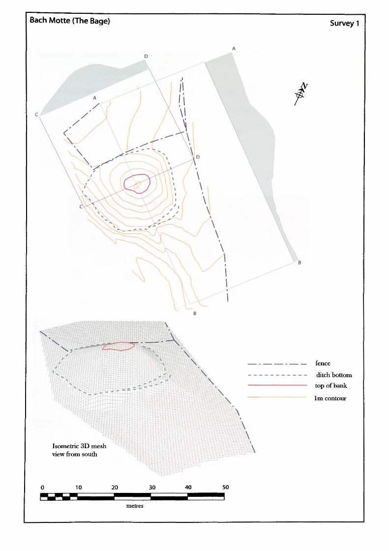
Bach Motte (The Bage) Survey 1
VS5,
\\\\
\
— - — — - — — fence—---------- ditch bottom————————————— top of bank
————————————— 1m contour
Isometric 3D mesh view from south
10 20 30 40 50
metres
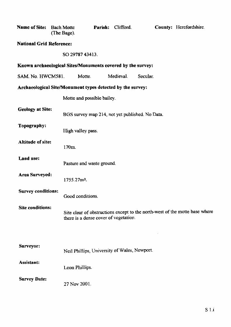
Name of Site: Bach Motte (The Bage).
National Grid Reference:
Parish: Clifford. County: Herefordshire.
SO 29787 43413.
Known archaeological Sites/Monuments covered by the survey:
SAM. No. HWCM581. Motte. Medieval. Secular.
Archaeological Site/Monument types detected by the survey:
Motte and possible bailey.
Geology at Site:
Topography:
Altitude of site:
Land use:
Area Surveyed:
Survey conditions:
Site conditions:
BGS survey map 214, not yet published. No Data.
High valley pass.
170m.
Pasture and waste ground.
1755.27m2.
Good conditions.
Site clear of obstructions except to the north-west of the motte base where there is a dense cover of vegetation.
Surveyor:
Assistant:
Survey Date:
Neil Phillips, University of Wales, Newport.
Leon Phillips.
27Nov2001.
Sl.i
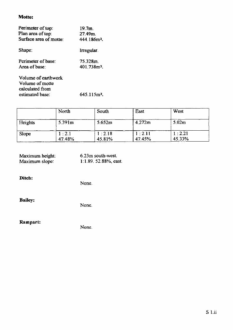
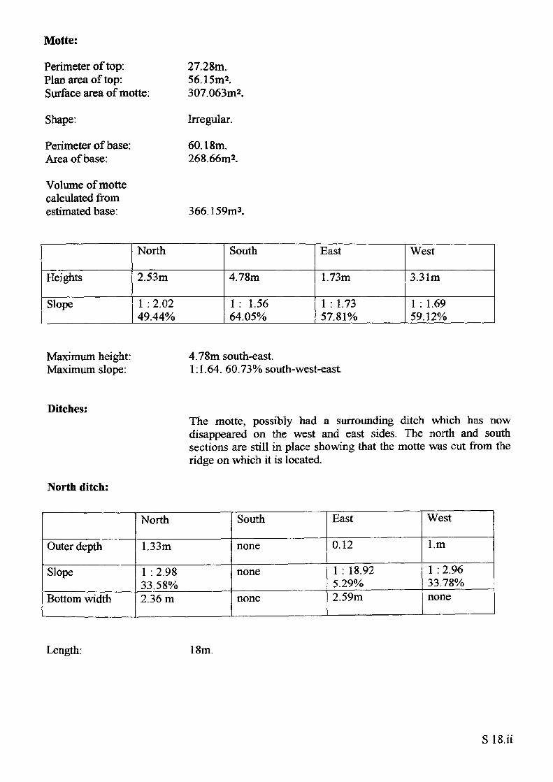
Motte:
Perimeter of top: Plan area of top: Surface area of motte:
Shape:
Perimeter of base: Area of base:
Volume of earthwork Volume of motte calculated from estimated base:
19.7m.27.49m.444.186m2.
Irregular.
75.328m. 401.738m2.
645.115m3.
Heights
Slope
North
5.391m
1 :2.1 47.48%
South
5.652m
1 :2.18 45.81%
East
4.272m
1 :2.1147.45%
West
5.02m
1:2.21 45.33%
Maximum height: Maximum slope:
6.23m south-west. 1:1.89. 52.88%, east.
Ditch:None.
Bailey:None.
Rampart:None.
Sl.ii
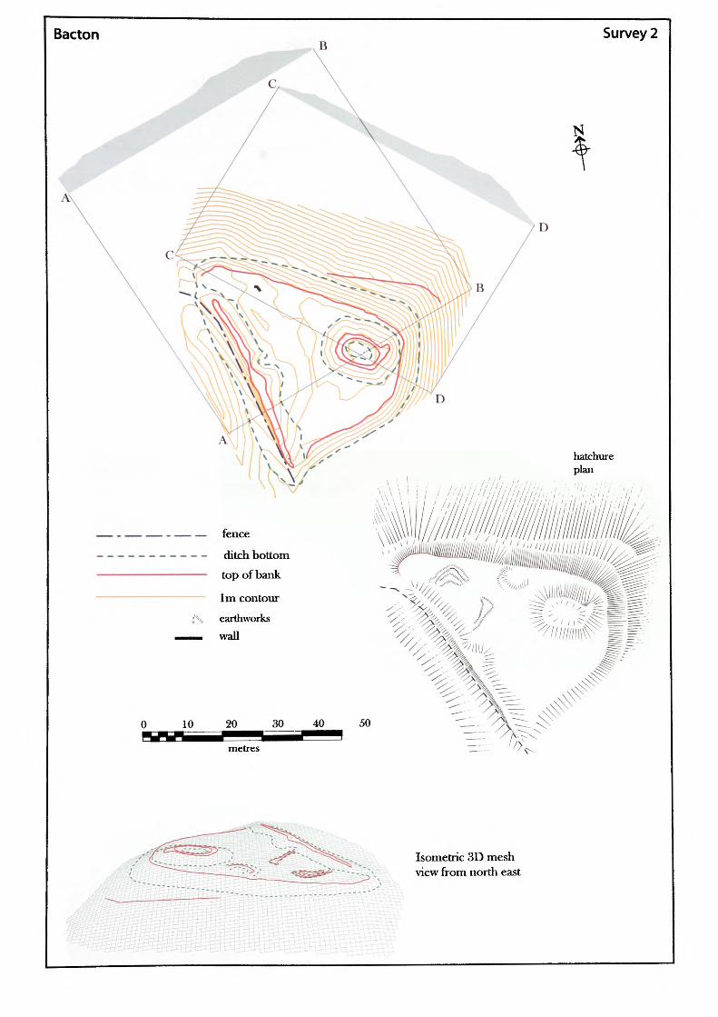
Bacton Survey 2
— fence
— - ditch bottom—— top of bank
— 1m contour
j'\ earthworks__ wall
40 50
Isometric 3D mesh view from north east
Name of Site: Bacton.
National Grid Reference:
Parish: Bacton. County: Herefordshire.
SO 37097 33554.
Known archaeological Sites/Monuments covered by the survey:
SAM. No. HWCM369. Motte and bailey. Medieval. Secular.
Archaeological Site/Monument types detected by the survey:
Motte and bailey.
Geology at Site:
Topography:
Altitude of site:
Land use:
Area Surveyed:
Survey conditions:
Site conditions:
BGS survey map 214, not yet published.Data projected from BGS 215: old red sandstone / Raglan mudstone/Bishop Frome limestone.
Hilltop site.
131m.
Pasture and waste ground.
4175.14m2.
Good conditions.
Site clear of obstructions, except to the west of the western rampart. Heavy vegetation covers this part making survey difficult.
Surveyor:
Assistant:
Survey Date:
Neil Phillips, University of Wales, Newport.
Leon Phillips.
24 Dec 2001.
S2. i
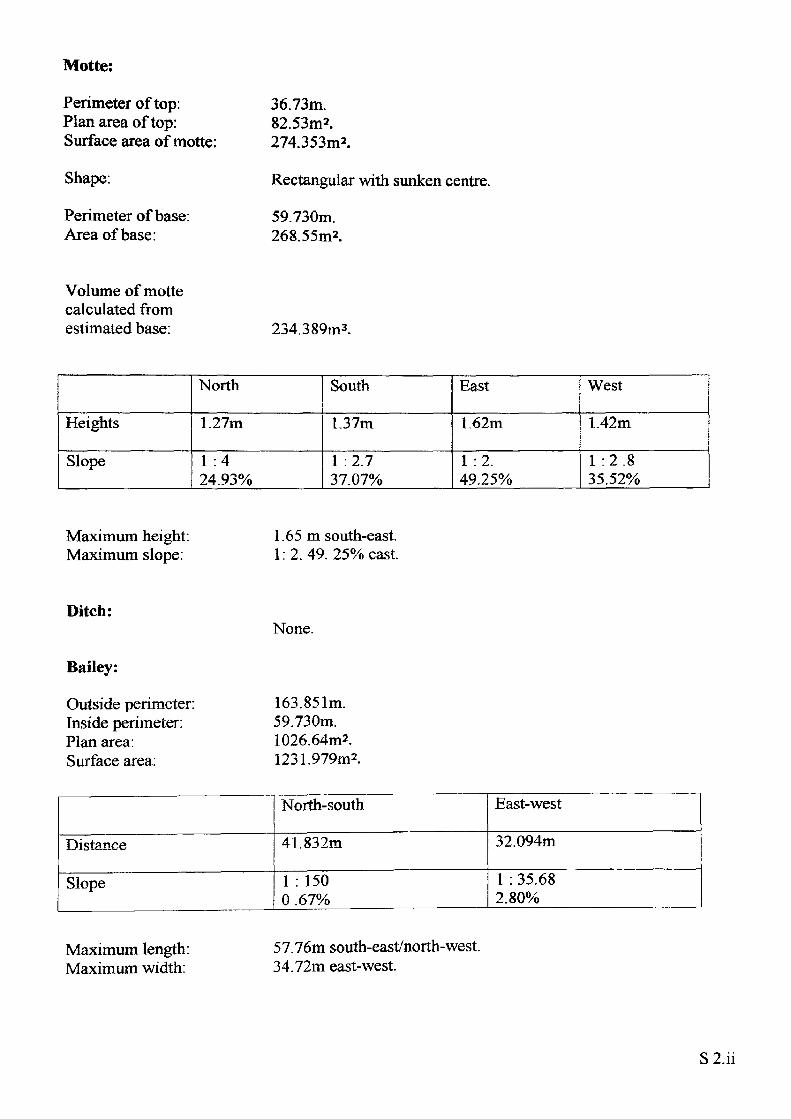
Motte:
Perimeter of top: Plan area of top: Surface area of motte:
Shape:
Perimeter of base: Area of base:
36.73m.82.53m2.274.353m2.
Rectangular with sunken centre.
59.730m. 268.55m2.
Volume of motte calculated from estimated base: 234.389m3.
Heights
Slope
North
1.27m
1 :4 24.93%
South
1.37m
1 :2.7 37.07%
East
1.62m
1 :2. 49.25%
West
1.42m
1 :2.8 35.52%
Maximum height: Maximum slope:
1.65 m south-east. 1:2.49. 25% east.
Ditch:
Bailey:
Outside perimeter: Inside perimeter: Plan area. Surface area:
None.
163.851m. 59.730m. 1026.64m2. 1231.979m2.
Distance
Slope
North-south
41.832m
1 : 150 0 .67%
East-west
32.094m
1 : 35.68 2.80%
Maximum length: Maximum width:
57.76m south-east/north-west. 34.72m east-west.
S2.ii
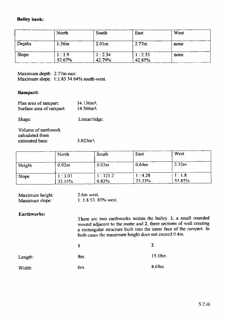
Bailey bank:
Depths
Slope
North
1.36m
1 :1.9 52.67%
South
2.01m
1 : 2.34 42.79%
East
2.77m
1 : 2.33 42.85%
West
none
none
Maximum depth: 2.77m east.Maximum slope: 1:1.83 54.64% south-west.
Rampart:
Plan area of rampart: Surface area of rampart:
Shape:
Volume of earthwork calculated from estimated base:
14.136m2. 14.566m2.
Linear/ridge.
3.023m3.
Height
Slope
North
0.92m
1 :3.01 33.15%
South
0.03m
1 : 121.2 0.83%
East
0.64m
1 : 4.28 23.33%
West
2.32m
1 : 1.853.85%
Maximum height: Maximum slope:
2.6m west.1: 1.853. 85% west.
Earthworks:
Length:
Width:
There are two earthworks within the bailey. 1, a small rounded mound adjacent to the motte and 2, three sections of wall creating a rectangular structure built into the inner face of the rampart. In both cases the maximum height does not exceed 0.4m.
1
8m.
6m.
15.18m.
8.68m.
S 2.iii
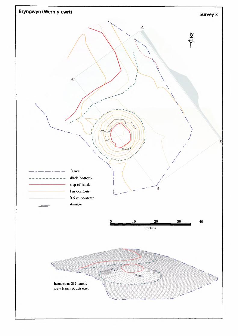
Bryngwyn (Wern-y-cwrt) Survey 3
\\
\
fence
ditch bottom
top of bank 1m contour
0.5 m contour damage
10 20
metres
30 40
Isometric 3D mesh view from south east
Name of Site: Bryngwyn.
National Grid Reference:
Parish: Llanarth. County: Gwent.
SO 39362 08799.
Known archaeological Sites/Monuments covered by the survey:
SAM. No. MM0801. Castle mound. Medieval. Secular.
Archaeological Site/Monument types detected by the survey:
Motte and possible bailey.
Geology at Site:
Topography:
Altitude of site:
Land use:
Area Surveyed:
Survey conditions:
Site conditions:
Glacial deposits of Morrainc drift.
Valley site.
58m.
Pasture and waste ground.
4004.236m2.
Good conditions.
Site surroundings were clear of obstructions. The south-west side of the site has been truncated by modern boundary hedges. The motte top and sides were covered by vegetation.
Surveyor:
Assistant:
Survey Date:
Neil Phillips, University of Wales, Newport.
Paul Huckfield.
17 Feb 2002.
S3.i
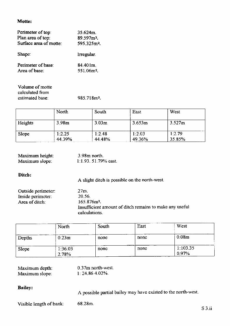
Motte:
Perimeter of top: Plan area of top: Surface area of motte:
Shape:
Perimeter of base: Area of base:
35.624m.89.597m2.595.325m2.
Irregular.
84.401m. 551.06m2.
Volume of motte calculated from estimated base: 985.71
Heights
Slope
North
3.98m
1:2.25 44.39%
South
3.03m
1:2.48 44.48%
East
3.653m
1:2.03 49.36%
West
3.527m
1:2.79 35.85%
Maximum height: Maximum slope:
3.98m north. 1:1.93. 51.79% east
Ditch:
Outside perimeter: Inside perimeter: Area of ditch:
A slight ditch is possible on the north-west.
27m.20.56.165.876m2.Insufficient amount of ditch remains to make any usefulcalculations.
Depths
Slope
North
0.23m
1:36.03 2.78%
South
none
none
East
none
none
West
0.08m
1:103.35 0.97%
Maximum depth: Maximum slope:
0.37m north-west. 1:24.864.02%.
Bailey:
Visible length of bank:
A possible partial bailey may have existed to the north-west.
68.28m.S3.ii
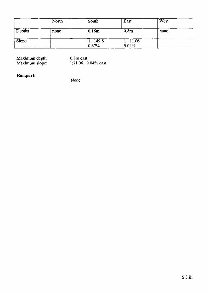
Depths
Slope
North
none
South
0.16m
1 : 149.8 0.67%
East
0.8m
1 : 11.06 9.04%
West
none
Maximum depth: Maximum slope:
0.8m east.1:11.06. 9.04% east.
Rampart:None.
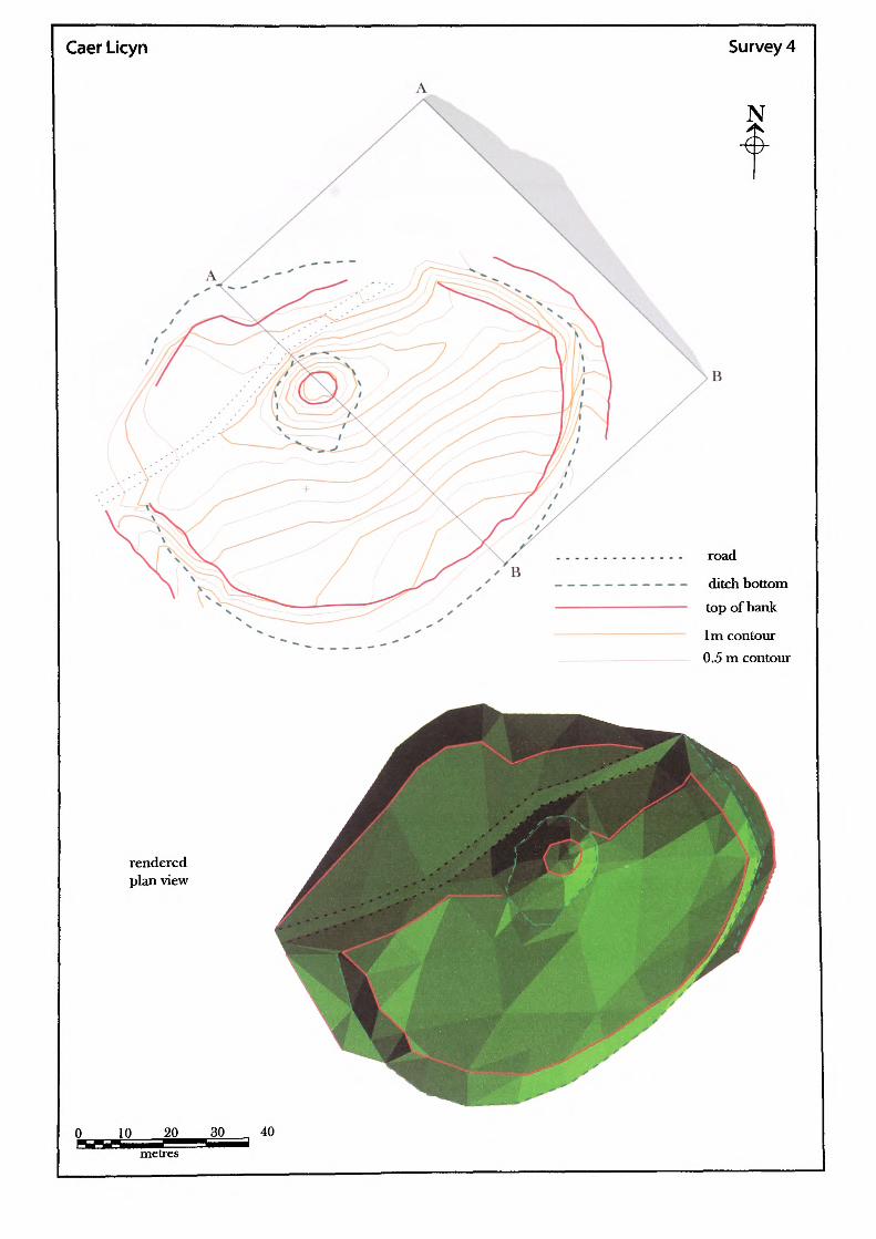
Caer Licyn Survey 4
N
road
ditch bottomtop of bank
1m contour 0.5 m contour
rendered plan view
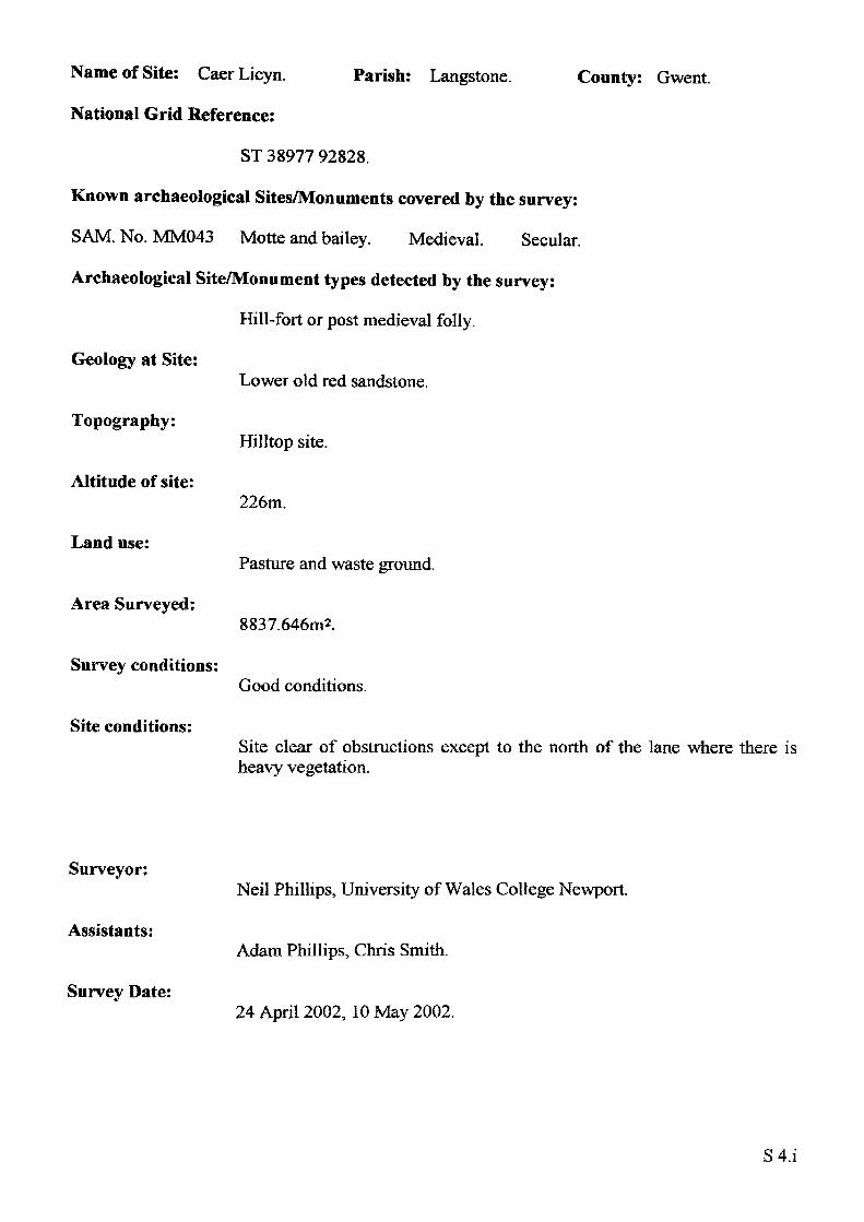
Name of Site: Caer Licyn.
National Grid Reference:
Parish: Langstone. County: Gwent.
ST 38977 92828.
Known archaeological Sites/Monuments covered by the survey:
SAM. No. MM043 Motte and bailey. Medieval. Secular.
Archaeological Site/Monument types detected by the survey:
Hill-fort or post medieval folly.
Geology at Site:
Topography:
Altitude of site:
Land use:
Area Surveyed:
Survey conditions:
Site conditions:
Lower old red sandstone.
Hilltop site.
226m.
Pasture and waste ground.
8837.646m2.
Good conditions.
Site clear of obstructions except to the north of the lane where there is heavy vegetation.
Surveyor:
Assistants:
Survey Date:
Neil Phillips, University of Wales College Newport.
Adam Phillips, Chris Smith.
24 April 2002, 10 May 2002.
S4.i
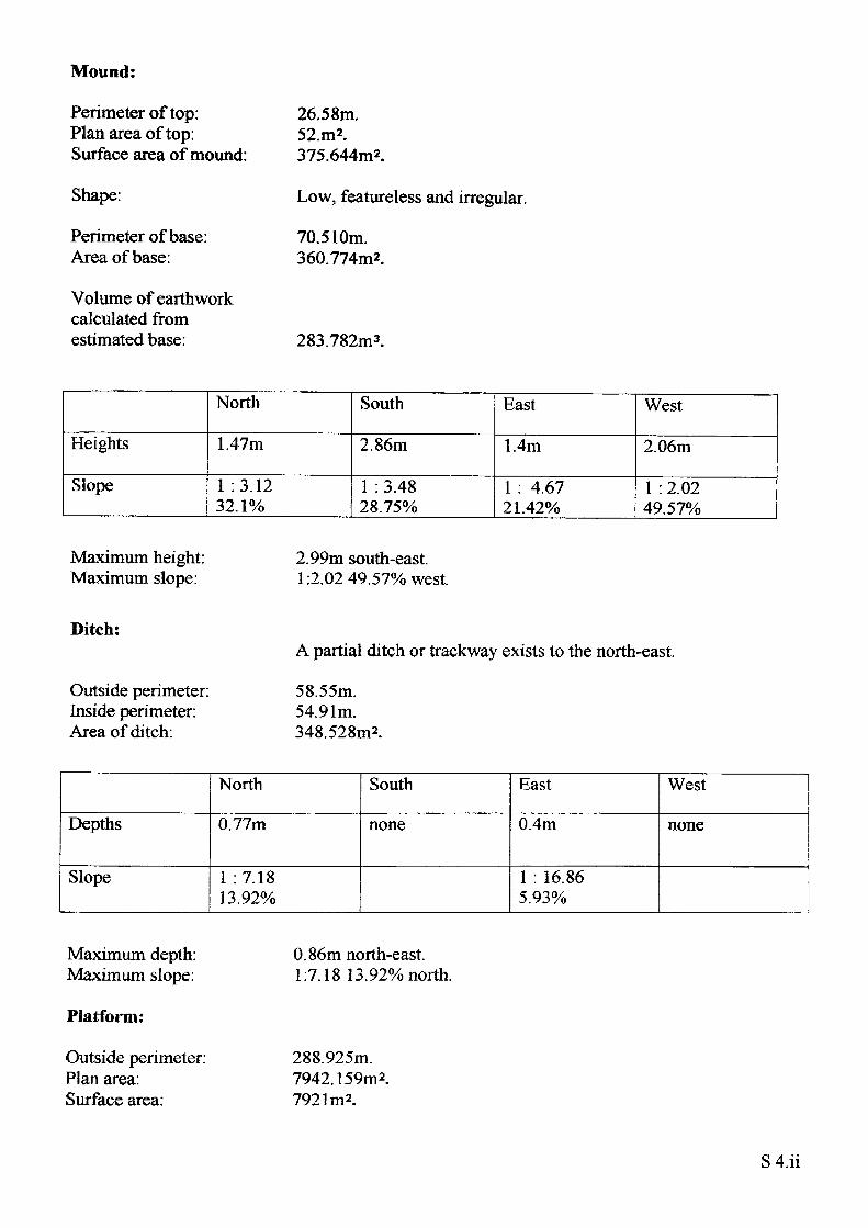
Mound:
Perimeter of top: Plan area of top: Surface area of mound:
Shape:
Perimeter of base: Area of base:
Volume of earthwork calculated from estimated base:
26.58m.52.m2.375.644m2.
Low, featureless and irregular.
70.510m. 360.774m2.
283.782m3.
Heights
Slope
North
1.47m
1 .3.12 32.1%
South
2.86m
1 : 3.48 28.75%
East
1.4m
1 : 4.67 21.42%
West
2.06m
1 : 2.02 49.57%
Maximum height: Maximum slope:
2.99m south-east.1:2.02 49.57% west.
Ditch:
Outside perimeter: Inside perimeter: Area of ditch:
A partial ditch or trackway exists to the north-east.
58.55m. 54.91m. 348.528m2.
Depths
Slope
North
0.77m
1 :7.18 13.92%
South
none
East
0.4m
1 : 16.865.93%
West
none
Maximum depth: Maximum slope:
Platform;
Outside perimeter: Plan area: Surface area.
0.86m north-east. 1:7.18 13.92% north.
288.925m. 7942.159m 2. 792 Im2.
S4.ii
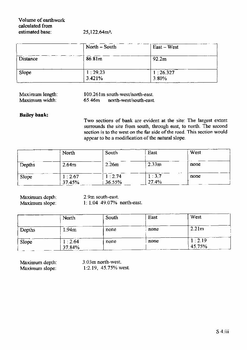
Volume of earthwork calculated from estimated base: 25,122.64m3.
Distance
Slope
North - South
86.81m
1 : 29.23 3.421%
East - West
92.2m
1 : 26.327 3.80%
Maximum length: Maximum width:
100.2 61 m south- west/north-east. 65.46m north-west/south-east.
Bailey bank:Two sections of bank are evident at the site: The largest extent surrounds the site from south, through east, to north. The second section is to the west on the far side of the road. This section would appear to be a modification of the natural slope.
Depths
Slope
North
2.64m
1 : 2.67 37.45%
South
2.26m
1 : 2.74 36.55%
East
2.33m
1 :3.7 27.4%
West
none
none
Maximum depth: Maximum slope:
2.9m south-east.1: 1.04 49.07% north-east.
Depths
Slope
North
1.94m
1 : 2.64 37.84%
South
none
none
East
none
none
West
2.21m
1 :2.1945.75%
Maximum depth: Maximum slope:
3.03m north-west. 1:2.19, 45.75% west.
S 4.iii
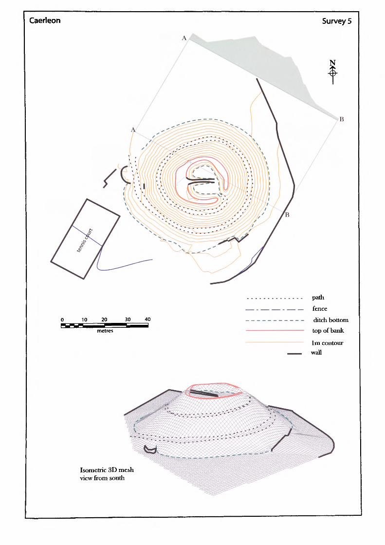
Caerleon Survey 5
B
10 20 30 40
path
fence
ditch bottom
top of bank
1m contour
wall
Isometric 3D mesh view from south
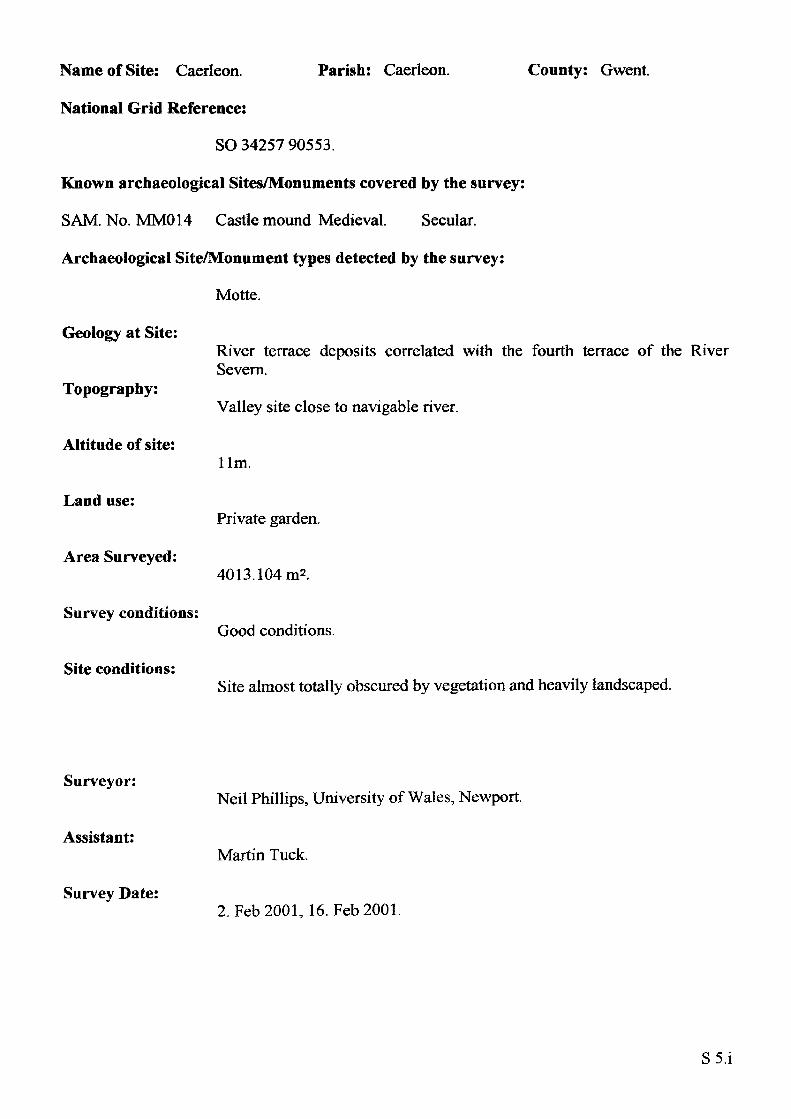
Name of Site: Caerleon.
National Grid Reference:
Parish: Caerleon. County: Gwent.
SO 34257 90553.
Known archaeological Sites/Monuments covered by the survey:
SAM. No. MM014 Castle mound Medieval. Secular.
Archaeological Site/Monument types detected by the survey:
Motte.
Geology at Site:
Topography:
Altitude of site:
Land use:
Area Surveyed:
Survey conditions:
Site conditions:
River terrace deposits correlated with the fourth terrace of the River Severn.
Valley site close to navigable river.
llm.
Private garden.
4013.104m2.
Good conditions.
Site almost totally obscured by vegetation and heavily landscaped.
Surveyor:
Assistant:
Survey Date:
Neil Phillips, University of Wales, Newport.
Martin Tuck.
2. Feb2001, 16. Feb2001.
SS.i
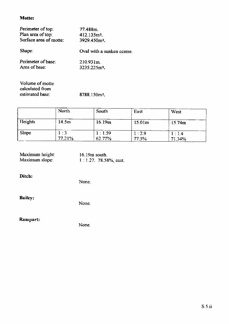
Motte:
Perimeter of top: Plan area of top: Surface area of motte:
Shape:
Perimeter of base: Area of base:
77.488m.412.135m2.3929.450m2.
Oval with a sunken centre.
210.931m.3235.225m2.
Volume of motte calculated from estimated base: 8788.150m3.
Heights
Slope
North
14.5m
1 :3 77.21%
South
16.19m
1 : 1.5962.77%
East
15.01m
1:2.9 77.5%
West
15.74m
1 : 1.4 71.34%
Maximum height: Maximum slope:
16.19m south.1 : 1.27. 78.58%, east.
Ditch:None.
Bailey:None.
Rampart:None.
S5.ii
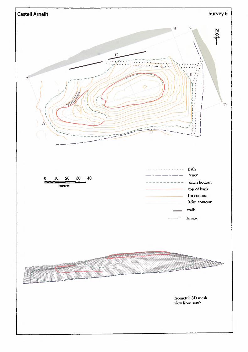
Castell Arnallt Survey 6
N
0 10 20 30 40
metres
path fence
ditch bottom top of bank 1m contour 0.5m contour
walls
damage
Isometric 3D mesh view from south
D
Name of Site: Castell Arnallt. Parish: Llanover.
National Grid Reference:
SO 31942 10019.
Known archaeological Sites/Monuments covered by the survey:
SAM. No. MM082. Castle Arnold. Medieval. Secular.
Archaeological Site/Monument types detected by the survey:
Llys.
Geology at Site:
County: Gwent.
Topography:
Altitude of site:
Land use:
Area Surveyed:
Survey conditions:
Site conditions:
Alluvium.
Valley site.
39m.
Pasture.
10,491.391m2.
Good conditions.
Site clear of obstructions.
Surveyor:
Assistant:
Survey Date:
Neil Phillips, University of Wales, Newport.
Frank Olding.
14 April 2000.
S6.i
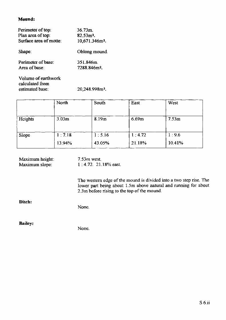
Mound:
Perimeter of top: Plan area of top: Surface area of motte:
Shape:
Perimeter of base: Area of base:
Volume of earthwork calculated from estimated base:
36.73m.82.53m2.10,671.346m2.
Oblong mound.
351.846m. 7288.846m2.
20,248.998m3.
Heights
Slope
North
3.03m
1 :7.18 13.94%
South
8.19m
1 :5.16 43.05%
East
6.69m
1 : 4.72 21.18%
West
7.53m
1 :9.6 10.41%
Maximum height: Maximum slope:
7.53m west.1 :4.72. 21.18% east.
Ditch:
The western edge of the mound is divided into a two step rise. The lower part being about 1.5m above natural and running for about 2.3m before rising to the top of the mound.
None.
Bailey:None.
S6.ii
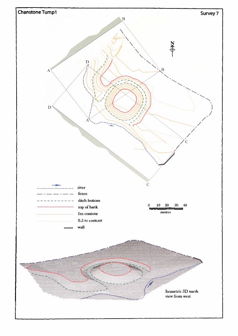
ChanstoneTumpI Survey 7
J
———————————— nver— - — — - — — fence
—---------- ditch bottom
top of bank 1m contour
0.5 m contour
waJl
0 10 20 30 40552S metres
Isometric 3D mesh view from west
Name of Site: Chanstone Tump 1. Parish: Vowchurch.
National Grid Reference:
SO 36547 35894.
Known archaeological Sites/Monuments covered by the survey:
SAM. No. HWCM1535. Motte and bailey. Medieval. Secular.
Archaeological Site/Monument types detected by the survey:
Fortified-site.
County: Herefordshire.
Geology at Site:
Topography:
Altitude of site:
Land use:
Area Surveyed:
Survey conditions!
Site conditions:
BGS survey map 214, not yet published.
Valley site.
I04m.
Pasture.
13,166.538m2.
Good conditions.
Site clear of obstructions.
Surveyor:
Assistant:
Survey Date:
Neil Phillips, University of Wales, Newport.
Adam Phillips.
20Feb2001.
S7.i
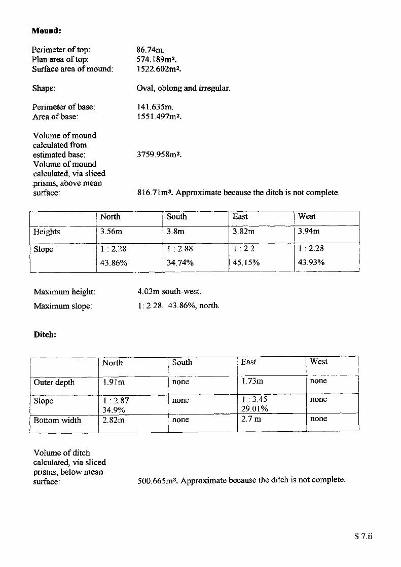
Mound:
Perimeter of top: Plan area of top: Surface area of mound:
Shape:
Perimeter of base: Area of base:
Volume of mound calculated from estimated base: Volume of mound calculated, via sliced prisms, above mean surface:
86.74m.574.189m2.1522.602m2.
Oval, oblong and irregular.
141.635m. 1551.497m2.
3759.958m3.
816.71m3. Approximate because the ditch is not complete.
Heights
Slope
North3.56m
1 : 2.28 43.86%
South3.8m
1 : 2.88 34.74%
East3.82m
1 :2.2 45.15%
West3.94m
1 : 2.28 43.93%
Maximum height: Maximum slope:
4,03m south-west. 1:2.28. 43.86%, north.
Ditch:
Outer depth
Slope
Bottom width
North
1.91m
1 : 2.87 34.9%2.82m
South
none
none
none
East
1.73m
1 : 3.45 29.01%2.7m
West
none
none
none
Volume of ditch calculated, via sliced prisms, below mean surface: 500.665m3. Approximate because the ditch is not complete.
S7.ii
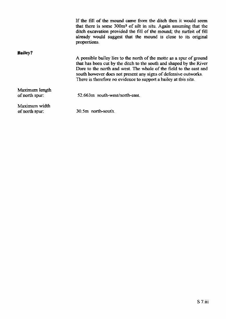
If the fill of the mound came from the ditch then it would seem that there is some 300m3 of silt in situ. Again assuming that the ditch excavation provided the fill of the mound; the surfeit of fill already would suggest that the mound is close to its original proportions.
Bailey?A possible bailey lies to the north of the motte as a spur of ground that has been cut by the ditch to the south and shaped by the River Dore to the north and west. The whole of the field to the east and south however does not present any signs of defensive outworks. There is therefore no evidence to support a bailey at this site.
Maximum lengthof north spur: 52.663m south-west/north-east.
Maximum widthof north spur: 30.5m north-south.
S 7.iii
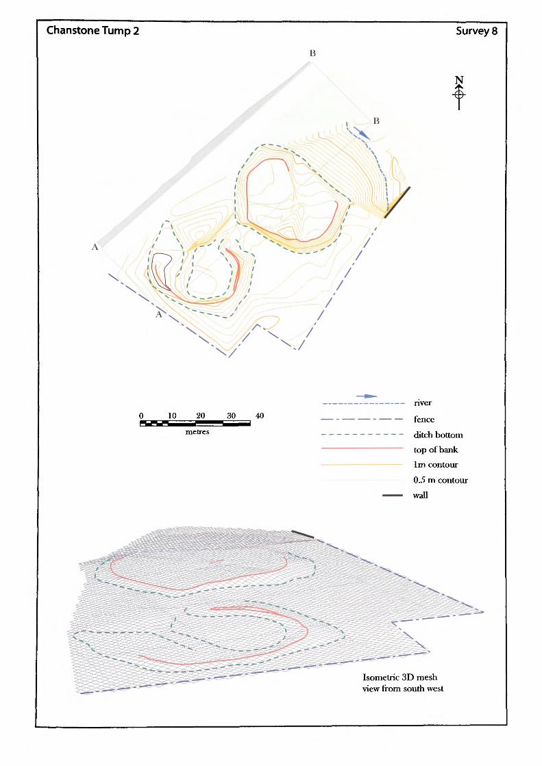
ChanstoneTump2
B
B
Survey 8
N
nver
fence
ditch bottom
top of bank
1m contour
0.5 m contour
wall
Isometric 3D mesh view from south west
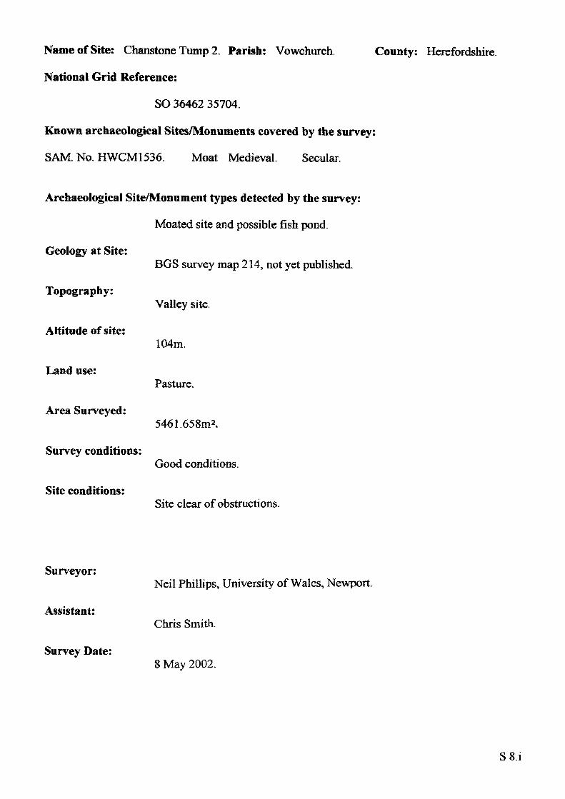
Name of Site: Chanstone Tump 2. Parish: Vowchurch.
National Grid Reference:
SO 36462 35704.
Known archaeological Sites/Monuments covered by the survey:
SAM No. HWCM1536. Moat Medieval. Secular.
Archaeological Site/Monument types detected by the survey:
Moated site and possible fish pond.
Geology at Site:
County: Herefordshire.
Topography:
Altitude of site:
Land use:
Area Surveyed:
Survey conditions:
Site conditions:
BGS survey map 214, not yet published.
Valley site.
104m.
Pasture.
5461.658m2.
Good conditions.
Site clear of obstructions.
Surveyor:
Assistant:
Survey Date:
Neil Phillips, University of Wales, Newport.
Chris Smith.
8 May 2002.
S8.i
Moated Site:
Perimeter of top: Plan area of top: Surface area of mound:
Shape:
Maximum length: Maximum width: Perimeter of base: Area of base: Volume of earthwork calculated from estimated base:
101.632m.723.172m2.1227.929m2.
Rectangular.
34m north-west/south-east. 25m north-east/south-west. 131.271m. 1218.142m*.
714.424m3.
Heights
Slope
North
0.67m
1 :7.9 12.66%
South
1.06m
1 : 4.72 21.18%
East
0.66m
1 :6.15 16.27%
West
0.34m
1 : 15.11 6.62%
Maximum height: Maximum slope:
1.17m south-east1:4.14. 24.14%, south-west.
Fish pond?
Shape:
Maximum length: Maximum width: Perimeter of base: Area of base: Volume of earthwork calculated from estimated base:
Rectangular with central depression Open to north.
29.5m north-west/south-east. 17.9m north-east/south-west. 182.876m. 705.028m2.
106.811m3.
Outer height
Slope
Inner depth
Slope
North
0.33m
1 : 9.38 10.66%0.26m
1 : 14.36 9.97%
South
0.24m
1 : 9.8610.14%0.21m
1 : 19.25.21%
East
0.56m
1 : 11.78 8.49%0.29m
1 : 6.8414.63%
West
0.39m
1 : 12 8.33%0.39m
1 : 23.14 4.32%
SS.ii

Maximum height: 0.56m east. Maximum slope: 1 : 9.38. 10.66% north.
Maximum lengthof central depression: 20.27m north-east/south-west.
Maximum widthof central depression: 14.7m north-west/south-east.
Area of central depression: 253.646m2 .
S S.iii
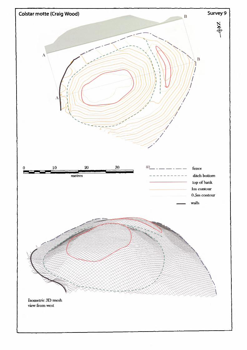
Colstar motte (Craig Wood)B
Survey 9
10 20 30 40
metres
fence
ditch bottom
top of bank 1m contour 0.5m contour
walls
Isometric 3D mesh view from west
Name of Site: Colstar Motte. Parish: Caerleon.
National Grid Reference:
ST 31872 92533.
Known archaeological Sites/Monuments covered by the survey:
SAM. No. MM087. Castle mound. Medieval. Secular.
Archaeological Site/Monument types detected by the survey:
Motte.
County: Gwent.
Geology at Site:
Topography:
Altitude of site:
Land use:
Area Surveyed:
Survey conditions:
Site conditions:
Glacial sand and gravel.
Valley site.
29m.
Private garden.
1484.190m2,
Good conditions.
Site heavily landscaped as garden feature.
Surveyor:
Assistant:
Survey Date:
Neil Phillips, University of Wales, Newport.
Adam Phillips.
4 Sept 2001.
S9.i
Motte:
Perimeter of top: Plan area of top: Surface area of motte:
Shape:
Perimeter of base: Area of base:
Volume of motte calculated from estimated base:
52.77m.190.08m*.830.457m2.
Oval.
99.03m. 738.43m*.
195.933m3.
Heights
Slope
North
4.213m
1 :84 54.05%
South
5.89m
1 :54 65.16%
East
4.89m
1 :3 57.77%
West
2.58m
1 :8.4 54.27%
Maximum height: Maximum slope:
5.89m south.1:54. 65.16% south.
Ditch:The ditch to the north and west is a heavily landscaped feature with little original value except for its alignment. A partial section of ditch exists to the east.
Outer depth
Slope
Inner depth
Slope
Bottom width
North
none
none
none
none
none
South
none
none
none
none
none
East
none
none
3.77m
1 :2.37 42.16%Common point
West
1.0m
1 : 2.96 33.78%none
none
none
Width: Length:
Common point. 13m.
S9.ii
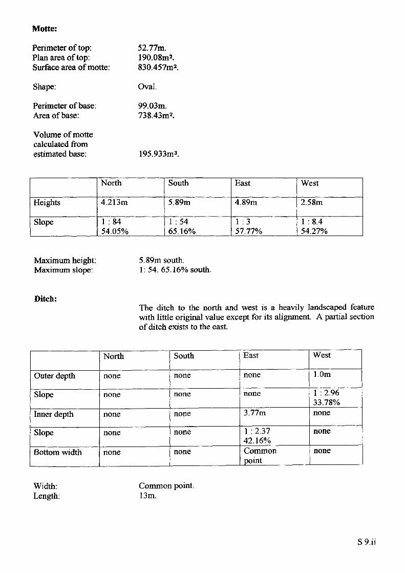
Rampart:
Perimeter of top: Plan area of top: Surface area of rampart:
Shape:
Perimeter of base: Area of base:
Volume of earthwork calculated from estimated base:
35.18m.26m2.NAm2.
Crescentic.
NAm. NAm2.
NAm3 (east side has no recognisable edge until modern cut).
Heights
Slope
North
0.972m
1 : 5.71 17.51%
South
0.13m
1 :9.16 10.92%
East
3.77m
1 : 2.37 42.16%
West
1.0m
1 : 2.9633.78%
Maximum length: Maximum width:
16.59m north-south. 2.56m east-west.
Bailey:The layout of the site would suggest that the bailey lay to the west but the modern house, garden, swimming pool and lawns have removed any trace of this feature.
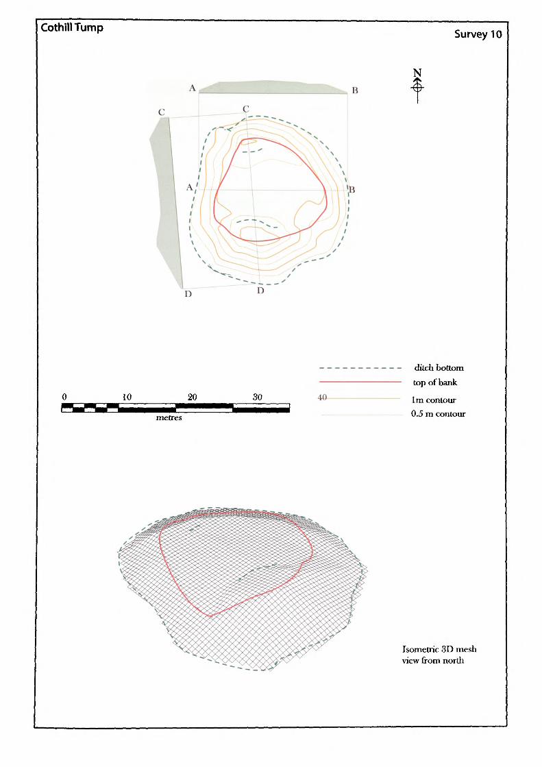
CothillTump Survey 10
NB
10 20
metres
30 40
ditch bottom top of bank
1m contour 0.5 m contour
Isometric 3D mesh view from north
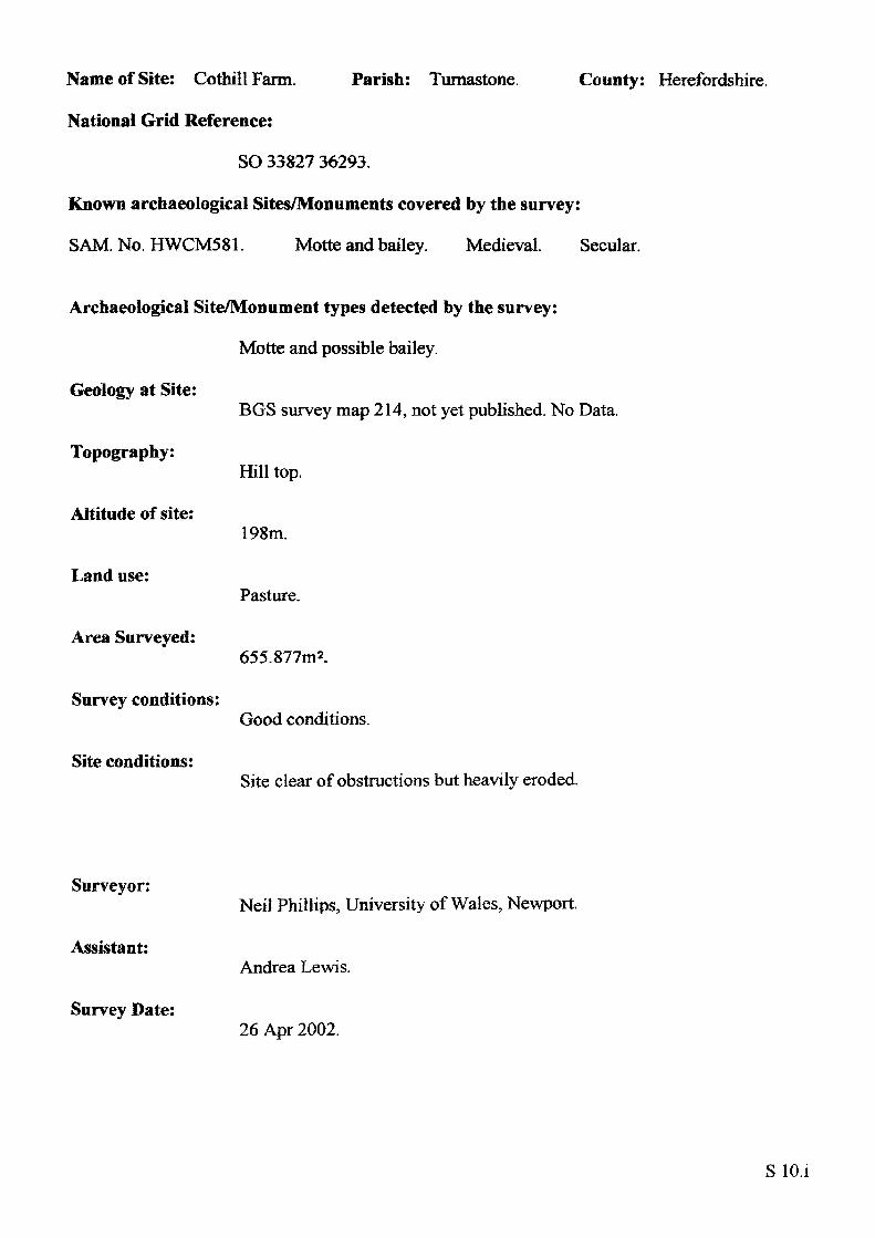
Name of Site: CothillFarm. Parish: Turnastone. County: Herefordshire.
National Grid Reference:
SO 33827 36293.
Known archaeological Sites/Monuments covered by the survey:
SAM. No. HWCM581. Motte and bailey. Medieval. Secular.
Archaeological Site/Monument types detected by the survey:
Motte and possible bailey.
Geology at Site:
Topography:
Altitude of site:
Land use:
Area Surveyed:
Survey conditions:
Site conditions:
BGS survey map 214, not yet published. No Data.
Hill top.
198m.
Pasture.
655.877m2.
Good conditions.
Site clear of obstructions but heavily eroded.
Surveyor:
Assistant:
Survey Date:
Neil Phillips, University of Wales, Newport.
Andrea Lewis.
26 Apr 2002.
SlO.i
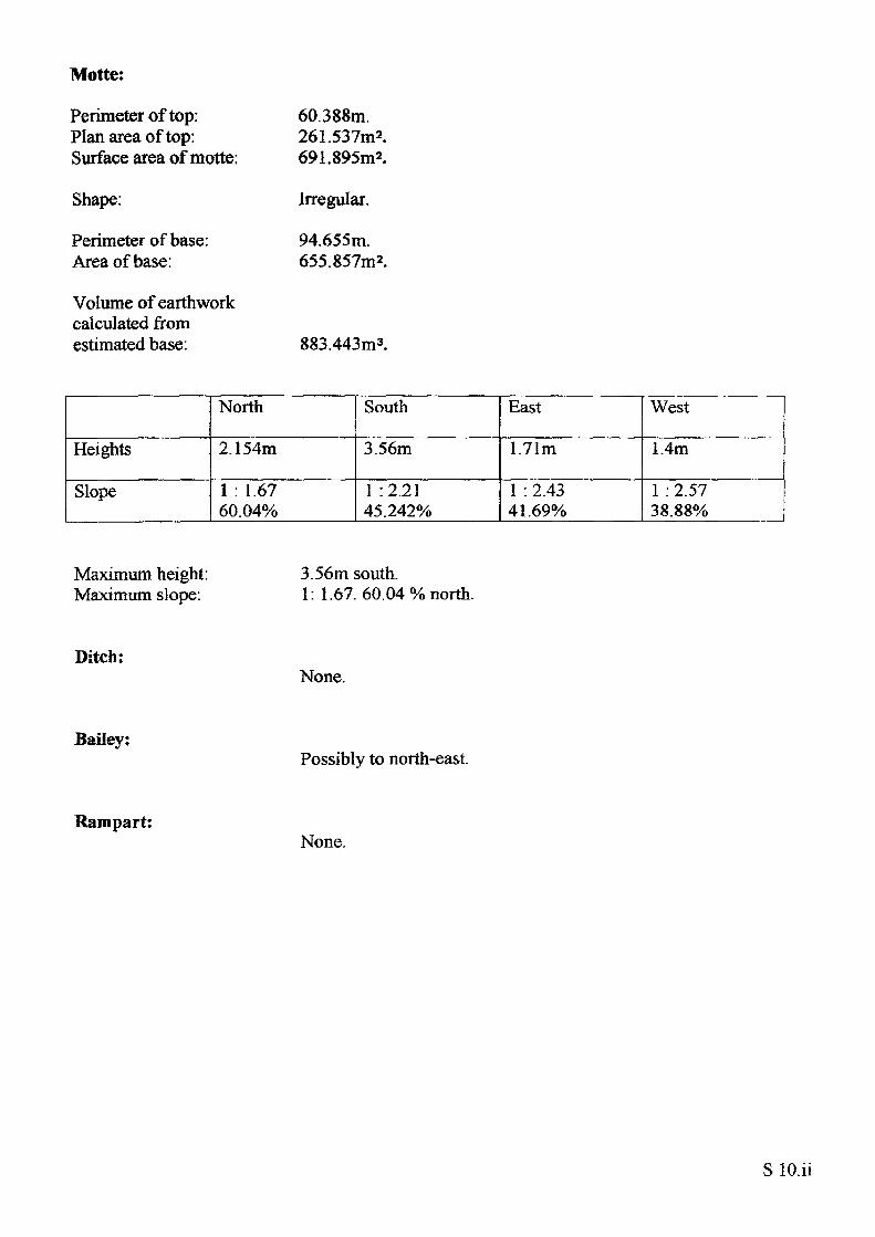
Motte:
Perimeter of top: Plan area of top: Surface area of motte:
Shape:
Perimeter of base: Area of base:
Volume of earthwork calculated from estimated base:
60.388m.261.537m2.691.895m2.
Irregular.
94.655m. 655.857m2.
883.443m3.
Heights
Slope
North
2.154m
1 : 1.67 60.04%
South
3.56m
1 '.2.21 45.242%
East
1.71m
1 : 2.43 41.69%
West
1.4m
1 : 2.57 38.88%
Maximum height: Maximum slope:
3.56m south.1: 1.67. 60.04% north.
Ditch:None.
Bailey:Possibly to north-east.
Rampart:None.
S lO.ii
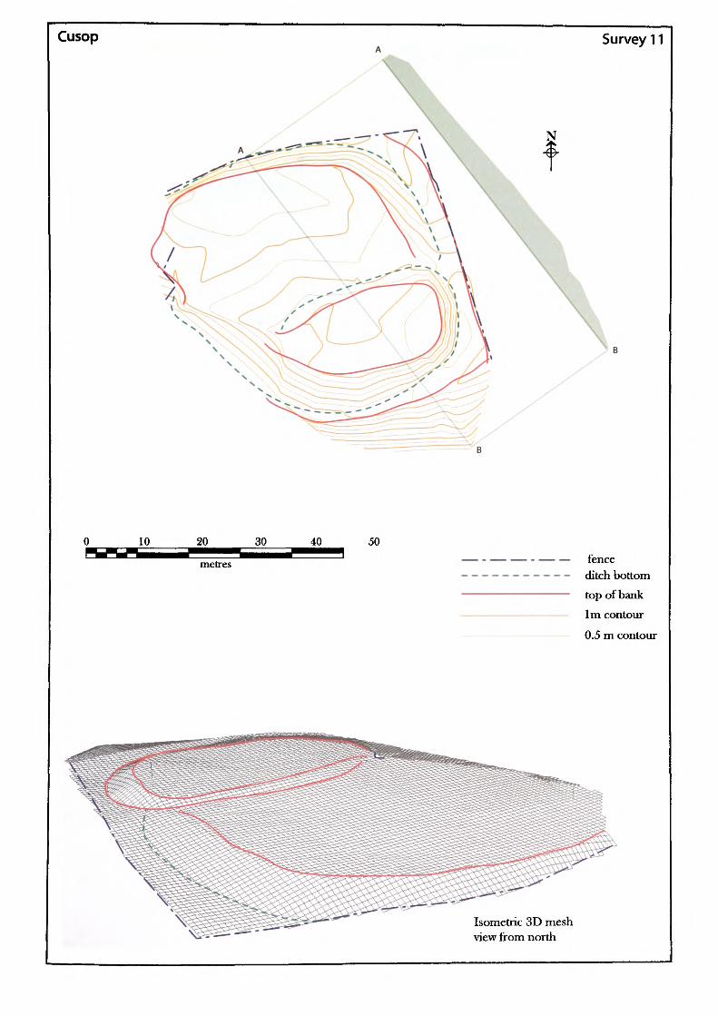
Cusop Survey 11
30 40 50fenceditch bottom top of bank 1m contour
0.5 m contour
Isometric 3D mesh view from north
Name of Site: Cusop Castle.
National Grid Reference:
Parish: Cusop. County: Herefordshire.
SO 33922 41393.
Known archaeological Sites/Monuments covered by the survey:
SAM. No. HWCM369. Castle ring-work. Medieval. Secular.
Archaeological Site/Monument types detected by the survey:
Fortified-site.
Geology at Site:
Topography:
Altitude of site:
Land use:
Area Surveyed:
Survey conditions:
Site conditions:
BGS survey map 214, not yet published. No data.
Valley site.
14 1m.
Pasture and waste ground.
7290.139m2.
Good conditions.
Site clear of obstructions.
Surveyor:
Assistant:
Survey Date:
Neil Phillips, University of Wales, Newport.
Chris Smith.
31 May 2002.
Sll.i
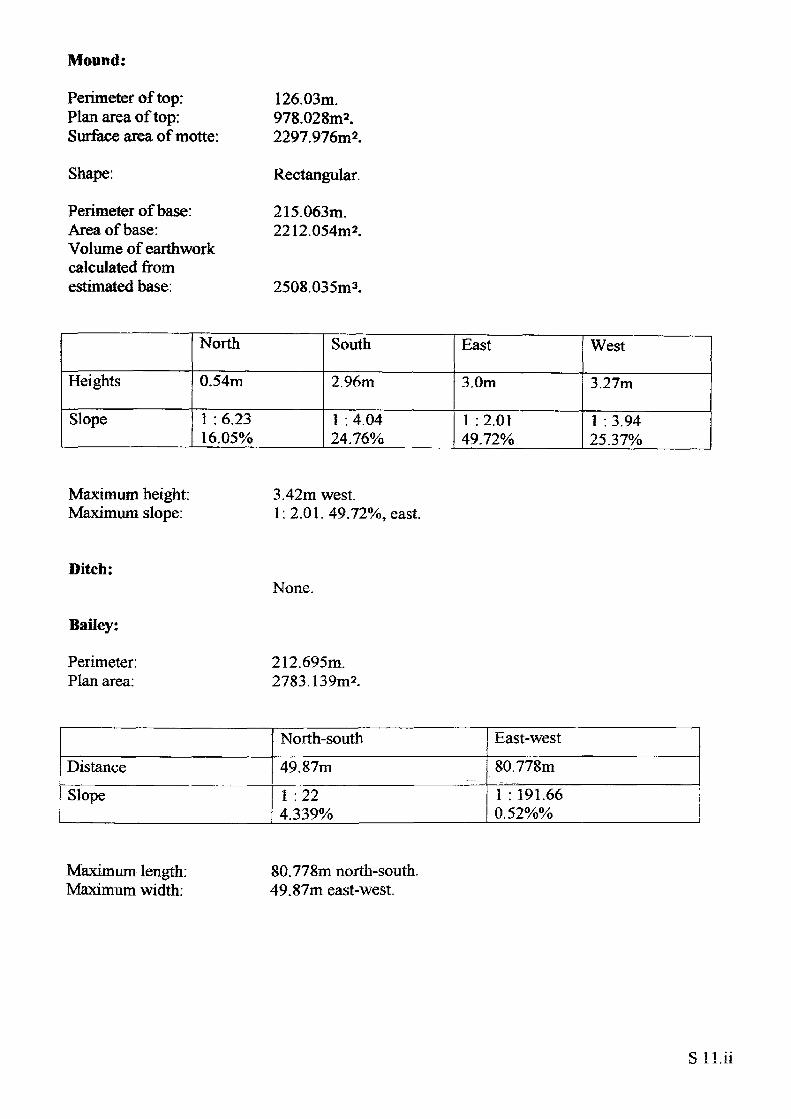
Mound:
Perimeter of top: Plan area of top: Surface area ofmotte:
Shape:
Perimeter of base: Area of base: Volume of earthwork calculated from estimated base:
126.03m.978.028m2.2297.976m2.
Rectangular.
215.063m. 2212.054m*.
2508.035m3.
Heights
Slope
North
0.54m
1 : 6.23 16.05%
South
2.96m
1 : 4.04 24.76%
East
3.0m
1 :2.01 49.72%
West
3.27m
1 : 3.94 25.37%
Maximum height- Maximum slope:
3.42m west.1:2.01.49.72%, east.
Ditch:
Bailey:
None.
Perimeter: 212.695m. Plan area: 2783.139m2.
Distance
Slope
North-south
49.87m1 :22 4.339%
East-west80.778m1 : 191.660.52%%
Maximum length: Maximum width:
80.778m north-south. 49.87m east-west.
Sll.ii
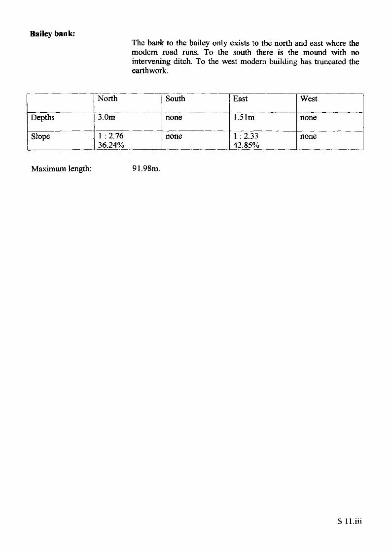
Bailey bank:The bank to the bailey only exists to the north and east where the modern road runs. To the south there is the mound with no intervening ditch. To the west modern building has truncated the earthwork.
Depths
Slope
North
3.0m
1 : 2.76 36.24%
South
none
none
East
1.51m
1 : 2.33 42.85%
West
none
none
Maximum length: 91.98m.
S ll.iii
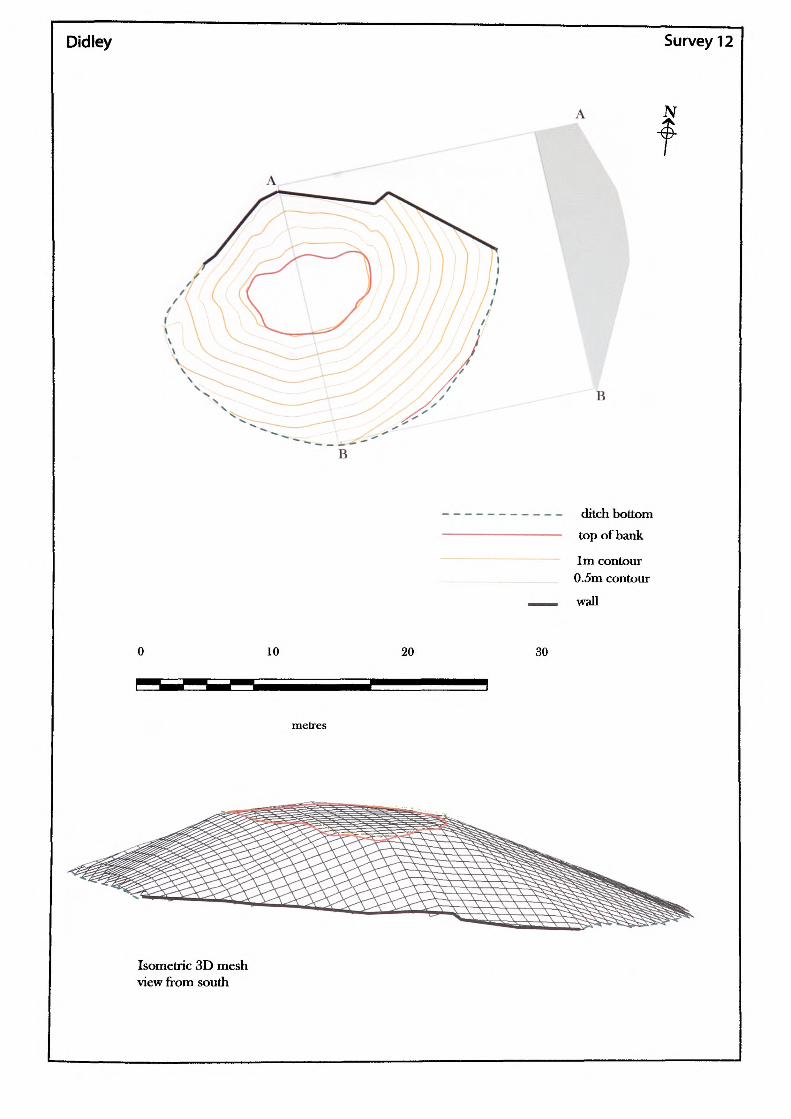
Didley Survey 12
B
ditch bottom top of bank
1m contour 0.5m contour
wall
10 20 30
metres
Isometric 3D mesh view from south
Name of Site: Didley Court Farm. Parish: StDevereux.
National Grid Reference:
SO 45022 31964.
Known archaeological Sites/Monuments covered by the survey:
SAM. No. HWCM581. Motte and bailey. Medieval. Secular.
Archaeological Site/Monument types detected by the survey:
Motte.
County: Herefordshire.
Geology at Site:
Topography:
Altitude of site:
Land use:
Area Surveyed:
Survey conditions:
Site conditions:
Glacial deposits, undifferentiated; includes morainic sandy tills, gravels and clays.
Valley.
100m.
Private garden.
1755.27m2.
Good conditions.
The site is clear of obstructions. Due to landscaping, very little remains of this site.
Surveyor:
Assistant:
Survey Date:
Neil Phillips, University of Wales, Newport.
Adam Phillips.
19 Jul 2000.
S12.i
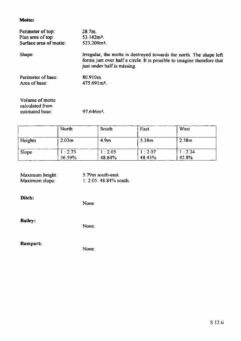
Motte:
Perimeter of top: Plan area of top: Surface area of motte:
Shape:
Perimeter of base: Area of base:
28.7m.53.142m2.523.209m2.
Irregular, the motte is destroyed towards the north. The shape left forms just over half a circle. It is possible to imagine therefore that just under half is missing.
80.910m. 475.691m*.
Volume of motte calculated from estimated base: 97.646m3.
Heights
Slope
North
2.03m
1 : 2.73 36.59%
South
4.9m
1 : 2.05 48.84%
East
5.38m
1 : 2.07 48.43%
West
2.38m
1 : 2.34 42.8%
Maximum height: Maximum slope:
5.79m south-east. 1:2.05. 48.84% south.
Ditch:None.
Bailey:None.
Rampart:None.
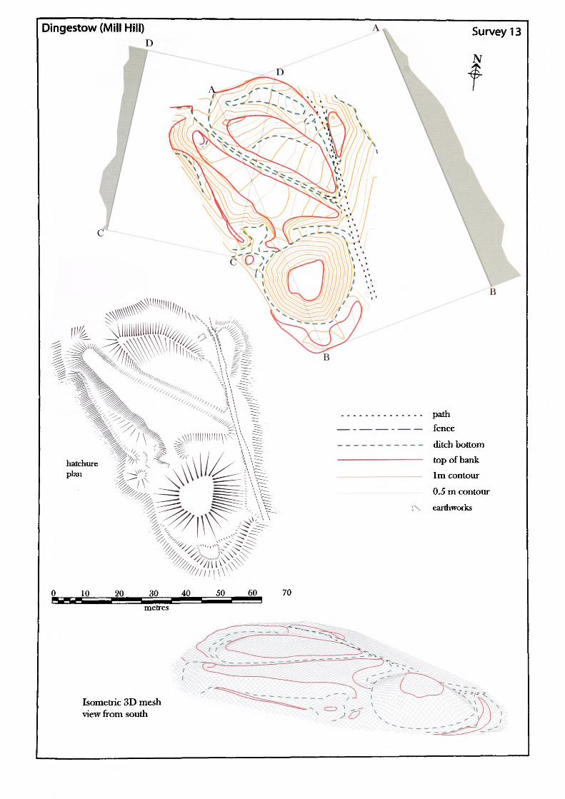
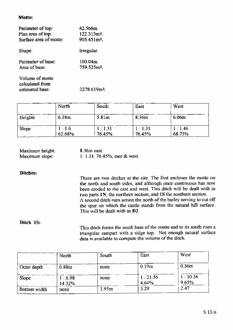
Dingestow (Mill Hill)D
...... path— —— — fence
— - — - - ditch bottom———— top of bank
———— 1m contour
——- 0.5 m contour
f\ earthworks
t<- :%s-
Isometric 3D mesh view from south
Name of Site: Dingestow (Mill Hill).
National Grid Reference:
Parish: Mitchell Troy. County: Herefordshire.
SO 45982 10364.
Known archaeological Sites/Monuments covered by the survey:
SAM. No. MM114. Castle mound. Medieval. Secular.
Archaeological Site/Monument types detected by the survey:
Motte and bailey.
Geology at Site:
Topography:
Altitude of site:
Land use:
Area Surveyed:
Survey conditions:
Site conditions:
Old red sandstone, Raglan Marl.
Hilltop site.
40m.
Pasture and waste ground.
4657.430m2.
Poor conditions, slight mist and drizzle.
The site was completely covered in dense vegetation and so the survey was limited to the immediate vicinity of the motte and bailey and even then was restricted. Attempts were made to work outside the area, particularly with reference to the ramparts but without success. As a result volume computations have been severely effected.
Surveyor:
Assistant:
Survey Date:
Neil Phillips, University of Wales, Newport.
Adam Phillips.
21Feb2001,27Feb2001.
S13.i
Motte:
Perimeter of top: Plan area of top: Surface area of motte:
Shape:
Perimeter of base: Area of base:
Volume of motte calculated from estimated base:
42.566m. 122.313m2. 905.451m*.
Irregular.
100.04m. 759.525m2.
2278.619m3.
Heights
Slope
North
6.38m
1 :1.662.68%
South
5.81m
1 : 1.31 76.45%
East
8.36m
1 : 1.31 76.45%
West
6.06m
1 : 1.46 68.73%
Maximum height: Maximum slope:
8.36m east.1: 1.31. 76.45%, east & west.
Ditches:
Ditch IS:
There are two ditches at the site. The first encloses the motte on the north and south sides, and although once continuous has now been eroded to the east and west. This ditch will be dealt with in two parts IN, the northern section, and IS the southern section. A second ditch runs across the north of the bailey serving to cut off the spur on which the castle stands from the natural hill surface. This will be dealt with as D2.
This ditch forms the south base of the motte and to its south rises a triangular rampart with a ridge top. Not enough natural surface data is available to compute the volume of the ditch.
Outer depth
Slope
Bottom width
North
0.88m
1 : 6.9814.32%none
South
none
none
1.95m
East
0.19m
1 : 21.56 4.64%3.29
West
0.36m
1 : 10.36 9.65%2.47
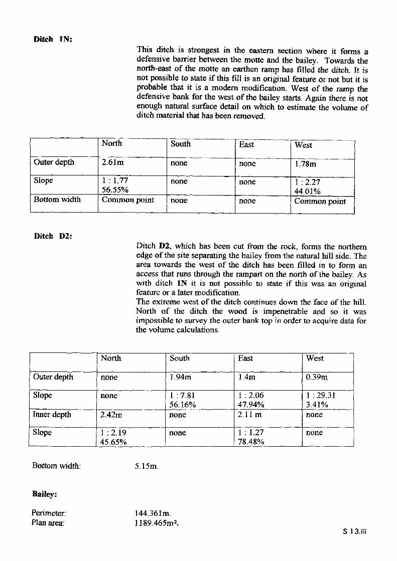
Ditch IN:This ditch is strongest in the eastern section where it forms a defensive barrier between the motte and the bailey. Towards the north-east of the motte an earthen ramp has filled the ditch. It is not possible to state if this fill is an original feature or not but it is probable that it is a modern modification. West of the ramp the defensive bank for the west of the bailey starts. Again there is not enough natural surface detail on which to estimate the volume of ditch material that has been removed.
Outer depth
Slope
Bottom width
North
2.61m
1 : 1.77 56.55%Common point
South
none
none
none
East
none
none
none
West
1.78m
1 : 2.27 44.01%Common point
Ditch D2:Ditch D2, which has been cut from the rock, forms the northern edge of the site separating the bailey from the natural hill side. The area towards the west of the ditch has been filled in to form an access that runs through the rampart on the north of the bailey. As with ditch IN it is not possible to state if this was an original feature or a later modification.The extreme west of the ditch continues down the face of the hill. North of the ditch the wood is impenetrable and so it was impossible to survey the outer bank top in order to acquire data for the volume calculations.
Outer depth
Slope
Inner depth
Slope
North
none
none
2.42m
1 :2.19 45.65%
South
1.94m
1 : 7.81 56.16%none
none
East
1.4m
1 : 2.06 47.94%2.11m
1 : 1.27 78.48%
West
0.39m
1 : 29.31 3.41%none
none
Bottom width: 5.15m.
Bailey:
Perimeter: Plan area:
144.361m. 1189.465m2.
S 1 S.iii
DistanceNorth-south42.S50m
East-west37.130m
Maximum length: Maximum width:
56.37m south-east /north-west. 29.97 m north-east/ south-west.
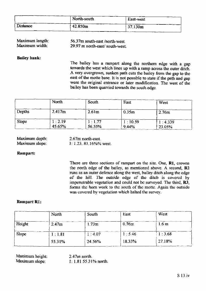
Bailey bank:The bailey has a rampart along the northern edge with a gap towards the west which lines up with a ramp across the outer ditch. A very overgrown, sunken path cuts the bailey from the gap to the east of the motte base. It is not possible to state if the path and gap were the original entrance or later modification. The west of the bailey has been quarried towards the south edge.
Depths
Slope
North
2.417m
1 :2.19 45.65%
South
2.61m
1 : 1.77 56.55%
East
0.35m
1 : 10.59 9.44%
West
2.76m
1 : 4.339 23.05%
Maximum depth: Maximum slope:
Rampart:
2.67m north-east.1: 1.23. 81.16%% west
There are three sections of rampart on the site. One, Rl, crowns the north edge of the bailey, as mentioned above. A second, R2 runs as an outer defence along the west, bailey ditch along 1he edge of the hill The outside edge of the ditch is covered by impenetrable vegetation and could not be surveyed. The third, R3, forms the horn work to the south of the motte. Again the outside was covered by vegetation which halted the survey.
RampartRl:
Height
Slope
North
2.47m
1 : 1.8155.31%
South
1.73m
1 : 4.0724.56%
East
0.76m
1 : 5.4618.33%
West
1.6m
1 : 3.6827.18%
Maximum height: Maximum slope:
2.47m north.1: 1.81 55.31% north.
S 13.iv
Rampart R2:R2 runs along the entire west of the bailey but the vegetation made it impossible to take measurements of its height above the ditch. One section to the north gave a height of 2,28m and another to the south a height of 1.99m.
Rampart R3:This section of rampart forms a horn work to the south of the site using what appears to be the natural slope on its outside edge. The impenetrable vegetation, however, prevented measurement on this outer slope. The inner side of the rampart has a height of 1.5m at the centre dropping off to ground level at the east and west.
S13.v
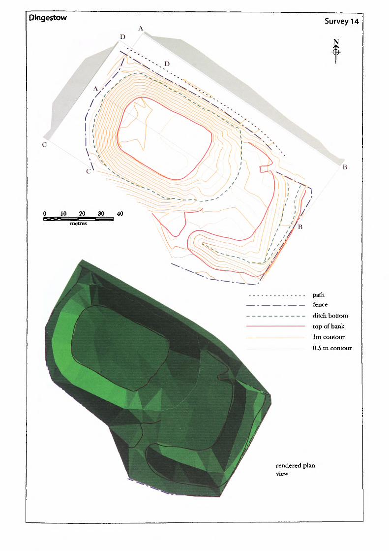
Dingestow
D
Survey 14
N
. D
0 10 20 30 40 i^E metres
B
path — fence
ditch bottom top of bank 1m contour
0.5 m contour
rendered planview
Name of Site: Dingestow 2 .
National Grid Reference:
Parish: Mitchell Troy. County: Gwent.
SO 45977 10354.
Known archaeological Sites/Monuments covered by the survey:
SAM. No. MM113. Castle. Medieval. Secular.
Archaeological Site/Monument types detected by the survey:
Masonry castle foundation.
Geology at Site:
Topography:
Altitude of site:
Land use:
Area Surveyed:
Survey conditions:
Site conditions:
Old red sandstone, Raglan Marl.
Valley site.
41m.
Pasture and waste ground.
10,776.349m2
Good conditions.
Site clear of obstructions.
Surveyor:
Assistant:
Survey Date:
Neil Phillips, University of Wales, Newport.
Chris Smith.
10 May 2002.
S14.1
Mound:
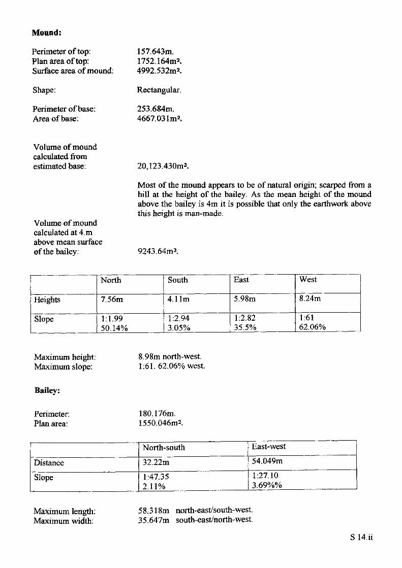
Perimeter of top: Plan area of top: Surface area of mound:
Shape:
Perimeter of base: Area of base:
157.643m.1752.164m*.4992.532m2.
Rectangular.
253.684m. 4667.031m2.
Volume of mound calculated from estimated base:
Volume of mound calculated at 4. m above mean surface of the bailey:
20,123.430m3.
Most of the mound appears to be of natural origin; scarped from a hill at the height of the bailey. As the mean height of the mound above the bailey is 4m it is possible that only the earthwork above this height is man-made.
9243.64m3.
Heights
Slope
North
7.56m
1:1.9950.14%
South
4.11m
1:2.94 3.05%
East
5.98m
1:2.82 35.5%
West
8.24m
1:6162.06%
Maximum height: Maximum slope:
8.98m north-west. 1:61.62.06% west.
Bailey:
Perimeter: 180.176m. Plan area: 1550.046m2.
Distance
Slope
North-south
32.22m
1:47.35 2.11%
East-west
54.049m
1:27.10 3.69%%
Maximum length: Maximum width:
58.318m north-east/south-west. 35.647m south-east/north-west.
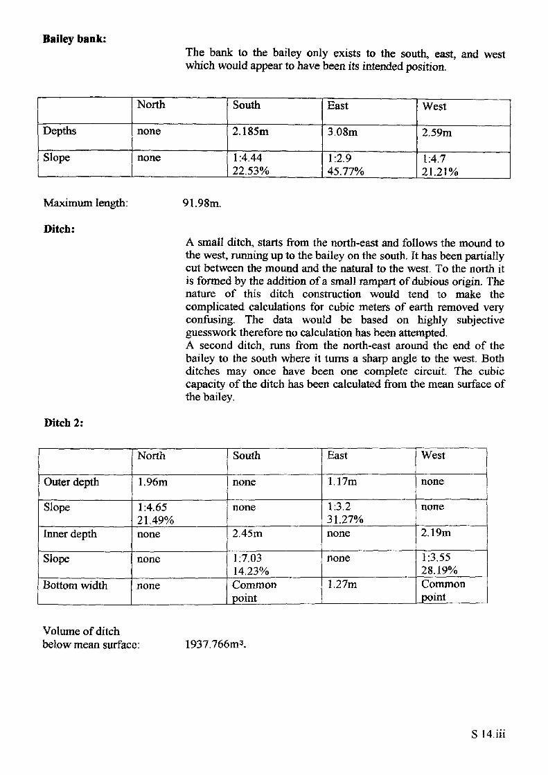
Bailey bank:The bank to the bailey only exists to the south, east, and west which would appear to have been its intended position.
Depths
Slope
North
none
none
South
2.185m
1:4.44 22.53%
East
3.08m
1:2.9 45.77%
West
2.59m
1:4.7 21.21%
Maximum length:
Ditch:
91.98m.
A small ditch, starts from the north-east and follows the mound to the west, running up to the bailey on the south. It has been partially cut between the mound and the natural to the west. To the north it is formed by the addition of a small rampart of dubious origin. The nature of this ditch construction would tend to make the complicated calculations for cubic meters of earth removed very confusing. The data would be based on highly subjective guesswork therefore no calculation has been attempted. A second ditch, runs from the north-east around the end of the bailey to the south where it turns a sharp angle to the west. Both ditches may once have been one complete circuit The cubic capacity of the ditch has been calculated from the mean surface of the bailey.
Ditch 2:
Outer depth
Slope
Inner depth
Slope
Bottom width
North
1.96m
1:4.65 21.49%none
none
none
South
none
none
2.45m
1:7.03 14.23%Common point
East
1.17m
1:3.2 31.27%none
none
1.27m
West
none
none
2.19m
1:3.55 28.19%Common point
Volume of ditch below mean surface: 1937.766m3.
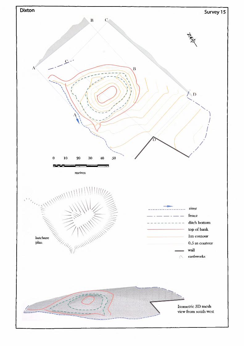
Dixton Survey 15
0 10 20 30 40 50
metres
hatchure plan
/ /
___— nver. —— — fence
— - - - ditch bottom
———— top of bank
—— 1m contour
0.5 m contour
——— wallt'\ earthworks
Isometric 3D mesh view from south west
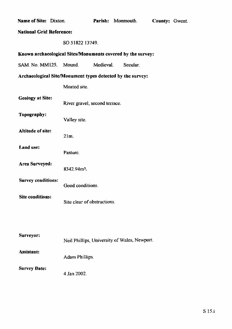
Name of Site: Dixton.
National Grid Reference:
Parish: Monmouth. County: Gwent.
SO 51822 13749.
Known archaeological Sites/Monuments covered by the survey:
SAM. No. MM125. Mound. Medieval. Secular.
Archaeological Site/Monument types detected by the survey:
Moated site.
Geology at Site:
Topography:
Altitude of site:
Land use:
Area Surveyed:
Survey conditions:
Site conditions:
River gravel, second terrace.
Valley site.
21m.
Pasture.
8342.94m2.
Good conditions.
Site clear of obstructions.
Surveyor:
Assistant:
Survey Date:
Neil Phillips, University of Wales, Newport.
Adam Phillips.
4 Jan 2002.
S15.i
Mound:
Perimeter of top: Plan area of top: Surface area of motte:
Shape:
Perimeter of base: Area of base: Volume of earthwork calculated from estimated base:
Volume of earthwork above mean surface:
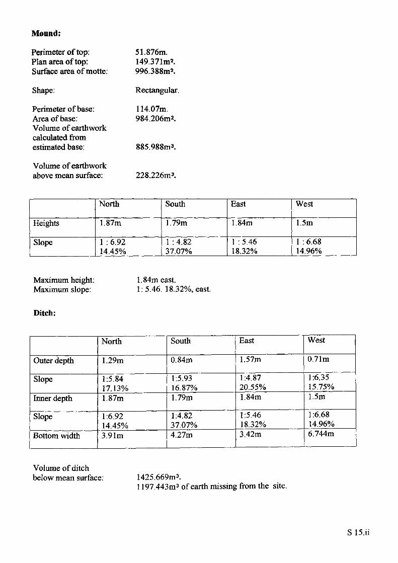
51.876m.149.371m2.996.388m2.
Rectangular.
114.07m. 984.206m2.
885.988m3.
228.226m3.
Heights
Slope
North
1.87m
1 : 6.92 14.45%
South
1.79m
1 : 4.82 37.07%
East
1.84m
1 : 5.46 18.32%
West
1.5m
1 : 6.68 14.96%
Maximum height: Maximum slope:
1.84m east.1:5.46. 18.32%, east.
Ditch:
Outer depth
Slope
Inner depth
Slope
Bottom width
North
1.29m
1:5.84 17.13%1.87m
1:6.9214.45%3.91m
South
0.84m
1:5.93 16.87%1.79m
1:4.82 37.07%4.27m
East
1.57m
1:4.87 20.55%1.84m
1:5.46 18.32%3.42m
West
0.71m
1:6.35 15.75%1.5m
1:6.6814.96%6.744m
Volume of ditch below mean surface: 1425.669m3.
1197.443m3 of earth missing from the site.
S 15.il
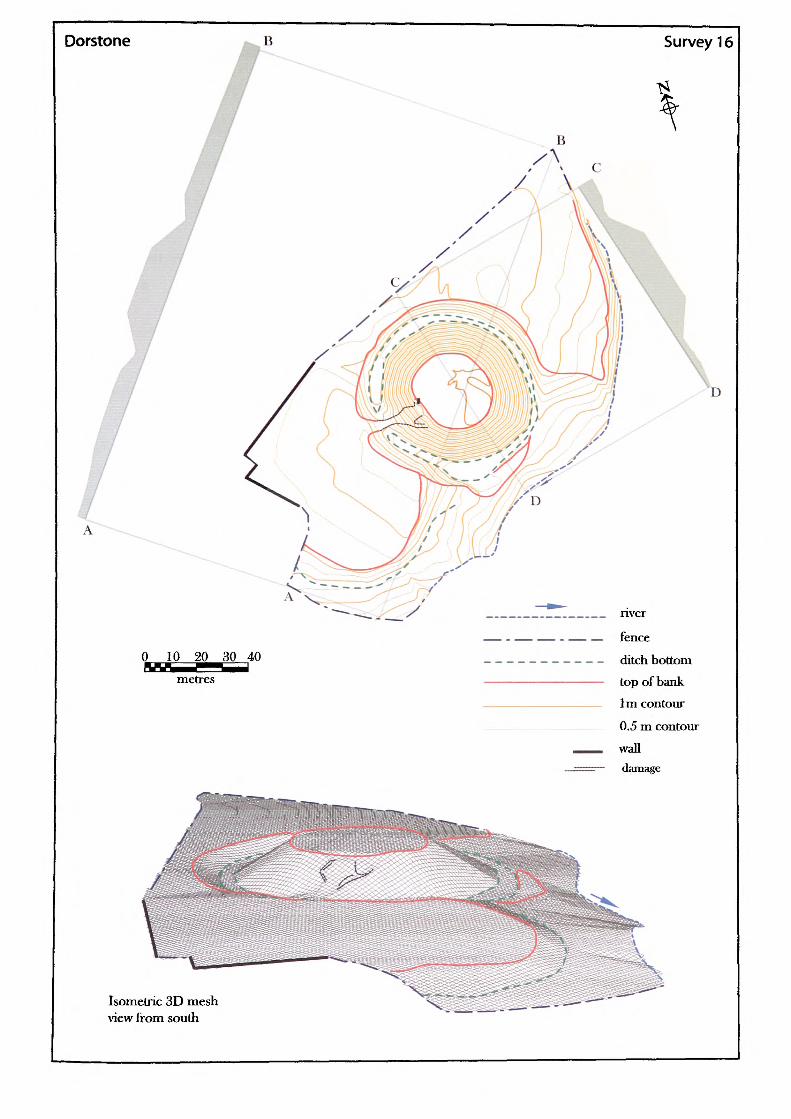
Dorstone Survey 16
0 10 2^ 30 40 metres
Isometric 3D mesh view from south
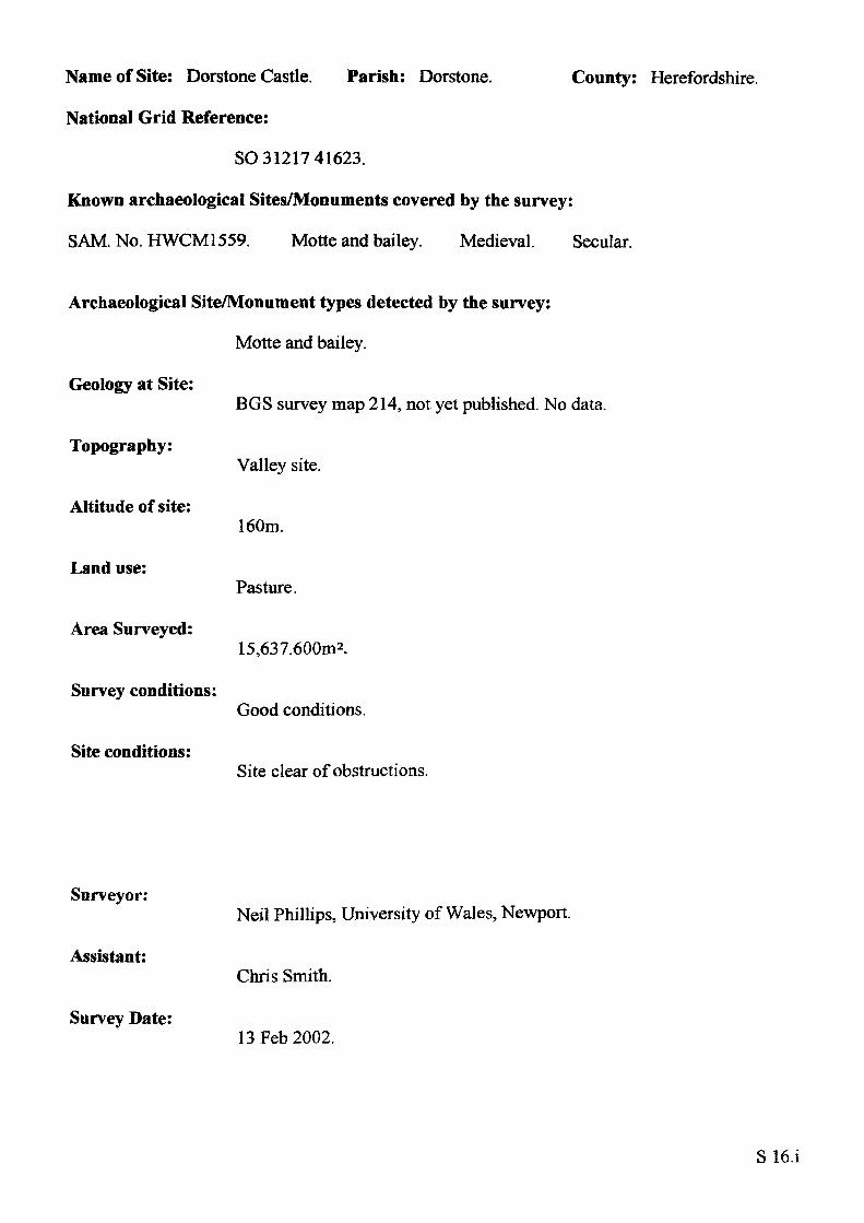
Name of Site: Dorstone Castle. Parish: Dorstone.
National Grid Reference:
SO 31217 41623.
Known archaeological Sites/Monuments covered by the survey:
SAM. No. HWCM1559. Motte and bailey. Medieval. Secular.
Archaeological Site/Monument types detected by the survey:
Motte and bailey.
Geology at Site:
County: Herefordshire.
Topography:
Altitude of site:
Land use:
Area Surveyed:
Survey conditions:
Site conditions:
BGS survey map 214, not yet published. No data.
Valley site.
160m.
Pasture.
15,637.600m2.
Good conditions.
Site clear of obstructions.
Surveyor:
Assistant:
Survey Date:
Neil Phillips, University of Wales, Newport.
Chris Smith.
13Feb2002.
S16.1
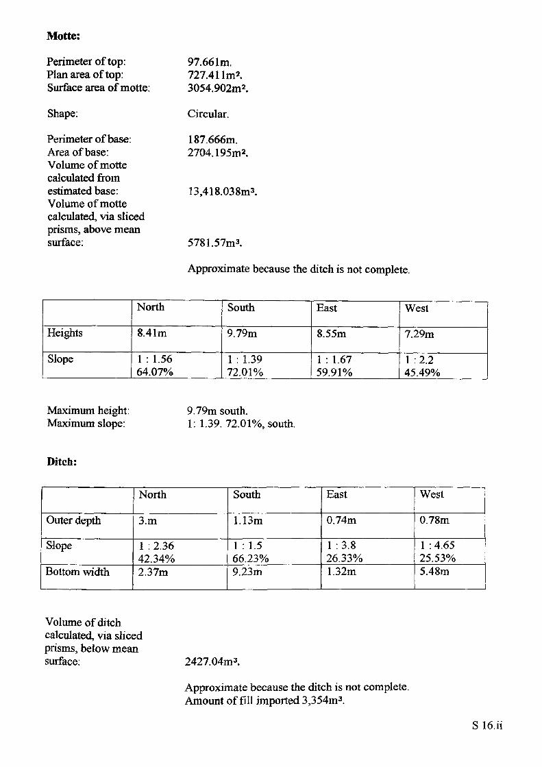
Motte:
Perimeter of top: Plan area of top: Surface area of motte:
Shape:
Perimeter of base: Area of base: Volume of motte calculated from estimated base: Volume of motte calculated, via sliced prisms, above mean surface:
97.661m. 727.4 llm*. 3054.902m2.
Circular.
187.666m.2704.195m2.
13,418.03 8m3.
5781.57m3.
Approximate because the ditch is not complete.
Heights
Slope
North
8.41m
1 : 1.56 64.07%
South
9.79m
1 : 1.39 72.01%
East
8.55m
1 : 1.67 59.91%
West
7.29m
1 :2.2 45.49%
Maximum height: Maximum slope:
9.79m south.1: 1.39. 72.01%, south.
Ditch:
Outer depth
Slope
Bottom width
North
3.m
1 : 2.36 42.34%2.37m
South
1.13m
1 : 1.5 66.23%9.23m
East
0.74m
1 :3.826.33%1.32m
West
0.78m
1 : 4.65 25.53%5.48m
Volume of ditch calculated, via sliced prisms, below mean surface: 2427.04m3.
Approximate because the ditch is not complete. Amount of fill imported 3,354m3 .
Bailey:
Surviving plan area: Maximum length: Maximum width:
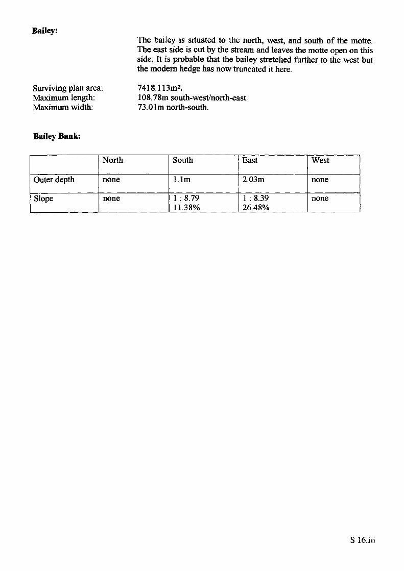
The bailey is situated to the north, west, and south of the motte. The east side is cut by the stream and leaves the motte open on this side. It is probable that the bailey stretched further to the west but the modern hedge has now truncated it here.
7418.113m2.108.78m south-west/north-east.73.01m north-south.
Bailey Bank:
Outer depth
Slope
North
none
none
South
l.lm
1 : 8.79 11.38%
East
2.03m
1 : 8.39 26.48%
West
none
none
Ewyas Harold
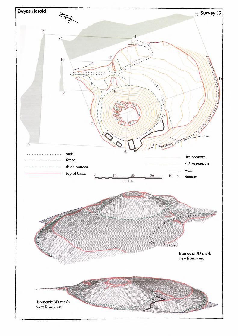
A ~
I) Survey 17
path fence
ditch bottom top ofbank H) 20
555Z55 metres
1m contour 0.5 m contour
40 (\ damage
Isometric 3D mesh view Irom west
Isometric 3D mesh view from east
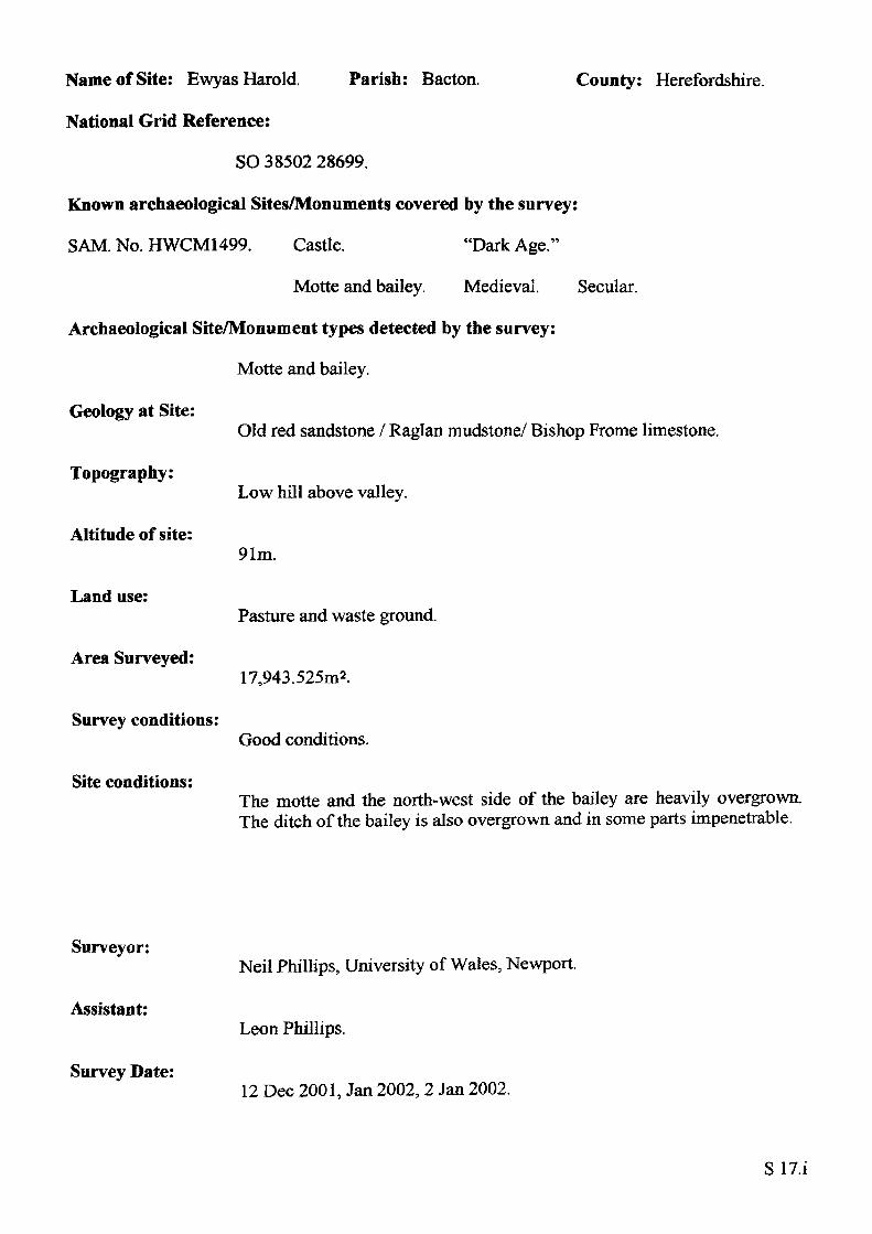
Name of Site: Ewyas Harold. Parish: Bacton.
National Grid Reference:
SO 38502 28699.
Known archaeological Sites/Monuments covered by the survey:
SAM. No. HWCM1499. Castle. "Dark Age."
Motte and bailey. Medieval. Secular.
Archaeological Site/Monument types detected by the survey:
Motte and bailey.
Geology at Site:
County: Herefordshire.
Topography:
Altitude of site:
Land use:
Area Surveyed:
Survey conditions:
Site conditions:
Old red sandstone / Raglan mudstone/ Bishop Frome limestone.
Low hill above valley.
91m.
Pasture and waste ground.
17,943.525m2.
Good conditions.
The motte and the north-west side of the bailey are heavily overgrown. The ditch of the bailey is also overgrown and in some parts impenetrable.
Surveyor:
Assistant:
Survey Date:
Neil Phillips, University of Wales, Newport.
Leon Phillips.
12 Dec 2001, Jan 2002,2 Jan 2002.
SIT.i
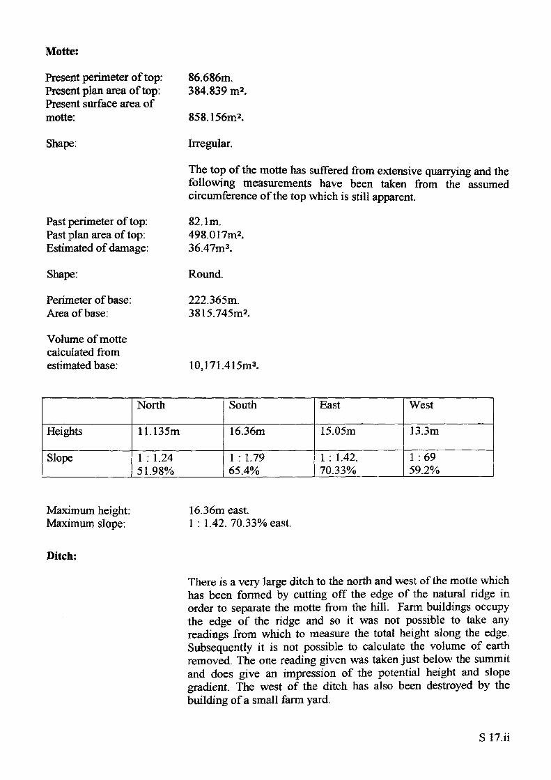
Motte:
Present perimeter of top: Present plan area of top: Present surface area of motte:
Shape:
Past perimeter of top: Past plan area of top: Estimated of damage:
Shape:
Perimeter of base: Area of base:
Volume of motte calculated from estimated base:
86.686m. 384.839 m2.
858.156m2.
Irregular.
The top of the motte has suffered from extensive quarrying and the following measurements have been taken from the assumed circumference of the top which is still apparent.
82.1m.498.017m2.36.47m3.
Round.
222.365m. 3815.745m2.
10,171.415m3.
Heights
Slope
North
11.135m
1 : 1.24 51.98%
South
16.36m
1 : 1.79 65.4%
East
15.05m
1 : 1.42. 70.33%
West
13.3m
1 :69 59.2%
Maximum height: Maximum slope:
16.36m east.1 : 1.42. 70.33% east.
Ditch:
There is a very large ditch to the north and west of the motte which has been formed by cutting off the edge of the natural ridge in order to separate the motte from the hill. Farm buildings occupy the edge of the ridge and so it was not possible to take any readings from which to measure the total height along the edge. Subsequently it is not possible to calculate the volume of earth removed. The one reading given was taken just below the summit and does give an impression of the potential height and slope gradient. The west of the ditch has also been destroyed by the building of a small farm yard.
Outer depth
Slope
Bottom width
North
4.6m
1 : 1.7 58.13%4.73m
South
none
none
none
East
none
none
5.10m
West
none
none
5.34m
Bailey:
Outside perimeter Plan area: Surface area:
350.997m.6924.617m2.7175.055m2.
DistanceNorth-south100.118m
East-west118.007m
Bailey bank:
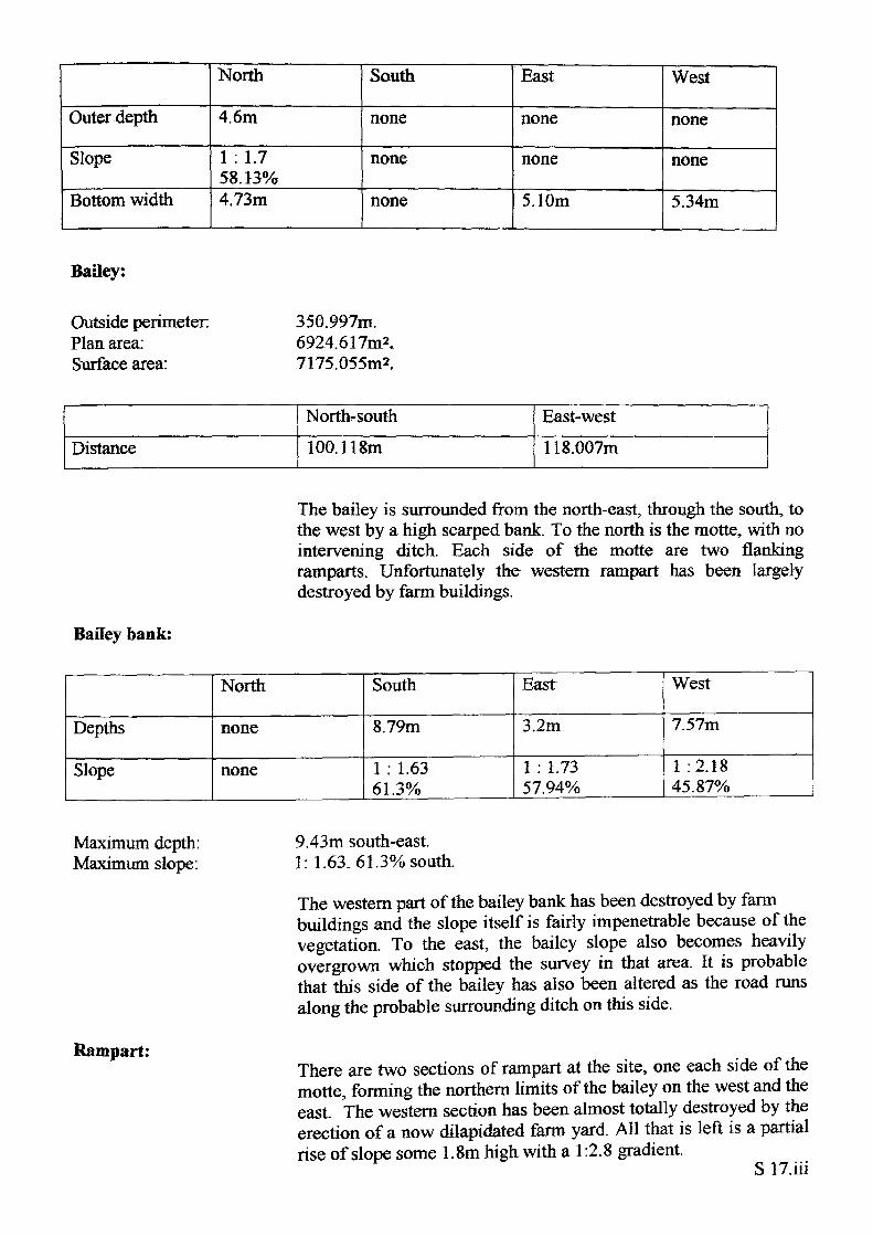
The bailey is surrounded from the north-east, through the south, to the west by a high scarped bank. To the north is the motte, with no intervening ditch. Each side of the motte are two flanking ramparts. Unfortunately the western rampart has been largely destroyed by farm buildings.
Depths
Slope
North
none
none
South
8.79m
1 : 1.63 61.3%
East
3.2m
1 : 1.73 57.94%
West
7.57m
1 :2.18 45.87%
Maximum depth: Maximum slope:
Rampart:
9.43m south-east. 1: 1.63. 61.3% south.
The western part of the bailey bank has been destroyed by farm buildings and the slope itself is fairly impenetrable because of the vegetation. To the east, the bailey slope also becomes heavily overgrown which stopped the survey in that area. It is probable that this side of the bailey has also been altered as the road runs along the probable surrounding ditch on this side.
There are two sections of rampart at the site, one each side of the motte, forming the northern limits of the bailey on the west and the east. The western section has been almost totally destroyed by the erection of a now dilapidated farm yard. All that is left is a partial rise of slope some 1.8m high with a 1:2.8 gradient.
S 17.iii
Plan area of rampart:
Shape:
The eastern rampart however is much more complete with the exception of a road that runs through it.
647.693m2.
Linear/ridge.
Height
Slope
North
1.5m
1 :5.9 16.7%
South
2.08m
1 :3.61 27.67%
East
0.64m
1 : 1.656.98%
West
none
none
Maximum height: Maximum slope:
1m north.1 : 1.6. 56.98% east (due to road cut).
S 17.iv
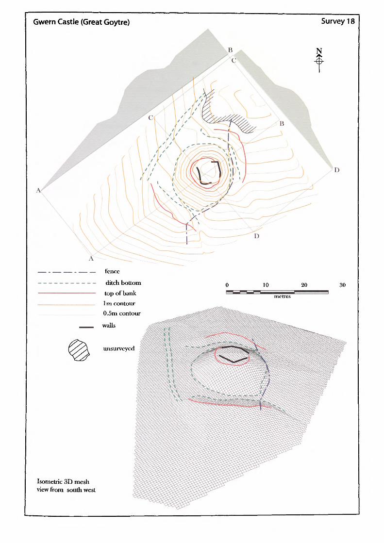
Gwern Castle (Great Goytre) Survey 18
B N
A
D
D
fence
ditch bottom top of bank 1m contour 0.5m contour
walls
unsurvcycd
10 20 30
metres
Isometric 3D mesh view from southwest
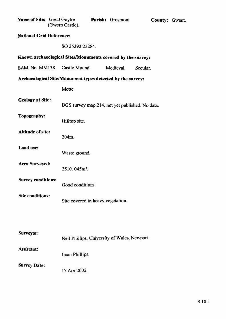
Name of Site: Great Goytre Parish: Grosmont. (Gwern Castle).
National Grid Reference:
SO 35292 23284.
Known archaeological Sites/Monuments covered by the survey:
SAM. No. MM138. Castle Mound. Medieval. Secular.
Archaeological Site/Monument types detected by the survey:
Motte.
County: Gwent.
Geology at Site:
Topography:
Altitude of site:
Land use:
Area Surveyed:
Survey conditions:
Site conditions:
BGS survey map 214, not yet published. No data.
Hilltop site.
204m.
Waste ground.
2510. 045m2.
Good conditions.
Site covered in heavy vegetation.
Surveyor:
Assistant:
Survey Date:
Neil Phillips, University of Wales, Newport.
Leon Phillips.
17 Apr 2002.
SIS.i
Motte:
Perimeter of top: Plan area of top: Surface area of motte:
Shape:
Perimeter of base: Area of base:
Volume of motte calculated from estimated base:
27.28m.56.15m2.307.063m2.
Irregular.
60.18m. 268.66m2.
366.159m3.
Heights
Slope
North
2.53m
1 : 2.02 49.44%
South
4.78m
1 : 1.56 64.05%
East
1.73m
1 : 1.73 57.81%
West
3.31m
1 : 1.6959.12%
Maximum height: Maximum slope:
4.78m south-east.1:1.64. 60.73% south-west-east.
Ditches:
North ditch:
The motte, possibly had a surrounding ditch which has now disappeared on the west and east sides. The north and south sections are still in place showing that the motte was cut from the ridge on which it is located.
Outer depth
Slope
Bottom width
North
1.33m
1 : 2.98 33.58%2.36m
South
none
none
none
East
0.12
1 : 18.92 5.29%2.59m
West
l.m
1 : 2.9633.78%none
Length. 18m.
S IS.ii
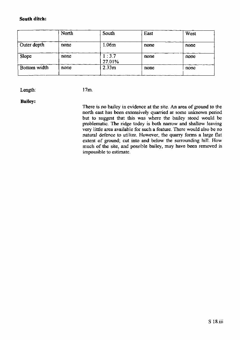
South ditch:
Outer depth
Slope
Bottom width
North
none
none
none
South
1.06m
1 :3.7 27.01%2.33m
East
none
none
none
West
none
none
none
Length:
Bailey:
17m.
There is no bailey in evidence at the site. An area of ground to the north east has been extensively quarried at some unknown period but to suggest that this was where the bailey stood would be problematic. The ridge today is both narrow and shallow leaving very little area available for such a feature. There would also be no natural defence to utilize. However, the quarry forms a large flat extent of ground; cut into and below the surrounding hill. How much of the site, and possible bailey, may have been removed is impossible to estimate.
S IS.iii
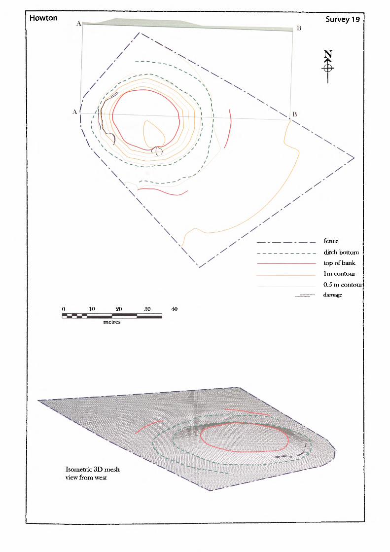
Howton Survey 19
— . — — . — — fence
___________ ditch bottom————————————— top of bank
____________ 1m contour____________ 0.5 m contoui
——— damage
30 40
Isometric 3D mesh view from west
Name of Site: Howton.
National Grid Reference:
Parish: Kenderchurch. County: Herefordshire.
SO 41487 29389.
Known archaeological Sites/Monuments covered by the survey:
SAM. No. HWCM923. Motte? Burial? Moat? Medieval. Secular.
Archaeological Site/Monument types detected by the survey:
Moated site.
Geology at Site:
Topography:
Altitude of site:
Land use:
Area Surveyed:
Survey conditions:
Site conditions:
Alluvium, mainly clay.
Valley site.
78m.
Pasture.
5610.435m2.
Good conditions.
Site surroundings were clear of obstructions.
Surveyor:
Assistant:
Survey Date:
Neil Phillips, University of Wales, Newport.
Leon Phillips.
20 Feb 2002.
S19.i

Mound:
Perimeter of top: Plan area of top: Surface area of mound:
Shape:
Perimeter of base: Area of base:
Volume of mound calculated from estimated base:
83.283m.526.872m*.1297.439m2.
Irregular.
128.009m. 1268.060m2.
1718.873m3.
Heights
Slope
North
1.69m
1 :3.1 32.27%
South
2.14m
1 :3.4 29.46%
East
1.93m
1 : 4.39 22.77%
West
2.38m
1 :3.81 26.28%
Maximum height: Maximum slope:
2.38m west.1:3.4. 29.46%, south.
Ditch:Two partial sections of a slight ditch are visible to the south and the east but not enough from which to calculate any meaningful volumes. The east section is discernable for about 16m with a maximum height of 0.29m and the southern section is slightly longer at 18m with a maximum depth of 0.39m. The width of the ditch varies between 8m and 4m.
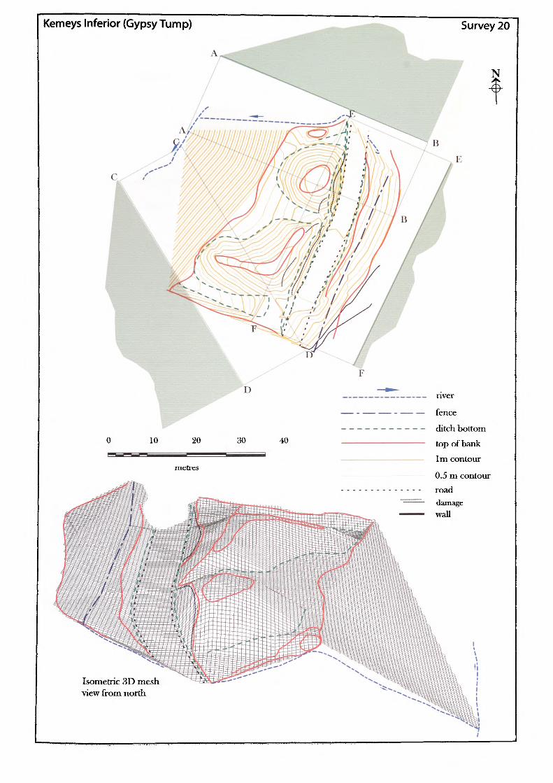
Kemeys Inferior (Gypsy Tump) Survey 20
N
B
Isometric 3D mesh •view from north
Name of Site: Kemeys Inferior Parish: Langstone. (Gypsy Tump).
National Grid Reference:
ST 38877 93928.
Known archaeological Sites/Monuments covered by the survey:
SAM. No. MM039. Mound and Bailey. Medieval. Secular.
Archaeological Site/Monument types detected by the survey:
Rectangular rampart enclosure.
Geology at Site:
County: Gwent.
Topography:
Altitude of site:
Land use:
Area Surveyed:
Survey conditions:
Site conditions:
Old red sandstone, St Maughan's Group.
Hilltop site.
llm.
Waste ground.
2667.337m2.
Good conditions.
Site covered in heavy vegetation.
Surveyor:
Assistant:
Survey Date:
Neil Phillips, University of Wales, Newport.
Martin Tuck.
20 Jan 2002.
S20.i
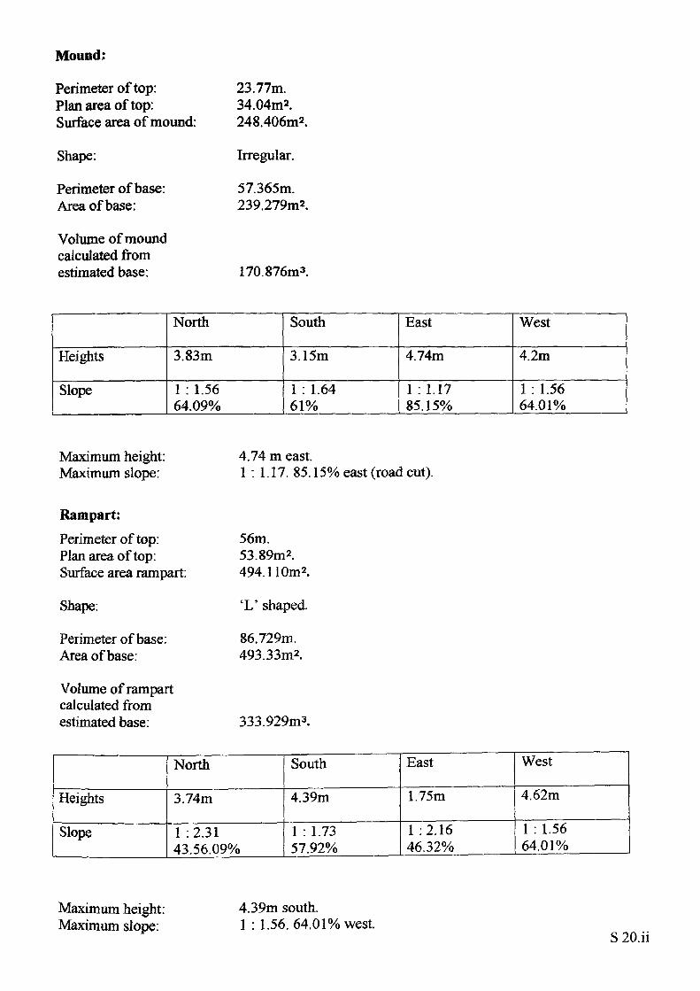
Mound;
Perimeter of top: Plan area of top: Surface area of mound:
Shape:
Perimeter of base: Area of base:
Volume of mound calculated from estimated base:
23.77m.34.04m2.248.406m2.
Irregular.
57.365m. 239.279m2.
170.876m3.
Heights
Slope
North
3.83m
1 : 1.56 64.09%
South
3.15m
1 : 1.64 61%
East
4.74m
1 : 1.17 85.15%
West
4.2m
1 : 1.56 64.01%
Maximum height: Maximum slope:
4.74 m east.1 : 1.17. 85.15% east (road cut).
Rampart:
Perimeter of top: Plan area of top: Surface area rampart:
Shape:
Perimeter of base: Area of base:
Volume of rampart calculated from estimated base:
56m.53.89m2.494.110m2.
'L' shaped.
86.729m. 493.33m2.
333.929m3.
Heights
Slope
North
3.74m
1 :2.31 43.56.09%
South
4.39m
1 : 1.73 57.92%
East
1.75m
1 :2.16 46.32%
West
4.62m
1 : 1.56 64.01%
Maximum height: Maximum slope:
4.39m south.1 : 1.56. 64.01% west.
S 20.ii
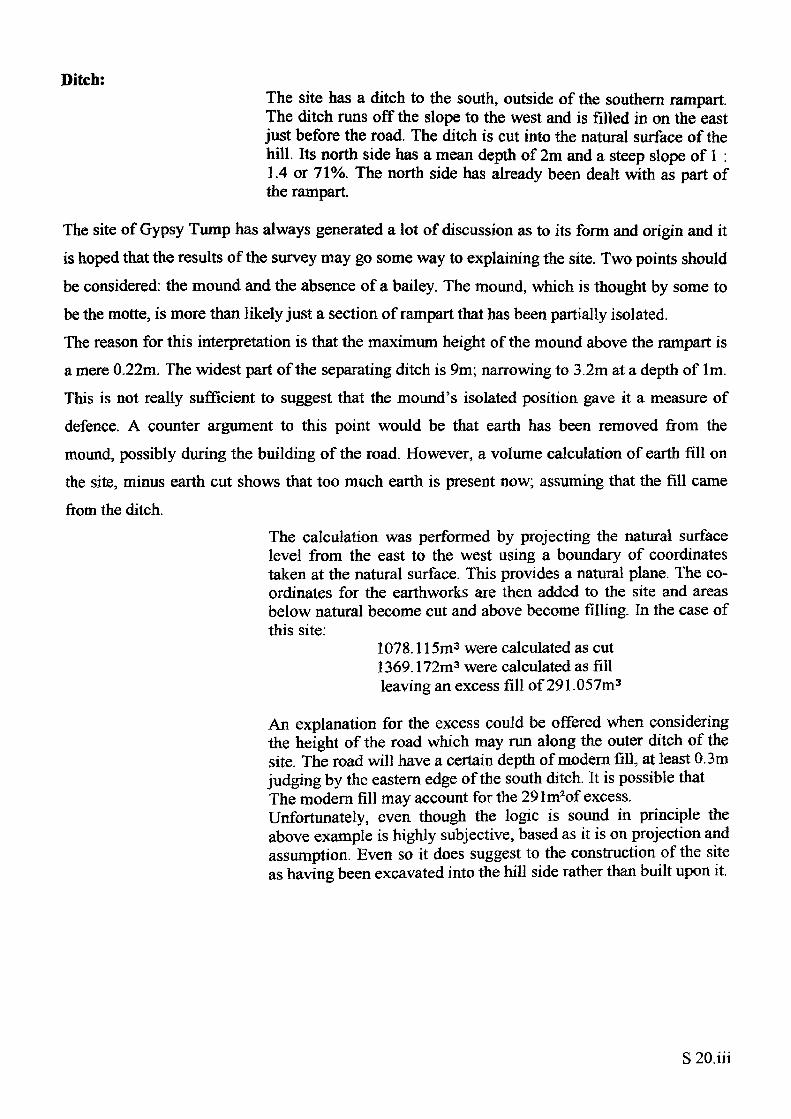
Ditch:The site has a ditch to the south, outside of the southern rampart. The ditch runs off the slope to the west and is filled in on the east just before the road. The ditch is cut into the natural surface of the hill. Its north side has a mean depth of 2m and a steep slope of 1 : 1.4 or 71%. The north side has already been dealt with as part of the rampart.
The site of Gypsy Tump has always generated a lot of discussion as to its form and origin and it is hoped that the results of the survey may go some way to explaining the site. Two points should be considered: the mound and the absence of a bailey. The mound, which is thought by some to be the motte, is more than likely just a section of rampart that has been partially isolated. The reason for this interpretation is that the maximum height of the mound above the rampart is a mere 0.22m. The widest part of the separating ditch is 9m; narrowing to 3.2m at a depth of 1m. This is not really sufficient to suggest that the mound's isolated position gave it a measure of defence. A counter argument to this point would be that earth has been removed from the mound, possibly during the building of the road. However, a volume calculation of earth fill on the site, minus earth cut shows that too much earth is present now; assuming that the fill came from the ditch.
The calculation was performed by projecting the natural surface level from the east to the west using a boundary of coordinates taken at the natural surface. This provides a natural plane. The co ordinates for the earthworks are then added to the site and areas below natural become cut and above become filling. In the case of this site:
1078.115m3 were calculated as cut 1369.172m3 were calculated as fill leaving an excess fill of 291.057m3
An explanation for the excess could be offered when considering the height of the road which may run along the outer ditch of the site. The road will have a certain depth of modern fill, at least 0.3m judging by the eastern edge of the south ditch. It is possible that The modern fill may account for the 29Im2of excess. Unfortunately, even though the logic is sound in principle the above example is highly subjective, based as it is on projection and assumption. Even so it does suggest to the construction of the site as having been excavated into the hill side rather than built upon it.
[King's CapJe Survey 21
N
10 20
metres
30
road
ditch bottomtop of bank1m contour
0.5 m contour(lamage
Isometric 3D mesh view from south
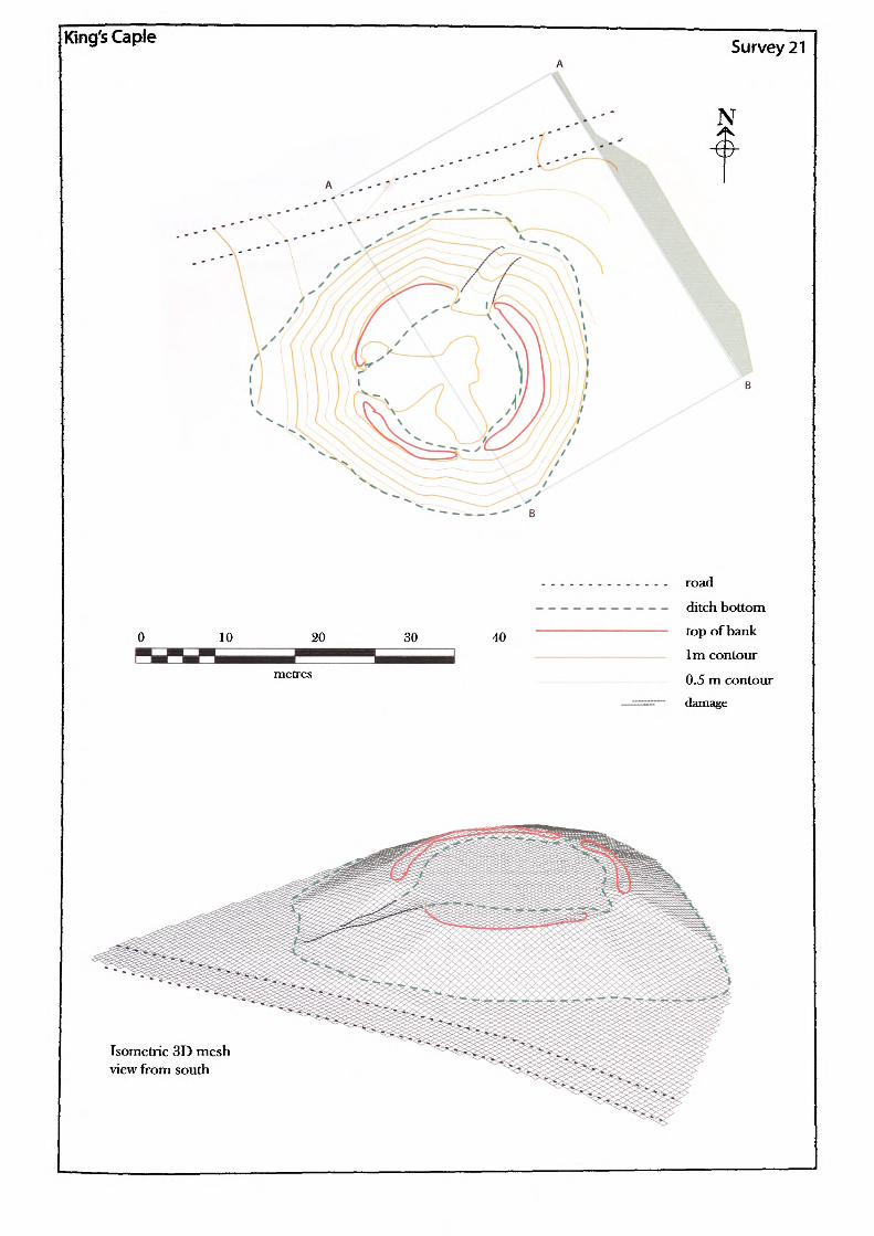
Name of Site: King's Caple. Parish: King's Caple. County: Herefordshire.
National Grid Reference:
SO 55932 28774.
Known archaeological Sites/Monuments covered by the survey:
SAM. No. HWCM921. Motte. Medieval. Secular.
Archaeological Site/Monument types detected by the survey:
Motte and possible bailey.
Geology at Site:
Topography:
Altitude of site:
Land use:
Area Surveyed:
Survey conditions:
Site conditions:
Lower old red sandstone.
Valley site.
81m.
Common.
1926.23 Im2.
Good conditions.
Site surroundings were clear of obstructions.
Surveyor:
Assistant:
Survey Date:
Neil Phillips, University of Wales, Newport.
Chris Smith.
7 Mar 2002.
S21.i
Motte;
Perimeter of top: Plan area of top: Surface area of motte:
Shape:
Perimeter of base: Area of base:
Volume of motte calculated from estimated base:
75.347m.439.248m2.1292.511m2.
Round.
129.529m. 1224.951m2.
2292.081m3.
The motte top has a well defined enclosure bank around the rim, possibly the remains of a shell wall.
Heights
Slope
North
3.31m
1 : 2.54 39.33%
South
2.43m
1 : 3.49 28.62%
East
2.44m
1 :2.32 43.06%
West
4.59m
1 : 3.22 31.02%
Maximum height: Maximum slope:
Ditch:
Bailey:
4.39m west.1 : 2.32. 43.06%, east.
None.
None.Although no bailey now exists at the site, the close proximity of anenclosed area of land with a surrounding ditch and raised profileare probably a good indicator of where the bailey used to be. Theproposed are of land is occupied by the church and its associatedgraveyard.
Rampart:None.
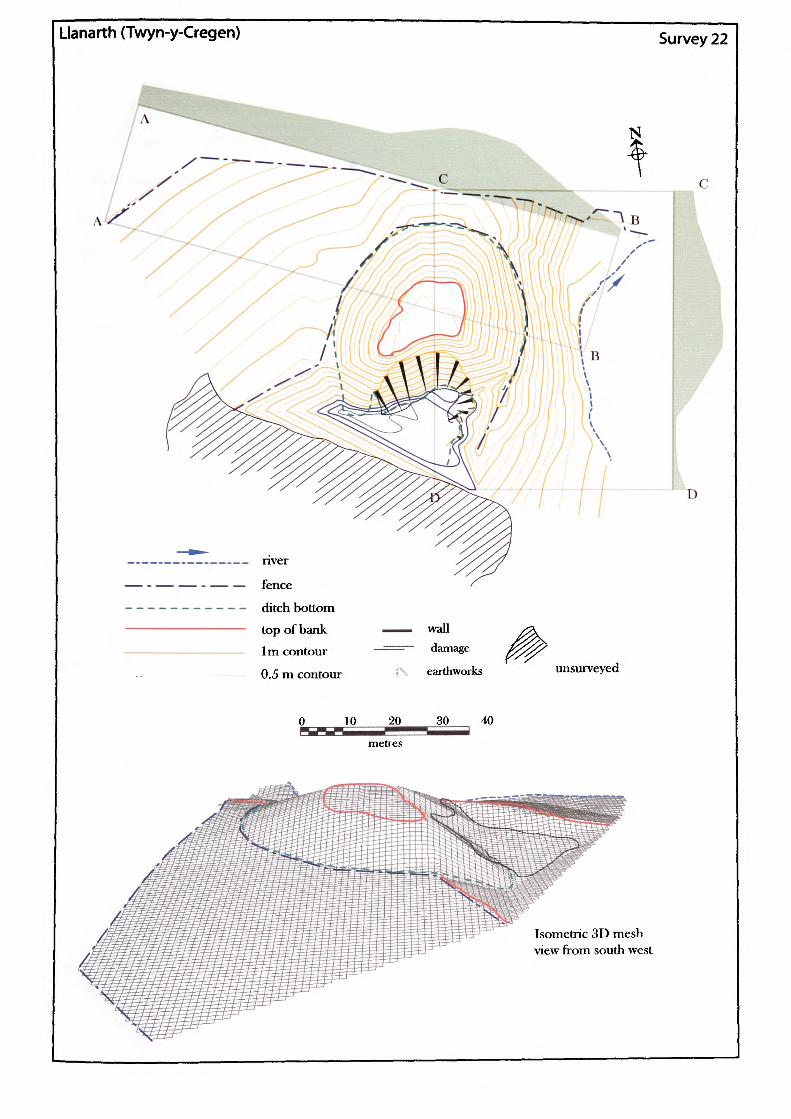
Llanarth (Twyn-y-Crcgen) Survey 22
nver
fence
ditch bottom
top of bank 1m contour
0.5 m contour
10 20
metres
wall damage
earthworks
30 40
unsurveyed
Isometric 3D mesh view from south west
D
Name of Site: Llanarth Parish: Llanarth. (Twyn-y-Cregen).
National Grid Reference:
SO 36237 09614.
Known archaeological Sites/Monuments covered by the survey:
SAM. No. MM080. Motte. Medieval. Secular.
Archaeological Site/Monument types detected by the survey:
Motte and possible bailey.
Geology at Site:
County: Gwent.
Topography:
Altitude of site:
Land use:
Area Surveyed:
Survey conditions:
Site conditions:
Glacial sand and gravel.
Valley site.
32m.
Waste ground.
7290.598m2.
Good conditions.
Very overgrown and in some parts impenetrable. Evidence of extensive damage to the south of the motte from quarrying.
Surveyor:
Assistant:
Survey Date:
Neil Phillips, University of Wales Newport.
Adam Phillips.
30. Dec 2001.
S22.i
Motte:
Perimeter of top: Plan area of top: Surface area of motte:
Shape:
Perimeter of base: Area of base:
Volume of motte calculated from estimated base:
65.121m.237.379m2.1846.625m2.
Irregular.
152.794m. 1589.705m2.
3877.222m3 .
The surface area and volumetric calculations on this site are fairly meaningless as regards the original structure, because the entire south end of the motte has been quarried away. The quarry activities have not only removed a substantial part of the motte fabric but have also removed the natural surface to a depth of over 5 metres.
Heights
Slope
North
5.051m
1 : 2.88 34.78%
South
8.86m
1 : 1.42 70.34%
East
7.67m
1 : 2.09 47.92%
West
5.62m
1 : 2.59 38.67%
Maximum height: Maximum slope:
Ditch:
Bailey:
Rampart:
7.67m east.1 : 2.09. 47.92%, east.
The figures for the south side represent quarry activity.
None.
None.
None.
S 22.ii
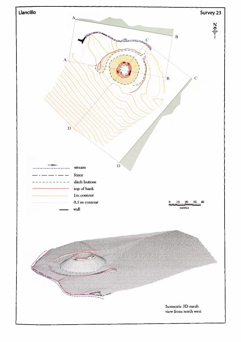
Llancillo
B
stream
fence
ditch bottomtop of bank1m contour
0.5 m contour
wall
Survey 23
N
0 10 20 30 40i=SH!5
metres
Isometric 3D mesh view from north west
Parish: Llancillo. County: Herefordshire.Name of Site: Llancillo.
National Grid Reference:
SO 36697 25539.
Known archaeological Sites/Monuments covered by the survey:
SAM. No. HWCM1477. Motte and bailey. Medieval. Secular.
Archaeological Site/Monument types detected by the survey:
Motte and possible bailey.
Geology at Site:BGS survey map 214, not yet published.Data projected from 215: Lower old red sandstone / St Maugham'sFormation.
Topography:
Altitude of site:
Land use:
Area Surveyed:
Survey conditions:
Site conditions:
Valley site.
92m.
Pasture and waste ground.
14,642.206m2.
Good conditions.
The surroundings of the bailey were clear of obstruction but the motte is tree clad, with the top fairly overgrown.
Surveyor:
Assistant:
Survey Date:
Neil Phillips, University of Wales, Newport.
Leon Phillips.
19. April 2002.
S23.i
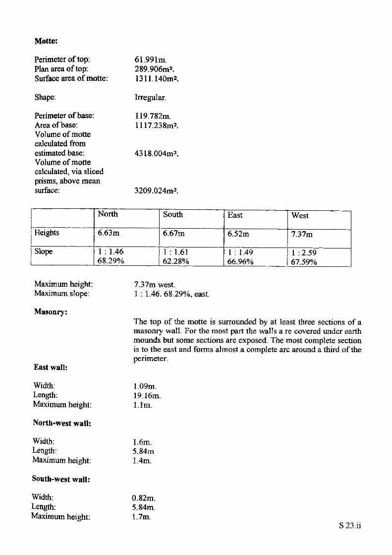
Motte:
Perimeter of top: Plan area of top: Surface area of motte:
Shape:
Perimeter of base: Area of base: Volume of motte calculated from estimated base: Volume of motte calculated, via sliced prisms, above mean surface:
61.991m.289.906m2.1311.140m2.
Irregular.
119.782m. 1117.238m2.
4318.004m3.
3209.024m3.
Heights
Slope
North
6.63m
1 : 1.46 68.29%
South
6.67m
1 : 1.61 62.28%
East
6.52m
1 : 1.49 66.96%
West
7.37m
1 : 2.59 67.59%
Maximum height: Maximum slope:
Masonry:
East wall:
Width: Length: Maximum height:
North-west wail:
Width: Length: Maximum height:
South-west wall:
Width: Length: Maximum height:
7.37m west.1 : 1.46, 68.29%, east.
The top of the motte is surrounded by at least three sections of a masonry wall. For the most part the walls a re covered under earth mounds but some sections are exposed. The most complete section is to the east and forms almost a complete arc around a third of the perimeter.
1.09m.19.16m.l.lm.
1.6m.5.84m1.4m.
0.82m. 5.84m. Um,
S23.ii
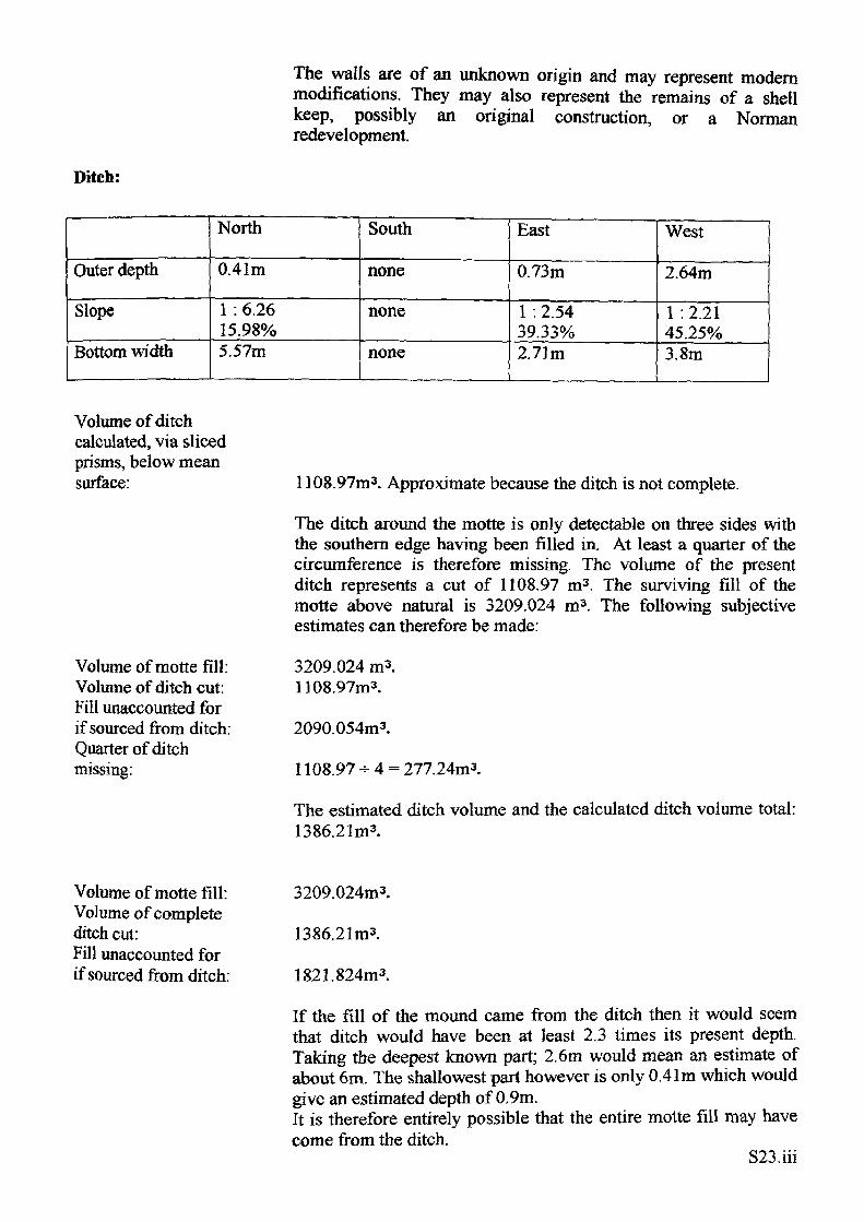
Ditch:
The walls are of an unknown origin and may represent modern modifications. They may also represent the remains of a shell keep, possibly an original construction, or a Norman redevelopment.
Outer depth
Slope
Bottom width
North
0.41m
1 : 6.26 15.98%5.57m
South
none
none
none
East
0.73m
1 : 2.54 39.33%2.71m
West
2.64m
1 :2.21 45.25%3.8m
Volume of ditch calculated, via sliced prisms, below mean surface:
Volume of motte fill: Volume of ditch cut: Fill unaccounted for if sourced from ditch: Quarter of ditch missing:
1108.97m3. Approximate because the ditch is not complete.
The ditch around the motte is only detectable on three sides with the southern edge having been filled in. At least a quarter of the circumference is therefore missing. The volume of the present ditch represents a cut of 1108.97 m3 . The surviving fill of the motte above natural is 3209.024 m3 . The following subjective estimates can therefore be made:
3209.024 m3. 1108.97m3.
2090.054m3.
1108.97- 4 = 277.24m3.
The estimated ditch volume and the calculated ditch volume total: 1386.21m3.
Volume of motte fill: Volume of complete ditch cut:Fill unaccounted for if sourced from ditch:
3209.024m3.
1386.21m3.
1821.824m3.
If the fill of the mound came from the ditch then it would seem that ditch would have been at least 2.3 times its present depth. Taking the deepest known part; 2.6m would mean an estimate of about 6m. The shallowest part however is only 0.41m which would give an estimated depth of 0.9m. It is therefore entirely possible that the entire motte fill may havecome from the ditch.
S23.iii
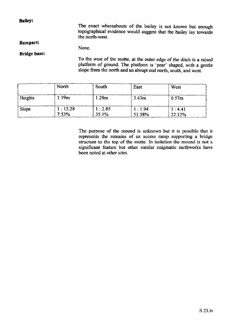
Bailey:
Rampart:
Bridge base:
The exact whereabouts of the bailey is not known but enough topographical evidence would suggest that the bailey lay towards the north-west.
None.
To the west of the motte, at the outer edge of the ditch is a raised platform of ground. The platform is 'pear' shaped, with a gentle slope from the north and an abrupt end north, south, and west.
Heights
Slope
North
1.19m
1 : 13.28 7.53%
South
1.28m
1 : 2.85 35.1%
East
3.43m
1 : 1.9451.58%
West
0.57m
1 : 4.41 22.12%
The purpose of the mound is unknown but it is possible that it represents the remains of an access ramp supporting a bridge structure to the top of the motte. In isolation the mound is not a significant feature but other similar enigmatic earthworks have been noted at other sites.
S 23.iv
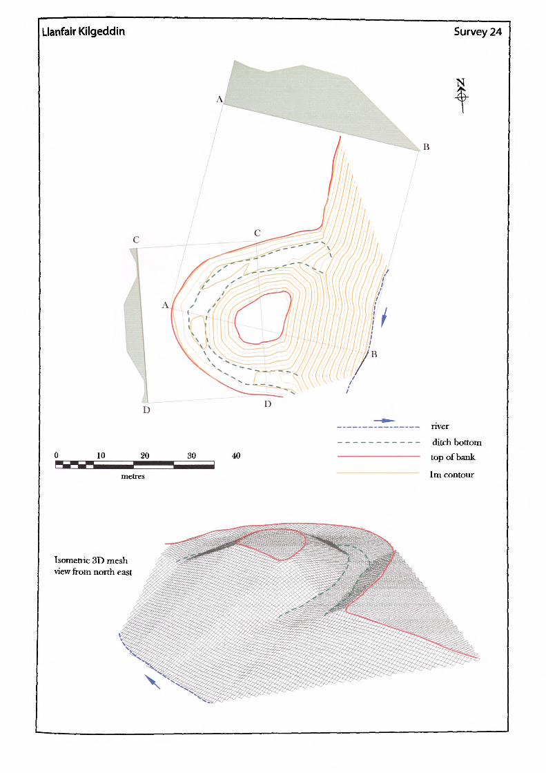
Llanfair Kilgeddin Survey 24
B
30 40
— nver
— - ditch bottom— top of bank
~~ 1m contour
Isometric 3D mesh view from north east
X
Name of Site: Llanfair Kilgeddin. Parish: Llanover.
National Grid Reference:
SO 34947 06934.
Known archaeological Sites/Monuments covered by the survey:
SAM. No. HWCM1535. Castle mound Medieval. Secular.
Archaeological Site/Monument types detected by the survey:
Fortified-site.
County: Gwent.
Geology at Site:
Topography:
Altitude of site:
Land use:
Area Surveyed:
Survey conditions:
Site conditions:
Glacial sand and gravel second terrace.
Valley site.
32m.
Waste ground.
1964.087m2.
Good conditions.
The site was clear of obstructions, eroded badly to the east.
Surveyor:
Assistant:
Survey Date:
Neil Phillips, University of Wales, Newport.
Adam Phillips.
28 May 2000.
S24.i
Mound:
Perimeter of top: Plan area of top: Surface area of mound:
Shape:
Perimeter of base: Area of base: Volume of mound calculated from estimated base:
45.194m.131.433m2.583.945m2.
'D shaped'.
107.270m. 536.961m2.
413.69lm3.
It was not possible to calculate the ditch cut/mound fill volume on this site due to an error in calculation within the software record. The amount of damage to the motte however would have been difficult to assess accurately and so the calculations would have been misleading.
Heights
Slope
North
4.07m
1 : 1.88 53.23%
South
3.64m
1 : 1.9850.49%
East
eroded
none
West
3.87m
1 : 2.04 49.1%
Maximum height: Maximum slope:
Ditch:
4.07m north.1 : 1.88. 53.23% north.
Outer depth
Slope
Bottom width
North
I Aim
I :2 50.88%5.2m
South
1.4m
1 : 3.45 28.99%2.81m
East
1.55m
1 : 3.72 26.88%2.71m
West
0.85m
1 :0.4124.72%5.49m
Subtraction of the ditch height from the mound height at adjacent points gives an idea of the height of the mound above natural. In the case of the surviving structure, the mean mound height is only 2m.
Bailey?None identifiable.
S 24.ii
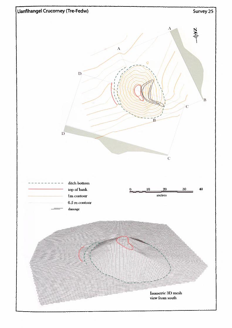
Uanflhangel Crucorney (Tre-Fedw) Survey 25
ditch bottom top of bank 1m contour
0.5 m contour damage
10 20 metres
30
Isometric 3D mesh view from south
40
Name of Site: Llanfihangel Crucorney.
Parish: Crucorney. County: Gwent.
National Grid Reference:
SO 33027 21769.
Known archaeological Sites/Monuments covered by the survey:
SAM. No. MM063. Moat mound and bailey. Medieval. Secular.
Archaeological Site/Monument types detected by the survey:
Motte and bailey.
Geology at Site:
Topography:
Altitude of site:
Land use:
Area Surveyed:
Survey conditions:
Site conditions:
BGS survey map 214, not yet published. No Data.
Valley site.
135m.
Waste ground.
3551.022m2.
Good conditions.
The site was clear of obstructions, although, there has been erosion on the eastern side.
Surveyor:
Assistant:
Survey Date:
Neil Phillips, University of Wales, Newport.
Leon Phillips.
27Nov2001.
S25.1
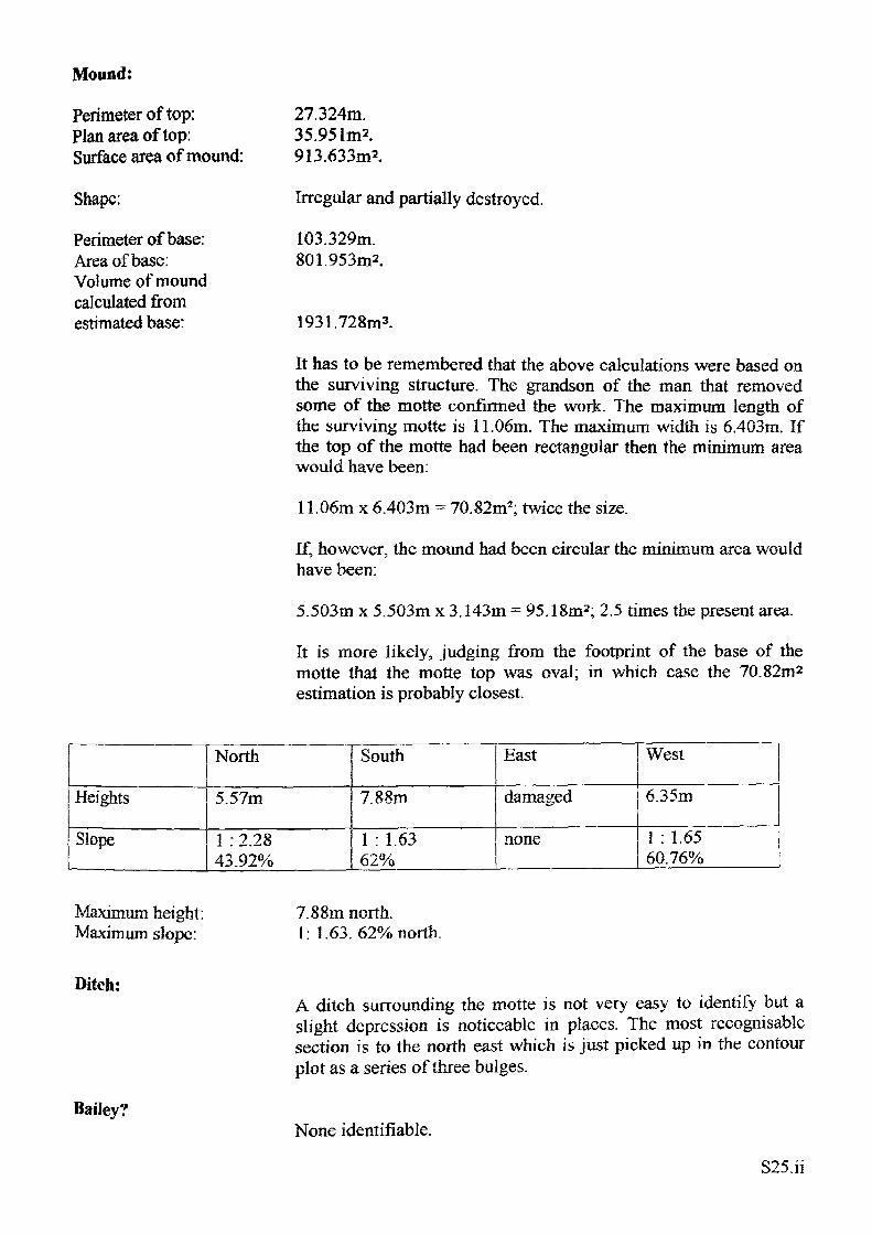
Mound:
Perimeter of top: Plan area of top: Surface area of mound:
Shape:
Perimeter of base: Area of base: Volume of mound calculated from estimated base:
27.324m. 35.951m*. 913.633m2.
Irregular and partially destroyed.
103.329m. 801.953m2.
1931.728m3.
It has to be remembered that the above calculations were based on the surviving structure. The grandson of the man that removed some of the motte confirmed the work. The maximum length of the surviving motte is 11.06m. The maximum width is 6.403m. If the top of the motte had been rectangular then the minimum area would have been:
11.06m x 6.403m = 70.82m2; twice the size.
If, however, the mound had been circular the minimum area would have been:
5.503m x 5.503m x 3.143m - 95.18m2; 2.5 times the present area.
It is more likely, judging from the footprint of the base of the motte that the motte top was oval; in which case the 70.82m2 estimation is probably closest.
Heights
Slope
North
5.57m
1 : 2.28 43.92%
South
7.88m
1 : 1.6362%
East
damaged
none
West
6.35m
1 : 1.65 60.76%
Maximum height: Maximum slope:
7.88m north.I: 1.63. 62% north.
Ditch:
Bailey?
A ditch surrounding the motte is not very easy to identify but a slight depression is noticeable in places. The most recognisable section is to the north east which is just picked up in the contour plot as a series of three bulges.
None identifiable.
S25,ii
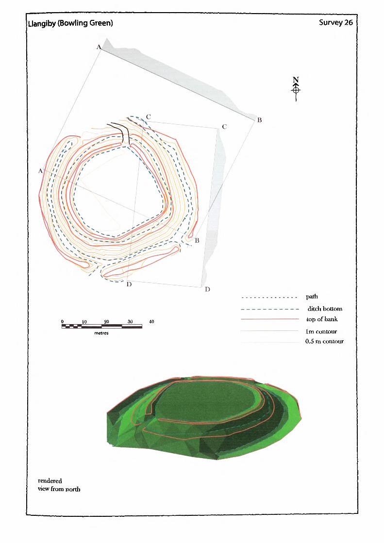
Llangiby (Bowling Green) Survey 26
D
30 40
renderedview from north
N
path
ditch bottom top of bank
1m contour 0.5 m contour
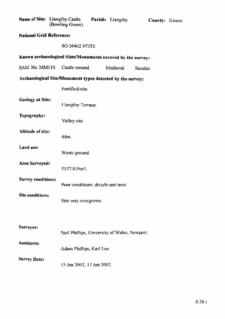
Name of Site: Llangiby Castle Parish: Llangiby. (Bowling Green).
National Grid Reference:
SO 36402 97353.
Known archaeological Sites/Monuments covered by the survey:
SAM. No. MM110. Castle mound. Medieval. Secular.
Archaeological Site/Monument types detected by the survey:
Fortified-site.
County: Gwent.
Geology at Site:
Topography:
Altitude of site:
Land use:
Area Surveyed:
Survey conditions:
Site conditions:
Llangiby Terrace.
Valley site.
44m.
Waste ground.
5157.819m2.
Poor conditions; drizzle and mist.
Site very overgrown.
Surveyor:
Assistants:
Survey Date:
Neil Phillips, University of Wales, Newport.
Adam Phillips, Karl Lee.
13 Jan 2002, 17 Jan 2002.
S26.i
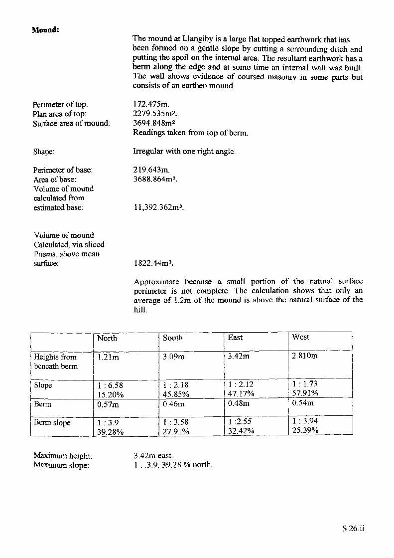
Mound:
Perimeter of top: Plan area of top: Surface area of mound:
Shape:
Perimeter of base: Area of base: Volume of mound calculated from estimated base:
The mound at Llangiby is a large flat topped earthwork that has been formed on a gentle slope by cutting a surrounding ditch and putting the spoil on the internal area. The resultant earthwork has a berm along the edge and at some time an internal wall was built. The wall shows evidence of coursed masonry in some parts but consists of an earthen mound.
172.475m.2279.535m2.3694.848m2Readings taken from top of berm.
Irregular with one right angle.
219.643m. 3688.864m2 .
Il,392.362m3.
Volume of mound Calculated, via sliced Prisms, above mean surface: 1822.44m3.
Approximate because a small portion of the natural surface perimeter is not complete. The calculation shows that only an average of 1.2m of the mound is above the natural surface of the hill.
Heights from beneath berm
Slope
Berm
Berm slope
North
1.21m
1 : 6.58 15.20%0.57m
1 : 3.9 39.28%
South
3.09m
1 :2.18 45.85%0.46m
1 : 3.58 27.91%
East
3.42m
1 :2.12 47.17%0.48m
1 :2.55 32.42%
West
2.810m
1 : 1.73 57.91%0.54m
1 : 3.94 25.39%
Maximum height: Maximum slope:
3.42m east.1 : .3.9. 39.28% north.
S 26.ii
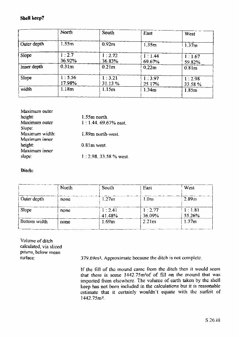
Shell keep?
Outer depth
Slope
inner depth
Slope
width
North
1.55m
1 :2.7 36.92%0.31m
1 : 5.56 17.98%1.18m
South
0.92m
1 : 2.72 36.83%0.21m
1 :3.21 31.13%1.15m
East
1.35m
1 : 1.44 69.67%0.22m
1 : 3.97 25.17%1.34m
West
1.37m
1 : 1.6759.82%0.81m
1 : 2.98 33.58 %1.85m
Maximum outer height:Maximum outer Slope:Maximum width: Maximum inner height:Maximum inner slope:
1.5 5m north.1 : 1.44. 69.67% east.
1.89m north-west.
0.81m west.
1 : 2.98. 33.58 % west.
Ditch:
Outer depth
Slope
Bottom width
North
none
none
none
South
1.27m
1 : 2.41 41.48%1.69m
East
1.0m
1 : 2.77 36.09%2.21m
West
2.89m
1 : 1.81 55.26%1.37m
Volume of ditch calculated, via sliced prisms, below mean surtace: 379.69m 3. Approximate because the ditch is not complete.
If the fill of the mound came from the ditch then it would seem that there is some 1442.75m3of of fill on the mound that was imported from elsewhere. The volume of earth taken by the shell keep has not been included in the calculations but it is reasonable estimate that it certainly wouldn't equate with the surfeit of 1442.75m3 .
S26.iii
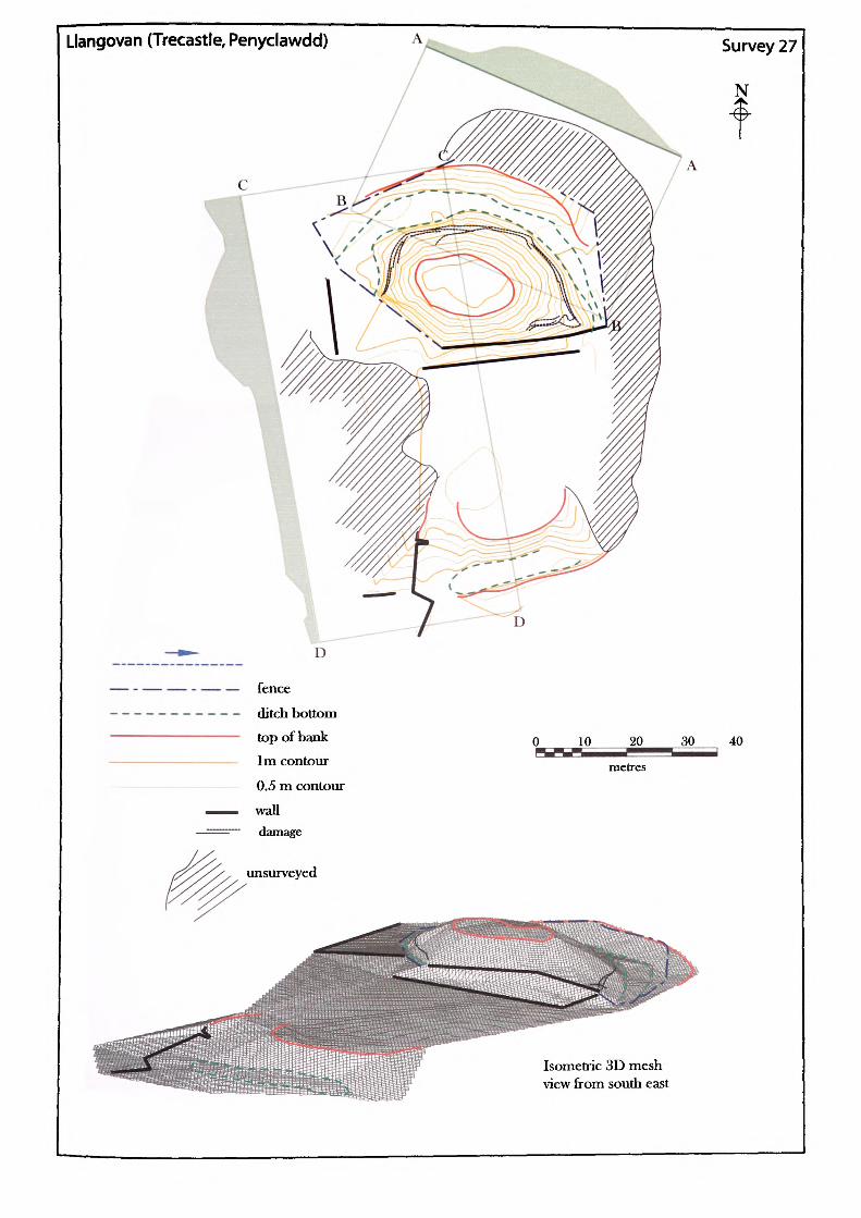
Llangovan (Trecastle, Penyclawdd)
D
fence
ditch bottom
top of bank 1m contour
0.5 m contour
wall damage
JKL_ 20•
metres
Survey 27
N
30 40
Isometric 3D mesh view from south east
Name of Site: Llangovan(Penyclawdd).
Parish: Raglan. County: Gwent
National Grid Reference:
SO 45147 0704.
Known archaeological Sites/Monuments covered by the survey:
SAM. No. MM098. Mound and bailey. Medieval. Secular.
Archaeological Site/Monument types detected by the survey:
Motte and bailey.
Geology at Site:
Topography:
Altitude of site:
Land use:
Area Surveyed:
Survey conditions:
Site conditions:
Old red sandstone. St Maugham's group.
Hill site.
121m.
Waste ground.
5521.687m2.
Due to light rain the conditions for surveying were poor.
The site completely overgrown and has been cut into by modern farm buildings and has been developed on all sides up to the base of the mound.
Surveyor:
Assistant:
Survey Date:
Neil Phillips, University of Wales, Newport.
Leon Phillips.
14 Dec 2001, 19 Dec 2001.
S27.i
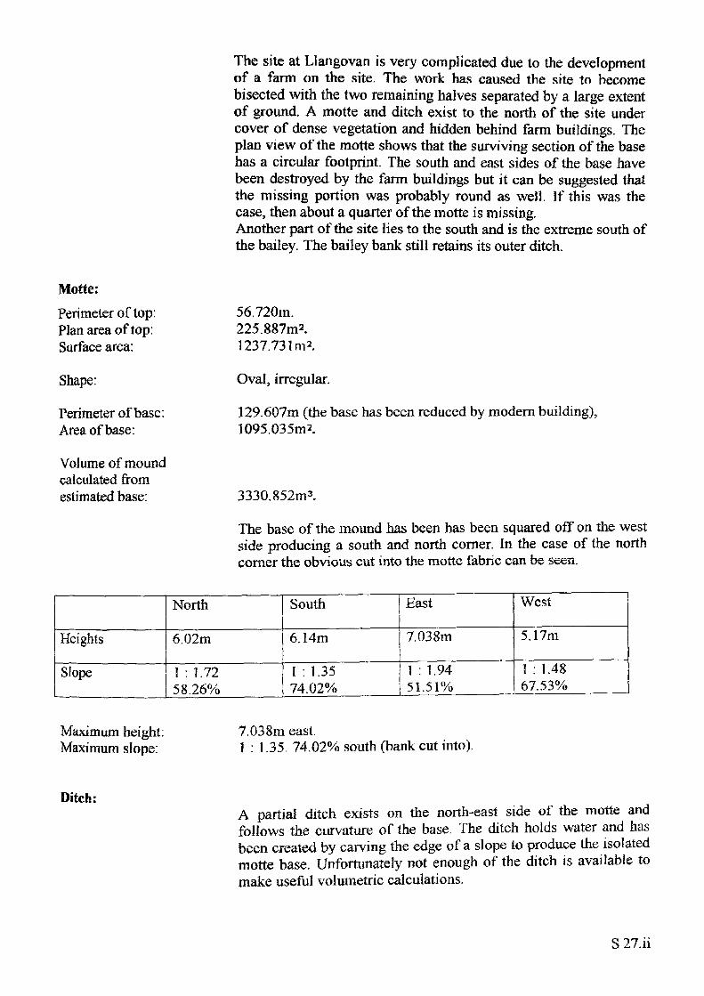
The site at Llangovan is very complicated due to the development of a farm on the site. The work has caused the site to become bisected with the two remaining halves separated by a large extent of ground. A motte and ditch exist to the north of the site under cover of dense vegetation and hidden behind farm buildings. The plan view of the motte shows that the surviving section of the base has a circular footprint. The south and east sides of the base have been destroyed by the farm buildings but it can be suggested that the missing portion was probably round as well. If this was the case, then about a quarter of the motte is missing. Another part of the site lies to the south and is the extreme south of the bailey. The bailey bank still retains its outer ditch.
Motte:
Perimeter of lop: Plan area of top: Surface area:
Shape:
Perimeter of base: Area of base:
56.720m.225.887m2.1237.731m 2.
Oval, irregular.
129.607m (the base has been reduced by modern building), 1095.035m2.
Volume of mound calculated from estimated base: 3330.852m 3.
The base of the mound has been has been squared off on the west side producing a south and north corner. In the case of the north comer the obvious cut into the motte fabric can be seen.
Heights
Slope
North
6.02m
1 : 1.72 58.26%
South
6.14m
1 : 1.3574.02%
East
7.038m
1 : 1.9451.51%
West
5.17m
1 : 1.4867.53%
Maximum height: Maximum slope:
7.038m east.1 : 1.35. 74.02% south (bank cut into).
Ditch:A partial ditch exists on the north-east side of the motte and follows the curvature of the base. The ditch holds water and has been created by carving the edge of a slope to produce the isolated motte base. Unfortunately not enough of the ditch is available to make useful volumetric calculations.
S 27.ii
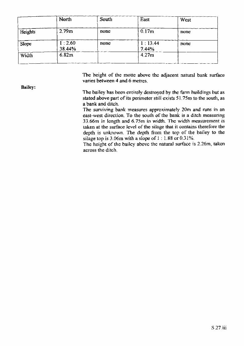
Heights
Slope
Width
North
2.79m
1 : 2.60 38.44%6.82m
South
none
none
East
0.17m
1 : 13.44 7.44%4.27m
West
none
none
Bailey:
The height of the motte above the adjacent natural bank surface varies between 4 and 6 metres.
The bailey has been entirely destroyed by the farm buildings but asstated above part of its perimeter still exists 51.75m to the south, asa bank and ditch.The surviving bank measures approximately 20m and runs in aneast-west direction. To the south of the bank is a ditch measuring33.66m in length and 6.75m in width. The width measurement istaken at the surface level of the silage that it contains therefore thedepth is unknown. The depth from the top of the bailey to thesilage top is 3.06m with a slope of 1 ; 1.88 or 0.31%.The height of the bailey above the natural surface is 2.26m, takenacross the ditch.
S 27.iii
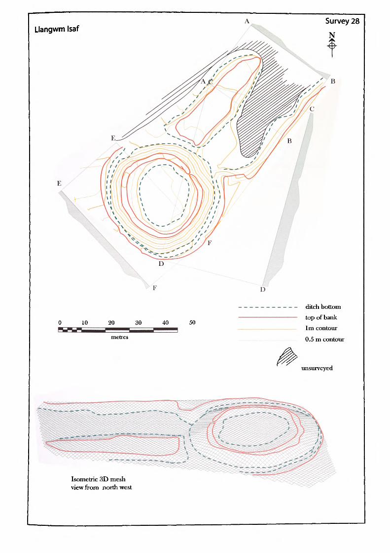
Llangwm Isaf
10 40 50
ditch bottom top of bank 1m contour
0.5 m contour
unsurveyed
Isometric 3D mesh view from northwest
Name of Site: Llangwm Tsaf Parish: Llangwm. (New House).
National Grid Reference:
SO 42422 01119.
Known archaeological Sites/Monuments covered by the survey:
SAM. No. MM074. Ring-work. Medieval. Secular.
Archaeological Site/Monument types detected by the survey:
Fortified-site.
County: Gwent.
Geology at Site:
Topography:
Altitude of site:
Land use:
Area Surveyed:
Survey conditions:
Site conditions:
Psammosteus limestone between old red sandstone. St Maughan's Group and Raglan Marl Group.
Hill site.
63m.
Waste ground.
4558.329m2.
Good conditions.
The site of the motte very overgrown and the probable bailey as been quarried and is now partly waterlogged.
Surveyor:
Assistants:
Survey Date:
Neil Phillips, University of Wales, Newport.
Chris Smith, Paul Huckfield, Daryl Smith.
23 Feb 2002.
S28.i
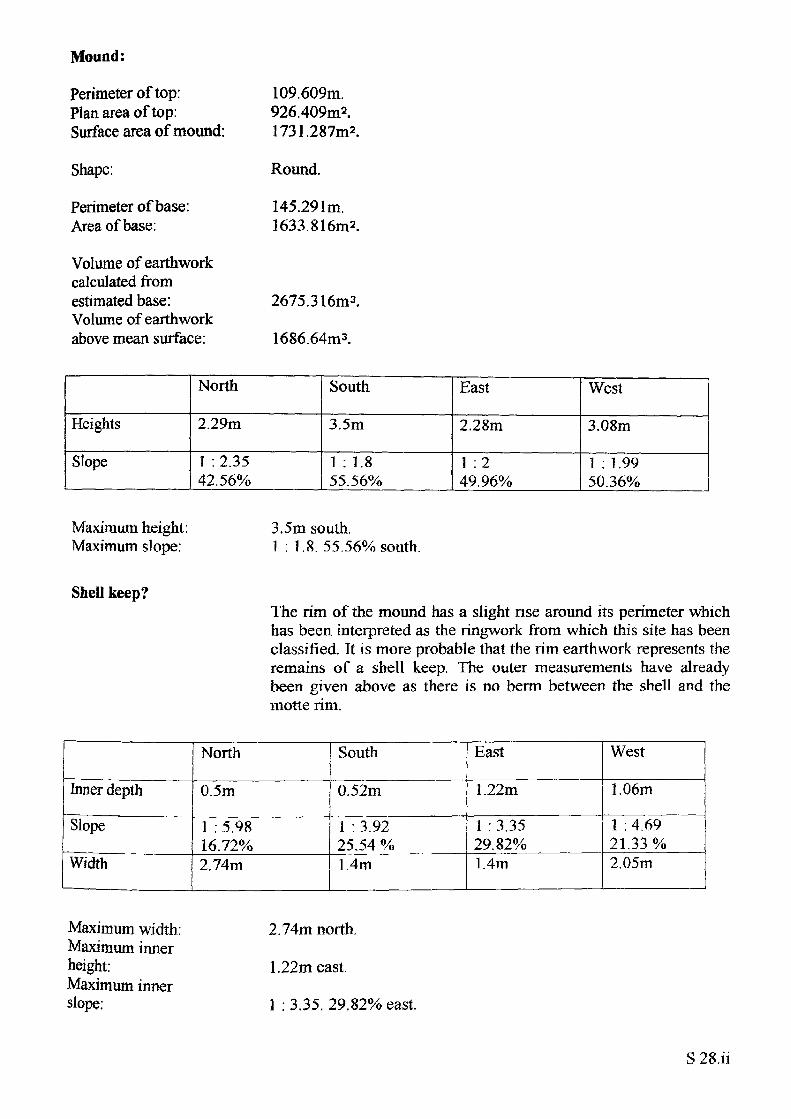
Mound:
Perimeter of top: Plan area of top: Surface area of mound:
Shape:
Perimeter of base: Area of base:
Volume of earthwork calculated from estimated base: Volume of earthwork above mean surface:
109.609m.926.409m*.1731.287m2.
Round.
145.291m. 1633.816m2.
2675.316m3.
1686.64m3.
Heights
Slope
North
2.29m
1 : 2.35 42.56%
South
3.5m
1 : 1.8 55.56%
East
2.28m
1 :2 49.96%
West
3.08m
1 : 1 .99 50.36%
Maximum height: Maximum slope:
3.5m south.1 : 1.8. 55.56% south.
Shell keep?The rim of the mound has a slight rise around its perimeter which has been interpreted as the ringwork from which this site has been classified. Tt is more probable that the rim earthwork represents the remains of a shell keep. The outer measurements have already been given above as there is no berm between the shell and the motte rim.
Inner depth
Slope
Width
North
0.5m
1 : 5.9816.72%2.74m
South
0.52m
i • 3 9225.54 %1.4m
East
1.22m
1 : 3.3529.82%1.4m
West
1.06m
1 : 4.6921.33 %2.05m
Maximum width: Maximum inner height:Maximum inner slope:
2.74m north.
1.22m east.
1 : 3.35. 29.82% east.
S 28.ii
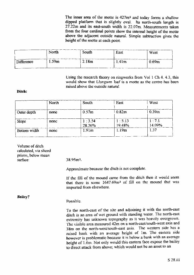
The inner area of the motte is 427m* and today forms a shallow dipped platform that is slightly oval, Its north-south length is 27.22m and its east-south width is 22.07m. Measurements taken from the four cardinal points show the internal height of the motte above the adjacent outside natural. Simple subtraction gives the height of the motte at each point.
Difference
North
1.59m
South
2.18m
East
1.41m
West
0.69m
Using the research theory on ringworks from Vol 1 Ch 4. 4.3, this would show that Llangwm Tsaf is a motte as the centre has been raised above the outside natural.
Ditch:
Outer depth
Slope
Bottom width
North
none
none
none
South
0.57m
1 : 3.54 28.26%1.91m
East
0.82m
1 :5.13 19.48%1.19m
West
0.39m
1 :7.1 14.09%1.37
Volume of ditch calculated, via sliced prisms, below mean surface:
Bailey?
38.95m3.
Approximate because the ditch is not complete.
If the fill of the mound came from the ditch then it would seem that there is some 1647.69m3 of fill on the mound that was imported from elsewhere.
Possible.
To the north-east of the site and adjoining it with the north-east ditch is an area of wet ground with standing water. The north-east extremity has unknown topography as it was heavily overgrown. The visible area measured 42m on a north-east/south-west axis and 38m on the north-west/south-east axis. The western side has a raised bank with an average height of 1m. The eastern side however is problematic because it is below a bank with an average height of 1.6m. Not only would this eastern face expose the bailey to direct attack from above; which would not be an asset to an

early castle, it also holds water as the survey conditions proved It is possible that later quarrying may have caused the damage but on the other hand there is the matter of the 1647.64m3 of fill unaccounted for on the top of the motte.
S 28.iv
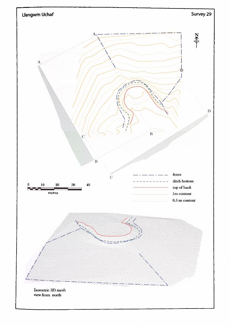
Llangwm Uchaf Survey 29
N
B
\
30 40
— — - — — fence-------- ditch bottom
top of bank 1m contour 0.5 m contour
D
Isometric 3D mesh view from north
Name of Site: Llangwm Uchaf Parish: Llangwm. (Camp House).
National Grid Reference:
ST 42727 99798.
Known archaeological Sites/Monuments covered by the survey:
SAM. No. MM061. Mound and bailey. Medieval. Secular.
Archaeological Site/Monument types detected by the survey:
Motte and Bailey.
Geology at Site:
County: Gwent.
Topography:
Altitude of site:
Land use:
Area Surveyed:
Survey conditions:
Site conditions:
Old red sandstone. St Maughan's Group.
ITill site.
70m.
Private garden.
5789.667m2.
Good conditions
The site is now a raised lawn belonging to a private house.
Surveyor:
Assistant:
Survey Date:
Neil Phillips, University of Wales, Newport.
Andrea Lewis.
14 Jan 2003
S29.i
Motte:
Partial perimeter of reduced top: Plan area of reduced top:
Shape:
Partial perimeter ofbase:Area of partial base:
The motte exists as a much reduced lawn feature and all that remains is a partial slope running east, north-south west.
61.798m.
274.532m2 .
Round on surviving structure.
82.455m. 481.561m2.
It was not possible to make any meaningful volume calculations because of the damage to the motte
Heights
Slope
North
1.52m
1 : 3.53 28.31%
South
none
none
East
I.I 8m
1 :2.6 38.53%
West
1.5m
1 : 12.7 36.76%
Maximum height: Maximum slope:
1.8m north-east. 1 : 2.6. 38.53% east.
Bailey? None identifiable.
There is no bailey identifiable at the site due to the development of the house and farm buildings. It is however reasonable to propose that a small bailey probably existed to the south east as there are features of intermittent bank which suggest that the entire site has been artificially scarped.
S 29.ii
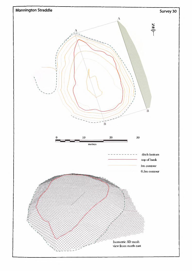
Monnington Straddle
B
10 20 30
Survey 30
N
metres
ditch bottom Lop of bank
1m contour
0.5m contour
Isometric 3D mesh view from north east
Name of Site: Monnington Parish: Vowchurch. Straddle Motte.
National Grid Reference:
SO 38197 36813.
Known archaeological Sites/Monuments covered by the survey:
SAM. No. HWCM890. Motte and bailey. Medieval. Secular.
Archaeological Site/Monument types detected by the survey:
Fortified-site.
County: Herefordshire.
Geology at Site:
Topography:
Altitude of site:
Land use:
Area Surveyed:
Survey conditions:
Site conditions:
Old red sandstone. Raglan mudstone.
Valley site.
129m.
Waste ground.
1116.432m2.
Good conditions.
Mound covered in bracken and bramble. Ditch overgrown and partially impenetrable.
Surveyor:
Assistant:
Survey Date:
Neil Phillips, University of Wales, Newport.
Marge Ferrier.
5 Mar 2002
S30.1
Mound:
Perimeter of top: Plan area of top: Surface area of mound:
Shape:
Perimeter of base: Area of base:
87.08m.485.493m2.968.420m2.
Irregular.
114.673m. 967.290m2.
Volume of mound calculated from estimated base: 1802.312m3.
Heights
Slope
North
1.83m
1 : 1.91 52.47%
South
2.71m
1 : 2.27 44.09%
East
2.79m
1 : 2.05 48.72%
West
2.21m
1 :3.1931.33%
Maximum height: Maximum slope:
2.79m east.1 : 1.91. 52.47% north.
Ditch:The surviving sections of the ditch were restricted to a small depression to the west of the site which was filled with water from the south-east. Elsewhere the ditch was either overgrown or filledin.
S 30.il
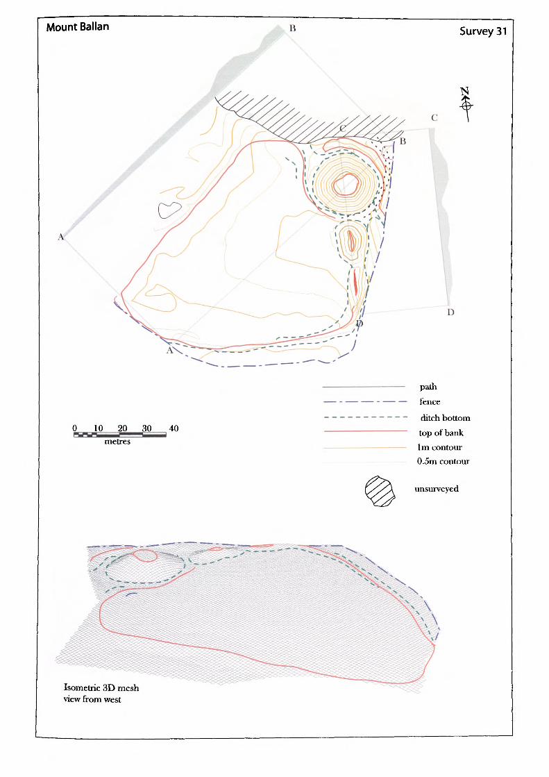
Mount Ballan Survey 31
0 10 20 30 40 metres
path fence
ditch bottom top of bank 1m contour 0.5m contour
unsurveyed
Isometric 3D mesh view from west
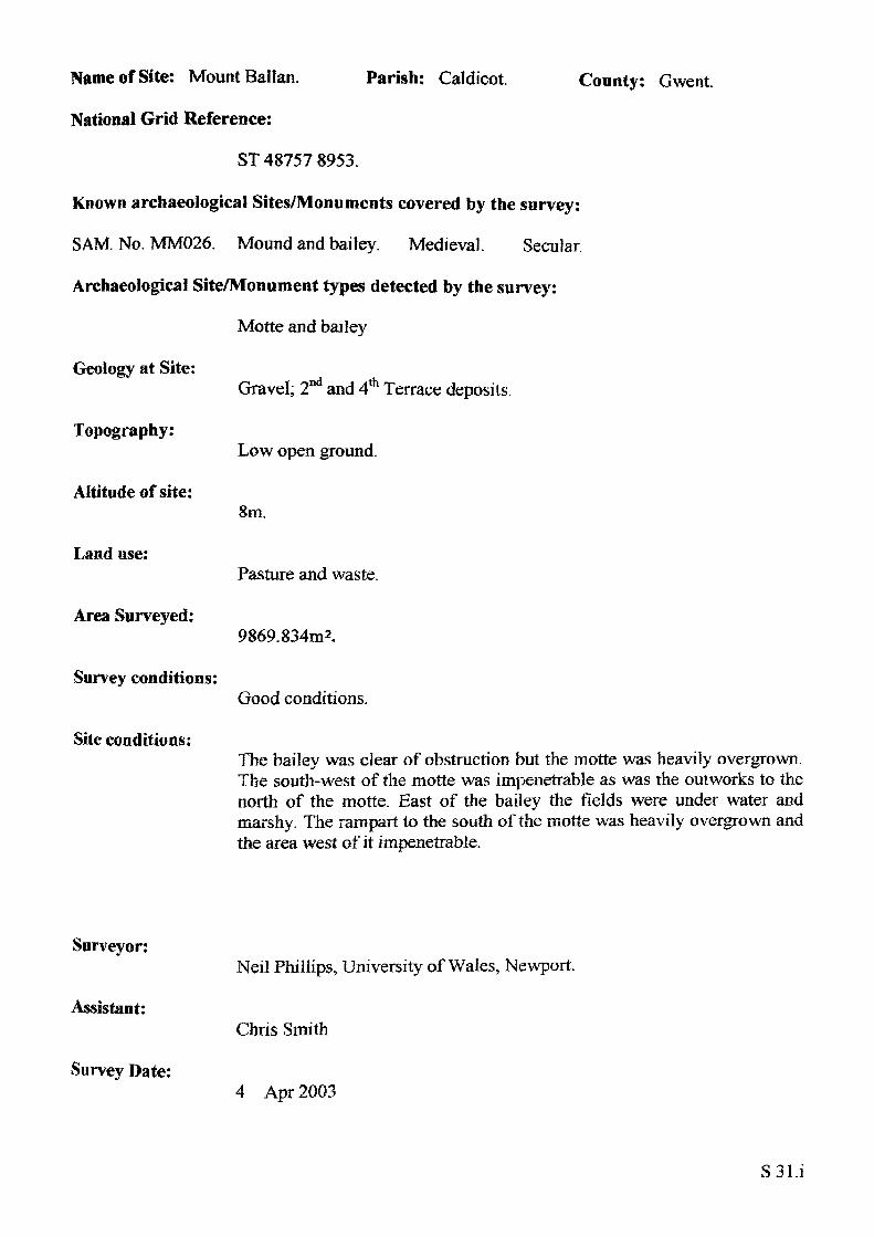
Name of Site: Mount Ballan. Parish: Caldicot.
National Grid Reference:
ST 48757 8953.
Known archaeological Sites/Monuments covered by the survey:
SAM. No. MM026. Mound and bailey. Medieval. Secular.
Archaeological Site/Monument types detected by the survey:
Motte and bailey
Geology at Site:
County: Gwent.
Topography:
Altitude of site:
Land use:
Area Surveyed:
Survey conditions:
Site conditions:
Gravel; 2 and 4 Terrace deposits.
Low open ground.
8m.
Pasture and waste.
9869.834m2.
Good conditions.
The bailey was clear of obstruction but the motte was heavily overgrown. The south-west of the motte was impenetrable as was the outworks to the north of the motte. East of the bailey the fields were under water and marshy. The rampart to the south of the motte was heavily overgrown and the area west of it impenetrable.
Surveyor:
Assistant:
Survey Date:
Neil Phillips, University of Wales, Newport.
Chris Smith
4 Apr 2003
S31.i
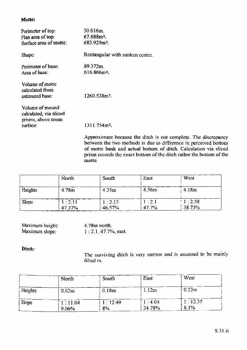
Motte:
Perimeter of top: Plan area of top: Surface area of motte:
Shape:
Perimeter of base: Area of base:
Volume of motte calculated from estimated base:
Volume of mound calculated, via sliced prisms, above mean surface:
30.616m.67.688m2.683.929m2.
Rectangular with sunken centre.
89.372m. 616.866m2.
1260.538m3.
1311.754m3.
Approximate because the ditch is not complete. The discrepancy between the two methods is due to difference in perceived bottom of motte bank and actual bottom of ditch. Calculation via sliced prism records the exact bottom of the ditch rather the bottom of the motte.
Heights
Slope
North
4.78m
1 :2.1147.37%
South
4.35m
1 :2.1546.57%
East
4.56m
1 :2.1 47.7%
West
4.18m
1 : 2.58 38.73%
Maximum height: Maximum slope:
4.78m north.i : 2.1.47.7%, east.
Ditch:The surviving ditch is very narrow and is assumed lo be mainly filled in.
Heights
Slope__ ___ ______
North
0.62m
1 : 11.04 9.06%
South
0.18m
1 : 12.49 8%
East
1.12m
1 : 4.04 24.78%
West
0.23m
I : 12.35 8.1%
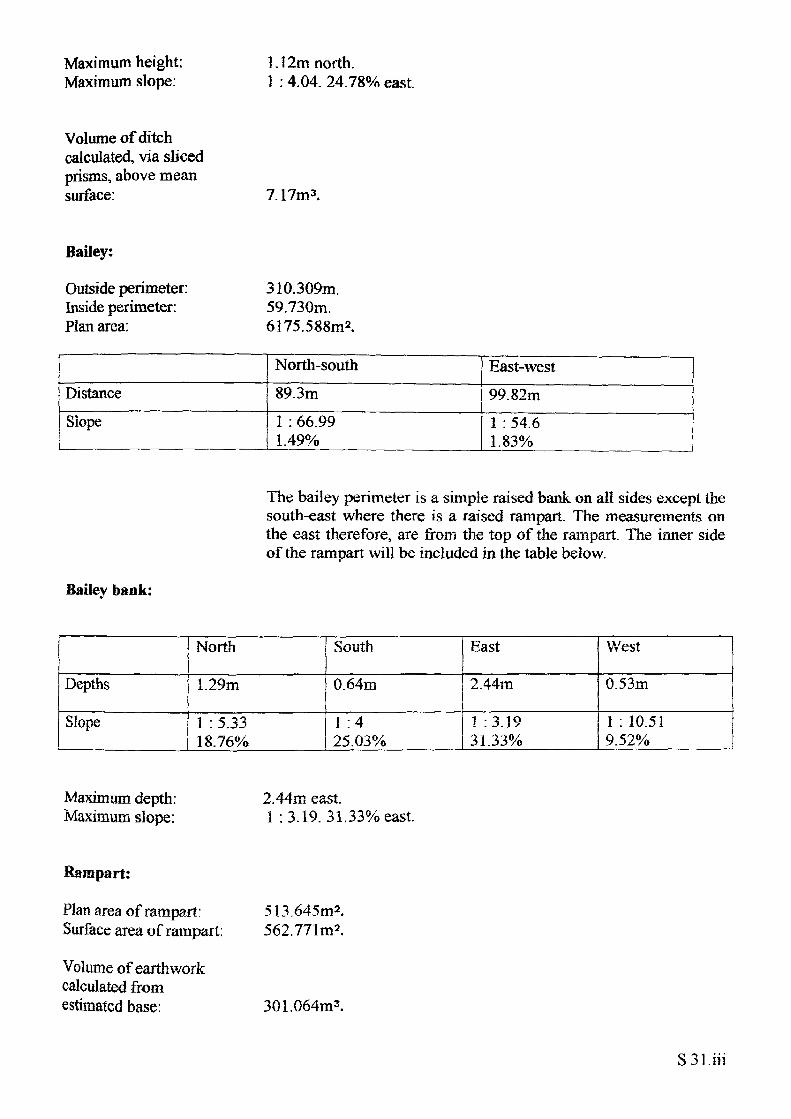
Maximum height: Maximum slope:
1.12m north.1 : 4.04. 24.78% east.
Volume of ditch calculated, via sliced prisms, above mean surface: 7.17m3.
Bailey:
Outside perimeter: 3 10.309m. Inside perimeter: 59.730m. Plan area: 6175.588m2.
DistanceSlope
North-south89.3m1 : 66.99 1.49%
East-west99.82m1 : 54.6 1.83%
The bailey perimeter is a simple raised bank on all sides except the south-east where there is a raised rampart. The measurements on the east therefore, are from the top of the rampart. The inner side of the rampart will be included in the table below.
Bailev bank:
Depths
Slope
North
1.29m
1 : 5.33 18.76%
South
0.64m
1 :4 25.03%
East
2.44in
1 :3.19 31.33%
V/est
0.53m
1 : 10.51 9.52%
Maximum depth: Maximum slope:
2.44m east. 1 : 3.19. 31.33% east.
Rampart:
Plan area of rampart: Surface area of rampart.
Volume of earthwork calculated from estimated base:
513.645m2. 562.771m2.
301.064m3.
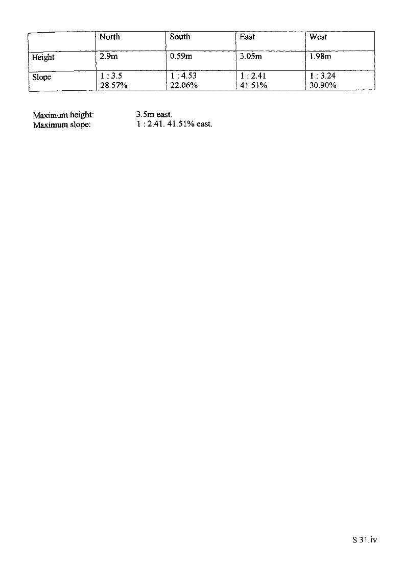
Height
Slope
North
2.9m
1 :3.5 28.57%
South
0.59m
1 : 4.53 22.06%
East
3.05m
1 :2.41 41.51%
West
1.98m
1 : 3.24 30.90%
Maximum height: Maximum slope:
3.5m east.1 : 2.41. 41.51% east.
SSl.iv
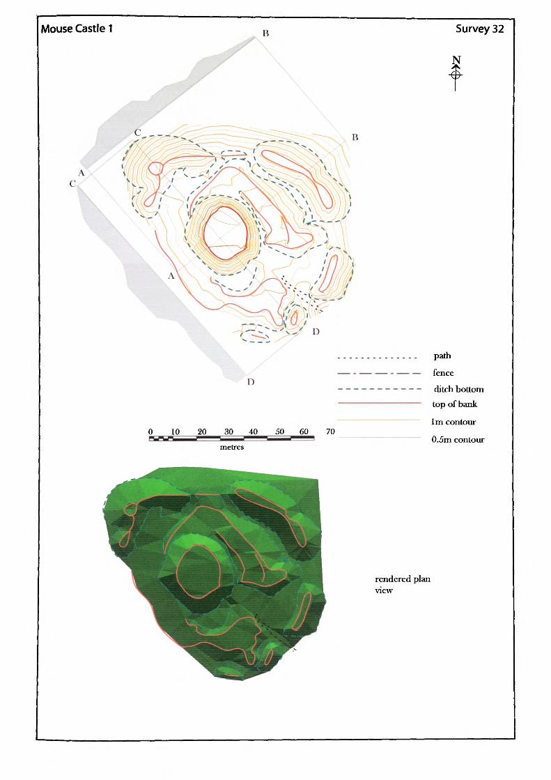
Mouse Castie 1
c «.,
D
10 20 30 40 50 60-metres
70
Survey 32
N
.............. path
—— - —— —— - —— — fence
—---------- ditch bottom————————————— top of bank
1m contour
0.5m contour
rendered plan view
Name of Site: Mouse Castle. Parish: Cusop.
National Grid Reference:
SO 24827 42458.
Known archaeological Sites/Monuments covered by the survey:
SAM.No. HWCM1227. Hill-fort. Prehistoric.
Motte and bailey. Medieval. Secular.
Archaeological Site/Monument types detected by the survey:
Motte and bailey
Geology at Site:
County: Herefordshire.
Topography:
Altitude of site:
Land use:
Area Surveyed:
Survey conditions:
Site conditions:
BGS survey map 214, not yet published. No Data.
Hill site.
246m.
Waste ground.
7194.499m2.
Very cold and sometimes misty.
The entire site is heavily overgrown and in some parts impenetrable. The site would seem to extend down the sides of the natural hill which was beyond the capability of the equipment.
Surveyor:
Assistant:
Survey Date:
Neil Phillips, University of Wales, Newport.
Leon Phillips.
11 Dec 2001, 1 5 Jan 2002,16 Jan 2002.
S32.1
Motte:
Present perimeter of top: 65.421m. Present plan area of top: 321.322m2. Present surface area of motte: 972.465m2.
Shape:
Perimeter of base: Area of base:
Volume of motte calculated from estimated base:
Irregular.
106.138m.
2,521.009m3.
Heights
Slope
North
3.80m
1 : 1.31 76.41%
South
5.164m
1 : 1.37 73.01%
East
4.24m
1 : 1.07 93.1%
West
5.3m
1 :36 73.43%
Maximum height: Maximum slope:
5,3m west.1 : 1.06. 94.23% south-east.
Ditch:
There is a ditch surrounding the motte on all sides but very little was accessible due to the dense overgrowth. Most of the accessible ditch is now very shallow and only the east section has any distinct shape. The other areas of visible ditch have either been filled or damaged; almost beyond recognition. It was impossible to reach the entire south-west section.
Outer depth
Slope
Bottom width
North-west
0.3m
1 : 8.64 11.58%Common point
South-east
0.66m
1 :4.19 23.84%8.6m
East
0.3m
1 : 10.15 9.85%1.22m
West
No Data
"No Data
No Data
No volume calculations could be performed on the data collected due to its incomplete nature.
S 32.ii
Bailey:
East:
Bailey bank:
The bailey area would appear to have lain to the east, south, and west of the motte. The interpretation is based on the flat raised section that was produced by the survey data. The possible bailey remains to the west were too overgrown to survey. The surviving remains of the bailey are in two sections; the best defined to the east and the badly damaged west section. At the south of the motte, where the east and west sections meet, is a gap through which a modern access path has been worn. This southern section is very overgrown and hides obvious earthwork forms.
Outside perimeter: 154.606m. Plan area: 503.248m2.
Distance
North-west/south-east
47.1mNorth-east/ South-west6.66m
Depths
Slope
North
none
none
South
1.39m
1 :3.91 25.61%
East
3.27m
1 : 2.96 33.79%
West
0.3m
1 : 10.15 9.85%
West:
Measurable outside perimeter: Measurable plan area:
175.851m.
642.647m 2.
Distance
North- west/south-east
67.74m
North-east/ South-west
23m
Bailey bank:
Depths
Slope
North
No data
No data
South
1.52m
1 : 3.49 28.69%
East
0.7m
1 :3.11 32.18%
West
No data
No data
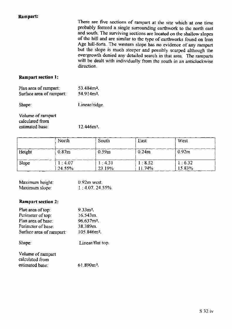
Rampart:
Rampart section 1:
Plan area of rampart: Surface area of rampart:
Shape:
Volume of rampart calculated from estimated base:
There are five sections of rampart at the site which at one time probably formed a single surrounding earthwork to the north east and south. The surviving sections are located on the shallow slopes of the hill and are similar to the type of earthworks found on Iron Age hill-forts. The western slope has no evidence of any rampart but the slope is much steeper and possibly scarped although the overgrowth denied any detailed search in that area. The ramparts will be dealt with individually from the south in an anticlockwise direction.
53.484m2. 54.914m2.
Linear/ridge.
12.446m3.
Height
Slope
North
0.87m
1 : 4.07 24.55%
South
0.59m
1 :4.31 23.19%
East
0.24m
1 : 8.52 11.74%
West
0.92m
1 : 6.32 15.83%
Maximum height: Maximum slope:
0.92m west.1 :4.07. 24.55%.
Rampart section 2:
Plan area of top: Perimeter of top: Plan area of base: Perimeter of base: Surface area of rampart:
Shape:
Volume of rampart calculated from estimated base:
9.33m2.16.543m.96.637m2.38.389m.105.846m2.
Linear/flat top.
61.890m3.
S 32.iv
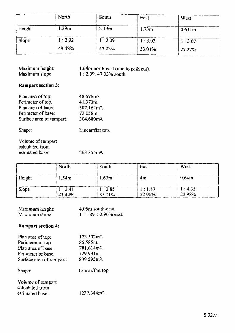
Height
Slope
North
1.39m
1 : 2.02 49.48%
South
2.19m
1 : 2.09 47.03%
East
1.73m
1 : 3.03 33.01%
West
0.611m
1 : 3.67 27.27%
Maximum height: Maximum slope:
Rampart section 3:
Plan area of top: Perimeter of top: Plan area of base: Perimeter of base: Surface area of rampart:
Shape:
Volume of rampart calculated from estimated base:
1.64m north-east (due to path cut). 1 : 2.09. 47.03% south.
48.676m2.41.373m.307.164m 2.72.058m.304.680m2.
Linear/flat top.
263.355m3.
Height
Slope___ ...
North
1.54m
1 :2.41 41.44%
South
1. 65m
I : 2.85 35.11%
East
4m
1 : 1.89 52.96%
West
0.64m
1 : 4.35 22.98%
Maximum height: Maximum slope:
Rampart section 4:
Pian area of top: Perimeter of top: Plan area of base: Perimeter of base: Surface area of rampart:
Shape:
Volume of rampart calculated from estimated base:
4.05m south-east. 1 : 1.89. 52.96% east.
123.552m2.86.585m.781.614m2.129.931m.839.595m2.
Linear/flat top.
1237.344m3,
S32.v
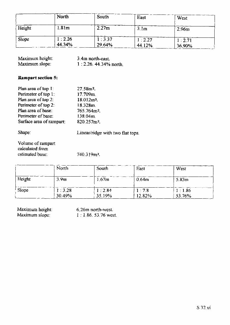
Height
Slope
North
1.81m
1 : 2.26 44.34%
South
2.27m
1 :3.37 29.64%
East
3.1m
1 : 2.27 44. 12%
West
2.96m
1 :2.71 36.90%
Maximum height: Maximum slope:
3.4m north-east.1 : 2.26. 44.34% north.
Rampart section 5:
Plan area of top 1: Perimeter of top 1: Plan area of top 2: Perimeter of top 2: Plan area of base: Perimeter of base: Surface area of rampart:
Shape:
Volume of rampart calculated from estimated base:
27.58m2.17.709m.18.012m2.18.328m.765.764m2.138.04m.820.257m2.
Linear/ridge with two flat tops.
740.319m3.
Height
Slope
North
3.9m
1 :3.2830.49%
South
1.67m
1 : 2.8435.19%
East
0.64m
1 :7.812.82%
West
5.83m
1 : 1.86 53.76%
Maximum height: Maximum slope:
6.26m north-west. 1 : 1.86. 53.76 west.
S 32.vi
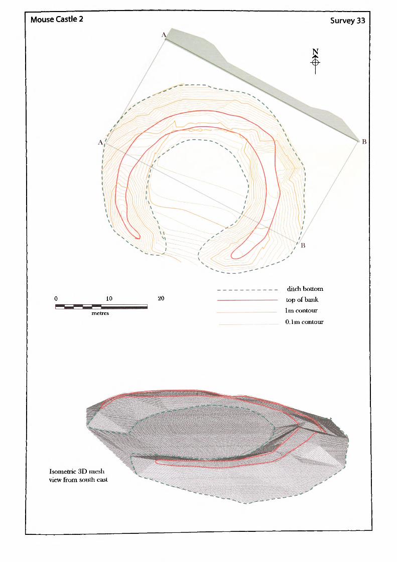
Mouse Castle 2 Survey 33
N
20ditch bottom top of bank 1m contour
O.lm contour
Isometric 3D mesh view from south east
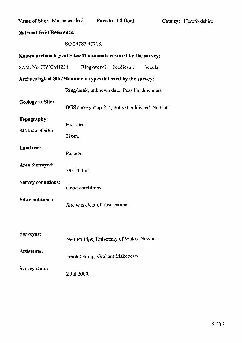
Name of Site: Mouse castle 2, Parish: Clifford,
National Grid Reference:
SO 24787 42718.
Known archaeological Sites/Monuments covered by the survey:
SAM. No. HWCM1231 Ring-work? Medieval. Secular.
Archaeological Site/Monument types detected by the survey:
Ring-bank, unknown date. Possible dewpond.
Geology at Site:
County: Herefordshire.
Topography:
Altitude of site:
Land use:
Area Surveyed:
Survey conditions:
Site conditions:
BGS survey map 214, not yet published. No Data.
Hill site.
216m.
Pasture.
383.204m2.
Good conditions.
Site was clear of obstructions.
Surveyor:
Assistants:
Survey Date:
Neil Phillips, University of Wales, Newport.
Frank Olding, Graham Makepeace.
2 Jul 2000.
S33.i
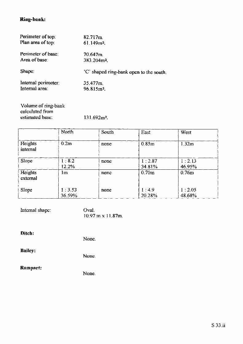
Ring-bank:
Perimeter of top: Plan area of top:
Perimeter of base: Area of base:
Shape:
Internal perimeter: Internal area:
82.717m. 61.149m2.
70.647m. 383.204m2.
'C' shaped ring-bank open to the south.
35.477m. 96.815m2.
Volume of ring-bank calculated from estimated base: 131.692m3.
Heights internal
Slope
Heights external
Slope
North
0.2m
1:8.2 12.2%1m
1 : 3.53 36.59%
South
none
none
none
none
East
0.85m
1 : 2.87 34.81%0.70m
1 :4.9 20.28%
West
1.32m
I :2.13 46.95%0.76m
1 : 2.05 48.68%
Internal shape: Oval.10.97m xl 1.87m.
Ditch:
Bailey:
Rampart:
None.
None.
None.
S 33.ii
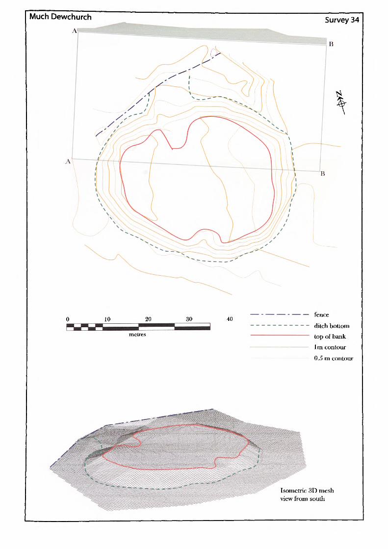
Much Dewchurch
AlSurvey 34
B
40—— - —— — fence
—------ ditch bottom——————— top of bank
——————— 1m contour
———————— 0.5 m contour
Isometric 3D mesh view from south
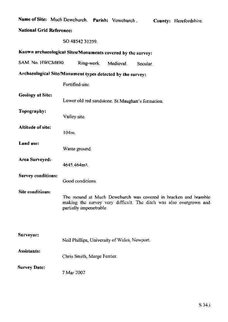
Name of Site: Much Dewchurch. Parish: Vowchurch ,
National Grid Reference:
SO 48542 31259.
Known archaeological Sites/Monuments covered by the survey:
SAM. No. HWCM890. Ring-work. Medieval. Secular.
Archaeological Site/Monument types detected by the survey:
Fortified-site.
County: Herefordshire.
Geology at Site:
Topography:
Altitude of site:
Land use:
Area Surveyed:
Survey conditions:
Site conditions:
Lower old red sandstone. St Maughan's formation.
Valley site.
104m.
Waste ground.
4645.464m2.
Good conditions.
The mound at Much Dewchurch was covered in bracken and bramble making the survey very difficult. The ditch was also overgrown and partially impenetrable.
Surveyor:
Assistants:
Survey Date:
Neil Phillips, University of Wales, Newport.
Chris Smith, Marge Ferrier.
7 Mar 2002
S34.1
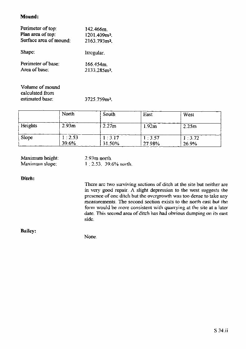
Mound:
Perimeter of top: Plan area of top: Surface area of mound:
Shape:
Perimeter of base: Area of base:
142.466m.1201.409m2.2163.793m2.
Irregular.
166.454m. 2133.285m2.
Volume of moundcalculated from estimated base: 3725.759nv*.
Heights
Slope
North
2.93m
1 : 2.53 39.6%
South
2.27m
1 :3.17 31.50%
East
1.92m
1 : 3.57 27.98%
West
2.25m
1 : 3.72 26.9%
Maximum height Maximum slope:
2.93m north.I : 2.53. 39.6% north.
Ditch:
Bailey:
There are two surviving sections of ditch at the site but neither are in very good repair. A slight depression to the west suggests the presence of one ditch but the overgrowth was too dense to take any measurements. The second section exists to the north east but the form would be more consistent with quarrying at the site at a later date. This second area of ditch has had obvious dumping on its east side.
None.
S 34. ii
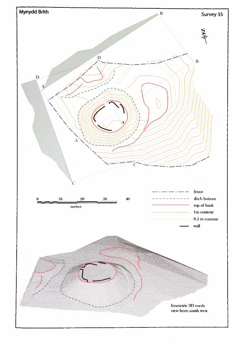
Mynydd BrTth
30 40
— —— - —— — fence
—------ ditch bottom———————— top of bank
——————— 1m contour
— 0.5 m contour——— wall
Isometric 3D mesh view from south west
Name of Site: Mynydd-brith. Parish: Dorstone.
National Grid Reference:
SO 27997 41468.
Known archaeological Sites/Monuments covered by the survey:
SAM. No. HWCM1241. Motte and bailey. Medieval. Secular.
Archaeological Site/Monument types detected by the survey:
Motte and bailey.
Geology at Site:
County: Herefordshire.
Topography:
Altitude of site:
Land use:
Area Surveyed:
Survey conditions:
Site conditions:
BGS survey map 214, not yet published.
Hill site.
269m.
Waste and private garden.
4645.464m2
Good conditions.
The top of motte at this site was covered in vegetation through which it was possible to see vague surface remains; of dubious origin. The surrounding area has been modified by road and garden.
Surveyor:
Assistant:
Survey Date:
Neil Phillips, University of Wales. Newport.
Adam Phillips.
22 Dec 2001.
S35.1
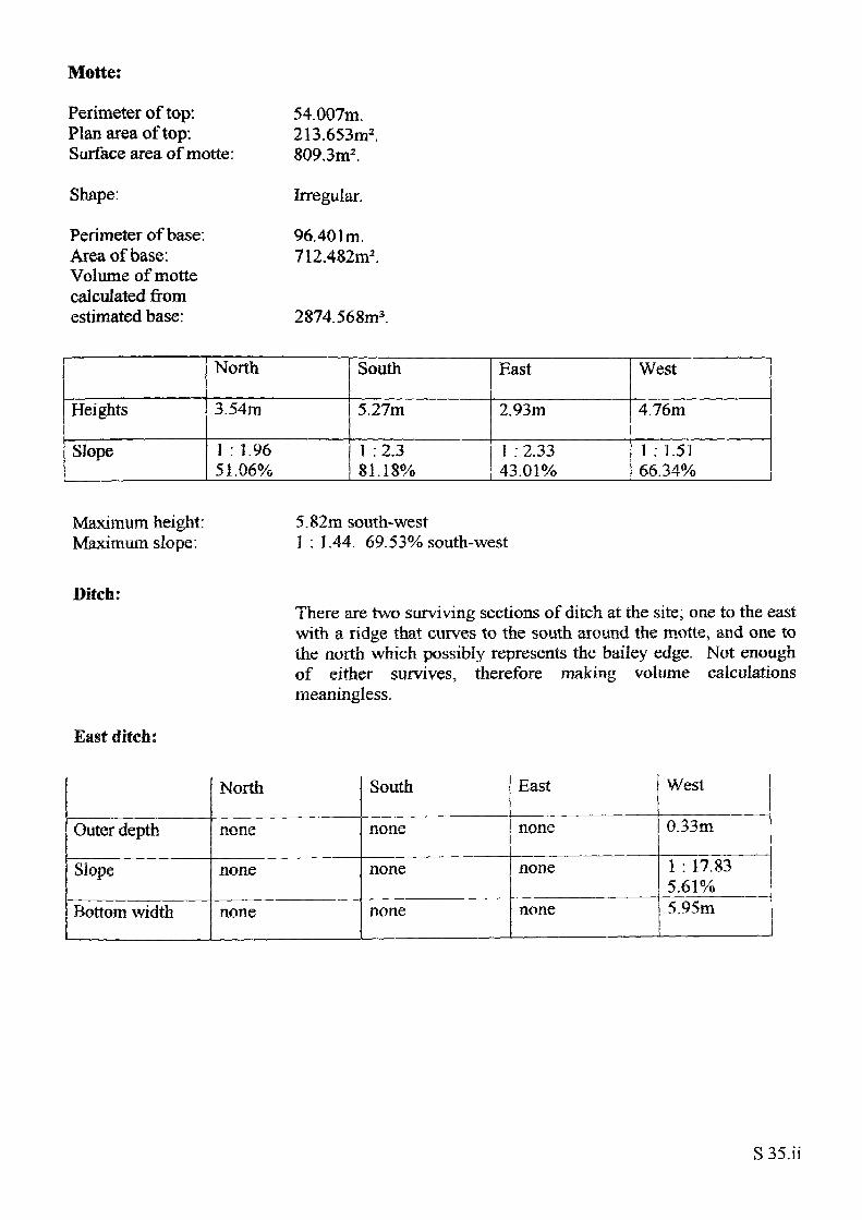
Motte:
Perimeter of top: Plan area of top: Surface area of motte:
Shape:
Perimeter of base: Area of base: Volume of motte calculated from estimated base:
54.007m.213.653m2 .809.3m2 .
Irregular.
96.401m. 712.482m2 .
2874.568m3
Heights
Slope
North
3.54m
1 : 1.9651.06%
South
5.27m
1 :2.3 81.18%
East
2.93m
1 : 2.33 43.01%
West
4.76m
1 : 1.51 66.34%
Maximum height: Maximum slope:
5.82m south-west1 : 1.44. 69.53% south-west
Ditch:
East ditch:
There are two surviving sections of ditch at the site; one to the east with a ridge that curves to the south around the motte, and one to the north which possibly represents the bailey edge. Not enough of either survives, therefore making volume calculations meaningless.
Outer depth
Slope
Bottom width
North
none
none
none
South
none
none
none
East
none
none
none
West
0.33m
1 : 17.83 5.61%5.95m
S 35.ii
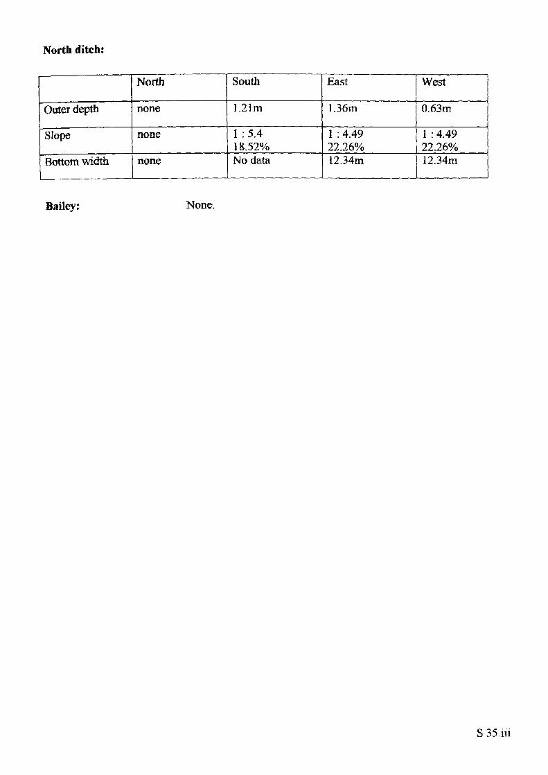
North ditch:
Outer depth
Slope
Bottom width
North
none
none
none
South
1.21m
1 :5.4 18.52%No data
East
1.36m
1 : 4.49 22.26%12.34m
West
0.63m
1 : 4.4922.26%12.34m
Bailey: None.
S35.iii
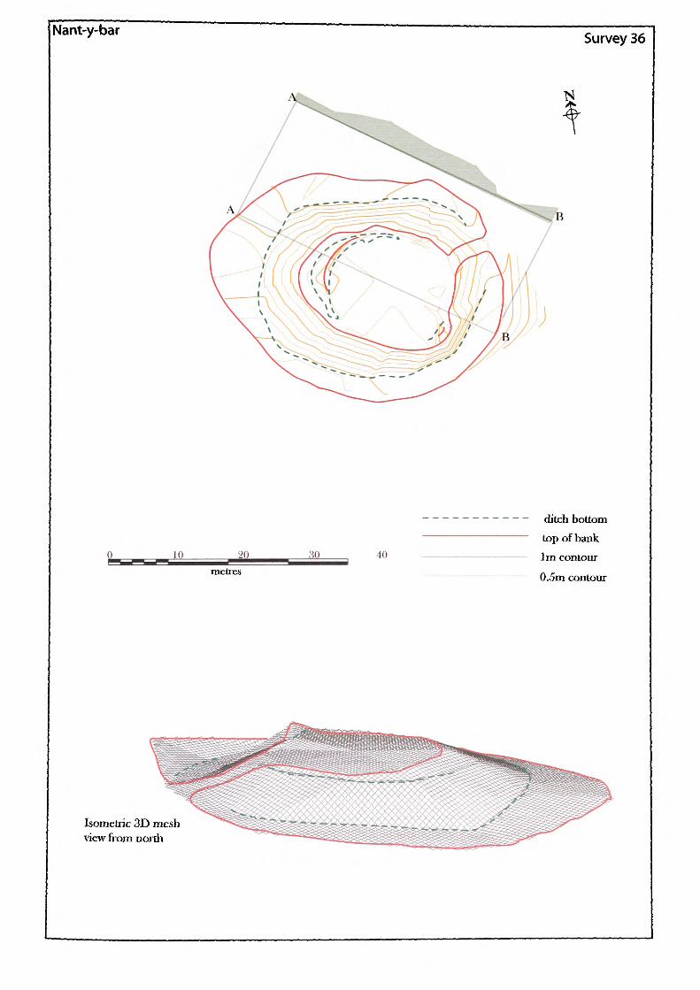
[Nant-y-bar Survey 36
40
melrcs
ditch bottom top of bank 1m contour
0.5m contour
Isometric 3D mesh view from north
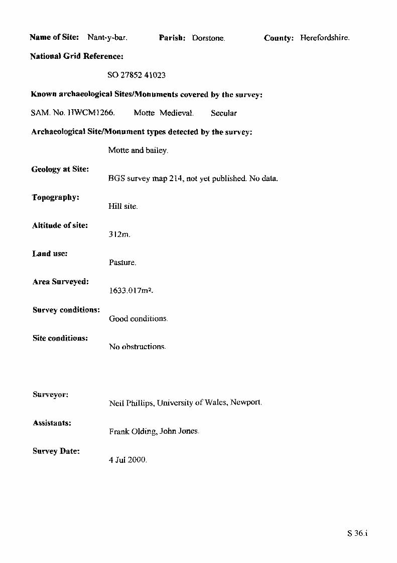
Name of Site: Nant-y-bar.
National Grid Reference:
Parish: Dorstone. County: Herefordshire.
SO 27852 41023
Known archaeological Sites/Monuments covered by the survey:
SAM. No. HWCM1266. Motte Medieval. Secular
Archaeological Site/Monument types detected by the survey:
Motte and bailey.
Geology at Site:
Topography:
Altitude of site:
Land use:
Area Surveyed:
Survey conditions:
Site conditions:
BGS survey map 214, not yet published No data.
Hill site.
312m.
Pasture.
1633.017m2.
Good conditions.
No obstructions.
Surveyor:
Assistants:
Survey Date:
Neil Phillips, University of Wales, Newport.
Frank Olding, John Jones.
4 Jul 2000.
S36.1
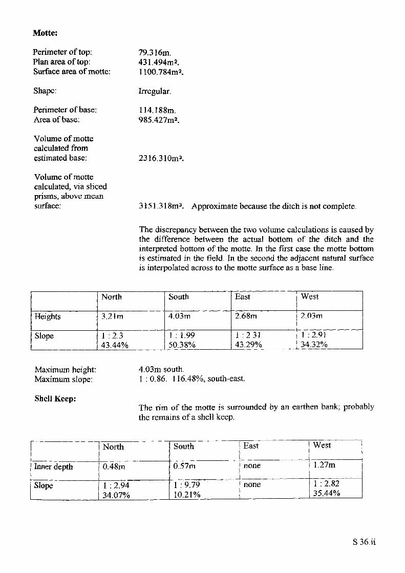
Motte:
Perimeter of top: Plan area of top: Surface area of motte:
Shape:
Perimeter of base : Area of base:
Volume of motte calculated from estimated base:
Volume of motte calculated, via sliced prisms, above mean surface:
79.316m.431.494m2.1100.784m2.
Irregular.
114.188m. 985.427m2.
2316.310m3.
3151.318m3. Approximate because the ditch is not complete.
The discrepancy between the two volume calculations is caused by the difference between the actual bottom of the ditch and the interpreted bottom of the motte. In the first case the motte bottom is estimated in the field. In the second the adjacent natural surface is interpolated across to the motte surface as a base line.
Heights
Slope
North
3.21m
1 : 2.3 43.44%
South
4.03m
1 : 1.99 50.38%
East
2.68m
1 :2.31 43.29%
West
2.03m
1 :2.91 34.32%
Maximum height: Maximum slope:
Shell Keep:
4.03m south.1 : 0.86. 116.48%, south-east.
The rim of the motte is surrounded by an earthen bank; probably the remains of a shell keep.
Inner depth
Slope
North
0.48m
1 : 2.94 34.07%
South
0.57m
1 : 9.79 10.21%
East
none
none
West
1.27m
1 : 2.82 35.44%
S 36.ii
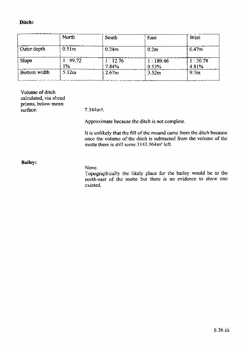
Ditch:
Outer depth
Slope
Bottom width
North
0.51m
1 : 99.72 1%5.12m
South
0.24m
1 : 12.76 7.84%2.67m
East
0.2m
1 : 189.460.53%3.52m
West
0.47m
1 : 20.78 4.81%9.7m
Volume of ditch calculated, via sliced prisms, below mean surface: 7.344m3.
Approximate because the ditch is not complete.
It is unlikely that the fill of the mound came from the ditch because once the volume of the ditch is subtracted from the volume of the motte there is still some 3143.964m3 left.
Bailey:None.Topographically the likely place for the bailey would be to thenorth-east of the motte but there is no evidence to show oneexisted.
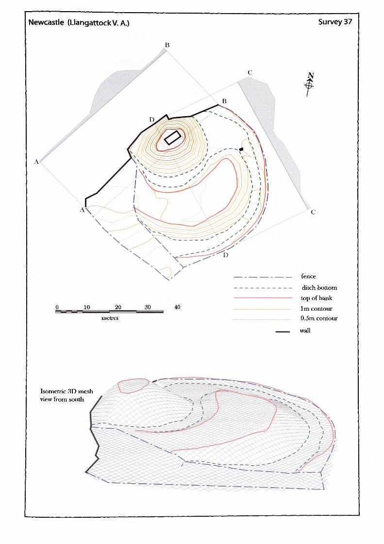
Newcastle (LlangattockV. A.) Survey 37
B
c
10 _ 20^^
metres
30 40
fence
ditch bottom top of bank
1m contour 0.5m contour
wall
Isometric 3D mesh view from south
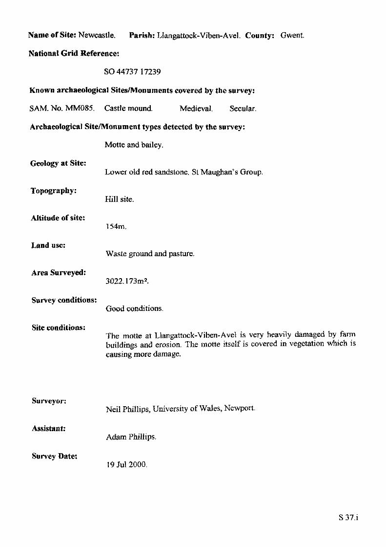
Name of Site: Newcastle. Parish: Llangattock-Viben-Avel, County: Gwent.
National Grid Reference:
SO 44737 17239
Known archaeological Sites/Monuments covered by the survey:
SAM. No. MM085. Castle mound. Medieval. Secular.
Archaeological Site/Monument types detected by the survey:
Motte and bailey.
Geology at Site:
Topography:
Altitude of site:
Land use:
Area Surveyed:
Survey conditions:
Site conditions:
Lower old red sandstone. St Maughan's Group.
Hill site.
154m.
Waste ground and pasture.
3022.173m2.
Good conditions.
The motte at Llangattock-Viben-Avel is very heavily damaged by farm buildings and erosion. The motte itself is covered in vegetation which is causing more damage.
Surveyor:
Assistant:
Survey Date:
Neil Phillips, University of Wales, Newport.
Adam Phillips.
19Jul2000.
S37.1
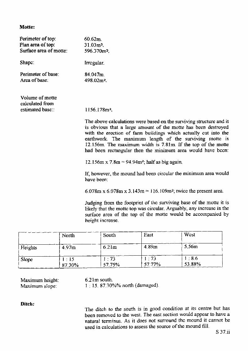
Motte:
Perimeter of top: Plan area of top: Surface area of motte:
Shape:
Perimeter of base: Area of base:
60.62m.31.03m2.596.370m2.
Irregular.
84.047m. 498.02m2.
Volume of motte calculated from estimated base:: 1156.178m3.
The above calculations were based on the surviving structure and it is obvious that a large amount of the motte has been destroyed with the erection of farm buildings which actually cut into the earthwork. The maximum length of the surviving motte is 12.156m. The maximum width is 7.81m. If the top of the motte had been rectangular then the minimum area would have been:
12.156m x 7.8m = 94.94m2; half as big again.
If, however, the mound had been circular the minimum area would have been:
6.078m x 6.078m x 3.143m = 116.109m2; twice the present area.
Judging from the footprint of the surviving base of the motte it is likely that the motte top was circular. Arguably, any increase in the surface area of the top of the motte would be accompanied by height increase.
Heights
Slope
North
4.97m
1 : 1587.30%
South
6.21m
1 :73 57.75%
East
4.89m
1 :73 57.77%
West
5.56m
1 : 8.6 53.88%
Maximum height: Maximum slope:
6.21m south.1 : 15. 87.30%% north (damaged).
Ditch:The ditch to the south is in good condition at its centre but has been removed to the west. The east section would appear to have a natural terminus. As it does not surround the mound it cannot be used in calculations to assess the source of the mound fill.
S 37.ii
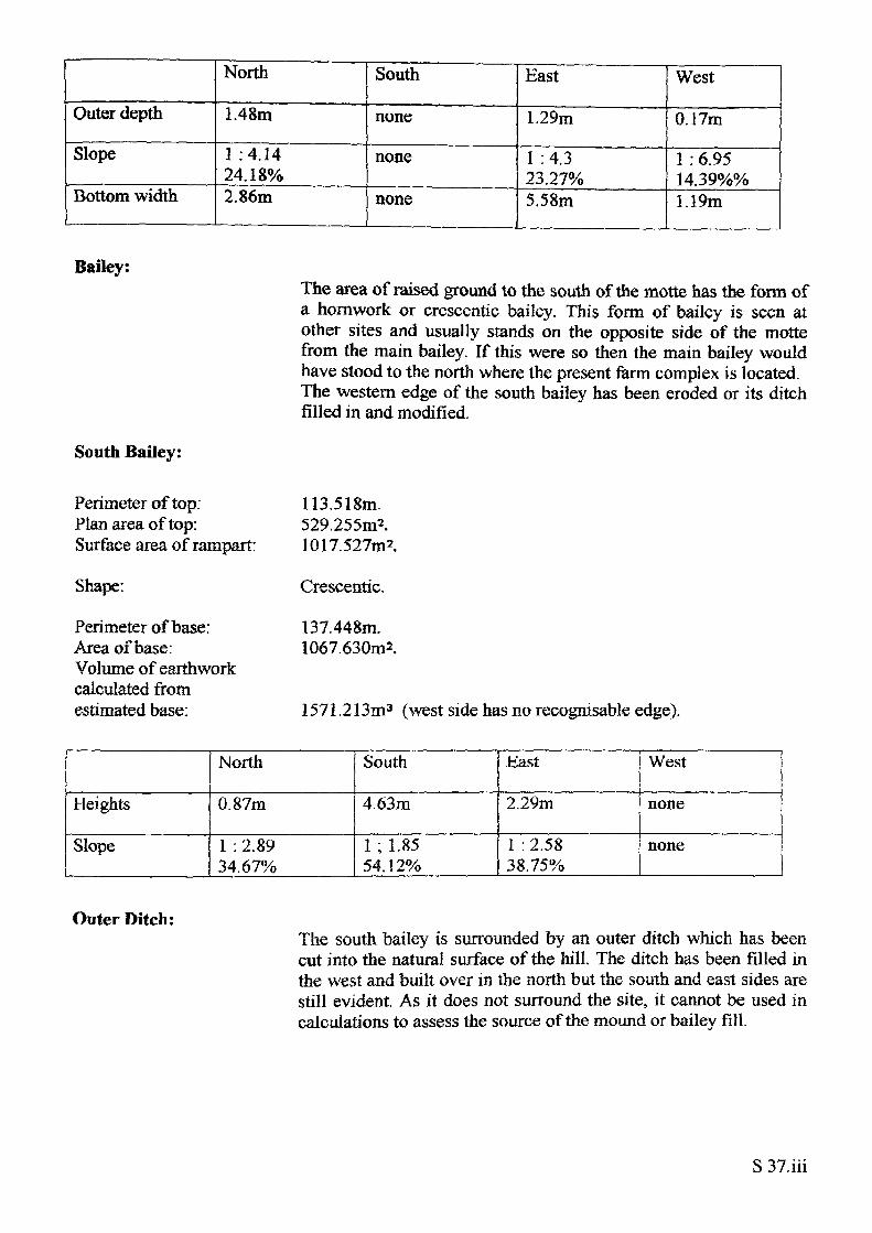
Outer depth
Slope
Bottom width
North
1.48m
1 :4.14 24.18%2.86m
South
none
none
none
East
1.29m
1 : 4.3 23.27%5.58m
West
0.17m
1 : 6.95 14.39%%1.19m
Bailey:
South Bailey:
The area of raised ground to the south of the motte has the form of a hornwork or crcsccntic bailey. This form of bailey is seen at other sites and usually stands on the opposite side of the motte from the main bailey. If this were so then the main bailey would have stood to the north where the present farm complex is located. The western edge of the south bailey has been eroded or its ditch filled in and modified.
Perimeter of top: Plan area of top: Surface area of rampart:
Shape:
Perimeter of base: Area of base: Volume of earthwork calculated from estimated base:
113.518m.529.255m2.1017.527m2.
Crescentic.
137.448m. 1067.630m2.
1571.213m3 (west side has no recognisable edge).
Heights
Slope
North
0.87m
1 : 2.8934.67%
South
4.63m
1 ; 1.85 54.12%
Hast
2.29m
1 :2.58 38.75%
West
none
none
Outer Ditch:The south bailey is surrounded by an outer ditch which has been cut into the natural surface of the hill. The ditch has been filled in the west and built over in the north but the south and east sides are still evident. As it does not surround the site, it cannot be used in calculations to assess the source of the mound or bailey fill.
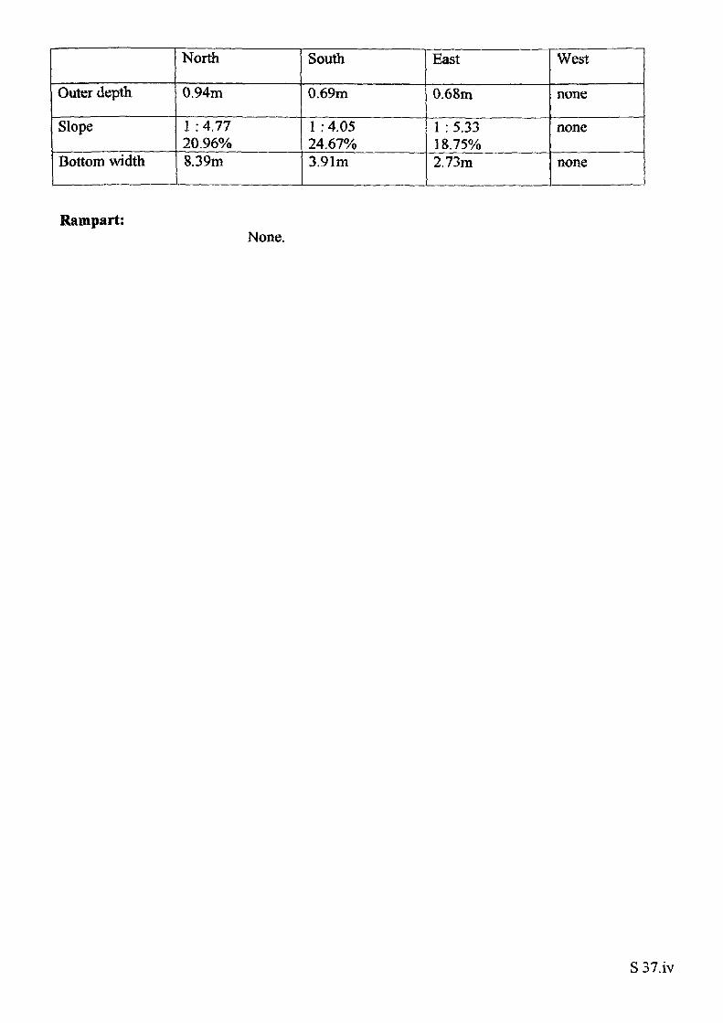
Outer depth
Slope
Bottom width
North
0.94m
1 : 4.77 20.96%8.39m
South
0.69m
1 : 4.05 24.67%3.91m
East
0.68m
1 : 5.33 18.75%2.73m
West
none
none
none
Rampart:None.
S 37.iv
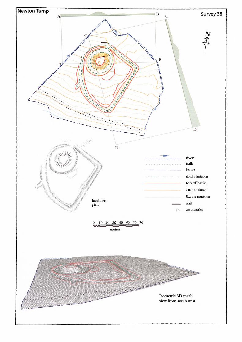
Newton Tump Survey 38
N
0 10 20 30 40 50 60 70—I——" metres
Isometric 3D mesh view from south west
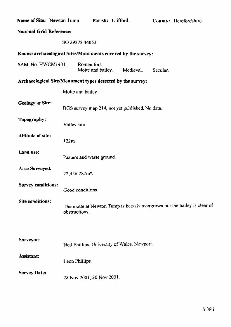
Name of Site: Newton Tump. Parish: Clifford.
National Grid Reference:
SO 29272 44053.
Known archaeological Sites/Monuments covered by the survey:
SAM. No. HWCM1401. Roman fort.Motte and bailey. Medieval. Secular.
Archaeological Site/Monument types detected by the survey:
Motte and bailey.
Geology at Site:
County: Herefordshire.
Topography:
Altitude of site:
Land use:
Area Surveyed:
Survey conditions:
Site conditions:
BGS survey map 214, not yet published. No data.
Valley site.
122m.
Pasture and waste ground.
22,456.782m2.
Good conditions.
The motte at Newton Tump is heavily overgrown but the bailey is clear of obstructions.
Surveyor:
Assistant:
Survey Date:
Neil Phillips, University of Wales, Newport.
Leon Phillips.
28 Nov 2001,30 Nov 2001.
S38.i
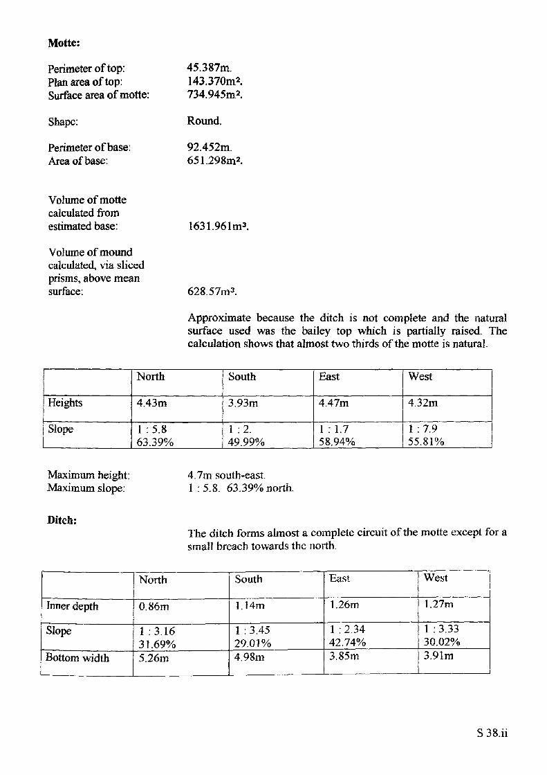
Motte:
Perimeter of top: Plan area of top: Surface area of motte:
Shape:
Perimeter of base: Area of base:
45.387m.143.370m2.734.945m2.
Round.
92.452m. 651.298m2.
Volume of motte calculated from estimated base:
Volume of mound calculated, via sliced prisms, above mean surface:
1631.961m3.
628.57m3 .
Approximate because the ditch is not complete and the natural surface used was the bailey top which is partially raised. The calculation shows that almost two thirds of the motte is natural.
Heights
Slope
North
4.43m
1 :5.863.39%
South
3.93m
1 :2. 49.99%
East
4.47m
1 :1.7 58.94%
West
4.32m
1 :7.9 55.81%
Maximum height: Maximum slope:
4.7m south-east.1 :5.8. 63.39% north.
Ditch:The ditch forms almost a complete circuit of the rnotte except for; small breach towards the north.
Inner depth
Slope
Bottom width
North
0.86m
1 :3.16 31.69%5.26m
South
1.14m
1 : 3.45 29.01%4.98m
East
1.26m
1 : 2.34 42.74%3.85m
West
1.27m
1 :3.33 30.02%3.91m
S 38.ii
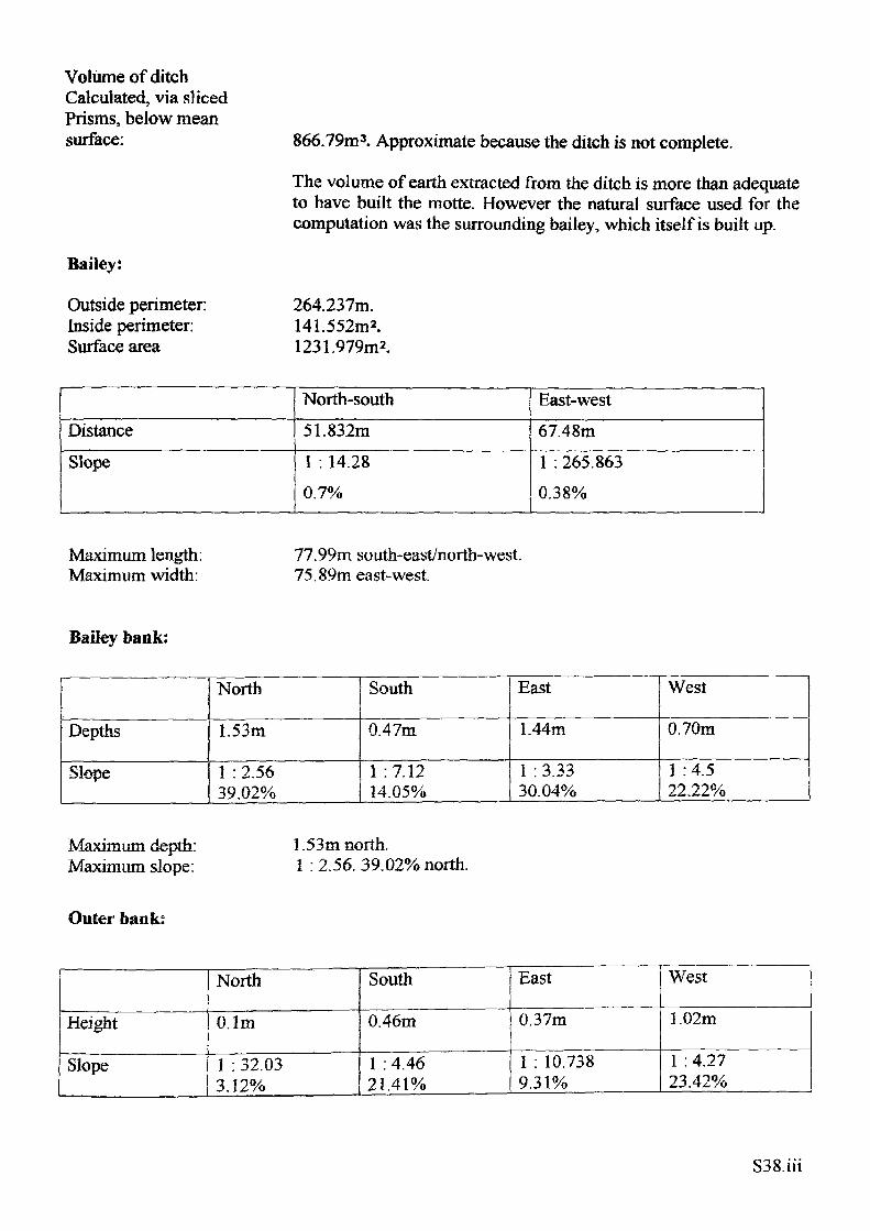
Volume of ditch Calculated, via sliced Prisms, below mean surface:
Bailey:
Outside perimeter: Inside perimeter: Surface area
866.79m3. Approximate because the ditch is not complete.
The volume of earth extracted from the ditch is more than adequate to have built the motte. However the natural surface used for the computation was the surrounding bailey, which itself is built up.
264.237m.141.552m 2.1231.979m2.
DistanceSlope
North-south51.832m1 . 14.28 0.7%
East-west67.48m1 . 265.8630.38%
Maximum length: Maximum width:
77.99m south-east/north-west. 75.89m east-west
Bailey bank;
Depths
Slope
North
1.53m
1 : 2.56 39.02%
South
0.47m
1 :7.12 14.05%
East
1.44m
1 : 3.33 30.04%
West
0.70m
1 :4.522.22%
Maximum depth: Maximum slope:
1.53m north.1 : 2.56. 39.02% north.
Outer bank:
Height
Slope
North
O.lm
1 : 32.03 3.12%
South
0.46m
1 : 4.46 21.41%
East
0.37m
1 : 10.738 9.31%
West
1.02m
1 : 4.27 23.42%
S38.iii
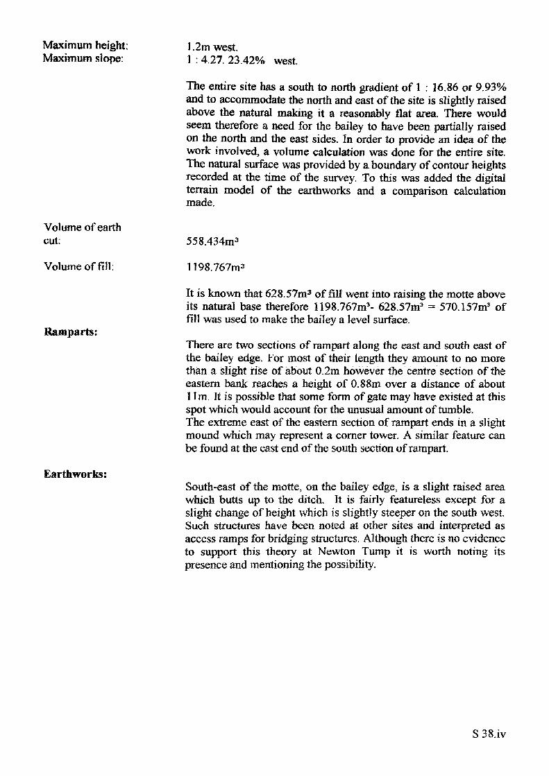
Maximum height; Maximum slope:
Volume of earth cut:
Volume of fill:
Ramparts:
Earthworks:
1.2m west.1 : 427. 23.42% west.
The entire site has a south to north gradient of 1 : 16.86 or 9.93% and to accommodate the north and east of the site is slightly raised above the natural making it a reasonably flat area. There would seem therefore a need for the bailey to have been partially raised on the north and the east sides. In order to provide an idea of the work involved, a volume calculation was done for the entire site. The natural surface was provided by a boundary of contour heights recorded at the time of the survey. To this was added the digital terrain model of the earthworks and a comparison calculation made.
558.434m3
1198.767m3
It is known that 628.57m3 of fill went into raising the motte above its natural base therefore 1198.767m3- 628.57m3 - 570.157m3 of fill was used to make the bailey a level surface.
There are two sections of rampart along the east and south east of the bailey edge. For most of their length they amount to no more than a slight rise of about 0.2m however the centre section of the eastern bank reaches a height of 0.88m over a distance of about 11m. It is possible that some form of gate may have existed at this spot which would account for the unusual amount of tumble. The extreme east of the eastern section of rampart ends in a slight mound which may represent a corner tower. A similar feature can be found at the east end of the south section of rampart.
South-east of the motte, on the bailey edge, is a slight raised area which butts up to the ditch. It is fairly featureless except for a slight change of height which is slightly steeper on the south west. Such structures have been noted at other sites and interpreted as access ramps for bridging structures. Although there is no evidence to support this theory at Newton Tump it is worth noting its presence and mentioning the possibility.
S 38.iv
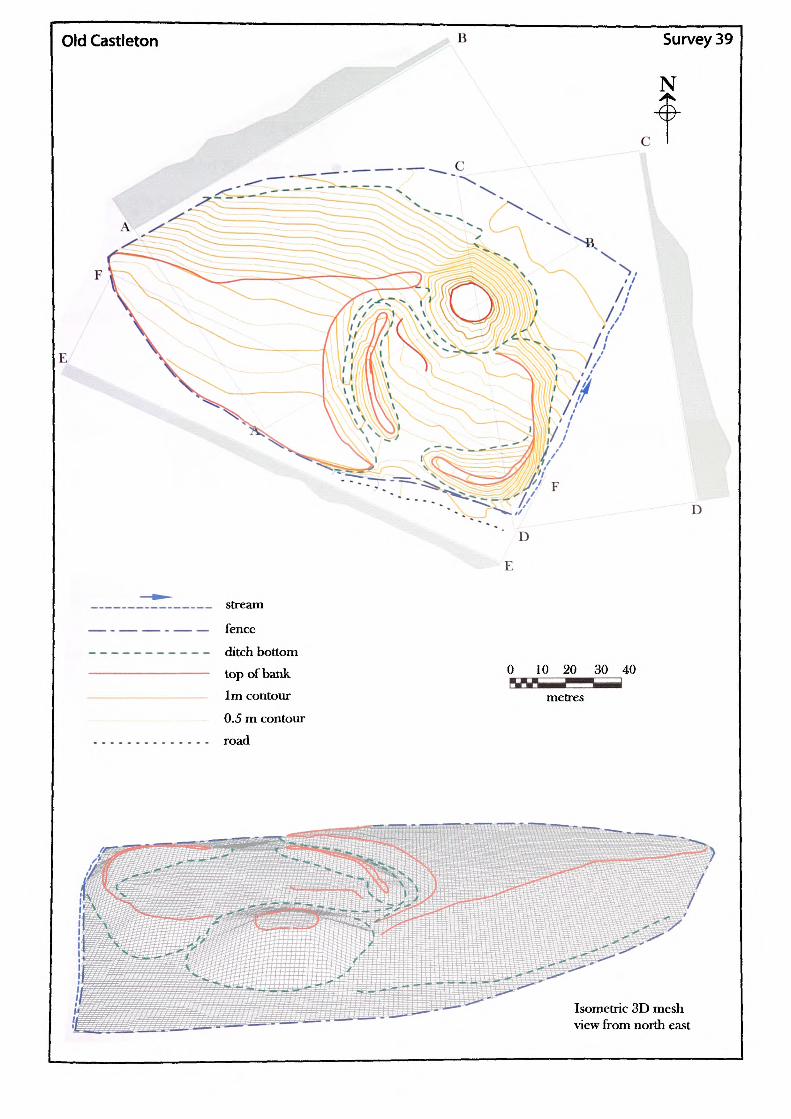
Old Castleton Survey 39
______________ stream
— - — — - — — fence
—---------- ditch bottom———————————— top of bank
——————————— 1m contour
_._ —_.._—.__— 0.5 m contour
.............. road
0 10 20 30 40 ——P-^ metres
Isometric 3D mesh view from north east
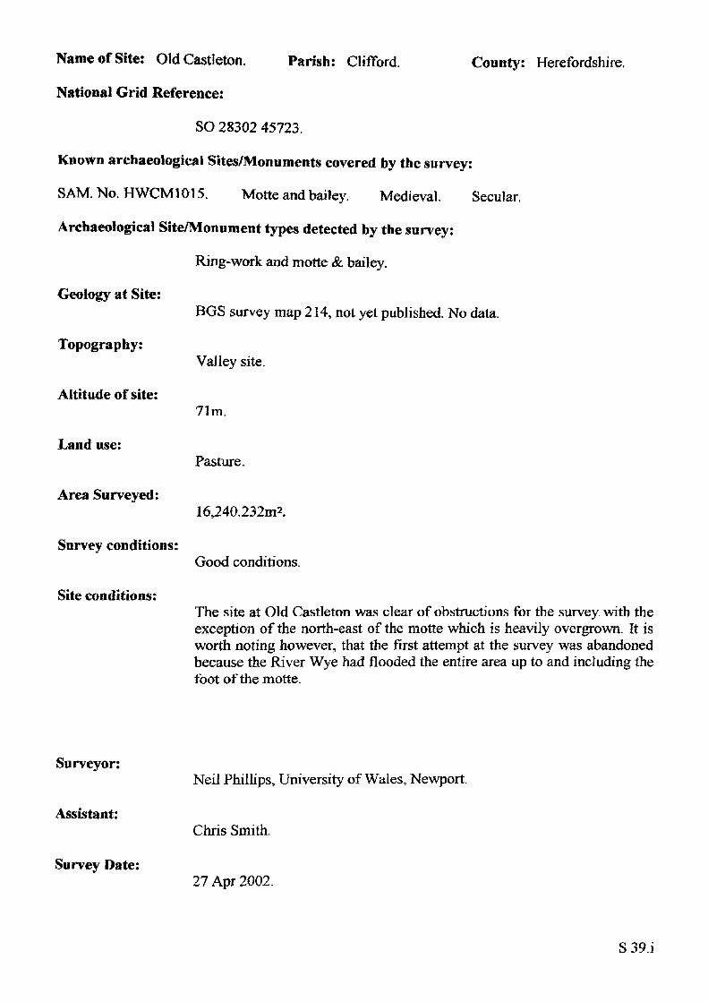
Name of Site: Old Castleton.
National Grid Reference:
Parish: Clifford. County: Herefordshire.
SO 28302 45723.
Known archaeological Sites/Monuments covered by the survey:
SAM. No. HWCM1015. Motte and bailey. Medieval. Secular.
Archaeological Site/Monument types detected by the survey:
Ring-work and motte & bailey.
Geology at Site:
Topography:
Altitude of site:
Land use:
Area Surveyed:
Survey conditions:
Site conditions:
BGS survey map 214, not yel published. No data.
Valley site.
71m.
Pasture.
16,240.232m2.
Good conditions.
The site at Old Castleton was clear of obstructions for the survey with the exception of the north-east of the motte which is heavily overgrown. It is worth noting however, that the first attempt at the survey was abandoned because the River Wye had flooded the entire area up to and including the foot of the motte.
Surveyor:
Assistant:
Survey Date:
Neil Phillips, University of Wales, Newport.
Chris Smith.
27 Apr 2002.
S39.i
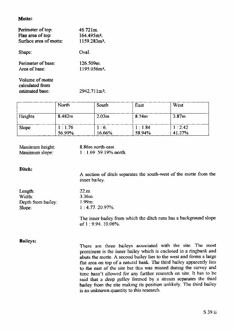
Motte:
Perimeter of top: Plan area of top: Surface area of motte:
Shape:
Perimeter of base: Area of base:
Volume of motte calculated from estimated base:
46.721m.164.495m2.1159.283m2.
Oval.
126.509m. 1195.056m2.
2942.711m3.
Heights
Slope
North
8.482m
1 : 1.76 56.99%
South
2.03m
1 :6. 16.66%
East
8.74m
1 : 1.84 58.94%
West
3.87m
1 : 2.42 41.27%
Maximum height: Maximum slope:
8.86m north-east.1 :1.69 59.19% north.
Ditch:
Length:Width:Depth from bailey:Slope:
A section of ditch separates the south-west of the motte from the inner bailey.
22.m.3.36m.1.99m.1 :4.77. 20.97%.
The inner bailey from which the ditch runs has a background slope of 1 : 9.94. 10.06%.
Baileys:There are three baileys associated with the site. The most prominent is the inner bailey which is enclosed in a ringbank and abuts the motte. A second bailey lies to the west and forms a large flat area on top of a natural bank. The third bailey apparently lies to the east of the site but this was missed during the survey and time hasn't allowed for any further research on site. It has to be said that a deep gulley formed by a stream separates the third bailey from the site making its position unlikely. The third bailey is an unknown quantity to this research.
S 39.H
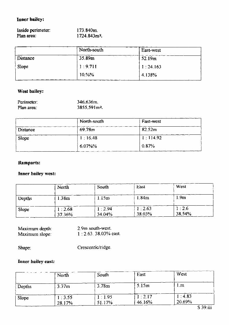
Inner bailey:
Inside perimeter: 1 73 . 840m. Plan area: 1724.843m2.
DistanceSlope
North-south35.89m1 : 9.71110.%%
East-west52.19m1 : 24. 1634.138%
West bailey:
Perimeter; 346.636m. Plan area: 3855.591m2.
Distance
Slope
North-south69.78m1 : 16.486.07%%
East-west82.52m1 : 174.920.87%
Ramparts:
Inner bailey west:
Depths
Slope
North
1.38m
1 : 2.6837.36%
South
1.15m
1 : 2.94 34.04%
bast
1.84m
1 : 2.63 38.03%
West
1.9m
1 :2.6 38.54%
Maximum depth: Maximum slope:
Shape:
Inner bailey east:
2.9m south-west. 1 : 2.63. 38.03% east.
Crescentic/ridge.
Depths
Slope
North
3.37m
1 : 3.55 28.17%
South
3.78m
1 : 1.95 51.17%
East
5.15m
1 :2.17 46.16%
West
l.m
1 : 4.83 20.69%
S
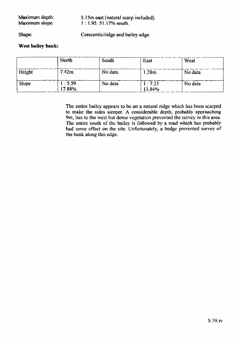
Maximum depth: Maximum slope:
5.15m east (natural scarp included). 1 : 1.95. 51.17% south.
Shape:
West bailey bank:
Crescentic/ridge and bailey edge.
Height
Slope
North
7.42m
1 : 5.59 17.88%
South
No data
No data
East
1.28m
1 : 7.23 13.84%
West
No data
No data
The entire bailey appears to be on a natural ridge which has been scarped to make the sides steeper. A considerable depth, probably approaching 9m, lies to the west but dense vegetation prevented the survey in this area. The entire south of the bailey is followed by a road which has probably had some effect on the site. Unfortunately, a hedge prevented survey of the bank along this edge.
S 39.iv
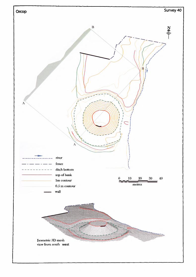
Orcop Survey 40
0 10 20 30 40 i^^ metres
Isometric 3D mesh view from south west
Name of Site: Orcop Castle. Parish: King's Caple. County: Herefordshire.
National Grid Reference:
SO 47282 26529.
Known archaeological Sites/Monuments covered by the survey:
SAM. No. HWCM922. Motte and bailey. Medieval. Secular.
Archaeological Site/Monument types detected by the survey:
Motte and bailey.
Geology at Site:
Topography:
Altitude of site:
Land use:
Area Surveyed:
Survey conditions:
Site conditions:
Lower old red sandstone. St Maughan's formation.
Valley site.
116m.
Waste ground and pasture.
9767.128m2.
The conditions were slightly misty and damp.
The motte is completely covered in dense vegetation and farm buildings occupy a significant area of the bailey.
Surveyor:
Assistant:
Survey Date:
Neil Phillips, University of Wales, Newport.
Adam Phillips.
21 Dec 2001.
S40.1
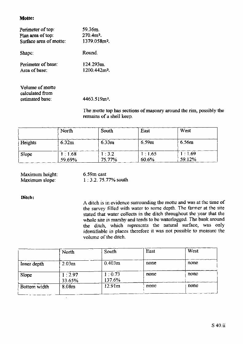
Motte:
Perimeter of top: Plan area of top: Surface area of motte:
Shape:
Perimeter of base: Area of base:
59.36m.270.4m2 .1379.058m2.
Round.
124.293m. 1200.442m2.
Volume of motte calculated from estimated base: 4463.519m3.
The motte top has sections of masonry around the rim, possibly the remains of a shell keep.
Heights
Slope
North
6.32m
1 : 1.68 59.69%
South
6.33m
1 :3.2 75.77%
East
6.59m
1 : 1.65 60.6%
West
6.56m
1 : 1.6959.12%
Maximum height: Maximum slope:
6.59m east1 : 3.2. 75.77% south
Ditch:A ditch is in evidence surrounding the motte and was at the time of the survey filled with water to some depth. The fanner at the site stated that water collects in the ditch throughout the year that the whole site is marshy and tends to be waterlogged. The bank around the ditch, which represents the natural surface, was only identifiable in places therefore it was not possible to measure the volume of the ditch.
Inner depth
Slope
Bottom width
North
2.03m
1 : 2.97 33.65%8.08m
South
0.403m
1 : 0.73 137.6%12.91m
East
none
none
none
West
none
none
none
S 40.ii
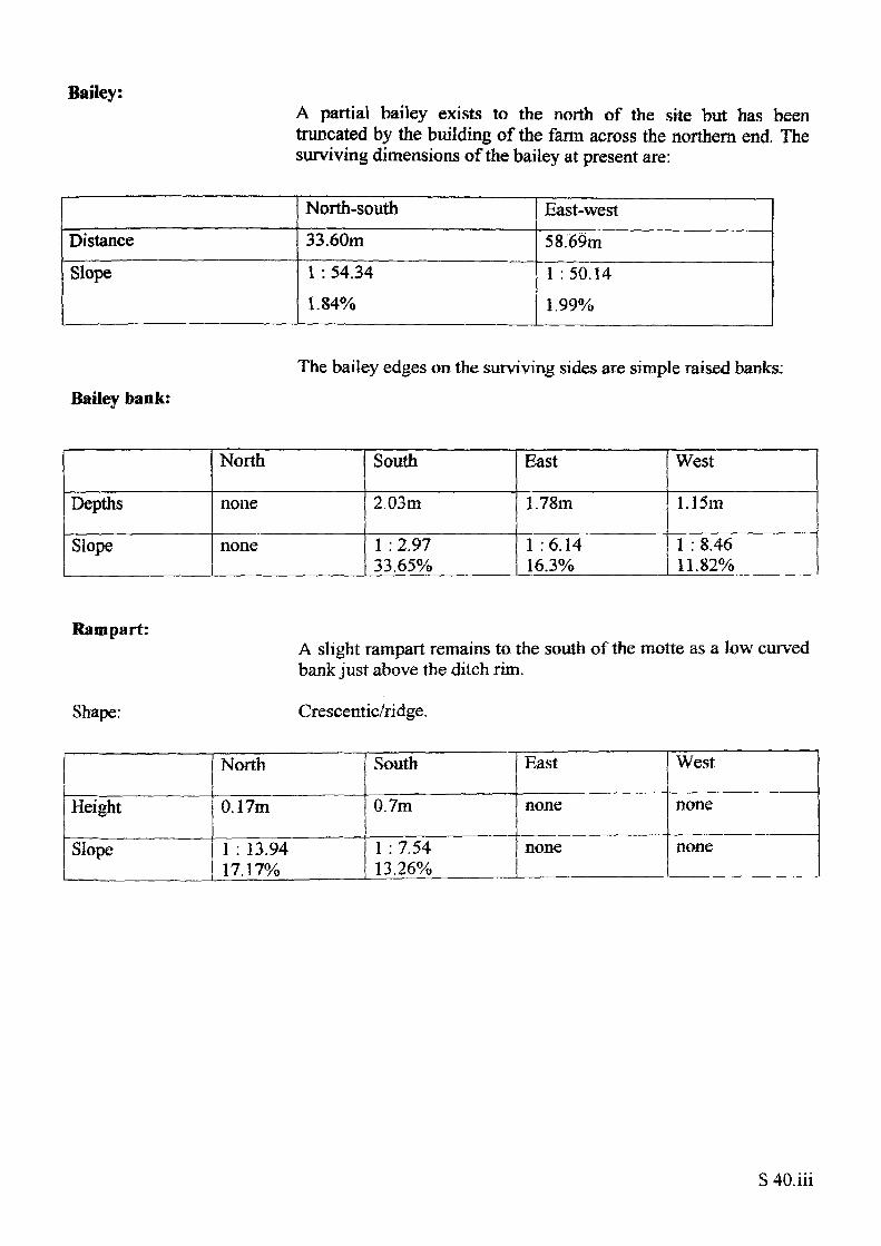
Bailey:A partial bailey exists to the north of the site but has been truncated by the building of the farm across the northern end. The surviving dimensions of the bailey at present are:
DistanceSlope
North-south33.60m1 : 54.34 1.84%
East-west58.69m1 :50.14 1.99%
Bailey bank:
The bailey edges on the surviving sides are simple raised banks:
Depths
Slope
North
none
none
South
2.03m
1 : 2.97 33.65%
East
1.78m
1 :6.14 16.3%
West
1.15m
1 : 8.46 11.82%
Rampart:
Shape:
A slight rampart remains to the south of the motte as a low curved bank just above the ditch rim.
Crescentic/ridge.
Height
Slope
North
0.17m
1 : 13.94 17.17%
South
0.7m
1 : 7.54 13.26%
East
none
none
West
none
none
S 40. hi
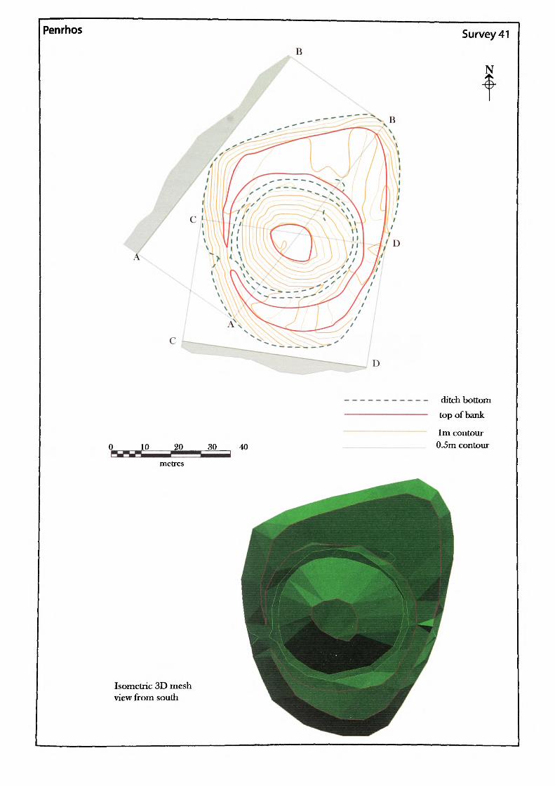
Penrhos
BSurvey 41
N
Isometric 3D mesh view from south
ditch bottom top of bank
1m contour 0.5m contour
Name of Site: Penrhos. Parish: LlantillioCrossenney.
County: Gwent.
National Grid Reference:
SO 40952 13169.
Known archaeological Sites/Monuments covered by the survey:
SAM. No. MM097. Mound and bailey. Medieval. Secular.
Archaeological Site/Monument types detected by the survey:
Motte. Possible early mound prehistoric - medieval?
Geology at Site:
Topography:
Altitude of site:
Land use:
Area Surveyed:
Survey conditions:
Site conditions:
Lower old red sandstone. Raglan Marl,
Hill site.
101m.
Pasture.
4340.387m2.
Good conditions-
Site clear of obstructions.
Surveyor:
Assistant:
Survey Date:
Neil Phillips, University of Wales, Newport.
Frank Olding.
6 June 2000.
S41.1
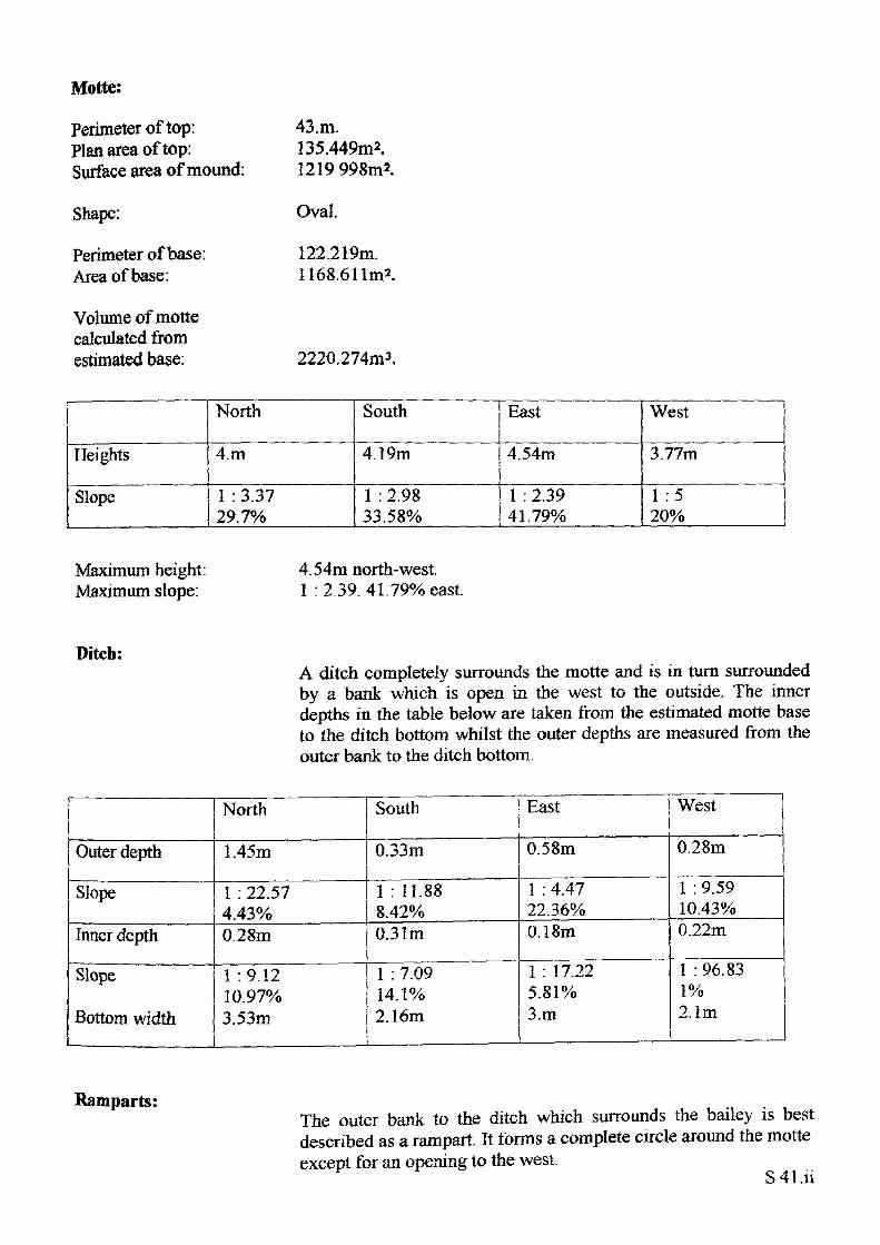
Motte:
Perimeter of top: Plan area of top: Surface area of mound:
Shape:
Perimeter of base: Area of base:
Volume of motte calculated from estimated base:
43.m.135.449m2. 1219 998m2.
Oval.
122.219m. 1168.611m*.
2220.274m3.
Heights
Slope
North
4.m
1 : 3.37 29.7%
South
4.19m
1 :2.98 33.58%
East
4.54m
1 : 2.39 41.79%
West
3.77m
1 :5 20%
Maximum height: Maximum slope:
4.54m north-west. 1 : 2.39. 41.79% east.
Ditch:A ditch completely surrounds the motte and is in turn surrounded by a bank which is open in the west to the outside. The inner depths in the table below are taken from the estimated motte base to the ditch bottom whilst the outer depths are measured from the outer bank to the ditch bottom.
Outer depth
Slope
Inner depth
Slope
Bottom width
North
1.45m
1 : 22.57 4.43%0.28m
1 :9.12 10.97% 3.53m
South
0.33m
1 : 11.88 8.42%0.31m
1 : 7.09 14.1% 2.16m
East
0.58m
1 : 4.47 22.36%0.18m
1 : 17.22 5.81% 3.m
West
0.28m
1 : 9.59 10.43%0.22m
1 : 96.83 1% 2.1m
Ramparts:The outer bank to the ditch which surrounds the bailey is best described as a rampart. It forms a complete circle around the motte except for an opening to the west.
S 41.H
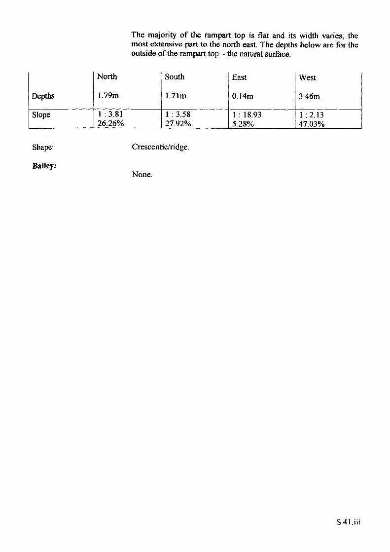
The majority of the rampart top is flat and its width varies; the most extensive part to the north east. The depths below are for the outside of the rampart top - the natural surface.
Depths
Slope
North
1.79m
1 :3.81 26.26%
South
1.71m
1 :3.58 27.92%
East
0.14m
1 : 18.93 5.28%
West
3.46m
1 :2.13 47.03%
Shape:
Bailey:
Crescentic/ridge.
None.
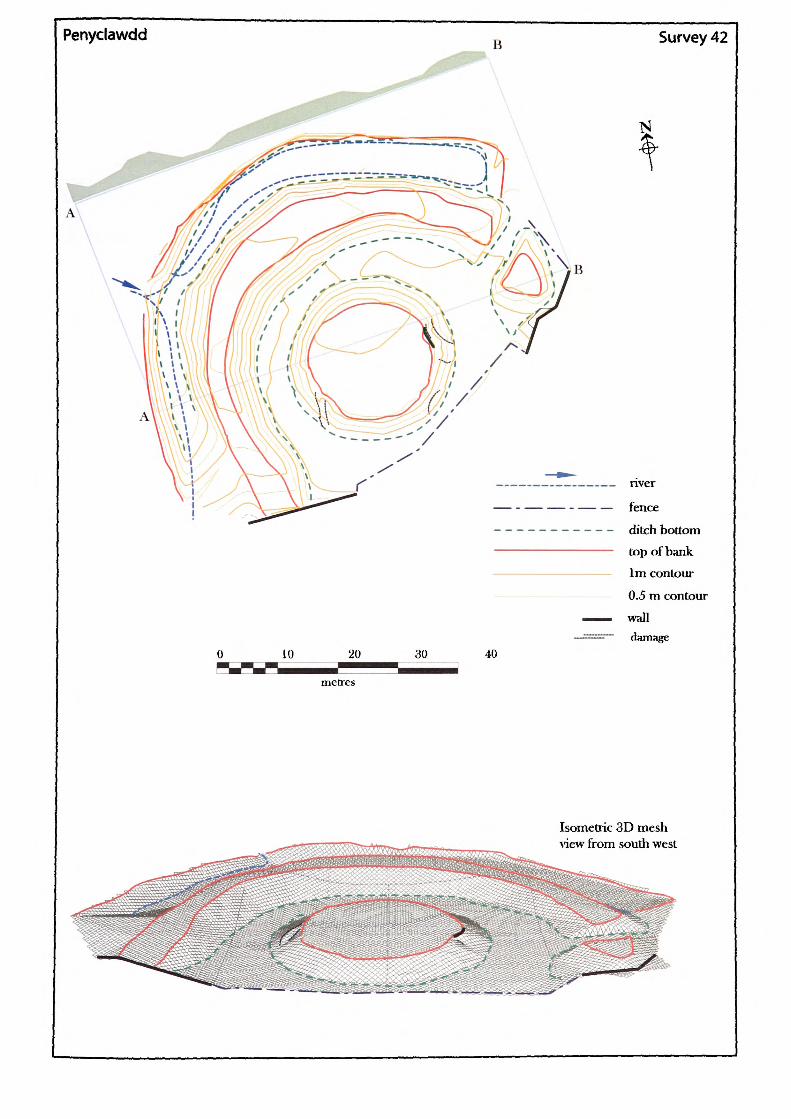
Penyclawdd Survey 42
10 30
_ nver
—— - —— —— - —— — fence
----------- ditch bottom
top of bank 1m contour
0.5 m contour
wall damage
40
metres
Isometric 3D mesh view from south west
Name of Site: Penyclawdd. Parish: Crucorney. County: Gwent.
National Grid Reference:
SO 30967 20139.
Known archaeological Sites/Monuments covered by the survey:
SAM, No. MM145. Castle mound Medieval. Secular.
Archaeological Site/Monument types detected by the survey:
Fortified-site.
Geology at Site:
Topography:
Altitude of site:
Land use:
Area Surveyed:
Survey conditions:
Site conditions:
Old red sandstone. St Maughan's formation.
Valley site.
171m.
Private garden.
3465.325m2.
Good conditions.
Site clear of obstructions.
Surveyor:
Assistant:
Survey Date:
Neil Phillips, University of Wales, Newport.
Adam Phillips.
25Nov2001.
S42.i
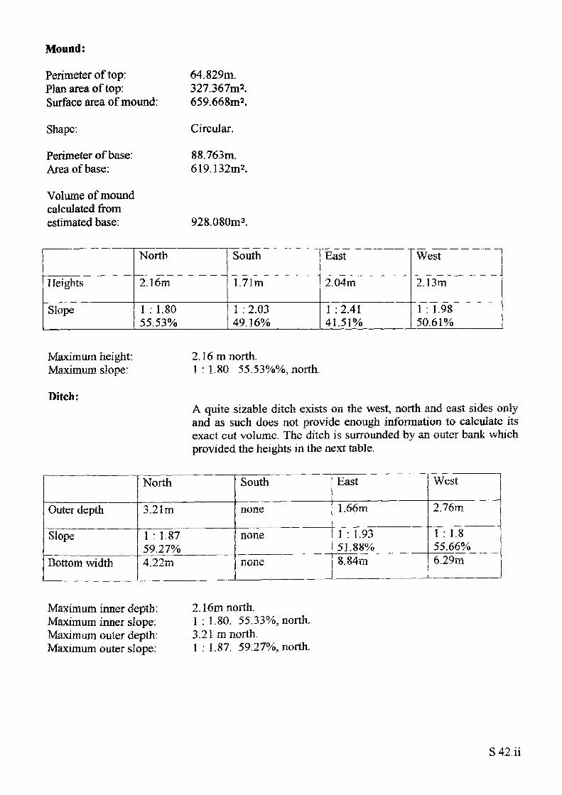
Mound:
Perimeter of top: Plan area of top: Surface area of mound:
Shape:
Perimeter of base: Area of base:
Volume of mound calculated from estimated base:
64.829m.327.367m2.659.668m2.
Circular.
88,763m. 619.132m2.
928.080m3.
Heights
Slope
North
2.16m
1 : 1.8055.53%
South
1.71m
1 : 2.03 49.16%
East
2.04m
1 :2.41 41.51%
West
2.13m
1 : 1.98 50.61%
Maximum height: Maximum slope:
Ditch:
2.16 m north.1 : 1.80. 55.53%%, north.
A quite sizable ditch exists on the west, north and east sides only and as such does not provide enough information to calculate its exact cut volume. The ditch is surrounded by an outer bank which provided the heights in the next table.
Outer depth
Slope
Bottom width
North
3.21m
1 : 1.87 59.27%4.22rn
South
none
none
none
East
1.66m
1 : 1.93 51.88%8.84m
West
2.76m
1 : 1.855.66%6.29m
Maximum inner depth: Maximum inner slope: Maximum outer depth: Maximum outer slope:
2.16m north.1 : 1.80. 55.33%, north.3.21 m north.1 : 1.87. 59.27%, north.
S 42. ii
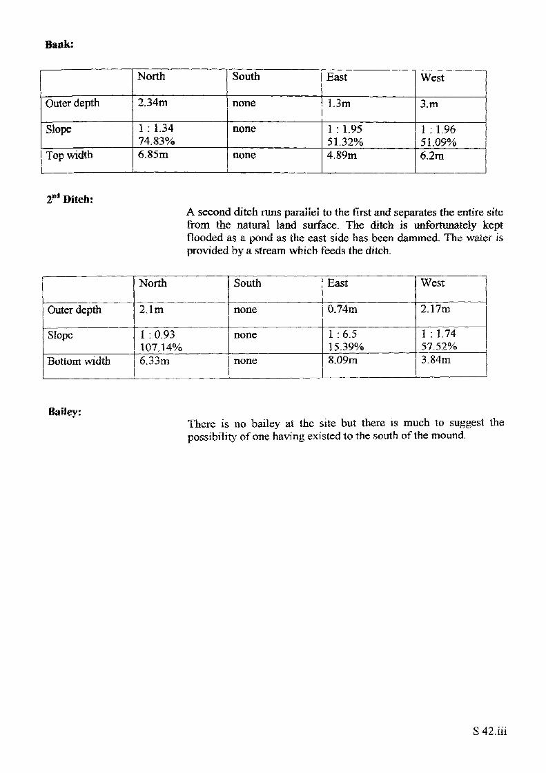
Bank:
Outer depth
Slope
Top width
North
2.34m
1 : 1.34 74.83%6.85m
South
none
none
none
East
1.3m
1 : 1.9551.32%4.89m
West
3.m
1 : 1.96 51.09%6.2m
2nd Ditch:A second ditch runs parallel to the first and separates the entire site from the natural land surface. The ditch is unfortunately kept flooded as a pond as the east side has been dammed. The water is provided by a stream which feeds the ditch.
Outer depth
Slope
Bottom width
North
2.1m
I : 0.93 107.14%6.33m
South
none
none
none
East
0.74m
1 :6.5 15.39%8.09m
West
2.17m
1 : 1.7457.52%3.84m
Bailey:There is no bailey at the site but there is much to suggest the possibility of one having existed to the south of the mound.
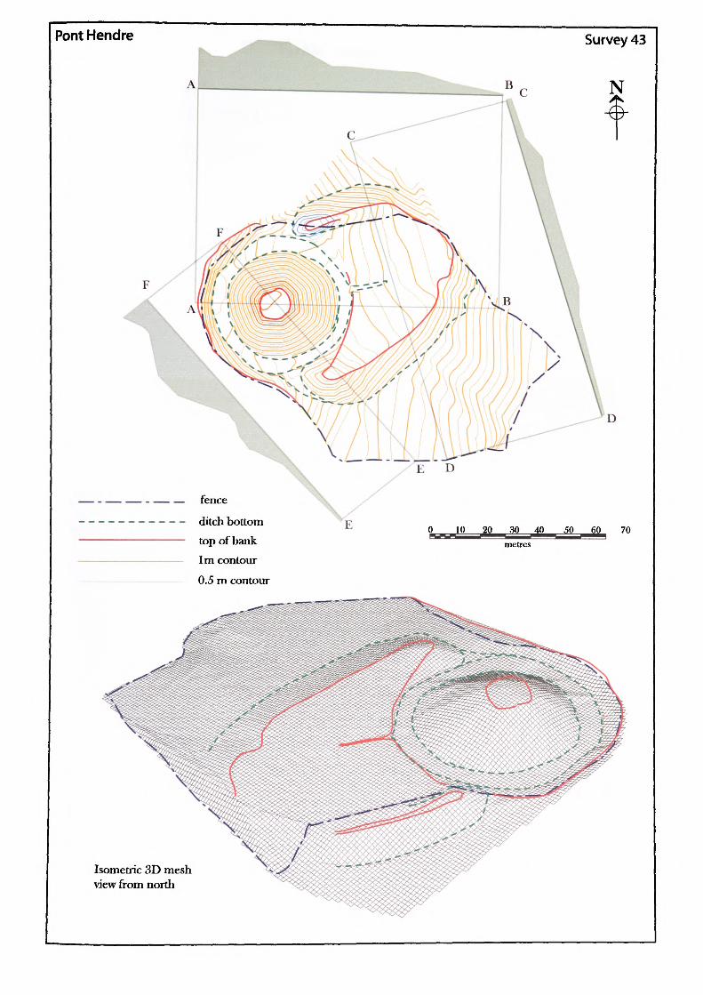
Pont Hendre Survey 43
N
E n
fence
ditch bottom top of bank 1m contour
0.5 m contour
30 _40 50 60 70 metres
Isometric 3D mei view from north
sh
Name of Site: PontHendre. Parish: Longtown. County: Herefordshire.
National Grid Reference:
SO 32572 28109.
Known archaeological Sites/Monuments covered by the survey:
SAM. No. HWCM1038. Castle. "Dark Age."
Motte and bailey. Medieval. Secular.
Archaeological Site/Monument types detected by the survey:
Motte and bailey
Geology at Site:
Topography:
Altitude of site:
Land use:
Area Surveyed:
Survey conditions:
Site conditions:
BGS survey map 214, not yet published. No data
Low hill above valley.
138m.
Pasture.
11,341.466m2.
Good conditions.
The site at Pont Hendre is relatively clear of obstruction with the exception of the north rampart which is heavily overgrown. The bailey area is also extremely boggy.
Surveyor:
Assistant:
Survey Date:
Neil Phillips, University of Wales, Newport.
Adam Phillips.
12Feb2001.
S43.i
Motte:
Perimeter of top: Plan area of top: Surface area of motte:
Shape:
Perimeter of base: Area of base:
41.048m.121.303m*.1749.255m2
Irregular.
139.345m. 1519.893m2.
Volume of motte calculated from estimated base: 6336.897m3.
Heights
Slope
North
9.38m
1 : 1.63 61.21%
South
9.360m
1 : 1.77 56.50%
East
10.60m
1.78. 56.17%
West
7.99m
1.59 63.01%
Maximum height: Maximum slope:
Ditch:
10.60m east.1 : 1.63, 61.21% north.
There is a ditch surrounding the motte at Pont Hendre which today holds water. The ditch differs in construction around its circuit with the eastern side just a shallow depression and the west side a very deep rock cut trench. The trench at the west has been cut in order to separate the motte from the natural bank. Unfortunately the varied nature of the ditch makes it impossible to assign a natural surface from which to compute a volume of cut calculation.
Outer depth
Slope
Bottom width
North
0.95m
1 : 2.58 38.82%5.01m
South
1.59m
1 : 2.25 44.49%7.06m
East
0.21m
1 : 6.26 15.98%4.73m
West
3.27m
1 : 1.3 76.71%6.0m
Bailey:
Outside perimeter: Plan area:
226.716m. 2151.234m2.
S43.ii
DistanceNorth-south59.77m
East-west42.m
Bailey bank:
To the south-west the bailey is separated from the motte by a small ditch whilst to the north-west a rampart on the edge of a steep drop marks the limit of the bailey. To the south-east, a steep bank raises the bailey above the slope of the hill but to the north east there are no defences apparent. The south-east bank is of special interest as it forms a ramp which rises to a height of almost 3m before coming to an abrupt stop. Such ramps have been noted on other site and interpreted as access points to the top of the motte.
Depths
Slope
North
2.89m
1 : 2.73 36.67%
South
4.48m
1 : 2,45 40.78%
East
3.30m
1 : 3.5 28.6%
West
2.41m
1 : 3.06 32.7%
Maximum depth: Maximum slope;
4.48m south1 : 2,45. 40.78% south
Rampart:
The rampart to the north of the motte runs down the length of the bailey on that side forming a formidable defensive earthwork. On the outside the slope drops fairly steeply to the stream below. The north-east end appears to have eroded away and may have curved to the south-east to join with the south-east bailey bank.
Shape. Linear/ridge.
Height
Slope
North
3.41m
1 : 2.54 39.36%
South
1.6m
1 : 1.67 59.96%
East
none
none
West
1.47m
1 : 4.05 24.72%
Maximum height: Maximum slope:
3.41m north.1 : 1.67. 59.96% south.
S43.iii
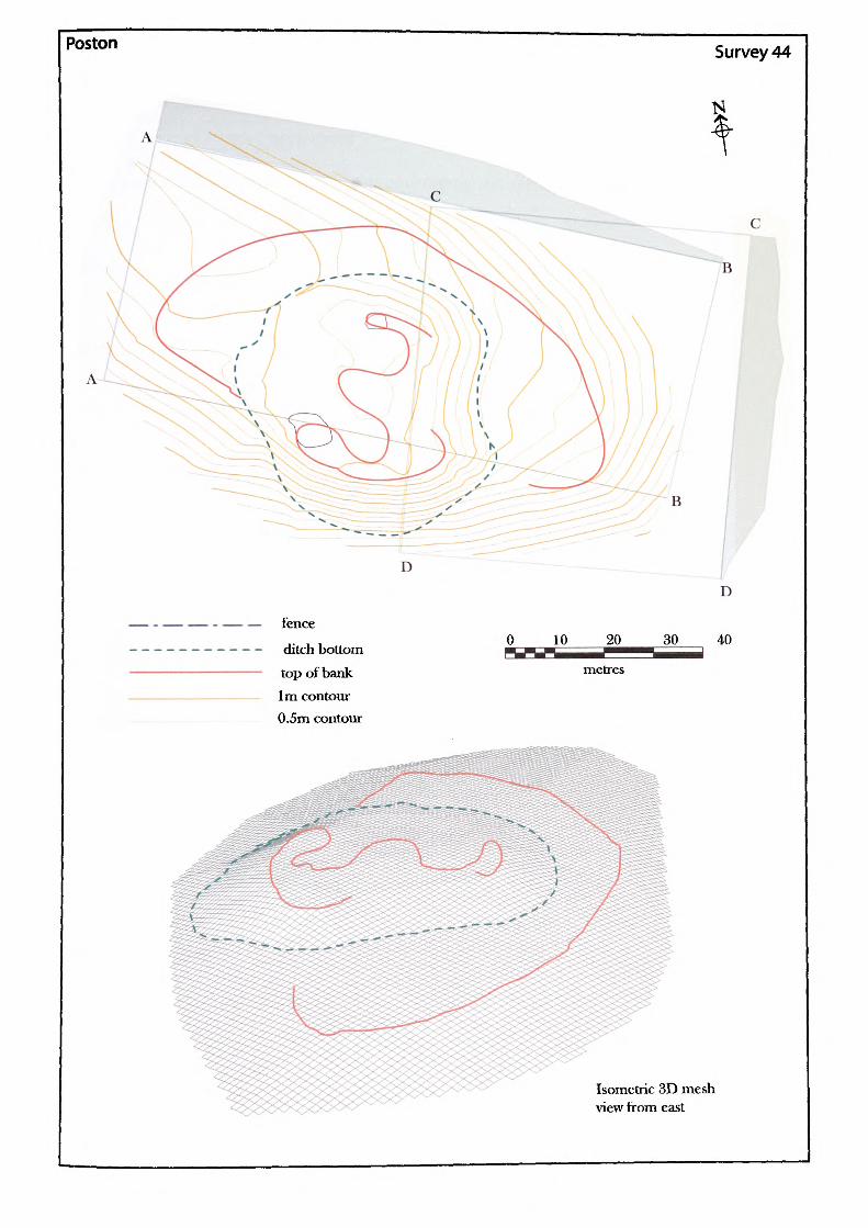
Poston
fence
ditch bottom top of bank 1m contour 0.5m contour
0 10 20 30
metres
D
40
Isometric 3D mesh view from east
Name of Site: Poston. Parish: Vowchurch. County: Herefordshire.
National Grid Reference:
SO 35807 37078.
Known archaeological Sites/Monuments covered by the survey:
SAM. No. HWCM8408. Motte and bailey. Medieval. Secular.
Archaeological Site/Monument types detected by the survey:
Possible motte and bailey.
Geology at Site:
Topography:
Altitude of site:
Land use:
Area Surveyed:
Survey conditions:
Site conditions:
BGS survey map 214, not yet published. No data.
Hill site.
140m.
Pasture.
7552.156m2.
Good.
Site mostly clear of obstructions except for trees across the south side. The site is badly damaged and not much remains of the mound.
Surveyor:
Assistant:
Survey Date:
Neil Phillips, University of Wales, Newport.
Chris Smith.
31 May 2002
S44.i
Mound:
Perimeter of top: Plan area of top:
Shape:
Perimeter of base: Area of base:
Volume of earthwork calculated from estimated base:
104.978m (vague). 718.423m2.
Irregular and considerably damaged.
169.608m. 2155.721m2.
1203.10m3 .
Heights
Slope
North
1.59m
1 : 6.07 16.47%
South
6.14rn
1 : 2.22 45.12%
East
2.2m
1 : 5.54 18.07%
West
1.71m
1 : 4.25 23.52%
Maximum height: Maximum slope:
6.14m south.1 : 2.22. 45.12% south.
Ditch:None.
Bailey:None.
S 44.H
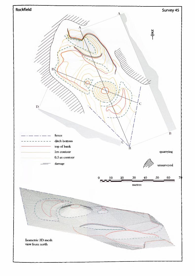
Rockfield
N
Survey 45
B
quarrying
unsurveyed
10 20 30 40 50 60 7(
Isometric 3D mesh view from north
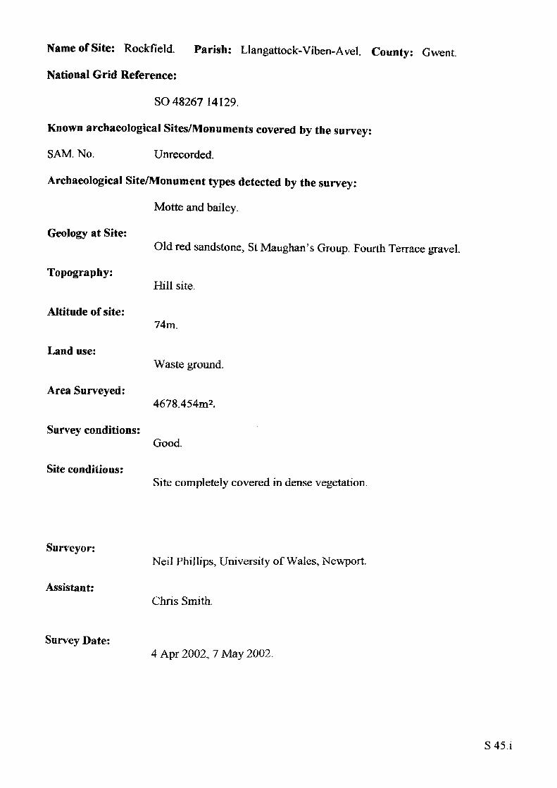
Name of Site: Rockfield Parish: Llangattock-Viben-Avel. County: Gwent.
National Grid Reference:
SO 48267 14129.
Known archaeological Sites/Monuments covered by the survey:
SAM, No. Unrecorded.
Archaeological Site/Monument types detected by the survey:
Motte and bailey.
Geology at Site:
Topography:
Altitude of site:
Land use:
Area Surveyed:
Survey conditions:
Site conditions:
Old red sandstone, St Maughan's Group. Fourth Terrace gravel.
Hill site.
74m.
Waste ground.
4678.454m2.
Good.
Site completely covered in dense vegetation.
Surveyor:
Assistant:
Survey Date:
Neil Phillips, University of Wales, Newport.
Chris Smith.
4 Apr 2002, 7 May 2002.
S45.i
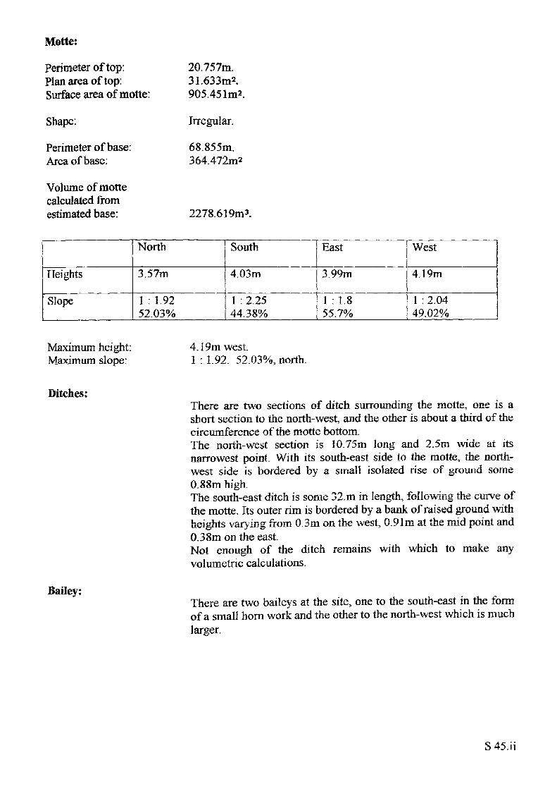
Motte:
Perimeter of top: Plan area of top: Surface area of motte:
Shape:
Perimeter of base: Area of base:
Volume of motte calculated from estimated base:
20.757m.31.633m2.905.
Irregular.
68.855m. 364.472m=
2278.619nv>.
Heights
Slope
North
3.57m
1 : 1.92 52.03%
South
4.03m
1 : 2.25 44.38%
East
3.99m
1 : 1.855.7%
West
4.19m
1 : 2.04 49.02%
Maximum height: Maximum slope:
4.19m west.1 : 1.92. 52.03%, north.
Ditches:
Bailey:
There are two sections of ditch surrounding the motte, one is a short section to the north-west, and the other is about a third of the circumference of the motte bottom.The north-west section is 10.75m long and 2.5m wide at its narrowest point. With its south-east side to the motte, the north west side is bordered by a small isolated rise of ground some 0.88m high.The south-east ditch is some 32. m in length, following the curve of the motte. Its outer rim is bordered by a bank of raised ground with heights varying from 0.3m on the west, 0.91m at the mid point and 0.38m on the east.Not enough of the ditch remains with which to make any volumetric calculations.
There are two baileys at the site, one to the south-east in the form of a small hom work and the other to the north-west which is much larger.
S45.ii
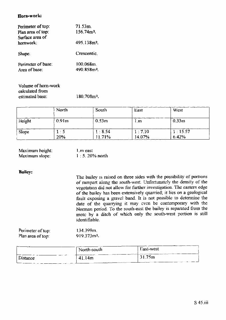
Horn-work:
Perimeter of top: Plan area of top: Surface area of homwork:
Shape.
Perimeter of base: Area of base:
71.53m. 156.74m2.
495.138m2.
Crescentic.
100.068m. 490.858™*.
Volume of horn-work calculated from estimated base: 180.708m3.
Height
Slope
North
0.91m
1 .5 20%
South
0.53m
1 : 8.54 11.71%
East
l.m
1 :7.10 14.07%
West
0.33m
1 : 15.57 6.42%
Maximum height: Maximum slope:
l.m east1 : 5. 20% north
Bailey:The bailey is raised on three sides with the possibility of portions of rampart along the south-west. Unfortunately the density of the vegetation did not allow for further investigation. The eastern edge of the bailey has been extensively quarried; it lies on a geological fault exposing a gravel band. It is not possible to determine the date of the quarrying it may even be contemporary with the Norman period. To the south-east the bailey is separated from the mote by a ditch of which only the south-west portion is still identifiable.
Perimeter of top: 134.399m. Plan area of top: 9 1 9.373m 2.
Distance
North-south
41.14m
East-west31.75m
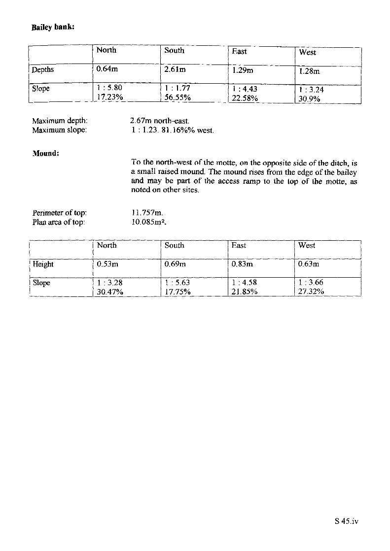
Bailey bank:
Depths
Slope
North
0.64m
1 :5.80 17.23%
South
2.61m
1 : 1.77 56.55%
East
1.29m
1 :4.43 22.58%
West
1.28m
1 : 3.24 30.9%
Maximum depth: Maximum slope:
2.67m north-east.1 : 1.23. 81.16%% west.
Mound:To the north-west of the motte, on the opposite side of the ditch, is a small raised mound. The mound rises from the edge of the bailey and may be part of the access ramp to the top of the motte, as noted on other sites.
Perimeter of top: Plan area of top:
11.757m. 10.085m2.
Height
Slope
North
0.53m
1 : 3.28 30.47%
South
0.69m
1 : 5.63 17.75%
East
0.83m
1 : 4.58 21.85%
West
0.63m
1 : 3.66 27.32%
S 45,iv
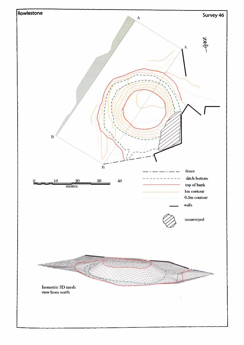
Rowlestone
B
JO__ 20^_____ metres
Survey 46
R
40
fence
ditch bottom top of bank 1m contour 0.5m contour
walls
unsurveyed
Isometric 3D mesh view from north
Name of Site: Rowlestone. Parish: Rowlestone.
National Grid Reference:
SO 37442 27164.
Known archaeological Sites/Monuments covered by the survey:
SAM.No. HWCM1481. Motte. Medieval. Secular.
Archaeological Site/Monument types detected by the survey:
Motte.
County: Herefordshire.
Geology at Site:
Topography:
Altitude of site:
Land use:
Area Surveyed:
Survey conditions:
Site conditions:
Lower old red sandstone. St Maughan's formation.
TTill site.
151m.
Waste ground.
2714.9m2.
Good conditions.
Site covered in heavy vegetation and the motte is surrounded by a wet ditch. The area to the south-east of the motte was impassable because of the depth of mud.
Surveyor:
Assistant:
Survey Date:
Neil Phillips, University of Wales, Newport.
Adam Phillips.
17Feb2001
S46.i
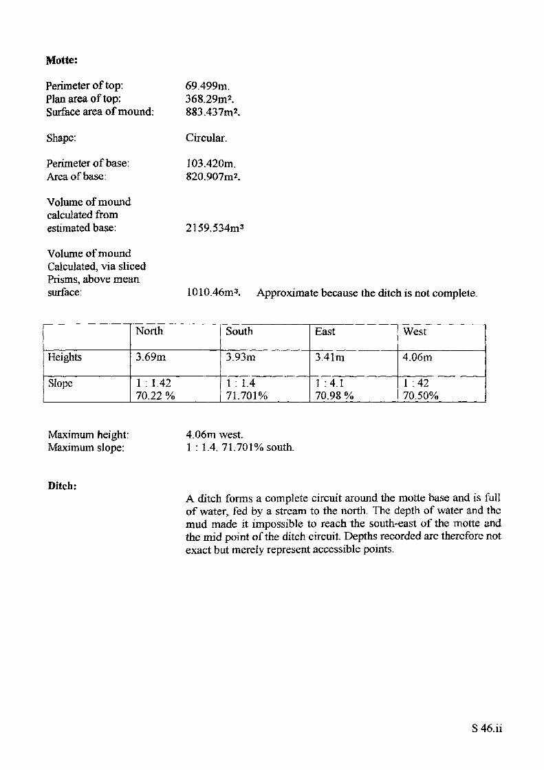
Motte:
Perimeter of top: Plan area of top: Surface area of mound:
Shape:
Perimeter of base: Area of base:
Volume of mound calculated from estimated base:
Volume of mound Calculated, via sliced Prisms, above mean surface:
69.499m.368.29m2.883.437m2.
Circular.
103.420m. 820.907m2.
2159.534m3
1010.46m3. Approximate because the ditch is not complete.
Heights
Slope
North
3.69m
1 : 1.42 70.22 %
South
3.93m
1 : 1.4 71.701%
East
3.41m
1 :4.1 70.98 %
West
4.06m
1 :42 70.50%
Maximum height: Maximum slope:
4.06m west.1 : 1.4. 71.701% south.
Ditch:A ditch forms a complete circuit around the motte base and is full of water, fed by a stream to the north. The depth of water and the mud made it impossible to reach the south-east of the motte and the mid point of the ditch circuit. Depths recorded are therefore not exact but merely represent accessible points.
S 46.ii
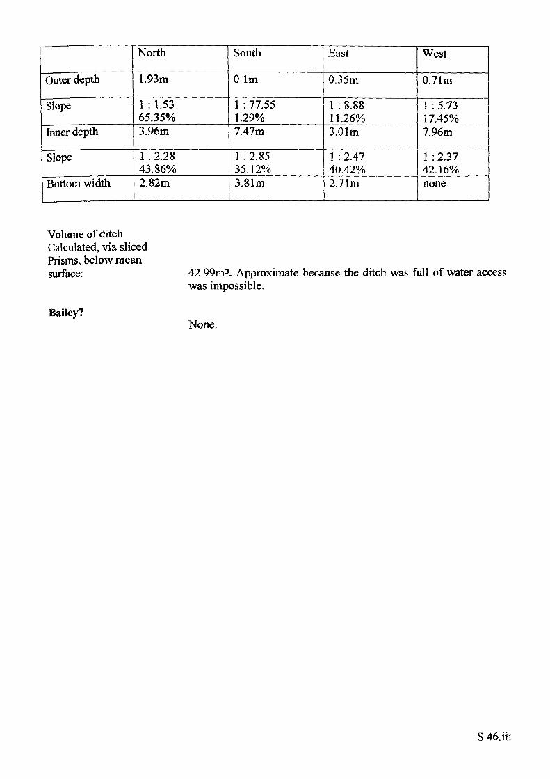
Outer depth
Slope
Inner depth
Slope
Bottom width
North
1.93m
1 : 1.53 65.35%3.96m
1 :2.28 43.86%2.82m
South
O.lm
1 : 77.55 1.29%7.47m
1 : 2.85 35.12%3.81m
East
0.35m
1 : 8.88 11.26%3.01m
1 : 2.47 40.42%2.71m
West
0.71m
1 : 5.73 17.45%7.96m
1 : 2.37 42.16%none
Volume of ditch Calculated, via sliced Prisms, below mean surface: 42.99m 3. Approximate because the ditch was full of water access
was impossible.
Bailey?None.
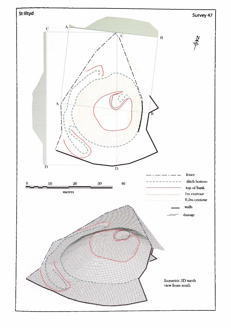
St Illtyd Survey 47
D
10 30 40
metres
— - — — fence—----- ditch bottom
——————— top of bank
—————— 1m contour
_____ 0.5m contour
^^__ walls
———— damage
Isometric 3D mesh \dew from south
Name of Site: Stllltyd. Parish: Llanhilleth. County: Gwent.
National Grid Reference:
SO 21692 01954.
Known archaeological Sites/Monuments covered by the survey:
SAM. No. MM141. Castle mound. Medieval. Secular.
Archaeological Site/Monument types detected by the survey:
Motte.
Geology at Site:
Topography:
Altitude of site:
Land use:
Area Surveyed:
Survey conditions:
Site conditions:
Carboniferous, sandstone.
Hill site.
352m.
Pasture.
1941.782m2.
Good conditions.
Site clear of obstructions.
Surveyor:
Assistant:
Survey Date:
Neil Phillips, University of Wales, Newport.
Adam Phillips.
11 May 2002
S47.i
Motte:
Perimeter of top: Plan area of top: Surface area of mound:
Shape:
Perimeter of base: Area of base:
Volume of mound calculated from estimated base:
59.396m. 269.80 Im2. 1003.382m2.
Irregular.
107.320m. 888.666012.
2493.112m3.
Heights
Slope
North
4.44m
1 : 1.74 57.57%
South
5.49m
1 : 1.78 56.29%
East
3.01m
1 : 1.42 70.31 %
West
6.19m
1 :43 69.84%
Maximum height: Maximum slope:
6.19m west.1 : 1.42. 70.31% east.
Ditch:A partial ditch remains around the west side of the site only. The south end of the ditch has been filed in which is obvious from the amount of heaped fill in the area. The road which was built along the south of the motte probably contributed to some of the damage. No ditch remains to the east due to the encroaching farm buildings which have actually cut into the side of the motte. To the north the ground appears to have been levelled.
Outer depth
Slope
Bottom width
North
0.73m
1 : 3.23 30.99%3.99m
South
O.lm
1 : 77.55 1.29%3.74m
East
none
none
none
West
0.89m
1 : 3.60 27.76%3.99m
Bailey?None
S 47.ii
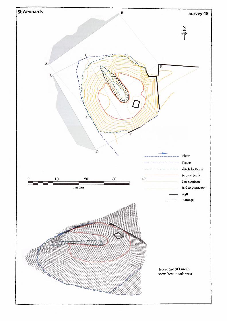
St Weonards Survey 48
N
10 20 30 40
metres
nver
fence
ditch bottom top of bank
1m contour
0.5 m contour
wall damage
Isometric 3D mesh view from north west
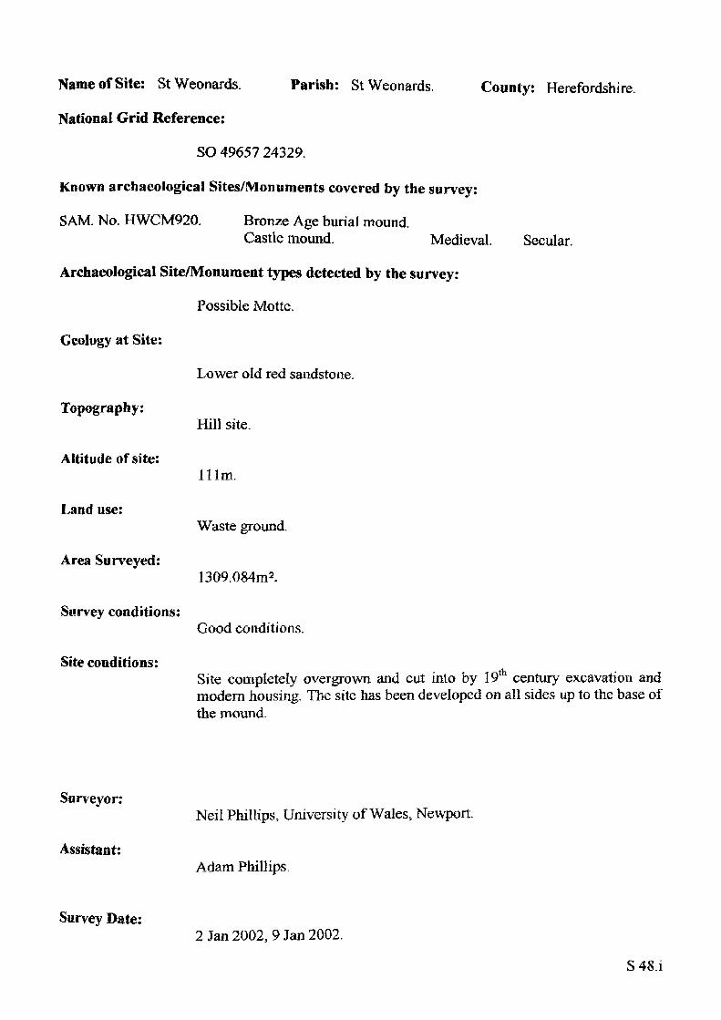
Parish: StWeonards. County: Herefordshire.Name of Site: St Weonards.
National Grid Reference:
SO 49657 24329.
Known archaeological Sites/Monuments covered by the survey:
SAM. No. HWCM920. Bronze Age burial mound.Castle mound. Medieval.
Archaeological Site/Monument types detected by the survey:
Possible Motte.
Secular.
Geology at Site:
Topography:
Altitude of site:
Land use:
Area Surveyed:
Survey conditions:
Site conditions:
Lower old red sandstone.
Hill site.
Him.
Waste ground.
1309.084m2.
Good conditions.
Site completely overgrown and cut into by 19th century excavation and modern housing. The site has been developed on all sides up to the base of the mound.
Surveyor:
Assistant:
Survey Date:
Neil Phillips, University of Wales, Newport.
Adam Phillips.
2 Jan 2002, 9 Jan 2002.
S48.i
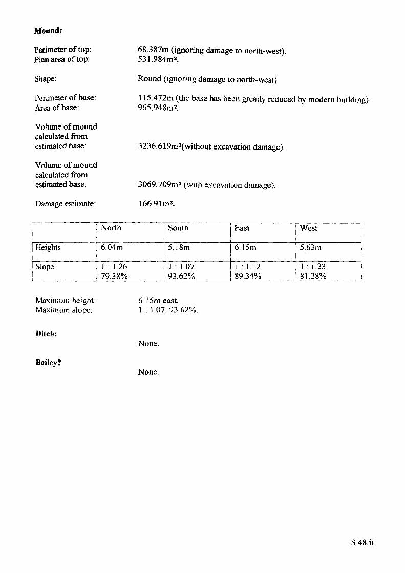
Mound:
Perimeter of top: Plan area of top:
Shape:
Perimeter of base: Area of base:
Volume of mound calculated from estimated base:
Volume of mound calculated from estimated base:
Damage estimate:
68.387m (ignoring damage to north-west). 531.984m2.
Round (ignoring damage to north-west).
115.472m (the base has been greatly reduced by modern building). 965.948m2.
3236.619m3(without excavation damage).
3069.709m3 (with excavation damage).
166.91m3.
Heights
Slope
North
6.04m
1 : 1.26 79.38%
South
5.18m
1 : 1.07 93.62%
East
6.15m
1 : 1.12 89.34%
West
5.63m
1 . 1.23 81.28%
Maximum height: Maximum slope:
Ditch:
Bailey?
6.15m east.1 : 1.07.93.62%.
None.
None.
S 48.ii
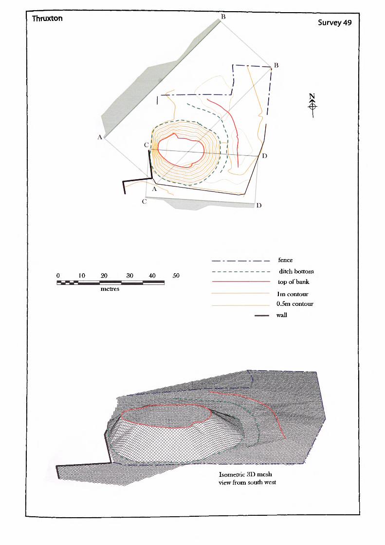
Thruxton
— - — _ B
Survey 49
N
0 10 20 30 40 50
fence
ditch bottomtop of bank
1m contour 0.5m contourwall
Isometric 3D mesh view from south west
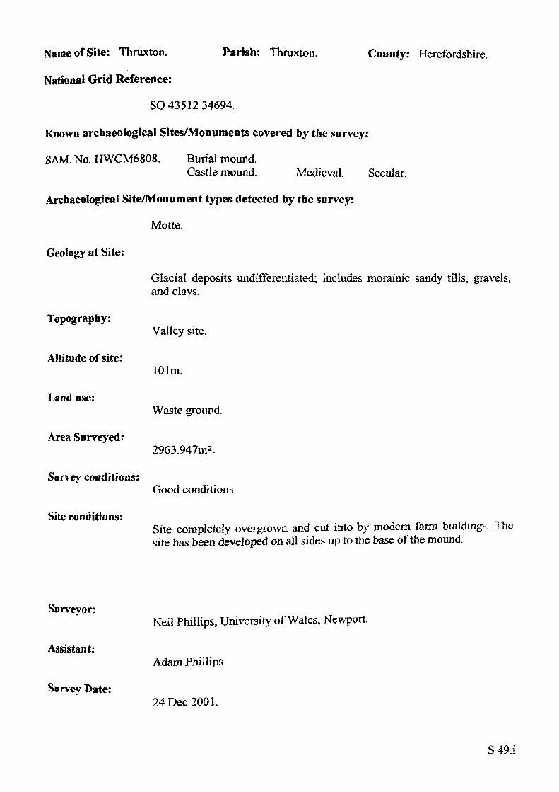
Name of Site: Thruxton. Parish: Thruxton.
National Grid Reference:
SO 43512 34694.
Known archaeological Sites/Monuments covered by the survey:
SAM. No. HWCM6808. Burial mound.Castle mound. Medieval. Secular.
Archaeological Site/Monument types detected by the survey:
Motte.
County: Herefordshire.
Geology at Site:
Topography:
Altitude of site:
Land use:
Area Surveyed:
Survey conditioas:
Site conditions:
Glacial deposits undifferentiated; includes morainic sandy tills, gravels, and clays.
Valley site.
101m.
Waste ground.
2963.947m2 .
Good conditions.
Site completely overgrown and cut into by modern farm buildings. The site has been developed on all sides up to the base of the mound.
Surveyor:
Assistant:
Survey Date:
Neil Phillips, University of Wales, Newport.
Adam Phillips
24 Dec 2001.
S49.i
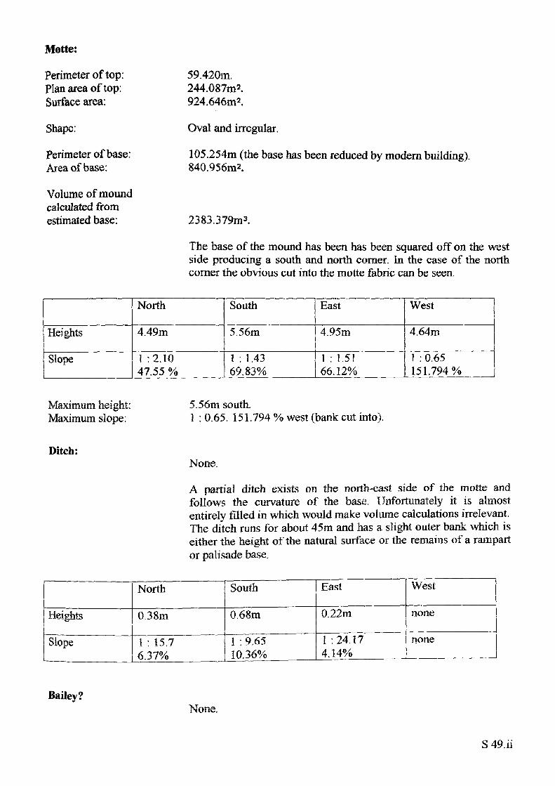
Motte:
Perimeter of top: Plan area of top: Surface area:
Shape:
Perimeter of base: Area of base:
Volume of mound calculated from estimated base:
59.420m.244.087m2.924.646m2 .
Oval and irregular.
105.254m (the base has been reduced by modern building) 840.956m2.
2383.379m3.
The base of the mound has been has been squared off on the west side producing a south and north corner. In the case of the north comer the obvious cut into the motte fabric can be seen.
Heights
Slope
North
4.49m
1 :2.10 47.55 %
South
5.56m
1 : 1 .43 69.83%
East
4.95m
1 : 1.51 66.12%
West
4.64m
1 : 0.65 151.794%
Maximum height: Maximum slope:
5.56m south.1 : 0.65. 151.794 % west (bank cut into).
Ditch:None
A partial ditch exists on the north-east side of the motte and follows the curvature of the base. Unfortunately it is almost entirely filled in which would make volume calculations irrelevant. The ditch runs for about 45m and has a slight outer bank which is either the height of the natural surface or the remains of a rampart or palisade base.
Heights
Slope
North
0.38m
1 : 15.7 6.37%
South
0.68m
1 : 9.65 10.36%
East
0.22m
1 -.24.17 4.14%
West
none
none
Bailey?None.
S 49.ii
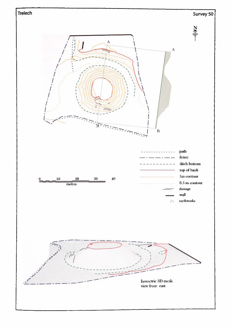
Trelech Survey 50
N
B
30 40
pathfence
ditch bottomtop ofbank1m contour
0.5 m contourdamage
wallearthworks
Isomctric 3D mesh view from east
Parish: Trelech United. County: Gwent.Name of Site: Trelech.
National Grid Reference:
SO 49952 05409.
Known archaeological Sites/Monuments covered by the survey:
SAM. No. MM016. Castle mound. Medieval. Secular.
Archaeological Site/Monument types detected by the survey:
Motte and bailey.
Geology at Site:
Old red sandstone, mostly brownstones.
Topography:
Altitude of site:
Land use:
Area Surveved:
Survey conditions:
Site conditions:
Valley site.
210m.
Pasture.
3003.606m2.
Good conditions.
The site was free of obstructions.
Surveyor:
Assistant:
Survey Date:
Neil Phillips, University of Wales, Newport.
Adam Phillips.
1 May 2002
S50.i
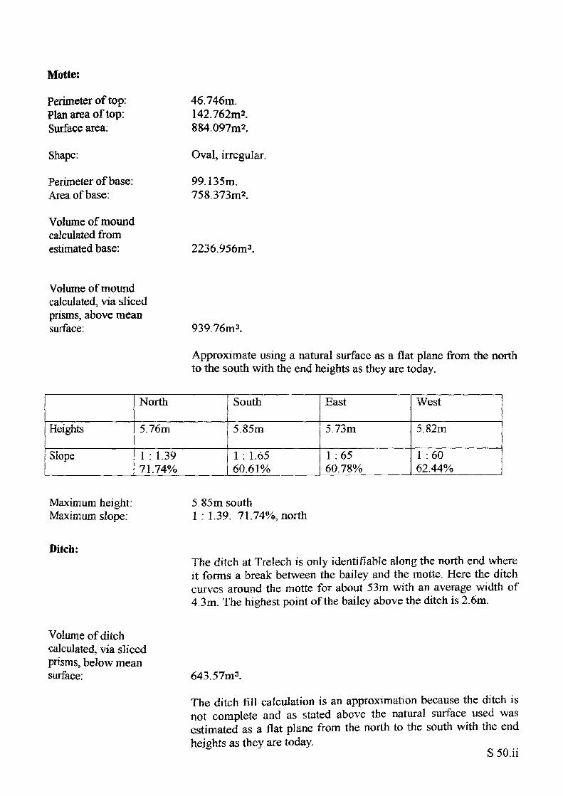
Motte:
Perimeter of top: Plan area of top: Surface area:
Shape:
Perimeter of base: Area of base:
Volume of mound calculated from estimated base:
46.746m.142.762m2.884,097m2.
Oval, irregular.
99.135m. 758.373m2.
2236.956m3.
Volume of mound calculated, via sliced prisms, above mean surface: 939.76m 3.
Approximate using a natural surface as a flat plane from the north to the south with the end heights as they are today.
Heights
Slope
North
5.76m
1 : 1.39 71.74%
South
5.85m
1 : 1.65 60.61%
East
5.73m
1 :65 60.78%
West
5.82m
1 :60 62.44%
Maximum height: Maximum slope:
5.85m south1 : 1.39. 7'1.74%, north
Ditch:The ditch at Trelech is only identifiable along the north end where it forms a break between the bailey and the motte. Here the ditch curves around the motte for about 53m with an average width of 4.3m. The highest point of the bailey above the ditch is 2.6m.
Volume of ditch calculated, via sliced prisms, below mean surface: 643.57m3.
The ditch fill calculation is an approximation because the ditch is not complete and as stated above the natural surface used was estimated as a flat plane from the north to the south with the end heights as they are today.
S 50.ii
The simple calculation: motle fill - ditch cut, leaves 296.19m3 of earth unaccounted for. Hither the excess earth was imported from another part of the site or it gives some estimation of how much the ditch has silted up.
Bailey?There is only a partial bailey left at Trelech due to the ingress of modern development but the raised bank to the north, now only a token of its former size is the most likely place. This theory was supported when a depression on the north bank of the bailey was shown to be the consequence of a trench which contained the trestle beam for a bridge base (see excavations).
S SO.iii
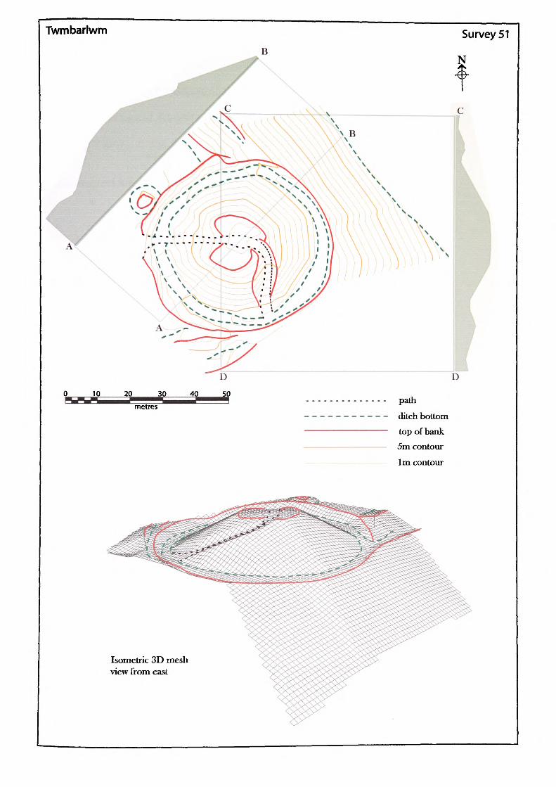
Twmbarlwm
D
path
ditch bottom top of bank 5m contour
1m contour
Isometric 3D mesh view from east
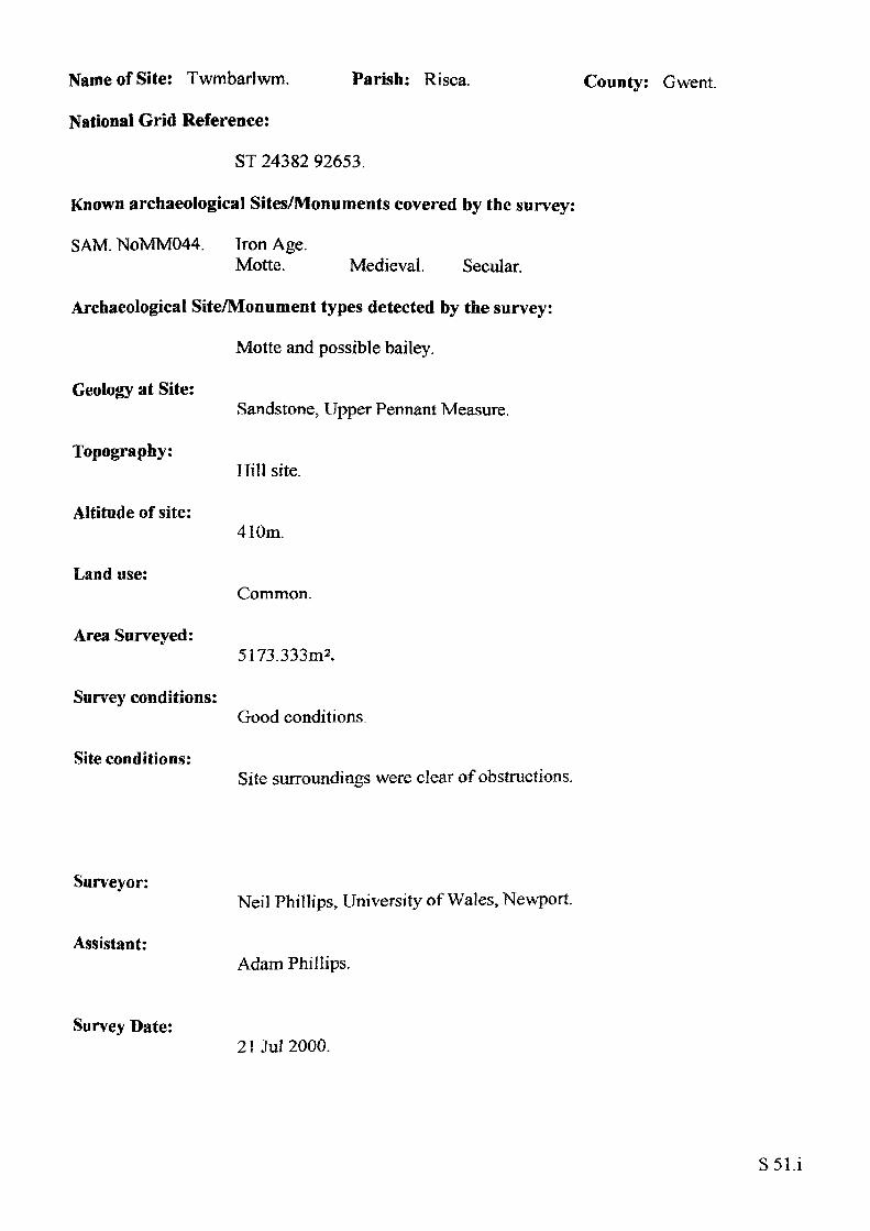
Name of Site: Twmbarlwm. Parish: Risca.
National Grid Reference:
ST 24382 92653.
Known archaeological Sites/Monuments covered by the survey:
SAM. NoMM044. Iron Age.Motte. Medieval. Secular.
Archaeological Site/Monument types detected by the survey:
Motte and possible bailey.
Geology at Site:
County: Gwent.
Topography:
Altitude of site:
Land use:
Area Surveved:
Survey conditions:
Site conditions:
Sandstone, Upper Pennant Measure.
ITill site.
410m.
Common.
5173.333m2.
Good conditions.
Site surroundings were clear of obstructions.
Surveyor:
Assistant:
Survey Date:
Neil Phillips, University of Wales, Newport.
Adam Phillips.
21 Jul 2000.
S51.i
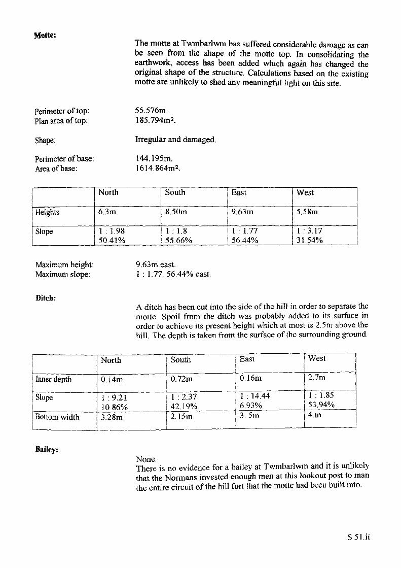
Motte:The motte at Twmbarlwm has suffered considerable damage as can be seen from the shape of the motte top. In consolidating the earthwork, access has been added which again has changed the original shape of the structure. Calculations based on the existing motte are unlikely to shed any meaningful light on this site.
Perimeter of top: Plan area of top:
Shape:
Perimeter of base: Area of base:
55.576m. 185.794m2.
Irregular and damaged.
144.195m. 1614.864m2 .
Heights
Slope
North
6.3m
1 : 1.9850.419/0
South
8.50m
1 : 1.8 55.66%
East
9.63m
1 : 1.77 56.44%
West
5.58m
1 :3.17 31.54%
Maximum height: Maximum slope:
9.63m east.1 : 1.77. 56.44% east.
Ditch:A ditch has been cut into the side of the hill in order to separate the motte. Spoil from the ditch was probably added to its surface in order to achieve its present height which at most is 2.5m above the hill. The depth is taken from the surface of the surrounding ground.
Inner depth
Slope
Bottom width
North
0.14m
1 :9.21 10.86%3.28m
South
0.72m
1 : 2.37 42.19%2.15m
East
0.16m
1 : 14.44 6,93%3.5m
West
2.7m
1 : 1.85 53,94%4.m
Bailey:None.There is no evidence for a bailey at Twmbarlwm and it is unlikely that the Normans invested enough men at this lookout post to man the entire circuit of the hill fort that the motte had been built into.
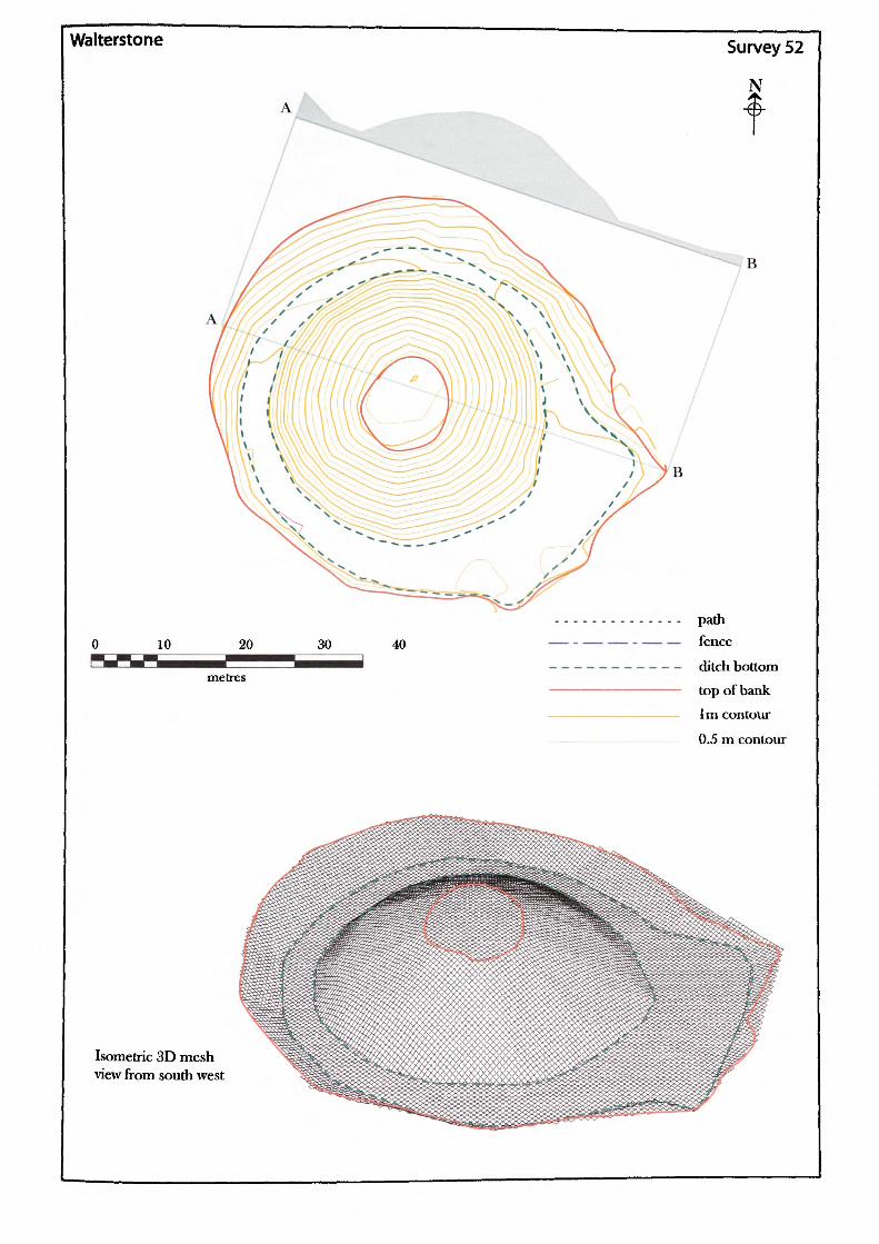
Walterstone Survey 52
N
B
pathfence
ditch bottom
top of bank1m contour
0.5 m contour
Isometric 3D mesh view from south west
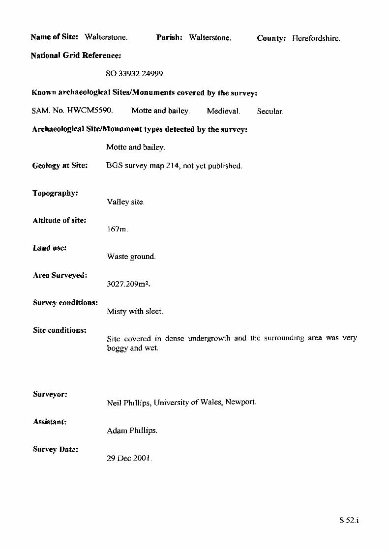
Name of Site: Walterstone. Parish: Walterstone, County: Herefordshire.
National Grid Reference:
SO 33932 24999.
Known archaeological Sites/Monuments covered by the survey:
SAM. No. HWCM5590. Motte and bailey. Medieval. Secular.
Archaeological Site/Monument types detected by the survey:
Motte and bailey.
Geology at Site: BGS survey map 214, not yet published.
Topography:
Altitude of site:
Land use:
Area Surveyed:
Survey conditions:
Site conditions:
Valley site.
167m.
Waste ground.
3027.209m2.
Misty with sleet.
Site covered in dense undergrowth and the surrounding area was very boggy and wet.
Surveyor:
Assistant:
Survey Date:
Neil Phillips, University of Wales, Newport.
Adam Phillips.
29 Dec 2001.
S52.1
Motte:
Perimeter of top: Plan area of top: Surface area of mound:
Shape:
Perimeter of base: Area of base:
Volume of mound calculated from estimated base:
Volume of mound calculated, via sliced prisms, above mean surface:
86.74m.574.189m2.1547.967m2.
Circular.
141.635m. 1551.497m2.
5539.545m3.
1391.525m3.
Heights
Slope
North
7.64m
1 : 1.8055.42 %
South
8.09m
1 : 1.63 61.20%
East
8.15m
1 : 2.04 49.02 %
West
8.76m
1 : 1.59 62.99%
Maximum height: Maximum slope:
8.76m west.1 : 1.59. 62.99% west
Ditch:
Outer depth
Slope
Bottom width
North
2.67m
1 :3.18 31.50%3.54m
South
1.18m
1 : 1 .46 68.38%7.08m
East
0.9m
1 : 5.73 17.47%13.64m
West
2.89m
1 : 1 .74
4.36m
Volume of ditch calculated, via sliced prisms, below mean surface: 2494.53m3.
If the fill of the mound came from the ditch then it would seem that there is some 1103.m3 of fill missing. Possibly the motte was bigger or the fill was used for surrounding ramparts that have nowdisappeared.
S 52.ii

Bailey?None.
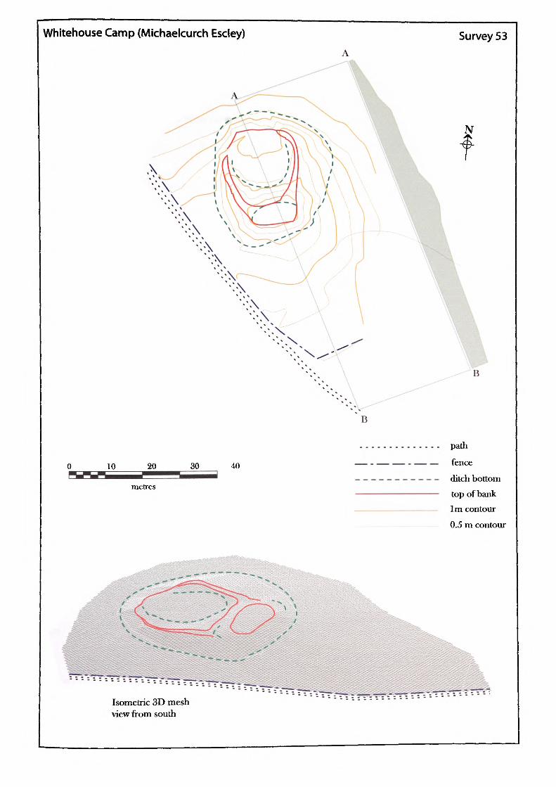
Whitehouse Camp (Michaelcurch Escley) Survey 53
N
30 40
path
fence
ditch bottom
top of bank1m contour
0.5 m contour
^*?s&.
Isometric 3D mesh view from south
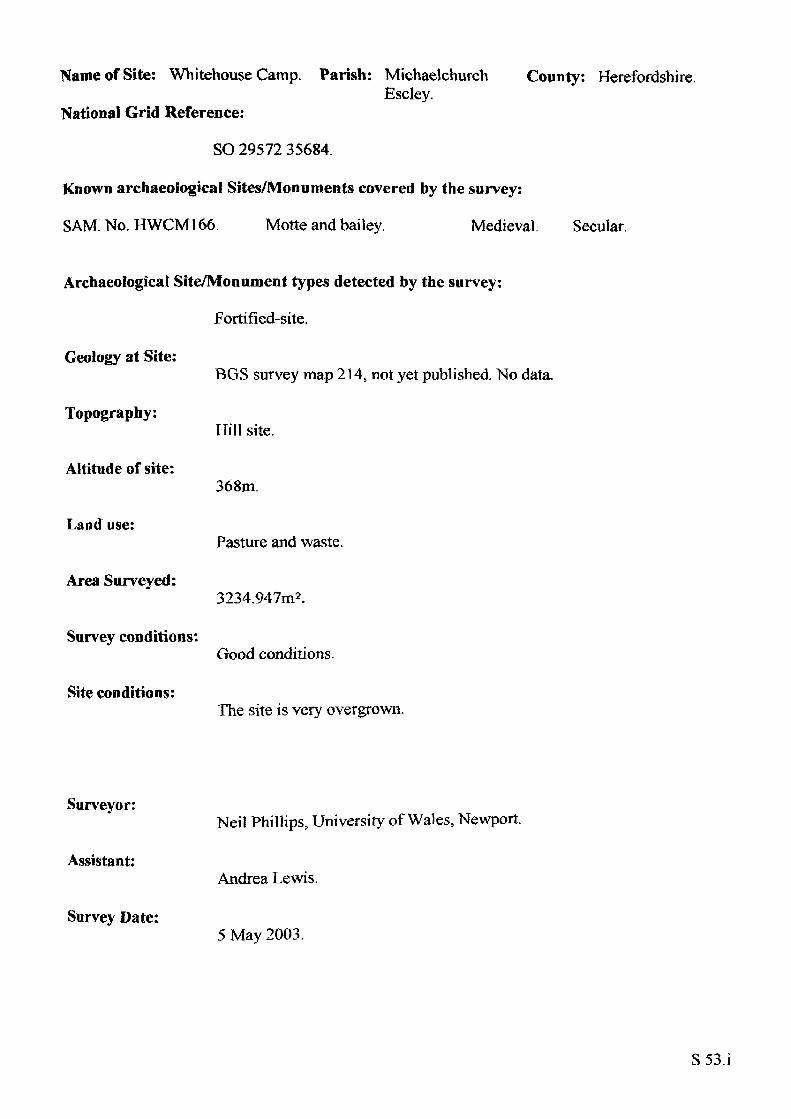
Name of Site: Whitehouse Camp. Parish: Michaelchurch County: Herefordshire.Escley.
National Grid Reference:
SO 29572 35684.
Known archaeological Sites/Monuments covered by the survey:
SAM.No. HWCM166. Motte and bailey. Medieval. Secular,
Archaeological Site/Monument types detected by the survey:
Fortified-site.
Geology at Site:
Topography:
Altitude of site:
Land use:
Area Surveyed:
Survey conditions:
Site conditions:
BGS survey map 214, not yet published. No data.
ITiH site.
368m.
Pasture and waste.
3234.947m2.
Good conditions.
The site is very overgrown.
Surveyor:
Assistant:
Survey Date:
Neil Phillips, University of Wales, Newport.
Andrea Lewis.
5 May 2003.
S53.i
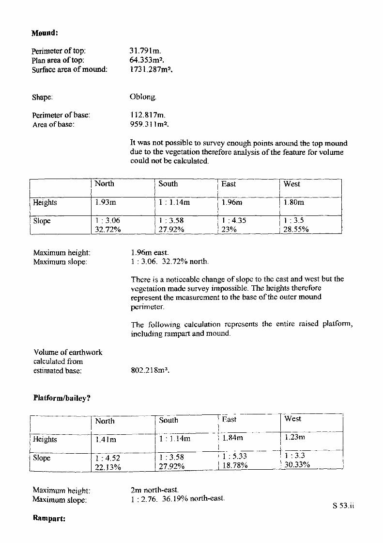
Mound:
Perimeter of top: Plan area of top: Surface area of mound:
31.791m.64.353m2.1731.287m2.
Shape:
Perimeter of base: Area of base:
Oblong.
112.817m. 959.3 1
It was not possible to survey enough points around the top mound due to the vegetation therefore analysis of the feature for volume could not be calculated.
Heights
Slope
North
1.93m
1 : 3.06 32.72%
South
1 : 1.14m
1 :3.5827.92%
East
1.96m
1 : 4.3523%
West
1.80m
1 :3.5 28.55%
Maximum height: Maximum slope:
Volume of earthwork calculated from estimated base:
1.96m east.1 : 3.06. 32.72% north.
There is a noticeable change of slope to the east and west but the vegetation made survey impossible. The heights therefore represent the measurement to the base of the outer mound perimeter.
The following calculation represents the entire raised platform, including rampart and mound.
802.218m3.
Platform/bailey?
Heights
Slope
North
1.41m
1 :4.52 22.13%
South
1 : 1.14m
1 : 3.58 L27.92%
East
1.84m
1 :5.33 18.78%
West
1.23m
1 :3.3 30.33%
Maximum height: Maximum slope:
Rampart:
2m north-east,1:2.76. 36.19% north-east.
S53.ii
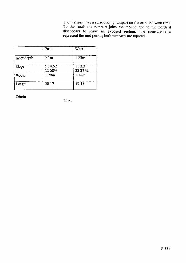
The platform has a surrounding rampart on the east and west rims. To the south the rampart joins the mound and to the north it disappears to leave an exposed section. The measurements represent the mid points; both ramparts are tapered.
Inner depth
Slope
Width
Length
East
0.5m
1 : 4.52 22.08%1.29m
20.17
West
1.23m
1 :2.333.37 %1.18m
19.41
Ditch:None.
S 53.in
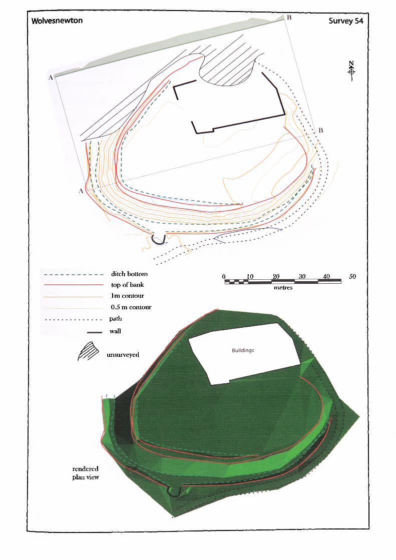
Wolvesnewton Survey 54
N
ditch bottom top of bank 1 m contour 0.5 m contour path
wall
unsurveyed
rendered plan view
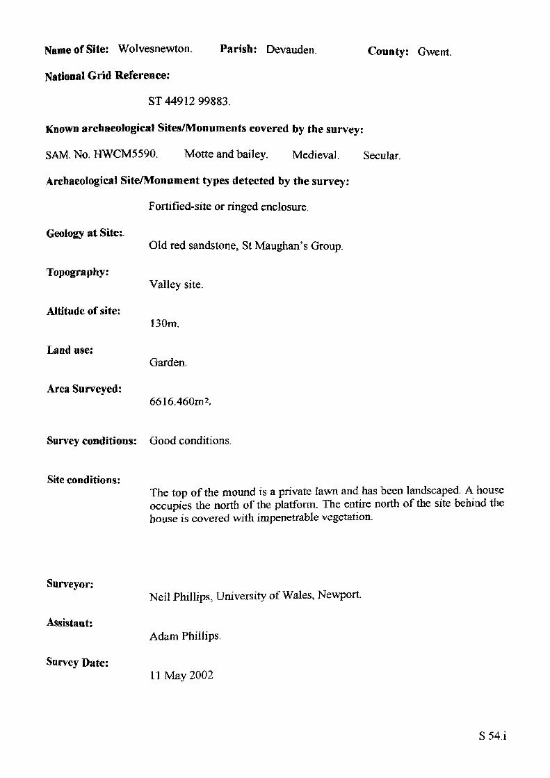
Name of Site: Wolvesnewton. Parish: Devauden.
National Grid Reference:
ST 44912 99883.
Known archaeological Sites/Monuments covered by the survey:
SAM. No. HWCM5590. Motte and bailey. Medieval. Secular.
Archaeological Site/Monument types detected by the survey:
Fortified-site or ringed enclosure.
Geology at Site:-
County: Gwent
Topography:
Altitude of site:
Land use:
Area Surveyed:
Old red sandstone, St Maughan's Group.
Valley site.
130m.
Garden.
6616.460m2.
Survey conditions: Good conditions.
Site conditions:The top of the mound is a private lawn and has been landscaped. A house occupies the north of the platform. The entire north of the site behind the house is covered with impenetrable vegetation.
Surveyor:
Assistant:
Survey Date:
Neil Phillips, University of Wales, Newport.
Adam Phillips.
11 May 2002
S54.i
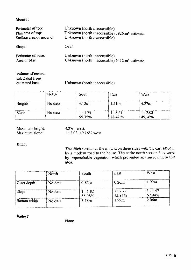
Mound:
Perimeter of top: Plan area of top: Surface area of mound:
Shape;
Perimeter of base: Area of base
Unknown (north inaccessible).Unknown (north inaccessible) 3826.m2 estimate.Unknown (north inaccessible).
Oval.
Unknown (north inaccessible).Unknown (north inaccessible) 64l2.m2 estimate.
Volume of mound calculated from estimated base: Unknown (north inaccessible).
— ._
Heights
Slope
North
No data
No data
South
4.13m
I : 1.79 55.75%
East
1.51m
I : 3.51 28.47 %
West
4.27m
I : 2.03 49.16%
Maximum height: Maximum slope:
4.27m west1 :2.03.49.16% west.
Diteh:The ditch surrounds the mound on three sides with the east filled in by a modern road to the house. The entire north section is covered by impenetrable vegetation which prevented any surveying in that area.
Outer depth
Slope
Bottom width
North
No data
No data
No data
South
0.82m
1 : 1.82 55.08%3.58m
East
0.26m
1 : 7.77 12.87%1.99m
__ ________ , ___ ___ „ ______
West
1. 92m
1 : 1.47 67.94%2.06m
Bailey?None.
S 54.ii
VOLUME II
EARTHWORK CASTLES OF GWENT AND ERGYNG AD 10501250
RESISTIVITY SURVEYS
N.Phil lips. 2004
CONTENTS
INTRODUCTION G iii
PRESENTATION G .iii
SURVEY MOTIVATION Giii
CASTELL ARNALLT G 1 i Description Survey layout Interpretation Conclusion
CHANSTONE TIJMP 1 G.2,f Description Survey layout Interpretation Conclusion
CHANSTONE TUMP 2 G 3 i Description Survey layout Interpretation Conclusion
DORSTONE G.4.1 Description Survey layout Interpretation Conclusion
HOWTON G.S.i Description Survey layout Interpretation Conclusion
NEWTON TUMP G - 6 -i Description Survey layout Interpretation Conclusion
PENYCLAWDD G7i Description Survey layout Interpretation Conclusion
G.i
PONTHENDRE G8i Description Survey layout Interpretation Conclusion
TRELECH G9i Description Survey layout Interpretation Conclusion
FiguresG.I Castle Amallt G.2 Chanstone Tump 1 G.3 Chanstone Tump 2 G.4 Dorstone G.5 Howton G.6 Newton Tump G.7 Penyclawdd G.SPontHendre G.9 Trelech
G.ii
INTRODUCTION
The following section presents the resistivity surveys undertaken for this study. The surveys were undertaken using a Geoscan RM15 resistivity meter with 0.5m array, with 1m space and 1m transverse making for 400 readings per 20m square. The data once collected was downloaded into Gcoplot 3 where it was processed to produce shade plots. In order to produce a meaningful graphic representation showing both the original shade plot and the interpretation, the findings were produced as a set of two images.
PRESENTATION
The first image contains the shade plot overlaid on a partial topographic plan taken from Vol. 2. surveys The second image shows the interpretation with the shade plot removed. All the displays with the exception of Chanstone 2 are shown with contour plotting: Chanstone 2 is different from the other eight as its topography is presented in the form of hachures. The reason for the difference is that the features of the site are very minor with hardly any height difference. Displaying the site as a contour plot requires settings of about 0.1m which as a display becomes very confused.
SURVEY MOTIVATION
The resistivity surveys were made mainly in order to sample two areas of earthwork castle function. The first was to explore, by non evasive means, the use of the area oil top of a rnotte to see if any building work couid be identified. The five chosen; Castell Arnallt, Chanstone, Dorstone, Howton and Fenyclawdd were representative of the larger motte top variety. A problem of using resistivity is the need for a good size surface for the findings to be meaningful. It has to be noted therefore that the small motte top earthworks have not been assessed in this survey. The second exploration was to gain an insight into the use of baileys and for this Newton Tump and Pont Hendre were chosen. Chanstone 2 was surveyed in order to identify its purpose whilst Trelech was included in order to investigate a possible structure at the edge of the bailey. Such a small sample of surveys will inevitably make a limited contribution to the research outcome but the restraints of time, equipment and assistants are the controlling factor. All the mottes surveyed were scheduled ancient monuments and the surveys were only possible with the permission of Cadw and English Heritage.
G.iii
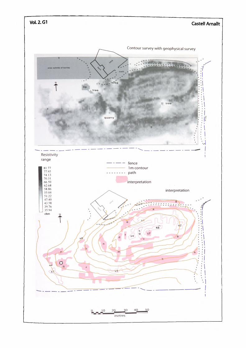
VOL2.G1 Castell Arnallt
Contour survey with geophysical survey
Resistivity range
fence1 m contourpath
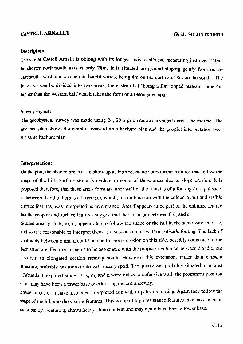
CASTELL ARNALLT Grid: so 31942
Description:
The site at Castell Arnallt is oblong with its longest axis, east/west, measuring just over 150m.
Its shorter north/south axis is only 78m. Tt is situated on ground sloping gently from north- cast/south- west, and as such its height varies; being 4m on the north and 8m on the south. The
long axis can be divided into two areas, the eastern half being a flat topped plateau, some 4m higher than the western half which takes the form of an elongated spur.
Survey layout:
The geophysical survey was made using 24, 20m grid squares arranged across the mound. The attached plan shows the geoplot overlaid on a hachure plan and the geoplot interpretation over the same hachure plan.
Interpretation:
On the plot, the shaded areas a - e show up as high resistance curvilinear features that follow the shape of the hill. Surface stone is evident in some of these areas due to slope erosion. Tt is proposed therefore, that these areas form an inner wall or the remains of a footing for a palisade. In between d and c there is a large gap, which, in combination with the colour layout and visible surface features, was interpreted as an entrance. Area f appears to be part of the entrance feature but the geoplot and surface features suggest that there is a gap between f, d, and e. Shaded areas g, h, k, m, n, appear also to follow the shape of the hill in the same way as a - e, and so it is reasonable to interpret them as a second ring of wall or palisade footing. The lack of continuity between g and n could be due to severe erosion on this side, possibly connected to the barn structure. Feature ni seems to be associated with the proposed entrance between d and c, but also has an elongated section running south. However, this extension, rather than being a structure, probably has more to do with quarry spoil. The quarry was probably situated in an area of abundant, exposed stone. If k, m, and n were indeed a defensive wall, the prominent position
of m, may have been a tower base overlooking the entrance way.Shaded areas o - r have also been interpreted as a wall or palisade footing. Again they follow the
shape of the hill and the visible features. This group of high resistance features may have been an
outer bailey. Feature q, shows heavy stone content and may again have been a tower base.
G.l.i
The southern part of area r has a linear feature running east to west for a distance of some 40m.
Running at right angles to this feature and attached to it are a series of square cells, approximately four metres across. As these buildings are on the outside of the supposed defensive wall they may represent later, possibly agricultural use.Un-shadcd features si - s9 were interpreted as building remains. The long double linear feature of si is possibly a hall although it may also have been a stock pen. The curious 80 degree alignment change at the west end of the feature would argue against it being a ridge and lurrow trench or orchard mark. At the east end there is a clear low resistance separation between si and s2. There is a very clear low resistance reading between si and a. The feature s2 appears to be a complex of structures with some very thick walls. The east -west aisle, on the east side of s2 is interesting and suggestive of something more than an entranceway. The feature s3 is on the same alignment as si and also has a direction change at the western end, although with s3 the continuation curved. The position of s4 tends to suggest a connection with the entranceway for this feature. The high resistance feature, s5 is not easy to interpret and may simply have been a path taken for the removal of rubble from the quarry. The feature marked s6 is on the very edge of the erosion area by the side of a large tree. It is not possible to offer an interpretation of this feature other than noting its existence. The low resistance feature s7 could possibly suggest a ditch beneath the wall or palisade footing. A further low resistance structure was noted between c, and s3, inside the top enclosure.The last feature to be mentioned is s9. This feature is unique on the site in that it forms a definite semi-circular. Both features si and c appear to overlie s9 and there is no evidence of its survival beyond them. It is possible that the west end of s3, mentioned earlier, has an association with the curve of s9.
Conclusion:
The historical importance of the site, as a castle of a Welsh lord, has always been suspected. The survey however, has shown that this neglected site may also contain a large archaeological record of medieval life. The site appears to have contained a large number of buildings and may well have had multivallate defences which probably evolved with the times in which they were used, probable early timber structures being replaced by the evident masonry that the survey recorded. Possibly the feature s9 may have been an earlier rampart that the site outgrew. It is more correct to think of Castell Arnallt as a Llys than a castle. If this is the case, it may be
possible to equate its potential importance with that of Dinas Powys.G.l.ii
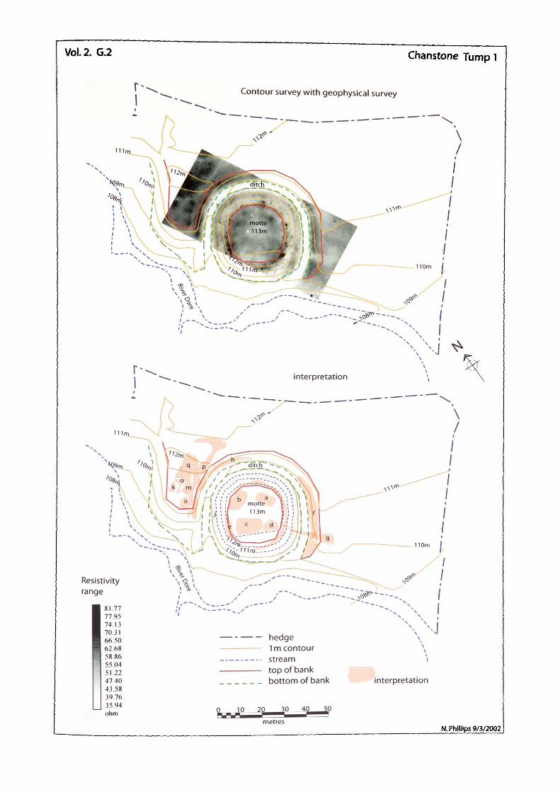
Vol.2. G.2 Chanstone Tump 1
r--Contour survey with geophysical survey
Resistivity range
81.77 77.95 74 13 70.31 66.50 62.68 58.86 5504 51.22 47.40 43.58 39.76 35.94 ohm
hedge1m contourstreamtop of bankbottom of bank interpretation
N. Phillips 9/3/2002
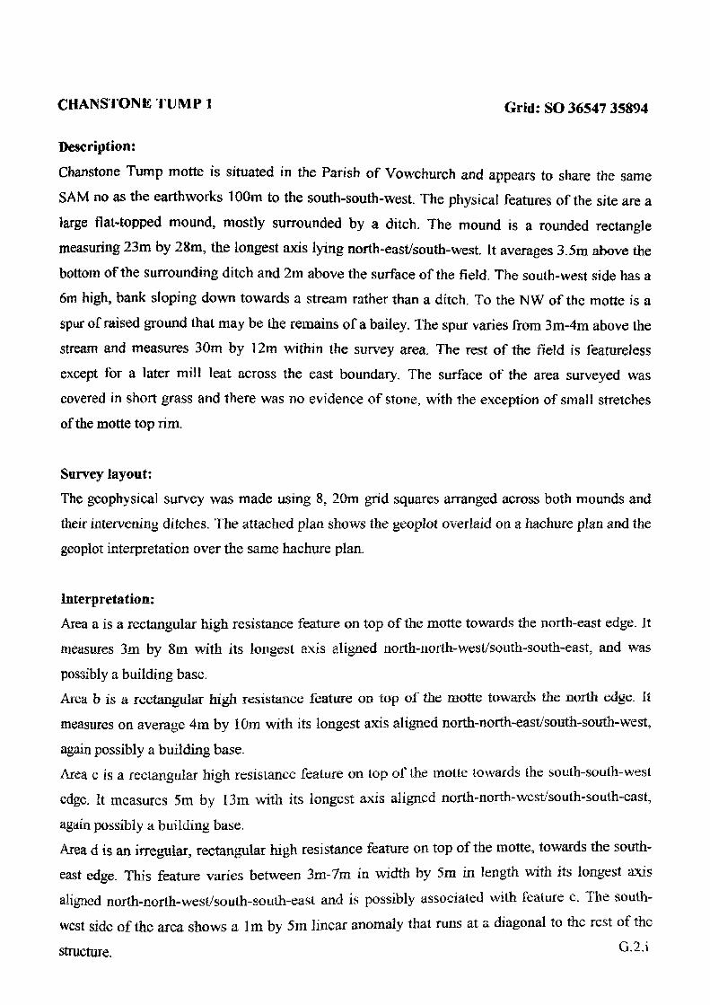
CHAINSTON K TU M P 1 Grid: SO 36547 35894
Description:
Chanstone Tump motte is situated in the Parish of Vowchurch and appears to share the same SAM no as the earthworks 100m to the south-south-west. The physical features of the site are a large flat-topped mound, mostly surrounded by a ditch. The mound is a rounded rectangle measuring 23m by 28m, the longest axis lying north-east/south-west. It averages 3.5m above the bottom of the surrounding ditch and 2m above the surface of the field. The south-west side has a 6m high, bank sloping down towards a stream rather than a ditch. To the NW of the motte is a spur of raised ground that may be the remains of a bailey. The spur varies from 3m-4m above the stream and measures 30m by 12m within the survey area. The rest of the field is featureless except for a later mill leat across the east boundary. The surface of the area surveyed was covered in short grass and there was no evidence of stone, with the exception of small stretches of the motte top rim.
Survey layout:
The geophysical survey was made using 8, 20m grid squares arranged across both mounds and their intervening ditches. The attached plan shows the geoplot overlaid on a hachure plan and the geoplot interpretation over the same hachure plan.
Interpretation:
Area a is a rectangular high resistance feature on top of the motte towards the north-east edge. It measures 3m by 8m with its longest axis aligned north-north-west/south-south-east, and was
possibly a building base.Area b is a rectangular high resistance feature on top of the motte towards the north edge. It measures on average 4m by I Om with its longest axis aligned north-north-east/south-south-west,
again possibly a building base.Area c is a rectangular high resistance feature on lop of the moite towards the south-south-west edge. It measures 5m by 13m with its longest axis aligned north-north-wcst/south-south-cast,
again possibly a building base.Area d is an irregular, rectangular high resistance feature on top of the motte, towards the south east edge. This feature varies between 3m-7m in width by 5m in length with its longest axis aligned norlh-norlh-wesf/soulh-south-east and is possibly associated with feature c. The south west side of the area shows a 1m by 5m linear anomaly that runs at a diagonal to the rest of the
structure. G21
Area c is a curvilinear, high resistance feature that appears to be associated with the rim of the motte top. Its width is very irregular; possibly, due to erosion, but on average seems to vary between lm-2m. It is possible that e represents a defensive rim wall or remains of a palisade bank, although the reading may be caused by differential drying of the motte edge. Area f is a high resistance curvilinear feature associated with the rim of the bailey bank. Its width averages 3m and it stretches around the south-cast side of the motte towards the north, for about 40m. The south-west end of the feature fades out at the stream slope and is noticeable in the field as a break of slope. The feature also narrows where it is cut by g.Area g is a low resistance linear feature, running 25m from the south survey edge, through f and e at the motte rim. This has been interpreted as a modern access path as it runs to the motte from the roadside gate.Area h is a high resistance curvilinear feature and like f, also appears to be associated with the rim of the bailey bank. Its width averages 3m and it stretches around the north-east side of the motte towards the west for about 48m, where it fades out at the stream slope; noticeable in the field as a break of slope.Area j is a continuous, curvilinear feature of high resistance averaging a width of 4m. It is not noticeable in the field either in vegetation or break of slope. Tt entirely encircles the motte bottom, within the survey area, but is inside and above the motte ditch. A reasonable interpretation would be an encircling wall or remains of palisade bank at the bottom of the motte slope. There is a possibility that the anomaly represents geology but as it is not evident at the same height on the outside of the ditch this would be unlikely.Area k is a high resistance, rectangular feature measuring 5m by 3m on a north-east/south-west axis; slightly bigger towards the north but clipped by the north edge of the survey. It is probably a building base situated on what may be a bailey.Area m is a high resistance, rectangular feature measuring 5m by 6m again on a north-east/south
west axis; probably another building base.Area n is a high resistance, rectangular feature measuring 5m by 4m on a north-north-east/south-
south-west axis, again a potential building base.Area o is a low resistance feature roughly 'T' shaped and between features k, m, and q. If k, m, and q were buildings then o, could be easily interpreted as a path between them. It is worth noting that in the field, o does show up as a slight depression.Area p is another low resistance feature that parallels h to the south and delineates q, m and n on the north. The resistivity range for this feature is similar to o and it may be another path.
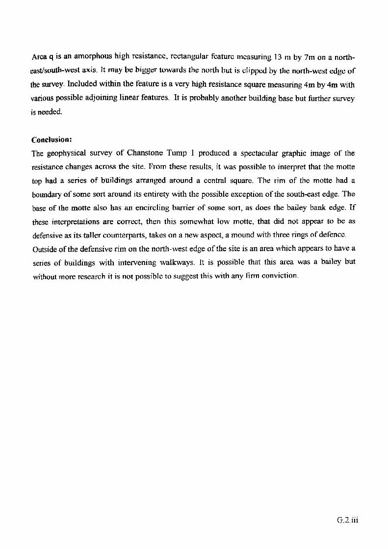
Area q is an amorphous high resistance, rectangular feature measuring 13 m by 7m on a north east/south-west axis. It may be bigger towards the north but is clipped by the north-west edge of
the survey. Included within the feature is a very high resistance square measuring 4m by 4m with various possible adjoining linear features. It is probably another building base but further survey
is needed.
Conclusion:
The geophysical survey of Chanstone Tump 1 produced a spectacular graphic image of the resistance changes across the site. From these results, it was possible to interpret that the motte top had a series of buildings arranged around a central square. The rim of the motte had a boundary of some sort around its entirety with the possible exception of the south-east edge. The base of the motte also has an encircling barrier of some sort, as does the bailey bank edge. If
these interpretations are correct, then this somewhat low motte, that did not appear to be as defensive as its taller counterparts, takes on a new aspect, a mound with three rings of defence. Outside of the defensive rim on the north-west edge of the site is an area which appears to have a series of buildings with intervening walkways. It is possible that this area was a bailey but without more research it is not possible to suggest this with any firm conviction.
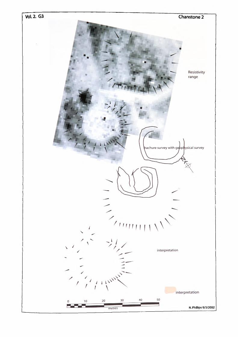
Vol.2. G3 Chanstone 2
Resistivity range
- k / V'it. ' *S^BW»
Lsical survey
N
X
\
\interpretation
interpretation
N. Phillips 9/3/2002
CHANSTONE JUMP 2 Grid : SO 36462 35704
Description;
The physical features of the site consist of two vaguely round earthwork mounds, one a raised platform on three sides, measuring 34m x 27m with a maximum height of 0,9m, the other a raised ring 28m x 30m with a maximum height of 0.4m. The centre of the second ring has a quantity of rubble in it. Both mounds seem to share a common system of ditches. The surfaces of the mounds were covered in short grass with patches of nettles and there was evidence of much stone within the fill and on the slopes of the mounds.
Survey layout:The geophysical survey was made using 11, 20m grid squares arranged across both mounds and their intervening ditches. The attached plan shows the geoplot overlaid on a hachure plan and the geoplot interpretation over the same hachure plan.
Interpretation:Area a is a curvilinear low resistance feature associated with the rim of the mound. It has nodiscernable width in this area as it runs outside of the survey, it is probable that this feature maywell represent natural ground surface.
Area b would appear to be a further expanse of the natural feature a but is this time bounded bythe higher resistance of the mound on one side and feature m, along the other.Area c is also a low resistance area and can be interpreted as natural ground surface, devoid offeatures.Area d is another low resistance area and can also probably be interpreted as natural ground
surface.Area e is further low resistance feature similar to a, b, c, and d except that it has a section oflower resistance. If the assumption that the resistance measured at a - d represents natural thenthe extremely low resistance at the centre of c could be due to silting of a ditch between bothmounds.
Area f is a circular, low resistance feature with readings similar to e. This would again suggestthat an underlying feature has silted up. The north side of feature f is probably linked to e and apossible explanation could be thai the ring mound is a fish pond with a feed ditch at e.The following areas g n arc to be found on top of the flat mound. G. 3. i
Area g is a low resistance feature measuring 18m by 6m with an offset area to the south and apossible entrance. A scatter of varying higher resistance features, which may have been walls,
surrounds it.Area h is a low resistance feature irregularly shaped with rough dimensions of 12m x 4m. Ascatter of varying higher resistance features, which may have been walls, surrounds it.Area i is a roughly triangular low resistance feature measuring 6m x 5m along its short lengthsand again a scatter of varying higher resistance features, which may have been walls, surroundsit. The very high resistance to the south-west of i could be caused by a large tree that growsthere.Area j is a low resistance rectangular feature measuring 7m by 7m with two 2m offsets. A scatterof varying higher resistance features, which may have been walls, surrounds it and it also sharesthe tree with i.Area k is a low resistance rectangular feature measuring 5m by 4m. It has a 2m x 1m extensionon the west side and a 3m x 3m addition to the north-east. A scatter of varying higher resistancefeatures, which may have been walls, surrounds it.Area 1 is an almost rectangular, low resistance feature measuring 5m by 4m. A scatter of varyinghigher resistance features, which may have been walls, surrounds it.Area m is a triangular feature of high resistance which runs between features b, and c. It is madeup of a jumble of high resistance readings which form no discernable patterns.
Area n is a curvilinear feature of high resistance which runs along the edge of the mound. It has avery slight rise on the inside of the mound and may have been a raised earthwork. It contains alot of stone fill. The west end of this feature ends abruptly at a, which does seem to show adeliberate purpose. At the east terminal there is a more gradual decline.Area o is a high resistance feature roughly circular with a 9m diameter. The physical nature of o
is a small mound of densely packed stone.Area p is a ring feature of high resistance which almost encircles f. It has a jumble of highresistance, which form no discernable patterns: similar to the north mound. The east and southsides of p are about 2m thick but on the west side the feature reaches some 11m across.
Conclusion:The features g - 1 are all low resistance areas between jumbles of higher readings. There are no real patterns of structure to be picked out but it is reasonable to interpret that the mound has had a concentration of buildings on it at one time. The high resistance features m and n and the fill

of the mound arc probably man made. A likely interpretation of the mound is that of a moated site. The western mound is very much of an enigma and it has been suggested that it may represent the remains of a fish pond, possibly associated with the moated site as they both appear to share a ditch system. However, they may also be associated with the railway line which used to run along side the site.
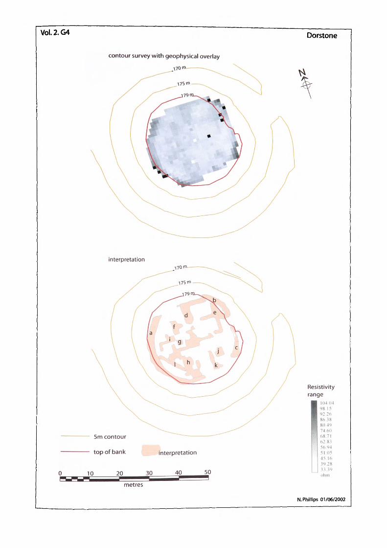
Vol.2.G4 Dorstone
contour survey with geophysical overlay
interpretation
5m contour
top of bank
10 20 30•metres
interpretation
40 50
Resistivity range
104 0498.1592.268638804974.6068 71628356.9451 0545 1639.2833 39ohm
N. Phillips 01/06/2002
DORS TONK Grid: so 31217 41623
Description:
The motte stands at a height varying between 8m to 9.5m above the bottom of its surrounding ditch. Its top is oval with diameters of 33m and 28m providing a surface area of 734m2 . The surface of the motte is covered in short grass and there are trees around the rim and three in the centre. Trees can be a problem with geophysics in that their root systems disturb the ground and so affect the resistivity of the soil. There is evidence of much stone within the fill and on the slopes of the motte.
Survey layout:The geophysical survey was made using 4, 20m grid squares arranged across the motte top. The centre of the 4 grids was positioned in the centre of the motte in order to give greater coverage of the edges. The attached plan shows the geoplot overlaid on a contour plan and the geoplot interpretation over the same contour plan.
Interpretation:Area a is a curvilinear high resistance feature associated with the rim of the motte. In places thewidth reaches some 3m in thickness. There is a great deal of small surface stone visible aroundthe motte top but no large masonry pieces. It is possible that the feature represents the remains of
an enclosing wall or earthwork around the top of the motte. There may have been a shell keep atDorstone, lack of large masonry pieces being the result of robbing.Area b is a probable continuation of a.Area c is also a probable continuation of a, the motte rim between b and c has been eroded whichmay account for the break, however; it is possible that this is an entrance through the enclosure
wall. The features a, b, c, are present wherever the resistivity survey reached the rim of the mottetop,Area d is a high resistance feature comprising two linear sections connected by a right angle, thenorth/south section of which measures 6m x 3m whilst the cast/west section is 12m x 2m.Area e is an area of high resistance that has two lengths of 1m wide stretches, again set at right
angles. The west length measures 5m and the south 5m with a 3m right angle corner runningwest. At their junction there is a more substantial feature that appears to stop just short of bsuggesting a passage between the two. The area between e and d is a regular rectangle of low
resistance, consistent with a large internal room 6m x 5m.
G.4.1
A probable doorway is present on the south-west side. There may be a similar room formed
between the southern arm of e and the east section of h, to be discussed later. Another large, lowresistance feature is contained between e and c, possible further evidence of the proposedentrance way between b and c.
Area f is a high resistance, T* shaped feature. One part, running north/south is 2m x 5m and the
other 1m x 2m. The thinner section is on the same alignment as east/west section of e suggesting
a continuation of a wall. The thicker, north/south section forms a rather solid reading that iscontinuous through g and h.
Area g is a high resistance feature, although probably a continuation of f, separated by a weak
resistance gap.Area h is a very complicated series of high resistance features. All the sections of h are aligned at
right angles to one another and appear as lengths of linear features with widths between 1 m and
2m. One part of h (where the letter 'h' is on the plan), measures 2m wide and 7m long. Its
alignment and width are identical to h, g, and f, suggesting a large continuous wall.
Area i, is another stretch of linear feature with right angled sections whose alignment is the same
as features d, e, f, g, and h.Area j, is a feature of high resistance measuring 1m x 12m between a, and h. It is the only feature
on the site that is not aligned north/south.
Conclusion:The noticeable alignment of these combined features d -i would suggest that they are all
associated with one another. A probable interpretation, considering the type of site as well as the
geophysics, would be of a set of connected rooms within a large building. The more indistinct
parts of the features are probably the result of tumble from walls, but even so, the overall nature
of the structure can be seen. A masonry wall of some considerable thickness surrounded the
whole building complex, which would be consistent of a shell keep with internal buildings.
GAii
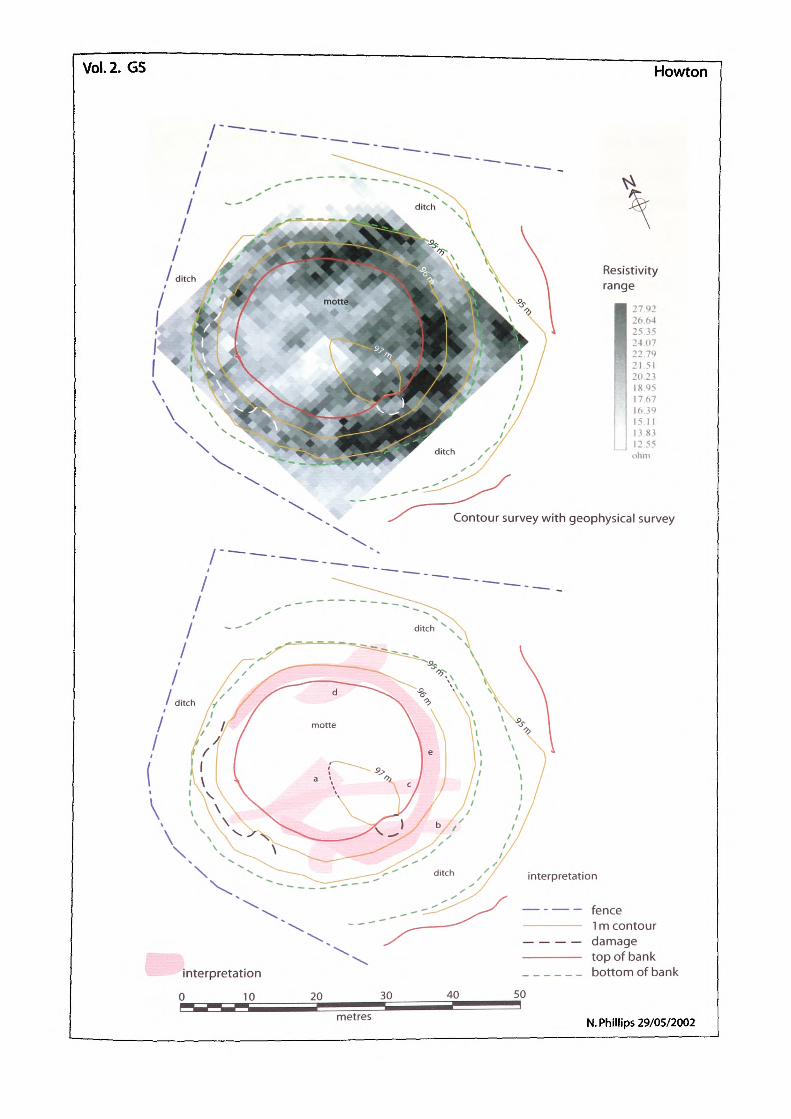
Vol.2. G5 Howton
Resistivity range
26.64 25.35 2407 22.79 21.51 20.23 18.95 17.67
I' | 16.39 15.11 13.83 12.55 ohm
Contour survey with geophysical survey
interpretation
0 10
interpretation
— - — — fence—————— 1 m contour— — — — damage—————— top of bank______ bottom of bank
20 30 40 50
metres N. Phillips 29/05/2002
HOW1ON Grid: SO 41487 29389
Description:The mound at Howton is quite low at an average height of 2m above the bottom of its surrounding ditch; around 1.5m above natural land surface. Its top is circular with a 26m diameter providing a surface area of 527m2 . The surface of the motte is covered in short grass.
Survey layout:The geophysical survey was made using 4, 20m grid squares arranged across the motte top. The centre of the 4 grids was positioned in the centre of the motle in order to give greater coverage of the edges. The attached plan shows the geoplot overlaid on a contour plan and the geoplot interpretation over the same contour plan.
Interpretation:Area a is a rectangular low resistance feature, 11m. in length by 5m wide running roughly east- north-east/west-south-west. It has been interpreted as a pit of some sort with a disturbed fill. It may be part of the 1906 excavation trench mentioned in the VCH. (1908. 227), alternatively it may be a cellar of a demolished, possibly timber, building.Area b is a linear, low resistance feature running east-south-east/west-north-west, turning at a right angle on the west side to continue west-south-west, it measures approx 24m by 3m along the longest part with the right-angled extension running a further 5m. It crosses the south side of the mound top at a tangent, and an area of damage to the rim is noticeable at this point. For this
reason it would appear that b is a later addition to the mound.Area c is an identical feature to b with the exception that it docs not have a right angle turn. It runs parallel to b for 24m but continues for a further 11m to the mound diteh. Both features b and c can be seen to have a slight curve along their length. If both are of a similar origin then
their combined width is some 8m.Area d is a higher resistance feature that runs from the bottom of the ditch to the top of the mound on the north side. Its longest side is 16m and its width is 5m. The jumbled effect and the resistance range would suggest that the feature is the result of differential drying due to it being
the north side of a steep bankArea e is an area of high resistance that seems to be found around the rim of the mound on all sides except the south-west. Again this would suggest differential drying due to the resistance
range. However, it is possible that it could also show evidence of the remains of a palisade bank.G.5.i
Conclusion:The range of the resistance encountered on this survey was limited and it was felt that this would have an influence on the interpretation. As no stone was found or felt with the probes, it was decided that higher resistance readings were probably the result of differential drying of the soil. The results of the geophysics in this instance were not very clear although it is possible to say that there is probably no masonry on the site. It may well be that Howton was a timber/earthwork structure. If this is the case then it may explain the absence of finds from the 1906 excavation.
G.5.H
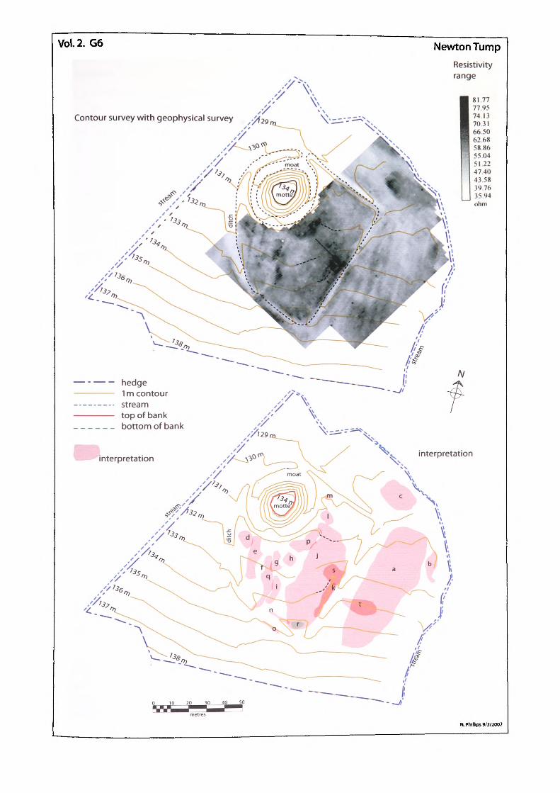
Vol. 2. G6 Newton TumpResistivity range
Contour survey with geophysical survey
- — — hedge1 m contour stream top of bank bottom of bank
N. Phillips 9/3/2002

NEWTON TDMP Grid: so 29272 44053
Description:
The site at Newton Tump consists of a motte and bailey, the motte stands at an average height of 5m above the bottom of its surrounding ditch, around 4m above the bailey. The bailey itself is raised by about 1m on the north side to counteract the slope of the hill.
Survey layout:
The geophysical survey was made using 24, 20m grid squares arranged across the bailey and surrounding natural surface. The motte and surrounding molte ditch were not surveyed due to vegetation coverage and boggy conditions. The western edge of the bailey was also not surveyed because the ground was waterlogged.
Interpretation:
Area a is a large stretch of ground showing both high resistance and low resistance features running in parallel lines. The lines vary in length with the longest reaching around 70m. The high resistance lines average 1m in width, whereas the low resistance features have a width averaging 3m. The lines are orientated north/south, following the gradient of the surface. This orientation would tend to eliminate the anomaly having been caused by an eroding bedding plane. The interpretation favoured therefore is that they are probably ridge and furrow plough marks. The high resistance may be either from underlying features that have been spread along the field by plough or they are cuts made through the sandstone bedrock. An interesting point to notice about the lines is that they run at an offset alignment with the bailey ditch. Area b is a semicircular, high resistance feature running north/south, with its curve towards the W. It measures approximately 10m, nort/south by 3m, east/west and according to the contour plan is associated with the 132m contour, in the field, the contour runs at a break of slope, that more than likely forms an old stream bank. This would account for the high resistance. Area c is a rectangular high resistance feature measuring 10m by 5m on and east/west axis. The feature is noticeable in the field as a slight rise of ground atop a very regular platform to the west and north. Low resistance on three sides surrounds the platform with a stream on the fourth. A faced slab of stone is present at surface level with more masonry immediately beneath the turf. The findings would suggest a large building possibly used to stand here an the east/west axis
may point to an ecclesiastical structure.
G.6.i
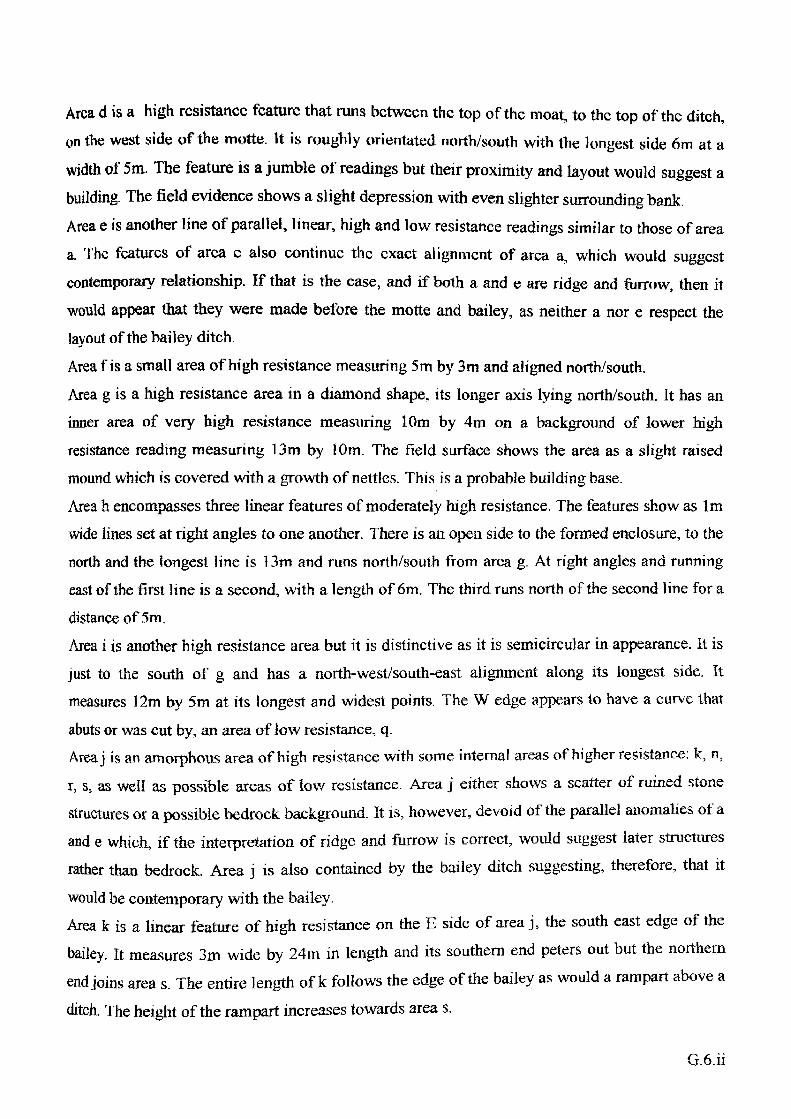
Area d is a high resistance feature that runs between the top of the moat, to the top of the ditch,
on the west side of the motte. It is roughly orientated north/south with the longest side 6m at a
width of 5m. The feature is a jumble of readings but their proximity and layout would suggest abuilding. The field evidence shows a slight depression with even slighter surrounding bank.Area e is another line of parallel, linear, high and low resistance readings similar to those of areaa. The features of area c also continue the exact alignment of area a, which would suggest
contemporary relationship. If that is the case, and if both a and e are ridge and furrow, then it
would appear that they were made before the motte and bailey, as neither a nor e respect thelayout of the bailey ditch.Area f is a small area of high resistance measuring 5m by 3m and aligned north/south.Area g is a high resistance area in a diamond shape, its longer axis lying north/south. It has aninner area of very high resistance measuring 10m by 4m on a background of lower high
resistance reading measuring 13m by 10m. The field surface shows the area as a slight raisedmound which is covered with a growth of nettles. This is a probable building base.Area h encompasses three linear features of moderately high resistance. The features show as 1mwide lines set at right angles to one another. There is an open side to the formed enclosure, to thenorth and the longest line is 13m and runs north/south from area g. At right angles and runningeast of the first line is a second, with a length of 6m. The third runs north of the second line for adistance of 5m,Area i is another high resistance area but it is distinctive as it is semicircular in appearance. It isjust to the south of g and has a north-westysouth-east alignment along its longest side. Itmeasures 12m by 5m at its longest and widest points. The W edge appears to have a curve that
abuts or was cut by, an area of low resistance, q.Area j is an amorphous area of high resistance with some internal areas of higher resistance: k, n,
r, s, as well as possible areas of low resistance. Area j either shows a scatter of ruined stone
structures or a possible bedrock background. It is, however, devoid of the parallel anomalies of a
and e which, if the interpretation of ridge and furrow is correct, would suggest later structures
rather than bedrock. Area j is also contained by the bailey ditch suggesting, therefore, that it
would be contemporary with the bailey.Area k is a linear feature of high resistance on the E side of area j, the south east edge of the
bailey. It measures 3m wide by 24m in length and its southern end peters out but the northern
end joins area s. The entire length of k follows the edge of the bailey as would a rampart above a
ditch. The height of the rampart increases towards area s.
Area 1, is a moderately high resistance rectangular feature, comprising three 2m wide linear
anomalies set at right angles to one another with an opening to the south. The internal enclosed
area is low resistance and the field evidence shows a depression covered in a stand of nettles. It
is a probable building base.
Area m is a small area of high resistance measuring 4m by 3m although the 3m measurement
only reflects the limit of the survey. The longer measurement is bounded by the motte ditch on
the one side and the bailey ditch on the other. The field evidence shows that the mound extends
west forming a terminus to the bailey on this side of the motte.
Area n is another linear feature of high resistance within area j on the south edge of the bailey. Tt
measures 3m wide by 15m in length but is not as high a resistance as the similar feature k. The
west end weakens but the east end joins area r. The entire length of n follows the south edge of
the bailey as would a rampart above a ditch. The height of the rampart increases towards area r.
Area o is a similar feature to n but is on the opposite edge of the ditch. Tt is possible that the ditch
at this point has cut through a bedrock outcrop although again there is none of the ridge and
furrow evidence interpreted for a and e. The limit of the survey at this point makes it difficult to
interpret this feature.Area p, is a large area of high resistance to the east of the motte. The amorphous shape has a
long side south-west/north east, measuring approximately 20m with a north west/south-east axis
of about 12m. Within the area is a higher resistance with a maximum width of 7m and an
average width of 4m. This internal feature follows the same alignment but is constrained on the
east side. The south-west end of area p seems to turn towards the motte whilst the north-east is
separated from the motte ditch edge by a 5m lower resistance band. Field evidence shows the
area as a low linear mound at the motte ditch edge. The mound rises gradually from the north
east to the south-west where it drops off more abruptly. Area p was the main interest of the
survey as it was hoped to investigate it as a possible bridge base to the motte. The findings,
though far from conclusive, certainly have not supported an alternative conclusion.
Area q is a curvilinear feature of low resistance separating features g and i from e and f. The
feature runs from the south-east bailey ditch, where its width is 3m, north for about 11m. It then
curves gently north-west for about 14m and increases its width to 7m. The field evidence for this
feature is that it lines up at the ditch edge to an area of ditch fill. It seems likely that the fill was a
later feature associated with what appears to be a modem path towards the motte from the road
to the S. This feature may therefore have been caused by modern access.
Area r, is an area of high resistance again included within feature j. This time the feature is to be found at the south-east corner of the bailey ditch. The feature is circular with an enclosed area of low resistance. Its diameter is approximately 9m and it has an apparent thickness of around 2m. There appears to be an association with n. The field evidence for the feature is a rounded mound on the raised edge of the bailey at the corner of the ditch. Interpretation of this feature would favour a masonry tower of some sort.Area s is a very densely packed area of high resistance that appears to run roughly parallel with the bailey ditch. It has three connected linear features with an internal gap of around 1m. The three features are at right angles to one another. The eastern feature that parallels the ditch is 10m by 2m, thickening to 3 in the north. The north-east feature is 9m by 4m whilst the southern one is 7m by 4m. Feature s appears to be an extension of k, and therefore part of the rampart. The field evidence shows a raised, rounded mound on the end of the linear mound k. Its position, central to the straight edged ditch and rampart, suggests that s has picked up a possible gatehouse structure for the bailey.Area t is a low resistance amorphous feature that would appear to lead towards s, although the alignment is far from perfect. This feature may be an early approach road to the castle or it may be another modern path.
Conclusion:The result of this geophysical survey has been very informative in that it shows extensive evidence for structures within the bailey compound. It has also shown that the bailey probably had a stone-surrounding wall with an entrance through a gatehouse on the east side. A possible tower crowned the south-east corner of the bailey whilst a similar tower expected on the north east corner was not found. Where the bailey narrows at features d and m were found other high resistance features. These may be additional towers but it is difficult to interpret as both overlap the edge of the survey. Feature p, the possible bridge base, supports such a feature. The field on which the motte and bailey castle was built seems to have had an agricultural use before its
construction.Area c would also be a very interesting site for further research. The form of the castle at Newton Tump is very similar to Lingen (SO 366 673), Adjacent to the bailey at Lingen is a church, on a mound, surrounded by a dry ditch with a stream on the N, (Shoesmith, 1996. pi61). it could be that c was a church and this would suggest that Newton Tump would have been
associated with a now lost village.G.6.iv
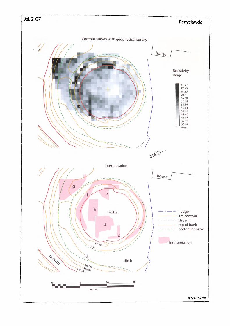
Vol.2.G7 Penyclawdd
Contour survey with geophysical survey
81.77 77.95 74.13 7031 66.50 62.68 5886 5504 51.22 4740 4358 39.76 35.94 ohm
interpretation
1 m contour stream top of bank bottom of bank
interpretation
metres
N. Phillips Dec 2001
PENYCLAWDD Grid; so 30%7 20139
Description:
The mound stands at an average height of 2m above the bottom of its surrounding ditch. Its top is circular with a 21m diameter providing a surface area of 326m2 . The surface of the mound is covered in short grass allowing for faint sub-surface structures to be seen. Tt was these structures that suggested the potential value of a geophysical survey.
Survey layout:
The geophysical survey was undertaken using 4, 20m grid squares arranged across the mound top. The centre of the 4 grids was positioned in the centre of the mound in order to give greater coverage of the edges. The attached plan shows the geoplot overlaid on a hachure plan and the geoplot interpretation over the same hachure plan.
Interpretation :
Area a shows a concentration of masonry, 8m in length by 5m at its widest point. The very darkarea to the east is actually an exposed section of wall some 2 courses high, probably once abuilding.Area b is another area of high resistance measuring 9m by 4m. It lies at right angles to and acrossthe northern edge of the motte and probably represents a building with tumble into the ditch.
Area c is a right angle feature with one 5m and one 4m section and an overall width of 1m.Area d has a very pronounced north- west/south-east line of high resistance. Its width is 1m andits length 8m. Also attached, and running south of the line, is a roughly 6m by 6m area of highresistance. It is possible that c and d arc two sides of one building. The low resistance betweenthe two may be the result of a possible entrance at the motte edge or the result of erosion. A
modern break of slope is visible in the form of a path at this point.Area e and area fare both stretches of intermittent high resistance. As these two areas follow the
edge of the mound lop, it is possible that they are masonry tumble either from a shell keep or
packing from a wooden palisade.Area g is an area of high resistance with surface stone apparent. This also has a probable
connection with masonry tumble but this time from the outer rampart. Unfortunately too little of
the rampart was included in the survey to draw a conclusion.
G.7.1
Conclusion:
The survey revealed various sections of possible stone walls, all roughly aligned or running at right-angles which would suggest that the mound top was once covered by a large building with internal divisions. Most of the anomalies seem confined to the west, north and east with the south and centre of the mound relatively free of response. There docs not appear to be any defence associated with the rim of the mound.
G.7.h
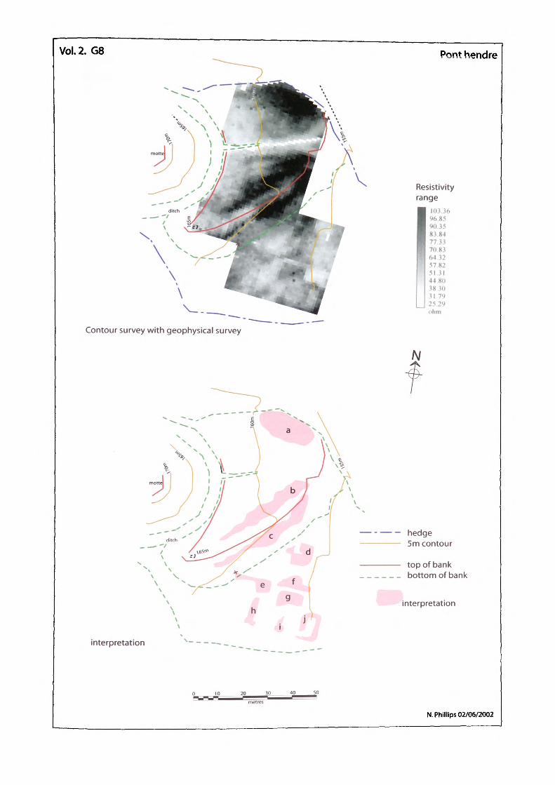
Vol. 2. G8 Pont hendre
Contour survey with geophysical survey
Resistivity range
103.36 96.85 90.35 83.84 77.33 70.83
| 64.32 57.82
' 51 31 4480 3830 31 79 25 29 ohm
N
hedge 5m contour
top of bank bottom of bank
interpretation
interpretation
N. Phillips 02/06/2002
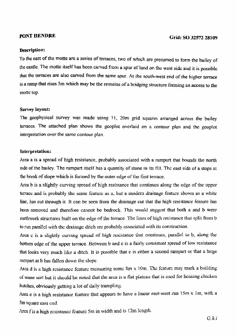
PONT HENDRE Crid: so 32572 28109
Description:
To the east of the motte are a series of terraces, two of which are presumed to form the bailey of the castle. The motte itself has been carved from a spur of land on the west side and it is possible that the terraces are also carved from the same spur. At the south-west end of the higher terrace is a ramp that rises 5m which may be the remains of a bridging structure forming an access to the motte top.
Survey layout:
The geophysical survey was made using 11, 20m grid squares arranged across the bailey terraces. The attached plan shows the geoplot overlaid on a contour plan and the geoplot interpretation over the same contour plan.
Interpretation:
Area a is a spread of high resistance, probably associated with a rampart that bounds the northside of the bailey. The rampart itself has a quantity of stone in its fill. The east side of a stops atthe break of slope which is formed by the outer edge of the first terrace.Area b is a slightly curving spread of high resistance that continues along the edge of the upperterrace and is probably the same feature as a, but a modem drainage feature shown as a white
line, has cut through it. It can be seen from the drainage cut that the high resistance feature hasbeen removed and therefore cannot be bedrock. This would suggest that both a and b wereearthwork structures built on the edge of the terrace. The lines of high resistance that split from bto run parallel with the drainage ditch arc probably associated with its construction.Area € is a slightly curving spread of high resistance that continues, parallel to b, along the
bottom edge of the upper terrace. Between b and c is a fairly consistent spread of low resistance
that looks very much like a ditch. It is possible that c is either a second rampart or that a large
ramparl at b has fallen down the slope.Area d is a high resistance feature measuring some 8m x 10m. The feature may mark a buildingof some sort but it should be noted that the area is a flat plateau that is used for housing chicken
hutches, obviously getting a lot of daily trampling.Area e is a high resistance feature that appears to have a linear east-west run 15m x 1m, with a
5m square east end.Area f is a high resistance feature 5m in width and is 12m length.
G.S.i
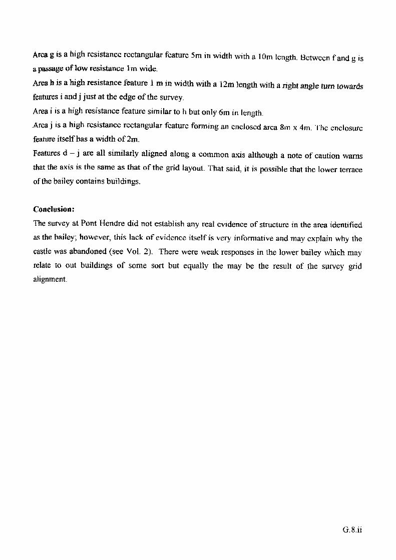
Area g is a high resistance rectangular feature 5m in width with a 10m length. Between f and g isa passage of low resistance 1m wide.Area h is a high resistance feature 1 m in width with a 12m length with a right angle turn towardsfeatures i and j just at the edge of the survey.Area i is a high resistance feature similar to h but only 6rn in length..Area j is a high resistance rectangular feature forming an enclosed area 8m x 4m. The enclosurefeature itself has a width of 2rn.Features d - j are all similarly aligned along a common axis although a note of caution warnsthat the axis is the same as that of the grid layout. That said, it is possible that the lower terraceof the bailey contains buildings.
Conclusion:The survey at Pont Hendre did not establish any real evidence of structure in the area identified as the bailey; however, this lack of evidence itself is very informative and may explain why the castle was abandoned (see Vol. 2). There were weak responses in the lower bailey which may relate to out buildings of some sort but equally the may be the result of the survey grid alignment.
G.S.ii
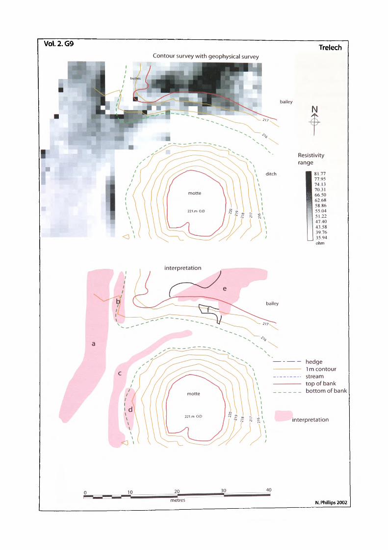
Vol.2.G9 TrelechContour survey with geophysical survey
bailey
N
Resistivity range
81 7777.9?74.1370.31665062.685886550451.2247.4043.58397635.94ohm
interpretation
bailey
— - — — hedge————— 1 m contour_.__.__.. stream————— top of bank______ bottom of bank
interpretation
metres N. Phillips 2002
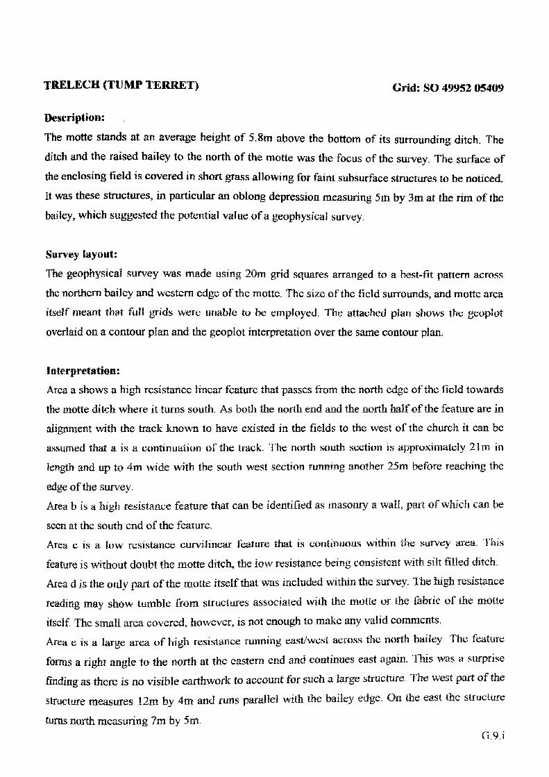
TRELECH (TDMP TERRET) Grid: so 49952 0
Description:
The motte stands at an average height of 5.8m above the bottom of its surrounding ditch. The
ditch and the raised bailey to the north of the motte was the focus of the survey. The surface of
the enclosing field is covered in short grass allowing for faint subsurface structures to be noticed,
It was these structures, in particular an oblong depression measuring 5m by 3m at the rim of the
bailey, which suggested the potential value of a geophysical survey.
Survey layout:
The geophysical survey was made using 20m grid squares arranged to a best-fit pattern across
the northern bailey and western edge of the motte. The size of the field surrounds, and motte area
itself meant that full grids were unable to be employed. The attached plan shows the geopiot
overlaid on a contour plan and the geopiot interpretation over the same contour plan.
Interpretation:Area a shows a high resistance linear feature that passes from the north edge of the field towards
the motte ditch where it turns south. As both the north end and the north half of the feature are in
alignment with the track known to have existed in the fields to the west of the church it can be
assumed that a is a continuation of the track. The north south section is approximately 21m in
length and up to 4m wide with the south west section running another 25m before reaching the
edge of the survey.Area b is a high resistance feature that can be identified as masonry a wall, part of which can be
seen at the south end of the feature.Area c is a low resistance curvilinear feature that is continuous within the survey area. This
feature is without doubt the motte ditch, the low resistance being consistent with silt filled ditch.
Area d is the only part of the motte itself that was included within the survey. The high resistance
reading may show tumble from structures associated with the motle or the fabric of the motie
itself. The small area covered, however, is not enough to make any valid comments. Area e is a large area of high resistance running east/west across the north bailey. The feature
forms a right angle to the north at the eastern end and continues east again. This was a surprise
finding as there is no visible earthwork to account for such a large structure. The west part of the
structure measures 12m by 4m and runs parallel with the bailey edge. On the east the structure
turns north measuring 7m by 5m.G.9.i
The north end of the survey shows the feature turning cast again but this may be associated witha modem wall.The southeast of the feature has an 'V shaped feature which runs down the bailey bank towardsthe ditch.Area fwas the original Focus of Ihe survey due to the rectangular depression and the steepness ofthe mottc at this point. The feature is enclosed in a visible depression the cast side of which is the'L1 shaped part of area e.
Conclusion:
Two points have arisen from the survey that requires further research:If a is the track way then it leads into the castle ditch which would appear to be an unusualdestination. Therefore, it would suggest that the track way is a later addition to the site, after themotte had gone out of use or that it ""drifted" into the ditch after abandonment.The original suspicion was that the depression was the remains of a bridge base from the baileyto the motte. The interpretation of the survey is that the bridge base could be in place as amasonry structure. If area f, is the bridge base then it is possible that e, is a gatehouse of somesort.
VOLUME II
EARTHWORK CASTLES OF GWENT AND ERGYNG AD 10501250
EXCAVATIONS
N.Phillips. 2004
CONTENTS
Introduction E ^
Penyclawdd E ^2002
Design briefResultsFinds
2003Design briefResultsFinds
Trelech E iv2002
Design briefResultsFinds
2003Design briefResultsFinds
FiguresE.1 Penyclawdd excavation trenches 2002/2003E.2 Penyclawdd excavation 2002, sections and plansE.3 Penyclawdd excavation 2003, trench 1 section drawingE.4 Penyclawdd excavation 2003, trench 2 planE.5 Trelech excavation 2002, section, plan and profileE.6 Trelech excavation 2003, plan
PlatesE. 1 Penyclawdd excavation 2002, ditchE.2 Penyclawdd excavation 2003, trench 1, ditchE.3 Penyclawdd excavation 2003, trench 2, wallsE.4 Penyclawdd excavation 2003, trench 2, wall side viewE.5 Trelech excavation 2002, trench 1E.6 Trelech excavation 2003, trenches 2,3, 4, and 5E.7 Trelech excavation 2002, trench 3, beam slotE.8 Trelech excavation 2002, trench 5, stone boss in ditch
E.i
INTRODUCTION
Excavation of specific sites would provide valuable data for both this research and castle studies in general. Key potential sites pinpointed were Castell Amallt, Bryngwyn, Dingestow (Mill
Hill), Dorstone, Gypsy Tump, Llangiby (Bowling Green), Llanvaches, Nant-y-bar, Newcastle, Newton Tump, Old Castleton, Penyclawdd, Pont Hendre, Poston, Trelech and Wolvesnewton.
The full excavation programme was far beyond the scope of this study but the list remains a useful guide to priority sites for future excavation. Practical constraints limited excavations undertaken to two, Penyclawdd and Trelech.
PENYCLAWDD 2002
Design brief:
The initial design brief for the excavation at Penyclawdd was a single trench 8m by 3m located
on the lawn of Penyclawdd Court, adjacent to the earthwork mound but outside of the scheduled area (Vol. 2. figure E.I). The objective of the excavation was to determine the existence of a
ditch to the south of the motte, which if present, would show that the mound originally had a complete surrounding ditch as shown on the 1775 estate plan, (D.591.32A.37) (see Vol. 2. figure 97). It was also hoped that the predicted ditch would yield dating evidence for the site; prior to excavation the earliest date for Penyclawdd, Castle Mound, was 1349 (see Vol. 1. page 296).
The plan shows the location of the 2002 trench on the right of the mound.
Results:
The results confirmed the presence of a ditch which was revealed as a cut slope in natural clay
roughly consistent with the predicted southern rim (Vol. 2. figure E.2). The plan shows the edge of the trench and both the west and northern trench sections. The edge of the ditch shows up in
the bottom of the photograph and can be easily identified as the red clay area in the foreground (Vol. 2. plate E.I). The change in context can be seen on the west side of the trench (far side of
the photograph) as a stark colour change marked by a layer of tumble. The ditch reached a depth of 1.47m within the confines of the excavated area and was seen to continue downwards towards
the earthwork.
Finds:The finds in the fill of the ditch were mostly 18th to 20* century pottery, metalwork and glass
E.ii
consistent with a cottage that used to occupy the area. An interesting layer towards the bottom of
the excavation consisted of a tumble of rubble and flat stones that appeared to be loosely stacked
and oriented away from the mound. No artefactual dating evidence other than that mentioned
above was found in context (Phillips 2002. 130-31).
PENYCLAWDD 2003
Design brief:
As a result of the 2002 excavation, scheduled monument consent enabling excavation was
granted to try to locate the bottom of the ditch and search for dating evidence. Consent was also
granted for an evaluation trench on top of the mound to examine the high resistance features that
were revealed during the geophysical survey (Vol. 2. figure E.I). Both the 2003 trenches are
shown giving the alignment of the 2002 trench as well as the geophysical results (see Vol. 2
geophysics). The first trench, 5m by 3m was excavated at the south of the mound as an extension
to the 2002 excavation, thereby producing a good section through the ditch. A gap of around two
metres had to be left between the two trenches because of a boundary hedge. The second trench
was located to the north of the mound top at a point where a high resistivity reading had
suggested a linear feature.
Results:
The result of the excavation was that the inner edge of the ditch was found as a continuous slope
of the mound which had been cut into the natural bedrock, thus confirming the construction of
the mound. The ditch continued to slope downwards to a depth of 2.67m beneath the present
surface at the time of the excavation, at which point it started to rise, probably towards the level
recorded in 2002. The photograph of the ditch close to the end of the excavation gives a good
idea of the depth that was finally reached (Vol. 2. plate E.2). The motte is in the foreground and
the maximum depth is just behind the person excavating. The present motte stands at a low
height of 1.89m at this point, however, the combined depth of the ditch and the height of the
motte, 4.56m would tend to make the overall structure more impressive.
Finds:The fill of the ditch showed phases of levelling, all of which overlay a collapse layer of large
stone roof tiles, context 022, (Vol. 2. figure E.3). Initial pottery analysis places the collapse
layer in the late Tudor period (Anthony pers comm.}.E.iii
The second trench, 3m by 3m, was opened in an area highlighted by the resistivity survey which
produced results that were interpreted as masonry walls (see Vol. 2. geophysics). The fill of the
trench contained areas of burning and collapse debris such as roof tile and the photograph shows
some of the burnt area to the left of the smaller wall (Vol. 2. plate E.3). As can be seen in the
photograph, the anticipated walls were found just under the surface. One main wall running east-
west measured 1.8m thick and survives to a depth of 0.6m (Vol. 2. figure E.3). The second wall,
only 0.5 m thick, butts onto the larger and is obviously a later build. The photomontage shows
the length of exposed main wall with the smaller wall to the right (Vol. 2. plate E.4). Tt can be
seen from the photograph that there was a difference in the build of the second wall. Apart from
the width, the smaller wall has much better facing. Initial pottery analysis from this trench again suggests late Tudor.
Interpretation:
The evidence suggests that the motte has at some time in the past supported a large, rectangular
masonry structure which suffered fire damage. Whether the structure was razed to the ground in
that fire or salvaged for the possible building of the present house is not known.
TRELECH 2002
Design brief:
During the topographical survey of the site at Trelech a large rectangular depression feature was
observed at the top of the raised bank to the north of the motte (Vol. 2. plate 251). The depression feature was dismissed as a possible tree-throw due to the regularity of its shape. On
close examination of the area, and with later reference to measured data from the topographical survey (Vol. 2. surveys), however, it was possible to identify a similar depression on the north
edge of the motte, quite close to the top (Vol. 2. plate 252). At this point the possible
significance of the two areas as the remains of a bridge base, suggested the need for further
investigation, which resulted in a geophysical survey (Vol. 2. geophysics). The results of the
resistivity survey revealed a high resistivity anomaly in the area of the bank, identified above.
Results:On the basis of the surveys, scheduled monument consent to excavate was obtained and
excavation started in 2002 with a single 10m by 3m trench orientated north/south at 90% to theE.iv
edge of the motte (Vol. 2. figure E.4). The plan shows the layout of the 2002 trench (TR1) with the motte base to the right. The initial aims for the excavation were to ascertain the nature and function of the depression feature in the top of the bank (Vol. 2. plate 252). As the feature was suspected to be a bridge base, then not only could there be further associated features along its path, but there was also a likelihood that finds dropped from such a structure could lie in the ditch below. It was therefore decided to put a trench across the whole length of the ditch and bank which would have an added bonus of being able to provide a complete section of the ditch (Vol. 2. plate E5).A great deal of information was gained from the excavation as regards the first objective, the bridge base. A large rock cut beam slot was revealed across the bank showing the position of what was interpreted as an upper trestle. A second beam slot was found, just at the edge of excavation, at the top of the bailey bank, which may have been a further trestle. A small offset post-hole was also discovered in the bank west of the upper trestle slot. The angle of the post- hole suggests that a support pole may have been set there, either to brace the bridge or possibly to support the walk-way. At the bottom of the bank, an area of the bedrock had been flattened off which may have supported another post.The bank itself had been sculpted into two distinct tiers around the area excavated and measurements taken from each side of the trench showed that the effect was indeed localised (Vol. 2. figure E.5 : plate E. 5). The section drawing shows the layout of the trench in relation to the motte, with included profiles of the natural land gradients east, ab and west, cd, of the trench. The trench profile shows the measured bedrock layer in section against the background, cd, to give an idea of the modification that had been done to accommodate the bridge structure. An interpretation was made that the bridge would have been supported from at least two beams set into rock cut ditches. A third support would have existed towards the bottom of the ditch on either posts or another beam and there may have been further support within the ditch.
Finds:The end of the rock cut slot yielded the articulated hind quarters of a horse that appeared to have been deposited in the cut. The rest of the horse appeared to lay to the west. At the bottom of the ditch in the south-east corner, a piece of wood was found and this was collected for radiocarbon dating. The wood a piece of oak, returned a date of 864±34 BP which works out to 1138 ±34
(University of Waikato, New Zealand). The pottery finds are awaiting analysis.
Other information derived from the excavation showed that the ditch had actually been cut into
E.v
the bedrock which also indicated that some 3m of the motte was partially natural, with only the top section added. Also important was the establishment of the bailey's position to the north of the motte rather than as previously suggested to the south.
TREJLECH 2003
Design brief:
The 2002 results posed questions such as how big was the bridge, and still to be addressed, how old was the motte? In an attempt to answer these questions scheduled monument consent was granted for a second season of excavation.
Results:
In 2003 four trenches were excavated; three located as east/west extensions of the 2002 trench and the fourth north/south across the ditch, 1m west of the 2003 trench (Vol. 2. figure E.6 : plate E.6). The trench atop the bailey revealed a possible foundation for a bridge support but the evidence was inconclusive. The second trench, placed on the line of the beam-slot from the 2002 excavation, revealed a rock cut slot measuring, 3.9m long by 1m wide (plate E.7 and E.8). The depth of the slot at the back was 0.8m and at the front varying from 0.2m-0.6m. The remaining skeleton of the horse, discovered in the previous year was also recovered from the beam slot. A small musket ball fell from the skull as it was being excavated and there was a hole at the front of the skull, presumably where it had been shot. Whether the horse fell in the hole and was dispatched or whether the horse's body was dumped is not known. The third trench at the bottom edge of the ditch bank revealed the natural bedrock which bad been cut to form the ditch. The fourth trench in the bottom of the ditch revealed more of the rock cut ditch and a curious raised boss of green sandstone that may have been natural, but arguably may have been purposely left in place. If the latter interpretation is correct then the boss may have had something to do with
the bridge support. The drawings at present have not been completed.
Finds:Dating evidence was provided by seventeen sherds of pot, one small piece of oak and a silver half-cross penny from the reign of Edward 1, c. 1275 (Besley,pers comm). The coin was found at
the top of the bailey bank, about 0.5m beneath the surface.
E.vi
The pot assemblage which was derived from the ditch included
one sherd of Bristol Redcliff 13th century,two sherds of Monnow Valley ware mid 13th century,one sherd of A5 mid thirteenth centurythirteen sherds of A3 hand-made late 12th century
(Clark pers comm., Antony pers. Comm.).
Interpretation:
The second season of excavation clearly revealed that the depression on the bank of the bailey was indeed caused by a large sub-surface feature. The feature, as suggested in the first excavation, was a rock cut slot to take a trestle which would have supported a bridge. The conclusion has led to the reassessment of the bailey at Trelech with possible reason to believe that the motte and bailey were quite extensive.Dating evidence from the excavation has pushed back the period of use at the motte from 1231 (see Vol. 1. page 332) to the late 12th century.
E.vii
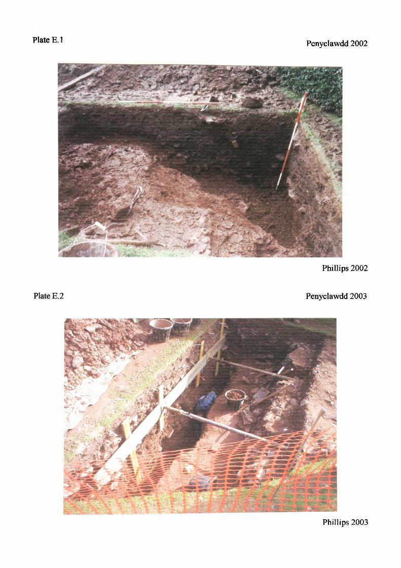
Plate E.I Penyclawdd 2002
Phillips 2002
Plate E.2 Penyclawdd 2003
Phillips 2003
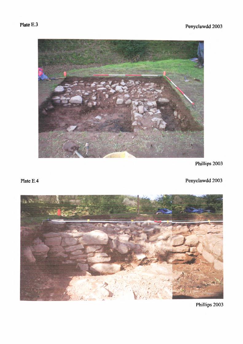
Plate E.3 Penyclawdd 2003
Plate E.4
Phillips 2003
Penyclawdd 2003
Phillips 2003
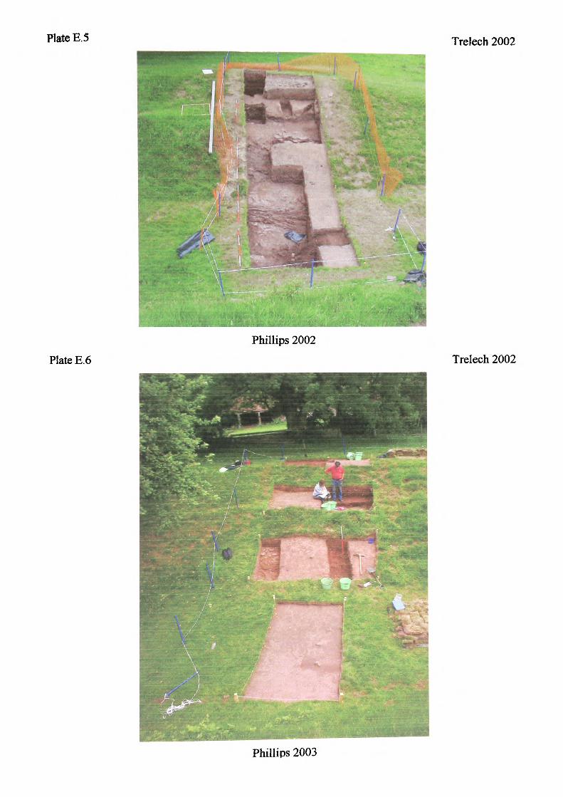
Plate E.5 Trelech 2002
Plate E.6Phillips 2002
Trelech 2002
Phillips 2003
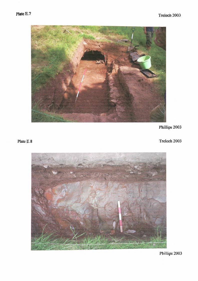
Plate E.7 Treiech 2003
Plate E.8
Phillips 2003
Treiech 2003
Phillips 2003
VOLUME II
EARTHWORK CASTLES OF GWENT AND ERGYNGAD 1050 -1250
SPREADSHEETS
N.Phillips. 2004
CONTENTS
Spreadsheet 1
Spreadsheet 2
Spreadsheet 3
Spreadsheet 4
Spreadsheet 5
Spreadsheet 6
Spreadsheet 7
Spreadsheet 8
Spreadsheet 9
Spreadsheet 10
Spreadsheet 11
Spreadsheet 12
Complete databaseIncluded earthworksTopographic location (natural defence)Topographic location (open)Miiller-Wille, classification system. Class IMuller-Wille, classification system. Class TIMiiller-Wille, classification system. Class 111Renn, classification systemTop surface area as a % of the bottom surface area (mottes)Fortified-sitesMottesWatch-towers
SPi
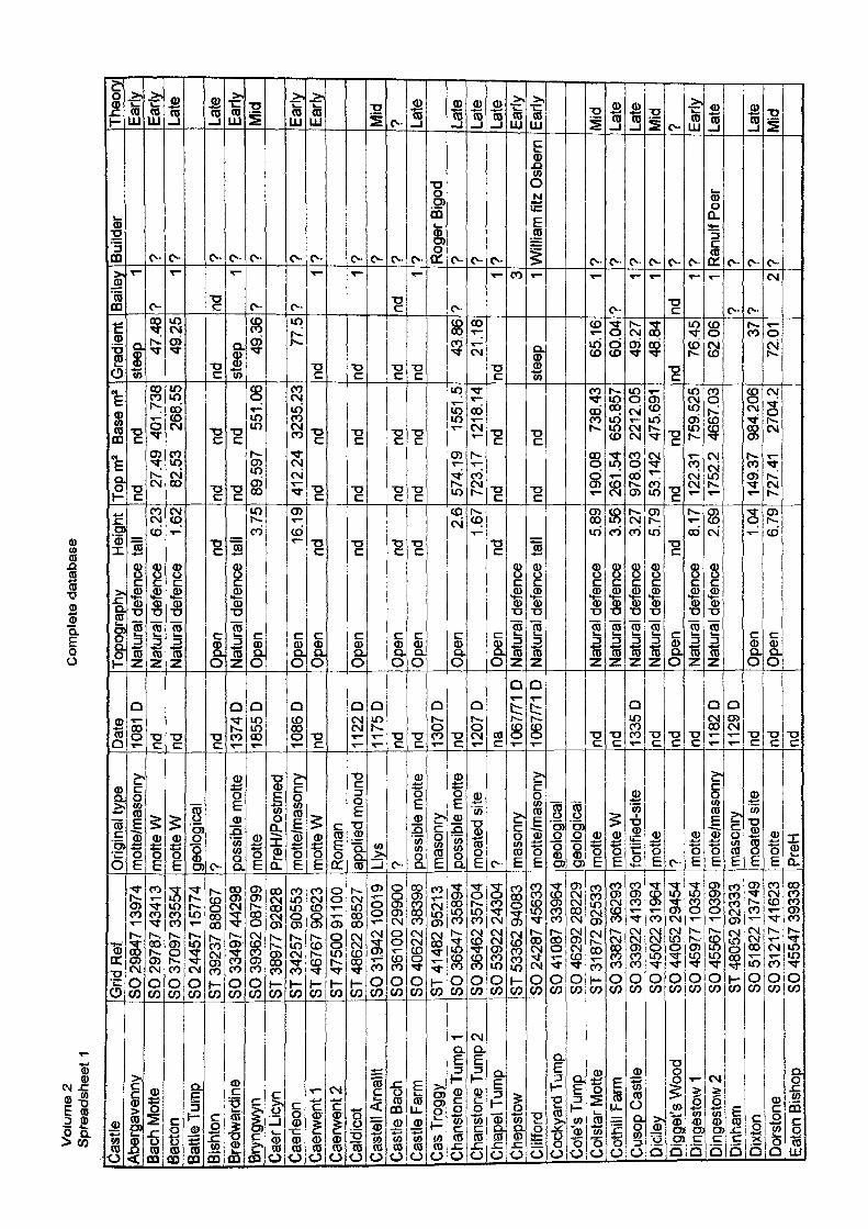
Vo
lum
e 2
S
pre
adsh
eet
1C
om
ple
te d
atab
ase
Castl
eAb
erga
venn
yBa
ch M
otte
Bacto
nBa
ttle T
ump
Bish
ton
Bred
ward
Jne
Bryn
gwyr
iCa
er L
icyn
Caer
leon
Caer
went
1Ca
erwe
nt 2
Cald
icot
Caste
ll Arn
allt
Castl
e Ba
chCa
stle
Farm
Cas T
rogg
yCh
ansto
ne T
ump
1Ch
ansto
ne T
ump
2Ch
apel
Tum
pCh
epsto
wCl
ifford
Cock
yard
Tum
pCo
le's
Tum
pCo
lstar
Mot
teCo
thill
Farm
Cuso
p Ca
stle
Dicll
eyDi
gget
's W
ood
Ding
esto
w 1
Ding
esto
w 2
Dinh
amDi
xton
Dors
tone
Eato
n Bi
shop
Grid
Ref
SO 2
9847
139
74SO
297
87 4
341
3SO
370
97 3
3554
SO 2
4457
157
74ST
392
37 8
8067
SO 3
3497
442
98SO
393
62 0
8799
ST 3
8977
928
28ST
342
57 9
0553
ST 4
6767
906
23ST
475
00 9
11 0
0ST
486
22 8
8527
8031
,942
1001
9SO
361
00
2990
0SO
406
22 3
8398
ST 4
1 482
952
1 3
SO 3
6547
358
94SO
364
62 3
5704
SO 5
3922
243
04ST
533
62 9
4083
;SO
242
87 4
5633
SO 4
1 087
339
64SO
462
92 2
8229
ST 3
1 872
925
33SO
338
27 3
6293
SO 3
3922
41 3
93SO
450
22 3
1 964
SO 4
4052
294
54SO
459
77 1
0354
SO 4
5567
103
99ST
480
52 9
2333
SO 5
1 822
137
49SO
312
17 4
1623
SO 4
5547
393
38
Orig
inal
type
mot
te/m
ason
rym
otte
Wm
atte
Wge
ologic
al? po
ssibl
e m
otte
mot
tePr
eH/P
ostm
edm
otte
/mas
onry
mot
te W
Rom
anap
plied
mou
ndLly
s? po
ssibl
e m
otte
mas
onry
poss
ible
mot
tem
oate
d sit
e? m
ason
rym
otte
/mas
onry
geolo
gical
geolo
gical
mot
tem
otte
Wfo
rtifie
d-sit
em
otte
7 mot
tem
otte
/mas
onry
mas
onry
moa
ted
site
mot
tePr
eH
Date
1081
Dnd nd nd 13
74D
1855
D
1086
Dnd 11
22D
1175
Dnd nd 13
07 D
nd 1207
Dna 10
67/71
D10
67/71
D
nd nd 1335
Dnd nd nd 11
82D
1129
Dnd nd nd
Topo
grap
hy
Heigh
tNa
tura
l def
ence
tall
Natu
ral d
efen
ce
6.23
Natu
ral d
efen
ce
1 .62
Open
nd
Natu
ral d
efen
ce ta
llOp
en
3.75
Open
16
.19
Open
nd
Open
nd
Open
nd
Open
nd
Ope
n 2.
61.
67Op
en
ndNa
tura
l def
ence
Natu
ral d
efen
ce ta
ll
Natu
ral d
efen
ce
5.89
Natu
ral d
efen
ce
3.56
Natu
ral d
efen
ce
3.27
Natu
ral d
efen
ce
5,79
Open
nd
Natu
ral d
efen
ce
8.17
Natu
ral d
efen
ce
2.69
Open
1 .0
4Op
en
6.79
Topm
2 Ba
sem
2nd
nd
27.4
9 40
1.73
882
.53
268.
55
nd
ndnd
nd
89.5
97
551.
06
412.
24
3235
.23
nd
nd
nd
nd
nd
ndnd
nd
574.
19
1551
.572
3.17
12
18.1
4nd
nd
nd
nd
190.
08
738.
4326
1.54
65
5.85
797
8.03
22
12.0
553
.142
47
5.69
1nd
nd
122.
31
759.
525
1752
.2
4667
.03
149.
37
984.
206
727.
41
2704
.2
Gra
dien
tst
eep 47
.48
49.2
5
nd steep 49
.36
77.5
nd nd nd nd
43.8
621
.18
nd stee
p 65.1
660
.04
49.2
748
.84
nd76
.45
62,0
6 3772
.01
Baile
y 1?
4
nd1
? ?1 1
nd1
?
1 3 1 1?
1 1nd
1 17 ?
2
Build
er
? ? ? 7 ? ? 7 ? 7 ? 7 Roge
r Bigo
d? ? 7 W
illiam
fitz
Osb
ern
7 7 7 7 7 7 Ranu
lf Poe
r7 9 7
Theo
ryEa
rlyEa
rlyLa
te
Late
Early
Mid
Early
Early
Mid
7 Late
Late
Late
Late
Earfy
Early
Mid
Late
Late
Mid
7 Early
Late
Late
Mid
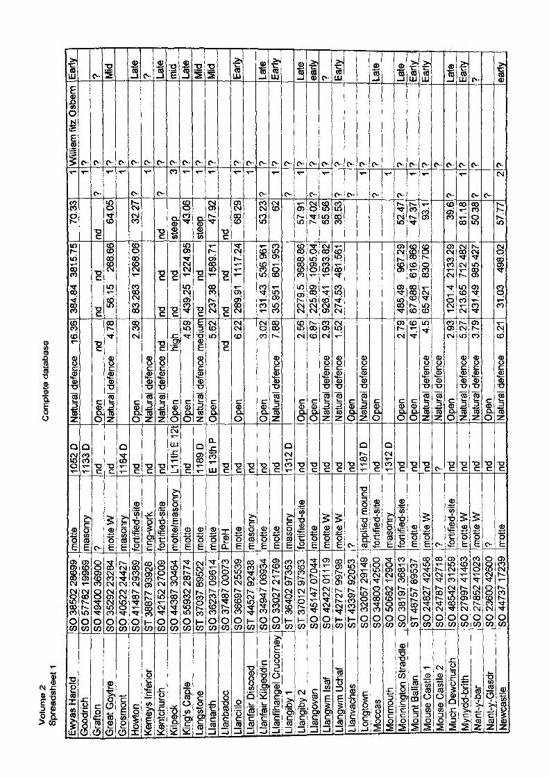
Vol
ume
2 S
prea
dshe
et 1
Co
mp
lete
dat
abas
e
Ewya
s Ha
rold
Goo
drich
Gra
fton
Gre
at G
oyjre
Gro
smon
tHo
wton
Kem
eys
Infe
rior
Kent
chur
chKi
lpec
kKi
ng's
Caple
Lang
ston
e.la
narth
Llan
bado
c.la
nd Ho
Llan
fair
Disc
oed
Llan
fair
Kilg
eddi
nLl
anfih
ange
l Cru
corn
eyLl
angi
by 1
SO 3
8502
286
99SO
577
82 1
9969
SO 4
9400
369
00SO
352
92 2
3284
SO 4
0522
244
27SO
414
87 2
9389
ST 3
8877
939
28SO
421
52 2
7009
SO 4
4387
304
64SO
559
32 2
8774
ST 3
7037
895
22SO
362
37 0
961
4SO
374
87 0
0073
SO 3
6697
255
39ST
445
27 9
2438
SO 3
4947
069
34SO
330
27 2
1 769
ST 3
6402
973
53Ll
angi
by2
ST 3
701 2
973
63Ll
ango
van
SO 4
51 47
070
44Ll
angw
m Is
af
SO 4
2422
011
19Ll
angw
m U
chaf
ST
427
27 9
9798
Llan
vach
es
ST 4
3397
920
53Lo
ngto
wn
SO 3
2057
291
49
Moc
cas
SO 3
4800
425
00M
onm
outh
SO
506
82 1
2904
Mon
ning
ton
Stra
ddle
Mou
nt B
alla
nM
ouse
Cas
tle 1
Mou
se C
astle
2M
uch
Dewc
hurc
hM
ynyd
d-br
ithNa
nt-y
-bar
Nant
-y-G
lasd
rNe
wcas
tle
SO 3
81 9
7 36
81 3
ST 4
8757
895
37SO
248
27 4
2458
SO 2
4787
427
18SO
485
42 3
1 259
SO 2
7997
41 4
63SO
278
52 4
1023
SO 2
3600
426
00SO
447
37 1
7239
mot
tem
ason
ry? m
otte
Wm
ason
ryfo
rtifie
d-sit
erin
g-wo
rkfo
rtifie
d-sit
em
otte
/mas
onry
mot
tem
otte
mot
tePr
eHm
otte
mas
onry
mot
tem
otte
mas
onry
forti
fied-
site
mot
tem
otte
Wm
otte
W? ap
plie
d m
ound
forti
fied-
site
mas
onry
forti
fied-
site
mot
tem
otte
W7 fo
rtifie
d-sit
em
otte
Wm
otte
W? m
otte
1052
D11
33 D
nd nd 1164
Dnd nd nd L1
1thE
12t
nd JJ89
DJE
_13t
hPnd nd nd nd nd 13
12 D
nd nd nd nd nd 1187
Dnd 13
12 D
nd nd nd ? nd nd nd nd nd
Natu
ral d
efen
ce
16.3
6
Open
nd
Natu
ral d
efen
ce
4,78
Ope
n 2.
38Na
tura
l def
ence
Natu
ral d
efen
ce n
dO
pen
high
Ope
n 4.
59Na
tura
l def
ence
med
iumO
pen
5.62
ndO
pen
6.22
Ope
n 3.
02Na
tura
l def
ence
7.
88
Ope
n 2.
56Op
en
6.87
Natu
ral d
efen
ce
2.93
Natu
ral d
efen
ce
1 .52
Open
Natu
ral d
efen
ceOp
en
Open
2.
79Op
en
4.16
Natu
ral d
efen
ce
4.5
Natu
ral d
efen
ceOp
en
2.93
Natu
ral d
efen
ce
5.27
Natu
ral d
efen
ce
3.79
Open
Natu
ral d
efen
ce
6.21
384.
84
3815
.75
nd
nd56
,15
268.
66
83.2
83
1268
.06
nd
ndnd
nd
439.
25
1224
.95
nd
nd23
7.38
15
89.7
1nd
nd
289.
91
1117
.24
131.
43
536.
961
35.9
51
801.
953
2279
.5
3688
.86
225.
89
1095
,04
926.
41
1633
.82
274.
53
481.
561
485.
49
967.
2967
.688
61
6.86
665
421
830.
706
1201
.4
2133
.29
213.
65
712.
482
431,
49
985.
427
31.0
3 49
8.02
70.3
3
nd64
.05
32.2
7
nd stee
p 43.0
6st
eep 47
.92
nd68
.29
53.2
3 62
57.9
174
.02
55.5
638
.53
52.4
747
.37
93.1
39.6
81.1
850
.38
57.7
7
1 1?
1 17
1?
r 0 1 1 1 1 17
17
1?
1? 7
1?
1?
1 1
7
17 7
2
Willi
am fi
tz O
sbem
? 7 7 ? 7 7 7 7 7 7 7 7 7 ? 7 7 ? ? 7 ? 7 ? 7 7 7 7 7 7 7 7 7
Early
? Mid
Late
? Late
mid
Late
Mid
Mid
Early
Late
Early
Late
early
? Early
Late
Late
Early
Early
Late
Early
7 early
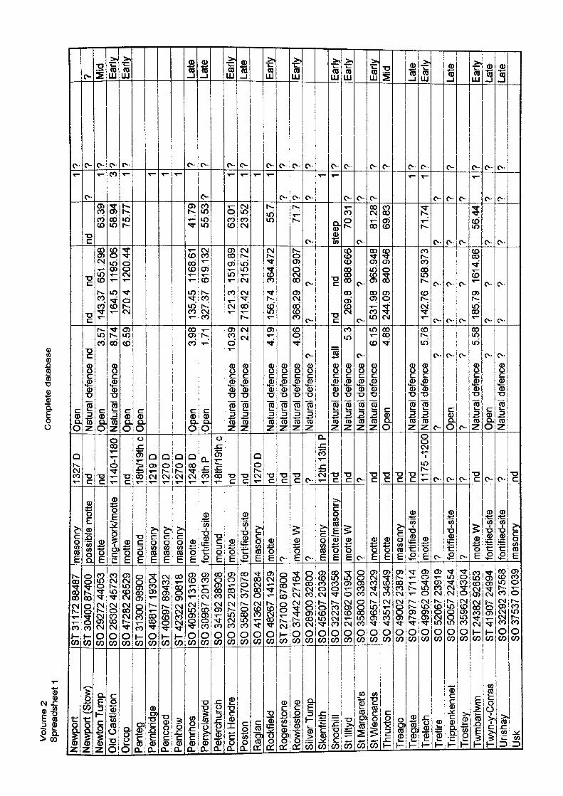
Vol
ume
2 S
prea
dshe
et 1
Co
mp
lete
dat
abas
e
Newp
ort
Newp
ort (
Stow
)Ne
wton
Tum
pOl
d Ca
stle
ton
Orc
op>a
nteg
Pem
brid
geJe
ncoe
dPe
nhow
'enr
hos
'eny
clawd
d3e
terc
hurc
hPo
nt H
endr
e3o
ston
Ragl
anRo
ckfie
ldRo
gers
tone
Rowl
esto
neSi
lver T
ump
Sken
frith
Snod
hill
St Il
ltyd
St M
arga
ret's
St W
eona
rds
Thru
xton
Trea
goTr
egat
eTr
elec
hTr
etire
Trip
penk
enne
tTr
ostre
yTw
mba
rlwm
Twyn
-y-C
orra
sUr
ishay
Usk
ST 3
11 7
2 88
487
ST 3
0400
874
00SO
292
72 4
4053
SO 2
8302
457
23SO
472
82 2
6529
ST 3
1 30
0 98
900
SO 4
881
7 19
304
ST 4
0697
894
32ST
423
22 9
081
8SO
409
52 1
31 6
9SO
309
67 2
01 3
9SO
341
92
3890
8SO
325
72 2
81 0
9SO
358
07 3
7078
SO 4
1 36
2 08
284
SO 4
8267
141
29
ST 2
71 0
0 87
800
SO 3
7442
271
64SO
289
00 3
2800
SO 4
5607
203
69SO
322
37 4
0358
SO 2
1 69
2 01
954
SO 3
5800
339
00SO
496
57 2
4329
SO 4
3512
346
49SO
490
02 2
3879
SO 4
7977
171
14
SO 4
9952
054
09SO
520
67 2
39 19
SO 5
0057
224
54SO
359
62 0
4304
ST 2
4382
926
53ST
41
907
2499
4SO
322
92 3
7568
SO 3
7537
01
039
mas
onry
poss
ible
mot
tem
otte
ing-
work
/mot
tem
otte
mou
ndm
ason
rym
ason
rym
ason
ry__
mot
tefo
rtifie
d-sit
em
ound
mot
tefo
rtifie
d-sit
em
ason
rym
otte
7 mot
te W
? mas
onry
mot
te/m
ason
rym
otte
W? m
otte
mot
tem
ason
ryfo
rtifie
d-sit
em
otte
? forti
fied-
site
? mot
te W
forti
fied-
site
forti
fied-
site
mas
onry
1327
Dnd nd 11
40-1
180
nd 18th
/19t
hc12
19 D
1270
D12
70 D
1248
D13
thP
18th
/19t
hcnd nd 12
70 D
nd nd nd ? 12th
13t
h P
nd nd ? nd nd nd nd 1175
-120
0? ? ? nd ? ? nd
Ope
nNa
tura
l def
ence
nd
Ope
n 3.
57Na
tura
l def
ence
8.
74Op
en
6.59
Open
Ope
n 3.
98Op
en
1.71
Natu
ral d
efen
ce
10.3
9Na
tura
l def
ence
2.
2
Natu
ral d
efen
ce
4.19
Natu
ral d
efen
ceNa
tura
l def
ence
4.
06Na
tura
l def
ence
?
Natu
ral d
efen
ce t
all
Natu
ral d
efen
ce
5.3
Natu
ral d
efen
ce ?
Natu
ral d
efen
ce
6.15
Open
4.
88
Natu
ral d
efen
ceNa
tura
l def
ence
5.
76?
?Op
en
??
?Na
tura
l def
ence
5.
58Op
en
?Na
tura
l def
ence
?
nd
nd14
3,37
65
1.29
816
4.5
1195
.06
270.
4 12
00.4
4
135,
45
1168
.61
327.
37
619.
132
121.
3 15
19.8
971
8,42
21
55.7
2
156,
74
3644
72
368,
29
8209
07?
?
nd
nd26
9.8
888.
666
? ?
531,
98
965.
948
244,
09
840.
946
142,
76
758.
373
? ?
? ?
? ?
185,
79
1614
.86
? ?
? ?
nd63
.39
58.9
475
.77
41.7
955
.53
63.0
123
.52
55.7
71.7
? stee
p 70.3
1?
81.2
869
.83
71.7
4? ? ?
56.4
4? ?
1?
1 t. 1 1 1 1
?
1 1 1 1? ? ?
1 1? ? ?
1 1? ? ?
1? ?
•? ? ? ? ? ? ? 7 ? ? ? 7 7 7 7 7 7 ? ? 7 ? ? 7
7 Mid
Early
Early
Late
Late
Early
Late
Early
Early
Early
Early
Early
Mid
Late
Early
Late
Early
Late
Late
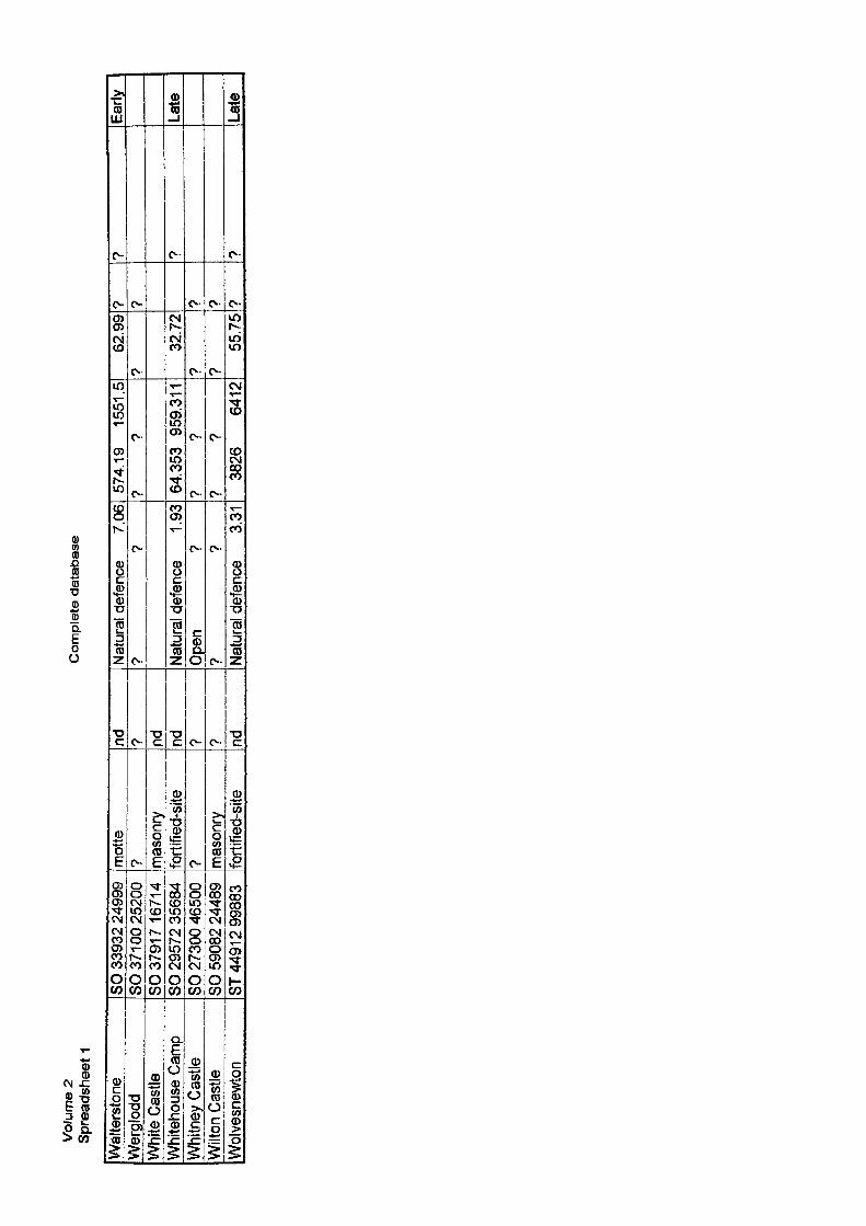
Vol
ume
2 S
prea
dshe
et 1
Co
mp
lete
da
tab
as
e
Wal
ters
tone
Wer
glod
dW
hite
Cas
tleW
hite
hous
e Ca
mp
Whi
tney
Cas
tleW
ilton
Cas
tleW
olve
snew
ton
SO 3
3932
249
99SO
37
100
2520
0SO
379
17 1
6714
SO 2
9572
356
84SO
273
00 4
6500
SO 5
9082
244
89ST
449
1 2 9
9883
mot
te? m
ason
ryfo
rtifie
d-sit
e? m
ason
ryfo
rtifie
d-sit
e
nd 7 nd nd ? ? nd
Nat
ural
def
ence
7.
06?
?
Natu
ral d
efen
ce
1 .93
Ope
n ?
? ?
Natu
ral d
efen
ce
3.31
574.
19
1551
.5?
?
64.3
53
959.
311
? ?
? ?
3826
64
12
62.9
9?
32.7
2? ?
55.7
5
? 7 ? ? ?
? 9 ?
Early
Late
Late
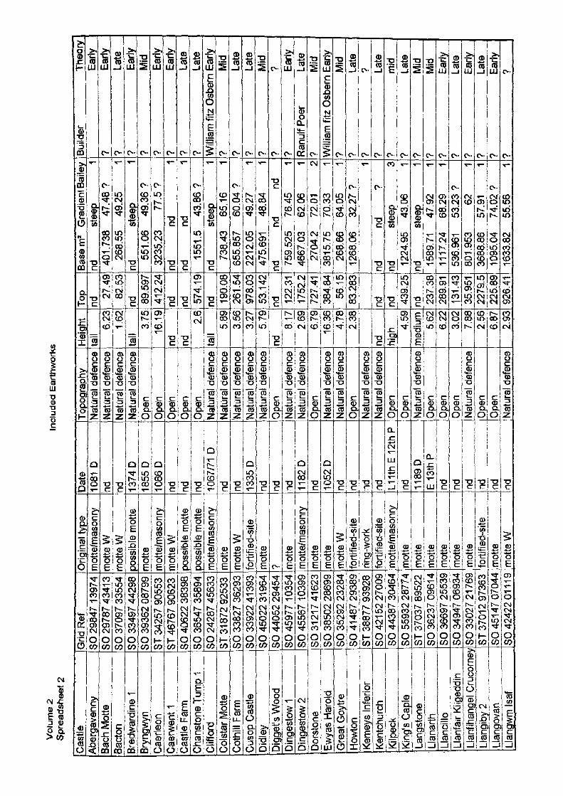
Vol
ume
2 S
prea
dshe
et 2
Incl
uded
Ear
thw
orks
Cast
leAa
erga
venn
yBa
ch M
ptte
Bacto
nBr
edwa
rdine
1Br
yngw
ynCa
erleo
nCa
erwe
nt 1
Castl
e Fa
rmCh
anst
one
Tum
p 1
Cliffo
rdCo
lstar
.Mott
eCo
thill
Farm
Cuso
p Ca
stle
Didle
yDi
gget
's W
ood
Ding
esto
w 1
Ding
esto
w 2
Dors
tone
Ewya
s Ha
rold
Gre
at G
oytre
Howt
onKe
mey
s In
ferio
rKe
ntch
urch
Kilp
eck
King
's Ca
ple
Lang
ston
eLl
anar
thLl
ancil
loLl
anfa
ir Ki
lged
din
Llan
fihan
gel C
ruco
rney
Llan
giby
2Ll
ango
van
Llan
gwm
Isaf
Grid
Ref
SO 2
9847
139
74SO
297
87 4
341
3SO
370
97 3
3554
SO 3
3497
442
98SO
393
62 0
8799
ST 3
4257
905
53ST
467
67 9
0623
SO 4
0622
383
98SO
365
47 3
5894
cr»
0/10
07 /
icco
oO
U 2
4zo
/ 40
boo
ST 3
1 872
925
33SO
338
27 3
6293
SO 3
3922
413
93SO
450
22 3
1 964
SO 4
4052
294
54SO
459
77 1
0354
|S04
5567
103
99SO
312
17 4
1623
SO 3
8502
286
99SO
352
92 2
3284
SO 4
1487
293
89ST
388
77 9
3928
SO 4
21 5
2 27
009
SO 4
4387
304
64SO
559
32 2
8774
ST 3
7037
895
22SO
362
37 0
961
4SO
366
97 2
5539
SO 3
4947
069
34SO
330
27 2
1 769
ST 3
701
2 97
363
SO 4
51 4
7 07
044
SO 4
2422
01
11 9
J^rjg
inal
jyjs
em
otte
/mas
onry
mot
te W
rmott
e W
poss
ible
mot
tem
otte
mot
te/m
ason
rym
otte
Wpo
ssibl
e m
otte
poss
ible
mot
tem
otte
/mas
onry
mot
tem
otte
Wfo
rtifie
d-sit
em
otte
? mot
tem
otte
/mas
onry
mot
tem
otte
mot
te W
forti
fied-
site
ring-
work
forti
fied-
site
mot
te/m
ason
rym
otte
mot
tem
otte
mot
tem
otte
mot
tefo
rtifie
d-sit
em
otte
mot
te W
Date
1081
Dnd nd 13
74 D
_
_18
55D
1086
Dnd nd nd 10
67/7
1 D
nd nd 1335
Dnd
^
nd nd 1182
Dnd 10
52 D
nd nd nd nd L11t
hE12
thP
nd 1189
DE
13th
Pnd nd nd nd nd nd
Topo
grap
hyNa
tura
l def
ence
Natu
ral d
efen
ceNa
tura
l def
ence
Natu
ral d
efen
ceOp
enOp
enOp
enOp
enOp
ennlc
uU
lCjl
UcH
cflW
C?
Natu
ral d
efen
ceNa
tura
l def
ence
'Nat
ural
defe
nce
Natu
ral d
efen
ce^
Open
Natu
ral d
efen
ceNa
tura
l def
ence
Open
Natu
ral d
efen
ceNa
tura
l def
ence
Open
Natu
ral d
efen
ceNa
tura
l def
ence
Open
Open
Natu
ral d
efen
ceOp
enOp
enOp
enNa
tura
l def
ence
Open
Open
Natu
ral d
efen
ce
Heig
htta
ll6.
23 1,62
tall
3.75
16.1
9nd nd
2.6
foil
la II
5.89
3.56
L
3-27
5.79
nd8.
172.
696.
79J6
.36
~Uz§
32.
38
nd high 4.
59m
edium 5.
626.
223.
027.
882.
566.
872,
93
Top
nd27
.49
82.5
3nd 89
.597
412.
24nd nd 57
4.19
nd 190.
0826
1.54
978.
0353
.142
nd 122.
3117
52.2
727.
4138
4.84
56.1
583
.283
nd nd 439.
25nd 23
7.38
289.
9113
1.43
35.9
5122
79.5
225,
8992
6.41
Base
m2
Gra
dien
l Bai
ley
nd
steep
1
401.
738
47.4
8?26
8.55
49
.25
1nd
ste
ep
155
1.06
49
.36?
3235
.23
77.5
?nd
nd
1
nd
nd
115
51.5
43
.86?
nd
steep
1
738.
43
65.1
6 1
655.
857
60.0
4 ?
2212
.05
49.2
7 1
475.
691
48.8
4 1
nd
nd
nd75
9.52
5 76
.45
146
67.0
3 62
.06
127
04.2
72
.01
2LJ
3815
.75
70.3
3 1
268.
66
64.0
5 1
1268
.06
32.2
7 ?
1nd
nd
?
nd
steep
3
1224
.95
43.0
6 1
nd
steep
1
1589
.71
47.9
2 1
1117
.24
68.2
9 1
536.
961
53.2
3 ?
801.
953
62
136
88.8
6 57
.91
110
95.0
4 74
.02
?16
33.8
2 55
.56
1
Build
er
Theo
ryEa
rly?
Early
? La
te?
Early
? M
id?
Early
? Ea
rly?
Late
? La
teW
illiam
fitz
Osb
ern
Early
? M
id?
Late
? La
te?
Mid
? ?
? Ea
rlyRa
nulf P
oer
Late
? M
idW
illiam
fitz
Osb
ern
Early
? M
id?
Late
? ?
? La
te?
mid
*> La
te?
Mid
? M
idf
Early
*? La
te•>
Early
' La
te?
Early
•? ?
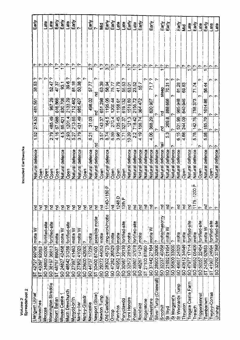
Vol
ume
2
Spr
eads
heet
2In
clu
ded
Eart
hw
ork
s
Llan
gwjn
Uch
afLl
anva
cnes
Moc
cas
Mon
ning
ton
Stra
ddle
Mou
nt B
alla
nM
ouse
Cas
He 1
Muc
h De
wchu
rch
Myn
ydd-
brith
Nant
-y-b
arNa
nt-y
-Gla
sdr
Newc
astle
j^ew
portj
Stow
)Ne
wton
Tum
pO
ld C
astle
ton
Orc
opPe
nrho
sPe
nycla
wdd
Pont
Hen
dre
Post
onRo
ckfie
ldRo
gers
tone
Rowl
esto
neSi
lver T
ump
(Cra
swal
l)Sn
odhi
llSt
Illty
dSt
Mar
gare
t'sSt
Weo
nard
s Tu
mp
Thru
xton
Treg
ate
Cast
le F
arm
Trel
ech
Trip
penk
enne
tTw
mba
rlwm
Twyn
-y-C
orra
sUr
ishay
ST 4
2727
997
98ST
433
97 9
2053
SO 3
4800
425
00SO
381
97
3681
3ST
487
57 8
9537
SO 2
4827
424
58SO
485
42 3
1259
SO 2
7997
41 4
63SO
278
52 4
1023
SO 2
3600
426
00SO
447
37 1
7239
ST 3
0400
874
00SO
292
72 4
4053
SO 2
8302
457
23SO
472
82 2
6529
SO 4
0952
131
691
SO 3
0967
201
39
SO 3
2572
281
09
SO 3
5807
370
78SO
482
67 1
4129
ST 2
7 10
0 87
800
SO 3
7442
271
64SO
289
00 3
2800
SO 3
2237
403
58SO
21 6
92 0
1 954
SO 3
5800
339
00SO
496
57 2
4329
SO 4
351 2
346
49SO
479
77 1
71 1
4SO
499
52 0
5409
SO 5
0057
224
54ST
243
82 9
2653
ST 4
1 907
249
94SO
322
92 3
7568
mot
te W
? forti
fied-
site
forti
fied-
site
mot
tem
otte
Wfo
rtifie
d-sit
em
otte
Wm
otte
W? m
otte
poss
ible
mot
tem
otte
jing-
work
/mot
tem
otte
mot
tefo
rtifie
d-sit
em
otte
forti
fied-
site
mot
te? m
otte
W? m
otte
/mas
onry
mot
te W
? mot
tem
otte
forti
fied-
site
mot
tefo
rtifie
d-sit
em
otte
Wfo
rtifie
d-sit
efo
rtifie
d-sit
e
nd nd nd nd nd nd nd nd nd nd nd nd nd 1140
-1 1
80 P
nd 1248
D13
thP
nd nd nd nd nd ? nd nd ? nd nd nd 1175
-12
00 P
? nd ? ?
Natu
ral d
efen
ceO
pen
Ope
nO
pen
Ope
nNa
tura
l def
ence
Ope
nNa
tura
l def
ence
Natu
ral d
efen
ceO
pen
Natu
ral d
efen
ceNa
tura
l def
ence
Open
Natu
ral d
efen
ceOp
enO
pen
Open
Natu
ral d
efen
ceNa
tura
l def
ence
Natu
ral d
efen
ceNa
tura
l def
ence
Natu
ral d
efen
ceNa
tura
l def
ence
Natu
ral d
efen
ceNa
tura
l def
ence
Natu
ral d
efen
ceNa
tura
l def
ence
Open
Natu
ral d
efen
ceNa
tura
l def
ence
Open
Natu
ral d
efen
ceO
pen
Natu
ral d
efen
ce
1.52
2.79
4.16 4.
52.
935.
273.
79
6.21
nd3.
578.
74_J
x5j9
|3.
98 1.71
10.3
92.
24.
19
4.06
? tall
5.3
?6.
154.
88
5.76
?5.
58? ?
274.
53
485.
4967
.688
65.4
2112
01.4
213.
6543
1.49
31.0
3nd 14
3.37
164.
527
O4J
135.
451
327.
3712
1.3
718.
4215
674
368.
29? nd
269.
8? 53
1.98
244.
09
142.
76? 18
5.79
? ?
481.
561
38.5
3 ? ? ?
967.
29
52.4
7 ?
616.
866
47.3
7 1
830.
706
93.1
1
2133
.29
39.6
?71
2,48
2 81
.18
198
5.42
7 50
.38
? ?49
8.02
57
.77
2nd
nd
?
651.
298
63.3
9 1
1195
.06
58.9
4 3
1200
.44
75.7
7 1
1168
.61
41.7
961
9.13
2 55
.53
?15
19.8
9 63
.01
121
55.7
2 23
.52
136
4.47
2 55
.7
1?
820.
907
71.7
??
? ?
nd
stee
p 1
888.
666
70.3
1 ?
? ?
?96
5.94
8 81
.28
?84
0.94
6 69
.83
175
8.37
3 71
.74
1?
? ?
1614
.86
56.4
4 1
? ?
??
? ?
? Ea
rly? ?
Late
? La
te?
Early
? Ea
rly?
Late
? Ea
rly?
?
? Ea
rly?
??
Mid
? Ea
rly?
Early
? La
te?
Late
? Ea
rly?
Late
? Ea
rly? ?
Early
? ? Ea
rly'
Early
•? Ea
rly?
Mid
? La
te?
Early
? La
te?
Early
t La
te?
Late
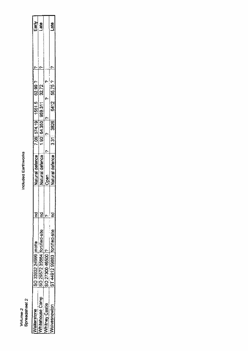
Vof
ume
2 S
prea
dshe
et 2
Incl
uded
Ear
thw
orks
Wal
ters
tone
Whi
teho
use
Cam
pW
hitn
ey C
astle
Wol
vesn
ewto
n
SO 3
3932
249
99SO
295
72 3
5684
SO 2
7300
465
00ST
449
1 2
9988
3
mot
tefo
rtifie
d-sit
e? fo
rtifie
d-sit
e
nd nd ? nd
Natu
ral d
efen
ceNa
tura
l def
ence
Open
Natu
ral d
efen
ce
7.06
1.93
?3.3
1
574.
1964
.353
7
3826
1551
.5
62.9
9?95
9.31
1 32
.72
? ?
?64
12
55.7
5 ?
? Ea
rly?
Late
? La
te

Volu
me
2 Sp
read
shee
t 3To
pogr
aphi
c lo
catio
n N
atur
al d
efen
ce
Stll
ltyd
SO 2
1 69
2 01
954
St W
eona
rds
SO 4
9657
243
29Jr
egat
e__
SO 4
7977
171
14Tr
elec
h SO
499
52 0
5409
Twm
barlw
m
ST 2
4382
926
53Ur
ishay
SO
322
92 3
7568
Wal
ters
tone
SO
339
32 2
4999
Whi
teho
use
Cam
p SO
295
72 3
5684
Wol
vesn
ewto
n ST
449
1 2 9
9883
mot
te W
mot
tefo
rtifie
d-sit
em
otte
mot
te W
forti
fied-
site
mot
tefo
rtifie
d-sit
efo
rtifie
d-sit
e
nd nd nd 1 1 7
5-1
200
Pind 7 nd nd nd
Natu
ral d
efen
ceNa
tura
l def
ence
Natu
ral d
efen
ceNa
tura
l def
ence
Natu
ral d
efen
ceNa
tura
l def
ence
Natu
ral d
efen
ceNa
tura
l def
ence
Natu
ral d
efen
ce
5.3
269.
8 88
8.66
66,
15
531.
98
965.
948
5.76
14
2.76
75
8.37
35.
58
185.
79
1614
.86
? ?
?7.
06
574.
19
1551
.51.
93
64.3
53
959.
311
3.31
38
26
6412
70.3
181
.28
71.7
456
.44
?62
.99
32.7
255
.75
? ?1 1 1
? ? ?
? Ea
rly?
Early
? La
te?
Early
? Ea
rly?
Late
? Ea
rly?
Late
? La
te
21E
11L
4m
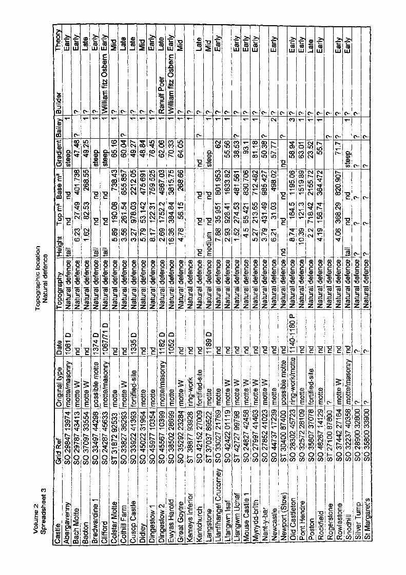
Vol
ume
2 S
prea
dshe
et 3
Topo
grap
hic
loca
tion
Nat
ural
def
ence
Cas
tte
Qriql
Ref
Abe
i^ay
erin
^ SO
298
47 1
3974
Bach
Mot
te
SO 2
9787
434
1 3Ba
cton
SO
370
97 3
3554
Bred
war
dine
1 SO
334
97 4
4298
Clif
ford
SO
242
87 4
5633
Col
star
Mot
te
ST 3
1872
925
33C
othi
ll Fa
rm
SO 3
3827
362
93Cu
sop
Cas
tle
SO 3
3922
41 3
93Di
dley
SO
450
22 3
1 964
Din
gest
ow 1
SO 4
5977
1 03
54D
inge
stow
2 SO
455
67 1
0399
Ewya
s H
arol
d SO
385
02 2
8699
Gre
at G
oytre
SO
352
92 2
3284
Kem
eys
Infe
rior
ST 3
8877
939
28Ke
ntch
urch
SO
421
52
2700
9La
ngst
one
ST 3
7037
895
22Ll
anfih
ange
l Cru
corn
ey
SO 3
3027
217
69Ll
angw
m Is
af
SO 4
2422
011
19Ll
angw
m U
chaf
ST
427
27 9
9798
Mou
se C
aslte
1 SO
248
27 4
2458
Myn
ydd-
brith
SO
279
97 4
1 463
Nan
t-y-b
ar
SO 2
7852
41 0
23N
ewca
stle
SO
447
37 1
7239
Newp
ort (
Stow
) ST
304
00 8
7400
Old
Cas
tleto
n SO
283
02 4
5723
Pont
Hen
dre
SO 3
2572
281
09
Post
on
SO 3
5807
370
78R
ockf
ield
SO
482
67 1
41 2
9Ro
gers
tone
ST
271
00
8780
0Ro
wles
tone
SO
374
42 2
71 6
4Sn
odhi
ll SO
322
37 4
0358
Silv
er T
ump
SO 2
8900
328
00St
Mar
gare
t's
SO 3
5800
339
00
Orig
jnaU
yjpe
mot
te/m
ason
rym
otte
Wm
otte
Wpo
ssib
le m
otte
mot
te/m
ason
rym
otte
mot
te W
forti
fied-
site
mot
tem
otte
mot
te/m
ason
rym
otte
mot
te W
rjng^
wprk
forti
fied-
site
mot
tem
otte
mot
te W
mot
te W
i
mot
te W
mot
te W
mot
te W
mot
tepo
ssib
le m
otte
ring-
wprk
/mot
tem
otte
forti
fied-
site
mot
te? m
otte
Wm
otte
/mas
onry
? ?
Date
1081
Dnd nd 13
74D
1067
/71
Dnd nd 13
35D
nd nd 1182
D10
52D
nd nd nd 1189
D
_jnd
__
__
__
nd nd
-Hnd nd nd
_
__
nd nd
n11
40-1
180
Pnd nd nd nd nd nd ? ?
Topo
grap
hy^
Natu
ral d
efen
ceNa
tura
l def
ence
Natu
ral d
efen
ceNa
tura
l def
ence
Natu
ral d
efen
ceNa
tura
l def
ence
Natu
ral d
efen
ceNa
tura
l def
ence
Natu
ral d
efen
ceNa
tura
l def
ence
Natu
ral d
efen
ceNa
tura
l def
ence
Natu
ral d
efen
ceNa
tura
l def
ence
Natu
ral d
efen
ceNa
tura
l def
ence
^Na
tura
l def
ence
!Na
tura
l def
ence
Natu
ral d
efen
ceNa
tura
l def
ence
Natu
ral d
efen
ceNa
tura
l def
ence
Natu
ral d
efen
ceNa
tura
l def
ence
Natu
ral d
efen
ceNa
tura
l def
ence
Natu
ral d
efen
ceNa
tura
l def
ence
Natu
ral d
efen
ceNa
tura
l def
ence
Natu
ral d
efen
ceNa
tura
l def
ence
Natu
ral d
efen
ce
Hei
ght
Topm
2 Ba
sem
*ta
ll nd
nd
6.23
27
.49
401.
738
1.62
82
.53
268.
55ta
ll nd
nd
tall
nd
nd5.
89
190.
08
738.
433.
56
261.
54
655.
857
3.27
97
8.03
22
12.0
55.
79
53.1
42
475.
691
8.17
12
2.31
75
9.52
52.
69
1752
.2
4667
.03
16.3
6 38
4.84
38
15.7
54.
78
56.1
5 26
8.66
nd
nd
ndm
edium
nd
nd
7.88
35
.951
80
1.95
32.
93
926.
41
1633
.82
1,52
27
4.53
48
1.56
14.
5 65
.421
83
0.70
65.
27
213,
65
712,
482
3.79
43
1.49
98
5.42
76.
21
31.0
3 49
8.02
nd
nd
nd8.
74
164.
5 11
95.0
610
.39
121.
3 15
19.8
92.
2 71
8.42
21
55.7
24.
19
156.
74
364.
472
4.06
36
8.29
82
0.90
7ta
ll nd
nd
? ?
??
? ?
Gra
dien
stee
p 47.4
849
.25
stee
pst
eep 65.1
660
.04
49.2
748
.84
76.4
562
.06
70.3
364
.05
nd steep
6255
.56
38.5
393
.181
.18
50.3
857
.77
nd58
.94
63.0
123
.52
55.7
71.7
stee
p___
? ?
Baile
y *
?t • • '
?t 1 1 1 1 1 1
?1 1
__
_ 1j
[71 1
?2
?3 1 1 1
7 7
1> 7
Build
er
Theo
ryEa
rly?
Early
? La
te?
Early
Willi
am fi
tz O
sbem
Ear
ly?
Mid
? La
te?
Late
? M
id?
Early
Ranu
lf Po
er
Late
Willi
am fi
tz O
sbem
Ear
ly?
Mid
? ? La
te?
Mid
? Ea
rly? ?
Early
? Ea
rly?
Early
? ? Ea
rly? ?
Early
? Ea
rly?
Late
•> Ea
rly7 t
Early
7 Ea
rly7
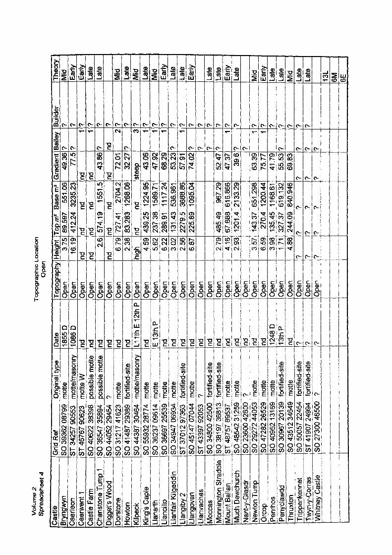
Vol
ume
2
Spr
eads
heet
4T
op
og
rap
hic
Lo
cati
on
O
pen
Cast
leBr
yngt
oyn
Caer
leon
Caer
went
1Ca
stle
Far
mCh
anst
one
Tum
p 1
Digg
et's
Woo
dDo
rsto
neHo
wton
Kilp
eck
King
's Ca
ple
Llar
iarth
Janc
illoLl
anfa
ir Ki
lged
din
Llan
giby
2Ll
ango
van
Llan
vach
esM
occa
sM
onni
ngto
n St
radd
leM
ount
Bal
lan
Muc
h De
wchu
rch
Nant
-y-G
lasd
rNe
wton
Tum
pO
rcop
Penr
hos
Peny
clawd
dTh
ruxt
onTr
ippe
nken
net
Twyn
-y-C
orra
sW
hjtn
ey C
astle
Grid
Ref
O
rigin
al ty
peSO
393
62 0
8799
m
otte
ST 3
4257
905
53
mot
te/m
asor
tryST
467
67 9
0623
m
otte
WSO
406
22 3
8398
po
ssib
le m
otte
SO 3
6547
358
94
poss
ible
mot
teSO
440
52 2
9454
?
SO 3
121 7
41 6
23
mot
teSO
414
87 2
9389
fo
rtifie
d-sit
eSO
443
87 3
0464
m
otte
/mas
onry
SO 5
5932
287
74
mot
teSO
362
37 0
9614
m
otte
SO 3
6697
255
39
mot
teSO
349
47 0
6934
m
otte
ST 3
7012
973
63
forti
fied-
site
SO 4
51 47
070
44
mot
teST
433
97 9
2053
?
SO 3
4800
425
00
forti
fied-
site
SO 3
81 97
368
1 3
forti
fied-
site
ST 4
8757
895
37
mot
teSO
485
42 3
1 259
m
otte
SO 2
3600
426
00
?SO
292
72 4
4053
m
otte
SO 4
7282
265
29
mot
teSO
409
52 1
31 6
9 m
otte
SO 3
0967
201
39
forti
fied-
site
SO 4
351 2
346
49
mot
teSO
500
57 2
2454
fo
rtifie
d-sit
eST
419
07 2
4994
fo
rtifie
d-sit
eSO
273
00 4
6500
?
Dat
e18
55 D
1086
Dnd nd nd nd nd nd L1
1th
E 1
2th
Pnd E
13th
Pnd nd nd nd nd nd nd nd nd nd nd nd 12
48 D
13th
Pnd 7 ? 9
Topo
grap
hy1
Ope
nO
pen
Ope
nO
pen
Ope
n ,
Ope
nOp
enO
pen
Opj
en__
Opj
3n__
Ope
nOp
enOp
enO
pen
Ope
nOp
enjO
gen
Lpj>
er^
Open
'
Open
Open
Open
Open
Open
Open
Open
Open
Open
Open
Heig
ht3,
7516
.19
nd nd2.
6nd
679
2.38
high 45
95^
62
6,22
302
256
6JJ7
2.79
4.16
2.93
3.57
Ljsj
g3.
981.
714,
88? ? ?
Top
mz
Base
m2
89.5
97
551.
0641
2.24
32
35.2
3nd
nd
nd
nd57
4.19
15
51.5
nd
nd72
7.41
27
04.2
83.2
83
1268
.06
nd
nd43
9.25
12
24.9
523
7.38
15
89.7
128
9.91
11
17.2
413
1.43
53
6.96
122
79.5
36
88.8
622
5.89
10
95.0
4
485.
49
967.
2967
.688
61
6.86
612
01.4
21
33.2
9
143.
37
651.
298
270.
4 12
00.4
413
5.45
11
68.6
132
7.37
61
9.13
224
4.09
84
0.94
6?
??
??
?
Gra
dien
t49
.36
77.5
nd nd43
.86
nd72
.01
32.2
7st
eep 43
.06
47.9
268
.29
53.2
357
.91
74.0
2
52.4
747
.37
39.6
63.3
975
.77
41.7
955
.53
69.8
3? ? ?
Bai
ley
? ?1 1
7 ndf /
?2 1 1 1
?1
? ? ? ?1
[? ?1 1
? ? ? ?
Bui
lder
? ? ? ? ? ? ? ? ? ? ? ? ? ? ? ? ? ? ? ? ? ? 7 ? ? ? ?
Theo
ryM
id Early
Early
Late
Late
Mid
Late
Mid
Late
Mid
Early
Late
Late
Early
Late
Late
Early
Late
Mid
Early
Late
Late
Mid
Late
Late
13L
6M 6E

Vof
ume
2 S
prea
dshe
et 5
Mul
ler-
Will
e C
lass
I
Cast
leCa
erle
onEw
yas
Haro
ldPo
nt H
endr
e
Grid
Ref
O
rigin
al ty
peST
342
57 9
0553
m
otte
/mas
onry
SO 3
8502
286
99
mot
teSO
325
72 2
81 0
9 m
otte
Date
1086
D10
52D
nd
Topo
grap
hy
Heig
htO
pen
16.1
9Na
tura
l def
ence
16
.36
Natu
ral d
efen
ce
10.3
9
Topm
241
2.24
384.
8412
1.3
Base
m2
Gra
dien
t32
35.2
3 77
.538
15.7
5 70
.33
1519
.89
63.0
1
Baile
y?
1 1
Build
er? W
illiam
fitz
Osb
ern
?
Theo
ry^
Early
Early
Early
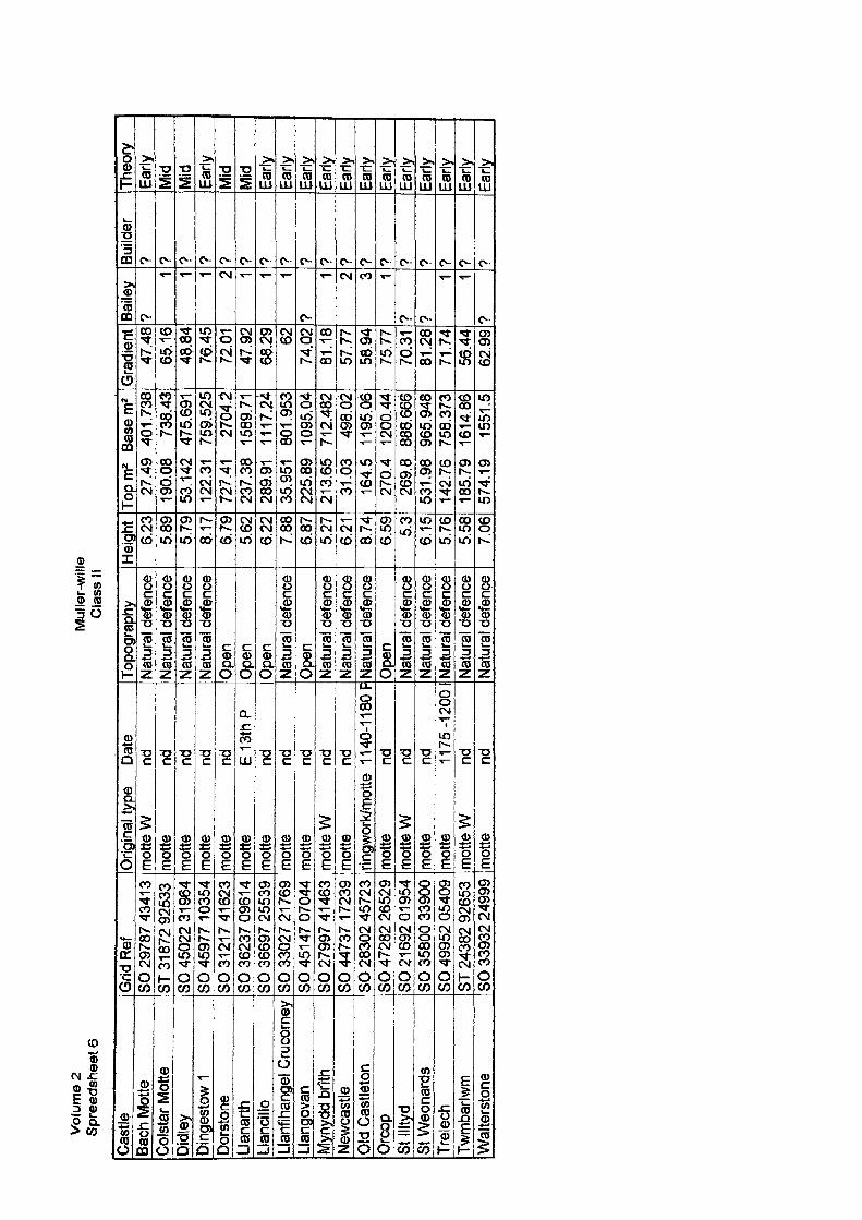
Vol
ume
2 S
prea
dshe
et 6
Mul
ler-
will
e C
lass
II
Cast
leBa
ch M
otte
Colst
ar M
otte
Didl
eyDi
nges
tow
1Do
rsto
neLl
anar
thLl
ancil
loLl
anfih
ange
l Cru
corn
eyLl
ango
van
Myn
ydd
brith
Newc
astle
Old
Cas
tleto
nO
rcop
St Il
ltyd
St W
eona
rds
Trel
ech
Twm
barlw
mW
alte
rsto
ne
Grid
Ref
SO 2
9787
434
1 3
ST 3
1 872
925
33SO
450
22 3
1 964
SO 4
5977
103
54SO
312
17 4
1623
SO 3
6237
096
1 4
SO 3
6697
255
39SO
330
27 2
1 769
SO 4
51 4
7 07
044
SO 2
7997
41 4
63SO
447
37 1
7239
SO 2
8302
457
23SO
472
82 2
6529
SO 2
1 692
01 9
54SO
358
00 3
3900
SO 4
9952
054
09ST
243
82 9
2653
SO 3
3932
249
99
Orig
inal
type
Da
tem
otte
W
ndm
otte
nd
mot
te
ndm
otte
nd
mot
te
ndm
otte
E
13th
Pm
otte
nd
mot
te
ndm
otte
nd
mot
te W
nd
mot
te
ndrin
gwor
k/m
otte
1 1
40-1
1 80
Fm
otte
nd
mot
te W
nd
mot
te
ndm
otte
11
75-1
2001
mot
te W
nd
mot
te
nd
Topo
grap
hyNa
tura
l def
ence
Natu
ral d
efen
ceNa
tura
l def
ence
Natu
ral d
efen
ceO
pen
Ope
nO
pen
Natu
ral d
efen
ceO
pen
Natu
ral d
efen
ceNa
tura
l def
ence
Natu
ral d
efen
ceO
pen
Natu
ral d
efen
ceNa
tura
l def
ence
Natu
ral d
efen
ceNa
tura
l def
ence
Natu
ral d
efen
ce
Hei
ght
6.23
5.89
5.79
8.17
6.79
5.62
6.22
7.88
6.87
5.27
6.21
8,74
6.59 5.
36.
155.
765.
587.
06
Topm
2 Ba
sem
227
.49
401.
738
190.
08
738.
4353
.142
47
5.69
112
2.31
75
9.52
572
7.41
27
04.2
237.
38
1589
.71
289.
91
1117
.24
35.9
51
801.
953
225.
89
1095
.04
213.
65
712.
482
31.0
3 49
8.02
164.
5 11
95.0
627
0,4
1200
.44
269.
8 88
8.66
653
1.98
96
5.94
814
2.76
75
8.37
318
5.79
16
14.8
657
4.19
15
51.5
Gra
dien
t47
.48
65.1
648
.84
76.4
572
.01
47.9
268
.29 62
74.0
281
.18
57.7
758
.94
75.7
770
.31
81.2
871
.74
56.4
462
.99
Baile
y?
1 1 1 2 1 1 1?
1 2 3 1? 9
1 1?
Build
er? ? 9 ? ? 9 9 9 9 9 9 9 9 9 9 9 ? 9
Theo
ryEa
rlyM
idM
idEa
rlyM
idM
idEa
rlyEa
rlyEa
rlyEa
rlyEa
rlyEa
rlyEa
rlyEa
rlyEa
rlyEa
rlyEa
rlyEa
rly
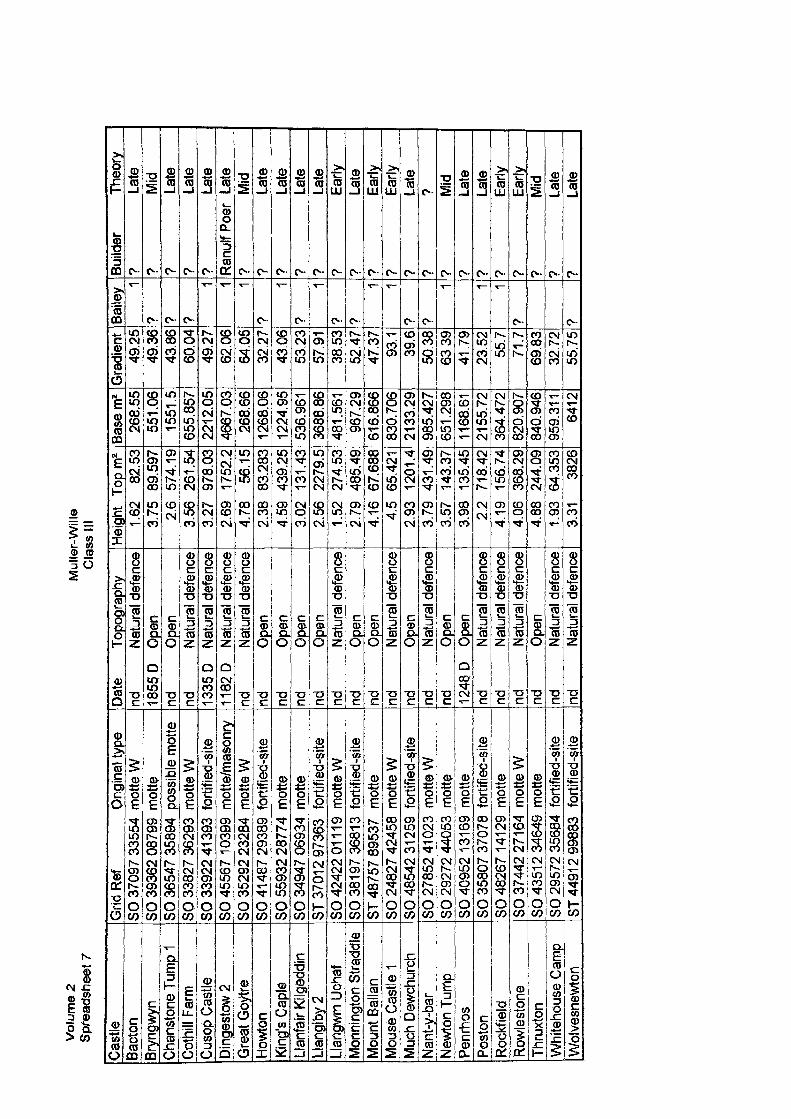
Vol
ume
2 S
prea
dshe
et 7
Mul
ler-
Will
e C
lass
III
Cast
leBa
cton
Bryn
gwyn
Chan
ston
e Tu
mp
1Co
thill
Farm
Cuso
p Ca
stle
Ding
esto
w 2
Grea
t Goy
treHo
wton
King
's Ca
pleLla
nfair
Kilg
eddin
Llang
iby 2
Llang
wm U
chaf
Mon
ningt
on S
tradd
leM
ount
Ball
anM
ouse
Cas
tle 1
Muc
h De
wchu
rch
Nant
-y-b
arNe
wton
Tum
pPe
nrho
sPo
ston
Rock
field
Rowl
esto
neTh
ruxto
nW
hite
hous
e Ca
mp
Wol
vesn
ewto
n
Grid
Ref
O
rigin
al ty
peSO
370
97 3
3554
mot
te W
SO 3
9362
087
99 m
otte
SO 3
6547
358
94 p
ossi
ble
mot
teSO
338
27 3
6293
mot
te W
SO 3
3922
41 3
93 f
ortif
ied-
site
SO 4
5567
103
99 m
otte
/mas
onry
SO 3
5292
232
84 m
otte
WSO
41 4
87 2
9389
for
tifie
d-si
teSO
559
32 2
8774
mot
teSO
349
47 0
6934
mot
teST
370
1 2 9
7363
fo
rtifie
d-si
teSO
424
22 0
1 11
9 m
otte
WSO
381
97
3681
3 fo
rtifie
d-si
teST
487
57 8
9537
m
otte
SO 2
4827
424
58 m
otte
WSO
485
42 3
1259
for
tifie
d-si
teSO
278
52 4
1 023
mot
te W
SO 2
9272
440
53
mot
teSO
409
52 1
31 6
9 m
otte
SO 3
5807
370
78 f
ortif
ied-
site
SO 4
8267
141
29 m
otte
SO 3
7442
27 1
64 m
otte
WSO
435
1 2
3464
9 m
otte
SO 2
9572
356
84 f
ortif
ied-
site
ST 4
491
2 99
883
forti
fied-
site
Date
To
pogr
aphy
nd
Natu
ral d
efen
ce18
55D
Open
nd
Open
nd
Natu
ral d
efen
ce13
35D
Natu
ral d
efen
ce11
82D
Natu
ral d
efen
cend
Na
tura
l def
ence
nd
Open
nd
Open
nd
Open
nd
Open
nd
Natu
ral d
efen
cend
Op
ennd
Op
ennd
Na
tura
l def
ence
nd
Open
nd
Natu
ral d
efen
cend
Op
en12
48 D
Op
ennd
Na
tura
l def
ence
nd
Natu
ral d
efen
cend
Na
tura
l def
ence
nd
Open
nd
Natu
ral d
efen
cend
Na
tura
l def
ence
Heigh
t To
pm2
1.62
82
.53
3.75
89
.597
2.6
574.
193.
56
261.
543.
27
978.
032.
69
1752
.24.
78
56.1
52.
38
83.2
834.
59
439.
253.
02
131.
432.
56
2279
.51.
52
274.
532.
79
485.
494.
16
67.6
884.
5 65
.421
2.93
12
01.4
3.79
43
1.49
3.57
14
3.37
3.98
13
5.45
2.2
718.
424.
19
156.
744.
06
368.
294.
88
244.
091.
93
64.3
533.
31
3826
Base
m2
268.
5555
1.06
1551
.565
5.85
722
12.0
546
67.0
326
8.66
1268
.06
1224
.95
536.
961
3688
.86
481.
561
967.
2961
6.86
683
0.70
621
33.2
998
5.42
765
1.29
811
68.6
121
55.7
236
4.47
282
0.90
784
0.94
695
9.31
164
12
Grad
ient
49.2
549
.36
43.8
660
.04
49.2
762
.06
64.0
532
.27
43.0
653
.23
57.9
138
.53
52,4
747
.37
93.1
39.6
50.3
863
3941
.79
23.5
255
.771
.769
.83
32.7
255
.75
Baile
y 1? ? ?
1 1 1?
1?
1? 9
1 19 9
1 1 1
? 9
Build
er
Theo
ry?
Late
? M
id?
Late
? La
te?
Late
Ranu
lfPoe
r La
te?
Mid
? La
te?
Late
? La
te?
Late
? Ea
rly?
Late
? Ea
rly?
Early
? La
te?
??
Mid
? La
te?
Late
? Ea
rly?
Early
? M
id?
Late
? La
te
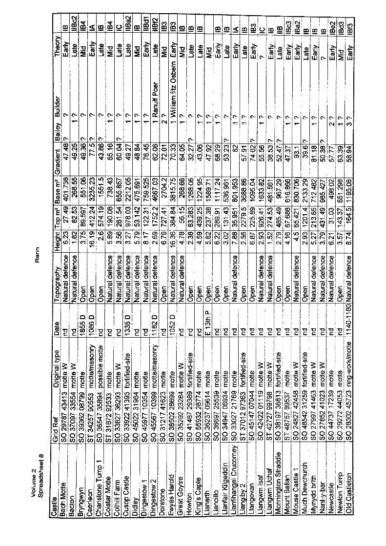
Vo
lum
e 2
Sp
read
shee
t 8
Ren
n
Cast
leBa
ch M
otte
Bact
onBr
yngw
ynCa
erle
onCh
anst
one
Tum
p 1
Colst
ar M
otte
Coth
ill Fa
rmCu
sop
Cast
le3i
dley
)inge
stow
1Di
nges
tow
2Do
rsto
neEw
yas
Haro
ldG
reat
Goy
treHo
wton
King
's Ca
ple
Llan
arth
Llan
cillo
Llan
fair
Kilg
eddi
n.la
nfih
ange
l Cru
corn
eyLl
angi
by 2
Llan
gova
nLl
angw
m Is
afLl
angw
m U
chaf
Mon
ning
ton
Stra
ddle
Mou
nt B
alla
nM
ouse
Cas
tle 1
Muc
h De
wchu
rch
Myn
ydd
brith
Nant
-y-b
arNe
wcas
tleNe
wton
Tum
pO
ld C
astle
ton
Grid
Ref
O
rigin
al ty
peSO
297
87 4
341
3 m
otte
WSO
370
97 3
3554
mot
te W
SO 3
9362
087
99 m
otte
ST 3
4257
905
53
mot
te/m
ason
rySO
365
47 3
5894
pos
sibl
e m
otte
ST 3
1 872
925
33
mot
teSO
338
27 3
6293
mot
te W
SO 3
3922
41
393
forti
fied-
site
SO 4
5022
31 9
64 m
otte
SO 4
5977
103
54 m
otte
SO 4
5567
103
99 m
otte
/mas
onry
SO 3
121 7
416
23 m
otte
SO 3
8502
286
99 m
otte
SO 3
5292
232
84 m
otte
WSO
41 4
87 2
9389
for
tifie
d-si
teSO
559
32 2
8774
mot
teSO
362
37 0
961 4
mot
teSO
366
97 2
5539
mot
teSO
349
47 0
6934
mot
teSO
330
27 2
1 769
mot
teST
370
1 2
9736
3 fo
rtifie
d-si
teSO
451
47 0
7044
mot
teSO
424
22 0
1 11
9 m
otte
WST
427
27 9
9798
m
otte
WSO
381
97
3681
3 fo
rtifie
d-si
teST
487
57 8
9537
m
otte
SO 2
4827
424
58 m
otte
WSO
485
42 3
1259
for
tifie
d-si
teSO
279
97 4
1 463
mot
te W
SO 2
7852
41 0
23 m
otte
WSO
447
37 1
7239
mot
teSO
292
72 4
4053
mot
teSO
283
02 4
5723
rin
g-wo
rk/m
otte
Date
nd nd 1855
D10
86D
nd nd nd 1335
Dnd nd 11
82D
nd 1052
Dnd nd nd E
13th
Pnd nd nd nd nd nd nd nd nd nd nd nd nd nd nd 11
40-1
180
Topo
grap
hyNa
tura
l def
ence
Natu
ral d
efen
ceOp
enO
pen
Ope
nNa
tura
l def
ence
Natu
ral d
efen
ceNa
tura
l def
ence
Natu
ral d
efen
ceNa
tura
l def
ence
Natu
ral d
efen
ceO
pen
Natu
ral d
efen
ce'N
atur
al de
fenc
eOp
enOp
enOp
enOp
enOp
enNa
tura
l def
ence
Open
Open
Natu
ral d
efen
ceNa
tura
l def
ence
Open
Open
Natu
ral d
efen
ceOp
enNa
tura
l def
ence
Natu
ral d
efen
ceNa
tura
l def
ence
Open
Natu
ral d
efen
ce
Heig
ht6.
231.
623.
7516
.19
2.6
5.89
3.56
3.27
5.79
8.17
2.69
6.79
16.3
64.
782.
384.
595.
626.
223.
027.
882.
566.
872.
931.
522.
794.
16 4.5
2.93
5.27
3.79
6.21 3.57
8.74
Topm
227
.49
82.5
389
.597
412.
2457
4.19
190.
0826
1.54
978.
0353
.142
122.
3117
52.2
727.
4138
4.84
56.1
583
.283
439.
2523
7.38
289.
9113
1.43
35.9
5122
79.5
225.
8992
6.41
274.
5348
5.49
67.6
8865
.421
1201
.421
3.65
431.
4931
.03
143.
3716
4.5
Base
m2
401.
738
268.
5555
1 .0
632
35.2
315
51.5
738.
4365
5.85
722
12.0
547
5.69
175
9.52
546
67,0
327
04.2
3815
.75
268.
6612
68.0
612
24.9
515
89.7
111
17.2
453
6.96
180
1.95
336
88.8
610
95,0
416
33.8
248
1.56
196
7.29
616.
866
830.
706
2133
.29
712.
482
985.
427
498.
0265
1.29
811
95.0
6
Gra
dien
t47
.48
49.2
549
.36
77.5
43.8
665
.16
60.0
449
.27
48.8
476
.45
62.0
672
.01
70.3
364
.05
32.2
743
.06
47.9
268
.29
53.2
3 6257
.91
74.0
255
.56
38.5
352
.47
47.3
793
.139
.681
.18
L_ 50
.38
57.7
763
.39
58.9
4
Baile
v Bu
ilder
Th
eory
? ?
Early
1 ?
Late
? ?
Mid
? ?
Early
? ?
Late
1 ?
Mid
? ?
Late
1 ?
Late
1 ?
Mid
1 ?
Early
1 R
anul
fPoe
r La
te2
? M
id1
Willi
am fi
tz O
sber
n Ea
rly1
? M
id?
? La
te1
? La
te1
? M
id1
? Ea
rly?
? La
te1
? Ea
rly1
? La
te?
? Ea
rly1
? ?
? ?
Early
? ?
Late
1 ?
Early
1 ?
Early
? ?
Late
1 ?
Early
? ?
?2
? Ea
rly1
? M
id3
? Ea
rly
IB IIBc2
IB4
IA IB IB4
1C IIBa2
IB IIBdl
IIBf2
IB3
IB3
IB IB IB IB IB IA IB IB3 C B IB Bc3
Ba2
B B B Be2
Bd3
Bf3
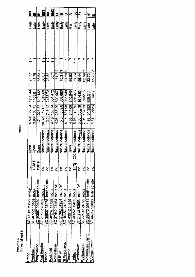
Vol
ume
2 S
pre
adsh
eet
3R
enn
Orc
opPe
nrho
sPe
nycla
wdd
Pont
Hen
dre
Posto
nRo
ckfie
ldRo
wles
tone
St Il
ltyd
St W
eona
rds
Thru
xton
Trel
ech
Twm
barlw
mW
alte
rsto
neW
hite
hous
e Ca
mp
Wol
vesn
ewto
n
SO
472
82 2
6529
mot
teSO
409
52 1
31 6
9 m
otte
SO 3
0967
201
39
fortf
fied-
site
SO 3
2572
281
09
mot
teSO
358
07 3
7078
for
tifie
d-si
teSO
482
67 1
41 2
9 m
otte
SO 3
7442
271
64
mot
te W
SO 2
1692
01 9
54 m
otte
WSO
496
57 2
4329
mot
teSO
435
1 2 3
4649
mot
teSO
499
52 0
5409
mot
teST
243
82 9
2653
m
otte
WSO
339
32 2
4999
mot
teSO
295
72 3
5684
for
tifie
d-si
teST
449
12 9
9883
fo
rtifie
d-si
te
nd 1248
D13
thP
nd nd nd nd nd nd ^— 1175
-120
Cnd nd nd nd
Open
Open
Open
Natu
ral d
efen
ceNa
tura
l def
ence
Natu
ral d
efen
ceNa
tura
l def
ence
Natu
ral d
efen
ceNa
tura
l def
ence
Open
Natu
ral d
efen
ceNa
tura
l def
ence
Natu
ral d
efen
ceNa
tura
l def
ence
Natu
ral d
efen
ce
6.59
3.98
1.71
J0.3
9 2.2
4.19
4.06 5.
36.
154.
885.
765.
587.
061.
933.
31
270.
413
5.45
327.
3712
1.3
718.
4215
6.74
368.
2926
9.8
531.
9824
4.09
142.
7618
5.79
574.
1964
.353
3826
1200
.44
1168
.61
619.
132
1519
.89
2155
.72
364.
472
820.
907
888.
666
965.
948
840.
946
758.
373
1614
.86
1551
.595
9.31
164
12
75.7
741
.79
55.5
363
.01
23.5
255
.771
.770
.31
81.2
869
.83
71.7
456
.44
62.9
932
.72
55.7
5
1 ?
Early
? La
te?
? La
te1
? Ea
rly1
? La
te1
? Ea
rly?
? Ea
rly?
? Ea
rly?
? Ea
rly?
Mid
1 ?
Early
1 ?
Early
? ?
Early
? La
te?
? La
te
IBS
IB IB IBf3
IIB IBd3
IB IB IB IB IB3
IB4
IB IIB IB
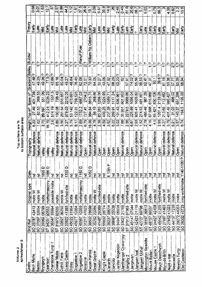
Vol
ume
2 sp
read
shee
t 9To
p su
rface
are
%
to b
otto
m s
urfa
ce a
rea
Cast
leBa
ch M
otte
Bact
onBr
yngw
ynCa
erle
onCh
anst
one
Tum
p 1
Colst
ar M
otte
Coth
ill Fa
rmCu
sop
Cast
leDi
dley
Ding
esto
w 1
Ding
esto
w 2
Dors
tone
Ewya
s Ha
rold
Gre
at G
oytre
Howt
onKi
ng's
Capl
eLla
narth
Llan
cillo
Llan
fair
Kilg
eddi
nLl
anfih
ange
l Cru
corn
eyLl
angi
by 2
Llan
gova
nLl
angw
m Is
afLl
angw
m U
chaf
Mon
ning
ton
Stra
ddle
Mou
nt B
alla
nM
ouse
Cas
tle 1
Muc
h De
wchu
rch
Myn
ydd-
Brith
Nant
-y-b
arNe
wcas
tleNe
wton
Tum
pO
ld C
astle
ton
Grid
Ref
SO 2
9787
434
1 3
SO 3
7097
335
54SO
393
62 0
8799
ST 3
4257
905
53SO
365
47 3
5894
ST 3
1 872
925
33SO
338
27 3
6293
SO 3
3922
413
93SO
450
22 3
1 96
4SO
459
77 1
0354
SO 4
5567
103
99SO
31 2
1 7
4162
3SO
385
02 2
8699
SO 3
5292
232
84SO
41
487
2938
9SO
559
32 2
8774
SO 3
6237
096
14SO
366
97 2
5539
SO 3
4947
069
34SO
330
27 2
1 76
9ST
370
1 2
9736
3SO
451
47 0
7044
SO 4
2422
01
119
ST 4
2727
997
98SO
381
97 3
6813
ST 4
8757
895
37SO
248
27 4
2458
SO 4
8542
312
59SO
279
97 4
1463
SO 2
7852
41
023
SO 4
4737
172
39SO
292
72 4
4053
SO 2
8302
457
23
Orig
inal
type
mot
te W
mot
te W
mot
tem
otte
/mas
onry
poss
ible
mot
tem
otte
mot
te W
forti
fied-
site
mot
tem
otte
mot
te/m
ason
rym
otte
Lmott
em
otte
Wfo
rtifie
d-sjt
em
otte
mot
tem
otte
mot
tem
otte
forti
fied-
site
mot
tem
otts
Wm
otte
Wfo
rtifie
d-sjt
em
otte
mot
te W
forti
fied-
sjte
mot
te W
mot
te W
mot
tem
otte
ring-
work
/mot
te
Date
nd nd 1855
D10
86D
nd nd nd 1335
Dnd nd hM
82D
nd 1052
Dnd nd nd E
13th
Pnd
_
nd nd nd nd nd _
__
__
nd nd nd nd nd nd nd
_nd nd 11
40-1
1 BOP
Topo
grap
hyNa
tura
l def
ence
Natu
ral d
efen
ceva
lley
valle
yva
lley
Natu
ral d
efen
ceNa
tura
l def
ence
Natu
ral d
efen
ceNa
tura
l def
ence
Natu
ral d
efen
ceNa
tura
l def
ence
Open
Natu
ral d
efen
ce(N
atur
al de
fenc
eO
pen
Open
Open
Open
Open
Natu
ral d
efen
ceOp
enOp
enNa
tura
l def
ence
Natu
ral d
efen
ceO
pen
Open
Natu
ral d
efen
ceO
pen
Natu
ral d
efen
ceNa
tura
l def
ence
Natu
ral d
efen
ceO
pen
Natu
ral d
efen
ce
Heig
ht6.
23 1.62
3.75
16.1
92.
65,
893.
563.
275.
798.
172.
696.
79Jy
S4.
782.
384.
595.
626,
223.
027.
882.
566.
872.
931,
522.
794.
16 4.5
L
2'9
3I"
5.27
3.79
6.21 3.57
8.74
Top
m2
Base
ma
27.4
9 40
1.73
882
.53
268.
5589
.597
55
1.06
412.
24
3235
.23
574.
19
1551
.519
0.08
73
8,43
261.
54
655.
857
978.
03
2212
.05
53,1
42
475.
691
122.
31
759.
525
1752
.2
4667
.03
727.
41
2704
.238
4.84
38
15.7
556
.15
268.
6683
,283
12
68.0
643
9.25
12
24.9
523
7.38
15
89.7
128
9.91
11
17.2
413
1.43
53
6.96
135
,951
80
1.95
322
79.5
36
88,8
622
5.89
10
95.0
492
6.41
16
33.8
227
4.53
48
1.56
148
5.49
96
7.29
67.6
88
616.
866
65.4
21
830.
706
1201
.4
2133
.29
213.
65
712.
482
431.
49
985.
427
31.0
3 49
8.02
143.
37
651.
298
164.
5 11
95.0
6
Gra
dien
t47
.48
49.2
549
.36
77.5
43.8
665
.16
60.0
449
.27
48.8
476
.45
62.0
672
.01
70.3
364
.05
32.2
743
.06
47.9
268
.29
53.2
3 6257
.91
74.0
255
.56
38.5
352
.47
47.3
793
.139
.681
.18
50.3
857
.77
63.3
958
.94
Baile
y?
•)? 9 ?
•?
• t 1 1 f £. 1 1?
1 1 1?
1 1?
19 ?
1 1?
1?
2 1 3
Build
er? 9 ? 9 9 9 9 9 9 9 Ra
nulf
Poer
? Willi
am fi
tz O
sbem
9 ? ? ? ? ? 7 ? 9 9 9 9 9 ? 9 9 7 9 9 7
Theo
ryEa
rlyLa
teM
idEa
rlyLa
teM
idLa
teLa
teM
idEa
rlyLa
teM
idEa
rlyM
idLa
teLa
teM
idEa
rlyJ-
ate
Early
Late
Early
•? Early
Late
Early
Early
Late
Early
Early
Mid
Early
0.68
3.07
1.63
12.7 37
2.57
3.99
44.2
1.12
1.61
37.5
26,9
10.1
2.09
6.57
35.9
14.9 26
2.45
0.45
61.8
20.6
56.7 5.7
5.02 1.
10.
7956
.3 34.
380.
62 2.2
138
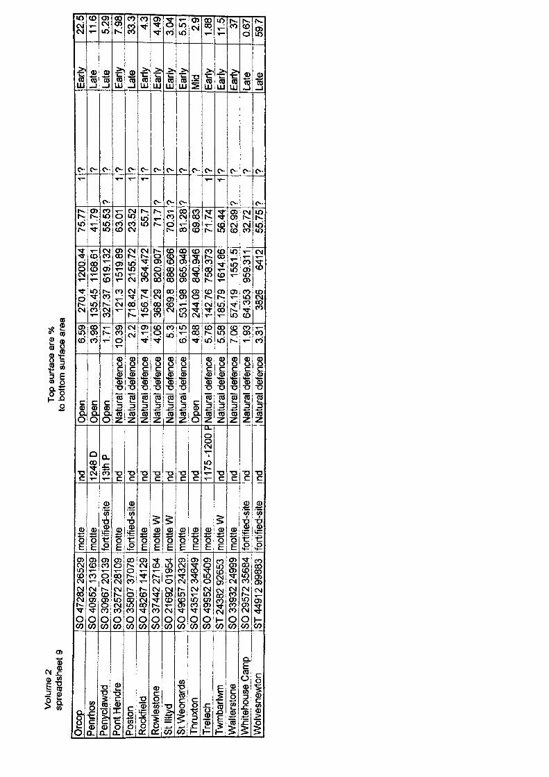
Vol
ume
2 sp
read
shee
t 9To
p su
rface
are
%
to b
otto
m s
urfa
ce a
rea
Orc
opPe
nrho
sPe
nycla
wdd
Pont
Hen
dre
Posto
nRo
ckfie
ldRo
wles
tone
St Il
ltyd
St W
eona
rds
Thru
xton
Trele
chTw
mba
rlwm
Walt
ersto
neW
hite
hous
e Ca
mp
Wolv
esne
wton
SO 4
7282
265
29SO
409
52 1
31 6
9SO
309
67 2
01 3
9SO
325
72 2
81 0
9SO
356
07 3
7078
SO 4
8267
141
29
SO 3
7442
271
64
SO 2
1 692
01 9
54£0 4
9657
243
29SO
435
1 2
3464
9SO
499
52 0
5409
ST 2
4382
926
53SO
339
32 2
4999
SO 2
9572
356
84ST
449
1 2
9988
3
mot
tem
otte
forti
fied-
site
mot
tefo
rtifie
d-sit
em
otte
mot
te W
mot
te W
mot
tem
otte
mot
tem
otte
Wm
otte
forti
fied-
site
forti
fied-
site
nd 1248
D13
thP
nd nd nd nd nd nd nd 1175
-120
0 P
nd nd nd nd
Open
Open
Open
Natu
ral d
efen
ceNa
tura
l def
ence
Natu
ral d
efen
ceNa
tura
l def
ence
Natu
ral d
efen
ceNa
tura
l def
ence
Open
Natu
ral d
efen
ceNa
tura
l def
ence
Natu
ral d
efen
ceNa
tura
l def
ence
Natu
ral d
efen
ce
6.59
3.98 1.71
10.3
92.
24.
194.
06 5.3
6.15
4.88
5.76
5.58
7.06
1.93
3.31
270.
4 12
00.4
413
5.45
11
68.6
132
7.37
61
9.13
212
1.3
1519
,89
718.
42
2155
.72
156.
74
364.
472
368.
29
820.
907
269.
8 88
8.66
653
1.98
96
5.94
824
4.09
84
0.94
614
2.76
75
8.37
318
5.79
16
14.8
657
4.19
15
51.5
64.3
53
959.
311
3826
64
12
75.7
741
.79
55.5
363
.01
23.5
255
.771
.770
.31
81.2
869
.83
71.7
456
.44
62.9
932
.72
55.7
5
1
?1 1 1
? ? ?
1 1? ?
? ? ? ? ? ? ? ? ? ? ? ? ? ? ?
Early
Late
Late
Early
Late
Early
Early
Early
Early
Mid
Early
Early
Early
Late
.ate
22.5
11.6
5.29
7.98
33.3 4.3
4.49
3.04
5.51 2.
91.
8811
.5 370.
6759
.7
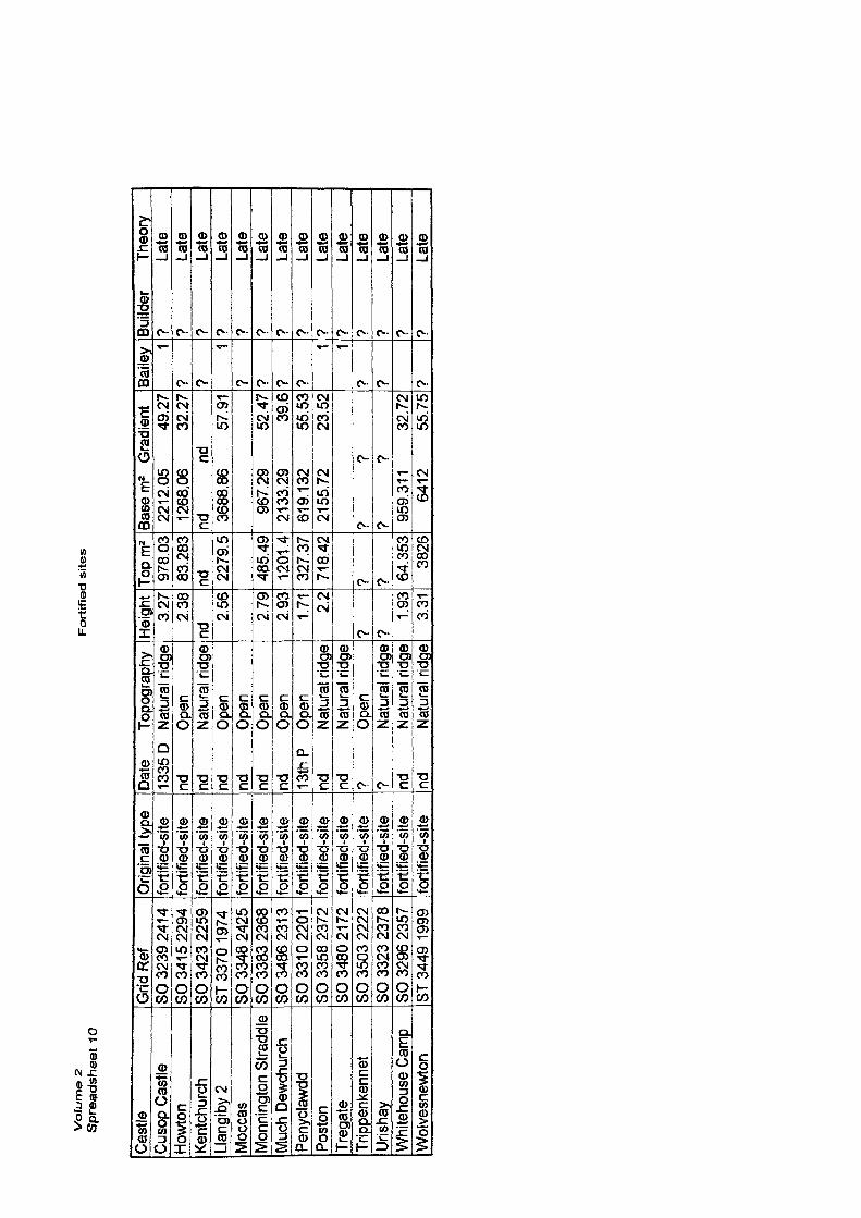
Vo
lum
e 2
S
pre
ad
sh
ee
t 10
Fo
rtif
ied
sit
es
Cast
leCu
sop
Castl
eHo
wton
Kent
chur
chLla
ngiby
2M
occa
sM
onnin
gton
Stra
ddle
Muc
h De
wchu
rch
Peny
clawd
dPo
ston
Treg
ate
Trip
penk
enne
tUr
ishay
Whi
teho
use
Cam
pW
olve
snew
ton
Grid
Ref
SO 3
239
241 4
SO 3
41 5
2294
SO 3
423
2259
ST 3
370
1974
SO 3
348
2425
SO 3
383
2368
SO 3
486
231 3
SO 3
31 0
2201
SO 3
358
2372
SO 3
480
21 7
2SO
350
3 22
22SO
332
3 23
78SO
329
6 23
57ST
344
9 19
99
Orig
inal
type
forti
fied-
site
forti
fied-
site
forti
fied-
site
forti
fied-
site
forti
fied-
site
forti
fied-
site
forti
fied-
site
forti
fied-
site
forti
fied-
site
forti
fied-
site
forti
fied-
site
forti
fied-
site
forti
fied-
site
forti
fied-
site
Date
To
pogr
aphy
1335
D Na
tura
l ridg
end
Op
ennd
Na
tura
l ridg
end
Op
ennd
Op
ennd
Op
ennd
Op
en13
thP
Open
nd
Natu
ral r
idge
nd
Natu
ral r
idge
? Op
en?
Natu
ral r
idge
nd
Natu
ral r
idge
nd
Natu
ral r
idge
Heigh
t3.
272.
38nd r~
2.56 2.79
2.93
1.71 2.
2
? ?1.
933.
31
Topm
297
8.03
83.2
83nd 22
79.5
^ 485
.49
1201
.432
7.37
718.
42
? ? 64.3
5338
26
Base
m2
Gra
dien
t22
12.0
5 49
.27
1268
,06
32.2
7nd
nd
3688
,86
57.9
1
967,
29
52.4
721
33,2
9 39
.661
9.13
2 55
.53
2155
,72
23.5
2
? ?
? ?
J359
.311
32
.72
6412
55
.75
Baile
y 1? ?
1? ? ? ?
1 1? ? ?
Build
er
Theo
ry?
Late
? La
te?
Late
? La
te?
Late
? La
te?
Late
? La
te?
Late
? La
te?
Late
? La
te?
Late
? La
te
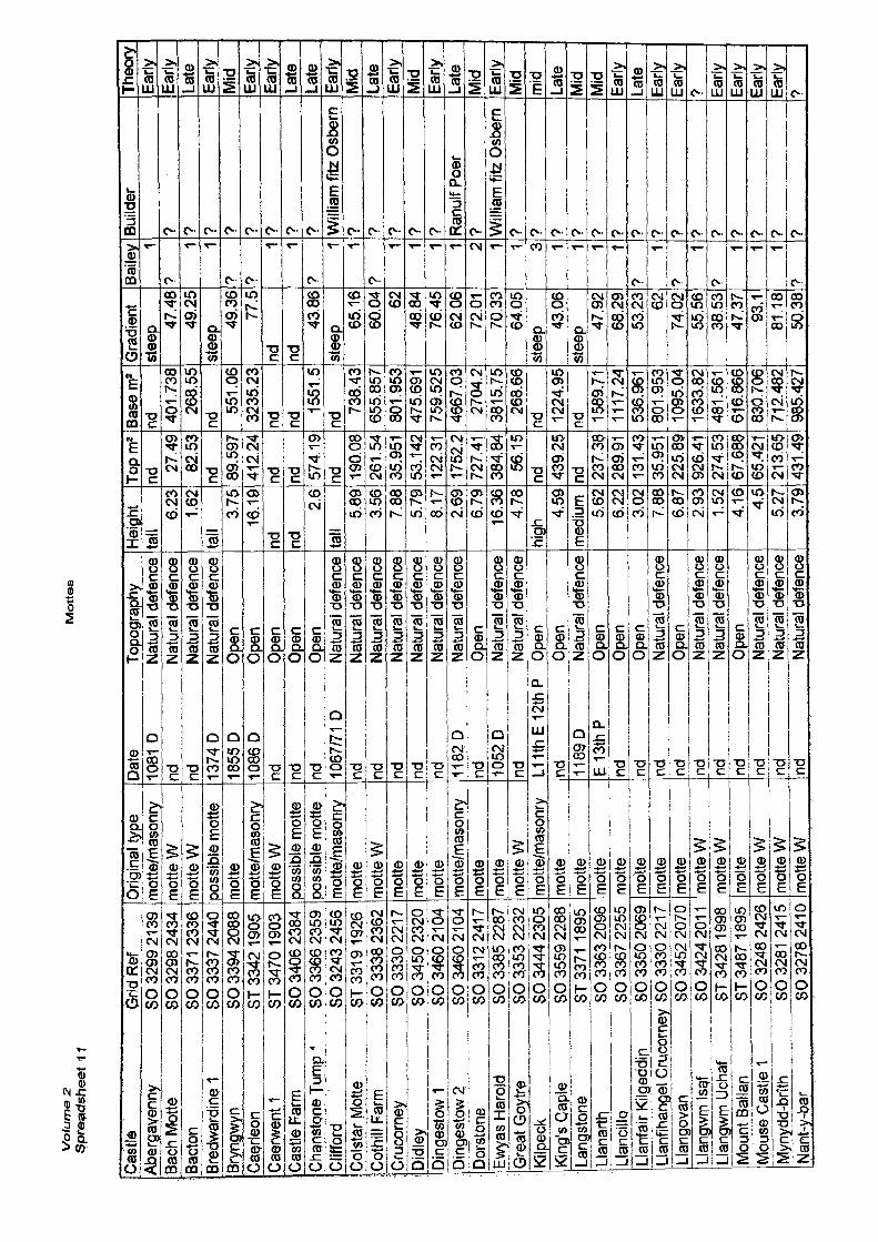
Vo
lum
e 2
S
pre
ad
sh
ee
t 1
1M
ott
es
Cast
le
Grid
Ref
Aber
gave
nny
SO 3
299
21 39
Bach
Mot
te
SO 3
298
2434
Bact
on
SO 3
371
2336
Bred
ward
ine
1 SO
333
7 24
40Br
yngw
yn
SO 3
394
2088
Cae,
rleon
ST
334
2 19
05C
aerw
entl
ST 3
470
1903
Cast
le F
arm
SO
340
6 23
84Ch
gnst
pne
Jum
p 1
SO 3
366
2359
Cliff
ord
SO 3
243
2456
Colst
ar M
otte
ST
331
9 1 9
26Co
thill
Farm
SO
333
8 23
62Cr
ucor
ney
SO 3
330
221 7
Didl
ey
SO 3
450
2320
Ding
esto
w 1
SO 3
460
2 1 0
4Di
nges
tow
2 SO
346
0 21
04
Dors
tone
SO
331
2 24
1 7Ew
yas
Haro
jd
SO 3
385
2287
Gre
at G
oytre
SO
335
3 22
32Ki
lpec
k SO
344
4 23
05Ki
ng's
Capl
e SO
355
9 22
88La
ngst
one
ST33
71 1
895
Llan
arth
SO
336
3 20
96Ll
ancil
lo
SO 3
367
2255
Ltan
fair
Kilg
eddi
n SO
335
0 20
69Ll
anfih
ange
l Cru
corn
ey S
O 33
30 2
217
Llan
gova
n SO
345
2 20
70Ll
angw
tp Is
af
SO 3
424
201
1Ll
angw
m U
chaf
ST
342
8 1 9
98M
ount
Bal
lan
ST 3
487
1895
Mou
se C
astle
1 SO
324
8 24
26M
ynyd
d-br
ith
SO 3
281
241 5
Nant
-y-b
ar
SO 3
278
2410
Orig
inal
type
mot
te/m
ason
rym
otte
Wm
otte
Wpo
ssibl
e m
otte
mot
tem
otte
/mas
onry
mot
te W
poss
ible
mot
tepo
ssibl
e m
otte
mot
te/m
ason
rym
otte
mot
te W
mot
tem
otte
mot
tem
otte
/mas
onry
mot
tem
otte
mot
te W
mot
te/m
ason
rym
otte
mot
tem
otte
mot
tem
otte
mot
tem
otte
mot
te W
mot
te W
mot
tem
otte
Wm
otte
Wm
otte
W
Date
To
pogr
aphy
1081
D
Natu
ral d
efen
cend
Na
tura
l def
ence
nd
Natu
ral d
efen
ce13
74D
Natu
ral d
efen
ce18
55 D
Op
en10
86 D
Op
ennd
Op
ennd
Op
ennd
Op
en10
67/71
D
Natu
ral d
efen
cend
Na
tura
l def
ence
nd
Natu
ral d
efen
cend
Na
tura
l def
ence
nd
Natu
ral d
efen
cend
Na
tura
l def
ence
1182
D Na
tura
l def
ence
nd
Open
1052
D Na
tura
l def
ence
nd
Natu
ral d
efen
ceU
1thE
12th
P
Open
nd
Open
1189
D Na
tura
l def
ence
E13t
hP
Open
nd
Open
nd
Open
nd
Natu
ral d
efen
cend
Op
ennd
Na
tura
l def
ence
nd
Natu
ral d
efen
cend
Op
ennd
Na
tura
l def
ence
nd
Natu
ral d
efen
cend
Na
tura
l def
ence
Heigh
tta
ll6.
23 1.62
tall
3.75
1679
nd nd2.
6ta
il5.
893.
567.
885.
798.
172.
696.
7916
.36
4.78
high 4.
59m
edium 5.
626.
223.
027.
886.
872.
93 1.52
4.16 4.5
5.27
3.79
Topm
*nd
27.4
982
.53
nd 89.5
9741
2,24
nd nd 574.
19nd 19
0.08
261.
5435
.951
53.1
42J2
23JI
175Z
2172
7.41
384.
8456
.15
nd 439,
25nd 23
7,38
289.
9113
1.43
35.9
5122
5,89
926.
4127
4.53
67.6
8865
.421
213,
6543
1,49
Base
m2
nd 401.
738
268.
55nd
551.
0632
35.2
3nd nd
1551
.5nd
738.
4365
5.85
780
1.95
347
5.69
175
9.52
546
67.0
327
04.2
3815
.75
268.
66nd 12
24.9
5nd 15
89.71
1117
.24
536.
961
8019
5310
95.0
416
33.8
248
1.56
161
6.86
683
0.70
671
2.48
298
5.42
7
Grad
ient
steep
47.4
849
.25
steep
49.3
677
.5nd nd
43.8
6ste
ep65
.16
60.0
4 6248
.84
76.4
562
.06
72.0
170
,33
64.0
5ste
ep43
.06
steep
47.9
268
.29
53.2
3 6274
.02
55.5
638
.53
47.3
793
.181
.18
50,3
8
Baile
y 1?
* ',? ?
1 1?
1 1?
1 1 1 1 ** 1 1 3 1 1 1 17
17
1
?
1 1 17
Build
er
? ? ? ? ? ? 7 7 Willi
am fi
tz O
sber
n? ? ? ? 7 Ra
nulf
Poer
7 Willi
am fi
tz Os
bern
? ? 7 ? 7 7 7 7 7 7 ? 7 7 7 7
Theo
ryEa
rlyEa
rlyLa
teEa
rlyM
idEa
rlyEa
rlyLa
teLa
teEa
rlyM
idLa
teEa
rlyM
idEa
rlyLa
teM
idEa
rlyM
idm
idLa
teM
idM
id Early
Late
Early
Early
7 Early
Early
Early
Early
>
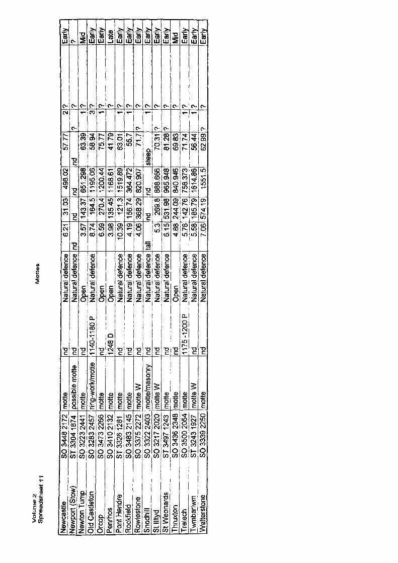
Vo
/um
e 2
Sp
rea
ds
he
et
11M
ott
es
New
cast
le
SO 3
448
21 7
2N
ewpo
rt (S
tow)
ST
330
4 1 8
74Ne
wton
Tum
p SO
322
3 24
41O
ld C
astle
ton
SO 3
283
2457
Orc
op
SO 3
473
2266
Penr
hos
SO 3
41 0
21 3
2Po
nt H
endr
e ST
332
6 12
81R
ockf
ield
SO
348
3 2 1
45R
owle
ston
e SO
337
5 22
72Sn
odhi
ll SO
332
2 24
03St
Illty
d __
_
SO 3
21 7
2020
St W
eona
rds
ST 3
497
1 243
Thrg
xton
SO
343
6 23
48Tr
elec
h SO
350
0 20
54Tw
mba
rlwm
ST
324
3 19
27W
alte
rsto
ne
SO 3
339
2250
mot
tepo
ssib
le m
otte
mot
terin
g-w
ork/
mot
tem
otte
mot
tem
otte
mot
tem
otte
Wm
otte
/mas
onry
mot
te W
mot
tem
otte
mot
tem
otte
Wm
otte
nd
Natu
ral d
efen
cend
Na
tura
l def
ence
nd
Ope
n1 1
40-1
1 80
P
Natu
ral d
efen
cend
O
pen
1248
D
Ope
nnd
N
atur
al d
efen
cend
Na
tura
l def
ence
nd
Natu
ral d
efen
cein
d Na
tura
l def
ence
nd
Natu
ral d
efen
cend
Na
tura
l def
ence
nd
Ope
n1 1
75 -1
200
P Na
tura
l def
ence
nd
Natu
ral d
efen
ce ,
nd
Natu
ral d
efen
ce I
6.21
nd3.
578.
746.
593.
9810
.39
4.19
4.06
tall
5.3
6.15
4.88
5.76
5.58
7.06
31 0
3nd 14
3.37
164.
527
0.4
135.
4512
1.3
156.
7436
8.29
nd26
9.8
531.
9824
4.09
142.
7618
5,79
574.
19
498.
02nd 65
1.29
811
95.0
612
00.4
411
68.6
115
19.8
936
4.47
282
0.90
7nd 88
8.66
696
5.94
884
0.94
675
8.37
316
14.8
615
51.5
57.7
7nd
63.3
958
.94
75.7
741
.79
63.0
155
.771
.7st
eep 70
.31
81.2
869
8371
.74
56.4
462
.99
27
1 3 1 1 1?
17 7
1 17
? 7 ? ? 7 ? ? ? ? 7 ? 7 7 7 7 ?
Early
7 Mid
Early
Early
Late
Early
-Ea
rlyEa
rlyEa
rlyEa
rlyEa
rlyM
idEa
rlyEa
rlyEa
rly
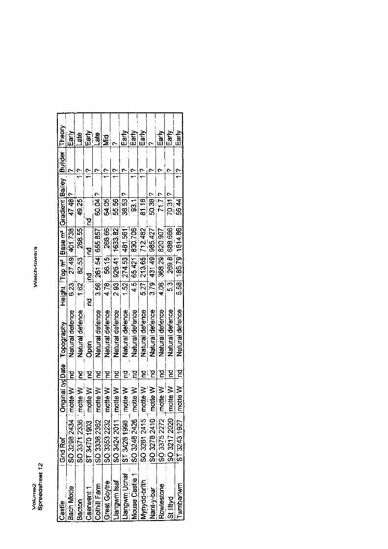
Vo
lum
es
S
pre
ad
sh
ee
t 12
Watc
h-t
ow
ers
Cast
le
! Grid
Ref
Etec
h M
otte
JJ
3O 3
298
2434
Bact
on
> SO
3371
233
6C
aerw
entl
ST 3
470
1903
Coth
ill Fa
rmG
reat
Goy
treLl
angw
m Is
afLl
angw
m U
chaf
Mou
se C
astle
1M
ynyd
d-br
ithNa
nt-y
-bar
Rowl
esto
neSt
Illty
dTw
mba
rlwm
SO 3
338
2362
SO 3
353
2232
SO 3
424
2011
ST 3
428
1998
'
SO 3
248
2426
SO 3
281
241
5SO
327
8 24
10SO
337
5 22
72SO
321
7 2
020
ST 3
243
1927
Orig
inal
tyf
mot
te W
mot
te W
mot
te W
mot
te W
mot
te W
mot
te W
mot
te W
mot
te W
mot
te W
mot
te W
mot
te W
mot
te W
mot
te W
Date
To
pogr
aphy
He
ight
nd
Natu
ral d
efen
ce
6.23
nd
Natu
ral d
efen
ce
1 .62
nd
Ope
n nd
nd
Natu
ral d
efen
ce
3,56
nd
Natu
ral d
efen
ce
4.78
nd
Natu
ral d
efen
ce
2 93
nd
Natu
ral d
efen
ce
1 .52
nd
Natu
ral d
efen
ce
4.5
nd
Natu
ral d
efen
ce
5.27
nd
Natu
ral d
efen
ce
3.79
nd
Natu
ral d
efen
ce
4,06
nd
Natu
ral d
efen
ce
5.3
nd
Natu
ral d
efen
ce
5.58
Tofjj
n227
.49
82.5
3nd 26
1 .5
4i^s
s.is1
926.
4127
4.53
i 65.
421
213.
65]
431
.49j
368.
2926
9.8
185.
791Ba
sem
240
1.73
826
8.55
nd 655.
857
268.
6616
33.8
248
1.56
183
0.70
671
2.48
298
5.42
782
0.90
788
8.66
616
1486
1Gra
dien
t47
.48
49.2
5nd
60.0
464
,05
55.5
638
,53
93.1
81,1
850
.38
71.7
7031
56,4
4
Baile
y?
1 1?
1 1?
T! 1? ? ?
1
Build
er? ? ? ? ? 9 ? ? ? ? r? ? ?
Theo
ryEa
rlyLa
teEa
rlyLa
teM
id? Ea
rlyEa
rlyEa
rly? Ea
rlyEa
rlyEa
rly
VOLUME II
EARTHWORK CASTLES OF GWENT AND ERGYNGAD 1050 -1250
BIBLIOGRAPHY
N.Phillips. 2004
BIBLIOGRAPHY
Primary (Including Translations)
Anon, 1808. The Harleian Miscellany; or a Collection of Scarce, Curious, and Entertaining Pamphlets and Tracts as well in Manuscript and Print Found in the Late Earl of Oxfords Library Intersperced with Historical, Political and Critical Notes. 1. 12. London.
Anon, 1903. Calendar of Charier Rolls Preserved in the Public Record Office, Henry HI 1226- 1257, I.London: HMSO.
Anon, 1903. Calendar of Charter Rolls Preserved in the Public Record Office Henrv H11226- 1257. 1. London: HMSO.
Anon, 1904. Calendar of Inquisitions Post Mortem Preserved in the Public Record Office Henry 111. London. HMSO.
Anon, 1908. Calendar of Close Rolls Preserved in the Public Record Office, Henry III 1225- 1231-1234. London: HMSO.
Anon, 1906. Calendar of Patent Rolls Preserved in the Public Record Office, Henry III 1232- 1247. London: HMSO.
Anon, 1916. Calendar of Inquisitions Miscellaneous (Chancery) Preserved in the Public Record Office, 1219-1307. 1. London: HMSO.
Anon, 1916. Calendar of Liberate Rolls Preserved in the Public Record Office, Henry III 1226- 1240. 1. London: HMSO.
Anon, 1927. Calendar of Chancery Warrants Preserved in the Public Record Office, 1. 1244- 1326. London: HMSO.
Anon, 1930. Calendar of Liberate Rolls Preserved in the Public Record Office, Henry 111 1240- 1245. 2. London: HMSO.
Anon, 1937. Calendar of Liberate Rolls Preserved in the Public Record Office, Henry HI 1245- 1251. 3. London: HMSO.
Anon, 1939. Schedule of Manuscripts, Letters, and Manorial Records from the Library of the late Major Albert Addams-Williams, Llangibby Castle, Mon. 1.. MSS. Letters Etc. National Library of Wales.
Anon, 1939. Schedule of Manuscripts, Letters, and Manorial Records from the Library of the late Major Albert Addams-Williams, Llangibby Castle, Mon. 2. Deeds and Documents. National Library of Wales.
Anon, 1946. Schedule of Deeds and Documents Deposited by His Grace The Duke of Beaufort, KG., P.C. Badminton. 1. National Library of Wales.
Anon, 1977. Monmouth, Special Community Review Draft Proposals. Local Government Boundary Commission for Wales. HMSO.
Bately, J., Cambell, J., Phelpstead, C, & Thirwell, D., 2000. The Anglo Saxon Chronicles, Interactive Reference Guide. Cd. Rom. Stratford on Avon: Cromwell Productions Ltd.
Barrow, J., 1993. English Episcopal Acta VII Hereford 1079-1234. Oxford' Oxford University Press. J
Bollandus, J, et al., 1643. Acta Sanctorum. Antwerp, Brussels and Tongerloo.
Brown, R.A., (ed). 1991. Calendar of Memoranda Rolls Preserved in the Public record Office 1231-1233. London: HMSO. JJ '
Colgrave, B., andMynors, R. A. B., (trans).1969. BedeA Historia Ecclesiastica Genlis Anglorum. Oxford: Oxford Medieval Texts.
Chibnall, M., (ed. and trans.). 1969-80. The Ecclesiastical History ofOderic Vitalis, 6 volx, Oxford: Clarendon Press.
Chibnall, M., (ed. and trans.). 1990. The Ecclesiastical History ofOderic Vitalis, 2. Oxford: Clarendon Press.
Cronne, H.A. and Davis, R.H.C., 1969. Regesta Regum Anglo-Normanorum 1066-1154, 4. Facsimiles of Original Charters and Writs of King Stephen The Empress Matilda and the Dukes Geoffrey and Henry 1135-1154. London: Oxford University Press.
Davies, R.T. 1927, (reprint) 1969. Documents Illustrating the History of Civilization in Medieval England 1066-1500. London: Methuen and Co Ltd.
Douglas, D.C. and Greenaway, G.W., (eds). 1981. English Historical Documents 1042-1189, 2. (2nd edn). London: Eyre Methuen.
Bales, R., 2003. Royal Power and Castles in Norman England. In R.Liddiard, (ed.). Anglo Norman Castles. Woodbridge: The Boydell Press.
Edwards, J.G., 1935 .Calendar of Ancient Correspondence Concerning Wales. Board of Celtic Studies History and Law Series No 2. Cardiff: University of Wales.
Edwards, J.G., 1939. Littere Wallie, Board of Celtic Studies History and Law Series No 5. Cardiff: University of Wales.
Gantz, J., (trans). 1976. Mabinogion. London: Penguin Classics.
Giles, J.A., (trans). 1866. William ofMalmesbury's Chronicle of the Kings of England from the Earliest Period to the Reign of King Stephen. London: Bell and Daldy.
Hardy, T.D., 1871. Descriptive Catalogue of Materials Relating to the History of Great Britain and Ireland to the Reign of Henry VII. AD 1200 - AD 1327. 3. London: The Lords Commissioners of Her Majesty's Treasury under the direction of The Master of The Rolls.
Jenkins, D., (ed and trans). 2000. Hywel Dda The Law. Llandysul: Gomer.
Jones, E.G., 1939. Exchequer Proceedings Concerning Wales, Board of Celtic Studies History and Law Series No 4. Cardiff: University of Wales.
Jones, T., (trans). 1952. Brut YTywysogyon or the Chronicle of Princes, Peniarth MS. 20 Version. Board of Celtic Studies History and Law Series. Cardiff: University of Wales.
Jones, T., (trans). 1955. Brut Y Tywysogyon or the Chronicle of Princes, Red Book of Hergest Version. Board of Celtic Studies History and Law Series. Cardiff: University of Wales.
Jones, T., (trans). 1971. Brenhinedd YSaesson or the Kings of the Saxons BM Cotton MS Cleopatra Bv and The Black Book of Basingwerk NLW MS. 7006. Board of Celtic Studies History and Law Series. Cardiff: University of Wales.
Moore, J.S-, 1982. (ed and trans). Domesday Book. Gloucestershire, Chichester: Phillimore.
Owen, E., (ed). 1900. Catalogue of Manuscripts Relating to Wales in the British Museum. Pt 1. London: The Honourable Society of Cymmrodorion.
Ogilby, J., 1736. (4th ed.) Britannia Depicta or Ogilby Improved. London: Tho: Bowles.
Ogilby, J., 1675. Britannia, (facsimile 1970.) Amsterdam: Theatrvm Orbis Terrarvm Ltd
Potter, K.R., (trans). 1955a. Gesta Stephani. The Deeds of Stephen. London: Thomas Nelson & Sons.
Potter, K.R., (trans). 1955b. Historia Novella by William ofMalmesbury. London: Thomas Nelson & Sons.
Rees, W.J., (trans). 1840. Liber Landavensis Llyfr Teilo. Llandovery: The Welsh MSS Society.
Rees, W., 1975. Calendar of Ancient Petitions Relating to Wales (13th - 16th centuries), Board of Celtic Studies History and Law series No 28. Cardiff: University of Wales.
Round, HJ. 1888. Ancient Charters Royal and Private Prior to A.D. 1200. The Pipe Role Society 10. Pt 1. London: The Pipe Role Society.
Round, J.H., (ed). 1899. Calendar of Documents Preserved in France Illustrative of the History of Great Britain and Ireland. London: Public Record Office.
Rothwell, H., 1975. English Historical Documents 1189-1327. 1. iii. London: Eyre & Spottiswood.
Sharp, J., (trans) and Stevenson, J., (ed). 2000. William ofMalmesbury. A History of the Norman Kings (1066-1142) with the Historia Novella or History of His Own Times (1126-1142). Felinfach: Llanerch Publishers.
Sherley-Price, L., (trans). l974.Bede A History of English Church and People. London: Penguin Classics.
Shirley, W, W., (ed). 1862. Royal and Other Historical Letters Illustrative Of The Reign of Henry III From The Originals In The Public Record Office. 1216-1235. 1. London: The Lords Commissioners of Her Majesty's Treasury under the direction of The Master of The Rolls.
Shirley W W 1866. (ed). Royal and Other Historical Letters Illustrative Of The Reign of Henry III From The Originals In The Public Record Office. 1236-1272. \. London: The Lords Commissioners of Her Majesty's Treasury under the direction of The Master of The Rolls.
Smith, L.C., (ed.).1906. The Itinerary in Wales of John Leland in or about the years 1536-1539. London: Bell & Sons.
IV
Smith, L.C., (ed). 1909. The Itinerary in Wales of John Leland in or about the years 1536 - 1539, with Appendices Including Extracts from Leland's Collectanea. 7 and 8. London' Bell and Sons.
Stevenson, J., (trans). 1989. William ofMalmesbury. The Kings Before The Norman Conquest. Felinfach: Llanerch Publishers.
Swanton, M, (ed). 2000. The Anglo Saxon Chronicles. London: Phoenix Press.
Thorn, C., Thorn, F., (eds) and Sankaran. V., (trans). 1983. Domesday Book. Herefordshire. Chichester: Phillimore.
Thorpe, L., (trans). 1966. Geoffrey ofMonmouih The History of the Kings of Britain. London: Penguin Classics.
Thorpe, L., (trans). 1978. Gerald of Wales - The Journey through Wales/The Description of Wales. London: Penguin Classics.
Tupper, F. and Ogle, M.B., (ed. & trans). 1924. Master Walter Map's Book De Nugis Curiaium. London: Chatto and Windus.
Van Houts, E.M.C., (ed. and trans). 1992. The Gesta Normannorum Ducum of William of Jumieges, Orderic Vitalis, and Robert of Torigni. 1. Oxford: Clarendon Press.
Van Houts, E.M.C., (ed. and trans). 1995. The Gesta Normannorum Ducum of William of Jumieges, Orderic Vitalis, and Robert of Torigni. 2. Oxford: Clarendon Press.
Vaughan, R., (ed and trans). 1984. Chronicles of Matthew Paris. Monastic Life in the Thirteenth Century. Stroud: Sutton Publishing Ltd.
Wade-Evans, A.W., 1944. Vitae Sanctorum, Board of Celtic Studies History and Law Series No 9. Cardiff: University of Wales.
Walker, D., 1964 (ed.). Charters of the Earldom of Hereford, 1095-1201. Camden Miscellany 22. London: The Royal Historical Society.
Williams, H., (trans). 1899. (1990 facsimile). Two Lives ofGildas by a Monk ofRuys, and Caradoc of Llancarfan. Felinfach: Llanerch Enterprises.
Unpublished Manuscripts and Documents:(Cardiff City Library)
MS.2.389 (HafodMS.7) The Genealogies of South Walian Families; Especially Those ofCardiganshire. 1627.MS.2.41 (Cardiff MS.46) Pedigees of Kings, Princes, Lords, Baronets and Gentry of Wales.1688.MS. 1.48 (Cardiff MS. 14) Lists of the Commotes, Parishes, Market Towns, and Castles of Wales.Jones, J., 1606.
(Gwent Record Office)Man/A/2/336. Lordship of Abergavenny c. 1767MSS 1508. Plan of Usk Castle. 1779.D10.1117. Lease of Ruinous Castle of Caerleon. 1735.
V
D25.1415. CasTroggy. 1902D298.1/0004. Marriage Settlement of Maria Burgh relating to Caerleon Castle 1779D43.3231 (M468). Site of Rogerstone Castle. 1758.D43.3623 (M431). Lease of an Old Castle called Lank's Castle, Bishton 1749D43.3728 (M434.6). Pencoed. 1778.D43.5415 (M453.4). Castle of Llangiby. 1725.D43.5611 (M423.4). Lease of Land Within the Walls of Llanfair Discoed Castle. 1766.D501.222. Castle Trogye. 1604.D501.595. Lank's Castle. Beeston. 1607.
(Newport Library)
MS pfM260 900 WOO. Notes on the Castle Mound, Caerleon. Woolett, R.F., 1878
Published documents, special collections:
(Bristol University Library, Arts and Social Science)
Lyttelton, G.L., 1781. A Gentleman's Tour Through Monmouthshire and Wales in the Months of June and July 1774. New Edition. London.
Prichard, J.E., 1897. Bristol Castle Existing Remains. (Store 182940)
(UWN Library, Primrose Hockey Collection)
Bayley, D., 1974. The Lordship of Monmouth from the Norman Conquest to the Dukes of Beaufort. Monmouth and District Field Club and Antiquarian Society. 942.9903 BAY
Kissack, K.E., (Na). Memorials ofMonmouth No 2. The Formative Years. The Rise ofMonmouth under its Breton Lords 1075 - 7257. Monmouth and District Field Club and Antiquarian Society.
942.99803 K1S
(Cardiff University Library, Arts and Social Science, Salisbury Collection)
Folio WG340. The Border Counties Described: the counties of Chester, Hereford, Monmouth and Salop described, with illustrations of castles, etc. London: Dodsly 1764.
Folio WG340. Wales: the counties of North and South Wales described, with illustrations of castles, etc, London: Dodsly 1764.
Heath, C, 1813 Historical and descriptive accounts of the ancient and present state of Raglan Castle, and a variety of other particulars, deserving the stranger's notice, relating to that much admired ruin, and its neighbourhood/ collected from original papers and unquestionable authorities by Charles Heath, (6th edn). (Unpaged). Monmouth: C. Heath,
Morris, A., 1901. Handbook of the Geography and History of Monmouthshire. Newport: A.W.
Dawson Ltd.
VI
Willet, M., 1813. A Survey of the History, Antiquities, and Scenery, of Monmouthshire- with Glossary. Chepstow: The Cambrian Office.
(Cwmbran Library, Local Studies reference)
Willet, M., (Anon), c.1847. The Stranger in Monmouthshire andS. Wales. Chepstow: Willet.
(Hereford City Library, Store)
Melville, H., 1896. The Ancestry of John Whitney. New York: De Vinne Press.
(Woolhope Collection)
Anon., 1799. A Collection of Tours in Wales or a Display of the Beauties of Wales: Selected Principally from Celebrated Histories and Popular Tours, with Occasional Remarks. London.
Sevan, J.O., Davies, J. and Haverfield, F. 1896. An Archaeological Survey of Herefordshire. Westminster: Nichols and sons.
Blanchard, E.L., (ed). Dugdale, T., 1854-60. Dugdale 's England and Wales Delineated. 2 Vols. London: Tallis.
Davies, J. and Bevan, J.O., 1897. An Archaeological Survey of Herefordshire; Including Introduction, Indicies, and Maps. Mediaeval Period. Hereford: Jakemanand Carver.
Secondary:
Addyman, P. V., 1968. Excavations at Baile Hill. Archaeological Journal 125., 178-9.
Addyman, P. V., 1969a. Baile Hill, York. Current Archaeology 12, 25-6.
Addyman, P.V., 1969b. Excavations at Baile Hill. ArchaeologicalJournal 126 178-9.
Addyman, P., 1972. Excavations at Baile Hill York. Chateau Gaillard 5. 7-12.
Addyman, P.V. and Priestly, J., 1977. Baile Hill, York. ArchaeologicalJournal 134,115-156.
Agach,R., 1999. Actes du Colloque International d'Archeologie Aerienne Aimens, 15-18 Octobre 1992. Revue Archeologique de Picardie 17. Ministere de la Culture et de la Communication.
Agach, R., 1999. Traces et Memoire. Revue Archeologique de Picardie 17. Ministere de la Culture et de la Communication.
Alcock, L., 1960. Glamorganshire. Penmaen Medieval Archaeology 5. 321.
Alcock, L., 1963. Dinas Powys: An Iron Age, Dark Age and Early Medieval Settlement in Glamorgan. Cardiff: University of Wales Press.
Alcock, L., 1965. Langstone Court. Medieval Archaeology 9. 193.
Alcock, L., 1966. Castle Tower, Penmaen: a Norman ring-work in Glamorgan. Antiquity 40. 178-210.
Alcock, L., 1987. Economy, Society and Warfare among the Britons and Saxons. Cardiff: University of Wales Press. -
Alexandar, D., 1992. The Timber Laced and Timber Framed Ramparts of Continental Europe. Fortress 14. 3-13.
Alspach, T., 1999. Illustrator 8 Bible. Foster City, California: IDG Books Worldwide Inc.
Alspach, T., and Murdock, K.L., 2001. Illustrator 9 Bible. Foster City, California: IDG Books Worldwide Inc.
Altschul, M., 1965. A Baronial Family in Medieval England: The Clares 1217- 1314. Baltimore: John Hopkins Press.
Anderson, W., 1970. Castles of Europe. London: Elek Books Ltd.
Anon., 1790. Chepstow Castle Monmouthshire. The Topographer, For The Year 1790, Containing A Variety Of Original Articles Illustrative Of The Local History And Antiquities Of England 21. 391-396.
Anon., 1850. Hereford Literary and Antiquarian Society. Archaeologia Cambrensis 5.212-220.
Anon., 1884. Hereford Castle and its Appurtenances in the 17th Century. Transactions of The Woolhope Naturalist's Field Club, 161-163.
Anon., 1885. 40 Annual Meeting of The Cambrian Archaeological Association. Archaeologia Cambrensis 40. 321-358.
Anon., 1886. Newport Castle. History and description of. Monmouthshire and Caerleon Antiquarian Association, 31-40.
Anon., 1860. On Military Architecture in Wales. Archaeologia Cambrensis 40.285-299.
Anon., 1927. Proceedings of the Annual General Meeting. Treago. Transactions of The Bristol and Gloucester Archaeological Society 49.29-30.
Anon., 1957. Monmouthshire, Skenfrith. Medieval Archaeology 1.158.
Armitage, E.S., 1912. Early Norman Castles of the British Isles. London: Murray.
Arnold, C, Avent. R., Butler, L.A.S., and Webster, P. 1983. Interim Reports on Excavations at Three Castles in Wales 1981 - 1982. Cardiff: Department of Extra Mural Studies, University College.
Arnold, C.J., and Hugget, J. W., 1987. Symon's Castle. Archaeology in Wales 27. 62.
Arnold, C.J., and Hugget, J. W., 1988. Symon's Castle. Archaeology in Wales 28. 74.
Asaphensis., 1846. British Chronicles. Archaeologia Cambrensis 1. 403-4.
Atkin, M, 1991. Twelfth and Thirteenth Century Castles in Ireland: An Assessment Fortress 9 24-34.
Atkinson, R.J.C., 1946. Field Archaeology. London: Methuen.
Baddeley, St. Clare, W., 1916. Herefordshire Place Names. Transactions of The Bristol and Gloucester Archaeological Society 39. 87-201.
Bagnall-Oakely, E.M., 1895-97. Grosmont Castle, Skenfrith Castle and Church, Pembroke Castle. Transactions of The Bristol and Gloucester Archaeological Society 20. 88-99.
Bagnall-Oakely, E.M., 1896a. Grosmont Castle. Monmouthshire and Caerleon Antiquarian Association, 81-86.
Bagnall-Oakely, E.M., 1896b. Skenfrith Castle and Church Monmouthshire and Caerleon Antiquarian Association, 86.
Bagnall-Oakely, E.M., 1896c. Pembridge Castle. Monmouthshire and Caerleon Antiquarian Association, 98.
Baker, R., 1679. A Chronicle of the Kings of England from the Time of the Roman Government, unto the Death of King James. London: S. Ballard.
Banks, R.W., 1876. The castles of Grosmont, Skenfrith and Whitecastle. Archaeologia Cambrensis 31. 299-311.
Banks, R.W,, 1881. Early Defences of Hereford and Other Towns of the Welsh Border. Archaeologia Cambrensis 34. 174-5.
Banks, R. W., 1882. Herefordshire and its Welsh Border During The Saxon Period. Archaeologia Cambrensis 37. 19-40.
Banks, R.W., 1883. The Early History of Hay and Its Lordship. Archaeologia Cambrensis 38. 172-192.
Banks, R.W., 1885. Early History of the Land of Gwent. Archaeologia Cambrensis 40.241-256.
Banks, R.W., 1886a. On the Early History of the Land of Gwent. Monmouthshire and Caerleon Antiquarian Association, 1-16.
Banks, R.W., 1886b. Some Account of the History and Descent of the Lordship Marcher or County of Wentllwch, as it was Called in Early Times, and Which is in the Present Day Designated as the Modern Hundred of Wentllwch or Wentloog. Monmouthshire and Caerleon Antiquarian Association, 16-30.
Bannister, A.T., 1902. The History ofEwias Harold, Its Castle, Priory, and Church, with Illustrations and an appendix containing Translations of many of the MSS. (Latin and Norman French), on Which the History is Based. Hereford: Jakeman and Carver.
Bannister, A.T., 1912. Herefordshire and its Place in English History. Hereford: Jakeman & Carver.
Barber, A., 1997. Castleton, Wentloog House. Archaeology in Wales 37.105.
1V
Barber, J.T., 1803. A Tour Throughout South Wales and Monmouthshire. London- T Cadell and W. Davies.
Baring-Gould, S., 1898-99. Early Fortifications in Wales. Transactions of The Honourable Society ofCymmrodorion 1-24.
Barker, P.A., 1967. 35 Hen Domen. Archaeology in Wales 7. 17-18.
Barker, P.A., 1969a. Hen Domen, Montgomery. Excavations, 1960-7. Chateau Gaillard3. 15- 27.
Barker, P. A., 1969b. 59 Hen Domen. Archaeology in Wales 9., 27-28.
Barker, P. A., 1970. 59 Hen Domen. Archaeology in Wales 10. 27.
Barker, P. A., 1972. 58 Hen Domen. Archaeology in Wales 12. 39-40.
Barker, P.A., and Barton, K.J., 1968. Hastings Castle, (in) Parsons, D., (Hon ed). 1978. Five Castle Excavations. Reports on the Institutes Research Project into the Origins of the Castle in England. London: The Royal Archaeological Institute.
Barker, P.A., and Higham, R., 1982. Hen Domen, Montgomery: A timber castle on the English- Welsh border. 1. London: The Royal Archaeological Institute.
Barlow, F., 1972. The Feudal Kingdom of England 1042-1216. London: Longman.
Barlow, F., 1990. William Rufus. London: Methuen.
Barton, K.C., and Holden, E.W., 1977. Excavations at Bramber Castle, Sussex, 1966-67. ArchaeologicalJournal. 134. 11-79.
Bates, D., 1982. Normandy before 1066. London & New York: Longman.
Beaumont, J.T.B., 1803. Tour Through South Wales and Monmouthshire. London: T. Cadell and W. Davies.
Beck, B., 1986. Chateaux forts de Normandie. Editions Quest-France.
Benn, C.A., 1941. Castles Mentioned in the Pipe Rolls Under Herefordshire. Transactions of The Woolhope Naturalist's Field Club, 128-138.
Beresford, M. W., and Finberg, H.P.R., 1973. English Medieval Boroughs, A Handlist. Devon: David and Charles Ltd.
Bettess, F., 1992. Surveying for Archaeologists (2nd edn). Durham: University of Durham.
Biddle, M., 1964. The Excavation of a Motte and Bailey Castle at Thetfield Herefordshire. Journal of the British Archaeological Association 27. 53-91.
Bidgewater N.P., 1966. Tretire. Medieval Archaeology 10. 202.
Birks, H.H., 1988. The Cultural Landscape: past, present and future. Cambridge: Cambridge University Press.
Birrell, J., 1989. Lords and Peasants in the Medieval Forest. Medieval Settlement Research Group 4. 7.
Blockley, K., 1993. Excavations on the Roman Fort at Abergavenny, Orchard Site 1972-1973 ArchaeologicalJournal 150. 168-242. '
Blockley, K., and Courtney, P., 1994. Langstone Court Motte, Monmouthshire Excavations by Leslie Alcock. 1964. Archaeology in Wales 34. 17.
Boon, G.C., 1987. fsca: the Roman legionary fortress at Caerleon. Cardiff: National Museum of Wales.
Bowden, M., (ed.). 1999. Unravelling The Landscape. An Inquisitive Approach lo Archaeology RCHME. ^
Bowen,E.G., 1957. Wales. London: Methuen and Co. Ltd.
Bradney, J.A., 1895-97. Raglan Castle. Transactions of The Bristol and Gloucester Archaeological Society 20. 76-87.
Bradney, J.A., 1896. Raglan Castle. Monmouthshire and Caerleon Antiquarian Association.
Bradney, J.A., 1904-33. A History of Monmouthshire from the Coming of the Normans into Wales Down to the Present Time, 4 vols. London: Hughes & Clarke.
Bradney, J.A., 1910. Llyfr Baglan. London: Michell, Hughes and Clark.
Braun, H., 1947. The English Castle. London: B.T. Batsford Ltd.
Brett, C., 1990. John Leland, Wales, and Early British History. Welsh History Review 15.2,169- 182.
Brooke, C., 2001. The Saxon and Norman Kings. Oxford: Blackwell Publishers Ltd.
Brown, A.R., 1969. The Norman Conquest and the Genesis of English Castles. 1966. Chateau Gaillard3. 1-35.
Brown, R.A., 1954. Medieval English Castles. London: Batsford
Brown, R.A., Colvin, H.M. and Taylor, A.J., 1963. The History of the King's Works. Volume. I The Middle Ages. London: HMSO.
Brown, R.A., 1984. The Architecture of Castles. London: Batsford.
Bull., 1869. Ewyas Harold, Its Name, Its Castle, and Its Priory. Transactions of The Woolhope Naturalist's Field Club, 28-33.
Burke, J., & Burke J.B., 1844. A Genealogical and Heraldic History of the Extinct and Dormant Baronetcies of England, Ireland and Scotland, (2nd edn). London: Burkes Peerage Ltd. (Facsimile 1964).
Burke, J.B., 1866. A Genealogical History of the Dormant, Abeyant, Forfeited, and Extinct Peerages of the British Empire. London: Harrison.
Cadw., 1996a. The Schedule of 'Ancient Monuments of National Importance to Wales. Blaenau Gwent.
Cadw., 1996b. The Schedule of Ancient Monuments of National Importance to Wales. Monmouthshire,
Cadw., 1996c. The Schedule of Ancient Monuments of National Importance to Wales. Newport.
Cameron, K., 1997. English Place Names. London: Batsford.
Carr, H.E., 1990. What is History. London: Penguin.
Chandler, J., 1993. John Leland's Itinerary Travels in Tudor England. Stroud Sutton Publishing Ltd.
Chibnall, M., T979 Feudal Society in Oderic Vitafis. Proceedings of The Battle Conference on Anglo Norman Studies 1. (1978). 35-48.
Chibnall, M., 1995. The Empress Matilda. Queen Consort, Queen Mother and Lady of the English. Oxford: Blackwell.
Churchyard, T., 1587. The Worthines of Wales, A Poem, (repr 1776). London: Thomas Evans.
Civilcad 5.5. 1998. Surveying and Engineering Software Manuals \ and 2. Australia: Topcon Australia Pty Ltd.
Clark, A., 1980. The Story of Monmouthshire, 1. Monmouth: Monnow Press.
Clark, A., 1996. Seeing Beneath the Soil Prospecting Methods in Archaeology. London: Batsford.
Clark, G.T., 1873. Kilpeck Castle. Archaeologia Cambrensis 27. 50-58.
Clark, G.T., 1875. Moated Mounds. Archaeologia Cambrensis 30. 63-69.
Clark, G.T., 1877a. The Castle of Ewias Harold. Archaeologia Cambrensis 32.116-124.
Clark, G.T., 1877b. The Manorial Particulars of the County of Glamorgan. Archaeologia Cambrensis 32. 249-269.
Clark, G.T., 1880. The Moated Mounds of the Upper Severn. Archaeologia Cambrensis 34. 200- 212.
Clark, G.T., 188 la. Of The Castles of England at The Conquest and Under The Conqueror. Archaeologia Cambrensis 34.1-16.
Clark, G.T., 1881b. Of The political Value of Castles Under The Successors of The Conqueror. Archaeologia Cambrensis 34. 109-125.
Clark, G.T., 1881c. The Political Influence of Castles in the Reign of Henry 11. Archaeologia Cambrensis 34.177-186.
Clark, G.T., 1884. Mediaeval Military Architecture in England, 2 Vols. London: Wymanand sons.
Clarke.H., 1986. The Archaeology of Medieval England. Oxford: Blackwell.
Clark, J. H., 1869. History of Monmouthshire. Usk: The County Observer Office.
Clark, K.C., 1999. Getting Started with Geographic Information Systems, (2nd edn) New Jersey Prentice Hall.
Clarke, S., 1991. The Origins of Medieval Pottery in South-East Wales, Medieval Ceramics 15. 29-6.
Coad, J.G. Streeten, A.D.F., and Warmington, R. 3 T987. Excavations at Castle Acre, Norfolk, 1975-1982 The Bridges, lime Kilns, and Eastern Gatehouse. Archaeological Journal 144. 256- 307.
Cobb, J.R., 1888. On Some Mediaeval Military Defences. Archaeologia Cambremis 43. 218-224.
Coleman, D., 1992. Orcop The Story of a Herefordshire Village from Pre-history to Present Times. Worcester: S.P.A. Ltd.
Cooke, W.H., 1882. Collections Towards the History and Antiquities of the County of Hereford in Continuation ofDuncumb 's History, 3. London: John Murrey.
Coplestone-Crow, B., 1979. The Baskervilles of Herefordshire. Transactions of The Woolhope Naturalist's Field Club, 18-40.
Couch, D., 1985. The Slow Death of Kingship in Glamorgan 1067-1158. Morgannwg 29. 20-41.
Counihan, J., 1990. Ella Armitage, Castle Studies Pioneer. Fortress 6.51-59.
Counihan, J., 1991. Mottes, Norman or Not? Fortress 11. 53-60.
Courtney, P., 1977. The Norman Invasion of Gwent Journal of Medieval History 12.4,297- 315.
Coxe, W., 1801. An Historical Tour Through Monmouthshire, 2 vols. (facsimile repr., 1995). Cardiff: Merton Priory Press.
Craster, O.E., 1967. Skenfrith Castle: When was it built? Archaeologia Cambremis 141. 133-58.
Craster, O.E., 1970. Skenfrith Castle, Gwent, Ministry of Public Building and Works. London: HMSO.
Creighton, O.K., 1999. Early Castles and Rural Settlement Patterns: Insights from Yorkshire and the East Midlands. Medieval Settlement Research Group 14.29-33.
Creighton, O.K., 2002. The Archaeology of Medieval Europe, 1100-1600: Castles and Landscapes. London: Continuum.
Critchley, J.S., 1978. Feudalism. London: George Alien and Unwin.
Crouch, D., 2000. The Reign of King Stephen 1135-1154. London: Longman.
Crouch, D., 2002a. William Marshal, Knighthood, War and Chivalry 1147-1219. London- Longman.
Crouch, D., 2002b. The Normans The History of a Dynasty. London: Hambledon and London.
Curnow, RE., and Johnson, E.A., 1984. St Briavels Castle. Chateau Gaillard 12.91-114.
Curaow, P.E., and Thompson, M.W., 1969. Excavations at Richard's Castle at Thetfield Herefordshire. Journal of the British Archaeological Association 32. 105-127.
Daniel, G.E., 1954. Who are the Welsh? Proceedings of The British Academy 40. 101-130.
Darby, H.C., and Terrett, I.B., 1954. The Domesday Geography of Middle England. Cambridge: Cambridge University Press.
Darvill, T, 1988. Excavations on the site of the Early Norman Castle at Gloucester, 1983-84. Medieval Archaeology 32. 1-49.
Davies, D., (nd). Welsh Place Names and Their Meanings. Aberystwyth: Cambrian News Ltd.
Davies, E.T., 1986. Bradney 's History of Monmouthshire An Assessment. Abergavenny: Regional Publications.
Davies, J., 1885. Caerleon On Usk. Archaeologia Cambrensis 40.297-304.
Davies, J., 1994. A History of Wales. London: Penguin Books.
Davies, M., 2004. The Coming of the Normans. In The Gwent County History Vol. 1. Gwent in Prehistory and Early History. Aldhouse-Green, M., and Howell, R., (eds.), Cardiff: University of Wales Press.
Davies, R.R., 1979. Kings, Lords and Liberties in the March of Wales 1066-1272. Royal Historical Society Transactions 5!h, 29, 41-62.
Davies, R.R., 1987. Conquest, Coexistence, and Change Wales 1063-1415. Oxford: Clarendon Press.
Davies, R.R., 1994. The Peoples of Britain and Ireland 1100-1408. Identities. Royal Historical Society Transactions 6th, 4. 1-20.
Davies, R.R., 1995. The Peoples of Britain and Ireland 1100-1408. New Boundaries and Regional Solidarities. Royal Historical Society Transactions 6th, 5. 1-20.
Davies, R.R., 1996. The Peoples of Britain and Ireland 1100-1408. Laws and Customs. Royal Historical Society Transactions 6 , 6. 1-24.
Davies, R.R., 2000. The Age of Conquest, Wales 1063-1415. Oxford: Oxford University Press. Davies' W., 1979. The Llandaff Charters. Aberystwyth: The National Library of Wales.
Davies, W., 1990. Patterns of Power in Early Wales: O 'Donnell lectures delivered at the University of 'Oxford 1983. Oxford: Clarendon Press.
Davies, W., 1996. Wales in the Early Middle Ages. Leicester: Leicester University Press.
Davies, W., and Fouracre, P., 1995. Property and Power in the Early Middle Ages Cambridge- Cambridge University Press.
Davis, P., 1988. Castles of the Welsh Princes. Swansea: Davies.
Davis, P., 2000. A Company of Forts. A Guide to the Medieval Castles of West Wales. Llanysul: Gomer.
Davison, B.K., 1966. 1969. Early Earthwork Castles: A New Model. Chateau GaillardS. 37-47.
Davison, B.K., 1967a. The origins of the Castle in England. ArchaeologicalJournal 124.202- 211.
Davison, B.K., 1967b. Three Eleventh Century Earthworks in England: Their Excavation and Implications. Chdleau Gaillard2. 39-48.
Davison, B.K., 1971-2. Castle Neroche: An Abandoned Norman Fortress in South Somerset. Somerset Archaeological and Natural History Society 116, 16.58.
Delaney, J., 1999. Geographical Information Systems An Introduction. Oxford: Oxford University Press.
Dingwall, L., Exon, S., Gaffoey, V., Laflin, S., and Van Leusen, M., (eds.).1999. Archaeology in the Age of the Internet CAA 97 Computer Applications and Quantitative Methods Archaeology. Oxford: British Archaeological Reports International Series 750.
Donovan, E., 1805. Descriptive Excursions Through South Wales and Monmouthshire, in the Year 1804, and the Four Preceeding Summers. 1. London: Rivingtons
Douglas, D., 1947. The Rise of Normandy. Proceedings of The British Academy 33, 101-130.
Douglas, D., 1957. Gloucestershire and the Norman Conquest. Transactions of The Bristol and Gloucester Archaeological Society 16, 5-20.
Duckett, G.F., 1881a.The Marches of Wales. Archaeotogia Cambrensis 36. 137-150.
Duckett, G.F., 1881b. The Marches of Wales. Archaeologia Cambrensis 36. 186-201.
Duncumb, J., 1812. Collections Towards the History and Antiquities of the County of Hereford. PtI, 2. Hereford: E.G. Wright.
Dunkin, E.H.W., 1872. Notes of An Antiquarian Ramble Among The Monmouthshire Hills. Archaeologia Cambrensis 27. 153-58.
Dunning, G.C., 1972. Two Fire-covers from Langstone Court. Medieval Archaeology 16. 57-61.
Dyer, C., 1989. Medieval Forests and Woodland: Settlements and Society. Medieval Settlement Research Group 4. 5.
Earp, J.R., and Hains, B.A., 1981. British Regional Geography The Welsh Borderland ($*). London: Natural Environment Research Council Institute of Geological Sciences. HMSO.
Edmondson, P., and Fielding, S., 1975. Castles. Glasgow: Blackie and Son.
Edwards, J.G., 1956. The Normans on The Welsh March. Proceedings of The British Academv 42. 155-178. ''
Ekelund, R.B., Hebert, R.F., Tollison, R.D., Anderson, G.M. and Davidson, A.B., 1996. Sacred Trust. The Medieval Church as an Economic Firm. Oxford: Oxford University Press.
Ellis, K.H., 1841. An Account of Ancient Remains Existing in the District adjacent to the confluence of the Wye and the Severn. Archaeologia 29. 5-31.
Ellis, P., 1997. Longtown Castle, A Report on Excavations. Transactions of The Woolhope Naturalist's Field Club 49. i. 141-159.
Elton, G.R., 1987. The Practice of History. London: Fontana Press.
Emery, A., 1975. The development of Raglan Castle and Keeps in Medieval England. Archaeologicaljournal 132. 151-186.
Enderbie, P., 1661. Cambria Triumphans, orBrittain in its Perfect Lustre Shewing the Origen and Antiquity of that Illustrious Nation. London: Andrew Crooke.
European Commission Raphael Program 2004 http://www.mondes- normands.caen.fr/angleterre/Patrimoinearchitectural/Norniandie/
Evans, C.J.O., 1953. Monmouthshire: Its History and Topography. Cardiff: William Lewis.
Evans, D.S., 1989. The Welsh and Irish Before The Normans. Contact or Impact. Proceedings of The British Academy 15. 143-162.
Evans, H.A., 1912. Castles of England and Wales. London: Methuen and Co Ltd.
Evans, J., & Britton, J., 1810. The Beauties of England and Wales: or Delineations, Topographical, Historical, and Descriptive, of Each County. 11. London: Vemor, Hood and Sharpe; Longman, Hurst, Rees, and Orme; J. Cuthell; J. Richardson; J. Harris; B. Crosby and Co and J.M. Richardson.
Evans, L., 1998. The Castles of Wales: a guide. London: Constable.
Fenton, R., Fisher, J.B.D. (ed.).1917. Tours in Wales (1804-1813). London: Cambrian Archaeological Association.
Finkelstein, E., 1999. AutoCAD 2000 Bible. Foster City, California: IDG Books Worldwide.
Fleming, R., 1995. Kings and Lords in Conquest England. Cambridge. Cambridge University Press.
Flinders-Petrie, W.M., 1917-18. Neglected British History. Proceedings of The British Academy 8.251-279.
Fosbroke, T.D., 1821. Ariconensia; or Archaeological Sketches ofRoss, and Archenfield: Illustrative of the Campaignes ofCaractacus; the Station ofAriconium and c. with other matters, never before published. Ross: W. Farror.
Fox, C., 1940. The Boundary Line of Cymru. Proceedings of The British Academy 36. 275-300.
Gascogine, B., and Gascogine, C., 1975. Castles of Britain. London: Thames and Hudson.
George, N.T., 1985. British Regional Geography South Wales (3rd;. London: Natural Environment Research Council Institute of Geological Sciences, HMSO.
Gibbs, V., (ed.). 1910. The Complete Peerage of England Scotland Ireland Great Britain and the United Kingdom Extant Extinct or Dormant. (Revised and much enlarged). London: St Catherine Press Ltd.
Gillingham, J., 1995. Thegns, and Knights in Eleventh Century England: Who was then the gentleman? Royal Historical Society Transactions 6lh, 5. 129-135.
Gillings, M., and Wise, A., (eds.). 1990. CIS Guide to Good Practice. Oxford: Oxbow.
Giuseppi, M.S., 1899. On the Testament of Sir Hugh de Neville, Written at Acre 1267. Archaeologia 56. ii, 351-370.
Grape, W., 1994. The Bayeux Tapestry. Munich: Prestel-Verlag.
Green, G.W., 1992. British Regional Geology Bristol and Gloucester region (3rd). London: HMSO.
Gresham, C.A., 1971. Gavelkind and the Unit System. ArchaeologicalJournal 128.174-5.
Griffiths, R.A., (ed.) 1978. Boroughs of Medieval Wales. Cardiff: University of Wales Press.
Gross, P., 1985. Knights, Esquires and the Origins of Social Graduation in England. Royal Historical Society Transactions 6th, 5. 155-178.
Halbertsma, H., 1975. Les Mottes Frisonnes. Chateau Gaillardl. 111-125.
Hancock, A., 1991. Goodrich Castle. London: English Heritage.
Hondo, F.J., 1924. Rambles in Gwent. Newport: R.H. Johns.
Harris, B.C., 1992. Principles of Archaeological Stratigraphy, (2nd edn). London: Academic Press.
Hassell, J., 1807. Hassell's Castles and Abbeys of the Border Counties and Cambria, engraved in aquatinta. London. (S.n.).
Hearne, T, 1786. Antiquities of Great Britain, Illustrated in Views of Mountains, Castles, and Churches Now Existing. London: Hearne, T. and Byrne, W.
Hereford 2002 http://www.herefordshire.gov.uk/castlesHertz, J., 1982. Danish Medieval Drawbridges. Chateau Gaillard9-W. 420-431.
Hester, T.R., Shafer, H. J., and Feder, K. L., 1997. Field Methods in Archaeology. California: Mayfield Publishing Company.
Keys, G.F., 1963. Excavations on a Medieval Site atBreinton, Herefordshire. Transactions of The Woolhope Naturalist's Field Club, 272-294.
Heywood, L, Cornelius, S., and Carver, S., 1998. An Introduction to Geographical Information Systems. New York: Longman.
Kindle, P., 1998. Maps for Historians. Chichester: Phillimore.
Hindley, G., 1990. The Book ofMagna Carta. London: Constable and Company Limited.
Higham, N.J., 1992. Medieval 'Overkingship' in Wales: The Earliest Evidence Welsh History Review 16. pt2, 145-159.
Higham, N.J., 1994. The English Conquest Gildas and Britain in the Fifth Century. Manchester: Manchester University Press.
Higham, N. J., 1997. The Death of Anglo Saxon England. Stroud: Sutton Publishing Ltd.
Higham, R.A., 1989. Timber Castles - a reassessment. Fortress I. 50-60.
Higham, R., and Barker, P., 1994. Timber Castles. London: Batsford.
Hillaby, J., 1985. Hereford Gold: Irish, Welsh and English Land Part 2. Transactions of The Woolhope Naturalist's Field Club, 193-270.
Hinz, H. 5 l9Sl.Motte UndDonjon, Zur Fruhgeschichte Der Mittelalterlichen Adelsburg. Koln: Rheinland - Verlag GMBH.
Hobson, M.J. 1909. Old Monmouth. Archaeologia Cambrensis 64. 15-34 and 302-311.
Hogg, A. H. A., and King, D. J. C., 1962-3. Early Castles in Wales and the Marches. Archaeologia Cambrensis 112. 77-124.
Hogg, A. H. A., and King, D. J. C., 1966-7. Masonry Castles in Wales and the Marches, Archaeologia Cambrensis 116. 71- 132.
Hogg, A. H. A., and King, D. J. C., 1970. Castles in Wales and the Marches. Archaeologia Cambrensis 119. 119- 124.
Holden, E.W., 1967. The Excavation of a Motte at Lodsbridge Mill, Lodsworth. Sussex Archaeological Collections 105.103-125.
Holden, B.W., 2000. The Making of the Middle March of Wales. Welsh History Review 20. 2, 207-226.
Hollister, W., 1975. The Anglo Norman Succession Date of 1126. Journal of Medieval History 1. 19-42.'
Holmes, G.A., 1957. Estates of the Higher Nobility in Fourteenth Century England, Cambridge: University Press.
Hollowell, S., 2000. Enclosure Records for Historians. Chichester: Phillimore and Co. Ltd.
Holt, J.C., 1982. Feudal Society and the Family in Early Medieval England. Royal Historical Society Transactions 5th, 32. 193-212.
Holt, J.C., 1983. Feudal Society and the Family in Early Medieval England. Royal Historical Society Transactions 5th, 33. 193-220.
Holt, J.C., 1984. Feudal Society and the Family in Early Medieval England. Royal Historical Society Transactions 5th, 34.1-26.
Holt, J.C., 1985. Feudal Society and the Family in Early Medieval England. Royal Historical Society Transactions 5 , 35. 1-282.
Holt, J.C., 1997. Colonial England 1066- 1215. London: The Hambledon Press.
Hook, D., and Burnell, S., (eds). 1995. landscape and Settlement in Britain AD 400-1066. Exeter: University of Exeter Press.
Hope-Taylor, B., 1950. The Excavation of a Motte at Abinger in Surrey. Archaeological Journal 106.15-35.
Hope-Taylor, B., 1960. Der Hiisterknupp: Eine Niederrheinische Burganlage Des Fruhen Mittelaters. By Adolf Herrnbrodt, Antiquity 34.279-290.
Howell, R., 1988. A History ofGwent. Landysul: Gomer Press.
Howell, R., 2000. The Demolition of the Roman Tetrapylon in Caerleon: An Erasure of a Memory? Oxford Journal of Archaeology 19.4, 387-395.
Howell, R., 2004. From the Fifth to the Seventh Century. In The Gwent County History Vol I Gwent in Prehistory and Early History. Aldhouse-Green, M., and Howell, R., (eds.), Cardiff: University of Wales Press.
Huggett, J., and Ryan, N., 1995. Computer Applications and Quantitative Methods in Archaeology 1994. Oxford: British Archaeological Reports S600.
Impey, E.A., 1999. The Seigneuril Residence in Normandy, 1125-1225: An Anglo-Norman Tradition. Medieval Archaeology 43. 45-73.
Illsley, J. S., 1993. The Medieval Gentry and the English Constitution from the Conquest to the Reign of Edward I. Medieval History 3. 3-20.
Jackson, R., 1994. Survey of a Motte and Bailey Castle at Mynydd-Brith, Dorestone. County Archaeology Service, Hereford and Worcester County Council. Report 253. Project 973.
Jarrett, M.G., and Jones, G.E.B., 1965-66 Excavations at Longtown. Archaeology in Wales 5. 31
Jenkins. G., Clarke, S.H., Jones, C.S., Wilson, P., and Entwistle, S., 1970. 45 Tregate Castle. Archaeology in Wales 10.26.
Jenkins, K., 1995. Re-thinking History. London and New York: Routledge.
John, E., 1996. Reassessing Anglo-Saxon England. Manchester: Manchester University Press.
Johnstone, N., 1992. An Investigation into the Location of the Royal Courts of Thirteenth Century Gwynedd. In N. Edwards (ed.), Landscape and Settlement in Medieval Wales. Oxford: Oxbow.
vi v
Johnstone, N., 1999. Cae Llys, Rhosyr: A Court of the Princes of Gwynedd. Studio Celtica 33.ji J 1 *"
Johnstone, N., 2000. Llys and Maerdref: The Royal Courts of the Princes of Gwynedd Studia Celtica 34. 167-210.
Jones, A., 1910. The History ofGruffyddap Cynan. Manchester: Manchester University Press.
Kain, R.J.P., and Prince, H.C., 2000. Tithe Surveys for Historians. Chichester Phillimore and Co. Ltd.
Kay, R.E., Diaries. Series 1.1. 1936-1937. R.C.A.H.M.W.
Kay, R.E., Diaries. Series 1. 2.. 1937-1940. R.C.A.H.M.W.
Kay, R.E., Diaries. Series 1. 3. 1941 and 1946-1947. R.C.A.H.M.W.
Kay, R.E., Diaries. Series 2. 2. May 1949-April 1950. R.C.A.H.M.W.
Kay, R.E., Diaries. Series 3. 4. Dec 1950 - Dec 1951. R.C.A.H.M.W.
Kay, R.E., Diaries. Series 3. 5. Jan-April 1952. R.C.A.H.M.W.
Kay, R.E., Diaries. Series 3. 7. Jan 1952 March 1954. R.C.A.H.M.W.
Kay, R.E., 1967. Three Unrecorded Earthworks from South West Herefordshire. Transactions of The Woolhope Naturalist's Field Club, 40-43.
Kauftnann, J.E., and Kaufmann, H.W., 2001. The Medieval Fortress, Castles, Forts and Walled Cities of the Middle Ages. London: Greenhill Books.
Kenyon, J.R., 1978. Castles, Town Defences, and Artillery Fortifications, in Britain and Ireland: a Bibliography 3. CBA Research Report, 72.
Kenyon, J.R., 1983-4. Abergavenny Castle: a Reinterpretation of Thomas Cook's Painting 'The Castle Mount', Caerleon, 1785. The Monmouthshire Antiquary 5. 1-2, 62-3.
Kenyon, J.R., 1997. Early Castle Studies and The Association. The Monmouthshire Antiquary 13. 17-42.
Kenyon, J.R., 1990. Castles, Town Defences, and Artillery Fortifications, in Britain and Ireland: a Bibliography 1945-74. CBA Research Report 25.
Kenyon, J.R., 1991a. Medieval Fortifications. London: Leicester University Press.
Kenyon, J.R., 1991b. David Cathcart King and the Castles of Wales and the Marches. Fortress 8. 44-50.
Kenyon, J.R., 1996. Fluctuating Frontiers: Normanno- Welsh Castle Warefare c. 1075 to 1240. Chateau GaillardYl. 119-126.
Kenyon, J.R., and Avent, R., (eds.). 1987. Castles in Wales and the Marches, Essays in honour ofDJ. Cathcart King. Cardiff: University of Wales Press.
vv
King, D.J. Cathcart, 1972. The field Archaeology of Mottes in England and Wales Chateau Gaillard 5. 101-118.
King, D.J.C., 1980. Castles and The Administrative Divisions of Wales- A Study of Names Welsh History Review 10. 1, 93-96.
King, D.J. Cathcart, 1983 Castellarium Anglicanum, An Index and Bibliography of the Castles in England, Wales and the Islands. 1. London: Kraus International Publications.
King, D. J. C, 1988, The Castles of England and Wales: An Interpretative History. London: Croom Helm.
King, D.J. Cathcart, and Alcock, L., 1972. Ringworks of England and Wales. Chateau Gaillard 5. 190-127.
King, D.J. Cathcart., and Perks, J.C., C.O.S., 1956. Llangiby Castle. Archaeologia Cambrensis CV, 96-132.
King, R., 1996. Castles in Wales. Shepperton: Dial House.
Kissack, K., 1974. Mediaeval Monmouth, Newport: The Monmouth Historical and Educational Trust.
Kissack, K., 1993. Monmouth Castle and Bridge. ArchaeologicalJournal 150.38-39.
Kissack, K., 1996. The Lordship, Parish and Borough of Monmouth. Hereford: Lapridge Publications.
Knight, J.K., 1963. The Keep of Caerleon Castle. The Monmouthshire Antiquary I. iii, 23-4.
Knight, J.K., 1972a. Monmouthshire, Skenfrith. Medieval Archaeology 17. 166.
Knight, J.K., 1972b. 55 Skenfrith Castle. Archaeology in Wales 12. 39-40.
Knight, J.K., 1987. The Road to Harlech. In Kenyon, J.R., and R., Avent, (eds.). 1987. Castles in Wales and the Marches, Essays in honour ofDJ. Cathcart King. Cardiff: University of Wales Press.
Knight, J.K., 1991. Newport Castle. The Monmouthshire Antiquary 7. 17-42.
Knight, J.K., 2000. The Three Castles Grosmont Castle Skenfrith Castle White Castle. Cardiff: Cadw.
Knight, J., 2004. Society and Religion in the Early Middle Ages. In The Gwent County History Vol 1 Gwent in Prehistory and Early History. Aldhouse-Green, M., and Howell, R., (eds.), Cardiff: University of Wales Press.
Knight, J. and Talbot, E.J., 1968-70. The Excavation of a Castle Mound and Round Barrow at Tre Oda, Whitchurch. Transactions of The Cardiff Naturalists Society 95. 9-23.
Leask,H.G., 1936. Irish Castles 1180-1310. Archaeological Journal 93. 143-199.
Lacey, R., and Danziger, D., 1999. What life was like at the turn of The First Millennium The Year 1000. London: Little, Brown and Co.
vvi
Lee, I.E., 1862. Isca Silurian, or an Illustated Catalogue of the Museum of Antiquities at Caerleon. London: Longman, Green, Longmons & Roberts.
Leslie, J.V. 1969. 62 Dingestow Castle. Archaeology in Wales 9. 28.
Lewis, C, 1984. The Norman Settlement of Herefordshire Under William I, Anglo Norman Studies Proceedings of The Battle Conference 1985 7. 195-213.
Lewis, C.P., 1994. The French in England Before The Norman Conquest. 1995, Anglo Norman Studies Proceedings of The Battle Conference 17.122-144.
Lewis, J.M., 1969. 56 Loughor Castle. Archaeology in Wales 9. 26.
Lewis, M.J., and Lloyd-Jones, R., 1996. Using Computers in History: a practical guide. London: Routledge.
Lewis, S., 1833. A Topographical Dictionary of Wales. London: S. Lewis and Co.
Lhwyd, E., 1909-11. Parochialia Being a Summary of Answers to Parochial Queries in Order to a Geographical Dictionary, Etc., of Wales, London: Cambrian Archaeological Association.
Lhuyd, E., 1984. (in) Camden's Wales Being the Welsh Chapters Taken from Edmund Gibson's Revised & Enlarged Edition of William Camden's Britannia 1722. Carmarthen: Rampart.
Liddiard, R., (ed.).2003. Anglo Norman Castles. Woodbridge: The Boydell Press.
Lifshitz, F., 1994. Dudo's Historical Narrative and the Norman Succession of 996. Journal of Medieval History 20. 2, 101-118.
Lloyd, J.E., 1899-1900. Wales and the Coming of the Normans 1039-1093. Transactions of The Honourable Society OfCymmrodorion 122-179.
Lloyd, I.E., 1928. The Welsh Chronicles. Proceedings of The British Academy 14. 369-394.
Lloyd, H.W., 1882. Llywelyn Ab Seisyllt and His Times. Archaeologia Cambrensis 37. 176- 196.
Lock, G., and Moffett, J., 1992. Computer Applications and Quantitative Methods in Archaeology 1991. Oxford: British Archaeological Reports S577.
Locock, M., 1999a. Kemeys Commander. Archaeology in Wales 39. 114-115.
Locock, M., I999b. Llangwm. Archaeology in Wales 39. 116.
Locock, M., 1999c. Llangybi. Archaeology in Wales 39. 116-117.
Locock, M., I999d. Pen-y-Clawdd. Archaeology in Wales 39. 120.
Locock, M., 1999e. Trelech. Archaeology in Wales 39. 121-122.
Locock, M., 1999f. Trostrey Castle. Archaeology in Wales 39. 122-123.
Locock, M., I999g. Wolvesnewton. Archaeology in Wales 39. 124.VY11
Locock, M., 2000. Dingestow. Archaeology in Wales 40. 109.
Long, C.E., (ed). 1859. The Diary of the Marches of the Royal Army During The Great Civil War Kept by Richard Symonds. The Camden Society 74.
Loyn, H.R., 1965. The Norman Conquest. London: Hutchinson University Library.
Lyon, H., 1981. Wales and England in the Tenth Century: The Context of the Athelstan Charters Welsh History Review 10. 3, 283-301.
Maclean, D.A.L., 1958. The Cantelupe Family. Transactions of The Woolhope Naturalist's Field Club, 5-21.
Macnab, J.W., 1965. British Strip Lynchets. Antiquity 39. 279-290.
Makepeace, G.A., 1996. Ysgyryd Fawr. Archaeology in Wales 36. 66-68.
Makepeace, G.A., 1999. Abergavenny Castle. Archaeology in Wales 39. 111-112.
Malkin, B.H., 1807. The Scenary, Antiquities, and Biography of South Wales from Materials Collected in Two Excursions in the Year 1803. (2nd edn.) 2 Vols. London: Longman, Hearst, Rees and Ocme.
Mann, K., 1996. The March of Wales: A Question of Terminology. Welsh History Review 18.1, 1-13.
Manning, W.H., 1999. The Use of Timber in Iron Age Defences. Studia Celtica 33.21-32.
Marjary, I.D., 1957. Roman Roads in Britain. 2. London: Phoenix.
Marshall, G., 1934. An Interim Report on the Excavation of an Iron Age Camp at Postern, Vowchurch, Herefordshire. Transactions of The Woolhope Naturalist's Field Club, 88-99.
Marshall, G., 1938. The Norman Occupation of the Lands in the Golden Valley. Ewyas, and Clifford, and their Motte and Bailey Castles. Transactions of The Woolhope Naturalist's Field Club, 141-159.
Mason, E., 1994. William Rufus; Myth and Reality. Journal of Medieval History 2.1. 1-20.
Mathews, J.H., 1912. Collections towards the History and Antiquities of the County of Hereford in Continuation ofDuncumb 's History. Hundred ofWormelow Upper division Pt I. Hereford: Jakeman & Carver.
Maund, K., 2000. The Welsh Kings. Stroud: Tempus Publishing Ltd.
Maylan, N., 1990a. Abergavenny Castle. Archaeology in Wales 30. 66.
Maylan, N., 1990b. Pencoedy Castle. Archaeology in Wales 30. 67.
Mayling, C.N., and Page, N. A., 1989. Excavations at Castle Mound Panteg, Gwent. GGAT. (unpublished).
Will
McCann, W.J., 1991. The Welsh View of the Normans in the 11 th and 12th Centuries. Transactions of The Honourable Society OfCymmrodorion, 39-69.
McClelland, D., 2001. Photoshop 6 for Windows Bible. New York: Hungry Minds, Inc.
McGrail, S., 1982. Woodworking Techniques before AD 1500: papers presented to a symposium at Greenwich in September 1980 together with edited discussion. Oxford: British Archaeological Reports International Series. 129.
McLynn, F., 1998. 1066 The Year of the Three Battles. London: Jonathan Cape.
Mee, A., 1951. Monmouthshire a Green and Smiling Land. London: Hodder & Stoughton.
Meeson, R.A., 1980. Tenth Tamworth Excavation Report, 1977 The Norman Bailey Defences at The Castle. Transactions of The South Staffordshire Archaeological and History Society 20.15- 28.
Mein, A.G., and Mein, P., 1977. 85 Usk. Archaeology in Wales 17. 44.
Mein, A.G., 1991a. Trostrey Castle. Archaeology in Wales 31.47-48.
Mein, A.G., 1991b. Coed y Fedw. Archaeology in Wales 31.47.
Mein, A.G., 1993. Trecastle. Archaeology in Wales 33. 80.
Mein, A.G., 1995. Castell Arnallt Archaeology in Wales 35. 63-64.
Mein, A.G., 1997a. Tregrug Old Castle. Archaeology in Wales 37. 102-104.
Mein, A.G., 1997b. Twm-Barlwm. Archaeology in Wales 37. 105.
Mein, A.G., 1998. Trostrey Castle. Archaeology in Wales 38. 138-139.
Mein, A.G., 2000. Trostrey Castle. Archaeology in Wales 40. 121.
Meisel, J.A., The Lives of Obscure Men: A Study of Three Baronial Families on the Welsh March, 1066 - 1272. Berkeley: University of California, PhD. Thesis.
Miller, E., and Hatcher, J., 1988. Medieval England. Rural Society and Economic Change. London: Longman.
Michael, D.P.M., 1985. The Mapping ofMonmoutshire. Bristol: Regional Publications Ltd.
Miscellania., 1924. Castell Taliorum. Archaeologia Cambrensis 79.385-388.
Mitchell, F.J., 1885. History and Description of Newport Castle. Archaeologia Cambrensis 40. 270-279.
Mitchell, F.J., 1886a. The History of Monmouthshire. Archaeologia Cambrensis 41. 1-16.
Mitchell, F.J., 1886b. Notes on the History of Monmouthshire. Monmouthshire and Caerleon Antiquarian Association, 67-78.
YY1V
Mitchell, J. s 2003. Joshua Gosselin in Monmouthshire. The Monmouthshire Antiquary 19. 87-
Morgan, C.O.S., 1885a. History and Descent of The Lordship Marcher or County Wentllwch. Archaeohgia Cambrensis 40. 257-270.
Morgan, C.O.S., 1885b. History and Description of Newport Castle. Archaeohgia Cambrensis 40. 271-279.
Morgan, C.O.S., 1885c. St Woollos' Church, Newport, Monmouthshire. Archaeologia Cambrensis 40. 279-291.
Morgan, O., 1863. Introduction. Monmouthshire and Caerleon Antiquarian Association, 5-36.
Morgan, O., 1864. Penhow. Monmouthshire and Caerleon Antiquarian Association, 5-21.
Morgan, O. and Milman, H.S., 1885. On Early Charters of the Borough of Newport in Wentloog. Archaeologia Cambrensis 48. ii, 431-455.
Morgan, O., and Wakeman, T., 1854. Notes on the Architecture and History of Caldicot Castle, Monmouthshire. Monmouthshire and Caerleon Antiquarian Association, 1-45.
Morgan, O., and Wakeman, T., 1864a. Langstone. Monmouthshire and Caerleon Antiquarian Association, 26-28.
Morgan, O., and Wakeman, T., 1864b. Pencoed Castle. Monmouthshire and Caerleon Antiquarian Association, 5-16.
Morgan, W. E. T., 1932. Hay and Neighbourhood. Hay: H.R. Grant and son.
Morrris, R., 1997. Curches in the Landscape. London: Phoenix.
Myres, J.N.L., 1986. The Oxford History of England. The English Settlements. Oxford: Clarendon Press.
Nash-Williams, V.E., 1930. Note on the Bath Building Outside the South Eastern Defences. Archaeologia Cambrensis 85. 147-152.
Neaverson, E., 1947. Mediaeval Castles in North Wales. A Study of Sites, Water Supply and Building Stones. London: Hodder and Stoughton Ltd. University Press of Liverpool.
Nelson, L. H., 1966. The Normans in South Wales, 1070 - 1171. Austin: University of Texas.
Nichols, F.M., 1863. On Feudal and Obligatory Knighthood. Archaeologia 29. i, 189-244.
Noble, F., 1964. Medieval Boroughs of West Herefordshire. Transactions of The Woolhope Naturalist's Field Club, 62-70.
O'Conor, K., 1992. Irish Earthwork Castles. Fortress 12. 3-12.
O'Conor, K., 1993. The Earthwork Castles of Leinster. Cardiff: unpublished Ph.D. Thesis.
Olding, F., 1998. Abergavenny Castle A History. Abergavenny: Monmouthshire Museums Service.
YW
Olding, F., 2000. Penrhos Castle, Gwent Local History Journal 88. 3-16.
Oliver, R., 1993. Ordnance Survey Maps a Concise Guide for Historians. London: The Charles Close Society.
O'Neil, B.H. St. J., 1936. Excavations at Twyn y Cregen, Lanarth, Monmouthshire. Archaeologia Cambrensis 91. i, 247-258.
Owen. D.H., 1989. Settlement and Society in Wales. Cardiff: University of Wales Press.
Page, W., (ed). 1908. The Victoria History of the County of Hereford. (1975 reprint). London: The University of London Institute of Historical Research.
Palmer, R., 1998. The Folklore of (old) Monmouthshire. Woonton Almeley: Logaston Press.
Parkes, L.N., 1973. 76 Langstone Court Farm. Archaeology in Wales 13. 53.
Parsons, D., (Hon ed). 1978. Five Castle Excavations. Reports on the Institutes Research Project into the Origins of the Castle in England. The Royal Archaeological Institute.
Penrose, R.L., 1997. Urban Development in the Lordships of Glamorgan, Gwynllwg, Caerleon and Usk Under the Clare Family, 1217- 314. Caerleon: unpublished Ph.D Thesis.
Perfect, L.C., 1958. The De Braose Family and the Sees of Hereford and Llandaff. Transactions of The Woolhope Naturalist's Field Club, 180-191.
Perks, J.C., 1968. Department of the Environment Ancient Monuments and Buildings Chepstow Castle. London: HMSO.
Phillips, N., 1999. History of the Ownership of Abergavenny Castle in the Middle Ages, 1087- 1535. Caerleon: Unpublished B. A. dissertation UWCN.
Phillips, N., 2000a. Castell Arnallt Survey. Archaeology in Wales 40.107-109.
Phillips, N., 2000b. History of the Ownership of Abergavenny Castle in the Middle Ages, 1087 - 1535. Gwent Local History Journal 88.17-31.
Phillips, N., 200 la. Castell Arnallt - A Topographical Survey. Gwent Local History Journal 90.
8-11.
Phillips, N., 200 Ib. Lanover Fawr, Castell Arnallt. Medieval Archaeology 45. 369-371.
Phillips, N., 2002a. Llanfihangel Crucorney. Archaeology in Wales 42. 128-131.
Phillips, N., 2002b. Tump Turret Archaeology in Wales 42. 143-145.
Phillips, N., 2003a. Chanstone Tumps Earthwork. Medieval Archaeology 47. 251-253.
Phillips, N., 2003b. Chanstone Tump Motte. Medieval Archaeology 47. 253-256.
Phillips, N., 2003c. Dorstone Motte. Medieval Archaeology 47. 256-258.
Phillips, N., 2003d. Howton Motte. Medieval Archaeology 47. 260-262.YYV1
Phillips, N., 2003 e. Newton Tump. Medieval Archaeology 47. 261-266.
Phillips, N., 2003f. Penyclawdd Castle Mound. Medieval Archaeology 47. 328-330.
Phillips, N., 2003g. Pont Hendre Bailey. Medieval Archaeology 47.266-268.
Phillips, N., 2003h. Trelech. Medieval Archaeology 47. 329-332.
Phillips, N., 2004a. Penyclawdd. Archaeology in Wales 43. 136.
Phillips, N., 2004b. Trelech. Archaeology in Wales 43. 138.
Pinnock, W., 1820. The History and Topography of the County ofMonmouth: with Biographical Sketches and a Neat Map of the County. London: Davidson. (printer).
Pitt-Rivers, A.H.L.F., 1878. Excavations at Caesar's Camp Near Folkstone, Conducted in June and July, 1878. 47. Archaeologia, 429-465.
Platt, C., 1984. Medieval Britain from the Air. London: George Philip.
Platt, C., 1997. Medieval England. London: Routledge.
Poole, A.L., 1987. Domesday Book to Magna Carta 1087 - 1216. (2nd edn). Oxford: Clarendon Press.
Powell, T.P., 1888. Snodhill Castle, with Plan. Transactions of The Woolhope Naturalist's Field Club, 227-229.
Powicke, F.M., 1944. The Completion of The Chronica Majora of Mathew Paris. Proceedings of The British Academy 3$. 147-160.
Powicke, M, 1988. The Oxford History of England, The Thirteenth Century 1216-1307. Oxford: Clarendon Press.
Pryce, H., 2001. British or Welsh? National Identity in Twelfth Century Wales. English Historical Review 116.468.
Purser, T.S., 1994. Castles of Herefordshire, 1066-1135. Medieval History 4. 72-90.
Radcliff, F. and Knight, J., 1972-73. Excavations at Abergavenny 1962-69, Medieval and Later. Monmouthshire Antiquary 3.pt 2, 65-103.
Radford, C.A. R., 1949. Skenfrith Castle, Monmouthshire. London: HMSO,
Radford, C.A. R., 1958. Goodrich Castle, Herefordshire. London: HMSO.
Radford, C.A. R., 1962. White Castle, Herefordshire. London; HMSO.
Radford, C.A.R., 1979. Department of the Environment Ancient Monuments and Buildings Goodrich Castle. London: HMSO.
Radford, C.A. R., 1978. The Pre-Conquest Boroughs of England, Ninth to Eleventh Centuries. Proceedings of The British Academy 64. 101-130.
VYV11
Ralphs, A. L., 1956. Abergavenny Castle. Abergavenny: Abergavenny Borough Council.
Reed, M., 1997. The Landscape of Britain from the beginnings to 1914. London: Routledge.
Rees, W., 1968. An Address Presented to William Rees by The Brecknock Society. Brecknock Museum Publication.
Rees, W., 1972. An Historical Atlas of Wales from early to modern times. London- Faber and Faber.
Reid, A., 1973. The Castles of Wales. London: Letts.
Remfry, P.M., 1994. Clifford Castle 1066 to 1299. Malvern Link: SCS Publishing.
Remfry, P.M., 1995a. Four Castles of the Middle Reaches of the Wye 1066 to 1282. Worcester: SCS Publishing.
Remfry, P.M., 1995b. Saint Briavels Castle 1066 to 1331. Malvern Link: SCS Publishing.
Remfry, P.M., 1995c. Hay on Wye Castle 1066 to 1298. Malvern Link: SCS Publishing.
Remfiry, P.M., 1998. The Castles ofEwias Lacey 1048 - 140. Malvern Link: SCS Publishing.
Renn, D.F., 1959. Mottes; a Classification. Antiquity 33,106-12.
Renn, D.F., 1960. The Anglo Norman Keep. Journal of the British Archaeological Association 23, 1-23.
Renn, D.F., 1961. The Round Keeps of Brecon Region, Archaeologia Cambrensis 110. 129 - 143.
Renn, D.F., 1964. The First Norman Castles in England, 1051-1071. Chateau Gaillardl. 125- 132.
Renn, D.F., 1968. Norman Castles in Britain. London: John Baker Publishers Ltd.
Rhys, J.D., 1854. Descent of the Lordship of Abergavenny. Archaeologia Cambrensis 9. 111- 114.
Richards, J.D., and Ryan, N.S., 1985. Data Processing in Archaeology. Cambridge: Cambridge University Press.
Richards, M., 1964. The Significance of Is and Uwch in Welsh Commote and Cantref Names, Welsh History Review 2. 1, 9-19.
Richards, M., 1970. The Population of the Welsh Border. Transactions of The Honourable Society OfCymmrodorion. 1-24.
Richardson, J., 1983. The Local Historian's Encyclopaedia. Herts: Historical Publications Ltd.
Rigold, S., 1973. Timber Bridges at English Castles and Moated Sites. Chateau Gaillard 6.183- 194.
Roberts, G., 1846. Llanthony Priory, Monmouthshire. Archaeologia Cambrensis 1.201-245.VYV111
Robinson, C.J., 1869a. A History of the Castles of Herefordshire and Their Lords Hereford High and Hull.
Robinson, C.J., 1869b. A History of the Castles of Herefordshire and Their Lords. (Facsimile repr. 2002). Woonton Almeley: Logaston Press.
Rogers, N., 1708. Memoirs of Monmouthshire. (Repr. 1983) London: Chepstow: Moss Rose Press.
Roseff, R. 5 (2003). Resources and Landscape in Herefordshire. (Unpublished lecture notes delivered at The Castle Studies Group Conference, Birmingham 2003).
Roskams, S., (ed.). 2000. Interpreting Stratigraphy Site Evaluation, Recording Procedures and Stratigraphic Analysis. Oxford: British Archaeological Reports International Series 910.
Ross, S., Moffett, J., & Henderson, J., 1991. Computing for Archaeologists. Oxford: Oxbow/Oxford University Committee for Archaeology Monograph 18.
Round, J.H., 1903. The Castles of the Conquest. Archaeologia 58. ii, 313-340.
Round, J.H., 1909. Feudal England Historical Studies on theXlth andXIIth Centuries. London: Swan Sonnenschein and Co Ltd
Rowley, T., 1975-76. Excavations at Woolaston Motte and Bailey Castle 1965. Transactions of The Shropshire Archaeological Society 60. 75-80.
Rowlands, H., 1766. Mona Antigua Restaurata. (2nd edn). London: Anon.
Royal Commission on Historical Monuments in England, 1931. An Inventory of the Historical Monuments in Herefordshire, Vol. 1. South West. London: HMSO.
Royal Commission on Ancient and Historical Monuments in Wales, 1991. An Inventory of the Ancient Monuments in Glamorgan, Vol. 1. Pre-Norman, part HI: the Early Christian Period. London: HMSO.
Royal Commission on Ancient and Historical Monuments in Wales, 1991. An Inventory of the Ancient Monuments in Glamorgan, Volume 111: Medieval secular monuments, Part la, the Early Castles from the Norman Conquest to 1215. London: HMSO.
Royal Commission on Ancient and Historical Monuments in Wales, 1991. An Inventory of the Ancient Monuments in Glamorgan, volume HI: Medieval secular monuments, Part II, non- defensive. London: HMSO.
Ruckley, N.A., 1990.Water Supply of Medieval Castles in the United Kingdom. Fortress 1. 14- 26.
Rushforth, G.McN., 1927. Herefordshire. Transactions of The Bristol and Gloucester Archaeological Society 49. 43-65.
St Joseph, J.K., 1962. Air Reconnaissance in Northern France. Antiquity 36.279-286.
Salter, M., 1991. The Castles ofG\vent, Glamorgan and Gower. Malvem: Folly Publications.
YV1Y
Salter, M., 1992. The Castles of Herefordshire and Worcestershire. Malvern: Folly Publications,
Salter, M., 2002. The Castles ofGwent, Glamorgan and Gower. Malvern: Folly Publications.
Saunders, A.D., 1964. Excavations at Launceston Castle an Interim Report. Cornish Archaeology 3. 63-69.
Saunders, A.D., 1970. Excavations at Launceston Castle. Cornish Archaeology 9. 83-92.
Saunders, A.D., 1977a. Excavations at Launceston Castle. Cornish Archaeology 16.129-37.
Saunders, A.D., (ed.) 1977b. Five Castle Excavations. Reports on the Institute's Research Project into the Origins of the Castle in England. ArchaeologicalJournal 134.1-156.
Saunders, A.D., 1979. Excavations at Launceston Castle. Cornish Archaeology 18. 80.
Saunders, A.D., 1980. Excavations at Launceston Castle. Cornish Archaeology 19.97-98.
Saunders, A.D., 1981. Excavations at Launceston Castle. Cornish Archaeology 20.220-1.
Saunders, A.D., 1982. Excavations at Launceston Castle. Cornish Archaeology 21.187-8.
Sawyer, P.H., and Wood, IN., 1977. Early Medieval Kingship. Leeds: University of Leeds.
Schama, S., 2000. A History of Britain. At the edge of the World 3000 BC-AD1630. London: BBC Worldwide Ltd.
Seaton., 1901. History of Goodrich. Transactions of The Woolhope Naturalist's Field Club, 212- 222.
Sheppard, H.E., 1895-97. Monmouth Castle and Priory. Transactions of The Bristol and Gloucester Archaeological Society 20. 59-75.
Shoesmith, R. 5 1969. 57 Bredwardirie. Archaeology in Wales 9. 27.
Shoesmith, R., 1980. Hereford City Excavations Vol. I, Excavations at Castle Green. London: Council for British Archaeology 36.
Shoesmith, R., 1982. Hereford City Excavations Vol. 2, Excavations on and Close to the Defences. London: Council for British Archaeology 46.
Shoesmith, R., 1987. Kilpeck. Medieval Settlement Research Group 2. 23.
Shoesmith, R., 1992. Excavations at Kilpeck, Herefordshire. Transactions of The Woolhope Naturalist's Field Club, 162-209.
Shoesmith, R., 1996. Castles & Moated Sites of Herefordshire. Woonton Almeley: Logaston Press.
Shoesmith, R., 2001a. Orcop, Moat Farm. Transactions of The Woolhope Naturalist's Field Club, 269.
Shoesmith, R., 2001. Thruxton, Exchequer Court, Earthworks. Transactions of The Woolhope Naturalises Field Club, 270b.
YYY
Siguret, P., 1964. Trois raottes de la Region de Bell6me. Chateau Gaillard 1. 133-148.
Skelton, R., 1983. Deserted Medieval Villages. Transactions of The Woolhope Naturalist's Field Club, 256-257.
Skidmore, W., 1989. The Scudamores ofUpton Scudamore: A Knightly Family in Medieval Wiltshire, 1086-1382. (2nd edn). Arkon: Anon .
Smith, C.E., 2003. An Investigation Into The Juxtaposition Of Castles And Churches Within The Welsh Kingdom Of Ergyng. Caerleon: (unpublished B.A. dissertation).
Snyder, C.A., 1998. An Age of Tyrants Britain and the Britons A.D. 400-600. Stroud: Sutton Publishing Ltd.
Soulsby, I.N., 1981/82. Trelech: A Decayed Borough of Medieval Gwent. The Monmouthshire Antiquary, 41-43.
Soulsby, I., 1983. The Towns of Medieval Wales, Chichester: Phillimore.
Speed, J., 1676. Wales The Second Part of John Speed's Atlas. The Theatre of Great Britain, (reprint 1970). East Ardsley: S.R. Publications.
Spoerry, P., 1992. Geopraspect ion in the Archaeological Landscape. Oxford: Oxbow Monograph 18.
Spurgeon, C.J., 1967. Newton Hall Motte. Archaeology in Wales 7. 18.
Spurgeon, C. J., 1986. The Castles of Glamorgan: Some Sites and Theories of General Interest. Chateau Gaillard 12. 203-226.
Spurgeon, C.J., 1987. Mottes and Castle Ringworks in Wales (in) J.R., Kenyon, and R., Avent, (eds.). 1987. Castles in Wales and the Marches, Essays in honour of D.J .Cathcart King. Cardiff: University of Wales Press.
Spurgeon, C.J., 1991. Glamorgan's First Castles. Fortress 8. 3-14.
Spurgeon, C.J., and Thomas, H.J., 1980. 56 Glamorgan Castles (General) Early Castles in Glamorgan. Archaeology in Wales 20. 64-69.
Spurgeon, C.J., Roberts, D.J., and Thomas, H.J., 1999. Supposed Castles in Glamorgan. Archaeology in Wales 39. 27-40.
Stamper. P., 1989. Did It Matter If You Lived in the Forest? Medieval Settlement Research Group 4. 7.
Stanford, S.C., 1980. The Archaeology of the Welsh Marches. London: Collins.
Stenton, P.M., 1910. The Development of the Castle in England and Wales. London: The Historical Association.
Stenton, F., 1932. The First Century of English Feudalism 1066-1166. Oxford: Clarendon Press.
Stenton, F., 1965. (ed). The Bayeux Tapestry. London: Phaidon Press.VYVl
Stenton, R, 1985. The Oxford History of England Anglo Saxon England. Oxford: Clarendon Press.
Stevenson, W.H., 1904. (ed). Asser's Life of King Alfred. Oxford: Clarendon Press.
Stiesdal, H., 1969. Late Earthworks of the Motte and Bailey Type. Chateau Gaillard 4.219- 220.
Strickland, M., 2000. (ed), Anglo-Norman Warfare. Woodbridge: The Boydell Press.
Stringer, K.J., 1993. The Reign of Stephen. Kingship, Warfare and Government in Twelth Century England. London: Routledge.
Suppe, F.C., 1994. Military Institutions on the Welsh Marches Shropshire, 1066-1300. Woodbridge: The Boydell Press.
Talbot,EJ., 1967. Oldcastle. Archaeology in Wales 7. 18-19.
Taylor, A.J., 1947. Usk Castle and the Pipe Roll of 1185. Archaeologia Cambrensis 99.249-255.
Taylor, A.J., 1976. Monmouth Castle and Great House, Department of the Environment. London: HMSO.
Taylor, C.C., 1966. Strip lynchets. Antiquity 40.277-284.
Taylor, E., 1991. An Early Motte and Enclosure at Upton Bishop. Transactions of The Woolhope Naturalist's Field Club, 24-27.
Taylor, E., 1997. Kings Caple in Archenfield. Woonton Almeley: Logaston Press.
Thomas, A., 1989. Kilpeck Excavation 1988-9. Medieval Settlement Research Group 4. 40.
Thompson, K., 1994. Oderic Vitalis and Robert of Belleme. Journal of Medieval History 2.2, 133-141.
Thompson, M. W., 1987. The Decline of the Castle, Cambridge: Cambridge University Press.
Thompson, M.W., 1992. A Suggested Dual Origin for Keeps. Fortress 15. 3-16.
Tomkeieff, O.G., 1966. Life in Norman England. London: B.T. Batsford Ltd.
Tonkin, J.W., 1984. Herefordshire Castles. Transactions of The Woolhope Naturalist's Field Club, 31-35.'
Toy, S., 1933. The Round Castles of Cornwall. Archaeologia 83.203-226.
Toy, S., 1939. Castles A Short History of Fortification from 1600 B.C. toA.D. 1600. London: W. Heinemann Ltd.
Toy, S., 1954. The Castles of Great Britain. London: W. Heinemann Ltd.
Toy, S., 1955. Castles History of Fortification from 3000 B.C. toA.D. 1700. London: W. Heinemann Ltd.
WV11
Trott, K,, 2003. Skenfrith. Archaeology in Wales 43.136-138..
Trumper, T.W.W., 1889. Clifford. Transactions of The Woolhope Naturalist's Field Club 365- 371.
Turvey,R., 1997. The Lord Rhys Prince of Deheubarth. Llandysul: Corner Press.
Turvey, R., 2002. The Welsh Princes 1063-1283. London: Longman.
V. Rev. Dean of Llandaff, 1910. The Family of De Braose. Archaeoloeia Cambrensis 65. 337- 354.
Wade, G.W., and J.H., 1930. Monmouthshire. (2nd edn). London: Methuen and Co Ltd.
Wakeman, T., 1854. Notes on the History of Caldicot Castle. Monmouthshire and Caerleon Antiquarian Association, 5-10.
Wakeman, T., 1855a. Prehistoric Remains in Monmouthshire. Archaeologia Cambrensis 10. 14- 17.
Wakeman, T., 1855b. Pencoyd Castle Monmouthshire. Archaeologia Cambrensis 10.118-9.
Wakeman, T., 1855c. Prehistoric Remains in Monmouthshire. Archaeologia Cambrensis 10. 120-3.
Walker, A., 1974. The Old Straight Track. London: Abacus.
Walker, D., 1958. Miles of Gloucester Earl of Hereford. Transactions of The Bristol and Gloucester Archaeological Society 77. 60-84.
Walker, D., 1978. The Norman Settlement in Wales. Proceedings of The Battle Conference on Anglo Norman Studies, 1.131-143.
Walker, D., 1991. Gloucestershire Castles. Transactions of The Bristol and Gloucester Archaeological Society 109. 5-24.
Walker, D., 1995. The Normans in Britain. Oxford: Blackwell.
Walker, D., 1999. Cambridge Medieval Textbooks: The Normans in Britain. Cambridge: Cambridge University Press.
Walker, I.W., 2000. Harold the Last Anglo-Saxon King. Stroud: Sutton Publishing Ltd.
Watkin, M., 1918-19. The French linguistic Influence in Medieval Wales. Transactions of The Honourable Society Of Cymmrodorion 146-222.
Watkin, M., 1919-20. The French linguistic Influence in Medieval Wales. Transactions of The Honourable Society Of Cymmrodorion 1-81.
Watkins M.G., 1897. Collections towards the History and Antiquities of the County of Hereford in Continuation ofDuncumb 's History. Hundred of Huntington. Hereford: Jakeman & Carver.
Watkins, M.P., 1961. The Lordship of Monmouth and the Hereford Monmouth Boundary. Transactions of The Woolhope Naturalist's Field Club, 67-76.
YYYl'ii
White, G.H., 1930. King Stephen's Earldoms. Royal Historical Society Transactions 4th, 13. 51- 82.
White, H.,1991a. Grafton Motte and Bailey. Medieval Settlement Research Group 6. 28.
White, H.,1991b. Longtown, Medieval Settlement. Medieval Settlement Research Group 6. 38.
White, J., 1846.Guide to the Town and Neighbourhood of Abergavenny. Archaeologia Cambrensis 1. 95.
Whittle, E., 1992. A Guide to Ancient and Historic Wales, Glamorgan and Gwent. London- CadwHMSO.
Wightman, W.E., 1966. The Lacy Family in England and Normandy 1066-1194. Oxford: Clarendon Press.
Wilcox, R., 1972. Timber Reinforcement in Medieval Castles. Chateau GaillardS. 183-194.
Wilkins, C., 1880. Tales and Sketches of Wales. Cardiff: Daniel Owain. Howell and Co.
Williams, A., 2003. A Bell-house and a Burh-geat: Lordly Residences in England before the Norman Conquest (in) Liddiard, R., (ed.).2003. Anglo Norman Castles. Woodbridge: The Boydell Press.
Williams, A.G., 1993. Norman Lordship in South-East Wales During the Reign of William I, Welsh History Review 16.4, 445-466.
Williams Ab Ithel, J., 1860. Annales Cambriae. London: The Lords Commissioners of Her Majesty's Treasury, under the direction of the Master of the Rolls.
Williams, D., 1796. The History of Monmouthshire; Illustrated and Ornamented by Views of its Principle Landscapes, Ruins, and Residences. London.
Williams, D.H., 2000. The Church in Medieval Wales (Maps). The Monmouthshire Antiquary 16. 2-10.
Williams, G.A., 1985. When -was Wales?: a history of the Welsh. Harmondsworth: Penguin.
Willis-Bund, J.W., 1890. The Religious Houses in Wales After 1066. Archaeologia Cambrensis 45. 1-16.
Wilson, S., 2000. Monmouth, Dixton Mound. Archaeology in Wales 40.111.
Wilson, S., and Clarke, S., 1997. Monmouth, Dixton Mound. Archaeology in Wales 37. 100.
Wood, J.G., 1905. Bredwardine and the "Wardines" of Herefordshire. Transactions of The Woolhope Naturalist's Field Club, 171-182.
Wood, J.G., 1910. Herefordshire and the Roman Occupation. Transactions of The Woolhope Naturalist's Field Club, 128-139.
Wood, J.G., 1917. Notes on the Early History of Goodrich Castle. Transactions of The Woolhope Naturalist's Field Club, 261-267.
YVY1V
Woollett, R.F., 1885. Caerleon Monmouthshire. Archaeologia Cambrensis 40, 292-296.
Woollett, R.F., 1886. Caerleon, Monmouthshire. Monmouthshire and Caerleon Antiquarian Association, 54-58.
Wrathmell, S., 1977. 84 Penhow Castle. Archaeology in Wales 17.44.
Wrathmell, S., 1978. 80 Penhow Castle. Archaeology in Wales 18. 57.
Wrathmell, S., 1990. Penhow Castle, Gwent: Survey and Excavation, 1976-9: Pt 1. The Monmouthshire Antiquary 6. 17-42.
Wright, T., 1855. Treago, and the Large Tumulus at St Weonards. Archaeologia Cambrensis 10 161-174.
Wyndham, H.P., 1781. A Tour Through Monmouthshire and Wales, Made in the Months of June and July, 1774 and in the Months of June, July, and August, 1777. (2nd ed). Salisbury: Easton.
Zienkiewicz, D., 1986. The Legionary Fortress Baths at Caerleon, 1. Cadw/ National Museum of Wales.
Zienkiewicz, D., 1993. Excavations in the Scamnum Tribunorum at Caerleon. Britannia 24.140.
Illustrations:
Anon., 1794. Remains of Castle at Abergavenny. Aquatint. Acc/no: PB02443. National Library of Wales.
Anon., 1800. Caldecot Castle and Church, Monmouthshire. Engraving. Acc/no: P04765/5. National Library of Wales.
Batty, Capt, 1823. Abergavenny Castle. Engraving. Acc/no: P04563. National Library of Wales.
Cox, D., 1809-1885. Goodrich Castle. Watercolour. Acc/no: PE02879. National Library of Wales.
D.L., 1784. Abergavenny Castle, Monmouthshire, P1.2. Engraving. Acc/no: P00784. National Library of Wales.
Gastineau, H., 1830. Caldicot Castle, Monmouthshire. Engraving. Acc/no: PD07618. National Library of Wales.
Chassell., J., 1807, Abergavenny Castle. Aquatint. Acc/no: P00843. National Library of Wales.
Ibbetson, J.C., 1759-1817. Skenfrith Castle. Oil on canvas, Acc/no: PE02107. National Library of Wales.
Ireland, S., 1820. Caldecot Castle, Monmouthshire. Lithograph. Acc/no: PA02331. National Library of Wales.
Parkman, A., 1890. Caerleon. Watercolour over pencil. Acc/no: 0199904606. National Library of Wales.
YYYV
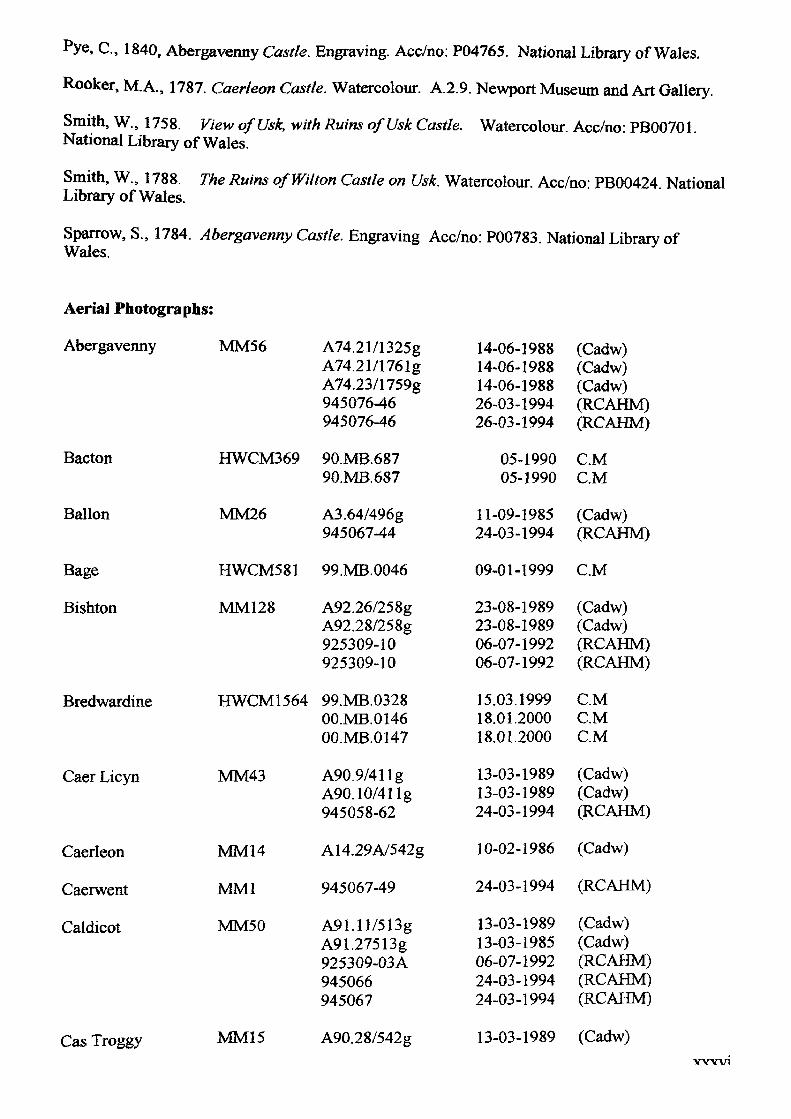
, C., 1840, Abergavenny Castle. Engraving, Acc/no; P04765. National Library of Wales.
Rooker, M.A., 1787. Caerleon Castle. Watercolour. A.2.9. Newport Museum and Art Gallery.
Smith, W., 1758. View ofUsk, -with Ruins ofUsk Castle. Watercolour. Acc/no: PB00701. National Library of Wales.
Smith, W., 1788. The Ruins of Wilton Castle on Usk. Watercolour. Acc/no: PB00424. National Library of Wales.
Sparrow, S., 1784. Abergavenny Castle. Engraving Acc/no: P00783. National Library of Wales.
Aerial Photographs:
Abergavenny
Bacton
Ballon
Bage
Bishton
Bredwardine
Caer Licyn
Caerleon
Caerwent
Caldicot
MM56 A74.21/1325g A74.21/1761g A74.23/1759g 945076-46 945076-46
HWCM369 90.MB.687 90.MB.687
MM26 A3.64/496g 945067-44
HWCM581 99.MB.0046
MM128 A92.26/258g A92.28/258g 925309-10 925309-10
HWCM1564 99.MB.0328 OO.MB.0146 OO.MB.0147
MM43 A90.9/411g A90.10/411g 945058-62
MM14 A14.29A/542g
MM1 945067-49
MM50 A91.ll/5l3g A91.27513g 925309-03A 945066 945067
14-06-1988 14-06-1988 14-06-1988 26-03-1994 26-03-1994
05-1990 05-1990
11-09-1985 24-03-1994
09-01-1999
23-08-1989 23-08-1989 06-07-1992 06-07-1992
15.03.1999 18.01.2000 18.01.2000
13-03-1989 13-03-1989 24-03-1994
10-02-1986
24-03-1994
13-03-1989 13-03-1985 06-07-1992 24-03-1994 24-03-1994
(Cadw) (Cadw) (Cadw) (RCAHM) (RCAHM)
C.M C.M
(Cadw) (RCAHM)
C.M
(Cadw) (Cadw) (RCAHM) (RCAHM)
C.M C.M C.M
(Cadw) (Cadw) (RCAHM)
(Cadw)
(RCAHM)
(Cadw) (Cadw) (RCAHM) (RCAHM) (RCAHM)
Cas Troggy MM15 A90.28/542g 13-03-1989 (Cadw)WW1
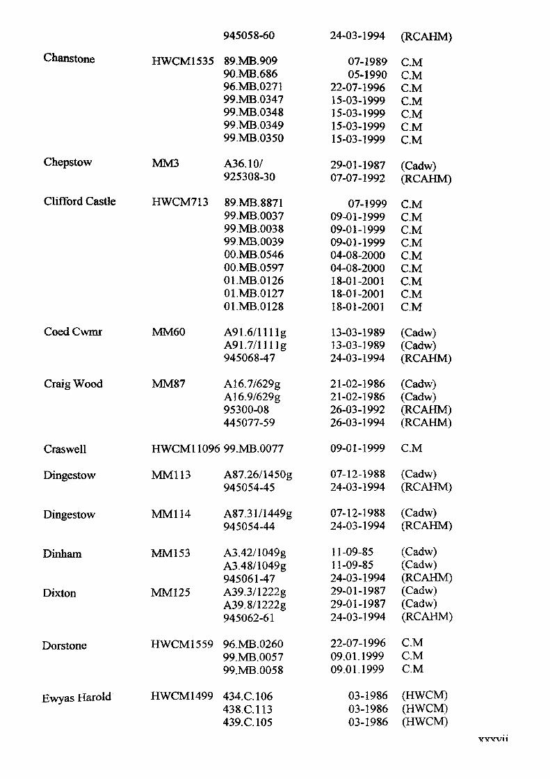
945058-60 24-03-1994 (RCAHM)
Chanstone HWCM1535
Chepstow
Clifford Castle
MM3
HWCM713
Coed Cwmr
Craig Wood
MM60
MM87
89.MB.90990.MB.68696.MB.027199.MB.034799.MB.034899.MB.034999.MB.0350
A36.10/925308-30
89.MB.887199.MB.003799.MB.003899.MB.0039OO.MB.0546OO.MB.059701.MB.012601.MB.012701.MB.0128
A91.6/llllgA91.7/llllg945068-47
A16.7/629gA16.9/629g95300-08445077-59
07-198905-1990
22-07-199615-03-199915-03-199915-03-199915-03-1999
29-01-198707-07-1992
07-199909-01-199909-01-199909-01-199904-08-200004-08-200018-01-200118-01-200118-01-2001
13-03-198913-03-198924-03-1994
21-02-198621-02-198626-03-199226-03-1994
C.MC.MC.MC.MC.MC.MC.M
(Cadw)(RCAHM)
C.MC.MC.MC.MC.MC.MC.MC.MC.M
(Cadw)(Cadw)(RCAHM)
(Cadw)(Cadw)(RCAHM)(RCAHM)
Craswell
Dingestow
Dingestow
Dinham
Dixton
Dorstone
Ewyas Harold
HWCM11096 99.MB.0077
MM113
MM114
MM153
MM125
HWCM1559
HWCM1499
A87.26/1450g 945054-45
A87.31/1449g 945054-44
A3.42/1049g A3.48/1049g945061-47A39.3/1222gA39.8/1222g945062-61
96.MB.0260 99.MB.0057 99.MB.0058
434.C.106438.C.113439.C.105
09-01-1999 C.M
07-12-1988 24-03-1994
07-12-1988 24-03-1994
11-09-8511-09-8524-03-199429-01-198729-01-198724-03-1994
22-07-1996 09.01.1999 09.01.1999
03-1986 03-1986 03-1986
(Cadw) (RCAHM)
(Cadw) (RCAHM)
(Cadw)(Cadw)(RCAHM)(Cadw)(Cadw)(RCAHM)
C.M C.M C.M
(HWCM) (HWCM) (HWCM)
YYW11
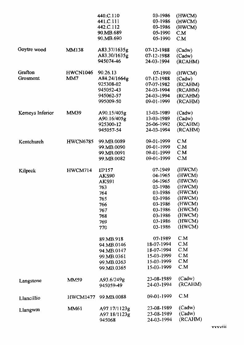
Goytre wood
Grafton Grosmont
Kemeys Inferior
Kentchurch
Kilpeck
Langstone
Llancillio
Llangwm
MM138
HWCN1046MM7
MM39
HWCN6785
HWCM714
MM59
440.C.110 441.C.111 442.C.112 90.MB.68990.MB.690
A83.37/1635gA83.30/1635g945074-46
90.26.13A84.24/1664g925308-02945052-43945062-57995009-50
A90.15/405gA90.16/405g925300-12945057-54
99.MB.008999.MB.009099.MB.009199.MB.0082
EP157AKS90AKS91763764765766767768769770
89.MB.91894.MB.014694.MB.014799.MB.036199.MB.036399.MB.0365
A93.6/249g945059-49
03-1986 03-1986 03-1986 05-199005-1990
07-12-198807-12-198824-03-1994
07-199007-12-198807-07-198224-03-199424-03-199409-01-1999
13-03-198913-03-198926-06-199224-03-1994
09-01-199909-01-199909-01-199909-01-1999
07-194904-196504-196503-198603-198603-198603-198603-198603-198603-198603-1986
07-198918-07-199418-07-199415-03-199915-03-199915-03-1999
23-08-198924-03-1994
(HWCM) (HWCM) (HWCM) C.MC.M
(Cadw)(Cadw)(RCAHM)
(HWCM)(Cadw)(RCAHM)(RCAHM)(RCAHM)(RCAHM)
(Cadw)(Cadw)(RCAHM)(RCAHM)
C.MC.MC.MC.M
(HWCM)(HWCM)(HWCM)(HWCM)(HWCM)(HWCM)(HWCM)(HWCM)(HWCM)(HWCM)(HWCM)
C.MC.MC.MC.MC.MC.M
(Cadw)(RCAHM)
HWCM1477 99.MB.0088
MM61 A97.17/1123g A97.18/1123g 945068
09-01-1999 C.M
23-08-198923-08-198924-03-1994
(Cadw) (Cadw) (RCAHM)
YYYV111
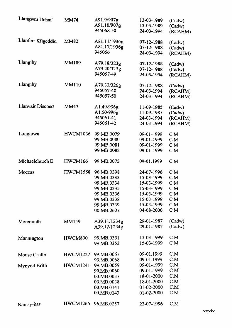
Llangwm Uchaf MM74
Llanfair Kilgeddin MM82
Llangiby
Llangiby
MM! 09
MM110
A91.9/907gA91.10/907g945068-50
A81.ll/1936g A81.17/1936g 945056
A79.18/323g A79.20/323g 945057-49
A79.33/326g945057-48945057-50
A1.49/996g A1.50/996g 945061-41 945061-42
99.MB.0079 99.MB.0080 99.MB.0081 99.MB.0082
Michaelchurch E HWCM166 99.MB.0075
Llanvair Discoed MM47
Longtown HWCM1036
Moccas HWCM1558
Monmouth
Monnington
Mouse Castle
Mynydd Brith
Nant-y-bar
96.MB.0398 99.MB.0333 99.MB.0334 99.MB.0335 99.MB.0336 99.MB.0338 99.MB.0339 OO.MB.0607
A39.ll/1234g A39.12/1234g
99.MB.0351 99.MB.0352
99.MB.0067 99.MB.0068 99.MB.0059 99.MB.0060 OO.MB.0037 OO.MB.0038 OO.MB.0141 OO.MB.0143
HWCM1266 96.MB.0257
MM159
HWCM890
HWCM1227
HWCM1241
13-03-198913-03-198924-03-1994
07-12-198807-12-198824-03-1994
07-12-198807-12-198824-03-1994
07-12-198824-03-199424-03-1994
11-09-198511-09-198524-03-199424-03-1994
09-01-199909-01-199909-01-199909-01-1999
09-01.1999
24-07-199615-03-199915-03-199915-03-199915-03-199915-03-199915-03-199904-08-2000
29-01-198729-01-1987
15-03-199915-03-1999
09-01.199909-01.199909-01-199909-01-199918-01-200018-01-200001-02-200001-02-2000
(Cadw)(Cadw)(RCAHM)
(Cadw)(Cadw)(RCAHM)
(Cadw)(Cadw)(RCAHM)
(Cadw)(RCAHM)(RCAHM)
(Cadw)(Cadw)(RCAHM)(RCAHM)
C.MC.MC.MC.M
C.M
C.MC.MC.MC.MC.MC.MC.MC.M
(Cadw)(Cadw)
C.MC.M
C.MC.MC.MC.MC.MC.MC.MC.M
22-07-1996 C.MVW1Y
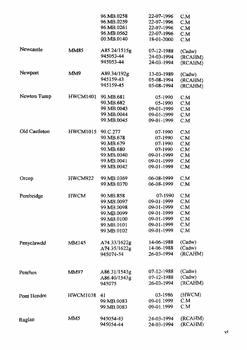
Newcastle
Newport
Newton Tump
MM85
MM9
HWCM1401
Old Castleton HWCM1015
Orcop
Pembridge
HWCM922
HWCM
Penyclawdd MM145
96.MB.025896.MB.025996.MB.026196.MB.0562OO.MB.0140
A85.24/1515g945053-44945053-44
A89.34/192g945159-43945159-45
90.MB.68190.MB.68299.MB.004399.MB.004499.MB.0045
90.C.27790.MB.67890.MB.67990.MB.68099.MB.004099.MB.004199.MB.0042
99.MB.036999.MB.0370
90.MB.85899.MB.009799.MB.009899.MB.009999.MB.010099.MB.010199.MB.0102
22-07-199622-07-199622-07-199622-07-199618-01-2000
07-12-198824-03-199424-03-1994
13-03-198905-08-199405-08-1994
05-199005-1990
09-01-199909-01-199909-01-1999
07-199007-199007-199007-1990
09-01-199909-01-199909-01-1999
06-08-199906-08-1999
07-199009-01-199909-01-199909-01-199909-01-199909-01-199909-01-1999
C.MC.MC.MC.MC.M
(Cadw)(RCAHM)(RCAHM)
(Cadw)(RCAHM)(RCAHM)
C.MC.MC.MC.MC.M
C.MC.MC.MC.MC.MC.MC.M
C.MC.M
C.MC.MC.MC.MC.MC.MC.M
A74.33/1622g A74.35/1622g 945074-54
14-06-1988 (Cadw)14-06-1988 (Cadw)26-03-1994 (RCAHM)
Penrhos
Pont Hendre
Raglan
MM97
HWCM1038
MM5
A86.31/1543g A86.40/1543g 945075
41 99.MB.0083 99.MB.0083
945054-43 945054-44
07-12-1988 07-12-1988 26-03-1994
03-1986 09-01.1999 09-01.1999
24-03-1994 24-03-1994
(Cadw) (Cadw) (RCAHM)
(HWCM) C.M C.M
(RCAHM) (RCAHM)
Yl
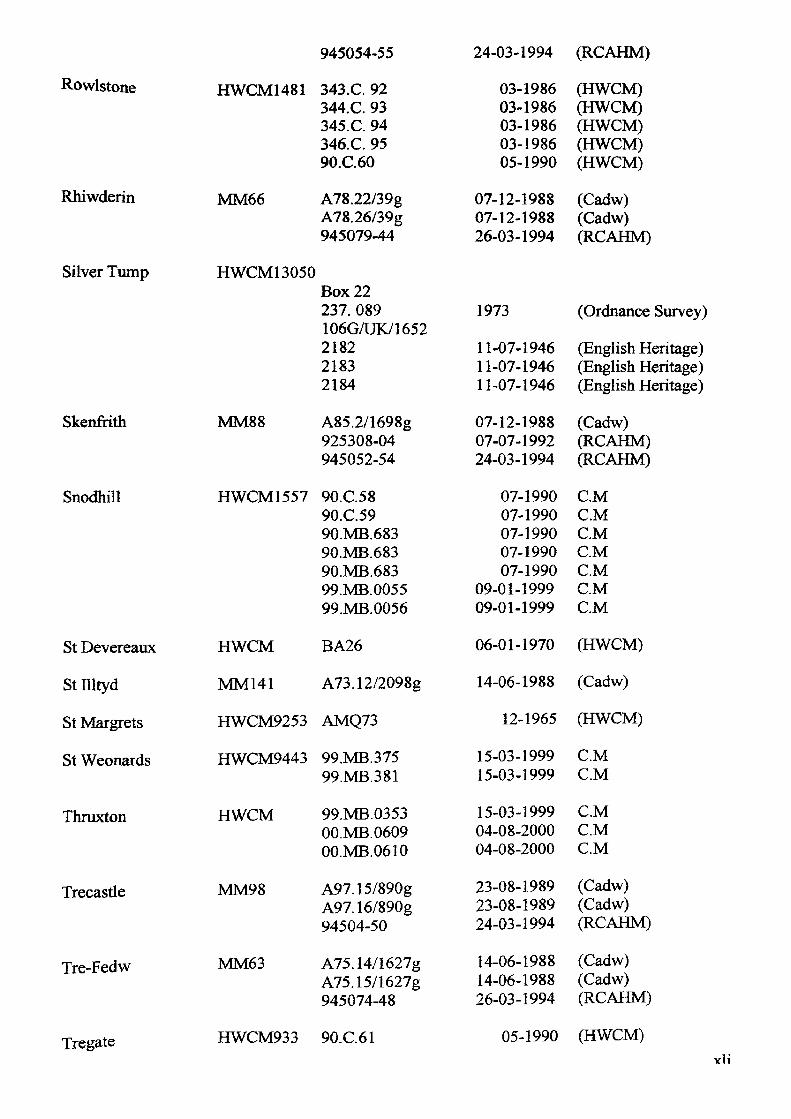
Rowlstone HWCM1481
Rhiwderin
Silver Tump
MM66
945054-55
343.C. 92344.C. 93345.C. 94346.C. 95 90.C.60
A78.22/39g A78.26/39g 945079-44
24-03-1994 (RCAHM)
HWCM 13050Box 22237. 089 106G/UK/1652218221832184
Skenfrith
Snodhill
MM88
HWCM1557
St Devereaux
St Illtyd
St Margrets
St Weonards
Thruxton
Trecastle
Tre-Fedw
Tregate
HWCM BA26
MM141 A73.12/2098g
HWCM9253 AMQ73
HWCM9443 99.MB.375 99.MB.381
HWCM
MM98
MM63
99.MB.0353 OO.MB.0609 OO.MB.0610
A97.15/890g A97.16/890g 94504-50
A75.14/1627g A75.15/1627g 945074-48
HWCM933 90.C.61
03-1986 03-1986 03-1986 03-1986 05-1990
(HWCM) (HWCM) (HWCM) (HWCM) (HWCM)
07-12-1988 (Cadw)07-12-1988 (Cadw)26-03-1994 (RCAHM)
1973
11-07-1946 11-07-1946 11-07-1946
(Ordnance Survey)
(English Heritage) (English Heritage) (English Heritage)
A85.2/1698g 925308-04 945052-54
90.C.5890.C.5990.MB.68390.MB.68390.MB.68399.MB.005599.MB.0056
07-12-1988 07-07-1992 24-03-1994
07-199007-199007-199007-199007-1990
09-01-199909-01-1999
(Cadw) (RCAHM) (RCAHM)
CMC.MC.MC.MC.MC.MC.M
06-01-1970 (HWCM)
14-06-1988 (Cadw)
12-1965 (HWCM)
15-03-1999 C.M15-03-1999 C.M
15-03-1999 C.M04-08-2000 C.M04-08-2000 C.M
23-08-1989 (Cadw)23-08-1989 (Cadw)24-03-1994 (RCAHM)
14-06-1988 14-06-1988 26-03-1994
(Cadw) (Cadw) (RCAHM)
05-1990 (HWCM)vli
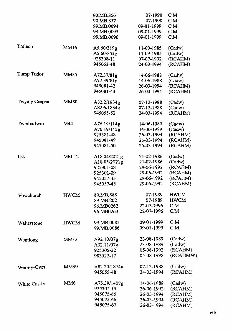
Trelech
Tump Tudor
Twyn y Cregen
Twmbarlwm
Usk
Vowchurch
Walterstone
Wentloog
Wern-y-Cwrt
White Castle
MM16
MM35
MM80
M44
MM 12
HWCM
HWCM
MM131
MM99
MM6
90.MB.856 90.MB.857 99.MB.0094 99.MB.0095 99.MB.0096
A5.60/219g A5.60/855g 925308-11 945063-48
A72.37/81g A72.39/81g 945081-42 945081-43
A82.2/1834g A82.6/1834g 945055-52
A76.19/114g A76.19/115g 925381-48 945081-49 945081-50
A18.04/2021g A18.05/2021g 925301-08 925301-09 945057-43 945057-45
89.MB.888 89.MB.202 96.MB0262 96.MB0263
99.MB.0085 99.MB.0086
A92.10/07g A92.ll/07g 925305-22 983522-17
A82.20/1874g 945055-48
A75.39/1407g 925301-13 945075-65 945075-66 945075-67
07-1990 07-1990
09-01-1999 09-01-1999 09-01-1999
11-09-1985 11-09-1985 07-07-1992 24-03-1994
14.06-1988 14-06-1988 26-03-1994 26-03-1994
07-12-1988 07-12-1988 24-03-1994
14-06-1989 14-06-1989 26-03-1994 26-03-1994 26-03-1994
21-02-1986 21-02-1986 29-06-1992 29-06-1992 29-06-1992 29-06-1992
07-1989 07-1989
22-07-1996 22-07-1996
09-01-1999 09-01-1999
23-08-1989 23-08-1989 05-08-1992 05-08-1998
07-12-1988 24-03-1994
14-06-1988 26-06-1992 26-03-1994 26-03-1994 26-03-1994
CM CM CM CM C.M
(Cadw) (Cadw) (RCAHM) (RCAHM)
(Cadw) (Cadw) (RCAHM) (RCAHM)
(Cadw) (Cadw) (RCAHM)
(Cadw) (Cadw) (RCAHM) (RCAHM) (RCAHM)
(Cadw) (Cadw) (RCAHM) (RCAHM) (RCAHM) (RCAHM)
HWCM HWCM C.M C.M
C.M C.M
(Cadw) (Cadw) (RCAHM) (RCAHMW)
(Cadw) (RCAHM)
(Cadw) (RCAHM) (RCAHM) (RCAHM) (RCAHM)
vlii
Wolves Newton MM67 A90.36/1134g 13-03-1989 (Cadw)945061-44 24-03-1994 (RCAHM)
Maps:
British Geological Survey, Geological survey of Great Britain (England and Wales). Ross-on- Wye. Sheet 215. Solid and Drift Edition.
© Crown Copyright 2000.
British Geological Survey, Geological survey of Great Britain (England and Wales). Abergavenny. Sheet 232. Solid and Drift Edition.
© Crown Copyright 1990.
British Geological Survey, Geological survey of Great Britain (England and Wales). Ross-on- Wye. Sheet 233. Solid and Drift Edition.
© Crown Copyright 1974.
Cary, J., 1787. Monmouthshire, (in) Williams, D., 1796. The History of Monmouthshire; Illustrated and Ornamented by Views of its Principle Landscapes, Ruins, and Residences. London.
Coltman, J., 1790. Monmouthshire (in) Michael, D.P.M., 1985. The Mapping ofMonmoutshire. Bristol: Regional Publications Ltd.
Melville, H., 1895. Map ofWhitney Estate. In Melville, H., 1896. The Ancestry of John Whitney. New York.
Ogilby, J., Monmouthshire 1690 (in) Ogilby, J., 1736. (4th ed.) Britannia Depicta or Ogilby Improved. London: Tho: Bowles.
Ordnance Survey, Administrative Areas Diagram. Gwent. 1:100000.© Crown Copyright 1993.
Ordnance Survey, Explorer Series. 152 Newport & Pontypool. 1:25 000.© Crown Copyright 1999.
Ordnance Survey, Explorer Series. 189 Hereford & Ross-on-Wye. 1:25 000.© Crown Copyright 1995.
Ordnance Survey 1 st edition maps 6 inch to a mile, (complete coverage). Old-maps.co.uk.
Ordnance Survey, Geological survey of Great Britain (England and Wales). Chepstow. Sheet 250. Solid and Drift Edition.
© Crown Copyright 1981.
Ordnance Survey, Geological survey of Great Britain (England and Wales). Newport. Sheet 249. Solid and Drift Edition.
© Crown Copyright 1969.
Ordnance Survey, Landranger Series. 148 Presteigne & Hay on Wye. 1:50 000.© Crown Copyright 1995.
Ordnance Survey, Landranger Series. 149 Hereford & Leominster. 1:50 000.© Crown Copyright 1999.
Ordnance Survey, Landranger Series. 161 Abergavenny & The Black Mountains. 1:50 000.© Crown Copyright 1994.
Ordnance Survey, Landranger Series. 162 Gloucester & The Forest of Dean. 1:50 000.© Crown Copyright 1998.
Ordnance Survey, IMndranger Series. 171 Cardiff & Newport. 1:50000.© Crown Copyright 1998.
Ordnance Survey, Outdoor Leisure Series. 13 Brecon Beacons National Park. Eastern Area. 1:25000.
© Crown Copyright 1996.
Ordnance Survey, Outdoor Leisure Series. 14 Wye Valley & Forest of Dean. 1:25 000.© Crown Copyright 1997.
Ordnance Survey, Royal Commission on Historical Monuments, England. Map Showing Ancient Monuments Scheduled in South West Herefordshire.
© Crown Copyright 1931.
Plan of Caerleon or Isca Silurum 1800. Gwent County Record Office. Misc MSS 1031.
Plan of Caerleon and its environs, shewing Roman Walls and Cemeteries Known in 1928 (in) Wheeler, T.V. King Arthur's Round Table at Caerleon. Transactions of The Honourable Society OfCymmrodorion, 1927-28.
Rees, W., 1932. South Wales and the Border in the Fourteenth Century, (O.S. 1932) SE Sheet.
Royal Commission of Ancient and Historic Monuments England. Herefordshire Map Shewing Division of County Into Hundreds. 1931.
Saxton, C., 1577. Monumethensis Comitatus Regis Henrici Quinti Natalitiis Celeberrimus (in) Michael, D.P.M., 1985. The Mapping of Monmoutshire. Bristol. Regional Publications Ltd.
Speed, J., 1610. The Countye OfMonmouth^ in Wales The Second Part of John Speed's Atlas. The Theatre of Great Britain, (reprint 1970). East Ardsley: S.R.Publications.
Taylor, L, 1754. New map of County of Hereford. (Hereford Library).
Wade, G.W., and J.H., 1909. A Map Showing the Sites of the Monmouthshire Castles, in Wade, G. W., & J.H., 1930. Monmouthshire. (2nd edn). London: Methuen & Co Ltd.
Willet, M., (Anon). A New and Accurate Map of the County ofMonmouth Divided into Hundreds, in Willet, M., (Anon). The Stranger in Monmouthshire andS. Wales. Chepstow: Willet. c. 1847.
vliv

vlv