no reprieve for tasmanian rock art - mdpi
TRANSCRIPT

Arts 2013, 2, 182-224; doi:10.3390/arts2040182
arts ISSN 2076-0752
www.mdpi.com/journal/arts
Review
No Reprieve for Tasmanian Rock Art
Peter C. Sims
Honorary Associate Researcher, Queen Victoria Museum and Art Gallery, C/- PO Box 692, Quoiba,
TAS 7310, Australia; E-Mail: [email protected]; Tel.: +61-3-6424-7006.
Received: 17 August 2013; in revised form: 24 September 2013 / Accepted: 24 September 2013 /
Published: 17 October 2013
Abstract: The Australian State of Tasmania, at latitude 42 degrees south, became an island
about 8,000 years ago when the sea rose to its present level, following the melting of polar
and glacial ice that covered much of the land mass. After that time, the Tasmanian
Aboriginal rock art developed independently of mainland Australia, with its form being
basically linear with some naturalistic figures and a predominance of cupules. The
petroglyphs with one lithophone site occur on various rock substrates varying in hardness
from granite to sandstone. Many sites exist along the western coastline that borders the
Southern Ocean where the landscape in some places has changed little since the arrival of
Europeans in 1803. The significance of this Tasmanian Aboriginal cultural heritage along
what is now known as the Tarkine Coast, named after an Aboriginal band that once
inhabited this area, was recognised by the Australian Government in February 2013 when a
21,000 ha strip, 2 km wide, was inscribed on its National Heritage Register, being one
of 98 special places listed in the country. However, politics and racism hamper its
management. This paper is based on the results of 40 years of field recording of the
Tasmanian Aboriginal rock art sites, many of which remain unpublished.
Keywords: Australia; Tasmania; World Heritage; National Heritage; Tarkine Coast;
Aboriginal rock art
OPEN ACCESS

Arts 2013, 2 183
1. Tasmania Its Location, European Discovery and Settlement
Tasmania is Australia’s only island state (Figure 1). At longitude 146°, latitude 41° to 43° south, it
lies in the Southern Ocean zone of the “Roaring 40s” that pound its western coastline. To the east is
the Tasman Sea and to the north it is separated from mainland Australia by the relatively shallow Bass
Strait. Named Van Diemen’s Land when it was discovered in 1642 by Dutch voyager Abel Jansz
Tasman, it was officially renamed as Tasmania in 1855, fifty two years after the establishment of the
British penal settlement by Governor David Collins (Robson 1983) [71]. To Lia Pootah Tasmanian
Aboriginal people, it is Trowernna, the land of their ancestors.
Figure 1. Australia—shaded area shows the exposed land 90,000 years ago.
During the early days of European settlement in Van Diemen’s Land, there were concerted efforts
made by the colonial authorities to remove the native people from the main island, culminating in the
Black War of 1828–1834. This undeclared war, coupled with the disastrous impact of alien diseases,
resulted in the decimation of tribal people over a very short period and the destruction of their age-old
society (Ryan 2012) [72]. Only a few Aborigines survived as wives, slaves or concubines to European
sealers and wayfarers on the Bass Strait Islands, others were absorbed into the under-class of convict
farming communities on the margins of colonial society, adopting the invaders’ language, clothing and
customs, and converting to Christianity. The ancient languages, songs and stories of the various
Trowernna tribal bands were almost completely abandoned, and relatively little of the ancient culture
was ever recorded by the colonists (Plomley 1987) [66]. For almost a century, it was widely believed
that the Tasmanian Aborigines had been “wiped out”.

Arts 2013, 2 184
Today, the descendants of the few survivors number less than 20,000 and represent 3.6% of the
total population of Tasmania (Census 2011) [21]. As with all oppressed indigenous minorities, it is
racked by horizontal violence, suffering from the appropriation of their traditional lands, as well as the
extremes of poverty, family break-down, high rates of alcoholism, poor educational outcomes, social
disharmony and pervasive discrimination. More Aborigines are jailed in Tasmania than any other
group. To make matters worse, the different families are often locked in dispute with one another.
As a consequence, the preservation and management of Aboriginal heritage in Tasmania is also
mired in on-going disputations, and this fractious political environment cannot be divorced from the
story of Tasmania’s precious, ancient rock-art.
2. Climate and Early Migration South
Early Tasmanian human occupation dates back more than 40,000 years to when sea levels were
much lower than at present, during the last Ice Age which exposed the land linking south-eastern
Australia to Tasmania (Figure 2). This land bridge allowed people to migrate southwards from what is
now known as South Australia and Victoria across the Bassian Plain, which is now submerged.
Figure 2. The changing profile of the south-eastern Australian peninsular. KEY: Grey:
Land exposed when the sea level was 60 m below current mean sea level 24,000 years ago;
Brown: Additional land exposed when the mean sea level was 95 m below current mean
sea level; yellow: land exposed about 130 m. below current mean sea level 95,000 years
ago; Green to blue: Sea depths >400 + m. below mean sea level.
At the peak of the Last Glacial Maximum about 24,000 years ago, much of inland Australia was a
“desert island” with wind-blown sand covering 80% of the land. Very low rainfall resulted in intense
fire activity. Unimaginably inhospitable conditions in northern Australia forced wildlife and
Aboriginal people to migrate to cooler, well-watered, wooded coastal areas in the south-east, which
would have seemed especially inviting (White 1997: 47) [98].

Arts 2013, 2 185
The commencement of the glacial recession led to the gradual drowning of the exposed land, until
the sea levels stabilised at around their present location between 5,000 and 8,000 years ago (Figure 2).
With the separation of the two land masses, the first Tasmanians were “stranded” by the rising seas.
Their culture developed from that time onwards independently of their mainland relatives. In northern
Australia, Aboriginal legends speak of this rise in sea levels as a “big flood”. Australian palaeobotanist
Mary White determined that the sea level rose of the order of 15 mm per year, with the horizontal land
loss on the flat coastal plains being nearly one metre per week (White 1997: 213) [98].
In 1974, an archaeologist Sandra Bowdler found Aboriginal occupational material evidence that
dated back 23,000 years during an excavation of a cave on what is now Hunters Island, about 6 km off
the north-west corner of Tasmania. From the evidence she unearthed, it was determined that food came
not from the sea, as the nearest coast would then have been 75 km away to the west, but from plants
and animals of the inland plains. It was not until 8,000 years ago, when the present coastline formed
with the melting of the polar and glacial ice, that the diet of the Hunter Island cave’s inhabitants
changed to include shellfish, seals and sea birds from the coast (Bowdler 1974) [18].
Earlier dates have been obtained from the caves in the river valleys of the south-west of the
Tasmanian main island, and at an inland rock shelter Parmerpar Meethaner, which is at an elevation of
200 m in the upper Forth River valley in the north-west, where human occupation extended from
c.34,000 BP to c.780 BP (Cosgrove 1995) [25]. More recently, the Jordan River Levee site at Brighton
in the southern Tasmanian Midlands was placed on the National Heritage List as it was found to
contain Aboriginal cultural material dating back to approximately 42,000 years (Neales 2011) [60], the
earliest date so far recorded in the whole of the Tasmanian archipelago.
3. Hand Stencils, Bark Drawings and Body Cicatrices
Sometime after the Dutch sighting, and prior to the establishment of the penal colony in Van
Diemen’s Land by the British in 1803, some contact with Tasmanian Aboriginal people had been
made by French explorers who were undertaking scientific expeditions. During the Baudin expedition
in 1772, for instance (Plomley 1983) [65], naturalist François Péron provided an account of Tasmanian
Aboriginal drawings, charcoal characters on bark (Figure 3), noting the similarity of these to the
decorative scars, or cicatrices, that adorned the bodies of the adults (Péron 1924) [63].
Figure 3. Charcoal drawings found on bark.

Arts 2013, 2 186
The observations of these bark drawings and cicatrices on the bodies of Aborigines (Figure 4) that
were made by these early French maritime explorers, as well as a few descriptions made by some of
the 19th century British colonists who followed (Plomley 1992) [67], provide the only documentary
evidence of this part of the way of life of the early Tasmanian Aboriginal people.
Figure 4. Bara-Ourou, a native of Maria Island, showing his cicatrices.
According to colonist James Bonwick, the Aboriginal “conciliator” George Augustus Robinson
observed some “drawings” during his long walks “rounding up” of the last tribal Aborigines in the
1830s (Bonwick 1870) [17]. However, it was not until 1958 that any paintings on rock surfaces were
re-discovered and documented (de Teliga and Bryden 1958) [92]. The first of these was an ochred
hand stencil found in a cave in the Derwent River valley in southern Tasmania. Over the next
twenty-five years, three more examples of hand stencils were located, two in the Derwent River valley
and one in the south-east, at Tasman Peninsula (Stockton 1977a; Gaughwin 1985) [37,87]. All of these
are in sandstone shelters, and made with red and yellow ochre. The discovery of another hand stencil
in the Blue Tier more recently has not yet been confirmed.
Thankfully, many of Tasmania’s most outstanding Aboriginal cultural heritage sites are situated in
a range of reserves. Thirty years ago, UNESCO inscribed some of Tasmania’s national parks as World
Heritage Areas, and earlier this year, an additional area was added, bringing the total of Tasmanian
land mass classified as World Heritage to 1,582,183 ha. (Figure 5).
The Western Tasmanian World Heritage Area was established under the Commonwealth World
Heritage Properties Conservation Act 1983, however, the extensive limestone cave systems and forests
in the remote south-west river valleys were not included in it (Figure 6 Site 1). Discoveries deep
within the dark recesses of several of these caves subsequently revealed ochred hand stencils
(Cosgrove and Jones 1989) [26]. As a result of these cave galleries being investigated, a vigorous
campaign was mounted to enlarge the World Heritage Area, and, in 1989 (Tasmanian Gazette 1989)
[90], the original area was extended to include this rich undisturbed suite of Pleistocene Aboriginal
sites dating back over 34,790 years and bearing testimony to an Ice Age society (Flood 1999: 119)
[33]. This became known as the Tasmanian Wilderness World Heritage Area.

Arts 2013, 2 187
The rock art in the Tasmanian Wilderness World Heritage Area compares very favorably in terms
of antiquity and cultural significance with the rock art that is located in mainland Australian World
Heritage Areas, such as Kakadu, Purnululu and Uluru-Kata Tjuta.
Figure 5. Tasmanian Wilderness World Heritage Area (green) as extended in 2013.
In 1995, in an act of reconciliation by the Tasmanian State Government, a small parcel of land
(730 ha) within the boundaries of the Tasmanian Wilderness World Heritage Area and containing
three cave sites known as Kutikina, Wargata Mina and Ballawinne was returned to the Tasmanian
Aboriginal community. This land is being held in trust by the Aboriginal Land Council of Tasmania as
the managing agency (Tasmania Parks and Wildlife Service 1999) [91].
Two petroglyph sites, one at Port Davey (Site 16) and the other at a remote and virtually
inaccessible part on the south-west coast (Site 15) also exist in the Tasmanian Wilderness World

Arts 2013, 2 188
Heritage Area. In addition, there are petroglyph sites located inland and on the coast outside of the
World Heritage Area (Figure 6), with various degrees of access and protection.
Figure 6. Location key to the main rock art sites in Tasmania, which will be referred to in
the text . KEY: 1. South-west hand stencils; 2. Blue Tier (Meenamatta); 3. Daisy Dell
(Cradle Mountain); 4. Central Plateau; 5. Mersey Bluff (Devonport); 6. Three Hummock
Island; 7. Cape Grim; 8. Mt Cameron West (Preminghana); 9. Sundown Point; 10. Nelson
Bay River; 11. Ordnance Point; 12. Greenes Creek; 13. Monster Creek; 14. Trial Harbour;
15. South-west coast cave; 16. Port Davey (Bond Bay).
4. Tasmanian Highland Petroglyphs
In the Tasmanian highlands, there are known to be at least three petroglyph sites. The site at Blue
Tier (Site 2) in the north-east is at an elevation of about 800 m where there are extensive views inland
to the high peaks of Mt Victoria and Ben Lomond, and views of the nearby coast and the eastern
Furneaux Islands. On these islands and on the Tasmanian mainland coast, there are many early
Aboriginal occupation sites to be found, some dating back over 21,000 years when this part of the land
was connected via the land bridge (Flood 1999: 208–220) [33].
Early last century, the Blue Tier was subject to exploration and mining for tin, and some rock
markings claimed by Aboriginal people as the work of their ancestors are the result of those activities.
When visiting Blue Tier 40 years ago, in the footsteps of Jessie Luckman (1957) [51],

Arts 2013, 2 189
Michael Sharland (1957) [74] and Frank Ellis (1958) [29], I saw those markings and confirmed that
they were made by miners’ metal tools, and that other markings nearby were of natural origin
(Sims 1977) [76].
However in 2007, I had cause to follow up a more recent discovery of other rock markings in the
same general area. It was immediately apparent to me that those markings were indeed petroglyphs.
This site is now known as Meenamatta by the local Aboriginal Custodians, the Noiheener Group. Its
suite of cupules (Figure 7) and grooves has also been examined by Robert Bednarik, who found
conclusive evidence of their anthropogenic origin (Bednarik et al. 2007; Sims 2007) [15,80].
Figure 7. Cupules at Meenamatta.
The Meenamatta site is on Crown land, classified as a Forest Reserve and managed by the
Tasmanian State Government’s agency for forests management, Forestry Tasmania. At the time,
Forestry Tasmania was attempting to demonstrate that tourism and industrialised native forest logging
can co-exist, as the forestry industry was under pressure to exit native forest logging in favor of a more
sustainable plantation-based industry. So Forestry Tasmania managers planned to construct a walking
track for tourists on the Tier, which would have compromised the site. Despite the disclosure that there
was an Aboriginal heritage site nearby which the Noiheener Group considered to have ceremonial
significance, being an important link to their ancestors (Cameron 2011) [20], the State Government’s
regulatory body, the Forest Practices Authority refused to re-route Forestry Tasmania’s walking track,
and proceeded then to engage archeological consultants in an attempt to refute the authenticity of the
petroglyphs (Field and McIntosh 2009) [31]. Even though this action was contrary to the expressed
wishes of the Traditional Custodians (Figure 8) and even though the authenticity of the site had by
then been scientifically confirmed, the State Government’s Aboriginal Heritage Office stood by and
failed to intervene, or even to acknowledge or record Meenamatta on the Tasmanian Aboriginal Site
Index (TASI) (Bednarik et al. 2010) [16]. The irrationality of these actions and
non-actions by the Tasmanian State Government agencies only makes sense when it is known that the
Aboriginal Heritage Office staff do not recognise the Aboriginality of the Noiheener Group.

Arts 2013, 2 190
Figure 8. Cupules at Meenamatta being observed by a Noiheener Group Elder.
A similar lack of respect, and inaction on the part of Tasmanian authorities to protect Aboriginal
rock art occurred not long afterwards at another inland site (Site 3) at an elevation of 800 m at Daisy
Dell, near the famed Cradle Mountain on the northern edge of the Tasmanian Wilderness World
Heritage Area. Despite an earlier published report of this cupule petroglyph site (Sims 2008a) [81],
and the discovery of additional Aboriginal cultural relics nearby, including the fragile skeletal remains
of a wooden shelter (called a mia-mia), perhaps the last remaining one in the State (Figure 9), there
was no on-ground inspection or assessment of any of this material evidence by the Aboriginal Heritage
Office, and no objection by that Office to the plantation developers’ plans to clear-fell the old-growth
native forests in which the rock art and the mia-mia were situated. The Executive Director National
Parks and Strategic Projects who was responsible for the Aboriginal Heritage Office at that time
advised the neighbouring landowner and members of the Six Rivers Aboriginal Corporation in
Devonport that “the best way forward is for the structure to be carefully photographed and for
measured drawings to be taken and then for it to be left alone to decay. It can be excavated at a later
date if necessary” (Gadd 2009) [36], but he did nothing to instigate those measures himself.
As the bulldozers were preparing to commence clear-felling the land, it seemed to the Six Rivers
Aboriginal Corporation that the only way to try to protect their heritage was to publicly expose the
situation in the media (Kempton 2009) [45]. Unfortunately, the media attention awoke the ire of
pro-forestry vandals who destroyed the mia-mia (Killick 2009) [46] and fire-bombed a nearby
Aboriginal shelter tree for good measure. The distress of the Six Rivers Aboriginal community and the
story of the destruction of the mia-mia attracted the attention of Sydney-based architectural PhD
student Jacqueline Power whose analysis of contested heritage was presented at an international
conference in Wellington, New Zealand (Power 2010) [68], but the Tasmanian authorities turned a
blind eye. Tasmania Police declined to act on the mia-mia’s destruction because it was not registered
on TASI by the Hobart-based Aboriginal Heritage Office as its staff declined to investigate it,
a catch-22.

Arts 2013, 2 191
Figure 9. The remains of the Daisy Dell mia-mia prior to its destruction by vandals.
The nearby cluster of cupules at Daisy Dell have been pecked, abraided or drilled on to 13 exposed
basalt rocks (Figures 10 and 11). These intentional cupules may have served a ceremonial or utilitarian
purpose in ancient times, when the now thickly forested sub-alpine area was dry grasslands or open
woodlands. The site is just one day’s walk from one of the earliest Aboriginal occupation sites in
Tasmania in the nearby Forth River valley, known as the Parmerpar Meethaner rock shelter (Cosgrove
1995) [25]. As the glacial ice melted from this high country about 10,000 years ago, grassy vegetation
would have gradually re-established itself on the sub-alpine plains, attracting browsing animals which
were a food source for the Aboriginal people, ideal for summertime hunting parties.
Figure 10. Cupules on one of the exposed basalt boulders at the Daisy Dell site.

Arts 2013, 2 192
Figure 11. One of the smaller rocks with cupules.
The Daisy Dell cupules bear close resemblance to the cupules found at sites in other parts of
mainland Australia, as well as overseas (Bednarik 2008) [11]. Indeed, the cupules at both of the
Tasmanian highland sites (2 & 3) are similar to those found in the Henan Province in China (Huisheng
2012) [42], in Iran (Lahafian 2010) [47] and in France (Hameau 2012) [38].
About 40 m away from this cupule cluster is a single petroglyph, consisting of a part-elliptical motif
pecked into the surface of an isolated flat basalt rock (Figure 12). There are no cupules on this
particular rock or on adjacent rocks, which suggests that this part of the site may have had a separate
function, such as being used to reinforce stories of past events.
Figure 12. A part-elliptical pecked figure on highland basalt at the Daisy Dell site.

Arts 2013, 2 193
Another highland site is located on the Central Plateau at 1,100 m (Site 4). It consists of impressive
concentric elliptical circles on the central face of a near vertical dolerite rock 3.7 m high by 1.5 m wide
(Figure 13). This remote site is within the Tasmanian Wilderness World Heritage Area. It was
inspected in 1999 by an archaeologist and an Aboriginal heritage officer who considered it to be an
Aboriginal rock “engraving” that dated back more than 10,000 years (Darby 1999) [27]. Three years
previously, the site had been reported to the Aboriginal Heritage Office manager who discouraged any
assessment “due to its remote location”, and suggested that “vandalism may occur should the site be
disclosed to the public” (Darby 1999) [27].
Figure 13. The impressive concentric elliptical circles on dolerite in the central highlands.
When visiting this site in 2004, I found the whole area abounding in wildlife. The open woodlands
had expansive marsupial lawns and abundant fresh water, making it ideal for excursions,
ceremony-making and hunting parties during the tribal times. There were also some stone flakes
nearby, evidence of those earlier visits. The high country of the Central Plateau had been utilised by
the Aborigines for at least 10,000 years (Lourandos 1983) [48]. It was the land of the Big River people
whose territory extended all along the Derwent River to the south, although it would have been also
visited by other bands from elsewhere who made seasonal forays into the highlands, with activities
intensifying as the climate warmed about 3,200 years ago (Smith et al. 1996) [85].
Although there has been some debate about whether or not the rock markings at this site are
anthropic in origin, or natural, an investigation by Robert Bednarik in 2010 detected traces of impact

Arts 2013, 2 194
on the lower parts of the grooves more recent than the severely weathered natural grooves and
depressions in the rock surface, confirming that it is at least partially anthropic. While the markings are
high up on the rock surface, Tasmanian Aborigines were adept at climbing trees, and it would have
been relatively easy for them to prop large branches up against the face of the rock, and to climb these.
Bednarik’s conclusions were that “this is a natural marking attributable to inherent characteristics of
the rock fabric, but it has been partly modified by human hand at some time in the Holocene. In the
absence of any ethnographic evidence, the markings as a whole should be regarded as having been of
considerable significance to traditional societies since it was first seen” (Bednarik 2010a) [12].
5. The Significance of Tasmanian Xenoliths
Xenoliths are naturally occurring rock features or surface markings resembling a petroglyph
(Bednarik 2007a: 211) [8], and they play an important part in Aboriginal culture. The Wardaman
Traditional Owners and custodians from the Victoria River district in the Northern Territory, for
instance, do not distinguish between anthropic and non-anthropic marks, as they consider some or both
have been “made in the Dreamtime” (Flood 2006) [34]. The Central Plateau site in Tasmania is one
such example (Bednarik 2007a: 18) [8].
Probably the most extensive Tasmanian xenolith site exists on exposed rocks at Mersey Bluff,
Devonport (Site 5). There are 270 separate markings in total, and all are on the horizontal surface of
Jurassic dolerite. They were first reported by Stuart Dove in 1923 (Dove 1923) [28] and ten years later
the local schoolmaster Archibald Meston presented a paper about them to the Royal Society of
Tasmania (Meston 1932) [54]. This followed his re-discovery of the Mt Cameron West rock markings
in the far north-west coast (Meston 1933) [55]. At the request of the Director of the Tasmanian
Museum, Dr Bryden, I submitted an article to the Royal Society on what we both believed was a
depiction of the now extinct Tasmanian emu (Figure 15) (Sims 1970) [75].
Figure 14. A motif at Mersey Bluff, resembling an abalone (Haliotis ruber) shell (40 cm
diameter).

Arts 2013, 2 195
Figure 15. A motif at Mersey Bluff, resembling the now extinct Tasmanian emu
(Dromaius novae-hollandiae).
Over the years, the Mersey Bluff site has been visited by many people, and the history of the site is
now documented in an audit commissioned by the local Mersey Leven Aboriginal Corporation
(Sims 2008b) [82]. Some academics have attempted to refute the anthropogenic origin of these rock
markings (Scott 1931; Murray 1980) [58,73], but their views have not swayed local Aboriginal people
from considering this a most significant cultural place. An investigation by a consulting geologist in
2008 concluded that the “rock markings currently on view at Mersey Bluff are in most instances
clearly superimposed on, and incised through these natural discontinuities in the Jurassic dolerite. An
anthropogenic origin for the rock markings cannot reasonably be discounted based on geological
evidence” (Evans 2008) [30]. Samantha Higgs, an archaeologist, concluded that “one circular shape in
particular (Figure 16) was the most convincing of cultural origin, and that part of some of the
shallower markings have been added to existing natural markings by humans to create an image”.
Whilst she did not discount that the markings did or do not have cultural significance to the local
indigenous people, she did recall that, in Western Australia, she had “observed engravings that mimic
fossils on the same rock outcropping, noting that the Traditional Owners there do not appear to
distinguish between them in terms of meaning or significance” (Higgs 2009) [40].
Figure 16. Concentric circular rock marking at Mersey Bluff, Devonport.

Arts 2013, 2 196
My own theory is that the rock “engravings” may have been made when the rocks were “soft”, not in
the Dreamtime, but during a period of natural decomposition of the dolerite. During some fieldwork in
1974, I observed that where the surface of dolerite is below ground level, it often appears to have
“decomposed” in places, sometimes to the point where it can easily be marked with a sharp rock or
even a pointed stick. Upon sustained exposure to air and the elements, the “soft” rock surface hardens.
It would be good to see some work undertaken to progress this line of inquiry.
The popularity of the whole of the Bluff site inspires ongoing debate about Tasmanian rock art, its
meanings and its preservation. The Bluff is a dominant feature of the coastal landscape overlooking
Bass Strait, with extensive views along the northern coastline to the east and west. As such, it is a
strategic communication location with views stretching far into the hinterland and towards the high
mountain country, near to freshwater with the remains of an ancient midden, an ochre outcrop, stone
tool-making deposits, and with safe beaches of pebbles and sand on both sides. The deep waters off the
rocky headland are still regularly fished for its abundant marine life, including abalone.
The Mersey Bluff has strong cultural significance to the local Six Rivers Aboriginal Corporation
who operate Tiagarra, an Aboriginal “keeping place” and cultural centre nearby. During its official
opening in 1976 by the then Governor of South Australia, the late Sir Douglas Nicholls KCVO OBE
JP who was himself a Victorian Yorta Yorta Aboriginal Elder, I listened intently as he shared with us
his childhood memory of seeing an outline of a whale on a rock at the Mersey Bluff. To him too, this
was definitely a “very special place” (Nicholls 1976) [61]. Realising the significance of the Bluff to
the local Aboriginal people, the local Devonport Council has taken measures for its protection, and the
area is well respected by the wider community. Some of the rock markings are linked to a scenic
walkway on the Mersey Bluff headland (Figure 17) which is used for Aboriginal cultural heritage
interpretation and as a local tourist feature (Sims 2008b) [82].
Figure 17. Mersey Bluff and the City of Devonport on the Mersey River.
Xenoliths can project the human spirit on to a range of representations in rock formations, creating
myths and legends that link us to ancestral beings or natural objects relating to everyday life
(Helvenston and Hodgson 2010) [39]. On the west coast, for example, there is a natural rock feature
approximately 8 m high (Figure 18) situated on the exposed shoreline, the silhouette of which
resembles a tribal Aboriginal woman with a child, looking out to sea. This xenolith is now within the
National Heritage Listed Western Tasmanian Aboriginal Cultural Landscape that stretches along the

Arts 2013, 2 197
wind-swept Southern Ocean coastline for 110 km no further than 2 km from the low water mark. This
coastal strip includes some of the best evidence of the traditional lifestyle of the ancient people in this
western region of Tasmania, with the remains of numerous hut depressions, stone arrangements,
petroglyphs and extensive middens.
The process of Tasmanian Aboriginal people re-discovering and re-connecting with these remnants
of an unusually specialised and nomadic way of life, based on the hunting of seals and land mammals
and the gathering of shellfish, is still in its early stages.
Figure 18. The rock feature silhouetted against the evening sky on the Tarkine Coast.
6. Petroglyphs of the West Coast
The main concentration of petroglyph sites occurs on the west coast, where ten sites are located
right on the coastal margins. One of these sites on Three Hummock Island is just 23 km off the far
north-west in western Bass Strait (Site 6), the only island site, with 7,200 ha gazetted as a State
Reserve in 1957. It is part of the Hunter Island Group between the Tasmanian mainland and
King Island.
On the western side of Three Hummock Island at Coulomb Bay, there are a series of circles pecked
onto the sloping face of a large shoreline granite boulder (Figure 19). About 4 km distance away from
here to the west, lies Hunter Island where Aboriginal occupational evidence has been dated to 23,000
BP at Cave Bay at a time when sea levels were at their lowest (Bowdler 1974) [18]. When the seas
rose to their present levels, only about 5 km separated Hunter Island from mainland Tasmania. In
journals of 1832, George Robinson reported that the Aborigines visited Three Hummock Island
seasonally, there being plenty of grass for marsupials, as well as seals and mutton birds
(Puffinus tenuirostris) to be found on the rocks (Plomley 1966: 667) [64].
Facing the Southern Ocean, further south, but also in the far north-west, lies Cape Grim (Figure
20), a site of sorrow where employees of the pastoralist Van Diemen’s Land Company massacred an
entire tribal group, throwing women and children off the cliffs onto rocks. Here on 24 June 1830,
Robinson wrote in his diary that there was a drawing to be found of “a circle with dots around it, on
the side of a cliff where there was a beautiful spring of water” (Plomley 1966: 183, 233) [64]. This

Arts 2013, 2 198
petroglyph has not been seen since then, not even by eminent archaeologists visiting in 1969 (Site 7).
The markings of the site may have weathered away, or disappeared completely due to coastal erosion.
Figure 19. Three Hummock Island petroglyphs on granite, adjacent to a mutton bird rookery.
Figure 20. Cape Grim, Southern Ocean, north-west Tasmania.
A short distance south of Cape Grim is the Mount Cameron West petroglyph site (Site 8) which is
widely regarded as being of international cultural significance (Hughes, Watchman and Sullivan
1981) [41]. This is arguably the most outstanding petroglyph site in all of Tasmania. It faces the
Southern Ocean, and is located 3 km north from Mt Cameron West, at the northern end of the beach
(Figure 21). This site, and the adjacent 545 ha of the Woolnorth pastoral property were acquired from
the Van Diemen’s Land Company in 1977, and formally gazetted as a State Reserve. Named
Preminghana in 1999, it was declared an Indigenous Protected Area, and was one of several parcels of
Crown land that the Tasmanian State Government returned to the Aboriginal Land Council of
Tasmania in perpetuity (Aboriginal Lands Act 1995) in a gesture of reconciliation.
These Aboriginal rock engravings were first reported in 1932 by Devonport schoolmaster Archibald
Meston, who acknowledged hearing about them from shepherds working on the Van Diemen’s Land
Company’s property (Meston 1933) [55]. His descriptive publication with photographs gained the
attention of stonemason Leo Luckman who visited the site in February 1950. Luckman noted that there
was another cliff face with similar engraved rocks 15 m to the south of the main site. Some of those
rock slabs had fallen and been broken into three pieces lying on the sandy beach. As they were eroding

Arts 2013, 2 199
badly, two of the fallen fragments were taken away to Launceston’s Queen Victoria Museum and Art
Gallery. For a time, they formed part of a display (Luckman 1951) [50].
Figure 21. Preminghana site with the view south to Mt Cameron West.
When I first visited this remote location in the early 1960s, most of the remainder of the broken
cliff face described by Luckman was covered with drifting sand. However, a colour slide taken by one
of our party (Figure 22) shows that the main rock art gallery was then still intact.
Figure 22. Mount Cameron West site in the early 1960s.
After my visit, the Hobart-based Tasmanian Museum and Art Gallery salvaged another of the major
engraved rock faces from the main site, to save it from the elements that they claimed were threatening
to destroy the entire site. An engraved rock slab (Figure 22, on left and Figure 48) was sawn off and
taken back to the museum in Hobart, where for many years it, too, went on public display (Sims
2006b) [79], alongside the bones of Truganini, reputedly “the last of the Tasmanian Aborigines”.
In 1969, the Mount Cameron West site was a focus of the attention by the Australian National
University’s Department of Prehistory, with staff members from the Research School of Pacific
Studies and other eminent archaeologists undertaking an excavation and making casts of the exposed
motifs. Rhys Jones found that the petroglyphs may have been made between 2,000 and 1,000 years

Arts 2013, 2 200
ago before the site was abandoned at around 850 years ago (Jones 1983) [44]. material evidence next
to the petroglyphs being carbon-dated to 1,350 years BP. Jones concluded that the motifs had been
made by punching or grinding a series of holes into the soft “calcarate” (aeoleonite dunerock
sandstone) and then by abrading the ridges between them, so as to form deeply abraded lines. During
these excavations, some large pointed core tools made from hard quartzite and basalt were found,
which were thought to have been the chisels used.
The ANU excavations revealed a matrix of geometric non-figurative motifs that covered nearly
every face of rock, causing some of the pieces to resemble a sculpture (Figure 23). Circles, trellises
and rows of dots formed intricate patterns, parts of composite designs occupied by crosses, parallel lines,
and one rock face, since removed, was surrounded with a large circle (Mulvaney 1969: 166–171) [57].
Figure 23. Part of the 1969 excavation of the Mt Cameron West site with the “sculptured”
rock (right). Note the bare slab (centre left) where the surface had earlier been removed by
Hobart’s Tasmanian Museum and Art Gallery (see Figure 48).
Fred McCarthy, then Principal of the Australian Institute of Aboriginal Studies, was a member of
the excavation team from the ANU. He reported the discovery of exposed rocks, separated from the
main gallery, with “large engraved bird tracks, probably of the extinct emu”, saying that he considered
these “the finest example of bird tracks in Tasmania” (McCarthy 1969) [52].
When I visited the site in 1974, I found another group of exposed rocks of the same composition, a
few hundred metres inland from the main site, beside a small freshwater soak. Here, there are more
motifs, including a well formed circle, lines and what appeared to be an animal print (Figure 24).
There is only one other petroglyph site known to me with a representation of an animal print, and it is
on the same rock substrate in the south-west cave at Site 15 (Figure 45).
Figure 24. This exposed petroglyph has subsequently eroded away and been lost.

Arts 2013, 2 201
McCarthy considered the Mt Cameron site to be just as important as Abu Simul in Egypt, where
several hundreds of millions of dollars were being spent at that time to raise the ancient temples above
the rising waters of the Aswan Dam. He remarked that “similar measures should be undertaken to
preserve this Tasmanian site” (McCarthy 1969) [52]. It was an ideal that could not be realised.
Since my 1974 visit, the main petroglyph site has been deliberately buried in sand in an attempt to
conserve the engravings. The extensive sand dune system surrounding the site was also planted out
with marrum grass (Ammophila arenaria) to try to stabilise the sand and to protect further the rock art
gallery (Hughes, Watchman and Sullivan 1981; Stockton 1982) [41, 89]. The marrum grass has
flourished, but in so doing, it has altered the landscape forever. (Figure 25).
Figure 25. The stabilised Preminghana petroglyph site in 2013, a landscape so different
from earlier times.
Further down the west coast, south of Mt Cameron West (Preminghana), is a section of the Arthur
Pieman Conservation Area, now called the Tarkine Coast, in recognition of the Tarkiner people who
occupied the Sandy Cape region, for many thousands of years. This area’s cultural heritage was
recognised by the Australian Government in February 2013 when a 21,000 ha coastal strip, 2 km wide,
was inscribed as the Western Tasmania Aboriginal Cultural Landscape on the National Heritage
Register (Commonwealth 2013) [23]. The Western Tasmania Aboriginal Cultural Landscape is now
one of 98 special places listed in Australia, all containing rock art sites. Other areas on the National
Heritage Register include Dampier Archipelago (Burrup Peninsula), Purnululu National Park and the
West Kimberley in Western Australia; Uluru and Kakadu National Park in the Northern Territory, and
Ku-ring-gai Chase National Park in New South Wales (National Heritage List 2013) [59].
Within this Tarkine Coast National Heritage Area, there exist five petroglyph sites (Sundown Point,
Nelson Bay River, Ordnance Point, Greenes Creek, Monster Creek). All of these bear a close
resemblance to the petroglyphs in the Southern Flinders Ranges of South Australia (Figure 29). The
sites at Sundown Point (shown on early maps as “Swandown Point”) (Tooley 1975) [93] (Figure 26),
Nelson Bay River (Figure 27) and Monster Creek (sometimes referred to as the Interview River or
Chimney Creek site) (Figure 28) (Sims 2012) [83], all have non-naturalistic motifs pecked onto
relatively flat rock surfaces.

Arts 2013, 2 202
Figure 26. Sundown Point Site 9 is a complex site consisting of many different motifs.
Figure 27. Nelson Bay River Site 10, now washed by the tides or covered by sand.
Figure 28. Monster Creek Site 13 on the beach, just above the high tide mark.

Arts 2013, 2 203
When I recently visited a rock art site at Orroroo, in South Australia (Figure 29), I noted a
similarity in both the design and the methods used. Both the Tasmanian and South Australian sites
appear to be very old with the Tasmanian sites now badly eroded away to just the base of the engraved
markings, which were likely to have been much deeper originally.
Figure 29. The Orroroo site in South Australia, 2013.
This similarity in “style” extends to a site at Huddleston, also in South Australia, which I liken to
the site at Trial Harbour (Site 14), on Tasmania’s west coast. Huddleston, 65 km inland from Port
Pirie, was first reported by Charles Mountford in 1928 in his paper on the South Australian
Aboriginal rock carvings, which was accompanied by an illustration (Figure 30) (Mountford 1929;
Flood 1997: 49) [32,56]. (Figure 30)
Figure 30. Drawing of the Huddleston petroglyphs—as reproduced by Mountford 1929.
Both of these petroglyph sites are on isolated boulders, and both have very similar circles and
cupules pecked onto a very hard rock surface. The Trial Harbour site is a free standing, rounded
granite boulder with a series of engraved circles and cupules (Figure 31). It is associated with a shell

Arts 2013, 2 204
midden (undated), indicating that this was also an Aboriginal occupation site. The Huddleston site
(Figure 32) is also a rounded boulder, of similar dimensions, but it differs in that it is quartzite and not
free standing, being partially buried in soil. The circles and cupules are very similar at both sites, and
have probably been associated with traditional ceremonies of one form or another.
Figure 31. The Trial Harbour site in Tasmania, showing similarities with the Huddleston
site in South Australia. (Figure 32).
Figure 32. The Huddleston site in South Australia.
Apart from the Huddleston site being inland and the Trial Harbour site being on the coast, the main
difference between these two sites is that the Trial Harbour site is a lithophone, as it rings with a
metallic sound when tapped with a rock. This is the only known petroglyph of its kind in Tasmania.
The term lithophone defines a musical instrument consisting of rock pieces (disks or slabs) that
produce musical notes when struck. Such lithophones or rock gongs are found all around the world.
Instances of them have been reported in Africa, Asia and North America (Bednarik 2008: 74, 75) [11].
For example, the “gong rock” (Figure 33) at a Serengeti Bushman’s site in East Africa is a feature of

Arts 2013, 2 205
safari tours. The upper surface of this isolated rock is covered with cupules used to this day by visitors
who are fascinated by the sounds coming from it (Australian Broadcasting Com. 1998) [1].
Figure 33. The “gong rock” at Serengeti Plains Tanzania, East Africa.
This acoustic phenomenon has been linked to the production and distribution of rock art. Based on
the assumption that sound and echo have been associated with the spiritual world in various cultures
and mythologies, it has been suggested that “sound-reflecting locations such as caves, canyons and
cliff faces are prime spots for artistic activity” (Achrati 2006) [2]. Sound adds another dimension to
rock art (Waller 1993) [94], an observation supported by Paul Bahn, who claimed that sound was a
“factor in whatever ceremonies accompanied rock art production, and may indeed have been the direct
inspiration of the positioning and/or content of such a depiction” (Bahn 1993) [4].
The Trial Harbour site was first reported in 1937 by J.F. Jones who presented a paper with
illustrations to the Royal Society of Tasmania (Figure 34). In addition to making note of the circular
engravings that feature on it, he mentioned that, with repeated hammering with a hard stone, “the rock
rings like metal” and that the site is known to locals as “the ringing rock” (Jones 1937) [43].
Figure 34. The “ringing rock” at Trial Harbour, with circles chalked, as illustrated by Jones.
I expect that much more may be learned from further examination of the Huddleston site, and from
comparative studies of the site at Trial Harbour (Sims 2013) [84] and the other South Australian and
Tasmanian sites. That future work may include discussions to develop ideas about the early links
between South Australia and Tasmania, when the sea levels were much lower than at present, and
when the land bridge was present during the Last Glacial Maximum.

Arts 2013, 2 206
Some fine examples of circles pecked onto hard rock also exist at another two coastal sites in
Tasmania, at Greenes Creek (Site 12) and Ordnance Point (Site 11), which are both within the
boundaries of the National Heritage Registered “Western Tasmania Aboriginal Cultural Landscape”.
The Greenes Creek site is the best preserved petroglyph site on the Tarkine coast (Figure 35) as it is
protected from the high seas by the offshore rocky reefs, a rocky shoreline with little sand. The
foredunes at this location are still largely intact, being covered with native vegetation (Figure 36).
Figure 35. Greenes Creek Site 12.
Figure 36. Greenes Creek Site 12 (foreground), with protective offshore rocky reefs and a
stable foreshore including middens.
Robinson’s 1833 diary contains an entry “saw large circles cut on the face of rocks done by natives.
Some were a foot (30 cm) and eighteen inches (45 cm) in diameter”. The diary included a drawing
which showed a plain circle representing black men and a circle with a horizontal bar representing
white men. In a note about this diary entry, Robinson’s biographer and Tasmanian Aboriginal
specialist historian, Brian Plomley, surmised that this entry was made at Greenes Creek (Plomley
1966: 790, 818 n170) [64]. However, there has been some doubt that this was the same site. For
instance, research officer Jim Stockton recorded one circle at this site with an internal mark, a cross,
and so considered that this was not the site noted by Robinson (Stockton 1977b) [88].

Arts 2013, 2 207
When I recorded this same site in the summer of 1974, close examination revealed internal pecked
marks within this same circle that Stockton had recorded (Figure 37). As Robinson’s visit was in
September and if his observation was around noon, the angle of the sun would have cast a shadow only
on the near-horizontal pecked line and not on the other shallower mark. From a distance, this motif
could easily have been misinterpreted as “a bar”. Consequently, I consider that this is indeed the site
observed by Robinson.
Figure 37. Greenes Creek Site 12, photographed at noon—the only “X” within a circle.
The main section of this metamorphosed sedimentary rock site at Greenes Creek is washed by high
tides and the action of the rounded hard quartzite pebbles mixed with sand has impacted on the motifs
by smoothing off the lower circles (Figure 38).
Figure 38. Impact of wave action on the lower section of the Greenes Creek site.
About 4 km north of the Greenes Creek site, a large white sand dune dominates the coastal
landscape at Ordnance Point (Site 11). Upon closer inspection, one realises, that this is a huge shell
midden (Figure 39) (Legg 1929: 326) [49]. This site was first reported in 1980 by Tasmanian
archaeologist Don Ranson. The discovery was soon followed up with an Australian Government
funded rock art survey on the section of coast that included Ordnance Point. That study generated a
detailed description of the site with six panels, three of which contained circular motifs and the rest
being clusters of linear and random peckings on the metamorphosed siltstone rock (Cosgrove 1983) [24].

Arts 2013, 2 208
Figure 39. The huge eroded Aboriginal midden at Ordnance Point petroglyph Site 11
(foreground) in 2007 with the remains of a fence erected in an attempt to exclude cattle.
When I visited Ordnance Point in 2007, the rock art site was exposed, but there was no sign of any
petroglyphs on the panels as reported by Cosgrove. At that time, the noonday sun cast few shadows.
Had I stayed until evening, it is possible that low angle light may have revealed the shallow pits that
were previously there. This site (Figure 39, foreground) is covered with wind-blown sand, and
periodically exposed to abrasive sand blasting winds that gradually wear down the pecked rock
markings. Given that I was unable to find any sign of the engravings, I expect that this is probably yet
another west coast petroglyph site that has now succumbed to the elements.
The remarkable similarity between the weathered pecked motifs found in the Southern Flinders
Ranges in the Olary region in South Australia, as typified by the Orroroo site (Figure 29), and the rock
art of Tasmania’s remote Tarkine Coast (Mulvaney 1969: 283; Maynard 1977; Flood 1997: 178;
Franklin 2007) [32,35,53,57] gave rise to the term “Panaramitee style”. This term has some resilience,
even though it is said that this large complex has no prospect of preserving Pleistocene rock art, and
convincing reasons have been put forward, suggesting differences between the South Australian and
the Tasmanian sites (Bednarik 2010b: 111) [13]. Perhaps the re-discovery of the cupule site at
Huddleston, South Australia (Figure 32) with its similarity with the Trial Harbour site on Tasmania’s
west coast may now provide the link with Pleistocene rock art in South Australia, as all rock art in
Tasmania is Mode 3 “Middle Palaeolithic” (Bednarik 2010b: 114) [13].
The last two petroglyph clusters to be discussed in this paper are located much further south, within
the boundary of the Tasmanian Wilderness World Heritage Area (Figure 5).
During a visit in 1971 to Port Davey (Site 16), our party found five separate sites all within close
proximity of each other, along the shoreline of a sheltered cove at Bond Bay (Figure 40). All of these
five sites at Bond Bay have a series of small cupules ranging in diameter from 10–40 mm with depths
up to 45 mm. The largest were on the wall of a rock shelter (Figure 41).

Arts 2013, 2 209
Figure 40. The sheltered Bond Bay site, view south towards the Port Davey entrance.
Figure 41. Bond Bay (Site A) first reported in 1954.
When this Bond Bay site was visited by Tasmanian educationist Owen Reid in 1950, he surmised
that the methods used by the Port Davey Tribe were “evidently similar to those used by other West
Coast Tribes further north and had possibly not reached the same stage of completion” as those at Trial
Harbour and Mt Cameron West (Reid 1954) [70].
Reid made a detailed sketch (Figure 42, corrected) which was included in his published report, but
it was printed upside down in error.

Arts 2013, 2 210
Figure 42. Bond Bay (Site 16 A) as sketched by Reid (corrected).
At Site A, which is only about 9 m away from the high water level, there are three separate areas of
cupules, all on the same quartzite schist rock face including the one as observed by Reid (Figure 41).
The other two areas had 26 and 13 cupules respectively. These were all about 1–1.5 m above the
ground level where there was a midden that contained shells and animal bones. This midden had been
disturbed. It was later excavated by a government-sponsored team in 1988–89, revealing that the rock
shelter was occupied over a 500 year period from around 800 to 300 years BP (Prince 1990) [69].
All five sites at Bond Bay had very similar rows and groups of cupules, and two sites A and B were
relocated by the 1988–89 team which registered Site A as TASI 3511. They did locate Site B, but
they were unable to locate the other three sites C, D and E. As the two rows of 17 cupules at Site E
(Figure 43) were on very soft sandstone, it is presumed that, in the seventeen year intervening period,
this site too has eroded and fallen away, becoming obliterated in the process.
Figure 43. Bond Bay cupules in a soft sandstone layer at Site E, 1971.
The cupules at the Bond Bay sites resemble the petroglyphs at many other sites in the world,
including at Stjordal, Norway where there are 2,500 cupules (Sognnes and Huag 1998) [86].
A little further north from Port Davey, along the south-west coast (Site 15), there is a small cave
completely decorated with rock art. Dominating one wall of this very soft aeoleonite sandstone is a
fish-like figure with a cupule “eye”, and above it, is a row of six cupules (Figure 44) that have an

Arts 2013, 2 211
appearance quite unlike the other engravings at this site (Sims 1977) [76]. One of the engravings
resembles the footprint of the extinct Tasmanian emu (Figure 45), one of only two known examples,
the other being at Mt Cameron West/Preminghana (Figure 24). These motifs bear a close resemblance
to a site in South Australia known as the Karlie-Ngoinpool cave, where the “Karake genre” engravings
are reputedly “the largest concentration of non-figurative cave art in the world”
(Aslin and Bednarik 1984) [3].
Figure 44. The South-west coast cave site with a range of figures on sandstone, including
a set of six cupules and a figure resembling a large fish or whale.
Figure 45. Motif of a footprint in this cave, possibly of the extinct Tasmanian emu.
All of these Tasmanian petroglyph sites are set in a landscape that is very scenic, spacious and
physically dramatic. Being in that environment, even today, is emotionally uplifting. This suggests that
the relationship between the Tasmanian rock art and the rest of the landscape may be as important as
the rock art itself, which, in turn, could “help to explain why it is not distributed randomly over the
area where it is found” (Williams 2012) [99].
7. The Status of Petroglyph Sites and Threats
Most, but not all, of the Tasmanian rock art sites are now located in state reserves. The caves with
hand stencils (Site 1) and two petroglyph sites (Sites 15 & 16) in the south-west and one on the Central
Plateau (Site 4) are part of the Tasmanian Wilderness World Heritage Area. Meenamatta (Site 2) is a
Forest Reserve, Daisy Dell (Site 3) is private land, Three Hummock Island (Site 6) is a Nature
Reserve, Preminghana (Site 8) is Aboriginal owned land, and the sites along the Tarkine Coast

Arts 2013, 2 212
(Sites 9–13) are all within the Arthur Pieman Conservation Area, part of which was recently listed as
National Heritage by the Australian Government, and called the Western Tasmania Aboriginal
Cultural Landscape. Unfortunately, two very important petroglyph sites on the west coast were omitted
from this new National Heritage area, one at Trial Harbour, the lithophone (Site 14), and the other at
Preminghana (Site 8).
These serious omissions will need to be corrected as soon as possible, perhaps with a separate
application yet to be prepared for consideration by the Australian Government.
All of the sites on the west coast including Preminghana, Sundown Point, Nelson Bay River,
Ordnance Point, Greenes Creek, Monster Creek and Trial Harbour are being severely eroded with
exposure to the prevailing westerly “Roaring 40s”, and with tidal surges whipped up by winds that
sweep in from the Southern Ocean, uninterrupted from South America. The damage is immense. When
revisiting Monster Creek (Site 13) after a lapse of thirty years, I found it almost unrecognisable
(Sims 1983). The rock containing the petroglyph was swept by high tides, and the wind had blown the
huge sand dunes well away from the site. When these coastal petroglyphs were being created, the sites
would have been several hundred metres away from the shoreline, behind wooded hills, sheltered from
the cold winds and well away from the drifting sands.
Erosion on the sandy soils has accelerated enormously since European settlement, severely
impacting the natural landscape. As early as 1928, Robert Legg lamented that ... pioneer settlers of this
coast, such as those of Marrawah, for instance, can remember, when some 45 years ago, they first took
up land out there, these great sand-dunes being covered with dense coastal scrub right down close to
the edge of the wide beaches, but since the introduction of stock, and on account of the periodical
burnings by the graziers for improvement of the rough pastures, the surface of the light soil had been
broken, and tracks and pathways have been made, allowing the wind to make inroads upon the sandy
soil, laying bare the roots of plants and trees, carrying on its work of denudation, leaving to-day many
wide areas of absolute desert land (Legg 1929: 323, 324) [49].
This 1928 description applies just as succinctly to the change in the landscape that I observed forty
years later at Mt Cameron West (Preminghana), and that is seen further south along part of the Tarkine
Coast today (Figure 46).
As a means to curb sand-drift, exotic marram grass (Ammophila arenaria) was planted extensively
on the drifting sand dunes of the west coast in the early 1980s, and some fences were constructed to
keep cattle off the most important sites, with firing reduced (Brown 1980) [19]. These actions were all
designed to re-establish vegetation cover, but the foreign grass has changed the landscape forever.
Another significant impact on the landscape has been the establishment of wind farms. At
Preminghanna, for instance, the giant white towers of the wind farm on the Van Diemen’s Land
Company’s Woolnorth property dominate the landscape and its sense of sanctity and antiquity is lost,
both visually and audibly, as there is now the added intrusion of mechanised sound from the rotating
generator blades. Another wind farm has been foreshadowed overlooking Trial Harbour.
Erosion on the coast has been documented for over fifty years, but the State Government’s land
managing authorities still allow cattle grazing to appease local farmers who consider seasonal cattle
grazing on public lands to be their “traditional right”, even in the newly announced Western Tasmania
Aboriginal Cultural Landscape near Temma.
Arts 2013, 2 213
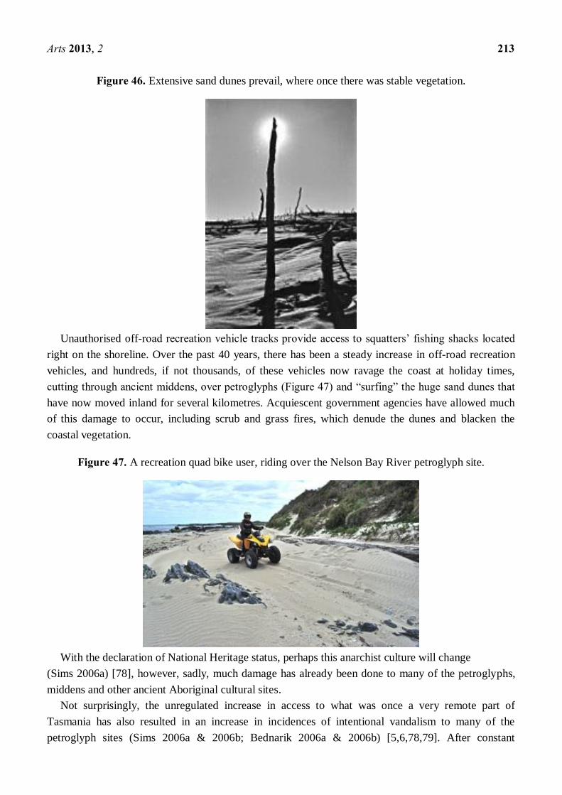
Figure 46. Extensive sand dunes prevail, where once there was stable vegetation.
Unauthorised off-road recreation vehicle tracks provide access to squatters’ fishing shacks located
right on the shoreline. Over the past 40 years, there has been a steady increase in off-road recreation
vehicles, and hundreds, if not thousands, of these vehicles now ravage the coast at holiday times,
cutting through ancient middens, over petroglyphs (Figure 47) and “surfing” the huge sand dunes that
have now moved inland for several kilometres. Acquiescent government agencies have allowed much
of this damage to occur, including scrub and grass fires, which denude the dunes and blacken the
coastal vegetation.
Figure 47. A recreation quad bike user, riding over the Nelson Bay River petroglyph site.
With the declaration of National Heritage status, perhaps this anarchist culture will change
(Sims 2006a) [78], however, sadly, much damage has already been done to many of the petroglyphs,
middens and other ancient Aboriginal cultural sites.
Not surprisingly, the unregulated increase in access to what was once a very remote part of
Tasmania has also resulted in an increase in incidences of intentional vandalism to many of the
petroglyph sites (Sims 2006a & 2006b; Bednarik 2006a & 2006b) [5,6,78,79]. After constant

Arts 2013, 2 214
lobbying, some of the minor off-road vehicle tracks have recently been closed off, and a permit system
has been introduced for recreation vehicle users in an effort to curtail further damage.
Hopefully, with the National Heritage listing of the Western Tasmania Aboriginal Cultural
Landscape in the Arthur Pieman Conservation Area, the government managing authority will adhere to
the National Heritage Management Principles (Commonwealth EPBC Act 2000) [22] and take greater
care of the area by providing adequate staff, engaging Aboriginal rangers, rehabilitating degraded
sites, implementing a public education and awareness program and enforcing appropriate regulations.
Vandalism to rock art sites in various forms is a threat everywhere. Probably some of
the worst examples occurred in Western Australia on the Dampier Archipelago through the
government-approved establishment of a vast industrial complex, and the destruction or relocation of
some Murujuga petroglyps (Bednarik 2006c & 2007c) [7,10].
In Tasmania, we have also had State-sanctioned vandalism of rock art sites. In 1961, for instance,
an outstanding example of rock art was removed from a section of the Mt Cameron West site by the
Tasmania Museum and Art Gallery in Hobart. This petroglyph gallery was reputed to be the finest
example of rock art in all of Tasmania, and one of the best displays of hunter/gatherer art in the world.
Prior to its removal, the impressive complexity of this slab of decorated rock was clearly evident
(Figure 48). Removing it from the site has stripped it of its context in the landscape.
Figure 48. The petroglyph at Mt Cameron West prior to its removal by staff of the
Tasmania Museum Hobart in 1961.
At Greenes Creek (Site 12), another portion of engraved rock was removed by the same institution,
and today the bare surface (Figure 49) is a reminder of this officially sanctioned “vandalism”. Such
practices by museums are simply deplorable. Professor John Mulvaney (Walsh 1988) [95] contends
that it sets a very poor example on how to care for ancient monuments. The sad irony is that one day
these decontexualised slabs of rock art in museums may end up being the only examples left.

Arts 2013, 2 215
Figure 49. Another example of sanctioned vandalism at Greenes Creek.
Racism is never far beneath the surface in modern-day Tasmania, and the few unadulterated
petroglyphs that now remain at some of the sites on the Tarkine Coast are constantly threatened with
vandalism by racists (Figure 50). As the sites are open, easily accessible, and poorly monitored by the
heritage authorities, the damage is incremental and inevitable.
Figure 50. An example of vandalism at Sundown Point site, the perpetrators never
identified or prosecuted.
In 1981, a very small area (0.92 ha) around the “ringing rock” at Trial Harbour (Site 14) was set
aside as a State Reserve. However, this site, too, is open to the public and only a short walking
distance from the coastal fishing village. Visitors are fascinated by the sound effects caused by tapping
the rock on its surface (Figure 51), but this thoughtless activity damages the patination.

Arts 2013, 2 216
Figure 51. Local people listening to the metallic ring at the Trial Harbour petroglyph site.
The only legislation that currently applies in Tasmania is the Aboriginal Relics Act 1975. After
years of promises (Bednarik 2006b & 2007b) [6,9], this Act is being reviewed, with the Draft
Aboriginal Heritage Legislation 2012 presently being considered by the government. Under the 1975
Act, the penalty for interference to an Aboriginal heritage site has a maximum fine of just A$1,000 or
six months imprisonment, yet the penalty for an offence committed to European cultural heritage
attracts fines of up to A$500,000. This discrepancy is a source of much resentment among
Aboriginal people.
The proposed new legislation is a substantial improvement on the existing law, and will hopefully
provide a workable framework for Tasmanian Aboriginal heritage to be recognised, protected and
managed into the foreseeable future.
A commendable feature of the proposed new legislation is a seven-member Aboriginal Heritage
Council formed by way of a rotating membership drawn from both sexes and from across all of the
Tasmanian Aboriginal communities (including the Tasmanian Aboriginal Centre but not confined to
it) to oversee its administration and to provide heritage advice directly to the Minister. Another
commendable feature is that it will involve the Resource Management and Planning Appeals Tribunal
through the Land Use Planning and Approvals Act 1993, which will greatly enhance transparency and
accountability of process in the eyes of the wider community, while assisting land owners and land
managers to comply with their obligations.
The upgraded penalties for interfering with, vandalising or destroying Tasmanian Aboriginal heritage
of up to $260,000 for individuals and up to $1.3 million for body corporates are especially welcome.
Not unexpectedly, the prospect of sharing responsibility for heritage among all Tasmanian
Aboriginal groups has not been accepted by everyone, and the Tasmanian Aboriginal Centre, whose
members account for less than a quarter of the total Tasmanian Aboriginal population, and who do not
recognise the Aboriginality of other Tasmanian Aboriginal people despite a Federal Court decision in
2002 that ruled otherwise, has already signaled a court challenge if the new legislation passes into law.
Of course, legislation alone will not prevent damage to Tasmania’s rock art sites. Instead, there
needs to be a change in mind-set; a government will to protect it, concerted collective responsiveness
to acts of vandalism (Figure 52), and greater respect shown on all sides.

Arts 2013, 2 217
Figure 52. Racist graffiti at the Trial Harbour site in 1971.
One way that may engender greater respect for Tasmanian Aboriginal culture is to publish more
information about the intrinsic values of rock art, and to grant wider access to research reports and
field studies, which currently have restricted access, due to claimed “cultural sensitivity” or, as is so
often the case in Tasmania, disputes over “ownership” and “intellectual property”.
Rock art sites, in Tasmania, as elsewhere, are susceptible to degradation though the pressures of
visitation (Ward & Crocombe 2010) [97]. However, from my own experiences at the Tiagarra
“keeping place” and cultural centre, it seems the public is supportive and hungers for knowledge.
Educating the public about these sites and about their cultural significance helps to break down social
barriers, and to increase awareness and respect.
According to local Aboriginal belief systems, petroglyphs are “permanent signs left by ancestral
beings”. As the initiators of Aboriginal laws, the ancestral beings left “designs in rocks as records,
both of their own existence and as evidence of the laws they formulated”. The petroglyphs we see
today are a reminder of the laws set down by them for all Aboriginal people to follow, and the motifs
continue to embody their spiritual powers.
This dictates certain obligations on Aboriginal custodians to look after these places of special
potency, which are handed down from one generation to the next. As such, they are “an inherited
responsibility” (Palmer 1977) [62]. If the custodians fail to protect these special sites, the spiritual
powers may be unleashed, harming both the people and the land.
8. Conclusion
As people moved south into Tasmania, the traditional expressions of rock art followed, and were
maintained after they were isolated when their land was separated by the rising sea levels.
The art form of the Tasmanian petroglyphs has linkages with the designs recorded by French
scientists in 1802 that were found on bark and also the decorative cicatrices on the bodies of the first
inhabitants. Most designs of the rock art are non-naturalistic, with the exceptions of animal footprints
at two sites, Site 8 and 15 and an outline representing a large fish at Site 15, as well as some xenolith
representations of marine and animal life at Mersey Bluff, which are partially natural in origin, but
nonetheless, culturally significant to the local Aboriginal people. A variety of different sized circles,
cupules, dots, arcs and linear motifs make up the majority expression of the Tasmanian art on rock.

Arts 2013, 2 218
In recognition of the natural and cultural values of much of the south-west and western region, 40%
of the island state has been recognised and inscribed by UNESCO as Tasmanian Wilderness World
Heritage Area, and a narrow strip of the Tarkine Coast 110 km long is now a National Heritage site.
Apart from the south-west, there are few areas in Tasmania where the original indigenous landscape
has escaped the impacts of European settlement. In just 200 years, so many of those early Aboriginal
sites have been lost through infrastructure developments, including the establishment of towns,
railways, roads, quarries and ports. It is largely unknown what has been lost from the construction of
dams that flooded whole valleys and tamed wild rivers for hydro-electric power generation or
irrigation schemes because these places were not surveyed in advance of them being flooded.
Likewise, land clearance for agriculture, forestry and mining has proceeded with little consideration
for the protection of 40,000 years of Aboriginal heritage.
Successive State Governments have lacked the will to change, and there has been a pervasive lack
of respect for the minority Tasmanian Aboriginal people and their unique cultural heritage, with little
or no appreciation or awareness of the legal regulations. Although these have been in place since 1975,
they are seldom implemented or policed. A history of poor land-management practices, open-range
cattle grazing, wildfires, prolific off-road vehicle recreational use, soil erosion, thefts by
souvenir-hunters and collectors, vandalism and the construction of coastal shacks have all contributed
to some of the most important Aboriginal heritage sites being lost during my lifetime.
It is well known that petroglyphs occur in profusion in all continents other than Antarctica. Apart
from a few hand stencils found in the inland caves and rock shelters, Tasmania’s petroglyphs occur
mainly on the west coast, with another three sites in the central highlands, north-west highlands and
north-eastern highlands, and one site on Three Hummock Island in western Bass Strait. Most of these
petroglyphs have been formed by direct or indirect percussion by pecking onto the surfaces of rocks of
varying hardness from granite, quartzite, dolerite, basalt, metamorphosed mudstone and sandstone. On
the softer sandstone sites, the grooves have probably been formed or accentuated by abraiding.
Despite a number of government-sponsored field trips conducted by Aboriginal site recorders and
archeologists, there is still a long way to go before there is a basic recognition of the significance of
Tasmanian rock art. It is still not generally known or appreciated that ... all Tasmanian rock art derives
from societies with Mode 3 traditions—what they call Middle Palaeolithic in Eurasia. That makes
Tasmanian rock art unique in the world: there can be no Mode 4 rock art on the island, by definition.
This means that it has an “Outstanding Universal Value” (Bednarik 2013) [14].
This paper provides an overall picture of the Tasmanian petroglyph sites, for which I contend, at
present there is no real sign of a reprieve, despite the inclusion of many of these sites in reserves of one
sort or another, in National Parks, in the Tasmanian Wilderness World Heritage Area and in areas
along the Tarkine Coast now listed as National Heritage. Perhaps the situation in Tasmania may
improve when the new Aboriginal cultural heritage legislation comes into effect, hopefully in the
coming months; as the State Government’s managing authorities begin to better appreciate the
significance of rock art, and as the various fractious Tasmanian Aboriginal communities reconcile
their differences, make peace among themselves, and start to take an active, collective interest in
gaining the knowledge and skills they will need to better manage and preserve these few remaining
expressions in stone that reflect their ancestors’ cultural practices and beliefs.

Arts 2013, 2 219
Acknowledgments
This paper is based on my experiences of over 40 years as a site recorder of Tasmanian
Aboriginal petroglyphs (Sims 1999) [77]. My voluntary work was initiated and supported by
Frederick D. McCarthy, the first Principal of the Australian Institute of Aboriginal Studies (now the
Institute of Aboriginal and Torres Strait Islander Studies (Ward 2011) [96] and, more recently,
supported by way of encouragement from Robert Bednarik.
My 40 years of site records are now archived at the Launceston’s Queen Victoria Museum and Art
Gallery (CHS 37), and whilst these records have a “closed access” policy, they are made available to
Aboriginal and other bone fide researchers. Special thanks to the following staff at the museum for
their support and assistance: Director Richard Mulvaney, Community History staff Jon Addison and
Ross Smith, Librarian Andrew Parsons and photographer John Leeming.
I also wish to acknowledge the assistance of the staff at LINC Tasmania (State Library of
Tasmania) Devonport, Launceston and Hobart; Lia Pootah Tasmanian Aboriginal Community Elder
Kaye McPherson; Emily Smith Archaeologist Aboriginal Heritage Tasmania, Hobart; site recording
field assistants Charles Turner, Roger and Mary Webb, Noiheener Aboriginal Group Elder Gloria
Andrews, Alan Haigh; Geoff King; Six Rivers Tasmanian Aboriginal Corporation Elder Paul Docking;
South Australian Museum Archaeologist Dr Keryn Walsh; Catherine and Neil Klingner, and friend
and colleague Dr John R. Wilson OAM.
Apart from the photographs from the author’s collection, the use of the following photographs and
images are acknowledged: Figure 1 Dr Mary E. White; Figure 2 Mike Sexton Geoscience Australia;
Figure 3 Tasmanian Archives and Heritage Office; Figure 4 National Library of Australia (NK660/8);
Figure 5 Department of Sustainability, Environment, Water, Population and Communities; Figure 6
Andrew Gibson Geodata Services Branch, Tasmanian Department of Primary Industries, Parks, Water
and Environment; Figure 19 Dr Sandra Bowdler; Figure 22 Bill Burford Collection; Figure 23
Bob Edwards; Figure 30 Charles Mountford; Figure 33 Serengeti National Park; Figure 34 Royal
Society of Tasmania; Figure 42 Royal Society of Tasmania; Figure 48 Bill Burford Collection; and
Figure 51 Western Herald (newspaper) Tasmania (18 June 1999, p15).
Conflicts of Interest
The author declares no conflict of interest.
References
1. Achrati, A. Music and rock art: A Saharan Note. Rock Art Res. 2006, 23, 71–78.
2. Australian Broadcasting Commission, Serengitti Air Safari. In Wild Screen: Dawn to Dusk; ABC,
Sydney, New South Wales, Australia, 1998.
3. Aslin, G.; Bednarik, R.G. Karlie-ngoinpool cave: A preliminary report. Rock Art Res. 1984, 1,
36–45.
4. Bahn, P.G. Comments sound and unsound. Rock Art Res. 1993, 10, 95–96.
5. Bednarik, R.G. Rock Art Vandalism. In AURA Newsletter; Archaeological Publications:
Melbourne, VIC, Australia, 2006a; Volume 23, p. 3.

Arts 2013, 2 220
6. Bednarik, R.G. Rock art protection in Tasmania. Rock Art Res. 2006b, 23, 282.
7. Bednarik, R.G. Australian Apocalypse The Story of Australia’s Greatest Cultural Monument;
Occasional AURA Publication No.14, Archaeological Publications: Melbourne, VIC,
Australia, 2006c.
8. Bednarik, R.G. Rock Art Science: the Scientific Study of Palaeoart; Aryan Books International:
New Delhi, India, 2007a.
9. Bednarik, R.G. Progress with rock art protection in Tasmania. Rock Art Res. 2007b, 24, 135.
10. Bednarik, R.G. The Removal of Rock Art. In AURA Newsletter; Archaeological Publications:
Melbourne, VIC, Australia, 2007c; Volume 24, pp. 1–7.
11. Bednarik, R.G. Cupules. Rock Art Res. 2008, 25, 74–76.
12. Bednarik, R.G. Melbourne, Victoria, Australia. Correspondence to Senator Bob Brown, 3 March
2010a.
13. Bednarik, R.G. Australian rock art of the Pleistocene. Rock Art Res. 2010b, 27, 95–120.
14. Bednarik, R.G. Melbourne, Victoria, Australia. Personal communication, 2013.
15. Bednarik, R.G.; Andrews, G.; Cameron, S.; Bednarik, E. Petroglyphs of Meenamatta, the Blue
Tier mountains, Tasmania. Rock Art Res. 2007, 24, 161–169.
16. Bednarik, R.G.; Andrews, G.; Cameron, S.; Sims, P.C.; Bednarik, E. The contested Meenamatta
petroglyphs, Tasmania. Rock Art Res. 2010, 27, 251–256.
17. Bonwick, J. Daily Life and Origin of the Tasmanians; Sampson Low, Son. & Marston: London,
UK, 1870.
18. Bowdler, S. An Account on an Archaeological Reconnaissance of Hunter’s Isles, north-west
Tasmania. In Records of the Queen Victoria Museum; Ellis, W.F., Ed.; Queen Victoria Museum,
Launceston, Tasmania, Australia, No. 54, 1974.
19. Brown, M.J. The vegetation of the Mt Cameron West Aboriginal site. Pap. Proc. R. Soc. Tasmania
1980, 114, 21–34.
20. Cameron, P. Greese and Ochre the Blending of Two Cultures at the Colonial Sea Frontier;
Fullers Bookshop: Launceston, Tasmania, Australia, 2011.
21. Census 2011. Australian Bureau of Statistics; Australian Government: Canberra, Australia, 2011.
22. Commonwealth Government. 2000. Environment Protection and Biodiversity Conservation
Regulations Schedule 5B; Australian Government: Canberra, ACT, Australia, 2000.
23. Commonwealth Gazette. Available online: http://www.comlaw.gov.au/Details/C2013G00230
(accessed on 14 March 2013).
24. Cosgrove, R. Tasmanian West Coast Aboriginal Rock Art Survey; National Parks and Wildlife
Service: Hobart, Tasmania, Australia, 1983. Occasional Paper No. 5.
25. Cosgrove, R. Late Pleistocene behavioural variation and time trends: The case from Tasmania in
Archaeology. Oceana 1995, 30, 83–104.
26. Cosgrove, R.; Jones, R. Judds Cavern: A subterranean Aboriginal painting site, southern
Tasmania. Rock Art Res. 1989, 6, 96–104.
27. Darby, A. Aboriginal Rock Art Find Marred by Damage Fear; The Age: Melbourne, Australia,
25 November 1999.
28. Dove, H.S. Aboriginal Rock Drawings; The Australasian: Melbourne, Australia, 15 September
1923; p. 582.

Arts 2013, 2 221
29. Ellis, W.F. Examination of Rock Markings; Walkabout: Melbourne, Victoria, Australia, 1958, 24:
2, 40.
30. Evans, D.A. Geological Investigation of Mersey Bluff, Devonport Tasmania: In Reference to
Rock Markings; Mersey Leven Aboriginal Corporation: Devonport, TAS, Australia, 2008,
Unpublished Report.
31. Field, J.; McIntosh, P. A re-evaluation of ‘petroglyphs’ on Blue Tier, northeast Tasmania.
Aust. Archaeol. 2009, 69, 11–20.
32. Flood, J. Rock Art of the Dreamtime; Angus & Robertson (an imprint of Harper Collins
Publishers, Australia): Sydney, Australia, 1997.
33. Flood, J. Archaeology of the Dreamtime, Revised edition; Angus & Robertson (an imprint of
Harper Collins Publishers, Australia): Sydney, Australia, 1999.
34. Flood, J. Copying the Dreamtime: Anthropic marks in early Aboriginal Australia. Rock Art Res.
2006, 23, 239–246.
35. Franklin, N.R. Discontinuous Dreaming networks: Analyses of variability in Australian
pre-historic petroglyphs. Rock Art Res. 2007, 24, 79–103.
36. Gadd, S. Department of Primary Industries, Parks and Environment, Hobart, Tasmania, Australia.
Correspondence 6 November 2009.
37. Gaughwin, D. An archaeological reconnaisance survey of the Tasman Peninsula. Aust. Archaeol.
1985, 20, 38–57.
38. Hameau, P. Organisation of a petroglyph complex at Creysseilles (Ardeche, France). Rock Art Res.
2012, 29, 89.
39. Helvenston, P.A.; Hodgson, D. The neuropsychology of ‘animalism’: Implications for
understanding rock art. Rock Art Res. 2010, 27, 72–73.
40. Higgs, S. Archaeological Assessment of Mersey Bluff Rock Markings; Mersey Leven Aboriginal
Corporation: Devonport, Australia, 2009, Unpublished Report.
41. Hughes, P.J.; Watchman, A.L.; Sullivan, M.E. Conservation of the Mount Cameron West
engraving site, north-western Tasmania. Pap. Proc. R. Soc. Tasmania 1951, 115, 211–222.
42. Huisheng, T. New discoveries of rock art and megalithic sites in the central plain of China.
Rock Art Res. 2012, 29, 157–170.
43. Jones, J.F. Trial Harbour. Pap. Proc. R. Soc. Tasmania 1937, 47–51.
44. Jones, R. Rocky Cape, West Point and Mt Cameron West, north-west Tasmania. In The Heritage
of Tasmania: The Illustrated Register of the National Estate; The Macmillan Company of
Australia in association with the Australian Heritage Commission: Melbourne, Australia, 1983;
pp. 86–90.
45. Kempton, H. Relic at Logging Risk. The Mercury, Hobart, Tasmania, Australia, 8 December
2009, p. 5.
46. Killick, D. Unique Relic Targeted. The Mercury, Hobart, Tasmania, Australia, 14 December
2009, p. 3.
47. Lahafian, J. Cupules in Kurdistan rock art. Rock Art Res. 2010, 27, 177–183.
48. Lourandos, H. 10,000 years in the Tasmanian highlands. Aust. Archaeol. 1983, 16, 39–47.
49. Legg, R.W. Tasmanian Aboriginal Middens on the West Coast. In Report of the Nineteenth
Meeting of the Australasian Association for the Advancement of Science (Australia and New

Arts 2013, 2 222
Zealand), Hobart meeting 12 January 1928. Lord, C. (ed.), John Vail, Government Printer,
Hobart. 1929.
50. Luckman, L. The Aboriginal rock carvings at Mt. Cameron West, Tasmania, photographs and
notes on the excavations. Pap. Proc. R. Soc. Tasmania 1951, 25–28.
51. Luckman, J. Expedition to Blue Tier, N.E. Tasmania, Observations of Alledged Aboriginal
Carvings; Sims Collection CHS37, Queen Victoria Museum and Art Gallery: Launceston, TAS,
Australia, 1957, Unpublished Report.
52. McCarthy, F.D. 1969. Investigation of Mt Cameron West Rock Engraving Site, Tasmania;
Australian Institute of Aboriginal Studies Newsletter 2, 4–6.
53. Maynard, L. Classification and Terminology in Australian Rock Art. In Form in Indigenous Art;
Ucko, P., Ed.; A.I.A.S: Canberra, Australia, 1977; pp. 387–402.
54. Meston, A.L. Aboriginal rock-carvings on the north-west coast of Tasmania. Pap. Proc. R. Soc.
Tasmania 1932, 12–19.
55. Meston, A.L. Aboriginal rock-carvings in Tasmania. Pap. Proc. R. Soc. Tasmania Part II 1933,
1–6.
56. Mountford, C.P. Aboriginal Rock Carvings in South Australia. In Report of the Nineteenth
Meeting of the Australasian Association for the Advancement of Science (Australia and New
Zealand), Hobart meeting 12 January 1928; Lord, C. (ed.).; John Vail, Government. Printer:
Hobart, Tasmania, Australia, 1929; pp. 358–359.
57. Mulvaney, D.J. The Prehistory of Australia; Thames and Hudson: London, UK, 1969.
58. Murray, P. Demystification of the Mersey Bluff markings. Pap. Proc. R. Soc. Tasmania 1980,
114, 41–48.
59. National Heritage List. Available online: www.environment.gov.au/heritage/places/national/
(accessed on 1 January 2013)
60. Neales, S. Levee Heritage Listing ‘too Little, too Late’. The Weekend Australian: The Nation,
24–25 December, 2011, p. 7.
61. Nicholls, Sir Douglas. Devonport, Tasmania, Australia. Personal communication, 1976.
62. Palmer, K. Myth, ritual and rock art. Archaeol. Phys. Anthropol. Ocean. 1977, 12, 38–50.
63. Péron, F.; de Freycinet, L. Voyage de découvertes aux Terres Australes, fait par ordre du
gouvernement, sur les corvettes le Géographe, le Naturaliste et la goëlette le Casuarina, pendant
les années 1800, 1801, 1802, 1803 et 1804, [Historique], 4 vols and Atlas par MM. Lesueur et
Petit, 2nd ed.; Arthus Bettrand, Paris, 1824.
64. Friendly Mission The Tasmanian Journals and Papers of George Augustus Robinson 1829-1834;
Plomley, N.J.B., Ed.; Tasmanian Historical Research Association: Hobart, Australia, 1966.
65. Plomley, N.J.B. The Baudin Expedition and the Tasmanian Aborigines 1802; Blubber Head
Press: Hobart, Australia, 1983.
66. Plomley, N.J.B. Weep in Silence. A history of the Flinders Island Aboriginal Settlement; Blubber
Head Press: Hobart, Australia, 1987.
67. Plomley, N.J.B. The Tasmanian Tribes and Cicatrices as Tribal Indicators among the Tasmanian
Aborigines; Queen Victoria Museum and Art Gallery: Launceston, Australia, 1992, Occasional
paper No. 5.

Arts 2013, 2 223
68. Power, J. Architectural Miopia: The Contested Authenticity of a Tasmanian mia-mia. In
Proceedings of Contained Memory Conference, Pupuri Pohewa, Wellington, New Zealand, 12
July, 2010.
69. Prince, G.B. Archaeological Excavations at Port Davey, South West Tasmania; Department of
Parks, Wildlife and Heritage: Hobart, Australia, 1990, Unpublished Report.
70. Reid, O.W. Additional discoveries of Aboriginal rock carvings in Tasmania. Pap. Proc. R.
Soc. Tasmania 1954, 88, 277–278.
71. Robson, L. A History of Tasmania Van Diemen’s Land Vol. I. From the Earliest Times to 1855;
Oxford University Press: Melbourne, Australia, 1983.
72. Ryan, L. Tasmanian Aborigines: A History Since 1803; Allen & Unwin: Crows Nest, NSW,
Australia, 2012.
73. Scott, E.O.G. Preliminary note on the supposed Aboriginal rock carvings at Mersey Bluff,
Devonport. Pap. Proc. R. Soc. Tasmania 1931, 112–129.
74. Sharland, M.S.R. Symbols of an extict race. Walkabout 1957, 23, 41–42.
75. Sims, P.C. A note on Aboriginal petroglyphs at Devonport, Tasmania. Pap. Proc. R. Soc. Tasmania
1970, 104, 117–118.
76. Sims, P.C. Variation in Tasmanian Petroglyps. In Form in Indigenous Art: Schematisation in the
Art of Aboriginal Australia and Prehistoric Europe; Ucko, P.J., Ed.; Australian Institute of
Aboriginal Studies: Canberra, Australia, 1977; pp. 429–438.
77. Sims, P.C. 30 years of recording Aboriginal sites in Tasmania. Pap. Proc. Launceston Hist. Soc.
1999, 114–118.
78. Sims, P.C. Anarchy on the Tarkine Coast; Sims Collection CHS37, Queen Victoria Museum and
Art Gallery: Launceston, TAS, Australia, 2006a, Unpublished Report.
79. Sims, P.C. Rock art vandalism in Tasmania. Rock Art Res. 2006b, 23, 119–122.
80. Sims, P.C. Rock art in high places. Rock Art Res. 2007, 24, 169–170.
81. Sims, P.C. More Tasmanian Cupules. Rock Art Res. 2008a, 25, 204–207.
82. Sims, P.C. Tiagarra - Mersey Bluff Assessment Project Auditor’s Report; Mersey Leven
Aboriginal Corporation: Devonport, Tasmania, Australia, 2008, Unpublished Report.
83. Sims, P.C. Tasmanian Aboriginal Rock Art: Monster Creek Site; Peter C. Sims: (self-published)
Quoiba, Tasmania, Australia, 2012.
84. Sims, P.C. Some Notes on the South Australian Huddleston Aboriginal Petroglyph Site and a
Comparison with the Trial Harbour Site, Tasmania; Queen Victoria Museum and Art Gallery:
Launceston, TAS, Australia, 2013, Unpublished Report.
85. Smith, J.; Brown, B.; Hamilton, F.; Richardson, A.; Collett, D. Tana Tawna Project: Aboriginal
Management Policies for the Central Plateau and Walls of Jerusalem; Tasmanian Aboriginal
Land Council and Parks and Wildlife Service: Hobart, Australia, 1996, Unpublished Report.
86. Sognnes, K.; Haug, A. Searching for hidden images: Rock art geography in Stjordal, Trondelag,
Norway. Rock Art Res. 1998, 15, 98–108.
87. Stockton, J. A Tasmanian painting site?. Pap. Proc. R. Soc. Tasmania 1977a, 111, 185–189.
88. Stockton, J. Greenes Creek Aboriginal Engraving Site; Occasional Paper 1, National Parks and
Wildlife Service: Hobart, TAS, Australia, 1977b.

Arts 2013, 2 224
89. Stockton, J. Fires by the seaside: Historic vegetation changes in northwestern Tasmania.
Pap. Proc. R. Soc. Tasmania 1982, 116.
90. Tasmanian Government Gazette, Hobart, Tasmania, Australia, 13 September 1989.
91. Tasmania Parks and Wildlife Service. Tasmanian Wilderness World Heritage Area Management
Plan 1999-2007 Update; Department of Tourism, Arts and the Environment: Hobart, Tasmania,
Australia, 1999; pp. 100–101.
92. De Telga, S.; Bryden, W. A note on Tasmanian Aboriginal drawings. Pap. Proc. R. Soc. Tasmania
1958, 92, 191.
93. Tooley, R.V. Printed Maps of Tasmania 1642-1900; Francis Edwards Ltd.: London, UK, 1975.
94. Waller, S.J. Sound Reflection as an explanation for the content and context of rock art.
Rock Art Res. 1993, 10, 91–95.
95. Walsh, L. Australia’s Greatest Rock Art; Brille-Brown and Associates (Aust) Pty. Ltd.: Bathurst,
NSW, Australia, 1988; pp. 56–57.
96. Ward, G.K. The role of AIATSIS in research and protection of Australian rock art. Rock Art Res.
2011, 28, 7–16.
97. Ward, G.K.; Crocombe, M. Rock paintings near Wadeye, Northern Territory: Site management
and educational aspects of research and tourism. Rock Art Res. 2010, 27, 229–237.
98. White, M. Listen Our Land is Crying; Kangaroo Press: Kenthurst, NSW, Australia, 1997.
99. Williams, G.E. Rock art and pre-historic ritual behaviours: A landscape and acoustic approach.
Rock Art Res. 2012, 29, 36.
© 2013 by the authors; licensee MDPI, Basel, Switzerland. This article is an open access article
distributed under the terms and conditions of the Creative Commons Attribution license
(http://creativecommons.org/licenses/by/3.0/).