nitrate contamination in groundwater around keffi town, northcentral nigeria
TRANSCRIPT

S.E. Obrike, G.K. Anudu, S. Iyakwari and C.C. Osadebe, 2011. Nitrate Contamination in Groundwater Around Keffi
Town, Northcentral Nigeria.
Journal of Applied Technology in Environmental Sanitation, 1 (3): 263-271.
263
Original Report
NITRATE CONTAMINATION IN GROUNDWATER AROUND KEFFI TOWN,
NORTHCENTRAL NIGERIA
S.E. OBRIKE1, G.K. ANUDU1*, S. IYAKWARI1 and C.C. OSADEBE2
1Department of Geology and Mining, Nasarawa State University, Keffi, Nigeria. 2Nigerian Building and Road Research Institute, P.M.B. 1055, Ota, Nigeria.
*Corresponding Author: Phone: +2348064306565; E-mail: anudugoodluck @yahoo.co.uk
Received: 15th July 2011; Revised: 1st August 2011; Accepted: 12th August 2011
Abstract: Ten (10) vertical electrical soundings (VES) were carried out in the study area, the field data obtained were then interpreted using partial curve matching and a 1-D inversion algorithm. Resistivity results indicate the presence of top soil (<300 ohm-m), weathered basement (100 to 150 ohm-m) and fractured basement (<3000 ohm-m). The thickness of the topsoil is generally less than 2m while the weathered basement varies from 5m to 30m. Fifteen (15) groundwater samples were collected from different locations across the Keffi area and analysed for their NO3-N concentration. Groundwater sampling were restricted to well-covered shallow hand-dug wells (SHW), medium depth hand pumps (MHP) and motorised boreholes (DMBH). In all the groundwater samples analysed, 10.5% of them exhibited NO3-N contents higher than 0.03mgL-1 and 65% of the samples collected from the agricultural fields contained NO3-N higher than 0.03mgL-1 in contrast to 15% of samples from residential areas. Results also revealed an inverse relationship between the NO3-N concentrations and the depth of the sampling aquifers (SHW>MHP>DMBH). Most of the analysed samples contained NO3-N load less than the fixed threshold limit by WHO (2006) for drinking purposes of below 10mgL-1, thus, rendering the waters safe for drinking purposes. Keywords: Nitrate contamination, groundwater, aquifer, shallow basement
INTRODUCTION
Crystalline basement occupies over 60% of the land area of Nigeria and like most areas so
located, is faced with the challenge of the provision of steady water supply. Crystalline rocks in their fresh compact state are largely impermeable with no groundwater storage, but the presence of a weathered mantle of considerable thickness and the relics of tectonic activities likes faults and fractures, increase their proficiency to serve as aquifers. These basement aquifers are of
This work is licensed under the Creative Commons Attribution 3.0 Unported License, which permits unrestricted use, distribution, and reproduction in any medium, provided the original work is properly cited.
ISSN 2088-3218
V o l u m e 1 , N u m b e r 3 : 2 6 3 - 2 7 1 , O c t o b e r , 2 0 1 1 © T2011 Department of Environmental Engineer ing S e p u l u h N o p e m b e r I n s t i t u t e o f T e c h n o l o g y , S u r a b a y a & Indonesian Society of Sanitary and Environmental Engineers, Jakarta O p e n A c c e s s h t t p : / / w w w . t r i s a n i t a . o r g / j a t e s
I n t e r n a t i o n a l p e e r - r e v i e w e d j o u r n a l
International peer-reviewed journal

S.E. Obrike, G.K. Anudu, S. Iyakwari and C.C. Osadebe, 2011. Nitrate Contamination in Groundwater Around Keffi
Town, Northcentral Nigeria.
Journal of Applied Technology in Environmental Sanitation, 1 (3): 263-271.
264
particular importance because of their widespread extent, accessibility and often the lack of a readily available alternative source of water supply, owing to epileptic utility services in develop-ing countries of sub Saharan Africa [25]. Of further interest are areas of shallow basement aqui-fers usually characterized with recharge and sustainability issues, overexploitation and potential for groundwater contamination.
The potential for pollution in the hydraulic system depends upon the mobility of the contami-nant, its accessibility to the groundwater reservoir and the hydraulic characteristics of the reser-voir [8]. Application of nitrogenous fertilizers and animal waste are considered to be the major sources of nitrates in groundwater [19]. In soils with considerable permeability, nitrogenous ferti-lizers rapidly convert to NO3 form, which are highly soluble, readily available to plants and easily leachable into groundwater when applied in quantities exceeding the amounts required by culti-vated plants. Nitrate enrichment in groundwater is a function of many factors such as soil charac-teristics particularly its hydraulic conductivity, nature of crops grown, their rooting behaviour, quantity of fertilizer use, depth of aquifers, magnitude of rainfall/irrigation water received [11]. Ni-trogen fertilizers or manure applied to farmlands can be considered as non-point sources of ni-trate [21]. With sufficient surface-water infiltration, soluble nitrate usually leach below the root zone to underlying groundwater. Unconfined aquifers with shallow water tables overlain by per-meable soils are especially vulnerable to agricultural contaminations [13].
The Keffi area is characterized by near surface outcrops of underlying basement rocks, vari-able overburden thickness and near surface water table. Keffi is essentially agrarian and home to a number of large farms. The area’s proximity to Abuja, the federal capital city of Nigeria, has in turn added to its annual influx of people. With increase in the number of mechanized farms and agro-allied activities in and around Keffi and environs, coupled with attendant increase in the ab-straction of groundwater via shallow boreholes to meet increased water supply need, the continu-ous monitoring of the groundwater quality-related parameters is of upmost importance. This study assessed the depth to aquifer and nitrate concentration in groundwater in the study area. MATERIALS AND METHODS Location and Physiography of Study Area
The study area is located between latitude 80 50I and 80 53I and longitude 70 50I and 70 55I. Generally the study area is located about 350 meters above sea level. The drainage within the study area is dendritic in pattern with the major river being River Antau with tributaries flowing westwards. The area falls within the Tropical guinea-savannah mixture characterized by trees, shrubs and grasses. Climatically, the area is characterized by long dry season (October-April) and a short wet season marked by fluctuations of precipitation (May-September). The mean an-nual rainfall is between 1000-1500mm, while the mean temperature is about 25.60C [1, 3, 17]. Geology and Hydrogeology
Keffi area is essentially underlain by crystalline rocks of the Basement Complex (Fig.1). Ra-haman [20] classified the Basement Complex rocks of Nigeria into five (5) groups namely; Mig-matite-gneiss complex; Slightly migmatised to unmigmatised para schist and mete-igneous rocks; Charnockitic rocks; Older Granites (which comprises of rock varying in composition from granodi-orite to granite and potassic syenite) and unmetamorphosed doleritc dykes.
The migmatites, gneisses, biotite granite and phyllite/schist with massive intrusions of peg-matites and quartz veins are well exposed in most of the study area (Fig. 2). The study area can be divided into two hydro-geological units namely; the aquiferous zone within the weathered

S.E. Obrike, G.K. Anudu, S. Iyakwari and C.C. Osadebe, 2011. Nitrate Contamination in Groundwater Around Keffi
Town, Northcentral Nigeria.
Journal of Applied Technology in Environmental Sanitation, 1 (3): 263-271.
265
overburden overlying the basement rocks and the aquiferious zone within the intense fracture joint system in the partially weathered basement.
Fig. 1: Generalised geological map of Nigeria (after Obaje, [15]).
Fig. 2: Geological map of study area. Sample Collection and Analysis
Geoelectrical measurements were conducted using the ABEM SAS 300B Terrameter with its accessories. The vertical electrical sounding (VES) technique was adopted for the study. Ten (10) vertical electrical soundings (VES) were carried out in the study area. The Schlumberger elec-trode array was employed with half current electrode spacing (AB/2) varied from 1m to 150m.

S.E. Obrike, G.K. Anudu, S. Iyakwari and C.C. Osadebe, 2011. Nitrate Contamination in Groundwater Around Keffi
Town, Northcentral Nigeria.
Journal of Applied Technology in Environmental Sanitation, 1 (3): 263-271.
266
Therefore, a maximum half current electrode spacing (AB/2) of 150m, which was deemed suffi-cient in allowing a depth of penetration of the order of 38m to 50m was adopted. The depth of current penetration using the Schlumberger electrode array is 1/3 to 1/4 of AB/2 [6, 22]. Four of the VES points were made at nearby existing hand-dug wells for correlation purposes. The axes of all the vertical electrical soundings were aligned parallel to the geological strike in order to re-duce the effects of lateral variations. The field data obtained were first interpreted using partial curve matching approach [9]. A 1-D inversion algorithm, RESIST VERSION 1.0, based on smoothness-constrained optimization technique was used to model the geoelectrical parameters obtained from manual interpretation of each sounding data [23]. A particular model was consid-ered acceptable at 10% error level, as proposed by Barker et al., [5].
In addition, a total of Fifteen (15) groundwater samples were collected from different loca-tions.Groundwater sampling were restricted to well covered shallow hand-dug wells (SHW), me-dium depth hand pumps (MHP) and motorized boreholes (DMBH) spread over the study area. The sampling was done purposefully in the month of December at the peak of the dry season, with the premise of recording the highest possible values of nitrate concentration and also avoids the effect of dilution that may arise from precipitation during the rainy season. To differentiate the influences of agricultural (cropping system and application of fertilizers and pesticides) and habi-tational activities, sampling was done in both residential and agricultural fields. During sampling, no particular spatial distance between samples was adopted. The foregoing notwithstanding, sample locations were chosen on the basis of an even spread over the study area. Before sample collection, the sample bottles were first rinsed thoroughly with the waters to be sampled. All sam-ples were collected in pre-cleaned and sterilized polyethylene bottles (1.5 litres). Water samples were collected from each location, labeled, stored in ice packed coolers and sent to the laboratory for analysis. The pH and electrical conductivity (EC) values of the water samples were measured in the field with the aid of a portable pH and conductivity meter. The water samples were collect-ed and analysed following procedures as recommended by APHA and AWWA [4]. The analysis of nitrate concentration in the waters was carried out, employing the Hack-Spectophotometer analytical method, at the Sheda Science and Technology Laboratory Complex, Sheda-Abuja. RESULTS AND DISCUSSION
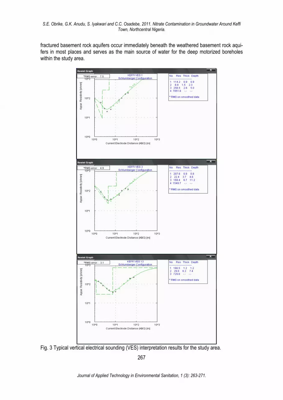
The resistivity results show a delineation of three to four subsurface horizons namely; the topsoil, weathered basement, fractured basement and fresh basement. Typical vertical electrical sounding (VES) data interpretation results for the study area are presented in Fig. 3. The topsoil resistivities are generally less than 1500 ohm-m with the most frequently occurring resistivities less than 300 ohm-m. Resistivities less than 300 ohm-m probably indicate clayey sand or sandy clay, while those greater than 300 ohm-m are characteristic of compact sand or laterite. Topsoil thicknesses are generally less than 2m, with the most frequently occurring thicknesses in the 1.0 to 1.5m range. The mean value of the topsoil resistivities is 486 ohm-m.
Weathered basement rock resistivities are generally less than 200 ohm-m with the highest frequencies in 50 to 100 ohm-m and 100 to 150 ohm-m ranges. The mean weathered basement rock resisitivities is 99 ohm-m. These resistivities values are indicative of clayey sand or silty sand containing water. These values fall within the range established for similar geological provinces [7, 16]. The weathered basement rock thicknesses are generally less than 30m (usually between 5 to 30m) with the highest frequencies within 10 to 15m and 15 to 20m. Weathered basement rock constitutes a major aquifer unit in the area. Most hand-dug wells and medium depth hand pumps in the study area are tapping water from this aforementioned aquifer type. In addition,
S.E. Obrike, G.K. Anudu, S. Iyakwari and C.C. Osadebe, 2011. Nitrate Contamination in Groundwater Around Keffi
Town, Northcentral Nigeria.
Journal of Applied Technology in Environmental Sanitation, 1 (3): 263-271.
267
fractured basement rock aquifers occur immediately beneath the weathered basement rock aqui-fers in most places and serves as the main source of water for the deep motorized boreholes within the study area.
Fig. 3 Typical vertical electrical sounding (VES) interpretation results for the study area.

S.E. Obrike, G.K. Anudu, S. Iyakwari and C.C. Osadebe, 2011. Nitrate Contamination in Groundwater Around Keffi
Town, Northcentral Nigeria.
Journal of Applied Technology in Environmental Sanitation, 1 (3): 263-271.
268
Table 1 shows the nitrate concentrations of groundwater from fifteen (15) wells sampled across the study area. The nitrate concentration ranges from nil - 0.042mgL-1. Out of the fifteen (15) samples analysed only 10.5% contained NO3-N higher than 0.030mgL-1 and the remaining 89.5% less than 0.030mgL-1. About 65% of the samples collected from agricultural fields con-tained NO3-N higher than 0.030mgL-1 compared to 15% of samples from the residential areas. On the average, the analysed samples are almost neutral in reaction, non-saline in nature and free from any colour, odour and taste (Table 2).
There exist little variations in pH and EC values of the samples (Table 1). Among the sources, the NO3-N content was highest in water from shallow hand dug wells: SHW (0.042 mg L−1) followed by: MHP (0.039 mg L−1) > DMBH (0.024 mg L−1) which, on average had the follow-ing depths: DMBH (30.0 m) > MHP (14.0 m) > SHW (4.5 m) (Table 3).
Table 1: EC, pH and NO3-N content of water samples from the study area
Location pH EC (µscm-1) N03-N(mgL-1)
Range Mean SD Range Mean SD Range Mean SD
D.1 6.1-6.4 6.30 0.19 0.185-0.356 0.273 0.42 0.011-0.034 0.022 0.21
D.3 6.1-7.4 6.34 0.28 0.323-0.586 0.560 0.34 - - -
G 1 5.3-6.9 5.96 0.39 0.242-0.546 0.462 0.45 0.016-0.042 0.027 0.32
G 2 6.8-7.5 7.28 0.26 0.346-0.568 0.420 0.32 0.016-0.024 0.019 0.14
BCG 6.4-7.4 6.94 0.32 0.345-0.762 0.602 0.48 0.014-0.036 0.031 0.25
E1 5.6-6.2 5.95 0.28 0.267-0.396 0.348 0.23 - - -
E2 5.7-6.1 5.91 0.12 0.286-0.465 0.336 0.34 0.021-0.039 0.026 0.23
Dadin 6.4-6.5 6.45 0.07 0.536-0.896 0.737 0.26 0.021-0.036 0.026 0.12
Table 2: Summary of physical parameters of analysed water samples of the study area
SN Location Appearance Colour Odour pH
1 D.1 Clear Colourless none 6.1 - 6.4 2 D.3 Clear Colourless none 6.1 - 7.4 3 G 1 Clear Colourless none 5.3 - 6.9 4 G 2 Clear Colourless none 6.8 - 7.5 5 BCG Clear Colourless none 6.4 - 7.4 6 E1 Clear Colourless none 5.6 - 6.2 7 E2 Clear Colourless none 5.7 - 6.1 8 Dadin Kowa Clear Colourless None 6.4 - 6.5
Considering the 10 mgL-1 threshold limit advocated by WHO [24] for drinking purposes, ana-
lysed samples showed that water from the study area currently possess no health risk to users (with respect to nitrate content only), as analysed nitrate values range from nil – 0.042mgL-1. Groundwater samples from agricultural field areas exhibit higher NO3-N content (0.018- 0.042 mgL-1) in contrast with those from the residential areas (0.016-0.034mgL-1).

S.E. Obrike, G.K. Anudu, S. Iyakwari and C.C. Osadebe, 2011. Nitrate Contamination in Groundwater Around Keffi
Town, Northcentral Nigeria.
Journal of Applied Technology in Environmental Sanitation, 1 (3): 263-271.
269
Table 3: Sampling depths and variations in EC, pH and NO3-N content s in groundwater samples across the study area
Source No. of samples
Depth of wells (m) pH EC (µscm-1) NO3-N(mgL-1)
Range Mean SD Range Mean SD Range Mean SD Range Mean SD
DMBH 3 28-45 30 5.80 6.1-7.6
6.52 0.14 0.185-0.384
0.362 0.18 Nil- 0.024
0.021 0.14
MHP 4 10-25 14 4.60 6.2-7.0
6.63 0.18 0.245- 0.598
0.482 0.24 Nil- 0.039
0.022 0.18
SHW 8 2-8 4.5 2.10 5.3-7.4
6.86 0.21 0.387- 0.896
0.523 0.36 0.011- 0.042
0.032 0.23
Overall 15 2-45 14.5 4.80 5.3-7.6
6.14 0.20 0.185- 0.896
0.543 0.38 Nil- 0.042
0.036 0.28
DMBH- deep motorized borehole, MHP- medium depth hand pump, SHW- shallow hand-dug wells
The use of nitrogenous fertilizers in the cultivated zones of the study area is believed to be
the main source of NO3-N content into the groundwater regime of these areas. When applied to soils, nitrogenous fertilizers rapidly converted to NO3 form. This NO3 is highly soluble and easily
leachable on irrigation or with a good amount of precipitation (∼1,200 mm) received in the areas having a fairly permeable lithology underneath [10]. Ladha et al. [12] opined that in fields with fi-ne-textured soils, leaching loss of NO3
- is low because of restricted percolation. Within the study area agricultural fields underlain by gneisses and areas with pegmatitic intrusions and massive quartz veins revealed evidence of higher NO3-N contamination of groundwater, in contrast with areas essentially underlain by migmatites with relatively thicker weathered mantle and apprecia-ble clayey horizons.
The concentration of NO3–N in groundwater decreased along the sequence: SHW > MHP > DMBH showing an inverse relationship with the depth of the sampling aquifers (Table 3). This is a typical feature in nitrate contamination of groundwater observed worldwide [2, 10, 14, 18]. Higher depth of sampling aquifers possibly imparts more restriction in the movement of NO3–N laden water along soil profile resulting in less NO3–N contamination in deeper aquifers [11]. Various researchers have shown that the concentration of NO3–N in groundwater may be influenced by the type of crops grown in a locality. Kundu [10] observed higher NO3-N content in areas where shallow rooted crops were grown than in the areas of deep-rooted crops. In this study no particu-lar influence by the type of crop grown was observed, possibly due to the fact that within the study area, majority of the crops grown were shallow rooted crops like maize, millet, sorghum, guinea corn and onions. The appreciable concentration of NO3–N in groundwater of habitational areas suggests that sewage system of human settlements produced significant NO3–N content coupled with poor waste management and disposal systems, leading to its leaching into ground-water aquifers below. Residential areas with detectable concentrations of NO3-N in groundwater were visibly more relatively densely populated. CONCLUSIONS
Results from the study revealed that weathered basement rock constitutes a major aquifer unit in the area. Most hand-dug wells and medium depth hand pumps in the study area are tap-ping water from this aforementioned aquifer type. In addition, fractured basement rock aquifers

S.E. Obrike, G.K. Anudu, S. Iyakwari and C.C. Osadebe, 2011. Nitrate Contamination in Groundwater Around Keffi
Town, Northcentral Nigeria.
Journal of Applied Technology in Environmental Sanitation, 1 (3): 263-271.
270
occur immediately beneath the weathered basement rock aquifers in most places and serves as the main water source for the deep motorized boreholes within the study area. Nitrate concentra-tions in groundwater within the study area can be considered as safe for drinking purposes (with respect to its nitrate load). As all analysed water samples had nitrate levels below the permissible limits (10mgL-1) recommended by WHO [24] for drinking purposes. Groundwater samples from agricultural farmlands and residential areas underlain by gneisses, quartz veins and pegmatitic intrusions revealed evidences of higher nitrate contamination of groundwater, in contrast with ar-eas essentially underlain by migmatites. There were also indications of possible build up of nitrate load in shallow aquifers around human settlements with poor waste management and disposal systems, resulting in its leaching into the groundwater aquifers below. Acknowledgements: The authors are grateful to the managements of the Sheda Science and Technolo-gy Laboratory Complex, Sheda-Abuja for the use of their laboratories and equipment. The invaluable con-tributions of the anonymous reviewers are also gratefully acknowledged. References 1. Adefolalu, A. O. 2002. Climate. In: Africa Atlases; Atlas of Nigeria. Les Editions J. A. Aux E’dition du
Jaguar 57 bis, rue d’Auteuil-75016 Paris-France. 2. Adelana, S.M.A. and Olashinde, P.I., 2003. High nitrate in water supply in Nigeria: Implication for
human health. Water Resour. J. Nig. Assoc. Hydrogeologists. 14: 1-11. 3. Akintola, J.O., 1986. Rain distribution in Nigeria: 1892-1983. Impact publishers Nigeria Limited, Iba-
dan, Nigeria, 371. 4. APHA and AWWA, 1998. Standard methods for examination of water and wastewater. 20th Ed. Amer-
ican Public Health Association. Washington DC. 5. Barker, R., Blunk, I. and Smith, I. 1996. Geophysical consideration in the design of UK National Re-
sistivity Sounding Database. First Break, Vol. 14, No. 2, Pp. 45-53. 6. Bernard, J. 2003. Short note on depth of investigation of electrical methods. www.iris-
instrunments.com. 7. Hazell, J. R. T., Cratchley, C, R. and Jones, C. R. C. 1992. The hydrogeology of crystalline aquifers
in northern Nigeria and geophysical techniques used in their exploration. In: Wright, E.P. and Burgess, W.G. (eds.). The hydrogeology of crystalline basement aquifers in Africa. Geological Society Special Publication, No.66, Pp. 155-182.
8. Kashef, A.I., 1986. Groundwater engineering. McGraw-Hill Book Company, New York 9. Keller, G. V. and Frischnecht, F. C. 1966. Electrical methods in geophysical prospecting. Pergamon
Press, Oxford, 523p. 10. Kundu, M. C., 2007. Studies on nitrate loading in groundwater due to intensive cultivation in Hooghly
district of West Bengal. Ph.D. Thesis (Unpub.), Bidhan Chandra Krishi Viswavidyalaya,West Bengal, India. 166.
11. Kundu, M.C. and Mandal, B., 2008. Agricultural activities influence nitrate and floride contamination in drinking groundwater of intensively cultivated district in India. Water Air Soil Pollut., 198: 243- 252.
12. Ladha, J. K., Pathak, H., Krupnik, T. J., Six, J. and Kessel, C., 2005. Efficiency of fertilizer nitrogen in cereal production- retrospect and prospects. Advances in Agronomy, 87: 85–156.
13. Mahvi, A. H., Nouri, J., Babaei, A. A. and Nabizadeh, R. 2005. Agricultural activities impact on groundwater nitrate pollution Int. J. Environ. Sci. Tech, 2(1): 41-47.
14. Nolan, B. T., 2001. Relating nitrogen sources and aquifer susceptibility to nitrate in shallow ground waters of the United States. Ground Water, 39: 290–299.
15. Obaje, N. G. 2000. Biomarker evaluation of the oil-generative potential of organic matter in Creta-ceous strata from the Benue Trough, Nigeria. NAPE Bulletin, 15(1): 29-46.

S.E. Obrike, G.K. Anudu, S. Iyakwari and C.C. Osadebe, 2011. Nitrate Contamination in Groundwater Around Keffi
Town, Northcentral Nigeria.
Journal of Applied Technology in Environmental Sanitation, 1 (3): 263-271.
271
16. Olayinka, A. I., Abimbola, A. F., Isibor, R. A. and Rafiu, A. R. 1999. A geoelectrical-hydrogeochemical investigation of shallow groundwater occurrence in Ibadan, southwestern Nigeria. Environ-mental Geology, Vol. 37, Nos. 1 & 2, Pp. 31-39.
17. Olorode, O. 2002. Vegetation and fauna. In: Africa Atlases; Atlas of Nigeria. Les Editions J. A. Aux E’dition du Jaguar 57 bis, rue d’Auteuil-75016 Paris-France.
18. Power, N. J. and Saikh, I. J., 1995. Nitrate pollution of groundwater from shallow basaltic aquifers, Deccan Trap Hydrologic Province, India. Environmental Geology, 25: 197–204.
19. Powlson, D. S., Addiscott, T. M., Benjamin, N., Cassman, K.G. and de Kok, T. M., 2008. When does nitrate become a risk for humans? Journal of Environmental Quality, 37: 291–295.
20. Rahaman, M.A., 1976. Review of the Basement Geology of south-western Nigeria. In: Geology of Nigeria. Kogbe C.A (ed). Elizabeth publishing Co., Lagos, 39-56.
21. Ray, C. and Member, P. E., 1999. Management nitrate problems for domestic wells in irrigated alluvi-al aquifers. J. Irrig. and Drain. Eng., 12: 49-53.
22. Roy, A. and Apparao, A. 1971. Depth of investigation in direct current methods. Geophysics, Vol. 36, No. 5, Pp. 943-959.
23. Vander Velpen, B. P. A. 1988. RESIST Version 1.0, MSc Research Project, ITC., Delf Netherland. 24. WHO. 2006. World Health Organization Guidelines for drinking water quality, 3rd Edn. World Health
Organisation of the United Nations, Rome, Italy, 1: 68. 25. Wright, E.P and Burgess, W.G. 1992. Hydrogeology of crystalline basement aquifers in Africa. Geo-
logical Society Special Publication, 66: 1-27.

S.E. Obrike, G.K. Anudu, S. Iyakwari and C.C. Osadebe, 2011. Nitrate Contamination in Groundwater Around Keffi
Town, Northcentral Nigeria.
Journal of Applied Technology in Environmental Sanitation, 1 (3): 263-271.
272
[This page is intentionally left blank]