multimedia mapping on the internet and language documentation: new directions in interdisciplinarity
TRANSCRIPT
Polymath: An Interdisciplinary Arts and Sciences Journal, Vol. 3, No. 3, Summer 2013
MULTIMEDIA MAPPING ON THE INTERNET AND LANGUAGE DOCUMENTATION:
NEW DIRECTIONS IN INTERDISCIPLINARITY
Kristine A. Hildebrandt and Shunfu Hu
SOUTHERN ILLINOIS UNIVERSITY EDWARDSVILLE
Abstract
This paper explores the ways in which two distinct areas of inquiry—multimedia mapping, a sub-
discipline of Geographic Information Systems (GIS) geography, and linguistics—can mutually inform
and benefit from each other. This mutual enhancement is located within the context of opportunities and
challenges encountered in a smaller, Master’s Intensive university context, where interdisciplinary
collaboration is particularly important for discipline survival and innovation, but where resources and
appropriate training, education and skills-application environments may be difficult to come by. We
illustrate the potentials (and challenges) of this cross-disciplinarity through a case study of ongoing
documentation and geo-visualization of endangered indigenous languages in lower Manang, Nepal.
Introduction Despite long-standing connections between humanities and geography, these linkages have been
compromised to a degree by fleeting or casual collaborations or methodologies, reflecting more the
tendency of geographers to be the discipline boundary crossers, and with goals of application and tool
development rather than long-term engagement in more substantive theoretical discourses (cf. Harris et al
2011 for a summary of discipline gaps, overlaps and opportunities)1.
This is changing though, particularly in projects on geo-temporal visualizations (i.e. geo-histories)
and in quests to spatially represent and (re-)create narrative and textual descriptions. One discipline that
would appear to have a great deal to benefit from a deeper collaboration with GIS-geography is that of
linguistics, particularly applied dimensions like typology, sociolinguistics, historical linguistics, and
language documentation and description. To be sure, geographic and GIS collaboration and overlap in
these fields is not categorically unattested, with notable examples like the AUTOTYP linguistic typology
project (http://www.spw.uzh.ch/autotyp/). Dialectologists have also published results of a few dialect
surveys in interactive, electronic, online forms, for example in Germany, Der sprechende Sprachatlas
‘The Speaking Language Atlas’ (http://sprachatlas.bayerische-landesbibliothek-online.de), and in the
United States, The Linguistic Atlas of the Middle and Atlantic States (http://us.english.uga.edu/lamsas/)
(Kirk and Kretzschmar 1992). Recent geolinguistics publications also reflect this shift in collaborative
momentum (cf. Auer and Schmidt eds. (2010) and Lameli et al eds. (2011)).
Turning specifically to language documentation and description, both itself a field of study and an
output of field-based research, most GIS interfaces and tools have been large-scale, including global
linguistic atlases (e.g. The Ethnologue www.ethnologue.com), or else have been clearinghouses for
collections of (printed and digital) resources on particular languages (e.g. UNESCO’s Atlas of the
World’s Languages in Danger http://www.unesco.org/culture/languages-atlas/). On a language-specific
scale, GIS technology is only more recently being embraced and also critically evaluated, largely due to
cross-disciplinary funding streams to encourage scholarly collaboration and the lowered (or zero) price
tag of basic software applications. Two examples include the Romani Project at the University of
1 By ‘humanities’ we mean disciplines concerned with the human condition, and involving largely qualitative,
introspective and speculative methods of inquiry (e.g. literature, anthropology, philosophy, history, communication
studies, and languages/linguistics); the linkages between social sciences and GIS-geography in contrast have been
more substantive and productive, (cf. Goodchild and Janelle eds. 2004).
Multimedia Mapping on the Internet and Language Documentation
52
Manchester, including an interactive dialect atlas (http://romani.humanities.manchester.ac.uk/) and
ongoing work to map travel narratives in Ahtna (Na-Dené, Alaska;) using Google Maps (Berez 2011).
The potential for mutual benefit in the GIS-language documentation collaborative context cannot be
overstated. Increasingly, language documentation (particularly of vulnerable or threatened speech
communities) relies on an awareness and understanding of the spatial-temporal interplay of language
practices, structural variation and contact dynamics (particularly in multilingual and shifting/changing
areas). This all helps to form a more comprehensive profile of the contributing variables to the survival
and threat scenarios of these languages. GIS visualization of documentation, through maps and atlases,
for example, also benefits grammatical description in itself as a product or output, as grammars vary
widely in their coding and conceptualization of space-time continua (e.g. Slobin 1996, Bickel 1997,
Harrison 2007). This variation can be more deeply appreciated in tandem with GIS applications (geo-
spatially) as relevant to the language communities.
The rest of this paper will focus on a case study of ongoing language documentation and description
of four languages in Nepal and how “multimedia mapping” (a sub-component of GIS) allows for
innovative outputs of benefit and interest to multiple audiences, both local and international. One
particular benefit of this overlap that we wish to highlight in this account is the ways that GIS and
documentary linguistics help re-define and re-shape interdisciplinary collaboration and teaching in higher
education contexts.
We close our account with a consideration of these activities and outputs within the context of
scholarship and teaching innovation in an undergraduate and Master’s Comprehensive university, where
this type of collaboration is not just attractive, it’s also critical towards program success and growth,
student professional skills acquisition, and a careful consideration of the ways that such institutions can
participate in dialogues about the intellectual and social impacts of interdisciplinary collaboration.
Multimedia Mapping and Language Documentation in Nepal In addition to the benefits previously discussed, on a more populist level, GIS visualization of
language documentation can open up language diversity and endangerment topics to wider user bases
beyond the academy, bringing previously unheard-of languages virtually to life before the eyes and ears
of new audiences. This is particularly true with the recent and rapid rise of what is known as “multimedia
mapping”. Multimedia mapping refers to the integration of computer-assisted mapping systems and
multimedia technologies that allow the incorporation not only of geospatial information in digital map
format, but also offer multimedia information (Hu 2010). This can include text (descriptive or narrative
text and labels), graphics (drawings, diagrams, charts or photographs), digital video (television-style
material in digital format), digital audio (music and oral narration), animation (dynamic maps, changeable
or moving objects and images), and also virtual reality.
Multimedia mapping techniques have evolved greatly in the past thirty years, including the
development of interactive maps and electronic atlases during the 1980’s (Peterson 1995, Openshaw and
Monnsey 1987, Rhind, et al. 1988 Shepherd 1991), the development of “hypermaps” in the early 1990’s
(Wallin 1990, Laurini and Milleret-Raffort 1990, Cotton and Oliver 1994, Cartwright 1999), the
integration of hypermedia systems (featuring hypertext, hyperlinks and multimedia) with geographic
information system (GIS) in the late 1990s and early 2000s (Shiffer 1998, Bill 1998, Hu 1999, Soomro et
al. 1999, Chong 1999, Hu et al 2003, Yagoub 2003, Goryachko and Chernyshev 2004, Belsis et al. 2004),
and more recently the integration of Web-based mapping tools and multimedia-rich Web applications
using Hypertext Markup Language (HTML), Extensible Markup Language (XML), and Asynchronous
JavaScript and XML (Ajax) (Hu 2009, Hu 2012).
However, it was the launching of Google Maps in 2005 that revolutionized the ways in which
information can be spatially represented on the Internet, and made geo-spatial representation easy to
access and entertaining for wide ranges of computer users. One particularly compelling example of this
potential outside of linguistics is “The Valley of the Shadow” (http://valley.lib.virginia.edu), an
interactive visualization (including animated maps) of life in two communities before, during and after
the U.S. Civil War. This project contains, among other features, animated maps illustrating infantry
Polymath: An Interdisciplinary Arts and Sciences Journal
53
movements and battles across a space-time continuum. More recently, mobile app development in the
past couple of years has allowed for the re-formatting of computer-based geo-spatial representation for
on-the-go access on smaller web-enabled devices like mobile phones and tablets.
It is in this scenario (online, multi-media and geospatial) that a multi-year project, titled
“Documenting the Languages of Manang, Nepal for Local and International Impact” was begun in 20122.
The goals of this project are of three types: linguistic (gather lexical, grammatical and phonetic data
towards reference grammars and dictionaries of four languages of the Manang District in western-central
Nepal), educational (provide socially responsible, and ethically acquired pedagogical materials for the
teaching and learning of linguistic structure, and to provide opportunities for language communities to
assess and act on initiatives of language maintenance and preservation), and geo-spatial (produce a
digital, interactive map containing, translated audio-video clips and descriptive text about points of
interest and activities and import to lifelong residents of Manang).
This region of Nepal is an ideal location in which to undertake GIS-enhanced documentation. It has
always been linguistically diverse, but it is also now a region of extreme social and economic change that
increasingly threatens to dramatically shift the language landscape. The Manang District in particular has
had a long history of language contact (Snellgrove 1961, Glassner 1997). Until the 1970’s Manang was
closed to international interests, due to its proximity to the border of Tibet. The recent district border
opening has resulted in a growing tourist economy and the rising influence of foreign languages like
English, French, German and Spanish. Nepali (the national language of Nepal) in particular has become a
major presence in business, education and in domestic settings, as some people have left for the capital
city of Kathmandu for their education, and then re-immigrated to Manang to take advantage of tourism
opportunities (Hildebrandt 2004, 2007). In the past ten years a motor road construction project has also
cut through Manang, with the goal of increasing local business activities. These initiatives have
complicated and exacerbated the language contact scenarios already in place as migrant workers arrive
and as populations shift in response to the construction and economic opportunities. The expanding path
of the road has also displaced local inhabitants, resulting in language endangerment scenarios for the
Gyalsumdo and Nar-Phu languages in particular.
The data for this project have thus far been gathered in two field trips. In summer 2012 the project
team (including Dr. Kristine Hildebrandt, SIUE, USA; Dr. Shunfu Hu SIUE; Dr. Oliver Bond, University
of Surrey, United Kingdom; Dr. Dubi Nanda Dhakal, Tribhuvan University, Nepal; Ms. Prita Malla,
graduate assistant, SIUE) undertook the first of three annual fieldtrips to twenty-one villages of the lower
Manang District to gather (through geo-tagged audio-visual recordings) lexico-grammatical information,
discourses (narratives and autobiographical monologues, demonstrations, local descriptions, and multi-
participant, free-form conversations), and sociolinguistic attitude and usage interviews from multiple
residents in the twenty-one Manang villages. A further eight villages in upper Manang were visited in
2013. Four more Manang villages are scheduled for visits and data collection in 2014, along with planned
data collection from diaspora Manang residents now living in the capital city of Kathmandu.
The digital map and satellite imagery were provided by Google Maps (via Google Maps API). Digital
photos were taken using Cannon SLR 40-D and Sony Cybershot digital cameras and saved in JPEG
format. Digital video clips were acquired using a Sony Handycam HDR-XR550 digital video camcorder
and stored as AVCHD format, a video format used in high definition digital camcorders. All of these
born-digital media were edited and tagged with meta-data, and they then became the basis for the
construction of the interactive multimedia atlas.
Atlas Construction and Representation: An Overview
The atlas is an ongoing work-in-progress. Currently, it contains geo-referenced data points linked to
the sociolinguistic interviews, discourses, photos and video associated with the same individual(s) who
gave the speech event. As our team gathers and processes more data in subsequent project years, we plan
2 The four languages are from Tibeto-Burman language family: Nyeshangte, Gurung, Nar-Phu, and Gyalsumdo.
More information on this project can be found at www.mananglanguages.org.
Multimedia Mapping on the Internet and Language Documentation
54
to incorporate other layers of visual and linear information, including quantitative analyses of the
sociolinguistic interviews across communities, glossary and interlinearized text exemplars, and also raw,
uncompressed audio data for acoustic (phonetic) analysis. We provide a visual illustration of the atlas in
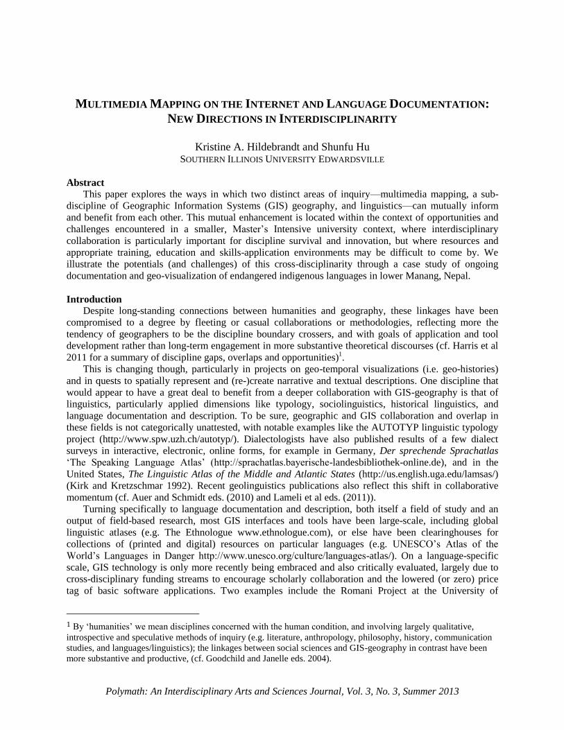
its most current instantiation here (Figure 1), and then elaborate on the design and ongoing goals. The
map may be accessed through www.mananglanguages.org/multi-media.html.
Figure 1. Atlas home page: Icons represent languages and interactive data access (interview data,
recorded texts and other information)
Figure 1 illustrates the home page to the interactive map, where visitors may then choose from several
options to access additional data gathered during the field trips, including selected answers from the
sociolinguistic interviews, sub-titled video texts, and data-sets on selected phonological and morpho-
syntactic phenomena as recorded from individual speakers.
We used XML to store and prepare the data for display in Google Map API v3 (cf. Hu 2012 for
discussion on approaches, benefits and drawbacks of this display type). For each sociolinguistic
interview, we coded points including the language name (for multi-lingual villages), village name,
longitude, latitude, a picture ID, and a video ID from YouTube. We used Notepad++, a free source code
editor that supports several programming languages running under a Microsoft Windows environment
(http://notepad-plus-plus.org/), to prepare the XML data file and to edit the JavaScript code for the
project.
In the design of the web application, we adopted a two-column layout design, including a column for
a map container for the Google map and/or satellite imagery and another column for a sidebar. Points of
interest (e.g., locations of the data collection) are marked with the customized language marker icons – a
green balloon with letter “N” for Nyeshangte, a yellow balloon with letters “MG” for (Manang) Gurung,
and so on.
The sidebar, on the right side of the layout in Figure 1, provides a place for the display of relevant
information for the points of interest marked on the map. Such information includes the name of the
language spoken at that location, photos relevant to different data-collection events, videos of interviews
Polymath: An Interdisciplinary Arts and Sciences Journal
55
and discourses, and a hypertext link to another web page that offers further information about the
interviews or discourses (e.g., interlinearized and annotated text scripts, sound files and other metadata.).
This can be accessed by visitors by using the clickable marker icons with Google Maps API’s
Infowindow. However, unlike the Google standard infowindow, which is displayed as a pop-up over the
map when an icon is clicked, the infowindow in this project is displayed in the Sidebar. This allows for an
uninterrupted visual perspective of the language and data distribution across villages in Manang.
In order to provide the user with an interactive mapping experience, we added some standard Google
Maps controls, such as Pan and Zoom controls, Map Scale control, and Map Type control (the current
choices include Roadmap, which gives the user information about the traditional foot paths and
expanding motor road, and Satellite, which gives an aerial perspective). In addition, tooltips (e.g.,
language names) are added to the markers, along with clickable marker icons with Google Maps API’s
standard Infowindow, which displays the meta-data about each interview or discourse collection event.
To make these interactive features accessible to visitors from anywhere in the world without the need
for special software, we have made use of photo and video hosting tools that are free and universally
available online. Flickr (www.flickr.com) is a photo and video hosting website that is popular for users to
share and embed personal photographs and to host images that they embed in blogs and social media.
SlideFlickr (www.slideflickr.com) is an online Flickr slideshow generator that can help create slideshows,
which can be later embedded on a website using a few lines of JavaScript code. For this project, all the
photographs were pre-loaded onto a Yahoo! Flickr account (free of charge), organized into sets and given
meta-data. Then, a SlideFlickr slideshow for each village was generated and SlideFlickr IDs were
obtained to embed those slideshows into the web page.
We have also made use of YouTube (www.youtube.com), a free online video streaming service that
allows the users to upload, share, and view videos. YouTube accepts many different video-file formats
and converts them to Flash-video file format (viewable on the Internet and compatible with most video-
viewing applications). The videos can then be integrated on websites using video embeds or APIs. For
this project, audio clips of the sociolinguistic interviews and video clips of discourses were initially saved
in MPEG format and uploaded onto the project’s YouTube account. A growing number of these videos
now contain English sub-titles. The shared links were embedded into the Languages_pts.xml document
and later used by jQuery to upload the video onto the web page. A future project goal is to include links to
more detailed transcription files for the interviews and discourses, along with other data and metadata3.
We have found that the use of Google Maps API V3 provides us with an efficient mechanism to
merge these resources to deliver both the digital cartographic information and the language data to
Internet users with a fast response time in an easy-to-understand way. At all levels of inquiry, users may
proceed with a degree of confidence, as they are working with already-familiar tools and viewing options.
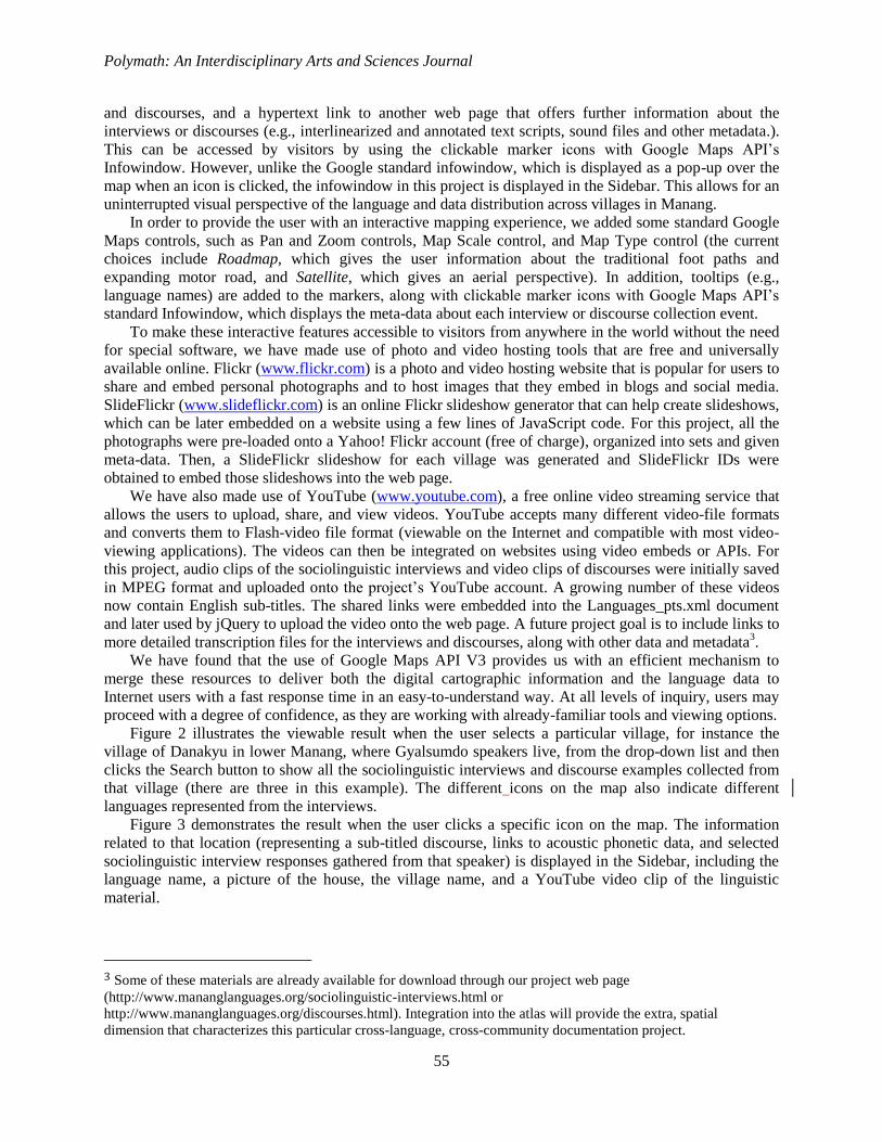
Figure 2 illustrates the viewable result when the user selects a particular village, for instance the
village of Danakyu in lower Manang, where Gyalsumdo speakers live, from the drop-down list and then
clicks the Search button to show all the sociolinguistic interviews and discourse examples collected from
that village (there are three in this example). The different icons on the map also indicate different
languages represented from the interviews.
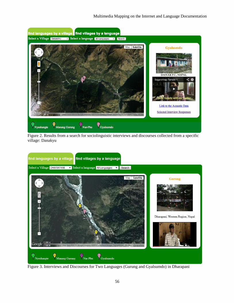
Figure 3 demonstrates the result when the user clicks a specific icon on the map. The information
related to that location (representing a sub-titled discourse, links to acoustic phonetic data, and selected
sociolinguistic interview responses gathered from that speaker) is displayed in the Sidebar, including the
language name, a picture of the house, the village name, and a YouTube video clip of the linguistic
material.
3 Some of these materials are already available for download through our project web page
(http://www.mananglanguages.org/sociolinguistic-interviews.html or
http://www.mananglanguages.org/discourses.html). Integration into the atlas will provide the extra, spatial
dimension that characterizes this particular cross-language, cross-community documentation project.
Multimedia Mapping on the Internet and Language Documentation
56
Figure 2. Results from a search for sociolinguistic interviews and discourses collected from a specific
village: Danakyu
Figure 3. Interviews and Discourses for Two Languages (Gurung and Gyalsumdo) in Dharapani
Polymath: An Interdisciplinary Arts and Sciences Journal
57
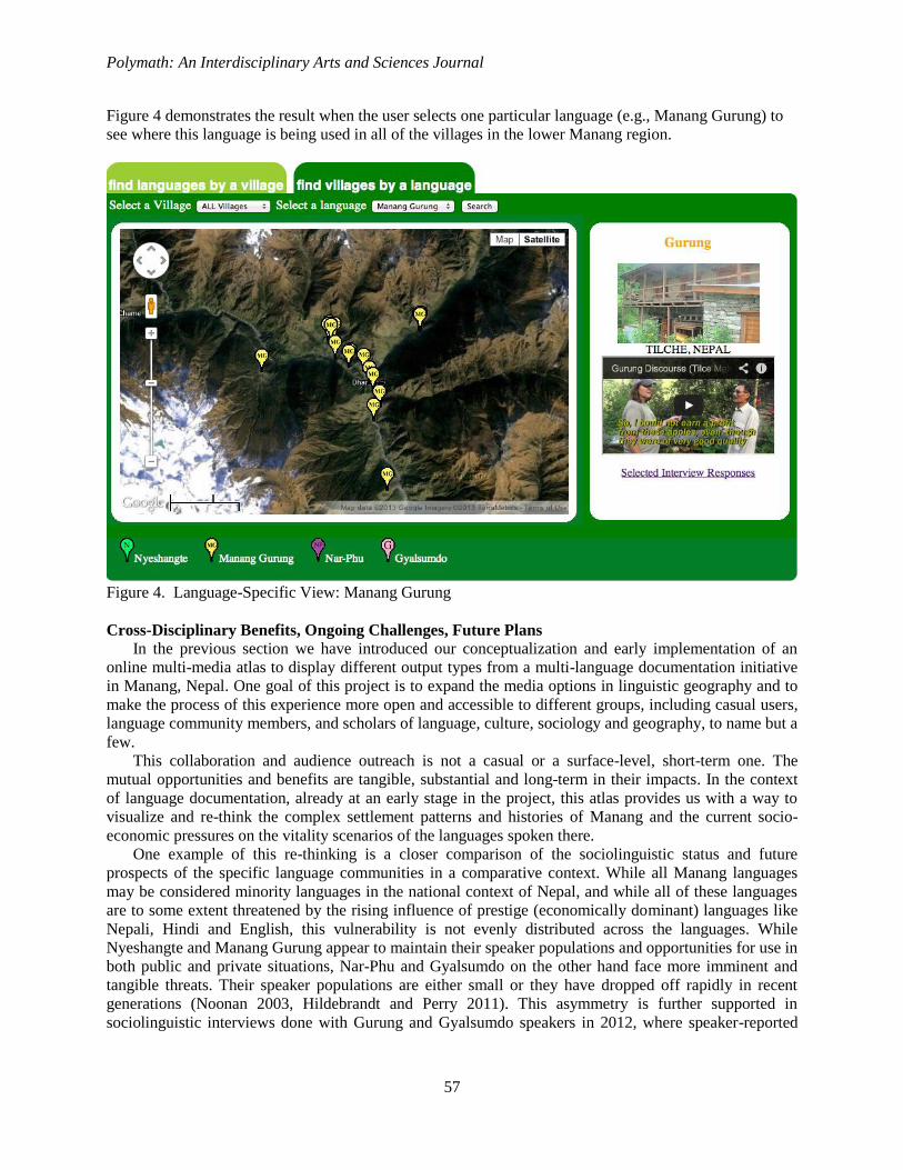
Figure 4 demonstrates the result when the user selects one particular language (e.g., Manang Gurung) to
see where this language is being used in all of the villages in the lower Manang region.
Figure 4. Language-Specific View: Manang Gurung
Cross-Disciplinary Benefits, Ongoing Challenges, Future Plans
In the previous section we have introduced our conceptualization and early implementation of an
online multi-media atlas to display different output types from a multi-language documentation initiative
in Manang, Nepal. One goal of this project is to expand the media options in linguistic geography and to
make the process of this experience more open and accessible to different groups, including casual users,
language community members, and scholars of language, culture, sociology and geography, to name but a
few.
This collaboration and audience outreach is not a casual or a surface-level, short-term one. The
mutual opportunities and benefits are tangible, substantial and long-term in their impacts. In the context
of language documentation, already at an early stage in the project, this atlas provides us with a way to
visualize and re-think the complex settlement patterns and histories of Manang and the current socio-
economic pressures on the vitality scenarios of the languages spoken there.
One example of this re-thinking is a closer comparison of the sociolinguistic status and future
prospects of the specific language communities in a comparative context. While all Manang languages
may be considered minority languages in the national context of Nepal, and while all of these languages
are to some extent threatened by the rising influence of prestige (economically dominant) languages like
Nepali, Hindi and English, this vulnerability is not evenly distributed across the languages. While
Nyeshangte and Manang Gurung appear to maintain their speaker populations and opportunities for use in
both public and private situations, Nar-Phu and Gyalsumdo on the other hand face more imminent and
tangible threats. Their speaker populations are either small or they have dropped off rapidly in recent
generations (Noonan 2003, Hildebrandt and Perry 2011). This asymmetry is further supported in
sociolinguistic interviews done with Gurung and Gyalsumdo speakers in 2012, where speaker-reported
Multimedia Mapping on the Internet and Language Documentation
58
phenomena like language use by children, use in local primary schools and in the local workplace, and
even language use among family members place Gurung at a distinct survival advantage over Gyalsumdo.
At this time, our project’s atlas is able to effectively show that the motor road construction project
distinctly favors Gurung community cohesion, as many of these communities lie alongside the path of
construction. Simultaneously, Gyalsumdo communities are either in direct line of major road construction
blast zones and hence susceptible to abandonment or other environmental compromise (e.g. Thonce and
Bagarchap villages), or else they are at the epicenter of rapid economic and political expansion due at
least in part to the road, and are literally being squeezed out due to the establishment of Nepali and
English and the recent settlement of other language groups, including Indian immigrants (e.g. Chame
village). What we may be witnessing is language death to Gyalsumdo not by war, famine or ethnic strife,
but simply due to economic and political pressures (cf. Edwards 1992 and Grenoble and Whaley 1998 for
typologies of language endangerment variables).
In the context of GIS-geography, this project allows for an implementation and testing of multimedia
mapping using tools that are already available. This approach combines spatial data, multimedia
information and functionality from sources such as Google Maps, SlideFlickr, and YouTube to create a
new service of use to many audience types. This new approach clearly has a number of advantages. First,
the programmer can employ easy-to-use commercial APIs to develop multimedia mapping applications.
With little or no investment on dedicated computer hardware (i.e., server space) and specialized software
(i.e., web server, map server), the developer just needs to have Internet access, a YouTube account, and a
Yahoo! Flickr account to develop a web page and deliver the multimedia mapping service to the Internet
user. Second, with much faster response times and greater user interaction, users only need a standard
Internet browser to navigate from place to place within the Google Maps environment and to access
different information or materials. All of this access is free of charge to both developers and users, a
benefit to those projects that lack the human resources and skill-sets and/or the budget to invest and make
use of more customized solutions.
At a more general level, this project also stands as a case study of what is possible when groups of
different backgrounds are able to incorporate and access quality information into what has traditionally
been thought of as a quantitative environment. The methods and representation of GIS in a context of
traditional reliance on “spatial primitives and the topological relations between these” has now merged
with a need to better appreciate language practices, attitudes and structures as dependent on these spatial
variables, thus responding to the need to emphasize the science of GIS and documentation and not simply
the system (Harris et al 2011: 228).
It should be noted that the atlas is currently still a work in-progress and is only one piece of a larger
and long-term language documentation project. Towards long-term data preservation and access, we are
currently working with our university to acquire streaming server space that can accommodate all of the
audio, video and meta-data for archival storage in a single virtual space. The project also has a formal
collaboration agreement with the Tibetan Himalayan Library (housed at the University of Virginia) in
which to house and feature selected information towards their stated goal to “promote the integration of
knowledge and community across the divides of academic disciplines, the historical and the
contemporary, the religious and the secular, the global and the local.”
(http://www.thlib.org/about/wiki/thdl/home/overview.html). As the atlas becomes further populated with
geo-referenced points and data from our 2013 and 2014 data collection, we also plan to integrate methods
to collect atlas user data, including integration of visitor feedback input options, and additional map
overlays to illustrate linguistic dimensions of dialect and language variation observed across the speech
communities of Manang. We are also working with the Manang Youth Society as the organization seeks
to identify and map alternative trekking trail development in the face of the motor road construction
throughout the district.
Final Remarks
This paper has demonstrated, via a case study, the benefits that two fields of inquiry have brought to
teach other, and has made a claim that such cross-disciplinary collaborations do more than enhance the
Polymath: An Interdisciplinary Arts and Sciences Journal
59
findings of a particular project; they also advance both fields as well. To be sure, there are reactions
against collaborative research, particularly in humanities-centered dimensions. These reactions are
summarized by Dwyer (2013), including the response that collaborative work implies a bias towards
capturing and wrangling large data-sets, and as such is not representative of the intellectual effort
involved in fine-level analysis. As Dwyer notes, this may be a reaction against so-called “big data”
movements that assume that humanities-centered research questions can be more satisfactorily answered
or dealt with through data mining or concordance, as opposed to the ‘close readings’ that typically
characterize the humanities (5).
However, as Dwyer (2010) notes, in the context of documentation linguistics, the most effective
methods, with the longest-lasting positive impacts, are those that are inherently focused on the
construction and maintenance of a community of practice. We hope to have shown that an interactive
atlas such as ours contributes to this at both the local level (interactions between linguists and local
community members and leaders) and at regional, national or international academic levels (e.g. the
sharing of knowledge, skills, resources and innovative ideas or approaches amongst scholars).
This need for thoughtful collaboration and the positive impacts that can come of it, has never been
more evident than now within the environment of university-level economic politics and the shifting
paradigms of private, state and federal-level funding opportunities. As the authors’ institution affiliations
indicate, this project is organized and run out of a regional, state-funded university, where there is
competition with other campuses for an ever-shrinking pot of resources. In such an environment, we are
compelled to consider the means to undertaking this effort as much as the end products generated. These
collaborative enterprises within a digital humanist framework avoid unnecessary duplication of financial
or equipment resources, while simultaneously providing undergraduate and Master’s-level students with
exciting and innovative theoretical and applied learning opportunities. Towards this end, we have
involved a rotating cadre of undergraduate and graduate-level students either as paid research assistants or
as credit-earning independent study participants. The students have so far assisted on-site in Nepal with
data collection or at the home institution with coding and analysis or with atlas design and development4.
In this way, students gain valuable, cutting-edge professional skills alongside increased awareness of
language diversity and practices beyond the scope of their everyday experiences, or beyond even their
traditional conceptualization of what is possible with Internet applications like YouTube and Google
Maps.
Acknowledgements We would like to acknowledge support from the National Science Foundation (DEL 1149639) and
from Southern Illinois University Edwardsville, in particular the Graduate School and the University
Research and Creative Activities program. Our postdoctoral research associate in Nepal is Dr. Dubi
Nanda Dhakal. We would like to thank the graduate and undergraduate students who have assisted us
with data collection, analysis and atlas development, including Prita Malla, Kanchan Karki, Yesha Malla,
Matthew Vallejo, Cassidy Martin, Samantha Jo Winkler and Alex Kalika. We are grateful to the Centre
for Nepal and Asian Studies at Tribhuvan University for their involvement in this project. We would also
like to thank the members of the Gurung, Gyalsumdo, Nar-Phu and Nyeshangte language communities
(in particular: Mr. Ritar Lhakpa Lama, Mr. Sangdo Lama, and Ms. Pushpa Gurung) for facilitating
contacts with the communities and for teaching us about their languages.
4 In future project years students will assist with language community materials production and with pedagogical
materials development.
Multimedia Mapping on the Internet and Language Documentation
60
REFERENCES
Auer, P. and J. E. Schmidt (eds.) 2010. Language and Space: An International Handbook of Linguistic
Variation, Volume 1: Theories and Methods. Berlin: de Gruyter.
Belsis, P., S. Gritzalis, A. Malatras, C. Skourlas, and I. Chalaris. 2004. Enhancing knowledge
management through the use of GIS and multimedia, Lecture Notes in Artificial Intelligence
(Subseries of Lecture Notes in Computer Science), 3336, 319-329.
Berez, A. 2011. Discourse, landscape and directional reference in Ahtna. PhD dissertation, University of
California Santa Barbara.
Bickel, B. 1997. Spatial operations in deixis, cognition, and culture: where to orient oneself in Belhare. In
Nuyts, J. and E. Pederson (eds.) Language and conceptualization, 46-83. Cambridge: Cambridge
University Press.
Bill, R. 1998. Multimedia-GIS concepts and applications, Geo-Informations-Systems, 11, 21-24.
Cartwright, W. 1999. Development of multimedia. In M. P. Peterson, and G. Gartner (eds.), Multimedia
Cartography, 11-30. New York, NY: Springer.
Chong, A. K. 1999. Orthoimage mapping bases for hybrid, multimedia, and virtual environment GIS,
Cartography 28: 33-41.
Cotton, B., and R. Oliver. 1994. The Cyberspace Lexicon—an illustrated dictionary of terms from
multimedia to virtual reality, London, UK: Phaidon Press Ltd.
Dwyer, A.M. 2013. Competing ideologies of collaborative research. MS. Retrieved from
http://hdl.handle.net/1808/10600
Dwyer, A. M. 2010. Models of successful collaboration. In N. Louanna Furbee and Lenore A.Grenoble
(eds.) Language Documentation: Practice and Values, 193-212. Amsterdam: Benjamins.
Edwards, J. 1992. Sociopolitical aspects of language maintenance and loss: Towards a typology of
minority language situations. In W. Fase, K. Jaspaert and S. Kroon (eds.),Maintenance and Loss of
Minority Languages, 22-54. Amsterdam: Benjamins.
Glassner, M. I. 1997. Tibetan Border Worlds. London: Routledge.
Goodchild, M. F. and D. G. Janelle (eds.) 2004. Spatially Integrated Social Science. New York: Oxford
University Press.
Goryachko, V. V., and A.V. Chernyshev. 2004. Multimedia and GIS-technologies in atlas mapping,
Vestnik Moskovskogo Universiteta, 5.2: 16-20.
Grenoble, L. and L. J. Whaley. 1998. Towards a typology of language endangerment. In Grenoble, L. and
L. J. Whaley (eds.), Endangered Languages, 22-54. Cambridge University Press.
Harris, T. M., S. Bergeron and L. J. Rouse. 2011. Humanities GIS: Place, spatial storytelling and
immersive visualization in the humanities. In Dear, M., J. Ketchum, S. Luria and D. Richardson
(eds.), Geohumanities: Art, History, Text at the Edge of Place, 226-240. London: Routledge.
Harrison, K. D. 2007. When Languages Die: The Extinction of the World’s Languages and the Erosion of
Human Knowledge. New York: Oxford University Press.
Hildebrandt, K. A. 2004. A grammar and glossary of the Manange language. In Genetti, C. (ed.), Tibeto-
Burman Languages of Nepal: Manange and Sherpa, 2-189. Canberra: Pacific Linguistics.
Hildebrandt, K. A. 2007. Manange [Nyeshangte]. In Y. Matras and J. Sakel (eds.), Grammatical
Borrowing in Cross-linguistic Perspective, 283-300. Berlin: Mouton.
Hildebrandt, K. A. and J. J. Perry. 2011. Preliminary notes on Gyalsumdo, an undocumented Tibetan
variety spoken in Manang, Nepal. Himalayan Linguistics 10.1: 1-19.
Hu, S. 1999. Integrated multimedia approach to the utilization of an Everglades vegetation database,
Photogrammetric Engineering and Remote Sensing, 65.2: 193-198.
Hu, S. 2009. Advancement of web standards and techniques for developing hypermedia GIS on the
Internet. In M. Madden (ed.), ASPRS Manual of GIS, 975-983. American Society of Photogrammetry
and Remote Sensing (ASPRS).
Hu, S. 2010. Multimedia mapping. In B. Warf (ed.), Encyclopedia of Geography. SAGE Reference
Publication.
Polymath: An Interdisciplinary Arts and Sciences Journal
61
Hu, S. 2012. Online Map Service Using Google Maps API and other JavaScript libraries: An open source
method, In M. P. Peterson (ed.) Online Maps with APIs and Mapservices, 265-278, Springer.
Hu, S., A. O. Gabriel and L. R. Bodensteiner. 2003. Inventory and characteristics of wetland habitat on
the Winnebago Upper Pool Lakes, Wisconsin, USA: An integrated multimedia GIS approach,
Wetland 23.1: 82-94.
Kirk, J. M. and W. A. Kretzschmar Jr. 1992. Interactive linguistic mapping of dialect features. Literary
and Linguistic Computing 7.3: 168-175.
Lameli, A., R. Kehrein, and S. Rabanus (eds.) 2011. Language and Space: An International Handbook of
Linguistic Variation, Volume 2: Language Mapping. Berlin: de Gruyter.
Laurini, R. and F. Milleret-Raffort. 1990. Principles of geomatic hypermaps. In Proceedings of the 4th
International Symposium on Spatial Data Handling, Zurich, Switzerland, 2: 642-655.
Noonan, M. 2003. Nar-Phu. In R. LaPolla, G. Thurgood (eds.), The Sino-Tibetan Languages, 336-352.
London: Routledge.
Openshaw, S. and H. Mounsey. 1987. Geographic information systems and the BBC’s Domesday
interactive videodisk, International Journal of Geographical Information Systems, 1.2: 173-179.
Peterson, M. P. 1995. Interactive and Animated Cartography, Upper Saddle River, NJ: Prentice Hall.
Rhind, D. P., P. Armstrong, and S. Openshaw. 1988. The Domesday machine: A nationwide geographical
information system, Geographical Journal, 154.1: 56-58.
Shepherd, I. D. 1991. Information integration and GIS, In D. J. Magurie, M. F. Goodchild, and D. W.
Rhind (eds.), Geographical Information Systems: Principles and Applications Volume 1, 337-357.
Essex, UK: Longman Scientific and Technical Publications.
Shiffer, M. J. 1998. Multimedia GIS for planning support and public discourse, Cartography and
Geographic Information Systems, 25.2: 89-94.
Snellgrove, D. 1961. Himalayan Pilgrammage: A Study of Tibetan Religion by a Traveler Through
Western Nepal. Boston: Shambhala.
Slobin, D. 1996. Two ways to travel: Verbs of motion in English and Spanish. In M. Shibatani and S.A.
Thompson (eds.), Grammatical Constructions: Their Form and Meaning, 195-217. Oxford: Oxford
University Press.
Soomro, T. R., K. Zheng, S. Turay, and Y. Pan. 1999. Capabilities of multimedia GIS, Chinese
Geographical Science, 9.2: 159-165.
Wallin, E. 1990. The map as hypertext—on knowledge support systems for the territorial concern. In
Proceedings of the First European Conference on Geographical Information System, EGIS’ 90,1125–
1134. EGIS Foundation, Munich.
Yagoub, M. M. 2003. Building an historical remote sensing atlas and multimedia GIS for Al Ain, GEO:
Connexion, 2.7: 54-55.