modelling the variability of midlatitude storm activity on decadal to century time scales
TRANSCRIPT

1
Modelling the Variability of Midlatitude Storm Activity on Decadal to Century Time Scales
I. FISCHER-BRUNS1, H. VON STORCH2,3, J. F. GONZÁLEZ-ROUCO4 AND E. ZORITA2
1Max-Planck-Institute for Meteorology, Hamburg, Germany
2Institute for Coastal Research, GKSS, Geesthacht
3Meteorological Institute, Univ. of Hamburg, Germany
4Universidad Complutense de Madrid, Spain
Accepted by Climate Dynamics
(8 April 2005)
Corresponding author:
Irene Fischer-Bruns
phone: +49-40-41173-242
fax: +49-40-41173-298
1

2
Abstract
The output of several multi-century simulations with a coupled Ocean-Atmosphere General
Circulation Model is examined with respect to the variability of global storm activity in winter on
time scales of decades and longer. The frequency of maximum wind speed events within a grid box,
using the lower limits on the Beaufort wind speed scale of 8 and 10 Bft as thresholds, is taken as the
characteristic parameter. Two historical climate runs with time-dependent forcing of the last five
centuries, one control simulation, and three climate change experiments are considered.
The storm frequency shows no trend until recently. Global maps for the industrially influenced
period hardly differ from pre-industrial maps, even though significant temperature anomalies
temporarily emerge in the historical runs. Two indicators describing the frequency and the regional
shift of storm activity are determined. In historical times they are decoupled from temperature.
Variations in solar and volcanic forcing in the historical simulations as well as in greenhouse gas
concentrations for the industrially influenced period are not related to variations in storm activity.
Also, anomalous temperature regimes like the Late Maunder Minimum are not associated with
systematic storm conditions.
In the climate change experiments, a poleward shift of storm activity is found in all three storm track
regions. Over the North Atlantic and Southern Ocean, storm activity increases, while it decreases
over the Pacific Ocean. In contrast to the historical runs, and with the exception of the North Pacific
storm frequency index, the storm indices parallel the development of temperature, exceeding the 2 σ-
range of pre-industrial variations in the early 21st century.
1. Introduction
Storms, or more precisely, windstorms, are a characteristic of the maritime weather at midlatitudes.
They are responsible for a significant part of the rainfall, for serious hazards both on land and at sea,
for mixing the ocean and efficiently transporting energy and substances. As such, storms deserve our
attention. The formation of these baroclinic storms has long been disentangled since the days of
Vilhelm Bjerknes (Friedman 1989), but knowledge about the statistics of storm events and their
changes through time is limited.
2

3
It is particularly difficult to homogeneously “measure” storm intensities. The World Meteorological
Organization (WMO) Beaufort scale is certainly most useful, but records based on visual
observations depend on subjective decisions as well as ship routing and other non-meteorological
phenomena. Long series of direct wind observations are almost always suffering from
inhomogeneities. Proxies, in particular based on pressure readings, allow some reconstructions of
past storm conditions (Schmidt and von Storch 1993; WASA 1998; Kaas et al. 1998; Alexandersson
et al. 2000). Seemingly, the storm climate in Northern Europe and in the adjacent North Atlantic
region has been relatively stable during the last 100 or even 200 years, even if some interdecadal
variability prevails (Bärring and von Storch 2004). This view is supported by scant historical
evidence based on dyke repair costs in the 17th century (de Kraker 1999). This relative stability is
astounding insofar as it contradicts views of many people who, in history, have often perceived
storms as having become more severe (von Storch and Stehr 2000).
From indirect evidence, in particular proxy data like tree ring width, it is known that the climate in
historical times has undergone significant variations – with extended periods like the Little Ice Age
and the Medieval Warm Period or shorter interruptions like the Late Maunder Minimum (1675-
1710; Lamb 1977). The spatial extent of these episodes is subject to debate, but there is little doubt
that significant temperature deviations prevailed during these times in large areas. Our question is:
Are these temperature variations associated with significant changes of storminess?
As already outlined, we cannot test this hypothesis – “significant temperature variations are linked to
significant changes of storminess” – with observed or indirect data. Therefore, we resort to the
output of several multi-centennial simulations with a climate model, forced realistically with
variable solar output, effect of volcanic aerosols and greenhouse gases (GHGs) (González-Rouco et
al. 2003; Zorita et al. 2004). Two of these runs simulate historical conditions in 1500-1990 and
1000-1990. They exhibit the above mentioned historical temperature anomalies although the
simulated anomalies are larger than the temperature anomalies estimated from proxy data and
historical accounts (e.g. Mann et al. 1998). On the other hand, evidence is accumulating that the last-
mentioned reconstructions underestimate variability on multi-decadal and centennial time scales
(von Storch et al., 2004). Also, the temperatures during the Late Maunder Minimum period in the
model are consistent with many local data (Zinke et al. 2004; Zorita et al. 2004). But even if the
temperature variations in our model simulations were too large, this would not be a severe limitation
for our attempt to test the hypothesis about a link of storminess and temperature variations. In the
remainder of this paper we will demonstrate that we have to reject the hypothesis and to conclude
that mid-latitude storm activity is mostly decoupled from hemispheric temperature variations – even
3

4
if the temperature variations are possibly too large. For the future scenario runs, however, it will be
shown that storm activity mostly parallels the development of temperature.
The paper is organized as follows: First, in Section 2, the model and experiments are described. In
Section 3, our technique for determining storminess from wind speed data is explained. The
frequency of storm days in terms of a storm frequency index is determined in Section 4. In Section 5
a storm shift index is introduced in order to ascertain the dominant modes of storm variability. The
paper is concluded in Section 6 with a discussion.
2. Model and Experiments
For all analyses we use the output of the coupled global Ocean-Atmosphere General Circulation
Model ECHAM4/HOPE-G. The spectral expansion of T30 in the atmospheric model corresponds to
a horizontal gridding of about 3.75° 3.75°. In the vertical, the model resolves 19 atmospheric
layers. The global general circulation model of the ocean, HOPE-G, has a horizontal gridding of
2.8° 2.8°, refining to 0.5° near the equator, and 20 vertical levels. An annual mean flux correction
of the heat and freshwater fluxes has been applied to the coupling between the ocean and the
atmosphere component to remove the climate drift. The coupled model with its components has been
documented in several publications, giving further details (Roeckner et al. 1992; Roeckner et al.
1996; Wolff et al. 1997; Legutke and Maier-Reimer 1999; Legutke and Voss 1999). The spatial
resolution of T30 in ECHAM4 is sufficient for the representation of synoptic cyclones (Stendel and
Roeckner 1998; Raible and Blender 2004). Since Stendel and Roeckner (1998) have shown that the
storm tracks show satisfactory agreement when compared with ERA-15/ECMWF re-analysis data
(deviations below 10%), we consider the model also as being suitable for our study.
Six climate simulations with different forcings are considered in this study: two realizations of a
historic climate change simulation, three transient climate change experiments with idealized forcing
simulating a future climate state, and a control simulation.
a) Historical Simulations H1 and H2
The two historical climate simulations (González-Rouco et al. 2003; Zorita et al. 2004; von Storch et
al. 2004) cover the periods 1500-1990 and 1000-1990. The time-dependent external forcing of the
4

5
model has been determined according to estimates of changes in solar radiation, in volcanic and
GHG forcing (carbon dioxide, methane and nitrous oxide). The solar and volcanic forcing has been
derived from data, which Crowley (2000) applied in his experiments. The historical simulations are
referred to as H1 (1500-1990) and H2 (1000-1990). In this study only the years 1550-1990 of both
runs are considered (in H1 the model achieves a stable state around year 1550).
b) Increased CO2 Integration CMIP2
During the Coupled Model Intercomparison Project (CMIP) exercise, the so-called ‘extended
CMIP2’ experiment has been performed with ECHAM4/HOPE-G along with several other climate
models (Meehl et al. 2000). The integration has been started from a control state (1990 conditions:
CO2 content of 353 ppm) with the CO2 concentration of the model’s atmosphere increasing at a rate
of 1% p.a. to quadrupling (140 years). This concentration has then been held constant until
simulation year 152. The 1% p.a. increase represents changes in equivalent CO2 concentration,
describing the radiative effects of the major GHGs, which are well mixed throughout the
atmosphere. This climate change experiment is referred to as CMIP2 in this study.
c) Increased CO2 Integrations A2 and B2
The Special Report on Emissions Scenarios (SRES; Nakicenovic and Swart 2000) describes a set of
emissions scenarios used in the Intergovernmental Panel on Climate Change (IPCC) Third
Assessment Report. These scenarios have been designed to investigate future changes in the global
environment taking into account especially the release of greenhouse gases and aerosol precursor
emissions.
We consider results of the model driven by a forcing prescribed by the IPCC SRES A2 and B2
emissions marker scenarios for CO2 and CH4 (with no aerosol changes). The main scenario
characteristic of A2 is a very heterogeneous world with a continuously increasing population,
strengthened regional cultural identities and a slow economic development. B2 assumes a slower
population growth with intermediate levels of economic development and more accent on
environmental protection producing therefore lower emissions and less future warming than A2 (for
more details see Nakicenovic and Swart 2000). We refer to these climate change experiments as A2
and B2.
5

6
d) Control Integration N
For the control simulation, the climate model has been integrated for 1000 years with fixed solar
and GHG forcing corresponding to present-day conditions (forcing values: solar (1365 Wm-2),
GHG concentrations: CO2 (353 ppm), CH4 (1720 ppb), N2O (310 ppb)). The control run is
simulating a realistic contemporary climate (Min et al. 2004). This experiment is referred to as
N hereinafter.
3. Evidence for storminess based on near-surface wind speed data
For the assessment of extreme wind speed events long time series of simulated maximum 10m wind
speed are analyzed. Following the concept of Weisse at al. (2005), we investigate the near-surface
wind speed data directly instead of analyzing proxies for storminess (e.g. cyclone counts based on
surface pressure). This approach has been chosen in order to avoid assumptions to be made when
using tracking algorithms. It is also reasonable since the wind speed data are easily accessible in a
high temporal resolution. They are stored by the model every 30 minutes, compared internally with
the preceding value and output every 12 hours. At every grid point we then determine the maximum
value for each day.
As thresholds for extreme wind speed events, the two lower limits (17.2 ms-1 and 24.5 ms-1) on the
WMO Beaufort wind speed scale of 8 Bft (17.2-20.7 ms-1) and 10 Bft (24.5-28.4 ms-1) are selected.
A ‘storm day’ (in our notation) is counted if the daily near-surface maximum wind speed reaches or
exceeds the threshold of 8 Bft. Thus, the total mean number of storm days per season is given by the
mean number of days when the maximum wind speed reaches at least 8 Bft. If the threshold of 10
Bft is reached or exceeded, the day is classified as a ‘severe storm day’. We only consider northern
and southern winter (DJF and JJA) since, in general, the winter has more intense extra-tropical
storms.
4. Frequency of Storm Days - Storm Frequency Index
With respect to maximum 10m wind speed we investigate first the frequency of storm days for the
pre-industrial time period from 1551 to 1850 in the simulations H1 and H2. Global maps for the total
mean number of storm days per season exhibit the well-known storm tracks in the NH for the
6

7
northern winter season (DJF) and in the SH for the southern winter season (JJA) (Fig. 1.a and b,
shown for H2). NH and SH stand for northern respectively southern hemisphere in the following.
“Hemispheric means” refer to spatial averages from 90N-15N and 90S-15S, respectively. The largest
frequency of extra-tropical storms in DJF can be seen to occur in the central North Atlantic and
central North Pacific Ocean, to the east of the paths of relatively warm ocean currents that follow the
eastern seaboards of North America and Asia, moving poleward and creating large temperature
contrasts with the cold continents. In these areas of large temperature gradients and thus large
vertical wind shear, the baroclinic disturbances draw energy from the mean flow, which is required
for generating and strengthening storm systems. Another storm track is circumnavigating the cold
continent of Antarctica (JJA). In the Mediterranean region the frequency of storm days is low (Fig.
1.a). As extreme wind speed events are produced by strong pressure gradients associated with
cyclones, we suppose an underestimation of the number of cyclones in this area. Since
Mediterranean cyclones are generally quite shallow and relatively small in scale, they are not well
represented by this model version having the relatively coarse resolution of T30. Also this region
appears to be dependent more on local processes than on the North Atlantic storm track (Knippertz
et al. 2003).
In the storm track regions the mean number of storm days per season is about 50 to 60 out of 90
days. The mean number of severe storm days only amounts to 10 to 20 per season (not shown).
Hence, in the following we focus mainly on the occurrence of storm days. A corresponding analysis
of simulation H1 shows that the storm climate of both simulations hardly differs.
The graphical representation of storm day frequency for the industrially influenced period 1851-
1990 in H2 is given in Fig. 2.a and b. A comparison with the respective pre-industrial maps (Fig. 1.a
and b) exhibits no noticeable difference. For a better comparison, Fig. 2.c and d show the differences
between industrial and pre-industrial time period for both winter seasons. They are negligible. If we
compare 1851-1990 with the recent period 1961-1990, a noticeable difference cannot be seen as well
(not shown). The same analysis has also been performed for severe storm days (not shown),
exhibiting no apparent differences also.
In a next step we analyze the control run N, in order to investigate the frequencies of extreme wind
speed events in an undisturbed simulation under contemporary GHG conditions. The 1000 year long
time series of maximum 10m wind speed is divided into three independent periods of 300 years
length each (year 1-300, 351-650 and 701-1000). As we expect, the storm activity does not change
from period to period. Compared to the maps for the pre-industrial and industrially influenced
7

8
periods of H1 and H2, only a slight difference is suggested, namely a poleward shift of the region
with maximum frequency on both hemispheres in the control run (not shown). This is due to the
constant present-day GHG concentration as a forcing factor in N, which is lacking in the pre-
industrial period in H2. Since during the industrially influenced period the GHG concentrations first
have to increase until they reach present day conditions, the increase simulated for the most recent
past has not yet had an effect on the time mean.
Finally, we analyze the wind data of the climate change experiments CMIP2, A2 and B2 in the same
way. Compared to N, H1 and H2 for the northern winter season, the region in the North Atlantic
Ocean with the largest number of storm days per season (50 to 60 as well) has enlarged in all three
future scenarios. As in N, this region is shifted to the northeast, which can be seen exemplarily for
A2 in Fig. 3.a. This is obviously due to the marked rise of GHGs in the climate change experiments.
An increase of storm day frequency also occurs in the region of the Southern Ocean storm track for
JJA, which is notorious for prevailing strong and ubiquitous westerly winds since they are not
impeded by large land areas like the winds in the NH. Here, the maximum number of storm days per
season is about 60-70 over the South Indian Ocean (Fig. 3.b), i.e. about 20% more compared to the
pre-industrial time periods of H1 and H2. In contrast to Fig. 2.c and d, where no difference between
industrial and pre-industrial can be seen, the comparison between A2 and pre-industrial times (Fig.
3.c and d) clearly exhibits regions with increases and decreases. Obviously, there is a poleward shift
of the regions with high storm day frequency on both hemispheres with future warming. This can be
explained by the change in temperature gradients and sea surface temperature and the withdrawal of
the ice edges in a warmer climate causing a poleward shift of the regions of cyclogenesis and the
whole storm track.
In order to assess what the threshold of 8 Bft actually relates to in the “real world”, a comparison of
the modelled storm day frequencies with those obtained by applying our method to NCEP/NCAR or
ERA-40/ECMWF reanalysis data could be considered. But such a comparison is not appropriate for
the following reasons: 1. The reanalysis databases do not provide instantaneous maximum 10m wind
speeds as have been analysed here. 2. The 10m wind speed (which also could be useful for
comparison) in our model version is available as an average over the output interval (12 h) only,
whereas reanalysed winds are instantaneous. We therefore refer to the findings of Weisse et al.
(2005), who have analysed the storm climate of the Northeast Atlantic and the North Sea simulated
by a regional climate model and compared their results with observations of marine stations. They
show that their model is able to reproduce the numbers of moderate and severe storms realistically.
8

9
From there we assume that the frequency of storms days determined by our method reflects a
realistic storm climate.
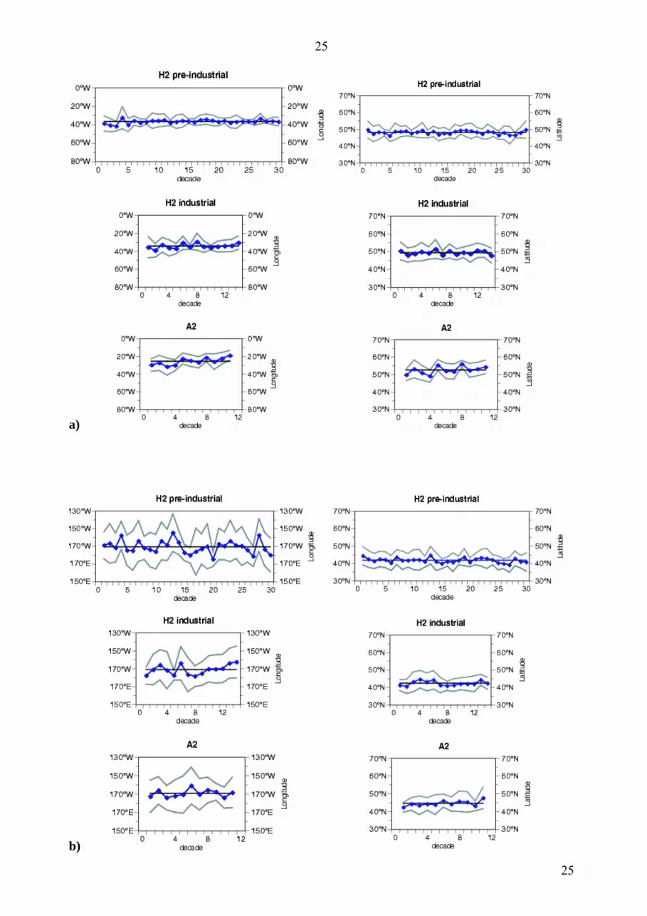
Fig. 4 shows the mean positions (averaged over 10 winter seasons) of the grid points where the
storm frequency is maximum as functions of time. The time series are displayed for the pre-
industrial and industrially influenced period in H2 and A2 for all three oceans. Additionally the long
time average of longitude and latitude has been indicated as a straight line to make it easier to
identify trends. In the pre-industrial and industrial period, the latitudinal and longitudinal positions in
the North Atlantic Ocean hardly change, since the time series show no trend and the variability is
low (Fig. 4.a, upper four panels). This is similar to the latitudinal position in the Southern Ocean,
whereas the corresponding longitudinal position is changing slightly from 1551-1850 (Fig. 4.c, H2
pre-industrial). This feature is even more outstanding in the Pacific region (Fig. 4.b), where the
longitudinal position is jumping back and forth between 145W to 175E with standard deviations
much higher than in the other regions. In the Pacific Ocean in all three time periods the longitudinal
and latitudinal positions are dispersed over a large region. With rising GHG concentrations (future
scenario A2), the positions tend to migrate further poleward in all oceans. Similar results can be
found for H1 and CMIP2 (not shown). However, the longitudinal positions in H1 are moving a little
more back and forth over the years than in H2.
A simple approach to define a storm index for frequency is to determine the mean number of storm
days in winter per grid point for each hemisphere. For the NH this index is nearly the same for all
simulation periods, i.e. there is no increase of modeled NH storm frequency with increasing GHGs.
For the SH, however, this index indicates an increase of modeled SH storm frequency beginning
with the industrialization (Fig. 5.a, b). The NH and SH indices differ in magnitude, because the NH
has more land points, where the winds are slowed down, than the SH. If this index is displayed as a
function of time for each hemisphere, the SH trend can be seen still more clearly. This is shown
exemplary for the pre-industrial and industrial phase of H2 and for A2 in Fig. 5.c, with standard
deviations of 0.36 (NH) and 1.13 (SH).
The same index determined separately for the North Atlantic (90W-30E) and North Pacific region
(150E-90W) however shows an increase in total number of storm days for the North Atlantic Ocean
but a decrease for the North Pacific Ocean (Fig. 5.d-f). The standard deviations of the index time
series in Fig. 5.f are 0.84 (N Atl), and 0.67 (N Pac). The slight North Pacific decrease in storm
frequency can be confirmed with Fig. 3.c, which shows that the region of decrease over the North
Pacific Ocean is larger than that of increase.
9

10
5. Dominant Modes of Storm Variability - Storm Shift Index
We want to express the variations in storm climate in the three storm track regions by using the same
reference frame. To do so, we first center all storm frequency data of H1 plus CMIP2 and H2 plus
A2, respectively B2, by subtracting the 1551-1850 pre-industrial mean of the H2 experiment (which
is defined as our reference period). Secondly, we calculate the leading EOFs from the centered data
of the pre-industrial H2 simulation. Finally, we project the centered 1551-2100 data from H2 plus
A2, respectively B2, onto these EOFs. (EOF stands for “Empirical Orthogonal Function”. With
“EOFs” we refer to the spatial structures, while the corresponding “principal components” (PCs)
reflect their development in time.) The same projection is applied with the centered 1551-2150 data
from H1 plus CMIP2. The resulting PC time series are considered as our winter storm shift indices
for the North Atlantic, North Pacific and Southern Ocean. They are also standardized to unit
variance for the pre-industrial time. Since these numbers are calculated with the same reference
means and patterns, the storm shift indices may be compared between the different simulations.
The first pre-industrial EOFs of H2 for the North Atlantic, North Pacific and SH region are shown in
Fig. 6 (left column, top to bottom). The spatial structures of these EOFs reflect a shift of the area
with maximum storm activity. The EOFs represent 23.4 %, 26.5 % and 11.2 % of the total simulated
variance respectively. Are these patterns of storm frequency, characterizing a climate undisturbed by
human activities, also the crucial patterns for describing the future climate? To assess this, we
exemplary calculate the linear trend of storm frequency at each grid point for the most extreme
scenario A2. A plot of the slope coefficient for the three regions generates the patterns shown in Fig.
6 (right column, top to bottom). As we expect from our previous results, over the North Atlantic and
in the SH, the regions with the strongest increasing trends extend over a larger area than those with
the strongest decreasing trends. Over the North Pacific Ocean, however, it is the opposite way round.
Since the first pre-industrial EOFs show a relatively good correspondence with the slope coefficient
patterns, we conclude that these EOFs can also describe the future climate in terms of storminess.
For the North Atlantic Ocean however, the correlation is not perfect, since the region of maximum
slope coefficient is located more eastward than the maximum of the first EOF. If we examine also
EOF2 to 5, the fourth EOF seems to describe this feature best. Moreover, the corresponding PC4
time series exhibits the second largest standard deviation of the first five PCs and, in addition, the
largest signal to noise ratio (here defined simply by dividing the last value (at year 2100) by the
standard deviation). EOF4 and the five PC time series corresponding to the first five EOFs
(determined by projection of the 1551-2100 data from H2 plus A2 on this EOF) are shown in Fig. 7.
10

11
For the sake of briefness, EOF2, 3 and 5 are not shown. Even though EOF4 is of secondary
importance for the pre-industrial period (describing only 6.1% of the total variance), it could also be
considered when describing the future change for the North Atlantic region. However, to simplify
matters, we only take into account the first EOFs in the following.
Both storm indices -for frequency and shift- versus the near surface temperature averaged over the
respective region are displayed in Fig. 8 for the North Atlantic Ocean, North Pacific Ocean and SH.
The temperature time series are standardized in the same manner, namely such that, during the H2
pre-industrial reference period, the mean is zero and the standard deviation is one. We show results
for experiment H1 continued with CMIP2 (Fig. 8.a-c) and H2 continued with A2 respectively B2
(Fig. 8.d-f). With both sets of experiments we achieve similar results: In pre-industrial times the
storm indices are almost stationary and decoupled from temperature. There is possibly a very minor
upward trend, which, surprisingly, does not match the trend in temperatures emerging since the
beginning of the industrialization in the middle of the 19th century. The future climate experiments
begin with a storm variability level that is consistent with the level in the historical experiments. But
this level increases clearly in the 21st century – in parallel to the development of temperature, with
the exception of the storm frequency index in the North Pacific region.
For the North Atlantic Ocean, there is a future pole ward shift of the region with highest storm
frequency beginning with the industrialization and overall a slight increase in storm frequency. For
the North Pacific region, the result is a pole ward shift but overall a decrease in storm frequency. The
result for the SH is a clear shift beginning with the industrialization and overall a large increase of
storm frequency. These results apply for all three sets of experiments.
When we consider the pre-industrial 2σ-range (horizontal gray lines in Fig. 8) as a normal within
which climatic variations would remain most of the time as long as anthropogenic factors do not
have a significant impact, then the simulated temperature conditions are no longer “normal” since
the 1950s for North Atlantic and North Pacific, and since about 1990 on the SH. The storminess
signals for the North Pacific, however, emerge some decades later, at about the year 2000.
The storm activity on both hemispheres is closely related to the simulated Arctic Oscillation (AO)-
and Antarctic Oscillation (AAO) indices, defined as the PCs corresponding to the first EOF of the
NH and SH mean sea level pressure (mslp), respectively. Fig. 9.a-d shows the AO and AAO patterns
for the pre-industrial period of H2 and the A2 scenario. A clear shift of the centers of action to the
east with future warming in both the North Atlantic and the North Pacific region can be seen. This
11

12
can be ascertained also by comparing the patterns of H1 pre-industrial and CMIP2 (not shown) and
is analog to the NAO shift found by Ulrich and Christoph (1999). On the SH the pattern is
elongating with the CO2 increase. The multi-century time series of the AO and AAO indices are
determined by projection of the 1551-2100 mslp data from H2 plus A2 on the pre-industrial EOFs
for the NH respectively SH. On both hemispheres, the indices are highly correlated with our storm
shift indices (NH: 0.92, SH: 0.96). On the NH the link between AO index and storm shift index is
unchanged during all time periods, while on the SH the storminess grows faster than the AAO index
during the 21st century (Fig. 9.e and f).
6. Discussion
The major results of our study are that
1. During historical times, storminess on both hemispheres is remarkably stationary with little
variability.
2. During historical times, storminess and large-scale temperature variations are mostly decoupled.
3. In the climate change scenarios, with a strong increase of greenhouse concentrations, in the
North Atlantic and Southern Ocean both temperature and storm shift index rise quickly beyond the
2σ-range of pre-industrial variations, although the trends in the storms are smaller than the trends in
temperature. In the North Pacific the changes to the storms moreover tend to occur after the changes
in temperature.
4. There are indications for a poleward shift of the regions with high storm frequency on both
hemispheres with future warming. Altogether, we have ascertained an increase of the North Atlantic
and SH storm frequency index, whereas the North Pacific storm frequency index decreases with
future warming.
The first result is consistent across the two historical simulations, but the second conclusion is not
that straight forward. Indeed, in one of the two historical simulations (H1), during the two periods
with extremely low external forcing, the Late Maunder Minimum (LMM, 1675-1710) and the
Dalton Minimum (1790-1840), a certain connection between storm track variability and temperature
emerges over the North Atlantic Ocean (Fischer-Bruns et al. 2002; Fischer-Bruns et al. 2004): during
the first half of the LMM and the Dalton Minimum less storms develop, while during the second half
more storms pass across the North Atlantic Ocean. This feature is, however, not present in the H2
12

13
simulation, which has been run with the same forcing as H1. As it happens twice in H1, but not in
H2, it may be seen as a random pattern. But it could also mean that a presently available larger
ensemble of simulations may exhibit regime-like behavior.
Even if under certain circumstances a complex temperature-storminess link like the one described
above in H1 is in operation, there is no evidence of a linear co-variability between extra tropical
storminess and large-scale temperature variations during historical times in our simulations. The fact
that parallel trends emerge in the scenario simulations may be due to a casual relationship between
warming and baroclinic instability, or may possibly be caused by or at least be related to the speed of
temperature change. The latter hypothesis is supported by a result of Stone et al. (2001), who found
the initial AAO intensification in the GFDL (Geophysical Fluid Dynamics Laboratory) CGCM to
diminish after stabilization of the temperature change. The former would be supported if the
warming were spatially inhomogeneous with stronger warming at subtropical latitudes and a weaker
warming at subpolar latitudes – leading to a stronger meridional temperature gradient. However this
was not found to be the case.
A review of the literature about the many different climate change experiments with global coupled
models reveals a mixed outcome. On the one hand, some models indicate an intensification of the
North Atlantic storm track (such as Ulbrich and Christoph 1999; Knippertz et al. 2000; Andersen et
al. 2001; Carnell et al. 1996). Knippertz et al. (2000), for example, relate the increase of cyclone
activity in their simulation to increased upper tropospheric baroclinity and the increasing number of
strong wind events to the increasing number of deep lows. On the other hand some studies find little
change or even a reduction of extreme winds for the North Atlantic region (such as Beersma et al.
1997; Kharin and Zwiers 2000; Zwiers and Kharin 1998). An overview over several publications can
be found in the IPCC Third Assessment Report (2001). As has been outlined there, Carnell and
Senior (1998) performed an analysis of an ensemble of four future climate change experiments with
rising CO2 and sulfate aerosols and show that the number of weaker storms is reduced. They assume
the reason for a weakening of storms in future climate can be seen in the higher warming at higher
latitudes compared to the warming at lower latitudes. As a consequence, the mean meridional
temperature decreases, and less storms occur. Sinclair and Watterson (1999) analyze different global
climate models and find a similar change for both hemispheres. They focus on the reduced sea level
pressure and argue that vorticity as a measure for cyclone strength does not increase. Finally, some
sensitivities have been noticed (Fyfe, pers. comm.). One such result is that the CCCma (Canadian
Centre for Climate Modelling and Analysis) model CGCM2 produces a much smaller AAO
13

14
intensification than the model version CGCM1 - with a different ocean mixing scheme being the
only difference (Stone and Fyfe, 2005). The other is the observation that also the change of the
southern storm track in different models depends on whether flux correction is invoked or not (Fyfe,
pers. comm.).
Thus, the projection of our simulation is consistent with some other simulations, but again
inconsistent with others.
Obviously there is one significant caveat with our study: it is also just a result of a single model.
Even though models might be powerful in reproducing many non-trivial aspects of climate – they all
may be too simple or suffer from similar inconsistencies making them inadequate positive analogs of
the real climate system. Also only single simulations of each scenario have been used. However,
there is no empirical evidence available to study hypotheses like the one examined by us. Therefore,
there is no alternative to the use of quasi-realistic models, but the caveat needs to be kept in mind
(Müller and von Storch 2004).
Acknowledgements
This work was partially funded by the SFB 512 sponsored by the ‘Deutsche
Forschungsgemeinschaft’ (DFG) and by the KIHZ project of ‘Helmholtz-Gemeinschaft Deutscher
Forschungszentren e.V.’ (HGF). The ECHAM4/HOPE-G was provided as community model by the
Model & Data Group at the Max-Planck Institute for Meteorology. The model simulations have been
integrated at the DKRZ climate computing center. We thank Reiner Schnur for helpful suggestions.
Discussions with John Fyfe and George Boer were constructive and helpful as well. We gratefully
acknowledge the help of Norbert Noreiks in adapting some of the figures.
14

15
References
Alexandersson H, Schmith T, Iden K, Tuomenvirta H (2000) Trends of storms in NW Europe
derived from an updated pressure data set. Clim Res 14:71-73
Andersen, UJ, Kaas E, May W (2001) Changes in the storm climate in the North Atlantic / European
region as simulated by GCM timeslice experiments at high resolution. Danish Climate Centre
Report, No 01-1, ISSN: 1399-1957 (Online), 15 pp.
Bärring L, von Storch H (2004) Northern European Storminess since about 1800. Geophys Res Lett,
31, L20202, doi:10.1029/2004GL020441:1-4
Beersma, JJ, Rider KM, Komen GJ, Kaas E, Kharin VV (1997) An analysis of extratropical storms
in the North Atlantic region as simulated in a control and 2´CO2 time-slice experiment with a high-
resolution atmospheric model. Tellus 49A:347-361
Carnell RE, Senior CA, Mitchell JFB (1996) An assessment of measures of storminess: Simulated
changes in Northern Hemisphere winter due to increasing CO2. Clim Dyn 12:467-476
Carnell RE, Senior CA (1998) Changes in mid-latitude variability due to increasing greenhouse
gases and sulfate aerosols. Clim Dyn 14:369-383
Crowley T (2000) Causes of Climate Change Over the Past 1000 Years. Science 289:270-277
de Kraker AMJ (1999) A method to assess the impact of high tides, storms and storm surges as vital
elements in climate history. The case of stormy weather and dikes in the Northern part of Flanders,
1488-1609. Climatic Change 43:287-302
Fischer-Bruns I, Cubasch U, von Storch H, Zorita E, Gonzáles-Rouco JF, Luterbacher J (2002)
Modelling the Late Maunder Minimum with a 3-dimensional Ocean-Atmosphere GCM. CLIVAR
Exchanges, No. 25 (Vol. 7, No. 3/4), pp. 59-61. International CLIVAR Project Office, Southampton,
UK, ISSN No. 1026-0471 (http://www.clivar.org/publications/exchanges/ex25/ spaper/s2515.pdf)
Fischer-Bruns I, Cubasch U, von Storch H (2004) North Atlantic Storms and NAO simulated by an
AOGCM during the Late Maunder Minimum. Meteor. Z. (Special issue). Submitted
15

16
Friedman RM (1989) Appropriating the Weather. Vilhelm Bjerknes and the construction of a
modern meteorology. Cornell University Press, 251 p, ISBN 0 8014-2062-8
González-Rouco JF, Zorita E, Cubasch U, von Storch H, Fischer-Bruns I, Valero F, Montavez JP,
Schlese U, Legutke S (2003) Simulating the climate since 1000 A. D. with the AOGCM ECHO-G.
Proc. ISCS 2003 Symposium, 'Solar Variability as an Input to the Earth's Environment', Tatranská
Lomnica, Slovakia, 23-28 June 2003. ESA SP-535, 329-338
IPCC (2001) Climate Change 2001, The Scientific Basis. Contribution of Working Group I to the
Third Assessment Report of the Intergovernmental Panel on Climate Change (IPCC). J. T.
Houghton, Y. Ding, D.J. Griggs, M. Noguer, P. J. van der Linden and D. Xiaosu (Eds.) Cambridge
University Press, UK. pp 944
Kaas E, Li T-S, Schmith T (1998) Northeast Atlantic winter storminess 1875-1995 re-analysed. Clim
Dyn 14:529-536
Kharin VV, Zwiers, FW (2000) Changes in the extremes in an ensemble of transient climate
simulations with a coupled atmosphere-ocean GCM. J Climate 13: 3670-3688
Knippertz P, Ulbrich U, Speth P (2000) Changing cyclones and surface wind speeds over the North
Atlantic and Europe in a transient GHG experiment. Clim Res 15:109-122
Knippertz P, Christoph M, Speth P, (2003) Long-term precipitation variability in Morocco and the
link to the large-scale circulation in recent and future climate. Meteorology and Atmospheric
Physics, 83, pp. 67-88
Lamb HH (1977) Climate: Present, Past and Future. Volume 2, Climatic History and the Future.
Methuen, London, 835pp
Legutke S, Voss R (1999) The Hamburg Atmosphere-Ocean Coupled Circulation Model ECHO-G.
Technical Report No. 18, German Climate Computer Center (DKRZ), Hamburg
Legutke S, Maier-Raimer E (1999) Climatology of the HOPE-G Global Ocean - Sea Ice General
Circulation Model. Technical Report No. 21, German Climate Computer Center (DKRZ), Hamburg
16

17
Mann M, Bradley RS, Hughes MK (1998) Global-scale temperature patters and climate forcing over
the past centuries. Nature 392:779-789
Meehl GA, Boer GJ, Covey C, Latif M, Stouffer RJ (2000) The Coupled Model Intercomparison
Project (CMIP). Bull Amer Meteorol Soc 81:313-318
Min, SK, Legutke , Hense A , Kwon, W-T (2004) Climatology and internal variability in a 1000-
year control simulation with the coupled climate model ECHO-G. M&D Technical Report, No. 2,
Max Planck Institute for Meteorology, Hamburg, Germany, 67 pp
(http://mad.zmaw.de/Pingo/reports/TeReport_Web02.pdf)
Müller P, von Storch H (2004) Computer Modelling in Atmospheric and Oceanic Sciences - On
Building Knowledge. Springer, Berlin Heidelberg New York, 304pp, ISN 1437-028X
Nakicenovic N, Swart R (eds) (2000) Emission Scenarios. Special Report of the Intergovernmental
Panel on Climate Change (IPCC) on Emission Scenarios. Cambridge University Press, UK.
(http://www.grida.no/climate/ipcc/emission/index.htm)
Raible CC, Blender R (2004) Northern Hemisphere Mid-latitude Cyclone Variability in different
Ocean Representations. Clim Dyn 22: 239-248
Roeckner E, Arpe K, Bengtsson L, Brinkop S, Dümenil L, Esch M, Kirk E, Lunkeit F, Ponater M,
Rockel B, Sausen R, Schlese U, Schubert S, Windelband M (1992) Simulation of the present-day
climate with the ECHAM model: Impact of model physics and resolution. Report No. 93, Max-
Planck-Institut für Meteorologie, Bundesstr 55, Hamburg
Roeckner E, Arpe K, Bengtsson L, Christoph M, Claussen M, Dümenil L, Esch M, Giorgetta M,
Schlese U, Schulzweida U (1996) The atmospheric general circulation model ECHAM4: model
description and simulation of present-day climate.Report No. 218, Max-Planck-Institut für
Meteorologie, Bundesstr 55, Hamburg
Schmidt H, von Storch H (1993) German Bight storms analyzed. Nature 365:791
17

18
Sinclair MR, Watterson IG (1999) Objective Assessment of Extratropical Weather Systems in
Simulated Climates. J Climate 12:3467-3485
Stendel M, Roeckner E (1998) Impacts of horizontal resolution on simulated climate statistics in
ECHAM4. Report No. 253, Max-Planck-Institut für Meteorologie, Bundesstr 55, Hamburg
Stone DA, Weaver AJ, Stouffer RJ (2001) Projections of climate change onto modes of atmospheric
variability. J Climate 14: 3551-3565
Stone DA, Fyfe JC (2005) The effect of ocean mixing parametrisation on the enhanced CO2
response of the Southern Hemisphere midlatitude jet. Geophys Res Lett. In press.
Ulbrich U, Christoph M (1999) A Shift of the NAO and Increasing Storm Track Activity over
Europe due to Anthropogenic Greenhouse Gas Forcing. Clim Dyn 15:551-559
von Storch H, Stehr N (2000) Climate change in perspective. Our concerns about global warming
have an age-old resonance. Nature 405: 615
von Storch, H, Zorita E, Jones J, Dimitriev Y, González-Rouco JF, Tett S (2004) Reconstructing
past climate from noisy data. Science 306:679-682
WASA (1998) Changing waves and storms in the Northeast Atlantic? Bull Amer Met Soc 79:741-
760
Weisse R, von Storch H, Feser F (2005) Northeast Atlantic and North Sea storminess as simulated
by a regional climate model 1958-2001 and comparison with observations. J Climate 18 465-479
Wolff J-O, Maier-Reimer E, Legutke S (1997) The Hamburg Ocean Primitive Equation Model.
Technical Report, No. 13, German Climate Computer Center (DKRZ), Hamburg
Zinke J, von Storch H, Müller B, Zorita E, Rein B, Mieding HB, Miller H, Lücke A, Schleser GH,
Schwab MJ, Negendank JFW, Kienel U, González-Ruoco JF, Dullo C, Eisenhauer A (2004)
Evidence for the climate during the Late Maunder Minimum from proxy data available within
KIHZ. In: Fischer H, Kumke T, Lohmann G, Flöser G, Miller H, von Storch H, Negendank JFW
18

19
(eds): The KIHZ project: towards a synthesis of Holocene proxy data and climate models, Springer
Berlin Heidelberg New York, 397-414
Zorita E, v. Storch H, Gonzales-Rouco JF, Cubasch U, Luterbacher J, Legutke S, Fischer-Bruns I,
Schlese U (2004) Transient simulation of the climate of the last five centuries with an atmosphere-
ocean coupled model: the Late Maunder Minimum and the Little Ice Age. Meteorol Z 13:271-289
Zwiers FW, Kharin VV (1998) Changes in the extremes of climate simulated by CCC GCM2 under
CO2-doubling. J Climate 11:2200-2222
19

20
Figure Captions
Fig. 1 Frequency of storm days (number of days with maximum daily 10m wind speed reaching or
exceeding the lower threshold of 8 Bft) for a) DJF and b) JJA for the pre-industrial period 1551-
1850 in the historical experiment H2.
Fig. 2 Upper two panels: Frequency of storm days for a) DJF and b) JJA for the industrially
influenced period 1851-1990 in the historical experiment H2. Lower two panels: Differences in
storm day frequency between industrial and pre-industrial period of H2 for c) DJF and d) JJA.
Fig. 3 Upper two panels: Frequency of storm days for a) DJF and b) JJA for the climate change
experiment A2. Lower two panels: Differences in storm day frequency between climate change
experiment A2 and pre-industrial period of H2 for c) DJF and d) JJA.
Fig. 4 Mean positions of the storm frequency maximum in H2 (pre-industrial and industrially
influenced period) and A2 in the a) North Atlantic, b) North Pacific and c) Southern Ocean region.
The time series represent the positions in terms of mean longitude and latitude averaged over 10
winter seasons. The black line shows the long time average, the gray lines indicate the standard
deviation.
Fig. 5 a) Storm frequency index defined as the mean number of storm days in winter per grid point
averaged over the pre-industrial and industrially influenced periods of H1 and over the climate
scenario CMIP2 for each hemisphere. b) As in a) but for H2 and A2 respectively B2. c) Index as
function of time corresponding to b), but only for H2 and A2. d)-f): As a)-c) but for North Atlantic
region (90W-30E) and North Pacific region (150E-90W).
Fig. 6 a), c) and e) Leading EOFs of storm frequency for the pre-industrial period of experiment H2
for the North Atlantic, North Pacific and SH region. b), d) and f) Corresponding patterns of linear
slope coefficient displayed at each grid point for the climate change experiment A2 determined by a
linear trend analysis.
Fig. 7 a) Fourth EOF of storm frequency for the pre-industrial period of experiment H2 for the North
Atlantic region. b) PC time series corresponding to the first 5 EOFs. The time series have been low
pass filtered by computing an 11-year running mean and standardized to unit variance and zero mean
in the pre-industrial period of H2.
Fig. 8 Mean near-surface temperature (red/orange colors), storm frequency index (blue colors) and
storm shift index (green colors) for North Atlantic, North Pacific and Southern Ocean (from top to
bottom) in different experiments. a-c) H1 (until 1990) and CMIP2 (after 1990). d-f) H2 (until 1990)
and two SRES scenarios (after 1990): A2 (red, dark blue and dark green) and B2 (orange, light blue
20

21
and light green). The bold gray lines indicate ±2 standard deviations for the pre-industrial period of
H2, continuing as thin gray lines. All time series have been low pass filtered by computing an 11-
year running mean and standardized to unit variance and zero mean in the pre-industrial period of
H2.
Fig. 9 a) AO pattern, defined as the first EOF of NH mslp for the pre-industrial period of H2. b) as
in a) but for A2. c) and d) as in a) and b) but SH AAO pattern. e) AO Index (purple) and NH storm
shift index (green). f) AAO Index (purple) and SH storm shift index (green). For explanation of gray
lines and filtering see Fig. 8.
21

22
a)
b)
Fig. 1 Frequency of storm days (number of days with maximum daily 10m wind speed reaching or
exceeding the lower threshold of 8 Bft) for a) DJF and b) JJA for the pre-industrial period 1551-
1850 in the historical experiment H2.
22

23
a)
b)
c)
d)
Fig. 2 Upper two panels: Frequency of storm days for a) DJF and b) JJA for the industrially
influenced period 1851-1990 in the historical experiment H2. Lower two panels: Differences in
storm day frequency between industrial and pre-industrial period of H2 for c) DJF and d) JJA.
23

24
a)
b)
c)
d)
Fig. 3 Upper two panels: Frequency of storm days for a) DJF and b) JJA for the climate change
experiment A2. Lower two panels: Differences in storm day frequency between climate change
experiment A2 and pre-industrial period of H2 for c) DJF and d) JJA.
24
25
a)
b)
25

26
c) Fig. 4 Mean positions of the storm frequency maximum in H2 (pre-industrial and industrially
influenced period) and A2 in the a) North Atlantic, b) North Pacific and c) Southern Ocean region.
The time series represent the positions in terms of mean longitude and latitude averaged over 10
winter seasons. The black line shows the long time average, the gray lines indicate the standard
deviation.
26

27
a) b) c)
d) e) f)
Fig. 5 a) Storm frequency index defined as the mean number of storm days in winter per grid point
averaged over the pre-industrial and industrially influenced periods of H1 and over the climate
scenario CMIP2 for each hemisphere. b) As in a) but for H2 and A2 respectively B2. c) Index as
function of time corresponding to b), but only for H2 and A2. d)-f): As a)-c) but for North Atlantic
region (90W-30E) and North Pacific region (150E-90W).
27

28
a)
b)
c)
d)
e)
f)
Fig. 6 a), c) and e) Leading EOFs of storm frequency for the pre-industrial period of experiment H2
for the North Atlantic, North Pacific and SH region. b), d) and f) Corresponding patterns of linear
slope coefficient displayed at each grid point for the climate change experiment A2 determined by a
linear trend analysis.
28

29
a)
b)
Fig 7. a) Fourth EOF of storm frequency for the pre-industrial period of experiment H2 for the North
Atlantic region. b) PC time series corresponding to the first 5 EOFs. The time series have been low
pass filtered by computing an 11-year running mean and standardized to unit variance and zero mean
in the pre-industrial period of H2.
29

30
a)
b)
c)
30

31
d)
e)
f)
Fig. 8 Mean near-surface temperature (red/orange colors), storm frequency index (blue colors) and
storm shift index (green colors) for North Atlantic, North Pacific and Southern Ocean (from top to
bottom) in different experiments. a-c) H1 (until 1990) and CMIP2 (after 1990). d-f) H2 (until 1990)
and two SRES scenarios (after 1990): A2 (red, dark blue and dark green) and B2 (orange, light blue
and light green). The bold gray lines indicate ±2 standard deviations for the pre-industrial period of
H2, continuing as thin gray lines. All time series have been low pass filtered by computing an 11-
year running mean and standardized to unit variance and zero mean in the pre-industrial period of
H2.
31

32
a)
b)
c)
d)
e) f)
Fig. 9 a) AO pattern, defined as the first EOF of NH mslp for the pre-industrial period of H2. b) as
in a) but for A2. c) and d) as in a) and b) but SH AAO pattern. e) AO Index (purple) and NH storm
shift index (green). f) AAO Index (purple) and SH storm shift index (green). For explanation of gray
lines and filtering see Fig. 8.
32