mobile phone location area based traffic flow estimation in urban road traffic
TRANSCRIPT
Columbia International Publishing Advances in Civil and Environmental Engineering (2014) Vol. 1 No. 1 pp. 1-15
Research Article
_____________________________________________________________________________________________________________________________ *Corresponding e-mail: [email protected] 1* Dept. of Control for Transportation and Vehicle Systems, Budapest University of Technology and Economics
1
Mobile Phone Location Area Based Traffic Flow Estimation in Urban Road Traffic
Tamás Tettamanti1* and István Varga1
Received 10 August 2013; Published online 22 February 2014 © The author(s) 2014. Published with open access at www.uscip.us
Abstract Signaling data of cellular phones can be used as valuable information for state-of-the-art traffic applications especially in urban areas. The traces of mobiles like handovers and location area updates may be efficiently utilized in the field of road traffic measurement and forecasting or even traffic control. By detecting and processing the locomotion of anonymous mobile phones, origin-destination flows and trip distribution can be inferred. This information may serve as important basis for transportation planning, and even for real-time applications, such as traffic control or route guidance. The proposed method apply only passive signaling events generated by the user and captured by the cellular system operator. Therefore, it does not require additional infrastructure on the operator-side or the use of any active application on the client-side such as GPS. Moreover, it can be applied in 2G as well as 3G cellular systems. Keywords: Mobile phone network; Location area; Handover; Traffic flow estimation
1. Introduction If a mobile phone (terminal) is moving in its cellular network different types of signaling events are generated due to the principles of the radio frequency based telecommunication. These events may provide suitably accurate location data of terminals and thus can be exploited to realize location based services (Küpper, 2005). Beside other research fields, there are several finished and ongoing projects which investigate the efficient use of cellular network data for road traffic related applications. The most important advantage of the mobile data is represented by the availability as almost everyone travels with a mobile phone. Traditional traffic detection systems (camera, loop detector, etc.) require costly infrastructure and are not able for overall detection of a traffic network. Contrarily, signaling events of every user are automatically captured through the base transceiver stations and stored by the operator of the telecommunication network. Practically, cellular phones can be used as traffic detectors without any additional infrastructure investment.
Tamás Tettamanti and István Varga / Advances in Civil and Environmental Engineering (2014) Vol. 1 No. 1 pp. 1-15
2
The utilization of the mobility event data, however, needs suitable algorithms. Accordingly, in this paper practical methods are presented for the estimation of route choice, origin-destination (O-D) matrix and traffic flows in urban traffic area. Although several applications exist for trajectory recovering from mobile phone data (typically by using GPS of the phones), we provide a different methodology which is based on the signaling data gathered by the telecommunication system operator exclusively. The GSM telecommunication network consists of radio cells. A cell represents geographic coverage area of a base transceiver station. The main task of a base station is to realize wireless communication between the terminal and the network. The horizontal radius of a mobile cell depends on antenna parameters and propagation conditions, and may vary from a couple of hundred meters to several tens of kilometers. The mobile cells of the network (tens or even hundreds of cells) are grouped into location areas (LA). Several signaling events are generated whenever a traveling mobile phone crosses a cell or a location area. The cell change and LA change are the most frequent and thus the most significant occurrences generating handover (HO) and location area update (LAU) events. A HO is reported when a phone call in progress is redirected from the current cell and its used channel to a new cell and channel. In inactive (idle) mode a LAU is generated when a terminal enters a new LA. The main potential of the signaling events is the opportunity to use them without any additional infrastructure. As the terminals automatically report HO/LAU events to the communication system, the cell phone operator may exploit these data (as server-side processing). The possible applications of the HO/LAU reports have been widely investigated, e.g. in the papers referred in the sequel. To exploit the mobility events, first of all, the monitoring and collecting of signaling data must be realized. Several monitoring methods exist, which can be classified as active, passive, client-side, server-side, or third party solutions. A detailed survey on monitoring possibilities is provided by Valerio (2009). Since the beginning of the 2000s, the O-D matrix estimation has been in the focus of the research exploiting mobile signaling events. The reason for this is due to the fact that O-D traffic flows represents valuable data at traffic design, traffic control and also commercial applications. One of the first papers investigating the potential of O-D matrix estimation from mobile phone data was provided by White and Wells (2002) with pilot study results. The proposed technique is based on the server-side billing information of the mobile operator. The method was introduced for future applications of the highways agency in order to create a national O-D matrix, covering the trunk road network in the UK. The article of Yoo et al. (2005) provides a methodology for O-D matrix estimation on cellular base station information. The method was tested in urban environment by considering HO events exclusively. At the same time, the proposed technique assumes that the coverage area information of each base station is provided by the mobile communication operator. Caceres et al. (2007) and Sohn and Kim (2008) introduced techniques to gather dynamic O-D information. These contributions are applicable only on freeways. The first one describes a basic methodology to demonstrate the potential use of the LAU based observations in future traffic applications. The latter one, however, applies only HO event recordings which are processed by Kalman Filtering method. The paper of Schlaich et al. (2010) investigates the route choice problem when O-D matrix estimation is carried out by observing mobile signaling data. The method is based on the LA sequences generated by the traveling terminals, and only applicable for freeway traffic.
Tamás Tettamanti and István Varga / Advances in Civil and Environmental Engineering (2014) Vol. 1 No. 1 pp. 1-15
3
The paper of Calabrese et al. (2011) introduces a system developed by Telecom Italia for the real-time evaluation of urban dynamics based on the anonymous monitoring of mobile networks. In addition, instantaneous positioning data of buses and taxis are used to gather information about urban mobility. The method was also demonstrated by a real case study (Calabrese et al., 2011), validated by census survey data in Boston metropolitan area. Several papers have been published about O-D matrix estimation based on mobile signaling data. However, the problem in metropolitan traffic area is limited to region level, i.e. the O-D trips can be estimated among regions. Moreover, beyond the O-D information, the route choice estimation is not investigated for urban traffic network. Accordingly, in the paper, a methodology is proposed for O-D traffic flow estimation in smaller areas. Furthermore, efficient route choice estimation and traffic assignment method are presented specifically for urban traffic area. The proposed technique is based on a static but effective model for cellular networks, i.e. propagation modeling and 3D environment model are not necessary. The simplicity is an important aspect of the presented method as it does not requires additional infrastructure, and can be used in 2G/3G systems. Moreover, it also has to be emphasized that the technique is energy efficient. It is based on user generated signaling events exclusively, i.e. the mobile phones are not actuated by the operator to gain more information than provided by the normal functioning of the system. Finally, the privacy problem is mentioned as it has to be clarified when mobility data of phone users are collected. The privacy protection of the users can be ensured regarding the technical problems. The legal aspects, however, still represent open problems. The key question concerns the accessibility of location information (Ackerman et al., 2003). The availability of sensitive personal information originated from mobile events should be regularized unambiguously by local law. On the other hand, the events are utilized as aggregated mobility data in the proposed method, i.e. mass traveler flows are investigated instead of individual locomotion.
2. Preliminaries In this section, preliminaries are provided which represent the basis of the later proposed methodologies. a. Modeling the transportation network The classical four-step system model for urban transportation planning and forecasting consists of trip generation, trip distribution, modal split, as well as traffic assignment (route choice) (de Dios Ortúzar and Willumsen, 2001; Gazis, 2002}. Basically, the construction of the O-D matrix represents the first step of the classical road traffic forecasting, i.e. trip generation and trip distribution. O-D flow estimation can be static or dynamic (Cremer, 1991; Willumsen, 1992) representing offline and online applications respectively. Nevertheless, in case of suitable quality and availability of historical observations, static O-D matrices can also properly characterize the typical daily variation of the traffic, i.e. by using time-sliced O-D matrices. O-D estimation can be done in a classical way. Household travel interviews, census survey data, or traffic counts represent traditional tools to estimate O-D flows. Interviews and surveys, however, are costly and conducted rarely. Automatic traffic count (e.g. loop detector, camera) is less expensive and represents a continuous measurement. At the same time, count data alone are usually not sufficient to estimate
Tamás Tettamanti and István Varga / Advances in Civil and Environmental Engineering (2014) Vol. 1 No. 1 pp. 1-15
4
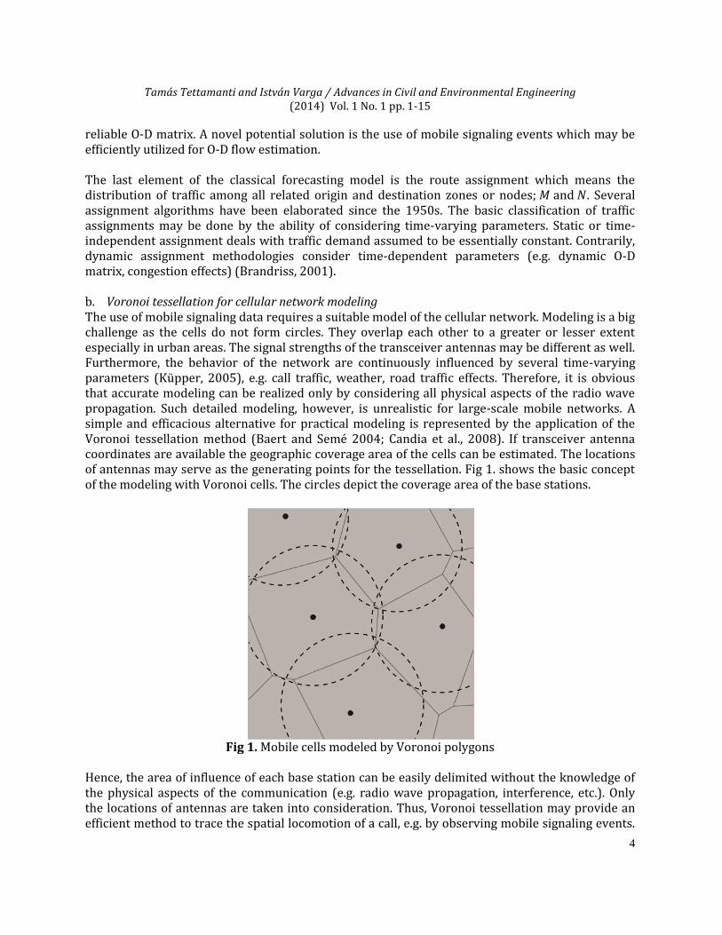
reliable O-D matrix. A novel potential solution is the use of mobile signaling events which may be efficiently utilized for O-D flow estimation. The last element of the classical forecasting model is the route assignment which means the distribution of traffic among all related origin and destination zones or nodes; and . Several assignment algorithms have been elaborated since the 1950s. The basic classification of traffic assignments may be done by the ability of considering time-varying parameters. Static or time-independent assignment deals with traffic demand assumed to be essentially constant. Contrarily, dynamic assignment methodologies consider time-dependent parameters (e.g. dynamic O-D matrix, congestion effects) (Brandriss, 2001). b. Voronoi tessellation for cellular network modeling The use of mobile signaling data requires a suitable model of the cellular network. Modeling is a big challenge as the cells do not form circles. They overlap each other to a greater or lesser extent especially in urban areas. The signal strengths of the transceiver antennas may be different as well. Furthermore, the behavior of the network are continuously influenced by several time-varying parameters (Küpper, 2005), e.g. call traffic, weather, road traffic effects. Therefore, it is obvious that accurate modeling can be realized only by considering all physical aspects of the radio wave propagation. Such detailed modeling, however, is unrealistic for large-scale mobile networks. A simple and efficacious alternative for practical modeling is represented by the application of the Voronoi tessellation method (Baert and Semé 2004; Candia et al., 2008). If transceiver antenna coordinates are available the geographic coverage area of the cells can be estimated. The locations of antennas may serve as the generating points for the tessellation. Fig 1. shows the basic concept of the modeling with Voronoi cells. The circles depict the coverage area of the base stations.
Fig 1. Mobile cells modeled by Voronoi polygons
Hence, the area of influence of each base station can be easily delimited without the knowledge of the physical aspects of the communication (e.g. radio wave propagation, interference, etc.). Only the locations of antennas are taken into consideration. Thus, Voronoi tessellation may provide an efficient method to trace the spatial locomotion of a call, e.g. by observing mobile signaling events.
Tamás Tettamanti and István Varga / Advances in Civil and Environmental Engineering (2014) Vol. 1 No. 1 pp. 1-15
5
A possible solution to improve the accuracy of the tessellation was proposed by Baert and Semé (2004) and Portela and Alencar (2006). If the power threshold assigned for each base station is known, a multiplicatively weighted Voronoi diagram can be created. Thus, the different transmitted signal strengths of the antennas can be also taken into account to improve modeling.
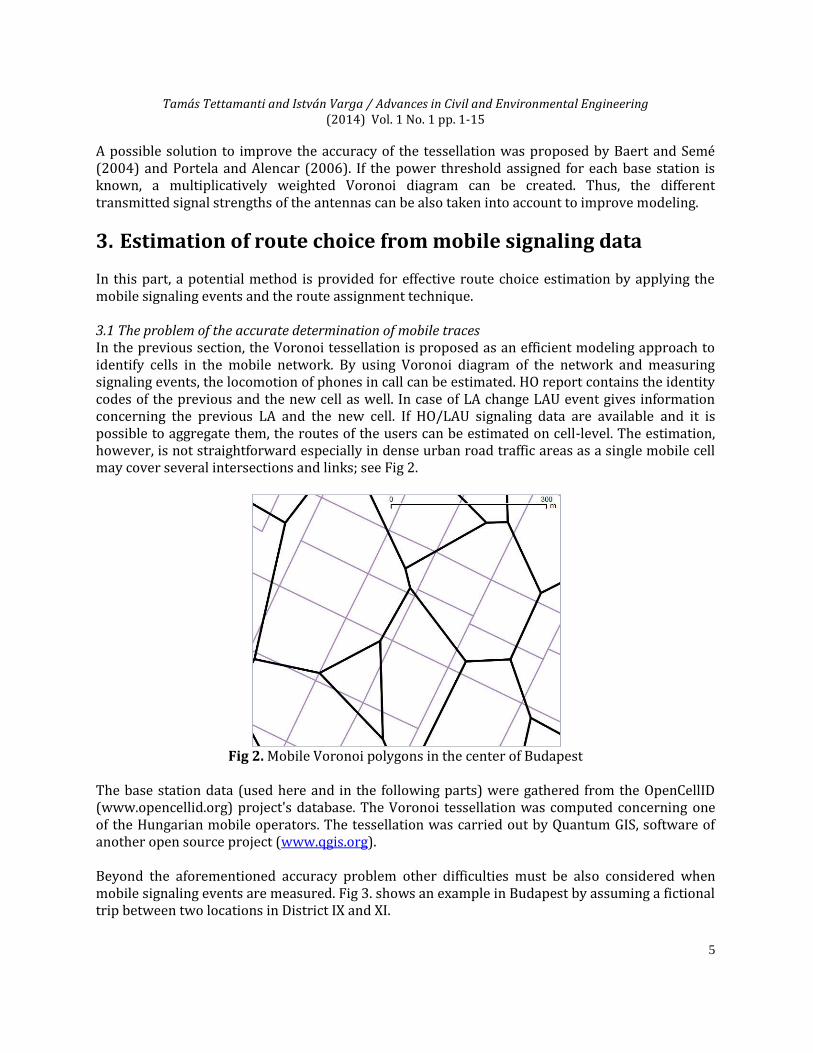
3. Estimation of route choice from mobile signaling data In this part, a potential method is provided for effective route choice estimation by applying the mobile signaling events and the route assignment technique. 3.1 The problem of the accurate determination of mobile traces In the previous section, the Voronoi tessellation is proposed as an efficient modeling approach to identify cells in the mobile network. By using Voronoi diagram of the network and measuring signaling events, the locomotion of phones in call can be estimated. HO report contains the identity codes of the previous and the new cell as well. In case of LA change LAU event gives information concerning the previous LA and the new cell. If HO/LAU signaling data are available and it is possible to aggregate them, the routes of the users can be estimated on cell-level. The estimation, however, is not straightforward especially in dense urban road traffic areas as a single mobile cell may cover several intersections and links; see Fig 2.
Fig 2. Mobile Voronoi polygons in the center of Budapest
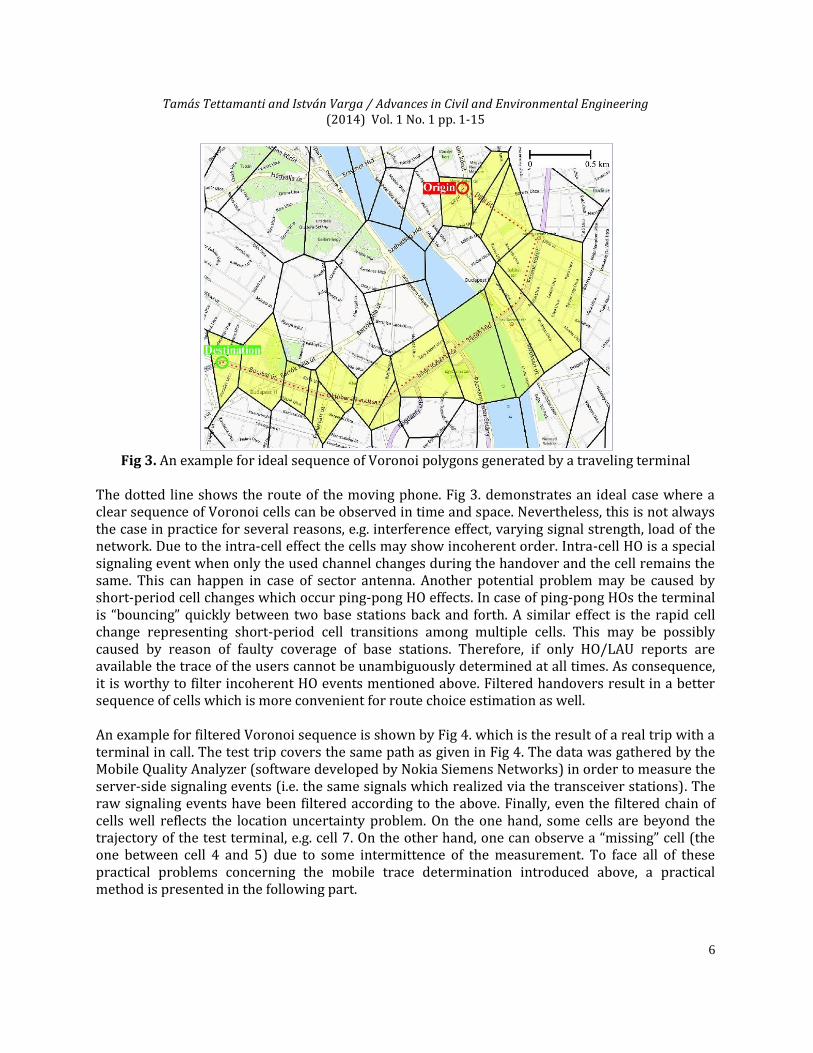
The base station data (used here and in the following parts) were gathered from the OpenCellID (www.opencellid.org) project's database. The Voronoi tessellation was computed concerning one of the Hungarian mobile operators. The tessellation was carried out by Quantum GIS, software of another open source project (www.qgis.org). Beyond the aforementioned accuracy problem other difficulties must be also considered when mobile signaling events are measured. Fig 3. shows an example in Budapest by assuming a fictional trip between two locations in District IX and XI.
Tamás Tettamanti and István Varga / Advances in Civil and Environmental Engineering (2014) Vol. 1 No. 1 pp. 1-15
6
Fig 3. An example for ideal sequence of Voronoi polygons generated by a traveling terminal
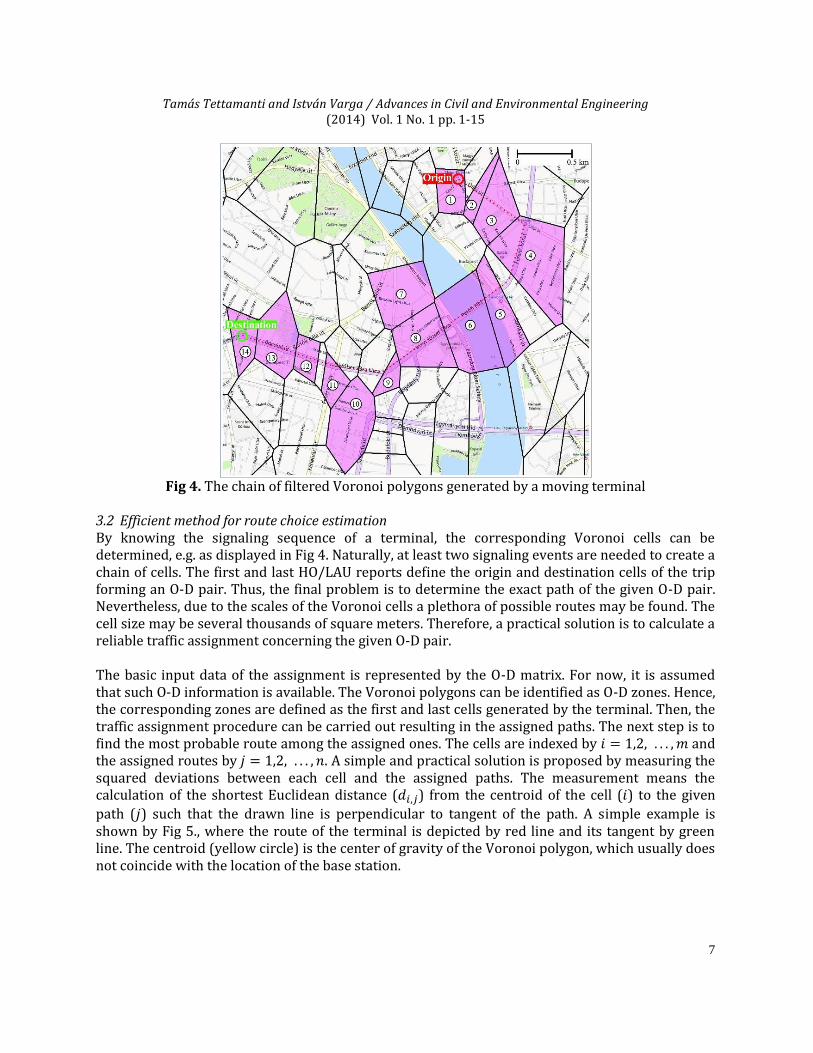
The dotted line shows the route of the moving phone. Fig 3. demonstrates an ideal case where a clear sequence of Voronoi cells can be observed in time and space. Nevertheless, this is not always the case in practice for several reasons, e.g. interference effect, varying signal strength, load of the network. Due to the intra-cell effect the cells may show incoherent order. Intra-cell HO is a special signaling event when only the used channel changes during the handover and the cell remains the same. This can happen in case of sector antenna. Another potential problem may be caused by short-period cell changes which occur ping-pong HO effects. In case of ping-pong HOs the terminal is “bouncing” quickly between two base stations back and forth. A similar effect is the rapid cell change representing short-period cell transitions among multiple cells. This may be possibly caused by reason of faulty coverage of base stations. Therefore, if only HO/LAU reports are available the trace of the users cannot be unambiguously determined at all times. As consequence, it is worthy to filter incoherent HO events mentioned above. Filtered handovers result in a better sequence of cells which is more convenient for route choice estimation as well. An example for filtered Voronoi sequence is shown by Fig 4. which is the result of a real trip with a terminal in call. The test trip covers the same path as given in Fig 4. The data was gathered by the Mobile Quality Analyzer (software developed by Nokia Siemens Networks) in order to measure the server-side signaling events (i.e. the same signals which realized via the transceiver stations). The raw signaling events have been filtered according to the above. Finally, even the filtered chain of cells well reflects the location uncertainty problem. On the one hand, some cells are beyond the trajectory of the test terminal, e.g. cell 7. On the other hand, one can observe a “missing” cell (the one between cell 4 and 5) due to some intermittence of the measurement. To face all of these practical problems concerning the mobile trace determination introduced above, a practical method is presented in the following part.
Tamás Tettamanti and István Varga / Advances in Civil and Environmental Engineering (2014) Vol. 1 No. 1 pp. 1-15
7
Fig 4. The chain of filtered Voronoi polygons generated by a moving terminal
3.2 Efficient method for route choice estimation By knowing the signaling sequence of a terminal, the corresponding Voronoi cells can be determined, e.g. as displayed in Fig 4. Naturally, at least two signaling events are needed to create a chain of cells. The first and last HO/LAU reports define the origin and destination cells of the trip forming an O-D pair. Thus, the final problem is to determine the exact path of the given O-D pair. Nevertheless, due to the scales of the Voronoi cells a plethora of possible routes may be found. The cell size may be several thousands of square meters. Therefore, a practical solution is to calculate a reliable traffic assignment concerning the given O-D pair. The basic input data of the assignment is represented by the O-D matrix. For now, it is assumed that such O-D information is available. The Voronoi polygons can be identified as O-D zones. Hence, the corresponding zones are defined as the first and last cells generated by the terminal. Then, the traffic assignment procedure can be carried out resulting in the assigned paths. The next step is to find the most probable route among the assigned ones. The cells are indexed by and the assigned routes by . A simple and practical solution is proposed by measuring the squared deviations between each cell and the assigned paths. The measurement means the calculation of the shortest Euclidean distance ( ) from the centroid of the cell ( ) to the given
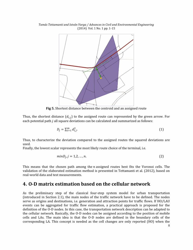
path ( ) such that the drawn line is perpendicular to tangent of the path. A simple example is shown by Fig 5., where the route of the terminal is depicted by red line and its tangent by green line. The centroid (yellow circle) is the center of gravity of the Voronoi polygon, which usually does not coincide with the location of the base station.
Tamás Tettamanti and István Varga / Advances in Civil and Environmental Engineering (2014) Vol. 1 No. 1 pp. 1-15
8
Fig 5. Shortest distance between the centroid and an assigned route
Thus, the shortest distance ( ) to the assigned route can represented by the green arrow. For
each potential path all square deviations can be calculated and summarized as follows: ∑
. (1)
Thus, to characterize the deviation compared to the assigned routes the squared deviations are used. Finally, the lowest scalar represents the most likely route choice of the terminal, i.e. . (2)
This means that the chosen path among the assigned routes best fits the Voronoi cells. The validation of the elaborated estimation method is presented in Tettamanti et al. (2012), based on real-world data and test measurements.
4. O-D matrix estimation based on the cellular network As the preliminary step of the classical four-step system model for urban transportation (introduced in Section 2.1), the main nodes of the traffic network have to be defined. The nodes serve as origins and destinations, i.e. generation and attraction points for traffic flows. If HO/LAU events can be aggregated for traffic flow estimation, a practical approach is proposed for the definition of the O-D nodes. In this case, the transportation network description can be adapted to the cellular network. Basically, the O-D nodes can be assigned according to the position of mobile cells and LAs. The main idea is that the O-D nodes are defined in the boundary cells of the corresponding LA. This concept is needed as the cell changes are only reported (HO) when the
Tamás Tettamanti and István Varga / Advances in Civil and Environmental Engineering (2014) Vol. 1 No. 1 pp. 1-15
9
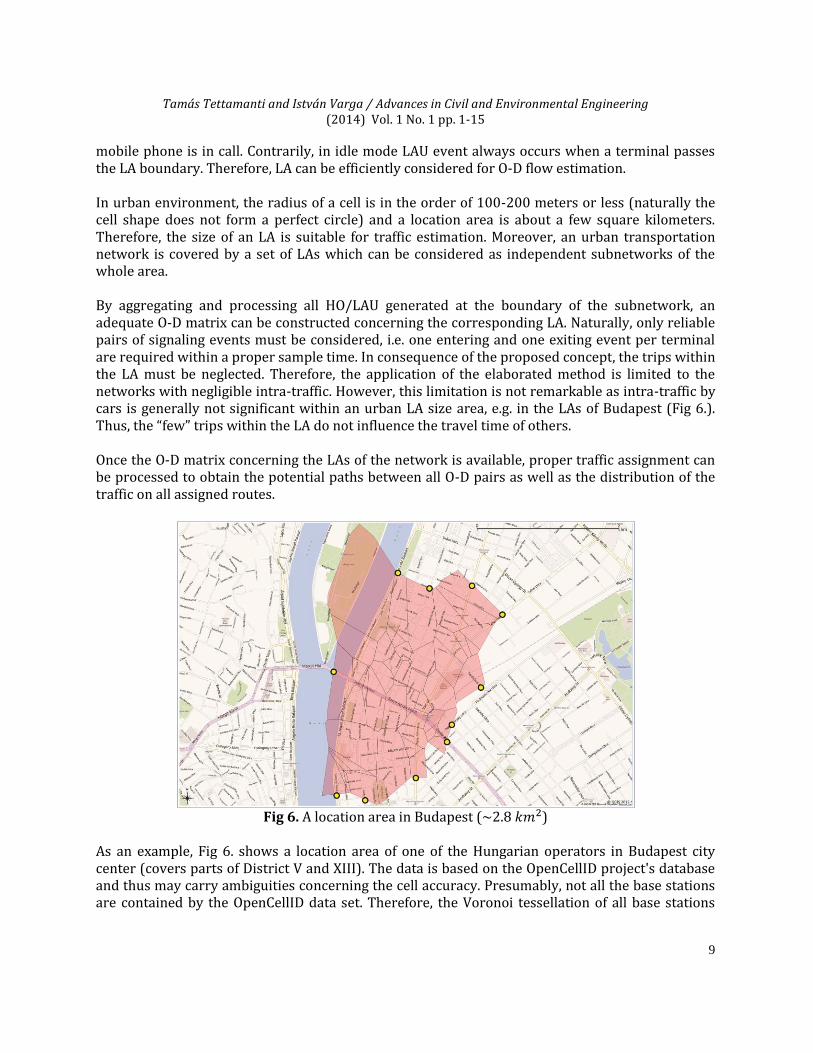
mobile phone is in call. Contrarily, in idle mode LAU event always occurs when a terminal passes the LA boundary. Therefore, LA can be efficiently considered for O-D flow estimation. In urban environment, the radius of a cell is in the order of 100-200 meters or less (naturally the cell shape does not form a perfect circle) and a location area is about a few square kilometers. Therefore, the size of an LA is suitable for traffic estimation. Moreover, an urban transportation network is covered by a set of LAs which can be considered as independent subnetworks of the whole area. By aggregating and processing all HO/LAU generated at the boundary of the subnetwork, an adequate O-D matrix can be constructed concerning the corresponding LA. Naturally, only reliable pairs of signaling events must be considered, i.e. one entering and one exiting event per terminal are required within a proper sample time. In consequence of the proposed concept, the trips within the LA must be neglected. Therefore, the application of the elaborated method is limited to the networks with negligible intra-traffic. However, this limitation is not remarkable as intra-traffic by cars is generally not significant within an urban LA size area, e.g. in the LAs of Budapest (Fig 6.). Thus, the “few” trips within the LA do not influence the travel time of others. Once the O-D matrix concerning the LAs of the network is available, proper traffic assignment can be processed to obtain the potential paths between all O-D pairs as well as the distribution of the traffic on all assigned routes.
Fig 6. A location area in Budapest (~ )
As an example, Fig 6. shows a location area of one of the Hungarian operators in Budapest city center (covers parts of District V and XIII). The data is based on the OpenCellID project's database and thus may carry ambiguities concerning the cell accuracy. Presumably, not all the base stations are contained by the OpenCellID data set. Therefore, the Voronoi tessellation of all base stations
Tamás Tettamanti and István Varga / Advances in Civil and Environmental Engineering (2014) Vol. 1 No. 1 pp. 1-15
10
with the accurate location would result in smaller cell sizes. Nevertheless, the order of an urban LA can be suitably interpreted by this database. The main nodes (yellow circles) are determined by the crossings of the significant roads and the boundary cells. Naturally, the selection of the O-D nodes is based on the typical traffic load on them, and needs some local knowledge. The side streets with small traffic load can be neglected in the network model. Finally, the 11 main nodes represent origin and destination points for which an O-D matrix can be created. The proposed methodology is summarized below (with the assumption that the Voronoi tessellation based cellular phone network is given and the corresponding O-D nodes are predefined):
1) Determine the investigated LA, i.e. the transportation network. 2) Determine the main nodes of the network. 3) Collect all HO/LAU events occurring in the boundary cells of the LA. 4) Filter HO/LAU events. Only the traveling terminals which cross the LA are investigated. 5) Discover the O-D trips from the relevant signaling data, i.e. estimate the O-D matrix.
5. Traffic flow estimation improved by cellular event based travel times
In the previous section, a potential method has been introduced for efficient O-D flow estimation by using all LAUs and HOs occurring at the boundary of the LA, exclusively. At the same time, the HO events of the terminals can also be recorded within the LA and used to improve the traffic flow estimation. HOs are only generated when a phone call is in progress. This means that a part of the users can provide path information. The average call duration is relatively short. In urban areas, the average call duration is about 2-3 minutes in the daytime Willkomm et al. (2009). However, the related travel time of a cellular phone is valuable if the corresponding trajectory reflects at least one road link. Hence, the travel times of the cellular phones may contribute to a more reliable traffic estimation. Basically, the traditional traffic assignment can be improved with travel time data if they are available within the current sample time. The traffic network is typically modeled by graphs where nodes denote the intersections and edges the links. A network object can be characterized by some impedance, i.e. the average travel time which is needed to pass it. A road link, therefore, is expressed as a weighted edge. Moreover, the turnings of the intersections within the nodes have also impedances, and thus considered as edges. The basis of the traffic assignments using Wardrop equilibrium conditions (Wardrop, 1952) is represented by the volume-delay functions (VDF), which reflects the impedances of the traffic network objects. There are several variants of VDF. Nevertheless, a general expression can be formulated for the VDF as follows:
(
), (3)
Tamás Tettamanti and István Varga / Advances in Civil and Environmental Engineering (2014) Vol. 1 No. 1 pp. 1-15
11
where denotes the average travel time with traffic volume ,
the free flow travel time, and
the maximal capacity (flow) concerning edge Generally, the traffic assignment calculation can be reformulated as a mathematical optimization problem with constraints. For instance, the well-known user equilibrium assignment forms the following nonlinear programming problem:
∑ ∫
(4)
∑
,
∑ ∑ ∑
,
,
.
expresses the set of the edges of the transportation network, the equilibrium flow on edge , the flow on path connecting O-D pair , and the total demand (number of trips)
between and . If edge is on path from to , ; otherwise
. If the reliable travel
times are available from the cellular signaling events, problem (4) can be potentially improved. By applying the Voronoi tesselation based network description and the aggregated HO/LAU events, the travel times of the terminals can be calculated. Ludvig et al. (2012) proposed the real-time estimation of travel times in urban traffic network by applying Kalman Filter. The measured mobile travel times can be further used expressing link travel times within the network. In optimization problem (4), each edge may have different volume-delay function. Therefore, the VDF of the measured links can be restricted according to the measured travel times. This means that the following constraints have to be added to problem (4):
, (5)
where denotes the average measured travel time and an uncertainty term. is needed due
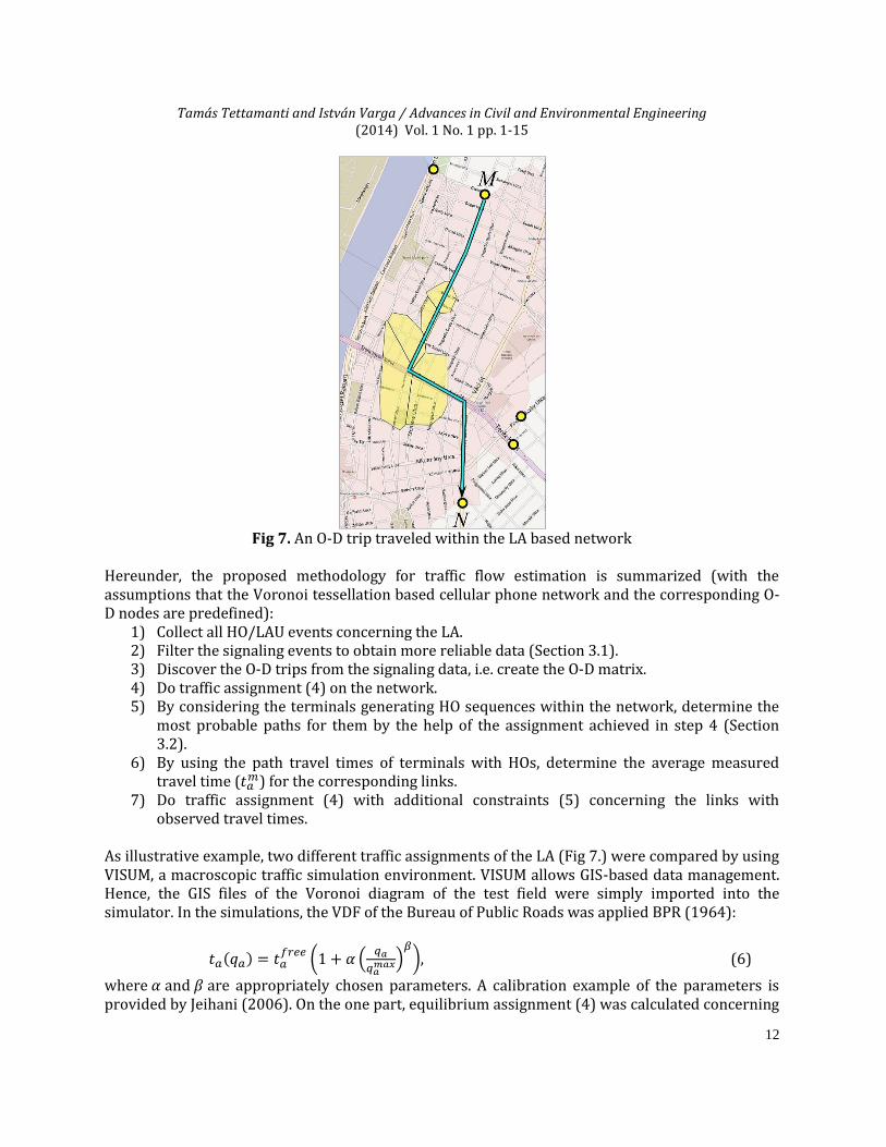
to the problems introduced in Section 3.1, and can be defined empirically. As an illustration of the method, Fig 7. is provided. The arrow line depicts the trip traveled by a terminal from node M to N. The origin and destination nodes can be defined based on the generated LAU events. At the same time, a chain of HOs are also observable as result of a call started and ended within the LA. By using the method provided in Section 3.2, the traveled path can be defined. Moreover, the travel time is also calculable form the HO events. Hence, the travel times of the road links concerned by the HO measurements can be used to improve the traffic assignment of the network.
Tamás Tettamanti and István Varga / Advances in Civil and Environmental Engineering (2014) Vol. 1 No. 1 pp. 1-15
12
Fig 7. An O-D trip traveled within the LA based network
Hereunder, the proposed methodology for traffic flow estimation is summarized (with the assumptions that the Voronoi tessellation based cellular phone network and the corresponding O-D nodes are predefined):
1) Collect all HO/LAU events concerning the LA. 2) Filter the signaling events to obtain more reliable data (Section 3.1). 3) Discover the O-D trips from the signaling data, i.e. create the O-D matrix. 4) Do traffic assignment (4) on the network. 5) By considering the terminals generating HO sequences within the network, determine the
most probable paths for them by the help of the assignment achieved in step 4 (Section 3.2).
6) By using the path travel times of terminals with HOs, determine the average measured travel time (
) for the corresponding links. 7) Do traffic assignment (4) with additional constraints (5) concerning the links with
observed travel times. As illustrative example, two different traffic assignments of the LA (Fig 7.) were compared by using VISUM, a macroscopic traffic simulation environment. VISUM allows GIS-based data management. Hence, the GIS files of the Voronoi diagram of the test field were simply imported into the simulator. In the simulations, the VDF of the Bureau of Public Roads was applied BPR (1964):
( (
)
), (6)
where and are appropriately chosen parameters. A calibration example of the parameters is provided by Jeihani (2006). On the one part, equilibrium assignment (4) was calculated concerning
Tamás Tettamanti and István Varga / Advances in Civil and Environmental Engineering (2014) Vol. 1 No. 1 pp. 1-15
13
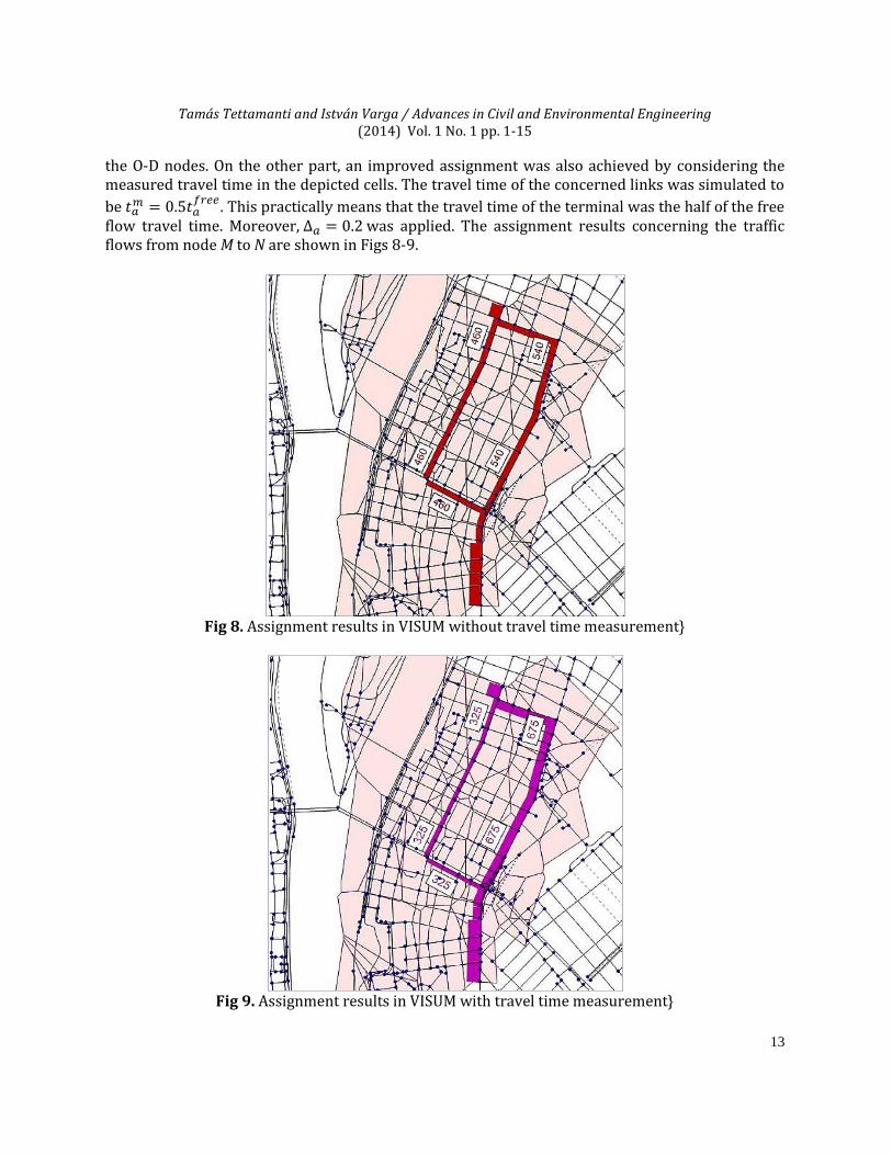
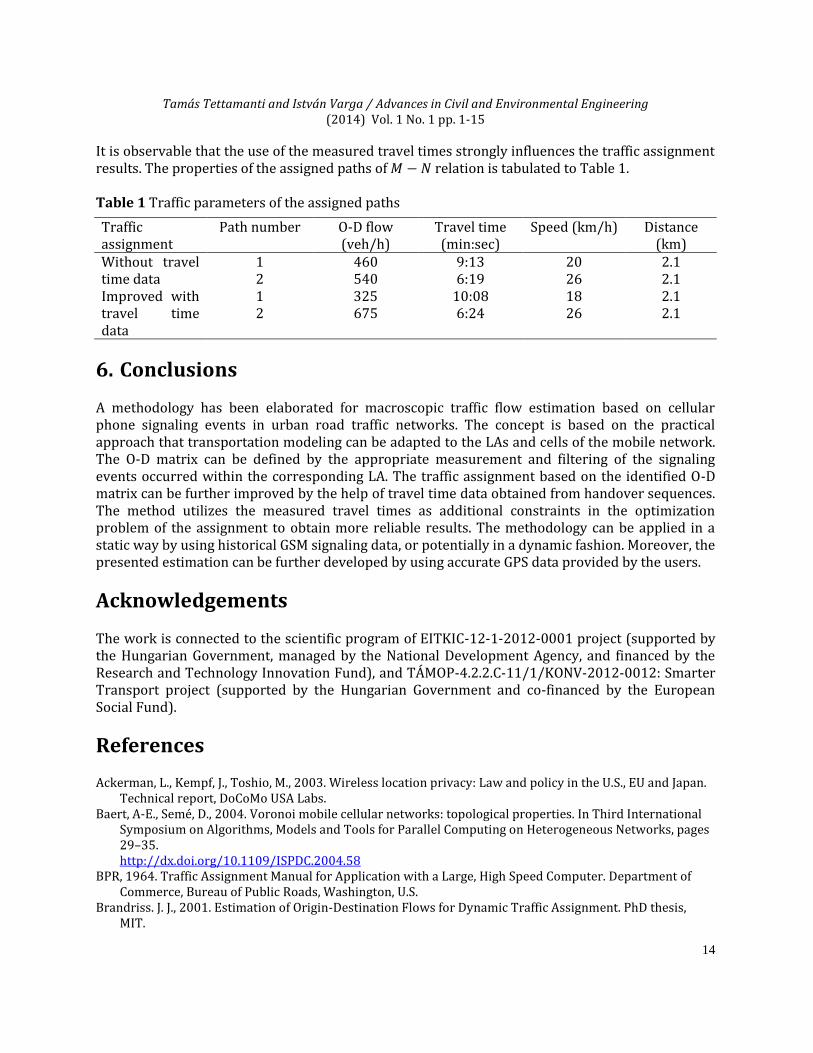
the O-D nodes. On the other part, an improved assignment was also achieved by considering the measured travel time in the depicted cells. The travel time of the concerned links was simulated to
be
. This practically means that the travel time of the terminal was the half of the free
flow travel time. Moreover, was applied. The assignment results concerning the traffic flows from node M to N are shown in Figs 8-9.
Fig 8. Assignment results in VISUM without travel time measurement}
Fig 9. Assignment results in VISUM with travel time measurement}
Tamás Tettamanti and István Varga / Advances in Civil and Environmental Engineering (2014) Vol. 1 No. 1 pp. 1-15
14
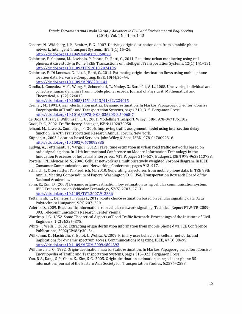
It is observable that the use of the measured travel times strongly influences the traffic assignment results. The properties of the assigned paths of relation is tabulated to Table 1. Table 1 Traffic parameters of the assigned paths
Traffic assignment
Path number O-D flow (veh/h)
Travel time (min:sec)
Speed (km/h) Distance (km)
Without travel time data
1 460 9:13 20 2.1 2 540 6:19 26 2.1
Improved with travel time data
1 325 10:08 18 2.1 2 675 6:24 26 2.1
6. Conclusions A methodology has been elaborated for macroscopic traffic flow estimation based on cellular phone signaling events in urban road traffic networks. The concept is based on the practical approach that transportation modeling can be adapted to the LAs and cells of the mobile network. The O-D matrix can be defined by the appropriate measurement and filtering of the signaling events occurred within the corresponding LA. The traffic assignment based on the identified O-D matrix can be further improved by the help of travel time data obtained from handover sequences. The method utilizes the measured travel times as additional constraints in the optimization problem of the assignment to obtain more reliable results. The methodology can be applied in a static way by using historical GSM signaling data, or potentially in a dynamic fashion. Moreover, the presented estimation can be further developed by using accurate GPS data provided by the users.
Acknowledgements The work is connected to the scientific program of EITKIC-12-1-2012-0001 project (supported by the Hungarian Government, managed by the National Development Agency, and financed by the Research and Technology Innovation Fund), and TÁMOP-4.2.2.C-11/1/KONV-2012-0012: Smarter Transport project (supported by the Hungarian Government and co-financed by the European Social Fund).
References Ackerman, L., Kempf, J., Toshio, M., 2003. Wireless location privacy: Law and policy in the U.S., EU and Japan.
Technical report, DoCoMo USA Labs. Baert, A-E., Semé, D., 2004. Voronoi mobile cellular networks: topological properties. In Third International
Symposium on Algorithms, Models and Tools for Parallel Computing on Heterogeneous Networks, pages 29–35.
http://dx.doi.org/10.1109/ISPDC.2004.58 BPR, 1964. Traffic Assignment Manual for Application with a Large, High Speed Computer. Department of
Commerce, Bureau of Public Roads, Washington, U.S. Brandriss. J. J., 2001. Estimation of Origin-Destination Flows for Dynamic Traffic Assignment. PhD thesis,
MIT.
Tamás Tettamanti and István Varga / Advances in Civil and Environmental Engineering (2014) Vol. 1 No. 1 pp. 1-15
15
Caceres, N., Wideberg, J. P., Benitez, F. G., 2007. Deriving origin destination data from a mobile phone network. Intelligent Transport Systems, IET, 1(1):15–26.
http://dx.doi.org/10.1049/iet-its:20060020 Calabrese, F., Colonna, M., Lovisolo, P. Parata, D., Ratti, C., 2011. Real time urban monitoring using cell
phones: A case study in Rome. IEEE Transactions on Intelligent Transportation Systems, 12(1):141–151. http://dx.doi.org/10.1109/TITS.2010.2074196 Calabrese, F., Di Lorenzo, G., Liu, L., Ratti, C., 2011. Estimating origin-destination flows using mobile phone
location data. Pervasive Computing, IEEE, 10(4):36–44. http://dx.doi.org/10.1109/MPRV.2011.41 Candia, J., González, M. C., Wang, P., Schoenharl, T., Madey, G., Barabási, A-L., 2008. Uncovering individual and
collective human dynamics from mobile phone records. Journal of Physics A: Mathematical and Theoretical, 41(22):224015.
http://dx.doi.org/10.1088/1751-8113/41/22/224015 Cremer, M., 1991. Origin-destination matrix: Dynamic estimation. In Markos Papageorgiou, editor, Concise
Encyclopedia of Traffic and Transportation Systems, pages 310–315. Pergamon Press. http://dx.doi.org/10.1016/B978-0-08-036203-8.50068-7 de Dios Ortúzar, J., Willumsen, L. G., 2001. Modelling Transport. Wiley, ISBN: 978-0471861102. Gazis, D. C., 2002. Traffic theory. Springer, ISBN:1402070950. Jeihani, M., Lawe, S., Connolly, J. P., 2006. Improving traffic assignment model using intersection delay
function. In 47th Transportation Research Annual Forum, New York. Küpper, A., 2005. Location-based Services. John Wiley & Sons. ISBN: 978-0470092316. http://dx.doi.org/10.1002/0470092335 Ludvig, Á., Tettamanti, T., Varga, I., 2012. Travel time estimation in urban road traffic networks based on
radio signaling data. In 14th International Conference on Modern Information Technology in the Innovation Processes of Industrial Enterprises, MITIP, pages 514–527, Budapest, ISBN 978-9633113738.
Portela, J. N., Alencar, M. S., 2006. Cellular network as a multiplicatively weighted Voronoi diagram. In IEEE Consumer Communications and Networking Conference, pages 913–917.
Schlaich, J., Otterstätter, T., Friedrich, M., 2010. Generating trajectories from mobile phone data. In TRB 89th Annual Meeting Compendium of Papers, Washington, D.C., USA, Transportation Research Board of the National Academies.
Sohn, K., Kim. D. (2008) Dynamic origin-destination flow estimation using cellular communication system. IEEE Transactions on Vehicular Technology, 57(5):2703–2713.
http://dx.doi.org/10.1109/TVT.2007.912336 Tettamanti, T., Demeter, H., Varga I., 2012. Route choice estimation based on cellular signaling data. Acta
Polytechnica Hungarica, 9(4):207–220. Valerio, D., 2009. Road traffic information from cellular network signaling. Technical Report FTW-TR-2009-
003, Telecommunications Research Center Vienna. Wardrop, J. G., 1952. Some Theoretical Aspects of Road Traffic Research. Proceedings of the Institute of Civil
Engineers, 1-2(9):325–378. White, J., Wells, I. 2002. Extracting origin destination information from mobile phone data. IEE Conference
Publications, 2002(CP486):30–34. Willkomm, D., Machiraju, S., Bolot, J., Wolisz, A, 2009. Primary user behavior in cellular networks and
implications for dynamic spectrum access. Communications Magazine, IEEE, 47(3):88–95. http://dx.doi.org/10.1109/MCOM.2009.4804392 Willumsen, L. G., 1992. Origin-destination matrix: Static estimation. In Markos Papageorgiou, editor, Concise
Encyclopedia of Traffic and Transportation Systems, pages 315–322. Pergamon Press. Yoo, B-S., Kang, S-P., Chon, K., Kim, S-G., 2005. Origin-destination estimation using cellular phone BS
information. Journal of the Eastern Asia Society for Transportation Studies, 6:2574–2588.