master thesis geological information system switzerland -
TRANSCRIPT
Master Thesissubmitted within the UNIGIS MSc programme
at the Centre for GeoInformatics (Z_GIS)Salzburg University
Geological Information System Switzerland -Supplying geoscientific geoinformation to the NSDI
by
Dr. Nils OesterlingU1304
A thesis submitted in partial fulfilment of the requirementsof the degree of Master of Science
(Geographical Information Science & Systems) – MSc (GISc)
Advisors:Dr. Andreas Kühni
Ao. Univ. Prof. Dr. Josef Strobl
Gümligen, October 31, 2009

Preface & Acknowledgements
Preface
The present master thesis was worked out in the framework of the UNIGIS course of studiesGeographical Information Science & Systems at the University of Salzburg, Austria. The topicof the thesis is related to my work at the Swiss Geological Survey (SGS). The SGS is beside othertasks responsible for the coordination of the geological, geotechnical and geophysical survey inSwitzerland. This task is difficult to perform, because the Swiss geo-community is diverse andheterogeneously structured. A corporate geological survey like in other countries does not exist.Because of this reason a tool for the coordination of the national geo-community and the accessand exchange of geo-scientific data and information is need.The vision for such an envisioned information system is:
Create an interactive tool for the players of the Swiss geo-community to improve existingwork-flows. Using such a system, the nowadays dispersed and heterogeneously organised Swissgeo-community gets a tool for the coordination of their tasks and the efficient and easy exchange ofdata and information. The more efficient access to geological information facilitates the activitiesin the geo-community and enhances the awareness of geology in the society, politics and economy.
The present master thesis is a preliminary study for the development of a national geologicalinformation system. It gives an overview of existing information system of geological purposesin Switzerland and on the international level. Furthermore the needs and requirements of thegeo-community are evaluated and a basic concept is designed. This concept can be used as abasis for future considerations and the development of the final system.
Acknowledgements
First of all I would like to thank Andreas Kühni (Head of the Geological Survey Coordinationand Management division of the Swiss Geological Survey (SGS)) for the supervision of this thesis.I am very grateful for his continuous technical support and the many fruitfull discussions. I amalso gratefull to the SGS which founded my participation in the UNIGIS course of study.I would also like to thank Josef Strobl, my main supervisor, who especially helped me a lot
during the search and adjustment of the subject of this thesis.I would not have been able to complete all the modules and assignments of the course without
the thousands of intensive discussions with my fellow students Marco Hoffmann, Hubert Klauser,Yves Maurer and Roger Wiss of our study group UNIGIS-Bottom-Left (or geographically speak-
iii

ing UNIGIS-South-West). Thank you mates!!!Many thanks also to my colleagues at work Roland Baumberger, Beat Niederberger and Stefan
Strasky who supported me in one way or another.My special thanks goes to my wife Simone and my children Emma and Matti who strongly
supported my work by accepting the many night shifts, weekend working and absences duringthe course.Last but no least I would like to thank Josef Strobl and the entire UNIGIS-Team in Salzburg
who did a great job during the entire almost three years of my study. Keep it up!
iv
Declaration
I confirm that this master thesis was written without the help of others and without using anysources other than the ones cited and that this thesis has not been submitted in its present formor a similar form to another examination board. All passages in this thesis that are quoted fromother sources are marked accordingly.
Gümligen, October 2009Nils Oesterling
v

Abstract
Geological information is of great importance for many products and activities of our everyday life. For instance, the creation of roads, buildings and other constructions or the supply offossil energy resources like oil and gas is impossible without geological data, information andknowledge.
In Switzerland the accessibility of geological and geology related information, referred to asgeo-thematic data in this thesis, is limited. This situation is caused amongst others by theheterogeneous structure of the Swiss geo-community. Unlike other countries, Switzerland doesnot have a corporate geological survey organisation. All geology related tasks are shared by thegeo-community which is composed of federal and cantonal offices, universities, private consultantsetc. As a consequence, of this non-uniform structure and the related non-coordinated activities ofthe individual organisations the geo-community has a restricted public awareness. Furthermore,the support by politics and economy is limited.
In order to enhance the accessibility of geo-thematic data and to contribute to the solutionof the aforementioned problems, the Swiss Geological Survey (SGS) is developing the GeologicalInformation System Switzerland (Geolo-GIS-CH). This internet based information system isintended to be the future gateway to all available geo-thematic data in Switzerland. It constitutesa tool for the Swiss geo-community which facilitates the communication among its particularmembers and improves their accessibility for external clients.
The present master thesis represents a preliminary study for the development of the Geolo-GIS-CH. It analyses the present situation regarding the geo-thematic data and its provisionin Switzerland. Especially the existing geological information systems on the international andnational level are identified and their components are reviewed. Moreover, the requirementsof potential users of the Geolo-GIS-CH are determined by a poll. This poll reveals that theinternational as well as the national geo-community consider the same components of the systemas most important. Comparing these core-components to those supplied by existing geologicalinformation systems, it turns out that the major part of the required components are already inuse. However, they are independent from each other, thus a central gateway is lacking.
Based on the analysis mentioned above a basic concept for the development of the Geolo-GIS-CH is proposed. Apart from the definition of the objectives of the system and its targetgroups, the general design and the abstract architecture of the Geolo-GIS-CH is discussed. Oneentry point to the system is the Geology Portal. This web portal contains three thematic sectorswhich which provides access to geo-thematic data, information on the members of the Swissgeo-community and to easy understandable geological knowledge. The second way to accessthe geo-thematic data in the core of the Geolo-GIS-CH are web-services. These services canconsumed by GIS and other applications.
vii

A roadmap illustrates the relative timing of particular tasks and reveals its dependencies. Thisroadmap shows one possible way for the future realisation of the project.The Swiss geo-community is a community around thematic data in the framework of the
National Spatial Data Infrastructure (NSDI). The Geolo-GIS-CH is the gateway to the data,information and knowledge of this community and represents by this one of the different thematicpillars of the Swiss NSDI.
viii
Kurzfassung
Geologische Informationen sind für eine Vielzahl von Produkten und Aktivitäten des täglichenLebens von entscheidender Wichtigkeit. So ist beispielsweise der Bau von Strassen, Gebäudenund anderen Bauwerken oder die Versorgung mit fossilen Energieträgern, wie Erdöl und Erdgasohne geologische Daten, Informationen und Wissen unmöglich.
In der Schweiz ist der Zugang zu geologischen und geologierelevanten Informationen, allgemeinals geo-thematische Daten in dieser Arbeit bezeichnet, stark eingeschränkt. Dieser Umstand wirdunter anderem durch die heterogene Struktur der Schweizer Geo-Szene begründet. So existiert,nicht wie in anderen Ländern, in der Schweiz kein einheitlicher Geologischer Dienst. Sämtlichegeologiebezogene Aufgaben sind auf die nationale Geo-Szene aufgeteilt, die sich aus Bundesämter,kantonale Fachstellen, Universitäten, Private Beratungsfirmen etc. zusammensetzt.
Folgen dieser uneinheitlichen organisatorischen Struktur und der damit verbundenen unkoor-dinierten Aktivitäten der Mitglieder ist die geringe öffentliche Wahrnehmung der Geo-Szene unddie eingeschränkte Unterstützung durch Politik und Wirtschaft.
Um den Zugang zu geo-thematischen Daten zu verbessern und damit die zu einer Lösungder vor genannten Probleme beizutragen, arbeitet die Landesgeologie an der Entwicklung desGeologischen Informationssystems Schweiz (Geolo-GIS-CH). Dieses internet-basierte Informa-tionssystem soll zukünftig den zentralen Zugang zu sämtlichen geo-thematischen Daten in derSchweiz darstellen und ein ein Werkzeug für die Schweizer Geo-Szene bilden. Mittels diesesWerkzeugs wird sowohl die Kommunikation zwischen der Mitgliedern der Geo-Szene vereinfacht,also auch die Sichtbarkeit und der Zugang zu den einzelnen Mitgliedsorganisationen verbessert.
Die vorliegende Arbeit stellt eine Voranalyse für die Entwicklung des Geolo-GIS-CH dar.Sie analysiert zum einen den aktuellen Zustand im Bezug auf geo-thematische Daten bzw.Geoinformation (GI) und der Bereitstellung in der Schweiz. Insbesondere werden bestehendegeologische Informationssysteme auf nationaler und internationaler Ebene identifiziert und derenKomponenten analysiert. Zum anderen werden die Anforderungen von potentiellen Kunden desGeolo-GIS-CH mittels einer Umfrage bestimmt. Sowohl auf nationaler als auch auf interna-tionaler Ebene werden ähnliche Komponenten des Systems verlangt. Der Vergleich dieser Kern-Komponenten mit den bestehenden geologischen Informationssystemen zeigt, dass der Grossteilder verlangten Komponenten bereits zur Nutzung zur Verfügung steht.
Basierend auf diesen Analysen wird ein Grobkonzept für die Entwicklung des Geolo-GIS-CHvorgeschlagen. Neben der Definition der Ziele und Zielgruppen wird darin der generelle Aufbauund die abstrakte Lösungsarchitektur des Systems diskutiert. Der Zugang zu Geolo-GIS-CHwird durch ein Geologie Portal gewährleistet. Dieses Web-Portal beinhaltet drei thematischeSektoren, über die auf sämtliche geo-thematischen Daten zugegriffen werden kann, Informationenüber die Mitglieder der Schweizer Geo-Szene verfügbar sind und geologisches Wissen in laien-
ix

verständlicher Weise angeboten wird. Neben dem Zugang über das Geologie Portal, können diegeo-thematischen Daten, auf denen das gesamte Geolo-GIS-CH basiert, über Web-Services direktin GIS und anderen Anwendungen integriert werden.Eine Roadmap für die Durchführung des gesamten Projektes beschreibt die zeitliche Abfolge
von Arbeitsschritten und deren gegenseitige Abhängigkeiten. Diese Roadmap bildet die Pla-nungsgrundlage für die konkrete Umsetzung des Geolo-GIS-CH.Die Schweizer Geo-Szene ist eine Fachinformationsgemeinschaft im Rahmen der Nationalen
Geodaten Infrastruktur (NGDI). Das Geolo-GIS-CH bildet den Zugang zu den Daten, Informa-tionen und Wissen dieser Gemeinschaft und stellt damit einen thematischen Pfeiler der SchweizerNGDI dar.
x
Contents
Preface & Acknowledgements . . . . . . . . . . . . . . . . . . . . . . . . . . . . . . . . iiiDeclaration . . . . . . . . . . . . . . . . . . . . . . . . . . . . . . . . . . . . . . . . . . vAbstract . . . . . . . . . . . . . . . . . . . . . . . . . . . . . . . . . . . . . . . . . . . . viiKurzfassung . . . . . . . . . . . . . . . . . . . . . . . . . . . . . . . . . . . . . . . . . . ixTable of contents . . . . . . . . . . . . . . . . . . . . . . . . . . . . . . . . . . . . . . . xiList of figures . . . . . . . . . . . . . . . . . . . . . . . . . . . . . . . . . . . . . . . . . xvList of tables . . . . . . . . . . . . . . . . . . . . . . . . . . . . . . . . . . . . . . . . . xviiAbbreviations . . . . . . . . . . . . . . . . . . . . . . . . . . . . . . . . . . . . . . . . . xix
1 Introduction 11.1 Background of thesis . . . . . . . . . . . . . . . . . . . . . . . . . . . . . . . . . . 11.2 Motivation . . . . . . . . . . . . . . . . . . . . . . . . . . . . . . . . . . . . . . . . 21.3 Aim of thesis . . . . . . . . . . . . . . . . . . . . . . . . . . . . . . . . . . . . . . 31.4 Approach & structure of thesis . . . . . . . . . . . . . . . . . . . . . . . . . . . . 3
2 Terminology 52.1 Geo-community . . . . . . . . . . . . . . . . . . . . . . . . . . . . . . . . . . . . . 52.2 (Geo-thematic-)data, information and knowledge . . . . . . . . . . . . . . . . . . 62.3 Portal & geoportal . . . . . . . . . . . . . . . . . . . . . . . . . . . . . . . . . . . 82.4 Geological Information System . . . . . . . . . . . . . . . . . . . . . . . . . . . . 92.5 Web-Services . . . . . . . . . . . . . . . . . . . . . . . . . . . . . . . . . . . . . . 102.6 Spatial data infrastructure . . . . . . . . . . . . . . . . . . . . . . . . . . . . . . . 112.7 Web2.0 and volunteered geographic information . . . . . . . . . . . . . . . . . . . 11
3 Methods 153.1 Web- and literature research . . . . . . . . . . . . . . . . . . . . . . . . . . . . . . 153.2 Poll on requirements . . . . . . . . . . . . . . . . . . . . . . . . . . . . . . . . . . 16
3.2.1 Structure of questionnaire . . . . . . . . . . . . . . . . . . . . . . . . . . . 173.2.2 Proposed components . . . . . . . . . . . . . . . . . . . . . . . . . . . . . 173.2.3 Scale of evaluation . . . . . . . . . . . . . . . . . . . . . . . . . . . . . . . 213.2.4 Recipients . . . . . . . . . . . . . . . . . . . . . . . . . . . . . . . . . . . . 213.2.5 Data analysis . . . . . . . . . . . . . . . . . . . . . . . . . . . . . . . . . . 22
4 Results 254.1 Present state analysis . . . . . . . . . . . . . . . . . . . . . . . . . . . . . . . . . 25
4.1.1 General technical progress . . . . . . . . . . . . . . . . . . . . . . . . . . . 254.1.2 Data availability & accessibility . . . . . . . . . . . . . . . . . . . . . . . . 26
xi
Contents
4.1.3 Data quality issues . . . . . . . . . . . . . . . . . . . . . . . . . . . . . . . 284.1.4 Standards . . . . . . . . . . . . . . . . . . . . . . . . . . . . . . . . . . . . 294.1.5 Spatial data infrastructures . . . . . . . . . . . . . . . . . . . . . . . . . . 314.1.6 Legal basis . . . . . . . . . . . . . . . . . . . . . . . . . . . . . . . . . . . 344.1.7 Geological information systems . . . . . . . . . . . . . . . . . . . . . . . . 35
4.2 Requirements of potential users . . . . . . . . . . . . . . . . . . . . . . . . . . . . 404.2.1 International geo-community . . . . . . . . . . . . . . . . . . . . . . . . . 414.2.2 Swiss geo-community . . . . . . . . . . . . . . . . . . . . . . . . . . . . . . 424.2.3 Core-components derived from requirements . . . . . . . . . . . . . . . . . 53
5 Discussion - A basic concept 555.1 Present state and focal problem . . . . . . . . . . . . . . . . . . . . . . . . . . . . 55
5.1.1 Positive aspects . . . . . . . . . . . . . . . . . . . . . . . . . . . . . . . . . 555.1.2 Negative aspects . . . . . . . . . . . . . . . . . . . . . . . . . . . . . . . . 565.1.3 Focal problem . . . . . . . . . . . . . . . . . . . . . . . . . . . . . . . . . . 58
5.2 Target situation . . . . . . . . . . . . . . . . . . . . . . . . . . . . . . . . . . . . . 585.3 Solution . . . . . . . . . . . . . . . . . . . . . . . . . . . . . . . . . . . . . . . . . 585.4 Aims . . . . . . . . . . . . . . . . . . . . . . . . . . . . . . . . . . . . . . . . . . . 605.5 Target groups . . . . . . . . . . . . . . . . . . . . . . . . . . . . . . . . . . . . . . 615.6 Supporting organisations . . . . . . . . . . . . . . . . . . . . . . . . . . . . . . . . 625.7 Overall system design . . . . . . . . . . . . . . . . . . . . . . . . . . . . . . . . . 62
5.7.1 Sectors . . . . . . . . . . . . . . . . . . . . . . . . . . . . . . . . . . . . . . 635.7.2 Core . . . . . . . . . . . . . . . . . . . . . . . . . . . . . . . . . . . . . . . 645.7.3 Points of entry . . . . . . . . . . . . . . . . . . . . . . . . . . . . . . . . . 64
5.8 Abstract system architecture . . . . . . . . . . . . . . . . . . . . . . . . . . . . . 675.8.1 Tiers . . . . . . . . . . . . . . . . . . . . . . . . . . . . . . . . . . . . . . . 695.8.2 Administration . . . . . . . . . . . . . . . . . . . . . . . . . . . . . . . . . 69
5.9 Third-party systems . . . . . . . . . . . . . . . . . . . . . . . . . . . . . . . . . . 705.10 Timing / Roadmap . . . . . . . . . . . . . . . . . . . . . . . . . . . . . . . . . . . 705.11 Costs & benefits . . . . . . . . . . . . . . . . . . . . . . . . . . . . . . . . . . . . 735.12 Risks . . . . . . . . . . . . . . . . . . . . . . . . . . . . . . . . . . . . . . . . . . . 74
6 Conclusions & Outlook 756.1 Conclusions . . . . . . . . . . . . . . . . . . . . . . . . . . . . . . . . . . . . . . . 756.2 Outlook . . . . . . . . . . . . . . . . . . . . . . . . . . . . . . . . . . . . . . . . . 75
Bibliography 81
A Overview of geo-thematic data in Switzerland A-1
B Questionnaires B-1B.1 International geo-community . . . . . . . . . . . . . . . . . . . . . . . . . . . . . B-1
B.1.1 Recipients . . . . . . . . . . . . . . . . . . . . . . . . . . . . . . . . . . . . B-1B.1.2 Questionnaire to the international geo-community . . . . . . . . . . . . . B-2
xii
Contents
B.2 National geo-community . . . . . . . . . . . . . . . . . . . . . . . . . . . . . . . . B-3B.2.1 Recipients . . . . . . . . . . . . . . . . . . . . . . . . . . . . . . . . . . . . B-3B.2.2 Introduction to national poll . . . . . . . . . . . . . . . . . . . . . . . . . B-5B.2.3 Questionnaire to the national geo-community . . . . . . . . . . . . . . . . B-6B.2.4 Appendix to questionnaire . . . . . . . . . . . . . . . . . . . . . . . . . . . B-9
C Analysed web sites C-1C.1 International geo-community . . . . . . . . . . . . . . . . . . . . . . . . . . . . . C-1C.2 National geo-community . . . . . . . . . . . . . . . . . . . . . . . . . . . . . . . . C-3
xiii

List of Figures
1.1 What is geology and where is it relevant for society? . . . . . . . . . . . . . . . . 2
2.1 Sketch of the Swiss geo-community . . . . . . . . . . . . . . . . . . . . . . . . . . 72.2 Classification of portals . . . . . . . . . . . . . . . . . . . . . . . . . . . . . . . . 82.3 Levels of SDIs . . . . . . . . . . . . . . . . . . . . . . . . . . . . . . . . . . . . . . 112.4 Weighted tag cloud of terms related to the Web2.0 . . . . . . . . . . . . . . . . . 13
3.1 Distribution of recipients addressed in the national poll . . . . . . . . . . . . . . . 23
4.1 Present (2009) production status of the GA25 . . . . . . . . . . . . . . . . . . . . 274.2 Abstract system architecture of a WFS using GeoSciML . . . . . . . . . . . . . . 304.3 Fields of activities of e-geo.ch . . . . . . . . . . . . . . . . . . . . . . . . . . . . . 324.4 Requirements of the international geo-community . . . . . . . . . . . . . . . . . . 414.5 Return rate of the national poll per category of organisation . . . . . . . . . . . . 434.6 Return rate of the national poll per category or organisation taking into account
initial number of recipients . . . . . . . . . . . . . . . . . . . . . . . . . . . . . . . 444.7 Requirements of the national geo-community . . . . . . . . . . . . . . . . . . . . 464.8 Group-1-, group-2- and group-3-components analysed per category of organisation 484.9 Server statistics of the Geological Dataviewer and WMS served to OneGeology. . 494.10 Additional datasets desired for the Geological Dataviewer . . . . . . . . . . . . . 514.11 Further suggestions for the Geological Dataviewer . . . . . . . . . . . . . . . . . . 524.12 Core-components of the Geolo-GIS-CH. Comparison of international and national
results . . . . . . . . . . . . . . . . . . . . . . . . . . . . . . . . . . . . . . . . . . 53
5.1 Problem tree illustrating the focal problem of the present situation . . . . . . . . 575.2 Objective tree illustrating the desired situation the future . . . . . . . . . . . . . 595.3 The Geolo-GIS-CH as central platform . . . . . . . . . . . . . . . . . . . . . . . . 605.4 Trend of the access to high-internet connections in Switzerland . . . . . . . . . . 615.5 Sketch of the Geolo-GIS-CH . . . . . . . . . . . . . . . . . . . . . . . . . . . . . . 635.6 Example for the integration of table and map view in a web portal . . . . . . . . 665.7 Example of a web portal of a Fachinformationsgemeinschaft . . . . . . . . . . . . 665.8 Abstract system architecture of the Geolo-GIS-CH . . . . . . . . . . . . . . . . . 685.9 Proposed roadmap for the development of the Geolo-GIS-CH . . . . . . . . . . . 72
xv

List of Tables
2.1 Major members of the Swiss geo-community . . . . . . . . . . . . . . . . . . . . . 62.2 Examples of different levels of Spatial Data Infrastructures (SDIs) . . . . . . . . . 12
3.1 Organisations whose web presences have been examined . . . . . . . . . . . . . . 163.2 Features and categories investigated in selected organisations’ web sites . . . . . . 173.3 Categories of organisations addressed in the national poll . . . . . . . . . . . . . . 22
4.1 Generalised procedure for ordering a digital geological map . . . . . . . . . . . . 284.2 Projects in the framework of e-geo.ch . . . . . . . . . . . . . . . . . . . . . . . . . 334.3 Analysed web sites of the international geo-community . . . . . . . . . . . . . . . 374.4 Analysed web sites of the national geo-community . . . . . . . . . . . . . . . . . 394.5 Names and abbreviations of proposed components . . . . . . . . . . . . . . . . . 404.6 Mean and standard deviation of the raking of the usefulness of each proposed
component from the international poll. . . . . . . . . . . . . . . . . . . . . . . . . 424.7 Send-return-statistics of the national poll. . . . . . . . . . . . . . . . . . . . . . . 454.8 Mean and standard deviation of the rating of usefulness and priority of implemen-
tation form the national poll . . . . . . . . . . . . . . . . . . . . . . . . . . . . . . 454.9 Ratings per category of organisation . . . . . . . . . . . . . . . . . . . . . . . . . 474.10 Additional desired features for the geological information system . . . . . . . . . 50
5.1 Proposed user-roles . . . . . . . . . . . . . . . . . . . . . . . . . . . . . . . . . . . 705.2 Risk analysis . . . . . . . . . . . . . . . . . . . . . . . . . . . . . . . . . . . . . . 74
A.1 Overview of geo-thematic data in Switzerland . . . . . . . . . . . . . . . . . . . . A-1
B.1 Recipients list of the international poll . . . . . . . . . . . . . . . . . . . . . . . . B-1B.2 Recipients of the national poll on requirements . . . . . . . . . . . . . . . . . . . B-3
C.1 Analysed web sites of the international geo-community . . . . . . . . . . . . . . . C-1C.2 Analysed web sites of the national geo-community . . . . . . . . . . . . . . . . . C-3
xvii

Abbreviations
APAT Italian Agency for Environmental Protection and Technical Services: Geological Survey of ItalyAPI Application Programming Interface: Interface that allows the interaction with a particular
software on the program code levelBGR Federal Institute for Geosciences and Natural Resources: Geological Survey of GermanyBGS British Geological SurveyBRGM Bureau de recherches géologiques et minières: Geological Survey of FranceCHGEOL Swiss Association of GeologistsCGI Commission for the Management and Application of Geoscience Information: Commission of
the IUGSCOGIS Coordination, Geo-Information and Services division of swisstopoCSW Catalogue Service for Web: OGC standardised service for the publication of information on
geo-applications, spatial services and geodataDBMS Database Management SystemDEM Digital Elevation Model : Aquatic research institute within the ETH-Domain.e-geo.ch Project on the federal level for the development of the Swiss NSDI and FSDIEGK Swiss Federal Geological CommissionEGKV Federal Ordonnance of the Swiss Federal Geological Commission: Related to the GeoIGEGS EuroGeoSurveys: Association of the European GSOsESDI European Spatial Data InfrastructureEU European UnionFOEN Swiss Federal Office for EnvironmentFSDI Federal Spatial Data InfrastructureFSO Swiss Federal Statistical OfficeGA25 Geological Atlas of Switzerland 1:25’000: Detailed scale geological map series of Switzerland
and major product of the SGSGBA Geologische Bundesanstalt Österreich: Geological Survey of AustriaGeoIG Federal Act on GeoinformationGeoIV Federal Ordonnance on Geoinformation: Related to the GeoIGGeolo-GIS-CH Geological Information System Switzerland: Information system for geological purposes as
described in the present thesisGeoRSS RSS for geographic contentGeoSciML Geoscience Markup Language: GML-application schema for geological featuresGI Geoinformation: Information with a spatial referenceGIC Geoscience Information Consortium: Assembly of the GI-responsibles of the international
GSOsGIS Geographic Information SystemGML Geographic Markup Language: XML-based language for the description and transfer of
geographic dataGSDI Global Spatial Data InfrastructureGSC Geological Survey of CanadaGSO Geological Survey Organisation: Organisation responsible for the geological survey and related
issues on the national or state levelHTTP Hypertext Transfer ProtocolICT Information and Communication Technology
xix
Abbreviations
IUGS International Union of GeosciencesINSPIRE Infrastructure for Spatial Information in Europe: Legal basis and driving force for the built-up
of the ESDIINTERLIS Modelling language and exchange format for GI. INTERLIS stands between (INTER) land
information systems (LIS)IYPE International Year of Planet EarthKML Keyhole Markup LanguageLGeolV Federal Ordonnance of the Swiss Geological Survey: Related to the GeoIGNAGRA National Cooperative for the Disposal of Radioactive Waste: National organisation in charge of
the search for suitable disposal sites for radioactive waste in SwitzerlandNSDI National Spatial Data InfrastructureOGC Open Geospatial ConsortiumOGM OpenGeoMap: Interactive Web2.0-application for capturing geo-thematic VGI. Component
proposed for the envisioned Geolo-GIS-CHOneGeology International Project of the GSOs in the framework of the IYPEOSI Open Systems Interconnection Reference ModelRSS Really Simple Syndication: Web-service for updating frequently changing web contentssc|nat Platform Geosciences: Platform of the Swiss Academy of Natural Sciences responsible for
geo-scientific issuesSDI Spatial Data InfrastructureSFOE Swiss Federal Office of EnergySGPK Swiss Geophysical CommissionSGS Swiss Geological Survey: Specialist department for geology of the Swiss confederation and
division of swisstopoSOGI Swiss Organisation for Geographic InformationSQL Standardised Querying Languageswisstopo Swiss Federal Office of TopographyVGI Volunteered Geographic InformationW3C World Wide Web Consortium: Standardisation body for web related technologiesWMS Web Map Service: OGC standardised service for the delivery of map data in raster format (i.e.
images) via the internetWFS Web Feature Service: OGC standardised service for the querying and retrieval of geographical
objects in vector format via the internetWFS-T Transactional Web Feature Service: While a normal WFS is restricted to querying and retrieval
of geographic objects, a WFS-T allows to create, delete and update geographic featuresWPS Web Processing Service: OGC standardised service GIS-processing, e.g. spatial analysis
available via the internetWWW World Wide WebXML Extensible Markup LanguageXMML Exploration and Mining Markup Language
xx
1 Introduction
1.1 Background of thesis
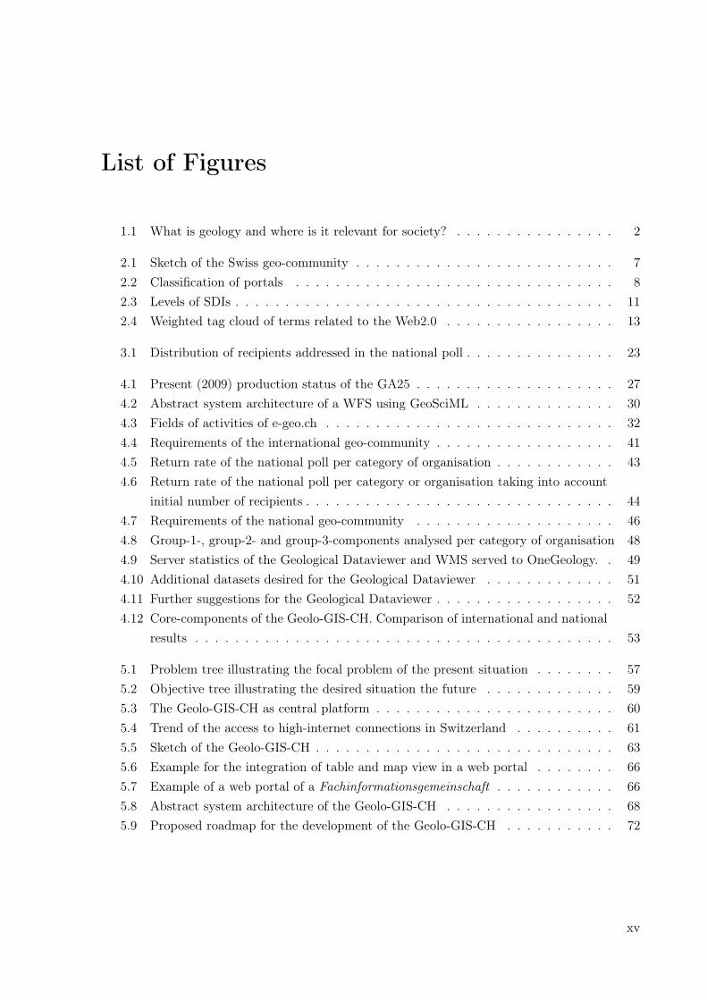
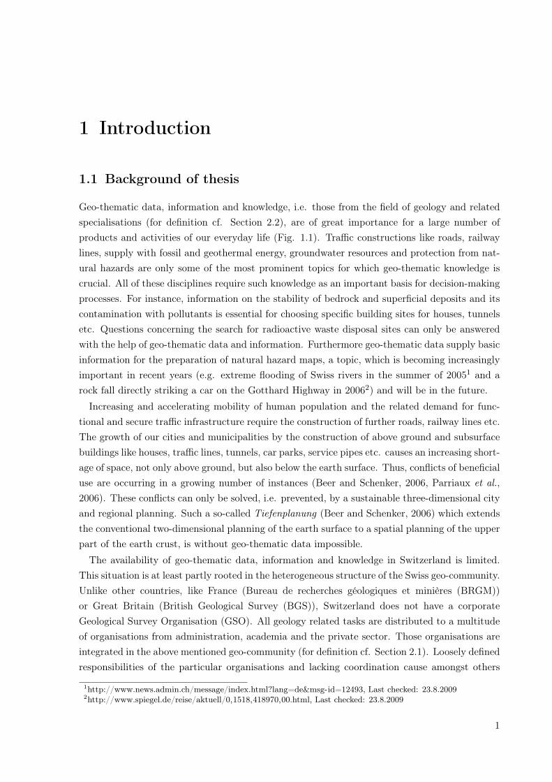
Geo-thematic data, information and knowledge, i.e. those from the field of geology and relatedspecialisations (for definition cf. Section 2.2), are of great importance for a large number ofproducts and activities of our everyday life (Fig. 1.1). Traffic constructions like roads, railwaylines, supply with fossil and geothermal energy, groundwater resources and protection from nat-ural hazards are only some of the most prominent topics for which geo-thematic knowledge iscrucial. All of these disciplines require such knowledge as an important basis for decision-makingprocesses. For instance, information on the stability of bedrock and superficial deposits and itscontamination with pollutants is essential for choosing specific building sites for houses, tunnelsetc. Questions concerning the search for radioactive waste disposal sites can only be answeredwith the help of geo-thematic data and information. Furthermore geo-thematic data supply basicinformation for the preparation of natural hazard maps, a topic, which is becoming increasinglyimportant in recent years (e.g. extreme flooding of Swiss rivers in the summer of 20051 and arock fall directly striking a car on the Gotthard Highway in 20062) and will be in the future.
Increasing and accelerating mobility of human population and the related demand for func-tional and secure traffic infrastructure require the construction of further roads, railway lines etc.The growth of our cities and municipalities by the construction of above ground and subsurfacebuildings like houses, traffic lines, tunnels, car parks, service pipes etc. causes an increasing short-age of space, not only above ground, but also below the earth surface. Thus, conflicts of beneficialuse are occurring in a growing number of instances (Beer and Schenker, 2006, Parriaux et al.,2006). These conflicts can only be solved, i.e. prevented, by a sustainable three-dimensional cityand regional planning. Such a so-called Tiefenplanung (Beer and Schenker, 2006) which extendsthe conventional two-dimensional planning of the earth surface to a spatial planning of the upperpart of the earth crust, is without geo-thematic data impossible.
The availability of geo-thematic data, information and knowledge in Switzerland is limited.This situation is at least partly rooted in the heterogeneous structure of the Swiss geo-community.Unlike other countries, like France (Bureau de recherches géologiques et minières (BRGM))or Great Britain (British Geological Survey (BGS)), Switzerland does not have a corporateGeological Survey Organisation (GSO). All geology related tasks are distributed to a multitudeof organisations from administration, academia and the private sector. Those organisations areintegrated in the above mentioned geo-community (for definition cf. Section 2.1). Loosely definedresponsibilities of the particular organisations and lacking coordination cause amongst others
1http://www.news.admin.ch/message/index.html?lang=de&msg-id=12493, Last checked: 23.8.20092http://www.spiegel.de/reise/aktuell/0,1518,418970,00.html, Last checked: 23.8.2009
1
1 Introduction
Geology is about Geology is about ......
... ... every-day every-day lifelife
1
23
4
56
8
7
Fig. 1.1: What is geology and where is it relevant for society? Geological and other geo-thematic knowledge isrelevant to many products and activities of our every-day life. Geology is about: 1) basic research, 2) environmen-tal protection, 3) energy supply, 4) traffic and constructions, 5) natural hazard protection, 6) natural resources,7) education and understanding our planet, 8) health and many other tasks and challenges of the modern society.
the aforementioned limitation in availability of geo-thematic data, information and knowledge.Moreover, unequally directed activities of the members of the geo-community lead to a lowawareness of the importance of geology and other geo-scientific fields in society. This limitedawareness, in turn, leads to poor political and economical support.
1.2 Motivation
One of the main tasks and the major challenge of the Swiss Geological Survey (SGS), the spe-cialist department for geology of the Swiss Confederation and one of the major players of thenational geo-community, is to coordinate and thereby concentrate the geology related activitiesin Switzerland. Concerning this challenge, the overall aim of the SGS is therefore, to strengthenthe impact of the geo-communities activities in society.In order to meet this challenge and to efficiently achieve the aim described above, a tool
is required. Therefore, the SGS decided to develop such a tool in the form of a geologicalinformation system and provide it to the Swiss geo-community. The vision of this GeologicalInformation System Switzerland (Geolo-GIS-CH) is as follows:
2
1.3 Aim of thesis
Create an interactive system for the players of the Swiss geo-community to improve existingworkflows. Using such a system, the nowadays dispersed and heterogeneously organised Swissgeo-community gets a tool for the coordination of their tasks and the efficient and easy exchangeof data and information. The more efficient access to geo-thematic information facilitates theactivities in the geo-community and enhances the awareness of geology in society, politics andeconomy.
1.3 Aim of thesis
The development and implementation of the Geolo-GIS-CH requires a conceptual planning. Sucha planning includes the development of a concept which implies besides design and architecturerelated considerations, also the analysis of the present state of relevant issues with respect to geo-thematic GI and the requirements of potential users of the Geolo-GIS-CH. This thesis addressesthe aforementioned issues, thus its following aims are defined:
1. Give an overview of the present state of relevant issues related to geo-thematic data, infor-mation and knowledge, with special focus on the situation in Switzerland
2. Give an overview of the requirements of potential users of the Geolo-GIS-CH, with specialfocus on those of the Swiss geo-community
3. Develop a basic concept for the Geolo-GIS-CH, based on the present state in Switzerlandand the requirements of the Swiss geo-community
4. Identify relevant issues and open questions to be considered for the development and im-plementation of the Geolo-GIS-CH
This thesis is a preliminary study for the development of a detailed concept for the Geolo-GIS-CH. Because of the size and complexity of the system the individual issues can be discussed onlyon a high level of abstraction. Detailed analyses are required in subsequent future projects.
1.4 Approach & structure of thesis
In order to achieve the aims of this thesis, the following approach has been taken:
• Perform a present state analysis regarding the handling and distribution of geo-thematicdata, information and knowledge on the international level and particularly in Switzerland
• Identify the central problem on the basis of the present state analysis
• Analyse the requirements of the international geo-community and those of the members ofthe Swiss geo-community, concerning a geological information system
• Develop a basic concept for a geological information system in Switzerland, based on theanalysis performed in the steps before
For the purpose of applying the above mentioned approach the thesis has been structured asfollows:
3
1 Introduction
Terminology (Chapter 2)
Important and frequently used terms in this thesis are described and definitions are given. Thesedefinitions are intended to constitute a common basis of understanding. Questions like Howis the Swiss geo-community defined? What is a geological information system?, What are geo-thematic data, information etc.?, How is a SDI defined and on which levels does it exist? etc.are addressed.
Methods (Chapter 3)
The methodology applied in this thesis are described. In particular the present state analysis andthe analysis of the requirements of potential users are reported. In the framework of the latteranalysis a number of components conceivable for the envisioned Geolo-GIS-CH are introduced.
Results (Chapter 4)
The results of the present state analyses on the international and national level are reported.Furthermore, the requirements of the different geo-communities concerning the envisioned infor-mation system are described. Based on theses results the core-components of the Geolo-GIS-CHand advancements and improvements of existing components are identified.
Discussion - A basic concept (Chapter 5)
On the basis of the results of the present state analysis and the analysis of requirements, i.e.the identified core-components, a basic concept is developed. In particular, the aims and targetgroups of the Geolo-GIS-CH are identified and its overall system design and abstract systemarchitecture and further issues related to the development of the Geolo-GIS-CH are discussed.Furthermore, a roadmap for the project are proposed and qualitative costs and benefits of theinformation system for the Swiss geo-community and potential risks of the project are considered.
Summary, Conclusions & Outlook (Chapter 6)
The addressed problems, applied approach and the results of the thesis are summarised andimportant conclusions are drawn. Based on the performed work and its results various tasks tobe performed parallel or after the implementation of the Geolo-GIS-CH are identified and listedin the outlook section of this chapter.
4
2 Terminology
Unambiguous terminology is an important precondition for avoiding misunderstandings. In orderto built a common basis of understanding, this chapter defines important and frequently usedterms.
2.1 Geo-community
The term geo-community in general, describes a group of organisations, institutions and individ-uals which are dealing with geology in a broad sense. A definition of what is mean by broad senseis given in Section 2.4. An international and national geo-community can be distinguished.
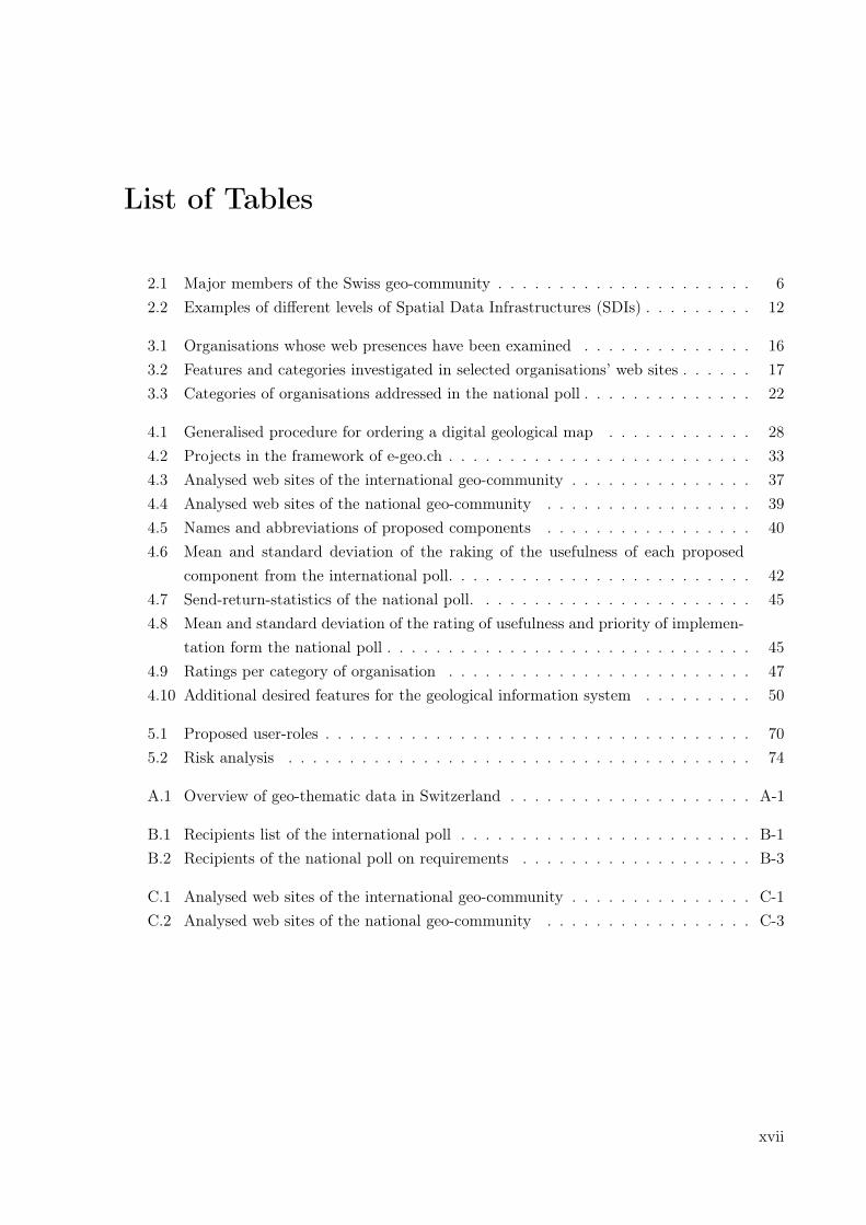
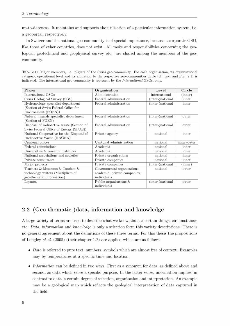
For this thesis, the international geo-community comprises the international GSOs only. Inparticular, the GSOs of the neighbouring countries of Switzerland, on the federal and state level,are addressed. Further organisations like administrative bodies, academia or private consultantshave been excluded, because those organisations participate in the Swiss geo-community onlyvery little. In contrast, Switzerland’s national geo-community comprises a large variety of or-ganisations. It contains governmental offices, agencies and societies on the federal and cantonallevel, commissions and associations, universities and other research institutes, private consul-tants, major projects (e.g. AlpTransit Gotthard1), multipliers of geo-thematic information liketeachers, museum educators, tourism specialists and technology writers as well as laymen fromthe broad public (cf. Tab. 2.1).
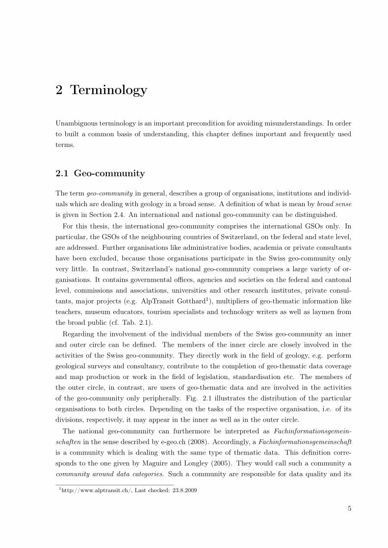
Regarding the involvement of the individual members of the Swiss geo-community an innerand outer circle can be defined. The members of the inner circle are closely involved in theactivities of the Swiss geo-community. They directly work in the field of geology, e.g. performgeological surveys and consultancy, contribute to the completion of geo-thematic data coverageand map production or work in the field of legislation, standardisation etc. The members ofthe outer circle, in contrast, are users of geo-thematic data and are involved in the activitiesof the geo-community only peripherally. Fig. 2.1 illustrates the distribution of the particularorganisations to both circles. Depending on the tasks of the respective organisation, i.e. of itsdivisions, respectively, it may appear in the inner as well as in the outer circle.
The national geo-community can furthermore be interpreted as Fachinformationsgemein-schaften in the sense described by e-geo.ch (2008). Accordingly, a Fachinformationsgemeinschaftis a community which is dealing with the same type of thematic data. This definition corre-sponds to the one given by Maguire and Longley (2005). They would call such a community acommunity around data categories. Such a community are responsible for data quality and its
1http://www.alptransit.ch/, Last checked: 23.8.2009
5
2 Terminology
up-to-dateness. It maintains and supports the utilisation of a particular information system, i.e.a geoportal, respectively.In Switzerland the national geo-community is of special importance, because a corporate GSO,
like those of other countries, does not exist. All tasks and responsibilities concerning the geo-logical, geotechnical and geophysical survey etc. are shared among the members of the geo-community.
Tab. 2.1: Major members, i.e. players of the Swiss geo-community. For each organisation, its organisationalcategory, operational level and its affiliation to the respective geo-communities circle (cf. text and Fig. 2.1) isindicated. The international geo-community is represent by the International GSOs, only.
Player Organisation Level CircleInternational GSOs Administration international (inner)Swiss Geological Survey (SGS) Federal administration (inter-)national innerHydrogeology specialist department(Section of Swiss Federal Office forEnvironment (FOEN))
Federal administration (inter-)national inner
Natural hazards specialist department(Section of FOEN)
Federal administration (inter-)national outer
Disposal of radioactive waste (Section ofSwiss Federal Office of Energy (SFOE))
Federal administration (inter-)national outer
National Cooperative for the Disposal ofRadioactive Waste (NAGRA)
Private agency national inner
Cantonal offices Cantonal administration national inner/outerFederal commissions Academia national innerUniversities & research institutes Academia national innerNational associations and societies Private organisations national innerPrivate consultants Private companies national innerMajor projects Private companies (inter-)national (inner)Teachers & Museums & Tourism &technology writers (Multipliers ofgeo-thematic information)
Governmental organisations,academia, private companies,individuals
national outer
Laymen Public organisations &individuals
(inter-)national outer
2.2 (Geo-thematic-)data, information and knowledge
A large variety of terms are used to describe what we know about a certain things, circumstancesetc. Data, information and knowledge is only a selection form this variety descriptions. There isno general agreement about the definitions of these three terms. For this thesis the propositionsof Longley et al. (2005) (their chapter 1.2) are applied which are as follows:
• Data is referred to pure text, numbers, symbols which are almost free of context. Examplesmay by temperatures at a specific time and location.
• Information can be defined in two ways. First as a synonym for data, as defined above andsecond, as data which serve a specific purpose. In the latter sense, information implies, incontrast to data, a certain degree of selection, organisation and interpretation. An examplemay be a geological map which reflects the geological interpretation of data captured inthe field.
6
2.2 (Geo-thematic-)data, information and knowledge
Fig. 2.1: Sketch of the Swiss geo-community. Two circles can be distinguished. Organisation within the innercircle are closely involved in the activities of the national geo-community. Those within the outer circle contributeonly partly or peripherally the geo-community’s activities. Entries of the same organisation in both circles indicatethat different parts, i.e. divisions of that organisation are involved to a different degrees in the geo-community.
• Knowledge is not easy to obtain or share. It is information with some added value. Theadded value is based on the interpretation of the information and depends on the particularcontext, purpose, experience, expertise and needs of the respective interpreter.
A specification of data, made for this thesis, is geo-thematic data. This kind of data comprisedatasets from various fields, all relevant for geology in a broad sense (cf. Section 2.4). Examplesare geological maps and cross section, geotechnical maps, geophysical datasets, Digital ElevationModels (DEMs), geomorphological maps, hazards maps, hydrological and hydrogeological dataetc. A more complete overview of such data is given by the BGS (cf. Britain beneath yourfeet2) (BGS, 2004) for the UK and by the Geologische Bundesanstalt Österreich (GBA) (cf.Geoaltas3) (Geologische Bundesanstalt Österreich, 2007) for Austria. A comparable overview ofthe geo-thematic data available for Switzerland is in preparation by the SGS, its current statusis show in Appendix A.Geo-thematic data has almost always a spatial reference, which is why it can be regarded
as spatial data i.e. Geoinformation (GI). Moreover, this data contains generally a substantialamount of interpretation, thus, it may be regarded as geo-thematic information, i.e. geo-thematicGI. Because of this reason, the terms data and information are used synonymously for theremainder of the present thesis.
2http://www.bgs.ac.uk/britainbeneath, Last checked: 27.10.20093http://www.geologie.ac.at/, Last checked: 27.10.2009
7
2 Terminology
2.3 Portal & geoportal
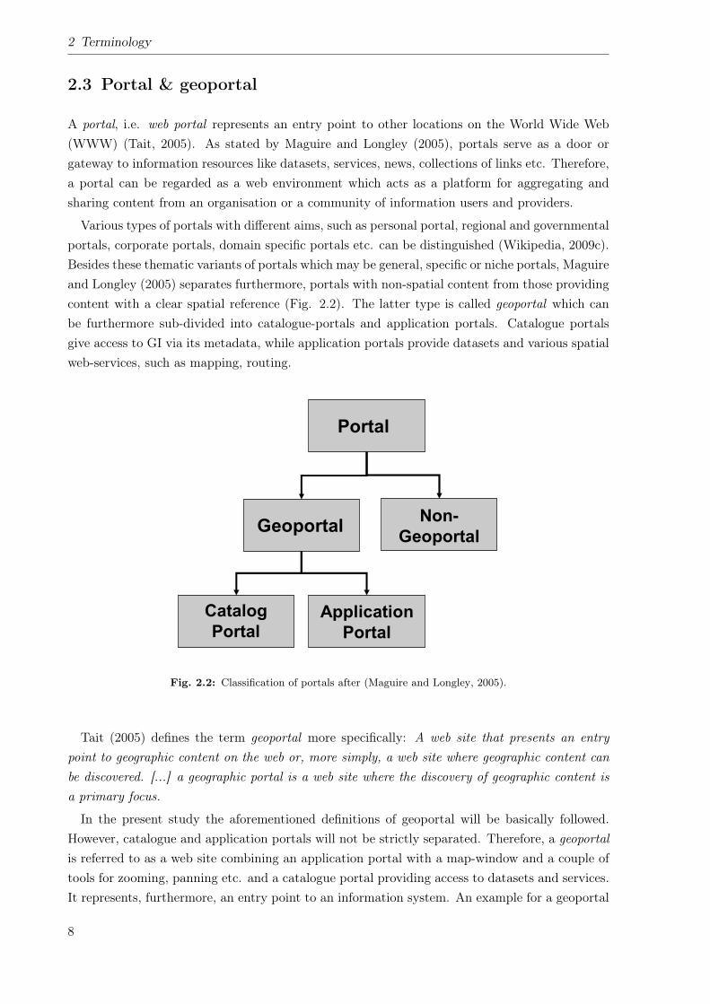
A portal, i.e. web portal represents an entry point to other locations on the World Wide Web(WWW) (Tait, 2005). As stated by Maguire and Longley (2005), portals serve as a door orgateway to information resources like datasets, services, news, collections of links etc. Therefore,a portal can be regarded as a web environment which acts as a platform for aggregating andsharing content from an organisation or a community of information users and providers.
Various types of portals with different aims, such as personal portal, regional and governmentalportals, corporate portals, domain specific portals etc. can be distinguished (Wikipedia, 2009c).Besides these thematic variants of portals which may be general, specific or niche portals, Maguireand Longley (2005) separates furthermore, portals with non-spatial content from those providingcontent with a clear spatial reference (Fig. 2.2). The latter type is called geoportal which canbe furthermore sub-divided into catalogue-portals and application portals. Catalogue portalsgive access to GI via its metadata, while application portals provide datasets and various spatialweb-services, such as mapping, routing.
3. Geoportals
The forgoing discussion on SDI/NSDI describes the key developments that led tothe need for geoportals and some of the functions they are required to perform. Theword !portal" stems from the Latin word porta and indicates an entrance point (An-noni et al., 2004). Portals are web sites that act as a door or gateway to a collection ofinformation resources, including data sets, services, cookbooks, news, tutorials, toolsand an organized collection of links to many other sites usually through catalogs.Thus a Portal is a web environment that allows an organization or a communityof information users and providers to aggregate and share content and create con-sensus. There are general portals and specialized or niche portals (http://whatis.tech-target.com/definition/0,,sid9_gci212810,00.html: also see Fig. 1). Some major generalportals include Yahoo, Excite, Netscape, Lycos, CNET, Microsoft Network, andAmerica Online"s AOL.com. Examples of niche portals include Garden.com (forgardeners), Fool.com (for investors), and SearchNetworking.com (for networkadministrators).
Tait (this issue) defines a geoportal as !a web site considered to be an entry pointto geographic content on the web or, more simply, a web site where geographic con-tent can be discovered". Already there are several examples of geoportals includingthe British Geological Survey (http://www.bgs.ac.uk/geoportal/home.html) that cov-ers geoscience resources, US Geospatial One Stop (www.geodata.gov) and EU IN-SPIRE (http://eu-geoportal.jrc.it/) that deal with national government data, andthe Geography Network (www.geographynetwork.com, and see Tait, this issue)and GSDI portal (http://gateway.gsdi.org/weswww/portal/index.html) that index awide variety of global geographic data, to cite just a few. Geoportals organize con-tent and services such as directories, search tools, community information, supportresources, data and applications. They provide capabilities to query metadata re-cords for relevant data and services, and then link directly to the on-line contentservices themselves. They can also control commercial usage of services by facilitat-ing the sale/purchase of data and services.
Portal
CatalogPortal
Geoportal
ApplicationPortal
Non-Geoportal
Fig. 1. A classification of geoportals.
D.J. Maguire, P.A. Longley / Comput., Environ. and Urban Systems 29 (2005) 3–14 7
Fig. 2.2: Classification of portals after (Maguire and Longley, 2005).
Tait (2005) defines the term geoportal more specifically: A web site that presents an entrypoint to geographic content on the web or, more simply, a web site where geographic content canbe discovered. [...] a geographic portal is a web site where the discovery of geographic content isa primary focus.
In the present study the aforementioned definitions of geoportal will be basically followed.However, catalogue and application portals will not be strictly separated. Therefore, a geoportalis referred to as a web site combining an application portal with a map-window and a couple oftools for zooming, panning etc. and a catalogue portal providing access to datasets and services.It represents, furthermore, an entry point to an information system. An example for a geoportal
8
2.4 Geological Information System
closely approaching the above definition is the Geological Dataviewer4 provided by the SGS.More recently theories like the semantic web5 (Berners-Lee et al., 2001, Wikipedia, 2009b)
and ontologies6 Wikipedia (2009a) start to influence the development of geoportals and infor-mation systems. Such approaches aim to deal with the growing volume of data, information andknowledge (Reitsma et al., 2009). As the volume increases steadily, it is getting essential to filterand extract information suitable for the respective question from this volume (Athanasis et al.,2009). Buccella and Cechich (2007) describes the development of an entire information systemsfor managing different types of geographic information (hydrology and road maintenance) whichare based on ontologies.Although these theories provide important mechanisms for the retrieval of particular infor-
mation from the hugh volume information they are not discussed in thesis in greater details.However, it should be considered during the design and developing phase of the Geolo-GIS-CH.
2.4 Geological Information System
When defining the term geological information system, two parts should be separated. First,geological and second, information system. In this thesis the term geological is defined in a broadsense. This means that it comprises all disciplines which are related to geology in a narrow sense7.Such disciplines comprise hydrogeology, geomorphology, natural hazards, geography, geophysics,geodesy, geotechnics, civil engineering, geo-botanic, land-use planing, energy supply etc.Other terms which might have been used instead are geoscience or earth science. Both terms
are rather loosely defined. Overlaps between the both terms exist and sometimes they are usedas synonyms. Because of this reason the term geological is preferred, it describes best the scopeof the envisioned information system.The second term to be defined is information system. It is used in this study to describe a
system which provides data, information and knowledge from a specific thematic field. In thiscase the thematic field is geology in the sense described above.Such an information system may be divided into an internal and an external part. The internal
one can be regarded as an intranet providing information, for instance on the production statusor on sensitive data and metadata of the respective organisation (e.g. personal information ofstaff, responsibilities etc.). Unlike the internal part, the external one provides data, metadata,information and knowledge specifically designed for public users. Referring to the Swiss geo-community and its heterogeneous organisational structure, an information system should providegeo-thematic data and information (e.g. mainly map data), information on the structure ofthe geo-community and its members (e.g. tasks, contact information etc.) as well as, geo-thematic knowledge for laymen from the broad public (e.g. easy understandable informationon geology). It should be intended to represent the tool for the geo-community to enhancedata availability, improve workflows, ameliorate networking among the players and to externalpartners and enhance public awareness of geology. Interaction of the user with the system in the
4http://www.geologieviewer.ch/, Last checked: 23.8.20095http://en.wikipedia.org/wiki/Semantic_Web, Last checked: 23.8.20096http://en.wikipedia.org/wiki/Ontology, Last checked: 23.8.20097http://en.wikipedia.org/wiki/Geology > Field or related disciplines, Last checked: 23.8.2009
9
2 Terminology
sense of Web2.0 philosophy (cf. Section 2.7), e.g. by providing user generated content, may bepossible but is not mandatory. Maguire and Longley (2005) would call such a system enterpriseinformation system which is characterised by a large number of users from various locations,large databases, various application etc.
This thesis focuses on the external part of such an information system. The internal onecopies the organisation’s internal processes. Its examination is not the aim of this study andwould exceed its scope.
Since the majority of geo-thematic data has a spatial reference, the information system dis-cussed in this this thesis implicitly deals with spatial data. Therefore, The Geolo-GIS-CH isto a large extent a Geographic Information System (GIS) as defined by Longley et al. (2005)(their Chapter 1.4). After their definition GISs represent simply containers for digital maps,tools for solving geographic problems, spatial decision support systems, mechanised inventories ofgeographically distributed features and facilities, tools for revealing what is otherwise invisible ingeographic information and tools for performing operations on geographic data.
2.5 Web-Services
The term web-services in general is defined rather imprecisely. The World Wide Web Consortium(W3C) defines it as follows:The World Wide Web is more and more used for application to application communication. Theprogrammatic interfaces made available are referred to as Web services.8 9.
In this thesis two specifications are distinguished: First, spatial web-services for handling geo-spatial datasets (e.g. Web Map Service (WMS), Really Simple Syndication (RSS) for geographiccontent (GeoRSS)10 etc.) and second, non-spatial web-services for providing thematic applica-tions, e.g. on-line shops, address-databases, image-databases, calculation services, RSS11 etc.The latter type is not discussed in greater detail, because it is only of minor relevance for thisthesis.
In contrast to non-spatial services which are standardised by the W3C, spatial web-servicesare passed by the Open Geospatial Consortium (OGC). The most common OGC-web-servicesare WMS, Web Feature Service (WFS) and Catalogue Service for Web (CSW). Apart fromspatial web-services, OGC pass also other standards like SimpleFeatures for the specificationof geographical objects, Geographic Markup Language (GML) for the exchange of geographicalobjects etc. An overview of the entire palette of standards of OGC can be found on the OGC’sweb site12.
8http://www.w3.org/2002/ws/, Last checked: 23.8.20099http://de.wikipedia.org/wiki/Webservice, Last checked: 23.8.2009
10http://en.wikipedia.org/wiki/GeoRSS, Last checked: 29.9.200911http://en.wikipedia.org/wiki/RSS, Last checked: 29.9.200912http://www.opengeospatial.org/standards, Last checked: 23.8.2009
10
2.6 Spatial data infrastructure
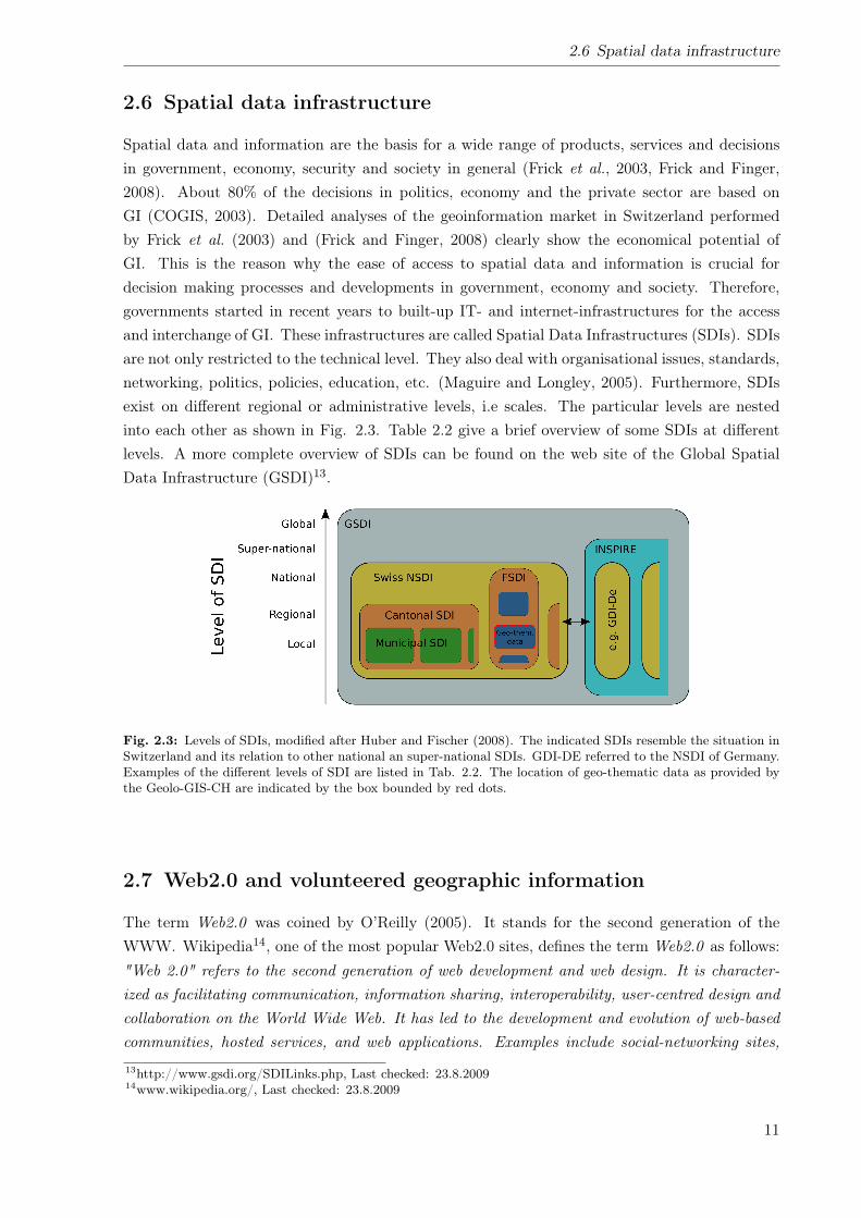
2.6 Spatial data infrastructure
Spatial data and information are the basis for a wide range of products, services and decisionsin government, economy, security and society in general (Frick et al., 2003, Frick and Finger,2008). About 80% of the decisions in politics, economy and the private sector are based onGI (COGIS, 2003). Detailed analyses of the geoinformation market in Switzerland performedby Frick et al. (2003) and (Frick and Finger, 2008) clearly show the economical potential ofGI. This is the reason why the ease of access to spatial data and information is crucial fordecision making processes and developments in government, economy and society. Therefore,governments started in recent years to built-up IT- and internet-infrastructures for the accessand interchange of GI. These infrastructures are called Spatial Data Infrastructures (SDIs). SDIsare not only restricted to the technical level. They also deal with organisational issues, standards,networking, politics, policies, education, etc. (Maguire and Longley, 2005). Furthermore, SDIsexist on different regional or administrative levels, i.e scales. The particular levels are nestedinto each other as shown in Fig. 2.3. Table 2.2 give a brief overview of some SDIs at differentlevels. A more complete overview of SDIs can be found on the web site of the Global SpatialData Infrastructure (GSDI)13.
Fig. 2.3: Levels of SDIs, modified after Huber and Fischer (2008). The indicated SDIs resemble the situation inSwitzerland and its relation to other national an super-national SDIs. GDI-DE referred to the NSDI of Germany.Examples of the different levels of SDI are listed in Tab. 2.2. The location of geo-thematic data as provided bythe Geolo-GIS-CH are indicated by the box bounded by red dots.
2.7 Web2.0 and volunteered geographic information
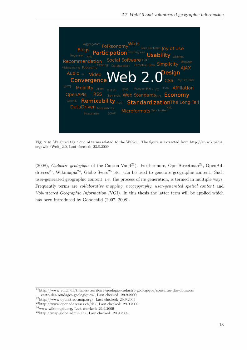
The term Web2.0 was coined by O’Reilly (2005). It stands for the second generation of theWWW. Wikipedia14, one of the most popular Web2.0 sites, defines the term Web2.0 as follows:"Web 2.0" refers to the second generation of web development and web design. It is character-ized as facilitating communication, information sharing, interoperability, user-centred design andcollaboration on the World Wide Web. It has led to the development and evolution of web-basedcommunities, hosted services, and web applications. Examples include social-networking sites,
13http://www.gsdi.org/SDILinks.php, Last checked: 23.8.200914www.wikipedia.org/, Last checked: 23.8.2009
11
2 Terminology
Tab. 2.2: Examples of different levels of SDIs as illustrated in Fig. 2.3
Level of SDI Example and Point of entryGlobal Global Spatial Data Infrastructure (GSDI): http://www.gsdi.org/SDILinks.php,
Last checked: 23.8.2009Super-national European Spatial Data Infrastructure (ESDI), i.e. INSPIRE:
http://www.inspire-geoportal.eu/index.cfm, Last checked: 2.10.2009National NSDI-Switzerland: (No central point of entry. However, geoportal is under
construction (Giger and Loidold, 2009))Federal Federal Spatial Data Infrastructure (FSDI)-Switzerland: (No central point of entry.
Separated geoportal available at http://www.swisstopo.admin.ch/internet/swisstopo/de/home/products/services/web_services/webGIS/webGIStab.html,Last checked: 2.10.2009
State Solothurn-GIS (SOGIS) for the canton of Solothurn:http://www.so.ch/departemente/bau-und-justiz/sogis.html,Lastchecked:2.10.2009and the geoportal of the Swiss Conference of State Centres for GeodataCoordination and GIS (KKGEO) for an inter-cantonal SDI:http://www.kkgeo.ch/go/, Last checked: 2.10.2009.
Municipal SDI-Zurich: Point of entry described by Gees (2006)
video-sharing sites, wikis, blogs, mashups and folksonomies.15
The basic differences between Web1.0 and Web2.0 are summarised by O’Reilly (2005) andimportant characteristics of the Web2.0 are shown in Fig. 2.4. Cormode and Krishnamurthy(2008) investigate these characteristics on the basis of popular Web2.0 sites. It becomes obviousthat in the Web2.0 philosophy the internet serves as a platform which allows the internet userto actively participate in shaping the WWW. Therefore, the Web2.0 is called participatoryweb16. Web sites like Wikipedia, YouTube, Flickr, facebook etc., for instance, can be used notonly to consume information (in the style of the Web1.0) but also to generate new content andto comment or modify existing content. Such user-generated content17 are named in multipleways. Popular terms which are generally used as synonyms are user-created content and crowdsourcing18.Liang (2008) detects in the change over form Web1.0 to Web2.0 a paradigm shift from the
information age towards the recommendation age. Since a huge volumes of information is avail-able easily, recommendations serve as shortcuts through the thicket of information. For instance,the online bookstore amazon19 not only enables the client to simply buy books. It also providesrevisions and comments from other clients which have purchased the respective product. Further-more, amazon shows products which have been purchased together with the respective productby other clients.Apart from the general characteristics of the Web2.0 mentioned above, it influences also the
usage of GI. Applications like GoogleMaps20 enables the users to apply the entire functionalrange by the help of its Application Programming Interface (API). Thus, Mash-ups with in-teractive maps can be developed and integrated in the user’s web sites (e.g. Rinner et al.
15http://en.wikipedia.org/wiki/Web_2.0, Last checked: 23.8.200916http://en.wikipedia.org/wiki/Web_2.0, Last checked: 23.8.200917http://en.wikipedia.org/wiki/User-generated_content, Last checked: 5.9.200918http://en.wikipedia.org/wiki/Crowdsourcing, Last checked: 5.9.200919http://www.amazon.com/, Last checked: 29.9.200920http://maps.google.ch/, Last checked: 29.9.2009
12
2.7 Web2.0 and volunteered geographic information
Fig. 2.4: Weighted tag cloud of terms related to the Web2.0. The figure is extracted from http://en.wikipedia.org/wiki/Web_2.0, Last checked: 23.8.2009
(2008), Cadastre geologique of the Canton Vaud21). Furthermore, OpenStreetmap22, OpenAd-dresses23, Wikimapia24, Globe Swiss25 etc. can be used to generate geographic content. Suchuser-generated geographic content, i.e. the process of its generation, is termed in multiple ways.Frequently terms are collaborative mapping, neogepgraphy, user-generated spatial content andVolunteered Geographic Information (VGI). In this thesis the latter term will be applied whichhas been introduced by Goodchild (2007, 2008).
21http://www.vd.ch/fr/themes/territoire/geologie/cadastre-geologique/consulter-des-donnees/carte-des-sondages-geologiques/, Last checked: 29.9.2009
22http://www.openstreetmap.org/, Last checked: 29.9.200923http://www.openaddresses.ch/de/, Last checked: 29.9.200924www.wikimapia.org, Last checked: 29.9.200925http://map.globe.admin.ch/, Last checked: 29.9.2009
13

3 Methods
In the following sections the methods are described which have been applied in the frameworkof the present thesis. Furthermore, the proposed components of the Geolo-GIS-CH which havebeen evaluated by the potential user are briefly introduced.
3.1 Web- and literature research
The present state analysis performed in this study, investigates the present situation concerningthe handling and distribution of geo-thematic information and GI in Switzerland. In order to givean overview of the present situation the following aspects have been analysed in a web-research:
• General technical status of Information and Communication Technology (ICT) and GIS
• Availability and accessibility of geo-thematic data in Switzerland
• Data quality issues
• Standards relevant for geo-thematic GI
• Switzerland’s NSDI and the ESDI
• Legal basis for handling of geo-thematic data in Switzerland
• Existing geological information systems
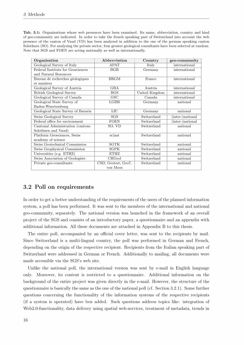
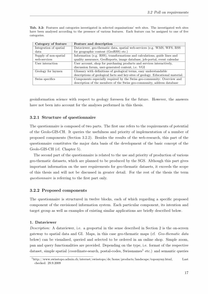
Since the present state analysis focusses on the situation in Switzerland the web presences of themajor members of the Swiss geo-community and those of the GSOs of Switzerland’s neighbouringcountries (Italian Agency for Environmental Protection and Technical Services (APAT) for Italy,the Federal Institute for Geosciences and Natural Resources (BGR) for Germany, the BRGM forFrance and the GBA for Austria) have been investigated. Additionally, the web presence of theBGS, representing a major GSO in the European Union (EU) and the the Geological Survey ofCanada (GSC) for America. Since in Germany geological survey is in the responsibility of thestates, the web portals of the geological state survey of Bavaria and Baden-Wuertemberg havebeen analysed (cf. Tab. 3.1).The web portal of each organisation was analysed according to the presence of 18 different
features. Each feature can be assigned to one of five categories. Features and categories arelisted in Tab. 3.2.In addition to the aforementioned analysis of the respective web portals, the relevant literature
has been examined. Such literature can be found in international scientific journals, organisationsstrategy papers, federal acts of law and associated ordinances, subject-specific guidelines andrecommendations, project reports, etc.
15
3 Methods
Tab. 3.1: Organisations whose web presences have been examined. Its name, abbreviation, country and kindof geo-community are indicated. In order to take the french speaking part of Switzerland into account the webpresence of the canton of Vaud (VD) has been analysed in addition to the one of the german speaking cantonSolothurn (SO). For analysing the private sector, four greater geological consultants have been selected at random.Note that SGS and FOEN are acting nationally as well as internationally.
Organisation Abbreviation Country geo-communityGeological Survey of Italy APAT Italy internationalFederal Institute for Geosciencesand Natural Resources
BGR Germany international
Bureau de recherches géologiqueset minières
BRGM France international
Geological Survey of Austria GBA Austria internationalBritish Geological Survey BGS United Kingdom internationalGeological Survey of Canada GSC Canada internationalGeological State Survey ofBaden-Wuertemburg
LGBR Germany national
Geological State Survey of Bavaria LfU Germany nationalSwiss Geological Survey SGS Switzerland (inter-)nationalFederal office for environment FOEN Switzerland (inter-)nationalCantonal Administration (cantonsSolothurn and Vaud)
SO, VD Switzerland national
Platform Geosciences, Swissacademy of science
sc|nat Switzerland national
Swiss Geotechnical Commission SGTK Switzerland nationalSwiss Geophysical Commission SGPK Switzerland nationalUniversities (e.g. ETHZ) ETHZ Switzerland nationalSwiss Association of Geologists CHGeol Switzerland nationalPrivate geo-consultants CSD, Geotest, Geo7,
von MoosSwitzerland national
3.2 Poll on requirements
In order to get a better understanding of the requirements of the users of the planned informationsystem, a poll has been performed. It was sent to the members of the international and nationalgeo-community, separately. The national version was launched in the framework of an overallproject of the SGS and consists of an introductory paper, a questionnaire and an appendix withadditional information. All these documents are attached in Appendix B to this thesis.
The entire poll, accompanied by an official cover letter, was sent to the recipients by mail.Since Switzerland is a multi-lingual country, the poll was performed in German and French,depending on the origin of the respective recipient. Recipients from the Italian speaking part ofSwitzerland were addressed in German or French. Additionally to mailing, all documents weremade accessible via the SGS’s web site.
Unlike the national poll, the international version was sent by e-mail in English languageonly. Moreover, its content is restricted to a questionnaire. Additional information on thebackground of the entire project was given directly in the e-mail. However, the structure of thequestionnaire is basically the same as the one of the national poll (cf. Section 3.2.1). Some furtherquestions concerning the functionality of the information systems of the respective recipients(if a system is operated) have ben added. Such questions address topics like: integration ofWeb2.0-functionality, data delivery using spatial web-services, treatment of metadata, trends in
16
3.2 Poll on requirements
Tab. 3.2: Features and categories investigated in selected organisations’ web sites. The investigated web siteshave been analysed according to the presence of various features. Each feature can be assigned to one of fivecategories.
Category of feature Feature and descriptionIntegration of spatialdata
Dataviewer, geo-thematic data, spatial web-services (e.g. WMS, WFS, RSSfor geographic content (GeoRSS) etc.)
Supply of non-spatialweb-services
Information (e.g. RSS), transformations and calculations, guide lines andquality assurance, GeoReports, image database, job-portal, event calendar
User interaction User account, shop for purchasing products and services interactively,discussion forum, user-generated content, i.e. VGI
Geology for laymen Glossary with definitions of geological terms, easy understandabledescriptions of geological facts and key-sites of geology. Educational material.
Swiss specifics Components especially required by the Swiss geo-community: Overview anddescription of the members of the Swiss geo-community, address database
geoinformation science with respect to geology foreseen for the future. However, the answershave not been into account for the analyses performed in this thesis.
3.2.1 Structure of questionnaire
The questionnaire is composed of two parts. The first one refers to the requirements of potentialof the Geolo-GIS-CH. It queries the usefulness and priority of implementation of a number ofproposed components (Section 3.2.2). Besides the results of the web-research, this part of thequestionnaire constitutes the major data basis of the development of the basic concept of theGeolo-GIS-CH (cf. Chapter 5).The second part of the questionnaire is related to the use and priority of production of various
geo-thematic datasets, which are planned to be produced by the SGS. Although this part givesimportant information on the user requirements for geo-thematic datasets, it exceeds the scopeof this thesis and will not be discussed in greater detail. For the rest of the thesis the termquestionnaire is referring to the first part only.
3.2.2 Proposed components
The questionnaire is structured in twelve blocks, each of which regarding a specific proposedcomponent of the envisioned information system. Each particular component, its intention andtarget group as well as examples of existing similar applications are briefly described below.
1. DataviewerDescription: A dataviewer, i.e. a geoportal in the sense described in Section 2 is the on-screengateway to spatial data and GI. Maps, in this case geo-thematic maps (cf. Geo-thematic databelow) can be visualised, queried and selected to be ordered in an online shop. Simple zoom,pan and query functionalities are provided. Depending on the type, i.e. format of the respectivedataset, simple spatial (coordinate-search, postal-codes, Swissnames1 etc.) and semantic queries
1http://www.swisstopo.admin.ch/internet/swisstopo/de/home/products/landscape/toponymy.html, Lastchecked: 29.9.2009
17
3 Methods
are performable.Target groups: The target-group of this component is rather broad, it comprises every internetuser interested in geo-thematic data.Examples: An example of such a dataviewer and its basic functionality is the GeologicalDataviewer2 provided by the SGS.
2. Geo-thematic dataDescription: Geo-thematic data (cf. Section 2.2 for definition) is the core of the plannedinformation system. Each component is based on it. A large number of geo-thematic data isalready existing in the Swiss geo-community, will be generated and completed in the near futureor are planned to be produced.Target groups: Similar to the dataviewer (cf. above), the target-group of this component datacomprises every user of the internet. However, professional geologists and other specialists aremainly addressed.Examples: Overview of existing geological maps and status of production; metadata ongeological reports and well-data; geological, geotechnical and geophysical maps, data on naturalhazards, etc. Like the BGS (Britain beneath your feet) and the GBA (Geoaltas), the SGS iscompiling an overview of the existing geo-thematic data in Switzerland.
3. Web-ServicesDescription: Web-Services, as defined in Section 2.5 comprise any spatial- and non-spatialservices distributed via the internet. The questionnaire focuses basically on the spatial serviceslike OGC-WMS and OGC-WFS.Target groups: The target-group for the above described web-services are mainly professionals.Examples: An example for a spatial web-service is the WMS of the Geological and Tectonic mapof Switzerland 1:500’000 (swisstopo, 2005a,b) which is provided by the SGS for the OneGeologyproject. Furthermore, non-spatial web-services like coordinate transformations between differentcoordinate systems, stratigraphic lexicon, discussion forum, glossary, address database, jobexchange, event calender etc. does exist on various web presences of the members of theSwiss geo-community. Since the latter five components are believed to be of special importancefor the Swiss geo-community, they are treated in separate blocks below (cf. No. 4, 7, 8, 9 and 10).
4. Geo-GlossaryDescription: A glossary gives easy understandable definitions of important geological andgeo-scientific terms and facts. Such a glossary may be administered by a single body or may bedesigned in Wiki-style, where a user-community creates and administers its content.Target groups: Primary target-groups are semi-professionals and laymen.Examples: None
5. Key-sites of Swiss geologyDescription: In addition to the glossary, this component gives easy understandable descriptions
2http://www.geologieviewer.ch/, Last checked: 23.8.2009
18
3.2 Poll on requirements
of key-features, particularities and peculiarities of Switzerland’s geology. An example such akey-site may be the Glarner Hauptüberschiebung which is one of the major tectonic structuresin Switzerland and a crucial feature for understanding the evolution of the Alps.Target groups: Semi-professionals and laymen are mainly addressed by this component.Examples: None
6. Overview of geo-communityDescription: As described in the Chapters 1.1 and 2.1 , Switzerland does not have a corporateGSO like other countries. Instead, a diverse geo-community exists. In order to introducethe members of the national geo-community, present their tasks and responsibilities and toillustrate their integration, this component gives an overview. The integration of the particularorganisations may be represented in a graphical way to better illustrate common interfaces,relationships and dependencies.Target groups: The main target-group are professional geologists. However, the component isopen to everybody who need to get in contact to or are interested in the national geo-community.Examples: None
7. Address databaseDescription: Closely related to the described overview of the geo-community is a comprehensiveaddress database. It contains all addresses of the members of the geo-community and providestools to easy query and locate them on a map. Systems with such functionalities already exist,mainly for common directories, like the Swiss search engine Local.ch3.Target groups: This component is designed for professionals, however, it is freely availableon-line to everybody.Examples: For the Swiss geo-community the Platform Geosciences (sc|nat) provide a com-prehensive address database4. This tool gives access to a large number of addresses andcontact-information to individuals, institutions, organisations, research projects and researchprograms. The database provides address information only, a spatial extension for the visual-isation of search results in map-view is not implemented yet. The existing database may beincorporated into the envisioned one, i.e. may be extended by a spatial extension.
8. Discussion-forum on geological topicsDescription: On the internet discussion forums are available for many different topics. Theyprovide a basis for discussions between the members of specific communities. For geology suchan discussion-form does not exist. Threats like general geology; geoinformation and geology;help with your master thesis; different threats on specific methods (geological mapping, appliedgeology, microscopy etc.) are conceivable.Target groups: Every geologists with an affinity to the internet may be the primary target-group.Students of any specialisation may use such a forum for support on their studies.
3http://www.local.ch, Last checked: 23.8.20094http://geosciences.scnat.ch/index.php?nav1=3&nav2=34, Last checked: 23.8.2009
19
3 Methods
Examples: An example from the geoinformation area is the Swiss GeoWebForum5. Thisforum provides in various thematic threats a platform for discussing different topics related togeoinformation science in Switzerland.
9. Job portalDescription: Compared to other specialisations like informatics, live-sciences, etc. the geo-community is rather small. Open positions, i.e. job offers can therefore be found only rarelyin common print media and job portals. Because of this reason, a job portal specialised ongeo-scientific positions would provide access to only job offers relevant to geologist and othergeo-scientists.Target groups: The target group of this component comprises everybody who searches an openposition in the geo-scientific area.Examples: Examples for web sites supplying such job offers do already exist in Switzerland(e.g. the Swiss Association of Geologists (CHGEOL) job portal6 and the sc|nat-Job portal7).However, these portals are not synchronised, thus, for getting every offer, always each portalhave to be checked separately. Because of this reason, the envisioned job portal should integrateall existing ones, thus, a central gateway to geo-scientific job offers in Switzerland as well on theinternational level can be provided.
10. Event calendarDescription: Colloquia, fairs, conferences, exhibitions, lectures, public events (e.g. ErlebnisGeologie8 and Basecamp09 9) are activities which shape the geo-community and support theinternal and external communication and knowledge transfer.Target groups: As target-groups professionals, semi-professionals and laymen can be identified.Examples: Similar to the job portal, several event calendars do exist for the Swiss geo-community.Those of the CHGEOL10 and the sc|nat11 are the most prominent ones. The content, however, isnot synchronised, thus, it is hard get an overall overview of upcoming events. Therefore, the en-visioned application should collect all event announcements by integrating the existing calendars.
11. OpenGeoMapDescription: Inspired by the OpenStreetMap-project12 and other participatory-GIS13 projects(e.g. WikiMapia14 and Globe Switzerland15 etc.) an interactive Web2.0-tool for collecting andpublishing user-generated geo-thematic data is proposed. Basically two types of functionalitieswhich have an implication on the complexity of the component are conceivable. First, a revision
5http://www.geowebforum.ch, Last checked: 23.8.20096http://www.chgeol.org/d/2/jobs.asp, Last checked: 23.8.20097http://www.geosciences.scnat.ch/index.php?nav1=2&nav2=166, Last checked: 23.8.20098http://www.erlebnis-geologie.ch, Last checked: 23.8.20099http://www.basecamp09.ch, Last checked: 23.8.2009
10http://www.chgeol.org/d/2/agenda.asp, Last checked: 23.8.200911http://geosciences.scnat.ch/index.php?nav1=3&nav2=33, Last checked: 23.8.200912http://www.openstreetmap.org, Last checked:23.8.200913http://en.wikipedia.org/wiki/Participatory_GIS, Last checked: 29.9.200914http://www.wikimapia.org, Last checked: 23.8.200915http://map.globe.admin.ch, Last checked:23.8.2009
20
3.2 Poll on requirements
client similar to the one provided by swisstopo16 which allows the user to comment on existinggeo-thematic datasets such as geological pixel-maps to communicate errors in the geometryof geological bodies or its interpretation. The respective entries are stored in the informationsystem and can be used for the updating the existing maps. Second, platform for capturingpersonal geological discoveries. Registered users may digitise geo-thematic objects and storethem directly on a server provided by the information system. In combination with a Wiki-site,the geometry, geological interpretation etc. may be discussed by the community. As a vision,all geologically uncovered areas in Switzerland are mapped and verified by the geo-communityitself.Target groups: Both varieties may be used by a broad geo-scientifically interested community.Examples: An example of an application similar to the one described above is provided by GlobeSwitzerland17, a division of the international Globe project18 which provides an interactiveplatform for students, teachers and scientists for capturing data on various topics.
12. Further required or desired components and general commentsDescription: The proposition of the above described components is based on considerations ofthe SGS. In order to give the recipients the possibility to indicate further desired componentsand features as well as to comment on the entire system, this block has been inserted into tothe questionnaire.
The proposition of the above listed components is based mainly on the analysis of the existingweb sites of the members of the Swiss geo-community. Furthermore, the existence of a geo-community covering the tasks of a single corporate geological survey, like in Switzerland, makescomponents like Overview of geo-community and Address data base necessary.
3.2.3 Scale of evaluation
For each block, i.e group of components, respectively, its usefulness and priority of implemen-tation have been queried. Participants of the poll could have assigned grades according to thefollowing 5-point scale:
1 = very low, 2 = low, 3 = medium, 4 = high, 5 = very high
Additionally to the evaluation of each block, specific comments on each component and furtherdesired components could have been added. For adding general remarks on the entire informationsystem, block No. 12 (cf. above) could have been used.
3.2.4 Recipients
The aim of the poll was to get an overview of the requirements of potential users of the envisionedinformation system. Because of this reason, recipients from various fields of specification and
16http://www.swisstopogeodata.ch/swisstopo_apps/tlm/index.php?lang=en, Last checked: 23.8.200917http://www.globe-swiss.ch, Last checked: 23.8.200918http://www.globe.gov/, Last checked: 23.8.2009
21
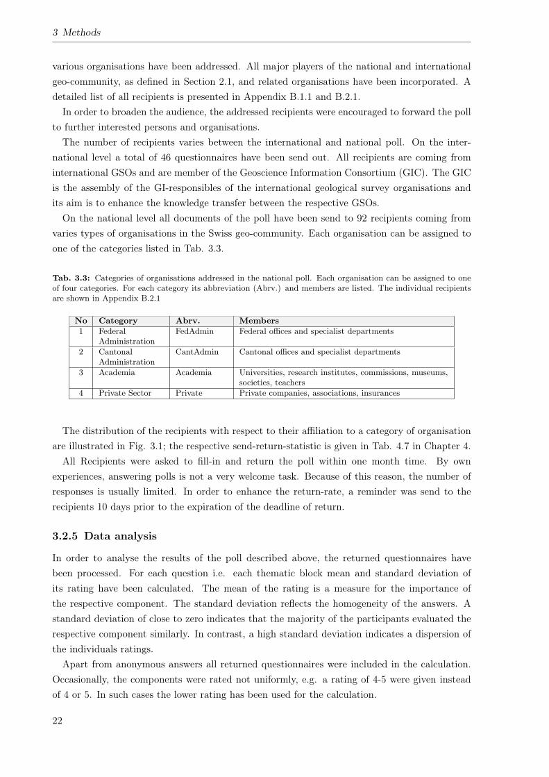
3 Methods
various organisations have been addressed. All major players of the national and internationalgeo-community, as defined in Section 2.1, and related organisations have been incorporated. Adetailed list of all recipients is presented in Appendix B.1.1 and B.2.1.In order to broaden the audience, the addressed recipients were encouraged to forward the poll
to further interested persons and organisations.The number of recipients varies between the international and national poll. On the inter-
national level a total of 46 questionnaires have been send out. All recipients are coming frominternational GSOs and are member of the Geoscience Information Consortium (GIC). The GICis the assembly of the GI-responsibles of the international geological survey organisations andits aim is to enhance the knowledge transfer between the respective GSOs.On the national level all documents of the poll have been send to 92 recipients coming from
varies types of organisations in the Swiss geo-community. Each organisation can be assigned toone of the categories listed in Tab. 3.3.
Tab. 3.3: Categories of organisations addressed in the national poll. Each organisation can be assigned to oneof four categories. For each category its abbreviation (Abrv.) and members are listed. The individual recipientsare shown in Appendix B.2.1
No Category Abrv. Members1 Federal
AdministrationFedAdmin Federal offices and specialist departments
2 CantonalAdministration
CantAdmin Cantonal offices and specialist departments
3 Academia Academia Universities, research institutes, commissions, museums,societies, teachers
4 Private Sector Private Private companies, associations, insurances
The distribution of the recipients with respect to their affiliation to a category of organisationare illustrated in Fig. 3.1; the respective send-return-statistic is given in Tab. 4.7 in Chapter 4.All Recipients were asked to fill-in and return the poll within one month time. By own
experiences, answering polls is not a very welcome task. Because of this reason, the number ofresponses is usually limited. In order to enhance the return-rate, a reminder was send to therecipients 10 days prior to the expiration of the deadline of return.
3.2.5 Data analysis
In order to analyse the results of the poll described above, the returned questionnaires havebeen processed. For each question i.e. each thematic block mean and standard deviation ofits rating have been calculated. The mean of the rating is a measure for the importance ofthe respective component. The standard deviation reflects the homogeneity of the answers. Astandard deviation of close to zero indicates that the majority of the participants evaluated therespective component similarly. In contrast, a high standard deviation indicates a dispersion ofthe individuals ratings.Apart from anonymous answers all returned questionnaires were included in the calculation.
Occasionally, the components were rated not uniformly, e.g. a rating of 4-5 were given insteadof 4 or 5. In such cases the lower rating has been used for the calculation.
22
3.2 Poll on requirements
12%
39.1%
26.1%
22.8%
FedAdmin
CantAdmin
Academia
Privat
Fig. 3.1: Distribution of recipients addressed in the national poll according to the category of its organisation.Recipients from the cantonal administration (CantAdmin) constitute the largest fraction (39.1%). Academia(26.1%) and the private sector (22.8%) are in the mid-range and the federal administration (FedAdmin) (12%)constitute the smallest fraction. Related data is provided in Tab. 4.7 in Chapter 4.
In the questionnaire the component geo-thematic data in general, could not been evaluatedindividually. Instead, several example datasets (e.g. geological maps, geotechnical maps, geo-physical maps etc.) have been asked to be evaluated (cf. Appendix B.2). In order to obtain arating for usefulness and priority of implementation of geo-thematic data as a whole, the meanand standard deviation of the rating of all example datasets has been calculated. Furthermore,various examples for web-services could have been evaluated besides the usefulness and priorityof implementation of web-services in general. The rating of the examples have been excludedfrom the analysis, because they represent a different level compared to the other components.On the international level, the results for all participants of the poll have been used. No further
classification and specification according to the affiliation of the particular participants has beenperformed. In contrast, on the national level, the results for the particular components havebeen segmented according to the categories of the respective organisations (cf. Tab. 3.3). Thus,the requirements of the federal administration, the cantonal administration, academia and theprivate sector can be compared to each other.Apart from the rating of the individual proposed components, the participants of the poll could
have indicated comments and propositions regarding each component which in turned could havebeen rated. These comments, propositions etc. were collected and segmented subjectively by theauthor of the thesis into various categories. The individual categories (cf. Tab. 4.10), in turnhave been grouped into five topics (Additional datasets, improvements for dataviewer, additionsto dataviewer, web-services and additional features). In order to analyse the importance of theindividual categories its number of reference has been multiplied by the rating for its usefulnessand priority of implementation, respectively.
23

4 Results
In order to accomplish a basis for the development and implementation of the Geolo-GIS-CH,the following analyses have been performed in the framework of this thesis:
• Present state analysis of relevant issues concerning geo-thematic data, it’s handling anddistribution with special focus to the situation in Switzerland.
• Analysis of the requirements of potential users of the Geolo-GIS-CH by means of pre-defined components. In doing so, the requirements of the Swiss geo-community are in thecentre of interest.
4.1 Present state analysis
The present state analysis examines different aspects with respect to geo-thematic GI such asdata availability and quality, existing SDIs and geological information systems, standards andlegal bases on the international and national level.
4.1.1 General technical progress
In recent years ICT advanced constantly. Apart from more powerful hardware and user-optimisedsoftware, high-performance local and wide area networks are established in many countries.Using these networks, the fast and failure-free communication among internet users and amongcomputers as well as the exchange of large datasets is facilitated.These advancements also influenced the GI- and GIS-sector. In general, the utilisation and
the integration of GI in standard operating procedures and standard applications is gettingincreasingly common and self-evident. Thus, the vision that GIS is established when nobody needsto interpret this acronym (Strobel, 1999) is becoming reality. Applications like GoogleEarth1,NASA World Wind2 and other virtual globes familiarise the general public with the value andthe handling of GI (Butler, 2006). Especially the internet supports the utilisation of GI. Forinstance, many web sites contain interactive maps which show e.g. the location of stores or events.Such features which are based on Application Programming Interfaces (APIs) are continuouslyreplacing the conventional static graphics of the position plan. One of the most popular APIs isthe GoogleMaps-API which allows the user to apply the entire functional range of GoogleMaps.But also other APIs like the JavaScript-based OpenLayers3 and the related MapFish-framework4
provide similar functionalities.1http://earth.google.com/, Last checked: 29.9.20092http://worldwind.arc.nasa.gov/, Last checked: 29.9.20093http://openlayers.org/, Last checked: 29.9.20094http://trac.mapfish.org/trac/mapfish, Last checked: 29.9.2009
25
4 Results
Data transfer and exchange is increasingly achieved by the use of spatial web-services. Thus,storage and maintenance of the particular GI can be performed locally by the data producer,i.e. owner, respectively. In doing so the permanent supply of up to date GI can be guaranteed.Apart from the provision of raster, i.e. picture data (e.g. scanned maps) using WMS, thesupply of vector data by the use of WFS is getting increasingly important. Furthermore, thedevelopment of transactional web services like Transactional Web Feature Service (WFS-T) andWeb Processing Service (WPS) (Huber, 2008) are being advanced. Transactional services canbe applied for the bi-directional transfer of VGI and facilitates thereby the participation of theinternet user in the process of data generation. WPSs permit spatial analyses and processing ofGI via the internet, a functionality which is provided usually by desktop-GIS only.In order to be able to provide the aforementioned services a large variety of applications can be
applied. The most popular one is the opensource MapServer5 which allows to distribute WMSas well as WFS. For the supply of WFS-T other products like the opensource GeoServer6 orcommercial applications like ESRI ArcGIS Server7 are required.
4.1.2 Data availability & accessibility
As described in Chapters 1 and 2, a corporate GSO does not exist in Switzerland. Instead,all tasks which are related to geology are carried out by the national geo-community. Apartfrom various other activities, such as geological consultancy, development of guidelines andstandards, geo-scientific education etc., the members of the geo-community, in particular thoseof the inner circle (cf. Section 2.1) act as producers and providers of the majority of thegeo-thematic data of Switzerland. An overview of the variety of existing geo-thematic datain Switzerland is given in Appendix A. Despite of this variety, the availability and accessi-bility of particular datasets is restricted. This limitation is caused by the following three reasons:
1) Each data producer, i.e. owner is providing their datasets via a separate channels, usuallythe producers web site. A central gateway to all existing datasets does not exist. Even thecorresponding metadata are not uniformly and entirely captured. Thus, they are not properlyretrievable via metadata catalogues like geocat.ch8 or geometa.info9. Clients have to search,detect and verify such information by themselves, a situation which clearly restricts dataaccessibility.
2) The coverage of Switzerland with various of the datasets listed in Appendix A is not completed.For instance, the Geological Atlas of Switzerland 1:25’000 (GA25) (cf. No. 6, 7 and 8 in AppendixA), a map series which was initiated about 80 year ago, is still being assembled. As shown inFig. 4.1, about 50% of the 254 map sheets of the GA25 have not been mapped yet and are,therefore, still not available.Furthermore, the GA25 is primarily published as paper maps, a format which still is of great
5http://mapserver.org/, Last checked: 29.9.20096http://geoserver.org/display/GEOS/Welcome, Last checked: 29.9.20097http://www.esri.com/software/arcgis/arcgisserver/index.html, Last checked: 29.9.20098http://www.geocat.ch/, Last checked: 29.9.20099http://geometa.info/, Last checked: 29.9.2009
26
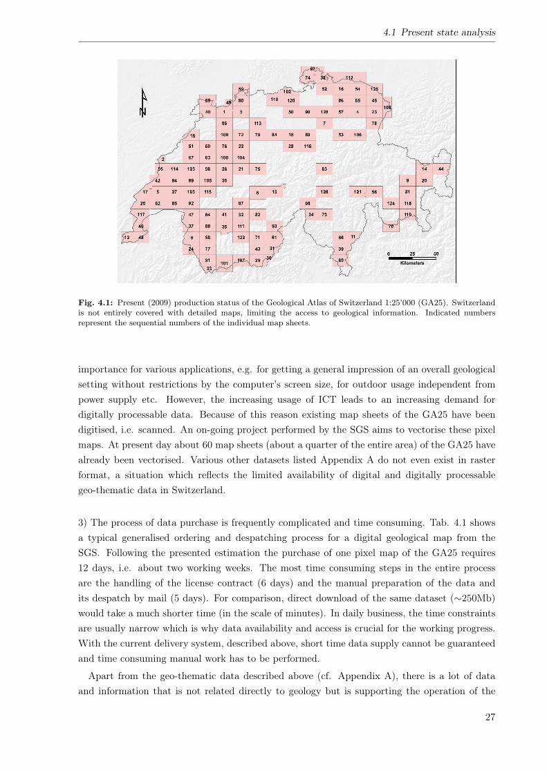
4.1 Present state analysis
Fig. 4.1: Present (2009) production status of the Geological Atlas of Switzerland 1:25’000 (GA25). Switzerlandis not entirely covered with detailed maps, limiting the access to geological information. Indicated numbersrepresent the sequential numbers of the individual map sheets.
importance for various applications, e.g. for getting a general impression of an overall geologicalsetting without restrictions by the computer’s screen size, for outdoor usage independent frompower supply etc. However, the increasing usage of ICT leads to an increasing demand fordigitally processable data. Because of this reason existing map sheets of the GA25 have beendigitised, i.e. scanned. An on-going project performed by the SGS aims to vectorise these pixelmaps. At present day about 60 map sheets (about a quarter of the entire area) of the GA25 havealready been vectorised. Various other datasets listed Appendix A do not even exist in rasterformat, a situation which reflects the limited availability of digital and digitally processablegeo-thematic data in Switzerland.
3) The process of data purchase is frequently complicated and time consuming. Tab. 4.1 showsa typical generalised ordering and despatching process for a digital geological map from theSGS. Following the presented estimation the purchase of one pixel map of the GA25 requires12 days, i.e. about two working weeks. The most time consuming steps in the entire processare the handling of the license contract (6 days) and the manual preparation of the data andits despatch by mail (5 days). For comparison, direct download of the same dataset (∼250Mb)would take a much shorter time (in the scale of minutes). In daily business, the time constraintsare usually narrow which is why data availability and access is crucial for the working progress.With the current delivery system, described above, short time data supply cannot be guaranteedand time consuming manual work has to be performed.
Apart from the geo-thematic data described above (cf. Appendix A), there is a lot of dataand information that is not related directly to geology but is supporting the operation of the
27
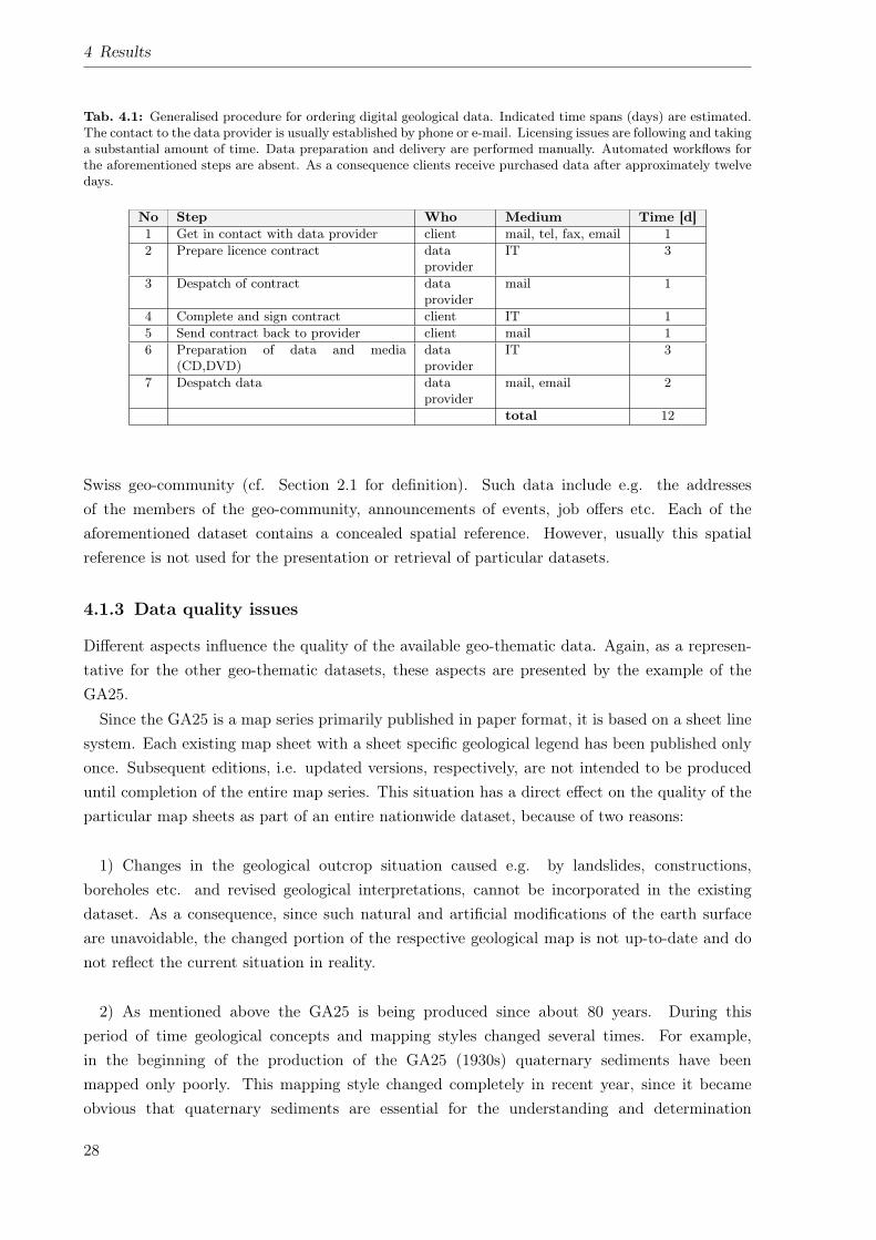
4 Results
Tab. 4.1: Generalised procedure for ordering digital geological data. Indicated time spans (days) are estimated.The contact to the data provider is usually established by phone or e-mail. Licensing issues are following and takinga substantial amount of time. Data preparation and delivery are performed manually. Automated workflows forthe aforementioned steps are absent. As a consequence clients receive purchased data after approximately twelvedays.
No Step Who Medium Time [d]1 Get in contact with data provider client mail, tel, fax, email 12 Prepare licence contract data
providerIT 3
3 Despatch of contract dataprovider
mail 1
4 Complete and sign contract client IT 15 Send contract back to provider client mail 16 Preparation of data and media
(CD,DVD)dataprovider
IT 3
7 Despatch data dataprovider
mail, email 2
total 12
Swiss geo-community (cf. Section 2.1 for definition). Such data include e.g. the addressesof the members of the geo-community, announcements of events, job offers etc. Each of theaforementioned dataset contains a concealed spatial reference. However, usually this spatialreference is not used for the presentation or retrieval of particular datasets.
4.1.3 Data quality issues
Different aspects influence the quality of the available geo-thematic data. Again, as a represen-tative for the other geo-thematic datasets, these aspects are presented by the example of theGA25.Since the GA25 is a map series primarily published in paper format, it is based on a sheet line
system. Each existing map sheet with a sheet specific geological legend has been published onlyonce. Subsequent editions, i.e. updated versions, respectively, are not intended to be produceduntil completion of the entire map series. This situation has a direct effect on the quality of theparticular map sheets as part of an entire nationwide dataset, because of two reasons:
1) Changes in the geological outcrop situation caused e.g. by landslides, constructions,boreholes etc. and revised geological interpretations, cannot be incorporated in the existingdataset. As a consequence, since such natural and artificial modifications of the earth surfaceare unavoidable, the changed portion of the respective geological map is not up-to-date and donot reflect the current situation in reality.
2) As mentioned above the GA25 is being produced since about 80 years. During thisperiod of time geological concepts and mapping styles changed several times. For example,in the beginning of the production of the GA25 (1930s) quaternary sediments have beenmapped only poorly. This mapping style changed completely in recent year, since it becameobvious that quaternary sediments are essential for the understanding and determination
28
4.1 Present state analysis
of ground stability for example during earthquakes (Bundesamt für Wasser und Geologie,2004). Changes like those mentioned above, influence the homogeneity of the geologicalobjects distinguished and listed in the particular geological map’s legend. As a consequence,adjacent map sheets showing a similar geological setting, not necessarily have a consistent legend.
Another issue influencing data quality and data consistency is joined to the latter point. Inorder to harmonise and standardise the existing geological map legends a corporate datamodelis needed. At present day such a datamodel is under construction BY the SGS. Without acorporate datamodel and standardise semantics, the compilation of a seamless vector dataset isimpossible and nationwide analyses are hampered.On the federal level the development of datamodels is mandatory for basic GI (Frick and
Kettiger, 2006, Swiss Confederation, 2008a). Since geological, geotechnical and geophysical dataare basic GI the present day absent datamodels have to be developed until the end of 2011.COGIS strongly supports and guides the process of model developments.
4.1.4 Standards
For the modelling and the transfer of geo-spatial data, i.e. GI a number of standards have beendeveloped. As described in Section 2.5, those are passed by OGC. A complete list of OGCstandards can be found on the OGC’s web site10. In the remainder of this section importantstandards and related projects with respect to the transfer of geo-thematic GI are described.
GML
GML (OGC, 2007) is one of the most important standard for the GI-sector. It is based on XMLand can be used for extensive modelling of GI. Web-services like WFS, for instance, use theGML syntax for the transfer of geographic features.
GeoSciML
Although GML has an extensive specification of more than 400 pages (OGC, 2007) which de-fines a large number of so-called primitives (e.g. features, geometries, coordinate systems, timeetc.)11, thus, only basic properties of geographic features can be represented. For a more de-tailed modelling of thematic objects, like , e.g. geological units, wells etc., so-called applicationschemas12 have to be developed. For geo-scientific, i.e. geological applications, respectively,the Geoscience Markup Language (GeoSciML) application schema has been developed by theCommission for the Management and Application of Geoscience Information (CGI) of the In-ternational Union of Geosciences (IUGS) in recent years. Using GeoSciML, geological features,can be modelled and transferred via the internet. GeoSciML replaces the Exploration and Min-ing Markup Language (XMML) with was developed for modelling and exchanging data andinformation from the mining and natural resources sector.
10http://www.opengeospatial.org/standards, Last checked: 23.8.200911http://de.wikipedia.org/wiki/Geography_Markup_Language, Last checked: 29.9.200912http://en.wikipedia.org/wiki/GML_Application_Schemas
29
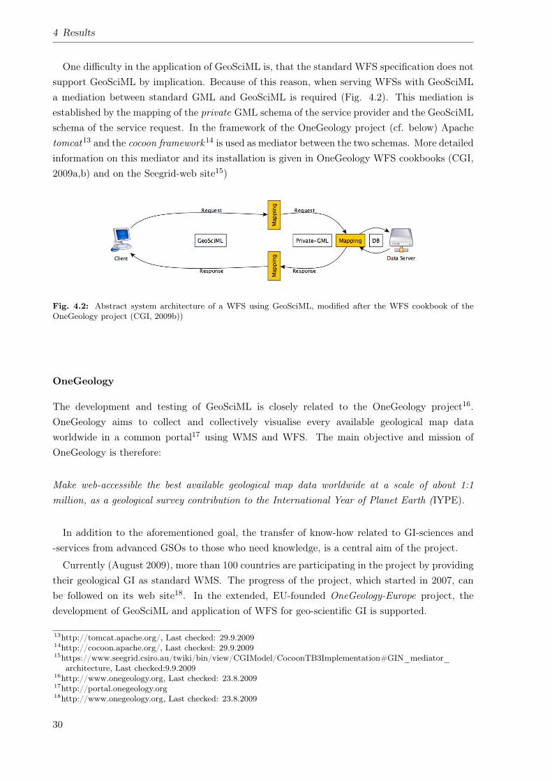
4 Results
One difficulty in the application of GeoSciML is, that the standard WFS specification does notsupport GeoSciML by implication. Because of this reason, when serving WFSs with GeoSciMLa mediation between standard GML and GeoSciML is required (Fig. 4.2). This mediation isestablished by the mapping of the private GML schema of the service provider and the GeoSciMLschema of the service request. In the framework of the OneGeology project (cf. below) Apachetomcat13 and the cocoon framework14 is used as mediator between the two schemas. More detailedinformation on this mediator and its installation is given in OneGeology WFS cookbooks (CGI,2009a,b) and on the Seegrid-web site15)
Fig. 4.2: Abstract system architecture of a WFS using GeoSciML, modified after the WFS cookbook of theOneGeology project (CGI, 2009b))
OneGeology
The development and testing of GeoSciML is closely related to the OneGeology project16.OneGeology aims to collect and collectively visualise every available geological map dataworldwide in a common portal17 using WMS and WFS. The main objective and mission ofOneGeology is therefore:
Make web-accessible the best available geological map data worldwide at a scale of about 1:1million, as a geological survey contribution to the International Year of Planet Earth (IYPE).
In addition to the aforementioned goal, the transfer of know-how related to GI-sciences and-services from advanced GSOs to those who need knowledge, is a central aim of the project.
Currently (August 2009), more than 100 countries are participating in the project by providingtheir geological GI as standard WMS. The progress of the project, which started in 2007, canbe followed on its web site18. In the extended, EU-founded OneGeology-Europe project, thedevelopment of GeoSciML and application of WFS for geo-scientific GI is supported.
13http://tomcat.apache.org/, Last checked: 29.9.200914http://cocoon.apache.org/, Last checked: 29.9.200915https://www.seegrid.csiro.au/twiki/bin/view/CGIModel/CocoonTB3Implementation#GIN_mediator_
architecture, Last checked:9.9.200916http://www.onegeology.org, Last checked: 23.8.200917http://portal.onegeology.org18http://www.onegeology.org, Last checked: 23.8.2009
30
4.1 Present state analysis
KML
Apart for GML in recent year the Keyhole Markup Language (KML) becomes more and morepopular. KML is, like GML, based on Extensible Markup Language (XML) and is being devel-oped by Google. It primarily serves for the visualisation of GI in applications like GoogleEarth19.In 2008 KML Version 2.2 (OGC, 2007) has been passed officially as OGC-standard. The speci-fication of KML with detailed information is available at the OGC’s web site20.
INTERLIS
In Switzerland INTERLIS21 (COGIS, 2006) plays, apart from the above mentioned formats, animportant role for the entire GI-sector. INTERLIS is an exchange mechanism which consistsof a conceptual modelling language and a XML-based transfer format. It was developed out ofthe requirements of the Swiss official survey, but can be used for a wide range of applicationsfrom other fields of specialisations. INTERLIS is a Swiss standard (SN 612030 and SN 612031)22
and is fully compatible with the ISO 19100 series. Its importance is strengthened by the SwissFederal Act on Geoinformation (GeoIG) (Swiss Confederation, 2008a) (cf. below). The GeoIGlegally stipulates that for basic GI, as defined in appendix 1 of the Federal Ordonnance onGeoinformation (GeoIV) (Swiss Confederation, 2008e,b), a datamodel in INTERLIS-format hasto be defined.
4.1.5 Spatial data infrastructures
As described in Section 2.6 SDIs exist on different level. In the present state analysis the nationallevel of Switzerland NSDI and FSDI have been considered. Furthermore, the european level hasbeen briefly reviewed.
Switzerland’s NSDI
Like other countries and regions (Bruggemann et al., 2004, Annoni and Craglia, 2005) alsoSwitzerland is developing a NSDI. It comprises various levels, thus cities (e.g. city of Zurich(Gees, 2006)), communes and cantons (Hösli and Ilfejika, 2006) as well as entire regions (Lip-puner, 2006) are participating and supplying their data. On the federal level the FSDI is beingbuilt-up. It contains the available GI of public interest which is owned by the confederation(swisstopo, 2009). Additionally, spatial data from public organisations and private companiesaccessible to the broad public is incorporated. The major goal of the NSDI is to enhance acces-sibility of GI and hence to create greater national economic benefits (COGIS, 2003).The driving force of the NSDI and FSDI is the e-geo.ch-project which is coordinated by CO-
GIS the coordination centre for GI of the Swiss confederation. The e-geo.ch-project started in2003 and focuses on several fields of activities23 (Fig. 4.3). These fields are dealing with the19http://earth.google.com/, Last checked: 29.9.200920http://www.opengeospatial.org/standards/kml, Last checked: 29.9.200921http://www.interlis.ch/, Last checked: 29.9.200922http://www.interlis.ch/general/faq_d.php, Last checked: 29.9.200923http://www.swisstopo.admin.ch/internet/swisstopo/de/home/topics/geodata_inf/bgdi.html, Last checked:
1.10.2009
31
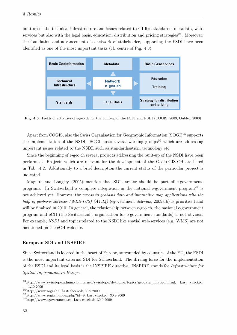
4 Results
built-up of the technical infrastructure and issues related to GI like standards, metadata, web-services but also with the legal basis, education, distribution and pricing strategies24. Moreover,the foundation and advancement of a network of stakeholder, supporting the FSDI have beenidentified as one of the most important tasks (cf. centre of Fig. 4.3).
Fig. 4.3: Fields of activities of e-geo.ch for the built-up of the FSDI and NSDI (COGIS, 2003, Gubler, 2003)
Apart from COGIS, also the Swiss Organisation for Geographic Information (SOGI)25 supportsthe implementation of the NSDI. SOGI hosts several working groups26 which are addressingimportant issues related to the NSDI, such as standardisation, technology etc.
Since the beginning of e-geo.ch several projects addressing the built-up of the NSDI have beenperformed. Projects which are relevant for the development of the Geolo-GIS-CH are listedin Tab. 4.2. Additionally to a brief description the current status of the particular project isindicated.
Maguire and Longley (2005) mention that SDIs are or should be part of e-government-programs. In Switzerland a complete integration in the national e-government program27 isnot achieved yet. However, the access to geobasis data and interactive map applications with thehelp of geobasis services (WEB-GIS) (A1.14) (egovernment Schweiz, 2009a,b) is prioritised andwill be finalised in 2010. In general, the relationship between e-geo.ch, the national e-governmentprogram and eCH (the Switzerland’s organisation for e-government standards) is not obvious.For example, NSDI and topics related to the NSDI like spatial web-services (e.g. WMS) are notmentioned on the eCH-web site.
European SDI and INSPIRE
Since Switzerland is located in the heart of Europe, surrounded by countries of the EU, the ESDIis the most important external SDI for Switzerland. The driving force for the implementationof the ESDI and its legal basis is the INSPIRE directive. INSPIRE stands for Infrastructure forSpatial Information in Europe.
24http://www.swisstopo.admin.ch/internet/swisstopo/de/home/topics/geodata_inf/bgdi.html, Last checked:1.10.2009
25http://www.sogi.ch/, Last checked: 30.9.200926http://www.sogi.ch/index.php?id=9, Last checked: 30.9.200927http://www.egovernment.ch, Last checked: 30.9.2009
32
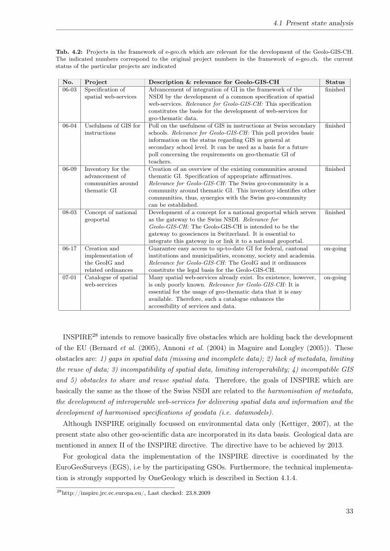
4.1 Present state analysis
Tab. 4.2: Projects in the framework of e-geo.ch which are relevant for the development of the Geolo-GIS-CH.The indicated numbers correspond to the original project numbers in the framework of e-geo.ch. the currentstatus of the particular projects are indicated
No. Project Description & relevance for Geolo-GIS-CH Status06-03 Specification of
spatial web-servicesAdvancement of integration of GI in the framework of theNSDI by the development of a common specification of spatialweb-services. Relevance for Geolo-GIS-CH: This specificationconstitutes the basis for the development of web-services forgeo-thematic data.
finished
06-04 Usefulness of GIS forinstructions
Poll on the usefulness of GIS in instructions at Swiss secondaryschools. Relevance for Geolo-GIS-CH: This poll provides basicinformation on the status regarding GIS in general atsecondary school level. It can be used as a basis for a futurepoll concerning the requirements on geo-thematic GI ofteachers.
finished
06-09 Inventory for theadvancement ofcommunities aroundthematic GI
Creation of an overview of the existing communities aroundthematic GI. Specification of appropriate affirmatives.Relevance for Geolo-GIS-CH: The Swiss geo-community is acommunity around thematic GI. This inventory identifies othercommunities, thus, synergies with the Swiss geo-communitycan be established.
finished
08-03 Concept of nationalgeoportal
Development of a concept for a national geoportal which servesas the gateway to the Swiss NSDI. Relevance forGeolo-GIS-CH: The Geolo-GIS-CH is intended to be thegateway to geosciences in Switzerland. It is essential tointegrate this gateway in or link it to a national geoportal.
finished
06-17 Creation andimplementation ofthe GeoIG andrelated ordinances
Guarantee easy access to up-to-date GI for federal, cantonalinstitutions and municipalities, economy, society and academia.Relevance for Geolo-GIS-CH: The GeoIG and it ordinancesconstitute the legal basis for the Geolo-GIS-CH.
on-going
07-01 Catalogue of spatialweb-services
Many spatial web-services already exist. Its existence, however,is only poorly known. Relevance for Geolo-GIS-CH: It isessential for the usage of geo-thematic data that it is easyavailable. Therefore, such a catalogue enhances theaccessibility of services and data.
on-going
INSPIRE28 intends to remove basically five obstacles which are holding back the developmentof the EU (Bernard et al. (2005), Annoni et al. (2004) in Maguire and Longley (2005)). Theseobstacles are: 1) gaps in spatial data (missing and incomplete data); 2) lack of metadata, limitingthe reuse of data; 3) incompatibility of spatial data, limiting interoperability; 4) incompatible GISand 5) obstacles to share and reuse spatial data. Therefore, the goals of INSPIRE which arebasically the same as the those of the Swiss NSDI are related to the harmonisation of metadata,the development of interoperable web-services for delivering spatial data and information and thedevelopment of harmonised specifications of geodata (i.e. datamodels).Although INSPIRE originally focussed on environmental data only (Kettiger, 2007), at the
present state also other geo-scientific data are incorporated in its data basis. Geological data arementioned in annex II of the INSPIRE directive. The directive have to be achieved by 2013.For geological data the implementation of the INSPIRE directive is coordinated by the
EuroGeoSurveys (EGS), i.e by the participating GSOs. Furthermore, the technical implementa-tion is strongly supported by OneGeology which is described in Section 4.1.4.
28http://inspire.jrc.ec.europa.eu/, Last checked: 23.8.2009
33
4 Results
The INSPIRE directive is not legally binding for Switzerland, but the GeoIG builds the IN-SPIRE-conform legal basis for Switzerland. It is clearly pointed out by COGIS that the activitiesrelated to INSPIRE are also useful for Switzerland (swisstopo, 2007). Because of this reason andto prevent problems related to the integration of national data into an ESDI (cf. below), theSwiss INSPIRE contact point (swisstopo, 2007) was initiated, which coordinates the INSPIRErelated activities in Switzerland. Such problems when integrating national data into a SDI are:
• Conflicting understanding of what a SDI is (Bruggemann et al., 2004)
• Incompatible technical solutions (Bruggemann et al., 2004)
• Diverging organisational structures and legislation
• Differences in spatial reference systems
• Languages
• Missing data harmonisation (e.g. borders, semantics)
• Interoperability, for instance interoperability of metadata (COGIS, 2005), i.e. compatiblewith standards like ISO19115
4.1.6 Legal basis
The implementation of the Swiss NSDI and the handling of GI is regulated by the Federal Acton Geoinformation (GeoIG) (Swiss Confederation, 2008a) and its associated ordonnances29. In2008 the GeoIG was passed by the Swiss Parliament and Swiss Federal Council and thus, becameoperative. The same applies to the majority of the associated ordonnances.The GeoIG is basically restricted to the so-called basic GI which are defined in appendix 1
of the Federal Ordonnance on Geoinformation (GeoIV) (Swiss Confederation, 2008e). A largenumber of geo-thematic data and information are part of the catalogue of basic GI, as mentionedin Section 4.1.3. In particular the geological, geophysical and geotechnical data and informationas well as basic data of the SGS are listed (cf. ID 46, 47, 48 and 50 of appendix 1 of the GeoIV).Therefore, also for geo-thematic data the regulations of the GeoIG, such as the development ofdatamodels, capture of metadata, fees etc. have to be applied.In the framework of the GeoIG the Federal Ordonnance of the Swiss Geological Survey (LGe-
olV) (Swiss Confederation, 2008d) and the Federal Ordonnance of the Swiss Federal GeologicalCommission (EGKV) (Swiss Confederation, 2008c) are of special importance for the Swiss geo-community. The latter ordonnance regulates the composition, tasks and duties of the SwissFederal Geological Commission (EGK) which is the advisory board of the Swiss Federal Councilregarding geology related affairs.The LGeolV defines the tasks and duties of the SGS. A basis of the LGeolVrepresent the
reports of Spinatsch and Hofer (2004a,b, 2003) which identify the main tasks of the SGS and itsimportance for political economics. These tasks are:29http://www.admin.ch/ch/d/sr/51.html#510.6, Last checked: 30.9.2009
34
4.1 Present state analysis
• Compile geological maps and reports
• Archive geological information (mainly reports and borehole data)
• Coordinate the geological, geotechnical and geophysical survey in Switzerland
The LGeolV constitutes the first strong legal basis for the SGS in its more than 100 years ofhistory.
4.1.7 Geological information systems
As described above (cf. Section 4.1.1), in recent years ICT and GIS-technologies are gettingincreasingly evolved, fast, widely used and familiar even to the broad public. Because of thisreason also the international geo-community is applying these technologies for presenting andcommunicating their products, i.e. their geo-thematic data, respectively. Almost every GSO (atleast in the developed countries) runs its own web portal which can be regarded as an entrypoint to the geological information system of the particular GSO. In such portals geo-thematicGI is increasingly incorporated. This integration is generally achieved by a geoportal, i.e. anapplication portal as described by Maguire and Longley (2005) which makes geo-thematic GIavailable in map view. Additional information like geological map’s legends and metadata areprovided together with the respective dataset, so that the user can obtain the same informationlike from printed products.
The international level
The BGS addresses in its 2009-2014 strategy (BGS, 2009) the improvement of the communicationof geo-scientific knowledge as one of its priority challenges. In order to face this challenge theinternet is identified as the most important tool of communication. Thus, numerous examples forapplications of their geological information, its respective importance and how data and servicescan be presented and distributed via the internet30 31 are available at the BGS’s web site. Theaccessibility of these geo-thematic information and services is easy and in many cases free ofcharge. Their relevance and importance is easy understandable for professionals and laymen.Like the BGS, also other GSOs have discovered the enormous potential of the internet for the
distribution and the exchange of information. In order to get an overview of which portals doexist and what content is presented on the international level, the web presences of the GSOs,listed in Tab. 3.1 have been analysed.Each investigated web portal has been analysed with respect to the occurrence of the features
listed in Tab. 3.2. A major part of the investigated components (cf. numbers in brackets inTab. 4.3) correspond to those described and evaluated in the poll on requirements described inSection 3.2.2.The results of this analysis are shown in Tab. 4.3. On the right side of the table (three right
most columns) the summary of the occurrences of each particular component are shown. Forcomparison, the summary of the evaluation performed by the Swiss geo-community (cf. Tab.30http://www.bgs.ac.uk/britainbeneath, Last checked: 23.8.200931http://www.bgs.ac.uk/services/home.html, Last checked: 23.8.2009
35
4 Results
4.4) are indicated to the left of the international results. The occurrences are color coded. Ifa component exists on the respective web site, it has been indicated as yes in green color, if acomponent does not exist a no has been indicated in red. Some component on the analysed websites do not exactly copy the particular specification, these components have been indicated as(yes) in yellow color. The urls of the particular web sites are given in Appendix C.1 for reference.
In general, each web portal gives numerous information on the tasks and activities of therespective organisation, its products and services as well as its national and international inte-gration. Additionally, various non-spatial web-services, like geological reports (GeoReports32),shops, image databases, job portals etc. are provided.
Besides these non-spatial web-services, each portal gives access to geo-scientific GI. This isachieved by the use of either geoportals or spatial web-services. A geoportal is provided by eachorganisation. It is separated from the main web site and is mainly composed of a stand-aloneapplication portal, as defined in Section 2.3. The applied technologies are coming from the entireproduct spectrum from commercial, e.g. ESRI ArcIMS33 to open source, e.g. mapbender34. Thecomplete integration of the visualisation of GI in the main web site, by using map-APIs, likeOpenLayers35 or GoogleMaps-API36, is not established yet.
Spatial web-services, mainly OGC-WMS, OGC-CSW or other non standardised services areprovided by each portal. The supply of OGC-WFS, however, is at the present status not existing.
The possibility for internet users to generate and provide user generated content and VGI, interms of Web2.0-philosophy, does not exist at present day. Thus, wiki-sites and transactionalservices (e.g. WFS-T) are not provided. Some organisations offer a user-account, however, thisis basically used for purchase processes in on-line shops. The BGS is the only organisationwhich supports social-networking applications such as facebook37, twitter38, YouTube39, etc.Furthermore, GeoRSS feeds on recent worldwide and UK-based earthquakes can be subscribedor included in the user’s web sites.
In contrast to the rather little activities in the area of Web2.0, almost every analysed portalprovides geological information, products and services, especially prepared for non-professionalsand laymen. Many of these services are available free of charge. Examples for such products are:
• The multimedia section40 of the web portal of the BRGM. This section provides for in-stance many laymen understandable block diagrams which illustrate various geology relatedprocesses.
• The BGS application Make-a-Map41 allows the user to manipulate a geological map inter-actively in map view. The different geological formations can be switched on and off, thus,
32http://shop.bgs.ac.uk/GeoReports/, Last checked: 25.10.200933http://www.esri.com/software/arcgis/arcims/index.html, Last checked: 30.9.200934http://www.mapbender.org/Main_Page, Last checked: 30.9.200935http://openlayers.org/, Last checked: 29.9.200936http://code.google.com/apis/maps/, Last checked: 30.9.200937http://de-de.facebook.com/, Last checked: 30.9.200938http://twitter.com/, Last checked: 30.9.200939http://www.youtube.com/, Last checked: 30.9.200940http://www.brgm.fr/multimedia.jsp, Last checked: 1.10.200941http://www.bgs.ac.uk/education/makeamap/home.html, Last checked: 1.10.2009
36
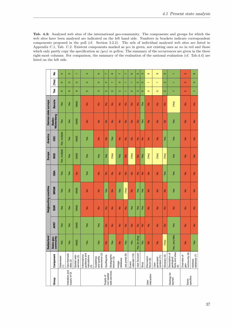
4.1 Present state analysis
Tab. 4.3: Analysed web sites of the international geo-community. The components and groups for which theweb sites have been analysed are indicated on the left hand side. Numbers in brackets indicate correspondentcomponents proposed in the poll (cf. Section 3.2.2). The urls of individual analysed web sites are listed inAppendix C.1, Tab. C.2. Existent components marked as yes in green, not existing ones as no in red and thosewhich only partly copy the specification as (yes) in yellow. The summary of the occurrences are given in the threeright-most columns. For comparison, the summary of the evaluation of the national evaluation (cf. Tab.4.4) arelisted on the left side.
Sw
itze
rland
Neig
bourl
ing c
oun
trie
sE
uro
pe
Am
eri
ca
Germ
an s
tate
surv
eys
Gro
up
Com
ponent
Sw
iss g
eo
-com
munity
APA
TB
GR
BR
GM
GB
AB
GS
GS
CB
aden
-W
ürt
em
berg
Bavari
aYes
(Yes)
No
Inte
ratio
n a
nd
su
pp
ly o
f G
I
Da
tavie
we
r(1
)Y
es
Ye
sY
es
Ye
sY
es
Ye
s,
mu
ltip
leY
es,
mu
ltip
leY
es
Ye
s9
00
Ge
o-t
he
ma
tic
da
ta (
2)
Ye
sY
es
Ye
sY
es
Ye
sY
es
Ye
sY
es
Ye
s9
00
Sp
atia
l w
eb
-se
rvic
es (
3)
WM
SW
MS
WM
SW
MS
No
WM
SW
MS
WM
SW
MS
80
1
Su
pp
ly o
fn
on
-sp
atia
lw
eb
-se
rvic
es
Info
rma
tio
ns
gu
ida
nce
an
dca
lcu
latio
ns
(3)
Ye
sY
es
No
No
Ye
sY
es
Ye
sN
oN
o5
04
Gu
ide
line
sa
nd
qu
alit
ya
ssu
ran
ce
(3
)Y
es
Ye
sN
oN
oN
oY
es
No
No
No
30
6
Ge
oR
ep
ort
sN
oN
oN
oY
es
No
Ye
sN
oN
oN
o2
07
Str
atig
rap
hic
lexic
on
(3
)Y
es
No
No
No
No
(Ye
s)
Ye
sN
oN
o2
16
Ima
ge
da
tab
ase
No
No
No
Ye
sN
oY
es
No
No
No
20
7
Jo
b p
ort
al (9
)Y
es
No
No
(Ye
s)
No
No
No
No
No
11
7
Eve
nt
ca
len
de
r (1
0)
Ye
sN
oY
es
No
No
(Ye
s)
No
No
No
21
6
Use
rin
tera
ctio
n
Use
r A
cco
un
tY
es,
for
sh
op
No
Ye
sY
es
No
No
No
No
No
30
6
Sh
op
Ye
sN
oY
es
Ye
sN
oY
es
No
Ye
sY
es
60
3
Dis
cu
ssio
nfo
rum
(8
)N
oN
oN
oN
oN
o(Y
es)
No
No
No
01
8
Use
r-g
en
era
ted
co
nte
nt
(11
)N
oN
oN
oN
oN
o(Y
es)
No
No
No
01
8
Ge
olo
gy f
or
laym
en
Glo
ssa
ry (
4)
(Ye
s)
No
No
No
Ye
s(Y
es)
Ye
sN
oN
o2
25
De
scrip
tio
n o
fg
eo
log
ica
lfa
cts
an
d s
ite
s(5
)
Ye
s,
ve
ry little
Ye
sN
oY
es
Ye
sY
es
Ye
sY
es
(Ye
s)
71
1
Sw
iss
sp
ecific
s
Ove
rvie
w o
fg
eo
-co
mm
un
ity (
6)
No
No
No
No
No
No
No
No
No
00
9
Ad
dre
ss
da
tab
ase
(7
)Y
es
No
No
No
No
No
No
No
No
10
8
37
4 Results
the user can get an inside in the structure of a geological map and the geological settingin Great Britain.
• The web site Geologie-ist...42 of the GBA provides short, laymen oriented descriptions ofthe manifold fields of geology.
• The Swiss Geological Survey (SGS)43 provides simplified geological, tectonic and hydroge-ological maps in postcard format.
The national level
In order to analyse the present situation in Switzerland, the web portals of the major players ofthe Swiss geo-community have been analysed. The investigation was performed similar to the oneperformed on the international level (cf. The international level above). Table 4.4 summarisesthe results of the analysis of the national web portals.In general it turns out, that a substantial number of data and information on geosciences and
geo-scientific organisations in Switzerland do exist on the web sites of the members of the Swissgeo-community. About two-thirds of the analysed components can be found on one or the otherweb site of a member of the Swiss geo-community.Apart from geological, geotechnical and geophysical maps and cross-sections etc. a large
number of non scientific data and information which is required for the activities and organisationof the Swiss geo-community is provided. Examples of such data are:
• Addresses and contact information of the members of the Swiss geo-community
• Offers for geo-scientific jobs
• Announcements of events like conferences, speeches etc.
Although this data and information are not obviously GI, it contains a clear spatial reference.This spatial reference is not used is the particular web portal,s neither for visualisation nor forsearch and filter functionalities. Thus, for instance, addresses (cf. address data base of thesc|nat44) can be retrieved only via textual search queries. Search results are presented only astext and not in map view.Each of the analysed web site can be regarded as a geological information system on its own,
i.e. as a part for an overall geological information system, respectively. However, data andinformation provided, mainly reflect the tasks and responsibilities of the respective organisation.It serves mainly the individual organisation’s requirements. An overall information system,combining and integrating the content of all of these web presences is lacking.A proposition of the integration of the content of the existing web portals, relevant for the
Swiss geo-community and the design of a overall geological information system for Switzerlandwas given by Oesterling et al. (2008b). These first ideas are extended in Chapter 5 of the presentthesis.42http://www.geologie-ist-alles.at/index.html, Last checked: 1.10.200943http://www.swisstopo.admin.ch/internet/swisstopo/de/home/products/accessories/postcards.html, Last
checked: 1.10.200944http://geosciences.scnat.ch/index.php?nav1=3&nav2=34, Last checked: 23.8.2009
38
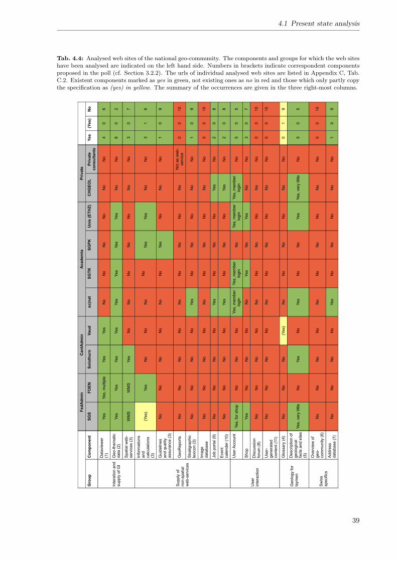
4.1 Present state analysis
Tab. 4.4: Analysed web sites of the national geo-community. The components and groups for which the web siteshave been analysed are indicated on the left hand side. Numbers in brackets indicate correspondent componentsproposed in the poll (cf. Section 3.2.2). The urls of individual analysed web sites are listed in Appendix C, Tab.C.2. Existent components marked as yes in green, not existing ones as no in red and those which only partly copythe specification as (yes) in yellow. The summary of the occurrences are given in the three right-most columns.
Fed
Ad
min
Can
tAd
min
Acad
em
iaP
rivate
Gro
up
Co
mp
on
en
tS
GS
FO
EN
So
loth
urn
Vau
dsc|n
at
SG
TK
SG
PK
Un
is (
ET
HZ
)C
HG
EO
LP
rivate
co
nsu
ltan
tsY
es
(Yes)
No
Inte
ration a
nd
supply
of G
I
Data
vie
wer
(1)
Yes
Yes, m
ultip
leY
es
Yes
No
No
No
No
No
No
40
6
Geo-t
hem
atic
data
(2)
Yes
Yes
Yes
Yes
Yes
Yes
Yes
Yes
No
No
80
2
Spatial w
eb-
serv
ices (
3)
WM
SW
MS
Yes
No
No
No
No
No
No
No
30
7
Supply
of
non-s
patial
web-s
erv
ices
Info
rmations
and
calc
ula
tions
(3)
(Yes)
Yes
No
No
No
No
Yes
Yes
No
No
31
6
Guid
elin
es
and q
ualit
yassura
nce (
3)
No
No
No
No
No
No
Yes
No
No
No
10
9
GeoR
eport
sN
oN
oN
oN
oN
oN
oN
oN
oN
oN
ot as w
eb-
serv
ice
00
10
Str
atigra
phic
lexic
on (
3)
No
No
No
No
Yes
No
No
No
No
No
10
9
Image
data
base
No
No
No
No
No
No
No
No
No
No
00
10
Job p
ort
al (9
)N
oN
oN
oN
oY
es
No
No
No
Yes
No
20
8
Event
cale
nder
(10)
No
No
No
No
Yes
No
No
No
Yes
No
20
8
User
inte
raction
User A
ccount
Yes, fo
r shop
No
No
No
Yes, m
em
ber
login
Yes, m
em
ber
login
No
Yes, m
em
ber
login
Yes, m
em
ber
login
No
50
5
Shop
Yes
No
No
No
No
Yes
No
Yes
No
No
30
7
Dis
cussio
nfo
rum
(8)
No
No
No
No
No
No
No
No
No
No
00
10
User-
genera
ted
conte
nt (1
1)
No
No
No
No
No
No
No
No
No
No
00
10
Geolo
gy for
laym
en
Glo
ssary
(4)
No
No
No
(Yes)
No
No
No
No
No
No
01
9
Description o
fgeolo
gic
al
facts
and s
ites
(5)
Yes, very
little
No
Yes
No
Yes
No
No
Yes
Yes, very
little
No
50
5
Sw
iss
specific
s
Overv
iew
of
geo-
com
munity (
6)
No
No
No
No
No
No
No
No
No
No
00
10
Addre
ss
data
base (
7)
No
No
No
No
Yes
No
No
No
No
No
10
9
39
4 Results
Geological information systems in literature
In literature Geological Information Systems as corporate applications are described rather rarely.For instance Chang and Park (2004) describes a Geological Information System especially de-signed for the management of borehole and other geo-thematic data. It is restricted to a mapviewer and its backbone is the datamodel of the individual datasets and the IT-architecture. Theintegration of other data or information (spatial and non-spatial) as well as issues related to ageo-community are not taken into account.A recent study by Howard et al. (2009) presents a corporate system of the BGS which focuses
on the one hand on geological surveying and data production and on the other hand on capturingand saving geological knowledge of the individual staff members. This tacit knowledge is neitherstored in analogue nor digital form but only as individual knowledge of the staff members. Theirsystem is called Knowledge Management System and focuses on guarding these unpublishedexplicit geological knowledge.The study by Fanger (2005) describes a web-based system for delivery and exchange of geo-
logical data in Switzerland. However, the presented system covers the requirements of geologicalconsultants and excludes requirements of other members of the Swiss geo-community.
4.2 Requirements of potential users
The requirements of the international and national geo-community on a geological informationsystem and its components were derived from the returned questionnaires described Section 3.2.1.In the questionnaire the usefulness and priority of implementation of 11 proposed componentsof the envisioned Geolo-GIS-CH have been queried. Each of those components is described inSection 3.2.2 in detail. Table 4.5 briefly lists the name and abbreviation of each component. Theindicated abbreviations are used in the subsequent figures and tables.
Tab. 4.5: Names and abbreviations of the proposed components of the planned Geolo-GIS-CH. Name andabbreviation of each component is listed. Abbreviations are used in subsequent figures and tables.
No Name Abbreviation1 Dataviewer GDView2 Geo-thematic data GDat3 Web-services GWebS4 Geo-glossary GGlos5 Key-sites of Swiss geology GKeyS6 Overview of geo-community GCom7 Address database GADB8 Discussion-forum on geological topics GForum9 Job portal GJobs10 Event calender GEvent11 OpenGeoMap OGM
According to the applied method of analysis the components with the highest rating can beregard as the most required ones.For each geo-community the requirements have been analysed separately. On the national
level the poll generates a substantial databases for the analysis of the requirements of the Swiss
40
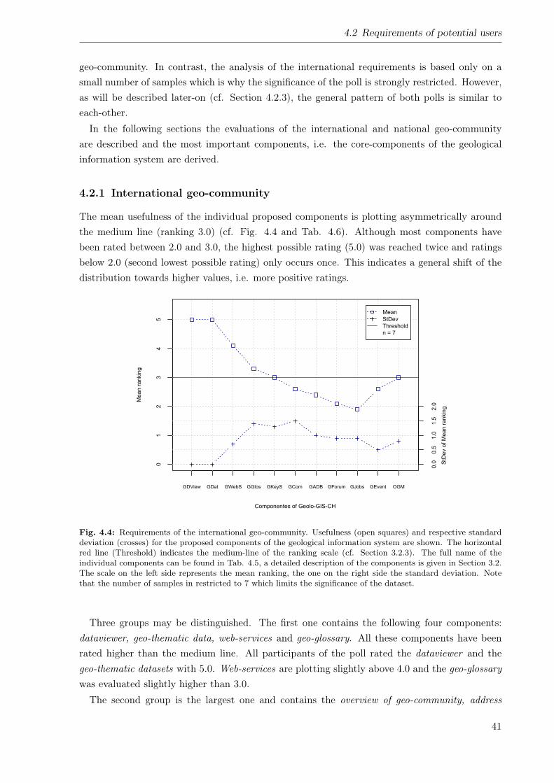
4.2 Requirements of potential users
geo-community. In contrast, the analysis of the international requirements is based only on asmall number of samples which is why the significance of the poll is strongly restricted. However,as will be described later-on (cf. Section 4.2.3), the general pattern of both polls is similar toeach-other.In the following sections the evaluations of the international and national geo-community
are described and the most important components, i.e. the core-components of the geologicalinformation system are derived.
4.2.1 International geo-community
The mean usefulness of the individual proposed components is plotting asymmetrically aroundthe medium line (ranking 3.0) (cf. Fig. 4.4 and Tab. 4.6). Although most components havebeen rated between 2.0 and 3.0, the highest possible rating (5.0) was reached twice and ratingsbelow 2.0 (second lowest possible rating) only occurs once. This indicates a general shift of thedistribution towards higher values, i.e. more positive ratings.
Componentes of Geolo-GIS-CH
Mean r
ankin
g
GDView GDat GWebS GGlos GKeyS GCom GADB GForum GJobs GEvent OGM
01
23
45
0.0
0.5
1.0
1.5
2.0
StD
ev o
f M
ean
rankin
g
Mean
StDev
Threshold
n = 7
Fig. 4.4: Requirements of the international geo-community. Usefulness (open squares) and respective standarddeviation (crosses) for the proposed components of the geological information system are shown. The horizontalred line (Threshold) indicates the medium-line of the ranking scale (cf. Section 3.2.3). The full name of theindividual components can be found in Tab. 4.5, a detailed description of the components is given in Section 3.2.The scale on the left side represents the mean ranking, the one on the right side the standard deviation. Notethat the number of samples in restricted to 7 which limits the significance of the dataset.
Three groups may be distinguished. The first one contains the following four components:dataviewer, geo-thematic data, web-services and geo-glossary. All these components have beenrated higher than the medium line. All participants of the poll rated the dataviewer and thegeo-thematic datasets with 5.0. Web-services are plotting slightly above 4.0 and the geo-glossarywas evaluated slightly higher than 3.0.The second group is the largest one and contains the overview of geo-community, address
41
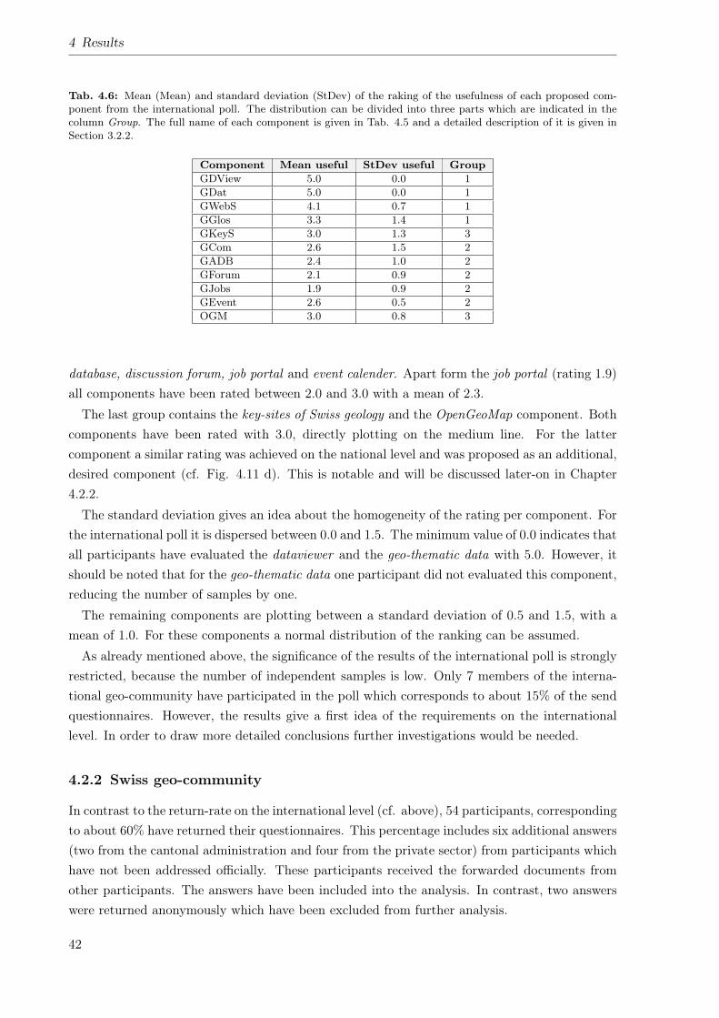
4 Results
Tab. 4.6: Mean (Mean) and standard deviation (StDev) of the raking of the usefulness of each proposed com-ponent from the international poll. The distribution can be divided into three parts which are indicated in thecolumn Group. The full name of each component is given in Tab. 4.5 and a detailed description of it is given inSection 3.2.2.
Component Mean useful StDev useful GroupGDView 5.0 0.0 1GDat 5.0 0.0 1GWebS 4.1 0.7 1GGlos 3.3 1.4 1GKeyS 3.0 1.3 3GCom 2.6 1.5 2GADB 2.4 1.0 2GForum 2.1 0.9 2GJobs 1.9 0.9 2GEvent 2.6 0.5 2OGM 3.0 0.8 3
database, discussion forum, job portal and event calender. Apart form the job portal (rating 1.9)all components have been rated between 2.0 and 3.0 with a mean of 2.3.
The last group contains the key-sites of Swiss geology and the OpenGeoMap component. Bothcomponents have been rated with 3.0, directly plotting on the medium line. For the lattercomponent a similar rating was achieved on the national level and was proposed as an additional,desired component (cf. Fig. 4.11 d). This is notable and will be discussed later-on in Chapter4.2.2.
The standard deviation gives an idea about the homogeneity of the rating per component. Forthe international poll it is dispersed between 0.0 and 1.5. The minimum value of 0.0 indicates thatall participants have evaluated the dataviewer and the geo-thematic data with 5.0. However, itshould be noted that for the geo-thematic data one participant did not evaluated this component,reducing the number of samples by one.
The remaining components are plotting between a standard deviation of 0.5 and 1.5, with amean of 1.0. For these components a normal distribution of the ranking can be assumed.
As already mentioned above, the significance of the results of the international poll is stronglyrestricted, because the number of independent samples is low. Only 7 members of the interna-tional geo-community have participated in the poll which corresponds to about 15% of the sendquestionnaires. However, the results give a first idea of the requirements on the internationallevel. In order to draw more detailed conclusions further investigations would be needed.
4.2.2 Swiss geo-community
In contrast to the return-rate on the international level (cf. above), 54 participants, correspondingto about 60% have returned their questionnaires. This percentage includes six additional answers(two from the cantonal administration and four from the private sector) from participants whichhave not been addressed officially. These participants received the forwarded documents fromother participants. The answers have been included into the analysis. In contrast, two answerswere returned anonymously which have been excluded from further analysis.
42
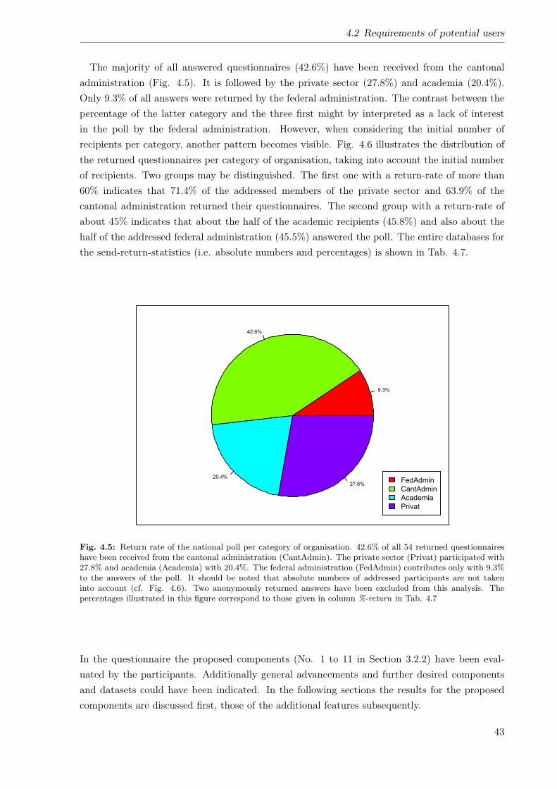
4.2 Requirements of potential users
The majority of all answered questionnaires (42.6%) have been received from the cantonaladministration (Fig. 4.5). It is followed by the private sector (27.8%) and academia (20.4%).Only 9.3% of all answers were returned by the federal administration. The contrast between thepercentage of the latter category and the three first might by interpreted as a lack of interestin the poll by the federal administration. However, when considering the initial number ofrecipients per category, another pattern becomes visible. Fig. 4.6 illustrates the distribution ofthe returned questionnaires per category of organisation, taking into account the initial numberof recipients. Two groups may be distinguished. The first one with a return-rate of more than60% indicates that 71.4% of the addressed members of the private sector and 63.9% of thecantonal administration returned their questionnaires. The second group with a return-rate ofabout 45% indicates that about the half of the academic recipients (45.8%) and also about thehalf of the addressed federal administration (45.5%) answered the poll. The entire databases forthe send-return-statistics (i.e. absolute numbers and percentages) is shown in Tab. 4.7.
9.3%
42.6%
20.4%
27.8%FedAdmin
CantAdmin
Academia
Privat
Fig. 4.5: Return rate of the national poll per category of organisation. 42.6% of all 54 returned questionnaireshave been received from the cantonal administration (CantAdmin). The private sector (Privat) participated with27.8% and academia (Academia) with 20.4%. The federal administration (FedAdmin) contributes only with 9.3%to the answers of the poll. It should be noted that absolute numbers of addressed participants are not takeninto account (cf. Fig. 4.6). Two anonymously returned answers have been excluded from this analysis. Thepercentages illustrated in this figure correspond to those given in column %-return in Tab. 4.7
In the questionnaire the proposed components (No. 1 to 11 in Section 3.2.2) have been eval-uated by the participants. Additionally general advancements and further desired componentsand datasets could have been indicated. In the following sections the results for the proposedcomponents are discussed first, those of the additional features subsequently.
43
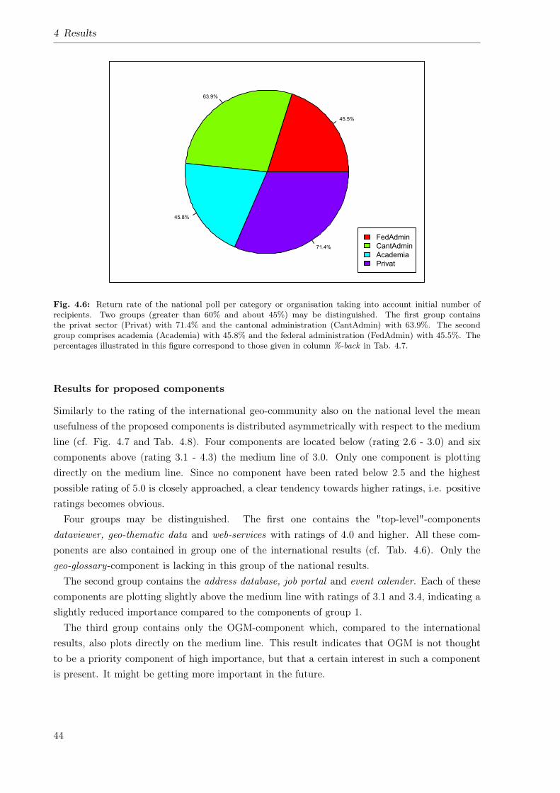
4 Results
45.5%
63.9%
45.8%
71.4%
FedAdmin
CantAdmin
Academia
Privat
Fig. 4.6: Return rate of the national poll per category or organisation taking into account initial number ofrecipients. Two groups (greater than 60% and about 45%) may be distinguished. The first group containsthe privat sector (Privat) with 71.4% and the cantonal administration (CantAdmin) with 63.9%. The secondgroup comprises academia (Academia) with 45.8% and the federal administration (FedAdmin) with 45.5%. Thepercentages illustrated in this figure correspond to those given in column %-back in Tab. 4.7.
Results for proposed components
Similarly to the rating of the international geo-community also on the national level the meanusefulness of the proposed components is distributed asymmetrically with respect to the mediumline (cf. Fig. 4.7 and Tab. 4.8). Four components are located below (rating 2.6 - 3.0) and sixcomponents above (rating 3.1 - 4.3) the medium line of 3.0. Only one component is plottingdirectly on the medium line. Since no component have been rated below 2.5 and the highestpossible rating of 5.0 is closely approached, a clear tendency towards higher ratings, i.e. positiveratings becomes obvious.Four groups may be distinguished. The first one contains the "top-level"-components
dataviewer, geo-thematic data and web-services with ratings of 4.0 and higher. All these com-ponents are also contained in group one of the international results (cf. Tab. 4.6). Only thegeo-glossary-component is lacking in this group of the national results.The second group contains the address database, job portal and event calender. Each of these
components are plotting slightly above the medium line with ratings of 3.1 and 3.4, indicating aslightly reduced importance compared to the components of group 1.The third group contains only the OGM-component which, compared to the international
results, also plots directly on the medium line. This result indicates that OGM is not thoughtto be a priority component of high importance, but that a certain interest in such a componentis present. It might be getting more important in the future.
44
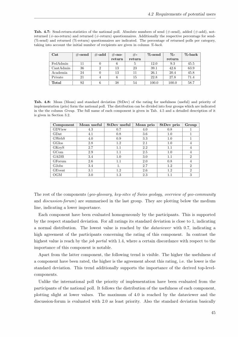
4.2 Requirements of potential users
Tab. 4.7: Send-return-statistics of the national poll. Absolute numbers of send (#-send), added (#-add), not-returned (#-no-return) and returned (#-return) questionnaires. Additionally the respective percentage for send-(%-send) and returned (%-return) questionnaires are indicated. The percentage of returned polls per category,taking into account the initial number of recipients are given in column %-back.
Cat #-send #-add #-no-return
#-return
%-send %-return
%-back
FedAdmin 11 0 6 5 12.0 9.3 45.5CantAdmin 36 2 13 23 39.1 42.6 63.9Academia 24 0 13 11 26.1 20.4 45.8Private 21 4 6 15 22.8 27.8 71.4Total 92 6 38 54 100.0 100.0 58.7
Tab. 4.8: Mean (Mean) and standard deviation (StDev) of the rating for usefulness (useful) and priority ofimplementation (prio) form the national poll. The distribution can be divided into four groups which are indicatedin the the column Group. The full name of each component is given in Tab. 4.5 and a detailed description of itis given in Section 3.2.
Component Mean useful StDev useful Mean prio StDev prio GroupGDView 4.3 0.7 4.0 0.8 1GDat 4.1 0.8 3.6 1.0 1GWebS 4.0 0.9 3.3 1.0 1GGlos 2.8 1.2 2.1 1.0 4GKeyS 2.7 1.1 2.2 1.1 4GCom 2.9 1.1 2.5 1.0 4GADB 3.4 1.0 3.0 1.1 2GForum 2.6 1.1 2.0 0.8 4GJobs 3.4 1. 2.7 1.2 2GEvent 3.1 1.2 2.6 1.2 2OGM 3.0 1.3 2.3 1.1 3
The rest of the components (geo-glossary, key-sites of Swiss geology, overview of geo-communityand discussion-forum) are summarised in the last group. They are plotting below the mediumline, indicating a lower importance.
Each component have been evaluated homogeneously by the participants. This is supportedby the respect standard deviation. For all ratings its standard deviation is close to 1, indicatinga normal distribution. The lowest value is reached by the dataviewer with 0.7, indicating ahigh agreement of the participants concerning the rating of this component. In contrast thehighest value is reach by the job portal with 1.4, where a certain discordance with respect to theimportance of this component is notable.
Apart from the latter component, the following trend is visible. The higher the usefulness ofa component have been rated, the higher is the agreement about this rating, i.e. the lower is thestandard deviation. This trend additionally supports the importance of the derived top-level-components.
Unlike the international poll the priority of implementation have been evaluated from theparticipants of the national poll. It follows the distribution of the usefulness of each component,plotting slight at lower values. The maximum of 4.0 is reached by the dataviewer and thediscussion-forum is evaluated with 2.0 as least priority. Also the standard deviation basically
45
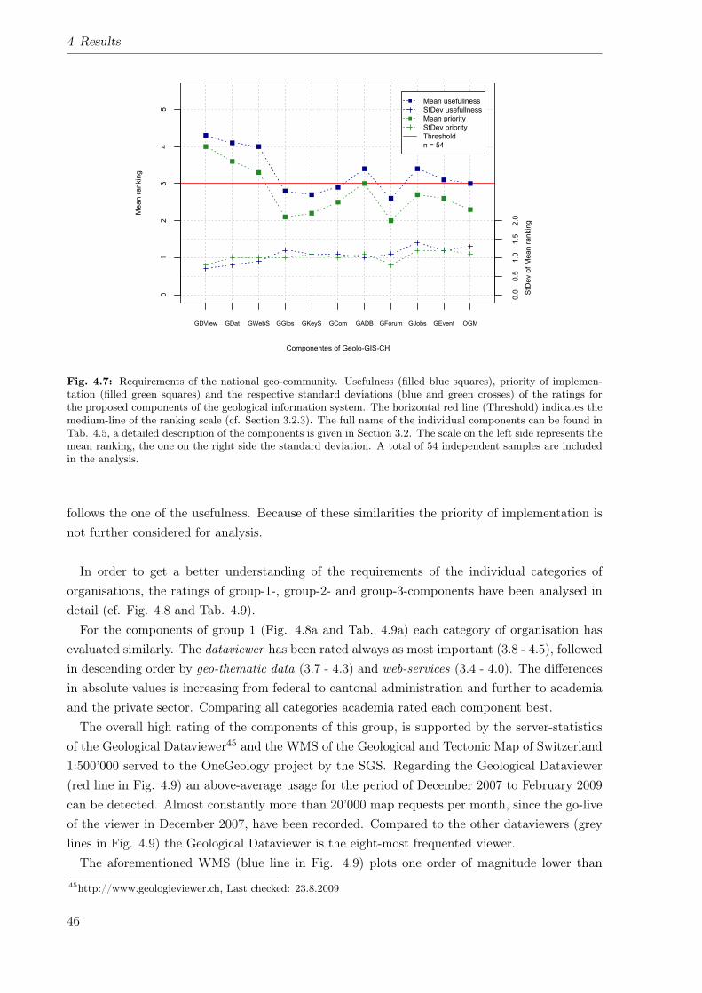
4 Results
Componentes of Geolo-GIS-CH
Mean r
ankin
g
GDView GDat GWebS GGlos GKeyS GCom GADB GForum GJobs GEvent OGM
01
23
45
0.0
0.5
1.0
1.5
2.0
StD
ev o
f M
ean r
ankin
g
Mean usefullness
StDev usefullness
Mean priority
StDev priority
Threshold
n = 54
Fig. 4.7: Requirements of the national geo-community. Usefulness (filled blue squares), priority of implemen-tation (filled green squares) and the respective standard deviations (blue and green crosses) of the ratings forthe proposed components of the geological information system. The horizontal red line (Threshold) indicates themedium-line of the ranking scale (cf. Section 3.2.3). The full name of the individual components can be found inTab. 4.5, a detailed description of the components is given in Section 3.2. The scale on the left side represents themean ranking, the one on the right side the standard deviation. A total of 54 independent samples are includedin the analysis.
follows the one of the usefulness. Because of these similarities the priority of implementation isnot further considered for analysis.
In order to get a better understanding of the requirements of the individual categories oforganisations, the ratings of group-1-, group-2- and group-3-components have been analysed indetail (cf. Fig. 4.8 and Tab. 4.9).For the components of group 1 (Fig. 4.8a and Tab. 4.9a) each category of organisation has
evaluated similarly. The dataviewer has been rated always as most important (3.8 - 4.5), followedin descending order by geo-thematic data (3.7 - 4.3) and web-services (3.4 - 4.0). The differencesin absolute values is increasing from federal to cantonal administration and further to academiaand the private sector. Comparing all categories academia rated each component best.The overall high rating of the components of this group, is supported by the server-statistics
of the Geological Dataviewer45 and the WMS of the Geological and Tectonic Map of Switzerland1:500’000 served to the OneGeology project by the SGS. Regarding the Geological Dataviewer(red line in Fig. 4.9) an above-average usage for the period of December 2007 to February 2009can be detected. Almost constantly more than 20’000 map requests per month, since the go-liveof the viewer in December 2007, have been recorded. Compared to the other dataviewers (greylines in Fig. 4.9) the Geological Dataviewer is the eight-most frequented viewer.The aforementioned WMS (blue line in Fig. 4.9) plots one order of magnitude lower than
45http://www.geologieviewer.ch, Last checked: 23.8.2009
46
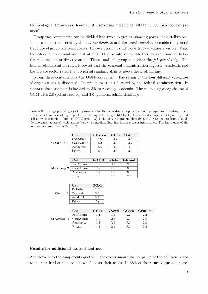
4.2 Requirements of potential users
the Geological Dataviewer, however, still reflecting a traffic of 1000 to 10’000 map requests permonth.Group two components can be divided into two sub-groups, showing particular distributions.
The first one, as reflected by the address database and the event calendar, resemble the generaltrend the of group one components. However, a slight shift towards lower values is visible. Thus,the federal and cantonal administration and the private sector rated the two components belowthe medium line or directly on it. The second sub-group comprises the job portal only. Thefederal administration rated it lowest and the cantonal administration highest. Academia andthe private sector rated the job portal similarly slightly above the medium line.Group three contains only the OGM-component. The rating of the four different categories
of organisations is dispersed. Its minimum is at 1.6, rated by the federal administration. Incontrast the maximum is located at 3.5 as rated by academia. The remaining categories ratedOGM with 2.8 (private sector) and 3.0 (cantonal administration).
Tab. 4.9: Ratings per category of organisation for the individual components. Four groups can be distinguished.a) Top-level -components (group 1) with the highest ratings. b) Slightly lower rated components (group 2), butstill above the medium line. c) OGM (group 3) is the only component directly plotting on the medium line. d)Components (group 4) with ratings below the medium line, indicating a lesser importance. The full names of thecomponents are given in Tab. 4.5.
a) Group 1
Cat GDView GDat GWebSFedAdmin 3.8 3.7 3.8CantAdmin 4.0 3.9 3.7Academia 4.5 4.3 4.0Privat 4.1 3.8 3.4
b) Group 2
Cat GADB GJobs GEventFedAdmin 3.0 1.6 2.0CantAdmin 3.4 3.7 3.0Academia 3.4 3.2 3.5Privat 3.1 3.3 2.7
c) Group 3
Cat OGMFedAdmin 1.6CantAdmin 3.0Academia 3.5Privat 2.8
d) Group 4
Cat GGlos GKeyS GCom GForumFedAdmin 1.4 1.4 2.2 2.2CantAdmin 3.1 2.7 2.7 2.5Academia 3.3 3.7 3.0 2.5Privat 1.9 2.4 3.0 2.5
Results for additional desired features
Additionally to the components quoted in the questionnaire the recipients of the poll were askedto indicate further components which cover their needs. In 68% of the returned questionnaires
47
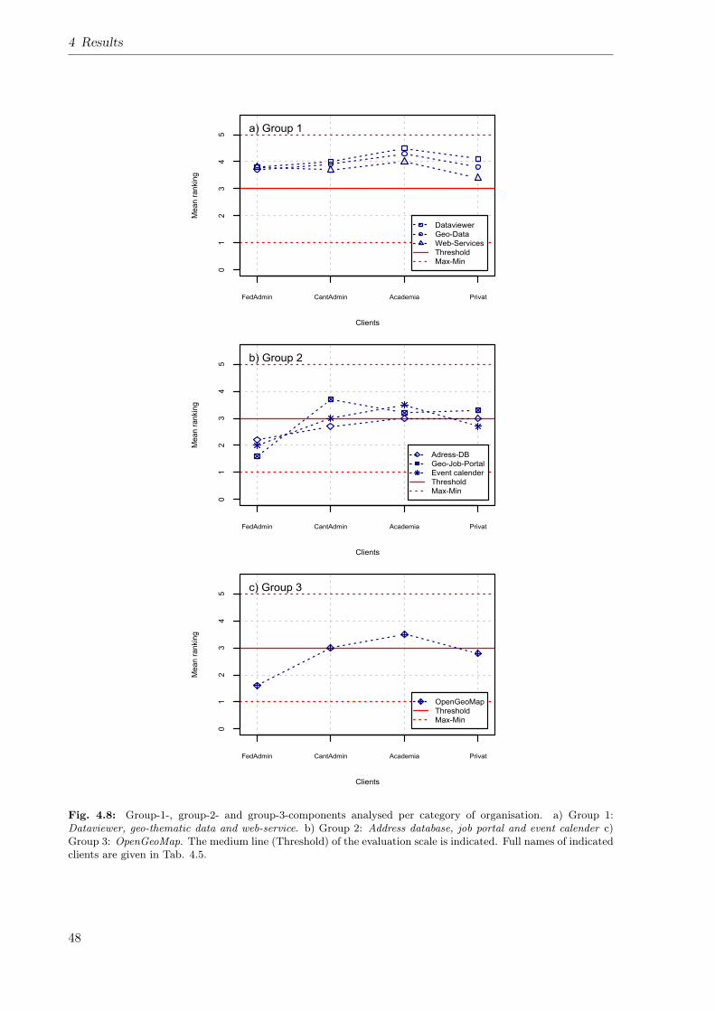
4 Results
Clients
Me
an
ra
nkin
g
FedAdmin CantAdmin Academia Privat
01
23
45
Dataviewer
Geo-Data
Web-Services
Threshold
Max-Min
a) Group 1
Clients
Me
an
ra
nkin
g
FedAdmin CantAdmin Academia Privat
01
23
45
Adress-DB
Geo-Job-Portal
Event calender
Threshold
Max-Min
b) Group 2
Clients
Me
an
ra
nkin
g
FedAdmin CantAdmin Academia Privat
01
23
45
OpenGeoMap
Threshold
Max-Min
c) Group 3
Fig. 4.8: Group-1-, group-2- and group-3-components analysed per category of organisation. a) Group 1:Dataviewer, geo-thematic data and web-service. b) Group 2: Address database, job portal and event calender c)Group 3: OpenGeoMap. The medium line (Threshold) of the evaluation scale is indicated. Full names of indicatedclients are given in Tab. 4.5.
48
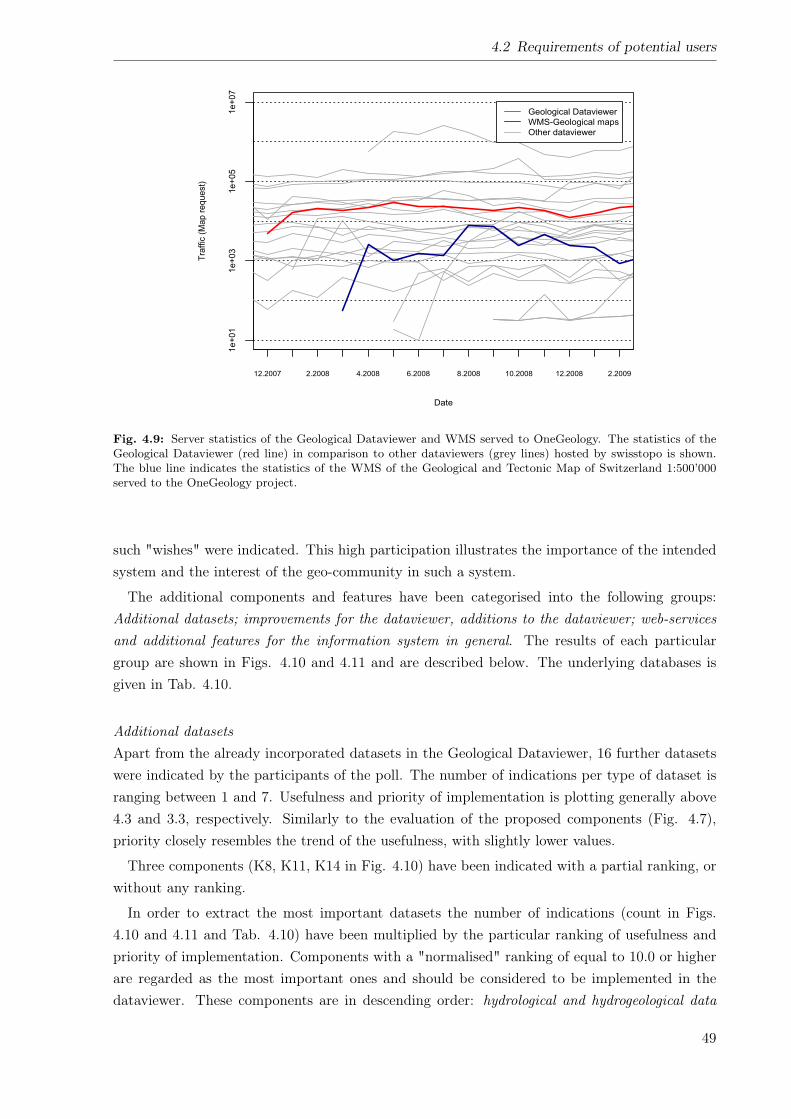
4.2 Requirements of potential users
Date
Tra
ffic
(M
ap
re
qu
est)
12.2007 2.2008 4.2008 6.2008 8.2008 10.2008 12.2008 2.2009
1e+01
1e+03
1e+05
1e+07
Geological Dataviewer
WMS-Geological maps
Other dataviewer
Fig. 4.9: Server statistics of the Geological Dataviewer and WMS served to OneGeology. The statistics of theGeological Dataviewer (red line) in comparison to other dataviewers (grey lines) hosted by swisstopo is shown.The blue line indicates the statistics of the WMS of the Geological and Tectonic Map of Switzerland 1:500’000served to the OneGeology project.
such "wishes" were indicated. This high participation illustrates the importance of the intendedsystem and the interest of the geo-community in such a system.
The additional components and features have been categorised into the following groups:Additional datasets; improvements for the dataviewer, additions to the dataviewer; web-servicesand additional features for the information system in general. The results of each particulargroup are shown in Figs. 4.10 and 4.11 and are described below. The underlying databases isgiven in Tab. 4.10.
Additional datasetsApart from the already incorporated datasets in the Geological Dataviewer, 16 further datasetswere indicated by the participants of the poll. The number of indications per type of dataset isranging between 1 and 7. Usefulness and priority of implementation is plotting generally above4.3 and 3.3, respectively. Similarly to the evaluation of the proposed components (Fig. 4.7),priority closely resembles the trend of the usefulness, with slightly lower values.
Three components (K8, K11, K14 in Fig. 4.10) have been indicated with a partial ranking, orwithout any ranking.
In order to extract the most important datasets the number of indications (count in Figs.4.10 and 4.11 and Tab. 4.10) have been multiplied by the particular ranking of usefulness andpriority of implementation. Components with a "normalised" ranking of equal to 10.0 or higherare regarded as the most important ones and should be considered to be implemented in thedataviewer. These components are in descending order: hydrological and hydrogeological data
49
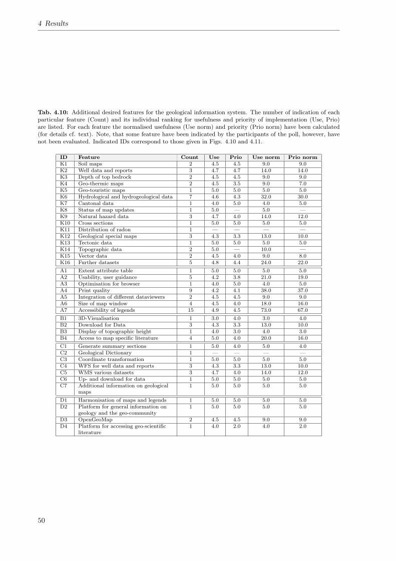
4 Results
Tab. 4.10: Additional desired features for the geological information system. The number of indication of eachparticular feature (Count) and its individual ranking for usefulness and priority of implementation (Use, Prio)are listed. For each feature the normalised usefulness (Use norm) and priority (Prio norm) have been calculated(for details cf. text). Note, that some feature have been indicated by the participants of the poll, however, havenot been evaluated. Indicated IDs correspond to those given in Figs. 4.10 and 4.11.
ID Feature Count Use Prio Use norm Prio normK1 Soil maps 2 4.5 4.5 9.0 9.0K2 Well data and reports 3 4.7 4.7 14.0 14.0K3 Depth of top bedrock 2 4.5 4.5 9.0 9.0K4 Geo-thermic maps 2 4.5 3.5 9.0 7.0K5 Geo-touristic maps 1 5.0 5.0 5.0 5.0K6 Hydrological and hydrogeological data 7 4.6 4.3 32.0 30.0K7 Cantonal data 1 4.0 5.0 4.0 5.0K8 Status of map updates 1 5.0 — 5.0 —K9 Natural hazard data 3 4.7 4.0 14.0 12.0K10 Cross sections 1 5.0 5.0 5.0 5.0K11 Distribution of radon 1 — — — —K12 Geological special maps 3 4.3 3.3 13.0 10.0K13 Tectonic data 1 5.0 5.0 5.0 5.0K14 Topographic data 2 5.0 — 10.0 —K15 Vector data 2 4.5 4.0 9.0 8.0K16 Further datasets 5 4.8 4.4 24.0 22.0A1 Extent attribute table 1 5.0 5.0 5.0 5.0A2 Usability, user guidance 5 4.2 3.8 21.0 19.0A3 Optimisation for browser 1 4.0 5.0 4.0 5.0A4 Print quality 9 4.2 4.1 38.0 37.0A5 Integration of different dataviewers 2 4.5 4.5 9.0 9.0A6 Size of map window 4 4.5 4.0 18.0 16.0A7 Accessibility of legends 15 4.9 4.5 73.0 67.0B1 3D-Visualisation 1 3.0 4.0 3.0 4.0B2 Download for Data 3 4.3 3.3 13.0 10.0B3 Display of topographic height 1 4.0 3.0 4.0 3.0B4 Access to map specific literature 4 5.0 4.0 20.0 16.0C1 Generate summary sections 1 5.0 4.0 5.0 4.0C2 Geological Dictionary 1 — — — —C3 Coordinate transformation 1 5.0 5.0 5.0 5.0C4 WFS for well data and reports 3 4.3 3.3 13.0 10.0C5 WMS various datasets 3 4.7 4.0 14.0 12.0C6 Up- and download for data 1 5.0 5.0 5.0 5.0C7 Additional information on geological
maps1 5.0 5.0 5.0 5.0
D1 Harmonisation of maps and legends 1 5.0 5.0 5.0 5.0D2 Platform for general information on
geology and the geo-community1 5.0 5.0 5.0 5.0
D3 OpenGeoMap 2 4.5 4.5 9.0 9.0D4 Platform for accessing geo-scientific
literature1 4.0 2.0 4.0 2.0
50
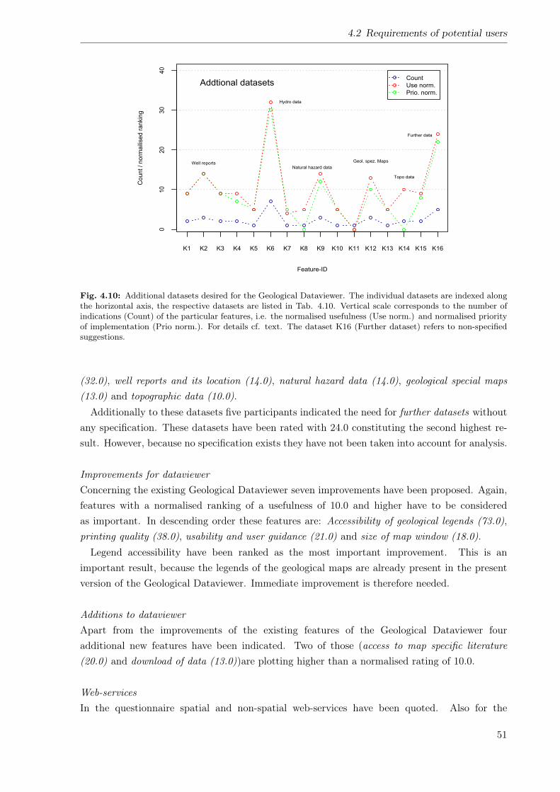
4.2 Requirements of potential users
Feature-ID
Count / norm
aili
sed r
ankin
g
K1 K2 K3 K4 K5 K6 K7 K8 K9 K10 K11 K12 K13 K14 K15 K16
010
20
30
40
Addtional datasets
Well reports
Hydro data
Natural hazard data
Geol. spez. Maps
Topo data
Further data
Count
Use norm.
Prio. norm.
Fig. 4.10: Additional datasets desired for the Geological Dataviewer. The individual datasets are indexed alongthe horizontal axis, the respective datasets are listed in Tab. 4.10. Vertical scale corresponds to the number ofindications (Count) of the particular features, i.e. the normalised usefulness (Use norm.) and normalised priorityof implementation (Prio norm.). For details cf. text. The dataset K16 (Further dataset) refers to non-specifiedsuggestions.
(32.0), well reports and its location (14.0), natural hazard data (14.0), geological special maps(13.0) and topographic data (10.0).Additionally to these datasets five participants indicated the need for further datasets without
any specification. These datasets have been rated with 24.0 constituting the second highest re-sult. However, because no specification exists they have not been taken into account for analysis.
Improvements for dataviewerConcerning the existing Geological Dataviewer seven improvements have been proposed. Again,features with a normalised ranking of a usefulness of 10.0 and higher have to be consideredas important. In descending order these features are: Accessibility of geological legends (73.0),printing quality (38.0), usability and user guidance (21.0) and size of map window (18.0).Legend accessibility have been ranked as the most important improvement. This is an
important result, because the legends of the geological maps are already present in the presentversion of the Geological Dataviewer. Immediate improvement is therefore needed.
Additions to dataviewerApart from the improvements of the existing features of the Geological Dataviewer fouradditional new features have been indicated. Two of those (access to map specific literature(20.0) and download of data (13.0))are plotting higher than a normalised rating of 10.0.
Web-servicesIn the questionnaire spatial and non-spatial web-services have been quoted. Also for the
51
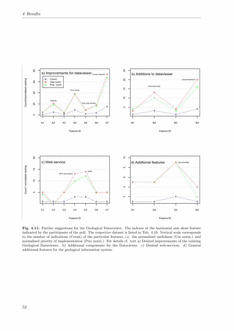
4 Results
Feature-ID
Co
un
t/n
ao
rma
lise
d r
an
kin
g
A1 A2 A3 A4 A5 A6 A7
020
40
60
80
a) Improvements for dataviewer
Usability
Print quality
Size map window
Access legends
Count
Use norm.
Prio. norm.
Feature-ID
B1 B2 B3 B45
10
15
20
25
b) Additions to dataviewer
Download data
Access literature
Feature-ID
Co
un
t /
no
rma
lise
d r
an
kin
g
C1 C2 C3 C4 C5 C6 C7
510
15
20
c) Web-service
WFS well reports
WMS
Feature-ID
D1 D2 D3 D4
24
68
10
d) Additional features OpenGeoMap
Fig. 4.11: Further suggestions for the Geological Dataviewer. The indexes at the horizontal axis show featureindicated by the participants of the poll. The respective dataset is listed in Tab. 4.10. Vertical scale correspondsto the number of indications (Count) of the particular features, i.e. the normalised usefulness (Use norm.) andnormalised priority of implementation (Prio norm.). For details cf. text a) Desired improvements of the existingGeological Dataviewer. b) Additional components for the Dataviewer. c) Desired web-services. d) Generaladditional features for the geological information system.
52
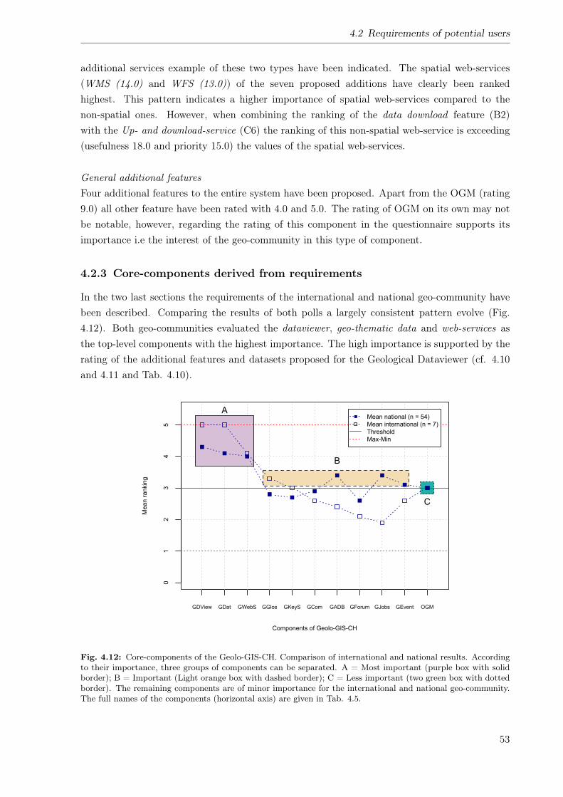
4.2 Requirements of potential users
additional services example of these two types have been indicated. The spatial web-services(WMS (14.0) and WFS (13.0)) of the seven proposed additions have clearly been rankedhighest. This pattern indicates a higher importance of spatial web-services compared to thenon-spatial ones. However, when combining the ranking of the data download feature (B2)with the Up- and download-service (C6) the ranking of this non-spatial web-service is exceeding(usefulness 18.0 and priority 15.0) the values of the spatial web-services.
General additional featuresFour additional features to the entire system have been proposed. Apart from the OGM (rating9.0) all other feature have been rated with 4.0 and 5.0. The rating of OGM on its own may notbe notable, however, regarding the rating of this component in the questionnaire supports itsimportance i.e the interest of the geo-community in this type of component.
4.2.3 Core-components derived from requirements
In the two last sections the requirements of the international and national geo-community havebeen described. Comparing the results of both polls a largely consistent pattern evolve (Fig.4.12). Both geo-communities evaluated the dataviewer, geo-thematic data and web-services asthe top-level components with the highest importance. The high importance is supported by therating of the additional features and datasets proposed for the Geological Dataviewer (cf. 4.10and 4.11 and Tab. 4.10).
Components of Geolo-GIS-CH
Me
an
ra
nkin
g
GDView GDat GWebS GGlos GKeyS GCom GADB GForum GJobs GEvent OGM
01
23
45
A
B
C
Mean national (n = 54)
Mean international (n = 7)
Threshold
Max-Min
Fig. 4.12: Core-components of the Geolo-GIS-CH. Comparison of international and national results. Accordingto their importance, three groups of components can be separated. A = Most important (purple box with solidborder); B = Important (Light orange box with dashed border); C = Less important (two green box with dottedborder). The remaining components are of minor importance for the international and national geo-community.The full names of the components (horizontal axis) are given in Tab. 4.5.
53
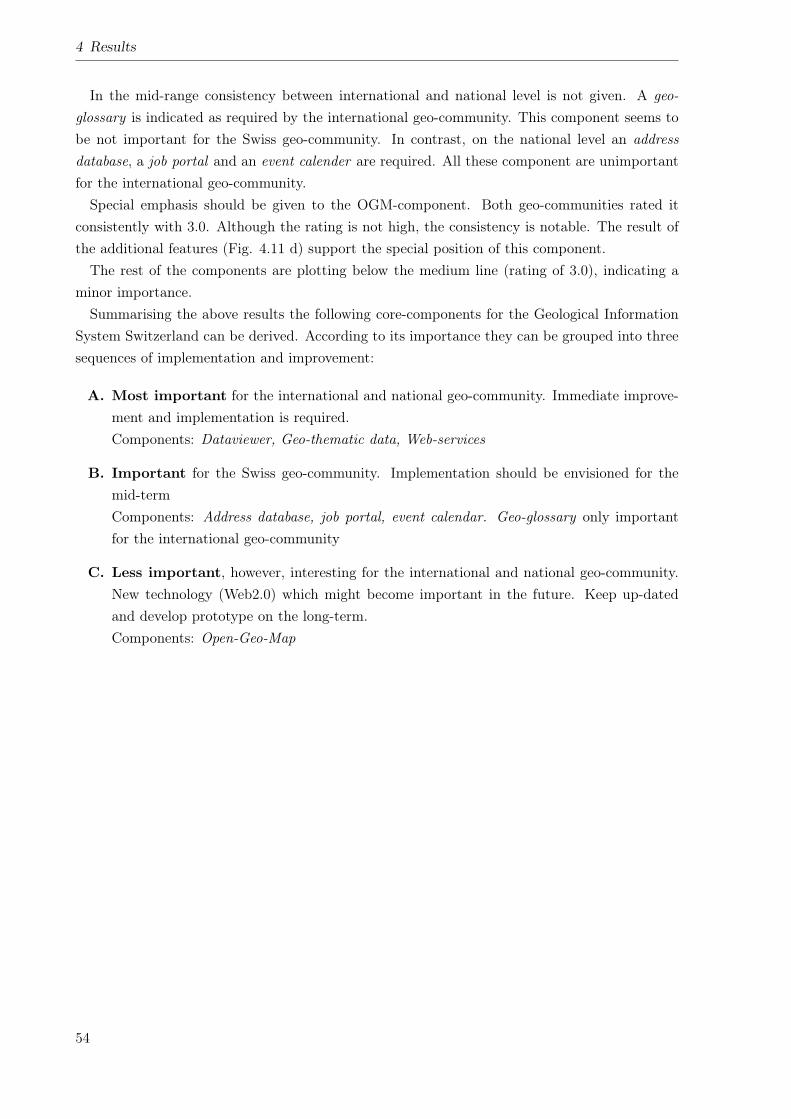
4 Results
In the mid-range consistency between international and national level is not given. A geo-glossary is indicated as required by the international geo-community. This component seems tobe not important for the Swiss geo-community. In contrast, on the national level an addressdatabase, a job portal and an event calender are required. All these component are unimportantfor the international geo-community.Special emphasis should be given to the OGM-component. Both geo-communities rated it
consistently with 3.0. Although the rating is not high, the consistency is notable. The result ofthe additional features (Fig. 4.11 d) support the special position of this component.The rest of the components are plotting below the medium line (rating of 3.0), indicating a
minor importance.Summarising the above results the following core-components for the Geological Information
System Switzerland can be derived. According to its importance they can be grouped into threesequences of implementation and improvement:
A. Most important for the international and national geo-community. Immediate improve-ment and implementation is required.Components: Dataviewer, Geo-thematic data, Web-services
B. Important for the Swiss geo-community. Implementation should be envisioned for themid-termComponents: Address database, job portal, event calendar. Geo-glossary only importantfor the international geo-community
C. Less important, however, interesting for the international and national geo-community.New technology (Web2.0) which might become important in the future. Keep up-datedand develop prototype on the long-term.Components: Open-Geo-Map
54
5 Discussion - A basic concept
In order to initialise the development and implementation of the Geolo-GIS-CH, a basic concepthas been elaborated. This concept is presented in the following sections.
5.1 Present state and focal problem
The present state analysis performed in Section 4.1 reveals several aspects which influence theavailability, accessibility and handling of geo-thematic GI and the awareness of geology in Switzer-land. Positive and negative aspects can be distinguished. In the following sections these aspectsare separately summarised and its interrelation is briefly discussed.
5.1.1 Positive aspects
The following aspects supporting the usage of geo-thematic GI can be detected.
• The general state of the technology in terms of ICT, GIS and internet is rather advanced.Thus, the handling, provision and processing even of large datasets is easily feasible. There-fore, technical barriers for the development of the Geolo-GIS-CH can be neglected.
• In Switzerland technical infrastructures for the hosting the Geolo-GIS-CH and for sup-plying geo-thematic data to the NSDI are operated by different members of the Swissgeo-community. Therefore, an important basis for the implementation and operation ofthe Geolo-GIS-CH is already existing.
• The members of the Swiss geo-community produce and provide a large variety of geo-thematic data and information. Furthermore, many components of the envisioned Geolo-GIS-CH are available via their web portals. Even in comparison to the international levelthe major part of the components provided by the international GSOs are supplied by eitherone or the other organisation of the Swiss geo-community (cf. Tab. 4.4). Therefore, thetechnical know-how with respect to such components does exit in the Swiss geo-community.However, it must be concentrated in a single point only.
• The awareness of the usefulness of geo-thematic GI and its applications is increasing steadilyin Switzerland. This situation is endorsed by the large number of events performed inSwitzerland or internationally which address or apply GI for geo-scientific purposes. Ex-amples for Switzerland are: Swiss Geoscience Meeting1; Géoperspective2; SIT/GIS3; base-
1http://geoscience-meeting.scnatweb.ch/sgm2008/, Last checked: 1.10.20092http://lasig2.epfl.ch/projets/cantons/programme/Geoperspectives09.pdf, Last checked: 1.10.20093http://www.congrex.ch/gis_sit2008/, Last checked: 1.10.2009
55
5 Discussion - A basic concept
camp20094; Erlebnis-Geologie5 etc. On the international level projects like OneGeology6,OneGeology-Europe7 and conferences like the International Geological Congress8 and EU-REGEO9 strongly support the application of GI, the conceptual and technical progressand the enhanced accessibility of GI.
5.1.2 Negative aspects
Apart from the above listed positive aspects, a number of negative aspects does exist. The causeand effect relationship of these aspects can be illustrated in a problem-tree as shown in Fig. 5.1.In such a problem tree, aspects shown in the lower part, i.e. in the roots of the tree, cause thosewhich are above them. Thus, the aspects in the upper part, i.e. the top of the tree, representthe effects of those in the lower part. The focal problem can be imagined as the trunk of thetree. The problem tree should be read from bottom to top. The following negative aspects canbe discovered.
• At the bottom of the problem tree a number of factors which cannot be influenced andchanged are the basis for the present situation. Such factors are the historical evolutionof the Swiss geo-community, i.e. the nonexistence of a corporate national GSO and thedistribution of tasks to several organisations; the ambition of these particular organisationsto act independently and the fact that geology is a subsidiary field of study for many otherdisciplines. Furthermore, a fact which cannot be influenced is that Switzerland does nothave large amounts of economically important natural resources such as hydrocarbon (e.g.oil, gas etc) resources or ore-deposits (e.g. copper, gold etc).
• Based on the aforementioned aspects, a heterogeneously structured and dispersed geo-community evolved. Lacking coordination and poor interaction among the particular mem-bers of the Swiss geo-community lead to separated activities and a non uniform appearanceof the geo-community. Therefore, for clients, especially from outside the geo-community itis difficult no get in contact with the desired organisation or to obtain the desired infor-mation.
• These aspects cause different problems. For instance, separated activities and a non-uniform appearance leads to a low public visibility of the geo-community and, thus, a poorawareness of the relevance of geology for society (cf. Section 1.1). Furthermore, separatedand un-coordinated activities result in an inefficient use of money, because similar tasks areperformed by several organisations simultaneously. This aspect is directly strengthened bythe fact that geology is a subsidiary field of study for many disciplines (cf. above).
• Caused by separated strategies for data capture and map production of the particularorganisations, the coverage of Switzerland with different map series, i.e. geo-thematic
4http://www.basecamp09.ch/, Last checked: 1.10.20095http://www.erlebnis-geologie.ch, Last checked: 1.10.20096http://www.onegeology.org/, Last checked: 1.10.20097http://www.onegeology-europe.org/, Last checked: 1.10.20098http://www.33igc.org/coco/LayoutPage.aspx, Last checked: 1.10.20099http://www.lfu.bayern.de/veranstaltungen/euregeo2009/, Last checked: 1.10.2009
56
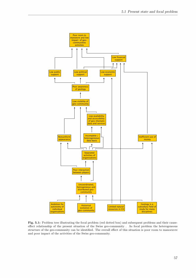
5.1 Present state and focal problem
Fig. 5.1: Problem tree illustrating the focal problem (red dotted box) and subsequent problems and their cause-effect relationship of the present situation of the Swiss geo-community . As focal problem the heterogeneousstructure of the geo-community can be identified. The overall effect of this situation is poor room to manoeuvreand poor impact of the activities of the Swiss geo-community.
57

5 Discussion - A basic concept
datasets is incomplete. Thus, the availability of the existing datasets is strongly limited.Furthermore, each organisation provides their data and services individually. A single pointof contact does not exist. Therefore, the accessibility of the existing data and services arestrongly restricted.
• Apart for the restricted availability particular datasets are frequently incompatible to eachother, because of their heterogeneous structure. Frequently datamodel are poorly docu-mented, non uniform or even absent.
• Restricted availability of geo-thematic data also influences the awareness of geology andgeosciences. A low awareness, in turn, lowers the public, political and economical supportwhich reduces the financial resources of the Swiss geo-community. The low financial supportof the economical sector, however, is also caused by the fact that Switzerland is not rich ineconomically exploitable natural resources.
• The overall effect of the aspects mentioned above is that the room to manoeuvre of theSwiss geo-community is rather small. With poor financial resources and limited public andpolitical support the impact of the activities of the geo-community is poor.
5.1.3 Focal problem
The analysis of the aforementioned aspects reveals the focal problem of the Swiss geo-communityand the usage of the geo-thematic GI. Thus, the trunk of the problem tree, i.e. the focal problemis the uncoordinated, heterogeneously structured Swiss geo-community itself (cf. red dotted boxin Fig. 5.1). Therefore, for changing the present situation, this focal problem has to be tackled.
5.2 Target situation
The network of problems illustrated in Fig. 5.1 can be converted into the future, desired situation.This target situation can be illustrated as objective tree (Fig. 5.2). The objective tree focuseson the means and end relation of the particular activities which are required for solving the focalproblem. Thus, the strategy for solving the focal problem can be derived. In the case of thepresent study it becomes apparent, that the key for solving this problem is closely related tothe development of a tool for the coordination of the geo-community and for the communicationamong its members (cf. red-dotted box in Fig. 5.2).
5.3 Solution
In order to meet the challenges of the SGS (cf. Section 1.2) and to solve the problems describedabove (cf. Section 5.1.2), the development of the Geological Information System Switzerland(Geolo-GIS-CH) is intended. As part of the National Spatial Data Infrastructure (NSDI) ofSwitzerland the Geolo-GIS-CH is thought to be the gateway to geosciences in general and to ge-ological sciences in particular. Thus, for instance, a geological consultant who needs informationon the geological setting of a particular location can quickly get it (cf. Fig. 5.3). When searching
58
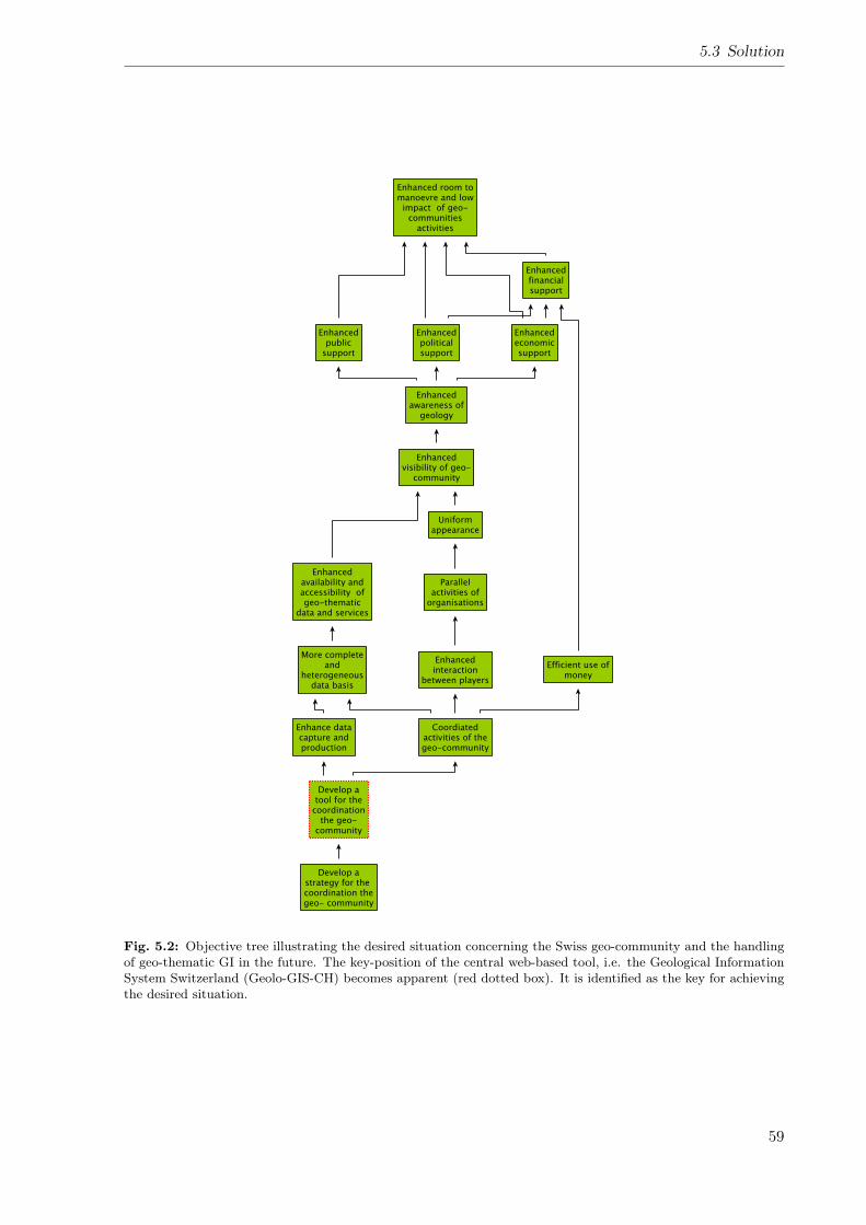
5.3 Solution
Fig. 5.2: Objective tree illustrating the desired situation concerning the Swiss geo-community and the handlingof geo-thematic GI in the future. The key-position of the central web-based tool, i.e. the Geological InformationSystem Switzerland (Geolo-GIS-CH) becomes apparent (red dotted box). It is identified as the key for achievingthe desired situation.
59
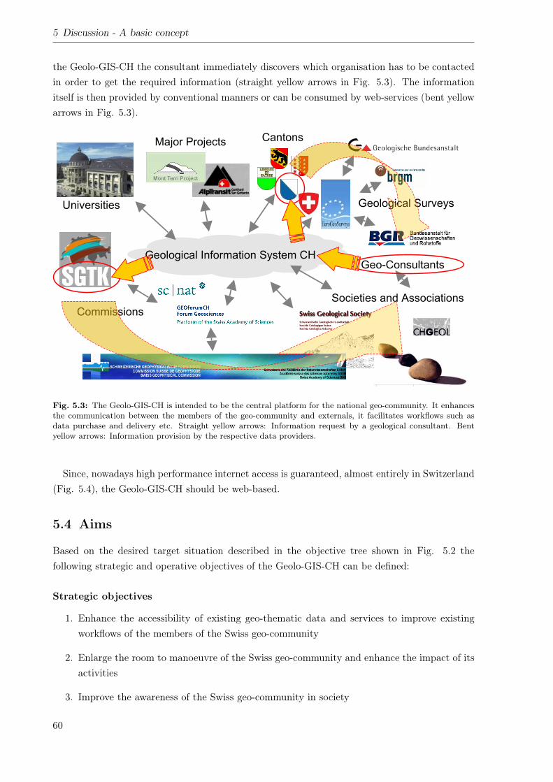
5 Discussion - A basic concept
the Geolo-GIS-CH the consultant immediately discovers which organisation has to be contactedin order to get the required information (straight yellow arrows in Fig. 5.3). The informationitself is then provided by conventional manners or can be consumed by web-services (bent yellowarrows in Fig. 5.3).
6Federal Office of Topography swisstopo
Swiss Geological Survey
EUREGEO 2009 - Geodata infrstructures, Munich / June 11th 2009
Geological Information System CH
Envisaged situation
Universities
Major Projects Cantons
Geological Surveys
Societies and Associations
Commissions
Geo-Consultants
Fig. 5.3: The Geolo-GIS-CH is intended to be the central platform for the national geo-community. It enhancesthe communication between the members of the geo-community and externals, it facilitates workflows such asdata purchase and delivery etc. Straight yellow arrows: Information request by a geological consultant. Bentyellow arrows: Information provision by the respective data providers.
Since, nowadays high performance internet access is guaranteed, almost entirely in Switzerland(Fig. 5.4), the Geolo-GIS-CH should be web-based.
5.4 Aims
Based on the desired target situation described in the objective tree shown in Fig. 5.2 thefollowing strategic and operative objectives of the Geolo-GIS-CH can be defined:
Strategic objectives
1. Enhance the accessibility of existing geo-thematic data and services to improve existingworkflows of the members of the Swiss geo-community
2. Enlarge the room to manoeuvre of the Swiss geo-community and enhance the impact of itsactivities
3. Improve the awareness of the Swiss geo-community in society
60
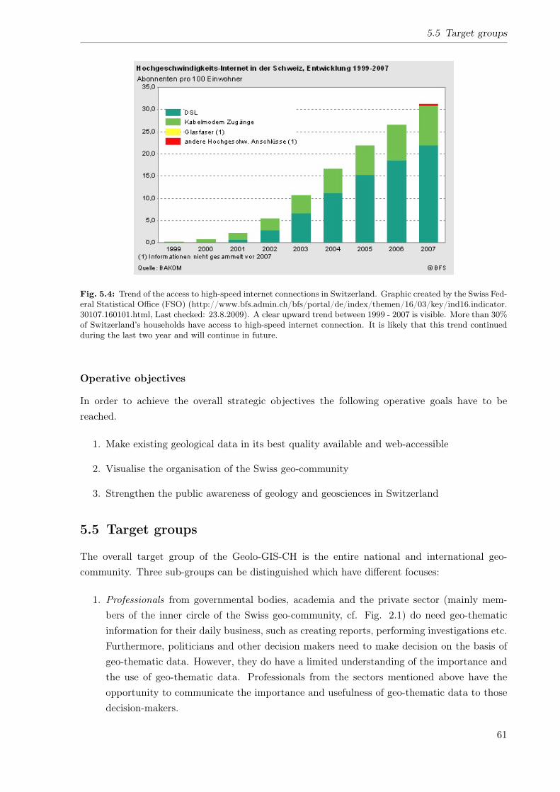
5.5 Target groups
Fig. 5.4: Trend of the access to high-speed internet connections in Switzerland. Graphic created by the Swiss Fed-eral Statistical Office (FSO) (http://www.bfs.admin.ch/bfs/portal/de/index/themen/16/03/key/ind16.indicator.30107.160101.html, Last checked: 23.8.2009). A clear upward trend between 1999 - 2007 is visible. More than 30%of Switzerland’s households have access to high-speed internet connection. It is likely that this trend continuedduring the last two year and will continue in future.
Operative objectives
In order to achieve the overall strategic objectives the following operative goals have to bereached.
1. Make existing geological data in its best quality available and web-accessible
2. Visualise the organisation of the Swiss geo-community
3. Strengthen the public awareness of geology and geosciences in Switzerland
5.5 Target groups
The overall target group of the Geolo-GIS-CH is the entire national and international geo-community. Three sub-groups can be distinguished which have different focuses:
1. Professionals from governmental bodies, academia and the private sector (mainly mem-bers of the inner circle of the Swiss geo-community, cf. Fig. 2.1) do need geo-thematicinformation for their daily business, such as creating reports, performing investigations etc.Furthermore, politicians and other decision makers need to make decision on the basis ofgeo-thematic data. However, they do have a limited understanding of the importance andthe use of geo-thematic data. Professionals from the sectors mentioned above have theopportunity to communicate the importance and usefulness of geo-thematic data to thosedecision-makers.
61
5 Discussion - A basic concept
2. Multipliers of geo-thematic information such as teachers, museum educators, tourism spe-cialists, technology writers etc. All of those require geo-thematic information in order toeducate geological sciences or to communicate geological facts to the broad public.
3. Laymen, e.g. Hobby-geologists and other people interested in geosciences from a broadpublic. Laymen need geological information for private issues and spare time activities.
Reaching the two latter target groups is especially important for strengthening the awarenessof geology in society. Teachers and museum educators need easy understandable geo-thematicinformation in order to teach geology and to captivate their students. Tourism specialists needinformation about geo-touristic sites for their recommendations to tourists. And technologywriters serve, just as the groups mentioned above, as multipliers for geo-scientific and geolog-ical knowledge. Last but not least laymen demand access to easy understandable geologicalinformation for their spare-time activities.
5.6 Supporting organisations
In order to achieve the most possible acceptance for the Geolo-GIS-CH, the members of the Swissgeo-community should be actively involved in the process of its development. However, relatedto the involvement of the organisations and its tasks the following questions arise:
• Whom to involve? – Involve only the interested members or all players of the Swiss geo-community?
• How many players to be involved? – The more involved, the more input – versus – Themore involved, the more different options and opinions, the slower the progress.
• How should the project be accomplished? – Realisation by the members of the geo-community, or realisation with the help of external partners and contractors?
• Where will the system, i.e. the technical infrastructure be hosted? – Inside geo-communityor at external contractors?
• Which organisation(s) is/are in charge of the realisation of the Geolo-GIS-CH? Who isproviding the project manager(s)? – Single organisation – versus – steering committee
• Who is in charge of the administration of the final system? – Members of the Swiss geo-community – versus – external contractor
These questions cannot be answered in the framework of this thesis. However, it should beaddressed prior to the development of the system during the elaboration of a detailed concept.
5.7 Overall system design
As a basis for the development of the Geolo-GIS-CH, the overall design and structure of the sys-tem have been outlined. A sketch of this proposition is shown in Fig. 5.5. This sketch illustrates
62
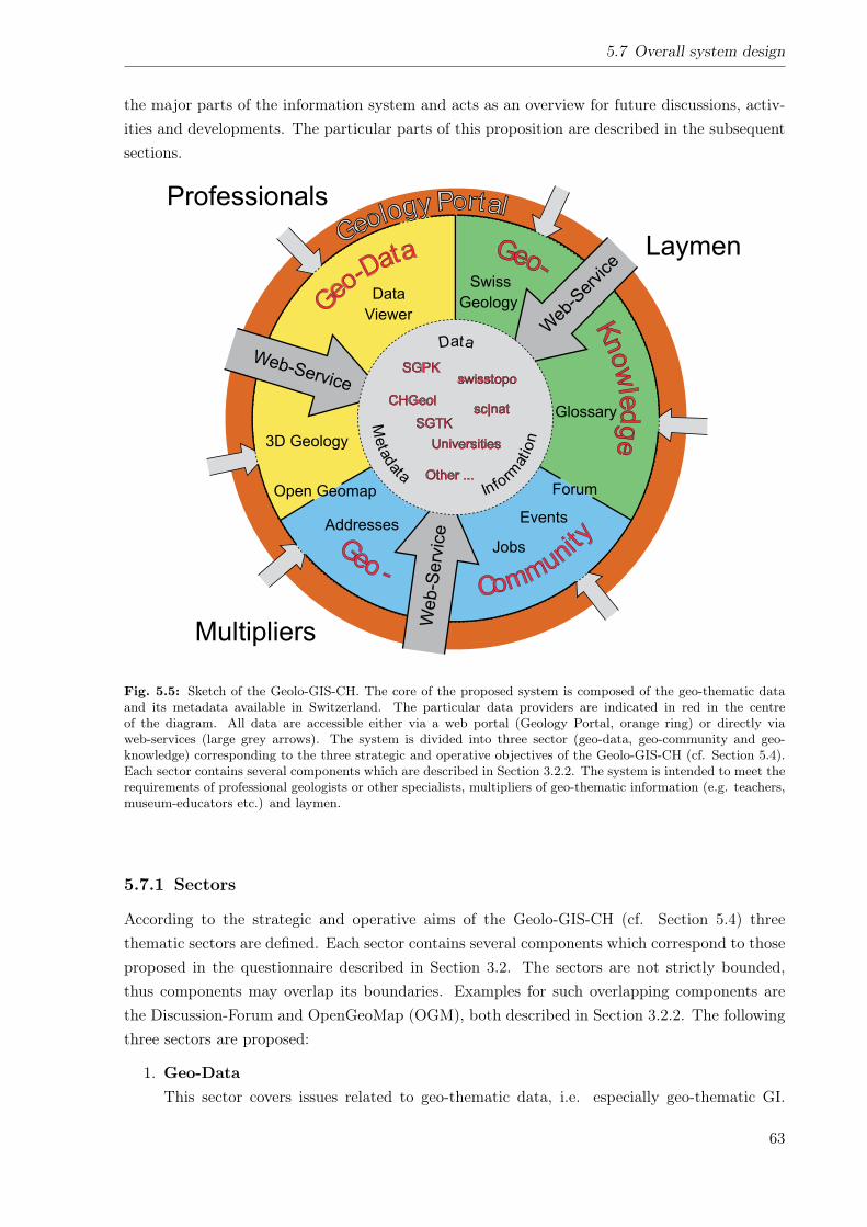
5.7 Overall system design
the major parts of the information system and acts as an overview for future discussions, activ-ities and developments. The particular parts of this proposition are described in the subsequentsections.
Fig. 5.5: Sketch of the Geolo-GIS-CH. The core of the proposed system is composed of the geo-thematic dataand its metadata available in Switzerland. The particular data providers are indicated in red in the centreof the diagram. All data are accessible either via a web portal (Geology Portal, orange ring) or directly viaweb-services (large grey arrows). The system is divided into three sector (geo-data, geo-community and geo-knowledge) corresponding to the three strategic and operative objectives of the Geolo-GIS-CH (cf. Section 5.4).Each sector contains several components which are described in Section 3.2.2. The system is intended to meet therequirements of professional geologists or other specialists, multipliers of geo-thematic information (e.g. teachers,museum-educators etc.) and laymen.
5.7.1 Sectors
According to the strategic and operative aims of the Geolo-GIS-CH (cf. Section 5.4) threethematic sectors are defined. Each sector contains several components which correspond to thoseproposed in the questionnaire described in Section 3.2. The sectors are not strictly bounded,thus components may overlap its boundaries. Examples for such overlapping components arethe Discussion-Forum and OpenGeoMap (OGM), both described in Section 3.2.2. The followingthree sectors are proposed:
1. Geo-DataThis sector covers issues related to geo-thematic data, i.e. especially geo-thematic GI.
63
5 Discussion - A basic concept
The most important component of this sector (and probably of the entire system) is adataviewer, i.e. a geoportal in the sense described in Section 2.3. Such a geoportal givesaccess to spatial geo-thematic data, information and its metadata. The same data andinformation are provided by spatial web-services, thus, it can be directly used in the GISof the clients. Each component mentioned above has been evaluated by the internationaland national geo-community as most important for the Geolo-GIS-CH (cf. Most importantin Section 4.2.3). However, further components like e.g. a visualisation tool for geological3D-models, comprehensive search functionalities and a catalogue of available services areconceivable.
2. Geo-CommunityThe Geo-community sector contains components relevant for the presentation of the struc-ture of the Swiss geo-community and the national and international integration of itsmembers. It gives access to contact information of the members of the geo-community,describes their tasks and responsibilities and announces news, events and open positionsetc. Therefore, an address database, an event calendar and a job portal are the majorcomponents of this sector. Each of the aforementioned components have been evaluatedas important for the Geolo-GIS-CH in the poll of requirements (cf. Important in Section4.2.3).
3. Geo-KnowledgeThe Geo-Knowledge sector provides geological facts and communicates it to the broadpublic. It serves as gateway to easy understandable information about geology and relatedspecifications. Definitions of terms in glossary-style and descriptions of geological sites inSwitzerland are in the centre of the scope of this sector. It is intended to mainly enhancethe awareness of geology and geosciences in the broad public. Regarding the evaluation ofthe potential users of the Geolo-GIS-CH, the above mentioned components are of minorimportance (cf. d) group 4 in Tab. 4.9)
5.7.2 Core
The core of the system, like for every GIS is data, i.e. GI. This data, as illustrated in Fig. 5.5,is provided by the members of the Swiss geo-community which are its producers and owners.Apart from geo-thematic data, in the sense defined in Section 2.2, the system’s core comprisesalso data on the organisational structure of the geo-community, for instance, addresses, job andevents announcements etc.
5.7.3 Points of entry
The data in the system’s core can be accessed in two different ways. First, via a web portal andsecond, via spatial and non-spatial web-services.
64
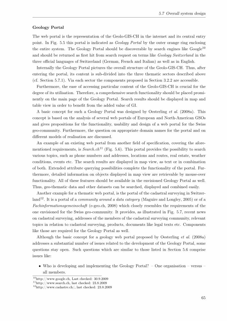
5.7 Overall system design
Geology Portal
The web portal is the representation of the Geolo-GIS-CH in the internet and its central entrypoint. In Fig. 5.5 this portal is indicated as Geology Portal by the outer orange ring enclosingthe entire system. The Geology Portal should be discoverable by search engines like Google10
and should be returned as first hit from search request on terms like Geology Switzerland in thethree official languages of Switzerland (German, French and Italian) as well as in English.Internally the Geology Portal pictures the overall structure of the Geolo-GIS-CH. Thus, after
entering the portal, its content is sub-divided into the three thematic sectors described above(cf. Section 5.7.1). Via each sector the components proposed in Section 3.2.2 are accessible.Furthermore, the ease of accessing particular content of the Geolo-GIS-CH is crucial for the
degree of its utilisation. Therefore, a comprehensive search functionality should be placed promi-nently on the main page of the Geology Portal. Search results should be displayed in map andtable view in order to benefit from the added value of GI.A basic concept for such a Geology Portal was designed by Oesterling et al. (2008a). This
concept is based on the analysis of several web portals of European and North-American GSOsand gives propositions for the functionality, usability and design of a web portal for the Swissgeo-community. Furthermore, the question on appropriate domain names for the portal and ondifferent models of realisation are discussed.An example of an existing web portal from another field of specification, covering the afore-
mentioned requirements, is Search.ch11 (Fig. 5.6). This portal provides the possibility to searchvarious topics, such as phone numbers and addresses, locations and routes, real estate, weatherconditions, events etc. The search results are displayed in map view, as text or in combinationof both. Extended attribute querying possibilities complete the functionality of the portal. Fur-thermore, detailed information on objects displayed in map view are retrievable by mouse-overfunctionality. All of these features should be available in the envisioned Geology Portal as well.Thus, geo-thematic data and other datasets can be searched, displayed and combined easily.Another example for a thematic web portal, is the portal of the cadastral surveying in Switzer-
land12. It is a portal of a community around a data category (Maguire and Longley, 2005) or of aFachinformationsgemeinschaft (e-geo.ch, 2008) which closely resembles the requirements of theone envisioned for the Swiss geo-community. It provides, as illustrated in Fig. 5.7, recent newson cadastral surveying, addresses of the members of the cadastral surveying community, relevanttopics in relation to cadastral surveying, products, documents like legal texts etc. Componentslike those are required for the Geology Portal as well.Although the basic concept for a geology web portal proposed by Oesterling et al. (2008a)
addresses a substantial number of issues related to the development of the Geology Portal, somequestions stay open. Such questions which are similar to those listed in Section 5.6 compriseissues like:
• Who is developing and implementing the Geology Portal? – One organisation – versus –all members.
10http://www.google.ch, Last checked: 30.9.200911http://www.search.ch, last checked: 23.8.200912http://www.cadastre.ch/, last checked: 23.8.2009
65
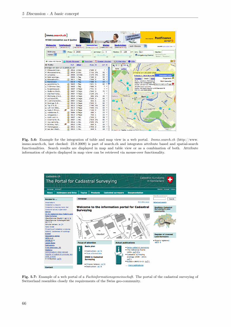
5 Discussion - A basic concept
Fig. 5.6: Example for the integration of table and map view in a web portal. Immo.search.ch (http://www.immo.search.ch, last checked: 23.8.2009) is part of search.ch and integrates attribute based and spatial-searchfunctionalities. Search results are displayed in map and table view or as a combination of both. Attributeinformation of objects displayed in map view can be retrieved via mouse-over functionality.
Fig. 5.7: Example of a web portal of a Fachinformationsgemeinschaft. The portal of the cadastral surveying ofSwitzerland resembles closely the requirements of the Swiss geo-community.
66
5.8 Abstract system architecture
• Where is the Geology Portal to be hosted? – inside geo-community – versus – externalcontractor.
• How is the portal financed? Is it, for instance, permitted to include advertisements (e.g.for geological consultants or other companies) for funding the portal and its maintenance?
• How does the layout of the Geology Portal look like? Do corporate design guidelines haveto be followed?
• How is the geoportal integrated in the Geology Portal? Make the geoportal the GeologyPortal’s main page, because most geo-thematic data and information are spatially refer-enced – versus – Geoportal in separated web site.
• How to administrate the system and its users? – Members of the Swiss geo-community –versus – external contractor.
Web-Services
The second way to access the data in the core of the system is the use of spatial and non-spatialweb-services. These services are provided by the respective data owners and can be consumedby the clients of the Geolo-GIS-CH and be embedded in the client’s GIS.Available services are provided via the Geology Portal or can by retrieved via metadata cata-
logues like geocat.ch13. Mainly spatial web-services are provided, because of the spatial natureof geo-thematic data. In order to support the interoperability of such services, standardisedservices like WMS, WFS, WFS-T, CSW etc. should be supported.Moreover, the use of web-services in general, should be favoured against the implementation
of independent components. For instance, the above mentioned provision of metadata via theGeology Portal, should be performed by using the geocat.ch-service instead of implementing anindependent metadata-catalogue.Questions concerning the implementation of web-services are:
• Which type of services (WMS, WFS, CSW etc.) should or have to be served?
• Which are the strategic objectives of serving geo-thematic data via web-services? What isthe pricing strategy for web-services?
• Which transfer format, e.g. INTERLIS, GeoSciML, KML etc. should be provided andhave to be used?
5.8 Abstract system architecture
In Section 5.7 the overall design of the Geolo-GIS-CH has been outlined. For the technicalimplementation of the system the specification of it’s architecture is required. In this section asystem architecture on a high level of abstraction is proposed. It is illustrated in Fig. 5.8 and isdescribed below.13http://www.geocat.ch, Last checked: 30.9.2009
67
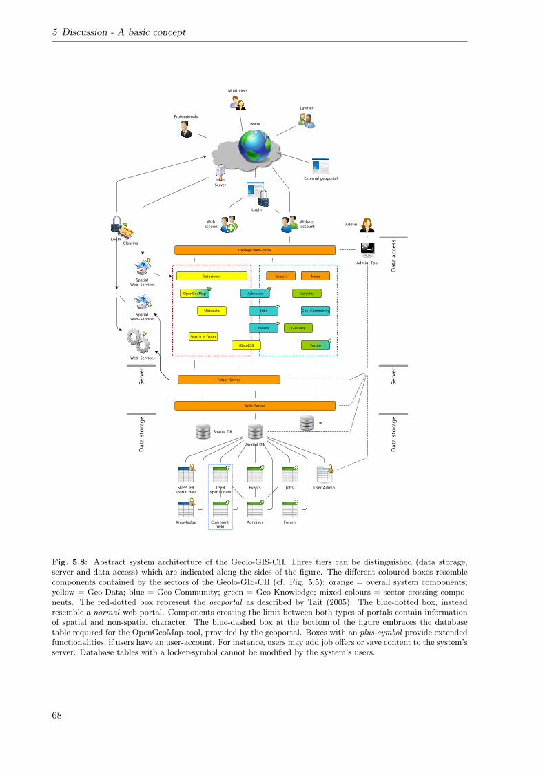
5 Discussion - A basic concept
Fig. 5.8: Abstract system architecture of the Geolo-GIS-CH. Three tiers can be distinguished (data storage,server and data access) which are indicated along the sides of the figure. The different coloured boxes resemblecomponents contained by the sectors of the Geolo-GIS-CH (cf. Fig. 5.5): orange = overall system components;yellow = Geo-Data; blue = Geo-Community; green = Geo-Knowledge; mixed colours = sector crossing compo-nents. The red-dotted box represent the geoportal as described by Tait (2005). The blue-dotted box, insteadresemble a normal web portal. Components crossing the limit between both types of portals contain informationof spatial and non-spatial character. The blue-dashed box at the bottom of the figure embraces the databasetable required for the OpenGeoMap-tool, provided by the geoportal. Boxes with an plus-symbol provide extendedfunctionalities, if users have an user-account. For instance, users may add job offers or save content to the system’sserver. Database tables with a locker-symbol cannot be modified by the system’s users.
68
5.8 Abstract system architecture
5.8.1 Tiers
The proposed architecture is characterised by three tiers which corresponds to the classicalthree-tier-system architecture14 (back end, middle tier, front-end). The three tiers describedhere comprise, a data storage tier, a server tier and a data access tier. Each particular tier isdescribed in the following sections.
Data storage
Similar to the overall design of the Geolo-GIS-CH (Fig. 5.5), its architecture is based on thecomprised data. Thus, the bottom tier covers the data storage. Data storage is realised by oneor multiple databases and Database Management Systems (DBMSs). Spatial data is stored indatabases with a spatial extension, non-spatial data in other relational databases. Querying andinformation retrieval is performed on the basis of Standardised Querying Language (SQL).
Web- and map-server
On top of the DBMS a web-server is processing the data and serving them to the web portal.If spatial data have to be served, a map-server supplies maps in raster format or geographicfeatures in vector format.This tier is not only responsible for the supply of information to the web portal. It also
provides spatial and non-spatial web-services which can be consumed without visiting the webportal. Data transfer is performed by HTTP-OSI reference model15 and OGC web-services.
Data access
As described in Section 5.7.3 the data can be accessed either via a web portal, i.e. the GeologyPortal or via web-services. The Geology Portal can be subdivided into a common web portalwhich supplies non spatial content (cf. blue dotted box in Fig. 5.8) and a geoportal servingspatial content (cf. red dotted box in Fig. 5.8). Depending on the kind of data supplied, theweb-server or the map-server is contacted.In order to permit the user to actively interact with the system a user account and a authen-
tication mechanism, e.g. triple-A-system16 with a login and password, is required. Such a useraccount extends the range of functionality of the respective components. Thus, users which havesigned in are permitted to add or modify the content of particular components, i.e. databasetables. For instance, events may be announced, jobs may be offered, or VGI may be capturedin the OGM-component. In Fig. 5.8 components or tables which can be accessed in the waydescribed above, are indicated with a plus-symbol.
5.8.2 Administration
The entire system and its users need to be administered. Therefore, an administration interfaceis proposed in the system’s architecture (cf. Fig. 5.8). Using this interface, each tier of the14http://de.wikipedia.org/wiki/Schichtenarchitektur, Last checked: 23.8.200915http://de.wikipedia.org/wiki/OSI-Modell16http://de.wikipedia.org/wiki/Triple-A-System
69
5 Discussion - A basic concept
information system, i.e. the respective databases, the servers, the Geology Portal and the useraccounts can be managed.In order to better control the permissions of different user groups, a set of user-roles (Ferraiolo
and Kuhn, 1992) may be defined. Depending on the particular role different types of permissionmay be allocated. In Tab. 5.1 are a number of such roles proposed for the administration of theusers of the Geology Portal, i.e. of the Geolo-GIS-CH.
Tab. 5.1: Proposed user-roles of the Geology Portal
No. Role name Description1 Administrator Read and Write access to all components
and tables2 Normal (internet)
userRead access to defined domain ofcomponents and tables
3 Signed-in user Read and Write access to a defineddomain of components and tables
4 Super user Read and Write access to an extendeddomain of components and tables
5.9 Third-party systems
Infrastructures for providing geo-thematic data and information are operated by the major play-ers of the Swiss geo-community. Those infrastructures follow individual aims which are relatedto the tasks of the particular hosting organisations. They are all operated individually and notconnected to each other. Therefore, they have to be considered as third-party systems whichinfluence the development of the Geolo-GIS-CH and its future operation. These third-partysystems may be involved into the hosting the Geolo-GIS-CH or parts of it. Thus, the Geolo-GIS-CH becomes a distributed data infrastructure provided by the major players of the Swissgeo-community in the the sense of the NSDI.
5.10 Timing / Roadmap
In order to develop, implement and operate the Geolo-GIS-CH various tasks have to be per-formed. Such tasks are related to:
• Data production
• Development of standards
• Built-up of a technical infrastructure
• Analysis of requirements of potential user
• Development of concepts
• Sensitisation of target-groups and the built-up and consolidation of the geo-community
70
5.10 Timing / Roadmap
• Finding of partners and supporting organisations
• Technical development of new components and advancement of existing components
• Implementation of the entire system
• Promotion of the system
The relative timing for performing these tasks are illustrated as roadmap in Fig. 5.9. It corre-sponds to a large extend to stage 1 of the model proposed by Longley et al. (2005) (their fig.17.4). This roadmap shows the dependencies of the particular tasks and can be used as centralplanning tool for the development of the Geolo-GIS-CH. For the planning the following aspectscan be retrieved from the roadmap:
• The data production is independent from the development and implementation of theGeolo-GIS-CH.
• At the current status (blue dotted line in Fig. 5.9) the definition of a datamodel is in-dependent from the development and implementation of the Geolo-GIS-CH. However,atlater stages it becomes essential for the development of databases which are storing therespective vector datasets.
• At the current status the requirements of potential users have been analysed (cf. sections3.2 and 4.2) and a basic concept for the development of the Geolo-GIS-CH (cf. this section)have been elaborated (bold bordered squares in Fig. 5.9). The completion of the basicconcept is the most important tasks, because almost all subsequent tasks are dependenton it.
• The tasks in Fig. 5.9 which are located between poll of user requirements to the elaborationof a detailed concept have to be performed largely in a sequential chain.
• After completion of the detailed concept two branches of further tasks have to be considered.First, the built-up of a server and database infrastructure and second, the technical devel-opment of the components of the Geolo-GIS-CH. Both branches are in parallel, however,the technical infrastructure have to be built-up prior the implementation of the respectivecomponents.
The development of the Geology Portal has to be regarded as the most extensive task. Itincludes several subordinate tasks, like the creation of web sites, the development of components,the generation of web-services etc. In order to prioritise the particular sub-tasks the followingquestions have to be addressed:
• Which tasks are important for reaching strategic and operative objectives of the respectiveorganisation (in this case of the SGS)? – Those tasks should be prioritised.
• Which tasks are required in order to provide the core-components of the Geolo-GIS-CH (cf.Section 4.2.3)? Following the results of the poll of requirements, the core-components havebeen identified as most useful for the geo-community. – Those tasks should be prioritised.
71
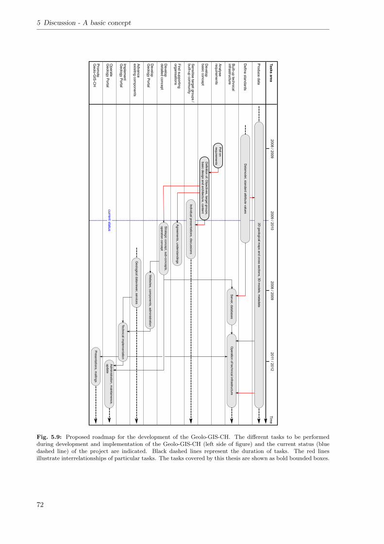
5 Discussion - A basic concept
Fig. 5.9: Proposed roadmap for the development of the Geolo-GIS-CH. The different tasks to be performedduring development and implementation of the Geolo-GIS-CH (left side of figure) and the current status (bluedashed line) of the project are indicated. Black dashed lines represent the duration of tasks. The red linesillustrate interrelationships of particular tasks. The tasks covered by this thesis are shown as bold bounded boxes.
72
5.11 Costs & benefits
• Which tasks are required in order to provide additional features to existing components orto advance existing components? (cf. Section 4.2.2). – Those tasks should be prioritised.
• Which tasks are depended on each other? – Basic tasks should be prioritised.
• Which tasks of minor importance can be implemented with low effort? Is it worth imple-menting those tasks? – If yes, those tasks should be prioritised.
5.11 Costs & benefits
The built-up of the Geolo-GIS-CH generate costs as well as benefits for the Swiss geo-community.In this section the qualitative cost and benefits are briefly listed. These listings are intended toprovide general aspects which have to be considered in detail in a future detailed concept.
Costs
• The implementation and operation of the Geolo-GIS-CH requires a system administration(systems content and user accounts). Therefore, at least one 100%-position is required forthis function. The required skills (IT, geosciences) of this position need to be defined.
• A technical infrastructure (servers, databases etc.) for the Geolo-GIS-CH have to be pro-vided. The volume of the infrastructure depends on the degree of participation of themembers of the Swiss geo-community, i.e. the participation of the various third-partysystems.
• The development of the Geolo-GIS-CH requires financial and human resources. Theseresources have to be supplied by the members of the Swiss geo-community. Expenses forthe technical development of the system, working groups, project management have to betaken into account.
Benefits
• The improved awareness within the geo-community for the tasks and activities of othermembers supports the development of efficient workflows.
• The improved collaboration among the members of the Swiss geo-community discoverssynergies and the establishment of partnerships.
• The enhanced accessibility causes an greater benefit of the individual geo-thematic datasets,because they are used more frequently by more users.
• All members of the Swiss geo-community are accessible by a central gateway. As a con-sequence communication among the members and the access for customers to particularorganisations is facilitated.
• The public awareness of geosciences and geology is enhanced, because the access to geo-scientific topics is more prominent in the internet.
73
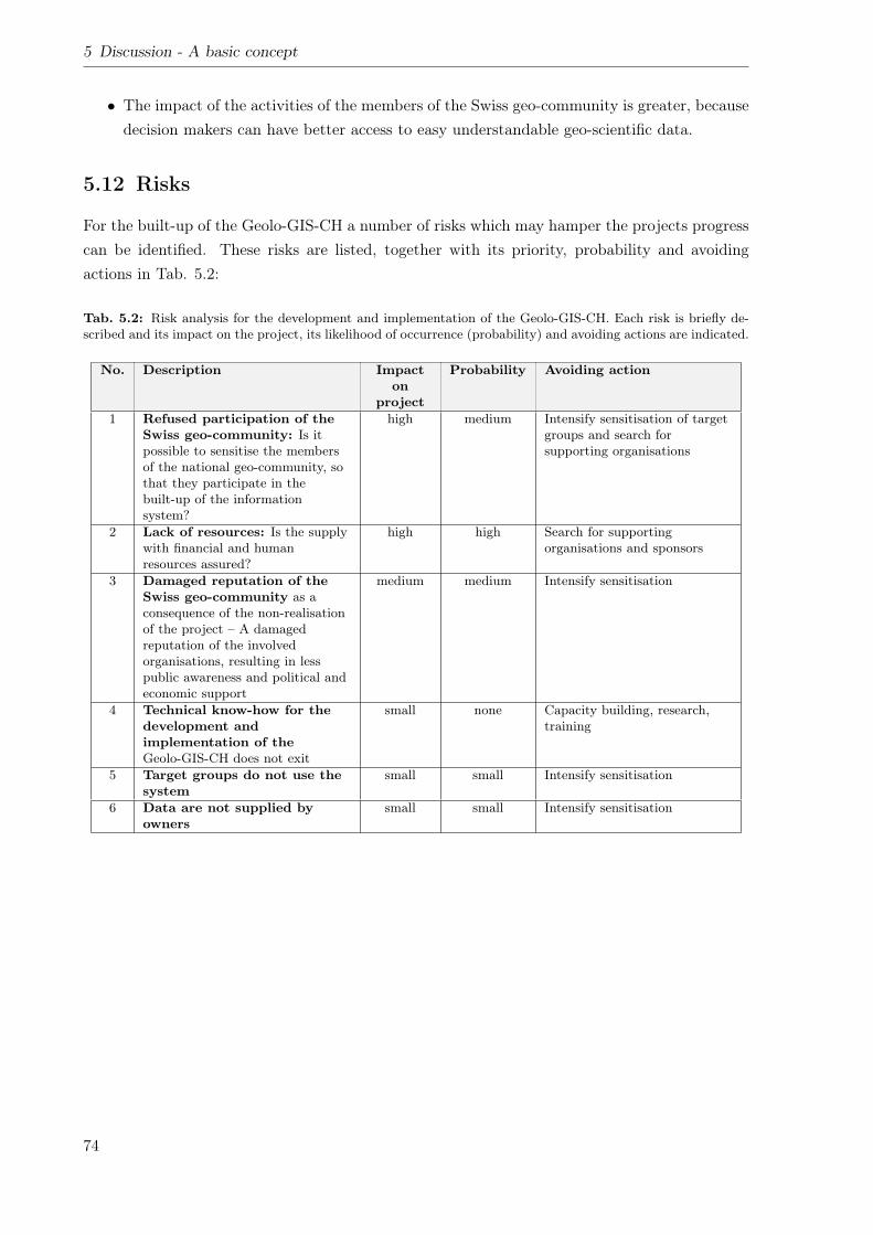
5 Discussion - A basic concept
• The impact of the activities of the members of the Swiss geo-community is greater, becausedecision makers can have better access to easy understandable geo-scientific data.
5.12 Risks
For the built-up of the Geolo-GIS-CH a number of risks which may hamper the projects progresscan be identified. These risks are listed, together with its priority, probability and avoidingactions in Tab. 5.2:
Tab. 5.2: Risk analysis for the development and implementation of the Geolo-GIS-CH. Each risk is briefly de-scribed and its impact on the project, its likelihood of occurrence (probability) and avoiding actions are indicated.
No. Description Impacton
project
Probability Avoiding action
1 Refused participation of theSwiss geo-community: Is itpossible to sensitise the membersof the national geo-community, sothat they participate in thebuilt-up of the informationsystem?
high medium Intensify sensitisation of targetgroups and search forsupporting organisations
2 Lack of resources: Is the supplywith financial and humanresources assured?
high high Search for supportingorganisations and sponsors
3 Damaged reputation of theSwiss geo-community as aconsequence of the non-realisationof the project – A damagedreputation of the involvedorganisations, resulting in lesspublic awareness and political andeconomic support
medium medium Intensify sensitisation
4 Technical know-how for thedevelopment andimplementation of theGeolo-GIS-CH does not exit
small none Capacity building, research,training
5 Target groups do not use thesystem
small small Intensify sensitisation
6 Data are not supplied byowners
small small Intensify sensitisation
74
6 Conclusions & Outlook
6.1 Conclusions
On the basis of the analyses and considerations performed in this thesis the following conclusioncan be drawn:
• The majority of the content of the envisioned information system is already existing onthe web sites of the members of the Swiss geo-community. Many on-going projects arecovering relevant tasks and open questions, e.g. creation of datamodels for harmonised ofgeo-thematic datasets.
• Some of the system’s core-components (job portal, event calendar) are provided by differentmembers simultaneously. Its content, however, is not harmonised. The centralisation ofsuch components and its supply with the help of web-services would enhance its efficiency.
• Many data has a concealed spatial reference. For instance addresses, jobs and events canall be spatially referenced. The benefit of the spatial component, e.g. spatial querying,representation on maps etc. should be exploited.
• On the international level the major components (dataviewer, data, services) are rankedequally as on the national level. However, components which are specific for the structure ofthe Swiss geo-community, e.g. an address database are less important for the internationalcommunity.
• Based on the results of the poll on requirements the development and implementation ofparticular components have to be prioritised. The identified core-components should beimplemented first. Advancements of existing components should be performed with highpriority, as well.
• The built-up of the NSDI is a chance for the Swiss geo-community to better communicatethe usefulness of geo-thematic data. In doing so more users can be attracted and thus, thepublic and political awareness of geology can be enhanced.
6.2 Outlook
This thesis is a preliminary study and contains a basic concept for the development and im-plementation of the Geolo-GIS-CH. It provides a basis for decisions during the planning of therealisation of the project. During the realisation a number of tasks have to be performed whichare introduced in the roadmap of Section 5.10. Performing these tasks are the next future steps.
75

6 Conclusions & Outlook
Apart from these tasks a number of issues should be considered for the handling of geo-thematicdata and the further advancement of the Geolo-GIS-CH. These issues are:
• Improve the availability of geo-thematic data by speeding up its production cycle. Theapplication of GIS during data capture and map production should be pushed.
• The Web2.0 philosophy and the possibility for users to participate in the generation ofinformation becomes increasingly important. Therefore, the potential of VGI for the pro-duction of geo-thematic data should be examined.
• Information on the subsurface is scarce. The creation of digital geological 3D-models canbridge this gap. Therefore, geological 3D-modelling techniques should be applied andadvanced.
• The volume of information is increasing steadily. Thus, it becomes more and more difficultto extract relevant information from this volume. Therefore, theories like ontologies andthe semantic web should be applied to be able to filter geo-thematic information moreefficiently.
76
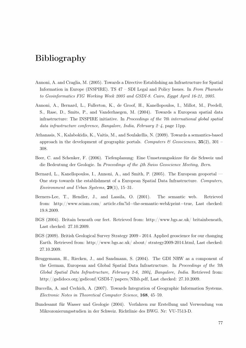
Bibliography
Annoni, A. and Craglia, M. (2005). Towards a Directive Establishing an Infrastructure for SpatialInformation in Europe (INSPIRE). TS 47 – SDI Legal and Policy Issues. In From Pharaohsto Geoinformatics FIG Working Week 2005 and GSDI-8. Cairo, Egypt April 16-21, 2005.
Annoni, A., Bernard, L., Fullerton, K., de Groof, H., Kanellopoulos, I., Millot, M., Peedell,S., Rase, D., Smits, P., and Vanderhaegen, M. (2004). Towards a European spatial datainfrastructure: The INSPIRE initiative. In Proceedings of the 7th international global spatialdata infrastructure conference, Bangalore, India, February 2–4, page 11pp.
Athanasis, N., Kalabokidis, K., Vaitis, M., and Soulakellis, N. (2009). Towards a semantics-basedapproach in the development of geographic portals. Computers & Geosciences, 35(2), 301 –308.
Beer, C. and Schenker, F. (2006). Tiefenplanung: Eine Umsetzungsskizze für die Schweiz unddie Bedeutung der Geologie. In Proceedings of the 4th Swiss Geoscience Meeting, Bern.
Bernard, L., Kanellopoulos, I., Annoni, A., and Smith, P. (2005). The European geoportal —One step towards the establishment of a European Spatial Data Infrastructure. Computers,Environment and Urban Systems, 29(1), 15–31.
Berners-Lee, T., Hendler, J., and Lassila, O. (2001). The semantic web. Retrievedfrom: http://www.sciam.com/ article.cfm?id=the-semantic-web&print=true, Last checked:19.8.2009.
BGS (2004). Britain beneath our feet. Retrieved from: http://www.bgs.ac.uk/ britainbeneath,Last checked: 27.10.2009.
BGS (2009). British Geological Survey Strategy 2009 - 2014. Applied geoscience for our changingEarth. Retrieved from: http://www.bgs.ac.uk/ about/ strategy2009-2014.html, Last checked:27.10.2009.
Bruggemann, H., Riecken, J., and Sandmann, S. (2004). The GDI NRW as a component ofthe German, European and Global Spatial Data Infrastructure. In Proceedings of the 7thGlobal Spatial Data Infrastructure, February 2-6, 2004, Bangalore, India. Retrieved from:http://gsdidocs.org/gsdiconf/GSDI-7/papers/NIhb.pdf, Last checked: 27.10.2009.
Buccella, A. and Cechich, A. (2007). Towards Integration of Geographic Information Systems.Electronic Notes in Theoretical Computer Science, 168, 45–59.
Bundesamt für Wasser und Geologie (2004). Verfahren zur Erstellung und Verwendung vonMikrozonierungsstudien in der Schweiz. Richtlinie des BWG. Nr: VU-7513-D.
77
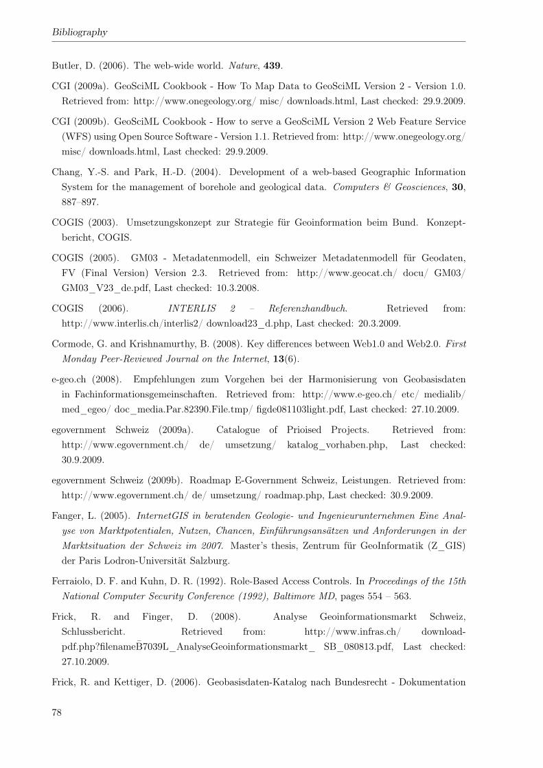
Bibliography
Butler, D. (2006). The web-wide world. Nature, 439.
CGI (2009a). GeoSciML Cookbook - How To Map Data to GeoSciML Version 2 - Version 1.0.Retrieved from: http://www.onegeology.org/ misc/ downloads.html, Last checked: 29.9.2009.
CGI (2009b). GeoSciML Cookbook - How to serve a GeoSciML Version 2 Web Feature Service(WFS) using Open Source Software - Version 1.1. Retrieved from: http://www.onegeology.org/misc/ downloads.html, Last checked: 29.9.2009.
Chang, Y.-S. and Park, H.-D. (2004). Development of a web-based Geographic InformationSystem for the management of borehole and geological data. Computers & Geosciences, 30,887–897.
COGIS (2003). Umsetzungskonzept zur Strategie für Geoinformation beim Bund. Konzept-bericht, COGIS.
COGIS (2005). GM03 - Metadatenmodell, ein Schweizer Metadatenmodell für Geodaten,FV (Final Version) Version 2.3. Retrieved from: http://www.geocat.ch/ docu/ GM03/GM03_V23_de.pdf, Last checked: 10.3.2008.
COGIS (2006). INTERLIS 2 – Referenzhandbuch. Retrieved from:http://www.interlis.ch/interlis2/ download23_d.php, Last checked: 20.3.2009.
Cormode, G. and Krishnamurthy, B. (2008). Key differences between Web1.0 and Web2.0. FirstMonday Peer-Reviewed Journal on the Internet, 13(6).
e-geo.ch (2008). Empfehlungen zum Vorgehen bei der Harmonisierung von Geobasisdatenin Fachinformationsgemeinschaften. Retrieved from: http://www.e-geo.ch/ etc/ medialib/med_egeo/ doc_media.Par.82390.File.tmp/ figde081103light.pdf, Last checked: 27.10.2009.
egovernment Schweiz (2009a). Catalogue of Prioised Projects. Retrieved from:http://www.egovernment.ch/ de/ umsetzung/ katalog_vorhaben.php, Last checked:30.9.2009.
egovernment Schweiz (2009b). Roadmap E-Government Schweiz, Leistungen. Retrieved from:http://www.egovernment.ch/ de/ umsetzung/ roadmap.php, Last checked: 30.9.2009.
Fanger, L. (2005). InternetGIS in beratenden Geologie- und Ingenieurunternehmen Eine Anal-yse von Marktpotentialen, Nutzen, Chancen, Einführungsansätzen und Anforderungen in derMarktsituation der Schweiz im 2007. Master’s thesis, Zentrum für GeoInformatik (Z_GIS)der Paris Lodron-Universität Salzburg.
Ferraiolo, D. F. and Kuhn, D. R. (1992). Role-Based Access Controls. In Proceedings of the 15thNational Computer Security Conference (1992), Baltimore MD, pages 554 – 563.
Frick, R. and Finger, D. (2008). Analyse Geoinformationsmarkt Schweiz,Schlussbericht. Retrieved from: http://www.infras.ch/ download-pdf.php?filenameB̄7039L_AnalyseGeoinformationsmarkt_ SB_080813.pdf, Last checked:27.10.2009.
Frick, R. and Kettiger, D. (2006). Geobasisdaten-Katalog nach Bundesrecht - Dokumentation
78
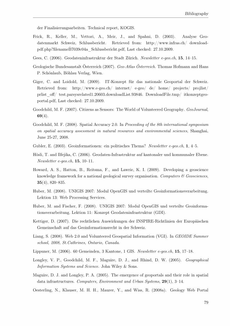
Bibliography
der Finalisierungsarbeiten. Technical report, KOGIS.
Frick, R., Keller, M., Vettori, A., Meir, J., and Spahni, D. (2003). Analyse Geo-datenmarkt Schweiz, Schlussbericht. Retrieved from: http://www.infras.ch/ download-pdf.php?filenameB̄7039c04a_Schlussbericht.pdf, Last checked: 27.10.2009.
Gees, C. (2006). Geodateninfrastruktur der Stadt Zürich. Newsletter e-geo.ch, 15, 14–15.
Geologische Bundesanstalt Österreich (2007). Geo-Atlas Österreich. Thomas Hofmann and HansP. Schönlaub, Böhlau Verlag, Wien.
Giger, C. and Loidold, M. (2009). IT-Konzept für das nationale Geoportal der Schweiz.Retrieved from: http://www.e-geo.ch/ internet/ e-geo/ de/ home/ projects/ projlist/prlist_off/ test.parsysrelated1.20603.downloadList.93846. DownloadFile.tmp/ itkonzeptgeo-portal.pdf, Last checked: 27.10.2009.
Goodchild, M. F. (2007). Citizens as Sensors: The World of Volunteered Geography. GeoJournal,69(4).
Goodchild, M. F. (2008). Spatial Accuracy 2.0. In Proceeding of the 8th international symposiumon spatial accuracy assessment in natural resources and environmental sciences, Shanghai,June 25-27, 2008.
Gubler, E. (2003). Geoinformationen: ein politisches Thema? Newsletter e-geo.ch, 1, 4–5.
Hösli, T. and Ilfejika, C. (2006). Geodaten-Infrastruktur auf kantonaler und kommunaler Ebene.Newsletter e-geo.ch, 15, 10–11.
Howard, A. S., Hatton, B., Reitsma, F., and Lawrie, K. I. (2009). Developing a geoscienceknowledge framework for a national geological survey organisation. Computers & Geosciences,35(4), 820–835.
Huber, M. (2008). UNIGIS 2007: Modul OpenGIS und verteilte Geoinformationsverarbeitung.Lektion 13: Web Processing Services.
Huber, M. and Fischer, F. (2008). UNIGIS 2007: Modul OpenGIS und verteilte Geoinforma-tionsverarbeitung. Lektion 11: Konzept Geodateninfrastruktur (GDI).
Kettiger, D. (2007). Die rechtlichen Auswirkungen der INSPIRE-Richtlinien der EuropäischenGemeinschaft auf das Geoinformationsrecht in der Schweiz.
Liang, S. (2008). Web 2.0 and Volunteered Geospatial Information (VGI). In GEOIDE Summerschool, 2008, St.Cathrines, Ontario, Canada.
Lippuner, M. (2006). 60 Gemeinden, 3 Kantone, 1 GIS. Newsletter e-geo.ch, 15, 17–18.
Longley, V. P., Goodchild, M. F., Maguire, D. J., and Rhind, D. W. (2005). GeographicalInformation Systems and Science. John Wiley & Sons.
Maguire, D. J. and Longley, P. A. (2005). The emergence of geoportals and their role in spatialdata infrastructures. Computers, Environment and Urban Systems, 29(1), 3–14.
Oesterling, N., Klauser, M. H. H., Maurer, Y., and Wiss, R. (2008a). Geology Web Portal
79
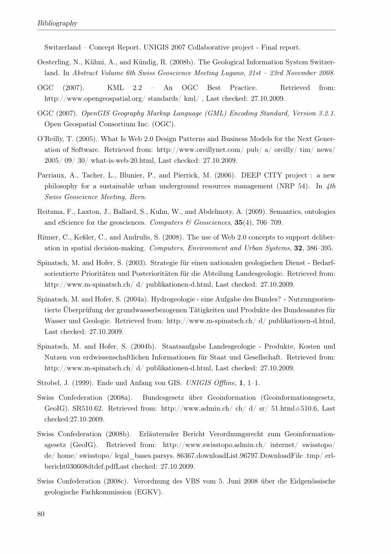
Bibliography
Switzerland – Concept Report. UNIGIS 2007 Collaborative project - Final report.
Oesterling, N., Kühni, A., and Kündig, R. (2008b). The Geological Information System Switzer-land. In Abstract Volume 6th Swiss Geoscience Meeting Lugano, 21st – 23rd November 2008.
OGC (2007). KML 2.2 – An OGC Best Practice. Retrieved from:http://www.opengeospatial.org/ standards/ kml/ , Last checked: 27.10.2009.
OGC (2007). OpenGIS Geography Markup Language (GML) Encoding Standard, Version 3.2.1.Open Geospatial Consortium Inc. (OGC).
O’Reilly, T. (2005). What Is Web 2.0 Design Patterns and Business Models for the Next Gener-ation of Software. Retrieved from: http://www.oreillynet.com/ pub/ a/ oreilly/ tim/ news/2005/ 09/ 30/ what-is-web-20.html, Last checked: 27.10.2009.
Parriaux, A., Tacher, L., Blunier, P., and Pierrick, M. (2006). DEEP CITY project : a newphilosophy for a sustainable urban underground resources management (NRP 54). In 4thSwiss Geoscience Meeting, Bern.
Reitsma, F., Laxton, J., Ballard, S., Kuhn, W., and Abdelmoty, A. (2009). Semantics, ontologiesand eScience for the geosciences. Computers & Geosciences, 35(4), 706–709.
Rinner, C., Keßler, C., and Andrulis, S. (2008). The use of Web 2.0 concepts to support deliber-ation in spatial decision-making. Computers, Environment and Urban Systems, 32, 386–395.
Spinatsch, M. and Hofer, S. (2003). Strategie für einen nationalen geologischen Dienst - Bedarf-sorientierte Prioritäten und Posterioritäten für die Abteilung Landesgeologie. Retrieved from:http://www.m-spinatsch.ch/ d/ publikationen-d.html, Last checked: 27.10.2009.
Spinatsch, M. and Hofer, S. (2004a). Hydrogeologie - eine Aufgabe des Bundes? - Nutzungsorien-tierte Überprüfung der grundwasserbezogenen Tätigkeiten und Produkte des Bundesamtes fürWasser und Geologie. Retrieved from: http://www.m-spinatsch.ch/ d/ publikationen-d.html,Last checked: 27.10.2009.
Spinatsch, M. and Hofer, S. (2004b). Staatsaufgabe Landesgeologie - Produkte, Kosten undNutzen von erdwissenschaftlichen Informationen für Staat und Gesellschaft. Retrieved from:http://www.m-spinatsch.ch/ d/ publikationen-d.html, Last checked: 27.10.2009.
Strobel, J. (1999). Ende und Anfang von GIS. UNIGIS Offline, 1, 1–1.
Swiss Confederation (2008a). Bundesgesetz über Geoinformation (Geoinformationsgesetz,GeoIG). SR510.62. Retrieved from: http://www.admin.ch/ ch/ d/ sr/ 51.html#510.6, Lastchecked:27.10.2009.
Swiss Confederation (2008b). Erläuternder Bericht Verordnungsrecht zum Geoinformation-sgesetz (GeoIG). Retrieved from: http://www.swisstopo.admin.ch/ internet/ swisstopo/de/ home/ swisstopo/ legal_bases.parsys. 86367.downloadList.96797.DownloadFile .tmp/ erl-bericht030608dtdef.pdfLast checked: 27.10.2009.
Swiss Confederation (2008c). Verordnung des VBS vom 5. Juni 2008 über die Eidgenössischegeologische Fachkommission (EGKV).
80
Bibliography
Swiss Confederation (2008d). Verordnung über die Landesgeologie (Landesgeologieverordnung,LGeolV). 510.624.
Swiss Confederation (2008e). Verordnung über Geoinformation (Geoinformationsverordnung,GeoIV). 510.620.
swisstopo (2005a). Geological Map of Switerland 1:500’000. Geological Maps 1:500’000.
swisstopo (2005b). Tectonic Map of Switzerland 1:500’000. Geological Maps 1:500’000.
swisstopo (2007). INSPIRE. Retrieved from: http://www.swisstopo.admin.ch/ internet/ swis-stopo/ en/ home/ topics/ geodata_inf/ inspire.htm, Last checked: 15.3.2008.
swisstopo (2009). Federal Spatial Data Infrastructure FSDI. Retrieved from:http://www.swisstopo.admin.ch/ internet/ swisstopo/ en/ home/ topics/ geodata_inf/bgdi.html, Last checked: 15.3.2008.
Tait, M. G. (2005). Implementing geoportals: applications of distributed GIS. Computers,Environment and Urban Systems, 29, 33–47.
Wikipedia (2009a). Ontology. Retrieved from: http://en.wikipedia.org/ wiki/ Ontology, Lastchecked: 1.9.2009.
Wikipedia (2009b). Semantic web. Retrieved from: http://en.wikipedia.org/ wiki/ Seman-tic_Web, Last checked: 1.9.2009.
Wikipedia (2009c). Web portal. Retrieved from: http://en.wikipedia.org/ wiki/ Web_portal,Last checked: 1.9.2009.
81

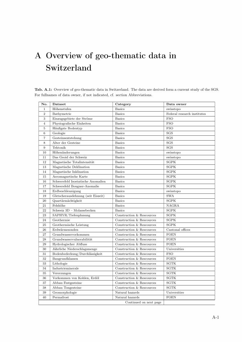
A Overview of geo-thematic data inSwitzerland
Tab. A.1: Overview of geo-thematic data in Switzerland. The data are derived form a current study of the SGS.For fullnames of data owner, if not indicated, cf. section Abbreviations.
No. Dataset Category Data owner1 Höhenstufen Basics swisstopo2 Bathymetrie Basics Federal research institutes3 Einzugsgebiete der Ströme Basics FSO4 Physiografische Einheiten Basics FSO5 Häufigste Bodentyp Basics FSO6 Geologie Basics SGS7 Gesteinsentstehung Basics SGS8 Alter der Gesteine Basics SGS9 Tektonik Basics SGS10 Höhenänderungen Basics swisstopo11 Das Geoid der Schweiz Basics swisstopo12 Magnetische Totalintensität Basics SGPK13 Magnetische Deklination Basics SGPK14 Magnetische Inklination Basics SGPK15 Aeromagnetische Karte Basics SGPK16 Schwerefeld Isostatische Anomalien Basics SGPK17 Schwerefeld Bouguer-Anomalie Basics SGPK18 Erdbeschleunigung Basics swisstopo19 Gletscherausdehnung (seit Eiszeit) Basics SWA20 Quartärmächtigkeit Basics SGPK21 Felshöhe Basics NAGRA22 Schweiz 3D – Molassebecken Basics SGPK23 SAPHYR/Tiefenplanung Construction & Rescources SGPK24 Geothermie Construction & Rescources SGPK25 Geothermische Leistung Construction & Rescources SGPK26 Erdwärmesonden Construction & Rescources Cantonal offices27 Grundwasservorkommen Construction & Rescources FOEN28 Grundwasservulnerabilität Construction & Rescources FOEN29 Hydrologischer Abfluss Construction & Rescources FOEN30 Jährliche Niederschlagsmenge Construction & Rescources Universities31 Bodenbedeckung/Durchlässigkeit Construction & Rescources FSO32 Baugrundklassen Construction & Rescources FOEN33 Lithologie Construction & Rescources SGTK34 Industrieminerale Construction & Rescources SGTK35 Vererzungen Construction & Rescources SGTK36 Vorkommen von Kohlen, Erdöl Construction & Rescources SGTK37 Abbau Festgesteine Construction & Rescources SGTK38 Abbau Tongesteine Construction & Rescources SGTK39 Geomorphologie Natural hazards Universities40 Permafrost Natural hazards FOEN
Continued on next page
A-1
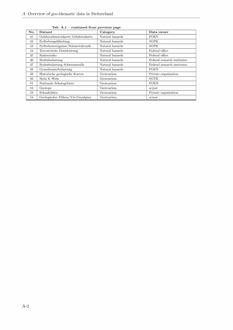
A Overview of geo-thematic data in Switzerland
Tab. A.1 – continued from previous pageNo. Dataset Category Data owner41 Gefahrenhinweiskarte/Gefahrenkarte Natural hazards FOEN42 Erdbebengefährdung Natural hazards SGPK43 Erdbebenereignisse/Seismotektonik Natural hazards SGPK44 Terrestrische Dosisleistung Natural hazards Federal office45 Radonrisiko Natural hazards Federal office46 Bodenbelastung Natural hazards Federal research institutes47 Bodenbelastung Schwermetalle Natural hazards Federal research institutes48 Grundwasserbelastung Natural hazards FOEN49 Historische geologische Karten Geotourism Private organisation50 Stein & Wein Geotourism SGTK51 Nationale Schutzgebiete Geotourism FOEN52 Geotope Geotourism sc|nat53 Schauhöhlen Geotourism Private organisation54 Geologischer Führer/Via Geoalpina Geotourism sc|nat
A-2
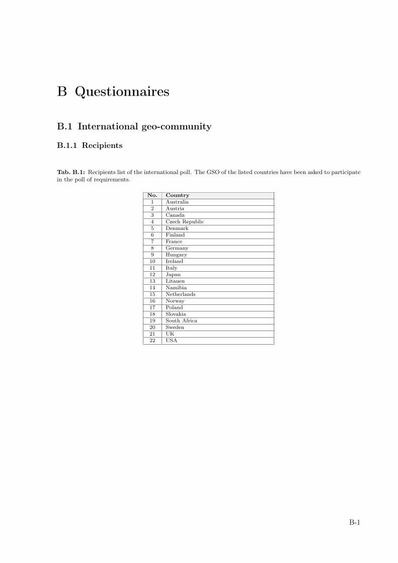
B Questionnaires
B.1 International geo-community
B.1.1 Recipients
Tab. B.1: Recipients list of the international poll. The GSO of the listed countries have been asked to participatein the poll of requirements.
No. Country1 Australia2 Austria3 Canada4 Czech Republic5 Denmark6 Finland7 France8 Germany9 Hungary10 Ireland11 Italy12 Japan13 Litauen14 Namibia15 Netherlands16 Norway17 Poland18 Slovakia19 South Africa20 Sweden21 UK22 USA
B-1
Subject: Poll on definition and requirements of a geological information
system
Dear GIC-colleagues,
I am contacting you to ask for your input (informations, comments,
suggestions, ...) to one of our major projects starting this year.
"The Build up of the Geological Information System Switzerland
(Geol-GIS-CH)".
Since a system for geological information management and distribution,
data visualisation and delivery is lacking at the Swiss Geological
Survey (SGS), we are building up a web-based information system for
geological purposes. Target groups are professional geologist, teachers
as well as laymen from the broad public.
One challenge of the build-up is related to the structure of the Swiss
"geo-community". In Switzerland a corporate geological survey like in
other countries does not exist, which is why geological tasks and
responsibilities are distributed to a number of committees, commissions
and other organisations. The organisational structure of this community
is not always transparent, especially for people from outside the
community. Clarification is therefore needed.
The overall aims of the Geol-GIS-CH are:
1) Make geological (geo-)data and information easy available to
professionals, but also to the broad public
2) Present the organisational structure of the Swiss Geo-Community
transparently
3) Enhance public awareness of geology. Attract people to get in touch
with geology
Questionnaire:
In order to get an idea what are the ideas, suggestions and requirements
of the international geological surveys, I like to ask you to answer the
following questions and fill in your feedback.
------------
1) Is your organisation solely responsible for geological issues in your
country or are their other players, maybe on other levels (state,
province, commune, ...)?
------------
2) How would you define a geological information system?
------------
3) What are the core-components of such a system?
------------
4) How would you evaluate the benefit and priority of implementation (1
= very low; 2 = low; 3 = medium; 4 = high; 5 = very high) of the
following components, which we are thinking to be necessary for the
Geol-GIS-CH?
4a) Dataviewer:
4b) Geological and geo-thematic data:
4c) Web-services (e.g. WMS, WFS, but also Geo-RSS and non geospatial
services):
4d) Geology-Glossary (geological terms explained easy understandable) or
Geology "Wiki"-site:
4e) Easy understandable description of "key-sites" of the Swiss Geology
(e.g. Glaner Hauptüberschiebung, UNESCO world heritage):
4f) Graphical presentation of the Swiss geo-community and description of
tasks and responsibilities of its members:
4g) Adress-database of the members of the geo-community:
4h) Geology discussion-forum:
4i) Job exchange:
4j) Calender of events:
4k) Web-application for user-generated geological content. Users can
comment on existing geological maps or create their own geological maps:
------------
- Do your organisation run a geological information system?
If yes:
------------
- Please specify URL (if it is accessible via the internet)
------------
- Which components does your system contain?
------------
- Do the users can contribute their own data to your system via the
internet? ("Web2.0-functionality": Transactional WFS-T, forum,
wiki-sites, RSS, etc.)
------------
- Do you distribute your data via geo-web-services (WMS, WFS)?
------------
- How do you handle metadata? Are you running your own metadata catalogue
or are you using an external one?
------------
- Do you visualise your data in 3D?
------------
- How do you handle multiple languages (in your system and in your data)?
Thank you very much in advance for giving your input. It is very
valuable for the further steps of the build-up of the Geological
Information System Switzerland.
Best regards
Nils Oesterling
B Questionnaires
B.1.2 Questionnaire to the international geo-community
B-2
B.2 National geo-community
B.2 National geo-community
B.2.1 Recipients
Tab. B.2: Recipients of the national poll on requirements
No. Organisation Category1 Bundesamt für Energie (BFE) FedAdmin2 Bundesamt für Gesundheit (BAG) FedAdmin3 Bundesamt für Raumentwicklung (ARE) FedAdmin4 Bundesamt für Strassen (ASTRA) FedAdmin5 Bundesamt für Umwelt (BAFU) - Gefahrenprävention FedAdmin6 Bundesamt für Umwelt (BAFU) – Hydrogeologie FedAdmin7 Bundesamt für Verkehr (BAV) FedAdmin8 Forschungsanstalt Agroscope Reckenholz-Tänikon (ART) FedAdmin9 Staatssekretariat für Wirtschaft (SECO) FedAdmin10 Bundesamt für Privatversicherungen (BPV) FedAdmin11 Interkantonaler Rückversicherungsverband Private12 Swiss RE Private13 Akademie der Naturwissenschaften (SCNAT) – Platform Geosciences Academia14 Centre de recherche sur l’environnemant alpin (CREALP) Private15 Eidgenössische Geologische Kommission (EGK) FedAdmin16 Fachverband der Schweizer Kies- und Betonindustrie (FSKB) Private17 Schweiz Tourismus Private18 Schweizer Geologenverband (CHGEOL) Private19 Schweizerische Akademische Gesellschaft für Umweltforschung und
Ökologie (SAGUF)Academia
20 Schweizerische Fachgruppe der Ingenieurgeologen (SFIG) Private21 Schweizerische Geologische Kommission (SGK) Academia22 Schweizerische Geophysikalische Kommission (SGPK) Academia23 Schweizerische Geotechnische Kommission (SGTK) Academia24 Schweizerische Gesellschaft für Hydrogeologie (SGH) Academia25 Schweizerische Vereinigung der Petrolium-Geologen und –Ingenieuren
(VSP)Private
26 Schweizerische Vereinigung der Strahler, Mineralien- undFossiliensammler (SVSMF)
Academia
27 Schweizerische Vereinigung für Geothermie (SVG) Private28 Schweizerischer Verband der Umweltfachleute Private29 Schweizerisches Institut für Speläologie und Karstforschung (SISKA) Academia30 WWF Schweiz Private31 Aargau (AG) – Dep. Bau, Verkehr und Umwelt CantAdmin32 Appenzell Ausserrhoden (AR)- Amt für Umwelt CantAdmin33 Appenzell Innerrhoden (AI) – Amt für Umweltschutz CantAdmin34 Basel-Landschaft (BL) CantAdmin35 Basel-Stadt (BS) – Amt für Umwelt und Energie CantAdmin36 Basel-Stadt (BS) – Uni Basel CantAdmin37 Bern (BE) – Amt für Umwelt CantAdmin38 Bern (BE) – Wasser- und Energiewirtschaftsamt CantAdmin39 Freiburg (FR) – Service de l’environnement CantAdmin40 Freiburg (FR) – Service des constructions et de l’aménagement CantAdmin41 Freiburg (FR) – SIT CantAdmin42 Genf (GE) – Service de géologie, sols et déchets CantAdmin43 Glarus (GL) – Departement Bau und Umwelt CantAdmin44 Graubünden (GR) – Amt für Natur und Umwelt CantAdmin45 Graubünden (GR) - Tiefbauamt CantAdmin46 Jura (JU) – Office de l’environnement CantAdmin47 Luzern (LU) – Umwelt und Energie CantAdmin
Continued on next page
B-3
B Questionnaires
Tab. B.2 – continued from previous pageNo. Organisation category48 Neuenburg (NE) – Département de la gestion du territoire CantAdmin49 Nidwalden (NW) – Amt für Umwelt CantAdmin50 Obwalden (OW) – Amt für Landwirtschaft und Umwelt CantAdmin51 Schaffhausen (SH) - Tiefbauamt CantAdmin52 Schwyz – Amt für Umwelt CantAdmin53 Schwyz (SZ) - Volkswirtschaftsdepartement CantAdmin54 Solothurn (SO) – Amt für Umwelt CantAdmin55 St. Gallen (SG) – Amt für Umwelt und Energie CantAdmin56 Tessin (TI) – Ufficio tecnico CantAdmin57 Thurgau (TG) – Amt für Umwelt CantAdmin58 Uri (UR) – Amt für Umweltschutz CantAdmin59 Waadt (VD) – Dépt. de la sécurité et de l’environnement CantAdmin60 Waadt (VD) – Dépt. des infrastructures CantAdmin61 Waadt (VD) – Service des eaux, sols et assainissement CantAdmin62 Wallis (VS) - Département des transports, de l’équipement et de
l’environnementCantAdmin
63 Wallis (VS) – Département des transports, de l’équipement et del’environnement
CantAdmin
64 Zug (ZG) – Amt für Umweltschutz CantAdmin65 Zürich (ZH) – Amt für Abfall, Wasser, Energie und Luft CantAdmin66 Zürich (ZH) – Amt für Abfall, Wasser, Energie und Luft CantAdmin67 EPFL, Laboratoire de géologie de l’ingénieur et de l’environnement Academia68 ETH Zürich, Geologisches Institut Academia69 ETH Zürich, Ingenieurgeologie Academia70 Scuola Universitaria Professionale della Svizzera Italiana Academia71 Uni Basel, Geologisch-Paläontologisches Institut Academia72 Uni Bern, Institut für Geologie Academia73 Uni Bern, Phil.-Naturwissenschaftl. Fakultät Academia74 Uni Freiburg, Département des Géosciences Academia75 Uni Genf, Dp. Géologie & Paleontologie Academia76 Uni Genf, Institute F.-A. Forel Academia77 Uni Lausanne, Institut de géomatique et de l’analyse du risque Academia78 Uni Zürich, Geologisches Institut Academia79 Böhringer AG Ingenieure Planer Private80 CSD-Bern Private81 Dr. Heinrich Jäckli AG Private82 Dr. von Moos AG Private83 Geotechnisches Institut Private84 Geotest AG Private85 Holcim Schweiz AG Private86 Kellerhals und Haefeli AG Private87 Matousek, Baumann & Niggli AG Private88 Schenker Korner & Partner Private89 Naturama Aargau Academia90 Naturhistorisches Museum Basel Academia91 Naturhistorisches Museum Neuenburg Academia92 Uni Bern, Geographisches Institut Academia
B-4
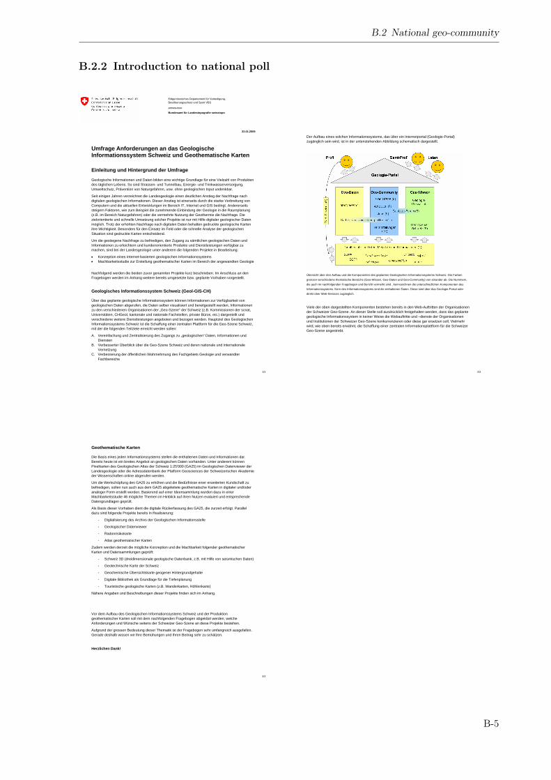
Eidgenössisches Departement für Verteidigung, Bevölkerungsschutz und Sport VBS
armasuisse
Bundesamt für Landestopografie swisstopo
22.01.2009
1/3
Umfrage Anforderungen an das Geologische Informationssystem Schweiz und Geothematische Karten
Einleitung und Hintergrund der Umfrage
Geologische Informationen und Daten bilden eine wichtige Grundlage für eine Vielzahl von Produkten des täglichen Lebens. So sind Strassen- und Tunnelbau, Energie- und Trinkwasserversorgung, Umweltschutz, Prävention von Naturgefahren, usw. ohne geologischen Input undenkbar.
Seit einigen Jahren verzeichnet die Landesgeologie einen deutlichen Anstieg der Nachfrage nach digitalen geologischen Informationen. Dieser Anstieg ist einerseits durch die starke Verbreitung von Computern und die aktuellen Entwicklungen im Bereich IT, Internet und GIS bedingt. Andererseits steigern Faktoren, wie zum Beispiel die zunehmende Einbindung der Geologie in die Raumplanung (z.B. im Bereich Naturgefahren) oder die vermehrte Nutzung der Geothermie die Nachfrage. Die zielorientierte und schnelle Umsetzung solcher Projekte ist nur mit Hilfe digitaler geologischer Daten möglich. Trotz der erhöhten Nachfrage nach digitalen Daten behalten gedruckte geologische Karten ihre Wichtigkeit. Besonders für den Einsatz im Feld oder die schnelle Analyse der geologischen Situation sind gedruckte Karten entscheidend.
Um die gestiegene Nachfrage zu befriedigen, den Zugang zu sämtlichen geologischen Daten und Informationen zu erleichtern und kundenorientierte Produkte und Dienstleistungen verfügbar zu machen, sind bei der Landesgeologie unter anderem die folgenden Projekte in Bearbeitung:
• Konzeption eines Internet-basierten geologischen Informationssystems • Machbarkeitsstudie zur Erstellung geothematischer Karten im Bereich der angewandten Geologie
Nachfolgend werden die beiden zuvor genannten Projekte kurz beschrieben. Im Anschluss an den Fragebogen werden im Anhang weitere bereits umgesetzte bzw. geplante Vorhaben vorgestellt.
Geologisches Informationssystem Schweiz (Geol-GIS-CH)
Über das geplante geologische Informationssystem können Informationen zur Verfügbarkeit von geologischen Daten abgerufen, die Daten selber visualisiert und bereitgestellt werden, Informationen zu den verschiedenen Organisationen der „Geo-Szene“ der Schweiz (z.B. Kommissionen der scnat, Universitäten, CHGeol, kantonale und nationale Fachstellen, private Büros, etc.) dargestellt und verschiedene weitere Dienstleistungen angeboten und bezogen werden. Hauptziel des Geologischen Informationssystems Schweiz ist die Schaffung einer zentralen Plattform für die Geo-Szene Schweiz, mit der die folgenden Teilziele erreicht werden sollen:
A. Vereinfachung und Zentralisierung des Zugangs zu „geologischen“ Daten, Informationen und Diensten
B. Verbesserter Überblick über die Geo-Szene Schweiz und deren nationale und internationale Vernetzung
C. Verbesserung der öffentlichen Wahrnehmung des Fachgebiets Geologie und verwandter Fachbereiche
2/3
Der Aufbau eines solchen Informationssystems, das über ein Internetportal (Geologie-Portal) zugänglich sein wird, ist in der untenstehenden Abbildung schematisch dargestellt.
Übersicht über den Aufbau und die Komponenten des geplanten Geologischen Informationssystems Schweiz. Die Farben grenzen verschiedene thematische Bereiche (Geo-Wissen, Geo-Daten und Geo-Community) von einander ab. Die Nummern, die auch im nachfolgenden Fragebogen und Bericht vermerkt sind , kennzeichnen die unterschiedlichen Komponenten des Informationssystems. Kern des Informationssystems sind die enthaltenen Daten. Diese sind über das Geologie-Portal oder direkt über Web-Services zugänglich.
Viele der oben dargestellten Komponenten bestehen bereits in den Web-Auftritten der Organisationen der Schweizer Geo-Szene. An dieser Stelle soll ausdrücklich festgehalten werden, dass das geplante geologische Informationssystem in keiner Weise die Webauftritte und –dienste der Organisationen und Institutionen der Schweizer Geo-Szene konkurrenzieren oder diese gar ersetzen soll. Vielmehr wird, wie oben bereits erwähnt, die Schaffung einer zentralen Informationsplattform für die Schweizer Geo-Szene angestrebt.
3/3
Geothematische Karten
Die Basis eines jeden Informationssystems stellen die enthaltenen Daten und Informationen dar. Bereits heute ist ein breites Angebot an geologischen Daten vorhanden. Unter anderem können Pixelkarten des Geologischen Atlas der Schweiz 1:25'000 (GA25) im Geologischen Datenviewer der Landesgeologie oder die Adressdatenbank der Platform Geosciences der Schweizerischen Akademie der Wissenschaften online abgerufen werden.
Um die Wertschöpfung des GA25 zu erhöhen und die Bedürfnisse einer erweiterten Kundschaft zu befriedigen, sollen nun auch aus dem GA25 abgeleitete geothematische Karten in digitaler und/oder analoger Form erstellt werden. Basierend auf einer Ideensammlung wurden dazu in einer Machbarkeitsstudie 46 mögliche Themen im Hinblick auf ihren Nutzen evaluiert und entsprechende Datengrundlagen geprüft.
Als Basis dieser Vorhaben dient die digitale Rückerfassung des GA25, die zurzeit erfolgt. Parallel dazu sind folgende Projekte bereits in Realisierung:
- Digitalisierung des Archivs der Geologischen Informationsstelle
- Geologischer Datenviewer
- Radonrisikokarte
- Atlas geothematischer Karten
Zudem werden derzeit die mögliche Konzeption und die Machbarkeit folgender geothematischer Karten und Datensammlungen geprüft:
- Schweiz 3D (dreidimensionale geologische Datenbank, z.B. mit Hilfe von seismischen Daten)
- Geotechnische Karte der Schweiz
- Geochemische Übersichtskarte geogener Hintergrundgehalte
- Digitale Bibliothek als Grundlage für die Tiefenplanung
- Touristische geologische Karten (z.B. Wanderkarten, Höhlenkarte)
Nähere Angaben und Beschreibungen dieser Projekte finden sich im Anhang.
Vor dem Aufbau des Geologischen Informationssystems Schweiz und der Produktion geothematischer Karten soll mit dem nachfolgenden Fragebogen abgeklärt werden, welche Anforderungen und Wünsche seitens der Schweizer Geo-Szene an diese Projekte bestehen.
Aufgrund der grossen Bedeutung dieser Thematik ist der Fragebogen sehr umfangreich ausgefallen. Gerade deshalb wissen wir Ihre Bemühungen und Ihren Beitrag sehr zu schätzen.
Herzlichen Dank!
B.2 National geo-community
B.2.2 Introduction to national poll
B-5
Eidgenössisches Departement für Verteidigung, Bevölkerungsschutz und Sport VBS
armasuisse
Bundesamt für Landestopografie swisstopo
22.01.2009
1/10
Fragebogen
Der Fragebogen ist in zwei Teile gegliedert. Im ersten Teil kann der Nutzen und die Priorität der geplanten Komponenten des Geologischen Informationssystems Schweiz bewertet werden. Der zweite Teil ist auf die Bewertung der geplanten geothematischen Karten ausgerichtet. Pro Projekt kann der Nutzen und die Priorität bewertet werden.
Teil 1: Anforderungen an das Geologische Informationssystem Schweiz
Nachfolgend sind die Komponenten des geplanten Geologischen Informationssystems Schweiz aufgeführt. Der Fokus liegt auf neuen Komponenten, Funktionen und Datensätzen. Die bestehende Funktionen, wie z.B. das Anzeigen und Selektieren von Daten im Geologischen Datenviewer können nicht bewertet werden.
Die Liste der aufgeführten Komponenten ist nicht abgeschlossen. Ergänzungen sind sehr willkommen und können an den vermerkten Stellen eingefügt werden.
Bewertung
Bitte bewerten Sie durch eintragen der unten angegebenen Ziffern den Nutzen der aufgeführten Komponenten für Ihre Arbeit und die Priorität der Umsetzung anhand des folgenden Systems:
1 = sehr gering; 2 = gering; 3 = mittel; 4 = hoch; 5 = sehr hoch
1. Geologischer Datenviewer (vgl. 1.2 im Anhang)
Beschreibung Applikation zur Visualisierung von Daten im Internet. Nachfolgend sind geplante Funktionen des bestehenden Geologischen Datenviewers aufgeführt.
Stand Erste Version besteht (http://prod.swisstopogeodata.ch/kogis_apps/ga/ga.php) und wird ergänzt
Nutzen Priorität
Wie schätzen Sie den Nutzen und die Priorität dieser Komponente ein?
Bitte tragen Sie nachfolgend wünschenswerte Funktionen des Datenviewers ein und bewerten Sie ihren Nutzen und ihre Priorität.
Nutzen Priorität
2/10
2. Geothematische Daten, Metadaten und Informationen (s. auch Teil 2 des Fragenbogens)
Beschreibung Die Daten (geologische und geothematische Karten, Informationen, etc.) bilden den Kern des Geologischen Informationssystems. Eine Vielzahl von Datensätzen besteht bereits und eine grosse Anzahl weiterer Datensätze ist denkbar. Geplante geothematische Karten können im Teil 2 des vorliegenden Fragebogens bewertet werden.
Stand Bestehend
Wie schätzen Sie den Nutzen und die Priorität der folgenden Daten ein?
Nutzen Priorität
Übersichten über die verfügbaren geothematischen Datensätze (Geologisches Kartenverzeichnis)
Übersicht über Bohrdaten, Geologische Berichte, etc. (GISGeol) http://prod.swisstopogeodata.ch/kogis_apps/webgeol/webgeol.php?
Geologische Karten
Geotechnische Karten und Rohstoffkarten
Naturgefahren, z.B. Historische Erdbeben, Baugrund, Mikrozonierung, Permafrost
Bitte tragen Sie nachfolgend weitere wünschenswerte Datensätze ein und bewerten Sie ihren Nutzen und ihre Priorität.
Nutzen Priorität
3/10
3. Web-Services (Dienste)
Beschreibung Über Web-Services können Dienstleitungen über das Internet angeboten oder Datensätze verteilt werden. Insbesondere bieten die Standards des OpenGIS-Consortium (OGC) die Möglichkeit, Karten als Bilder (WebMapService, WMS) oder als vektorisierte Datensätze (WebFeatureService, WFS) über das Internet bereitzustellen und in einem Desktop-GIS zu visualisieren und zu nutzen.
Stand In Planung, zum Teil bestehend
Nutzen Priorität
Wie schätzen Sie den Nutzen und die Priorität dieser Komponente ein?
Wie schätzen Sie den Nutzen und die Priorität der folgenden Dienste ein?
Nutzen Priorität
Bereitstellung als Pixelkarten (WMS) (geplant)
Bereitstellung von Vektordaten (Web Feature Service, WFS) (geplant)
Einfügen und Editieren von Daten auf dem Server des Geologischen Informationssystems (geplant)
Qualitätssicherung in der angewandte Geophysik (besteht bei der Schweizerischen Geophysikalischen Kommission, http://www.gr.sgpk.ethz.ch/)
Stratigraphisches Lexikon (besteht bei der Plattform Geosciences http://www.geosciences.scnat.ch/index.php?lang=fr&nav1=5&nav2=55&nav3=77)
Rechendienst zur Transformation von Koordinatensystemen (besteht bei swisstopo Geodäsie, http://www.swisstopo.admin.ch/internet/swisstopo/de/home/apps/calc/reframe.html)
Bitte tragen Sie nachfolgend weitere wünschenswerte Dienste ein und bewerten Sie ihren Nutzen und ihre Priorität.
Nutzen Priorität
4/10
4. Geologie-Glossar
Beschreibung Kurze, laienverständliche Beschreibung wichtiger geologischer oder geo-wissenschaftlicher Begriffe und Sachverhalte. Eventuell ähnlich wie in www.wikipedia.org, bei dem die Nutzer den Inhalt selber erstellen.
Stand Geplant
Nutzen Priorität
Wie schätzen Sie den Nutzen und die Priorität der Komponente ein?
5. Geologie der Schweiz; Die Schlüsselstellen der Schweizer Geologie
Beschreibung Schlüsselstellen der Schweizer Geologie, wie z.B. die Glarner Hauptüberschiebung werden laienverständlich beschrieben und in den generellen geologischen Bau der Schweiz eingebunden. Interaktive 3D-Darstellungen unterstützen die Verständlichkeit.
Stand Geplant
Nutzen Priorität
Wie schätzen Sie den Nutzen und die Priorität der Komponente ein?
6. Grafische Übersicht über die Organisation der Geo-Szene Schweiz
Beschreibung Darstellung der Vernetzung und der Aufgaben der Organisationen der Schweizer Geo-Szene.
Stand geplant
Nutzen Priorität
Wie schätzen Sie den Nutzen und die Priorität der Komponente ein?
7. Adressdatenbank und -suche
Beschreibung Applikation zur Suche nach Adressen von Organisationen und Personen der Schweizer Geo-Szene.
Stand Besteht bei der Platform Geosciences: „Geoscience-Switzerland“-online: http://www.geosciences.scnat.ch/
Nutzen Priorität
Wie schätzen Die den Nutzen und die Priorität der Komponente ein?
8. Geologie-Forum
Beschreibung Diskussionsforum für geologische Fragen. Professionelle Geologen können untereinander Probleme diskutieren oder sich mit Laien austauschen.
Stand Denkbar, ähnlich wie http://www.geowebforum.ch/
B Questionnaires
B.2.3 Questionnaire to the national geo-community
B-6
5/10
Nutzen Priorität
Wie schätzen Sie den Nutzen und die Priorität der Komponente ein?
9. Jobbörse
Beschreibung Stellenangebote und -gesuche können auf einer Website platziert werden
Stand Besteht via CHGeol-Webseite: http://www.chgeol.ch/d/2/jobs.asp
Nutzen Priorität
Wie schätzen Sie den Nutzen und die Priorität der Komponente ein?
10. Veranstaltungskalender (Konferenzen, Versammlungen, Sitzungen, Events, ...)
Beschreibung Übersicht über aktuelle Veranstaltungen in Zusammenhang mit Geologie. Denkbar wäre eine Darstellung im Datenviewer bei der die Orte der Veranstaltungen angezeigt werden und weitere Informationen abrufbar sind.
Stand Besteht bei der Plattform Geosciences: http://geosciences.scnat.ch/index.php?nav1=3&nav2=33
Nutzen Priorität
Wie schätzen Sie den Nutzen und die Priorität der Komponente ein?
11. Geologische Kartier- und Kommentierplattform
Beschreibung Geologische Entdeckungen und Kartierungen können in einem interaktiven Datenviewer und –editor im Internet erfasst, dargestellt und diskutiert werden. Bestehende geologische Karten können z.B. bei Fehlern oder veränderter geologischer Situation kommentiert werden.
Stand denkbar
Nutzen Priorität
Wie schätzen Sie den Nutzen und die Priorität der Komponente ein?
Weitere Komponenten
Bitte tragen Sie nachfolgend weitere wünschenswerte Komponenten mit einer kurzen Beschreibung ein und bewerten Sie ihren Nutzen und ihre Priorität.
Nutzen Priorität
6/10
Teil 2: Geothematische Karten
Nachfolgend sind die künftigen Projekte zu geothematischen Karten aufgelistet. Erläuterungen zu den jeweiligen Projekten sind im Anhang (Kapitel 3) zu finden.
Die Inhalte sind nicht abgeschlossen; Ergänzungen sind sehr willkommen und können für jedes Projekt und am Ende dieses Teils eingefügt werden. Bitte bewerten Sie durch einfügen der unten angegebenen Ziffern den Nutzen und die Priorität der Projekte
Bewertung
Bitte bewerten Sie durch eintragen der unten angegebenen Ziffern den Nutzen der aufgeführten Komponenten für Ihre Arbeit und die Priorität der Umsetzung anhand des folgenden Systems:
1 = sehr gering; 2 = gering; 3 = mittel; 4 = hoch; 5 = sehr hoch
Schweiz 3D (s. 2.1)
Beschreibung dreidimensionales geologisches Modell der Schweiz, basiert auf der drei-dimensionalen Erfassung geologischer Daten (z.B. Tunnelprofile und Seismiken)
Stand Machbarkeit mittels des derzeit in Entstehung begriffenen, seismischen Atlas des Molassebeckens (s. Marillier et al. 2007) nachgewiesen; entsprechendes Modell müsste aber auf ganze Schweiz ausgedehnt werden.
Nutzen Priorität
Wie schätzen Sie den Nutzen und die Priorität des Projekts ein?
Wie schätzen Sie den Nutzen und die Priorität der folgenden Inhalte ein?
Nutzen Priorität
Untiefe Bohrungen (< 100 m)
Tiefe Bohrungen (> 100 m)
Tunnelaufnahmen
Bitte tragen Sie nachfolgend weitere wünschenswerte Inhalte ein und bewerten Sie ihren Nutzen und ihre Priorität.
Nutzen Priorität
7/10
Geotechnische Karte der Schweiz (s. 2.2)
Beschreibung Flächendeckende, moderne geotechnische Karte mit Angaben zu Lithologie, Grundwasserspiegel, Grundwasserstauer, Felsoberfläche und Sondierlokalitäten.
Stand Projekt in Evaluation, technische Machbarkeit nachgewiesen
Nutzen Priorität
Wie schätzen Sie den Nutzen und die Priorität des Projekts ein?
Bitte tragen Sie nachfolgend weitere Inhalte ein, welche Sie sich ausser den im Projektbeschrieb genannten Inhalten (Lithologie, Grundwasserisohypsen, Isolinien von Grundwasserstauer und Felsoberfläche sowie bekannte Sondierlokalitäten) wünschen würden (vgl. 2.2 in Anhang) und bewerten Sie ihren Nutzen und ihre Priorität.
Nutzen Priorität
Übersichtskarte Geogener Hintergrundgehalte (s. 2.3)
Beschreibung Flächendeckende Karte der geogenen Hintergrundsgehalte der wichtigsten bzw. problematischsten Schwermetalle im C-Horizont. Diese Karte ermöglicht es die Herkunft von Bodenbelastungen abzuschätzen und z.B. Gebiete mit erhöhtem Risiko von Schwermetallbelastungen auszuscheiden.
Stand Projekt in Evaluation, technische Machbarkeit nachgewiesen
Nutzen Priorität
Wie schätzen Sie den Nutzen und die Priorität des Projekts ein?
Bitte tragen Sie nachfolgend weitere Inhalte ein, welche Sie sich ausser den im Projektbeschrieb genannten Inhalten wünschen würden (vgl. 2.3 in Anhang) und bewerten Sie ihren Nutzen und ihre Priorität.
Nutzen Priorität
8/10
Tiefenplanung (s. 2.4)
Beschreibung Elektronische Bibliothek der Grundlagen der Tiefenplanung; umfasst u.a. Daten der bisherigen Richtplanungen, geotechnische Karten und Schweiz 3D
Stand Projekt in Evaluation
Nutzen Priorität
Wie schätzen Sie den Nutzen und die Priorität des Projekts ein?
Bitte tragen Sie nachfolgend weitere Inhalte ein, welche Sie sich ausser den im Projektbeschrieb genannten Inhalten wünschen würden (vgl. 2.4 in Anhang) und bewerten Sie ihren Nutzen und ihre Priorität.
Nutzen Priorität
Geologische Wanderkarten (s. 2.5)
Beschreibung Geologische Wanderkarte für einzelne ausgewählte Gebiete, Highlights werden z.B. in separatem Führer oder auf Kartenrückseite in Bild und Wort erläutert.
Stand Projekt in Evaluation, technische Machbarkeit durch analoge Projekte im Ausland nachgewiesen (z.B. geologische Wanderkarte Sextener Dolomiten)
Nutzen Priorität
Wie schätzen Sie den Nutzen und die Priorität des Projekts ein?
Bitte tragen Sie nachfolgend wünschenswerte Inhalte einer geologischen Wanderkarte ein.
Nutzen Priorität
B.2 National geo-community
B-7
9/10
Höhlenkarte (s. 2.5) Nutzen Priorität
Beschreibung Flächendeckende Karte der bekannten Höhlen und Bergwerke im Massstab 1:200'000, analog z.B. zu Burgenkarte gestaltet.
Stand Projekt in Evaluation
Wie schätzen Sie den Nutzen und die Priorität des Projekts ein?
Bitte tragen Sie nachfolgend wünschenswerte Inhalte einer Höhlenkarte ein.
Nutzen Priorität
Bemerkungen
10/10
Kontaktinformationen:
Name Vorname
Firma/Organisation
Typ der Organisation Privat Forschung Verwaltung sonstige
Telefon / e-mail
Alle Ihre Angaben werden vertraulich behandelt. Selbstverständlich nehmen wir auch gerne Fragebogen ohne persönliche Angaben entgegen. Damit wir Ihre Antworten besser den Bedürfnissen unserer verschiedenen Kundengruppen zuordnen können, wären wir Ihnen aber sehr dankbar, wenn Sie zumindest die Angaben zum Typ Ihrer Organisation einfüllen würden.
Herzlichen Dank für Ihre Mitwirkung und Ihre Unterstützung!
Bitte senden Sie Ihre Antworten mit beiliegendem Rückantwortecouvert bis am 28. Februar 2009 an die nachfolgende Adresse. Die Teilnehmer werden innerhalb von drei Monaten nach dem zuvor genannten Datum über die Ergebnisse der Umfrage informiert.
Bundesamt für Landestopografie swisstopo Landesgeologie Koordination und Administration geol. Landesuntersuchung Dr. Milan Beres Seftigenstrasse 264 3084 Wabern
oder per e-mail an:
Für weitere Informationen stehen Ihnen folgende Personen zur Verfügung
Geologisches Informationssystem: Geothematische Karten:
Dr. Nils Oesterling Bundesamt für Landestopografie, 3084 Wabern Tel. 031 963 25 24, [email protected]
Dr. Milan Beres Bundesamt für Landestopografie, 3084 Wabern Tel. 031 963 25 74, [email protected]
Ueli Schindler G+U Geologie + Umwelt AG, Ringstrasse 2, 4600 Olten Tel. 062 213 06 60, [email protected]
Die vorliegenden Dokumente stehen unter
www.swisstopo.ch/Geol-Q oder www.swisstopo.ch > Themen > Geologie > Umfrage und Fragebogen
zum Download zur Verfügung.
B Questionnaires
B-8
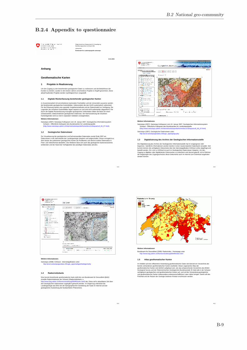
Eidgenössisches Departement für Verteidigung, Bevölkerungsschutz und Sport VBS
armasuisse
Bundesamt für Landestopografie swisstopo
22.01.2009
1/12
Anhang
Geothematische Karten
1 Projekte in Realisierung
Um den Zugang zu den bestehenden geologischen Daten zu verbessern und die Bedürfnisse der Kunden zu decken, wurden in den letzten Jahren verschiedene Projekte in Angriff genommen. Diese aktuell laufenden Projekte werden nachfolgend kurz vorgestellt.
1.1 Digitale Rückerfassung bestehender geologischer Karten
In Zusammenarbeit mit verschiedenen kantonalen Fachstellen und der Universität Lausanne werden die bestehenden geologischen Kartenblätter, insbesondere die des GA25 systematisch vektorisiert. Für die Erfassung stehen eine spezielle Vorgehensmethode und ein Datenmodell zur Verfügung. Die Legenden der einzelnen Kartenblätter liegen separat vor und sind nicht aufeinander abgestimmt. Die durch die Digitale Rückerfassung erzeugten geologischen Vektordaten bilden die Basis für einen schweizweiten, blattschnittlosen geologischen Datensatz. Die Harmonisierung der einzelnen Kartenlegenden wird zur Zeit in separaten Gebieten vorangetrieben.
Weitere Informationen:
Swisstopo (2007): Swisstopo Kolloquium vom 19. Januar 2007, Geologisches Informationssystem Schweiz.- Öffentliche Kolloquien des Bundesamtes für Landestopografie. (http://www.swisstopo.admin.ch/internet/swisstopo/de/home/docu/colloquia/coll_06_07.html)
1.2 Geologischer Datenviewer
Zur Visualisierung der geologischen und fachverwandten Datensätze wurde Ende 2007 ein Datenviewer in die Internetseite der Landesgeologie integriert und aufgeschaltet. Dieser ermöglicht es dem Nutzer die publizierten geologischen Karten als Pixelkarten und diverse andere Datensätze in Pixel- und Vektorformat darstellen. Des Weiteren lässt sich auch das geologische Kartenverzeichnis einblenden und der Stand der Verfügbarkeit der jeweiligen Datensätze abrufen.
2/12
Weitere Informationen:
Swisstopo (2007): Swisstopo Kolloquium vom 19. Januar 2007, Geologisches Informationssystem Schweiz.- Öffentliche Kolloquien des Bundesamtes für Landestopografie. (http://www.swisstopo.admin.ch/internet/swisstopo/de/home/docu/colloquia/coll_06_07.html)
Swisstopo (2007): Geologischer Datenviewer unter: http://prod.swisstopogeodata.ch/kogis_apps/ga/ga.php
1.3 Digitalisierung des Archivs der Geologischen Informationsstelle
Die Digitalisierung des Archivs der Geologischen Informationsstelle hat im vergangenen Jahr begonnen. Sämtliche Informationen werden bereits in einer neukonzipierten Datenbank verwaltet. Seit kurzem können die verfügbaren Dokumente über die Internetapplikation GISGeol online abgefragt und bestellt werden. Ein Link zu GISGeol ist auch im Geologischen Datenviewer integriert. Um den Zugang zu digitalen oder digitalisierten Dokumenten zu erleichtern wird derzeit geprüft, ob im Rahmen der Regelungen des Zugangsschutzes diese Dokumente auch im Internet zum Download angeboten werden können.
3/12
Weitere Informationen:
Swisstopo (2008): GISGeol.- Internetapplikation unter http://prod.swisstopogeodata.ch/kogis_apps/webgeol/webgeol.php
1.4 Radonrisikokarte
Eine bereits bestehende geothematische Karte stellt die vom Bundesamt für Gesundheit (BAG) erstellte Radonrisikokarte der Schweiz (Radonrisikokarte: s. http://www.bag.admin.ch/themen/strahlung/00046/index.html) dar. Diese soll in absehbarer Zeit über den Geologischen Datenviewer zugänglich gemacht werden. Im Gegenzug unterstützt die Landesgeologie das BAG bei der kartographischen Darstellung der Karte im Internet und der geologischen Auswertung der beobachteten Phänomene.
4/12
Weitere Informationen:
Bundesamt für Gesundheit (2008): Radonrisiko.- Homepage unter http://www.bag.admin.ch/themen/strahlung/00046/index.html
1.5 Atlas geothematischer Karten
Im Hinblick auf eine effizientere Anwendung geothematischer Daten wird derzeit ein Verzeichnis der bereits vorhandenen geothematischen Karten erarbeitet. Dieser sogenannte Atlas der geothematischen Karten wird ähnlich aufgebaut sein, wie das entsprechende Verzeichnis des British Geological Survey und der Österreichischen Geologischen Bundesanstalt. Er listet alle in der Schweiz verfügbaren geologischen und geothematischen Karten auf, und soll die Verwendung geologischer und geothematischer Karten insbesondere erdwissenschaftlichen Laien näher bringen. Damit soll das Potential und der Nutzen der Geologie breiteren Kreisen erschlossen werden.
B.2 National geo-community
B.2.4 Appendix to questionnaire
B-9
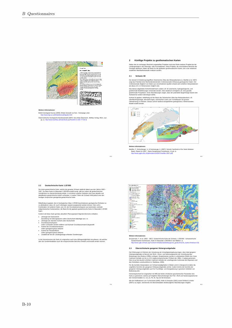
5/12
Weitere Informationen:
British Geological Survey (2005): Britain beneath our feet.- Homepage unter http://www.bgs.ac.uk/britainbeneath/guide.html
Österreichische Geologische Bundesanstalt (2007): Geo-Atlas Österreich.- Böhlau Verlag, Wien, 112 pp. (s. http://www.boehlau.at/main/book.jsp?bookID=3-205-77726-3)
6/12
2 Künftige Projekte zu geothematischen Karten
Neben den im vorherigen Abschnitt vorgestellten Projekten sind eine Reihe weiterer Projekte bei der Landesgeologie in der Planungs- oder Konzeptphase. Diese Projekte, die verschiedene Bereiche der Geologie abdecken, bilden die Basis für die geplanten geothematischen Karten, die in der einleitend erwähnten Machbarkeitsstudie evaluiert wurden.
2.1 Schweiz 3D
Der derzeit in Entstehung begriffene Seismischen Atlas des Molassebeckens (s. Marillier et al. 2007) zeigt das Potential einer flächendendeckenden 3-dimensionalen Erfassung geologischer Daten. Der 3-dimensionale Abgleich von Daten aus verschiedenen Quellen erlaubt weit schärfere Interpretationen als diese z.B. in 2 Dimensionen möglich sind.
Das daraus abgeleitete Schichtmodell kann zudem z.B. für seismische, hydrogeologische, und geothermale Modellierungen verwendet werden. Dies wiederum ermöglicht z.B. eine gezielte geothermale Prospektion. Erste Abschätzungen zeigen, dass der potentielle längerfristige Nutzen den Aufwand bei weitem überwiegen dürfte.
Konkret ist geplant, mittelfristig auf der Basis des Seismischen Atlas des Molassebeckens z.B. Oberflächengeologie, tiefe Bohrungen, seismischen Linien und Tunnelbauten mit grosser Überdeckung zu erfassen. Daraus soll ein laufend nachgeführtes geologisches 3-dimensionales Modell erstellt werden.
Weitere Informationen:
Marillier, F, Eichenberger, U. & Sommaruga, A. (2007): Seismic Synthesis of the Swiss Molasse Basin, Report for 2007.- Swiss Geophysical Commission, 11 pp. (s. http://www.sgpk.ethz.ch/jahresbericht/2007/marillier-2007.pdf)
7/12
2.2 Geotechnische Karte 1:25’000
Die letzte geotechnische Karte, welche die gesamte Schweiz abdeckt datiert aus den Jahren 1963 – 1967. Da diese Karte im Massstab 1:200’000 erstellt wurde, gibt sie zudem die geotechnischen Verhältnisse nur übersichtsmässig wieder. In einzelnen urbanen Gebieten sind zwar aktuelle und detailliertere geotechnische Karten vorhanden. In weiten Teilen der Schweiz fehlt jedoch eine den heutigen Ansprüchen genügende geotechnische Karte.
Mittelfristig ist geplant, die im Geologischen Atlas 1:25'000 beschriebenen geologischen Einheiten so zu attributieren, dass z.B. auch Lithologien separat ausgewertet werden können. Dies soll in Kombination mit weiteren Daten, wie z.B. den Grundwasserisohypsen aus kantonalen und/oder eidgenössischen Kartenwerken, die Basis für die geplante geotechnische Karte im Massstab 1:25’000 legen.
Konkret soll diese Karte gemäss aktuellem Planungsstand folgende Elemente enthalten:
• Lithologie der Deckschicht Darstellung mit Übersignaturen sofern Deckschicht Mächtiger als 1 m
• Lithologie der obersten Schicht unter Deckschicht • Grundwasserisohypsen
sofern vorhanden werden mittlerer und höchster Grundwasserstand dargestellt • Isolinie des Grundwasserstauers
sofern genügend genau bekannt • Isolinie der Felsoberfläche
sofern genügend genau bekannt • Lokalität der bei der Landesgeologie erfassten Sondierungen
In der Internetversion der Karte ist vorgesehen auch eine Abfragemöglichkeit einzubauen, mit welcher über die Sondierlokalitäten auch die entsprechenden Berichte ermittelt und bestellt werden können.
8/12
Weitere Informationen:
de Quervain, F. et al. (1963 - 1967): Geotechnische Karte der Schweiz, 1:200'000.- Schweizerische Geotechnische Kommission, Karte im Massstab 1:200’000 in vier Blättern. (s. http://www.sgtk.ch/main.asp?content=inhalt/produkte/baugrund_geotechnische_karten.htm&nav=23)
2.3 Übersichtskarte geogener Hintergrundgehalte
Die Erfahrungen im Rahmen der Umsetzung der Umweltgesetzgebung zeigen, dass lokal geogene Hintergrundgehalte im Bereich der Richt-, Grenz- und Sanierungswerten der Verordnung über Belastungen des Bodens (VBBo) vorliegen. Beispielsweise wurden in unbelasteten Böden des Juras Cadmium-Gehalte von bis zu 10.4 mg/kg (entsprechender Prüfwert der VBBo: 2 mg/kg) gemessen. Dies ist auf die deutlich erhöhten Cadmium-Gehalte der unterliegenden Karbonate des Bajocians und des Oxfordians zurückzuführen (s. Rambeau, 2006).
Für die korrekte Interpretation von Schwermetallgehalten in Böden und im Untergrund ist daher die ungefähre Kenntnis der geogenen Hintergrundsgehalte zentral. Zudem könnte die Kenntnis der geogenen Hintergrundgehalte auch für Fruchtfolge- und Düngeplanung in gewissen Gebieten von Bedeutung sein.
Dementsprechend ist vorgesehen mit Hilfe der bisher erhobenen geochemischen Parameter eine Karte zu generieren, welche auf mögliche Überschreitungen der Prüf-, Richt und Sanierungswerte bei den Schwermetallen Cr, Cd, Zn, Pb, Ni, Hg und Sb hinweisen.
Wie die Publikationen von Tuchschmid (1995), Keller & Desaules (2001) sowie Rehbein & Keller (2007a, b) zeigen, sind bereits mit Übersichtsdaten diesbezügliche Abschätzungen möglich.
B Questionnaires
B-10
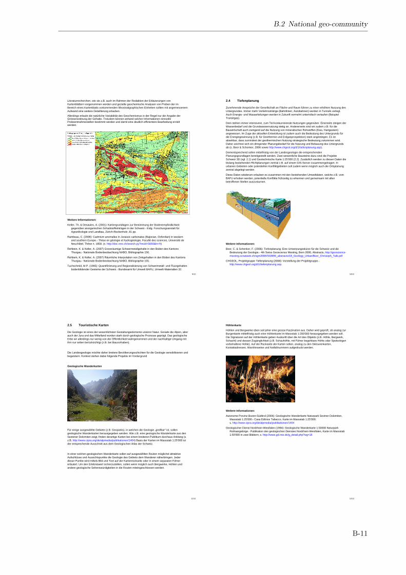
9/12
Literaturrecherchen, wie sie z.B. auch im Rahmen der Redaktion der Erläuterungen von Kartenblättern vorgenommen werden und gezielte geochemische Analysen von Proben der im Bereich eines Kartenblatts vorkommenden lithostratigraphischen Einheiten sollten mit angemessenem Aufwand eine weitere Detaillierung erlauben.
Allerdings erlaubt die natürliche Variabilität des Geochemismus in der Regel nur die Angabe der Grössenordnung der Gehalte. Trotzdem können anhand solcher Informationen sinnvolle Probeentnahmestellen bestimmt werden und damit eine deutlich effizientere Bearbeitung erzielt werden.
Weitere Informationen:
Keller, Th. & Desaules, A. (2001): Kartiergrundlagen zur Bestimmung der Bodenempfindlichkeit gegenüber anorganischen Schadstoffeinträgen in der Schweiz.- Eidg. Forschungsanstalt für Agrarökologie und Landbau, Zürich-Reckenholz, 81 pp.
Rambeau, C. (2006): Cadmium anomalies in Jurassic carbonates (Bajocian, Oxfordian) in western and southern Europe.- Thèse en géologie et hydrogéologie, Faculté des sciences, Université de Neuchâtel, Thèse n. 1858. (s. http://doc.rero.ch/search.py?recid=5693&ln=fr)
Rehbein, K. & Keller, A. (2007) Grossräumige Schwermetallgehalte in den Böden des Kantons Thurgau.- Nationale Bodenbeobachtung NABO, Bibliographie 156.
Rehbein, K. & Keller, A. (2007) Räumliche Interpolation von Zinkgehalten in den Böden des Kantons Thurgau.- Nationale Bodenbeobachtung NABO, Bibliographie 155.
Tuchschmid, M.P. (1995): Quantifizierung und Regionalisierung von Schwermetall- und Fluorgehalten bodenbildender Gesteine der Schweiz.- Bundesamt für Umwelt BAFU, Umwelt-Materialien 32.
10/12
2.4 Tiefenplanung
Zunehmende Ansprüche der Gesellschaft an Fläche und Raum führen zu einer erhöhten Nutzung des Untergrundes. Immer mehr Verkehrsstränge (Bahnlinien, Autobahnen) werden in Tunnels verlegt. Auch Energie- und Wasserleitungen werden in Zukunft vermehrt unterirdisch verlaufen (Beispiel Transitgas).
Dem stehen immer intensivere, zum Teil konkurrierende Nutzungen gegenüber. Einerseits steigen der Wasserbedarf und die Grundwassernutzung stetig an. Andererseits sind wir zudem z.B. für die Bauwirtschaft auch zwingend auf die Nutzung von mineralischen Rohstoffen (Kies, Hartgestein) angewiesen. Im Zuge der aktuellen Entwicklung ist zudem auch die Bedeutung des Untergrunds für die Energiegewinnung (z.B. für Geothermie und Erdgasprospektion) stark angestiegen. Es ist absehbar, dass zumindest der geothermischen Nutzung strategische Bedeutung zukommen wird. Daher zeichnet sich ein dringender Planungsbedarf für die Nutzung und Bebauung des Untergrunds ab (s. Beer & Schenker, 2006 sowie http://www.chgeol.org/d/1/tiefenplanung.asp).
Dementsprechend sollen mittelfristig von der Landesgeologie die entsprechenden Planungsgrundlagen bereitgestellt werden. Zwei wesentliche Bausteine dazu sind die Projekte Schweiz 3D (vgl. 2.1) und Geotechnische Karte 1:25’000 (2.2). Zusätzlich werden zu diesen Daten die bislang bestehenden Richtplanungen zentral z.B. auf einem GIS-Server zusammengetragen. In urbanen Gebieten oder potentiellen Konfliktgebieten soll zudem wenn möglich auch die Ortsplanung zentral abgelegt werden.
Diese Daten wiederum erlauben es zusammen mit den bestehenden Umweltdaten, welche z.B. vom BAFU erhoben werden, potentielle Konflikte frühzeitig zu erkennen und gemeinsam mit allen betroffenen Stellen auszuräumen.
Weitere Informationen:
Beer, C. & Schenker, F. (2006): Tiefenplanung: Eine Umsetzungsskizze für die Schweiz und die Bedeutung der Geologie.- 4th Swiss Geoscience Meeting, Bern 2006, Abstracts, http://geoscience-meeting.scnatweb.ch/sgm2006/SGM06_abstracts/18_Geology_Urban/Beer_Christoph_Talk.pdf
CHGEOL, Projektgruppe Tiefenplanung (2008): Vorstellung der Projektgruppe.- http://www.chgeol.org/d/1/tiefenplanung.asp.
11/12
2.5 Touristische Karten
Die Geologie ist eines der wesentlichsten Gestaltungselemente unserer Natur. Gerade die Alpen, aber auch der Jura und das Mittelland wurden stark durch geologische Prozesse geprägt. Das geologische Erbe wir allerdings nur wenig von der Öffentlichkeit wahrgenommen und der nachhaltige Umgang mit ihm nur selten berücksichtigt (z.B. bei Bauvorhaben).
Die Landesgeologie möchte daher breitere Bevölkerungsschichten für die Geologie sensibilisieren und begeistern. Konkret stehen dabei folgende Projekte im Vordergrund
Geologische Wanderkarten
Für einige ausgewählte Gebiete (z.B. Geoparks), in welchen die Geologie „greifbar“ ist, sollen geologische Wanderkarten herausgegeben werden. Wie z.B. eine geologische Wanderkarte aus den Sextener Dolomiten zeigt, finden derartige Karten bei einem breiteren Publikum durchaus Anklang (s. z.B. http://www.cipra.org/de/alpmedia/publikationen/1404) Basis der Karten im Massstab 1:25'000 ist der entsprechende Ausschnitt aus dem Geologischen Atlas der Schweiz.
In einer solchen geologischen Wanderkarte sollen auf ausgewählten Routen möglichst attraktive Aufschlüsse und Aussichtspunkte die Geologie des Gebiets dem Wanderer näherbringen. Jeder dieser Punkte wird mittels Bild und Text auf der Kartenrückseite oder in einem separaten Führer erläutert. Um den Erlebniswert sicherzustellen, sollen wenn möglich auch Bergwerke, Höhlen und andere geologische Sehenswürdigkeiten in die Routen miteingeschlossen werden.
12/12
Höhlenkarte
Höhlen und Bergwerke üben seit jeher eine grosse Faszination aus. Daher wird geprüft, ob analog zur Burgenkarte mittelfristig auch eine Höhlenkarte im Massstab 1:200'000 herausgegeben werden soll. Die Signaturen auf der Höhlenkarte geben Auskunft über die Art des Objekts (z.B. Höhle, Bergwerk, Schacht) und dessen Zugänglichkeit (z.B. Schauhöhle, mit Führer begehbare Höhle oder Speleologen vorbehaltene Höhle). Auf der Rückseite der Karten sollen, analog zu den Skitourenkarten, Kontaktadressen, Warnhinweise und Notfallnummern aufgedruckt werden.
Weitere Informationen:
Autonome Provinz Bozen-Südtirol (2004): Geologische Wanderkarte Naturpark Sextner Dolomiten, Massstab 1:25'000.- Casa Editrice Tabacco, Karte im Massstab 1:25'000; s. http://www.cipra.org/de/alpmedia/publikationen/1404
Geologischer Dienst Nordrhein-Westfalen (1994): Geologische Wanderkarte 1:50000 Naturpark Rothaargebirge.- Publikation des geologischen Dienstes Nordrhein-Westfalen, Karte im Massstab 1:50'000 in zwei Blättern; s. http://www.gd.nrw.de/g_detail.php?wg=16
B.2 National geo-community
B-11

C Analysed web sites
C.1 International geo-community
Tab. C.1: Analysed web sites of the international geo-community. The indicated components correspond tothose shown in Tab. 4.3. All urls have been last checked August 22nd, 2009. If no specific url can be indicated,all individual steps necessary to access the site are given separated by ">".
Organisation Component URLSwiss GeologicalSurvey (SGS)
homepage http://www.swisstopo.admin.ch/internet/swisstopo/en/home/swisstopo/org/geology.html
SGS Dataviewer http://www.geologieviewer.ch/SGS Spatial
web-servicescf. http://portal.onegeology.org/
SGS (i.e. swisstopogeodesy division)
Non-spatialweb-services
http://www.swisstopo.admin.ch/internet/swisstopo/de/home/apps/calc.html
SGS Shop http://www.toposhop.admin.ch/de/shop/indexSGS Geology for
laymenhttp://www.swisstopo.admin.ch/internet/swisstopo/de/home/topics/geology.html
Geological Surveyof Italy (APAT)
homepage http://www.apat.gov.it/site/en-GB/
APAT Dataviewer http://serviziogeologico.apat.it/Portal/APAT Spatial
web-servicescf. http://portal.onegeology.org/
APAT Non-spatialweb-services
http://www.apat.gov.it/site/en-GB/Environmental_Services/Environmental_services_list/
APAT Geology forlaymen
http://www.museo.isprambiente.it/home.page
Federal Institutefor Geosciences andNatural Resources(BGR)
homepage http://www.bgr.bund.de
BGR Dataviewer http://geoviewer.bgr.deBGR Spatial
web-serviceshttp://www.bgr.bund.de/cln_092/nn_1002738/DE/Themen/Geoinformationen/Webdienste/webdienste__node.html?__nnn=true
BGR Event calendar http://www.bgr.bund.de/cln_101/nn_334532/DE/Gemeinsames/Nachrichten/Veranstaltungen/veranstaltungen__node.html?__nnn=true
BGR Shop http://www.geoshop-hannover.deBureau derecherchesgéologiques etminières (BRGM)
homepage http://www.brgm.fr/index.jsp
BRGM Dataviewer http://infoterre.brgm.fr/BRGM Spatial
web-servicescf. http://portal.onegeology.org/
BRGM GeoReportsweb.service
http://www.brgm.fr/georapport.jsp
Continued on next page
C-1
C Analysed web sites
Tab. C.1 – continued from previous pageOrganisation Component URLBRGM Image
databaseservice
http://www.brgm.fr/image.jsp
BRGM Job portal http://www.brgm.fr/brgm/Emploi/default.htmBRGM Geology for
laymenhttp://www.brgm.fr/multimedia.jsp
Geological Surveyof Austria (GBA)
homepage http://www.geologie.ac.at/
GBA Dataviewer http://www.geologie.ac.at/ > GBA-onlineGBA Web-services http://www.geologie.ac.at/ > GBA-onlineGBA Glossary http://www.geologie.ac.at/ > GBA-online > RockyAustriaBritish GeologicalSurvey (BGS)
homepage http://www.bgs.ac.uk/home.html
BGS Dataviewer http://www.bgs.ac.uk/geoindex/beta.htmlBGS Spatial
web-servicescf. http://portal.onegeology.org/
BGS Non-spatialweb-services
http://www.bgs.ac.uk/services/home.html
BGS GeoReports http://www.bgs.ac.uk/services/services_for_you/home.htmlBGS Stratigraphic
lexiconhttp://www.bgs.ac.uk/education/britstrat/home.html
BGS Imagedatabase
http://www.bgs.ac.uk/photoarchive/home.cfm
BGS event calendar http://www.bgs.ac.uk/news/diary.htmlBGS Shop http://shop.bgs.ac.uk/BGS Discussion
forumhttp://www.bgs.ac.uk/education/ask_about_geology/question.html
BGS Geology forlaymen
http://www.bgs.ac.uk/education/home.html
Geological Surveyof Canada (GSC)
homepage http://gsc.nrcan.gc.ca/index_e.php
GSC Dataviewer http://gdr.ess.nrcan.gc.ca/english/explorer.jspGSC Spatial
web-serviceshttp://gdr.nrcan.gc.ca/access_e.php
GSC Non-spatialweb-services
http://gdr.nrcan.gc.ca/index_e.php
GSC Stratigraphiclexicon
http://cgkn1.cgkn.net/weblex/weblex_e.pl
GSC Glossary http://gdr.nrcan.gc.ca/gloss_e.phpGSC Geology for
laymenhttp://gsc.nrcan.gc.ca/education_e.php
Geological statesurvey ofBaden-Würtemberg(LGRB)
hompage http://www.lgrb.uni-freiburg.de/lgrb/home/index_html
LGRB Dataviewer http://www.lgrb.uni-freiburg.de/lgrb/lgrb_mapserverLGRB Spatial
web-serviceshttp://www.lgrb.uni-freiburg.de/lgrb/lgrb_mapserver/wms-layer
LGRB Shop http://www.lgrb.uni-freiburg.de/lgrb/ProdukteLGRB Geology for
laymenhttp://www.lgrb.uni-freiburg.de/lgrb/Fachbereiche/geotourismus
Geological StateSurvey of Bavaria(LfU)
homepage http://www.lfu.bayern.de/geologie/
LfU Dataviewer http://www.bis.bayern.de/bis/initParams.do?role=bisContinued on next page
C-2
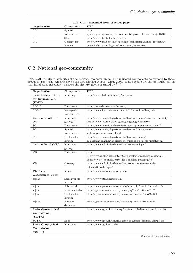
C.2 National geo-community
Tab. C.1 – continued from previous pageOrganisation Component URLLfU Spatial
web-serviceshttp://www.gdi.bayern.de/Geowebdienste/geowebdienste.htm#GK500
LfU Shop http://www.bestellen.bayern.de/LfU Geology for
laymenhttp://www.lfu.bayern.de/geologie/fachinformationen/geoforum/geologische_grundlageninformationen/index.htm
C.2 National geo-community
Tab. C.2: Analysed web sites of the national geo-community. The indicated components correspond to thoseshown in Tab. 4.4. All urls have been last checked August 22nd, 2009. If no specific url can be indicated, allindividual steps necessary to access the site are given separated by ">".
Organisation Component URLSwiss Federal Officefor Environment(FOEN)
homepage http://www.bafu.admin.ch/?lang=en
FOEN Dataviewer http://umweltzustand.admin.ch/FOEN Non-spatial
web-serviceshttp://www.hydrodaten.admin.ch/d/index.htm?lang=de
Canton Solothurn(SO)
homepagegeology
http://www.so.ch/departemente/bau-und-justiz/amt-fuer-umwelt/fachbereiche/steine-erden-geologie/geologie.html?0=
SO Dataviewer http://www.sogis1.so.ch/sogis/internet/pmapper/map.phtml?SO Spatial
web-serviceshttp://www.so.ch/departemente/bau-und-justiz/sogis/web-map-services-wms.html
SO Geology forlaymen
http://www.so.ch/departemente/bau-und-justiz/geologische-sehenswuerdigkeiten/durchblicke-in-die-urzeit.html
Canton Vaud (VD) homepagegeology
http://www.vd.ch/fr/themes/territoire/geologie/
VD Dataviewer http://www.vd.ch/fr/themes/territoire/geologie/cadastre-geologique/consulter-des-donnees/carte-des-sondages-geologiques/
VD Glossary http://www.vd.ch/fr/themes/territoire/dangers-naturels/informations/lexique/
PlatformGeosciences (sc|nat)
home http://www.geosciences.scnat.ch/
sc|nat Stratigraphiclexicon
http://www.stratigraphie.ch/
sc|nat Job portal http://www.geosciences.scnat.ch/index.php?nav1=2&nav2=166sc|nat Event calendar http://geosciences.scnat.ch/index.php?nav1=3&nav2=33sc|nat Geology for
laymenhttp://geosciences.scnat.ch/index.php?nav1=1&nav2=120
sc|nat Addressdatabase
http://geosciences.scnat.ch/index.php?nav1=3&nav2=34
Swiss GeotechnicalCommission(SGTK)
2 http://www.sgtk.ch/main.asp?content=inhalt/start.htm&nav=10
SGTK Shop http://www.sgtk.ch/inhalt/shop/candypress/Scripts/default.aspSwiss GeophysicalCommission(SGPK)
homepage http://www.sgpk.ethz.ch/
Continued on next page
C-3
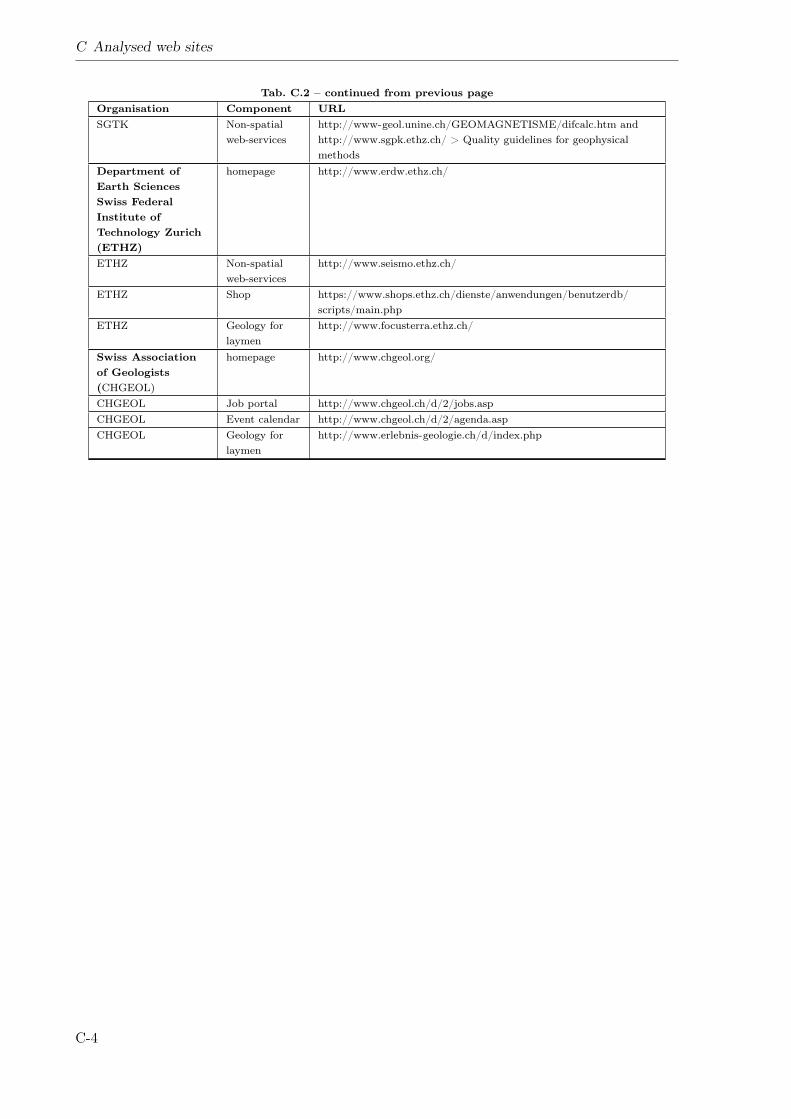
C Analysed web sites
Tab. C.2 – continued from previous pageOrganisation Component URLSGTK Non-spatial
web-serviceshttp://www-geol.unine.ch/GEOMAGNETISME/difcalc.htm andhttp://www.sgpk.ethz.ch/ > Quality guidelines for geophysicalmethods
Department ofEarth SciencesSwiss FederalInstitute ofTechnology Zurich(ETHZ)
homepage http://www.erdw.ethz.ch/
ETHZ Non-spatialweb-services
http://www.seismo.ethz.ch/
ETHZ Shop https://www.shops.ethz.ch/dienste/anwendungen/benutzerdb/scripts/main.php
ETHZ Geology forlaymen
http://www.focusterra.ethz.ch/
Swiss Associationof Geologists(CHGEOL)
homepage http://www.chgeol.org/
CHGEOL Job portal http://www.chgeol.ch/d/2/jobs.aspCHGEOL Event calendar http://www.chgeol.ch/d/2/agenda.aspCHGEOL Geology for
laymenhttp://www.erlebnis-geologie.ch/d/index.php
C-4