marine geology of the bahama escarpment
TRANSCRIPT
Marine Geology, 44 (1981) 119--156 119 Elsevier Scientific Publishing Company, Amsterdam -- Printed in The Netherlands
MARINE GEOLOGY OF THE BAHAMA ESCARPMENT
RAYMOND P. FREEMAN-LYNDE l *, MARIA B. CITA 2, FLAVIO JADOUL:, ELIZABETH L. MILLER'** and WILLIAM B.F. RYAN 1
' Lamont-Doherty Geological Observatory of Columbia University, Palisades, N.Y. (U.S.A.) 2Institute of Geology, University of Milan, Milan (Italy)
(Accepted for publication March 16, 1981)
ABSTRACT
Freeman-Lynde, R.P., Cita, M.B., Jadoul, F., Miller, E.L. and Ryan, W.B.F., 1981. Marine geology of the Bahama Escarpment. In: M.B. Cita and W.B.F. Ryan (Editors), Carbon- ate Platforms of the Passive-Type Continental Margins, Present and Past. Mar. Geol., 44: 119--156.
A 2 km thick stratigraphic section of the Bahama Escarpment off Cat Island in the northwestern Bahamas has been measured and sampled by submersible. The escarpment, from 3940 m upwards, consists of lower and middle Cretaceous peritidal, lagoonal, patch- reef and hackreef limestones unconformably overlain by an intermittent cover of Maastrichtian and Eocene pelagic limestone.
Data from additional dive traverses and dredging elsewhere on the Bahama Escarpment indicate that shallow-water platform limestones similar in age and lithofacies to the Cat Island sequence occur along the entire 800 km of the escarpment as far as Navidad Bank.
Comparison of our section to stratigraphic data from coeval Mesozoic carbonate plat- forms surrounding the Gulf of Mexico and extending up the east coast of North America as well as from other ancient and modern carbonate platforms reveals that the Bahama sequences have the greatest similarity to deposits characteristic of the marginal zones (1--10 km wide) of these platforms. In particular, the Bahama sequence is most similar to the "bank-interior" and "backreef" portions of the marginal zone and not to the "reef" portion. It is clear from both modern and ancient examples that a purely constructive carbonate platform margin should consist of a reef and associated forereef deposits, and not only of "bank-interior" peritidal and lagoonal strata, as exposed along the Bahama Escarpment. Therefore, the reef and forereef debris which constituted the original seaward edge of the Bahama must have been removed by erosion. The amount of erosion is esti- mated as 1--5 km and is effected at present by spallation of joint blocks. Lithostatic pres- sure at 4--5 km depth may exceed the strength of the limestone comprising the platform, resulting in the pervasive jointing observed in the lower portion of the escarpment.
Subsidence of the Cat Island Escarpment has been exponential, decreasing from 60 m/ m.y. in the Early Cretaceous to 40 m/m.y, in the Middle Cretaceous. Extrapolated values for the Late Cretaceous and Tertiary are 20 m/m.y.
*Present address: Department of Geology, Western Michigan University, Kalamazoo, Mich. (U.S.A.). **Present address: Department of Geology, Stanford University, Stanford, Calif. (U.S.A.).
0025--3227/81/0000--0000/$02.75 © 1981 Elsevier Scientific Publishing Company
120
INTRODUCTION
The greatest accumulations of undeformed sedimentary rocks found today occur along passive continental margins. For the most part, the deposits that record the early history of an old margin lie deeply buried by many kilometers of younger sediments. Along some margins, however, old rocks are exposed either in canyons eroded into the continental slope, or along precipitous carbonate escarpments.
Old rocks are extensively exposed along portions of the precipitous Blake-- Bahama, Mazagan, Campeche, and West Florida Escarpments, where lower Cretaceous and upper Jurassic strata have been recovered (Heezen and Sheridan, 1966; Bryant et al., 1969; Schneidermann et al., 1972; d'Argenio et al., 1975; Renz et al., 1975; Ryan et al., 1978; Wissman and Von Rad, 1979}. In these regions a portion of the stratigraphic record can be glimpsed, and this record is invaluable in understanding the geologic history of the margin.
Sampling the Blake--Bahama Escarpment was initiated by Bruce C. Heezen in 1966. At first the sampling program involved hit-or-miss dredging with Duke University's R/V "Eastward" through the Cooperative Oceanographic Program. A more discretionary sampling program using deep-diving submers- ibles (DSRV "Alvin" and DSV "Trieste"} was organized by Heezen in 1976 and was completed in 1978 after his death.
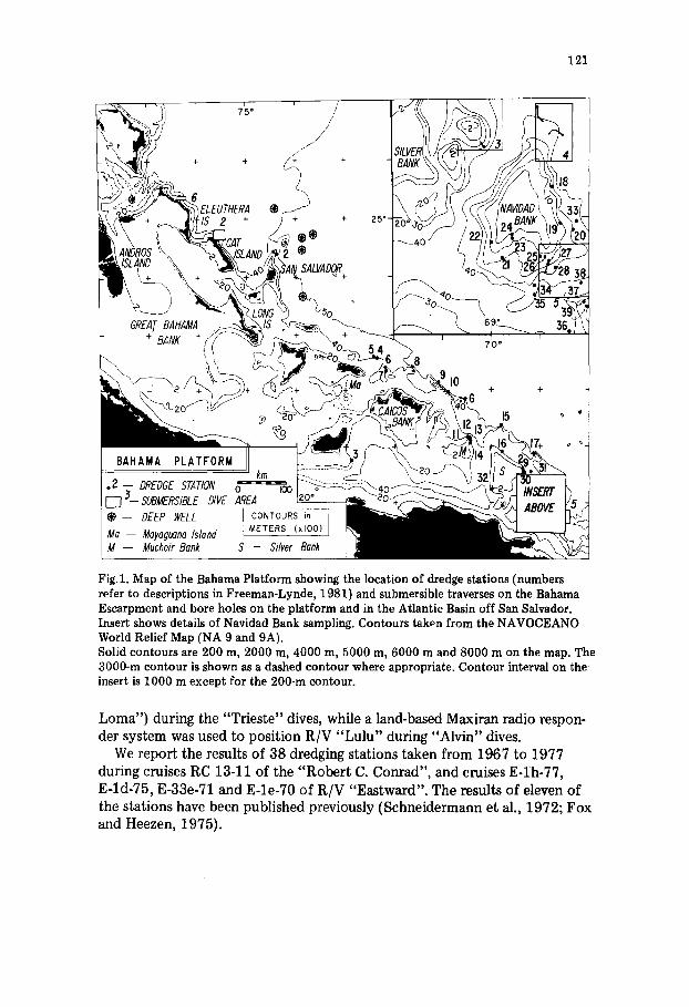
The main objective of the program was to compile a stratigraphic section for the Bahama Platform comparable to one which might be constructed from drilling (Fig.l).
This study emphasizes the results of the "Alvin" field program on the Cat Island Escarpment (dives 866--868 and dive 704) as these provide a more basic and complete framework in which to view the findings of submersible dives and dredging elsewhere along the Bahama Escarpment.
Methods
Our submersible program consisted of one DSV "Trieste" (1977) and three DSRV "Alvin" (1976, 1977 and 1978) expeditions during which seven "Alvin" dives and three "Trieste" dives were made on the Bahama Escarp- ment. A total of 85 sampling stations, recovering 78 rock samples and 4 sedi- ment cores, were occupied during these dives. Although we attempted to recover rock samples from outcrops, we sometimes had to settle for talus that was judged to be locally derived. On all but one of the dives, continuous black- and-white video-tape recordings from an externally mounted TV camera were made between sampling stations. Up to 700 externally mounted bow camera and 200--300 internal hand-held black-and-white and color 35-mm photo- graphs were shot for each dive; these photos and the video-recordings allow review and synthesis of the field observations.
During the "Trieste" and the 1978 "Alvin" field programs, the submersible was navigated by acoustic slant-ranging to the support vessel. Loran-C, supple- mented by satellite fixes, was used to position the surface ship (USS "Point
121
Fig.1. Map of the Bahama Platform showing the location of dredge stations (numbers refer to descriptions in Freeman-Lynde, 1981) and submersible traverses on the Bahama Escarpment and bore holes on the platform and in the Atlantic Basin off San Salvador. Insert shows details of Navidad Bank sampling. Contours taken from the NAVOCEANO World Relief Map (NA 9 and 9A). Solid contours are 200 m, 2000 m, 4000 m, 5000 m, 6000 m and 8000 m on the map. The 3000-m contour is shown as a dashed contour where appropriate. Contour interval on the insert is 1000 m except for the 200-m contour.
Loma") during the "Trieste" dives, while a land-based Maxiran radio respon- der system was used to position R/V "Lulu" during "Alvin" dives.
We report the results of 38 dredging stations taken from 1967 to 1977 during cruises RC 13-11 of the "Rober t C. Conrad", and cruises E-Ih-77, E-ld-75, E-33e-71 and E-le-70 of R/V "Eastward". The results of eleven of the stations have been published previously (Schneidermann et al., 1972; Fox and Heezen, 1975).
122
GEOLOGY OF THE CAT ISLAND ESCARPMENT
Morphology
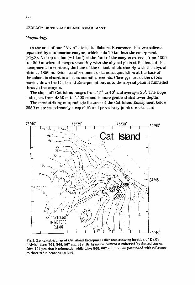
In the area of our "Alvin" dives, the Bahama Escarpment has two salients separated by a submarine canyon, which cuts 10 km into the escarpment (Fig.2). A deep-sea fan (~1 km 3) at the foot of the canyon extends from 4300 to 4850 m where it merges smoothly with the abyssal plain at the base of the escarpment. In contrast, the base of the salients abuts sharply with the abyssal plain at 4850 m. Evidence of sediment or talus accumulation at the base of the salient is absent in all echo-sounding records. Clearly, most of the debris moving down the Cat Island Escarpment out onto the abyssal plain is funnelled through the canyon.
The slope off Cat Island ranges from 15 ° to 40 ° and averages 250 . The slope is steepest from 4850 m to 1500 m and is more gentle at shallower depths.
The most striking morphologic features of the Cat Island Escarpment below 2650 m are its extremely steep cliffs and pervasively jointed rocks. This
75°40 ' 75 ° 35' I 47-. L I ,~ e I I
4 6 ~ ~ ~ - ~ ~ . . ~ \ , \
75"50' I , I , I , , |
C a t I nd 4 24°50 '
24045 '
I 24°40 '
Fig. 2. Bathymetric map of Cat Island Escarpment dive area showing location of DSRV "Alvin" dives 704, 866, 867 and 868. Bathymetric control is indicated by dotted tracks. Dive 704 position is schematic, while dives 866, 867 and 868 are positioned with reference to three radio-beacons on land.
123
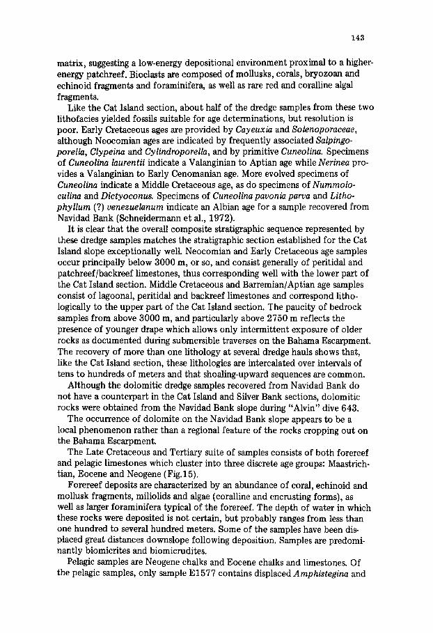
pervasive fracturing is visible in hand sample and in thin section as well. The cliffs are the steep walls of a series of gullies and spurs which extensively dis- sect the escarpment. Gullies cut about 30 m into the slope, and intergully spurs form knife-edged crests that rise about 10 m above gully floors. Maxi- mum relief on these ridges tends to be greater at depth and diminishes up the slope. Gullies are filled with sediment and various sized talus blocks, while spurs are generally sediment-free. Pointed, angular, joint-bound blocks of bed- rock occur along ridge crests, enhancing their knife-edge character (Fig.3, A}.
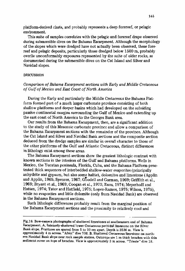
Jointing is commonly observed below 2650 m. Joint spacing varies from 0.2 to t0 m, and at times jointing is so closely spaced (centimeters apart), as to give rocks a shattered appearance along spur crests (Fig.3, B). Some of the most spectacular cliffs are formed by steep, smooth joint planes 5 m or more in height, and often deep, irregular fissures are created as huge {> 5 m) tilted rock pinnacles spall from the intact cliff along joint planes (Fig.4). These pinnacles seem frozen in precarious position as they jut as much as 30 ° away from the cliff.
Joint sets, although non-systematic, tend to be vertical to subvertical. Thus talus blocks have a characteristic angular oblong shape, oriented perpendicular to bedding.
Below 3250 m, there is an almost continuous exposure of well-bedded rocks, interlayered with more massive or at least non-bedded rocks (Fig.4}. Morphologically, the bedded and unbedded sequences are each 20--160 m thick. Talus-strewn surfaces seem to be more prevalent above 3250 m. Above 3250 m, joint surfaces tend to be much smoother and to be coated with thinner manganese crusts than observed below. Joint planes appear to be degraded at depth enhancing bedding characteristics.
The slope becomes less steep (average 10 °} at about 2670 m (dives 868 and 704). Jointing and steep cliffs diminish and a smoother slope replaces the very jagged and fractured slope of the deeper escarpment (Fig.5, A). The smoother slope appears to be the result of a pelagic sediment cover or apron that is draped over the more rugged morphology. These pelagic sediments are bedded parallel to the seafloor. Where this cover is breached by erosion, talus derived from the pelagic drape is irregular and plate-shaped, commonly 3--5 cm thick (reflecting bedding thickness} and from 0.1 to 2 m in diameter {Fig. 5, A). More resistant layers form overhangs which eventually break off to generate slab-shaped talus (Fig.5, B}.
Bedrock exposures comprise about 40% of the slope above 2650 m, and vary from isolated meter-high ledges to cliffs with tens of meters of relief, separated by intervals of pelagic cover. 3ointing is not pervasive at these depths, although joint faces are much better preserved, continuing the trend observed below. These smooth faces, formed by one vertical joint set, are cut by small gullies and chutes, localized along a second vertical joint set which is more or less orthogonal to the first, although, again, neither set is systematic- ally oriented at outcrop scale.
A series of steep, smooth cliffs, each about 5 m high, and separated from each other by 10 m wide benches, comprise the slope from 2375 to 2350 m.
124
125
The faces of these cliffs are joint surfaces which bound very large blocks. No signs of movement along joint planes, such as striations, slickenslides or gouge were seen. No discernible displacement occurred along any joint surfaces we observed, a fact particularly well-documented within the bedded sequences.
No samples were recorded above 3150 m during dive 704, but visual evid- ence for the presence of an old lithified apron, younger ooze deposits, and thick manganese crusts was recorded from 2000 to 1290 m.
Stratigraphy
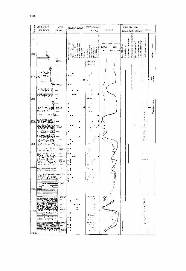
A composite stratigraphic section was measured and sampled at average spacings of 25--50 m from 3940 to 2055 m during the four dives made on the Cat Island Escarpment (Fig.6). The majority of samples were deposited in a shallow carbonate platform environment and range in age from Earliest Cret- aceous (Berriasian) to Middle Cretaceous (Cenomanian)*. Rocks of this age typical of bank margin environments are conspicuously absent. Maastrichtian and Middle Eocene pelagic limestones and Neogene calcareous ooze and manganese crust cover or fill fractures in the older shallow-water rocks.
Although age resolution in the shallow platform limestones is relatively poor (at best ages are resolved to within two stages), the section appears to contain no significant disconformities. A plot of age versus depth illustrates the continuity of the section, as shown in Fig.7, which will be further discussed at the end of this paper.
The bedrock samples can be divided into two subsequences based on gross lithology: Units 1 and 2.
Unit 1. Neocomian, Barremian and perhaps Aptian peritidal and patchreef/ backreef limestones outcrop extensively from 3940 to approximately 3000 m and constitute Unit 1.
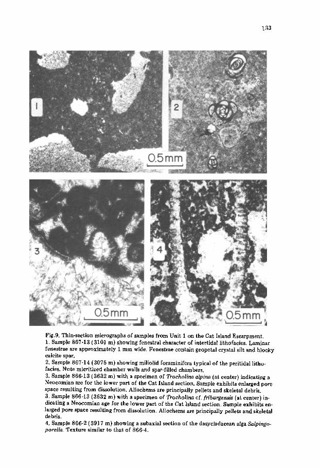
The peritidal lithofacies of this unit is characterized by deposition in pre- dominantly low-energy, restricted environments and the development of desiccation features (Fig.8) principally in intertidal portions. Allochems are predominantly pellets or intraclasts and rocks are generally muddy. Geopetal filling of fenestrae (Fig.9-1) and burrows are common. Early cloudy to clear acicular calcite cements are generally present in interparticle pores and primary cavities. They indicate precipitation in a marine environment. Later clear, blocky spar, locally the only cement, suggests episodes of fresh-water
*Following the increasing usage of the term "Middle Cretaceous" we include in this t ime unit ages from Barremian to Cenomanian inclusive.
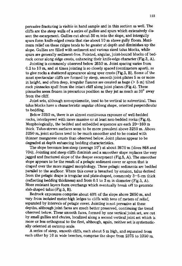
Fig.3. "Alvin" bow camera photographs of patchreef/backreef limestones on lower part of Cat Island Escarpment (dive 666). A. Pinnacle (about 1 m wide) isolated by spallation of joint blocks f rom either side. Depth 3747 m, 15 m below stat ion 10. View is approxi- mately 2 m across. B. Pervasive jointing with spacing of 5--20 cm. Depth 3618 m at station 14. View is approximately 3 m across.
126
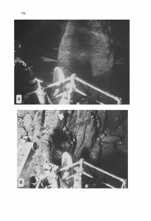
Fig.4. "Alvin" dive 704 bow-camera photomosaic, showing near-vertical cliff with alterna- tion of thin- (5--10 cm) and thick- (50--100 cm) bedded Middle Cretaceous peritidal lime stone on the Cat Island Escarpment. Sequence is probably a shoaling-upwards cycle. Irregular fissure, 10 m high, on right side of photograph separates joint block from main cliff. Depth is 3254 m at bottom of photograph and 3242 m at top.
127
influx and precipitation in a schizohaline environment (Folk and Siedlecka, 1974).
Miliolid foraminifera and smooth, thin-shelled ostracods are typical of low- energy, restricted environments and comprise the bulk of the fossil suite con- tained in these peritidal samples of peloidal wackestones/packstones (Fig.9-2). A few samples (sorted intraclastic packstones to grainstones) contain a more diverse flora and fauna, e.g. Trocholina foraminifera (Fig.9-3}, Porostromata Cayeuxia, Clypeina and Salpingoporella algae (Fig. 9-4) which indicate more vigorous, probably near-tidal channel conditions, as do the associated super- ficial ooids in samples 866-1, -2 and -11. Effective communication with the open ocean, or a series of storm events, is suggested by the presence of sparse Tintinnids (Tintinnopsella and Calpionellites) in 867-1 and 867-2, while proxi- mity to fresh or brackish water is indicated by Characeae oogonia (867-6, -9}.
The patchreef/backreef lithofacies is characterized by bioclastic sparites and sparrudites that were deposited in a high-energy environment (Fig.10). Bioclasts are rounded, exhibit fair sorting and often have micritized rims. Bio- clasts are composed of algal (Solenoporaceae and Cayeuxia), coral rudist and gastropod fragments. Additional skeletal debris consist of echinoid spines and benthic foraminifera typical of backreef environments (Cuneolina). Early fibrous palisade calcite cement is probably derived from aragonite needles deposited under marine conditions, while less common "gravitational cement" and later blocky calcite represent vadose and fresh-water diagenesis.
The close association of this lithofacies with the peritidal lithofacies and the occurrence of Monopleura which is typical of lagoonal biostromes (Wilson, 1975) suggests a patchreef, rather than a backreef environment of deposition, for these rocks, but a backreef interpretation is not ruled out.
The age of these two lithofacies is poorly controlled. The base of the section appears to be lowermost Cretaceous (Berriasian) or uppermost Jurassic in age. Although Solenoporaceae developed throughout the Mesozoic, they reached their acme in the Jurassic. This age assignment is supported by the occurrence of Trocholina cf. friburgensis and T. cf. elongate in the lower 300 m of the section.
A specimen of the gastropod Nerinea (866-7, 3832 m) provides a Valangin- ian to Early Cenomanian age, probably Valanginian based on stratigraphic grounds. Specimens of Monopleura (866-12, 3636 m) (Fig.10) suggest a Late Neocomian to Aptian age for the lower patchreef/backreef lithofacies.
Small, primitive Cuneolina foraminifera suggest a Neocomian age for the upper patchreef/backreef sequence as well as for the bottom of the peritidal sequence traversed during dive 704. A Valanginian to Aptian age is indicated for sample 704-2 by more evolved Cuneolina foraminifera and Cylindroporella algae.
The sparse Tintinnids of samples 867-1,867-2, and 867-7 provide a Neo- comian age as do abundant, well-preserved dasycladacean algae (Salpingo- porella, Cylindroporella, and Munieria). Cuneolina foraminifera indicate a Valanginian to Aptian age.
I
129
These two lithofacies exhibit characteristic outcrop morphology. All but one (866-6) of the peritidal rocks recovered below 3398 m (dives 866 and 867) and the four peritidal samples collected during dive 704 came from bedded outcrops. The massive intervals from 3765 to 3635 m and from 3615 to 3595 m yielded patchreef]backreef samples. This difference in bedding style has allowed us to visually map the distribution of these lithofacies with con- fidence below 3398 m for the portion of the slope traversed during dives 866 and 867 (Figs.6 and 11). Within the'peritidal sequence, it is also possible to relate thick-bedded (20--100 cm) intervals with intertidal rocks, but this rela- tionship is more tenuous.
Above 3398 m, a correlation between lithology and outcrop morphology is not possible. Peritidal facies rocks were recovered from both massive and bedded intervals. The lack of backreef samples from 3398 to 3000 m suggests that the entire section consists of peritidal lithofacies.
Based on sample lithology, this unit appears to consist of at least five shoaling-upwards cycles, features which are typical of tidal-flat environments {James, 1977). Each cycle begins with open-marine or high-energy deposits and evolves toward shallower, more restricted, lower energy tidal flat deposits which have built up to and occasionally above sea-level. Oolitic, high-energy tidal channel sediments initiate two cycles (866-1, -2, and 867-11); patchreef/ backreef deposits are found at the base of another two cycles {866-10 to -12 and 866-14 and -15); and the fifth cycle begins with open-marine subtidal rocks (867-1, -2). These cycles range from 150 to 250 m in thickness.
The shoaling-upward sequence facies model described in James (1977) indicates that cycles are 5--10 m thick. The cycles observed on the Cat Island slope are much thicker, suggesting that they are megacycles which probably consist of a number of 5--10 m thick sequences. That such sequences do occur in the Cat Island section is indicated: (1) by 10--20 cm thick intercala- tions of subtidal and intertidal lithologies at several samples, e.g., 866-3, 866-6, 867-6, and (2) by alternation of thin and thick beds in outcrops over 10--15 m intervals (Fig. 4).
Unit 2. The second unit comprising the Cat Island section is that part of the slope traversed by dive 868 and extending from about 3000 to 2050 m. This subsequence consists of three lithofacies (subtidal, lagoonal and backreef) of Middle Cretaceous age (Barremian/Aptian to Cenomanian).
Allochems in both lagoonal and subtidal rocks are predominantly pellets and intraclasts with occasional abundant biogenic debris in subtidal samples.
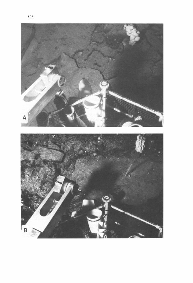
Fig. 5. "Alvin" dive 868 bow-camera photographs of breached pelagic drape observed above 2670 rn on the Cat Island Escarpment. A. Maastrichtian pelagic limestone showing develop- ment of large (1 m) plate-like talus and internal stratification parallel to seafloor. Depth is 2611 rn. View is about 3 rn across. B. Eocene pelagic limestone showing DSRV "Alvin" 's ski, extending approximately 10 cm under cantilevered bed. Depth is 2088 m. View is about 3 m across.
,,,
~ ~
_ .
..
..
.
~/~
l
, ,
Y ,,
~
~ ~,
~1~o
~, .
~ ~
~ :.
~,
~ ~.
~ ,~
#,
:
L..
...
...
..
..
..
.
• o
o
• •
• •
• ii
•
• ii
•
ii
• •
r q
• R
es
tric
ted
ta
go
on
T
ida
t fl
at
<
(3p
en
mlh
tid
al
.~
Pa
t{h
i~
ef
Bio
cla
sli
c
sho
at
~ck
ree
~ /
P~
ee f
Fo
re r
ee
l Z
P
ela
gic
E 0
• oe
Q
oo
• •
i oo
~
• i
.
o ~
.o
• °o
o o
o o
o
° ~
~ °
~ ~
..
..
.
" °
o o
o ~ ~
o o
o °°c~
° ~o
oo
o °og-
o oo
o o
o
~ m
ud
sto
nc
m
~
o ~
~
p
ae
ks
ton
e
~ g
rain
sto
l~e
~ -"
"
bo
utl
ds
ton
e
~
hto
/bio
ela
~t~
c b
rec
cia
m
, -
-
m
E A
t~,L
y
CR
E l
AC
EO
t)S
i
"' M
IDI)
LE
~
:Rt
T A
C:~
()U
S '
' i z
I 1
I a
~e
r M
aast
ric
hti
an
Eocene
Tro
eh
oli
na
sp
C41
rleo
Hno
Sp
~
Cur
leol
ina
latw
enti
i "~
Ctm
eoli
na p
avon
ia
pd
r~
~
Cel
pion
elli
ten
sp
~ Z
Til
~tin
rlop
~lla
Sp
e ~
rbo
na
t~,
pla
l ~
ur~
* ~>
~3
pe
lag
ic
dra
pe
131
AGE
50 I00
-I000
-2000
- 5 0 0 0
- 4 0 0 0
~my
ANDROS \
WELL \\
CAT ISLAND
SOBS,DENCE 0F CAT ISLAND '\
AND ANDROS WELL SECTIONS \
i ~ i i I i i i i i
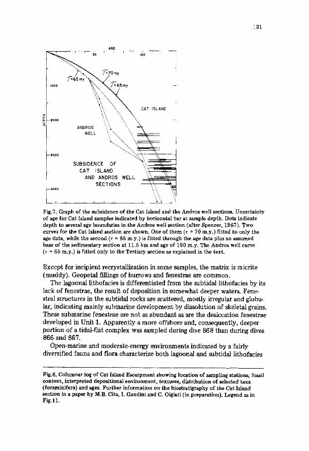
Fig.7. Graph of the subsidence of the Cat Island and the Andros well sections. Uncertainty of age for Cat Island samples indicated by horizontal bar at sample depth. Dots indicate depth to several age boundaries in the Andros well section (after Spencer, 1967). Two curves for the Cat Island section are shown. One of them (r = 70 m.y.) fitted to only the age data, while the second (~ = 65 m.y.) is fitted through the age data plus an assumed base of the sedimentary section at 11.5 km and age of 190 m.y. The Andros well curve (T = 65 m.y.) is fitted only to the Tertiary section as explained in the text.
Except for incipient recrystallization in some samples, the matrix is micrite {muddy). Geopetal fillings of burrows and fenestrae are common.
The lagoonal lithofacies is differentiated from the subtidal lithofacies by its lack of fenestrae, the result of deposition in somewhat deeper waters. Fene- stral structures in the subtidal rocks are scattered, mostly irregular and globu- lar, indicating mainly submarine development by dissolution of skeletal grains. These submarine fenestrae are not as abundant as are the desiccation fenestrae developed in Unit 1. Apparently a more offshore and, consequently, deeper portion of a tidal-flat complex was sampled during dive 868 than during dives 866 and 867.
Open-marine and moderate-energy environments indicated by a fairly diversified fauna and flora characterize both lagoonal and subtidal lithofacies
Fig.6. Columnar log of Cat Island Escarpment showing location of sampling stations, fossil content, interpreted depositional environment, textures, distribution of selected taxa (foraminifera) and ages. Further information on the biostratigraphy of the Cat Island section in a paper by M.B. Cita, I. Gandini and C. Olgiati (in preparation). Legend as in Fig.11.
132
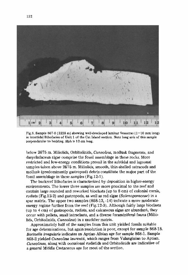
Fig.8. Sample 867-8 (3228 m) showing well-developed laminar fenestrae (1--10 mm long) in intertidal lithofacies of Unit 1 of the Cat Island section. Note long axis of this sample perpendicular to bedding. Slab is 13 cm long.
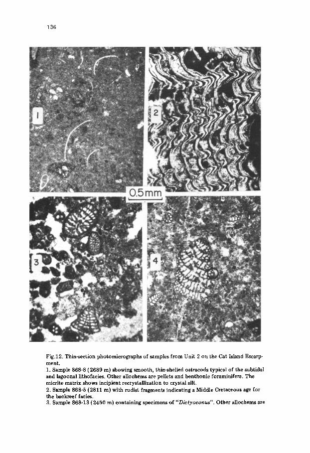
below 2675 m. Miliolids, Orbitolinids, Cuneolina, mollusk fragments, and dasycladacean algae comprise the fossil assemblage in these rocks. More restricted and low-energy conditions prevail in the subtidal and lagoonal samples taken above 2675 m. Miliolids, smooth, thin-shelled ostracods and mollusk {predominantly gastropod) debris constitute the major part of the fossil assemblage in these samples (Fig.12-1).
The backreef lithofacies is characterized by deposition in higher-energy environments. The lower three samples are more proximal to the reef and contain large rounded and reworked bioclasts (up to 8 cm) of colonial corals, rudists fiFig.12-2) and gastropods, as well as red algae (Solenoporaceae) in a spar matrix. The upper two samples (868-13, -14) indicate a more moderate- energy regime further from the reef (Fig.12-3). Although fairly large bioclasts (up to 4 cm) of gastropods, rudists, and calcareous algae are abundant, they occur with pellets, small intraclasts, and a diverse foraminiferal fauna (Milio- lids, Orbitolinids, Cuneolina) in a muddier matrix.
Approximately half of the samples from this unit yielded fossils suitable for age determinations, but again resolution is poor, except for sample 868-18. Bacinella irregularis indicates an Aptian-Albian age for sample 868-1. Sample 868-2 yielded Cuneolina laurentii, which ranges from Valanginian to Aptian. Cuneolinas, along with occasional rudistids and Orbitolinids are indicative of a general Middle Cretaceous age for most of the section.
133
Fig.9. Thin-section micrographs of samples from Unit 1 on the Cat Island Escarpment. 1. Sample 867-13 (3101 m) showing fenestral character of intertidal lithofacies. Laminar fenestrae are approximately 1 mm wide. Fenestrae contain geopetal crystal silt and blocky calcite spar. 2. Sample 867-14 (3075 m) showing miliolid foraminifera typical of the peritidal litho- facies. Note micritized chamber walls and spar-filled chambers. 3. Sample 866-13 (3632 m) with a specimen of Trocholina alpina (at center) indicating a Neocomian are for the lower part of the Cat Island section. Sample exhibits enlarged pore space resulting from dissolution. Allochems are principally pellets and skeletal debris. 3. Sample 866-13 (3632 m) with a specimen of Trocholina cf. friburgensis (at center) in- dicating a Neocomian age for the lower part of the Cat Island section. Sample exhibits en- larged pore space resulting from dissolution. Allochems are principally pellets and skeletal debris. 4. Sample 866-2 (3917 m) showing a subaxial section of the dasycladacean alga Salpingo- porella. Texture similar to that of 866-4.
134
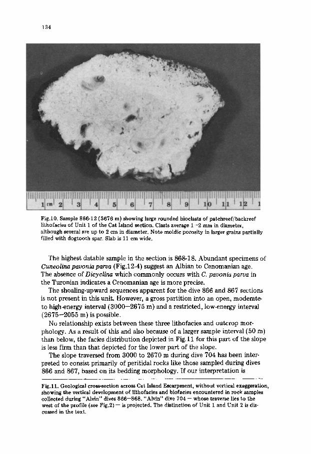
Fig.10. Sample 866-12 (3676 m) showing large rounded bioclasts of patchreef/backreef lithofacies of Unit 1 of the Cat Island section. Clasts average 1--2 mm in diameter, although several are up to 2 cm in diameter. Note moldic porosity in larger grains partially filled with dogtooth spar. Slab is 11 cm wide.
The highest datable sample in the section is 868-18. Abundant specimens of Cuneolina pavonia parva (Fig.12-4) suggest an Albian to Cenomanian age. The absence of Dicyclina which commonly occurs with C. pavonia parva in the Turonian indicates a Cenomanian age is more precise.
The shoaling-upward sequences apparent for the dive 866 and 867 sections is not present in this unit. However, a gross partit ion into an open, moderate- to high-energy interval (3000--2675 m) and a restricted, low-energy interval (2675--2055 m) is possible.
No relationship exists between these three lithofacies and outcrop mor- phology. As a result of this and also because of a larger sample interval (50 m) than below, the facies distribution depicted in Fig. 11 for this part of the slope is less firm than that depicted for the lower part of the slope.
The slope traversed from 3000 to 2670 m during dive 704 has been inter- preted to consist primarily of peritidal rocks like those sampled during dives 866 and 867, based on its bedding morphology. If our interpretation is
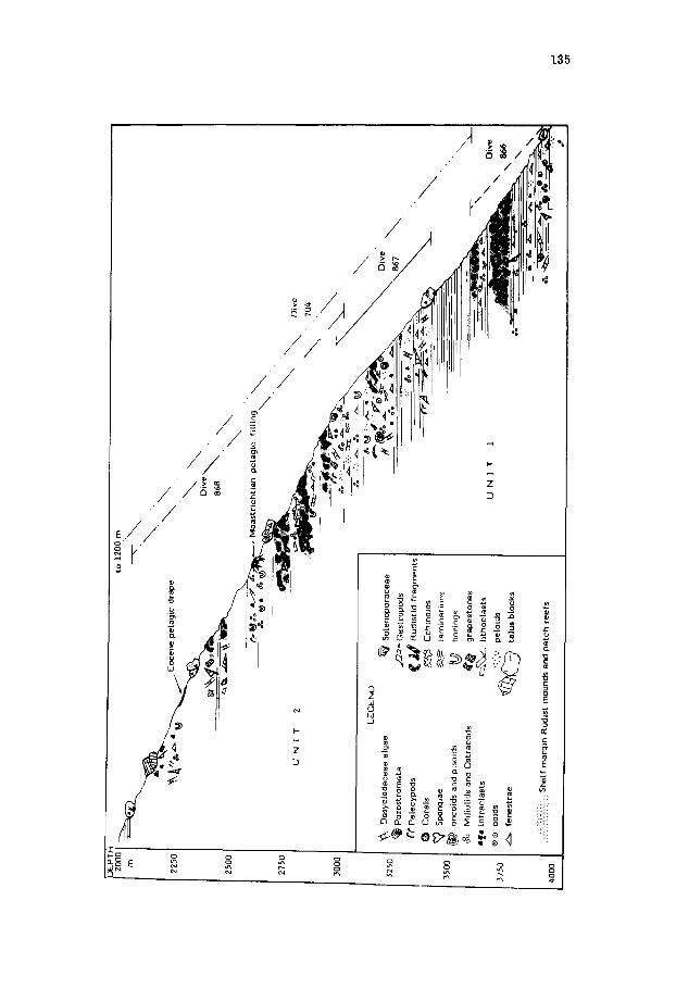
Fig.11. Geological cross-section across Cat Island Escarpment, without vertical exaggeration, showing the vertical development of lithofacies and biofacies encountered in rock samples collected during "Alvin" dives 866--868. "Alvin" dive 704 -- whose traverse lies to the west of the profile (see Fig.2) -- is projected. The distinction of Unit I and Unit 2 is dis- cussed in the text.
3500
S750
~000
\ &¢
r~o ~
v.
..~
E ..
...
pela
gic
drap
e
INIT
2
--
=&
~
l
-EC
EN
D
~x
Das
yela
dace
ae a
lgae
(~
So
leno
pora
ceae
(~
Por
ostr
omat
a ~
Gas
tropo
ds
~'t"
Pel
ecyp
ods
~ ~
Rud
istid
fra
gmen
ts
(~
Cor
als
~ E
chin
oids
~
) 5p
ongi
ae
~ la
min
Atin
ns
~)
onco
ids
and
piso
ids
~:~
borin
gs
o°o
Mili
olid
s an
d O
stra
cods
~
grap
esto
nes
I~e
intr
acla
sts
t:~
,~
~ lit
hocl
asts
')
~ oo
ids
d:cX
~.
::¼":'
pel
oids
fe
nest
rae
~ ta
lui
bloc
ks
She
lf m
argi
n R
udis
t m
ound
s an
d pa
tch
reef
s
o 1200 m
\\
\ D
ive
~
868
"~
~ st
rich
tian
pe
lagi
c fi
llin
g"
__
~.:
.:.
~ ~
~ ¢o
.:.
. ~_
~o
.~-~
~o~
~,~'.
..-.~
JNI
T
\\
Div
e
" 70
4
\
~O
Jnl
136
Fig.12. Thin-section photomicrographs of samples from Unit 2 on the Cat Island Escarp- ment. 1. Sample 868-8 (2689 m) showing smooth, thin-shelled ostracods typical of the subtidal and lagoonal lithofaeies. Other allochems are pellets and benthonic foraminifera. The micrite matrix shows incipient recrystallization to crystal silt. 2. Sample 868-5 (2811 m) with rudist fragments indicating a Middle Cretaceous age for the backreef facies. 3. Sample 868-13 (2450 m) containing specimens of "Dictyoconus". Other allochems are
137
correct, a lateral facies change must occur to account for the lagoonal and backreef lithofacies sampled during dive 868. Apparently, tidal-flat conditions characterized the western part of the Cat Island slope while lagoonal condi- tions prevailed in the east during Barremian/Aptian time.
Rapid lateral variations in lithology such as this are not unexpected. Although carbonate lithofacies tend to occur in belts around shallow platforms (Wilson, 1975), these belts vary in width along strike and the presence or absence of an individual facies belt depends upon local conditions. In addition, the lithologic make-up of each facies belt (Wilson, 1975) can vary widely due to the presence of local or intermittent features, such as patchreefs, cays or tidal channels. In terms of Wilson's idealized sequence of facies belts (Wilson, 1975), the Cat Island section consists essentially of Standard Facies Belts 6, 7 and 8, i.e., sands at edge of platform and open and restricted platform facies.
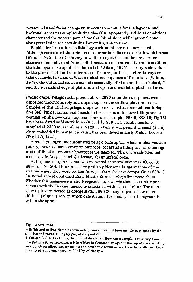
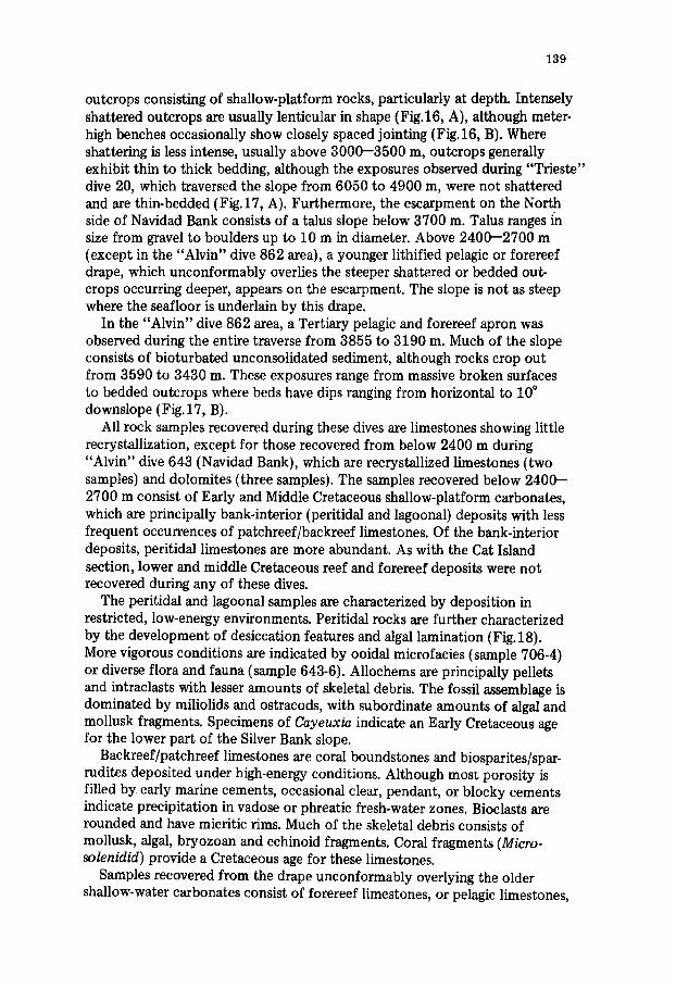
Pelagic drape. Pelagic rocks present above 2670 m on the escarpment were deposited unconformably as a slope drape on the shallow platform rocks. Samples of this lithified pelagic drape were recovered at four stations during dive 868. Pink foraminiferal limestone that occurs as fracture-fillings and as coatings on shallow-water lagoonal limestones (samples 868-9, 868-10; Fig.13) have been dated as Maastrichtian (Fig.14;1, -2; Fig.15). Pink limestone sampled at 2300 m, as well as at 2128 m where it was present as small (2 cm) chips embedded in manganese crust, has been dated as Early Middle Eocene (Fig.14-3,144).
A much younger, unconsolidated pelagic ooze apron, which is observed as a patchy, loose sediment cover on outcrops, occurs as a filling in macro-borings in six of the shallow-water limestones we sampled. This unconsolidated sedi- ment is Late Neogene and Quaternary foraminiferal ooze.
Authigenic manganese crust was recovered at several stations (866-5, -8; 868-12, -19, -20). These crusts are probably Neogene in age at three of the stations where they were broken from platform-facie.~ outcrops. Crust 868-19 (as noted above) contained Early Middle Eocene pe:agic limestone chips. Whether this manganese is also Neogene in age, or whether it is contempor- aneous with the Eocene limestone associated with it, is not clear. The man- ganese plate recovered at dredge station 868-20 may be part of the older lithified pelagic apron, in which case it could form manganese hardgrounds within the apron.
Fig. 12 continued.
miliolids and pellets. Sample shows enlargment of original interparticle pore space by dis- solution and partial filling by geopetal crystal silt. 4. Sample 868-18 (2210 m), the upmost datable shallow-water sample, containing Cuneo- lina pavonia parva indicating a late Albian to Cenomanian age for the top of the Cat Island section. Other allochems are pellets and benthonic foraminifera. Chamber walls have been micritized while chambers are filled by calcite spar.
138
Fig.13. Sample 868-10 (2600 m) showing filling of fractures in Middle Cretaceous lagoonal limestone by Maastrichtian pink pelagic limestone from the Cat Island section. Gastropod molds filled with sparry calcite. Slab is 10 cm wide.
COMPARISON OF CAT ISLAND DATA TO SUBMERSIBLE AND DREDGING RESULTS ELSEWHERE ON BAHAMA ESCARPMENT
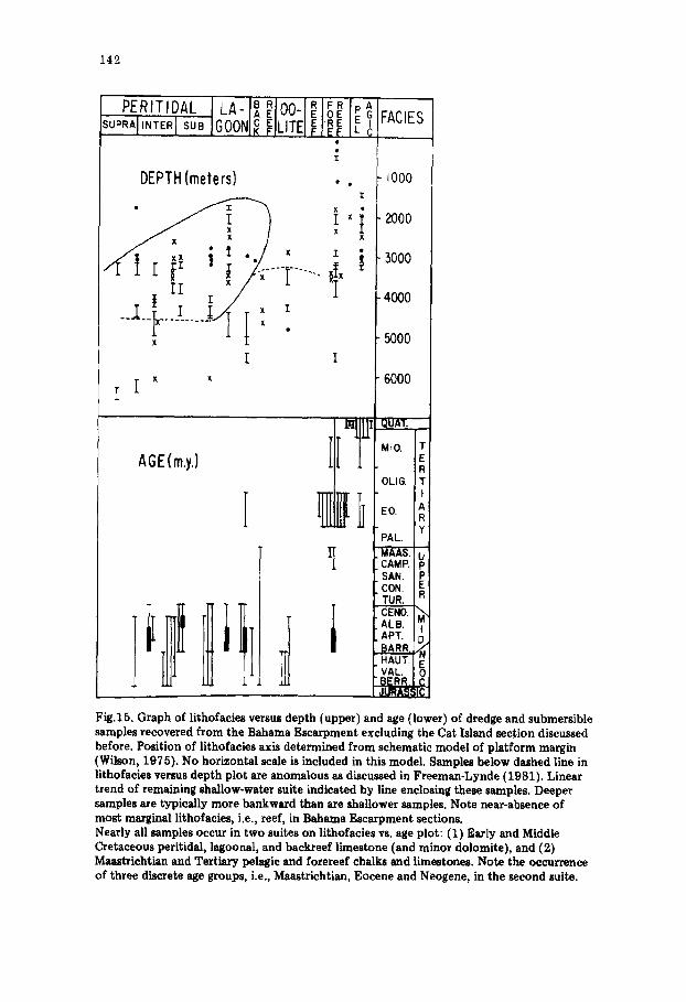
Our submersible and dredging results from elsewhere along the Bahama Escarpment indicate that shallow-water platform limestones of similar age and lithofacies occur along the 800 km of the escarpment southeast of Cat Island. Location of submersible dives and dredge stations are shown in Fig.1. Ages and facies of all samples investigated have been plotted versus depth in Fig. 15. Some comments follow separately, concerning: (1) submersible results, and (2) dredging results.
Submersible results
Submersible dives were made with DSRV "Alvin" and DSV "Trieste" at several localities (Fig.l), including: a knoll situated between Silver Bank and Navidad Bank ("Alvin" dive 706), the northern ("Trieste" dives 18 and 19) and southern ("Alvin" dive 643 and "Trieste" dive 20) slopes of Navidad Bank, and near a small canyon incising a slope northeast of Eleuthera Island ("Alvin" dive 862).
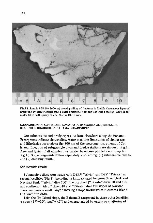
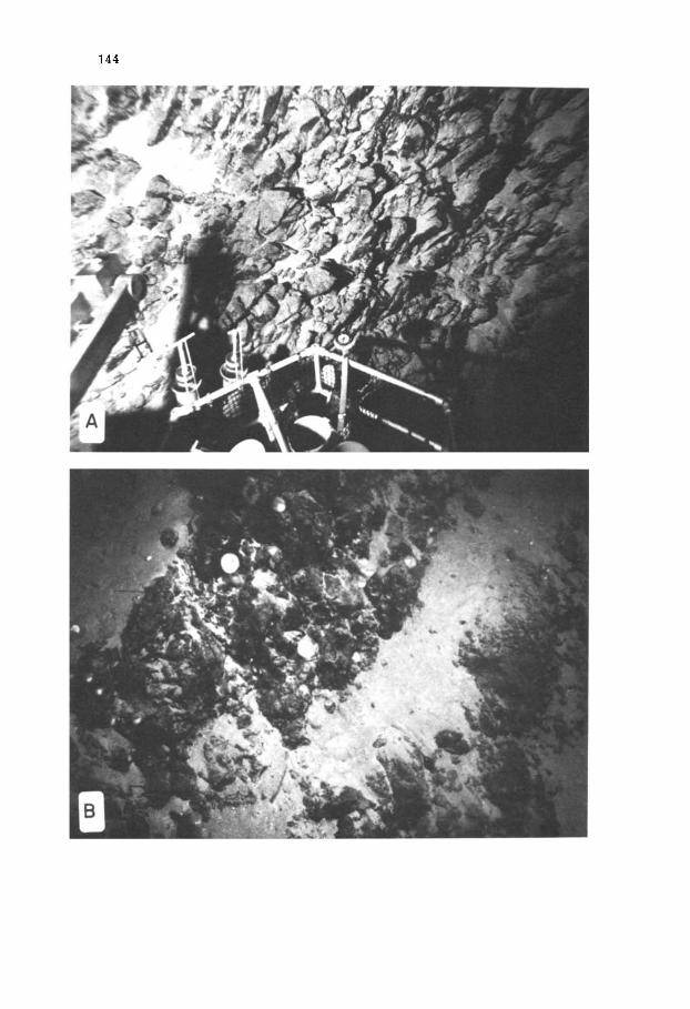
Like the Cat Island slope, the Bahama Escarpment in these other localities is steep (15°--30 °, locally 45 °) and characterized by extensive shattering of
139
outcrops consisting of shallow-platform rocks, particularly at depth. Intensely shattered outcrops are usually lenticular in shape (Fig.16, A), although meter- high benches occasionally show closely spaced j ointing (Fig. 16, B). Where shattering is less intense, usually above 3000--3500 m, outcrops generally exhibit thin to thick bedding, although the exposures observed during "Trieste" dive 20, which traversed the slope from 6050 to 4900 m, were not shattered and are thin-bedded (Fig.17, A). Furthermore, the escarpment on the North side of Navidad Bank consists of a talus slope below 3700 m. Talus ranges in size from gravel to boulders up to 10 m in diameter. Above 2400--2700 m {except in the "Alvin" dive 862 area), a younger lithified pelagic or forereef drape, which unconformably overlies the steeper shattered or bedded out- crops occurring deeper, appears on the escarpment. The slope is not as steep where the seafloor is underlain by this drape.
In the "Alvin" dive 862 area, a Tertiary pelagic and forereef apron was observed during the entire traverse from 3855 to 3190 m. Much of the slope consists of bioturbated unconsolidated sediment, although rocks crop out from 3590 to 3430 m. These exposures range from massive broken surfaces to bedded outcrops where beds have dips ranging from horizontal to 10 ° downslope ( Fig. 17, B).
All rock samples recovered during these dives are limestones showing little recrystallization, except for those recovered from below 2400 m during "Alvin" dive 643 (Navidad Bank), which are recrystallized limestones (two samples) and dolomites (three samples). The samples recovered below 2400-- 2700 m consist of Early and Middle Cretaceous shallow-platform carbonates, which are principally bank-interior (peritidal and lagoonal) deposits with less frequent occurrences of patchreef/backreef limestones. Of the bank-interior deposits, peritidal limestones are more abundant. As with the Cat Island section, lower and middle Cretaceous reef and forereef deposits were not recovered during any of these dives.
The peritidal and lagoonal samples are characterized by deposition in restricted, low-energy environments. Peritidal rocks are further characterized by the development of desiccation features and algal lamination (Fig.18). More vigorous conditions are indicated by ooidal microfacies (sample 706-4) or diverse flora and fauna (sample 643-6). Allochems are principally pellets and intraclasts with lesser amounts of skeletal debris. The fossil assemblage is dominated by miliolids and ostracods, with subordinate amounts of algal and mollusk fragments. Specimens of Cayeuxia indicate an Early Cretaceous age for the lower part of the Silver Bank slope.
Backreef/patchreef limestones are coral boundstones and biosparites/spar- rudites deposited under high-energy conditions. Although most porosity is filled by early marine cements, occasional clear, pendant, or blocky cements indicate precipitation in vadose or phreatic fresh-water zones. Bioclasts are rounded and have micritic rims. Much of the skeletal debris consists of mollusk, algal, bryozoan and echinoid fragments. Coral fragments (Micro- solenidid) provide a Cretaceous age for these limestones.
Samples recovered from the drape unconformably overlying the older shallow-water carbonates consist of forereef limestones, or pelagic limestones,
140
Fig.14. Thin-section photomicrographs from samples of the pelagic drape on the Cat Island Escarpment. 1. Sample 868-10 (2600 m) containing abundant Maastrichtian planktonic foraminifera ( Globotruncana spp., Globigerinelloides spp., Pseudotextularia elegans, Planoglobulina acervulinoides) in pelagic limestone which fills fissures in Middle Cretaceous lagoonal limestone. 2. Sample 868-10 (2600 m) showing two thin seams of Maastrichtian pelagic limestone in Cretaceous (probably Albian) lagoonal limestone. Host-rock consists of biomicrite mudstone
141
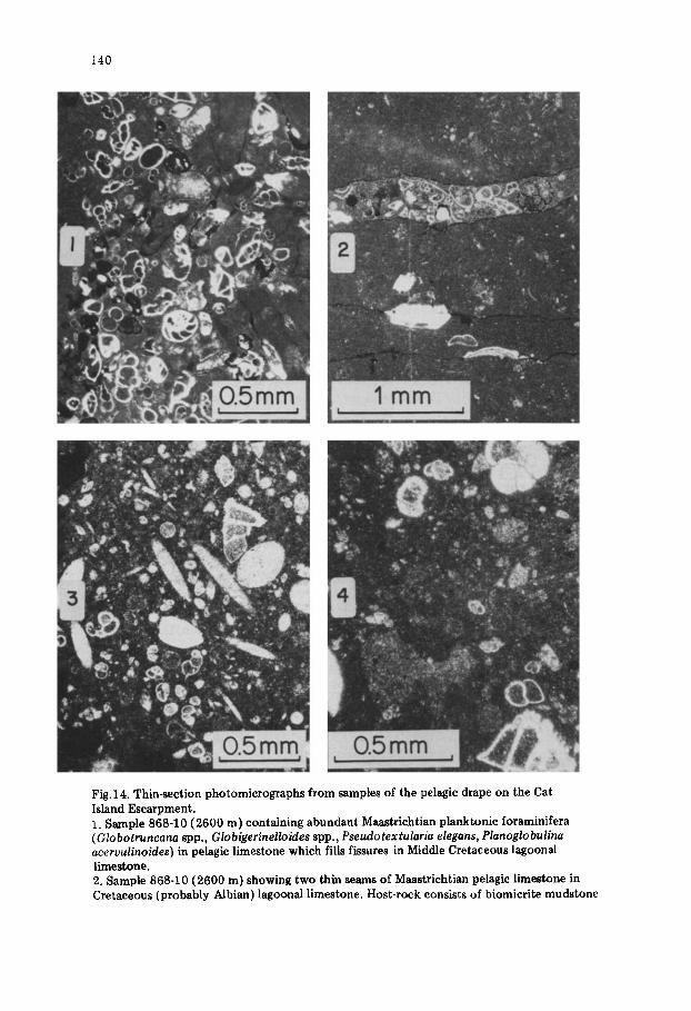
chalk and ooze. Ages determined for the forereef limestone are Maastrichtian {sample 643-7, see Fig.19-1) and Eocene {samples 643-8, .9 and samples 862-2, -3, -4, see Fig.19-2). Pelagic samples indicate Eocene (limestones), Neogene {chalk), and Quaternary (ooze) ages. Forereef samples generally contain abundant shallow-water debris, as well as numerous large foraminifera, while shallow-water debris is absent in pelagic samples, which contain only plank- tonic foraminifera.
Dredging results
The majority of dredge samples recovered from the Bahama Escarpment can be divided into two suites of rocks, which correlate almost exactly with the Cat Island and other submersible samples. The first suite consists of peri- tidal, lagoonal, patehreef, and rare backreef limestones, which are Early and Middle Cretaceous in age when datable, and also includes several supratidal to intertidal dolomites from Navidad Bank. All but three samples of this suite were dredged from deeper than 2750 m.
The second suite consists of pelagic and forereef limestones and chalks which are latest Cretaceous and Tertiary in age. All but four samples of this suite were dredged from shallower than 3000 m.
Early and Middle Cretaceous platform limestones and dolomites are charac- terized by deposition in generally low-energy, restricted environments assoc- iated principally with tidal fiats and lagoons.
Desiccation features and algal lamination are well developed in tidal-flat samples, while lagoonal deposits are more typically bioturbated. Allochems consist of pellets, intraclasts and skeletal debris. Miliolids and ostracods (Fig.19-3) are conspicuous components of the fossil assemblage in these rocks. The occurrence of other flora and fauna, including foraminifera, dasycladacean algae, red algae, gastropods, and pelecypods, echinoid and bryozoan fragments in the fossil assemblage of several samples suggests normal salinity and less- restricted conditions. High-energy tidal-channel and bar conditions are indi- cated by small channels and rip-up clasts as well as ooidal microfacies (Fig. 19-4).
Patchreef, or backreef samples, which are subordinate constituents of this first suite of rocks are generally biosparites and biosparrudites containing rounded, well-worn bioclasts. However, included in this microfacies are pelbio- micrites and pelbiomicrudites, which contain rounded bioclasts in a muddy
with ostracods and skeletal debris including Cuneolina spp. Notice the thin film of iron and/or manganese oxides coating the walls of the fissures, which documents the exposure of the Cat Island Escarpment to the deep oceanic realm in pre-Maastrichtian times. 3. Sample 868-16 (2300 m) containing early Middle Eocene planktonic foraminifera in a pelagic limestone which unconformably overlies Middle Cretaceous lagoonal, backreef and subtidal limestone. A specimen of Globorotalia aragonensis is at the upper right. Note abundant spicules and numerous small globigerinids. 4. Sample 868-16 (2300 m). Pelagic limestone of early Middle Eocene draping the escarp- ment, which consists of Middle Cretaceous lagoonal backreef and subtidal limestone (Unit 1 of Cat Island Escarpment).
142
SUPRAI'NTER I sub IGOONI~ ~ILITEI E RE [ ?IFACIES EF G
DEPTH (meters) . . - Iooo Z
x ! x i " 2000
I 'T ...... ~' -3ooo
. . . . . 5000 [ I
I [ x ~ 6000
AGE(m.y.) II
¸ i
i l l
QUAT.
MIO. T E R
OLIG. T t
EO. A R
PAL. Y
L MAAS. U CAMP. p
i SAN. P h CON. E
TUR. R CENO. ALB. I APT. I D
HAUT. VAL. ;~) BERR. ~ C JURASSIC
Fig.15. Graph of lithofacies versus depth (upper) and age (lower) of dredge and submersible samples recovered from the Bahama Escarpment excluding the Cat Island section discussed before. Position of lithofacies axis determined from schematic model of platform margin (Wilson, 1975). No horizontal scale is included in this model. Samples below dashed line in litbofacies versus depth plot are anomalous as discussed in Frceman-Lynde (1981). Linear trend of remaining shallow-water suite indicated by line enclosing these samples. Deeper samples are typically more bankward than are shallower samples. Note near-absence of most marginal lithofacies, i.e., reef, in Bahama Escarpment sections. Nearly all samples occur in two suites on lithofacies vs. age plot: (1) Early and Middle Cretaceous peritidal, lagoonal, and backreef limestone (and minor dolomite), and (2) Maastrichtian and Tertiary pelagic and forereef chalks and limestones. Note the occurrence of three discrete age groups, i.e., Maastrichtian, Eocene and Neogene, in the second suite.
143
matrix, suggesting a low-energy depositional environment proximal to a higher- energy patchreef. Bioclasts are composed of mollusks, corals, bryozoan and echinoid fragments and foraminifera, as well as rare red and coralline algal fragments.
Like the Cat Island section, about half of the dredge samples from these two lithofacies yielded fossils suitable for age determinations, but resolution is poor. Early Cretaceous ages are provided by Cayeuxia and Solenoporaceae, although Neocomian ages are indicated by frequently associated Salpingo- porella, Clypeina and Cylindroporella, and by primitive Cuneolina. Specimens of Cuneolina laurentii indicate a Valanginian to Aptian age while Nerinea pro- vides a Valanginian to Early Cenomanian age. More evolved specimens of Cuneolina indicate a Middle Cretaceous age, as do specimens of Nummolo- culina and Dictyoconus. Specimens of Cuneolina pavonia parva and Litho- phyllum (?) venezuelanum indicate an Albian age for a sample recovered from Navidad Bank (Schneidermann et al., 1972).
It is clear that the overall composite stratigraphic sequence represented by these dredge samples matches the stratigraphic section established for the Cat Island slope exceptionally well. Neocomian and Early Cretaceous age samples occur principally below 3000 m, or so, and consist generally of peritidal and patchreef/backreef limestones, thus corresponding well with the lower part of the Cat Island section. Middle Cretaceous and Barremian/Aptian age samples consist of lagoonal, peritidal and backreef limestones and correspond litho- logically to the upper part of the Cat Island section. The paucity of bedrock samples from above 3000 m, and particularly above 2750 m reflects the presence of younger drape which allows only intermittent exposure of older rocks as documented during submersible traverses on the Bahama Escarpment. The recovery of more than one lithology at several dredge hauls shows that, like the Cat Island section, these lithologies are intercalated over intervals of tens to hundreds of meters and that shoaling-upward sequences are common.
Although the dolomitic dredge samples recovered from Navidad Bank do not have a counterpart in the Cat Island and Silver Bank sections, dolomitic rocks were obtained from the Navidad Bank slope during "Alvin" dive 643.
The occurrence of dolomite on the Navidad Bank slope appears to be a local phenomenon rather than a regional feature of the rocks cropping out on the Bahama Escarpment.
The Late Cretaceous and Tertiary suite of samples consists of both forereef and pelagic limestones which cluster into three discrete age groups: Maastrich- tian, Eocene and Neogene (Fig.15).
Forereef deposits are characterized by an abundance of coral, echinoid and mollusk fragments, miliolids and algae (coralline and encrusting forms), as well as larger foraminifera typical of the forereef. The depth of water in which these rocks were deposited is not certain, but probably ranges from less than one hundred to several hundred meters. Some of the samples have been dis- placed great distances downslope following deposition. Samples are predomi- nantly biomicrites and biomicrudites.
Pelagic samples are Neogene chalks and Eocene chalks and limestones. Of the pelagic samples, only sample E1577 contains displaced Amphistegina and
144
145
platform-derived clasts, and probably represents a deep forereef, or pelagic environment.
This suite of samples correlates with the pelagic and forereef drape observed during submersible dives on the Bahama Escarpment. Although the morphology of the slopes which were dredged have not actually been observed, these fore- reef and pelagic deposits, particularly those dredged below 1500 m, probably overlie unconformably exposures represented by the suite of older rocks, as documented during the submersible dives on the Cat Island and Silver and Navidad slopes.
DISCUSSION
Comparison of Bahama Escarpment sections with Early and Middle Cretaceous of Gulf of Mexico and East Coast of North America
During the Early and particularly the Middle Cretaceous the Bahama Plat- form formed part of a much larger carbonate province consisting of both shallow platforms and deeper basins which had developed on the subsiding passive continental margins surrounding the Gulf of Mexico and extending up the east coast of North America to the Georges Bank area.
Our results from the Bahama Escarpment, then, are a significant addition to the study of this Mesozoic carbonate province and allow a comparison of the Bahama Escarpment sections with the remainder of the province. Although the Cat Island and Silver and Navidad Bank sections and the composite section deduced from the dredge samples are similar in overall character to those of the other platforms of the Gulf and Atlantic Cretaceous, distinct differences in lithology exist among these areas.
The Bahama Escarpment sections show the greatest lithologic contrast with known sections in the interiors of the Gulf and Bahama platforms. Wells in Mexico, the Yucatan peninsula, Florida, Cuba, and the Bahama Platform pene- trated thick sequences of interbedded shallow-water evaporites (principally anhydrite and gypsum, but also some halite), dolomites and limestone (Applin and Applin, 1965; Spencer, 1967; G~odell and Garman, 1969; Griffith et al., 1969; Bryant et al., 1969; Coogan et al., 1972; Enos, 1974; Meyerhoff and Hatten, 1974; Tator and Hatfield, 1975; Lopez-Ramos, 1975; Wilson, 1975), while no evaporites and little dolomite (only from Navidad Bank) are observed in the Bahama Escarpment sections.
Such lithologic differences probably result from the marginal position of the Bahama Escarpment sections and the proximity to relatively cool and
Fig.16. Bow-camera photographs of shattered limestones at southeastern end of Bahama Escarpment. A. Intensely-shattered lower Cretaceous peritidal l imestone on the Silver Bank slope. Fractures are spaced from 5 to 20 cm apart. Depth is 3536 m. View is approximately 4 m across. "Alvin" dive 706. B. Shattered Cretaceous limestone on north- ern Navidad Bank slope near rock sample station. Outcrops are 1 m thick benches with thin sediment cover on tops of benches. View is approximately 3 m across, "Tries te" dive 18.
7~
147
normal-salinity ocean waters. Although many of the samples recovered from the Bahama Escarpment indicate the development of restricted, perhaps hyper- saline conditions even in this marginal position, salinities did not increase to levels sufficient to cause evaporite precipitation or dolomitization, as occurred well back on these platforms.
Despite these lithologic differences, the bank-interior sections represent the same environments as the Bahama Platform sections, i.e., low-energy, restricted peritidal and lagoonal conditions. For example, Goodell and Garman (1969) suggest that the dolomites found in the Andros well were lagoonal pelmicrites and biopelmicrites, like those in the upper part of the Cat Island section, prior to dolomitization.
On the other hand, samples recovered from the marginal positions are, for the most part, more similar to the Bahama Escarpment samples in terms of lithology than are the bank-interior sections. In the north and west Gulf plat- forms, where the most data exist, two distinct lithofacies are present in these marginal areas. A relatively narrow zone (1--10 km wide) at the platform edge consists of a "reef" lithofacies, while bankward of this zone is a "backreef" (Enos, 1974) or "bank-interior" (Wilson, 1975) facies. The "reef" facies is characterized by coarse-grained skeletal packstones and grainstones, discon- tinuous rudist banks or reefs, and local oolite shoals, and are deposits typical of the high-energy environments found at bank edges. The "bank-interior" facies, on the other hand, is dominated by fenestral and stromatolitic mud- stones and wackestones, and miliolid and peloidal wackestones and pack- stones typical of low-energy, restricted environments, with minor skeletal packstones and grainstones associated with high-energy patchreefs, occurring in cyclic shoaling-upwards sequences.
The Bahama Escarpment sections, which are predominantly low-energy, restricted shoaling-upward sequences of peritidal mudstones, wackestones and packstones, with minor higher-energy patchreef, or backreef, skeletal packstones and grainstones, are lithologically correlative to the "bank-interior" facies. The high-energy "reef" facies is poorly represented in the Bahama Escarpment sections.
The margins of other portions of this Mesozoic platform have not been sampled as extensively as have the north and west Gulf platforms. The data consist of samples acquired at several DSDP sites on the Campeche Escarp- ment (Worzel/Bryant et al., 1973) and Blake Nose (Benson]Sheridan et al., 1978), and several dredge stations on the Campeche, West Florida and Blake Escarpments (Heezen and Sheridan, 1966; Bryant et al., 1969; Sheridan et al., 1969, 1971).
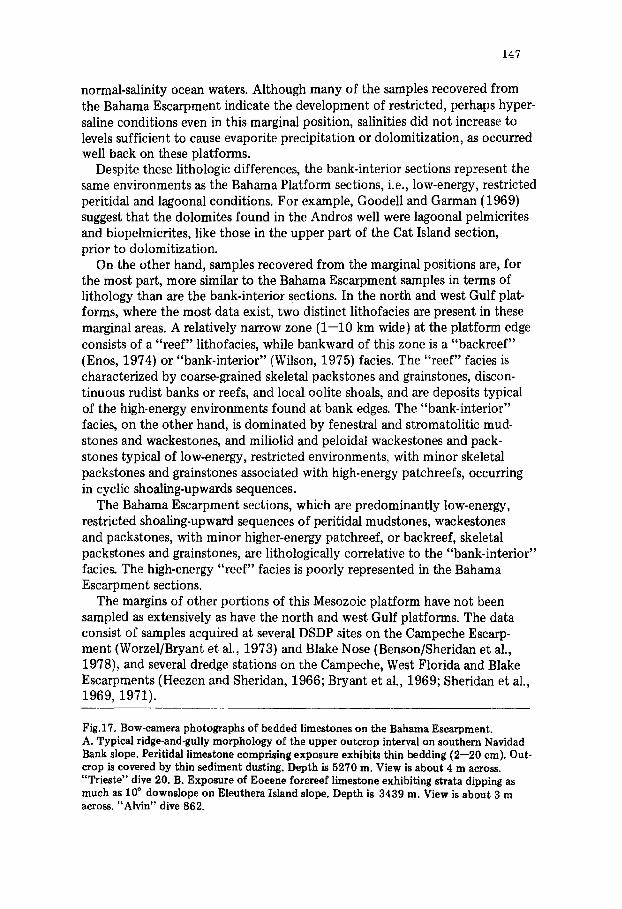
Fig.17. Bow-camera photographs of bedded limestones on the Bahama Escarpment. A. Typical ridge-and-gully morphology of the upper outcrop interval on southern Navidad Bank slope. Peritidal limestone comprising exposure exhibits thin bedding (2--20 cm). Out- crop is covered by thin sediment dusting. Depth is 5270 m. View is about 4 m across. "Trieste" dive 20. B. Exposure of Eocene forereef limestone exhibiting strata dipping as much as 100 downslope on Eleuthera Island slope. Depth is 3439 m. View is about 3 m across. "Alvin" dive 862.
@
e
n
!
9 J
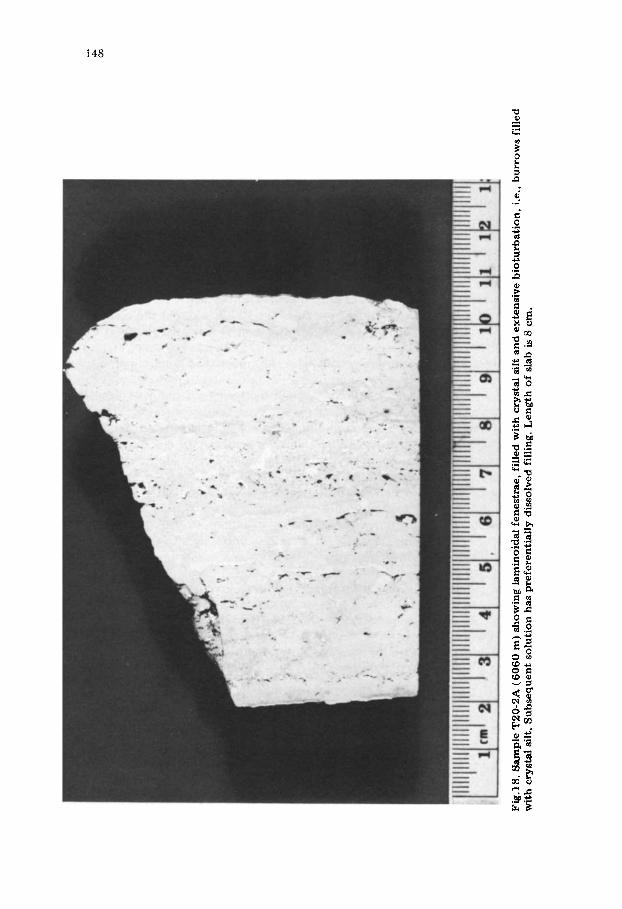
Fig.18. Sample T
20-2A (6060 m
) s
howi
ng la
mino
idal
fenestrae, filled wit
h crystal silt and e
xten
sive
bio
turb
atio
n, i.e., bur
rows
filled
with
crystal silt. Sub
sequ
ent
solu
tion
has
preferentially dissolved
filling. Len
gth
of slab is 8 c
m.
149
In general, the rocks recovered during these various studies are peritidal and lagoonal limestones and dolomites similar in age (Early and Middle Cretaceous) and lithology (miliolid and peloidal wackestones and packstones) to the Bahama Escarpment sections and corresponding to the "bank-interior" facies of the north and west Gulf platforms. Neocomian oolitic limestone (Blake Nose), Neocomian algal grainstone (Blake Escarpment) and Albian forereef deposits (Campeche Escarpment and Jordan Knoll) were recovered during these investigations as well. The Blake samples, although they were deposited under high-energy conditions, according to us probably represent "bank- interior", rather than "reef" facies, in light of their close association with unequivocal "bank-interior" deposits. Schlager and Ginsburg (this volume) note that Quaternary oolithic limestones extend across the platform west of Andros Island, supporting our interpretation of the Blake Nose samples.
The Albian forereef rocks from Campeche Escarpment and Jordan Knoll correspond to Middle Cretaceous forereef limestones recovered from the Silver Bank slope (E1603). The presence of these forereef deposits indicates that these margins have suffered a smaller amount of erosion than have the other Mesozoic platform margins (see following discussion).
Lastly, the Bahama Escarpment sections contrast with the other parts o~ the Mesozoic platform in containing no record of a termination of shallow- platform conditions in the Cretaceous and Early Tertiary. The Blake Nose section discussed above is Neocomian/Barremian in age and is separated by an erosional unconformity from Barremian and younger deep-water deposits (Enos and Freeman, 1978). This Barremian drowning of the Blake Nose is not evident in any of the Bahama Escarpment sections. The West Florida Escarp- ment shows similar drowning, although at a later, poorly constrained time, probably Late Cretaceous (Uchupi and Emery, 1968; Bryant et al., 1969; Garrison and Martin, 1973). The Blake Plateau became a deep-water province in the Late Cretaceous as well (Ewing et al., 1966; Dillon et al., 1979). The Bahama Platform, on the other hand, has remained a predominantly shallow- water province throughout the Late Cretaceous and Tertiary, although locally deep-water channels were developed, apparently due to drowning (Paulus, 1972). Also features like the San Salvador salient, and several knolls located 50 km seaward of the main bank margin (Fig.1) may have undergone drown- ing events similar to those experienced by the Blake Nose and West Florida Escarpment.
In summary, the Mesozoic sections exposed on the Bahama Escarpment correspond closely to coeval sections in the Gulf of Mexico which are situated at platform margins, although this close correspondence applies principally to the "bank-interior", or "backreef" and not to the "reef" or "forereef" por- tions of the marginal zones, which are poorly represented in the Bahama Escarpment sections.
150
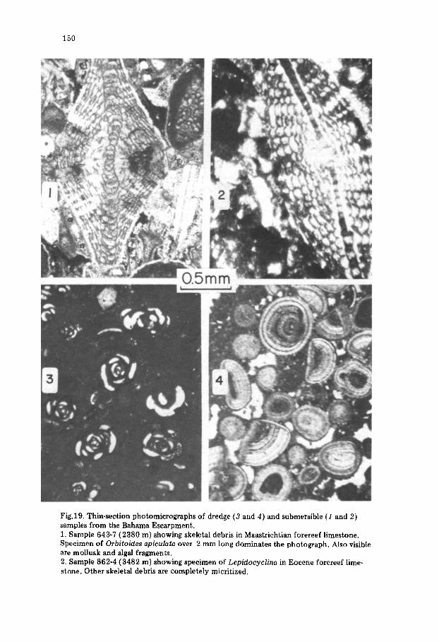
Fig. 19. Thin-section photomicrographs of dredge (3 and 4) and submersible (1 and 2) samples from the Bahama Escarpment. 1. Sample 643-7 (2380 m) showing skeletal debris in Maastrichtian forereef limestone. Specimen of Orbitoides apiculata over 2 mm long dominates the photograph. Also visible are mollusk and algal fragments. 2. Sample 862-4 (3482 m) showing specimen of Lepidocyclina in Eocene forereef lime- stone. Other skeletal debris are completely micritized.
151
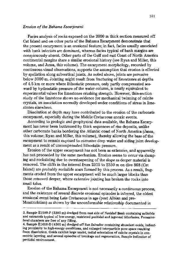
Erosion of the Bahama Escarpment
Facies analysis of rocks exposed on the 2000 m thick section measured off Cat Island and on other parts of the Bahama Escarpment demonstrate that the present escarpment is an erosional feature; in fact, facies usually associated with bank interiors are dominant, whereas facies typical of bank margins are conspicuously absent. Other parts of the Gulf and east Coast of North America continental margins share a similar erosional history (see Ryan and Miller, this volume, and Jansa, this volume). The escarpment morphology, recorded by continuous visual observations, supports the assumption that erosion is effected by spallation along subvertical joints. As noted above, joints are pervasive below 3000 m. Jointing might result from fracturing of limestones at depths of 4.5 km or more where lithostatic pressure, only partly compensated sea- ward by hydrostatic pressure of the water column, is nearly equivalent to experimental values for limestones crushing strength. However, thin-section study of the limestone shows no evidence for mechanical twinning of calcite crystals, an association normally developed under conditions of stress in lime- stones elsewhere.
Dissolution at depth may have contributed to the erosion of the carbonate escarpment, especially during the Middle Cretaceous anoxic events.
According to geologic and geophysical data available, the Bahama Escarp- ment has never been buttressed by thick sequences of rise deposits, unlike other carbonate banks bordering the Atlantic coast of North America (Jansa, this volume; l~yan and Miller, this volume), thereby allowing the base of the escarpment to remain exposed to corrosive deep water and aiding joint develop- ment as a result of uncompensated lithostatic pressure.
Erosion of the upper escarpment has not been as extensive, and apparently has not proceeded by the same mechanism. Erosion seems to occur via slump- ing and rocksliding due to oversteepening of the slope as deeper material is removed. The cliffs in the interval from 2375 to 2350 m on dive 868 (Cat Island) are probably rockslide scars formed by this process. As a result, frag- ments eroded from the upper escarpment will be much larger blocks than those removed deeper, where extensive jointing has broken the rocks into small talus.
Erosion of the Bahama Escarpment is not necessarily a continuous process, and the existence of several discrete erosional episodes is inferred, the oldest erosional event being Late Cretaceous in age (post Albian and pre- Maastrichtian) as shown by the unconformable relationship documented in
3. Sample E1589-F (3300 m) dredged from east side of Navidad Bank containing miliolids and ostracods typical of low-energy, restricted peritidal and lagoonal lithofacies. Foramini- feral chambers ave free of any filling. 4. Sample E1610-D (4300 m) dredged off San Salvador containing abundant ooids, indicat- ing proximity to high-energy conditions, and enlarged interparticle pore space resulting from dissolution. Ooids exhibit large nuclei, radial orientation of calcite crystals in con- centric layering, and several episodes of breakage and regeneration. Sample indicative of peritidal environment.
152
sample 868-10 (see Figs.13, 14-1 and 14-2). Three erosional episodes of the slope off Georges Bank correlate with the events on the Bahama Escarpment (Ryan et al., 1978; Ryan and Miller, this volume).
Estimates of the amount of erosional backcutting range from 5 km at the base of the escarpment to 1 km at 2000 m, based on analogy with the Middle Cretaceous platforms of eastern Mexico (Freeman-Lynde, 1981).
Subsidence of the Bahama Platform
As Steckler and Watts (1978) have pointed out, the large thicknesses of predominantly shallow-water sediments and rocks observed at passive conti- nental margins, including the Bahama Platform, cannot be produced by the effects of sediment loading alone. Steckler and Watts (1978) and Watts and Steckler (1979) have shown that subsidence of the passive margin off the Mid-Atlantic and Nova Scotia coasts of North America can be explained by a simple thermal model of lithospheric cooling by calculating depth basement without a sediment load through time, using simple models of sediment loading combined with biostratigraphic data. With their observations as a guide, the subsidence history of the Bahama Platform as recorded in the Andros Island well and on the Cat Island Escarpment has been examined.
The Cat Island section is incomplete, extending from 4000 to 2000 m and covering the period from earliest Cretaceous to Cenomanian. Nevertheless, an exponential curve, with a time constant of 70 m.y., can be fitted to the data (Fig.7). This curve does not need to be corrected for compaction of sedi- ments or water depth, because the carbonate sections lithification commonly occurs within the first few meters of burial and shallow-platform carbonate rocks by their very nature accumulate in water no greater than a few to a few tens of meters deep. In addition, there is no sea-level correction. Watts and Steckler (1979) show that sea level was nearly constant from 135 to 100 m.y. (i.e., most of the period encompassed by the Cat Island section) and at approxi- mately the same level as present sea level.
It is clear from Fig.7 that subsidence rates of the Cat Island section steadily diminish. The subsidence rate in the Earliest Cretaceous (4000--3300 m) is >60 m/m.y, while in the Middle Cretaceous (3300--2000 m) the rate dimin- ishes to 40 m/m.y. Although we do not know the details of the subsidence for the Cat Island slope above 2000 m (i.e., for the Late Cretaceous and Tertiary) due to a lack of age data for this part of the slope, the average subsidence rate
~must be approximately 20 m/m.y. (2000 m/94 m.y.), i.e., half to a third of the Middle and Early Cretaceous rates.
The age data for the Andros Island well which was drilled to 4350 m (Spencer, 1967; Goodell and Garman, 1969) have also been plotted in Fig.7. Unfortunately the age at the base of the hole is not well determined; in our calculations, we have taken it as 115 m.y. following Spencer (1967).
In addition, it is clear that "local" tectonic events during the Late Cretaceous and Early Tertiary have perturbed the subsidence observed at the Andros well and further complicate any attempt to fit an exponential curve to the subsi- dence data. These "local" tectonic events are probably related to Cuban
153
orogenesis at this time. Nevertheless, the subsidence of the upper part of the well, i.e., down to 800 m (Middle Eocene) does fit the exponential curve with a time constant of 65 m.y. This curve does not, of course, fit the data for the lower part of the well. It is significant, however, that the observed subsidence rate of the lower 1150 m of the well, i.e., the Early Cretaceous section from 100 m.y. to 115 m.y., matches that predicted by the exponential curve for the Early Cretaceous and implies that the subsidence of the Andros well is expo- nential except for perturbation during the Late Cretaceous and Early Tertiary.
It is clear that the subsidence history of the Bahama Platform, as deduced from these two sections, is exponential in form, with somewhat faster subsi- dence occurring at the Andros well site than at the Cat Island slope. The subsidence of the Bahama Platform is of the same magnitude as that observed off of New Jersey and Nova Scotia (Steckler and Watts, 1978; Watts and Steckler, 1979), i.e., 3000 to 4500 m since the Early Cretaceous.
CONCLUSIONS
(1) A 2000 m thick stratigraphic section of the Bahama Escarpment off Cat Island, measured and sampled by deep.diving submersible, consists of Early and Middle Cretaceous shallow-water limestones deposited in peritidal, lagoonal, patchreef and backreef environments. Reef and forereef deposits of this age are conspicuously absent. Maastrichtian and Eocene pelagic limestones unconformably overlie these older rocks above 2650 m.
(2) This sequence of rocks has been extended along the 800 km of the Bahama Escarpment southeast of Cat Island using additional dive traverses, and dredge stations. Forereef deposits of Late Cretaceous and Early Tertiary age, in addition to pelagic limestones as observed in the Cat Island section, occur on the Navidad Bank slope.
(3) These Early and Middle Cretaceous shallow-water limestones exposed on the Bahama Escarpment are similar in age and lithology to "bank-interior" deposits comprising the marginal portions of a vast carbonate platform devel- oped on the subsiding passive continental margins surrounding the Gulf of Mexico and extending up the east coast of North America in the Early and Middle Cretaceous. "Reef" and "forereef" strata of this age, which occur at the most marginal part of this platform, are not found on the Bahama Escarpment.
(4) The exposure of Early and Middle Cretaceous "bank-interior" deposits on the Bahama Escarpment and the absence of "reef" and "forereef" accumu- lations of this age indicate that the escarpment is an erosional, rather than a constructive, feature. The amount of erosion is estimated to range from 5 km at the base of the escarpment to 1 km at 2000 m, where the younger pelagic or forereef drape overlaps the older rocks completely. Erosion occurs by spallation of joint blocks from the extensively shattered and fractured lower escarpment and by rock-sliding of huge blocks on the upper escarpment. The intense jointing may result from uncompensated lithostatic pressure exceeding the crushing strength of the limestone.
154
(5) The subsidence rate of the Bahama Escarpment off Cat Island has been exponential, and ranges from 60 m/m.y, in the Early Cretaceous to 40 m/m.y. in the Middle Cretaceous. Extrapolated values for the Late Cretaceous and Tertiary are 20 m/m.y.
ACKNOWLEDGEMENTS
This study constitutes the bulk of the senior author's Ph.D. dissertation at Columbia University. He initiated the work under the guidance of B.C. Heezen and continued it under the supervision of W.B.F. Ryan, following Heezen's death.
The submersible investigations, field work in Italy, and analysis of samples were funded by contracts from the Office of Naval Research (N 00014-75-c- 0210, -0264 and -0264A). Dredging operations were funded by the National Science Foundation (NSF-OCE 76-23531) under the Cooperative Oceano- graphic Program.
The participation of two Italian scientists in the "Alvin" 1978 expedition to the Bahamas was supported by Ministero della Pubblica Istruzione through a grant on passive continental margin evolution.
We acknowledge the professionalism of the Masters and crew of the "Alvin" and "Lulu" during all submersible operations, as well as the Master and crew of the "Eastward" during the dredge cruise. Special thanks go to the Survey Office of the Bahamas for invaluable aid in locating benchmarks and surveying positions used for the Maxiran radio-navigation system during the 1978 "Alvin" field expedition.
We also thank M. Rawson, H. Chezar and D. Chayes for their participa- tion in several aspects of the submersible and dredge operations. H. Chezar, R. Havira and A. Lewis aided in photographic work. The use of the Maxiran radio-navigation system resulted from a joint expedition in the Bahamas with B. Hecker.
We thank B.C. Schreiber, W. Pitman, J. Sanders and It. Catalano for valuable discussions which improved the manuscript. We benefited from the advice of A. Balduzzi, E. Bellini and I. Premoli Silva for the identification of some microfossils.
The present text has been critically read by F. Benelli and B.C. Schreiber. The manuscript was prepared while the senior author was assistant professor
at Western Michigan University. He gratefully acknowledges the aid rendered by the staff of the Department of Geology. L-DGO Contribution number 000.
REFERENCES
Applin, P.L. and Applin, E.R., 1965. The Comanche Series and associated rocks in the subsurface in central and south Florida. U.S. Geol. Surv. Prof. Pap., 447:84 pp.
Benson, W.E., Sheridan, R.E. et al., 1978. Initial Reports of the Deep Sea Drilling Project, 44. U.S. Gov. Print. Off., Washington, D.C., 1005 pp.
Bryant, W.R., Meyerhoff, A.A., Brown, N.K. Jr., Furrer, M.A., Pyle, T.E. and Antoine, J.W., 1969. Escarpments, reef trends, and diapiric structures, eastern Gulf of Mexico. Am. Assoc. Pet. Geol. Bull., 53: 2506--2542.
155
Coogan, A.H., Bebout, D.G., and Maggio, C., 1972. Depositional environments and geologic history of Golden Lane and Poza Rica Trend, Mexico, an alternative view. Am. Assoc. Pet. Geol. Bull., 56: 1419--1447.
D'Argenio, B., De Castro, P., Emiliani, C. and Simone, L., 1975. Bahamian and Apenninic limestones of identical lithofacies and age. Am. Assoc. Pet. Geol. Bull., 59: 524--533.
Dillon, W.P., Paull, C.K., Dahl, A.G. and Patterson, W.C., 1979. Structure of the continen- tal margin near the COST No. GE-1 Drill Site from a common depth-point seismic- reflection profile. In: P.A. Scholle (Editor), Geological Studies of the COST GE-1 Well, United States South Atlantic Outer Continental Shelf Area. U.S. Geol. Surv. Circ., 800: 97--114.
Enos, P., 1974. Reefs, platforms, and basins of Middle Cretaceous in northeast Mexico. Am. Assoc. Pet. Geol. Bull., 58: 800--809.
Enos, P. and Freeman, T., 1978. Shallow-water limestones from the Blake Nose, sites 390 and 392. In: W.E. Benson, R.E. Sheridan et al., 1978. Initial Reports of the Deep Sea Drilling Project, 44. U.S. Gov. Print. Off., Washington, D.C., pp.413--475.
Ewing, J., Ewing, M. and Leyden, R., 1966. Seismic-profiler survey of Blake Plateau. Am. Assoc. Pet. Geol. Bull., 50: 1948--1971.
Folk, R.L. and Siedlecka, A., 1974. The "schizohaline" environment: its sedimentary and diagenetic fabrics as exemplified by the Late Paleozoic rocks of Bear Island, Svalbard. Sediment. Geol., 11: 1--15.
Fox, P.J. and Heezen, B.C., 1975. Geology of the Caribbean crust. In: A.E.M. Nairn and F.G. Stehli (Editors), The Ocean Basins and Margins, 3. Plenum Press, New York. N.Y., pp. 421--486.
Freeman-Lynde, R.P., 1981. The marine geology of the Bahama Escarpment. Ph.D. disser- tation, Columbia University, New York, N.Y., 250 pp. (unpublished).
Garrison, L.E. and Martin, R.G. Jr., 1973. Geologic structures in the Gulf of Mexico Basin. U.S. Geol. Surv. Prof. Pap., 773:85 pp.
Goodell, H.G. and Garman, R.K., 1969. Carbonate geochemistry of Superior deep well, Andros Island, Bahamas. Am. Assoc. Pet. Geol. Bull., 53: 513--536.
Griffith, L.S., Pitcher, M.G. and Rice, G.W., 1969. Quantitative environmental analysis of a Lower Cretaceous reef complex. In: G.M. Friedman (Editor), Depositional Environ- ments in Carbonate Rocks. SEPM Spec. Publ., 14: 120--138.
Heezen, B.C. and Sheridan, R.E., 1966. Lower Cretaceous rocks (Neocomian--Albian) dredged from Blake Escarpment. Science, 154: 1644--1647.
James, N.P., 1977. Facies models, 8. Shallowing-upward sequences in carbonates. Geosei. Can., 4: 126--136.
Jansa, L.F., 1981. Mesozoic carbonate platforms and banks of the eastern North American margin. Mar. Geol., 44: 97--117.
Lopez-Ramos, E., 1975. Geological summary of the Yucatan peninsula. In: A.E.M. Nairn and F.G. Stehli (Editors), The Ocean Basins and Margins, 3. Plenum Press, New York, N.Y., pp.257--282.
Meyerhoff, A.A. and Hatten, C.W., 1974. Bahamas Salient of North America. In: C.A. Burk and C.L. Drake (Editors), The Geology of Continental Margins, Springer, Berlin, pp.429---446.
Paulus, F.J., 1972. The geology of Site 98 and the Bahama Platform. In: C.D. Hollister, J.I. Ewing et al., 1972. Initial Reports of the Deep Sea Drilling Project, 11. U.S. Gov. Print. Off., Washington, D.C., pp.877--897.
Renz, O., Imlay, R., Lancelot, Y. and Ryan, W.B.F., 1975. Ammonite-rich Oxfordian limestones from the base of the continental slope off northwest Africa. Eclogae Geol. Helv., 68: 431--448.
Ryan, W.B.F. and Miller, E.L., 1981. Evidence of a carbonate platform beneath Georges Bank. Mar. Geol., 44: 213--228.
Ryan, W.B.F., Cita, M.B., Miller, E.B., Hanselman, D., Nesteroff, W.D., Hecker, B. and Nibbelink, M., 1978. Bedrock geology in New England submarine canyons. Oceanol. Acta, 1: 233--254.
156
Schlager, W. and Ginsburg, R.N., 1981. Bahama carbonate platforms--the deep and the past. Mar. Geol., 44: 1--24.
Schneidermann, N., Beckman, J.P. and Heezen, B.C., 1972. Shallow-water carbonates from the Puerto Rico Trench region. In: C. Petzall (Editor), Proc. 6th Caribb. Geol. Conf., pp.423--425.
Sheridan, R.E., Smith, J.D. and Gardner, J., 1969. Rock dredges from Blake Escarpment near Great Abaco canyon. Am. Assoc. Pet. Geol. Bull., 53: 2551--2558.
Sheridan, R.E., Berman, R.M. and Corman, D.B., 1971. Faulted limestone block dredged from Blake Escarpment. Geol. Soc. Am. Bull., 82: 199--206.
Spencer, M., 1967. Bahamas deep test. Am. Assoc. Pet. Geol. Bull., 51: 263--268. Steckler, M.S. and Watts, A.B., 1978. Subsidence of the Atlantic-type continental margin
off New York. Earth Planet. Sci. Lett., 41: 1--13. Tator, B.A. and Hatfield, L.E., 1975. Bahamas present complex geology: Oil Gas J.,
73(43): 172--176; 44: 120--122. Uchupi, F. and Emery, K.O., 1968. Structure of continental margin off Gulf Coast of
United States. Am. Assoc. Pet. Geol. Bull., 52: 1162--1193. Watts, A.B. and Steckler, M.S., 1979. Subsidence and eustacy at the continental margin of
eastern North America. In: M. Talwani, W. Hay and W.B.F. Ryan (Editors), Deep- drilling results in the Atlantic Ocean: continental margins and paleoenvironment. Am. Geophys. Union, pp.218--234.
Wilson, J.L., 1975. Carbonate Facies in Geologic History, Springer, Berlin, 471 pp. Wissman, G. and Von Rad, U., 1979. Seismic structure continental basement, and meso-
zoic sediments from the Mazagan Plateau off Morocco. "Meteor" Forschergeb., Reihe C 31: 1--20.
Worzel, J.L., Bryant, W. et al., 1973. Initial Reports of the Deep Sea Drilling Project, 10. U.S. Gov. Print. Off., Washington, D.C., 748 pp.