madole, r. f., 1987, geology of archeological sites in middle cottonwood creek valley and taylor...
TRANSCRIPT

DEPARTMENT OF THE INTERIOR
U.S. GEOLOGICAL SURVEY
Geology of Archeological Sites in Middle Cottonwood Creek
Valley and T ay lor Park, Chaffee and Gunnison
Counties, Colorado
by
Richard F. Madole 1
Open-File Report 87-78
This report is preliminary and has not been reviewed for conformity with U.S.
Geological Survey editorial standards.
' Golden, Colorado
1987

INTRODUCTION
The geology of two archeological sites in montane environments, one near the east edge of the Sawatch Range and the other adjacent to the west edge of the range, was studied to determine the age and origin of the stratigraphic units present and to obtain paleoenvironmental information in support of archeological investigations prior to road construction. The site on the east flank of the Sawatch Range, designated 5CF358, is in the valley of Middle Cottonwood Creek about 10 km west of Buena Vista (fig. 1). The site adjacent to the west edge of the range, designated 5GN289, is at the south edge of Taylor Park.
Middle Cottonwood Creek heads near the crest of the Sawatch Range and flows eastward for about 18 km in a deep valley cut in granitic and gneissic rocks of Precambrian and Tertiary age (Tweto and others, 1976). It flows from the Sawatch Range into the structurally controlled Arkansas River valley (northernmost part of the Rio Grande Rift) at a point about 3 km downvalley from site 5CF358. The Sawatch Range is composed of a complex of highly deformed gneissic rocks, about 1.8 billion years old, intruded by younger Precambrian granitic rocks and by stocks and smaller intrusive bodies of late Cretaceous-early Tertiary and middle Tertiary age. Site 5CF358 lies within the boundary of one of the largest of the middle Tertiary stocks. The stock is composed of the Mount Princeton Quartz Monzonite and extends from North Cottonwood Creek southward to the South Arkansas River, a distance of about 35 km (Brock and Barker, 1972).
End moraine Glacial deposits Continental Divide Taylor Park boundary Paved road
Figure 1. Map of the central Sawatch Range and adjoining areas showing the location of the Runberg (5CF358) and Taylor Park (5GN289) sites and the geographical features mentioned in the text. The only glacial deposits shown (after Tweto and others, 1976) are those near the sites.
Taylor Park is a structural basin downwarped between the Sawatch Range on the east and the Elk Mountains on the west (fig. 1). Taylor Park is underlain by sedimentary rocks of Paleozoic, Mesozoic, and Cenozoic age (Tweto and others, 1976). These rocks are concealed over most of the park by surficial deposits of Quaternary age that were derived largely from Precambrian crystalline rocks in the Sawatch Range and Elk Mountains. The surficial deposits include glacial till, outwash, stream alluvium, and fan alluvium.
RUNBERG SITE (5CF358)
Geomorphic Setting
The Runberg site, 5CF358, is within the area that was glaciated (fig. 1) during Pinedale time (ca. 30,000-14,000 B.P.) and is underlain by alluvium and colluvium that was derived locally from the north side of the valley and deposited after the withdrawal of Pinedale ice. The site is near the valley floor of Middle Cottonwood Creek about 180 m below the weakly defined crest of the Pinedale lateral moraine on the north side of the valley and about 2.5 km upvalley from the Pinedale terminal moraine, which is just inside the mountain front at an altitude of 2,622 m (8,600 ft). The valley of Middle Cottonwood Creek contains an extraordinary amount of sediment that was deposited after withdrawal of Pinedale ice. Alluvial fans, some formed on landslide deposits, occupy a large part of the valley floor, and deposits of slope wash and colluvium, including debris-flow deposits, are present along the valley sides in areas between fans.
Stratigraphy
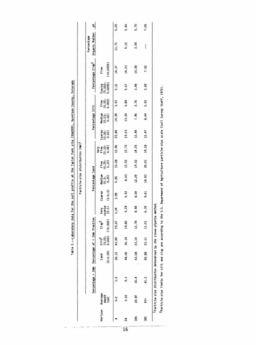
The stratigraphy at site 5CF358 was examined in two pits (28S/2E and 30S/14E) about 10 m apart, each of which was about 75 cm deep. A third pit (6S/12E), located along the north side of the Cottonwood Pass road, was less instructive than the other two, because the upper part of the stratigraphic section had been removed by erosion and road construction. Four stratigraphic units were identified in the two pits (fig. 2). Stratification is weakly expressed because, except for the basal unit, changes in texture, sorting, and color between units are slight. From bottom to top, the four units are (1) matrix-supported cobble-boulder gravel, (2) light yellowish-brown sand, (3) pale-brown to brown sand, and (4) grayish-brown silty sand. In soil terminology, unit 1 is gravelly loamy sand, unit 2 and the lower part of unit 3 are loamy sand, and the upper part of unit 3 and all of unit 4 are sandy loam (fig. 2, table 1). All units are very poorly sorted.

CO
Tab
le 1
. L
ab
ora
tory
da
ta fo
r th
e soil
pro
file
a
t th
e R
unbe
rg site
(5C
F358
), M
iddl
e C
otto
nwoo
d C
reek
, C
haffe
e C
ount
y,
Col
orad
o
Pa
rtic
le-s
ize
dis
trib
ution
(ran
)*
Per
cent
age
Per
cent
age
> 2m
m P
erce
ntag
e o
f <
2nm
fr
action
_________P
erc
enta
ge S
an
d_
__
__
__
__
P
erce
ntag
e S
ilt_
___
Per
cent
age
Cla
y2
Org
anic
Ma
tte
r pH
7 >
Ver
y H
oriz
on
Ave
rage
Sa
nd
Silt
^
Cla
y^
Ver
y C
oars
e M
ediu
m
Fin
e F
ine
Coa
rse
Med
ium
F
ine
Coa
rse
Fin
ede
pth
(0.0
5-
coar
se
(0.5
- (0
.25-
(0.1
0-
(0.0
5-
(0.0
3-
(0.0
2-
(0.0
02-
(cm
) (2
-0.0
5)
0.00
2)
(<0.
002)
(2
-1)
(1-0
.5)
0.2
5)
0.1
0)
0.05
) 0.0
3)
0.0
2)
0.00
2)
0.00
05)
(<0.
0005
)
A 2A 2AC
2Cox
3Cox
0-6
6-25
25-4
3
43-7
3
73+
4.8
19.6
14.9
19.3
40.4
67.9
8
75.7
0
77.7
1
82.9
5
80.8
4
22.0
3
15.8
4
15.2
7
9.14
9.06
10.0
0
8.4
6
7.01
7.91
10.1
0
8.00
10.0
2
8.73
10.6
7
11.3
0
13.5
4
14.0
2
13.3
6
15.6
6
13.2
1
15.5
7
18.7
6
18.7
1
22.6
9
19.2
4
18.8
6
21.8
0
24.2
2
24.7
7
26.0
0
12.0
1
11.0
8
12.6
8
9.16
11.0
9
10.9
2
7.02
7.20
4.22
4.01
8.7
0
6.12
5.27
2.81
2.96
2.41
2.7
0
2.81
2.11
2.09
3.52
2.34
1.58
1.23
,
2.09
6.48
6.1
2
5.43
6.68
8.01
3.15
1.77
1.36
1.51 __
6.70
6.4
0
6.30
6.3
0
6.40
^Pa
rtic
le-s
ize
dis
trib
ution
dete
rmin
ed b
y th
e si
eve
-pip
ett
e m
etho
d.
2Pa
rtic
le-s
ize
lim
its fo
r silt
and
clay
ar
e ac
cord
ing
to
the
U.S
. D
epar
tmen
t of
Agricu
lture
p
art
icle
-siz
e
scal
e (S
oil
Sur
vey
Sta
ff,
1975
).

WEST
28S/2E
EAST
30S/I4E
Horizons 88401100 "onzons (Beta-14921)
8650± IIO(Beta-l4l85)7980 ±!20(Beta-14182)
2 A ~2~AC~
2 Cox
3 Cox
7740±l40(Beta-l4922)
n' 0 0 .-... 0 . o.o.'..-.'--
: .' o-. 00 '..0 o . 9 -/0 «° '« f>-.°o.;.
UJI- UJ
hl.O
6 METERS
8 10 12
UNIT 4
UNIT 3
UNIT 2
UNIT I
VERTICAL EXAGGERATION = 2X
GRAYISH-BROWN SILTY SAND
PALE-BROWN TO BROWN SAND
LIGHT YELLOWISH-BROWN SAND
MATRIX-SUPPORTED COBBLE-BOULDER GRAVEL
Figure 2.--Generalized diagram showing the stratigraphy, soil profile, and stratigraphic positions of four radiocarbon ages obtained from archeological features at site 5CF358. The stratigraphic positions of the features were projected into the section. Except for the westernmost feature, which was 6 upslope (north), all features shown were within 0.5 to 1.5 m of the line of section.
Unit 1
m
Unit 1 is a matrix-sup ported cobble-boulder gravel of unknown thickness. Only the upper surface was exposed in the floors of the two pits (28S/2E and 30S/14E) at depths of 70-75 cm. The uppermost 30 cm of unit 1 was exposed also in the north and east walls of pit 30S/14E (fig. 2). Clasts range in size from pebbles to small boulders, are mostly subrounded to rounded and granitic, and are estimated to compose as much as 25-35 percent of the unit. The matrix is yellowish-brown (10YR 5/4, dry), compact, predominantly subrounded and subangular fine and medium sand (fig. 2, table 1).
So little of unit 1 is exposed that statements about its origin and age are largely speculative. The exposed part of unit 1 is probably colluvium and alluvium derived from the north valley wall. Glacial till may underlie unit 1, but the surface that slopes from the base of the north valley wall to the channel of Middle Cottonwood Creek is clearly the product of alluvial processes, and it is unlikely that only the upper 70-75 cm of sediment are nonglacial. Bouldery debris-flow deposits are widespread on the surface and probably compose a significant part of the sediment underlying site 5CF358. The exposed part of unit 1 may be debris-flow deposit. The character and form of this unit in the walls of pit 30S/14E resemble those of the debris-flow deposits that are present upslope from the site.

Debris-flow deposits are common in the Southern Rocky Mountains in settings like that of site 5CF358. The initiation of debris flows capable of transporting boulders requires only moderately intense rainstorms, which occur relatively often in this region (Costa and Jarrett, 1981; Costa, 1984). Diamictons of various origins, such as till, debris-flow deposits, and landslide deposits, all of which are common in mountainous regions, generally cannot be distinguished on the basis of sedimentary properties alone (Madole, 1982). It was partly for this reason that Flint and others (1960) introduced the term diamicton, a nongenetic term for a poorly sorted terrestrial sediment containing a wide range of particle sizes, such as a till.
Unit 1 is believed to be part of a sequence of sediment derived from valley sides after Pinedale deglaciation. The valley-side sediment probably began to accumulate as soon as Pinedale ice receded from the area. On the basis of information from the Park Range and Front Range (Madole, 1980, 1986), glacier recession from the vicinity of site 5CF358 is estimated to have occurred after 18,000 B.P. but before 15,000 B.P. The Pinedale valley glaciers of the area were probably near their maximum extent from about 23,000 B.P. to sometime after 18,000 B.P. By 15,000 B.P., however, they had receded to the heads of their respective valleys or had disappeared altogether. Hence, site 5CF358 was ice-free and subject to erosion and deposition by alluvial and colluvial processes prior to 15,000 B.P. Therefore, unit 1 could be 15,000 years or more old.
Unit 2
Unit 2 is light yellowish-brown sand (10YR 6/4, dry) that is typically 30 cm thick (fig. 2, table 1). Fine sand is dominant, and most grains are subangular or subrounded. The unit also contains abundant granules and many small (4-16 mm) pebbles. Unit 2 is interpreted to be alluvium transported and deposited chiefly by sheetwash from the valley sides and foot slopes above site 5CF358. The unit is similar in color and composition to the matrix of unit 1, from which it may have been partly derived. Unit 2, however, lacks the large clasts that are common in unit 1.
Units 1 and 2 would have been interpreted to be a single fining-upward unit were it not for unit 1 being a darker yellowish brown than unit 2. Soil colors typically are weaker and paler with increasing depth. The darker color of unit 1, relative to unit 2, is a reversal of what is typical, and suggests that an unconformity may exist between the two units. The darker color of unit 1 was probably produced by oxidation when it was near the surface prior to being buried by unit 2.
Unit 2 is considered to be older than 10,000 B.P. because, for reasons discussed later, the lower part of the overlying unit (unit 3) may be as old as, or older than, 10,000 years. The older age limit of unit 2 is a matter of speculation. However, if the darker color of unit 1 is due to weathering, then unit 2 could have accumulated during Satanta Peak time (12,000- 10,000 B.P., Benedict, 1973, 1981), and development of a weathering profile in unit 1 would be correlated with the time of landscape stability presumed to have occurred between the withdrawal of Pinedale ice and the glacial advances of Satanta Peak time.

Holocene stratigraphic data, some of which is discussed later, suggest that times of increased snow cover and expanded cirque glaciers were also times of high sediment flux in alpine environments and, to a lesser extent, in montane environments. During times of high sediment flux, sediment was eroded from slopes and topographic highs and deposited in adjacent low areas. Hence, during Satanta Peak time, the valley floor of Middle Cottonwood Creek and adjacent footslopes were probably loci of deposition of sediment derived primarily from the adjacent valley sides. During the times when perennial snowfields and cirque glaciers were not present (fig. 3), sediment flux is thought to have been low. During times of low sediment flux, the amount of soil that formed equaled or exceeded the amount removed by erosion.
Unit 3
Unit 3 is brown to pale-brown (10YR 5/3 to 6/3, dry) sand that is typically 37 cm thick (fig. 2, table 1). The brown color, which pales downward, is due primarily to the presence of humus. Unit 3 is interpreted to be slope wash that was transported and deposited by sheet flow across the slope that extends from the base of the north valley wall. Unit 3 contains a buried soil. The horizons of this soil are described in another section of this report (p. 12-13), but are not denoted by the letter b as being buried. By convention, a soil is not designated as buried if the unit that covers it is less than 30 cm thick (Soil Survey Staff, 1975, p. 2).
Deposition of unit 3 may have begun in Satanta Peak time (12,000- 10,000 B.P.) and continued into Holocene time. A ^C age of charcoal from a hearth (Kevin Black, written comrnun., 1986) about 15 cm below the top of unit 3 (fig. 2) indicates that more than half of the unit had been deposited prior to 8,840+100 yr B.P. (Beta-14921). Moreover, the charcoal and hearth may be substantially younger than the sediment in which they were emplaced; hence, most of unit 3 could be of Satanta Peak age.
It is not possible to say precisely when deposition of unit 3 ended. Six " ^C ages of archeological features provide a wide range of minimum ages. Four of the features are early Holocene (8,840+100, 8,650+110, 7,980+120, and 7,740+140 yr B.P.) and two are late Holocene (3,480+100 and 2,840+80 yr B.P.) (Kevin Black, written commun., 1986). The latter are from the upper third of unit 3, and the former are from the lower two-thirds of the unit (fig. 2). The feature with an age of 7,740+140 yr B.P. was about 10 cm lower in the section than the feature with an age of 8,650+110, suggesting that the stratigraphic positions of the features are controlled partly by the amount of excavation done in their construction.
Both the early and late Holocene archeological features correlate with intervals when climate is thought to have been relatively mild in montane areas of Colorado (fig. 3). However, as discussed in the section on geologic history, the climate between 6,400 and 5,200 B.P. was also relatively mild, yet no features or artifacts of this age were found at the site. The absence of features and artifacts with ages between 7,740+100 and 3,480+100 yr B.P. suggests that part of the geologic record may have been eroded and that an unrecognized unconformity may exist within unit 3. However, unequivocal evidence of a major episode of erosion was not observed in unit 3 at the site. Given the abundance of stoney sediment in the area, major episodes of erosion are likely to be recorded by distinct stonelines, but none were

observed in the two pits examined. Stonelines, however, were reported to exist locally in other nearby pits at a depth of 15-20 cm (Kevin Black, written commun., 1986).
0
CL
^ 5 or
z0 CDor
o oo
or
10
FRC GLt CHF
-
)NT F !\CIAL *ONOl
ZZXS&SgfiM
iSliiili
jjjggj^ggjljlg
Xj$M$&'gjjjljjiljji
ililsllslil
1
JANGE Tl Hl<
.OGY PR
Arapaho Peak Advances
Audubon Advances
Triple Lakes Advances
Ptarmigan Advance
Satanta Peak Advances
MBERLINE OCCUPATION OF MON- 3HER THAN TANE ARCHEOLOGICAL ESENT SITES
5GA2I7 5CF358 5GN289
-cr-_-_5r-
"_-_-. _ 9 _J- r- ~ -j
!-_-_-_- .I O--_
^ZZZZt ~ 2 ~~"KxXXx - ---
§^s ^V"'_ __ .
7̂-^y f̂
1 -̂- .
EXPLANATION
'// uata from ban .. . . . . . . ^ Juan Mtns || Nonglac.al interval
\N\ Data from r^-.-. Number of I4 c ages ^V^ Front Range H^-j defining interval
Figure 3.--Diagram showing the chronologic relationships between archeological features, nonglacial intervals, and times of timberline higher than present. The limits of glacial-nonglacial intervals are based on work in the Front Range (Benedict 1973, 1981, 1985). Data on timberline elevation for the San Juan Mountains are from Carrara and others (1984), Carrara (written commun., 1986), and Andrews and others (1975), and data for the Front Range are from Nichols and others (1984). Dates of archeological features are from Liestman (1984) and Kevin Black (written commun,, 1986).

In addition to the absence of continuous stonelines, the soil profile at site 5CF358 also does not contain evidence of a major episode of erosion during deposition of unit 3. On the contrary, the soil-profile characteristics imply that aggradation during this time was slow and relatively continuous. A subtle unconformity, reflected in both humus content and texture (table 1), exists 6-7 cm below the ground surface, otherwise soil humus decreases progressively downward from the ground surface to a depth of 43 cm. This unusually thick interval of humified organic matter and the gradual change in character downward suggests that this unit aggraded slowly over a considerable period of time and (or) that it includes redeposited humus eroded from A horizons farther upslope.
Unit 4
Unit 4 is grayish-brown (10YR 5/2, dry) silty sand that is typically 5-7 cm thick (fig. 2, table 1). The gray color is due chiefly to humus. Unit 4 is slope wash, and is believed to unconformably overlie unit 3 on the basis of the A horizon developed in unit 3 and textural differences between the two units. The amount of time that might have elapsed between deposition of units 3 and 4 is unknown. On the basis of archeological evidence, unit 4 is probably younger than 1,800 B.P. (Kevin Black, written commun., 1986).
Soil Profile
Soil Nomenclature
The soil-horizon nomenclature used in this report follows that proposed for the new Soil Conservation Service Soil Survey Manual, Chapter 4, summarized by Guthrie and Witty (1982) and Birkeland (1984). In addition, Birkeland's (1984, Chapter 1) nomenclature for C horizons is used.
Surface layers of organic material that overlie the mineral soil are referred to as 0 horizons. A horizons form in the upper part of the mineral soil, and are as dark or darker than the adjacent underlying horizon. They include humified organic matter that is mixed with the mineral soil. B horizons form below 0, A, and E horizons, and are recognized by a variety of dominant features (Soil Survey Staff, 1975, p. 460; Birkeland, 1984, p. 7-8). A chief attribute of B horizons is that the parent material has been altered to the extent that little or none of the original sediment structure is retained. C horizons underlie B horizons, and are characterized by little, if any, soil formation; therefore, they lack the properties that are diagnostic of A, E, and B horizons. The Cox horizon (Birkeland, 1984) is an oxidized C horizon that does not meet the color requirements of a cambic B horizon (Bw horizon of the recently revised nomenclature), but has higher chromas (stronger color), generally 3 or 4 in soil color charts, and (or) redder hues than the underlying Cu horizon. The Cu horizon is unoxidized parent material (Birkeland, 1984).
The soil-horizon designators revised in the new Soil Survey Manual include (1) a change from Arabic numeral suffixes for subdivisions of the 0 horizon to letter suffixes, (2) elimination of the Arabic numeral suffix 1 for A horizons, and (3) a change from Roman numerals to Arabic numerals for prefixes that denote lithologic discontinuities in the parent material. The suffixes used for subdivision of the 0 horizon are defined as: a highly

decomposed organic matter, e--intermediately decomposed organic matter, and i--slightly decomposed organic matter. With the elimination of Arabic numeral suffixes from A horizon designations, Al horizons are now simply A horizons, and what were formerly referred to as A2 horizons are now referred to as E horizons.
The soil at site 5CF358 is weakly developed and the properties exhibited change gradually with depth. The principal pedogenic development is the formation of an A horizon by the humification of organic matter incorporated into the mineral soi1.
Location:
Altitude:
Vegetation:
Parent Material
Topography:
Climate:
Horizon: Oi ,e,a 3 0.5-0 cm (0.5 cm)
A0-6 cm(6 cm)
2A6-25 cm (19 cm)
Profile Description 1
Buena Vista West 7 1/2 minute quadrangle at a point about 20 m south of the Cottonwood Pass Road, a few tens of meters east of the boundary with the Mount Yale 7 1/2 minute quadrangle, and approximately 350 m west of the junction with the South Cottonwood Creek road.
2,732 m (8960 ft)
Thin cover of grass and scattered shrubs; wild rose is particularly common. Aspen groves including a few pines are abundant downslope from the site. Upslope from the site, vegetation is mostly grass, shrubs, and a few large Ponderosa pines. Pinon pines and yucca dominate on the south-facing valley wall where vegetation is sparse.
Silty sand slope wash overlying matrix-supported cobble- boulder gravel of colluvial and alluvial origin.
Relatively smooth surface that slopes south at about 8°-9° (14-16 percent) in the vicinity of 5CF358. The edge of the channel of Cottonwood Creek is 12 m south of the soil-profile site.
Mean annual precipitation is estimated to be about 36 cm. Mean January temperature is estimated to be about -7°C and mean July temperature is estimated to be about 14.6°C. 2
Horizon is thin and discontinuous; aggregate thickness of all three stages of organic matter is commonly 0.5 cm or less. Fresh material (Oi) is dominant.
Grayish-brown (10YR 5/2, dry) sandy loam; weak, fine granular; nonsticky, nonplastic; abrupt, smooth to slightly wavy boundary.
Brown (10YR 5/3, dry) sandy loam; weak, fine to medium subangular blocky; slightly sticky, nonplastic; clear, slightly wavy boundary.

2AC Pale-brown (10YR 6/3, dry) loamy sand; weak, fine to25-43 cm medium subangular blocky; slightly sticky, nonplastic;(18 cm) clear, wavy boundary.
2Cox Light yellowish-brown (10YR 6/4, dry) loamy sand; weak,43-73 cm fine to medium subangular blocky tending toward single-(30 cm) grain; nonsticky, nonplastic; gradual, wavy boundary.
3Cox Yellowish-brown (10YR 5/4, dry) gravelly loamy sand;73+ cm single grain; nonsticky, nonplastic; lower boundary not
exposed.
' All horizon descriptions are according to criteria defined by the Soil Survey Staff (1975) and Birkeland (1984).
p̂Mean annual precipitation and temperature are estimated from data fromthe Buena Vista, Colorado, weather station for the period 1908-1950 (U.S. Department of Commerce, 1959).
o^Because 0 horizons at the surface may be rapidly altered in thickness or
be destroyed by fire or by the activities of man or animals, the depth limits of 0 horizons that are at the surface are always measured upward from the top of the underlying mineral soil (Soil Survey Staff, 1975, p. 460). Horizon thicknesses are shown in parentheses.
Geologic History
Most of the sediment underlying site 5CF358 was deposited in late Pleistocene time. The valley glacier of Pinedale age had receded upvalley from the site prior to 15,000 B.P., and deposition of sediment derived locally from valley sides, probably much of it from glacial drift, began soon after the ice receded. Till of Pinedale age was deposited on the valley floor, but later was buried extensively by colluvium, fan alluvium, and slope wash. The large volume of fan alluvium and slope wash in the valley of Middle Cottonwood Creek is thought to have been deposited under conditions that Ryder (1971) and Church and Ryder (1972) have called paraglacial, a term describing newly deglaciated terrain. Sediment yield immediately after deglaciation is very high, especially in deep mountain valleys like those of the Sawatch Range. During this time, the stabilizing influence of vegetation is minimal and slope failures are common for a variety of reasons including loss of support because of glacial erosion (oversteepening of slopes), loss of support for sediment deposited on steep valley sides when ice withdrew, lack of vegetation, and high pore-water pressures owing to a relatively abundant supply of moisture.
Timberline rose as Pinedale glaciers receded and the frequency of slope movements (landslides and flows) decreased. Revegetation of the deglaciated terrain and the decreased frequency of mass movement sharply reduced sediment flux. By 10,000 B.P., timberline in the Sawatch Range is estimated, on the basis of data from the Front Range (Bachhuber J_n_ Madole and others, 1973; Legg and Baker, 1980; Madole, 1986), to have risen several hundred meters from the position occupied at the maximum of Pinedale glaciation to about present-day
10

levels. From 10,000 B.P. to the present, timberline elevation has fluctuated but remained near the present level. During this time, site 5CF358 has been far below timberline, and the landscape has changed very little in the vicinity of the site. Overall, there has been a net gain of sediment ranging in thickness from 6 cm to as much as 50 cm locally. Sedimentation on this surface probably occurred unevenly in both time and space. During times of aggradation, sediment accumulated mainly in swales and rills, the positions of which shifted as deposition proceeded. The net effect has been the development of a relatively smooth surface.
Stratigraphic records from several parts of mountainous Colorado indicate that a succession of environmental changes occurred during Holocene time (fig. 3). However, the impact of these changes was apparently much greater in alpine and subalpine areas than at lower altitudes, such as that of site 5CF358. The meager Holocene Stratigraphic record at site 5CF358 is attributed to a low production of sediment on the valley sides and to a low sediment flux rate across the slope on which the site is situated. Also, it is possible that once Middle Cottonwood Creek had begun to incise its channel, sediment ceased to be deposited on and near the valley floor; instead, it was conveyed across the valley floor and into the channel.
The first half of Holocene time (10,000-5,000 B.P.) was generally warmer than present, except for an episode of cooler climate at about the middle of this interval (fig. 3). In the Sawatch Range, as elsewhere in mountainous Colorado, climate ameliorated after 10,000 B.P. Timberline rose to levels above that of the present, probably by amounts similar to those recorded in the San Juan Mountains of southwestern Colorado (Carrara and others, 1984), and sediment flux decreased as slopes stabilized. The more moderate climate of earliest Holocene time persisted for more than 2,000 years, and it was during this time that most of the archeological features found at site 5CF358 were emplaced (fig. 3).
The moderate climate of early Holocene time was interrupted by an episode of cooler climate during which cirque glaciers and alpine snowfields expanded and sediment flux rates increased. In the Front Range, this deterioration of climate culminated in the Ptarmigan glacial advance that Benedict (1981, 1985) dated as having occurred between about 7,250 and 6,380 B.P. In the San Juan Mountains, Andrews and others (1975) found that a reversal of the more moderate early Holocene climate occurred sometime between 8,000 and 7,000 B.P. They recognized several periods of increased clastic sedimentation during Holocene time in five high alpine basins, and correlated these periods with cirque-glacier advances. More recently, Leonard (1986) documented the relationship between increased sediment yield and increased glacier activity in three lakes in the Canadian Rocky Mountains. In the same general part of the Canadian Rockies, Luckman and Kearney (1986) reconstructed Holocene changes in timberline that are similar to those reconstructed by Carrara and others (1984) for the San Juan Mountains, and these changes include a short interval of lower timberline at about 7,400-7,300 B.P. Luckman and Kearney (1986) found that at about 7,400-7,300 B.P., timberline elevation was close to that of the present, and was about 100 m lower than during the preceding 1,300 years and the following 2,000 years. Definitive evidence of a similar lowering of timberline has not been reconstructed for the San Juan Mountains. However, a notable gap, spanning about 7,800-6,700 B.P., exists in the list of 1 ^C ages of wood from the Lake Emma site reported by Carrara and
11
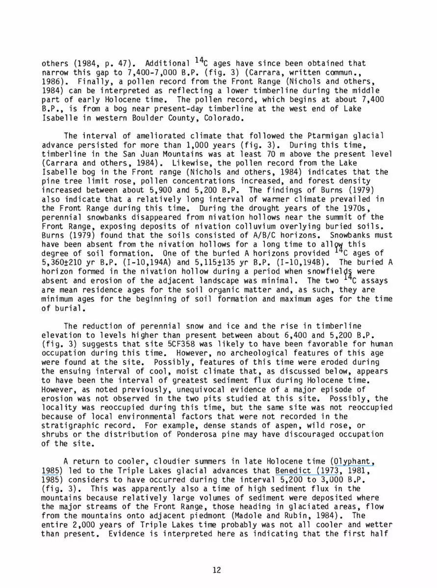
others (1984, p. 47). Additional 14C ages have since been obtained that narrow this gap to 7,400-7,000 B.P. (fig. 3) (Carrara, written commun., 1986). Finally, a pollen record from the Front Range (Nichols and others,1984) can be interpreted as reflecting a lower timberline during the middle part of early Holocene time. The pollen record, which begins at about 7,400 B.P., is from a bog near present-day timberline at the west end of Lake Isabelle in western Boulder County, Colorado.
The interval of ameliorated climate that followed the Ptarmigan glacial advance persisted for more than 1,000 years (fig. 3). During this time, timberline in the San Juan Mountains was at least 70 m above the present level (Carrara and others, 1984). Likewise, the pollen record from the Lake Isabelle bog in the Front range (Nichols and others, 1984) indicates that the pine tree limit rose, pollen concentrations increased, and forest density increased between about 5,900 and 5,200 B.P. The findings of Burns (1979) also indicate that a relatively long interval of warmer climate prevailed in the Front Range during this time. During the drought years of the 1970s, perennial snowbanks disappeared from nivation hollows near the summit of the Front Range, exposing deposits of nivation colluvium overlying buried soils. Burns (1979) found that the soils consisted of A/B/C horizons. Snowbanks must have been absent from the nivation hollows for a long time to allow this degree of soil formation. One of the buried A horizons provided 14 C ages of 5,360+210 yr B.P. (I-10.194A) and 5,115+135 yr B.P. (I-10,194B). The buried A horizon formed in the nivation hollow during a period when snowfields were absent and erosion of the adjacent landscape was minimal. The two * C assays are mean residence ages for the soil organic matter and, as such, they are minimum ages for the beginning of soil formation and maximum ages for the time of burial.
The reduction of perennial snow and ice and the rise in timberline elevation to levels higher than present between about 6,400 and 5,200 B.P. (fig. 3) suggests that site 5CF358 was likely to have been favorable for human occupation during this time. However, no archeological features of this age were found at the site. Possibly, features of this time were eroded during the ensuing interval of cool, moist climate that, as discussed below, appears to have been the interval of greatest sediment flux during Holocene time. However, as noted previously, unequivocal evidence of a major episode of erosion was not observed in the two pits studied at this site. Possibly, the locality was reoccupied during this time, but the same site was not reoccupied because of local environmental factors that were not recorded in the stratigraphic record. For example, dense stands of aspen, wild rose, or shrubs or the distribution of Ponderosa pine may have discouraged occupation of the site.
A return to cooler, cloudier summers in late Holocene time (Olyphant,1985) led to the Triple Lakes glacial advances that Benedict (1973, 1981, 1985) considers to have occurred during the interval 5,200 to 3,000 B.P. (fig. 3). This was apparently also a time of high sediment flux in the mountains because relatively large volumes of sediment were deposited where the major streams of the Front Range, those heading in glaciated areas, flow from the mountains onto adjacent piedmont (Madole and Rubin, 1984). The entire 2,000 years of Triple Lakes time probably was not all cooler and wetter than present. Evidence is interpreted here as indicating that the first half
12

was cooler and wetter, but that climate warmed in the latter half of Triple Lakes time.
Ages obtained for most Triple Lakes moraines are in the range of 5,200- 4,000 B.P. According to Benedict (1985, p. 78), at one Front Range locality, the outer of two Triple Lakes moraines formed between 5,260 and 4,010+170 yr B.P. (1-12,840) and the inner moraine is older than 3,340+110 yr B.P. (1-7457) and at another nearby locality, a Triple Lakes moraine formed between 5,925 and 3,945 B.P.
Data from three study sites in western Boulder County, Colorado, indicate that conditions changed to wetter, if not cooler, just prior to 5,000 B.P. In Caribou Park, located below timberline in western Boulder County at an altitude of about 3,010 m, just upstream from Devlins Park (Madole, 1986), a dry meadow became a peat bog at about 5,000+60 yr B.P. (W-4683) (Madole, unpub. data). At a second site, above timberline across the Continental Divide about 9 km northwest and 400 m higher than Caribou Park, Benedict (1985, locality J) reports that accumulation of peat was followed by the deposition of a thin clayey unit at about 5,035+75 yr B.P. (1-12,115). The clayey interval has a maximum thickness of only 5 cm but represents 1,500 years of deposition that ended at about 3,380+65 yr B.P. (1-12,114). I interpret this stratigraphy as reflecting a change wherein the peat bog became a pond. The third site is the nivation hollow in alpine tundra mentioned above, where Burns (1979) found a paleosol that began to be buried by nivation colluvium at about 5,100 B.P.
Nichols and others (1984, p. 9) refer to the interval between 5,200 and 4,200 B.P. in the pollen record from the Lake Isabelle bog, western Boulder County, as the Birch period, because of moderate to large percentages and concentrations of Betula pollen. Pollen of shrubs and herbs is also significant in this interval, whereas percentages of arboreal pollen are very low. They interpret this pollen spectrum as a local event representing the drying out of the bog surface and invasion by shrubs. However, I prefer to interpret the pollen spectrum as reflecting a time of wetter, cooler climate that expanded the area of wet sites favorable for the growth of Betula. A drying trend during the interval 5,200-4,200 B.P. is inconsistent with the data described above that suggests a shift toward more moist conditions during this time. Also, the low percentages of arboreal pollen during the Birch period could be interpreted as reflecting climatic cooling and a recession of timberline rather than local drying.
The change in the pollen record of the Lake Isabelle bog that Nichols and others (1984) place at about 4,200 B.P. is also possibly of more than local significance and may represent a shift to a warmer climate. Nichols and others (1984) report that the pollen profile from 4,200 to 3,250 B.P. is dominated by peak arboreal pollen percentages and rising pine pollen percentages. They interpret this interval as representing the maximum extent of timberline at this site. Hence, climate may have remained moist during Triple Lakes time, but warmed during the latter part of the interval. Benedict (1981, 1985) defines the latter part of Triple Lakes time largely on the basis of processes associated with advances of rock glaciers and points out (Benedict, 1981, p. 117) that the rock glaciers of late Triple Lakes time "could have advanced to their modern positions at a time when warm summer temperatures encouraged deformation of interstitial or buried massive ice".
13

Andrews and others (1975) also indicate that climate was warmer in the San Juan Mountains between 3,600 and 3,000 B.P., on the basis of evidence of higher timberlines.
Timberline in the San Juan Mountains definitely rose to levels above that of the present at about 3,100 B.P. (Carrara and others, 1984). This rise marked a return to a more moderate climate that is estimated to have lasted for about 1,000 years. The estimate is based on the glacial and peri glacial history of the Front Range (Benedict, 1973, 1981, 1985) and on the archeological data of this report (fig. 3) as well as that from Pontiac Pit, a site in the uppermost Colorado River valley about 8 km north of Grand Lake, Colorado (Liestman, 1984; Madole 1984). During this interval of more moderate climate, humans intermittently reoccupied site 5CF358 and also site 5GN289 in Taylor Park.
TAYLOR PARK SITE (5GN289)
Geomorphic Setting
Valley glaciers originating in cirques along the western side of the Sawatch Range during late Pleistocene time advanced as far west as Taylor Park (fig. 1). Site 5GN289 is about 4 km west of the limit reached by these glaciers. The valley floor of Willow Creek, one of the larger glaciated valleys in the area, is underlain by outwash of both Bull Lake age (ca. 150,000-130,000 B.P.) and Pinedale age (ca. 30,000-12,000 B.P.). Excavations on the valley floor of Willow Creek, 1.3 km east of site 5GN289, exposed 3 m of outwash of Pinedale age overlying 2.7 m (bottom of section not exposed) of outwash of Bull Lake age. In the vicinity of site 5GN289, these deposits are now partly covered by Taylor Park Reservoir. Site 5GN289 is estimated to lie about 30-36 m above the level of the late Pleistocene outwash.
Stratigraphy
The stratigraphy at site 5GN289 was examined in four 2 x 2-m pits, excavated to depths of about 50 cm, on the north side of the road, and in two pits south of the road, also about 50 cm deep, the larger of which was 4 x 4 m. The latter received the most study and was the site selected for soil descriptions and samples. Three stratigraphic units were recognized in all of the pits (fig. 4). From bottom to top, these are (1) thick cobble- boulder gravel, (2) a thin bed (7-24 cm) of sheetwash composed largely of silt and fine sand, and (3) a very thin layer (2-4 cm) of eolian silt and fine sand. An unconformity separates the gravel from the two overlying units of silt and sand and truncates a buried soil formed in the gravel.
Unit 1
Unit 1 is a clast-supported gravel (gravel wherein clasts are in nearly continuous contact, and the matrix, material less than 2 mm in size, is subordinate). Clasts of chiefly granitic and gneissic rock compose an estimated 60-70 percent of the deposit, and large cobbles and boulders are abundant. Most clasts are subangular or subrounded but many are angular. The matrix is yellowish-brown to light yellowish-brown (10YR 5/4 to 6/4, dry) silty sand, in which fine sand is dominant (fig. 4, table 2). The color is a
14

WEST23501120
EAST
3BC >^
3 METERS
UNIT 3 DARK GRAYISH-BROWN FINE SANDY SILT
UNIT 2 DARK BROWN SILTY SAND
UNIT I CLAST-SUPPORTED GRAVEL
Figure 4.--Generalized diagram showing the stratigraphy, soil profile, and stratigraphic positions of two radiocarbon ages obtained from archeological features at site 5GN289. The stratigraphic positions of the features were projected into the line of section from localities that are approximately 73 m apart, north-south.
function of weathering (oxidation) and becomes paler with depth. A 4-m-thick section of the unit is exposed in an old roadcut, but total thickness of the unit is unknown. However, the unit is probably considerably thicker than 4 m, judging from the position where the slope angle changes along the sides of valleys entrenched in the gravel and from the distribution of float (gravel on the surface) on valley sides.
Unit 1 was deposited by a stream that was ancestral to a small stream just west of site 5GN289 (not shown in fig. 1). The ancestral stream headed on the flank of Park Cone (fig. 1) and drained northeast to join Willow Creek at a point now covered by Taylor Park Reservoir. This stream has since incised a narrow valley into, and probably through, unit 1. Unit 1 is considerably more poorly sorted than the glacial outwash along Willow Creek, and the clasts in it are much more angular than those in outwash.
On the basis of soil development alone, unit 1 would be considered pre- Pinedale (pre-30,000 B.P.), and the position of unit 1 well above a flood plain underlain by glacial outwash of Bull Lake age, also suggests that the unit is pre-Bull Lake, or at least pre-130,000 B.P. Unfortunately, Taylor Park Reservoir conceals the relationship between the landforms and deposits of Willow Creek and those of the small unnamed stream west of site 5GN289.
15
Tab
le 2
.--L
ab
ora
tory
data
fo
r th
e soil
pro
file
at
the
Ta
ylo
r P
ark
site
(5G
N28
9).
Gun
nlso
n C
ount
y,
Col
orad
o
Par
ticl
e- s
ize
Per
cent
age
> 2n
m
Per
cent
age
of
< 2n
m fr
acti
on
Hor
izon
A 2A 3Bt
3BC
Ave
rage
de
pth
(cm
)
0-2
1.9
2-22
9.
3
22-8
7 30
.4
87+
41.2
Sand
S
ilt2
(0
.05-
(2
-0.0
5)
0.00
2)
36.3
3 43
.99
44.0
6 36
.14
63.0
8 23
.14
65.8
8 23
.11
Cla
y2
(<0.
002)
19.6
7
19.8
0
13.7
8
11.0
1
dis
trib
uti
on (
mm)1
Per
cent
age
Sand
Ver
y C
oars
e co
arse
(2
-1)
(1-0
.5)
3.34
3.
99
5.24
5.
52
8.48
8.
54
6.35
9.
61
Med
ium
(0
.5-
0.25
)
5.96 8.03
18.2
9
14.8
3
Fin
e (0
.25-
0.
10)
10.0
8
12.5
2
19.5
2
20.9
1
Ver
y Fi
ne
(0.1
0-
0.05
)
12.9
6
12.7
5
14.2
5
14.1
8
Per
cent
age
Sil
t
Coa
rse
(0.0
5-
0.03
)
25.8
6
19.0
3
12.4
9
12.4
7
Med
ium
(0
.03-
0.
02)
14.5
9
13.2
6
7.90
8.44
Fine
(0
.02-
0.
002)
3.53
3.84
2.76
2.20
Perc
enta
ge C
lay2
Coa
rse
Fin
e (0
.002
- 0.
0005
) (<
0.00
05)
5.31
14
.37
5.57
14
.23
3.49
10
.28
3.49
7.
52
Per
cent
age
Org
anic
M
atte
r pH
11.7
3 5.
00
5.12
5.
40
3.00
5.
70
7.00
Part
icle
-siz
e d
istr
ibu
tio
n
dete
rmin
ed
by
the
sie
ve
-pip
ett
e
met
hod.
2Pa
rt1
c1e
-s1
ze lim
its fo
r silt
and
cla
y ar
e a
cco
rdin
g to
th
e
U.S
. D
epar
tmen
t of
Ag
ricu
ltu
re p
art
icle
-siz
e
sca
le
(Soil
Sur
vey
Sta
ff,
19
75
).

Unit 2
Unit 2 is dark brown (10YR 4/3, dry) poorly sorted silty sand (fig. 4, table 2), loam in pedologic terminology, that varies in thickness from 7-24 cm, but typically is 15-20 cm thick. The variation in thickness is attributed to deposition on an uneven surface eroded in unit 1. Granules are abundant and widespread, but most of the unit consists of silt, very fine sand, and fine sand. Unit 2 was deposited around and over large clasts embedded in unit 1 (fig. 4). Cobbles and boulders were not observed entirely within unit 2, although small pebbles are widespread and locally make up as much as 5 percent of the unit.
The high percentage of silt and very fine sand suggests Unit 2 is eolian, but the coarser material, particularly the granules and scattered pebbles, suggests a fluvial origin. Unit 2 is considered to be sheetwash that may have been derived partly from eolian sediment. The dark color of unit 2 is due primarily to humus that was formed in place by pedologic processes and possibly also by sheetwash erosion of the A horizon of pre-existing soils. The weakly developed soil in unit 2 suggests that the unit is of late Holocene age, and two ^C ages from archeological features support this age assignment. Charcoal from two features near the base of unit 2, 25-30 cm below the ground surface (fig. 4), provided a 14C age of 2,650+180 yr B.P. (Beta-14919), and charcoal from a second feature, 11-14 cm below the ground surface, provided a 14C age of 2,350+120 yr B.P. (Beta-11187).
Unit 3
Unit 3 is dark grayish-brown (10YR 4/2, dry) sandy silt (fig. 4, table 2). Only a small percentage of the unit is larger than fine sand, and granules and larger clasts are rare. The unit is commonly only 2-4 cm thick; hence, it appears to be part of unit 2, but texturally different (table 2) and slightly darker in color. Unit 3 is believed to be of eolian origin.
A thin surface layer of eolian sediment like unit 3 is present in many localities near glaciated areas in the Colorado Rocky Mountains. One such deposit at the Pontiac Pit archeological site (5GA217), which is on a terrace 5 m above the flood plain of the Colorado River about 8 km north of Grand Lake, Colorado, was younger than 780+50 yr B.P. (Madole, 1984). At this locality, the eolian sediment covered four hearths that ranged in age from 780+50 to 980+180 yr B.P. (Leistman, 1984). The eolian sediment was interpreted to have been derived from the flood plain of the Colorado River during the interval of climatic deterioration that culminated in the Arapaho Peak glacial advances. Unit 3 at site 5GN289 could be correlative with the surface layer of eolian sediment at the Pontiac Pit site.
17

Soil Profile
Location:
Altitude:
Vegetation:
Parent Material
Topography:
Climate:
Hori zon; Oi ,e,a 1-0 cm
A0-2 cm(2 cm)
2A2-22 cm (20 cm)
3Bt 22-87 (65 cm)
SBC 87+ cm
Profile Description
Taylor Park Reservoir 7 1/2' quadrangle at a point a few tens of meters south of the road along the south side of Taylor Park Reservoir and several tens of meters east of the small valley along the east side of Lakeview Campground.
2,866 m (9,400 ft)
A thin to moderate cover of grass is dominant, and sagebrush and potentilla are common, as are various wildflowers. The more steeply sloping terrain starting about 90 m south of the site is covered by a lodgepole pine forest.
A thin cover of eolian sediment and sheetwash overlying fan alluvium of clast-supported cobble-boulder gravel.
Relatively smooth surface that slopes northward at 4°-5° (7-9 percent)
Mean annual precipitation is about 47 cm. Mean January temperature is -14.4°C and mean July temperature is14.6°C-
The aggregate thickness of undecomposed and decomposed organic matter is commonly 0.5-1.0 cm; very abrupt smooth boundary.
Dark grayish-brown (10YR 4/2, dry) loam; weak to moderate, fine granular; loose, slightly sticky, slightly plastic; abrupt smooth boundary.
Dark-brown (10YR 4/3, dry) loam; weak, fine to moderate subangular blocky; loose, slightly plastic to plastic, slightly sticky; abrupt smooth boundary.
Yellowish-brown (10YR 5/4, dry) gravelly sandy loam; moderate, medium subangular blocky; loose, slightly sticky, slightly plastic; abrupt smooth boundary.
Light yellowish-brown (10YR 6/4, dry) gravelly sandy loam; weak, fine subangular blocky; slightly sticky, slightly plastic; lower boundary not exposed.
^Mean annual precipitation and temperature data are from Taylor Park, Colorado, weather station for the period 1940-1964 (U.S. Department of Commerce, 1959, 1964).
18

Geologic History
The alluvium of unit 1 was deposited in middle Pleistocene time by small streams that headed on the flank of Park Cone south of Taylor Park (fig. 1). The alluvium was deposited where the streams entered Taylor Park. These streams were graded to an ancestral Willow Creek whose valley floor was at a higher level than that of the present stream. Subsequently, Willow Creek incised its channel, as did the small stream in the vicinity of site 5GN289, by as much as 15 m. Stream incision ended deposition of coarse alluvium in the vicinity of site 5GN289, as alluvium was confined thereafter to the incised channel. Erosion undoubtedly occurred in areas adjacent to the small streams as channel incision progressed, and possibly is partly responsible for the unconformity between units 1 and 2. This unconformity represents an unknown amount of erosion that occurred during or subsequent to channel incision. In the vicinity of site 5GN289, losses by erosion exceeded gains from deposition until late Holocene time when a relatively thin cover of sheetwash was deposited. The unconformity between units 1 and 2 separates deposits differing in age by more than 100,000 years. Unit 1 is at least 150,000-130,000 years old (predates outwash of Bull Lake age) and probably older, whereas unit 2 is less than 3,000 years old, according to two 14C ages.
Unit 2 is interpreted to be sheetwash derived partly from eolian sediment. Most of the unit is thought to have been deposited during Triple Lakes and Audubon time (fig. 3) when increased winter snowfall favored greater sheetwash during the snowmelt season and possibly established conditions favoring eolian transport and deposition. The source of the eolian sediment is unknown. Some or all may have come from local sources such as the flood plains of Willow Creek, Texas Creek, and the Taylor River, streams whose upper reaches were glaciated. Alternatively, it may have come from distant sources in arid and semi arid areas to the west and southwest.
Flood plains of streams that drain from modern alpine glaciers are known to be sources of eolian sediment; the same was probably true during earlier glacial advances. During times of expanded cirque glaciers and increased snow cover, as in Triple Lakes time and Audubon time, summer runoff would have increased. Streams in coarse materials such as exist in these valleys adjust to greater runoff by widening rather than deepening their channels. Hence, increased snowmelt runoff would tend to develop broader, shallow streams. Stream discharge would have fluctuated markedly from the height of the snowmelt season to autumn, much as it does at present. As runoff declined through late summer into autumn, progressively more channel surface and bar deposits would become exposed to wind erosion. However, if the source of eolian sediment is linked to expanded glaciers, then the eolian stratigraphic record ought to be similar to the glacial stratigraphic record, which it is not. The eolian record is much less complex than the glacial record. Therefore, the eolian sediment may have a nonglacial origin.
SUMMARY AND CONCLUSIONS
The Runberg site (5CF358) and Taylor Park site (5GN289) are at similar altitudes, but differ in topographic setting, amount and kind of vegetation, and climate. These differences have influenced the kinds and amounts of sediment deposited at each site during Quaternary time and the degree to which the stratigraphic record was preserved.
19

The Runberg site is at an altitude of 2,732 m (8,960 ft) and is on the floor of a glaciated valley near the lower limit of the montane forest. The forest is relatively open near the lower limit, especially on south-facing exposures like that of the Runberg site. In such places, grassland, including herbs and locally dense stands of shrubs, may exceed the area in forest. The grass cover is generally sparse, both in open areas and under trees. The sparseness of ground cover is reflected in the nearly complete absence of a soil 0 horizon. Given the sparse vegetation and the amount of bare ground, sheetwash is likely to be an active process over much of the area today and probably was a dominant process during much of Holocene time.
The Taylor Park site is at an altitude of 2,866 m (9,400 ft), 134 m (710 ft) higher than the Runberg site, and is on dissected fan alluvium at the south edge of Taylor Park. Taylor Park is a grassland composed mainly of bunchgrass, wild flowers, and variable amounts of big sagebrush. The slopes surrounding Taylor Park are forested. Site 5GN289 is less than 100 m from the south edge of Taylor Park and forested slopes of predominantly lodgepole pine. The Taylor Park site receives, on the average, 5-10 cm more annual precipitation than the Runberg site and has similar summer temperatures but markedly colder winter temperatures. Mean January temperatures at the Taylor Park station are -14.4°C as compared to -7°C for the Runberg site.
The stratigraphic record is relatively meager at both the Runberg and Taylor Park sites. Four stratigraphic units were recognized in the upper 1 m of sediment at the Runberg site. A basal unit of matrix-supported cobble- boulder gravel is overlain by three units of sand, collectively 70-75 cm thick, that were distinguished on the basis of subtle differences in texture and color. Several meters of sediment are estimated to underlie the site; most of the sediment is likely to be of late Pleistocene age. The Holocene part of the section is probably less than 25 cm thick over most of the area.
At the Taylor Park site, three stratigraphic units were recognized that include several meters of bouldery fan alluvium overlain by 7-24 cm of fine- grain sheetwash that, in turn, is overlain by 2-4 cm of eolian silt and fine sand. On the basis of position in the landscape and soil development, the fan gravel is believed to be of middle Pleistocene age (790,000-130,000 B.P.). A weakly developed soil and two 14C ages indicate that unit 2 is of late Holocene age and that a large part of it was deposited between 3,000 and 2,000 B.P. Although the age of unit 3 is unknown, the unit is similar in composition and stratigraphic setting to eolian sediment deposited after 780±50 yr B.P. at the Pontiac Pit site, which is on a low-lying terrace near the head of the Colorado River (Madole, 1984). The unconformity separating the fan alluvium and the thin layer of Holocene sediment represents more than 100,000 years of time and an unknown amount of erosion that occurred during and subsequent to channel incision. The incision of stream channels during middle Pleistocene time isolated the Taylor Park site from further sedimentation, except from eolian sources and sheetwash.
The artifacts and features at both the Runberg and Taylor Park sites indicate that they were occupied during intervals when climate was milder in montane Colorado than it has been during the past few centuries. Radiocarbon ages of four hearths from the Runberg site indicate that it was occupied intermittently between 8,840+100 (Beta-14921) and 7,740+140 yr B.P. (Beta- 14922), which coincides with an interval when timberline in the San Juan
20

Mountains had risen to levels higher than that of the present (Carrara and others, 1984). Two other ^C-dated archeological features at the Runberg site and two features at the Taylor Park site indicate that both sites were also occupied between 3,480+100 (Beta-14920) and 2,350+120 yr B.P. (Beta-11187), which corresponds to another interval of relatively mild climate (fig. 3). The 3,480+100-yr age is within the time of the Triple Lakes glacial advances (Benedict 1973, 1981), but the latter part of Triple Lakes time, which is defined by rock-glacier advances, may not have been cooler than the present. Pollen data from both the San Juan Mountains (Andrews and others, 1975) and the Front Range (Nichols and others, 1984) indicate that climate was warmer during this time, and, by 3,100 B.P., timberline in the San Juan Mountains was higher than present (Carrara and others, 1984). This interval of milder climate is thought to have persisted until the Audubon glacial advances, the beginning of which is placed at about 2,400 B.P. (Benedict, 1985).
Timberline elevations were also above those of the present between about 6,400 and 5,200 B.P. (fig. 3), but no archeological remains related to this time were found at the Runberg site, and the Taylor Park site does not contain sediment of this age. It is possible that the stratigraphic record of this interval was eroded at the Runberg site; however, unequivocal evidence of such erosion was not found.
REFERENCES CITEDAndrews, J. T., Carrara, P. E., King, F. B., and Stuckenrath, Robert, 1975,
Holocene environmental changes in the alpine zone, northern San Juan Mountains, Colorado Evidence from bog stratigraphy and palynology: Quaternary Research, v. 5, p.173-197.
Benedict, J. B., 1973, Chronology of cirque glaciation, Colorado Front Range: Quaternary Research, v. 3, p. 584-599.
___1981, The Fourth of July Valley Glacial Geology and Archeology of theTimberline Ecotone: Center for Mountain Archeology, Ward, Colorado, Research Report No. 2, 139 p.
___1985, Arapaho Pass--Glacial geology and archeology at the crest of the Colorado Front Range: Center for Mountain Archeology, Ward, Colorado, Research Report No. 3, 197 p.
Birkeland, P. W., 1984, Soils and geomorphology: New York, Oxford University Press, 372 p.
Brock, M. R., and Barker, Fred, 1972, Geologic map of the Mount HarvardQuadrangle, Chaffee and Gunnison Counties, Colorado: U. S. Geological Survey Geologic Quadrangle Map GQ-952, scale 1:62,500.
Burns, S. F., 1979, Buried soils beneath alpine snowbanks may date the end of the altithermal: Geological Society of America Abstracts with Programs, v. 11, no. 6, p. 267-268.
Carrara, P. E., Mode, W. N., Rubin, Meyer, and Robinson, S. W., 1984, Deglaciation and postglacial timberline in the San Juan Mountains, Colorado: Quaternary Research, v. 21, p. 42-55.
21

Church, Michael, and Ryder, J. M., 1972, Paraglacial sedimentation Aconsideration of fluvial processes conditioned by glaciation: Geological Society of America Bulletin, v. 83, p. 3059-3072.
Costa, J. E., 1984, Physical geomorphology of debris flows, JJT_ Costa, J. E., and Fleisher, P. J., eds., Developments and applications of Geomorphology: Berlin, Springer-Verlag, p. 268-317.
Costa, J. E., and Jarrett, R. D., 1981, Debris flows in small mountain stream channels of Colorado and their hydrologic implications: Association of Engineering Geologists Bulletin, v. 18, no. 3, p. 309-322.
Flint, R. F., Sanders, J. E., and Rodgers, John, 1960, Diamictite, asubstitute term for symmictite [an addendum]: Geological Society of America Bulletin, v. 71, no. 12, p. 1809-1810.
Guthrie, R. L., and Witty, J. E., 1982, New designations for soil horizons and layers and the new Soil Survey Manual: Soil Science Society of America Journal, v. 46, p. 443-444.
Legg, T. E., and Baker, R. G., 1980, Palynology of Pinedale sediments, Devlin Park, Boulder County, Colorado: Arctic and Alpine Research, v. 12, p. 319-333.
Leistman, T. L., 1984, Archeological excavations at the Pontiac Pit site--A multi-component campsite in the Rocky Mountains: Lincoln, Nebraska, National Park Service, Midwest Archeological Center, 199 p.
Leonard, E. M., 1986, Use of lacustrine sedimentary sequences as indicators of Holocene glacial history, Banff National Park, Alberta, Canada: Quaternary Research, v. 26, p. 218-231.
Luckman, B. H., and Kearney, M. S., 1986, Reconstruction of Holocene changes in alpine vegetation and climate in the Maligne Range, Jasper National Park, Alberta: Quaternary Research, v. 26, p. 244-261.
Madole, R. F., 1980, Time of Pinedale deglaciation in north-central Colorado- Further Considerations: Geology, v. 8, p. 118-122.
___1982, Possible origins of til 1-1 ike deposits near the summit of the FrontRange in north-central Colorado: U. S. Geological Survey ProfessionalPaper 1243, 31 p.
___1984, Geology of the Pontiac Pit archeological site, Rocky MountainNational Park, Colorado: U.S. Geological Survey Open-File Report 84-223, 8 p.
___1986, Lake Devlin and Pinedale glacial history, Front Range, Colorado: Quaternary Research, v. 25, no. 1, p. 43-54.
Madole, R.F., Bachhuber, F. W., and Larson, E. E., 1973, Geomorphology, palynology, and paleomagnetic record of glacial Lake Devlin, Front Range: Geological Society of America, Rocky Mountain Section 26th Annual Meeting, Guidebook (Trip 1), 25 p.
22

Madole, R. F., and Rubin, Meyer, 1984, Reinterpretation of Holocene alluvial chronology in major valleys of the northern Colorado Piedmont: Abstracts, Eighth Biennial Meeting, American Quaternary Association, p. 76.
Nichols, Harvey, Short, Susan, Elias, Scott, and Harbor, Jonathan, 1984,Sedimentation and palynology in high-level lakes, Front Range: Boulder, Colorado, Guidebook for Field Trip 11, Eighth Biennial Meeting, American Quaternary Association, 21 p.
Olyphant, G. A., 1985, Topoclimate and the distribution of neoglacial facies in the Indian Peaks section of the Front Range, Colorado, U.S.A.: Arctic and Alpine Research, v. 17, no. 1, p. 69-78.
Ryder, J. M., 1971, The stratigraphy and morphology of para-glacial alluvial fans in south-central British Columbia: Canadian Journal of Earth Sciences, v. 8, p. 279-298.
Soil Survey Staff, 1975, Soil taxonomy A basic system of soil classification for making and interpreting soil surveys: U. S. Department of Agriculture, Soil Conservation Service Agricultural Handbook 436, 754 p.
Tweto, Ogden, Steven, T. A., Hail, W. J., Jr., and Moench, R. H., 1976,Preliminary geologic map of the Montrose 1° x 2° Quadrangle, southwestern Colorado: U. S. Geological Survey Miscellaneous Field Studies Map MF-761, scale 1:250,000.
U. S. Department of Commerce, 1959, Climatic summary of the United States-- Supplement for 1931 through 1952: Weather Bureau, Climatography of the United States No. 11-5, 62 p.
U. S. Department of Commerce, 1964, Climatic summary of the United States- Supplement for 1951 through 1960: Weather Bureau, Climatography of the United States No. 86-5, 86 p.
23