texas archeological society
TRANSCRIPT
bulle$in of the Texas Archeological Society Volume 52 Published by the Society Fort Worth, Texas 1981
TEXAS ARCHEOLOGICAL SOCIETY
The Society was organized and chartered in pursuit of a literary and scien- tific undertaking: the study of man’s past in Texas and contiguous areas. The Bulletin offers an outlet for the publication of serious research on history, prehistory, and archeological theory. In line with the goals of the Society, it encourages scientific collection, study, and publication of archeological data.
The Bulletin is published annually for the distribution to the members of the Society. Opinions expressed herein are those of the writers and do not neces- sarily represent the views of the Society or editorial staff.
Officers of the Society 1980-1981
President: PAUL LORRAIN (Dallas) President-elect: WILLIAM L. RICHMAN (Austin) Secretary-Treasurer: C.K. CHANDLER (San Antonio)
Editor: EILEEN JOHNSON (Lubbock) Editor-elect: ROBERT J. MALLOUF
Newsletter Editor: PATRICIA WHEAT (Houston) Immediate Past President: ANNE FOX (San Antonio)
Directors (in addition to the above): JOHN HEDRICK (El Paso), THOM- AS R. HESTER (San Antonio), GERALD HUMPHREYS (Washington), W.L. McCLURE (Houston), JANE SCHWEITZER (Midland), R.L. TURNER JR. (Ft. Worth).
Regional Vice Presidents: ROBERT SMITH (Stinnett), CLAUDE BROWN (Lubbock), W.E. RAINWATER (Ft. Worth), DOYLE S. GRAN- BERRY (Dallas), KENNETH L. BROWN (Houston), GRANT HALL (San Antonio), EDWARD R. MOKRY (Corpus Christi), JOHN STOCKLEY (Quemado), SAMUEL D. McCULLOCH (Austin), OTTIS BOBBITT (San Angelo), ROSE MARY ROGERS (Iraan).
Memberships and Publications
Membership in the Society is for the calendar year. Dues are as follows: Regular--S15.00; Chartered Societies and Institutional--S15.00; Contrib- uting--$30.00; Life--S300.00. All members of the Society receive the Bul- letin, published annually, and Texas Archeology, a newsletter mailed about four times a year. A monograph series, Special Publications, also is published by the Society. Back issues of the Bulletin, up to and including Volume 39, that are still in print, may be obtained for $5.00 per volume. Subsequent volumes are available at a cost of $12.50.
Address orders for publications and membership applications to Secretary- Treasurer, Texas Archeological Society, Center for Archaeological Re- search, The University of Texas at San Antonio, San Antonio, Texas 78285.
©Copyright by the Texas Archeological Society, 1981
Bulletin of the
TEXAS ARCHEOLOGICAL
Volume 52/1981
SOCIETY
Eileen Johnson, Editor Technical Assistants
April MacDowell Mei Wan Gerald Urbankte
Cover design by Gerald Urbantke; courtesy of Texas Parks and Wildlife Department; artist reconstruction of Thomas F. McKinney House. 1980 cover courtesy of Texas Memorial Museum, The University of Texas, Austin; Thomas F. McKinney.
PUBLISHED BY THE SOCIETY AT FORT WORTH, TEXAS 1981

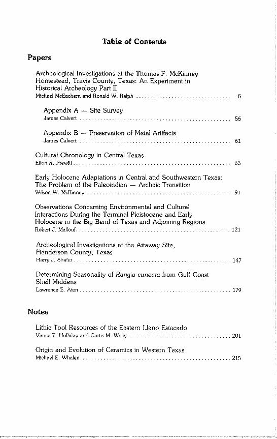
Table of Contents
Papers
Archeological Investigations at the Thomas F. McKinney Homestead, Travis County, Texas: An Experiment in Historical Archeology Part II Michael McEachern and Ronald W. Ralph ................................
Appendix A -- Site Survey James Calvert ................................................... 56
Appendix B -- Preservation of Metal Artifacts James Calvert ................................................... 61
Cultural Chronology in Central Texas Elton R. Prewitt ..................................................... 65
Early Holocene Adaptations in Central and Southwestern Texas:
The Problem of the Paleoindian -- Archaic Transition Wilson W. McKinney ................................................. 91
Observations Concerning Environmental and Cultural Interactions During the Terminal Pleistocene and Early Holocene in the Big Bend of Texas and Adjoining Regions Robert J. Mallouf .................................................... 121
Archeological Investigations at the Attaway Site, Henderson County, Texas Harry J. Shafer ..................................................... 147
Determining Seasonality of Rangia cuneata from Gulf Coast
Shell Middens Lawrence E. Aten ................................................... 179
Notes
Lithic Tool Resources of the Eastern Llano Estacado Vance T. Holliday and Curtis M. Welty ................................... 201
Origin and Evolution of Ceramics in Western Texas
Michael E. Whalen .................................................. 215
Reviews
Late Prehistoric Bison Procurement in Southeastern New Mexico: The 1978 Season at the Garnsey Site (LA-18379). John D. Speth and William T. Parry. Vance T. Holliday ................................................... 231
Bioarchaeology of the McCutchan-McLaughlin Site.
Mary Powell and J. Daniel Rogers. Gentry Steele ....................................................... 233
Index
BULLETIN OF THE TEXAS ARCHEOLOGICAL SOCIETY, Volumes 1 - 50 Helen Simons ...................................................... 237
Authors .......................................................... 313
Bulletin of the Texas Archeological Society 52:5-63 1981
Michael HcEachem and Ronald W. Ralph
ABSTRACT
The Thomas F. McKinney homestead and mill complex represents an upper class Anglo rural occupation dating after the Texas Republic Period (1850’s) with subsequent occupation by rural blacks. Pedestrian survey, archeological prospecting, and excavation by the Texas Archeological Society Field School and Texas Parks and Wildlife personnel defined prehistoric occupations and historic structures along with background, historical, and environmental data. Some prospecting techniques revealed probable additional archeological features. Survey and excavation data helped minimize site damage during development of McKinney Falls State Park.
MILL
We are pleased to hear that the Hon. Thomas F. McKinney has erected an elegant flouring mill on Onion Creek, about four miles from the city, and is prepared to manufacture flour of a superior quality. Among all the wants of this rich country, none has been felt so seriously as that now supplied by the enterprise of Mr. McKinney. Up to the present time, all the flour used in Western Texas has been imported from the North, creating an immense drain upon the cash resources of the country. We hope now to see this drawback arrested, in giving ample en- couragement to the public spirited efforts of Mr. McKinney to supply among us an all-important improvement. In no country can better wheat be grown than in ours, and it is a burning reproach to us to longer rely upon imported flour for our daily bread (Texas State Gazette, July 10, 1852:3).
Research Design
Excavations at the mill were designed to "trace the walls of the struc- ture . . . [to] determine whether the mill is of the turbine type and the direc~ tion of the outlet tunnel" (Ralph and McEachern, 1974:4). TAS excavated 69 units, mostly I x 1 m squares, at various locations around the mill. The main emphasis was on the machine room just south of the wheel pit where details
of walls and machinery installation were noted. Excavations in the wheel pit were aborted when time and depth became a problem. Subsequent excava-
tion by Parks and Wildlife Department personnel (September and October, 1974) exposed the mill turbine and defined the tailrace to a certain extent. Data concerning these excavations, artifacts, and architectural notes are pre-
sented in this report as they complement the research design.
6 Texas Archeological Society
Excava~ons
An expandable metric grid pattern was established, oriented parallel to the main wall lines. The east west grid lines were labeled A, B, etc., starting in the south with A. The north south grid lines were labeled 1, 2, etc., starting in the west with 1. Units were identified by their southeast corner; thus, Unit A1 was located in the extreme southwest corner and Unit T26 in the northeast corner. Elevations were taken from Texas Parks and Wildlife Department monu- ments and converted into meters.
Brush was cleared away from the interior of all obvious wall lines. Units selected for excavation were swept clean; recovered artifacts were labeled surface and plotted on level records. Units were carefully troweled in 10 cm levels. Level I is 1-10 cm below surface and Level II is 10-20 cm below sur- face. Excavated matrix was passed through 1/4 in mesh hardware cloth; all artifacts and faunal remains were saved.
Thirty nine units were excavated in the machine room and eight in the north room. Nine shallow units were placed at strategic points, such as wall corners and pier foundations, to trace structural details.
A wooden bridge was constructed across the wheel pit around the mill shaft to prevent it from shifting as the excavation proceeded. Four low artifact yield units were excavated in the wheel pit, but little was learned of the nature of the feature. The units were left open at the request of the Texas Parks and Wildlife Department and work was resumed (September, 1974) by Parks and Wildlife personnel.
The later work by the Texas Parks and Wildlife Department utilized the TAS grid system and reference points. One large unit was opened, rather than the standard 1 m units used by TAS. Matrix was not screened due to budget constraints and a more than adequate TAS sample.
In excavating the wheel pit, all fill was removed and all in situ artifacts accurately plotted. Fill was placed in a large heavy duty garbage can and lifted using a nylon climbing rope, a rescue pulley, and a front end loader. The can was hand dumped into the front end loader bucket and removed to a backdirt pile. Mapping was facilitated by dropping plumbs at I m intervals and triangu- fating from these points. Line levels provided vertical control from transit surveyed datum points.
Each artifact was bagged separately or by lot and its provenience noted. Each artifact in a lot had a discrete provenience and no two artifacts in any lot were similar. Although it was possible to keep the specimens separate, the system proved difficult to use in the laboratory and is not recommended.
Heavy pick work on the fallen building stone complicated control and often endangered the workers.
Deposit
The machine room fill varies from sandy loam to clayey silt which was very hard when dry and turned dark gumbo when wet. Metal and glass artifacts were interspersed with rock rubble and displaced building stone. The deposit changed to mostly limestone rubble and mortar as excavation proceeded into the lower levels. Ant burrows and roots of a large persimmon tree disturbed
McEachern and Ralph - McKinney Homestead 7
the northeastern portions of the room. Excavations into the millrace deposit beneath the stone arch (L16) encoun-
tered a loose black sediment with many roots and a few small rocks. At the 10- 20 cm level, mortar and limestone were mixed with window glass artifacts.
Deposits of sterile yellow sediment were in the southeast corner of the north room (016). This deposit is possibly water washed materials from flood or erosion later buried by wall collapse.
Fill in the wheel pit consisted of stratified layers of black clayey gumbo and medium to coarse yellow sands. The upper fill slopes from the walls toward the wheel on a fairly gentle grade. It appears that alternating floods washed in different segregated materials. Rough faced limestone blocks, 5-25 kg each, lie haphazardly throughout the fill. Mortar mixed with metal and glass artifacts appear washed in, since a discernible pattern could not be noted until reach- ing the turbine at the bottom of the excavation. A hole 3.7 m by about 1.5 m and almost 4 m deep (about 20 m3) was excavated down to the water table (an elevation of 143 m). Enough of the turbine could be exposed in the allowed time to show how the system worked. Another 0.5 m or so of fill still lies underwater and could not be excavated without using a pump.
Architecture
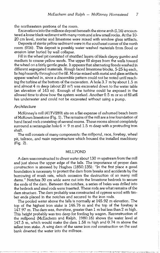
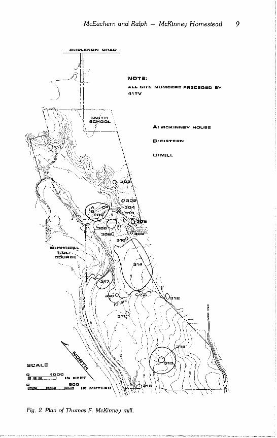
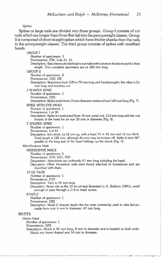
McKinney’s mill (41TV289) sits on a flat expanse of exhumed beach berm of McKown limestone (Fig. 1). The remains of the mill are a low foundation of hand faced rock consisting of several rooms. These rooms almost completely surround a rectangular hole 6 x 9 m and 1.5 m deep with a protruding iron shaft.
The mill consists of many components: the millpond, race, forebay, wheel pit, tailrace, and main superstructure which housed the installed machinery (Fig. 2).
MILLPOND
A dam was constructed to divert water about 130 m upstream from the mill and just above the upper edge of the falls. The importance of proper dam construction is stressed by Hughes (1850:135): "In the first place a good foundation is necessary to protect the dam from breaks and accidents by the burrowing of musk rats, which occasion the destruction of so many mill dams." Notches 30 cm wide were cut into the limestone bedrock to secure the ends of the dam. Between the notches, a series of holes was drilled into the bedrock and steel rods were inserted. These rods are what remains of the dam structure. The dam probably was constructed of cypress wood with tim- ber ends placed in the notches and secured to the iron rods.
The pooled water above the falls is normally at 145.92 m elevation. The top of the highest iron stake is 146.76 m and the top of the forebay is 147.97 m. The dam was, therefore, greater than 1 m but less than 2 m high. This height probably was too deep for fording by wagon. Reconstruction of the millpond (McEachern and Ralph, 1980:16) shows the water level at 147.5 m, which would make the dam 1.58 m high and 0.74 m above the tallest iron stake. A wing dam of the same iron rod construction on the east bank diverted the water into the millrace.
8 Texas Archeological Society
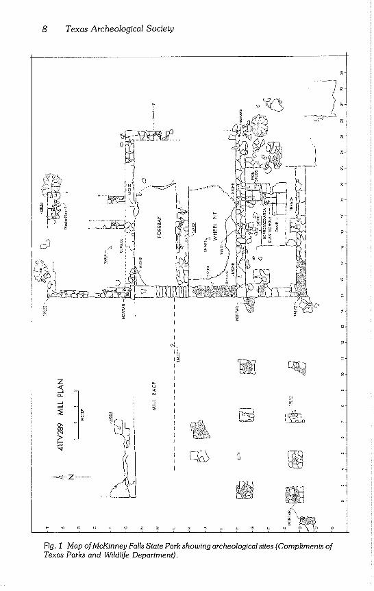
Fig. 1 Map of McKinney Falls State Park showing archeological sites (Compliments of Texas Parks and Wildlife Department).
McEachern and Ralph - McKinney Homestead 9
NOTE:
ALL SITE NUMmERS PRECEOEO BY
41TV
HOUSE
B: CISTE RN
C:MILL
:\
\
/
\
|12
SCALE
SOO
Fig. 2 Plan of Thomas F. McKinney mill.
10 Texas Archeological Society
MILLRACE
The millrace delivers water from the millpond to the forebay. The race at McKinney’s mill, which was 108 m long and about 3.5 m wide, utilized a natural channel in the bedrock. The north side of the millrace was formed by the north bank of the stream. At least part, if not all, of the stream bank is faced with rock. The south side of the race was formed in part by the wing dam and in part by natural bedrock. Remnants of two rock pillars 11 m up- stream from the forebay and in line with the wing dam may have been part of a water gate which was used to divert water away from the mill and regulate water level.
FOREBAY
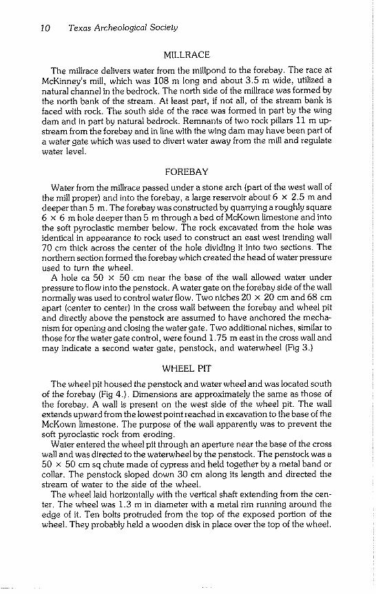
Water from the millrace passed under a stone arch (part of the west wall of the mill proper) and into the forebay, a large reservoir about 6 x 2.5 m and deeper than 5 m. The forebay was constructed by quarrying a roughly square 6 x 6 m hole deeper than 5 m through a bed of McKown limestone and into the soft pyroclastic member below. The rock excavated from the hole was identical in appearance to rock used to construct an east west trending wall 70 cm thick across the center of the hole dividing it into two sections. The northern section formed the forebay which created the head of water pressure used to turn the wheel.
A hole ca 50 x 50 cm near the base of the wall allowed water under pressure to flow into the penstock. A water gate on the forebay side of the wall normally was used to control water flow. Two niches 20 x 20 cm and 68 cm apart (center to center) in the cross wall between the forebay and wheel pit and directly above the penstock are assumed to have anchored the mecha- nism for opening and closing the water gate. Two additional niches, similar to those for the water gate control, were found 1.75 m east in the cross wall and may indicate a second water gate, penstock, and waterwheel (Fig 3.)
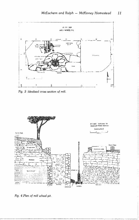
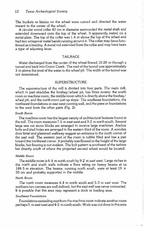
WHEEL PIT
The wheel pit housed the penstock and water wheel and was located south of the forebay (Fig 4.). Dimensions are approximately the same as those of the forebay. A wall is present on the west side of the wheel pit. The wall extends upward from the lowest point reached in excavation to the base of the McKown limestone. The purpose of the wall apparently was to prevent the soft pyroclastic rock from eroding.
Water entered the wheel pit through an aperture near the base of the cross wall and was directed to the waterwheel by the penstock. The penstock was a 50 x 50 cm sq chute made of cypress and held together by a metal band or collar. The penstock sloped down 30 cm along its length and directed the stream of water to the side of the wheel.
The wheel laid horizontally with the vertical shaft extending from the cen- ter. The wheel was 1.3 m in diameter with a metal rim running around the edge of it. Ten bolts protruded from the top of the exposed portion of the wheel. They probably held a wooden disk in place over the top of the wheel.
McEachern and Ralph - IVicKinney Homestead 11
41 TV 289 *k~
MILL-WHEEL PIT
+ + ~ +
Fig. 3 Idealized cross section of mill.
Fig. 4 Plan of mill wheel pit.
12 Texas Archeological Society
The buckets or blades on the wheel were curved and directed the water inward to the center of the wheel,
A circular wood collar 40 cm in diameter surrounded the metal shaft and extended downward onto the top of the wheel. It apparently rested on a metal plate. The top of the collar was 1.4 m above the top of the wheel and had two octagonal metal bands running around it. The collar may have func- tioned as a bearing. A metal rod extended from the collar and may have been a type of adjusting lever.
TAILRACE
Water discharged from the center of the wheel flowed 15-20 m through a tunnel and back into Onion Creek. The roof of the tunnel was approximately 3 m above the level of the water in the wheel pit. The width of the tunnel was not determined.
SUPERSTRUCTURE
The superstructure of the mill is divided into four parts. The main mill, which in part straddles the forebay/wheel pit, has three rooms: the south room or machine room; the middle room which is directly above the forebay/ wheel pit; and the north room just up slope. The southeast foundations, the northwest foundations or east west running wall, and the piers or foundations to the west form the other parts (Fig. 2).
South Room
The machine room has the largest variety of architectural features found at the mill. The room measures 7.5 m east west and 3.2 m north south. Several large saw cut stone blocks are arranged to receive large machines. Anchor bolts and stud holes are arranged in the eastern third of the room. A wooden door lintel and plastered walkway suggest an entrance in the north corner of
the east wall. The western part of the room is rubble filled and has a pier toward the northwest corner. It probably was floored to the height of the large blocks, but flooring is not evident. The bolt pattern is southeast of the turbine but directly south of where the projected second wheel would be located.
Middle Room
The middle room is 6.4 m north south by 9.2 m east west. Large niches in the north and south walls indicate a floor sitting on heavy beams at ca
148.5 m elevation. The beams, running north south, were at least 19 x
33 cm and probably supported in the middle.
North Room
The north room measures 4.4 m north south and 5.3 m east west. The
northern two corners are well defined, but the east wall was never connected. It is possible that this area may represent a dock or loading area.
Southeast Foundations
Foundations extending east from the machine room indicate another room perhaps 5 m east west and 4-5 m north south. Work was not done in this area
McEachern and Ralph - McKinney Homestead 13
other than clearing brush along the south wall for mapping purposes. The northern half of the room still is covered by rock rubble.
Northwest Foundations
A faintly traced wall is an extension of the east west wall between the middle and north rooms of the mill. Foundations were not noted north of this wall. It is believed that the wall represents a stone retainer used to keep slope wash out of the millrace. The wall is 12.8 m long.
West Piers or Foundations
Two foundations buttress the west wall of the machine room and four pairs
of evenly spaced piers extend west to a point due south of the northwest foundation ending point. A lone pier is located another meter west and
slightly south of the westernmost pair. The function of these piers is unknown, but they may have been part of a long raised shed. The shed may have housed a sawmill, storehouse, or any type of mill related machinery. Mill power could have been easily brought into this area.
Very little faunal material was recovered from the mill excavation. Only four species were identified: Trionyx (softshell turtle), Didelphis marsupialis (opossum), Sylvilagus (cottontail), and Sus scrofa (domestic pig). With the exception of a tooth from S. scrofa, identified remains are from native species
(Table 1).
Fauna From the Mill
Table 1
Provenience Species Elements
D17 Sus scrofa tooth G17 Sylvilagus sp. 2 mandibles, 3 teeth G24 Didelphis marsupialis 1 unidentified fragment
skull fragment, mandible
118 Trionyx sp. almost complete specimen
120 Trionyx sp. recovered from 3 adja-
122 Trionyx sp. cent units O16 31 unidentified bone
fragments
$22 1 unidentified bone fragment
Mill Artifacts
Mill excavation produced 1,461 artifacts including specimens of ceramic, glass, metal, and miscellaneous materials. Only 12 ceramic sherds and three lithic artifacts were recovered. The metal artifacts are represented by fasteners (nails, spikes, pins, bolts, nuts, etc.), a few tools, and miscellaneous identified and unidentified specimens. Classification is first by material and then by function.
14 Texas Archeological Society
CERAMICS
Only 12 ceramic sherds were recovered from the mill excavation. Sherds are from whitewares with a relatively hard white paste and clear glaze. Deco- ration includes repousse edge, monochromatic transfer printed, and hand painted underglaze. The ceramics fit well into the time period when the mill was known to be in use. Transfer printing is common in sites from 1790 to 1850, and hand painted Gaudy Dutch is dated 1830-1860 (Walker, 1971:116; Roberson, 1974:43). The single maker’s mark recovered dates 1845-1856.
Plates
Number of specimens: 3 sherds (from two vessels) Provenience: 022, $20, T16 Description: Two sherds are from a whiteware plate with a repousse edge. The remaining
specimen is a body sherd from a whiteware plate.
Basin
Number of specimens: 2 sherds (from one vessel) Provenience: L16, $17 Description: Whiteware basin or pitcher from which these fragments came had a base about
15.5 cm in diameter.
Bowl
Number of specimens: 4 sherds (from one vessel) Provenience: C23(2), D22, D23 Description: Whiteware bowl with hand painted, underglaze floral design in red, green, blue,
and black. Discussion: Gaudy Dutch style decoration usually considered to date 1830-1860 (Roberson,
1974:43).
Vase
Number of specimens: 1 sherd Provenience: $20 Description: Sherd comes from a straight sided whiteware vessel faceted on the outside. It
may have been a vase.
Maker’s Mark
Number of specimens: 1 sherd Provenience: K15 Description: Whiteware sherd has the mark and name of Edward Walley and the words
"IRONSTONE CHINA." Discussion: Godden (1971:97) assigns the mark to Edward Walley, Cobridge, Staffordshire,
ca 1845-1856.
Transfer Ware
Number of specimens: 1 Provenience: D22 Description: Small sherd of whiteware with monochromatic red transfer print. Vessel form
could not be determined. Discussion: Transfer printing was most popular between 1790-1850 (Walker, 1971:116).
Bottles
GLASS
McEachern and Ralph - McKinney Homestead 15
BOTTLENECKS
Number of specimens: 4 Provenience: D22, D24, 122, $21 Description: D22: Light green neck sherd without a rim; 13 mm inside diameter of mouth;
possibly from the same bottle as the base with a pontil mark. D24: Olive; rim type M (Boice, 1980:170); 19 mm inside diameter of mouth. 122: Clear; wire rim with metal screw on cap attached. $21: Light green neck sherd without a rim; 13 mm inside diameter of mouth; possibly from the same bottle as the base with the pontil mark.
BOTTLE BASES
Number of specimens: 2
Provenience: D22(2) Description: One specimen is a green circular base 69 mm in diameter with straight sides.
The other specimen is a light green bottom sherd with a pontil mark.
Discussion: According to Lorraine (1968:36): A pontil mark is a spot of rough glass in the center of the bottom of a bottle. It is formed when the pontil rod is attached to the base with a glob of molten glass to hold the object while the blow pipe is struck off and the raw edge is finished. It was used exclusively until 1857 when the snap case was introduced to replace the pontil rod for finishing bottles.
Colored Body Sherds
CLEAR
Number of specimens: 22 Provenience: D16(3), D17, 120(11), 122(4), Lots 27, 55, 62 Description: Clear sherds; one basal corner. Sherds from the mill shaft (Lots 27, 55, and
62) appear to come from the same bottle.
AMBER
Number of specimens: 6 Provenience: D19, E25, 119(2), Lots 26, 28 Description: Amber colored; sherds from 119 appear to be from one vessel. Sherds from
Lots 26 and 28 are from a cylindrical bottom ca 70 mm in diameter.
OLIVE
Number of specimens: 7 Provenience: D19(6), D21 Description: Olive colored; sherds from D21 appear to be part of a circular base.
GREEN
Number of specimens: 12 Provenience: D20, D22(10), 118 Description: Green colored sherds.
LIGHT GREEN
Number of specimens: 11 Provenience: D22(5), $20, $21(5) Description: Light green body sherds which probably are associated with $21 and D22 light
green neck sherds and D22 light green base with pontil mark.
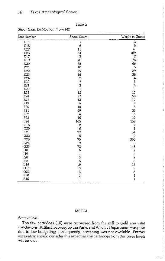
Window Glass
Number of specimens: 757 (1.37 kg) Provenience: Table 2 Description: Window glass. Discussion: The most common artifacts in the mill at McKinney Falls were broken sheet glass.
The largest fragment of window pane weighs 255 gr. Four concentrations of window glass came from the major excavations in the southern part of the mill. Evidence is too spotty to reconstruct either a pane or a window. One pane has a dimension of 29.2 cm, but it cannot be discerned whether that is width or length. Glass thickness is a uniform 2 mm.
16 Texas Archeological Society
Table 2
Sheet Glass Distribution From Mill
Unit Number Sherd Count Weight in Grams
C17 1 3 C18 6 5 C22 11 6 C23 34 159 D17 2 2 D19 70 78 D20 38 66 D21 10 5 D22 49 39 D23 36 38 D24 3 4 E20 7 3 E21 3 4 E22 1 1 E23 13 17 E24 27 50 E25 13 17 F19 6 8 F20 10 8 F21 49 35 F22 4 6 F23 16 12 F24 105 158 G18 2 2 G20 6 5 G21 37 54 G22 8 9 G23 75 360 G24 9 8 G25 72 143 118 6 7 119 1 5 120 3 8 122 5 6 L16 19 33 O16 3 3 022 3 5 P20 1 1 $16 1 1
METAL
Ammunition
Too few cartridges (10) were recovered from the mill to yield any valid conclusions, Artifact recovery by the Parks and Wildlife Department was poor due to low budgeting; consequently, screening was not available. Further excavation should consider this aspect as any cartridges from the lower levels
will be old.
McEachern and Ralph -- McKinney Homestead 17
RIMFIRE
Federal Cartridge Co..22 Caliber Long or Long Rifle Number of specimens: 2
Provenience: 118(2) Description: Brass cases are 15.11 mm long. Discussion: Cartridge dates to the present; the beginning date is unknown (Logan,
1959:191).
American Cartridge Co..22 Caliber Long or Long Rifle Number of specimens: 1 Provenience: 122 Description: A copper cased standard length shell. Discussion: Cartridge dates to the present; beginning date is unknown (Amber,
1968:92; Logan, 1959:189).
Winchester Repeating Arras Co..38 Caliber Short, Smith and Wesson Number of specimens: 1 Provenience: Lot 4 Description: Brass case 19.05 mm long. Discussion: Cartridge dates 1869 to the 1940’s (Barnes, 1965:345). Fontana and
Greenleaf (1962:82) note that Smith and Wesson made their first .38 caliber center fire in 1865 but that heavy production did not begin until 1876
Union Metallic Cartridge Co..22 Caliber Long or Long Rifle Number of specimens: 1 Provenience: 120 Description: A 15.11 mm copper case. Discussion: Cartridge dates 1868 to the present (Logan, 1959:191).
CENTER FIRE
Winchester Repea~ng Arms Co..41 Long Colts, Double action Number of specimens: 1 Provenience: Lot 35 Description: Copper case is 27.79 mm long. Discussion: Logan (1959:134) shows a 23.8 mm case length. Case was developed in
1877 for the .41 Colts Lightning double action and made until 1910 (Logan, 1959:122). It has a balloon head primer.
SHOTGUN
Winchester New Rival Number of specimens: 1 Provenience: Lot 34 Description: Winchester Repeating Arms Co. 10-gauge, 9.144 mm case length. Discussion: It was available 1875 to about 1930 (Amber, 1968:91).
Remington Express Number of specimens: 1 Provenience: 118 Description: Remington Arms Co. 12-gauge with 21.44 m case; probably a recent high
base with a black powder load. Discussion: It dates to the 1930’s (Amber, 1968:91) and has a battery cup primer.
Remington-U.M. C. Shurshot Number of specimens: 1 Provenience: F21 Description: A late model 12-gauge, black powder load with a case length of 12.7 mm. Discussion: This shell was listed in the 1935 Remington-U.M.C. price list and must be
later than the 1902 merger of Remington and Union Metallic Cartridge Co. (Amber, 1968:91).
Bullet Number of specimens: I Provenience: F24
18 Texas Archeological Society
Description: A spent but well preserved .22 caliber bullet. Discussion: It was found in the first level of excavation of the mill machine room,
Fasteners
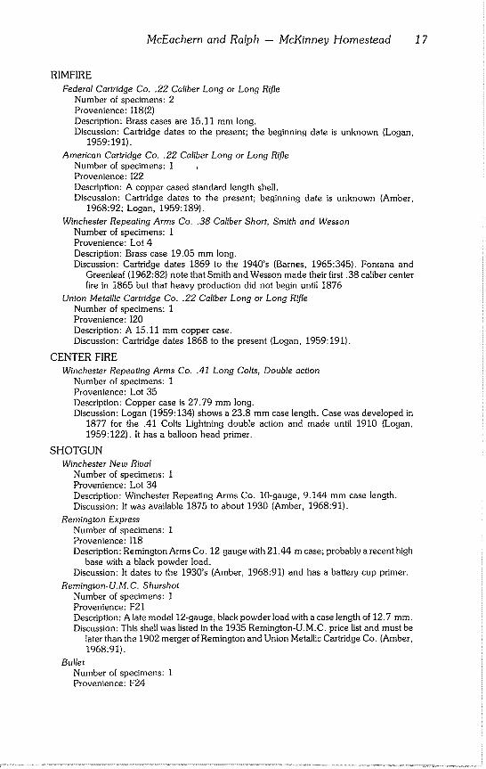
This functional class consists of 301 specimens which includes nails, rivets, screws, nuts, bolts, washers, and harness parts. Nails were the second most common artifact (267 specimens) found at the mill. A total of 139 typable nails was found, plus eight spikes, three horseshoe nails, a tack, and a staple. Of the typed nails, 133 were cut; the remaining were hand wrought. Of the cut nails, 106 were common nails; 12 were finishing nails; and the remaining 15 had hand wrought heads (Fig. 6). Nine different pennyweight classes were present and a total of 15 different nail types was recovered. In addition to the typed nails, 115 fragments were recovered.
NAILS Nails were classified by the following methods. Unbroken nails in good
condition were separated into types and sizes. Using various pennyweight (d) standards, nails were placed in the general pennyweight class which they seemed to fit best. These standards include U.S. 1876, 1897, 1931 (Walker, 1971:69); Simmons (1884); A. Baldwin (1891); and Unknown (Fontana and Greenleaf, 1962:56). After this preliminary sorting, nails were shifted around until there seemed to be a reasonable break between the different pennyweights. Then the fragmentary but classifiable nails were added to the established types on the basis of head style and shank diameter (Table 3).
Nails from the McKinney mill appear to fall into a very short time span. Absence of wire nails suggests that the nails relate to the mill itself and not to any later structures. Most nails probably date from the original construction of the mill, although some may come from alterations or additions made after the original construction and before the mill was destroyed in 1967.
CUT NAILS
3°1
o 20- o
3d 6d 8d 9d 20d 40d 6d 8d lOd
Common Finishing
8d
Handmade heads
Fig. 6 Relative percentages of cut nail types from mill.
McEachern and Ralph - McKinney Homestead 19
Table 3
Nail Length Standards (Measurements in Inches and Fractions of Inches)
U.S. Simmons Baldwin U.S. U.S. Unknown Size 1876 1884 1891 1897 1931 1876-88?
2d 15/16 1 1 1 1 3d 1-1/8 1-1/4 1-5/16 1-1/4 1~1/4 1~1/4 4d 1-3/8 1-1/2 1-9/16 1-1/2 1-1/2 1-1/2 5d 1-9/16 1-11/16 2-1/16 1-3/4 1-3/4 1-3/4 6d 1-13/16 2 2-1/4 2 2 2 7d 2-1/16 2-3/16 2-9/16 2-1/4 2-1/4 2-I/4 8d 2-5/16 2-1/2 2-3/4 2-I/2 2-1/2 2-1/2 9d 2-9/16 2-3/4 2-3/4 2-3/4 2-3/4 10d 2-11/16 2-13/16 3 3 3 3-1/4 12d 2-15/16 3-1/8 3-3/16 3-1/4 3-1/4 3-1/4 16d 3-7/16 3-11/16 3-3/4 3-1/2 3-1/2 3-1/4 20d 3-3/4 4-1/8 4-1/4 4 4 4 30d 4-3/16 4-1/2 4-5/8 4~1/2 4-1/2 4-1/2 40d 4-5/8 4-15/16 5-1/16 5 5 5 50d 5-1/16 5-7/16 5-9/16 5-1/2 5-1/2 5-1/2 60d 5-9/16 5-15/16 6-1/8 6 6 6
Cut Nails
8d HANDMADE HEAD Number of specimens: 15 Provenience: D19(3), D20(3), D21(2), D23(2), E25, F21, F23, G23, $21 Description: Nails are 2 1/2 in long (excluding head) and have handmade heads
with two facets each. Direction of iron fibers is lengthwise. Nail plate was cut from opposite sides.
Discussion: Cut nails with handmade heads were common from 1790 to the mid- 1820’s when they were replaced with machine headed nails. These early nails had iron fibers running across or perpendicular to the length of the nail. Around 1840, nails were manufactured with iron fibers lengthwise like the McKinney Falls specimens (Nelson, 1868).
3d COMMON HEAD Number of specimens: 9 Provenience: C15, D19(2), D20(3), D22(2), E25 Description: Specimens are about I 1/4 in in length; three have heads which are off
center with the shank.
6d COMMON Number of specimens: 34 Provenience: C15, D19(3), D20, D21(7), D22(7), E17, E24, E25(3), F17(2), F21,
F23, G17(4), G23(2). Description: Specimens have shanks about I 15/16 in long and well made heads.
6d FINISHING Number of specimens: 5
Provenience: D19, D20(2), D22, E25 Description: Nails are 2 in in length and have tiny heads characteristic of finishing
nails.
8d COMMON Number of specimens: 19 Provenience: C15(2), D16, D19(3), D20, D21(2), D23, E20, E25, F19, F21,
G12(2), G16, G17(2) Description: Nails are 2 3/8 in in length and have well centered heads. Discussion: Nails do not exactly fit a pennyweight category but they fall within the
range of the 8d.
20 Texas Archeological Society
8d FINISHING Number of specimens: 6 Provenience: D19, D20, D21, E25, G17(2) Description: Shanks are 2 1/2 in long. Discussion: Specimens fit well in the 8d category and are unlike the 8d common
nails.
9d COMMON Number of specimens: 11 Provenience: D19(2), D21, D23, E25(3), G16, G23, O16, $20 Description: Shanks are 2 3/4 in long.
10d FINISHING Number of specimens: 1 Provenience: D23 Description: Shank is 3 in long. Discussion: This nail illustrates the difficulty in using pennyweight classes. Following
Fontana and Greenleaf (1962:56), the specimen can be classified as 10d. Follow- ing the U.S. standards for 1876 (Walker, 1971:69), it would be classed as 12d.
10d COMMON Number of specimens: 7 Provenience: Lots 40, 41, 44, 51(3), 1 unknown Description: Nails average 2 7/8 in in length.
20d COMMON Number of specimens: 16 Provenience: C15(2), D17, D22(5), E25(2), G22, 120, Lots 41(2), 62(2) Description: Only two complete specimens; shank lengths are 3 5/8 in and 3 3/4
in.
40d COMMON Number of specimens: 1 Provenience: E23 Description: Cut nail with 5 in shank
50d COMMON Number of specimens: 1 Provenience: Lot 44 Description: Specimen is 5 I/8 in long.
60d COMMON Number of specimens: 6 Provenience: Lots 24, 25, 30, 36, 61(2) Description: Vary in length from 5 in to 5 1/4 in.
UNTAPERED COMMON Number of specimens: 2 Provenience: C15, D19 Description: Similar to the other cut nails but these are tapered with the shank uni-
formly square from head to tip. Specimen from C15 is 2 in long and the other is 1 in.
10d HANDWROUGHT Number of specimens: 6 Provenience: Lots 36(2), 40, 51(2), 58 Description: Nails are bent or clinched at a right angle ca 35 mm from the head
indicating they were used on planks of that thickness.
NAIL FRAGMENTS Number of specimens: 115 Provenience: C15(5), C23, D19(11), D20(I0), D21(6), D22(13), D23(12),
E23(2), F17(2), F19, F22, G23(2), Lots 36(3), 38, 40(7), 41(5), 47, 51(8), 58(3), 62(3), 63(18)
Description: Cut nail fragments that are too fragmentary to classify. Discussion: Fragment in Lot 47 was embedded in a fragment of wood.
McEachern and Ralph -- McKinney Homestead 21
Spikes
Spikes or large nails are divided into three groups. Group I consists of cut
nails which are longer than those that fall into the pennyweight classes. Group II is composed of short straight spikes which have thicker shanks than the nails
in the pennyweight classes. The third group consists of spikes with modified
heads.
GROUP I Number of specimens: 3 Provenience: F24, Lots 31, 61 Description: Specimens are identical to cut nails with common heads except for their
length. Two complete specimens are ca 182 mm long.
GROUP II Number of specimens: 2
Provenience: G23, 120 Description: Specimen from G23 is 79 mm long and handwrought; the other is 51
mm long and machine cut.
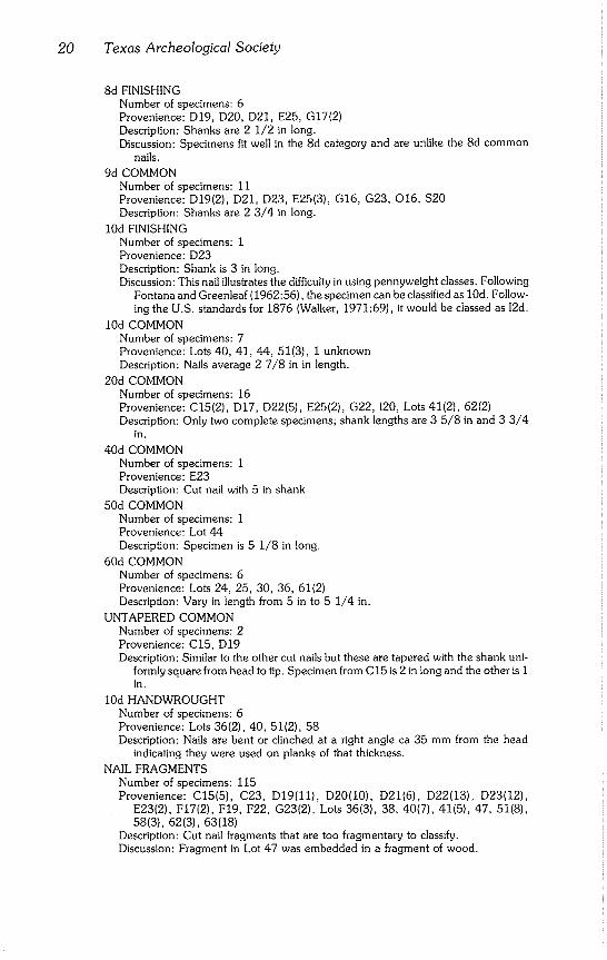
J SHAPED SPIKE Number of specimens: 1 Provenience: 022 Description: Spike made from 13 mm diameter metal rod and 160 mm long (Fig. 7).
SPIKE WITH EYE HEAD Number of specimens: 1 Provenience: Lot 30 Description: Spike is constructed from 14 mm metal rod; 153 mm long with the rod
looped at the head for an eye 35 mm in diameter (Fig. 8).
T SHAPED SPIKE Number of specimens: 1 Provenience: Lot 61 Description: Iron stock, ca 15 mm sq, with a head 15 x 45 mm and 12 mm thick.
Total length is 135 mm, although the end may be broken off. Spike is bent 32° parallel to the long axis of the head halfway up the shank (Fig. 9).
Miscellaneous Nails
HORSESHOE NAILS Number of specimens: 3 Provenience: D19, D21, E20 Description: Specimens are uniformly 47 mm long including the head. Discussion: Other horseshoe nails were found attached to horseshoes and are
described with them.
12 OZ TACK Number of specimens: 1 Provenience: D19 Description: Tack is 18 mm long. Discussion: Same size as the 12 oz cut tack illustrated in A. Baldwin (1891); small
enough to pass through a 1/4 in mesh screen.
STAPLE Number of specimens: 1 Provenience: D22 Description: Metal U shaped staple like the ones commonly used in wire fences;
made from wire 6 mm in diameter; 47 mm long.
RIVETS
Dome Head Number of specimens: 1 Provenience: G23 Description: Shank is 30 mm long, 8 mm in diameter and is headed on both ends.
Heads are dome shaped and 14 mm in diameter.
22 Texas Archeological Society
i o
rn
5
Fig. 7 J shaped spike from mill.
! Fig. 8 Spike with eye head from mill.
Fig. 9 T shaped spike from mill.
"0
-3
-0
-5
cm
Fig. 10 Pins or keepers with circular
heads from mill.
McEachern and Ralph - McKinney Homestead 23
Flat Head
Number of specimens: 1
Provenience: D21
Description: Specimen has a flat circular head 12 mm in diameter and I mm thick. The
circular shank, which is broken 8 mm from the head, is 4 mm in diameter.
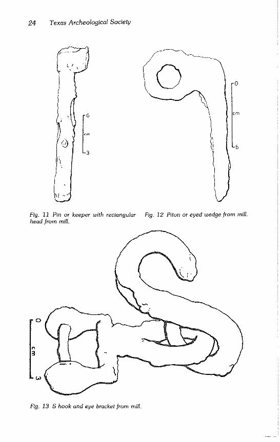
PINS OR KEEPERS
Circular Heads Number of specimens: 4 Provenience: D22(4) Description: Specimens have truncated conical heads with the base of the cone toward
the shank and diameters of 29 mm. Head height is 18 mm. Shanks are 18 mm in diameter and of varying lengths (Fig. I0). Two complete specimens are 97 and 76 mm long; remaining two specimens are sheared off at approximately 12 mm.
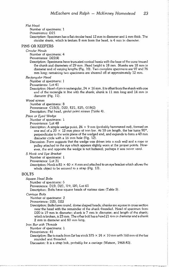
Rectangular Head Number of specimens: 1 Provenience: Lot 41 Description: Head ofpinisrectangular, 24 x 16mm. Itis offset from the shank with one
end of the rectangle in line with the shank; shank is 11 mm long and 14 mm in diameter (Fig. 11).
Wood screws Number of specimens: 8 Provenience: C15(3), D20, E21, E25, G18(2) Description: Flat head, gimlet point screws (Table 4).
Piton or Eyed Wedge Number of specimens: 1 Provenience: Lot 48 Description: A simple wedge point, 24 x 9 mm (probably hammered out), formed on
one end of a 20 x 12 mm piece of iron bar. At 10 cm length, the bar turns 90°, perpendicular to the wide plane of the wedged end, and expands to form a 40 mm diameter circle with a 16 mm hole (Fig. 12).
Discussion: Form suggests that the wedge was driven into a rock wall and a rope or pulley attached to the eye which appears slightly worn at the proper points. How- ever, the end opposite the wedge is not battered; perhaps it was never used.
S Hook and Eye Bracket Number of specimens: 1 Provenience: Lot 31 Description: Hook is 85 × 40 x 8 mm and attached to an eye bracket which allows the
whole object to be secured to a strap (Fig. 13).
BOLTS
Square Head Bolts Number of specimens: 5 Provenience: D19, D21, 119, 120, Lot 61 Description: Bolts have square heads of various sizes (Table 5).
Carriage Bolts Number of specimens: 2 Provenience: D20, D22 Description: Bolts have round, dome shaped heads; shanks are square in cross section
near the head with the remainder of the shank threaded. Head of specimen from D20 is 19 mm in diameter; shank is 7 mm in diameter; and length of the shank; which is broken, is 23 mm. The other bolt has a head 21 mm in diameter and a shank 2 mm in diameter and 60 mm long.
Iron Bar with Threads Number of specimens: 1 Provenience: 41 Description: Bar is made from flat bar stock 375 x 24 x 10 mm with 160 mm of the bar
rounded and threaded. Discussion: It is a strap bolt, probably for a carriage (Watson, 1968:83).
24 Texas Archeological Society
i o
cm
3
-o
-5
Fig. 11 Pin or keeper with rectangular Fig. 12 Piton or eyed wedge from mill.
head from mill.
O
Fig. 13 S hook and eye bracket from mill.
McEachern and Ralph -- McKinney Homestead 25
Table 4
Wood Screws From Mill (in ram)
Provenience Head Diameter Shank Diameter Shank Length Condition
C15 9 5 28 complete C15 10 6 39 complete C15 10 6 28 tip missing D20 14 8 54 tip missing E21 14 8 52 tip missing E25 11 7 23 complete G18 12 7 20 tip missing G 18 -- 6 39 shank fragment
Table 5
Square Head Bolts From Mill (in ram)
Provenience Head Size Shank Length Shank Diameter Condition
D19 17 x 17 x 7 20 12 fragment D21 27 x 27 x 13 18 13 fragment 119 24 x 24 x 26 41 16 complete 120 25 x 25 x 10 44 16 complete
Lot 61 -- -- -- fragment
Bolt Shank Number of specimens: I Provenience: E23 Description: Fragment of a bolt shank which is 11 mm in diameter and 46 mm long.
Wing Head Bolt Number of specimens: 1 Provenience: D19 Specimens: Bolt has a wing head (for thumb tightening) which is 18 x 11 × 4 mm;
shank is 7 mm in diameter and 11 mm long.
NUTS
Brass Wing Nut Number of specimens: 1 Provenience: D19 Description: Inside diameter is 8 mm and outside diameter 12 mm. Two wings protrude
12 mm from body of the nut.
Square Nuts Number of specimens: 4 Provenience: D19, D23, E25(2) Description: Smallest specimen is 15 x 15 x 5 mm with a 4 mm hole. Two are 17 x 17
x 11 mm with 12 mm holes; largest is 18 x 18 x 15 mm with a 12 mm hole.
Hex Nut Number of specimens: 1 Provenience: D20 Description: Hexagonal shaped nut with longest diameter 38 mm and a center hole 17
mm in diameter. Specimen is 23 mm thick and has remains of a sheared bolt at- tached.
WASHERS
Circular Washers Number of specimens: 6
Provenience: C23, D21, E23, Lots 35(2), 36 Description: Flat metal disks with center holes (Table 6).
26 Texas Archeological Society
Table 6
Circular Washers From Mill (in ram)
Provenience Outside Diameter Inside Diameter Thickness Condition
C23 15 6 2 complete
D21 82 34 8 fragment
E23 31 16 3 complete
Lot 35 53 24 -- fragment
Lot 35 53 24 -- fragment
Lot 36 62 23 7 complete
Rectangular Washers Number of specimens: 2 Provenience: Lots 48, 56 Description: Washer from Lot 48 cons~ucted from a roughly square plate of steel, 77 ×
81 × 5 mm, and has a 17 mm center hole. Second specimen is rectangular, 103 x 77 × 4 mm, with a center hole 20 mm in diameter.
Lead Disks or Washers Number of specimens: 3 Provenience: D20(2), D22 Description: Various sizes (Table 7).
Brass Washers or Rings Number of specimens: 3 Provenience: D20(2), D22 Description: Specimens from D20 are identical; outside diameter, 12 mm; inside
diameter, 8 mm; 2 mm thick. Holes in specimens not completely circular as one quarter of the circle is flat. Remaining specimen is split and its original diameter was about 15 mm with a 1 mm hole. Specimen is 3 mm thick.
HARNESS PARTS
Number of specimens: 6 Provenience: G23(6) Description: Parts consist of a buckle, two rectangles, and three rings. Outside dimensions
of the buckle are 68 x 45 mm. Buckle includes a cross bar and tongue and is con- structed from 17 mm round stock. Rectangles are made from oval shaped bar stock 9 x 7 mm and are 56 x 48 mm. Rings are made from 7 mm diameter wire and are 56 mm in diameter.
Discussion: Parts came from the same location and apparently belong to a composite object such as a harness.
Containers
CRIMPED CAN
Number of specimens: 1 fragment Provenience: 122 Description: Can is 73 mm in diameter and 45 mm tall. It is fragmentary and missing the
seam. Ends were attached to the body by crimping. Discussion: Hunt (1959:9) places the widespread in~oductoin of this can at approximately
the time of World War I. Other than a handful of unidentified fragments, this is the only container from the mill.
Tools
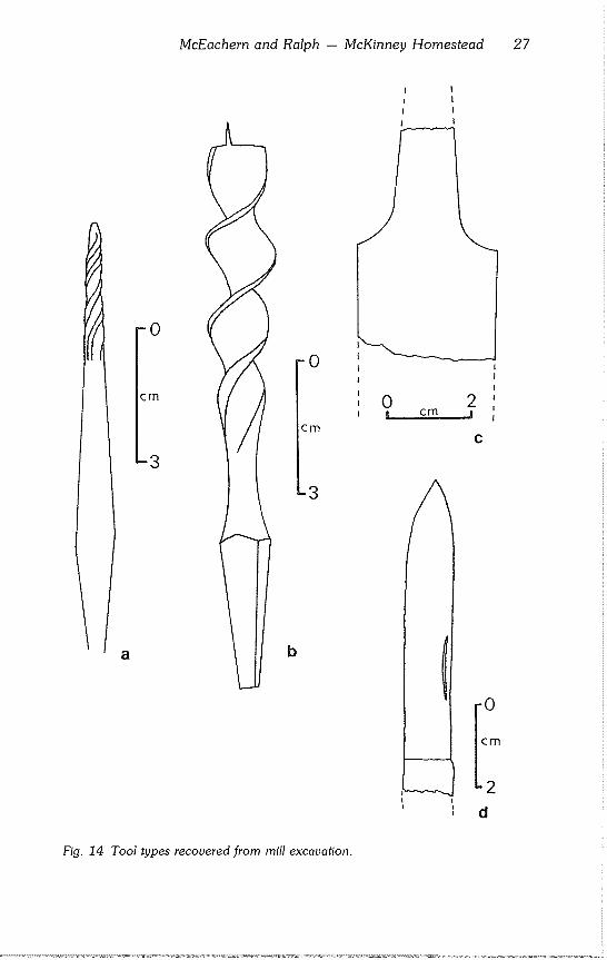
AWL SHANK Number of specimens: 1
Provenience: D20 Description: Rectangular awl shank 102 mm long with screw tip (Fig. 14a).
McEachern and Ralph -- McKinney Homestead 27
J
-0
cm
-3
a b
-0
icm
-3
0 2 cm j
Fig. 14 Tool types recovered from mill excavation.
28 Texas Archeological Society
BIT
Number of specimens: 1 Provenience: D23 Description: Drill for a brace and bit; 134 mm long and 16 mm in diameter (Fig. 14b).
FILE
Number of specimens: 1 Provenience: D19 Description: Shoulder fragment of a flat file 33 mm wide and 5 mm thick (Fig 14c).
KNIFE BLADE
Number of specimens: 1 Provenience: D20 Description: Broken blade 74 x 11 mm from a folding knife (Fig 14d).
METAL DIE
Number of specimens: 1 Provenience: D19 Description: Die to cut standard threads (2.125 mm center to center) on a 13 mm (1/2 in)
bolt.
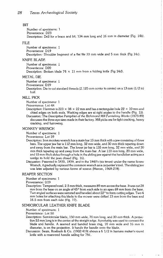
MILL PICK
Number of specimens: 1 Provenience: Lot 48 Description: Hammer is 223 x 38 x 22 mm and has a rectangular hole 22 x 10 mm and
chisel edges on both ends. Working edges are at right angles to the handle (Fig. 15). Discussion: The Descriptive Pamphlet of the Richmond Mill Furnishing Works (1873:89)
discusses the three eye sizes made in their factory. Mill picks are for light cracking, heavy cracking, and furrowing.
MONKEY WRENCH
Number of specimens: 1 Provenience: Lot 59 Description: Iron monkey wrench has a main bar 15 mm thick with a jaw consisting of three
bars. The upper jaw bar is 112 mm long, 32 mm wide, and 30 mm thick tapering down and away from the main bar. The lower jar bar is 155 mm long, 32 mm wide, and 30 mm thick tapering up and away from the main bar. A bar 110 mm long, 20 mm wide, and 15 mm thick slides through a hole in the sliding jaw against the handlebar acting as a wedge to hold the jaws closed (Fig. 16).
Discussion: Patented in 1835, 1839, and in the 1840’s (six times) under the name Screw Wrench, it gradually replaced the common wrench as a carpenter’s tool. The sliding jaw was later adjusted by various forms of screws (Mercer, 1968:278).
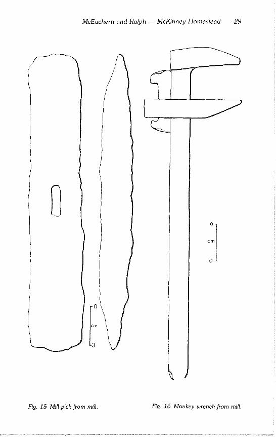
REAPER SECTION
Number of specimens: I Provenience: D19 Description: Tempered steel, 2.5 mm thick, measures 89 mm across the base. It was cut 28
mm from the base on an angle of 45° from each side to an apex 69 mm from the base. Two angled surfaces were serrated and beveled about 22° to form cutting edges. Two 4 mm holes for attaching this blade to the mower were drilled 13 mm from the base and 16,5 mm from each side (Fig. 17).
SEMICIRCULAR LEATHER KNIFE BLADE
Number of specimens: 1 Provenience: Lot 50 Description: Semicircular blade, 150 mm wide, 70 mm long, and 30 mm thick. A projec-
tion 53 mm long is in the center of the straight edge. It probably was used to connect the blade and handle. A seamed and banded brass ring, 10 mm wide and 16 mm in diameter, is on the projection. It bands the handle onto the blade.
Discussion: Sears, Roebuck & Co. (1902:419) shows a 6 1/2 in harness maker’s round knife with a rosewood handle selling for 75¢.
McEachern and Ralph -- McKinney Homestead 29
Fig. 15 Mill pick from mill. Fig, 16 Monkey wrench from mill,
30 Texas Archeological Society
0 5 [ Cm ..... j
Fig. 17 Reaper section from mill.
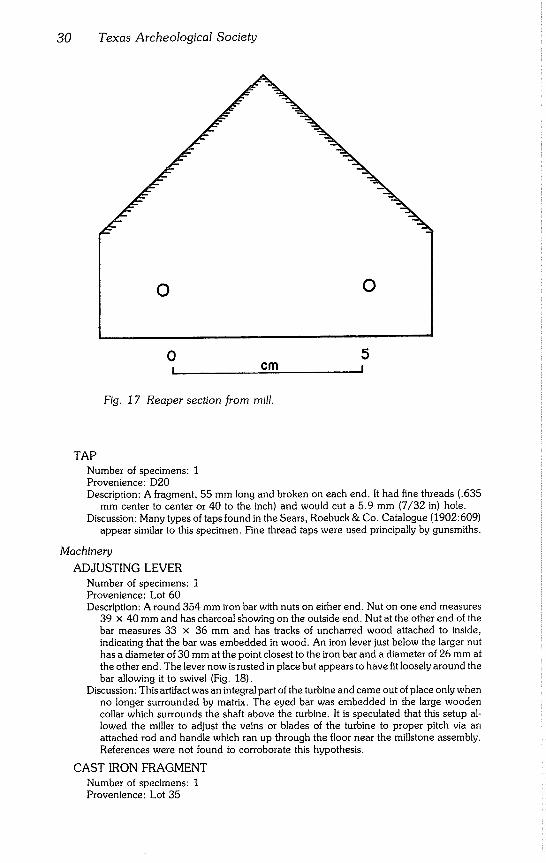
TAP
Number of specimens: 1 Provenience: D20 Description: A fragment, 55 mm long and broken on each end. It had fine threads (.635
mm center to center or 40 to the inch) and would cut a 5.9 mm (7/32 in) hole. Discussion: Many types of taps found in the Sears, Roebuck & Co. Catalogue (1902:609)
appear similar to this specimen. Fine thread taps were used principally by gunsmiths.
Machinery
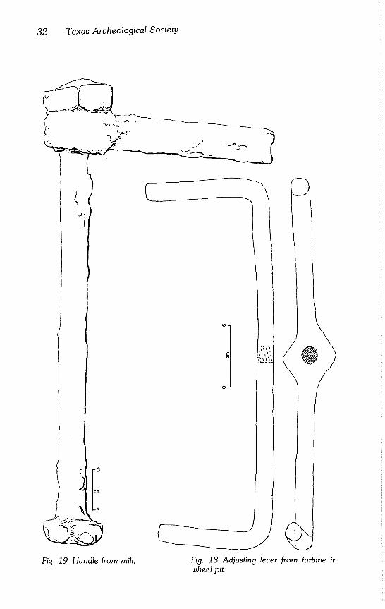
ADJUSTING LEVER
Number of specimens: 1 Provenience: Lot 60 Description: A round 354 mm iron bar with nuts on either end. Nut on one end measures
39 x 40 mm and has charcoal showing on the outside end. Nut at the other end of the bar measures 33 x 36 mm and has tracks of uncharred wood attached to inside, indicating that the bar was embedded in wood. An iron lever just below the larger nut has a diameter of 30 mm at the point closest to the iron bar and a diameter of 26 mm at the other end. The lever now is rusted in place but appears to have fit loosely around the bar allowing it to swivel (Fig. 18).
Discussion: This artifact was an integral part of the turbine and came out of place only when no longer surrounded by matrix. The eyed bar was embedded in the large wooden collar which surrounds the shaft above the turbine. It is speculated that this setup al- lowed the miller to adjust the veins or blades of the turbine to proper pitch via an attached rod and handle which ran up through the floor near the millstone assembly. References were not found to corroborate this hypothesis.
CAST IRON FRAGMENT
Number of specimens: 1 Provenience: Lot 35
McEachern and Ralph - McKinney Homestead 31
Lead Washers From Mill (in ram)
Table 7
Provenience Outside Diameter Inside Diameter Thickness Comments
D20 23 11 2 D20 48 34 7 fragments D22 10 3 5
Description: Wheel fragment is 165 x 40 x 22 mm and has the remnants of a spoke. In cross section, it looks pentagonal with a 22 mm wide base. Wheel is 400 mm in diameter and was probably a part of some machinery.
HANDLE
Number of specimens: 1 Provenience: Lot 61 Description: Specimen is a round metal bar with ends turned up 90° to form two handles
about 185 mm high. The main bar is 305 mm long and 16 mm wide. In the center, the width of the bar expands to 45 mm forming a diamond shape with a hole in the center for attachment to the object to be turned (Fig. 19).
Discussion: The handle appears to fit the pinion gear which in turn fits the rack gear.
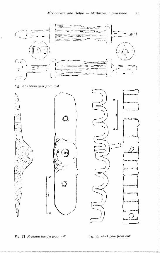
PINION GEAR
Number of specimens: 1 Provenience: Lot 48 Description: Pinion gear is 400 mm long and has a central shaft 24 mm in diameter. This
shaft has a U connection on top 68 mm wide, 40 mm tall, and 11 mm thick. A nodule from the central shaft extends out 12 mm and is threaded and made to take a handle. A ring 20 mm thick and 62 mm in diameter is attached (welded?) to the center shaft 72 mm below the bottom of the U connection. A second ring is attached 165 mm below the first ring. Four round bars 65 mm long and 13 mm in diameter equally spaced 20 mm apart on the rings connect those two rings. Groo~ed, worn places in the bars appear 40 mm above the lower ring. Spacing of the grooves fits the rack gear comfortably (Fig. 20).
PRESSURE HANDLE
Number of specimens: 1 Provenience: Lot 55 Description: A 167 x 29 mm bar varying in thickness from 25 mm at the center to 4 mm at
each rounded end. Extra metal is built up on one side only; opposite side is flat. A conical hole 12 mm in diameter is drilled into the built up center on an angle of 45°. Two other holes, ca 6 mm in diameter and each 44 mm from the center, are drilled com- pletely through the bar (Fig. 21).
Discussion: Although function is unknown, it possibly could be a pivot point for a rotating pin or perhaps a belt turned pulley.
RACK GEAR
Number of specimens: 8 Provenience: Lots 40(3), 41(2), 43, 48, 56 Description: Part of one long piece, total length at least 1966 mm. Each of the rack gear
segments has from one to four holes. The 225 mm segment and 335 mm segment have cut nails extending through these holes. The 600 mm segment is charred and has a wave or bow unlike the others (Fig. 22).
Discussion: Wear patterns of the rack gear match the pinion gear.
SHAFT
Number of specimens: I Provenience: Lot 37 Description: Cylindrical bar fragment 872 mm long and 63 mm in diameter. A slot in one
end (22 x 18 x 2 mm) accepts a key for attaching a pulley or bearing.
32 Texas Archeological Society
Fig. 19 Handle from mill, Fig. 18 Adjusting lever from turbine in
wheel pit.
McEachern and Ralph - McKinney Homestead 33
Discussion: Shafts this size commonly are used to transmit power or motion by rotation and are called king shafts.
WEDGES
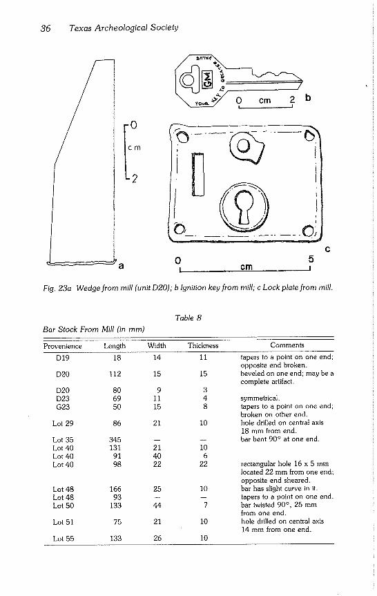
Number of specimens: 3 Provenience: D20, Lots 43, 61 Description: Specimen D20 is made of square iron bar stock 24 x 24 mm and 81 mm
long. This artifact is beveled on a single side to form a cutting edge while the opposite end is battered (Fig. 23a). Specimen Lot 43 is a wedge 235 mm long made of square barstock 30 x 18 mm. Specimen Lot 61 is an unused wedge (or shim) made of 64 × 19 mm rectangular stock sheared on one end to 120 mm in length. The other end is beveled 22° on a single side. The shearing was done poorly, resulting in a trailing lip and slightly dished long axis.
WHEEL
Number of specimens: 1 Provenience: Lot 53 Description: This round iron object has a diameter of 150 mm, it is 10 mm thick and has a
bar 75 mm long and 33 mm in diameter extending out from one side. A washer or nut 12 mm thick and 62 mm in diameter is at the base of the bar. Rectangular holes measur- ing 27 x 13 mm are on each side of the extending iron bar. These holes are in the iron wheel. One is filled with iron.
Miscellaneous Metal Artifacts
BABBIT
Number of specimens: 38 Provenience: D19(2), D20(5), D21, D22(19), E21(2), E22, E23, F19, F20(2), F22, G20,
G23, 118 Description: Miscellaneous pieces of lead of various shapes probably used for a variety of
purposes. There is evidence that some were used in mounting heavy machinery by being poured into grooves cut into the stone base. One specimen from D19 has a pattern of striation which suggests that it was used as a bearing for a large diameter shaft.
ELBOW JOINT
Number of specimens: I Provenience: D20 Description: Right angle elbow joint for pipe 31 mm in diameter.
HORSESHOES Number of specimens: 3 Provenience: Lots 30, 35, 40 Description: Specimens are incomplete. Horseshoes from Lots 30 and 35 appear to be
machine made; shoe from Lot 40 probably was hand forged. One or more horseshoe nails are present in each specimen.
Discussion: Specimens lack turned heel calks and are similar to the Berkins’ mud or trotting shoes (A. Baldwin Company, 1891:537).
KEY
Number of specimens: 1 Provenience: L16 Description: Ignition key for a General Motors vehicle (Fig. 23b).
LOCK PLATE
Number of specimens: 1 Provenience: D12 Description: Rectangular brass lock cover 58 x 45 x 1 mm with four corner holes, a
rectangular slot, and a key hole (Fig. 23c).
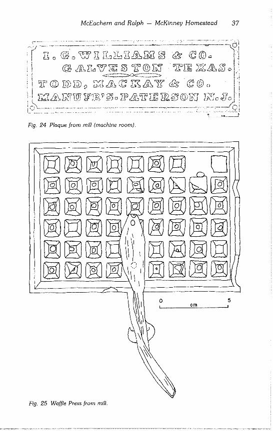
PLAQUE
Number of specimens: 1 Provenience: D19
34 Texas Archeological Society
Description: Machine nameplate 346 x 117 x 6.4 mm with four holes 7 mm in diameter, one in each corner for mounting. Background behind letters is recessed 2 mm. Lettering indicates that"l. G. WILLIAMS & CO. GALVESTON TEXAS" were the distributors or agents and "TODD, MACKAY & CO. MANUFR’S. PATTERSON N. J." were the manufacturers (Fig. 24).
Discussion: Isaac G. Williams was appointed Mayor of Galveston by the newly arrived carpetbagger Charles Griffin in June 1867 (Graham, 1945:47). At this time, advertise- ments in the Galveston City Directory (Marston, 1875) failed to show Williams con- nected with any retail business, agricultural, or manufacturing enterprises.
Earlier (1856), Williams operated the Galveston Agricultural Warehouse at the cor- ner of Strand and Tremont streets. He was a dealer in agricultural implements and machines and also acted as an agent for several equipment companies on the East Coast (Polk, 1857). Additional information about I. G. Williams’ earlier enterprises and his relation to Samuel May Williams (McKinney’s Galveston based partner) requires further historical research.
About 1835, Joseph Todd began manufacturing machines for spinning Manila, Rus- sia, and other hemp into cordage or rope. He probably manufactured other machinery including steam engines. The firm’s name was originally Todd and MacKey (sic) until 1848 when Phillip Rafferty joined in the partnership, hence the name Todd, MacKay and Company. Todd and Rafferty later attained a reputation for steam engines and boilers after MacKey dropped out (Bishop, 1966(3):226-227; Shriner, 1890:195).
The name plaque must have been made to order for I. G. Williams; and must have adorned a piece of mill related machinery that was manufactured post 1848 and prior to 1855, the year MacKey left the partnership. As cordage manufacturing was unknown in the Austin area, it is hypothesized that the machine was a steam engine probably used as an accessory power source for the flour mill, a sawmill, or both.
WAFFLE PRESS
Number of specimens: i Provenience: Lot 56 Description: This 146 x 120 mm iron plate, 12 mm thick, has a grooved side and a flat side
to which a handle is attached. The grooved side has 10 × 10 mm squares arranged in six rows with nine columns. The scissor style handle is attached flush with the flat surface, extending out from that side 90 mm. The other half of the handle appears to have projection catches on the inside which fit into the other half of the waffle press (Fig. 25).
Unidentified Metal Artifacts
ANCHOR PLATE
Number of specimens: 1 Provenience: D19 Description: Iron eye, 10 mm inside diameter, 25 mm outside diameter, with a broken
protrusion extending from this foot. Discussion: Item is probably part of a machine base.
BALL
Number of specimens: 1 Provenience: G22 Description: Rusted ball, 17 mm in diameter, weighing 6 gr. Discussion: It does not float; could be a deteriorated ball bearing.
BAR STOCK
Number of specimens: 15 Provenience: D19, D20(2), D23, G23, Lots 29, 35, 40(3), 48(2), 50, 51, 55 Description: Various fragments of fiat, round, and square bar stock (Table 8).
COPPER CYLINDER OR PIPE
Number of specimens: 1 Provenience: D20 Description: Length is 78 mm; 32 mm in diameter; walls 2 mm thick.
McEachern and Ralph - McKinney Homestead 35
Fig. 20 Pinion gear from mill.
\
0
!
Pig. 21 Pressure handle from mill. Fig. 22 Rack gear from mill.
36 Texas Archeological Society
I O
cm
2
&
....
5 ,I
C
Fig. 23a Wedge from mill (unit D20); b Ignition key from mill; c Lock plate from mill.
Table 8
Bar Stock From Mill (in ram)
Provenience Length Width Thickness Comments
D19 18 14 11 tapers to a point on one end; opposite end broken.
D20 112 15 15 beveled on one end; may be a complete artifact,
D20 80 9 3 D23 69 11 4 symmetrical.
G23 50 15 8 tapers to a point on one end; broken on other end.
Lot 29 86 21 I0 hole drilled on central axis 18 mm from end.
Lot 35 345 -- -- bar bent 90° at one end. Lot 40 131 21 10 Lot 40 91 40 6 Lot 40 98 22 22 rectangular hole 16 x 5 mm
located 22 mm from one end; opposite end sheared.
Lot 48 166 25 10 bar has slight curve in it.
Lot 48 93 -- -- tapers to a point on one end.
Lot 50 133 44 7 bar twisted 90°, 25 mm from one end.
Lot 51 75 21 I0 hole drilled on central axis 14 mm from one end.
Lot 55 133 26 10
McEachern and Ralph -- McKinney Homestead 37
Fig, 24 Plaque from mill (machine room).
/
5 1
Fig. 25 Waffle Press from mill.
38 Texas Archeological Society
CYLINDER OR PIPE
Number of specimens: 1 Provenience: D24 Description: Length is 86 mm; ca 25 mm in diameter; walls 2 mm thick. Specimen partly is
crushed.
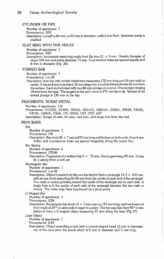
FLAT RING WITH FIVE HOLES
Number of specimens: 1 Provenience: D23 Description: Incomplete metal ring made from flat iron 21 x 5 mm. Outside diameter of
ring is 109 mm and inside diameter 71 mm. Countersunk holes are spaced equally and 8 mm in diameter (Fig. 26).
FORKED BAR
Number of specimens: 1 Provenience: Lot 39 Description: Iron bar with central midsection measuring 172 mm long and 30 mm wide at
center. It has an 8 mm hole that is 36 mm deep into a nodule that protrudes 26 mm from the surface. Each end is forked with two 86 mm prongs on a curve. One prong is missing 18 mm from the base. The tangent at the arch curve is 275 mm tip to tip. Spread of the forked prongs is 130 mm at the tips.
FRAGMENTS, SCRAP METAL
Number of specimens: 110 Provenience: C15(25), D19(9), D20(5), D21(13), D22(15), D23(5), E25(8), F20(6),
F21(4), G24(3), 118(4), 119, 122(9), O21, P20, $22 Description: Scraps of wire, tin cans, cast iron, and scrap iron from the mill.
IRON BARS
Bar Number of specimens: 1 Provenience: 118 Description: Bar stock 26 x 7 mm is 670 mm long and broken on both ends. Four 4 mm
drilled and countersunk holes are spaced irregularly along the center line.
Bar Spring Number of specimens: 4 Provenience: F23(4) Description: Fragments of a resilient bar 5 x .75 mm, the longest being 90 mm. It may
be a spring from a lock set.
Rectangular Bar Number of specimens: I Provenience: Lot 42 Description: Object is made from flat iron bar bent to form a rectangle 19.5 x 100 mm,
with an eye hook extending 50-55 mm from the center of each end of the rectangle. Two nails or screws pointing toward the inside of the rectangle are on each side. A single hole is in the center of each side of the rectangle between the two nails or screws. The holes may have functioned as a pivot point.
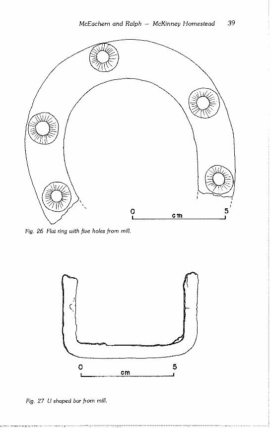
U Shaped Bar Number of specimens: 1 Provenience: G24 Description: Rectangular bar stock 13 x 7 mm was cut 131 mm long; each end was cut
at an angle of 25° on same side to taper to a point. The bar was then bent 90° in two places to form a U shaped object measuring 57 mm along the base (Fig 27).
Lead Object Number of specimens: 1 Provenience: D19 Description: Object resembles a rivet with a conical shaped head 13 mm in diameter;
top of the cone joins the shank which is 6 mm in diameter and 5 mm long.
McEachern and Ralph -- McKinney Homestead 39
Fig+ 26 Flat ring with five holes from mill.
0 ! cm
Fig. 27 U shaped bar from mill.
40 Texas Archeological Society
Lead Sphere Number of specimens: 1 Provenience: D22 Description: Sphere is 16 mm in diameter with a 1 mm diameter hole through the
center. Discussion: It may be a fishing weight.
Machine Base(?) Number of specimens: 2 Provenience: 119(2) Description: Broken (?) cast iron machine base of multiple sized stock. One specimen
consists of two parallel tracks or runners 46 mm center to center which terminate in rectangular stops or blocks. Runners are an inverted T shape, 40 mm wide at the base and tapering to 13 mm at the middle and 10 mm at the top. Base is grooved longitudinally. Altitude of runners is not constant, sloping from 105 mm at the high end to 88 mm at a point 280 mm from the high end. At this point, the slope increases radically until turning downward and terminating at the low end. The stop on the low end is 97 x 77 × 42 mm; the opposite end stop is 100 x 70 x 20 mm. Overall dimensions are 462 x 98 × 105 mm.
Discussion: Function is unknown. The other specimen is a fragment of one track.
Metal Loops Number of specimens: 2 Provenience: Lots 38, 54 Description: Ring from Lot 38 is constructed from flat bar 25 x 3 mm which is looped to
form a ring ca 65 mm in diameter. The other ring is made from flat bar 52 x 8 mm and is 288 mm in diameter. There are three holes in the fiat portion of the bar 75 mm apart.
Pipes Number of specimens: 2 Provenience: Lots 41, 52 Description: Iron pipe from Lot 41 is 298 mm long and oval in cross section with the long
axis 24 mm and the short axis 17 mm. The pipe from Lot 52 is made of copper and has a seam running the length of it. It is crimped on one end and open on the other. Length is 622 mm and diameter 45 mm.
Plates
L SHAPED PLATE Number of specimens: I Provenience: Lot 36 Description: A piece of plate stock 73 mm wide and 12 mm thick; long axis 248 mm.
Originally, one end was sheared and the other cut down to form a handle or leg 130 mm long and 39 mm wide at the base or step. Artifact is bent 90° at the step leg point. Leg tapers slightly to a shoulder 43 mm away from the step. It abruptly cuts down to a width of 24 mm and tapers again to the end point. Leg is almost circular with a diameter of 15 mm at this end point. It appears that the shank, 85 mm long, was embedded in another material (perhaps wood), the rectangular cross section keeping the step rigid. A wear pattern was not discernible since a great deal of rust obscures details.
RECTANGULAR IRON PLATE WITH BOLTS Number of specimens: 2 Provenience: Lots 43, 61 Description: Specimens are identical; iron plate is 105 x 26 × 6 mm with two bolts
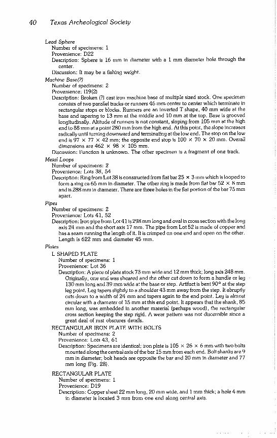
mounted along the central axis of the bar 15 mm from each end. Bolt shanks are 9 mm in diameter; bolt heads are opposite the bar and 20 mm in diameter and 77 mm long (Fig. 28).
RECTANGULAR PLATE Number of specimens: 1 Provenience: D19 Description: Copper sheet 22 mm long, 20 mm wide, and I mm thick; a hole 4 mm
in diameter is located 3 mm from one end along central axis.
McEachern and Ralph - McKinney Homestead 41
0 ! Cm
Fig. 28 Rectangular iron plate with bolts from mill.
5 l
Rod Ring Number of specimens: 1 Provenience: E25 Description: Ring made of iron rod 14 mm in diameter. Ends of the rod are pressed
together. Ring diameter is 45 mm.
Three Cornered Brass/Copperplated Object Number of specimens: 1 Provenience: Lot 36 Description: Two of the three corners are 64 mm apart; the third corner is 48 mm from
the other two. Two base corners have centered holes with 10 mm diameters. An irregular chunk of iron attached to the corner without holes protrudes 3 mm from the actual object surface. Iron attachment is 40 mm wide and 3 mm thick. The inner triangle, inside the iron stdps, measures 24 x 2 x 2 mm, with inward curving sides and straight base.
Unidentified Brass Objects Number of Specimens: 2 Provenience: D20, D22 Description: Specimen from D20 appears to have been a small lever 28 x 7 x I mm.
The other object seems to be a fragment of a small handle and is 23 x 10 × 4 mm with a hole 3 mm in diameter at one end.
~ire
Number of specimens: 25 Provenience: C23, D19, D20, E25(2), G21, G23, G25, 118(13), 118.5(4) Description: Fragments of wire of various diameters and lengths. Three tiny fragments
from 118 are copper; other specimens are steel.
42 Texas Archeological Society
MISCELLANEOUS MATERIALS
Three artifacts of aboriginal manufacture were recovered from the mill. One specimen each of bone and wood complete the artifact assemblage from the mill.
Lithics
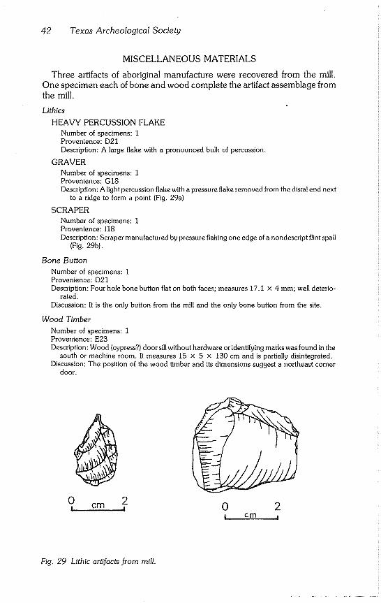
HEAVY PERCUSSION FLAKE
Number of specimens: 1 Provenience: D21 Description: A large flake with a pronounced bulk of percussion.
GRAVER
Number of specimens: 1 Provenience: G18 Description: A light percussion flake with a pressure flake removed from the distal end next
to a ridge to form a point (Fig. 29a)
SCRAPER
Number of specimens: 1 Provenience: 118 Description: Scraper manufactured by pressure flaking one edge of a nondescript flint spall
(Fig, 29b).
Bone Button Number of specimens: 1 Provenience: D21 Description: Four hole bone button flat on both faces; measures 17.1 x 4 mm; well deterio-
rated. Discussion: It is the only button from the mill and the only bone button from the site,
Wood Timber
Number of specimens: 1 Provenience: E23 Description: Wood (cypress?) door sill without hardware or identifying marks was found in the
south or machine room. It measures 15 x 5 x 130 cm and is partially disintegrated, Discussion: The position of the wood timber and its dimensions suggest a northeast corner
door.
\
0 ! cm
2 ! 0 2
Fig, 29 Lithic artifacts from mill.
McEachern and Ralph -- McKinney Homestead 43
DISCUSSION
Prospecting
The results of prospecting techniques correlated well with the expected results with few exceptions. Concentrations of metal artifacts were located at both the house and mill through remote sensing techniques. Although pH sediment analysis proved negative, phosphate analysis proved rewarding with a number of concentrations occurring around the house.
Comparing the value of each technique, the pH studies were of low value at McKinney Falls. Cook and Heizer (1951) estimates the percentage of vari-
ous chemicals added to sediment by human effects are of impressive values. Eidt (1973:206) discounts this when he states that "losses brought about by
leaching and other processes such as oxidation are relatively great..." Successful pH surveys are lacking in the published literature, but the tech- nique has proved sucessful at several California sites investigated by the sen- ior author. It seems that the pH technique should not be used in areas where limestone is present in quantity.
Some problems developed with the phosphate survey. When the initial phosphate test was run, high phosphate was found over the entire prospect- ing grid. This situation contrasted markedly with samples collected by the site survey which showed considerable variation in phosphate content. There was some confusion as to the meaning of the results until it was realized that the technique of collecting samples was based on sediment testing for agri- cultural purposes. Agricultural testing utilizes a shallow sampling depth which apparently is unsuitable for archeological testing. A rerun of the phosphate survey, utilizing a greater sampling depth, produced the results that were used to construct the phosphate map. The phosphate survey gave excellent results at a cost in keeping with the budget of most archeological projects. The larger the area surveyed, the more valid the results.
Of all the prospecting techniques, the metal detector produced the most detailed results. Each hit indicated a specific artifact and the distribution of
those artifacts indicated the probable location of various features. The results require detailed plotting of artifact location and thus a greater amount of field time than phosphate and proton magnetometer surveying. The nominal cost of a metal Iocator makes it available for most projects.
When the results of the various techniques are compared to each other by overlaying the different grid plots, the correlation between the various ano-
malies is impressive. The phosphate, proton magnetometer, and metal de- tector surveys produced similar results. Since the most time consuming as- pect of prospecting is establishing a grid, it is recommended that as many prospecting techniques as possible be run over the pattern before resorting to
the more expensive technique of excavation. Prospecting provides an excel- lent method of generating sophisticated hypotheses before the first shovel of dirt is taken from the ground.
44 Texas Archeological Society
HOUSe
In the research design for the house, the main hypothesis was that the "occupation deposit is expected to be thickest close to the house and diminish
rapidly as it approaches the cultivated field" (Ralph and McEachern, 1974:3). Explicit methodological steps necessary to test the hypothesis were not ex- plored fully.
The definition of what is considered deposit was not expressed in the field
guide; also, how different excavators might interpret the individual excava- tion units was not considered. Further problems were introduced by not ex-
cavating all units to the same depth or to the bottom of the cultural deposit. Another aspect of the research which was not stated but implied was the
selection of arbitrary 10 cm excavation levels. It was believed that such levels would produce useful stratigraphic information which would allow the rate of cultural deposition to be studied over time. However, the cultural deposit was generally only 12 to 15 cm deep. Early and late artifacts were therefore mixed in the first level. Five cm levels probably would have produced the desired information. As a result, the hypothesis as stated is not testable.
The stated hypothesis does indicate the presence of some underlying as- sumptions which can be used to form a logical, testable, corollary hypothesis. Cultural deposition is the major depositional factor around the house. Natural deposition is the predominate factor away from the house. There exists a relationship between natural and cultural deposition which varies between
the house and field. Natural deposition can be considered as spatially occurring at a relatively
equal rate, while cultural deposition is localized and unequal in space. This situation can be expressed as a hypothesis. Given equal volumes of matrix, artifact density will be highest toward the house and decline as one moves away from the house.
To adequately test the hypothesis, some artifact classes which would ob- viously bias the results need to be excluded from the analysis. The house can be considered a single artifact; inclusion of window glass and nail categories in the analysis would tend to mask the cultural depositional processes which were in effect while the house was in use. Nails and window glass more likely are related to erosional factors (both natural and cultural) which took place
after abandonment. Three categories of artifacts were selected which were likely to be deposited
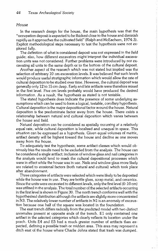
while the house was in use. They are bottle glass, scrap metal, and ceramics. Since the units were excavated to different levels, only the first level (0-10 cm) was utilized in the analysis. The total number of the selected artifacts occurring in the first level is shown in Figure 30. The north trench conforms well with the
hypothesized distribution although the artifacts are slightly more concentrated in N3. The relatively lower number of artifacts in N1 is an anomaly of excava- tion because one half of the square was located in the foundation.
The east trench differs radically from the predicted model with two distinct anomalies present at opposite ends of the trench. E1 only contained one artifact in the selected categories which clearly reflects its location under the porch. Units E4 and E5 had a much greater number of artifacts than ex- pected, defining a possible trash or midden area. This area may represent a ditch east of the house where Charlie Johns stated that trash was dumped.
McEachern and Ralph - McKinney Homestead 45
Distribution of bottle ~;lass,
ceramics and scrap metal
in the 0-~’ cm. level.
L -120
~N94 w 7o
41 TV 289
o House
13 D FTq L_
Fig. 30 Distribution of bottle glass, ceramics, and scrap metal from the Thomas F. McKinney house (0-10 cm level).
Cistern
The cistern deposit differed from the model predicted in the research de- sign in several ways. It had been assumed that the cistern had been used until the house was abandoned; but associated artifacts indicate that it may have gone out of use as early as 1900. Firm evidence of the 1921 flood was lack-
ing. It is apparent that the effect of such periodic flooding was greatly overesti- mated. However, the assumption that the cistern would contain microfauna which could be recovered through fine mesh wet screening was borne out by
the rich collection of recovered fauna. The large number of artifacts recovered from the cistern allows the deposit
to be dated with unusual precision. Two of the bottles in 304 (30-40 cm) were dated to 1905; filling of the cistern is assumed to have started sometime
around 1900. The uppermost level (301) has two bottles of a type which was manufactured until 1929 and one of a type which ceased to be manufactured in 1932. Deposition seems to stop around the mid-1930’s, with only a few artifacts of more recent manufacture added after that date.
The stratigraphy of the tin cans corroborates the dating provided by the bottles. Hole-in-the-top cans are the only type present in the lowest level, while open-the-top rolled seam cans are the only type associated in the highest level. The open-the-top can generally was accepted by 1922 (Fon-
tana and Greenleaf, 1962:73). The cistern deposit apparently is associated with the Charlie Johns’ period.
Garbage occasionally was dumped into the cistern until 1936 when Albert
Meeks moved into the house. A few additional artifacts apparently were thrown into the cistern after the house was abandoned in the mid-1940’s.
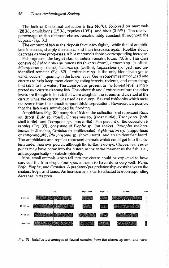
46 Texas Archeological Society
The bulk of the faunal collection is fish (46%), followed by mammals (28%), amphibians (15%), reptiles (10%), and birds (0.5%). The relative percentage of the different classes remains fairly constant throughout the deposit (Fig. 31).
The amount ’of fish in the deposit fluctuates slightly, while that of amphib- ians increases, sharply decreases, and then increases again. Reptiles slowly decrease as time progresses, while mammals show a corresponding increase.
Fish represent the largest class of animal remains found (46%). This class consists of Aplodinotus grunniens (freshwater drum), Lepornis sp. (sunfish), Micropterus sp. (bass),Ictalurus sp. (catfish), Lepisosteus sp. (gar), and un- identified remains (Fig. 32). Lepisosteus sp. is the only identifiable genus which occurs in quantity in the lower level. Gar is sometimes introduced into cisterns to help keep them clean by eating insects, rodents, and other things that fall into the water. The Lepisosteus present in the lowest level is inter- preted as a cistern cleaning fish. The other fish and Lepisosteus from the other levels are thought to be fish that were caught in the stream and cleaned at the cistern while the cistern was used as a dump. Several fishhooks which were recovered from the deposit support this interpretation. However, it is possible that the fish were introduced by flooding.
Amphibians (Fig. 33) comprise 15% of the collection and represent Rana sp. (frog), Bufo sp. (toad), Chrysernys sp. (slider turtle), Trionyx sp. (soft- shell turtle), and Terrapene sp. (box turtle). Ten percent of the collection is reptiles (Fig. 33), consisting of Elaphe sp. (rat snake), Pituophis rnelano- leucus (bull snake), Crotalus sp. (rattlesnake), Agkistrodon sp. (copperhead or cottonmouth), Phrynosoma sp. (horn lizard), and an unidentified lizard. The amphibians and reptiles represent animals which could get into the cis- tern under their own power, although the turtles (Trionyx, Chrysemys, Terra- pene) may have come into the cistern in the same manner as the fish, i.e., anthropogenically or catastrophically.
Most small animals which fall into the cistern could be expected to have survived the 5 m drop. Four species seem to have done very well: Rana, Bufo, Elaphe, and Crotalus. A predator/prey relationship exists between the snakes, frogs, and toads. An increase in snakes is reflected in a corresponding decrease in its prey.
Fish Amphibian Reptile Mammal Bird
o_iooo
lO_2O oo B
o_3oco
Fig. 31 Relative percentages of faunal remains from the cistern by level and class.
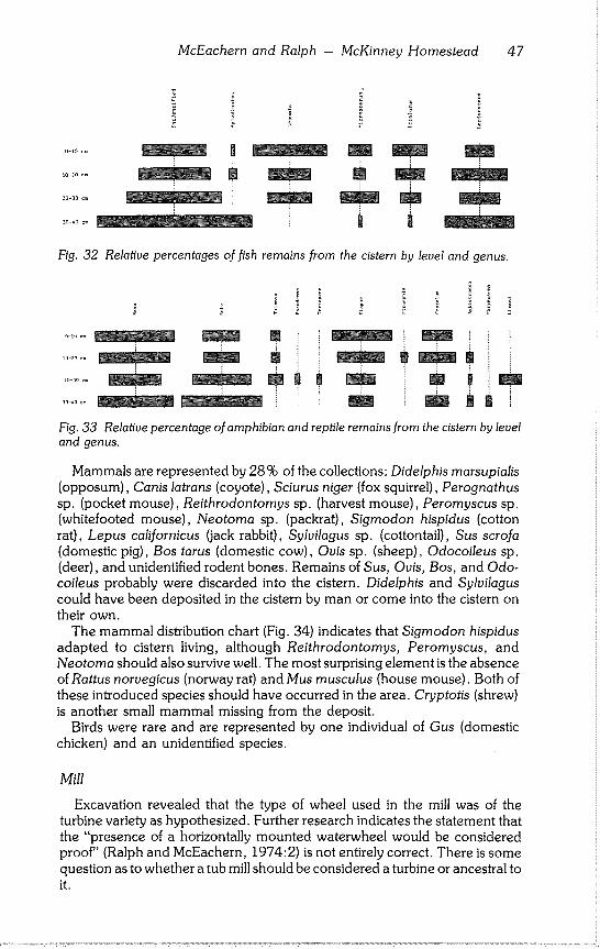
McEachern and Ralph - McKinney Homestead 47
3Q-4o c~ .........................................
F
Fig. 32 Relative percentages offish remains from the cistern by level and genus.
! i!¸
}
m
~B m
Fig. 33 Relative percentage of amphibian and reptile remains from the cistern by level
and genus.
Mammals are represented by 28% of the collections: Didelphis marsupialis (opposum), Canis latrans (coyote), Sciurus niger (fox squirrel), Perognathus
sp. (pocket mouse), Reithrodontomys sp. (harvest mouse), Peromyscus sp. (whitefooted mouse), Neotoma sp. (packrat), Sigmodon hispidus (cotton rat), Lepus californicus (jack rabbit), Sylvilagus sp. (cottontail), Sus scrofa (domestic pig), Bos tarus (domestic cow), Ovis sp. (sheep), Odocoileus sp.
(deer), and unidentified rodent bones. Remains of Sus, Ovis, Bos, and Odo- coileus probably were discarded into the cistern. Didelphis and Sylvilagus could have been deposited in the cistern by man or come into the cistern on
their own. The mammal distribution chart (Fig. 34) indicates that Sigmodon hispidus
adapted to cistern living, although Reithrodontomys, Peromyscus, and Neotoma should also survive well. The most surprising element is the absence of Rattus norvegicus (norway rat) and Mus musculus (house mouse). Both of these introduced species should have occurred in the area. Cryptotis (shrew)
is another small mammal missing from the deposit. Birds were rare and are represented by one individual of Gus (domestic
chicken) and an unidentified species.
Mill
Excavation revealed that the type of wheel used in the mill was of the turbine variety as hypothesized. Further research indicates the statement that the "presence of a horizontally mounted waterwheel would be considered proof" (Ralph and McEachern, 1974:2) is not entirely correct. There is some question as to whether a tub mill should be considered a turbine or ancestral to
it.
48 Texas Archeological Society
Evans (1795:11) states in The Young Mill-Wright and Miller’s Guide: A tub mill has a horizontal waterwheel, that is acted on by the percussion of the water altogether; the shaft is vertical, carrying the stone on the top of it, and serves in place of a spindle; the lower end of this shaft is set in a step fixed in a bridge-tree, by which the stone is raised and lowered, as by the bridge-tree of other mills; the water is shot on the upper side of the wheel, in a tangent direction with its circum- ference.
Evans (1795:28) considered the tub mill superior to other types. "Having levelled your seat, and finding that you have above 8 feet fall, and plenty of water, and wish to build a mill on the simplest, cheapest, and best construction to suit your seat, you will, of course, make choice of a tub mill."
The Young Mill- Wright and Miller’s Guide became the miller’s bible for the
next 50 years. Evan’s (1795) preference for the tub mill over other types probably did much to encourage the development of the true turbine. The turbine was invented by Ferguson about 1828 and imported to France where it was called the tourbillion or turbine waterwheel (Hughes, 1850:56).
Hughes (1850) refers to the turbine as a reaction waterwheel because the action of the water after it hits the bucket or vane contributes power to the wheel. Unlike the tub mill, the reaction wheel is placed in the water and not
above it. As the stroke by impulse is communicated to the bucket of the wheel, only one half of the power of the column of water is received, until the other action is communi- cated from the wheel to the body of water in which it stands. But as soon as the wheel moves it forms a whirling vortex, which acts in a contrary direction to the first action of the water by impulse; consequently, by this means we receive a double action of the same water, which gives a double power (Hughes, 1850:54).
A combination reaction wheel is a wheel designed in such a way that water is applied at the edge of the wheel and discharged at the center of the wheel by means of curved buckets (Hughes, 1850:58). The waterwheel at McKinney’s mill is of this type. However, more exact identification of the wheel is difficult.
Within the last ten or fifteen years, a numerous tribe of reaction waterwheels have sprung into existence, all aiming at the main object, if possible, to supercede each
other in using the least complement of water to perform the greatest amount of work (Hughes, 1850:55).
The wheel pit forms the heart of the mill and also the millwright’s biggest
headache. To the old school millwright, the wheel pit was a perpetual nightmare--a continu- ous performance pit in which he [the millwright] might be called at any minute, day or night, to do a turn in water to his waist as he wrestled with rusty nuts and bolts in an attempt to put in a new waterwheel step, three feet under water (Hobart, 1919:378).
One of the ongoing problems with a horizontal turbine wheel was that the waterwheel step often broke down. This step was a piece of conical wood placed in the end of the shaft below the waterwheel. At first, this piece did not fit well; spent water from the turbine would lubricate it. Later, it would begin to heat up, charring the wood, until charcoal formed and the step began to crumble under the weight of the waterwheel. At some point, the step would go down, maybe stripping the above gears.
Development of the iron cased turbine eliminated this troublesome step by
placing the shaft bearing inside the casing. This procedure marked the end of the large wheel pit required for combination wheels. Iron cased wheels were available by 1870 and are illustrated in the Descriptive Pamphlet of Richmond
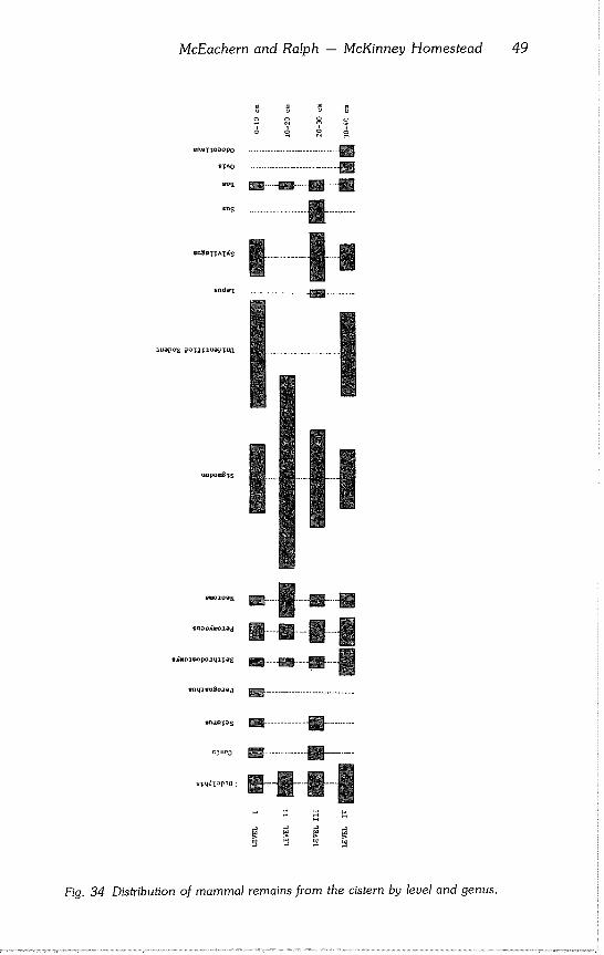
McEachern and Ralph - McKinney Homestead 49
o o o c
enaTTOOO~ .............................. []
°°~ m-----m---B----S
n
u~opo~TS
en~ e~mo.z~,d
mmuleu~o~d
STUe~
~TI4dI OPT(1 ’~
Fig. 34 Distribution of mammal remains from the cistern by level and genus.
50 Texas Archeological Society
Mill Furnishing Works (1873:Fig. 6). The MCD. Moore Mill in Van Zandt County (Texas), which started operating in 1871, used an iron cased wheel (Jackson, 1971:51-52). Use of water turbines to power mills began to fade in the late 1880’s with the introduction of mechanical and electrical motive power.
The most noticeable artifacts missing from the McKinney Falls mill collec- tion are gearing, shafts, couplings, pillow blocks, bearings, and accessory
machinery. It appears that everything that could be salvaged was removed. Much of the building stone was removed from the mill to construct erosion dams (according to an interview with J. E. "Pete" Smith). Remains of these dams still are evident about the western part of the park.
Stone Working Tools
Stone used at the house, mill, horse trainer’s cabin, and other buildings was worked with different tools. Saw cut stone was noted at the house and mill. Saw diameters were 111 and 91 cm; the one from the mill was not checked. One stone at the house appeared to be cut with a handsaw.
Almost all rock used at the mill had a rock faced surface. A pitching chisel was used in finishing most of the stone with occasional use of small droves 4.0 to 6.5 cm wide. The hole in the limestone was drilled with a 3 cm diameter drill at least a meter long and then blasted.
Chisel work at the house was confined to a toothed chisel 4 cm wide. Most of the interior smooth saw cut surfaces were roughened by a mason’s pick which left marks 3.0 to 7.0 cm long and 0.7 cm wide. Marks look like after- thoughts when the stone was in place. Most begin at one o’clock and move to seven o’clock, as if struck by a right handed mason. The stone was roughened to accept the plaster.
The horse trainer’s cabin is of limestone with a rock faced surface. Some chisel work was noted on the north wall and the northeast corner of the east wall. The work was done by 6-10 cm wide straight chisels, the smaller being called droves and the larger called tools, boasters, or bolsters (McKee, 1973:21-31). The picnic table downstream and above the supposed hog wallow was formed mostly with wood and poured in concrete. The few chisel marks are by droves 4-7 cm. wide.
Cartridges
The distribution of the 65 cartridges in the collection suggests function, economics, and time. Four poorly dated rimfire .22 caliber cartridges came from the mill (American Cartridge Co., Federal Cartridge Co., and the pre 1902 Union Metallic Cartridge Co.). The late 1800’s/early-1900’s rimfire cartridges came from outside the house in the lower level of a trash dump (E5) or generally in the fill outside the house (United States Cartridge Co., Win- chester Repeating Arms Co., Peters Cartridge Co.). The middle-1900’s rim- fire cartridges were found inside the house below the fire zone (Remington- U.M.C., Western Cartridge Co., Peters Cartridge Co.). A .22 caliber Short (Peters Cartridge Co.) came from level 4 (304) in the cistern.
McEachern and Ralph - McKinney Homestead 51
The distribution suggests plinking or target practice around the house. Some shells were carried to a dump located east of the house. The main activity occurred at the turn of the century. Rimfire are the least expensive cartridges made in general. Rimfire weapons traditionally are popular and inexpensive.
Center fire cartridges, externally primed, date after 1866 (Logan, 1959:8) ; the nine in the collection appear to date after the 1880’s. The earliest sample comes from the mill shaft. This .41 caliber Long Double Action made for the model 1877 Colt Lightning may be early, but does not date from the time when the mill was in operation. The absence of any early, externally primed, center fire cartridges (which became obsolete in 1890) suggests a late date for all gun activity at this site. Only two of the nine cartridges (.22 W.C.F. and.32 W.C.F) were made for rifles, suggesting small game hunting activities.
Twenty six shotgun shells were recovered, the bulk (15) from the cistern. The shotgun shell literature is sketchy. The best is Vinson (in Amber, 1968:91-97) which contains some glaring errors but points out the impossibil- ity of extracting exact dates for many brands. Cistern distribution gives a fairly good time depth; the earliest shells are probably the 10-gauge Winchester cartridges from the east room of the house and the mill shaft. The one plastic case indicates small bird hunting (#6 shot); while a #2 buckshot from the house area (El) indicates larger game.
All but two of the cartridges were fired and none appear to have been reloaded. The collection suggests the following weapons: two rifles (.22 W.C.F., .32 W.C.F.); one automatic pistol (9 mm Luger); four revolvers (.32 caliber, .38 caliber, .41 Colt Lightning Double Action, and .44 caliber percussion revolver); and three shotguns (10, 12, and 20 gauge). Gun parts were not recovered.
The cartridge collection from the Ward Ranch (Fontana and Greenleaf, 1962:79-83) indicated at least six rifles, five revolvers, and two shotguns. The balance of these cartridges favors heavier game and military loads. If personal protection or large game hunting were performed at McKinney Falls, it is not demonstrable in the colleciton.
The three shotgun shells from the Ward Ranch (Fontana and Greenleaf, 1962) are slightly different from their counterparts at McKinney Falls and probably date a little earlier. The Ward Ranch New Club cartridge has a double circle (7.9 mm diameter and 10.7 mm respectively) head stamp (Fontana and Greenleaf, 1962), whereas none of the six McKinney Falls specimens has double circles. Two (from the cistern, level 4) lack a design. The other four New Club cartridges are of two types, both showing eight pointed star patterns (Lot 16, cistern, levels 2 and 3). Two of the smaller caliber center fire revolver cartridges (.41 L DA and .38 S&W) are common to the McKinney Falls and Ward Ranch (Fontana and Greenleaf, 1962) col- lections.
Many of the weapons were out of time and some badly in need of lepair. The New Club shell from the bottom of the cistern was bent, the primer raised, and the firing pin dentent was off to one side. The weapon that fired it was in poor condition and could have injured the user by misfiring or exploding.
52 Texas Archeological Society
CONCLUSIONS
This report attempted to apply archeology in its widest sense (i.e., the study of relationships between process and time during the epoch of man) to a primarily historic site utilized approximately between 1850 and 1950. The approach is environmental archeology. A particular aspect of the total en- vironment was not singled out as being most important; some attempt was made to capture the diversity of both archeology and environment. Environ- mental archeology is not simply anthropology, history, biology, botany, or any other specifically categorized field of study. It is an attempt to study the total resource, utilizing the standard approach of hard science which tries to investigate the interrelationships of the smallest definable data at the least complex levels of abstraction.
The very breadth of the subject makes conclusions hard to draw, but certain highlights can be pointed out. In terms of the research designs, the study largely was successful with the exception of the flood hypothesis which ap- parently is reflected in much more subtle data than anticipated. Other failures stemmed from poorly expressed research designs which were not completely thought out before going into the field. The successes, however, seem to outweigh the failures; a number of hypotheses bore fruit.
Results of the prospecting experiments were exciting. Archeologists will come to depend on those techniques to a much greater degree in the future.
Excavations at the house produced the suspected architectural features as
well as a clearer understanding of the nature of the deposit. The depositional model developed needs further testing in a wider range of sites (and this site), but it did draw attention to certain anomalies. Perhaps the further develop-
ment of such models will lead to the discovery of types of anomalies which have thus far eluded the investigators. Discovery of the relatively high per- centage of porcelain around the house was not predicted but seems to bear out the aristocratic image of McKinney reflected in the historical records.
Results of the cistern excavation far surpassed expectations. The full impli-
cations of a well dated faunal assemblage within a relatively closed environ- mental system has yet to be realized. The analysis presented was preliminary;
a much more detailed analysis and greater sample is necessary before the value of the collection can be understood.
Mill excavations produced the desired results and discovery of the turbine
was a highlight in the investigations. The combination reaction type wa- terwheel was an important step in the development of the modern turbine; the example recovered provides clues to the technological level of millwright- ing in 1850.
Application of the environmental approach to the historic McKinney homestead produced widely diverse but interrelated data reflecting cultural and environmental processes which have been in effect over the last 125
years. This approach may work best in recent sites where the fossil record is most complete. Such sites provide the necessary time depth to understand the development of contemporary ecological and environmental problems.
McEachern and Ralph -- McKinney Homestead 53
REFERENCES CITED
A. Baldwin Company, Ltd. 1891 Catalogue of A. Baldwin and Co., Ltd. W. St. John Wolseley and A.
Baldwin Co., New Orleans.
Amber, John T. 1968 Gun Digest. 22nd ed. Gun Digest Company, Chicago.
Barnes, Frank G. 1969 Cartridges of the World. 2nd review edition. Gun Digest Company, Chi-
cago.
Bishop, James Leander 1966 A History of American Manufacturers from 1608 to 1860. Third Revised
Edition, Three Volumes, A. M. Kelley, New York.
Boice, Nancy 1980 Cistern One Glass. In: Michael McEachern and Ronald W. Ralph, Ar-
cheological Investigations at the Thomas F. McKinney Homestead, Travis County, Texas: An Experiment in Historic Archeology. Part I Ap- pendix G. Bulletin of the Texas Archeological Society, 51:168-208.
Cook, Sherburne F. and Robert F. Heizer 1950 The Physical Analysis of Nine Indian Mounds of the Lower Sacramento
Valley. University of California Publications in American Archaeology and Ethnology, 40(7):281-312.
Eidt, Robert C. 1973 A Rapid Chemical Field Test for Archeological Site Survey. American
Antiquity, 38(2):206-210.
Evans, Oliver 1795 The Young Mill-Wright and Miller’s Guide. Philadelphia.
Fontana, 1962
Godden, 1971
Bernard L. and J. Cameron Greenleaf Johnny Ward’s Ranch: A Study in Historic Archeology. The Kiva, 28 (1-2):1-115.
Geoffrey A. The lllustrated Guide to Mason’s Patent Ironstone China. Praeger Publishers, New York.
Graham, W. 1945 Galveston Community Book. Galveston.
Hobart, James 1919 Millwrighting. 2nd Edition. McGraw-Hill Co., Chicago.
Hughes, William Carter
1850 The American Miller and Millwright’ s Assistant. Harsha and Hart Printers,
Detroit.
Hunt, C. B. 1959 Dating of Mining Camps with Tin Cans and Bottles. GeoTimes, 3(8):8-
10.
54 Texas Archeological Society
Jackson, A. T. 1971 Mills of Yesteryear. Texas Western Press, University of Texas, El Paso.
Logan, Herschel C. 1959 Cartridges. Bonanza Books, New York.
Lorrain, Dessamae 1968 An Archaeologist’s Guide to Nineteenth Century American Glass. His-
torical Archaeology, 2:35-44.
Marston, C. 1975
McEachern, 1980
Wo
Galveston City Directorie. Shaw and Blaylock, Galveston.
Michael and Ronald W. Ralph Archeological Investigations at the Thomas F. McKinney Homestead, Travis County, Texas: An Experiment in Historic Archeology, Part I. Bulletin of the Texas Archeological Society, 51:5~208.
McKee, Harley J. 1973 Introduction to Early American Masonry, Stone, Brick, Mortar, and Plas-
ter. Columbia University, New York.
Mercer, Henry C. 1968 Ancient Carpenter’s Tools. 4th ed. Bucks County Historical Society,
Doylestown, Pennsylvania.
Nelson, Lee H. 1968 Nail Chronology As an Aid to Dating Old Building. American Association
for State and Local History, Technical Leaflet, 48:1~112.
Polk, R. L. and Company 1856 Polk’s Galveston (Galveston County) City Directory. Dallas.
Ralph, Ronald W. and M. McEachern 1974 TAS Field School 1974. Speleo Press, Austin.
Richmond Mill Furnishing Works 1873 Descriptive Pamphlet of the Richmond Mill Furnishing Works. Nordyke,
Marmon and Co., Richmond, Indiana. Telegram Steam Printing Co., Richmond.
Roberson, Wayne Reed 1974 The Carrington-Covert House: Archeological Investigations of a 19th
Century Residence in Austin, Texas. Texas Historical Commission, Of- rice of the State Archeologist, Report, 25:1-142.
Sears, Roebuck and Company
1902 The 1902 Sears, Roebuck and Co. Catalogue. Reprinted 1969, Crown
Publishers, Inc., New York.
Shriner, Charles A. 1890 Paterson, blew Jersey, Illustrated. The Press Printing and Publishing
Company, Paterson.
Simmons Hardware Company 1884 Simmons Hardware Catalogue. St. Louis, Missouri.
McEachern and Ralph -- McKinney Homestead 55
Texas State Gazette (Austin) 1852 Texas Newspapers and Non-Textural Records, Barker Texas History
Center, University of Texas at Austin.
Walker, John W~ 1971 Excavation of the Arkansas Post Branch of the Bank of the State of
Arkansas. Southeastern Archeological Center, Division of Archeology, National Park Service, U.S. Department of the Interior, Office of Ar- cheology and Historic Preservation, Washington.
Watson, Aldren A. 1968 The Village Blacksmith. Thomas Y. Crowell Company, New York.
APPENDIX A
INTRODUCTION
The site survey segment of the 1974 Texas Archeological Society field school was charged with appraising the park area for archeological resources
and recording archeological sites. The northern one third of McKinney Falls State Park was surveyed during the eight day field school; 12 sites were recorded. Sites were defined as those areas holding a significantly high con- centration of artifacts or features. Some lithic or historic scatters were not recorded for lack of good focal points. For each site, a University of Texas at
Austin Site Survey Form was completed, and the location plotted on aerial photographic maps and topographical maps of the park.
Site types range from prehistoric lithic scatters and rock shelters to historic
house sites.
(41TV302) Description: House Site
Remnants of an historic house are located near the top of a hill overlooking a spring fed meadow. Dates of occupation should lie somewhere within the range of 1850-1900. A dirt road east of the site runs north northeast and may have been used as the entrance to the complex. Other road indications were not found. The road leads to the McKinney home complex (41TV289), indi- cating a connection between the two sites.
Remains consist of a large cut stone (perhaps a corner stone) and a high concentration of debris in the surrounding area. Metal door hinges, latches,
and a door handle were found. The house probably was made of wood although remains of wood or other building materials were not found.
A clearing a few meters north of the house contained artifact types indica- tive of an outbuilding, perhaps a barn. Scattered chert flakes, unifacially worked flakes, and bifaces were observed in the area; significant concentra-
tions were not found. A random metal detector survey covered a portion of the site area. Areas of concentration were determined and a representative sample of datable artifacts collected.
(41TV303) Description: House Site
Structural remains and historic artifacts lie 230 m north of 41TV302. The site appears to be more recent than 41TV302, dating sometime after 1900 and probably not extending beyond the mid-1904’s. The quantity of surface material is greater than at 41TV302.
Calvert -- Site Survey 57
A garbage dump containing bedsprings, a washtub, and other discarded household items lay nearby. Barbed wire was collected and found to be con- temporaneous with a standing fence nearby. It appears the occupants lived there for a long time period, raised chickens and horses, did some fencing, had a garden, and farmed.
A random metal detector survey was conducted. Concentrations of mate- rial were noted and datable artifacts collected. A concentration of cut nails, wire nails, and dimensional lumber was associated with a rockpile that might represent a structural corner.
Glass artifacts include a McCormick & Co. panel bottle, J. R. Watkins Co. panel bottle, Chattanooga Medicine Co. bottle, milk emulsion bottle, and two snuff bottles. Prehistoric material included chert nodules with removed flakes and concentrations of bifacially worked chert flakes.
(41TV304) Description: Picnic Table Site
A stone picnic table rests on the rock surface about 100 m west of 41TV302 and 120 m downstream from the mill on the left bank of Onion Creek. It consists of a concrete slab table top resting on two rectangular pillars. Each pillar is composed of several irregularly shaped fractured limestone blocks. These blocks have been plastered or cemented together forming mas- sive but uniform table supports.
Benches flanking the table are chiseled limestone in the McKinney house style. A three wall fireplace composed mostly of hand cut stone was plastered together forming an open ended rectangle. These stones are irregular in shape, although some have been well formed by cutting or chiseling. Notches are cut in the stones probably for a grill. A small rock quarry is located a few meters away in the Upper portion of a rock ledge adjacent to the fireplace. Measurements and computed volume compares favorably with the volume of stone used for construction in the picnic area.
(41TV305) Description: Habitation Scatter
Another occupation site located 230 m downstream from 41TV304 was recorded as 41TV305. It is characterized by having both historic and prehis- toric material scattered in a wash. The foca! point was not located. Several
chert flakes and bifaces were observed.
(41TV306) Description: Prehistoric Chipping Station
A prehistoric locale containing numerous large, bifacially worked chert flakes and nodules was recorded on a hilltop across from the mill and 160 m south of Onion Creek. Several cores and concentrations of small flakes and chips were noted. This site tentatively is defined as a chipping station. Dating is not possible from field observations. Shovel tests did not indicate significant subsurface deposits.
58 Texas Archeological Society
(41TV307) Description: Horse Trainer’s Cabin
A site that historical reports indicate is the house of Thomas F. McKinney’s horse trainer is on the right bank of Rinard Creek about 350 m above Onion Creek. Several rock fences leading away from the site appear to be of con- struction similar to the cabin, i.e., they have double stone walls. House struc- ture is of cut and chiseled stone; the fence consists of irregularly fractured stone.
More than 50% of the cabin structure is still standing. The cabin is a one room structure house with two doors and at least one window. Remnants of a stone corral located a short way downstream and adjacent to Rinard Creek may be associated with this complex. The corral may have been used to trap, hold, or shunt horses to different pastures.
(41TV308) Description: Prehistoric Midden Deposit (Rockwall Site)
A Texas Parks and Wildlife Department construction supervisor described a burned rock midden that had been disturbed by machinery during road construction in an area about 40 m south of 41TV306. The amount of burned rock fragments do not support this description. Numerous chips, flakes, several bifaces, and two projectile point fragments were found in the disturbed areas. One point fragment has a Pedernales like form.
A small sewer line ditch adjacent to the disturbed area showed a prehistoric midden deposit in profile. The midden lens is about 20 cm thick with an 8 to 10 cm alluvial fill above it. Materials noted in the cultural deposit include a high number of snail shell fragments, chert chips and flakes, some charcoal, and one mussel shell fragment. Midden is a darker color than the sediment above and below.
A 1 x 1 m test pit was excavated adjacent to the sewer ditch. Very little additional data were recovered although chert flakes and chips were plentiful. A few bifaces were found but diagnostic tools were not recovered. One occu- pation of long duration during the Archaic period is assumed. The area of occupation was not determined. Surface material was noted in a broad area.
(41TV309) Description: Rock Shelters
Two shallow rock shelters were observed in a bluff on the right bank of Onion Creek across from 41TV305. One probably never was occupied (it may have been used as a water source) ; the other was used during prehistoric and historic times. Chert chips and flakes were collected while profiling two pot holes located beneath signs painted on the ceiling which read "NO DIG- GING BY LAW."
Projectile point fragments found in the profiles indicate small arrow tech- nology. The occupation dates to late prehistoric times. Testing was limited to the site surface; earlier occupation might be present in lower levels. The shel- ter is dry, but a spring seeps from the middle of the back wall, providing a constant water supply. The shelter is about 40 m from Onion Creek.
The site’s historic component shows utilization of the spring. A pipe was placed into the back wall bringing spring water to a small metal trough located near the middle of the shelter. There is a very thick mineral deposit on the
Calvert -- Site Survey 59
trough and log support caused by overflow from the trough. This deposit may indicate a considerable antiquity.
A metal detector survey revealed very recent tin cans and a large spike. Sediment analysis showed a high pH count; phosphate analysis measured medium to strong within the shelter.
(41TV310) Description: Prehistoric Chipping Station with Historic Pits
A small scatter of lithic debris is located 75 m southwest of 41TV309. A portion of the site displays a layer of chips, flakes, cores, and bifaces exposed on a bare rock surface. The main site is covered with alluvium.
The historical component consists of two pits. The smaller has field lime- stone piled around it. The stone could have been either removed from the pit or be the remains of a structure. Window glass eroding from the side wall a few centimeters from the surface may indicate further a small structure. Chips and chert flakes are scattered near the pit and may have been removed from a lower prehistoric component. The larger pit located to the southeast utilized wooden crossposts to support a sheetmetal covering. This pit may be a small storage pit.
The site is located immediately above shelter site 41TV309; the two locales could be components of the same site, both prehistorically and historically.
(41TV311) Description: Prehistoric Site
Numerous chert chips and flakes, a core, and projectile point base were observed 200 m south of 41TV307 immediately west of a rock wall. The site may be either a chipping station or habitation site. Chert nodules were ex- posed during park road constructions. Depth and lateral extent are unknown; the site appears to be undisturbed.
(41TV312) Description: House Site
A wood frame house with wood siding and shingles overlaid by tin is Io- cated near the proposed park main entrance about 450 m east of 41TV311. The house consists of one main and two small lean-to rooms. A rock fence is located adjacent to the house on the west side. The site is of fairly recent origin, probably dating from the 1930’s-1940’s.
(41TV313) Description: Rock Shelters
Three rock shelters, one found below the picnic table site (41TV304) and the other two farther to the south, occur on the left bank of Onion Creek. The first two upstream shelters are wet with water constantly dripping from the ceiling. The third is relatively dry but has an erosion area where water at times pours over the upper shelter ledge. A small drainage leads down to Onion Creek. The shelters would have been adequate for prehistoric occupation but evidence to support this hypothesis was not found. A biface was observed at
60 Texas Archeological Society
the south end of the middle shelter. The middle shelter contains two square excavation units or pot holes, but cultural debris was not located.
The shelter below 41TV304 shows utilization during modern times. A rock hearth with ashes and modern wine bottles are of recent origin.
The small downstream shelter shows the greatest potential for prehistoric habitation. It is dry, has a lower ceiling, and is better protected from the weather. The surface was devoid of artifacts and testing was not initiated.
Reasons for recording these shelters as a site derives from sediment tests. Collected sediment samples were tested for phosphate and pH content. All samples showed a high pH. This situation can be explained by limestone in the sediment. All but one sediment sample (14 total) showed strong to me- dium phosphate content. The shelters possess a sandy loam derived from creek flooding and natural rock deterioration. The phosphate is assumed to have come from occupation by man or animal.
CONCLUSIONS
Although historical document research was not performed, the earlier his- torical park sites might be compared in the future. Sites 41TV289, 41TV307, 41TV302, and 41TV304 are connected by a dirt road and contain similar artifacts and building materials. Their cultural affinity requires more explora- tion. The horse trainer’s cabin (41TV307) and the rock fences were con- structed during Thomas F. McKinney’s occupation at 41TV289. Herds of cattle, sheep, horses, and mules could have been maintained by McKinney in the large complex of rock fences on the south side of Onion Creek.
The field north of 41TV289 may have been the farming aspect of the complex. If the barbed wire fences containing square nails are contemporan- eous with the late occupation of McKinney, then perhaps the occupants of 41TV302 were overseers of this pasture. Additional historic document re- search, minimal site testing, and protection from both natural and anthropo- genic agents are warranted for these fragile, nonrenewable resources belong- ing to the State of Texas and administered by the Texas Parks and Wildlife Department.
APPENDIX B
Preservation of Metal Artifacts
Ja es Calvert
INTRODUCTION
While it is the archeologist’s responsibility to see that all artifacts brought in from the field are stored for future analysis, it is also important that they be preserved so that deterioration will not take place during storage. This is expressed in the Antiquities Code of Texas (1969).
Conservation of artifacts from historical sites, where artifact numbers reach into the thousands, may not be financially possible. In this case, it is desirable to stabilize a select group of diagnostic specimens.
DISCUSSION
Forty metal artifacts were selected from the homestead and mill excava- tions and metal detector survey collections. Primary objectives were stabiliza- tion of artifacts (thus halting future deterioration); and removal of surface encrustations and corrosive layers as an aid to identification and analysis. The following is a list of the artifacts that were given special treatment:
Cut Nails Plaque Handle (Mill Machinery) Rack Gear (Mill Machinery) Horseshoes Semicircular Leather Knife Blade Metal Button Spikes Monkey Wrench Toy Train Pinion Gear (Mill Machinery) Waffle Press
Cleaning and preservation (Calvert, ms) were processed at the Antiquities Conservation Facility of the Texas Archeological Research Laboratory (TARL), University of Texas, Austin. A description of the general procedures for cleaning metal artifacts at TARL is detailed in Hamilton (1973).
A preliminary investigation and evaluation was made of each artifact to determine what method to employ in its cleaning and stabilization. The first steps in assuring that all phases of preservation are reversible were taken. An accurate description of the artifact was made before treatment. While a speci- men underwent treatment, its appearance changed as corrosive compounds were removed. Weights, measurements, sketches, and photographs were taken at this time so that alteration during processing might be monitored. A magnet was used to determine if there was sufficient metal in the iron artifacts to allow removal of their corrosive compounds.
Specimens were cleaned and stabilized using electrolytic reduction after preliminary mechanical cleaning (Hamilton, 1973; Plenderleith and Werner, 1971; UNESCO, 1968). Artifacts were separated into the following catego- ries: 1) a brass artifact; 2) iron artifacts without sufficient metal for removal of
62 Texas Archeological Society
all corrosive compounds; 3) small iron artifacts that could be treated similarly together and had a substantial metal core allowing all corrosive compounds to be removed; and 4) large iron artifacts that needed to be treated individually and could have all corrosive compounds removed.
The brass artifact was a collar that slides over the wooden handle of a leather cutting tool. A low current density electrolysis removed its corrosive compounds in 24 hours. It then was rinsed extensively in alternate containers of hot and cold deionized water and allowed to dry with the aid of a water miscible alcohol. As a final sealant, clear acrylic spray was used to prevent further oxidation.
Two iron artifacts so severely were deteriorated that removal of their corro- sive compounds would have seriously altered or destroyed their diagnostic value. The metal button and a large portion of a leather cutting tool were oxidized almost completely. Low current density electrolysis was used to re- move the bulk of the chlorides without removing the corrosive layers. A small amount of the corrosion then was removed mechanically.
Remaining artifacts were cleaned using a high current density electrolysis to remove corrosive compounds. Some mechanical cleaning with a small pneumatic chisel was used alternately with the electrolytic reduction to speed up the treatment. The only variation in this treatment was with the large monkey wrench and plaque. These artifacts were cleaned individually in sep- arate electrolytic vats. Other artifacts were treated collectively in a single vat. Specimens were cleaned in 7 to 14 days.
An extensive rinsing procedure then followed, using alternate hot and cold deionized water to remove the electrolyte and any chlorides still remaining on the objects. This procedure took I to 4 days. As a final sealant, artifacts were submerged in a vat of synthetic microcrystalline wax (Gulf Microwax 75) at 350° F. until bubbles stopped evolving. The vat then was allowed to cool and artifacts removed at 215°-225° F. Excessive wax was removed by wiping with a rag.
CONCLUSION
Artifacts gained an aesthetically pleasing appearance and were stabilized for storage. The three mill parts were cleaned sufficiently to be identified as a
rack, pinion gear, and a handle that may have been used to turn the pinion. After removing the corrosive coating, the train passenger coach was identified when the name of the railway line became visible. The train engine was cleaned to the extent that it could be reconstructed to form an almost com- plete specimen showing considerable detail. The waffle iron was cleaned such that it could be accurately measured and drawn. The cut nail collection re- mains as a preserved type collection of nails from the McKinney Homestead
for correlation with other historical sites. These stabilized artifacts will be utilized in the proposed Smith Visitor Cen-
ter as part of an interpretive display to be viewed and enjoyed by future generations.
Calvert - Preservation 63
REFERENCES CITED
Antiquities Code of Texas 1969 Article 6145-9, Vernons Texas Civil Statutes S.B. No. 58. Effective Sep-
tember 10, 1969. Texas Antiquities Committee, Austin.
Calvert, James A. ms Preservation of Metal Artifacts from McKinney Falls State Park. On file at
the Texas Archeological Research Laboratory, University of Texas, Aus- tin.
Hamilton, Donald L. 1973 Electrolytic Cleaning of Metal Articles Recovered from the Sea. In: N. C.
Flemming (ed.), Science Diving International, pp. 78-93. Proceedings of the 3rd Scientific Symposium of the Scientific Committee of the Confed- eration Mondiale Des Activities Subaquatiques, London.
Plenderleith, H. J. and A. E. A. Werner 1971 The Conservation of Antiquities and Works of Art. Oxford University
Press, London.
UNESCO 1968 The Conservation of Cultural Property. Museum and Monuments Series,
11:237-249.

Bulletin of the Texas Archeological Society 52:65-89 1981
Cultural Chronology in Central Texas
ABSTRACT
The development of cultural chronologies in the Central Texas region are reviewed briefly; two major terminological problems are identified and discussed. The first problem is that of the pre- Archaic which was proposed for the region by SoUberger and Hester (1972); the second is the variety of terms used to denote the groups who adopted the bow and arrow late in the prehistoric cultural sequence. These problems are used as a springboard to review and restate a simplified model of cultural chronology which may be applied to the region.
The model is based on an evolutionary cultural-historical developmental concept as defined by Willey and Phillips (1958). It progresses from specific components to temporal phases to general- ized stages of development. The existing defined, named, temporal phases proposed by Jelks (1962) and Weir (1976) are refined. Where appropriate, they are divided into newly named phases within the structure of the chronological model. Summary descriptions of 13 proposed temporal phases which compose two of the four developmental stages within the Central Texas region are presented.
INTRODUCTION
Chronological constructs in the Central Texas region traditionally have relied upon the changing morphologies of projectile points as indicators of temporal periodicity and geographic distribution of cultural expressions. While this approach may not be the most desirable, investigations of stratified sites in the region have shown consistently that projectile points are indeed sensitive and reliable chronological indicators.
Despite a long and relatively well established projectile point sequence, controversies center upon differing interpretations of how successive prehis- toric manifestations should be characterized in terms of regional developmen- tal stages and recognizable periodicity. An attempt is made to briefly review the development of Central Texas chronological constructs and the con-
troversies surrounding certain parts of the chronologies as they are used in the current literature. This review is followed by a suggested chronological con- struct which is intended to provide a basis for the logical discussion and com- parison of successive cultural manifestations in the Central Texas archeologi- cal region.
66 Texas Archeological Society
Development of Chronologies
Beginning with Pearce (1932:49), a succession of increasingly complex chronological schemes were proposed, used, discarded, or modified as new archeological evidence became available. Some proposed schema, such as that of Sayles (1935:52-53), were discarded because they were too cumber- some. Others, such as Kelley (1947a, 1947b, 1959), persist but have been modified substantially.
A comprehensive cultural and chronological framework based upon the Midwestern Taxonomic System (McKern, 1939:301-313) was presented by Suhm et al. (1954:16-21). Widely used for a short time, this scheme was replaced by a modification based on four developmental stages. In the revised version, the Archaic Stage was divided into Early, Middle, Late, and Transi- tional; the Neo-American Stage was divided into two formal foci (Austin and Toyah) in keeping with the 1954 scheme; the Paleoindian and Historic stages were left intact (Johnson et al., 1962:117-124).
The Austin and Toyah foci are separable and chronologically distinct as conclusively demonstrated at the Kyle Site (Jelks, 1962:84-99). Still search- ing for a better and more manageable way to handle the stratified occupations in Central Texas, Sorrow et al. (1967:141-145) proposed a series of Local Phases which were based on the model presented by Willey and Phillips (1958:22). The sequential divisions provided the first inclusive scheme which, although terminology may differ, has had the least modification. This scheme represents a significant achievement in the sense of obtaining a grasp upon clearly demonstrable sequential occupations over a long period of time.
To some degree, cultural chronologies proposed after 1947 and before 1972 relied upon a four stage division of cultural manifestations. The division is based jointly upon the systems presented by McKern (1939) and Willey and Phillips (1958). These developmental stages were termed the Paleo-Ameri- can, Archaic, Neo-American, and Historic (Suhm et al., 1954:16-21). How- ever, Sollberger and Hester (1972:326-327) proposed a fifth developmental stage which they termed the pre-Archaic; this stage was envisioned as a tran- sitional period following the Paleoindian and preceding the Archaic Stage.
Shortly thereafter, Weir (1976) reviewed the Central Texas Archaic in de- tail. Rather than use the concept of the pre-Archaic, he presented a sequence of phases similar to that employed by Sorrow et al. (1967:Fig. 72). Weir (1976) took the scheme for the Archaic subdivisions a step further and pro- posed formal phase names for five chronological divisions. He recognized these divisions on the basis of projectile point styles, certain other tool forms, and occurrence of features such as burned rock middens. Prewitt (in press, ms) divided the Archaic phases proposed by Weir (1976) into two phases each; in addition, a phase encompassing the late Paleoindian manifestations was proposed.
An attempt by Jelks (1978) to revamp the Central Texas chronology was not successful in that other workers have not used his proposed model. How- ever, his concept of projectile point series and placement of the Central Texas region into a larger interregional scheme should certainly be considered care- fully.
Prewitt - Cultural Chronology 67
The Archaic versus the pre-Archaic
The origin and development of the use of the term Archaic to denote a cultural stage characterized by hunting and gathering exploitive strategies was summarized by Willey and Phillips (1958:104-111). In Central Texas, the term became firmly entrenched upon the publication of An Introductory Handbook of Texas Archeology (Suhm et al., 1954) ; as defined, the Archaic "bridges the time between Paleo-American nomadic hunting people on the one hand, and the settled agricultural, pottery-making Indians on the other" (Suhm et al., 1954:18). Their definition of the Archaic as a hunting and gathering adaptation (or stage of cultural development) closely parallels the later definitions provided by Willey and Phillips (1958).
Archeologists have viewed the Archaic Stage as both a cultural and chro- nological construct which sets apart hunting and gathering peoples from their predecessors who were more dependent upon big game procurement strate- gies (Paleoindian Stage); and from their successors (in some regions) who developed sedentary agricultural exploitive strategies (Neo-American Stage).
Despite a variety of chronological problems, the concept of the Archaic as a developmental stage has been used effectively in Central Texas. Although resolution appears to be the intent, introduction of the term pre-Archaic to denote a 2,500 year long transition from Paleoindian to fully developed Ar- chaic (Sollberger and Hester 1972:327) does not resolve problems surround- ing early chronological successions in the Central Texas region.
Based on Caldwell (1958:8-11), Sollberger and Hester’s (1972:327) con- ception of the pre-Archaic is that "... it represents a transitory period follow- ing the late Paleo-lndian occupations and predates the beginning of the local Archaic traditions." They (Sollberger and Hester, 1972:340) equate the pre- Archaic with the duration of an Altithermal period in the Lower Pecos region as proposed by Bryant and Larson (1968:57-70). Bryant and Shafer (1977:15-18) do not formally label that period as Altithermal in later discus- sions of the Lower Pecos paleoenvironment.
Conflicting interpretations emerge from the chronological and terminologi- cal overlap of the pre Archaic with the early Archaic San Geronimo and Clear Fork phases. Weir (1976:119) sees the San Geronimo Phase as an Archaic adaptation. But, it is one which precedes the development of an intensive exploitive strategy which resulted in the accumulation of large mounds of thermally fractured limestone cobbles. Characteristic projectile points include Bell, Gower, and Uvalde types as well as a series of untyped early barbed points. Weir (1976:127) includes early triangular forms (illustrated by Sollberger and Hester, 1972) in the Clear Fork Phase. This phase follows the San Geronimo Phase and marks the beginning of burned rock midden accu- mulation.
The pre-Archaic of Sollberger and Hester (1972) is proposed as a transi- tional period which encompasses both the San Geronimo Phase and part of the Clear Fork Phase. In view of continuing efforts to isolate more discrete episodes of human occupation in the region, the pre-Archaic seems a less desirable concept than does shorter duration phases representing Archaic adaptations.
68 Texas Archeological Society
The Neo-American versus the Late Prehistoric and other Designations
Following coinage of the term Neo-American (Suhm et al., 1954:13), a series of terms have been used to denote those cultures which succeeded the basic defined Archaic. These cultures adopted the bow and arrow in prefer- ence to the atlatl, began to manufacture ceramics, and in some regions, de- veloped an agriculturally based subsistence. Frequently used interchange- ably, these terms include Neo-lndian (Hughes and Willey, 1978), Late Prehistoric (Hester and Parker, 1970), and Post-Archaic (Prewitt, 1974).
Each of these terms possesses certain merit in that they denote a distinct technological shift. However, the terms are used as identifiers for a chrono- logical period which differs in the developmental stages represented in vari- ous regions. For example, any of these four terms could be used as an identi- fier for the agriculturally based Caddoan groups in the East Texas region or for the nonagriculturally based bow and arrow using groups in the Lower Pecos region. This usage seems inappropriate since the terms are applied to a For- mative Stage of development (in the sense of Willey and Phillips, 1958:144- 147) in the East Texas region and an Archaic Stage of development (bow and arrow present, but hunting and gathering adaptation without agriculture) in the Lower Pecos region.
In order that this type of contradiction be eliminated, E. Mott Davis (Prewitt and Nance, 1980:3-4) suggested that the term Neoarchaic be used to identify those cultures wherein ceramics and/or the bow and arrow were adopted but in which agriculture was never practiced or in which agriculture did not emerge as a dominant economic pattern. It is proposed that the term Neoar- chaic be applied to the Central Texas archeological region and that it be used specifically to identify the Austin and Toyah phases of Central Texas.
The Neoarchaic is envisioned as a variant of the Archaic. It distinguishes hunting and gathering cultures which adopted the bow and arrow, but never adopted agriculture, from cultures which achieved a Formative Stage of de- velopment. Further, the term is proposed on the assumption that the techno- logical changes which occurred appear not to have made a basic difference in the general subsistence base.
CULTURAL CHRONOLOGY MODEL
Several sources (McKern, 1939; Krieger, 1953; Suhm et al., 1954; Willey and Phillips, 1958) were used from which to derive concepts and a model of regional relationships within which a modified chronological scheme may be constructed. Definitions are taken from these sources with minor modifica- tions:
Stage: A segment of cultural-historical development which, in a given
area, may be characterized by a dominant economic pattern. Phase: A chronologically and spatially limited cultural manifestation which
possesses sufficient traits to distinguish it from all other similarly conceived units.
Component: An expression of a Phase at a single site; a Component may com- pose all or part of a site.
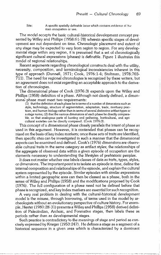
Prewitt -- Cultural Chronology 69
Site: A specific spatially definable locus which contains evidence of hu- man occupation or use.
The model accepts the basic cultural-historical development concept pre- sented by Willey and Phillips (1958:61-78) wherein specific stages of devel- opment are not dependent on time. Chronologic placement and extent of any stage may be expected to vary from region to region. For any develop- mental stage within any region, it is presumed that a set of chronologically significant cultural expressions (phases) is definable. Figure 1 illustrates this model of regional relationships.
Recent arguments regarding chronological constructs deal with the utility, necessity, composition, and terminological inconsistencies inherent in this type of approach (Dunnell, 1971; Cook, 1976:1-4; Stoltman, 1978:703- 711). The need for regional chronologies is recognized by these writers, but an agreement does not exist regarding an acceptable approach to the deriva- tion of chronologies.
The dimensional phase of Cook (1976:3) expands upon the Willey and Phillips (1958) definition of a phase. Although not clearly defined, a dimen- sional phase must meet two requirements:
(1) that the definition of each phase bein terms of a number of dimensions such as style, technology, structure of segmentation, adaptation, trade, mortuary prac- rices, and human biology rather than in terms of several distinctive artifact types or a stage name; (2) that the various dimensions of each phase be directly compara- ble, so that analogous parts of hunting and gathering, horticultural, and agri- cultural societies can be directly compared. (Cook 1976:3).
This concept of a dimensional phase closely parallels the intent of phase as used in this argument. However, it is contended that phases can be recog- nized on the basis of key index markers; once these sets of traits are identified, then specific sites can be investigated in such a manner that the dimensional aspects can be examined and defined. Cook’s (1976) dimensions are observ- able cultural traits in the same category as artifact styles; the relationships of the aggregate of observed data within a given episode of occupation are the elements necessary to understanding the lifestyles of prehistoric peoples.
It does not matter whether one labels classes of data as traits, types, styles, or dimensions. The important point is to isolate an episode in time, define the internal composition and relationships of the episode, and explain the cultural system represented by the episode. Similar episodes with similar expressions within a limited geographic area can then be classed as a phase, both in the sense of Willey and Phillips (1958) and the modifications proposed by Cook (1976). The full configuration of a phase need not be defined before that phase is recognized, and key index markers are essential for such recognition.
A very real problem in dealing with the cultural-historical development model is the misuse, through borrowing, of terms used in the model by ar- cheologists without an evolutionary perspective of culture history. For exam- ple, Hester (1980:28-31) presents a Willey and Phillips (1958) derived defini- tion of Paleoindian, Archaic, and Formative stages, then labels these as periods rather than as developmental stages.
Such practice is contradictory to the meanings of stage and period as con- cisely expressed by Krieger (1953:247). He defines a stage as a segment of a historical sequence in a given area which is characterized by a dominant
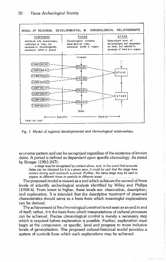
70 Texas Archeological Society
MODEL OF REGIONAL
COMPONENT
Individual site expressions,
restricted in time~ oaf necessarily chronologically
sucessive within a phase.
~OMPONENT’~--~
~OMPONENT)-------’~
(COMPONENT)-------~
~OMPONENT~"-’~-’~
~OMPONENT)-------~
~OMPONENTk’-----~
~OMPONENT~------~
~OMPONENT.)’--’-’-’-~
DEVELOPMENTAL 8~ CHRONOLOGICAL RELATIONSHIPS
P~AI/BI/$HP
PHASE
Chronological divisions
dependent on time sucessive within a region.
Younger
Older
STAGE
Generalized level of development; not dependent
on time, but related to passage of time in o region,
I
I
1
- Specific General )
Fig. 1 Model of regional developmental and chronological relationships.
economic pattern and can be recognized regardless of the existence of known dates. A period is defined as dependent upon specific chronology. As stated by Krieger (1953:247):
¯ . . a stage may be recognized by content alone, and, in the event that accurate dates can be obtained for it in a given area, it could be said that the stage here existed during such-and-such a period. Further, the same stage may be said to appear at different times or periods in different areas ....................
The proposed model is viewed as a tool which achieves the second of three levels of scientific archeological analysis identified by Willey and Phillips (1958:4). From lower to higher, these levels are: observation, description; and explanation. It is intended that the descriptive treatment of observed characteristics should serve as a basis from which meaningful explanations can be derived.
The achievement of the chronological construct is not seen as an end in and of itself; rather, it is the basis from which interpretations of cultural processes can be achieved. Precise chronological control is merely a necessary step which is required before explanation is possible. Further, explanation must begin at the component, or specific, level and progress to more inclusive levels of generalization. The proposed cultural-historical model provides a system of controls from which such explanations may be achieved.
Prewitt -- Cultural Chronology 71
PROPOSED CENTRAL TEXAS CHRONOLOGY
Cultural chronologies are useful only so long as they contribute to the understanding of past human lifeways. The primary purpose of regional chronologies should be to identify discrete episodes of cultural expressions in order to facilitate definition of adaptations as they change through time. It is emphasized that chronologies should be developed on a regional basis. How- ever, it should be expected that geographical boundaries of specific episodes of adaptation will fluctuate within a given region. In other words, adaptive mode A may encompass a more limited geographic extent than the succeed- ing adaptive mode B. As a whole, however, a series of adaptations may be expected within a definable region.
Central Texas is the specific region under consideration. This region (Fig. 2) encompasses the eastern half of the Edwards Plateau, the Llano Uplift, most of the Lampasas Cut Plains, the Comanche Plateau, the southern end of the Grand Prairie, and the Blackland Prairies bordering the Balcones Es- carpment from near Waco to near Uvalde.
Based upon the model (Fig. 1), it is possible to suggest a detailed chrono- logical construct for the Central Texas archeological region. Available evi- dence indicates that four major stages of development are present and recog- nizable: Paleoindian, Archaic, Neoarchaic, and Historic. Three stages proposed by Willey and Phillips (1958), the Formative, Classic, and Post- Classic, are not included in this regional chronology. Archeological evidence to support the existence of these stages in the Central Texas region is absent.
Problems exist with the term Paleoindian (Willey and Phillips, 1958:80). However, in view of the entrenched nature of the term’s acceptance and use, it is retained to denote those cultures which were oriented toward big game procurement; food collecting was not the overriding economic pursuit. The Paleoindian Stage has been stereotyped (somewhat erroneously) as a migra- tory systematic big game procurement adaptation (Johnson, 1977:65-77).
Identifiable remains of the Paleoindian Stage in Central Texas are sparse and limited in large part to single occurrences. Segmentation of the Stage at this time would be spurious. The discovery and investigation of more sites on the order of 41BX52 should contribute to a better understanding of the Pa- leoindian stage in Central Texas (Jerry Henderson, personal communica- tion). This site contained a distinct, isolatable component that yielded Folsom points and related camping debris.
The Archaic Stage dominates all other remains in Central Texas. The Ar- chaic is a term used to denote hunting and gathering (or food collecting) cultures. Eleven phases are recognizable in the Archaic expressions in Central Texas; each phase is assigned a formal name. Some of the phase names are taken from Kelley (1947a), Weir (1976), and Prewitt (in press); the remain- der are new terms taken from towns or communities in the Central Texas region.
Phase distinctions are based on data from numerous sites but primarily drawn from Johnson et al. (1962), Shafer (1963), Sorrow et al. (1967), Weir (1976), Wesolowsky et al. (1976), and Prewitt (ms). From oldest to youngest, proposed phases are: Circleville, San Geronimo, Jarrell, Oakalla,
72 Texas Archeological Society
CENTRAL TEXAS ARCHEOLOGICAL REGION
LOCATION MAP
0 I00 200 400
kilometers
0 40 80 160
miles
PaAI/81/SHP
Fig. 2 Location map showing the Central Texas Archeological Region.
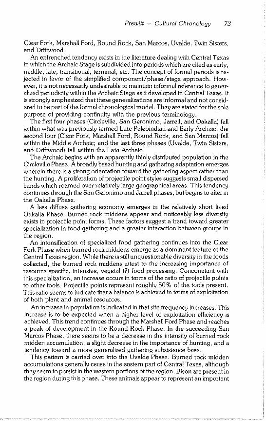
Prewitt -- Cultural Chronology 73
Clear Fork, Marshall Ford, Round Rock, San Marcos, Uvalde, Twin Sisters, and Driftwood.
An entrenched tendency exists in the literature dealing with Central Texas in which the Archaic Stage is subdivided into periods which are cited as early, middle, late, transitional, terminal, etc. The concept of formal periods is re- jected in favor of the simplified component/phase/stage approach. How- ever, it is not necessarily undesirable to maintain informal reference to gener- alized periodicity within the Archaic Stage as it developed in Central Texas. It is strongly emphasized that these generalizations are informal and not consid- ered to be part of the formal chronological model. They are stated for the sole
purpose of providing continuity with the previous terminology. The first four phases (Circleville, San Geronimo, Jarrell, and Oakalla) fall
within what was previously termed Late Paleoindian and Early Archaic; the
second four (Clear Fork, Marshall Ford, Round Rock, and San Marcos) fall within the Middle Archaic; and the last three phases (Uvalde, Twin Sisters,
and Driftwood) fall within the Late Archaic. The Archaic begins with an apparently thinly distributed population in the
Circleville Phase. A broadly based hunting and gathering adaptation emerges wherein there is a strong orientation toward the gathering aspect rather than
the hunting. A proliferation of projectile point styles suggests small dispersed bands which roamed over relatively large geographical areas. This tendency continues through the San Geronimo and Jarrell phases, but begins to alter in
the Oakalla Phase. A less diffuse gathering economy emerges in the relatively short lived
Oakalla Phase. Burned rock middens appear and noticeably less diversity exists in projectile point forms. These factors suggest a trend toward greater specialization in food gathering and a greater interaction between groups in the region.
An intensification of specialized food gathering continues into the Clear Fork Phase when burned rock middens emerge as a dominant feature of the Central Texas region. While there is still unquestionable diversity in the foods collected, the burned rock middens attest to the increasing importance of resource specific, intensive, vegetal (?) food processing. Concomitant with
this specialization, an increase occurs in terms of the ratio of projectile points to other tools. Projectile points represent roughly 50% of the tools present. This ratio seems to indicate that a balance is achieved in terms of exploitation of both plant and animal resources.
An increase in population is indicated in that site frequency increases. This increase is to be expected when a higher level of exploitation efficiency is achieved. This trend continues through the Marshall Ford Phase and reaches a peak of development in the Round Rock Phase. In the succeeding San Marcos Phase, there seems to be a decrease in the intensity of burned rock midden accumulation, a slight decrease in the importance of hunting, and a
tendency toward a more generalized gathering subsistence base. This pattern is carried over into the Uvalde Phase. Burned rock midden
accumulations generally cease in the eastern part of Central Texas, although they seem to persist in the western portions of the region. Bison are present in the region during this phase. These animals appear to represent an important
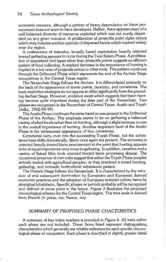
74 Texas Archeological Society
economic resource, although a pattern of heavy dependence on bison pro- curement does not seem to have developed. Rather, there appears more of a well balanced diversity of resources exploited which was not overly depen- dent on any given resource. A proliferation of projectile point styles occurs which may indicate another episode of dispersed bands which roamed widely over the region.
A coalescence of intensive, broadly based exploitation heavily oriented toward gathering appears to occur during the Twin Sisters Phase. A prolifera- tion of specialized tool types other than projectile points suggests an efficient system of food collecting. A marked decrease in the importance of hunting is implied in a low ratio of projectile points to other tools. This pattern continues through the Driftwood Phase which represents the end of the Archaic Stage occupations in the Central Texas region.
The Neoarchaic Stage follows the Archaic. It is differentiated primarily on the basis of the appearance of arrow points, ceramics, and cemeteries. The basic exploitive strategies do not appear to differ significantly from the preced- ing Archaic Stage. However, evidence exists which suggests that bison hunt- ing became quite important during the later part of the Neoarchaic. Two phases are recognized in the Neoarchaic of Central Texas: Austin and Toyah (Jelks, 1962:84-99).
The Austin Phase continues the same trend as was present in the Driftwood Phase of the Archaic. The emphasis seems to be on gathering a balanced variety of plant foods rather than on hunting, although a slight increase occurs in the overall importance of hunting. Another important facet of the Austin Phase is the widespread appearance of true cemeteries.
Cemeteries carry over into the succeeding Toyah Phase, but the subsis- tence base shifts dramatically. Bison once again are present. The economy is oriented heavily toward bison procurement to the point that hunting appears to be of equal importance once more to gathering. In addition, ceramics and a variety of flaked lithic tools oriented toward bison processing a~pear. The occasional presence of corn cobs suggest that either the Toyah Phase peoples actively traded with agricultural peoples; or they practiced a mixed hunting, gathering, and nomadic horticultural subsistence pattern.
The Historic Stage follows the Neoarchaic. It is characterized by the intru- sion of and subsequent domination by Europeans and European derived economic practices and the adoption of European material culture items by aboriginal inhabitants. Specific phases or periods probably will be recognized and defined at some point in the future. Figure 3 illustrates the proposed chronological scheme for the Central Texas region. The time scale is derived from Prewitt (in press, ms; Nance, ms).
SUMMARY OF PROPOSED PHASE CHACTERISTICS
A summary of key index markers is provided in Figure 4. All traits within each phase are not included. Those items listed represent distinguishing characteristics which generally are reliable indicators for each specific chrono- logical phase of occupation. Each phase is described in slightly greater detail
Prewitt -- Cultural Chronology 75
PROPOSED CHRONOLOGICAL SCHEME-CENTRAL TEXAS REGION
RE PRE SENTATIVE PH A S E APPROXIMATE S TAGE
COMPONENT YEARS B.P.~
Kyle Site, 41 HI I --I
Barker Site, 41WM 71 J Loeve-Fox Site, 4t WM 230 Smith Rockshelter, 41TV 42
TOYAH
Kyle Site, 41 HI I Smith Roekshelteq 41 TV 42 J Leave-Fox Site, 4~ WM 230
Pot Porker Site, 41 TV 88
AUSTIN
Loeve-Fox Site, 41WM 230 Smith Rockshelter, 41TV 42
Evoe Terrace Site, 41BL tO4
McConn Site, 41 LM 5
DRIFTWOOD
TWIN SISTERS
UVALDE
Oblate Site, 41 CM I
Loeve-Fox Site, 41 WM 230 Youngsport Site, 41 BL 78
Evoe Terrace Site, 41BL 104
Youngsport Site, 41 BL 78 "7 Crumley Site, 41TV 86 / Evoe Terrece Site. 41BL 104 John Ischy Site, 4t WM 49
Loeve-Fox Site, 41 WM 250 -7 Crumley Site, 41 TV 86 J Evoe Terrace Site, 4! BL 104 John Ischy Site, 41 WM 49
-0 1 Historic
200
650
I Neo-Ar chalc
Loeve-Fox Site, 41 WM 230 Rogers Springs Site, 41 TV 39
Willloms Site, 41 TV 75 John Ischy Site, 41 WM 49
Crumley Site, 41 TV 86
Greenhow Site, 41 HY 29 Rogers Springs Site, 41TV 39 John Ischy Site, 4] WM 49
Williams Site, 41 TV 75 Crumley Site, 41 TV 86
McCann Site, 41 LM B
Greenhew Site, 41 HY 29
Landslide Site, 41 BL 85 John Ischy Site~ 41 WM 49
Lo Jite SHe, 41 UV 21 Wounded Eye Site, 41 KR 107
Landslide Site, 41BL 85 -1 Goult Site, 41 WM I0 J Tombstone Bluff Site, 41 WM 165
LO Jita Site, 41 UV 21
Tombstone Bluff Site, 41 WM 165 -1
Granite Beech Site, 41 LL 2 J Youngsport Site. 41 BL 78
Son Geronimo Site. 41 BX 196
1,250
Levi RocksheRer Site, 41TV 49 -1 Loeve Site, 41 WM 13B J Tombstone Bluff Site, 41 WM 165 Strohocker Site, 41 KR 29
1,400
- t,750
- 2,250
SAN M ARCOS
2,600
ROUND ROCK
3,400
MARSHALL FORD
4,000
CLEAR FORK
4,600 .....
OAKALLA
- 5,000
JARRELL
SAN GERONIMO
6,000
.... 7,000
CIRCLE VILL E
Archaic
b4
1 8,500 i
_ ]
_ _ ? ] Po,oo-,od,o°
~Age ranges based on radiocarbon essays assembled by L, Nonce (ms,); assays have been adjusted by
application of Arizona Correction (Demon, Ferguson, Long and Wollick, 1974),
Fig. 3 Proposed chronological scheme, Central Texas Region.
76 Texas Archeological Society
SUMMARY OF KEY INDEX MARKERS -- CENTRAL TEXAS CHRONOLOGY
STAGE KEY INDEX MARKERS
Jistoric
Nee-
Archaic
Archaic~
Paleo-
Indian
PHASE
Toyoh
Austin
Driftwood
Twin Sisters
Uvalde
San Morcos
Round Rock
Marshall Ford
Clear Fork
Oakalla
darrell
San Geronimo
Circleville
Items of European Manufacture
/ I ~ l ~Screpers ~ ~Bifoces C~’~’\cs Perdiz Ct’ff ~ ~-/ -- /A ~/ Cemeteries / ..’on Covlngfon /\
So°W" A 8i~a~e I \ ~.iday I~ I I Gronbury I \ Biface cam°,°,..
Mahomef [ t~ [ Hare Biface
LJ L_. - ’ASanGabrie/ Erafh~777~-
II ~"°°el l "°’e\ / ~A A L2f’s°r ^L__J ̂ kJ_ Vl \.I\
Marsha/l l \t~,l/liom$I \ Lange/ \ B .... d Rock
///~ ~j~ ~.__~ ~_~ Middens
~ Pederno/es Burned Rock
Middens
A Bolverde
/ \ A Burned Rock
A /I .,,°e°.
I ~olo. I ] TrOViS B .... d Rock
\ / // Midden,
A,.,,, i B.rned Rock k ~ / \ Middens
Clovis . . Folsom "Ploinview
P S A //EP/81
Fig. 4 Summary of Key Index Markers, Central Texas Chronology.
Prewitt -- Cultural Chronology 77
in the following discussion. These discussions are summaries and additional research should provide more detailed data for each. Not all known compo- nents of each phase are discussed; representative components are listed in order to provide a general set of references.
Regionally specific cultural chronologies are useful if they contribute to an understanding of past human lifeways. The proposed scheme was developed on the premise that it is flexible and will be modified as new data become available. In order to accomplish the objective of understanding past events in Central Texas, the proposed chronology should be used only within the re- gion for which it is intended to apply. Separate, similar schemes should be constructed for adjacent regions (such as the Lower Pecos and South Texas) in order to facilitate interregional comparisons.
Only the named proposed phases are discussed. The Archaic and Neoar- chaic stages are included, but Paleoindian and Historic stages are omitted. With the former, a detailed examination of specific adaptations within that stage awaits accumulation of more precise data. With the latter, segmentation into phases at this stage of archeological knowledge of the region is not war- ranted.
Archaic Stage
CIRCLEVILLE PHASE (Prewitt, in press; Patterson, 1977)
Representative Components: Levi Rockshelter (41TV49; Alexander, 1963); Loeve (41WM133; Eddy, 1973; Prewitt, ms); Tombstone Bluff (41WM165; Prewitt, ms); Strohacker (41KR29; Sollberger and Hester, 1972); Granite Beach (41LL2; Crawford, 1965).
Site Types: rockshelter; point bar; bluff top; terrace. Representative Artifacts: Angostura, Golondrina, Meserve, and Scottsbluff projectile points;
Clear Fork gouges; miscellaneous bifaces; drills; scrapers; gravers; hammerstones; grooved stones (?); grinding stones; bone awls; carved bones.
Features: large and medium basin shaped, stone lined fire hearths; burned clay/charcoal pits; mussel shell concentrations.
Mortuary Practices: data lacking. Subsistence: hunting and gathering with an emphasis on gathering; plant food processing
indicated by grinding stones; freshwater mussels collected~ deer and other small game hunted. External Relations: This phase represents a regional expression of a widespread adaptation
which occurred following the disappearance of Paleoindian lifeways. In the adjacent Lower Pecos region, a concurrent expression occurred with Golondrina projectile points the dominant key index marker. While these two areas undoubtedly are related during this phase, the overall material culture assemblage is varied sufficiently to warrant separation of the two regions.
Estimated Age: ca 8500 B.P. to 7000 B.P. (ca 6550 B.C. to 5050 B.C.) Discussion: The Circleville Phase continues the Paleoindian style of lithic tool production in
terms of flaking techniques and projectile point morphology. The subsistence base, however, is Archaic in that it is a hunting and gathering adaptation. For this reason, the phase is considered to be the earliest Archaic expression in Central Texas.
Selected References: Alexander (1963)~ Crawford (1965); Sollberger and Hester (1972); Eddy (1973); Prewitt (ms).
SAN GERONIMO PHASE (Weir, 1976)
Representative Components: San Geronimo (41BX196; Weir, 1976); Youngsport
(41BL78; Shafer, 1963)~ Granite Beach (41LL2); Tombstone Bluff (41WM165).
78 Texas Archeological Society
Site Types: terrace; bluff top. Representative Artifacts: Gower, Hoxie, and Wells projectile points; Clear Fork gouges;
Guadalupe gouges; miscellaneous bifaces; scrapers. Features: data unclear; possibly large and medium basin shaped, stone lined hearths at
Granite Beach. Mortuary Practices: data lacking. Subsistence: hunting and gathering; available data too sparse to allow detailed statements on
specific adaptive orientations. External Relations: It is relatively localized to the Central Texas Region although a similar
expression was noted in the Lower Pecos region at Devils Rockshelter (41VV264; Prewitt, 1966).
Estimated Age: 7000 B.P. to ca 6000 B.P. (5050 B.C. to ca 4050 B.C.) Discussion: Although some Paleoindian lithic traits persist (particularly edge grinding and
occasional parallel flaking of projectile points), projectile point morphology differs strongly from the preceding Circleville Phase. The subsistence base appears to be Archaic although the paucity of available data preclude detailed examination.
Selected References: Shafer (1963); Crawford (1965); Weir (1976); Prewitt (ms).
JARRELL PHASE (new name; Sorrow et al., 1967)
Representative Components: Landslide (41BL85; Sorrow et al., 1967); Gault (41WM10; TARL); Site 41VT17 (Fox and Hester, 1976); Tombstone Bluff (41WM165); Merrell (41WM2; Campbell, 1948); La Jita (41UV21; Hester, 1971); Jetta Court (41TV151; Wesolowsky et al., 1976).
Site Types: terrace and bluff top, Representative Artifacts: Andice, Bell, Martindale, and Uvalde projectile points; Clear Fork
gouges; miscellaneous bifaces; scrapers; hammerstones; grinding stones. Features: large fiat hearths. Subsistence: hunting and gathering with a probable tendency for an emphasis on gathering;
bison present and used as a food source although hunting probably not dominant; freshwater mussels collected for food.
External Relations: This phase appears to be relatively localized to the general Central Texas region except that Martindale dart points (and slight variants of the type) also occur in the Lower Pecos Region. Andice and Bell types possibly are related to the same tradition represented by the morphologically similar Calf Creek type in northeastern Oklahoma, northwestern Arkansas, and southwestern Missouri (Perino, 1968:14-15).
Estimated Age: ca 6000 B.P. to 5000 B.P (ca 4050 B.C. to 3050 B.C.) Discussion: Some holdovers exist from the Paleoindian lithic tradition, with frequent edge
grinding on Martindale and Uvalde points and flaking reminiscent of that tradition on Andice points. Subsistence is thoroughly Archaic and probably tends toward an emphasis on gathering.
Selected References: Campbell (1948); Sorrow et al. (1967); Fox and Hester (1976); Weso- Iowsky et al. (1976); Prewitt (ms.)
OAKALLA PHASE (new name; Sorrow et al., 1967)
Representative Components: Landslide (41BL85); John Ischy (41WM49; Sorrow, 1969); McCann (41LM3; Preston, 1969); La Jita (41UV21); Greenhaw (41HY29; Weir, 1979); Tombstone Bluff (41WM165); Shep (41KR109; Luke, 1980); Wounded Eye (41KR107; Luke, 1980).
Site Types: terrace; bluff top. Representative Artifacts: Baird and Taylor projectile points; Clear Fork gouges. Features: burned rock middens; large fiat hearths; medium basin hearths. Mortuary Practices: data lacking. Subsistence: hunting and gathering; however, paucity of isolated components hampers a
detailed examination of subsistence base; diagnostic projectile points rarely occur in relatively
Prewitt - Cultural Chronology 79
large numbers (Greenhaw is an exception); significant accumulations of fire cracked rocks ap- pear to coincide with this phase (beginnings of burned rock middens) and suggests that plant food collecting and processing important; freshwater mussels apparently collected.
External Relations: While diagnostic projectile points generally are more prevalent in Central Texas, they also are known to occur in East Texas (e.g., George C. Davis). The many varieties of the morphologically similar Tortugas projectile point which occur in the South Texas region may indicate some relations with that area, although Tortugas seems to occur later in time.
Estimated Age: 5000 B.P. to ca 4600 B.P. (3050 B.C. to ca 2650 B.C.) Discussion: The Oakalla Phase is probably the least well defined of the Central Texas phases.
This situation is due to a general lack of stratigraphically isolatable components. This lack may be a reflection of the apparently short duration of the phase (ca 400 years).
Selected References: Hester (1971); Sorrow (1969); Sorrow et al. (1967); Preston (1969); Luke (1980); Prewitt (ms).
CLEAR FORK PHASE (Weir, 1976)
Representative Components: Williams (41TV75; Suhm, 1959); Crumley (41TV86; Kelly, 1961); McCann (41LM3); Greenhaw (41HY29); Rogers Springs (41TV39; Prewitt, in press).
Site Types: terrace; upland. Representative Artifacts: Nolan and Travis projectile points; Clear Fork gouges; bifaces;
scrapers; strangulated scrapers; grinding stones. Features: burned rock middens. Mortuary Practices: data lacking. Subsistence: relatively even balance between hunting and gathering emerged during this
phase; burned rock middens appear to accumulate rapidly and indicates extensive plant food processing; however, relatively large numbers of projectile points indicate that hunting also quite important with frequency of dart points being roughly equal to frequency of all other tools.
External relations: Diagnostic projectile point styles are concentrated relatively within the Central Texas region. However, these styles occur infrequently in the Lower Pecos region. An extension in range to the northwest is indicated by the presence of these styles of dart points into the general Abilene area.
Estimated Age: ca 4600 B.P. to 4000 B.P. (ca 2650 B.C. to 2050 B.C.) Discussion: The burned rock midden tradition is well established during this phase; the
general subsistence pattern which prevails during the next two phases is set. Selected References: Suhm (1959); Kelly (1961); Preston (1969); Weir (1979); Prewitt (in
press).
MARSHALL FORD PHASE (new name; Weir, 1976)
Representative Components: Crumley (41TV86); Rogers Springs (41TV39); John Ischy (41WM49); McCann (41LM3); Evoe Terrace (41BL104; Sorrow et al., 1967); Wunderlich (41CM3; Johnson et al., 1962); Youngsport (41BL78).
Site Types: terrace; upland; rockshelter. Representative Artifacts: Bulverde projectile points; bifaces; unifaces; grinding stones. Features: burned rock middens. Mortuary Practices: data lacking. Subsistence: relatively balanced hunting and gathering system similar to preceding Clear Fork
Phase. External Relations: This phase primarily is confined to the Central Texas region although
Bulverde type dart points occur occasionally in East Texas (Suhm and Jelks, 1962). Estimated Age: 4000 B.P. to ca 3400 B.P. (2050 B.C. to ca 1450 B.C.) Discussion: This phase primarily is associated with burned rock midden sites. However,
sparse materials from this phase do occur in rockshelters such as the Oblate site (41CM1; John- son et al., 1962). There does not seem to be any dramatic shift toward the occupation of rock- shelters which would indicate a significant change in camping habits.
Selected References: Kelly (1961); Weir (1979); Sorrow (1969); Preston (1969); Johnson et al. (1962); Prewitt (in press).
80 Texas Archeological Society
ROUND ROCK PHASE (Weir, 1976)
Representative Components: Williams (41TV75); Crumley (41TV86); Greenhaw (41HY29); John Ischy (41WM49); Youngsport (41BL78); Rogers Springs (41TV39); Loeve-
Fox (41WM230; Prewitt, 1974, ms). Site Types: terrace, upland; rockshelter. Representative Artifacts: Pedernales projectile points, bifaces; unifaces; grinding stones. Features: burned rock middens; medium and small basin hearths~ burned clay/charcoal
lenses and pits~ lithic debris concentrations. Mortuary Practices: data lacking. Subsistence: relatively balanced hunting and gathering system which follows in the tradition of
the preceding two phases; plant food processing indicated by burned rock middens; freshwater mussel shells collected as food source; roughly equal ratio of projectile points to all other tools indicates importance of hunting in the economy.
External Relations: While this phase primarily is restricted to the Central Texas region, the key index marker (Pedernales projectile points) occurs to the northwest into the Abilene area and to the southwest into the Lower Pecos region (Suhm and Jelks, 1962). Sparsely distributed exam- ples of Pedernales also occur on the coastal plain to the south and southeast of the primary distribution area.
Estimated Age: ca 3400 B.P. to 2600 B.P. (ca 1450 B.C. to 650 B.C.) Discussion: This phase appears to represent the peak of burned rock midden use on the
Edwards Plateau and associated physiographic regions. There is not such a domination of the region in terms of quantities of a single projectile point style and frequency of site occurrence at any other time during the Archaic of Central Texas. Burned rock midden sites have been the focus of investigations into this phase. Recent discovery of stratified Round Rock Phase compo- nents at Loeve-Fox (Prewitt, ms) provides a glimpse of activities not associated with a burned rock midden.
At Loeve-Fox (Prewitt, ms), Round Rock Phase hearths (medium and small stone lined basins) are surrounded by burned clay/charcoal lenses and pits, lithic debris concentrations, and other scattered debris such as burned rocks, freshwater mussel shells, and tools. Spatial distribu- tion of these features and materials provides support for the hypothesis that the middens repre- sent the accumulated debris from hundreds or thousands of disrupted hearths. Presence of dense lithic debris concentrations also provides an explanation of the tremendous quantities of flaking debris frequently encountered in middens.
Selected References: Suhm (1959); Kelly (1961); Weir (1979); Sorrow (1969); Shafer (1963)~ Prewitt (in press, ms).
SAN MARCOS PHASE (Weir, 1976)
Representative Components: Crumley (41TV86); La Jita (41UV21); Evoe Terrace (41BLI04); John Ischy (41WM49); Youngsport (41BL78); Loeve-Fox (41WM230).
Site Types: terrace; upland; rockshelter. Representative Artifacts: Marshall, Williams, and Lange projectile points~ bifaces; scrapers;
small concave unifaces; grinding stones; marine shell ornaments. Features: burned rock middens; large flat hearths; medium and small basin hearths; lithic
debris concentrations; freshwater mussel shell concentrations. Mortuary Practices: single cremation at Loeve-Fox (Prewitt, ms); cremation secondary in that
body was burned, then remains interred in a small basin shaped pit. Subsistence: hunting and gathering with a probable slight emphasis on gathering~ freshwater
mussels collected for food~ slight decrease in ratio of projectile points to other tools indicates that hunting not as important as in preceding phases~ burned rock middens a continuation of the established pattern of intensive plant food processing.
External Relations: Distribution of the key index marker for this phase (Marshall dart points) has a broad range which extends beyond the Central Texas region. However, the most intensive occurrence of this type and its two companions (Williams and Lange) is within the region. Pres- ence of marine shell ornaments indicates contact, probably through an extensive trade network, with peoples or resources from a coastal environment.
Estimated Age: 2600 B.P. to ca 2250 B.P. (650 B.C. to ca 300 B.C.)
Prewitt -- Cultural Chronology 81
Discussion: This phase appears to represent the end of significant burned rock midden accu- mulation over most of the Central Texas region. Ring and crescent middens may continue in use into later phases in the western portions of the region. Practices which lead to the accumulation of these features in general wane during the San Marcos Phase. It is probable that bison once again appear in the region either during this phase or in the succeeding Uvalde Phase.
Selected References: Shafter (1963); Kelly (1961); Hester (1971); Sorrow (1969); Sorrow et al. (1967); Prewitt (ms).
UVALDE PHASE (new name; Kelley, 1947a)
Representative Components: Wunderlich (41CM3); Oblate (41CM1; Johnson et al., 1962); Youngsport (41BL78); Crumley (41TV86); Evoe Terrace (41BL104); John Ischy (41WM49); Jetta Court (41TV151); Scorpion Cave (41ME7; Highley et al., 1978); La Jita (41UV21);
McCann (41LM3). Site Types: terrace~ upland; rockshelter. Representative Artifacts: Castroville, Marcos, and Montell projectile points; bifaces; unifaces;
grinding stones; ulna flakers. Features: data lacking. Mortuary Practices: data lacking. Subsistence: hunting and gathering with a probable slight emphasis on gathering; freshwater
mussels collected (not in large quantities); grinding stones indicate continued processing of plant foods; bison present in region during this phase but not a primary food source.
External Relations: The key index markers for this phase (Castroville, Marcos, and Montell dart points) also occur as horizon markers in the adjacent Lower Pecos region to the west (Dibble, 1967; Prewit~, 1970). A possibility exists that this phase represents a more widespread adapta- tion. Marine shell artifacts noticeably are lacking and indicates a discontinuation of the earlier apparent trade system.
Estimated Age: ca 2250 B.P. to 1750 B.P. (ca 300 B.C. to A.D. 200) Discussion: Artifacts diagnostic of this phase are found frequently in upper portions of burned
rock middens; middens apparently did not accumulate during this phase. A tendency exists for diagnostic materials to occur adjacent to middens and in terraces which lack burned rock mid- dens. This situation, in combination with the trend toward an emphasis on gathering, suggests that intensive processing which earlier led to midden formation is not practiced and a different adaptation existed.
Selected References: Johnson et al. (1962); Shafer (1963); Kelly (1961); Sorrow (1969); Sorrow et aL (1967); Wesolowsky et al. (1976); Highley et al. (1978); Hester (1971); Preston (1969).
TWIN SISTERS PHASE (Weir, 1976)
Representative Components: Oblate (41CM1); Wunderlich (41CM3); Williams (41TV75); Youngsport (41BL78); Evoe Terrace (41BL104)~ La Jita (41UV21)~ Scorpion Cave (41ME7); McCann (41LM3); Penny Winkle (41BL23; Shafer et al., 1964); Hoxie Bridge (41WM103;
Bond, 1978); Loeve-Fox (41WM230). Site Types: terrace; rockshelter. Representative Artifacts: Ensor projectile points; Erath and San Gabriel bifaces; Clear Fork
gouges; perforators; gravers; large and small concave unifaces; scrapers; crushers; grinding stones; boatstones; stone and marine shell gorgets~ freshwater shell pendants.
Features: large, medium, and small basin hearths; arcuate hearths~ burned clay/charcoal lenses and pits; mussel shell caches.
Mortuary Practices: isolated flexed burials. Subsistence: hunting and gathering with a decided emphasis on gathering; projectile points in
low ratio to all other tools; freshwater mussels collected but apparently in lesser quantities than preceding phases.
External Relations: Ensor dart points are distributed over a much larger area than the Central Texas region and may represent a more generalized horizon marker. The existence of an exten- sive trade network is indicated by the occurrence of marine shell artifacts and various stone objects fashioned from materials which are relatively limited in distribution. The presence of
82 Texas Archeological Society
boatstones suggests possible influences from the Southeastern or, less probably, Southwestern U.S.
Estimated Age: 1750 B~P. to ca 1400 B.P. (A.D. 200 to ca A.D. 550). Discussion: The Twin Sisters Phase appears to represent the beginning of a distinct tradition.
Emphasis of the hunting and gathering adaptation leans heavily toward gathering rather than hunting. A proliferation of seemingly formal tool types other than projectile points appears to reflect a diversified, yet intensive, exploitive system which was probably quite efficient.
Indications of intrasite patterning have been documented at Loeve-Fox (Prewitt, ms). At least three episodes of site use during the Twin Sisters Phase were identified. In each episode, pattern- ing is identical and consists of semicircular arrangements of specialized cooking features and waste debris centered about a large basin hearth. These sets of features and debris are arranged in a semicircle around other hearths. These latter hearths included at least one large example that contained items (tool and ornaments) in which particular care had been taken to safeguard and maintain them. The patterning is interpreted to reflect extended kin (or residence) units arranged in an encampment much like the historically documented 19th Century Plains Indian groups (Lowie, 1963:93, Fig. 29).
Selected References: Johnson et al. (1962); Suhm (1959); Shafer (1963); Sorrow et al. (1967); Hester (1971); Preston (1969); Story and Shafer (1965); Highley et al. (1978); Bond (1978); Prewitt (1974, ms).
DRIFTWOOD PHASE (new name; Weir, 1976)
Representative Components: Smith Rockshelter (41TV42~ Suhm, 1957); Williams (41TV75); Baylor (41ML35; Story and Shafer, 1965); Britton (41ML37; Story and Shafer, 1965); Evoe Terrace (41BL104); Jetta Court (41TV151); McCann (41LM3); Kyle (41H11; Jelks, 1962); Pat Parker (41TV88; Greer and Benfer, 1975); Hoxie Bridge (41WM130)~ Do- bias-Vitek (41WMl18; Eddy, 1973); Loeve (41WM133); Loeve-Fox (41WM230).
Site Types: terrace; rockshelter. Representative Artifacts: Mahomet projectile points; Hare bifaces; miscellaneous bifaces;
small concave unifaces; gravers; polished chert flakes; grinding stones; hammerstones; freshwa- ter mussel shell pendants; bone beads; bone awls.
Features: medium and small basin hearths; burned clay/charcoal lenses and pits. Mortuary Practices: isolated flexed burials. Subsistence: appears to be a definite emphasis on the gathering aspect in the basic hunting
and gathering system. External Relations: in contrast to the preceding Twin Sisters Phase and the following Austin
Phase, there seems to be a lack of exotic materials which suggests an absence of any widespread trade networks. Distribution of the key index marker (Mahomet dart points) seems to be restricted to the eastern half of the Central Texas region. This restriction suggests that the western portions were occupied by peoples more closely affiliated with the Lower Pecos region during this phase.
Estimated Age: ca 1400 B.P. to 1250 B.P. (ca A.D. 550 to A.D. 700). Discussion: This phase appears to represent a continuation of the tradition established during
the Twin Sisters Phase and signals the end of the Archaic Stage in Central Texas. This is the last phase during which the atlatl was used. While sparse occupation of rockshelters occurred during several of the preceding Archaic phases, there seems to be a decided shift toward the occupation of those types of sites during the Driftwood Phase. This shift represents a noticeable change in the overall settlement pattern. However, terrace sites still represent the major type of site occupied during this phase.
Selected References: Suhm (1957, 1959); Story and Shafer (1965); Sorrow et al. (1967); Jelks (1962); Preston (1969); Wesolowsky et al. (1976); Greer and Benfer (1975); Eddy (1973); Bond (1978); Prewitt (1974, ms).
Neoarchaic Stage
AUSTIN PHASE (Jelks, 1962)
Representative Components: Smith Rockshelter (41TV42); Kyle (41H11); Oblate (41CM1); Baylor (41ML35); Penny Winkle (41BL23); Evoe Terrace (41BL104); Pat Parker (41TV88); Wheatley (41BCl14; Greer, 1976); Frisch Aufl (41FY42; Hester and Collins, 1969); Jetta Court (41TV151)~ Dobias-Vitek (41WMl18); Hoxie Bridge (41WM130); Loeve-Fox (41WM230).
Prewitt - Cultural Chronology 83
Site Types: terrace; rockshelter. Representative Artifacts: Scallorn and Granbury projectile points; Friday bifaces; miscella-
neous bifaces; Clear Fork gouges; scrapers; small concave unifaces; grinding stones; hammer- stones; painted pebbles; bone awls; ulna flakers; bone beads; marine shell beads and pendants.
Features: large, medium, and small basin hearths; burned clay/charcoal lenses and pits; cemeteries.
Mortuary Practices: Cemeteries apparently are preferred although isolated interments may occur. Both situations occur in terrace sites and rockshelters, usually associated with habitation sites. Noncremated and cremated interments are present. Noncremated burials usually are flexed or semiflexed and may be placed on either the right or left side, the back, or stomach rarely. Cremation appears to have been carried out away from the cemeteries, then charred remains placed in shallow pits.
At Loeve-Fox (Prewitt, ms), the noncremated remains were placed in a 3 m diameter circular area; cremated interments were placed in a 3 m wide band encircling the noncremated burials. A fence or structure presumedly marked the cemetery locations. Grave goods include marine shell beads, marine shell pendants, unaltered freshwater mussel shells, antler tines, and cut deer parietals. Arrow points (Scallorn) frequently are associated; however, most of these specimens appear to represent the cause of death rather than funeral offerings.
Subsistence: The hunting and gathering system of the two previous phases continues in the Austin Phase and appears to be more dependent upon gathering. However, a definite slight increase occurs in the importance of hunting as shown by an increased ratio of projectile points to all other tools. Whether an increased frequency in the occurrence of deer bones is a reflection of this trend or the result of differential preservation is unknown. Freshwater mussels continue to be collected, but in relatively small numbers in comparison to the preceding Archaic phases.
External Relations: The diagnostic projectile point (Scallorn) is very widespread in distribu- tion, extending from central Texas Gulf Coast northward into the Plains region (Bell, 1960; Chapman, 1980). It is probable that the Central Texas region represents a localized adaptation within a more generalized pattern. This hypothesis is supported by the apparent presence of an extensive trade network indicated by frequent occurrence of marine shell artifacts.
Estimated Age: 1250 B.P. to 650 B.P. (A.D. 700 to A.D. 1300). Discussion: The Austin Phase is placed within the Neoarchaic Stage primarily because of the
change in weaponry from atlatl to bow and arrow. Other changes occur, particularly in regards to the definite selection of rockshelters as habitation sites and return to a somewhat greater depend- ence upon hunting. These changes characterize this phase and set it apart as a distinct cultural expression.
Selected References: Suhm (1957)~ Jelks (1962); Johnson et al. (1962); Story and Sharer (1965); Shafer et al. (1964); Sorrow et al. (1967); Greet and Benfer (1975); Greet (1976); Hester and Collins (1969)~ Wesolowsky et al. (1976); Eddy (1973); Bond (1978); Watt (1936); Prewitt (1974, ms).
TOYAH PHASE (Jelks, 1962)
Representative Components: Smith Rockshelter (41TV42); Kyle (41H11); Oblate (41CM1); Penny Winkle (41BL23); Baylor (41ML35); Barker (41WM71; Sorrow, 1970); Berclair (41GD4; Hester and Parker, 1970); Wheatley (41BCl14); Finis Frost (41SS20; Green and Hester, 1973); Hoxie Bridge (41WM130); Loeve-Fox (41WM230).
Site Types: terrace; rockshelter. Representative Artifacts: Perdiz and Cliffton projectile points; Covington bifaces; four bevel
bifaces; end scrapers; drills; grinding stones; freshwater mussel shell pendants~ bone beads~ bone awls; ulna flakers; various bison bone tools; Leon Plain and Doss Redware ceramics, imported ceramics; wooden arrow foreshafts~ cane arrow shafts; digging sticks; basketry; cordage; miscel- laneous perishable artifacts.
Features: large flat hearths; large and medium basin hearths; burned clay/charcoal lenses; pits; cemeteries.
Mortuary Practices: Both cemeteries and isolated interments continue in this phase, although they do not appear to occur as frequently as in the Austin Phase. Semiflexed modes of burial predominate but cremations also are present. The possible association of grave goods is not conclusive. Perdiz and Cliffton arrow points frequently associated with the burials appear to represent aggression which resulted in death rather than funeral offerings.
84 Texas Archeological Society
Subsistence: Although a hunting and gathering system appears to have been practiced during the Toyah Phase, a radical departure exists from the preceding Austin Phase in several respects. Perhaps most significant is the presence of bison once again in the Central Texas region. Fre- quence of bison bone occurrences and definite emphasis on tools which reflect bison procure- ment, processing, and use suggest that hunting is of equal (or possibly greater) importance than gathering. This shift is reinforced at such sites as Loeve-Fox (Prewitt, ms) where projectile points represent 50% of all tools associated with this phase.
The sporadic occurrence of corn cobs in Toyah Phase contexts implies that the subsistence may have included maize horticulture as a supplement. It is equally possible, however, that these grains could have been acquired through trade with nearby sedentary groups such as various Caddoan (including Wichita) groups.
External Relations: The key index markers (Perdiz and Cliffton arrow points) are widespread in distribution and not restricted to those groups which inhabited the Central Texas region. An extensive trade system is indicated by the frequent occurrence of Caddoan ceramics in Toyah Phase sites; presence of corn cobs may indicate trade for foodstuffs. Less certainly, trade with coastal peoples may be indicated by Goose Creek Plain ceramics at the Smith Rockshelter (Suhm, 1957) although there appears to be a paucity of marine shell artifacts.
Estimated Age: 650 B.P. to 200 B.P. (A.D. 1300 to A.D. 1750). Discussion: The Toyah Phase closely follows the Austin Phase in several respects, but most
particularly in terms of settlement pattern, cemetery use, human aggression, and continuation of a hunting and gathering subsistence system. However, definite changes occurred in terms of: an emphasis on bison procurement; addition of appropriate tools to the inventory; addition of ceramics (both imported trade wares and locally manufactured wares); and either addition of maize horticulture to subsistence system or importation of maize through trade.
Selected References: Suhm (1957); Jelks (1962); Johnson et al. (1962); Shafer et al. (1964); Story and Shafer (1965); Sorrow (1970)~ Hester and Parker (1970); Greer (1976); Green and Hester (1973); Bond (1978); Prewitt (1974, ms).
ACKNOWLEDG EMENTS
Thanks are extended to those persons who read drafts of this paper and who provided thoughtful, provocative critical comments: Drs. E. Mott Davis, David S. Dibble, and Dee Ann Story of the University of Texas at Austin; Thomas R. Hester of The University of Texas at San Antonio; and Frank A. Weir of the State Department of Highways and Public Transportation. Numerous other people served as sounding boards for ideas and concepts presented in this paper; all of these people, particularly the staff of Prewitt and Associates, Inc., are thanked for their patience, understanding, and helpful criticisms.
REFERENCES CITED
Alexander, Herbert L. Jr. 1963 The Levi Site: A Paleo-lndian Campsite in Central Texas. American An-
tiquity, 28(4):510-528.
Bell, Robert E. 1960 Guide to the Identification of Certain American Indian Projectile Points.
Oklahoma Anthropological Society Special Bulletin, 2:1-105.
Bond, Clell L. 1978 Three Archeological Sites at Hoxie Bridge, Williamson County, Texas.
Texas A&M University, Anthropological Laboratory, Report, 43:1-296.
Prewitt -- Cultural Chronology 85
Bryant, V.M. Jr. and D.A. Larson 1968 Pollen Analysis of the Devil’s Mouth Site, Val Verde County, Texas.
Appendix. In: William M. Sorrow, The Devil’s Mouth Site: The Third Season. Papers of the Texas Archeological Salvage Project, 14:57-70.
Bryant, Vaughn M. Jr. and Harry J. Shafer
1977 The Later Quaternary Paleoenvironment of Texas: A Model for the Ar-
cheologist. Bulletin of the Texas Archeological Society, 48:1-25.
Caldwell, J.R. 1958 Trend and Tradition in the Prehistory of the Eastern United States.
American Anthropological Association Memoir, 88:1-88.
Campbell, Thomas N. 1948 The Merrell Site: Archaeological Remains Associated with Alluvial Ter-
race Deposits in Central Texas. Bulletin of the Texas Archeological and Paleontological Society, 19:7-35.
Chapman, Carl H. 1980 The Archaeology of Missouri, II. University of Missouri Press, Columbia.
Cook, Thomas Glen 1976 Koster: An Artifact Analysis of Two Archaic Phases in Westcentral lllinois.
Northwest University Archeological Program. Koster Research Reports, 3:1-218.
Crawford, Daymond D. 1965 The Granite Beach Site, Llano County, Texas. Bulletin of the Texas
Archeological Society, 36:71-97.
Damon, P.E., C.W. Ferguson, A. Long, and E.I. Wallick 1974 Dendrochronological Calibration of the Radiocarbon Time Scale. Ameri-
can Antiquity, 39(2):350-366.
Dibble, David S. 1967 Excavations at Arenosa Shelter, 1965-66. Report submitted to the Na-
tional Park Service by the Texas Archeological Salvage Project, The Uni- versity of Texas at Austin.
Dillehay, Tom D. 1974 Late Quaternary Bison Population Changes on the Southern Plains.
Plains Anthropologist, 19(65):180-196.
Dunnell, Robert C. 1971 Systematics in Prehistory. The Free Press, New York.
Eddy, Frank W. 1973 Salvage Archeology in the Laneport Reservoir District, Central Texas.
Report submitted to the National Park Service by the Texas Archeological Survey, The University of Texas at Austin.
Fox, Anne A. and Thomas R. Hester 1976 An Archaeological Survey of Coleto Creek, Victoria and Goliad Coun-
ties, Texas, The University of Texas at San Antonio, Center for Ar- chaeological Research, Survey Report, 18:1-85.
Green, L. M. and Thomas R° Hester 1973 The Finis Frost Site: A Toyah Phase Occupation in San Saba County,
Texas. Bulletin of the Texas Archeological Society, 44:69-88.
86 Texas Archeological Society
Greer, John W. 1976 Neo-American Occupation at the Wheatley Site, Pedernales Falls State
Park, Blanco County, Texas. Bulletin of the Texas Archeological So- ciety, 47:89-169.
Greer, John W. and Robert A. Benfer 1975 Austin Phase Burials at the Pat Parker Site, Travis County, Texas. Bul-
letin of the Texas Archeological Society, 46:189-216.
Hester, Thomas R. 1971 Archeological Investigations at the La Jita Site, Uvalde County, Texas.
Bulletin of the Texas Archeological Society, 42:51-148.
1980 Digging into South Texas Prehistory. Corona Publishing Company, San Antonio.
Hester, Thomas R. and Michael B. Collins 1969 Burials from the Frisch Auf! Site: 41FY42. The Texas Journal of Science,
20(3) :261-272.
Hester, Thomas Roy and Robert C. Parker 1970 The Berclair Site: A Late Prehistoric Component in Goliad County,
Southern Texas. Bulletin of the Texas Archeological Society, 41:1-23.
Highley, Lynn, Carol Graves, Carol Land, and George Judson 1978 Archeological Investigations at Scorpion Cave (41ME7), Medina
County, Texas. Bulletin of the Texas Archeological Society, 49:139- 194.
Hughes, Jack T. and Patrick S. Willey 1978 Archeology at Mackenzie Reservoir. Texas Historical Commission, Office
of the State Archeologist, Archeological Survey Report, 24:1-294.
Jelks, Edward B. 1962 The Kyle Site: A Stratified Central Texas Aspect Site in Hill County,
Texas. The University of Texas, Department of Anthropology, Ar- chaeology Series,5 : l-l l 5.
1978 Diablo Range. In: R. E. Taylor and Clement W. Meighan (eds.), Chronologies in New World Archeology, pp. 71-111. Academic Press, New York.
Johnson, Eileen 1977 Animal Food Resources of Paleoindians. The Museum Journal, 17:65-
77.
Johnson, LeRoy Jr., Dee Ann Suhm, and Curtis D. Tunnell 1962 Salvage Archeology of Canyon Reservoir: The Wunderlich, Footbridge,
and Oblate Sites. Texas Memorial Museum Bulletin, 5:1-126.
Kelley, J. Charles 1947a The Lehmann Rock Shelter: A Stratified Site of the Toyah, Uvalde, and
Round Rock Foci. Bulletin of the Texas Archeological and Paleontologi- cal Society, 18:115-128.
1947b The Cultural Affiliations and Chronological Position of the Clear Fork Focus. American Antiquity, 13(2):97-109.
1959 The Desert Cultures and the Balcones Phase: Archaic Manifestations in the Southwest and Texas. American Antiquity, 24(3):276-288.
Prewitt - Cultural Chronology 87
Kelly, Thomas C. 1961 The Crumley Site: A Stratified Burnt Rock Mid~len, Travis County,
Texas. Bulletin of the Texas Archeological Society, 31:239-272.
Krieger, Alex D. 1953 New World Culture History: Anglo-America. In: A. L. Kroeber (ed.),
Anthropology Today, pp. 238-264. University of Chicago Press, Chi- cago.
Lowie, Robert H. 1963 Indians of the Plains. American Museum Science Books, The Natural
History Press, Garden City, New York.
Luke, Clive 1980
g.
Continuing Archeology on State Highway 16 in Kerr County, Texas: The Excavations of the Shep Site (41KR109) and the Wounded Eye Site (41KR107). Texas State Department of Highways and Public Transpor- tation, Publications in Archaeology, 16:1-66.
McKern, W. C. 1939 The Midwestern Taxonomic Method as an Aid to Archeological Culture
Study. American Antiquity, 4:301-313.
Nance, Linda A. ms. A Review of Central Texas Radiocarbon Chronologies. M.A. thesis in
preparation for The University of Texas at Austin.
Patterson, Patience E. 1977 A Lithic Reduction Sequence: A Test Case in the North Fork Reservoir
Area, Williamson County, Texas. Bulletin of the Texas Archeological Society, 48:53-82.
Pearce, J. E. 1932 The Present Status of Texas Archeology. Bulletin of the Texas Archeo-
logical and Paleontological Society, 4:44-54.
Perino, Gregory 1968 Guide to the Identification of Certain American Indian Projectile Points.
Oklahoma Anthropological Society Special Bulletin, 3:1-104.
Preston, Nolan E. 1969 The McCann Site. Bulletin of the Texas Archeological Society, 40:167-
192.
Prewitt, Elton R. 1966 A Preliminary Report on the Devil’s Rockshelter Site, Val Verde County,
Texas. The Texas Journal of Science, 18(2):206-224.
1970
1974
in press
ms
The Piedra Del Diablo Site, Val Verde County, Texas. Texas Historical Survey Committee, Archeological Report, 18(1):1-31.
Archeological Investigations at the Loeve-Fox Site, Williamson County. Texas Archeological Survey, Research Report, 49: i-
The Rogers Spring Site: 1974 Investigations. Texas Archeological Sur- vey, Research Report, 54.
Archeological Investigations in the Granger Lake District, Central Texas.
88 Texas Archeological Society
Prewitt, Elton R. and Linda A. Nance 1980 Archeological Survey and Assessments on the McBryde Lease, Duval
County, Texas. Prewitt and Associates, Inc., Reports of Investigations, 7:1-35.
Sayles, E. B. 1935 An Archeological Survey of Texas. Medallion Papers, 17:1-164.
Shafer, Harry J. 1963 Test Excavations at the Youngsport Site: A S~atified Terrace Site in Bell
County, Texas. Bulletin of the Texas Archeological Society, 34:57-81.
Shafer, Harry J., Dee Ann Suhm, and J. Dan Scurlock 1964 An Investigation and Appraisal of the Archeological Resources of Belton
Reservoir, Bell and Coryell Counties, Texas: 1962. Texas Archeological Salvage Project, Miscellaneous Papers, 1:1-113.
Sollberger, J. B. and T. R. Hester 1972 The Strohacker Site: A Review of Pre-Archaic Manifestations in Texas.
Plains Anthropologist, 17(58):326-344.
Sorrow, William M. 1969 Archeological Investigations at the John Ischy Site: A Burnt Rock Midden
in Williamson County, Texas. Papers of the Texas Archeological Salvage Project, 18:1-62.
1970 Archeological Investigations at the Barker Site. Texas Archeological Salvage Project, Research Report, 1:1-23.
Sorrow, William M., Harry J. Shafer, and Richard E o Ross 1967 Excavations at Stillhouse Hollow Reservoir. Papers of the Texas Arch-
eological Salvage Project, 11:1-148.
Stoltman, James B. 1978 Temporal Models in Prehistory: An Example from Eastern North
America. Current Anthropology, 19(4):703-746.
Story, Dee 1965
Ann and Harry J. Shafer 1964 Excavations at Waco Reservoir, McLennan County, Texas: The Baylor and Britton Sites. Texas Archeological Salvage Project, Miscella- neous Papers, 6:1-140.
Suhm, Dee 1957
1959
Ann
Excavations at the Smith Rockshelter, Travis County, Texas. The Texas Journal of Science, 9(1):26-58. The Williams Site and Central Texas Archeology. The Texas Journal of Science, 11(2):218-250.
Suhm, Dee Ann, Alex D. Krieger, and Edward B. Jelks 1954 An Introductory Handbook of Texas Archeology. Bulletin of the Texas
Archeological Society, 25:1-582.
Suhm, Dee Ann and Edward B. Jelks 1962 Handbook of Texas Archeology: Type Descriptions. Texas Archeological
Society Special Publication, I: 1-299.
Watt, Frank H. 1936 A Prehistoric Shelter Burial in Bell County, Texas. Bulletin of the Central
Texas Archeological Society, 2:3-58.
Prewitt -- Cultural Chronology 89
Weir, Frank A. 1976 The Central Texas Archaic. Unpublished Ph. D. dissertation, Washington
State University, Pullman.
1979 Greenhaw: An Archaic Site in Central Texas. Bulletin of the Texas Arch- eological Society, 50:5-67.
Wesolowsky, AI B., Thomas R. Hester, and Douglas R. Brown 1976 Archeological Investigations at the Jetta Court Site (41TV151), Travis
County, Texas. Bulletin of the Texas Archeological Society, 47:25-87.
Willey, Gordon R. and Philip Phillips 1958 Method and Theory in American Archaeology. The University of Chi-
cago Press, Chicago.

Bulletin of the Texas Archeological Society 52:91-120 1981
ABSTRACT
In the 10 years since a pre-Archaic transitional period between the late Paleoindian and Early Archaic in Central and Southwestern Texas was postulated by Sollberger and Hester (1972), the concept has been widely discussed and an increasing amount of data bearing on the problem gathered. Interpretations of the data have differed, however, on whether the period from 8000 to 5000 years B.P. was transitional or it represented a fully Archaic adaptation following an earlier transitional period. It also has been suggested the data are incomplete and a judgement on the problem cannot yet be made. The differing concepts are examined along with distribution and associations of a number of diagnostic artifacts of the period in the light of paleoenvironmen- tal models.
INTRODUCTION
Interpretations of post Pleistocene cultural adaptations in Central and
Southwest Texas have undergone significant revision in the last 10 years (Bryant and Shafer, 1977; Patterson, 1977; Prewitt, 1974, in press; Shafer, 1977; Sollberger and Hester, 1972; Weir, 1976a, 1976b). In Central Texas especially, the growing body of archeological data has permitted more confi- dent discussion of cultural process and chronology (Fig. 1).
Weir (1976a) proposed a five part division of the Archaic in the region, based on systems theory and subsistence data. This division has gained in- creasing acceptance, especially for the periods following 4500 B.P. (Prewitt,
1976; Patterson, 1977; Gerstle et al., 1978; Gunn and Mahula, 1977). A similar analysis for southwestern Texas has not been attempted. However, Shafer (1976:5-6) notes that changes can be documented through time in
Lower Pecos Archaic point styles. Very early Holocene adaptations in both areas remain less clear (Story,
1980:10, Bryant and Shafer, 1977:20). Especially open to interpretation is the nature of the transition from Paleoindian to Archaic strategies of resource exploitation. The discussion centers on the interval from ca 10,000 years to ca 5000 years ago.
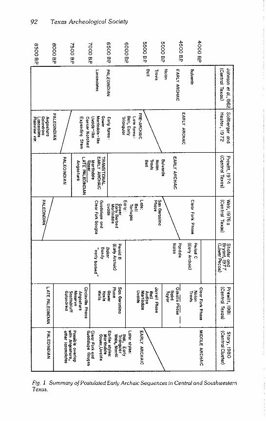
92 Texas Archeological Society
co oo "~ "q o~ o~ oi on
.r~ 4~
ol 0 on 0 on 0 on 0 on 0
0 0 0 0 0 0 0 0 0 0
0 0 0 0 0 0 0 0 0 0
m "m ".W ".w m "m ".w ":’0 .’~
o~ o o Z
Z
m
~0
--oo~
/ I-- rn o z
z
~- m-4
_
z
_..~ Qr~
~ m
;~ga2
m r" o c~o~° ....tin o
oo~o~: .... ~ - ~ ~’,
o~=o ~ c: o. o.
,~o~o~ ~_~
o.
m ~o -q
o
m
-% 30
x.o_
i~0
~o~
¢D ’,D ’-q o
~__..
o
~-~
Fig. 1 Summary of Postulated Early Archaic Sequences in Central and Southwestern
Texas.
McKinney -- Paleoindian/Archaic Transition Problem 93
THE STUDY AREA
The Central Texas Archaic and Lower Pecos Archaic represent distinct extractive adaptations that are not readily equated. There are, however, rea- sons to examine concurrently very early adaptations in both areas at a time when the distinct regional patterns of later periods are not as evident (Story, 1980:15; Gunn and Mahula, 1977:259-260). A number of investigators (Johnson, 1964:55; Hester, 1971:71-73; Prewitt, 1966:221-224; Sorrow, 1968:21, 28; Sorrow et al., 1967:14; Weir, 1976a:11) recognized that several projectile point styles recovered in very Early Archaic contexts from both Central and Southwest Texas corresponded very closely.
Story (1980:15-20) discerned a number of "broad areal artifact clusters" that may represent interaction spheres on the West Gulf Coastal Plain during the Early Archaic, from 8000 B.P. to 5000 B.P. The most prominent of these, which she terms the central cluster, occurs along and on both sides of the Balcones faultline from north of the Colorado River south and west to the Lower Pecos region. Story (1980:17) includes Bell County sites (Youngsport and Landslide) in an eastern areal cluster. However, they are included in the area of this study because of the resemblances of a good part of their Early Archaic assemblages to those found farther south and west.
The area thus defined is more limited than that covered by Sollberger and Hester (1972) in their transitional or pre-Archaic; somewhat broader than that considered by Story (1980) in the central Early Archaic cluster; and considerably broader than the San Geronimo Phase of the Central Texas Archaic defined by Weir (1976a) and expanded upon by Prewitt (in press; Patterson, 1977:57) (Fig. 2).
ENVIRONMENTAL FACTORS
The Balcones Escarpment (Pass, 1979:113), the heavily eroded southern and eastern margin of the uplifted Edwards Plateau, is the most prominent physiographic feature of the area. In Central Texas, the escarpment marks the boundary between the Texan and Balconian biotic provinces (Blair, 1950; Fig. 3). To the southwest, it forms the boundary of the Balconian and Tamaulipan provinces to the point in the Amistad region where the Chi- huahuan province of Northern Mexico and Trans-Pecos Texas intrudes into southwestern Texas. The Balcones Escarpment has an appreciable effect on both temperatures and rainfall in both regions (Carr, 1967:20,26; Fig. 3).
The Amistad area presently is far more arid than Central Texas (Carr, 1967:Fig. 2).
The line dividing North America into regions of moisture sufficiency and moisture deficiency passes through Central Texas (Blair, 1950:93). The 34 in
(863 mm) annual average rainfall isogram (Carr, 1967:20, Fig. 2) closely parallels the Balcones faultline from the Red River south almost to San Mar-
cos. It swings eastward and roughly parallels the boundary of the Texan and Tamaulipan biotic provinces. While the bulk of the Texan province lies east of the line of moisture sufficiency, it is classified as "moist subhumid" (Blair,
1950:100).
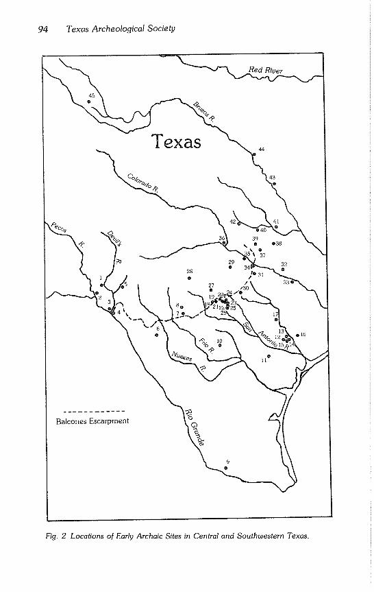
94 Texas Archeological Society
\ Texas 0~ °~.
41
O
39
o
29 ~ 37 32
o
/o 31 o
27
Balcones Escarpment
Fig. 2 Locations of Early Archaic Sites in Central and Southwestern Texas.
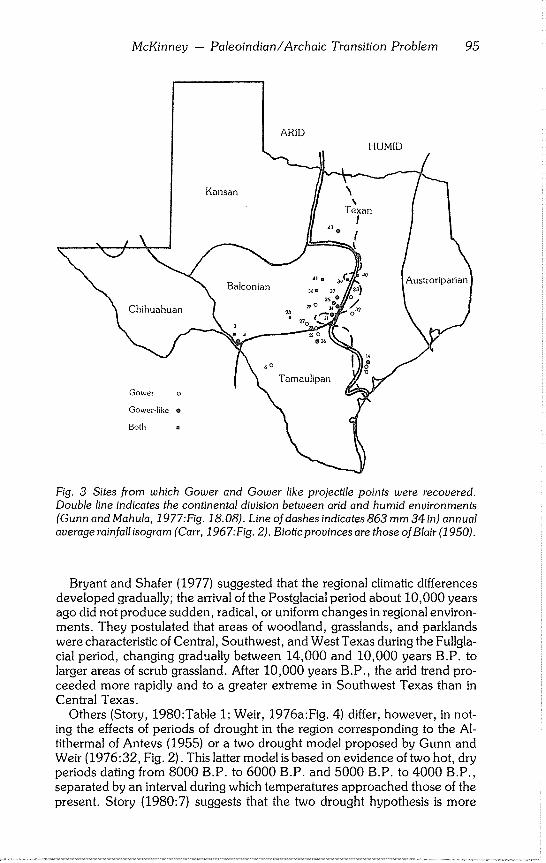
McKinney -- Paleoindian/Archaic Transition Problem 95
ARID
, ,,,_./ \
I--. / \
Both .
Fig. 3 Sites from which Gower and Gower like projectile points were recovered.
Double line indicates the continental division between arid and humid environments (Gunn and Mahula, 1977:Fig. 18.08). Line of dashes indicates 863 mm 34 in) annual
average rainfall isogram (Carr, 1967:Fig. 2). Biotic provinces are those of Blair (1950).
Bryant and Shafer (1977) suggested that the regional climatic differences developed gradually; the arrival of the Postglacial period about 10,000 years ago did not produce sudden, radical, or uniform changes in regional environ- ments. They postulated that areas of woodland, grasslands, and parklands were characteristic of Central, Southwest, and West Texas during the Fullgla- cial period, changing gradually between 14,000 and 10,000 years B.P. to larger areas of scrub grassland. After 10,000 years B.P., the arid trend pro- ceeded more rapidly and to a greater extreme in Southwest Texas than in Central Texas.
Others (Story, 1980:Table I; Weir, 1976a:Fig. 4) differ, however, in not- ing the effects of periods of drought in the region corresponding to the AI- tithermal of Antevs (1955) or a two drought model proposed by Gunn and Weir (1976:32, Fig. 2). This latter model is based on evidence of two hot, dry periods dating from 8000 B.P. to 6000 B.P. and 5000 B.P. to 4000 B.P., separated by an interval during which temperatures approached those of the present. Story (1980:7) suggests that the two drought hypothesis is more
96 Texas Archeological Society
useful than either the gradual change model of Bryant and Shafer (1977) or the single long drought of Antevs (1955).
THE TRANSITIONAL PERIOD
Terminology is not the least of the problems in discussing the period from 10,000 B.P. to 4500 B.P. Some of the chronologies and period labels that have been used are summarized in Table 1. The distinction between the Early Archaic and Paleoindian periods is somewhat arbitrarily and variably defined. Story (1980) begins the Early Archaic at about 8000 B.P., approximately the time late Paleoindian lanceolate points fade from the archeological record.
The distinction between Paleoindian and Archaic was defined in the past (Suhm at al., 1954; Krieger, 1964; Willey and Phillips, 1958) not only by differences in projectile points and lithic technology, but by differing subsis- tence bases. Paleoindian culture was seen to consist of nomadic hunters de- pendent on specific species of big game; while the Archaic was defined as "the stage of migratory hunting and gathering cultures continuing into environ- mental conditions approximating those of the present" (Willey and Phillips, 1958:107). Suhm et al. (1954:18) saw the Archaic as a "bridge" between the nomadic Paleoindian hunters and settled, pottery making, agricultural so- cieties.
Johnson (1964:92) observed that the Archaic probably did not evolve from a general Paleoindian type, and that the Paleoindian and Archaic should be viewed as culture types rather than stages. Bryant and Shafer (1977) postulated that outside of the High Plains, hunting and gathering was the primary economic adaptation as early as 12,000 years ago. This initial prehistoric adaptation, termed early lithic (Shafer, 1977), existed in large areas of Texas woodlands and parklands between the Plains and Eastern Woodlands, including Central and Southwest Texas.
A sudden shift from Paleoindian to fully developed Archaic lifeways seemed unlikely to Sollberger and Hester (1972:327), although they placed the transition later. They believed the change proceeded slowly, lasting from 8000 B.P. or earlier to 5500 B.P. or later in both Central and Southwest Texas. The end of the transition coincided with the end of the Altithermal.
Sollberger and Hester (1972) borrowed the term pre-Archaic from Caldwell (1958:8-11). He used it to refer to a transitory period in the south- eastern United States characterized by a highly varied lithic assemblage that differed from both the preceding and succeeding periods in that area. Caldwell (1958) believed the assemblage represented a period of highly mo- bile small bands.
Sollberger and Hester (1972) felt those circumstances were paralleled in Central and Southwest Texas. In their tentative formulation, they called at- tention to the diversity in projectile point forms in both areas. These forms preceded in the archeological record the Early Archaic projectile point types (Suhm et al., 1954; Suhm and Jelks, 1962). They represent occupations earlier than the Early Archaic defined in periodizations of the Archaic (John- son et al., 1962).
McKinney - Paleoindian/Archaic Transition Problem 97
Projectile points referrable to the pre-Archaic in Texas had triangular blades, expanding stems with slightly concave bases, and exhibited certain Paleoindian like traits such as parallel flaking and dulled stem edges. Corner notched, expanding stem points (Gower, Martindale like, and Uvalde like) characterized the earlier part of this period, while heavily barbed, basally notched Bell points and a variety of triangular points characterized the later part.
Small numbers of bifacially and unifacially flaked lithic tools and an occa- sional grinding slab also were traits of the transitional period. Culturally, the period was seen to represent the localized continuation of late Paleoindian lifeways changed only by the introduction of new projectile point styles.
Weir (1976a; 1976b) placed the period within the Archaic. He called it the San Geronimo Phase, earliest of five postulated Central Texas Archaic phases (phase used in the sense of Willey and Phillips, 1958:22). He set its temporal limits from about 8000 B.P. to 4500 B.P. and drew attention to its continuity with and within the Archaic while not necessarily disputing its de- velopmental nature.
Weir (1976a) saw the Central Texas Archaic phases as periods of stability reinforced by negative feedback, separated by abrupt periods of disequili- brium. The San Geronimo Phase was defined as "a system of hunting and gathering that is loosely structured, nonspecialized, and is poorly delimited spatially" (Weir, 1976a:50). Influences from both east and west are evident in the San Geronimo. The small, widely scattered sites of the phase are found on small knolls or terrace remnants.
Unlike Sollberger and Hester (1972), Weir (1976a:50,124) included Angostura points in the San Geronimo; but like Sollberger and Hester (1972), he placed Early Barbed, Gower, Martindale, and Uvalde points early in the phase, Bell and triangular Tortugas points later. San Geronimo tool types included Clear Fork and Guadalupe gouges, thick triangular and ovate bifaces, and a variety of trimmed flakes. Late in the San Geronimo, burned rock accumulations and oval middens appeared along with broad hearths on flat surfaces.
Prewitt (1974:Fig. 7) tentatively proposed a Central Texas period based on radiocarbon dates he called "Transitional Early Archaic-Late Paleoindian," for which, apparently, Angostura, Martindale, and Gower points were diagnostic. Later, expanding on Weir’s (1976a) work, Prewitt (1981, in press) subdivided Central Texas prehistory from the end of the Paleoindian period through the post Archaic into 13 phases. The first of these, the Cir- cleville Phase (8000 B.P. to 7000 B.P.) is a transitional period that included the earliest manifestations of Weir’s (1976a) San Geronimo Phase, Archaic economic adaptations, and late Paleoindian lithics such as Angostura, Go- Iondrina, Meserve, and Scottsbluff points. Circleville is represented by sites such as Levi (Alexander, 1963) and Tombstone Bluff (Prewitt, 1974).
If the Circleville Phase were to be extended to the Amistad area, it would include (Prewitt, 1981) components such as the Golondrina occupation at Baker Cave (Hester, 1979a). Prewitt (1981) further subdivided Weir’s
98 Texas Archeological Society
Table 1
Early Archaic Sites in Central and Southwestern Texas
Map No.
I.
2.
3.
4.
5.
6.
7.
8.
9.
I0.
Site Reference
Baker Cave (41VV213)
Hinds Cave (41VV456)
Devil’s Mouth (41VV188)
Devil’s Rockshelter (41VV264)
Eagle Cave (41VV167)
Chaparrosa Ranch (41ZV81, Chaparrosa 146, 156, 159)
Kincaid Rockshelter (41UV1)
La Jita (41UV21)
La Perdida (Starr County)
San Miguel Creek (41AT4, 41AT7,
Word and Douglas, 1970
Shafer and Bryant, 1977
Johnson 1964; Sorrow, 1968
Prewitt, 1966
Ross, 1965
Hester, 1978b
Suhm, 1960; Hester, 1971
Hester, 1971
Weir, 1956
Hester, 1968 71A9-1)
11. Buckner Ranch (41BE2)
12. Coleto Creek (41GD22)
13. Willeke (41VT16)
14. Coleto Creek (41VT17)
15. Coleto Creek (41VT20)
16. J-2 Ranch (41VT6)
17. Cuero I (41GZ108)
18. San Geronimo (41BX196)
19. Leon Creek (41BX52)
20. Camp Bullis (41BX376, 41BX402, 41BX403, 41BX409)
21. Camp Bullis (41BX36)
22. Elm Waterhole (41BX300)
23. Upper Salado drainage (41BX442, 41BX444)
24. Panther Springs Creek (41BX228)
25. St. Mary’s Hall (41BX229)
26. Granberg II (41BX271)
27. Cibolo Creek drainage (41KE49, 41KE50)
28. Strohacker (41KR29)
29. Johnson City (41BC65)
30. FM 306 (41CMl11)
31. Greenhaw (41HY29)
32. Lake Thunderbird (41BP78)
33. La Grange (41FY135)
34. Jetta Court (41TV151)
35. Crumley (41TV86)
36. Granite Beach (41LL2)
37. Merrill (41WM2)
Sellards, 1940
Fox et al., 1979
Fox and Hester, 1976
Fox and Hester, 1976
Fox and Hester, 1976
Fox et al., 1978
Fox et al., 1974
Weir, 1976a, 1980
Henderson, 1980
Gerstle et al., 1978
Gerstle et al., 1978
Gerstle et al., 1978
McGraw and Valdez, 1978
Black, 1980; Jaquier et al., 1979
Hester, 1978a, 1979b
Hester and Kohnitz, 1975; Hester, 1977
Kelly and Hester, 1976
Sollberger and Hester, 1972
Weir, 1980
Weir, 1980
Weir, 1979
Duke, 1977
Weir, 1980
Wesolowsky et al., 1976; Hester, 1979b
Kelly, 1961
Crawford, 1965
Campbell, 1948
McKinney -- Paleoindian/Archaic Transition Problem 99
Map Site Reference No.
38. Tombstone Bluff (41WM165) Prewitt, 1974
39. John Ischy (Williamson County) Sorrow, 1969
40. Landslide (41BL85) Sorrow et al., 1967
41. Youngsport (41BL78) Shafer, 1963
42. McCann (Lampasas County) Preston, 1969
43. Ballew and Francis (Hill County) Watt and Agogino, 1967
44. Acton (x41HD13) Blaine et al., 1968
45. Crosby County (41CB64) Parker and Mitchell, 1979
(1976a) San Geronimo Phase into the San Geronimo (7000 B.P. to 6000 B.P.) and Jarrell (6000 B.P. to 5000 B.P.). Jarrell includes some of the later manifestations of Weir’s (1976a) San Geronimo Phase. Triangular projectile points, however, which Prewitt (1981) termed Baird and Taylor after Kelley (1959) and Sorrow (1969:19) to distinguish them from the more southerly Tortugas type, are assigned to the subsequent Oakalla Phase (5000 B.P. to 4500 B.P.).
In the Amistad region, Shafer and Bryant (1977) tentatively adapted a projectile point chronology developed by Collins (1974), placing Baker, Bandy, and early barbed points in an Early Archaic period (Period B, 9000 B.P. to 6000 B.P.). Golondrina, Angostura, and early stemmed forms were placed in Period A (before 9000 B.P.) immediately following the Paleoindian period characterized by Plainview and Folsom points.
The net effect of the past 10 years has been a realignment with the Middle Archaic of the previously defined Early Archaic (Johnson et al., 1962), which Weir (1976a, 1976b) termed the Clear Fork Phase; and redefinition of the term Early Archaic to designate the period proposed by Sollberger and Hester (1972) as the pre-Archaic (Story, 1980:10-11).
THE SITES
More than 40 sites have yielded evidence of some sort of very Early Archaic occupation (Table 1). Most are found in or near the transitional zone between the Edwards Plateau and Gulf Coastal Plain (Story, 1980; Fig. 2). This situa- tion may be a result either of selective attention to the area by archeologists; or actual differences in aboriginal residence patterns during the Altithermal droughts.
Principal criteria for selecting sites were diagnostic artifact forms (Table 2). However, inventories (Table 2) are not meant to imply primary associations of all artifacts found in each component. Furthermore, distribution of an arti- fact style, or even of an apparent assemblage, does not necessarily imply a concomitant distribution of economic strategies (Story, 1980). Differences through time in diagnostic artifacts do not necessarily imply changes in subsis- tence adaptations (Bryant and Shafer, 1972:21).
100 Texas Archeological Society
Table 2
Summary of Early Archaic Artifact Contexts
Site
Baker Cave 41VV213
Hinds Cave Burned rock 41VV456 midden deposit
Devil’s Mouth Upper Gravels
41VV188 Area C
Provenience Artifacts
Zone I Early Barbed Golodrina (5) Plainview like Triangular (Early Triangular) Various bifaces, choppers, scrapers
Zone II Baker I and II (7) Bandy (5) Darl Various Early Barbed forms Langtry (4) Pandale (3) Pedernales Tortugas Travis Zorra Lanceolate, foliate, and convex
blade bifaces Drill Choppers (3) Hammerstone Fistaxe Scrapers
Bandy
Devil’s Rockshelter Mixed Zone 41VV264 le, III
Zone III
Zone le
Eagle Cave Mixed strata III-V 41VV167
Stratum IV
Gower like (2) Lerma like Leaf shaped, straight base Meserve like Expanding Stem (3) Possible Golondrina (fragment)
Gower like (2) Drill Biface fragment Elongated bifaces (3)
Unifaces (3) Flint flakes Bone fragments
Gower like (3) Stemmed scraper Bifaces (4)
Groove stone Bifaces (5) Red ocher (2) Flint flakes Several scratched pebbles
Early Barbed I (3)
Desmuke Early Barbed I Bifurcated Base Ovoid, pointed knives Subtriangular knives
McKinney -- Paleoindian/Archaic Transition Problem 101
Site Provenience Artifacts
Stratum V Early Barbed I (4) Early Barbed II (3) Lanceolate forms (3) Leaf shaped knives Bifaces Unifacial flakes Scrapers Spokeshaves Burins and spalls Matting
Angostura Chaparrosa Ranch Surface 41ZV81
Chaparrosa- 146 Surface
Chaparrosa- 156 Surface
Chaparrosa- 159 Surface
Private Unknown collections
Kincaid
Rockshelter
41UV1
Zones 5 and 6
La Jita Levels 7-10 41UV21
La Perdida Surface (Starr County)
Early Corner Notched
Gower Golondrina Early Corner Notched Blade core
Golondrina Bifacial Clear Fork tool
Uvalde Early Corner Notched Angostura Scottsbluff
Early Corner Notched I (18) Early Corner Notched II (3) Bifacial and unifacial
Clear Fork tools Guadalupe tools
Early Corner Notched (three varieties)
Bulverde Kinney La Jita Lanceolate Nolan Pedernales Travis Early Triangular Choppers Thinned bifaces Thick percussion bifaces Cores Miscellaneous unifaces
Bell like (Shumla) Langtry Kent Castroville Lerma Abasolo Leaf shaped Tortugas Refugio Pandora Desmuke Angostura
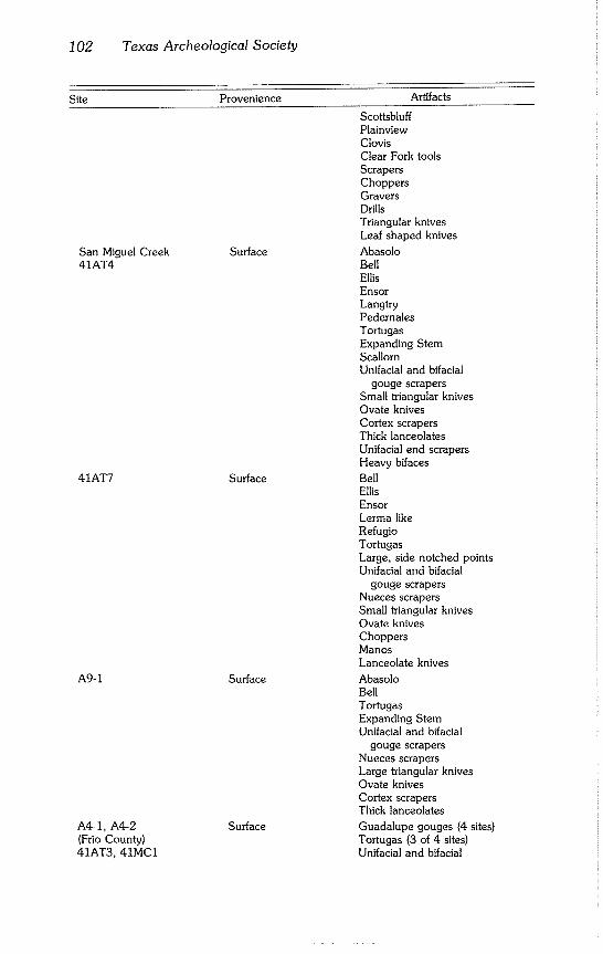
102 Texas Archeological Society
Site Provenience
San Miguel Creek Surface 41AT4
41AT7 Surface
A9-1 Surface
A4-1, A4-2 (Frio County) 41AT3, 41MC1
Surface
Artifacts
Scottsbluff Plainview Clovis Clear Fork tools Scrapers Choppers Gravers Drills Triangular knives Leaf shaped knives
Abasolo Bell Ellis Ensor Langtry Pedernales Tortugas Expanding Stem Scallorn Unifacial and bifacial
gouge scrapers Small triangular knives Ovate knives Cortex scrapers Thick lanceolates Unifacial end scrapers Heavy bifaces
Bell Ellis Ensor Lerma like Refugio Tortugas Large, side notched points Unifacial and bifacial
gouge scrapers Nueces scrapers Small ~iangular knives Ovate knives Choppers Manos Lanceolate knives
Abasolo Bell Tortugas Expanding Stem Unifacial and bifacial
gouge scrapers Nueces scrapers Large triangular knives Ovate knives Cortex scrapers Thick lanceolates
Guadalupe gouges (4 sites) Tortugas (3 of 4 sites) Unifacial and bifacial
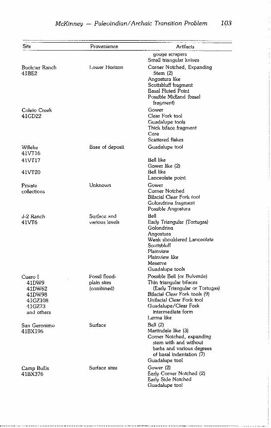
McKinney - Paleoindian/Archaic Transition Problem 103
Site Provenience
Buckner Ranch Lower Horizon 41BE2
Coleto Creek 41GD22
Willeke 41VT16
41VT17
41VT20
Base of deposit
Private Unknown collections
J-2 Ranch Surface and 41VT6 various levels
Cuero I Fossil flood- 41DW9 plain sites
41DW62 (combined) 41DW98 41GZ108 41GZ73 and others
San Geronimo Surface 41BX196
Camp Bullis Surface sites 41BX376
Artifacts
gouge scrapers Small triangular knives
Corner Notched, Expanding Stem (2)
Angostura like Scottsbluff fragment Basal Fluted Point Possible Midland (basal
fragment)
Gower Clear Fork tool Guadalupe tools Thick biface fragment Core Scattered flakes
Guadalupe tool
Bell like Gower like (2) Bell like Lanceolate point
Gower Corner Notched Bifacial Clear Fork tool Golondrina fragment Possible Angostura
Bell Early Triangular (Tortugas) Golondrina Angostura Weak shouldered Lanceolate Scottsbluff Plainview Plainview like Meserve Guadalupe tools
Possible Bell (or Bulverde) Thin triangular bifaces
(Early Triangular or Tortugas) Bifacial Clear Fork tools (9) Unifacial Clear Fork tool Guadalupe/Clear Fork
intermediate form Lerma like
Bell (2) Martindale like (3) Corner Notched, expanding
stem with and without barbs and various degrees of basal indentation (7)
Guadalupe tool
Gower (2) Early Corner Notched (2) Early Side Notched Guadalupe tool
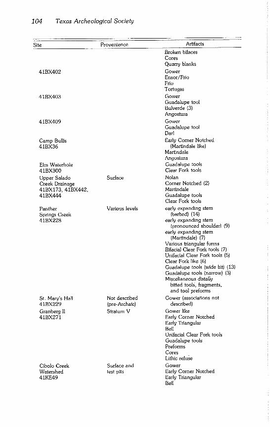
104 Texas Archeological Society
Site Provenience
41BX402
41BX403
41BX409
Camp Bullis 41BX36
Elm Waterhole 41BX300
Upper Salado Creek Drainage 41BX173, 41BX442, 41BX444
Panther Springs Creek 41BX228
St. Mary’s Hall 41BX229
Granbergll 41BX271
Cibolo Creek Watershed 41KE49
Surface
Various levels
Not described
(pre-Archaic)
Stratum V
Surface and test pits
Artifacts
Broken bifaces Cores Quarry blanks
Gower Ensor/Frio Frio Tortugas
Gower Guadalupe tool Bulverde (3) Angostura
Gower Guadalupe tool Darl
Early Corner Notched (Martindale like)
Martindale Angostura Guadalupe tools Clear Fork tools
Nolan Corner Notched (2) Martindale Guadalupe tools Clear Fork tools
early expanding stem (barbed) (14)
early expanding stem (pronounced shoulder) (9)
early expanding stem (Martindale) (7)
Various triangular forms Bifacial Clear Fork tools (7) Unifacial Clear Fork tools (5) Clear Fork like (6) Guadalupe tools (wide bit) (13) Guadalupe tools (narrow) (3) Miscellaneous distally
bitted tools, fragments, and tool preforms
Gower (associations not described)
Gower like Early Corner Notched Early Triangular Bell Unifacial Clear Fork tools Guadalupe tools Preforms Cores Lithic refuse
Gower Early Corner Notched Early Triangular Bell
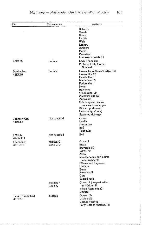
McKinney -- Paleoindian/Archaic Transition Problem 105
Site Provenience Artifacts
41KE50 Surface
Strohacker Surface
41KR29
Johnson City Not specified
41BC65
FM306 Notspec~ied
41CMlll
Greenhaw Midden C
41HY29 Zone C-D
Midden F Zone A
Lake Thunderbird Surface
41BP78
Bulverde Uvalde Nolan La Jita Wells Langtry Almagre Marcos Plainview Lanceolate points (2)
Early Triangular Probable Early Corner
Notched
Gower (smooth stem edge) (4) Gower like (3) Uvalde like Martindale (2) Pedernales Nolan Bulverde Golondrina (2) Plainview like (2) Angostura Subtriangular bifaces,
concave basal edges Bifaces (preforms) Unifaces (preforms) Scattered debitage
Gower
Uvalde Martindale Bell Triangular
Bell
Gower I Buda Bulverde (4) Travis (4) Zorra Miscellaneous dart points
and fragments Bifaces and fragments Unifaces Burin Burin Spall Core Scored rock
Gower II (deepest artifact in Midden F)
Biface fragments (2) Uniface
Gower (7) Uvalde (3) Corner notched Early Corner Notched (2)
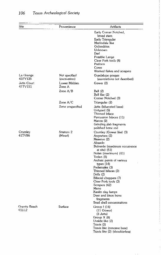
106 Texas Archeological Society
Site Provenience Artifacts
La Grange Not specified 41FY135 (excavation)
Jetta Court Lower Midden 41TV151 Zone A
Zone A/B
Crumley 41TV86
Granite Beach 41LL2
Zone A/C
Zone unspecified
Stratum 2 (Mixed)
Surface
Early Corner Notched, broad stem
Early Triangular Marlindale like Golondrina Unknown Darl Possible Lange Clear Fork tools (8) Preform Cores Worked flakes and scrapers
Guadalupe gouges (associations not described)
Gower (2)
Bell (2) Bell like (2) Corner Notched (3)
Triangular (2)
Jetta (bifurcated base) Untyped (5) Thinned biface Percussion bifaces (11) Manos (2) Grinding slab fragments polished bone rod
Crumley (Gower like) (3) Angostura (2) Meserve (2) Abasolo Bulverde (maximum occurrence
at site) (51) Nolan (maximum) (41) Trolan (5) Archaic points of various
types (14) Pedernales (3) Thinned bifaces (2) Drills (2) Bifacial choppers (7) Clear Fork tools (3) Scrapers (42) Mano Kaolin clay lumps Deer and bison bone
fragments Snail shell concentrations
Group I (14) (11 Gower) (3 Jetia)
Group X (8) Uvalde like (2) Travis (2) Travis like (concave base) Travis like (2) (shoulderless)
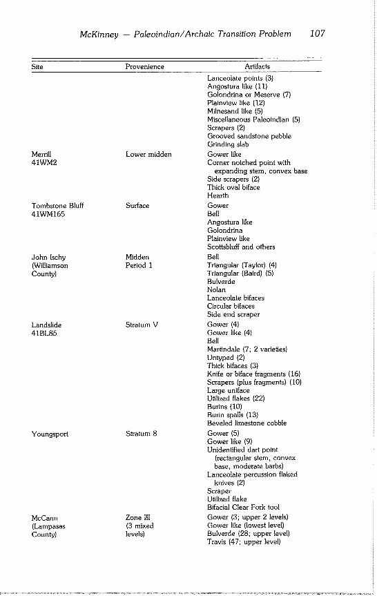
McKinney - Paleoindian/Archaic Transition Problem 107
Site Provenience
Merrill Lower midden 41WM2
Tombstone Bluff Surface 41WM165
John Ischy Midden (Williamson Period 1 County)
Landslide Stratum V 41BL85
Youngsport Stratum 8
McCann Zone III (Lampasas (3 mixed County) levels)
Artifacts
Lanceolate points (3) Angostura like (11) Golondrina or Meserve (7) Plainview like (12) Milnesand like (5) Miscellaneous Paleoindian (5) Scrapers (2) Grooved sandstone pebble Grinding slab
Gower like Corner notched point with
expanding stem, convex base Side scrapers (2) Thick oval biface Hearth
Gower Bell Angostura like Golondrina Plainview like Scottsbluff and others
Bell Triangular (Taylor) (4) Triangular (Baird) (5) Bulverde Nolan Lanceolate bifaces Circular bifaces Side end scraper
Gower (4) Gower like (4) Bell Martindale (7; 2 varieties) Untyped (2) Thick bifaces (3) Knife or biface fragments (16) Scrapers (plus fragments) (10) Large uniface Utilized flakes (22) Burins (10) Burin spalls (13) Beveled limestone cobble
Gower (5) Gower like (9) Unidentified dart point
(rectangular stem, convex
base, moderate barbs) Lanceolate percussion flaked
knives (2) Scraper Utilized flake Bifacial Clear Fork tool
Gower (3; upper 2 levels) Gower like (lowest level) Bulverde (28; upper level) Travis (47; upper level)
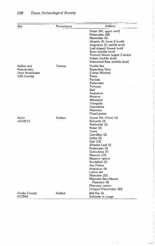
108 Texas Archeological Society
Site Provenience Artifacts
Ballew and Francis sites, Horn Rockshelter (Hill County)
Acton x41HDI3
Crosby County 41CB64
Nolan (80; upper level)
Pedernales (38) Martindale (4) Abasolo (4; lower 2 levels) Angostura (2; middle level) Leaf shaped (lowest level) Burin (middle level) Thinned bifaces (upper 2 levels) Foliate (middle level) Retouched flake (middle level)
Various Uvalde like Expanding Stem Corner Notched Travis Pandale Pedernales Tortugas Darl Angostura Meserve Milnesand Triangular Golondrina Plainview Fluted points
Surface Gower like (Varia) (2) Bulverde (3) Martindale (2) Nolan (3) Travis Carrollton (2) Dallas (2) Darl (12) Wheeler Leaf (2) Pedemales (5) Golondrina (7) Meserve (13) Meserve variant Scottsbluff (2) San Patrice Angostura (4) Lerma like Plainview (23) Plainview like/Altered
Plainview (4) Plainview variant Untyped Paleoindian (20)
Surface Bell like (5) Bulverde or Lange
McKinney -- Paleoindian/Archaic Transition Problem 109
Gower projectile points are among the most pervasive indicators of very Early Archaic occupations in a large part of Texas. Gower and Gower like points were reported from at least 20 localities (Table 3, Fig. 3), stretching from Val Verde County (Devil’s Mouth, Johnson, 1964) in Southwest Texas, along both sides of the Balcones faultline, to Hood County (Acton site, Blaine et al., 1968) in Northcentral Texas. Southeastward, Gower points were re- ported in Victoria County (Fox and Hester, 1976), almost on the coast.
Gower was first proposed as a type by Shafer (1963) at Youngsport, Bell County. In general appearance, Gower points show a close affiliation with Archaic projectile points and look like very crude Pedernales points (Shafer, 1963:64). Kelly (1979a: 13) suggested Gower points probably were misclas- sifted in the past because of their basal similarity to Pedernales. He noted the poor workmanship of most Gower points. Kelly’s (1979a) conclusion (based on edge wear patterns) that Gower artifacts may be hafted knives or scrapers has been disputed (Patterson, 1979; Shafer, 1979).
Despite their notable resemblances to Archaic projectile points, Gower like points with basal and stem edge smoothing in the Paleoindian style were reported from at least five localities: Devil’s Mouth (Johnson, 1964:55,Fig. 17J), Strohacker (Sollberger and Hester, 1972), Granite Beach (Crawford, 1965), Merrill (Campbell, 1948; Sorrow et al., 1967:25), and McCann (Preston, 1969). Lateral stem edge smoothing may not, however, be evi- dence of any relationship to Paleoindian traits. Pedernales projectile points recovered from very early levels often show lateral stem edge smoothing. Those from McCann (Preston, 1969) were found in the same level with the smooth stem edge Gower like points.
Of the 22 sites and watersheds (Table 3) that have yielded Gower or Gower like points, only one is not an open site, i.e., the Devil’s Rockshelter (Prewitt, 1966). Twelve are buried sites: Devil’s Mouth (Johnson, 1964); Devil’s Rock- shelter (Prewitt, 1966); Willeke (Fox and Hester, 1976); St. Mary’s Hall (Hester, 1978a, 1979a); Granberg II (Hester and Kohnitz, 1975); Greenhaw (Weir, 1979); Jetta Court (Wesolowsky et al., 1976); Crumley (Kelly, 1961); Merrill (Campbell, 1948); McCann (Preston, 1969); Landslide (Sorrow et al., 1967); and Youngsport (Shafer, 1963). While the Jetta Court specimens (Wesolowsky et al., 1976:Fig. 11 e-f) were identified as Gower, Hester (1979b:6) recently expressed doubt about that classification.
At the Greenhaw site (Weir, 1979), a Gower like point (termed Gower II) was found in the lowest stratum of Midden F (largest midden on the site). Weir’s (1979) Gower Variety I (found in Midden C) was comparable to Baker projectile points from Baker Cave (Word and Douglas, 1970:21).
The three Crumley projectile points recovered from near the boundary between Strata 1 and 2 at the Crumley site (Kelly, 1961) were noted by Shafer (1963:81) to be similar to Gower points from Youngsport. Crumley points, among the earliest projectile points recoverd at the site, have shal- lowly notched bases, poorly developed shoulders, and serrated blade edges (Kelly, 1961:247-249).
Eleven of the Gower sites are represented by surface collections: Stro- hacker (Sollberger and Hester, 1972); four sites at Camp Bullis (Gerstle et al., 1978)~ Cibolo Creek (Kelly and Hester, 1976)~ 41BC65 (Weir, 1980);
110 Texas Archeological Society
Table 3
Sites Yielding Gower and Gower like Points
Map Site No.
3. Devil’s Mouth (41W188) 4. Devil’s Rockshelter (41VV264) 6. Chaparrosa Ranch (Chaparrosa 156)
12. Coleto Creek (41GD22) 14. Coleto Creek (41VT17) 20. Camp Bullis (41BX376, 41BX402, 41BX403, 41BX409) 25. St. Mary’s Hall (41BX229) 26. Granberg II (41BX271) 27. Cibolo Creek (41KE49) 28. Strohacker (41KR29) 29. Johnson City (41BC65) 31. Greenhaw (41HY29) 32. Lake Thunderbird (41BP78) 34. Jetta Court (41TV151) 35. Crumley (41TV86) 36. Granite Beach (41LL2) 37. Merrill (41WM2) 38. Tombstone Bluff (41WM165) 39. Landslide (41BL85) 40. Youngsport (41BL78) 41. McCann (Lampasas County) 43. Acton (x41HD13)
Tombstone Bluff (Prewitt, 1974); Lake Thunderbird (Duke, 1977); Granite Beach (Crawford, 1965); and Acton (Blaine et al., 1968). Comparisons with artifact assemblages at stratified sites and observations of relative patination of earlier artifacts within assemblages from surface sites provide a degree of temporal placement.
At Strohacker (Sollberger and Hester, 1972), for example, Paleoindian and pre-Archaic artifacts except one (an exotic Plainview point) were pati-
nated. At the Camp Bullis sites (Gerstle et al., 1978:81-83), Gower points, at least one Guadalupe tool, six of seven Martindale points, and most other pre-
Archaic points characteristically were patinated, as were Paleoindian points. The later Archaic points were not patinated. The seven Gower points recov- ered from the Lake Thunderbird site (Duke, 1977:Fig. 3k-p) were patinated heavily as was the "Unknown type" point (Duke, 1977:Fig. 3a). This latter point appears much like the "Other Paleoindian Points" of Johnson (1964:Fig. 17L) from Devil’s Mouth.
In addition to Gower artifacts reported from localities in Table 3, Watt (1938:Fig. 26, Nos. 16-18) illustrated three dart points with deeply indented bases, roughly rectangular stems, weak to moderately strong shoulders, and triangular blades. These points were reputed to be among typical projectile points commonly found in Waco sinker camps in Northcentral Texas along the Brazos River and its middle drainage. Watt (1938:Fig. 26, No. 24) also illustrated a corner notched point with a Martindale like stem.
McKinney -- Paleoindian/Archaic Transition Problem 111
Bell projectile points also have gained status as an indicator of the Early Archaic. Their geographical range of occurrence appears to be very much
wider than Gower. Bell was defined as a type at the Landslide site (Sorrow et al., 1967:12, 14, Fig. 10a-j). It has a resemblance to one of the Early Barbed projectile points found at Devil’s Mouth (Johnson, 1964:Fig. 11o). Bell or Bell like points were recovered from 15 localities (Table 4). Nine of these also have yielded Gower or Gower like points.
The identification of a Bell like point at La Perdida (Weir, 1956) could be challenged, since reports of Bell points from that part of Texas are lacking. At La Perdida, Weir (1956:PI. 9o) recovered a Shumla projectile point in sur-
face association with both Paleoindian and Archaic points. The slightly ex- panding stem and convex base conform to the Bell type (Sorrow et al.,
1967). It also has the hint of an indentation in the convex base similar to some of the points illustrated in Sorrow et al. (1967:Fig. 10b). Whether this is a Bell point is difficult to confirm without knowing the thickness of the La Perdida specimen.
Parker and Mitchell (1979:Fig. 1) illustrate five Bell like points recovered
from a sand hill site (41CB64) in Crosby County on the eastern edge of the Llano Estacado, far from the area of most other Bell occurrences. They point out apparent similiarities of the Bell type to Calf Creek projectile points in eastern Oklahoma, northwestern Arkansas, and southern Missouri (Story, 1980:16-17). They also compare one of the Crosby County Bell points to some of the provisional Charcos points reported from Coahuila, Mexico, by Heartfield (1975:136, Fig. 2o). Parker and Mitchell (1979) suggest Bell
points are not restricted to Central and Southwest Texas and may be part of an Early Archaic dart point series with much wider distribution.
The Bell like projectile point recovered at Devil’s Mouth was one of a group from the deepest Archaic level that Johnson (1964:33-34, Fig. 11j-s) termed "Early Barbed." The group had in common long barbs formed by basal notches and wide, thin triangular blades. The great variability among the
group prevented Johnson (1964) from considering it a point type and most subsequent investigators have followed suit. The early barbed, expanding stem, early corner notched, early side notched, and early triangular (some of which may be Bell preforms) categories badly need to be sorted out and a standardized nomenclature adopted.
The Early Archaic sites under consideration contain a wide variety of tools. However, in many cases, the tool assemblages recovered from very Early Archaic levels are not noticeably distinct from those of Archaic occupations higher in the site (Wesolowsky et al, 1976:39). At other sites, there is little apparent distinction between late Paleoindian and Archaic tool assemblages (Blaine et al., 1968; Alexander, 1963). Numerical analysis (Weir, 1976a; Gunn and Weir, 1976) suggests a difference in tool assemblages from the San Geronimo to the succeeding Clear Fork Phase; but the distinction diminishes
later in the Central Texas Archaic. The tool kit predominating in the San Geronimo Phase (comprising irregu-
far bifaces, six unifacial forms, two core forms, burin truncations, and burin spalls) shares most of its tool types with tool kits predominating later in the Archaic. It is relatively unspecialized, seemingly intended for grooving, cut-
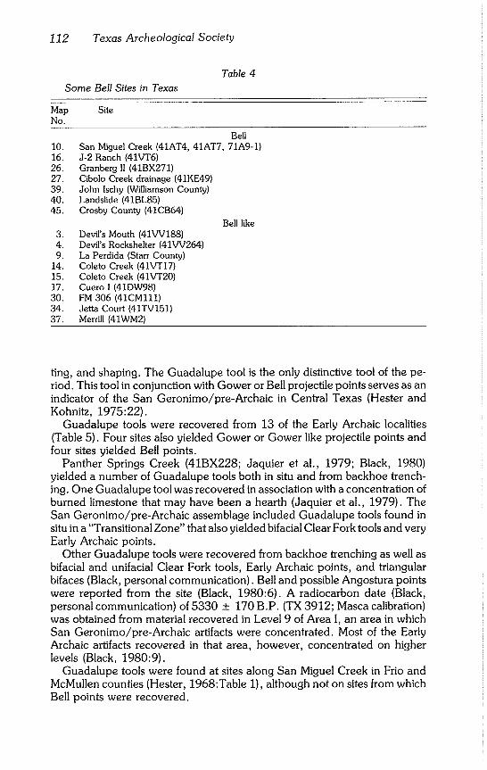
112 Texas Archeological Society
Table 4
Some Bell Sites in Texas
Map Site No.
Bell 10. San Miguel Creek (41AT4, 41AT7, 71A9-1) 16. J-2 Ranch (41VT6) 26. Granberg II (41BX271) 27. Cibolo Creek drainage (41KE49) 39. John Ischy (Williamson County) 40. Landslide (41BL85) 45. Crosby County (41CB64)
3. Devil’s Mouth (41VV188) 4. Devil’s Rockshelter (41VV264) 9. La Perdida (Starr County)
14. Coleto Creek (41VT17) 15. Coleto Creek (41VT20) 17. Cuero I (41DW98) 30. FM 306 (41CMl11) 34. Jetta Court (41TV151) 37. Merrill (41WM2)
Bell like
ting, and shaping. The Guadalupe tool is the only distinctive tool of the pe- riod. This tool in conjunction with Gower or Bell projectile points serves as an indicator of the San Geronimo/pre-Archaic in Central Texas (Hester and Kohnitz, 1975:22).
Guadalupe tools were recovered from 13 of the Early Archaic localities (Table 5). Four sites also yielded Gower or Gower like projectile points and four sites yielded Bell points.
Panther Springs Creek (41BX228; Jaquier et al., 1979; Black, 1980) yielded a number of Guadalupe tools both in situ and from backhoe trench- ing. One Guadalupe tool was recovered in association with a concentration of burned limestone that may have been a hearth (Jaquier et al., 1979). The San Geronimo/pre-Archaic assemblage included Guadalupe tools found in situ in a "Transitional Zone" that also yielded bifacial Clear Fork tools and very Early Archaic points.
Other Guadalupe tools were recovered from backhoe trenching as well as bifacial and unifacial Clear Fork tools, Early Archaic points, and triangular bifaces (Black, personal communication). Bell and possible Angostura points were reported from the site (Black, 1980:6). A radiocarbon date (Black, personal communication) of 5330 + 170 B.P. (TX 3912; Masca calibration) was obtained from material recovered in Level 9 of Area I, an area in which San Geronimo/pre-Archaic artifacts were concentrated. Most of the Early Archaic artifacts recovered in that area, however, concentrated on higher levels (Black, 1980:9).
Guadalupe tools were found at sites along San Miguel Creek in Frio and McMullen counties (Hester, 1968:Table 1), although not on sites from which Bell points were recovered.
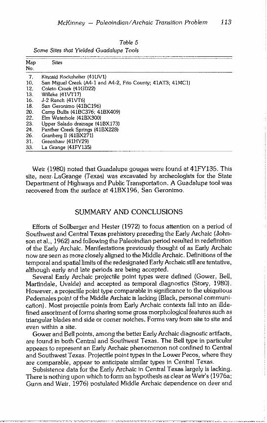
McKinney - Paleoindian/Archaic Transition Problem 113
Table 5
Some Sites that Yielded Guadalupe Tools
Map Sites No.
7. Kincaid Rockshelter (41UV1) 10. San Miguel Creek (A4-1 and A4-2, Frio County; 41AT3; 41MC1) 12. Coleto Creek (41GD22) 13. Willeke (41VT17) 16. J-2 Ranch (41VT6) 18. San Geronimo (41BC196) 20. Camp Bullis (41BC376; 41BX409) 22. Elm Waterhole (41BX300) 23. Upper Salado drainage (41BX173) 24. Panther Creek Springs (41BX228) 26. Granberg II (41BX271) 31. Greenhaw (41HY29) 33. La Grange (41FY135)
Weir (1980) noted that Guadalupe gouges were found at 41FY135. This site, near~ LaGrange (Texas) was excavated by archeologists for the State Department of Highways and Public Transportation. A Guadalupe tool was recovered from the surface at 41BX196, San Geronimo.
SUMMARY AND CONCLUSIONS
Efforts of Sollberger and Hester (1972) to focus attention on a period of
Southwest and Central Texas prehistory preceding the Early Archaic (John- son et al., 1962) and following the Paleoindian period resulted in redefinition
of the Early Archaic. Manifestations previously thought of as Early Archaic now are seen as more closely aligned to the Middle Archaic. Definitions of the temporal and spatial limits of the redesignated Early Archaic still are tentative, although early and late periods are being accepted.
Several Early Archaic projectile point types were defined (Gower, Bell, Martindale, Uvalde) and accepted as temporal diagnostics (Story, 1980). However, a projectile point type comparable in significance to the ubiquitous
Pedernales point of the Middle Archaic is lacking (Black, personal communi- cation). Most projectile points from Early Archaic contexts fall into an illde- fined assortment of forms sharing some gross morphological features such as triangular blades and side or corner notches. Forms vary from site to site and
even within a site. Gower and Bell points, among the better Early Archaic diagnostic artifacts,
are found in both Central and Southwest Texas. The Bell type in particular appears to represent an Early Archaic phenomenon not confined to Central and Southwest Texas. Projectile point types in the Lower Pecos, where they are comparable, appear to anticipate similar types in Central Texas.
Subsistence data for the Early Archaic in Central Texas largely is lacking. There is nothing upon which to form an hypothesis as clear as Weir’s (1976a; Gunn and Weir, 1976) postulated Middle Archaic dependence on deer and
114 Texas Archeological Society
the acorn crop. Only in Southwest Texas, where conditions were ideal for preservation of nonlithic cultural remains, is the subsistence base during Early Archaic times fairly clear. Very little evidence (Shafer and Bryant, 1977) has been found for change of exploitive strategies over time since about 8000
B.P. Study of the Central Texas environment (Gunn and Mahula, 1977) indi-
cates the post Pleistocene climate in that area was highly variable, even during the Altithermal. Analysis of lithic technology in Central Texas (Gunn and Weir, 1976) indicates readaptation to frequent environmental change was
characteristic of the Archaic. Benedict’s (1979) hypothesis that High Plains and Great Basin populations
moved to refugia in the Central Rockies and Pacific Northwest during the two
severe droughts of the Altithermal provides a model by which to interpret the apparent concentration of Early Archaic sites along the Balcones Escarp- ment. Increasing aridity could have induced aboriginal Central Texas popula-
tions to concentrate in the Hill Country as Central Texas environmental con- ditions approached those normal to the Lower Pecos region.
Adaptations to those conditions may have been borrowed from popula- tions whose culture had long since adjusted to arid conditions and the biota of the Chihuahuan province, forming a "sphere of interaction" (Story, 1980). The wide distribution of some Early Archaic point types and undefined forms would be a result of this borrowing. The mesic interval peaking around 5500 B.P. would have relaxed environmental pressures enough so that later Early Archaic populations could move out on the coastal plains again. A second adaptation to arid conditions would have been required during the second lobe of the Altithermal toward the end of the Early Archaic.
The two drought model of the Altithermal reinforces the concept of an
Early Archaic of at least two periods based on projectile point sequences. Until a series of reliable radiocarbon dates is available for the Early Archaic in Central Texas to provide absolute chronological underpinnings, periodiza- tions of the Early Archaic remains on shaky ground.
ACKNOWLEDGMENTS
This manuscript is a revised version of a research paper required as part of an independent study course on the archeology of Texas and surrounding areas under Thomas R. Hester, to whom I am indebted for guidance and help in securing references. My thanks also to Stephen L. Black and Elton R. Prewitt for sharing with me work in progress, and to the reviewers of an earlier
version of this paper. I owe a special debt of gratitude to my wife, Sandra, for her encouragement and forebearance.
McKinney -- Paleoindian/Archaic Transition Problem 115
REFERENCES CITED
Alexander, Herbert L. Jr. 1963 The Levi Site: A Paleo-lndian Campsite in Central Texas. American An-
tiquity, 28(4):510-527.
Antevs, Ernst 1955 Geologic-Climatic Dating in the West. American Antiquity, 20(4):317-
335.
Benedict, James B. 1979 Getting Away From it All: A Study of Man, Mountains, and the Two-
Drought Altithermal. Southwestern Lore, 45(3):1-12.
Black, Stephen L. 1980 The Panther Springs Creek Site, 41 BX 228: Preliminary Summary of
1979 Excavations. University of Texas at San Antonio, Center for Ar- chaeological Research, 1-18.
Blaine, Jay C., R. K. Harris, Wilson W. Crook Jr., and Joel L. Shiner 1968 The Acton Site: Hood County, Texas. Bulletin of the Texas Archeologi-
cal Society, 39:45-94.
Blair, W. Frank
1950 The Biotic Provinces of Texas. Texas Journal of Science, 2(1):93-117.
Bryant, Vaughn M. Jr. and Harry J. Shafer 1977 The Late Quaternary Paleoenvironment of Texas: A Model for the Ar-
cheologist. Bulletin of the Texas Archeological Society, 48:1-25.
Caldwell, J. R. 1958 Trend and Tradition in the Prehistory of the Eastern United States.
American Anthropological Association Memoirs, 88:1-88.
Campbell, T. N. 1948 The Merrill Site: Archeological Remains Associated with Alluvial Terrace
Deposits in Central Texas. Bulletin of the Texas Archeological and Pa- leontological Society, 19:7-35.
Carr, J. T. 1967 Climate and Physiography of Texas. Texas Water Development Board
Special Report, 53:1-26.
Collins, Michael B. 1974 A Functional Analysis of Lithic Technology Among Prehistoric Hunter-
Gatherers of Southwestern France and Western Texas. Unpublished Ph.D. dissertation, University of Arizona, Tucson.
Crawford, Daymond D. 1965 The Granite Beach Site, Llano County, Texas. Bulletin of the Texas
Archeological Society, 36:71-97.
Duke, Paul L. 1977 The Lake Thunderbird Site (41 BP 78), Bastrop, Texas. La Tierra,
4(3): 15-26.
116 Texas Archeological Society
Fox, Anne A. and Thomas R. Hester 1976 An Archaeological Survey of Coleto Creek, Victoria and Goliad Coun-
ties, Texas. University of Texas at San Antonio, Center for Archaeologi- cal Research, Archaeological Survey Report, 18:1-85.
Fox, Anne A., Stephen L. Black, and Steven R. James 1979 Intensive Survey and Testing of Archaeological Sites on Coleto Creek,
Victoria and Goliad Counties, Texas. University of Texas at San Antonio, Center for Archaeological Research, Archaeological Survey Report, 67:1-76.
Fox, Anne A., E. H. Schmiedlin, and J. L. Mitchell 1978 Preliminary Report on the J-2 Ranch Site (41 VT 6), Victoria County,
Texas. La Tierra, 5(3):2-14.
Fox, Daniel E., Robert J. Mallouf, Nancy O’Malley, and William M. Sorrow 1974 Archeological Resources of the Proposed Cuero I Reservoir, Dewitt and
Gonzales Counties, Texas. Texas Historical Commission and Texas Wa- ter Development Board, Archeological Survey Report, 12:1-311.
Gerstle, Andrea, Thomas C. Kelly, and Cristi Assad 1978 The Fort Sam Houston Project: An Archaeological and Historical Assess-
ment. University of Texas at San Antonio, Center for Archaeological Research, Archaeological Survey Report, 40:1-390.
Gunn, Joel 1977
and Royce Mahula Hop Hill: Culture and Climatic Change in Central Texas. University of Texas at San Antonio, Center for Archaeological Research, Special Re- port, 5:1-295.
Gunn, Joel and Frank Weir 1976 Tool Kit Hypotheses: A Case of Numerical Induction. Lithic Technology,
5(3):131-135.
Heartfield, Lorraine 1975 Archeological Investigations of Four Sites in Southwestern Coahuila,
Mexico. Bulletin of the Texas Archeological Society, 46:127-177.
Henderson, Jerry 1980 Update on the Texas Highway Department’s Excavations at 41BX52 on
Leon Creek. Paper presented at the meeting of the Southern Texas Ar- chaeological Association, San Antonio.
Hester, Thomas R. 1968 Paleoindian Artifacts from Sites Along San Miguel Creek; Frio, Atascosa
and McMullen Counties, Texas. Bulletin of the Texas Archeological So- ciety, 39:147-161.
1971
1977
1978a
Archeological Investigations at La Jita Site, Uvalde County, Texas. Bul- letin of the Texas Archeological Society, 42:51-148.
The Current Status of Paleoindian Studies in Southern Texas and North- eastern Mexico. In: Eileen Johnson (ed.), Paleoindian Lifeways. The Museum Journal, 17:169-186.
Early Human Occupations in South Central and Southwestern Texas: Preliminary Papers on the Baker Cave and St. Mary’s Hall Sites. Univer- sity of Texas at San Antonio, Center for Archaeological Research, 1-11.
McKinney - Paleoindian/Archaic Transition Problem 117
1978b Background to the Archaeology of Chaparrosa Ranch, Southern Texas. University of Texas at San Antonio, Center for Archaeological Research, Special Report, 6:1~46.
1979a Early Populations in Prehistoric Texas. Archaeology, 32(6):26-33.
1979b Notes on Gower, Jetta and Other Projectile Points of the Pre-Archaic
Period. La Tierra, 6(3):5-8.
1980 Digging into South Texas Prehistory. Corona, San Antonio.
Hester, Thomas R. and Harvey Kohnitz 1975 Chronology and Placement of "Guadalupe" Tools. La Tierra, 2(2):22-
25.
Jaquier, J. A., Frank Valdez Jr., A. Joachim McGraw, I. Waynne Cox, and Thomas R. Hester
1979 Interim Report on Archaeological Test Excavations at Site 41 BX 228, Walker Ranch, Bexar County, Texas. University of Texas at San Anto- nio, Center for Archaeological Research, Archaeological Survey Report, 18:1-18.
Johnson, LeRoy Jr. 1964 The Devils Mouth Site: A Stratified Campsite at Amistad Reservoir, Val
Verde County, Texas. University of Texas, Departme n t of A n th ropology Archaeology Series, 6:1-115.
Johnson, LeRoy Jr., Dee Ann Suhm, and Curtis D. Tunnell 1962 Salvage Arch~.ology of Canyon Reservoir: The Wunderlich, Footbridge
and Oblate Sites. Bulletin of the Texas Memorial Museum, 5:1-126.
Kelly, J. Charles 1959 The Desert Cultures and the Balcones Phase: Archaic Manifestations in
the Southwest and Texas. American Antiquity, 24(3):276-288.
Kelly, Col. Thomas C.
1962 The Crumley Site: A Stratified Burnt Rock Midden, Travis County,
Texas. Bulletin of the Texas Archeological Society, 31:239-272.
1979 Gower Projectile Points? La Tierra, 6(2):13-19.
Kelly, Thomas C. and Thomas R. Hester 1976 Archaeological Investigations at Sites in the Cibolo Creek Watershed,
Central Texas. University of Texas at San Antonio, Center for Archaeo- logical Research, Archaeological Survey Report, 17:1-33.
Krieger, Alex D. 1964 Early Man in the New World. In: Jesse D. Jennings and Edward Norbeck
(eds.), Prehistoric Man in the New World, pp. 23~84. University of Chi- cago Press, Chicago.
McGraw, A. Joachim and Fred Valdez Jr. 1978 Investigations of Prehistoric Rockshelter and Terrace Sites along Portions
of the Salado Creek Drainage, Northern Bexar County, Texas. University of Texas at San Antonio, Center for Archaeological Research, At- chaeological Survey Report, 55:1-41.
118 Texas Archeological Society
Parker, Wayne and Jim Mitchell 1979 Notes on Some Bell Points from a Site in Crosby County, Texas. La
Tierra, 6(2):26-27.
Pass, Fred (ed.) 1979 Texas Almanac 1980-1981. A. H. Belo, Dallas.
Patterson, L. W. 1979 An Alternate Explanation of Edge Damage on Gower Points. La Tierra,
6(3) :3-4.
Patterson, Patience E. 1977 A Lithic Reduction Sequence: A Test Case in the North Fork Reservoir
Area, Williamson County, Texas. Bulletin of the Texas Archeological Society, 48:53-82.
Prewitt, Elton R. 1966 Preliminary Report on the Devil’s Rockshelter. Texas Journal of Science,
18(2) :206-224.
1974
1976
1981
in press
Archaeological Investigations at the Loeve-Fox Site, Williamson County, Texas. Texas Archaeological Survey, Research Report, 49:1-147.
Late Archaic Occupations at the Loeve-Fox Site: The San Marcos and Twin Sisters Phases. In: Thomas R. Hester (ed.), The Texas Archaic, A Symposium. University of Texas at San Antonio, Center for Archaeologi- cal Research, Special Report, 2:67-82.
Cultural Chronology in Central Texas. Bulletin of the Texas Archeologi- cal Society, 52:65-89.
The Rogers Springs Site: 1974 Investigations. Texas Archeological Sur- vey, Research Report, 54.
Sellards, E. H. 1940 Pleistocene Artifacts and Associated Fossils from Bee County, Texas.
Bulletin of the Geological Society of America, 51(11):1627-1658.
Shafer, Harry J. 1963 Test Excavations at the Youngsport Site: A Stratified Terrace Site in Bell
County, Texas. Bulletin of the Texas Archeological Society, 24:57-81.
1976
1977
1979
Defining the Archaic: An Example from the Lower Pecos Area of Texas. In: Thomas R. Hester (ed.), The Texas Archaic: A Symposium. Univer- sity of Texas at San Antonio, Center for Archaeological Research, Spe- cial Report, 2:1-9.
Early Lithic Assemblages in Eastern Texas. In: Eileen Johnson (ed.), Paleoindian Lifeways. The Museum Journal, 17:187-197.
Comments on Kelly’s "Gower Projectile Point?" Article. La Tierra, 6(3):9-10.
Shafer, Harry J. and Vaughn M. Bryant Jr. 1977 Archaeological and Botanical Studies at Hinds Cave, Val Verde County,
Texas. Texas A&M University Anthropology Research Laboratory, Spe- cial Series, 1:1-137.
McKinney -- Paleoindian/Archaic Transition Problem 119
Sollberger, J. B. and Thomas Roy Hester 1972 The Strohacker Site: A Review of Pre-Archaic Manifestations in Texas.
Plains Anthropologist, 17(58):327-344.
Sorrow, William M. 1968 The Devirs Mouth Site: The Third Season -- 1967. Papers of the Texas
Archeological Salvage Project, 14:1-70.
1969 Archeological Investigations at the John Ischy Site: A Burnt Rock Midden
in Williamson County, Texas. Papers of the Texas Archeological Sal-
vage Project, 18:1-62.
Sorrow, William M., Harry J. Shafer, and Richard E. Ross 1967 Excavations at Stillhouse Hollow Reservoir. Papers of the Texas Ar-
cheological Salvage Project, 11: I- 148.
Story, Dee Ann 1980 Adaptive Strategies of Archaic Cultures of the West Gulf Coastal Plain.
Unpublished seminar paper, University of Texas at Austin.
Suhm, Dee Ann, Alex D. Krieger, and Edward B. Jelks 1954 An Introductory Handbook of Texas Archeology. Bulletin of the Texas
Archeological Society, 25:1-562.
Suhm, Dee Ann and Edward B. Jelks 1962 Handbook of Texas Archeology: Type Descriptions. Texas Archeological
Society, Special Publication, 1:1-299.
Watt, Frank H. 1938 The Waco Sinker. Central Texas Archeologist, 4:21-70.
Watt, Frank H. and George A. Agogino 1967 First Citizens of Central Texas. Texana, 5(4):293-316.
Weir, Frank A. 1956 Surface Artifacts from La Perdida, Starr County, Texas. Bulletin of the
Texas Archeological Society, 27:59-78.
1976a
1976b
The Central Texas Archaic. Unpublished Ph. D. dissertation, Washington State University, Pullman.
The Central Texas Archaic Reconsidered. In: Thomas R. Hester (ed.), The Texas Archaic: A Symposium. University of Texas at San Antonio, Center for Archaeological Research, Special Report, 2:60-66.
1979 Greenhaw, An Archaic Site in Central Texas. Bulletin of the Texas Ar- cheological Society, 50:5-67.
1980 Letter to Stephen L. Black on file at the Center for Archaeological Re- search, University of Texas at San Antonio.
Wesolowsky, AI B., Thomas R. Hester, and Douglas R. Brown 1976 Archeological Investigations at the Jetta Court Site (41 TV 151), Travis
County, Texas. Bulletin of the Texas Archeological Society, 47:25-88.
Willey, Gordon R. and Philip Phillips 1958 Method and Theory in American Archeology. University of Chicago
Press, Chicago.
120 Texas Archeological Society
Word, James H. and C. L. Douglas 1970 Excavations at Baker Cave, Val Verde County, Texas. Bulletin of the
Texas Memorial Museum, 16:1-151.
Bulletin of the Texas Archeological Society 52:121-146 1981
Robert J. Mallouf
ABSTRACT
Environmental and cultural data spanning the period 13,000-9000 B.P. in the Big Bend are summarized and discussed. A hypothetical construct of human adaptation to a changing en- vironment during the early Holocene is offered. The construct is based upon extant data from Big Bend, the lower Pecos River, northern and central Coahuila, and northern and western Trans- Pecos Texas. It is postulated that the eastern Big Bend ultimately may prove to contain the earliest indications of a transition from Paleoindian to Archaic lifeways in Texas and north central Mexico due to a unique combination of climatic, biotic, and geologic circumstances existing during the period 11,000- I0,000 B.P. The primary stimulus for such an adaptation was a mixing of xerophilous woodland communities with Chihuahuan Desert species in an eastern Big Bend biotic refugium. This mixture resulted in a vegetation assemblage of maximum potential for human extractive subsistence economies.
INTRODUCTION
In a general sense, the principal topic is the availability and relationship of Big Bend resources and landforms to prehistoric human populations of the terminal Pleistocene-early Holocene. In order to understand and fully appre- ciate human adaptation through time, it is necessary to understand the en- vironmental context in which such adaptations operated. Toward that end, an attempt is made to provide a hypothetical construct of cultural environ-
mental interaction for early inhabitants of the Big Bend and adjoining regions. The construct offered may serve to stimulate renewed interest in this ar- cheologically poorly known region.
Big Bend generally refers to that portion of Trans-Pecos Texas which is surrounded on three sides by a long, southward sweep of the Rio Grande River. The Big Bend region is considered to include the southern half of Brewster and Presidio counties in Texas and northern portions of the states of
Chihuahua and Coahuila in Mexico. A large portion of this area is contained within Big Bend National Park, which lies at the southern tip of Trans-Pecos Texas (Fig. 1).

122 Texas Archeological Society
33
27
24
108 105
\ NEW
102 99
r i
TEXAS
CHIHUAHUA -Big Bend Region
-- 33
3O
27
L
¯ "y
I 108 105 102 99
21
Fig. 1 Location of the Big Bend region in the Chihuahuan Desert (adapted from Schmidly, 1977).
Big Bend is situated in the east central portion of the Chihuahuan Desert, one of the highest North American deserts in terms of both maximum and mean elevation above sea level (Wells, 1977). Physiographically, Big Bend lies within the southern portion of the Basin and Range Province (Wauer, 1973a). It consists of a terrain that contains high desert mountains sur- rounded by extensive gravel surfaces, dissected bajadas, volcanic outcrops, massive limestone canyons, alluvial valleys, and high fiat topped mesas. Elevations range from less than 2,000 ft (ca 600 m) above sea level in the vicinity of Maravillas Canyon on the east to as high as 7,835 ft (2,374 m) at the summit of Emory Peak in the Chisos Mountains.
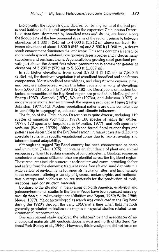
Mallouf -- Big Bend Pleistocene/Holocene Observations 123
Biologically, the region is quite diverse, containing some of the best pre- served habitats to be found anywhere in the expansive Chihuahuan Desert. Luxuriant flora, dominated by broadleaf trees and shrubs, are found along the floodplains of the few perennial streams of the region, primarily between elevations of 1,800 ft (545 m) to 4,000 ft (1,212 m) above sea level. Be- tween elevations of about 1,800 ft (545 m) and 3,500 ft (1,060 m), a desert shrub environment dominates the landscape. This zone contains a variety of more widely spaced, relatively low growing desert species and includes many succulents and semisucculents. A generally low growing sotol-grassland pre- vails just above the desert flats where precipitation is somewhat greater at elevations of 3,200 ft (970 m) to 5,550 ft (1,667 m).
In still higher elevations, from about 3,700 ft (1,121 m) to 7,800 ft (2,364 m), the dominant vegetation is of woodland broadleaf and coniferous composition. Moist woodland assemblages, including Arizona cypress, pine, and oak, are interspersed within this latter vegetational zone at elevations from 5,000 ft (1,515 m) to 7,200 ft (2,182 m). Descriptions of modern bo- tanical communities of the Big Bend region are provided in McDougall and Sperry (1957), Warnock (1970), Wauer (1973a), and Johnston (1977). A modern vegetational transect through the region is provided in Figure 2 (after Johnston, 1977:341). Modern vegetational patterns are quite complex due to variability in topographic, edaphic, and climatic influences.
The fauna of the Chihuahuan Desert also is quite diverse, including 119 species of mammals (Schmidly, 1977), 100 species of native fish (Miller, 1977), 170 species of herpetofauna (Morafka, 1977), and 385 species of avifauna (Wauer, 1973b). Although broad faunal-floral relationships and patterns are discernible in the Big Bend region, in many cases it is difficult to correlate fauna with specific vegetational zones due to habitat overlap and inherent faunal adaptability.
Although the rugged Big Bend country has been characterized as harsh and uninviting (Tyler, 1975), it contains an abundance of plant and animal resources sufficient to sustain a variety of cultural systems. Geologic resources conducive to human utilization also are plentiful across the Big Bend region. These resources include numerous rockshelters and caves, providing shelter and safety from the elements; frequent stone free silt and sand deposits in a wide variety of environments for open air habitation sites; and innumerable stone resources, offering a variety of igneous, metamorphic, and sedimen- tary outcrops and cobbles as source materials for the production of tools, weapons, and construction materials.
Contrary to the situation in many areas of North America, ecological and paleoenvironmental studies in the Trans-Pecos have been pursued more rig- orously than cultural investigations (Albritton and Bryan, 1939; Wells, 1966; Meyer, 1977). Major archeological research was conducted in the Big Bend during the 1920’s through the early 1950’s at a time when field methods generally precluded collection of samples for special studies related to en- vironmental reconstruction.
One exceptional study explored the relationships and association of ar- cheological materials with geologic deposits west and north of Big Bend Na- tional Park (Kelley et al., 1940). However, this investigation did not focus on
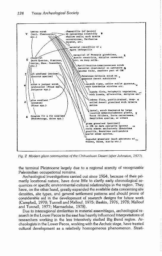
124 Texas Archeological Society
v
o
Fig. 2 Modern plant communities of the Chihuahuan Deser~ (after Johnston, 1977/,
the terminal Pleistocene largely due to a regional scarcity of recognizable Paleoindian occupational remains.
Archeological investigations carried out since 1954, because of their pri- marily Iocational nature, have done little to clarify early chronological se- quences or specific environmental-cultural relationships in the region. They
have, on the other hand, greatly expanded the available data concerning site densities, site types, and general settlement patterns and should prove of considerable aid in the development of research designs for future work (Campbell, 1970; Tunnell and Mallouf, 1975; Baskin, 1976, 1978; Mallouf
and Tunnell, 1977; Marmaduke, 1978). Due to interregional similarities in material assemblages, archeological re-
search in the Lower Pecos to the east has heavily influenced interpretations of researchers working in the less intensively studied Big Bend region. Ar- cheologists in the Lower Pecos, working with the Archaic stage, have treated
cultural development as a relatively homogeneous phenomenon. Strati-
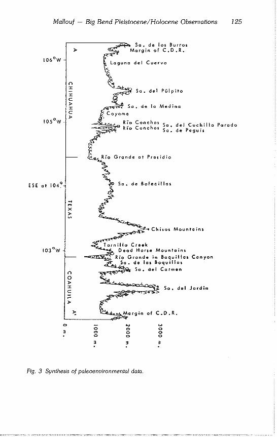
Mallouf -- Big Bend Pleistocene/Holocene Observations 125
106°W
105°W
ESE at 104~.
103°W
Sa. de los Burros Margin of C.D.R.
Laguna del Cuervo
-4 rn
x
o
3
(’1 0 J> T C
F-
Sa. del P61plto
Sa. de la Medina
_~ Coyame R*’o Conchos ........ Parado
~ Grande at Presidio
..
Sa. de Bofecillas
-~-4 Chlsos Mountains
<~Toi’nillo Creek Dead Horse Mountains
"~;;~. Rio Grande in Boquillas Canyon
~._~Sa. de tas Boquillas Sa. del Carmen
~ ~ So. del Jardln
~.~argin of C.D.R.
o o
3 3 3
Fig. 3 Synthesis of paleoenvironmental data.
126 Texas Archeological Society
graphic and chronological markers arbitrarily divide the continuity into defin- able periods or working units (Johnson, 1964; Story, 1966.)
Extensive excavations and radiocarbon dating of deposits at Lake Amistad facilitated formulation of a comparatively sound chronological sequence based primarily on projectile point styles. This temporal sequence on occa- sion has been applied in slightly modified form to morphologically similar implements found in a variety of contexts in the contiguous Big Bend region (Marmaduke, 1978). However, applications of the Lower Pecos temporal framework to the Big Bend should be considered tentative in the absence of empirical validation.
PALEOENVIRONMENTAL BACKGROUND
Although still relatively poorly understood, the Late Pleistocene and Holo- cene environments of the Big Bend region gradually are becoming better known as a result of several active avenues of research: palynology, verte- brate paleontology, paleobotany, and geomorphology. While data forthcom- ing from these disciplines do not always concur, certain broad patterns of significance to environmental reconstruction are nevertheless evident. Figure 3 provides a chronologically structured synthesis of major contributions from sample localities within or adjacent to the Big Bend region. The table is ar- ranged by major categories of research (pollen, Neotoma sp. middens, plant macrofossils, fauna, and geology) in an attempt to illustrate interdisciplinary discrepancies and gaps in the data base.
Pollen data, based primarily on Martin and Mehringer (1965), Meyer (1973), Bryant (1974), and Bryant and Shafer (1977), suggest a cool, moist climate in which woodland, parkland, and scrub grasslands thrived across much of the Big Bend region during the terminal Pleistocene (13,000-11,000 B.P .). A major constituent of this biotic assemblage across both lowlands and uplands appears to have been pinyon pine, which today is found only in the higher elevations of regional mountain ranges. This interpretation generally is supported by wood rat (Neotoma sp.) midden analysis from Maravillas Can- yon, Burro Mesa, Dagger Mountain (Wells, 1966) and Guadalupe, Quitman, and Hueco mountains (Van Devender and Wiseman, 1977; Van Devender and Spaulding, 1979).
The normally excellent state of preservation and relative ease of identifica- tion of plant macrofossils in wood rat middens would appear to make them the more reliable indicator of past environments (Wells, 1976). There are differences in content between reported middens from the eastern edge of the Big Bend and those from areas to the north and west. Middens from very low elevations (660 m or 1,980 ft) in Maravillas Canyon (Wells, 1966) along the eastern extent of the Big Bend reveal a terminal Pleistocene mixture of xerophytic woodland species (pinyon pine, juniper, algerita, live oak, and
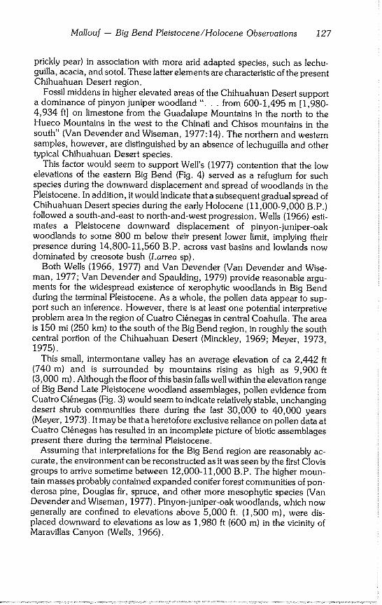
Mallouf - Big Bend Pleistocene/Holocene Observations 127
prickly pear) in association with more arid adapted species, such as lechu- guilla, acacia, and sotol. These latter elements are characteristic of the present Chihuahuan Desert region.
Fossil middens in higher elevated areas of the Chihuahuan Desert support a dominance of pinyon juniper woodland "... from 600-1,495 m [1,980- 4,934 ft] on limestone from the Guadalupe Mountains in the north to the Hueco Mountains in the west to the Chinati and Chisos mountains in the south" (Van Devender and Wiseman, 1977:14). The northern and western samples, however, are distinguished by an absence of lechuguilla and other typical Chihuahuan Desert species.
This factor would seem to support Well’s (1977) contention that the low elevations of the eastern Big Bend (Fig. 4) served as a refugium for such species during the downward displacement and spread of woodlands in the Pleistocene. In addition, it would indicate that a subsequent gradual spread of Chihuahuan Desert species during the early Holocene (11,000-9,000 B.P.) followed a south-and-east to north-and-west progression. Wells (1966) esti- mates a Pleistocene downward displacement of pinyon-juniper-oak woodlands to some 800 m below their present lower limit, implying their presence during 14,800-11,560 B.P. across vast basins and lowlands now dominated by creosote bush (Larrea sp).
Both Wells (1966, 1977) and Van Devender (Van Devender and Wise- man, 1977; Van Devender and Spaulding, 1979) provide reasonable argu- ments for the widespread existence of xerophytic woodlands in Big Bend during the terminal Pleistocene. As a whole, the pollen data appear to sup- port such an inference. However, there is at least one potential interpretive problem area in the region of Cuatro Ci@negas in central Coahuila. The area is 150 mi (250 km) to the south of the Big Bend region, in roughly the south central portion of the Chihuahuan Desert (Minckley, 1969; Meyer, 1973, 1975).
This small, intermontane valley has an average elevation of ca 2,442 ft (740 m) and is surrounded by mountains rising as high as 9,900 ft (3,000 m). Although the floor of this basin falls well within the elevation range of Big Bend Late Pleistocene woodland assemblages, pollen evidence from Cuatro Ci~negas (Fig. 3) would seem to indicate relatively stable, unchanging desert shrub communities there during the last 30,000 to 40,000 years (Meyer, 1973). It may be that a heretofore exclusive reliance on pollen data at Cuatro Ci@negas has resulted in an incomplete picture of biotic assemblages present there during the terminal Pleistocene.
Assuming that interpretations for the Big Bend region are reasonably ac- curate, the environment can be reconstructed as it was seen by the first Clovis groups to arrive sometime between 12,000-11,000 B.P. The higher moun- tain masses probably contained expanded conifer forest communities of pon- derosa pine, Douglas fir, spruce, and other more mesophytic species (Van Devender and Wiseman, 1977). Pinyon-juniper-oak woodlands, which now generally are confined to elevations above 5,000 ft. (1,500 m), were dis- placed downward to elevations as low as 1,980 ft (600 m) in the vicinity of Maravillas Canyon (Wells, 1966).
128 Texas Archeological Society
BP 2,000 BC 0--
3,000 -- 1,000--
4,000-- 2,000--
5,000-- 3,000--
6,000-- 4,000--
7,000-- 5,000--
8,000 -- 6,000--
9,000-- 7,000--
10,000-- 8,000--
11,000-- 9,000--
12,000-- 10,000--
13,000-- 11,000--
14,000-- t2,000----
15,000-- 13,000--
16,000 -- 14,000--
17,000~ 15,000--
18,000-- 16,000--
19,000-- 17,000--
20,000-- 18,000--
Pollen
Martin 6 Mehringer 1965
West 6 Central Texas
Fluctuations of
forest, woodlands,
grasslands,
Drier, warmer. Evidence for alti-
thermal conditions
generally lacking.
Pine-spruce forest.
Moist, cool.
Pollen
Meyer 1973
Coahuila, Mexico
Vegetational distri- bution becomes sub- modern to modern. No evidence of alti- thermal or hypsi- thermal.
Elevational constric- tion of upland vegeta- tion assemblages. Basin floors remain unchanged.
Cool 6 moist (7) with more extensive pine forests 6 woodlands on surrounding mountains. Scrub oak-pinyon-acacia woodland on bajadas surrounding basin. Basin floor probably had same desert species as today.
Pollen Bryant 1974 Lake Amistad
Brief mesic interval with reinvasion o£ pinyon pine.
Reduced pine & grasses.
Increase in joint fir,
mesquite, acacia, &
agave.
Widespread erosion.
Uninterrupted grassland with scattered trees shrubs.
No major climatic changes.
Joint fir 6 juniper (?) in grassland/pinyon larklands.
Grasslands interrupted by isolated trees clumps of trees, iRising summer tempera- ~tures.
Change in climate; aver- age st~nmer temperature i0° F lower than present.
Open canopy forest with )inyon pine dominant.
Fig. 3 Synthesis of paleoenvironmental data.
Mallouf -- Big Bend Pleistocene/Holocene Observations 129
Pollen Neotoma sp. Middens Neotoma sp. Middens Bryant & Shafer 1977 Wells 1966 Wells 1974 Southwest Texas BiB Bend Big Bend Region
Mesic interval.
Widespread alluvial
erosion.
Increase in agave.
Slightly more mesic.
Savanna.
More arid.
Warmer & drier.
Parkland vegetation with ephedra under-
story & some juniper overstory; also agave, yucca, sotol, cactii, & pockets of pinyon.
Warmer ~ drier.
Grass & scrub expand- ing. Higher summer tempera- tures. Widespread loss of pinyon pine woodland.
Cool & wet.
Mosaic of woodland,
parkland, & scrub
grassland, composed
primarily of grasses,
pinyon pine, & some juniper. Douglas fir & ponde- rosa pine at higher elevations.
At 600 m typical desert shrub assemblage, including ocotillo, lechuguilla, opuntia, acacia, yucca, sotol, etc.; no woodland species.
No good data.
Species include pinyon pine, juniper, algerita, shrubby live-oak, prickly pear, lechu- guilla, acacia, sotol, & a few other extant desert species at 600+ elevation.
Relatively dry, pos- sibly cool, pluvial woodlond climate in lowlands of Chihuahuan Desert.
Appearance of creosote, ocotillo, g candelilla.
More scrub oak & juni- per; less pine; xero- phytic additions.
Onset of drier condi- tions.
Pinyon dominant.
Pinyon, juniper, & oak forest dominant with mixture of xero- phytic species at lower elevations, including lechuguilla, sotol, sacahuista, yucca, prickly pear, acacia, & ephedra.
130 Texas Archeological Society
BP 2,000--
3,000--
4,000 --
5,000 --
6,000--
7,000--
8,000--
9,000--
10,000--
11,000--
12,000--~
13,000--
14,000--
15,000--
16,000 --
17,000--
18,000--
19,000--
20,000--
BC 0--
1,000--
2,000--
3,000--
4,000--
5,000--
6,000 --
7,000--
8,000--
9,000--
10,000--
ii,000
12,000--
13,000i
14,000--
15,000--
16,000 --
17,000--
18,000--
tJeotoma sp. Middens Van Devender & Wiseman Trans-Pecos 1977
Appearance of xeric desert vegetation.
Summer monsoon becomes well developed.
Transition from wood- land to grassland desert.
Variability in pre- cipitation.
Juniper-oak woodland.
Pinyon-juniper wood- land at lower eleva- tions.
Mixed conifer forests at higher elevations.
Mild winters; cool sun~mers.
Winter precipitation much higher; summer precipitation minor.
More surface water.
I Neotoma sp. Middens 1979 iVan Oevender & Spaulding Big 8end/Guadalupe M!ns.
~dern desert scrub !communities.
Possible widespread soi! erosion. Diverse desert scrub communities. Low winter precipita-
i tion; expanded summer :monsoon.
Increase in desert species; ocotillo
!becomes widespread. Widespread grasslands in some regions. Retreat of woodland species. Spread of warm deserts.
Xeric woodland period. Retreat of pinyon pine. Spread of juniper-oak woodlands & grasslands.
Disappearance of spruce & dwarf juniper in Guadalupe Moun- tains.
Lower winter tempera- tures. Mesophytic spruce, fir, white pine, & juniper at elevations now occupied by desert grassland in Guadalupe Mountains. Pinyon-juniper wood- lands at middle eleva- tions of 550-1525 m in areas now occupied by desert scI~/b. Major desert scrub at elevations below 400 m.
Mild & moist winters. Cooler summers.
Plant Macrofossils Dering 1979 Lower Pecos
blodern grasslands;
scattered shrubs, juni-
per, & oaks; decline
of pine.
Resur8ence of pine (?)
Continued slow drying &
warming trends. Grasslands; juniper/ oaks.
Grasslands in uplands
with scattered xero- phytic shrubs & semi- succulents.
Juniper/oaks.
Increase in herbaceous species, Some reduction in oaks
juniper, Decline of pines.
South: juniper/oak
parkland; grassland
with xerophytic species.
North: pinyon pine
parkland (?)
Mosaic of woodland,
parkland, & scrub
grass.
Fig. 3 Synthesis of paleoenuironmental data.
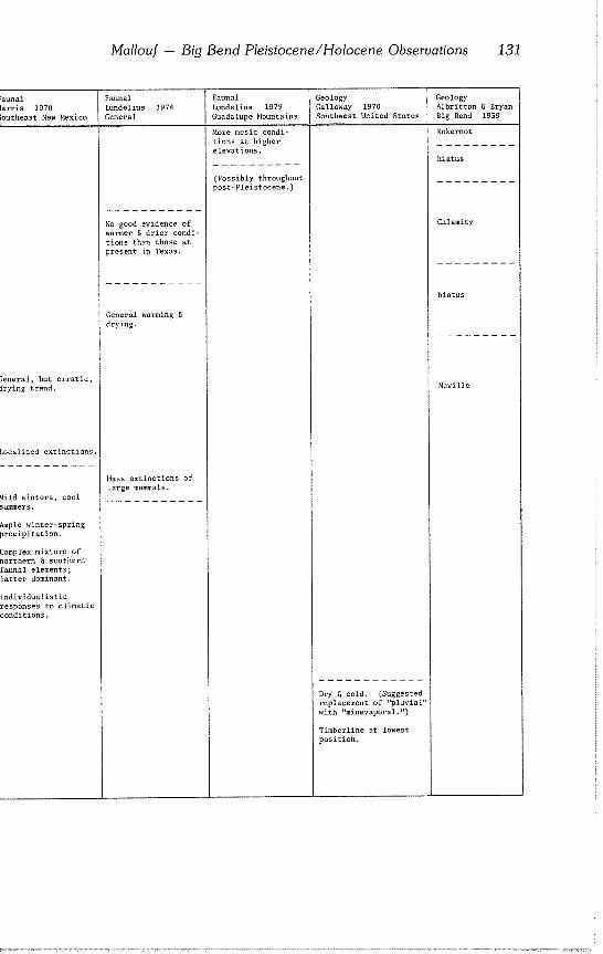
Mallouf - Big Bend Pleistocene/Holocene Observations 131
unal rris 1970 utheast New Mexico
~neral, but erratic, !ying trend.
~calized extinctions.
Lld winters, cool
nple winter-spring precipitation.
~mplex mixture of )rthern & southern
~unal elements;
~tter dominant.
~dividualistic zsponses to climatic anditions.
Faunal Lundelius 1974 General
Faunal Geology Lundelius 1979 Galloway 1970 Guadalupe Mountains Southwest United States
More mesic condi- tions at higher elevations.
No good evidence of warmer & drier condi- tions than those at present in Texas.
General warming & drying.
Mass extinctions of large mammals.
Dry & cold. (Suggested replacement of "pluvial" with "minevaporal.")
Timberline at lowest position.
(Possibly throughout post-Pleistocene.)
Geology Albritton & Bryan Big Bend 1939
Kokernot
hiatus
Calamity
hiatus
Neville
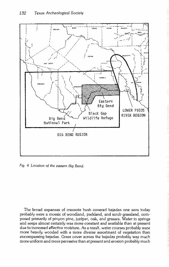
132 Texas Archeological Society
i
L/
Eas tern Bi g Bend
Black Gap Wi I dl i fe Refuge
LOWER PECOS
RIVER REGION
BIG BEND REGION
Fig. 4 Location of the eastern Big Bend.
The broad expanses of creosote bush covered bajadas one sees today probably were a mosaic of woodland, parkland, and scrub grassland, com- posed primarily of pinyon pine, juniper, oak, and grasses. Water in springs and seeps almost certainly was more constant and available than at present due to increased effective moisture. As a result, water courses probably were more heavily wooded with a more diverse assortment of vegetation than encompassing bajadas. Grass cover across the bajadas probably was much more uniform and more pervasive than at present and erosion probably much
Mallouf -- Big Bend Pleistocene/Holocene Observations 133
less severe. Pollen data indicate generally wetter conditions, although Wells (1966) suggests a relatively dry, cool climate for the lowlands (Fig. 3).
The early Holocene (11,000-9,000 B.P.), due to a gradual warming and drying trend, saw an overall reduction in forest species in the lowlands and a concomitant increase in woodland (oak and juniper) and grassland biota (Fig. 3). Although precipitation regimes during this period may have been chang- ing (Van Devender and Wiseman, 1977), perennial water sources remained much more abundant than at present.
CULTURAL BACKGROUND
In comparison to environmental data, cultural data for the terminal Pleisto- cene and early Holocene in the Big Bend are scant. The only evidence found to date of Paleoindian presence in Big Bend proper are a few surface finds of their distinctive projectile points. Campbell’s (1970) survey of Big Bend Na- tional Park took him to several hundred archeological sites. Campbell reports finding only one Clovis and four Plainview-Golondrina points during the course of his survey, facts which led him to speculate that Paleoindian occu- pation in the region was sporadic at best (Campbell, 1970:71). Evidence of Folsom occupation is lacking. Similar finds in areas immediately adjacent to the park and in northern Mexico are quite rare and often poorly documented.
To the west and north of Big Bend, Paleoindian materials are found more consistently and in greater quantity. Evidence of Clovis, Folsom, and Plain- view occupations are found to the north in the Pecos, Texas area (Hamilton Collection: notes on file, Texas Historical Commission); and a major Folsom habitation site was discovered to the northwest of Big Bend near Van Horn, Texas in the 1950’s (Lindsay, 1969). Krone (1975) reported a series of Folsom finds from the El Paso area in the western Trans-Pecos.
East of Big Bend in the Lower Pecos region, evidence of Holocene Pa- leoindian activity was found in the deepest cultural levels of an extensive silt river terrace (Johnson, 1964). At Bonfire Shelter (Dibble and Lorrain, 1968), definitive evidence of early Holocene Folsom and Plainview big-game hunt- ing (ca 10,230 B.P.) was found at a repeatedly used bison jump. A few surface finds of terminal Pleistocene Clovis points also were made in the Lower Pecos region (Campbell, 1970:67). Paleoindian habitation sites have not yet been identified in the Lower Pecos region.
Evidence of terminal Pleistocene Clovis occupation occurs from the Lower Pecos region west across Big Bend, throughout the southwestern United States, into northwestern Mexico. Clovis materials recovered to date in Trans-Pecos Texas are surface finds. Early Holocene Folsom remains, on the other hand, are reported from east of the Big Bend in the Lower Pecos region (Bonfire Shelter) and to the north and northwest of Big Bend in the Pecos and Van Horn, Texas areas. Evidence of Folsom occupation has not yet been found in the Big Bend proper.
Early Holocene Plainview occupations are known to occur in the lower and middle Pecos River areas (Bonfire Shelter and Hamilton Collection), but are
134 Texas Archeological Society
not well documented from Big Bend and areas west to El Paso. Golondrina points commonly assigned to Plainview (Johnson, 1964; Campbell, 1970) occur sporadically in the Big Bend proper (Campbell, 1970).
GENERAL CULTURAL-ENVIRONMENTAL RELATIONSHIPS
There are several factors to weigh in considering Paleoindian environmen- tal relationships in Big Bend and adjacent regions. Evidence is lacking for use of rockshelters or caves as habitation sites by Clovis, Folsom, or later big game hunters. The use of Bonfire Shelter (Dibble and Lorrain, 1968) by Folsom and Plainview hunters in the Lower Pecos region was directly related to the short term killing and butchering of large game. If Paleoindian incursions into the Lower Pecos and Big Bend were as sporadic as findings (Dibble and Lorrain, 1968; Campbell, 1970) indicate, then short term, open hunting camps located on strategic, well elevated landforms for observing the sur- rounding terrain may prove characteristic. Long term encampments, on the other hand, may indeed be rare and could occur in a variety of environmental settings.
Additional considerations might have influenced cultural-environmental interactions, specifically during the early Holocene in Big Bend. Jennings (1957) early proposed that Paleoindian cultures in the semiarid to arid lands of the western United States evolved a cultural tradition, termed the Desert Culture, which was distinctly different from that of the Central Plains and the densely wooded eastern United States. He proposed that the Desert Culture was a more economically generalized, but basic, adaptation to greater aridity and a concomitant lack or scarcity of large game or herd animals. It involved intensive exploitation of plant resources as well as a variety of available fauna.
Within many regions of the southwestern United States, the Desert Archaic is best represented in rockshelter and cave sites, where datable remains may range as early as 11,000 B.P. (Jennings, 1957; Aikens, 1970), such dates being comparable to Paleoindian dates on the High Plains. The Desert Ar- chaic could be considered an alternative early Holocene adaptation as op- posed to the Plains bison-hunting lifeway typified by Folsom and Plainview remains.
With regard to areas south of Big Bend in Coahuila, Taylor (1966:61-62) observed that:
From the earliest times of which we have knowledge to the latest there was a cultural continuum in Coahuila, belonging to what has been called the Desert culture . . . Many classes and types of artifacts are the same from bottom to top in the stratigraphic sequence. Variations occur and relative frequencies change, but without doubt it is a single cultural ~adition throughout its approximately 10,000 years.
Taylor’s (1966) Chihuahuan Desert data, the earliest dates for which are 9,540 B.P. and 9,300 B.P., were obtained from the lowest levels of cave sites in central Coahuila. Evidence of earlier Clovis or Folsom occupation is ab- sent.
In the central and eastern United States, there appears to be a continuum of development from big game hunters to more diversified hunting-gathering
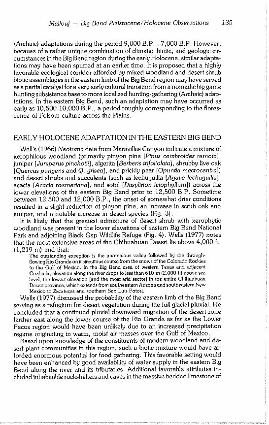
Mallouf - Big Bend Pleistocene/Holocene Observations 135
(Archaic) adaptations during the period 9,000 B.P. - 7,000 B.P. However, because of a rather unique combination of climatic, biotic, and geologic cir- cumstances in the Big Bend region during the early Holocene, similar adapta- tions may have been spurred at an earlier time. It is proposed that a highly favorable ecological corridor afforded by mixed woodland and desert shrub biotic assemblages in the eastern limb of the Big Bend region may have served as a partial catalyst for a very early cultural transition from a nomadic big game hunting subsistence base to more localized hunting-gathering (Archaic) adap- tations. In the eastern Big Bend, such an adaptation may have occurred as early as 10,500-10,000 B.P., a period roughly corresponding to the flores- cence of Folsom culture across the Plains.
EARLY HOLOCENE ADAPTATION IN THE EASTERN BIG BEND
Well’s (1966) Neotoma data from Maravillas Canyon indicate a mixture of xerophilous woodland (primarily pinyon pine [Pinus cembroides remota], juniper [Juniperus pinchotii], algerita [Berberis trifoliolata], shrubby live oak [Quercus pungens and Q. grisea], and prickly pear [Opuntia macrocentra]) and desert shrubs and succulents (such as lechuguiUa [Agave lechuguilla], acacia [Acacia roemeriana], and sotol [Dasylirion leiophyllum]) across the lower elevations of the eastern Big Bend prior to 12,500 B.P. Sometime between 12,500 and 12,000 B.P., the onset of somewhat drier conditions resulted in a slight reduction of pinyon pine, an increase in scrub oak and juniper, and a notable increase in desert species (Fig. 3).
It is likely that the greatest admixture of desert shrub with xerophytic woodland was present in the lower elevations of eastern Big Bend National Park and adjoining Black Gap Wildlife Refuge (Fig. 4). Wells (1977) notes that the most extensive areas of the Chihuahuan Desert lie above 4,000 ft. (1,219 m) and that:
The outstanding exception is the anomalous valley followed by the through- flowing Rio Grande on it circuitous course from the snows of the Colorado Rockies to the Gulf of Mexico. In the Big Bend area of western Texas and adjacent Coahuila, elevation along the river drops to less than 610 m (2,000 ft) above sea level, the lowest elevation [and the most arid sector] in the entire Chihuahuan Desert province, which extends from southeastern Arizona and southeastern New Mexico to Zacatecas and southern San Luis Potosi.
Wells (1977) discussed the probability of the eastern limb of the Big Bend serving as a refugium for desert vegetation during the full glacial pluvial. He concluded that a continued pluvial downward migration of the desert zone farther east along the lower course of the Rio Grande as far as the Lower Pecos region would have been unlikely due to an increased precipitation regime originating in warm, moist air masses over the Gulf of Mexico.
Based upon knowledge of the constituents of modern woodland and de- sert plant communities in this region, such a biotic mixture would have af- forded enormous potential for food gathering. This favorable setting would have been enhanced by good availability of water supply in the eastern Big Bend along the river and its tributaries. Additional favorable attributes in- cluded inhabitable rockshelters and caves in the massive bedded limestone of
136 Texas Archeological Society
the eastern area and elevated, silt terraces along the river and its major tribu-
taries. The eastern Big Bend region, then, must have presented an optimal habitat
for food gathering during the period 11,000-10,000 B.P., a time correspond- ing to the florescence of Folsom culture across much of North America. The development of a comparable mixed woodland-desert shrub assemblage in the high elevations of the northern and western Big Bend and adjoining re-
gions occurs some 2,000 years later (Van Devender and Spaulding, 1979; Van Devender and Wiseman, 1977). Because of the unusually rich and var- ied assortment of plant resources available in the eastern Big Bend, it is con- ceivable that subsistence emphases might have experienced a somewhat pro- nounced shift from hunting to gathering quite early.
Coincident to this development would have been adjustments in the distri- bution of groups across the landscape, group sizes, and home range sizes.
These adjustments eventually would culminate in the distinctive Archaic life- style that characterized the following 9,000 years in this and adjoining re- gions.
The next problem that must be confronted is where in the eastern Big Bend such early, culturally transitional archeological components can be expected to be found and how they can be recognized. There are extant preliminary data that help in generally discussing the first question. The second question,
however, is more difficult to resolve.
CURRENT RESEARCH
Since 1973, the Office of the State Archeologist has conducted a staggered series of nonextractive archeological reconnaissances along the Rio Grande. The study area stretches from Redford (Presidio County) downstream through numerous canyon systems to Dryden Crossing (Terrell County), a
distance of some 275 river miles (440 km). Because of the remote and fie- quently inaccessible nature of the terrain, all work was conducted in river segments by way of canoe expeditions. Each expedition was normally of a 7 to 14 day duration (Tunnell and Mallouf, 1975~ MaUouf and Tunnell, 1977). As a result of this work, over 150 archeological sites were recorded along both sides of the river and in the mouths of its major tributaries in the eastern Big
Bend area (Sanderson Canyon, Panther Canyon, San Francisco Canyon, Ca~on Caballo Blanco, Ca~on de San Rosendo, Reagan Canyon, Big Can- yon, Maravillas Canyon, Ca~on de Ceferino).
Site types consist primarily of rockshelters and caves in limestone bluffs and open campsites on elevated silt terraces. Intrasite surficial features commonly
consist of burned rock accumulations, hearths, occasional burned rock mid- dens, burned rock talus, bedrock mortars and metates, and occasional pe-
troglyph panels inside or in front of rockshelters and caves. Surficial cultural debris commonly encountered at open campsites consist primarily of ground- stone implements, various tools such as retouched flakes and projectile
points, and quantities of debitage in midden sediments. Within the shelters and caves, surface remains include perishable items (cut sticks, lechuguilla
Mallouf -- Big Bend Pleistocene/Holocene Observations 137.
and sotol quids, cordage), groundstone implements, debitage, and occa- sional projectile points. Temporally diagnostic artifacts observed on the sur-
face of sites thus far are indicative of Late Archaic and Late Prehistoric affilia- tions.
Although many open and sheltered sites appear to have the potential for deeply buried early components, it is possible that geomorphological and hydrological processes in the past have greatly altered or eliminated such deposits. These factors may have directly affected the presence or absence of
such components, particularly in open silt terrace sites. Much of the river course in the eastern Big Bend is contained within steep walled limestone
canyons which serve to narrow average river width considerably. During
floods, river waters are funneled through the narrow canyons at an acceler- ated rate, cutting away existing silt and gravel terraces and creating new ter-
races. The force of such floods is attested by the presence of jumbled up, water worn boulders the size of automobiles in the floors of some tributary
canyons. Most very early components contained in silt terraces fronting the river
probably have long since been removed by erosion. Exceptions to this gener- alization include: silt terraces at elevations high enough to avoid most flood-
ing; and terraces that are relatively high and protected from swift river cur- rents by fortuitously located bedrock outcrops or other natural phenomena. This interpretation is supported by the fact that, out of 40 silt terrace sites examined in this area, only five exhibit the definite presence of deeply buried cultural zones. This observation is based upon examination of erosional cut banks within numerous site areas. In main stem river reaches having broader
and more open floodplains, the percentage of deeply buried components should increase markedly (Fig. 5). A similar situation can be expected under
favorable conditions in the lower reaches of tributary canyons. In light of the hydrologic situation, archeologists must depend primarily on
the deep, well preserved cultural deposits in numerous extensive rockshelters
and caves for the earliest indications of hunting-gathering adaptations. Nu- merous, extensive dry caves, containing what appear to be very deep cultural deposits with perishable remains, are within the Lower Canyons on both
Texas and Coahuila sides of the river (Mallouf and Tunnell, 1977). These same sites probably contain Neotoma middens and paleontological as- semblages. Rockshelters and caves containing good cultural deposits always
are well elevated above the river. Those located in bluffs too low to the river are invariably scoured clean by rushing flood waters.
Rockshelters and caves having good potential are to be found throughout
the extensive limestone areas of the eastern Big Bend (Fig. 6). They are, however, particularly susceptible to destruction by relic hunters, primarily because of the ease with which they can be located and the richness of their artifactual remains. It is essential that controlled, scientific investigations be
carried out at select sites in the near future. In cases where such natural features were available, there appears to have
been a propensity toward rockshelters and caves as habitation sites in the Archaic of Big Bend. While rockshelters are not difficult to locate, recognition
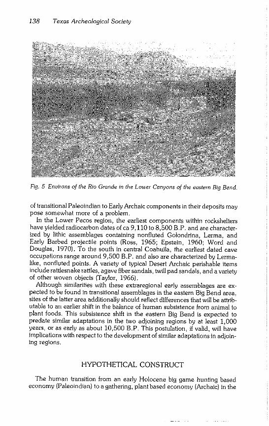
138 Texas Archeological Society
Fig. 5 Environs of the Rio Grande in the Lower Canyons of the eastern Big Bend.
of transitional Paleoindian to Early Archaic components in their deposits may pose somewhat more of a problem.
In the Lower Pecos region, the earliest components within rockshelters have yielded radiocarbon dates of ca 9,110 to 8,500 B.P. and are character- ized by lithic assemblages containing nonfluted Golondrina, Lerma, and Early Barbed projectile points (Ross, 1965; Epstein, 1960; Word and Douglas, 1970). To the south in central Coahuila, the earliest dated cave occupations range around 9,500 B.P. and also are characterized by Lerma- like, nonfluted points. A variety of typical Desert Archaic perishable items include rattlesnake rattles, agave fiber sandals, twill pad sandals, and a variety of other woven objects (Taylor, 1966).
Although similarities with these extraregional early assemblages are ex- pected to be found in transitional assemblages in the eastern Big Bend area, sites of the latter area additionally should reflect differences that will be attrib- utable to an earlier shift in the balance of human subsistence from animal to plant foods. This subsistence shift in the eastern Big Bend is expected to predate similar adaptations in the two adjoining regions by at least 1,000 years, or as early as about 10,500 B.P. This postulation, if valid, will have implications with respect to the development of similar adaptations in adjoin- ing regions.
HYPOTHETICAL CONSTRUCT
The human transition from an early Holocene big game hunting based economy (Paleoindian) to a gathering, plant based economy (Archaic) in the
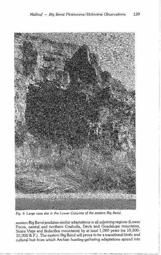
Mallouf -- Big Bend Pleistocene/Holocene Observations 139
Fig. 6 Large cave site in the Lower Canyons of the eastern Big Bend.
eastern Big Bend predates similar adaptations in all adjoining regions (Lower Pecos, central and northern Coahuila, Davis and Guadalupe mountains,
Sierra Vieja and Bofecillos mountains) by at least 1,000 years (ca 10,500- 10,000 B.P.). The eastern Big Bend will prove to be a transitional biotic and cultural hub from which Archaic hunting-gathering adaptations spread into
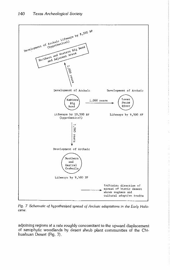
140 Texas Archeological Society
~o?~~ o~ ~?o¢~-~
Development of Archaic
1,000 years
Lifeways by 10,500 BP (hypothetical)
Development of Archaic
Lifewa~ by 9,500 BP
Development of Archaic
Lifeways by 9,500 BP
indicates direction of spread of biotic desert shrub regimes and cultural adaptive traits
Fig. 7 Schematic of hypothesized spread of Archaic adaptations in the Early Holo- cene.
adjoining regions at a rate roughly concomitant to the upward displacement of xerophytic woodlands by desert shrub plant communities of the Chi- huahuan Desert (Fig. 7).
Mallouf -- Big Bend Pleistocene/Holocene Observations 141
DATA SUMMARY
1. Due to downward displacement of xerophytic woodlands, a desert shrub refugium of Chihuahuan Desert species existed in the lower elevations of the eastern Big Bend at ca 14,000 to 10,000 B.P.
2. Within this terminal Pleistocene-early Holocene refugium, desert shrub
species were mixed with xerophilous woodland species. This mixture resulted
in a vegetation assemblage of maximum potential for human extractive sub-
sistence economies. 3. The favorability of the eastern Big Bend refugium for human occupa-
tion was enhanced by the presence of extensive, stone free terrace surfaces, innumerable rockshelters and caves for habitation, and relatively stable water
sources.
4. Although sparse and surficial in nature, there is evidence for utilization
of the Big Bend region and the north central Coahuila region by terminal Pleistocene big game hunters of Clovis affiliation. Early Holocene Folsom remains have not been discovered in the Big Bend to date, regardless of
numerous, regional archeological surveys. Evidence in the Big Bend of utili- zation of rockshelters and caves by Paleoindian fluted point traditions is lack- ing.
5. By 10,500 B.P. in the eastern Big Bend, the xerophilous woodland was in gradual retreat due to drying conditions which favored the spread of Chi- huahuan Desert species. Assuming the presence of man in this ecologically highly favorable environment, it is likely that a cultural transition to a gather- ing subsistence economy already was underway by this date. This adaptation probably placed more emphasis on rockshelters as longer term habitation sites in response to a constricting of territorial range. Specimens exhibiting
similarities to Angostura, Golondrina, and Lerma projectile points, along with a variety of groundstone implements, will be found to characterize this very early adaptation. An absence of Folsom remains in the eastern Big Bend may be attributable to an attendant pre 10,500 B.P. shift in lithic technology and tool assemblages.
6. In contrast, to the east in the Lower Pecos region, the Paleoindian big game tradition existed until 10,000 B.P. and possibly longer due to a contin-
ued presence of parkland grasses. This grasslands may have supported bison herds as late as 8,500 B.P. (based on pollen data). The prolonged existence of parklands is attributed to greater influence on this area of eastern (Gulf of Mexico) climatic regimes.
7. In the Lower Pecos region, pollen evidence exists by 9,500 B.P. for xerophilous parkland vegetation with mixtures of desert shrub succulents. The earliest radiocarbon dates from inhabited rockshelters and open sites in the Lower Pecos fall within a range from 9,500 to 8,900 B.P. (Word and Douglas, 1970; Epstein, 1960; Johnson, 1964) and are associated with non-
specialized, Archaic like assemblages. The environment at 9,500 B.P. roughly corresponds to that of the eastern Big Bend 1,000 years earlier. This latent correspondence suggests the concomitant spread of biotic regimes and attendant cultural adaptive traits from west to east.
142 Texas Archeological Society
8. The earliest dated assemblages from northern and central Coahuila range between 9,500 and 9,300 B.P. (Taylor, 1966) and are of a distinctive Archaic character. These assemblages suggest the possibility of migration of peoples and/or adaptive traits from already established Archaic traditions in the Big Bend to the north. Unlike the more northerly regions, the transitional Late Pleistocene-Early Holocene environmental of central Coahuila may have remained more stable (from pollen data).
9. Neotorna sp. midden data for the higher elevated northern and western sections of the Big Bend and adjacent areas indicate the development of mixed xerophilous desert shrub biotic assemblages no earlier than 8,500 B.P. or 2,000 years later than in the eastern Big Bend. Although radiocarbon dates for cultural assemblages in these areas are lacking, it is predicted that the earliest evidences of Archaic lifeways will roughly correspond to this late date; such influences will have emanated, along with biotic characteristics, from sources to the south and east in the Big Bend proper.
As one moves westward, the dates of origin of such assemblages will, for an undetermined distance, correspondingly decrease. Because of a longer dura- tion of parkland grassland (and attendant bison herds) in these northerly and westerly regions, the presence of Paleoindian big game hunting traditions in the form of both kill sites and habitation sites can be expected to occur there as late as 9,000 to 8,500 B.P.
ACKNOWLEDGMENTS
The author wishes to acknowledge Drs. Russell Graham and Ernest Lundelius for their aid in securing reference materials and review of the original version of this paper. A great debt is owed to Virginia Wulfkuhle of the Texas Historical Commission who provided editorial advice and typed the preliminary version; and to Dr. Eileen Johnson of The Museum of Texas Tech Univer- sity for editorial comments. Final copy was typed by Nancy Stolleis.
REFERENCES CITED
Aikens, C. Melvin 1970 Hogup Cave. University of Utah Anthropological Papers, 93:1-286.
Albritton, Claude C. Jr. and Kirk Bryan
1939 Quaternary Stratigraphy in the Davis Mountains, Trans-Pecos Texas. Bulletin of the Geological Society of America, 50(9):1423-1474.
Baskin, Barbara J. 1976 An Archeological Reconnaissance in the Bofecillos Mountains, Presidio
County, Texas. University of Texas Natural Area Survey, 12:149-181.
1978 Test Excavations at a Prehistoric, Stratified Campsite: Big Bend National Park, Brewster County, Texas. Submitted to the National Park Service, Southwest Regional Office, Santa Fe.
Bryant, Vaughn M. Jr. 1974 Late Quaternary Pollen Records from the East-Central Periphery of the
Chihuahuan Desert. In: R. H. Wauer and D. H. Riskind (eds.), Transac-
Mallouf - Big Bend Pleistocene/Holocene Observations 143
tions of the Symposium on the Biological Resources of the Chihuahuan Desert Region. National Park Service Transactions and Proceedings Se-
ties, 3:3-21.
Bryant, Vaughn M. Jr. and Harry J. Shafer 1977 The Late Quaternary Paleoenvironment of Texas: A Model for the Ar-
cheologist. Bulletin of the Texas Archeological Society, 48:1-25.
Campbell, T. N.
1970 Archeological Survey of the Big Bend National Park, 1966-67. Un-
published manuscript submitted to the National Park Service. On file in the Office of the State Archeologist, Texas Historical Commission, Aus-
tin.
Dering, James Philip 1979 Pollen and Plant Macrofossil Vegetation Record Recovered from Hinds
Cave, Val Verde County, Texas. Unpublished master’s thesis, Texas A&M University, College Station.
Dibble, David S. and Dessamae Lorrain 1968 Bonfire Shelter: A Stratified Bison Kill Site, Val Verde County, Texas.
Texas Memorial Museum Miscellaneous Papers, I: 1-138.
Epstein, Jeremiah F. 1960 Centipede and Damp Caves: Excavations in Val Verde County, Texas,
1958. Texas Archeological Salvage Project, pp. 1-173.
Galloway, Robert W. 1970 The Full-Glacial Climate in the Southwestern United States. Annals of the
Association of American Geographers, 60(2):245-256.
Harris, Arthur H. 1970 The Dry Cave Mammalian Fauna and Late Pluvial Conditions in South-
eastern New Mexico. Texas Journal of Science, 22(1):3-27.
Jennings, Jesse D. 1957 Danger Cave. University of Utah Anthropological Papers, 27:1-328.
Johnson, LeRoy Jr. 1964 The Devils Mouth Site: A Stratified Campsite at Amistad Reservoir, Val
Verde County, Texas. University of Texas, Department of Anthropology Archaeology Series, 6:1-115.
Johnston, Marshall C. 1977 Brief Resume of Botanical, Including Vegetational, Features of the Chi-
huahuan Desert Region with Special Emphasis on their Uniqueness. In: R. H. Wauer and D. H. Riskind (eds.), Transactions of the Symposium on the Biological Resources of the Chihuahuan Desert Region. National Park Service Transactions and Proceedings Series, 3:335-359.
Kelley, J. Charles, T. N. Campbell, and Donald J. Lehmer 1940 The Association of Archaeological Materials with Geological Deposits in
the Big Bend Region of Texas. West Texas Historical and Scientific So- ciety Publication, 10:1-173.
Krone, Milton F. 1975 A Report of Folsom Points Found in the El Paso Area. The Artifact,
13(4):1-19.
144 Texas Archeological Society
Lindsay, Alexander J. Jr. 1969 Current Research: Southwest: Texas. American Antiquity, 34(1):102-
103.
Lundelius, 1974
Ernest L. Jr. The Last Fifteen Thousand Years of Faunal Change in North America. In: Craig C. Black (ed.), History and Prehistory of the Lubbock Lake Site. The Museum Journal, 15:141-160.
1979 Post-Pleistocene Mammals from Pratt Cave and their Environmental Sig- nificance. In: H. H. Genoways and R. J. Baker (eds.), The Guadalupe Mountains National Park, Texas. National Park Service Proceedings and Transactions Series, 4:239-258.
Mallouf, Robert J. and Curtis Tunnell 1977 An Archeological Reconnaissance in the Lower Canyons of the Rio
Grand. Texas Historical Commission, Office of the State Archeologist Survey Report, 22:1-71.
Marmaduke, William S. 1978 Prehistory at Bear Creek, Brewster County, Texas. Texas Historical
Commission, Office of the State Archeologist Survey Report, 25:1-195.
Martin, Paul S. and Peter J. Mehringer Jr. 1965 Pleistocene Pollen Analysis and Biogeography of the Southwest. In:
H. E. Wright, Jr. and David G. Frey (eds.), The Quaternary of the United States, pp. 433-451. Princeton University Press, Princeton.
McDougall, 1957
W. B. and Omer E. Sperry Plants of Big Bend National Park. National Park Service, U.S. Depart- ment of the Interior, Washington.
Meyer, Edward R. 1973 Late Quaternary Paleoecology of the Cuatro Ci~negas Basin, Coahuila,
Basin, Coahuila, Mexico. Ecology. 54(5):982-995.
1975 Vegetation and Pollen Rain in the Cuatro Ci@negas Basin, Coahuila, Mexico. The Southwestern Naturalist, 20(2):215-224.
1977 A Reconnaissance Survey of Pollen Rain in Big Bend National Park, Texas: Modern Control for a Paleoenvironmental Study. In: R. H. Wauer and D. H. Riskind (eds.), Transactions of the Symposium on the Biological Resources of the Chihuahuan Desert Region. National Park Service Transactions and Proceedings Series, 3:115-123.
Miller, Robert Rush 1977 Composition and Derivation of the Native Fish Fauna of the Chihuahuan
Desert Region. In: R. H. Wauer and D. H. Riskind (eds.), Transactions of the Symposium on the Biological Resources of the Chihuahuan Desert Region. National Park Service Transactions and Proceedings Series, 3:365-381.
Minckley, W. L.
1969 Environments of the Bolson of Cuatro Ci~negas, Coahuila, Mexico, with
Special Reference to the Aquatic Biota. Texas Western Press, University
of Texas at El Paso.
Mallouf -- Big Bend Pleistocene/Holocene Observations 145
Morafka, David J. 1977 Is There a Chihuahuan Desert? A Quantitative Evaluation through a Her-
petofaunal Perspective. In: R. H. Wauer and D. H. Riskind (eds.), Transactions of the Symposium on the Biological Resources of the Chi- huahuan Desert Region. National Park Service Transactions and Pro- ceedings Series, 3:437-454.
Ross, Richard E. 1965 The Archeology of Eagle Cave. Papers of the Texas Archeological
Salvage Project, 7:1-163.
Schmidly, David J. 1977 Factors Governing the Distribution of Mammals in the Chihuahuan De-
sert Region. In: R. H. Wauer and D. H. Riskind (eds.), Transactions of the Symposium on the Biological Resources of the Chihuahuan Desert Region. National Park Service Transactions and Proceedings Series, 3:163-192.
Story, Dee Ann 1966 Archeological Background. In: Dee Ann Story and Vaughn M. Bryant Jr.
(eds.), A Preliminary Study of the Paleo-ecology of the Amistad Reser- voir Area. Report of research, National Science Foundation.
Taylor, Walter W. 1966 Archaic Cultures Adjacent to the Northeastern Frontiers of Meso-
America. In: Robert Wauchope (ed.), Handbook of Middle American Indians, Vol. 4: Archaeological Frontiers and External Connections, pp. 59-94. University of Texas Press, Austin.
Tunnell, Curtis and Robert J. Mallouf 1975 Cultural Resources in the Canyons of the Rio Grande. Texas Historical
Commission, Office of the State Archeologist Special Report, 17:1-28.
Tyler, Ronnie C.
1975 The Big Bend: A History of the Last Texas Frontier. National Park Serv-
ice, U.S. Department of the Interior, Washington.
Van Devender, Thomas R. and W. Geoffrey Spaulding 1979 Development of Vegetation and Climate in the Southwestern United
States. Science, 204:701-710.
Van Devender, Thomas R. and Frederick M. Wiseman 1977 A Preliminary Chronology of Bioenvironmental Changes During the Pa-
leoindian Period in the Monsoonal Southwest. The Museum Journal, 17:13-27.
Warnock, Barton H. 1970 Wildflowers of the Big Bend Country, Texas. Sul Ross State University,
Alpine.
Wauer, Robert H. 1973a Naturalist’s Big Bend. Peregrine Productions, Santa Fe.
1973b Birds of Big Bend National Park and Vicinity. University of Texas Press,
Austin.
Wells, Philip V. 1966 Late Pleistocene Vegetation and Degree of Pluvial Climatic Change in the
Chihuahuan Desert. Science, 153:970-974.
146 Texas Archeological Society
1976 Macrofossil Analysis of Wood Rat (Neotoma) Middens as a Key to the Quaternary Vegetational History of Arid America. Quaternary Research, 6:223-248.
1977 Post-Glacial Origin of the Present Chihuahuan Desert Less than 11,500 Years Ago. In: R H. Wauer and D. H. Riskind (Eds.), Transactions of the Symposium on the Biological Resources of the Chihuahuan Desert Re~ gion. National Park Service Transactions and Proceedings Series, 3:67- 83.
Word, James H. and Charles L. Douglas 1970 Excavations at Baker Cave, Val Verde County, Texas. Bulletin of the
Texas Memorial Museum, 16:1-151.
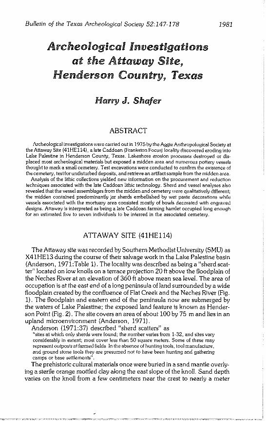
Bulletin of the Texas Archeological Society 52:147-178 1981
Harry J. Shafer
ABSTRACT
Archeological investigations were carried out in 1975 by the Aggie Anthropological Society at the Attaway Site (41HEl14), a late Caddoan (Frankston Focus) locality discovered eroding into Lake Palestine in Henderson County, Texas. Lakeshore erosion processes destroyed or dis- placed most archeological materials but exposed a midden area and numerous pottery vessels thought to mark a small cemetery. Test excavations were conducted to confirm the existence of the cemetery, test for undisturbed deposits, and retrieve an artifact sample from the midden area.
Analysis of the lithic collections yielded new information on the procurement and reduction techniques associated with the late Caddoan lithic technology. Sherd and vessel analyses also revealed that the vessel assemblages from the midden and cemetery were qualitatively different; the midden contained predominantly jar sherds embellished by wet paste decorations while vessels associated with the mortuary area consisted mostly of bowls decorated with engraved designs. Attaway is interpreted as being a late Caddoan farming hamlet occupied long enough for an estimated five to seven individuals to be interred in the associated cemetery.
ATTAWAY SITE (41HEl14)
The Attaway site was recorded by Southern Methodist University (SMU) as X41HE13 during the course of their salvage work in the Lake Palestine basin (Anderson, 1971:Table 1). The locality was described as being a "sherd scat- ter" located on low knolls on a terrace projection 20 ft above the floodplain of the Neches River at an elevation of 360 ft above mean sea level. The area of occupation is at the east end of a long peninsula of land surrounded by a wide floodplain created by the confluence of Flat Creek and the Neches River (Fig. 1). The floodplain and eastern end of the peninsula now are submerged by
the waters of Lake Palestine; the exposed land feature is known as Hender-
son Point (Fig. 2). The site covers an area of about 100 by 75 m and lies in an
upland microenvironment (Anderson, 1971).
Anderson (1971:37) described "sherd scatters" as "sites at which only sherds were found; the number varies from 1-32, and sites vary considerably in extent; most cover less than 50 square meters. Some of these may represent outposts at farmed fields. In the absence of hunting tools, tool manufacture, and ground stone tools they are presumed not to have been hunting and gathering camps or base settlements".
The prehistoric cultural materials once were buried in a sand mantle overly- ing a sterile orange mottled clay along the east slope of the knoll. Sand depth varies on the knoll from a few centimeters near the crest to nearly a meter
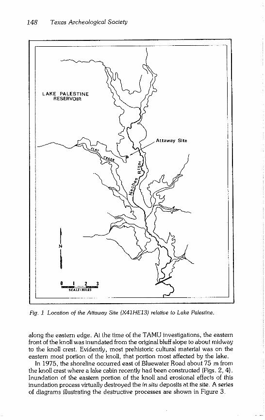
148 Texas Archeological Society
LAKE PALESTINE RESERVOIR
Site
o J 2.. 3 SCALE : MILES
Fig. 1 Location of the Attaway Site (X41HE13) relative to Lake Palestine.
along the eastern edge. At the time of the TAMU investigations, the eastern front of the knoll was inundated from the original bluff slope to about midway
to the knoll crest. Evidently, most prehistoric cultural material was on the eastern most portion of the knoll, that portion most affected by the lake.
In 1975, the shoreline occurred east of Bluewater Road about 75 m from the knoll crest where a lake cabin recently had been constructed (Figs. 2, 4). Inundation of the eastern portion of the knoll and erosional effects of this
inundation process virtually destroyed the in situ deposits at the site. A series of diagrams illustrating the destructive processes are shown in Figure 3.
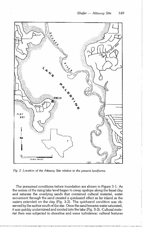
Shafer - Attaway Site 149
FLAT
BAY
<
%
Fig. 2 Location of the Attaway Site relative to the present landformso
The presumed conditions before inundation are shown in Figure 3-1. As
the waters of the rising lake level began to creep upslope along the basal clay and saturate the overlying sands that contained cultural material, water movement through the sand created a quicksand effect as far inland as the waters extended on the clay (Fig. 3-2). The quicksand condition was ob- served by the author south of the site. Once the sand became water saturated,
it was quickly undermined and eroded into the lake (Fig. 3-3). Cultural mate- rial then was subjected to shoreline and wave turbulence; cultural features
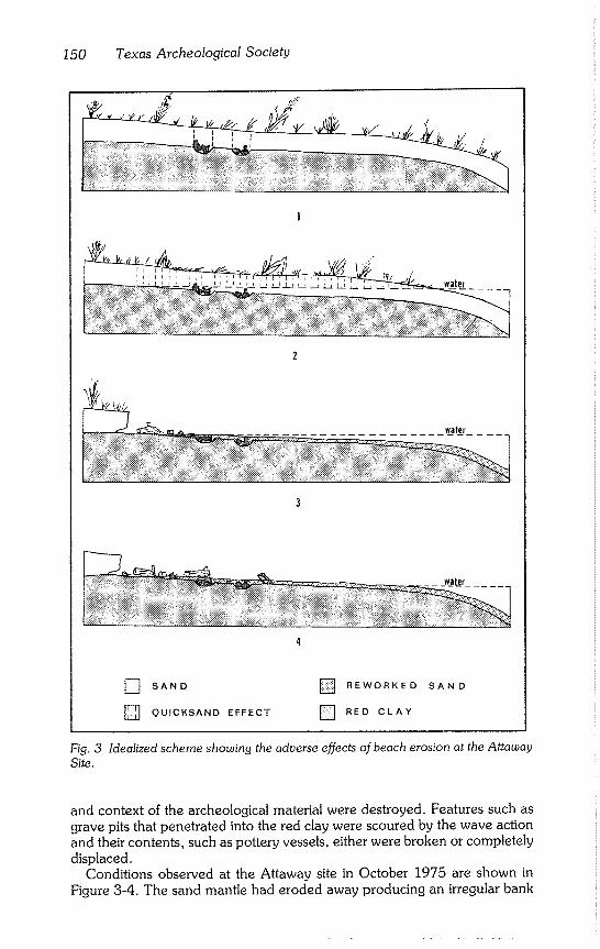
150 Texas Archeological Society
7
water
water
] SAND [] REWORKED SAND
[] QU’CKSAND EFFECT [] RED CLAY
Fig. 3 Idealized scheme showing the adverse effects of beach erosion at the Attaway
Site.
and context of the archeological material were destroyed. Features such as grave pits that penetrated into the red clay were scoured by the wave action and their contents, such as pottery vessels, either were broken or completely displaced.
Conditions observed at the Attaway site in October 1975 are shown in Figure 3-4. The sand mantle had eroded away producing an irregular bank
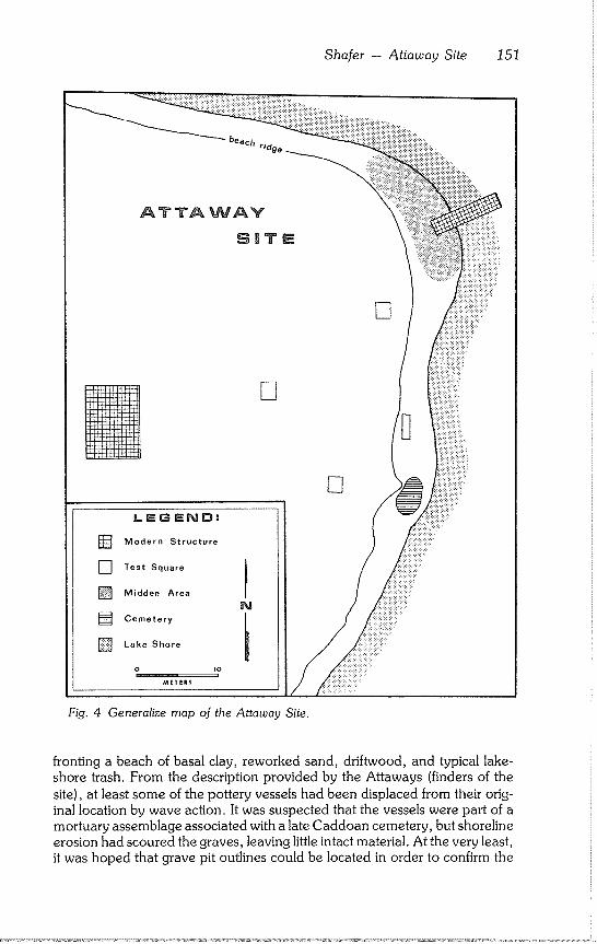
Shafer - Attaway Site 151
beach ridge
ATTAWAY
StaTE
[]
D
[] LEGEND:
] Modern Structure
[] Test Square 1
f [] Midden Area
N [] Cemetery
i
] Lake Shore
o io
METERS
Fig. 4 Generalize map of the Attaway Site.
fronting a beach of basal clay, reworked sand, driftwood, and typical lake- shore trash. From the description provided by the Attaways (finders of the
site), at least some of the pottery vessels had been displaced from their orig- inal location by wave action. It was suspected that the vessels were part of a mortuary assemblage associated with a late Caddoan cemetery, but shoreline erosion had scoured the graves, leaving little intact material. At the very least,
it was hoped that grave pit outlines could be located in order to confirm the
152 Texas Archeological Society
cemetery assumption; at the very most, it was hoped that the number of graves could be determined and other site features located.
ENVIRONMENT
A detailed description of the environment of the Lake Palestine area is in Anderson (1971:5-13) and Anderson et al. (1974:4-7). Certain general as- pects of the environment relevant to the present study are reviewed.
Lake Palestine is near the western border of a zone of mixed pine-oak forest, with predominantly sandy soils, in a region of 40-46 inches of rainfall per year. Sum- mers are warm and long, with approximately 260 frost-free days between March and November (Anderson et al., 1974:4).
Anderson et al. (1974:6) lists four major soil types within the lake area: 1) alluvial sandy Ioams of the bottoms; 2) fine brown sandy Ioams and loamy sands of the uplands; 3) red fine sandy Ioams of moderate to low fertility which occur in the eastern uplands~ and 4) infertile loamy soils on upland slopes. The soil type associated with 41HEl14 is included in category 2.
Lithic resources which were available locally include ferrugenous sand-
stone from the Neches Formation and fine grained quartzite, petrified wood, and some small chert pebbles. The materials occur in Pleistocene gravels, especially along the western border of the river bottoms (Anderson et al.,
1974:7).
ARCHEOLOGICAL BACKGROUND
Archeological History
Archeological work began in the upper Neches Valley in the 1930’s under the sponsorship of the University of Texas and the Works Progress Adminis- tration (WPA). Numerous archeological sites were investigated during this decade and quality of work varied considerably. The basic objective of these
endeavors was the acquisition of large collections of artifacts, especially pot- tery vessels. This early work resulted, however, in an awareness of regional differences in ceramic variation and mortuary practices (Jackson, 1936,
1938). Ceramic collections were used by Krieger (Suhm et al., 1954:151-227) to
define several prehistoric cultural units (termed foci) following the Midwestern Taxonomic System. The Alto, Frankston, and Allen foci incorporated the upper and middle Neches River areas. The Alto Focus was defined largely on the basis of the massive WPA excavations at the George C. Davis site in Cherokee County (Newell and Krieger, 1949~ Story, 1972~ Shafer, 1973). The Frankston and Allen foci were defined on the basis of excavation samples
from the A. C. Saunders, Omer and Otis Hood, Isabel Donnell, W. W. Ellis, J. M. Cook, Jim Allen, and Patton sites among others (Suhm et al.,
1954:184-189).
Shafer - Attaway Site 153
The first archeological survey of the upper Neches area was conducted in 1957 under the auspices of the National Park Service River Basin Surveys
(Johnson, 1961) in the Blackburn Crossing (now Lake Palestine) basin. Johnson (1961) reported 35 archeological sites, all but one of which yielded
ceramics. Preliminary ceramic classification revealed that most sites belonged to the Frankston Focus although one was defined as an Alto Focus site. Archaic sites were represented by a single example.
A more intensive archeological survey was conducted in the Lake Palestine basin by SMU in 1969 and 1970 (Anderson, 1971). A total of 98 sites were
located within the reservoir area including 85 ceramic sites. Only eight of
Johnson’s (1961) sites were rerecorded. A small number of middle Archaic sites were noted and interpreted as "intermittently used hunting sites" (An-
derson, 1971:iii). The SMU survey was structured in a problem oriented manner with the
primary aim the establishment of a settlement model for the Caddoan occu- pations that could be tested by an excavation program. Survey conditions generally were poor and the field parties had difficulty in confirming the Ioca- tion of Johnson’s (1961) sites due to heavy vegetation and time of year. Despite these shortcomings, sites were arbitrarily grouped into seven descrip- tive/functional classes: chipping scatter, hunting station, gathering station, gathering camp, sherd scatter, base camp/settlement, and base settlement.
Sites were placed into one of these categories based on field observations
regardless of the survey conditions, topographic setting and visibility, and surface exposure of the site at the time of the survey. Ethnographic sources on the Hasinai Caddo were reviewed to obtain an indication of site variability and a "settlement model" was formulated with the archeological and ethno- graphical data.
Using information derived from the 1969-70 survey, SMU selected 10 sites for partial excavation to test the settlement model. More specifically, the stated objectives for the Caddo sites were:
¯ . . to determine the settlement-types represented by excavated sites. The proce-
dure is to discriminate between alternative elements of a settlement model pro- posed from survey data and the ethnographic accounts of the Hasinai. The al- ternatives, which have been proposed on the basis of surveys, are base settlements, temporary camps and hunting stations. Their ethnographic equiva-
lents are swidden hamlets, fishing camps and hunting camps or stations (Ander-
son et al., 1974:2). The predicted Archaic settlement model was described as follows:
It was initially proposed that the Archaic occupation of the Upper Neches River
consisted of transient hunting camp sites where bifacial tools were made, with
other economic and technological activities expected at a base camp or gathering
camp being minimal. It was suggested that these camps were part of the seasonal
cycle of hunting bands whose territory extended to central Texas (Anderson et al.,
1974:183). Data from three excavated sites were used to test the Archaic model. The
findings indicated that the Archaic settlements were more intensively used than initially was anticipated. This situation implied that the patterns of activi- ties probably were more generalized rather than specialized, regimented be- haviors. Excavation results failed to confirm the predicted Caddoan settle- ment model (Anderson et al., 1974:178-188) as Caddoan sites essentially were described in the end as being "base settlements".
154 Texas Archeological Society
Prehistory
The prehistory of East Texas is divided into four periods (Story, 1981): Paleoindian (12,000 - 8000 B.P.), Archaic (8000 to 2150 B.P.), Early
Ceramic (2150 B.P. - 1250 B.P. [A.D. 700]), and Late Prehistoric (1250 B.P. - 250 B.P.; A.D. 700 - A.D. 1700). Not all periods are defined in the
upper Neches drainage, presumably due, in part, to previous research em- phasis and poor site visibility.
The earliest assemblage to be consistently represented is the Late Archaic.
Known Late Archaic sites, or sites in which the Late Archaic assemblage are well represented, include 41HE19, Mitchell (41HE18), Forest Drive
(41HE184), and Beach (41AN62)(Johnson, 1961; Anderson et al., 1974). These sites characteristically are situated on prominent knolls or ridges and
usually are in proximity to permanent streams and several different environ- mental zones. The material assemblage is dominated by lithic artifacts. The
non specialized foraging adaptation left few formal or specialized tools. Dart points signaling the use of the spear and spear thrower are the most
diagnostic artifacts. The reductive process of their manufacture produced a
series of bifacial forms and residual flake debris that dominate most Archaic assemblages. Uniface tools are not common and there is a general lack of formal tools other than projectile points. Dart point types which occur include Gary, Ellis, Kent, and Castroville like. Ferrugenous sandstone and hematite cobbles exhibiting one or more surface depressions are common at most sites,
including the Archaic locations. Story’s (1981) Early Ceramic Period has not been defined in the upper
Neches but is known to occur in the middle portion of the drainage (Shafer, 1973:27-33; Arnold, 1973; Creel, 1979:145-148). It is recognized on the basis of sandy paste pottery which usually occurs with a Late Archaic lithic
assemblage containing Gary and Kent dart points. The earlier phase of the Late Prehistoric Period is represented meagerly in
the present site inventory for the lake basin. Sites 41SM73 and 41HE81 (Mitchell) yielded ceramics recognized as Alto Focus forms and arrow point types Alba, Friley, and Steiner (Johnson, 1961; Anderson, 1971; Anderson et al., 1974), indicating some exploitation of the upper Neches area at this
time. The Alto Focus is the dominant cultural unit is the middle Neches, centering around the large mound complex settlement at George C. Davis (Newell and Krieger, 1949).
The dominant cultural assemblage in the upper Neches is the late phase of the Late Prehistoric Period, notably sites yielding ceramics diagnostic of the Frankston Focus (Suhm, et al., 1954:184-189). Diagnostic ceramics include
Poynor Engraved, Hume Engraved, LaRue Neck Banded, Maydelle Incised, Killough Pinched, Bullard Brushed, Fulton Aspect effigy bowls, and elbow
pipes. Possibly intrusive pottery includes Taylor Engraved and Ripley En- graved. These types are associated with the Titus Focus assemblage, a con- temporary cultural unit northeast of the research area.
Arrow point forms are almost exclusively Perdiz. Other artifacts common to this assemblage includes large, expertly thinned, lozenge or lenticular shaped
bifaces and celts that are typically short and thick, exhibiting unsmoothed
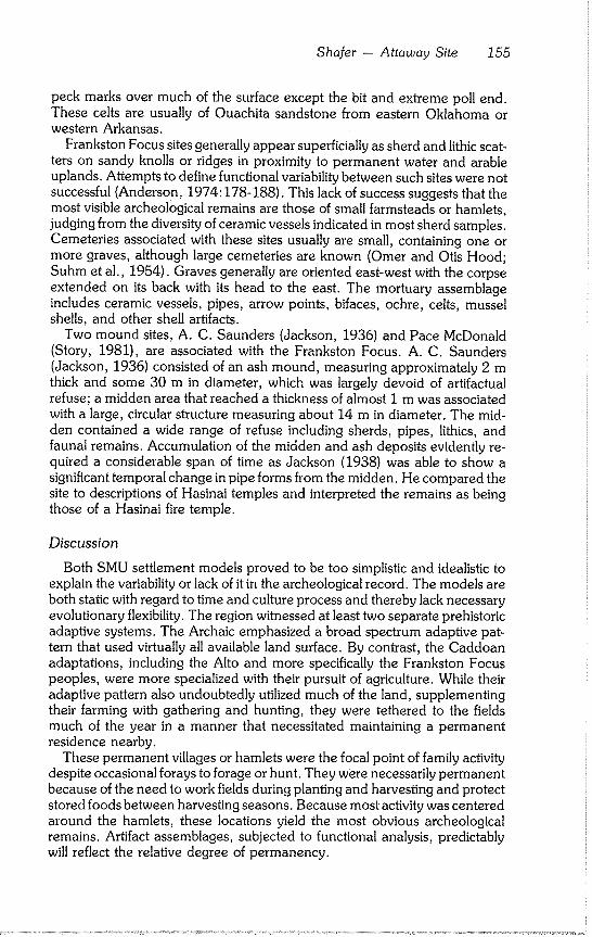
Shafer - Attaway Site 155
peck marks over much of the surface except the bit and extreme poll end. These celts are usually of Ouachita sandstone from eastern Oklahoma or western Arkansas.
Frankston Focus sites generally appear superficially as sherd and lithic scat- ters on sandy knolls or ridges in proximity to permanent water and arable uplands. Attempts to define functional variability between such sites were not successful (Anderson, 1974:178-188). This lack of success suggests that the most visible archeological remains are those of small farmsteads or hamlets, judging from the diversity of ceramic vessels indicated in most sherd samples. Cemeteries associated with these sites usually are small, containing one or more graves, although large cemeteries are known (Omer and Otis Hood; Suhm et al., 1954). Graves generally are oriented east-west with the corpse extended on its back with its head to the east. The mortuary assemblage includes ceramic vessels, pipes, arrow points, bifaces, ochre, celts, mussel shells, and other shell artifacts.
Two mound sites, A. C. Saunders (Jackson, 1936) and Pace McDonald (Story, 1981), are associated with the Frankston Focus. A. C. Saunders (Jackson, 1936) consisted of an ash mound, measuring approximately 2 m thick and some 30 m in diameter, which was largely devoid of artifactual refuse; a midden area that reached a thickness of almost I m was associated with a large, circular structure measuring about 14 m in diameter. The mid- den contained a wide range of refuse including sherds, pipes, lithics, and faunal remains. Accumulation of the midden and ash deposits evidently re- quired a considerable span of time as Jackson (1938) was able to show a significant temporal change in pipe forms from the midden. He compared the site to descriptions of Hasinai temples and interpreted the remains as being those of a Hasinai fire temple.
Discussion
Both SMU settlement models proved to be too simplistic and idealistic to explain the variability or lack of it in the archeological record. The models are both static with regard to time and culture process and thereby lack necessary evolutionary flexibility. The region witnessed at least two separate prehistoric adaptive systems. The Archaic emphasized a broad spectrum adaptive pat- tern that used virtually all available land surface. By contrast, the Caddoan adaptations, including the Alto and more specifically the Frankston Focus peoples, were more specialized with their pursuit of agriculture. While their adaptive pattern also undoubtedly utilized much of the land, supplementing their farming with gathering and hunting, they were tethered to the fields much of the year in a manner that necessitated maintaining a permanent residence nearby.
These permanent villages or hamlets were the focal point of family activity despite occasional forays to forage or hunt. They were necessarily permanent because of the need to work fields during planting and harvesting and protect stored foods between harvesting seasons. Because most activity was centered around the hamlets, these locations yield the most obvious archeological remains. Artifact assemblages, subjected to functional analysis, predictably will reflect the relative degree of permanency.
156 Texas Archeological Society
Agricultural activity was largely a community enterprise. However, early chroniclers were not specific as to land clearing methods or how many years it
took to exhaust a particular field. Although described as swidden or slash- and-burn agriculture (Anderson et al., 1974:1), actual farming methods largely are unknown. Presumably, settlements frequently were moved as
needed to open new fields, replacing old, exhausted ones. Former fields may have later become settlements; former Archaic encampments may have be- come fields or locations for hamlets; locations of former hamlets may have
been choice locations for later fields. Critical resource localities such as those used for the procurement of nuts, fish, lithics, etc. likely would have been used by both adaptive systems.
Land use practices of the two systems, while qualitatively different, predict- ably would overlap to some degree given the 6,000-7,000 years of prehis- toric activity; favored localities critical to settlement trends of both systems would be the most visible archeologically. These sites also would show a mixing of assemblages. Special activity locations such as a traditional stopping
place for a passing group of hunters, or where a family group might choose to fish at a favored spot, would likely either be masked by activities of previous or subsequent groups or be beneath the level of archeological visibility, espe- cially surface surveys.
Findings from the previous archeological survey and excavations indicate that the most frequently encountered sites in the area are Frankston Focus hamlets. The suggested explanation for their high frequency is due to their being hamlets which were occupied only long enough to exhaust sufficiently the fields located in the proximity. The population density, while several times that of the Archaic Period, probably was never very high. Due to the frequent shifting of the settlements during the 300-400 years spanned by the Frank- ston Focus, a large number of settlement sites resulted from this pattern. More permanent and specialized community integrating sites such as the A. C. Saunders (Jackson, 1936) and Pace McDonald (Story, 1981) mound com- plexes served to maintain a quasistratified social structure. These sites most likely represent temple precincts that served a catchment of hamlets in the proximity.
The relative duration of the hamlets can be measured by the number of
graves in the cemeteries and relative temporal placement of each hamlet can
be determined by seriating mortuary assemblages. Given the prehistoric land use practices and transformation processes operating on the East Texas cultural resources, short term foraging of hunting locales predictably would lie beneath the level of archeological visibility. Nevertheless, models for late
Caddoan settlement, subsistence, and procurement behaviors can be formu- lated and tested with a rigidly designed and realistic sampling program com- bined with analytical techniques aimed at delineating the functional realms of the surviving material culture elements.
Sharer - Attaway Site 157
RESEARCH OBJECTIVES
Despite the extensively displaced condition of the archeological materials observed during the first inspection, additional investigations were war- ranted. Field investigations were aimed toward achieving several objectives: 1) test the area where the Attaways had recovered the pottery vessels to determine if additional, intact materials were present and if grave outlines could be detected in the underlying clay; 2) test the intact portion of the knoll between the beach and crest in an attempt to locate undisturbed midden deposits; and 3) make an extensive surface collection along the beach in order to retrieve a representative sample of ceramics and lithics.
These objectives were fulfilled. Although the site was found to be almost completely destroyed by wave action and inundation, data were recovered that allowed for a confident assessment of the site with regard to its cultural identity and function. Furthermore, new information on mortuary behavior and ceramic vessel function for the Frankston Focus was gained.
Description of Work
Three 2 m test pits were placed selectively between the crest of the knoll and the present bluff line to search for in situ midden materials (Fig. 4). These test pits were excavated in 15 cm arbitrary levels; the bottom of each level was troweled and examined for cultural features. Sterile clay was encountered between 30 and 45 cm in each of the test pits and only a trace of cultural material was observed.
A concentration of sherds and flakes interpreted as a midden area was observed along the shoreline 30 m north of the area where the Attaway find was made. Both surface and screened samples were made to recover a repre- sentative collection. The sampling involved screening heavy fraction beach erosion debris using I/4 in hardware cloth to recover smaller lithic items. Ex- cavation units were not established since the materials were not in situ.
Cemetery Area
The area designated by the Attaway find was assumed to be a cemetery area since complete ceramic vessels typically mark such situations in the late prehistoric Caddoan sites (Johnson, 1961). The near absence of midden refuse except for an occasional sherd or flake along the shore would argue for a specifically designated mortuary area removed from village activity. Test pits were placed to examine for traces of burial pit outlines which may have penetrated the erosion resistant basal clay formation.
Excavation in the cemetery area consisted of establishing several arbitrarily sized units, 1 x 2 or I x 1 m, in an area adjacent to the Attaway finds. These test units, labelled A - G, were excavated in one level, usually about 10 cm in depth, removing the redeposited beach sand down to sterile clay. Two distur- bances, designated as Features I and 2, were recorded, which confirmed the existence of burial pits. A general plan of this excavation is shown in Figures 4 and 5.
158 Texas Archeological Society
FEATURE 1
This feature consisted of a slight pit disturbance, interpreted as being a burial pit remnant, that extended approximately 10 cm into the basal clay. The feature was located across the southern end of Unit C and extended slightly into adjoining units E, F, and G (Fig. 5). The pit contained the follow- ing items tightly clustered together: four Fulton Aspect effigy vessels, one large carinated Poynor Engraved bowl, one Iongneck Poynor engraved bottle (Fig. 10), one flare rim elbow pipe (Fig. 9E), and a cluster of nine Perdiz arrow points (Fig. 7).
The arrow points were tightly grouped and pointing approximately west. The north edge of the pit disturbance also suggested a general east-west orientation for the grave. If the arrow points were part of a quiver and the arrow shafts were parallel to the long axis of the grave, then their placement would correlate with the grave orientation.
The mortuary assemblage also may provide some indication of the individual’s status in life. The function and symbolism of the four effigy ves- sels, carinated bowl, and bottle are unknown; but the pipe and arrow points may signify that the individual was a male.
FEATURE 2
A remnant of another burial pit was located in Unit D (Fig. 5). A small, crudely executed Poynor Engraved bowl was the only surviving artifact.
ARTIFACT ASSEMBLAGE
The intrasite context for most of the artifactual material generally is poor, having been displaced by erosion and recovered from the beach area. How- ever, the assemblage is revealing and provides data on late Caddoan behav- ioral patterns. Brief descriptions of the artifacts are presented; taxonomic designations follow those of Suhm et al. (1954) and Suhm and Jelks (1962).
If data on the original vertical position of the artifacts were available, tem- poral changes might be observable in the lithic and ceramic samples. Such data are largely missing due to both natural and recently man made (i.e., rising waters of Lake Palestine) transformations of the archeological situation. General horizontal information was maintained, however, by sorting the arti-
facts by their respective provenience lots. These lots included Test Pits and Trench A (grouped together), Mortuary Area, and Midden Area. Sorting on this basis served to demonstrate quantitative and qualitative differences be- tween the midden and mortuary areas.
Lithic Artifacts
The lithic collection contains a small sample of bifacial artifacts (mostly
stemmed projectile points), two pitted stones, and a moderate sampling of flaking debitage. Examples of lithic artifacts are illustrated to scale in figures 6
and 7; general horizontal provenience is provided in Table 1.
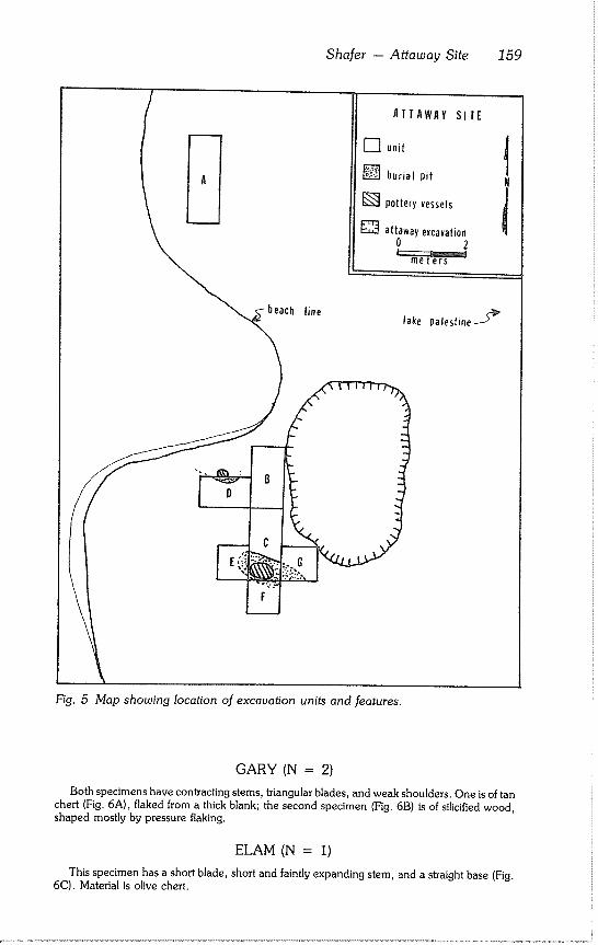
Shafer -- Attaway Site 159
ATTAWAY SITE
[] unit t [] burial pit N
[] pottery vessels
[] attaway excavation 0 2
met~
Fig. 5 Map showing location of excavation units and features.
GARY (N = 2) Both specimens have contracting stems, triangular blades, and weak shoulders. One is of tan
chert (Fig. 6A), flaked from a thick blank; the second specimen (Fig. 6B) is of silicified wood, shaped mostly by pressure flaking.
ELAM (N = 1)
This specimen has a short blade, short and faintly expanding stem, and a straight base (Fig.
6C). Material is olive chert.
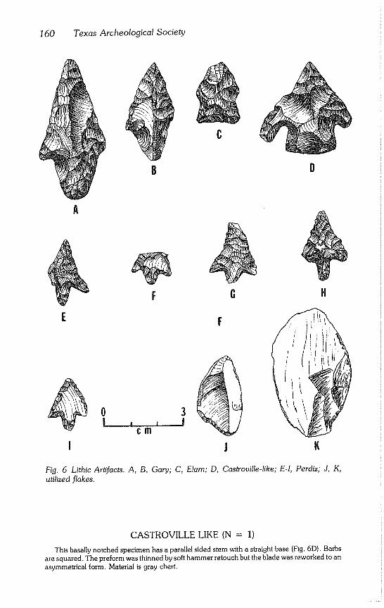
160 Texas Archeological Society
C
D
A
i
0 i
J
H
Fig. 6 Lithic Artifacts. A, B. Gary; C, Elarn; D, Castroville-like; E-I, Perdiz; J, K,
utilized flakes.
CASTROVILLE LIKE (N = 1)
This basally notched specimen has a parallel sided stem with a straight base (Fig. 6D). Barbs are squared. The preform was thinned by soft hammer retouch but the blade was reworked to an asymmetrical form. Material is gray chert.
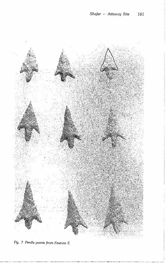
Shafer -- Attaway Site 161
Fig. 7 Perdiz points from Feature 2.
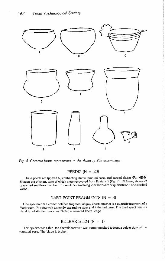
162 Texas Archeological Society
B
F
!
Fig. 8 Ceramic forms represented in the Attaway Site assemblage.
PERDIZ (N = 20)
These points are typified by contracting stems, pointed base, and barbed blades (Fig. 6E-I). Sixteen are of chert, nine of which were recovered from Feature 1 (Fig. 7). Of these, six are of gray chert and three tan chert. Three of the remaining specimens are of quartzite and one silicified wood.
DART POINT FRAGMENTS (N = 3)
One specimen is a corner notched fragment of gray chert; another is a quartzite fragment of a Yarbrough (?) point with a slightly expanding stem and indented base. The third specimen is a distal tip of silicified wood exhibiting a serrated lateral edge.
BULBAR STEM (N = 1)
This specimen is a thin, tan chert flake which was corner notched to form a bulbar stem with a rounded base. The blade is broken.
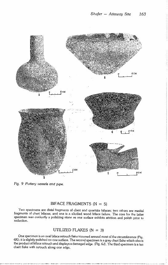
Shafer - Attaway Site 163
Fig. 9 Pottery vessels and pzpe.
~CM ,,i
BIFACE FRAGMENTS (N = 5)
Two specimens are distal fragments of chert and quartzite bifaces; two others are medial fragments of chert bifaces; and one is a silicified wood biface failure. The core for the latter specimen was evidently a polishing stone as one surface exhibits at~ition and polish prior to reduction.
UTILIZED FLAKES (N = 3)
One specimen is an oval biface retouch flake trimmed around most of the circumference (Fig. 6K) ; it is slightly polished on one surface. The second specimen is a gray chert flake which also is the product of biface retouch and displays a damaged edge. (Fig. 6J). The third specimen is a tan chert flake with retouch along one edge.
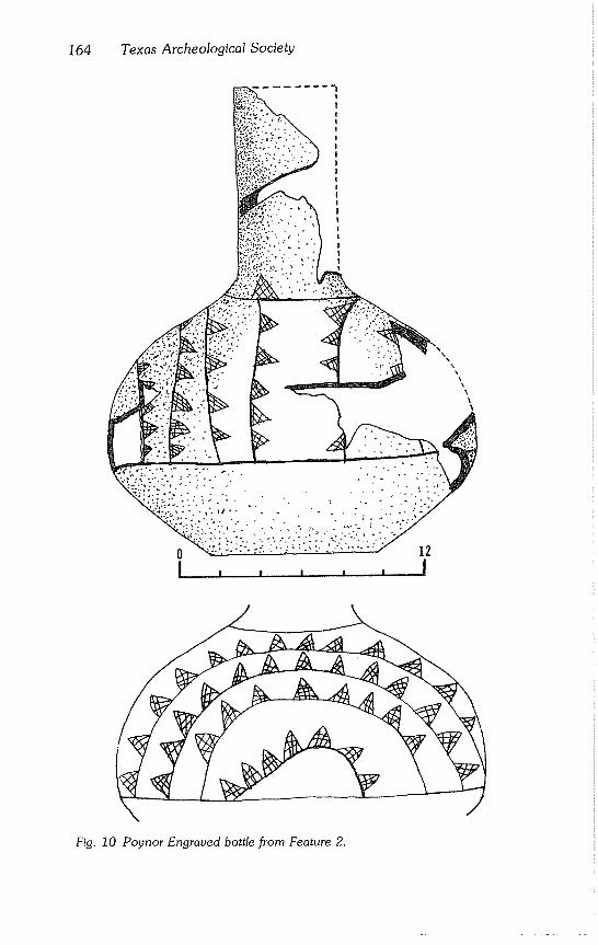
164 Texas Archeological Society
! !
!
!
!
i
\ \
\ \
Fig. 10 Poynor Engraved bottle from Feature 2.
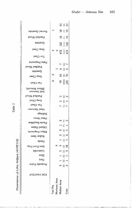
Shafer - Attaway Site 165
.o
"s" 0o
e-
g o
~aaqD uej.
siuam~md a~leld
poo/~ pa!j!alad
a~!z~a~n0
~aaqo ~mO
1aaqD ue±
(qano~ai~I aa~!~) :aatutu~H ~JoS
poo!y~ pa!t!alad
~aaqo ~mO
l~aqD UKL
:aatutu~H pa~H
alS~l!qa(l
auols pal~!d
saatl!nbs~t saaa!d
Sa~l~Inl paz!l.qfl
s:~uatug~ad aaeJ!~l
tuais a~qln~l
z!paad
¯ 8m:-I lu!od la~(l
all!aO~S~D
tu~IR
fiae9
s~u!od algaaOad
d~±SVd 80d
~11~
’~ ~11~
~ttm
ol ~,1
p~ p~
~11~
~ll~
~11~
~11~
¯ ~ll~
¯ ~11~
~11~
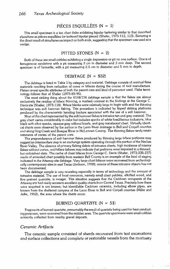
166 Texas Archeological Society
PII~CES ESQUILLI~ES (N = 1)
This small specimen is a tan chert flake exhibiting bipolar battering similar to that described elsewhere as pi~ces esquill~es (or battered bipolar pieces) (Shafer, 1973:112, 113). Battering is the direct result of simultaneous impact on both ends, suggesting that the specimen was used as a wedge.
PITTED STONES (N = 2)
Both of these are small cobbles exhibiting a single depression or pit on one surface. One is of ferrugenous sandstone with a pit measuring 3 cm in diameter and 5 mm deep. The second specimen is of hematite, with a pit measuring 2.5 cm in diameter and 5 mm in depth.
DEBITAGE (N = 832)
The debitage is listed in Table I by category and material. Debitage consists of residual flake materials resulting from reduction of cores or bifaces during the course of tool manufacture. Flakes reveal specific atlxibutes of both the parent core and kind of percussor used. Flake termi- nology follows that of Shafer (1973:83-95).
The most striking thing about the 41HEl14 debitage sample is that the flakes are almost exclusively the residue of biface thinning, a marked contrast to the findings at the George C. Davis site (Shafer; 1973:118). Biface blanks were relatively large to begin with and the thinning technique was soft hammer flaking. This procedure is indicated by lipped striking platforms produced by the characteristic bending fracture associated with the use of a soft hammer.
Most of the chert represented by the soft hammer flakes is intrusive tan and gray material. The gray chert varies considerably in color but includes specks of white fossiliferous inclusions, blue black with olive specks, opaque gray without fossils, and gray translucent chert. Virtually identi- cal cherts were observed by the author in the Leon River drainage in Bell and Coryell counties and along Hog Creek and Bosque River in McLennen County. The thinning flakes rarely retain remnants of cortex of the parent core.
The preponderance of soft hammer flakes produced by thinning large biface preforms may suggest an intermediate step in an exchange system operating through this portion of the Neches River Valley. The absence of primary flaking debris of intrusive cherts, high incidence of interior flakes without cortex, and biface failures may indicate that preforms were imported in a thinned, but unfinished state. The cache of chert bifaces from George C. Davis (Shafer, 1973:235-237) made of annealed chert possibly from western Bell County is an example of the kind of staging indicated in the Attaway site debitage. Very large chert bifaces were recovered from archeologi- cally contemporary sites in east Texas (Jackson, 1938); source of these intrusive objects has not been documented.
The debitage sample is very revealing especially in terms of technology and the amount of intrusive material. The use of local resources, namely small chert pebbles, silicified wood, and fine grained quartzite, is meager. This situation suggests that the Caddoan occupants of the Attaway site had ready access to excellent quality cherts from Central Texas. Precisely how these were acquired is not known; but identifiable Caddoan ceramics, including elbow pipes, are known from the sheltered canyons of the Leon River in Bell and Coryell counties (Miller and Jelks, 1952), the area where the cherts occur.
BURNED QUARTZITE (N = 51)
Fragments of burned quartzite, presumably the result of quartzite being used for heat conduct- ing purposes, were recovered from the midden area. The quartzite specimens were small cobbles evidently collected from nearby gravel deposits.
Ceramic ArtT"facts
The ceramic sample consisted of sherds recovered from test excavations and surface collections and complete or restorable vessels from the mortuary
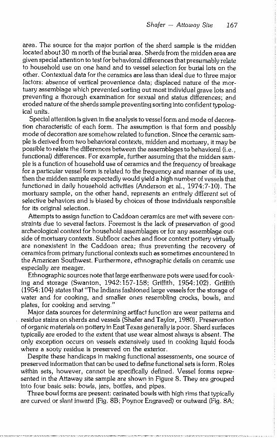
Sharer -- Attaway Site 167
area. The source for the major portion of the sherd sample is the midden located about 30 m north of the burial area. Sherds from the midden area are given special attention to test for behavioral differences that presumably relate to household use on one hand and to vessel selection for burial lots on the other. Contextual data for the ceramics are less than ideal due to three major factors: absence of vertical provenience data; displaced nature of the mor- tuary assemblage which prevented sorting out most individual grave lots and preventing a thorough examination for sexual and status differences; and eroded nature of the sherds sample preventing sorting into confident typolog- ical units.
Special attention is given in the analysis to vessel form and mode of decora- tion characteristic of each form. The assumption is that form and possibly mode of decoration are somehow related to function. Since the ceramic sam- ple is derived from two behavioral contexts, midden and mortuary, it may be possible to relate the differences between the assemblages to behavioral (i.e., functional) differences. For example, further assuming that the midden sam- ple is a function of household use of ceramics and the frequency of breakage for a particular vessel form is related to the frequency and manner of its use, then the midden sample expectedly would yield a high number of vessels that functioned in daily household activities (Anderson et al., 1974:7-10). The mortuary sample, on the other hand, represents an entirely different set of selective behaviors and is biased by choices of those individuals responsible for its original selection.
Attempts to assign function to Caddoan ceramics are met with severe con- straints due to several factors. Foremost is the lack of preservation of good archeological context for household assemblages or for any assemblage out- side of mortuary contexts. Subfloor caches and floor context pottery virtually are nonexistent in the Caddoan area; thus preventing the recovery of ceramics from primary functional contexts such as sometimes encountered in the American Southwest. Furthermore, ethnographic details on ceramic use especially are meager.
Ethnographic sources note that large earthenware pots were used for cook- ing and storage (Swanton, 1942:157-158~ Griffith, 1954:102). Griffith (1954:104) states that "The Indians fashioned large vessels for the storage of water and for cooking, and smaller ones resembling crocks, bowls, and plates, for cooking and serving."
Major data sources for determining artifact function are wear patterns and residue stains on sherds and vessels (Shafer and Taylor, 1980). Preservation of organic materials on pottery in East Texas generally is poor. Sherd surfaces typically are eroded to the extent that use wear almost always is absent. The only exception occurs on vessels extensively used in cooking liquid foods where a sooty residue is preserved on the exterior.
Despite these handicaps in making functional assessments, one source of preserved information that can be used to define functional sets is form. Roles within sets, however, cannot be specifically defined. Vessel forms repre- sented in the Attaway site sample are shown in Figure 8. They are grouped into four basic sets: bowls, jars, bottles, and pipes.
Three bowl forms are present: carinated bowls with high rims that typically are curved or slant inward (Fig. 8B~ Poynor Engraved) or outward (Fig. 8A;
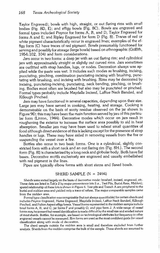
168 Texas Archeological Society
Taylor Engraved); bowls with high, straight, or out flaring rims with small bodies (Fig. 8D, E); and effigy bowls (Fig. 8C). Bowls are engraved and formal types included Poynor for forms A, B, and D; Taylor Engraved for
forms A and E; and Ripley Engraved for form D (Fig. 8). Traces of red or white pigment characteristically occur in engraved lines; examples of the ef- figy form (C) have traces of red pigment. Bowls presumably functioned for serving and possibly for storage (large bowls) based on ethnographic (Griffith,
1954:102, 104) and form considerations. Jars occur in two forms: a deep jar with an out flaring rim; and cylindrical
jars with approximately straight or slightly out curved rims. Jars sometimes are outfitted with strap handles, lugs, or nodes. Decoration always was ap- plied while the paste was wet. It includes such modes as brushing, incising, punctating, pinching, combination punctating-incising with brushing, punc- tating with brushing, and incising with brushing. Rims may be decorated by incising, punctating-incising, punctating, neck banding, pinching, or brush- ing. Bodies most often are brushed but also may be punctated or pinched. Formal types probably include Maydelle Incised, LaRue Neck Banded, and Killough Pinched.
Jars may have functioned in several capacities, depending upon their size. Large jars may have served in cooking, heating, and storage. Cooking is demonstrable on the basis of sooty residue observed on the jar shown in Figure 9D; this may have been the main function served by jars of this particu- lar form (Linton, 1944). Decorative modes which occur on jars result in
roughening the exterior to increase the surface area possibly to aid in heat absorption. Smaller jars may have been used to reheat small quantities of food although direct evidence of this is lacking except for the presence of strap handles or lugs. These may have aided in removing vessels from the fire or suspending the vessel over a fire.
Bottles also occur in two basic forms. One is a cylindrical, slightly con- stricted form with a short neck and an out flaring rim (Fig. 8H.). The second
form (Fig. 81) is characterized by a long neck and globular body. Both have flat bases. Decorative motifs exclusively are engraved and usually embellished with red pigment in the lines.
Pipes are typically elbow forms with short stems and flared bowls.
SHERD SAMPLE (N = 2494)
Sherds were sorted largely on the basis of decorative mode: brushed, incised, engraved, etc~ These data are listed in Table 2 by major provenience lots (i.e., Test Pits, Burial Area, Midden); spatial relationship of these lots is shown in Figure 4. Test pits and Trench A are peripheral to the burial and midden area and yielded only a trace of refuse. The major comparable samples came from the midden area.
Formal type classification was recognizable (but not always quantifiable) for certain sherds and includes Poynor Engraved, Hume Engraved, Maydelle Incised, LaRue Neck Banded, Killough Pinched, and Fulton Aspect effigy bowls~ Vessel forms represented in the midden sample include bowl forms A, B, and C; jar forms F and possibly G~ and pipe form J. A wide range of vessel forms may be present but vessel identification is made difficult by the small size and eroded nature of most sherds. Bottles, for example, are based on technological attributes but frequency to other engraved vessels cannot be measured. Rim forms are used as the most confident guide for vessel classification along with mode of decoration.
The sherd sample outside the midden area is small and therefore excluded from further analysis. Sherds from the midden comprise the bulk of the sample. These sherds are assumed to
Shafer - Attaway Site 169
¢xa
uapp!Ki
ea~v 6~en]JolAl
S]!d ]saL
09
"a-
£
~Eo
~.~ ~ ~.~ =_ ~ ~u3
CO
o f--
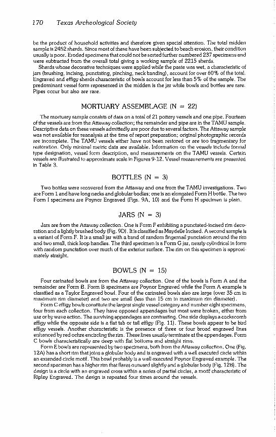
1 70 Texas Archeological Society
be the product of household activities and therefore given special attention. The total midden sample is 2452 sherds. Since most of these have been subjected to beach erosion, their condition usually is poor. Eroded specimens that could not be sorted further numbered 237 specimens and were subtracted from the overall total giving a working sample of 2215 sherds.
Sherds whose decorative techniques were applied while the paste was wet, a characteristic of jars (brushing, incising, punctating, pinching, neck banding), account for over 60% of the total. Engraved and effigy sherds characteristic of bowls account for less than 5% of the sample. The predominant vessel form represented in the midden is the jar while bowls and bottles are rare. Pipes occur but also are rare.
MORTUARY ASSEMBLAGE (N = 22)
The mortuary sample consists of data on a total of 21 pottery vessels and one pipe. Fourteen of the vessels are from the Attaway collection; the remainder and pipe are in the TAMU sample. Descriptive data on these vessels admittedly are poor due to several factors. The Attaway sample was not available for reanalysis at the time of report preparation; original photographic records are incomplete. The TAMU vessels either have not been restored or are too fragmentary for restoration. Only minimal metric data are available. Information on the vessels include formal type designation, vessel form description, and measurements on the TAMU vessels. Certain vessels are illustrated to approximate scale in Figures 9-12. Vessel measurements are presented in Table 3.
BOTTLES (N = 3)
Two bottles were recovered from the Attaway and one from the TAMU investigations. Two are Form I and have long necks and globular bodies; one is an elongated Form H bottle. The two Form I specimens are Poynor Engraved (Figs. 9A, 10) and the Form H specimen is plain.
JARS (N = 3)
Jars are from the Attaway collection. One is Form F exhibiting a punctated-incised rim deco- ration and a lightly brushed body (Fig. 9D). It is classified as Maydelle Incised. A second sample is a variant of Form F. It is a small jar with a band of random fingernail punctation around the rim and two small, thick loop handles. The third specimen is a Form G jar, nearly cylindrical in form with random punctation over much of the exterior surface. The rim on this specimen is approxi- mately straight.
BOWLS (N = 15)
Four carinated bowls are from the Attaway collection. One of the bowls is Form A and the remainder are Form B. Form B specimens are Poynor Engraved while the Form A example is classified as a Taylor Engraved bowl. Four of the carinated bowls also are large (over 35 cm in maximum rim diameter) and two are small (less than 15 cm in maximum rim diameter).
Form C effigy bowls constitute the largest single vessel category and number eight specimens, four from each collection. They have opposed appendages but most were broken, either from use or by wave action. The surviving appendages are contrasting. One side displays a cockscomb effigy while the opposite side is a fiat tab or tail effigy (Fig. 11). These bowls appear to be bird effigy vessels. Another characteristic is the presence of three or four broad engraved lines enhanced by red ochre encircling the rim. These lines usually terminate at the appendages. Form C bowls characteristically are deep with fiat bottoms and straight rims.
Form E bowls are represented by two specimens, both from the Attaway collection. One (Fig. 12A) has a short rim that joins a globular body and is engraved with a well executed circle within an extended circle motif. This bowl probably is a well executed Poynor Engraved example. The second specimen has a higher rim that flares outward slightly and a globular body (Fig, 12B). The design is a circle with an engraved cross within a series of partial circles, a motif characteristic of Ripley Engraved. The design is repeated four times around the vessels.
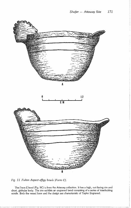
Sharer - Attaway Site 171
Fig. 11 Fulton Aspect effigy bowls (Form C).
The Form E bowl (Fig. 9C) is from the Attaway collection. It has a high, out flaring rim and short, globular body. The rim exhibits an engraved band consisting of a series of interlocking scrolls. Both the vessel form and the design are characteristic of Taylor Engraved.
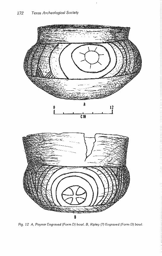
172 Texas Archeological Society
0 l
8
Fig. 12 A, Poynor Engraved (Form D) bowl. B, Ripley (?) Engraved (Form D) bowl.
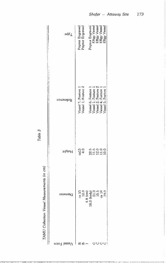
Shafer - Attaway Site 173
o~
ad/~I
aaua~a~aEl
~tl[~!aH
~a}auu~!G
oo o
>> >>>>>
~0 ~000
o~o~o ~.~
uu~o~lassaA mm~ oooo
174 Texas Archeological Society
PIPE (N = 1)
The pipe (Fig. 9E) is an elbow form with a flared bowl. The base or heel of the pipe is sharply angled in profile and rounded when viewed from above. It is decorated with five rows of tiny punctations extending from the midline of the bowl around the end of the opposite side. Three raised bands of punctations form the collar for the stem. Jackson (1936:168) notes that pipes of this form are late in the midden at the A.C. Saunders site, which seems to be an exclusively Frankston Focus deposit. Assuming that Jackson’s (1936) chronological trend is correct, the pipe may signal a late Frankston Focus placement for the site.
SUMMARY
Archeological investigations at the Attaway site revealed the presence of a badly disturbed late Caddoan settlement which yielded ceramics and other artifacts diagnostic of a Frankston Focus assemblage (Suhm et al., 1954:184- 189). The site was first recorded during the course of a SMU survey of the Lake Palestine basin and was defined as a sherd scatter. This assessment was based on only a brief surface inspection of the locality and not confirmed by subsurface investigations. The TAMU investigation revealed two spatially and functionally separate activity areas within the site (midden area and cemetery area), each exposed by beach erosion. Test excavations confirmed the exist- ence of burial pits in the cemetery area but failed to locate undisturbed midden deposits.
Artifact assemblage includes both lithic and ceramic specimens. The lithic sample consists mostly of debitage produced by retouching large biface pre- forms of imported chert. It is suggested that this hamlet also participated in an exchange system that involved, among other things, acquiring biface pre- forms from Central Texas and reducing and trading them to other villages that had little or lacked access to Central Texas cherts. Certain residual flakes subsequently were utilized either as tools or were fashioned into stemmed arrow points. Several dart point specimens were found in the lithic sample from the midden area. These may represent either a thin Archaic scatter on the knoll or items collected by the late Caddoan peoples for raw material. Evidence of an extensive Archaic occupation at the site is lacking.
Ceramics were recovered from both the eroded midden area and the cem- etery. The ceramic analysis was directed at determining functionally separate areas within the site that could provide information on the more general nature of the site itself. Sherd analysis from the midden indicated that most vessels were jars decorated by wet paste techniques (e.g., brushing, incising, punctating, neck banding, pinching, etc.). Bowls and bottle sherds were un- common. Formal types represented in the midden included Maydelle In- cised, Bullard Brushed, Killough Pinched, Poynor Engraved, LaRue Neck Banded, and Fulton Aspect effigy bowls.
Twenty one vessels were recovered from the cemetery area as a result of the investigations by both the Attaways and TAMU. Bowls represent the predominant form and Fulton Aspect effigy bowls notably were common (8 of 21 vessels). Four bowls were recovered from Feature 1, a burial pit. Three jars were recovered from the cemetery. Pottery types in the mortuary as-
Sharer - Attaway Site 175
semblage included Poynor Engraved, Taylor Engraved, Ripley Engraved, Fulton Aspect effigy vessels, and Maydelle Incised.
It was not possible to determine precisely how many individual graves were once present in the cemetery. The TAMU investigations located the remains of two burial pits and the Attaways located what they described as "three clusters of vessels." These clusters may represent individual grave lots. If so, at least five graves may have been present in the cemetery, doubtfully more than seven judging from the small size.
The two ceramic lots were contemporaneous. Differences in forms repre- sented in the two areas are attributed to differences in the related behaviors that produced the respective ceramic samples. The high percentage of jars in the midden compared to the low percentage of engraved bowls or bottles is attributed to the frequency and nature of jar uses in the everyday life of these late Caddoan peoples. Bowls and bottles probably were represented equally in a household assemblage at any one point in time but jar use was such that these vessels were more likely to be broken. Lack of preservation of Caddoan house floors and associated artifact assemblages negates the opportunity of constructing a comparable household assemblage of vessels from archeologi- cal data that might be represented in a house at any one time.
The mortuary sample, by contrast, represents a much more biased sample with regard to Caddoan behavior as each vessel was specifically selected for use as burial furniture. Some may have been containers but others, such as two effigy vessels from Feature 1, seemingly were placed one in the other. Why certain vessels were selected for burial inclusion will never be known; but a factor analysis of mortuary assemblages in the Frankston and Titus foci areas might reveal a common sequence of vessel selection. It may be that the mortuary assemblages were intended to mirror a mini-household assemblage envisioned to take care of the needs of that specific individual.
Sexual status also may be a factor in vessel selection. It seems to have at least partly determined the assemblage of nonceramic artifacts such as pipes, arrow point clusters, and celts, all of which presumably denote male status. The function of certain pottery vessels such as the effigy bowls is unknown. Anderson et al. (1974:Figure 10) suggested that these vessels were incense burners but evidence to support this function is lacking. The characteristic deep form and straight rim with opposed appendages should perhaps be viewed as being something other than merely aesthetic ornaments.
Dating the remains at the Attaway site within the temporal span of the Frankston Focus is tenuous at best. Chronometric dating techniques have not been applied to Frankson Focus material, further complicating the dating. A review of the dates for the various Caddoan ceramic assemblages to better assess the temporal placement for the Frankston Focus is beyond the scope of this study. Ninety seven radiocarbon dates were reported from George C. Davis, an early Caddoan site (Story and Valestro, 1977; Creel, 1979). Statis- tical analysis of these data allowed Story and Valestro (1977) to date confi- dently the Davis site Caddoan occupation from A.D. 780 - A.D. 1260.
The origin of the Frankston Focus population is unknown. Evolution from the Alto Focus populations at the Davis site (Story 1972, 1981) is not demon- strable. The earliest Caddoan settlements in the upper Neches are few and
176 Texas Archeological Society
seem to correlate with the Davis site occupation with regard to similarities in ceramics. Story (1981) argues that the Davis site settlement was established
by agricultural peoples moving westward from the Red River Valley. It is possible that the Frankston Focus peoples followed the same course or perhaps were from the Sabine Valley. Some time overlap cannot be ruled
out. However, since Alto ceramics are absent from Frankston Focus sites, it is assumed that the latter settlements are temporally separate. Furthermore, the Frankston Focus settlements probably date after A.D. 1300, possibly after
A.D. 1400. By seriating ceramic attributes from specimens obtained from pure and
mixed Frankston and Allen foci sites, Shafer (1968) was able to demonstrate a general evolution from one assemblage to the other. Allen Focus sites are associated with European trade materials and therefore are assumed to date sometime after A.D. 1650. Given these minimum and maximum age ranges,
it is possible to tentatively place the Frankston Focus in the time between A.D. 1300 and A.D. 1650.
Eventually, it may be possible to identify temporal variability within the
Frankston Focus with more detailed attribute studies on ceramics available from mortuary and midden samples. An attribute study conducted in 1968 (Shafer, 1968) was on mortuary vessels from five sites in the upper Neches Valley: Omer and Otis Hood, J. M. Cook, Freeman, Jim Allen, and Patton. Results of this analysis allowed a temporal seriation of the five sites.
Attempts were made to compare the ceramic attributes from the Attaway site with those in Shafer (1968). Attaway ceramic attributes more closely compare to those of the Omer and Otis Hood site which was the earliest of the
five in the study sample. This information does not provide any indication of the relative age of the Attaway site, but only that of the five sites, the ceramics compare closer as an assemblage to the Hood site. Sites used in the 1968 study lie south of the Lake Palestine basin. The northern location of the Attaway site may help to explain the occurrence of presumably intrusive ceramics from assemblages (Titus Focus) located along Cypress Creek
(Suhm et al, 1954:189-190).
CONCLUDING STATEMENT
Archeological remains at the Attaway site are interpreted as being those of a small late Caddoan farming hamlet. The settlement was occupied long enough for a recognizable midden area to accumulate and for the family groups to bury an estimated five to seven individuals in the associated ceme- tery. The temporal duration of the occupation is unknown but doubtfully would be more than two generations.
ACKNOWLEDGMENTS
The author was contacted in the fall of 1975 by Susan Forsgard, then a Texas A & M Univer- sity (TAMU) anthropology student from Tyler, and informed of an archeological find along the shores of Lake Palestine, Two residents from Tyler, Jim and Sally Attaway, had discovered
Sharer - Attaway Site 177
several Caddoan pottery vessels eroding from the shoreline along the western portion of the lake. Further exploration by them revealed several more vessels. The Attaways recognized the relative importance of the find, notified Forsgard of their discovery, and agreed to accompany represen- tatives from TAMU to the site for further investigations.
The effort to salvage archeological data from a late prehistoric site exposed along the shores of Lake Palestine was made possible by the awareness shown by the Attaways. Whatever signifi- cance this project may have on illuminating facets of late Caddoan prehistory or bringing to light archeological mistakes of the past in the upper Neches River region, the credit belongs to them.
The participation by all individuals involved in this project was strictly on a volunteer basis. Field work was conducted on two weekends during October, 1975, by members of the Aggie Anthropological Society headed by Thomas Stearns and operating under the overall supervision of the author. TAMU students who contributed their time and energy to the field work include Donna Chapman, Kathy Cushman, Susan Forsgard, Stan Grysinski, Elaine Hughes, John Ippo- lito, John Oeffinger, Lawrence Rearick, Reed Smith, and Thomas Stearns. Laboratory process- ing was facilitated by Elaine Hughes, Mary McMillan, Lisa Niederauer, and John Oeffinger. Staff archeologist Edward P. Baxter coordinated much of the field activity. Roger Coleman drafted figures 1-4 and prepared the artifact drawings for figure 6.
Since the site location was on land under the jurisdiction of the Upper Neches River Municipal Water Authority, an application was made to acquire an antiquities permit in the event that artifact collections or subsurface investigations were warranted. Antiquities Permit 98 was issued by the Antiquities Committee to TAMU allowing further investigations at the site.
The interest and assistance shown by all of those individuals mentioned above are greatly appreciated. The ideas, interpretations, and shortcomings of the report, are, however, solely
those of the author.
REFERENCES CITED
Anderson, Keith M. 1971 Archaeological Resources of Lake Palestine, Texas. Report submitted to
the National Park Service by the Department of Anthropology, Southern Methodist University, Dallas.
Anderson, Keith M., Kathleen Gilmore, Olin F. McCormick, III, and E. P. Morenon 1974 Archaeological Investigations at Lake Palestine, Texas. Southern Meth-
odist University Contributions in Anthropology, 11:1-203.
Arnold, J. Barto, III 1973 George C. Davis Site Ceramic Analysis: Excavations of 1968-1970. Mas-
ters thesis, University of Texas, Austin.
Creel, Darrell 1979 Archaeological Investigations at the George C. Davis Site, Cherokee
County, Texas, Summer, 1978. Report submitted to the Texas Antiqui- ties Committee by the Anthropology Research Laboratory, Texas A & M University, College Station.
Griffith, William J. 1954 The Hasinai Indians of East Texas as Seen by Europeans, 1687-1772.
Middle American Research Institute, Publication, 12 (41-168): 1-165.
Jackson, A. T. 1936 A Perpetual Fire Site. Bulletin of the Texas Archeological and Paleonto-
logical Society, 8: 134-174.
1938 Fire in East Texas Burial Rites. Bulletin of the Texas Archeological and
Paleontological Society, 10: 77-113.
1 78 Texas Archeological Society
Johnson, LeRoy Jr. 1961 An Archeological Survey of Blackburn Crossing Reservoir on the Upper
Neches River. Bulletin of the Texas Archeological Society. 31: 213-238.
Linton, R. 1944 North American Cooking Pots. American Antiquity, 9(4): 369-380.
Miller, E. O. and Edward B. Jelks 1952 Archeological Excavations at the Belton Reservoir, Coryell County,
Texas. Bulletin of the Texas Archeological Society, 23: 168-217.
Newell, H. Perry and Alex D. Krieger 1949 The George C. Davis Site, Cherokee County, Texas. Memoirs of the
Society for American Archaeology, 5: 1-255.
Shafer, Harry J. 1968 Toward an Application of the Modified Wheat-Gifford-Wasley Tax-
onomy to Fulton Aspect, Frankston and Allen Focus Pottery. Paper pre- sented at the 1968 Caddoan Conference, Arkadelphia, Arkansas.
1973 Lithic Technology at the George C. Davis Site, Cherokee County, Texas. Ph.D. dissertation, University of Texas, Austin.
Shafer, Harry J. and Anna J. Taylor 1980 Form and Uses of Mimbres Classic Black-on-White at the NAN Ranch
Ruin, Grant County, New Mexico. Paper presented at the 45th Meeting of the Society for American Archaeology, Philadelphia.
Story, Dee 1972
Ann
A Preliminary Report of the 1968, 1969, and 1970 Excavations at the George C. Davis Site, Cherokee County, Texas. Report of Field Re- search Conducted Under National Science Foundation (GS2573 and 3200) and Interagency Contracts between the University of Texas at Aus- tin, the Texas Building Commission and the Texas Historical Survey Committee submitted to the National Science Foundation.
1981 An Overview of the Archeology of East Texas. Plains Anthropologist, (in press).
Story, Dee 1977
Suhm, Dee 1962
Suhm, Dee 1954
Ann, and Sam Valestro Radiocarbon Dating at the George C. Davis Site, Texas. Journal of Held Archaeology, 4(1): 63-89.
Ann, and Edward B. Jelks Handbook of Texas Archaeology: Type Descriptions. Texas Archeologi-
cal Society Special Publication, 1: 1-299.
Ann, Alex D. Krieger and Edward B. Jelks
An Introductory Handbook of Texas Archeology. Bulletin of the Texas
Archeological Society, 25: 1-562.
Swanton, John R. 1942 Source Material on the History and Ethnology of the Caddo Indians.
Smithsonian Institution, Bureau of American Ethnology Bulletin, 132: 1- 332.
Bulletin of the Texas Archeological Society 52:179-200 1981
Lawrence E. Aten
ABSTRACT
A method is described for efficiently recording seasonality characteristics from the shell of the temperate, estuarine clam Rangia cuneata (Gray) as it occurs archeologically on the coast of the northern Gulf of Mexico. The seasonal growth stage morphology is classified according to the ratio of most recent growth to the extent of a full year’s growth. This classification is applied to a sample of 50 shells and resulting frequency distribution of growth stages compared to a master sequence. The master sequence is based on modern collections of R. cuneata. A match between archeological and master sequence samples is used to infer seasonality of the archeological shells and their context. The range of error is ± 1 month.
INTRODUCTION
Shell middens are peerless as a comprehensive record of the historical interaction between man and nature in coastal zones. However, they are reaching an attenuated state as a result of thousands of years of erosion by nature and centuries of exploitation by man for road and building construc- tion materials. This situation is particularly serious since shell middens are one of the most prolific sources of cultural and environmental information. Many archeological observations of molluscs and other shell midden materials are convertible to baseline data about the status of coastal environments prior to the alteration of worldwide air and water chemistry by industrial societies beginning in the 19th Century. Because of this, middens which do remain are increasing in value as a national resource for environmental monitoring.
Shell middens have many interpretive advantages. Aside from the mollusc shell, which itself is a major data source, the carbonate enriched sediment enables near total preservation of bone material. The shell matrix discourages burrowing animals and limits effects of solifluction. The shell bulk dilutes time/space volumetric relationships of deposition so that small temporal in- crements of archeological deposits can be documented. The often wa- terlogged condition of these sites enhances the retention of seldom preserved materials such as uncarbonized seeds, cordage, bark, and wood. From obser- vation of midden shell condition, morphology, structure, composition, and demography, conclusions may be drawn about:
1. Radiocarbon age of the shells and their context; 2. Time or season of year shellfish collection occurred; 3. Qualitative and quantitative dietary contribution; 4. Differentiating separate occupational episodes;
180 Texas Archeological Society
5. Identifying hearth and other activity features within occupational episodes;
6. Effects of human predation on shellfish populations; 7. Postdepositional climatic history of a site and its immediate area; 8. History of clam habitat water chemistry; 9. High resolution reconstruction of the region’s paleotemperature record;
I0. Evolution of estuaries and other landforms. As a corollary to investigation of shell middens on the upper Texas coast,
several of these questions were studied as they pertain to the temperate, estuarine, epifaunal clam Rangia cuneata (Gray) within that portion of its range located on the northern coast of the Gulf of Mexico (Andrews,
1971:186). An analysis of the use of R. cuneata for radiocarbon dating is available (Aten, 1979:Appendix A).
Results of investigations into determining the collection season of Rangia
cuneata shells are presented. The ability to evaluate collection time represents
a potential for precisely controlling settlement scheduling and related ques- tions for possibly 80% of the shell middens within the coastal zone of Texas and Louisiana. Brief descriptions of this procedure were published previously in Aten (1972, 1976, 1977), Dillehay (1975), Gilmore (1974), and McGuff
(1978). Other applications of R. cuneata to archeological problems remain under investigation.
CONCEPTS
A basic observation on the growth of organisms is that they manifest cyclical features. These cycles reflect metabolic responses to environmental and physiological conditions of greater or lesser duration. At a major scale, rates of growth or metabolic function respond to phases of the life cycle; while near the opposite extreme of scale, growth responds to diurnal cycles. The ques- tion arises, therefore, whether this property of organisms, as documented in mollusc shells, can be used on Gulf coast archeological problems for which
relatively precise determinations of season are required. General introduc- tions to pelecypod shell growth are available (Rhoads and Pannella, 1970; Barker, 1970; Berta, 1976; Kennish and Olsson, 1975; Rosenberg and Run-
corn, 1975). Approaches to seasonality analysis may be categorized as either chemical,
structural, morphological, or demographic. Chemical techniques (Shackle- ton, 1973; Killingley, 1981) measure oxygen isotope ratios to determine water temperature at the time shell was formed. A series of mass spectrome- ter measurements are made on a shell to construct a temperature curve from which collection season is inferred. This procedure is essential for paleotem- perature research, but for archeological purposes it is technologically com-
plex. The method is useful primarily on specimens from temperate climates and its accuracy can be matched by other techniques.
Structural methods involve cutting a shell parallel to its width and examin- ing the growth increments in the cross section either through thin section or acetate peel (Coutts, 1970; Coutts and Higham, 1971; Koike, 1975; Rhoads and Pannella, 1970). The method involves counting the daily increments of growth between two periods of annual growth interruption. Because of prob-
Aten - Rangia cuneata 181
lems in identifying and interpreting the daily increments, an error of from I to 3 months is possible. Moreover, the daily and annual growth increments in the shell are manifested best when there are strong warm and cold tempera- ture cycles. Consequently, this method is less effective on subtidal and tropi- cal species.
Morphological methods are practical when cyclical environmental varia- tions in the mollusc habitat are sufficiently pronounced that gross morphology of the shell is affected (Aten, 1972; Coutts and Higham, 1971; Weide, 1969). These methods compare the proportion of most recent growth to the total annual growth increment. Under appropriate conditions, morphological techniques can easily duplicate the level of precision attainable with structural techniques. They probably are the simplest procedures now available and have the particular advantage of being usable while in the field.
Demographic methods are based on changes in the mean shell size of a shellfish population; this will cycle as juveniles grow larger and adults die. Although the method is simple, its archeological applications are limited. For small, short lived species such as the coquina, Donax variabilis, the results (Miller, 1980) appear comparable to the morphological and structural methods. For larger species (including Rangia cuneata) with several age classes in the population, this technique probably would give a much less satisfactory result. If the shellfish population was being collected intensively, size data and seasonality conclusions would be confounded by predation effects (Swadling, 1976).
Because Rangia cuneata is a temperate species with prominent growth related shell morphology, a morphological technique was developed for seasonality analysis. The approach is technologically simple, relatively fast, and yields results as precise as the structural methods. R. cuneata is a practical species to use because once it has settled on the water bottom as a juvenile clam, it has total osmoregulatory ability. It can adjust its blood salinity to that of the environment, thereby keeping its growth functionally unaffected by significant changes in habitat salinity (Hopkins et al., 1973:70-74). This im- portant adaptive capability limits the effects of environmental phenomena, such as storms and neap tides, which act on shellfish physiology to inhibit shell growth through creation of major salinity changes in the clam habitat.
Morphological seasonality methods require an understanding of pelecy- pod growth features. There are a variety of growth increments on mollusc shell, from a few microns to several millimeters in width, all of which have physiological, environmental, and/or chronological significance. These re- flect subdaily, daily, tidal, lunar month, and annual growth periodicity (Ken- nish and Olsson, 1975:52).
Evidence of other phenomena causing growth reductions and interrup- tions is superimposed on patterns of shell growth: freeze shocks, heat shocks, spawning breaks, storm breaks, and neap tide breaks (Kennish and Olsson, 1975). Each of these is characterized by distinctive patterns of growth prior and subsequent to the growth interruption. Therefore, many of the environ- mental conditions of the shellfish habitat and, indirectly, those of the region, are identifiable by the growth patterns preserved in the shell structure, morphology, and composition. Principal tasks in a morphological approach
182 Texas Archeological Society
are to identify, amidst the noise of other growth and interruption features, the annual growth increment and the proportion of this annual increment repre- sented by the most recent period of growth prior to its death (collection).
METHOD
This method provides a systematic basis for classifying individual valves of Rangia cuneata into growth stage classes employing macroscopic observa- tional techniques. It has two basic parts: identification of annual growth incre- ments which ordinarily are separated by a narrow, indented band around the shell marking the annual growth interruption; and determination of which stage in this cycle is represented by the most recent growth. For purposes of orientation, typical R. cuneata shell morphology is shown in Figure 1A.
Through inspection and comparison with the age/length data in Table 1, it usually is possible to identify, tentatively at least, one of the annual growth interruption rings because of its dimension and/or prominence. Ordinarily, second or third year rings are the easiest to recognize. A pair of sliding calipers are set at the interval separating the tentatively identified annual ring and an adjacent prominent growth ring. By moving up and down the growth axis (i.e., width) of the valve, it can be seen if this interval matches additional major rings.
If the measured interval between the rings in question matches prominent rings over the entire width of the shell, then an annual growth increment match likely has been made. If this interval does not match prominent rings for the entire valve, then the annual ring sequence probably has not been correctly identified. If this occurs, another tentative annual growth interval should be selected and the procedure repeated.
Although there are exceptions, only two types of important growth inter- ruption rings usually have to be distinguished on Rangia cuneata. These rings are the major growth reduction or interruption ring associated with the cold season; and a less frequent and shorter duration thermal shock interruption ring apparently associated with high water temperatures of July and August. The summer season ring usually is less prominent morphologically and oc- curs (if at all) near the middle of the annual growth increment.
One can often match across most of the shell width, more or less equal intervals between winter and summer interruptions. For this reason, it is im- portant to count the number of these rings to estimate the age of the shellfish. Then shell length is measured at the last growth interruption ring and an age estimate of the shellfish is derived from Table 1. If the summer increments were mistaken for a cold season growth interruption, the clam will appear to be nearly twice as old, by growth ring count, than the result from Table 1. The average annual increment of growth is not exactly the same for all years in the shellfish’s life cycle. The amount of difference from year to year, however, is not great (Table 2) and does not obstruct analysis so long as the point is not overlooked.
This method for evaluating annual ring increments is illustrated in Figure lB. For demonstration purposes only, the sample valve shown in profile is
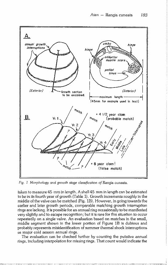
Aten - Rangia cuneata 183
As
annua/ growth interruptions
hinge
hinge
(Exterior) Growth section to be examined.
I (Znterior) I maximum length :~
(45ram for example used in text)
= 4 1/2 year clam (’probable match)
/
=8year clam!
(false match)
Fig. 1 Morphology and growth stage classification of Rangia cuneata.
taken to measure 45 mm in length. A shell 45 mm in length can be estimated to be in its fourth year of growth (Table 1). Growth increments roughly in the middle of the valve can be matched (Fig. 1B). However, in going towards the earlier and later growth periods, comparable matching growth interruption rings are lacking. It is possible for an annual ring occasionally to be manifested very slightly and to escape recognition; but it is rare for this situation to occur repeatedly on a single valve. An evaluation based on matches in the small, middle segment shown in the lower portion of Figure 1B is dubious and probably represents misidentification of summer thermal shock interruptions as major cold season annual rings.
The evaluation can be checked further by counting the putative annual rings, including interpolation for missing rings. That count would indicate the
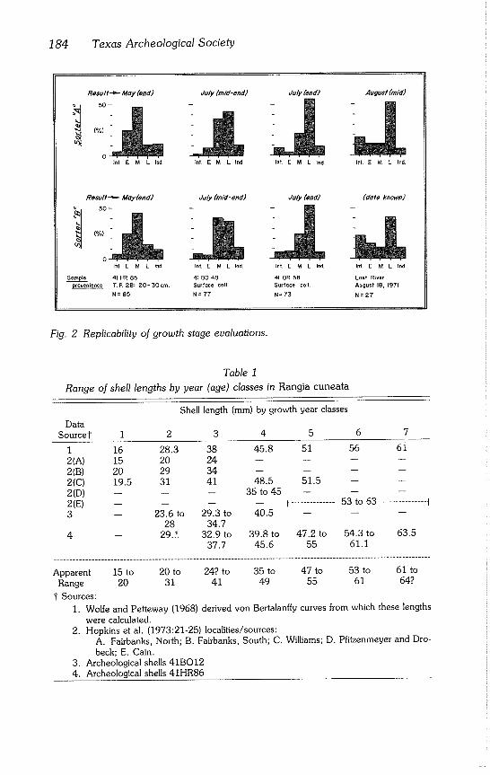
184 Texas Archeological Society
Result.==- May (end)
50-
(%)
Inl E M L Ind
July (mid-end)
J!. Int E M LInd
July (end)
Int. E M L Ind
August (mid)
Int. E M L Ind,
ResuH ~ May (end)
i 50-
[%)
July (end) July (mid- end)
Int. E M LInd
41 BO 48 Surface coll.
N=77
Int E M L Ind Int. E M L Ind.
Sample 41 HR 85 41 OR 58
provenience T. F~ 2B: 20- 50 cm. Surface coll.
N=85 N=73
(date known)
Int. g M L Ind
Lost River
August 18, 1971
N=27
Fig. 2 Replicability of growth stage evaluations.
Table 1
Range of shell lengths by year (age) classes in Rangia cuneata
Shell length (mm) by growth year classes
Data Source1" I 2 3 4
1 16 28.3 38 45.8
2(A) 15 20 24 --
2(B) 20 29 34 -- 2(C) 19.5 31 41 48.5
2(D) -- -- -- 35 to 45
2(E) .... 3 -- 23.6 to 29.3 to 40.5
28 34.7
4 -- 29.?. 32.9 to 37.7
5 6 7
51 56 61 __ i --
51.5 i _
F .............. 53 to 63 .............. I
39.8 to 47.2 to 54.3 to 63.5 45.6 55 61.1
Apparent 15 to 20 to 24? to 35 to 47 to 53 to 61 to
Range 20 31 41 49 55 61 64?
I Sources:
1. Wolfe and Petteway (1968) derived von Bertalanffy curves from which these lengths were calculated.
2. Hopkins et al. (1973:21-25) localities/sources: A. Fairbanks, North; B. Fairbanks, South; C. Williams; D. Pfitzenmeyer and Dro- beck; E. Cain.
3. Archeological shells 41BO12 4. Archeological shells 41HR86
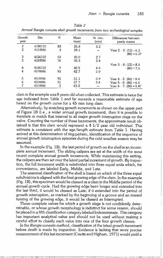
Aten - Rangia cuneata 185
Table 2
Annual Rangia cuneata shell growth increments from two archeological samples
Growth Site N Mean St. dev. Differences between year (mm) (mm) yearly means
2 41BO12 83 25.8 2.2 2 41HR86 3 29.1 -- Year 2 ~ 3: (12) =6.2
(86) = 6.27 3 3
4 4
41BO12 52 32.0 2.7 41HR86 76 35.3 2.4
Year 3 - 4: (12) =8.5 41BO12 9 40.5 4.4 (86) = 7.5 41HR86 93 42.7 2.9
5 6 7
41HR86 93 51.1 3.9 Year 4 - 5: (86) = 8.4 41HR86 31 57.7 3.4 Year 5 - 6: (86) =6.6 41HR86 3 63.5 -- Year 6 - 7: (86) = 5.8?
clam in the example was 8 years old when collected. This estimate is twice the age indicated from Table 1 and far exceeds a reasonable estimate of age based on the growth curve for a 45 mm long clam.
Alternatively, by matching growth increments as shown on the upper part of Figure IB (i.e., a wider annual growth increment), then it is possible to translate or match that interval to all major growth interruption rings on the valve. Counting the number of these increments, the approximate result ob-
tained is that this clam would represent a 4 1/2 year old individual. This estimate is consistent with the age/length estimate from Table 1. Having
arrived at this determination of ring pattern, identification of the sequence of annual growth interruption episodes during the cold weather season may be
assumed. In the example (Fig. 1B), the last period of growth on the shell is an incom-
plete annual increment. The sliding calipers are set at the width of the most recent complete annual growth increments. While maintaining this setting, the calipers are then set over the latest partial increment of growth. By inspec- tion, the full increment width is subdivided into three equal units which, for
convenience, are labeled Early, Middle, and Late. The seasonal classification of the shell is based on which of the three equal
subdivisions is aligned with the final growing edge of the clam. In the example (Fig. 1B), this specimen would be classed as a clam in the Middle period of the
annual growth cycle. Had the growing edge been longer and extended into the last third, it would be classed as Late; if it extended into the period of growth interruption, as marked by the beginning of a groove and an inward turning of the growing edge, it would be classed as Interrupted.
Those complete valves for which a growth stage is not confidently deter- minable, or whose growth morphology is indistinct for some reason, should be placed in a fifth classification category labeled Indeterminate. This category has important analytical value and should not be used without making a careful effort to classify each valve into one of the four growth classes.
In the Rangia cuneata method, classification of the latest growth increment before death is made by inspection. Evidence is lacking that more precise measurement of this last increment (Coutts and Higham, 1971) would yield a
186 Texas Archeological Society
superior determination of seasonality for this species. The range of error in selecting appropriate landmarks on the valve from which to measure ordinar- ily exceeds the metric accuracy necessary to make growth stage estimates on a more precise basis. This problem has been approached on R. cuneata by using a visual evaluation of growth increments in terms of the four ordinal growth categories (Early, Middle, Late, and Interrupted) on a large sample of valves.
Rangia cuneata samples occasionally are encountered in which the seasonal changes of the clam habitat evidently were not as intense as usual. As a result, it may be difficult to discern where interruptions in shell growth took place and which of these interruptions occurred during the annual cold season. The best procedure is to spread out all of the valves to be classified and inspect them for growth event regularities and irregularities affecting the sample as a whole. Ordinarily, there will be some shells in the sample which display prominent annual rings. Working from these specimens, an overall impression is gained of the growth characteristics of that particular popula- tion. From this initial inspection of the whole sample, it generally is possible to go on to evaluate growth on the individual shells.
Different archeological samples often represent breeding populations which experienced a variety of habitat conditions. The resulting phenotypic variation in shells must be recognized in order to evaluate growth stages suc- cessfully. The appearance of growth increments can be expected to change with each new sample. Initially, these may appear hopelessly confused and variable. However, there usually is a pronounced central tendency for the length of shells in a given population for each age grade. Once this tendency is identified with the aid of age/size models (Table 1) and an approximation has been made of the increment of shell growth during the annual growth period for a given age grade, growth stage evaluation can proceed.
EVALUATING THE CLASSIFICATION
The classification of growth stages has proved to be sensitive to population growth changes over very short periods of time. Usually, this sensitivity has meant intervals of about two weeks, although there is some variation, particu- larly during the cold season. Once frequency data for the sample have been compiled into growth stages, the next step is to relate these to the annual growth cycle. This relationship is expressed by arranging the data in a relative frequency histogram (Fig. 2) and comparing it against a master sequence.
The master sequence (Fig. 3) is based on growth stage classification of 30 modern Rangia cuneata samples collected semimonthly from several Ioca- tions on the upper Texas coast for most periods of the year (Table 3). Often, more than one sample was taken in different years or from different upper coast locations from some of these semimonthly periods. The multiple sam- ples have been averaged together to provide histogram patterns (Fig. 3) which represent the upper Texas coast as a whole. Because the growing edge of the living clam is a very thin, delicate margin, it is almost always broken off of archeological specimens by the periostracum as it dries and flakes off the
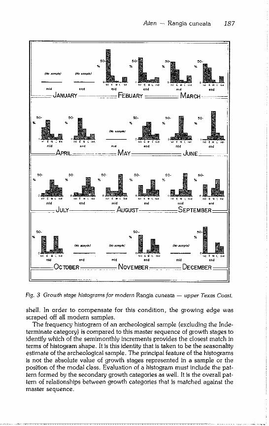
Aten -- Rangia cuneata 187
o o o nr r ¯ , ......... r E u L I~ i~ E M L i*d t E M L ~d
mid end mid end
FEBUARY MARCH
50- 50- 50- 50- %50
L~
50-
"LI. "n o ..... o ..... -- o ..... e o ..... ~n~ E M L ~ Inl E M LInd Int E M LInd Inf E M LInd Inl E M L Lnd Int E M L I~d
mid end mid end mid end
JULY AUGUST :SEPTEMBER--
50- 50 - 50-
% % %
(tlo ~) (No aomple) (Ko #ompl#J
in~. [ M L ted. I,t E M L Ind.
mid end mid end
OCTOBER NOVEMBER
Int. E M L Ind.
mid end
DECEMBER --
Fig. 3 Growth stage histograms for modern Rangia cuneata -- upper Texas Coast.
shell. In order to compensate for this condition, the growing edge was scraped off all modern samples.
The frequency histogram of an archeological sample (excluding the Inde- terminate category) is compared to this master sequence of growth stages to identify which of the semimonthly increments provides the closest match in terms of histogram shape. It is this identity that is taken to be the seasonality estimate of the archeological sample. The principal feature of the histograms is not the absolute value of growth stages represented in a sample or the position of the modal class. Evaluation of a histogram must include the pat- tern formed by the secondary growth categories as well. It is the overall pat- tern of relationships between growth categories that is matched against the master sequence.
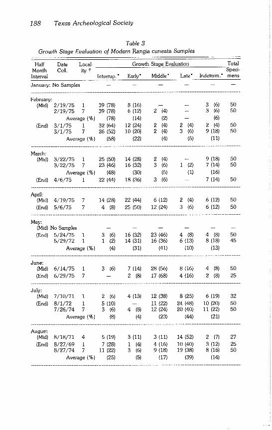
188 Texas Archeological Society
Table 3
Growth Stage Evaluation of Modern Rangia cuneata Samples
Half Date Local- Growth Stage Evaluation Total
Month Coll. ity I" Speci-
Interval Interrup.’ Early" Middle’ Late’ Indeterm." mens
January: No Samples ......
February: (Mid) 2/19/75 1 39 (78) 8 (16) -- -- 3 (6) 50
2/19/75 7 39 (78) 6 (12) 2 (4) -- 3 (6) 50
Average (%) (78) (14) (2) -- (6)
(End) 3/1/75 1 32 (64) 12 (24) 2 (4) 2 (4) 2 (4) 50
3/1/75 7 26 (52) I0 (20) 2 (4) 3 (6) 9 (18) 50
Average (%) (58) (22) (4) (5) (11)
March: (Mid) 3/22/75 1 25 (50) 14 (28) 2 (4) -- 9 (18) 50
3/22/75 7 23 (46) 16 (32) 3 (6) 1 (2) 7 (14) 50
Average (%) (48) (30) (5) (I) (16)
(End) 4/6/75 1 22 (44) 18 (36) 3 (6) -- 7 (14) 50 .......................................................................................................................
April: (Mid) 4/19/75 7 14 (28) 22 (44) 6 (12) 2 (4) 6 (12) 50
(End) 5/6/75 7 4 (8) 25 (50) 12 (24) 3 (6) 6 (12) 50 .......................................................................................................................
May: (Mid) No Samples ......
(End) 5/24/75 1 3 (6) 16 (32) 23 (46) 4 (8) 4 (8) 50 5/29/72 1 1 (2) 14 (31) 16 (36) 6 (13) 8 (18) 45
Average (%) (4) (31) (41) (I0) (13) .......................................................................................................................
June: (Mid) 6/14/75 1 3 (6) 7 (14) 28 (56) 8 (16) 4 (8) 50
(End) 6/29/75 7 -- 2 (8) 17 (68) 4 (16) 2 (8) 25 .......................................................................................................................
July: (Mid) 7/10/71 1 2 (6) 4 (13) 12 (38) 8 (25) 6 (19) 32
(End) 8/1/72 1 5 (10) -- 11 (22) 24 (48) 10 (20) 50 7/26/74 7 3 (6) 4 (8) 12 (24) 20 (40) 11 (22) 50
Average (%) (8) (4) (23) (44) (21) .......................................................................................................................
August: (Mid) 8/18/71 4 5 (19) 3 (11) 3 (11) 14 (52) 2 (7) 27
(End) 8/27/69 I 7 (28) 1 (4) 4 (16) 10 (40) 3 (12) 25 8/27/74 7 11 (22) 3 (6) 9 (18) 19 (38) 8 (16) 50
Average (%) (25) (5) (17) (39) (14) .......................................................................................................................
Aten - Rangia cuneata 189
Half Date Local- Growth Stage Evaluation Total Month Coll. ity I Speci- Interval Interrup. ’ Early" Middle* Late* Indeterm." mens
September: (Mid) 9/21/72 1 8 (19) -- 3 (7) 26 (60) 6 (14) 43
9/21/72 8 4 (10) I (2) 11 (27) 20 (49) 5 (12) 41
Average (%) (14) (1) (17) (54) (13)
(End) 9/28/73 2 4 (29) -- 2 (14) 6 (43) 2 (14) 14 9/25/74 7 12 (27) -- 11 (24) 17 (38) 5 (11) 45
Average (96) (28) -- (19) (40) (12)
October: mid- (Mid) Oct/66 5 22 (44) 1 (2) 2 (4) 21 (42) 4 (8) 50
10/17/72 1 8(36) 1 (5) 2 (9) 9(41) 2 (9) 22 10/22/74 7 20 (40) -- 5 (10) 18 (36) 7 (14) 50
Average (%) (40) (2) (8) (40) (10)
(End) No Samples ......
November: (Mid) No Samples ......
(End) 11/26/73 2/6 15 (44) -- -- 13 (38) 6 (18) 34 11/27/75 1 18 (36) -- 4 (8) 19 (38) 9 (18) 50 11/27/75 7 22 (44) -- 6 (12) 12 (24) 10 (20) 50
Average (%) (42) -- (7) (33) (19)
December: (Mid) No Samples ......
(End) 1/2/74 2/3 21 (62) -- -- 8 (24) 5 (15) 34 .......................................................................................................................
" ( ) = percent
I Key to collecting localities:
Chambers County, Texas
1. Lake Anahuac 2. Lost River at John Wiggins Bayou 3. Mouth of Round Lake 4. Lost River, 1700 meters downstream from John Wiggins Bayou 5. Lost River, 600 meters downstream from John Wiggins Bayou 6. Mouth of Lost Lake
Jackson County, Texas
7. Confluence of Lavaca and Navidad rivers
Jefferson County, Texas
8. West end of Shell Lake
190 Texas Archeological Society
The Indeterminate category is used as a control on the evaluation method. In modern samples of Rangia cuneata used to prepare the master sequence, the Indeterminate category fluctuates around a mean of nearly 13%, with a standard deviation of about 4% (Fig. 4). This fluctuation means that when an archeological sample’s Indeterminate category exceeds a range of from 5 to 21% (two standard deviations from the mean), the origin of this excessive deviation should be determined.
If it can be shown through cross checking the classification with different evaluators that these criteria have been applied uniformly and produced repli- cable results (Fig. 2), then the shells should be checked to see which morpho- logical features caused the rate of indeterminancy to be increased or de- creased beyond expectations for normal populations. In some cases, the reason can be attributed readily to poor shell preservation such as erosion of morphologic detail through leaching or weathering processes. Or, it may be traceable to perturbations in the habitat of the living clam. Under some cir- cumstances, these observations can be developed into paleoclimatic data and inferences (Aten, 1972:5).
As an example of interpretation, a sample from site 41HR85 (Aten et al., 1976), has the following key attributes (Fig. 2): 1) indeterminate category is within the normal range; 2) overall pattern is unimodal in the Middle stage; and 3) secondary abundances are Early greater than Late greater than Inter- rupted (E> L~ Int).
This sample may be viewed as an instantaneous slice of a clam population’s annual growth dynamics. Nearly all of the population has passed out of the period of growth interruption; most have passed beyond the period of initial or Early growth. The majority of individuals are in the Middle of their active growth period, and some members have entered the Late or final phases of active growth during this growing year. Comparison of the shape of this histo- gram (Fig. 2) with those of the master sequence (Fig. 3) indicates that the only histogram bearing a comparable shape is that derived from modern samples for the end of the month of May. The slight differences in classification of the same sample by a second worker (Fig. 2) does not alter this interpretation of seasonality; it is replicable.
As a second example, the modern clam sample collected on August 18, 1971 (Fig. 2) was evaluated by Sorter B as if it were an archeological sample of unknown collection season. The key attributes are: 1) indeterminates are within the normal range; 2) histogram is unimodal (because growth is cyclic, the Late category is succeeded by the Interrupted category at the beginning of the histogram); 3) mode is in the Late stage; and 4) secondary abundances are Interrupted greater than Early slightly greater than Middle (Int~E~M).
Comparison of the shape of this histogram (Fig. 2) with those of the master sequence (Fig. 3) indicates that the only histogram bearing a comparable shape is the one for mid August. In this case, Sorter B knew neither the date of collection nor the results of evaluation by Sorter A. A histogram from any other period of the year could not be confused with this particular one for mid August. This classification was replicable in that slight differences in sorting by the two workers would not alter the interpretation of collection season.
Because of the relatively rapid progress of the growth stage mode through the calendar, especially when this progress is viewed as the pattern combina-
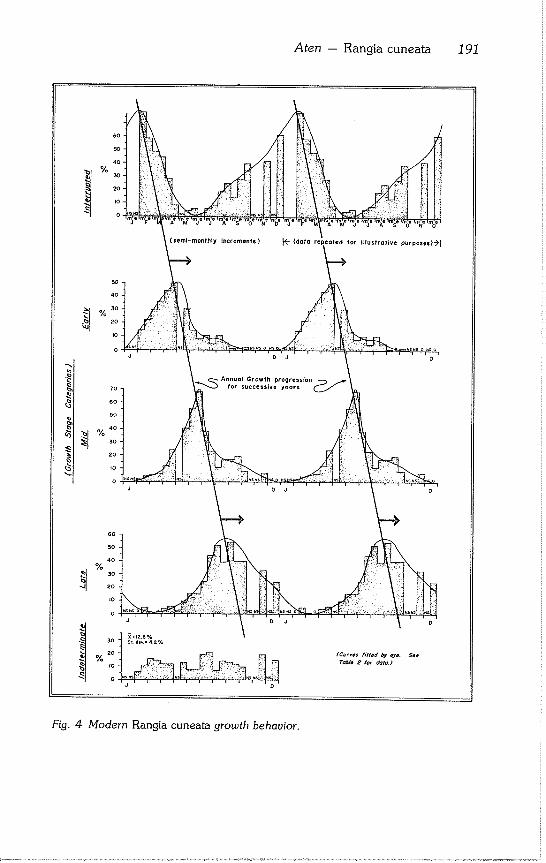
Aten - Rangia cuneata 191
~b
Fig. 4 Modern Rangia cuneata growth behavior.
192 Texas Archeological Society
tion of four categories, it often is possible to recognize samples of varying
modes of origin. Samples representing a single episode of collection, a series of single collection episodes during the same month but repeated over a
period of years, or a continuous collection (occupation) for not more than a month or so will all produce clam growth stage histograms strongly unimodal in one or, rarely, two sequential growth stage categories.
For many survey and testing purposes, distinguishing among these three possibilities is not of great importance. If the samples were from excavations
of individual habitation areas, other field evidence might indicate which type of occupation took place. Occasionally, however, a sample either will lack a mode or display a weak mode in two or more adjacent growth stages. Condi- tions in nature will not produce such evenly distributed growth classes si- multaneously in a Rangia cuneata population. The cause must be either an
error in sorting technique or a sample consisting of a composite of clams collected over a span of time exceeding one month, but probably less than
three months. If a bimodal histogram occurs, this reflects either error or a composite sam-
ple in which substantial seasonal separation of occupations has occurred (probably more than three but less than six months). In evaluation of more than 300 Rangia samples using this seasonality method, bimodal frequencies did not occur. Because such composite distributions must be a very rare occurrence, a significant effort should be made to determine whether error in technique is the cause before proposing cultural explanations.
If a large number of seasonality estimates exist from a single cultural unit, these can be easily summarized on a statistical basis by assigning a coded value to each semimonthly seasonality increment (Fig. 5). In the example (Fig. 5), the mean of 18 seasonality estimates is 4.8, which correlates approx- imately with a mid to end May season. The standard deviation is 0.7, or approximately 3/4 of a month. The first standard deviation range is 4.1 to
5.5, translatable to a collection period extending from the beginning of May through mid June.
Review of figures 3 and 4 verifies the discrete character of most of the semimonthly histograms. The ability to evaluate modern samples of known date correctly when they are treated as unknowns (Fig. 2) provides added confidence. The most difficult application of the master sequence occurs with
samples from the September to November period and February. However, archeological samples attributable to these periods are rare on the Texas
coast. This approach actually correlates the archeological Rangia cuneata growth
patterns with a set of modern environmental conditions yielding similar growth patterns. However, the relation of the calendar to environmental con- ditions may have shifted somewhat, especially over the short term. In this sense, the archeological seasonality estimates are floating. However, because there is little between year variation in the correlation of growth stage histo- grams from modern samples with their collection dates (Table 3), the recent
accuracy of this method is within + I month and likely may not be more than
+ 1/2 month.
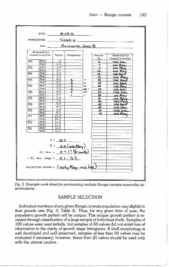
Aten - Rangia cuneata 193
PROVENIENCE:
AGE:
I Seasonality I I classification I Value I f IJan (Mid) [ .5 I (End) I 1.5 IFeb (Mid) [ 2.0 I (End) [ 2.5 [Mar (Mid) [ 3.0 [ (End) I 3.5
I Apr (Mid) I 4.0 (End) [ 4.5
l ~___y_ (Mid) [ 5.0 (End) [ 5.5
IJun (Mid) [ 6.0 [ (End) 1 6.5 [Jul (Mid) ] 7.0 [ I (End) [ 7.5 [
I Au__~ ~Mid) 1 8.0 I (End) I 8.5 l
[Sep (Mid) I 9.0 I [ (End) [ 9.5 [ IOet (Mid) [ i0.0 [
] (End) 1 10.5 I INov (Mid) [ II.0 I [ (End) I 11.5 [ [Dec (Mid) [ 12.0 [
[ (End) ] 12.5 [
N =
St. dev. =
1 St. dev. range =
COLLECTION SEASON =
I [ Frequency i I
I
,, +1
I 6 J I 4 I i~. I I II
I Sample [ Seasonality [
[ No. I classification ]
1 1 I n,.~ ,~,~,., I I ,~ 1 ~.~ I I I~ I t~,~ ~,~,~ I I 14- I t~"~ ~,..ili I I t~ I ,-,~,+, ~ I
¯ I I z~ I rn~. ,d,,~;f I , I
I ~ I r~i~ Ju~_ I I ~ I i~-.I M~u_~ I I 4~ I ,,,~ M Lz~--I
I 4~ I ~ ~il~ I I 4~7 I h-~_b]~.~
I I I I ]"
I- I I
I~,.0 I I
ol (+ I
I
Fig. 5 Example work sheet for summarizing multiple Rangia cuneata seasonality de-
terminations,
SAMPLE SELECTION
Individual members of any given Rangia cuneata population vary slightly in their growth rate (Fig. 3; Table 3). Thus, for any given time of year, the
population growth pattern will be unique. This unique growth pattern is re- vealed through classification of a large sample of individual shells. Samples of
100 valves were used initially, but samples of 50 valves did not entail loss of information in the clarity of growth stage histograms. If shell morphology is well developed and well preserved, samples of less than 50 valves may be
evaluated if necessary; however, fewer than 20 valves should be used only with the utmost caution.
194 Texas Archeological Society
The most suitable Rangia cuneata shells to use for seasonality classification are those in the third and fourth year age groups. Shellfish younger than 2 years have not completed an annual increment of shell growth as an adult; therefore, the latest growth stage cannot be compared with its pattern of adult growth. In exceptional cases (e.g., when third year clams are not available), second year clams could be used to make a generalized estimate of growth stage, such as assignment to early or late in the growth cycle. This assignment would permit at least a crude estimate of the season of collection.
On shells 5 or more years old, annual rings become progressively more difficult to distinguish. Feeding and respiratory efficiency of bivalve molluscs decreases as they grow larger so that their growth is a self limiting process (Stanley, 1970:54). Although the between year variation in width of new growth is not great in Rangia cuneata (Table 2), methodological noise in the histograms is minimized by concentrating on samples from a single, or perhaps two sequential, age classes.
In selecting a sample, the principal criterion to observe is that all specimens should be as capable of interpretation as when originally taken from their habitat. Specimens should be selected carefully for: 1) age/size (preferably third or fourth year clams); 2) completeness (must have an umbo to growing edge section); and 3) preservation (shells must not be heavily eroded or leached).
The sorting class of Indeterminate does not refer to fragmentary, eroded, or otherwise degraded shells. The Indeterminate class is needed for whole, well preserved shells of optimum size which nevertheless grew an indistinct or equivocal morphology precluding assignment to a growth category. While Indeterminates are not a growth stage, they are a function of growth pro- cesses in the clam population and serve as a methodological check.
Another important sampling factor is the selection of either right or left valves for growth stage evaluation. This selection has not been observed uniformly in the archeological samples because of the extreme bilateral sym- metry in this species. There is only a remote possibility of duplicating right and left valves from the same clam often enough to make any impact on the growth pattern of a sample of 50 or so valves. Discretion should be used; if a small shell lens consisting only of a few hundred valves were sampled, it-might be more appropriate for only right or left valves to be selected. If the sample represents tens of thousands of valves, then same valve selection would not matter.
SIGNIFICANCE OF MAJOR GROWTH INTERRUPTIONS
Initially, the annual growth interruption rings were assumed to be asso- ciated exclusively with the winter season, but this is not exactly so. Close examination of the modern clam growth stage histograms (Fig. 3) reveals a regular progression of the modal growth category through the year. Dynamics of growth variation become much more clear when the Figure 3 data are replotted in a time series by individual growth stage classes (Fig. 4).
At the top of Figure 4, Interrupted growth stages through the year are plotted along one time axis; below this, the Early growth category is plotted,
Aten - Rangia cuneata 195
etc. By connecting the modal peaks of these sequential growth stages with a straight line, the progression of each year’s growth through a population is graphically demonstrated. By selecting any point along the horizontal time axis and then looking vertical to that axis through the growth stages, the growth variation around the mode is seen. By this means, the duration and magnitude of Interrupted growth is seen to be always present to some degree. Interruption is a major constituent of variation from roughly August to April and reaches its maximum intensity from December to February. This situation suggests a causal relationship with habitat temperature.
Rangia cuneata ciliary activity is reduced substantially below 16 °C (6 I°F) and above 28°C (82°F) (Hopkins et al., 1973:154). Because the cilia are essential to feeding and ventilation, their response to temperature variation must be related significantly to shell growth. To test this, there should be a strong negative correlation between the percentage of clams in the Inter- rupted growth stage and temperature (Table 4). The correlation coefficient for this relationship was R = - .84 (significant at the .01 level) which sup- ports the hypothesis.
Other environmental factors, however, might influence the proportion of shells in the Interrupted stage. For example, rainfall may affect salinity, and stream discharge may affect salinity as well as flush quantities of algae, detri- tus, or phytoplankton into the lower streams and estuaries. Salinity alone, however, was not found to be a controlling factor in ciliary activity (Hopkins et al., 1973:25-27).
Correlation coefficients relating rainfall and stream discharge to the com- bined proportions of Early, Middle, and Late clam growth stages should be of a much lower order than for temperature. In testing this relationship, data were used both for a large river (the Trinity) and for a small river draining only the coastal plain (the Lavaca). None of the correlation coefficients was statisti- cally significant, thus supporting the hypothesis (Table 4). Because the growth response to salinity might not be immediate, correlation coefficients also were calculated for stream discharge against the total percentage of Early, Middle, and Late stage clams of the succeeding month. Results were not statistically significant (Table 4).
Data on reduced ciliary activity at temperatures above 28 °C (82 OF) proba- bly point directly at the cause of the principal secondary, or summer, growth interruption feature. Average air temperatures of 82°F are exceeded in July and August (Table 4) and water temperatures are only slightly cooler. There is a pronounced positive bulge in the Interrupted growth curve for the August- September period (Fig. 4) reflecting the small but noticeable impact of high temperature growth interruption.
The conclusion is that the major annual Interrupted growth stage is of long duration and most closely associated with seasonal variations in temperature. It is not correlated with fluctuations of rainfall, stream discharge, and salinity. Presumably, any other natural phenomena which might cause a growth inter- ruption would introduce very low orders of predictable interruptions. These mechanisms primarily contribute to background noise; some amount of growth interruption may be found on virtually all modern seasonality esti- mates throughout the year.
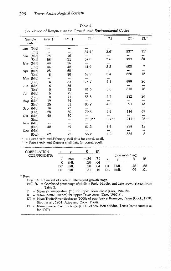
196 Texas Archeological Society
Table 4
Correlation of Rangia cuneata Growth with Environmental Cycles
Sample Inter.l EMLt T~ R~ DTI" DLt
date
Jan (Mid) ...... (End) -- -- 54.4" 3.6" 537" 11"
Feb (Mid) 78 16 .... (End) 58 31 57.0 3.6 449 20
Mar (Mid) 48 36 .... (End) 44 42 61.9 2.8 600 7
Apt (Mid) 28 60 .... (End) 8 80 68.9 3.4 620 18
May (Mid) ...... (End) 4 83 75.7 4.1 999 26
Jun (Mid) 6 86 .... (End) 0 92 81.5 3.6 613 18
Ju! (Mid) 6 75 .... (End) 8 71 83.3 4.7 282 26
Aug (Mid) 19 74 .... (End) 25 61 83.2 4.5 91 13
Sep (Mid) 14 73 .... (End) 28 60 79.3 4.6 114 67
Oct (Mid) 40 50 .... (End) -- -- 71.9" * 3.7*" 211’" 26""
Nov (Mid) ...... (End) 42 39 61.3 3.6 298 12
Dec (Mid) ...... (End) 62 23 56.2 4.2 556 8
¯ = Paired with mid-February shell data for correl, coeff.
"* = Paired with mid-October shell data for correl, coeff.
CORRELATION x y R R2 COEFFICIENTS: (one month lag)
T Inter -.84 .71 x y R R2 R EML .20 .04
DT EML .20 .04 DT EML .46 .22
DL EML .31 .10 DL EML .09 .01
I Key: Inter. % = Percent of shells in Interrupted growth stage. EML % = Combined percentage of shells in Early, Middle, and Late growth stages, from
Table 3. T = Mean air temperature (°F) for upper Texas coast (Carr, 1967:8). R = Mean rainfall (inches) for upper Texas coast (Carl 1967:8). DT = Mean Trinity River discharge (1000s of acre-feet) at Romayer, Texas (Cook, 1970;
Stout et al.) 1961; Adey and Cook, 1964). DL = Mean Lavaca River discharge (1000s of acre-feet) at Edna, Texas (same sources as
for "DT").
Aten -- Rangia cuneata 197
CONCLUSIONS
One of the principal foundations for describing and testing archeological models is the determination of temporal and spatial control of archeological data. Because of this need, reconstruction of annual patterns and schedules of settlement must be made. On the northern coast of the Gulf of Mexico, from the coastal bend of Texas to the Florida panhandle, the majority of shell middens are composed either partially or entirely of the brackish water clam Rangia cuneata. A practical method now exists for determining the season of collection of R. cuneata clams with an accuracy of at least + 1 month.
Use of this method opens opportunities for analysis of scheduling at both an intersite regional and intrasite local scale. For example, current analysis (Aten, unpublished data) indicates that nearly all coastal shell middens in the upper Texas coast were occupied during the early summer. Seasonality sam- ples have been analyzed from single occupation episode sites which seem to allow discrimination of habitation periods as short as 2 weeks duration from others occupied for periods up to 6 weeks duration (Aten, unpublished data).
Other applications are plausible. Archeological Rangia cuneata shells theo- retically contain the most detailed season by season record in existence of water temperatures for the last 3500 years on the coast. The morphological seasonality technique used in conjunction with oxygen isotope and C14 de- terminations could be the basis for a practical regional research program into high resolution reconstruction of paleotemperatures.
Finally, a second Rangia species, R. flexuosa, is found occasionally in the region’s archeological sites (Aten et al., 1976:9; Fig. 4). Rangia flexuosa is distinguished from R. cuneata only by its slightly indented pallial sinuses and short hinge teeth which do not extend to the adductor muscle scars (Fig. 1A). Rangiaflexuosa occupies somewhat higher salinity estuarine habitats than are normally used by R. cuneata; is uniformly smaller in size; and does not display the prominent growth ring morphology seen on R. cuneata. Consequently, this seasonality procedure probably cannot be extended to R. flexuosa.
ACKNOWLEDGMENTS
I am indebted to Bob Cole, Glen Fredlund, Jim McMichael, and Duford Skelton who assisted in making the collections of modern Rangia cuneata for the master sequence; to Tom Dillehay and Duford Skelton who applied the
seasonality method; to Phil Dering who pointed out to me the significance of the osmoregularity capability of R. cuneata; to Dee Ann Story and the staff of the Texas Archeological Research Laboratory (The University of Texas at Austin) for understanding the significance of these studies and making possi- ble the curation of large quantities of shell samples; and to the National Park Service for funding the 1969 season of rescue archeology at Wallisville Reser- voir during which this seasonality method was first conceived.
198 Texas Archeological Society
REFERENCES CITED
Adey, E. A. and H. M. Cook 1964 Suspended-Sediment Load of Texas Streams, Compilation Report, Oc~
tober 1959-September 1961. Texas Water Development Board Bulletin, 6410:1-49.
Andrews, Jean 1971 Sea Shells of the Texas Coast. University of Texas Press, Austin.
Aten, Lawrence E. 1972 An Assessment of the Archeological Resources to be Affected by the
Taylors Bayou Drainage and Flood Control Project, Texas. Texas At- cheological Salvage Project Research Report, 7:1-24.
1976
1977
1979
Three Notes on Rangia cuneata as a Source of Archeological Data. Paper presented at the 33rd Southeastern Archeological Conference, Tusca- Ioosa, Alabama.
Estimating Seasonality from Shellfish Remains. Paper presented at the Mid-Atlantic Archaeological Conference, Trenton, New Jersey.
Indians of the Upper Texas Coast: Ethnohistoric and Archeological Frameworks. Unpublished Ph.D. dissertation, University of Texas, Aus- tin.
Aten, Lawrence E., Charles K. Chandler, AI B. Wesolowsky, and Robert M. Malina 1976 Excavations at the Harris County Boys School Cemetery: Analysis of
Galveston Bay Area Mortuary Practices. Texas Archeological Society Special Publication, 3:1-112.
Barker, Richard M. 1970 Constituency and Origins of Cyclic Growth Layers in Pelecypod Shells.
Unpublished Ph.D. dissertation, University of California, Berkeley.
Berta, Annalisa 1976 An Investigation of Individual Growth and Possible Age Relationships In a
Population of Protothaca staminea (Mollusca: Pelecypoda). PaleoBios, 21:1-26.
Carr, John T., Jr. 1967 The Climate and Physiography of Texas. Texas Water Development
Board Report, 53:1-27.
Cook, H. M. 1970 Suspended-Sediment Load of Texas Streams, Compilation Report, Oc-
tober 1963-September 1965. Texas Water Development Board Report, 106:1-61.
Coutts, P. J. F. 1970 Bivalve-Growth Patterning as a Method for Seasonal Dating in Ar-
chaeology. Nature, 226:874.
Coutts, Peter, and Charles Higham 1971 The Seasonal Factor in Prehistoric New Zealand. World Archaeology,
2(3) :266-277.
Aten - Rangia cuneata 199
Dillehay, Tom D. 1975 Prehistoric Subsistence Exploitation in the Lower Trinity River Delta,
Texas. Texas Archeological Survey Research Report, 51:1-193.
Gilmore, Kathleen 1974 Cultural Variation on the Texas Coast: Analysis of an Aboriginal Shell
Midden, WallisviUe Reservoir, Texas. Texas Archeological Survey Re- search Report, 44:1-108.
Hopkins, S. H., J. W. Anderson, and K. Horvath 1973 The Brackish Water Clam Rangia cuneata As Indicator of Ecological Ef-
fects of Salinity Changes in Coastal Waters. U.S. Army Engineer, Water- ways Experiment Station Contract Report, H-73-1:1-250.
Killingley, John S. 1981 Seasonality of Mollusk Collecting Determined from 0-18 Profiles of Mid-
den Shells. American Antiquity, 46(1):152-158.
Koike, Hiroko 1975 The Use of Daily and Annual Growth Lines of the Clam Meretrix lusoria in
Estimating Seasons of Jomon Period Shell Gathering. In: R. P. Suggate and M. M. Cresswell (eds.), Quaternary Studies, pp. 189-193. The Royal Society of New Zealand, Wellington.
Kennish, Michael J. and Richard K. Olsson 1975 Effects of Thermal Discharges on the Microstructural Growth of Mercena-
ria mercenaria. Environmental Geology, 1:41-64.
McGuff, Paul R. 1978 Prehistoric Archeological Investigations at Palmetto Bend Reservoir:
Phase 1, Jackson County, Texas. Texas Archeological Survey Research Report, 58:1-278.
Miller, James J. 1980 Coquina Middens on the Florida East Coast. Florida Anthropologist,
33(1):2-16.
Rosenberg, G. D. and S. K. Runcorn (eds.) 1975 Growth Rhythms and the History of the Earth’s Rotation. John Wiley and
Sons, New York.
Rhoads, Donald C. and Giorgio Pannella 1970 The Use of Molluscan Shell Growth Patterns in Ecology and Paleoecol-
ogy. Lethaia, 3:143-161.
Shackleton, N. J. 1973 Oxygen Isotope Analysis as a Means of Determining Season of Occupa-
tion of Prehistoric Midden Sites. Archaeometry, 15(1):133-141.
Stanley, Steven M.
1970 Relation of Shell Form to Life Habits of the Bivalvia (Mollusca). Geologi-
cal Society of America Memoir, 125:1-296.
Stout, I. M., L. C. Bentz, and H. W. Ingram 1961 Silt Load of Texas Streams, Compilation Report for the Period June
1889-1959. Texas Water Development Board Bulletin, 6108:1-236.

200 Texas Archeological Society
Swadling, Pamela 1976 Changes Induced by Human Exploitation in Prehistoric Shellfish Popula-
tions. Mankind, 10(3):156-162.
Weide, Margaret L. 1969 Seasonality of Pismo Clam Collecting at ORA-82. UCLA Archeological
Survey Annual Report, 11:127~141.
Wolfe, Douglas A. and Ernest N. Petteway 1968 Growth of Rangia cuneata Gray. Chesapeake Science, 9(2):99-102.
Bulletin of the Texas Archeological Society 52:201-214 1981
NOTES
Vance T. Hoiiiday and Curtis M. Weity
ABSTRACT
A survey of lithic tool resources of the eastern Llano Estacado was aimed at characterizing the types and availability of material suitable for tool making found in the various geologic units that make up the bedrock of the area. Five major units are present along the eastern Llano Estacado: Quartermaster Formation; Dockum Group; Antlers Sand; Edwards Limestone; and Ogallala Formation. The Quartermaster Formation (uppermost Permian) contains the Alibates Dolomite Lentil, providing the well known, multicolored Alibates agate found along the Canadian River Valley. The Dockum Group (upper Triassic) has a basal gravel with quartzite and cherts, com- mon throughout the survey area. Along the east central Llano Estacado, the Dockum contains the Tecovas Formation which often yields lenses of jasper (Tecovas or Quitaque jasper) and chert. The Antlers Sand (lower Cretaceous) found on the southeastern Llano Estacado has a basal gravel with quartzites, cherts, and jasper. The Edwards Limestone, occurring in the same areas as the Antlers, sometimes contains nodules and lenses of chert. The Ogallala Formation (Miocene-Pliocene) has the most variety and abundance of suitable and available raw material for artifacts. Gravels are found throughout the area, including quartzites, cherts, flint, and jasper. Pedogenic caliches formed in the upper Ogallala, Edwards, and Blanco Formation (Pliocene) are often silicified and occasionally opalized, providing marginal to good quality material. The pres- ence of such quantities of varied, readily available material imposes severe limitations on the use of particular rock types as indicators of trade with other areas.
INTRODUCTION
The types, quantities, and availability of rocks suitable for manufacturing lithic tools in a given area should have considerable influence on the quantity and quality of lithic tools and debitage found in archeological sites. The physi- cal properties of a particular rock type will, in large measure, control the workability of a tool and its wear resistance. The availability and amount of usable material would be expected to control the degree of reutilization and conservation of tools and debitage. As Ahler (1977:133) stated, a geological
survey aimed at linking".., stone types to an area of natural occurence... is an essential step in any meaningful investigations of lithic or any other raw material selection and procurement system."
The importance of proximity and quality of geological outcrops to ar- cheological investigations is not new to archeology (Bryan, 1950; Coffin, 1951). However, such systematic surveys of lithic resource areas are rela-
202 Texas Archeological Society
tively rare in archeology. Surveys and petrographic studies of specific, well known rock types or outcrops are more common (Clayton et al, 1970; Hood, 1978; Schaeffer, 1958).
The Llano Estacado (Southern High Plains of Texas and eastern New Mex- ico) has been the scene of archeological investigations for over half a century (Collins, 1971; Kelly, 1964; Holliday, in press). The importance of raw mate- rial availability and types to the quality and quantity of tools and debitage in archeological sites has been recognized (Green and Kelly, 1960; Hester, 1975; Hood, 1978; Hughes, 1976). The area contains outcrops and quarries of Alibate agate, one of the best known raw materials on the Plains. Consider- able attention has been given the material (Asquith, 1975; Bowers and Reaser, 1974; Bryan, 1950; Green and Kelly, 1960; Schaeffer, 1958).
Hester (1972, 1975) reviews some of the more common rock types availa- ble in the area and mentions several specific locations. Several reviews of rock types common in specific areas and some associated outcrops are available (Etchieson et al., 1977, 1978; Hughes and Hood, 1976; Harrison and Killen, 1978). Hughes (1978) and Willey and Hughes (1978) review the bedrock stratigraphy in the MacKenzie Reservoir area. Hughes (1976) provides a re- view of references to lithic resources in the Texas Panhandle.
Despite previous work, a regional, systematic research concerning the characteristics of lithic material as they relate to bedrock types is lacking. Such a survey is particularly important on the Llano Estacado because the surface is mantled by a thick cover of Pleistocene eolian sediments. Hence, rock out- crops are common only along the escarpments that form the west, north, and east boundaries of the Llano Estacado. Limited outcrops also occur along the deeper drainages (draws) and lake basins (playas). To procure material, in- habitants of the interior of the area would have to travel some distance to the outcrops or trade. Additionally, by determining the nature of available local material, identification of rock types from other areas is feasible.
METHODOLOGY
A preliminary survey of available lithic tool resources on the eastern Llano Estacado was conducted. The principal goal was to characterize, macroscopi- cally, the types of materials available in each of the major bedrock units in the region. Petrographic analysis was not undertaken nor an intensive study of the knapping characteristics of individual rock types. Field investigations cen- tered on the Lubbock area and included the eastern escarpment of the Llano Estacado extending from the eastern end of Palo Duro Canyon (Briscoe County) south and west to Fluvanna (Scurry County) and Lamesa (Dawson County) and extending east from the escarpment a short distance onto the Rolling Plains (Fig. 1).
Roadcuts and quarries were examined along the escarpment, reentrant canyons, draws, and larger playa lake basins. An effort was not made to locate archeological quarry sites. A survey of geological and archeological literature dealing with rock types and stratigraphy and specific outcrop areas and quarries also was conducted.
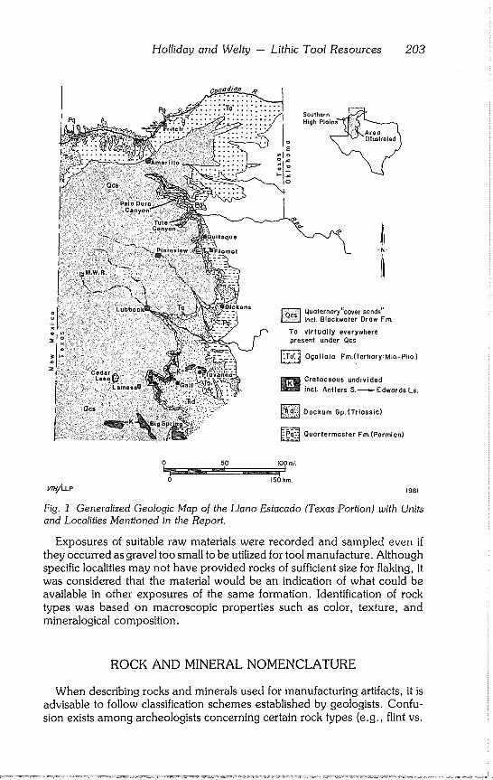
Holliday and Welty - Lithic Tool Resources 203
~itaque
Dickens
Soulhern High Pla~
~N-
Quoternnry"caver sands" tncL Btackwoter Draw Fm.
To virtually everywhere present under Qcs
Ogallala Fm.!Ter rio r y: Mia.- Plio,)
~ Cretaceous undivided
incl. Antlers S, ~ Edwards Ls.
~ Dockum Gp. (Trinssic)
~ Quorterrnaster Fm,(Permian)
0 50 lOOmL
0 150 kin.
1981
Fig. 1 Generalized Geologic Map of the Llano Estacado (Texas Portion) with Units
and Localities Mentioned in the Report.
Exposures of suitable raw materials were recorded and sampled even if they occurred as gravel too small to be utilized for tool manufacture. Although specific localities may not have provided rocks of sufficient size for flaking, it
was considered that the material would be an indication of what could be available in other exposures of the same formation. Identification of rock types was based on macroscopic properties such as color, texture, and mineralogical composition.
ROCK AND MINERAL NOMENCLATURE
When describing rocks and minerals used for manufacturing artifacts, it is advisable to follow classification schemes established by geologists. Confu- sion exists among archeologists concerning certain rock types (e.g., flint vs.
204 Texas Archeological Society
chert); and in many cases, terms have been improperly used by geologists, primarily because a general agreement on terminology is lacking. The follow- ing summary of various rock and mineral types commonly used for artifacts, particularly on the Southern High Plains, follows those of Blatt et al. (1980) and Lapedes (1978). Definitions can vary depending on the source con-
sulted. Most lithic tools are made from various forms of fine crystalline quartz
(silica). This quartz generally occurs as either fiberous varieties, termed chalcedony (a mineral), or microcrystalline or cryptocrystalline forms termed chert (a rock). Differentiating chalcedony from chert (which can have chal- cedony in it) is very difficult in hand specimens. Color is the best key for a general classification of forms of chert. The best known variety of chalcedony is agate, which has multicolored bands. Cherts are most commonly various shades of gray to tan. Very dark gray or black cherts usually are referred to as flint. Cherts strongly colored with red, brown, or yellow are termed jasper.
Other common rock types for tools are quartzite and silicified and opalized caliche. Quartzite is a metamorphic rock, usually a metamorphosed sand- stone (i.e., subjected to high temperature and pressure). Quartz sandstone cemented with silica is often mistermed quartzite. Individual grains of quartz usually are not apparent in metamorphic quartzite (metaquartz). In silica ce- mented quartz sandstone (often called orthoquartz), individual, rounded
quartz grains generally are visible, particularly with the aid of a hand lens. Ebright (1979) presents a summary of quartzite genesis and terminology oriented toward the archeologist and lithic technician.
Caliche, also referred to as calcrete, is a frequently misused term. Caliche is
a massive, Well indurated form of calcium carbonate, precipitated during very long periods of soil formation in semiarid to arid regions. Under proper condi- tions, calcium carbonate can be replaced by silica resulting in the formation of silicified caliche. Generally, obvious visual differences are lacking between caliche and silicified forms but the latter tends towards greenish hues. It also
breaks in concoidal fractures. The silicification process also can result in the formation of opalized caliche.
Opal is a hydrated form of silica, usually a lustrous white and sometimes exhibiting various spectral colors. The opal often is found in the caliche as irregularly shaped nodules.
Much of the raw material used for tool making comes from gravels in un- consolidated sediments or conglomerates in consolidated deposits. Size clas- sification of the clasts is of considerable importance in assessing suitability for flaking into an artifact. They are as follows: boulders -- 256 mm (10 in) + ; cobbles -- 64-256 mm (21/2-10 in); pebbles -- 4-64 mm (3/16-21/2 in).
BEDROCK STRATIGRAPHY
The stratigraphy and structure of the Southern High Plains is well known from diverse studies (Meade et al, 1974; Evans, 1949; Evans and Brand, 1956; Nicholson, 1960; Sellards et al., 1947). Geologic maps of the area include 1:250,000 scale maps of the Amarillo (Barnes, 1969), Plainview
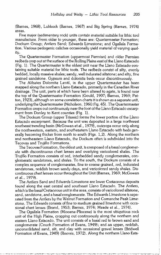
Holliday and Welty - Lithic Tool Resources 205
(Barnes, 1968), Lubbock (Barnes, 1967) and Big Spring (Barnes, 1974) areas.
Five major (sedimentary rock) units contain material suitable for lithic tool manufacture. From older to younger, these are: Quartermaster Formation~ Dockum Group; Antlers Sand; Edwards Limestone; and Ogallala Forma- tion. Various pedogenic caliches occasionally yield material of varying qual- ity.
The Quartermaster Formation (uppermost Permian) and older Permian redbeds crop out at the surface of the Rolling Plains east of the Llano Estacado (Fig. 1). The Quartermaster is the oldest unit near the Llano Estacado con- taining suitable material for lithic tools. The redbeds consist of silty, evenly bedded, locally massive shales; sandy, well indurated siltstone; and silty, fine grained sandstone. Gypsum and dolomite beds occur discontinuously.
The Alibates Dolomite Lentil, in the upper Quartermaster has been mapped along the northern Llano Estacado, primarily in the Canadian River drainage. The unit, parts of which have been altered to agate, is found near the top of the Quartermaster Formation (Gould, 1907; Barnes, 1969; Pat- ton, 1923), although on some correlation charts it is shown as a separate unit, underlying the Quartermaster (Nicholson, 1960:Fig. 45). The Quartermaster Formation crops out continuously near the foot of the Llano Estacado escarp- ment from Donley to Kent counties (Fig. 1).
The Dockum Group (upper Triassic) forms the lower portion of the Llano Estacado escarpment. Because the unit was deposited in a large northwest southeast trending basin (McGowan et al., 1979), outcrops occur only along the northwestern, eastern, and southeastern Llano Estacado with beds gen- erally becoming thicker from north to south (Figs. 1,2). Along the northern and northeastern Llano Estacado, the Dockum often is subdivided into the Tecovas and Trujillo Formations.
The Tecovas Formation, the oldest unit, is composed of a basal conglomer- ate with discontinuous chert lenses and overlying varicolored shales. The Trujillo Formation consists of red, interbedded sandy conglomerates, con- glomeratic sandstones, and shales. To the south, the Dockum consists of a complex sequence of conglomerates, fine to coarse grained, red, indurated sandstones, reddish brown sandy clays, and varicolored sandy shales. Dis- continuous chert lenses occur throughout the Unit (Barnes, 1969; McGowan et al., 1979).
The Antlers Sand and Edwards Limestone are lower Cretaceous deposits found along the east central and southeast Llano Estacado. The Antlers, which is the basal Cretaceous unit in the area, consists of varicolored siltstone, sand, sandstone, and a basal conglomerate. The Edwards Limestone is sepa- rated from the Antlers by the Walnut Formation and Comanche Peak Lime- stone. The Edwards consists of fine to medium grained limestone with occa- sional chert lenses (Brand, 1953; Barnes, 1974; Meade et al., 1974).
The Ogallala Formation (Miocene-Pliocene) is the most ubiquitous rock unit of the High Plains, cropping out continuously along the northern and eastern Llano Estacado. The unit consists of a basal red to brown sand and conglomerate (Couch Formation of Evans, 1949); and an upper, reddish, unconsolidated sand, silt, and clay with occasional gravel lenses (Bridwell Formation of Evans, 1949) (Reeves, 1972). Along the northern Llano Esta-
206 Texas Archeological Society
High Plains
cover sands~
"caprock caliche" silicified & opalized caliches
gravels w/quartzites, jasper,
flint, cherts
in situ chert
Ogallala Fm
Edwards Ls.
Comanche Peak Ls.
Walnut Fm.
Antlers Sand grovels w/quortzites, jasper, flint
Trujillo FI \ gravels w/quartzites, jasper,
Dockum Gp. ~, flint, cherts
TecovasFm.~ inzitu jasper, chert
Alibates Dolomite
~
insifu agate
^ ~ Rolling
uuartermaster Fm. ~
32°N I
no vertical scale
Plainview Big Spring Lubbock
ploi,
High
56°N i
Amarillo Canadian R
:Pg = -
~--~ plains
/~ol/ing
V7H/LLP (section approx, along 101°W) 1981
Fig. 2 Composite Stratigraphic Column of Geologic Units and Respective Rock Types
Suitable for Tool Manufacture (above). Generalized North-South Geologic Cross Sec-
tion of the Eastern Llano Estacado Showing Relative Thicknesses and Stratigraphic
Relationships of Units (below).
cado, Patton (1923) identified a basal gravel, termed the Potter Formation or Potter gravel (Hood, 1978), lithologically different from the basal gravel com- mon in the Ogallala to the south.
A very well developed, well indurated caliche formed at the top of the bedrock, the ledge forming caprock caliche. Generally, the unit developed by soil forming processes in the upper Ogallala. On the southern Llano Esta- cado, where the Ogallala thins and the Edwards Limestone forms the surface outcrop, caliche formed in the latter.
Holliday and Welty -- Lithic Tool Resources 207
On the south central Llano Estacado, along the escarpment and in draws, outcrops of the Blanco Formation (upper Pliocene) consist of discontinuous deposits of dolomite set into the top of the Ogallala. A well developed caliche often is found at the top of the Blanco. The Ogallala and Blanco caliches are often silicified and occasionally opalized.
The surface of the Llano Estacado is mantled by a thick deposit of Pleisto- cene eolian sediments referred to as the cover sands (Frye and Leonard, 1965) or Blackwater Draw Formation (Reeves, 1976). The Ogallala appears present virtually everywhere beneath the Pleistocene deposits (Oetking, 1959).
BEDROCK MATERIAL SUITABLE FOR TOOL MANUFACTURE
Alibates agate is the only material in the Quartermaster Formation suitable for manufacturing tools. This multicolored material, occurring as lenses and nodules, is the result of silicification of the dolomite (Gould, 1907; Asquith, 1975; Bowers and Reaser, 1974). The best known outcrops are in Alibates National Monument near Fritch (Fig. 1). Other outcrops are found on both sides of the Canadian River northeast of Amarillo and sometimes in local gravels (Etchieson et al., 1978; Gould, 1907; Hughes, 1976; Patton, 1923). The colors in the agate occur mainly in bands, but also as mottles (Patton, 1923). Most colors are maroon to reds to tans with milky white interbands. Other colors observed include chocolate brown, blue, and yellow.
Several different kinds of materials are available from the Dockum Group. Most common are the pebble and cobble conglomerates, particularly notable in the lower Dockum. In outcrops west of Flomot (Fig. 1), dominant litholo- gies are coarse to medium grained, light colored quartzites and red jaspers. Other materials included flint and light glassy, fine grained, tan and light to medium gray cherts. Similar lithologies are reported from a variety of areas (McGowan et al., 1979) and outcrops appear to be quite common through- out the survey area. Outcrops with cobbles were not observed. Some proba- bly are available and presumably lithologies would be similar.
Artifacts made from a jasper from the Tecovas Formation of the lower Dockum Group are common in many archeological sites in the area. The material is known locally known as Tecovas or Quitaque jasper (after the best known outcrop near the town of Quitaque) (Fig. 1). Other reported outcrops are in Palo Duro Canyon (Etchieson et al., 1978; McGowan et al., 1979) and along the Canadian River Valley northwest of Amarillo (Jack T. Hughes, personal communication). The material usually occurs as lenses. Colors usually are maroon with mottles of yellow and brown common.
Tecovas jasper has been confused with Alibates agate, particularly if the specimens are small such as flakes (Hughes, 1976; Green and Kelley, 1960; Katz and Katz, 1976). Banding has been used as an indicator of Alibates agate. However, Alibates also can be mottled. Alibates agate often has faint suggestions of other colors within the red, whereas Tecovas jasper usually has an even red color. Tecovas jasper tends to have more tiny quartz vugs than Alibates agate.
Recent studies of the Lubbock lithic assemblage indicate that Alibates agate and Tecovas jasper can be distinguished with relative confidence using low
208 Texas Archeological Society
magnifications (10-20x) (Doug Bamforth, personal communication). Ali~ bates agate tends to have a more vitreous, waxy luster and frequently, it is possible to see a short distance into the stone. Tecovas jasper, on the other hand, is opaque and bluish white quartz vugs are apparent.
A quartzite that is coarser grained than the jasper but otherwise has a similar appearance (Tecovas quartzite) also is found in the Tecovas Formation (Et-
chieson et al., 1978). Outcrops of the Antlers Sand are found in Borden, Dawson, and Garza
counties, south of Post and west of Fluvanna and Gail (Barnes, 1974) and in Shafter Lake, Andrews County (Meade et al., 1974) (Fig. 1). The unit often
contains a basal gravel with lithologies similar to the Dockum gravel, including some light colored quartzites, jasper, flint, and petrified wood. Observed out- crops of Antlers yielded only pebble clasts. It is not known if cobbles are available.
Outcrops of material adequate for tool making were not found in the
Walnut Formation nor Comanche Peak Limestone. However, Evans and Brand (1956:10) mention "a prominent quartzose conglomerate in the basal 3 feet of the [Commanche Peak Limestone]" in southeast Lubbock County.
Tan to gray cherts quite similar to cherts commonly found in the Edwards Limestone in Central Texas are ubiquitous in archeological sites on the Llano Estacado (Hester, 1972; Johnson and Holliday, 1981). In the survey area,
outcrops of light gray to tan cherts were found in the Edwards Limestone along the southeast escarpment of the Llano Estacado in Borden and Garza counties. The chert was not present everywhere in the Edwards outcrops.
This particular material probably does not account for the high percentages of similar chert in local archeological sites. Hester (1972, 1975) reports out- crops of chert in the Edwards Limestone in the Sterling City - San Angelo area, 50~90 mi southeast of Big Spring. Harrison and Killen (1978) mention
an outcrop in Jones County, northeast of San Angelo. In the survey area, gravel of the Ogallala Formation produces the most
abundant and varied material for making lithic tools. The material is common throughout the area. Within the Ogallala, the basal gravel generally seems to have the largest clasts and highest quality materials. Light colored, medium to coarse grained quartzites are most common. Several experimental tools were
made of this material by the authors, with most satisfactory results. Dark gray to black, medium grained quartzites also were found; and red to
brown jaspers, medium to dark gray and dark blue chert, and flint were com- mon. Outcrops of the upper Ogallala yielded a generally finer grained (pebble sized) gravel and contained light colored, coarse grained quartzite, purple quartzite, flint, some medium gray chert, and brown to yellow jasper. Along the northeastern Llano Estacado, cherts apparently are rare in Ogallala gravels, quartzites being the dominant lithology (Jack T. Hughes, personal
communication). Potter chert is found in gravel of the Potter Formation of the lower Ogallala
on the northern Llano Estacado (Hood, 1978). The material is a dense, gray to brown, silica cemented, very fine grained siltstone; it possibly is derived
from the Morrison Formation (Jurrasic) in New Mexico. Other materials found in the Potter gravels are purple quartzite, some jasper, chert, petrified
Holliday and Welty -- Lithic Tool Resources 209
(silicified) wood, and various quartzites referred to as Potter quartzite (Hood,
1978~ Etchieson et al., 1977). The various well developed caliches in the area provide occasionally
marginal to high quality raw materials for lithic tool manufacture. The caprock caliche in the upper Ogallala Formation and Edwards Limestone and the caliche formed in the upper Blanco Formation are silicified in places. Such
silicified caliche, although of poor quality, can be used for lithic tools. Despite its poor workability the material is common in some archeological sites (John- son and Holliday, 1981), particularly where outcrops are nearby.
In some areas, the silicification process has gone so far as to produce an
opalized caliche, usually in the lower caprock caliche (Reeves, 1970). The
opal is of fairly good quality and flakes of the material are common in ar- cheological sites in the area (Hughes, 1976~ Hughes and Willey, 1978). Opal outcrops were observed in exposures of the caprock at the Muleshoe Wildlife
Refuge (MWR) and reported from Cedar Lake (C.C. Reeves Jr., personal communication) and in the MacKenzie Reservoir area (Hughes, 1978). (Fig.
1). Outcrops of other materials sometimes found in sites on or near the Llano
Estacado are outside of the survey area. The Seymour Formation (Pleisto- cene) occurs in a north south trending outcrop 80 to 100 mi east of the Llano
Estacado. The deposit consists of gravels apparently derived from the Potter gravels of the Ogallala Formation and the siliceous conglomerates from the. Dockum Group (Hood, 1978). Presumably, Ogallala gravels with lithologies similar to those found south of the Potter outcrops would be found in the
Seymour gravels. Durler (1976) discusses a conglomerate with quartzites and other siliceous
material suitable for tool manufacture that makes up early or pre-Pleistocene
terraces of the Pecos River near Carlsbad (New Mexico), southwest of the Llano Estacado.
Quartzite considered to be from outcrops of the Dakota Formation (upper
Cretaceous) near Ft. Sumner and Tucumcari (New Mexico), along the north- west escarpment, is a common artifact material on the northern Llano Esta-
cado (Hester, 1975; Willey and Hughes, 1978). Although the material has been described as "metamorphosed sandstone" (Willey and Hughes, 1978:47), this description is misleading as it is not a metamorphic rock. The material is a silica cemented sandstone more properly termed Dakota ortho- quartzite (Hughes and Hood, 1976). The material is coarse grained and varies from reds to browns, causing some problem in differentiating it from Tecovas quartzite.
Obsidian occasionally is found in archeological sites in the area. The
nearest source of this material is believed to be central New Mexico.
SUMMARY AND CONCLUSIONS
A variety of materials suitable for manufacturing lithic artifacts is available along the eastern escarpment of the Llano Estacado. Most of the material is available in the form of gravel and includes flint, chert, jasper, and various
210 Texas Archeological Society
quartzites. Material found in situ in various deposits includes high quality agate and jasper, chert, and some opal. The Ogallala Formation has the greatest variety and abundance of material in the area.
Due to the amount of raw material available in gravels in the region, caution should be exercised in naming rock types. Such distinctive in situ materials as Alibates agate and Tecovas jasper are properly named. However, materials found in gravels should only be described by rock type and not formally named. The geological convention for naming a formation using its lithology (e.g., Edwards Limestone, Antlers Sand) is employed only when the unit is predominately of one lithology. When a variety of rock types is present, the term Formation is used in place of the lithology (e.g., Ogallala Formation). By analogy, the use of such terms as Potter chert or Ogallala chert (Hughes, 1976) implies that the material formed in the deposit. Ogallala chert or opal may be properly applied to the silicified or opalized caliche in the Ogallala (Hughes, 1976).
The availability of such a variety of material places considerable limitations on the use of rock types found in archeological sites for estimating possible trade routes. A notable example are the gravels of high quality chert and flint in the Ogallala. The material is macroscopically identical to chert found in the Edwards Limestone in Central Texas and may have been derived from pre- viously existing Cretaceous outcrops in the area during deposition of the Ogallala.
The availability and quality of chert from the Ogallala along the eastern and southeastern Llano Estacado escarpment probably accounts for the large number of tools made from it in archeological sites in the area rather than trade networks between this area and Central Texas. Such trade routes may have existed but lithic artifact materials should not be used as evidence.
ACKNOWLEDGMENTS
The survey of lithic resources on the Eastern Llano Estacado was the culmination of several years of interest and sporadic research in the topic. During this time, a number of individuals provided considerable information on types and outcrops of regional lithic materials. Dr. Jack T. Hughes (West Texas State University) freely shared his considerable knowledge of the subject. Dr. C. C. Reeves Jr. (Texas Tech University), Dr. John P. Brand (formerly with Texas Tech University), and Michael J. Kaczor (Arkansas Archeological Survey) also made available valu- able information concerning rock types and specific outcrops. Douglas Bamforth (University of California, Santa Barbara) provided valuable comments on the manuscript in light of his research on the Lubbock Lake lithic assemblage.
Dr. Eileen Johnson (Director, Lubbock Lake Project) provided considerable encouragement and support for this undertaking and reviewed drafts of the manuscript. Drs. James B. Benedict (Center for Mountain Archeology) and Peter W. Birkeland (University of Colorado) also re- viewed drafts of the manuscript and provided constructive criticism. Anne Knedler typed final drafts of the manuscript. The survey was part of continuing research of the Lubbock Lake Proj- ect, funded by National Science Foundation (Grants SOC75-14857, BNS 7612006, BNS 7612006-AO1, BNS78-11155), National Geographic Society, Center for Field Research (EARTHWATCH), Texas Historical Commission (National Register Program), City and County of Lubbock, and the Museum, Texas Tech University.
Holliday and Welty - Lithic Tool Resources 211
REFERENCES CITED
Ahler, Stanley A.
1977 Lithic Resource Utilization Patterns in the Middle Mississippi Subarea.
Plains Anthropologist Memoir, 13:132-150.
Asquith, George B. 1975 Origin of the Dolomite and Chert. In: Jack T. Hughes and Kim E. Taylor,
Archeological Salvage at Pipeline Construction in Alibates National Monument, pp. 29-31. Archeological Research Laboratory, Killgore Re- search Center, West Texas State University, Canyon.
Barnes, Virgil E. 1967 Lubbock Sheet (1:250,000). Geological Atlas of Texas, Bureau of
Economic Geology, University of Texas, Austin.
1968 Plainview Sheet (1:250,000). Geologic Atlas of Texas, Bureau of Economic Geology, University of Texas, Austin.
1969 Amarillo Sheet (1:250,000). Geologic Atlas of Texas, Bureau of Economic Geology, University of Texas, Austin.
1974 Big Spring Sheet (1:250,000). Geologic Atlas of Texas, Bureau of Economic Geology, University of Texas, Austin.
Blatt, Harvey, Gerard Middleton, and Raymond Murray 1980 Origin of Sedimentary Rocks (2nd Ed.). Prentice--Hall, Inc., Englewood
Cliffs, New Jersey.
Bowers, R. 1974
L. and Reaser, D. F. Local Chert Occurrence in Alibates Dolomite, Alibates National Monu- ment and Vicinity, Northern Panhandle of Texas. Paper presented at the annual meeting of the Geological Society of America, Stillwater, Okla- homa.
Brand, John P. 1953 Cretaceous of the Llano Estacado of Texas. Bureau of Economic
Geology, The University of Texas at Austin, Report of Investigations, 20:1-59.
Bryan, Kirk 1950 Flint Quarries. Peabody Museum Papers, 17(3):1-40.
Coffin, Roy G. 1951 Sources and Origins of Northern Colorado Artifact Materials. Southwest-
ern Lore, 17(3):2-6.
Collins, Michael B. 1971 A Review of Llano Estacado Archeology and Ethnohistory. Plains An-
thropologist, 16(52):85-104.
Clayton, Lee, W. B. Bickley Jr., and W. J. Stone 1970 Knife River Flint. Plains Anthropologist, 15(50):282-290.
Durler, David 1976 Quartzite Conglomerate and Dune Deposits, Brantley Reservoir area.
Report prepared for Archeology Research Program, Southern Methodist University, Dallas.
212 Texas Archeological Society
Ebright, C. A. 1979 Comment on "Quartzite Qua Lithic Material in Archeology" by H.
Wolcott Toll. Plains Anthropologist, 24(84):169-170.
Etchieson, Gerald M., Roberta D. Speer, and Jack T. Hughes 1977 An Archeological Survey of Certain Tracts in and near Caprock Canyons
State Park in Eastern Briscoe County, Texas. Archeological Research Laboratory, Killgore Research Center, West Texas State University, Can- yon.
1978 Archeological Investigations in the Truscoot Reservoir Area, King and Knox Counties, Texas. Archeological Research Laboratory, Killgore Re- search Center, West Texas State University, Canyon.
Evans, Glen L. 1949 Upper Cenozoic of the High Plains. In: Cenozoic Geology of the Llano
Estacado and Rio Grande Valley, pp. 1-9. West Texas Geological So- ciety and New Mexico Geological Society Guidebook, Lubbock.
Evans, Glen L. and John P. Brand 1956 Eastern Llano Estacado and Adjoining Osage Plains. West Texas Geo-
logical Society and Lubbock Geological Society Guidebook, Lubbock.
Frye, John 1965
C. and A. Byron Leonard Quaternary of the Southern Great Plains. In: H. E. Wright Jr. and David G. Frye (eds.), The Quaternary of the United States, pp. 203-216. Princeton University Press, Princeton.
Gould, Charles N. 1907 The Geology and Ground Water Resources of the Western Portion of the
Panhandle of Texas. United States Geological Survey Water Supply and Irrigation Paper, 191:1-70.
Green, F. Earl and Jane Holden Kelley 1960 Comments on Alibates Flint. American Antiquity, 25(3):413-414
Harrison, Billy R. and Kay Killen 1978 Lake Theo: A Stratified Early Man Bison Butchering and Camping Site,
Briscoe County, Texas. Panhandle-Plains Historical Museum, Special Archeological Report, 1:1-108.
Hester, James J. 1972 Blackwater Draw Locality No. 1: A Stratified Early Man Site in Eastern
New Mexico. Ft. Burgwin Research Center, Southern Methodist Univer- sity, Dallas.
1975 Paleoarcheology of the Llano Estacado. In: Fred Wendorf and James J. Hester (eds.), Late Pleistocene Environments of the Southern High Plains, pp. 247-256. Ft. Burgwin Research Center, Southern Methodist University, Dallas.
Holliday, Vance T. in press Cultural Chronology of the Llano Estacado. In: Eileen Johnson (ed.),
Lubbock Lake: Late Quaternary Studies on the Southern High Plains. University of Texas Press, Austin.
Holliday and Welty -- Lithic Tool Resources 213
Hood, Charles N. 1978 Analysis of the Seymour Gravels. In: Gerald M. Etchieson, Roberta D.
Speer, and Jack T. Hughes, Archeological Investigations in the Truscott Reservoir Area, King and Knox Counties, Texas, pp. 379-386. Killgore Research Center, Archeological Research Laboratory, West Texas State University, Canyon.
Hughes, Jack T. 1976 A Review of Some References to Hint Sources in the Texas Panhandle.
Killgore Research Center, Archeological Research Laboratory, West Texas State University, Canyon.
1978 Geology. In: Jack T. Hughes and Patrick S. Willey, Archeology at Mac- Kenzie Reservoir. Texas Historical Commission, Archeological Survey Report, 24:16-32.
Hughes, Jack T. and Charles N. Hood 1976 Archeological Testing in the Lakeview Watershed, Hall County, Texas.
Killgore Research Center, Archeological Research Laboratory, West Texas State University, Canyon.
Hughes, Jack T. and Patrick S. Willey 1978 Archeology at MacKenzie Reservoir. Texas Historical Commission, At-
theological Survey Report, 24:1-294.
Johnson, Eileen and Vance T. Holliday 1981 Late Paleoindian Activity at the Lubbock Lake Site. Plains Anthropolo-
gist, 26(93):173-193.
Katz, Susanna and Paul R. Katz 1976 Archeological Investigations in Lower Tule Canyon, Briscoe County,
Texas. Texas Historical Commission, Archeological Survey Report, 16:1-141.
Kelly, Jane Holden
1964 Comments on the Archeology of the Llano Estacado. Bulletin of the
Texas Archeological Society, 35:1-18.
Lapedes, Daniel N.
1978 McGraw-Hill Encyclopedia of the Geological Sciences. McGraw-Hill
Book Company, New York.
McGowan, J. H., G. E. Granaton, and S. J. Seni 1979 Depositional Framework of the Lower Dockum Group (Triassic), Texas
Panhandle. Bureau of Economic Geology, The University of Texas at Austin, Report of Investigations, 97:1-60.
Meade, Grayson E., Glen L. Evans, and John P. Brand 1974 Mesozoic and Cenozoic Geology of the Southern Llano Estacado. Lub-
bock Geological Society Guidebook, Lubbock.
Nicholson, John H. 1960 Geology of the Texas Panhandle. In: Aspects of the Geology of Texas: A
Symposium, pp. 51-64. Bureau of Economic Geology, The University of
Texas at Austin.
Oetking, Philip F. 1959 Geologic Highway Map of Texas. Dallas Geological Society of Dallas.
214 Texas Archeological Society
Patton, Leroy T. 1923 The Geology of Potter County, Texas. University of Texas Bulletin,
2330:1-180.
Reeves, C. 1970
1972
1976
C. Jr.
Some Geomorphic, Structural, and Stratigraphic Aspects of the Pliocene and Pleistocene Sediments of the Southern High Plains. Unpublished Ph.D. dissertation, Texas Tech University, Lubbock.
Tertiary-Quaternary Stratigraphy and Geomorphology of West Texas and Southeastern New Mexico. In: Vincent C. Kelly and Frederick D. Trauger (eds.), Guidebook of East-Central New Mexico, pp. 108-117. New Mexico Geological Society, Socorro.
Quaternary Stratigraphy and Geologic History of the Southern High Plains, Texas and New Mexico. In: W. C. Mahaney (ed.), Quaternary Stratigraphy of North America, pp. 213-234. Dowden, Hutchinson, and Ross, Inc.
Schaffer, James B. 1958 The Alibates Flint Quarry of Texas. American Antiquity, 24(2): 189-191.
Sellards, E. H., W. S. Adkins, and F. B. Plummer 1947 The Geology of Texas (Vol. 1), Stratigraphy. University of the Texas at
Austin Bulletin, 3232:1-1007.
Willey, Patrick and Jack T. Hughes 1978 Archeological Methods. In: Jack T. Hughes and Patrick S. Willey, Ar-
cheology at MacKenzie Reservoir. Texas Historical Commission, Ar- cheological Survey Report, 24:45-48.
Bulletin of the Texas Archeological Society 52:215-229 1981
ABSTRACT
Although it is a Southwestern affiliated area, western Texas largely has been ignored by regional archeologists. The area’s ceramic chronology was sketched out some 30 years ago and not substantially modified until 1976. A combination and synthesis is presented of results of several recent ceramic studies in and around the Hueco Bolson, immediately east of El Paso (Texas). These analyses consisted of morphological studies of local wares in order to discover stylistic trends which were potentially significant as chronological markers; and application of a series of radiocarbon, archaeomagnetic, and ceramic thermoluminescence dates in order to place the sequence in time. Results of these efforts are a new, and early, origin date for local West Texas ceramics ai~d a substantially refined developmental sequence for these wares.
INTRODUCTION
Archeologists have long recognized the Southwestern affinites of the pre- historic cultures of western Texas (Stallings, 1932). This tradition includes
sedentary villages of pithouses and later multiroomed pueblos, corn-bean- squash agriculture, and extensive use of ceramics. Nevertheless, western Texas traditionally has attracted little of the attention of Southwestern ar- cheologists. This situation undoubtedly is due to the area’s position on the periphery of the Greater Southwest.
The ceramic chronology of western Texas was established in very broad terms between 1930 and 1948 (Stallings, 1930, 1931; Lehmer, 1948). The chronology largely was created by application of chronological schemes from
better known areas of the Southwest. Dated ceramics from the nearby Casas Grandes, Mimbres, and Gila areas were employed extensively. These intri- cately decorated, highly visible, intrusive ceramics characteristically occur in small quantities in western Texas and are not usually present on small sites. Early ceramic studies gave very limited attention to the less complex local
ceramics which make up the overwhelming majority of every western Texas sherd collection.
What little work was done with local western Texas ceramics succeeded in establishing two basic, although very broad, categories. The later type, El Paso Polychrome, was described by Stallings (1930, 1931). Polychrome is a misnomer as vessels of this type are decorated with black and red only. The predecessor of El Paso Polychrome was not recognized for some years.
Lehmer (1948) defined El Paso Brown as the local manifestation of the Pithouse period brownware tradition which was widespread in portions of
eastern Arizona, southern New Mexico, northern Mexico, and western
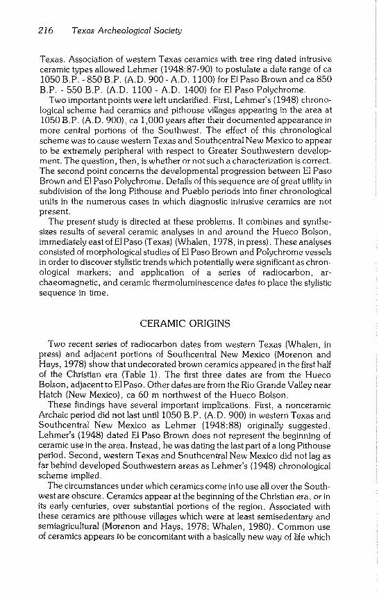
216 Texas Archeological Society
Texas. Association of western Texas ceramics with tree ring dated intrusive ceramic types allowed Lehmer (1948:87-90) to postulate a date range of ca
1050 B.P. - 850 B.P. (A.D. 900 - A.D. 1100) for El Paso Brown and ca 850 B.P. - 550 B.P. (A.D. 1100 - A.D. 1400) for El Paso Polychrome.
Two important points were left unclarified. First, Lehmer’s (1948) chrono- logical scheme had ceramics and pithouse villages appearing in the area at 1050 B.P. (A.D. 900), ca 1,000 years after their documented appearance in more central portions of the Southwest. The effect of this chronological
scheme was to cause western Texas and Southcentral New Mexico to appear to be extremely peripheral with respect to Greater Southwestern develop- ment. The question, then, is whether or not such a characterization is correct. The second point concerns the developmental progression between El Paso Brown and El Paso Polychrome. Details of this sequence are of great utility in subdivision of the long Pithouse and Pueblo periods into finer chronological units in the numerous cases in which diagnostic intrusive ceramics are not present.
The present study is directed at these problems. It combines and synthe- sizes results of several ceramic analyses in and around the Hueco Bolson, immediately east of El Paso (Texas) (Whalen, 1978, in press). These analyses consisted of morphological studies of El Paso Brown and Polychrome vessels in order to discover stylistic trends which potentially were significant as chron- ological markers; and application of a series of radiocarbon, ar-
chaeomagnetic, and ceramic thermoluminescence dates to place the stylistic sequence in time.
CERAMIC ORIGINS
Two recent series of radiocarbon dates from western Texas (Whalen, in press) and adjacent portions of Southcentral New Mexico (Morenon and Hays, 1978) show that undecorated brown ceramics appeared in the first half
of the Christian era (Table 1). The first three dates are from the Hueco Bolson, adjacent to El Paso. Other dates are from the Rio Grande Valley near
Hatch (New Mexico), ca 60 m northwest of the Hueco Bolson. These findings have several important implications. First, a nonceramic
Archaic period did not last until 1050 B.P. (A.D. 900) in western Texas and
Southcentral New Mexico as Lehmer (1948:88) originally suggested. Lehmer’s (1948) dated El Paso Brown does not represent the beginning of ceramic use in the area. Instead, he was dating the last part of a long Pithouse period. Second, western Texas and Southcentral New Mexico did not lag as far behind developed Southwestern areas as Lehmer’s (1948) chronological scheme implied.
The circumstances under which ceramics come into use all over the South- west are obscure. Ceramics appear at the beginning of the Christian era, or in its early centuries, over substantial portions of the region. Associated with
these ceramics are pithouse villages which were at least semisedentary and semiagricultural (Morenon and Hays, 1978~ Whalen, 1980). Common use of ceramics appears to be concomitant with a basically new way of life which
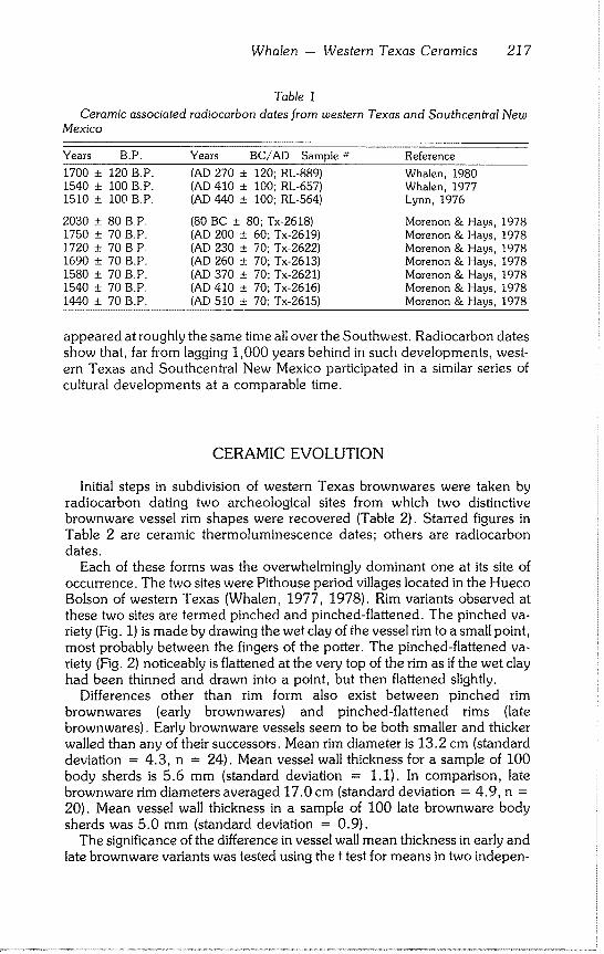
Whalen - Western Texas Ceramics 217
Table I
Ceramic associated radiocarbon dates from western Texas and Southcentral New Mexico
Years B~P. Years BC/AD Sample # Reference
1700 + 120 B.P. (AD 270 + 120; RL-889) Whalen, 1980 1540 + 100 B.P. (AD 410 + 100; RL-657) Whalen, 1977 1510 + 100 B.P. (AD 440 ± 100; RL-564) Lynn, 1976
2030 + 80 B.P. (80 BC + 80; Tx-2618) Morenon & Hays, 1978 1750 + 70 B.P. (AD 200 ± 60; Tx-2619) Morenon & Hays, 1978 1720 ± 70 B.P. (AD 230 ± 70~ Tx~2622) Morenon & Hays, 1978 1690 ± 70 B.P. (AD 260 ± 70~ Tx-2613) Morenon & Hays, 1978 1580 ± 70 B.P. (AD 370 + 70; Tx-2621) Morenon & Hays, 1978 1540 ± 70 B.P. (AD 410 ± 70, Tx~2616) Morenon & Hays, 1978 1440 ± 70 B.P. (AD 510 ± 70; Tx-2615) Morenon & Hays, 1978
appeared at roughly the same time all over the Southwest. Radiocarbon dates show that, far from lagging 1,000 years behind in such developments, west- ern Texas and Southcentral New Mexico participated in a similar series of cultural developments at a comparable time.
CERAMIC EVOLUTION
Initial steps in subdivision of western Texas brownwares were taken by
radiocarbon dating two archeological sites from which two distinctive brownware vessel rim shapes were recovered (Table 2). Starred figures in
Table 2 are ceramic thermoluminescence dates~ others are radiocarbon dates.
Each of these forms was the overwhelmingly dominant one at its site of occurrence. The two sites were Pithouse period villages located in the Hueco
Bolson of western Texas (Whalen, 1977, 1978). Rim variants observed at these two sites are termed pinched and pinched-flattened. The pinched va- riety (Fig. 1) is made by drawing the wet clay of the vessel rim to a small point, most probably between the fingers of the potter. The pinched-flattened va- riety (Fig. 2) noticeably is flattened at the very top of the rim as if the wet clay had been thinned and drawn into a point, but then flattened slightly.
Differences other than rim form also exist between pinched rim
brownwares (early brownwares) and pinched-flattened rims (late brownwares). Early brownware vessels seem to be both smaller and thicker
walled than any of their successors. Mean rim diameter is 13.2 cm (standard deviation = 4.3, n = 24). Mean vessel wall thickness for a sample of 100
body sherds is 5.6 mm (standard deviation = 1.1). In comparison, late brownware rim diameters averaged 17.0 cm (standard deviation = 4.9, n =
20). Mean vessel wall thickness in a sample of 100 late brownware body
sherds was 5.0 mm (standard deviation = 0.9). The significance of the difference in vessel wall mean thickness in early and
late brownware variants was tested using the t test for means in two indepen-
218 Texas Archeological Society
000000
~ 0000
H. H. H. ~
oo00
¯ ~ ~ 0 cy~ 0 °OH.
I+ H. H. ~+
- O0~
r~ t~ t~ Z~
~ ~000~D
O~::L
E
,<
P~
~V .~.a,
~J
0
t~
Whalen -- Western Texas Ceramics 219
Fig. 1 Early "pinched" Brownware rims.
Fig. 2 Late "pinched-flattened" Brownware rims.
dent populations. The hypothesis tested was that the early brownware thick- ness mean (/.1) is equal to the late brownware thickness means (/.2), or Ho:
/.1 -- /’2" The alternative hypothesis is that the earlier brownware thickness mean is significantly greater than that of the later brownware, or H 1:/’1 ~/’2"
The level of significance of the test (~) is 0.01. The form of the alternative hypothesis requires a one-tailed t test in which the null hypothesis is rejected if
the calculated value of t is greater than a critical value (k), defined as tI _ i/2c~ for N1 + N2 - 2 degrees of freedom. The value of k is read from tables of percentiles for the t distribution.
The t statistic is"
- t=
Sp x/(I/N1) + (I/N2)
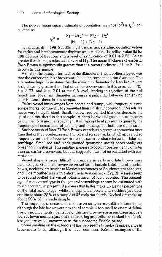
220 Texas Archeological Society
The pooled mean-square estimate of population variance (o2) is Sp2, cal-
culated as:
(N1- 1)Sl2 + (N2- 1)s22
SP2 = (N1 - 1) + (N2- 1)
In this case, df -- 198. Substituting the mean and standard deviation values
for earlier and later brownware thicknesses, t = 4.29. The critical value (k) for 198 degrees of freedom and a level of significance of 0.01 is 2.58. As t is
greater than k, Ho is rejected in favor of H1. The mean thickness of earlier El Paso Brown is significantly greater than the mean thickness of later El Paso Brown in this sample.
A similar t-test was performed for rim diameters. The hypothesis tested was that the earlier and later brownware have the same mean rim diameter. The alternative hypothesis states that the mean rim diameter for later brownware is significantly greater than that of earlier brownware. In this case, df = 42, t = 2.73, and k = 2.01 at the 0.5 level, leading to rejection of the null hypothesis. Mean rim diameter increases significantly between earlier and later Pithouse times in this sample.
Earlier vessel finish ranges from coarse and bumpy with frequent pits and scrape marks (common), to somewhat finer finish (uncommon). Vessels are never very finely finished. Small, hollow, red painted triangles decorate the lip of one rim sherd in this sample. A deep horizontal groove also appears
below the lip of another specimen. It is impossible at present to quantify the frequency of occurrence of painting and incising, but both are quite rare.
Surface finish of later El Paso Brown vessels as a group is somewhat finer than that of their predecessors. The pit and scrape marks which appeared so
frequently on earlier brownware do not seem to characterize the later as- semblage. Small red and black painted geometric motifs occasionally are present on rim sherds. This painting appears to occur more frequently on later than on earlier brownware, but this suggestion cannot be validated with cur-
rent data. Vessel shape is more difficult to compare in early and late brown ware
assemblages. General brownware vessel forms include ladels, hemispherical bowls, neckless jars similar to Mexican tecomates or Southwestern seed jars, and wide mouthed jars with a short, near vertical neck (Fig. 3). Vessels seem to be round bodied; flat vessel bottoms have not been recorded. The percent-
age of each vessel type in the general assemblage cannot be estimated with much accuracy at present. It appears that ladles make up a small percentage
of the total assemblage, while hemispherical bowls and neckless jars each constitute about 25 % of a sample of 32 early rim sherds. Necked jars make up about 50% of the early sample.
The frequency of occurrence of these vessel types may differ in later times, although the late brownware rim sherd sample is too small to attempt defini- tive pronouncements. Tentatively, this late brownware assemblage appears to have fewer neckless jars and an increasing proportion of necked jars. Neck- less jars are quite uncommon in the succeeding Pueblo period.
Some painting on the exteriors of jars also seems to make its appearance in brownware times, although it is never common. Painted examples of the
Whalen - Western Texas Ceramics 221
d
e
o 15
cm
Fig. 3 El Paso Brown vessel types. The 5 cm scale is for vesseis a-d. The 15 cm scale is for vessel e.
pinched-flattened brownwares are shown in Figure 4. These decorations are simple, crude, and widely spaced. They may well be the marks of fingertips dipped in paint and drawn over portions of the vessel in roughly parallel lines. A trend in brownware rim shape may be toward a simple direct rim form, i.e., one that is rounded rather than being pinched or flattened. This rim form is not well represented in current collections.
It appears that brownware jars diminish in frequency after 850 B.P. (A.D.
1100) or during the western Texas Pithouse to Pueblo transition period. The
222 Texas Archeological Society
Fig. 4 Early painted ceramics; ’a’ is an interior surface, ’b ’ and ’c’ are exterior surfaces.
decline of brownware jars appears to be synchronous with the rise of El Paso Polychrome jars. Unpainted or scantily painted hemispherical bowls outlast brownware jars. By early Pueblo times, these bowls appear to be the only surviving remnants of the millennium old brownware tradition.
It is in the Pithouse to Pueblo transition, ca 850 B.P. - 750 B.P. (A.D. 1100 - A.D. 1200), that El Paso Polychrome makes its initial appearance. Lehmer (1948) and succeeding workers (Whalen, 1977, 1978) used El Paso
Whalen - Western Texas Ceramics 223
Polychrome as a broad diagnostic of post Pithouse times, i.e., after 850 B.P. (A.D. 1100). However, the type can be broken into early and late variants which are recognizable even in very small ceramic samples.
The early variant of El Paso Polychrome was defined and described on stylistic grounds by Whalen (1978), although firm dates were not available. Subsequent work by Way (1979) established a firmer chronological frame- work for early Polychrome. Way (1979:44-51) dates the ware at 850 B.P. - 700 B.P. (A.D. 1100 - A.D. 1250). The initial date relies on association of the early Polychrome ware with Mimbres Black-on-White, a well dated intrusive ceramic from southwestern New Mexico. Confirmation of this suggestion comes from a recent radiocarbon date of 800 + 50 B.P. (A.D. 1150 + 50, Tx 1735). The dated charcoal was associated with the early variant of El Paso Polychrome at the Hueco Tanks site, east of El Paso (Kegley, 1980:10).
A ceramic thermoluminescence reading of 745 + 67 B.P. (A.D. 1233 + 67, WU-77d7) also was secured from a western Texas sherd of the early Polychrome type (Whalen, in press). Archaeomagnetic dates on associated features provide an approximate end for the ware, which is not present in western Texas Pueblo period contexts dated to 690 + 18 B.P. (A.D. 1260 + 18) and 655 + 13 B.P. (A.D. 1295 + 13). Both these determinations are archaeomagnetic dates from the Earth Science Laboratory, University of Oklahoma. The early Polychrome variant thus seems to appear in the early or middle 12th Century and to extend into the middle or late 13th Century in western Texas and adjacent portions of Southcentral New Mexico.
The late variant of El Paso Polychrome, termed Classic El Paso Poly- chrome by Way (1979), is the best known form of the ware. It appears in the latter half of the 13th Century. Archaeomagnetic dates (690 + 18 B.P. and 655 + 13 B.P.) denote the earliest recorded appearances of late (Classic) El Paso Polychrome in western Texas. The ware persists until the end of the Pueblo period in western Texas and Southcentral New Mexico. Additional archaeomagnetic dates (Brook, 1970) and ceramic thermoluminescence dates (Whalen, in press) place this event fairly firmly at 630 B.P. - 590 years B.P. (A.D. 1350- A.D. 1390).
Major morphological differences between the early and late variants of El Paso Polychrome are shape of jar rims and necks and form and extent of vessel decoration. Early Polychrome jars have straight, near vertical necks with globular bodies. The general shape of these jars is reminiscent of the brownware jars of the preceding Pithouse period. Marked thickening of the vessel lip also is present in most early Polychrome jars. Rim profiles are wedge shaped with flattened tips. This trend finds its fullest development in the suc- ceeding late Polychrome wares.
Late Polychrome vessels are characterized by widely flared rims (Fig. 6). This flaring may become more extreme as the Pueblo period progresses, although current data are inadequate for pursuit of this issue. Collection and measurement of flare angles, together with a series of absolute dates, might provide a useful chronological tool for subdivision of the late Pueblo period. Further investigation certainly is warranted.
Vessel size continues to increase between late brownware and early Po- lychrome times. Mean vessel wall thickness in a sample of 100 early Poly-
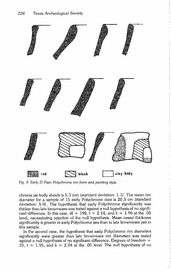
224 Texas Archeological Society
red ~;~ black ~ clay body
Fig. 5 Early El Paso Polychrome rim form and painting style.
chrome jar body sherds is 5.3 mm (standard deviation: 1.1). The mean rim
diameter for a sample of 15 early Polychrome rims is 20.3 cm (standard deviation: 5.0). The hypothesis that early Polychrome significantly was thicker than late brownware was tested against a null hypothesis of no signifi-
cant difference. In this case, df = 198, t -- 2.14, and k = 1.96 at the .05 level, necessitating rejection of the null hypothesis. Mean vessel thickness significantly is greater in early Polychrome jars than in late brownware jars in this sample.
In the second case, the hypothesis that early Polychrome rim diameters significantly were greater than late brownware rim diameters was tested against a null hypothesis of no significant difference. Degrees of fre~edom =
33, t = 1.95, and k = 2.04 at the .05 level. The null hypothesis of no
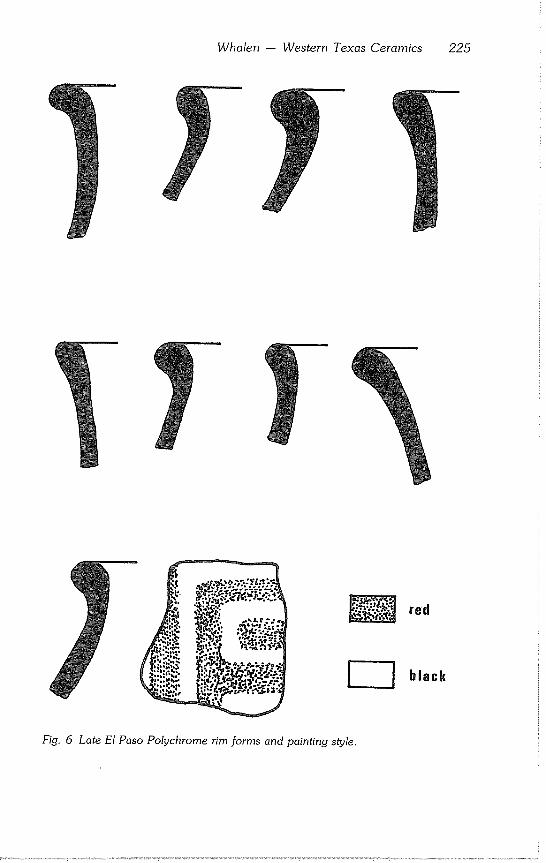
Whalen -- Western Texas Ceramics 225
black
Fig. 6 Late El Paso Polychrome rim forms and painting style.
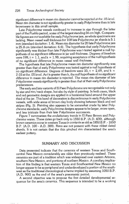
226 Texas Archeological Society
significant difference in mean rim diameter cannot be rejected at the. 05 level. Mean rim diameter is not significantly greater in early Polychrome than in late brownware in this small sample.
Late Polychrome vessels continued to increase in size through the latter part of the Pueblo period, some of the largest standing 56 cm high. Compara- ble figures are not available for early Polychrome jars, as whole specimens are lacking. Mean vessel wall thickness for 100 late Polychrome jar sherds is 5.1 m m (standard deviation: 1.4). Mean rim diameter for 20 late Polychrome jars is 25.8 cm (standard deviation: 6.6). The hypothesis that early Polychrome significantly Was thicker than late Polychrome was t-tested against a null hy- pothesis of no significant difference in jar wall thickness. Degrees of freedom were 198, t = 1.1, and k = 1.98, requiring acceptance of the null hypothesis of no significant difference in mean vessel wall thickness.
The hypothesis that late Polychrome mean rim diameter significantly was greater than that of early Polychrome was tested against a null hypothesis of no significant difference. Degrees of freedom were 33, t = 2.69, and k = 2.03 at the .05 level. As t is greater than k, the null hypothesis of no significant difference in mean rim diameter is rejected. The mean rim diameter of late Polychrome vessels significantly is greater than that of their early Polychrome predecessors.
The early and late variants of El Paso Polychrome are recognizable not only by size and rim/neck shape, but also by style of painting. In both cases, black and red geometric designs are applied in a horizontal band around the upper third of the jar. This band of decoration is discontinuous in early Polychrome vessels, with wide areas of brown clay body showing between black and red stripes (Fig. 5). Painting also appears to be somewhat crude by later Poly- chrome standards; early Polychrome designs appear to be larger, more open, and less intricate than their late Polychrome successors.
Figure 7 summarizes the evolutionary trends in El Paso Brown and Poly- chrome wares. These dates go back only to 1550 B.P. (A.D. 400), although brown ceramics occur in western Texas in contexts as old as 1850 B.P. - 1650 B.P. (A.D. 100 - A.D. 300). Rims are not present with these oldest dated sherds. It is not certain that the thin pinched rim characterized the area’s earliest pottery.
SUMMARY AND DISCUSSION
Data presented indicate that the ceramics of western Texas and South- central New Mexico considerably are older than previously realized. These ceramics are part of a tradition which was widespread over eastern Arizona,
southern New Mexico, and portions of northern Mexico. A corollary implica- tion of this finding is that western Texas and Southcentral New Mexico no
longer appear to be as peripheral and underdeveloped a portion of the south- west as the traditional chronological scheme implied by assuming 1050 B.P. (A.D. 900) as the end of the area’s preceramic period.
A second objective was to propose the first detailed developmental se- quence for the area’s ceramics. This sequence is intended to be a working
Whalen - Western Texas Ceramics 227
ear I ies t rim forms unknown
almost oil unpainted-rare red or black lines, later form most often painted.
painted, open red & black goometrics.
J painted.tight red & black geometries.
I BC!AD AD 400-000 AD 800-1100 AD 1100-1250 AD 1250-1400
Fig. 7 Some dated central tendencies in western Texas ceramic evolution.
model, rather than a definitive pronouncement. The proposed sequence ties
a number of stylistic attributes of local western Texas pottery to a series of radiocarbon, archaeomagnetic, and ceramic thermoluminescence dates. The sequence is not an arbitrary or stylistic ordering of rim shapes.
The progression introduced in Figure 7 recognizes central tendencies at several points in time; too little is known about how change is made from one to another of these rim form variants. Pinched brownware rims are recog-
nized as earlier than flattened brownware rims, although there may be in- termediate stages in which pinched and flattened forms occur together or as
ambiguous hybrids. Rates and directions of change in ceramic styles may or may not have been uniform over a large region.
Ceramic studies in western Texas should be seen as in a formative stage. Work to date has suggested a particular progression between several central
tendencies in rim form. Most details necessary to fill gaps in the proposed scheme are lacking. More excavation and absolute dating of ceramics from controlled proveniences are needed. Studying fine scale progressions of ceramic change from the Hueco Bolson’s severely eroded surface remains alone is difficult. Rim sherds are few in number, often badly damaged, and their proveniences and associations frequently unclear. The area’s subsurface ceramics are better preserved and in clearer association with each other and with other datable materials. It is these deposits which should prove most
useful in continued refinement of the ceramic chronology of western Texas.
ACKNOWLEDGMENTS
The field work upon which much of this study is based was carried out on lands owned or leased by the United States Army, Fort Bliss, Texas. The survey work was arranged, financed, and managed through Fort Bliss as part of that institution’s on-going cultural resource manage- ment program, Additional project support was provided by the U.S. Army Corps of Engineers and the U.S. Army Training and Documentation Command. The field and laboratory work was carried out under the auspices of the El Paso Centennial Museum of the University of Texas at El Paso and the Environmental Office, Fort Bliss. The writer is especially grateful for the support and
228 Texas Archeological Society
assistance of Rex Gerald, Museum Director and Project Principal Investigator, Glen DeGarmo, Fort Bliss Archaeologist, and other of the military and civilian authorities at Fort Bliss facilitated
the work in many ways and their aid is gratefully acknowledged.
REFERENCES
Brook, Vernon 1970 Four Archaeomagnetic Dates from the Hot Wells Site (EPAS -- 3). The
Artifact, 8(1):I-II.
Kegley, George 1980 Archeological Investigations at Hueco Tanks State Park. El Paso County,
Texas. Texas Parks and Wildlife Department. Austin.
Lehmer, David J. 1948 The Jornada Branch of the Mogollon. University of Arizona Bulletin,
19(2) :1-99.
Lynn, Warren M. 1976 Archaeological Testing at the Northgate Sewage Treatment Plant, El
Paso County, Texas. Texas Historical Commission, Archeological Sur- vey Report, 15:1-45.
Morenon, E. Pierre and T. R. Hays 1978 New Evidence from the Jornada Branch: Excavations at Placitas Arroyo.
Paper presented at the annual meetings of the Society for American Ar- chaeology, Tucson.
Stallings, W. S. Jr. 1930 Notes on the Pueblo Culture in South-Central New Mexico and in the
Vicinity of El Paso, Texas. Paper presented at Southwestern Division of the American Association for the Advancement of Science, Denver.
1931
1932
El Paso Polychrome. Laboratory of Anthropology, Santa Fe, Technical Series Bulletin Number, 3:1-13.
Notes on the Pueblo Culture in South Central New Mexico and in the Vicinity of El Paso, Texas. American Anthropologist, 34(1):67-78.
Way, Karen L. 1979 Early Puebloan Occupation in the Southern Tularosa Basin, New Mex-
ico. In: P. Beckett and R. Wiseman (eds.), Jornada Mogollon Ar- chaeology, pp. 41-52. New Mexico State University and New Mexico State Historic Preservation Officer’s Office, Las Cruces.
Whalen, Michael E. 1977 Settlement Patterns of the Eastern Hueco Bolson. Centennial Museum,
University of Texas, El Paso. Anthropological Paper, 4:1-217.
1978
1980
Settlement Patterns of the Western Hueco Bolson. Centennial Museum, University of Texas, El Paso. Anthropological Paper, 6:1-260.
The Pithouse and Pueblo Periods of South-central New Mexico and Western Texas. In: Steven LeBlanc and Michael Whalen (eds.), An Ar- chaeological Synthesis of South-central and Southwestern New Mexico, pp. 317-448. Office of Contract Archaeology, University of New Mexico, Albuquerque.
Whalen - Western Texas Ceramics 229
in press Specialized Studies in the Hueco Bolson. El Paso Centennial Museum, University of Texas, El Paso, Anthropological Paper, 9.

Bulletin of the Texas Archeological Society 52:231-236 1981
BOOK REVIEWS
Late Prehistoric Bison Procurement in Southeastern New Mexico: The 1978 Season at the Garnsey Site (LA-18379). By John D. Speth and William T. Parry, with contributions by Michael Wilson, Regge N. Wiseman and Danny N. Walker. Museum of Anthropology, The University of Michigan, Techni- cal Report 12, Contribution 7, 1980. xvi + 369 pp. $9.00.
This monograph is a report on the second season of excavations at a series of bison kills dating to between A.D. 1450 and A.D. 1650. The first season of excavations was reported in an earlier monograph in the same series (Speth and Parry, 1978).
The Garnsey site is located near Roswell, New Mexico, on the southwestern Southern High Plains (Llano Estacado). Bison kills from the late Prehistoric and His- toric are not well known nor documented. As a result of the detailed reports the two seasons of work at Garnsey, considerably more data now are available. The site can be compared with the few other bison kills of similar age in the area (e.g., Lubbock Lake to the northeast: Johnson, 1976; Johnson et al., 1977).
The report on the 1978 season consists of 13 sections and eight appendices. The first four chapters contain background information on the site and methodology, es- sentially summarizing and updating information presented in the report on the 1977 season. Most of the rest of the report presents data with interpretations scattered throughout.
The Introduction and Site Descriptions sections outline the objectives of the field research and review the site situation. The site is located in a dry, filled wash that is a tributary of the Pecos River. Recent arroyo cutting along the wash exposed portions of the site. Research goals of the 1978 season were to clarify the stratigraphy and chronol- ogy of the site, identify discrete bone cluster, increase sample size of bison remains, and determine if a nearby campsite (Garnsey Springs Campsite) was related to the kill.
The Excavation Procedures and Grid System sections outline, in some detail, the methods employed in excavating the site. Methodology seemed quite adequate for the local field situation. However, the discussion of field procedures and grid system seem overly detailed, particularly the latter. The rationale behind the grid system and changes in it probably are of little concern except to those working at the site.
Stratigraphy section reviews the complex sequence of arroyo cuttings, filling, and soil formation and archeological deposits. General descriptions of the sediments within the four geologic deposits identified are provided in the course of the discussion. This review would be clarified considerably by inclusion of profile drawings or at least a schematic illustration of the arroyo stratigraphy and stratigraphic and/or pedologic descriptions of selected profiles.
Soils formed within the sediments; and each one buried by later filling are mentioned (as paleosols) and used as stratigraphic markers. Information is lacking, however, on the nature of the soils (horizonation, physical characteristics, degree of development). Where soils have formed in a sedimentary sequence, origins of the deposits are only a part of the geologic history. Soils represent periods of landscape stability, neither ero- sion nor deposition. The record of the period between depositional events is in the soil itself. A discussion of the soils, then, is as equally important as the discussion of the sediments in which the soil formed.
Preliminary textural analysis (sand, silt, clay percent) was carried out on sediments from one deep profile with some basic statistical analyses applied to the results. How- ever, the method employed for the textural analysis was not mentioned and the results of the statistical analyses, although presented graphically, were not discussed.
232 Texas Archeological Society
The relationship of the bones to the stratigraphic units was determined by a com- puter generated "backplot" of bone provenience vs. geologic deposit. The authors seem to make a good case for the presence of at least six bone beds.
An important consideration in the stratigraphic discussion is the extent to which the archeological materials have been reworked and redeposited. The authors do an ad- mirable job of dealing with this phenomenon, which apparently took place in some of the bone concentrations.
The Chronology section is a review of radiocarbon ages secured from the site. Fourteen bone samples were submitted for dating. In most cases, ages were deter- mined on both apatite and gelatin. Although a majority of the samples were from one bone bed, there is considerable range in the resulting determinations: A.D. 1360 to A.D. 1840. Most of this section is a discussion of the problems with the ages. The authors briefly mention the problems with dating bone and the fluctuations in atmo- spheric 14C levels documented for the past five centuries. Both of these factors should be given more and serious consideration. They are significant problems and most likely the cause of the problems with the Garnsey ages. To eliminate the problem with bone dating, humates from the A horizons of the underlying and overlying paleosols should be dated.
Considering the range in ages from Garnsey, the authors calculated weighted averages and standard deviations for groups of ages that appear to be from single events. The most probable age range for the Garnsey kills was determined by selecting the zone within which all separate weighted averages overlap. The most probable age range was given as A.D. 1450 to A.D. 1650.
The next three sections in the report contain discussions and analyses of the bison remains recovered from the site. The Garnsey Bison section includes a detailed discus- sion of the condition and treatment of the bone, inventory, minimum number of indi- viduals, spatial distribution, butchering, and sex. This section provides a wealth of data for those interested in Plains bison populations.
Additional information that would be of use to researchers would be drawings of the bone beds. Although computer generated distribution plots are provided, detailed drawings were made for all excavated levels. Drawings of the bone beds made from this field information would be equally informative and provide more realistic illustra- tions of the physical nature of the site.
The Population Dynamics of the Garnsey bison section is by Michael Wilson. He compares the Garnsey bison with data from some of the Northern Plains archeological sites. Although there is certainly some validity in this comparison, considering the amount of information on bison kills in the Northern P|ains, it would seem more useful to compare this Southern Plains kill with other Southern Plains kills such as those at Lubbock Lake.
The Method of Bison Procurement section presents brief observations on how the bison may have been gathered, contained, and killed. This section includes a north south cross section of the site which would be useful in the Site Setting or Stratigraphy sections.
Archeological materials besides the bison recovered from the site are discussed in the next three sections: Non-Bison Remains, Lithics, and Ceramics (the latter section by Regge N. Wiseman). Non-Bison remains is a brief review of other faunal remains. The Lithics section presents detailed descriptions and some basic statistical analyses of lithic tools found at the site. Diagnostic lithic tools include eight Harrell points. This particular style was recovered from well dated contexts at Lubbock Lake in both Protohistoric (A.D. 1450 - A.D. 1650) and aboriginal Historic levels (A.D. 1650 to A.D. 1870). In the latter level, Harrell points are associated with Washita points. A single Washita point was recovered from the Garnsey site in the first season of excavations (Speth and Perry, 1978). Based on data from Lubbock Lake, this Washita point dates the Garnsey
Book Reviews 233
kills to no older than (i.e., not before) about A.D. 1650. The Ceramics section provides a brief discussion of the 19 sherds recovered from
Garnsey. Due to small sample size and few dates associated with recovered types, only a general age range of A.D. 900 to A.D. 1400 is provided.
Conclusions is a very general summary of the data presented previously. Consider- ing all available information on the site, this section could have included a more wide ranging summary.
The Conclusions is followed by eight appendices, which together account for ap- proximately half of the monograph. The first and largest appendix presents measure- ments of the bison remains. The other appendices present sexed bison postcranial elements, measurements of the lithic remains, descriptions of fire cracked rock recov- ered, preliminary charcoal identifications, provenience data on recovered hackberry seeds, a note on the cataloging system, and a discussion of a canid from the site by Danny N. Walker.
The report on the 1978 season at the Garnsey site presents a wealth of data on a series of bison kills from the Southern High Plains. The two principal criticisms of the report are the authors apparent lack of familiarity with regional archeology and litera- ture and the absence of a comprehensive summary of what is known about the site. Otherwise, this report, along with the earlier monograph, is a valuable contribution to Southern Plains archeology in the data it contains and its timely appearance within two years after the field season. The amount of data processed and published within such a relatively short time is rather remarkable.
Vance T. Holliday Department of Geological Sciences University of Colorado Boulder, Colorado 80309
REFERENCES CITED
Johnson, Eileen 1976 Investigations into the Zooarchaeology of the Lubbock Lake Site. Un-
published Ph.D. dissertation, Texas Tech University, Lubbock.
Johnson, Eileen, Vance T. Holliday, Michael Kaczor, and Robert Stuckenrath 1977 The Garza Occupation at the Lubbock Lake Site. Bulletin of the Texas
Archeological Society, 48:83-110.
Speth, John D. and William J. Parry 1978 Late Prehistoric Bison Procurement in Southeastern New Mexico: The
1977 Season at the Garnsey Site. Museum of Anthropology, The Univer- sity of Michigan, Research Reports in Archaeology, 4:1-139.
Bioarchaeology of the McCutchan-McLaughlin Site. By Mary Lucas Powell and J. Daniel Rogers. Oklahoma Archaeological Survey, Studies in Oklahoma’s Past, No. 5, Norman, Oklahoma, 1980.98 pages.
This monograph represents the combined efforts of Powell who analyzed the skele- tal remains of 48 individuals from the McCutchan-McLaughlin site and Rogers who described the burial patterns observed at the site. The site was described as similar to other sites of the Fourche Maline Focus in Oklahoma. It contained two distinct cultural
234 Texas Archeological Society
components which may have been separated by a temporal hiatus of 600 years. Cultural material from the earlier component is typified by large projectile points, while cultural material from the upper component is typified by the presence of arrowpoints and ceramics. Dates for the site range from 2250 B.P. to 985 B.P. (300 B.C. to A.D. 765).
Powelrs analysis of the skeletal remains includes discussions of demography, skele- tal morphology, skeletal and dental pathology, and a review of health and disease in hunter-gatherer populations. In all of these analyses, the skeletal material from the site was treated as one sample; this approach was a research plan that the authors felt was necessitated by the problems of assigning burials to specific cultural components at the site.
In describing the demographic structure of the skeletal sample, Powell documented that 31% of the individuals had died before the age of 15 years. This high mortality rate for the skeletal sample, typical for pre-industrial societies, was still estimated to be lower than the mortality of the actual population because the authors felt that remains of very young individuals were poorly represented.
Among the adults, differential mortality was documented clearly. The mean age of the females in the sample was estimated to be 32.3 years with 69.2% of the females dying by 35. The mean age of the males, on the other hand, was 38.5 years with only 46.2 % of the males dying by 35. The authors felt this differential mortality observed in the skeletal sample could be attributed to two possible phenomena: a proportionately high number of females dying during pregnancy and child birth, or young males dying away from the area and not being interred in the cemetery.
The analysis of the skeletal morphology of the McCutchan-McLaughlin sample was restricted because of the relatively small sample size and fragmentary nature of the material. For this reason, an assessment was not undertaken of the biological relation- ship of the population to other North America populations. It was possible, however, to make some assessment of the size of the individuals and amount of sexual di- morphism present in the sample. The average size of the females was approximately 159 cm (5 ft 2 in) while the males averaged 168 cm (5 ft 6 in). Compared to other populations, these individuals tended to be relatively small and gracile. Sexual di- morphism within the sample was typical for other populations with which it was com- pared.
The description of the pathologies observed on the skeletal material from this site, and material from other sites with which it was compared, represents the longest portion of the text. Pathologies observed in the McCutchan-McLaughlin site included fractures, evidence of violent death, infectious diseases, arthritis, exostoses, abcesses, osteoporotic pitting, dental pathologies, and evidence of periodic metabolic stress. In summarizing this wealth of information about the state of health of the individuals, the authors commented on their comparatively fine state of health. Compared to a se- lected Caddoan skeletal sample representative of a farming society, the McCutchan- McLaughlin site occupants suffered from far less matabolic stress and dental patholo- gies. On this evidence then, Powell and Rogers referred to the McCutchan-McLaughlin population as members of Service’s original affluent society.
On the other hand, while their state of health may have been relatively good, the number of individuals who appeared to have died violently was extremely high for such a skeletal sample. One burial alone contained the remains of five to nine individ- uals who apparently had been hit and presumably killed by dart points. In addition to these individuals, four other skeletons were associated intimately with dart points, and presumably had been injured or died from wounds inflicted by the points.
Book Reviews 235
In examining the burials for patterns of interrment, the authors considered spatial distributions, burial orientation, artifact associations, and burial conditions. Burial posi- tions included individuals who were buried in a tightly flexed position to individuals who were buried in a spread position. The most frequent position for burial was moder- ately flexed. Orientation of individuals also was varied, but the most frequent orienta- tion was with the spine oriented in a northwest direction.
Of the 32 burials recovered, six represented multiple burials. There appeared to be only one other recognizable pattern in spatial distribution; that was the close approx- imation of some adult female and child burials. Artifacts were associated with 40% of the burials. Artifacts commonly found in association included projectile points, uni- faces, bifaces, a boat stone, seed and shell beads, bone awls, and fish hooks. Again, there appeared to be few recognizable patterns in the distribution of these artifacts.
Three burials, however, appeared to have noteworthy artifact associations. Two infant burials had artifact associations while six other infant and four adolescent burials lacked artifact associations. On this evidence, the authors suggested that two infants with artifact association may have had ascribed status. In addition to these two infants, one multiple burial contained numerous beads associated with an adolescent and a small boat stone associated with a male. Again, these associations were considered significant and suggestive of ascribed status for these two individuals.
The single most interesting burial reported was the burial containing the nine individ- uals who the authors felt met violent death. The dart points found lodged among the skeletons were made from material found in northeastern Oklahoma. The authors felt these individuals, mostly females and young children, represented the victims of a raiding party coming from north of the Arkansas River.
In reading this monograph, I was struck by how it reflects the general shift in research orientation which is evident throughout anthropology and the social sciences. This shift is that from mainly examining the problems of biological and cultural relationships between populations to an emphasis on examining questions of the adaptation and processes seen within populations. In the present study, this shift is reflected by the fact that minimal space is devoted to questions of the structural relationships of this popula- tion to others in the area, while a great deal of space is devoted to questions concerning the demographic structure of the population and state of health of the individuals.
The emphasis on questions of adaptation and process has come about for a variety 9f reasons. In the first place, it has been realized that small, fragmented samples typical of recovered human skeletal remains rarely are adequate to provide information about the small biological differences distinguishing one local population from another. On the other hand, these small, fragmented samples often can be useful in providing information about the state of health of the individuals. This situation is because many pathologies are as recognizable in fragmented material as they are in complete speci- mens in pristine condition.
Secondly, this shift in interest is possible now because of the amount of information that has accumulated on skeletal pathologies during the last two decades. Fourteen years ago, Kerley and Bass’s article (1967), reviewing the prospects of paleopathol- ogy, marked a burgeoning interest in paleopathology. Approximately 10 years ago, the Department of Anthropology at the Smithsonian Institution initiated their summer training program in paleopathology.
Today, the cumulative results of these early interests in health and local adaptations are seen in such volumes as Steinbock’s (1976) excellent review of skeletal pathologies and Powell and Rogers’ examination of the state of health of a regional population of particular interest to Texas archeologists.
236 Texas Archeological Society
In addition to these very positive comments, there are some minor points of criti- cism. First of all, the authors’ attempt to coin a new term "bioarchaeology" for the interdisciplinary analysis of human burials associated with archeological sites is unnec- essary. The interdisciplinary study of human populations associated with archeological sites has been going on for quite some time. The particular need to champion that interplay by providing it with a new title does not exist. Besides, the field of anthropol- ogy is becoming so burdened already with contracted names denoting the interplay of biological and anthropological studies that one more name only confuses the issue rather than clarifies it.
More importantly, several typos have crept into the publication that are distracting. Similarly, data presented in the tables could have been more consistent. Summarizing statistics for which the sample size is not presented as in Tables 5, 6, and 8 are always difficult to evaluate. Finally, a better selection of illustrations could have been made. Several of the plates illustrating artifacts are referred to only perfunctorily in the text. If they do not warrant specific description in the text, they should not be included as illustrations. On the other hand, more illustrations of the pathologies which were described in the text are needed. This is not a reflection of a particular ghoulish taste, but rather a perceived need in biological anthropology. Careful descriptions of pathol- ogies, such as the ones presented in this report, associated with good illustrations of the pathologies, will go a long way towards helping to train other scholars in the appear- ance of skeletal pathologies. Such training will have to occur before producing the necessary reports on human skeletal samples recovered in Texas can begin.
D. Gentry Steele Anthropology Program Texas A & M University College Station, Texas
REFERENCES CITED
Kerley, Ellis R. and William M. Bass 1967 Paleopathology: Meeting Ground for Many Disciplines. Science.
157:638-644.
Steinbock, R. Ted 1976 Paleopathological Diagnosis and Interpretation. Charles C. Thomas,
Springfield, Illinois.
Bulletin of the Texas Archeological Society 52:237-312 1981
Bulletin of the Texas Archeologtcai Society
Vois, 1-50
Helen Simons
INTRODUCTION
The decision to include the first 50 volumes of the Bulletin of the Texas Archeological Society (BTAS) in the Council of Texas Archeologists (CTA) Microfilm Archive of Texas Archeology, and the permission of the Texas Archeological Society (TAS) Board of Directors to do so, led to the compila- tion of this index. Although entries for Bulletin articles are included in the
archival index, it was felt that a separate index for the Bulletin, which may be used either with printed issues or with the microfilm, would be useful.
EXPLANATION OF THE INDEX
Author Index
The Author Index appears in bibliographical style; authors are listed alpha- betically and articles by date. In addition, a cross reference is given for articles of which an individual is a junior author. Brief, unsigned articles are attributed in this index to the BTAS editor. The Author Index is the principal listing and contains complete bibliographical information. Location of each article in the Bulletin is indicated as in the following example: v27:7-100, or Vol. 27, pp. 7-100. Location of this volume in the Archive follows: a29(2), or Roll 29, item 2 on roll.
Title Index
Article titles are listed alphabetically, excluding introductory words a, an,
and the. Each entry includes a citation of author (e.g., Witte 1936) and Ioca- tional information for BTAS volume and Archive location. The researcher may use this index without reference to the Author Index; however, biblio- graphical information is not complete, since abbreviations are used in titles and authors’ full names are not given.
238 Texas Archeological Society
Key Word in Title Index
The key word(s) in each title, excluding county names, are listed in alpha- betical order. Citations refer the researcher back to the Author Index. Al- though the entries almost exclusively are key words from titles, an attempt was made to include other obvious key words that were readily apparent. For example, names of sites in excavation or testing reports were included even if they did not appear in the titles. In addition, some types of articles were grouped under appropriate key words; e.g., articles dealing primarily with burials are listed under that word, regardless of title wording.
Cross references are given to related key words or, in some instances, to related articles by author. Although a "key word in title" index can never prove as useful as an analytical index, it is hoped that this will serve until such time as a computer assisted attempt at an analytical index is made.
County Index
Like the Key Word Index, these entries refer the researcher back to the Author Index. For some early articles and those covering general areas, a county listing could not be determined. Therefore, it is suggested that this index be used in conjunction with appropriate key word entries such as Big Bend br Gulf Coast.
Because of the general geographical areas covered in some articles, county locations could not be determined accurately. Therefore, the following geo- graphical area entries in the Key Word Index also may be consulted: Abilene area; Big Bend; Central Texas; Coastal Bend; East Texas; East Texas, northern; Gulf Coast; North Texas; Panhandle; South Texas; Southwest Texas; Trans-Pecos Texas; West Texas. Out of state entries appear in a sepa- rate section at the end of the County Index.
Reviews Index
Only works reviewed are included; works merely listed in the Bulletin were not indexed. However, the researcher is referred to such listings and bibliog- raphies that appear in various issues. Lists of books may be found in the following issues of the Bulletin: 11:259-266, a27(11); 24:259-260, a28(10). In addition, the bibliography entry in the Key Word Index may be consulted. Entries in the Reviews Index are listed alphabetically by author of work re- viewed, and Iocational information is given.
ACKNOWLEDGMENTS
I wish to express my thanks, as well as those of the Texas Historical Com- mission, which produces the archive, to the following people: the TAS Board, for their cooperation; Dee Ann Story, Curtis Tunnell, Robert J. Mal- Iouf, Virginia Wulfkuhle, and Bill Wright, for making copies of the Bulletin
available; and to Cynthia Banks, for microfilming and assistance with proof- reading.
Simons - BTAS Index 239
In any compilation of this length that was made in the old fashioned way, i.e., with cards, pen, and eyestrain, errors are inevitable. While these cannot be corrected in this publication, they can be corrected in the Archive Index as it is updated~ Please send notices of any errors discovered to CTA Archive, Texas Historical Commission, P.O. Box 12276, Austin, Texas 78711.
AUTHOR
-A-
ADAMS, E. T.
1949 Skeletal remains of man and extinct animals: a camp site covered by river drift, v20:7- 20. a28(6)
ADAMS, H. H. 1943 Windblown oil sands, v15:
105-107. a28(1)
ALLEN, D. C. and E. P. Cheatum 1960 Ecological implications of
fresh-water and land gastro- pods in Texas archeological studies, v31:291-316, a29(6)
ALVES, EILEEN E. 1930 Shelter caves of the El Paso
district, v2:64-68, a27(2)
1931 Pottery of the El Paso region. v3:57-69, a27(3)
1932 A small ruin in New Mexico. v4:40-43, a27(4)
1933 A metate factory in New Mex- ico. v5:66-68, a27(5)
1934 Fetish stones from near El Paso. v6:70-74, a27(6)
ANDERSON, A. E. 1932 Artifacts of the Rio Grande
delta region, v4:29-31, a27(4)
ANDERSON, KEITH M. 1972 Prehistoric settlement of the
upper Neches River. v43:121- 198. a31(1)
ANDRETTA, ANTONIO A. 1956 Commercialism in East Texas.
v27:208-209, a29(2)
ARELLANO, A. R. V. 1951 Some new aspects of the Te-
pexpan Man case. v22:217- 226. a28(8)
ARNOLD, J. BARTO III 1974 A magnetometer survey of the
nineteenth-century steamboat Black Cloud. v45:225-230." a31(3)
1975 Porosity and retiring tests on ceramics from the George C. Davis Site, Texas. v46:231- 242. a31(4)
Arnold, J. B. III. See also Clausen and Arnold 1975
ATEN, LAWRENCE El 1965 Five crania from the Jamaica
Beach Site (41GV5), Galves- ton County, Texas. v36:153- 162. a30(3)
Aten, L. 1969
E. and C. N. Bollich A preliminary report on the de- velopment of a ceramic chro- nology for the Sabine Lake area of Texas and Louisiana. v40:241-258, a30(7)
ATWOOD, W. L. 1952 Three sites near Baytown.
v23:303-307, a28(9)
-B-
BAERREIS, DAVID A. See Bell and Baerreis 1951
BELL, ROBERT E. 1948 Recent archaeological re-
search in Oklahoma. v19:148- 154. a28(5)
240 Texas Archeological Society
1957
1960
Clear Fork gouges found in Oklahoma. v28:285-287. a29(3)
Relationships between the Caddoan area and the Plains. v31:53-64, a29(6)
Bell, R. E. and D. A. Baerreis 1951 A survey of Oklahoma ar-
chaeology, v22: 7-100. a28(8)
Bell, R. E. and Charlene Dale 1953 The Morris Site, Ck-39,
Cherokee County, Okla- homa. v24:69-140, a28(10)
BENFER, ROBERT A. and T. W. McKern
1967 Analysis of human skeletal re- mains from Coontail Spin. v38:66-75, a30(5)
Benfer, R. A. See also Greer and Benfer 1962, 1975
BENHAM, BLAKE L. See Gibson and Benham 1969
BENNETT, LEONARD D. 1936 Interesting artifacts of Clay
County, Texas. v8:87-93. a27(8)
BLAINE, JAY C., R.K. Harris, W. W. Crook, and J. L. Shiner
1968 The Acton Site, Hood Coun- ty, Texas. v39:45-94, a30(6)
Blaine, J. C. See also Harris et al. 1965 Miroir et al. 1973
BLAINE, JERRYLEE. See Harris et al. 1965
BOLLICH, CHARLES N. See Aten and Bollich 1969
BRIGHTON, HAROLD D. 1951 Archaeological sites in Custer
County, Oklahoma. v22:164- 187. a28(8)
BROGAN, A. P., J. G. McAllister, and T. N. Campbell
1961 In Memoriam: George Charles Marius Engerrand. v32:1-8. a29(7)
BROWN, DOUGLAS R. See Wesolowsky et al. 1976
BROWN, K. M. 1976 Fused volcanic glass from the
Manning Formation. v47: 189-208. a31(7)
BRYAN, FRANK 1930 Archaeological remains in the
Black and Grand Prairies of Texas. v2:76-84, a27(2)
BRYAN, KIRK 1938 Deep site near Abilene, Texas.
v10:273-274, a27(10)
1939 Stone cultures near Cerro Pe- dernal and their geological an- tiquity, v11:9-46, a27(11)
Bryan, Kirk and C. N. Ray 1938 Long channelled point found
in alluvium beside bones of Elephas Colurnbi. vi0:263- 268. a27(10)
Bryan, Kirk, Henry Retzek, and F. T. McCann
1938 Discovery of Sauk Valley Man of Minnesota with an account of the geology, v10:114-135. a27(10)
BRYANT, VAUGHN M. Jr. 1974 The role of coprolite analysis in
archeology, v45:1-28, a31(3)
1975 Pollen as an indicator of pre- historic diets in Coahuila, Mex- ico. v46:87-106, a31(4)
Bryant, V. M. Jr. and R. K. Hoh 1965 A guide to the drafting of ar-
cheological maps. v36:269- 286. a30(3)
Bryant, V. M. Jr. and H. J. Shafer 1977 The Late QuaternaryPaleoen-
vironment of Texas: a model for the archeologist, v48:1-26. a31(6)
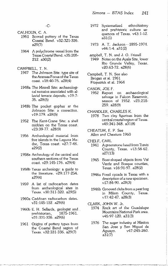
Simons - BTAS Index 241
-C-
CALHOUN, C. A. 1961 Scored pottery of the Texas
Coastal Bend. v32:321-326. a29(7)
1964 A polychrome vessel from the
Texas Coastal Bend. v35:205-
212. a30(2)
CAMPBELL, T. N. 1947 The Johnson Site: type site of
the Aransas Focus of the Texas coast, v18:40-75, a28(4)
1948a The Merrell Site: archaeologi- cal remains associated with al- luvial terrace deposits, v19:7- 35. a28(5)
1948b The pocket gopher at the Johnson Site: a correction. v19:179, a28(5)
1952 The Kent-Crane Site: a shell midden on the Texas coast. v23:39-77, a28(9)
1956 Archeological material from five islands in the Laguna Ma- dre, Texas coast, v27:7-46. a29(2)
1958a Archeology of the central and southern sections of the Texas coast, v29:145-176, a29(4)
1958b Texas archeology: a guide to the literature, v29:177-254. a29(4)
1959 A list of radiocarbon dates from archeological sites in Texas. v30:311-320, a29(5)
1960a Caddoan radiocarbon dates. v31:145-152, a29(6)
1960b E. H. Sellards, geologist and prehistorian, 1875-1961. v31:331-336, a29(6)
1961 Origins of pottery types from the Coastal Bend region of Texas. v32:331-336, a29(7)
1972 Systematized ethnohistory and prehistoric culture se- quences of Texas. v43:1-12. a31(1)
1973 A.T. Jackson--1895-1974. v44:1-4, a31(2)
.ampbell, T. N. and J. O. Frizzell 1949 Notes on the Ayala Site, lower
Rio Grande Valley, Texas. v20:63-72, a28(6)
Campbell, T. N. See also Brogan et al. 1961 Fitzpatrick et al. 1964
CASON, JOE F. 1952 Report on archaeological
salvage in Falcon Reservoir, season of 1952. v23:218- 259. a28(9)
CHANDLER, CHARLES K. 1978 Two clay figurines from the
central coastal region of Texas. v49:341-348, a31(8)
CHEATUM, E. P. See Allen and Cheatum 1960
CHELF, CARL 1941 Agreenstone head from Travis
County, Texas. v13:58-62. a27(13)
1945 Boat-shaped objects from Val Verde and Bosque counties, Texas. v16:91-97, a28(2)
1946a Fossil cycads in Texas with a description of a new specimen. v17:84-90, a28(3)
1946b Grooved clubs from a peat bog in Milam County, Texas. v17:42-47, a28(3)
CLARK, 1974
JOHN W. Jr. Rock art of the Guadalupe Mountains National Park area. v45:97-120, a31(3)
1976 The sugar industry at Mission San Jose y San Miguel de Aguayo. v47:245-260. a31(7)
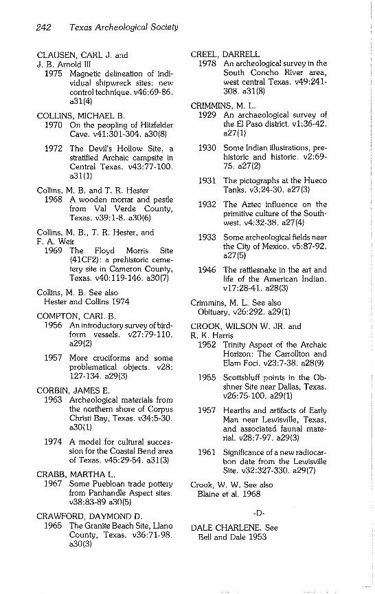
242 Texas Archeological Society
CLAUSEN, CARL J. and J. B. Arnold III
1975 Magnetic delineation of indi- vidual shipwreck sites: new control technique, v46:69-86. a31 (4)
COLLINS, MICHAEL B. 1970 On the peopling of Hitzfelder
Cave. v41:301-304, a30(8)
1972 The Devil’s Hollow Site, a stratified Archaic campsite in Central Texas. v43:77-100. a31(1)
Collins, M. B. and T. R. Hester 1968 A wooden mortar and pestle
from Val Verde County, Texas. v39:1-8, a30(6)
Collins, M. B., T. R. Hester, and F. A. Weir
1969 The Floyd Morris Site (41CF2): a prehistoric ceme- tery site in Cameron County, Texas. v40:119-146, a30(7)
Collins, M. B. See also Hester and Collins 1974
COMPTON, CARL B. 1956 An introductory survey of bird-
form vessels, v27:79-110. a29(2)
1957 More cruciforms and some problematical objects, v28: 127-134. a29(3)
CORBIN, JAMES E. 1963 Archeological materials from
the northern shore of Corpus Christi Bay, Texas. v34:5-30. a30(1)
1974 A model for cultural succes- sion for the Coastal Bend area of Texas. v45:29-54, a31(3)
CRABB, 1967
MARTHA L. Some Puebloan trade pottery from Panhandle Aspect sites. v38:83-89 a30(5)
CRAWFORD, DAYMOND D. 1965 The Granite Beach Site, Llano
County, Texas. v36:71-98. a30(3)
CREEL, DARRELL 1978 An archeological survey in the
South Concho River area, west central Texas. v49:241- 308. a31(8)
CRIMMINS, M. L. 1929 An archaeological survey of
the El Paso district, v1:36-42. a27(1)
1930 Some Indian illustrations, pre- historic and historic, v2:69- 75. a27(2)
1931 The pictographs at the Hueco Tanks. v3:24-30, a27(3)
1932 The Aztec influence on the primitive culture of the South- west. v4:32-38, a27(4)
1933 Some archeological fields near the City of Mexico. v5:87-92. a27(5)
1946 The rattlesnake in the art and life of the American Indian. v17:28-41, a28(3)
Crimmins, M. L. See also Obituary, v26:292, a29(1)
CROOK, WILSON W. JR. and R. K. Harris
1952 Trinity Aspect of the Archaic Horizon: The Carrollton and Elam Foci. v23:7-38, a28(9)
1955 Scottsbluff points in the Ob- shner Site near Dallas, Texas. v26:75-100, a29(1)
1957 Hearths and artifacts of Early Man near Lewisville, Texas, and associated faunal mate- rial. v28:7-97, a29(3)
1961 Significance of a new radiocar- bon date from the Lewisville Site. v32:327-330, a29(7)
Crook, W. W. See also Blaine et al. 1968
-D-
DALE CHARLENE. See Bell and Dale 1953
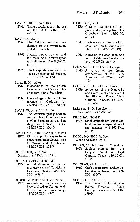
Sirnons - BTAS Index 243
DAVENPORT, J. WALKER 1943 Some experiments in the use
of the atlatl, v15:30~37. a28(1)
DAVIS, E. MOTT 1960 The Caddoan area: an intro-
duction to the symposium. v31:3-10, a29(6)
1963 A guide to pottery sorting, and the meaning of pottery types and attributes, v34:189-202. a30(I)
1979 The first quarter century of the Texas Archeological Society. v50:159-194, a31(9)
Davis, E. M., editor 1959 Proceedings of the Fourth
Conference on Caddoan Ar- cheology, v30:1-34, a29(5)
1960 Proceedings of the Fifth Con- ference on Caddoan Ar- cheology, v31:77-144, a29(6)
DAVIS, 1964
W. A. and H. R. Horn The Zavonian Springs Site: an Archaic - Neo-American site in McGee Bend Reservoir, San Augustine County, Texas. v35:213-250, a30(2)
DAVISON, CLAIRE C. and R. K. Harris 1974 Chemical profile of glass trade
beads from archeological sites in Texas and Oklahoma. v45:209-218, a31(3)
DELLINGER, S. C. See Dickinson and Dellinger 1940
DEL RIO, PABLO MARTINEZ 1953 A preliminary report on the
mortuary cave of Candelaria, Coahuila, Mexico. v24:208- 256. a28(I0)
DERING, J. PHIL and H. J. Shafer 1976 Analysis of matrix samples
from a Crockett County shel- ter: a test for seasonality. v47:209-230, a31(7)
DICKINSON, S. D. 1936 Ceramic relationships of the
pre-Caddo pottery from the Crenshaw Site. v8:56-70. a27(8)
1941 Certain vessels from the Clem- ents Place, an historic Caddo site. v13:117-132, a27(13)
1943 Notes on the decoration and form of Arkansas Caddo pot- tery. v15:9-29, a28(1)
Dickinson, S. D. and S. C. Dellinger 1940 A survey of the historic
earthenware of the lower Arkansas. v12:76-98, a27 (12)
Dickinson, S. D. and H. J. Lemley 1939 Evidences of the Marksville
and Coles Creek complexes at the Kirkham Place, Clark County, Arkansas. v11:139- 189. a27(11)
Dickinson, S. D. See also Lemley and Dickinson 1937
DILLEHAY, TOM D. 1973 Small archeological site inves-
tigations for interpretation of site activities, v44:169-178. a31(2)
DODD, MONROE Jr. See Webb and Dodd 1941
DORAN, GLEN H. and R. M. Malina 1975 Skeletal material from the
Cogdell Burial in Floyd County, Texas. v46:65-68. a31(4)
DOUGLAS, CHARLES L. 1969 Catfish spines from archeolog-
ical sites in Texas. v40:263- 266. a30(7)
DUFFIELD, LATHEL F. 1959 The Limerick Site at Iron
Bridge Reservoir, Rains County, Texas. v30:51-116. a29(5)
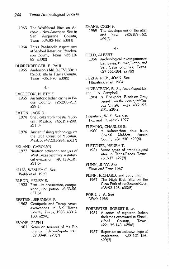
244 Texas Archeological Society
1963 The Wolfshead Site: an Ar- chaic - Neo-American Site in San Augustine County, Texas. v34:83-142, a30(1)
1964 Three Panhandle Aspect sites at Sanford Reservoir, Hutchin- son County, Texas. v35:19- 82. a30(2)
DURRENBERGER, E. PAUL 1965 Anderson’s Mill (41TV130): a
historic site in Travis County, Texas. v36:1-70, a30(3)
-E-
EAGLETON, N. ETHIE 1955 An historic Indian cache in Pe-
cos County. v26:200-217. a29(1)
EATON, JACK D. 1974 Shell celts from coastal Yuca-
tan, Mexico. v45:197-208. a31(3)
1976 Ancient fishing technology on the Gulf Coast of Yucatan, Mexico. v47:231-244, a31(7)
EKLAND, CAROLYN 1977 Neutron activation analysis of
West Texas ceramics: a statisti- cal evaluation, v48:119-132. a31 (6)
ELLIS, WESLEY G. See Webb et al. 1969
ELROD, HENRY E. 1933 Flint--its occurrence, compo-
sition, and patina, v5:53-56. a27(5)
EPSTEIN, JEREMIAH F. 1962 Centipede and Damp caves:
excavations in Val Verde County, Texas, 1958. v33:1- 130. a29(8)
EVANS, GLEN L. 1961 Notes on terraces of the Rio
Grande, Falcon-Zapata area. v32:33-46, a29(7)
EVANS, OREN F. 1959 The development of the atlatl
and bow. v30:159-162.
a29(5)
-F-
FIELD, ALBERT 1956 Archeological investigations in
Lampasas, Burnet, Llano, and San Saba counties, Texas. v27:161-184, a29(2)
FITZPATRICK, JOAN. See Fitzpatrick et al. 1964
FITZPATRICK, W. S., Joan Fitzpatrick, and T. N. Campbell
1964 A Rockport Black-on-Gray vessel from the vicinity of Cor- pus Christi, Texas. v35:193- 204. a30(2)
Fitzpatrick, W. S. See also Fox and Fitzpatrick 1977
FLEMING, CHARLES B. 1960 A radiocarbon date from
Goebel Midden, Austin County. v31:330, a29(6)
FLETCHER, HENRY T. 1931 Some types of archeological
sites in Trans-Pecos Texas. v3:7-17, a27(3)
FLINN, JUDY. See Flinn and Flinn 1967
FLINN, RICHARD, and Judy Flinn 1967 The High Bluff Site on the
Clear Fork of the Brazos River. v38:93-125, a30(5)
FORD, J. A. See Webb 1968
FORRESTER, ROBERT E. Jr. 1951 A series of eighteen Indian
skeletons excavated in Shack- elford County, Texas. v22:132-143, a28(8)
1957 Report on an unknown type of implement, v28:121-126. a29(3)
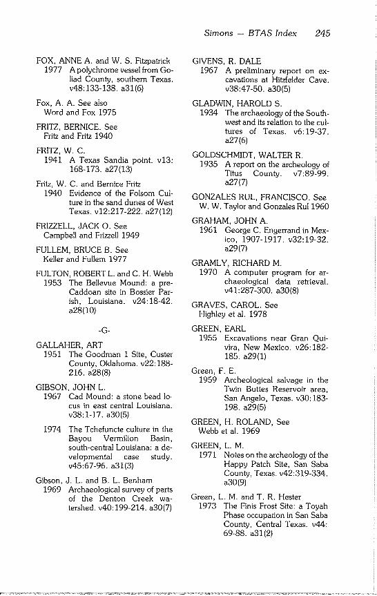
Simons - BTAS Index 245
FOX, ANNE A. and W. S. Fitzpatrick 1977 A polychrome vessel from Go-
liad County, southern Texas. v48:133-138, a31(6)
Fox, A. A. See also Word and Fox 1975
FRITZ, BERNICE. See Fritz and Fritz 1940
FRITZ, W. C. 1941 A Texas Sandia point, v13:
168-173. a27(13)
Fritz, W. C. and Bernice Fritz 1940 Evidence of the Folsom Cul-
ture in the sand dunes of West Texas. v12:217-222, a27(12)
FRIZZELL, JACK O. See Campbell and Frizzell 1949
FULLEM, BRUCE B. See Keller and Fullem 1977
FULTON, ROBERT L. and C. H. Webb 1953 The Bellevue Mound: a pre-
Caddoan site in Bossier Par- ish, Louisiana. v24:18-42. a28(10)
-G-
GALLAHER, ART 1951 The Goodman I Site, Custer
County, Oklahoma. v22:188- 216. a28(8)
GIBSON, JOHN L. 1967 Cad Mound: a stone bead lo-
cus in east central Louisiana. v38:1-17, a30(5)
1974 The Tchefuncte culture in the Bayou Vermilion Basin, south-central Louisiana: a de- velopmental case study. v45:67-96, a31(3)
Gibson, J. L. and B. L. Benham 1969 Archaeological survey of parts
of the Denton Creek wa- tershed, v40:199-214, a30(7)
GIVENS, R. DALE 1967 A preliminary report on ex-
cavations at Hitzfelder Cave. v38:47-50, a30(5)
GLADWIN, HAROLD S. 1934 The archaeology of the South-
west and its relation to the cul- tures of Texas. v6:19-37. a27(6)
GOLDSCHMIDT, WALTER R. 1935 A report on the archeology of
Titus County. v7:89-99. a27(7)
GONZALES RUL, FRANCISCO. See W. W. Taylor and Gonzales Ru11960
GRAHAM, JOHN A. 1961 George C. Engerrand in Mex-
ico, 1907-1917. v32:19-32. a29(7)
GRAMLY, RICHARD M. 1970 A computer program for ar-
chaeological data retrieval. v41:287-300, a30(8)
GRAVES, CAROL. See Highley et al. 1978
GREEN, EARL 1955 Excavations near Gran Qui-
vira, New Mexico. v26:182- 185. a29(1)
Green, F. E. 1959 Archeological salvage in the
Twin Buttes Reservoir area, San Angelo, Texas. v30:183- 198. a29(5)
GREEN, H. ROLAND, See Webb et al. 1969
GREEN, L. M. 1971 Notes on the archeology of the
Happy Patch Site, San Saba County, Texas. v42:319-334. a30(9)
Green, L. M. and T. R. Hester 1973 The Finis Frost Site: a Toyah
Phase occupation in San Saba County, Central Texas. v44: 69-88. a31(2)
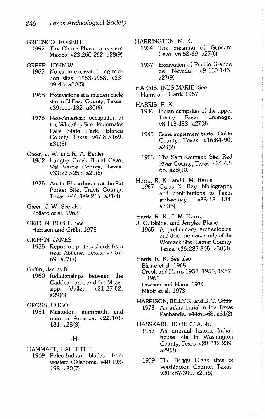
246 Texas Archeological Society
GREENGO, ROBERT 1952 The Olmec Phase in eastern
Mexico. v23:260-292, a28(9)
GREER, JOHN W. 1967 Notes on excavated ring mid-
den sites, 1963-1968. v38: 39-45. a30(5)
1968 Excavations at a midden circle site in El Paso County, Texas. v39:111-132, a30(6)
1976 Neo-American occupation at the Wheatley Site, Pedernales Falls State Park, Blanco County, Texas. v47:89-169. a31(5)
Greer, J. W. and R. A. Benfer 1962 Langtry Creek Burial Cave,
Val Verde County, Texas. v33:229-253, a29(8)
1975 Austin Phase burials at the Pat Parker Site, Travis County, Texas. v46:189-216, a31(4)
Greer, J. W. See also Pollard et aL 1963
GRIFFIN, BOB T. See Harrison and Griffin 1973
GRIFFIN, JAMES 1935 Report on pottery sherds from
near Abilene, Texas. v7:57- 69. a27(7)
Griffin, James B. 1960 Relationships between the
Caddoan area and the Missis- sippi Valley. v31:27-52. a29(6)
GROSS, HUGO 1951 Mastodon, mammoth, and
man in America. v22:101- 131. a28(8)
-H-
HAMMATT, HALLETT H. 1969 Paleo-lndian blades from
western Oklahoma. v40:193- 198. a30(7)
HARRINGTON, M. R.
1934 The meaning of Gypsum
Cave. v6:58-69, a27(6)
1937 Excavation of Pueblo Grande de Nevada. v9:130-145. a27(9)
HARRIS, INUS MARIE. See Harris and Harris 1967
HARRIS, R. K. 1936 Indian campsites of the upper
Trinity River drainage. v8:113-133, a27(8)
1945
1953
Bone implement burial, Collin County, Texas. v16:84-90t a28(2)
The Sam Kaufman Site, Red River County, Texas. v24:43- 68. a28(10)
Harris, R. K., and I. M. Harris 1967 Cyrus Nt Ray: bibliography
and contributions to Texas archeology, v38:131-134. a30(5)
Harris, R. K., I. M. Harris, J. C. Blaine, and Jerrylee Blaine
1965 A preliminary archeological and documentary study of the Womack Site, Lamar County, Texas. v36:287-365t a30(3)
Harris, R. K. See also Blaine et al. 1968 Crook and Harris 1952, 1955, 1957,
1961 Davison and Harris 1974 Miroir et al. 1973
HARRISON, BILLY R. and B. T. Griffin 1973 An infant burial in the Texas
Panhandle. v44:61-68, a31(2)
HASSKARL, ROBERT At Jr. 1957 An unusual historic Indian
house site in Washington County, Texas. v28:232-239. a29(3)
1959 The Boggy Creek sites of Washington County, Texas. v30:287-300, a29(5)
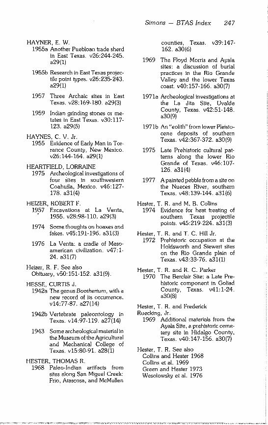
Simons - BTAS Index 247
HAYNER, E. W. 1955a Another Puebloan trade sherd
in East Texas. v26:244-245. a29(I)
1955b Research in East Texas projec- tile point types, v26:235-243. a29(1)
1957 Three Archaic sites in East Texas. v28:169-180, a29(3)
1959 Indian grinding stones or me- tates in East Texas. v30:117- 123. a29(5)
HAYNES, C. V. Jr. 1955 Evidence of Early Man in Tor-
rance County, New Mexico. v26:144-164, a29(1)
HEARTFIELD, LORRAINE 1975 Archeological investigations of
four Rites in southwestern Coahuila, Mexico. v46:127- 178. a31(4)
HEIZER, ROBERT F. 1957 Excavations at La Venta,
1955. v28:98-110, a29(3)
1974 Some thoughts on hoaxes and fakes, v45:191-196, a31(3)
1976 La Venta: a cradle of Meso- american civilization, v47:1- 24. a31(7)
Heizer, R. F. See also Obituary, v50:151-152, a31(9).
HESSE, 1942a
CURTIS J. The genus Bootheriu m, with a new record of its occurrence. v14:77-87, a27(14)
1942b Vertebrate paleontology in Texas. v14:97-119, a27(14)
1943 Some archeological material in the Museum of the Agricultural and Mechanical College of Texas. v15:80-91, a28(1)
HESTER, THOMAS R. 1968 Paleo-lndian artifacts from
sites along San Miguel Creek: Frio, Atascosa, and McMullen
counties, Texas. v39:147- 162. a30(6)
1969 The Floyd Morris and Ayala sites: a discussion of burial practices in the Rio Grande Valley and the lower Texas coast, v40:157-166, a30(7)
1971a Archeological investigations at the La Jita Site, Uvalde County, Texas. v42:51-148. a30(9)
1971b An "eolith" from lower Pleisto- cene deposits of southern Texas. v42:367-372, a30(9)
1975 Late Prehistoric cultural pat- terns along the lower Rio Grande of Texas. v46:107- 126. a31(4)
1977 A painted pebble from a site on the Nueces River, southern Texas. v48:139-144, a31(6)
Hester, T. R. and M. B. Collins 1974 Evidence for heat treating of
southern Texas projectile points, v45:219-224, a31(3)
Hester, T. R. and T. C. Hill Jr. 1972 Prehistoric occupation at the
Holdsworth and Stewart sites on the Rio Grande plain of Texas. v43:33-76, a31(1)
Hester, T. R. and R. C. Parker 1970 The Berclair Site: a Late Pre-
historic component in Goliad County, Texas. v41:1-24. a30(8)
Hester, T. R. and Frederick Ruecking, Jr.
1969 Additional materials from the Ayala Site, a prehistoric ceme- tery site in Hidalgo County, Texas. v40:147-156, a30(7)
Hester, T. R. See also Collins and Hester 1968 Collins et al. 1969 Green and Hester 1973 Wesolowsky et al. 1976
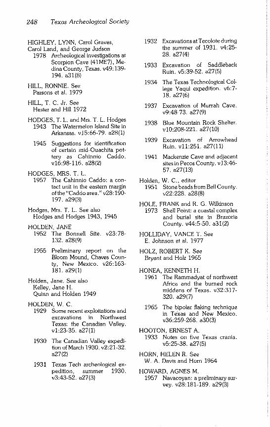
248 Texas Archeological Society
HIGHLEY, LYNN, Carol Graves, Carol Land, and George Judson
1978 Archeological investigations at Scorpion Cave (41ME7), Me- dina County, Texas. v49:139- 194. a31(8)
HILL, RONNIE. See Parsons et al. 1979
HILL, T. C. Jr. See Hester and Hill 1972
HODGES, T. L. and Mrs. T. L. Hodges 1943 The Watermelon Island Site in
Arkansas. v15:66-79, a28(1)
1945 Suggestions for identification of certain mid-Ouachita pot- tery as Cahinnio Caddo. v16:98-116, a28(2)
HODGES, MRS. T. L. 1957 The Cahinnio Caddo: a con-
tact unit in the eastern margin of the "Caddo area." v28:190- 197. a29(3)
Hodges, Mrs. T. L. See also Hodges and Hodges 1943, 1945
HOLDEN, JANE 1952 The Bonnell Site. v23:78-
132. a28(9)
1955 Preliminary report on the Bloom Mound, Chaves Coun- ty, New Mexico. v26:163- 181. a29(1)
Holden, Jane. See also Kelley, Jane H. Quinn and Holden 1949
HOLDEN, W. C. 1929 Some recent exploitations and
excavations in Northwest Texas: the Canadian Valley. vi:23-35, a27(1)
1930 The Canadian Valley expedi- tion of March 1930. v2-21-32. a27(2)
1931 Texas Tech archeological ex- pedition, summer 1930. v3:43-52, a27(3)
1932
1933
1934
1937
1938
1939
1941
Excavations at Tecolote during the summer of 1931. v4:25- 28. a27(4)
Excavation of Saddleback Ruin. v5:39-52, a27(5)
The Texas Technological Col- lege Yaqui expedition, v6:7- 18. a27(6)
Excavation of Murrah Cave. v9:48-73, a27(9)
Blue Mountain Rock Shelter. v10:208-221, a27(10)
Excavation of Arrowhead Ruin. v11-251, a27(11)
Mackenzie Cave and adjacent sites in Pecos County. v13:46- 57. a27(13)
Holden, W. C,, editor 1951 Stone beads from Bell County.
v22:228, a28(8)
HOLE, FRANK and R. G. Wilkinson 1973 Shell Point: a coastal complex
and burial site in Brazoria County. v44:5-50, a31(2)
HOLLIDAY, VANCE T. See E. Johnson et al. 1977
HOLZ, ROBERT K. See Bryant and Holz 1965
HONEA, KENNETH H. 1961 The Rammadyat of northwest
Africa and the burned rock middens of Texas. v32:317- 320. a29(7)
1965 The bipolar flaking technique in Texas and New Mexico. v36:259-268, a30(3)
HOOTON, ERNEST A. 1933 Notes on five Texas crania.
v5:25-38, a27(5)
HORN, HELEN R. See W. A. Davis and Horn 1964
HOWARD, AGNES M. 1957 Navacoyan: apreliminary sur-
vey. v28:181-189, a29(3)
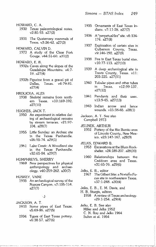
Simons - BTAS Index 249
HOWARD, C. A. 1930 Texas paleontological notes.
v2:85-93, a27(2)
1931 The Quaternary mammals of Texas. v3:26-42, a27(3)
HOWARD, CALVIN D. 1973 A study of the Clear Fork
Gouge. v44:51-60, a31(2)
HOWARD, E. B. 1932a Caves along the slopes of the
Guadalupe Mountains. v4:7- 19. a27(4)
1932b Figurine from a gravel pit of Dallas, Texas. v4:79-81. a27(4)
HRDLICKA, ALES 1938 Skeletal remains from north-
ern Texas. v10:16%192. a27(I0)
HUGHES, JACK T. 1950 An experiment in relative dat-
ing of archaeological remains by stream terraces, v21:97- 104. a28(7)
1955 Little Sunday: an Archaic site in the Texas Panhandle. v26:55-74, a29(I)
1961 Lake Creek: A Woodland site in the Texas Panhandle. v32:65-84, a29(7)
HUMPHREYS, SHERRY 1969 New perspectives for physical
anthropology and archae- ology, v40:259-262, a30(7)
HUSKEY, VANE 1935 An archeological survey of the
Nueces Canyon. v7:105-114. a27(7)
-J-
JACKSON, A. T. 1933 Some pipes of East Texas.
v5:69-86, a27(5)
1934 Types of East Texas pottery. v6:38-57, a27(6)
1935 Ornaments of East Texas In- dians, v7:11-28, a27(7)
1936 A"perpetual fire" site. v8:134- 174. a27(8)
1937 Exploration of certain sites in Culberson County, Texas. v9:146-192, a27(9)
1938 Fire in East Texas burial rites. vi0:77-113, a27(I0)
1939 A deep archeological site in Travis County, Texas. v11: 203-225. a27(11)
1940 Tubular pipes and other tubes in Texas. v12:99-137. a27(12)
1941 Pendants and their uses. v13:9-45, a27(13)
1943 Indian arrow and lance wounds, v15:38-65, a28(1)
Jackson, A. T. See also Campbell 1973
JELINEK, ARTHUR 1952 Pottery of the Rio Bonito area
of Lincoln County, New Mex- ico. v23:147-167, a28(9)
JELKS, EDWARD B. 1953 Excavations at the Blum Rock-
shelter, v24:189-207, a28(10)
1960 Relationships between the Caddoan area and Texas. v31:65-76, a29(6)
Jelks, E. B., editor 1967 The Gilbert Site: a Norte~o Fo-
cus site in northeastern Texas. v37:1-248, a30(4)
Jelks, E. B., E. M. Davis, and H. B. Sturgis, editors
1958 A review of Texas archeology. v29:1-254, a29(4)
Jelks, E. B. See also Miller and Jelks 1952 C. N. Ray and Jelks 1964 Suhm et al. 1954
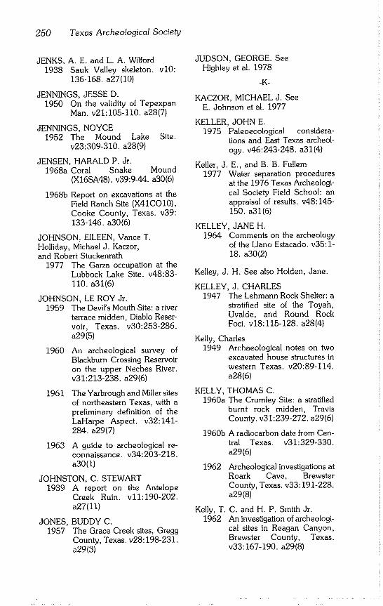
250 Texas Archeological Society
JENKS, A. E. and L. A. Wilford 1938 Sauk Valley skeleton, v10:
136-168. a27(I0)
JENNINGS, JESSE D. 1950 On the validity of Tepexpan
Man. v21:105-110, a28(7)
JENNINGS, NOYCE 1952 The Mound Lake Site.
v23:309-310, a28(9)
JENSEN, HARALD P. Jr. 1968a Coral Snake
1968b
Mound (X16SA48). v39:9-44, a30(6)
Report on excavations at the Field Ranch Site (X41CO10), Cooke County, Texas. v39: 133-146. a30(6)
JOHNSON, EILEEN, Vance T. Holliday, Michael J. Kaczor, and Robert Stuckenrath
1977 The Garza occupation at the Lubbock Lake Site. v48:83- 110. a31(6)
JOHNSON, LE ROY Jr. 1959 The Devil’s Mouth Site: a river
terrace midden, Diablo Reser- voir, Texas. v30:253-286. a29(5)
1960 An archeological survey of Blackburn Crossing Reservoir on the upper Neches River. v31:213-238, a29(6)
1961 The Yarbrough and Miller sites of northeastern Texas, with a preliminary definition of the LaHarpe Aspect. v32:141- 284. a29(7)
1963 A guide to archeological re- connaissance, v34:203-218. a30(I)
JOHNSTON, C. STEWART 1939 A report on the Antelope
Creek Ruin. v11:190-202. a27(11)
JONES, BUDDY C. 1957 The Grace Creek sites, Gregg
County, Texas. v28:198-231. a29(3)
JUDSON, GEORGE. See Highley et al. 1978
-K-
KACZOR, MICHAEL J. See E. Johnson et al. 1977
KELLER, JOHN E. 1975 Paleoecological considera-
tions and East Texas archeol- ogy. v46:243-248, a31(4)
Keller, J. E., and B. B. Fullem 1977 Water separation procedures
at the 1976 Texas Archeologi- cal Society Field School: an appraisal of results, v48:145- 150. a31(6)
KELLEY, JANE H. 1964 Comments on the archeology
of the Llano Estacado. v35:1- 18. a30(2)
Kelley, J. H. See also Holden, Jane.
KELLEY, J. CHARLES 1947 The Lehmann Rock Shelter: a
stratified site of the Toyah, Uvalde, and Round Rock Foci. v18:115-128, a28(4)
Kelly, Charles 1949 Archaeological notes on two
excavated house structures in western Texas. v20:89-114. a28(6)
KELLY, THOMAS C. 1960a The Crumley Site: a stratified
burnt rock midden, Travis County. v31: 239-272. a29(6)
1960b A radiocarbon date from Cen- tral Texas. v31:329-330. a29(6)
1962
Kelly, T. 1962
Archeological investigations at Roark Cave, Brewster County, Texas. v33:191-228. a29(8)
C. and H. P. Smith Jr. An investigation of archeologi- cal sites in Reagan Canyon, Brewster County, Texas. v33:167-190, a29(8)
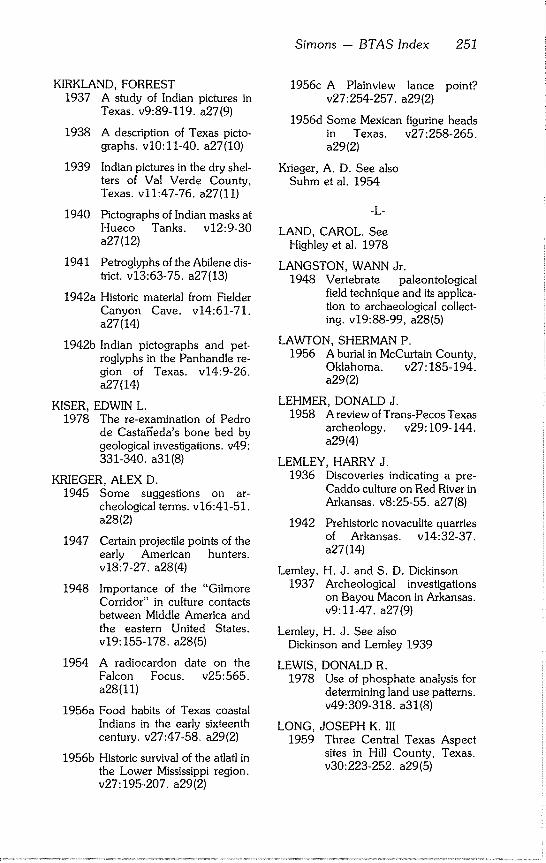
Simons - BTAS Index 251
KIRKLAND, FORREST 1937 A study of Indian pictures in
Texas. v9:89-119, a27(9)
1938 A description of Texas picto- graphs, v10:11-40, a27(10)
1939 Indian pictures in the dry shel- ters of Val Verde County, Texas. v11:47-76, a27(11)
1940 Pictographs of Indian masks at Hueco Tanks. v12:9-30 a27(12)
1941 Petroglyphs of the Abilene dis- h’ict, v13:63-75, a27(13)
1942a Historic material from Fielder Canyon Cave. v14:61-71. a27(14)
1942b Indian pictographs and pet- roglyphs in the Panhandle re- gion of Texas. v14:9-26. a27(14)
KISER, EDWIN L. 1978 The re-examination of Pedro
de Casta~’eda’s bone bed by geological investigations, v49: 331-340. a31(8)
KRIEGER, ALEX D. 1945 Some suggestions on ar-
cheological terms, v16:41-51. a28(2)
1947 Certain projectile points of the early American hunters. v18:7-27, a28(4)
1948 Importance of the "Gilmore Corridor" in culture contacts between Middle America and the eastern United States. v19:155-178, a28(5)
1954 A radiocardon date on the Falcon Focus. v25:565. a28(11)
1956a Food habits of Texas coastal Indians in the early sixteenth century, v27:47-58, a29(2)
1956b Historic survival of the atlatl in the Lower Mississippi region. v27:195-207, a29(2)
1956c A Plainview lance point? v27:254-257, a29(2)
1956d Some Mexican figurine heads in Texas. v27:258-265. a29(2)
Krieger, A. D. See also Suhm et al. 1954
-L-
LAND, CAROL. See Highley et al. 1978
LANGSTON, WANN Jr. 1948 Vertebrate paleontological
field technique and its applica- tion to archaeological collect- ing. v19:88-99, a28(5)
LAWTON, SHERMAN P. 1956 A burial in McCurtain County,
Oklahoma. v27:185-194. a29(2)
LEHMER, DONALD J. 1958 A review of Trans-Pecos Texas
archeology, v29:109-144. a29(4)
LEMLEY, HARRY J. 1936 Discoveries indicating a pre-
Caddo culture on Red River in Arkansas. v8:25-55, a27(8)
1942 Prehistoric novaculite quarries of Arkansas. v14:32-37. a27(14)
Lemley, H. J. and S. D. Dickinson 1937 Archeological investigations
on Bayou Macon in Arkansas. v9:11-47, a27(9)
Lemley, H. J. See also Dickinson and Lemley 1939
LEWIS, DONALD R. 1978 Use of phosphate analysis for
determining land use patterns. v49:309-318, a31(8)
LONG, JOSEPH K. III 1959 Three Central Texas Aspect
sites in Hill County, Texas. v30:223-252, a29(5)
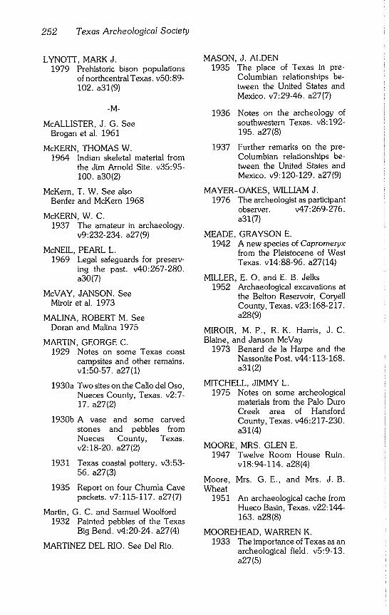
252 Texas Archeological Society
LYNOTT, MARK J. 1979 Prehistoric bison populations
of northcentral Texas. v50:89- 102. a31(9)
-M-
McALLISTER, J. G. See Brogan et al. 1961
McKERN, THOMAS W. 1964 Indian skeletal material from
the Jim Arnold Site. v35:95- 100. a30(2)
McKern, T. W. See also Benfer and McKern 1968
McKERN, W. C. 1937 The amateur in archaeology.
v9:232-234, a27(9)
McNEIL, PEARL L. 1969 Legal safeguards for preserv-
ing the past. v40:267-280. a30(7)
McVAY, JANSON. See Miroir et al. 1973
MALINA, ROBERT M. See Doran and Malina 1975
MARTIN, GEORGE C. 1929 Notes on some Texas coast
campsites and other remains. v1:50-57, a27(1)
1930a
1930b
Two sites on the Callo del Oso, Nueces County, Texas. v2:7- 17. a27(2)
A vase and some carved stones and pebbles from Nueces County, Texas. v2:18-20, a27(2)
1931 Texas coastal pottery, v3:53- 56. a27(3)
1935 Report on four Chumla Cave packets, v7:115-117, a27(7)
Martin, G. C. and Samuel Woolford 1932 Painted pebbles of the Texas
Big Bend. v4:20-24, a27(4)
MARTINEZ DEL RIO. See Del Rio.
MASON, J. ALDEN 1935 The place of Texas in pre-
Columbian relationships be- tween the United States and Mexico. v7:29-46, a27(7)
1936
1937
Notes on the archeology of southwestern Texas. v8:192- 195. a27(8)
Further remarks on the pre- Columbian relationships be- tween the United States and Mexico. v9:120-129, a27(9)
MAYER-OAKES, WILLIAM J. 1976 The archeologist as participant
observer, v47:269-276. a31(7)
MEADE, GRAYSON E. 1942 A new species of Capromeryx
from the Pleistocene of West Texas. v14:88-96, a27(14)
MILLER, E. O. and E. B. Jelks 1952 Archaeological excavations at
the Belton Reservoir, Coryell County, Texas. v23:168-217. a28(9)
MIROIR, M.P., R.K. Harris, J.C. Blaine, and Janson McVay
1973 Benard de la Harpe and the Nassonite Post. v44:113-168. a31 (2)
MITCHELL, JIMMY L. 1975 Notes on some archeological
materials from the Palo Duro Creek area of Hansford County, Texas. v46:217-230. a31 (4)
MOORE, MRS. GLEN E. 1947 Twelve Room House Ruin.
v18:94-114, a28(4)
Moore, Wheat
1951
Mrs. G.E., and Mrs. J. B.
An archaeological cache from Hueco Basin, Texas. v22:144- 163. a28(8)
MOOREHEAD, WARREN K. 1933 The importance of Texas as an
archeological field, v5:9-13. a27(5)
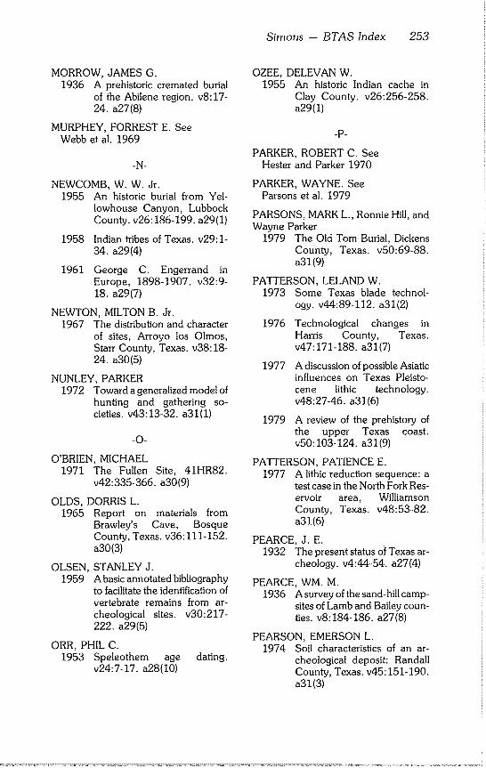
Simons -- BTAS Index 253
MORROW, JAMES G. 1936 A prehistoric cremated burial
of the Abilene region, v8:17- 24. a27(8)
MURPHEY, FORREST E. See Webb et al. 1969
-N-
NEWCOMB, W. W. Jr. 1955 An historic burial from Yel-
Iowhouse Canyon, Lubbock County. v26:186-199, a29(1)
1958 Indian tribes of Texas. v29:1- 34. a29(4)
1961 George C. Engerrand in Europe, 1898-1907. v32:9- 18. a29(7)
NEWTON, MILTON B. Jr. 1967 The distribution and character
of sites, Arroyo los Olmos, Starr County, Texas. v38:18- 24. a30(5)
NUNLEY, PARKER 1972 Toward a generalized model of
hunting and gathering so- cieties, v43:13-32, a31(1)
-O-
O’BRIEN, MICHAEL 1971 The Fullen Site, 41HR82.
v42:335-366, a30(9)
OLDS, DORRIS L. 1965 Report on materials from
Brawley’s Cave, Bosque County, Texas. v36:111-152. a30(3)
OLSEN, 1959
STANLEY J. A basic annotated bibliography to facilitate the identification of vertebrate remains from ar- cheological sites, v30:217- 222. a29(5)
ORR, PHIL C. 1953 Speleothem age dating.
v24:7-17, a28(10)
OZEE, DELEVAN W. 1955 An historic Indian cache in
Clay County. v26:256-258. a29(1)
-p-
PARKER, ROBERT C. See Hester and Parker 1970
PARKER, WAYNE. See Parsons et al. 1979
PARSONS, MARK L., Ronnie Hill, and Wayne Parker
1979 The Old Tom Burial, Dickens County, Texas. v50:69-88. a31 (9)
PATTERSON, LELAND W. 1973 Some Texas blade technol-
ogy. v44:89-112, a31(2)
1976 Technological changes in Harris County, Texas. v47:171-188, a31(7)
1977
1979
A discussion of possible Asiatic influences on Texas Pleisto- cene lithic technology. v48:27-46, a31(6)
A review of the prehistory of the upper Texas coast. v50:103-124, a31(9)
PATTERSON, PATIENCE E. 1977 A lithic reduction sequence: a
test case in the North Fork Res- ervoir area, Williamson County, Texas. v48:53-82. a31(6)
PEARCE, J. E. 1932 The present status of Texas ar-
cheology, v4:44-54, a27(4)
PEARCE, WM. M. 1936 A survey of the sand-hill camp-
sites of Lamb and Bailey coun- ties. v8:184-186, a27(8)
PEARSON, EMERSON L. 1974 Soil characteristics of an ar-
cheological deposit: Randall County, Texas. v45:151-190. a31(3)
254 Texas Archeological Society
PHELPS, ALAN L. 1974 An analysis of the ceramics of
the Guadalupe Mountains Na- tional Park. v45:121-150. a31(3)
PHILLIPS, DAVID A. 1978 Additional notes on the fishing
technology of the Yucatan Peninsula, Mexico. v49:349- 354. a31(8)
POLLARD, J. C., J. W. Greer, and H. F. Sturgis
1963 Archeological excavations at the Boy Scout Rockshelter (41TV69), Travis County, Texas. v34:31-56, a30(I)
POTEET, SYBIL 1938 The occurrence and distribu-
tion of beveled knives. v10:245~262, a27(10)
POTTER, WENDELL H. 1930 Ornamentation on the pottery
of the Texas coastal tribes. v2:41-44, a27(2)
POWELL, MARY LUCAS 1977 Prehistoric ritual skull burials at
the Crenshaw Site (3M16), southwest Arkansas. v48:111- 118. a31(6)
PRESTON, NOLAN E. 1969 The McCann Site. v40:167-
192. a30(7)
PREWITT, ELTON R. 1964 Excavations at the Terri and
Lightfoot sites, Proctor Reser- voir, Comanche County, Texas. v35:143-188, a30(2)
1974 Preliminary archeological in- vestigations in the Rio Grande delta of Texas. v45:55-66. a31(3)
QUINN, JEAN, and Jane Holden 1949 Caves and shelters in Dawson
and Borden counties. v20:115-131, a28(6)
-R-
RASH, RANDLE. See Skinner and Rash 1969
RAUN, GERALD G. 1964 West Indian seal remains from
two historic sites in coastal South Texas. v35:189-192. a30(2)
RAY, CYRUS N. 1929 A differentiation of the prehis-
toric cultures of the Abilene section, v1:7-22, a27(1)
1930
1931
1932
1933a
1933b
1934a
1934b
1935a
1935b
1935c
1935d
1936
Report on some recent ar- chaeological researches in the Abilene section, v2:45-58. a27(2)
Recent archeological re- searches in the Abilene sec- tion. v3:76-89, a27(3)
Archeological research in cen- tral West Texas. v4:63-70. a27(4)
The Brownwood skull, v5:95- 98. a27(5)
Multiple burials in stone cist mounds of the Abilene region. v5:14-24, a27(5)
Flint cultures of ancient man in Texas. v6:107-111, a27(6)
Report on two mineralized skeletons, v6:115-118, a27(6)
Folsom sites, v7:127-129. a27(7)
Indian flint saws. v7:125-127. a27(7)
The Pottery Complex artifacts of the Abilene region, v7:70- 88. a27(7)
Some unusual cremated buri- als. v7:130-131, a27(7)
Some unusual cremated buri- als found near Colorado, Texas. v8:9-16, a27(8)
Simons - BTAS Index 255
1937a
1937b
1938
1939a
1939b
1940a
1940b
1940c
1940d
1941a
1941b
1942a
1942b
1942c
1942d
1943a
1943b
More evidence concerning Abilene Man. v9:193-217. a27(9)
More Pueblo pottery found near Abilene. v9:234, a27(9)
The Clear Fork Culture Com- plex. v10:193-207, a27(10)
Is the American mano of Pleis- tocene age? v11:251-252. a27(11)
Some unusual Abilene region burials, v11:226-250, a27(11)
The deeply buried Gibson Site. v12:223-237, a27(12)
Four Sand Dune Culture buri- als~ v12:241-242, a27(12)
New type of painted pebble found near Abilene. v12:242- 247. a27(12)
Unusual skull, v12:238-241. a27(12)
Another type of Gibson Site point, v13:177, a27(13)
Various types of Clear Fork Gouges. v13:152-162, a27(13)
Ancient artifacts and mammoth’s teeth of the McLean Site. v14:137-146. a27(14)
Animal hole molds in the Per- mian. v14:120-129, a27(14)
Prehistoric paintings covered with staligmitic deposit. v14:49-60, a27(14)
What caused these Permian grooves? v14:147-156. a27(14)
Ground sandstone balls of up- per Elm Creek bed gravel. v15:97-104, a28(1)
Human burial covered by twenty-one feet of silt. v15:110-116, a28(1)
1945 Stream bank silts of the Abi- lene region, v16:117-147. a28(2)
1946a
1946b
Permian polished boulders in Texas. v17:63-83, a28(3)
Scientists inspect ancient hearths in river silts, v17:104- 112. a28(3)
1946c
1947
1948
Two buried multiple stone cist structures, v17:18-27, a28(3)
Chemical alteration of silicate artifacts, v18:28-39, a28(4)
Camp sites in Coke County. v19:36-57, a28(5)
1955a Comments concerning some type names in An Introductory Handbook of Texas Ar- cheology, v26:274-278. a29(1)
1955b
1959
Stone-lined basin with char- coal in lower Clear Fork silt. v26:101-108, a29(i)
Deductions concerning the Clear Fork Gouge. v30:199- 208. a29(5)
Ray, C. 1964
N. and E. B. Jelks The W. H. Watson Site: a his- toric Indian burial in Fisher County, Texas. v35:127-142. a30(2)
Ray, C. N. See also Obituary, v38:130-134, a30(5)
RAY, JOHN H. 1955 Peculiar manos from lower
Pease River Valley. v26:109- 112. a29(1)
Ray, J. H. and Mrs. J. H. Ray 1946 Mexican pottery head found in
Texas. v17:93-98, a28(3)
REED, CLYDE T. 1937 A Carankawa fire implement.
v9:218-221, a27(9)
256 Texas Archeological Society
REED, ERIK K. 1950 Population shifts in the pre-
Spanish Southwest. v21:90- 96. a28(7)
RENAUD, E. B. 1937 Folsom and Yuma points.
v9:74-88, a27(9)
1938 Typology of lithic artifacts. vi0:41-76, a27(10)
1939 The Clactonian flake tech- nique in the western states. v11:129-138, a27(11)
1940 Flaked weapon points. v12:138-168, a27(12)
RICHARDSON, RUPERT 1929 The culture of the Comanche
Indians. v1:58-73, a27(1)
RIGGS, AARON D. Jr. 1967 Excavation of a buried mid-
den, Site 41CXll, in Crockett County, Texas. v38:76-82. a30(5)
1969 Rattlesnake Shelter, 41CX29. v40:107-118, a30(7)
RING, E. RAYMOND Jr. 1960a An evaluation of radiocarbon
dates from the Galena Site, southeastern Texas. v31:317- 326. a29(6)
1960b Two radiocarbon dates from the Galena Site of southeast- ern Texas. v31:329, a29(6)
ROBERTS, E. WAYNE. See Webb et al. 1971
ROBERTS, H. H. 1945 A deep burial on the Clear
Fork of the Brazos River. v16:9-30, a28(2)
ROOSA, WILLIAM B. 1952 Sandals of Feather Cave.
v23:133-146, a28(9)
ROUSE, IRVING 1952 The age of the Melbourne in-
terval, v23:293-302, a28(9)
RUECKING, FREDERICK Jr. See Hester and Ruecking 1969
RUNKLES, FRANK A. 1964 The Garza Site: a Neo-
American campsite near Post, Texas. v35:101-126, a30(2)
-S-
SAYLES, E. B. 1929 Some types of archaeological
sites near Abilene, Texas. v1:43-49, a27(I)
1930 A rock shelter in Coke County. v2:33-40, a27(2)
1931 Some flint sources in central West Texas. v3:18-23, a27(3)
1941a Infant burial in carrying basket. v13:77-87, a27(13)
1941b Some Texas cave dweller arti- facts, v13:163-167, a27(13)
SCHMITT, KARL 1950 The Lee Site, Gv3, of Garvin
County, Oklahoma. v21:69- 89. a28(7)
Schmitt, Karl and Raymond Toldan Jr. 1953 The Brown Site, Gd-1, Grady
County, Oklahoma. v24:141- 176. a28(10)
SCHUETZ, MARDITH K. 1956 An analysis of Val Verde
County Cave material [Part 1]. v27:129-160, a29(2)
1957a A carbon-14 date from Trans- Pecos Texas. v28:288-289. a29(3)
1957b A report on Williamson County mound material. v28:135-168, a29(3)
1959 An analysis of Archaic material from three areas of North America. v30:163-182. a29(5)
Simons - BTAS Index 257
1960 An analysis of Val Verde County cave material, Part 2. v31:167-206, a29(6)
1962 An analysis of Val Verde County cave material, Part 3. v33:131-166, a29(8)
SCURLOCK, J. DAN 1961 The Culpepper Site, a late
Fulton Aspect site in northeast- ern Texas. v32:285-316. a29(7)
SECRIST, JUNE 1979 High resolution photography
for archeology, v50:141-146. a31 (9)
SELLARDS, E. H. 1950 Clear Fork points, v21:110-
111. a28(7)
Sellards, E. H. See also Campbell 1960b
SHAEFFER, JAMES B. 1957 The McCarter Site, a Late Ar-
chaic occupation at Musko- gee, Oklahoma. v28:240- 268. a29(3)
SHAFER, HARRY J. 1963 Test excavations at the Young-
sport Site: a stratified terrace site in Bell County, Texas. v34:57-82, a30(1)
1975 Comments on Woodland cul- tures of East Texas. v46:249- 254. a31(4)
Shafer, H. J. See also Bryant and Shafer 1977 Dering and Shafer 1976
SHINER, JOEL L. 1969 Component analysis for Ar-
chaic sites, v40:215-230. a30(7)
1970 Activity analysis of a prehis- toric site. v41:25-36, a30(8)
Shiner, J. L. See also Blaine et al. 1968 Webb et al. 1971
SHULER, ELLIS W. 1934 Collecting fossil elephants at
Dallas, Texas. v6:75-87. a27(6)
SKINNER, S. ALAN 1971 Prehistoric settlement of the
De Cordova Bend Reservoir, Central Texas. v42:149-270. a30(9)
Skinner, S. A. and Randle Rash 1969 A Clovis fluted point from
Hood County, Texas. v40:1- 2. a30(7)
SLESICK, LEONARD M. 1978 A lithic tool cache in the Texas
Panhandle. v49:319-330. a31(8)
SMILEY, NANCY K. 1979 The use of worked potsherds
as ceramic scrapers: evidence from the Tularosa Basin, New Mexico. v50:125-140, a31(9)
SMITH, HARVEY P. Jr. 1967 An unusual hollow reed.
v38:90-92, a30(5)
Smith, H. P. Jr. See also T. C. Kelly and Smith 1962
SMITH, VICTOR J. 1931 Archeological notes of the Big
Bend region, v3:60-69. a27(3)
1932 The relation of the southwest- ern Basket Maker to the dry shelter culture of the Big Bend. v4:55-62, a27(4)
1933 Sandals of the Big Bend cul- ture with additional notes con- cerning Basket Maker evi- dence, v5:57-65, a27(5)
1934 Hord Rock Shelter. v6:97- 1975 The Clear Fork Gouge revis- 106. a27(6)
ited. v46:179-188, a31(4)
258 Texas Archeological Society
1935 The split stick basket, a Big Bend culture trait, v7:100- 104. a27(7)
1936 The pottery horizons of Texas. v8:94-112, a27(8)
1938 Carved Rock Shelter. v10:222-233, a27(I0)
1940
1941
Cordage of the caves in the greater Big Bend. v12:175- 194. a27(12)
Some unusual basketry from the Big Bend. v13:133-151. a27(13)
1942 Evidence of European in- fluence in the pictographs of West Texas. v14:38-48. a27(14)
1946 Evidence of European in- fluence in the pictographs of West Texas. v17:48-62. a28(3)
SOLLBERGER, J.B. 1967 The Paleo type flake knife.
v38:45-46, a30(5)
1968 A partial report on research work concerning lithic typol- ogy and technology, v39:95- 110. a30(6)
1969 The basic tool kit required to make and notch arrow shafts for stone points, v40:231- 240. a30(7)
1976 Bifacing patterns on prismatic flakes, v47:261-268, a31(7)
1977 On fluting Folsom: notes on recent experiments, v48:47- 52. a31(6)
SQUIER, ROBERT J. 1957 Post-Olmec occupations at La
Venta, Tabasco. v28:111- 121. a29(3)
STEEN, CHARLIE R. 1953 Two early historic sites on the
Southern Plains. v24:177- 188. a28(10)
STEPHENSON, ROBERT L. 1947 Archaeological survey of Whit-
ney Basin: a preliminary re- port. v18:129-142, a28(4)
1948
1949
1970
Archaeological survey of McGee Bend Reservoir: a pre- liminary report, v19:58-73. a28(5)
Archaeological survey of Lavon and Garza - Little Elm Reservoirs: a preliminary re- port. v20:21-62, a28(6)
Archeological investigations in the Whitney Reservoir area, Central Texas. v41:37-286. a30(8)
STEWART, T..D. 1945 Report on the J. C. Putnam
skeleton from Texas. v16:31- 40. a28(2)
STORY, DEE ANN 1965 The archeology of Cedar
Creek Reservoir, Henderson and Kaufman counties, Texas. v36:163-258, a30(3)
Story, D. A. See also Suhm, D. A.
STUCKENRATH, ROBERT. See E. Johnson et al. 1977
STUDER, FLOYD W. 1931 Archeological survey of the
north Panhandle of Texas. v3:70-75, a27(3)
1934 Texas Panhandle Culture Ruin No. 55. v6:80-96, a27(6)
STURGIS, H. F. 1956 A burnt-rock midden site in
Travis County. v27:111-128. a29(2)
Sturgis, H. F. See also Pollard et al. 1963
SUHM, DEE ANN 1955 Excavations at the Collins Site,
Travis County. v26:7-54. a29(1)
Simons - BTAS Index 259
1958 A review of Central Texas ar- cheology, v29:63-108, a29(4)
1960 The Beidleman Ranch Site: an Early Man kill site in Stonewall County, Texas. v31:207-212. a29(6)
1961 The White Site: an historic In- dian burial in Yoakum County, Texas. v32:85-120. a29(7)
Suhm, D. A., A. D. Krieger, and E. B. Jelks
1954 An Introductory Handbook of Texas Archeology. v25:1- 562. a28(11)
Suhm, D. A. See also Story, D. A.
-T-
TAYLOR, HERBERT C. Jr. 1948 An archaeological reconnais-
sance in northern Coahuila. v19:74-87, a28(5)
1949 A tentative cultural sequence for the area about the mouth of the Pecos. v20:73-88, a28(6)
1960 Archeological notes on the route of Cabeza de Vaca. v31:273-290, a29(6)
1961 The utilization of archeological and ethnohistorical data in es- timating aboriginal population. v32:121-140, a29(7)
TAYLOR, WALTER W. 1956 Some implications of the car-
bon-14 dates from a cave in Coahuila, Mexico. v27:215- 234. a29(2)
Taylor, W. W. and Francisco Gonzales Rul
1960 An archeological reconnais- sance behind the Diablo Dam, Coahuila. v31:153-166. a29(6)
THOMAS, GEORGE B. 1978 A survey and assessment of
the archeological resources of
Fort Hood, Texas. v49:195-
240. a31(8)
TOLDAN, RAYMOND. See Schmitt and Toldan 1953
TROIKE, NANCY P. 1961 Archeological reconnaissance
in the drainage of the Rio Verde, San Luis Potosi, Mex- ico. v32:47-56, a29(7)
TROIKE, RUDOLPH C. 1955 Anthropological theory and
Plains archeology, v26:113- 143. a29(1)
1957 Time and types in archeologi- cal analysis: the Brainerd- Robinson technique, v28: 269-284. a29(3)
1959 Researches in Coahuiltecan ethnography, v30:301-310. a29(5)
1961 Notes on Coahuiltecan eth- nography, v32:57-64, a29(7)
TUNNELL, CURTIS D. 1959 Evidence of a Late Archaic ho-
rizon at three sites in the McGee Bend Reservoir, San Augustine County, Texas. v30:123-158, a29(5)
1964 Two burials from the Jim Arnold Site in Northwest Texas. v35:83-94, a30(2)
TURNER, ROBERT L. Jr. 1978 The Tuck Carpenter Site and
its relation to other sites within the Titus Focus. v49:1-110. a31(8)
-V-
VARNER, DUDLEY M. 1967 The nature of non-buried ar-
cheological data: problems in northeastern Mexico. v38:51- 65. a30(5)
VAUGHAN, DAVID S. 1974 Methodological comments on
Woodall’s prehistoric social boundaries, v45:231-234. a31(3)
260 Texas Archeological Society
-W-
WALLACE, ERNEST 1947 The Comanche Eagle Dance.
v18:83-86, a28(4)
WALLEY, RAYMOND 1955 A preliminary report on the AI-
bert George Site in Fort Bend County. v26:218-234, a29(1)
WARNICA, JAMES M. 1959 The Elida Site, evidence of a
Folsom occupation in Roose- velt County, eastern New Mexico. v30:209-216, a29(5)
WATSON, VIRGINIA 1950 The Optima Focus of the
Panhandle Aspect: description and analysis, v21:7-68. a28(7)
WATT, FRANK H. 1960 Two radiocarbon dates from
the central Brazos Valley. v31:327-328, a29(6)
1965
1978
Notes on the Clark Site, Mc- Lennan County, Texas. v36:99-110, a30(3)
Radiocarbon chronology of sites in the central Brazos Valley. v49:111-138, a31(8)
WATTS, W. C. 1939 Lake sites of the South Plains
of Texas. v11:77-91, a27(11)
WEBB, CLARENCE H. 1940 House types among the
Caddo Indians. v12:49-75. a27(12)
1945 Asecond historic Caddo site at Natchitoches, Louisiana. v16:52-83, a28(2)
1946 Two unusual types of chipped stone artifact from northwest Louisiana. v17:9-17, a28(3)
1948
1955
Caddoan prehistory: the Bos- sier Focus. v19:100-147. a28(5)
Comments concerning the East Texas section of An Intro- ductory Handbook of Texas Archeology. v26:259-273. a29(1)
1958 A review of northeast Texas ar- cheology, v29:35-62, a29(4)
1960 Relationships between the Caddoan and Central Loui- siana sequences, v31:11-26. a29(6)
1963 The Smithport Landing Site: an Alto Focus component in De Soto Parish, Louisiana. v34:143-188, a30(1)
1967 James Alfred Ford, 1911- 1968. v38:126-129, a30(5)
Webb, C. H. and Monroe Dodd Jr. 1939 Further excavations of the Ga-
hagan Mound: connections with a Florida culture, v11:92- 128. a27(11)
1941 Pottery types from the Belcher Mound Site. v13:88-116. a27(13)
Webb, C. H., F. E. Murphey, W. G. El- lis, and H. R. Green
1969 The Resch Site (41HS16), Harrison County, Texas. v40:3-106, a30(7)
Webb, C. H., J. L. Shiner, and E. W. Roberts
1971 The John Pearce Site (16CD56): a San Patrice site in Caddo Parish, Louisiana. v42:1-50, a30(9)
Webb, C. H. See also Fulton and Webb 1953
WEIR, FRANK A. 1956 Surface artifacts from La Per-
dida, Starr County, Texas. v27:59-78, a29(2)
Simons - BTAS Index 261
1979 Greenhaw: an Archaic site in Central Texas. v50:5-68. a31(9)
Weir, F. A. See also Collins et al. 1969
WESOLOWSKY, AL B., T. R. Hester, and D. R. Brown
1976 Archeological investigations at the Jetta Court Site (41TV151), Travis County, Texas. v47:25-88, a31(7)
WHEAT, JOE B. 1940 Preliminary report on excava-
tion of the Hodges Site. v12:195-216, a27(12)
1947a
1947b
Archaeological survey of the Addicks Basin: a preliminary report, v18:143-145, a28(4)
Notes on the W. A. Myatt Site. v18:87-93, a28(4)
WHEAT, MRS. JOE B. See Moore and Wheat 1951
WILKINSON, RICHARD G. See Hole and Wilkinson 1973
WILMSEN, EDWIN N. 1959 A suggested developmental
sequence for house forms in the Caddoan area. v30:35- 50. a29(5)
WILSON, ERNEST W. 1930 Burned rock mounds of
Southwest Texas. v2:59-63. a27(2)
WILSON, JOSEPH B. 1979 A preliminary report on the
Little Pin Oak Creek Site (41FY53), a campsite with Clovis, Plainview, and subse- quent artifacts in Fayette County, Texas. v50:135-140. a31(9)
WITTE, ADOLPH H. 1935 Archeology of a section of the
Red River drainage, v7:47-56. a27(7)
1936 Kitchen middens of the upper Red River drainage, v8:71-86. a27(8)
1937 Buried middens in the flood- plain of the Little Wichita River. v9:222-226, a27(9)
1938 Spanish Fort, an historic Wichita site. v10:234-244. a27(10)
1942a Certain caches of flints from the North Texas area. v 14: 72- 76. a27(14)
1942b Channelled points from Clear Fork sites in North Texas. v14:27-31, a27(14)
1943 Notes on the Big Bend region of Texas. v15:108-109. a28(I)
1946 Additional archeological data from North Texas. v17:91-92. a28(3)
1947 Certain archaeological notes on the High Plains of Texas. v18:76-82, a28(4)
1955 Surface points from the badlands of the upper western Cross Timbers of Texas. v26:249-255, a29(1)
1956 An artifact from the high ter- race of Red River. v27-210- 214. a29(2)
WOODALL, J. NED 1967 The use of statistics in ar-
chaeology: a bibliography. v38:25-38, a30(5)
1972 Prehistoric social boundaries: an archeological model and test. v43:101-120, a31(1)
1974 Reply to Vaughan [Vaughan 19741. v45:235-236, a31(3)
WOOLFORD, SAMUEL. See Martin and Woolford 1932
WORD, JAMES H. 1971 The Dunlap complex in west-
262 Texas Archeological Society
ern central Crockett County, Texas. v42:271-318, a30(9)
1979 A history of the Texas Ar- cheological Society and the es- tablishment of a state ar- cheologist, v50:153-158. a31(9)
Word, J. H. and A. A. Fox 1975 The Cogdell Burial in Floyd
County, Texas. v46:1-64. a31(4)
WRIGHT, BILL 1967 Cyrus N. Ray, 1880-1966.
v38:130, a30(5)
WRIGHT, GEORGE T. 1940 Triangular points of Red River
County. v12:169-174. a27(12)
1943 A Pueblo pot found near Paris, Texas. v15:92-96, a28(1)
WRIGHT, WELTY 1940 The type, distribution, and oc-
currence of flint gravers in Texas. v12:31-48, a27(12)
ARTICLE TITLE
-A-
Activity analysis of a prehistoric site. Shiner 1970. v41:25-36, a30(8)
Acton Site, Hood Co., TX. Blaine et al. 1968. v39:45-94, a30(6)
Additional archeological data from North Texas. Witte 1946. v17:91-92. a28(3)
Additional materials from the Ayala Site, a prehistoric cemetery site in Hidalgo Co., TX. Hester and Ruecking 1969. v40:147-156, a30(7)
Additional notes on the fishing technol- ogy of the Yucatan Peninsula, Mex. Phillips 1978. v49:349-354, a31(8)
Age of the Melbourne interval. Rouse 1952. v23:293-302, a28(9)
Amateur in archaeology. W. C. McKern 1937. v9:232-234, a27(9)
Analysis of Archaic material from three areas of North America. Schuetz 1959. v30:163-182, a29(5)
Analysis of human skeletal remains from Coontail Spin. Benfer and McKern 1967. v38:66-75, a30(5)
Analysis of matrix samples from a Crock- ett Co. shelter: a test for seasonality. Dering and Shafer 1976. v47:209- 230. a31(7)
Analysis of the ceramics of the Guada- lupe Mountains National Park. Phelps 1974. v45:121-150, a31(3)
Analysis of Val Verde Co. cave material [Part 1]. Schuetz 1956~ v27:129- 160. a29(2)
Analysis of Val Verde Co. cave material, Part 2. Schuetz 1960. v31:167-206. a29(6)
Analysis of Val Verde Co. cave material, Part 3. Schuetz 1962. v33:131-166. a29(8)
Ancient artifacts and mammoth’s teeth of the McLean Site. C. N. Ray 1942a. v14:137-146, a27(14)
Ancient fishing technology on the Gulf Coast of Yucatan, Mex. Eaton 1976. v47:231-244, a31(7)
Anderson’s Mill (41TV130): a historic site in Travis Co., TX. Durrenberger 1965. v36:1-70, a30(3)
Animal hole molds in the Permian. C.N. Ray 1942b. v14:120-129. a27(14)
Another Puebloan trade sherd in East TX. Hayner 1955a. v26:244-245. a29(1)
Another type of Gibson Site point. C. N. Ray 1941a. v13:177, a27(13)
Anthropological theory and Plains ar- cheology. R.C. Troike 1955. v26:113-143, a29(1)
Sirnons - BTAS Index 263
Archaeological cache from Hueco Ba- sin, TX. Moore and Wheat 1951. v22:144-163, a28(8)
Archaeological excavations at the Belton Reservoir, Coryell Co., TX. Miller and Jelks 1952. v23:168-217. a28(9)
Archeological excavations at the Boy Scout Rockshelter (41TV69), Travis Co., TX. Pollard et al. 1963. v34:31- 56. a30(1)
Archeological investigations at Roark Cave, Brewster Co., TX. T. C. Kelly 1962. v33:191-228, a29(8)
Archeological investigations at Scorpion Cave (41ME7), Medina Co., TX. Highley et al. 1978. v49:139-194. a31(8)
Archeological investigations at the Jetta Court Site (41TV151), Travis Co., TX. Wesolowsky et al. 1976. v47:25- 88. a31(7)
Archeological investigations at the La Jita Site, Uvalde Co., TX. Hester 1971a. v42:51-148, a30(9)
Archeological investigations in Lampas- as, Burnet, Llano, and San Saba cos., TX. Field 1956. v27:161-184. a29(2)
Archeological investigations in the Whit- ney Reservoir area, Central TX. Stephenson 1970. v41:37-286. a30(8)
Archeological investigations of four sites in southwestern Coahuila, Mex. Heartfield 1975. v46:127-178. a31(4)
Archeological investigations on Bayou Macon in AR. Lemley and Dickinson 1937. v9:11-47, a27(9)
Archeological material from five islands in the Laguna Madre, TX coast. Campbell 1956. v27:7-46, a29(2)
Archeological materials from the northern shore of Corpus Christi Bay, TX. Corbin 1963. v34:5-30, a30(1)
Archeological notes of the Big Bend re- gion. V. J. Smith 1931. v3:60-69. a27(3)
Archeological notes on the route of Ca- beza de Vaca. H. C. Taylor 1960. v31:273-290, a29(6)
Archaeological notes on two excavated house structures in western TX. C. Kelly 1949. v20:89-114, a28(6)
Archeological reconnaissance behind the Diablo Dam, Coahuila. W. W. Taylor and Gonzales Rul 1960. v31:153-166, a29(6)
Archaeological reconnaissance in northern Coahuila. H.C. Taylor 1948. v19:74-87, a28(5)
Archeological reconnaissance in the drainage of the Rio Verde, San Luis Potosi, Mex. N.P. Troike 1961. v32:47-56, a29(7)
Archaeological remains in the Black and Grand Prairies of TX. F. Bryan 1930. v2:76-84, a27(2)
Archeological research in central West TX. C.N. Ray 1932. v4:63-70. a27(4)
Archeological salvage in the Twin Buttes Reservoir area, San Angelo, TX. F.E. Green 1959. v30:183-198. a29(5)
Archaeological sites in Custer Co., OK. Brighton 1951. v22:164-187, a28(8)
Archeological survey in the South Con- cho River area, west central TX. Creel 1978. v49:241-308, a31(8)
Archeological survey of Blackburn Crossing Reservoir on the upper Neches River. L. Johnson 1960. v31:213-238, a29(6)
Archaeological survey of Lavon and Garza -- Little Elm reservoirs: a pre- liminary report. Stephenson 1949. v20:21-62, a28(6)
Archaeological survey of McGee Bend Reservoir: a preliminary report.
264 Texas Archeological Society
Stephenson 1948. v19:58-73. a28(5)
Archaeological survey of parts of the Denton Creek watershed. Gibson and Benham 1969. v40:199-214, a30(7)
Archaeological survey of the Addicks Basin: a preliminary report. J.B. Wheat 1947a. v18:143-145, a28(4)
Archaeological survey of the El Paso dis- trict. Crimmins 1929. v1:36-42. a27(1)
Archeological survey of the north Panhandle of Texas. Studer 1931. v3:70-75, a27(3)
Archeological survey of the Nueces Can- yon. Huskey 1935. v7:105-114. a27(7)
Archaeological survey of Whitney Ba- sin: a preliminary report. Stephenson 1947. v18:129-142, a28(4)
Archeologist as participant observer. Mayer-Oakes 1976. v47:269-276. a31 (7)
Archeology of a section of the Red River drainage. Witte 1935. v7:47-56. a27(7)
Archeology of Cedar Creek Reservoir, Henderson and Kaufman cos., TX. Story 1965. v36:163-258, a30(3)
Archeology of the central and southern sections of the TX coast. Campbell 1958a. v29:145-176.’ a29(4)
Archaeology of the Southwest and its re- lation to the cultures of Texas. Gladwin 1934. v6:19-37, a27(6)
Artifact from the high terrace of Red River. Witte 1956. v27:210-214. a29(2~
Artifacts of the Rio Grande delta region. A.E. Anderson 1932. v4:29-31. a27(4)
A. T. Jackson -- 1895-1974. Campbell 1973. v44:1-4, a31(2)
Austin Phase burials at the Pat Parker Site, Travis Co., TX. Greer and Ben- fer 1975. v46:189-216, a31(4)
Aztec influence on the primitive culture of the Southwest. Crimmins 1932. v4:32-38, a27(4)
-B-
Basic annotated bibliography to facilitate the identification of vertebrate remains from archeological sites. Olsen 1959. v30:217-222, a29(5)
Basic tool kit required to make and notch arrow shafts for stone points. Sollberger 1969. v40:231-240. a30(7)
Beidleman Ranch Site: an Early Man kill site in Stonewall Co. Suhm 1960. v31:207-212, a29(6)
Bellevue Mound: a pre-Caddoan site in Bossier Parish, LA. Fulton and Webb 1953. v24:18-42, a28(I0)
Benard de la Harpe and the Nassonite Post. Miroir et al. 1973. v44:113- 168. a31(2)
Berclair Site: a Late Prehistoric compo- nent in Geliad Co., southern TX. Hester and Parker 1970. v41:1-24. a30(8)
Bifacing patterns on prismatic flakes. Sollberger 1976. v47:261-268. a31(7)
Bipolar flaking technique in TX and NM. Honea 1965. v36:259-268, a30(3)
Blue Mountain Rock Shelter. W.C. Holden 1938. v10:208-221, a27(10)
Boat-shaped objects from Val Verde and Bosque cos., TX. Chelf 1945. v16:91-97, a28(2)
Boggy Creek sites of Washington Co., TX. Hasskarl 1959. v30:287-300. a29(5)
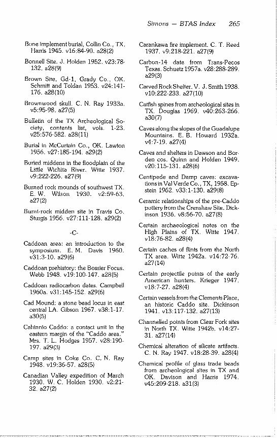
Simons - BTAS Index 265
Bone implement burial, Collin Co., TX. Harris 1945. v16:84-90, a28(2)
Bonnell Site. J. Holden 1952. v23:78- 132. a28(9)
Brown Site, Gd-1, Grady Co., OK. Schmitt and Toldan 1953. v24:141- 176. a28(10)
Brownwood skull. C. N. Ray 1933a. v5:95-98, a27(5)
Bulletin of the TX Archeological So- ciety, contents list, vols. 1-23. v25:576-582, a28(11)
Burial in McCurtain Co., OK. Lawton 1956. v27:185-194, a29(2)
Buried middens in the floodplain of the Little Wichita River. Witte 1937. v9:222-226, a27(9)
Burned rock mounds of southwest TX. E.W. Wilson 1930. v2:59-63. a27(2)
Burnt-rock midden site in Travis Co. Sturgis 1956. v27:111-128, a29(2)
-C-
Caddoan area: an introduction to the symposium. E.M. Davis 1960. v31:3-10, a29(6)
Caddoan prehistory: the Bossier Focus. Webb 1948. v19:100-147, a28(5)
Caddoan radiocarbon dates. Campbell 1960a. v31:145-152, a29(6)
Cad Mound: a stone bead locus in east central LA. Gibson 1967. v38:1-17. a30(5)
Cahinnio Caddo: a contact unit in the eastern margin of the "Caddo area." Mrs. T. L. Hodges 1957. v28:190- 197. a29(3)
Camp sites in Coke Co. C. N. Ray 1948. v19:36-57, a28(5)
Canadian Valley expedition of March 1930. W. C. Holden 1930. v2:21- 32. a27(2)
Carankawa fire implement. C. T. Reed 1937. v9:218-221, a27(9)
Carbon-14 date from Trans-Pecos Texas. Schuetz 1957a. v28:288-289. a29(3)
Carved Rock Shelter. V. J. Smith 1938. v10:222-233, a27(10)
Catfish spines from archeological sites in TX. Douglas 1969. v40:263-266. a30(7)
Caves along the slopes of the Guadalupe Mountains. E.B. Howard 1932a. v4:7-19, a27(4)
Caves and shelters in Dawson and Bor- den cos. Quinn and Holden 1949. v20:115-131, a28(6)
Centipede and Damp caves: excava- tions in Val Verde Co., TX, 1958. Ep- stein 1962, v33:1-130, a29(8)
Ceramic relationships of the pre-Caddo pottery from the Crenshaw Site. Dick- inson 1936. v8:56-70, a27(8)
Certain archaeological notes on the High Plains of TX. Witte 1947. v18:76-82, a28(4)
Certain caches of flints from the North TX area. Witte 1942a. v14:72-76. a27(14)
Certain projectile points of the early American hunters. Krieger 1947. v18:7-27, a28(4)
Certain vessels from the Clements Place, an historic Caddo site. Dickinson 1941. v13:117-132, a27(13)
Channelled points from Clear Fork sites in North TX. Witte 1942b. v14:27- 31. a27(14)
Chemical alteration of silicate artifacts. C. N. Ray 1947. v18:28-39, a28(4)
Chemical profile of glass trade beads from archeological sites in TX and OK. Davison and Harris 1974. v45:209-218, a31(3)
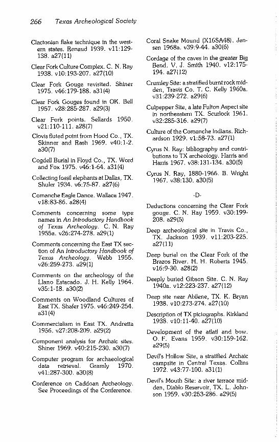
266 Texas Archeological Society
Clactonian flake technique in the west- ern states. Renaud 1939. v11:129- 138, a27(11)
Clear Fork Culture Complex, C. N, Ray 1938, v10:193-207, a27(I0)
Clear Fork Gouge revisited. Shiner 1975. v46:179-188, a31(4)
Clear Fork Gouges found in OK. Bell 1957, v28:285-287, a29(3)
Clear Fork points. Sellards 1950, v21:110-111, a28(7)
Clovis fluted point from Hood Co., TX. Skinner and Rash 1969, v40:1-2. a30(7)
Cogdell Burial in Floyd Co., TX. Word and Fox 1975. v46:1-64, a31(4)
Collecting fossil elephants at Dallas, TX. Shuler 1934. v6:75-87, a27(6)
Comanche Eagle Dance. Wallace 1947. v18:83-86, a28(4)
Comments concerning some type names in An Introductory Handbook of Texas Archeology. C.N. Ray 1955a. v26:274-278, a29(I)
Comments concerning the East TX sec- tion of An Introductory Handbook of Texas Archeology. Webb 1955. v26:259-273, a29(I)
Comments on the archeology of the Llano Estacado, J. H. Kelly 1964. v35:1~18, a30(2)
Comments on Woodland Cultures of East TX. Shafer 1975. v46:249-254, a31 (4)
Commercialism in East TX. Andretta 1956, v27:208~209, a29(2)
Component analysis for Archaic sites. Shiner 1969, v40:215-230, a30(7)
Computer program for archaeological data retrieval. Gramly 1970, v41:287-300, a30(8)
Conference on Caddoan Archeology, See Proceedings of the Conference.
Coral Snake Mound (XI6SA48). Jen- sen 1968a. v39:9-44, a30(6)
Cordage of the caves in the greater Big Bend. V, J. Smith 1940. v12:175- 194, a27(12)
Crumley Site: a stratified burnt rock mid- den, Travis Co, T. C, Kelly 1960a, v31:239-272, a29(6)
Culpepper Site, a late Fulton Aspect site in northeastern TX. Scurlock 1961. v32:285-316, a29(7)
Culture of the Comanche Indians. Rich- ardson 1929, v1:58-73, a27(1)
Cyrus N. Ray: bibliography and contri- butions to TX archeology. Harris and Harris 1967. v38:131-134, a30(5)
Cyrus N. Ray, 1880-1966. B. Wright 1967, v38:130, a30(5)
-D-
Deductions concerning the Clear Fork gouge. C. N, Ray 1959. v30:199- 208. a29(5)
Deep archeological site in Travis Co,, TX. Jackson 1939, v11:203-225. a27(11)
Deep burial on the Clear Fork of the Brazos River. H. H. Roberts 1945. v16:%30, a28(2)
Deeply buried Gibson Site, C. N, Ray 1940a, v12:223-237, a27(12)
Deep site near Abilene, TX. K, Bryan 1938. v10:273-274, a27(I0)
Description of TX pictographs, Kirkland 1938. v10:11-40, a27(I0)
Development of the atlatl and bow. O.F. Evans 1959. v30:159-162. a29(5)
Devil’s Hollow Site, a stratified Archaic campsite in Central Texas. Collins 1972. v43:77-100, a31(1)
Devil’s Mouth Site: a river terrace mid- den, Diablo Reservoir, TX. L. John- son 1959, v30:253-286, a29(5)
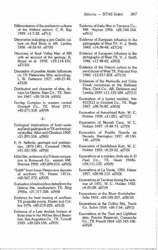
Simons - BTAS Index 267
Differentiation of the prehistoric cultures of the Abilene section. C. N. Ray 1929. v1:7-22, a27(I)
Discoveries indicating a pre-Caddo cul- ture on Red River in AR. Lemley 1936. v8:25-55, a27(8)
Discovery of Sauk Valley Man of MN with an account of the geology. K. Bryan et al. 1938. v10:114-135. a27(10)
Discussion of possible Asiatic influences on TX Pleistocene lithic technology. L. W. Patterson 1977. v48:27-46. a31(6)
Distribution and character of sites, Ar- royo los Olmos, Starr Co., TX. New- ton 1967. v38:18-24, a30(5)
Dunlap Complex in western central Crockett Co., TX. Word 1971. v42:271-318, a30(9)
-E-
Ecological implications of fresh-water and land gastropods in TX archeologi- cal studies. Allen and Cheatum 1960. v31:291-316, a29(6)
E. H. Sellards, geologist and prehisto- rian, 1875-1961. Campbell 1960b. v31:331-336, a29(6)
Elida Site, evidence of a Folsom occupa- tion in Roosevelt Co., eastern NM. Warnica 1959. v30:209-216, a29(5)
"Eolith" from lower Pleistocene deposits of southern TX. Hester 1971b. v42:367-372, a30(9)
Evaluation of radiocarbon dates from the Galena Site, southeastern TX. Ring 1960a. v31:317-326, a29(6)
Evidence for heat treating of southern TX projectile points. Hester and Col- lins 1974. v45:219-224, a31(3)
Evidence of a Late Archaic horizon at three sites in the McGee Bend Reser- voir, San Augustine Co., TX. Tunnell 1959. v30:123-158, a29(5)
Evidence of Early Man in Torrance Co., NM. Haynes 1955. v26:144-164. a29(1)
Evidence of European influence in the pictographs of West TX. V. J. Smith 1942. v14:38-48, a27(14)
Evidence of European influence in the pictographs of West TX. V. J. Smith 1946. v17:48-62, a28(3)
Evidence of the Folsom culture in the sand dunes of West TX. Fritz and Fritz 1940. v12:217-222, a27(12)
Evidences of the Marksville and Coles Creek complexes at the Kirkham Place, Clark Co., AR. Dickinson and Lemley 1939. v11:139-189, a27(11)
Excavation of a buried midden, Site 41CXll in Crockett Co., TX. Riggs 1967. v38:76-82, a30(5)
Excavation of Arrowhead Ruin. W. C. Holden 1939. v11:251, a27(11)
Excavation of Murrah Cave. W.C. Holden 1937. v9:48-73, a27(9)
Excavation of Pueblo Grande de Nevada. Harrington 1937. v9:130- 145. a27(9)
Excavation of Saddleback Ruin. W. C. Holden 1933. v5:39-52, a27(5)
Excavations at a midden circle site in El Paso Co., TX. Greer 1968a. v39:111-132, a30(6)
Excavations at La Venta, 1955. Heizer 1957. v28:98-110, a29(3)
Excavations at Tecolote during the sum- mer of 1931. W. C. Holden 1932. v4:25-28, a27(4)
Excavations at the Blum Rockshelter. Jelks 1953. v24-189-207, a28(10)
Excavations at the Collins Site, Travis Co. Suhm 1955. v26:7-54, a29(1)
Excavations at the Terri and Lightfoot sites, Proctor Reservoir, Comanche Co., TX. Prewitt 1964. v35:143-188. a30(2)
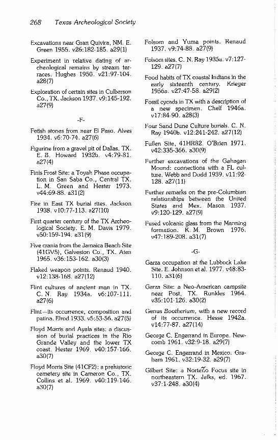
268 Texas Archeological Society
Excavations near Gran Quivira, NM. E. Green 1955. v26:182-185, a29(I)
Experiment in relative dating of ar- cheological remains by stream ter- races. Hughes 1950. v21:97~104. a28(7)
Exploration of certain sites in Culberson Co., TX. Jackson 1937. v9:145-192. a27(9)
-F-
Fetish stones from near El Paso. Alves 1934. v6:70-74, a27(6)
Figurine from a gravel pit of Dallas, TX. E.B. Howard 1932b. v4:79-81. a27(4)
Finis Frost Site: a Toyah Phase occupa- tion in San Saba Co., Central TX. L.M. Green and Hester 1973. v44:69-88, a31(2)
Fire in East TX burial rites. Jackson 1938. v10:77-113, a27(10)
First quarter century of the TX Archeo- logical Society. E. M. Davis 1979. v50:159-194, a31(9)
Five crania from the Jamaica Beach Site (41GV5), Galveston Co., TX. Aten 1965. v36:153-162, a30(3)
Flaked weapon points. Renaud 1940. v12:138-168, a27(12)
Flint cultures of ancient man in TX. C.N. Ray 1934a. v6:107-111. a27(6)
Flint--its occurrence, composition and patina. Elrod 1933. v5:53-56~ a27(5)
Floyd Morris and Ayala sites: a discus- sion of burial practices in the Rio Grande Valley and the lower TX coast. Hester 1969. v40:157-166. a30(7)
Floyd Morris Site (41CF2) : a prehistoric cemetery site in Cameron Co., TX. Collins et al. 1969. v40:11%146. a30(7)
Folsom and Yuma points. Renaud 1937. v9:74-88, a27(9)
Folsom sites. C. N. Ray 1935a. v7:127- 129. a27(7)
Food habits of TX coastal Indians in the early sixteenth century. Krieger
1956a. v27:47-58, a29(2)
Fossil cycads in TX with a description of a new specimen. Chelf 1946a. v17:84-90, a28(3)
Four Sand Dune Culture burials. C. N. Ray 1940b. v12:241-242, a27(12)
Fullen Site, 41HR82. O’Brien 1971. v42:335-366, a30(9)
Further excavations of the Gahagan Mound: connections with a FL cul- ture. Webb and Dodd 1939. v11:92- 128. a27(11)
Further remarks on the pre-Columbian relationships between the United States and Mex. Mason 1937. v9:120-129, a27(9)
Fused volcanic glass from the Manning formation. K.M. Brown 1976. v47:189-208, a31(7)
-G-
Garza occupation at the Lubbock Lake Site. E. Johnson et al. 1977. v48:83- 110. a31(6)
Garza Site: a Neo-American campsite near Post, TX. Runkles 1964. v35:101-126, a30(2)
Genus Bootherium, with a new record of its occurrence. Hesse 1942a. v14:77-87, a27(14)
George C. Engerrand in Europe. New- comb 1961. v32-9-18, a29(7)
George C. Engerrand in Mexico. Gra- ham 1961. v32:19-32, a29(7)
Gilbert Site: a Norte~o Focus site in northeastern TX. Jelks, ed. 1967. v37:1-248, a30(4)
Simons -- BTAS Index 269
Goodman 1 Site, Custer Co. OK. Galla- her 1951. v22:188-216, a28(8)
Grace Creek sites, Gregg Co., TX. Jones 1957. v28:198-231, a29(3)
Granite Beach Site, Llano Co., TX. Crawford 1965. v36:71-98, a30(3)
Greenhaw: an Archaic site in Central TX. Weir 1979. v50:5-68, a31(9)
Greenstone head from Travis Co., TX. Chelf 1941. v13:58-62, a27(13)
Grooved clubs from a peat bog in Milam Co., TX. Chelf 1946b. v17:42-47. a28(3)
Ground sandstone balls of upper Elm Creek bed gravel. C. N. Ray 1943a. v15:97-I04, a28(1)
Guide to archeological reconnaissance. L. Johnson 1963. v34:203-218. a30(1)
Guide to pottery sorting, and the mean- ing of pottery types and attributes. E.M. Davis 1963. v34:189-202. a30(I)
Guide to the drafting of archeological maps. Bryant and Holz 1965. v36:269-286, a30(3)
-H-
Hearths and artifacts of Early Man near Lewisville, TX, and associated faunal material. Cook and Harris 1957. v28:7-97, a29(3)
High Bluff Site on the Clear Fork of the Brazos River. Flinn and Flinn 1967. v38:93-125, a30(5)
High resolution photography for ar- cheology. Secrist 1979. v50:141- 146. a31(9)
Historic burial from Yellowhouse Can- yon, Lubbock Co. Newcomb 1955. v26:186-199, a29(I)
Historic Indian cache in Clay Co. Ozee 1955. v26:256-258, a29(1)
Historic Indian cache in Pecos Co. Eagleton 1955. v26:200-217, a29(1)
Historic material from Fielder Canyon Cave. Kirkland 1942a. v14:61-71. a27(14)
Historic survival of the atlatl in the Lower Mississippi region. Krieger 1956b. v27:195-207, a29(2)
History of the TX Archeological Society and the establishment of a state ar- cheologist. Word 1979. v50:153- 158. a31(9)
Hord Rock Shelter. V. J. Smith 1934. v6:97-106, a27(6)
House types among the Caddo Indians. Webb 1940. v12:49-75, a27(12)
Human burial covered by twenty-one feet of silt. C.N. Ray 1943b. v15:110-116, a28(1)
-I-
Importance of TX as an archeological field. Moorehead 1933. v5:9-13. a27(5)
Importance of the "Gilmore Corridor" in culture contacts between Middle America and the eastern United States. Krieger 1948. v19:155-178. a28(5)
Indian arrow and lance wounds. Jack- son 1943. v15:38-65, a28(1)
Indian campsites of the upper Trinity River drainage. Harris 1936. v8:113- 133. a27(8)
Indian flint saws. C. N. Ray 1935b. v7:125-127, a27(7)
Indian grinding stones or metates in East TX. Hayner 1959. v30:117-123. a29(5)
Indian pictographs and petroglyphs in the Panhandle region of TX. Kirkland 1942b. v14:9-26, a27(14)
Indian pictures in the dry shelters of Val Verde County, TX. Kirkland 1939. v11:47-76, a27(11)
270 Texas Archeological Society
Indian skeletal material from the Jim Arnold site. T.W. McKern 1964. v35:95-100, a30(2)
Indian tribes of TX. Newcomb 1958. v29:1-34, a29(4)
Infant burial in carrying basket. Sayles 1941a. v13:77-87, a27(13)
Infant burial in the TX Panhandle. Harri- son and Griffin 1973. v44:61-68. a31(2)
In memoriam: George Charles Marius Engerrand. Brogan et al. 1961. v32:1-8, a29(7)
Interesting artifacts of Clay Co., TX. Bennett 1936. v8:87-93, a27(8)
Introductory Handbook of Texas Ar- cheology. Suhm et al. 1954. v25:1- 562. a28(11)
Introductory Handbook of Texas Ar- cheology, Comments on. C. N. Ray 1955a. v26:274-278, a29(1)
Introductory Handbook of Texas Ar- cheology, Comments on. Webb 1955. v26:259-273, a29(1)
Introductory survey of bird-form vessels. Compton 1956. v27:79-110, a29(2)
Investigation of archeological sites in Reagan Canyon, Brewster Co., TX. T.C. Kelly and Smith 1962. v33:167-190, a29(8)
Is the American mano of Pleistocene age? C. N. Ray 1939a. v11:251-252. a27(11)
-J-
James Alfred Ford, 1911-1968 [bibliog- raphy]. Webb 1967. v38:126-129. a30(5)
John Pearce Site (16CD56): a San Pa- trice site in Caddo Parish, LA. Webb et al. 1971. v42:1-50, a30(9)
Johnson Site: type site of the Aransas Focus of the TX coast. Campbell 1947. v18:40-75, a28(4)
-K-
Kent-Crane Site: a shell midden on the TX coast. Campbell 1952. v23:39- 77. a28(9)
Kitchen middens of the upper Red River drainage. Witte 1936. v8:71-86. a27(8)
-L-
Lake Creek: a Woodland site in.the TX Panhandle. Hughes 1961. v32:65- 84. a29(7)
Lake sites of the South Plains of TX. Watts 1939. v11:77-91, a27(11)
Langtry Creek Burial Cave, Val Verde Co., TX. Greer and Benfer 1962. v33:229-253, a29(8)
Late Prehistoric cultural patterns along the lower Rio Grande of TX. Hester 1975. v46:107-126, a31(4)
Late Quaternary Paleoenvironment of TX: a model for the archeologist. Bry- ant and Shafer 1977. v48:1-26. a31(6)
La Venta: a cradle of Mesoamerican civi- lization. Heizer 1976. v47:1-24. a31(7)
Lee Site, Gv3, of Garvin Co., OK. Schmitt 1950. v21:69-89, a28(7)
Legal safeguards for preserving the past. McNeil 1969. v40:267-280, a30(7)
Lehmann Rock Shelter: a stratified site of the Toyah, Uvalde, and Round Rock Foci. J.C. Kelley 1947. v18:115-128, a28(4)
Limerick Site at Iron Bridge Reservoir, Rains Co., TX. Duffield 1959. v30:51-116, a29(5)
Simons - BTAS Index 271
List of radiocarbon dates from archeo- logical sites in TX. Campbell 1959. v30:311-320, a29(5)
Lithic reduction sequence: a test case in the North Fork Reservoir area, Wil- liamson Co., TX. P. E. Patterson 1977. v48:53-82, a31(6)
Lithic tool cache in the TX Panhandle. Slesick 1978. v49:319-330, a31(8)
Little Sunday: an Archaic site in the TX Panhandle. Hughes 1955. v26:55- 74. a29(1)
Long chanelled point found in alluvium beside bones of Elephas Columbi. K. Bryan and Ray 1938. v10:263-268. a27(10)
-M-
McCann Site. Preston 1969. v40:167- 192. a30(7)
McCarter Site, a Late Archaic occupa- tion at Muskogee, OK. Shaeffer 1957. v28:240-268, a29(3)
Mackenzie Cave and adjacent sites in Pecos Co. W.C. Holden 1941. v13:46-57, a27(13)
Magnetic delineation of individual ship- wreck sites: a new control technique. Clausen and Arnold 1975. v46:69- 86. a31(4)
Magnetometer survey of the nineteenth- century steamboat Black Cloud. Arnold 1974. v45:225-230, a31(3)
Mastodon, mammoth, and man in America. Gross 1951. v22:101-131. a28(8)
Meaning of Gypsum Cave. Harrington 1934. v6:58-69, a27(6)
Merrell Site: archaeological remains as- sociated with alluvial terrace deposits. Campbell 1948a. v19:7-35, a28(5)
Metate factory in NM. Alves 1933. v5:66-68, a27(5)
Methodological comments on Woodall’s Prehistoric social boundaries. Vaughan 1974. v45:231-234. a31(3)
Mexican pottery head found in TX. J. H. Ray and Ray 1946. v17:93-98. a28(3)
Model for cultural succession for the Coastal Bend area of TX. Corbin 1974. v45:29-54, a31(3)
More cruciforms and some problemati- cal objects. Compton 1957. v28:127- 134. a29(3)
More evidence concerning Abilene Man. C. N. Ray 1937a. v9:193-217. a27(9)
More Pueblo pottery found near Abi- lene. C.N. Ray 1937b. v9:234. a27(9)
Morris Site, Ck-39, Cherokee Co., OK. Bell and Dale 1953. v24:69-140. a28(10)
Mound Lake Site. N. Jennings 1952. v23:309-310, a28(9)
Multiple burials in stone cist mounds of the Abilene region. C. N. Ray 1933b. v5:14-24, a27(5)
-N-
Nature of non-buried archeological data: problems in northeastern Mex. Varner 1967. v38:51-65, a30(5)
Navacoyani a preliminary survey. A. M. Howard 1957. v28:181-189, a29(3)
Neo-American occupation at the Wheatley Site, Pedernales Falls State Park, Blanco Co., TX. Greer 1976. v47:89-169, a31(5)
Neutron activation analysis of West TX ceramics: a statistical evaluation. Ekland 1977. v48:119-132, a31(6)
New perspectives for physical anthro- pology and archaeology. Humphreys 1969. v40:259-262, a30(7)
272 Texas Archeological Society
New species of Capromeryx from the Pleistocene of West TX. Meade 1942. v14:88-96, a27(14)
New type of painted pebble found near Abilene. C. N. Ray 1940c, v12:242- 247, a27(12)
Notes on Coahuiltecan ethnography. R.C. Troike 1961. v32:57~64. a29(7)
Notes on excavated ring midden sites, 1963-1968. Greer 1967, v38:39-45. a30(5)
Notes on five TX crania. Hooton 1933. v5:25-38, a27(5)
Notes on some archeological materials from the Palo Duro Creek area of Hansford Co., TX. Mitchell 1975. v46:217-230, a31(4)
Notes on some Texas coast campsites and other remains. Martin 1929. v1:50-57, a27(1)
Notes on terraces of the Rio Grande Falcon-Zapata area. G.L. Evans 1961. v32:33-46, a29(7)
Notes on the archeology of southwest- ern TX. Mason 1936. v8:192-195. a27(8)
Notes on the archeology of the Happy Patch Site, San Saba Co., TX. L. M. Green 1971. v42:319-334, a30(9)
Notes on the Ayala Site, Lower Rio Grande Valley, TX. Campbell and Frizzell 1949. v20:63-72, a28(6)
Notes on the Big Bend°region of TX. Witte 1943. v15:108-109, a28(1)
Notes on the Clark Site, McLennan Co., TX. Watt 1965. v36:99-110, a30(3)
Notes on the decoration and form of Arkansas Caddo pottery. Dickinson 1943. v15:9-29, a28(1)
Notes on the W. A. Myatt Site. J. B. Wheat 1947b. v18:87-93, a28(4)
-O-
Occurrence and distribution of beveled knives. Poteet 1938. v10:245-262. a27(10)
Old Tom Burial, Dickens Co., TX. Par- sons et al. 1979. v50:69-88, a31(9)
Olmec Phase in eastern Mex. Greengo 1952. v23:260-292, a28(9)
On fluting Folsom: notes on recent ex- periments. Sollberger 1977. v48:47- 52. a31(6)
On the peopling of Hitzfelder Cave. Col- lins 1970, v41:301~304, a30(8)
On the validity of Tepexpan Man. J. D. Jennings 1950. v21:105-110, a28(7)
Optima Focus of the Panhandle Aspect: description and analysis. Watson 1950. v21:7-68, a28(7)
Origins of pottery types from the Coastal Bend region of TX, Campbell 1961. v32:331-336, a29(7)
Ornamentation of the pottery of the TX coastal tribes. Potter 1930. v2:41-44. a27(2)
Ornaments of East TX Indians. Jackson 1935. v7:11-28, a27(7)
Painted pebble from a site on the Nueces River, southern TX. Hester 1977, v48:139-144, a31(6)
Painted pebbles of the TX Big Bend. Martin and Woolford 1932. v4:20- 24. a27(4)
Paleoecological considerations and East TX archeology. Keller 1975. v46:243-248, a31(4)
Paleo-lndian artifacts from sites along San Miguel Creek: Frio, Atascosa, and McMullen cos., TX, Hester 1968. v39:147-162, a30(6)
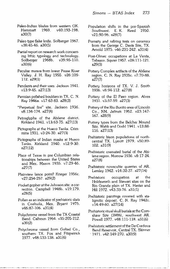
Simons - BTAS Index 273
Paleo-lndian blades from western OK. Hammatt 1969. v40:193-198. a30(7)
Paleo type flake knife. Sollberger 1967. v38:45-46, a30(5)
Partial report on research work concern- ing lithic typology and technology. Sollberger 1968b. v39:95-110. a30(6)
Peculiar manos from lower Pease River Valley. J. H. Ray 1955. v26:109- 112. a29(1)
Pendants and their uses. Jackson 1941. v13:9-45, a27(13)
Permian polished boulders in TX. C. N. Ray 1946a. v17:63-83, a28(3)
"Perpetual fire" site. Jackson 1936. v8:134-174, a27(8)
Petroglyphs of the Abilene district. Kirkland 1941. v13:63-75, a27(13)
Pictographs at the Hueco Tanks. Crim- mins 1931. v3:24-30, a27(3)
Pictographs of Indian masks at Hueco Tanks. Kirkland 1940. v12:9-30. a27(12)
Place of Texas in pre-Columbian rela- tionships between the United States and Mex. Mason 1935. v7:29-46. a27(7)
Plainview lance point? Krieger 1956c. v27:254-257, a29(2)
Pocket gopher at the Johnson site: a cor- rection. Campbell 1948b, v19:179. a28(5)
Pollen as an indicator of prehistoric diets in Coahuila, Mex. Bryant 1975. v46:87-106, a31(4)
Polychrome vessel from the TX Coastal Bend. Calhoun 1964. v35:205-212. a30(2)
Polychrome vessel from Goliad Co., southern TX. Fox and Fitzpatrick 1977. v48:133-138, a31i6)
Population shifts in the pre-Spanish Southwest. E.K. Reed 1950. v21:90-96, a28(7)
Porosity and retiring tests on ceramics from the George C. Davis Site, TX. Arnold 1975. v46:231-242, a31(4)
Post-Olmec occupations at La Venta, Tabasco. Squier 1957. v28:111-121. a29(3)
Pottery Complex artifacts of the Abilene region. C. N. Ray 1935c. v7:70-88. a27(7)
Pottery horizons of TX. V. J. Smith 1936. v8:94-112, a27(8)
Pottery of the El Paso region. Alves 1931. v3:57-59, a27(3)
Pottery of the Rio Bonito area of Lincoln Co., NM. Jelinek 1952. v23:147- 167. a28(9)
Pottery types from the Belcher Mound Site. Webb and Dodd 1941. v13:88- 116. a27(13)
Prehistoric bison populations of north- central TX. Lynott 1979. v50:89- 102. a31(9)
Prehistoric cremated burial of the Abi- lene region. Morrow 1936. v8:17-24. a27(8)
Prehistoric novaculite quarries of AR. Lemley 1942. v14:32-37, a27(14)
Prehistoric occupation at the Holdsworth and Stewart sites on the Rio Grande plain of TX. Hester and Hill 1972. v43:33-76, a31(I)
Prehistoric paintings covered with sta- ligmitic deposit. C. N. Ray 1942c~ v14:49-60, a27(14)
Prehistoric ritual skull burials at the Cren- shaw Site (3M16), southwest AR. Powell 1977. v48:111-118, a31(6)
Prehistoric settlement of the De Cordova Bend Reservoir, Central TX. Skinner 1971. v42:149-270, a30(9)
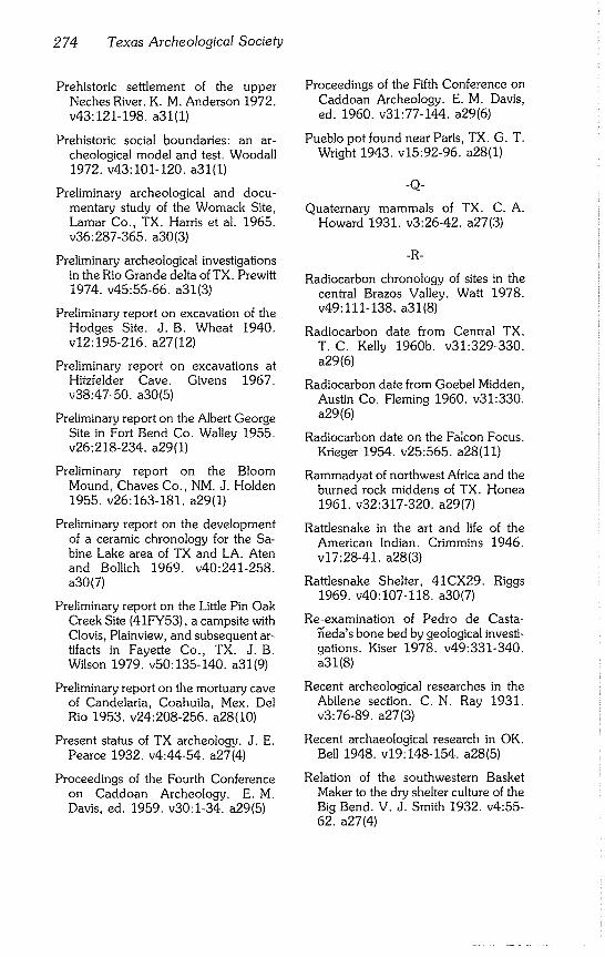
274 Texas Archeological Society
Prehistoric settlement of the upper Neches River. K. M. Anderson 1972. v43:121-198, a31(1)
Prehistoric social boundaries: an ar- cheological model and test. Woodall 1972. v43:101-120, a31(1)
Preliminary archeological and docu- mentary study of the Womack Site, Lamar Co., TX. Harris et al. 1965. v36:287-365, a30(3)
Preliminary archeological investigations in the Rio Grande delta of TX. Prewitt 1974. v45:55-66, a31(3)
Preliminary report on excavation of the Hodges Site. J.B. Wheat 1940. v12:195-216, a27(12)
Preliminary report on excavations at Hitzfelder Cave. Givens 1967. v38:47-50, a30(5)
Preliminary report on the Albert George Site in Fort Bend Co. Walley 1955. v26:218-234, a29(1)
Preliminary report on the Bloom Mound, Chaves Co., NM. J. Holden 1955. v26:163-181, a29(1)
Preliminary report on the development of a ceramic chronology for the Sa- bine Lake area of TX and LA. Aten and Bollich 1969. v40:241-258. a30(7)
Preliminary report on the Little Pin Oak Creek Site (41FY53), a campsite with Clovis, Plainview, and subsequent ar- tifacts in Fayette Co., TX. J.B. Wilson 1979. v50:135-140, a31(9)
Preliminary report on the mortuary cave of Candelaria, Coahuila, Mex. Del Rio 1953. v24:208-256, a28(I0)
Present status of TX archeology. J. E. Pearce 1932. v4:44-54, a27(4)
Proceedings of the Fourth Conference on Caddoan Archeology. E.M. Davis, ed. 1959. v30:1-34, a29(5)
Proceedings of the Fifth Conference on Caddoan Archeology. E. M. Davis, ed. 1960. v31:77-144, a29(6)
Pueblo pot found near Paris, TX. G. T. Wright 1943. v15:92-96, a28(1)
-Q-
Quaternary mammals of TX. C.A. Howard 1931. v3:26-42, a27(3)
-R-
Radiocarbon chronology of sites in the central Brazos Valley. Watt 1978. v49:111-138, a31(8)
Radiocarbon date from Central TX. T.C. Kelly 1960b. v31:329-330. a29(6)
Radiocarbon date from Goebel Midden, Austin Co. Fleming 1960. v31:330. a29(6)
Radiocarbon date on the Falcon Focus. Krieger 1954. v25:565, a28(11)
Rammadyat of northwest Africa and the burned rock middens of TX. Honea 1961. v32:317-320, a29(7)
Rattlesnake in the art and life of the American Indian. Crimmins 1946. v17:28-41, a28(3)
Rattlesnake Shelter, 41CX29. Riggs 1969. v40:107-118, a30(7)
Re-examination of Pedro de Casta- ~eda’s bone bed by geological investi- gations. Kiser 1978. v49:331-340. a31(8)
Recent archeological researches in the Abilene section. C. N. Ray 1931. v3:76-89, a27(3)
Recent archaeological research in OK. Bell 1948. v19:148-154, a28(5)
Relation of the southwestern Basket Maker to the dry shelter culture of the Big Bend. V. J. Smith 1932. v4:55- 62. a27(4)
Sirnons - BTAS Index 275
Relationships between the Caddoan area and Central LA sequences. Webb 1960. v31:11-26, a29(6)
Relationships between the Caddoan area and neighboring areas, v31:3- 76. a29(6)
Relationships between the Caddoan area and TX. Jelks 1960. v31:65-76. a29(6)
Relationships between the Caddoan area and the Mississippi Valley. J. B. Griffin 1960. v31:27-52, a29(6)
Relationships between the Caddoan area and the Plains. Bell 1960. v31:53-64, a29(6)
Reply to Vaughan’s methodological comments on Woodall’s prehistoric social boundaries. Woodall 1974. v45:235-236, a31(3)
Report on an unknown type of imple- ment. Forrester 1957. v28:121-126. a29(3)
Report on archaeological salvage in Falcon Reservoir, season of 1952. Cason 1952. v23:218-259, a28(9)
Report on excavations at the Field Ranch Site (X41CO10), Cooke Co., TX. Jensen 1968b. v39:133-146. a30(6)
Report on four Chumla Cave packets. Martin 1935. v7:115-117, a27(7)
Report on materials from Brawley’s Cave, Bosque Co., TX. Olds 1965. v36:111-152, a30(3)
Report on pottery sherds from near Abi- lene, TX. J. Griffin 1935. v7:57-69. a27(7)
Report on some recent archaeological researches in the Abilene section. C. N. Ray 1930. v2:45-58, a27(2)
Report on the Antelope Creek Ruin. Johnston 1939. v11:190-202. a27(11)
Report on the archeology of Titus Co. Goldschmidt 1935. v7:89-99, a27(7)
Report on the J. C. Putnam skeleton from TX. Stewart 1945. v16:31-40. a28(2)
Report on two mineralized skeletons. C.N. Ray 1934b. v6:115-118. a27(6)
Report on Williamson Co. mound mate- rial. Schuetz 1957b. v28:135-168. a29(3)
Resch Site (41HS16), Harrison Co., TX. Webb et al. 1969. v40:3-106. a30(7)
Researches in Coahultecan ethnog- raphy. R. C. Troike 1959. v30:301- 310. a29(5)
Research in East TX projectile point types. Hayner 1955b. v26:235-243. a29(1)
Review of Central TX archeology. Suhm 1958. v29:63-108, a29(4)
Review of northeast TX archeology. Webb 1958. v29:35-62, a29(4)
Review of the prehistory of the upper TX coast. L.W. Patterson 1979. v50:103-124, a31(9)
Review of Texas archeology. Jelks et al., eds., 1958. v29:1-254, a29(4)
Review of Trans-Pecos TX archeology. Lehmer 1958. v29:109-144, a29(4)
Rock art of the Guadalupe Mountains National Park area. Clark 1974. v45:97-120, a31(3)
Rockport Black-on-Gray vessel from the vicinity of Corpus Christi, TX. Fitz- patrick et al. 1964. v35:193-204. a30(2)
Rock shelter in Coke Co. Sayles 1930. v2:33-40, a27(2)
Role of coprolite analysis in archeology. Bryant 1974. v45:1-28, a31(3)
276 Texas Archeological Society
-S-
Sam Kaufman Site, Red River Co., TX. Harris 1953. v24:43-68, a28(10)
Sandals of Feather Cave. Roosa 1952. v23:133-146, a28(9)
Sandals of the Big Bend Culture with ad- ditional notes concerning Basket Maker evidence. V. J. Smith 1933. v5:57-65, a27(5)
Sauk Valley skeleton. Jenks and Wilford 1938. v10:136-168, a27(I0)
Scientists inspect ancient hearths in river silts. C. N. Ray 1946b. v17:104~112. a28(3)
Scored pottery of the TX Coastal Bend. Calhoun 1961. v32:321-326, a29(7)
Scottsbluff points in the Obshner Site near Dallas, TX. Crook and Harris 1955. v26:75-100, a29(1)
Second historic Caddo site at Natchi- toches, LA. Webb 1945. v16:52-83. a28(2)
Series of eighteen Indian skeletons exca- vated in Shackelford Co., TX. Forres- ter 1951. v22:132-143, a28(8)
Shell celts from coastal Yucatan, Mex. Eaton 1974. v45:197-208, a31(3)
Shell Point: a coastal complex and burial site in Brazoria Co. Hole and Wilkin- son 1973. v44:5-50, a31(2)
Shelter caves of the El Paso district. Alves 1930. v2:64-68, a27(2)
Significance of a new radiocarbon date from the Lewisville Site. Crook and Harris 1961. v32:327-330, a29(7)
Skeletal material from the Cogdell Burial in Floyd Co., TX. Doran and Malina 1975. v46:65~68, a31(4)
Skeletal remains from northern TX. Hrdlicka 1938. v10:169-192. a27(10)
Skeletal remains of man and extinct ani- mals: a camp site covered by river
drift. E. T. Adams 1949. v20:7-20. a28(6)
Small archeological site investigations for interpretation of site activities. Dil- lehay 1973. v44:169-178, a31(2)
Small ruin in NM. Alves 1932. v4:40- 43. a27(4)
Smithport Landing Site: an Alto Focus component in DeSoto Parish, LA. Webb 1963. v34:143-188, a30(1)
Soil characteristics of an archeological deposit: Randall Co., TX. Pearson 1974. v45:151-190, a31(3)
Some archeological fields near the City of Mexico. Crimmins 1933. v5:87- 92. a27(5)
Some archeological material in the Mu- seum of the Agricultural and Mechani- cal College of TX. Hesse 1943, v15:80-91, a28(I)
Some experiments in the use of the atlatl. Davenport 1943. v15:30-37. a28(1)
Some flint sources in central west TX. Sayles 1931. v3:18-23, a27(3)
Some implications of the carbon-14 dates from a cave in Coahuila, Mex. W. W. Taylor 1956. v27:215-234. a29(2)
Some Indian illustrations, prehistoric and historic. Crimmins 1930. v2:69- 75. a27(2)
Some Mexican figurine heads in TX. Krieger 1956d. v27:258-265, a29(2)
Some new aspects of the Tepexpan Man case. Arellano 1951. v22:217-226. a28(8)
Some pipes of East TX. Jackson 1933. v5:69-86, a27(5)
Some Puebloan trade pottery from Panhandle Aspect sites. Crabb 1967. v38:83-89, a30(5)
Some recent exploitations and excava- tions in northwest TX: the Canadian
Simons - BTAS Index 277
Valley. W. C. Holden 1929. v1:23- 35. a27(1)
Some suggestions on archeological terms. Krieger 1945. v16:41-51. a28(2)
Some TX blade technology. L. W. Pat- terson 1973. v44:89-112, a31(2)
Some TX cave dweller artifacts. Sayles 1941b. v13:163-167, a27(13)
Some thoughts on hoaxes and fakes. Heizer 1974. v45:191-196, a31(3)
Some types of archeological sites in Trans-Pecos TX. Fletcher 1931. v3:7-17, a27(3)
Some types of archaeological sites near Abilene, TX. Sayles 1929. v1:43-49. a27(1)
Some unusual Abilene region burials. C.N. Ray 1939b. v11:226-250. a27(11)
Some unusual basketry from the Big Bend. V. J. Smith 1941. v13"133- 151. a27(13)
Some unusual cremated burials. C. N. Ray 1935d. v7:130-131, a27(7)
Some unusual cremated burials found near Colorado, TX. C. N. Ray 1936. v8:9-16, a27(8)
Spanish Fort, an historic Wichita site. Witte 1938. v10:234-244, a27(I0)
Speleothem age dating. Orr 1953. v24:7-17, a28(10)
Split stick basket, a Big Bend culture trait. V. J. Smith 1935. v7:100-104. a27(7)
Stone beads from Bell Co. W.C. Holden, ed. 1951. v22:228, a28(8)
Stone cultures near Cerro Pedernal and their geological antiquity. K. Bryan 1939. v11:9-46, a27(11)
Stone-lined basin with charcoal in lower Clear Fork silt. C. N. Ray 1955b. v26:101-108, a29(1)
Stream bank silts of the Abilene region. C.N. Ray 1945. v16:117-147. a28(2)
Study of Indian pictures in TX. Kirkland 1937. v9:89-119, a27(9)
Study of the Clear Fork Gouge. C. D. Howard 1973. v44:51-60, a31(2)
Sugar industry at Mission San Jose y San Miguel De Aguayo. Clark 1976. v47:245-260, a31(7)
Suggested developmental sequence for house forms in the Caddoan area. Wilmsen 1959. v30:35-50, a29(5)
Suggestions for identification of certain mid-Ouachita pottery as Cahinnio Caddo. Hodges and Hodges 1945, v16:98-116, a28(2)
Surface artifacts from La Perdida, Starr Co., TX. Weir 1956. v27:59-78. a29(2)
Surface points from the badlands of the upper western Cross Timbers of TX. Witte 1955. v26:249-255, a29(1)
Survey and assessment of the archeo- logical resources of Fort Hood, TX. Thomas 1978. v49:195-240, a31(8)
Survey of OK archaeology, Bell and Baerreis 1951. v22:7-100, a28(8)
Survey of sand-hill camp sites of Lamb and Bailey cos. W. M. Pearce 1936, v8:184-186, a27(8)
Survey of the historic earthenware of the lower Arkansas. Dickinson and Del- linger 1940. v12:76-98, a27(12)
Systematized ethnohistory and prehis- toric culture sequences of TX. Camp- bell 1972. v43:1-12, a31(1)
-T-
Tchefuncte culture in the Bayou Vermil- ion Basin, south-central LA" a devel- opmental case study. Gibson 1974. v45:67-96, a31(3)
278 Texas Archeological Society
Technological changes in Harris Co., TX. L. W. Patterson 1976. v47:171- 188. a31(7)
Tentative cultural sequence for the area about the mouth of the Pecos. H. C. Taylor 1949. v20:73-88, a28(6)
Test excavations at the Youngsport Site: a stratified terrace site in Bell Co., TX. Shafer 1963. v34-57-82, a30(1)
Texas archeology: a guide to the litera- ture. Campbell 1958b. v29:177-254. a29(4) ~
Texas coastal pottery. Martin 1931. v3:53-56, a27(3)’~
Texas paleontological n~6tes. C.A. Howard 1930. v2:85-93, a27(2)
Texas Panhandle Culture Ruin No. 55. Studer 1934. v6:80-96, a27(6)
Texas Sandia point. Fritz 1941. v13:168-173, a27(13)
Texas Tech archeological expedition, summer 1930. W. C. Holden 1931. v3:43-52, a27(3)
Texas Technological College Yaqui ex- pedition. W. C. Holden 1934. v6:7- 18. a27(6)
Three Archaic sites in East TX. Hayner 1957. v28:169-180, a29(3)
Three Central TX Aspect sites in Hill Co., TX. Long 1959. v30:223-252. a29(5)
Three Panhandle Aspect sites at Sanford Reservoir, Hutchinson Co., TX. Duf- field 1964. v35:19-82, a30(2)
Three sites near Baytown. Atwood 1952. v23:303-307, a28(9)
Time and types in archeological analysis: the Brainerd-Robinson technique. R. C. Troike 1957. v28:269-284. a29(3)
Toward a generalized model of hunting and gathering societies. Nunley 1972. v43:13-32, a31(1)
Triangular points of Red River Co. G. T. Wright 1940. v12:169-174, a27(12)
Trinity Aspect of the Archaic Horizon: the Carrollton and Elam Foci. Crook and Harris 1952. v23:7-38, a28(9)
Tubular pipes and other tubes in TX. Jackson 1940. v12:99-137, a27(12)
Tuck Carpenter Site and its relation to other sites within the Titus Focus. Turner 1978. v49:1-110, a31(8)
Twelve Room House Ruin. Moore 1947. v18:94-114, a28(4)
Two burials from the Jim Arnold Site in Northwest TX. Tunnell 1964. v35:83-94, a30(2)
Two buried multiple stone cist structures. C. N. Ray 1946c. v17:18-27, a28(3)
Two clay figurines from the central coastal region of TX. Chandler 1978. v49:341-348, a31(8)
Two early historic sites on the Southern Plains. Steen 1953. v24:177-188. a28(10)
Two radiocarbon dates from the central Brazos Valley. Watt 1960. v31:327- 328. a29(6)
Two radiocarbon dates from the Galena Site of southeastern Texas. Ring 1960b. v31:329, a29(6)
Two sites on the Callo del Oso, Nueces Co., TX. Martin 1930a. v2:7-17. a27(2)
Two unusual types of chipped stone arti- fact from northwest LA. Webb 1946. v17:9-17, a28(3)
Type, distribution, and occurrence of flint gravers in TX. W. Wright 1940. v12:31-48, a27(12)
Types of East TX pottery. Jackson 1934. v6:38-57, a27(6)
Typology of lithic artifacts. Renaud 1938. v10:41-76, a27(10)

Simons - BTAS Index 279
-U-
Unusual historic Indian house site in Washington Co., TX. Hasskar11957. v28:232-239, a29(3)
Unusual hollow reed. H.P. Smith 1967. v38:90-92, a30(5)
Unusual skull. C.N. Ray 1940d. v12:238-241, a27(12)
Use of phosphate analysis for determin- ing land use patterns. Lewis 1978. v49:309-318, a31(8)
Use of statistics in archaeology: a bibliog- raphy. Woodall 1967. v38:25-38. a30(5)
Use of worked potsherds as ceramic scrapers: evidence from the Tularosa Basin, NM. Smiley 1979. v50:125~ 140. a31(9)
Utilization of archeological and ethno- historical data in estimating aboriginal population. H.C. Taylor 1961. v32:121-140, a29(7)
-V-
Various types of Clear Fork Gouges. C.N. Ray 1941b. v13:152-162. a27(13)
Vase and some carved stones and peb- bles from Nueces County, TX. Martin 1930b. v2:18-20, a27(2)
Vertebrate paleontological field tech- nique and its application to archaeo- logical collecting. Langston 1948. v19:88-99, a28(5)
Vertebrate paleontology in Texas. Hesse 1942b. v14:97-119, a27(14)
Watermelon Island Site in AR. Hodges and Hodges 1943. v15:66-79. a28 (1)
Water separation procedures at the 1976 TX Archeological Society field school: an appraisal of results. Keller and Fullem 1977~ v48:145~150. a31(6)
West Indian seal remains from two his- toric sites in coastal South TX. Raun 1964. v35:189-192, a30(2)
What caused these Permian grooves? C.N. Ray 1942d. v14:147-156. a27(14)
White Site: an historic Indian burial in Yoakum Co., TX. Suhm 1961. v32:85-120, a29(7)
W. H. Watson Site: a historic Indian burial in Fisher Co., TX. C. N. Ray and Jelks 1964. v35:127-142. a30(2)
Wind blown oil sands. H. H. Adams 1943. v15:105-107, a28(1)
Wolfshead Site: an Archaic-Neo- American site in San Augustine Co., TX. Duffield 1963. v34:83-142. a30(1)
Wooden mortar and pestle from Val Verde Co., TX. Collins and Hester 1968. v39:1-8, a30(6)
-y-
Yarbrough and Miller sites of northeast- ern TX, with a preliminary definition of the LaHarpe Aspect. L. Johnson 1961. v32:141-284, a29(7)
-Z-
Zavonian Springs Site: an Archaic-Neo- American site in McGee Bend Reser- voir, San Augustine Co., TX. W. A. Davis and Horn 1964. v35:213-250. a30(2)
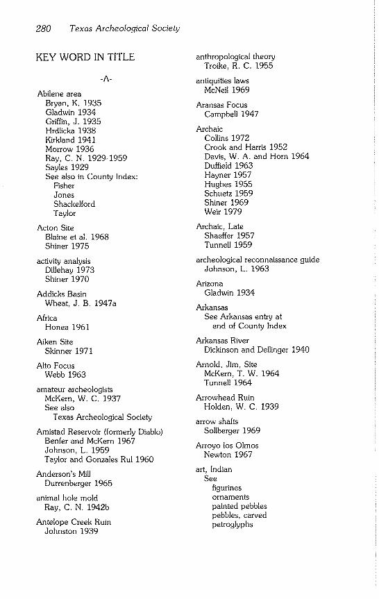
280 Texas Archeological Society
KEY WORD IN TITLE
-A-
Abilene area Bryan, K. 1935 Gladwin 1934 Griffin, J. 1935 Hrdlicka 1938 Kirkland 1941 Morrow 1936 Ray, C. N. 1929-1959 Sayles 1929 See also in County Index:
Fisher Jones Shackelford Taylor
Acton Site Blaine et al. 1968 Shiner 1975
activity analysis Dillehay 1973 Shiner 1970
Addicks Basin Wheat, J. B. 1947a
Africa Honea 1961
Aiken Site Skinner 1971
Alto Focus Webb 1963
amateur archeologists McKern, W. C. 1937 See also
Texas Archeological Society
Amistad Reservoir (formerly Diablo) Benfer and McKern 1967 Johnson, L. 1959 Taylor and Gonzales Rul 1960
Anderson’s Mill Durrenberger 1965
animal hole mold Ray, C. N. 1942b
Antelope Creek Ruin Johnston 1939
anthropological theory Troike, R. C. 1955
antiquities laws McNeil 1969
Aransas Focus Campbell 1947
Archaic Collins 1972 Crook and Harris 1952 Davis, W. A. and Horn 1964 Duffield 1963 Hayner 1957 Hughes 1955 Schuetz 1959 Shiner 1969 Weir 1979
Archaic, Late Shaeffer 1957 Tunnell 1959
archeological reconnaissance guide Johnson, L. 1963
Arizona Gladwin 1934
Arkansas See Arkansas entry at
end of County Index
Arkansas River Dickinson and Dellinger 1940
Arnold, Jim, Site McKern, T. W. 1964 Tunnell 1964
Arrowhead Ruin Holden, W. C. 1939
arrow shafts Sollberger 1969
Arroyo los Olmos Newton 1967
art, Indian See
figurines ornaments painted pebbles pebbles, carved petroglyphs
Sirnons - BTAS Index 281
pictographs rock art
artifacts Anderson, A. E. 1932 Bennett 1936 Chelf 1945 Crook and Harris 1957 Forrester 1957 Hester 1968 Ray, C. N. 1942a Sayles 1941b Weir 1956 Wilson, J. B. 1979 Witte 1956 See also
bone implement cache ceramics figurines lithics ornaments perishable artifacts shell surface artifacts
Asiatic influences Patterson, L. W. 1977
atlatl Chelf 1945 Evans, O. F. 1959 Davenport 1943 Krieger 1956b
Austin Phase Greer and Benfer 1975
Ayala Site Campbell and Frizzell 1949 Hester 1969 Hester and Ruecking 1969
Aycock Shelter Watt 1960, 1978
Aztec Crimmins 1932
balls, sandstone Ray, C. N. 1943a
basket Sayles 1941a
Smith, V. J. 1935, 1941 See also
Basket Maker culture
Basket Maker culture Smith, V. J. 1932, 1933, 1935
Bayou Macon Lemley and Dickinson 1937
Bayou Vermilion Gibson 1974
Baytown, city of Atwood 1952
beads See
ornaments stone beads trade beads
Beidleman Ranch Site Suhm 1960
Belcher Mound Site Webb 1940 Webb and Dodd 1941
Bellevue Mound Fulton and Webb 1953
Belton Reservoir Miller and Jelks 1952
Berclair Site Hester and Parker 1970
bibliography Campbell 1958b, 1960b, 1973 Harris and Harris 1967 Olsen 1959 Patterson, L. W. 1979 Webb 1967 Woodall 1967 See also
Book Reviews Index
bifacing patterns Sollberger 1976
Big Bend Martin and Woolford 1932 Sayles 1941b Smith, V. J. 1931, 1932, 1933, 1934, 1935, 1940, 1941 Witte 1943
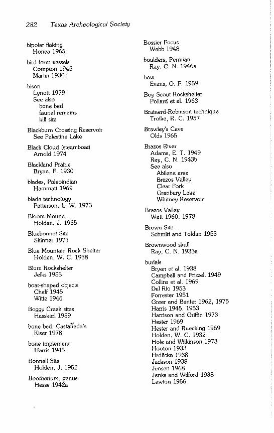
282 Texas Archeological Society
bipolar flaking Honea 1965
bird form vessels Compton 1945 Martin 1930b
bison Lynott 1979 See also
bone bed faunal remains kill site
Blackburn Crossing Reservoir See Palestine Lake
Black Cloud (steamboat) Arnold 1974
Blackland Prairie Bryan, F. 1930
blades, Paleoindian Hammatt 1969
blade technology Patterson, L. W. 1973
Bloom Mound Holden, J. 1955
Bluebonnet Site Skinner 1971
Blue Mountain Rock Shelter Holden, W. C. 1938
Blum Rockshelter Jelks 1953
boat-shaped objects Chelf 1945 Witte 1946
Boggy Creek sites Hasskarl 1959
bone bed, Casta~eda’s Kiser 1978
bone implement Harris 1945
Bonnell Site Holden, J. 1952
Bootherium, genus Hesse 1942a
Bossier Focus Webb 1948
boulders, Permian Ray, C. N. 1946a
bow
Evans, O. F. 1959
Boy Scout Rockshelter Pollard et al. 1963
Brainerd-Robinson technique Troike, R. C. 1957
Brawley’s Cave Olds 1965
Brazos River Adams, E. T. 1949 Ray, C. N. 1943b See also
Abilene area Brazos Valley Clear Fork Granbury Lake Whitney Reservoir
Brazos Valley Watt 1960, 1978
Brown Site Schmitt and Toldan 1953
Brownwood skull Ray, C. N. 1933a
burials Bryan et al. 1938 Campbell and Frizzell 1949 Collins et al. 1969 Del Rio 1953 Forrester 1951 Greer and Benfer 1962, 1975 Harris 1945, 1953 Harrison and Griffin 1973 Hester 1969 Hester and Ruecking 1969 Holden, W. C. 1932 Hole and Wilkinson 1973 Hooton 1933 Hrdlicka 1938 Jackson 1938 Jensen 1968 Jenks and Wilford 1938 Lawton 1956
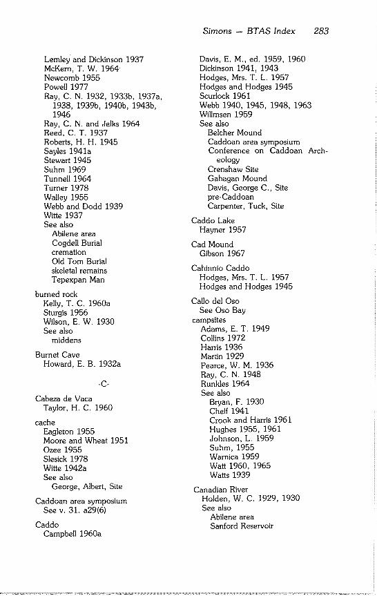
Lemley and Dickinson 1937 McKern, T. W. 1964 Newcomb 1955 Powell 1977 Ray, C. N. 1932, 1933b, 1937a,
1938, 1939b, 1940b, 1943b, 1946
Ray, C. N. and Jelks 1964 Reed, C. T. 1937 Roberts, H. H. 1945 Sayles 1941a Stewart 1945 Suhm 1969 Tunnell 1964 Turner 1978 Walley 1955 Webb and Dodd 1939 Witte 1937 See also
Abilene area Cogdell Burial cremation Old Tom Burial skeletal remains Tepexpan Man
burned rock Kelly, T. C. 1960a Sturgis 1956 Wilson, E. W. 1930 See also
middens
Burnet Cave Howard, E. B. 1932a
-C-
Cabeza de Vaca Taylor, H. C. 1960
cache Eagleton 1955 Moore and Wheat 1951 Ozee 1955 Slesick 1978 Witte 1942a See also
George, Albert, Site
Caddoan area symposium See v. 31. a29(6)
Caddo Campbell 1960a
Simons -- BTAS Index 283
Davis, E. M., ed. 1959, 1960 Dickinson 1941, 1943 Hodges, Mrs. T. L. 1957 Hodges and Hodges 1945 Scurlock 1961 Webb 1940, 1945, 1948, 1963 Willmsen 1959 See also
Belcher Mound Caddoan area symposium Conference on Caddoan Arch-
eology Crenshaw Site Gahagan Mound Davis, George C., Site pre-Caddoan Carpenter, Tuck, Site
Caddo Lake Hayner 1957
Cad Mound Gibson 1967
Cahinnio Caddo Hodges, Mrs. T. L. 1957 Hodges and Hodges 1945
Callo del Oso See Oso Bay
campsites Adams, E. T. 1949 Collins 1972 Harris 1936 Martin 1929 Pearce, W. M. 1936 Ray, C. N. 1948 Runkles 1964 See also
Bryan, F. 1930 Chelf 1941 Crook and Harris 1961 Hughes 1955, 1961 Johnson, L. 1959 Suhm, 1955 Warnica 1959 Watt 1960, 1965 Watts 1939
Canadian River Holden, W. C. 1929, 1930 See also
Abilene area Sanford Reservoir
284 Texas Archeological Society
Candelaria Cave Del Rio 1953
Capromeryx Meade 1942
Carankawa See Karankawa
carbon- 14
See radiocarbon
Carpenter, Tuck, Site Turner 1978
Carrollton focus Crook and Harris 1952
Carved Rock Shelter Smith, V. J. 1938
Casta~eda, Pedro de Kiser 1978
catfish spines Douglas 1969
caves
Holden, W. C. 1941 Howard, E. B. 1932a Kelly, T. C. and Smith 1962 Jackson 1937 Long 1959 Orr 1953 Quinn and Holden 1949 Sayles 1941b Schuetz 1956, 1960, 1962 Smith, V. J. 1940 Taylor, W. W. 1956 See also
Brawley’s Cave Candelaria Cave Centipede Cave Damp Cave Feather Cave Fielder Canyon Gypsum Cave Hitzfelder Cave Langtry Creek Burial Cave Mackenzie Cave Murrah Cave Roark Cave rockshelters Shumla Caves Scorpion Cave
Cedar Creek Reservoir Story 1965
celts, shell Eaton 1974
cemetery sites See
burials skeletal remains
Centipede Cave Epstein 1962
Central Texas Collins 1972 Creel 1978 Honea 1961 Long 1959 Lynott 1979 Schuetz 1959 Suhm 1958 Weir 1979 See also
Granbury Lake Whitney Reservoir
ceramics Alves 1931 Arnold 1975 Aten and Bollich 1969 Calhoun 1961, 1964 Campbell 1961 Compton 1956 Crabb 1968
Davis, E. M. 1963 Dickinson 1936, 1941, 1943 Dickinson and Dellinger 1940 Ekland 1977 Fitzpatrick et al. 1964 Fox and Fitzpatrick 1977 Griffin, J. 1935 Hayner 1955a Hodges and Hodges 1945 Jackson 1934 Jelinek 1952 Lemley and Dickinson 1937 Martin 1930b, 1931 Phelps 1974 Potter 1930 Ray, C. N. 1935c, 1937b Smiley 1979 Smith, V. J. 1936 Webb and Dodd 1941 Wright, G. T. 1943
See also ceramic typology
figurines pipes
vandalism
ceramic typology Davis, E. M. 1963 Jackson 1934 Suhm et al. 1954
Cerro Pedernal Bryan, K. 1939
channelled points Bryan, K. and Ray 1938 Witte 1942b
Chumla Cave See Shumla Caves
Clactonian flake technique Renaud 1939
Clark Site Watt 1960, 1965
Clear Fork Culture complex Ray, C. N. 1938 See also
Abilene area
Clear Fork Gouge Bell 1957 Howard, C. D. 1973 Ray, C. N. 1941b, 1959 Shiner 1975
Clear Fork of Brazos Roberts, H. H. 1945 Ray, C. N. 1955b Flinn and Flinn 1967
Clear Fork points Sellards 1950 Witte 1942b
Clear Lake area
O’Brien 1971
Clements Place Dickinson 1941
Clovis point Skinner and Rash 1969 Wilson, J. B. 1979
clubs, grooved Chelf 1946b
Simons - BTAS Index 285
Coahuila, Mexico Bryant 1975 Del Rio 1953 Heartfield 1975 Taylor, H. C. 1948 Taylor, W. W. 1956, 1961 Taylor, W. W. and Gonzales Rul
1960
Coahuiltecans Troike, R. C. 1959, 1961
Coastal Bend Calhoun 1961, 1964 Campbell 1958a, 1961 Chandler 1978 Corbin 1963, 1974 Fitzpatrick et al. 1964 Martin 1930a, 1930b See also
Gulf Coast
Cochiti Reservoir Honea 1965
Cogdell Burial Doran and Malina 1975 Word and Fox 1975
Coles Creek Complex Dickinson and Lemley 1939
Collins Site Suhm 1955
Colorado Greer 1968b
Comanche Richardson 1929 Wallace 1947
commercialism Andretta 1956
component analysis Shiner 1969
computer program Gramly 1970
Concho River See Twin Buttes Reservoir
Conference on Caddoan Archeology Davis, E. M., ed. 1959, 1960
Coontail Spin Benfer and McKern 1967
286 Texas Archeological Society
coprolite analysis Bryant 1974
Coral Snake Mound Jensen 1968a
cordage Smith, V. J. 1940 See also
perishable artifacts
Corpus Christi, city of Fitzpatrick et al. 1964
Corpus Christi Bay Corbin 1963
crania See skeletal remains
cremation Morrow 1936 Ray, C. N. 1935d, 1936 See also
burial rites
Crenshaw Site Dickinson 1936 Powell 1977
Cross Timbers Witte 1955
cruciforms Compton 1957
Crumley Site
Kelly, T. C. 1960a
Culpepper Site Scurlock 1961
cultural patterns, lower Rio Grande
Hester 1975
cultural sequences Campbell 1972 Taylor, H. C. 1949
cultural succession, Coastal Bend
Corbin 1974
-D-
Dallas, city of Crook and Harris 1955 Shuler 1934
Dallas Lake See Garza - Little Elm Reservoir
Damp Cave Epstein 1962
dating methods Hughes 1950 Orr 1953 See also
radiocarbon dates
Davis, George C., Site Arnold 1975 Keller 1975
De Cordova Bend Reservoir See
Acton Site Granbury Lake
Deer Creek Site Steen 1953
de la Harpe, Benard See La Harpe, Benard de
demographic studies Reed, E. K. 1950 Taylor, H. C. 1961
Denton Creek watershed Gibson and Benham 1969
Devil’s Canyon Site Davison and Harris 1974
Devil’s Hollow Site Collins 1972
Devil’s Mouth Site Johnson, L. 1959
Diablo Reservoir See Amistad Reservoir
diet See food habits
cycads, fossil Chelf 1946a documentary sources
See bibliography
dune fields See sand hills
Dunlap Complex Word 1971
-E-
Eagle dance, Comanche Wallace 1947
earthenware See ceramics
East Texas Andretta 1956 Brown, K. M. 1976 Hayner 1955a, 1955b, 1957, 1959 Jackson 1933, 1934, 1935, 1938 Keller 1975 Shafer 1975 Webb 1948, 1955 See also
East Texas, northern
East Texas, northern Jackson 1933, 1938 Jelks, ed. 1967 Johnson, L. 1961 Scurlock 1961 Webb 1958
Edwards Plateau Elrod 1933
Elam Focus Crook and Harris 1952
elephant fossils Shuler 1934
Elephas Columbi Bryan, K. and Ray 1938
Elida Site Warnica 1959
Elm Creek (Taylor Co.) Ray, C~ N. 1943a
Elm Fork of Trinity Jensen 1968b See also
Lewisville Lake
El Paso area Alves 1930, 1931, 1934, 1939
Sirnons - BTAS Index 287
Crimmins 1929 Moore, Mrs. G. E. 1947
Engerrand, George C. M. See v32. 1961
"eolith" Hester 1971b
ethnography Troike, R. C. 1959, 1961 See also
ethnohistory
ethnohistory Campbell 1972 Newcomb 1958 Richardson 1929 Taylor, H. C. 1961 Wallace 1947 See also
ethnography
European influence Smith, V. J. 1942, 1946
-F-
fakes Heizer 1974
Falcon Focus Krieger 1954
Falcon Reservoir Cason 1952 Evans, G. L. 1961
faunal remains Adams, E. T. 1949 Allen and Cheatum 1960 Bryan, K. and Ray 1938 Campbell 1948b, 1952 Crook and Harris 1957 Douglas 1969 Gross 1951 Hesse 1942a, 1942b Howard, C. A. 1930, 1931 Johnson, E. et al. 1977 Kiser 1978 Krieger 1956a Langston 1948 Lynott 1979 Meade 1942 Olsen 1959 Raun 1964
288 Texas Archeological Society
Ray, C. N. 1942a, 1942b Shuler 1934 Suhm 1960 See also
fishing technology middens
Feather Cave Roosa 1952
fetish stone Alves 1934
field techniques Johnson, L. 1963 Langston 1948
Field Ranch Site Jensen 1968b
Fielder Canyon Cave Kirkland 1942a
figurines Chandler 1978 Chelf 1941 Howard, E. B. 1932b Krieger 1956d Ray, J. H. and Ray 1946
fire implement Reed, C. T. 1937
fire in burial rites Jackson 1938
fishing technology Eaton 1976 Phillips 1978
flaking technique Honea 1965 Renaud 1939 Sollberger 1976
flint See
lithic resource areas lithic studies projectile points
flintcul~res Ray, C. N. 1943a
flintsaws Ray, C. N. 1935b
Folsom Fritz and Fritz 1940
Ray, C. N. 1935a Renaud 1937 Sollberger 1977 Warnica 1959
food habits Bryant 1975 Krieger 1956a See also
faunal remains
Ford, James A. Webb 1967
Fort Hood Thomas 1978
Frightful Cave Taylor, W. W. 1956
Frost, Finis, Site Green, L. M. and Hester 1973
Fullen Site O’Brien 1971
Fulton Aspect Scurlock 1961
-G-
Gahagan Mound Webb and Dodd 1939
Galena Site Ring 1960b
Garza - Little Elm Reservoir (now Lewisville Lake)
Stephenson 1949
Garza occupation Johnson, E. et al. 1977
Garza Site Runkles 1964
gastropods Allen and Cheatum 1960
George, Albert, Site Walley 1955
Gibson Site Ray, C. N. 1940a, 1941a, 1955
Gilbert Site Davison and Harris 1974 Jelks, ed. 1967
Simons - BTAS Index 289
Gilmore Corridor Krieger 1948
Goebel Midden Fleming 1960
Goodman I Site Gallaher 1951
gouges See Clear Fork Gouges
Grace Creek sites Jones 1957
Granbury Lake Blaine et al. 1968 Skinner 1971
Grand Prairie Bryan, F. 1930
Granite Beach Site Crawford 1965
Gran Quivira Green, E. 1955
gravers, flint Wright, W. 1940
Greenhaw Site Weir 1979
greenstone Chelf 1941
Guadalupe Mountains Howard, E. B. 1932 See also
Guadalupe Mountains Park
National
Guadalupe Mountains National Park Clark 1974 Phelps 1974
Gulf Coast Calhoun 1961, 1964 Campbell 1956, 1958a, 1961 Chandler 1978 Corbin 1963, 1974 Fitzpatrick et al. 1964 Hester 1969 Hole and Wilkinson 1973 Jackson 1935 Krieger 1956a Martin 1929, 1930a, 1930b, 1931 Patterson, L. W. 1973, 1979
Potter 1930 Raun 1964 See also
Yucatan
Gypsum Cave Harrington 1934
habitation sites See
campsites caves
house sites rockshelters ruins structural remains
Happy Patch Site Green, L. M. 1971
heads, ceramic See figurines
hearths Crook and Harris 1957 Ray, C. N. 1946b
heat treating Hester and Collins 1974
High Bluff Site Flinn and Flinn 1967
High Plains Renaud 1939 Witte 1947
historic sites Crimmins 1930 Dickinson 1941 Dickinson and Dellinger 1940 Durrenberger 1965 Eagleton 1955 Hasskarl 1957 Kirkland 1942a Krieger 1956b Newcomb 1955 Ozee 1955 Raun 1964 Ray, C. N. and Jelks 1964 Steen 1953 Stephenson 1947 Suhm 1953 Webb 1945
290 Texas Archeological Society
Witte 1938 See also
Cabeza de Vaca Casta~eda, Pedro de European influence Nassonite Post shipwreck sites Stansbury Site sugar industry trade beads
Hitzfelder Cave Collins 1970 Givens 1967
hoaxes Heizer 1974
Hodges Site Wheat, J. B. 1940
Holdsworth Site Hester and Hill 1972
Hord Rock Shelter Smith, V. J. 1934
Horn Rock Shelter Watt 1978
house forms, Caddoan Wilmsen 1959
house sites Hasskarl 1957 Kelly, C. 1949 Webb 1940 Wilmsen 1959 See also
pueblos ruins structural remains
Hueco Basin Moore and Wheat 1951
Hueco Tanks Crimmins 1931 Kirkland 1940
hunting and gathering societies model Nunley 1972
4-
implement, unknown Forrester 1957
infant burial Harrison and Griffin 1973 Sayles 1941a
Iron Bridge Reservoir Duffield 1959
-g-
Jackson, A. T. Campbell 1973
Jamaica Beach Site Aten 1965
Jetta Court Site Wesolowsky et al. 1976
Johnson Site Campbell 1947, 1948b
-K-
Karankawa Potter 1930 Reed, C. T. 1937
Kaufman, Sam, Site Harris 1953
Kent-Crane Site Campbell 1952
kill site Suhm 1960 See also
bone bed
Kirkham Place Dickinson and Lemley 1939
kitchen middens Witte 1936
knives, lithic Poteet 1938 Sollberger 1967
-L-
Laguna Madre Campbell 1956
La Harpe, Benard de Miroir et al. 1973
La Harpe Aspect Johnson, L. 1961
La Jita Site Hester 1971a
Lake Creek Site Hughes 1961
lake sites, plains Watts 1939
Landua Site Hasskarl 1957
land use patterns Lewis 1978
Langtry Creek Burial Cave Green and Benfer 1962
La Perdida Weir 1956
La Venta Heizer 1957, 1976 Squier 1957
Lavon Lake Stephenson 1949
Lee Site Schmitt 1950
Lehmann Rock Shelter Kelly, J. C. 1947
Leon River See Proctor Reservoir
Lewisville Lake Stephenson 1949
Lewisville Site Crook and Harris 1957, 1961
Lightfoot Site Prewitt 1964
Limerick Site Duffield 1959
lithic reduction sequence Patterson, P. E. 1977
lithic resource areas Creel 1978 Elrod 1933 Lemley 1942 Sayles 1931 Witte 1947
Simons - BTAS Index 291
lithic studies Brown, K. M. 1976 Hester 1971b Hester and Collins 1974 Honea 1965 Patterson, L. W. 1973, 1976, 1977 Patterson, P. E. 1977 Poteet 1938 Ray, C. N. 1947 Renaud 1938 Sollberger 1967, 1968, 1969, 1976,
1977 Webb 1946 See also
cache balls, sandstone Clear Fork gouges and points flaking techniques gravers, flint knives, lithic lithic resource areas mano projectile points saws, flint
Little Pin Oak Creek Site Wilson, J. B. 1979
Little Sunday Site Hughes 1955
Little Wichita River Witte 1937
Llano Estacado Kelley, J. H. 1964 See also
South Plains
Louisiana See entry at the end of
County Index
Lowden Site Skinner 1971
Lubbock Lake Site Johnson, E. et al. 1977 Secrist 1979
-M-
McCann Site Preston 1969
292 Texas Archeological Society
McCarter Site Shaeffer 1957
McGee Bend Reservoir Davis, W. A. and Horn 1964 Honea 1965 Stephenson 1948 Tunnell 1959
McGregor Guided Missile Range Smiley 1979
Mackenzie Cave Holden 1941
McLean Site Ray, C. N. 1942a Shiner 1975
magnetometer survey Arnold 1974 Clausen and Arnold 1975
mammoth Bryan, K. and Ray 1938 Gross 1951 Ray, C. N. 1942a Shuler 1934
Mangum Ranch Hester 1977
Manning Formation Brown, K. M. 1976
mano Ray, C. N. 1939a Ray, J. H. 1955
map drafting Bryant and Holz 1965
Marksville complex Dickinson and Lemley 1939
masks, pictographs of Kirkland 1940
mastodon Bryan, K. and Ray 1938 Gross 1951 Shuler 1934 See also
mammoths
matrix sample analysis Dering and Shafer 1976
Melbourne interval Rouse 1952
Meredith Lake See Sanford Reservoir
Merrell Site Campbell 1948a
Mesoamerican See Middle America
metate Alves 1933 Hayner 1959
Mexico See entry at end of
County Index
Mexico City
Crimmins 1933
middens Campbell 1952 Greer 1967, 1968 Honea 1961 Riggs 1967 Sturgis 1956 Witte 1936, 1937 See also
Addicks Basin Berclair Site burned rock
Crumley Site Devil’s Mouth Site Dunlap Complex Greenhaw Site Goebel Midden Holdsworth Site Jetta Court Site McCann Site Merrell Site shell midden South Concho River Twin Buttes Reservoir
Middle America Heizer 1976 Krieger 1948 See also
Mexico entry at end of County in- dex
Olmec
Miller Site Johnson, L. 1961
Simons - BTAS Index 293
mineralized skeletons Ray, C. N. 1934b
Minnesota See Minnesota entry at end of County
index
Mississippi Valley Griffin 1960 Krieger 1956b
Morris Site (OK) Bell and Dale 1953
Morris, Floyd, Site (TX) Collins et al. 1969 Hester 1969
mortar and pestle Collins and Hester 1968
mounds Schuetz 1957b See also
Bayou Macon Bloom Mound Cad Mound Caddo Coral Snake Mound Gahagan Mound
Mound Lake Site Jennings, N. 1952
Murrah Cave Holden, W. C. 1937
Musk Hog Canyon Keller and Fullem 1977
Myatt, W. A., Site Wheat, J. B. 1947b
-N-
Nassonite Post Miroir et al. 1973
Natchitoches Webb 1945
Navacoyan Howard, A. M. 1957
Neches River Anderson, K. M. 1972 See also
Palestine Lake
Neo-American Davis, W. A. and Horn 1964 Duffield 1963 Greer 1976 Runkles 1964
neutron activation analysis Ekland 1977
Nevada Harrington 1934, 1937
New Mexico See New Mexico entry at end of
County index
Norte~o Focus Jelks, ed. 1967
North Texas Holden, W. C. 1929 Hrdlicka 1938 Witte 1946 See also
East Texas, northern Panhandle (TX)
Northeast Texas See East Texas, northern
North Fork Reservoir Patterson, P. E. 1977
Northwest Texas See
Canadian River Panhandle (TX)
novaculite quarries Lemley 1942
Nueces Canyon Huskey 1935
Nueces River Hester 1977
-O-
Oak Creek (Coke Co.) Sayles 1930
Obshner Site Crook and Harris 1955 Shiner 1970
oil sands Adams, H. H. 1943
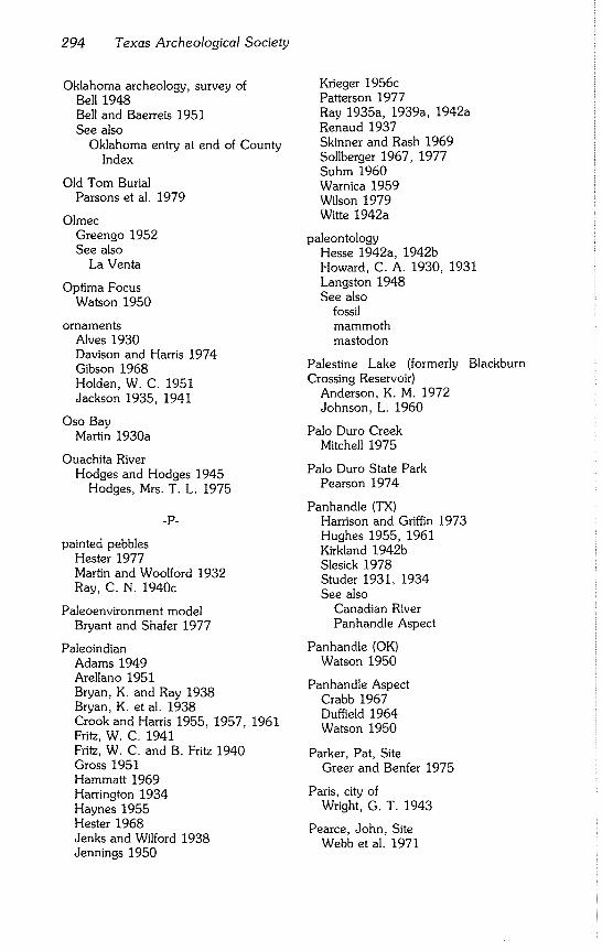
294 Texas Archeological Society
Oklahoma archeology, survey of Bell 1948 Bell and Baerreis 1951 See also
Oklahoma entry at end of County Index
Old Tom Burial Parsons et al. 1979
Olmec
Greengo 1952 See also
La Venta
Optima Focus Watson 1950
ornaments Alves 1930 Davison and Harris 1974 Gibson 1968 Holden, W. C. 1951 Jackson 1935, 1941
Oso Bay Martin 1930a
Ouachita River Hodges and Hodges 1945
Hodges, Mrs. T. L. 1975
.p-
painted pebbles Hester 1977 Martin and Woolford 1932 Ray, C. N. 1940c
Paleoenvironment model Bryant and Shafer 1977
Paleoindian Adams 1949 Arellano 1951 Bryan, K. and Ray 1938 Bryan, K. et al. 1938 Crook and Harris 1955, 1957, 1961 Fritz, W. C. 1941 Fritz, W. C. and B. Fritz 1940 Gross 1951 Hammatt 1969 Harrington 1934 Haynes 1955 Hester 1968 Jenks and Wilford 1938 Jennings 1950
Krieger 1956c Patterson 1977 Ray 1935a, 1939a, 1942a Renaud 1937 Skinner and Rash 1969 Sollberger 1967, 1977 Suhm 1960 Warnica 1959 Wilson 1979 Witte 1942a
paleontology Hesse 1942a, 1942b Howard, C. A. 1930, 1931 Langston 1948 See also
fossil mammoth mastodon
Palestine Lake (formerly Crossing Reservoir)
Anderson, K. M. 1972 Johnson, L. 1960
Blackburn
Palo Duro Creek Mitchell 1975
Palo Duro State Park Pearson 1974
Panhandle (TX) Harrison and Griffin 1973 Hughes 1955, 1961 Kirkland 1942b Slesick 1978 Studer 1931, 1934 See also
Canadian River Panhandle Aspect
Panhandle (OK) Watson 1950
Panhandle Aspect Crabb 1967 Duffield 1964 Watson 1950
Parker, Pat, Site Greer and Benfer 1975
Paris, city of Wright, G. T. 1943
Pearce, John, Site Webb et al. 1971
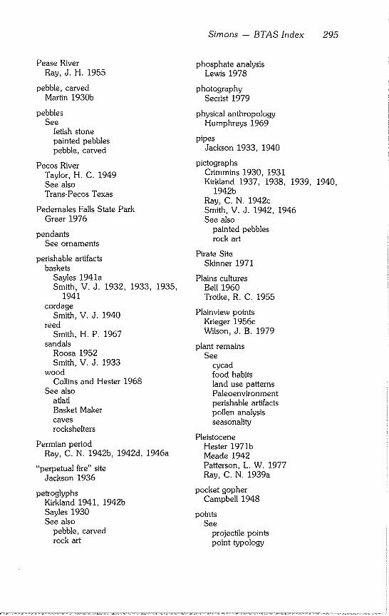
Simons - BTAS Index 295
Pease River Ray, J. H. 1955
pebble, carved Martin 1930b
pebbles See
fetish stone painted pebbles pebble, carved
Pecos River Taylor, H° C. 1949 See also Trans-Pecos Texas
Pedernales Falls State Park Greer 1976
pendants See ornaments
perishable artifacts baskets
Sayles 1941a Smith, V. J. 1932, 1933,
1941 cordage
Smith, V. J. 1940 reed
Smith, H. P. 1967 sandals
Roosa 1952 Smith, V. J. 1933
wood Collins and Hester 1968
See also atlatl Basket Maker caves
rockshelters
1935,
Permian period Ray, C. N. 1942b, 1942d, 1946a
"perpetual fire" site Jackson 1936
petroglyphs Kirkland 1941, 1942b Sayles 1930 See also
pebble, carved rock art
phosphate analysis Lewis 1978
photography Secrist 1979
physical anthropology Humphreys 1969
pipes Jackson 1933, 1940
pictographs Crimmins 1930, 1931 Kirkland 1937, 1938, 1939,
1942b Ray, C. N. 1942c Smith, V. J. 1942, 1946 See also
painted pebbles rock art
Pirate Site Skinner 1971
Plains cultures Bell 1960 Troike, R. C. 1955
Plainview points Krieger 1956c Wilson, J. B. 1979
plant remains See
cycad food habits land use patterns Paleoenvironment perishable artifacts pollen analysis seasonality
Pleistocene Hester 1971b Meade 1942 Patterson, L. W. 1977 Ray, C° N. 1939a
pocket gopher Campbell 1948
points See
projectile points point typology
1940,
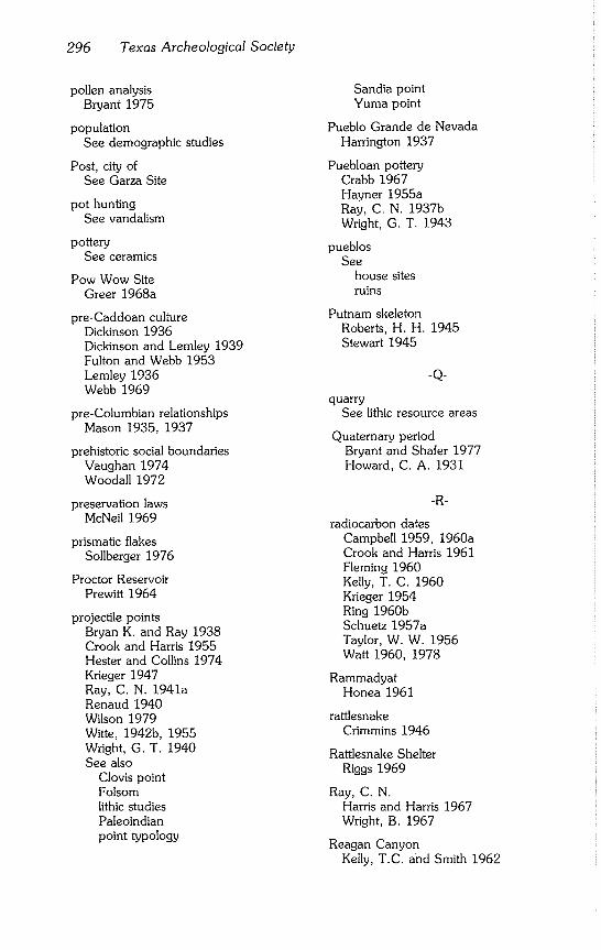
296 Texas Archeological Society
pollen analysis Bryant 1975
population See demographic studies
Post, city of See Garza Site
pot hunting See vandalism
pottery See ceramics
Pow Wow Site Greer 1968a
pre-Caddoan culture Dickinson 1936 Dickinson and Lemley 1939 Fulton and Webb 1953 Lemley 1936 Webb 1969
pre-Columbian relationships Mason 1935, 1937
prehistoric social boundaries Vaughan 1974 Woodall 1972
preservation laws McNeil 1969
prismatic flakes Sollberger 1976
Proctor Reservoir Prewitt 1964
projectile points Bryan K. and Ray 1938 Crook and Harris 1955 Hester and Collins 1974 Krieger 1947 Ray, C. N. 1941a Renaud 1940 Wilson 1979 Witte, 1942b, 1955 Wright, G. T. 1940 See also
Clovis point Folsom lithic studies Paleoindian point typology
Sandia point Yuma point
Pueblo Grande de Nevada Harrington 1937
Puebloan pottery Crabb 1967 Hayner 1955a Ray, C. N. 1937b Wright, G. T. 1943
pueblos See
house sites ruins
Putnam skeleton Roberts, H. H. 1945 Stewart 1945
-Q-
quarry See lithic resource areas
Quaternary period Bryant and Shafer 1977 Howard, C. A. 1931
-R-
radiocarbon dates Campbell 1959, 1960a Crook and Harris 1961 Fleming 1960 Kelly, T. C. 1960 Krieger 1954 Ring 1960b Schuetz 1957a Taylor, W. W. 1956 Watt 1960, 1978
Rammadyat Honea 1961
rattlesnake Crimmins 1946
Rattlesnake Shelter Riggs 1969
Ray, C. N. Harris and Harris 1967 Wright, B. 1967
Reagan Canyon Kelly, T.C. and Smith 1962
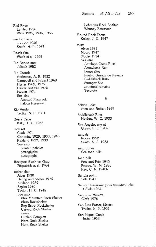
Red River Lemley 1936 Witte 1935, 1936, 1956
reed artifacts Jackson 1940 Smith, H. P. 1967
Resch Site Webb et al. 1969
Rio Bonito area Jelinek 1952
Rio Grande Anderson, A. E. 1932 Campbell and Frizzell 1949 Hester 1969, 1975 Hester and Hill 1972 Prewitt 1974 See also
Amistad Reservoir Falcon Reservoir
Rio Verde Troike, N. P. 1961
Roark Cave Kelly, T. C. 1962
rock art Clark 1974 Crimmins 1929, 1930, 1946 Kirkland 1937, 1939 See also
painted pebbles petroglyphs pictographs
Rockport Black-on-Gray Fitzpatrick et al. 1964
rockshelter Alves 1930 Dering and Shafer 1976 Kirkland 1939 Sayles 1930 Taylor, H. C. 1948 See also
Blue Mountain Rock Shelter Blum Rockshelter Boy Scout Rockshelter Carved Rock Shelter caves Dunlap Complex Hord Rock Shelter Horn Rock Shelter
Simons -- BTAS Index 297
Lehmann Rock Shelter Whitney Reservoir
Round Rock Focus Kelley, J. C. 1947
ruins Alves 1932 Moore 1947 Studer 1934 See also
Antelope Creek Ruin Arrowhead Ruin house sites Pueblo Grande de Nevada Saddleback Ruin Stamper Site structural remains Tecolote
-S-
Sabine Lake Aten and Bollich 1969
Saddleback Ruin Holden, W. C. 1933
San Angelo, city of Green, F. E. 1959
sandals Roosa 1952 Smith, V. J. 1933
sand dunes See sand hills
sand hills Fritz and Fritz 1940 Pearce, W. M. 1936 Ray, C. N. 1940b
Sandia point
Fritz 1941
Sanford Reservoir (now Meredith Lake) Duffield 1964
San Jose Mission Clark 1976
San Luis Potosi, Mexico Troike, N. P. 1961
San Miguel Creek Hester 1968
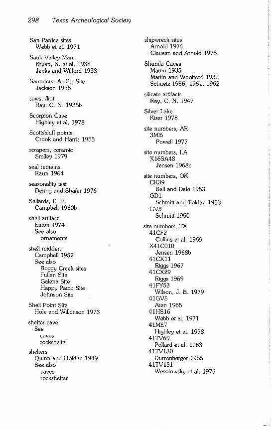
298 Texas Archeological Society
San Patrice sites Webb et al. 1971
Sauk Valley Man Bryan, K. et al. 1938 Jenks and Wilford 1938
Saunders, A. C,, Site Jackson 1936
saws, flint Ray, C. N. 1935b
Scorpion Cave Highley et al. 1978
Scottsbluff points Crook and Harris 1955
scrapers, ceramic Smiley 1979
seal remains Raun 1964
seasonality test Dering and Shafer 1976
Sellards, E. H. Campbell 1960b
shell artifact Eaton 1974 See also
ornaments
shell midden Campbell 1952 See also
Boggy Creek sites Fullen Site Galena Site Happy Patch Site Johnson Site
Shell Point Site Hole and Wilkinson 1973
shelter cave See
caves
rockshelter
shelters Quinn and Holden 1949 See also
caves
rockshelter
shipwreck sites Arnold 1974 Clausen and Arnold 1975
Shumla Caves Martin 1935 Martin and Woolford 1932 Schuetz 1956, 1961, 1962
silicate artifacts Ray, C. N. 1947
Silver Lake Kiser 1978
site numbers, AR 3M16
Powell 1977
site numbers, LA X16SA48
Jensen 1968b
site numbers, OK CK39
Bell and Dale 1953 GDI
Schmitt and Toldan 1953 GV3
Schmitt 1950
site numbers, TX 41CF2
Collins et al. 1969 X41C010
Jensen 1968b 41CXll
Riggs 1967 41CX29
Riggs 1969 41FY53
Wilson, J. B. 1979 41GV5
Aten 1965 41HS16
Webb et al. 1971 41ME7
Highley et al. 1978 41TV69
Pollard et al. 1963 41TV130
Durrenberger 1965 41TV151
Wesolowsky et al. 1976
skeletal analysis See
burials skeletal remains, human
skeletal remains, human Adams, E. T. 1949 Aten 1965 Benfer and McKern 1967 Hrdlicka 1938 Hooton 1933 Jenks and Wilford 1938 Ray, C. N. 1933a, 1934b, 1940d See also
burials
skeletal remains, non-human See faunal remains
skull See skeletal remains, human
small site investigation Dillehay 1973
Smithport Landing Site Webb 1963
social boundaries, prehistoric Woodall 1972, 1974 Vaughan 1974
soil analysis Pearson 1974 See also
speleothem
South Concho River Creel 1978
South Dakota Hughes 1950
South Plains Watts 1939 Steen 1953
South Texas Fox and Fitzpatrick 1977 Hester 1971b, 1977 Hester and Collins 1974 Hester and Parker 1970 Kirkland 1937, 1938 Raun 1964 Ring 1960a, 1960b Shiner 1969 Taylor, H. C. 1960 Troike, R. C. 1959
Simons - BTAS Index 299
See also Rio Grande Southwest Texas
Southwest, U.S. Crimmins 1932 Gladwin 1934 Reed, E. K. 1950 Smith, V. J. 1932 See also at end of County Index: Arizona New Mexico
Southwest Texas Douglas 1969 Mason 1936 Schuetz 1959 Wilson, E. W. 1930
Spanish Fort Site Davison and Harris 1974 Steen 1953 Witte 1938
speleothem Orr 1953
split stick basket Smith, V. J. 1935
Stamper Site Watson 1950
Stansbury Site Stephenson 1970
statistics, use of Woodall 1967
Steele Site Stephenson 1970
Stewart Site Hester and Hill 1972
stone beads Gibson 1967 Holden, W. C. ed. 1951 See also
ornaments
stone cist See stone-lined basins
stone-lined basins Ray, C. N. 1933b, 1946c, 1955b
structural remains Bell and Dale 1953
300 Texas Archeological Society
Crimmins 1929 Duffield 1964 Gallaher 1951 Green, E. 1955 Greer 1976 Harris 1953 Harris et al. 1965 Heizer 1957 Holden, J. 1952 Holden, W. C. 1930 Shaeffer 1957 Squier 1957 Webb 1963 See also
house sites ruins
sugar industry Clark 1976
surface artifacts Weir 1956 Witte 1955 Varner 1967
-T-
Tabasco See La Venta
Tchefuncte culture Gibson 1974
Tecolote Holden, W. C. 1931, 1932
Terri Site Prewitt 1964
Tepexpan Man Arellano 1951 Jennings, J. D. 1950
Texas A&M University Hesse 1943
Texas Archeological Society School, 1976
Keller and Fullem 1977
Field
Texas Archeological Society, history of Davis, E. M. 1979 Word 1979
Texas Tech University Holden, W. C. 1931, 1934
Titus Focus Turner 1978
Tobin Ranch Moore 1947 Moore and Wheat 1951
Toledo Bend Reservoir Jensen 1968a
tool kit, lithic Sollberger 1969
Toyah Phase Green, L. M. and Hester 1973 Kelley, J. C. 1947
trade beads, chemical profile of Davison and Harris 1974 See also
ornaments
Trans-Pecos Texas Fletcher 1931 Honea 1961 Lehmer 1958 Schuetz 1957 See also
Big Bend
Trinity Aspect Crook and Harris 1952
Trinity River
Harris 1936
Jensen 1968b
See also Lavon Lake
tubes Jackson 1940
Tularosa Basin Smiley 1979
Twelve Room House Ruin Moore 1947
Twin Buttes Reservoir Green, F. E. 1959
typology, lithic Hayner 1955b Krieger 1947 Renaud 1938 Ray, C. N. 1955a Sollberger 1968b Suhm et al. 1954 Webb 1955
Simons - BTAS Index 301
Wright, W. 1940 See also
projectile points lithic studies
-U-
underwater archeology See
magnetometer surveys shipwreck sites
Uvalde Focus Kelley, J. C. 1947
-V-
vandalism Andretta 1956
vertebrate remains bibliography Olsen 1959
village sites See
house sites ruins structural remains
Vinson Site Davison and Harris 1974
volcanic glass Brown, K. M. 1976
-W-
Watermelon Island Site Hodges and Hodges 1943
water separation procedure Keller and Fullem 1977
Watson, W. H., Site Ray, C. N. and Jelks 1964
West Indian seal Raun 1964
West Texas Douglas 1969 Ekland 1977 Fritz and Fritz 1940 Kirkland 1937, 1938 Meade 1942 Ray, C. N. 1932 Richardson 1929 Sayles 1931
Wheatley Site Greer 1976
White Site Suhm 1961
Whitney Basin See Whitney Reservoir
Whitney Reservoir Stephenson 1947, 1970
Wichita Indians Witte 1938
Wolfshead Site Duffield 1963
Womack Site Davison and Harris 1974 Harris et al. 1965
wooden artifacts See perishable artifacts
Woodland cultures Hughes 1961 Shafer 1975
wounds Jackson 1943
-y-
Yaqui expedition Holden, W. C. 1934
Yarbrough Site Johnson, L. 1961
Yellowhouse Canyon Newcomb 1955
Youngsport Site Shafer 1963
Yucatan Eaton 1974, 1976 Phillips 1978
Yuma points Renaud 1937
-Z- Zavonian Springs Site
Davis, W. A. and Horn 1964
Zweifel Site Skinner 1971
302 Texas Archeological Society
COUNTY
-A-
Anderson County Anderson, K. M. 1972 Jackson 1933, 1934, 1936 Johnson, L. 1960 Krieger 1956 Woodall 1972
Andrews County Fritz 1941 Fritz and Fritz 1940 Watts 1939
Angelina County Stephenson 1948
Aransas County Campbell 1947, 1948b, 1952 Corbin 1974 Martin 1929
Armstrong County Kirkland 1942b
Atascosa County Hester 1968
Austin County Fleming 1960 Howard, C. D. 1973 Patterson, L. W. 1979
-B-
Bailey County
Kiser 1978
Pearce, W. M. 1936 Watts 1939
Bell County Forrester 1957 Holden, W. C., ed. 1951 Shafer, 1963 Thomas 1978 Wa~t 1960
Bexar County Clark 1976 Collins 1970 Givens 1967 Hester and Collins 1974 Howard, C. D. 1973
Blanco County Greer 1976
Borden County Quinn and Holden, 1949
Bosque County Chelf 1945 Olds 1965 Stephenson 1970 Watt 1978
Bowie County Jackson 1933, 1934 Miroir et al. 1973
Brazoria County Hole and Wilkinson 1973 Patterson, L. W. 1979
Brazos County Brown, K. M. 1976 Hesse 1942a, 1943
Brewster County Fletcher 1931 Kelly, T. C. 1962 Kelly, T. C. and Smith 1962 Sayles 1941b Smith, H. P. 1967 Smith, V.J. 1931, 1934,
1942, 1946
Brown County Ray, C. N. 1933a
Burnet County Field 1956
1938,
Callahan County Ray, C. N. 1929, 1931 See also in Key Word Index, Abilene
area,
Cameron County Anderson, A. E. 1932 Collins et al. 1969 Hester 1969 Prewitt 1974
Camp County Jackson 1934 Turner 1978
Cass County Dickinson 1941
Sirnons - BTAS Index 303
Hayner 1959 Jackson 1933, 1934
Chambers County Dillehay 1973 Patterson, L. W. 1979
Cherokee County Anderson, K. M. 1972 Arnold 1975 Brown, K. M. 1976 Campbell 1959 Jackson 1934 Johnson, L. 1960 Keller 1975 Woodall 1972
Clay County Bennett 1936 Ozee 1955 Witte 1935, 1936, 1937,
1942b, 1946, 1955
Cochran County Kiser 1978
Coke County Kirkland 1941 Ray, C. N. 1946a, 1948 Sayles 1930
Collin County Harris 1936, 1945 Stephenson 1949
Colorado County Howard, C. D. 1973
Comanche County
Forrester 1957
Prewitt 1964
Concho County Smith, V. J. 1946
Cooke County Crook and Harris 1952 Jensen 1968b Witte 1955
Coryell County Miller and Jelks 1952. Thomas 1978
Crockett County Dering and Shafer 1976 Greer 1967 Keller and Fullem 1977
1942a,
Riggs 1967, 1969 Word 1971
Culberson County Clark 1974 Ekland 1977 Howard, E. B. 1932 Jackson 1937 Phelps 1974 Sayles 1941a
Dallas County Campbell 1959 Crook and Harris 1952, 1955 Harris 1936 Howard, E. B. 1932 Shiner 1970 Shuler 1934
Dawson County Quinn and Holden 1949
Deaf Smith County Holden, W, C. 1931
Delta County Johnson, L. 1961
Denton County Campbell 1959 Crook and Harris 1957, 1961 Harris 1936 Stephenson 1949
Dickens County Parsons et al. 1979
Dimmitt County
Hester 1975
Hester and Collins 1974
Duval County Hester 1971b
-E-
Eastland County Ray, J. H. and Mrs. 1946
Edwards County Huskey 1935 Wilson, E. W. 1930
El Paso County Alves 1930, 1931, 1934, 1939 Crimmins 1929, 1931
304 Texas Archeological Society
Ekland 1977 Greer 1967, 1968 Kelly, C. 1949 Kirkland 1940 Moore 1947 Moore and Wheat 1951 Sayles 1941b Smith, V. J. 1946
-F-
Fayette County Brown, K. M. 1976 Wilson, J. B. 1979
Fisher County Ray, C. N. 1940c, 1946c Ray, C. N. and Jelks 1964
Floyd County Doran and Malina 1975 Word and Fox 1975
Fort Bend County Patterson, L. W. 1979 Walley 1955
Franklin County Jackson 1933, 1934
Frio County Hester 1968 Hester and Collins 1974
Gaines County Fritz and Fritz 1940 Watts 1939
Galveston County Aten 1965 Patterson, L. W. 1979
Garza County Runkles 1964
Gillespie County Kelley, J. C. 1947
Goliad County Campbell 1961 Corbin 1974 Fox and Fitzpatrick 1977 Hester and Parker 1970 Raun 1964
Gray County Witte 1947
Gregg County Hayner 1959 Jones 1957
Grimes County Brown, K. M. 1976 Patterson, L. W. 1979
~H-
Hale County Campbell 1959 Kelley, J. H. 1964
Hall County McKern, T. W. 1964 Tunnell, 1964
Hansford County Mitchell 1975
Hardin County Patterson, L. W. 1979
Harris County Atwood 1952 O’Brien 1971 Patterson, L. W. 1973, 1976, 1979 Ring 1960a, 1960b Wheat, J. B. 1947
Harrison County Hayner 1955a, 1957, 1959 Jackson 1933, 1934 Webb et al. 1969
Hays County Weir 1979
Henderson County Anderson, K. M. 1972 Crook and Harris 1952 Jackson 1933, 1934 Johnson, L. 1960 Story 1965 Woodall 1972
Hidalgo County Campbell and Frizzell 1949 Hester 1969 Hester and Ruecking 1969
Hill County Jelks 1953
Simons - BTAS Index 305
Long 1959 Stephenson 1947, 1970
Hockley County Kiser 1978 Watts 1939
Hood County Blaine et al. 1968 Shiner 1975 Skinner 1971 Skinner and Rash 1969 Witte 1955
Hopkins County Jackson 1933, 1934 Scurlock 1961
Houston County Brown, K. M. 1976
Hudspeth County Ekland 1977 Phelps 1974 Smith, V. J. 1946
Hutchinson County Duffield 1964 Hughes 1961 Johnston 1939
Jack County Witte 1942, 1955
Jasper County Patterson, L. W. 1979 Stephenson 1948
Jeff Davis County Crimmins 1930 Smith, V. J. 1931, 1942, 1946
Jefferson County
Aten and Bollich 1969
Patterson, L. W. 1979
Jones County Hooton 1933 Hrdlicka 1938 Ray, C.N. 1929, 1932, 1933b,
1937a, 1938, 1941b Wheat, J. B. 1940, 1947 See also in Key Word Index: Abilene area
-K-
Kaufman County Harris 1936 Story 1965
Kent County Holden, W. C. 1929
Kerr County Sollberger 1968
Kimble County Wilson, E. W. 1930
Kleberg County Reed, C. T. 1937
-L-
Lamar County Davison and Harris 1974 Harris et al. 1965 Jackson 1933, 1934 Wright, G, T. 1943
Lamb County Kiser 1978 Pearce, W. M. 1936 Watts 1939
Lampasas County Field 1956 Preston 1969
LaSalle County Hester and Collins 1974
Liberty County Arnold 1974 Patterson, L. W~ 1979
Limestone County Davison and Harris 1974
Live Oak County
Chandler 1978
Llano County Crawford 1965 Field 1956
Lubbock County Campbell 1959 Johnson, E. et al. 1977 Kelley, J. H. 1964 Meade 1942 Newcomb 1955
306 Texas Archeological Society
Secrist 1979 Witte 1947
Lynn County Jennings, N. 1952 Watts 1939
-M-
McLennan County Watt 1960, 1965, 1978
McMullen County Hester 1968
Matagorda County Corbin 1974
Maverick County Hester and Collins 1974
Medina County Highley et al. 1978 Patterson, L. W. 1977
Menard County Wilson, E. W. 1930
Midland County Campbell 1959 Kelley, J. H. 1964 Ray, C. N. 1940d
Milam County Chelf 1946b
Mitchell County Ray, C. N. 1935d, 1936
Montague County Chelf 1946a Davison and Harris 1974 Gibson and Benham 1969 Steen 1953 Witte 1936, 1938, 1942b, 1955
Montgomery County Patterson, L. W. 1979
Moore County Crabb 1967
Morris County Jackson 1933, 1934 Hayner 1959
-N-
Nacogdoches County Brown, K. M. 1976 Honea 1965 Stephenson 1948
Newton County Patterson, L. W. 1979
Nolan County Kirkland 1941 Ray, C. N. 1946a
Nueces County Calhoun 1961, 1964 Campbell 1956, 1961 Fitzpa~ick et al. 1964 Martin 1929, 1930a, 1930b, 1939 Raun 1964 See also in Key Word Index:
Coastal Bend
-O-
Ochiltree County Holden, W. C. 1929
Orange County Aten and Bollich 1969 Patterson, L. W. 1979
-p.
Palo Pinto County Witte 1955
Parker County Skinner 1971 Witte 1955
Pecos County Eagleton 1955 Holden, W. C. 1941
Polk County Brown, K. M. 1976 Patterson, L. W. 1979
Potter County Crabb 1967 Harrison and Griffin 1973 Holden, W. C. 1932, 1933 Johnston 1939 Slesick 1978 Studer 1934 Witte 1942a, 1947
Presidio County Sayles 1941b Smith, V. J. 1946
-R-
Rains County Davison and Harris 1974 Duffield 1959 Jelks 1966
Randall County Hughes 1955 Pearson 1974 Witte 1942a
Real County Huskey 1935
Red River County Harris 1953 Jackson 1934 Wright, G. T. 1940
Refugio County Calhoun 1961
Reeves County Sayles 1941a Smith, V. J. 1946
Rockwall County Harris 1936
Rusk County Brown, K. M. 1976
Sabine County Stephenson 1948
San Augustine County Davis, W. A. and Horn 1964 Duffield 1963 Honea 1965 Stephenson 1948 Tunnell 1959
San Jacinto County Patterson, L. W. 1979
San Patricio County Chandler 1978 Corbin 1963, 1974
San Saba County Field 1956
Simons - BTAS Index 307
Green, L. M. 1971 Green, L. M. and Hester 1973
Shackelford County Forrester 1951, 1957 Ray, C. N. 1931, 1940c, 1942d,
1946a See also in Key Word Index, Abilene
area.
Shelby County Jackson 1934
Smith County Anderson, K. M. 1972 Johnson, L. 1960 Woodall 1972
Somervell County Witte 1955
Starr County Campbell 1959 Cason 1952 Evans, G. L. 1961 Krieger, ed. 1954 Newton 1967 Weir 1956
Stephens County Flinn and Flinn 1967 Forrester 1957 Ray, C. N. 1931, 1942c See also in Key Word Index, Abilene
area.
Stonewall County Suhm 1960
Sutton County Greer 1967
Swisher County Kirkland 1942b
-T-
Taylor County Bryan and Ray 1938 Griffin, J. B. 1935 Hooton 1933 Kirkland 1941 Morrow 1936 Ray, C. N. 1929,
1933b, 1942b, 1946c
1931, 1932, 1934b, 1939b, 1940c, 1943a, 1945, 1946a,
308 Texas Archeological Society
Roberts, H. H. 1945 Sayles 1929, 1931 Stewart 1945 See also in Key Word Index, Abilene
area,
Terrell County Smith, V° J. 1946
Terry County Watts 1939
Titus County Goldschmidt 1935
Tom Green County Creel 1978 Green, F. E. 1959
Travis County Campbell 1959 Chelf 1941 Collins 1972 Durrenberger 1965 Greer and Benfer 1975 Jackson 1939 Kelly, T. C. 1960a, 1960b Pollard et al. 1963 Sturgis 1956 Suhm 1955 Wesolowsky et al. 1976
Trinity County Brown, K. M. 1976
Tyler County Patterson, L. W. 1979
-U-
Upshur County Jackson 1933, 1934
Uvalde County Campbell 1959 Hester 1971a Huskey 1935
-V-
Val Verde County Benfer and McKern 1967 Campbell 1959 Chelf 1945 Collins and Hester 1968 Epstein 1962
Greer 1967 Greer and Benfer 1962 Holden, W. C. 1937 Johnson, L. 1959 Kirkland 1939, 1942a Martin 1935 Mason 1936 Sayles 1941b Schuetz 1956, 1957a, 1960, 1962 Smith, V. J. 1946 Taylor, H. C. 1949
Van Zandt County Johnson, L. 1961
-W-
Walker County Brown, K. M. 1976 Patterson, L. W. 1979
Waller County Howard, C. D. 1973 Patterson, L. W. 1979
Washington County Brown, K. M. 1976 Hasskarl 1957, 1959 Patterson, L. W. 1979
Webb County Shiner 1975
Wilbarger County Ray, J. H. 1955
Williamson County Campbell 1948a Patterson, P. E. 1977 Schuetz 1957b
Winkler County Fritz and Fritz 1940 Holden, W~ C. 1938
Wise County
Gibson and Benham 1969 Witte 1955
Wood County Jackson 1933
Yoakum County Fritz and Fritz 1940 Suhm 1961
Simons - BTAS Index 309
-Z-
Zavala County Hester 1975, 1977 Hester and Collins 1974 Hester and Hill 1972
Zapata County Cason 1952 Evans, G. L. 1961
OUT OF STATE
UNITED STATES
Arizona Gladwin 1934
Arkansas Dickinson 1936, 1943 Dickinson and Dellinger 1940 Dickinson and Lemley 1939 Hodges and Hodges 1943 Hodges, Mrs. T. L. 1957 Lemley 1936, 1942 Lemley and Dickinson 1937 Powell 1977 Webb 1948
Colorado Greer 1967
Florida Webb and Dodd 1939
Louisiana Aten and Bollich 1969 Fulton and Webb 1953 Gibson 1967, 1974 Hodges, Mrs. T. L. 1957 Jensen 1968a Webb 1940, 1945, 1946, 1948,
1950, 1963 Webb and Dodd 1939, 1941 Webb et al. 1971
Minnesota Bryan, K. et al. 1938 Jenks and Wilford 1938
Nevada Harrington 1934, 1937
New Mexico Alves 1932, 1933 Crimmins 1930 Gladwin 1934 Green, E. 1955 Greer 1967 Haynes 1955 Holden, J. 1952, 1955 Holden, W. C. 1931, 1939 Honea 1965 Howard, E. B. 1932 Jelinek 1952 Roosa 1952 Smiley 1979 Warnica 1959
Oklahoma Bell 1948, 1957 Bell and Baerreis 1941 Bell and Dale 1953 Brighton 1951 Gallaher 1951 Hammatt 1969 Lawton 1956 Schmitt 1950 Schmitt and Toldan 1953 Shaeffer 1957 Steen 1953 Watson 1950 Witte 1956
South Dakota Hughes 1950
Southwest, U.S. See Key Word entry
MEXICO Arellano 1951 Bryan, K. 1939 Bryant 1975 Cason 1952 Compton 1956, 1957 Crimmins 1933 Del Rio 1953 Eaton 1974, 1976 Greengo 1952 Heartfield 1975 Heizer 1957, 1976 Holden, W. C. 1934 Howard, A. M. 1957 Krieger 1956d Mason 1935, 1937 Phillips 1978
310 Texas Archeological Society
Ray, J. H. and Ray 1946 Shiner 1969 Squier 1957 Taylor, H. C. 1948 Taylor, W. W. 1956 Taylor, W. W. and Gonzales Rul
1960 Troike, N. P. 1961 Varner 1967
REVIEWS
Ambler, J. R. 1967. Three prehistoric sites near Cedar Bayou, Galveston Bay area. v39:167-172, a30(6)
Arroyo de Anda, Luis et al. 1956. Cueva de la Candelaria, Vol. I. v27:267-268, a29(2)
Bell, R. E. 1972. The Harlan Site, CK- 6, a prehistoric mound center in Cherokee Co., eastern OK. v43:199- 200. a31(1)
Bibby, Geoffrey. 1956. The testimony of the spade, v28:290-291, a29(3)
Black, C. C., ed. 1974. History and prehistory of the Lubbock Lake Site. v46:257-258, a31(4)
Campbell, E. W. and W. H. Campbell. 1935. The Pinto Basin Site. v7:121- 123. a27(7)
Campbell, T. N. 1975. The Payaya In- dians of southern TX. v47:278-279. a31(7)
Caso, Alfonso. 1958. The Aztecs: peo- ple of the sun. v30:322-323, a29(5)
Central TX Archeological Soc. 1935. Bulletin No. 2. v8:177-178, a27(8)
Chandler, Charles et al. 1976. Excava- tions at the Harris County Boys’ School: analysis of Galveston Bay mortuary practices, v48:159-160. a31(6)
Cosgrove, Mr. and Mrs. C. B. 1965. The Cosgrove Report. v36:365. a30(3)
Crosby, H. A. 1977. Architecture of Texana, 1831-1883, Jackson Co., TX. v49:355-359, a31(8)
Davis, W. A. and E. M. Davis. 1960. The Jake Martin Site: an Archaic site in the Ferrelrs Bridge Reservoir area, northeastern TX. v31:339-340. a29(6)
Dutton, B. P. 1953. Sun Father’s way: the Kiva murals of Kuaua. v35:257- 258. a30(2)
Fladmark, K. R. 1978. A guide to basic archaeological field procedures. v49:368, a31(8)
Ford, J. A. 1935. Analysis of Indian vil- lage site collections from LA and MS. v9:227-229, a27(9)
1969. A comparison of formative cultures in the Americas: diffusion of the psychic unity of man. v42:377-381, a30(9)
Ford, J. A. and C. H. Webb. 1956. Poverty Point: a Late Archaic site in LA. v30:324-326, a29(5)
Forrester, Robert E. 1964. The Ham Creek Site. v35:253-254, a30(2)
Fundaburk, E. L. and M. D. F. Fore- man, eds. n.d. Sun circles and human hands: the southeastern Indians--art and industry, v28:293-294, a29(3)
Gardner, Fletcher and G. C. Martin. n.d. A new type of atlatl from a cave shelter on the Rio Grande near Shumla. v5:99, a27(5)
Gunn, Joel and Royce Mahula. 1977. Hop Hill: culture and climatic change in Central TX. v49:360-361, a31(8)
Hall, R. L. 1962. The archeology of Carcajou Point, with an interpretation of the development of Oneota culture in WI. v34:219-220, a30(1)
Simons - BTAS Index 311
Hester, J. J. 1952. Early Navajo migra- tions and acculturation in the South- west. v35:256-257, a30(2)
Hester, T. R. et al. 1975. Field methods in archeology, 6th ed. v46:261-263. a31 (4)
Hinsdale, W. B. and E. F. Greenman. 1936. Perforated Indian crania in MI. v8:179-180, a27(8)
Holden, Curry. 1956. Hill of the Roost- er. v27:266-267, a29(2)
Holden, W. C. et al. 1935. Studies of the Yaqui Indians of Sonora, Mex. v8:176-177, a27(8)
Hole, Frank. 1974. Reply to review of An ethnohistorical survey of Texas In- dians, v45:244-245, a31(3)
Hole, Frank and R. F. Heizer. 1969. An introduction to prehistoric ar- cheology, 2nd ed. v41:310-315. a30(8)
Hole, Frank, ed. 1974. Archeological investigations along Armand Bayou~ Harris Co., TX. v46:258-259, a31(4)
House, K. D., ed. 1978. Texas ar- cheology: essays honoring R.K. Harris. v50:147-148, a31(9)
Howard, E. B., 1935. Evidence of Early Man in North America. v8:178-179. a27(8)
Hurt, W. R. and W. E. Lass. 1956. Frontier photographer: Stanley J. Morrow’s Dakota years, v27:266. a29(2)
Jackson, M. S. 1977. Texana: excava- tions at a nineteenth century coastal town, Jackson Co., TX. v49:355- 359. a31(8)
Jelks, E. B. and C. D. Tunnell. 1959. The Harroun Site: a Fulton Aspect component area, Upshur Co., TX. v31:337-338, a29(6)
Jenks, A. E. 1935. Pleistocene man in MN. v9:292-231, a27(9)
Krieger, A. D. 1945. Culture complexes in northern TX. v18:157-167, a28(4)
Lewis, T. M. N. and Madeline Kneberg. 1958. Tribes that slumber: Indian times in the TN region, v30:326-327. a29(5)
Lynott, M. J. 1975. Archaeological ex- cavations at Lake Lavon, 1974. v47:280-281, a31(7)
Macgowan, Kenneth. 1950. Early Man in the New World. v21:116-117. a28(7)
McHargue, Georgess, and Michael Roberts. 1977. A field guide to con- servation archaeology in North America. v50:149-150, a31(9)
Mallouf, R. J. 1976. Archeological in- vestigations at proposed Big Pine Lake, 1974-1975, Lamar and Red River cos., TX. v48:155-159, a31(6)
Mallouf, R. J. et al. 1977. A predictive assessment of cultural resources in Hi- dalgo and Willacy counties, TX. v49:362-364, a31(8)
Martin, G. C. n.d. The Big Bend Basket Maker. v5:99, a27(5)
Martin, G.C., ed. 1933. Big Bend Basket Maker papers, v6:114, a27(6)
Mewhinney, H. 1957. A manual for Neanderthals. v28:294-295, a29(3)
Michels, J W. 1973. Dating methods in archaeology, v44:181-183, a31(2)
Moorhead, M. L. 1975. The Presidio: bastion of the Spanish borderlands. v47:277-278, a31(7)
Murdock, G.P. 1950. Ethnographic bibliography of North America. v31:343-345, a29(6)
Newell, H. P. and A. D. Krieger. 1949. The George C. Davis Site, Cherokee Co., TX. v21:112-116, a28(7)
Nowotny, K. A. 1951. Tlacuilolli: die mexikanischen bilderhandscriften stil und inhalt mit einem katalog der cor-
312 Texas Archeological Society
dex-borgia-gruppe, v36:366-367. a30(3)
Patterson, J.T. 1935. The Corner- Tang flint artifacts of TX. v8:175-176. a27(8)
Pearce, J. E. 1933. A prehistoric rock shelter in Val Verde Co., TX. v6:112- 114. a27(6)
1935. Tales that dead men tell. v7:118, a27(7)
Roberts, F. H. H. Jr. n.d. A Folsom complex: preliminary report on inves- tigations at the Lindenmier Site in northern CO. v7:120-121, a27(7)
Sayles, E. B. 1935. An archeological survey of TX. v8:180-184, a27(8)
Schaafsma, Polly. n.d. Rock art in NM. v44:179-180, a31(2)
Schmandt-Besserat, Deinise. 1974. Ar- chaeology, v45:246, a31(3)
Schuyler, R. L., ed. 1978. Historical ar- chaeology: a guide to substantive and theoretical contributions, v50:148- 149. a31(9)
Setzler, F. M. 1933. Prehistoric cave dwellers of TX. v6:115, a27(6)
1932. A prehistoric cave in TX. v6:114-115, a27(6)
Sibley, J. A. Jr. 1967. Louisiana’s an- cients of man: a study of changing characteristics of LA Indian cultures. v42:383-385, a30(9)
Skeels, L. L. M. 1972. An ethnohistori- cal survey of TX Indians. v45:240- 242. a31(3)
1974. Reply to review of An ethnohistorical survey of TX In- dians, v45:244, a31(3)
Southern Methodist University. 1934. Field and laboratory: contributions from the Science Department, Vols. 2 and 3. v7:119, a27(7)
South Plains Archeological Soc. 1963
Bulletin, Vol. 1. v35:254-255. a30(2)
Suhm, D. A. and E. B. Jelks. 1962. Handbook of TX Archeology: type descriptions, v33:253-256, a29(8)
Swift Eagle and Charles Gallenkamp. n.d. The Pueblo Indians in story, song, and dance, v28:291-293. a29(3)
Thomas, D. H. 1974. Predicting the past: an introduction to anthropologi- cal archaeology, v45:239-240. a31(3)
Wallace, Ernest and E.A. Hoebel. 1952. The Comanches, lords of the South Plains. v23:311-312, a28(9)
Webb, C.H. 1959. The Belcher Mound: a stratified Caddoan site in Caddo Parish, LA. v30:321-322. a29(5)
1977. The Poverty Point
Culture. v49:364-367, a31(8)
Wendorf, Fred et al. 1955. The Midland discovery: a report on the Pleistocene human remains from Midland, TX. v26:289-291, a29(1)
West TX Historical and Scientific Soc. 1932. Bulletin 44. v5:98, a27(5)
1933. Bulletin 48, No. 5. v7:123, a27(7)
Wilmsen, E. N. 1970. Lithic analysis and cultural inference: a Paleo-lndian case. v42:373-375, a30(9)
Woodbury, R. B. ed. 1951. Abstracts of New World archaeology, Vol. 1. v31:241-243, a29(6)
Wormington, H. M. 1957. Ancient man in North America. v28:290, a29(3)
Authors 313
AUTHORS
Michael McEachern is a free lance archeologist and speleologist currently with the University of Alabama in Birmingham. He received his B.A. and M.A. degrees from California State University, Sacramento. He has worked in California, Nevada, Texas, Alabama, New Mexico, and Alberta, Canada. His research interests include the conservation of archeological sites and cave environments and application of computer technology to research goals. Address: Depart- ment of Anthropology, University Station, Birmingham, Alabama, 35294.
Ronald W. Ralph is an archeologist with the State of Texas. He received his degree from the University of Texas at Austin. He has conducted field work in Mexico, California, Arizona, and Texas for the last 17 years. His research interests in- clude settlement patterns, rock art conservation, and cave studies. He currently is responsible for cultural resource management within the state park system. Address: Texas Parks and Wildlife Department, Master Planning Branch, 4200 Smith School Road, Austin, Texas 78744.
Elton R. Prewitt received his B.A. from The University of Texas at Austin in 1974 and is working toward an M.A. at that institution. He has published numerous reports and articles dealing with many areas of Texas archeology during 18 years of work in the state. His research interests include the prehistoric cultures of Texas, applications of remote sensing techniques to archeological problems, prehistoric cemeteries, projectile point morphologies, and regional chronologies. His work during the last nine years at the Loeve-Fox Site in Central Texas has yielded significant implications regarding intrasite camping patterns, prehistoric ceme- tery structuring, and regional chronology. He currently is president of a private archeological consulting firm. Address: Prewitt and Associates, Inc., Suite 200, 7530 N. Lamar Blvd., Austin, Texas 78752.
Wilson W. McKinney is an assistant city editor for the San Antonio Express and is a parttime graduate student in Anthropology at The University of Texas at San Antonio. Address: 3023 Shadow Bend Drive, San Antonio, Texas 78230.
Robert J. Mallouf is Assistant State Archeologist, Texas Historical Commission, and in the Anthropology Graduate Program of the University of Texas at Austin. He studied in Texas, California, and Egypt, receiving a B.A. in Anthropology from the University of Texas at Austin in 1970. He has conducted archeological fieldwork in Texas and northern Mexico.
Harry J. Sharer is Associate Professor of Anthropology and Coordinator of the Ar- cheological Research Laboratory at Texas A&M University. He received his Ph.D. degree from The University of Texas at Austin and has conducted ar- cheological field work in many areas of Texas, and in Israel and Belize. His publications include a number of monographs in the Texas Archeological Salvage Project series, and he is also the author of "Clay Figurines from the Lower Pecos Region, Texas" (American Antiquity, 1975) and Archeological and Botanical Studies at Hinds Cave, Val Verde County, Texas (Texas A&M, 1977). Address: Department of Sociology and Anthropology, Texas A&M Uni- versity, College Station, Texas 77843.
314 Texas Archeological Society
Lawrence E. Aten is Chief of the Division of State Plans and Grants, National Park Service, U.S. Department of the Interior, Washington, D.C. In this capacity, he supervises the Historic Preservation Fund which provides grant assistance to State Historic Preservation Officers for surveys, planning, acquisition, and de- velopment of historic and archeological sites. He received a B.S. (Geology) from the University of Houston and Ph.D. (Anthropology) from The University of Texas at Austin. He formerly was a research archeologist at the Texas Ar- cheological Salvage Project and served as Chairman of the Houston Archeo- logical Society. He has authored or co-authored several publications on Texas coast archeology including the Texas Archeological Society’s Special Publica- tion No. 3: Excavations at the Harris County Boys School Cemetery (with Charles K. Chandler, AI B. Wesolowsky, and R. M. Malina), and a book en- titled Indians of the Texas Coast to be published in 1982 by Academic Press.
Vance T. Holliday is a candidate for the Ph.D. in the Department of Geological Sciences, University of Colorado. He received his B.A. in Anthropology at the University of Texas-Austin (1972), and a M.A. in Museum Science at Texas Tech University (1977). He worked for the Texas Archeological Survey (Austin) for three years as a field archeologist. He joined the Lubbock Lake Project (The Museum, Texas Tech University) in 1973 and is now Field Supervisor of the project. He is directing the geological and soils investigations of the project and is working on the archeology with Dr. Eileen Johnson, project director. His doc- toral dissertation concerns rates of Holocene soil development at Lubbock Lake. Other research interests include applications of geology and soils to ar- cheological problems, Quaternary stratigraphy of Central and Western United States, genesis and morphology of arid and semi-arid soils, and Plains ar- cheology particularly the Paleoindian period. Address: Department of Geologi- cal Sciences, University of Colorado, Boulder, CO 80309.
Curtis M. Welty is a staff member of the High Country School, Portland, Oregon. He currently is pursuing a Masters Degree in Geology at the University of Colorado, Boulder. His interests are in teaching, Quaternary geology, and sedimentary environments. Address: 5913 S.W. Clay, Portland, Oregon 97221.
Michael E. Whalen currently is an Assistant Professor of Anthropology atThe Univer- sity of Tulsa. He received his M.A. and Ph.D. degrees from the University of Michigan. His areas of interest are the Southwestern United States and Mexico. His topical interests include cultural ecology, prehistoric demography, and the evolution of early village societies. He is a member of the Texas Archeological Society and the El Paso Archeological Society. Address: Department of Anthro- pology, University of Tulsa, Tulsa, Oklahoma 74104.


Informatlon for Contributors The Bulletin of the Texas Archeological Society publishes original papers in the field
of American archeology. Emphasis is placed on Texas and adjoining areas in the United States and Mexico; papers on other areas are also considered. Articles con- cerning archeological technique, method, or theory are encouraged.
Manuscripts must be typed, double spaced throughout, on 81/2 x 11 white paper. Footnotes should be avoided. References to published literature, by author, date, and page or figure number, should be placed within parentheses in the body of the text, with full bibliographic citations at the end. See this issue of the Bulletin for examples. Authors also should consult"Style Sheet for Authors" in Texas Archeology, 23(I): 11- 13 (January, 1979) or write the Editor for a copy.
The proportions of full page illustrations (picture or drawing plus captions) should be suitable for reduction to effective Bulletin page size of 41/4 x 7 inches. Plates may be printed either horizontally or vertically; allowance for the caption to be printed in the same direction must be made. Captions for illustrations should be listed in numerical order and placed behind the list of references cited.
A complete manuscript is one with: a title, abstract, main body with subdivisions, acknowledgements, references cited, appendices (if necessary), figure captions, com- pleted photographic and drafted plates, and biographical note. Submit three copies of the typed manuscript. Manuscripts are subject to peer review; final decision rests with the Editor.
Papers published in the Bulletin are abstracted and indexed in Abstracts in Anthro- pology.
Manuscripts should be addressed to: Robert J. Mallouf, Texas Historical Commis- sion, P.O. Box 13102, Capitol Station, Austin, Texas 78711.