landslide processes in argentina
TRANSCRIPT
01
02
03
04
05
06
07
08
09
10
11
12
13
14
15
16
17
18
19
20
21
22
23
24
25
26
27
28
29
30
31
32
33
34
35
36
37
38
39
40
41
42
43
44
45
46
C H A P T E R 1 5
Landslide Processes in Argentina
Stella M. Moreiras1,� and Andrea Coronato2
1Instituto Argentino de Nivologıa, Glaciologıa y Ciencias Ambientales
(IANIGLA-CONICET).2Centro Austral de Investigaciones Cientıficas (CADIC-CONICET). B. Houssay
200 (9410) Ushuaia, Argentina.
Contents
1. Introduction 3012. Geographical Location of Landslides 302
2.1. Northern Argentina: Puna—Cordillera Oriental—Sierras Subandinas 3022.2. Northwestern Argentina: Sierras Pampeanas—Sierras de Santa
Barbara—Sistema de Famatina 3082.3. Central Western Argentina: Cordillera Principal—Cordillera
Frontal—Precordillera—Bloque San Rafael 3092.4. Southern Argentina: Cordillera Patagonica SeptentRivernal—Cordillera
Patagonica Austral-Engolfamiento Neuquino—Bernardides-MesetaPatagonica Norte—Meseta Patagonica Sur—Cordillera Fueguina 313
3. Paleo-Landslides 3164. Outburst Floods Caused by Dammed Lake Failure 3225. Main Landslide Trigerring Mechanisms in Argentina 3246. Losses, Economical Impacts, and Physical Land-Use Planning 3297. Final Remarks 331
1. Introduction
During the early twentieth century, landslides in Argentina were vaguelymentioned in technical reports on the main earthquakes as ‘‘secondary effects’’(Forbes, 1861;
AU18
Bodenbender, 1894; Loos, 1926, 1928; Lunkenheimer, 1929;Harrington, 1944) or by railway workers when railway lines were affected
�Corresponding author: Instituto Argentino de Nivologıa, Glaciologıa y Ciencias Ambientales (IANIGLA-CONICET).Av. Dr Ruiz Leal s/n. Parque (5500). Mendoza. ARGENTINA. Casilla Correo 330. Tel:þ54-061-4287029.Fax:þ54-0261-4285940. [email protected]
Font: Bembo & Meta Size:11/12pt Margins:Top:12mm Gutter:15mm T.Area:126mm�192mm 1 Color Lines: 46 Fresh Recto
India NATURAL Chapter 15 17-6-2009 14:45 Page: 301 Trim: 152mm�229mm Floats: Top/Bottom TS: Integra, India
Developments in Earth Surface Processes, Volume 13 � 2009 Elsevier B.V.
ISSN 0928-2025, DOI 10.1016/S0928-2025(08)10015-3 All rights reserved.
301
(Coleman, 1949, in Gonzalez Dıaz et al., 2001). Kilt (1939) was a pioneer in thisarea of study, reporting landslides affecting mountain roads independently of theirtriggering mechanisms. Later, Polanski (1966) studied these processes in arid regionsand proposed a classification for debris flows and floods based on their depositcharacteristics. The number of geomorphological studies describing prehistoriclandslides increased in Argentina 10 years ago, but these studies misjudged currentevents. At present, landslide research aims to understand the probable causes andchronology of these paleo-landslides, but actual landslide hazard and risk assessmentstudies are starting to be included in the government’s land-use planning efforts.
This chapter reviews data on landslides in Argentina in order to explain theiractivities and their implications for landscape evolution and thereby analyze boththe vulnerability of mountain communities and the potential risk landslides pose forregional society and economies. Earlier works on this subject are Schuster andHighland (2001) and the Special Issue of Argentinean Association of AppliedGeologyAU1 and Engineering (ASAGAI, 2004).
2. Geographical Location of Landslides
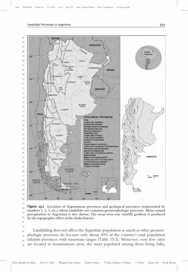
Although landslides are widespread in Argentina, the most catastrophic oneshave affected mountain regions, which comprise one-third of the country, extend-ing from northern Jujuy to southern Tierra del Fuego, and involving mountains,ranges, tablelands, and sea-cliffs where precipitation can be quite differenAU2 t. For thisreason, slope instability processes are mainly analyzed on the basis of Argentinegeological provinces according to Ramos (1999) (Fig. 15. 1).
Atypical rainstorms and seismic events affecting geological structures and weath-ered rocks have been identified as the main forces triggering landslides in Argentina.Heavy summer rainfalls occur in the north and northwestern arid mountains, wherethe abundant deep gorges and gullies moved debris flows to the lowlands and valleyfloors. The Patagonian Andes, where precipitation is produced by the winter wester-lies, also affect the fall and flux mechanisms of landsliding. Excessive snows as well asfast-melting snows during exceptionally warm spring days cause avalanches and debrisflows. In addition, volcanic activity has promoted the formation of lahars.
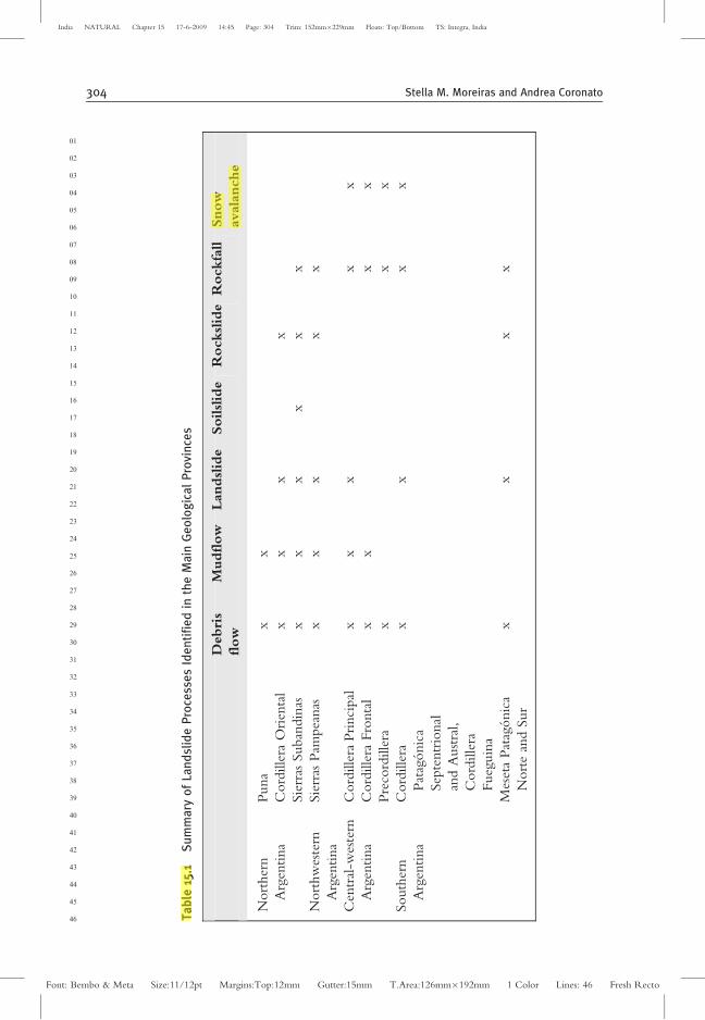
Landsliding triggered by seisms can occur all along the Andes, especially in itscentral and northern geological units, where the seismic hazard is high due to theactivity of Nazca and South American tectonic plates. Landslides occur over thevolcanic-sedimentary of the Patagonian tablelands, and are most commonlytriggered by fluvial undercutting after heavy summer storms, wave erosion at thefootslopes, or groundwater-level variations. Anthropic activities, as well as exoticfauna that modify rivers along the mountain slopes, should also be considered to befactors triggering landslides. Table 15.1 summarizes the main landslide processesrecognized all over Argentina, and reports on events that occurred in each regionalso appear in this chapter. Only snow avalanche and mudflow/debris-flowprocesses seem to be climatically conditioned in specific regions, whereas theother processes have a wide distribution.
01
02
03
04
05
06
07
08
09
10
11
12
13
14
15
16
17
18
19
20
21
22
23
24
25
26
27
28
29
30
31
32
33
34
35
36
37
38
39
40
41
42
43
44
45
46
302 Stella M. Moreiras and Andrea Coronato
Font: Bembo & Meta Size:11/12pt Margins:Top:12mm Gutter:15mm T.Area:126mm�192mm 1 Color Lines: 46 Fresh Recto
India NATURAL Chapter 15 17-6-2009 14:45 Page: 302 Trim: 152mm�229mm Floats: Top/Bottom TS: Integra, India
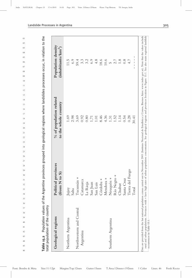
Landsliding does not affect the Argentine population as much as other geomor-phologic processes do because only about 30% of the country’s total populationinhabits provinces with mountain ranges (Table 15.2). Moreover, very few citiesare located in mountainous areas, the most populated among them being Salta,
01
02
03
04
05
06
07
08
09
10
11
12
13
14
15
16
17
18
19
20
21
22
23
24
25
26
27
28
29
30
31
32
33
34
35
36
37
38
39
40
41
42
43
44
45
46
Figure 15.1 Location of Argentinean provinces and geological provinces (represented bynumbers 1, 2, 3, etc.) where landslides are common geomorphologic processes. Mean annualprecipitation in Argentina is also shown. The steep west-east rainfall gradient is producedby the topographic effect of the Andes barrier.
Landslide Processes in Argentina 303
Font: Bembo & Meta Size:11/12pt Margins:Top:12mm Gutter:15mm T.Area:126mm�192mm 1 Color Lines: 46 Fresh Recto
India NATURAL Chapter 15 17-6-2009 14:45 Page: 303 Trim: 152mm�229mm Floats: Top/Bottom TS: Integra, India
01
02
03
04
05
06
07
08
09
10
11
12
13
14
15
16
17
18
19
20
21
22
23
24
25
26
27
28
29
30
31
32
33
34
35
36
37
38
39
40
41
42
43
44
45
46 Ta
ble
15.1
Su
mm
ary
of
Lan
dsl
ide
Pro
cess
es
Ide
nti
fie
din
the
Ma
inG
eo
log
ica
lP
rovi
nce
s
Debri
s
flow
Mudflow
Landslid
eSoilslid
eR
ockslid
eR
ockfa
llSnow
avala
nche
Nort
her
n
Arg
entina
Puna
xx
Cord
ille
raO
rien
tal
xx
xx
Sie
rras
Suban
din
asx
xx
xx
x
Nort
hw
este
rn
Arg
entina
Sie
rras
Pam
pea
nas
xx
xx
x
Cen
tral
-wes
tern
Arg
entina
Cord
ille
raPri
nci
pal
xx
xx
x
Cord
ille
raFro
nta
lx
xx
x
Pre
cord
ille
rax
xx
South
ern
Arg
entina
Cord
ille
ra
Pat
agonic
a
Sep
tentr
ional
and
Aust
ral,
Cord
ille
ra
Fueg
uin
a
xx
xx
Mes
eta
Pat
agonic
a
Nort
ean
dSur
xx
xx
304 Stella M. Moreiras and Andrea Coronato
Font: Bembo & Meta Size:11/12pt Margins:Top:12mm Gutter:15mm T.Area:126mm�192mm 1 Color Lines: 46 Fresh Recto
India NATURAL Chapter 15 17-6-2009 14:45 Page: 304 Trim: 152mm�229mm Floats: Top/Bottom TS: Integra, India
01
02
03
04
05
06
07
08
09
10
11
12
13
14
15
16
17
18
19
20
21
22
23
24
25
26
27
28
29
30
31
32
33
34
35
36
37
38
39
40
41
42
43
44
45
46 Ta
ble
15.2
Po
pu
lati
on
valu
es
of
the
Arg
en
tin
ep
rovi
nce
sg
rou
pe
din
tog
eo
log
ica
lre
gio
ns
wh
ere
lan
dsl
ide
sp
roce
sse
so
ccu
r,in
rela
tio
nto
the
tota
lp
op
ula
tio
no
fth
eco
un
try
Geolo
gic
alre
gio
ns
Politicalpro
vin
ces
(fro
mN
toS)
%ofpopula
tion
rela
ted
toth
ew
hole
countr
y
Popula
tion
densi
ty
(inhabitants
/km
2)
Nort
her
nA
rgen
tina
Juju
y1.6
911.5
Sal
ta2.9
86.9
Nort
hw
este
rnan
dC
entr
al
Arg
entina
Tucu
man�
3.6
959.4
Cat
amar
ca0.9
23.3
La
Rio
ja0.8
03.2
San
Juan
1,7
16.9
San
Luis
1.0
14.8
Cord
oba�
8.4
618.6
Men
doza�
4.3
610.6
South
ern
Arg
entina
Neu
quen�
1.3
15
Rıo
Neg
ro�
1.5
22.7
Chubut
1.1
41.8
San
taC
ruz
0.5
40.8
Tie
rra
del
Fueg
o0.2
84.7
Tota
l30.4
1-
--
--
Dat
aar
epro
vid
edfr
om
the
last
nat
ional
popula
tion
censu
sca
rrie
dout
inN
ovem
ber
2001
(Inst
ituto
Nac
ional
de
Est
adıs
tica
yC
enso
s,B
uen
os
Air
es:w
ww
.indec
.gov.a
r).N
ote
that
the
val
ues
incl
ude
rura
lan
durb
anpopula
tions.
Pro
vin
ces
with�
hav
ehig
hra
tes
of
urb
anpopula
tion
conce
ntr
atio
n.
See
geo
logic
alre
gio
ns
and
pro
vin
ces
loca
tion
inFig
ure
15.1
.See
also
mai
nre
gio
nal
landslid
eocc
urr
ence
sin
Tab
le15.1
.
Landslide Processes in Argentina 305
Font: Bembo & Meta Size:11/12pt Margins:Top:12mm Gutter:15mm T.Area:126mm�192mm 1 Color Lines: 46 Fresh Recto
India NATURAL Chapter 15 17-6-2009 14:45 Page: 305 Trim: 152mm�229mm Floats: Top/Bottom TS: Integra, India

Jujuy, San Carlos de Bariloche, Comodoro Rivadavia, and Ushuaia. Western citiessuch as Mendoza and San Juan are located in piedmont areas, so they are notdirectly affected. Because only small towns or villages, mainly rural, are establishedin mountain regions, neither the general population nor the government gives greatconsideration to landslides.
2.1. Northern Argentina: Puna—Cordillera Oriental—SierrasSubandinas
Despite its arid climate, debris flows or mudflows in the high basinal plateau ofPuna have been full described; however, landslide activity is generally moreimportant in Cordillera Oriental (Fig. 15.2). Debris-mudflows show a great spatialdistribution along the Rıo Grande Basin (Jujuy Province) (Chayle and Aguero,
01
02
03
04
05
06
07
08
09
10
11
12
13
14
15
16
17
18
19
20
21
22
23
24
25
26
27
28
29
30
31
32
33
34
35
36
37
38
39
40
41
42
43
44
45
46
Figure 15.2 Northwestern Argentinean region comprising the Puna, the Cordillera Oriental,and the Sierras Subandinas geological provinces.
306 Stella M. Moreiras and Andrea Coronato
Font: Bembo & Meta Size:11/12pt Margins:Top:12mm Gutter:15mm T.Area:126mm�192mm 1 Color Lines: 46 Fresh Recto
India NATURAL Chapter 15 17-6-2009 14:45 Page: 306 Trim: 152mm�229mm Floats: Top/Bottom TS: Integra, India
1987; Solis and Rivero, 1994; Solis and Orosco, 1996; Azarevich et al., 1999).Earlier, Harrington (1945) described the ‘‘Volcan’’ debris flows that occurred inJanuary and February 1943, which ran 10 km until reaching the Humahuaca valley.They moved 3� 109 m3 of material with an estimated velocity of 10-15 km/h,resulting from water saturation of soils due to vigorous rainfall on the Penorco peakand the later mobilization of blocks from the Arroyo del Medios headwater. Annualoccurrence of these events, which usually damage the railways, is well known; themost destructive events occurred in 1923 and 1930. Similar debris flows channeledinto the Rıo Grande destroyed houses, disrupted roads, and interrupted railroads inHumahuaca village in January 1986 and March 1990; whereas Purmamarca villagewas affected in January 1984 (Wayne and Alonso, 1991). Furthermore, extremeevents have dammed the River Grande, crossing to the opposite valley hillslope,such as occurred in 1945 when Volcan village was flooded.
Atypical summer rainstorms have also generated debris flows in the HuasamayoRiver (tributary of the Grande river) affecting Tilcara village. In 1984, a flowdamaging the river’s defenses destroyed 30 homes ,and village inhabitants had tobe evacuated. Later, a debris flow on January 6, 1998 deposited 5-m-thick sedi-ments on Road 9. On January 20 and February 2, 1999, cultivated fields weredamaged on the river’s alluvial plain. In addition, the Grande River was dammedon March 22, 1999 and again in January 2000, inundating neighboring sectors(Azarevich et al., 1999; Solıs et al., 2004). Planar slides related to high-dip Cam-brian rocks have also been reported, and rock avalanches have been observed alongthe Arroyo Santa Rita (Palma Sola). In 2001 a mudflow was recorded in Tunalito,next to the Maimara locality. These processes are related to important erosion ratesin the Tumbaya Grande valley locality (Solıs et al., 2004).
Kittl (1939) reported the occurrence of an active Volcan landslide from Cum-bres del Obispo (Salta Province) that was originated by the fall of moraine bouldersreaching a volume of 3� 107 m3 (observe that this event differs from the abovementioned events). Kittl noted that the involved mass had been moving severalmillimeters per year. In addition, rockfall debris flows and mudflows were describedby Igarzabal (1971) along the Quebrada del Toro stream; Igarzabal pointed out thatthe rockfall debris flows were the most common, as flows resulting from soilsaturation were mainly generated during the wetter seasons. Furthermore, Sanchezet al. (2005) identified paleo-landslides along the Pascha-Incamayo River draininginto the Toro River; however, they observed that debris flows and rockfalls arecommon at present. A debris flow disrupted the Belgrano Railway connecting Saltacity with Chile on January 10, 2005, covering it with 7-m-thick sediments. Themost catastrophic event in this region was a debris flow triggered by a rainstorm inJanuary 1976, which caused overflooding of the Escoipe River. As a result, thetown of San Fernando de Escoipe was completely destroyed, being covered by 3 mof rocks and mud (Igarzabal, 1978; Wayne, 1987, Alonso and Wayne, 1992).Subsequently, damaging debris flows have regularly occurred in this region (Mar-cuzzi et al. 1994, Chayle and Wayne, 1995).
Catastrophic dense flows have been reported for the western margin of the ValleCalchaquı (Salta Province), between San Carlos and Angastaco localities. Theseflows occurred in 1964 and 1967 in the Quebrada San Lucas valley area. In 1967
01
02
03
04
05
06
07
08
09
10
11
12
13
14
15
16
17
18
19
20
21
22
23
24
25
26
27
28
29
30
31
32
33
34
35
36
37
38
39
40
41
42
43
44
45
46
Landslide Processes in Argentina 307
Font: Bembo & Meta Size:11/12pt Margins:Top:12mm Gutter:15mm T.Area:126mm�192mm 1 Color Lines: 46 Fresh Recto
India NATURAL Chapter 15 17-6-2009 14:45 Page: 307 Trim: 152mm�229mm Floats: Top/Bottom TS: Integra, India
they caused fatalities in Santa Rosa and San Martin, as well as in Arcadia, LasBarrancas, Quebradadel Tonco, Quebrada de la Calderilla, and Quebradade laBajada (Solıs et al., 2004).
Tartagal village (Sierras Subandinas) was severely damaged in March–April 2006due to a 1311.9-mm rainfall (mean annual 692.9 mm). More than 5000 people hadto be evacuated, and half a village stood isolated as a bridge was destroyed by a raisedriver stream that also generated many landslides along river margins, collapsing manyhomes. Road 34 and several bridges were damaged. Moreover, during this powerfulevent, a creek 6 m deep was eroded until reaching 20 m in depth. Also, the vicinityof the Yacui locality was completely evacuated when a natural dam collapsed.
2.2. Northwestern Argentina: Sierras Pampeanas—Sierras de SantaBarbara—Sistema de Famatina
Initially, Lafone Quevedo (La Nacion, 1880) reported a flood of the AndalgalaRiver (Catamarca Province) caused by several debris flows in the Sierra Aconquija(Sierras Pampeanas), which most impacted the Choya valley and damaged theHoyada and Negro valleys (Fig. 15.3). Kuhn (1915) portrayed the occurrence ofa debris flow that was channeled into a creek, impacting Andalgala village onNovember 16, 1913. Four debris flows were recorded in December 1915 due toa 166-mm precipitation (Kantor, 1916). They raised the Andalgala River to1400 m3/sec (normal 0.7 m3/sec), flooding the whole village, and also damaginghouses, vineyards, and cultivated fields. Twelve fatalities and twenty-four missingpersons were reported.
Mudflows have also impacted Valles Calchaquies (Tucuman Province), such asthose recorded in Colalao del Valle locality (1968–1970), the Amaicha locality(1966), and the Tafı del Valle (1987) (Suayter, 1997). On March 13, 1964 a rapiddebris flow triggered by an intense rainfall (117 mm followed by 22 mm in the nexttwo days) was channeled into the Chumbicha Arroyo (Catamarca Province). Forthat reason, Gonzalez Diaz (1972) defined it as ‘‘aluvion de Chumbicha.’’AU3 Rainfallhad begun during the previous days on the upper mountainous basin, and debrisavalanches, debris slides, and soil slides were generated upstream. When this violentflow moving toward the east left the creek, it formed an alluvial cone and split intotwo tracks. One of them affected Chumbicha village, destroying houses, streets, andcultivated fields. A railway infrastructure stopped one of the currents, saving severalbuildings in town. Nonetheless, wagons were covered by 1.5 m of mud. The otherflow destroyed bridges and affected uncultivated fields.
Along Sierra Chica (Cordoba Province), rockfall mainly concentrated along aregional fault, and block slides and soil slides occurred. Moreover, a rotational slidenear the La Falda locality affected the route connecting La Falda with Rıo Ceballoslocalities (Beltramone, 2005). Moreover, in the Nogolı locality (San Luis Pro-vince), a slide was generated over alluvial fans with a steep slope after a violentrainfall in 2001, damaging provincial Road 9, which construction could promoteinstabilityAU4 (Giardini et al., 2003). One slide, with rotational and translationalcomponents, was documented as well for the Intihuasi peak, near the La Carolina
01
02
03
04
05
06
07
08
09
10
11
12
13
14
15
16
17
18
19
20
21
22
23
24
25
26
27
28
29
30
31
32
33
34
35
36
37
38
39
40
41
42
43
44
45
46
308 Stella M. Moreiras and Andrea Coronato
Font: Bembo & Meta Size:11/12pt Margins:Top:12mm Gutter:15mm T.Area:126mm�192mm 1 Color Lines: 46 Fresh Recto
India NATURAL Chapter 15 17-6-2009 14:45 Page: 308 Trim: 152mm�229mm Floats: Top/Bottom TS: Integra, India
locality, in 1978. This process started in a traction crack system on weatheredvolcaniclastic rocks 120 m long associated with a subvertical fault plane with 6- and20-m displacements. This slide could have affected the cultural site ‘‘Inti Huasicave,’’ which was located on the opposite slope. Moreover, unstable conditionsexist in this rock outcropping and slide blocks (Sales et al., 2002; Fauque andGonzalez, 2004).
01
02
03
04
05
06
07
08
09
10
11
12
13
14
15
16
17
18
19
20
21
22
23
24
25
26
27
28
29
30
31
32
33
34
35
36
37
38
39
40
41
42
43
44
45
46
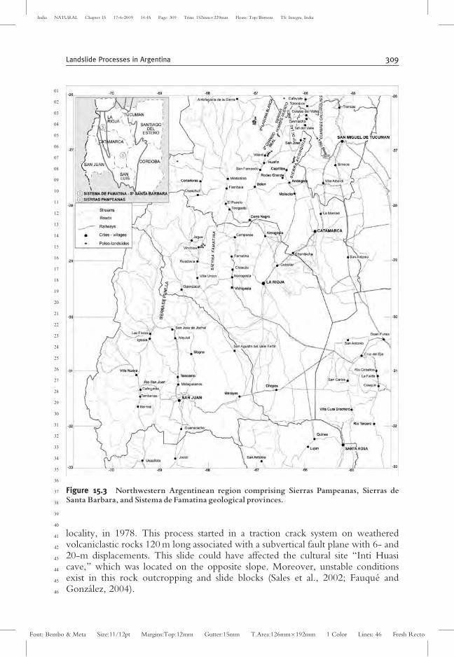
Figure 15.3 Northwestern Argentinean region comprising Sierras Pampeanas, Sierras deSanta Barbara, and Sistema de Famatina geological provinces.
Landslide Processes in Argentina 309
Font: Bembo & Meta Size:11/12pt Margins:Top:12mm Gutter:15mm T.Area:126mm�192mm 1 Color Lines: 46 Fresh Recto
India NATURAL Chapter 15 17-6-2009 14:45 Page: 309 Trim: 152mm�229mm Floats: Top/Bottom TS: Integra, India
2.3. Central Western Argentina: Cordillera Principal—CordilleraFrontal—Precordillera—Bloque San Rafael
At 32�S,AU5 several travelers crossing from Mendoza city to Santiago de Chile talkedabout hazards relating to sudden and violent rockfalls (Miers, 1826; Brandt, 1828;Forbes, 1861; Lemos, 1884, Proctor, 1920) along the valleys of the Mendoza andCuevas rivers, where the international road to Chile was installed later. In 1819,while on one of his travels, Miers (1826) found a fallen block in Cortaderas thatcaused the death of the muleteer, Santiago Molina, in 1790. Then, Brand (1828)described the occurrence of a rockfall on February 27, 1828 at the same place.Miers (1826) also reported several rockfalls in the La Jaula and Las Cuevas localitiesand referred to the occurrence of dangerous debris flows in the Precordilleracausing severe damages. Afterward, Verdaguer (1929) mentioned damage causedby debris flows triggered by rainstorms in the Precordillera during the summer of1824. In 1834, Osculati (in RJEHM, 1987) mentioned some fatalities caused byfalls, extreme cold, and snow avalanches along this trail. In 1890 the Los Andesnewspaper reported serious damages caused to the Transandino Railway, alsoconnecting Mendoza with Santiago de Chile, during its inauguration (Fig. 15.4).
Salomon (1969) identified several active mudflows in his geomorphologicalstudy along the valleys of Las Cuevas and Mendoza rivers, comprising CordilleraPrincipal and Cordillera Frontal geological provinces. This author also noted a hugeancient rockslide at the Las Cuevas locality sourced on the Tolosa peak, producingdeposits 1.5 km long and 50 m thick, reaching 1� 107 m3 in volume and withboulders >7 m in diameter (Pereyra, 1995). Oral tradition holds that further eventstook place here during the eighteenth and nineteenth centuries following earth-quakes (Miers, 1826). Moreover, rockslides periodically damaged the TransandinoRailway in Cuevas locality, until 1993 when it was finally closed.
Furthermore, similar events, whose ages are unknown, were identified inQuebrada Tolosa Oriental valley and Cristo Redentor locality; whereas minordeposits were observed in the Quebrada Matienzo and Paramillos de Cuevas valleyareas and near Puente del Inca. The last named involved a 6-km2 area and hasrecently been interpreted as a deep-seated gravitational slide associated with sub-sequent debris flows (Fauque et al., 2005a). Moreover, dangerous rockfall areaswere identified in Cristo Redentor, Punta de Vacas, Cerro Juan Pobre, La Jaula,and Cortaderas (Espizua et al., 1993).
The landslide inventory map elaborated by Moreiras (2002, 2003) along theMendoza River valley shows more than 250 events, 82.5% of them correspondingto debris flows and 5.7% to rockfall. Moreover, the magnitude of the debris flows,expressed as deposit area, can be as large as 3.15� 106 m2 and as small as 800 m2
(X = 0.27 km2; SD = 0.29 km2), despite the fact that slides and complex eventsinvolve greater areas, 10 km2 and 17.5 km2, respectively. In addition, 48% of land-slides show evidence of activity either in the scar or at the toe (Moreiras, 2004a,2004b, 2005a). In addition, substantial historical data were gathered on rockfall anddebris flows from historical sources and interviews with local people. Based onthese data, Moreiras (2006a) established the recurrence interval as 4 and 15 years inCordillera Frontal and Precordillera, respectively. Debris flows near the Picheuta
01
02
03
04
05
06
07
08
09
10
11
12
13
14
15
16
17
18
19
20
21
22
23
24
25
26
27
28
29
30
31
32
33
34
35
36
37
38
39
40
41
42
43
44
45
46
310 Stella M. Moreiras and Andrea Coronato
Font: Bembo & Meta Size:11/12pt Margins:Top:12mm Gutter:15mm T.Area:126mm�192mm 1 Color Lines: 46 Fresh Recto
India NATURAL Chapter 15 17-6-2009 14:45 Page: 310 Trim: 152mm�229mm Floats: Top/Bottom TS: Integra, India
01
02
03
04
05
06
07
08
09
10
11
12
13
14
15
16
17
18
19
20
21
22
23
24
25
26
27
28
29
30
31
32
33
34
35
36
37
38
39
40
41
42
43
44
45
46
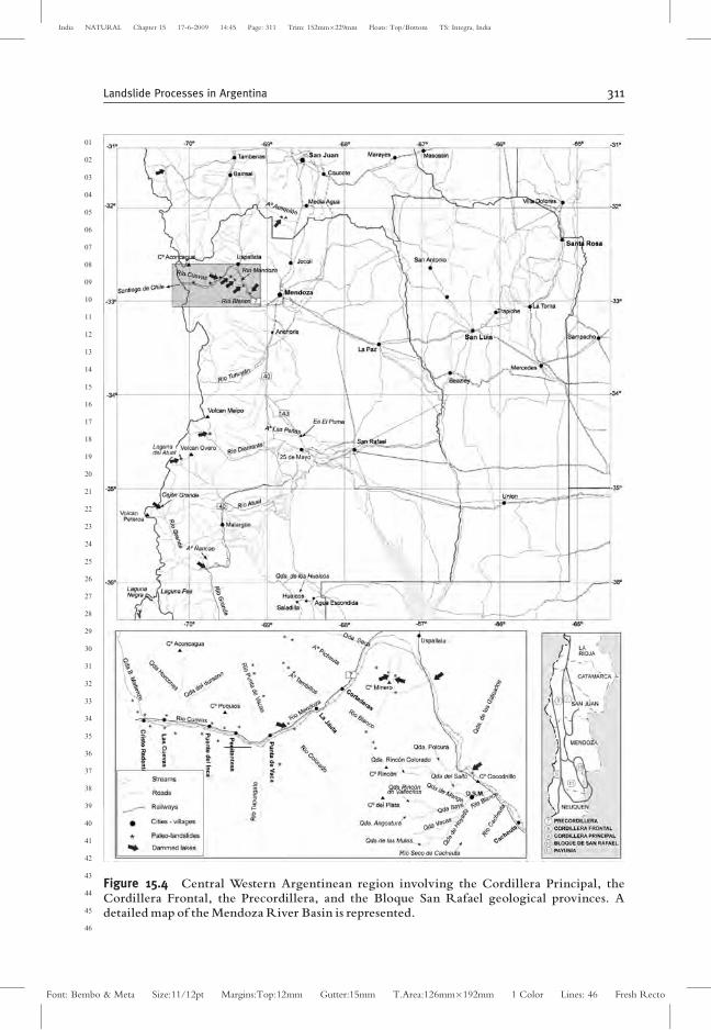
Figure 15.4 Central Western Argentinean region involving the Cordillera Principal, theCordillera Frontal, the Precordillera, and the Bloque San Rafael geological provinces. Adetailed map of theMendoza River Basin is represented.
Landslide Processes in Argentina 311
Font: Bembo & Meta Size:11/12pt Margins:Top:12mm Gutter:15mm T.Area:126mm�192mm 1 Color Lines: 46 Fresh Recto
India NATURAL Chapter 15 17-6-2009 14:45 Page: 311 Trim: 152mm�229mm Floats: Top/Bottom TS: Integra, India
River caused interruptions in international traffic in 1975, 1998, 2003, and 2006;dangerous flows from the Quebrada Seca and Quebrada Camino stream-valleylocalities are also well known. A car was dragged into the water by one of theseflows in 1968, and similar events happened in 1976, 1980, 1999, and 2000. Otherscoming from the del 60AU6 (or Quebrada Polcura) and Guido valleys also inundatedthis road in 1999, 2001, and 2005 (Fig. 15.5). In addition, rockfalls are verycommon, producing blockages on tunnels for roads or railways, as during the Ms3.9 earthquake of 1987. A train fell into the river in 1976 as a consequence of ablockage, and a block fell over the railway in the Cacheuta locality in 1956. Similarevents were recorded in 1976, 1982, 1984, 1989, 1990, 1992, 1997, and 2000.Recently, several rockfalls produced by a persistent winter rainfall were observedalong the whole international road in July 2006; the most important one blockedthe road near Uspallata. Recurrent topples, blockfalls, and blockslides have beenobserved in steeply dipping Triassic sediment of the Bayo and Cocodrilo (Potrer-illos locality) peaks where weaker levels are eroded, exposing massive and compactconglomerate or sand-layer levels prone to instability.
Along the River Blanco Basin, intense rainfall has triggered many damagingdebris flows in the arroyos of El Salto, uebrada LaAU7 Angostura, Las Mulas, andQuebrada Colorada, adversely impacting the local population mainly establishedat the Potrerillos, El Salto, and Vallecitos localities. These debris flows, which beganat the Cordon del Plata Range, are commonly channeled into the Blanco River,increasing its stream flow and sometimes reaching the Mendoza River valley. Theygenerated overflows on the Blanco River in 1942, 1945, and 1957. Damagingtorrents reported in January 1946 destroyed a bridge in Chacritas, and in January1947, wrappedAU8 a school at Potrerillos village. Intense rainstorms in December 1954
01
02
03
04
05
06
07
08
09
10
11
12
13
14
15
16
17
18
19
20
21
22
23
24
25
26
27
28
29
30
31
32
33
34
35
36
37
38
39
40
41
42
43
44
45
46
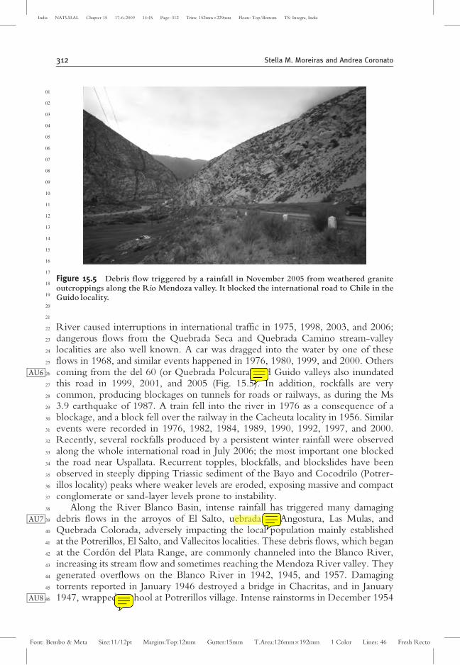
Figure 15.5 Debris flow triggered by a rainfall in November 2005 from weathered graniteoutcroppings along the Rıo Mendoza valley. It blocked the international road to Chile in theGuido locality.
312 Stella M. Moreiras and Andrea Coronato
Font: Bembo & Meta Size:11/12pt Margins:Top:12mm Gutter:15mm T.Area:126mm�192mm 1 Color Lines: 46 Fresh Recto
India NATURAL Chapter 15 17-6-2009 14:45 Page: 312 Trim: 152mm�229mm Floats: Top/Bottom TS: Integra, India
and 1955 produced debris fall along the QuebradaColorada stream, closing offaccess to the Vallecitos ski tourist complex. Along this glacial valley, boulderscommonly fall where morainic deposits are water-saturated. Moreover, a debrisflow again cut access to the complex on February 7, 1967.
In the Tunuyan Basin, Polanski (1966) noted historical debris flows duringsummer seasons caused by a rainstorm in Anchoris (Mendoza Province) at 33�S,remobilizing great amount of fine material, reaching 1–2 m/sec in velocity.Polanski also mentioned a debris flow in February 1962 that was sourced fromweathered volcanic rocks in Huaicos and Salinillas de la Escondida (MendozaProvince). These flows were channeled into the Huaicos valley, reaching thelocality of Jaguel and the Amarillo Peak area after traveling 12 km, and depositeda 1- to 1.5-m-thick layer of unsorted sands. In addition, Polanski detailed a suddendebris flow that occurred on December 15, 1951 in Las Penas creek (El Puma farm)that reached a velocity of 5 m/sec and rose 1.6 m high. This event, the largestrecorded in 10 years, dragged a 1-ton pickup truck along for 500 m. Smaller debrisflows caused by rainstorms were reported for 1951 and 1952.
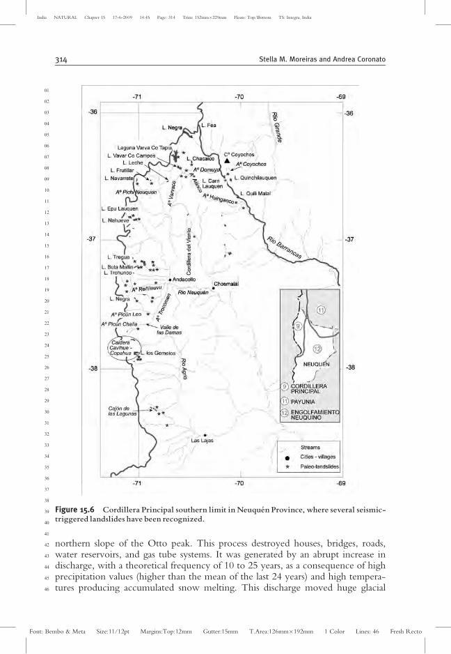
At more southern latitudes, Espizua and Bengochea (2002) produced a landslideinventory map along the Grande River, concluding that slides and flows are thephenomena with the largest dimensions and that flows are the most common.However, they give only two historical data: a mudflow resulting from a torrentialrainstorm on March 25, 1990 in Nancao creek damaging a humble home; and areactivated slide in Cajon Bayo creek, which occurred between March 1985 andFebruary 1986, as was inferred by satellite images. Gonzalez Dıaz et al. (2000)reported recent flows and rock avalanches along the Barrancas River. Moreover,rotational slides and earthflows caused by river lateral erosion over moraine depositshave been observed along the Varvaco River and Manchana Covunco River(Neuquen River Basin) (Gonzalez Dıaz et al., 2003). These processes are frequentlyrelated to ephemeral impounding lagoons. Twenty-five years ago, a debris flowchanneling into La Tregua creek (Neuquen River Basin) dammed the Buta MallinArroyo and generated a tiny lagoon (Gonzalez Dıaz et al., 2005) (Fig. 15.6).
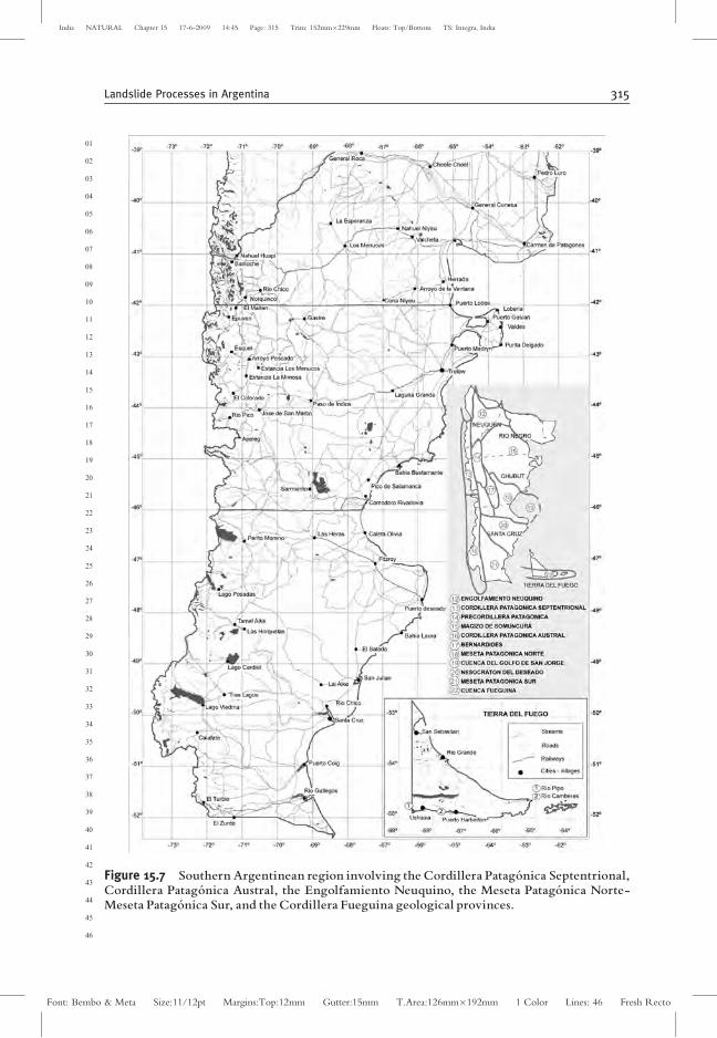
2.4. Southern Argentina: Cordillera Patagonica SeptentRivernal—Cordillera Patagonica Austral-Engolfamiento Neuquino—Bernardides-Meseta Patagonica Norte—Meseta PatagonicaSur—Cordillera Fueguina
Further south, along the Patagonian Andes (Fig. 15.7), landslides are very commonin the slope-modeling process. Rapid snow melting during warm spring days,sometimes linked to heavy precipitation events, produces channeled debris flowsalong the medium and stepper slopes. Debris is composed not only of channeldeposits but also of forest material that frequently erodes routes, blocks sewagesystems, or damages bridges, which usually are not properly designed for thevolume of material moved by these processes.
In the city of Bariloche (Rıo Negro Province), a violent debris flow thatoccurred in June 1976 affected the Melipal neighborhood and settled on the
01
02
03
04
05
06
07
08
09
10
11
12
13
14
15
16
17
18
19
20
21
22
23
24
25
26
27
28
29
30
31
32
33
34
35
36
37
38
39
40
41
42
43
44
45
46
Landslide Processes in Argentina 313
Font: Bembo & Meta Size:11/12pt Margins:Top:12mm Gutter:15mm T.Area:126mm�192mm 1 Color Lines: 46 Fresh Recto
India NATURAL Chapter 15 17-6-2009 14:45 Page: 313 Trim: 152mm�229mm Floats: Top/Bottom TS: Integra, India
northern slope of the Otto peak. This process destroyed houses, bridges, roads,water reservoirs, and gas tube systems. It was generated by an abrupt increase indischarge, with a theoretical frequency of 10 to 25 years, as a consequence of highprecipitation values (higher than the mean of the last 24 years) and high tempera-tures producing accumulated snow melting. This discharge moved huge glacial
01
02
03
04
05
06
07
08
09
10
11
12
13
14
15
16
17
18
19
20
21
22
23
24
25
26
27
28
29
30
31
32
33
34
35
36
37
38
39
40
41
42
43
44
45
46
Figure 15.6 Cordillera Principal southern limit in Neuque¤ n Province, where several seismic-triggered landslides have been recognized.
314 Stella M. Moreiras and Andrea Coronato
Font: Bembo & Meta Size:11/12pt Margins:Top:12mm Gutter:15mm T.Area:126mm�192mm 1 Color Lines: 46 Fresh Recto
India NATURAL Chapter 15 17-6-2009 14:45 Page: 314 Trim: 152mm�229mm Floats: Top/Bottom TS: Integra, India
01
02
03
04
05
06
07
08
09
10
11
12
13
14
15
16
17
18
19
20
21
22
23
24
25
26
27
28
29
30
31
32
33
34
35
36
37
38
39
40
41
42
43
44
45
46
Figure 15.7 Southern Argentinean region involving the Cordillera Patago¤ nica Septentrional,Cordillera Patago¤ nica Austral, the Engolfamiento Neuquino, the Meseta Patago¤ nica Norte-Meseta Patago¤ nica Sur, and the Cordillera Fueguina geological provinces.
Landslide Processes in Argentina 315
Font: Bembo & Meta Size:11/12pt Margins:Top:12mm Gutter:15mm T.Area:126mm�192mm 1 Color Lines: 46 Fresh Recto
India NATURAL Chapter 15 17-6-2009 14:45 Page: 315 Trim: 152mm�229mm Floats: Top/Bottom TS: Integra, India
boulders and fallen trunks off the channel bed, promoting bank erosion (Dom-inguez et al., 1981). Several recommendations were proposed to the local govern-ment in hopes of mitigating future risks in this increasingly urbanized area; one ofthe recommendations was to restrict urbanization on the generated alluvial cone.Dominguez and Rabassa (1981), who analyzed slope instability along the RıoNireco, recommended not using this area for urban purposes. However, theneighborhood is now already fully urbanized. Besides landslides, the NirecoRiver often floods its alluvial plain, which is amply occupied by houses. DuringJune 1977, precipitation values were also higher than the mean monthly value;therefore, landslides on oversaturated morainic deposits occurred in the downtownarea, producing large economic losses (Dominguez et al., 1981).
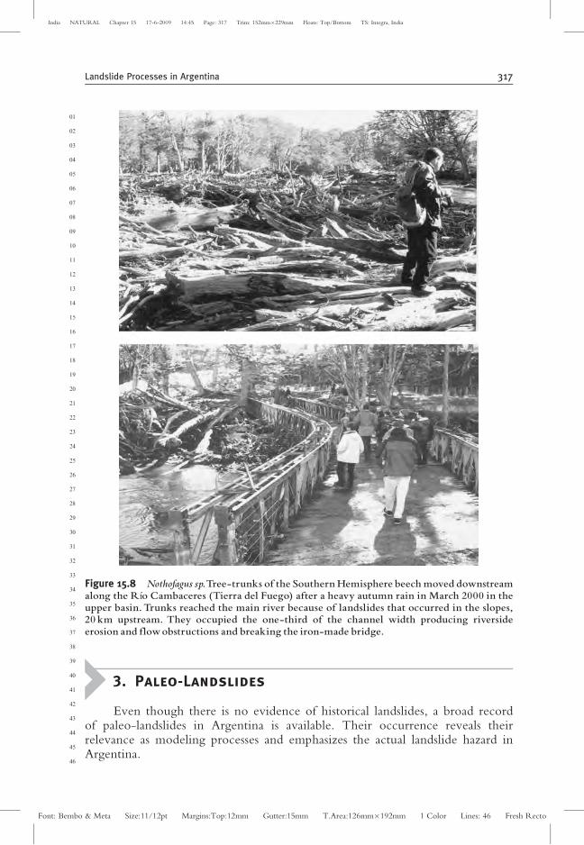
In Cordillera Fueguina (Tierra del Fuego Province), landslide processesmodified the slopes of glacial valleys after the general ice recession, whichwould have occurred after 12 ky BP (Coronato, 1995). Morphological evidenceof earthslides, avalanches, and rockfall has been found on the slopes, but nodetailed data or proper geomorphologic knowledge of these processes are avail-able. Undoubtedly, former glacial and periglacial processes provided fine and lowpermeable sediments, whereas the present cryogenic fragmentation of schists andvolcanic outcrops offers debris material for landsliding. During a heavy precipita-tion in March 2000, the Cambaceres River, near its mouth at the BeagleChannel, was blocked, and its iron bridge was totally curved by tree trunkscoming from the upper basin (Fig. 15.8).
East of the Andes, inside the edges of sedimentary and volcanic Patagoniantablelands, a stepped relief has developed due to ancient rotational slumps associatedwith earthflows. Several examples could be seen along the Limay, Negro, and SantaCruz rivers and also in the tablelands where the the Posadas, Stroebel, Cardiel,Buenos Aires, San Martin, Viedma, and Argentino lakes (Pereyra et al., 2002) wereexcavated by former glacial or tectonic processes.
Lateral spreading is observed in Comodoro Rivadavia city (Chubut Province).Frequent slides on the highly urbanized Chenque peak have also been reported inthis city (Gonzalez Dıaz, 2004; Tejedo et al, 1999). In the city’s littoral neighbor-hoods, six slumps occurred during 1990–2000 (Hirtz et al., 2000). The mostimportant of them was in February 1995, severely damaging the urban infrastruc-ture and cutting the traffic on National Road 3 (Codignotto, 2004), cutting the cityoff for several days. Along the tableland scarp mudflows, debris-creep, and debrisfall are produced in claystones, whereas block falls are present in sandstones.Urbanization has advanced on the surrounded sedimentary hills, generating land-slide reactivation (Hirtz et al., 2000).
In the extra-Andean tablelands, rotational slides sourced from basaltic plains arecommon; however, these events have ended as debris flows in the distal parts.Gonzalez Dıaz (2004) mentions that several tablelands such as Meseta de Somun-cura in the Negro River and mesetas (plateaus) in Castillo, Salamanca, and Mon-temayor in Chubut show many successive landslide scars. Moreover, retrogressiverotational slides have been identified in Canadon del Pilar, disturbing the Sierra dela Victoria landscape.
01
02
03
04
05
06
07
08
09
10
11
12
13
14
15
16
17
18
19
20
21
22
23
24
25
26
27
28
29
30
31
32
33
34
35
36
37
38
39
40
41
42
43
44
45
46
316 Stella M. Moreiras and Andrea Coronato
Font: Bembo & Meta Size:11/12pt Margins:Top:12mm Gutter:15mm T.Area:126mm�192mm 1 Color Lines: 46 Fresh Recto
India NATURAL Chapter 15 17-6-2009 14:45 Page: 316 Trim: 152mm�229mm Floats: Top/Bottom TS: Integra, India
3. Paleo-Landslides
Even though there is no evidence of historical landslides, a broad recordof paleo-landslides in Argentina is available. Their occurrence reveals theirrelevance as modeling processes and emphasizes the actual landslide hazard inArgentina.
01
02
03
04
05
06
07
08
09
10
11
12
13
14
15
16
17
18
19
20
21
22
23
24
25
26
27
28
29
30
31
32
33
34
35
36
37
38
39
40
41
42
43
44
45
46
Figure 15.8 Nothofagus sp.Tree-trunks of the Southern Hemisphere beech moved downstreamalong the Rıo Cambaceres (Tierra del Fuego) after a heavy autumn rain in March 2000 in theupper basin. Trunks reached the main river because of landslides that occurred in the slopes,20 km upstream. They occupied the one-third of the channel width producing riversideerosion and flowobstructions and breaking the iron-made bridge.
Landslide Processes in Argentina 317
Font: Bembo & Meta Size:11/12pt Margins:Top:12mm Gutter:15mm T.Area:126mm�192mm 1 Color Lines: 46 Fresh Recto
India NATURAL Chapter 15 17-6-2009 14:45 Page: 317 Trim: 152mm�229mm Floats: Top/Bottom TS: Integra, India
In northern Argentina, 10 rock avalanches related to high-magnitude earth-quakes have been reported for Sierra Laguna Blanca (Puna) as neither regionalnor global warm periods nor interstadial periods were found. Numerical datingranging from 262+ 36 to 172+ 13 Ky was determined for six of these super-posed deposits showing a high scarp height to travel distance (H/L) ratio(Hermann et al., 2000). The Brealito landslide associated with a paleo-dammedlake was identified in Las Lagunas peaks (25� 170 S) (Hermann and Strecker,1999a). Prehistorical rock avalanches were also noted at the abrupt fault scarpthat defines the eastern limit of Sierra La Palca Range (Catamarca Province)(Gonzalez Dıaz, 1972b).
Along the valley of Quebrada del Toro (at 24� 400 S), six rock avalanchessourced at the Choro Range and Pascha Range have been described (Hermann andStrecker, 1999b; Hermann et al., 2001). Two of these events dammed the ToroRiver near the Golgota locality, which is evidenced by thick lake sequences. 14Cdating of rare fresh water snails for both paleo-lakes provided ages of30,050+ 190yr BP and 26,080+ 130yr BP. For that reason, landslide occurrencewas linked to the Minchin wet period (25–40 Ky) (Trauth and Strecker, 1999;Trauth et al., 2000).
In the Santa Maria-Las Conchas Basin (25� 580 S), huge landslide deposits(108 m3) related to paleo-dammed lakes were described near the Yesera River(Torres, 1985; Gallardo, 1988). These deposits were then called El Paso I, ElPaso II, Casa de Loros I, and Casa de Loros II by Hermann and Strecker (1999b),who established, based on stratigraphic relations, that El Paso I is the oldest eventand the youngest is Casa de Los Loros II, which, moving at 294 km/h, dammed thede las Conchas River again. A minimum age of 28,990+ 150 yr BP was thenobtained for the El Paso I rock avalanche by dating bivalve shells sampled from thelake sediments. Hence its occurrence was related to the Minchin wet period as well(Trauth and Strecker, 1999; Trauth et al., 2000). Nearby, five rock landslides wereidentified in the Tonco River valley (25� 300 S), whereas at 26� 060 S furtherextraordinary landslide deposits outcrop in the areas of Paranilla peak, SierraCarahuasi, and Sierra de Vazquez (Hermann and Strecker, 1999b). Remnants oftephra overlaying the Paranilla peak and Tonco River deposits were dated723+ 89 Ky and >33 Ky, respectively (Hermann et al., 2000).
The Alemania rockfall, exceeding 6.5� 107 m3 in volume, derived by erosionduring intense rainstorms from the Quitilipi peak (Salta Province). Radiocarbondating of shells from sediments related to an impounding lake on Las ConchasRiver showed an age of 5180+ 50 yr BP (Wayne, 1999). Similar ages (4910+ 40yr BP, 5,140+ 40 yr BP, and 4840+ 40 yr BP) were obtained from further 14Cdatings on lake sediments (Trauth et al., 2000). In addittion, Gonzalez Dıaz andMon (1996) interpreted the Lagunas de Yala (Jujuy) to be a water-filled depressionof a massive rock avalanche deposit.
In the Sierras Pampeanas, seven giant landslide deposits (>106 m3) collapsedfrom the southern mountain front of the Sierras Calchaquies during the LatePleistocene (Fernandez, 2005). Fernandez noted that the town of Tafi del Valle isadvancing on these deposits as several settlements and cultivation fields are estab-lished at present.AU9
01
02
03
04
05
06
07
08
09
10
11
12
13
14
15
16
17
18
19
20
21
22
23
24
25
26
27
28
29
30
31
32
33
34
35
36
37
38
39
40
41
42
43
44
45
46
318 Stella M. Moreiras and Andrea Coronato
Font: Bembo & Meta Size:11/12pt Margins:Top:12mm Gutter:15mm T.Area:126mm�192mm 1 Color Lines: 46 Fresh Recto
India NATURAL Chapter 15 17-6-2009 14:45 Page: 318 Trim: 152mm�229mm Floats: Top/Bottom TS: Integra, India
Southward (27� 100 S), eight rock avalanches with volumes ranging from5� 106 to 6.5� 107 m3 were recognized in a 10-km-wide strip in front of SierraAconquija at Loma de la Aspereza, Zarzo, and Loma Redonda localities (CatamarcaProvince). Because of the carbonate stage (III–IV) developed on these deposits, aMiddle Pleistocene age (0.6–1.2 My) was suggested (Fauque and Strecker, 1998).Moreover, six rock avalanches (106 m3) sourced from Sierra Chango Real at 26� 370 Smoved toward the El Rincon valley (Hermann and Strecker, 1999a). And 10rock avalanches with volumes of 107 - 108 m3 were identified in the Hualfin Rangenext to the locality of Villavil (Catamarca Province- 25� 300 S). Three of themobstructed the Bolson River; thus organic material preserved in one of these lakesgave a 14C age 1432+ 132 yr (Fauque and Tchilinguirian, 2002). Seismic shakingrelated to regional faults is suggested in both areas, and the potential hazardconcerning Villavil rockslides has been highlighted because 350 inhabitants live inthis locality.
Eight rock avalanches along the Segovia stream on the southwestern slope ofSierra de Famatina (La Rioja province) were identified by Fauque (1987). Inaddition, avalanche deposits were noted in Sierra de Umango and Sierras deSanogasta-Vilgo (Fauque and Gonzalez, 2004). Moreover, two landslides identifiedin Sierra de la Punilla seem to be related to the neotectonic activity of the LasMajaditas and Bolsa faults (Perucca, 1995).
In addition, two Pleistocene rock avalanches were identified in Sierras de SanLuis: Potrero de Leyes and Las Canas, with a volume of 6� 108 m3 and 2.5� 107 to3.7� 107 m3, respectively (Gonzalez Dıaz et al., 1997; 1998). Dating by cosmo-genic isotopes on blocks showed ages of 32.7+ 6.7 Ky and 40.8+ 8.6 Ky (Potrerode Leyes), and 52.9+ 10.8 Ky and 66.1+ 14.1 Ky (Las Canas) (Gonzalez Diazet al., 1999). Gonzalez Diaz et al. suspect M > 6.2 earthquakes as the triggeringmechanisms.
In the Precordillera, two Holocene rock avalanches were studied by Peruccaand Moreiras (2003). Both events dammed the Acequion River, which is evi-denced by a 20-m-thick sequence of fine lake sediments. Organic matter preservedin the younger paleo-lake gave cal. 7,497+ 157 yr 14C BP. A regional fault systemassociated with the historical rupture of the 1952 earthquake (Ms 7) affects theregion, and lake deposits show liquefaction features evidencing at least three paleo-earthquakes (M > 5).Therefore, a seismic shaking (M > 6) has been proposed asthe triggering mechanism (Perucca and Moreiras, 2006).
In the Mendoza River valley, Salomon (1969) identified two paleo-landslides,one sourced at the southeastern hillslope of the Juan Pobre peak and the other at thesouth margin of the river. They were called Amarillo and Negro landslides,respectively. The Amarillo landslide covered a 0.8-km2 area, and the Netro com-prised 1.25 km2, with an estimated volume of 3.44� 108 m3. According to strati-graphic studies, the Amarillo landslide preceded the other, occurring during aninterglacial stage from 125 ky to 75 Ky. Even so, a seismic source was suggested byEspizua (2005).
At Cordon del Plata Range (32� S), at least six closed rock avalanches wereidentified: one in the Soltera valley called Tigre Dormido (TD), two in PlacetasAmarillas (PA-1 and PA-2), and three in Piedras Blancas (PB-1, PB-2, and PB-3)
01
02
03
04
05
06
07
08
09
10
11
12
13
14
15
16
17
18
19
20
21
22
23
24
25
26
27
28
29
30
31
32
33
34
35
36
37
38
39
40
41
42
43
44
45
46
Landslide Processes in Argentina 319
Font: Bembo & Meta Size:11/12pt Margins:Top:12mm Gutter:15mm T.Area:126mm�192mm 1 Color Lines: 46 Fresh Recto
India NATURAL Chapter 15 17-6-2009 14:45 Page: 319 Trim: 152mm�229mm Floats: Top/Bottom TS: Integra, India
(Fauque et al., 2000). However, Moreiras (2004a, 2006b) reclassified the PA-2deposit as a rockslide due to discrete material involved and to moderate displace-ment. Moreiras then established that PB-1, PB-2 and PB-3 deposits resulted fromthe same event renamed as the PB rock avalanche (Moreiras, 2006c). According toMoreiras (2004a, 2005e), the TD rock avalanche is at least Middle Pleistocene inage as its deposit is eroded by a Pleistocene moraine younger than an ash levelearlier dated as 360+ 70 Ky. This event reached a volume of �1.7� 109 m3 andtraveled more than 10 km (H/D = 0.22). Moreover, the PB-1 rock avalanche, withan estimated volume of 1.6� 109 m3 (H/D = 0.11), is younger than an ash layerdated 350+ 80 Ky by the Ar39/Ar40 method (Moreiras, 2006b). Based on geo-chemical analysis and field observations, a similar age was established for PB rockavalanche (�8.9� 108 m3, H/D = 0.2) since an ash layer covering its deposits wascorrelated by geochemistry with one dated previously (Moreiras, 2006c).
The occurrence of an ancient channeled mudflow in Quebradade las Vacascreek, which is a tributary of the Blanco River (Mendoza Province), was noted(Mikkan, 1992). Several agricultural villages such as Las Vegas, Valle del Sol, andTierras Blancas have been established over these deposits because of its good qualityas water reservoir.
Between 36� and 38� S, more than 50 paleo-landslides have been identified inCordillera Principal. In many cases, however, neither their chronology nor theirstratigraphic position has been determined. Initially, Groeber (1916) reported ahuge ancient landslide in the Barrancas River area, damming the current Carri-Lauquen Lake. This event was later classified as a rock avalanche by Gonzalez Dıazet al. (2001), and its age was established by cosmogenic dating at 2 Ky (GonzalezDıaz et al., 2005). Gonzalez Dıaz also described two prehistoric landslides in thenearby Coyochos and Huingaco arroyos, with uncertain age. Southward, in theupper basin of the Neuquen River, two prehistoric rock avalanches were identifiedalong the Vavarco River (Gonzalez Dıaz et al., 2000). As they dammed presentVarva Co Tapia and Varva Co Campos lakes, they were identified with the samenames as the lakes. The Varva Co Tapia rock avalanche, covering 15.35 km2 andtraveling 5.5 km, reached �1.07� 108 m3 in volume. The Varva Co Campos rockavalanche moved 7.5 km with a velocity of 310 km/h, and its volume has beenestimated as 3.51� 109 m3. According to Gonzalez Diaz et al. (2005) ,the isotopiccosmogenic ages of Varva Co Tapia and Varva Co Campos rock avalanches are60 Ky and 30 Ky, respectively. A younger successive slide named Malvarco was alsoidentified in this area, and landslides damming secondary valleys were also reportedfor Cajon Chacaico, Cajon de la Crianza, and Laguna de la Leche (Gonzalez Dıazet al., 2000).
In the Ailinco River surroundings (Rıo Neuquen Basin), Gonzalez Dıaz et al.(2003) recognized two rock avalanches, Ailinco and the Papas peaks, whichGroever (1947) initially mapped as till deposits. The first moved 90 km towardthe opposite valley hillslope, reaching �2.84� 107 m3 in volume; whereas thePapas peak rock avalanche, �8.24� 107 m3 in volume, moved 9 km. These authorsalso recognize the Olletas slide, 1.77� 106 m3 in volume, in this region. At 37� 100 S,the neighboring Los Cardos rock avalanche, covering 24 km2 and another sixsmaller rock avalanches have been identified in the region between the Nahueve
01
02
03
04
05
06
07
08
09
10
11
12
13
14
15
16
17
18
19
20
21
22
23
24
25
26
27
28
29
30
31
32
33
34
35
36
37
38
39
40
41
42
43
44
45
46
320 Stella M. Moreiras and Andrea Coronato
Font: Bembo & Meta Size:11/12pt Margins:Top:12mm Gutter:15mm T.Area:126mm�192mm 1 Color Lines: 46 Fresh Recto
India NATURAL Chapter 15 17-6-2009 14:45 Page: 320 Trim: 152mm�229mm Floats: Top/Bottom TS: Integra, India
and Renileuvu rivers (tributaries of the River Neuquen) (Gonzalez Dıaz et al., 2005).Earlier, Escosteguy et al. (1999) identified the Moncol rock avalanche covering8.3 km2 that dammed the Renileuvu River and generated a paleo-lake, evidencedby 1-m-thick lake sediments. Nearby, further events were identified: the PicheMoncol rock avalanche along the Renileuvu Arroyo, the Guanaco peak rock ava-lanche, the Coronal peak rock avalanche, and a rotational slide in the Nireco Arroyothat involved 2.4 km2 and dammed the current Lauquen Mallin Lake (Gonzalez Dıazand Folguera, 2005). Finally, four landslide deposits were also distinguished along thePilun Challa Arroyo, one of them corresponding to the Pilun Challa rock avalanche,with an estimated volume of 1.46� 107 m3, which dammed Las Damas valley(Gonzalez Dıaz et al., 2006). The Pilun Challa rock avalanche is younger than aglaciation dated before 30 Ky. Another landslide in the Pilun Challa Arroyo covering2.8 km2 impounds Los Maderos Lake, and another one impounds the current LagunasNegras Lake. Though numerical dating is still lacking, the occurrence of all theseevents during postglacial times is suggested. Anyway, a seismic triggering mechanismis presumed based on the seismic-tectonic conditions of the area (Gonzalez Dıaz et al.,2000, 2001, 2003).
Later, Hermann et al. (2006) carried out 3He cosmogenic dating determiningthe ages of 3,700+ 350 yr and 2700+ 700 yr for the rotational slide of the NirecoArroyo and the slide identified in front, respectively. They concluded that theyounger slide should have fallen into the Lauquen Mallin Lake, causing a laketsunami downslope. In addition, these authors established the age of the Moncolrock avalanche as 3,800+ 650 yr, supporting its age as contemporary with theNireco Arroyo rotational slide and suggesting a common seismic origin.
At 38–45� S, in the surroundings of the Caviahue-Copahue volcanic edifice,Gonzalez Dıaz (2003, 2005) recognized the Compul and the Cajon Chico rockavalanches in the Hualcupen valley. These were initially described as terminalmoraines by Groeber (1925) and recently defined like rock avalanche depositssimilar to those described above (Pillun-Challa, Picun-Leo, and Trocoman or LasDamas valleys). The Compul rock avalanche dammed the valley, forming theCompul Lake (also known as Hualcupen Lake). The Holocene age is attributed toboth rock avalanches, considering that they should have occurred after theHolocene glacial retreat, perhaps favoring slope instability. The authors alsosuggest that seismic movements related to any eruption might have triggeredthem. In addition, an ancient landslide with uncertain age is recognized southof Cavihue Lake. At 38� 300 S, Escosteguy et al. (2005) described another sixlandslides; two of them correspond to rotational slides, and four are rock ava-lanches. The rock avalanche identified in Romero valley reached 1.13� 108 m3;whereas those occurring along the Codihue valley are 1.5� 107 m3,1.03� 106 m3, and 8.5� 106 m3 in volume, respectively. The last named is relatedto an impounded paleo-lake. Escosteguy et al. concluded that these events wouldhave happened after the Last Pleistocene glaciation (30–640 Ky), assuming thatduring the deglaciation, steeper slopes were more susceptible to instability due toloss of ice support and increase in precipitation. A seismic cause is discountedbecause the seismicity decreases south of 38� S (see Perucca and Moreiras in thisvolume).
01
02
03
04
05
06
07
08
09
10
11
12
13
14
15
16
17
18
19
20
21
22
23
24
25
26
27
28
29
30
31
32
33
34
35
36
37
38
39
40
41
42
43
44
45
46
Landslide Processes in Argentina 321
Font: Bembo & Meta Size:11/12pt Margins:Top:12mm Gutter:15mm T.Area:126mm�192mm 1 Color Lines: 46 Fresh Recto
India NATURAL Chapter 15 17-6-2009 14:45 Page: 321 Trim: 152mm�229mm Floats: Top/Bottom TS: Integra, India

Paleo-landslide processes have been mapped as rock avalanches or earthslides indifferent glacial valleys of Tierra del Fuego (Coronato, 1994; Coronato and Roig,1999). Many of the huge earthslides are interpreted as the consequence of the loss ofpressure after the ice recession. In the Roca glacial lakes, postglacial landslides shapeits northern shore. Avalanche chutes are very well developed from 700 m.a.s.l. tothe bottom of the valleys, almost 120–200 m.a.s.l. above the treeline. Thus, theforest has been completely removed during violent processes, and many of themremain without vegetation. Few scars of earthslides are also visible in many steepslopes, but no data about their origin and date are available.
4. Outburst Floods Caused by Dammed Lake Failure
Landslides generally distort hydrological systems and generate dammed lakes.Nonetheless, these lakes commonly have a short life on a geological timescale; theirsudden collapses resulting in overflows/overburst floods are potential catastrophesfor humans. Gonzalez (1979) warned of the probable failure of the Laguna del Atuel(the headwater of the Rıo Atuel) impounded by a prehistoric landslide, which isover soluble karst gypsum. Moreover, other causes for a probable collapse aremoraine erosion in the western sector, another landslide sourced at Overo volcanofalling into the lake, a sudden advance of the surge glacier draining into the lake,and a seismic shaking.
A natural dam located at the Rıo Santa Cruz (Blanco River’s headwater, SanJuan Province) collapsed on November 12t,2005 generating an outburst flood onthe San Juan River that reached 1000 m3 (Fig. 15.9). The resulting violent flow
01
02
03
04
05
06
07
08
09
10
11
12
13
14
15
16
17
18
19
20
21
22
23
24
25
26
27
28
29
30
31
32
33
34
35
36
37
38
39
40
41
42
43
44
45
46
Figure 15.9 a. The 57-m-high natural dam located at the Rıo Santa Cruz (Blanco¤ s Riverheadwater, San Juan Province). b. Outburst flood/debris flow resulting from the dam failureonNovember12, 2005 (Photograph by J. P. Ceballos).
322 Stella M. Moreiras and Andrea Coronato
Font: Bembo & Meta Size:11/12pt Margins:Top:12mm Gutter:15mm T.Area:126mm�192mm 1 Color Lines: 46 Fresh Recto
India NATURAL Chapter 15 17-6-2009 14:45 Page: 322 Trim: 152mm�229mm Floats: Top/Bottom TS: Integra, India
caused severe damages downslope destroying bridges and roads, and isolating manypeople in the mountain areas. The just-built Caracoles dam was severely damaged,as was the Ullum dam reservoir, located 180 km from the failure area. TheCaracoles damAU10 became turbid in three minutes, affecting the availability of potablewater for the people of San Juan city.
Perhaps the most drastic outburst was recorded in 1914 when the Carri Lau-quen Lake collapsed, generating an extraordinary outburst flood on the BarrancasRiver. This lake was formed by a Pleistocene landslide that had dammed the river.Groeber (1916) reported that overnight 2 billion m3 of water were drained; as aconsequence, the original 21-km-long lake was reduced to 5.6 km, and its surfacewas lowered about 95 m. The resulting debris flow/flood dammed the Quili-Malalal River, forming a tiny lagoon 200 m long and 25 m wide, and flowedmore than 300 km devastating downstream valleys. Several animal farms completelydisappeared, and fields of wheat, corn, and alfalfa were buried by debris. Inaddition, two small towns in this valley were devastated. This debris flow/floodalso wiped out farms, railway stations, railway lines, and roads located along thevalley of the Colorado River, which is formed by the union of the Barrancas andGrande rivers. The overflow also triggered several landslides. In all, 175 fatalitieswere reported, and more than 100 persons disappeared. Groeber (1933) noted that20 years later the farmland in both valleys still had not recovered.
Impounded lakes are not always related to catastrophic failures, however; someof them maintain their equilibrium between inflow and outflow, and so they can bepreserved for long periods. Such are the cases of existing Varva Co Tapia and VarvaCo Campos lakes (Neuquen) related to the Varva Co Tapia and Varva Co Camposrock avalanches, respectively (Gonzalez Dıaz et al, 2000). Nearby, the Coyochosslump earthflow and the Huinganco landslide, respectively, damming Coyochosand Huiganco creeks, have experienced a gradual drain. Even so, they represent apotential hazard during periods with increased precipitation or spring thawing.Both kinds of water sources may increase the lake volume, causing dam failure; forthis reason a periodic monitoring of the water level is suggested. The Carri-Lauquen Lake, which collapsed drastically in December 1914 during the late springseason, used to drain slowly to the Barrancas River. The local people present duringthe event reported that the cause of the failure was the increased inflow resultingfrom extreme thawing of high snow accumulation during the 1914 winter season.Native inhabitants remember common increases in the Barrancas River flowduring spring time but at lower levels (Gonzalez Dıaz et al., 2001).
Temporary impounded lakes have also been common. On February 15, 1961the Diamante River was dammed by a landslide at 35 km downstream of theLaguna Diamante Lake. Rainfall increased the volume of this impounded lake(200 m high and 2000 m long), reaching 259,300 m3 in five days. Water flowedby seepage, but the lake lasted until the 1970s, amazing populations downstream. Adammed landslide-lake was observed in the Cajon Bayo valley (Grande RiverBasin) on June 6, 1986, but its failure is uncertain. A new landslide dammed thevalley again in this sector in 1992. Gonzalez Dıaz et al. (2001) also mentioned anephemeral impounding lake caused by a landslide in Menucos Arroyo, a tributaryof the Barrancas River, in 1999.
01
02
03
04
05
06
07
08
09
10
11
12
13
14
15
16
17
18
19
20
21
22
23
24
25
26
27
28
29
30
31
32
33
34
35
36
37
38
39
40
41
42
43
44
45
46
Landslide Processes in Argentina 323
Font: Bembo & Meta Size:11/12pt Margins:Top:12mm Gutter:15mm T.Area:126mm�192mm 1 Color Lines: 46 Fresh Recto
India NATURAL Chapter 15 17-6-2009 14:45 Page: 323 Trim: 152mm�229mm Floats: Top/Bottom TS: Integra, India
Dammed paleo-lakes have occurred in the past, lasting for long periods asevidenced by thick lake sequences. Several paleo-lakes have been reported alongthe Las Cuevas and Mendoza rivers at Las Cuevas, near Puente del Inca and nearColorado River localities (Salomon, 1969). The last one, resulting from theAmarillo landslide, was 7 km long, and its volume was estimated at 4� 108 m3
(Fauque et al., 2005). At Los Arboles place, another rock avalanche dammed theMendoza River, evidenced by an 18-m-thick sequence of fine material. Thispaleo-lake could have been �1.72� 106 m3 in volume. Ancient dammed lakeshave also been reported along the Quebrada Horcones valley (Fauque et al., 2005).Those Pleistocene rock avalanches identified in the Cordon del Plata Range havealso generated paleo-lakes (Fauque et al., 2000). The TD rock avalanche dammedthe Mendoza River; the resulting barrier-lake could have an estimated volume of1.6� 109 m3 (Fauque et al., 2005). Whereas the paleo-lake generated by the PA-1rock avalanche reached 0.6 km2, the lake sequence is 38 m thick (Moreiras, 2006a).The paleo-lake caused by PB rock avalanche left a 30-m-thick relict sequencereaching an extent of �0.7 km2 (Moreiras, 2006d).
5. Main Landslide Trigerring Mechanisms
in Argentina
Seismic movements are a major factor triggering landslides, and for that reasonhistorical landslides have been reported during high-magnitude earthquakes affect-ing seismic areas of Argentina, as mentioned earlier. Similarly, more than onehundred events were documented for northern Mendoza Province, which hashad historical earthquakes Ms > 7. According to these data, rockfalls began to berecorded with an earthquake magnitude �3.9 (Moreiras, 2004a). The maximumdistance between events and epicenter does not exceed 250 km; still the relationbetween earthquake magnitude and epicenter distance is uncertain (Moreiras,2004a, 2006a).
Torrential summer rainstorms are also widely related to landslide occurrence,mainly in arid climate regions. Debris flows in northern Argentina occur fromJanuary to March when storms drop large amounts of rain in a few hours onsaturated slopes. Moreover, more than 150 events caused by rainfall, which mainfailure mechanism is related toAU11 crack filling or saturation with water, were identifiedalong the Mendoza River valley from 1952 to 2002 (Moreiras, 2004b, 2006a). Kittl(1939) observed that hillslope instability in the Volcan landslide (Salta Province)depends on material cohesion that varies with humidity condition forced mainly bythe occurrence of rainfall or wetter periods. However, the precipitation thresholdvalue for triggering landslides has rarely been determined. Moreiras (2005c) statis-tically established that at least 6 to 12 mm precipitation (X = 17.5 mm) per day isneeded to generate rockfalls and debris flows along the Mendoza River wheremean annual precipitation does not exceed 250 mm. Nonetheless, several limita-tions in this value exist due to the scarcity of meteorological stations in the region,the meso-scale rainstorm distribution, the lack of precipitation duration, and
01
02
03
04
05
06
07
08
09
10
11
12
13
14
15
16
17
18
19
20
21
22
23
24
25
26
27
28
29
30
31
32
33
34
35
36
37
38
39
40
41
42
43
44
45
46
324 Stella M. Moreiras and Andrea Coronato
Font: Bembo & Meta Size:11/12pt Margins:Top:12mm Gutter:15mm T.Area:126mm�192mm 1 Color Lines: 46 Fresh Recto
India NATURAL Chapter 15 17-6-2009 14:45 Page: 324 Trim: 152mm�229mm Floats: Top/Bottom TS: Integra, India
uncertainties about previous land conditions. Antecedent precipitation also plays aconsiderable roleAU12 (Moreiras, 2005c).
In addition, the temporal distribution of landslides triggered by precipitation isforced by extraordinary cyclic climatic events. The Intihuasi slide (San Luis Pro-vince) in 1978 occurred during a period of elevated precipitation. Moreover, theslide that occurred at Nogalı (San Luis Province) may be related to an increase inprecipitation during January 2000–April 2001 (Giardini et al., 2003). In addition,the debris flow that destroyed San Fernando de Escoipe in 1976 occurred in theyears affected by the El Nino Southern Oscillation (ENSO) phenomenon (Alonsoand Wayne, 1992). In addition, Moreiras (2005c) maintains that landslide activity inthe Cordillera Frontal increases during warm ENSO episodes (Ninos), concludingthat this geological province is mainly influenced by the Pacific anticyclone. Incontrast, in the Precordillera region no significant differences in landslide activityhave been identified for both warm and cold phases of the ENSO phenomenon.However, a greater number of landslides occurs during wet periods influenced bythe Atlantic anticyclone, whereas fewer events are observed during the dry periods.Thus, the occurrence of landslides triggered by precipitation in the Precordilleraseems to be mainly forced by the Atlantic anticyclone.
Water saturation resulting from the rapid thawing of snow cover is also wellknown as a landslide-triggering mechanism. Gonzalez Dıaz (2004) noted that waterresulting from snow ablation may swap the action of rainfall in the Patagonianextra-Andean tablelands. For this reason, those years associated with greater snowaccumulation in mountain areas show greater landslide activity, as can be demon-strated for the Mendoza River when an El Nino ENSO phase exists.
Further events are caused by lateral erosion of rivers, in both mountainous areasand plains (Gonzalez Dıaz, 2005; Moreiras, 2005a, 2005c). In rivers fed by snowthawing, landslides caused by this mechanism are common during the spring(October, November, and December). Similarly, slope instability may be greaterafter an ENSO warm phase as a consequence of greater snow accumulation(Moreiras, 2005b). Volcanic processes are also related to mass movements. Danger-ousAU13 lahars were generated on the Copahue volcano by snow thawing caused byfallen hot pyroclastic material (Gonzalez Diaz, 2005). Furthermore, Sruoga (2004)reported falls in the oriental sector of Planchon volcano caused by strong explosionsin March 1994. Wind action has caused debris falls along the Mendoza Rivervalley; clasts and rubble generated in the weathered granite are easily removed,damaging the windshields of vehicles moving on International Road 7 (Moreiras,2004b, 2005c). This process also occurs in the Cordillera Fueguina during sunnyspring days, when volcanic and metamorphic rock fragments, cryogenically weath-ered, suddenly fall on the National Road 3 injuring vehicles and people alike.
Far away from mountain areas, along the Patagonian coastal zones, severallandslides including slumps and rockfall have been generated by intense rainfall,water-table increases, pore-water saturation in sedimentary rocks, fluvial under-cutting, and wave erosion (Gonzalez Dıaz, 2004). Traffic on the coast avenue,running along the Las Grutas beaches (Rio Negro Province), was closed owing tofissures that might be related to potential landslides. Moreover, on December 28,2003, a creek 5 m deep was eroded along 1 km of the beach, damaging much of the
01
02
03
04
05
06
07
08
09
10
11
12
13
14
15
16
17
18
19
20
21
22
23
24
25
26
27
28
29
30
31
32
33
34
35
36
37
38
39
40
41
42
43
44
45
46
Landslide Processes in Argentina 325
Font: Bembo & Meta Size:11/12pt Margins:Top:12mm Gutter:15mm T.Area:126mm�192mm 1 Color Lines: 46 Fresh Recto
India NATURAL Chapter 15 17-6-2009 14:45 Page: 325 Trim: 152mm�229mm Floats: Top/Bottom TS: Integra, India
infrastructure in Villa Gessel city, one the most important beaches of the BuenosAires Province (Codignotto, 2004).
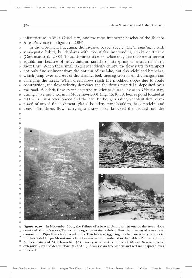
In the Cordillera Fueguina, the invasive beaver species Castor canadensis, withsemiaquatic habits, builds dams with tree-sticks, impounding creeks or streams(Coronato et al., 2003). These dammed lakes fail when they lose their input-outputequilibrium because of heavy autumn rainfalls or late spring snow and rains in ashort time. When these small lakes are suddenly empty, the flow starts to transportnot only fine sediment from the bottom of the lake, but also sticks and branches,which jump over and out of the channel bed, causing erosion on the margins anddamaging the forest. When creek flows reach the modified slopes due to routeconstruction, the flow velocity decreases and the debris material is deposited overthe road. A debris-flow event occurred in Monte Susana, close to Ushuaia city,during a late snow storm in November 2001 (Fig. 15.10). A beaver pond located at500 m.a.s.l. was overflooded and the dam broke, generating a violent flow com-posed of mixed fine sediment, glacial boulders, rock boulders, beaver sticks, andtrees. This debris flow, carrying a heavy load, knocked the ground and the
01
02
03
04
05
06
07
08
09
10
11
12
13
14
15
16
17
18
19
20
21
22
23
24
25
26
27
28
29
30
31
32
33
34
35
36
37
38
39
40
41
42
43
44
45
46
Figure 15.10 In November 2001, the failure of a beaver dam built in one of the steep slopecreeks of Monte Susana,Tierra del Fuego, generated a debris flow that destroyed a road anddammed the Pipo River for several hours.This biotic-triggering mechanism is only present inthe Tierra del Fuego Mountains where beavers were introduced in the 1940s. (Photographs byA. Coronato and M. Chiaradia). (A): Rocky near vertical slope of Mount Susana erodedextensively by the debris flow; (B and C): beaver dam tree debris and sediment spread overthe road.
326 Stella M. Moreiras and Andrea Coronato
Font: Bembo & Meta Size:11/12pt Margins:Top:12mm Gutter:15mm T.Area:126mm�192mm 1 Color Lines: 46 Fresh Recto
India NATURAL Chapter 15 17-6-2009 14:45 Page: 326 Trim: 152mm�229mm Floats: Top/Bottom TS: Integra, India
vegetation, destroying the surrounding forest. Both flood and jumping marks couldbe seen at 0.80 m and 2 m, respectively, over the ground, damaging forest trees withdeep scars. Downslope, the mixed load crossed the road, damming the main valleyriver for many hours. Upstream, a golf course, a camping place, and a tourismrailway station could have been affected if the damming had lasted several moredays. The road was closed, isolating many people on the other side of the valley formany hours.
The influence of human activity on landslide activity cannot be ascertained inArgentina due to lack of historical data and/or a monitoring system. In any case,landslide activity seems to be greater along those roads where vertical slope cutshave been made. After the wider reconstruction of the Paso de Jama (JujuyProvince), more commonly rockfall has affected itAU14 (Solıs et al., 2004). Moreiras(2005b) noted that construction of the international road to Chile and the Trans-andino Railway favored slope instability by slope cutting and detonations, resultingin weak rocks. Small earthslides and rock landslides have been generated alongNational Road 3 along the Cordillera Fueguina, after two years of the talusmodification due to road work. Unfortunately, planned pavement works did nottake into consideration either the talus stabilization or rockwall net protection; thuslandslides and rockfall were activated, generating dangerous processes for peopleand vehicles. In addition, the present pit activity in the higher gravel and sandbeaches along the Santa Cruz and Chubut coasts is causing talus instability onNational Road 3 (Lapido and Pereyra, 2002), which in many sections is threatenedby rockfall and landslides from the lateral tablelands. In Tucuman Province, changesin slope geometry that occurred during the construction of Road 307, as well as fireon Selva Montana, enhanced unstable conditions (Ferreira Centeno and Giambasti,1992). Catastrophic events (rockfall, slides, and debris flows as well as floods andriver obstructions) occurring at La Falda (Cordoba Province) in 1995, which weregenerated by an intense rainstorm, were especially damaging because of previousland conditions resulting from forest fires, route construction, and improper soiluses (Beltramone, 2005). Moreover, the flood of 1992 affecting San Carlos Minasdestroyed the river defenses and advanced on this village. It was especially damagingbecause the overflow of the Rıo Noguinet was partially dammed by a very lowbridge (Ferreira Centeno and Giambasti, 1992).
Along the western margin of the Rıo Neuquen, one of the largest rivers innorthern Patagonia, located 11 km north of the city of Centenario(NeuquenProvince), the edge of the sedimentary rock tableland shows that recent landslidingprocesses have been triggered by drop irrigation (Fig. 15.11). Fruit orchards havebeen developed on top of the tableland, which require intensive planned irrigationin semiarid climates. Infiltration of a larger water volume oversaturates lower claylevels, generating slumps on hillslopes. Downslope, slow mudflows are generatedwith the groundwater source intruding on the higher fluvial terraces where thereare fields and homes. This landslide mechanism is among thoseAU15 induced by humanactivities where no land-use planning was developed.
The violent debris flows that damaged the town of Tartagal in 2006, as wellprevious events, were facilitated by fires and intense deforestation on Yungas andthe tropical forests of Tucuman-Salta provinces. Deforestation began in the early
01
02
03
04
05
06
07
08
09
10
11
12
13
14
15
16
17
18
19
20
21
22
23
24
25
26
27
28
29
30
31
32
33
34
35
36
37
38
39
40
41
42
43
44
45
46
Landslide Processes in Argentina 327
Font: Bembo & Meta Size:11/12pt Margins:Top:12mm Gutter:15mm T.Area:126mm�192mm 1 Color Lines: 46 Fresh Recto
India NATURAL Chapter 15 17-6-2009 14:45 Page: 327 Trim: 152mm�229mm Floats: Top/Bottom TS: Integra, India
1960s, when oil companies made seismic lines for exploration, and it increased inthe 1990s. Noninfiltrated rainfall water is channeled into these paths, reachinghigher velocities. Moreover, during the last eight years, hundreds of sawmillshave been established in these forests. According to the Forest Direction, 94,087hectares (10.84 %) of Yungas and 56,664 hectares in Chaco forest were deforestedduring 1984–2001.
01
02
03
04
05
06
07
08
09
10
11
12
13
14
15
16
17
18
19
20
21
22
23
24
25
26
27
28
29
30
31
32
33
34
35
36
37
38
39
40
41
42
43
44
45
46
Figure 15.11 Satellite image of the lower Rıo Neuque¤ n eroding its valley in a tablelandlandscape (A). Artificial drop-irrigation in fruit plantations developed over the arid tablelandpromotes the groundwater saturation in claystones, moving down through the upperpermeable rock layers to generate rotational slumps and flows.The earthflows are invading thefields in the upper fluvial terrace (B), generating economic losses and damaging the highelectrical power system (D).Tensional faults are developed along the scarp (C). Satellite image(2006) taken fromGoogle-Earth free software and photographs byA. Coronato (2001).
328 Stella M. Moreiras and Andrea Coronato
Font: Bembo & Meta Size:11/12pt Margins:Top:12mm Gutter:15mm T.Area:126mm�192mm 1 Color Lines: 46 Fresh Recto
India NATURAL Chapter 15 17-6-2009 14:45 Page: 328 Trim: 152mm�229mm Floats: Top/Bottom TS: Integra, India
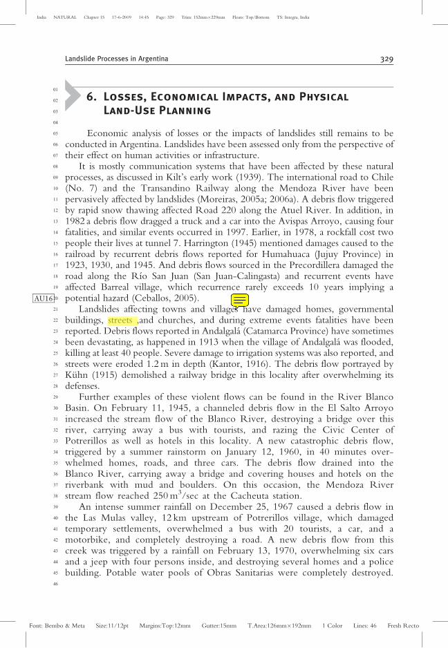
6. Losses, Economical Impacts, and Physical
Land-Use Planning
Economic analysis of losses or the impacts of landslides still remains to beconducted in Argentina. Landslides have been assessed only from the perspective oftheir effect on human activities or infrastructure.
It is mostly communication systems that have been affected by these naturalprocesses, as discussed in Kilt’s early work (1939). The international road to Chile(No. 7) and the Transandino Railway along the Mendoza River have beenpervasively affected by landslides (Moreiras, 2005a; 2006a). A debris flow triggeredby rapid snow thawing affected Road 220 along the Atuel River. In addition, in1982 a debris flow dragged a truck and a car into the Avispas Arroyo, causing fourfatalities, and similar events occurred in 1997. Earlier, in 1978, a rockfall cost twopeople their lives at tunnel 7. Harrington (1945) mentioned damages caused to therailroad by recurrent debris flows reported for Humahuaca (Jujuy Province) in1923, 1930, and 1945. And debris flows sourced in the Precordillera damaged theroad along the Rıo San Juan (San Juan-Calingasta) and recurrent events haveaffected Barreal village, which recurrence rarely exceeds 10 years implying apotential hazardAU16 (Ceballos, 2005).
Landslides affecting towns and villages have damaged homes, governmentalbuildings, streets ,and churches, and during extreme events fatalities have beenreported. Debris flows reported in Andalgala (Catamarca Province) have sometimesbeen devastating, as happened in 1913 when the village of Andalgala was flooded,killing at least 40 people. Severe damage to irrigation systems was also reported, andstreets were eroded 1.2 m in depth (Kantor, 1916). The debris flow portrayed byKuhn (1915) demolished a railway bridge in this locality after overwhelming itsdefenses.
Further examples of these violent flows can be found in the River BlancoBasin. On February 11, 1945, a channeled debris flow in the El Salto Arroyoincreased the stream flow of the Blanco River, destroying a bridge over thisriver, carrying away a bus with tourists, and razing the Civic Center ofPotrerillos as well as hotels in this locality. A new catastrophic debris flow,triggered by a summer rainstorm on January 12, 1960, in 40 minutes over-whelmed homes, roads, and three cars. The debris flow drained into theBlanco River, carrying away a bridge and covering houses and hotels on theriverbank with mud and boulders. On this occasion, the Mendoza Riverstream flow reached 250 m3/sec at the Cacheuta station.
An intense summer rainfall on December 25, 1967 caused a debris flow inthe Las Mulas valley, 12 km upstream of Potrerillos village, which damagedtemporary settlements, overwhelmed a bus with 20 tourists, a car, and amotorbike, and completely destroying a road. A new debris flow from thiscreek was triggered by a rainfall on February 13, 1970, overwhelming six carsand a jeep with four persons inside, and destroying several homes and a policebuilding. Potable water pools of Obras Sanitarias were completely destroyed.
01
02
03
04
05
06
07
08
09
10
11
12
13
14
15
16
17
18
19
20
21
22
23
24
25
26
27
28
29
30
31
32
33
34
35
36
37
38
39
40
41
42
43
44
45
46
Landslide Processes in Argentina 329
Font: Bembo & Meta Size:11/12pt Margins:Top:12mm Gutter:15mm T.Area:126mm�192mm 1 Color Lines: 46 Fresh Recto
India NATURAL Chapter 15 17-6-2009 14:45 Page: 329 Trim: 152mm�229mm Floats: Top/Bottom TS: Integra, India
Then, on December 27, 1982, flows coming from the El Salto, de las Mulas,and Burrito Arroyos drained into the Blanco River also damaging ObrasSanitarias facilities, and upon reaching the Mendoza River damaged theTransandino Railway and the international road to Chile. When the debrisflows reached the Mendoza River, they damaged facilities installed in thisvalley. The electric power plant at Cacheuta was severely damaged in 1913and again in 1957. Also, two fatalities were reported, and the thermal baths ofthe Cacheuta Hotel were affected when the Mendoza River stream flowreached 346 m3/sec in 1920.
In some cases, cultivated fields and livestock were lost. The violent flow in 1880that affected the village of Andalgala also impacted desolate areas of the Choya,Hoyada, and Negro valleys. This event carried away a local man who drove a muleherd (La Nacion, 1880). During the 1990s, rotational slides at Volcan (JujuyProvince) were caused by lateral river erosion; one block of this town wasdestroyed completely, and many cultivated fields were lost (Solıs et al., 2004).
Finally, economic losses stemming from lost revenues from tourism and thecountry’s historical heritage must be taken into account. Mountain areas areimportant tourist attractions, as are the valleys surrounded by these ranges, wherepre-Hispanic settlements are found. Much of Argentina’s historic heritage is asso-ciated with the high landslide hazard zone in Uspallata valley (Mendoza RiverBasin) where Inca monuments and Inca routes have been found. Diaguita hier-oglyphics 1300 years-old and Huarpe remains were also discovered in this valley(Moreiras, 2004d, 2005d, 2006a). Other places such as the village of Tilcara, whichis pervasively affected by debris flows, is an international tourist spot, being one ofthe main pre-Hispanic settlements of the Omaguaca group in northern Argentina.The localities of Humahuaca, Purmamarca, and Maimara have similar historicimportance. Debris flows have also damaged many tourism infrastructures. Forexample, the thermal baths of Fiambala, located at Sierra Fiambala (La RiojaProvince), were severely damaged by a debris flow emanating from the Quebradade los Banos valley on February 2, 2003 (Gonzalez, 2003).
In any case, during the last decade some applied studies on land-use planninghave included analyses of natural hazards. Along several sections of the provincialroads E-55 and A-73, Cordoba Province, a landslide hazard map has been created(Bejerman, 1993; Bejerman and Giraud, 1993). Also, the Landslide PossibilityIndex (LPI) has been applied in order to evaluate risks from natural hazards alongthe road rocky talus. In the first caseAU17 , 73 % of them have high and middle LPIvalues; whereas in the second case, the highest LPI value was assigned to 76% of therocky talus. Landslide occurrences have been identified in several road sections builtin mountainous areas of San Juan Province (Salinas et al., 1995). The incidence andsusceptibility of landslides have been analyzed for the Mendoza River (Moreiras,2004c, 2005a), and a probabilistic hazard assessment and risk map was elaborated(Moreiras, 2004a, 2004d). In the Lasifashaj valley, Tierra del Fuego, a geomorpho-logical hazard map has been prepared as a tool for ecological landscape analysis andland-use planning (Coronato and Roig, 1999). In the most hazardous zone, earth-slides, rockfalls, debris falls, and avalanches occupy more than 50% of the area.
01
02
03
04
05
06
07
08
09
10
11
12
13
14
15
16
17
18
19
20
21
22
23
24
25
26
27
28
29
30
31
32
33
34
35
36
37
38
39
40
41
42
43
44
45
46
330 Stella M. Moreiras and Andrea Coronato
Font: Bembo & Meta Size:11/12pt Margins:Top:12mm Gutter:15mm T.Area:126mm�192mm 1 Color Lines: 46 Fresh Recto
India NATURAL Chapter 15 17-6-2009 14:45 Page: 330 Trim: 152mm�229mm Floats: Top/Bottom TS: Integra, India
7. Final Remarks
During the last two decades, an increasing number of geomorphologicalstudies on landslides have appeared. Although currently there is a boon of paleo-landslide dating for evaluating landscape evolution, calculating erosion rates, andextending paleoseismicity, the occurrence of present-day landslides has not beenstudied at all. Moreover, assessments of landslide hazard and risk are lacking inArgentina. Such assessments are essential for proposing proper territorial planningand future preventive measures.
Such studies would help to reduce future economic losses: population growthand expanding urbanization are increasing the potential devastating impact oflandslides in most of Argentina’s mountain areas. The Patagonian Andean cities,which are generally built over glacial deposits and over steep slopes, are expandingowing to increases in tourism. Urbanization and road construction have increasedsignificantly over the last three decades, transforming the landscape. Consequently,improving the criteria used to identify hazards associated with natural events is evenmore critical. However, neither threshold precipitation nor minimum earthquakemagnitudes producing landslide occurrences have been determined for differentArgentine regions.
Both local people and the authorities should be educated about landslides.Intensive educational plans should especially be designed for the communitiesthat could be most affected. People should learn to recognize which places aredangerous to settle in and to develop economic activities. Governments shoulddevelop careful monitoring systems for seismic, volcanic ,and climatic processes,including the monitoring of beaver dams, to avoid any surprises connected withlandslides. Alarm systems have not yet been developed in the affected areas,although they could save lives and properties. In addition, the lack of evaluationstudies for the slope instability associated with volcanic eruptions should also beremedied, for lahars sourced from sudden ice or snow melting often result incatastrophic events.
Hazards related to impounded lakes also have to be taken into account. Her-mann et al, (2003) established that at least 90 % of Pliocene-Holocene landslidesidentified along the Andes between 36� and 38� S have dammed lakes, and about23 of them remain until the present day. Moreover, instability in the boundaries ofdammed lakes should be evaluated, as rocks show a different behavior when theyare saturated with water Even though impounded lakes drain slowly, they representa potential hazard because periods of increased precipitation or spring thawing mayincrease the lake level, causing dam failure.
Although landslides do not affect most of the Argentine population, theyare one of the most important processes in modeling Argentina’s mountainousareas, which is clearly evidenced by all recognized paleo-landslides. Adding totheir potential significance is the fact that several deposits earlier identified as ofglacial origin have been recently been reinterpreted as landslides. Moreover,the frequency of landslides may increase in the future in response to climatechange and extreme climate phenomena (Paolini et al, 2005; Moreiras, 2006a,
01
02
03
04
05
06
07
08
09
10
11
12
13
14
15
16
17
18
19
20
21
22
23
24
25
26
27
28
29
30
31
32
33
34
35
36
37
38
39
40
41
42
43
44
45
46
Landslide Processes in Argentina 331
Font: Bembo & Meta Size:11/12pt Margins:Top:12mm Gutter:15mm T.Area:126mm�192mm 1 Color Lines: 46 Fresh Recto
India NATURAL Chapter 15 17-6-2009 14:45 Page: 331 Trim: 152mm�229mm Floats: Top/Bottom TS: Integra, India
2006c). Hence, landslides need to be better known in Argentina, not only foracademic purposes, but especially for the economic development of mountainregions.
Acknowledgments
We want to express our gratitude to Edgardo Latrubesse for inviting us toparticipate in this book and to Mauro Soldati for his review and important sugges-tions and comments. We also thank Jack Shroder for comments and suggestionsthat improved the manuscript. We thank Rafael Bottero (IANIGLA) for figuredesign and Nelly Horak (IADIZA) for checking the English version. We are alsoindebted to Juan Pablo Ceballos for photos of dam failure on the River Santa Cruz(San Juan provinces) and to Marcelo Chiaradia for photos of the Monte Susanadebris flow over the National Route 3 in Tierra del Fuego.
01
02
03
04
05
06
07
08
09
10
11
12
13
14
15
16
17
18
19
20
21
22
23
24
25
26
27
28
29
30
31
32
33
34
35
36
37
38
39
40
41
42
43
44
45
46
332 Stella M. Moreiras and Andrea Coronato
Font: Bembo & Meta Size:11/12pt Margins:Top:12mm Gutter:15mm T.Area:126mm�192mm 1 Color Lines: 46 Fresh Recto
India NATURAL Chapter 15 17-6-2009 14:45 Page: 332 Trim: 152mm�229mm Floats: Top/Bottom TS: Integra, India

Chapter No: 15
Query No Contents
AU1 Is this a journal title? If so it need to be italicized.
AU2 Diferent from what?
AU3 Pls give the translation of this phrase.
AU4 What does this mean?
AU5 When was this?
AU6 What is the del 60?
AU7 Pls fix this word
AU8 Wrapped? What does that mean?
AU9 Pls clarify.
AU10 Is this what became turbit, or was it the Ullum dam?
AU11 Please clarify this part.
AU12 Role in what?
AU13 When was this
AU14 Has affected what?
AU15 Among those what? Pls. Clarify here.
AU16 What does this mean?
AU17 Do you mean in the case of E-55? Please be specific here.
AU18 We have retained the corresponding author address. Please check.
AU19 Please provide Keywords.
Non-Print Item
Abstract
AU19 This chapter reviews the status of knowledge on landslides in Argentina in order to
understand their behavior and their implications for landscape evolution. This basic under-
standing allows an analysis of both the vulnerability of mountain communities and the
potential risk for regional society and economies.
Slope instability processes are analyzed as related to the Argentinean geological
provinces. The main landslide processes throughout Argentina and detailed events that
have occurred in each region of the country are reported. Landslides are widespread in
Argentina. The most catastrophic events have been described for mountain regions, which
comprise one-third of the country, extending from the north to the south border, involving
mountains, ranges, tablelands, and sea-cliffs.
Atypical rainstorms and seismic events affecting geological structures and weathered
rocks are identified as the main landslides triggering forces in Argentina. Winter precipita-
tion caused by the westerlies generate landslides, together with fall and flux mechanisms.
Overaccumulation of snow and fast melting of snows during exceptionally warm spring
days cause avalanches and debris flows. Landsliding triggered by earthquakes can occur all
along the Andes, especially in the central and northern geological units. Volcanic activity
promotes lahar formations. Over the Patagonian tablelands, landsliding is initiated mainly
by fluvial undercutting after heavy summer storms, wave erosion at the footslopes, or
groundwater-level variations.
Snow avalanches and mudflows seem to be climatically conditioned in specific
regions, while the other processes have a wide distribution. Antropic activities such as
slope urbanization, irrigation, roads development, ski centers as well as exotic fauna that
block and affect mountain rivers should also be considered landslide-triggering factors.