land suitability assessment for afforestation with elaeagnus angustifolia l. in degraded...
TRANSCRIPT
1
LAND SUITABILITY ASSESSMENT FOR AFFORESTATION WITH ELAEAGNUS ANGUSTIFOLIA L. IN
DEGRADED AGRICULTURAL AREAS OF THE LOWER AMUDARYA RIVER BASIN
Short title:
LAND SUITABILITY ASSESSMENT FOR ELAEAGNUS ANGUSTIFOLIA L.
OLENA DUBOVYKA,D*, GUNTER MENZB,D, ASIA KHAMZINAC
a Institute of Crop Science and Resource Conservation (INRES), University of
Bonn, Katzenburgweg 5, 53115 Bonn, Germany bRemote Sensing Research Group, Department of Geography, University of
Bonn, Meckenheimer Allee, 166, 53115 Bonn, Germany cCenter for Development Research, University of Bonn, Walter-Flex Str. 3, 53113
Bonn, Germany dCenter for Remote Sensing of Land Surfaces (ZFL), University of Bonn, 53113
Bonn, Germany
Corresponding author (*):
Olena Dubovyk
Institute of Crop Science and Resource Conservation (INRES), University of Bonn
Katzenburgweg 5, 53115 Bonn, Germany
Tel.: +49 (0) 228 / 73-7198, fax: +49 (0) 228-73-2045
Email: [email protected]
ABSTRACT
Degradation of irrigated croplands in arid regions is of great environmental concern worldwide.
Based on a series of field trials, afforestation with well-adapted tree species were evaluated as a
viable option for the cropland rehabilitation in the lower reaches of the Amudarya River Basin in
Uzbekistan. Our aim was to extend available site-specific information for the entire regional
landscape and provide spatially explicit guidance in support of afforestation land rehabilitation
efforts. To this end, a geographic information system (GIS)-based multi-criteria decision-making
approach has been developed for assessing the suitability of degraded irrigated cropland for
introducing plantations of Elaeagnus angustifolia L. This approach utilized expert knowledge,
fuzzy logic, and a weighted linear combination to produce an afforestation land suitability map.
Overall, 75,287 ha of degraded croplands (18% of the irrigated cropland area) were identified as
suitable for introduction of E. angustifolia. We also conclude that irrigation water supply and
groundwater table depth are the critical factors determining suitability of degraded irrigated
land. These findings improve understanding of the spatial variability of areas suitable for the
initiation of agroforests and support better informed decisions on cropland rehabilitation.
Keywords: Land evaluation; agroforestry; land degradation; multi-criteria evaluation; fuzzy
logic; GIS; Central Asia

2
INTRODUCTION
In Central Asia as well as in other irrigated regions in the world, the problem of cropland
degradation due to soil salinity is acute, particularly in river valleys and downstream areas
(Dubovyk et al., 2013a). A number of methods have been developed for rehabilitating degraded
cropland. Afforestation with salt-tolerant tree species is a viable option (König et al., 2012;
Rigueiro-Rodríguez et al., 2012), especially for areas characterized by shallow saline groundwater
tables. The lower Amudarya River Basin of Uzbekistan is such an area. Published research has
addressed several aspects of afforestation. Lamers et al., (2006), Khamzina (2006a), and
Khamzina et al. (2006b) have evaluated the suitability of selected tree species for afforestation.
Khamzina et al. (2008) examined the establishment, irrigation demands and groundwater uses
by tree plantations. Several researchers have focused on the potential for afforeatation to
replenish soil nutrient stocks and improve soil quality (Hbirkou et al., 2011; Fialho & Zinn, 2012;
Bruun et al., 2013; Vasconcellos et al., 2013; Wu et al., 2013). More recently, the feasibility of
extending specific afforestation efforts to cropping sites removed from cultivation has been
explored (Schachtsiek et al., 2014). Native tree species which have been evaluated includes
Elaeagnus angustifolia L., a multipurpose, N2-fixing, salt-tolerant and fast-growing species with
a high potential for afforestation of nutrient depleted sites affected by salinity.
These site-specific results must now be extended to determine the size, distribution and
overall area of degraded cropland parcels that are best suited for afforestation in irrigated
agricultural landscapes. Land suitability for introducing forestry in degraded agricultural areas
differs spatially due to variable landscape characteristics that determine tree survival and
establishment. Thus, spatially explicit information is vital for effective allocation of land resources
to create a basis for efficient environmental policy intervention.
Multi-criteria decision making is a useful approach for land evaluation. This approach
allows the analyst to combine qualitative and quantitative criteria in determining site-specific
suitability values for a proposed land use option. Geographic information systems (GIS) are well
suited for manipulating a wide range of data from various sources for cost effective and time-
efficient analyses (Pandey et al., 2011). A number of GIS-based multi-criteria evaluation (MCE)
methods have been tested in research applications (Malczewski, 2004; Jarnevich & Reynolds,
2011).
The focus of our study was to develop and apply a GIS-based MCE approach to assess
the suitability of degraded irrigated cropland for conversion to tree plantations of E. angustifolia

3
in the lower Amudarya River basin region of Uzbekistan. We also seek to contribute in a
functional way to land rehabilitation efforts in the region.
MATERIALS AND METHODS
Study area
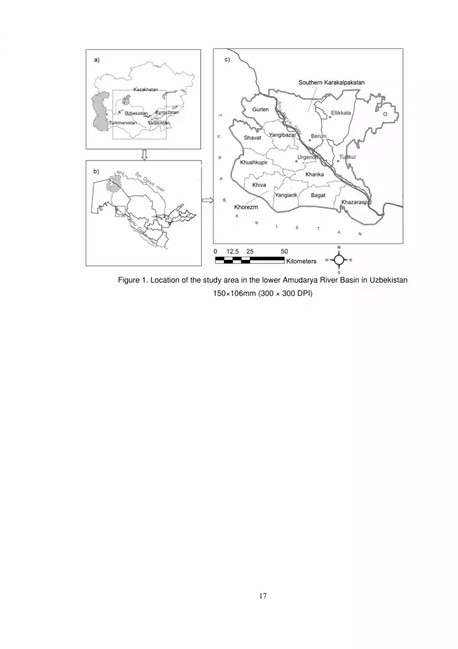
The study area included the Khorezm Province and the southern part of the Autonomous
Republic of Karakalpakstan (SKKP) (Figure 1c) located in the lower reaches of the Amudarya River
in Uzbekistan (Figure 1a,b). The region covers an area of about 662,042 ha, of which 410,000 ha
is arable irrigated land (Tüshaus et al., 2014). The area is characterized by the extreme
continental climate with an annual rainfall below 100mm. The Amudarya River is the main source
of fresh water for the irrigated agriculture production, which is the backbone of the regional
economy (Conrad et al., 2014).
Natural riparian and desert forests have been greatly reduced as the irrigated cropland
expanded since the 1960s. Trees, mostly in the form of fruit orchards and windbreaks, occur on
less than 2% of the agricultural area. Principal tree species include Morus alba L., hybrid Populus
spp., Salix spp., and E. angustifolia.
The regional hydrology is characterized by a naturally shallow groundwater table (GWT)
level with a long-term average depth of 1.2m, and low to moderate salinity levels (1.8 g/l) that
are affected by irrigation inputs (Ibrakhimov et al., 2007). Due to rising GWT and resulting soil
salinization, cropland degradation is an acute problem. Land productivity is declining in
approximately 20% (94,835 ha) of the arable area (Dubovyk et al., 2013a).
Data sources
The data on the performance of E. angustifolia in the study area were derived from published
reports and original datasets based on eight experimental afforestation sites in Khorezm and
SKKP (Table 1). All sites were treated with less than 200mm of irrigation for first two years and
thereafter relied fully on groundwater.
Data on the suitability criteria were obtained from the ZEF/UNESCO project database
(www.zef.de/) established through statistical data collection from various institutions. The
obtained datasets were preprocessed and converted into the GIS format. All datasets were
converted to the same coordinate system (ED 1950 UTM Zone 41N) with the same spatial extent
4
and 250m cell size. The cropland degradation trend map, calculated from the 250m MODIS time
series (2000-2010) (Dubovyk et al., 2013a), was used as the basis to define the suitability of
degraded cropland for afforestation with E. angustifolia.
Multi-criteria evaluation
The development of a GIS-based MCE in the suitability analysis of degraded irrigated cropland
for afforesting with E. angustifolia involved: (i) identification of the factors determining survival
and establishment rates of E. angustifolia saplings that served as land suitability criteria for
afforestation; (ii) specification of the quantitative relationship between tree establishment and
each selected criterion; (iii) definition of a range of suitability values for each criterion; (iv)
combination of the criteria to determine the overall suitability of land for tree planting.
The Ordered Weighted Averaging (OWA) technique was selected for multi-criteria
aggregation of the weighted criteria (Yager, 1988). Previous research has shown that the
combination of fuzzy logic (Zadeh, 1965) and OWA can yield promising results for land suitability
analyses (Chen & Paydar, 2012). Weighted linear combination (WLC) is one of the most
frequently used decision rules in GIS and is also a specific case of an OWA (Boroushaki &
Malczewski, 2008); this procedure was adapted in this study.
In WLC, criterion weights indicate the relative importance of each criterion to the
objective under consideration. In this study, simple ranking was applied to rate criteria from 1
(least important) to 5 (most important) based on expert knowledge.
General environmental requirements and reclamation characteristics of E. angustifolia
The N2-fixing, deciduous tree species Elaeagnus angustifolia L., native to central and west Asia
and southern Europe, is useful for fruit, fuelwood, gum, leaf fodder, nectar and honey
production, medicinal purposes and ornamental planting (Katz & Shafroth, 2003; Khamzina et al.,
2009). It can withstand temperatures ranging from -45°C to 45°C and occur from sea level to
above 2,000m elevation. While prefering sandy floodplains, E. angustifolia is often associated
with moist riparian habitats but withstands droughts and is able to grow in a wide range of
climatic and soil conditions. Particularly, due to its ability to pioneer disturbed sites, it has been
widely propagated as a wildlife, windbreak, road hedgerow and reclamation species. In riparian
ecosystems, E. angustifolia can colonize aggressively, displacing native vegetation and might be
regarded as an invasive exotics, e.g., in the U.S. (Katz & Shafroth, 2003). However, the ability to
5
fix atmospheric N allows E. angustifolia to colonize N-depleted soils, thus building up soil organic
matter and creating suitable habitat for other plants. Mixing valuable tree crops with E.
angustifolia was shown to improve their growth performance (Paschke, 1997).
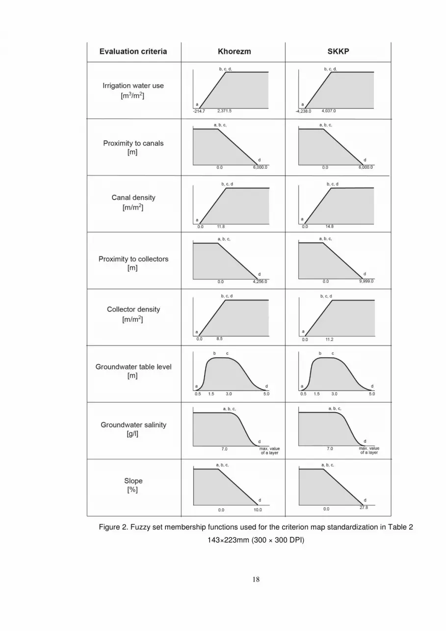
Criteria selection and standardization
The list of criteria was based on the conclusions of afforestation experts involved in afforestation
trials in the region. The list included local environmental factors favorable for E. angustifolia
survival and defined their presence within the study landscape. The final selection of the criteria
was guided by the GIS data availability.
To define a range of suitability values for each criterion, a literature review was
performed, and interviews were conducted with local afforestation experts. This information was
formalized using a fuzzy set approach. For each criterion, a suitability function was defined that
assigned a degree of suitability to every value of the criterion. Subsequently, the criterion maps
were recompiled in the GIS according to the selected fuzzy function. A fuzzy set is characterized
by a fuzzy membership grade without sharp boundaries, with grade values ranging from 0 to 1.
This scale indicates a continuous increase from non-suitability (‘non-membership’) to complete
suitability (‘membership’) as described by Dubois & Prade (1982). Depending on the selected
type of fuzzy set membership functions, the positions of a maximum of 4 points governs the
shape of the fuzzy curve (Figure 2):
� a = membership rises above 0
� b = membership becomes 1
� c = membership falls below 1
� d = membership becomes 0.
Irrigation water supply. Parameters describing irrigation water availability and groundwater
characteristics are of paramount importance in determining the land suitability for dryland
afforestation. This is due to irrigation needs at the early stage of tree growth to counterbalance
the salt stress and to satisfy the water demand before trees can rely on groundwater (Khamzina
et al., 2008). To account for this condition, the regional irrigation water supplies showing
differences for each pair of years between 2000 and 2010 were calculated for each agricultural
district (Figure 1) and averaged over 11 years. Negative values indicate that the water supply has
decreased for some districts over the last decade, whereas positive values indicate an increase.
The district with the highest increase in water supply was considered as the most suitable for the

6
establishment of tree plantations (suitability score=1), whereas the district with the highest
decrease in water supply was considered as the least suitable (suitability score=0) (Table 2, Figure
2). Following discussion with experts, relationships for all criteria related to the irrigation water
and irrigation network were assumed to be linear. A monotonically decreasing linear function
was then implemented to rescale criterion of irrigation water supply, i.e sites with the lowest
irrigation supply had the lowest suitability score and sites with the largest supply had the highest
suitability score. This function used minimum and maximum values from the irrigation water
supply map as the control points at the end of the linear curve (Figure 2).
Irrigation network. As an access to irrigation water depends on the site location within
the irrigation infrastructure, the criteria ‘proximity to irrigation canals’ and ‘density of irrigation
canals’ were incorporated into the analysis.
The criterion ‘proximity to irrigation canal’ was rescaled using the monotonically
decreasing linear function (Figure 2). The areas closest to irrigation canals were considered most
suitable (suitability score=1) in contrast to least suitable remote areas (suitability score=0) (Table
2, Figure 2). The criterion ‘density of irrigation canals’ was rescaled using a monotonically
increasing linear function. Areas with the highest canal density were considered most suitable
(suitability score=1) in contrast to the areas with the lowest density of the canals (suitability
score=0) (Table 2, Figure 2).
In addition, the criteria ‘proximity to drains’ and ‘density of drains’ were included in the
analysis. Operation of the drainage network is important for controlling the salt balance in the
irrigated areas (Ibrakhimov et al., 2011). In the study region, fresh water availability is frequently
insufficient for irrigation (Glantz, 1999), prompting the farmers in some districts to irrigate with
a drainage water in water-scarce years. Rescaling of these criteria was performed similarly to that
of the criteria related to irrigation canals.
Groundwater table. As is the case everywhere, GWT depth and groundwater salinity
(GWS) influence tree growth in the irrigated cropland of the study area. If irrigation input is low,
tree establishment is particularly influenced by the presence of shallow GWT with salt
concentrations below the salinity tolerance of saplings (Schachtsiek et al., 2014). A shallow GWT
genereally is present within irrigated lowlands areas; the GWT can be deeper within those sites
where cropping and irrigation have been abandoned for extended periods (Ibrakhimov et al.,
2011). In afforestation trials in the study region, tree plantations were established on marginal
or abandoned cropping sites with wide ranges of GWT depths (0.4m-2.0m). In these tests, E.

7
angustifolia showed at least 90% survival rate due to effective uptake of saline groundwater and
with the support of deficit irrigation in the first years of growth (Table 1). Kang et al. (2004)
identified an optimal GWT range of 1.5m-3.0m for cultivation of E. angustifolia’s in arid China
(Table 1). Although a very shallow GWT (<0.5m) is favoured during the seedling phase when tree
roots are not completely developed, a GWT this close to the surface would restrict longer term
root growth (Ruger et al., 2005). Those sites characterized by a GWT deeper than 3m would
require higher irrigation inputs for establishing tree plantations. In non-irrigated drylands with a
GWT in the range of 3.0m-5.0m and deeper, E. angustifolia did not grow well due to lack of the
GWT contribution to overall soil moisture levels (Kang et al., 2004).
The relationship between GWT condition and tree plantation suitability can best be
depicted using a symmetric sigmoidal curve, and such a curve was used to rescale the GWT layer
into a continuous variable (Table 2, Figure 2). The suitability increases monotonically from 0.5m
to 1.5m, does not change for the GWT range of 1.5m-3.0m, and decreases monotonically with
GWT depths greater than 3.0m.
Groundwater salinity. Elaeagnus angustifolia is known as a relatively salt-tolerant species.
Its actual salinity tolerance, however, also depends on soil moisture and nutrient conditions, the
ionic composition of the soil solution, as well as on the plant age (Kozlowski, 1997). In the study
region, successful establishment of E. angustifolia saplings was reported for GWS ranging during
the crop growing season from 0.6 to 5.4g/l (Table 1); such salinity levels are typically described
as in the “slight to moderate” range (Rhoades et al., 1992).
There is an absence of experimental data on field performance of E. angustifolia under
conditions of GWS > 5.0g/l within the study regions. As slight to moderate GWS levels are typical
in Khorezm and SKKP, the optimal GWS level was assumed <7.0g/l, according to the general
classification described by Rhoades et al. (1992). Site suitability was assumed to decrease
exponentially with a further increase in GWS. Such a relationship is best described by a
monotonically decreasing sigmoidal curve (Table 2, Figure 2). With this function, the first control
point is the GWS value at which a location is considered to be unsuitable for afforestation
(<7.0g/l). Suitability rises sharply above the zero value with decreasing GWS levels and the second
control point is the value at which suitability approaches its maximum.
To capture within-season fluctuations of the groundwater parameters, three factors
representing the GWT and GWS in spring, summer, and fall were included in the analysis (Table
8
2). Separate criterion maps representing GWT and GWS were prepared for land suitability
assessment. Identical ranks and weights were assumed for each parameter.
Slope. Even small variations in micro-relief (slopes<10%) of the flat irrigated terrain in Khorezm
influenced accumulation of topsoil salt in the fields, as well as the supply of irrigation water and
its distribution within the field parcels. The slope was also included as a criterion, principally to
delineate sites where costs for land leveling and salt leaching prior to plantation establishment
would be minimized.
In order to characterize terrain differences, the suitability of a site for afforestation was
assumed to decrease linearly with increasing slope. Thus, the slope criterion was rescaled using
the monotonically decreasing linear function: areas with a slope of 0% were considered as the
most suitable for afforestation and areas with the steepest slope as the least suitable (Table 2;
Figure 2).
Evaluation of land suitability model
An analysis was conducted to test the sensitivity of the results to changes in the assigned criteria
weights. A suitability map based on the equal-weight WLC was computed and compared with an
alternative suitability map generated from the WLC with criteria weights defined by experts.
Chen & Paydar (2012) describe a procedure for validating these results utilizing a straightforward
comparison procedure employing in situ crop distribution data. Such an assessment was not
possible in this application, as afforestation is an innovative land use within the study region that
is represented only by some experimental plantations.
RESULTS AND DISCUSSION
Suitability of degraded croplands for E. angustifolia
The multi-criteria evaluation results in a continuous land suitability layer where a value of 0
indicates unsuitable and a value of 1 indicates most suitable sites. The overall suitability map was
subsequently overlaid with the MODIS-based cropland degradation map (Dubovyk et al., 2013a)
to highlight the suitability of E. angustifolia afforestation on cropping sites with declining
productivity (Figure 3). The assessment revealed that the majority of the degraded irrigated
cropland area was characterized by average and above average suitability values. This is expected
for the native species, which is broadly distributed in natural riparian habitat and within
agroforestry systems in the study area (Tupitsa et al., 2010).

9
The statistics describing the suitability values of the degraded cropland are shown in
Table 3. Overall, the suitability was higher for Khorezm compared to the SKKP; the highest
suitability was observed in the Yangibazar district of Khorezm and the lowest suitability in the
Turtkul district of the SKKP. Additionally, the range of suitability values was wider for the SKKP,
suggesting higher spatial variability of the evaluation criteria in this area compared to Khorezm.
In general, higher suitability values were observed in the districts bordering the Amudarya
River, including Gurlan, Bagat, Khanka and Khazarasp (Figure 1). This is likely the result of better
access to irrigation water within these districts. In contrast, lower suitability was identified in
the districts of Khiva, Kushkhupyr and Turtkul that are in the more distantl sections of the
irrigation system.
Evaluation of land suitability model
Tests of the model’s sensitivity in relation to the selected criteria were conducted by assessing a
series of reduced criteria suitability maps. These maps were calculated by sequentially omitting
one criterion per calculation. The resultant maps were compared with the suitability map
generated using the full criteria set. The results demonstrate clearly that removing the factor
reflecting annual fluctuations in irrigation water supply had the most significant impact on the
suitability results; the correlation between the maps decreasing to R2=0.65. Omitting the criteria
of GWT depth also reduced the correlation between the maps (to R2=0.85). These results
generally confirm the importance of the choice of criteria as well as the weighting factors
assigned to each criteria for suitability assessment. In contrast, very little overall impact was
observed when criteria related to irrigation and the drainage network were omitted (overall
R2=0.98). Eliminating the criterion indicating proximity to irrigation canals had a somewhat
greater impact, with a resultant R2=0.90. This implies that these criteria might be redundant for
analyses at a district scale, but may be useful at finer spatial scales where higher resolution
datasets could reveal impacts of these factors. Omitting the seasonal GWS criteria also made
little difference in the results. Removing spring and summer criteria both produced an R2=0.95;
omitting fall yielded R2=0.99. Omitting the slope criteria also had an insignificant impact
(R2=0.99). These results can be explained by the overall low GWS within the irrigated areas
(Ibrakhimov et al., 2007) and a lack of significant topographic relief within the study area
(Dubovyk et al., 2013a).
10
Due to data limitations, our assessment did not include other relevant suitability
criteria, such as soil characteristics. The soil nitrogen content was not distinguished in the analysis
due to the effective N2-fixing ability of E. angustifolia (Khamzina et al., 2009). This species also
grows on a wide range of soil textures from sand to heavy clay (Tu, 2003). The absence of a soil
texture criteria could be justified because the current assessment is focused on tree survival and
establishment; E. angustifolia saplings’ survival rates have been measured at > 90% on sandy and
silt-loamy soils, which are predominant in the study region (Khamzina, 2006a; Khamzina et al.,
2008; Schachtsiek et al., 2014). E. angustifolia has, however, shown significant variation in
biomass production depending on soil texture (Khamzina et al., 2006b), and the soil texture
parameter should be considered in further assessments when these data become available.
Spatiallly explicit data on soil salinity dynamics could be quite useful for the analysis of
land suitability for afforestation in those areas where salinity is the main vegetation growth
constraint. The contribution of saline GWT to soil salinity is significant when GWT levels exceed
a threshold horizon above which groundwater rises via capillarity action towards the soil surface
(Hillel, 2000). In our study region, this threshold was defined as 1.5m-2.0m, related to soil texture
and GWS (Rakhimbaev et al., 1992). In this case, then, we regard soil salinity as the product of
GWT and GWS in combination with annual salt leaching and irrigation inputs. Groundwater and
irrigation parameters then operated in place of explicit soil salinity data in the suitability model.
Our regional tests of the model’s sensitivity to changes in the assigned criteria weights
did not reveal substantially different results. The comparisons of the suitability map based on the
equal weight WLC and the suitability map based on the WLC with expert-defined weights
produced similar outputs: R2=0.93 for Khorezm and R2=0.89 for the SKKP. The knowledge-based
approach, commonly applied in land evaluation studies (Krueger et al., 2012), was also used here
to assign weights and determine fuzzy membership functions. This approach is somewhat
subjective compared to automated approaches (Liu et al., 2013). Implementation of the data
driven approach to model suitability is, however, pre the availability of comprehensive
quantitative information on environmental variables (Bradshaw et al., 2002). Further work might
incorporate an empirical approach towards parameterization of the developed model. This
approach would require incorporating data from an extended experimental dataset or from the
simulated analyses of E. angustifolia’s survival and growth in response to prevailing
environmental conditions in a specific area.
11
Implications for afforestation planning
Our assessment of the suitability of degraded croplands for afforestation with E. angustifolia
revealed multiple small-scale patches (2-3ha in size) scattered within the irrigated zone rather
than contiguous large areas. This pattern should be considered in planning afforestation
measures. The overall degraded cropland area suitable for the introduction of E. angustifolia
(suitability values >=0.5), totaled 75,287 ha (18% of the irrigated cropland area). The proportion
of this area which eventually may be converted to tree plantations would depend on
socioeconomic criteria and policy incentives. Degraded croplands associated with a high
population density might be prioritized in afforestation planning as their rehabilitation would
likely have more impact on the region’s rural livelihood (Dubovyk et al., 2013a; Dubovyk et al.,
2013b). Establishing tree plantations on the degraded margins of irrigated areas will require
more intense management inputs. Afforestation decisions affecting these croplands should
therefore be based on biophysical as well as economic assessments. Such a perspective can
promote effective decisions regarding whether afforestation in a specific area is an ecologically
viable alternative land use as well as whether the area is capable of generating additional
income resources through the production of commercially viable commodities and services.
This suitability model has relatively modest minimum input data requirements and can
be easily modified. Subject to data availability, it can be extended for suitability analysis of other
tree species and/or ecosystem services by releavant planning authorities. Due to data constraints
and the absence of validation datasets, the assessment performed here can serve only for
general planning purposes. Our results, however, serve to generalize and rescale the available
site specific information on the potential of agroforestry as an alternative land use in the
degraded agricultural areas and can serve as the foundation for land rehabilitation planning in
this region.
CONCLUSIONS
A GIS-based multi-criteria regional evaluation model was developed for a landscape scale
suitability assessment of establishing plantations of Elaeagnus angustifolia L. on degraded
croplands. The results revealed higher than average suitability potential for afforestation in the
lower Amudarya River Basin and delineated specific sites most suitable for the potential
introduction of trees. Parameters characterizing irrigation water supply and groundwater depth
and salinity were most decisive in defining land suitability. These findings improve the
12
understanding of spatial variations in suitability of degraded irrigated cropland for E. angustifolia
and, subsequently, support land rehabilitation planning through afforestation. This model can be
further developed by integrating additional datasets relevant to suitability analyses of E.
angustifolia as well as for other tree species that are important for biomass production and other
ecololgical purposes.
ACKNOWLEDGMENTS
The authors greatly appreciate the support of the Robert Bosch Foundation (Germany) for
conducting this study within the project ‘Opportunities for climate change mitigation and
adaptation through afforestation of degraded lands in Central Asia’. We acknowledge the expert
advice of Dr. John Lamers, Dr. Hayot Ibrakhimov, Mrs. Elena Kan, Mr. Tilman Schachtsiek, and
and thank Mr. Joseph Scepan for his contribution in producing this document.
REFERENCES
Boroushaki S, Malczewski J 2008. Implementing an extension of the analytical hierarchy process
using ordered weighted averaging operators with fuzzy quantifiers in ArcGIS. Computers &
Geosciences 34: 399-410.
Bradshaw CJA, Davis LS, Purvis M, Zhou Q, Benwell GL 2002. Using artificial neural networks to
model the suitability of coastline for breeding by New Zealand fur seals (Arctocephalus forsteri).
Ecological Modelling 148: 111-131.
Bruun TB, Elberling B, de Neergaard A, Magid J 2013. Organic carbon dynamics in different soil
types after conversation of forest to agriculture. Land Degradation & Development: n/a-n/a.
Chen Y, Paydar Z 2012. Evaluation of potential irrigation expansion using a spatial fuzzy multi-
criteria decision framework. Environmental Modelling & Software 38: 147-157.
Conrad C, Dech S, Dubovyk O, Fritsch S, Klein D, Löw F, Schorcht G, Zeidler J 2014. Derivation of
temporal windows for accurate crop discrimination in heterogeneous croplands of Uzbekistan
using multitemporal RapidEye images. Computers and Electronics in Agriculture 103: 63-74.
Djumaeva D, Lamers JPA, Khamzina A, Vlek PLG 2013. The benefits of phosphorus fertilization
of trees grown on salinized croplands in the lower reaches of Amu Darya, Uzbekistan.
Agroforestry Systems 87: 1-15.
Dubovyk O, Menz G, Conrad C, Lamers J, Lee A, Khamzina A 2013a. Spatial targeting of land
rehabilitation: a relational analysis of cropland productivity decline in arid Uzbekistan. Erdkunde
67: 167-181.
Dubovyk O, Menz G, Conrad C, Thonfeld F, Khamzina A 2013b. Object-based identification of
vegetation cover decline in irrigated agro-ecosystems in Uzbekistan. Quaternary International
311: 163-174.
Dubovyk O, Schachtsiek T, Khamzina A, Menz G 2012. Exploring the biophysical potential of
dryland afforestation on degraded lands in the downstream of the Amu Darya River,
Uzbekistan. Earth Bioresources and Life Quality 1.
Fialho RC, Zinn YL 2012. Changes in soil organic carbon under Eucalyptus plantations in Brazil: a
comparative analysis. Land Degradation & Development: DOI: 10.1002/ldr.2158.
13
Glantz M. 1999. Creeping Environmental Problems and Sustainable Development in the Aral Sea
Basin. Cambridge, Cambridge University Press.
Hbirkou C, Martius C, Khamzina A, Lamers JPA, Welp G, Amelung W 2011. Reducing topsoil
salinity and raising carbon stocks through afforestation in Khorezm, Uzbekistan. Journal of Arid
Environments 75: 146-155.
Hillel D. 2000. Salinity management for sustainable agriculture: integrating science,
environment, and economics. Washington DC, World Bank.
Ibrakhimov M, Khamzina A, Forkutsa I, Paluasheva G, Lamers JPA, Tischbein B, Vlek PLG,
Martius C 2007. Groundwater table and salinity: Spatial and temporal distribution and influence
on soil salinization in Khorezm region (Uzbekistan, Aral Sea Basin). Irrigation and Drainage
Systems 21: 219-236.
Ibrakhimov M, Martius C, Lamers JPA, Tischbein B 2011. The dynamics of groundwater table
and salinity over 17 years in Khorezm. Agricultural Water Management 101: 52-61.
Jarnevich C, Reynolds L 2011. Challenges of predicting the potential distribution of a slow-
spreading invader: a habitat suitability map for an invasive riparian tree. Biological Invasions 13:
153-163.
Kang S, Su X, Tong L, Shi P, Yang X, Abe Y, Du T, Shen Q, Zhang J 2004. The impacts of human
activities on the water–land environment of the Shiyang River basin, an arid region in
northwest China. Hydrological Sciences Journal 49: 410-427.
Katz GL, Shafroth PB 2003. Biology, ecology and management of Elaeagnus angustifolia L.
(Russian olive) in western North America. Wetlands 23: 763-777.
Khamzina A. 2006a. The assessment of tree species and irrigation techniques for afforestation of
degraded agricultural landscapes in Khorezm, Uzbekistan, Aral Sea Basin. Göttingen Cuvillier
Verlag.
Khamzina A, Lamers J, Worbes M, Botman E, Vlek P 2006b. Assessing the Potential of Trees for
Afforestation of Degraded Landscapes in the Aral Sea Basin of Uzbekistan. Agroforestry Systems
66: 129-141.
Khamzina A, Lamers JPA, Vlek PLG 2008. Tree establishment under deficit irrigation on
degraded agricultural land in the lower Amu Darya River region, Aral Sea Basin. Forest Ecology
and Management 255: 168-178.
Khamzina A, Lamers JPA, Vlek PLG 2009. Nitrogen fixation by Elaeagnus angustifolia L. in the
reclamation of degraded croplands of Central Asia. Tree Physiology 29: 799-808.
König HJ, Zhen L, Helming K, Uthes S, Yang L, Cao X, Wiggering H 2012. Assessing the impact of
the sloping land conversation programme on rural sustainability in Guyuan, Western China.
Land Degradation & Development: DOI: 10.1002/ldr.2164.
Kozlowski TT 1997. Responses of woody plants to flooding and salinity. Tree Physiology
Monograph 1.
Krueger T, Page T, Hubacek K, Smith L, Hiscock K 2012. The role of expert opinion in
environmental modelling. Environmental Modelling & Software 36: 4-18.
Lamers JPA, Khamzina A, Worbes M 2006. The analyses of physiological and morphological
attributes of 10 tree species for early determination of their suitability to afforest degraded
landscapes in the Aral Sea Basin of Uzbekistan. Forest Ecology and Management 221: 249-259.
Liu Y, Jiao L, Liu Y, He J 2013. A self-adapting fuzzy inference system for the evaluation of
agricultural land. Environmental Modelling & Software 40: 226-234.
Malczewski J 2004. GIS-based land-use suitability analysis: A critical overview. Progress in
Planning 62: 3-65.

14
Pandey A, Chowdary VM, Mal BC, Dabral PP 2011. Remote sensing and GIS for identification of
suitable sites for soil and water conservation structures. Land Degradation & Development 22:
359-372.
Paschke MW 1997. Actinorhizal plants in rangelands of the western United States. Journal
Range Management 50: 62-72.
Rakhimbaev F, Bezpalov M, Khamidov M, Isabaev K, Alieva D. 1992. Peculiarities of crop
irrigation in lower Amu Darya river areas. Tashkent, FAN.
Rhoades JD, Kandiah A, Mashali AM. 1992. The use of saline waters for crop production - FAO
irrigation and drainage paper 48. Rome, FAO.
Rigueiro-Rodríguez A, Mosquera-Losada MR, Fernández-Núñez E 2012. Afforestation of
agricultural land with Pinus radiata D. don and Betula alba L. in NW Spain: Effects on soil PH,
understorey production and floristic diversity eleven years after establishment. Land
Degradation & Development 23: 227-241.
Ruger N, Schluter M, Matthies M 2005. A fuzzy habitat suitability index for Populus euphratica
in the Northern Amudarya delta (Uzbekistan). Ecological Modelling 184: 313-328.
Schachtsiek T, Lamers J, Khamzina A 2014. Early Survival and Growth of Six Afforestation
Species on Abandoned Cropping Sites in Irrigated Drylands of the Aral Sea Basin. Arid Land
Research and Management. 28: 410-427.
Tu M. 2003. Element Stewardship Abstract for Phragmites australis. Arlington, The Nature
Conservancy.
Tüshaus J, Dubovyk O, Khamzina A, Menz G 2014. Comparison of Medium Spatial Resolution
ENVISAT-MERIS and Terra-MODIS Time Series for Vegetation Decline Analysis: A Case Study in
Central Asia. Remote Sensing 6: 5238-5256.
Vasconcellos RLF, Bonfim JA, Baretta D, Cardoso EJBN 2013. Arbuscular mycorrhizal fungi and
glomalin-related soil protein as potential indicators of soil quality in a recuperation gradient of
the atlantic forest in Brazil. Land Degradation & Development: DOI: 10.1002/ldr.2228.
Wu JP, Liu ZF, Sun YX, Zhou LX, Lin YB, Fu SL 2013. Introduced Eucalyptus Urophylla plantations
change the composition of the soil microbial community in subtropical China. Land Degradation
& Development 24: 400-406.
Yager RR 1988. On ordered weighted averaging aggregation operators in multicriteria
decisionmaking. IEEE Transactions on Systems, Man and Cybernetics 18: 183-190.
Zadeh LA 1965. Fuzzy sets. Information and Control 8: 338-353.
15
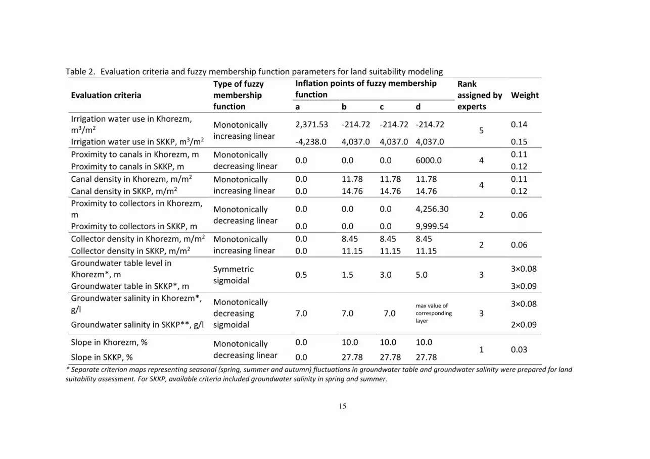
Table 2. Evaluation criteria and fuzzy membership function parameters for land suitability modeling
Evaluation criteria
Type of fuzzy
membership
function
Inflation points of fuzzy membership
function
Rank
assigned by
experts
Weight
a b c d
Irrigation water use in Khorezm,
m3/m2 Monotonically
increasing linear
2,371.53 -214.72 -214.72 -214.72 5
0.14
Irrigation water use in SKKP, m3/m2 -4,238.0 4,037.0 4,037.0 4,037.0 0.15
Proximity to canals in Khorezm, m Monotonically
decreasing linear 0.0 0.0 0.0 6000.0 4
0.11
Proximity to canals in SKKP, m 0.12
Canal density in Khorezm, m/m2 Monotonically
increasing linear
0.0 11.78 11.78 11.78 4
0.11
Canal density in SKKP, m/m2 0.0 14.76 14.76 14.76 0.12
Proximity to collectors in Khorezm,
m Monotonically
decreasing linear
0.0 0.0 0.0 4,256.30 2 0.06
Proximity to collectors in SKKP, m 0.0 0.0 0.0 9,999.54
Collector density in Khorezm, m/m2 Monotonically
increasing linear
0.0 8.45 8.45 8.45 2 0.06
Collector density in SKKP, m/m2 0.0 11.15 11.15 11.15
Groundwater table level in
Khorezm*, m Symmetric
sigmoidal 0.5 1.5 3.0 5.0 3
3×0.08
Groundwater table in SKKP*, m 3×0.09
Groundwater salinity in Khorezm*,
g/l Monotonically
decreasing
sigmoidal
7.0 7.0 7.0 max value of
corresponding
layer 3
3×0.08
Groundwater salinity in SKKP**, g/l 2×0.09
Slope in Khorezm, % Monotonically
decreasing linear
0.0 10.0 10.0 10.0 1 0.03
Slope in SKKP, % 0.0 27.78 27.78 27.78
* Separate criterion maps representing seasonal (spring, summer and autumn) fluctuations in groundwater table and groundwater salinity were prepared for land
suitability assessment. For SKKP, available criteria included groundwater salinity in spring and summer.

16
Table 1. Suitability ranges of the groundwater conditions for the afforestation with E.angustifolia
Optimal range / range
in experimental trials Ecosystem/ location References
GWS, g/l GWT, m
2.0-5.0 0.6-1.7 Afforestation on silt-loamy and
sandy cropland soils in Khorezm
Khamzina et al. (2006a;
2006b)
0.6-5.4 0.7-2.2
Afforestation on marginal
cropping sites with silt-loam soils
in Khorezm
Khamzina et al. (2008;
2009); Djumaeva et al.
(2013)
1.4-4.2 0.4-2.2
Afforestation on abandoned
cropping sites with silt-loamy
and sandy soils in Khorezm and
SKKP
Schachtsiek et al.
(2014);
Dubovyk et al. (2012)
- 1.5-3.0
Afforestation on sandy desert
soil in Minqin oasis of northwest
China
Kang et al. (2004)
Table 3. Descriptive statistics of degraded cropland suitability for afforestation with E.
angustifolia
District Land suitability
min max mean standard
deviation
Bagat 0.62 0.88 0.78 0.05
Gurlen 0.66 0.85 0.78 0.03
Khanka 0.65 0.91 0.82 0.03
Khazarasp 0.59 0.87 0.76 0.05
Khiva 0.58 0.84 0.71 0.06
Kushkhupyr 0.56 0.79 0.72 0.04
Shavat 0.67 0.85 0.75 0.02
Urgench 0.63 0.85 0.71 0.02
Yangiaryk 0.50 0.83 0.66 0.07
Yangibazar 0.68 0.88 0.83 0.02
Khorezm 0.50 0.91 0.76 0.06
Beruniy 0.33 0.91 0.78 0.07
Ellikkala 0.26 0.83 0.61 0.04
Turtkul 0.18 0.74 0.53 0.10
Southern Karakalpakstan 0.18 0.91 0.65 0.13
17
Figure 1. Location of the study area in the lower Amudarya River Basin in Uzbekistan
150×106mm (300 × 300 DPI)
18
Figure 2. Fuzzy set membership functions used for the criterion map standardization in Table 2
143×223mm (300 × 300 DPI)

19
Figure 3. Suitability of degraded irrigated cropland in the lower Amudarya River Basin for the
establishment of E. angustifolia plantations
147×104mm (300 × 300 DPI)