krajcarz m., kot m., pavlenok k., fedorowicz s., krajcarz m., lazarev s., mroczek p., radzhabov a.,...
TRANSCRIPT
lable at ScienceDirect
Quaternary International 399 (2016) 136e150
Contents lists avai
Quaternary International
journal homepage: www.elsevier .com/locate/quaint
Middle Paleolithic sites of Katta Sai in western Tian Shan piedmont,Central Asiatic loess zone: Geoarchaeological investigation of the siteformation and the integrity of the lithic assemblages
Maciej T. Krajcarz a, *, Małgorzata Kot b, Konstantin Pavlenok c, Stanisław Fedorowicz d,Magdalena Krajcarz a, Sergei Yu. Lazarev e, Przemysław Mroczek f, Alisher Radzhabov g,Svetlana Shnaider c, Marcin Szymanek h, Karol Szymczak i
a Institute of Geological Sciences, Polish Academy of Sciences, Twarda 51/55, 00-818 Warszawa, Polandb Faculty of “Artes Liberales”, University of Warsaw, Nowy �Swiat 69, 00-046 Warszawa, Polandc Institute of Archaeology and Ethnography, Siberian Branch of the Russian Academy of Sciences, Ac. Lavrentieva 17, 630090 Novosibirsk, Russiad Institute of Geography, Department of Geomorphology and Quaternary Geology, University of Gda�nsk, Jana Ba _zy�nskiego 4, 80-952 Gda�nsk, Polande Laboratory of Mesozoic and Cenozoic Continental Ecosystems, Tomsk State University, 36 Lenin Prospect, Tomsk 634050, Russiaf Faculty of Earth Sciences and Land Management, Maria Curie-Skłodowska University, Kra�snicka 2cd, 20-718 Lublin, Polandg Archaeological Institute of the Uzbek Academy of Sciences, Abdullaeva 3, 703051 Samarkand, Uzbekistanh Faculty of Geology, University of Warsaw, _Zwirki i Wigury 93, 02-089 Warszawa, Polandi Institute of Archaeology, University of Warsaw, Krakowskie Przedmie�scie 26/28, 00-927 Warszawa, Poland
a r t i c l e i n f o
Article history:Available online 29 August 2015
Keywords:Central AsiaMiddle Palaeolithic“Loess Paleolithic”Site formationErosional rillAssemblage integrity
* Corresponding author.E-mail address: [email protected] (M.T. Kr
http://dx.doi.org/10.1016/j.quaint.2015.07.0511040-6182/© 2015 Elsevier Ltd and INQUA. All rights
a b s t r a c t
This paper presents the results of a large-scale fieldwork project of interdisciplinary studies on theMiddle Paleolithic settlement in the western Tian Shan piedmont. A complex of newly discovered “loessPaleolithic” open-air sites near Yangiobod (Uzbekistan), Katta Sai, was excavated. The excavationsallowed identification of a new variant of human adaptation in the regional Middle Paleolithic. In thelight of the newest anthropological and genetic data, this new archaeological sites fit to the currentstudies on the relations between different human species during the Middle and Early Upper Paleolithicin Central Asia. Geoarchaeological investigation of the sites has shown that the Paleolithic assemblages ofKatta Sai are not preserved in situ. Cultural levels suffered from rill erosion, and most of the artifacts werere-deposited by water flow, and accumulated in secondary positions on the bottom of the branched rillsystem. This paper aims to reconstruct the subsequent processes of the site formation and to present thecomplicated geological situation of the studied sites of the Katta Sai complex, with implication for thearchaeological interpretation of Paleolithic assemblages of the region.
© 2015 Elsevier Ltd and INQUA. All rights reserved.
1. Introduction
Central Asia has been seen for many years as a peripheral regionfor human evolution in the Lower and Middle Paleolithic period.Archaeological assemblages were mostly described by reference toEuropean nomenclature, typology, and cultural schemes. After theTeshik Tash discovery in 1938 the whole region has been treated aspopulated by the Neanderthals, and consequently the MiddlePalaeolithic assemblages were described as Mousterian. Re-searchers of the Soviet period, e.g. Ranov (1968), Suleymanov
ajcarz).
reserved.
(1972), Kasymov (1972, 1990) have tended to allocate severaldistinct facies in regional Middle Paleolithic. The most popular wasa scheme of Ranov and Davis (1979), who recognized four typo-logical facies: Levallois, Levallois-Mousterian, Typical (Mountain)Mousterian, and Mousterian of Soan Tradition. Vishniatsky lumpedall of the Central Asian Middle Paleolithic into one category e ‘or-dinary Mousterian’ (Vishniatsky, 1996).
Only during the last 15 years have researchers changed theparadigm, describing archaeological phenomena in Central Asia notaccording to the European or Near Eastern patterns, but as distinct,separate entities. Most recently, Krivoshapkin (2012) and Kolobovaet al. (2012) proposed to abandon the division of Central AsianMiddle Paleolithic into a number of facies, retaining its division into
M.T. Krajcarz et al. / Quaternary International 399 (2016) 136e150 137
Mousterian (flake), and Obirakhmatian (blade) complexes. Untilrecently, in the territory of western Tian Shan only two bladecomplex sites (Obi-Rakhmat and Kulbulak e layer 23) were noted.
The newest physical anthropology and DNA data from CentralAsia (Glantz et al., 2004; Krause et al., 2007, 2010; Bailey et al.,2008; Derevianko, 2010; Reich et al., 2010; Prüfer et al., 2013)have shown a possibility, that during the Middle and Early UpperPaleolithic, this region had been inhabited by at least three humanspecies: Modern Human, Neanderthal, and Denisovan. In such asituation, a problem of the relations between those species arises.This gives a newand completely different view to the stone artifactsdiscovered in Central Asian archaeological sites.
Therefore, in 2013 a project of a large-scale fieldworkwas started,in order to conduct interdisciplinary studies on Middle Paleolithicsettlement in the western Tian Shan piedmont (Kot et al., 2014). Theproject is coordinated by the University of Warsaw, Siberian Branchof the Russian Academy of Sciences in Novosibirsk, and the UzbekAcademy of Sciences. Within the project, a complex of newlydiscovered open-air sites near Yangiobod (Uzbekistan), named KattaSai, has been excavated in 2013e14, and the works are still inprogress. These excavations allowed identification of a new variantof human adaptation in the regional Middle Paleolithic.
Katta Sai 1 and 2 sites were discovered by accident by theRussian amateur archaeologist K.I. Milutin in 2006. In 2009, ar-chaeologists from the Institute of Archaeology, Russian Academy ofSciences in Novosibirsk with the help of K.I. Milutin, opened a
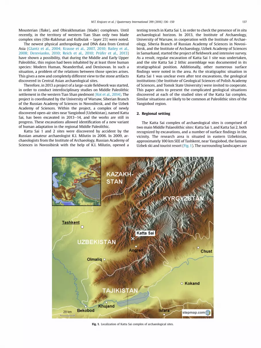
Fig. 1. Localization of Katta Sai co
testing trench in Katta Sai 1, in order to check the presence of in situarchaeological horizon. In 2013, the Institute of Archaeology,University of Warsaw, in cooperation with the Institute of Archae-ology, Siberia Branch of Russian Academy of Sciences in Novosi-birsk, and the Institute of Archaeology, Uzbek Academy of Sciencesin Samarkand, started the project of fieldwork and intensive survey.As a result, regular excavation of Katta Sai 1 site was undertaken,and the site Katta Sai 2 lithic assemblage was documented in itsstratigraphical position. Additionally, other numerous surfacefindings were noted in the area. As the stratigraphic situation inKatta Sai 1 was unclear even after test excavations, the geologicalinstitutions (the Institute of Geological Sciences of Polish Academyof Sciences, and Tomsk State University) were invited to cooperate.This paper aims to present the complicated geological situationsdiscovered at each of the studied sites of the Katta Sai complex.Similar situations are likely to be common at Paleolithic sites of theYangiobod region.
2. Regional setting
The Katta Sai complex of archaeological sites is comprised oftwomainMiddle Palaeolithic sites: Katta Sai 1, and Katta Sai 2, bothrecognized by excavations, and a number of surface findings in thevicinity. The research area is situated in eastern Uzbekistan,approximately 100 km SEE of Tashkent, near Yangiobod, the famousUzbek ski and tourist resort (Fig.1). The surrounding landscapes are
mplex of archaeological sites.
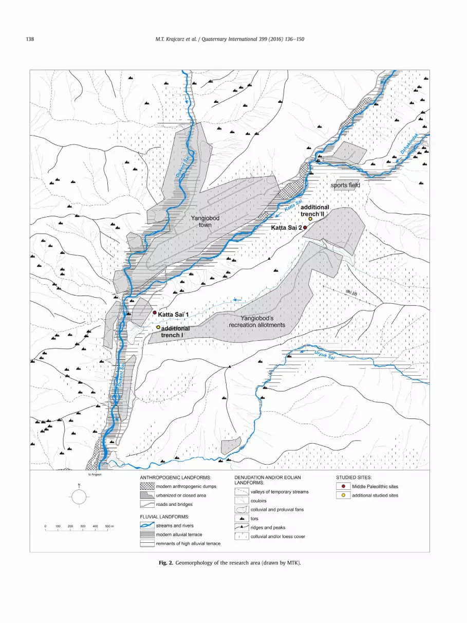
Fig. 2. Geomorphology of the research area (drawn by MTK).
M.T. Krajcarz et al. / Quaternary International 399 (2016) 136e150138
M.T. Krajcarz et al. / Quaternary International 399 (2016) 136e150 139
mid-to high-mountains, with the highest picks elevated over2500 m a.s.l., and river valleys with their bottoms situated at1200e1400 m a.s.l. The mountain massifs constitute the mostwestern part of Chatkal Ridge, representing the north-westernpiedmont of the Tian Shan mountains. Mounts and hills are builtof felsic intrusive and volcanic rocks (Nalivkin, 1957), partiallycovered by eolian, colluvial, and proluvial and deluvial deposits(Gorodeckaya et al., 1960).
Katta Sai 1 is situated on the western slope of elongated hill, atthe altitude of about 1310 m a.s.l. (41�06049.700N, 70�05028.200E),
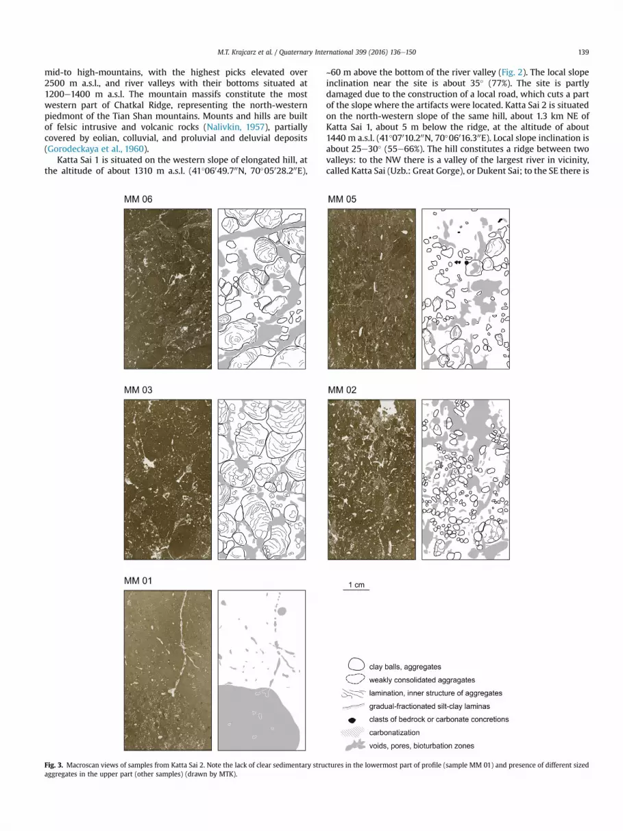
Fig. 3. Macroscan views of samples from Katta Sai 2. Note the lack of clear sedimentary struaggregates in the upper part (other samples) (drawn by MTK).
~60 m above the bottom of the river valley (Fig. 2). The local slopeinclination near the site is about 35� (77%). The site is partlydamaged due to the construction of a local road, which cuts a partof the slope where the artifacts were located. Katta Sai 2 is situatedon the north-western slope of the same hill, about 1.3 km NE ofKatta Sai 1, about 5 m below the ridge, at the altitude of about1440 m a.s.l. (41�07010.200N, 70�06016.300E). Local slope inclination isabout 25e30� (55e66%). The hill constitutes a ridge between twovalleys: to the NW there is a valley of the largest river in vicinity,called Katta Sai (Uzb.: Great Gorge), or Dukent Sai; to the SE there is
ctures in the lowermost part of profile (sample MM 01) and presence of different sized
M.T. Krajcarz et al. / Quaternary International 399 (2016) 136e150140
a high valley of a relatively small, ephemeral stream. The junction ofthese two valleys is situated below Katta Sai 1 (Fig. 2). The hill isfelsic intrusive rock, with veins of porphyry. Bedrock is exposedonly at the top of the ridge, and locally at the steep NE slope. Theother parts, including the areas of both sites, are covered by siltyloamwith sparse clasts of bedrock. In some places the silty loam isunderlain by colluvial debris, which can be observed in landslideson the NE slope. On the lower parts of the slopes, coarse alluvialgravels occur.
3. Material and methods
3.1. Archaeological excavation
The archaeological excavation of the Katta Sai 1 site was con-ducted in a meter network system. To date, the excavated areacovered 27 m2, although different depths were achieved inparticular square meters. The archaeological material was collected
Fig. 4. Microphotographs of chosen sedimentary and postsedimentary features preserved iCarbonate precipitations, sample MM14; note that precipitations may fill the voids (lower ligneous rock; (b) e silteclay laminas with gradual fractionation, sample MM13; note the prloose sediment; (c) e clay balls dispersed in loose sediment, sample MM13; (d, e) e zones oclay balls, sample MM12; (f) e clay balls with hollows inside, sample MM05; note the compconcentric laminas of lighter and darker sediment are visible; (i) e inner structure of mid-
during the exploration of sediments by 10 cm thick horizontalmechanical layers. The sediments were water sieved to collect fineartifacts and paleontological remains. Additionally, from eachexploration layer a malacological sample was sieved with use of0.5 mm mesh. During the fieldwork, a detailed documentation ofthe three-dimensional position of all the finds was conducted withthe use of geodetic equipment (tacheometer), ensuring the accu-racy of 1.0 cm. It also allowed establishment of their relative loca-tion in the geological layers, and their position in space. Theinclination of each artifact was also measured by clinometer. Afterthe discovery of Katta Sai 2 site, a small (3 m2) testing trench wasopened there. It was excavated using similar methods as for KattaSai 1, although sieved malacological samples were not taken.
3.2. Geological investigation
Additional sounding trenches were dug in the vicinity of bothsites, in order to check the variability of geological structure (Fig. 2).
n Katta Sai sediments. PPL e planar-polarized light, XPL e cross-polarized light. (a) eeft) or surround them (upper right); the white angular spot in the middle is a clast ofesence of bigger clast that formed an obstacle for sediment movement and presence off loose silt sediment with sparse clay balls and zones of dense sediment with multipleosite inner structure of balls; (g, h) e inner structure of bigger clay ball, sample MM05;sized clay ball, sample MM05 (drawn by MTK).
M.T. Krajcarz et al. / Quaternary International 399 (2016) 136e150 141
Trench I was situated 120 m SSE of the Katta Sai 1 archaeologicalmain trench, on the steep slope built of silty loam, at the oppositeside of the stream (41�06046.000N, 70�05030.000E), at the elevation of~1315 m a.s.l. Trench II was situated 55 m NE of the Katta Sai 2trench, on the same slope (41�07011.600N, 70�06017.600E), at theelevation of ~1410 m a.s.l.
Walls and bottoms of the archaeological and additional trencheswere accessible for geological investigation in the field. The visiblesedimentary structures (such as: boundaries of strata, bedding,lamination), as well as the post-sedimentary features (such as:traces of bioturbation, cracks and fissures, discontinuity of sedi-mentary structures), were described, hand drawn, and photo-graphed. The basic lithological parameters were detailed,including: color, soil texture, soil structure, reaction with 10% HCl.Layers (strata) were distinguished as archaeological excavationprogressed, with basic field lithological criteria: changes in sedi-mentary structures, soil texture and structure, color, and intensityof bioturbation. The same procedure was used for additionaltrenches.
To investigate the micromorphology, 14 standard samples werecollected in 2014 from the walls of Katta Sai 1 and Katta Sai 2trenches. Due to many burrows and cracks, only limited areas wereavailable for sampling. The position of samples is presented inSupplement 1. In the laboratory, the samples were dried, impreg-nated with resin, cut into small slabs of ~1 cm thickness, glued onto4.5 � 8 cm basal glass slides and polished to 30 mm thin sections.The sections were observed under a petrographic microscope, with5�, 10� and 20� magnitudes, and digital image-acquiring camera.The occurrence of mineral grains, biological elements, microstruc-ture, fabric, and presence of bioturbation traces were analyzed,according to the methods elaborated by Stoops et al. (2010).
Altogether, 51 small (~15 g each) samples of sediments weretaken from Katta Sai 1 profile in 2013, and additional 16 samples in2014. Every sample was divided into 3 sub-samples, and one serieswas analyzed for grain size, the second for CaCO3 content, and thethird for chemical composition. The grain size analysis was per-formed in the Department of Geoecology and Palaeogeography,Maria Curie-Skłodowska University in Lublin, on a Malvern Mas-tersizer 2000 laser diffractometer with HydroG adapter. The pro-cedure followed the methodology presented by Antoine et al.(2013). The 2, 4, 5.5, 16, 32 and 63 mm fraction bounds were used,where fraction up to 5.5 mm represents the content of colloidal clayaccording to the older methods (Konert and Vandenberghe, 1997).The index of standard deviation is presented in accordancewith theproposal of Folk and Ward (1957) used in statistical research ofclastic sediment grain size. The CaCO3 content was analyzed withthe Scheibler method, in the same department. The chemicalcomposition was established with the use of ICP-MS, after multi-acid digestion in AcmeLabs, Vancouver, Canada.
3.3. Dating
Due to traces of slope processes andmass movements, as well asbioturbation structures noticed on almost the entire profiles,sampling for luminescence dating was difficult. Only a small part oflayer 2b in Katta Sai 2 trench seemed to represent undisturbedsediment, so a standard TL sample could be collected. The annualdose was established with gamma spectrometry, and performed ona Polon-Izot gamma spectrometer with Mazar scintillationaugment in the Institute of Geography, University of Gda�nsk.Equivalent dose was established on the 63e80 mm polymineralfraction, after 10% HCl and 30% H2O2 washing and UV opticalleaching. The samples were irradiated with 20 Gy, 50 Gy, 100 Gy,200 Gy dozes from 60Co gamma source, and heated in 140 �C for 3 h.The registration of curves was performed on RA'94 (Mikrolab)
thermoluminescence reader, coupled with EMI 9789 QA photo-multiplier. The TL age was calculated according to Frechen (1992).The detailed description of dating procedure is presented inSupplement 2.
Eleven terrestrial snail shells from layers 4b and 4c of Katta Sai 1site were joined together, to achieve a sufficient sample, which wasdirected to U-series dating performed in the Institute of GeologicalSciences, Polish Academy of Sciences, Warsaw. Each shell was toosmall for dating. After the initial chemical treatment, uranium andthoriumwere separated in chromatographic columnwith a Dowex1x8 ion exchanger and electrodeposited on steel disks. Activitymeasurements of uranium and thorium were performed onOCTETE-PC (prod. EGandG ORTEC) alpha spectrometer, allowingcalculation of the isotope ratios of 234U/238U, 230Th/234U,230Th/232Th, and the uranium concentration. The age was calcu-lated according to Gorka and Hercman (2002). Detailed descriptionof procedure is presented in Supplement 2.
3.4. Subfossil fauna
During the malacological analysis, shells collected directly fromthe trench, as well as those acquired in course of wet-sieving of thedeposits on 0.5 mm mesh, were investigated. After maceration, allmollusc shells and their fragments were collected from driedresiduum. The material was identified under a stereoscopic mi-croscope in magnifications up to 64�. Some of the shell fragmentswere considered as unidentifiable, but all molluscs were counted.Nomenclature after Sysoev and Schileyko (2009) was applied. Thelow frequency of shell material from Katta Site excluded quanti-tative methods proposed in previous studies (Lo�zek, 1964;Alexandrowicz, 1987; Alexandrowicz and Alexandrowicz, 2011).
4. Results
4.1. Archaeological material
The stratigraphic situation of the Katta Sai 1 site is quitecomplicated, due to its location on the slope. In the upper layers,single pieces of ceramics and burned clay were found. Single lithicartifacts may be connected with this horizon, but morphotechno-logically they resemble the lithic assemblage found below. Theceramics was ascribed to the widely understood Late Bronze AgeAndronovska culture, dated to XXVeXIII and XIIIeXI c. BC,respectively. Approximately 1.0e1.5 m below this level, a quitedense concentration of Middle Palaeolithic artifacts was found. Allthe artifacts were found in a single horizon, and gave a number ofrefittings. Dense horizon of artifacts shows distinctive inclination,following the inclination of stratigraphical layers. At Katta Sai 1, atotal of 416 Middle Paleolithic stone artifacts were excavated. Thepreliminary archaeological description of the assemblage waspresented by Kot et al. (2014).
At Katta Sai 2, only 6 lithic artifacts were excavated, and 10morewere found re-deposited on the road below the site. The techno-logical and rawmaterial analyses of the lithics from both sites are inprocess, and the detail description of assemblages will be presentedin a separate publication.
Within the inventory of Katta Sai 1, one can findmainly debitagecoming from all the manufacturing stages, starting from largedecortication flakes, or even opening flakes, and ending on theblanks and scarce tools. Over 40% of the inventory consists ofdecortication flakes and core preparation spalls, coming from thefirst stages of the manufacturing process, which could suggest theworkshop character of the site. As the raw material, the stoneknappers used river pebbles, brought mostly from the nearby rivergorge. Among the raw material, mainly effusive rocks were
M.T. Krajcarz et al. / Quaternary International 399 (2016) 136e150142
selected. The use of rounded river pebbles restricted themanufacturing process heavily.
4.2. Geological sequences
The description of geological profiles uncovered in Katta Saitrenches is presented. The hand drawings of the particular profilesare also available in Supplement 1, together with their position inthe area shown there.
4.2.1. Katta Sai 1 e archaeological trenchesIn Katta Sai 1, eleven profiles were documented (Supplement 1).
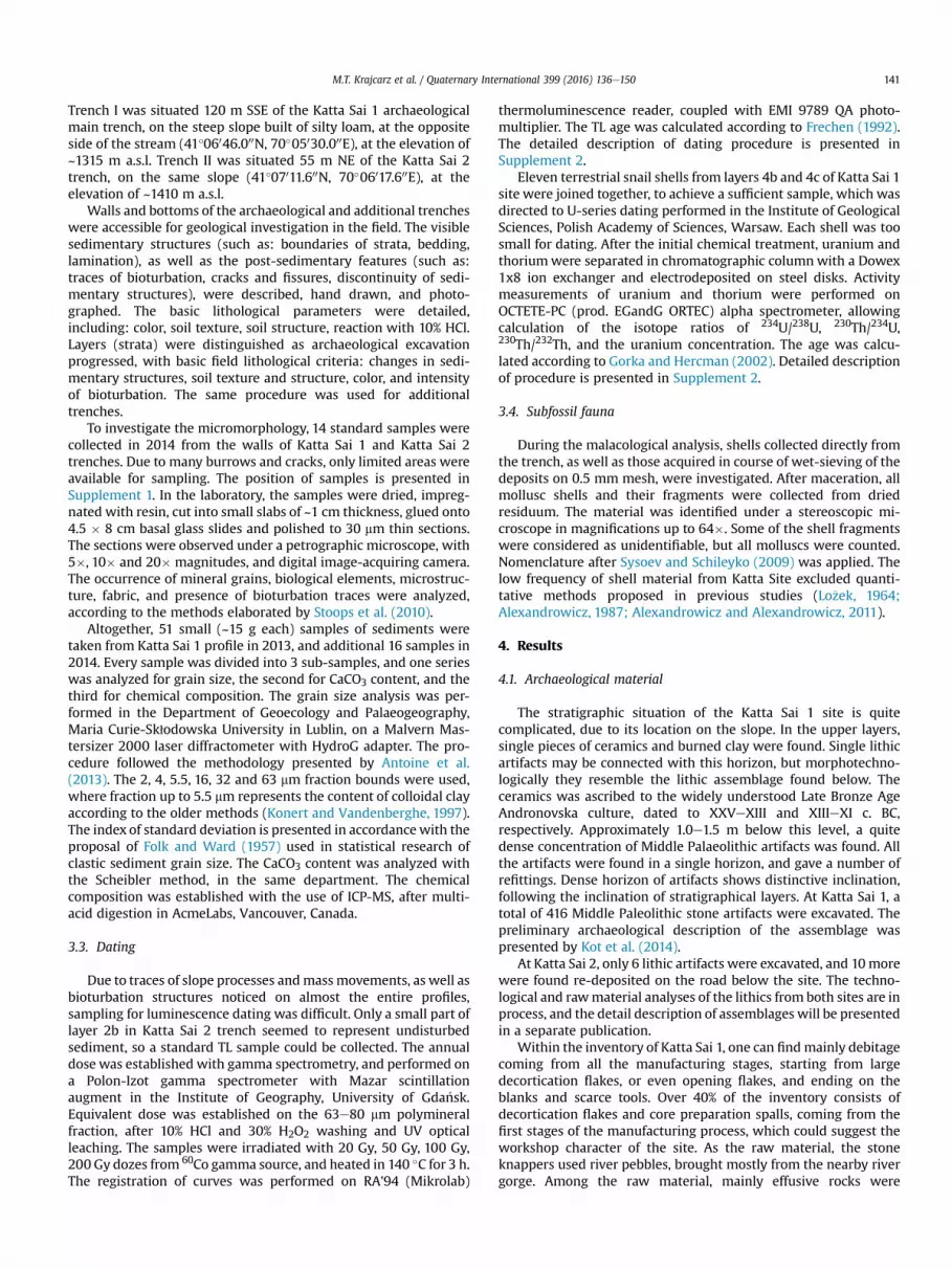
On the southern profile of square meters K/6,7,8, running along theslope, six weakly diversified layers were distinguished. Thelowermost layer 6 is the most distinct, as it consists of sand andgravel. This layer corresponds well to the remnants of high alluvialterrace, visible on the slope below the site, and which occurs also inanother parts of the valley (see Fig. 3). This layer is covered by theover 1.5 m thick brownish layer 5, a weakly laminated, silty sedi-ment with intercalations of sand in its lower part. Micromorpho-logical observations revealed intensive bioturbation andcarbonates' precipitation in this sediment (Fig. 4). The upperboundary is sharp, and numerous erosional rills are cut in layer 5.The largest of them are 2.5 mwide and at least 75 cm deep (Fig. 5).Rills are filled with the material of layer 4 (sublayer 4c), a siltysediment, rich in Paleolithic artifacts and subfossil snail shells.Numerous clay balls and laminas with gradual fractionation occurin microscope images of the basal part of this sublayer. Upward, the
Fig. 5. Geological cross-sections of the site Katta Sai 1 (trench K/6,7,8) (drawn by MTK, SL). E4c, containing the Paleolithic artifacts. Flame structures and clasts of layer 5 inside the rill filayer 4c indicates that rill erosion ceased and the rills became covered with silty material,
clay balls disappear and are replaced by rounded aggregates andweakly marked lamination. The overlaying sublayer 4b is similar interms of color and texture, but contains carbonate concretions andthe sediment consists of numerous aggregates of 1e5 cm size andirregular shape. Aggregates are built of finer and darker sedimentthan the surrounding matrix, many of them revealing theconcentric “onion” structure. Only isolated Paleolithic artifactswere found in this layer. The boundary between sublayers 4c and4b is indistinct. Sublayer 4a is similar in terms of soil texture, but itis strongly bioturbated, mainly by small burrows of soil dwellinginsects. The sequence is topped with artificially disturbed sedi-ments and recent soil (layers 3, 2 and 1). Inclination of layers isSSW, except layer 1, which exhibits W inclination, the same incli-nation as the modern slope surface.
4.2.2. Additional trench IThe base of profile is brownish silt, at least 3 m thick, similar to
layer 5 fromKatta Sai 1. The upper boundary is sharp, erosional, andcovered with sediment analogous to layer 4b from Katta Sai 1, builtof numerous loamy aggregates. The upper part of the profile isdisturbed by bioturbation. No Palaeolithic artifacts were found inthis trench.
4.2.3. Katta Sai 2 e archaeological trenchThe S and E profiles of the trench were investigated, 3 and 1 m
wide and 4 m deep (Supplement 1). The sequence was divided intosix weakly differentiated layers. The basal sediment of layer 4b ismassive yellowish silt, revealing under a microscope numerous
rosional rill is visible at WE cross-section, cut in layer 5 and filled with material of layerlling indicate the high energy flow. Lack of sedimentary structures in the upper part ofdeposited in relatively low-energy environment.
M.T. Krajcarz et al. / Quaternary International 399 (2016) 136e150 143
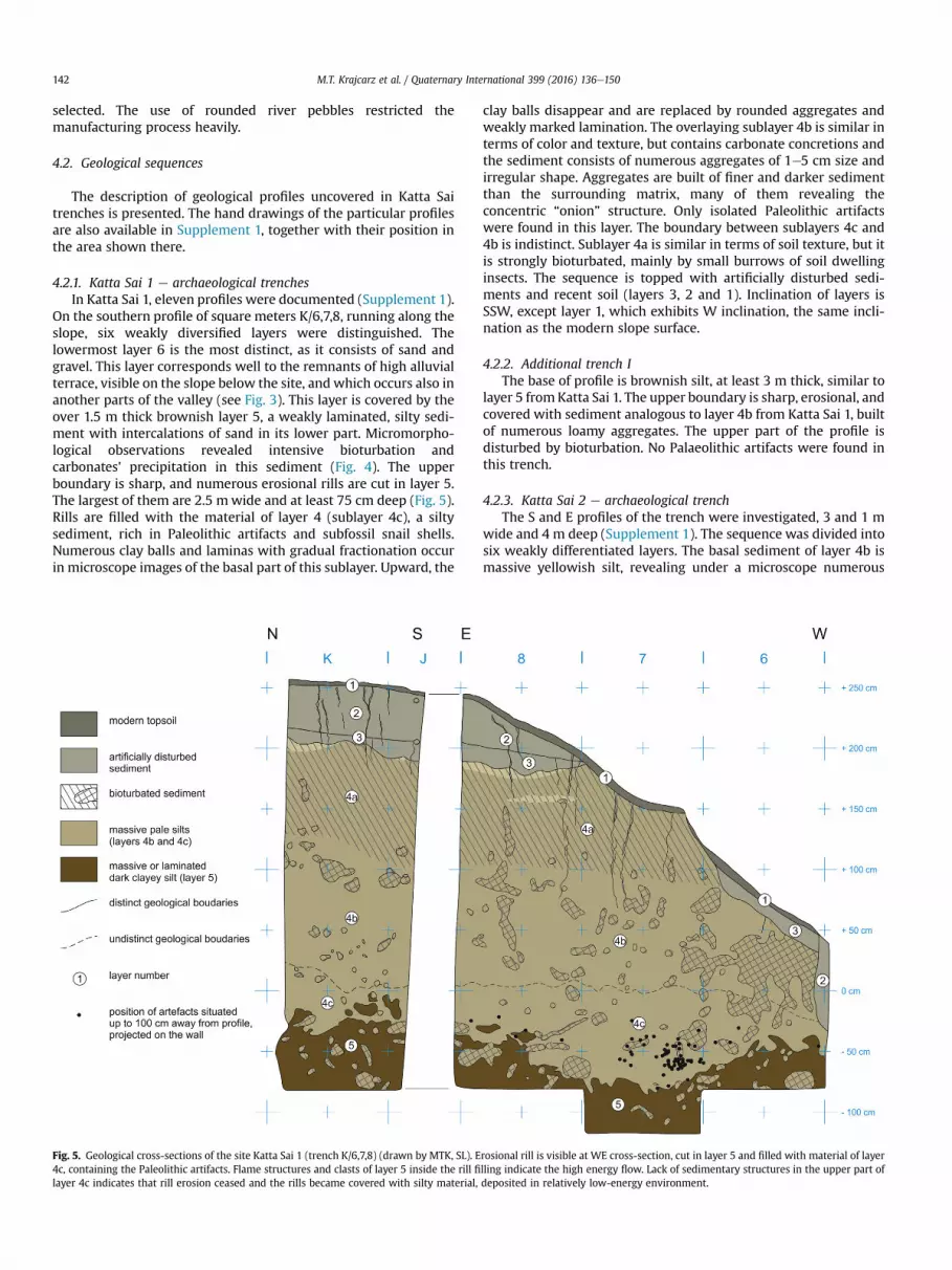
small (few mm to 1 cm) aggregates (Fig. 6). This sediment wasuncovered only in an area of 0.25 m2, and there was no possibilityto deepen the trench, due to the risk of road damage. Layer 4aconsists of numerous irregular or rounded loamy aggregates of1.0e5.0 cm, similar to the ones observed in sublayer 4b from KattaSai 1. Palaeolithic artifacts and mollusc shells were found in thislayer. Layer 3 is slightly darker sediment, with aggregates notvisible with a naked eye, but recognizable through microscopicobservation. In the uppermost part of layer 3 and layer 2b, theaggregates are bigger and more numerous (Fig. 6). Boundaries be-tween all layers are fuzzy and unclear. The upper part of the profileis strongly disturbed by bioturbation. All layers exhibit inclinationtoward NW, parallel to the modern slope surface.
4.2.4. Additional trench IIThe lower part of the profile is laminated, brownish sediment,
similar to layer 5 from Katta Sai 1, both in terms of macro- andmicro-features. The upper boundary is clear, sharp, parallel to thedirection of lamination, covered with silty sediment containingnumerous aggregates, analogous to the ones observed in layer 4afrom Katta Sai 2, and sublayer 4b from Katta Sai 1. Upward theaggregates become more rare and disappear above 1 m above theerosional boundary. No Paleolithic artifacts were found here, butmollusc shells were abundant both in the sediment with aggre-gates, and in the sediment above it.
Fig. 6. Macroscan views of samples from Katta Sai 1, revealing the strong bioturbated sedmentary structures in layer 4c (samples MM 12 and MM 13) connected to geological transpoThe material of layer 5 in sample MM 13 crumbled during slide preparation (drawn by MT
4.3. Grain size analysis
The results of grain size analysis are presented in Supplement 3.The dominant fraction is silt, and the average grain size is in therange of 15e50 mm (Fig. 7). The sand fraction has the biggestfluctuations in the distribution, and it changes abruptly from traceto more than 40%. Clay fraction (up to 5.5 mm) demonstrates thesmallest changes. Changes in the share of clay and sand fractionsare reversed. These deposits are very poorly sorted, the standarddeviation exceeding 1.8 in each case.
4.4. Geochemistry
The amount of major and trace elements is typical for loess-paleosol sediments (for example: Boguckyj et al., 2009). The dis-tribution of some elements exhibits important changes in theprofile, which suggests the presence of weathering/pedogenic ho-rizons. The results of geochemical analyses are presented inSupplement 3 (see also Fig. 7).
4.5. Dating
The TL dating procedure enabled estimation of age of layer 2bfrom Katta Sai 2 to 26.3 ± 3.4 ka (Table 1). The U-series procedurerevealed unusually high uranium content (Table 2), which suggests
iment in upper part of profile (sample MM 11). Note the presence of numerous sedi-rt down the slope, and lack of clear sedimentary structures in layer 5 (sample MM 14).K).
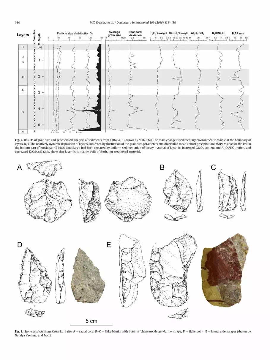
Fig. 7. Results of grain size and geochemical analysis of sediments from Katta Sai 1 (drawn by MTK, PM). The main change is sedimentary environment is visible at the boundary oflayers 4c/5. The relatively dynamic deposition of layer 5, indicated by fluctuation of the grain size parameters and diversified mean annual precipitation (MAP), visible for the last inthe bottom part of erosional rill (4c/5 boundary), had been replaced by uniform sedimentation of loessy material of layer 4c. Increased CaCO3 content and Al2O3/TiO2 ration, anddecreased K2O/Na2O ratio, show that layer 4c is mainly built of fresh, not weathered material.
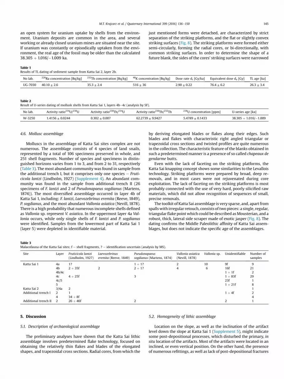
Fig. 8. Stone artifacts from Katta Sai 1 site. A e radial core; BeC e flake blanks with butts in ‘chapeaux de gendarme’ shape; D e flake point; E e lateral side scraper (drawn byNatalya Vavilina, and MKr).
M.T. Krajcarz et al. / Quaternary International 399 (2016) 136e150144
M.T. Krajcarz et al. / Quaternary International 399 (2016) 136e150 145
an open system for uranium uptake by shells from the environ-ment. Uranium deposits are common in the area, and severalworking or already closed uraniummines are situated near the site.If uranium was constantly or episodically uptaken from the envi-ronment, the real age of the fossil may be older than the calculated38.305 þ 1.016/�1.009 ka.
Table 1Results of TL dating of sediment sample from Katta Sai 2, layer 2b.
No lab. 226Ra concentration [Bq/kg] 232Th concentration [Bq/kg] 40K concentration [Bq/kg] Dose rate dr [Gy/ka] Equivalent dose de [Gy] TL age [ka]
UG-7030 40.10 ± 2.6 35.3 ± 2.4 516 ± 36 2.90 ± 0.22 76.4 ± 6.2 26.3 ± 3.4
Table 2Result of U-series dating of mollusk shells from Katta Sai 1, layers 4be4c (analysis by SF).
No lab. Activity ratio234U/238U Activity ratio230Th/234U Activity ratio230Th/232Th 238U concentration [ppm] U-series age [ka]
W-3250 1.4156 ± 0.0244 0.302 ± 0.007 62.2739 ± 9.9427 5.4789 ± 0.1433 38.305 þ 1.016/�1.009
4.6. Mollusc assemblage
Molluscs in the assemblage of Katta Sai sites complex are notnumerous. The assemblage consists of 4 species of land snails,represented by a total of 106 specimens preserved in whole, and251 shell fragments. Number of species and specimens in distin-guished horizons varies from 1 to 3, and from 2 to 31, respectively(Table 3). Themost abundant communitywas found in sample fromthe additional trench I, but it comprises only one species e Fruti-cicola lantzi (Lindholm, 1927) (Supplement 4). An abundant com-munity was found in the sample from additional trench II (26specimens of F. lantzi and 2 of Pseudonapaeus sogdianus (Martens,1874)). The most diversified assemblage occurred in layer 4b ofKatta Sai 1, including: F. lantzi, Laevozebrinus eremita (Reeve, 1849),P. sogdianus, and the most abundant Vallonia asiatica (Nevill, 1878).There is a high probability that numerous incomplete shells definedas Vallonia sp. represent V. asiatica. In the uppermost layer 4a Val-lonia occurs, while only single shells of F. lantzi and P. sogdianuswere identified. Samples from the lowermost part of Katta Sai 1(layer 5) were depleted in identifiable material.
Table 3Malacofauna of the Katta Sai sites; f e shell fragments, ? e identification uncertain (analysis by MS).
Site Layer Fruticicola lantzi(Lindholm, 1927)
Laevozebrinuseremita (Reeve, 1849)
Pseudonapaeussogdianus (Martens, 1874)
Vallonia asiatica(Nevill, 1878)
Vallonia sp. Unidentifiable Number ofsamples
Katta Sai 1 4a 1? 1 þ 1? 2 10 9f 94b 2 þ 35f 2 2 þ 1? 4 6 16f 214b/4c 1 þ 1f 24c 4 þ 25f 3 1 þ 83f 294c/5 23f 15 1 þ 21f 8
Katta Sai 2 3/4a 2 1Additional trench I 2 1 1 þ 4f 2
4 34 þ 8f 4Additional trench II 2 26 þ 46f 2 2 1
5. Discussion
5.1. Description of archaeological assemblage
The preliminary analyses have shown that the Katta Sai lithicassemblage involves predetermined flake technology, focused onobtaining the relatively thin flakes and blades of the elongatedshapes, and trapezoidal cross sections. Radial cores, fromwhich the
just mentioned forms were detached, are characterized by strictseparation of the striking platforms, and the flat or slightly convexstriking surfaces (Fig. 8). The striking platforms were formed eithersemi-circularly, forming the radial cores, or bi-directionally, withcommon striking surfaces. In order to determine the shape of afuture blank, the sides of the cores' striking surfaces were narrowed
by deriving elongated blades or flakes along their edges. Suchblades and flakes with characteristic right angled triangular ortrapezoidal cross sections and twisted profiles are quite numerousin the collection. The characteristic feature of the blanks obtained insuch a predeterminedmanner is a presence of so called chapeaux degendarme butts.
Even with the lack of faceting on the striking platforms, theKatta Sai knapping concept shows some similarities to the Levalloistechnology. Striking platforms were prepared by broad, deep re-movals, and in most cases were not rejuvenated during coreexploitation. The lack of faceting on the striking platforms is mostprobably connected with the use of very hard, poorly silicified rawmaterials, which did not allow recognition of sequences of small,precise removals.
The toolkit of Katta Sai assemblage is very sparse, and, apart fromspallswith irregular retouch, consists of twopieces: a single, regular,triangularflake pointwhich could be described asMousterian, and arobust, thick, lateral side scraper made of exotic jasper (Fig. 8). Thedating confirms the Middle Paleolithic affinity of Katta Sai assem-blages, but does not indicate the specific age of the assemblages.
5.2. Homogeneity of lithic assemblage
Location on the slope, as well as the inclination of the artifactlevel down the slope at Katta Sai 1 (Supplement 5), might indicatesome post-depositional processes, which disturbed the primary, insitu location of the artifacts. Most of the artifacts were located in aninclined, or even vertical position. On the other hand, the presenceof numerous refittings, as well as lack of post-depositional fractures
M.T. Krajcarz et al. / Quaternary International 399 (2016) 136e150146
or damage on the artifacts' surfaces and especially along theiredges, might indicate that the post-depositional transportationwasneither too distant, nor too intensive. The consistency of theassemblage was confirmed by technological analyses, which haveshown the unified knapping concept within the whole assemblage.
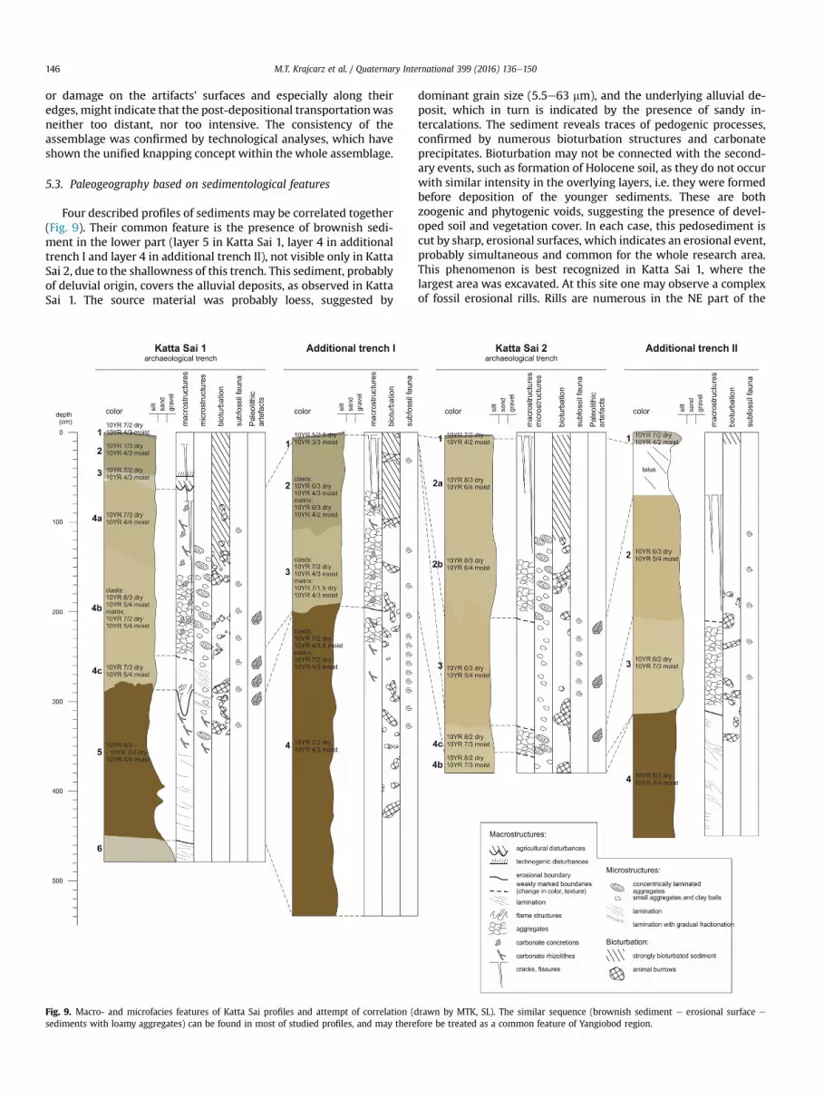
5.3. Paleogeography based on sedimentological features
Four described profiles of sediments may be correlated together(Fig. 9). Their common feature is the presence of brownish sedi-ment in the lower part (layer 5 in Katta Sai 1, layer 4 in additionaltrench I and layer 4 in additional trench II), not visible only in KattaSai 2, due to the shallowness of this trench. This sediment, probablyof deluvial origin, covers the alluvial deposits, as observed in KattaSai 1. The source material was probably loess, suggested by
Fig. 9. Macro- and microfacies features of Katta Sai profiles and attempt of correlation (dsediments with loamy aggregates) can be found in most of studied profiles, and may there
dominant grain size (5.5e63 mm), and the underlying alluvial de-posit, which in turn is indicated by the presence of sandy in-tercalations. The sediment reveals traces of pedogenic processes,confirmed by numerous bioturbation structures and carbonateprecipitates. Bioturbation may not be connected with the second-ary events, such as formation of Holocene soil, as they do not occurwith similar intensity in the overlying layers, i.e. they were formedbefore deposition of the younger sediments. These are bothzoogenic and phytogenic voids, suggesting the presence of devel-oped soil and vegetation cover. In each case, this pedosediment iscut by sharp, erosional surfaces, which indicates an erosional event,probably simultaneous and common for the whole research area.This phenomenon is best recognized in Katta Sai 1, where thelargest area was excavated. At this site one may observe a complexof fossil erosional rills. Rills are numerous in the NE part of the
rawn by MTK, SL). The similar sequence (brownish sediment e erosional surface e
fore be treated as a common feature of Yangiobod region.
M.T. Krajcarz et al. / Quaternary International 399 (2016) 136e150 147
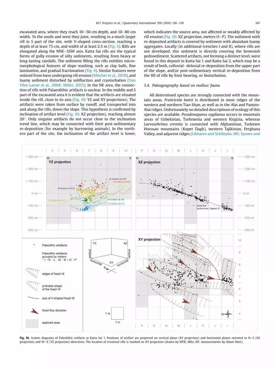
excavated area, where they reach 10e50 cm depth, and 10e80 cmwidth. To the south and west they joint, resulting in a much largerrill in S part of the site, with V-shaped cross-section, reaching adepth of at least 75 cm, and width of at least 2.5 m (Fig. 5). Rills areelongated along the NNEeSSW axis. Katta Sai rills are the typicalforms of gully erosion of silty sediments, resulting from heavy orlong-lasting rainfalls. The sediment filling the rills exhibits micro-morphological features of slope washing, such as clay balls, finelamination, and gradual fractionation (Fig. 4). Similar features werenoticed from loess undergoing rill erosion (Mücher et al., 2010), andloamy sediment disturbed by solifluction and cryoturbation (VanVliet-Lano€e et al., 2004; Miller, 2015). In the NE area, the connec-tion of rills with Palaeolithic artifacts is unclear. In the middle and Spart of the excavated area it is evident that the artifacts are situatedinside the rill, close to its axis (Fig. 10: YZ and XY projections). Theartifacts were taken from surface by runoff, and transported intoand along the rills, down the slope. This hypothesis is confirmed byinclination of artifact level (Fig. 10: XZ projection), reaching almost20�. Only singular artifacts do not occur close to the inclinationtrend line, which may be connected with their post-sedimentaryre-deposition (for example by burrowing animals). In the north-ern part of the site, the inclination of the artifact level is lower,
Fig. 10. Scatter diagrams of Paleolithic artifacts at Katta Sai 1. Positions of artifact are prprojection) and WeE (YZ projection) directions. The location of erosional rills is marked on
which indicates the source area, not affected or weakly affected byrill erosion (Fig. 10: XZ projection, meters OeP). The sediment withre-deposited artifacts is covered by sediment with abundant loamyaggregates. Locally (in additional trenches I and II), where rills arenot developed, this sediment is directly covering the brownishpedosediment. Scattered artifacts, not forming a distinct level, werefound in this deposit in Katta Sai 1 and Katta Sai 2, which may be aresult of both, colluvialedeluvial re-deposition from the upper partof the slope, and/or post-sedimentary vertical re-deposition fromthe fill of rills by frost heaving, or bioturbation.
5.4. Paleogeography based on mollusc fauna
All determined species are strongly connected with the moun-tain areas. Fruticicola lantzi is distributed in most ridges of thewestern and northern Tian Shan, as well as in the Alai and Pamiro-Alai ridges. Unfortunately no detailed descriptions of ecology of thisspecies are available. Pseudonapaeus sogdianus occurs in mountainareas of Uzbekistan, Turkmenia and western Kirgizia, whereasLaevozebrinus eremita is connected with Afghanistan, TurkmenHorosan mountains (Kopet Dagh), western Tajikistan, FerghanaValley, and adjacent ridges (Likharev and Schileyko, MS; Sysoev and
ojected on vertical plane (XY projection) and horizontal planes oriented to NeS (XZXY projection (drawn by MTK, MKo, KP; measurements by Adam Mart).
M.T. Krajcarz et al. / Quaternary International 399 (2016) 136e150148
Schileyko, 2009). Their western boundary covers the Kopet DaghMountains of Turkmenistan (Starobogatov, 1994). Both speciesinhabit gravel and rocky scree (Starobogatov, 1994). In addition,Laevozebrinus eremita may have some stratigraphical significance,as Meng (2004) describes Pseudonapaeus eremita (Benson,1849) ¼ Laevozebrinus eremita (Reeve, 1849), from loess depositscorrelated with interstadials and rather mild glacial phases of thelast glaciation. Recent L. eremita also occurs in Central Asia (Sysoevand Schileyko, 2009), but its possible connection with milderglacial episodes would allow the estimation of the climatic condi-tions of the shell accumulation. Vallonia asiatica has been found inArmenia, Afghanistan and the mountains of Central Asia (Gerber,1996; Sysoev and Schileyko, 2009). Meng (2004) described itfrom Pleistocene deposits of Tajikistan among an assemblagetypical of rather dry glacial phases. Its occurrence was graduallylimited in interstadials and glacial/interglacial transitions.
If Laevozebrinus eremita is synonymous with Pseudonapaeuseremita, rather cool conditions can be inferred from the molluscanassemblage from the Katta Sai. The correlation with the last glaci-ation seems more than probable.
Snails occurring in the sediment that fills the erosional rill(F. lantzi and P. sogdianus), distributed in this sediment togetherwith the artifacts, represent the period of Palaeolithic human ac-tivity with high probability. These species are recently present inCentral Asia, which suggests that the climatic and ecological con-ditions during the Palaeolithic occupation were similar to themodern ones. The same spectrum is observed also in the brownishpedosediment, indicating the long-lasting period of stable climate.However, in the overlying sediments the mollusc spectrum isdifferent, with significant presence of V. asiatica, a species of dryenvironments.
5.5. Paleogeography based on geochemistry
In the Katta Sai 1 geochemically investigated profile, the con-centration of calcium exhibits distinct differences. As this elementin the soils is mainly connected with CaCO3, its content reflectscarbonate migration in the profile. Low Ca content in the upper-most part of layer 5, and oscillations inside this layer, indicates thecomplex pedogenic history, ending with soil formation, andeluviation of Ca. This observation corresponds well with micro-morphological features and paleontological conclusions. Thedistinct second episode of calcium eluviation is recorded in theuppermost part of the profile, andmay be linked with the Holocenesoil formation. This event is linked to the Ca-illuviation horizon,recorded in layer 4b as increased Ca content, and the presence ofcarbonate concretions.
Several geochemical indicators based on elementary composi-tion of sediment are used for estimation of weathering intensity, i.e.the ratio of the concentration of the components sensitive forweathering to fairly resistant ones (e.g. Al2O3/TiO2 ratio; Zhang andFrost, 2002). Moreover, the intensity of pedogenesis may be illus-trated by the variations in the concentration ratios of the relativelymore to the relatively less mobile elements (e.g. Rb/Sr and Sr/Ba;Gallet et al., 1996, 1998; Zhang and Frost, 2002). Lower values ofthese ratios reflect strong weathering and/or high mobility ofparticular element in the soil, related tomore advanced weatheringand/or pedogenesis. In Katta-Sai, the usage of Rb/Sr and Sr/Ba ratiosis ineffective due to high concentration and high mobility of Ca.Barium and especially strontium are geochemically related withcalcium, and therefore their dissolution/precipitation processes arecontrolled more by Ca2þ activity in the profile than by climate. Inthis case, the Al2O3/TiO2 ratio is a better paleoweathering indicator,and it suggests the most advanced alteration of material in layer 5of Katta Sai 1, and also in the uppermost part of the profile.
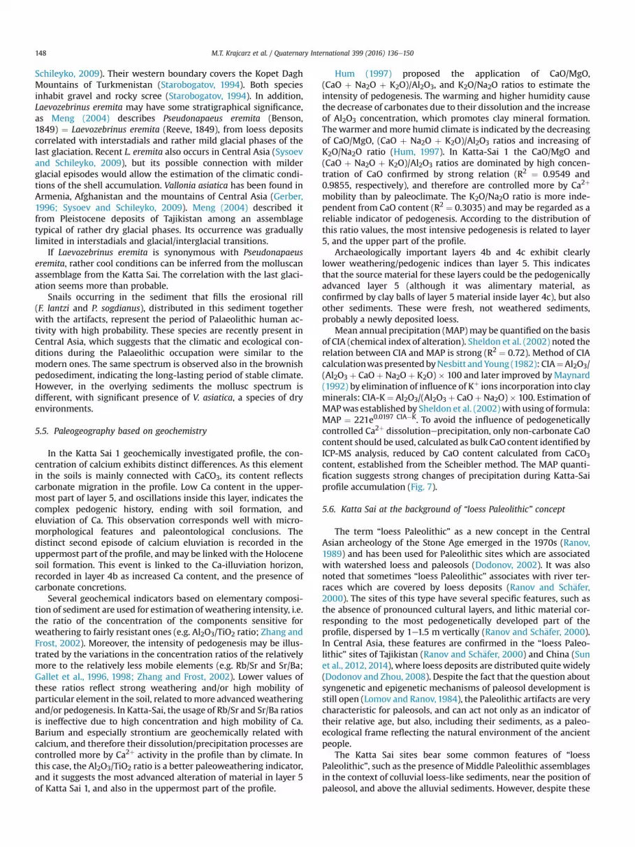
Hum (1997) proposed the application of CaO/MgO,(CaO þ Na2O þ K2O)/Al2O3, and K2O/Na2O ratios to estimate theintensity of pedogenesis. The warming and higher humidity causethe decrease of carbonates due to their dissolution and the increaseof Al2O3 concentration, which promotes clay mineral formation.Thewarmer andmore humid climate is indicated by the decreasingof CaO/MgO, (CaO þ Na2O þ K2O)/Al2O3 ratios and increasing ofK2O/Na2O ratio (Hum, 1997). In Katta-Sai 1 the CaO/MgO and(CaO þ Na2O þ K2O)/Al2O3 ratios are dominated by high concen-tration of CaO confirmed by strong relation (R2 ¼ 0.9549 and0.9855, respectively), and therefore are controlled more by Ca2þ
mobility than by paleoclimate. The K2O/Na2O ratio is more inde-pendent from CaO content (R2 ¼ 0.3035) and may be regarded as areliable indicator of pedogenesis. According to the distribution ofthis ratio values, the most intensive pedogenesis is related to layer5, and the upper part of the profile.
Archaeologically important layers 4b and 4c exhibit clearlylower weathering/pedogenic indices than layer 5. This indicatesthat the source material for these layers could be the pedogenicallyadvanced layer 5 (although it was alimentary material, asconfirmed by clay balls of layer 5 material inside layer 4c), but alsoother sediments. These were fresh, not weathered sediments,probably a newly deposited loess.
Mean annual precipitation (MAP)may be quantified on the basisof CIA (chemical index of alteration). Sheldon et al. (2002) noted therelation between CIA and MAP is strong (R2 ¼ 0.72). Method of CIAcalculationwaspresentedbyNesbitt andYoung (1982): CIA¼Al2O3/(Al2O3 þ CaOþ Na2Oþ K2O) � 100 and later improved byMaynard(1992) by elimination of influence of Kþ ions incorporation into clayminerals: CIA-K¼ Al2O3/(Al2O3þ CaOþNa2O)� 100. Estimation ofMAPwas established by Sheldon et al. (2002)with using of formula:MAP ¼ 221e0.0197 CIA�K. To avoid the influence of pedogeneticallycontrolled Ca2þ dissolutioneprecipitation, only non-carbonate CaOcontent should be used, calculated as bulk CaO content identified byICP-MS analysis, reduced by CaO content calculated from CaCO3content, established from the Scheibler method. The MAP quanti-fication suggests strong changes of precipitation during Katta-Saiprofile accumulation (Fig. 7).
5.6. Katta Sai at the background of “loess Paleolithic” concept
The term “loess Paleolithic” as a new concept in the CentralAsian archeology of the Stone Age emerged in the 1970s (Ranov,1989) and has been used for Paleolithic sites which are associatedwith watershed loess and paleosols (Dodonov, 2002). It was alsonoted that sometimes “loess Paleolithic” associates with river ter-races which are covered by loess deposits (Ranov and Sch€afer,2000). The sites of this type have several specific features, such asthe absence of pronounced cultural layers, and lithic material cor-responding to the most pedogenetically developed part of theprofile, dispersed by 1e1.5 m vertically (Ranov and Sch€afer, 2000).In Central Asia, these features are confirmed in the “loess Paleo-lithic” sites of Tajikistan (Ranov and Sch€afer, 2000) and China (Sunet al., 2012, 2014), where loess deposits are distributed quitewidely(Dodonov and Zhou, 2008). Despite the fact that the question aboutsyngenetic and epigenetic mechanisms of paleosol development isstill open (Lomov and Ranov, 1984), the Paleolithic artifacts are verycharacteristic for paleosols, and can act not only as an indicator oftheir relative age, but also, including their sediments, as a paleo-ecological frame reflecting the natural environment of the ancientpeople.
The Katta Sai sites bear some common features of “loessPaleolithic”, such as the presence of Middle Paleolithic assemblagesin the context of colluvial loess-like sediments, near the position ofpaleosol, and above the alluvial sediments. However, despite these
M.T. Krajcarz et al. / Quaternary International 399 (2016) 136e150 149
similarities, the geoarchaeological investigations of Katta Sai sitesrevealed some other facts: 1) secondary position of artifacts due tore-deposition; 2) the commonness of the colluvial character ofsediments with artifacts; and 3) connection with recent-like mal-acofauna. The extent of these features in Uzbekistan and neighborterritories needs further research.
6. Conclusions
Technological analyses of the stone assemblage indicate that thePaleolithic inhabitants of Katta Sai used non-volumetric preferen-tial lithic technology similar to Levallois type technology, aimed atthe production of predetermined flattened flakes, points, andblades from well-prepared, radial cores. The retouched toolkit, inspite of a few spalls with irregular retouch, includes only theelongated triangular point, and the lateral side scraper. The maincharacteristics of Katta Sai lithic industry indicate that it mayrepresent some variety of the Mousterian/flake/complex, as ac-cording to Krivoshapkin (2012).
Geoarchaeological investigations have shown that the Palae-olithic assemblage of Katta Sai 1 is not preserved in situ. Culturallevels suffered from rill erosion, and most of the artifacts (at leastthe already excavated ones) were re-deposited by water flow andaccumulated at secondary positions on the bottom of the branchedrill system. However, some arguments, such as pattern of rill dis-tribution, their depth, and low angle inclination of the level of ar-tifacts in the NE part of excavated area, suggest that in Katta Sai 1some area could be preserved in situ, and not disturbed by rillerosion. This area contains square meters O,P/5,6,7,8, and mostprobably also the area situated east and north of the currentexcavation area. The future excavations of this part of the site maypotentially reveal the cultural level in its primary position.
The erosional event that disturbed the cultural level at Katta Sai1 was not an isolated case. Traces of erosion in similar stratigraphicposition were discovered in other studied profiles from the vicinityof the site, which suggests that otherMiddle Palaeolithic sites in theregion may be disturbed in the same manner.
On the basis of the observations, we may make an attempt toreconstruct the stratigraphic position of theMiddle Paleolithic levelat Katta Sai 1. It is likely that the human occupation was placed onthe surface of layer 5. This event may be connected with a sedi-mentary hiatus, when soil formation processes occurred, thevegetation and soil-burrowing fauna developed, and poorly diver-sified mollusc fauna lived on this surface. Occurrence of the samesnail species which are recently widespread in the mountains ofCentral Asia suggests that climatic and ecological conditions weresimilar to those observed today in the region. Estimated MAP forthe uppermost part of layer 5, which is ~80e120mm/year, indicatesslightly lower precipitation in comparison to modern precipitationin eastern Uzbekistan, being ~250 mm/year. The climatic collapse,probably connected with full glacial conditions, is confirmed by thepresence of mollusc fauna of arid environments in the upper part ofthe Katta Sai 1 profile (layers 4be4a). On the basis of TL dating wemay cautiously correlate this period with the Last Glacial Maximum(MIS 2). The period of Paleolithic occupation may be thereforelinked with MIS 3, suggested by U-series dating. However, the TLage represents the sediment younger than the horizon of artifacts,and it is probable that the U-series age is younger than the real ageof the sediment. The age of Katta Sai Paleolithic assemblage needsfurther investigation.
Acknowledgements
This study was supported by Polish National Science Center,grant number 2011/03/B/HS3/00473, entitled “Three human
species in Middle Upper Palaeolithic of Central Asia e an archae-ological perspective”; the Institute of Geological Sciences, PolishAcademy of Sciences, inner project “Uzbekistan”; and Tomsk StateUniversity, Academic D.I. Mendeleev Fund Program (in2014e2015). The statistical and typological analyses of artifactshave been done with a financial support of Russian ScientificFoundation, grant number 14-50-00036 entitled “Multidisciplinaryresearches in the archaeology and ethnography of Northern andCentral Asia”. Particle size analyses were possible thanks to theequipment purchased in the Operational Program ‘Development ofEastern Poland’ 2007e13. Priority Axis I: Modern Economy. MeasureI.3. Supporting innovation “The growth of the R and D potential ofthe Departments of Chemistry, Biology and Earth Sciences of theUniversity of Maria Curie-Skłodowska in Lublin”.
We are thankful to Danuta Portka for analysis of carbonatecontent, to Adam Mart for geodesic measurements and toMukhiddin Khudzhanazarov for his help in organization of exca-vations.Wewish to thank the anonymous reviewer for constructivecomments.
Appendix A. Supplementary data
Supplementary data related to this article can be found at http://dx.doi.org/10.1016/j.quaint.2015.07.051.
References
Alexandrowicz, S.W., 1987. Malacological analysis in Quaternary research (in Polishwith English summary). Kwartalnik AGH, Geologia 12 (1e2), 1e240.
Alexandrowicz, S.W., Alexandrowicz, W.P., 2011. Analiza malakologiczna. Metodybada�n i interpretacji. Rozprawy Wydziału Przyrodniczego PAU, tom 3.Wydawnictwa PAU, Krak�ow.
Antoine, P., Rousseau, D.D., Degeai, J.P., Moine, O., Lagroix, F., Kreutzer, S., Fuchs, M.,Hatt�e, Ch., Gauthier, C., Svoboda, J., Lis�a, L., 2013. High-resolution record of theenvironmental response to climatic variations during the Last Inter-glacialeGlacial cycle in Central Europe: the loess-palaeosol sequence of DolníV�estonice (Czech Republic). Quaternary Science Reviews 67, 17e38.
Bailey, S., Glantz, M., Weaver, T.D., Viola, B., 2008. The affinity of the dental remainsfrom Obi-Rakhmat Grotto, Uzbekistan. Journal of Human Evolution 55 (2),238e248.
Boguckyj, A., Łanczont, M., Łacka, B., Madeyska, T., Nawrocki, J., 2009. Quaternarysediment sequence at Skala Podil'ska, Dniester River basin (Ukraine): pre-liminary results of multi-proxy analyses. Quaternary International 198,173e194.
Derevianko, A.P., 2010. Three scenarios of the Middle to Upper Paleolithic transition.Archaeology, Ethnology and Anthropology of Eurasia 38 (4), 2e38.
Dodonov, A.E., 2002. Quaternary of Central Asia: Stratigraphy, Correlation, Paleo-geography. GEOS, Moscow, pp. 67e124 (in Russian).
Dodonov, A.E., Zhou, L., 2008. Loess deposition in Asia: its initiation and develop-ment before and during the Quaternary. Episodes 31, 222e225.
Folk, L.R., Ward, W.C., 1957. Brazos River bar: a study in the significance of grain sizeparameters. Journal of Sedimentary Petrology 27, 3e26.
Frechen, M., 1992. Systematic thermoluminescence dating of two loess profilesfrom the Middle Rhine Area (F.R.G.). Quaternary Science Reviews 11, 93e101.
Gallet, S., Bor-Ming, J., Torii, M., 1996. Geochemical characterization of the Luochuanloess-paleosol sequence, China, and paleoclimatic implications. Chemical Ge-ology 133, 67e88.
Gallet, S., Bor-ming, J., Van Vliet Lano€e, B., Dia, A., Rossello, E., 1998. Loessgeochemistry and its implication for particle origin and composition of theupper continental crust. Earth and Planetary Science Letters 156, 157e172.
Gerber, J., 1996. Revision der Gattung Vallonia Risso 1826 (Mollusca: Gastropoda:Valloniidae). Schriften zur Malakozoologie aus dem Haus der Natur e Cismar 8,1e227.
Glantz, M., Viola, B., Chikisheva, T., 2004. New hominid remains from Obi-RakhmatGrotto. In: Derevianko, A.P. (Ed.), Obi-Rakhmat Grotto. Institute for Archaeologyand Ethnography SB, RAS Press, Novosibirsk, pp. 93e99.
Gorka, P., Hercman, H., 2002. URANOTHOR V. 2.6. Delphi Code of Calculation Pro-gram and User Guide. Archive of Quaternary Geology Department, Institute ofGeological Sciences, PAS, Warsaw.
Gorodeckaya, Ya.O., Grin', M.I., Dolgonos, L.G. (Eds.), 1960. Karta ChetvertichnykhOtlozhenij SSSR 1: 5 000 000. Ministerstvo Geologii i Okhrany Nedr CCCR.
Hum, L., 1997. Paleoenvironmental changes and geochemistry of loess and paleosolsin SE-Transdanubia, Hungary. Zeitschrift für Geomorphologie NF 110, 69e83.
Kasymov, M.R., 1972. Mnogosloinaya paleoliticheskaya stoyanka Kulbulak v Uzbe-kistane (predvaritelnye itogi issledovanii). MIA 185, 111e119.
M.T. Krajcarz et al. / Quaternary International 399 (2016) 136e150150
Kasymov, M.R., 1990. Problemy paleolita Srednei Azii i Yuzhnogo Kazakhstana (pomaterialam mnogosloinoi paleoliticheskoi stoianki Kulbulak) (D.Sc. thesis),Novosibirsk.
Kolobova, K.A., Krivoshapkin, A.I., Pavlenok, K.K., Derevianko, A.P., Flas, D.,Islamov, U.I., 2012. The Denticulate Mousterian as a supposedly distinct facies inWestern Central Asia. Archaeology, Ethnology and Anthropology of Eurasia 40(1), 11e23.
Konert, M., Vandenberghe, J., 1997. Comparison of laser grain size analysis withpipette and sieve analysis: a solution for the underestimation of the clay frac-tion. Sedimentology 44, 523e535.
Kot, M., Pavlenok, K., Radzhabov, A., Sneider, S., Szymczak, K., 2014. Katta Sai: aPalaeolithic site in the Tian Shan piedmont, Uzbekistan, Central Asia. AntiquityJournal 88 (340). Project Gallery article. http://journal.antiquity.ac.uk/projgall/kot340.
Krause, J., Fu, Q., Good, J.M., Viola, B., Shunkov, M.V., Derevianko, A.P., P€a€abo, S.,2010. The complete mitochondrial DNA genome of an unknown hominin fromsouthern Siberia. Nature 464, 894e897.
Krause, J., Orlando, L., Serre, D., Viola, B., Prüfer, K., Richards, M.P., Hublin, J.-J.,H€anni, C., Derevianko, A.P., P€a€abo, S., 2007. Neanderthals in central Asia andSiberia. Nature 449, 902e904.
Krivoshapkin, A.I., 2012. Obirakhmatien Version of Middle to Upper PaleolithicTransition. Institute of Archaeology and Ethnography, Siberian Branch of theRussian Academy of Sciences, Novosibirsk (in Russian).
Likharev, I.M., Schileyko, A.A., MS. Terrestrial Molluscs of Russia and Adjacent Ter-ritories. 1384 pp. (in Russian).
Lomov, S.P., Ranov, V.A., 1984. The buried soils of Tajikistan and the distribution inthem of Paleolithic tools. Pedology 4, 21e30 (in Russian).
Lo�zek, V., 1964. Quart€armolluscen der Tschechoslowakei. Rozpravy Úst�redníhoústavu geologick�eho 31, 1e374.
Maynard, J.B., 1992. Chemistry of modern soils as a guide to interpreting Precam-brian paleosols. Journal of Geology 100, 279e289.
Meng, S., 2004. Central Asian Pleistocene gastropod faunas, especially from SouthTajikistan. In: 18th International Senckenberg Conference in Weimar.
Miller, C.E., 2015. A Tale of Two Swabian Caves. In: Geoarchaeological Investigationsat Hohle Fels and Geißenkl€osterle. Kerns Verlag, Tübingen.
Mücher, H., van Steijn, H., Kwaad, F., 2010. Colluvial and mass wasting deposits(Chapter 3). In: Stoops, G., Marcelino, V., Mees, F. (Eds.), Interpretation ofMicromorphological Features of Soils and Regoliths. Elsevier, Amsterdam,pp. 37e48.
Nalivkin, D.V. (Ed.), 1957. Geologicheskaya Karta SSSR 1:2 500 000. MinisterstvoGeologii i Okhrany Nedr CCCR.
Nesbitt, H.W., Young, G.M., 1982. Early Proterozoic climates and plate motionsinferred from major element chemistry of lutites. Nature 299, 715e717.
Prüfer, K., Racimo, F., Patterson, N., Jay, F., Sankararaman, S., Sawyer, S., Heinze, A.,Renaud, G., Sudmant, P.H., de Filippo, C., Li, H., Mallick, S., Dannemann, M.,Fu, Q., Kircher, M., Kuhlwilm, M., Lachmann, M., Meyer, M., Ongyerth, M.,Siebauer, M., Theunert, C., Tandon, A., Moorjani, P., Pickrell, J., Mullikin, J.C.,
Vohr, S.H., Green, R.E., Hellmann, I., Johnson, P.L.F., Blanche, H., Cann, H.,Kitzman, J.O., Shendure, J., Eichler, E.E., Lein, E.S., Bakken, T.E., Golovanova, L.V.,Doronichev, V.B., Shunkov, M.V., Derevianko, A.P., Viola, B., Slatkin, M., Reich, D.,Kelso, J., P€a€abo, S., 2013. The complete genome sequence of a Neanderthal fromthe Altai Mountains. Nature 505, 43e49.
Ranov, V.A., 1989. Is the use of the term “loess Paleolithic” justifiable? In:Yanshin, A.L. (Ed.), The Quaternary Period. Paleontology and Archeology,pp. 137e145. Kishinev (in Russian).
Ranov, V.A., 1968. O vozmozhnosti vydeleniya lokalnykh kultur v paleolite SredneiAzii. Izvestiya AN Tadzh SR. Otdeleniye Obschestv. Nauk 3, 3e11.
Ranov, V.A., Davis, R.S., 1979. Toward a new outline of the Soviet Central AsianPaleolithic. Current Anthropology 20 (2), 249e270.
Ranov, V.A., Sch€afer, J., 2000. Loess Paleolithic. Archeology, Ethnography and An-thropology of Eurasia 2, 20e32 (in Russian).
Reich, D., Green, R.E., Kircher, M., Krause, J., Patterson, N., Durand, E.Y., Viola, B.,Briggs, A.W., Stenzel, U., Johnson, P.L.F., Maricic, T., Good, J.M., Marques-Bonet, T., Alkan, C., Fu, Q., Mallick, S., Li, H., Meyer, M., Eichler, E.E.,Stoneking, M., Richards, M., Talamo, S., Shunkov, M.V., Derevianko, A.P.,Hublin, J.-J., Kelso, J., Slatkin, M., P€a€abo, S., 2010. Genetic history of an archaichominin group from Denisova Cave in Siberia. Nature 468, 1053e1060.
Sheldon, N.D., Retallack, G.J., Tanaka, S., 2002. Geochemical climo-functions fromNorth American soils and application to paleosols across the EoceneeOligoceneboundary in Oregon. Journal of Geology 110, 687e696.
Starobogatov, Y.I., 1994. Fauna and zoogeography of molluscs of Turkmenistan. In:Fet, V., Atamuradov, K.I. (Eds.), Biogeography and Ecology of Turkmenistan,Monographiae Biologicae, vol. 72. Kluwer Academic Publishers, Dordrecht,Boston, London, pp. 535e543.
Stoops, G., Marcelino, V., Mees, F. (Eds.), 2010. Interpretation of MicromorphologicalFeatures of Soils and Regoliths. Elsevier, Amsterdam.
Suleymanov, R.K., 1972. Statisticheskoye izuchenie kultury grota Obi-Rachmat. FAN,Tashkent.
Sun, X., Lu, H., Wang, Sh., Cosgrove, R., Zhang, W., Yu, K., Zhuo, H., 2014. Age ofnewly discovered Paleolithic assemblages at Liuwan site Luonan Basin, centralChina. Quaternary International 347, 193e199.
Sun, X., Lu, H., Wang, Sh., Yi, Sh., Shen, Ch., Zhang, W., 2012. TT-OSL dating ofLongyadong Middle Paleolithic site and paleoenvironmental implications forhominin occupation in Luonan Basin (central China). Quaternary Research 79,168e174.
Sysoev, A., Schileyko, A.A., 2009. Land Snails and Slugs of Russia and AdjacentCountries. Pensoft, Sofia.
Van Vliet-Lano€e, B., Fox, C.A., Gubin, S.V., 2004. Micromorphology of cryosols(Chapter 2). In: Kimble, J.M. (Ed.), Cryosols. Springer-Verlag, Berlin Heidelberg,pp. 365e390.
Vishniatsky, L.B., 1996. Paleolit srednei Asii i Kazakhstana. Evropeisky dom, St.Petersburg.
Zhang, Y., Frost, J.K., 2002. Regional distribution of some elements in Illinois soils.Environmental Geology 154, 1e13.