is-simar (limiti ta' san pawl il baħar) annex
TRANSCRIPT

Wwwwww.natura2000malta.org.mt
Is-Simar (limiti
ta’ San Pawl il
Baħar)
Annex
www.natura2000malta.org.mt
Simar (limiti
ta’ San Pawl il-
ħar)

Natura 2000 Management Plan
page A-2
ANNEX 1 MANAGEMENT PLAN DEVE
A.1.1 Summary of Methodology
A.1.2 Data Collection A.1.3 Formulation of Management Objectives
A.1.4 Formulation of Management Actions
A.1.5 Work Plan Structure and Reporting and Review Plan
ANNEX 2 RELEVANT PLANNING PO
A.2.1 Structure Plan and Local Plan Policies
ANNEX 3 ASSESSMENT METHODOLO
ANNEX 4 SPECIFICATIONS OF MA
A.4.1 Guidelines for Standard Monitoring Plans for Annex I Habitats and Annex II Species of
the Habitats Directive and Annex i S
A.4.2 Guidelines for the Elaboration of National Species Action PlansA.4.3 Guidelines for Habitat Restoration Actions
P8. Removal of trapping sites and habitat restoration within the Bird Sanctuary
P9. Planning and implementation of an IAS species control / eradication programme
A.4.4 Guidelines for the Signposting and Site promotionP7. Elaboration of a study for the design and technical specifications for warning/
information/interpretation signposting and promotion m
A.4.5 Patrolling Schedule
ANNEX 5 COST RECOVERY MECHAN
A.5.1 Revenue Generating and Self
A.5.2 Funding Opportunities
ANNEX 6 MAPS
A.6.1 Boundary Map
A.6.2 Hydrology Map A.6.3 Geology Map
A.6.4 Cultural Heritage Map
A.6.5 Land Use Map
A.6.6 Habitats Map
A.6.7 Signage Map
A.6.8 Species Map
A.6.9 Land Ownership Map
A.6.10 Visitor Access Map
A.6.11 Actions Map
ANNEX BIBLIOGRAPHY
Tables
Table A-1: Structure Plan policies; Is
Table A-2: North West Local Plan policies applicable to Is
Table A-3: Evaluating the current condition of a habitat type
Table A-4: Evaluating the current condition of a speciesTable A-5: Maltese Islands Annex I Habitats and Annex II Species to be monitored
Table A-6: Maltese Islands Bird Species to be monitored
MANAGEMENT PLAN DEVELOPMENT
Summary of Methodology
Formulation of Management Objectives
Formulation of Management Actions
Work Plan Structure and Reporting and Review Plan
RELEVANT PLANNING POLICIES
Structure Plan and Local Plan Policies
ASSESSMENT METHODOLOGY OF CONSERVATION STATUS
SPECIFICATIONS OF MANAGEMENT ACTIONS
Guidelines for Standard Monitoring Plans for Annex I Habitats and Annex II Species of
the Habitats Directive and Annex i Species of the Birds Directive
Guidelines for the Elaboration of National Species Action Plans Guidelines for Habitat Restoration Actions P8. Removal of trapping sites and habitat restoration within the Bird Sanctuary
lementation of an IAS species control / eradication programme
Guidelines for the Signposting and Site promotion P7. Elaboration of a study for the design and technical specifications for warning/
information/interpretation signposting and promotion material
COST RECOVERY MECHANISMS
Revenue Generating and Self-financing Opportunities
1: Structure Plan policies; Is-Simar ................................................................
t Local Plan policies applicable to Is-Simar area ................................
3: Evaluating the current condition of a habitat type ................................
4: Evaluating the current condition of a species............................................................5: Maltese Islands Annex I Habitats and Annex II Species to be monitored
6: Maltese Islands Bird Species to be monitored ..........................................................
Epsilon-Adi
4 4 5 6 7 7 8 8
30 38
Guidelines for Standard Monitoring Plans for Annex I Habitats and Annex II Species of
38 44 47
P8. Removal of trapping sites and habitat restoration within the Bird Sanctuary 47 lementation of an IAS species control / eradication programme 48
50 P7. Elaboration of a study for the design and technical specifications for warning/
50 55 68 68 71 73 74 75 76 77 78 79 80 81 82 84 85 86
.................................................. 9 ....................................... 16
.................................................... 31 ............................ 34
5: Maltese Islands Annex I Habitats and Annex II Species to be monitored ................. 38 .......................... 40

Is-Simar (limiti ta’ San Pawl il-Baħar)
Epsilon-Adi page A-3
Table A-7: FRVs to be established for the following habitats and species ................................. 41 Table A-8: Parameters for determining Favourable Conservation Status according to Article 17
of the Habitats Directive ............................................................................................................. 42 Table A-9: Content explanation of Table A-11: Site Identity – Management Structure ............. 57 Table A-10: Content explanation of Table A-13: Activities per site ............................................ 57 Table A-11: Site Identity – Management Structure .................................................................... 58 Table A-12: Half-year patrolling schedule ................................................................................... 62 Table A-13: Activities monitored through patrolling .................................................................. 65
Figures
Figure A-1: Map showing indicative locations for sign posting................................................... 54

Natura 2000 Management Plan
page A-4 Epsilon-Adi
ANNEX 1 MANAGEMENT PLAN DEVELOPMENT
A standardised methodology has been developed for the development of all Natura 2000
Management Plans. The use of a standardised methodology allows for facilitated quality
assurance and control. This chapter outlines the management planning methodology.
A.1.1 SUMMARY OF METHODOLOGY
Step-1 Information acquisition, evaluation: One of the first tasks that were undertaken
was the identification of information requirements for the management planning
process. Once this was done, the team acquired information available for the site from MEPA, literature, available reports, interviews, team experts and academia
contacts. In addition to the above, a data gap analysis was carried out to
determine what supplementary information was required to be gathered from the
field / other sources (Information and Gap Analysis).
Step-2 Site/s visit & field work: The team conducted site visits as necessary to verify the
information collected in Step-1 and collected additional information and data
(Surveys and Data Gathering Exercise) whilst concluding the gap analysis
Step-3 Database development and drafting of Chapter 2: The team evaluated all
information for consistency, quality and reliability, drafted Chapter 2 and stored
information in an ArcGIS system. All baseline information was submitted to MEPA
for their feedback. This information was thoroughly reviewed and revised as the
Management Plan was drafted and was revisited each time new information was
made available through additional site visits, stakeholder consultation and expert
input (Εvaluation of Data and Information Gathered).
Step-4 Drafting of Chapter 3: Based on the above, the team drafted Chapter 3 of the
Management Plan. The 1st draft was peer reviewed by the team and external consultants (Evaluation of Data and Information Gathered, Setting Conservation
Objectives). This Chapter was circulated to MEPA for their feedback and revised
following MEPA feedback.
Step-5 Drafting of Chapters 4 to 6, Draft-1: Based on the above, the team drafted
Chapters 4, 5 and 6, by following the steps described below and produced a 1st
Draft of the Management Plan, including the Introductory Chapter 1
(Management Planning). The draft was made available to MEPA for their
comments and revised following MEPA feedback.
Step-6 Public consultation & stakeholders meetings: This is a horizontal action carried out
concurrently with the above steps. The team organized public consultation
meetings and public information days with stakeholders and the MEPA, presented
the Natura 2000 programme for Malta, and acquired general and specific
information for the sites. It also discussed the vision, management objectives, and
actions for the site (Stakeholder Involvement).
Step-7 2nd site visit, verification, Draft-2; Consultation and Draft-3; Database update,
Is-Simar (limiti ta’ San Pawl il-Baħar)
Epsilon-Adi page A-5
maps, Live.Doc: The team conducted a 2nd site visit to verify measures proposed in
Draft-1 and produced a Draft-2 Management Plan. Draft-2 was peer reviewed by
consultants and experts and the team used the feedback from these to produce Draft-3. Based on the above, the team updated the site database and GIS system
and produced maps and other information (Management Planning,
update/contribution of/to the Surveys and Data Gathering Exercise and the
Evaluation of Data and Information Gathered)
Step-8 Delivery of the Live.doc to the MEPA: The Live.doc was delivered for review to
MEPA. Comments by MEPA were addressed as required.
Step-9 The final document is then produced: The live.doc has been circulated, comments
have been incorporated and the Final Report has been produced which includes the Executive Summary.
A.1.2 DATA COLLECTION
Data has been collated for:
• Physical features
• Management infrastructure
• Relevant plans, policies and legislation
• Ecology
• Geology, Geomorphology, Hydrology, Climate
• Cultural and heritage elements
• Landscape features • Human uses within and around the site
• Land Ownership
• Tourism
• Accessibility
• Economic and social aspects including stakeholder consultation.
The data has been collated from various sources according to the procedures:
• A desk study was first carried out to gather all relevant data related to the site.
• Typical information sources used are MEPA databases, maps and documents, information from the Lands Department, information from the Agriculture Department,
information from the Malta Resources Authority.
• Field surveys were carried out to support the desk study.
• Surveys were carried out for land use and habitat mapping, in particular to confirm or
update the habitats maps available at ERA.
• Meetings were held with relevant stakeholders during which the site was discussed and
information as well as feedback was obtained.
• Survey methodologies and details of the consultation carried out are described in detail
in Chapter 2.

Natura 2000 Management Plan
page A-6 Epsilon-Adi
A.1.3 FORMULATION OF MANAGEMENT OBJECTIVES
Compiled data is evaluated in Chapter 3, leading to the vision of the site with the help of a
SWOT analysis as described in the equivalent sections.
The essence of conservation management is the ability to improve the weak features
(weaknesses) and to control the negative factors (threats) impacting a particular feature or
group of features, while enhancing the strengths and increasing the probability of the
opportunities identified.
To aid the process a Prospects Matrix is employed. Principal features targeted for conservation
are plotted against the ecological, social and institutional prospects that can be contemplated
for them and for the site as a whole.
In Natura 2000 sites the ecological prospects are well defined and refer to:
• The natural habitat types listed in Annex I of the Habitats Directive
• The species listed in Annex II of the Habitats Directive
• The species listed in Annex I of the Birds Directive and migratory birds as per Article 4 of
the Birds Directive
• Other important species defined for the site.
Institutional and social prospects, such as archaeological elements, cultural elements and
landscape value, are site specific and derived from the evaluation of the features (other than
habitats and species) and the factors influencing the site. Ideally every issue identified in the SWOT analysis should appropriately fit in a cell of the Prospect Matrix so that a formula for
addressing weaknesses and threats and building on strengths and opportunities can be later
constructed.
A vision for the site is then created to summarise the ideal situation after a period of
management of the protected area. The vision is based on the evaluation of the prospects that
can be contemplated for each of the features and the factors identified for the site.
The vision is composed of discrete vision statements. Each vision statement corresponds to a
line in the Prospect Matrix.
The above led to the formulation of the Management Objectives and, subsequently,
Operational Objectives. The Management Objectives define the policies through which the
vision will be achieved and are long-term objectives to be attained over a long period of time.
For every Management Objective defined, a number of Operational Objectives are assigned.
The Operational Objectives are basically the objectives to which all the management work is
directly related and are to be attainted during the 5-year period of the plan. The Operational
Objectives also lay the groundwork for the Management Actions.
Is-Simar (limiti ta’ San Pawl il-Baħar)
Epsilon-Adi page A-7
A.1.4 FORMULATION OF MANAGEMENT ACTIONS
Operational Objectives are given a priority rating, based on urgency for addressing certain
conservation problems (as they have been identified during the evaluation process) and
subsequently lead to the formulation of Management Actions as described in Chapter 4. In most cases certain actions can be grouped together so that a more comprehensive final list of
Management Actions is produced.
For each action a brief description is given together with expected results, priority ratings and
foreseen constraints. For a number of Management Actions, some of which would be best
implemented horizontally across sites, the aforementioned brief description is supplemented
by specifications which are included in Annex 4. The specifications elaborate further on the
needs of the implementation to facilitate future work.
A.1.5 WORK PLAN STRUCTURE AND REPORTING AND REVIEW PLAN
Prior to the Management Plan implementation a detailed Work Plan must be prepared by the
relevant entity and site manager, on annual basis and reviewed at the end of each year, which makes clear what is expected to be achieved over specific periods of the plan and how much it
will cost, as is indicated in Chapter 5.
To facilitate the elaboration of the Work Plan the following are provided:
• An indication of the financial resources needed annually for the implementation of each
action.
• The annual time schedule for the implementation of each action, checklist of the
expected deliverables and year of delivery of each action and the entity proposed as
responsible to deliver the actions.
In addition, cost recovery mechanisms are identified, both per site and horizontally, to
facilitate securing resources for the subsequent implementation of the actions suggested
within the Management Plan. These are included in Annex 5.
The management plan should be reviewed on an annual basis and given an in-depth review
immediately after its five year period of validity, as indicated in Chapter 6. It is important to
review the management plan on a regular basis since this:
• Makes clear whether or not all the objectives and targets are being achieved efficiently
and effectively
• Allows resource shifting and re-prioritisation if necessary
• Assists forward planning for the following year or period, so that uncompleted projects
can be added in and tasks re-timed in the light of experience.
To facilitate the five year revision plan and specifically to assist the evaluation of the
effectiveness of the actions in achieving the objectives, a list of initial performance indicators
is also provided.

Natura 2000 Management Plan
page A-8 Epsilon-Adi
ANNEX 2 RELEVANT PLANNING POLICIES
A.2.1 STRUCTURE PLAN AND LOCAL PLAN POLICIES

Is-Simar (limiti ta’ San Pawl il-Baħar)
Epsilon-Adi page A-9
Table A-1: Structure Plan policies; Is-Simar
Policy Description Relevance to management plan
process
SET 11 No form of urban development will be permitted outside existing and committed built-up areas, and
primary development areas as designated in the Structure Plan even where roads and public utilities are
available. Permitted forms of non urban development outside such areas are restricted to the categories
referred to in Paragraph 7.6
The management plan will take note of
this policy.
SET 12 Notwithstanding the policy against any form of urbanisation outside areas designated for urban uses in the
Structure Plan, the Planning Authority will consider applications for permission to develop which ostensibly
infringe Policy SET 11. In any such case the onus will be on the applicant to present evidence as to why the
policy should be infringed, giving reasons why from a planning point of view such proposed use cannot be
located in areas designated for development. The Planning Authority will additionally require the applicant
to submit at his own expense a full Environmental Impact Assessment of a form and content satisfactory to
the Authority. This policy is not a means of evading policy SET 11 or any other policy. An Environmental
Impact Assessment which adequately demonstrates acceptable impacts will not be a reason for the granting
of a development permit if the proposed use can be located in an area intended for its development under
the Structure Plan or any subsequent approved Planning Authority document.
The management plan will take note of
this policy.
BEN 5 Applications for development permits outside urban areas will be judged against the policies and design
guidelines of the Local Plans for Rural Conservation Areas, and in the interim period, to Structure Plan
policies and the guidelines contained in the Explanatory Memorandum.
The management plan will take note of
this policy.
AHF 1 Major improvements in agriculture, horticulture, and fisheries will be encouraged, so that:
• The sector assists the overall economy of the country through reduced imports and increased
exports
• Better quality products are available to domestic consumers
• The countryside land resource is used efficiently and does not become derelict
• Food supplies are safeguarded in the event of natural, accidental, or deliberate calamities
• The countryside is safeguarded for the benefit of future generations
More than 60% of Is-Simar area is used
for agricultural activity.
AHF 4 Soil conservation and soil saving measures will continue to be mandatory on all occasions. Soil
replenishment measures will be adopted where there are suitable opportunities.
Conserving soil is important both for
agricultural reasons and for
safeguarding of the existing landforms.
AHF 8 Further measures will be developed to promote the reinstatement and maintenance of random rubble walls
throughout the countryside with priority given to walls alongside rural roads, and for the removal of visual
intrusions.
The management plan area includes
agricultural land.
AHF 13 Government will promote efficiency in agriculture and fisheries through land availability measures,
including:
More than 60% of Is-Simar area is used
for agricultural activity.

Natura 2000 Management Plan
page A-10 Epsilon-Adi
Policy Description Relevance to management plan
process
1. Establishing access rights of way for agricultural vehicles and machinery, and improving rural roads and
tracks, in a manner which improves the appearance of the countryside.
2. Making land available on long leases to secure capital investment in agriculture, including for livestock,
forage, and organic farming.
3. Introducing measures to encourage the formation of larger more viable farms and farming businesses.
4. Identifying sites for the establishment of secure boat storage with maintenance facilities, near to but not
on the coastline.
AHF 16 Large land based aquaculture units will be restricted to industrial estates and former quarries, and multi
storey structures used where feasible. Small units will be permitted on forms in conformity with Policy AHF
5. All offsite water supply and discharge pipes will be underground, and the reuse of water, other than
seawater, is mandatory. Detailed planning criteria and permit conditions will be developed to ensure
suitable safeguards.
The management plan area includes a
small aquaculture unit which is
currently in disuse.
RDS 4 The principal new links and major improvements required on the arterial network are as follows. A
programme of junction improvements, including interim measures is also required following detailed
studies.
1. High Priority (0-5 years)
- Marsa to Msida link (Tal-Qroqq to Aldo Moro Road)
- Regional Road to Sliema and Gzira links (detailed studies required)
- Regional Road to St. Andrews upgrade (Entrance to Paceville, Swieqi, Pembroke, and St. George's Bay)
- South East Sector upgrading of arterial and distributor networks
2. Medium Priority (5-10 years)
- Victoria bypass (Gozo)
- Salina to Baħar ic-Cagħaq bypass to Coast Road
- Attard bypass
- Mriehel bypass
- Mosta bypass
3. Low Priority (10-20 years)
- Northern coast route upgrading of arterial and distributor networks
- Western sector upgrading of arterial and distributor networks.
Road upgrading works include the provision of alternative vehicle parking areas.
The northern coast route passes from
the eastern part of the site.
RCO 1 Rural Conservation Areas are designated as illustrated in the Key Diagram. Within such areas the following The management plan area includes

Is-Simar (limiti ta’ San Pawl il-Baħar)
Epsilon-Adi page A-11
Policy Description Relevance to management plan
process
sub areas will be designated, using World Conservation Union definitions and criteria where relevant:
1. Areas of Agricultural Value: areas comprised of high grade agricultural land including irrigated and
partially irrigated land
2. Areas of Ecological Importance: relatively large areas designated to protect typical and rare habitats
3. Sites of Scientific Importance: sites containing individual species, groups of species, and geological
features
4. Areas of Archaeological Importance: concentrations of valuable archaeological sites
5. Sites of Archaeological Importance: individual and/or isolated archaeological sites
6. National Parks: relatively large areas of national significance not materially altered by human use, with
managed visitor access and amenities
7. Areas of High Landscape Value
Areas of Ecological Importance, a Site
of Scientific Importance and an Area of
Archaeological Importance.
RCO 2 Within Rural Conservation Areas and in accordance with Policy SET 11 no form of urban development will
be allowed. However, in accordance with Policy BEN 5, applications for permission to develop structures or
facilities essential to agricultural, ecological, or scenic interests will be favourably considered as long as the
proposed development does not infringe the principles set out in Policy RCO 4 as subsequently detailed in
the relevant Local Plan (Policy RCO 3). See also Policies RCO 7 and 8. With regard to existing buildings and
other structures in Rural Conservation Areas, and other rural areas, the overall aim is to improve the rural
environment. To this end the rehabilitation and suitable change of use of some buildings will be permitted,
in conjunction with the removal of other buildings and structures which adversely affect the rural
environment.
The management plan will take note of
this policy.
RCO 4 The Planning Authority will not permit the development of any structure or activity which in the view of the
Authority would adversely affect scenic value because it would:
1. Break a presently undisturbed skyline
2. Visually dominate or disrupt its surroundings because of its mass or location
3. Obstruct a pleasant and particularly a panoramic view
4. Adversely affect any element of the visual composition - for example, cause the destruction or
deterioration of traditional random stone walls
5. Adversely affect existing trees or shrubs
6. Introduce alien forms, materials, textures, or colours
The management plan will take note of
this policy.
RCO 5 In Rural Conservation Areas, permission for the development of new or extended infrastructure (roads,
reservoirs, overhead electricity and telephone cables, pipelines, tipping sites, etc.) will only be given if the
Planning Authority is satisfied that all possible measures have been taken to mitigate the visual impact of
the proposed development.
The management plan will take note of
this policy.

Natura 2000 Management Plan
page A-12 Epsilon-Adi
Policy Description Relevance to management plan
process
RCO 6 Following the adoption of the Local Plans for Rural Conservation Areas, the Planning Authority will institute
a programme of enhancement and management in conjunction with the Ministry of Agriculture and the
Secretariat of the Environment comprising:
1. Afforestation and landscaping schemes
2. Rehabilitation of abandoned quarries
3. Reactivation of abandoned agricultural land, encouraging compatible methods of cultivation
4. Reuse and conversion of rural buildings which are compatible with their scenic setting
5. Rehabilitation of degraded habitats
6. The encouragement of and provision of incentives for the relocation to appropriate existing or planned
urban areas of structures and activities which are incompatible with the creation and maintenance of a high
quality of rural environment.
The management plan area includes an
afforested area.
RCO 7 Structure Plan policies with respect to agriculture generally are set out in Policies AHF 1 to 13. In applying
these policies, particular attention will be paid to the needs of designated Areas of Agricultural Value and to
their importance in the resolution of conflicts with other rural interests in Local Plans.
More than 60% of Is-Simar area is used
for agricultural activity.
RCO 8 In Rural Conservation Areas, individual cultivators will be required to illustrate to the Planning Authority
how any planned agricultural development will not harm the ecological, archaeological, and scenic value of
the Area.
More than 60% of Is-Simar area is used
for agricultural activity.
RCO 9 In Rural Conservation Areas, individual cultivators will be required to put forward proposals to the Planning
Authority for the cultivation of abandoned or derelict agricultural plots and for the restitution of
ecologically, archaeologically, or scenically valuable environments which have been degraded because of
agricultural malpractice or neglect. Where scientifically important species have become established on
abandoned agricultural land, they will be protected and no reversion to agriculture will be required.
More than 60% of Is-Simar area is used
for agricultural activity.
RCO 10 In identifying and designating Areas of Ecological
Importance in Local Plans, one or more of the following habitat types must be present:
1. Permanent springs
2. Saline marshlands
3. Sand dunes
4. Forest remnants
5. Semi natural woodland
6. Natural freshwater pools and transitional coastal wetlands
7. Deep natural caves
8. Coastal cliffs
9. Representative examples of typical Maltese habitats such as garigue, maquis, valley sides, watercourses,
The area includes a saline marshland,
forest remnants and natural freshwater
pools.

Is-Simar (limiti ta’ San Pawl il-Baħar)
Epsilon-Adi page A-13
Policy Description Relevance to management plan
process
and gently sloping rocky coasts.
RCO 11 In identifying and designating Sites of Scientific Importance
in Local Plans, one or more of the following features must be present:
1. The only known locality in the Maltese Islands where certain endemic and/or non endemic species are
found
2. A locality where certain endemic and/or non endemic species with a restricted distribution in the Maltese
Islands occur (`restricted distribution' is taken to mean occurrence in five localities or less)
3. The type locality of an endemic species
4. An important bird nesting site or of some other major ornithological interest
5. A locality of special palaeontological interest
6. A lithostratigraphical type section
7. A locality of particular geomorphological interest
8. Some other specific feature of scientific importance not listed above
Is-Simar Nature Reserve is an important
bird nesting site and is a site of major
ornithological interest.
RCO 12 In Local Plans, the Planning Authority will give protection ratings to Areas of Ecological Importance and Sites
of Scientific Importance as follows:
1. LEVEL 1 zones will include important habitat types present only in small areas and/or sites with unique
species or features
2. LEVEL 2 zones will include important habitat types present in relatively large areas and/or sites with rare
species or features
3. LEVEL 3 zones will include areas where control is necessary to preserve habitats/species/features in
adjacent sites
4. LEVEL 4 zones will include habitats and/or features of general interest
Is-Simar has different levels of
protection.
RCO 20 Positive action will be taken to rehabilitate identified areas of degraded habitat and landscape, and
proposals from Government agencies and non governmental bodies for rehabilitation schemes for these
areas, provided that such schemes do not conflict with other policies and/or regulations concerning these
areas, will be supported subject to scrutiny and approval by competent experts.
The management plan will take note of
this policy.
RCO 22 Positive action will be taken to prevent further loss of sandy beaches, sand dunes, coastal clay slopes, soil,
and cliff edges.
The management plan will take note of
this policy.
RCO 23 Developments connected with the construction of coastal defences, the enlargement of existing beaches,
and the creation of new ones will only be allowed following a scientific study by competent persons of their
short term and long term environmental, social, and economic impact, and provided that it is clearly
demonstrated that there is a real need for such development and that the benefits outweigh any negative
impacts.
Studies have been undertaken in order
to assess the proposal to enlarge the
beach at Xemxija Bay.

Natura 2000 Management Plan
page A-14 Epsilon-Adi
Policy Description Relevance to management plan
process
RCO 26 The removal of the vegetation cover from abandoned fields and derelict land without good reason will not
be permitted.
The management plan will take note of
this policy.
RC0 30 There is a general presumption against the siting of afforestation projects where stable indigenous (native
species) natural vegetational communities are already established, but encouragement of the siting of
afforestation projects on abandoned agricultural land and on derelict ground will be given.
The management plan will take note of
this policy.
RCO 31 Afforestation projects sites in non urban areas will make use only of indigenous and archaeophytic (brought
by man in prehistoric times, and now naturally occuring) species. The use of exotic (not native to the
country) species will be limited to urban areas.
The management plan will take note of
this policy.
RCO 32 The planting of appropriate species of trees will be encouraged where they enhance the landscape,
particularly along roadsides, where they provide a screen to visually unattractive areas, and alongside
footpaths where they provide shade. Species which attract birds will be encouraged in suitable locations.
The management plan will take note of
this policy.
RCO 33 Specified individual trees or groups of trees of aesthetic, historical, cultural, arboricultural, and/or scientific
interest will be protected by means of Tree Preservation Orders which prohibit the uprooting, destruction,
or damage to trees growing in the wild and in public parks, gardens, and other spaces, or on private land,
and regulate any other activity which may cause harm or death of such trees.
The management plan will take note of
this policy.
RCO 39 Educational programmes aimed at creating positive patterns of behaviour of individuals, groups, and of
society as a whole, towards the environment will be promoted.
The Simar Nature Reserve within the
SAC and SPA already provides an
educational experience to the students
and general public that visit it. The
management plan will take note of this
policy.
RCO 41 The establishment of Field Centres by recognised educational institutions will be encouraged, and of
interpretive Visitor Centres associated with Conservation Areas, providing that these are established in
harmony with other policies and regulations.
The Simar Nature Reserve includes a
Visitor Centre.
ARC 2 In making the designations referred to in Policy ARC 1, the
Planning Authority will give protection ratings as appropriate to local
circumstances as follows:
Class A: Top priority conservation. No development to be allowed which would adversely affect the natural
setting of these monuments or sites. A minimum buffer zone of at least 100m around the periphery of the
site will be established in which no development will be allowed.
Class B: Very important to be preserved at all costs. Adequate measures to be taken to preclude any
The site includes an Area of
Archaeological Importance and Class A
and B features.

Is-Simar (limiti ta’ San Pawl il-Baħar)
Epsilon-Adi page A-15
Policy Description Relevance to management plan
process
damage from immediate development.
Class C: Every effort must be made for preservation, but may be covered up after proper investigation,
documentation and cataloguing. Provision for
subsequent access shall be provided.
Class D: Belonging to a type known from numerous other examples. To be properly recorded and
catalogued before covering or destroying.
ARC 3 Applications for planning permission for development affecting ancient monuments and important
archaeological areas and sites, including areas and sites having such potential, will normally be refused if
there is an overriding case for preservation. Where there is no overriding case for preservation,
development of such sites will not normally be permitted until adequate opportunities have been provided
for the recording and, where desirable, the excavation of such sites.
The management plan will take note of
this policy.
PUT 7 Water storage reservoirs shall either be located underground or be designed so as to blend to the maximum
extent with the landscape.
The management plan will take note of
this policy.

Natura 2000 Management Plan
page A-16 Epsilon-Adi
Table A-2: North West Local Plan policies applicable to Is-Simar area
Policy Description Relevance to the management plan
process
NWUS 1 The Local Plan has reviewed the development boundaries and is proposing a number of sites to be
included or excluded from the development zone as listed in the Table 1 below. The changes to the
boundaries are to be considered at the next Structure Plan Review and are indicated on Maps in
Appendix A attached with the Maps’ Volume.
A development boundary for Mtarfa has been established.
Settlement Revision Map No Area sqm
Xemxija, St. Paul’s Bay Exclusion of vacant land Ex.2 -2,803
The management plan will take note of this
policy.
NWUS 3 The Local Plan designates Residential Areas (RAs) within the following urban settlements delineated by
the limits to development (Settlement) boundary:
Mellieħa, Tas-Sellum, St. Paul’s Bay / Bugibba / Qawra, Xemxija, Burmarrad, Salina, Mgarr, Zebbiegh,
Rabat, Bahrija, Mtarfa and Dingli.
The RAs are indicated on the relevant Area Policy Maps.
The following is a list of acceptable land-uses (new uses, extensions to existing uses, and change of
uses) within all frontages located within the RAs. The list identifies also those uses that are acceptable
in specific RAs only, and thus are excluded from the remaining RAs.
i. A mix of Class 1 (Use Classes Order, 1994) dwelling units as detailed in Part 3 of the Development
Control Policy and Design Guidance 2005 and in accordance with the specific building design
conditions indicated in the same guidance, unless otherwise stated by a policy in this Local Plan. In
Mgarr, Zebbiegh and Bahrija no residential unit will be permitted having less than a net floor area of
120 sqm. However, in cases where the proposal will result in the creation of not more than two units
on the same footprint, smaller dwelling units may be permitted provided
that the difference between th built footprint and the 120 sqm is left as an open space in addition to
the statutory side curtilage, backyard/ front garden as the case may be. This additional open space
shall be secured by a planning obligation;
The Xemxija Residential Area just extends
into the SAC/SPA in the area between Triq
il-Ħaġra l-Wieqfa and Triq il-Pwales.

Is-Simar (limiti ta’ San Pawl il-Baħar)
Epsilon-Adi page A-17
Policy Description Relevance to the management plan
process
ii. Class 2 (Use Classes Order, 1994) residential institutions, provided that:
a. they are small scale and do not create adverse impacts on the residential amenity of the area;
b. Class 2 (a) institutions are located in close proximity to a town or neighbourhood centre;
c. Class 2 (b) nursing homes are acceptable in Mellieħa, St. Paul’s Bay and Rabat only, are easily
accessible from the arterial and distributor road network.
iii Class 3 (Use Classes Order, 1994) hostels and new hotel beds as extensions to existing operating
hotels, provided that these uses are in accordance with all other relvant Local Plan policies;
iv Class 4 (Use Classes Order, 1994) small shops, provided that:
a. the small shops (of any nature) are not to exceed a total floor area of 50 sqm each, and convenience
shops are not to exceed a total floor area of 75 sqm each;
b.they comply with all the provisions of paras. 1.4.16 to 1.4.18 of the Interim Retail Planning
Guidelines of 2003;
c.they comply with any relevant section of the Policy and Design Guidance 2005 (design, access,
amenity, etc).
v. Class 5 (Use Classes Order, 1994) offices provided that:
a. the floorspace does not exceed 75 sqm;
b. they comply with any relevant section of the Policy and Design Guidance 2000 (and any future
revisions) (design, access, amenity, etc).
vi. Supermarkets provided they comply with all the provisions of policy NWCM 7;
vii. Classes 7 and 9 (d) only (Use Classes Order, 1994) social and recreational facilities, including
interpretation centres, provided the facility:
a. is located within Mellieħa, St. Paul’s Bay/Bugibba/Qawra, and Rabat only;
b. is of a small scale and does not create adverse impacts on the residential amenity of the area;
c. is located on land already occupied by buildings and will replace these buildings provided they are
not worthy of retention due to their historic/architectural merit and/or their contribution to the
character of the area, unless land is specifically allocated for the facility by this Local Plan; and
d. the immediate surroundings of the site are already of a mixed use character;
Natura 2000 Management Plan
page A-18 Epsilon-Adi
Policy Description Relevance to the management plan
process
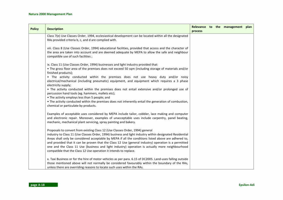
Class 7(e) Use Classes Order, 1994, ecclesiastical development can be located within all the designated
RAs provided criteria b, c, and d are complied with.
viii. Class 8 (Use Classes Order, 1994) educational facilities, provided that access and the character of
the area are taken into account and are deemed adequate by MEPA to allow the safe and neighbour
compatible use of such facilities ;
ix. Class 11 (Use Classes Order, 1994) businesses and light industry provided that:
• The gross floor area of the premises does not exceed 50 sqm (including storage of materials and/or
finished products);
• The activity conducted within the premises does not use heavy duty and/or noisy
electrical/mechanical (including pneumatic) equipment, and equipment which requires a 3 phase
electricity supply;
• The activity conducted within the premises does not entail extensive and/or prolonged use of
percussion hand tools (eg. hammers, mallets etc);
• The activity employs less than 5 people; and
• The activity conducted within the premises does not inherently entail the generation of combustion,
chemical or particulate by products.
Examples of acceptable uses considered by MEPA include tailor, cobbler, lace making and computer
and electronic repair. Moreover, examples of unacceptable uses include carpentry, panel beating,
mechanic, mechanical plant servicing, spray painting and bakery.
Proposals to convert from existing Class 12 (Use Classes Order, 1994) general
industry to Class 11 (Use Classes Order, 1994) business and light industry within designated Residential
Areas shall only be considered acceptable by MEPA if all the conditions listed above are adhered to,
and provided that it can be proven that the Class 12 Use (general industry) operation is a permitted
one and the Class 11 Use (business and light industry) operation is actually more neighbourhood
compatible that the Class 12 Use operation it intends to replace.
x. Taxi Business or for the hire of motor vehicles as per para. 6.15 of DC2005. Land-uses falling outside
those mentioned above will not normally be considered favourably within the boundary of the RAs,
unless there are overriding reasons to locate such uses within the RAs.

Is-Simar (limiti ta’ San Pawl il-Baħar)
Epsilon-Adi page A-19
Policy Description Relevance to the management plan
process
NWUS 4 The Local Plan designates Residential Priority Areas (RPAs) within the following urban settlements
delineated by the limits to development boundary:
Mellieħa, Manikata, Tal-Fjuri St. Paul’s Bay, Bugibba, Qawra, Xemxija, and Rabat
The RPAs are indicated on the relevant Area Policy Maps. The acceptable land-uses (new uses,
extensions to existing uses, and changes of uses) within all frontages located within the RPAs are:
i. Dwelling units in accordance with the zoning conditions for villa and bungalow areas as detailed in
the Development Control Policy and Design Guidance 2005, unless otherwise stated by a policy in this
Local Plan;
ii. A mix of Class 1 (Use Classes Order, 1994) dwelling units for terraced house areas as detailed in Part
3 of the Development Control Policy and Design Guidance 2005, subject to the approval of the Housing
Authority when these areas include Home Ownership Schemes, and provided the development does
not detract from the residential character of the area due to increased densities, and additional traffic
generation;
In Manikata no residential unit will be permitted having less than a net floor area of 120sqm. However,
in cases where the proposal will result in the creation of not more than two units on the same
footprint, smaller dwelling units may be permitted provided that the difference between the built
footprint and the 120 sqm is left as an open space in addition to the statutory side curtilage, backyard/
front garden as the case may be. This additional open space shall be secured by a planning obligation.
In those areas, indicated on the relevant policy map, in St.Paul’s Bay, Bugibba and Qawra, Salina, and
Bahrija previously zoned for villas in the Temporary Provisions Scheme of 1988 but not designated as
RPAs by the Local Plan, the acceptable land uses are defined by the designations identified for each
site in this Plan. The conditions in the Development Control Policy and Design Guidance 2005 for villa
development will still control the detailed design of the buildings on these areas and building heights
are to comply with those indicated on the relavant Building Heights maps.
The Xemxija Residential Area just extends
into the SAC/SPA in the area adjacent to
Triq ir-Ridott.
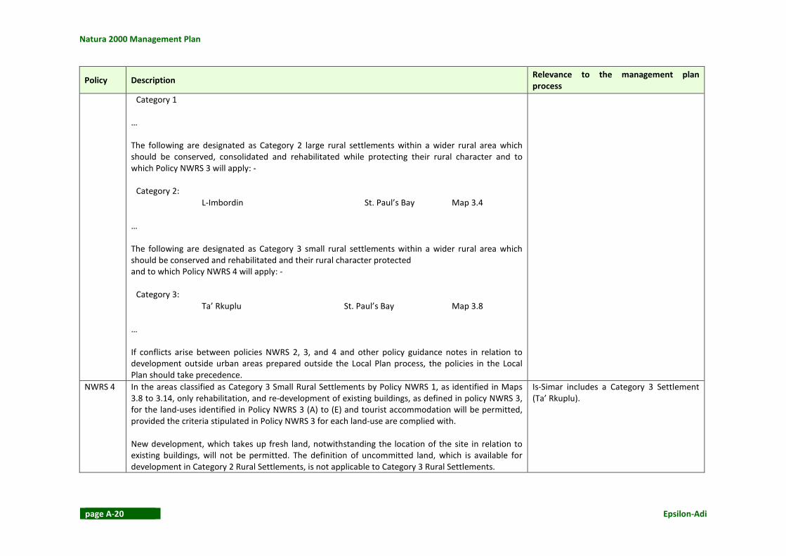
NWRS 1 The following are designated as Category 1 ODZ settlements in close proximity to the main urban area
which should be consolidated and to which Policy NWRS 2 will apply:
Is-Simar includes a Category 3 Settlement
(Ta’ Rkuplu) and borders a Category 2 Rural
Settlement (L-Imbordin).
Natura 2000 Management Plan
page A-20 Epsilon-Adi
Policy Description Relevance to the management plan
process
Category 1
…
The following are designated as Category 2 large rural settlements within a wider rural area which
should be conserved, consolidated and rehabilitated while protecting their rural character and to
which Policy NWRS 3 will apply: -
Category 2:
L-Imbordin St. Paul’s Bay Map 3.4
…
The following are designated as Category 3 small rural settlements within a wider rural area which
should be conserved and rehabilitated and their rural character protected
and to which Policy NWRS 4 will apply: -
Category 3:
Ta’ Rkuplu St. Paul’s Bay Map 3.8
…
If conflicts arise between policies NWRS 2, 3, and 4 and other policy guidance notes in relation to
development outside urban areas prepared outside the Local Plan process, the policies in the Local
Plan should take precedence.
NWRS 4 In the areas classified as Category 3 Small Rural Settlements by Policy NWRS 1, as identified in Maps
3.8 to 3.14, only rehabilitation, and re-development of existing buildings, as defined in policy NWRS 3,
for the land-uses identified in Policy NWRS 3 (A) to (E) and tourist accommodation will be permitted,
provided the criteria stipulated in Policy NWRS 3 for each land-use are complied with.
New development, which takes up fresh land, notwithstanding the location of the site in relation to
existing buildings, will not be permitted. The definition of uncommitted land, which is available for
development in Category 2 Rural Settlements, is not applicable to Category 3 Rural Settlements.
Is-Simar includes a Category 3 Settlement
(Ta’ Rkuplu).

Is-Simar (limiti ta’ San Pawl il-Baħar)
Epsilon-Adi page A-21
Policy Description Relevance to the management plan
process
NWAG 1 MEPA will continue to protect agricultural land from all types of inappropriate development. Within
“Areas of Agricultural Value” as indicated on Map 4 only buildings, structures and uses essential to the
needs of agriculture will be permitted and then only if it can be demonstrated to the satisfaction of
MEPA that they will not adversely affect water supplies, soil and landscape, and accord with all other
policies within this Local Plan. Applications for development permission for agricultural related
developments, which will result in the subdivision of land holdings, will not be permitted.
This will also apply to other land being cultivated for agricultural use and which in the opinion of MEPA
(after consultation with the Department of Agriculture) has a realistic potential to be upgraded and
sustainably improve its productivity. (This policy will not apply to such land where it is designated for
other purposes in the Local Plan).
Improvements to existing agricultural land and buildings aimed at increased productivity will be
favourably considered by MEPA providing they are well designed, efficient and contribute to rather
than detract from the quality of the local and surrounding environment.
Agriculture is a principal land use in the
SAC.
NWAG 2 The reclamation of abandoned or derelict land for agricultural purposes including viticulture or
afforestation will be supported providing the land is not designated, protected or scheduled for other
purposes in the Local Plan or, otherwise of ecological, scientific, landscape and/archaeological
importance.
Agriculture is a principal land use in the
SAC. This includes abandoned land.
NWAG 5 MEPA will permit a land-based hatchery within the plan area subject to all the following criteria being
met: -
i. Prior approval is obtained from the Malta Resources Authority;
ii. The siting and design should be sympathetic with the existing character and appearance of the area;
iii. The hatchery should be located, wherever practical, outside residential areas but within existing or
committed built up areas, have good road access and be in accordance with veterinary requirements;
iv. A landscape scheme shall be submitted and approved with any planning application, which shall be
implemented in its entirety within the first planting season and thereafter maintained.
The SAC/SPA includes a ‘defunct’ fish
hatchery.
NWTO 3 MEPA will give favourable consideration to the development of visitor attractions within the
settlement boundaries, including change of use of vacant and derelict buildings, which enhance the
quality of the experience of the visitor to urban areas, provided they are located within the
settlements of Mellieħa, Tas-Sellum, St. Paul’s Bay/Bugibba/Qawra, Rabat, and Mdina, and on specific
sites only in Mtarfa as indicated on the Area Policy Maps.
The SAC/SPA has both natural and cultural
attractions, mainly the saline marshland
and a number of
archaeological/architectural features which
are found within the Area of Archaeological

Natura 2000 Management Plan
page A-22 Epsilon-Adi
Policy Description Relevance to the management plan
process
Particular consideration would be given to proposals that take advantage of the historic and
architectural value of Rabat and Mdina and seek to present this heritage to locals and visitors while
also restoring and maintaining it.
Such favourable consideration to the development of visitor attractions in urban areas can only be
given subject to the following criteria:
i. The prior approval of the Malta Tourism Authority;
ii. The proposed development will not cause detrimental pressures on the local community;
iii. The scale of the project is consistent with the character of the site and surrounding area;
iv. High design quality in terms of height, volume, bulk, materials and finishes, and landscaping, is
achieved;
v. The existing infrastructure is not adversely affected by the proposed project, and can meet the
demands of the project without significant intervention;
vi. The proposed development would not exacerbate existing problems of traffic congestion, potential
street/highway danger and vehicular and pedestrian conflict and appropriate off street parking is
provided; vii. Access to the foreshore and scenic views are not restricted or limited by the proposed
development;
viii. For the reuse of scheduled buildings and structures of architectural or historical interest policies in
this Plan, existing policies and guidelines related to developments in Urban Conservation Areas and on
scheduled buildings also apply;
ix. The proposals comply with all other policies in this Plan relating to specific areas such as
Town/Neighbourhood Centres, Tourism Zones, Entertainment Priority Areas, Residential Areas.
MEPA will give favourable consideration to the location of facilities and amenities, which will enhance
the experience of the visitor to sites outside the development zone, which due to their intrinsic
archaeological/architectural/cultural/heritage value are an attraction for visitors, provided the
proposed development:
1. Has obtained the prior approval of the Malta Tourism Authority;
2. Makes use of vacant and/or derelict buildings or utilises derelict land which is not designated for
protection;
3. Is of a scale and design which respects the character of the site and the surrounding area; and
4. Does not exacerbate any existing traffic problems, and vehicular/pedestrian conflicts.
Importance. The Simar Nature Reserve
already hosts a visitors’ centre.

Is-Simar (limiti ta’ San Pawl il-Baħar)
Epsilon-Adi page A-23
Policy Description Relevance to the management plan
process
The development of visitor attractions as part of an established and continuing farming enterprise
should comply with the provisions set out in draft Agriculture, Farm Diversification and Stables (2005)
and future amendments.
NWTR 3 Working with the Malta Transport Authority (ADT) and the Local Councils, MEPA will seek the
implementation of traffic management measures to improve road safety and reduce through traffic in
towns and villages. MEPA will support measures, which deter through traffic and calm “essential”
traffic particularly in residential areas and streets with high pedestrian activity, such as in the town
centres of Mellieħa, St Paul’s Bay, Rabat, Zebbiegh, Mgarr and Dingli.
Traffic calming measures are proposed along the following streets:
i. Triq il-Marfa, Triq G.Borg Olivier and Triq il-Kbira, Mellieħa (Maps 15 and 24);
ii. Triq Louis Wettinger, Ta’ Masrija, Mellieħa (Maps 15 and 24);
iii. End of Triq il-Manikata and Xifer Knisja l-Qadima, Manikata (Map 15);
iv. Triq San Pawl, Triq Parades, and Triq il-Mosta, St Paul’s Bay (Maps 15, 37 and 38);
v. Triq Santa Rita, Misrah il-Parocca & adjoining streets, Rabat (Maps 15 and 62);
vi. Triq Sir Temi Zammit, Zebbiegh (Map 15);
vii. Wesgha Gublew, Mgarr (Map 15); and
viii. Triq il-Kbira, Dingli (Map 15).
And at the following junctions:
i. St Paul’s Bay bypass (northern end), Pwales Valley (Maps 15 and 37);
ii. Saqqajja Square/Triq Nikol Sawra, Rabat (Maps 15 and 62); and
iii. Mdina Road/roundabout, southwest corner of Ta’ Qali (Map 15).
New developments should be designed in such a way as to inherently discourage through traffic, seek
to restrain vehicle speeds and so produce a safe, pleasant environment giving priority to sustainable
modes of transport.
St Paul’s Bay bypass (northern end), Pwales
Valley junction is located close to the
SAC/SPA.
NWTR 6 MEPA will assist the Malta Transport Authority (ADT) and the Local Councils in securing improvements
to the strategic road network at the following locations:
i. Coast Road between Baħar ic-Cagħaq and Salina Bay (Maps 15 and 38);
ii. Arterial road between Mistra Valley and Belleview roundabout (Maps 15,24 and 43);
iii. Xemxija Hill (Maps 15 and 43); and
Xatt il-Pwales (first part of Xemxija Hill
road) is found within the SAC/SPA.

Natura 2000 Management Plan
page A-24 Epsilon-Adi
Policy Description Relevance to the management plan
process
iv. Arterial road behind the Seabank Hotel, Ghadira (Map 15).
NWCO
4
Areas and sites of Archaeological Importance, as indicated on Map 18, are designated to regulate their
conservation in accordance with Section 46 of the Development Planning Act (1992), and development
will only be permitted where it accords with specific criteria for SSIs Level 1- 4 as stated in this policy.
Protection Rating CLASS A
No development will be permitted which would adversely affect the monument or site or its setting. A
minimum buffer zone of at least 100m around the periphery of the site will be established in which no
such development will be allowed.
Locations of Class A Archaeological Sites …
Protection Rating CLASS B
No development will be permitted which would adversely affect the monument or site or its natural
setting. A buffer zone of at least 50 m will be identified, its size dependent on the level of protection
appropriate to the specific site or area, in which no such development will be allowed.
Protection Rating CLASS C
No development will be permitted within the site or area of archaeological importance until the
applicant has submitted a written scheme of investigation, which has been approved by the
Superintendence of Cultural Heritage. Adequate opportunities must be provided for the recording and,
where necessary, the excavation of such sites. Before a permit is issued, agreement must be reached
to cover provision for detailed ground and structural surveys, excavation in advance of development,
the conservation of remains in-situ, and on the carrying out of a monitoring report as the development
proceeds. Provision for subsequent access and presentation of the area or site shall be made.
Protection Rating CLASS D
No development will be permitted within the site or area of archaeological importance until the
applicant has submitted a written scheme of investigation, which has been approved by the
Superintendence of Cultural Heritage. Adequate opportunities must be provided for the recording and,
where necessary, the excavation of such sites. Before a permit is issued, agreement must be reached
to cover provision for detailed ground and structural surveys, excavation in advance of development,
the conservation of remains in-situ and on the carrying out of a monitoring report as the development
Is-Simar SAC/SPA has a Class A late
Neolithic Temple and a Class B Punic Tomb.

Is-Simar (limiti ta’ San Pawl il-Baħar)
Epsilon-Adi page A-25
Policy Description Relevance to the management plan
process
proceeds. Where possible provision for subsequent presentation of the area or site shall be made.
Protection Rating CLASS E
Where applications for development permission are submitted on a site or area in which the
Superintendence of Cultural Heritage or MEPA may have some archaeological interest, the applicant
will be required to undertake an investigation including excavation if necessary. If following
investigation, the Superintendence of Cultural Heritage considers the site to be of archaeological
value, MEPA will normally refuse development permission if the proposed development would lead to
the destruction of the site, or require the development to be modified so that the archaeological value
of the site is protected.
NWCO 6 Areas of Ecological Importance (AEIs) and Sites of Scientific Importance (SSIs) are designated to
regulate their conservation in accordance with Section 46 of the Development Planning Act 1992 and
development will only be permitted in accordance with the level of protection required within the
appropriate grading.
General Protection will apply as follows: -
i. No inappropriate development to the rural countryside will be permitted. However, suitable
maintenance of existing structures and construction of minor amenities designed to enhance the
conservation or educational use of any area may be permitted. Supervised visits to sites of natural
importance will be encouraged in order to increase public awareness;
ii. no development activities that are likely to be a fire risk to trees and wooded areas will be allowed;
iii. no development where noxious emissions, effluents or waste are likely to create an adverse impact
on nearby AEIs or SSIs will be allowed.
iv. The removal of intrusive elements and alien species in a manner compatible with conservation; and
the inclusion of buffer zones to further the protection of AEIs and SSIs.
Level 1 AEIs and SSIs (Ecological)
No development will be permitted and access will be limited except to enhance the educational use of
Is-Simar SAC/SPA includes AEI/SSIs.

Natura 2000 Management Plan
page A-26 Epsilon-Adi
Policy Description Relevance to the management plan
process
the area whilst not damaging the features being protected and for necessary rehabilitation works.
Locations of Level 1 Ecological Sites …
I Is-Simar …
Level 2 AEIs and SSIs (Ecological)
Permission will only be granted for the maintenance of existing structures, covered by a permit and
construction of minor amenities where permissible, designed to enhance the educational and
recreational use of the area (e.g. narrow footpaths, nature trails and small scale visitor centres).
Level 3 AEIs and SSIs (Ecological)
No residential, industrial, commercial, tourism development, infrastructure or public utility works will
be permitted. A satisfactory environmental impact assessment is to be undertaken and approved by
MEPA.
Level 4 AEIs and SSIs (Ecological)
Permission will only be granted for small-scale development provided that no suitable alternative
locations exist and features of ecological and scientific interest are protected. A satisfactory
environmental planning statement is to be undertaken and approved by MEPA.
NWCO 7 MEPA will encourage small scale development proposals that support visits by the public to
appropriate sites for educational purposes in order to increase awareness of the importance of the
Islands heritage.
Proposals, which through proper management and interpretation can preserve/conserve the cultural,
recreational, ecological, educational and tourist potential of the built and natural heritage sites will be
supported and promoted. Sites for public presentation must be well managed and subject to the
following objectives and criteria: -
i. the development has minimal adverse visual impact or other impact on the character or setting of
the site;
ii. the development does not damage or otherwise adversely affect the cultural or natural heritage
value of the site;
iii. in appropriate areas, the regeneration or reintroduction of indigenous plants and animals and their
The management plan will take note of this
policy.
Is-Simar (limiti ta’ San Pawl il-Baħar)
Epsilon-Adi page A-27
Policy Description Relevance to the management plan
process
habitats;
iv. visitor education through sign posting/way marking, interpretation boards and permanent
exhibitions, e.g. visitor centres (utilising existing buildings wherever possible);
v. adequate and safe access for visitors to the site and where appropriate, provision for vehicle parking
which does not adversely affect the setting of the site;
vi. visitors are managed according to the carrying capacity or resilience of each site, so as to minimize
visitor impact on the site, and
vii. there is no conflict with other policies of this Local Plan (especially those for the protection of the
rural environment).
The Plan identifies the following sites, which need immediate protection and enhancement, and puts
forward detailed policies listed against these sites in order to secure proper management.
… L-Ghadira and Is-Simar Bird Sanctuaries Policy NWCO 8 …
NWCO 8 The area of sanctuaries for birds within the existing Nature Reserves at l-Ghadira, Is-Simar and Ta’ Qali
will be enlarged. MEPA will initiate and support the establishment of managed nature reserves as
indicated on Map 18 based on areas of ecological importance and/or sites of scientific importance and
will seek to enter into management agreements with the landowners, local councils, non-government
organisations and others to ensure the long-term protection and enhancement of such reserves.
No development of any kind will be permitted within the boundary except for suitable maintenance of
existing structures and construction of minor amenities designed to enhance the conservation or
educational use of the area.
Is-Simar SAC/SPA is a bird sanctuary.
NWCO
10
Woodland Conservation Areas are designated, as illustrated on Map 20, for protection and no
development will be permitted, which in the opinion of MEPA, will be detrimental to the ecosystem of
these areas.
MEPA in conjunction with the relevant government agencies, NGOs and land owners, will encourage
the planting and maintenance of indigenous trees in Woodland Conservation Areas unless this is
deemed to be detrimental to the forest remnants or established maquis and woodland areas or other
natural habitats. The use of woodland for passive recreation activities will be encouraged. Planting
shall aim at an ecological approach to the sites and shall be in accordance with the Supplementary
Planning Guidance on “Trees, Shrubs and Plants for Planting and Landscaping in the Maltese Islands”.
Part of Il-Miżieb planted area is within Is-
Simar SAC/SPA.

Natura 2000 Management Plan
page A-28 Epsilon-Adi
Policy Description Relevance to the management plan
process
MEPA will support and protect potential sites identified by PARK Department for development and
management as Areas of Afforestation, in order to safeguard future options and prevent inappropriate
allocation and use of the land.
Woodland Conservation Areas are listed below.
Planted Areas
• Il-Mizieb NWCO
13
Wherever possible, MEPA will protect areas of garrigue as indicated on Map 22, from activities that
create adverse impact. The illegal deposit of soil, or the use for off-roading on such areas will not be
permitted.
The management plan will take note of this
policy.
NWCO
14
In accordance with Structure Plan Policy AHF 8, MEPA will encourage the appropriate Government
agencies including the Department of Agriculture and Local Councils, to promote a Grant Scheme to
assist farmers and landowners to reinstate and maintain random rubble walls throughout the
countryside with priority given to walls alongside rural roads and tracks, and the removal of visual
intrusions, provided that the alignment of existing rubble walls is retained. There will be a strong
presumption against widening of countryside roads, carriageways or footpaths.
All Giren (Corbelled Stone Huts) within the Local Plan area, are protected pending their official
scheduling under Section 46 of the Development Planning Act. In the interim, all such structures shall
be afforded the same protection as Grade 1 scheduled property under Structure Plan Policy UCO 7.
The SAC/SPA includes rural structures and
features. On the Bajda Ridge escarpment
there is also a Girna (Corbelled Stone Huts).
NWSP 18 MEPA will seek to introduce, in conjunction with the Malta Transport Authority (ADT) and the Local
Council, a scheme which respects the approved road alignment at Xemxija Hill and which includes the
following measures:
i. Junction improvements;
ii. Relocation of on-street parking to convenient alternative off-street locations such as at Triq is-Simar
and Mistra Village;
iii. Parking controls in adjacent residential areas;
iv. Un/loading laybys and bus-stop laybys at appropriate locations;
v. Improved public transport services;
vi. Introduction of footways along the length of this road and on both sides;
The management plan will take note of this
policy.

Is-Simar (limiti ta’ San Pawl il-Baħar)
Epsilon-Adi page A-29
Policy Description Relevance to the management plan
process
vii. Improved accesses to the main leisure and recreation attractions;
viii. Pelican crossings to replace zebra crossings; and
ix. Enforcement of 50kph speed limit and measures to encourage compliance.
Some of these measures are shown on Transport Strategy Map 43. Others will be located on advice
from ADT.
NWSP 22 The area indicated in Map 43 is being safeguarded for the development of a yacht marina.
Developments, both on land and the sea, which are likely to compromise the implementation of a
yacht marina project in the area, will not be allowed.
MEPA will also favourably consider beach replenishment schemes provided such proposals are backed
up by all the necessary environmental studies and any appropriate mitigation measures recommended
by the studies are introduced to ensure that there is no demonstrable harm to the environment, and
most importantly to the ecology of the bay and its sphere of influence.
The management plan will take note of this
policy.
Natura 2000 Management Plan
page A-30 Epsilon-Adi
ANNEX 3 ASSESSMENT METHODOLOGY OF CONSERVATION
STATUS
The assessment of Conservation Status of habitats and species was done in accordance with
methodology provided by the Competent Authority, the Malta Environment and Planning
Authority (MEPA).
Table A-3 illustrates each of the parameters that were evaluated individually and were then
used to establish the overall Conservation Status for each habitat type at each Natura 2000
site. The table presents the evaluation matrix for this assessment. The evaluated parameters
are Area, Structure and Function (including typical species) and Future Prospects (in terms of
area covered, structure and function). Typical species were identified with reference to Article
17 reporting sheets for the Maltese Islands and the European Commission’s Interpretation
Manual of European Habitats Eur 27 (2007). Habitat evaluation was based on surveys carried
out between 2012 and 2013, during which all Natura 2000 sites were visited; desk-top
research and expert judgement were also used. The level of confidence in the habitats assessment is generally considered to be moderate.
Table A-4 presents the methodology for evaluation of parameters relevant in the assessment
of species; the parameters are Range, Size of Population, Habitat for the Species, and Future
Prospects (including range, population, its sustainability and habitat availability). Although
during the habitat surveys Annex II species were actively noted, no specific species surveys
were carried out. Instead, particularly for Annex II fauna, existing data and expert judgement
provided the basis for the evaluation. In many cases, however, insufficient data was available
that did not allow for a robust evaluation. In such cases, the Conservation Status was defined
as Indeterminate. Due to the lack of data, most Annex II species evaluations were carried out with a low to moderate (in the case of some plants) level of confidence.
Table A-4 was also used to evaluate the conservation status of Annex I birds, breeding birds
and migratory birds listed in the Birds Directive. The evaluations carried out on Annex I
breeding seabirds were carried out with a high level of confidence given the fact that they
were based on trend data for the most part spanning over approximately 25 years (data
provided by John J Borg). Evaluations of other birds were carried out with a moderate level of
confidence.
It is noted that the evaluation of all Annex I habitats and Annex II species was carried out at site level. Despite this, however, where necessary, the evaluation identifies scenarios where
nation-wide data is required in order to obtain a more robust understanding at site level e.g. in
the case of bats. Also, even though assessment was carried out at site level, expert judgement
and associated desk-top and field surveys included an element of comparison to examples of
each habitat-type at various sites. It should also be noted that Favourable Reference Values
(FRVs), against which certain parameters used to evaluate habitats and species should be
assessed, have not yet been assigned in the Maltese Islands. To reiterate, therefore, all
evaluations have been undertaken in the absence of FRVs, and based largely on expert
judgement.

Is-Simar (limiti ta’ San Pawl il-Baħar)
Epsilon-Adi page A-31
Table A-3: Evaluating the current condition of a habitat type
Parameter /
Criterion Description of Parameter Description of Current Condition
Favourable
(green / A)
Unfavourable – Inadequate
(amber / B)
Unfavourable – Bad
(red / C)
Area The area occupied by the habitat type.
Evaluation of area includes consideration
of:
• current area
• previous distribution, if available, which
may indicate changes or stability in the
area and any correlation with factors
• evidence on site that the area has
changed or is stable or is occupying its
full potential
• presence of factors which may be
influencing the current area at present
(e.g. encroaching agricultural land,
competing habitat)
The area of the habitat is
stable in the long-term or
increasing (based on current
area, previous records or
evidence on site or, in the
case of increasing area, the
presence of factors
contributing to the increase)
Any other condition other than
A or C.
This category could be:
• B1 if the condition of the
area is inadequate but
improving
• B2 if the condition of the
area is inadequate and stable
• B3 if the condition of the
area is inadequate and
deteriorating*
(This evaluation is based on
current area, previous records
or evidence on site or presence
of factors contributing to a
change in area (positively in the
case of B1 and negatively in the
case of B3)
The area has significantly
deteriorated in coverage or
decreasing or may decrease due
to significant pressures and
threats.
This category could be:
• C1 if the condition of the area
is bad but improving
• C2 if the condition of the area
is bad and stable
• C3 if the condition of the area
is bad and deteriorating*
(This evaluation is based on
current area, previous records
or evidence on site or presence
of factors contributing to a
change in area (positively in the
case of C1 and negatively in the
case of C3)
Structure &
function
(including
typical
species)
The structure of a given habitat type can be
compared with the data of the EU
Interpretation Manual, the associated
PHYSIS interpretations and the
interpretation of each habitat (and its
typical species) provided at Malta’s
The structure (including
typical species) and function
(including ecological
requirements) of the habitat
is in good condition, no
significant deteriorations
Any other condition other than
A or C.
This category could be:
• B1 if the condition of the
More than 25% of the area is in
a bad condition with regard to
its structure and function
(including typical species)
This category could be:

Natura 2000 Management Plan
page A-32 Epsilon-Adi
Parameter /
Criterion Description of Parameter Description of Current Condition
national level through Malta’s reporting
sheets for Article 17. Not all typical species
listed therein need to be present at the site
for the habitat to be interpreted as such.
Function refers to the ecological processes
and capacity of the habitat to maintain its
structure.
Typical species, as defined above, are also
included in this assessment. In order to
assess the overall condition of the typical
species consideration can be given to
typical species richness, coverage of the
ruderals, ermes, invasive plant species and
degree of interfloral competition affecting
the area covered by the habitat.
are experienced and no
pressures are present. structure and function is
inadequate but improving
• B2 if the condition of the
structure and function is
inadequate and stable
• B3 if the condition of the
structure and function is
inadequate and
deteriorating*
(This evaluation is based on the
structure (including typical
species) and function (including
ecological requirements) of the
habitat and presence of
pressures or threats).
• C1 if the condition of
structure and function is bad
but improving
• C2 if the condition of the
structure and function is bad
and stable
• C3 if the condition of the
structure and function is bad
and deteriorating* (This evaluation is based on the
structure (including typical
species) and function (including
ecological requirements) of the
habitat and presence of
pressures or threats).
Future
prospects (as
regards area
covered,
structure &
function)
Capacity and probability of the habitat type
concerned on the site in question to
maintain its structure for the future, given
on the one hand the possible unfavourable
influences and on the other hand all the
reasonable conservation effort which is
possible.
The habitat prospects for its
future are excellent / good,
with no significant impacts
from threats expected. The
long-term viability is also
assured.
Any other condition other than
A or C.
This category could be: • B1 if the future prospects are
inadequate but improving
• B2 if the c future prospects
are inadequate and stable
• B3 if the future prospects are
inadequate and
deteriorating*
The habitat prospects are bad,
with severe impacts from
threats expected. The long-term
viability is not assured.
This category could be:
• C1 if the future prospects are
bad but improving
• C2 if the future prospects are
bad and stable
• C3 if the future prospects are
bad and deteriorating*
OVERALL CONDITION If the condition of all
parameters is evaluated as
favourable (green/A), then
the overall condition of the
If the condition of one or more
parameters is Unfavourable-
Inadequate (amber/B) and
none of the parameters is
If the condition of one or more
parameters is Unfavourable-
Bad (red/C), then the overall
condition of the habitat is

Is-Simar (limiti ta’ San Pawl il-Baħar)
Epsilon-Adi page A-33
Parameter /
Criterion Description of Parameter Description of Current Condition
habitat is FAVOURABLE
(green/A).
evaluated as Unfavourable-Bad
(red/C), then the overall
condition of the habitat is
UNFAVOURABLE –
INADEQUATE (amber/B).
UNFAVOURABLE –BAD (red/C).
* If one does not wish to assign a sub-category to this conservation status assessment, it would be sufficient to have a reasonably good justification from which this
can be extracted by the reader.
Source: MEPA

Natura 2000 Management Plan
page A-34 Epsilon-Adi
Table A-4: Evaluating the current condition of a species
Parameter /
Criterion Description of Parameter Description of Current condition
Favourable
(green / A)
Unfavourable – Inadequate
(amber / B)
Unfavourable – Bad
(red / C)
Range Area over which a species is usually to be
found in the protected area being
considered, and shows outer limits of the
overall area in which the species is found at
present. Useful information to assess range
includes:
• current range
• previous records, if available, which may
indicate changes or stability in the range
and any correlation with factors;
• evidence on site that the range has
changed or is stable/at its full potential
• presence of factors (such as abiotic
factors) which may be influencing the
current range at present or in the future.
• range required for viability of species,
including consideration of connectivity
The range should be stable
or increasing and must not
be contracting (based on
current range, previous
records or evidence on site
or, in the case of increasing
range, the presence of
factors contributing to the
increase)
Any other condition other than
A or C
This category could be:
• B1 if the condition of the
range is inadequate but
improving
• B2 if the condition of the
range is inadequate is and
stable
• B3 if the condition of the
range is inadequate and
deteriorating*
(This evaluation is based on
current range, previous records
or evidence on site or presence
of factors contributing to a
change in range (positively in
the case of B1 and negatively in
the case of B3)
Large decline in the range (or
evidence of loss from one year
to the next), which is foreseen
to have a significant impact on
the survival of the species /
population
This category could be:
• C1 if the condition of the
range is bad but improving
• C2 if the condition of the
range is bad and stable
• C3 if the condition of the
range is bad and
deteriorating*
(This evaluation is based on
current range, previous records
or evidence on site or presence
of factors contributing to a
change in range (positively in
the case of C1 and negatively in
the case of C3)
Size of
population
The following information is commonly
needed for each species:
• estimate of the population size
The size of the population is
maintained or increasing
and reproduction, mortality
Any other condition other than
A or C
Large decline in the size of the
population and reproduction,
mortality and age structure are

Is-Simar (limiti ta’ San Pawl il-Baħar)
Epsilon-Adi page A-35
Parameter /
Criterion Description of Parameter Description of Current condition
• unit used to express population size
Examples of units commonly used are given
below:
• number of individuals or estimation
thereof - (normally adult individuals) - As
for vascular plant species, it is possible to
count/estimate the number of flowering
plants only and/or to exclude seedlings.
For vegetatively reproducing plants,
either tufts/clumps or individual shoots
or rosettes may be regarded as
‘individuals’.
• area covered by population - estimation
of the total area covered by the species,
expressed in m2;
• number of localities - a geographical area
inhabited by a set of individuals which
are able to reproduce or occur on a long-
term basis and cover continuous space in
a given period. ‘Continuous space’ means
a portion of the territory with suitable
biotic and abiotic conditions for the long-
term occurrence of the species delimited
by natural or artificially made ecological
barriers, possibly also by social
relationships or by some length of
distance.
and age structure are
maintained at a healthy
balance. Maintenance
should be at the minimum
necessary to ensure long-
term viability of the species.
This category could be:
• B1 if the population size is
inadequate but improving
• B2 if the population size is
inadequate is and stable
• B3 if the population size is
inadequate and
deteriorating*
significantly affecting the long-
term viability of the species.
This category could be:
• C1 if the population size is
bad but improving
• C2 if the population size is
bad and stable
• C3 if the population size is
bad and deteriorating*
Habitat for
the species
Area thought suitable for the species, both
currently occupied and currently
unoccupied but suitable. The abiotic
features and structure of the habitat and
biological requirements of the species
Area of the habitat is
sufficiently large, stable or
increasing and sufficient
good quality habitat exists
to support the population in
Any other condition other than
A or C
This category could be:
Area of the habitat is clearly not
sufficiently large to ensure the
long term survival of the species
OR habitat quality is bad, clearly
not allowing long term survival

Natura 2000 Management Plan
page A-36 Epsilon-Adi
Parameter /
Criterion Description of Parameter Description of Current condition
should be taken into consideration as much
as possible.
Pollinators, predators, symbionts and
fructivores of the species should be taken
into consideration where relevant.
the long term. • B1 if the habitat for the
species is inadequate but
improving
• B2 if the habitat for the
species is inadequate is and
stable
• B3 if the habitat for the
species is inadequate and
deteriorating*
of the species.
This category could be:
• C1 if the habitat for the
species is bad but improving
• C2 if the habitat for the
species is bad and stable
• C3 if the habitat for the
species is bad and
deteriorating*
Future
prospects (as
regards
range,
population,
including its
long-term
sustainability
and habitat
availability)
Capacity and probability of the species
concerned in the site in question to
maintain its population dynamics and the
availability of its habitat, given on the one
hand the possible unfavourable influences
and on the other hand all the reasonable
conservation effort which is possible.
The species prospects for its
future are excellent / good,
with no significant impacts
from threats and pressures
expected. The long-term
viability is also assured.
Any other condition other than
A or C
This category could be:
• B1 if the future prospects are
inadequate but improving
• B2 if the c future prospects
are inadequate and stable
• B3 if the future prospects are
inadequate and
deteriorating*
The species prospects are bad
or its future, with severe
influence of pressures and
threats expected. The long-term
viability is not assured.
This category could be:
• C1 if the future prospects are
bad but improving
• C2 if the future prospects are
bad and stable
• C3 if the future prospects are
bad and deteriorating*
If the condition of all
parameters is evaluated as
favourable (green/A), then
the overall condition for the
habitat is FAVOURABLE
(green/A).
If the condition of one or more
parameters is Unfavourable-
Inadequate (amber/B) and none
of the parameters is evaluated
as Unfavourable-Bad (red/C),
then the overall condition of the
If the condition of one or more
parameters is Unfavourable-
Bad (red/C), then the overall
condition of the habitat is
UNFAVOURABLE –BAD (red/C).

Is-Simar (limiti ta’ San Pawl il-Baħar)
Epsilon-Adi page A-37
Parameter /
Criterion Description of Parameter Description of Current condition
habitat is UNFAVOURABLE –
INADEQUATE (amber/B) .
* If one does not wish to assign a sub-category to this conservation status assessment, it would be sufficient to have a reasonably good justification from which this
can be extracted by the reader.
Source: MEPA

Natura 2000 Management Plan
page A-38 Epsilon-Adi
ANNEX 4 SPECIFICATIONS OF MANAGEMENT ACTIONS
A.4.1 GUIDELINES FOR STANDARD MONITORING PLANS FOR ANNEX I HABITATS AND ANNEX II SPECIES OF THE HABITATS DIRECTIVE AND ANNEX I SPECIES OF THE BIRDS DIRECTIVE
This section provides concise guidelines as regards the scope, the preparatory actions the
requirements and deliverables of this action.
The Management Plan (MP) has identified the need for the establishment of a National
monitoring programme applicable to the Maltese Islands Annex I habitats and Annex II species
of the Habitats Directive and Annex I birds of the Birds Directive and a number of other
relevant bird species (see Table A-5 and Table A-6). This monitoring programme consists of the
development of standard monitoring plans specific for each habitat and species and the
subsequent application of them in the field. The design of the standard monitoring plans will
build on the habitat/species conservation assessment work carried during the development of the Management Plans for the terrestrial Natura 2000 sites. The elaboration of the monitoring
plans is a once for all action and it is independent of any other action foreseen in the MPs. This
task is a responsibility of ERA in connection with the habitats and species of the Habitats
Directive listed in the tables below and the Wild Birds Regulation Unit with the Parliamentary
Secretariat for Agriculture, Fisheries and Animal Rights in connection with the bird species
listed in the table below and it will be accomplished within the first two years of the MP
implementation in order to allow for the subsequent implementation and field testing of the
monitoring plans, ideally within the last three years of the first MP period. This monitoring
programme will ensure that data continues to be collected and that the data gathered over the MP period informs the re-assessment of the Conservation Status of habitats and species
after the first planning period (5 years). Moreover, the data gathered will be used to
determine Favourable Reference Values for garrigue and steppe habitats and for four Annex II
plant species (Elatine gussonei, Ophrys melitensis, Anacamptis urvilleana and Linaria
pseudolaxiflora) (see Table A-7).
Table A-5: Maltese Islands Annex I Habitats and Annex II Species to be monitored
Code Name
Annex I habitats
1150 Coastal lagoons
1170 Reefs
1210 Annual vegetation of drift lines
1240 Vegetated sea cliffs of the Mediterranean coasts with endemic Limonium spp.
1310 Salicornia and other annuals colonising mud and sand
1410 Mediterranean salt meadows (Juncetalia maritimi)
1420 Mediterranean and thermo-Atlantic halophilous scrubs (Sarcocornetea fruticosi)
1510 Mediterranean salt steppes (Limonietalia)
2110 Embryonic shifting dunes

Is-Simar (limiti ta’ San Pawl il-Baħar)
Epsilon-Adi page A-39
Code Name
2210 Crucianellion maritimae fixed beach dunes
2220 Dunes with Euphorbia terracina
3140 Hard oligo-mesotrophic waters with benthic vegetation of Chara spp.
3170 Mediterranean temporary ponds
5230 Arborescent matorral with Laurus nobilis
5330 Thermo-Mediterranean and pre-desert scrub
5410 West Mediterranean clifftop phryganas (Astragalo-Plantaginetum subulatae)
5420 Sarcopoterium spinosum phryganas
5430 Endemic phryganas of the Euphorbio-Verbascion
6220 Pseudo-steppe with grasses and annuals of the Thero-Brachypodietea
8210 Calcareous rocky slopes with chasmophytic vegetation
8310 Caves not open to the public
8330 Submerged or partially submerged sea caves
9320 Olea and Ceratonia forests
9340 Quercus ilex and Quercus rotundifolia forests
9540 Mediterranean pine forests with endemic Mesogean pines
9570 Tetraclinis articulata forests
92A0 Salix alba and Populus alba galleries
92D0 Southern riparian galleries and thickets (Nerio-Tamaricetea and Securinegion tinctoriae)
Annex II Species
P Anacamptis urvilleana
P Cremnophyton lanfrancoi
P Crepis pusilla
P Elatine gussonei
P Hyoseris frutescens
P Helichrysum melitense
P Ophrys melitensis
P Linaria pseudolaxiflora
P Orobanche densiflora
P Palaeocyanus crassifolius
P Petalophyllum ralfsii
P Riella helicophylla
I Armadillidium ghardalamensis
I Brachytrupes megacephalus
I Lampedusa imitratix
I Lampedusa melitensis
I Myrmecophilus baronii

Natura 2000 Management Plan
page A-40 Epsilon-Adi
Code Name
I Pseudoseriscius cameroni
F Aphanius fasciatus
R Zamenis situla
M Myotis punicus1
M Rhinolophus hipposideros
Table A-6: Maltese Islands Bird Species to be monitored
Name Resident/
Breeding visitors Wintering
Other relevant
birds in
connection with
Article 4
Tachybaptus ruficollis √ √
Hydrobates pelagicus √
Puffinus yelkouan √
Calonectris diomedea √
Aythya nyroca √
Accipitridae (Aquila pomarina, Pernis
apivorus, Milvus migrans, Circus
aeruginosus, Circus pygargus, Accipiter
nisus) and Pandion haliaetus
√
Falconidae (Falco peregrinus, Falco
vespertinus, F.naumanni, F.biarmicus, F.
eleonorae, F.subbuteo, F. tinnunculus)
√
Ixobrychus minutus √
Himantopus himantopus √
Gallinula chloropus √
Fulica atra √
Alcedo atthis √
Wetland birds –staging (Phoenicopterus
ruber, Platalea leucorodia, Pluvialis
apricaria, Gallinago media, Philomachus
pugnax, Porzana porzana, Plegadis
falcinellus, Tringa glareola, Charadrius
alexandrinus, Actitis hypoleucos)
√
Charadrius dubius √
Larus michahellis √
Gulls/Terns (Larus melanocephalus, Larus √
1 The species referred to in Annexes of the Habitats Directive is Myotis blythii s.l. Recent taxonomic data
has divided this taxon into different species. The Maltese Myotis blythii s.l. is now considered as Myotis punicus. Consequently, Myotis punicus is still considered as an Annex II species.

Is-Simar (limiti ta’ San Pawl il-Baħar)
Epsilon-Adi page A-41
Name Resident/
Breeding visitors Wintering
Other relevant
birds in
connection with
Article 4
genei, Sterna caspia)
Calandrella brachydactyla √
Acrocephalus scirpaceus √
Cisticola juncidis √
Monticola solitarius √
Sylvia melanocephala √
Sylvia conspicillata √
Passeriformes (Cettia cetti, Hirundo rustica,
Muscicapa striata, Passer montanus,
Emberiza calandra)
√
Passeriformes (Anthus campestris,
Acrocephalus schoenobaenus, Ficedula
albicollis, F. parva, F.semitorquata, Lanius
collurio, Phylloscopus sibilatrix, Ph.
trochilus, Saxicola rubetra, Sylvia
communis, Emberiza pusilla, Emberiza
schoeniclus, Erithacus rubecula,
Phylloscopus collybita, Serinus serinus)
√
Table A-7: FRVs to be established for the following habitats and species
Code Name
Annex I habitats
5230 Arborescent matorral with Laurus nobilis
5330 Thermo-Mediterranean and pre-desert scrub
5410 West Mediterranean clifftop phryganas (Astragalo-Plantaginetum subulatae)
5420 Sarcopoterium spinosum phryganas
5430 Endemic phryganas of the Euphorbio-Verbascion
6220 Pseudo-steppe with grasses and annuals of the Thero-Brachypodietea
Annex II Species
Anacamptis urvilleana Linaria pseudolaxiflora
Elatine gussonei Ophrys melitensis
a. Scope
In April 2005, the Habitat Committee (committee created under Article 20 of the Habitats
Directive), adopted binding requirements for the compilation of monitoring data and for the
assessment of the conservation status of natural habitats and species of common interest ().
Member States must ensure that the design of their monitoring programme is harmonized
with the working documents of the European Commission concerning the definition and

Natura 2000 Management Plan
page A-42 Epsilon-Adi
description of the parameters that are included in the reporting requirements of the EU
member states under Article 17 of Directive 92/43/EC and especially with the «Art 17
guidelines» report. (http://circa.europa.eu/Public/irc/env/monnat/library?l=/&vm=detailed&sb=Title).
The following parameters are specified for each of the assessment criteria to determine the
Favourable Conservation Status mentioned above and defines an assessment scale
(Assessment and reporting under Article 17 of the Habitats Directive – Reporting Formats for
the period 2007-2012):
Table A-8: Parameters for determining Favourable Conservation Status according to Article 17
of the Habitats Directive
Natural habitats Species of common interest
Range (overall distribution) Range
Area (actually) covered Population (size of stock)
Structure and functions, including characteristic
habitat structures and characteristic species
inventory
Habitat for the species
Outlook (including impairments, threats and
long-term survival prospects)
Outlook (including impairments, threats and
long-term survival prospects)
To ensure a unified overall survey design that is adapted to the conditions in Malta, it is important that any existing programmes for surveillance and assessment of habitats and
species based on surveys carried out by scientific and nature conservation agencies are
consolidated into a comprehensive, nationally uniform monitoring system. This can be done
through a research and development project that will also help to appropriately channel
efforts in this field.
b. Requirements
The following activities are to be coordinated:
• Adaptation of existing approaches (primarily to arrive at a uniform cross-national survey
method)
• Cross-national coordination of monitored parameters, field survey methods, survey
intervals, sample sizes and sample distribution
• Development and coordination of methods for identifying areas and habitat sizes,
threats and long term survival prospects.
• Utilization of synergies with other ongoing survey programmes (e.g. monitoring under
the EU Water Framework Directive, the Nitrates Directive, and spatial mapping
programmes)
• Design of databases for data aggregation and analysis • Compliance of spatial data to the INSPIRE principles
Steps towards this standardization include preparatory actions and the establishment of
monitoring protocols, Conservation Status and Favourable Conservation Status.

Is-Simar (limiti ta’ San Pawl il-Baħar)
Epsilon-Adi page A-43
i. Preparatory actions
• Bibliographic reviews, recording and spatial mapping of each habitat type / species. For each habitat type and plant species, ERA will collect, document and spatially map in GIS,
the existing distribution reports at least for the past 40 years, depending on the
availability and accuracy of bibliographic data (point, line or surface distribution data),
and for the entire national terrain.
• Data storage and analysis. All the information collected shall be registered in a database,
that will have provision for recording the presence of each habitat type and plant species
documented in the literature review. This database will be linked to geographical
mapping of information in GIS.
• Registration of data gaps concerning habitats and species and the type, intensity,
frequency and location of threats/pressures/limiting factors impacting them as they have been identified by the Management Plans.
• Compilation of a summary report of existing knowledge and knowledge gaps/
requirements
• The above reports will be valid for the first monitoring implementation period and will
be updated from the second period and on. The next steps are based on these reports.
ii. Establishment of monitoring protocols, Conservation Status and Favourable Conservation
Status
Standardization of field survey protocols. At this stage the following will be established per habitat type and species/species group:
• The type of field data to be collected from field sampling specific to each habitat and
species/species group (presence / absence, relative abundance, density, physicochemical
parameters, threats, other impact factors, etc.).
• The number and positioning of sampling stations Determination of the intensity and the
sampling distribution pattern of and determination of the grid reference: a) the intensity
of the sampling effort, b) the distribution pattern of sampling within and outside N2000
sites and c) the reference grid (grid) per habitat type or species. • The survey intervals to be defined specifically for each species and habitat type,
according to their population dynamics
• The sampling methods Cross-national survey methods and census parameters will be
determined for all species and habitat types justified and supported by relevant
international or national standards, or by the international scientific bibliography.
Methodologies adopted by existing monitoring programmes (Habitat and plant species
evaluation conducted through the Management Plan elaboration, the Aphanius fasciatus
monitoring programme, sea birds survey methodologies) will be incorporated. The
recording of appropriate environmental parameters and of the
threats/pressures/limiting factors is included and given special emphasis.
Establishment of the methodology for the assessment of the conservation status and the
definition of Favourable Reference Values for habitats and species/species groups. Selection of
the methods (model use, etc) most suited to the Maltese natural territory for the analysis of
field data as scheduled to be collected during the implementation of the monitoring plans,
justified and supported by the relevant scientific experience recently acquired through the
implementation of similar projects throughout the European Union.

Natura 2000 Management Plan
page A-44 Epsilon-Adi
NOTE: It is acknowledged that some differentiation in the methodology may occur since some
aspects might be site-specific, such as the need for different monitoring frequencies depending
on the status of habitats/species and/or the levels of pressures and impacts. These
discrepancies will be identified and fully recorded during the site level implementation.
c. Deliverables
The following will be delivered for each habitat and species/species group.
• Report and database of bibliographic references consolidating all current knowledge on
the conservation status of the specific habitat/species.
• Geographical extent in which surveys will take place with grid reference for each habitat
type and species/species group.
• Field work protocols for each habitat type and each species/ species group • Protocol for the GIS mapping of the existing and potential spread of each species
• Field work scheduling and repeatability requirements at yearly, monthly and weekly
levels.
• Methodology for the evaluation of the conservation status to be applied during the
implementation phase.
• Methodology for the assessment of the Favourable Reference Values and the Favourable
Conservation Status to be applied during the implementation phase.
A.4.2 GUIDELINES FOR THE ELABORATION OF NATIONAL SPECIES ACTION PLANS
Action Plans for threatened species are technical instruments vital to the conservation of flora
and fauna. They define the actions that need to be taken to improve the status of a threatened
species.
a. Targeted species
For the first period of implementation Action Plans are intended for the following animal
taxonomical groups and species.
Invertebrates: All RDB species are presently included. The list may be further refined and
species grouped according to experts
Amphibians:
Discoglossus pictus
Being the only amphibian in Malta and belonging to a taxonomic group especially vulnerable to
climatic changes and with special water requirements, Discoglossus pictus should be treated
with priority and with a cross-country spatial reference.
Reptiles

Is-Simar (limiti ta’ San Pawl il-Baħar)
Epsilon-Adi page A-45
Chalcides ocellatus tiligugu
Podarcis filfolensis maltensis
Telescopus fallax
Coluber viridiflavus carbonarius
Coluber algirus
Action Plans can be elaborated either for each species or species groups according to the
taxonomy and ecology of species.
Mammals:
Suncus etruscus
Pipistrellus pipistrellus
Pipistrellus kuhlii
Pipistrellus pygmaeus
Plecotus austriacus
Tadarida teniotis
Eptesicus serotinus
Mustela nivalis
Action Plans can be elaborated either for each species or species groups according to the
taxonomy and ecology of species.
b. Geographical scope of Action Plans
Action plans shall take into account species’ habitats both within and outside Natura 2000 sites
taking into consideration the specific species’/species groups’ ecological requirements.
Especially for Discoglossus pictus and the bat species, due to specific water requirements and
mobility respectively, the entire Maltese Islands should be considered as the field of
application of certain conservation actions.
c. General characteristics of Action Plans
The Action Plans:
• Aim to make possible in the short and medium term to maintain or even increase
number of the targeted species. They clearly define the desirable population level, in
order to ensure the sustainable conservation of species in their immediate environment. • Do not contain detailed biological information and they are usually based on the best
available scientific knowledge. The emphasis is on conservation (not science) and on the
actions required and the changes needed to achieve the targets.
• Must have clear objectives, measurable goals and the follow up process (including
update of success) should be integrated in the plan and budgeted accordingly.
• During the site level implementation species plans need to adapt to site-specific
concerns about the species in question as regards the status of its habitat or the levels of
pressures and impacts.
• Need to be realistic, taking into account the social and cultural characteristics in the
areas where the plans will be implemented.
d. List of headings which may be incorporated into an action plan for an animal species

Natura 2000 Management Plan
page A-46 Epsilon-Adi
A following format can be adopted:
i. Current status/assessment of future prospects of species
• Taxonomy of the species
• Biological data (reproduction, feeding habits, habitat, optimum population
density, relation between species)
• International, national protection status
• Historical causes for decreasing numbers, current status and trends,
possibilities for colonization
• Current and potential threats /limiting factors
• Lists of protected/unprotected areas in which the species is present and
existing conservation measures taken in favor of the species
• Research work carried out in situ, ex situ and results
ii. Implementation of a restoration plan
• Conservation objectives
• Research work to be implemented in situ (reproduction, feeding habits)
justifications, proposed timetable.
• Recovery plans
• Management measures to be put into practice to achieve the proposed
conservation objective:
- in relation to the species : on- going monitoring of population, feeding, reintroduction or strengthening populations, increase of species
distribution. Proposed timetables.
- in relation to its habitat and other species present: review habitat
management, creation of new protected areas, establishment of nesting
area (trophic improvement, increasing numbers of prey, restricting
numbers of predators, adapting infrastructure and modifying numbers of
tourists). Proposed timetables.
- Legislative and economic measures
- Information activities to be carried out - Training courses for administrative officials, local and regional authorities
with direct responsibility for managing the species in the field
e. Indicative list of actions
Depending on the taxonomical groups different actions can be proposed, which generally may
fall under the following categories
• Policy and legislation
• Future research and monitoring
• Site safeguard and management
• Species management and protection • Communications and publicity
Actions can indicatively include:
• Designation of new areas of vital importance for species

Is-Simar (limiti ta’ San Pawl il-Baħar)
Epsilon-Adi page A-47
• Reform and review of management methods for areas which have lost their original
capacity to sustain the species
• Surveys to determine distribution and population size • Genetic and population dynamics studies
• Monitoring
• Ex- situ conservation
• Reintroduction and translocation
• Water quality and quantity improvements
• Special habitat management and restoration
• Habitat creation
• Control of competitors/predators
• Wardening of sites
• Communication and public awareness campaigns
Text adapted from: Council of Europe (1997). Drafting and implementing action plans for
threatened species (Council of Europe publishing, Environmental Encounters No 39).
Consulted document: MEPA (2011) Dossier on Wild Fauna in the Maltese Islands: Capture,
Killing and Exploitation
A.4.3 GUIDELINES FOR HABITAT RESTORATION ACTIONS
P8. Removal of trapping sites and habitat restoration within the Bird Sanctuary
a. Trained personnel required: Number and qualifications
1 full time person or 2 part timers with a qualification at EQF (European Qualifications
Framework) Level 4.
b. Draft spotting of the areas where the action will take place.
This action covers the entire SAC where there are trapping sites (note the site is a Bird
Sanctuary).
c. Materials and equipment required
Basic manual builders’ tools.
d. Plant species to be used for habitat restoration
Species typical of habitat 5410 which is found within the SAC, including: Thymus capitatus,
Periploca angustifolia, Teucrium fruticans, Anthyllis hermanniae, Hyparrhenia hirta.
e. Methods of habitat restoration
Any trapping hides should be dismantled. Concrete, large masonry stones, and metal artifacts
such as corrugated wire should be removed from site and disposed of in an authorized waste disposal facility. The trapping site itself should be dismantled from any wires or metal stakes
that constituted the trapping structure. Following dismantlement, a low intensity restoration

Natura 2000 Management Plan
page A-48 Epsilon-Adi
programme is recommended that includes the active seeding of cleared up areas for a period
of five years with seeds belonging to species characteristic of the predominant habitat. This
method is recommended in view that the area concerned does not have access to a supply of water for irrigation. This inevitably rules out the long-term irrigation of introduced plantlets.
The choice of seeds will depend on the availability of seeds, however it will focus on the
following species: Thymus capitatus, Periploca angustifolia, Teucrium fruticans, Anthyllis
hermanniae, Hyparrhenia hirta. Seeding will involve the random dispersal of seeds by hand. No
further subsequent intervention will be required to avoid trampling. The introduced plants will
be allowed to establish themselves on their own.
f. Protective measures required (Materials and Methods)
None envisaged.
g. Warning/information signage required
None required, to avoid reprisals and vandalism from aggrieved trappers.
h. Reporting requirements
Progress related to the clearance of trapping sites should be reported annually to ERA and
compiled within the annual MP review report.
P9. Planning and implementation of an IAS species control / eradication programme
a. Trained personnel required: Number and qualifications
3 persons with a qualification at EQF (European Qualifications Framework) Level 4 in
Environmental Science or sustainability.
b. Identification of IAS species to be removed
Acacia trees in the section of the Mizieb woodland that lies within the SAC. It is not part of an
Annex I habitat but the potential dispersal of seeds from this source throughout the SAC is a
threat.
c. Suggested method for IAS removal/eradication per species
The population consists of open woodland of Acacia saligna with scattered trees distributed
throughout the Mizieb woodland. In accordance with MEPA’s guidelines on managing non-
native plant invaders, it is recommended that these trees are all felled within the same season
using hand held mechanical tools such as a chainsaw. Felling should be carried out by
horizontal cutting near ground level. This should be followed by stump grinding up to a depth
of 2 feet. The holes produced should be filled with soil. Stump grinding should only be used
where the trees are easily accessible with the relevant equipment. Access should not be
created where it is currently not available.

Is-Simar (limiti ta’ San Pawl il-Baħar)
Epsilon-Adi page A-49
All woody material should be removed from the area and disposed of. Burning any vegetation
on site is not recommended since fire is known to trigger seed germination in Acacias (MEPA,
2013). It is also recommended that the removal of the leaf litter and top 5cm of soil from beneath the trees is removed to deplete the soil bank. Trees belonging to this genus are
known to accumulate large quantities of seed in their soil seed bank which can lie dormant for
many years. Cutting the trees would eliminate shade and increase the light intensity on the
ground, which in turn would trigger high germination rates during the following spring.
Removing the top 5cm would drastically decrease regeneration potential of the soil seed bank
and has been seen to be one of the best ways of reducing regeneration for these species (Le
Maitre et al., 2011). Moreover, the ground below the Acacias is already degraded with most of
the seed bank being dominated by an accumulation of over 30 years of Acacia seeds. Thus the
benefits of removing the top layer of the soil profile will outweigh any minor impacts. The
removal of topsoil should however be restricted to immediately below the tree, and any typical garrigue shrubs growing underneath the Acacia should be left untouched.
In order to address resprouting of cut stumps, tarping with heavy black plastic will impede light
reaching the trees and will also act as a physical barrier thereby preventing resprouting. All
unused plastic should be removed from the site and the site manager should regularly visit the
area to ensure that plastic from this activity does not litter the area.
Consistent and timely follow-up treatments to remove germinating seedlings are necessary for
a number of years until seed bank is exhausted. Seedlings and saplings can be hand pulled.
Incineration of plant debris is the most desirable option especially when dealing with alien
species which are prolific seed producers and / or spread by vegetative growth. Nevertheless,
burning of plant material on-site should not be allowed, unless prior authorization for
controlled burning on site is given by ERA.
Plant debris which is not able to grow into a new plant can be carried in a registered waste
carrier that can be securely covered and disposed of in a registered landfill, unless prior
authorization for controlled burning and disposal on site is given by ERA.
d. Suggested method of habitat restoration
A passive restoration programme will be applied. Once the Acacia trees are eliminated no
further intervention will be required since the Acacia trees do not encroach on any Annex I
habitat. Instead it is most likely that this habitat will be gradually occupied by the Pine
woodland, in view of the predominance of Pinus halepensis in this woodland.
e. Protective measures required
None required.
f. Information/warning signage required
Signage is required in the area of active restoration to inform visitors why species are being
removed, what work is being undertaken and to keep to the footpath and avoid trampling on
the sections being restored.
g. Monitoring and post- removal monitoring requirements

Natura 2000 Management Plan
page A-50 Epsilon-Adi
The areas being restored should be monitored once a year to assess the success of the
restoration programme and apply it to other areas in the country. The following data should
be collected:
• Quantitative data on coverage, species dominance and diversity through the use of a 2m
X 2m quadrat in each location where a tree was cut down and plants and seeds
characteristic of the Annex I habitat were introduced. This will allow the manager to
assess the rate of reestablishment of the targeted habitat and the success of the
restoration program. This data shall be collected once every three years in spring for a
period of ten years after the initiation of the restoration program.
• The survival rate of planted species should be monitored each year by recording the
number of deceased plants. This data shall be collected each year in September for a
period of five years after the planting phase.
• The quantity of seedlings of targeted alien species sprouting each year following the
eradication of the trees. This data shall be collected each year in spring for a period of
five years after the termination of the restoration program.
h. Reporting requirements
It is important to document (and also inform ERA on) attempts made to remove invasive alien
species as well as findings in order to serve as a learning tool and to keep track of actions
taken across the Maltese Islands.
A.4.4 GUIDELINES FOR THE SIGNPOSTING AND SITE PROMOTION
P7. Elaboration of a study for the design and technical specifications for warning/ information/interpretation signposting and promotion material
A national interpretation strategy for the entire Natura 2000 network across the Maltese
archipelago will present the required framework through which all aspects of stakeholder
communication and education, product development, promotion, on-site and inter-site visitor
flow management, visitor experience and revenue generation will be addressed.
The study for the design and technical specifications for signposting and promotional material
will therefore be undertaken within this framework. Particularly given Malta’s size, and in
recognition of current awareness of Natura 2000, the marketing potential from promoting and
creating a movement around the Natura 2000 network as a whole is significant. This will considerably enhance the promotion and revenue generating value of each of the individual
sites in the network, as well as serve to achieve the site-specific conservation objectives.
Critically, this approach will build upon the success of the communications and awareness
raising campaign for the project, which has succeeded in fostering initial awareness of a
network of local nature conservation sites with a range of different and unique attributes and
assets but also with certain commonalities. It is essential, at this stage, to build upon the

Is-Simar (limiti ta’ San Pawl il-Baħar)
Epsilon-Adi page A-51
existing knowledge base and therefore to execute a promotional and marketing plan derived
from the interpretation strategy, aimed at the promotion of Natura 2000 as a national
network, within which individual sites will also be promoted for their specific attributes and assets, as well as for their relationships with other sites where there is a commonality in
respect of characteristics / features, habitats and species, tourism/recreational opportunities
and / or geographical location.
Another critical advantage to creating a movement around the Natura 2000 network is the
ability to use the ‘pull factor’ of the more well known and already frequented sites to garner
interest in the less well-known or smaller sites, by drawing on their various common attributes
and by promoting these sites together. Is-Simar is one of the most well-known sites; hence Is-
Simar is one of a number of important ‘gateway sites’.
The signposting and promotional plan for Is-Simar will focus on the specific attributes and
assets of the site, but will also offer the opportunity to reference and promote the national
network, other Natura 2000 wetland sites, as well as the Natura 2000 sites in St Paul’s Bay.
Given its gateway potential, information will also be provided on initiatives, events and
activities planned for the Natura 2000 network as part of the national interpretation strategy.
Responsibility for delivering and implementing the Natura 2000 promotional and marketing
plan, and for the study for the design and technical specifications for signposting and
promotional material, will fall to a bespoke management team. Taking account of the wider
international context, and with little already in place for marketing the local Natura 2000 network, this management team will have the opportunity to customise and adopt
international best practices.
The interpretation strategy will serve as the basis upon which the marketing and branding
strategy for the Natura 2000 network will be developed, ensuring unity and continuity of the
Natura 2000 ‘brand’, not only in terms of design (logo and colours) but also its values and
overall themes / messages. This brand will be carried through in all signposting and
promotional material, as well as all Natura 2000 merchandising, events and activities.
Signposting and promotional material for Is-Simar (as with all Natura 2000 sites) will be
designed to deliver ‘edutainment’ – education through entertainment, in line with recreational
learning theory. Such communication must provoke interest and thought within visitors and
help them to personally relate with the issues at hand, whilst the core message is being
naturally developed and revealed within their minds as a result of their experience of the site,
guided through the interpretative services. The interpretation strategy will therefore be
designed to inform and educate, as well as to guide and warn (particularly on-site signposting),
in the interests of the protection and conservation management of the site as well as visitor
enjoyment and safety.
An emphasis on interpretative signage will ensure that the information presented brings
meaning and interest to the visitor, and that it strengthens their relationship with the site (and
the Natura 2000 network generally). Warning signage will convey the necessary regulations
and restrictions; however, these messages will be delivered sensitively and with sufficient
justification (emphasis on interpretation). The signposting generally will be designed to
welcome and encourage the visitor’s enjoyment of the site. As mentioned above, where
detailed background information is required to be delivered to visitors, trained guides and
innovative use of technology may present the most effective and least invasive form of
communication media.

Natura 2000 Management Plan
page A-52 Epsilon-Adi
Taking account of the emphasis on there being a national interpretation strategy with bespoke
branding for the Natura 2000 network as a whole, the signposting regime for individual sites will have regard to any existing signage relating to the ecological, geological, historical,
cultural, etc. attributes of that site, such as that at Is-Simar. There may be the potential to
combine signage to communicate information on other projects together with information on
Natura 2000, where this is deemed to be appropriate without compromising on the objectives
for the national Natura 2000 interpretation strategy.
As a general guide, all communication will reflect the main theme identified through the
interpretation strategy by addressing the ‘whole’ in terms of the overall learning, emotional
and behavioural objectives, and by striving for message unity through usage of standardised
materials, designs, logos, layouts, text, colours, etc.
The amount of information communicated will take account of the method of delivery,
whether that be signage, information panels, brochures, etc.; however, signposting and
promotional materials generally for Is-Simar will include:
• Name of the site;
• Written and pictorial description of the particular attributes and assets of the site
(ecological, historical, cultural, etc.);
• Written and pictorial description of Natura 2000 in the international and national
context; • Written and pictorial description of the other wetland sites in the local Natura 2000
network, specifically, L-Inħawi tal-Għadira, Is Salini, Il-Ballut ta’ Marsaxlokk, Il-Magħluq
tal-Baħar ta' Marsaskala, and L-Għadira s-Safra;
• Written and pictorial description of the other Natura 2000 sites in St Paul’s Bay,
specifically Il-Ballut tal-Wardija, Ix-Xagħra tal-Kortin and Is-Salini.
• Direction / orientation information (in the case of on-site signposting) to aid site
navigation; and
• Warning information (in the case of on-site signposting), in terms of the specific ‘dos and
don’ts’ to take account of. Such instructions should be imparted to the visitor in as much of an intuitive way as possible, for example, by setting trails that stay clear of
sensitive or fragile ecosystems or using site hardening methods (behavioural objective –
to stay clear of sensitive species), whilst presenting information on how delicate or rare
certain important species may be and how they are negatively affected by external
factors (educational and emotional objectives).
Proposed signposting for Is-Simar
Figure A-1 shows the proposed location for the signposts for this SAC. The figure illustrates two
types of signposts:
i. Directional signs positioned along the main roads leading to the site, indicating to drivers
where they can access the SAC; these signposts will generally be fixed to existing road
signs (where they exist) and will typically be similar to the signs already used to indicate
cultural heritage sites.
ii. Information signs, positioned at the main entrances to the site and within the site, in
areas where important features are located. Four information signs (two of which
describe cultural heritage features within the site) are proposed for this site. It is advised

Is-Simar (limiti ta’ San Pawl il-Baħar)
Epsilon-Adi page A-53
that signposts are erected in areas that are either already disturbed or where there are
existing footpaths, roads, etc.; habitats should not be affected by signposts.
Furthermore, since it is recommended that the Natura 2000 network is uniformly branded, it is also advised that any existing information signage be replaced by new
composite signs designed in accordance with the branding specifications for the national
Natura 2000 interpretation strategy.
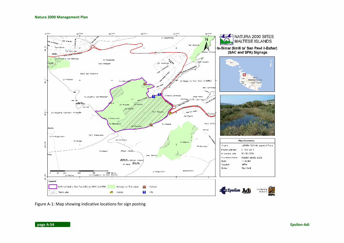
Natura 2000 Management Plan
page A-54 Epsilon-Adi
Figure A-1: Map showing indicative locations for sign posting

Is-Simar (limiti ta’ San Pawl il-Baħar)
Epsilon-Adi page A-55
A.4.5 PATROLLING SCHEDULE
Safeguarding / wardening of the protected area is the most important conservation action to
be performed under the management of the Natura 2000 sites. It is a constant action and
subject to continuous adaptations in line with progress in site management. As it relies entirely on the capacity of human resources it has to be regularly re-evaluated in order to
remain effective and fulfil its intended objectives.
The main objectives of patrolling the Maltese Natura 2000 sites are:
• Protection of the key features, habitats and wildlife and any other important features
that have been identified for each site;
• Prevention of illegal actions and activities according to law;
• Control of harmful human activities;
• Ensuring observance of site rules and regulations by visitors, owners, and users; • Protection and maintenance of management infrastructure;
• Contribution to the managers’ knowledge about the protected site; and
• Contribution to the knowledge and awareness raising of visitors and users of the area.
Patrolling staff
In order to fulfil the above tasks, it is recommended that the patrolling staff fulfils the
following requirements:
• It has law enforcement powers;
• It is skilled in outdoor working conditions and can work unsocial hours, including
weekends and public holidays;
• It has mastered a knowledge of the ecological features of the site, the vision, the
conservation objectives and the management principles pertaining to the site;
• Accordingly, it has mastered a knowledge on the identified and potential threats to the
above features and the site’s integrity;
• It possesses adequate communication and interpersonal skills; and
• It possesses adequate recording and reporting skills.
As such the minimum requirements for patrolling officers should be:
• Preferably have an undergraduate diploma in natural sciences or similar or, in the
absence of academic qualifications, a proven interest and a number of years of
experience in nature conservation (persons with no academic qualifications will be
required to sit for such courses as may be identified by the site manager / ERA);
• Report writing and computer skills (word processing, spreadsheet, database);
• A valid driving license;
• Good knowledge of both spoken Maltese and English;
• First Aid Certificate (or the willingness to acquire this); • Fire-fighting certificate, especially for shrub fires (or the willingness to acquire this);
• A clean police conduct; and
• Preferably have map reading and trekking capabilities;

Natura 2000 Management Plan
page A-56 Epsilon-Adi
• Preferably have a medical certificate attesting to the fitness and health of the officers
that would not hinder them from carrying out their job or placing them at undue risk.
Staff training
Patrolling staff should undergo a series of training seminars that are prepared and
implemented under the auspices of ERA. It is stressed that the recording and reporting
requirements of the job must be taught in detail having in mind that these invaluable field
data will feed into the Work Plan at the start of the MP implementation (see below), the
habitat/monitoring plans and reports and ultimately all management actions in the following
years.
Training of the patrolling staff must be provided both in the office and on the field. It is therefore recommended that a trained ecologist, police officer and a local
stakeholder/inhabitant escort the crew team during the first period of implementation and
provide knowledge and advice. Annual evaluation and additional/further training is required.
Training will aim at:
• Basic identification of protected habitats and species present in the Maltese Natura 2000
sites;
• Dealing with people and preparation of evidence for investigations.
• Anthropogenic impacts on the environment; • Knowledge of Maltese environmental legislation;
• Professional recording and reporting techniques;
• Basic arrest-and-control techniques; and
• Self-defence and first aid.
Patrolling scheme
At this stage only preliminary recommendations are provided:
• A patrolling unit consists of at least 2 officers
• The patrolling unit is equipped at least with: 1 conventional vehicle, intra/inter-
communication equipment, 2 pairs of binoculars, 2 cameras, detailed digital maps,
outdoors clothing and equipment, reporting sheets or electronic means of recording and
a first aid kit. In addition to this, the text of the actions of the site’s Management Plan
and, when applicable, the text of the code of conduct of the site.
Patrolling schedule
The patrolling schedule applicable to each site and to the entire network depends on the
resources allocated to this task and, as already discussed, is subject to continuous changes and
improvements as management progresses.
Input for the drafting of the site specific initial patrolling schedules is given below; an initial
pilot schedule is given for the first six months of implementation (see Table A-11, Table A-12
and Table A-13). Ideally, these schedules should be run in parallel and in collaboration with
the drafting of the site specific Work Plans based on the site specific Management Plan. This
synergy will provide invaluable input to the author of the Work Plans and guarantee the

Is-Simar (limiti ta’ San Pawl il-Baħar)
Epsilon-Adi page A-57
drafting of effective and realistic patrolling schedules available at site level very early in the
implementation period.
A half-year test period is considered as an adequate time to guide the composition of an
effective and realistic annual schedule plan. Note that given frequencies (weekly, fortnightly
and monthly) indicate minimum standard patrolling requirements at site level as they have
been evaluated by the Management Plan. No attempt has been made to distinguish periods of
increased requirements (e.g. hunting periods, first period of infrastructure installation, period
of trapping devices removal, etc), or give further timeframe details. This is a task to be
accomplished by the patrolling schedule compiler in a trial and error fashion and provided that
the required administrative and funding are available.
Patrolling schedule specifications are explained in Table A-9 and Table A-10.
Table A-9: Content explanation of Table A-11: Site Identity – Management Structure
COLUMN TITLE CONTENT
CODE / NAME Code and Name of each Natura 2000 site
AREA Identification of the extent of the area to be patrolled
PROPOSED SITE
ENLARGEMENT
New area under surveillance to be added whenever applicable
MANAGEMENT
SCHEME
Wherever other entities apart from ERA are involved in the site’s
management, the level and content of cooperation of the patrolling entity
with these entities must be specified. Indications of minimum
collaboration requirements are given in the Management Plans at site level STAKEHOLDERS
INVOLVEMENT
WARDENING SYSTEM Existing wardening schemes are indicated at site level, to be further
examined and incorporated in the patrolling schedules
POLICE PATROLLING
SYSTEM
Existing police patrolling schemes are indicated at site level, to be further
examined and incorporated in the patrolling schedules
CLEANING SCHEME Existing and proposed cleaning schemes are indicated at site level, to guide
related collaboration and allocation of responsibility
Table A-10: Content explanation of Table A-13: Activities per site
COLUMN TITLE CONTENT
MANAGEMENT
ACTIVITIES TO BE
SAFEGUARDED
Two main categories of physical objects of safeguarding are indicated:
Infrastructure maintenance including existing and proposed visitor
infrastructure, signposting etc, and physical materials related to habitat
manipulation works, ie. fences, seeded plots etc. These features must be
listed and mapped in detail at site level together with the key physical
features (Annex I habitats, etc) under protection
MAJOR
ILLEGAL/HARMFUL
HUMAN ACTIVITIES TO
BE CONTROLLED
An initial list of the identified major and common illegal – harmful human
activities at site level is given. An initial map of identified point factors can
be provided based on the information available in the Management Plans.
The list is not exhaustive and other already identified and newly
investigated activities must be added progressively after mastering of the
recording and reporting skills is secured.
It is stressed, that the recording and reporting of the locations, the
frequencies and the intensities of these factors is probably the principal
patrolling task and it will also provide invaluable field data for the
monitoring plans/reports.

Natura 2000 Management Plan
page A-58 Epsilon-Adi
Table A-11: Site Identity – Management Structure
SITE IDENTITY MANAGEMENT STRUCTURE
CODE NAME AREA
(ha)
PROPOSED SITE
ENLARGEMENT
MANAGEMENT SCHEME STAKEHOLDERS'
INVOLVEMENT
WARDENING
SYSTEM
EXISTING POLICE
PATROLLING
CLEANING
SCHEME EXISTING PROPOSED
1 L-Inħawi ta’ Għajn
Barrani
54.56 LAND OWNERS /
XAGHRA LOCAL
COUNCIL /
MINISTRY FOR
GOZO / ERA
� �
2 L-Inħawi ta’
Pembroke
96.75 COMMITTEE COMMITTEE � � �
3 Il-Ballut tal-Wardija 20.37 ERA / LAND
OWNERS � �
4 Il-Maqluba (limiti tal-
Qrendi)
2.62 LAND OWNERS /
QRENDI LOCAL
COUNCIL / MTA
/ ERA
�
5 L-Inħawi tar-Ramla 7.42 GAIA
FOUNDATION
ERA / GAIA
FOUNDATION � � �
6 Is-Simar (limiti ta’
San Pawl il-Baħar)
58.38 WETLAND
ENLARGEMENT
BIRDLIFE MALTA BIRDLIFE MALTA � � �
PARTIAL
(RESERVE)
7 Is-Salini 23.67 MINISTRY FOR
TRANSPORT &
INFRASTRUCTUR
E / ERA
� �
8 L-Għadira s-Safra 1.54 SITE
ENLARGEMENT
ERA
9 L-Inħawi tar-Ramla
tat-Torri u tal-Irdum
tal-Madonna
74.91 BIRDLIFE MALTA BIRDLIFE MALTA
� �
10 Ix-Xagħra tal-Kortin 12.61 LAND OWNERS /
ST PAUL’S BAY

Is-Simar (limiti ta’ San Pawl il-Baħar)
Epsilon-Adi page A-59
SITE IDENTITY MANAGEMENT STRUCTURE
CODE NAME AREA
(ha)
PROPOSED SITE
ENLARGEMENT
MANAGEMENT SCHEME STAKEHOLDERS'
INVOLVEMENT
WARDENING
SYSTEM
EXISTING POLICE
PATROLLING
CLEANING
SCHEME EXISTING PROPOSED
LOCAL COUNCIL
/ ERA
11 Għar Dalam 0.17 HERITAGE
MALTA
HERITAGE
MALTA
� �
12 Wied il-Miżieb 24.66 ERA /
COMMITTEE �
13 Iċ-Ċittadella 2.07 MINISTRY FOR
GOZO
MINISTRY FOR
GOZO � � �
14 Il-Ballut ta’
Marsaxlokk
23.3 ERA ERA � �
15 L-Inħawi tal-Għadira 97.94 BIRDLIFE MALTA
(part of the site)
DIN L-ART
HELWA (part of
the site)
BIRDLIFE MALTA
/ ERA
� � � PARTIAL
(RESERVE)
16 Filfla u l-Gżejjer ta’
Madwarha
6.58 ERA �
17 Kemmuna u l-Gżejjer
ta’ Madwarha
294.66 ERA
� �
18 L-Inħawi tal-Buskett
u tal-Girgenti
244.71 ELC (part of the
SAC)
PARKS (part of
the SAC)
ERA / PARKS
� PARTIAL
(BUSKETT
GARDENS)
PARTIAL
(BUSKETT
GARDENS)
19 L-Inħawi tad-Dwejra
u tal-Qawra, inkluż
Ħaġret il-Ġeneral /
Rdumijiet ta’
Għawdex: Il-Ponta ta’
86.93 MANAGEMENT
COMMITTEE
ERA
� �

Natura 2000 Management Plan
page A-60 Epsilon-Adi
SITE IDENTITY MANAGEMENT STRUCTURE
CODE NAME AREA
(ha)
PROPOSED SITE
ENLARGEMENT
MANAGEMENT SCHEME STAKEHOLDERS'
INVOLVEMENT
WARDENING
SYSTEM
EXISTING POLICE
PATROLLING
CLEANING
SCHEME EXISTING PROPOSED
Ħarrux sal-Bajja tax-
Xlendi / Rdumijiet ta’
Għawdex: Il-Ponta ta’
San Dimitri sal-Ponta
ta’ Ħarrux
20 L-Inħawi tax-Xlendi u
tal-Wied tal-Kantra /
Rdumijiet
ta’Għawdex: Id-
Dawra tas-Sanap sa
tal-Ħajt
296.3 ERA
� �
21 L-Inħawi tal-
Imġiebaħ u Tal-
Miġnuna
176.4 MELLIEHA LOCAL
COUNCIL (part of
the site)
ERA
22 Il-Gżejjer ta’ San Pawl
(Selmunett)
10.75 ERA � �
23 Il-Magħluq tal-Baħar
ta’ Marsaskala
4.42 ERA/
LOCAL COUNCIL � � �
24 Rdumijiet ta’Malta:
Ir-Ramla taċ-
Ċirkewwa sar-Ramla
tal-Mixquqa
MAJJISTRAL
PARK BOARD
(part of the site)
COMMITTEE
PARTIAL
(MAJISTRAL)
PARTIAL
(MAJISTRAL)
25 Rdumijiet ta’ Malta:
Għajn Tuffieħa
GAIA
FOUNDATION
COMMITTEE/
GAIA
FOUNDATION
� � �
26 Rdumijiet ta’ Malta:
Ir-Ramla ta’ Għajn
Tuffieħa sax-Xaqqa
COMMITTEE
27 Rdumijiet ta’ Malta:
Mix-Xaqqa sal-Ponta
COMMITTEE

Is-Simar (limiti ta’ San Pawl il-Baħar)
Epsilon-Adi page A-61
SITE IDENTITY MANAGEMENT STRUCTURE
CODE NAME AREA
(ha)
PROPOSED SITE
ENLARGEMENT
MANAGEMENT SCHEME STAKEHOLDERS'
INVOLVEMENT
WARDENING
SYSTEM
EXISTING POLICE
PATROLLING
CLEANING
SCHEME EXISTING PROPOSED
ta’ Bengħisa
28 L-Għar tal-Iburdan u
l-Inħawi tal-Madwar
69.13 ERA / OWNER
29 Il-Qortin tal-Magun u
il-Qortin il-Kbir
OWNER / ERA � �
30 Rdumijiet u L-Inħawi
ta’ Ta’Ċenċ
OWNER OWNER / ERA
� �

Natura 2000 Management Plan
page A-62 Epsilon-Adi
Table A-12: Half-year patrolling schedule
SITE IDENTITY SIX MONTH PATROLLING SCHEDULE
(Monthly – Weekly)
CODE NAME Month 1 Month 2 Month 3 Month 4 Month 5 Month 6
W1 W2 W3 W4 W1 W2 W3 W4 W1 W2 W3 W4 W1 W2 W3 W4 W1 W2 W3 W4 W1 W2 W3 W4
1 L-Inħawi ta’ Għajn Barrani √ √ √ √ √ √ √ √ √ √ √ √
2 L-Inħawi ta’ Pembroke √ √ √ √ √ √ √ √ √ √ √ √ √ √ √ √ √ √ √ √ √ √ √ √
3 Il-Ballut tal-Wardija √ √ √ √ √ √ √ √ √ √ √ √
4 Il-Maqluba (limiti tal-
Qrendi) √ √ √ √ √ √
5 L-Inħawi tar-Ramla √ √ √ √ √ √ √ √ √ √ √ √ √ √ √ √ √ √ √ √ √ √ √ √
6 Is-Simar (limiti ta’ San
Pawl il-Baħar) √ √ √ √ √ √ √ √ √ √ √ √ √ √ √ √ √ √ √ √ √ √ √ √
7 Is-Salini √ √ √ √ √ √
8 L-Għadira s-Safra √ √ √ √ √ √ √ √ √ √ √ √
9
L-Inħawi tar-Ramla tat-
Torri u tal-Irdum tal-
Madonna √ √ √ √ √ √ √ √ √ √ √ √ √ √ √ √ √ √ √ √ √ √ √ √
10 Ix-Xagħra tal-Kortin √ √ √ √ √ √
11 Għar Dalam
12 Wied il-Miżieb √ √ √ √ √ √ √ √ √ √ √ √
13 Iċ-Ċittadella √ √ √ √ √ √ √ √ √ √ √ √ √ √ √ √ √ √ √ √ √ √ √ √
14 Il-Ballut ta’ Marsaxlokk √ √ √ √ √ √ √ √ √ √ √ √ √ √ √ √ √ √ √ √ √ √ √ √
15 L-Inħawi tal-Għadira √ √ √ √ √ √ √ √ √ √ √ √ √ √ √ √ √ √ √ √ √ √ √ √
16 Filfla u l-Gżejjer ta’
Madwarha √ √ √ √ √ √ √ √ √ √ √ √ √ √ √ √ √ √ √ √ √ √ √ √
17 Kemmuna u l-Gżejjer ta’
Madwarha √ √ √ √ √ √ √ √ √ √ √ √ √ √ √ √ √ √ √ √ √ √ √ √
18 L-Inħawi tal-Buskett u tal-
Girgenti √ √ √ √ √ √ √ √ √ √ √ √

Is-Simar (limiti ta’ San Pawl il-Baħar)
Epsilon-Adi page A-63
SITE IDENTITY SIX MONTH PATROLLING SCHEDULE
(Monthly – Weekly)
CODE NAME Month 1 Month 2 Month 3 Month 4 Month 5 Month 6
W1 W2 W3 W4 W1 W2 W3 W4 W1 W2 W3 W4 W1 W2 W3 W4 W1 W2 W3 W4 W1 W2 W3 W4
19
L-Inħawi tad-Dwejra u tal-
Qawra, inkluż Ħaġret il-
Ġeneral / Rdumijiet ta’
Għawdex: Il-Ponta ta’
Ħarrux sal-Bajja tax-
Xlendi / Rdumijiet ta’
Għawdex: Il-Ponta ta’ San
Dimitri sal-Ponta ta’
Ħarrux
√ √ √ √ √ √ √ √ √ √ √ √ √ √ √ √ √ √ √ √ √ √ √ √
20
L-Inħawi tax-Xlendi u tal-
Wied tal-Kantra /
Rdumijiet ta’Għawdex:
Id-Dawra tas-Sanap sa
tal-Ħajt
√ √ √ √ √ √ √ √ √ √ √ √
21 L-Inħawi tal-Imġiebaħ u
Tal-Miġnuna √ √ √ √ √ √ √ √ √ √ √ √
22 Il-Gżejjer ta’ San Pawl
(Selmunett) √ √ √ √ √ √
23 Il-Magħluq tal-Baħar ta’
Marsaskala √ √ √ √ √ √ √ √ √ √ √ √
24
Rdumijiet ta’Malta: Ir-
Ramla taċ-Ċirkewwa sar-
Ramla tal-Mixquqa √ √ √ √ √ √ √ √ √ √ √ √ √ √ √ √ √ √ √ √ √ √ √ √
25 Rdumijiet ta’ Malta:
Għajn Tuffieħa √ √ √ √ √ √ √ √ √ √ √ √ √ √ √ √ √ √ √ √ √ √ √ √
26
Rdumijiet ta’ Malta: Ir-
Ramla ta’ Għajn Tuffieħa
sax-Xaqqa √ √ √ √ √ √ √ √ √ √ √ √ √ √ √ √ √ √ √ √ √ √ √ √

Natura 2000 Management Plan
page A-64 Epsilon-Adi
SITE IDENTITY SIX MONTH PATROLLING SCHEDULE
(Monthly – Weekly)
CODE NAME Month 1 Month 2 Month 3 Month 4 Month 5 Month 6
W1 W2 W3 W4 W1 W2 W3 W4 W1 W2 W3 W4 W1 W2 W3 W4 W1 W2 W3 W4 W1 W2 W3 W4
27
Rdumijiet ta’ Malta: Mix-
Xaqqa sal-Ponta ta’
Bengħisa √ √ √ √ √ √ √ √ √ √ √ √ √ √ √ √ √ √ √ √ √ √ √ √
28 L-Għar tal-Iburdan u l-
Inħawi tal-Madwar √ √ √ √ √ √
29 Il-Qortin tal-Magun u il-
Qortin il-Kbir √ √ √ √ √ √ √ √ √ √ √ √
30
Rdumijiet u L-Inħawi ta’
Ta’Ċenċ
√ √ √ √ √ √ √ √ √ √ √ √

Is-Simar (limiti ta’ San Pawl il-Baħar)
Epsilon-Adi page A-65
Table A-13: Activities monitored through patrolling
SITE IDENTITY
MAIN MANAGEMENT
ACTIVITIES TO BE
SAFEGUARDED
MAJOR ILLEGAL / HARMFUL HUMAN ACTIVITIES TO BE MONITORED / CONTROLLED THROUGH
PATROLLING
CODE NAME
CO
NS
TR
UC
TIO
N,
INF
RA
ST
RU
CT
UR
E
INS
TA
LLA
TIO
N A
ND
MA
NA
GE
ME
NT
HA
BIT
AT
MA
NA
GE
ME
NT
WO
RK
S
HU
NT
ING
TR
AP
PIN
G
OF
F-R
OA
DIN
G
TR
AM
PLI
NG
UN
CO
NT
RO
LLE
D
HU
MA
N A
CT
IVIT
Y
OU
TD
OO
R L
EIS
UR
E
AC
TIV
ITIE
S
PLA
NT
ING
OF
IA
S
SP
EC
IES
DU
MP
ING
/ L
ITT
ER
ING
1 L-Inħawi ta’ Għajn Barrani √ √ √ √ √ √
2 L-Inħawi ta’ Pembroke √ √ √ √ √ √
3 Il-Ballut tal-Wardija √ √
4 Il-Maqluba (limiti tal-Qrendi) √ √ √
5 L-Inħawi tar-Ramla √ √ √ √ √ √ √
6 Is-Simar (limiti ta’ San Pawl il-
Baħar) √ √ √ √ √ √
7 Is-Salini √ √ √ √ √
8 L-Għadira s-Safra √ √ √ √
9 L-Inħawi tar-Ramla tat-Torri u
tal-Irdum tal-Madonna √ √ √ √ √ √ √ √ √
10 Ix-Xagħra tal-Kortin √ √ √ √
11 Għar Dalam √ √
12 Wied il-Miżieb √ √ √ √ √
13 Iċ-Ċittadella √ √ √
14 Il-Ballut ta’ Marsaxlokk √ √ √ √ √ √
15 L-Inħawi tal-Għadira √ √ √ √ √ √ √ √ √
16 Filfla u l-Gżejjer ta’
Madwarha √

Natura 2000 Management Plan
page A-66 Epsilon-Adi
SITE IDENTITY
MAIN MANAGEMENT
ACTIVITIES TO BE
SAFEGUARDED
MAJOR ILLEGAL / HARMFUL HUMAN ACTIVITIES TO BE MONITORED / CONTROLLED THROUGH
PATROLLING
CODE NAME
CO
NS
TR
UC
TIO
N,
INF
RA
ST
RU
CT
UR
E
INS
TA
LLA
TIO
N A
ND
MA
NA
GE
ME
NT
HA
BIT
AT
MA
NA
GE
ME
NT
WO
RK
S
HU
NT
ING
TR
AP
PIN
G
OF
F-R
OA
DIN
G
TR
AM
PLI
NG
UN
CO
NT
RO
LLE
D
HU
MA
N A
CT
IVIT
Y
OU
TD
OO
R L
EIS
UR
E
AC
TIV
ITIE
S
PLA
NT
ING
OF
IA
S
SP
EC
IES
DU
MP
ING
/ L
ITT
ER
ING
17 Kemmuna u l-Gżejjer ta’
Madwarha √ √ √ √ √ √ √ √
18 L-Inħawi tal-Buskett u tal-
Girgenti √ √ √ √ √ √ √
19
L-Inħawi tad-Dwejra u tal-
Qawra, inkluż Ħaġret il-
Ġeneral / Rdumijiet ta’
Għawdex: Il-Ponta ta’ Ħarrux
sal-Bajja tax-Xlendi /
Rdumijiet ta’ Għawdex: Il-
Ponta ta’ San Dimitri sal-
Ponta ta’ Ħarrux
√ √ √ √ √ √ √ √ √
20
L-Inħawi tax-Xlendi u tal-
Wied tal-Kantra / Rdumijiet
ta’Għawdex: Id-Dawra tas-
Sanap sa tal-Ħajt
√ √ √ √ √ √ √ √
21 L-Inħawi tal-Imġiebaħ u Tal-
Miġnuna √ √ √ √ √ √
22 Il-Gżejjer ta’ San Pawl
(Selmunett) √ √ √
23 Il-Magħluq tal-Baħar ta’
Marsaskala √ √ √

Is-Simar (limiti ta’ San Pawl il-Baħar)
Epsilon-Adi page A-67
SITE IDENTITY
MAIN MANAGEMENT
ACTIVITIES TO BE
SAFEGUARDED
MAJOR ILLEGAL / HARMFUL HUMAN ACTIVITIES TO BE MONITORED / CONTROLLED THROUGH
PATROLLING
CODE NAME
CO
NS
TR
UC
TIO
N,
INF
RA
ST
RU
CT
UR
E
INS
TA
LLA
TIO
N A
ND
MA
NA
GE
ME
NT
HA
BIT
AT
MA
NA
GE
ME
NT
WO
RK
S
HU
NT
ING
TR
AP
PIN
G
OF
F-R
OA
DIN
G
TR
AM
PLI
NG
UN
CO
NT
RO
LLE
D
HU
MA
N A
CT
IVIT
Y
OU
TD
OO
R L
EIS
UR
E
AC
TIV
ITIE
S
PLA
NT
ING
OF
IA
S
SP
EC
IES
DU
MP
ING
/ L
ITT
ER
ING
24
Rdumijiet ta’Malta: Ir-Ramla
taċ-Ċirkewwa sar-Ramla tal-
Mixquqa √ √ √ √ √ √ √ √ √
25 Rdumijiet ta’ Malta: Għajn
Tuffieħa √ √
PARTIAL (MAJISTRAL
/ GHAJN TUFFIEHA)
√ √ √ √ √ √ √
26 Rdumijiet ta’ Malta: Ir-Ramla
ta’ Għajn Tuffieħa sax-Xaqqa √ √ √ √ √ √ √ √ √ √
27 Rdumijiet ta’ Malta: Mix-
Xaqqa sal-Ponta ta’ Bengħisa √ √ √ √
28 L-Għar tal-Iburdan u l-Inħawi
tal-Madwar √ √
29 Il-Qortin tal-Magun u il-
Qortin il-Kbir √ √ √
30
Rdumijiet u L-Inħawi ta’
Ta’Ċenċ
√ √ √ √ √

Natura 2000 Management Plan
page A-68 Epsilon-Adi
ANNEX 5 COST RECOVERY MECHANISMS
Revenue generating mechanisms and self-financing opportunities for Is-Simar (limiti ta’ San
Pawl il-Baħar) are suggested. These initiatives can additionally contribute to promoting and
establishing the concept of a network of Natura 2000 sites in Malta. Other funding
mechanisms are also identified, excluding reference to governmental funding which could be
induced in other ways, e.g. through the police undertaking patrol duties.
A.5.1 REVENUE GENERATING AND SELF-FINANCING OPPORTUNITIES
Through the Management Agreement between the Office of the Prime Minister (OPM), ERA and BirdLife Malta (Managing Body), OPM pays the Managing Body a certain amount for the
accomplishment of the tasks appointed by the approved Management Plan(s). These tasks
refer mostly day to day site management, categorised as follows:
• Site wardening
• Habitat management actions
• Operation of a visitor centre
The status and popularity of the reserve makes it attractive to prospective sponsors and several agreements have been reached with companies, banks and private entities that result
in extra funding for the reserve. Such funds are usually tied down to a specific project that
needs to be carried out within a pre-established timeframe.
A small part of self financing is achieved through the sale of small items, souvenirs and small
donations at the visitors’ centre. It is recommended that the Site Manager should, together
with the St Paul’s Bay Local Council, Department of Agriculture and the Malta Competition and
Consumer Affairs Authority (MCCAA) identify farmers that produce organically within the locality. The Site Managers could then sell organic produce from the visitors’ centre.
In addition, the revenue generating and self-financing potential of this SAC derives from the
multi-pronged promotion and marketing of the Natura 2000 network, as set by the national
interpretation strategy, which considers the importance and contribution of each site at the
national level, the local (individual site) level, and at the group level (groups of related sites
with commonalities). Within this context, the Natura 2000 interpretation strategy will take forward a cohesive implementation programme of innovative mechanisms aimed at direct and
indirect revenue generation as well as at the network and individual site level.
Examples of direct revenue-generating initiatives that could be implemented for this site
include:
• Introduction of a discretionary entrance fee, or donation. Where there may be a
reluctance to introduce a mandatory entrance fee, the practice of suggesting that
visitors leave a donation towards the upkeep a heritage site has proven to be very
successful nationally and internationally, often proving to yield more revenue than a small mandatory entrance fee.

Is-Simar (limiti ta’ San Pawl il-Baħar)
Epsilon-Adi page A-69
• Publication and sale of a guidebook(s) on the site, and other advertising material,
including postcards, badges, fridge magnets, and similar souvenirs.
• Sale on-site of other merchandise not directly related to Natura 2000 but which is environment-related and / or supports sustainable industries, for example, local artisan
and cottage industry foods and crafts products; these could be sourced from and
showcase Mellieha, thereby also serving to encourage diversification and economic
opportunity for local producers.
Examples of network-wide direct revenue-generating initiatives which can be adapted to
individual sites, such as the cliffs, may include:
• Designation of an annual ‘Natura 2000 Day’ (this could be adapted locally as ‘L-Inħawi
tas-Simar Day’). This would be added to the local calendar of events and, similar to
events such as ‘Birgu by Candlelight’, would involve the holding of fairs / activities in a number venues, including within Natura 2000 sites, exposing Natura 2000 by a number
of means, including guided tours, talks, promotional stands, and generating revenue
through the display and sale of Natura 2000 related merchandise.
• A ‘Friends of Natura 2000’ badge scheme (adapted at the local level as a ‘Friends of Is-
Simar scheme), similar to established charity schemes (such as the ‘Poppy Appeal’), with
badges on sale at the visitors centre and elsewhere in Malta (or nationally).
• An initiative with hotels and other tourism accommodation providers, as part of their
corporate social responsibility programmes, to offer guests the opportunity to round-up
their bill, or to give small donation, with the monies going towards the management of
the Natura 2000 network. The MTA’s Eco-certification Scheme could be very influential in respect of this initiative, and a number of hotels in the area are already part of this
Scheme. The initiative could also be applied to restaurants and other service providers.
• Creation of one or more ‘Natura Cafes’. Located in popular tourist locations and
locations frequented by locals (adapted at the local level for a location in the
surrounding areas), and not necessarily within Natura 2000 sites, these could be already
established cafes, or new cafes, which would act as a showcases and potentially as
interpretations centre for the Natura 2000 network. Revenue would be generated from
the sale of food and drink and from promotional merchandise / souvenirs. There would
be set criteria for qualification as a Natura Cafe, with an emphasis on a sustainable business model (from the products on offer through to environmental management best
practise); extension of the MTA’s Eco-certification Scheme to cover cafes and
restaurants would be beneficial.
• An initiative with the Malta Crafts Council to produce and market a nature-themed range
of crafts product (possibly a Natura 2000 themed range) that would be available on sale
at Natura 2000 visitor centres, Natura cafes, and at other heritage and tourist sites.
• Initiatives with local farmers and producers to produce, market and sell food and drink
(for example, honey, cheese, fruit and vegetables, wine, olive oil, etc.) and artisan crafts
produced within and in the vicinity of Natura 2000 sites, marketed under the Natura
2000 brand. This would also serve to encourage diversification and economic opportunity for local producers. As an extension of direct-point sale, non-perishable
food products and crafts could also be sold on-line.

Natura 2000 Management Plan
page A-70 Epsilon-Adi
• Publication and sale of a high-quality photo book showcasing the Natura 2000 network,
possibly commissioning professional photographers, but alternatively produced as the
product of a photographic competition; this ‘coffee table’ book could be published in conjunction with postcards and other promotional images from the range.
Examples of network-wide in-direct revenue-generating initiatives which can be adapted to
individual sites, may include:
• Recruitment of ‘Natura 2000 Ambassadors’ (adapted at the local level as ambassadors
for the sites in St Paul’s Bay, for example). These ambassadors would be tasked with
raising awareness of the Natura 2000 network (or of individual sites or groups of sites,
for example, wetlands) through their everyday activities; the ambassadors could be
media personalities, experts in the field, educators, local people (particularly for
individual sites), etc.
• Exposure of Natura 2000 at visitor gateways, such as Malta International Airport and all
ferry terminals (adapted at the local level at Cirkewwa, the Mellieha bus interchange,
and the St Paul’s Bay bus stops). This could be delivered together with exposure at key
tourist locations and in key tourist publications, including il-Bizzilla, the Air Malta in-flight
magazine.
• Initiatives with the Government’s Health Promotion Unit to encourage physical exercise
and healthy lifestyles through the enjoyment of the natural environment within the
Natura 2000 network. Initiatives could include low impact sporting events / activities
(marathons, triathlons, cycling, walks, etc) organised within the network and promoted
to advertise Natura 2000 (for example, an annual sporting / recreation activity organised in conjunction with ‘Natura 2000 Day’). It must be ensured that such activities do not
negatively affect the site.
• Initiatives with the Department of Education and / or with local schools education
facilities to establish better access to nature conservation and the Natura 2000 network.
Adapting international best practice, initiatives could include following the ‘nature
kindergarten’ models which are a growing trend in Europe and the US, where exposure
to and experimentation in nature is seen to significantly benefit child development.
Trained nature conservation professionals (possibly site wardens) could host nature
sessions with school children of all ages. Additionally, and very applicable to the local level, schools could decide to ‘adopt’ a Natura 2000 site. Where schools undertake
planting initiatives within the school grounds, these should be encouraged to use
established nurseries in the Natura 2000 network.
• Targeted tourism and recreation initiatives aimed at promoting the Natura 2000 network
through working off the existing marketing capacity for rural and coastal recreation
activities, for example, walking, cycling, snorkelling, diving, etc.
• Creation of a Natura 2000 Loyalty Card (potentially operating with the ‘Friends of Natura
2000’ scheme), which would allow visitors to earn points as they visit different sites in
the network, affording them discounts on Natura 2000 products and services, on
activities carried out within or in the vicinity of Natura 2000 sites (for example, bicycle hire, diving, etc.), and possibly on hotels and restaurants / cafes in the localities,
including the Natura Cafes.

Is-Simar (limiti ta’ San Pawl il-Baħar)
Epsilon-Adi page A-71
• Creation of a system wherein various walks in the different site have their own
personalized stamp and visitors would be encouraged to stamp a booklet of the Natura
2000 network (that they would have purchased a priori form one of the N2000 centres/cafes/gateways, etc) when they visit the different sites. The stamps would only
be available at the sites, and therefore people would have to visit the locations to collect
these. One could also consider having a small memento that would be given to persons
that collect all the 30 stamps.
A.5.2 FUNDING OPPORTUNITIES
In addition to the revenue generating initiatives on a national level, the following funding
programmes provide opportunities for funding of the management and interpretation of Is-
Simar (limiti ta’ San Pawl il-Baħar), and of the Natura 2000 network:
LIFE
A number of the management actions proposed for the site are eligible for co-funding under
the Nature and Biodiversity component of the LIFE initiative.
LIFE is the EU’s financial instrument supporting environmental and nature conservation
contributing approximately €3.1 billion to the protection of the environment. Since 1992, LIFE
has co-financed some 3954 projects. Recently (09 December 2013) the European Council
adopted a new regulation that establishes the Environment and Climate Action sub-
programmes of the LIFE Programme for the next funding period, 2014–2020. The budget for
the period is set at €3.4 billion in current prices.
The programme will contribute to sustainable development and to the achievement of the
objectives and targets of the Europe 2020 Strategy, the 7th Union Environmental Action
Programme and other relevant EU environment and climate strategies and plans.
The ‘Environment’ strand of the new programme covers three priority areas: environment and
resource efficiency; nature and biodiversity; and environmental governance and information.
The new regulation is in force from the 1st of January 2014.
European Agricultural Fund for Rural Development
The European Agricultural Fund for Rural Development (EAFRD) is an important funding source
for the taking forward of management actions for the site, providing for direct payments to
farmers to compensate for implementing Natura 2000 related management requirements.
The EAFRD will continue to provide this and several other opportunities to fund Natura 2000
management and interpretation related activities during the EU 2014-2020 funding period. As
during 2007-2013, the new round of EAFRD funding includes specific provisions for the LEADER
approach, supporting the implementation of EAFRD objectives through the local action groups
(LAGs). The new round also includes a provision to support the implementation of European
Innovation Partnership (EIP) on Agricultural Productivity and Sustainability, with the objective of promoting a resource efficient, productive, low emission, climate friendly and resilient
agricultural sector, and improving processes to preserve the environment, adapt to climate
change and mitigate it. This opens up new opportunities for financing Natura 2000 related

Natura 2000 Management Plan
page A-72 Epsilon-Adi
activities, for example, in the support of innovative approaches for agriculture and farming
within and in the vicinity of Natura 2000 sites.
Structural Funds
The European Regional Development Fund (ERDF) provides some opportunities to fund Natura
2000 management activities during the period 2014-2020, with a number of actions eligible
under the ‘Biodiversity and Ecosystem Services’ stream of the initiative; the ERDF provides for
direct support for the protection of biodiversity and ecosystem services. There is also
potential for funding for management and interpretation activities indirectly, through the
ERDF’s support for broader sustainable development, for example, through the protection and
promotion of cultural heritage.
The Cohesion Fund delivers a wide range of measures linked to the management of Natura
2000, as well as wider green infrastructure, and will continue to provide an important funding
opportunity for Natura 2000 management actions during the 2014-2020 funding period.
These funds can directly support restoration and conservation measures as well as support
investments in sustainable tourism, awareness-raising, training and education, and
communication and information activities relating to Natura 2000. Opportunities for Natura
2000 management are also available through investment support in the broader sustainable
development sphere, for example, supporting investment in the adaptation to climate change.
The European Social Fund (ESF) addresses the support of economic and social cohesion but offers the opportunity for funding of actions and activities with possible indirect links to Natura
2000 management, for example, enhancing the competitiveness of small and medium-sized
Natura 2000-related enterprises.
Horizon 2020
Horizon 2020 is the new EU Framework Programme for Research and Innovation, aimed at
contributing to the creation of growth and jobs in research, innovation and technological
development. The Programme will run from 2014 to 2020, with approximately €80 billion budgeted for this period. Thematic areas of interest for Natura 2000 include health,
sustainable agriculture, the bio-economy, climate action, resource efficiency and raw
materials.
Horizon 2020 offers opportunities for Natura 2000 management-related activities in respect of
the research, development and testing of new management approaches and the evaluation
and monitoring of management regimes.

Is-Simar (limiti ta’ San Pawl il-Baħar)
Epsilon-Adi page A-73
ANNEX 6 MAPS
This section includes the maps of the site in A3 format.

Natura 2000 Management Plan
page A-74 Epsilon-Adi
A.6.1 BOUNDARY MAP

Is-Simar (limiti ta’ San Pawl il-Baħar)
Epsilon-Adi page A-75
A.6.2 HYDROLOGY MAP

Natura 2000 Management Plan
page A-76 Epsilon-Adi
A.6.3 GEOLOGY MAP

Is-Simar (limiti ta’ San Pawl il-Baħar)
Epsilon-Adi page A-77
A.6.4 CULTURAL HERITAGE MAP
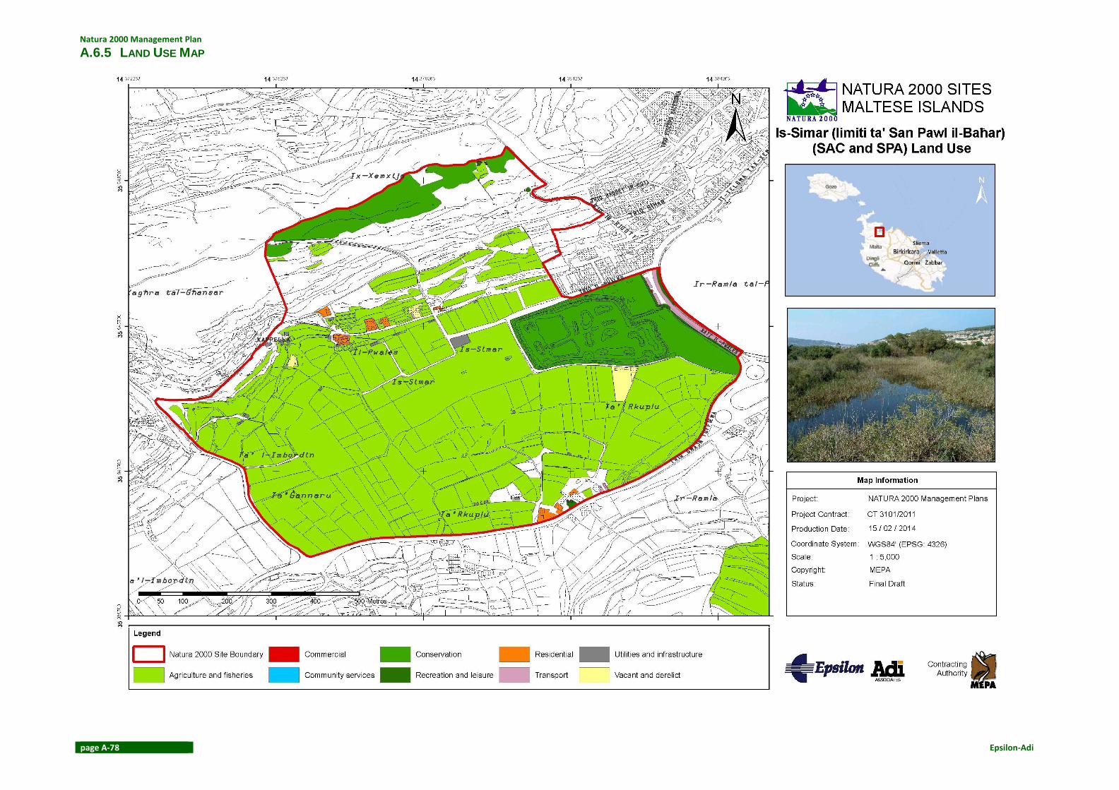
Natura 2000 Management Plan
page A-78 Epsilon-Adi
A.6.5 LAND USE MAP

Is-Simar (limiti ta’ San Pawl il-Baħar)
Epsilon-Adi page A-79
A.6.6 HABITATS MAP

Natura 2000 Management Plan
page A-80 Epsilon-Adi
A.6.7 SIGNAGE MAP

Is-Simar (limiti ta’ San Pawl il-Baħar)
Epsilon-Adi page A-81
A.6.8 SPECIES MAP

Natura 2000 Management Plan
page A-82 Epsilon-Adi
A.6.9 LAND OWNERSHIP MAP

Is-Simar (limiti ta’ San Pawl il-Baħar)
Epsilon-Adi page A-83

Natura 2000 Management Plan
page A-84 Epsilon-Adi
A.6.10 VISITOR ACCESS MAP
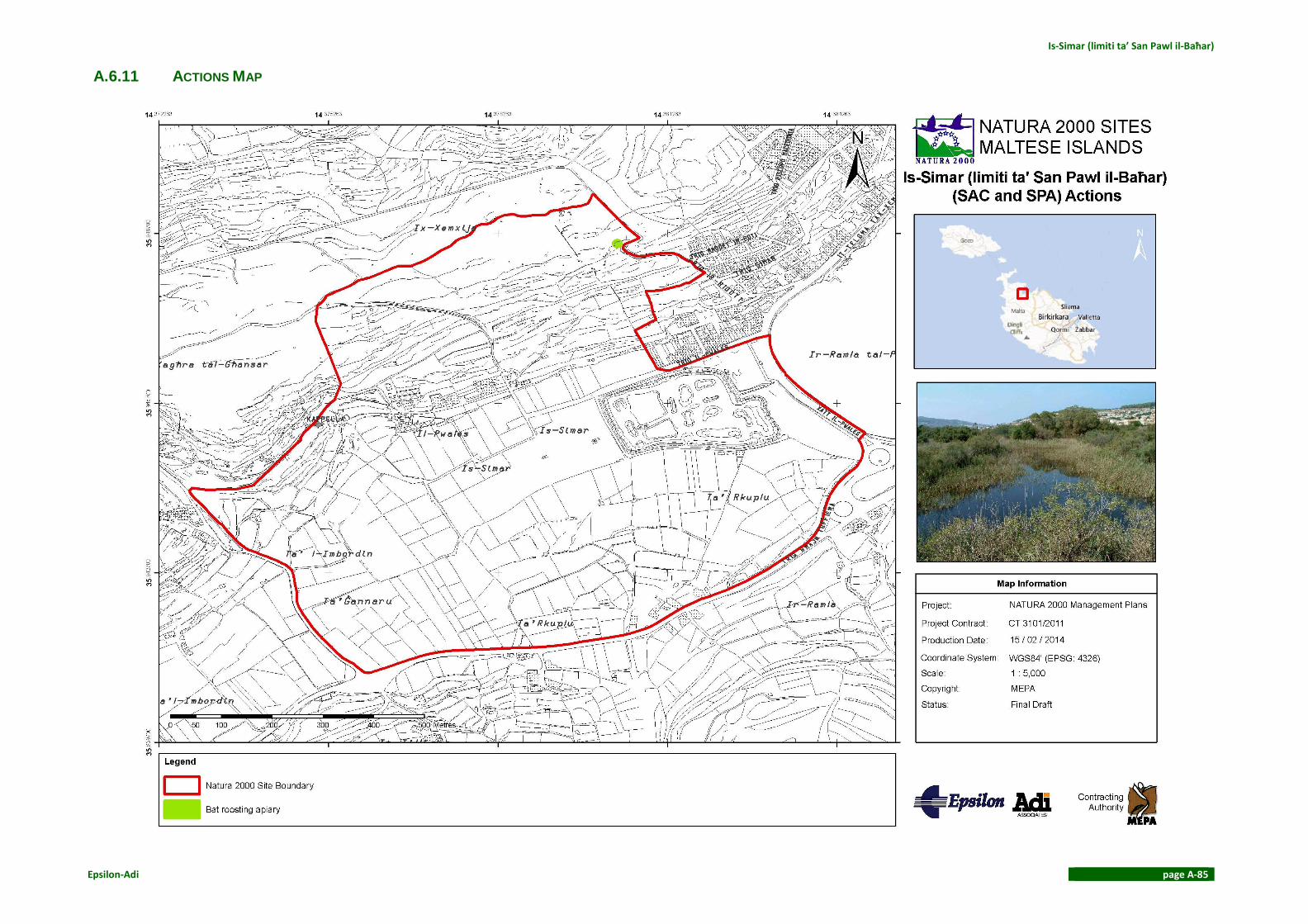
Is-Simar (limiti ta’ San Pawl il-Baħar)
Epsilon-Adi page A-85
A.6.11 ACTIONS MAP

Natura 2000 Management Plan
page A-86 Epsilon-Adi
ANNEX BIBLIOGRAPHY
Le Maitre, D. C. et al., 2011. Impacts of invasive Australian acacias: implications for
management and restoration. Diversity and Distributions, Volume 17, pp. 1015-1029.
MEPA, 2013. Guidelines on managing plant invaders and restoring Native Plant Communities,
St Francis Ravelin: MEPA

Is-Simar (limiti
ta’ San Pawl il-
Baħar)
s
This is the Is-Simar (limiti ta’ San Pawl il-Baħar) Management Plan that
contains available information
retrieved up to 2013 for the site. The
Management Plan delivers details on
site conservation and protection.
The Natura 2000 Management
Planning for Malta and Gozo project
is funded by the EAFRD and pioneered
by MEPA. It is aimed to establish
management plans and legal
provisions for the management of all
terrestrial Natura 2000 sites in the
Maltese Islands and to increase
awareness of Natura 2000 amongst
the general public and stakeholders.
The project started in October 2012
and ended in March 2014. It is
considered a milestone in the
protection of Malta’s rural
environment, as it undertakes
necessary actions required in
management planning for the 34
terrestrial Natura 2000 sites.
The project involved gathering
information, carrying out surveys,
defining conservation objectives and
identifying management measures,
with intensive stakeholder
involvement. These management
plans are not intended to restrain
recreational or other economical
activities within these sites, but rather
to support the sustainable use of Malta’s natural resources with the
involvement of stakeholders.