integrating geospatial information into fire risk assessment
TRANSCRIPT

EUR 24941 EN - 2011
Advances in Remote Sensing and GIS
applications in Forest Fire Management
From local to global assessments
Jesus San-Miguel Ayanz, Ioannis Gitas, Andrea Camia, Sandra Oliveira
Editors

Proceedings of the 8th
International EARSeL FF-SIG Workshop
Stresa (Italy), 20 - 21 October 2011
Advances in Remote Sensing and GIS applications in Forest
Fire Management
From local to global assessments
Edited by:
Jesus San-Miguel Ayanz
Andrea Camia
Sandra Santos de Oliveira
Institute for Environment and Sustainability
Joint Research Centre (Italy)
Ioannis Gitas
Laboratory of Forest Management and Remote Sensing
Aristotle University of Thessaloniki (Greece)

The mission of the JRC-IES is to provide scientific-technical support to the European Union’s policies for the protection
and sustainable development of the European and global environment.
European Commission
Joint Research Centre
Institute for Environment and Sustainability
Contact information
Address: TP261, Via Fermi, 2749 – 21027 – Ispra (VA) - Italy
Tel.: +39 0332 786138
Fax: +39 0332 785500
http://forest.jrc.ec.europa.eu/earsel
Legal Notice
Neither the European Commission nor any person acting on behalf of the Commission
is responsible for the use which might be made of this publication.
Europe Direct is a service to help you find answers
to your questions about the European Union
Freephone number (*):
00 800 6 7 8 9 10 11
(*) Certain mobile telephone operators do not allow access to 00 800 numbers or these calls may be billed.
A great deal of additional information on the European Union is available on the Internet.
It can be accessed through the Europa server http://europa.eu/
JRC 66634
EUR 24941 EN
ISBN 978-92-79-21256-7 (print)
ISBN 978-92-79-21257-4 (pdf)
ISSN 1018-5593 (print)
ISSN 1831-9424 (online)
doi: 10.2788/66489
Luxembourg: Publications Office of the European Union
© European Union 2011
Reproduction is authorised provided the source is acknowledged
Printed in Italy

173
INTEGRATING GEOSPATIAL INFORMATION INTO FIRE RISK ASSESSMENT
E. Chuvieco1, I. Aguado1, S. Jurdao1, M.L. Pettinari1, J. Salas1, J. de la Riva2, P. Ibarra2, M. Rodríguez2, M. Echeverría2, D. Azqueta3, M.V. Román3, A. Bastarrika4, S. Martínez5, C. Recondo6,
E. Zapico6, F. J. Martínez-Vega7, S. Martín8 1Departamento de Geografía, Universidad de Alcalá. C/ Colegios, 2. 28801 Alcalá de Henares (Madrid).
[email protected]; 2Departamento de Geografía y Ordenación del Territorio, Universidad de Zaragoza
(Zaragoza); 3Departamento de Fundamentos de Economía e Historia Económica, Universidad de Alcalá (Madrid);
4Departamento de Ingeniería Topográfica, Universidad del País Vasco (Vitoria);
5Departamento de Botánica-IBADER,
Universidad de Santiago (Lugo); 6INDUROT. Campus de Mieres, Universidad de Oviedo (Asturias);
7Centro de Ciencias
Humanas y Sociales (CCHS), Consejo Superior de Investigaciones Científicas (CSIC); 8Departamento de Economía y
Gestión Forestal. ETSI Montes, UPM (Madrid)
Abstract
The conceptual definition of a fire risk assessment system should include the most relevant components associated to the fire process. Fire occurrence factors have been traditionally classified in three groups: Fuels, Heat source and Oxygen. In the case of wildland fires, heat source is mostly related to the starting of the fire (fire ignition), and can be further divided in natural-caused (lightning, volcano eruption) and human-caused. Oxygen is needed for combustion, and it is mostly related to fire propagation, being the critical parameters wind speed, direction and slopes. Fuels are both related to fire ignition (the drier, the more likely to ignite) and propagation (the more fuel load available, the more energy will be released and favour further ignition). Fuel moisture is associated to short-term weather factors, topographic conditions and soil characteristics, while fuel load and geometrical properties are related to climate, soil and land use patterns. In addition to these factors, fire risk assessment should also consider the potential damages caused by fires, which are very much dependent on fire characteristics (energy released, residence time, flame length, etc.). Following these ideas, a comprehensive fire risk assessment system has been developed within the Fireglobe project (www.fireglobe.es), funded under the Spanish Program for Science and Research. To implement the proposed risk framework, the first phase focused on the generation of risk factors for the whole Spanish Iberian territory (both the Canary and the Balearic islands were not considered at this stage). Human factors, lightning probability, fuel moisture content of both dead and live fuels, and propagation have been considered. Additionally, fire vulnerability has been assessed by analyzing values at risk and landscape resilience. Once the variables were generated, the fire risk model was defined by integrating the input variables using statistical and physical approaches. Finally, the validation has been performed using fire statistics derived from the fire seasons of 2010 and 2011. Keywords: Fire Risk, Fuel Moisture Content, Vulnerability, Human factors, Fire propagation
1.1 Fire risk conceptual framework
Forest fires are a major factor of environmental transformation in a wide variety of ecosystems
(FAO 2007), while they also have important impacts at global scale, both in terms of land use
transformation (affecting habitats and biodiversity) and gas emission (Chuvieco 2008). Recent
impacts of severe fire seasons in Europe (Portugal, 2005; Greece, 2007; Russia, 2010) have
made the importance of improving current fire risk assessment systems evident for alleviating
the most negative effects of fire.
Any fire risk assessment system should aim to provide certain functions that are either not
currently available or are unsatisfactory. In most operational fire risk assessment systems, the
main objectives are to improve the pre-fire planning actions or improve the suppression
actions. The end-users are fire managers at local or regional administrations. The conceptual
definition of a fire risk assessment system should include the most relevant components
associated to the fire process. Traditionally, fire ignition and propagation has been concerned

174
with three factors: Fuels, Heat source and Oxygen. The heat source can be either natural-
caused (lightning, volcano eruption) or human-caused, being the latter the most extended
worldwide. Oxygen is needed for combustion, and it is mostly related to fire propagation, being
the critical parameters wind speed, wind direction and slope gradient. Fuels are both related to
fire ignition (the drier, the more likely to ignite) and propagation (the more fuel load available,
the more energy will be released and favour further ignition). Fuel moisture is associated to
short-term weather factors, topographic conditions and soil characteristics, while fuel load and
geometrical properties are related to climate, soil and land use patterns.
A comprehensive risk assessment system should also consider the potential damages that may
be caused by a natural hazard. In the case of forest fires, the actual damages are very
dependent on fire behaviour (energy released, residence time, flame length, etc.), which is not
known before the fire. Therefore, the estimation of potential damages is based on expected
scenarios, the worst-case and average conditions being the most common. Those conditions are
commonly based on historical trends of weather variables for the target region, but modelling
approaches are also very useful, especially when considering medium-term changes of weather
or land use patterns as a result of climatic or socio-economic changes.
Figure 1 includes the components of a fire risk system that we have developed within the
framework of the Fireglobe project, funded under the Spanish Science and Innovation program.
It includes the physical probability that a fire starts or propagates, and the potential damages
that it may cause. The former component is named fire danger throughout this document,
whiles the latter, named vulnerability, includes damages related to socio-economic and
ecological values.
Figure 1. Proposed Framework for an integrated fire risk assessment system (adapted from Chuvieco et al. 2010)
To implement the proposed risk framework, the following steps should be carried out:
• Generation of risk factors, using a common geographical unit. A target scale and spatial
resolution needs to be defined, in relation to the sources of data available.
• Model calibration. Input variables of the risk index are measured in a very different
scale (%, m, m/s), and they must be integrated using a sound model that provides
175
objective assessment of risk conditions. This model should be properly parameterized
for a wide set of input conditions.
• Validation. The proposed system should be compared with actual impacts of fire to
quantify its performance for different ecosystem types and for various fire
characteristics.
• Dissemination of risk information, defining the mechanisms to transfer the computed
indices to the end-users, including temporal updating.
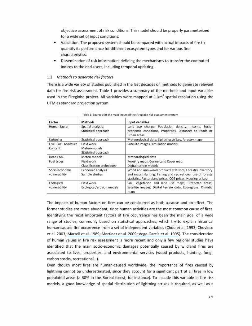
1.2 Methods to generate risk factors
There is a wide variety of studies published in the last decades on methods to generate relevant
data for fire risk assessment. Table 1 provides a summary of the methods and input variables
used in the Fireglobe project. All variables were mapped at 1 km2 spatial resolution using the
UTM as standard projection system.
Table 1. Sources for the main inputs of the Fireglobe risk assessment system
Factor Methods Input variables
Human factor Spatial analysis. Statistical approach
Land use change, Population density, Income, Socio-economic conditions, Properties, Distances to roads or urban areas
Lightning Statistical approach Meteorological data, Lightning strikes, forestry maps
Live Fuel Moisture Content
Field work Meteo-models Statistical approach
Satellite images, simulation models
Dead FMC Meteo-models Meteorological data
Fuel types Field work Classification techniques
Forestry maps. Corine Land Cover map. Digital terrain models
Socio-economic vulnerability
Economic analysis Sample studies
Wood and non-wood products statistics, Forestry inventory and maps, Hunting, Fishing and recreational use of forests statistics, Pastureland prices, CO2 prices, Housing prices
Ecological vulnerability
Field work Ecological/erosion models
Soil, Vegetation and land use maps, Protected areas, satellite images, Digital terrain data, Ecoregions, Climatic maps
The impacts of human factors on fires can be considered as both a cause and an effect. The
former studies are more abundant, since human activities are the most common cause of fires.
Identifying the most important factors of fire occurrence has been the main goal of a wide
range of studies, commonly based on statistical approaches, which try to explain historical
human-caused fire occurrence from a set of independent variables (Chou et al. 1993; Chuvieco
et al. 2003; Martell et al. 1989; Martínez et al. 2009; Vega-García et al. 1995). The consideration
of human values in fire risk assessment is more recent and only a few regional studies have
identified that the main socio-economic damages potentially caused by wildland fires are
associated to lives, properties, and environmental services (wood products, hunting, fungi,
carbon stocks, recreational…).
Even though most fires are human-caused worldwide, the importance of fires caused by
lightning cannot be underestimated, since they account for a significant part of all fires in low
populated areas (> 30% in the Boreal forest, for instance). To include this variable in fire risk
models, a good knowledge of spatial distribution of lightning strikes is required, as well as a

176
better understanding on why a strike becomes an ignition point (Dissing and Verbyla 2003;
Larjavaara et al. 2005; Renkin and Despain 1992).
With respect to fuel moisture content status (FMC, commonly expressed as percentage of dry
weight), the most common approach has been the estimation through moisture codes based on
weather data. The spatial estimation of these indices is commonly based on interpolation
techniques or on gridded forecasted data (Aguado et al. 2007). The FMC of live plants has been
approached from satellite data, both using empirical and simulation methods (Chladil and
Nunez 1995; Garcia et al. 2008; Yebra et al. 2008).
Fire propagation potential was modelled in this project using the Behave model (Rothermel
1983). As an approximation of fuel type mapping, the forestry map of Spain was used, and
updated for some categories using the CORINE land cover map at 1:200.000.
For assessing the potential impacts of fire, and therefore which areas might be more affected if
burned, two synthetic variables were derived. On one hand, the ecological vulnerability, which
was based on an estimation of the number of years any cell in our study area would recuperate
its pre-fire conditions, and on the other the socio-economic values at stake. This latter variable
has in turn two components: values of houses that may be burned in case of fire (those close to
the forest interface), and ecosystem services that may be affected (including wood prices,
firewood, cork, pine nuts, pasture, hunting, CO2 sinks, fishing and recreational services.
1.3 Integration
The integration of input variables is being based in statistical and physical approaches.
Probabilistic scenarios are being considered for human and natural causes, while the
propagation is based on fire behavior models and vulnerability is based on production and
utility functions and expressed in monetary units.
The validation will be based on the fire seasons of 2010 and 2011. Preliminary results show
significant differences between high and low risk areas in terms of fire occurrence.
References
Aguado, I., Chuvieco, E., Boren, R., & Nieto, H. (2007). Estimation of dead fuel moisture content from meteorological data in Mediterranean areas. Applications in fire danger assessment. International Journal of Wildland Fire, 16, 390-397.
Chladil, M.A., & Nunez, M. (1995). Assessing grassland moisture and biomass in Tasmania. The application of remote sensing and empirical models for a cloudy environment. International Journal of Wildland Fire, 5, 165-171.
Chou, Y.H., Minnich, R.A., & Chase, R.A. (1993). Mapping probability of fire occurrence in San Jacinto Mountains, California, USA. Environmental Management, 17, 129-140.
Chuvieco, E. (2008). Satellite observation of biomass burning: implications in global change research. In E. Chuvieco (Ed.), Earth Observation and Global Change (pp. 109-142). New York: Springer
Chuvieco, E., Aguado, I., Yebra, M., Nieto, H., Salas, J., Martín, P., Vilar, L., Martínez, J., Martín, S., Ibarra, P., de la Riva, J., Baeza, J., Rodríguez, F., Molina, J.R., Herrera, M.A., & Zamora, R. (2010). Development of a framework for fire risk assessment using remote sensing and geographic information system technologies. Ecological Modelling, 221, 46-58.
Chuvieco, E., Allgöwer, B., & Salas, F.J. (2003). Integration of physical and human factors in fire danger assessment. In E. Chuvieco (Ed.), Wildland Fire Danger Estimation and Mapping. The Role of Remote Sensing Data (pp. 197-218). Singapore: World Scientific Publishing
Dissing, D., & Verbyla, D.L. (2003). Spatial patterns of lightning strikes in interior Alaska and their relations to elevation and vegetation. Canadian Journal of Forest Research, 33, 770-782.
FAO (2007). Fire management - global assessment 2006. A thematic study prepared in the framework of the Global Forest Resources Assessment 2005. Rome: FAO Forestry Paper 151

177
Garcia, M., Aguado, I., & Chuvieco, E. (2008). Combining AVHRR and meteorological data for estimating live fuel moisture content in forest fire danger rating. Remote Sensing of Environment, 112, 3618-3627, doi:3610.1016/j.rse.2008.3605.3002.
Larjavaara, M., Pennanen, J., & Tuomi, T.J. (2005). Lightning that ignites forest fires in Finland. Agricultural and Forest Meteorology, 132, 171-180.
Martell, D.L., Bevilacqua, E., & Stocks, B.J. (1989). Modelling seasonal variation in daily people-caused forest fire occurrence. Canadian Journal of Forest Research, 19, 1555-1563.
Martínez, J., Vega-García, C., & Chuvieco, E. (2009). Human-caused wildfire risk rating for prevention planning in Spain. Journal of Environmental Management, 90, 1241-1252.
Renkin, R.A., & Despain, D.G. (1992). Fuel moisture, forest type, and lightning-caused fire in Yellowstone National Park. Canadian Journal of Forest Research, 22, 37-45.
Rothermel, R.C. (1983). How to predict the spread and intensity of forest and range fires. Ogden, UT: USDA, Forest Service, GTR INT-143
Vega-García, C., Woodard, T., Adamowicz, & Lee, B. (1995). A logit model for predicting the daily occurence of human caused forest fires. International Journal of Wildland Fire, 5, 101-111.
Yebra, M., Chuvieco, E., & Riaño, D. (2008). Estimation of live Fuel Moisture Content from MODIS images for fire risk assessment. Agricultural and Forest Meteorology, 148, 523-536.