integrating cultural heritage into maritime spatial planning in
TRANSCRIPT
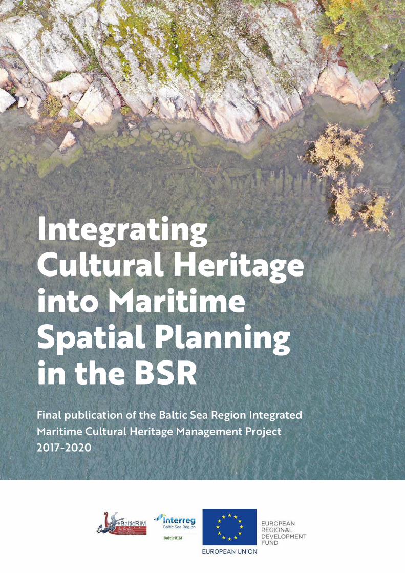
Integrating Cultural Heritage into Maritime Spatial Planning in the BSRFinal publication of the Baltic Sea Region Integrated
Maritime Cultural Heritage Management Project
2017-2020

Integrating cultural heritage into maritime spatial planning in the BSR
Final publication of the Baltic Sea Region Integrated Maritime Cultural Heritage Management Project
(BalticRIM) 2017-2020
Editors:
Marianne Lehtimäki, Sallamaria Tikkanen and Riikka Tevali, Finnish Heritage Agency
Authors in bold and contributors:
Susanne Altvater, Robert Aps, Leyla Bashirova, Nerijus Blazauskas, Larisa Danilova, Kristjan Herkül, Krista
Karro, Krzysztof Kurzyk, Liisi Lees, Marianne Lehtimäki, Paweł Litwinienko, Matthias Maluck, Magdalena
Matczak, Joanna Pardus, Iwona Pomian, Janusz Różycki, Mailis Roio, Lise Schrøder, Laura Seesmeri, Łukasz
Szydłowski, Riikka Tevali, Sallamaria Tikkanen, Jakub Turski, Joanna Witkowska, Kamila Zalesiak, Jacek
Zaucha, Vladas Zulkus, Daniel Zwick.
Layout and graphic design: Mainostoimisto KMG Turku
Cover photo: Wreck of Korpoström Alf, Parainen, Finland. Photo: Maija Huttunen
Contact persons for the BalticRIM project: Matthias Maluck, Lead Partner State Archaeology Department
of Schleswig-Holstein and Coordinator Susanne Altvater, s.Pro
Contact person for cultural heritage: Sallamaria Tikkanen, Finnish Heritage Agency
Contact person for MSP: Jacek Zaucha, University of Gdańsk
Contact person for BalticRIM Data Portal: Lise Schrøder, Aalborg University
Disclaimer: The publication is a result of the project “BalticRIM– Baltic Sea Region Integrated Maritime
Cultural Heritage Management” (2017–2020). Part-financed by the European Union (European Regional
Development Fund). Report content is the sole responsibility of the authors and can in no way be taken
to reflect the views of the European Union.
ForewordWater connects us, and culture unites. This Council
of Baltic Sea States’ motto can be applied as an
overall theme for the BalticRIM approach, too.
The slogan capsulizes the project's commitment
to safeguard social and heritage assets of the Baltic
Sea through the long-standing tradition of a cul-
ture of cooperation in the region.
The BalticRIM project developed Baltic Sea wide
principles and elaborated national practices for
integrating maritime cultural heritage into mari-
time spatial planning. The project strived for con-
tributing to a culture of sustainability, where the
diversity and accessibility of maritime attractions
and landscapes will strengthen the well-being of
citizens and visitors, and raise the awareness for
and the protection of the Baltic Sea.
The project idea was born in the minor Pro BSR
project conducted by the Baltic Sea Region her-
itage networks in 2016. This project updated the
strategy for Baltic Sea Region cultural heritage
cooperation and elaborated a related Action Plan
for maritime cultural heritage. The Action Plan set
the goal of integrating maritime cultural heritage
into ongoing maritime spatial planning in accord-
ance with the EU Maritime Spatial Planning Direc-
tive of 2014. The CBSS funded the Pro BSR project
from its Project Support Facility.
As a first steppingstone in this initiative, the CBSS
Secretariat assisted with establishing the contacts
to HELCOM and VASAB. For the development
of the project application, the Baltic Sea Region
Expert Working Groups on underwater and on
coastal cultural heritage combined their expertise
with the Submariner Network for Blue Growth
EEIG. The Submariner Network works in dialogue
with the Joint HELCOM-VASAB Maritime Spatial
Planning Working Group.
Thanks to strong stakeholder support and cross-dis-
cipline and -sectoral cooperation, the BalticRIM
project initiative was given the EUSBSR PA Culture
Flagship status, and the project received funding
from the Baltic Sea Region Programme (Interreg).
The Blue Growth Agenda for the Baltic Sea Region
endorsed in 2014, highlights the extraordinary
potential for developing the maritime economy
thanks to the vast capacity for innovation and
competitiveness and a strong tradition of transna-
tional cooperation in the region. The Agenda ranks
tourism and maritime experience industry as an
emerging area with high potential. The results of
the BalticRIM project will contribute to the sus-
tainable exploitation of this potential.
Dr Kaarina Williams
Senior Advisor for Regional Identity,
Council of the Baltic Sea States
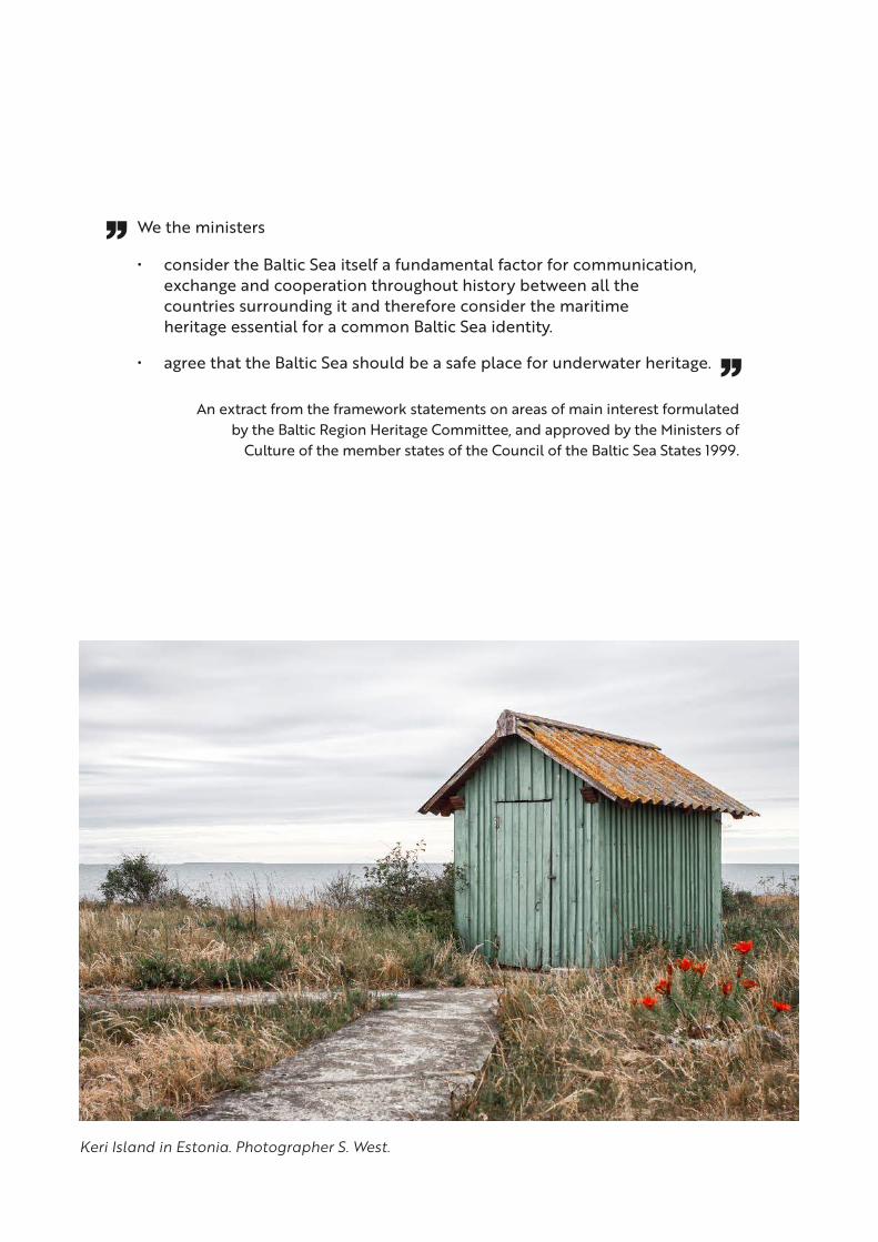
We the ministers
• consider the Baltic Sea itself a fundamental factor for communication, exchange and cooperation throughout history between all the countries surrounding it and therefore consider the maritime heritage essential for a common Baltic Sea identity.
• agree that the Baltic Sea should be a safe place for underwater heritage.
An extract from the framework statements on areas of main interest formulated by the Baltic Region Heritage Committee, and approved by the Ministers of
Culture of the member states of the Council of the Baltic Sea States 1999.
Keri Island in Estonia. Photographer S. West.
ContentsAbbreviations 6Introduction 8
1. BalticRIM Starting Points 111.2 Baltic Sea cultural heritage reflects connections 11
1.2 Cultural heritage as a part of maritime spatial planning 11
1.3 The significance of seas and cultural heritage for society 16
1.4 Maritime cultural heritage in the Baltic Sea 19
2. BalticRIM Analyses 232.1 Baltic Sea as an environment for underwater cultural heritage 23
2.2 Maritime cultural heritage approach for MSP 30
2.3 Cultural heritage data registers 31
2.4 The first MSP round: country-specific conditions in the integration of MCH to MSP 31
2.5 The first MSP round: an overview of the challenges to integration 45
3. BalticRIM Solutions 523.1 The BalticRIM Data Portal 52
3.2 BalticRIM WIKI – a glossary of maritime and underwater cultural heritage terms 55
3.3 BalticRIM underwater landscape concept 55
3.4 Culturally Significant Areas and Underwater Landscape in maritime spatial planning 59
3.5 How to integrate maritime cultural heritage into MSP 60
4. BalticRIM Recommendations 634.1 Recommendations for heritage authorities and stakeholders 63
4.2 Recommendations for maritime spatial planners, authorities and decision makers 70
4.3 Recommendations for co-operation for heritage and planning experts 74
5. Maritime Cultural Heritage and Blue growth 765.1 Maritime cultural heritage as part of blue economy 76
5.2 Recommendations to promote blue growth based on maritime cultural heritage 84
References 88Sources 92Annex 101Partners 103
6
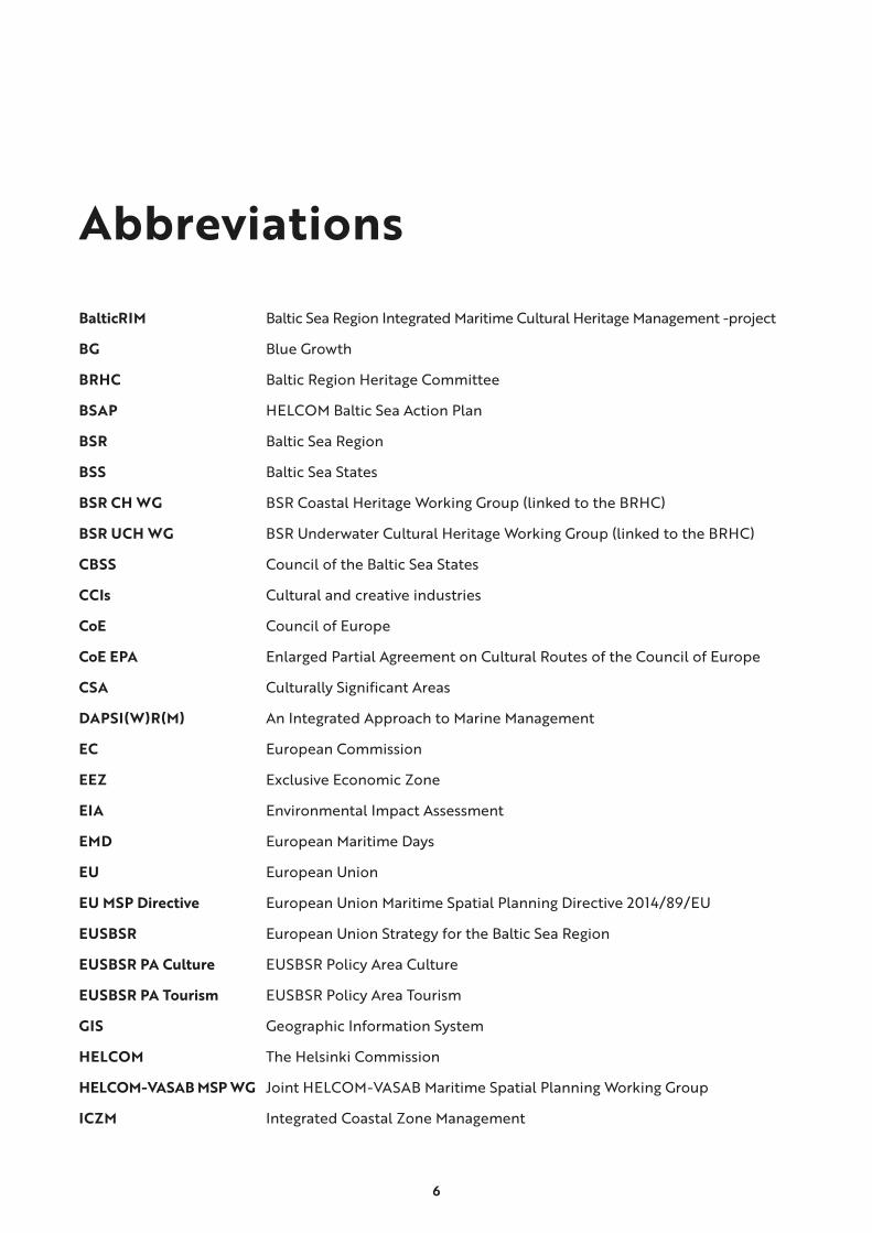
Abbreviations
BalticRIM Baltic Sea Region Integrated Maritime Cultural Heritage Management -project
BG Blue Growth
BRHC Baltic Region Heritage Committee
BSAP HELCOM Baltic Sea Action Plan
BSR Baltic Sea Region
BSS Baltic Sea States
BSR CH WG BSR Coastal Heritage Working Group (linked to the BRHC)
BSR UCH WG BSR Underwater Cultural Heritage Working Group (linked to the BRHC)
CBSS Council of the Baltic Sea States
CCIs Cultural and creative industries
CoE Council of Europe
CoE EPA Enlarged Partial Agreement on Cultural Routes of the Council of Europe
CSA Culturally Significant Areas
DAPSI(W)R(M) An Integrated Approach to Marine Management
EC European Commission
EEZ Exclusive Economic Zone
EIA Environmental Impact Assessment
EMD European Maritime Days
EU European Union
EU MSP Directive European Union Maritime Spatial Planning Directive 2014/89/EU
EUSBSR European Union Strategy for the Baltic Sea Region
EUSBSR PA Culture EUSBSR Policy Area Culture
EUSBSR PA Tourism EUSBSR Policy Area Tourism
GIS Geographic Information System
HELCOM The Helsinki Commission
HELCOM-VASAB MSP WG Joint HELCOM-VASAB Maritime Spatial Planning Working Group
ICZM Integrated Coastal Zone Management

7
LSI Land Sea Interaction
MCH maritime cultural heritage
MEA Millennium Ecosystem Assessment
MSDI Marine Spatial Data Infrastructure
MSP maritime spatial planning
SEA Strategic Environmental Assessment
UNWTO World Tourism Organization of United Nations
UCH underwater cultural heritage
UWL BalticRIM Underwater Landscape
VASAB Vision and strategies around the Baltic Sea
WHS World Heritage Site
8
IntroductionMaritime cultural heritage (MCH) encompasses
all physical and intangible remains of historical
sea uses on the water, under water and on land.
Today, however, this heritage is increasingly under
pressure by ever-growing uses of the seas. The
Baltic Sea is one of the most heavily used seas
worldwide. The construction of the infrastructure
of renewable energy sources, other maritime
infrastructure in the form of ports, pipelines or
submarine cables, as well as the exploitation of
other raw materials are overtaking traditional uses,
such as fishing or even shipping. Furthermore, the
Baltic Sea is heavily polluted by, for example, the
input of fertilizer from the surrounding countries,
by the sea use itself and by ammunition disposed
of during and after the wars.
The UNESCO Convention on the Protection of the
Underwater Cultural Heritage of 2001 established
a comprehensive legal framework for the preserva-
tion, protection, and management of underwater
cultural heritage (UCH). To date, Estonia, Lithuania
and Poland have ratified this convention in the
Baltic Sea region. According to the European Union
Maritime Spatial Planning Directive (2014/89/
EU), UCH is one possible activity, use and interest
in planning of maritime space. Spatial planning
provides an outstanding tool to mediate between
diverging interests and mitigate the conflicting uses.
BalticRIM (acronym for Baltic Sea Integrated
Maritime Cultural Heritage Management) sought
to integrate MCH into MSP. It promoted the sig-
nificance of maritime cultural heritage (MCH) in
the MSP community. The project looked for ways
to incorporate safeguarding and sustainable utili-
zation of MCH into MSP processes, practices and
plans. In order to synchronize the interdisciplinary
attempts, instruments to serve integration were
developed for both disciplines. BalticRIM has
facilitated cross-sectoral dialogue with different
stakeholders to identify conflict areas and created
applicable solutions. Furthermore, the knowledge,
compiled in this project, promotes a sustainable
use of MCH in terms of blue growth.
The project brought together experts of both dis-
ciplines of MCH and MSP around the Baltic Sea to
find new solutions and approaches for sustainable
management, protection and use of MCH. Working
methods and tools for integrating cultural heritage
aspects in MSP were developed and applied in
national and transboundary pilot cases. The part-
nership comprised of public authorities, museums,
expert institutes and universities from Denmark,
Estonia, Finland, Germany (Schleswig-Holstein),
Lithuania, Poland and Russia.
BSR cultural heritage cooperation between state
agencies on cultural heritage (BRHC) initiated
the BalticRIM as a lighthouse project. The pro-
ject received the status of Flagship Project of the
EUSBSR PA Culture. The European Commission
selected BalticRIM as a project under the Euro-
pean Year of Cultural Heritage 2018. Several BSR
macro-regional organisations, such as the CBSS,
the EUSBSR PA Culture Coordinators, and the
HELCOM-VASAB WG on MSP1 encouraged and
supported project preparation, implementation
and stakeholder cooperation.
9
This publication provides a synopsis of the legal
and administrative situation and of the practises
concerning the management of MCH with respect
to MSP across the Baltic Sea states. Analyses deal
with the first round processes of MSP during 2017-
2020. The BalticRIM recommendations are tailored
separately for both cultural heritage administra-
tion and MSP. In addition, this publication con-
siders the role of MCH in current blue growth
initiatives across the BSR and the development
perspectives, focussing on tourism.
BalticRIM data portal displays the spatial data
regarding both the MSP pilots and gathered blue
growth information and BalticRIM WIKI presents
MCH and UCH terminology with attached defini-
tions. A separate handbook provides an overview
of the solutions (chapter 3) concisely.
Roedvig harbour in Denmark. Photo L. Schrøder.

10
The first sentence of Rule 1 of the UNESCO Convention on the Protection of the Underwater Cultural Heritage of 2001 states: ‘The protection of underwater cultural heritage through in situ preservation shall be considered as the first option’ is the core of this rule. The consideration given to preservation in situ by the Convention and its Annex is based on the recognition of the importance of the interplay between the site, its story and its context.
In situ preservation is the first option, because
• The site of a historic event is authentic,• Context defines significance,• Heritage is finite, and• Many sites cannot be preserved in situ.
unesco.org homepage / Manual for activities directed at UCH
Remains of trees, found on the seabed in the depth of 25 m in Lithuanian waters, inside the BalticRIM pilot planning area. These trees used to grow about 10500 years ago. Photo V. Žulkus, Klaipeda University.

11
1. BalticRIM Starting Points
1.2 Baltic Sea cultural heritage reflects connections
On the shores of the Baltic Sea, we have a
common sea, diverse cultures and common mar-
itime heritage. We owe part of our wealth, pros-
perity and success to past maritime industries
and cultures. Therefore, we have an abundant,
varied and often well-preserved MCH and UCH
to enrich our lives, which must be protected and
used in a sustainable way. The diversity of this
heritage appears in its most fascinating form from
the pan-Baltic perspective as an assemblage of
multi-narratives, unique even on a global scale.
Baltic Sea space should be taken account as a
valuable asset.2
Maritime routes have played a key role in cre-
ating and shaping regional and national cultures.
Through the centuries-long maritime and coastal
interaction between people, towns and regions,
the Baltic Sea forms a multifaceted and millennia
old cultural area in the same way as the Mediterra-
nean or Black Sea. The MCH has great potential to
demonstrate the connectedness of the BSR. Both
tangible and intangible heritage illustrate the flow
of goods, crafts and cultural influences.
Tangible cultural heritage encapsulates the phys-
ical and material elements of heritage. Intangible
heritage refers to “practices, representations,
expressions, knowledge, skills − as well as instru-
ments, objects, artefacts and cultural spaces
associated therewith − that communities, groups
and, in some cases, individuals recognize as part of
their cultural heritage”.3
The BalticRIM as a MSP project concentrated
mainly on the tangible cultural heritage with fixed
coordinates and recorded physical features, such
as archaeological sites, monuments, and buildings,
but with less information regarding intangible
values. For promoting the intangible values and
significances of underwater sites and spaces, the
project worked on the Concept of Underwater
Landscape (chapter 3.3).
1.2 Cultural heritage as a part of maritime spatial planning
Directive 2014/89 of the European Parliament and
of the Council establishes a framework for MSP
aimed at promoting the sustainability in terms of
growth of maritime economies, development of
marine areas and use of marine resources. This
directive refers to UCH as a possible activity, use
and interest of maritime space.4 Thereby UCH
should be considered in the planning of maritime
space, along, for example, with transport, nature
and tourism.
The MSP directive notices only UCH, and con-
sequently, this is also the case for many MSP
processes.5 However, MSP should also consider a

12
Estonian Keri lighthouse. Photo Kaupo Kalda.
Heritage has a specific role in achieving sustainable and inclusive growth, due to its social and economic impact and its key contribution to environmental sustainability. Culture and cultural heritage can be perceived not only as a structural component, but also as a necessary agent in moving towards a more sustainable society.
Soini, K., Dessain J. Culture-Sustainability Relation: Towards a Conceptual Framework 2016:6
13
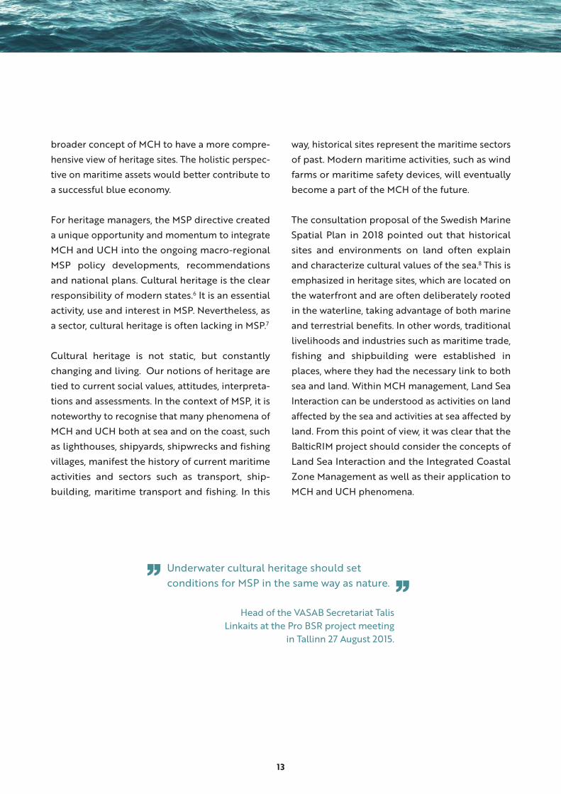
broader concept of MCH to have a more compre-
hensive view of heritage sites. The holistic perspec-
tive on maritime assets would better contribute to
a successful blue economy.
For heritage managers, the MSP directive created
a unique opportunity and momentum to integrate
MCH and UCH into the ongoing macro-regional
MSP policy developments, recommendations
and national plans. Cultural heritage is the clear
responsibility of modern states.6 It is an essential
activity, use and interest in MSP. Nevertheless, as
a sector, cultural heritage is often lacking in MSP.7
Cultural heritage is not static, but constantly
changing and living. Our notions of heritage are
tied to current social values, attitudes, interpreta-
tions and assessments. In the context of MSP, it is
noteworthy to recognise that many phenomena of
MCH and UCH both at sea and on the coast, such
as lighthouses, shipyards, shipwrecks and fishing
villages, manifest the history of current maritime
activities and sectors such as transport, ship-
building, maritime transport and fishing. In this
way, historical sites represent the maritime sectors
of past. Modern maritime activities, such as wind
farms or maritime safety devices, will eventually
become a part of the MCH of the future.
The consultation proposal of the Swedish Marine
Spatial Plan in 2018 pointed out that historical
sites and environments on land often explain
and characterize cultural values of the sea.8 This is
emphasized in heritage sites, which are located on
the waterfront and are often deliberately rooted
in the waterline, taking advantage of both marine
and terrestrial benefits. In other words, traditional
livelihoods and industries such as maritime trade,
fishing and shipbuilding were established in
places, where they had the necessary link to both
sea and land. Within MCH management, Land Sea
Interaction can be understood as activities on land
affected by the sea and activities at sea affected by
land. From this point of view, it was clear that the
BalticRIM project should consider the concepts of
Land Sea Interaction and the Integrated Coastal
Zone Management as well as their application to
MCH and UCH phenomena.
Underwater cultural heritage should set conditions for MSP in the same way as nature.
Head of the VASAB Secretariat Talis Linkaits at the Pro BSR project meeting
in Tallinn 27 August 2015.
14
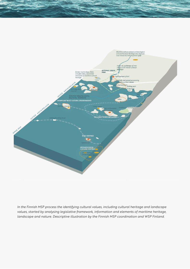
In the Finnish MSP process the identifying cultural values, including cultural heritage and landscape values, started by analysing legislative framework, information and elements of maritime heritage, landscape and nature. Descriptive illustration by the Finnish MSP coordination and WSP Finland.
15
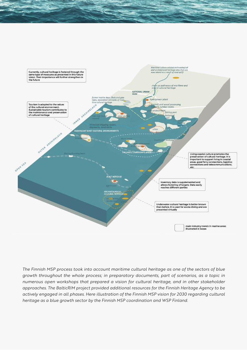
The Finnish MSP process took into account maritime cultural heritage as one of the sectors of blue growth throughout the whole process; in preparatory documents, part of scenarios, as a topic in numerous open workshops that prepared a vision for cultural heritage, and in other stakeholder approaches. The BalticRIM project provided additional resources for the Finnish Heritage Agency to be actively engaged in all phases. Here illustration of the Finnish MSP vision for 2030 regarding cultural heritage as a blue growth sector by the Finnish MSP coordination and WSP Finland.

16
1.3 The significance of seas and cultural heritage for society
Cultural heritage plays an important role in cre-
ating and enhancing quality of life, sense of place,
social capital and blue growth. Maritime cultural
heritage connects people and generations, and
helps us to understand the past, present and
future of humanity’s relationship with the seas
and oceans.9
The seas and oceans have a strong human
dimension as places for heritage, imagination
and projection.10 Indeed, we are dealing with a
number of overlapping sea spaces, which act as
social, communication and cultural spaces. Marine
space is a multi-dimensional concept requiring a
multidisciplinary approach by physicists, biolo-
gists, geographers, economists, political scientists,
spatial planners, sociologists, philosophers and
humanists.11 Landscape research and maritime
archaeology can be added to the list of sciences,
which are interested in the maritime “vital space” 12.
There is a strong current trend of the “blue human-
ities”, which engage scholars in sociology, cultural
and literary studies as well as other disciplines to
lively debates reconsidering terms, concepts and
vocabulary.13 Emerging discourses provide fresh
perspectives to the idea of a “blue planet”14 and
of the human - sea relationship.15 A key message
of this research is that “the sea is not a material or
metaphorical void, but alive with embodied human
experiences, more-than-human agencies and as
well as being a space in and of itself that has mate-
rial character, shape and form”.16 This approach is
suitable also for MSP as it takes into consideration
non-human agencies such as flora, fauna and the
sea as water. It also points out that our life depends
on the well-being of the oceans and seas.
Cultural heritage forms a finite, non-renewable,
fragile and irreplaceable assembly.17 If destroyed,
whether intentionally, accidentally or by “over
loving”18, the invaluable information and poten-
tial of the heritage sites will be lost forever, and
cannot be recovered. Heritage sites have intrinsic
spiritual, symbolic, historical, and cultural values. 19
As a resource, sites have also instrumental value
for creating a sense of identity for locals and
raising economic well-being through tourism and
recreation.20
Cultural heritage is relevant to the whole spectrum
of United Nations Decade of Ocean Science for
Sustainable Development 2021 – 2030 objectives,
themes and priorities. In general, archaeological
and wider cultural heritage approaches provide
information on human activity on the marine
space over millennia, which help to design future
strategies.21 Old and new narratives and recog-
nition of cultural heritage are fascinating to the
public and enable engagement with many themes
of Ocean Literacy.22
In general, cultural heritage contributes to the
feeling of continuity and the crisis resistance of
communities. It also has a role in planning plan-
etary sustainability. These are all necessary quali-
ties, when we are heading towards a post-Covid 19
society, with a shared responsibility to implement
more sustainable land use- and consumption
patterns.
17
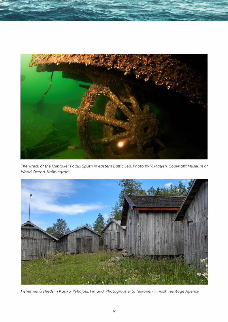
The wreck of the Icebraker Pollux Sputh in eastern Baltic Sea. Photo by V. Malysh. Copyright Museum of World Ocean, Kaliningrad.
Fishermen’s sheds in Kauko, Pyhäjoki, Finland. Photographer S. Tikkanen. Finnish Heritage Agency.
18
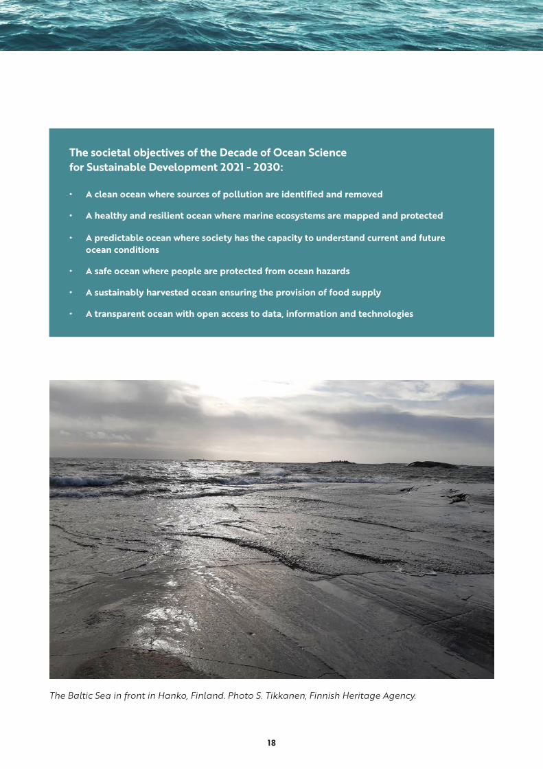
The societal objectives of the Decade of Ocean Science for Sustainable Development 2021 - 2030:
• A clean ocean where sources of pollution are identified and removed
• A healthy and resilient ocean where marine ecosystems are mapped and protected
• A predictable ocean where society has the capacity to understand current and future ocean conditions
• A safe ocean where people are protected from ocean hazards
• A sustainably harvested ocean ensuring the provision of food supply
• A transparent ocean with open access to data, information and technologies
The Baltic Sea in front in Hanko, Finland. Photo S. Tikkanen, Finnish Heritage Agency.
19
1.4 Maritime cultural heritage in the Baltic Sea
The four compass points of Baltic Sea
The northern Baltic Sea is characterized by
archipelagos divided to outer, middle and inner
archipelagos with the islands becoming smaller
and sparser the further one gets to open sea. The
human adaptation to the environment is visible
in the cultural history and the archaeological
remains. The Bothnian Sea has a very different
environment and a different sea from the southern
parts. Fishing villages dot the archipelagos in the
south along with pilot stations and lighthouses. In
the Bothnian Sea, the coasts are always new due to
the isostatic land uplift, which carries the historical
coasts inland and makes new islands.
There is a strong tendency in the eastern Baltic
Sea countries to consider cultural heritage in the
shores of the large rivers and inland, where most
of the great manors, castles and ancient hillforts
are situated along with the historic towns. The long
shallow beaches have made it difficult to board
ships, so traffic and towns have conglomerated
along the large rivers, Narva, Daugava and Neman
/Nemunas. The view from the eastern Baltic Sea
is unlike from the other shores, with the open sea
as long as the eye can see and long sandy beaches
with no obstacles, like along the Curonian Spit.
The western Baltic Sea consists of the coasts and
islands of Sweden, Germany and Denmark. The
sea is saltier than in the north, where water is
almost sweet. The Baltic Sea has inundated land
since the Stone Age, leaving large settlement
sites underwater today. The busy route of sailing
and commerce through the Sound has brought
hundreds of wrecks from all eras to the coasts
and open sea. However, most have vanished due
to the woodborers, which eat away the wooden
ships leaving only the parts covered by the sandy
bottom untouched.
In ancient times, the south coast extended much
further north. Today, remains of ancient settle-
ments or remains of ancient forests are under
water. The southern Baltic Sea has a coastline
dotted with extensive river systems as well as
lagoons, sealed off from the sea by sandy spits,
thus forming sheltered navigable waters in the
coastal zone, which became important for fishing
and local transport. From the Early Medieval
emporia along rivers, large towns were first estab-
lished on the coasts of the Baltic Sea in the Middle
Ages, where it was possible to gaze towards new
shores and possibilities. The ancient and impor-
tant towns in the southern coast include massively
built waterfronts, harbours and warehouse struc-
tures, not to mention the wrecks testifying of the
importance of the region.
20
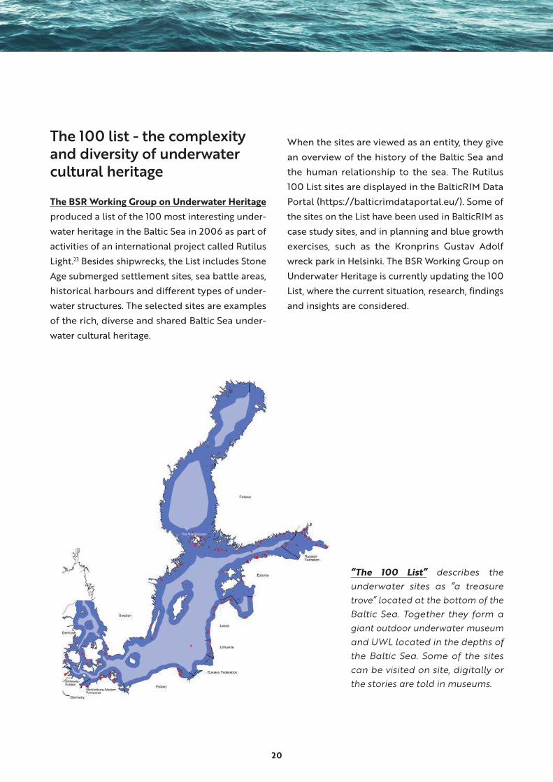
The 100 list - the complexity and diversity of underwater cultural heritage
The BSR Working Group on Underwater Heritage
produced a list of the 100 most interesting under-
water heritage in the Baltic Sea in 2006 as part of
activities of an international project called Rutilus
Light.23 Besides shipwrecks, the List includes Stone
Age submerged settlement sites, sea battle areas,
historical harbours and different types of under-
water structures. The selected sites are examples
of the rich, diverse and shared Baltic Sea under-
water cultural heritage.
When the sites are viewed as an entity, they give
an overview of the history of the Baltic Sea and
the human relationship to the sea. The Rutilus
100 List sites are displayed in the BalticRIM Data
Portal (https://balticrimdataportal.eu/). Some of
the sites on the List have been used in BalticRIM as
case study sites, and in planning and blue growth
exercises, such as the Kronprins Gustav Adolf
wreck park in Helsinki. The BSR Working Group on
Underwater Heritage is currently updating the 100
List, where the current situation, research, findings
and insights are considered.
“The 100 List” describes the underwater sites as “a treasure trove” located at the bottom of the Baltic Sea. Together they form a giant outdoor underwater museum and UWL located in the depths of the Baltic Sea. Some of the sites can be visited on site, digitally or the stories are told in museums.
21
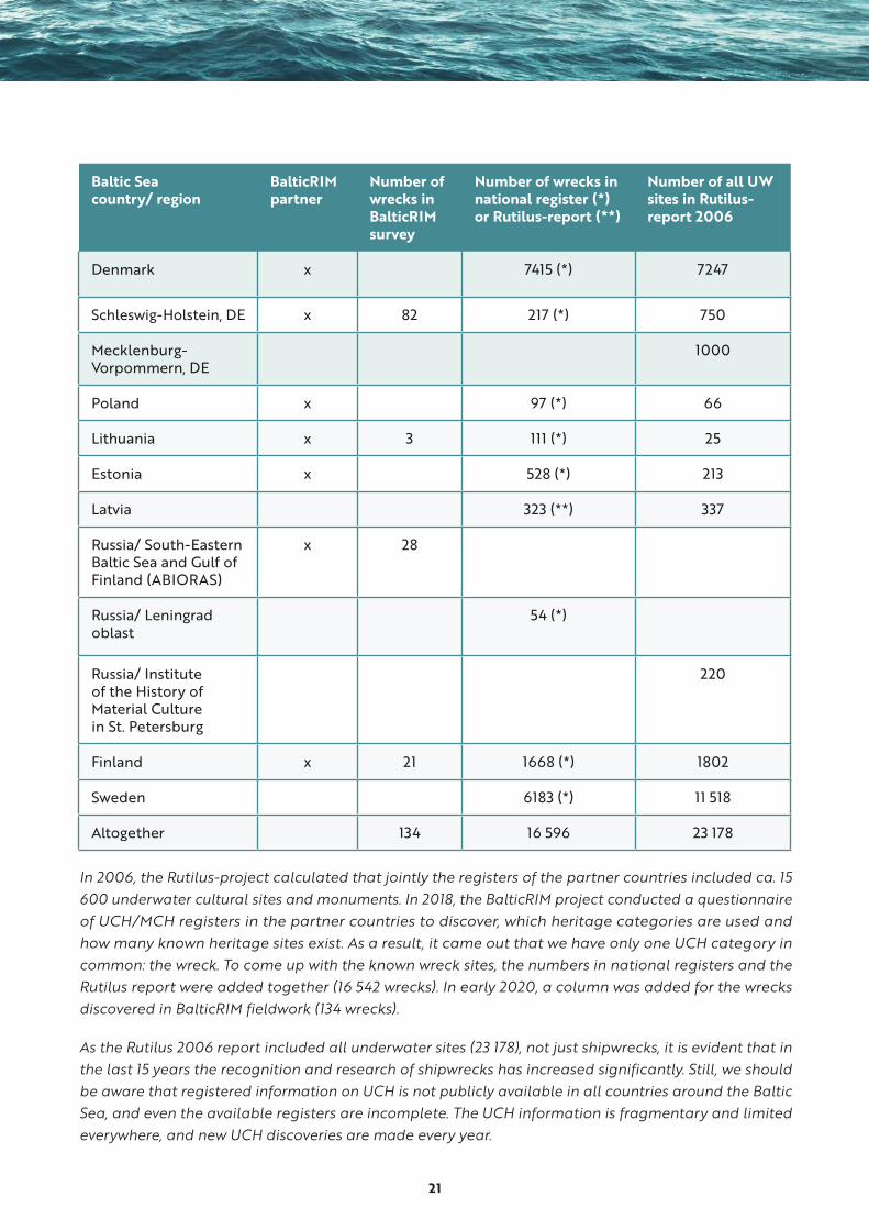
Baltic Sea country/ region
BalticRIM partner
Number of wrecks in BalticRIM survey
Number of wrecks in national register (*) or Rutilus-report (**)
Number of all UW sites in Rutilus- report 2006
Denmark x 7415 (*) 7247
Schleswig-Holstein, DE x 82 217 (*) 750
Mecklenburg- Vorpommern, DE
1000
Poland x 97 (*) 66
Lithuania x 3 111 (*) 25
Estonia x 528 (*) 213
Latvia 323 (**) 337
Russia/ South-Eastern Baltic Sea and Gulf of Finland (ABIORAS)
x 28
Russia/ Leningrad oblast
54 (*)
Russia/ Institute of the History of Material Culture in St. Petersburg
220
Finland x 21 1668 (*) 1802
Sweden 6183 (*) 11 518
Altogether 134 16 596 23 178
In 2006, the Rutilus-project calculated that jointly the registers of the partner countries included ca. 15 600 underwater cultural sites and monuments. In 2018, the BalticRIM project conducted a questionnaire of UCH/MCH registers in the partner countries to discover, which heritage categories are used and how many known heritage sites exist. As a result, it came out that we have only one UCH category in common: the wreck. To come up with the known wreck sites, the numbers in national registers and the Rutilus report were added together (16 542 wrecks). In early 2020, a column was added for the wrecks discovered in BalticRIM fieldwork (134 wrecks).
As the Rutilus 2006 report included all underwater sites (23 178), not just shipwrecks, it is evident that in the last 15 years the recognition and research of shipwrecks has increased significantly. Still, we should be aware that registered information on UCH is not publicly available in all countries around the Baltic Sea, and even the available registers are incomplete. The UCH information is fragmentary and limited everywhere, and new UCH discoveries are made every year.
22
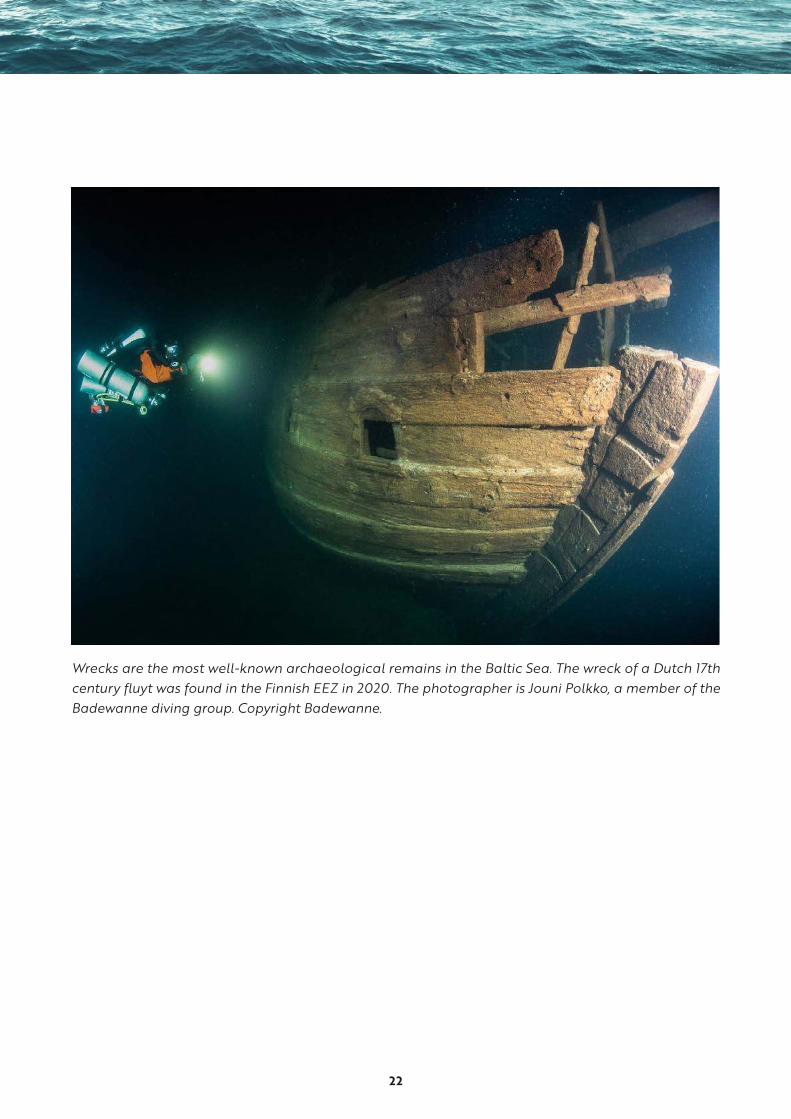
Wrecks are the most well-known archaeological remains in the Baltic Sea. The wreck of a Dutch 17th century fluyt was found in the Finnish EEZ in 2020. The photographer is Jouni Polkko, a member of the Badewanne diving group. Copyright Badewanne.
23
2. BalticRIM Analyses
2.1 Baltic Sea as an environment for under-water cultural heritage
The Baltic Sea is a young sea. In its current form,
it has existed for some 7000 years, and it does
not remain static. It is an urban sea, and its small
size and shallow waters make it particularly vul-
nerable to the consequences of people’s actions.
The ecosystem of the Baltic Sea is regressing
due to eutrophication and global warming. In
time, the Sea will be less salty and will have less
oxygen. Regarding its ecosystems and ecological
condition, the Sea is probably one of the most
well researched seas in the world. More research
is needed on the archaeological remains in the
Baltic Sea to understand how these transforma-
tive processes affect the UCH and MCH.
The Baltic Sea is a cold and dark sea, where the
level of salinity is low. The shipworm Teredo
navalis does not thrive in the northern Baltic
Sea, but it is found near the Sound. These factors
have contributed to the remarkable and unique
preservation of organic materials in the Baltic Sea.
The conditions of shipwrecks vary from piles of
planks to intact vessels. The most complete ship-
wrecks are situated in the northern Baltic Sea’s
deep waters, 30–100 meters, while the wrecks in
shallow waters are likely to have been damaged
by storms, salvage operations, or pack ice.
Due to current, almost optimal preservation
conditions for wooden structures in the northern
Baltic Sea, there are remains of wrecks, fishing
structures, remnants of ancient harbours and
trading sites, defence structures and bridges.
Every summer new finds are made. This “age of
discovery” is a result of accessible remote sensing
equipment and an increase in the number of
hydrographical surveys and infrastructural pro-
jects around the Baltic Sea.
24
1
2
3
4
56
7
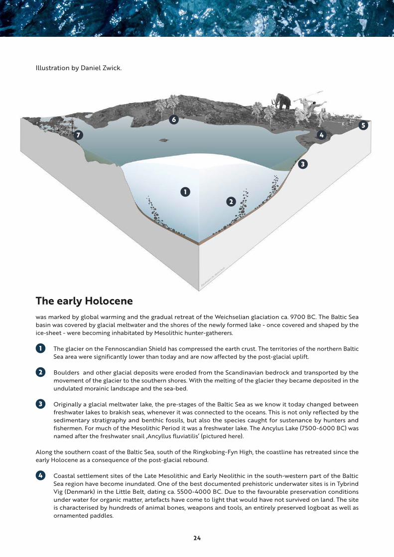
Illustration by Daniel Zwick.
The early Holocenewas marked by global warming and the gradual retreat of the Weichselian glaciation ca. 9700 BC. The Baltic Sea basin was covered by glacial meltwater and the shores of the newly formed lake - once covered and shaped by the ice-sheet - were becoming inhabitated by Mesolithic hunter-gatherers.
1 The glacier on the Fennoscandian Shield has compressed the earth crust. The territories of the northern Baltic Sea area were significantly lower than today and are now affected by the post-glacial uplift.
2 Boulders and other glacial deposits were eroded from the Scandinavian bedrock and transported by the movement of the glacier to the southern shores. With the melting of the glacier they became deposited in the undulated morainic landscape and the sea-bed.
3 Originally a glacial meltwater lake, the pre-stages of the Baltic Sea as we know it today changed between freshwater lakes to brakish seas, whenever it was connected to the oceans. This is not only reflected by the sedimentary stratigraphy and benthic fossils, but also the species caught for sustenance by hunters and fishermen. For much of the Mesolithic Period it was a freshwater lake. The Ancylus Lake (7500-6000 BC) was named after the freshwater snail ‚Ancyllus fluviatilis‘ (pictured here).
Along the southern coast of the Baltic Sea, south of the Ringkobing-Fyn High, the coastline has retreated since the early Holocene as a consequence of the post-glacial rebound.
4 Coastal settlement sites of the Late Mesolithic and Early Neolithic in the south-western part of the Baltic Sea region have become inundated. One of the best documented prehistoric underwater sites is in Tybrind Vig (Denmark) in the Little Belt, dating ca. 5500-4000 BC. Due to the favourable preservation conditions under water for organic matter, artefacts have come to light that would have not survived on land. The site is characterised by hundreds of animal bones, weapons and tools, an entirely preserved logboat as well as ornamented paddles.
25
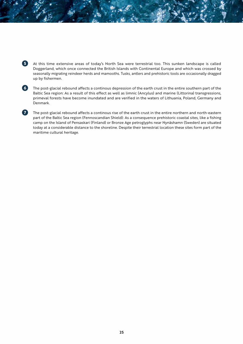
5 At this time extensive areas of today‘s North Sea were terrestrial too. This sunken landscape is called Doggerland, which once connected the British Islands with Continental Europe and which was crossed by seasonally migrating reindeer herds and mamooths. Tusks, antlers and prehistoric tools are occasionally dragged up by fishermen.
6 The post-glacial rebound affects a continous depression of the earth crust in the entire southern part of the Baltic Sea region: As a result of this effect as well as limnic (Ancylus) and marine (Littorina) transgressions, primeval forests have become inundated and are verified in the waters of Lithuania, Poland, Germany and Denmark.
7 The post-glacial rebound affects a continous rise of the earth crust in the entire northern and north-eastern part of the Baltic Sea region (Fennoscandian Shield): As a consequence prehistoric coastal sites, like a fishing camp on the Island of Pensaskari (Finland) or Bronze Age petroglyphs near Nynäshamn (Sweden) are situated today at a considerable distance to the shoreline. Despite their terrestrial location these sites form part of the maritime cultural heritage.

26
8
9
10
11
12
13
14
15
16
17
Illustration by Daniel Zwick.
Today‘s impact on the Underwater Cultural Heritage8 Due to the continued post-glacial uplift in Fennoscandinavia, new islands are emerging and existing islands
become larger, like the Kvarken Archipelago (Finland) or the Estonian Islands.
9 Sea traffic in shallow coastal waters may pose a threat to the underwater cultural heritage as sediment covers are whirled up by ship propellers. For example, the wrecks of ships sunken in the Battle of Svensksund of 1790 are affected by sea-traffic to Kotka‘s nearby container terminal.
10 In the north-eastern part of the Baltic Sea, in situ preservation conditions are particularly good due to the absence of marine borers and the cold climate. Entire shipwrecks have survived the centuries. Some are testimony to historic sea battles. Others, like the wreck of the 17th-century BODEKULL (Dalarö Dykpark, Sweden) are managed heritage sites where a diving infrastructure has been created. In general, looting at shipwreck sites is still considered a potential threat.
11 Fish-trawlers can adversely affect cultural heritage covered by sediments, as the otter boards penetrate the sea-bed. Ancient shipwrecks can be torn apart by trawling gear, especially if trawlers are fitted with powerful engines. The situation is aggravated further by the habit of fishermen to intentionally seek out the vicinity ofwrecks, as these are artificial reefs and thus habitats for marine life.
12 The coastline in the southern part has retreated as a consequence of the post-glacial rebound as well as consecutive marine transgressions, of which the ‚Littorina Transgression‘ (6900-4900 BC) was the last. It was named after the common periwinkle ‚Littorina littorea‘ (pictured here) which migrated from the Atlantic Ocean and thus reflects the process when the Baltic Sea emerged in its present form as marine environment. This period was marked also by a gradual sea-level rise, in which wake Mesolithic and early Neolithic sites have become inundated along the Baltic Sea‘s southern coast.
27
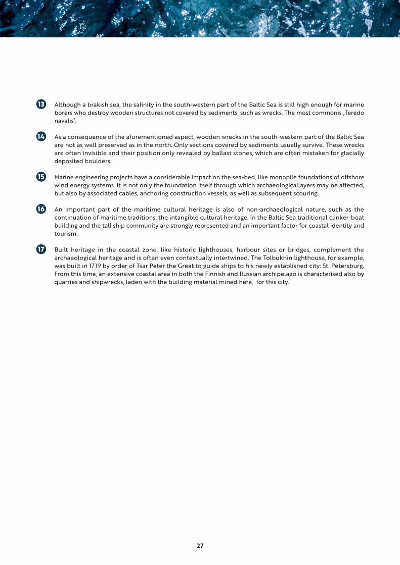
13 Although a brakish sea, the salinity in the south-western part of the Baltic Sea is still high enough for marine borers who destroy wooden structures not covered by sediments, such as wrecks. The most commonis ‚Teredo navalis‘.
14 As a consequence of the aforementioned aspect, wooden wrecks in the south-western part of the Baltic Sea are not as well preserved as in the north. Only sections covered by sediments usually survive. These wrecks are often invisible and their position only revealed by ballast stones, which are often mistaken for glacially deposited boulders.
15 Marine engineering projects have a considerable impact on the sea-bed, like monopile foundations of offshore wind energy systems. It is not only the foundation itself through which archaeologicallayers may be affected, but also by associated cables, anchoring construction vessels, as well as subsequent scouring.
16 An important part of the maritime cultural heritage is also of non-archaeological nature, such as the continuation of maritime traditions: the intangible cultural heritage. In the Baltic Sea traditional clinker-boat building and the tall ship community are strongly represented and an important factor for coastal identity and tourism.
17 Built heritage in the coastal zone, like historic lighthouses, harbour sites or bridges, complement the archaeological heritage and is often even contextually intertwined. The Tolbukhin lighthouse, for example, was built in 1719 by order of Tsar Peter the Great to guide ships to his newly established city: St. Petersburg. From this time, an extensive coastal area in both the Finnish and Russian archipelago is characterised also by quarries and shipwrecks, laden with the building material mined here, for this city.

28
Drawing by Tiina Miettinen, Finnish Heritage Agency.
At the site of Vrouw Maria environmental data was collected during the MoSS Project 2001 - 2004. Related to condition change monitoring theme of the project, the data recording sensors measured environmental data such as temperature, conductivity, redox potential, pH, turbidity, and current periodically. The results in short: environmental conditions in the vicinity of the wreck of the Vrouw Maria are essentially stable and satisfactory as concerns the preservation of both the ship itself and its contents. BalticRIM homepage includes a template of main environmental factors and human impacts, which have an effect to the UCH and MCH in the Baltic Sea, and should be considered in management, monitoring and conservation activities of UCH.
29
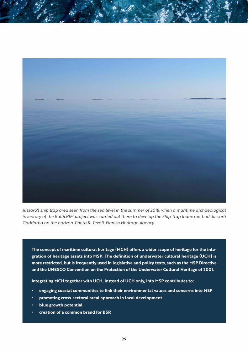
Jussarö's ship trap area seen from the sea level in the summer of 2018, when a maritime archaeological inventory of the BalticRIM project was carried out there to develop the Ship Trap Index method. Jussarö Gaddarna on the horizon. Photo R. Tevali, Finnish Heritage Agency.
The concept of maritime cultural heritage (MCH) offers a wider scope of heritage for the inte-
gration of heritage assets into MSP. The definition of underwater cultural heritage (UCH) is
more restricted, but is frequently used in legislative and policy texts, such as the MSP Directive
and the UNESCO Convention on the Protection of the Underwater Cultural Heritage of 2001.
Integrating MCH together with UCH, instead of UCH only, into MSP contributes to:
• engaging coastal communities to link their environmental values and concerns into MSP
• promoting cross-sectoral areal approach in local development
• blue growth potential
• creation of a common brand for BSR
30
2.2 Maritime cultural heritage approach for MSP
Both maritime and underwater cultural heritage
have been defined in various ways according to
different national management systems, academic
disciplines, and research.24 In the BalticRIM project,
MCH is defined as cultural heritage25 that is formed
by material and immaterial remains of seafaring
and the use(s) of sea located on dry land and
under water:
“Maritime cultural heritage is both tangible and
intangible, and is associated with the connections
people have with the sea and the resources orig-
inating from the different maritime communities
in the past.
Maritime cultural heritage refers to the traces
of people and the elements in the natural envi-
ronment; the remains of the everyday lives of
human beings living in interaction with nature
constrained to maritime areas such as the coast,
archipelago and open sea, and the elements,
objects and places that are either terrestrial or
partly or fully under water.
Maritime cultural heritage refers to both concrete
traces of maritime cultural heritage in the land-
scape as well as skills and beliefs, customs and
practices related to maritime issues passed from
generation to generation and extended to dif-
ferent communities in order to present, construct
and maintain their identities.
Maritime cultural heritage is associated with the
settlement of coastal areas and archipelagos,
seafaring and navigation, fishing and other
hunting cultures by the sea, diving, and habits
and beliefs related to maritime issues that con-
nect humans to marine features and landscape,
among others“.26
The UCH is a part of a broader concept of the
MCH.27 According to the UNESCO Convention
on the Protection of the Underwater Cultural
Heritage of 2001, UCH is defined as all traces of
human existence having a cultural, historical or
archaeological character which have been partially
or totally under water, periodically or continuously,
for at least 100 years.
The same definition and age limit were adopted
for ”The Code of Good Practice for the Manage-
ment of the Underwater Cultural Heritage in the
Baltic Sea Region (COPUCH)”, which was elabo-
rated within the Baltic Sea Heritage Cooperation
in 2008.
In the BalticRIM WIKI, UCH is defined as the mate-
rial remains of seafaring and other forms of MCH,
which are situated under water.
31
2.3 Cultural heritage data registers
As a rule, cultural heritage organisations keep regis-
ters of their data. The registered MCH and UCH data
is far from complete, as none of the Baltic Sea states
have carried out systematic surveys in their sea areas.
Maritime archaeology as a discipline has only been
built up since the 1960s. In most countries, wrecks
and other underwater sites have been acknowl-
edged as cultural heritage only since the 1970s.
Therefore, UCH sites have been mostly incorporated
and included in the existing registers intended for
terrestrial sites. The registers are still being adjusted
to accommodate also underwater sites.
Heritage data is the result of field surveys, documen-
tation and research. It often consists of a description
and location of a site. According to the description,
a site is allocated to a category. There is only one
common UCH category, which all BSR national
registers contain: the wreck. This site type has also
dominated the maritime archaeological research.
Heritage registers consist of several heritage cate-
gories, which mirror the national history. In order
to understand the logic and relevance of the
heritage data in register, one needs to understand
the context and administration systems of each
country in question. Similar to the MSP, also the
heritage assessment, registers and policies are
“deeply embedded in a country’s history, geog-
raphy, cultural traditions, political orientation,
prevailing ideology, and states of economic and
urban development, constitutional government
structure or legal constitutional framework.”28 The
data in registers is supplemented and utilized in
various surveys and listings, which in turn may be
linked to the protection status of the sites.
Annex lists major inter-governmental conven-
tions that guide the cultural heritage policies and
practices implemented in the management and
safeguarding of maritime cultural heritage.
2.4 The first MSP round: country-specific condi-tions in the integration of MCH to MSP
The following descriptions highlight the conditions
and specific barriers that each BalticRIM partner
country is facing regarding their integration of
MCH in the MSP process during the first round.
This is followed by different types of solutions
for the integration on a national basis, as well as
concluding remarks. These analyses display the
situation on MSP and MCH integration during
2018-2020 − before the closure of the first MSP
round by the end of March 2021.
The INSPIRE directive provides a framework to open spatial data sets online. The directive has
been implemented in many ways, and not all BSR countries have opened their data yet. Usually,
the sites of the data sets of the cultural environment have also been geocoded on a map either
as points corresponding to locations or as delineated areas. These points and areas form the
spatial data of the sites.
32
Denmark
Conditions for integrating MCH into MSP
Cultural heritage will not be regulated by the plan.
MCH will be taken into account by its addition
to the Danish Marine Spatial Data Infrastructure
(msdi.dk), a service layer supplementing the com-
pletely digital plan.
MSP is still under development. The lack of polit-
ical will to support the integration of MCH into
the current plan may change as awareness starts
to rise concerning the need for doing an MSP, as
well as the development of MSP as a planning tool.
Possible ways to integrate MCH into MSP
Denmark will develop sector specific, map-based
service layers, including cultural heritage and rec-
reational sites to support the MSP process. This
opens the opportunity to work in parallel on MCH
maps and provide input from BalticRIM experi-
ence and results:
• approach other sectors and promote MCH
actively
• try to include as many aspects of MCH as pos-
sible into the frame MSP text.
Conclusion
The current sectoral approach in MSP is difficult
to overcome. It may change in near future due to
an increased political will to include the ecosys-
tem-based approach into planning. This approach
could also take co-location and multi-use poten-
tials more into account.
The focus is on blue economy sectors, such as
renewable energies. Tourism and MCH are not as
prominent yet.
UWL and CSA have not been taken into account
so far, though these kinds of planning concepts
are well-known from Danish spatial planning on
land. Future planning of the coastal zone might
contribute to the implementation of these kinds of
concepts from a land-sea interaction perspective.
33
Estonia
Conditions for integrating MCH into MSP
MCH in general is not under legislative protection
as the cultural monuments are. Estonian Heritage
Conservation Act protects underwater cultural
monuments, which are mostly shipwrecks. Protected
cultural monuments are managed through setting
guidelines and conditions in the MSP.
The MSP does not designate specific maritime cul-
ture areas due to the strategic nature of the spa-
tial development document at the national level.
Both intangible and tangible maritime culture are
valued by planning through setting guidelines.
Practical ways to integrate MCH into MSP
The Ministry of Finance as MSP authority and the
National Heritage Board of Estonia (ENHB) as the
MCH authority, are co-operating based on the
provisions of Estonian Planning Act. The ENHB
has participated in the MSP stakeholder meetings.
It has been directly involved in the evaluation of
the planning issues related to cultural monuments
protection. Furthermore, the ENHB is one of the
stakeholders, who approve the plan.
An interesting addition in the Estonian MSP is the
collaboration with local communities and organ-
isations, whose activities are related to marine
and coastal culture. They give information on the
important recreational and traditional sites on the
coast.
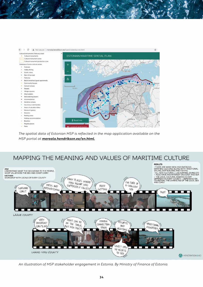
An example of the stakeholder engagement is
the mapping of the marine cultural values in the
Lääne County and the Lääne-Viru County. This
information, together with the results from the
methodological overview of available data, has
been used in preparation of the county plans.
County plans are one-pagers created to give a
quick overview of the main sea uses and general
information of the county. In the county plans,
special features of each county are highlighted.
These special features are mostly connected to
local cultural heritage tradition such as iden-
tity, landscapes and history. Currently these
county plans are available in Estonian only. One
related stakeholder event is posted to YouTube:
https://cutt.ly/ht09e70
Conclusion
The ways to integrate MCH into planning and man-
agement are available. The efficient co-operation
between the MCH and MSP authorities is based
on the provisions of the Estonian Planning Act.
Specific sectoral maps are seen as an appropriate
factual background to integrate MCH interests
into the on-going MSP process, including the les-
sons-learned and scientific data derived from the
BalticRIM planning cases and cross-border pilot
case with Finland.
34
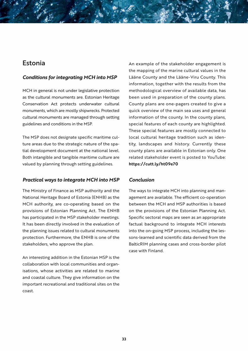
The spatial data of Estonian MSP is reflected in the map application available on the MSP portal at mereala.hendrikson.ee/en.html.
An illustration of MSP stakeholder engagement in Estonia. By Ministry of Finance of Estonia.
35
Finland
Conditions for integrating MCH into MSP
The map-based digital plan is displayed on a scale
of 1:750 000. Significant clusters of cultural values
are indicated with a “cultural values”- area. The back-
ground materials are also visible in the digital map
and they include many cultural information points
and areas, such as protected archaeological sites
including wrecks, UNESCO World Heritage Sites and
Nationally Significant Built Cultural Environments.
There is an option to zoom into scale of 1:577 000,
which makes it possible to observe the location of
point-based MCH from the background material.
Practical ways to integrate MCH into MSP
The plan is strategic and not legally binding. Envi-
ronmental impact assessment is part of the plan-
ning process. Cultural heritage, including MCH and
UCH, is one of the themes in the Finnish MSP.
The Finnish Heritage Agency (FHA) and the
museums with regional responsibility have an
official role and mandate to participate in the MSP
in terms of statements and stakeholder meetings.
The Finnish MSP process is open for stakeholders,
interested parties and individuals. A “Report on
maritime cultural heritage”, produced by the FHA,
provides a review of the available data on MCH,
including UCH. The report was utilized in the dif-
ferent MSP outputs.
MCH sites are included in the Cultural Values
-marking in the digital map. The Svensksund sea
battle area has been indicated on the plan due to
its large scale.
The Concept of Underwater Landscape has been
included in the MSP proposal. Thus, the plan pro-
motes the goals of European Landscape Conven-
tion of the Council of Europe, which Finland has
ratified.
Conclusion
A strong regional approach and stakeholder par-
ticipation process act as driving forces to incorpo-
rate MCH into the MSP process in an efficient way.
Open heritage registers with WMS/WFS interfaces
and downloadable data are useful tools for MSP
as spatial information on MCH sites. Taking into
account the Finnish MSP objectives, its scale and
strategic nature, the maritime spatial plan 2030
proposal of Finland published online in autumn
2020, highlights the cultural heritage adequately,
appropriately and interestingly.
36
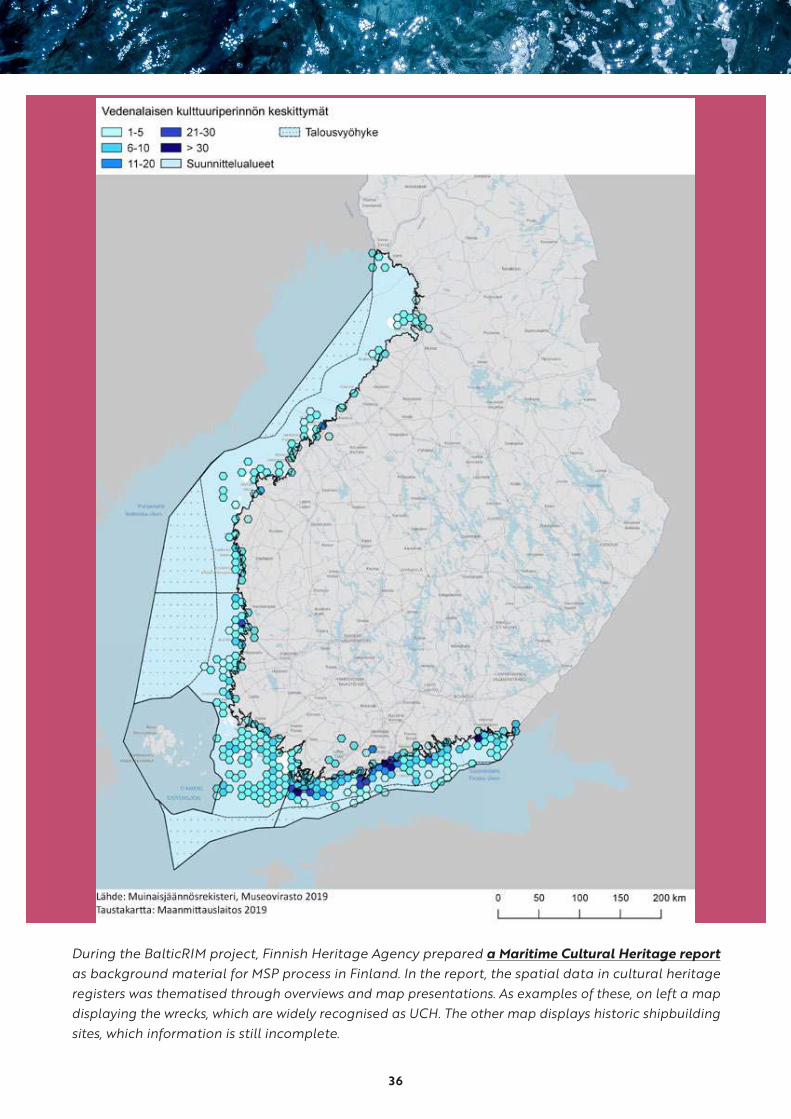
During the BalticRIM project, Finnish Heritage Agency prepared a Maritime Cultural Heritage report
as background material for MSP process in Finland. In the report, the spatial data in cultural heritage registers was thematised through overviews and map presentations. As examples of these, on left a map displaying the wrecks, which are widely recognised as UCH. The other map displays historic shipbuilding sites, which information is still incomplete.

37

38
Germany
Conditions for integrating MCH into MSP
The MCH has been hitherto taken into account
near the end of the decision-making cycle of
project planning through EIA legalisation, e.g.
in the context of the Fehmarn Belt Fixed Link
(Schleswig-Holstein) and the Nord Stream pipe-
line (Mecklenburg-Vorpommern). This allowed
only for reactive actions focussed on averting or
mitigating direct impacts on the MCH, but did not
allow for a pro-active cultural heritage manage-
ment. The BalticRIM project provided the first
opportunity to integrate MCH issues into MSP in
a more systematic and thus sustainable way.
Because cultural politics are within the domain
of the German federal states (“Kulturhoheit der
Länder”) and not the German national govern-
ment, the legislation and responsible authorities
differ between the territorial waters of each
state, as well as the EEZ. For this reason, different
approaches are necessary.
In territorial waters:
● The territorial waters in all German states are
legally defined as a federal waterway, and the
freedom of navigation is the overriding policy
by default. Any in-depth sea-space planning
conflicting with this policy therefore cannot
take place, which generally reduces the appli-
cability of MSP in German waters. As a result,
the MSP cannot be as detailed as elsewhere
and is restricted in terms of sector prioritising.
Maritime interests mainly come from the ship-
ping sector and existing rights assure undis-
turbed trade relations.
In the Exclusive Economic Zone (EEZ):
● There is no UCH authority for the German EEZ
because of the aforementioned fact that cultural
politics are within the domain of the German
federal states, but not the German state per se.
● Therefore, UCH legislation on the national
level does not exist, apart from the Cultural
Property Protection Act (KGSG) regarding illicit
trade with archaeological artefacts.
● The UCH in the German EEZ is only nominally
protected by UNCLOS (Art. 303) as well as
through EIA legislation. Therefore, the UCH is
often only taken into consideration in a late
phase of the planning cycle, i.e. during sub-
soil investigations, for example for corridors
and routes for cables, which is very late in the
planning process.
Potential ways to integrate MCH into MSP
In the waters of the federal state of Schleswig-Holstein:
● Although a consideration of the UCH / MCH
in the determination map (1: 300 000) is out
of question due to relevancy, scale and statu-
tory protection status, there is a possibility
to include UCH / MCH in regional plans in the
long-term, if a spatially relevant protection
status for UCH/MCH sites can be enforced.29
● The default perimeter protection status of
listed monuments is not deemed sufficient to
consider UCH/MCH sites as priority or reser-
vation areas in MSP, therefore the ALSH has to
designate greater areas for which a protection
status has to be issued.
39
● The legal instrument for the designation of
MCH areas is already existent in regard of
Cultural Landscapes protection, which could
be arguably also applied in a maritime and/or
ICZM-context.
● In principle, the integration of MCH into MSP
should be seen primarily as a political, not a
technical issue: although it would be theoreti-
cally possible to include UCH / MCH on a legal
basis, there needs to be a political mandate for
the decisive impetus for implementation.
In the EEZ:
● The precondition is a legal protection status of
UCH sites, with an emphasis on in situ protec-
tion. In theory, this can be legislated already
on the basis of UNCLOS Art. 303 by the Fed-
eral Republic of Germany.
● As long as the regulatory vacuum with regard
to the UCH in the EEZ continues, the heritage
protection authorities of the three German
littoral states of Lower-Saxony, Schleswig-Hol-
stein and Mecklenburg-Vorpommern ought to
contribute to the EIA and SEA reports in lieu.
● The lack of UCH data was identified as a
serious problem to contribute to EIA and
SEA reports. Therefore it is a desideratum to
facilitate data exchange with regard to sea-bed
core sampling and other marine data.
● If the UNESCO Convention on the Protection of
the Underwater Cultural Heritage were ratified
by Germany, there would be a legal requirement
for in situ protection of UCH sites in the EEZ.
Conclusion
Several interim goals could be achieved within
the framework of the BalticRIM project: UCH/
MCH issues are integrated into the text version
of the currently updated Land Development Plan
of Schleswig-Holstein, which includes the official
MSP. Moreover, a statement of the ALSH written in
conjunction with colleagues from the responsible
archaeological heritage authorities from the two
other littoral German states of Lower Saxony and
Mecklenburg-Vorpommern will enter the EIA- and
SEA-reports currently updated by the BSH for the
German EEZ.
In general, the integration of MCH into MSP should
be seen as a political and not a technical issue.
Strong efforts of co-operation between MCH and
MSP authorities on EEZ and federal state level are
ongoing and seem to have positive effects for the
integration

40
Lithuania
Conditions for integrating MCH into MSP
The plan with introduced potential MCH sites has
been approved in 2014. The new edition of the plan
is currently in the final stage of development and is
submitted for approval later this year (2020).
So far, there are first signs of potentially good
collaboration between sectorial experts and the
responsible MSP ministry. The heritage database
and assets’ evaluation are in the hands of experts
at the Department for Protection of Cultural Her-
itage under the Ministry of Culture of Lithuania,
which could push the proper documentation of
the MCH findings as well as the recognition of the
UWL as a valuable asset. Currently, the formal reg-
ister is oriented to land-based heritage. The MCH/
UCH categorization is in the development stage.
Potential ways to integrate MCH into MSP
Based on the analysis of barriers, the following
steps are necessary:
● institutional system to provide, update and
document the relevant information/datasets
● proper database with clear categorization and
description of the heritage assets
● principles of the determination of the level
of protection (no go, highly protected, under
research, open for recreational/educational
purposes or similar) and/or the nature of utili-
zation (for science, tourism, education, other)
● delineation of the “to-be-established MCH”
site including a location map and the descrip-
tion of the asset(s)
● status of introduction (under investigation,
recommended, potential – introduced and
under development, established and reg-
ulated, under revision etc.) related to the
national planning documents (MSP, regional
development plan, or others)
● preparation of a regulatory framework for all
types of UCH
Conclusion
The ways to integrate MCH into planning and man-
agement are twofold: providing background data
and sectorial maps to be integrated into the new
generation of plans after the year 2021. Therefore,
the contribution of the BalticRIM project can be
considered very relevant. The project provided
firstly a proper example on how to document the
particular assets/area and conduct preparations
for further integration into the database. Secondly,
the project activities guided the introduction of
the particular assets or areas into the action plan
for MSP implementation, supported by a well-de-
veloped regulatory framework for the particular
case and potential other cases.
41
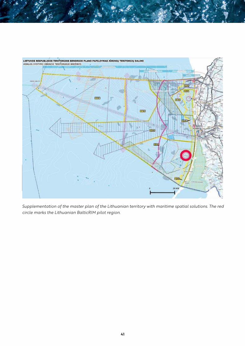
Supplementation of the master plan of the Lithuanian territory with maritime spatial solutions. The red circle marks the Lithuanian BalticRIM pilot region.
42
Poland
Conditions for integrating MCH into MSP
● UCH has been mapped and analysed during
stock taking stage (2014-2015) and outcomes
of the analysis were collected in the report
discussed with stakeholders.30
● The information gaps with regard to UCH were
identified, in particular areas with insufficient
information on UCH.
● Aforesaid analysis were informed to the plan-
ning process in preparation of the plan in scale
1:200 000 in the years 2016-2019 (i.e. before
BalticRIM findings became available).
● UCH has been regulated by the MSP in a form
of general rules protecting UCH but MCH has
been taken into account as information, only.
● MSP in Poland is still under development, and
new more detailed plans are under preparation
e.g. Gdańsk Bay plan, Vistula Lagoon. During
these MSP processes one can observe aware-
ness rising concerning the MCH as a sector.
● These recent planning processes are informed
by the new outcomes and information i.e.
BalticRIM ones.
Practical ways to integrate MCH into MSP
The zoning plan in the scale 1:200 000 that covers
majority of the Polish sea areas (its elaboration
was completed in 2019):
● considers mainly UCH and prefers it in situ pro-
tection (removal is possible in exceptional cases)
● UCH is defined as monuments located in Polish
sea areas and their surroundings, in accordance
with Art. 3 of the Act of 23 July 2003 on the pro-
tection and care of monuments
● function: cultural heritage means indicating in
the plan, UCH in order to ensure its protection
conditions, as well as indicating the location of
underwater warehouses and museums
● for each sea zone delimited in the plan the
location of the UCH is indicated in the sea
zone card as a background information
The plan enforces spatial protection of the UCH. The
following general rules are formulated in the plan:
• UCH is protected on the terms set out in
the provisions of the Act of 23 July 2003
on the protection and care of monuments
the Act of 21 March 1991 on the maritime
areas of the Republic of Poland, and on
maritime and other regulations. The
established safety zones around the UCH
and rules in force in these zones should
be taken account.
• Apart from emergencies, the use of Polish
sea areas may not damage or destroy
the UCH. This particularly applies to the
operation of ports and marinas, the laying
of linear elements, the construction of
artificial islands, structures and devices,
protection of the seashore, tourism, sports
43
and recreation, obtaining renewable
energy, exploration, recognition of min-
eral deposits and extraction of minerals
from deposits, aquaculture and scientific
research.
• In the event of locating or recognizing
the underwater cultural heritage, until
the safety zone around it and the rules
in force in this zone are designated, it is
prohibited to conduct works that may
damage UCH.
• There is an obligation to make an archae-
ological inventory of the seabed in areas
designated for investments, the conduct
of which may endanger the UCH.
Potential ways to better integrate MCH
into MSP (progress since 2019)
● Usage of the MSP process to approach other
sectors and promote MCH actively.
● Extending the existing approach of zoning and
inclusion of aspects of UCH into the general
rules by more advanced thinking on MCH i.e.:
areal approach to MCH, better inclusion of ter-
restrial MCH objects into MSP, more attention
to paleo-landscapes etc.
● Developing MCH integrated maps for special
sites, to support the integration of MCH into
MSP process, such maps should position MCH
against other sectors and act as boundary
spanning objects.31
● Continuation of the MSP process after adop-
tion of the plan with active participation of
the MCH sector in particular MCH authorities
(National Maritime Museum) and other MCH
stakeholders.
● Promoting an idea of multi-use with regard to
e.g. MCH and environmental protection and
underwater tourism.
Conclusion
Thanks to various MCH related processes, and
in particular BalticRIM co-operation, the Polish
approach regarding inclusion of MCH into MSP
has been maturing in the recent years. This can
be observed in ongoing MSP processes. Practical
steps, such as the MCH classification and devel-
opment of planning tools to integrate MCH, have
been taken in the detailed MSP for the Gulf of
Gdańsk and Vistula Lagoon due to the BalticRIM
project. Intensive stakeholder consultation will
guide planners to use these data and incorporate
MCH at least on a low level, e.g. as a sectoral map.
The concepts of UWL and CSA were not taken into
account so far, but they might be developed or
tested in the detailed MSP for the Gulf of Gdańsk
and Vistula Lagoon.
44
Russia
Conditions for integrating MCH into MSP
There are processes on-going related to MSP, but
no active MSP process so far. Therefore, indirect
influence conducted by the MCH authorities and
experts as well as MSP experts would be needed
to draw attention to the sector and to be prepared
when planning in maritime areas begins.
Potential ways to integrate MCH into MSP
● approach other sectors and promote MCH
actively backed by the Marine Board under
the Government of the Russian Federation and
Regional Maritime Councils
● try to include as many aspects of MCH as pos-
sible into the MSP frame rather than follow
the approach of zoning
● include identified UCH in the National Cul-
tural Heritage Register of Russia and establish
a framework for its protection
● include MCH into BSR MSP Roadmap, Russian
MSP Roadmap and the HELCOM Baltic Sea
Action Plan
Conclusion
The sectoral approach is difficult to overcome and it
may change due to political changes towards a more
ecosystem-based MSP approach. So far, the concepts
of UWL and CSA have not been considered.
Priority steps to improve the Russian MSP and UCH legislation and water area management system
• Adoption of the federal law on state management of maritime activities;
• Development and adoption of a federal law on MSP;
• Development and adoption of a federal law on underwater cultural heritage;
• Identification of authorized federal and regional bodies responsible for MSP and UCH management;
• Compilation of the Register of objects of the marine archaeological heritage of the Russian Federation (UCH);
• Development and adoption of relevant regional laws of the coastal regions of the Russian Federation on MSP and UCH.
Progress in MSP development in Russia from 2012, and recommendations for Russian stakeholders on the operation and management of MCH in the Gulf of Finland. Roadmaps for using MCH is based on BalticRIM pilot case studies on the Gulf of Finland. Priority steps elaborated by the Institute of Maritime Spatial Planning Ermak Northwest.
45
2.5 The first MSP round: an overview of the challenges to integration
The co-operation in the BalticRIM case study areas
revealed several challenges that might hinder the
integration of UCH and MCH into MSP. The most
widespread and significant challenges are grouped
in the following:
● MCH and MSP authorities’ do not have suffi-
cient mandate to include UCH and MCH into
MSP in some BSR countries.
• good practice to solve the challenge:
ensure in national legislation that there
are cultural heritage authorities with legal
mandate to participate in MSP
• good practice to solve the challenge:
ensure in national MSP policies that at
least UCH according to the MSP Directive
will be taken officially into account in MSP
• good practice to solve the challenge:
BalticRIM recommends to integrate MCH
instead of only UCH into MSP in order
to have a more holistic land-sea interac-
tion approach of cultural heritage of our
coastal, archipelagic and maritime areas,
such as lighthouses, sea fortresses and
fishing villages
● Due to existing legislation or administrative
routines, the MSP effort towards UCH is lim-
ited only to minimum.
• good idea to solve the challenge: strengthen
the preplanning phase focusing on the
informal planning processes, as well as on
MCH promotion and stakeholder engage-
ment
● Maritime and underwater surveys of cultural
heritage of national coastal areas, archipel-
agos, territorial waters, and EEZ are not sys-
tematic in any BSR countries. Therefore, the
scope, nature and location of UCH are unde-
fined, and UCH significance is not sufficiently
determined at national, regional or local
levels. In some BSR countries, the existing UCH
data is not available in open registers. In all
BSR countries, the accuracy and quality of the
UCH data varies, but this is not systematically
assessed. In short, the UCH and MCH data and
planning evidence are incomplete.
• good practice to solve the challenge:
publish cultural heritage data in open
registers
• good practice to solve the challenge:
conduct more archaeological surveys and
documentation. Based on these, recognise
MCH/UCH themes and create regional
MCH/UCH areas
• example to solution: in Finland, the Lahia
and Jussarö ship trap areas were defined
through fieldwork and archival research
during BalticRIM
• example to solution: adopt a flexible
planning approach in terms of the com-
bination of zoning, when necessary, and
46
general rules, particularly precautionary
rules. This was implemented in the Polish
MSP in the scale 1:200 000
● The MCH and UCH data and other information
are collected in various registers, possibly even
maintained by different authorities.
• good practice to solve the challenge:
create a data portal, where the various
marine and maritime data is found in one
place
• examples to good practice: BalticRIM
Data Portal (balticrimdataportal.eu); Par-
ticipatoryGIS portal mch4blue created by
University of Tartu within the BalticRIM
project and MarineFinland.fi portal
● MSP planners are not properly informed yet
to take MCH into consideration in their plans.
• good practice to solve the challenge: train
and include planners on projects dealing
with MCH, as in the SEAPLANSPACE, Par-
tiSEApate, Capacity4MSP and BalticRIM
projects
● Knowledge, tools and experience on how to
assess the different environmental and human
pressures on UCH and MCH in the context of
MSP is insufficient.
• good practice to solve the challenge: use
EIA, the BalticRIM Environmental Fac-
tors and Human Impact Template, (see
BalticRIM homepage) Bow-tie analysis or
DAPSI(W)R(M) framework
● There are difficulties to include intangible and
emotional values of the UCH and MCH sites
into MSP.
• good practice to solve the challenge:
adopt the ideas of the BalticRIM Under-
water Landscape and Culturally Significant
Areas (Chapter 3.4) as well as different
kinds of areal and landscape approaches
• good practice to solve the challenge:
make the MSP process open and inclusive,
and involve the local level as well
● There is underrepresentation of UCH & MCH
theme compared to other blue economy sectors.
• good practice to solve the challenge: pro-
mote the examples and models of blue
growth utilizing the MCH assets
• good practice to solve the challenge: use
the potential of UCH and MCH in sustain-
able tourism
● The BSR Countries do not practise MSP in
identical ways. Therefore, it is not feasible to
have a Pan-Baltic approach to integrate MCH
to MSP.
• good practice to overcome the challenge:
understand the complexity and variations
of the different national systems
● Cooperation between BSR countries on the
integration of MCH into MSP seems insuffi-
cient.

47
• good example to solve the challenge: get
involved in co-operation projects like
BalticRIM. Support the continuous col-
laboration between the BSR MSP working
groups and networks as well as the BSR
expert working groups on underwater
heritage and coastal heritage
● About 40% of the Baltic Sea is not covered by
the national heritage legislation.
• good practice to solve the challenge: in
Estonia the national heritage legislation
protects heritage sites located in EEZ as
well as territorial waters
• good practice to solve the challenge: rat-
ification of UNESCO 2001 Convention on
the Protection of the Underwater Cultural
Heritage
• good practice to solve the challenge:
implement the Code of Good Practice for
Management of Underwater Cultural Her-
itage of the Baltic Sea Region (COPUCH)
by the Baltic Sea Heritage Committee and
the BSR Working Group on underwater
heritage
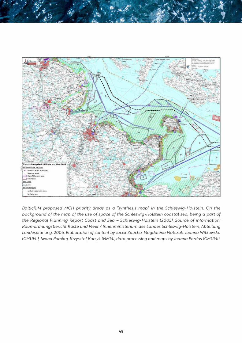
48
S
BaSbspcRS
SRMLaA
BalticRIM proposed MCH priority areas as a ”synthesis map” in the Schleswig-Holstein. On the background of the map of the use of space of the Schleswig-Holstein coastal sea, being a part of the Regional Planning Report Coast and Sea – Schleswig-Holstein (2005). Source of information: Raumordnungsbericht Küste und Meer / Innenministerium des Landes Schleswig-Holstein, Abteilung Landesplanung, 2006. Elaboration of content by Jacek Zaucha, Magdalena Matczak, Joanna Witkowska (GMUMI), Iwona Pomian, Krzysztof Kurzyk (NMM), data processing and maps by Joanna Pardus (GMUMI).
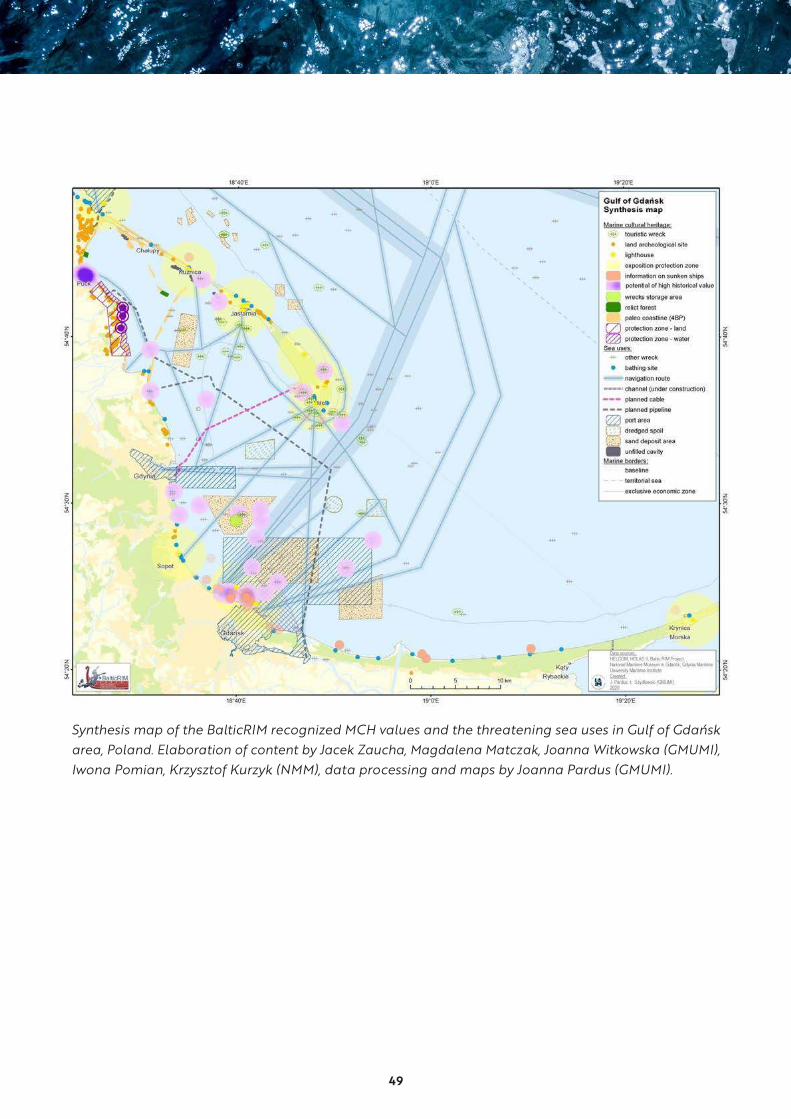
49
ŃSK
Synthesis map of the BalticRIM recognized MCH values and the threatening sea uses in Gulf of Gdańsk area, Poland. Elaboration of content by Jacek Zaucha, Magdalena Matczak, Joanna Witkowska (GMUMI), Iwona Pomian, Krzysztof Kurzyk (NMM), data processing and maps by Joanna Pardus (GMUMI).

50
Synthesis map of the BalticRIM recognized MCH priority areas and the threatening sea uses in Kalingrad Oblast, Russia. Elaboration of content by Jacek Zaucha, Magdalena Matczak, Joanna Witkowska (GMUMI), Iwona Pomian, Krzysztof Kurzyk (NMM), data processing and maps by Joanna Pardus (GMUMI).
51
BalticRIM MSP pilot planning studies regarding the Polish (Gulf of Gdańsk), German (Schleswig-Holstein) and Russian (Kalingrad Oblast) cases were worked out to fill knowledge gaps by mapping exercise. Map services were used to detect spatial conflicts and synergies and to prepare maps integrating MCH with other users, resulting cross-sectoral pilot spatial plans. The processes were step-by-step approach towards conflicts visualisation and solution findings.
The first step was to visualize MCH assets as described by the BalticRIM partners. The short descriptions of MCH priority areas were provided.
The second step was to map the sea uses, which have been described in earlier project phase as carrying physical and aesthetic threat to the cultural objects and sites. The information and data about the existing and planned sea uses was obtained from both open sources, strategic, planning documents and from the scientific publications. The short descriptions of sea-uses were provided.
The third step was to elaborate a synthesis map, which allows to brainstorm on and understand the main spatial conflicts and start the discussion on potential solutions.
The forth step was to give proposal of planning suggestions, which might by used in the further discussions with planning authorities and other stakeholders. In case of Poland – the planning suggestions have been submitted as an official proposal to the ongoing Gulf of Gdańsk MSP process in March 2020.
The process was not perfect. In most of the cases the resolution of data from regional sources (like HELCOM data base) did not suit the scale of the MCH priority areas, some of the data is missing – like the recreational coastal traffic, some of the data should be verified with the local stakeholders. Still, the planning experience show that even coarse analyses and maps brings fuel for further discussions.
Below the integrated maps for the SchleswigHolstein (Germany), Gulf of Gdańsk (Poland) and Kaliningrad Oblast. They can used as a tool for awareness rising and discussing potential planning solutions.
Elaboration of pilot studies by Jacek Zaucha, Magdalena Matczak and Joanna Witkowska (GMUMI), with contributions by project partners. Data processing and maps by Joanna Pardus (GMUMI).
52
3. BalticRIM Solutions
3.1 The BalticRIM Data Portal
The Web-GIS service, called the BalticRIM Data
Portal, was designed in order to create new MSP
approaches for MCH integration. The BalticRIM
Data Portal established a supportive structure
to facilitate collaboration within an MCH-MSP
community of practice. The data portal assists in
the identification of cross-border cultural heritage
phenomena, and provides BSR wide schematiza-
tion of UCH and MCH. It also shows how under-
water and coastal cultural heritage often have
a strong land-sea connection. From a capacity
building perspective, the BalticRIM Data Portal
furthermore contributes to the ongoing mutual
learning processes across national and organisa-
tional borders within the organisational setups of
MCH and MSP.
Project case study data was stored and displayed
in the Data Portal. During the project, the Data
Portal served as an arena to exchange data and
insights across borders enabling discussions on
how to manage MCH values in the context of MSP.
The digital features facilitated shared understand-
ings and the development of concepts fitting into
maritime spatial plans and processes.
Besides supporting the case studies, the portal
serves as a means for communicating project
results to a broader audience. The publicly avail-
able part displayed by the pan-Baltic view pre-
sents central characteristics of the national UCH
and MCH the Baltic Sea Region. These themes
include the promotion of some of the broader
blue growth perspectives as pan-Baltic legacies or
specific sites of cultural and touristic significance.
Features of the BalticRIM Data Portal - www.balticrimdataportal.eu
The basic design addresses the need for pro-
viding an online service with various possibili-
ties for the users. The advantage of the system
is that it enables quick and easy access to the
data in a web browser, and the user does not
need special GIS software or GIS knowledge.
The main features of the interface include three
parts: a navigation bar, a selection tool, and the
interactive map in the right side, as shown in the
figures above.
The BalticRIM Data Portal displays subsets of mar-
itime cultural heritage data published by national
data providers through OGC open geospatial
standards – WMS and WFS – and includes UCH
data as well as land-based MCH in the coastal
areas. Metadata are collected, stored, and man-
aged in the database, and metadata tables are
available for the datasets. For selected layers,
which can be publicly accessible data from other
portals or for other layers without restrictions,
download functions are included.32
53
The BalticRIM Data Portal provides also a closed
GIS-based working environment, which allows
displaying and discussing sensitive as well as
not publicly available data. This supported the
co-creation and sharing of new spatial planning
concepts for MCH. Dealing with the cross-border
case studies data, the portal enables the sharing
of data, the discussion of legislative matters and
not least the visualisation and testing of new
planning-oriented MCH concepts.
The future of the BalticRIM Data Portal
The prototype of the BalticRIM Data Portal was
developed in order to spatially enable the com-
munication across the professional domains of
MCH experts and maritime spatial planners. This
was done by providing an internal digital working
environment, where initial data, ideas, and concepts
could be shared, developed and tested in the Bal-
ticRIM project. Some of these results are already
being implemented in national maritime spatial
plans; others provide a basis for further develop-
ment and dissemination, which will be enabled by
the services of the BalticRIM Data Portal.
During the project, the BalticRIM Data Portal
has provided an arena for knowledge sharing,
engagement, and mutual learning processes
across national borders and among practitioners
in a complex, interdisciplinary professional com-
munity. The need for a digital infrastructure facil-
itating the collaboration regarding the develop-
ment and testing of new shared spatial concepts,
evolved during the project and turned out to be
a central feature of the project. Even if national
setups will remain different and data might never
be fully harmonised, experiences from the ongoing
collaborative MSP projects and processes, illus-
trate how new integrated concepts are starting
to bridge across borders and among the cultural
heritage and MSP communities.
In the future, the closed part of the portal can still
function as a closed working environment sup-
porting the further discussions and development
of concepts within the MCH community, while the
publicly available part can be utilised for continu-
ously promoting MCH as one of the key elements
of BSR MSP.

54
The interface of the BalticRIM Data Portal displaying the public Pan-Baltic part – here “The Hansa” as one of the famous transboundary legacies.
Layers are still being added into the Data Portal. Here displayed are shipwrecks and lighthouses across the Baltic Sea.
55
3.2 BalticRIM WIKI – a glossary of maritime and underwater cultural heritage terms
The BalticRIM WIKI contains selected MCH and
UCH terminology with attached definitions and
visualizations along with basic MSP glossary.
It introduces those heritage terms that have a
specific use regarding MSP perspectives. This
meant, in particular, maritime and underwater
site categories that are geographically large-scale
phenomena and thus suitable for the wide scale
of MSP.
The BalticRIM WIKI:
● gathers together selected maritime and under-
water cultural heritage site categories, terms
and definitions in one location
● is based on an agreement on common MCH
and UCH terms and their consistent use in the
project
● develops cultural heritage terminology and
definitions for less known site categories such
as ship trap
Most of the presented MCH and UCH definitions
and descriptions are based on the Finnish wiki-
based “Guide to the Archaeological Heritage in
Finland”, which was published by the Finnish Her-
itage Agency in 2017.33 For each of the selected
terms, a definition and a description have been
produced, such as “maritime heritage”, “under-
water heritage”, “underwater landscape”, “sea
battle area”, “ballast dumping site”, “a ship trap”,
a ship cemetery”, and “maritime recycling area”.
In addition, terms of MCH management concept
and strategies - such as in situ conservation,
underwater park and underwater storage - and
acronyms of organizations, networks and projects
have been included.
The project partners aim to continue the main-
tenance and development of the BalticRIM WIKI
after the end of the project.
3.3 BalticRIM underwater landscape concept
Within the UCH management, most underwater
cultural heritage sites are usually mapped as
single dots with coordinates or as small areas. It
has also become obvious that these delimitations
are often not sufficient for proper management,
for instance, concerning wrecks. Neither are they
proper for the needs of MSP. To improve the situa-
tion, MCH authorities have begun to pay attention
to the underwater landscape. They point out that
the individual underwater historical sites should
be seen as a part of a broader landscape, not
only as individual dots separately from the other
nearby cultural and natural features.34
The BalticRIM concept of Underwater Landscape
(UWL) was developed to promote the applica-
tion of the term in heritage management and in
MSP.35 The final goal was that the concept could
act as a new tool for heritage management and
in planning of maritime space. The reasons for
developing the concept were:

56
Screen shot of main page http://dokuwiki.balticrim.eu
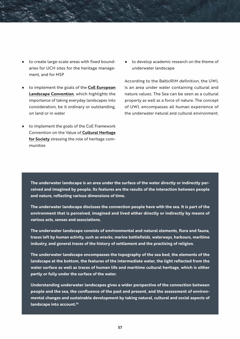
57
The underwater landscape is an area under the surface of the water directly or indirectly per-
ceived and imagined by people. Its features are the results of the interaction between people
and nature, reflecting various dimensions of time.
The underwater landscape discloses the connection people have with the sea. It is part of the
environment that is perceived, imagined and lived either directly or indirectly by means of
various acts, senses and associations.
The underwater landscape consists of environmental and natural elements, flora and fauna,
traces left by human activity, such as wrecks, marine battlefields, waterways, harbours, maritime
industry, and general traces of the history of settlement and the practising of religion.
The underwater landscape encompasses the topography of the sea bed, the elements of the
landscape at the bottom, the features of the intermediate water, the light reflected from the
water surface as well as traces of human life and maritime cultural heritage, which is either
partly or fully under the surface of the water.
Understanding underwater landscapes gives a wider perspective of the connection between
people and the sea, the confluence of the past and present, and the assessment of environ-
mental changes and sustainable development by taking natural, cultural and social aspects of
landscape into account.36
● to create large-scale areas with fixed bound-
aries for UCH sites for the heritage manage-
ment, and for MSP
● to implement the goals of the CoE European
Landscape Convention, which highlights the
importance of taking everyday landscapes into
consideration, be it ordinary or outstanding,
on land or in water
● to implement the goals of the CoE Framework
Convention on the Value of Cultural Heritage
for Society stressing the role of heritage com-
munities
● to develop academic research on the theme of
underwater landscape
According to the BalticRIM definition, the UWL
is an area under water containing cultural and
nature values. The Sea can be seen as a cultural
property as well as a force of nature. The concept
of UWL encompasses all human experience of
the underwater natural and cultural environment.
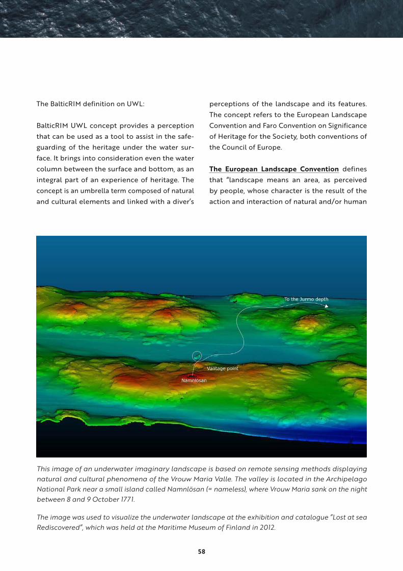
58
The BalticRIM definition on UWL:
BalticRIM UWL concept provides a perception
that can be used as a tool to assist in the safe-
guarding of the heritage under the water sur-
face. It brings into consideration even the water
column between the surface and bottom, as an
integral part of an experience of heritage. The
concept is an umbrella term composed of natural
and cultural elements and linked with a diver’s
perceptions of the landscape and its features.
The concept refers to the European Landscape
Convention and Faro Convention on Significance
of Heritage for the Society, both conventions of
the Council of Europe.
The European Landscape Convention defines
that “landscape means an area, as perceived
by people, whose character is the result of the
action and interaction of natural and/or human
This image of an underwater imaginary landscape is based on remote sensing methods displaying natural and cultural phenomena of the Vrouw Maria Valle. The valley is located in the Archipelago National Park near a small island called Namnlösan (= nameless), where Vrouw Maria sank on the night between 8 and 9 October 1771.
The image was used to visualize the underwater landscape at the exhibition and catalogue ”Lost at sea Rediscovered”, which was held at the Maritime Museum of Finland in 2012.

59
factors.” The Convention promotes the protec-
tion, management and planning of European
landscapes. It also promotes countries to identify
their own landscapes throughout their territories
including land, inland water and marine areas. So
far, underwater landscapes are not sufficiently
mapped in the BSR.
Another topical convention in the context of
underwater landscape is the CoE Framework
Convention on the Value of Cultural Heritage
for Society It acknowledges that rights relating
to cultural heritage are inherent. It defines also a
new concept of “heritage community”, explaining
that it consists of people, who value specific
aspects of cultural heritage. In addition, the Con-
vention encourages participation and the recog-
nition of the role of voluntary organisations.37
In connection to underwater landscape, diver
organisations and clubs act as heritage com-
munities. Divers can – and have – offer a great
volunteer assistance in finding, localising, moni-
toring, protecting and even guarding the under-
water heritage sites. They are actually also the
only stakeholders – users –, who experience the
underwater world first hand.38
3.4 Culturally Significant Areas and Underwater Landscape in maritime spatial planning
Culturally Significant Areas (CSA) approach relies
on a participative process to establish evidence
on what, where, when and to whom specific areas
are important and what qualities are needed to
sustain them. CSA is analogous to ecologically
significant areas, aiming at designating an area
containing a culturally significant feature, or a
feature in its own right. So far, the elaboration
of the concept is based on academic research
interest.39
When dealing with the notions of CSA and UWL,
different conventions of CoE and UNESCO are
vital and form a more international basis for
these approaches. They emphasise binding nat-
ural, cultural and intangible values. Especially
the consideration of intangible values has been
recognised as a challenge in MSP.40
To promote CSA and UWL, their ideas, notions
and values must be first documented during
fieldwork, and later built up in stakeholder work-
shops and in the management level. Finally, the
concept should be implemented in terrestrial
and MSP planning. This process can be described
as a ”bottom up” method, where the meaning
of the concept is elaborated by archaeological
surveys, analysis of the heritage registers and
management and fed into MSP and further into
the strategic level. The management level should
prepare recording systems and registers, which
are compatible for descriptions of UWL and cul-
tural values at defined locations.
If the heritage register does not have its own cat-
egory for CSA or UWL, the values can be added
to the descriptions of existing suitable categories.
A good method is to update existing listed sites,
such as World Heritage Sites, with CSA and UWL
descriptions.
The concept of UWL and the bottom up process
have been tested at the Finnish Heritage Agency.
In the FHA Register of Ancient Monuments, there
is no category for UWL, but in some cases, the
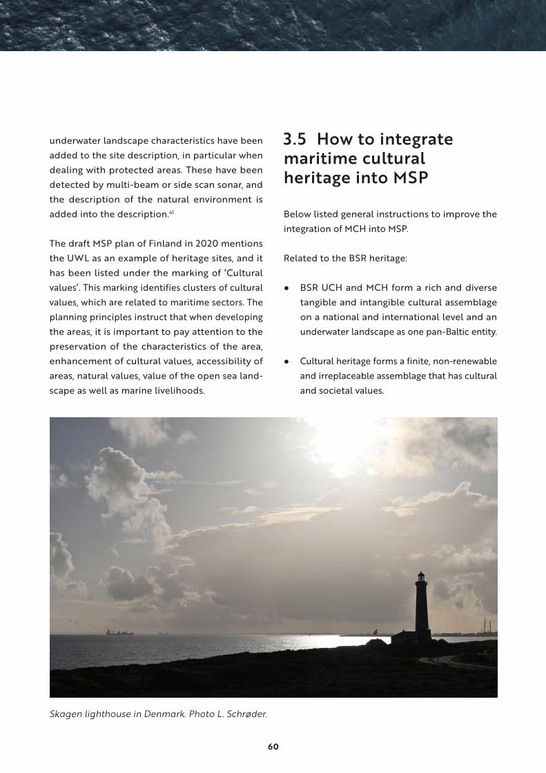
60
underwater landscape characteristics have been
added to the site description, in particular when
dealing with protected areas. These have been
detected by multi-beam or side scan sonar, and
the description of the natural environment is
added into the description.41
The draft MSP plan of Finland in 2020 mentions
the UWL as an example of heritage sites, and it
has been listed under the marking of ‘Cultural
values’. This marking identifies clusters of cultural
values, which are related to maritime sectors. The
planning principles instruct that when developing
the areas, it is important to pay attention to the
preservation of the characteristics of the area,
enhancement of cultural values, accessibility of
areas, natural values, value of the open sea land-
scape as well as marine livelihoods.
3.5 How to integrate maritime cultural heritage into MSP
Below listed general instructions to improve the
integration of MCH into MSP.
Related to the BSR heritage:
● BSR UCH and MCH form a rich and diverse
tangible and intangible cultural assemblage
on a national and international level and an
underwater landscape as one pan-Baltic entity.
● Cultural heritage forms a finite, non-renewable
and irreplaceable assemblage that has cultural
and societal values.
Skagen lighthouse in Denmark. Photo L. Schrøder.

61
● The protection of cultural heritage is the
responsibility of states and in this way, it is
an essential theme to take into account and
safeguard in terrestrial and maritime spatial
planning.
Related to MSP:
● Increasing demand for maritime space for dif-
ferent purposes requires integrated planning
and management of maritime areas.
● According to the EU MSP Directive, UCH is
one possible activity, use and interest in the
planning of maritime space.
● MSP as a crosscutting policy tool enables
public authorities and stakeholders to apply
a coordinated, integrated and trans-boundary
approach to planning.
Related to ways if integration:
● BalticRIM project recommends integrating
MCH instead of only UCH into MSP. The aim
is to have a more holistic land-sea interaction
approach to the cultural heritage of our coastal,
archipelagic and maritime areas, such as light-
houses, sea fortresses and fishing villages.
● The integration of the UCH / MCH into the
national MSP requires certain capabilities
and formalization, such as regulations on the
involvement of MCH authorities in the MSP
and the obligation of the planners to take the
UCH / MCH into account.
● Land sea interaction should be applied for
the proper inclusion of MCH into MSP. In par-
ticular, the influence of the MSP on the MCH
terrestrial objects and on landscapes from the
sea towards land and from land towards sea
should be routinely considered in planning.
● An ecosystem-based approach contributes to
the sustainable development and growth of
maritime and coastal economies and the sus-
tainable use of maritime and coastal resources,
such as cultural heritage.
● The ecosystem-based approach and multi-use
concept can be applied to combine cultural
and nature heritage, sustainable recreation
and tourism.
MCH as part of blue growth and culture of sus-
tainability:
● As a cultural ecosystem service, cultural her-
itage has great potential to build up attractive
and sustainable communities, for recreation,
sustainable tourism, and for enhancing well-
being, the quality of life, identity, sense of
place, social capital, and blue growth.
● Cultural heritage has a specific role in
achieving the Sustainable Europe by 2030
Strategy goals for a smart, sustainable and
inclusive growth because of its social and
economic impact and its key contribution to
environmental sustainability.
● MCH assists in delivering the goals of the
UNESCO Decade of Ocean Science for Sus-
tainable Development (2021-2030). Cultural
heritage should be considered as a necessary
agency and as the Fourth Pillar of sustainable
development.
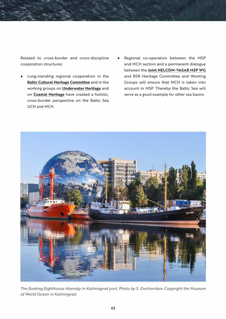
62
Related to cross-border and cross-discipline
cooperation structures:
● Long-standing regional cooperation in the
Baltic Cultural Heritage Committee and in the
working groups on Underwater Heritage and
on Coastal Heritage have created a holistic,
cross-border perspective on the Baltic Sea
UCH and MCH.
● Regional co-operation between the MSP
and MCH sectors and a permanent dialogue
between the Joint HELCOM-VASAB MSP WG
and BSR Heritage Committee and Working
Groups will ensure that MCH is taken into
account in MSP. Thereby the Baltic Sea will
serve as a good example for other sea basins.
The floating flighthouse Irbensky in Kaliningrad port. Photo by S. Ovchinnikov. Copyright the Museum of World Ocean in Kaliningrad.

63
4. BalticRIM RecommendationsThe BalticRIM partners have, in co-operation with
planners, MCH experts and stakeholders, extracted
a set of sector-based recommendations aiming to
ease the process of integrating MCH to MSP. Rec-
ommendations are addressed separately for
1) heritage authorities and stakeholders
2) MSP planners and decision makers
3) the co-operation of heritage and planning experts
4.1 Recommendations for heritage authorities and stakeholders
● Get acquainted with the EU MSP Directive 2014/89/EU, BSR MSP guidelines and recommendations,
the national MSP legislation, processes, administrative routines and other MSP documents.
• good practice: Maritime Spatial Planning of European Commission
• good practice: European MSP Platform
• good practice: HELCOM-VASAB Working Group on MSP web page
• good practice: National MSP websites, for example:
• Denmark
• Estonia
• Finland
• Germany:
- for the EEZ
- for the Federal State of Schleswig-Holstein
• Lithuania
• Poland:
- MSP and Maritime Office in Gdynia
- MSP and Maritime Office in Szczecin
• Sweden
• Åland
● Ensure that UCH and/or MCH is mentioned as one of the many marine activities, uses and interests,
or as a sector, theme or in other form, in the national planning of maritime space as suggested in the
European Maritime Spatial Planning Directive 2014/89/EU.
64
• good practice: promote the use of MCH instead only of UCH
• good practice: Finnish MSP process where cultural heritage, including both MCH and UCH, is one of
the nine blue growth sectors
• good practice: if this was not the case during the first round, ensure that UCH and MCH are included
during the second round
● Remember and implement conventions on cultural heritage, such as the UNESCO Convention on
the Protection of the Underwater Cultural Heritage, the CoE European Landscape Convention, CoE
Framework Convention on the Value of Cultural Heritage for Society and UNESCO Convention for
the Safeguarding of the Intangible Cultural Heritage
• good example to follow: Estonia, Lithuania and Poland which have ratified the UNESCO Conven-
tion on the Protection of the Underwater Cultural Heritage
● Ensure that your national MCH authority/authorities and other stakeholders are recognised, engaged
and officially consulted in the MSP planning process according to the national legislation.
• good practice: Finnish systems of official legally based cultural heritage statements by Finnish
Heritage Agency and museums with regional responsibility
• good practice: other forms of formal consultation procedures
● Launch and ensure early and continuous formal and informal discussion and co-operation with plan-
ners, national, regional and local authorities, maritime heritage experts and communities, and other
stakeholders.
• good practice: work with authorities and volunteer MCH and UCH organizations
• good practice: build collaboration methods and processes between land use planning and cultural
heritage management
• good practice: invite diver organisations as underwater stakeholders to participate in MSP
• good practice: organise workshops, seminars, webinars, meetings, common projects etc.
● Communicate and work with other stakeholders and sectors and participate in national and cross-
border dialogue in order to familiarize with various viewpoints.
• good practice: workshops, seminars, webinars, meetings, common projects etc.
● Provide comprehensive and convenient access to basic data, registers, heritage categories and surveys
on MCH and UCH and facilitate national and transnational availability of the relevant data.
• good practice: Estonian and Finnish open access GIS based heritage registers with map services
and downloadable datasets
65
• good practice: in countries with confidential UCH registers, such as in Germany, Lithuania and
Poland, describe, disseminate and publish MCH and UCH data on a national level to other sectors,
and to the transnational MSP co-operation
• good practice: Finnish MSP approach of mapping and collecting data from numerous registers
and surveys
• good practice: in Germany, State Department of Archaeological Protection of Schleswig-Holstein
provided BalticRIM templates disseminating UCH information for the MSP
• good practice: explain and develop a set of basic terms for planners that facilitate the description
of the different heritage categories
• good practice: Finnish Heritage Agency’s WIKI based Guide for Archaeological Heritage in Finland
• good practice: BalticRIM WIKI of UCH and MCH terms
● Provide descriptions, analyses, map examples and visualizations of UCH and MCH on a national,
regional and local level. Take advantage also of new technologies.
• good practice: Report on maritime cultural heritage with illustrations, definitions of heritage cat-
egories, and density maps to serve the Finnish MSP process. Text is only in Finnish
• good practice: 3D visualizations of UCH sites, for example https://sketchfab.com/tags/shipwreck
• good practice: county profiles of Estonian MSP describing the specialities of each region, for
example dried fish, Vikings and shipbuilding
● Improve the quality of UCH and MCH data to be more suitable for MSP.
• good practice: map the underwater landscapes as broader areas
• good practice: locate UCH and MCH phenomena, such as ship traps, sea battle areas and ship-
building places
● Recognise and demonstrate that many MCH and UCH, such as lighthouses, shipyards, shipwrecks
and fishing villages, manifest the history of current maritime activities and sectors such as transport,
shipbuilding and fishing. Historical sites represent the maritime sectors of their own time.
• good practice: BalticRIM Data Portal
● Promote and apply the concepts of Underwater Landscape and Culturally Significant Areas:
• good practice: improve the concepts towards a more practical application
• good practice: define your underwater landscapes and culturally significant areas by giving exam-
ples of real sites
One can only protect what one knows.
66
• good practice: use the Bottom up approach: from surveys into categories, registers, listed sites,
land-use planning and towards MSP, BSR and national strategies
• good practice: add Underwater Landscape and Culturally Significant Areas concepts and descriptions
into registers, planning documents, maps, action plans, strategies, tourism guides and apps, etc.
• good practice: connect with related development enterprises, such as United Nations Decade of
Ocean Science for Sustainable Development, EU Strategy for the Baltic Sea Region and related
national strategies and action plans
• good practice: describe the benefits of the concepts: the combination of culture, nature and
immaterial values, underwater and local stakeholders, underwater world, local ideas, well-being
and quality of life
• good practice: test, play and be creative
• good practice: promote the concepts actively in the second round of MSP
● Disseminate good MCH management practices to MSP and other maritime sectors, particularly to set
standards for precautionary principles towards UCH finds.
• good practice: precautionary rules were implemented in the Polish MSP in the scale 1:200 000
● Ensure the legal protection, safeguarding and sustainable use of heritage sites in territorial waters and
in the EEZ in your national MSP and/or in other processes.
• good practice: recognize that maritime spatial planning is not necessarily a tool for protection
• good practice: set rules and planning orders regarding the protection of UCH and MCH
• good practice: in Estonia, heritage sites located in the EEZ are legally protected
• good practice: the PartiSEApate project discussion on MCH at a pan-Baltic level
• good practice: Code of Good Practice for the Protection of the Underwater Heritage (COPUCH)
• good practice: the UNESCO Convention on the Protection of the Underwater Cultural Heritage
2001
● Ensure that an impact-based risk assessment (environmental and human risks) of MCH sites has been
taken into account in MSP.
• good practice: in Finland the Environmental Impact Assessment (EIA) system is included in the
MSP process
• example: the ISO 31000:2018 standard provides definitions, performance criteria and a common
overarching process for identifying, analysing, evaluating and managing risks within a policy con-
text initiative
• example: bow-tie analysis is an instrument to structure varied and multifaceted information from
different disciplines and different levels (e.g. local-regional-international-ecosystem scales; oper-
ational-tactical-strategic levels) into a transparent, logical and defendable framework

67
• example: DAPSI(W)R(M) management framework as a conceptual background for the MCH risk-based
impact assessment and management activities. More detailed information on impact-based risk assess-
ment is found in in the report Maritime Cultural Heritage impact assessment strategy for MSP
• good practice: BalticRIM Environmental Factors and Human Impact Template for UCH sites and
management (Annex)
● Disseminate the success stories on how MCH was integrated to MSP in different countries and regions.
• good practice: in Estonia, planners organized seminars in different regions to map cultural values
of the sea. The aim was to gather knowledge and discuss maritime practises and traditions in those
regions
• good practice: in Estonia, MSP county profiles were created. These are one pagers containing the
significant county information including marine heritage and important MCH/UCH
• good practice: in Finland, cultural heritage is one of the nine themes for MSP. The MSP integrated
UCH, MCH, UWL, and other cultural heritage and nature assets as “Cultural Value” areas indicating
clusters of cultural values. The planning principle of the “Cultural Values” -marking pays attention
to the preservation of these values. The MSP displays a holistic picture of the cultural assets in
coastal, archipelagic and maritime areas for regional development
● Promote the multi-use concept in the integration of MCH into MSP
• good practice: multi-use can be applied to heritages sites, which combine sustainable tourism,
nature and heritage protection and the inclusion of intangible values and experience
• good practice: dive trails created by the BALTACAR Project, which protect heritage and nature
and promote sustainable tourism
• good practice: the MUSES Project explored the opportunities for multi-use in the European Seas
(Baltic Sea, North Sea, Mediterranean Sea, Black Sea and Eastern Atlantic
● Orientate yourself with the data other sectors have.
• good practice: the treasure trove of marine and maritime data: MarineFinland.fi
● Promote the role of UCH and MCH as one possible activity, use and interest in planning of maritime
space as instructed in the European MSP Directive for planners, other sectors, decision makers and
creative industries.
• good practice: generate ideas for UCH and MCH based blue growth
• good practice: provide value maps to indicate good locations as well as synergy and multiuse areas
for blue growth activities, such as dive trails and maritime museums
• good example: BALTACAR Project dive trails in Estonia, Finland and Sweden
• good example: Nordic Blue Parks –project
68
● Promote heritage’s important role in creating and enhancing well-being, quality of life, identity, sense
of place, social capital and blue growth. Heritage has the power to connect generations and people
to each other.
• good practice: BalticRIM UCH and MCH Blue Growth Examples on BalticRIM Data Portal
• good practice in identifying emotional sea related values enhancing well-being, quality of life, iden-
tity, sense of place: Land-Sea Act project – Cultural values in MSP & Blue Growth (Polish case study)
• good practice: in June 2016, the M/S Gamle Oksøy started her Baltic Sea voyage from Bergen,
Norway, to meet the public in eight countries around the Baltic Sea. On board were exhibitions
and film screenings focussing on MCH and coastal culture.
● Orientate yourself with the richness and diversity of BSR UCH and MCH and demonstrate and visualize
it for the planners and other stakeholders to have a pan-Baltic picture of MCH.
• good practice: the 100 List of Rutilus Report
• good practice: the Nordic Blue Parks Project
• good practice: the BalticRIM Data Portal
● Orientate yourself to different national classification systems, terminologies and understanding of
UCH and MCH, as they are closely interlocked with national legislation and management systems.
• good practice: use BalticRIM WIKI terminology
• good practice: Finnish Heritage Agency’s WIKI based Guide for Archaeological Heritage in Finland
• good practice: CoE HEREIN good practice: elaborate different national UCH and MCH terms and
categories for the planners
● Orientate yourself with cultural heritage phenomena and landscapes located in the neighbouring
countries on both sides of the border and discuss together how to take these cross-border sites into
account in MSP.
• good practice: national heritage registers, the BalticRIM Data Portal
• good example: archaeological remains, traces in landscape and infrastructure of stone quarries
in Virolahti, Finland, where construction material was transported to build St. Petersburg and
Kronstadt
• good example: BalticRIM blue growth pilot case focusing on Tallinn-Helsinki waterway with wrecks,
historic ship routes, intangible heritage of “Soome sild” (“Suomen silta”) (“Bridge of Finland”),
maritime and underwater landscape as well as nature values.
69
● Promote awareness of international and national conventions, legislation, charters and recommen-
dations regarding cultural heritage.
• good practice:
• UNESCO Underwater Convention 2001, UNESCO Convention on Cultural Property 1970,
Hague Convention 1954
• CoE Convention for the Protection of the Archaeological Heritage of Europe (also called as
Valletta Convention 1992), CoE Convention for the Protection of the Architectural Heritage of
Europe (also called as Granada Convention 1985) etc. (see annex)
• the Code of Good Practice for the Protection of the Underwater Heritage (COPUCH) of the
Baltic Sea by the BRHC and BSR WG on Underwater Cultural Heritage
● Promote the UNESCO Decade of Ocean Science for Sustainable Development 2021-2030. Cultural
heritage can assist in delivering the Decade goals. Be involved in the Ocean Decade Heritage Network.
• good practice: Ocean Decade Heritage Network
● Promote the specific role of MCH in achieving the Europe 2030 Strategy goals for a smart, sustainable
and inclusive growth because of the social and economic impact and its key contribution to environ-
mental sustainability.
● Be involved actively in the second round of MSP.
• good practice: participate in the follow-up process of monitoring and evaluation of MSP and in
the second round of MSP.
70
4.2 Recommendations for maritime spatial planners, authorities and decision makers
● Recognize the richness and diversity of the BSR UCH and MCH on national and Pan-Baltic level.
• good practice: national heritage registers and MCH reviews
• good practice: the Rutilus Report and the 100 List
• good practice: the Nordic Blue Parks Project
• good practice: BalticRIM Data Portal
● Recognise that many MCH phenomena, such as lighthouses, shipyards, shipwrecks and fishing villages,
manifest the history of current maritime activities and sectors, for example shipbuilding, maritime
transport and fishing. The historical sites represent the maritime sectors of their own time. Maritime
spatial plans should not affect negatively to their accessibility, visibility and possibility to create iden-
tity to a given place.
• good practice: BalticRIM Data Portal
● Ensure that UCH and/or MCH is mentioned as one of many marine activities, uses and interests, or
as a sector, theme or in other form in the national planning of maritime space as suggested in the
European Maritime Spatial Planning Directive (2014/89/EU).
• good practice: promote the use of MCH instead only UCH
• good example: Finnish MSP process where cultural heritage is one of the nine blue growth sectors
(tourism and recreation another)
• good practice: if this was not the case during the first MSP round, ensure that UCH and MCH are
mentioned during the second round
• good practice: discuss with MCH authorities about good ideas on developing MCH based blue
growth and the soft values of MCH and sea space
• good practice: provide planning solutions and rules to indicate good locations and synergistic
areas for blue growth activities
Our cultural heritage should be used, but not consumed. Not exploited as a product, but linked to society and its cultural, political, spiritual and social landscape.
BALTACAR Project
71
• good example: the Estonian national MSP process states that marine culture is created by the users
of the marine area and the coast: fishermen, shipbuilders, vacationers, surfers, divers, etc., as well
as the tangible cultural heritage located in the marine area. Marine culture encompasses the way
of life of both seafarers and the coastal people, as well as the expression of the maritime sphere
in culture. Guidelines are set for the management of marine culture.
● Integrate MCH located both at sea and on land into MSP to gain a more holistic picture of cultural
heritage of our coastal, archipelagic and maritime areas.
• good practice: “Cultural Values -areas” -marking in the Finnish MSP
● Ensure that your national UCH and MCH authority/authorities and other stakeholders are recognised,
engaged and heard officially and timely in the MSP planning process according to the national leg-
islation.
• good practice: Finnish system of official legally based cultural heritage statements by the Finnish
Heritage Agency and museums with regional responsibility
• good example: during the Estonian MSP process everyone could add their thoughts and sugges-
tions on the values and the use of the sea on an idea collection map
• good practice: all forms of formal consultation procedures.
● Facilitate public involvement and encourage communities associated with UCH and MCH to take part
in the MSP process.
• good practice: work together with clubs, volunteers, UCH and MCH stakeholders such as divers,
shipping companies, municipalities, and maritime museums to gain relevant input, and to create
links and synergy for future blue growth initiatives
• good practice: thematic meetings organised under the Polish MSP for coastal areas and Gulf of
Gdańsk, where MCH is abundant
● Familiarize with respective national UCH and MCH legislation, site categories and terminology, regis-
ters and management principles.
• good practice: national heritage registers (chapter 2.3) and legislation
• good example: “Report on maritime cultural heritage” made for the Finnish MSP process, and the
Finnish WIKI based Guide for Archaeological Heritage in Finland
● Verify the state and need of UCH and MCH protection and ensure the safeguarding and sustainable
use of heritage sites in national waters and EEZ in your national MSP
• good practice: note that the MSP is not necessarily an instrument for the protection of cultural
heritage, and ensure that protection measures are taken into account in other ways
• good practice: rules and planning orders regarding UCH and MCH

72
● Ensure that an impact-based risk assessment for UCH and MCH sites, related both to environmental
and human risks, has been taken into account.
• good practice: in Finland the Environmental Impact Assessment (EIA) system is included in the
MSP process
• good practice: the ISO 31000:2018 standard provides definitions, performance criteria and a
common overarching process for identifying, analysing, evaluating and managing risks within a
policy context initiative
• good practice: bow-tie analysis is an instrument to structure varied and multifaceted information
from different disciplines and different levels (e.g. local-regional-international-ecosystem scales;
operational-tactical-strategic levels) into a transparent, logical and defendable framework
• good practice: DAPSI(W)R(M) based unifying management framework as a conceptual background
for the UCH and MCH risk-based impact assessment and management activities
● Be aware of areas of high potential in coastal waters, “the kingdom of Maritime Cultural Heritage”,
such as bays, archipelagos and sandy bottoms of the southern Baltic Sea in case of new discoveries.
• good example: the Polish MSP process pays adequate respect for the potential areas while plan-
ning human activities
• good practice: ensure proper investment in archaeological surveys and create planning security
● MSP should produce creative and flexible protection measures, especially if the MSP is legally binding
and there are no adequate legal protection for UCH.
• good example: rules on UCH in the Polish MSP are based on precautionary principles and regu-
lating spatial development in case new UCH objects are discovered
● Due to the small scale of UCH and MCH, MSP should consider using rules for MCH. Zones can be
meaningful in case of large archaeological and built sites.
• good practice: remember to sustain the untouched exposition of maritime landscape, seen both
from sea and from land. Create protection zones for the boundless maritime landscape
● Extend the list of UCH and MCH categories routinely used under MSP by testing new categories,
rethinking the existing ones or using an areal approach. MSP should take into consideration, not only

73
wrecks, but also key seascapes and historic sites, such as large battlefields, ship cemeteries, natural
harbours, maritime recycling areas, wreck parks, historic sea routes and areas of prehistoric settlement
sites under water. Ensure/provide site-specific conditions for safeguarding them.
• good practice: BalticRIM WIKI to find and define new UCH and MCH categories
• good example: battlefields and ship traps have been considered in the Finnish MSP
• good example: introducing discussion on underwater paleo-landscape under the detailed plan
of the Gulf of Gdańsk in the Polish MSP
● Design the MSP process into more UCH and MCH relevant and supportive, also by creating informal
measures.
• good example: informal meetings with UCH and MCH officials under the Polish MSP
• good example: the BalticRIM pilot projects and UCH and MCH, and MSP in the Russian sea areas
● Identify planning options, which increase the possibility that MCH is covered in cross-sector, cross-
border and land-sea aspects.
● Promote the multi-use concept (heritage and other uses) in integration of MCH to MSP.
• good practice: multi-use can be applied for heritages sites by combining sustainable tourism,
protection of nature and heritage sites as well as including intangible values and the idea of
experience
• good example: the BALTACAR project developed various concepts for dive trails along with their
guidebook Creating a dive park From idea to reality on setting up dive trails in Estonia, Sweden
and Finland
• good example: the MUSES project explored the opportunities for multi-use in the Baltic, North,
Mediterranean and Black Sea along with the eastern Atlantic
● Understand the importance of UCH and MCH even if not possible to integrate it in the MSP in a formal
way or if it remains as a planning precondition.
• good practice: Study of Conditions of Spatial Development of Polish Sea Areas
● Ensure that cultural heritage is taken into account in the second round of MSP.
74
4.3 Recommendations for co-operation for heritage and planning experts
● Identify the official national cultural heritage authority/authorities with legal mandate to participate
in the planning process. Ascertain their involvement in the MSP process.
• good example: Finnish systems of official legally based cultural heritage statements and MSP
participation by Finnish Heritage Agency and museums with regional responsibility
● Identify the official MSP authority/authorities and process with legal mandate to prepare the Maritime
Spatial Plans. Ascertain their involvement with the UCH and MCH knowledge base.
• good practice: participate in the national MSP process
● Launch and ensure in an early stage the continuous formal and informal discussions and participation,
capacity building and co-operation among planners, UCH and MCH authorities and other stakeholders.
• good practice: work with MCH and MSP authorities and NGOs focussing to MCH and UCH
• good practice: informal planning and pre-planning processes to build trust and find consensus
between MCH and MSP experts
● Ensure that UCH and/or MCH are mentioned as one of many marine activities, uses and interests or as
a sector, theme or in other form in the national planning of maritime space as suggested in European
Maritime Spatial Planning Directive 2014/89/EU.
• good practice: promote the use of MCH instead of UCH only
• good example: Finnish MSP process where MCH (not only UCH) is one of the nine themes
• good practice: ensure that MCH is seen as a framework and as a theme setting conditions for the
MSP
• good practice: ensure that MCH is discussed in the MSP Forum and other related BSR platforms,
and in the HELCOM-VASAB MSP Working Group
• good practice: if this was not the case during the first round, ensure that UCH and MCH are
included during the second MSP round
● Identify the challenges recognised by the BalticRIM project and other obstacles regarding the integra-
tion of UCH and MCH to the planning process. Address them in the MSP planning solutions.
• good example: the proposal submitted to the Gulf of Gdańsk MSP process on how to protect,
sustain and use the MCH potential recognized during the BalticRIM project. One of the challenges
recognized was the high probability of the occurrence of paleo-landscape and archaeological
sites in the shallow Puck Bay and the need to protect the undiscovered MCH. Specific rules were
proposed for the area

75
● Learn from the BSR countries, and from other sea basins, where UCH and MCH has been taken into
account in the planning of territorial waters before the implementation of the EU MSP Directive, from
the first round of MSP in Europe and from global examples.
• good example: the Finnish regional plans include internal and external territorial waters, and, for
example, information on UCH and MCH
• good example: the Finnish MSP has taken cultural heritage into account in many ways: statements,
workshops, scenarios, visions, draft plans and proposal
• good practice: conflicting uses with UCH and MCH can be mitigated by approaches, which are
already tested or under development (for example statements)
● Ensure the exchange of UCH and MCH knowledge between neighbouring countries to detect areas
with high probability of cross border UCH and MCH.
• good practice: launch regular communication between national MSP and UCH and MCH author-
ities, VASAB-HELCOM MSP WG and the BSR Heritage Committee and BSR Working Groups on
underwater cultural heritage and on coastal cultural heritage
• good practice: familiarize with the UCH and MCH data in heritage registers in your neighbouring
countries
● Be involved in the second round of MSP.
76
5. Maritime Cultural Heritage and Blue growth
5.1 Maritime cultural heritage as part of blue economy
Blue economy can be defined as the sustainable
industrialisation of the oceans to the benefit
of all. It encompasses the effort to balance the
economic activities and the marine ecosystem
with a purpose to achieve a resilient and healthy
management of the marine areas.42 The Blue
Growth Strategy of the EU acts as a long-term
plan to implement blue economy in different
marine areas, including the Baltic Sea, for smart,
sustainable and inclusive growth. Blue growth
encompasses different sectors, including aquacul-
ture, marine biotechnology, ocean energy, seabed
mining and coastal tourism.43
The EU Strategy for the Baltic Sea region has
three objectives: “Saving the sea”; “Connecting
the region”; and “Increasing prosperity”. The third
objective acknowledges, among others, culture and
tourism as a means for employment and regional
development. In the updated EUSBSR Action Plan,
one of the three actions of the PA Tourism is “Pro-
tection and sustainable utilization of cultural her-
itage and natural resources in tourism destinations.”
The EUSBSR PA Spatial Planning refers to MSP.
Spatial planning is mentioned as an important
tool for promoting sustainable development and
improving the quality of life.
The European Commission adopted the Sustain-
able Blue Growth Agenda for BSR in 2014. This
Agenda highlights the extraordinary potential
for developing the maritime economy, thanks to
innovation and competitiveness capacity in the
region and a strong tradition of transnational
co-operation. The BSR Agenda ranks tourism
and maritime experience industry as an area of
emerging high potential.44 MCH is a central asset
for both coastal and maritime tourism as well
as for maritime experience industry, or creative
industries in general.45
The Millennium Ecosystem Assessment (MEA)
defines Ecosystem services as the benefits people
obtain from ecosystems. The Ecosystem Services
Framework should be considered in the tourism
use of natural and heritage resources. The MEA
services are divided to provisioning, regulation,
cultural and supporting ones. These services are
able to mitigate risks that affect tourism activity
and which are expected to grow in the future due
to climate change. Cultural ecosystem services
that provide recreational, aesthetic, or spiritual
benefits are crucial to visitor satisfaction in terms
of aesthetic appreciation and recreational expe-
riences.46

77
MSP and maritime cultural heritage for blue growth
In national maritime spatial plans, in accordance
with the principles of blue growth, it is important
to stress the existence of cultural heritage as an
aspect that often has an effect to all other eco-
nomic activities in the sea. A discussion on the
sustainable use of cultural heritage is beneficial
to all. The BalticRIM project highlights the need to
involve stakeholders from various fields to create
thoroughly considered and inclusive plans.
Multi-use has proved to be a good way to con-
sider both the preservation and sustainable use
of cultural heritage. The MUSES project (2016-
2018), which also involved BalticRIM project
partners, explored MSP’s multiple uses even
related to Baltic Sea, identifying both key drivers
and benefits, as well as challenges and barriers.
Tourism, UCH and environmental protection
were one recommended combination of uses
to create win-win situations for both tourism
and UCH and nature protection. Co-operation
between heritage authorities, regional authori-
ties, tourism operators and dive centres as well
as efficient management policies and practices
to enable tourists’ and divers’ access to UCH,
strengthen the public involvement to the ‘cul-
ture of the sea’.47
The participants of the third Baltic Sea Region Cultural Heritage Forum recommend:
• creation of cross sector networks between cultural heritage and tourism organisations for developing joint policies and strategies for a diverse, sustainable and prosperous cultural tourism and establishing regional cultural routes
• that politicians at all levels in the Baltic Sea region to recognise the vital role of a well-preserved and diverse Cultural Heritage for prosperous tourism and consequently for the versatile development of the entire region.
Cultural heritage and tourism: Potential, impacts, partnership and governance 2008. The presentations on the II Baltic Sea Region Cultural Heritage Forum 2008.

78
Sustainable BSR maritime tourism development
According to the World Tourism Organisation of
United Nations (UNTWO) sustainable tourism
should:
● “Make optimal use of environmental resources
that constitute a key element in tourism devel-
opment, maintaining essential ecological
processes and helping to conserve natural
heritage and biodiversity.
● Respect the socio-cultural authenticity of host
communities, conserve their built and living
cultural heritage and traditional values, and
contribute to inter-cultural understanding
and tolerance.
● Ensure viable, long-term economic opera-
tions, providing socio-economic benefits to
all stakeholders that are fairly distributed,
including stable employment and income-
earning opportunities and social services to
host communities, and contributing to pov-
erty alleviation.” 48
As environmental resources, MCH and UCH
sites are often fascinating attractions and key
elements in coastal or underwater landscapes.
As cultural assets, they add an important
dimension to our understanding of our regions
history and legacy. The assets contain tangible
remains such as submerged prehistoric and
historic sites, coastal and underwater archae-
ology as well as intangible components, such
as cultural practices, artistic and linguistic
expressions and skills along with traditional
and historical knowledge.
Coastal and maritime tourism can also create a
significant source of employment and income for
remote communities, where economic opportu-
nities may otherwise be limited. At the same time,
the growth of tourism can have an effect to the
eutrophication of the sea and intensify coastal
erosion. Therefore, the development of attractive
maritime tourism requires monitoring the well-
being and resilience of the marine environment
and the sustainability of operations. This under-
lines the need to raise awareness among other
involved sectors and the public. Any economic
utilization should be based on a good under-
standing of the heritage values. These are a part
of the cultural and social capital and integrated to
the community welfare. Often they are a combi-
nation of historical, symbolic, spiritual, aesthetic
and social values.
We need good practices to be implemented by
all sectors of the maritime economy to ensure
the preservation of our common social capital,
the cultural heritage in the Baltic Sea. In order
to demonstrate the benefits of maritime tourism
to blue growth from local to BSR levels, specific
indicators and statistics are required to calculate
the environmental, economic and social impacts
in order to develop a culture of sustainability.
The covid-19 pandemic has raised the demand
for easily accessible recreational areas and local,
small-scale tourism. The One Planet Vision of
UNWTO calls for responsible recovery of the
tourism sector, founded on sustainability. The
Vision supports the development and imple-
mentation of recovery plans, which contribute
to the SDGs and to the Paris Agreement of
United Nations (2015) and strengthen the global
response to the threat of climate change.
79
Baltic Sea maritime and underwater cultural heritage as one destination
The overall target of the EUSBSR PA Tourism is to
establish a common and coherent BSR tourism
destination, built on sustainability, cultural assets
and nature. Several actions are defined to imple-
ment these objectives, including:
● design tourism products and services for the
BSR as a coherent destination.
● increase the number of jointly developed
tourism strategy and policy documents
focusing on more specific aspects of tourism
in the BSR.
The BalticRIM project sought to promote the idea
of the BSR as one destination to other relevant
stakeholders. The developed concept of “Baltic
Sea Maritime and Underwater Cultural Heritage
as One Destination” combines main categories of
MCH and UCH, and visualizes MCH as a dimen-
sion of blue growth. To preserve this maritime
heritage in the future, we need traditional skills
and practices i.e. intangible heritage in historical
environments, active volunteers, interested citi-
zens and academic research. Their involvement
and various economic activities raise awareness
to safeguard this heritage.
BalticRIM presented the BSR MCH as one des-
tination -approach to the Routes4U project at
a stakeholder meeting in Helsinki in 2019. The
Routes4U project integrated the CoE Cultural
Routes as tools for implementing macro-regional
strategies in the framework of the Joint Pro-
gramme between the Enlarged Partial Agreement
on Cultural Routes of Council of Europe and the
European Commission in 2017-2020. Within the
framework of EUSBSR, and based on stakeholder
consultations, maritime heritage was identified as
one of the central themes with growing demand.
Regarding the certified CoE Cultural Routes with
a strong BSR profile, the Vikings Route, certified
in 1993, the Hansa Route, certified in 1991, and the
Route of Saint Olav Ways, certified in 2010, have
all proved to be successful and durable. How-
ever, their maritime profile could be enriched
by linking visualizations of, for example, the
wrecks of the Viking ships or Hanseatic cogs, and
other maritime attractions related to theme. The
newest extension to the Route of Saint Olav Ways
is the St Olav Waterways between Finland and
Sweden, which was added in 2019. St Olav Water-
ways is, so far, the only waterway among the CoE
Cultural Routes.
To enhance the sustainable utilization of the mar-
itime cultural heritage as a regional cultural and
tourism asset, the Routes4U project ordered a
feasibility study to map BSR MCH more compre-
hensively. “Feasibility Study on the Maritime Her-
itage Route in the Baltic Sea Region” encourages
to develop the maritime potential as a macro-re-
gional approach linking heritage, tourism and
regional development. Three types of maritime
attractions were mapped closer, as their manage-
ment agenda includes the sustainable promotion
of both cultural heritage and tourism:
● maritime museums
● World Heritage Sites in coastal areas
● lighthouses as examples of maritime sites
with recreational uses
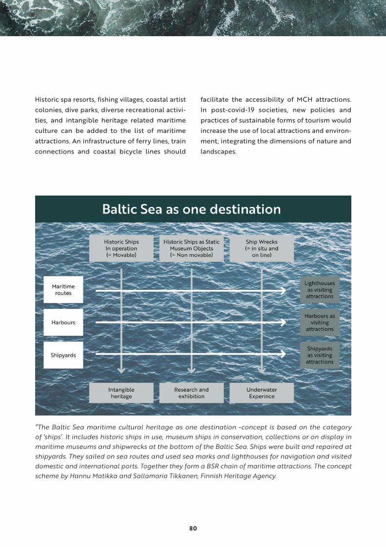
80
Historic spa resorts, fishing villages, coastal artist
colonies, dive parks, diverse recreational activi-
ties, and intangible heritage related maritime
culture can be added to the list of maritime
attractions. An infrastructure of ferry lines, train
connections and coastal bicycle lines should
facilitate the accessibility of MCH attractions.
In post-covid-19 societies, new policies and
practices of sustainable forms of tourism would
increase the use of local attractions and environ-
ment, integrating the dimensions of nature and
landscapes.
“The Baltic Sea maritime cultural heritage as one destination -concept is based on the category of ‘ships’. It includes historic ships in use, museum ships in conservation, collections or on display in maritime museums and shipwrecks at the bottom of the Baltic Sea. Ships were built and repaired at shipyards. They sailed on sea routes and used sea marks and lighthouses for navigation and visited domestic and international ports. Together they form a BSR chain of maritime attractions. The concept scheme by Hannu Matikka and Sallamaria Tikkanen, Finnish Heritage Agency.

81
Routes4U Project
Routes4U
Feasibility Study
on the Maritime Heritage Route
in the Baltic Sea Region
The Council of Europe report “Feasibility study on the Maritime Heritage Route in the Baltic Sea Region” combines maritime museums, coastal World Heritage Sites and lighthouses in recreation use. There are several maritime museums of international importance in the BSR. They serve citizens' access to information, objects, archives and interpretations of cultural heritage, and are increasingly involved in local social activities. WHS have a practical management policy with an obligation present and preserve maritime cultural heritage engaging in particularly young people. Both museums and WHS are often located centrally, well accessible and marked on maps, making it easy for the traveller to find them. Lighthouse associations gather enthusiasts and local people.

82
Thematic MCH tourism development - dive tourism
Promoting the Baltic Sea tourism by raising aware-
ness of UCH and MCH was an important part of
the BalticRIM project. The estimated number of
divers in the BSR is ca. 300 000 and there are over
16 000 known UCH sites in the heritage registers
of the Baltic Sea States.
The first underwater wreck park in the Baltic Sea
was established by the Finnish Heritage Agency in
2000 on the wreck of the Swedish ship of the line
Kronprins Gustav Adolf, which sank in the waters
of Helsinki in 1788.
As part of BalticRIM activities, Metsähallitus Parks
& Wildlife in Finland compiled and conducted
a visitor survey to find out more information
on wreck diving and its development needs in
Finland.49 Estonian National Heritage Board con-
ducted the same survey in Estonia. These surveys
engaged the diving community as expert stake-
holders to the project activities, and helped to
understand the current situation of BSR scuba
tourism in order to enhance the blue economy
potential in this area. A key result of the survey
was, that divers considered marking wrecks with
buoys the most important feature of a dive park.
They were seen to increase the safety of both the
diver and the wreck. Another interesting aspect
that the survey revealed was an interest in wreck-
diving sites in the immediate vicinity of the coast.
The underwater sites are sensitive to human
impact. The managers of cultural heritage and the
providers of dive services should follow the same
principles to monitor the impacts. It is the proper
way to keep these sites open to visitors.
MCH and maritime experience industry
Cultural and creative industries (CCIs) provide new
ways to communicate archaeological and historic
contents. They create augmented reality experiences
or explore MCH digitally in various forms, such as
story-telling, 3D models, literary heritage, interac-
tive museum installations, virtual museums, web
and mobile games and portals. They can be directly
linked to specific sites, or use the maritime cultural
heritage as a source for inspiration and knowledge.
Thereby MCH can act as drivers for coastal
tourism, BSR branding and for citizen engagement
to environmental and cultural preservation. To
enhance the use of MCH in CCIs and experience
industry, cultural heritage must be made available
in digital formats.
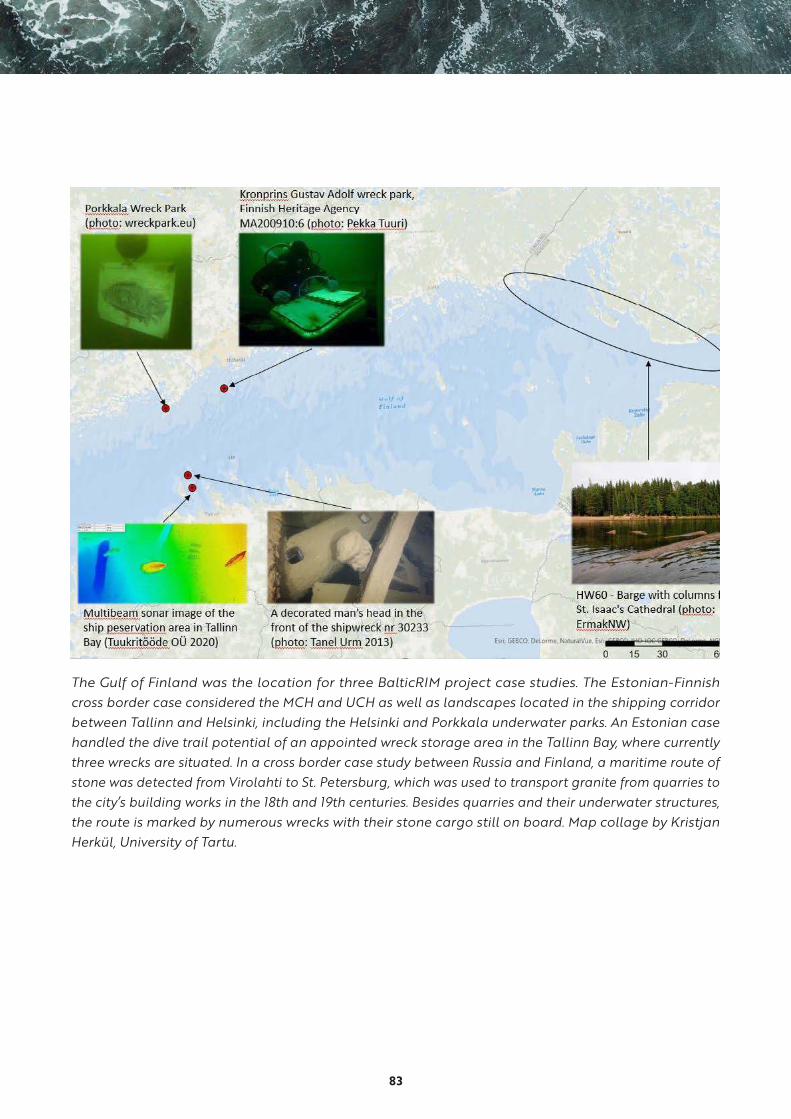
83
The Gulf of Finland was the location for three BalticRIM project case studies. The Estonian-Finnish cross border case considered the MCH and UCH as well as landscapes located in the shipping corridor between Tallinn and Helsinki, including the Helsinki and Porkkala underwater parks. An Estonian case handled the dive trail potential of an appointed wreck storage area in the Tallinn Bay, where currently three wrecks are situated. In a cross border case study between Russia and Finland, a maritime route of stone was detected from Virolahti to St. Petersburg, which was used to transport granite from quarries to the city’s building works in the 18th and 19th centuries. Besides quarries and their underwater structures, the route is marked by numerous wrecks with their stone cargo still on board. Map collage by Kristjan Herkül, University of Tartu.

84
A joint case study between Denmark and Germany in Flensburg focused on a ship-cemetery with the wreck of the “Oline” (built in 1878) and with other historic wrecks. The site could potentially become a dive trail. Wreck of the historic gaff-ketch “Oline” in Flensburg, Photo NDR.
5.2 Recommendations to promote blue growth based on maritime cultural heritage
● Promote the BSR as one brand and destination
built on sustainability and on cultural assets
and nature according to the EUSBSR and
EUSBSR PA Tourism.
• good example: “The Concept of Baltic Sea
Maritime and Underwater Cultural Her-
itage as One Destination”
• good practice: CoE Cultural Routes Pro-
gramme and Routes4U Project, which
ordered the Feasibility Study on the
Maritime Heritage Route in the Baltic Sea
Region combining BSR maritime museums,
coastal BSR World Heritage Sites and light-
houses in recreational use
• good practice: CoE Cultural Route St Olav
Ways includes a maritime part, the St Olav
Water Ways between Finland, Åland and
Sweden
• good example: Mediterranean BlueMed
coordination and support action financed
by the H2020 framework programme
• good idea for the future: have a selection
of BSR UCH and MCH sites on the World
Heritage List and /or European Heritage
Label -list

85
● Promote UCH and MCH to be used in creative
industries, which then has also great potential
for tourism.
• good practice: historical sources and mate-
rials regenerated, re-used and utilized in
city planning, harbours and waterfronts,
city sightseeing by ships and boats
• good practice: use BSR UCH and MCH
attractions in virtual games, literature and
films. For example, the fiction novel Hylky
(Wreck) by Helen Moster, describing the
last voyage of Vrouw Maria, which now lies
wrecked in the bottom of the Baltic Sea
● Provide visual material for commercial activi-
ties, employment, regional and coastal regen-
eration, skills development by entrepreneurs,
officials, creative industries, and enthusiasts.
• good example: BalticRIM Data Portal
• good example: BALTACAR project publi-
cation describing historical wrecks with 3D
models and illustrations.
• good example: PERICLES project map service
● Create joint effort and projects and co-op-
erate in potential cross borders, areas of
common conditions and common problegood
example: the cross border regional co-opera-
tion between Finland and Russia in Virolahti
and Viborg in the eastern Gulf of Finland,
where several 18th-19th century stone quar-
ries produced stone for the building works
in St. Petersburg and Kronstadt. The quarries
had a large impact in the regional economy,
shipbuilding and masonry. The sea routes and
the archipelago formed a borderless entity
to facilitate the transport of stone. Several
regional tourism projects are now utilizing the
historical narrative of the quarries and ships
turned into wrecks during the journey of car-
rying stones from the quarries in Virolahti to
Russia
● Work together with tourism sector and local
divers to create UCH and MCH visitor attrac-
tions.
• good example: underwater parks and trails
in Estonia, Finland and Sweden
• good example: identification of potential
underwater trail sites and shipwreck pres-
ervation areas in Tallinn Bay
● Promote and disseminate data on UCH and
MCH.
• good example: the Finnish MarineFinland.fi
data portal
• good example: web applications such as
the BalticRIM ParticipatoryGIS. This site
makes the cultural heritage data complied
during the BalticRIM project publicly avail-
able and allows quick and easy access to
data in a web browser. User does not need
special GIS software or GIS knowledge
• good practice: surveys or inventories based
on MCH registers providing information
regarding the possible sustainable uses
of a site. For example suitable for recrea-
tional use, tourism activities, educational
purposes, scientific research and clear
restrictions
● Recognise areas with integrated nature values,
cultural heritage and landscape values as
significant landscapes and underwater land-
scapes.
• good example: the Estonian Keri Island
Tourism Programme

86
• good example: the Estonian Maritime
Museum
• good practice: BalticRIM ParticipatoryGIS
web application, which introduces natural
and cultural features in Estonian sea
• good practice: promote outdoor, health
and wellness tourism, for example spa’s
offering traditional treatments, such as
mud bathing
• good example: the WWF Ghost Net appli-
cation
• good example: the Underwater Cultural
Landscape concept adopted by the Finnish
MSP
● Co-operate to create MCH projects financed
from innovation and research programmes like
Interreg and Horizon.
• good practice: BSR heritage co-operation
● UN Decade of Ocean Science for Sustainable
Development 2021-2030 creates a Heritage
Network and provides an opportunity to
engage a wide audience, highlight the impor-
tance of UCH & MCH and to develop sustain-
able tourism creating jobs and promoting local
cultures and products.
• good practice: sailing ships of the Northern
Baltic, Council of Europe Cultural Routes
Programme and Routes4U Project
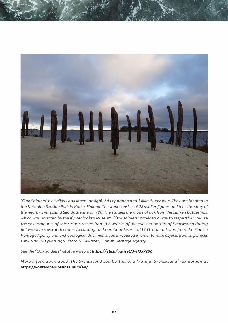
87
”Oak Soldiers” by Heikki Laaksonen (design), Ari Leppänen and Jukka Auervuolle. They are located in the Katariina Seaside Park in Kotka, Finland. The work consists of 28 soldier figures and tells the story of the nearby Svensksund Sea Battle site of 1790. The statues are made of oak from the sunken battleships, which was donated by the Kymenlaakso Museum. ”Oak soldiers” provided a way to respectfully re-use the vast amounts of ship’s parts raised from the wrecks of the two sea battles of Svensksund during fieldwork in several decades. According to the Antiquities Act of 1963, a permission from the Finnish Heritage Agency and archaeological documentation is required in order to raise objects from shipwrecks sunk over 100 years ago. Photo: S. Tikkanen, Finnish Heritage Agency.
See the ”Oak soldiers” -statue video at https://yle.fi/uutiset/3-11359296
More information about the Svensksund sea battles and ”Fateful Svensksund” -exhibition at https://kohtalonaruotsinsalmi.fi/en/

88
References1 A joint Working Group on Maritime Spatial Planning of the VASAB Committee on Spatial Planning and
Development of the Baltic Sea Region (CSPD/BSR) and the Helsinki Commission (HELCOM) to ensure
cooperation among the Baltic Sea Region countries for coherent regional Maritime Spatial Planning
processes.
2 BaltSeaPlan, Vision 2030, Towards the sustainable planning of Baltic Sea space, Summary, 2011.
3 UNESCO 2003: 2, 2003. “Convention for the Safeguarding of the Intangible Cultural Heritage”.
4 EUR-Lex, Access to European Union Law, https://eur-lex.europa.eu/legal-content/EN/TXT/
PDF/?uri=CELEX:32014L0089&from=EN
5 Matczak et al. 2015 /www.umgdy.gov.pl/?p=6341 [Matczak M., Zaucha J., and others, (2015) Study on
conditions of spatial management of Polish Sea Areas. Maritime Institute: Gdańsk https://www.umgdy.
gov.pl/?p=6341
6 Trakadas et al 2019: 154.
7 For example Ounanian et al 2018: 8-9; Moodie et al 2019: 4-5.
8 Swedish Marine Spatial Plan, Consultation proposal 2018:74, Proposal for the Marine Spatial Plan Baltic
Sea, Consultation document, Swedish Agency for Marine and Water Management.
9 Related to UCH and MCH, see for example Trakadas et al. 2019:158.
10 For example, see Gee et al. 2016: 140.
11 Zaucha & Gee 2019:2.
12 Brown & Humberstone 2018: 4.
13 See for example Land 2018: 31-40; The New Coastal History, Territory Beyond Terra, Seascapes: Shaped
by the Sea, Living with the Sea”.
14 Armitage, Bashford and Sivasundaram 2018: 15.
15 Brown & Humberstone 2018: 4.
16 Anderson and Peters 2014:4; Claesson 2019:61.
17 Claesson S. 2019:61.
18 Ounanian et al. 2018:9.
19 Related to UCH and MCH, see for example Claesson S. 2019: 63.
20 Soini 2016:6. According to Dr Jessica S. Lehman, Durham University, maritime cultural heritage may
be understood as a frontier in terms not only of spatial territory, but of also regarding knowledge,
governance and politics. Dr Lehman gave a presentation at the BalticRIM Webinar on 10th of September
89
2020. Especially when working with underwater cultural heritage, it is good to realize that the invisibility
afforded by being underwater, is the primary attribute differentiating underwater heritage from land
based heritage, placing this heritage in the to the frontier and in periphery.
21 Henderson 2019:6.
22 Trakadas A. et al 2019: 157-158.
23 In addition to the most interesting sites, the project exchanged data about protection by law in
territorial waters and EEZ; underwater archaeological education; tourism strategies; diving and
conservation equipment. The 2006 List can be viewed at http://baltic-heritage.eu/working-groups/
underwater-cultural-heritage/rutilus-project-and-100-list/
24 Some definitions in the BalticRIM WIKI, http://dokuwiki.balticrim.eu/index.php?title=Maritime_Cultural_
Heritage_(MCH). For the difference between marine and maritime, see e.g. Gee et al. 2016, footnote
1; Henderson 2019, 3-4. Generally, the term “marine or nautical archaeology” has been used in the
USA and when referring to scientific applications in archaeology. “Maritime archaeology” is a more
generally accepted umbrella term, as it includes all "material remains of man and his activities of the
sea" (Muckelroy 1978, 4), and thus is not restricted to the underwater heritage as such, but encompasses
also cultural aspects in coastal zones on a broader scale.
25 Term of cultural heritage has been elaborated by multiple disciplines, such as archaeology, human
geography, (cultural) anthropology and history. In modern understanding cultural heritage refers to
both tangible and intangible (Ounanian K. et al 2018: 4).
26 http://dokuwiki.balticrim.eu/index.php?title=Maritime_Cultural_Heritage_(MCH)
27 Some definitions in the BalticRIM WIKI. http://dokuwiki.balticrim.eu/index.php?title=Underwater_
Cultural_Heritage_(UCH)
28 Kull et al. 2017: 38
29 Results of a meeting between ALSH and MSP authority of Schleswig-Holstein on 6th September 2019.
30 https://www.umgdy.gov.pl/?p=6341.
31 Zaucha et al. 2016 [Zaucha J, Davoudi S., Slob A., Bouma G., van Meerkerk I., MP Oen A., and Breedveld
G. D (2016) State-of-the-Lagoon Reports as Vehicles of Cross-Disciplinary Integration, Integrated
Environmental Assessment and Management 14(4):690-700, https://doi.org/10.1002/ieam.1802 ]
32 For more details regarding the design of the portal, see Schrøder et al (2020) (Schrøder, L, Georgati,
M & Hansen, HS 2020, Enabling Collaboration Among Cultural Heritage Experts and Maritime Spatial
Planners. in Kö, A et al (eds.), EGOVIS 2020. Vol. 12394, pp 106-120, Springer, Switzerland, Lecture Notes
in Computer Science.
33 More information in Finnish http://akp.nba.fi/; Arkeologisen kulttuuriperinnön opas.
34 Such terms as marine landscape, benthoscape, seabed landscape and seascape can refer also into
physical landscapes of the seabed including sometimes also features of biodiversity. More information
e.g. in Kaskela 2017.
90
35 The work was done by Laura Seesmeri form the University of Turku, More information: Seesmeri, Laura
2020: Kokemuksia syvyyksistä. Teoksessa Muutoksen tyrskyt ja kotirannan mainingit. Toimittaneet
Jaana Kouri, Tuomas Räsänen ja Nina Tynkkynen. Suomalaisen Kirjallisuuden Seura, Helsinki, and a
forthcoming article: Seesmeri, Laura: The benefits of the concept of underwater landscape to maritime
spatial planning of the Baltic Sea, Ocean management.
36 BalticRIM WIKI http://dokuwiki.balticrim.eu/index.php?title=Underwater_landscape
37 https://www.coe.int/en/web/conventions/full-list/-/conventions/treaty/199
38 The Finnish Heritage Agency has a long history in working together with divers. The Agency invited
the Finnish Divers Federation to take part in the BalticRIM project as an associated organisation in
order to enhance commitment and liaisons between heritage protection and underwater heritage
“users”. To collect diver’s experiences, opinions and notions about underwater landscape, underwater
heritage, protection, use and experiences, and to promote Landscape Convention and to confirm
participation according to the Convention on the Value of Cultural Heritage for Society, a questionnaire
on underwater heritage landscape was conducted in 2018. In total, 138 answers gave highly interesting
and rare data of diver´s experiences and definitions of underwater landscape emphasizing how the
underwater landscape is composed of both nature and heritage. The results were published in Finnish
and online on Finnish Divers Federation’s pages (“Sukeltajille suunnatun vedenalaista maisemaa
kartoittavan kyselyn tulokset”, Laura Seesmeri, University of Turku, 2018). In addition, the outcome were
presented in various BalticRIM stakeholder events. Similar results were gained in a wreck diving survey
by Metsähallitus (Lakso and Laine 2019).
39 Kee G. at al 2017.
40 The BalticRIM online Landscape Workshop ”BalticRIM Underwater Landscape Concept and other tools
for landscape approach” was organized in May 2020. The aim of the Workshop was to discuss two
different ”landscape concepts”; the BalticRIM Underwater Landscape (UWL) and Culturally Significant
Areas (CSA) Concepts. (Gee at al 2017. More information look at BalticRIM Landscape Workshop Report).
41 This has been done for example, for the sites of Vrouw Maria (register category: wreck); Svensksund
sea battle area (register category: place of historical event: battlefield); Suomenlinna sea fortress
(Suomenlinna is a UNESCO World Heritage site and its cultural heritage are placed in different register
categories including wreck and barrier); Virolahti stone quarries (categories: wreck, jetty etc.) and
Jussarö ship trap (category: wreck). In the case of Vrouw Maria, the amateur and professional divers
were interviewed about their UWL experience. Sallamaria Tikkanen 2012: The Vrouw Maria’s Underwater
Landscape in Lost at sea, Rediscovered, Ed. Eero Ehanti, Johanna Aartomaa, Irma Lounatvuori and Erik
Tirkkonen, Finland’s National Board of Antiquities.
42 Smith-Godfrey 2016, 60.
43 COM(2014) 254/2 (13/05/2014.
44 https://www.balticsea-region-strategy.eu/attachments/article/590764/INFORMATION%20LEAFLET_
Sustainable-blue-growth-agenda-160906.pdf
91
45 Cultural heritage can be viewed as social capital in the recreational sector (derived from the idea of
cultural landscapes as social capital in Kizos et al 2018), but as cultural heritage is not a renewable asset,
it is necessary to highlight the necessity of its usage in a sustainable way as it is done with natural capital
(Silver et al 2015).
46 Pueyo-Ros, J. 2018. The Role of Tourism in the Ecosystem Services Framework. MDPI land-07-00111.pdf.
Licensee MDPI, Basel, Switzerland.
47 Ocean Multi-Use Action Plan Executive Summary, 2018.
48 https://www.unwto.org/sustainable-development
49 Lakso and Laine 2019
92
SourcesAhtiainen, H., Liski, E., Pouta, E., Soini, K., Bertram, C., Rehdanz, K., Pakalniete, K. and Meyerhof, J. 2019:
“Cultural ecosystem services provided by the Baltic Sea marine environment”. Ambio 2019. Online: https://
link.springer.com/article/10.1007/s13280-019-01239-1.
Anderson, J. and Peters, K. 2014: “A Perfect and absolute blank”. Human Geographies of Water Worlds. In
Peters, K., & Anderson, J. (eds.). Water words: Human geographies of the ocean.
Armitage, D., Bashford, A. and Sivasundaram, S. (eds.) 2018: “Introduction: Writing World Oceanic Histories”.
In Oceanic Histories, pp. 1–27.
Brown, M. and Humberstone, B. (eds.) 2018: “Introduction”. In Seascapes: Shaped by the Sea. Embodied
Narratives and Fluid Geographies, pp. 1–11.
Brown, M. and Humberstone, B. (eds.) 2018: Seascapes: Shaped by the Sea. Embodied Narratives and Fluid
Geographies.
Brown, M. and Peters, K. (eds.) 2019: Living with the Sea. Knowledge, Awareness and Action.
Claesson, S. 2011: “The Value and Valuation of Maritime Cultural Heritage”. International Journal of Cultural
Property (2011), (18), pp. 61-80.
Gee, K., Kannen, A., Adlam, R., Brooks, C., Chapman, M., Cormier, R., Fischer, C., Fletcher, S., Gubbins, M.,
Shucksmith, R. and Shellock, R. 2017: “Identifying culturally significant areas for maritime spatial planning”.
Ocean & Coastal Management 136 (2017), pp. 139-147.
Henderson, J. 2019: “Oceans without History? Marine Cultural Heritage and the Sustainable Development
Agenda”. Sustainability 11 (18). https://doi.org/10.3390/su11185080
Kaskela, A. 2017: “Seabed landscapes of the Baltic Sea. Geological characterization of the seabed
environment with spatial analysis techniques”. Geological Survey of Finland.
Kull, M., Moodie, J., Goacomentti, A. and Morf, A. 2017: Lessons Learned: Obstacles and Enablers When
Tackling the Challenges of Cross-Border Maritime Spatial Planning – Experiences from Baltic SCOPE.
Stockholm, Espoo and Gothenburg. http://www.balticscope.eu/content/uploads/2015/07/BalticScope_
LL_WWW.pdf
Lakso, E. and Laine, A. 2019: Survey of Finnish coastal area wreck diving practices. Metsähallitus Parks &
Wildlife. BalticRIM project publication. https://www.submariner-network.eu/images/BalticRIM/BalticRIM_
Wreck-Diving-Survey_Report_Metsa%CC%88hallitus2019.pdf
Lehtimäki, M. (ed.) 2008: Cultural heritage and tourism: Potential, impacts, partnership and governance.
The presentations on the III Baltic Sea Region Cultural Heritage Forum.
Lehtimäki, M. 2020: Feasibility Study on the Maritime Heritage Route in the Baltic Sea Region. https://
rm.coe.int/routes4u-study-eusbsr-policies/16809ee4de%0A%0A

93
Litwin, J. (ed.) 2003: Baltic Sea Identity, Common Sea – Common Culture? 1st Cultural Heritage Forum.
Gdansk 3rd – 6th April 2003.
Muckelroy, Keith 1978: Maritime Archaeology.
Ounanian, K., Hansen, K. J., Delaney, A., van Tatenhove, J., Bohnstedt, H., Kenter, J., Azzopardi, E., Flannery,
W., Ferguson, L., Toonen, H., Kraan, M., Macia, J. V., Lamers, M., Pita, C., Albuquerque, H., Ferreira da Silva,
A. M., Alves, F., Mylona, D. and Frangoudes, K. 2018: “Synthesis paper of the three pillars concept for
sustainable CH utilization. Conceptualizing Coastal and Maritime Cultural Heritage through Communities
of Meaning and Participation”. PERICLES (PrEseRving and sustainably governing Cultural heritage and
Landscapes in European coastal and maritime regions) Project Report D2.3.
Peters, K., Steinberg, P. and Stratford, E. (eds.) 2018: Territory Beyond Terra.
Soini, K. and Dessein, J. 2016: “Culture-Sustainability Relation: Towards a Conceptual Framework”.
Sustainability 2016, (8).
Swedish Marine Spatial Plan, Consultation Proposal 2018:74. Proposal for Marine Spatial Plan Baltic Sea,
Consultation Document, Swedish Agency for Marine and Water management.
Trakadas, A., Firth, A., Gregory, D., Elkin, D., Guerin, U., Henderson, J., Kimura, J., Scott-Ireton, D., Shashoua,
Y., Underwood, C. and Viduka, A. 2019: “The Ocean Decade Heritage Network. Integrating Cultural Heritage
Within the UN Decade of Ocean Science 2021-2030”. Journal of Maritime Archaeology (2019) 14, pp. 153-
165.
Tikkanen, S. 2012: The Vrouw Maria’s Underwater landscape. Ehanti E., Aartomaa J., Lounatvuori I., and
Tirkkonen E. (eds.). Lost at Sea, Rediscovered, pp. 192-221.
Worthington, D. (ed.) 2017: The New Coastal History. Cultural and Environmental Perspectives from
Scotland and Beyond.
94
Internet sources
• BalticRIM:
BalticRIM data portal:
https://balticrimdataportal.eu
BalticRIM WIKI:
http://dokuwiki.balticrim.eu
ParticipatoryGIS portal mch4blue:
http://www.sea.ee/mch4blue
BalticRIM Landscape Workshop Report:
https://www.submariner-network.eu/balticrim
BSR national maritime data registers:
https://2019.submariner-network.eu/images/BalticRIM/5_Data_accessibility_template.xlsx
Maritime Cultural Heritage impact assessment strategy for MSP, Status report 3.2: https://www.
submariner-network.eu/balticrim
• BALTACAR Project:
https://projectbaltacar.eu/
BALTACAR Project publication:
https://projectbaltacar.eu/wp-content/uploads/2020/01/BALTACAR_netti1.pdf
Creating a dive park From idea to reality:
https://projectbaltacar.eu/wp-content/uploads/2020/01/Dive-park-handbook-layout_eng.pdf
• Baltic Region Heritage Committee networks:
https://baltic-heritage.eu
BSR Working Group on Coastal Heritage:
https://baltic-heritage.eu/working-groups/coastal-heritage/
BSR Working Group on Underwater Heritage:
https://baltic-heritage.eu/working-groups/underwater-cultural-heritage
95
The Code of Good Practice for the Management of the Underwater Cultural Heritage in the Baltic Sea
Region (COPUCH):
https://baltic-8326.wilhelm-osl.servebolt.cloud/working-groups/underwater-cultural-heritage/code-
of-good-practice/
The Rutilus report 2006:
https://baltic-heritage.eu/working-groups/underwater-cultural-heritage/rutilus-project-and-100-list
• Baltic Sea voyage:
http://coastlight.net/detaljer/?req=5018
• BlueMed project:
http://www.bluemed-initiative.eu/the-project/
• Capacity4MSP project:
https://www.msp-platform.eu/projects/capacity4msp-strengthening-capacity-msp-stakeholders-
and-decision-makers
• Council of Europe:
Convention for the Protection of the Archaeological Heritage of Europe: https://www.coe.int/en/web/
culture-and-heritage/valletta-convention
Convention for the Protection of the Architectural Heritage of Europe:
https://www.coe.int/en/web/culture-and-heritage/granada-convention
Framework Convention on the Value of Cultural Heritage for Society:
https://www.coe.int/en/web/culture-and-heritage/faro-convention
HEREIN:
https://www.coe.int/en/web/herein-system
Landscape Convention:
https://www.coe.int/en/web/landscape

96
• Council of Europe Cultural Routes Programme:
https://pjp-eu.coe.int/en/web/cultural-routes-and-regional-development/coe-cultural-routes
• Council of Europe Cultural Routes with major references in BSR:
Hansa Route:
https://www.coe.int/en/web/cultural-routes/the-hansa
Route of Saint Olav Ways:
https://www.coe.int/en/web/cultural-routes/the-route-of-saint-olav-ways
St Olav Waterways:
https://stolavwaterway.com/en/
Vikings Route:
https://www.coe.int/en/web/cultural-routes/the-viking-routes
• Council of Europe and European Commission Routes4U project 2017-2020 and BSR:
https://pjp-eu.coe.int/en/web/cultural-routes-and-regional-development/2019-routes4u-eusbsr-
meeting
Routes4U Report Feasibility study on the Maritime Heritage Route in the Baltic Sea Region: https://
rm.coe.int/maritime-heritage-study/16809ed711%0A%0A
• Decade of Ocean Science:
https://www.oceandecade.org
• Estonian Maritime Museum:
www.meremuuseum.ee
• European Commission:
Europe 2030 Strategy:
https://ec.europa.eu/commission/publications/reflection-paper-towards-sustainable-europe-2030_en
The INSPIRE directive:
https://inspire.ec.europa.eu/inspire-directive/2

97
Sustainable Blue Growth Agenda for BSR: https://webgate.ec.europa.eu/maritimeforum/system/files/
INFORMATION%20LEAFLET_Sustainable-blue-growth-agenda.pdf
• European Union Maritime Spatial Planning Directive (2014/89/EU):
https://www.eea.europa.eu/policy-documents/directive-2014-89-eu-maritime
European MSP Platform:
https://www.msp-platform.eu/
EU Strategy for the Baltic Sea Region (EUSBSR):
https://www.balticsea-region-strategy.eu/
EUSBSR Action Plan:
https://www.balticsea-region-strategy.eu/action-plan
• Finnish Heritage Agency:
https://www.museovirasto.fi/en/
Wiki based Guide for Archaeological Heritage in Finland (in Finnish only):
http://akp.nba.fi/
• HELCOM-VASAB MSP WG:
https://helcom.fi/helcom-at-work/groups/helcom-vasab-maritime-spatial-planning-working-group/
• Keri Island Tourism Programme:
www.keri.ee
• MarineFinland.fi portal:
https://marinefinland.fi/en-US
• Maritime spatial planning in Denmark:
https://danishbusinessauthority.dk/sites/default/files/media/2012_planning_eng_guide.pdf
98
• Maritime spatial planning in Estonia:
http://mereala.hendrikson.ee/en.html
An example of a stakeholder engagement in the Lääne County and the Lääne-Viru County in YouTube:
https://cutt.ly/ht09e70
• Maritime spatial planning in Finland:
https://www.merialuesuunnittelu.fi/en;
https://www.merialuesuunnittelu.fi/en/msp-draft-2030/
Report on maritime cultural heritage:
https://www.merialuesuunnittelu.fi/wpcontent/uploads/2019/04/Suomen_merellisen_
kulttuuriperinn%C3%B6n_tilannekuva_2019-1.pdf
• Maritime spatial planning for the EEZ in Germany:
https://www.bsh.de/EN/TOPICS/Offshore/Maritime_spatial_planning/maritime_spatial_planning_
node.html
• Maritime spatial planning in the Federal State of Schleswig-Holstein, Germany:
https://www.schleswigholstein.de/DE/Fachinhalte/L/landesplanung_raumordnung/weitereThemen/
landesplanung_maritime_raumordnung.html
• Maritime spatial planning in Lithuania
https://e-seimas.lrs.lt/portal/legalAct/lt/TAP/be950850b36e11e486d695b7d843f736?jfwid=-je7i1syyn)
• Maritime spatial planning in Poland:
MSP and Maritime Office in Gdynia:
https://www.umgdy.gov.pl/?page_id=2161
MSP and Maritime Office in Szczecin:
https://www.ums.gov.pl/plany-morskie.html
MSP will be placed in a data portal of maritime administration:
https://sipam.gov.pl/mapy/plany-morskie)
Study of Conditions of Spatial Development of Polish Sea Areas:

99
https://www.umgdy.gov.pl/?cat=96
• Maritime spatial planning in Sweden
https://www.havochvatten.se/en/eu-and-international/marine-spatial-planning.html
• Maritime spatial planning in Åland
https://www.regeringen.ax/demokrati-hallbarhet/hallbar-utveckling/marin-kustomradesplanering-
havsplanering
• MUSES project:
https://muses-project.com/
• Nordic Blue Parks project:
https://www.norden.org/en/publication/nordic-blue-parks
• PartiSEApate project:
http://www.partiseapate.eu/
PartiSEApate project discussion on mCH:
http://www.partiseapate.eu/dialogue/workshop-cultural-heritage-tourism/
• PERICLES project’s map service:
https://mapyourheritage.eu/
• SEAPLANSPACE project:
https://seaplanspace.ug.edu.pl
UNESCO:
Convention on the Protection of the Underwater Cultural Heritage of 2001: http://www.unesco.org/
new/en/culture/themes/underwater-cultural-heritage/2001-convention
Decade of Ocean Science for Sustainable Development 2021-2030:
https://en.unesco.org/ocean-decade/about
100
Hague Convention 1954:
http://www.unesco.org/new/en/culture/themes/armed-conflict-and-heritage/convention-and-
protocols/1954-hague-convention/
Manual for activities directed at UCH
http://www.unesco.org/new/en/culture/themes/underwater-cultural-heritage/unesco-manual-
for-activities-directed-at-underwater-cultural-heritage/unesco-manual/general-principles/in-situ-
preservation-as-first-option
• UNWTO:
https://www.unwto.org/sustainable-development
• 3D visualizations of UCH sites, an example:
https://sketchfab.com/tags/shipwreck
Personal communication
Dr. Jessica Lehman, Durham University at BalticRIM Webinar on 10th of September 2020.
101
Annex
International framework for Maritime Cultural Heritage Protection and Management
Conventions and recommendations created by intergovernmental organizations.
Links to respective sites, where one can search the state of ratifications.
UNESCO Draft model provisions on State Ownership of Undiscovered Cultural Object.
Explanatory Report with model provisions and explanatory guidelines 2012
https://www.unidroit.org/instruments/cultural-property/model-provisions
Council of Europe Framework Convention on the Value of Cultural Heritage for Society 2005/2011
https://rm.coe.int/1680083746
UNESCO Convention on the Protection and Promotion of the Diversity of Cultural Expressions 2005
https://en.unesco.org/creativity/convention
The European Landscape Convention of the Council of Europe 2000/2004
https://www.coe.int/en/web/landscape
UNESCO Convention for the Safeguarding of the Intangible Cultural Heritage 2003
http://portal.unesco.org/en/ev.php-URL_ID=17716&URL_DO=DO_TOPIC&URL_SECTION=201.html
UNESCO Convention on the Protection of the Underwater Cultural Heritage 2001
https://unesdoc.unesco.org/ark:/48223/pf0000126065
UNIDROIT Convention on Stolen or Illegally Exported Cultural objects 1995
https://www.unidroit.org/102-instruments/cultural-property/cultural-property-convention-
1995/173-unidroit-convention-on-stolen-or-illegally-exported-cultural-objects-1995-rome
Council of Europe European Convention on the Protection of the Archaeological Heritage 1992
https://www.coe.int/en/web/conventions/full-list/-/conventions/treaty/066
Council of Europe Convention for the Protection of the Architectural Heritage of Europe 1985
https://rm.coe.int/168007a087
102
UNESCO Convention Concerning the Protection of the World Cultural and Natural Heritage 1972/1975
https://whc.unesco.org/en/conventiontext/
UNESCO Convention on the Means of Prohibiting and Preventing the Illicit Import,
Export and Transfer of Ownership of Cultural Property 1970
http://portal.unesco.org/en/ev.php-URL_ID=13039&URL_DO=DO_TOPIC&URL_SECTION=201.html
UNESCO Hague Convention for the Protection of Cultural Property in the Event of Armed Conflict 1954
http://www.unesco.org/new/en/culture/themes/armed-conflict-and-
heritage/convention-and-protocols/1954-hague-convention/
103
Partners
BalticRIM PROJECT PARTNERS
State Archaeology Department of Schleswig-Holstein, Germany (ALSH), Lead Partner, Schleswig-Holstein
Submariner Network for Blue Growth EEIG (SUBMARINER), Germany
Finnish Heritage Agency (FHA), Finland
Metsähallitus Parks & Wildlife Finland
University of Turku, Finland
University of Tartu (UTARTU), Estonia
Estonian National Heritage Board (ENHB), Estonia
Coastal Research and Planning Institute (CORPI), Lithuania
Klaipeda University, Lithuania
National Maritime Museum in Gdańsk, Poland
Maritime Institute in Gdańsk (MIG), Poland
Atlantic Branch of the P.P. Shirshov Institute of Oceanology,
Russian Academy of Science, Russian Federation
Aalborg University (AU), Denmark
BALTICRIM PROJECT ASSOCIATED ORGANISATIONS
Regional Council of Kymenlaakso, Finland
Åland Board of Antiquities, Government of the Åland Islands, Finland
Viking Ship Museum Roskilde, Denmark
State Agency for Agriculture, Environment and Rural Areas Schleswig-Holstein; Germany
Ostseefjord Schlei GmbH, Germany
Ministry of the Interior of of Schleswig-Holstein, Germany
Helmholtz Centre Geesthacht for Coastal Research, Germany
Kingisepp District municipality and Underwater Research Centre of
the Russian Geographical Society, Russian Federation
Scientific and Research Institute of Maritime Spatial Planning Ermak NorthWest, Russian Federation
Finnish Divers’ Federation, Finland
Dutch Cultural Heritage Agency, the Netherlands
Museum of Kronstadt, Russian Federation
Baltic Sea States Sub-regional Co-operation, Eastern Norway County Network, Norway
Museum of the World Ocean, Russian Federation
National Centre of Underwater Research, Russian Federation